information sheet on ramsar wetlands (ris)
TRANSCRIPT

Information Sheet on Ramsar Wetlands (RIS) – 2009-2012 version
Available for download from http://www.ramsar.org/ris/key_ris_index.htm.
Categories approved by Recommendation 4.7 (1990), as amended by Resolution VIII.13 of the 8th Conference of the Contracting
Parties (2002) and Resolutions IX.1 Annex B, IX.6, IX.21 and IX. 22 of the 9th Conference of the Contracting Parties (2005).
Notes for compilers: 1. The RIS should be completed in accordance with the attached Explanatory Notes and Guidelines for
completing the Information Sheet on Ramsar Wetlands. Compilers are strongly advised to read this guidance before filling in the RIS.
2. Further information and guidance in support of Ramsar site designations are provided in the
Strategic Framework and guidelines for the future development of the List of Wetlands of International Importance (Ramsar Wise Use Handbook 14, 3rd edition). A 4th edition of the Handbook is in preparation and will be available in 2009.
3. Once completed, the RIS (and accompanying map(s)) should be submitted to the Ramsar
Secretariat. Compilers should provide an electronic (MS Word) copy of the RIS and, where possible, digital copies of all maps.
1. Name and address of the compiler of this form: Jasminka Radović State Institute for Nature Protection Trg Mažuranića 5 HR ‐ 10000 Zagreb Republic of Croatia tel: +385 1 5502 931 fax: +385 1 5502 902 e‐mail: [email protected] Eugen Draganović Ministry of Environmental and Nature Protection Nature Protection Directorate Republike Austrije 14 HR ‐ 10000 Zagreb Republic of Croatia tel: +385 1 4866 110 fax: +385 1 4866 100 e‐mail: [email protected] 2. Date this sheet was completed/updated: July, 2012 3. Country: Croatia / Republic of Croatia
FOR OFFICE USE ONLY. DD MM YY
Designation date Site Reference Number

Information Sheet on Ramsar Wetlands (RIS), page 2
4. Name of the Ramsar site: The precise name of the designated site in one of the three official languages (English, French or Spanish) of the Convention. Alternative names, including in local language(s), should be given in parentheses after the precise name. Neretva River Delta (Neretva Delta) 5. Designation of new Ramsar site or update of existing site: This RIS is for (tick one box only): a) Designation of a new Ramsar site ; or b) Updated information on an existing Ramsar site 6. For RIS updates only, changes to the site since its designation or earlier update: a) Site boundary and area
The Ramsar site boundary and site area are unchanged: or If the site boundary has changed: i) the boundary has been delineated more accurately ; or ii) the boundary has been extended ; or iii) the boundary has been restricted** and/or If the site area has changed: i) the area has been measured more accurately ; or ii) the area has been extended ; or iii) the area has been reduced**
** Important note: If the boundary and/or area of the designated site is being restricted/reduced, the Contracting Party should have followed the procedures established by the Conference of the Parties in the Annex to COP9 Resolution IX.6 and provided a report in line with paragraph 28 of that Annex, prior to the submission of an updated RIS. b) Describe briefly any major changes to the ecological character of the Ramsar site, including in the application of the Criteria, since the previous RIS for the site:
Application of the Criteria There was no update of the RIS since designation of the site in 1993. There is a significant amount of new information available today, allowing more precise application of previous criteria from 1990 as well as of revised Criteria adopted in 2005.
7. Map of site: Refer to Annex III of the Explanatory Note and Guidelines, for detailed guidance on provision of suitable maps, including digital maps. a) A map of the site, with clearly delineated boundaries, is included as: see Appendix 1 (hard copy) and Appendix 2 (CD with JPEG and GIS file)
i) a hard copy (required for inclusion of site in the Ramsar List): ; ii) an electronic format (e.g. a JPEG or ArcView image) ; iii) a GIS file providing geo-referenced site boundary vectors and attribute tables .

Information Sheet on Ramsar Wetlands (RIS), page 3
b) Describe briefly the type of boundary delineation applied: e.g. the boundary is the same as an existing protected area (nature reserve, national park, etc.), or follows a catchment boundary, or follows a geopolitical boundary such as a local government jurisdiction, follows physical boundaries such as roads, follows the shoreline of a waterbody, etc.
The boundary follows the edge of Neretva River valley on its contact with surrounding karst hills. On its NE part, between settlements Prud and Metković, it follows the state border between Croatia and Bosnia & Herzegovina. On its SW part, starting from the settlement Čeveljuša, it follows the eastern bank of the canal Vlaška that connects the lake Jezero Vlaška and the sea. The marine boundary is designed to include the large sandbank in front of the river mouth and is defined by several point coordinates. Ramsar site encompasses five areas protected by the Law on Nature Protection in Neretva Delta. 8. Geographical coordinates (latitude/longitude, in degrees and minutes): Provide the coordinates of the approximate centre of the site and/or the limits of the site. If the site is composed of more than one separate area, provide coordinates for each of these areas. Approximate centre: 43° 1' 40" N, 17° 34' 25" E West corner: 43° 1' 45" N, 17° 25' 28" E East corner: 43° 1' 00" N, 17° 41' 11" E North corner: 43° 5' 55" N, 17° 37' 27" E South corner: 42° 56' 50" N, 17° 37' 11" E 9. General location: Include in which part of the country and which large administrative region(s) the site lies and the location of the nearest large town.
Neretva Delta is situated in southern part of Croatian coast. The whole site belongs to the administrative unit of Dubrovnik‐Neretva County. It is located cca 65 km NW from the County center, town of Dubrovnik. While the whole Croatia, according to 2011 census (Croatian Bureau of Statistics, 2011) has 4,290,612 inhabitants on its territory of 56,550 km2, the Dubrovnik‐Neretva County has 122,783 and its capital Dubrovnik 42,641 inhabitants. The nearest towns are Ploče (bordering the site on its western part, including the large Ploče Port with 5,871 inhabitants), Metković with 15,056 inhabitants and Opuzen with 2,732 inhabitants, the last two located inside the Ramsar site. Smaller settlements in Neretva Delta are Kula Norinska, Slivno and Zažablje, which represent centers of three municipalities. Apart from towns Metković, Opuzen and Ploče, other settlements number less than 1,000 inhabitants.
10. Elevation: (in metres: average and/or maximum & minimum) Minimum: 0 m Maximum: 135 m 11. Area: (in hectares) 12,742 ha

Information Sheet on Ramsar Wetlands (RIS), page 4
12. General overview of the site: Provide a short paragraph giving a summary description of the principal ecological characteristics and importance of the wetland.
Neretva River with its 218 km long watercourse is the largest river of the eastern Adriatic watershed. Its final section of cca 22 km stretches through Croatian territory, forming an extensive delta with large reedbeds, lakes, wet meadows, lagoons, sandbanks, sandflats and saltmarshes. Neretva Delta is the most valuable wetland on eastern Adriatic coast and one of only few wetlands remained in Mediterranean region of Europe. It is the only delta in Croatia and the site with the largest reedbeds in the country that cover more than 3,000 ha. Although a large part of formerly vast marshes of Neretva Delta have been turned into agricultural land, remained wetland habitats are representative and important on international level. A number of habitat types are threatened on European level, like the estuary, lagoons, shallow sandbanks, tidal flats and saltmarshes.
In the Neretva Delta, at least 313 bird species have been registered. Altogether there are around 193 regularly occurring species out of which around 89 are breeding birds. The area is important stop‐over place during migrations of birds from Middle and NE Europe to Africa, situated on the route of Central European (Black Sea/Mediterranean) Flyway. It is also of great importance for wintering. About 1/3 of registered species are wintering birds, accompanied with residents during the winter. The river mouth with its shoals, sandbanks and saltmarshes is of greatest importance for migration of waders, the Spoonbill (Platalea leucorodia), terns and gulls as well as for breeding of the Kentish Plover (Charadrius alexandrines) and the Stilt (Himantopus himantopus). Reedbeds and water bodies shelter migrating and wintering ducks, coots and grebes. Extensive reedbeds are, along with the reedbed in Vransko jezero Nature Park, for many waterbirds the most important breeding site in Mediterranean region of Croatia (for details see 22. Noteworthy fauna).
Neretva and its tributaries are exceptionally rich in fish species. Out of almost 150 species that use watercourses and/or estuary in some stage of their life, 49 are freshwater fishes and out of them even 19 are endemic for Eastern Adriatic catchment area while 4 are endemic for Croatia. Due to its high biological production, the Neretva mouth is a feeding ground for many kinds of fish. The delta, lagoons and bodies of brackish water present spawning sites and nurseries for fish and crayfish which spend the rest of their lives in fresh or salt water. These waterbodies are important for many species concerning their migrations, like the European eel (Anguilla anguilla).
Neretva Delta is surrounded with karst hills rich with underground water that supplies numerous springs, streams and lakes. More than 80 registered caves and other underground habitats in these karst surroundings are home for rich fauna with many threatened and endemic taxa. Especially important are underground species dependent on water habitats like the Olm (Proteus anguinus), Dinaric cave clam (Congeria kusceri) and Dinaric tube‐worm (Marifugia cavatica).
Due to very specific way of life of local people who have co‐existed with the wetland through centuries, Neretva Delta represents the unique landscape in Europe. It is characterized by diversity of wetland habitats mixed with agricultural land surrounded by karst hills as well as with the sea at the river mouth. The area is inhabited and includes three towns and several small settlements. Agricultural land was traditionally created through the process of digging canals and making small land plots with excavated wet soil on its top. Farmers are moving between the parcels and through the marsh in traditional small boats (‘trupa’ and ‘lađa’). Besides such traditional agriculture landscape, there are large complexes of intensively managed agricultural land with plantations of tangerines and greenhouses with vegetables created after extensive land‐reclamation works in 1960’s.

Information Sheet on Ramsar Wetlands (RIS), page 5
Neretva Delta is also rich with cultural and historical heritage. This area was inhabited by Illyrian tribes even since the Iron Age. It is full of archeological remnants from pre‐historical times as well as from times of ancient Greece and Rome.
Out of 12,742 hectares of the Neretva Delta Ramsar site in Croatia, five localities covering 1,724 ha are protected according to the Law on Nature Protection. They contain the best preserved remnants of formerly integral Mediterranean wetland. Besides these, there are more than 3,000 ha of wetland habitats that are still not legally protected. It is planned to protect Neretva Delta in category of nature park which is also in accordance with Physical Planning Strategy of the Republic of Croatia as well as the National Strategy and Action Plan for the Protection of Biological and Landscape Diversity («Official Gazette» no. 143/08).
Neretva Delta is a part of the wider transboundary wetland of the Lower Neretva valley that represents ecologically unique area. It stretches along final 30 km of Neretva River, from Hutovo Blato in Bosnia and Herzegovina to the river’s mouth that branches into a wide delta. Lower Neretva valley covers some 20,000 hectares, out of which 8,000 ha belongs to Hutovo Blato and cca 12,000 to Neretva Delta. Hutovo Blato with its natural and artificial lakes hosts significant numbers of migratory and wintering waterbirds. It has been protected as nature park since 1995 and inscribed in the Ramsar list by B&H. Hutovo Blato and Neretva Delta should be evaluated as one integral transboundary Ramsar site because the same birds use both sites during migration, wintering and even breeding. Some species breed in Hutovo Blato and feed in Neretva Delta, like the Pygmy Cormorant (Phalacrocorax pygmeus). Separate evaluation of two sites according to Ramsar criteria is difficult to make when it comes to numbers of regularly present birds. It would be more appropriate to evaluate both Ramsar sites together and treat them as one transboundary site. 13. Ramsar Criteria: Tick the box under each Criterion applied to the designation of the Ramsar site. See Annex II of the Explanatory Notes and Guidelines for the Criteria and guidelines for their application (adopted by Resolution VII.11). All Criteria which apply should be ticked. 1 • 2 • 3 • 4 • 5 • 6 • 7 8 • 9 14. Justification for the application of each Criterion listed in 13 above: Provide justification for each Criterion in turn, clearly identifying to which Criterion the justification applies (see Annex II for guidance on acceptable forms of justification).
Criterion 1 Criterion 1: A wetland should be considered internationally important if it contains a representative, rare, or unique example of a natural or near-natural wetland type found within the appropriate biogeographic region.
Neretva Delta contains the largest and the most valuable remnants of Mediterranean wetlands on the eastern Adriatic coast and one of only few such areas remaining in Mediterranean biogeographical region of Europe. Although the major part of the former vast marsh in the area has been mostly reclaimed, in the Neretva Delta there are still wide areas of wetland habitats that are highly representative for Mediterranean region of Europe. It is in fact the complex of wetland habitats, containing 17 Ramsar types of wetlands, including 8 marine/coastal, 6 inland and 3 human made. Extensive reedbeds in Neretva Delta are the largest ones in Croatia and along with the reedbed in Vransko jezero Nature Park represent the most valuable breeding site for a number of threatened reedbed breeding birds in Mediterranean biogeographical region. The mouth of Neretva River is characterized with habitats threatened on European level and protected by the EU Habitats Directive and the Convention on the Conservation of European Wildlife and Natural Habitats. These

Information Sheet on Ramsar Wetlands (RIS), page 6
habitats are well represented here, like the estuary, lagoons, sandbanks, saltmarshes, sandflats and mudflats. International importance of Neretva Delta is strengthened by the fact that it is a part of the wider wetland of the Lower Neretva valley that includes Hutovo Blato Ramsar site in Bosnia & Herzegovina. These two sites are ecologically identical and should be treated as one transboundary Ramsar site. Criterion 2
A wetland should be considered internationally important if it supports vulnerable, endangered, or critically endangered species or threatened ecological communities.
According to the IUCN Red List of Threatened Species (IUCN, 2012), Neretva Delta with surrounding area supports significant number of globally threatened species in categories CR, EN, VU and NT. They include: 1 VU and 2 NT mammals; 5 NT birds; 2 NT reptiles; 1 VU amphibian; 2 CR, 1 EN and 5 VU fishes; 1 VU mollusk. Neretva Delta is also important site for a number of species of European concern that are protected by the Birds Directive and the Habitats Directive as well as by the Convention on the conservation of European wildlife and natural habitats. European Red List species include: 3 NT vascular plants; 1 VU and 4 NT mammals; 2 NT reptiles; 1 VU amphibian; 2 CR, 1 EN and 5 VU fishes; 1 VU dragonfly and 1 VU mollusk. Regarding regularly occurring ornithofauna, Neretva Delta supports 80 birds under BirdLife categories of Species of European Concern (SPEC 2 and SPEC 3 – 8 vulnerable, 34 declining, 5 rare, 32 depleted and 1 localized) and 46 birds protected as the Annex I species of the Birds Directive. Neretva Delta is important for 60 Croatian Red List species (8 CR, 19 EN, 10 VU and 23 NT).
Neretva Delta is proposed NATURA 2000 site (SPA and pSCI). It represents the important site on EU level for 25 Habitats Directive Annex II species (6 mammals, 2 reptiles, 1 amphibian, 13 fishes, 2 dragonflies and 1 mollusk) as well as for at least 19 Birds Directive Annex I species and many non‐Annex I migratory waterbirds.
At national scale, Neretva Delta is important for Croatian Red List species: 42 vascular plants, 5 mammals, 14 birds, 2 reptiles, 1 amphibian, 25 fishes, 7 dragonflies, 1 butterfly, 1 mollusk and 1 tube‐worm.
More detailed information on threatened species is given in the chapter‐22. Noteworthy fauna. Criterion 3
A wetland should be considered internationally important if it supports populations of plant and/or animal species important for maintaining the biological diversity of a particular biogeographic region.
Neretva Delta is one of the most important sites regarding species richness and high biological diversity in the Mediterranean biogeographical region of Croatia (for more details see chapters 20‐22). Final number of species occurring in the area is not known. So far there has been registered: 820 vascular plants, 53 mammals, 313 birds (about 193 regularly occurring), 17 reptiles, 7 amphibians, 49 freshwater fishes in the area, 48 dragonflies, about 40 butterflies, 1 underground mollusk, 1 underground tube‐worm and many other underground invertebrates, including mostly endemic taxa. Neretva Delta with its surrounding carst area supports high level of endemism, especially regarding freshwater fishes (19 species endemic to the Adriatic Basin, 4 of which are Croatian endemics; 1 subspecies and 5 species restricted only to Neretva river basin); fauna of underground water habitats as well as vascular plants (more than 20 species of Illyrian – Adriatic endemics with distribution area being Eastern Adriatic coast and its Dinaric karst hinterland).

Information Sheet on Ramsar Wetlands (RIS), page 7
Criterion 4
A wetland should be considered internationally important if it supports plant and/or animal species at a critical stage in their life cycles, or provides refuge during adverse conditions.
Neretva Delta is one of the most important stop‐over sites in Mediterranean region of Europe for migratory waterbirds from NE and Central Europe, situated on the route of Central European (Black Sea/Mediterranean) Flyway. After stopping‐over in alluvial wetlands of Sava and Drava in continental part of Croatia, birds fly over Dinaric mountains and many of them stop in Neretva Delta, including ducks, herons, the Coot, the Spoonbill, many warblers, waders, crakes, terns, gulls and other birds. They use complex of marine and coastal habitats on the river mouth as well as extensive reedbeds. Flocks of the Common Crane (Grus grus) regularly fly over Neretva Delta in early springtime. More than 10,000 waterbirds regularly winter in Neretva Delta and during severe winters their numbers are especially large and include non‐regularly occurring species, like some geese and others. River mouth is also very important feeding area for the Pygmy Cormorant (Phalacrocoray pygmaeus) that breeds in Hutovo Blato in B&H. Out of breeding birds, the most important are species breeding in reedbeds that include many threatened species like the Bittern (Botaurus stellaris), Little Bittern (Ixobrychus minutus), Marsh Harrier (Circus aeruginosus), Baillon’s Crake (Porzana pusilla), Little Crake (Porzana parva), Spotted Crake (Porzana porzana), many warblers and others. The shallow sea, lagoons and brackish waters in Neretva estuary is important feeding as well as spawning ground and nursery area for number of marine, brackish and fresh waters fishes. The fish fry can grow intensively here and later spend their life cycle in the sea or fresh water. Furthermore, these areas are important for migration of anodromous and catadromous species. Neretva Delta is the most significant site on Croatian coast for globally critically endangered species the European eel (Anguilla anguilla) whose juveniles grow in this area and migrate back to the sea after reaching adulthood. Criterion 6
A wetland should be considered internationally important if it regularly supports 1% of the individuals in a population of one species or subspecies of waterbird.
Neretva Delta regularly supports > 1% SE Europe/Turkey population of Pygmy Cormorants (Phalacrocoray pygmaeus). 1% level counts 700 specimens and recent monitoring on the river mouth shows that 700 – 1,000 birds regularly feed there throughout the year. These are birds from the colony in Hutovo Blato in B&H where registered number of these birds reaches 2,366 (Stumberger and Schneider‐Jacoby, 2010). Bird monitoring on the river mouth during last several years indicates that Neretva Delta probably satisfies 1% level for Central and SE population of the Spoonbill (Platalea leucorodia) which is 120 (see details in 22. Noteworthy fauna). Criterion 7 A wetland should be considered internationally important if it supports a significant proportion of indigenous fish subspecies, species or families, life-history stages, species interactions and/or populations that are representative of wetland benefits and/or values and thereby contributes to global biological diversity
Neretva Delta represents the habitat used by around 150 fish species, including marine and freshwater species as well as species of brackish waters. Out of 49 freshwater fishes there are even 19 species endemic to the Adriatic Basin, 4 of which are Croatian endemics. One subspecies and five species inhabit only Neretva River and its tributaries (see details in 22. Noteworthy fauna).

Information Sheet on Ramsar Wetlands (RIS), page 8
Criterion 8 A wetland should be considered internationally important if it is an important source of food for fishes, spawning ground, nursery and/or migration path on which fish stocks, either within the wetland or elsewhere, depend.
Many marine fishes enter into shallow sea, lagoons and brackish waters in Neretva Delta for spawning. This is also a feeding area as well as the nursery for fish fry of fishes of Mugilidae and Sparidae families, several flatfish and other species that spend the rest of their life cycle in the sea or fresh water. Neretva Delta is also important for migration of anodromous and catadromous species. The most famous and characteristic for this area is the European eel (Anguilla anguilla). Adult eels migrate in the autumn towards the sea while during the springtime juvenile ‘glass eels’ enter the delta to live there until their adulthood. 15. Biogeography (required when Criteria 1 and/or 3 and /or certain applications of Criterion 2 are applied to the designation): Name the relevant biogeographic region that includes the Ramsar site, and identify the biogeographic regionalisation system that has been applied.
a) biogeographic region:
Mediterranean biogeographic region of EU and Europe
b) biogeographic regionalization scheme (include reference citation):
EU biogeographic regionalization, in accordance with the Habitat Directive (Council Directive 92/43/EEC on the conservation of natural habitats and of wild fauna and flora). Reference: European Commission (2011): Map of EU biogeographic regions EU 27+1, Doc.Hab. 11‐05/04

Information Sheet on Ramsar Wetlands (RIS), page 9
16. Physical features of the site: Describe, as appropriate, the geology, geomorphology; origins - natural or artificial; hydrology; soil type; water quality; water depth, water permanence; fluctuations in water level; tidal variations; downstream area; general climate, etc.
Origin: Neretva Delta was created during the last glacial period which had its maximum extent of glaciation approximately 18,000 years ago. In the period from 17,000 to 6,000 years ago the ice was melting intensively and accordingly, the level of Adriatic Sea was raised to some 120 m. The sea was gradually flooding coastal karst relief and the highest hills and mountains turned into numerous islands. Neretva River formed its course along the tectonic rift that stretches vertically to the line of Dinaric Mountains. The river mouth that used to be in the Adriatic , where the sea is 100 m deep today, moved with rising of the sea level. A deep bay was formed in this area, reaching today’s territory of Bosnia & Herzegovina. The sea rising stopped some 8,000‐6,000 years ago, enabling Neretva River to deposit its sediments, gradually filling‐up the sunken karst depressions and forming the wetland. At parts more distant from the river, where sedimentation was not so high, marshes and lakes remained (Juračić, 1998).
Climate: The area has Mediterranean climate with mild, rainy winters and hot, dry summers. Here are some basic climate characteristics according to data of the Meteorogical and Hydrological Service of Croatia. The air temperature has an average value of 14‐15 °C. The coldest is December – February period with average temperature of cca 7°C, although temperatures can go down to ‐5°C or even below. The temperatures are highest in July (average cca 25°C) and August and can go over 40°C. Average annual precipitation ranges from 1,250‐1,500 mm. December is the rainiest month while July is the driest one with less than 200 mm. Humidity is highest in September, December and January (average 72%) and the lowest in July and August (average 54%). In Neretva Delta there are more than 2,400 sunny hours per year. Dominant winds are eastern (mostly during autumn and winter) and western ones, while the north and north‐east winds are the strongest, blowing mostly in November‐April period, often with the speed of 2.8‐3.3 m/s.
Geology: Wider area of Neretva Delta belongs to geotectonic unit of Outer Dinarides (SINP, 2007). It is characterized by layers of Mesozoic, Cenozoic and Quaternary. Mesozoic carbonates form the outer rim of the Delta which was created as the part of several kilometers thick Adriatic carbonate platform. This platform resulted from intensive sedimentation of organisms in shallow and warm sea of that time. This marine area was changed in Tertiary when Dinaric massif mounted here, in the same time forming tectonic rifts stretching NW‐SE. Neretva watercourse follows one of these rifts. By the end of Tertiary karst depressions of Neretva valley were filled with lake sediments. The central part of Neretva Delta consists of Pleistocene sediments driven by the river, mostly of clay, pebbles and sands.
Geomorphology: Today’s relief of Neretva Delta area is a result of tectonic movements, climate changes and sea level changes through geological history, that had influence on erosion and sedimentation processes. There are three characteristic morphological parts of Neretva Delta: marginal karst area, river valley and coastal zone. Karst hills that surround the valley are morphologically diverse and rich with different karst forms like karrens, sinkholes, pits and caves. The river valley is also sporadically covered with solitary karstic hummocks rising from alluvial sediments. The highest peak in the Delta is Mala Rujnica (598 m).
Soils: Hydromorphic soils prevail in Neretva Delta. Narrow zones along watercourses are covered with alluvial soils (fluvisol). Amphigley soils are represented in wider area, receiving water from rainfall as well as from underground water. Surrounding carbonate hills are covered mostly with calcicambisol (‘brown’ soil on carbonates) and mould (‘black’ soil).
Information Sheet on Ramsar Wetlands (RIS), page 10
Hydrology: Neretva River is dominant watercourse of the area. Its main characteristics in this final section are: average annual water level of 91±13 cm (range 65‐124 cm); average annual water flow of 269 m³/s (range 44– 2,179 m³/s); average annual water temperature near Metković being 11.9 °C (range 0 ‐26 °C). River has a high water level in winter, while during summer there is a lack of water. This is partly due to several hydropower plants upstream in B&H, which hold the most of Neretva waters with dams. In such situations when Neretva has a very small flow downstream of the dams, marine waters enter the river, spreading its influence upstream all the way to Metković (border with B&H).
Some 12 km from the sea, near the town of Opuzen, Neretva creates four branches – only these remained out of former 12 branches that formed the delta before melioration works in 1960’s. Neretva has also several small tributaries in its lower part, the most important being the Norin River that flows through large reedbeds. The river mouth area is characterized with a large number of drainage channels that are often overgrown with marsh vegetation, representing favorable habitats for waterbirds. Along the edge of delta, there are many water springs coming out of karst underground. The right edge of delta, there are three groups of springs – altogether 50, receiving waters from rainfalls in watershed of Trebižat River in B&H and Vrgoračko polje in Croatia. The left edge has three groups with 68 springs that get water from sinking creeks of Popovo polje in B&H. From previously numerous lakes, today only five remained, the largest being the lake Kuti which is the only one not influenced by the sea. Lakes Vlaška and Parila are in fact lagoons as they are connected to the sea.
Water quality in Neretva Delta is threatened with non‐purified communal waste waters as well as with pesticides and fertilizers from arable land. This pollution is partly coming from upstream area in B&H and partly is created in the Delta area. The large problem is high salinity of the Neretva River due to strong influence of the sea. It results in salinization of adjacent soils and threatens agriculture. Salinization is especially strong in periods of low water level in the Neretva and its catchment area.
17. Physical features of the catchment area: Describe the surface area, general geology and geomorphological features, general soil types, and climate (including climate type).
The largest part of the Neretva catchment area is situated in B&H. Neretva River is 218 km long and its watershed spreads over 10,100 km². General geographical location, nearness of the Adriatic Sea and of the Dinaric mountains as well as differences in altitude of this area (sea level‐Dinaric mountains) has an important impact on climate characteristics of this area. These facts have led to uneven and complicated temperature and precipitation regime. Regions located close to the sea have characteristics of Mediterranean climate (relatively high winter temperatures and low number of cold days). In regions distant from the sea and of higher altitude, there is a transitional climate type towards continental climate with longer and colder winters and shorter and fresher summers.
Waters of the Neretva catchment area have hydrological characteristics of karstic waters that often have intermittent surface watercourses as well as numerous sinkholes and underground watercourses. Main tributaries of the lower part of the Neretva are Trebižat, Bregava and Krupa. There are about 20 large and small karst fields in the area often lying in parallel on different altitudes. This enables a rhythm of appearance and disappearance of waters from field to field ‐ water which dives into field sinkholes on higher level appears again in springs of lower fields.
Upstream of the delta, Neretva flows through torrents being erosive watercourse in these non‐regulated segments. Downstream of the Gabela settlement it changes into calm flow with meanders. This area of the Lower Neretva valley spreads downstream of mouths of Trebižat and Bregava rivers. On the left bank side there is a depression of Hutovo Blato where the Krupa River starts its flow.

Information Sheet on Ramsar Wetlands (RIS), page 11
In B&H five hydropower plants were built with large dams on Neretva and one in near‐by area of Hutovo blato. They influence downstream Neretva flow and dictate its water level. During dry periods, usually in summer, there is a lack of water in this part of the river, resulting in its strong salinization due to the influence of the sea.
Neretva catchment area is closely connected to the Trebišnjica River catchment area in B&H. These are two largest neighboring watersheds on SW part of Dinarides. As the whole territory of two watersheds is karstic, it is filled with sinkholes, underground watercourses as well as with karst fields that are temporarily flooded. Waters of Neretva and Trebišnjica are interconnected through the karst terrain and it is difficult to divide their watersheds. Trebišnjica is mostly an intermittent watercourse with numerous sinkholes, underground flows and springs. 18. Hydrological values: Describe the functions and values of the wetland in groundwater recharge, flood control, sediment trapping, shoreline stabilization, etc.
Functions and values of Neretva River and adjacent wetlands in delta are numerous. Along the rocky and dry Croatian Adriatic coast, rich sediments of delta enabled development of intensive agriculture in the area, especially after meliorations in 1960’s. Water is used for irrigation and for water supply of settlements. Wetlands along the river represent natural retentions flooded during high waters and have significant role in flood control. Additionally, there are many underground karst streams and springs in the surrounding limestone terrain that contribute to the water regime of the area. Diversity of habitats and species in this area depends on the water regime affected by the Neretva River. 19. Wetland Types a) presence: Circle or underline the applicable codes for the wetland types of the Ramsar “Classification System for Wetland Type” present in the Ramsar site. Descriptions of each wetland type code are provided in Annex I of the Explanatory Notes & Guidelines. Marine/coastal: A • B • C • D • E • F • G • H • I • J • K • Zk(a) Inland: L • M • N • O • P • Q • R • Sp • Ss • Tp • Ts • U • Va
• Vt • W • Xf • Xp • Y • Zg • Zk(b) Human-made: 1 • 2 • 3 • 4 • 5 • 6 • 7 • 8 • 9 • Zk(c) b) dominance: List the wetland types identified in a) above in order of their dominance (by area) in the Ramsar site, starting with the wetland type with the largest area. Tp -- Permanent freshwater marshes/pools; ponds (below 8 ha), marshes and swamps on
inorganic soils; with emergent vegetation water-logged for at least most of the growing season.
F -- Estuarine waters; permanent water of estuaries and estuarine systems of deltas. J -- Coastal brackish/saline lagoons; brackish to saline lagoons with at least one relatively
narrow connection to the sea. G -- Intertidal mud, sand or salt flats. H -- Intertidal marshes; includes salt marshes, salt meadows, saltings, raised salt marshes;
includes tidal brackish and freshwater marshes. 4 -- Seasonally flooded agricultural land (including intensively managed or grazed wet
meadow or pasture).

Information Sheet on Ramsar Wetlands (RIS), page 12
Ts -- Seasonal/intermittent freshwater marshes/pools on inorganic soils; includes
sloughs, potholes, seasonally flooded meadows, sedge marshes. A -- Permanent shallow marine waters in most cases less than six metres deep at low tide;
includes sea bays and straits. B -- Marine subtidal aquatic beds; includes kelp beds, sea-grass beds, tropical marine
meadows. M -- Permanent rivers/streams/creeks; includes waterfalls. E -- Sand, shingle or pebble shores; includes sand bars, spits and sandy islets; includes
dune systems and humid dune slacks. O -- Permanent freshwater lakes (over 8 ha); includes large oxbow lakes. P -- Seasonal/intermittent freshwater lakes (over 8 ha); includes floodplain lakes. 3 -- Irrigated land; includes irrigation channels and rice fields. 9 -- Canals and drainage channels, ditches. N -- Seasonal/intermittent/irregular rivers/streams/creeks. Zk(a) – Karst and other subterranean hydrological systems, marine/coastal 20. General ecological features: Provide further description, as appropriate, of the main habitats, vegetation types, plant and animal communities present in the Ramsar site, and the ecosystem services of the site and the benefits derived from them.
One of the main characteristics of the Neretva Delta is a great diversity of habitat types. Apart from artificial habitats (settlements and agricultural land covered with orchards and greenhouses), there are three groups of valuable natural habitat types: river mouth with its shallow marine waters, tidal flats and salt marshes; wide delta valley with inland wetland habitats; and habitats of the karst hills that surround the delta, including underground waters and springs. Such complex of habitat types, especially the combination of Mediterranean wetland and karst habitats, is unique, not only for Croatian coast but also on international level.
Here can be found the most representative areas of halophylous marsh vegetation in Croatia (annuals, scrubs, salt meadows). Delta represents the largest area of brackish waters in the country. Two lagoons in the estuary (Parila and Vlaška) are the only large lagoons in Croatia – apart from them, just a few small sites can be found along the coast. Extensive mudflats and sandflats, including a large sandbank, spread over the river mouth. As Croatian coast is predominantly rocky, these habitats are very rare. Neretva Delta contains the largest reedbeds in Croatia, with rich communities of breeding birds, unique for Mediterranean region of Croatia. Freshwater habitats include Neretva River, Norin River and other smaller watercourses; permanent (Kuti, Desansko jezero) and temporary lakes; many springs with water coming out from surrounding karst hills; large number of artificial canals along the agricultural land, containing marsh vegetation significant for some species of waterbirds. Karst hills in and around the delta are covered with Mediterranean and sub‐Mediterranean grasslands, Illyrian garrigues as well as with macchia and thickets of the Holm oak (Quercus ilex) and the Pubescent oak (Quercus pubescens). Very important karst habitats are numerous caves rich with underground fauna, including endemic taxa.
Due to this diversity of habitats, Neretva Delta contains rich fish and bird life that supported survival of local people through history. Nowadays agriculture is predominant over fishing, hunting loses its importance too. Natural values are more and more regarded as valuable resource for development of tourism.
Neretva Delta contains 12 habitat types important on European level, listed in Annex I of the EU Habitats Directive (NATURA classification) and on the Resolution 4 of the Bern Convention (EUNIS classification – in brackets). Vegetation associations are listed according to N. Jasprica (in SINP, 2007).

Information Sheet on Ramsar Wetlands (RIS), page 13
1110 Sandbanks which are slightly covered by sea water all the time / (A5 Sublittoral sediment ‐ certain subcategories belong under 1110) ‐ Shallow sea of Neretva estuary with sandbanks, including diverse vegetation of photophilous algae and seagrass beds, predominantly of the Lesser Neptun grass (Cymodocea nodosa) (As. Cymodoceetum nodosae).
1130 Estuaries / (X01 – Estuaries) ‐ It is the complex of different habitat types on the river mouth, including associations: Zosterelletum noltii, Cymodoceetum nodosae and Coleogeto‐Zannichellietum martimae.
1140 Mudflats and sandflats not covered by seawater at low tide / (A2 Littoral sediment ‐ certain subcategories belong under 1140) ‐ This habitat type represents important feeding ground for many waterbirds, especially waders. It includes salt ponds covered with As. Zosterelletum noltii.
1150 Lagoons / (X03 Brackish coastal lagoons) ‐ Lagoons in Neretva Delta are important for wintering waterbirds and also as spawning areas and nurseries for fishes and other marine organisms. Water edges are covered with halophilous vegetation of Bolboschoenetum maritimi while their sandy bottom is covered with seagrass beds of Coleogeto‐Zannichellietum martimae.
1310 Salicornia and other annuals colonizing mud and sand / (A2.551 [Salicornia], [Suaeda] and [Salsola] pioneer saltmarshes) ‐ This vegetation is developed fragmentary on muds and sands in the river mouth. It includes As. Salicornietum europaeae and As. Suaedo‐Salsoletum sodae
1410 Mediterranean salt meadows (Juncetalia maritimi) / (A2.522 Mediterranean [Juncus maritimus] and [Juncus acutus] saltmarshes) ‐ Salt meadows of As. Juncetum maritimo‐acuti develop on shallow muds and sands under the constant influence of salt or brackish water. It is dominated by the Sea rush (Juncus maritimus) and the Spiny rush (Juncus acutus).
1420 Mediterranean and thermo‐Atlantic halophilous scrubs (Sarcocornetea fruticosi) / (A2.52 Upper saltmarshes) ‐ This saltmarsh of the shallow coast is represented on the river mouth with As. Limonio‐Artemisietum coerulescentis with characteristic species the Common sea‐lavander (Limonium serotinum) and the Sagebrush (Artemisia coerulescens).
2110 Embryonic shifting dunes / (B1.31 Embryonic shifting dunes) ‐ Today only fragments of this habitat type of psamophytic vegetation (As. Echinophoro‐Elymetum farcti) remained on the river mouth.
3130 Oligotrophic to mesotrophic standing waters with vegetation of the Littorelletea uniflorae and/or of the Isoëto‐Nanojuncetea / (C3.4 Species‐poor beds of low‐growing water‐fringing or amphibious vegetation) ‐ This is the most endangered habitat type in Neretva Delta, developing on wet meadows, mud coasts or along the small waterbodies (pools, lake coasts) that are left without water during the dry period. Associations of the alliance Fimbristylion dichotomae (Cypero‐Paspaletum distichi and Dichostyli‐Fimbristyletum dichotomae) are especially valuable because of their rare and threatened plants, e.g. the Lesser water‐plantain (Baldellia ranunculiodes), the Flat sedge (Blysmus compressus), the Yellow flat‐sedge (Cyperus flavescens), the Brown galingale (Cyperus fuscus), the Galingale (Cyperus longus) and others.
3140 Hard oligo‐mesotrophic waters with benthic vegetation of Chara spp./ C1.25 Charophyte submerged carpets in mesotrophic waterbodies ‐ This submerged vegetation of freshwater lakes is represented with associations Charetum fragilis and Charetum vulgaris.
3150 Natural eutrophic lakes with Magnopotamion or Hydrocharition ‐ type vegetation / (C1.3 Permanent eutrophic lakes, ponds and pools: C1.32 Free‐floating vegetation of eutrophic waterbodies and C1.33 Rooted submerged vegetation of eutrophic waterbodies) ‐ On eutrophic water bodies in Neretva Delta several associations are included with dominance of different duckweeds (Lemnaceae) or with the European frogbit (Hydrocharis morsus‐ranae): Lemno‐Utricularietum vulgaris, Lemnetum trisulcae and Hydrocharietum morsus‐ranae.

Information Sheet on Ramsar Wetlands (RIS), page 14
92D0 Southern riparian galleries and thickets (Nerio‐Tamaricetea and Securinegion tinctoriae) / F9.31 [Nerium oleander], [Vitex agnus‐castus] and [Tamarix] galleries ‐ This habitat type is represented in Neretva Delta only locally, in small patches. As. Periploco‐Viticetum agni‐casti is distributed in transition zone between the marsh and terrestrial vegetation while subendemic Adriatic As. Vitici agni‐casti ‐ tamaricetum dalmaticae is present in upper coastal area.
Karstic hills surrounding the Delta or popping up from it like solitary hummocks include following NATURA/EUNIS habitat types: 6220* Pseudo‐steppe with grasses and annuals of the Thero‐Brachypodietea / E1.3 Mediterranean xeric grassland; 62A0 Eastern sub‐Mediterranean dry grasslands (Scorzoneratalia villosae) / E1.55 Eastern sub‐Mediterranean dry grassland; 8310 Caves not open to the public /H1.1 Cave entrances and H1.2 Cave interiors; 9320 Olea and Ceratonia forests / G2.4 [Olea europaea] ‐ [Ceratonia siliqua] woodland; 9340 Quercus ilex and Quercus rotundifolia forests / G2.12 (d) [Quercus ilex] woodland.
Apart from these habitat types of European conservation interest, the Neretva Delta contains other habitat types according to EUNIS classification (based on Alegro, 2010 and Jasprica&Kovačić, 2005). Important for maintaining wetlands are waters with fringe vegetation: C1 ‐ Surface standing waters; C2 ‐ Surface running waters and C3.2 ‐ Water‐fringing reedbeds and tall helophytes other than canes. The most widespread is water‐fringing vegetation, including dominating reedbeds of As. Phragmitetum australis distributed as the first vegetation belt along the water bodies. As. Scirpetum lacustris covers the deepest waters. Other associations of this vegetation include: Scirpetum tabernaemontani, Bolboschoenetum maritime, Typhetum angustifoliae, association with Iris pseudacorus, Mariscetum serrati (=Cladietum marisci), Hydrocotyle‐Caricetum elatae, Phalaridetum arundinaceae, Cyperetum longi and Sparganio‐Cyperetum longi. Vegetation of surface standing waters includes associations: Myriophyllo‐Nupharetum, Nymphoidetum peltatae, Potameto‐Najadetum, Ceratophyllo‐Potametum crispi and Potametum natantis.
Besides water and water fringe vegetation, other EUNIS habitat types are represented with: F3.242 ‐ Illyrio‐Adriatic deciduous thickets; F6.3 ‐ Illyrian garrigues; G1.D4‐ Fruit orchards; G1.73 ‐ Eastern [Quercus pubescens] woods; I1.1 ‐ Intensive unmixed crops; J1.2 ‐ Residential buildings of villages and urban peripheries; J2 ‐ Low density buildings and X0.7 ‐ Intensively‐farmed crops interspersed with strips of natural and/or semi‐natural vegetation. 21. Noteworthy flora: Provide additional information on particular species and why they are noteworthy (expanding as necessary on information provided in 14, Justification for the application of the Criteria) indicating, e.g., which species/communities are unique, rare, endangered or biogeographically important, etc. Do not include here taxonomic lists of species present – these may be supplied as supplementary information to the RIS. Flora and vegetation of Neretva Delta have been researched quite well and the site was designated as the Important Plant Area of Europe under the name Estuary of Neretva Delta (Alegro, 2010). The complete list of flora does not exist but based on literature data and recent research there are 820 plant species registered for this area, what makes cca 15% of Croatian flora. They include 42 species from Croatian Red List (CRL) (SINP, 2007; Flora Croatica Database).
There are 19 threatened species from Croatian Red List of vascular flora that were qualifying species for IPA designation, including 3 species from European Red List (ERL) with status NT: Orange foxtail (Alopecurus aequalis) ‐CRL/VU; Lesser water‐plantain (Baldellia ranunculoides) ‐ CRL/CR, ERL/NT; Long‐bracted sedge (Carex extensa) ‐ CRL/EN; Bottle sedge (Carex rostrata) ‐ CRL/VU; Stranglewort (Cynanchum acutum) ‐ CRL/EN; Brown galingale (Cyperus fuscus) ‐ CRL/VU; Sweet cyperus (Cyperus longus) ‐ CRL/VU; Michelis cyperus (Cyperus michelianus) ‐ CRL/VU, ERL/NT; Upright dorycnium (Dorycnium rectum) ‐ CRL/CR; Carnic spike‐rush (Eleocharis carniolica) ‐ CRL/EN; Common Mare's tail (Hippuris vulgaris) ‐ CRL/EN; Marsh pennywort (Hydrocotyle vulgaris) ‐ CRL/CR;

Information Sheet on Ramsar Wetlands (RIS), page 15
Four Leaf Clover (Marsilea quadrifolia) (species was not confirmed since 1993) – Annex II of the Habitats Directive, CRL/EN; ERL/NT; Curly ryegrass (Parapholis incurva) ‐ CRL/VU; Silk vine (Periploca graeca) ‐ CRL/EN; Greater spearwort (Ranunculus lingua) ‐ CRL/EN; Adder's‐tongue spearwort (Ranunculus ophioglossifolius) ‐ CRL/EN; Bog bulrush (Scirpus mucronatus) ‐ CRL/CR; Reversed clover (Trifolium resupinatum) ‐ CRL/VU.
In the Neretva Delta and surrounding karst area there are more than 20 species that belong to the group of Illyrian – Adriatic endemics, whose distribution spreads along Eastern Adriatic coast and its Dinaric karst hinterland. 22. Noteworthy fauna: Provide additional information on particular species and why they are noteworthy (expanding as necessary on information provided in 14. Justification for the application of the Criteria) indicating, e.g., which species/communities are unique, rare, endangered or biogeographically important, etc., including count data. Do not include here taxonomic lists of species present – these may be supplied as supplementary information to the RIS.
One of the main characteristic of the Neretva Delta is its richness in bird and fish fauna but it also represents important site for many species of other taxonomic groups. There are no complete faunistic lists for this area but during the last several decades a significant research work was done in Neretva Delta. Results indicate that it is important for many species of European conservation concern (Birds Directive, Habitats Directive, Bern Convention, European Red List ‐ ERL) and even for some that are threatened on global level (IUCN Red List species). Neretva Delta is the proposed site of EU ecological network NATURA 2000 (SPA and pSCI). It is important for at least 19 Birds Directive Annex I species and many non‐Annex I migratory waterbirds as well as for 25 other species from Annex II of the Habitats Directive (HD‐II). Also the area is inhabited with a number of Croatian Red List (CRL) species.
Mammals
According to literature data and recent research, 53 mammal species have been registered for Neretva Delta, including even 25 species of bats (SINP, 2007). The most important species are bats and the Otter.
In contact zone of Neretva Delta there are many caves, some of them representing hibernation and breeding sites for bats, among them for some HD Annex II species. The most important is Vištičina jama cave. Neretva Delta is significant for Schreiber’s bat (Miniopterus schreibersi) – IUCN/NT, ERL/NT, CRL/EN, containing 15‐30% wintering population in Croatia (SINP, NATURA database). Long‐fingered bat (Myotis capaccinii) – IUCN/VU, ERL/VU, CRL/EN and Lesser horseshoe bat (Rhinolophus hipposideros) ‐ ERL/NT, CRL/NT have breeding colonies in this area, while Geoffroy’s bat (Myotis emarginatus) – ERL/LC, CRL/NT and Greater horseshoe bat (Rhinolophus ferrumequinum) ‐ ERL/NT, CRL/NT use it for breeding and for migration/wintering.
The Otter (Lutra lutra) – IUCN/NT, ERL/NT, CRL/DD: According to the recent survey of otters in the Mediterranean region of Croatia, it is estimated that 1‐2 animals inhabit the area of Baćinska jezera lakes some 4 km far from Neretva Delta, belonging to the same watershed (Sunce, 2009). As the Otter is rare along Croatian coast, its occurrence is significant and opens the possibility for this species to spread its areal on the Neretva River area.
Birds
Neretva Delta was famous for its diverse and rich ornithofauna since the middle of the 20th century, when Croatian ornithologist Dragutin Rucner spent several years researching this area and collecting bird specimens for ornithological collection of the Institute of Ornithology. At that time Neretva Delta was still a compact wetland with vast reedbeds and broad estuary covered with lagoons and saltmarshes. Rucner’s collection of stuffed birds from 1950’s has been well preserved and today

Information Sheet on Ramsar Wetlands (RIS), page 16
serves as valuable documentation of ornithofauna composition of Neretva Delta previous to large land reclamation works. During his research he recorded 297 species (Rucner, 1993) and congregations of tens of thousands birds. After drainage works in Delta and significant loss of wetland habitats, ornithofauna became poorer. Former colonies of Dalmatian Pelican (Pelecanus crispus), the Pygmy Cormorant (Phalacrocorax pygmeus) and mixed heron colonies have disappeared. During the last 50 years even 5 breeding species became extinct, 4 of them being waterbirds: the Black‐necked Grebe (Podiceps nigricollis), the Dalmatian Pelican (Pelecanus crispus), the White‐tailed Eagle (Haliaeetus albicilla) and the Tufted Duck (Aythya fuligula).
Although the ornithofauna of Neretva Delta has quantitatively drastically decreased because of the habitat loss as well as of intensive hunting and disturbance, new research indicates that it is qualitatively still very rich and that it has significant potential for recovery through implementation of effective conservation measures.
The list of birds registered for Neretva Delta based on literature data and recent research numbers at least 313 species (Ilić, COS, pers.com.). Nowadays there are around 193 species that can be considered as regularly occurring. There are around 89 breeding birds and 73 of them are waterbirds. Among regularly occurring species there are 5 birds from IUCN Red List, 80 birds under BirdLife categories of Species of European Concern (SPEC 2 and SPEC 3) (Burfield and van Bommel, 2004) and 46 protected as the Annex I species of the Birds Directive. The site is proposed NATURA 2000 for at least 19 Birds Directive Annex I species and a number of non‐Annex I migratory waterbirds. At national scale, Neretva Delta is important for 14 Croatian Red List species (1 CR, 7 EN and 6 VU). Altogether 60 Croatian Red List species regularly occur here (8 CR, 19 EN, 10 VU and 23 NT).
It should be noted that an overview of Neretva Delta ornithofauna can be complete only taking into consideration populations in Hutovo Blato in B&H. Hutovo Blato and Neretva Delta represent unique habitat for the most of waterbirds. Large flocks of migratory species spend a day on open freshwater bodies in Hutovo Blato and fly to the Delta reedbeds to spend the night. Many species that breed in Hutovo Blato, regularly feed in Delta.
Today’s remnants of formerly vast reedbeds and diverse estuarine habitats represent internationally important site and the most significant area in Mediterranean region of Croatia for many wetland species. Along with the large reedbed in Vransko Jezero Nature Park, Neretva Delta is the only site on Croatian coast with significant communities of reedbed breeding birds. Monitoring started in 2010 by Croatian Ornithological Society, including basic estimations of populations. Numbers of breeding birds vary significantly from year to year, mostly because of fires usually set up by local people. The most important species include:
The Bittern (Botaurus stellaris) – the first thorough counting from 2001 resulted in 44 calling males while the following counts from 2008 onwards show significant decrease to only 18, possibly because of burning of reedbeds by local people (Stumberger and Schneider‐Jacoby, 2010). Croatian Ornithological Society (COS) started with monitoring of the Bittern in 2010 (16 c.m. registered). In 2011 very detailed counting of the whole >3,000 ha of suitable habitats revealed 23 c.m. and this number was taken as the starting point for further monitoring (COS, 2011). Reedbeds are especially important for breeding of three species of Crakes: the Baillon’s Crake (Porzana pusilla), the Little Crake (Porzana parva) and the Spotted Crake (Porzana porzana). Estimations from 2010 indicate that >80% of Croatian population of Baillon’s Crake breeds here as well as cca 17% of the Spotted Crake and 25% of the Little Crake (Institute of Ornithology, 2010). Cca 12.5% of Croatian population of the Little Bittern (Ixobrychus minutus) breeds in Neretva Delta, as well as cca 17.5 of the Marsh Harrier (Circus aeruginosus). There is no heron colony in Delta but it seems that the Purple Heron (Ardea purpurea) breeds here sporadically (Stumberger and Schneider‐Jacoby, 2010; Ilić, COS, pers.com.).

Information Sheet on Ramsar Wetlands (RIS), page 17
In 2010 and 2011 the breeding of the Ferruginous Duck (Aythya nyroca) was registered for the first time after more than 30 years, probably due to better regulation of hunting and protection of birds that was noticed during the last several years. Today this is the only breeding site for this duck in Mediterranean region of Croatia with 7‐15 pairs (Ilić, COS, pers. com.). The breeding of the Moustached Warbler (Acrocephalus melanopogon) was also registered for the first time in Neretva Delta in 2011. Along with the Cetina River, this is the only breeding site in Mediterranean region of Croatia. Apart from BD Annex I species, reedbeds of Neretva Delta are also important for other birds. Here is the only breeding site in Mediterranean region of Croatia for the Bearded Tit (Panurus biarmicus) – 20‐25 pairs, as well as for the Sedge Warbler (Acrocephalus schoenobenus) – 10‐20 pairs. Reedbeds support significant populations of the Great Reed Warbler (Acrocephalus arundinaceus) – >2,000 pairs and the Reed Warbler (A. scirpaceus) – >3,000 pairs (Ilić, COS – pers.com.). Other reedbed breeders include the Water Rail (Rallus aquaticus) ‐ cca 500 pairs, the Moorhen (Gallinula chloropus) ‐ cca 300 pairs, the Little Grebe (Tachibaptus ruficollis), the Cetti’s Warbler (Cettia cetti), the Fan‐tailed Warbler (Cisticola juncidis), the Savi’s Warbler (Locustella luscinioides), the Penduline Tit (Remiz pendulinus) and others.
Reedbeds of Neretva Delta are also important for migrating and wintering birds, especially for wintering population of the BD Annex I species the Moustached Warbler (Acrocephalus melanopogon), estimated at > 3,000 birds (Ilić, COS – pers.com.). Here is also the most important site for wintering of the Little Crake (Porzana parva) – 250‐300 ind., the Spotted Crake (Porzana porzana) – 300‐400 ind. and the Baillon’s Crake (Porzana pusilla) – up to 100 ind. in Croatia (COS, 2011; Ilić, COS, pers.com.). Cca 3,000 Water Rails (Rallus aquaticus) and 2,000‐ 2,500 Moorhens (Gallinula chloropus) regularly winter here. The largest problem for reedbed birds are fires that each year destroy parts of the reedbeds.
Neretva mouth with its shallow coasts, sandbanks, salt marshes, sandflats and mudflats, represent the complex of habitats important for many waterbirds. Breeding birds include the Stilt (Himantopus himantopus) and the Kentish Plover (Charadrius alexandrinus). The Stilt started to breed in Neretva estuary during the last decade. In 2011‐2012 there was cca 20 pairs but the most of them on deposition area of the Ploče Port that borders with Neretva estuary (COS, 2011; Ilić, COS, pers.com.). Similar is with the Kentish Plover that in 2012 had 2 pairs in Ploče Port and 2 pairs in the estuary (Ilić, COS, pers.com.). The problem is that the beach in estuary is intensively exploited for recreation, kite surfing, auto‐camp, bait collection by fishermen and other purposes so there is significant disturbance of the area. Still, because of the strong decrease of population of the Kentish Plover on the second breeding area in NW Dalmatia and Pag Island, the Neretva Delta is today the most significant site for breeding of this species in Croatia.
River mouth is also very important feeding area for the Pygmy Cormorant (Phalacrocorax pygmaeus) that breeds in Hutovo Blato in B&H. EuroNatur mentions 2,366 specimens counted in the whole Lower Neretva Valley (Stumberger and Schneider‐Jacoby, 2010). 700‐ 1,000 ind. are regularly seen in Neretva Delta (Ilić, COS, pers. com.). Accordingly, Neretva Delta satisfies the Ramsar criterion 6 as 1% of SE and Turkey population is 700 ind. (Wetlands International, 2006). The Spoonbill (Platalea leucorodia) does not reach regularly occurring 1% of C and SE Europe population (120 ind.), although in Mostarsko Blato (B&H) up to 200 birds/day have been counted (Stumberger & Schneider‐Jacoby, 2010). In Neretva estuary during the winter several dozens of birds are recorded regularly, the highest number being 86/day (Ilić, COS, pers.com.). Having in mind high turnover rates in the whole Lower Neretva valley, monitoring in 2011 and 2012 on the river mouth indicates that at least 250 ind. use Delta as stop‐over site during migration. The estuary is also important feeding area for many species of migrating waders as well as for several tern species. As Neretva Delta is situated on the Central European (Black Sea/Mediterranean) Flyway, this area is also important for migration of the Common Crane (Grus grus). During February and March, flocks of cranes are flying over the delta on heights 500‐1,000 m and up to several hundred of birds per day have been registered (Ilić, COS,

Information Sheet on Ramsar Wetlands (RIS), page 18
pers.com.). Although monitoring started only in 2011, data indicate that probably around 3,000 cranes migrate over Neretva Delta (threshold for the ‘bottleneck’ of European importance according to the BirdLife criteria). This should be confirmed by future monitoring.
More than 10,000 waterbirds regularly winter in Neretva Delta (Ilić, COS, pers.com.), including several thousands of ducks, up to 3,000 Coots (Fulica atra), up to 2,000 ind. of the Black‐headed Gull (Larus ridibundus), up to 2,000 ind. of the Yellow‐legged Gull (Larus cachinnans michahellis), cca 400 ind. of the Great Cormorant (Phalacrocorax carbo) and others (Ilić, COS, pers.com.). Interesting species recorded recently include the Red‐breasted Goose (Branta ruficollis) and the Shellduck (Tadorna tadorna). During very cold winters, large numbers of geese stay in the estuary. In February 2012 there were more than 3,000 geese in Neretva Delta, mostly the Whitefront (Anser albifrons) and the Grayleg Goose (Anser anser). If we add wintering waterbirds of Hutovo Blato that has bigger numbers because of large open‐water habitats (EuroNatur counts in period 2007‐2010 range from 5,800‐11,300 ind. ‐ Stumberger and Schneider‐Jacoby, 2010), the whole Lower Neretva area (transboundary Ramsar site) probably reaches the criterion of ≥20,000 waterbirds. Stumberger and Schneider‐Jacoby believe that the potential of the whole area is to support even 100,000 migratory waterbirds, if effective protection measures would be taken to eliminate different sources of disturbance.
Apart from waterbirds, significant populations of other BD Annex I species are present in Neretva Delta and its surrounding karst area, like: the Short‐toed Eagle (Circaetus gallicus) – 5‐6 pairs or cca 3% of national population; the Eagle Owl (Bubo bubo) – 27 registered pairs make >1% of national population; the Lesser Grey Shrike (Lanius minor) with cca 4% of national population and others.
Reptiles
Altogether 17 reptile species have been registered in the Neretva Delta wider area (SINP, 2007). The European pond turtle (Emys orbicularis) – IUCN /NT, ERL/NT, CRL/NT inhabits the wetland while surrounding karst area is important for two more HD Annex II species: Four‐lined snake (Elaphe quatuorlineata) – IUCN/NT, ERL/NT and the Leopard snake (Zamenis situla) – IUCN/LC, ERL/LC, CRL/DD (SINP, NATURA database)
Amphibians
Out of 7 amphibians registered for Neretva Delta (SINP, 2007), the site is important for HD Annex II species the Olm (Proteus anguinus) – IUCN/VU, ERL/VU, CRL/VU that lives in underground water habitats.
Fishes
Due to the great diversity of water habitats (watercourses, lakes, ponds, canals, lagoons, marine and brackish waters), Neretva Delta is inhabited with rich ichthyofauna – marine fishes, freshwater fishes as well as species that use brackish water. Some species are found throughout the entire course of the river, while 49 species have been confirmed for the lower part of the Neretva watercourse and its tributaries, on the boundary of the freshwater and brackish habitats (Mrakovčić et al., 2006). Many species occasionally enter into this area from the sea. It is assumed that around 150 fish species use the area in some segment of their lives. Many marine fishes enter the shallow sea, lagoons and brackish waters of the river estuary for spawning. This area is very important as feeding place, spawning area and nursery for fishes of Mugilidae and Sparidae, for several flatfish and others too. The fish fry can grow intensively here and later spend the rest of their life cycle in the sea or fresh water. Furthermore, these areas are important for migration of anodromous and catadromous species. The most famous and characteristic for this area is the European eel (Anguilla anguilla). Adult eels migrate in the autumn towards the sea while during the springtime juvenile ‘glass eels’ enter the delta to live here until their adulthood.
Information Sheet on Ramsar Wetlands (RIS), page 19
With a large number of endemic species and great diversity, the mouth of the Neretva River is one of the most important areas in Croatia for fishes (Mrakovčić et al., 2006). One subspecies – the Adriatic salmon (Salmothymus obtusirostris oxyrhynchus) and five species – the Neretvan spined loach (Cobitis narentana), the Dalmatian nase (Chondrostoma knerii), the Dalmatian roach (Rutilus basak), the Croatian goby (Knipowitschia croatica) and the Radović’s goby (Knipowitschia radovici) – are found only in Neretva river basin. In this area, there are also 19 species endemic to the Adriatic watershed, 4 of which are Croatian endemics – the Neretvan spined loach, the Dalmatian roach, the Croatian goby and the Radović’s goby. The Radović’s Goby (Knipowitschia radovici) was discovered in small Neretva tributary Norin near Metković and described as the new species in 2005.
There is a significant number of the Neretva fish species threatened on international level. Neretva Delta is the most significant site on Croatian coast for the European eel (Anguilla anguilla), species that is critically endangered in Europe (ERL – CR) as well as globally (IUCN –CR), probably having suffered as much as a 99% decline of its European stocks since the 1980s (Freyhof and Brooks, 2011). It is protected by the Barcelona Convention (Annex III of the SPAMI Protocol ‐ species whose exploitation is regulated), by the CITES convention and the European CITES regulations (ban on import in EU and export from EU). Juvenile “glass eels” enter freshwater habitats in the Neretva and its tributaries from the Adriatic Sea and live there until reaching adult stage, when they migrate back to the sea towards their spawning area.
Besides the European eel, even 7 fish species that inhabit Neretva Delta are listed in IUCN global and European red lists with the same status: CR – the Illyrian Loach (Cobitis illyrica); EN – the Adriatic salmon (Salmo obtusirostris); VU – the Radović’s goby (Knipowitschia radovici), the Croatian Goby (Knipowitschia croatica), the Adriatic Dace (Squalius svallize), the Dalmatian Nase (Chondrostoma knerii), the Neretvan spined loach (Cobitis narentana). All of them except the Radović’s goby are NATURA (Habitats Directive Annex II) species. Altogether, Neretva Delta is important site for 13 HD II species, including 6 already mentioned as well as: the Sea lamprey (Petromyzon marinus), the Po brook lamprey (Lampetra zanandreai), the Marble trout (Salmo marmoratus), the Canestrini’s goby (Pomatoschistus canestrini), the Neretva Bleak (Alburnus neretvae), the Mediterranean shad (Alosa fallax) and the Adriatic dwarf goby (Knipowitschia panizzae). Croatian red list freshwater fishes include 6 CR, 8 EN, 7 VU, 1 NT and 3 DD species (Mrakovčić et al., 2006).
12 allochthonous species have been introduced into the Neretva Basin, mostly in the early or mid‐20th century with fish stocking of the upper parts of the Neretva River, from which they migrated into the lower part (Mrakovčić et al., 2006). 4 species, the Grayling (Thymallus thymallus), the Common carp (Cyprinus carpio), the Ruffe (Gymnocephalus cernuus) and the Pikeperch (Sander lucioperca) were introduced from the Danube Basin. The rest includes the Rainbow trout (Oncorhynchus mykiss), the Prussian carp (Carassius gibelio), the Silver carp (Hypophthalmichthys molitrix), the Big head carp (Hypophthalmichthys nobilis), the False harlequin (Pseudorasbora parva), the Catfish (Silurus glanis), the Eastern mosquitofish (Gambusia affinis) and the Pumpkinseed (Lepomis gibbosus).
Dragonflies
The comprehensive list of dragonflies of Neretva Delta counts 48 species (Bogdanović et al., 2008). Recent research (2003‐2005) confirmed 44 species that makes 65% of Croatian Odonata and confirms large importance of this area for dragonflies’ diversity. It represents important site for two HD Annex II species that are target features of proposed NATURA site: the Bladetail (Lindenia tetraphylla) ‐ ERL/VU, CRL/EN and the Ornate bluet (Coenagrion ornatum) ‐ CRL/NT. Although it was not yet scientifically described, it seems that Neretva Delta has an endemic dragonfly – the Neretva bladetail (Lindenia sp.) ‐ CRL/DD (Belančić et al. 2008).

Information Sheet on Ramsar Wetlands (RIS), page 20
Besides mentioned species, regular inhabitants of Neretva Delta are threatened species (Bogdanović et al., 2008): the Black pennant (Selysiothemis nigra) ‐ CRL/EN, the Yellow‐spotted emerald (Somatochlora flavomaculata) ‐ CRL/NT, the Small red damsel (Ceriagrion tenellum) ‐ CRL/VU, the Dalmatian demoiselle (Calopteryx balcanica) ‐ CRL/DD‐ species described from the Neretva Delta and the Migrant spreadwing (Lestes barbarous) ‐ CRL/NT.
Butterflies
Butterflies in Neretva Delta have not been systematically researched. About 40 species have been registered so far, including Croatian Red List species the Southern festoon (Zerynthia polyxena) ‐ ERL/LC, CRL/NT. There are even 12 migratory butterflies using this area as a part of their migratory route, including the Clouded yellow (Colias crocea), the Painted lady (Vanessa cardui), the Convolvulus Hawkmoth (Agrius convolvuli) and others (SINP, 2007). The most species migrate from Africa and Asia.
Cave invertebrates
More than 80 caves have been registered in wider Neretva Delta area (SINP, 2007). The whole area is rich in underground watercourses and springs while many caves contain water habitats and water‐dwelling fauna. Like the whole Dinaric area, this part is also rich in endemics, mostly troglobiontic snails, crustaceans and beetles. Especially important are the Tertiary relic Dinaric cave clam (Congeria kusceri) ‐ IUCN/VU, ERL/VU, HD II and CRL/CR species as well as the Dinaric tube‐worm (Marifugia cavatica) – CRL/DD. 23. Social and cultural values: a) Describe if the site has any general social and/or cultural values e.g., fisheries production, forestry, religious importance, archaeological sites, social relations with the wetland, etc. Distinguish between historical/archaeological/religious significance and current socio-economic values:
Neretva Delta has a great sociological significance and contains exceptional cultural heritage.
Social values are connected to local people that inhabit the area. They mostly base their way of life on values provided by unique combination of wetland and parts turned into arable land. Besides agriculture, the main traditional activities in the area used to be fishing (Delta is especially famous for eels) and bird hunting. Today, due to significant decrease of bird and richness of fish populations in delta through last decades, fishing and especially hunting are losing significance and became restricted by legal provisions. Nowadays, agriculture is the prevailing activity in this area while the role of tourism is growing. After land reclamation works in 1960’s, a large part of wetland was turned into agricultural land used for production of mandarins, other fruits and vegetables.
Cultural values People are present in Neretva Delta for thousands of years, turning wetland into arable land and establishing transportation routes towards the hinterland. Agriculture was developing gradually through traditional way of creating land parcels in the marsh (digging channels and putting excavated soil aside, thus making small land plots). These traditional channels are called “jendeci” and form unique, specific landscape in Europe. People used to move between them in small narrow wooden boats suitable for only one or two persons (“trupa”) while larger boats “lađa” were used mainly for transport of agricultural products and livestock. Today these boats are still in use, representing one of the main characteristics of local tradition. They are also used for touristic purposes: boat tours through wetland (“photo safari”) as well as famous race of boats “maraton lađa” held each year in August, being one of great touristic attractions today.

Information Sheet on Ramsar Wetlands (RIS), page 21
Traditional architecture in the Neretva Delta has its specific characteristics and makes part of the monumental heritage of this region. Numerous scattered villages consist of stone houses covered with stone plates. They are more and more abandoned and either become ruins or adapted in an inadequate way. Monument heritage of this area is exceptional and significant on international level. Many prehistorically fortifications and settlements as well as tumuluses are scattered mainly on higher positions along the Neretva River. This area was inhabited by Illyrian tribes as far back as in the Iron Age. In the 4th century B.C., the ancient Greeks founded an emporium (the port) there, which developed into the well‐known Roman market town Narona, today called Vid near the Metković town. Many monuments from the Roman times are present here, such as city walls with towers, Roman villas and mosaics. All over the delta around Narona there were suburbs and estates the remnants of which are now covered by the marsh and deposited sediments. The whole area has enormous archeological value. Systematic researches and excavations from the beginning of 20th century had sensational results. The most famous discovery was made in 1996 in the center of the village Vid where the remains of the main square (Roman forum) with the temple devoted to Augustus (Augusteum) were found. The temple that was built cca 10 years BC contained 12 marble statues among which is dominant the impressive 3 m high statue of the emperor Augustus in his imperial dress. Statues have been placed into the temple through 200 years period, and include sculptures of Roman imperial dynasties from times of emperors Augustus, Claudius, Vespasian and Severus. The other famous discovery in Narona was the torso of Livia Drusilla, the wife of Emperor Augustus. The head of Livia belonging to this torso was taken to Ashmolean museum in Oxford in 1878 while the torso is kept locally in the Opuzen town (so‐called “Oxford‐Opuzen Livia”). This torso probably also belongs to Augesteum. Today the group of imperial sculptures of Augusteum, together with the relief group Ara Pacis in Rome, is the most numerous group of imperial sculptures of the Old Rome in the world. Sculptures of Augestum have been restored and shown in numerous museum exhibitions throughout the Europe. Today sculptures are kept in Museum Narona in the village of Vid opened in 2007 as the only in situ museum in Croatia.
The Christianity can be traced in the Neretva Delta as far back as from the middle of the 5th century. Of the five Early Christian sacral monuments the dominant one is St Vid's Basilica with very well preserved baptistery at the place of the present church in Vid. The medieval monuments are only few. During the Turkish invasion at the end of the 15th century, the impressive fortress Norinska kula (Fortress of Norin) was built by the Otoman Empery at the mouth of the Norin River into the Neretva, serving for defense against Venetian ships. Due to frequent wars in this area, no significant monuments from those times have been left. b) Is the site considered of international importance for holding, in addition to relevant ecological values, examples of significant cultural values, whether material or non-material, linked to its origin, conservation and/or ecological functioning? If Yes, tick the box and describe this importance under one or more of the following categories: i) sites which provide a model of wetland wise use, demonstrating the application of traditional
knowledge and methods of management and use that maintain the ecological character of the wetland:
ii) sites which have exceptional cultural traditions or records of former civilizations that have
influenced the ecological character of the wetland: As explained under a), in Neretva Delta people have been changing the wetland for thousands of years. Here can be found evidence of the influence of several civilizations, documented by rich cultural monuments and archeological findings. Traditional way of life in and with the wetland resulted in representative landscape that is quite unique and significant on international level.
Information Sheet on Ramsar Wetlands (RIS), page 22
iii) sites where the ecological character of the wetland depends on the interaction with local
communities or indigenous peoples: iv) sites where relevant non-material values such as sacred sites are present and their existence is
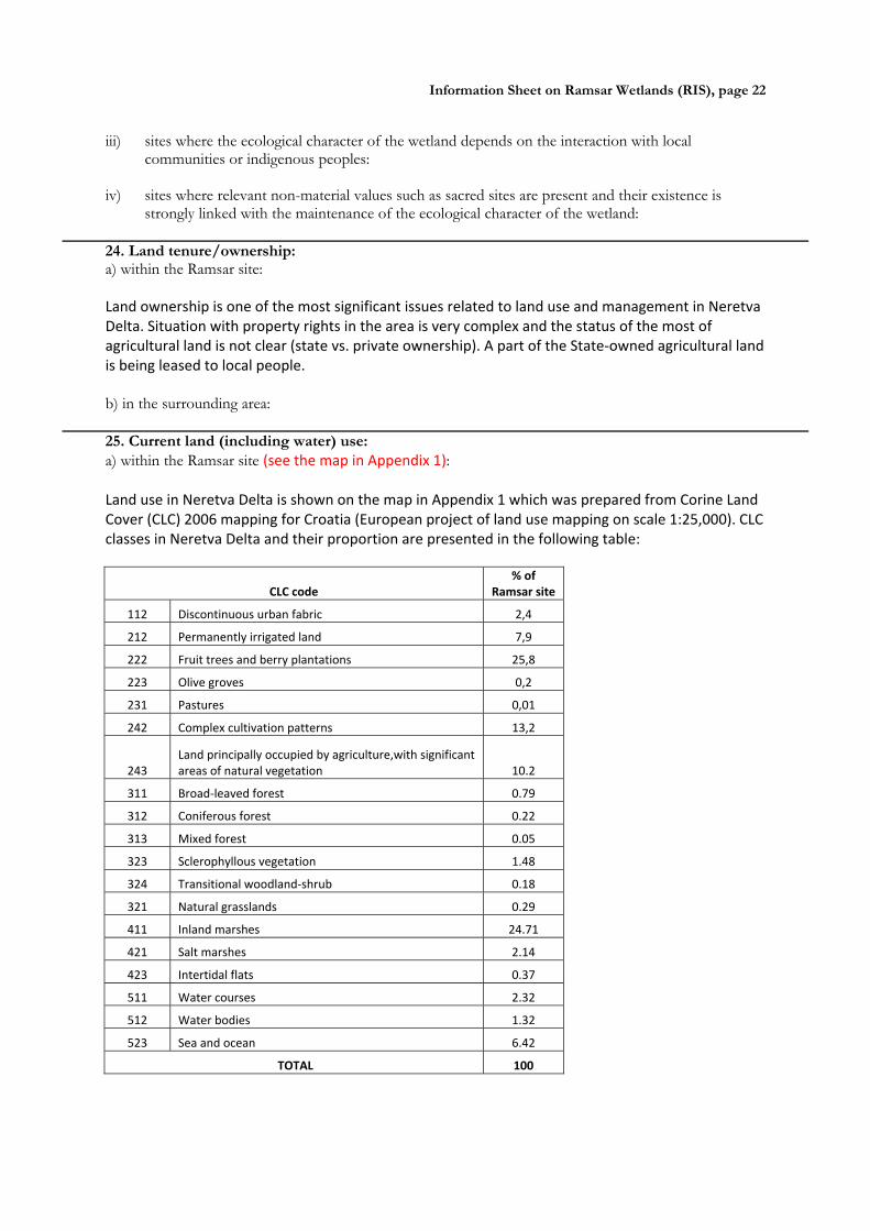
strongly linked with the maintenance of the ecological character of the wetland: 24. Land tenure/ownership: a) within the Ramsar site: Land ownership is one of the most significant issues related to land use and management in Neretva Delta. Situation with property rights in the area is very complex and the status of the most of agricultural land is not clear (state vs. private ownership). A part of the State‐owned agricultural land is being leased to local people. b) in the surrounding area: 25. Current land (including water) use: a) within the Ramsar site (see the map in Appendix 1): Land use in Neretva Delta is shown on the map in Appendix 1 which was prepared from Corine Land Cover (CLC) 2006 mapping for Croatia (European project of land use mapping on scale 1:25,000). CLC classes in Neretva Delta and their proportion are presented in the following table:
CLC code
% of Ramsar site
112 Discontinuous urban fabric 2,4
212 Permanently irrigated land 7,9
222 Fruit trees and berry plantations 25,8
223 Olive groves 0,2
231 Pastures 0,01
242 Complex cultivation patterns 13,2
243 Land principally occupied by agriculture,with significant areas of natural vegetation 10.2
311 Broad‐leaved forest 0.79
312 Coniferous forest 0.22
313 Mixed forest 0.05
323 Sclerophyllous vegetation 1.48
324 Transitional woodland‐shrub 0.18
321 Natural grasslands 0.29
411 Inland marshes 24.71
421 Salt marshes 2.14
423 Intertidal flats 0.37
511 Water courses 2.32
512 Water bodies 1.32
523 Sea and ocean 6.42
TOTAL 100

Information Sheet on Ramsar Wetlands (RIS), page 23
From this data it is obvious that prevailing land use in Ramsar site is agriculture. The largest area of agricultural land (25.8%) is covered with fruit trees plantations, mostly tangerines. They were developed in the large complex of meliorated land close to the river mouth. Smaller agricultural parcels are part of mapped CLC classes “complex cultivation patterns” (13.2%), “land principally occupied by agriculture, with significant areas of natural vegetation” (10.2%) and “permanently irrigated land” (7.9%). Recently, more and more greenhouses are being built for intensive vegetable growing. Traditional cultures like vineyards and olive groves have almost disappeared from Delta after large land reclamation works in 1960’s. Neretva Delta is the largest and the most significant agricultural area on Croatian coast. Large majority of local people make their living of agriculture.
The second largest group of CLC classes includes inland marshes (24.7%), watercourses (2.32%) and water bodies (1.32%). Marshes include several nature protection areas but some important parts are not legally protected yet. These areas are used for hunting and fishing and even for illegal creation of agricultural land or parcels for greenhouses. Small watercourses are also used for tourist boat tours (“photo safari”). The Neretva River watercourse is completely regulated in its last section through the Delta.
The third complex is made of shallow sea with lagoons, intertidal flats and salt marshes. Although the most of this area is protect, there are intensive activities ongoing there still threatening valuable habitats and their significance for bird and fish fauna. These activities are recreation on the sand beach, kite surfing, bait collecting, auto‐camp on the river mouth, illegal fishing and hunting. This is the most endangered part of the Ramsar site.
Additionally, there are also settlements in Neretva Delta. Large traffic infrastructure covers 2.4% of the site surface. b) in the surroundings/catchment:
Surroundings of Neretva Delta are made of karst hills that are mostly covered with grasslands and macchia. There are some small settlements scattered over karst hills. Significant part of wider area is covered with numerous roads. Important national and international traffic corridors cross the Ramsar site. On the SW border of the Ramsar site there is the port Ploče ‐ large international port for cargo ships. The port is expanding and developing its infrastructure, so wise management is needed in order not to influence negatively the Ramsar site. On SE, the Ramsar site borders with the marine reserve Malostonski zaljev, famous for shell aquaculture.
26. Factors (past, present or potential) adversely affecting the site’s ecological character, including changes in land (including water) use and development projects: a) within the Ramsar site:
The most prominent factors in the past that adversely affected ecological character of Neretva Delta were connected to water management, including land reclamation activities with the purpose of turning wetland into agricultural land. Today the largest threats are also connected to issues of water management and agriculture sectors. As the consequence of water regulation activities in surrounding area of Croatia in B&H, there is an obvious trend of decrease of water level and quantity in Neretva Delta that adversely affect not only wetland habitats and biological diversity of Delta but also agriculture. The less water in Neretva and its tributaries in Delta, the stronger influence of the sea and salinization of water and soil can be expected. There are different water management plans and projects currently going on in Neretva Delta. They deal with solving the problem of salinization; irrigation of agricultural land; flood control, treatment of sewage water of the town Metković and other activities. There are even plans for further meliorations of remained wetland areas. Other problems and threats to ecological character of the Ramsar site include: expansion and

Information Sheet on Ramsar Wetlands (RIS), page 24
intensification of agriculture; excessive use of pesticides and fertilizers; fragmentation of wetland habitats; spreading of urban zones on account of wetland; water pollution with non‐purified urban and industrial waters; unsolved land property rights; illegal taking of state owned agricultural land, including marshes; non‐regulated recreational and touristic activities, especially on the river mouth, illegal hunting and fishing; frequent fires in reedbeds. b) in the surrounding area: In the surrounding area especially problematic are issues related to transboundary water management and numerous water regulations in catchment area of the Neretva and neighboring Trebišnjica River in B&H. Watersheds of these two rivers are connected through karst underground. Re‐direction of waters from so called Upper horizons (“Gornji horizonti”) of Trebišnjica River into the area of Lower horizons (“Donji horizonti”) with three existing hydropower plants results in loss of water in lower Neretva area, lower summer water level, drying out of water springs and strengthening of influence of the sea. There are plans to even increase these activities and to take the most of available water for additional use of hydropower plants in eastern Herzegovina. Currently, environmental impact assessment is being prepared in co‐operation between two countries. Additionally, considerable water regime disturbance was caused by the construction of five upstream hydropower plants on Neretva River on the territory of B&H. Their dams keep water and sediments, thus causing frequent and rapid water level changes or water shortage, especially during summer. Effective management 27. Conservation measures taken: a) List national and/or international category and legal status of protected areas, including boundary relationships with the Ramsar site: In particular, if the site is partly or wholly a World Heritage Site and/or a UNESCO Biosphere Reserve, please give the names of the site under these designations.
National legal status: Five wetland sites with total area of 1,724 ha have been protected in period 1965 – 1974. Three of them (Prud, Pod gredom and Orepak) make ecologically unique area of large reedbeds and are protected as ornithological reserves. South‐eastern part of the river mouth with a complex of threatened habitat types (sandbanks, tidal flats, salt marshes) is protected as ichthyo‐ornithological reserve Jugoistočni dio delte Neretve. Modro oko and Jezero Desne lakes are designated as protected landscape. Wider area of Neretva delta (24,845 ha), including also surrounding karst hills that represent the buffer zone and contain valuable underground watercourses and springs as well as a number of caves rich with rare and endemic underground fauna, has been proposed as nature park in 2007 but the process of proclamation was stopped because of non‐approval of some local communities. Nature Park is to be proclaimed by Croatian Parliament by the Law on proclamation of nature park and Government is obliged to establish the park management authority. This nature park has been planned through National Physical Planning Strategy and National Biodiversity and Landscape Strategy as well. Neretva Delta in boundaries of proposed nature park was proclaimed a site of National ecological network in 2007 by the Government of Croatia (“Official Gazette” No 109/07). According to the Regulation on special habitats of fish and other marine organisms that is based in Marine Fishery Law, Neretva estuary and adjacent marine area of Neretvanski Kanal is proclaimed a special fish habitat where fishery is strictly regulated and bottom trawls are forbidden.
International legal status: Neretva Delta has been enlisted in the Ramsar list in 1993 with the area of 11,500 ha (updated GIS based area is 12,742 ha). It is also designated as the Important Bird Area (IBA) of Europe according to the BirdLife International criteria (www.birdlife.org ). Wider area, following the boundary of proposed Nature Park Neretva Delta, has been proposed as the site of EU ecological network NATURA 2000 (SPA – Special Protection Area for birds of BD Annex I and pSCI –
Information Sheet on Ramsar Wetlands (RIS), page 25
proposed Site of Community Interest for species and habitat types of the Habitats Directive) in the current proposal of NATURA 2000 for Croatia. b) If appropriate, list the IUCN (1994) protected areas category/ies which apply to the site (tick the box or boxes as appropriate):
Ia ; Ib ; II ; III ; IV ; V ; VI c) Does an officially approved management plan exist; and is it being implemented?: Management plan for Neretva Delta has not been developed yet. Land use is regulated by the Physical Plan of Dubrovnik‐Neretva County and by physical plans of local towns and municipalities. d) Describe any other current management practices:
In ornithological reserves hunting is forbidden while in ichthyological‐ornithological reserve of Jugoistočni dio delte Neretve fishery is also forbidden. Fishery is strictly regulated in the whole marine area of Neretvanski Kanal which is proclaimed a special habitat for fish and other marine organisms according to the Marine Fishery Law.
Fishery, forestry and hunting are being implemented through sectoral management plans that are obliged to contain nature conservation measures issued by the ministry responsible for nature protection matters. The same is with water management annual programs of works and regular maintenance of waters. As Neretva Delta is the National ecological network site, all projects that could significantly influence its target features are subject to the procedure of nature impact assessment. General restrictions and procedures for issuing permits for planned projects and activities, including impact assessment, are determined by the Nature Protection Law and the Law on Environmental Protection. 28. Conservation measures proposed but not yet implemented: e.g. management plan in preparation; official proposal as a legally protected area, etc. In order to achieve effective conservation of Ramsar site’s values in future, it would be important to:
Proclaim Neretva Delta Nature Park
Establish systematic co‐operation between Croatia and B&H for transboundary management of two Ramsar sites in Lower Neretva Valley (Neretva Delta and Hutovo Blato), including development of transboundary management plan
Prepare transboundary environmental impact assessment for water management projects that influence both countries
Develop management plans for protected areas in Neretva Delta and incorporate them in Neretva Delta Nature Park management plan, upon its designation.
Prevent further degradation of wetland habitats in Neretva Delta and restore degraded parts, where appropriate and possible
Support development of ecological agriculture and ensure the system of incentive measures (agri‐environment measures) for nature‐friendly agriculture
Develop sustainable tourism and recreation programs and activities, based on biological diversity, landscape, cultural and traditional values
Ensure systematic monitoring of birds and other target features of ecological network site
Strengthen promotion of Ramsar site as well as educational and public awareness activities
Build bird watching hides and towers; ensure educational trails and other facilities for visitors and researchers
Information Sheet on Ramsar Wetlands (RIS), page 26
29. Current scientific research and facilities: e.g., details of current research projects, including biodiversity monitoring; existence of a field research station, etc.
Many national and international projects have been implemented in Neretva Delta but they were mostly concentrated on CEPA activities while research work was done only sporadically. During the last decade research of certain NATURA 2000 species was done as the part of activities on preparation of Croatian proposal of EU ecological network NATURA 2000 organized by the Croatian State Institute for Nature Protection (SINP). EURONATUR collected data on winter bird counting for the whole transboundary area of Lower Neretva valley (Stumberger and Schneider‐Jacoby, 2010). There are still no systematic lists of flora and fauna of the area or species distribution maps and habitat maps detailed enough for effective management.
Bird monitoring activities started recently by the Croatian Ornithological Society (COS) which established Ornithological station Metković lead by the local ornithologist from Metković. The station does not have built object or any other facilities for research purposes. There is also no bird watching hides or towers in the area. COS is implementing several bird monitoring programs co‐financed by the SINP and partly by the Port of Ploče :
Monitoring of breeding population of the Stilt (Himantopus himantopus) in Neretva Delta and Ploče Port from 2007 – 2011
Monitoring of breeding population of the Kentish Plover (Charadrius alexandrinus) in Neretva Delta and Ploče Port from 2007 – 2011
Monitoring of breeding population of the Great Bittern (Botaurus stellaris) in Neretva Delta from 2010 – 2011
Monitoring of breeding population of the Eagle Owl (Bubo bubo) in Neretva Delta from 2010 ‐ 2011
Monitoring of breeding birds of wetland habitats along the Lisna River and Parila Lake from 2007 – 2011
Monitoring of bird community in the reedbeds along the Norin River from 2010 ‐ 2011
Monitoring of wintering populations of the reedbeds along the Norin River in winters 2009/10 and 2010/11
Monitoring of wintering populations of the reedbeds along the Lisna River and Parila Lake in winters 2009/10 and 2010/11
30. Current communications, education and public awareness (CEPA) activities related to or benefiting the site: e.g. visitors’ centre, observation hides and nature trails, information booklets, facilities for school visits, etc.
Ministry responsible for nature protection and the Croatian State Institute for Nature Protection had significant CEPA activities related to designation of Neretva Delta Nature Park. Unfortunately, when the official procedure for proclamation of Nature park started in 2007, the proposal was not accepted by a part of local communities. Local NGO’s have been intensively involved in CEPA activities through several nature protection projects implemented in the area. Currently, CEPA activities in Neretva Delta are not intensive. The only large project being implemented (period 2008‐
2013) is the GEF/World Bank transboundary project “Neretva and Trebišnjica River Management Project” that also includes many CEPA activities. The project objective is to provide mechanisms for the efficient and equitable water allocation amongst the users of the Neretva and Trebišnjica river basin on transboundary level, and for enhancing the basin ecosystems and biodiversity through improved water resources management.

Information Sheet on Ramsar Wetlands (RIS), page 27
31. Current recreation and tourism: State if the wetland is used for recreation/tourism; indicate type(s) and their frequency/intensity.
The importance of recreation and tourism in Neretva Delta has been evaluated only recently. During the last decade tourism‐related activities were developing intensively but not in a systematic and planned way. They still depend mostly on initiatives of local people and are not organized to assess its influence on natural values and adapt it accordingly. Private initiatives include organizing of boat tours through the wetland (“photo safari”) on traditional boats (“lađa”) and offering traditional meals in restaurants. There are several hotels in the area, most of them in Metković.
There are several attractions in the area that are important part of touristic offer. The most important is related to the rich historical heritage of Neretva Delta is Museum Narona in Vid that was opened in 2007 as the only in situ museum in Croatia. It is located on the site with remains of the main square (Roman forum) that contained the temple devoted to Augustus (Augusteum). Its exibits include 12 marble sculptures of Roman imperial dynasties among which is dominant the impressive 3 m high statue of the emperor Augustus. Ornithological collection in Metković was opened for public since 1952 owing to ornithologist Dragutin Rucner who was its author. The collection of stuffed birds shows more than 340 exhibits of 218 bird species of the area. Very popular tourist attraction in Neretva Delta is the race of traditional wooden boats “maraton lađa” held each year in August, when about 30 traditional boats with rower teams from local settlements race for 22,5 km along the Neretva river from Metković to Ploče.
32. Jurisdiction: Include territorial, e.g. state/region, and functional/sectoral, e.g. Dept of Agriculture/Dept. of Environment, etc.
Territorial jurisdiction:
Dubrovnik – Neretva County Gundulićeva poljana 1 HR‐20 000 Dubrovnik tel: +385 20 351 402 fax: +385 20 321 059 e‐mail: zupan@dubrovnik‐neretva.hr web: http://www.edubrovnik.org/ Sectoral jurisdiction:
Ministry of Environmental and Nature Protection Ulica Republike Austrije 14 HR‐ 10 000 Zagreb tel: +385 1 3782 111 fax: +385 1 3717 149 e‐mail: [email protected] web: http://www.mzoip.hr/ Ministry of Agriculture (responsible also for forestry, hunting, fishery and water management) Ulica grada Vukovara 78 HR‐10000 Zagreb tel: +385 6106 111
Information Sheet on Ramsar Wetlands (RIS), page 28
fax: +385 6109 201 e‐mail: [email protected] web: http://www.mps.hr 33. Management authority: Provide the name and address of the local office(s) of the agency(ies) or organisation(s) directly responsible for managing the wetland. Wherever possible provide also the title and/or name of the person or persons in this office with responsibility for the wetland.
Public Institution for management of protected natural values in Dubrovnik ‐ Neretva County Branitelja Dubrovnika 41 HR‐20 000 Dubrovnik tel/fax: +385 20 411 533 e‐mail: [email protected] web: www.zastita‐prirode‐dnz.hr 34. Bibliographical references: Scientific/technical references only. If biogeographic regionalisation scheme applied (see 15 above), list full reference citation for the scheme.
Alegro, A. et al. (2010): Botanički važna područja Hrvatske/ Important Plant Areas in Croatia. Školska knjiga, Zagreb
Barišić, I., Croatian Ornithological Society (pers. comm.): Data on birds of Neretva Delta.
Belančić et al. (2008): Red data book of dragonflies of Croatia. Ministry of Culture, State Institute for Nature Protection
Bogdanović , T. et al. (2008): Podatci o fauni vretenaca donjega toka rijeke Neretve. ‐ Entomol. Croat. 2008, Vol. 12. Num. 2
Burfield, I. and van Bommel, F. (2004): Birds in Europe. Population estimates, trends and conservation status. BirdLife International.
Croatian Bureau of Statistics (2011): Census of Population, Households and Dwellings, 2011 http://www.dzs.hr/Hrv/censuses/census2011/censusfirstres.htm
Croatian Ornithological Society (2011a): Monitoring of breeding population of the Eagle Owl (Bubo bubo) in Neretva Delta from 2010 ‐ 2011. Report for the State Institute for Nature Protection. Zagreb
Croatian Ornithological Society (2011b): Monitoring of breeding population of the Stilt (Himantopus himantopus) in Neretva Delta and Ploče Port from 2007 ‐ 2011. Report for the State Institute for Nature Protection. Zagreb
Croatian Ornithological Society (2011c): Monitoring of breeding population of the Kentish Plover (Charadrius alexandrinus) in Neretva Delta and Ploče Port from 2007 ‐ 2011. Report for the State Institute for Nature Protection. Zagreb
Croatian Ornithological Society (2011d): Monitoring of breeding population of the Great Bittern (Botaurus stellaris) in Neretva Delta from 2010 ‐ 2011. Report for the State Institute for Nature Protection. Zagreb
Croatian Ornithological Society (2011e): Monitoring of breeding birds of wetland habitats along the Lisna River and Parila Lake from 2007 ‐ 2011. Report for the State Institute for Nature Protection. Zagreb
Croatian Ornithological Society (2011f): Monitoring of bird community in the reedbed along the Norin River from 2010 ‐ 2011. Report for the State Institute for Nature Protection. Zagreb

Information Sheet on Ramsar Wetlands (RIS), page 29
Croatian Ornithological Society (2011g): Monitoring of wintering populations of the reedbed along the Norin River in winters 2009/10 and 2010/11. Report for the State Institute for Nature Protection. Zagreb
Croatian Ornithological Society (2011h): Monitoring of wintering populations of the reedbed along the Lisna River and Parila Lake in winters 2009/10 and 2010/11. Report for the State Institute for Nature Protection. Zagreb
European Commission (2012): European Red List.
http://ec.europa.eu/environment/nature/conservation/species/redlist/ European Comission (2011): Map of EU biogeographic regions EU 27+1, Doc.Hab. 11‐05/04
Flora Croatica Database: http://hirc.botanic.hr/fcd
Freyhof, J. and Brooks, E. (2011): European Red List of Freshwater Fishes. Luxembourg: Publications Office of the European Union.
Government of Croatia (2007): Regulation on proclamation of ecological network. Official Gazette No 109/07. http://narodne‐novine.nn.hr/clanci/sluzbeni/2007_10_109_3182.html
Institute for Ornithology (Sanja Barišić, Davor Ćiković, Jelena Kralj, Goran Sušić,Vesna Tutiš), Dragan Radović, Ivan Budinski, Robert Crnković, Antun Delić, Dubravko Dender, Vlatka Dumbović, Ivan Darko Grlica, Luka Jurinović, Davor Krnjeta, Krešimir Leskovar, Duje Lisičić, Ivica Lolić, Gordan Lukač. Kristijan Mandić, Krešimir Mikulić, Tibor Mikuska, Gvido Piasevoli, Andrej Radalj, Zlatko Ružanović, Vlatka Šćetarić, Mirko Šetina, Adrian Tomik) (2010): Estimations of bird populations for proposed SPA's in Croatia. Report for the State Institute for Nature Protection. Zagreb
IUCN (2012): IUCN Red List of Threatened Species. Version 2012.1. www.iucnredlist.org
Jasprica, N., Kovačić, S., 2005. Water and marshland vegetation in the Neretva River delta, Croatia. Book of Abstract of the 30th Symposium of the East Alpine‐Dinaric Society for Plant Ecology. Zagreb, Croatia, July 4‐6, 2005.
Juračić, M. (1998): O nastanku i promjenama delte rijeke Neretve. Dubrovnik (Matica hrvatska) 4, 228‐232
Mrakovčić et al. (2006): Red book of freshwater fish of Croatia. Ministry of Culture, State Institute for Nature Protection
Radović, D. et al. (2005): National Ecological Network – areas important for birds in Croatia. State Institute for Nature Protection, Zagreb
Rucner, D. (1993): O životu ptica u dolini Neretve. Galerija Stećak, Klek and Matica Hrvatska Metković. Metković‐Klek, 1993.
State Institute for Nature Protection (SINP) (2007): Nature Park Neretva Delta ‐ Background study for protection. Zagreb
State Institute for Nature Protection: NATURA 2000 GIS database
State Institute for Nature Protection: Red lists of plants and animals of Croatia http://www.dzzp.hr/vrste/crveni‐popis‐biljaka‐i‐zivotinja‐rh/crveni‐popis‐biljaka‐i‐zivotinja‐republike‐hrvatske‐146.html
Udruga Sunce (2009): Scientific analysis of the Otter ( Lutra lutra L.) in Mediterranean and Alpine biogeographical region in Croatia
Wetlands International (2006): Waterbird Population Estimates – 4th Edition. Wetlands International, Wageningen, the Netherlands. http://www.wetlands.org

Information Sheet on Ramsar Wetlands (RIS), page 30
Tutiš, V. et al. (2010): Red book of birds of Croatia. Institute of Ornithology, Zagreb. In prep.
Stumberger, B. & Schneier‐Jacoby, M. (2010): International importance of three Adriatic Flyway priority sites: Livanjsko polje, the Neretva Delta and Lake Skadar‐Shkoder with the Bojana‐Buna Delta. In: Denac,D., Schneider‐Jacoby, M. & Stumberger, B. (eds.). Adriatic Flyway – closing the gap in bird conservation. Euronatur. Radolfzell.
http://www.birdlife.org/datazone/sitefactsheet.php?id=3609
http://www.eea.europa.eu/data‐and‐maps/data/nationally‐designated‐areas‐national‐cdda‐3/eunis‐habitat‐classification
http://www.dzzp.hr
Please return to: Ramsar Convention Secretariat, Rue Mauverney 28, CH-1196 Gland, Switzerland Telephone: +41 22 999 0170 • Fax: +41 22 999 0169 • e-mail: [email protected]

Information Sheet on Ramsar Wetlands (RIS), page 31
APPENDIX 1 – Maps
1. Boundaries of Neretva River Delta Ramsar site on topographic map 1: 100,000 2. Territorial units (towns and municipalities) in Neretva River Delta Ramsar site on topographic
map 1: 100,000 3. Protected areas in Neretva River Delta Ramsar site on topographic map 1: 100,000 4. Land use map of Neretva River Delta Ramsar site (Corine Land Cover)