improvement planning work final year new project work
TRANSCRIPT
1.0 INTRODUCTION
The world is becoming increasingly urbanized, the projected
number of people living in cities is expected to be more than
double between 2010 and 2025, growing from 4.4 billion to 8.5
billion. This trend is accelerating in developing countries.
Their share of the total urban population will rise from 63% in
2005 to 80% in 2025(UNCHS). The huge increase in urban population
is linked to the economic development of cities and towns and
this has given rise to the concern about the sustainability of
these trends.
The Nigerian urban area is characterized by deteriorating
environmental conditions due to rapid growth and polarization of
activities which exceed the provision and development of physical
structures and urban infrastructural facilities to the required
standard. These further causes haphazard growth of all sorts of
mixed land uses. Bad drainage system or no drainage at all,
dilapidated buildings, unsightly street furniture, over
crowdiness, dirty and polluted environment e.t.c.
The methods adopted for solving these problems involves
strategies such as comprehensive redevelopment, rehabilitation,
preservation/conservation and upgrading the site and services,
all these are known as “an improvement scheme”. However the
solutions to the blighted residential area must start with
planning, which involves corrective measures, design execution,
management and provision of additional amenities where necessary.
Ungwan Yusi exhibits characteristics of urban decay as a result
of rapid population growth as well as the organic spatial nature
of the town. The rapid growth of urban population has serious
impact on the availability of urban land for the provision of
housing infrastructure and services. According to Akuruju (2004),
he reported that in Rivers state between 40%-50% of the
population live in slums and unplanned settlements like okirika,
marine base water front e.t.c. where access roads, drainages,
sanitation and social services are virtually poor or absent.
Therefore the improvement plan is aimed at resolving
aforementioned and other associated spatial problems.
1.2 STATEMENT OF RESEARCH PROBLEM
Unplanned settlements always lead to haphazard development
and this is a general problem of most Nigerian towns.Un-
organized structures,poor circulation,poor drainage
system,bad sanitary conditions and bad network system are
generally associated with unplanned settlement.The need for
planning intervention by improvement of unplanned and
degenerated housing area has been justified for
health,economic,social and aesthetic reasons,but many of the
plans for improvement merely emphasis physical upgrading.This
project is an attempt to incorporate both social and economic
considerations in the improvement of Unguwan
yusi,zaria.Unguwan yusi was formerly an Agricultural area as
provided for in Zaria master plan of 1975. It is an area
allocated for intensive agricultural activities due to its
rich water logged soil which can support the growth of crops
like maize,millet and sorghum.However the master plan also
considers that the area in the long run could be used for
future urban expansion.Today,Ungwan Yusi has developed into
large residential area that is experiencing,further rapid
development through residential, commercial, public and
recreational use. Resultingfrom this,the area is presently
faces problems of haphazard and un-organised physical
development,poor environmental condition,and absence of
recreation and circulation,facilities and infrastructure.
Poor road networks and absence of drainage,poor sanitary
conditions, dilapidated structures,poor disposal of wastes,
insufficient utilities and services(such as
electricity,water,health,etc.),are the majorproblems of the
area.Therefore,this research project is an attempt to correct
these shortcomings through preparation of an improvement
plan.The plan has scope in the identification of physical
planning problems, theircharacteristicsand in addition to
making proposals for remedies. The output of the study is
expected to provide insights into how similar problems could
be handled in other communities.
1.4:AIM
The aim of this research is to examine the socio-spatial
characteristics and problem of Ungwan Yusi with a view to
preparing an improvement plan for the area.
1.5: OBJECTIVES
1.To review the concepts, strategies and principles used in
improving urban areas.
2. To examine the physical and socio-economic characteristics of
Ungwan Yusi.
3.To identify the socio-spatial problems of Ungwan Yusi.
4.To prepare an improvement plan for Ungwan Yusi based on the
socio-economic,spatial and environmental goals.
1.6: SCOPE AND LIMITATION
A broader aspect of the study will be confined to the
investigation of physical planning problems within the study area
and a design proposal for the area (Ungwan Yusi).
1.7: RESEARCH METHODOLOGY
1.7.1 :DATA REQUIRED;
The data required for this research work are enumrated below:
i. Satellite imagery of Unguwan Yusi was gotten from the
Google earth software by connecting to the internet,Unguwan
Yusi was searched for in the location panel,it navigated to
the site,it begins to stream lined to the point where each
landuse could be seen at 100 percent,the site boundary is
then demarcated and saved to the highest resolution at a
diameter of 30 metres.
ii. Base map of the site is gotten by importting the saved
satellite imary of the site gotten through the Google earth
software,to Geographic Information System software,to
digitize each building,roads,the boundary,natural attributes
and other essential features of the area,by creating a
shapefile for each attributes and saved to either Jpeg or Pdf
format.
iii. Land use map of the site is also gotten from GIS
softwares through the digitized basemap,each landuse is
represented by using the satellite image to updated and know
the various landuses,the mixed landuses,through visiting the
site.
iv. Reconnissance survey which involves visual survey of the
study area to observe the nature, location and extent of
degeneration. Based on the observation, photographs of some
areas will be taken
v. The socio-economic characteristics such as level of
income, type of occupation, level of education, age/sex
structure,population of the area etc.
vi. Data on physical planning problems in order to determine
the nature, extent and location of degeneration. Data on
circulation, drainage condition, solid waste management,
facilities, utilities and services are to be obtained through
questionaires.
1.7.2: METHODS OF DATA COLLECTION AND SOURCES.
Pimary source
Information collected through these sources was obtained
through visit to the site to have a general understanding of
the existing infrastructure and environmental situation in
relation to existing physical and socio economic
characteristics,population characteristics which is gotten
from the admnistered questionaires.
Secondary sources
Relevant literature and research work will be reviewed with a
view to obtain the theoritical framework and also other
means such as textbooks,journals,seminars etc
Data analysis/presentation
These mass of data collected from the primary and secondary
sources will be thoroughly analysed and descriptive
statistics will be used for data analysis.The data will be
presented in forms of words documents,maps,tables,bar
charts,pie charts,pictures in order to give more explanations
and conclusion.
CHAPTER TWO
LITERATURE REVIEW
2.0 DEFINATION OF TERMS
Urban area:According to United Nations defination;An urban
area can be defined as a geographical area that has a
population of 20,000 individuals who resides there.An urban
area is characterized by higher population density and vast
human features in comparison to areas surrounding it.Urban
area may be cities,towns or conurbation but the term is not
commonly extended to rural settlements such as villages and
hamlets.
Need for an urban area: The need is the necessity or the
advantages that an urban area gives its settlers and the
value the settlers brings to it(economic,environmental and
social values).
Challenges of an urban area:These are the problems,set-backs or
difficulty that is usually encountered or faced in any
urban settings.
Prospects of an urban area:These are the benefits,advantages or
importances that an urban area or a place can bring or
produce.
Improvement :Improvement is bettering or working on urban
areas to become better than the way it used to be before.
An improved area is a place that is well managed,controlled
and monitored for better performance and efficiency that
benefit its citizen.
An Improvement Plan: An improvement plan addresses the
physical planning problems,their nature,causes and remedies
for present problem and how to prevent future occurence.
1.0 CONCEPT OF AN IMPROVEMENT PLAN.
An improvement plan is one which promotes the vision of a
vital urban area with a mix of residential area,industrial
area,community-oriented commercial corridor and local
parks.Improvement plan aim at creating a vibrant district in
which residents takes full advantage of the proximity to
transit,open spaces,facilities and amenities.
An improvement plan can be defined as an action plan or a
short term plan,is usually last from four to ten years and
is capital intensive,done by either a state Government or
Federal government agencies. An improvement plan is a living
document that reflects the beginning of an ongoing process
which integrate into the city’s general plan and service as
a starting point for future strategies,development and
change. The methods adopted for solving these problems
involves strategies such as comprehensive redevelopment,
rehabilitation, preservation/conservation and upgrading the
site and services is what is known as an improvement scheme.
However the solutions to blighted residential area must
start with planning, which involves corrective measures,
design execution, management and provision of additional
amenities where necessary.
Improvement planning is the process of implementing an
already prepared Improvement plan in accordance to the
master plan.
Improvement planning is under Part V of the Nigerian Urban
and Regional Planning Act of 1992,from section 79 to 85 of
the act,which states that improvement planning contains
Improvement areas in terms of rehabilitation, renewal and upgrading with the
following responsibilities of Improvement areas,Consultation and
co-operation in improvement areas,Powers of the authority in
an improvement area,Restriction on power to
demolish,Exercise of power of repair, demolition and
renovation andProvision of alternative accommodation, etc.
1.1PROBLEMS OF URBAN AREAS AND NEED FOR
IMPROVEMENT.
Planning is a strategic process that is intended to
complement the comprehensive plan (development
plan),planning helps to address the problems in the
urban areas such as; Housing, is the most important
problem in all cities and this is due to sudden
andlarge scale influx of migrants from rural areas to
urban areas especially the metropolises and state
capitals. Due to lack of housing, in every city almost
fifty percent of its population live in slums as in the
case of india. Slums are actually illegally created
colonies of housing on open spaces in the cities. The
structures are temporary,they are very crowded and rows
of such houses are separated by very narrow lanes
through which household drainage is allowed to flow.They
do not have any civic amenities like drinking water,
sewage, electricity etc. Waste Disposal is another big
problem that has risen due to the large increase in
population,has been the enormous amount of solid waste
generated. In a city like Bengaluru the solid waste
generated daily is estimated to be around 5000 tons. The
collection, transportation and disposal of this huge
quantity of solid waste is posing serious problems to
the municipality. Finding dumping grounds for this waste
has become difficult. Dumping this sort of waste has
created serious problems of pollution, ill-health and
stink to inhabitants even a kilometer away. Recycling
the solid waste material and converting much of it into
usable products seems to be the only solution.It would
greatly revolutionize the civic amenities provision if a
method can be invented to dispose of this waste at the
site where it is generated.Public Transport is next
after housing and waste disposal,urban areas lacks
adequate public transport. As the cities are growing,
distances to be travelled for work and other reasons are
increasing. With more than half the population being
poor or belonging to low income groups, public transport
is a very important facility to be provided in urban
areas. Unfortunately while the richer classes are buying
more and more two wheeler and four wheeler automobiles,
the average and below average citizen does not have
access to adequate and affordable transport facility. As
the number of motor vehicles increases, roads get
cluttered, pollution increases and it takes longer to
reach one’s destination.Cities like Bengaluru and
Hyderabad have just initiated action to provide elevated
metro rail on a limited scale. Presently people rely
mostly on bus transport but their number is not enough
nor the roads able to accommodate all the vehicles now
in use. There are frequent traffic jams further delaying
people from reaching their destinations. The way forward
is to restrict severely individual transport and
increase manifold public transport both by road and
rail. Public transport must be made much more efficient,
regular, punctual, attractive and adequate. Then the
need for individual transports will go down and the
state would be able to put severe restrictions on use of
individual transport as is being done in Singapore.
Shortage of Electric Power is also a very serious
problem facing the entire country is the acute shortage
of electric power both in urban and rural areas. This
can be solved only by generating much more electricity
than at present. However, this solution has met with
almost a wall-like obstruction. Conventional methods of
generation like coal based thermal power, nuclear power
and hydro electric power are being opposed by people for
reasons of environmental pollution, displacement of
people submergence of land and forests etc. There are
some gas based power stations which are less polluting
but due to lack of sufficient quantity of natural gas
they are working at less than half their load capacity.
Non-conventional sources of power like solar power and
wind power are not that economically viable or
affordable by the consumers. The power generation is
also intermittent requiring large storage capacity for
energy. One does not know what new problems will arise
in storing energy on such large scale.
Securityissue finally among many other problems,is
presently a problem on a high scale in large cities where
all sorts of people have settled down has been the security
situation. Well to do citizens are being forced to organize
their own security. This is the reason for the coming up of
gated communities with private security arrangements. Entry
to these communities is strictly controlled and monitored by
the security staff. This is a sad reflection on the capacity
of the authorities to provide security to their
citizens.Thus almost all major cities in India and Nigeria
are facing serious problems of slum clearance, housing,
inadequate civic amenities for a fast growing population,
absence of efficient public transport system, the growing
insecurity in the cities and so on. Problems will become
more acute and may go beyond repair if immediate steps are
not taken to solve at least some of these problems.
Meanwhile the forecast is that half the country’s population
will be living in urban areas in another two to three
decades. This trend needs to be reversed urgently by
providing urban facilities in rural areas and locating
several industries and providing employment opportunities in
rural areas.Urban areas face daunting economic challenges
that have increased in scope in recent years. At the same
time, cities provide exciting opportunities for growth and
revitalization. The interplay of these challenges and
opportunities create important tasks for policymakers and
researchers that brought the need for a detailed lay - out
plan preparation.
1.2 PROBLEMS OF IMPROVEMENT PLANNING IN NIGERIA
It is assumed that some kind of form of renewal is both
necessary and desirable in most Nigerian cities. Obstacles
to effect actions were of many different kinds and were
encountered in different forms. The problems are as follows;
1. Inadequate public participation:Inadequate public
participation is usually unavoidable when government is
solely handling the improvement project with the
professional given the sole right to take all decision
without necessary consulting the community. Some
believe that it is quicker and less troublesome if the
project is just contracted between professionals alone.
It may be quicker but experience from projects all over
the world points to the fact that community
participation is vital for success. The reason is clear
that the community knows the area and problems better
than outsider. The result of this is usually the
preparation of improvement plan which does not reflect
needs, priorities and aspiration of the beneficiaries.
2. Poor funding: Shortage in the adequate financial
resources needed for the preparation of improvement
plan and its subsequent implementation has usually be
one of the major problem encountered improvement
project in Nigeria. This is mostly as a result of the
fact that all the financial burden is put on the
government who usually claims to have limited financial
resources to adequately support the preparation and
implementation of improvement plan.
3. People perception to Renewal Methodology :This has to
do with people view of what they see planning and the
activities of planner. Planners are seen to be
destroyers than menders. Mostly, to many people, urban
renewal a comprehensive campaign or programme to attack
the problem of blight in a locality through clearance
of the whole area of redevelopment. The public has now
developed a negative idea that renewal will only worsen
their problem rather than solving it.
4. Shortage of technical expertise :Experienced man power
is needed to implement and to negotiate with owners of
properties, land lords and tenants in order to achieve
the most satisfactory method to individual compound and
environmental improvement. Such experienced
professionals are short in supply, hence emergence of
varied complains.
5. Problem of choosing appropriate Strategy: There is
usually a problem of choosing an appropriate Improvement
strategy as means of eliminating a particular urban blight.
This concern with development possibilities and
potentialities of the renewal area to sustain the selected
strategy. And criteria based on existing condition like
population since problem of relocation (if necessary) most
be solved before redevelopment can begin. This lack
feasibility study of renewal project caused shifting of
slum from one locality to another. This resulted in
idealization of squatter settlement in the name of urban
renewal.
6. Delay in execution of Improvement project :Most of the
Improvement planning programme would have been successful
if done earlier without considering the cost. It is believe
that the longer it was postponed the more serious it would
be. Improvement planning, therefore must not be held back
by these prospects in cost consideration.
The need for an improvement plan is growing daily because
urban areas are becoming larger and larger as a result of
rural- urban migration.As such,these is mounting pressure
on the infrastructures,utilities and services which
facilitates the process of urban degeneration.Structures
that are haphazardly developed as a result of increase in
population may make the environment chaotic and
aesthetically unpleasing,therby causing many physical
planning problems like overcrowding,poor sanitary
condition and poor circulation pattern.Improvement
planning therefore could be said to be critical to the
success of local communities and the long- term
prosperity of citizes living in an urban area.
Different human societies have carried out exercise that is
aimed at renewing their environment with a view of
improving the quality of their environment, its
productivity and liveability. Urban renewal therefore is
not a new phenomenon. This assertion can best be put in
Abrams (1967) words “kings and parliaments over the
centuries have widened streets, built parks, create new
districts and made room for new rows of houses”. The need
to renew an environment is brought about by a combination
of numerous factors for the purpose of renewing the
structures, changes in economic aspiration of the people
and the necessary changes in the residential, commercial,
industrial, recreational and transportation needs of the
society.
The residential area urban renewal is more practiced because
it is the zone or area that forms the center of all human
activities. People spend more of their private times in
residential area, children spend a lot of times playing with
friends and hence develop the desirable early spirit of
friendship and cooperation while domestic activities that
generate lots of solid and liquid wastes constantly take
place.As time goes on, conditions begin to change either as
a result of influence in modern technologies make the
existing houses and other community facilities to start
looking degenerated.
Inuwa (1984), summarized the need for improvement planning
in a degenerated environments as follows;
a. To ensure that towns grows sufficiently to accommodate
the growth in its population.
b. To ensure that schemes are carried out at minimum cost
and therefore affordable by low income groups.
c. To ensure that the housing conditions within the scheme
are at least as good as the average of the town as a whole.
d. To ensure an aesthetically pleasing physical environment.
e. To ensure an improvement in the overall quality of the
environment for productivity and liveability.
2.2.1. ADVANTAGES OF IMPROVEMENT PLANNING.
The advantages of improvement planning are many it ensure
good planning scheme is obtained,it also serves as a guide
to know how to properly organized urban areas in a manner
that its beauty will be appreciated and gives no room for
manoevering that could lead to squatter settlements and
other benefits like:
i. It does not involve total demolition of structures
rather minimum demolition.
ii. It does not involve displacement of people in a
particular neighborhood in which the scheme is carried
out.
iii. It has no financial difficulties unlike in the
redevelopment approach.
iv. There is no psychological and social difficulty that is
attributed to the issue of improvement programme.
2.3. HISTORY OF IMPROVEMENT PLANNING.
The improvement scheme can be set firmly in the forefront of
the long process by which urban planning become a legal
institutions, since it establishs the basic principles that
collective will is supperior to individual rights in the
community.The second characteristic concerns the improvement
scheme as a physical planning concept. Its central powers
were the clearance powers. The right of property acquisition
was also the right of demolition and redevelopment. The
objectives of the redevelopment exercise was to introduce
new buildings, new streets and new open spaces into an urban
fabric which was judge to be worn out. The early improvement
scheme were concentrated in the central districts of the
rapidly growing cities where the process of environmental
degeneration were at their peak. Similarly, one of
Flaussman’s (1850), four planning goals in the
reconstruction of central Paris was the amelioration of the
state of health of the town through the systematic
destruction of infected alleyways and centres of epidemics.
Patrick Geddes (1915), condemned physical clearance as
“one of the disasterous and harmful blunders in the
history of sanitation”. He condenmed the street
improvement appraoch because of its totally destructive
impact on the community. His crisitism was based on thirty
years of close observation of the urban renewal
(improvement) process in Edinburg backed by an enviable
record of personal involvement in a variety of
redevelopment and rehabilitation projects. St. Cuthberts
board of parochial, seized on the fact that the 1867
redevelopment scheme would destroy much of the city’s
cheapest housing, and so would worsen rather than improve
the lot of the poor. It proposed an improvement scheme
which was accepted as a public health intervention
measured by improving the houses and the environment.
In accordance with the broadly based concept of improvement,
the general legislation accepted this principle and the 1975
act in Edinburg. Physical planners were given the right to
carryout improvement schemes. Since it was a progressive
image of the city, the scheme came to be accepted as a
progressive institution in its own right, yielding
benefits in the public health which were believed to be
beyond challenges. And while the initial vision of physical
clearance was to fade in time, as attention was focused more
and more sharply on the goal of improvement.
The Victorian planning system is continuously improving and
this includes strategically reviewing planning policy and
statutory frameworks,planning processes and how they deliver
planning services.The Victorian cities uses “reformed zones”
to plan their cities using different laws and
amendments,reformed zones has been reformed to ensure that
they are still relevant and adequately reflects the
aspirations of the Victorians.News and amended zones were
approved by the Minister of planning,the reformed zones have
simplified requirement that allows broader range of
activities to be considered to improve the range of zones
for better manage growth,through Amendment V8 gazetted on 1st
July 2013, which state that (3) three residential zones were
introduced into the Victorian planning provision while
Amendment VC100 gazetted on 15th July,2013 states that the
three amended residential zones,two newly commercial zones
and three amended industrial zones were introduced into the
Victoria planning schemes and also Amendment VC103 gazetted
on 5th September 2013 with their numerous contribution on
planning.
2.3.1 REVIEW OF PREVIOUS IMPROVEMENT SCHEMES IN NIGERIA.
Improvement planning aims at improving and preventing the
premature obsolence of urban neighborhood and facilities. In
Nigeria, urban renewal has been employed to solve urban
problems such as slums, poor land use organization,
congestion, overcrowding resulting from rural-urban
migration. The type of renewal strategy employed to solve
urban problems depends on the aspect and level of urban
decay. This aspect examines some urban renewal programmes in
Nigeria cities to know the success and failure of such
programmes.
1. The central Lagos slum clearance scheme (Redevelopment
Strategy).
The scheme was prepared in 1952 by the Lagos Executive
Development Board (L.E.D.B). It came into operation after
three years of preparation. Under this scheme, buildings
within the area where to be cleared except those which by
reason of their construction were adopted and worthy of
preservation by the board opinion.
The total area coverage of the site was 28 hectares of
built-up land densely used for residential, industrial and
commercial purpose. The total population of the residents in
the area was about 200,000 people. The area was to be re-
planned with transportation network, organized open space
and new plots lay out.The total amount allocated by the
government for the execution of this scheme was N5.9 million
and this is supposed to cover the acquisition of both
building and land. But out of the 28 hectares, only 10
hectares are able to be acquired. In addition, it was
estimated that about 10 million was needed to accomplish the
renewal scheme. However, the scheme was later abandon in
1962 due to lack of funds and serious opposition from the
residents (Man’s 1962).
2. Maroko slum clearance (Redevelopment Strategy)
It was a neighborhood in Lagos with a population of about
300,000 people. The area layed in direct path of the sea and
lacked any facility, utility or services and consisted of
degenerated structures.The area was demolished in July 1990
and the intension of government was to sand fill and reclaim
the land and re-allocate to private individuals and
developers. However, the scheme like others failed due to
the following reasons
A) Demolition took place before a resettlement
committee was set-up
B) There was no provision for alternative accommodation
and compensation of residents. (Kaurah 1995).
3. Ahmadu Bello Way Rehabilitation in Kaduna
(Rehabilitation)
The scheme was to improve the sub-substandard structures
constructed with mud, thatch roof etc. around the modern
commercial storey building along the highway. The
improvement scheme was drawn up by Kaduna Capital
Development Board (K.C.D.B) in 1970, which include the
provision of parking facilities along the high way. The
property owners were given guidelines for the
redevelopment of their premises. The scheme faced some
draw back such as inadequate space for provision of
facilities and lack of comprehensiveness.
4. Bauchi upgrading (site and services) scheme
The programme was motivated by the third National Housing
Programme (NHP).The aim of the scheme was to improve the
living standard of a targeted population of 50,000 people
through upgrading and was also expected to provide both
physical and social infrastructures. The programme was
undertaken with the assistance of World Bank and achievement
of this scheme was significant compared to its shortcoming
because of citizen participation and revitalization that was
involved.
5. Imo state (upgrading scheme)
This scheme was expected to provide about 8,540 serviced
plots and also provides physical and social infrastructures
in Owerri, Aba and Umuahia. The scheme was also expected to
upgrade the older core of Owerri town and areas liable to
flooding in Aba.
2.4 STRATEGIES FOR IMPROVEMENT PLANNING.
Improvement scheme has quite a number of strategies like
the ones carried out by The Nigerian Government in order to
improve degenerated areas or neighbourhoods.The 1992
Nigerian Urban and Regional Planning Law states that local
authority can prepare an improvement plan showing what ways
and what period of time the area will take to be
improved.The strategies adopted vary according to the scale
and intensity of the operations to be carried out.These
include “conservation and preservation,comprehensive
redevelopment, rehabilitation, upgrading site and service
scheme”.
2.4.1 PREVENTION
This is a strategy for improvement planning in which actions
are taken to prevent the spread of slum to neighboring
communities or other areas. It also involves measures taken
right from drawing board, to prevent the reoccurrence of
decay after it most have been initially been wiped out.
Though some argue about this but it is known that prevention
is better than cure. Prevention can be done through;
Maintenance of facilities utilities and services.
Effective development control.
2.4.2 CONSERVATION AND PRESERVATION.
Conservation is used to protect and retain residential or
neighborhood areas that have achieved desirable and
acceptable standards in terms of structural conditions and
environmental quality. It is applied to neiborhoods that are
judge to be good.
Preservation on the other hand involves situations where
buildings and structures or urban elements considered being
of historical, Architectural and or cultural values are left
untouched or put back to their original state by making
minor repair. I.e. traditional palace, historic walls,
statues etc. such buildings are referred to as listed
buildings.
2.4.3 COMPREHENSIVE REDEVELOPMENT.
It is popularly referred to as bulldozer approach to slum
clearance. It is a strategy that refers to the process
involving the demolition of properties and building of new
structures according to define preconceived plan. It
involves putting existing slum situations or areas back to a
worthwhile state after they have become unsatisfactory.
However, the approach is criticized because it lead to loss
of family and friendship ties, lack adequate public
participation especially in our context and brings about new
slum\squatter conditions.
2.4.4 REHABILITATION
This is a process of putting existing buildings back to
worthwhile state. It involves renovating blighted
structures and improving the general environmental
condition and housing condition in terms of roof, paint,
wall etc. without outright demolition. It also takes into
consideration the health and sanitation of a particular
area that has started to deteriorate, scattered heaps
refuse and over utilization of public utilities and
facilities. There is selective demolition of houses\
structures that have displayed extreme negative condition.
It was first introduce in (1949)in Britain, when it was
thought that the funds available for urban renewal could
not be used to Completely wipe out slums.
Adepoju (1972), sees it as “ a physical environmental
improvements at both micro and macro levels, at the micro
level, it refers to the environmental upgrading on an
individual housing unit basis, i.e. the defective houses
are repaired, plastered and repainted. While at the macro
level, it refers to the process of neighbouhood
revitalization through the removal of the worst houses, the
repairing and construction of streets and the addition of
parks and other open spaces”.In rehabilitation, there is
less re-housing problem as communities life and existing
structures are not tampered with.
2.4.5 UPGRADING (SITE AND SERVICE SCHEME).
This is a more recent World Bank initiated approach
development in response to the need for more positive and
appropriate renewal approach. According to the World Bank
report (1979), upgrading approach is defined as government
intervention whereby government coordinates the process of
urban improvement and development by the provision of basic
infrastructure (service plots) on site to enable individual
to further improve their living
conditions on their initiatives. It is also to educate
people on the importance of environmental conservation and
sanitation.
2.4.6. URBAN RENEWAL
Urban renewal scheme is as a result of urban planning
problems. These problems include obsolescence, blight, and
poor land use arrangements and urbanization resulting from
rural-urban migration. The concept has an American origin in
the housing Act of 1949. The term urban renewal scheme is
used to describe the deliberate effort by Government to
improve the existing city environment in order to reflect
the present and future requirements for living and working
in such areas. (New Nigeria, Aug. 20, 1990, p 5-7).
When urban renewal was introduced it began as a housing
programme. Its originators were instituted in large degree
to improve the welfare of the low income consumers of
housing services. But later developments have altered the
approach to make it more comprehensive giving more
considerations to non residential land uses as well.
United Nation defines urban renewal as a system that is used
for preventing the premature blight of urban neighborhood
and facilities. Urban renewal is generally a process by
which a large portion of a town or city slowly renews itself
and hence gradually changes its character to fit in with the
needs of contemporary society.
Urban renewal is a healing treatment on slums. Its main
purpose is to stimulate economic growth, create a climate
and opportunity for private investment and also to improve
and expand housing opportunities in the urban area.
According to J. Levy, 2009, the goals of urban renewal are;
Eliminating sub-standard housing
Revitalizing city economies
Constructing good housing, and
Reducing de factor segregation.
It is done in areas that have lost their social, economical
and physical functionality. It has become an increasingly
prominent tool that urban planners use in reshaping the
urban environment. In Nigeria, diverse urban renewal
projects have been carried out using different approaches
with varying degree of success or failure.
2.4.7 FACTORS RESPONSIBLE FOR URBAN DEGENERATION
There are various factors that are responsible for
urban degeneration which will be discus bellow
1. Rapid urban growth: urban areas grow as a result of
the lack of balance in migration into cities which
increases the population of urban centers, this
development over stretch the capacity of infrastructure
which lead to the emergence of urban degeneration.
Rapid population growth quite often leads to stress and
deterioration of existing facilities, utilities and
services.
2. Urban land problem: the rapid influx of population into
urban areas and the limited access to land makes people
to erect shanty homes in or on dilapidated land. Also
the value of urban land is beyond the urban poor, and
therefore they choose buying land at the periphery of
the urban area where land is cheaper. Normally, these
areas are not recognized by the planning authorities.
3. Housing problems: The rapid growth of urban areas makes
the housing supply in the urban areas inadequate or not
proportion to the urban population increase, and thus
create the problem of overcrowding in the few existing
housing stock.
4. Age and change in function: The age of a building can
affect its usefulness as well as its quality. It is
worsen where adequate maintenance is not available.
Also the change of function of building from its
original function can affect its usefulness and could
lead to the deterioration of the building.
5. Human factor: the behavioral factor and socio-economic
aspect of some community may encourage degeneration.
For example, poverty can be lower if there is
availability of fund for housing maintenance. Also low
level of education could mean poor appreciation of
environmental quality.
2.4.8 EFFECT OF URBAN DEGENERATION
1. Socio-economic implication: most degenerated areas in
cities are usually overcrowded and therefore breed
social ills to the cities. These include crime, drug
addiction, prostitution etc. because of social vices
and poor quality of physical environment, urban
investors dislike such location. (George, 1999).
2. Environmental problem: Most degenerated areas in cities
lack adequate facilities. They include the absence of
solid waste collection, lack of drainage system as well
as the facilities for the control of industrial waste.
As a result, all categories of waste are discarded into
the environment.
3. Destruction of environmental quality: Slums generally
have degenerated physical environment in terms physical
structures and infrastructural facilities. Therefore,
they are aesthetically unappealing in the wider context
of the city.
2.4.9 OTHER STRATEGIES
These are auxiliary strategies used to complement the
major strategies. They include the following:
i. New town project and development of satellite towns, for
examples Ajoda New town in lbadan, New Town projects in
Bendel and Lagos State.
ii. Cellular renewal: A sectoral approach to rent wall,
mostly based on particular project. It incorporates change
of use of function of the renewal area of structure. For
example Benue state university where all the initial
functions of that area is integrated to form a university
community. Likewise it can be privately carried out in
cities to cater for improvement on properties. For example
Gidan Bamaiyi along Ahmadu Bello University Way in the
central area in Kaduna.
iii. Land use relocation on small re-development. This
involves moving away of certain functions from the affected
area. Such functions would either be non-conforming uses or
excesses devicing from conforming use. Original site can
then be planned for other uses. For example the modern
comprehensive Gbagi market in Ibadan which was removed from
Dugbe CBD of lbadan to a new site along Ife road, Ibadan.
2.6.0 THE GOALS GUIDING IMPROVEMENT PLANNING.
The general goal is to control, maintain and improve the
different aspects which are important ingredients that
make up an improvement plan. These aspects are, economic,
environmental, social and spatial/physical.
2.6.1 Economic Goals:
Economic aspect of an improvement plan constitute what
can influence economy of the area,this deals with various
activities that dwellers can be engaged in to source
income,different economic activities like means of
transportation,location of industries,housing
quality,etc.the economic goal helps in the planning of the
improvement plan through examining the various development
in relation to urban spatial growthand changes with the rate
of unemployment in the region,provide basic utilities like
electricity,water supply,gas,etc.Other aspect of the
economic goal are;
a. Developing land policy framework to support the efficient
land adminstration and development which contribute to the
economic growth.
b. Developing and implementing land policies which ensure
growth, equality and environmental sustainability and an
efficient administration based on land management system.
c. Develop, expand and straighten the road network to enhance
sustainable development.
d. Financial and economic services for the poor such as
vocational training facilities, financial commitment of
government determines the level of achivement in any urban
improvement scheme.
Therefore, the feasibility of the plan determines
the level of improvement possible.
2.6.2 Environmental Goals:
Environmental goals handles the physical environment
interms of the green areas,temperature,climatic
condition,and other necessary attributes of the environment
that is expected to be taken into cosideration when making a
plan that will be effective and implentatable,under this
aspect areas with vast open space which is prone to high
wind,trees could be planted to reduce the effect of the
breeze on the buildings,environment and its dwellers,places
that flood affects, gully erosion could be made through
environmental management system(EMS) which is a framework
that helps to achieve environmental goals through consistent
control.Also constitutes the provision of physical
infrastructure such as water supply,drainage,etc,these
supports the objective of improving the quality of life and
these can be achieved through
a. Community based approach, which is the active involvement of
the members of the community at every stage of design
implementation and maintenance.
b. Service delivery on individual household and this help to
improve operations, maintenance and facilitate recovery of
user changes and thus improve the overall environment.
Community participation in improvement plan promotes
democratization of these activities.It also ensures that
planning proposala are felt needs of the people.The lack of
public participation could lead to ineffectiveness of
project because such will not reflect the aspiration, needs
of the community and
Interaction between the government and the people will be
hostile.
2.6.3 Social Goals:
Social deal with human behaviours and needs of
individuals in a society and their interaction among
themselves,social aspect of an improvement plan considers
first the behavior of the people and their needs of the
people,how to organized and plan for their welfare, this
help in planning the area socially.these deals with
unemployment of the citizen(rate of young people who are
neither working nor having educational training),considers
household income,improve area that are poorly developed or
under-utilized,It enables one to manage deteriorated
buildings,streets and utilities.
2.6.4 Spatial /Physical Goals:
This is responsible for cartography,drawing of
structures and detailed lay-out plan,refers to the active
process of organizing the structure functions to ensure
orderly,efficient sitting for location of landuse, and
cordinated spatial socio-economic development,facilitate the
equitable distribution of services,integration of the
function of rural and urban settlements,optimum use of land
for agriculture,industrial,human settlements,infrastructural
and other land use purpose.Alsoensures that equiptable and
balanced spatial disribution of development.
2.7 PROCESS AND STAGES OF IMPROVEMENT PLANNING.
The procedure or steps for carrying or
preparation of an improvement plan are five.The first stage
for preparing an improvement plan involves carrying out
field survey of the area.This is consititute reconnaissance
survey,interviewing the resident,admnistration of
questionaires to get relevant data like socio-economic
activies,facilities and services,to determine the study area
boundary and spatial characteristics of the area.The second
stage involves analysing the data collected from the field
survey,these data collected are analysed here to have good
understanding of the area and also to determines the level
of degeneration of the area, so that the appropriate
improvement strategy can be adopted.The third stage is the
preparation of an improvement plan,which supports findings
of the condition surveyed.In the plan preparation, the
overlay plans, zoning and design standards must be
inculcated in plan preparation and the financial analysis
must also be prepared along with the improvement plan and
also active participation of the community is needed and
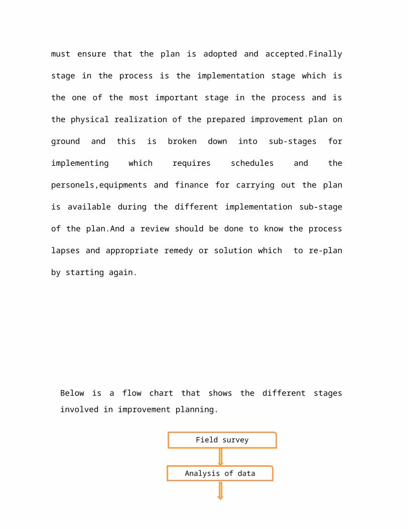
must ensure that the plan is adopted and accepted.Finally
stage in the process is the implementation stage which is
the one of the most important stage in the process and is
the physical realization of the prepared improvement plan on
ground and this is broken down into sub-stages for
implementing which requires schedules and the
personels,equipments and finance for carrying out the plan
is available during the different implementation sub-stage
of the plan.And a review should be done to know the process
lapses and appropriate remedy or solution which to re-plan
by starting again.
Below is a flow chart that shows the different stages
involved in improvement planning.
Field survey
Analysis of datacollected
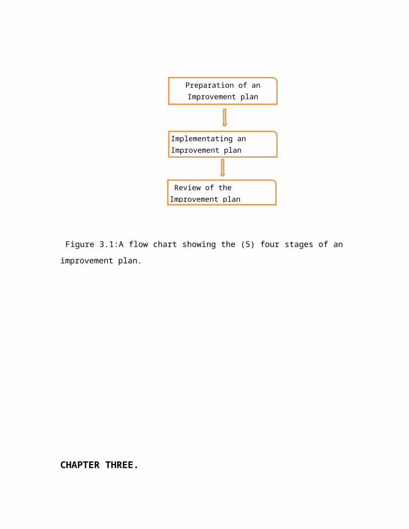
Figure 3.1:A flow chart showing the (5) four stages of an
improvement plan.
CHAPTER THREE.
Preparation of anImprovement plan
Implementating an Improvement plan
Review of the Improvement plan
3.0 :PHYSICAL AND SOCIO-ECONOMIC CHARACTERISTICS OF
GRACELAND.
This chapter deal with the existing physical and socio-
economic characteristics of Graceland
3.0.1:BRIEF HISTORY OF GRACELAND.
The study area,Gracelandwas formerly an
Agricultural area. This was due to the rich water logged soil
which was very good for growing of rice, maize, millet, sorghum
and vegetables. The Fulanis also rear cattles in this area
because of the rich green abundant pastures and water.
The settlement of Ungwanyusihas been in existence for over one
hundred and twenty years based on the information given by the
mai-Angwar. People settled at the heart of this area which is
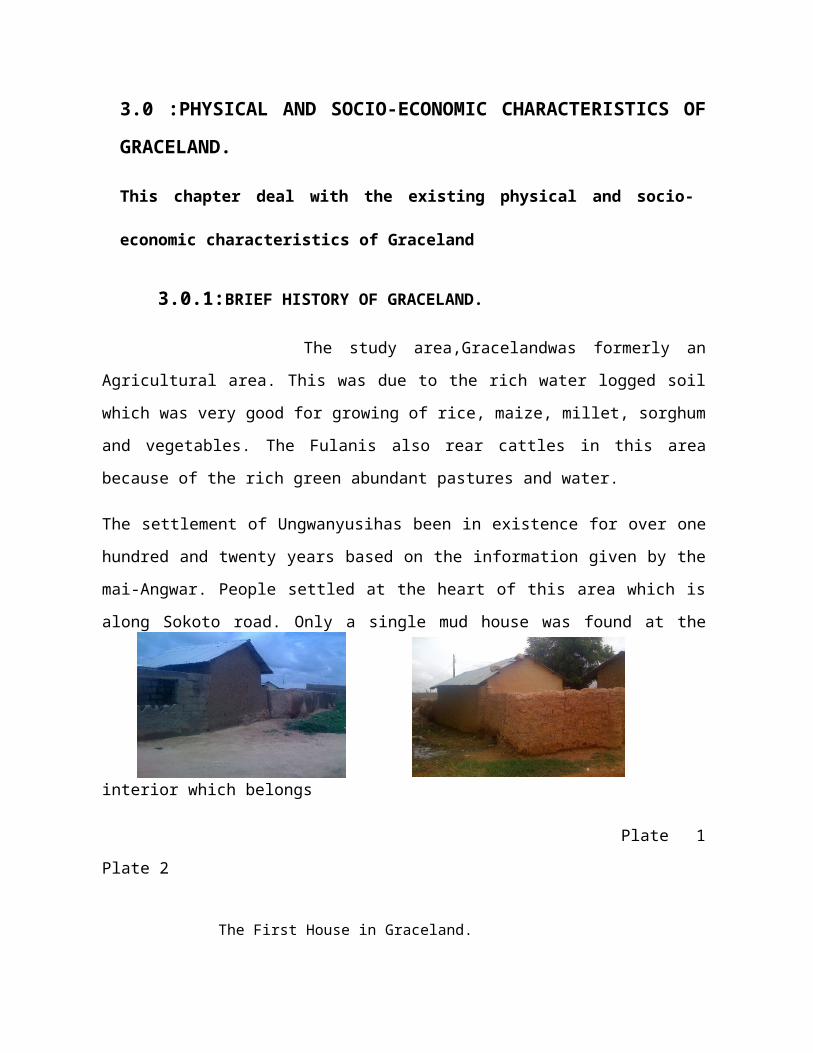
along Sokoto road. Only a single mud house was found at the
interior which belongs
Plate 1
Plate 2
The First House in Graceland.
to Mallam Ibrahim Dan Ayashe. According to district head,
Mallam Mustapha Mai-Unguwan, the house is about one hundred and
twenty years old.Plate 1 and 2 shows the first house in
Graceland.
The initial inhabitants of this area were
predominantly the Hausas and the Fulanis. The Fulanis occupy
mainly Hanwa Fulani and Tundun Fulani. The Fulanis have cattle
ranches scattered around the area, which mean they do not
necessarily have to go outside the confines because of the
abundance of food and water for their cattles. While only
Hausas do not usually live there, they normally stay in near-by
villages like Tudun-Jukun, Turkur-Tukur, and areas like Layin
Zomo and Palladan.As time went on, the Fulanis began to sell
their land to people. One of the few people who bought a bid
chunk of the land was Dikko Sarkin Shannu who later sold the
land to Alhaji Sambo Sada Organizer. This man, later sold the
land in pieces to people on which they built houses and
structures. Farmers also sold their land and relocated to
somewhere else. This as a result, led to rapid development of
the area which is about 16 – 18 yearsago. At present, the
inhabitants of this area are heterogeneous. They are mostly
staff of government institutions in Zaria, or business men and
women of the middle and high income group.
Land tenure of the area is of great concern as a current
dispute on the land ownership is in court. Information from
the Mai- Unguwan shows that there is no land dispute with
College of Aviation but rumours has been spreading on the
issue. The information from the College of Aviation is
different as they say that there is a case in court about
settlements/residents encroaching into their area. The
college has an approved map which was endorsed by the
Federal Government in 2006.
The verge of growth or expansion of this settlement could be
attributed to the establishment of Nigerian Collage of
Aviation Technology and the existence of Sokoto road,
Kwangila market and Bus Stop which encourages commercial
activities. The recent development in the area can be
attributed to the fact that it is one of the new expansion
areas for residential development in Zaria urban area among
other reasons.
3.0.2: LOCATION
Graceland is located at the North Western part of Zaria
urban scape. It is bounded by AviationTechnology in the
North-West, LayinZomo in the North, Kaduna road in the East
and Kubanni River at the South-West.
The settlement is located between latitude 10W and longitude
6E. It is found on the map of Zaria metropolis around the
junction of the Kaduna road and Sokoto road. It occupies a
total land area of 308.1 hectares on a regional plane
between altitude 655-670 meters above sea level.
3.1 :LAND USE STATISTICS
The various land uses existing in Graceland includes
residential, public, commercial, industrial, open space, and
recreational land use. The study area has a mixture of some
uses i.e. it has the residential/commercial, public and open
spaces. The residential land use consist of the dwelling
units, the commercial land use consist of a cluster of
shops, the public land use consists of various schools,
institutions, mosques and churches. The recreational land
use/open space includes the organized and unorganized open
spaces.
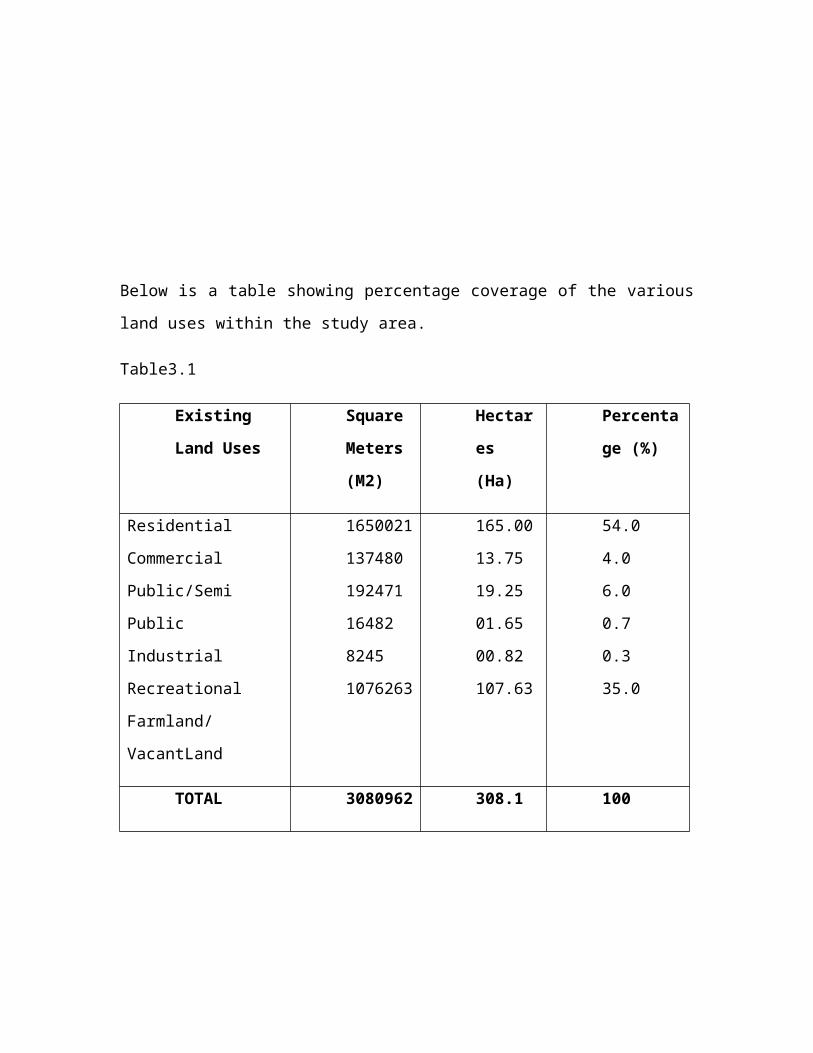
Below is a table showing percentage coverage of the various
land uses within the study area.
Table3.1
Existing
Land Uses
Square
Meters
(M2)
Hectar
es
(Ha)
Percenta
ge (%)
Residential
Commercial
Public/Semi
Public
Industrial
Recreational
Farmland/
VacantLand
1650021
137480
192471
16482
8245
1076263
165.00
13.75
19.25
01.65
00.82
107.63
54.0
4.0
6.0
0.7
0.3
35.0
TOTAL 3080962 308.1 100
Developed land
area
Undeveloped land
area
2004699
1076263
200.47
107.63
72.9
35.0
TOTAL 3080962 308.1 100
Source: Field Survey 2014.
Plate 3.1
0204060
544 6 0.7 0.3
35
LAND USE ANALYSIS
Percentage
Total Land Area =3080962 (308.1Ha)
The study area has an area of 308.1 hectares with
residential area having the highest percentage of total area
with 60%, which is covering 165 hecters of land. The
Recreational land use is taking 0.3% of the total land area,
which is the least percentage coverage.Industrial land uses
have 0.6% of the total land area. Public/semi-public land
uses have 7% of the total land area. The
vacantland/organized and unorganized open spaces cover
107.63 hectares with 35% and commercial land use with 5%,
respectively. We can then say that the major land use in the
study area is the residential land use.
3.2 :SOCIO ECONOMICS CHARACTERISTIC OF THE STUDY
AREA.
3.2.0: POPULATION OF THE STUDY AREA.
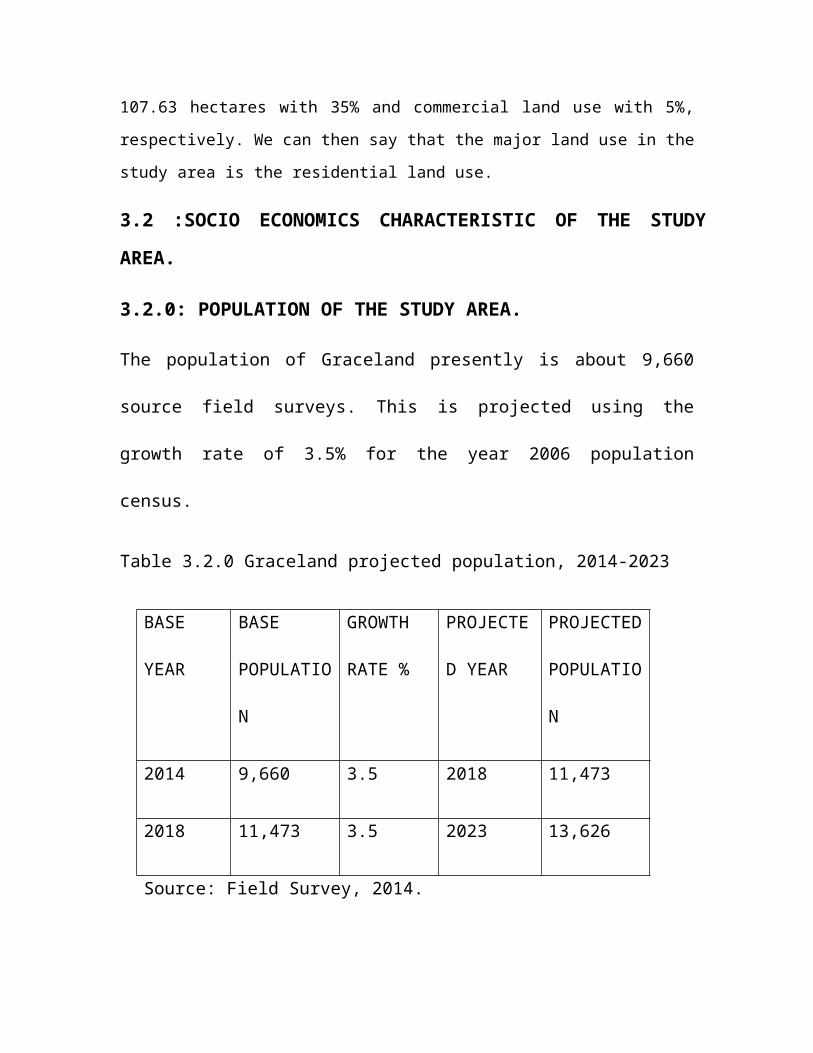
The population of Graceland presently is about 9,660
source field surveys. This is projected using the
growth rate of 3.5% for the year 2006 population
census.
Table 3.2.0 Graceland projected population, 2014-2023
BASE
YEAR
BASE
POPULATIO
N
GROWTH
RATE %
PROJECTE
D YEAR
PROJECTED
POPULATIO
N
2014 9,660 3.5 2018 11,473
2018 11,473 3.5 2023 13,626
Source: Field Survey, 2014.
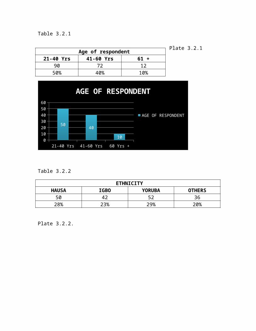
Table 3.2.1
Plate 3.2.1
21-40 Yrs 41-60 Yrs 60 Yrs +0102030405060
50 40
10
AGE OF RESPONDENT
AGE OF RESPONDENT
Table 3.2.2
ETHNICITYHAUSA IGBO YORUBA OTHERS50 42 52 3628% 23% 29% 20%
Plate 3.2.2.
Age of respondent21-40 Yrs 41-60 Yrs 61 +
90 72 1250% 40% 10%
HAUSA IGBO YORUBA OTHERS0102030405060
50
23 29 20
ETHNICITY
ETHNICITY
Table 3.2.3
3. RELIGIONISLAM CHRISTIANITY TRADITIONAL OTHERS73 107 0 0
40.56% 59.44% 0% 0%
Plate 3.2.3.
ISLAM
CHRISTIANITY
TRADITIONAL
OTHERS
04080
40.56 59.44
RELIGION
RELIGION
Table 3.2.4
4.LEVEL OF EDUCATIONPRIMARY SECONDARY TERTIARY KURANIC OTHERS
0 21 120 25 140% 11.7% 66.7% 13.8% 7.8%
Plate 3.2.4.
PRIMARY
SECONDARY
TERTIARY
KURANIC
OTHERS
0
40
80
0 11.766.7
13.8 7.8
LEVEL OF EDUCATION
LEVEL OF EDUCATION
Table 3.2.5.
5.OCCUPATIONCIVIL SERVANT FARMER TRADER OTHERS
80 7 60 3344.5% 3.9% 33.3% 18.3%
Plate 3.2.5.
CIVIL SERVANT
FARMER TRADER OTHERS0
20
40
44.5
3.933.3
18.3
OCCUPATION
OCCUPATION
Table 3.2.6.
6.INCOME LEVEL PER MONTHLESS 5,000- 10,000- 20,000- 30,000- 50,000 +
THAN5,000
10,000 20,000 30,000 50,000
6 12 15 12 60 753.3% 6.7% 8.3% 6.7% 33.3% 41.7%
Plate 3.2.6.
02040
6 6.7 8.3 6.733.341.7
INCOME LEVEL PER MONTH
INCOME LEVEL PER MONTH
Table 3.2.7.
7.REASON FOR RESIDING IN GRACELAND.CHEAP
ACCOMODATIONCLOSENESS TOPLACE OFWORK
ONLYAVAILABLEOPTION
INHERITANCE OTHERS
15 60 45 24 368.3% 33.4% 25% 13.3% 20
Plate 3.2.7.
02040
8.333.4 25 13.3 20
REASON FOR RESIDING IN GRACELAND.
REASON FOR RESIDING IN GRACELAND.
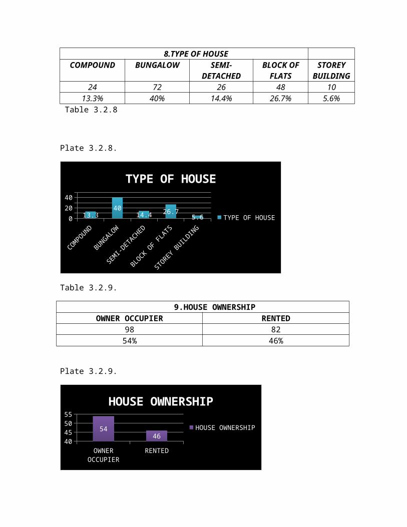
8.TYPE OF HOUSECOMPOUND BUNGALOW SEMI-
DETACHEDBLOCK OF
FLATSSTOREY
BUILDING24 72 26 48 10
13.3% 40% 14.4% 26.7% 5.6% Table 3.2.8
Plate 3.2.8.
COMPOUND
BUNGALOW
SEMI-DETACHED
BLOCK OF FLATS
STOREY BUILDING
02040
13.340
14.4 26.75.6
TYPE OF HOUSE
TYPE OF HOUSE
Table 3.2.9.
9.HOUSE OWNERSHIPOWNER OCCUPIER RENTED
98 8254% 46%
Plate 3.2.9.
OWNER OCCUPIER
RENTED40455055
5446
HOUSE OWNERSHIP
HOUSE OWNERSHIP
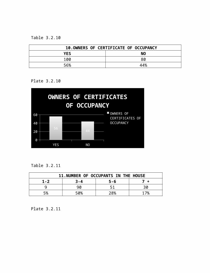
Table 3.2.10
10.OWNERS OF CERTIFICATE OF OCCUPANCYYES NO100 8056% 44%
Plate 3.2.10
YES NO0
20
40
60
56 44
OWNERS OF CERTIFICATES OF OCCUPANCY
OWNERS OF CERTIFICATES OF OCCUPANCY
Table 3.2.11
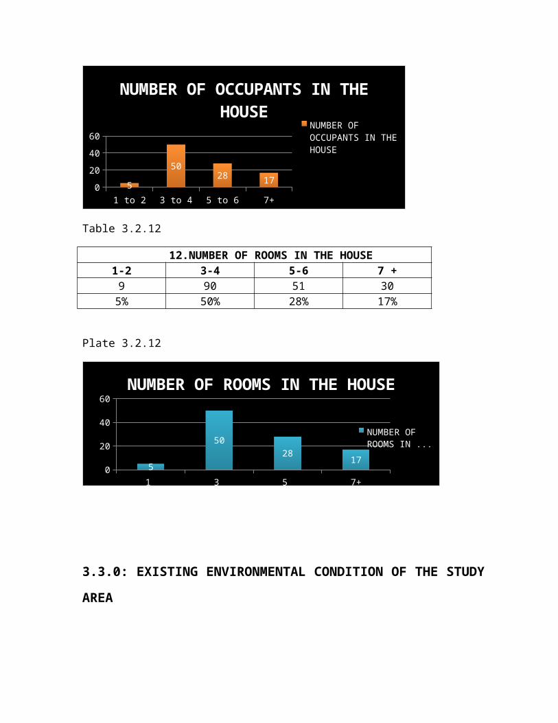
11.NUMBER OF OCCUPANTS IN THE HOUSE1-2 3-4 5-6 7 +9 90 51 305% 50% 28% 17%
Plate 3.2.11
1 to 2 3 to 4 5 to 6 7+0204060
5
5028 17
NUMBER OF OCCUPANTS IN THE HOUSE
NUMBER OF OCCUPANTS IN THE HOUSE
Table 3.2.12
12.NUMBER OF ROOMS IN THE HOUSE1-2 3-4 5-6 7 +9 90 51 305% 50% 28% 17%
Plate 3.2.12
1 3 5 7+0
20
40
60
5
5028 17
NUMBER OF ROOMS IN THE HOUSE
NUMBER OF ROOMS IN ...
3.3.0: EXISTING ENVIRONMENTAL CONDITION OF THE STUDY
AREA
Environmental condition is a compound word that describes the
physical situation or condition of a geographical location or a
place. It explains the visible traits or characteristics that
pertain to a particular environment. This ranges from the
street pattern, kind of activities, road furniture, sanitary
condition, facilities, utilities, landscape features, natural
and man-made features or any other special features that makes
up the environment. Environmental conditions deals also with
the buildings in an area and not just the environment,
buildings for commercial, residential or other purposes. It
explains or gives a picture of what is physically obtainable at
a particular site, neighborhood or location.
3.3.1: EXISTING LAYOUT
Graceland has no formal layout plan at the moment. Land
subdivision is done at individual plot level without contacting
the necessary authorities. Plot sizes acquired by individuals
depend on the amount of money they have at their disposal. This
has resulted to irregular plot sizes and shapes arranged
haphazardly which has led to criss-crossing of roads, Y –
junctions, unnecessary open spaces between buildings mostly
leading to dead ends, unwarranted closes, etc.As shown in plate
3.3.1a,3.3.1b and 3.3.1c.
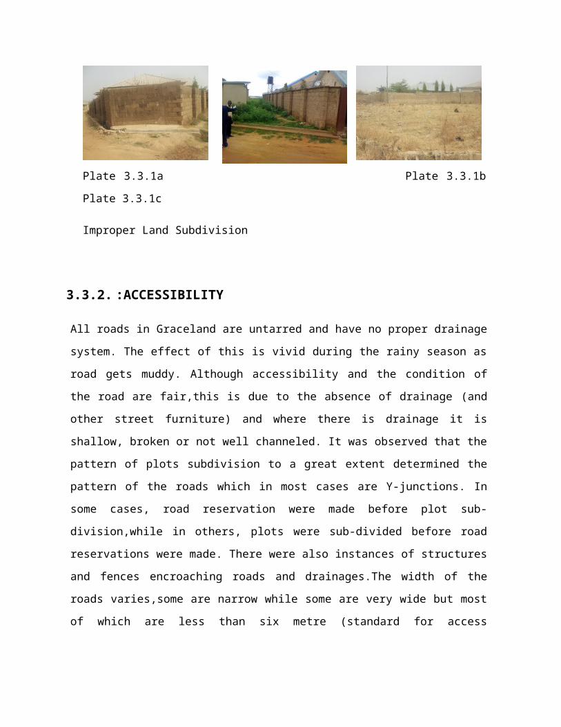
Plate 3.3.1a Plate 3.3.1b
Plate 3.3.1c
Improper Land Subdivision
3.3.2. :ACCESSIBILITY
All roads in Graceland are untarred and have no proper drainage
system. The effect of this is vivid during the rainy season as
road gets muddy. Although accessibility and the condition of
the road are fair,this is due to the absence of drainage (and
other street furniture) and where there is drainage it is
shallow, broken or not well channeled. It was observed that the
pattern of plots subdivision to a great extent determined the
pattern of the roads which in most cases are Y-junctions. In
some cases, road reservation were made before plot sub-
division,while in others, plots were sub-divided before road
reservations were made. There were also instances of structures
and fences encroaching roads and drainages.The width of the
roads varies,some are narrow while some are very wide but most
of which are less than six metre (standard for access
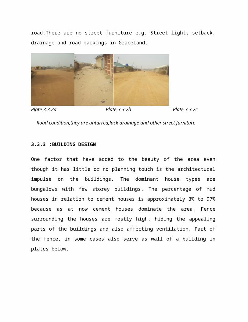
road.There are no street furniture e.g. Street light, setback,
drainage and road markings in Graceland.
Plate 3.3.2a Plate 3.3.2b Plate 3.3.2c
Road condition,they are untarred,lack drainage and other street furniture
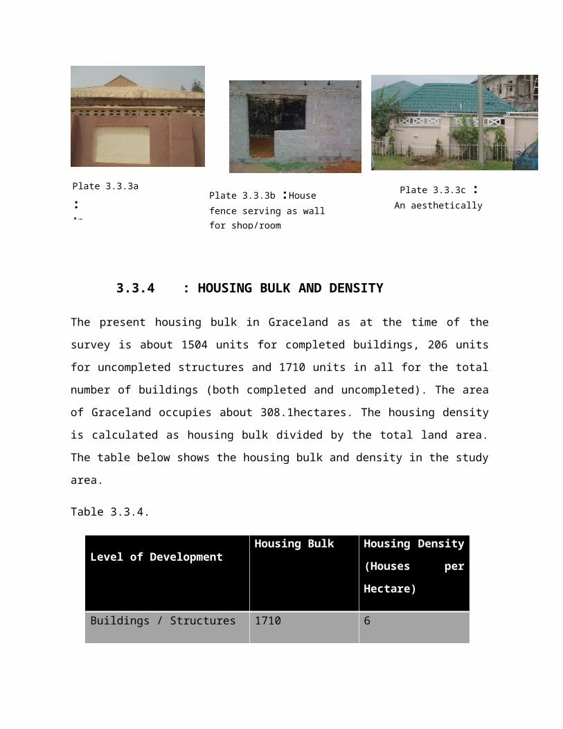
3.3.3 :BUILDING DESIGN
One factor that have added to the beauty of the area even
though it has little or no planning touch is the architectural
impulse on the buildings. The dominant house types are
bungalows with few storey buildings. The percentage of mud
houses in relation to cement houses is approximately 3% to 97%
because as at now cement houses dominate the area. Fence
surrounding the houses are mostly high, hiding the appealing
parts of the buildings and also affecting ventilation. Part of
the fence, in some cases also serve as wall of a building in
plates below.
3.3.4 : HOUSING BULK AND DENSITY
The present housing bulk in Graceland as at the time of the
survey is about 1504 units for completed buildings, 206 units
for uncompleted structures and 1710 units in all for the total
number of buildings (both completed and uncompleted). The area
of Graceland occupies about 308.1hectares. The housing density
is calculated as housing bulk divided by the total land area.
The table below shows the housing bulk and density in the study
area.
Table 3.3.4.
Level of DevelopmentHousing Bulk Housing Density
(Houses per
Hectare)
Buildings / Structures 1710 6
Plate 3.3.3b :House fence serving as wallfor shop/room
Plate 3.3.3c : An aesthetically pleasing house
Plate 3.3.3a
: An
3.4.0 :UTILITIES, FACILITIES AND SERVICES
3.4.1:EDUCATIONAL FACILITIES:
Observation from the survey shows that most of the educational
centres in the study area are private primary and secondary
schools. The schools are Buks primary and secondary schools,
Vital Years Secondary School,Aunty Grace Nursery and Primary
School and Bethel Day Care, Nursery, Primary and Secondary
School,Christ Center international primary and secondary school
and Our Lady of Perpectual Help Pastoral Center Catholic
Diocese of Zaria. They are all unisex schools. There is no
public schools.There are four (4) qur’anic schools in the area.
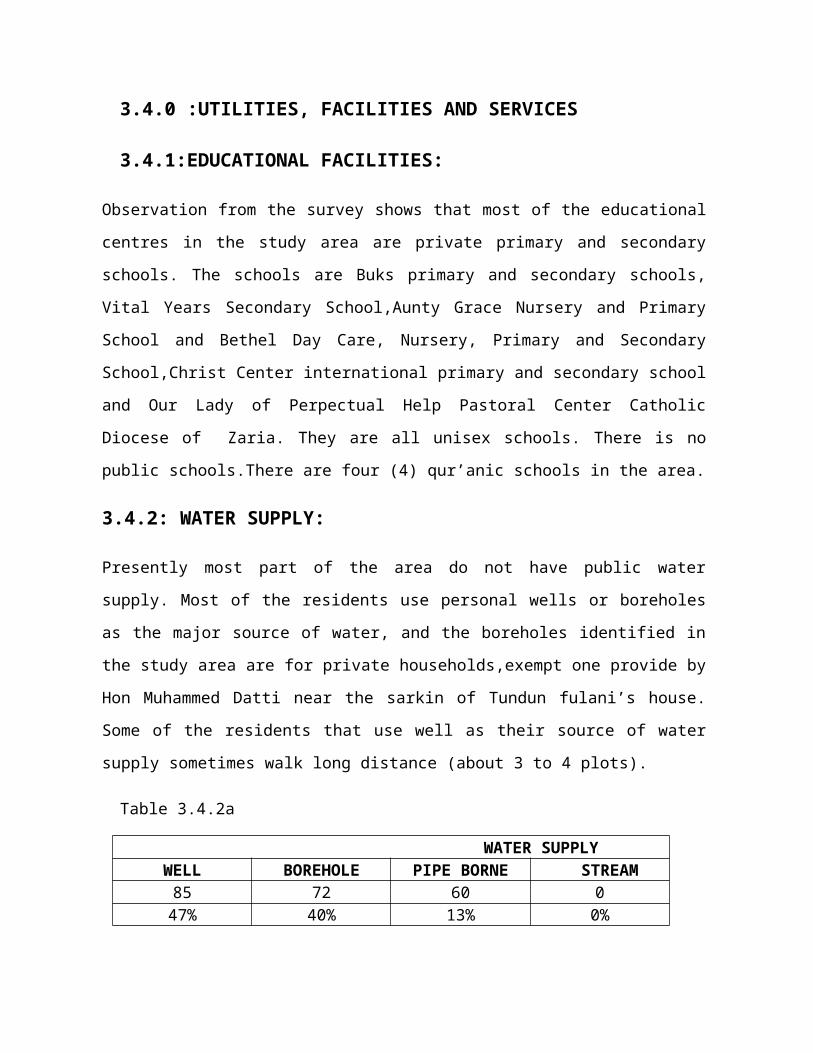
3.4.2: WATER SUPPLY:
Presently most part of the area do not have public water
supply. Most of the residents use personal wells or boreholes
as the major source of water, and the boreholes identified in
the study area are for private households,exempt one provide by
Hon Muhammed Datti near the sarkin of Tundun fulani’s house.
Some of the residents that use well as their source of water
supply sometimes walk long distance (about 3 to 4 plots).
Table 3.4.2a
WATER SUPPLYWELL BOREHOLE PIPE BORNE STREAM85 72 60 047% 40% 13% 0%
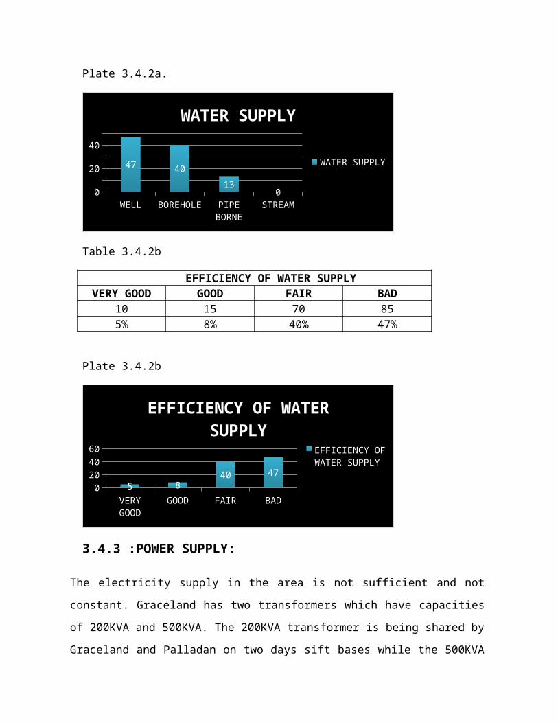
Plate 3.4.2a.
WELL BOREHOLE PIPE BORNE
STREAM0
20
40
47 4013
0
WATER SUPPLY
WATER SUPPLY
Table 3.4.2b
EFFICIENCY OF WATER SUPPLYVERY GOOD GOOD FAIR BAD
10 15 70 855% 8% 40% 47%
Plate 3.4.2b
VERY GOOD
GOOD FAIR BAD0204060
5 840 47
EFFICIENCY OF WATER SUPPLY
EFFICIENCY OF WATER SUPPLY
3.4.3 :POWER SUPPLY:
The electricity supply in the area is not sufficient and not
constant. Graceland has two transformers which have capacities
of 200KVA and 500KVA. The 200KVA transformer is being shared by
Graceland and Palladan on two days sift bases while the 500KVA

is only for the consumption of the people living in the study
area. There are some houses within the study
area that do not have power supply at all. The 500KVA
transformer is located beside Mobil filling station in
Kwangila while the 200KVA can be found after the refuse dump
close to aviation fence.
Table 3.4.3a
3. EFFICIENCY OF POWER SUPPLYVERY GOOD GOOD FAIR BAD
10 15 70 855% 8% 40% 47%
Plate 3.4.3a
VERY GOOD
GOOD FAIR BAD0204060
5 840 47
EFFICIENCY OF POWER SUPPLY
EFFICIENCY OF POWER SUPPLY
3.4.3.The 200KVA Transformer close
3.4.4: HEALTH FACILITY:
Presently, there is one private clinic (Hanwa Clinic) found in
the study area. It is located along Sokoto road. Only four
chemists were found. One of the chemists is located at the
outskirts of the area along Sokoto road and the other in the
interior of the area.
3.4.5: RECREATIONAL FACILITY:
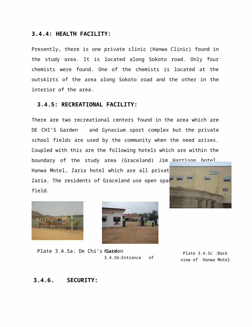
There are two recreational centers found in the area which are
DE CHI’S Garden and Gynasium sport complex but the private
school fields are used by the community when the need arises.
Coupled with this are the following hotels which are within the
boundary of the study area (Graceland) Jim Harrison hotel,
Hanwa Motel, Zaria hotel which are all private facilities in
Zaria. The residents of Graceland use open space(s) as football
field.
Plate 3.4.5a: De Chi’s Garden
3.4.6. SECURITY:
Plate 3.4.5c :Back view of Hanwa Motel
Plate 3.4.5b:Entrance ofZaria Hotel
Graceland falls under the Kwangila Police Security coverage.
The study area has a vigilante group that patrols at night.
3.4.7. REFUSE DISPOSAL:
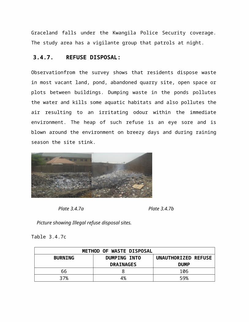
Observationfrom the survey shows that residents dispose waste
in most vacant land, pond, abandoned quarry site, open space or
plots between buildings. Dumping waste in the ponds pollutes
the water and kills some aquatic habitats and also pollutes the
air resulting to an irritating odour within the immediate
environment. The heap of such refuse is an eye sore and is
blown around the environment on breezy days and during raining
season the site stink.
Plate 3.4.7a Plate 3.4.7b
Picture showing Illegal refuse disposal sites.
Table 3.4.7c
METHOD OF WASTE DISPOSALBURNING DUMPING INTO
DRAINAGESUNAUTHORIZED REFUSE
DUMP66 8 10637% 4% 59%
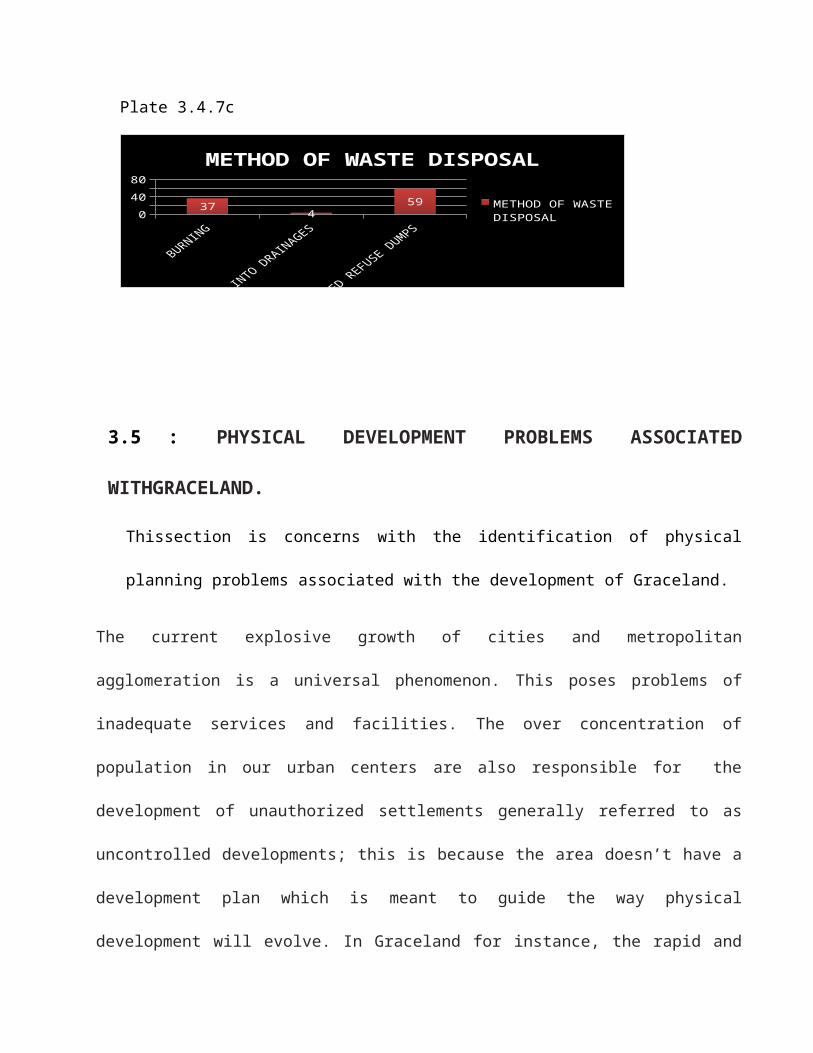
Plate 3.4.7c
04080
37 459
METHOD OF WASTE DISPOSAL
METHOD OF WASTE DISPOSAL
3.5 : PHYSICAL DEVELOPMENT PROBLEMS ASSOCIATED
WITHGRACELAND.
Thissection is concerns with the identification of physical
planning problems associated with the development of Graceland.
The current explosive growth of cities and metropolitan
agglomeration is a universal phenomenon. This poses problems of
inadequate services and facilities. The over concentration of
population in our urban centers are also responsible for the
development of unauthorized settlements generally referred to as
uncontrolled developments; this is because the area doesn’t have a
development plan which is meant to guide the way physical
development will evolve. In Graceland for instance, the rapid and
high rate of urban growth has overstretched the basic
infrastructural facilities available in the area,for e.g pipe borne
water. Therefore thesecause alot of problem on the urban
environment. The field survey carried out in the study area reveals
the following physical planning problems,which are mentioned below:
3.5:SPATIAL DEVELOPMENT PROBLEMS.
The spatial development problems of Ungwan Yusi is;
3.5.1 : CHAOTIC DEVELOPMENT PATTERN
A greater portion of the area is haphazardly developed without
taking any regular pattern of form. This situation as identified
from the field can be attributed to a variety of factors such as.
a. Inadequate or unorganized land acquisition pattern
b. Lack of securing building approval plan before erection
c. Low literacy and lack of awareness on (neglecting) the
importance of securing approved building plan before constructing
any building.
The combine effect of the above mentioned factors could be
attributed to the existing scattered development in the area
without giving spaces for access roads, drainages, and even
setbacks. The result of this is the poor ventilation in some parts
of the area. Poor ventilation could also promote easy spread of
diseases.This therefore calls for quick intervention to improve the
undesirable condition.About (15) fifteen plots were affected after
the area was being organised for easy accessibilty because they
encroached into the road.
3.6: ECONOMIC PROBLEM OF UNGWAN YUSI.
The economic problems are,
3.6.1:UNEMPLOYMENT OF THE RESIDENT:
There is the problem of unemployment in the sense that the
population or community is made up of people who are unemployed
which could yield to high crime rate in the area,problem of
undevelopment in terms of less accessibilty of the urban poor to
buy land for development and causes slum generation .
3.6.2: PROBLEM OF INADEQUATE FACILITIES UTILITIES AND SERVICES
The deficiencies in the supply of basic utilities such as water and
electricity have been identified in the area. The data gathered
showed that the pipe borne water supply in the area is grossly
inadequate. Wells which is the predominant source of water supply
in the area has been gathered to be seasonal in nature.
Inconveniency was also identified to be existing in quest to source
for water as some household have to travel metres away from their
homes to get water.
Erratic electric power supply was also identified in the area. the
supply period to the greatest proportion is less than 5 hours
daily, while some area are not even having the presence of the
supply lines especially at the extreme of the area. This has an
adverse effect on the economy of the area and deprived the people
in the area the social amenity
The existing educational facilities are privately owned, no
Government schools and health centers.
3.7: ENVIRONMENTAL PROBLEM OF UNGWAN YUSI
The environmental problems are listed below;
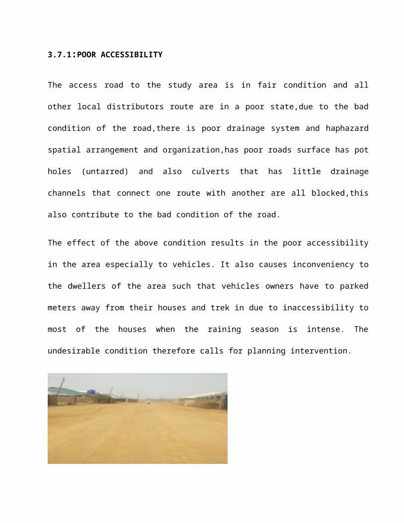
3.7.1:POOR ACCESSIBILITY
The access road to the study area is in fair condition and all
other local distributors route are in a poor state,due to the bad
condition of the road,there is poor drainage system and haphazard
spatial arrangement and organization,has poor roads surface has pot
holes (untarred) and also culverts that has little drainage
channels that connect one route with another are all blocked,this
also contribute to the bad condition of the road.
The effect of the above condition results in the poor accessibility
in the area especially to vehicles. It also causes inconveniency to
the dwellers of the area such that vehicles owners have to parked
meters away from their houses and trek in due to inaccessibility to
most of the houses when the raining season is intense. The
undesirable condition therefore calls for planning intervention.
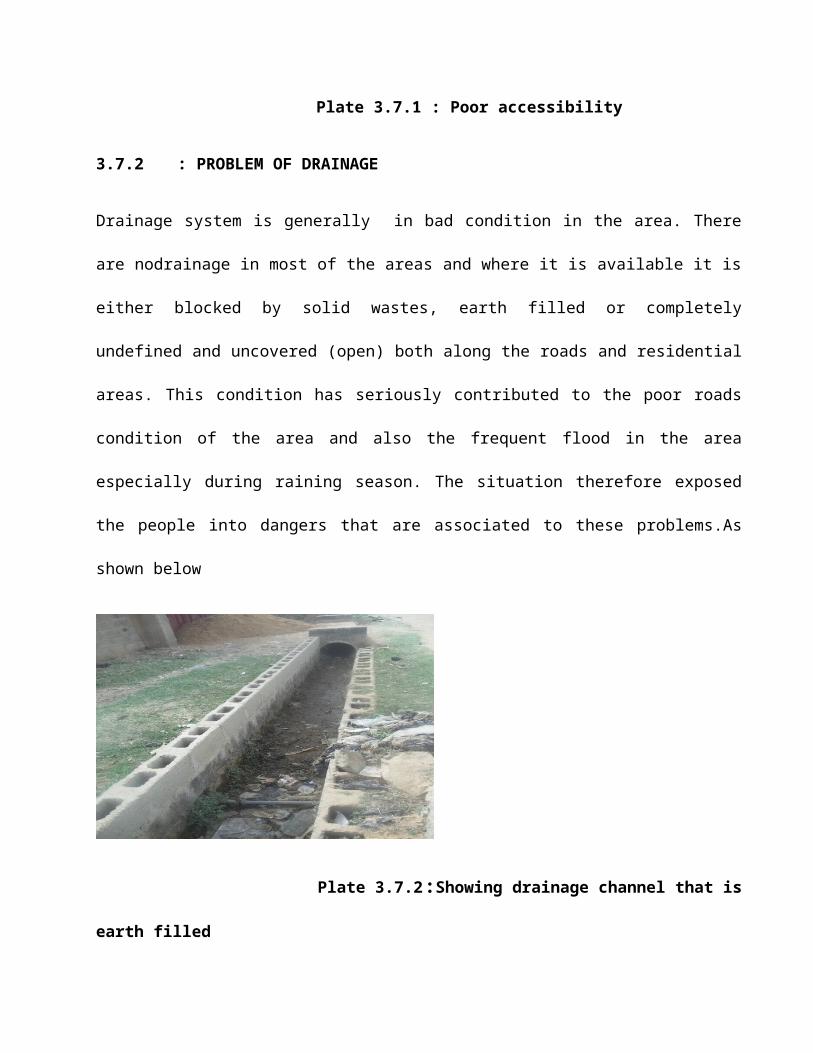
Plate 3.7.1 : Poor accessibility
3.7.2 : PROBLEM OF DRAINAGE
Drainage system is generally in bad condition in the area. There
are nodrainage in most of the areas and where it is available it is
either blocked by solid wastes, earth filled or completely
undefined and uncovered (open) both along the roads and residential
areas. This condition has seriously contributed to the poor roads
condition of the area and also the frequent flood in the area
especially during raining season. The situation therefore exposed
the people into dangers that are associated to these problems.As
shown below
Plate 3.7.2:Showing drainage channel that is
earth filled
3.7.3 : PROBLEM OF SANITATION/WASTE DISPOSAL
Poor solid waste management was identified in the area. There is
lack of any organized refuse collection, transportation, and
disposal system in the area. The absence of the refuse collection
sites in the area has resulted in indiscriminate disposal of waste
into available open spaces,drainage and uncompleted buildings. The
result of these practices was found to be blockage of drainage
facilities which are initially inadequate, discharge of bad odour,
unpleasant look and its characteristics poor sanitation. This
situation have the capacity of promoting the outbreak of diseases
such as cholera, since such indiscriminate refuse sites form a good
breeding ground for disease vectors.
With appropriate planning measures this problem and its adverse
consequences can be taking care of by making an appropriate plan
for the study area.
3.8 : POOR ENVIRONMENTAL QUALITY
The combine effect of haphazard physical development of buildings
and their poor physical condition, disorganized access roads,
indiscriminate disposal and dumping of refuse and its consequential
poor sanitation and unpleasant outlook of the environment and
absence of organized landscape have been identified. As a result,
poor physical scenery and unpleasant outlook have set in. this
situation encourages ill behaviors such as indiscriminate refuse
and sewage disposal, crime of all kinds and poor mental and
psychological development
Proper planning measure can resolve the situation to improve the
situation of the study area.
3.9 : SUMMARY OF IDENTIFIED PROBLEMS OF GRACELAND.
Inferences drawn from the analysis data above are summed up as
follows.
There is poor accessibility in the area. First is the nature
of the road. The only access road is the one that link the
area with sokoto road that is untarred, and within the built-
up areas of Graceland there are no accessibility for
vehicles, the few that exist are not deplorable in the area.
There is chaotic development pattern due to lack of physical
development plan
Land use are not organized which lead to haphazard growth of
the area
There is poor environmental quality and sanitation
The majority of the populations are medium income earners.
There are general inadequate and poor basic facilities,
utilities, and services.
There is no organized and adequate method of refuse disposal
as most of the people burn or disposed their waste
indiscriminately.
The study area is not adequately provided with utilities and
facilities such as poor portable water supply and network in
the area etc.
There is poor drainage system in the area.
All the educational facilities in the area are privately
owned
CHAPTER
FOUR
4.1 GOALS AND OBJECTIVES OF THE IMPROVEMENT PLAN
4.1.1 SPATIAL GOALS
4.1.2 ECONOMIC GOALS
4.1.3 SOCIAL GOALS
4.1.4 ENVIRONMENTAL GOALS
2.6.0 THE GOALS GUIDING IMPROVEMENT PLANNING.
The general goal is to control, maintain and improve the
different aspects which are important ingredients that
make up an improvement plan. These aspects are, economic,
environmental, social and spatial/physical.
2.7.1 Economic Goals:
Economic aspect of an improvement plan constitute what
can influence economy of the area,this deals with various
activities that dwellers can be engaged in to source
income,different economic activities like means of
transportation,location of industries,housing
quality,etc.the economic goal helps in the planning of the
improvement plan through examining the various development
in relation to urban spatial growthand changes with the rate
of unemployment in the region,provide basic utilities like
electricity,water supply,gas,etc.Other aspect of the
economic goal are;
e. Developing land policy framework to support the efficient
land adminstration and development which contribute to the
economic growth.
f. Developing and implementing land policies which ensure
growth, equality and environmental sustainability and an
efficient administration based on land management system.
g. Develop, expand and straighten the road network to enhance
sustainable development.
h. Financial and economic services for the poor such as
vocational training facilities, financial commitment of
government determines the level of achivement in any urban
improvement scheme.
Therefore, the feasibility of the plan determines
the level of improvement possible.
2.7.2 Environmental Goals:
Environmental goals handles the physical environment
interms of the green areas,temperature,climatic
condition,and other necessary attributes of the environment
that is expected to be taken into cosideration when making a
plan that will be effective and implentatable,under this
aspect areas with vast open space which is prone to high
wind,trees could be planted to reduce the effect of the
breeze on the buildings,environment and its dwellers,places
that flood affects, gully erosion could be made through
environmental management system(EMS) which is a framework
that helps to achieve environmental goals through consistent
control.Also constitutes the provision of physical
infrastructure such as water supply,drainage,etc,these
supports the objective of improving the quality of life and
these can be achieved through
c. Community based approach, which is the active involvement of
the members of the community at every stage of design
implementation and maintenance.
d. Service delivery on individual household and this help to
improve operations, maintenance and facilitate recovery of
user changes and thus improve the overall environment.
Community participation in improvement plan promotes
democratization of these activities.It also ensures that
planning proposala are felt needs of the people.The lack of
public participation could lead to ineffectiveness of
project because such will not reflect the aspiration, needs
of the community and
Interaction between the government and the people will be
hostile.
2.6.3 Social Goals:
Social deal with human behaviours and needs of
individuals in a society and their interaction among
themselves,social aspect of an improvement plan considers
first the behavior of the people and their needs of the
people,how to organized and plan for their welfare, this
help in planning the area socially.these deals with
unemployment of the citizen(rate of young people who are
neither working nor having educational training),considers
household income,improve area that are poorly developed or
under-utilized,It enables one to manage deteriorated
buildings,streets and utilities.
2.6.4 Spatial /Physical Goals:
This is responsible for cartography,drawing of
structures and detailed lay-out plan,refers to the active
process of organizing the structure functions to ensure
orderly,efficient sitting for location of landuse, and
cordinated spatial socio-economic development,facilitate the
equitable distribution of services,integration of the
function of rural and urban settlements,optimum use of land
for agriculture,industrial,human settlements,infrastructural
and other land use purpose.Alsoensures that equiptable and
balanced spatial disribution of development.
4.2 PROPOSALS OF IMPROVEMENT PLAN FOR UNGUWAN YUSI
4.2.1 SPATIAL PLAN PROPOSAL
4.2.2 ECONOMIC DEVELOPMENT PROPOSAL
4.2.3 SOCIAL DEVELOPMENT PROPOSAL
4.2.4 ENVIRONMENTAL DEVELOPMENT PROPOSAL
1.1. CHALLENGES OF IMPROVEMENT PLANNING.
There a lot of challenges or problems faced in preparing an
improvement plan among which are:
a. The problem of getting a good and clear map or areal photograh of
the study area which enhances the preparation of a base map to be
used for correction.
b. Another issue is determining the need of the people, due to lack
of public active participation in the work.
c. Lack or at times insufficient skilled personel and equipments for
the exercise.
d. The challenge of funding and implementing the improvement plan,
because finance is a major problem in the implementation of any
plan.
e. Corruption is another factor among the personels and the
authorities who will finance the project. Resources could be
gotten and could be diverted to another thing or embezzle.
1.2. PROSPECTS OF AN IMPROVEMENT PLAN.
a. It creates employment oppurtunity for its resident:The improvement
plan create job for its resident in terms of if they anyone among
them is well trained about organizing,designing the environment
like Architects,Planners,industrialist,etc,they could be employed
through community active participation,resident could also be
selling to the workers who are implementing the plan and road
network challenges gives way for trading.
b. It also helps in the reduction of environmental pollution: A well
planned area reduces all kinds of pollution like noise pollution
that emerge from mechnic,heavy industries,because the plan will
make provision for their location where they cann’t affect the
community.
c. It reduces the rate of accidents in the area: A good and well
channeled circulation pattern is established and this reduces rate
of accidents in the urban areas.
d. It also minimizes the cost spent on health cases: A good
environment encourages good health through provision of health
services.
e. Transforming the city into a better habitable environment:
Improvement plan, if implemented as it is, support to be with
consideration on renewal concept and what it entails, the renewal
strategies would definitely produce an urban community that is
good to work and live in. this incorporates the following
characteristics.Livability, efficiency and aesthetics, amenities
and flexibility. It produces a city with an acceptable symbol of
people expectations through provision of amenities of good design.
These will re-emphasize that the city exist to serve the needs of
all its citizens. A good urban pattern that allows for orderly
growth and adjustments to meet changes in habits of life and
methods of conducting business and industry.
f. Access to basic infrastructure and social services : This is
achieved most in improvement planning through the provision of
basic public facilities and utilities and increased safety,
convenience and amenities in the city. Therefore, emphasizing the
need of the poor. Likewise, urban renewal mostly involves layout\
isolated projects (cellular renewal). This emphasizes housing and
residential infrastructure towards integrated city wide and
regional development effort. This normally promotes urban housing
supply.
g. Improvement plan encourages efficiency in urban form : An improved
area ought to be a unit for which modern public services can be
economically and efficiently provided. The new pattern of urban
community would make it possible for the business, industrial and
personal activities of its citizen to be carried out with minimum
of undue costs and wastes. This is achieved in a successful
implementation of urban renewal. This makes larger contribution to
national economic growth.
h. Increased appreciation of land value: The increase appreciation of
land value is coupled with more incentives to residents. This is
resulting from increase availability of better quality housing and
the ultimate aim of own houses. Moreover, there is redistribution
of income, if better quality of homes is offered at lower rents to
former slum dwellers.
i. Increase awareness of the significance of urban scope : Most
people living in cities in developing countries are not aware of
the effects in substandard environmental condition. In addressing
environmental problems through urban improvement, there is
increasing understanding of urban issues, on the part of
government through research and increased awareness for
environmental conservation on the part of the people through
public enlightment.
j. Improvement of human resources : This is benefit that will occur
from successful execution of urban renewal scheme and which leads
to overall development of the whole nation, that is, it is a vital
urban investment. As a result of more job creation, there will be
increasing demand for labour. Mostly when renewal is done with a
focus on generating jobs for the urban poor.
1.0 RECOMMEDATIONS.
The recommendations made are towards improvement of urban areas
are;
a. There should be strict development control, so as to
avoid the emergence of unplanned/unguided development in order
to achieve the desired goal.
b. Public enlightment must be in place to ensure maximum co-
operation of the public.
c. Government should ensure the equitable distribution of
income among the people and this is to empower them to maintain
their living environments.
d. The local planning authorities should educate and see that
total compliance of building regulation and bye laws are
maintained and that the community members or their
representative participates fully during the design of the plan
and implementation.
e. Skilled personels and sufficient equipments should be
provided in all the necessary stages of the implementation
exercise.
f. Both public and private institutions can provide fund for
the implementing of the designed plan by getting loans from
commercial banks and multi –lateral agencies,individual
agencies/ companies,levy from tenament rent,revenue generated
from tax.
6.0. CONCLUSION.
In conclusion, Improvement planning in any city or
metropolitan area become a tool or method for making effective
and comprehensive plan for the physical development of the
entire area. The social dimension of urban renewal scheme
should be greatly enhanced. As such, a multi-dimensional
approach adopted and employed for any community must realize
the limited resources of the government. The government of any
state or local area must therefore seek private sector and
public participation. Above all, the strategies evolved to
solve the problem of degenerated urban areas in Nigeria must
be implemented within the socio-cultural constrain of a
particular affected environment.
CHAPTER FIVE
5.0 RECOMMENDATION FOR IMPLEMENTING THE IMPROVEMENT PLAN OFUNGUWAN YUSI
5.1 PROSPECTS OF THE UNGUWAN YUSI IMPROVEMENT PLAN

5.2 RECOMMEDATION FOR THE IMPLEMENTING THE IMPROVEMENTPLAN.