impact of gated communities on local mobility
TRANSCRIPT
TRIBHUVAN UNIVERSITY
INSTITUTE OF ENGINEERING
PULCHOWK CAMPUS
THESIS NO: 074/MSU/005
Impact of Gated Communities on Local Mobility
by
Ashraya Pradhan
A THESIS
SUBMITTED TO THE DEPARTMENT OF ARCHITECTURE IN PARTIAL
FULFILLMENT OF REQUIREMENTS FOR THE DEGREE OF MASTER IN
URBAN PLANNING
DEPARTMENT OF ARCHITECTURE
LALITPUR, NEPAL
August, 2020
Impact of Gated Communities on Local Mobility
i
COPYRIGHT
The author has agreed that the library, Department of Architecture,
Pulchowk Campus, Institute of Engineering may make this thesis freely
available for inspection. Moreover, the author has agreed that permission
for extensive copying of this thesis for scholarly purpose may be granted
by the professor(s) who supervised the work recorded herein or, in their
absence, by the Head of the Department wherein the thesis was done. It is
understood that the recognition will be given to the author of this thesis and
to the Department of Architecture, Pulchowk Campus, Institute of
Engineering in any use of the material of this thesis. Copying or publication
or the other use of this thesis for financial gain without approval of the
Department of Architecture, Pulchowk Campus, Institute of Engineering
and author’s written permission is prohibited. Request for permission to
copy or to make any other use of the material in this thesis in whole or in
part should be addressed to:
Head
Department of Architecture
Pulchowk Campus, Institute of Engineering
Lalitpur, Kathmandu
Nepal
Impact of Gated Communities on Local Mobility
ii
DECLARATION
I hereby declare that the thesis entitled “Impact of Gated Communites on Local
Mobility” submitted to the Department of Architecture in partial fulfilment of the
requirement for the degree of Master of Science in Urban Planning, is a record of an
original work done under the guidance of Dr. Ajay Chandra Lal, Institute of
Engineering, Pulchowk Campus. This thesis contains only work completed by me
except for the consulted material which has been duly referenced and acknowledged.
______________
Ashraya Pradhan
074/MSU/005
Impact of Gated Communities on Local Mobility
iv
ABSTRACT
Gated communities are residential areas with restricted access designed to privatize
normally public spaces. These secluded clusters of houses form a separate community
within its walls. They often have facilities and infrastructures that are not open to the
public. Mobility is the ability to move or travel around easily. Kathmandu has seen a
surge in the development of gated communities. These communities restrict access and
contribute to densification while reducing access.
Gated communities especially housing colonies are gaining a lot of popularity in
Kathmandu valley. Most these developments are constructed in the suburban or peri-
urban areas where the growth and development is relatively low. The introduction of
these projects accelerates the rate of population growth and infrastructure development.
With the first gated community, Kathmandu Residency, an apartment complex
development starting in 2000 A.D. followed by the first housing colony, Civil Homes,
in 2001 A.D. Construction and sale of housing colonies have skyrocketed. This boom
in real estate development business comes along as proper regulations and guidelines
are lacking to adequately regulate such developments. The inadequacy in regulation,
lack of proper and specific guidelines causes various issues and impacts in the society
and lives of the general public excluded from these secluded abodes.
This research aims to identify the legal provisions and restrictions of these gates. It shall
look into if and how accessibility is or can be affected. A literature review of gated
communities and a review of legal documents related to housing, public roads and lands
confirm that the law for approval and allowance of construction of housing colonies
and particularly gates in such colonies are lacking.
Direct observation and unstructured in-depth interviews reveal that accessibility is a
growing issue with the increase in urbanization, population growth and densification.
Opening the gates of such communities or them requiring to provide access should be
an option to increase accessibility and mobility of the growing area.
Impact of Gated Communities on Local Mobility
v
ACKNOWLEDGEMENTS
I would like to express my sincere gratitude to the Department of Architecture for the
opportunity to perform a thesis research on this topic. I would like to thank all my
teachers and guides for their invaluable insights, suggestions, guidance and support that
has helped me prepare for this thesis.
I would like to thank my thesis supervisor Dr. Ajay Chandra Lal for his support and
guidance through my research. His inputs, discussions and directions have been
invaluable in the preparation of this report. I would also like to thank Dr. Kirti Kusum
Joshi for his inputs on my work, Mr. Anish Joshi and Mr. Pramod Karmacharya sir for
providing me with GIS data. I am grateful to Prof. Dr. Sudha Shrestha and the entire
faculty of MSc. Urban Planning for facilitating and enabling me to pursue this thesis
research.
I would like to thank Ar. Anuja Rajkarnikar for helping me in data collection, tabulation
and review of legal documents and for her support and encouragement. I am also
grateful to my family for their continuous support and encouragement through the
process.
I would like to appreciate the traffic management personnel, Mr. Ram Singh Bhandari
for facilitating me while data collection and for the patient participation in the
interview. I would also like to mention Mr. Gopal Dangol, ward member (ward 18) for
his time interest and inputs and insights through the interview.
Lastly I would also like to thank everyone who have contributed in the preparation and
completion of this thesis report in any way. The success of this thesis is the culmination
of all your efforts, support and guidance.
Ashraya Pradhan
074/MSU/005
Impact of Gated Communities on Local Mobility
vi
TABLE OF CONTENTS
COPYRIGHT .................................................................................................................. i
DECLARATION ........................................................................................................... ii
APROVAL PAGE ........................................................................................................ iii
ABSTRACT .................................................................................................................. iv
ACKNOWLEDGEMENTS ........................................................................................... v
TABLE OF CONTENTS .............................................................................................. vi
LIST OF ABBREVIATIONS ....................................................................................... xi
LIST OF FIGURES ..................................................................................................... xii
LIST OF TABLES ....................................................................................................... xv
1. INTRODUCTION .................................................................................................. 1
1.1. Background ..................................................................................................... 1
1.2. Problem Statement .......................................................................................... 2
1.3. Need of Research ............................................................................................ 3
1.4. Importance of Research ................................................................................... 4
1.5. Research Question ........................................................................................... 4
1.6. Research Objectives ........................................................................................ 4
1.7. Validity of Research ........................................................................................ 5
1.8. Expected Outputs ............................................................................................ 5
1.9. Scope of Study ................................................................................................ 5
2. CONCEPTUAL FRAMEWORK OF RESEARCH AND METHODOLOGY ..... 7
Impact of Gated Communities on Local Mobility
vii
2.1. Research Paradigm .......................................................................................... 7
2.2. Research Methodology .................................................................................... 9
Literature Review................................................................................... 11
Case Studies ........................................................................................... 12
Policy Review ........................................................................................ 12
Data Collection ...................................................................................... 13
Field Visit............................................................................................... 13
Data Analysis ......................................................................................... 14
Recommendation ................................................................................... 14
2.3. Limitations .................................................................................................... 14
3. LITERATURE REVIEW ..................................................................................... 15
3.1. Gated Communities ....................................................................................... 15
3.2. Defining a Gated Community ....................................................................... 17
3.3. Types of Gated Communities ........................................................................ 18
Lifestyle Communities ........................................................................... 19
Prestige Communities ............................................................................ 20
Security Zone Communities .................................................................. 21
3.4. Features of Gated Communities .................................................................... 22
3.5. Social Divide ................................................................................................. 28
3.6. Rise of Gated Communities .......................................................................... 29
3.7. Housing Scenario and Development in Nepal .............................................. 31
Impact of Gated Communities on Local Mobility
viii
3.8. Gated Communities in Nepal ........................................................................ 35
3.9. Mobility and Accessibility ............................................................................ 37
3.10. The Concept of Social Justice ................................................................... 38
4. CASE STUDIES .................................................................................................. 39
4.1. Lajpat Nagar IV, New Delhi ......................................................................... 39
Site Design and Security Features ......................................................... 39
4.2. Raleigh Park, Kensington .............................................................................. 41
Site Design and Security Features ......................................................... 42
4.3. Macquarie Links, Campbell town ................................................................. 44
Site Design and Security Features ......................................................... 45
4.4. Vinayak Colony, Bhaisipati .......................................................................... 46
Site Design and Security Features ......................................................... 47
4.5. Management, Restrictions and Agreements .................................................. 48
Management ........................................................................................... 49
Restrictions and Agreements ................................................................. 49
5. POLICY REVIEW ............................................................................................... 51
5.1. The Lands Act, 2021 B.S. (1964 A.D.) ......................................................... 51
5.2. Public Roads Act, 2031 B.S. (1974 A.D.)..................................................... 52
5.3. The Ownership of Joint Housing Act, 2054 B.S. (1997 A.D.) ..................... 54
5.4. Building Byelaws, 2064 B.S. (2007 A.D.) .................................................... 56
5.5. The Town Development Act, 2045 B.S. (1998 A.D.) ................................... 57
Impact of Gated Communities on Local Mobility
ix
5.6. The Right to Housing Act, 2075 B.S. (2018 A.D.) ....................................... 58
5.7. Land Use Policy 2015 A.D. .......................................................................... 59
5.8. National Urban Development Strategy 2017 A.D. ....................................... 60
6. STUDY AREA ..................................................................................................... 62
6.1. Study Area Overview .................................................................................... 62
6.2. Growth and Development of Study Area ...................................................... 65
6.3. Site Area ........................................................................................................ 67
7. FIELD OBSERVATIONS, DATA AND ANALYSIS ........................................ 69
7.1. Description of Site Area ................................................................................ 69
7.2. Data Collection .............................................................................................. 71
7.3. Traffic Count and Pattern .............................................................................. 72
7.4. Travel Time Data .......................................................................................... 77
7.5. Road Sections ................................................................................................ 79
7.6. Traffic Data Analysis .................................................................................... 81
7.7. Travel Time Data Analysis ........................................................................... 83
7.8. Population Data Analysis .............................................................................. 85
7.9. Vehicle Data Analysis ................................................................................... 87
8. FINDINGS AND DISCUSSION ......................................................................... 89
8.1. Population and Traffic ................................................................................... 89
8.2. Policy Findings .............................................................................................. 90
8.3. Views of Locals ............................................................................................. 92
Impact of Gated Communities on Local Mobility
x
9. CONCLUSION AND RECOMMENDATION ................................................... 96
9.1. Policy Recommendations .............................................................................. 97
9.2. Strategy Recommendations ........................................................................... 99
9.3. Further Research ........................................................................................... 99
10. REFERENCES ................................................................................................... 101
APPENDIX 1: MATRIX SHEET ............................................................................. 107
APPENDIX 2: PUBLISHED ARTICLE ................................................................... 108

Impact of Gated Communities on Local Mobility
xi
LIST OF ABBREVIATIONS
CBD - Central Business District
CBS - Central Bureau of Statistics
CIUD - Centre for Integrated Urban Development
DoTM - Department of Transport Management
GIS - Geographic Information System
GLD - Guided Land Development
HOA - Home Owners’ Association
JICA - Japan International Cooperation Agency
KMC - Kathmandu Metropolitan City
KVTDC - Kathmandu Valley Town Development Committee
LUP - Land Use Policy
MoUD - Ministry of Urban Development
NEA - Nepal Electricity Authority
NLHDA - Nepal Land and Housing Developers’ Association
NTC - Nepal Telecommunication Corporation
NUDS - National Urban Development Strategy
TDC - Town Development Committee
TDPIC - Town Development Plan Implementation Committee
Impact of Gated Communities on Local Mobility
xii
LIST OF FIGURES
Figure 1 Gated Communities ......................................................................................... 1
Figure 2 Inductive Approach ....................................................................................... 11
Figure 3 Preston Oaks Gated community in Buffalo, NY ........................................... 29
Figure 4 Gated community in South Africa ................................................................. 29
Figure 5 Stonebrook Falls Gated community in Lebanon ........................................... 30
Figure 6 Paradise Village Gated community in Mexico .............................................. 30
Figure 7 The Pine Gated community in Hull, England ............................................... 30
Figure 8 Kathmandu Residency, Bagdole, Lalitpur (The first gated community in
Kathmandu).................................................................................................................. 36
Figure 9 Civil Homes, Bhaisipati (The first housing colony in Kathmandu) .............. 37
Figure 10 Lajpat Nagar, New Delhi (Location Map) .................................................. 39
Figure 11 Lajpat Nagar IV (Blocks and Connection) .................................................. 40
Figure 12 Raleigh Park, Kensington (Location map) .................................................. 41
Figure 13 Raleigh Park, Kensington (Areal view) ....................................................... 41
Figure 14 Raleigh Park, Kensington (Master Plan) ..................................................... 42
Figure 15 Guard Station in Raleigh Park ..................................................................... 42
Figure 16 Perimeter Fence and Typical House in Raleigh Park .................................. 43
Figure 17 Entrance to The Raleigh Park ...................................................................... 43
Figure 18 Macquarie Links, Campbell town (Location map)...................................... 44
Figure 19 Macquarie Links, Campbell town (Area view) ........................................... 44
Impact of Gated Communities on Local Mobility
xiii
Figure 20 Macquarie Links, Campbelltown (Master Plan) ......................................... 44
Figure 21 Multi-story Apartment with Strata title in Macquarie Links ....................... 45
Figure 22 Tennis court, Macquarie Links .................................................................... 45
Figure 23 Swimming pool, Macquarie Links .............................................................. 45
Figure 24 Detached house with Torrens title in Macquarie Links ............................... 45
Figure 25 Golf course, Macquarie Links ..................................................................... 46
Figure 26 Entrance Gate, Macquarie Links ................................................................. 46
Figure 27 Vinayak Colony, Bhaisipati (Location map) ............................................... 46
Figure 28 Vinayak Colony, Bhaisipati (Areal view and Master Plan) ........................ 47
Figure 29 Detached Housing in Vinayak Colony ........................................................ 47
Figure 30 Swimming pool in Vinyak Colony .............................................................. 47
Figure 31 Department Store in Vinayak Colony ......................................................... 48
Figure 32 Gate and Boundary of Vinayak Colony ...................................................... 48
Figure 33 Temple in Vinayak Colony ......................................................................... 48
Figure 34 Community Center of Vinayak Colony ....................................................... 48
Figure 35 Study Area with Housing Communities and Routes to the City ................. 64
Figure 36 Satellite History Image of Growth of Study ................................................ 65
Figure 37 Sainbu-Bhaisipati Area ................................................................................ 68
Figure 38: Study Area (Bhaisipati) .............................................................................. 68
Figure 39 Description of Site Area .............................................................................. 70
Figure 40 Bottleneck Nakkhu Junction........................................................................ 71
Impact of Gated Communities on Local Mobility
xiv
Figure 41 Junction View for Recording Video ............................................................ 71
Figure 42 Road Towards Eantakuna Junction from Bottle neck Junction ................... 75
Figure 43 Road Towards Bhaisipati From Bottle neck Junction ................................. 76
Figure 44 Road Towards Mediciti/Chobhar from Bottle neck Junction ...................... 77
Figure 45 Route Options to Point A ............................................................................ 79
Figure 46 Road Sections Along Route 1 and 2 ............................................................ 80
Figure 47 Traffic Count at Nakkhu Junction (Morning 9:30 AM - 10:30AM) ........... 81
Figure 48 Traffic Count at Bottleneck Junction (Evening 4:30 PM - 5:30 PM) ......... 82
Figure 49 Travel Time between A-B and A-D in Different Traffic Conditions .......... 83
Figure 50 Time Comparison Between Routes 1 and 2 ................................................ 84
Figure 51 Population Projection for Bungamati, Khokana and Sainbu individually as
per current .................................................................................................................... 85
Figure 52 Population Projection for Bungamati, Khokana and Sainbu Area as a Whole
...................................................................................................................................... 86
Figure 53 Number of registered vehicles in Bagmati Zone from Fiscal Year 46/47 to
74/75 ............................................................................................................................ 87
Impact of Gated Communities on Local Mobility
xv
LIST OF TABLES
Table 1 General Typologies of Gated Communities ................................................... 18
Table 2 Features Defining Gated Communities........................................................... 23
Table 3 Classifying Gated Communities as per 'Enclosure' ........................................ 25
Table 4 Completed housing projects in the Kathmandu Valley between 1988-2003
(Shrestha 2010) ............................................................................................................ 33
Table 5. Restrictions and Agreements in Gated Communities .................................... 50
Table 6 Household and Population Data of Study Area .............................................. 66
Table 7 Traffic Count at Bottle neck Junction (Morning) ........................................... 73
Table 8 Traffic Count at Bottle neck Junction (Evening) ............................................ 74
Table 9 Travel Times Between A - B and A - D ......................................................... 78
Impact of Gated Communities on Local Mobility
1
1. INTRODUCTION
1.1. Background
“A gated community is a housing development on private roads closed to general traffic
by a gate across the primary access. The developments may be surrounded by fences,
walls, or other natural barriers that further limit public access.” (Grant & Mittelsteadt,
2004)
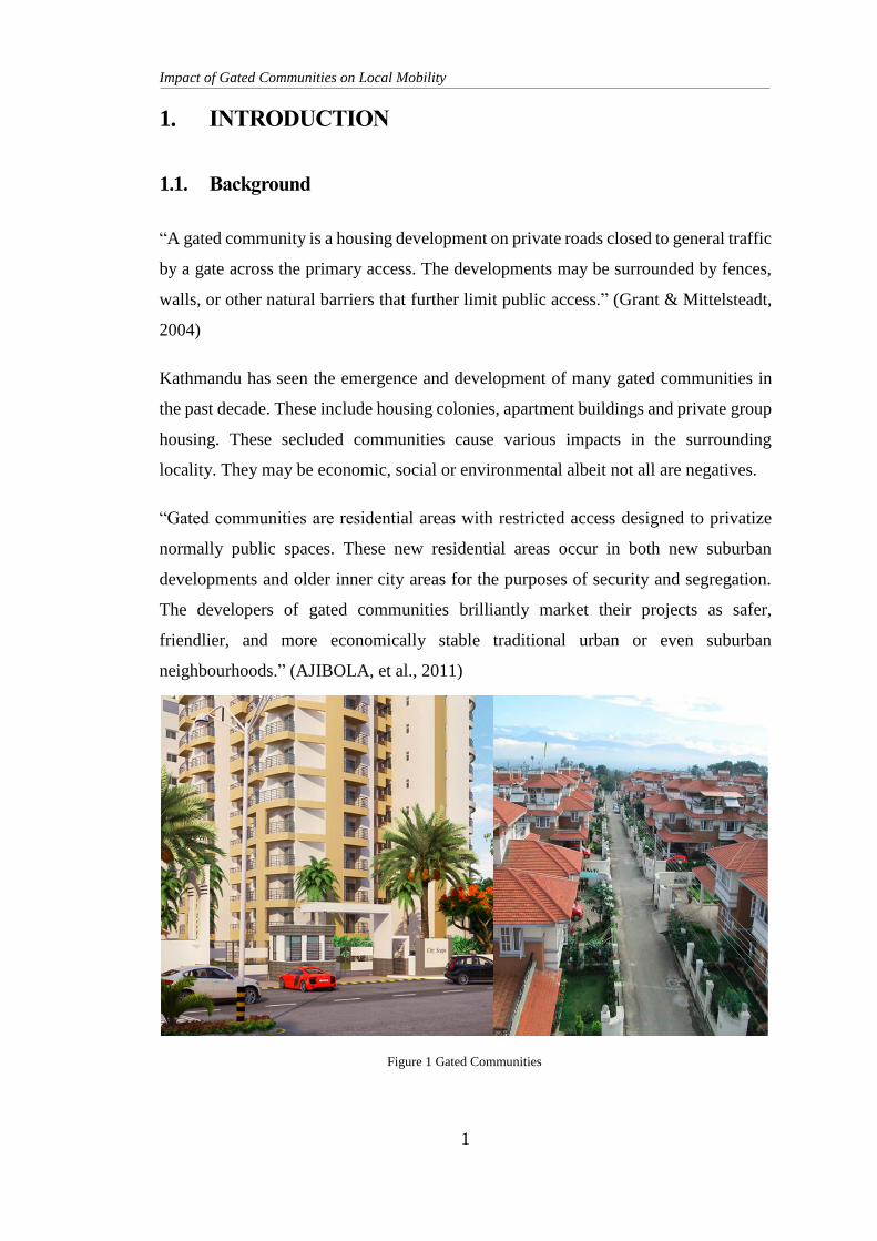
Kathmandu has seen the emergence and development of many gated communities in
the past decade. These include housing colonies, apartment buildings and private group
housing. These secluded communities cause various impacts in the surrounding
locality. They may be economic, social or environmental albeit not all are negatives.
“Gated communities are residential areas with restricted access designed to privatize
normally public spaces. These new residential areas occur in both new suburban
developments and older inner city areas for the purposes of security and segregation.
The developers of gated communities brilliantly market their projects as safer,
friendlier, and more economically stable traditional urban or even suburban
neighbourhoods.” (AJIBOLA, et al., 2011)
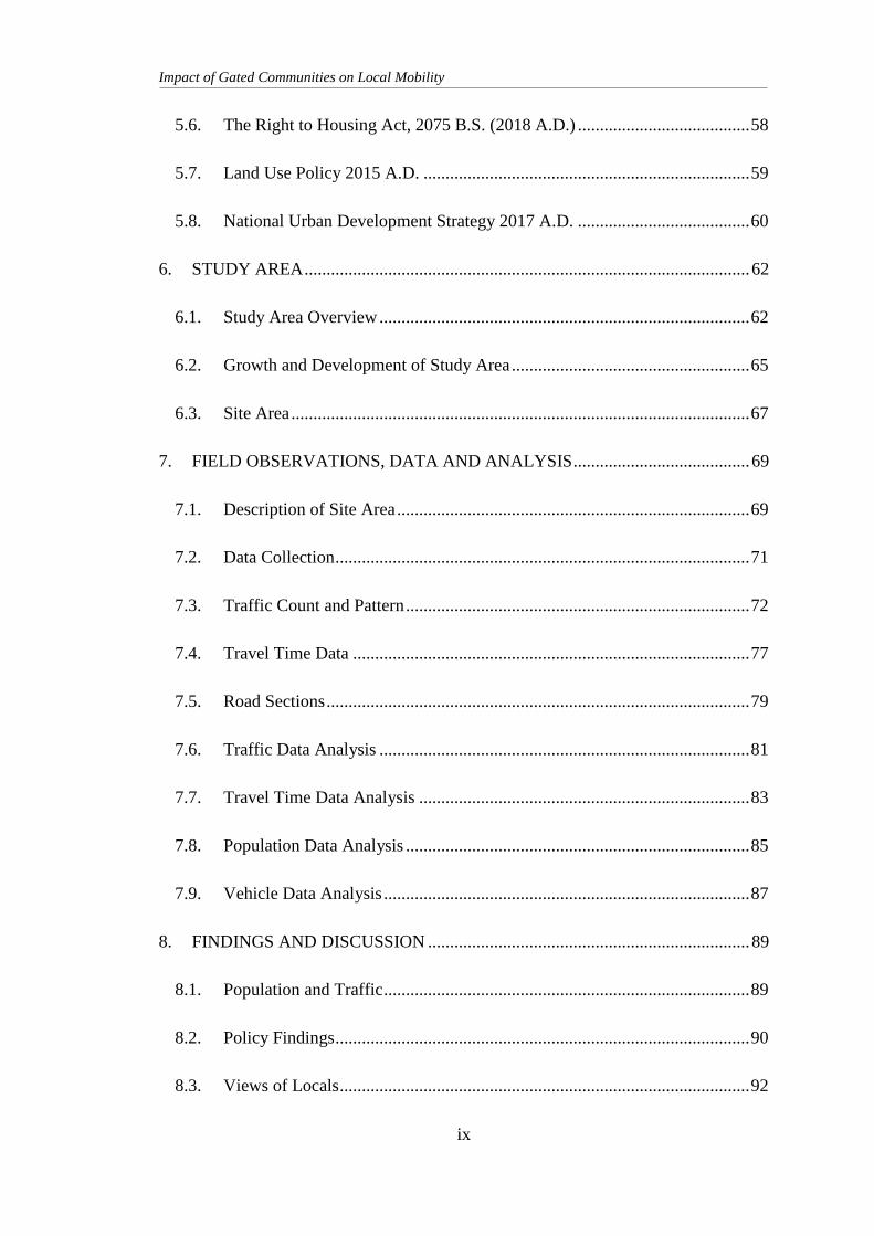
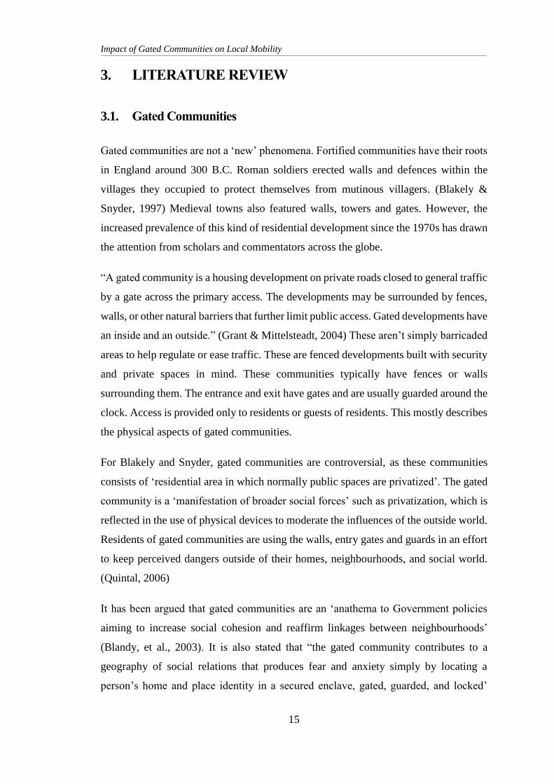
Figure 1 Gated Communities
Impact of Gated Communities on Local Mobility
2
People, residents go to these communities in search of security and a higher standard
of living. These communities play a role in the land usage, land value, urban
management of the area. There are meanwhile some restrictions in the development of
these “privatized public spaces” (AJIBOLA, et al., 2011). However “it is the absence of
these groups from most aspects of city living that creates a wider problem for those
concerned with the quality of civic spaces and institutions.” (Atkinson & Flint, 2004)
Oxford Learner’s Dictionary defines mobility as “the ability to move or travel around
easily” It says mobility is “the ability to move easily from one place, social class or job to
another”. It iterates how easily and conveniently a person can travel to and from places. It
gives an idea of how easily can a person access services and facilities. Gated communities
come up and densifies settlements. However, it closes its gates to the general public who
happen to live outside the gates. This can cause various issues on mobility and ease of
access. A possible alternate path or access way is blocked by the community. Where with
densification ease of access should increase, gated communities form barriers to the
accessibility of various infrastructure and services.
This research is an attempt to look at the impact of gated communities in the local
mobility and ease of access. To study if these “fortified enclaves” (Atkinson & Flint,
2004) create more problems than solutions in the locality.
1.2. Problem Statement
With rapid urbanization and urban densification in Kathmandu in recent years, people
have started seeking housing and residence in the peri-urban areas of Kathmandu.
People migrating in from outside cannot afford to buy land in the main city so they
move to the outskirts and suburbs, or people traditionally from the core cities move out
due to congestions. This trend of gentrification has fuelled the boom in the development
of gated communities. People seeking affordable housing prefer to avoid such
communities, while people seeking comfort, luxury and security gravitate towards
gated communities. This however comes at a premium price. “Gated communities
reflect an urban entity that is physically and often socially and economically
differentiated from the surrounding urban environment.” (Landman, 2000). With this
Impact of Gated Communities on Local Mobility
3
kind of seclusion and isolation, there tends to be a disconnect in status, class, amenities,
services, facilities and lifestyle among the locals.
These secluded clusters of houses form a separate community within its walls. They
often have facilities and infrastructures like parks, department stores, swimming pools,
community halls among others. The public or anyone not part of the gated community
is not allowed in and not allowed to use any of the amenities. Likewise, communities
that have connections to two or more roads at its boundaries benefit from alternate route
options. However, residents excluded from this walled housing cannot use said road
and ease of access is compromised and mobility is affected.
1.3. Need of Research
The trend of gated communities is growing rapidly in Kathmandu. Developers and
residents alike are highly interested in the concept of gated communities, secluded
living and privatized spaces. Comfort, security, status, elite residence etc. are the terms
that are generally associated with these enclaves. Locals view families living in these
cordoned off bungalows and villas as elites or ones with a higher social status. This
creates a sort of social divide and social disconnect. As this concept of secure, secluded
living sees rapid interest and development in the urban context of Kathmandu, little
study has been done in the impacts that these communities has in the locality. The trends
of land use and land use changes, the pace of development, the demand of
infrastructure, the outcome of such growth along with all the factors these gated
communities affect largely remains unchecked. The changes and challenges thus
brought by the introduction of or development of such privatized spaces needs to be
studied to help regulate and ease livelihood while improving access to infrastructure
and facilities.
Strategies, policies, plans, including land use policies, development strategies, housing
byelaws, infrastructure development plans need to take into consideration the impacts
these communities have on the surrounding areas to formulate rules, regulations and
policies. The thought out strategies thus implemented will help regulate these
developments and ensure all parties have equal, easy access to infrastructure and reduce
social divide and benefits.
Impact of Gated Communities on Local Mobility
4
1.4. Importance of Research
“Gates and guards” (Webster, et al., 2002) has been gaining popularity in Kathmandu
in the past decade. The business of building, selling and buying of gated communities
has seen a significant growth in Kathmandu. The periphery and the suburb areas of the
valley are seen littered with these gated and guarded communities. However, “gates and
guards are just one part of a bigger package” (Webster, et al., 2002). These urban
developments impact the accessibility, the mobility, the land use along with the
development pattern and pace of the locality.
This research aims to highlight the issues and benefits surrounding gated communities.
To describe gated communities, explore its types, its contribution to society and social
structure. To examine the effect, it has on the livelihood and structure of society. How
local mobility and ease of access are affected by the introduction of closed housing
communities and apartments.
Thus, this study will be useful to planners, policy makers, and developers to plan for a
better urban area, formulate polices for sustainable and appropriate urban growth and
develop said land appropriately.
1.5. Research Question
What are the impacts of gated communities on surrounding communities in the
aspect of mobility and accessibility?
1.6. Research Objectives
To measure impact of gated communities on local mobility using specific
parameters
To examine the bottlenecks created due to restricted access from the gated
community
To review the legality of gated communities and provide possible policies to
address issues
Impact of Gated Communities on Local Mobility
5
1.7. Validity of Research
It is important in planning to foresee possible issues and provide measures to curb these
issues. With gated communities gaining much popularity, the issues these communities
might pose are relatively unexplored. These closed and secluded residential
developments causes relative rapid increase in density while restricting access and
mobility. This research attempts to highlight issues created by gated communities and
the gaps in policy and planning procedures.
This study will look into traffic flow in the area with a lot of gated communities, study
the policies relating to these communities and explain how mobility and accessibility
is affected and look into possible means of correcting or improving them.
1.8. Expected Outputs
Gated communities restrict access through its premises. The legality of this is
questionable. With the popularity of gated housing colonies rising, it is imperative to
understand the issues and challenges gating might create in the future. This research
hopes to provide insight on the issues, legality and possible solutions in regards to the
issues in mobility created by gated communities,
Gated communities, its types and functions will be iterated and described. Mobility,
accessibility, ease of access and parameters related to the same will be discussed. The
legality of gates and gated communities in terms of group housing projects will be
studied and presented. How mobility is affected due to restrictions in movement
through a gated community is experimented and presented.
Then possible solutions and opportunities for betterment is recommended.
1.9. Scope of Study
The research studies why gating is done in a community. It explores the legality and
validity of the gating. It shall explain the types of gating and gated community; the
reason people commonly seek to live in gated communities. It will measure the extent
of the effect on mobility due to the access restriction of gated community in Bhaisipati.
Impact of Gated Communities on Local Mobility
6
It shall study various laws, policies and strategies that relate to or should relate to the
phenomenon of gating, the legality of blocking passage, the process of permit to plan,
design and construct such communities. It shall then review and recognise issues and
shortcomings in these legal documents then recommend possible changes,
opportunities and requirements to improve and ensure the rights and duties of all parties
involved.
The research however does not explore the socio economic differences, the rift in class
created and other administrative and law enforcement impacts gating and gated
communities may have.
Impact of Gated Communities on Local Mobility
7
2. CONCEPTUAL FRAMEWORK OF RESEARCH AND
METHODOLOGY
2.1. Research Paradigm
The Oxford Dictionary defines paradigm as “a typical example or pattern of
something”. It is something that describes a typical pattern, behaviour or an example of
anything. When defining “research paradigm”, it can be described as an established
model of thought and ideologies that a large number of people in the research
community accept and follow. Kuhn describes paradigms as “sufficiently
unprecedented to attract an enduring group of adherents away from competing modes
of scientific activity” and being “sufficiently open-ended to leave all sorts of problems
for the redefined group of practitioners to resolve.” (Kuhn, 1962) c.f. (Orman, 2016). It
is further described as “A paradigm is a basic belief system and theoretical framework
with assumptions about 1) ontology, 2) epistemology, 3) methodology and 4) methods. In
other words, it is our way of understanding the reality of the world and studying it.”
(Rehman & Alharthi, 2016).
This particular research requires specific data for the fulfilment of objectives stated
above. This shall require a definite way of looking at the research problem. Thus,
suitable research paradigm and methodology needs to be associated with the thesis.
Positivist paradigm believes in empiricism, the idea that observation and measurement
was the core of the scientific endeavour. The key approach of the scientific method is
experimentation, the attempt to discern natural laws through direct manipulation and
observation. Positivists believe that social observations should be treated as similar to
how scientists treat any physical phenomena. Here, researchers believe that the observer
is separate from the subject of observation and can perform a well-informed judgement.
Positivism is the scientific method where all ideas are based on rationality. Positivists
tend to look at social science same as the natural world. They are also called quantitative
purists. This thesis primarily aims to study the impacts of the gated communities to the
area. One of the research objectives requires to explore the socio cultural issue and
Impact of Gated Communities on Local Mobility
8
cannot be solved with a universal truth. Quantitative data is not sufficient here. Thus,
positivist paradigm is not adequate for this research.
Post positivist paradigm states that the social science cannot be looked as the natural
science. The truth may differ from cases to cases. It sees the world as ambiguous and
variable with multiple realities - "what might be the truth for one person or cultural
group may not be the "truth" for another" (O’Leary, 2004) suggests that post positivism
is intuitive and holistic, inductive and exploratory with findings that are qualitative in
nature. Post positivist paradigm is based on most likely truth. This study is related to
the impacts gated communities have on mobility of its surrounding locality. This
requires quantitative as well as qualitative data thus, post positivist paradigm alone
cannot fulfil the requirements of this thesis.
Critical theory/ Transformative paradigm has two main propositions. One being that
people are a shaped by the society in which they live. This so implies that there is no
such thing as an objective fact that can be observed by a person without being involved
and learning the societies area known outside of social structure. The other proposition
is researcher or intellectuals should try to be objective and not let their personal matter
or emotions hamper judgement. “The ontological position of critical theorists is that of
historical realism. It is assumed that a reality exists, but it has been shaped by cultural,
political, ethnic, gender and religious factors which interact with each other to create a
social system. Epistemologically, critical theory is subjective in that it is assumed that
no object can be researched without being affected by the researcher. Critical
educational researchers try to be self-conscious of their own epistemological
presuppositions and communicate them clearly when entering into an investigation.”
(Rehman & Alharthi, 2016)
Gated communities in Kathmandu is a development emerging and booming rapidly in
relatively recent times. It is also creating is a real problem and can cause a lot of issues
in the local area. One can hope to be unbiased and provide with good judgement and
observation every time, however it may not always be possible. Thus, critical theory is
not a suitable logic to be followed while performing this research.
Impact of Gated Communities on Local Mobility
9
Interpretivist/Constructivist paradigm assumes that all knowledge is gained through
experience and previous knowledge. It argues that learning is a constant project and an
active process. Constructivists are referred to as qualitative purists, as they reject
positivism. It says time and context free generalization is not possible. Constructivists
believe in qualitative research process. They believe that the locals or people involved
in a certain field for a period of time have more knowledge and insight than the outside
observer. This research also aims to look at all the issues and hindrances these gated
communities are causing rather than just social research. Thus, an interpretivist or
constructivist paradigm alone isn’t adequate for this thesis.
Pragmatic paradigm is a simple mix of qualitative and quantitative research logics.
“Pragmatism is not committed to any one system of philosophy or reality.” (Mackenzie
& Knipe, 2006). As a research paradigm, pragmatism is based on the proposition that
researchers should use the approach be it philosophical and/or methodological that
works best for the specific research problem. “The focus is on the consequences of
research and on the research questions rather than on the methods.” (Kaushik & Walsh,
2019). Pragmatic paradigm is not to be mistaken with two paradigms merged together
rather a process of using both paradigms.
Since the objectives of this research includes looking at real issues of mobility and
accessibility, it needs to deal with both the expertise of the locals and residents and
utilize the external observers point of view. Thus, both post positivist and interpretative
paradigm shall be used in this research process.
2.2. Research Methodology
Ontology is among the main elements of a research paradigm. It is the study of reality.
It forms the understanding of the researcher and helps formulate the progress of the
research. Here, the ontological position in this research is that “Gated communities
reduce ease of access while increasing density of a locality”
Gated communities that includes both housing colonies and apartment complexes have
been steadily gaining popularity in Kathmandu among both residents and developers.
These communities are marketed as upper class, secure and posh by the developers,
Impact of Gated Communities on Local Mobility
10
likewise residents move into these communities in search of security, calm and secluded
living within the city. Most of these communities are developed in the outskirts and
suburbs of the city to ensure affordability. Thus, when these developments start in these
suburbs, the sparsely populated area suddenly sees rapid development and growth. The
gated community adds a lot of houses and families in an area in a short span of time.
The surrounding areas grow to provide support to the community in terms of building
materials as well as other construction needs while under construction and to provide
daily requirements to the growing population. Thus, the introduction of gated
community significantly increases the density of a place in a relatively short time.
When the population of the housing colonies and apartment complexes are seen, it can
be observed that majority of the households own at least one personal vehicle. This also
significantly increases the vehicular traffic density of the area. However, various access
ways may be blocked by these communities. Ultimately increasing travel time. It also
closes its gates to any amenities or facilities that may be housed within its boundaries.
Restricting public movement and access to amenities results in decreased ease of access
to the residents of the surrounding community.
Increased travel time, more congestion, less ease of mobility and accessibility along
with densification is seen in areas where gated communities have developed. In an open
urban context, accessibility should increase with increased density as more roads,
amenities, and services are added along with the growth.
“Epistemology is concerned with the nature of knowledge and ways of knowing and
learning about social reality” (Bergin, 2017). It is the means or method to be followed
to learn or shed light on the ontological claim of a research.
The methodology for any research is defined by the paradigm it is following. Here, this
research shall follow a pragmatic paradigm where it will take into account both
qualitative and quantitative data to induce conclusions.
Qualitative data may be observed and recorded. This type of data is non-numerical in
nature. Qualitative data is usually collected through various methods such as
observations, one-to-one interviews, conducting focus groups discussions, and other
similar methods to engage public and take their views and opinions. This type of data
Impact of Gated Communities on Local Mobility
11
in statistics can be known as categorical data that is, data that can be arranged
categorically based on its attributes and properties.
Quantitative data can be defined as the value of data in the form of numbers or counts.
Here each data-set has a unique numerical value associated with it. This data is any
quantifiable information that can be used for mathematical calculations and statistical
analysis,
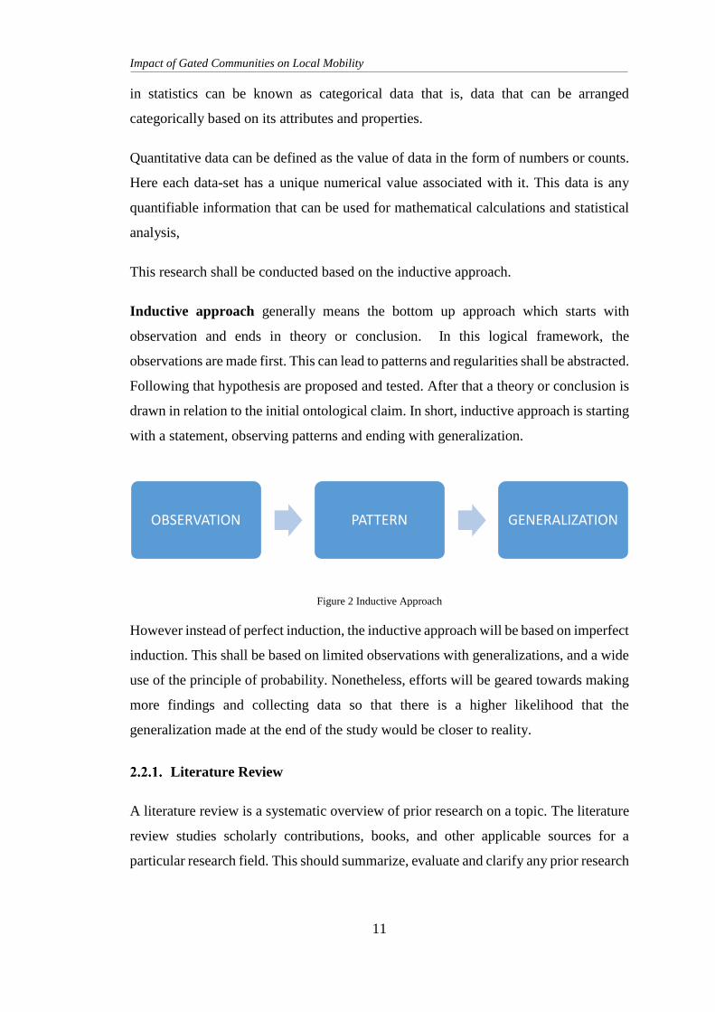
This research shall be conducted based on the inductive approach.
Inductive approach generally means the bottom up approach which starts with
observation and ends in theory or conclusion. In this logical framework, the
observations are made first. This can lead to patterns and regularities shall be abstracted.
Following that hypothesis are proposed and tested. After that a theory or conclusion is
drawn in relation to the initial ontological claim. In short, inductive approach is starting
with a statement, observing patterns and ending with generalization.
Figure 2 Inductive Approach
However instead of perfect induction, the inductive approach will be based on imperfect
induction. This shall be based on limited observations with generalizations, and a wide
use of the principle of probability. Nonetheless, efforts will be geared towards making
more findings and collecting data so that there is a higher likelihood that the
generalization made at the end of the study would be closer to reality.
Literature Review
A literature review is a systematic overview of prior research on a topic. The literature
review studies scholarly contributions, books, and other applicable sources for a
particular research field. This should summarize, evaluate and clarify any prior research
OBSERVATION PATTERN GENERALIZATION
Impact of Gated Communities on Local Mobility
12
in the field. It should provide a base for the research and help determine the nature of
the research.
Firstly, literature relating to gated communities, its origins, types and characteristic was
studied. This helped form the basis of understanding of gated communities. How they
are formed, why they are popular and how it affects the society. These articles, books
and reports related to gated communities, their types, issues and challenges was
referenced through various scholarly domains and portals. Also papers on mobility,
accessibility and ease of access was reviewed. These studies then helped to define
parameters of mobility and ease of access. This as a result helped streamline and
measure the impacts on mobility.
Case Studies
A case study is a research strategy and an empirical inquiry that investigates a
phenomenon within its real-life context. They are based on an in-depth investigation of
a single individual, group or event to explore the causes of underlying principles. In
research, it can be single or multiple case studies, include quantitative evidence, rely on
multiple sources of evidence and benefit from the prior development of theoretical
propositions.
Case studies on foreign gated communities, their structure, size, characteristics and how
they function has been done with the help of peer reviewed literature and reports. These
helped understand, acknowledge and appreciate the scale, structure and character of
these communities.
Policy Review
Policy is a set of ideas or a plan of what to do in particular situations that has been
agreed to officially. It is a document showing an agreement on the plans and actions to
be taken or implemented
Policies, laws and regulations related to gated communities, housing, and joint housing
was reviewed and interpreted.
Impact of Gated Communities on Local Mobility
13
The review of legal documents were done to understand the legality of gated
communities in Nepal. Documents such as The Lands Act, 2021 B.S., Public Roads
Act, 2031 B.S., The Ownership of Joint Housing Act, 2054 B.S., Building Byelaws,
2064 B.S., and The Right to Housing Act, 2075 B.S was studied. These documents
provide an understanding the legal provisions around development, purchasing, selling
and maintenance of gated communities.
Data Collection
Primary data is data that is collected by a researcher from first-hand sources, using
methods like surveys, interviews, observations, focus groups or experiments. It is
collected with the research project in mind, directly from primary sources. Secondary
data is data gathered from studies, surveys, or experiments that have been run
previously. Secondary data is usually defined in opposition to primary data. It refers to
data collected by someone other than the user / researcher. In other words, secondary
data refers to data that have already been collected for some other purpose. Yet, such
data may be very useful for one’s research purpose.
This research shall involve primary and secondary data collection for understanding
mobility patterns, access ways and infrastructures. Primary data such as traffic count,
commute time, distance shall be collected. Also unstructured in-depth interviews with
locals shall be done to understand the local mentality and the issues and challenges they
may be facing. Secondary data such as time, population, vehicle registry, housing
company registry, articles, surveys, GIS maps etc. shall also be referenced.
Field Visit
To understand the mobility patterns, ease of access, volume of traffic, distance to be
travelled, researcher shall visit site observe the patterns and identify bottle necks.
Traffic volume shall be measured and time of commute shall be defined and measured
on site. Distance to travel shall also be determined and assumed in case of hypothetical
scenarios. Researcher shall also interact with local residents, business owners and
traffic management personnel.
Impact of Gated Communities on Local Mobility
14
Data Analysis
Data collected shall be studied and examined. Traffic counts, patterns, distances,
commute time shall be analysed through researcher observation. The meaning and gist
of interviews, patterns and volume shall be interpreted through the researcher
perspective. Then assumptions regarding a hypothetical scenario shall be made to come
up with possible solutions.
Recommendation
After doing the literature study, reading the policies, going for field visits, talking to
the locals, collecting traffic data, looking at similar possible cases, the information is
processed, data analysed.
Following the literature study, data collection, compilation and analysis of the study
area, recommendations on policies and regulations shall be suggested.
2.3. Limitations
Analysis is done via personal interpretation, there may be some bias to the results and
outcomes. Since the data collection for the research will be done via interviews and the
opinions of people are susceptible to change over time and change of context, the
research will be true to the present scenario of the study area.
Impact of Gated Communities on Local Mobility
15
3. LITERATURE REVIEW
3.1. Gated Communities
Gated communities are not a ‘new’ phenomena. Fortified communities have their roots
in England around 300 B.C. Roman soldiers erected walls and defences within the
villages they occupied to protect themselves from mutinous villagers. (Blakely &
Snyder, 1997) Medieval towns also featured walls, towers and gates. However, the
increased prevalence of this kind of residential development since the 1970s has drawn
the attention from scholars and commentators across the globe.
“A gated community is a housing development on private roads closed to general traffic
by a gate across the primary access. The developments may be surrounded by fences,
walls, or other natural barriers that further limit public access. Gated developments have
an inside and an outside.” (Grant & Mittelsteadt, 2004) These aren’t simply barricaded
areas to help regulate or ease traffic. These are fenced developments built with security
and private spaces in mind. These communities typically have fences or walls
surrounding them. The entrance and exit have gates and are usually guarded around the
clock. Access is provided only to residents or guests of residents. This mostly describes
the physical aspects of gated communities.
For Blakely and Snyder, gated communities are controversial, as these communities
consists of ‘residential area in which normally public spaces are privatized’. The gated
community is a ‘manifestation of broader social forces’ such as privatization, which is
reflected in the use of physical devices to moderate the influences of the outside world.
Residents of gated communities are using the walls, entry gates and guards in an effort
to keep perceived dangers outside of their homes, neighbourhoods, and social world.
(Quintal, 2006)
It has been argued that gated communities are an ‘anathema to Government policies
aiming to increase social cohesion and reaffirm linkages between neighbourhoods’
(Blandy, et al., 2003). It is also stated that “the gated community contributes to a
geography of social relations that produces fear and anxiety simply by locating a
person’s home and place identity in a secured enclave, gated, guarded, and locked’
Impact of Gated Communities on Local Mobility
16
Despite this criticism, gated communities are a common form of residential
development in the United States, South Africa and Latin America and are growing in
popularity in places such as Indonesia. (Quintal, 2006). Nepal is also seeing an
increasing public interest and popularity in terms of gated communities, their prospects,
characteristics and development.
Developers, landowners, investors, and consumers have together shaped a new genre
of modern urban habitat. An increasingly sophisticated mass market has emerged in
entire neighbourhoods, comprising homes, community infrastructure, services, and
micro urban governance. Gates and guards are just one part of a bigger package. The
phenomenon is a spontaneous one and it has spread rapidly within and between
countries. Its significance lies not so much in the physical impact of gated
developments, though this may pose challenges to urban designers, but in their
underlying sociology, politics, and economics. In short, they challenge the spatial,
organizational, and institutional order that has shaped modern cities. (Webster, et al.,
2002)
Gated communities are residential areas with restricted access designed to privatize
normally public spaces. These new residential areas occur in both new suburban
developments and older inner city areas for the purposes of security and segregation.
The developers and builders of gated communities brilliantly market their projects as
safer, friendlier, and more economically stable traditional urban or even suburban
neighbourhoods.” (AJIBOLA, et al., 2011)
There is also a continuous rise of community associations. These are contractual
associations that deliver some form of neighbourhood-level governance in the form of
regulations and local civic goods and services on the basis of assessments (fees)
collected from members. (Webster, et al., 2002)
Some gated communities reflect the growing range of choices available to consumers
in the postmodern city. The affluent can move to gated enclaves in search of privacy
and exclusivity, and in flight from fear, closing themselves off from the dangers outside.
(Dillion, 1994)
Impact of Gated Communities on Local Mobility
17
There may be compelling international trends in taste, but these may transform
differently, in the context of locally specific social and environmental capital. Important
in this respect are local variations in the institutions (rules) that govern housing; capital
and labour markets; local variations in entrepreneurial abilities and cultures; and local
values governing interpersonal and intergroup relationships.
(Hamid, n.d.) includes gated communities in the term “commons”. He explains that
commons, in its most basic sense, it is associated with shared goods and resources
among members of the same community. Since gated communities is sharing goods
and services among a certain related group of people, it falls under this category.
3.2. Defining a Gated Community
Blakely and Snyder in their seminal work Fortress America: gated communities in the
United States define ‘gated communities’ as secure housing estates ‘with designated
perimeters, usually walls or fences, and controlled entrances that are intended to prevent
penetration by non-residents’ (Blakely & Snyder, 1997)
The most common feature of a ‘gated’ community or any ‘gated’ housing development
is a perimeter wall or fencing that envelopes and closes off the entire area of the
development. Vehicular access to the development may also be restricted by a gate or
a boom arm and entry is either granted by security guards stationed at the entry points
or gained by entering a pin-code into a key-pad at the entryway. by use of an access
card.
Security may be ensured through a variety of means:
24-hour security patrols by guards and ‘back-to-base’ alarms
Panic buttons to alert security guards of a perceived security issue;
Neighbourhood siren systems to raise the alarm in case of emergencies.
The use of guard dogs or closed-circuit television cameras;
Electric fencing, spikes and other forms of anti-intruder treatments
Impact of Gated Communities on Local Mobility
18
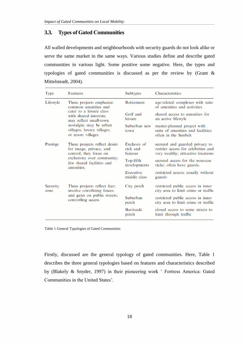
3.3. Types of Gated Communities
All walled developments and neighbourhoods with security guards do not look alike or
serve the same market in the same ways. Various studies define and describe gated
communities in various light. Some positive some negative. Here, the types and
typologies of gated communities is discussed as per the review by (Grant &
Mittelsteadt, 2004).
Firstly, discussed are the general typology of gated communities. Here, Table 1
describes the three general typologies based on features and characteristics described
by (Blakely & Snyder, 1997) in their pioneering work ‘ Fortress America: Gated
Communities in the United States’.
Table 1 General Typologies of Gated Communities
Impact of Gated Communities on Local Mobility
19
The three general typologies of gated communities are:
Lifestyle Communities
Prestige Communities
Security Zone Communities
Lifestyle Communities
In lifestyle communities, the gates provide security and separation for the leisure
activities and amenities offered within. These projects emphasize common amenities
and cater to a leisure class with shared interests; may reflect small-town nostalgia; may
be urban villages, luxury villages, or resort villages. There are three distinct types of
lifestyle community
The retirement community
The golf and leisure community
The suburban new town.
The retirement community, is developed for middle and upper-middle class retirees
who want structure, recreation, and a built-in social life in their early retirement years.
Many of these developments start out as second homes to which their owners eventually
retire permanently. As a result, these developments often contain both part-year and
year-round residents.
The golf and leisure community is exemplified by the golf course and tennis club that
are central features. Recreation spots, leisure sports, comfortable amenities integrated
in the community for shared access for the residents define these communities. These
developments have been noted for their retirement and leisure orientations for many
years.
The suburban new town is a new class of suburban lifestyle community. They are
large, comprising as many as several thousand housing units, and attempt to incorporate
both residential and commercial/industrial and retail activities within or adjacent to the
development. New towns are not new; but the gating of their residential areas is. The
complex may contain both gated and non-gated areas.
Impact of Gated Communities on Local Mobility
20
Prestige Communities
Prestige communities are among the fastest-growing development forms. Their gates
symbolize distinction and prestige and create and protect a secure place on the social
ladder. They lack the recreational amenities of the lifestyle communities, often differing
little from a standard residential subdivision except for their gates. The gates are
motivated by a desire to project an image, protect current investments, and control
housing values.
They include:
the enclaves of the rich and famous;
developments for the top fifth, the very affluent;
executive home developments for the middle class.
The enclaves rich and famous are the communities with small compounds of privacy
for celebrities and the gated enclaves of the very rich. Highly exclusive, often hidden
and heavily defended, they are the model for all the gated communities proliferating
across the world.
The top-fifth developments are meant to confer some of the prestige of the rich and
famous enclaves to those with less exclusive status. The intention is also in part to
artificially induce community, where physical security and social security are enhanced
both by sameness and by controlled access. Top-fifth developments are designed for
senior executives, managers, and other successful professionals. They feature elaborate
gatehouses, monumental entrances, and prestige amenities such as artificial lakes or
carefully preserved natural features such as ocean or river fronts and woods.
The executive home developments for middle class are communities that are the
scaled down versions of top-fifth developments, they are sold by developers as
''executive," although they are really just middle class subdivisions. These are a
growing and ever more prominent form of development in many metropolitan areas
around the globe. These are also the primary development sold as housing
developments in Kathmandu.
Impact of Gated Communities on Local Mobility
21
Security Zone Communities
In security zone communities the fear of crime and outsiders is the foremost motivation
for defensive fortification.
This class includes three types:
the city perch,
the suburban perch,
the barricade perch.
These are called perches because it is not the developers who build the gates but the
residents, who are often desperately trying to maintain and stay in their
neighbourhoods. The residents retrofit their neighbourhoods with gates or barricades,
erecting fortifications to fend off or regain control from some outside threat. By
marking their boundaries and restricting access, they attempt to build and strengthen
the feeling and function of community in their neighbourhood. Security zone gating
and street closures occur at all income levels and in all areas. The disruptions caused
by crime and traffic that their residents fear may be real or perceived, near or far; the
important point is not whether they need to cut off access to their streets, but that they
feel they must.
The city perch is the gates erected by the residents in the city neighbourhoods in search
of security. In the city, neighbourhoods from the most affluent to the most desperately
poor are looking to gates as a way to hold off the urban disorder they see around them.
Sometimes the threat is on their own doorsteps, sometimes a number of blocks away.
Creators of the city perch are looking to protect themselves from crime and from traffic,
wanting their homes secure, their streets safe to walk on, their children protected from
speeding cars and predators. Sometimes unwilling, sometimes unable to flee to the
higher ground of the suburbs, they fort up in place.
The suburban perch is a more recent but growing phenomenon, as more and more of
the problems previously thought of as urban occur in the suburbs and smaller towns. In
some cases, as the inner suburbs age and urbanize, the quality of life their residents
once enjoyed deteriorates. Sometimes residents of older suburban subdivisions fear that
Impact of Gated Communities on Local Mobility
22
they will be next and move to gate their entrances before real trouble reaches their
doors. As with the city perches, the danger or threat may be more from traffic rather
than crime, as residents fear the impact of overburdened residential streets on their
quality of life.
The barricade perch is the fastest-growing type of community in the security zone
category. Barricade perches are not fully gated communities; they are not completely
walled or fenced and all entrances are not secured with gates. Instead they use
barricades to close off some streets. Barricade perches are intentionally designed
security settlements with restricted access to normally public spaces. Partly because of
the expense, but often because the neighbourhoods exist on public streets, their
complete closure is impossible. The barricades create a suburban cul-de-sac pattern out
of the city grid and leave just one or two entrances to the neighbourhood. The effect is
as close to full gating as is practicable.
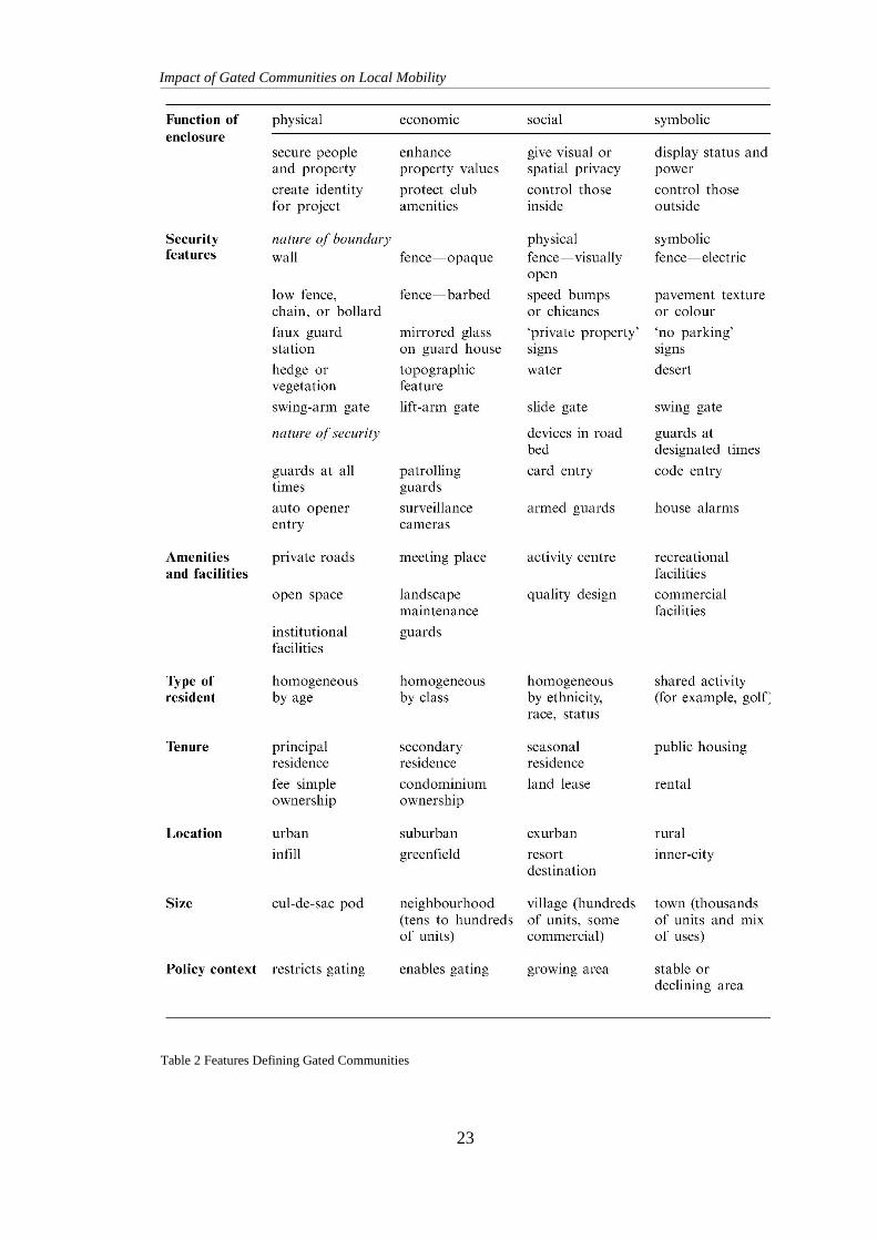
3.4. Features of Gated Communities
There are several functions and variables that differentiate the kinds of gating. Grant
and Mittelsteadt describe and elaborate eight factors that differentiate gated
communities. (2004, pp. 917-918)
These characteristics are based on the following factors.
Functions of enclosure,
Security features and barriers,
Amenities and facilities included,
Type of residents.
Tenure,
Location,
Size,
Policy context.
These eight features and dimensions defining and differentiating gating are elaborated
in Table 2.
Impact of Gated Communities on Local Mobility
23
Table 2 Features Defining Gated Communities
Impact of Gated Communities on Local Mobility
24
Function of enclosure
Although walls and gates may look similar across cultures, they have a range of
functions: physical, economic, social, and symbolic. An enclosure affects the way that
people navigate and use space.
Enclosures in lifestyle community limits access to shared amenities within the walls.
They restrict club goods to community members and for seasonally occupied homes,
the gates also limit off-season vandalism and theft. For prestige developments it is
mainly protecting property values. Walls and gates also provide visual separation.
Security zone developments have defensive functions. In communities around the
world, people have used fences and walls to offer domestic security. In nations plagued
by violence or war, walled camps may develop to separate feuding peoples, or to control
subject or dangerous peoples. Walls have also been built in history for demonstrating
power and authority.
Security features
There are various types of gates and guarding, different nature of the boundaries used,
and a wide range of security features found today.
Nature of boundary
Boundaries around communities serve several functions: they create visual
screening, permit privacy, define property, and limit access. Some are easily
permeable, whereas others are high or opaque. Some create character and
identity, whereas others inspire fear and loathing. Some are physical, whereas
others may be psychological or symbolic.
In many cases boundaries do not prevent access for non-residents, but they
regulate the degree of difficulty of access and the distance from any public
goods which non- residents may want to share. In some cases, barriers do not
inhibit pedestrian movement, but simply prevent cars and trucks from entering.
Some neighbourhoods find strategies for discouraging visitors without applying
full gating. Faux-gated entries employ structures to give the appearance of guard
houses and discourage entry to people not from the area.
Impact of Gated Communities on Local Mobility
25
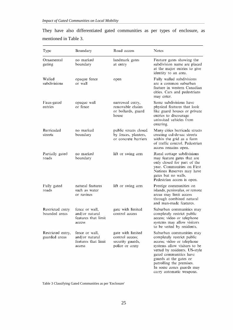
They have also differentiated gated communities as per types of enclosure, as
mentioned in Table 3.
Table 3 Classifying Gated Communities as per 'Enclosure'
Impact of Gated Communities on Local Mobility
26
Nature of security
Features that provide security, privacy, and control are central to many gated
communities. Gated communities in insecure areas tend to employ more
expensive and extensive security devices than gated communities in low-crime
areas. Where gating is used as a niche marketing strategy, for instance, it may
involve only a simple lift or swing gate that impedes car entry by strangers.
Some projects have 24-hour-a-day roving armed guards and video surveillance.
Devices in the road bed may puncture the tires of vehicles trying to crash
through the gates. Homes have private alarms tied in to central security services.
Although such measures may reassure residents that their homes provide
sanctuary from the risks of the world, they also expose the fear of community
members.
Amenities and facilities
Enclaves range from having few amenities to constituting complete towns. Seasonal
cottage developments may have private roads that are impassable in winter when routes
are covered with snow, and full-service master-planned communities offer shopping
malls, schools, industry, recreational departments, and police. The availability of
amenities and facilities within the enclave may affect the degree of interaction with the
world outside, and so has major implications for social integration and exchange.
Type of residents
Those inside the walls of contemporary gated enclaves fall into two categories. Those
who move into walls by choice are typically economically privileged, sometimes
ethnically or age segregated. Gated communities may provide a means for people to
separate themselves from the unknown or feared other, or to congregate with others
who share their world view. Those who move into a gated community out of force may
be refugees or captives.
Impact of Gated Communities on Local Mobility
27
Tenure
The suburban new gated communities in are primarily first homes for the owner-
residents. We can also see, however, a many second-home gated market. Some owners
buy residents as holiday homes while others occupy homes just as an investment in real
estate.
Location
Most of the gated communities are known to be found in urban or suburban sites. While
there are some enclaves that may also appear in exurban1 areas and rural regions.
Location is clearly tied to other variables that drive gating. For instance, fear of crime
and rates of crime vary. Extreme poverty, violence, and lawlessness occur more
commonly in some parts of the world than in others, thus encouraging those with means
to look for residential solutions to the threats they face.
Size
The size of the enclosure clearly affects social functions and characteristics. Some
enclaves are small developments of only a few houses; these tend to have few common
amenities other than the road and wall. Others may be neighbourhoods of dozens of
homes, with shared facilities such as a club house or swimming pool. Village-sized
developments will have limited commercial uses. A few gated communities are the size
of towns or cities: they have a full suite of facilities and may incorporate as municipal
units. The size affects not only the kinds of amenities in the settlement, but also the way
in which residents interact, and the level of security provided. The larger the settlement,
the greater the chance that it reflects some level of social or economic diversity, and
that it may become all-encompassing in meeting residents' needs. In the largest
enclaves, residents may virtually secede from public life outside.
1 An exurban area is an area outside the typically denser inner suburban area of a metropolitan area,
which has an economic and commuting connection to the metro area, low housing density, and growth.
Impact of Gated Communities on Local Mobility
28
Policy context
The policy context of a place affects how and under what conditions communities can
close themselves off from others. Some jurisdictions place few limits on gating, or lack
the police powers to prevent neighbourhoods from enclosing themselves. Some cities
essentially encourage it. In other areas local policy may restrict or limit gating.
Some gated communities have their own management, first under the project developer,
and later under homeowners' associations. The association provides services that in
cities would be the responsibility of local government. This policy context reflects a
distrust of government and a weak planning regime that can enhance commitment to
the private community. Projects that provide their own local services ease pressure on
governments which currently lack resources to provide adequate urban infrastructure.
In the process the gated community grows distant from the public realm and the rules
that govern it. Nations with a strong tradition of local land-use planning or highly
centralized planning authority may react differently to proposals for gated communities
than do nations with a policy in minimum interference from governments on private
transactions.
As authorities look at developing policy to control or manage gated communities, they
have to consider several questions about the potential of the strategy to meet local
objectives. Is the project self-governing or a residential enclave within an established
political unit? How does the settlement integrate with the larger community? What
impact will gating have on the larger community? How might it affect traffic and crime
patterns? Will it contribute to urban fragmentation, social segregation, and perceptions
of crime? Because communities find different responses to these questions, their
approaches to gating vary. (Grant & Mittelsteadt, 2004)
3.5. Social Divide
Gated communities are secluded and are facilitated with security and various other
amenities managed by a community body of governance. The area is cordoned off, well
maintained and made to feel like a different area compared to the outside locality. This
creates a difference in the social structure and mentality. The differences in their social
structure could be a crucial factor in explaining the level of urban inequality, the
Impact of Gated Communities on Local Mobility
29
symbolic distance between the groups and differences in residential mobility.
(Ruoppila, 2006)
Residents of these communities living in a guarded, protected and well maintained
parcel of land are considered “well off”. They are considered the elites and the
privileged. This mentality suggests that the residents have a higher perceived income
over residents outside the locality. This is mostly untrue. However, this is not what is
perceived. The perception of unfair advantage and privilege is abundant in this topic of
discussion. If the perception were to change or some sort of access or benefit given to
the public/locals by the developers and buyers of said gated community, the perceived
level of fairness and society would increase. And higher levels of perceived fairness
cause higher levels of utility, and lower preferred levels of income redistribution.
(Bjørnskov, et al., 2010)
3.6. Rise of Gated Communities
Gated communities are a very popular
form of development in the United
States, South Africa, Mexico and Latin
America. However, it is difficult to know
how many people reside in gated
developments, primarily because
comprehensive surveys have not been
undertaken. (Low, 2003) estimates that
16 million people in the United States
live in gated communities. In
comparison, a survey conducted in
2003/04 of the English planning
authorities to collect factual details of
gated communities, indicate that there
are approximately one thousand gated
communities in England. (Blandy, 2007)
Figure 4 Gated community in South Africa
Figure 3 Preston Oaks Gated community in Buffalo, NY
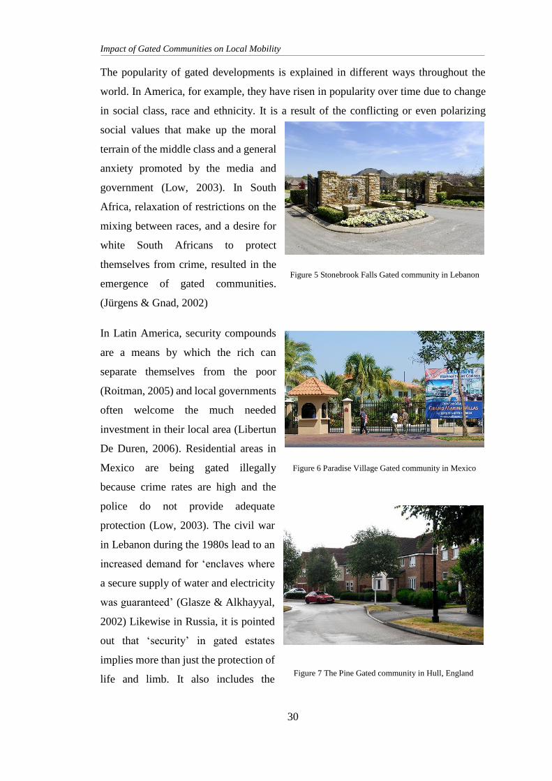
Impact of Gated Communities on Local Mobility
30
The popularity of gated developments is explained in different ways throughout the
world. In America, for example, they have risen in popularity over time due to change
in social class, race and ethnicity. It is a result of the conflicting or even polarizing
social values that make up the moral
terrain of the middle class and a general
anxiety promoted by the media and
government (Low, 2003). In South
Africa, relaxation of restrictions on the
mixing between races, and a desire for
white South Africans to protect
themselves from crime, resulted in the
emergence of gated communities.
(Jürgens & Gnad, 2002)
In Latin America, security compounds
are a means by which the rich can
separate themselves from the poor
(Roitman, 2005) and local governments
often welcome the much needed
investment in their local area (Libertun
De Duren, 2006). Residential areas in
Mexico are being gated illegally
because crime rates are high and the
police do not provide adequate
protection (Low, 2003). The civil war
in Lebanon during the 1980s lead to an
increased demand for ‘enclaves where
a secure supply of water and electricity
was guaranteed’ (Glasze & Alkhayyal,
2002) Likewise in Russia, it is pointed
out that ‘security’ in gated estates
implies more than just the protection of
life and limb. It also includes the
Figure 6 Paradise Village Gated community in Mexico
Figure 5 Stonebrook Falls Gated community in Lebanon
Figure 7 The Pine Gated community in Hull, England
Impact of Gated Communities on Local Mobility
31
guarantee of the long-term functioning of ‘normal’ residential infrastructure, e.g. the
provision of water, gas, electricity, heating, regular waste collection, lift maintenance
and so on – services which frequently failed in formerly state owned and now
municipally owned housing in the period of transformation’ (Lentz, 2006)
3.7. Housing Scenario and Development in Nepal
Developing countries like Nepal were initially left out of such gated developments. It
was only during the late 1990s and early 2000s that small-scale gated communities
started appearing in Kathmandu valley. Locally referred to as ‘colony’ or simply
‘housing’, gated communities in Nepal have been limited to roughly 50 to 250 units, so
far with relatively limited mixed-use character and amenities. Unlike an orthodox gated
community, these housings are not strictly self-governed or fully provisioned.
They do qualify to be called gated communities, because they are gated and they are
walled. Fundamentally, the primary focus is mostly always on the physical aspect of
these entities, such as walled perimeter, restricted access, amenities within them, and
isolation from the outer world. However, they are different from the much celebrated
gated communities around the world. (Thapa, 2017)
Kathmandu valley saw a major housing deficit in the past few decades. This is due to a
combination of three factors. First, there have been various phases of transition.
Politically speaking, this involved the end of the Rana dynasty in 1951 A.D., the
restoration of a multiparty democracy system in 1990 A.D., the Maoist armed struggle
in 1996 A.D., the people’s movement that abolished the monarchy and the peace
agreement with the Maoists in 2006 A.D. Natural disasters also caused great transition
because of the loss of properties and homes, environmental degradation and low socio-
economic development in rural regions. There was a large population migrating into
the Kathmandu valley seeking better economic and educational opportunities as well
as health, safety and other services not easily available or accessible in other parts of
the country. Instead of regulating this trend of urbanization, successive governments
adopted a centralizing policy and concentrated development projects within the valley,
causing a 6% annual urban population growth, against the national average of 2.1%,
and resulting in the population of Kathmandu valley to be about 30.9% of the total
Impact of Gated Communities on Local Mobility
32
national urban population. The available developed land, extended infrastructure and
constructed housing did not meet the demands of the ever-increasing urban population,
resulting in a growing number of vehicle registrations and haphazard expansion of
settlement in the Kathmandu Valley. The following are some of the driving forces
influencing the dynamic pattern of urban growth in the valley: physical conditions,
public service accessibility, economic opportunities, land market, population growth,
political situation, and plans and policies.
Second, urban poverty and the increasing gap between rich and poor have constrained
the accessibility and affordability of housing. Nepal was one of the poorest countries in
the world, with a per capita income of NPR 20,543 ($278 in 2003–2004) according to
CBS, 2004. In the capital city of Kathmandu, the urban poor was estimated to represent
about 15.1% of the city’s population. Disparity in income levels is very high, a lot of
people in Kathmandu live in rental housing. There were only 17 squatter settlements in
the valley in 1985, and in 2003 that number had increased to 64 according to Lumanti
Support Group for Shelter. In a span of 18 years, the squatter population increased from
2,134 to 14,500, almost a sevenfold increase. Popularly known as landless settlements,
squatter developments have provided housing for around 2,600 families or 14,500
people. More than half of the population of the large squatter development close to the
urban centre consists of migrants or the low-income group that was displaced from the
city centre when many ground-floor apartments were converted into shops.
Third, until recently, construction of a house in Nepal was entirely the responsibility of
the individual or family. In such an owner-built informal housing development system,
individuals first acquire a plot of land through their own finances and then build a house
themselves. All of the infrastructure required for the land and house will be managed
incrementally through cooperation with the neighbours. The dwelling units are built
and expanded incrementally over a period of time as both the family size and income
increase. Due to these factors there was a massive deficit in housing in Kathmandu
Valley.
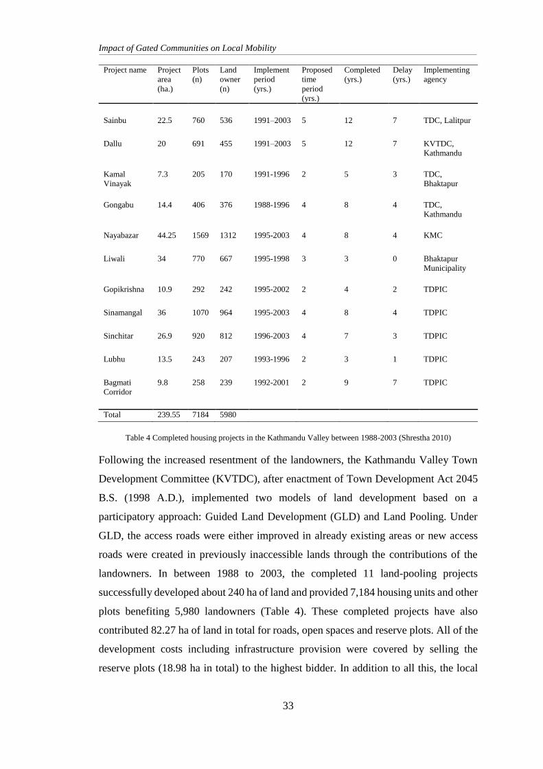
Impact of Gated Communities on Local Mobility
33
Project name Project
area
(ha.)
Plots
(n)
Land
owner
(n)
Implement
period
(yrs.)
Proposed
time
period
(yrs.)
Completed
(yrs.)
Delay
(yrs.)
Implementing
agency
Sainbu 22.5 760 536 1991–2003 5 12 7 TDC, Lalitpur
Dallu 20 691 455 1991–2003 5 12 7 KVTDC,
Kathmandu
Kamal
Vinayak
7.3 205 170 1991-1996 2 5 3 TDC,
Bhaktapur
Gongabu 14.4 406 376 1988-1996 4 8 4 TDC,
Kathmandu
Nayabazar 44.25 1569 1312 1995-2003 4 8 4 KMC
Liwali 34 770 667 1995-1998 3 3 0 Bhaktapur
Municipality
Gopikrishna 10.9 292 242 1995-2002 2 4 2 TDPIC
Sinamangal 36 1070 964 1995-2003 4 8 4 TDPIC
Sinchitar 26.9 920 812 1996-2003 4 7 3 TDPIC
Lubhu 13.5 243 207 1993-1996 2 3 1 TDPIC
Bagmati
Corridor
9.8 258 239 1992-2001 2 9 7 TDPIC
Total 239.55 7184 5980
Table 4 Completed housing projects in the Kathmandu Valley between 1988-2003 (Shrestha 2010)
Following the increased resentment of the landowners, the Kathmandu Valley Town
Development Committee (KVTDC), after enactment of Town Development Act 2045
B.S. (1998 A.D.), implemented two models of land development based on a
participatory approach: Guided Land Development (GLD) and Land Pooling. Under
GLD, the access roads were either improved in already existing areas or new access
roads were created in previously inaccessible lands through the contributions of the
landowners. In between 1988 to 2003, the completed 11 land-pooling projects
successfully developed about 240 ha of land and provided 7,184 housing units and other
plots benefiting 5,980 landowners (Table 4). These completed projects have also
contributed 82.27 ha of land in total for roads, open spaces and reserve plots. All of the
development costs including infrastructure provision were covered by selling the
reserve plots (18.98 ha in total) to the highest bidder. In addition to all this, the local
Impact of Gated Communities on Local Mobility
34
real estate and the individual land brokers made a significant contribution on land
availability compared to that of the government’s efforts. Private owners also supplied
rental housing that helped fulfil the housing needs the urban population of the
Kathmandu metropolitan area. (Shrestha, 2010)
In the 1970s land use plans for all the five regional centres were prepared and includes
detailed physical development plan of government’s institutional area. Also a number
of towns were established in Terai by clearing some forest lands and attempts were
made to implement a physical development plan in Kathmandu Valley including three
sites and services projects. There have been a series of plans prepared in the case of
Kathmandu Valley, and some other towns like Birgunj and Biratnagar. However, they
were not implemented. Since then no comprehensive planning effort has taken place in
Nepal’s urban areas. Land is mostly developed by individual’s decisions with a mixed
residential-commercial land use pattern. (Steekelenburg, Ester van ; CIUD, 2010)
Private developers are a recent phenomenon in Nepal. The high influx of population to
cities, particularly in Kathmandu Valley and other prominent cities like Pokhara and
Birgunj during and after the ten-year long insurgency in the country, the remittance
fund inflow from the workers outside the country, availability of housing loans, and
improvement in construction technologies saw a slowly emerging formal housing
market. In the mid-1990s, the government began to encourage private- sector
investment in land and housing development with the promulgation of The Ownership
of Joint Housing Act 2054 B.S. (1997 A.D.) (The Apartment Ownership Act), that
provided the legal framework for development sales and management of multi-story
buildings and paved road for private sector developers to enter into the housing sector.
(Steekelenburg, Ester van ; CIUD, 2010)
The Ownership of Joint Housing Act 2054 B.S. (1997 A.D.), which was only finalized
in 2003 due to legal and administrative obstacles. Within a span of 2 years (2003–2005),
as many as 15 housing companies were sanctioned by the KVTDC for the development
of housing units (independent, duplex and apartment types) in the valley. Over a 3-year
period, 14 private housing programs produced about 965 dwelling units on 254.3 ropani
of land. In response to the public’s overwhelming approval of the program, over 150
real estate companies have since registered with the Nepal Land and Housing
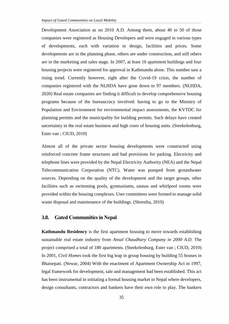
Impact of Gated Communities on Local Mobility
35
Development Association as on 2010 A.D. Among them, about 40 to 50 of those
companies were registered as Housing Developers and were engaged in various types
of developments, each with variation in design, facilities and prices. Some
developments are in the planning phase, others are under construction, and still others
are in the marketing and sales stage. In 2007, at least 16 apartment buildings and four
housing projects were registered for approval in Kathmandu alone. This number saw a
rising trend. Currently however, right after the Covid-19 crisis, the number of
companies registered with the NLHDA have gone down to 97 members. (NLHDA,
2020) Real estate companies are finding it difficult to develop comprehensive housing
programs because of the bureaucracy involved: having to go to the Ministry of
Population and Environment for environmental impact assessments, the KVTDC for
planning permits and the municipality for building permits. Such delays have created
uncertainty in the real estate business and high costs of housing units. (Steekelenburg,
Ester van ; CIUD, 2010)
Almost all of the private sector housing developments were constructed using
reinforced concrete frame structures and had provisions for parking. Electricity and
telephone lines were provided by the Nepal Electricity Authority (NEA) and the Nepal
Telecommunication Corporation (NTC). Water was pumped from groundwater
sources. Depending on the quality of the development and the target groups, other
facilities such as swimming pools, gymnasiums, saunas and whirlpool rooms were
provided within the housing complexes. User committees were formed to manage solid
waste disposal and maintenance of the buildings. (Shrestha, 2010)
3.8. Gated Communities in Nepal
Kathmandu Residency is the first apartment housing to move towards establishing
sustainable real estate industry from Ansal Chaudhary Company in 2000 A.D. The
project comprised a total of 180 apartments. (Steekelenburg, Ester van ; CIUD, 2010)
In 2001, Civil Homes took the first big leap in group housing by building 55 houses in
Bhaisepati. (Newar, 2004) With the enactment of Apartment Ownership Act in 1997,
legal framework for development, sale and management had been established. This act
has been instrumental in initiating a formal housing market in Nepal where developers,
design consultants, contractors and bankers have their own role to play. The bankers
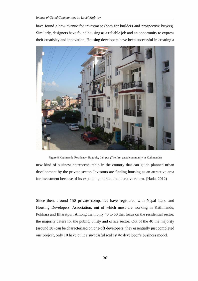
Impact of Gated Communities on Local Mobility
36
have found a new avenue for investment (both for builders and prospective buyers).
Similarly, designers have found housing as a reliable job and an opportunity to express
their creativity and innovation. Housing developers have been successful in creating a
new kind of business entrepreneurship in the country that can guide planned urban
development by the private sector. Investors are finding housing as an attractive area
for investment because of its expanding market and lucrative return. (Hada, 2012)
Since then, around 150 private companies have registered with Nepal Land and
Housing Developers' Association, out of which most are working in Kathmandu,
Pokhara and Bharatpur. Among them only 40 to 50 that focus on the residential sector,
the majority caters for the public, utility and office sector. Out of the 40 the majority
(around 30) can be characterised on one-off developers, they essentially just completed
one project, only 10 have built a successful real estate developer’s business model.
Figure 8 Kathmandu Residency, Bagdole, Lalitpur (The first gated community in Kathmandu)
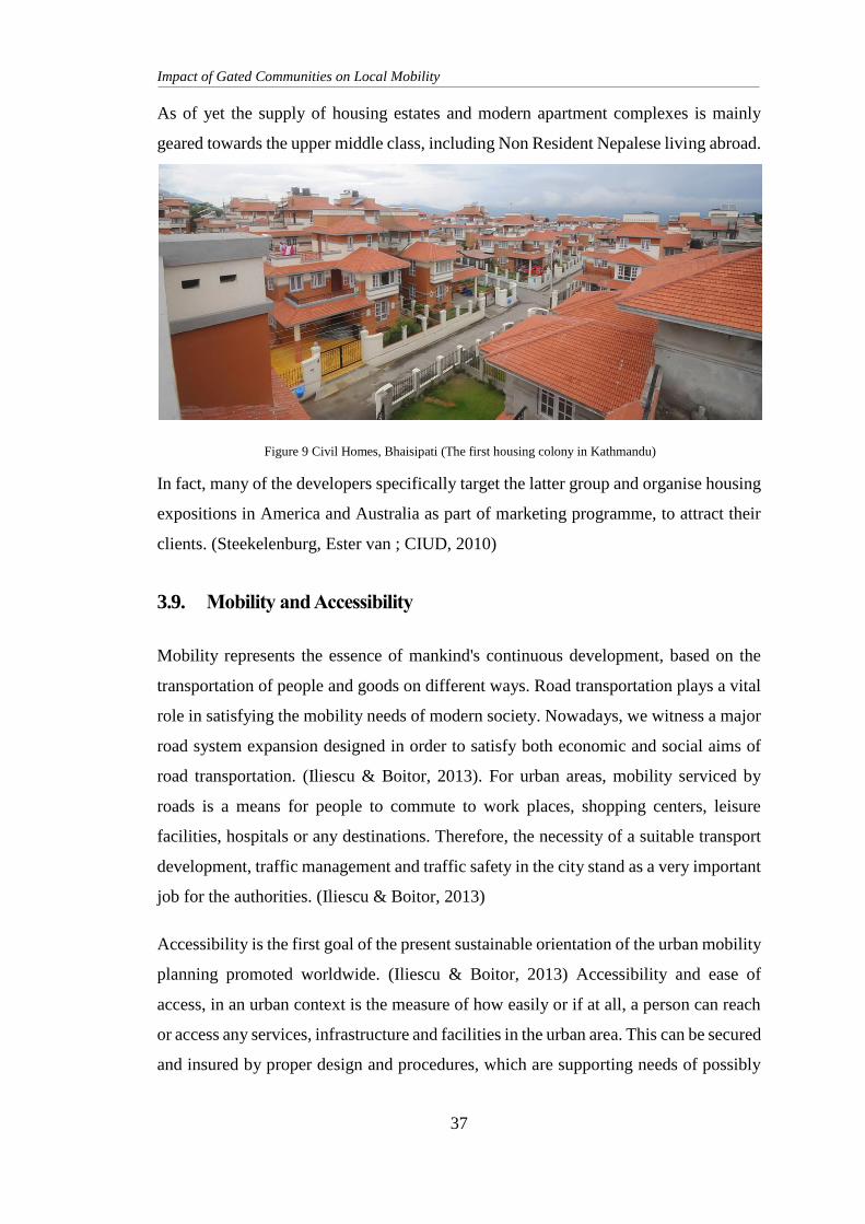
Impact of Gated Communities on Local Mobility
37
As of yet the supply of housing estates and modern apartment complexes is mainly
geared towards the upper middle class, including Non Resident Nepalese living abroad.
In fact, many of the developers specifically target the latter group and organise housing
expositions in America and Australia as part of marketing programme, to attract their
clients. (Steekelenburg, Ester van ; CIUD, 2010)
3.9. Mobility and Accessibility
Mobility represents the essence of mankind's continuous development, based on the
transportation of people and goods on different ways. Road transportation plays a vital
role in satisfying the mobility needs of modern society. Nowadays, we witness a major
road system expansion designed in order to satisfy both economic and social aims of
road transportation. (Iliescu & Boitor, 2013). For urban areas, mobility serviced by
roads is a means for people to commute to work places, shopping centers, leisure
facilities, hospitals or any destinations. Therefore, the necessity of a suitable transport
development, traffic management and traffic safety in the city stand as a very important
job for the authorities. (Iliescu & Boitor, 2013)
Accessibility is the first goal of the present sustainable orientation of the urban mobility
planning promoted worldwide. (Iliescu & Boitor, 2013) Accessibility and ease of
access, in an urban context is the measure of how easily or if at all, a person can reach
or access any services, infrastructure and facilities in the urban area. This can be secured
and insured by proper design and procedures, which are supporting needs of possibly
Figure 9 Civil Homes, Bhaisipati (The first housing colony in Kathmandu)
Impact of Gated Communities on Local Mobility
38
the biggest group of users. (Zajac, 2016) This may be via policies, plans, regulations,
design considerations or even general awareness and civic sense of the general public.
Accessibility and availability of transport both public and private is becoming an
important problem, especially for city planners and public transport experts. This topic
is also highly promoted by European Commission (COM 2011/898), which
distinguished the following elements of passenger rights, strictly bound with
accessibility:
non-discrimination;
accurate, timely and accessible information;
immediate and proportionate assistance. (Zajac, 2016)
3.10. The Concept of Social Justice
The notion of social justice is relatively new. The concept first surfaced in Western
thought and political language in the wake of the industrial revolution and the parallel
development of the socialist doctrine. It emerged as an expression of protest against
what was perceived as the capitalist exploitation of labour and as a focal point for the
development of measures to improve the human condition. It was born as a
revolutionary slogan embodying the ideals of progress and fraternity. By the mid-
twentieth century, the concept of social justice had become central to the ideologies and
programmes of virtually all the leftist and centrist political parties around the world,
and few dared to oppose it directly.
In the contemporary context, social justice is typically taken to mean distributive
justice, which is often identified with unqualified references to justice. To support the
concept of social justice is to argue for a reconciliation of the priorities within the
context of a broader social perspective in which individuals endowed with rights and
freedoms operate within the framework of the duties and responsibilities attached to
living in society. Notwithstanding the implied associations between social justice,
redistributive justice, and justice as a more general concept. (DESA, 2006)
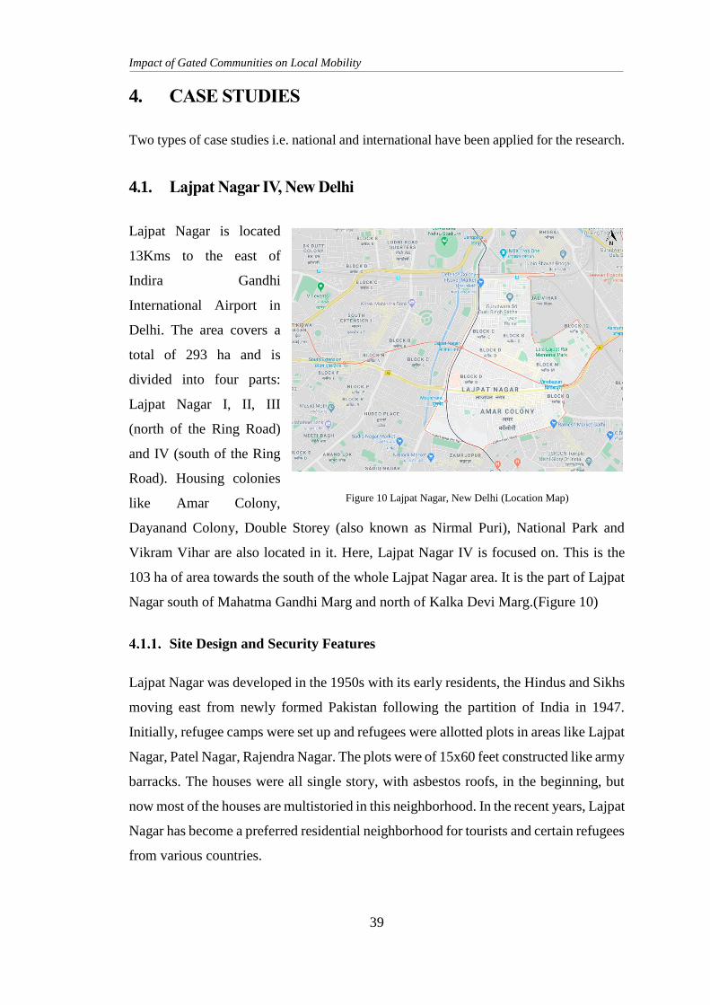
Impact of Gated Communities on Local Mobility
39
4. CASE STUDIES
Two types of case studies i.e. national and international have been applied for the research.
4.1. Lajpat Nagar IV, New Delhi
Lajpat Nagar is located
13Kms to the east of
Indira Gandhi
International Airport in
Delhi. The area covers a
total of 293 ha and is
divided into four parts:
Lajpat Nagar I, II, III
(north of the Ring Road)
and IV (south of the Ring
Road). Housing colonies
like Amar Colony,
Dayanand Colony, Double Storey (also known as Nirmal Puri), National Park and
Vikram Vihar are also located in it. Here, Lajpat Nagar IV is focused on. This is the
103 ha of area towards the south of the whole Lajpat Nagar area. It is the part of Lajpat
Nagar south of Mahatma Gandhi Marg and north of Kalka Devi Marg.(Figure 10)
Site Design and Security Features
Lajpat Nagar was developed in the 1950s with its early residents, the Hindus and Sikhs
moving east from newly formed Pakistan following the partition of India in 1947.
Initially, refugee camps were set up and refugees were allotted plots in areas like Lajpat
Nagar, Patel Nagar, Rajendra Nagar. The plots were of 15x60 feet constructed like army
barracks. The houses were all single story, with asbestos roofs, in the beginning, but
now most of the houses are multistoried in this neighborhood. In the recent years, Lajpat
Nagar has become a preferred residential neighborhood for tourists and certain refugees
from various countries.
Figure 10 Lajpat Nagar, New Delhi (Location Map)
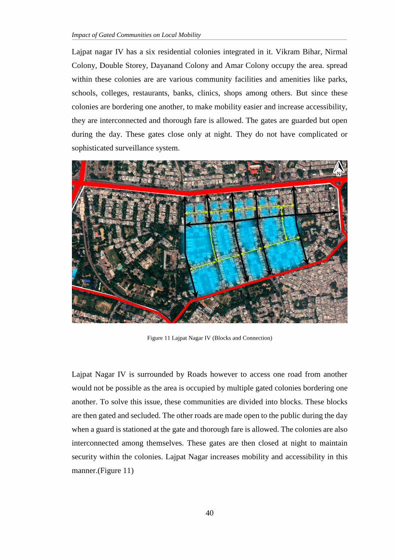
Impact of Gated Communities on Local Mobility
40
Lajpat nagar IV has a six residential colonies integrated in it. Vikram Bihar, Nirmal
Colony, Double Storey, Dayanand Colony and Amar Colony occupy the area. spread
within these colonies are are various community facilities and amenities like parks,
schools, colleges, restaurants, banks, clinics, shops among others. But since these
colonies are bordering one another, to make mobility easier and increase accessibility,
they are interconnected and thorough fare is allowed. The gates are guarded but open
during the day. These gates close only at night. They do not have complicated or
sophisticated surveillance system.
Lajpat Nagar IV is surrounded by Roads however to access one road from another
would not be possible as the area is occupied by multiple gated colonies bordering one
another. To solve this issue, these communities are divided into blocks. These blocks
are then gated and secluded. The other roads are made open to the public during the day
when a guard is stationed at the gate and thorough fare is allowed. The colonies are also
interconnected among themselves. These gates are then closed at night to maintain
security within the colonies. Lajpat Nagar increases mobility and accessibility in this
manner.(Figure 11)
Figure 11 Lajpat Nagar IV (Blocks and Connection)
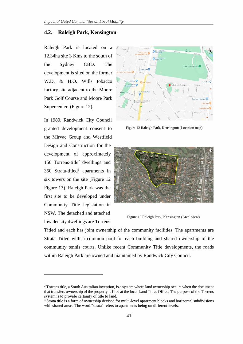
Impact of Gated Communities on Local Mobility
41
4.2. Raleigh Park, Kensington
Raleigh Park is located on a
12.34ha site 3 Kms to the south of
the Sydney CBD. The
development is sited on the former
W.D. & H.O. Wills tobacco
factory site adjacent to the Moore
Park Golf Course and Moore Park
Supercenter. (Figure 12).
In 1989, Randwick City Council
granted development consent to
the Mirvac Group and Westfield
Design and Construction for the
development of approximately
150 Torrens-title2 dwellings and
350 Strata-titled3 apartments in
six towers on the site (Figure 12
Figure 13). Raleigh Park was the
first site to be developed under
Community Title legislation in
NSW. The detached and attached
low density dwellings are Torrens
Titled and each has joint ownership of the community facilities. The apartments are
Strata Titled with a common pool for each building and shared ownership of the
community tennis courts. Unlike recent Community Title developments, the roads
within Raleigh Park are owned and maintained by Randwick City Council.
2 Torrens title, a South Australian invention, is a system where land ownership occurs when the document
that transfers ownership of the property is filed at the local Land Titles Office. The purpose of the Torrens
system is to provide certainty of title to land. 3 Strata title is a form of ownership devised for multi-level apartment blocks and horizontal subdivisions
with shared areas. The word "strata" refers to apartments being on different levels.
Figure 12 Raleigh Park, Kensington (Location map)
Figure 13 Raleigh Park, Kensington (Areal view)
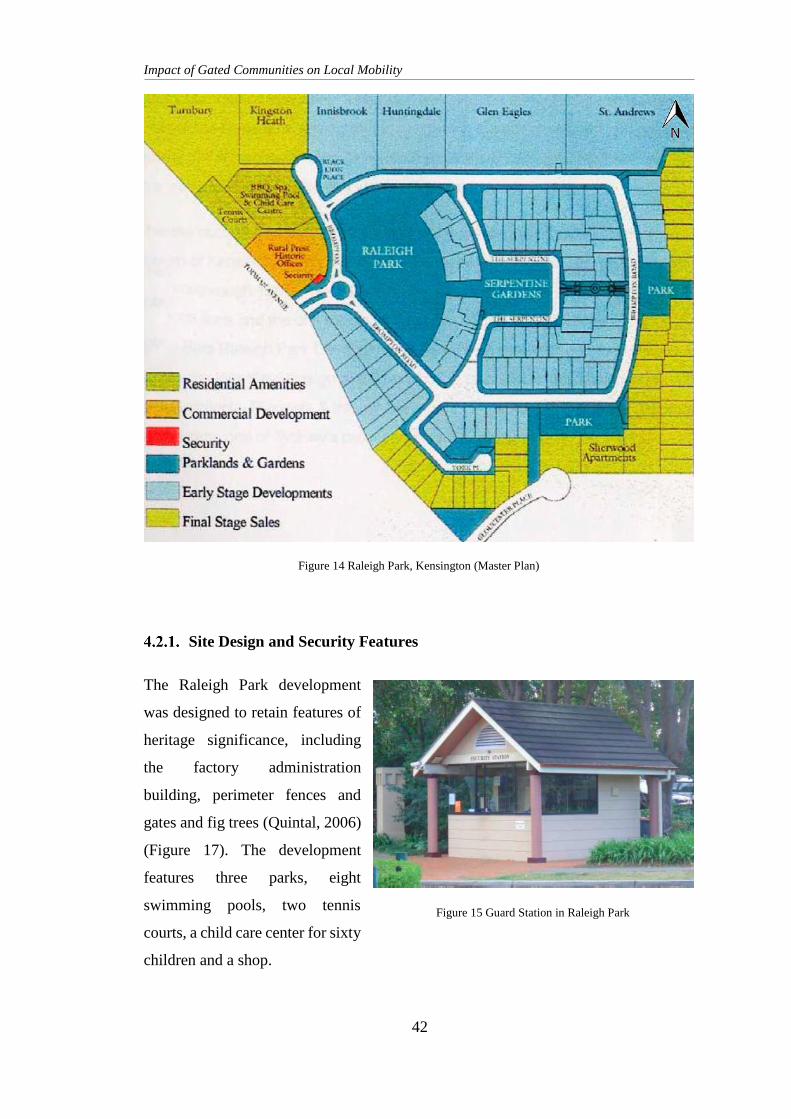
Impact of Gated Communities on Local Mobility
42
Site Design and Security Features
The Raleigh Park development
was designed to retain features of
heritage significance, including
the factory administration
building, perimeter fences and
gates and fig trees (Quintal, 2006)
(Figure 17). The development
features three parks, eight
swimming pools, two tennis
courts, a child care center for sixty
children and a shop.
Figure 14 Raleigh Park, Kensington (Master Plan)
Figure 15 Guard Station in Raleigh Park
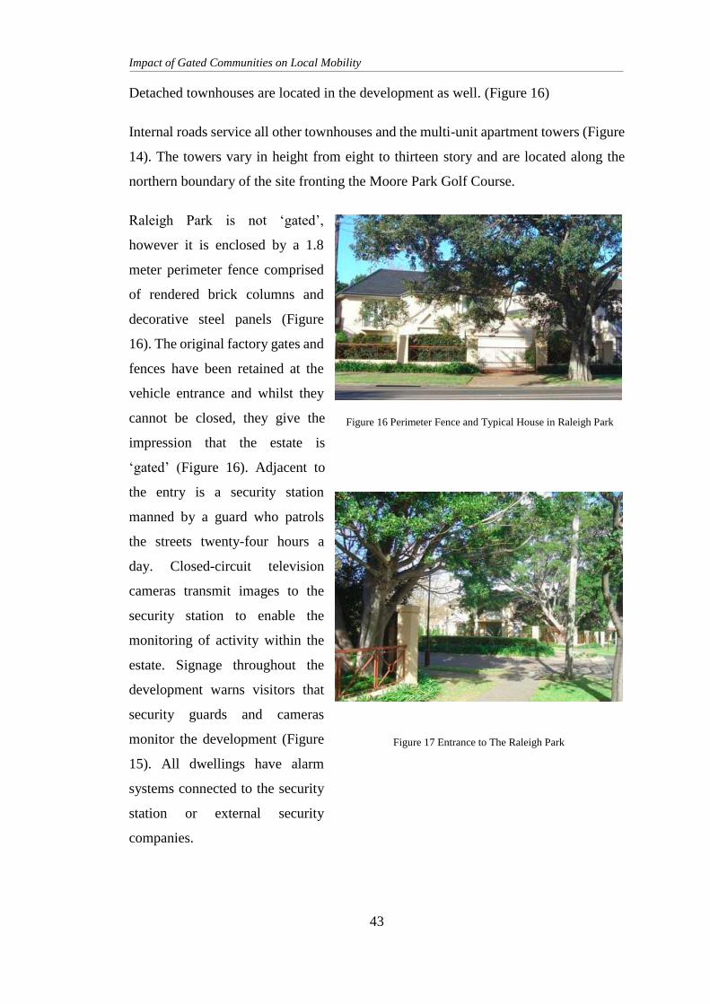
Impact of Gated Communities on Local Mobility
43
Detached townhouses are located in the development as well. (Figure 16)
Internal roads service all other townhouses and the multi-unit apartment towers (Figure
14). The towers vary in height from eight to thirteen story and are located along the
northern boundary of the site fronting the Moore Park Golf Course.
Raleigh Park is not ‘gated’,
however it is enclosed by a 1.8
meter perimeter fence comprised
of rendered brick columns and
decorative steel panels (Figure
16). The original factory gates and
fences have been retained at the
vehicle entrance and whilst they
cannot be closed, they give the
impression that the estate is
‘gated’ (Figure 16). Adjacent to
the entry is a security station
manned by a guard who patrols
the streets twenty-four hours a
day. Closed-circuit television
cameras transmit images to the
security station to enable the
monitoring of activity within the
estate. Signage throughout the
development warns visitors that
security guards and cameras
monitor the development (Figure
15). All dwellings have alarm
systems connected to the security
station or external security
companies.
Figure 17 Entrance to The Raleigh Park
Figure 16 Perimeter Fence and Typical House in Raleigh Park
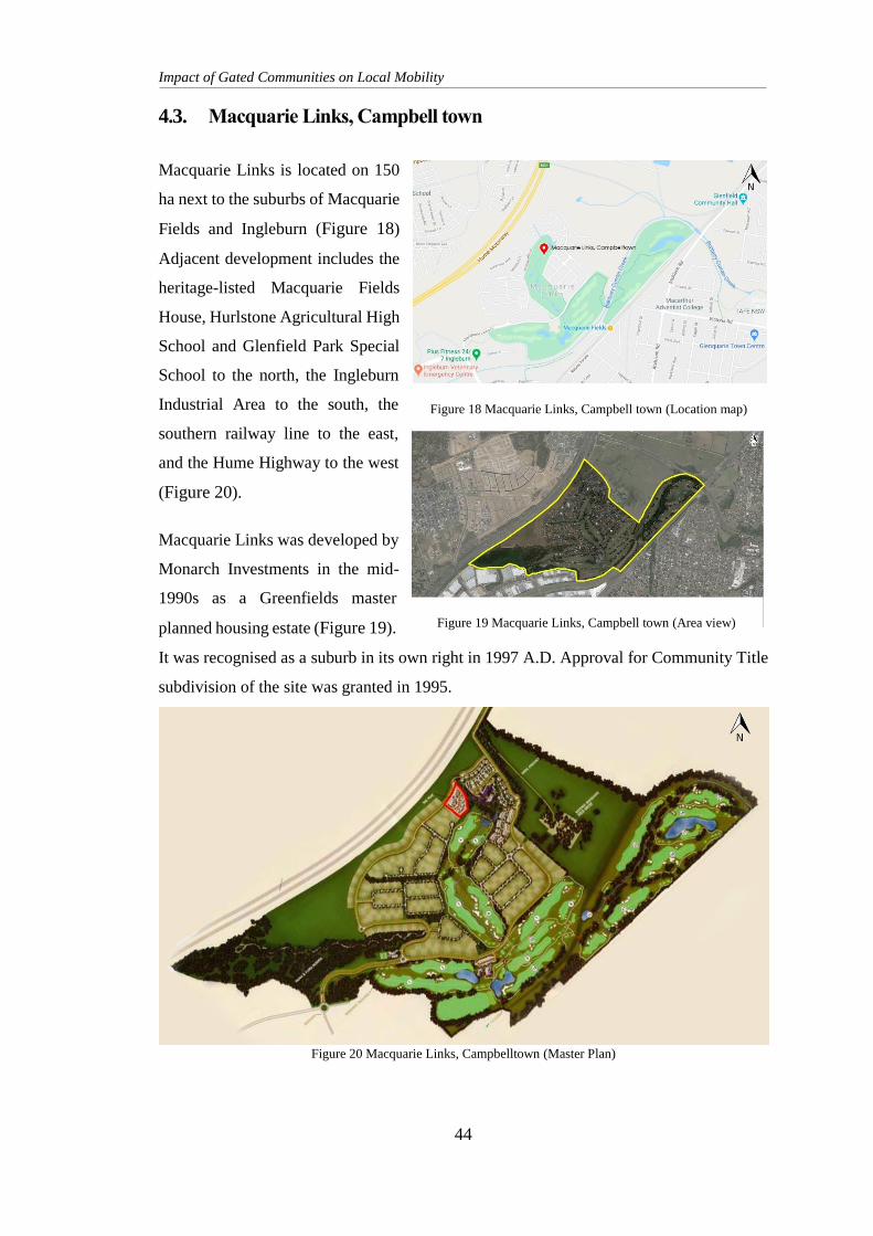
Impact of Gated Communities on Local Mobility
44
4.3. Macquarie Links, Campbell town
Macquarie Links is located on 150
ha next to the suburbs of Macquarie
Fields and Ingleburn (Figure 18)
Adjacent development includes the
heritage-listed Macquarie Fields
House, Hurlstone Agricultural High
School and Glenfield Park Special
School to the north, the Ingleburn
Industrial Area to the south, the
southern railway line to the east,
and the Hume Highway to the west
(Figure 20).
Macquarie Links was developed by
Monarch Investments in the mid-
1990s as a Greenfields master
planned housing estate (Figure 19).
It was recognised as a suburb in its own right in 1997 A.D. Approval for Community Title
subdivision of the site was granted in 1995.
Figure 20 Macquarie Links, Campbelltown (Master Plan)
Figure 18 Macquarie Links, Campbell town (Location map)
Figure 19 Macquarie Links, Campbell town (Area view)
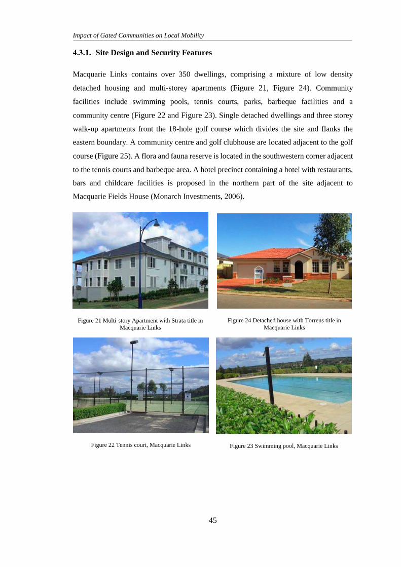
Impact of Gated Communities on Local Mobility
45
Site Design and Security Features
Macquarie Links contains over 350 dwellings, comprising a mixture of low density
detached housing and multi-storey apartments (Figure 21, Figure 24). Community
facilities include swimming pools, tennis courts, parks, barbeque facilities and a
community centre (Figure 22 and Figure 23). Single detached dwellings and three storey
walk-up apartments front the 18-hole golf course which divides the site and flanks the
eastern boundary. A community centre and golf clubhouse are located adjacent to the golf
course (Figure 25). A flora and fauna reserve is located in the southwestern corner adjacent
to the tennis courts and barbeque area. A hotel precinct containing a hotel with restaurants,
bars and childcare facilities is proposed in the northern part of the site adjacent to
Macquarie Fields House (Monarch Investments, 2006).
Figure 24 Detached house with Torrens title in
Macquarie Links Figure 21 Multi-story Apartment with Strata title in
Macquarie Links
Figure 23 Swimming pool, Macquarie Links Figure 22 Tennis court, Macquarie Links
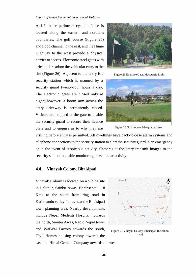
Impact of Gated Communities on Local Mobility
46
A 1.8 metre perimeter cyclone fence is
located along the eastern and northern
boundaries. The golf course (Figure 25)
and flood channel to the east, and the Hume
Highway to the west provide a physical
barrier to access. Electronic steel gates with
brick pillars adorn the vehicular entry to the
site (Figure 26). Adjacent to the entry is a
security station which is manned by a
security guard twenty-four hours a day.
The electronic gates are closed only at
night; however, a boom arm across the
entry driveway is permanently closed.
Visitors are stopped at the gate to enable
the security guard to record their licence
plate and to enquire as to why they are
visiting before entry is permitted. All dwellings have back-to-base alarm systems and
telephone connections to the security station to alert the security guard in an emergency
or in the event of suspicious activity. Cameras at the entry transmit images to the
security station to enable monitoring of vehicular activity.
4.4. Vinayak Colony, Bhaisipati
Vinayak Colony is located on a 5.7 ha site
in Lalitpur, Sainbu Awas, Bhainsepati, 1.8
Kms to the south from ring road in
Kathmandu valley. It lies near the Bhaisipati
town planning area. Nearby developments
include Nepal Mediciti Hospital, towards
the north, Sainbu Awas, Radio Nepal tower
and WaiWai Factory towards the south,
Civil Homes housing colony towards the
east and Himal Cement Company towards the west.
Figure 27 Vinayak Colony, Bhaisipati (Location
map)
Figure 25 Golf course, Macquarie Links
Figure 26 Entrance Gate, Macquarie Links
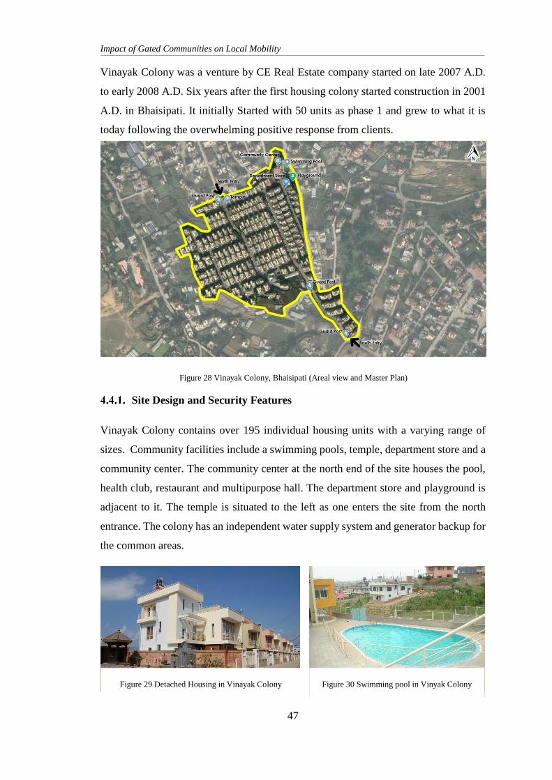
Impact of Gated Communities on Local Mobility
47
Vinayak Colony was a venture by CE Real Estate company started on late 2007 A.D.
to early 2008 A.D. Six years after the first housing colony started construction in 2001
A.D. in Bhaisipati. It initially Started with 50 units as phase 1 and grew to what it is
today following the overwhelming positive response from clients.
Site Design and Security Features
Vinayak Colony contains over 195 individual housing units with a varying range of
sizes. Community facilities include a swimming pools, temple, department store and a
community center. The community center at the north end of the site houses the pool,
health club, restaurant and multipurpose hall. The department store and playground is
adjacent to it. The temple is situated to the left as one enters the site from the north
entrance. The colony has an independent water supply system and generator backup for
the common areas.
Figure 28 Vinayak Colony, Bhaisipati (Areal view and Master Plan)
Figure 29 Detached Housing in Vinayak Colony Figure 30 Swimming pool in Vinyak Colony

Impact of Gated Communities on Local Mobility
48
A 2.5-meter perimeter compound wall made of a cement brick n concrete base and steel
fence top, surrounds the colony with vehicular entrance gates to the north and south.
Large iron gates with brick pillars and a capital stand at the vehicular entryways to the
site. Adjacent to the entry is a security station which is manned by security guards
twenty-four hours a day. The iron gates are closed only at night, however, a boom arm
across the entry driveway is permanently closed. Visitors are stopped at the gate by the
security guard to record their vehicle number plates and to enquire the reason for the
visit and provide a visitors’ pass before entry is permitted. Round the clock security is
provided by a team of security guards stationed at each entrance and also patrolling the
streets at night. The community is also fitted with the neighborhood siren system where
residents can sound the alarm in case of emergencies and security risks.
4.5. Management, Restrictions and Agreements
Each of these gated communities are considerably different in all regards, including the
location, scale, recreational facilities and the complexity of security measures. Despite
Figure 31 Department Store in Vinayak Colony Figure 33 Temple in Vinayak Colony
Figure 32 Gate and Boundary of Vinayak Colony Figure 34 Community Center of Vinayak Colony
Impact of Gated Communities on Local Mobility
49
these numerous differences, the three communities are managed in similar ways and
are all have a certain set of restrictions, guidelines and agreements.
Management
Raleigh Park and Macquarie Links are managed by strata management companies4 and
are divided into several different bodies corporate based upon consecutive development
stages. Vinayak Colony is managed by a HOA called the ‘Vinayak Colony society’,
which is run solely by the residents.
The body corporate or HOA is responsible for the collection of levies and the
coordination of repairs and maintenance of all the common assets of the community.
Residents meet to discuss resident development proposals, maintenance issues and the
scheduling of maintenance works. All residents must pay levies to ensure that there are
adequate funds to meet security, maintenance and repair costs.
Macquarie Links Golf Club is managed and maintained independently of the
community by ClubCorp. Memberships are available to both residents and non-
residents, e.g. non-residents may become members of the golf club with the purchase
of a lifetime membership of $46,000. (Quintal, 2006) The restaurant and department
stores in Vinayak Colony are run and managed independently by the respective owners
and provide service only the residents of the colony.
Restrictions and Agreements
Each community is subject to restrictions on dwelling design, property maintenance
and landscaping. In all developments there are restrictions on the colours of exterior
paint, materials and requirements for the maintenance of common areas, driveways and
gardens.
4 Strata management, sometimes known as "body corporate management", is a specialist area of property
management involving the day-to-day operation and management of a property that is jointly owned and
comprises multiple units, common areas and common facilities.
Impact of Gated Communities on Local Mobility
50
In Raleigh Park and Macquarie Links, external alterations to all dwellings must meet
preordained guidelines and be approved by the body corporate. Driveways, roads and
footpaths in Raleigh Park are subject to a prescribed paving colour and type.
In Vinayak Colony, external alterations are completely prohibited with an exception to
adding a car shade made of clear acrylic sheets.
Residents of all communities, Raleigh Park, Macquarie Links and Vinayak Colony
indicated that the restrictions and agreements were strictly adhered to, particularly with
respect to external alterations to the residences. Raleigh Park residents acknowledged
that over time residents are becoming more accepting of the need to change some of the
by-laws or be more flexible, for example with respect to exterior paint schemes.
Vinayak Colony residents informed that the restrictions and agreements are subject to
change following a community meeting, discussion and decision when any issues arise.
All residents noted that tensions arise within the community when residents do not
comply with the rules and that this was an inherent problem of community self-
management.
Raleigh Park Macquarie Links Vinayak Colony
Pets are not permitted The erection of flag poles and
satellite dishes is prohibited
Making changes to the structure is
not permitted
Vehicles are not to be parked
on the road
Fencing must be constructed
from brick
Vehicles are allowed to be parked
on the road
Front fences are not permitted All letterboxes must be of the
same design
Car shade with clear acrylic sheet
is permitted
Non-residents are permitted to
use the parks
All driveways must be the
same width
Non-residents are not allowed to
use the community areas
Table 5. Restrictions and Agreements in Gated Communities
Impact of Gated Communities on Local Mobility
51
5. POLICY REVIEW
The Government of Nepal has prepared various laws and legislation regarding Housing
and group housing. The following legal documents are prepared related to community
housing, land and joint ownership.
The Lands Act, 2021 B.S. (1964)
Public Roads Act, 2031 B.S. (1974)
The Ownership of Joint Housing Act, 2054 B.S. (1997)
Building Byelaws, 2064 B.S. (2007)
The Town Development Act, 2045 B.S. (1998)
The Right to Housing Act, 2075 B.S. (2018)
Land Use policy 2015 A.D.
National Urban Development Strategy 2017 A.D.
5.1. The Lands Act, 2021 B.S. (1964 A.D.)
The lands act, 2021 B.S. was made to amend and consolidate the lands act. It provided
for, the expediting the diversion of the burden of inactive capital and population from
the land to the other sectors of economy in order to accelerate the pace of economic
development in the country. It aimed to bring about improvements in the standard of
living of farmers’ dependent on land by making justified distribution of cultivable land
and by making necessary knowledge and resources on agriculture easily accessible. The
act also had provisions to maintain or boost the convenience and economic benefit of
the public by encouraging to maximize agricultural production. The latest amendment
to this act was done in 2076 B.S. to update the act and accommodate the federal
government system.
The act defines ‘Landowner’ as “a person who has the land registered in his/her name,
subject to the payment of land revenue to Government of Nepal under the prevailing
law and has, by virtue thereof, the title to the land.” It also defines the term ‘Family’,
in relation to any person as only his or her relative in the status of husband or wife,
irrespective of whether there has been any property division, and until the father or
mother is alive, a son or daughter who has not attained the age of 16 years irrespective
Impact of Gated Communities on Local Mobility
52
of whether he has been property division. According to the act, ‘Company’ means any
entity defined as a company in the “Company Act 2063 B.S. (2006 A.D.)”, this includes
private company, public company, holding company, subsidiary company, foreign
company, listed company and non-profit company.
As per Chapter 3, Section 7, Sub-section (1) the upper ceiling of land allowed to be
owned by a landowner, in any way, is not more than 25 Ropani in Kathmandu valley.
Moreover, as per Section 7, Sub-section (2), notwithstanding anything contained in,
Section 7, Sub-section (1), any person or his or her family as a land owner may own,
not exceeding the upper ceiling of, 5 Ropani of land in Kathmandu valley for their
housing purposes in addition to the land referred to in Section 7, Sub-section (1).
Section 12, iterates the provision for exemptions from the upper ceiling contained in
Section 7. The 8th amendment of the act in 2076 B.S. (2020 A.D) Section 12, Sub-
section (g) and Section 12A mentions land owned by a company or association as the
landowner, exempt from the upper ceiling specified in Section 7, provided that the land
ceiling is not sufficient or is inadequate for the company or association to run its
operations and acquires special permission from the government of Nepal for the
ownership of such land.
According to this lands act any landowner shall not own land more than 30 Ropani for
any foreseeable purposes in the Kathmandu Valley.
5.2. Public Roads Act, 2031 B.S. (1974 A.D.)
The “Public Roads Act 2031 B.S.” came into effect in 2031.06.20. This was made to
provide for the development, maintenance and expansion of Public roads. It makes
provisions to classify all kinds of public roads and acquire lands required for the
development, maintenance, expansion or improvement of the public roads. It iterates
laws related to collection of development tax from landholders near the roads who
benefit from the public roads, in order to maintain the convenience and economic
interest of the general public.
The act defines “Public roads” as “roads that are not subject to personal possession by
any person.” It defines the term "Road border" as a public road and the area of land as
Impact of Gated Communities on Local Mobility
53
prescribed on the right and left hand sides of the central line of such a road, pursuant to
Section 3 of the Public Road Act. Section 3 of the Public Road Act classifies the road
into highways, feeder roads, district roads and urban roads. It specifies the road border
shall not exceed thirty-one meters on both right and left hand sides from the central line
of such roads. Provided that even in relation to the whole length of the same kind of
road, the Government of Nepal may, owing to the topography and habitation, specify
the required border. The term "Land" mentioned in the Public Road Act means any
land, and this term also includes a shed, house, building, tree etc. situated in and
anything permanently fixed to such a land.
Chapter 3 Section 18 describes the power of the Government of Nepal or the
Department of Roads to remove goods causing obstruction to movement on public
roads. Section 18 Sub-section (4) states that in addition to any goods left, placed or
thrown on the public road, anything including any arm or branch of a door, tree or wire,
that is held, installed or made with a house or wall on either side of a public road as to
project towards the road and causes obstruction to the movement on the road, the
Department of Roads may issue an order to the concerned person to remove such
obstruction or arrange the goods in a manner not to cause obstruction within a
reasonable period of time as specified in the order.
Chapter 3 Section 19 states the prohibition on doing any act on public roads or road
border without obtaining permission. According to Section 19 Sub-section (1) no
person shall build an access road joined to a public road or dig or demolish a hole or
ditch on a public road or within the road border or install or place barrier, peg or fort
on the public road or build a house or shed thereon or cultivate a land within the road
border or do any other similar act without obtaining the permission of the Department
of Roads.
As this act defines public roads as roads not subject to personal possession by any
individual or family. This implies that when a road is used for access or otherwise by
more than one household or parcel of land, it is deemed public road. The act prohibits
any person, individual or group to obstruct movement on these public roads in any way.
It also prohibits any individual, family or landowner from doing any act as to barricade,
obstruct or damage the area within the road border without permission from the
Impact of Gated Communities on Local Mobility
54
Department of Roads or the local authorities. Failure to do so shall give the Department
of Road, the authority to carry out the removal or demolition of the said obstruction, by
their own employees or others on a contract basis.
5.3. The Ownership of Joint Housing Act, 2054 B.S. (1997 A.D.)
This Act was passed on 2054.09.07. It was passed to provide for the ownership of joint
housing. Due to overpopulation in urban areas of Nepal, there is an increment in the
price of land depriving housing facilities to many residents of the cities. To solve the
housing problem, the concept of joint housing was introduced, whereby arrangements
were made for selling apartments in a planned manner. The act ensures rights and duties
in such apartments.
Chapter 1, Section 2 provides the definition for ‘Joint Housing’ as meaning and
including any building consisting of two or more two apartments with two or more
floors built on a plot of land and two or more than two buildings designated as a block,
pocket or any building of a similar designation and the land, compound and complex
ancillary thereto. It defines ‘Apartment’ as a unit of a building consisting of one or more
than one rooms that could be used independently in a joint housing along with collective
areas and facilities. According to the act, ‘Promoter’ is any corporate body incorporated
under the laws in force and authorized to build and operate joint housing by approval
from a competent authority and ‘Apartment Owner’ is any person or corporate body
buying, leasing or possessing, subject to the terms and conditions set forth in the
agreement as referred to in this Act, an apartment in any other manner. It also says that
‘Committee’ means a housing management committee formed pursuant to section 24
to look after, manage and operate of a joint housing.
Chapter 5, section 16, mentions that an apartment owner has right over collective areas
and facilities such as land of joint housing, the structure of the building with its services
(sewerage, fire escapes, way in and way out), amenities (basement, solar, courtyard,
garden, parking lots and go-down), generator post and guard post, facilities like
electricity, gas, parts arranging, making of cold and hot water and parts of the building
used for heating and air conditioning. An owner is also subjected to the rights to items
of collective use such as elevators, pump, tanks, motor, fan and garbage container. As
Impact of Gated Communities on Local Mobility
55
per section 17, no division of these collective areas and facilities are allowed. While
Section 18 states that an apartment owner shall pay the promotor or committee for
maintenance, cleaning and upkeep of Collective areas and facilities, Section 19 denies
the right to refuse to pay for them. In case of non-payment issue, Section 20 gives the
right to the promotor or committee to withhold the use of any collective area and
facilities and also prevent transfer of such apartment to any other person in any manner.
In case of the complete destruction of joint housing in any manner, Section 22
subsection 1 states that the land area of the housing will be divided among all the
apartment owners proportionately.
Chapter 6 Section 23 states that protection, repairs and maintenance of the building and
collective area and facilities is the duty of the promoter. In case the promoter is to sell
all his apartments owned or is unable to perform his duties, Section 24 mentions that
the duties under promoter is to fall under a committee formed among the apartment
owners with everyone’s consent. The promoter is liable to raise charges and fees for his
duty as fixed in agreement according to Section 25.
Competent authority can issue directives to promoter or the committee which must be
complied with according to Chapter 7, section 33. The government of Nepal may make
rules for carrying out the objectives of this Act as stated in Section 35.
The Act does not cover any provisions for housing colonies where the owner buys a
particular piece of land and an individual house. The definition of “joint housing” under
the Ownership of Joint Housing Act only mention about the apartments and the rights
and duties of an apartment owner, its promoter and the committee formed by a
unanimous decision of the owners. An apartment complex is a building or a cluster of
buildings with common collective spaces, and facilities. These spaces and facilities are
shared by the apartment owners collectively and equally. The Act does not allow use
of collective space for any private purpose. It does not allow the demarcation and
prohibition of land. The apartment owners do not own parcels of land within the
complex privately. They get a share of the land only in case of complete destruction of
the apartment buildings. This is not the case for group housing colonies. In a housing
colony, each house owner owns their parcel of land separately. There are roads
Impact of Gated Communities on Local Mobility
56
providing access to each land or house. These houses do not conform with the definition
of joint housing or apartment explicitly mentioned in the act. There are minimum to no
common spaces other than the road and some community spaces. So, the act does not
particularly cater for gated housing colonies.
5.4. Building Byelaws, 2064 B.S. (2007 A.D.)
The Building Byelaws 2064 B.S. was brought into effect with the rapid urbanization,
population growth, safety in construction and construction practices in mind. It is a
document explaining and listing all the byelaws and regulations to be followed while
planning, designing and constructing any infrastructure or building within the valley
metropolis and neighbouring VDCs. It has provisions for the permit and construction
process of a variety of building types and sizes.
Section 5 – Sub-section 5 (a) of the Building Byelaws addresses regulations for
infrastructure planning and development of Apartment Housing, Group Housing and
Residential Plot Development. This section has set the minimum area limit for
government or private planned housing to 2 ropanies. It provides a provision that in
areas having these planned developments, development of other infrastructures such as
roads, water supply, telecommunication, electricity, etc. will be given priority by the
concerned department.
Sub-section 5 (b) is concerned with the plans to be submitted (maps of surrounding
lands, the proposed planned maps, maps of road, drainage, waste disposal system, water
supply, etc. and blow out plan of each building) and the scale of the plans. The
submitted plans are to specify the width of entrance, the roads and the area of the plots.
The section further defines the minimum sizes of plots and open spaces. It provides for
the land management, ownership and consolidation before and during the permit
process.
Section 5 – Sub-section 5 (c) specifies the criteria for development and construction of
apartment housing. It iterates the setbacks, ground coverage, FAR among other
requirements that developers and builders need to meet to be permitted to construct an
apartment housing.
Impact of Gated Communities on Local Mobility
57
This Building Byelaws document lacks detailed criteria one has to follow to be
permitted to construct a group housing development. It lacks provision for the
ownership of land common land within the group housing boundary.
5.5. The Town Development Act, 2045 B.S. (1998 A.D.)
The Town Development Act was formulated on 2045.08.01. The act was passed in the
context of growing population and urbanization to provide necessary provisions for
required services and facilities to the residents of the town. The act made provisions for
reconstruction, expansion and development of existing towns and also the construction
of new towns to maintain health, convenience and economic interest of the general
public.
It defines "Town Planning" as plans formulated by the “committee” to carry out
physical development, reconstruction or expansion of towns. It can also determine land
use area for physical development to provide facilities such as road, transport,
electricity, drainage etc and approved by the Government of Nepal. Town Development
Committee is the committee formed by the Government of Nepal in any rural, town or
regional development area to formulate plans for the town development. "Local body"
means VDC or Municipality and also includes Metropolitan or Sub- Metropolitan city.
"Local Plan" means a plan prepared by local body upon setting programs for the
development of its area.
Section 3 and 4 of the act provides for the details of town planning, local plans and the
committee. Section 8 and 9 provides for the power of committee to impose restrictions,
regulate, control and prohibit certain activities within the planning area that may affect
the plan or the outlook, over view and integrity of the development.
Section 10 gives the committee the power to prevent or demolish acts or construction
performed by a person that violates the conditions and guidelines of the plan through
proper notice, prescription and order. Section 11 iterates the functions, duties and
powers of the committee, among which is the power to specify necessary conditions or
standard in land use area for physical development. It has the power to prescribe
necessary conditions on construction and other activities and to perform and cause to
Impact of Gated Communities on Local Mobility
58
perform the act as per said conditions. The third amendment added section 12 A
mandates any institution that intends to operate physical development in the area where
town planning has come into effect to take approval from the committee. Upon
approval, the institution is allowed to operate as per the terms set by the committee.
This act mainly provides for and caters to the planning and development of towns and
other development areas performed by a government body. It however has provisions
and restrictions for private institutions wishing to perform development activities in the
planning area. This facilitates an opportunity for the government body to implement
regulations to ensure the development caters to and facilitates the town and community
as a whole and is not completely secluded for the use and benefit to private parties.
5.6. The Right to Housing Act, 2075 B.S. (2018 A.D.)
The Right to Housing Act was formulated on 2076.06.02. The act was made to provide
for the right to housing of every citizen of the country. It was passed to make necessary
provisions on providing the homeless citizens with appropriate and safe housing facility
in accordance with the Constitution of Nepal.
Chapter 1, Section 2 defines “Housing” as a building, house, part of it or such
permanent or temporary, partial or full structure constructed for the residential purpose.
It defines “Place of housing” as the housing and the four corners occupied by it, and
this term also includes the place having joint or group housing. According to the act
"Housing site" means the group of one or more places of housing and ‘Local Level’
means rural municipality or municipality.
Under chapter 2, the policy states that every citizen shall have the right to make a safe,
appropriate and suitable housing and such right shall be respected, protected and
fulfilled to this Act and other prevailing laws.
The Act relates to citizen’s rights and duties related to housing. It lacks provisions
related to gated community and group housing. It does not specify the rights,
restrictions and responsibilities of residents or owners of plots within the group housing
to the common areas.
Impact of Gated Communities on Local Mobility
59
5.7. Land Use Policy 2015 A.D.
The Land Use Policy was introduced for protection, promotion and optimum use and
effective management of Land and Land Resources (LLRs). Land Use Policy 2013’s
main agenda was protection of arable land to ensure food security. The earthquake of
2015 brought into light the need to focus on secured settlement as well and disaster risk
mitigation to escape the vulnerability from such devastating disaster. So the policy was
reviewed and Land Use Policy 2015 was formulated.
Land Use Policy 2015, aims for social, economic and ecological development by
optimum use of available Land and Land Resources (LLR) thus leading the country
towards prosperity. The objective of Land Use Policy 2015 is to categorize lands into
specific land use zones thus making it easy for protection of agricultural land, forest
land and develop better sustainable settlement all the while reducing the risk of
disastrous hazards.
Policy 2 of LUP 2015 states that level-wise Land Use Plans shall be devised of and be
executed according to the federal structure. With expertise on hand, new technology
and technical assistance, Federal Land Use Map is to be prepared, based on national
priority and policy, following the objectives of the Land Use Plan. The plan thus
formulated at federal level provides a better basis upon which Land use plans at local
levels can be further detailed with modified application, additional rules and regulation
concurring with the Federal Level Land Use Plan.
Land Use plan at local level is to involve local communities and should be devoid of
discrimination in any form.
According to Policy 4, Level wise LUP compatible with physical Infrastructure and
development projects shall be devised of and implemented. On the basis of Land Use
Plan, a proper well organized and planned human settlement is to be proposed in places
that are geologically sound (i.e. low risk due to land nature). Proper planning of
infrastructure is advised for better distribution of facilities and uplift quality of life to
form a resilient community towards any form of risks.
Impact of Gated Communities on Local Mobility
60
For the operation of physical infrastructure development work, industrial development
as well as land development programs private and cooperative sectors is to be
encouraged.
These policies provide for the power and responsibility to all levels of government from
local to central or federal bodies to formulate a land use plan suitable for their area and
enforce the same. This gives local bodies a new and unique opportunity to perform
proper urban development plans, specify the usage of land and responsibilities that a
private or government body have to fulfil and abide by while performing planning,
construction and development.
5.8. National Urban Development Strategy 2017 A.D.
MoUD has formulated National Urban Development Strategy (NUDS) to lead the
process of urbanization by integrating actions of important urban sectors through
strategies that will help shape the future of the urban areas. With the vision for next 15
years, NUDS has envisaged integrated urban development efforts. NUDS has been
shaped realizing the need of strategic direction that will guide the urban development
process in the country.
Under safety and resilience of NUDS, a strategy targeting physically, socially,
economically, environmentally and culturally safe and resilient urban areas has been
cited. Risk sensitive resource mapping is prepared identifying high risk areas in all
urban areas based on available information, and existing building regulations. Also
rapid hazard appraisal technique is developed to identify hazards and prepare multi-
hazard map of all urban areas and incorporate disaster risk management component in
urban development plans, generate information on climate change in urban areas of
different ecological regions. Formulate National Adaptation Plan (NAP) on urban
settlements and infrastructure
Another strategy to establish system of periodic review to strengthen building code,
building regulations and guidelines and planning by-laws on the basis of lessons learnt
with mechanisms to enforce and monitor them in all urban areas is provided. Building
code/regulations/guidelines and planning byelaws is reviewed periodically which
Impact of Gated Communities on Local Mobility
61
increase technical capacity of the local bodies to enforce building
code/regulations/guidelines and planning by-laws. The preparation simplified building
guidelines and planning byelaws that can be understood at grass root level. Also
facilitating mandatory enforcement and periodic monitoring of land use regulation,
building code/regulations/guidelines and planning bylaws in all urban areas.
This target to continually study urban patterns, assess risk and hazards, evaluate issues
and shortcomings in the plans and policies give opportunity to notice and learn from
the drawbacks and obstacles in safety, security, convenience and development. The
commitment to review and revise building code/regulations/guidelines and planning
byelaws periodically then provides room and opportunity to improve said regulations
and guidelines to help local bodies understand and enforce the codes and byelaws.
Impact of Gated Communities on Local Mobility
62
6. STUDY AREA
A study area is the place where research was conducted. Study area is selected per the
characters of the gated community and its locality. Here a study area with a few gated
communities and a growing population and density is required to study the impacts of
gated communities and increasing density on mobility and accessibility. An area with
a sizeable gated community with multiple access points is taken. The accessibility and
mobility trends and ease of access are studies via observations at junctions or
bottlenecks. Travel times are recorded and distances measured or possible route
options. Then hypothetical scenarios shall be created to understand the implications of
gate communities in mobility and ease of access. These data shall be analysed, and shall
help determine how mobility and ease of access can be increased.
The study area taken for the purpose of this research is, Sainbu, Khokana and
Bungamati area. The area is made up of wards 18, 21, 22 and 25 of the Lalitpur
Metropolitan City.
6.1. Study Area Overview
Sainbu, Khokana and Bungamati area covers a total area of 11.18 Sq.Km. Bhaisipati is
growing as a posh, luxurious residential settlement. It is a part of Lalitpur Metropolitan
city. It lies in the southern outskirts of the city outside the ring road. With such
development comes land use change, demand for infrastructure, rise in the number of
people using facilities and services. Various communities (gated or otherwise) is
emerging in this location. Some gated communities reflect the growing range of choices
available to consumers in the postmodern city. The affluent can move to gated enclaves
in search of privacy and exclusivity, and in flight from fear, closing themselves off from
the dangers outside. (Dillion, 1994)
It being in the outskirts of the city many people residing there have jobs in the city and
commute to and from the city every day. There are 3 routes from the study area to the
city or CBD. These are shown in Figure 35. Here, “Route 1” acts as the primary access
way for the entire area, i.e. Sainbu, Khokana, Bungamati area. This route runs through
the spine of the settlement and connects Bhaisipati, Nakkhu, Bungamati and Khokana
Impact of Gated Communities on Local Mobility
63
to Ekantakuna junction at ring road. This is a mostly wide (20 m) road that narrows at
certain places near Nakkhu junction and beyond Bhaisipati. “Route 2” branches out
from the spine and goes through some residential areas in Sainbu (Nakhudole area)
across the Nakkhu River through Kusunti area and connects to Mahalaxmisthan
junction at ring road. This route is mostly narrow (4-6 m) and is mostly gravelled and
not black topped. This route is long and tedious to access the central or western parts
of the city. Thus, this route does not see much traffic going to and from the city. “Route
3” is an access road that would go through Vinayak Colony area had it not been
restricted and closed off to the general public. This access way connects the lower parts
of Khokana along with Magargaun through Bhaisipati Awas to the main Spinal road.
This route can circle back to Nakkhu junction or go across Bagmati river towards
Balkhu junction or Sanepa- Dhobighat area through Chobhar. The road is mostly black
topped and wide (8-20m). However, since it is closed off at the gated colony, to go
towards Chobhar and Kirtipur, one has to go through “Route 1” and access that route
via Nakkhu junction. Although there are these 3 routes (Figure 35) most of Sainbu,
Khokana and Bungamati area has only one primary access to and from the city, i.e. via.
Nakkhu road (Route 1). Thus, traffic count of Route 1 (Figure 35) is conducted for the
study purpose.
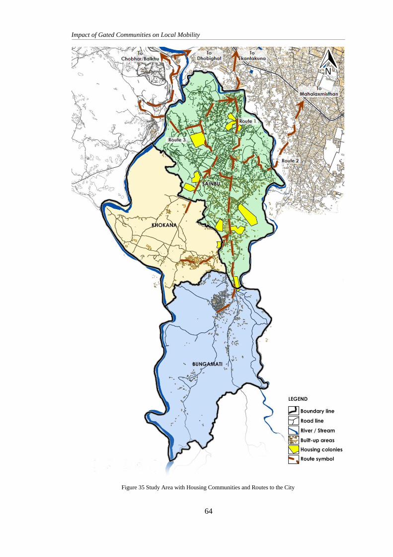
Impact of Gated Communities on Local Mobility
64
Figure 35 Study Area with Housing Communities and Routes to the City
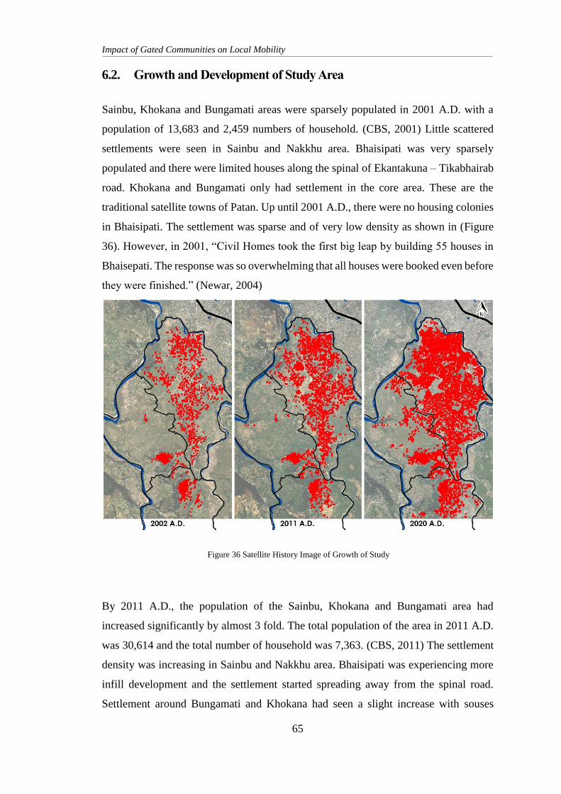
Impact of Gated Communities on Local Mobility
65
6.2. Growth and Development of Study Area
Sainbu, Khokana and Bungamati areas were sparsely populated in 2001 A.D. with a
population of 13,683 and 2,459 numbers of household. (CBS, 2001) Little scattered
settlements were seen in Sainbu and Nakkhu area. Bhaisipati was very sparsely
populated and there were limited houses along the spinal of Ekantakuna – Tikabhairab
road. Khokana and Bungamati only had settlement in the core area. These are the
traditional satellite towns of Patan. Up until 2001 A.D., there were no housing colonies
in Bhaisipati. The settlement was sparse and of very low density as shown in (Figure
36). However, in 2001, “Civil Homes took the first big leap by building 55 houses in
Bhaisepati. The response was so overwhelming that all houses were booked even before
they were finished.” (Newar, 2004)
By 2011 A.D., the population of the Sainbu, Khokana and Bungamati area had
increased significantly by almost 3 fold. The total population of the area in 2011 A.D.
was 30,614 and the total number of household was 7,363. (CBS, 2011) The settlement
density was increasing in Sainbu and Nakkhu area. Bhaisipati was experiencing more
infill development and the settlement started spreading away from the spinal road.
Settlement around Bungamati and Khokana had seen a slight increase with souses
Figure 36 Satellite History Image of Growth of Study
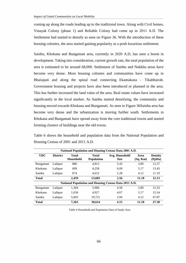
Impact of Gated Communities on Local Mobility
66
coming up along the roads leading up to the traditional town. Along with Civil homes,
Vinayak Colony (phase 1) and Reliable Colony had come up in 2011 A.D. The
Settlement had started to densify as seen on Figure 36. With the introduction of these
housing colonies, the area started gaining popularity as a posh luxurious settlement.
Sainbu, Khokana and Bungamati area, currently in 2020 A.D, has seen a boom in
development. Taking into consideration, current growth rate, the total population of the
area is estimated to be around 68,000. Settlement of Sainbu and Nakkhu areas have
become very dense. More housing colonies and communities have come up in
Bhaisipati and along the spinal road connecting Ekantakuna – Tikabhairab.
Government housing and projects have also been introduced or planned in the area.
This has further increased the land value of the area. Real estate values have increased
significantly in the local market. As Sainbu started densifying, the community and
housing moved towards Khokana and Bungamati. As seen in Figure 36Sainbu area has
become very dense and the urbanization is moving further south. Settlements in
Khokana and Bungamati have spread away from the core traditional towns and started
forming clusters of buildings near the old towns.
Table 6 shows the household and population data from the National Population and
Housing Census of 2001 and 2011 A.D.
National Population and Housing Census Data 2001 A.D.
VDC District Total
Household
Total
Population
Avg. Household
Size
Area
(Sq. Km)
Density
(PpHa)
Bungamati Lalitpur 886 4,813 5.43 3.89 12.37
Khokana Lalitpur 699 4,258 6.09 3.17 13.43
Sainbu Lalitpur 874 4,612 5.28 4.12 11.19
Total 2,459 13,683 5.56 11.18 12.13
National Population and Housing Census Data 2011 A.D.
Bungamati Lalitpur 1,304 5,966 4.58 3.89 15.33
Khokana Lalitpur 1,056 4,927 4.67 3.17 15.54
Sainbu Lalitpur 5,003 19,721 3.94 4.12 47.87
Total 7,363 30,614 4.15 11.18 27.38
Table 6 Household and Population Data of Study Area
Impact of Gated Communities on Local Mobility
67
6.3. Site Area
Site area for the data collection, survey and analysis in this research is selected as the
Bhaisipati area in Sainbu. We can see that the density of this area is relatively high and
growing. The number of housing and gated colonies are growing as gating and living
in a plotted land development have garnered an increased interest in the locals.
Bhaisipati Area
Bhaisipati area is located towards the west of LMC. It falls within ward 18 and 25,
previously Sainbu VDC of the Lalitpur District. It is bordered with the Bagmati river
to the west and Nakkhu river to the north and east directions. The settlements of
Khokana, Karyabinayak and Bungamati lie towards the south and is accessed through
the Ekantakuna – Tikabhairab road that runs along the spine of the area.
Bhaisipati area houses various housing colonies among which is Vinayak Colony. It is
a closed gated community with access on 2 different roads, thus having a possible
thorough fare access. It also restricts public access to a road that could have been a
thorough fare road. It is a large cluster of houses with privatized land. The colony is a
fenced and gated community that also houses amenities including a departmental store
and swimming pool. These amenities and facilities are restricted to use for the residents
of the community only. This gated cluster of houses has access to Bhaisipati Awas to
the south and the road connecting the Nakkhu road to Chobhar towards the north. The
residents of the community have direct access to either Bhaisipati Awas to the south or
the road connecting Nakkhu road to Chobhar towards the north. However, this access
route is blocked off to the general public who may not be a resident of the gated
community. The gates are closed to all non-residents of the community and access to
any infrastructure or amenities is restricted or blocked altogether. Thus, the roads inside
this community is not accessible to the public. They don’t allow thoroughfare from
Bhaisipati Awas to the road in the north through the community roads to the public.
This can cause various impacts on the mobility of the locality.
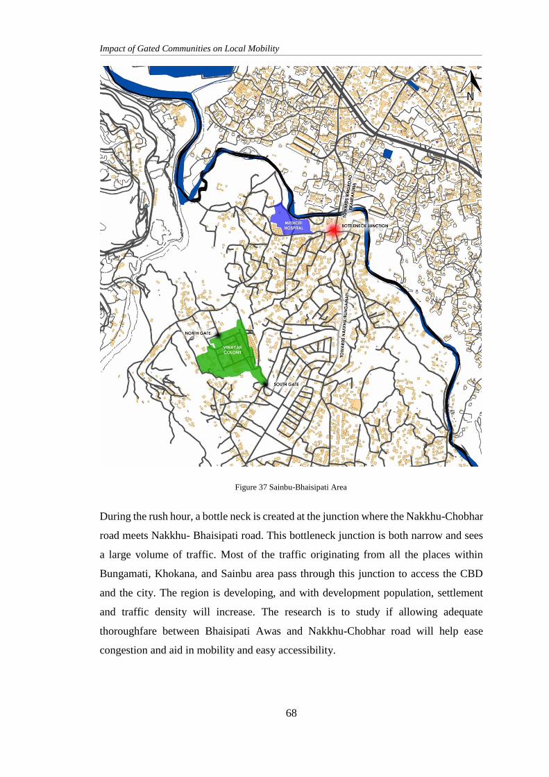
Impact of Gated Communities on Local Mobility
68
During the rush hour, a bottle neck is created at the junction where the Nakkhu-Chobhar
road meets Nakkhu- Bhaisipati road. This bottleneck junction is both narrow and sees
a large volume of traffic. Most of the traffic originating from all the places within
Bungamati, Khokana, and Sainbu area pass through this junction to access the CBD
and the city. The region is developing, and with development population, settlement
and traffic density will increase. The research is to study if allowing adequate
thoroughfare between Bhaisipati Awas and Nakkhu-Chobhar road will help ease
congestion and aid in mobility and easy accessibility.
Figure 38: Study Area (Bhaisipati)
Figure 37 Sainbu-Bhaisipati Area
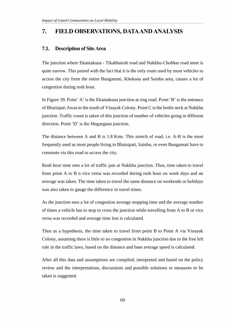
Impact of Gated Communities on Local Mobility
69
7. FIELD OBSERVATIONS, DATA AND ANALYSIS
7.1. Description of Site Area
The junction where Ekantakuna - Tikabhairab road and Nakkhu-Chobhar road meet is
quite narrow. This paired with the fact that it is the only route used by most vehicles to
access the city from the entire Bungamati, Khokana and Sainbu area, causes a lot of
congestion during rush hour.
In Figure 39, Point ‘A’ is the Ekantakuna junction at ring road. Point ‘B’ is the entrance
of Bhaisipati Awas to the south of Vinayak Colony. Point C is the bottle neck at Nakkhu
junction. Traffic count is taken of this junction of number of vehicles going in different
direction. Point ‘D’ is the Magargaun junction.
The distance between A and B is 1.8 Kms. This stretch of road, i.e. A-B is the most
frequently used as most people living in Bhaisipati, Sainbu, or even Bungamati have to
commute via this road to access the city.
Rush hour time sees a lot of traffic jam at Nakkhu junction. Thus, time taken to travel
from point A to B n vice versa was recorded during rush hour on week days and an
average was taken. The time taken to travel the same distance on weekends or holidays
was also taken to gauge the difference in travel times.
As the junction sees a lot of congestion average stopping time and the average number
of times a vehicle has to stop to cross the junction while travelling from A to B or vice
versa was recorded and average time lost is calculated.
Then as a hypothesis, the time taken to travel from point B to Point A via Vinayak
Colony, assuming there is little to no congestion in Nakkhu junction due to the free left
rule in the traffic laws, based on the distance and base average speed is calculated.
After all this data and assumptions are compiled, interpreted and based on the policy
review and the interpretations, discussions and possible solutions or measures to be
taken is suggested.
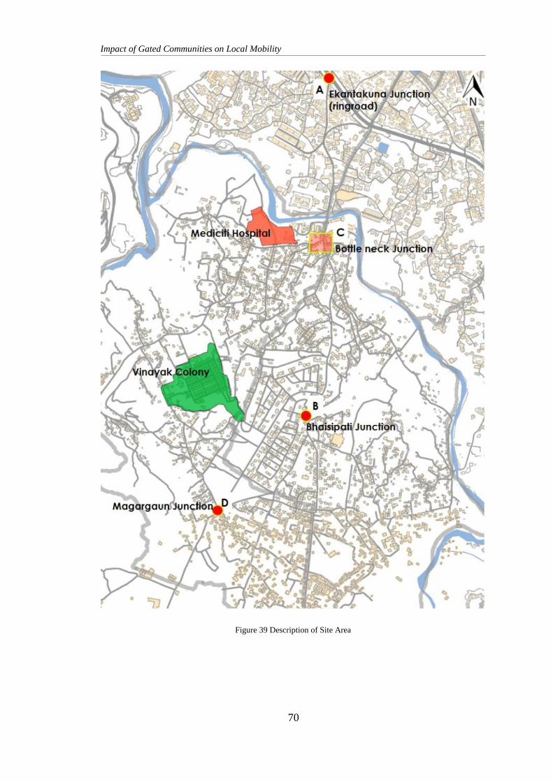
Impact of Gated Communities on Local Mobility
70
Figure 39 Description of Site Area
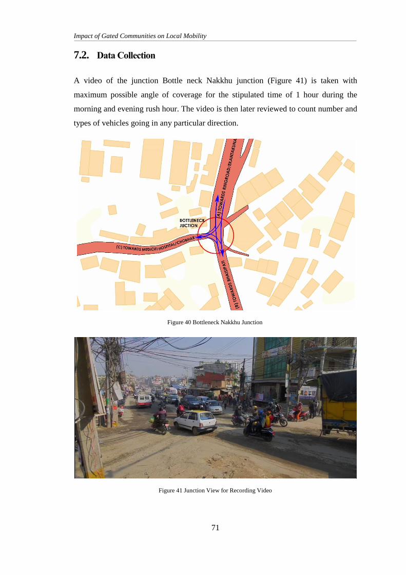
Impact of Gated Communities on Local Mobility
71
7.2. Data Collection
A video of the junction Bottle neck Nakkhu junction (Figure 41) is taken with
maximum possible angle of coverage for the stipulated time of 1 hour during the
morning and evening rush hour. The video is then later reviewed to count number and
types of vehicles going in any particular direction.
Figure 40 Bottleneck Nakkhu Junction
Figure 41 Junction View for Recording Video
Impact of Gated Communities on Local Mobility
72
Figure 40 of the Nakkhu junction shows that the junction has 3 main roads connecting
to it. From ‘A’ Ekantakuna, from ‘B’ Bhaisipati and from ‘C’ Mediciti / Chobhar. Here
there is a lot of cross flowing traffic as vehicles move from all three sides to all three
sides. This makes traffic management a compulsion. Number of vehicles travelling
from A to B, A to C, B to A, B to C, C to A and C to B is recorded and calculated.
7.3. Traffic Count and Pattern
Traffic count is carried out at the bottle neck junctions. The traffic is divided to 4
categories namely:
Two Wheelers: This includes motorbikes, scooters, mopeds, and bicycles.
Light Vehicles: This includes all light three wheelers and four wheelers. These are
small cars, hatchbacks, sedans, crossovers, SUVs, jeeps, delivery vans, micro bus or
vans, tempo and pickup trucks.
Heavy Vehicles: This includes all heavy vehicles including busses, trucks, mini busses,
mini trucks, tippers and any other heavy machinery vehicles.
Other Vehicles: This includes all light slow vehicles that might affect traffic flow
significantly, like 3 wheeler rickshaw, a tractor, a tractor trailer, a motor rickshaw, etc.
The Metropolitan Traffic Division has allocated the time between 9-11 am in the
morning and 4-6 pm in the evening as rush hour. Thus, traffic count is done for one
hour between 9:30-10:30 am in the morning and 4:30-5:30 pm in the evening at bottle
neck junction to determine the volume and flow of traffic.
Time taken to commute from a fixed point to and from ring road is also taken during
peak rush hour and on a holiday to compare the time spent. Average wait time and the
number of times one has to stop is also taken during the peak rush hours. This helps
determine traffic patterns, mobility trends, ease of access and commute time and
distance.
Two wheelers, small vehicles (3 or 4 wheelers) and heavy vehicles are counted. Other
miscellaneous vehicles such as tractors or rickshaws are included as well.
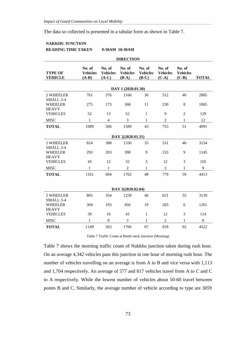
Impact of Gated Communities on Local Mobility
73
The data so collected is presented in a tabular form as shown in Table 7.
NAKKHU JUNCTION
READING TIME TAKEN 9:30AM 10:30AM
DIRECTION
TYPE OF
VEHICLE
No. of
Vehicles
(A-B)
No. of
Vehicles
(A-C)
No. of
Vehicles
(B-A)
No. of
Vehicles
(B-C)
No. of
Vehicles
(C-A)
No. of
Vehicles
(C-B) TOTAL
DAY 1 (2020.01.30)
2 WHEELER 761 376 1166 30 512 40 2885
SMALL 3-4
WHEELER 275 173 368 11 230 8 1065
HEAVY
VEHICLES 52 13 52 1 9 2 129
MISC 1 4 3 1 2 1 12
TOTAL 1089 566 1589 43 753 51 4091
DAY 2(2020.01.31)
2 WHEELER 824 388 1330 35 531 46 3154
SMALL 3-4
WHEELER 293 203 398 9 233 9 1145
HEAVY
VEHICLES 43 12 32 3 12 3 105
MISC 1 1 2 1 3 1 9
TOTAL 1161 604 1762 48 779 59 4413
DAY 3(2020.02.04)
2 WHEELER 805 354 1258 46 621 55 3139
SMALL 3-4
WHEELER 304 193 456 19 283 6 1261
HEAVY
VEHICLES 39 16 43 1 12 3 114
MISC 1 0 3 1 2 1 8
TOTAL 1149 563 1760 67 918 65 4522
Table 7 Traffic Count at Bottle neck Junction (Morning)
Table 7 shows the morning traffic count of Nakkhu junction taken during rush hour.
On an average 4,342 vehicles pass this junction in one hour of morning rush hour. The
number of vehicles travelling on an average is from A to B and vice versa with 1,113
and 1,704 respectively. An average of 577 and 817 vehicles travel from A to C and C
to A respectively. While the lowest number of vehicles about 50-60 travel between
points B and C. Similarly, the average number of vehicle according to type are 3059
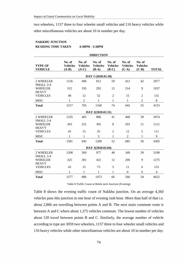
Impact of Gated Communities on Local Mobility
74
two wheelers, 1157 three to four wheeler small vehicles and 116 heavy vehicles while
other miscellaneous vehicles are about 10 in number per day.
NAKKHU JUNCTION
READING TIME TAKEN 4:30PM - 5:30PM
DIRECTION
TYPE OF
VEHICLE
No. of
Vehicles
(A-B)
No. of
Vehicles
(A-C)
No. of
Vehicles
(B-A)
No. of
Vehicles
(B-C)
No. of
Vehicles
(C-A)
No. of
Vehicles
(C-B) TOTAL
DAY 1 (2020.01.30)
2 WHEELER 1156 496 812 59 412 42 2977
SMALL 3-4
WHEELER 312 195 295 12 214 9 1037
HEAVY
VEHICLES 48 12 52 2 15 2 131
MISC 1 2 1 1 1 2 8
Total 1517 705 1160 74 642 55 4153
DAY 2(2020.02.31)
2 WHEELER 1235 405 886 41 468 39 3074
SMALL 3-4
WHEELER 303 221 365 8 203 11 1111
HEAVY
VEHICLES 42 15 35 2 12 5 111
MISC 1 1 3 1 2 1 9
Total 1581 642 1289 52 685 56 4305
DAY 3(2020.02.04)
2 WHEELER 1208 569 977 48 349 39 3190
SMALL 3-4
WHEELER 325 301 422 12 206 9 1275
HEAVY
VEHICLES 43 15 73 5 11 6 153
MISC 1 1 1 1 0 0 4
Total 1577 886 1473 66 566 54 4622
Table 8 Traffic Count at Bottle neck Junction (Evening)
Table 8 shows the evening traffic count of Nakkhu junction. On an average 4,360
vehicles pass this junction in one hour of evening rush hour. More than half of that i.e.
about 2,866 are travelling between points A and B. The next main commute route is
between A and C where about 1,375 vehicles commute. The lowest number of vehicles
about 120 travel between points B and C. Similarly, the average number of vehicle
according to type are 3059 two wheelers, 1157 three to four wheeler small vehicles and
116 heavy vehicles while other miscellaneous vehicles are about 10 in number per day.
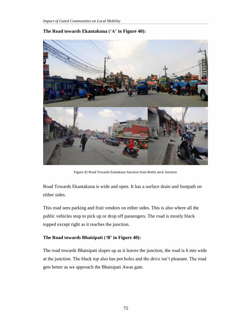
Impact of Gated Communities on Local Mobility
75
The Road towards Ekantakuna (‘A’ in Figure 40):
Road Towards Ekantakuna is wide and open. It has a surface drain and footpath on
either sides.
This road sees parking and fruit vendors on either sides. This is also where all the
public vehicles stop to pick up or drop off passengers. The road is mostly black
topped except right as it reaches the junction.
The Road towards Bhaisipati (‘B’ in Figure 40):
The road towards Bhaisipati slopes up as it leaves the junction, the road is 6 mts wide
at the junction. The black top also has pot holes and the drive isn’t pleasant. The road
gets better as we approach the Bhaisipati Awas gate.
Figure 42 Road Towards Eantakuna Junction from Bottle neck Junction
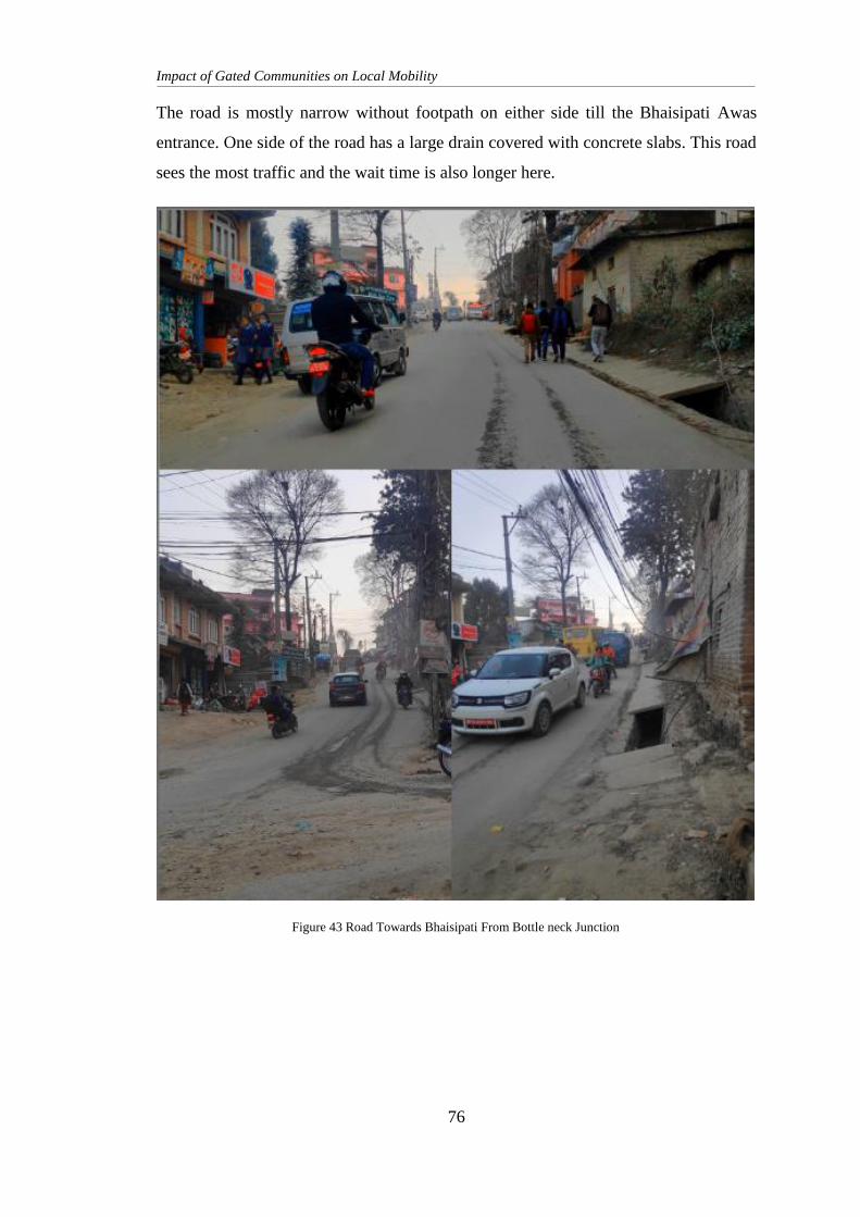
Impact of Gated Communities on Local Mobility
76
The road is mostly narrow without footpath on either side till the Bhaisipati Awas
entrance. One side of the road has a large drain covered with concrete slabs. This road
sees the most traffic and the wait time is also longer here.
Figure 43 Road Towards Bhaisipati From Bottle neck Junction
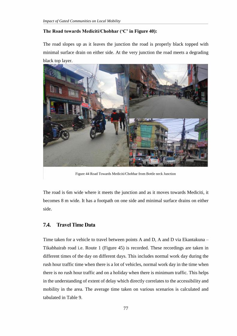
Impact of Gated Communities on Local Mobility
77
The Road towards Mediciti/Chobhar (‘C’ in Figure 40):
The road slopes up as it leaves the junction the road is properly black topped with
minimal surface drain on either side. At the very junction the road meets a degrading
black top layer.
The road is 6m wide where it meets the junction and as it moves towards Mediciti, it
becomes 8 m wide. It has a footpath on one side and minimal surface drains on either
side.
7.4. Travel Time Data
Time taken for a vehicle to travel between points A and D, A and D via Ekantakuna –
Tikabhairab road i.e. Route 1 (Figure 45) is recorded. These recordings are taken in
different times of the day on different days. This includes normal work day during the
rush hour traffic time when there is a lot of vehicles, normal work day in the time when
there is no rush hour traffic and on a holiday when there is minimum traffic. This helps
in the understanding of extent of delay which directly correlates to the accessibility and
mobility in the area. The average time taken on various scenarios is calculated and
tabulated in Table 9.
Figure 44 Road Towards Mediciti/Chobhar from Bottle neck Junction
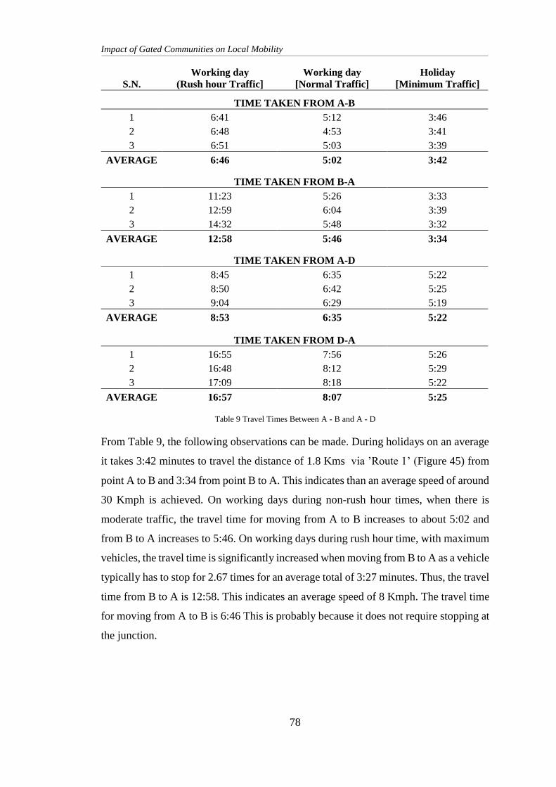
Impact of Gated Communities on Local Mobility
78
S.N.
Working day
(Rush hour Traffic]
Working day
[Normal Traffic]
Holiday
[Minimum Traffic]
TIME TAKEN FROM A-B
1 6:41 5:12 3:46
2 6:48 4:53 3:41
3 6:51 5:03 3:39
AVERAGE 6:46 5:02 3:42
TIME TAKEN FROM B-A
1 11:23 5:26 3:33
2 12:59 6:04 3:39
3 14:32 5:48 3:32
AVERAGE 12:58 5:46 3:34
TIME TAKEN FROM A-D
1 8:45 6:35 5:22
2 8:50 6:42 5:25
3 9:04 6:29 5:19
AVERAGE 8:53 6:35 5:22
TIME TAKEN FROM D-A
1 16:55 7:56 5:26
2 16:48 8:12 5:29
3 17:09 8:18 5:22
AVERAGE 16:57 8:07 5:25
Table 9 Travel Times Between A - B and A - D
From Table 9, the following observations can be made. During holidays on an average
it takes 3:42 minutes to travel the distance of 1.8 Kms via ’Route 1’ (Figure 45) from
point A to B and 3:34 from point B to A. This indicates than an average speed of around
30 Kmph is achieved. On working days during non-rush hour times, when there is
moderate traffic, the travel time for moving from A to B increases to about 5:02 and
from B to A increases to 5:46. On working days during rush hour time, with maximum
vehicles, the travel time is significantly increased when moving from B to A as a vehicle
typically has to stop for 2.67 times for an average total of 3:27 minutes. Thus, the travel
time from B to A is 12:58. This indicates an average speed of 8 Kmph. The travel time
for moving from A to B is 6:46 This is probably because it does not require stopping at
the junction.
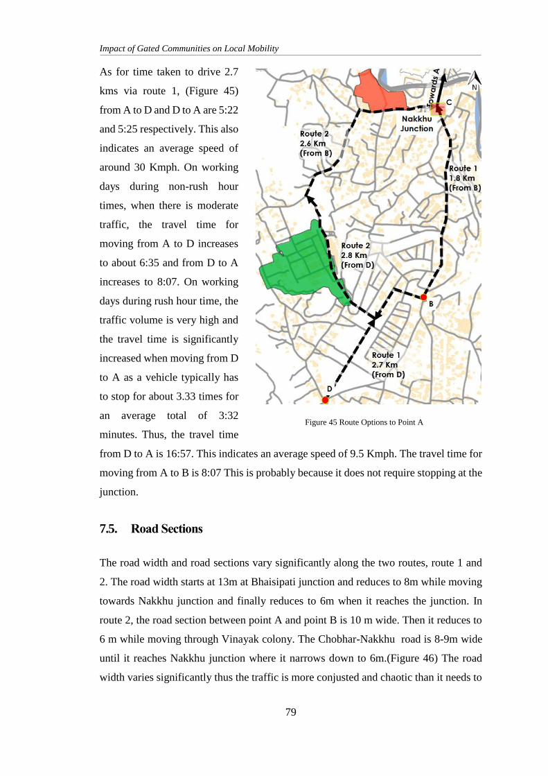
Impact of Gated Communities on Local Mobility
79
As for time taken to drive 2.7
kms via route 1, (Figure 45)
from A to D and D to A are 5:22
and 5:25 respectively. This also
indicates an average speed of
around 30 Kmph. On working
days during non-rush hour
times, when there is moderate
traffic, the travel time for
moving from A to D increases
to about 6:35 and from D to A
increases to 8:07. On working
days during rush hour time, the
traffic volume is very high and
the travel time is significantly
increased when moving from D
to A as a vehicle typically has
to stop for about 3.33 times for
an average total of 3:32
minutes. Thus, the travel time
from D to A is 16:57. This indicates an average speed of 9.5 Kmph. The travel time for
moving from A to B is 8:07 This is probably because it does not require stopping at the
junction.
7.5. Road Sections
The road width and road sections vary significantly along the two routes, route 1 and
2. The road width starts at 13m at Bhaisipati junction and reduces to 8m while moving
towards Nakkhu junction and finally reduces to 6m when it reaches the junction. In
route 2, the road section between point A and point B is 10 m wide. Then it reduces to
6 m while moving through Vinayak colony. The Chobhar-Nakkhu road is 8-9m wide
until it reaches Nakkhu junction where it narrows down to 6m.(Figure 46) The road
width varies significantly thus the traffic is more conjusted and chaotic than it needs to
Figure 45 Route Options to Point A
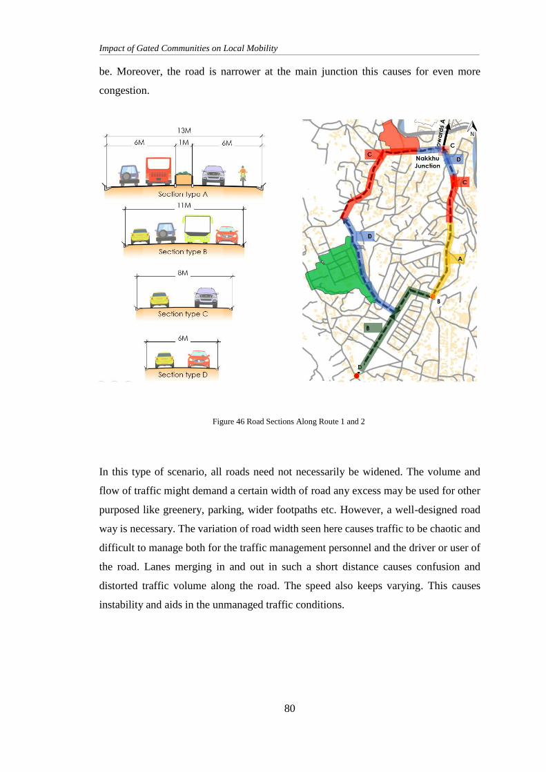
Impact of Gated Communities on Local Mobility
80
be. Moreover, the road is narrower at the main junction this causes for even more
congestion.
In this type of scenario, all roads need not necessarily be widened. The volume and
flow of traffic might demand a certain width of road any excess may be used for other
purposed like greenery, parking, wider footpaths etc. However, a well-designed road
way is necessary. The variation of road width seen here causes traffic to be chaotic and
difficult to manage both for the traffic management personnel and the driver or user of
the road. Lanes merging in and out in such a short distance causes confusion and
distorted traffic volume along the road. The speed also keeps varying. This causes
instability and aids in the unmanaged traffic conditions.
Figure 46 Road Sections Along Route 1 and 2
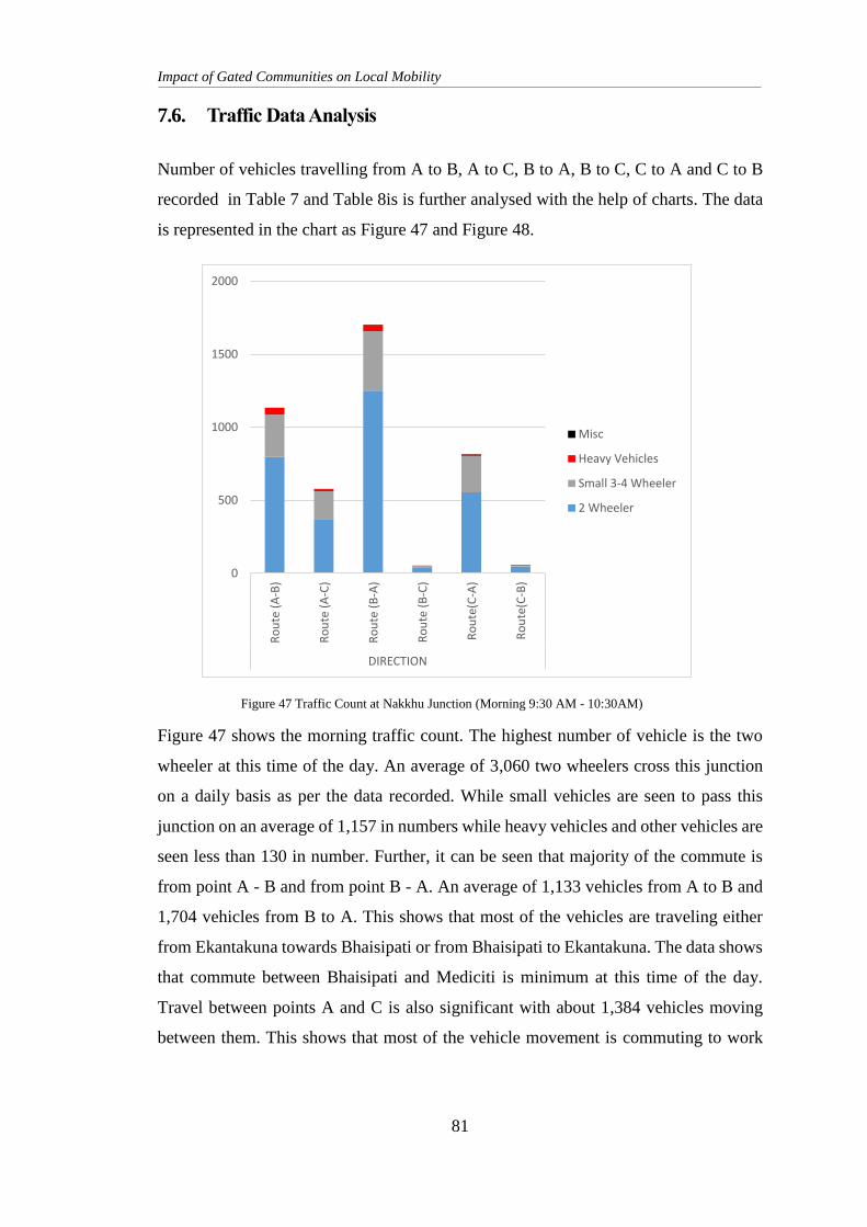
Impact of Gated Communities on Local Mobility
81
7.6. Traffic Data Analysis
Number of vehicles travelling from A to B, A to C, B to A, B to C, C to A and C to B
recorded in Table 7 and Table 8is is further analysed with the help of charts. The data
is represented in the chart as Figure 47 and Figure 48.
Figure 47 shows the morning traffic count. The highest number of vehicle is the two
wheeler at this time of the day. An average of 3,060 two wheelers cross this junction
on a daily basis as per the data recorded. While small vehicles are seen to pass this
junction on an average of 1,157 in numbers while heavy vehicles and other vehicles are
seen less than 130 in number. Further, it can be seen that majority of the commute is
from point A - B and from point B - A. An average of 1,133 vehicles from A to B and
1,704 vehicles from B to A. This shows that most of the vehicles are traveling either
from Ekantakuna towards Bhaisipati or from Bhaisipati to Ekantakuna. The data shows
that commute between Bhaisipati and Mediciti is minimum at this time of the day.
Travel between points A and C is also significant with about 1,384 vehicles moving
between them. This shows that most of the vehicle movement is commuting to work
0
500
1000
1500
2000R
ou
te (
A-B
)
Ro
ute
(A
-C)
Ro
ute
(B
-A)
Ro
ute
(B
-C)
Ro
ute
(C-A
)
Ro
ute
(C-B
)
DIRECTION
Misc
Heavy Vehicles
Small 3-4 Wheeler
2 Wheeler
Figure 47 Traffic Count at Nakkhu Junction (Morning 9:30 AM - 10:30AM)
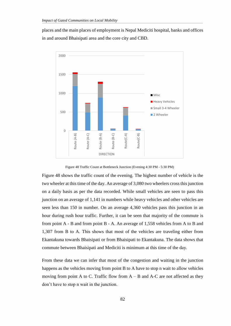
Impact of Gated Communities on Local Mobility
82
places and the main places of employment is Nepal Mediciti hospital, banks and offices
in and around Bhaisipati area and the core city and CBD.
Figure 48 shows the traffic count of the evening. The highest number of vehicle is the
two wheeler at this time of the day. An average of 3,080 two wheelers cross this junction
on a daily basis as per the data recorded. While small vehicles are seen to pass this
junction on an average of 1,141 in numbers while heavy vehicles and other vehicles are
seen less than 150 in number. On an average 4,360 vehicles pass this junction in an
hour during rush hour traffic. Further, it can be seen that majority of the commute is
from point A - B and from point B - A. An average of 1,558 vehicles from A to B and
1,307 from B to A. This shows that most of the vehicles are traveling either from
Ekantakuna towards Bhaisipati or from Bhaisipati to Ekantakuna. The data shows that
commute between Bhaisipati and Mediciti is minimum at this time of the day.
From these data we can infer that most of the congestion and waiting in the junction
happens as the vehicles moving from point B to A have to stop n wait to allow vehicles
moving from point A to C. Traffic flow from A – B and A-C are not affected as they
don’t have to stop n wait in the junction.
0
500
1000
1500
2000
Ro
ute
(A
-B)
Ro
ute
(A
-C)
Ro
ute
(B
-A)
Ro
ute
(B
-C)
Ro
ute
(C-A
)
Ro
ute
(C-B
)
DIRECTION
Misc
Heavy Vehicles
Small 3-4 Wheeler
2 Wheeler
Figure 48 Traffic Count at Bottleneck Junction (Evening 4:30 PM - 5:30 PM)
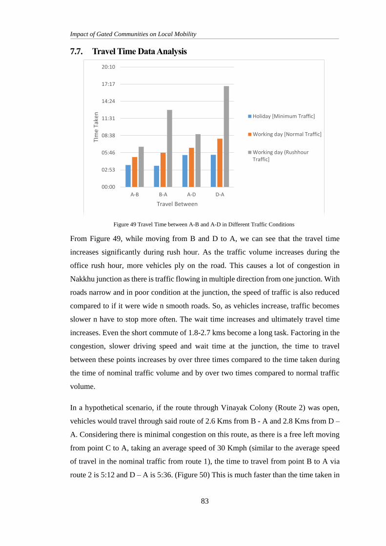
Impact of Gated Communities on Local Mobility
83
7.7. Travel Time Data Analysis
From Figure 49, while moving from B and D to A, we can see that the travel time
increases significantly during rush hour. As the traffic volume increases during the
office rush hour, more vehicles ply on the road. This causes a lot of congestion in
Nakkhu junction as there is traffic flowing in multiple direction from one junction. With
roads narrow and in poor condition at the junction, the speed of traffic is also reduced
compared to if it were wide n smooth roads. So, as vehicles increase, traffic becomes
slower n have to stop more often. The wait time increases and ultimately travel time
increases. Even the short commute of 1.8-2.7 kms become a long task. Factoring in the
congestion, slower driving speed and wait time at the junction, the time to travel
between these points increases by over three times compared to the time taken during
the time of nominal traffic volume and by over two times compared to normal traffic
volume.
In a hypothetical scenario, if the route through Vinayak Colony (Route 2) was open,
vehicles would travel through said route of 2.6 Kms from B - A and 2.8 Kms from D –
A. Considering there is minimal congestion on this route, as there is a free left moving
from point C to A, taking an average speed of 30 Kmph (similar to the average speed
of travel in the nominal traffic from route 1), the time to travel from point B to A via
route 2 is 5:12 and D – A is 5:36. (Figure 50) This is much faster than the time taken in
00:00
02:53
05:46
08:38
11:31
14:24
17:17
20:10
A-B B-A A-D D-A
TIm
e Ta
ken
Travel Between
Holiday [Minimum Traffic]
Working day [Normal Traffic]
Working day (RushhourTraffic]
Figure 49 Travel Time between A-B and A-D in Different Traffic Conditions
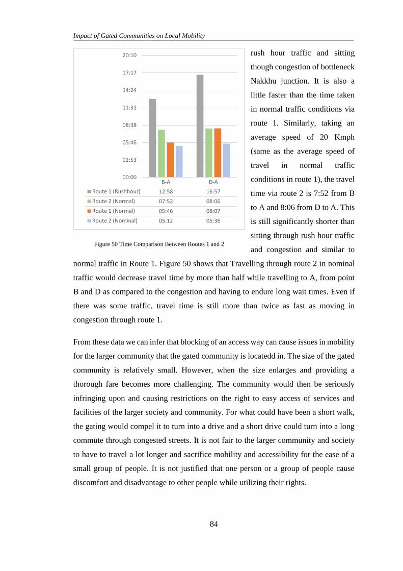
Impact of Gated Communities on Local Mobility
84
rush hour traffic and sitting
though congestion of bottleneck
Nakkhu junction. It is also a
little faster than the time taken
in normal traffic conditions via
route 1. Similarly, taking an
average speed of 20 Kmph
(same as the average speed of
travel in normal traffic
conditions in route 1), the travel
time via route 2 is 7:52 from B
to A and 8:06 from D to A. This
is still significantly shorter than
sitting through rush hour traffic
and congestion and similar to
normal traffic in Route 1. Figure 50 shows that Travelling through route 2 in nominal
traffic would decrease travel time by more than half while travelling to A, from point
B and D as compared to the congestion and having to endure long wait times. Even if
there was some traffic, travel time is still more than twice as fast as moving in
congestion through route 1.
From these data we can infer that blocking of an access way can cause issues in mobility
for the larger community that the gated community is locatedd in. The size of the gated
community is relatively small. However, when the size enlarges and providing a
thorough fare becomes more challenging. The community would then be seriously
infringing upon and causing restrictions on the right to easy access of services and
facilities of the larger society and community. For what could have been a short walk,
the gating would compel it to turn into a drive and a short drive could turn into a long
commute through congested streets. It is not fair to the larger community and society
to have to travel a lot longer and sacrifice mobility and accessibility for the ease of a
small group of people. It is not justified that one person or a group of people cause
discomfort and disadvantage to other people while utilizing their rights.
00:00
02:53
05:46
08:38
11:31
14:24
17:17
20:10
B-A D-A
Route 1 (Rushhour) 12:58 16:57
Route 2 (Normal) 07:52 08:06
Route 1 (Normal) 05:46 08:07
Route 2 (Nominal) 05:12 05:36
Figure 50 Time Comparison Between Routes 1 and 2
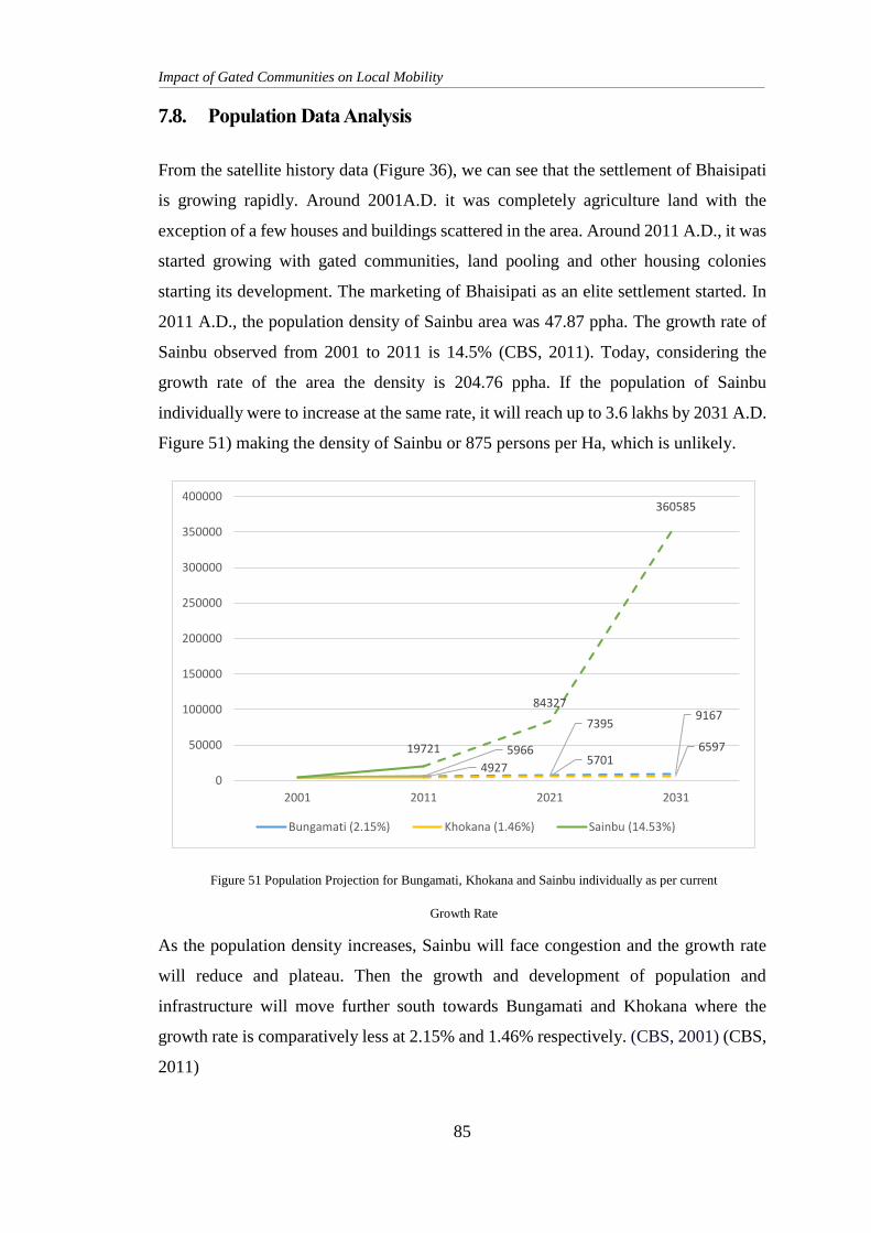
Impact of Gated Communities on Local Mobility
85
7.8. Population Data Analysis
From the satellite history data (Figure 36), we can see that the settlement of Bhaisipati
is growing rapidly. Around 2001A.D. it was completely agriculture land with the
exception of a few houses and buildings scattered in the area. Around 2011 A.D., it was
started growing with gated communities, land pooling and other housing colonies
starting its development. The marketing of Bhaisipati as an elite settlement started. In
2011 A.D., the population density of Sainbu area was 47.87 ppha. The growth rate of
Sainbu observed from 2001 to 2011 is 14.5% (CBS, 2011). Today, considering the
growth rate of the area the density is 204.76 ppha. If the population of Sainbu
individually were to increase at the same rate, it will reach up to 3.6 lakhs by 2031 A.D.
Figure 51) making the density of Sainbu or 875 persons per Ha, which is unlikely.
As the population density increases, Sainbu will face congestion and the growth rate
will reduce and plateau. Then the growth and development of population and
infrastructure will move further south towards Bungamati and Khokana where the
growth rate is comparatively less at 2.15% and 1.46% respectively. (CBS, 2001) (CBS,
2011)
5966
73959167
49275701
659719721
84327
360585
0
50000
100000
150000
200000
250000
300000
350000
400000
2001 2011 2021 2031
Bungamati (2.15%) Khokana (1.46%) Sainbu (14.53%)
Figure 51 Population Projection for Bungamati, Khokana and Sainbu individually as per current
Growth Rate
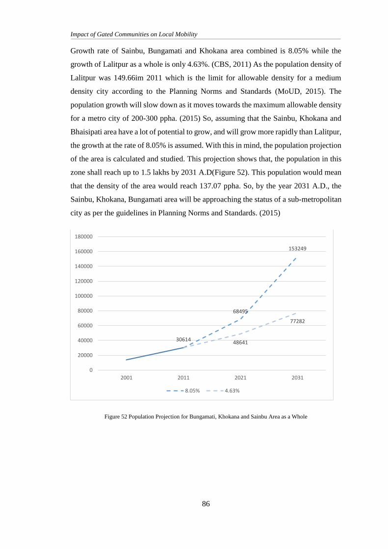
Impact of Gated Communities on Local Mobility
86
Growth rate of Sainbu, Bungamati and Khokana area combined is 8.05% while the
growth of Lalitpur as a whole is only 4.63%. (CBS, 2011) As the population density of
Lalitpur was 149.66im 2011 which is the limit for allowable density for a medium
density city according to the Planning Norms and Standards (MoUD, 2015). The
population growth will slow down as it moves towards the maximum allowable density
for a metro city of 200-300 ppha. (2015) So, assuming that the Sainbu, Khokana and
Bhaisipati area have a lot of potential to grow, and will grow more rapidly than Lalitpur,
the growth at the rate of 8.05% is assumed. With this in mind, the population projection
of the area is calculated and studied. This projection shows that, the population in this
zone shall reach up to 1.5 lakhs by 2031 A.D(Figure 52). This population would mean
that the density of the area would reach 137.07 ppha. So, by the year 2031 A.D., the
Sainbu, Khokana, Bungamati area will be approaching the status of a sub-metropolitan
city as per the guidelines in Planning Norms and Standards. (2015)
Figure 52 Population Projection for Bungamati, Khokana and Sainbu Area as a Whole
30614
68495
153249
48641
77282
0
20000
40000
60000
80000
100000
120000
140000
160000
180000
2001 2011 2021 2031
8.05% 4.63%
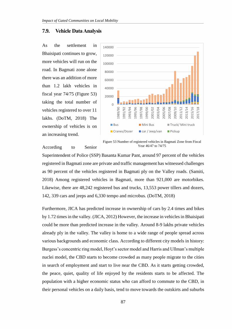
Impact of Gated Communities on Local Mobility
87
7.9. Vehicle Data Analysis
As the settlement in
Bhaisipati continues to grow,
more vehicles will run on the
road. In Bagmati zone alone
there was an addition of more
than 1.2 lakh vehicles in
fiscal year 74/75 (Figure 53)
taking the total number of
vehicles registered to over 11
lakhs. (DoTM, 2018) The
ownership of vehicles is on
an increasing trend.
According to Senior
Superintendent of Police (SSP) Basanta Kumar Pant, around 97 percent of the vehicles
registered in Bagmati zone are private and traffic management has witnessed challenges
as 90 percent of the vehicles registered in Bagmati ply on the Valley roads. (Samiti,
2018) Among registered vehicles in Bagmati, more than 921,000 are motorbikes.
Likewise, there are 48,242 registered bus and trucks, 13,553 power tillers and dozers,
142, 339 cars and jeeps and 6,330 tempo and microbus. (DoTM, 2018)
Furthermore, JICA has predicted increase in ownership of cars by 2.4 times and bikes
by 1.72 times in the valley. (JICA, 2012) However, the increase in vehicles in Bhaisipati
could be more than predicted increase in the valley. Around 8-9 lakhs private vehicles
already ply in the valley. The valley is home to a wide range of people spread across
various backgrounds and economic class. According to different city models in history:
Burgess’s concentric ring model, Hoyt’s sector model and Harris and Ullman’s multiple
nuclei model, the CBD starts to become crowded as many people migrate to the cities
in search of employment and start to live near the CBD. As it starts getting crowded,
the peace, quiet, quality of life enjoyed by the residents starts to be affected. The
population with a higher economic status who can afford to commute to the CBD, in
their personal vehicles on a daily basis, tend to move towards the outskirts and suburbs
0
20000
40000
60000
80000
100000
120000
140000
19
89
/90
19
91
/92
19
93
/94
19
95
/96
19
97
/98
19
99
/00
20
01
/02
20
03
/04
20
05
/06
20
07
/08
20
09
/10
20
11
/12
20
13
/14
20
15
/16
20
17
/18
Bus Mini Bus Truck/ Mini truck
Cranes/Dozer car / Jeep/van Pickup
Micro Bus Tempo Trackter/
Ambulanc e C.D/U.N Motorcycl eFigure 53 Number of registered vehicles in Bagmati Zone from Fiscal
Year 46/47 to 74/75
Impact of Gated Communities on Local Mobility
88
for a quieter life with open spaces and a better quality of life. This peri-urban
development is fuelled by these people moving away from the CBD. These theories can
be observed in the Sainbu-Bhaisepati area as well. Bhaisepati has been targeted as a
prime location for luxurious living by many group housing companies. The government
ministers’ quarters are also proposed in the area. We can assume that because of all
this, the majority of population moving to this area shall own their own personal
vehicles. Thus, the number of vehicles in Bhaisipati will be higher than projection for
the entire valley.
Impact of Gated Communities on Local Mobility
89
8. FINDINGS AND DISCUSSION
8.1. Population and Traffic
The settlement of Bhaisipati is growing rapidly. It started around 2011 A.D. with a
number of gated communities, land pooling projects and other housing being
introduced here. As the density increases, Sainbu will face congestion and the growth
and development of population and infrastructure will move further south towards
Bungamati and Khokana and the density of the area would reach around 135 ppha by
2031 A.D. The Sainbu, Khokana, Bungamati area will be approaching the status of a
sub-metropolitan city as per the guidelines in Planning Norms and Standards. (2015)
With already a total of over 11 lakhs vehicles registered, around 8-9 lakhs private
vehicles already ply in the valley. In the Data Collection Survey on Traffic
Improvement in Kathmandu Valley, JICA has predicted increase in ownership of bikes
and cars by 1.72 to times in the valley. However, the increase in vehicles in Bhaisipati
could be more than predicted increase in the valley, as the majority of population
moving to this area shall own their own personal vehicles. Thus, the number of vehicles
in Bhaisipati will be higher than projection for the entire valley.
With only one major access road connecting this area to the main city and CBD, the
Ekantakuna - Tikabhairab road will see a lot of vehicles unless alternate route or
transport options are provided. The Nakkhu junction is a bottleneck spot and is the main
area for traffic jam due to the long wait time while passing through or crossing said
junction. With the population of the place about 60 thousand, we see an average of
4,000 to 4,600 vehicles pass through this junction. The population of the place is
projected to reach around 1.5 lakhs. We can see the travel time increase by about 3.1 to
3.6 times during rush hour. The area is still in the process of development and
densification. If gated communities with an option for thorough fare allow vehicles to
pass, an alternate route is provided. This would open up alternate routes to access the
city through Chobhar, Mahalaxmisthan or Satdobato. This will ease traffic congestion
and reduce travel time.
Impact of Gated Communities on Local Mobility
90
8.2. Policy Findings
The Ownership of Joint Housing Act defines and describes “joint housing” in in terms
of apartments. Here, joint housing is defined as a building or group of buildings with
multiple floors with different apartment units where two or more families can live in a
single building. The building or a cluster of buildings can be within one parcel of land
with the open spaces as common collective spaces. The Act does not allow use of these
collective space for any private use or demarcation and prohibition of land. The act
gives power to the promoters or elected committee of the apartment owners to maintain,
protect and repair the collective spaces. However, the apartment owners do not own
parcels of land within the complex privately. They get a share of the land only in case
of complete destruction of the apartment buildings. In a housing colony, each resident
is a land owner and owns their parcel of land separately. There are roads providing
access to each land or house. These houses do not conform with the definition of joint
housing or apartment explicitly mentioned in the act.
The Public Road Act defines “public road” as roads that is not privately owned. So
any road providing access to more than one parcel of land or more than one landowner
is considered public road. According to this, the roads in the housing colonies appear
to be “public roads”. This act prohibits any individual or group from causing any
obstruction of movement on these public roads in any way. It also prohibits anyone
from performing any act as to barricade, obstruct or damage the area within the road
border without permission from the Department of Roads or the local authorities.
The Lands Act describes provisions and prohibitions of ownership of land to any
individual, committee, institute or cooperative. It states that anybody, be it individual
or group is not allowed to own more than 25 ropani of land in Kathmandu valley. It
mentions that the individual or group is allowed to own 5 ropani more for housing
purposes. It provides exceptions to institutes and other groups to own more land by
special permission on the pretext that the 25 ropani is not sufficient for the group or
individual to run their operations.
Housing colonies are much larger than 25 ropani and thus cannot be owned by the
committee. The ownership of joint housing act does not cover the housing colony
Impact of Gated Communities on Local Mobility
91
specifically. Thus, power cannot be given to the committee to control common areas as
the common areas in housing colonies are “public roads” as per the public roads act, as
opposed to the parks, utility spaces, basements in apartment complexes.
So, from a legal stand point, the gates in the boundaries of housing colonies does not
appear to be legal. Thus, if ordered by the Department of Roads or by the local
authority, the gate restricting movement shall be removed.
The Building Byelaws is a document explaining and listing all the byelaws and
regulations to be followed while planning, designing and constructing any
infrastructure or building within the valley metropolis and neighbouring VDCs. It has
provisions for the permit and construction process of a variety of building types and
sizes.
This document does not provide specific regulations and guidelines for group housing.
It lacks detailed criteria one has to follow to be permitted to construct a group housing
development. It lacks provision for the ownership of land common land within the
group housing boundary.
The Town Development Act made provisions for reconstruction, expansion and
development of existing towns and also the construction of new towns. This act mainly
provides for and caters to the planning and development of towns and other
development areas performed by a government body. It however has provisions and
restrictions for private institutions wishing to perform development activities in the
planning area. This facilitates an opportunity for the government body to implement
regulations to ensure the development caters to and facilitates the town and community
as a whole and is not completely secluded for the use and benefit to private parties.
The Right to Housing Act was made to provide for the right to housing of every citizen
of the country. The Act relates to citizen’s rights and duties related to housing. It lacks
provisions related to gated community and group housing. It does not specify the rights,
restrictions and responsibilities of residents or owners of plots within the group housing
to the common areas.
Impact of Gated Communities on Local Mobility
92
The Land Use Policy 2015 aims for social, economic and ecological development by
optimum use of available LLR thus leading the country towards prosperity. Policies 2
and 4 of this document provide for the power and responsibility to all levels of
government from local to central or federal bodies to formulate a land use plan suitable
for their area and enforce the same. This gives local bodies a new and unique
opportunity to perform proper urban development plans, specify the usage of land and
responsibilities that a private or government body have to fulfil and abide by while
performing planning, construction and development.
The National Urban Development Strategy aims to lead the process of urbanization
by integrating actions of important urban sectors through strategies that will help shape
the future of the urban areas. Strategies mentioned in the document targets to
continually study urban patterns, assess risk and hazards, evaluate issues and
shortcomings in the plans and policies. This gives opportunities to notice and learn from
the drawbacks and obstacles in safety, security, convenience and development. The
commitment to review and revise building code/regulations/guidelines and planning
byelaws periodically then provides room and opportunity to improve said regulations
and guidelines to help local bodies understand and enforce the codes and byelaws.
Even though there does not seem to be specific rules and regulations regarding design
and development of private housing colonies, policies, strategies and acts have
provisions and opportunities for different local or federal government bodies to initiate
the formulation and enforcement of rules that will help ensure public wellbeing along
with privacy for the owners of the plots inside a gated community.
8.3. Views of Locals
During the research the views of the locals, the local traffic management personnel and
their representatives were collected. All agreed that that traffic congestion was
becoming a problem and it was getting worse as the settlement densified. Everyone had
an issue with there being only one road to the city that was usable and expressed the
need for more routes as alternates. While many people had not considered the
possibility of making roads through gated communities.
Impact of Gated Communities on Local Mobility
93
Talking to the traffic management personnel revealed some hidden and some obvious
shortcomings in the traffic management scene. Mr. Ram Singh Bhandari, a traffic police
who is regularly stationed at the Nakkhu junction shared some of his experiences with
regards to the difficulties in traffic management at the place. First and foremost, he talks
about the road condition, road infrastructure and public behaviour. The road condition
at the junction is quite poor. The black topping has eroded and a lot of pot holes are
seen. This doesn’t allow the vehicles to move smoothly and with so much cross flow
of traffic, it adds to the travel and wait time. Another traffic Ms. Srijana Thapa pointed
out that the road infrastructures were inadequate as it was narrow, lacked lane markings,
footpaths, adequate drains and proper traffic management system. This meant unsafe
roads for pedestrians, vehicles as well as traffic personnel. This is amplified by
negligence and ignorance of the public. Not following traffic rules, lane discipline,
haphazard pedestrian crossing, arbitrarily walking on the roads, motor bikes not waiting
their turn an obstructing oncoming traffic etc. are among the issues with public
behaviour. The traffic personnel mobilised are not adequate to deal with so many
offenders while managing traffic flow. This creates obstacles and dangers in the flow
of traffic.
They both agree that letting the traffic flow freely often results in lesser wait time and
the congestion seems less. However, the road becomes very chaotic and more
dangerous to all the parties involved. The agree that widening the road will help the
congestion but insist that that is not the solution as currently the cross flow is the main
obstacle. They emphasise on the fact that providing new alternate routes, opening and
maintaining available alternate routes or reducing cross flow (possibly by making one
of the roads one way) will help solve the issue.
Mr. Gopal Dangol, a resident and member of ward 18 discussed in length about the
shortcomings and possibilities of rectifying these issues but noted the constraints in
budget and legal frame work for the same. He emphasized that alternate routes are
needed to curb the increasing demands and traffic flow. Stating that the area is growing
rapidly and soon the traffic conditions would be similar to Koteshwor area, he said route
to Chobhar and Balkhu, a Nakkhu corridor connecting to Bagmati corridor, opening the
route to Mahalaxmisthan through Nakkhudol, opening the route to Sunakoti via
Karyabinayak could be possible routes. He seemed reluctant to consider opening a route
Impact of Gated Communities on Local Mobility
94
through Vinayak Colony as they had permission from the then local authority for the
gating. He however mentioned opening gates after construction is a difficult task,
provisions should be made before hand so that a company building a housing colony
can plan for a thorough fare without hampering their security. He mentioned the lack
of proper prior planning and weak governance was also a limiting factor in development
as at that time the government didn’t implement the Town Development Act 2045 B.S.
properly and the buildings and infrastructures have been built with proper approvals.
Now it becomes next to impossible to remove such infrastructure for development
process. Thus introduction of roads, road widening and other similar development
works are in snag.
Stating these he mentioned that planning ahead is necessary and it is not too late for the
area. Proper planning, informed and responsible public and a dedicated government
body is necessary to see change.
Upon discussion with locals of the area who live outside the gated community, I t comes
to light that that area is seen as a separate unit. They don’t think of the colony as part
of the community, it is see as a secluded unit that is not to be messed with. Mr. Manoj
KC, a resident in the Bhaisipati area talked about the congestion and condition of road
and infrastructure with some frustration. He said that it was shameful that the
government calls it part of the metropolitan city, levies a large tax and provides them
with nominal facilities. The roads are limited, congested, and unmanaged, the road
conditions are in a sorry state, the community lacks public infrastructure were among
his chief complaints. Mr, Sonam Magar joked that the only alternative seemed to be
building flyovers as houses built before with proper permission from the government
bodies cannot be pulled down without proper compensation and the government cannot
provide the free market rate.
They maintain that only the traffic management are not to be blamed for the congestion
as public behaviour, working conditions, road conditions are all part of the problem.
While they agree that alternate routes would help immensely with the congestion, they
were unaware of the possible route through Vinayak colony that is blocked and said the
route connecting to Mahalaxmisthan was in a very poor condition and to risk damaging
their vehicles would be foolish.
Impact of Gated Communities on Local Mobility
95
The residents of Vinayak Colony say that the congestion is not major while going from
route 2 as there is free left and they don’t have to stop much. They also said that if they
are not going towards Ekantakuna or Satdobato, it is easier to go through Dhobighat as
taking a U turn to move towards Sanepa is difficult in the new layout of the ring road.
They stated that the North entrance is usually closed for vehicular entry even for the
residents and act only as a secondary entrance in case it becomes necessary and as a
pedestrian entrance. They also mentioned that the road adjacent to Vinayak colony
(route2) is now open to the public after the issue was brought to light and a community
meeting held. The guards stop and enquire before letting a private vehicle of non-
residents pass but they have separate entrance for the lower and upper colony and they
allow vehicles to pass albeit with some hassle.
They contest the idea of opening the gates for the public in a gated community with
concerns of safety stating that opening the gates would mean it is no different than
normal community and the premium paid for the exclusive facilities would be a waste.
They however agree that placing byelaws and acts beforehand requiring developers to
provide a certain space and route through for the public will go a long way in improving
a sense of community and increasing mobility and accessibility.
Impact of Gated Communities on Local Mobility
96
9. CONCLUSION AND RECOMMENDATION
The study shows that restricting access in a growing settlement can cause congestion
and elongate travel time. Longer travel times means lesser accessibility and mobility.
Gated communities with the ability for thoroughfare limit access and contributes to
congestion. Limiting access results in lower mobility, ease of access is reduced and
time taken to travel potentially increases significantly.
Looking at the legal standpoint, there can be seen a gap in the availability of specific
laws and regulations regarding gated communities. While there are explicit laws for
apartment complexes, on the rights, duties, allowances and prohibitions. The law does
not have a provision to allow housing colonies to place a gate and restrict access to the
area.
However, despite the legal provisions and documents not seeming to have specific rules
and regulations regarding design and development of private housing colonies, there
are policies, strategies and acts that have provisions and opportunities for different local
or federal government bodies to initiate the formulation and enforcement of rules that
will help ensure public wellbeing along with privacy for the owners of the plots inside
a gated community.
Installing a gate and privatizing these roads means the residents usually take
responsibility of protection and maintenance of the areas within the boundaries and the
local body does not interfere. This is usually accepted and promoted around the world
by local or government bodies that lack the financial strength and resource to develop
land on their own. So they rely on private parties to help develop some portions of the
land, as is the case in Nepal despite the lack of legal provisions.
Access however, should be granted to the public in locations where there needs a
thoroughfare and ease congestion. All areas in the process of developing and
densification needs adequate roads to access such areas. Strategic planning to provide
adequate and accessible roadways is important. Social justice is crucial in these terms.
One person or a group of people should not be infringing upon the rights of others while
exercising their own. Everyone has a responsibility and duty towards the society they
live in. In order to plan and develop a gated community, the developer must ensure
Impact of Gated Communities on Local Mobility
97
thoroughfare such that the effect on mobility and accessibility is minimum or not at all
due to the existence of said gated community.
Adequate and relevant laws on the rights, provisions and prohibitions that gated
communities, their residents and committee should abide by needs to be formulated.
The competent authority should formulate and regulate proper process of approval to
own, construct, sell and run these communities. These policies, regulations and process
need to be made clear and readily available.
Thus, accessible roadways should be maximized as far as possible. This shall include
opening gated communities or requiring gated communities to provide an accessible
road across the enclosed area where necessary. Adequate laws regulating housing
colonies and the requirement of access should be formulated. Planning policy and
development guidelines should include the need for accessible and inclusive
development.
9.1. Policy Recommendations
The research found that Nepal has some policies that provide room that enables
government bodies to easily formulate guidelines, and enforce regulations to monitor,
maintain and ensure proper planning, design and construction of development projects.
With this provision, these bodies can implement rules and mandate that access to road
and some public infrastructure be made available to the general public when providing
permits to institutions wishing to build these group housing projects. They can provide
compensation or rebates for the same to the institution. This helps ensure inclusion of
the public and helps garner a sense of security while discouraging a sense of
discrimination and fear.
Specific laws, rules and regulations focusing on group housing is also necessary similar
to the ownership or joint housing act. This should take into consideration the housing
colonies built by builders and developers along with the provision or restriction of
gating done locally by the locals and community members. It should specify the
provisions that allow, restrict or prohibit gating. It should mandate that an alternate road
Impact of Gated Communities on Local Mobility
98
and access to amenities be provided around the site to be eligible for fencing or gating
a community.
Section 3 of the Public Road Act should add a classification of roads located within
gated communities to help formalise and make use of this road differently form that of
the general urban roads. This way sections 18 and 19 can provide for different power
of the government, the public and the residents of gated community and have a separate
set of prohibitions.
Section 2 of The Ownership of Joint Housing Act needs to include group housing, and
community cluster of houses in the definition of “Joint housing” and not limit the
definition of “joint housing” to apartment complexes. It should modify the term
“Apartment owner” to “Property owner” to include house owners rather than just
apartment owner. Section 16, 17 and 18 should mention the rights of both apartment
and house owners. The act mentions apartment built by a company referred to as
“promoter”. It should specify if the law binds for joint housing built by individuals or
a group of individuals for private use.
Section 5 – Sub-section a, b and c of the building Byelaws should iterate specific criteria
for the planning, construction and ownership of joint housing, not just the documents
required. It should also mention in detail the permit process and restrictions for these
developments.
Section 3, 4, 8 and 9 of The Town Development Act should include the possibility or
prohibition of putting up gates by the unanimous decision of some local property
owners in various circumstances. Section 10 should include the power of the committee
to prohibit or demolish if already built gates and fences that does not follow the
guidelines and prohibitions imposed upon the locality by law.
The gated communities started out with a small number of houses in the early 2000s
but now a gated community houses more that 150-200 houses and the trend of having
more is increasing. This can cause a major issue on mobility an ease of access to the
general public living outside these communities if the planning, design and construction
of these developments and gating of a community by the unanimous decision of the
members of the committee in that area is not checked.
Impact of Gated Communities on Local Mobility
99
9.2. Strategy Recommendations
While forming strategies and plans, it is vital to keep the wellbeing of all the general
public in mind. Extensive, detailed and fair plans which ensures that both parties are
fairly treated is necessary. The community wants safety, security and exclusivity. They
have the right to that status. However, they also have a duty to not interfere and hamper
the accessibility, wellbeing and quality of life of the people outside their gates. The
general public also has the right to infrastructure, amenities and facilities. So, there
should be penalties to the parties restricting and infringing upon the rights of others for
their benefit in a community and town development scenario. Basic accessibility and
mobility should be mandated and communities that provide amenities to the general
public should be rewarded or encouraged with concession on tax and rebates on
expenditure.
9.3. Further Research
Urbanization is a continuous process. The towns, cities and metropolis are ever
evolving with the passage of time and course of development. This research focuses on
only how gates affect mobility. Gates, gated community, their size and dynamics also
has a range of other effects in the locality. The social, emotional, economic,
psychological, administrative and governance factors in the community, society, cities
and country as a whole is not considered here. Currently, there are only small lifestyle
and prestige gated communities with some city perches that seek some security and
exclusivity. If left unregulated it could enlarge in size with their own administration
and governance within that the city administration have no right. This will cause
problems in terms of various factors ranging from legal to administrative or governance.
Impact of Gated Communities on Local Mobility
100
Thus further research on the following categories are recommended:
Size of gated communities and how they affect the locality.
Socio-economic impacts of gates and gated communities on the society and city.
Challenges on law enforcement and administration within gated communities
to the city.
How does gated communities create social divide among the community
members and what are the ways to mitigate them?
Does the seclusion of the residents and exclusion of the public by the gates and
fences of the gated community create discrimination and hostility in society?
How can the planning, design and development of gated communities be used
as an opportunity to enhance the sense of community and create a better local
area?
Impact of Gated Communities on Local Mobility
101
10. REFERENCES
Ajibola, M. O., Oloke, O. C. & Ogungbemi, A. O., 2011. Impacts of Gated
Communities on Residential Property Values: A Comparison of Onipetesi Estate and
Its Neighbourhoods in Ikeja, Lagos State, Nigeria. Journal of Sustainable Development,
4(2), pp. 72-79.
AJIBOLA, M. O., OLOKE, O. C. & OGUNGBEMI, A. O., 2011. Impacts of Gated
Communities on Residential Property Values: A Comparison of ONIPETESI Estate
and Its Neighbourhoods in IKEJA, Lagos State, Nigeria. Journal of Sustainable
Development, 4(2), pp. 72-79.
Anon., 2007. Kathmandu Valley Building Byelaws. s.l.:s.n.
Atkinson, R. & Flint, J., 2004. Fortress UK? Gated Communities, the Spatial Revolt of
the Elites and Time-Space Trajectories of Segregation. Housing Studies, 9(6), pp. 875-
892.
Bergin, M., 2017. Researchgate. [Online]
Available at: https://www.researchgate.net/profile/Michael_Bergin2
[Accessed 05 December 2019].
Bjørnskov, C., Dreher, A., Fischer, J. A. & Schnellenbach, J., 2010. Inequality and
Happiness: When Perceived Social. s.l.:CESifo Working Paper.
Blakely, E. J. & Snyder, M. G., 1997. Fortress America: Gated Communities in the
United States.. Washington D.C.: Brookings Institution Press.
Blandy, S., 2007. Gated communities in England as a response to crime and disorder:
context, effectiveness and implications. People, Place & Policy Online, 1(2), pp. 47-
54.
Blandy, S., Lister, D., Atkinson, R. & Flint, J., 2003. Gated Communities: A Systematic
Review of the Research Evidence, Glasgow/Bristol: ESRC Centre for Neighbourhood
Research,.
Impact of Gated Communities on Local Mobility
102
CBS, 2001. National Population and Housing Census 2001, s.l.: The Government of
Nepal.
CBS, 2011. National Population and Housing Census 2011, s.l.: The Government of
Nepal.
Chitrakar, R. M., 2015. Transformation Of Public Space In Contemporary Urban
Neighbourhoods Of Kathmandu Valley, Nepal: An Investigation Of Changing
Provision, Use And Meaning , Queensland, Australia: School of Civil Engineering and
Built Environment, Faculty of Science and Engineering, Queensland University of
Technology.
Chitrakar, R. M., Baker, D. & Guaralda, M., 2014. Urban Growth in the Kathmandu
Valley: The Transformation of Public Space. Bologna, Italy, s.n.
DESA, 2006. Social Justice in an Open World : The Role of the United Nations, New
York: United Nations.
Dillion, D., 1994. Planning. Fortress America, 60(6), pp. 8-12.
DoTM, 2018. Details of registration of transport upto fiscal year 2046/47-074/75, s.l.:
THe Government of Nepal.
Glasze, G. & Alkhayyal, A., 2002. Gated housing estates in the Arab world: case studies
in Lebanon and Riyadh, Saudi Arabia. Environment and Planning B: Planning and
Design, Volume 29, pp. 321-336.
Grant, J. & Mittelsteadt, L., 2004. Types of gated communities. Environment and
Planning B: Planning and Design, Volume 31, pp. 913-930.
Hada, C. L., 2012. New Housing Colonies as a means of Improving Urban Living in
Nepal. Kathmandu: UNDP/ERRRP Project.
Hamid, T. A., n.d. academia.edu. [Online]
Available at:
https://www.academia.edu/27412516/Urban_Governance_within_Gated_Communitie
Impact of Gated Communities on Local Mobility
103
s_in_Egypt
[Accessed 25 November 2019].
Iliescu, M. & Boitor, R. M., 2013. Mobility for wheelchair bounded people in the city
of Cluj Napoca. Acta Technica Napocensis: Civil Engineering & Architecture, 56(1),
pp. 82-90.
JICA, 2012. Data Collection Survey on Traffic Improvement in Kathmandu Valley, s.l.:
Department of Roads.
Jürgens, U. & Gnad, M., 2002. Gated communities in South Africa - experiences from
Johannesburg. Environment and Planning B: Planning and Design, Volume 29, pp.
337-353.
Kaushik, V. & Walsh, C. . A., 2019. Pragmatism as a Research Paradigm and Its. Social
Sciences, 06 09.
Kuhn, T., 1962. The Structure of Scientific Revolutions. Chicago: Chicago Press.
Landman, K., 2000. Gated communities and urban sustainability: taking a closer look
at the future. Pretoria, South Africa, s.n.
Lentz, S., 2006. MORE GATES, LESS COMMUNITY? Guarded housing in Russia.
In: G. Glasze, C. Webster & K. Frantz, eds. Private Cities: Global and local
perspectives. New York: Routledge, pp. 201-216.
Libertun De Duren, N., 2006. Planning à la Carte: The Location Patterns of Gated
Communities around Buenos Aires in a Decentralized Planning Context. International
Journal of Urban and Regional Research, Volume 30.2, pp. 308-327.
Low, S., 2003. Behind the Gates Life, Security, and the Pursuit of Happiness in Fortress
America. New York: Routledge.
Mackenzie, N. & Knipe, S., 2006. Research dilemmas: Paradigms, methods and
methodology. Issues In Educational Research, Volume 16.
Impact of Gated Communities on Local Mobility
104
Mahmoudi, D., Lubitow, A. & Christensen, M. A., 2019. Reproducing spatial
inequality? The sustainability fix and barriers to urban mobility in Portland, Oregon.
Urban Geography.
MoLRM, 2015. Land Use Policy. Kathmandu: The Government of Nepal.
MoUD, 2015. Planning Norms and Standards. Kathmandu: Government of Nepal.
MoUD, 2017. National Urban Developent Strategy. Kathmandu: The Government of
Nepal.
Newar, N., 2004. Nepali Times. [Online]
Available at: http://archive.nepalitimes.com/news.php?id=1566#.XvNr1IbBWyc
[Accessed 11 May 2020].
NLHDA, 2020. Nepal Land and Housing Developers’ Association Membership List,
Kathmandu: Nepal Land and Housing Developers’ Association (NLHDA).
O’Leary, Z., 2004. The Essential GUide To Doing Research. First ed. London: SAGE
Publication.
Orman, T. F., 2016. “Paradigm” as a Central Concept in Thomas Kuhn’s Thought.
International Journal of Humanities and Social Science , 6(October 2016), pp. 47-52.
Quintal, D., 2006. Gated Communities in Sydney: A search for security, s.l.: s.n.
Rafiemanzelat, R., 2016. Gated Communities and Sense of Community: A Review on
the Social Features of Gated Communities. International Journal of Civil,
Environmental, Structural, Construction and Architectural Engineering, 10(5), pp.
671-676.
Rehman, A. A. & Alharthi, K., 2016. An Introduction to Research Paradigms.
International Journal of Educational Investigations, 3(8), pp. 51-59.
Roitman, S., 2005. Who Segregates Whom? The Analysis of a Gated Community in
Mendoza, Argentina. Housing Studies,, 20(2), pp. 303-321.
Impact of Gated Communities on Local Mobility
105
Ruoppila, S., 2006. Residential Differentiation, Housing Policy and Urban Planning,
s.l.: Centre for Urban and Regional Studies Publications.
Samiti, R. S., 2018. The Himalayan Times. [Online]
Available at: https://thehimalayantimes.com/kathmandu/traffic-management-turns-
daunting-as-vehicles-exceed-1-1-mil-mark/
[Accessed 25 March 2020].
Santos, J. R., 2019. Public Space, Tourism and Mobility: Projects, Impacts and
Tensions in Lisbon’s Urban Regeneration Dynamics. The Journal of Public Space,
4(2).
Shrestha, B. K., 2010. Housing provision in the Kathmandu Valley:: Public agency and
private sector initiation. Urbani Izziv, 21(2), pp. 85-95.
Steekelenburg, Ester van ; CIUD, 2010. Nepal Urban Housing Sector Profile, s.l.:
United Nations Human Settlements Programme (UN-HABITAT).
Tanyeh, J. P., Anokye, P. A. & S. K., A. F., 2013. The Emergence of Gated
Communities in Ghana and their Implications on Urban Planning and Management.
Developing Country Studies, 3(14), pp. 40-46.
Thapa, A. J., 2017. myRepublica. [Online]
Available at: https://myrepublica.nagariknetwork.com/news/gated-existence/
[Accessed 15 April 2020].
The Government of Nepal, 1964. The Lands Act, 2021 B.S.. s.l.:s.n.
The Government of Nepal, 1974. Public Roads Act, 2031 B.S.. ed. : .
The Government of Nepal, 1997. The Ownership of Joint Housing Act, 2054 B.S.. ed. :
.
The Government of Nepal, 1998. The Town Development Act. Kathmandu: s.n.
The Government of Nepal, 2018. The Right to Housing Act. Kathmandu: s.n.

Impact of Gated Communities on Local Mobility
106
Webster, C., Glasze, G. & Frants, K., 2002. The global spread of gated communities.
Environment and Planning B: Planning and Design, Volume 29, pp. 315-320.
Zajac, A. P., 2016. City accessible for everyone- improving accessibility of public
transport using universal design concept. Transport Research Arena, Volume 6, pp. 18-
21.
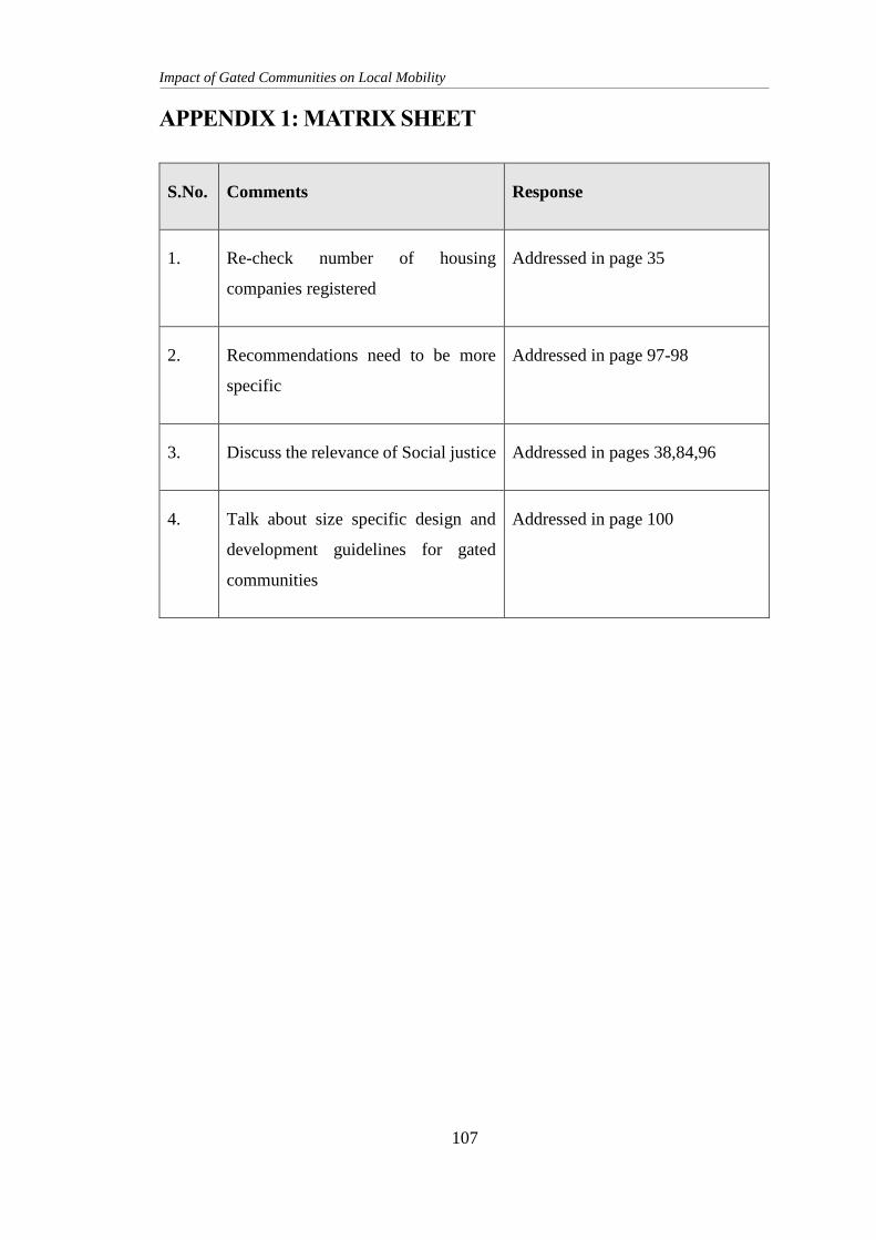
Impact of Gated Communities on Local Mobility
107
APPENDIX 1: MATRIX SHEET
S.No. Comments Response
1. Re-check number of housing
companies registered
Addressed in page 35
2. Recommendations need to be more
specific
Addressed in page 97-98
3. Discuss the relevance of Social justice Addressed in pages 38,84,96
4. Talk about size specific design and
development guidelines for gated
communities
Addressed in page 100
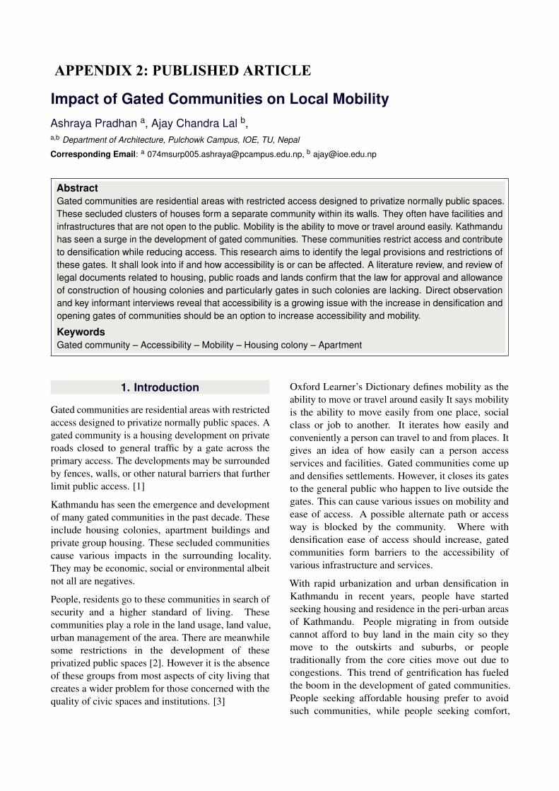
Impact of Gated Communities on Local MobilityAshraya Pradhan a, Ajay Chandra Lal b,a,b Department of Architecture, Pulchowk Campus, IOE, TU, Nepal
Corresponding Email: a [email protected], b [email protected]
AbstractGated communities are residential areas with restricted access designed to privatize normally public spaces.These secluded clusters of houses form a separate community within its walls. They often have facilities andinfrastructures that are not open to the public. Mobility is the ability to move or travel around easily. Kathmanduhas seen a surge in the development of gated communities. These communities restrict access and contributeto densification while reducing access. This research aims to identify the legal provisions and restrictions ofthese gates. It shall look into if and how accessibility is or can be affected. A literature review, and review oflegal documents related to housing, public roads and lands confirm that the law for approval and allowanceof construction of housing colonies and particularly gates in such colonies are lacking. Direct observationand key informant interviews reveal that accessibility is a growing issue with the increase in densification andopening gates of communities should be an option to increase accessibility and mobility.
KeywordsGated community – Accessibility – Mobility – Housing colony – Apartment
1. Introduction
Gated communities are residential areas with restrictedaccess designed to privatize normally public spaces. Agated community is a housing development on privateroads closed to general traffic by a gate across theprimary access. The developments may be surroundedby fences, walls, or other natural barriers that furtherlimit public access. [1]
Kathmandu has seen the emergence and developmentof many gated communities in the past decade. Theseinclude housing colonies, apartment buildings andprivate group housing. These secluded communitiescause various impacts in the surrounding locality.They may be economic, social or environmental albeitnot all are negatives.
People, residents go to these communities in search ofsecurity and a higher standard of living. Thesecommunities play a role in the land usage, land value,urban management of the area. There are meanwhilesome restrictions in the development of theseprivatized public spaces [2]. However it is the absenceof these groups from most aspects of city living thatcreates a wider problem for those concerned with thequality of civic spaces and institutions. [3]
Oxford Learner’s Dictionary defines mobility as theability to move or travel around easily It says mobilityis the ability to move easily from one place, socialclass or job to another. It iterates how easily andconveniently a person can travel to and from places. Itgives an idea of how easily can a person accessservices and facilities. Gated communities come upand densifies settlements. However, it closes its gatesto the general public who happen to live outside thegates. This can cause various issues on mobility andease of access. A possible alternate path or accessway is blocked by the community. Where withdensification ease of access should increase, gatedcommunities form barriers to the accessibility ofvarious infrastructure and services.
With rapid urbanization and urban densification inKathmandu in recent years, people have startedseeking housing and residence in the peri-urban areasof Kathmandu. People migrating in from outsidecannot afford to buy land in the main city so theymove to the outskirts and suburbs, or peopletraditionally from the core cities move out due tocongestions. This trend of gentrification has fueledthe boom in the development of gated communities.People seeking affordable housing prefer to avoidsuch communities, while people seeking comfort,
APPENDIX 2: PUBLISHED ARTICLE
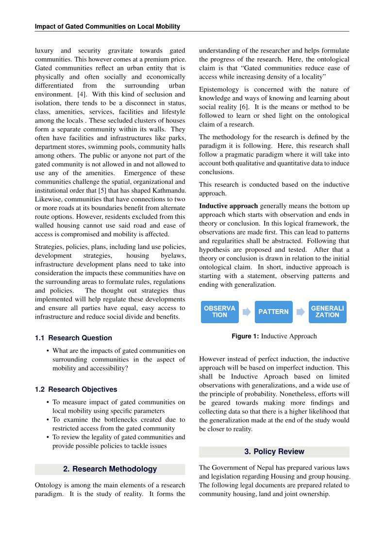
Impact of Gated Communities on Local Mobility
luxury and security gravitate towards gatedcommunities. This however comes at a premium price.Gated communities reflect an urban entity that isphysically and often socially and economicallydifferentiated from the surrounding urbanenvironment. [4]. With this kind of seclusion andisolation, there tends to be a disconnect in status,class, amenities, services, facilities and lifestyleamong the locals . These secluded clusters of housesform a separate community within its walls. Theyoften have facilities and infrastructures like parks,department stores, swimming pools, community hallsamong others. The public or anyone not part of thegated community is not allowed in and not allowed touse any of the amenities. Emergence of thesecommunities challenge the spatial, organizational andinstitutional order that [5] that has shaped Kathmandu.Likewise, communities that have connections to twoor more roads at its boundaries benefit from alternateroute options. However, residents excluded from thiswalled housing cannot use said road and ease ofaccess is compromised and mobility is affected.
Strategies, policies, plans, including land use policies,development strategies, housing byelaws,infrastructure development plans need to take intoconsideration the impacts these communities have onthe surrounding areas to formulate rules, regulationsand policies. The thought out strategies thusimplemented will help regulate these developmentsand ensure all parties have equal, easy access toinfrastructure and reduce social divide and benefits.
1.1 Research Question
• What are the impacts of gated communities onsurrounding communities in the aspect ofmobility and accessibility?
1.2 Research Objectives
• To measure impact of gated communities onlocal mobility using specific parameters
• To examine the bottlenecks created due torestricted access from the gated community
• To review the legality of gated communities andprovide possible policies to tackle issues
2. Research Methodology
Ontology is among the main elements of a researchparadigm. It is the study of reality. It forms the
understanding of the researcher and helps formulatethe progress of the research. Here, the ontologicalclaim is that “Gated communities reduce ease ofaccess while increasing density of a locality”
Epistemology is concerned with the nature ofknowledge and ways of knowing and learning aboutsocial reality [6]. It is the means or method to befollowed to learn or shed light on the ontologicalclaim of a research.
The methodology for the research is defined by theparadigm it is following. Here, this research shallfollow a pragmatic paradigm where it will take intoaccount both qualitative and quantitative data to induceconclusions.
This research is conducted based on the inductiveapproach.
Inductive approach generally means the bottom upapproach which starts with observation and ends intheory or conclusion. In this logical framework, theobservations are made first. This can lead to patternsand regularities shall be abstracted. Following thathypothesis are proposed and tested. After that atheory or conclusion is drawn in relation to the initialontological claim. In short, inductive approach isstarting with a statement, observing patterns andending with generalization.
Figure 1: Inductive Approach
However instead of perfect induction, the inductiveapproach will be based on imperfect induction. Thisshall be Inductive Aproach based on limitedobservations with generalizations, and a wide use ofthe principle of probability. Nonetheless, efforts willbe geared towards making more findings andcollecting data so that there is a higher likelihood thatthe generalization made at the end of the study wouldbe closer to reality.
3. Policy Review
The Government of Nepal has prepared various lawsand legislation regarding Housing and group housing.The following legal documents are prepared related tocommunity housing, land and joint ownership.

IOE Graduate Conference, 2020-Summer
3.1 The Lands Act, 2021 B.S. (1964)[7]
As per Chapter 3, Section 7, Sub-section (1) the upperceiling of land allowed to be owned by a landowner,in any way, is not more than 25 Ropani in Kathmanduvalley. Moreover, as per Section 7, Sub-section (2),notwithstanding anything contained in, Section 7, Sub-section (1), any person or his or her family as a landowner may own, not exceeding the upper ceiling of, 5Ropani of land in Kathmandu valley for their housingpurposes in addition to the land referred to in Section7, Sub-section (1).
Section 12, iterates the provision for exemptions fromthe upper ceiling contained in Section 7. The 8thamendment of the act in 2076 B.S. (2020 A.D) Section12, Sub-section (g) and Section 12A mentions landowned by a company or association as the landowner,exempt from the upper ceiling specified in Section 7,provided that the land ceiling is not sufficient or isinadequate for the company or association to run itsoperations and acquires special permission from thegovernment of Nepal for the ownership of such land.
According to this lands act any landowner shall notown land more than 30 Ropani for any foreseeablepurposes in the Kathmandu Valley.
3.2 Public Roads Act, 2031 B.S. (1974)[8]
Chapter 3 Section 18 describes the power of theGovernment of Nepal or the Department of Roads toremove goods causing obstruction to movement onpublic roads. Section 18 Sub-section (4) states that inaddition to any goods left, placed or thrown on thepublic road, anything including any arm or branch ofa door, tree or wire, that is held, installed or madewith a house or wall on either side of a public road asto project towards the road and causes obstruction tothe movement on the road, the Department of Roadsmay issue an order to the concerned person to removesuch obstruction or arrange the goods in a manner notto cause obstruction within a reasonable period oftime as specified in the order.
Chapter 3 Section 19 states the prohibition on doingany act on public roads or road border withoutobtaining permission. According to Section 19Sub-section (1) no person shall build an access roadjoined to a public road or dig or demolish a hole orditch on a public road or within the road border orinstall or place barrier, peg or fort on the public roador build a house or shed thereon or cultivate a landwithin the road border or do any other similar act
without obtaining the permission of the Department ofRoads.
As this act defines public roads as roads not subjectto personal possession by any individual or family.This implies that when a road is used for access orotherwise by more than one household or parcel ofland, it is deemed public road. The act prohibits anyperson, individual or group to obstruct movement onthese public roads in any way. It also prohibits anyindividual, family or landowner from doing any act asto barricade, obstruct or damage the area within theroad border without permission from the Departmentof Roads or the local authorities. Failure to do so shallgive the Department of Road, the authority to carryout the removal or demolition of the said obstruction,by their own employees or others on a contract basis.
3.3 The Ownership of Joint Housing Act,2054 B.S. (1997)[9]
Chapter 5, section 16, mentions that an apartmentowner has right over collective areas and facilitiessuch as land of joint housing, the structure of thebuilding with its services (sewerage, fire escapes, wayin and way out), amenities (basement, solar, courtyard,garden, parking lots and go-down), generator post andguard post, facilities like electricity, gas, partsarranging, making of cold and hot water and parts ofthe building used for heating and air conditioning. Anowner is also subjected to the rights to items ofcollective use such as elevators, pump, tanks, motor,fan and garbage container. As per section 17, nodivision of these collective areas and facilities areallowed. While Section 18 states that an apartmentowner shall pay the promotor or committee formaintenance, cleaning and upkeep of Collective areasand facilities, Section 19 denies the right to refuse topay for them. In case of non-payment issue, Section20 gives the right to the promotor or committee towithold the use of any collective area and facilitiesand also prevent transfer of such apartment to anyother person in any manner.
In case of the complete destruction of joint housingin any manner, Section 22 subsection 1 states that theland area of the housing will be divided among all theapartment owners proportionately.
Chapter 6 Section 23 states that protection, repairsand maintenance of the building and collective areaand facilities is the duty of the promoter. In case thepromoter is to sell all his apartments owned or is
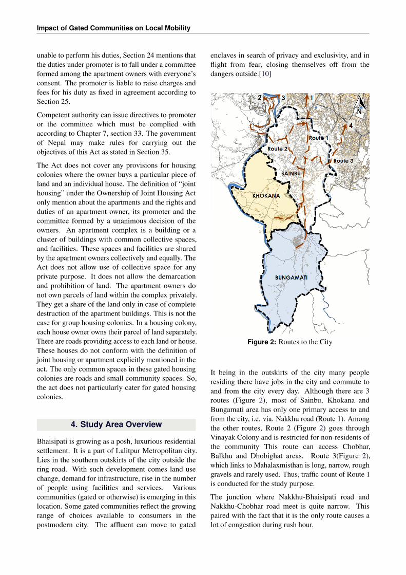
Impact of Gated Communities on Local Mobility
unable to perform his duties, Section 24 mentions thatthe duties under promoter is to fall under a committeeformed among the apartment owners with everyone’sconsent. The promoter is liable to raise charges andfees for his duty as fixed in agreement according toSection 25.
Competent authority can issue directives to promoteror the committee which must be complied withaccording to Chapter 7, section 33. The governmentof Nepal may make rules for carrying out theobjectives of this Act as stated in Section 35.
The Act does not cover any provisions for housingcolonies where the owner buys a particular piece ofland and an individual house. The definition of “jointhousing” under the Ownership of Joint Housing Actonly mention about the apartments and the rights andduties of an apartment owner, its promoter and thecommittee formed by a unanimous decision of theowners. An apartment complex is a building or acluster of buildings with common collective spaces,and facilities. These spaces and facilities are sharedby the apartment owners collectively and equally. TheAct does not allow use of collective space for anyprivate purpose. It does not allow the demarcationand prohibition of land. The apartment owners donot own parcels of land within the complex privately.They get a share of the land only in case of completedestruction of the apartment buildings. This is not thecase for group housing colonies. In a housing colony,each house owner owns their parcel of land separately.There are roads providing access to each land or house.These houses do not conform with the definition ofjoint housing or apartment explicitly mentioned in theact. The only common spaces in these gated housingcolonies are roads and small community spaces. So,the act does not particularly cater for gated housingcolonies.
4. Study Area Overview
Bhaisipati is growing as a posh, luxurious residentialsettlement. It is a part of Lalitpur Metropolitan city.Lies in the southern outskirts of the city outside thering road. With such development comes land usechange, demand for infrastructure, rise in the numberof people using facilities and services. Variouscommunities (gated or otherwise) is emerging in thislocation. Some gated communities reflect the growingrange of choices available to consumers in thepostmodern city. The affluent can move to gated
enclaves in search of privacy and exclusivity, and inflight from fear, closing themselves off from thedangers outside.[10]
Figure 2: Routes to the City
It being in the outskirts of the city many peopleresiding there have jobs in the city and commute toand from the city every day. Although there are 3routes (Figure 2), most of Sainbu, Khokana andBungamati area has only one primary access to andfrom the city, i.e. via. Nakkhu road (Route 1). Amongthe other routes, Route 2 (Figure 2) goes throughVinayak Colony and is restricted for non-residents ofthe community This route can access Chobhar,Balkhu and Dhobighat areas. Route 3(Figure 2),which links to Mahalaxmisthan is long, narrow, roughgravels and rarely used. Thus, traffic count of Route 1is conducted for the study purpose.
The junction where Nakkhu-Bhaisipati road andNakkhu-Chobhar road meet is quite narrow. Thispaired with the fact that it is the only route causes alot of congestion during rush hour.
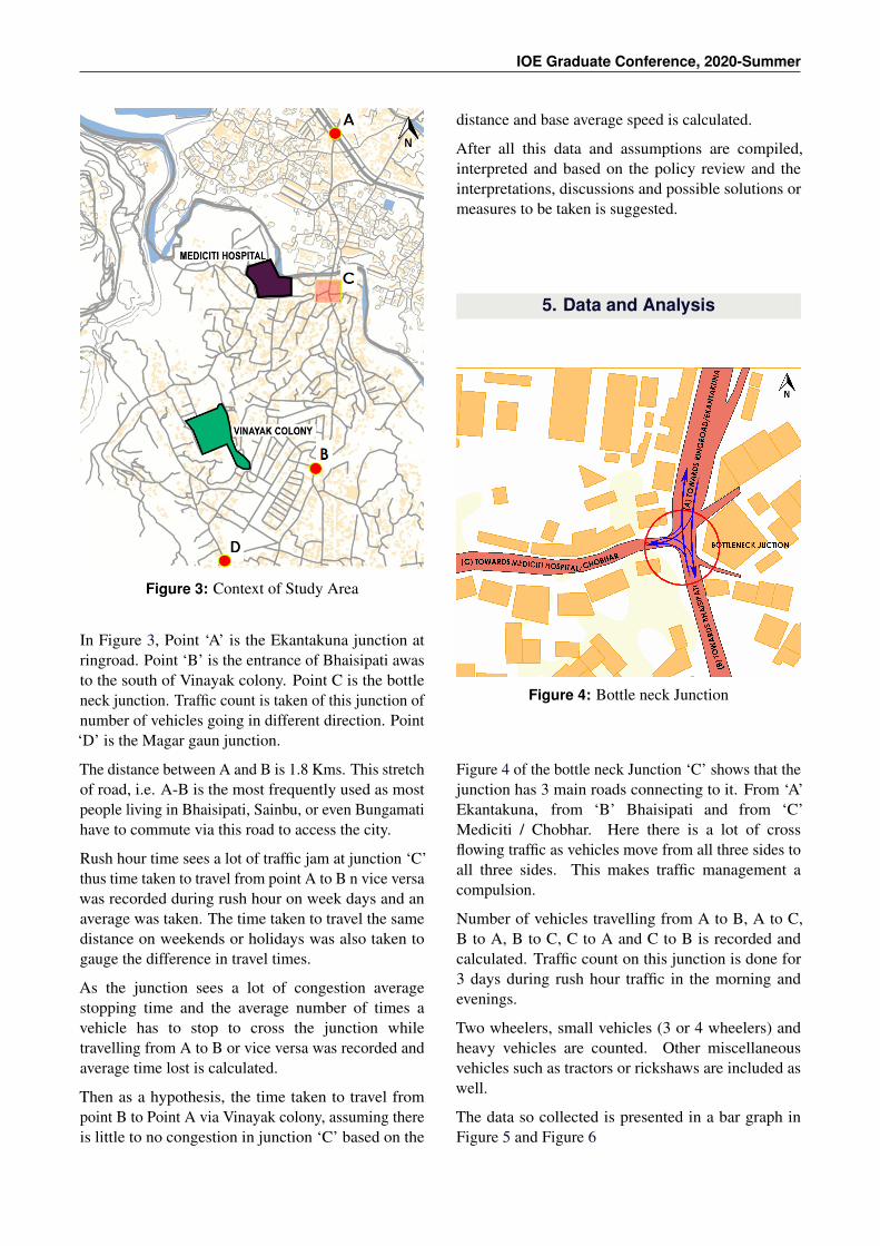
IOE Graduate Conference, 2020-Summer
Figure 3: Context of Study Area
In Figure 3, Point ‘A’ is the Ekantakuna junction atringroad. Point ‘B’ is the entrance of Bhaisipati awasto the south of Vinayak colony. Point C is the bottleneck junction. Traffic count is taken of this junction ofnumber of vehicles going in different direction. Point‘D’ is the Magar gaun junction.
The distance between A and B is 1.8 Kms. This stretchof road, i.e. A-B is the most frequently used as mostpeople living in Bhaisipati, Sainbu, or even Bungamatihave to commute via this road to access the city.
Rush hour time sees a lot of traffic jam at junction ‘C’thus time taken to travel from point A to B n vice versawas recorded during rush hour on week days and anaverage was taken. The time taken to travel the samedistance on weekends or holidays was also taken togauge the difference in travel times.
As the junction sees a lot of congestion averagestopping time and the average number of times avehicle has to stop to cross the junction whiletravelling from A to B or vice versa was recorded andaverage time lost is calculated.
Then as a hypothesis, the time taken to travel frompoint B to Point A via Vinayak colony, assuming thereis little to no congestion in junction ‘C’ based on the
distance and base average speed is calculated.
After all this data and assumptions are compiled,interpreted and based on the policy review and theinterpretations, discussions and possible solutions ormeasures to be taken is suggested.
5. Data and Analysis
Figure 4: Bottle neck Junction
Figure 4 of the bottle neck Junction ‘C’ shows that thejunction has 3 main roads connecting to it. From ‘A’Ekantakuna, from ‘B’ Bhaisipati and from ‘C’Mediciti / Chobhar. Here there is a lot of crossflowing traffic as vehicles move from all three sides toall three sides. This makes traffic management acompulsion.
Number of vehicles travelling from A to B, A to C,B to A, B to C, C to A and C to B is recorded andcalculated. Traffic count on this junction is done for3 days during rush hour traffic in the morning andevenings.
Two wheelers, small vehicles (3 or 4 wheelers) andheavy vehicles are counted. Other miscellaneousvehicles such as tractors or rickshaws are included aswell.
The data so collected is presented in a bar graph inFigure 5 and Figure 6
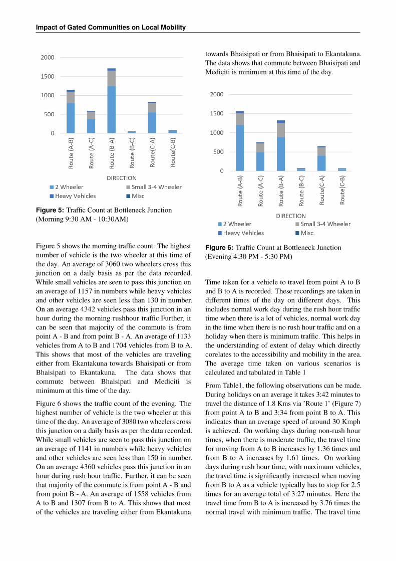
Impact of Gated Communities on Local Mobility
Figure 5: Traffic Count at Bottleneck Junction(Morning 9:30 AM - 10:30AM)
Figure 5 shows the morning traffic count. The highestnumber of vehicle is the two wheeler at this time ofthe day. An average of 3060 two wheelers cross thisjunction on a daily basis as per the data recorded.While small vehicles are seen to pass this junction onan average of 1157 in numbers while heavy vehiclesand other vehicles are seen less than 130 in number.On an average 4342 vehicles pass this junction in anhour during the morning rushhour traffic.Further, itcan be seen that majority of the commute is frompoint A - B and from point B - A. An average of 1133vehicles from A to B and 1704 vehicles from B to A.This shows that most of the vehicles are travelingeither from Ekantakuna towards Bhaisipati or fromBhaisipati to Ekantakuna. The data shows thatcommute between Bhaisipati and Mediciti isminimum at this time of the day.
Figure 6 shows the traffic count of the evening. Thehighest number of vehicle is the two wheeler at thistime of the day. An average of 3080 two wheelers crossthis junction on a daily basis as per the data recorded.While small vehicles are seen to pass this junction onan average of 1141 in numbers while heavy vehiclesand other vehicles are seen less than 150 in number.On an average 4360 vehicles pass this junction in anhour during rush hour traffic. Further, it can be seenthat majority of the commute is from point A - B andfrom point B - A. An average of 1558 vehicles fromA to B and 1307 from B to A. This shows that mostof the vehicles are traveling either from Ekantakuna
towards Bhaisipati or from Bhaisipati to Ekantakuna.The data shows that commute between Bhaisipati andMediciti is minimum at this time of the day.
Figure 6: Traffic Count at Bottleneck Junction(Evening 4:30 PM - 5:30 PM)
Time taken for a vehicle to travel from point A to Band B to A is recorded. These recordings are taken indifferent times of the day on different days. Thisincludes normal work day during the rush hour traffictime when there is a lot of vehicles, normal work dayin the time when there is no rush hour traffic and on aholiday when there is minimum traffic. This helps inthe understanding of extent of delay which directlycorelates to the accessibility and mobility in the area.The average time taken on various scenarios iscalculated and tabulated in Table 1
From Table1, the following observations can be made.During holidays on an average it takes 3:42 minutes totravel the distance of 1.8 Kms via ’Route 1’ (Figure 7)from point A to B and 3:34 from point B to A. Thisindicates than an average speed of around 30 Kmphis achieved. On working days during non-rush hourtimes, when there is moderate traffic, the travel timefor moving from A to B increases by 1.36 times andfrom B to A increases by 1.61 times. On workingdays during rush hour time, with maximum vehicles,the travel time is significantly increased when movingfrom B to A as a vehicle typically has to stop for 2.5times for an average total of 3:27 minutes. Here thetravel time from B to A is increased by 3.76 times thenormal travel with minimum traffic. The travel time
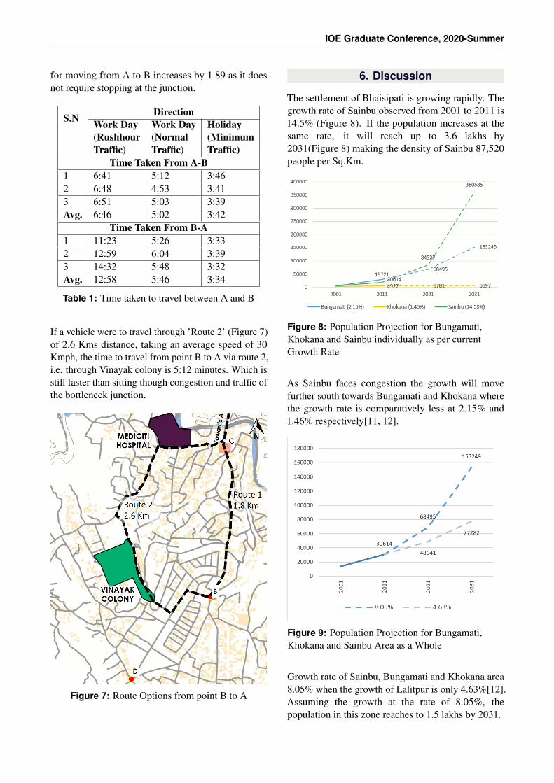
IOE Graduate Conference, 2020-Summer
for moving from A to B increases by 1.89 as it doesnot require stopping at the junction.
S.N DirectionWork Day(RushhourTraffic)
Work Day(NormalTraffic)
Holiday(MinimumTraffic)
Time Taken From A-B1 6:41 5:12 3:462 6:48 4:53 3:413 6:51 5:03 3:39Avg. 6:46 5:02 3:42
Time Taken From B-A1 11:23 5:26 3:332 12:59 6:04 3:393 14:32 5:48 3:32Avg. 12:58 5:46 3:34
Table 1: Time taken to travel between A and B
If a vehicle were to travel through ’Route 2’ (Figure 7)of 2.6 Kms distance, taking an average speed of 30Kmph, the time to travel from point B to A via route 2,i.e. through Vinayak colony is 5:12 minutes. Which isstill faster than sitting though congestion and traffic ofthe bottleneck junction.
Figure 7: Route Options from point B to A
6. Discussion
The settlement of Bhaisipati is growing rapidly. Thegrowth rate of Sainbu observed from 2001 to 2011 is14.5% (Figure 8). If the population increases at thesame rate, it will reach up to 3.6 lakhs by2031(Figure 8) making the density of Sainbu 87,520people per Sq.Km.
Figure 8: Population Projection for Bungamati,Khokana and Sainbu individually as per currentGrowth Rate
As Sainbu faces congestion the growth will movefurther south towards Bungamati and Khokana wherethe growth rate is comparatively less at 2.15% and1.46% respectively[11, 12].
Figure 9: Population Projection for Bungamati,Khokana and Sainbu Area as a Whole
Growth rate of Sainbu, Bungamati and Khokana area8.05% when the growth of Lalitpur is only 4.63%[12].Assuming the growth at the rate of 8.05%, thepopulation in this zone reaches to 1.5 lakhs by 2031.
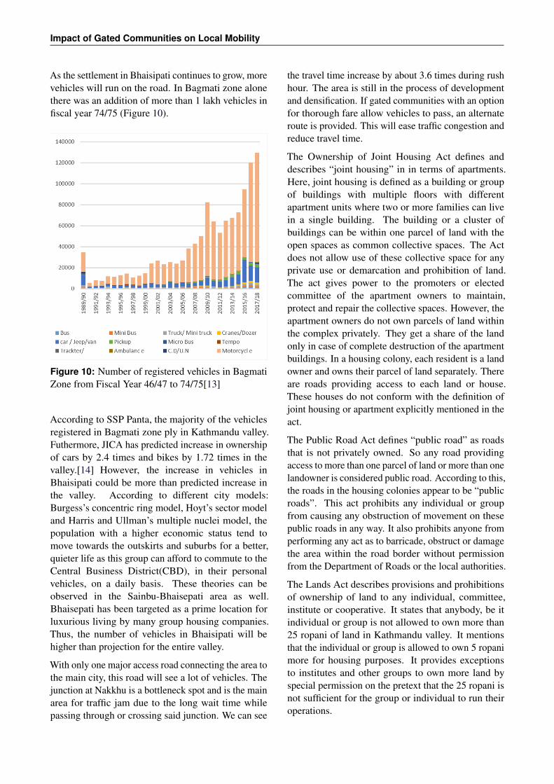
Impact of Gated Communities on Local Mobility
As the settlement in Bhaisipati continues to grow, morevehicles will run on the road. In Bagmati zone alonethere was an addition of more than 1 lakh vehicles infiscal year 74/75 (Figure 10).
Figure 10: Number of registered vehicles in BagmatiZone from Fiscal Year 46/47 to 74/75[13]
According to SSP Panta, the majority of the vehiclesregistered in Bagmati zone ply in Kathmandu valley.Futhermore, JICA has predicted increase in ownershipof cars by 2.4 times and bikes by 1.72 times in thevalley.[14] However, the increase in vehicles inBhaisipati could be more than predicted increase inthe valley. According to different city models:Burgess’s concentric ring model, Hoyt’s sector modeland Harris and Ullman’s multiple nuclei model, thepopulation with a higher economic status tend tomove towards the outskirts and suburbs for a better,quieter life as this group can afford to commute to theCentral Business District(CBD), in their personalvehicles, on a daily basis. These theories can beobserved in the Sainbu-Bhaisepati area as well.Bhaisepati has been targeted as a prime location forluxurious living by many group housing companies.Thus, the number of vehicles in Bhaisipati will behigher than projection for the entire valley.
With only one major access road connecting the area tothe main city, this road will see a lot of vehicles. Thejunction at Nakkhu is a bottleneck spot and is the mainarea for traffic jam due to the long wait time whilepassing through or crossing said junction. We can see
the travel time increase by about 3.6 times during rushhour. The area is still in the process of developmentand densification. If gated communities with an optionfor thorough fare allow vehicles to pass, an alternateroute is provided. This will ease traffic congestion andreduce travel time.
The Ownership of Joint Housing Act defines anddescribes “joint housing” in in terms of apartments.Here, joint housing is defined as a building or groupof buildings with multiple floors with differentapartment units where two or more families can livein a single building. The building or a cluster ofbuildings can be within one parcel of land with theopen spaces as common collective spaces. The Actdoes not allow use of these collective space for anyprivate use or demarcation and prohibition of land.The act gives power to the promoters or electedcommittee of the apartment owners to maintain,protect and repair the collective spaces. However, theapartment owners do not own parcels of land withinthe complex privately. They get a share of the landonly in case of complete destruction of the apartmentbuildings. In a housing colony, each resident is a landowner and owns their parcel of land separately. Thereare roads providing access to each land or house.These houses do not conform with the definition ofjoint housing or apartment explicitly mentioned in theact.
The Public Road Act defines “public road” as roadsthat is not privately owned. So any road providingaccess to more than one parcel of land or more than onelandowner is considered public road. According to this,the roads in the housing colonies appear to be “publicroads”. This act prohibits any individual or groupfrom causing any obstruction of movement on thesepublic roads in any way. It also prohibits anyone fromperforming any act as to barricade, obstruct or damagethe area within the road border without permissionfrom the Department of Roads or the local authorities.
The Lands Act describes provisions and prohibitionsof ownership of land to any individual, committee,institute or cooperative. It states that anybody, be itindividual or group is not allowed to own more than25 ropani of land in Kathmandu valley. It mentionsthat the individual or group is allowed to own 5 ropanimore for housing purposes. It provides exceptionsto institutes and other groups to own more land byspecial permission on the pretext that the 25 ropani isnot sufficient for the group or individual to run theiroperations.
IOE Graduate Conference, 2020-Summer
Housing colonies are much larger than 25 ropani andthus cannot be owned by the committee. Theownership of joint housing act does not cover thehousing colony specifically. Thus, power cannot begiven to the committee to control common areas asthe common areas in housing colonies are “publicroads” as per the public roads act, as opposed to theparks, utility spaces, basements in apartmentcomplexes.
So, from a legal stand point, the gates in theboundaries of housing colonies does not appear to belegal. Thus, if ordered by the Department of Roads orby the local authority, the gate restricting movementshall be removed.
7. Conclusion
The study shows that restricting access in a growingsettlement can cause congestion and elongate traveltime. Longer travel times means lesser accessibilityand mobility. Gated communities with the ability forthoroughfare limit access and contributes tocongestion.
Looking at the legal standpoint, there can be seen agap in the availability of specific laws and regulationsregarding gated communities. While there is explicitlaws for apartment complexes, on the rights, duties,allowances and prohibitions. The law does not havea provision to allow housing colonies to place a gateand restrict access to the area.
Installing a gate and privatizing these roads means theresidents usually take responsibility of protection andmaintenance of the areas within the boundaries andthe local body does not interfere.
Access should be granted to the public in locationswhere there needs a thoroughfare and ease congestion.All areas in the process of developing and densificationneeds adequate roads to access such areas. Strategicplanning to provide adequate and accessible roadwaysis important.
Adequate and relevant laws on the rights, provisionsand prohibitions that gated communities, theirresidents and committee should abide by needs to beformulated. The competent authority shouldformulate and regulate proper process of approval toown, construct, sell and run these communities. These
policies, regulations and process need to be madeclear and readily available.Thus, accessible roadways should be maximized as faras possible. This shall include opening gatedcommunities or requiring gated communities toprovide an accessible road across the enclosed areawhere necessary. Adequate laws regulating housingcolonies and the requirement of access should beformulated. Planning policy and developmentguidelines should include the need for accessible andinclusive development.
References
[1] Jill Grant and Lindsey Mittelsteadt. Types of gatedcommunities. Environment and Planning B: Planningand Design, 31:913–930, 2004.
[2] M. O. Ajibola, O. C. Oloke, and A. O. Ogungbemi.Impacts of gated communities on residential propertyvalues: A comparison of onipetesi estate and itsneighbourhoods in ikeja, lagos state, nigeria. Journalof Sustainable Development, 4:72–79, 2011.
[3] Rowland Atkinson and John Flint. Fortress uk? gatedcommunities, the spatial revolt of the elites and time-space trajectories of segregation. Housing Studies,9:875–892, 2004.
[4] Karina Landman. Gated communities and urbansustainability: taking a closer look at the future. 2000.
[5] Crish Webster, Gerog Glasze, and Klaus Frants. Theglobal spread of gated communities. Environmentand Planning B: Planning and Design, 29:315–320,2002.
[6] Michael Bergin. Researchgate, 2017.
[7] The Government of Nepal. The Lands Act, 2021 B.S.The Government of Nepal, 1964.
[8] The Government of Nepal. Public Roads Act, 2031B.S. The Government of Nepal, 1974.
[9] The Government of Nepal. The Ownership of JointHousing Act, 2054 B.S. The Government of Nepal,1997.
[10] David Dillion. Planning. Fortress America, 60:8–12,1994.
[11] National population and housing census 2011.Technical report, 2001.
[12] National population and housing census 2011.Technical report, 2011.
[13] Details of registration of transport up to fiscal year2046/47-074/75. Technical report, 2018.
[14] Data collection survey on traffic improvement inkathmandu valley. Technical report, 2012.