hurricane-induced failure of low salinity wetlands
TRANSCRIPT
Hurricane-induced failure of low salinity wetlandsNick C. Howesa,1, Duncan M. FitzGeralda, Zoe J. Hughesa, Ioannis Y. Georgioub, Mark A. Kulpb,Michael D. Minerb, Jane M. Smithc, and John A. Barrasd
aDepartment of Earth Sciences, Boston University, 675 Commonwealth Avenue, Boston, MA 02215; bPontchartrain Institute for Environmental Sciences,University of New Orleans, New Orleans, LA 70148; cUnited States Army Engineer Research and Development Center, 3909 Halls Ferry Road, Vicksburg,MS 39180-6199; and dUnited States Army Engineer Research and Development Center, Environmental Laboratory, Wetlands Environmental TechnologyResearch Facility, Baton Rouge, LA 70803
Edited by David H. Thomas, American Museum of Natural History, New York, NY, and approved June 24, 2010 (received for review December 26, 2009)
During the 2005 hurricane season, the storm surge and wave fieldassociated with Hurricanes Katrina and Rita eroded 527 km2 ofwetlands within the Louisiana coastal plain. Low salinity wetlandswere preferentially eroded, while higher salinity wetlands re-mained robust and largely unchanged. Here we highlight geotech-nical differences between the soil profiles of high and low salinityregimes, which are controlled by vegetation and result in differen-tial erosion. In low salinity wetlands, a weak zone (shear strength500–1450 Pa) was observed ∼30 cm below the marsh surface,coinciding with the base of rooting. High salinity wetlands hadno such zone (shear strengths > 4500 Pa) and contained deeperrooting. Storm waves during Hurricane Katrina produced shearstresses between 425–3600 Pa, sufficient to cause widespreaderosion of the low salinity wetlands. Vegetation in low salinitymarshes is subject to shallower rooting and is susceptible toerosion during large magnitude storms; these conditions may beexacerbated by low inorganic sediment content and high nutrientinputs. The dramatic difference in resiliency of fresh versus moresaline marshes suggests that the introduction of freshwater tomarshes as part of restoration efforts may therefore weakenexisting wetlands rendering them vulnerable to hurricanes.
wetland loss ∣ Mississippi Delta ∣ shear stress ∣ soil shear strength ∣vegetation roughness
Coastal wetlands are valued for their ability to protectlandward areas from the impacts of storms: dampening wave
energy, distancing the mainland from the open water, and poten-tially reducing storm surge height (1–5). Understanding and pre-dicting wetland loss, and the consequences with respect to coastalpopulations, is of global interest. Present projections suggest thatbefore the end of the century, as much as one third of the world’scoastal wetlands could be lost to sea-level rise (6). Furthermore, arecent study (7) underscores the vulnerability of the world’slargest deltas and the need to maintain the sediment supply tothe vast wetlands that comprise these regions. In an effort tostabilize deltaic wetlands, riverine diversions have been intro-duced, designed to restore (preanthropogenic) conditions byreducing salinity and reintroducing sediment within these vulner-able deltas (8).
Much of the research pertaining to wetland loss considers thethreat of submergence due to an inability to keep pace with sealevel (2–4, 9). However, in their role as a coastal buffer, marshesmay experience a range of damage including vegetation mortalityas a result of wrack deposition during high waters, salt intrusioninto freshwater wetlands, enhanced wave erosion at the marshedge (10), or the bulk removal of the vegetation mat. The extentof this damage will affect recovery time and the health of thepoststorm marsh and its effectiveness as a buffer, and it may leadto permanent wetland loss (5, 11). Arguably, cannibalization ofsediment from one region of the marsh may provide the inputnecessary to bolster neighboring zones (3), but the result is stillone of net loss.
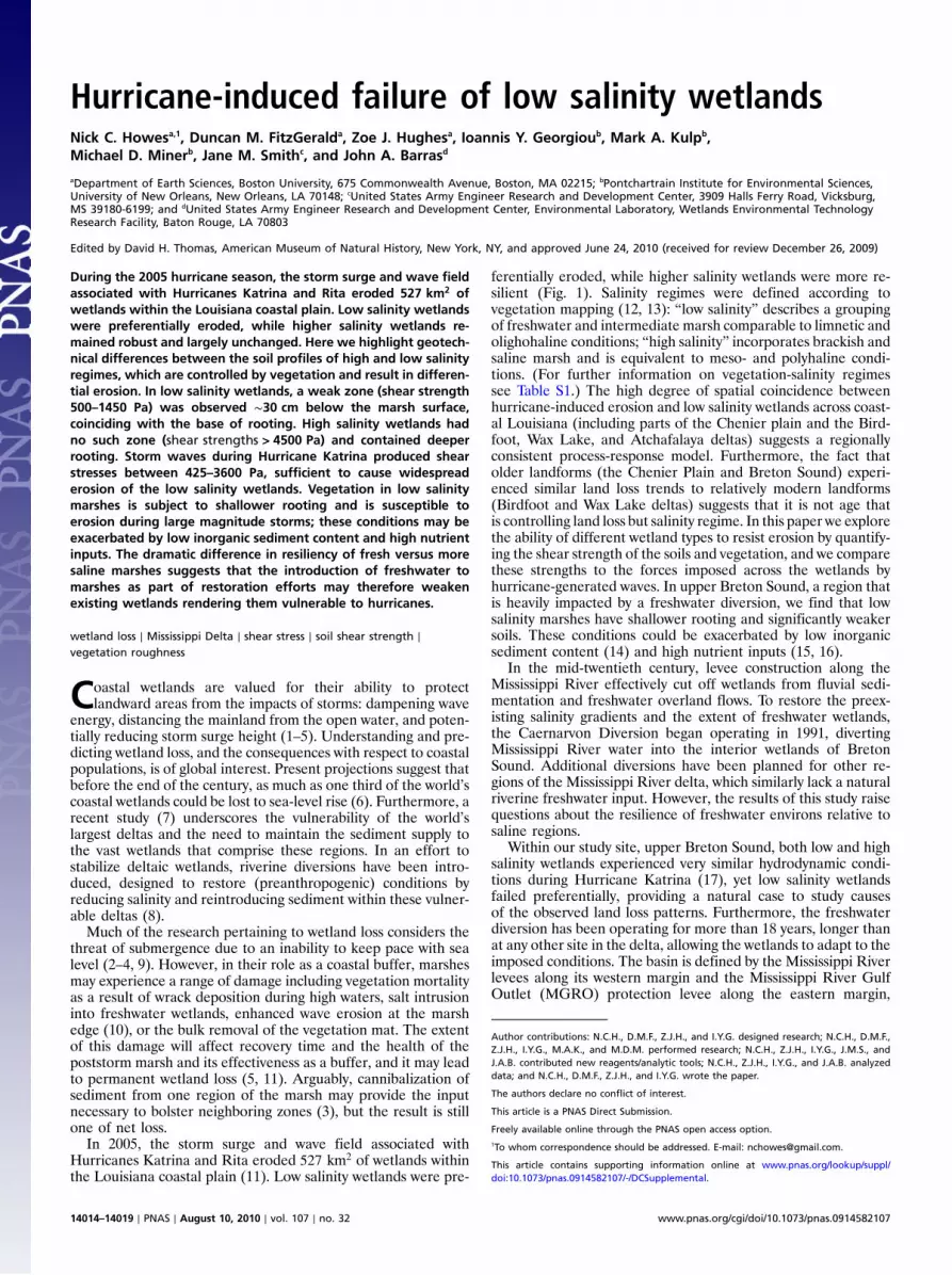
In 2005, the storm surge and wave field associated withHurricanes Katrina and Rita eroded 527 km2 of wetlands withinthe Louisiana coastal plain (11). Low salinity wetlands were pre-
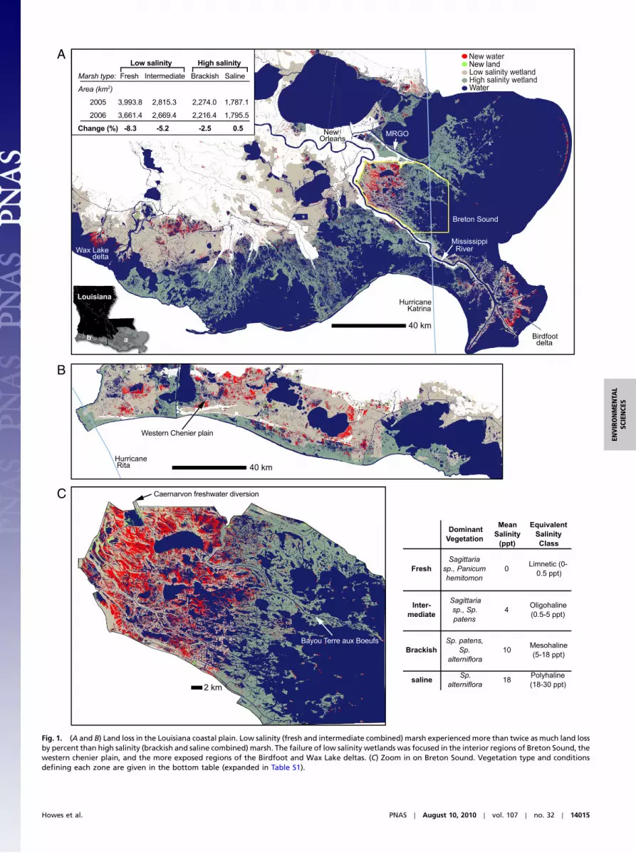
ferentially eroded, while higher salinity wetlands were more re-silient (Fig. 1). Salinity regimes were defined according tovegetation mapping (12, 13): “low salinity” describes a groupingof freshwater and intermediate marsh comparable to limnetic andolighohaline conditions; “high salinity” incorporates brackish andsaline marsh and is equivalent to meso- and polyhaline condi-tions. (For further information on vegetation-salinity regimessee Table S1.) The high degree of spatial coincidence betweenhurricane-induced erosion and low salinity wetlands across coast-al Louisiana (including parts of the Chenier plain and the Bird-foot, Wax Lake, and Atchafalaya deltas) suggests a regionallyconsistent process-response model. Furthermore, the fact thatolder landforms (the Chenier Plain and Breton Sound) experi-enced similar land loss trends to relatively modern landforms(Birdfoot and Wax Lake deltas) suggests that it is not age thatis controlling land loss but salinity regime. In this paper we explorethe ability of different wetland types to resist erosion by quantify-ing the shear strength of the soils and vegetation, and we comparethese strengths to the forces imposed across the wetlands byhurricane-generated waves. In upper Breton Sound, a region thatis heavily impacted by a freshwater diversion, we find that lowsalinity marshes have shallower rooting and significantly weakersoils. These conditions could be exacerbated by low inorganicsediment content (14) and high nutrient inputs (15, 16).
In the mid-twentieth century, levee construction along theMississippi River effectively cut off wetlands from fluvial sedi-mentation and freshwater overland flows. To restore the preex-isting salinity gradients and the extent of freshwater wetlands,the Caernarvon Diversion began operating in 1991, divertingMississippi River water into the interior wetlands of BretonSound. Additional diversions have been planned for other re-gions of the Mississippi River delta, which similarly lack a naturalriverine freshwater input. However, the results of this study raisequestions about the resilience of freshwater environs relative tosaline regions.
Within our study site, upper Breton Sound, both low and highsalinity wetlands experienced very similar hydrodynamic condi-tions during Hurricane Katrina (17), yet low salinity wetlandsfailed preferentially, providing a natural case to study causesof the observed land loss patterns. Furthermore, the freshwaterdiversion has been operating for more than 18 years, longer thanat any other site in the delta, allowing the wetlands to adapt to theimposed conditions. The basin is defined by the Mississippi Riverlevees along its western margin and the Mississippi River GulfOutlet (MGRO) protection levee along the eastern margin,
Author contributions: N.C.H., D.M.F., Z.J.H., and I.Y.G. designed research; N.C.H., D.M.F.,Z.J.H., I.Y.G., M.A.K., and M.D.M. performed research; N.C.H., Z.J.H., I.Y.G., J.M.S., andJ.A.B. contributed new reagents/analytic tools; N.C.H., Z.J.H., I.Y.G., and J.A.B. analyzeddata; and N.C.H., D.M.F., Z.J.H., and I.Y.G. wrote the paper.
The authors declare no conflict of interest.
This article is a PNAS Direct Submission.
Freely available online through the PNAS open access option.1To whom correspondence should be addressed. E-mail: [email protected].
This article contains supporting information online at www.pnas.org/lookup/suppl/doi:10.1073/pnas.0914582107/-/DCSupplemental.
14014–14019 ∣ PNAS ∣ August 10, 2010 ∣ vol. 107 ∣ no. 32 www.pnas.org/cgi/doi/10.1073/pnas.0914582107
A
B
C
Fig. 1. (A and B) Land loss in the Louisiana coastal plain. Low salinity (fresh and intermediate combined) marsh experienced more than twice as much land lossby percent than high salinity (brackish and saline combined) marsh. The failure of low salinity wetlands was focused in the interior regions of Breton Sound, thewestern chenier plain, and the more exposed regions of the Birdfoot and Wax Lake deltas. (C) Zoom in on Breton Sound. Vegetation type and conditionsdefining each zone are given in the bottom table (expanded in Table S1).
Howes et al. PNAS ∣ August 10, 2010 ∣ vol. 107 ∣ no. 32 ∣ 14015
ENVIRONMEN
TAL
SCIENCE
S
encompassing 1;100 km2 of wetlands that grade from freshwaterto saline. Bayou Terre aux Beoufs, a distributary of the former St.Bernard delta, partitions the flow from the diversion resulting inextensive low salinity wetlands west of the bayou and higher sali-nity brackish and saline marshes to the east (18). The diversionhas successfully increased the extent of low salinity wetlandswest of the bayou, displacing the boundary between low and highsalinity wetlands seaward by as much as 29 km since 1991.
As part of this study, ground and aerial surveys of the low sali-nity wetlands in Breton Sound conducted following HurricaneKatrina revealed extensive deposits of “marshballs,” uprootedmasses of marsh grass consisting of a rooting mat and boundsediment. Similar observations have been made elsewhere (5).The marshballs typically had a rooting depth of 20–30 cm andwere neutrally buoyant. Devegetated peat surfaces in the nearbymarsh surface marked the source regions of the rafted marshballs.Field observations illustrated that the erosion occurred by scour-ing of the marsh surface, including the root mat, rather than bysediment resuspension as has been studied elsewhere (10, 19). Asimilar process was suggested by van de Plassche et al. (2004) toexplain erosive contacts within the stratigraphy of a Connecticutwetland (20). In contrast to the low salinity regions, saline por-tions of the marsh were left largely intact. We hypothesize thatwave shear stresses generated during the hurricanes exceededthe shear strength of the low salinity wetland soils, resulting infailure, whereas greater soil shear strength in the saline wetlandslargely precluded erosion. Soil shear strength and the resistanceof the soil to erosion are determined by the properties of thevegetation, the surrounding soil matrix, and their interaction.We propose that resistance to erosion is primarily a function ofrooting characteristics, which depend on the dominant speciesof vegetation, as controlled by salinity (2, 13) (Table S1).
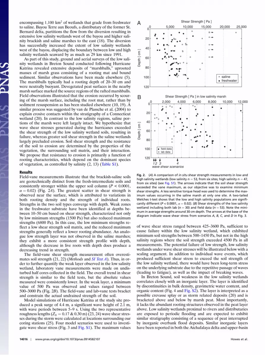
ResultsField-vane measurements illustrate that the brackish-saline soilsare geotechnically distinct from the fresh-intermediate soils andconsistently stronger within the upper soil column (P < 0.0001,α ¼ 0.02) (Fig. 2A). The greatest scatter in shear strength isobserved near the surface, which is attributed to variations inboth rooting density and the strength of individual roots.Strengths in the two soil types converge with depth. Weak zonesin the freshwater substrate have been identified at depths be-tween 10–50 cm based on shear strength, characterized not onlyby low minimum strengths (1500 Pa) but also reduced maximumstrengths (6800 Pa). In this case, the low minimum strengths re-flect a low shear strength soil matrix, and the reduced maximumstrengths generally reflect a lower rooting abundance. An analo-gue low strength layer was not observed in the saline marshes;they exhibit a more consistent strength profile with depth,although the decrease in live roots with depth does produce adecreasing trend in strength.
The field-vane shear strength measurement often overesti-mates soil strength (21, 22) (Methods and SI Text A). Thus, in or-der to further quantify the weak layer observed in the low salinitywetland, laboratory vane measurements were made on undis-turbed half cores collected in the field. The overall trend in shearstrength is similar to the field tests, but the absolute valuesmeasured were consistently lower. In the weak layer, a minimumvalue of 500 Pa was observed and values ranged between500–3000 Pa (Fig. 2B). The field-vane and lab-vane tests bracketand constrain the actual undrained strength of the soil.
Model simulations of Hurricane Katrina at the study site pro-duced a peak surge of 4.4 m, a significant wave height of 2.1 m,with wave periods between 5–9 s. Using the two representativeroughness lengths (Z0 ¼ 0.17& 0.30 m) (23, 24) wave shear stres-ses during the storm were calculated at locations surrounding ourcoring stations (25). Four model scenarios were used to investi-gate wave shear stress (Fig. 3 and Fig. S1). The maximum values
of wave shear stress ranged between 425–3600 Pa, sufficient tocause failure within the low salinity wetland, which exhibitedminimum soil strengths between 500–1450 Pa, but not in the highsalinity regions where the soil strength exceeded 4500 Pa in allmeasurements. The potential failure of low strength, low salinitywetlands under wave shear stresses will be illustrated below with ascaling argument. In addition to individual wave events, whichproduced sufficient shear stress to exceed the soil strength ofthe low salinity wetland, there would have been long-term stresson the underlying substrate due to the repetitive passage of waves(leading to fatigue), as well as the impact of breaking waves.
In Breton Sound, soil weakness in the low salinity wetlandscorrelates closely with an inorganic layer. The layer is identifiedby discontinuities in bulk density, gravimetric water content, andorganic content (Fig. 4 and Fig. S2). The layer is interpreted as apossible crevasse splay or as storm related deposits (20) and isbracketed above and below by marsh peat. Most importantly,it lacks the abundant rooting structures observed in the peat layerabove. Low salinity wetlands proximal to rivers and distributariesare exposed to periodic flooding and are expected to exhibitsimilar stratigraphy consisting of a sequence of peat interruptedby inorganic overbank flood deposits. Similar inorganic layershave been reported in both the Atchafalaya delta and upper-basin
0 5,000 10,000 15,000 20,000 25,0000
20
40
60
80
100
120
salinefreshwater
Shear Strength [ Pa ]
Dep
th [
cm ]
A
0 2,000 4,000 6,000 8,000 10,000 12,0000
20
40
60
80
100
120
Shear Strength [ Pa ] in low salinity marsh
Dep
th [
cm ]
field datalab data
B
1 2 3 4wave shear scenarios
Fig. 2. (A) A comparison of in situ shear strength measurements in low andhigh salinity wetlands (low salinity n ¼ 53, from six sites; high salinity n ¼ 47,from six sites) (see Fig. S1). The arrows indicate that the soil shear strengthexceeded the vane maximum, as our objective was to examine minimumshear strengths. A less sensitive torque head was used to determine the max-imum values occurring in the saline marsh at only one site. A two-tailedWelches t-test shows that the low and high salinity populations are signifi-cantly different (P < 0.0001, α ¼ 0.02). (B) Shear strengths of the low salinitywetland including both lab (n ¼ 30) and field data (n ¼ 53). Note the mini-mum in average strengths around 30 cm depth. The arrows at the base of thediagram indicate wave shear stress from scenarios A, B, C, and D in Fig. 3.
14016 ∣ www.pnas.org/cgi/doi/10.1073/pnas.0914582107 Howes et al.

freshwater wetlands (26, 27). Hurricanes are also capable ofdepositing inorganic material across a marsh platform (3).
The minimum freshwater soil strengths were concentratednear the top of the inorganic layer, approximately 30 cm belowthe marsh surface. The depth of the root mat within the post-Katrina marshballs (20–30 cm) supports the theory that thewetlands failed along this layer. The interruption in rooting thatcoincided with the inorganic sediment layer was likely exploited
during the storm. Intact roots contribute to overall strength of asoil. Vegetation increases the strength of soils by providing me-chanical reinforcement, which in turn is controlled by the rootingdepth, diameter, and density (28, 29). The tensile force requiredto break individual roots and rhizomes has been shown to scalewith diameter, and the overall shear strength of a soil increasesproportionally to the cross sectional area of the roots crossing theshearing plane (28, 29). As a result, highly decayed rooting andunvegetated depths in the soil column display lower values ofstrength (30).
Spartina alterniflora is the most abundant species in highsalinity wetland, characterized by extensive horizontal rhizomesand a dense stem-root network that reinforces the surroundingsoil (31). The rooting depth of Sp. alterniflora is less sensitiveto anoxic soil conditions than other species, allowing it to colonizelower elevations in the tidal regime (32). In contrast, manypost-Katrina marshballs consisted of Spartina patens, one ofthe dominant species in intermediate wetlands (Table S1), whichalso has extensive rooting but of a smaller diameter. The plant isless tolerant to anoxic soil conditions, which likely limits the rootnetwork to shallower depths (32). Direct comparisons of thevariation of belowground biomass with depth indicate that liverooting is shallower and less abundant in Sp. patens marshes thanin Sp. alterniflora marshes (e.g., 33).
In unvegetated soils, a typical soil strength profile increaseswith depth and the greater degree of consolidation. The strengthprofile is fundamentally different in vegetated soils (28). In thiscase, strength decreases with depth as the result of a decrease inroot abundance. The saline marsh strength measurements exhibitthis trend, which illustrates the dominant role of vegetation in theuppermost meter of the soil column. The freshwater data reflect acombination of vegetated and unvegetated profile characteristics.In the near surface, the vegetation effect is reflected by relativelyhigh values of strength. However, the profile rapidly decreasestoward a minimum as rooting diminishes near the inorganic layerand transitions into the typical unvegetated profile of increasingstrength with depth (Fig. 5). Based on our data, the minimumstrength in a wetland soil profile occurs where the control of soilstrength by roots is superseded by control of the substrate (i.e.,unvegetated soil). This situation exists at a shallow depth in thelow salinity wetland but was not clearly observed in the saline
12:00 00:00Aug. 29
12:00 00:00Aug. 30
12:000
100
200
300
400
500S
hear
Str
ess
[Pa]
12:00 00:00Aug. 29
12:00 00:00Aug. 30
12:000
100
200
300
400
500
600
She
ar S
tres
s [P
a]
12:00 00:00Aug. 29
12:00 00:00Aug. 30
12:000
200
400
600
800
1000
1200
She
ar S
tres
s [P
a]
12:00 00:00Aug. 29
12:00 00:00Aug. 30
12:000
500
1000
1500
2000
2500
3000
3500
4000
She
ar S
tres
s [P
a]
Hs
z0=0.176 mHs
z0=0.300 m
Hmax
z0=0.176 mHmax
z0=0.300 m
A B
C D
high salinitylow salinity
Fig. 3. Wave shear stressesgenerated during HurricaneKatrina at seven sites in BretonSound (see also Fig. S1). Fourscenarios are modeled with dif-ferent combinationsof twowaveheights (H) and two roughnesslengths (Z0).Hs is significantwaveheight and Hmax is maximumwave height (Hmax ¼ 1.868Hs).
0 0.25 0.5 0.75 10
20
40
60
80
100
120
water content [ mw/mt]
1 1.25 1.5 1.75 20
20
40
60
80
100
120
bulk density [g/cm3]
0 25 50 750
20
40
60
80
100
120
Organic Content [%]
Dep
th [
cm ]
A B C
Fig. 4. Geotechnical soil properties measured in the low salinity wetland(see also Figs. S1 and S2). A discontinuity exists at roughly 30 centimetersdepth attributed to an inorganic layer that interrupts the rooting profileand displays markedly different soil properties.
Howes et al. PNAS ∣ August 10, 2010 ∣ vol. 107 ∣ no. 32 ∣ 14017
ENVIRONMEN
TAL
SCIENCE
S
wetland, where the rooting continued to dominate the strengthprofile to greater depths. The convergence of strength profilesin the saline and low salinity soils at around 1 m in depth likelyreflects the beginning of the transition from root to substrate con-trol in the saline marsh.
DiscussionTo illustrate the effect of rooting depth (d) on soil failure, wecompare the force of waves imparted on a block of soil and com-pare it with the forces resisting erosion. The soil fails if the forceof the waves on the block is equal to or greater than the forceresisting scour: Force ¼ Stress ×Area
Failure occurs if:FR
FA≤ 1 [1]
Where FR is the resisting force, in this case the strength of thesoil, and FA is the applied force, in this case the wave forcing.
Wave shear stress (τw) acts tangential to the surface of themarsh and is multiplied by the area over which it acts to calculatetotal wave force. The stress is assumed constant over the surfaceof the block if the length (l) and width (w) of the block is much lessthan the wavelength of the wave. In each wave cycle, there are twopeak wave shear stress events: one with the passage of the troughand the other beneath the crest. These peak stresses occur in op-posite directions. The undrained soil strength (τs) is assumedidentical in each plane and acts to resist erosion. This is a simpli-fication of nature, and of the processes occurring, but remainsuseful to illustrate the concept of rooting depth. To erode a rec-tangular block from an intact marsh surface, failure occurs on fiveplanes (four vertical planes and one basal plane). In this case, thetotal force resisting erosion is the soil strength multiplied by thesurface area of the failure planes. When the ratio of the soil forcesto the wave forces are compared Eq. 1 becomes:
τsðwþ 2wdþ 2ldÞτwðwÞ
≤ 1 [2]
Where τs is the undrained shear strength and τw is the wave shearstress. This expands to�
τsτw
þ τsτw
�2dl
�þ τsτw
�2dw
��≤ 1 [3]
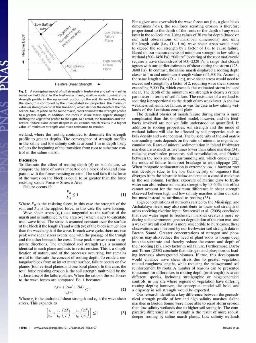
For a given area over which the wave forces act (i.e., a given blockdimensions l × w), the soil force resisting erosion is thereforeproportional to the depth of the roots or the depth of any weaklayer in the soil column. Using values of 30 cm for depth (based onour field observations of marshball dimensions) and unityfor length scale (i.e., O ∼ 1 m), wave shear stress would needto exceed the soil strength by a factor of 1.6, to cause failure.Based on our measurements of minimum strength in low salinitywetland (500–1450 Pa), “failure” (scouring of the root mat) wouldrequire a wave shear stress of 800–2320 Pa, a range that closelyagrees with our earlier estimates of shear during the storm (425–3600 Pa). In contrast, the saline marsh displayed a rooting depthcloser to 1 m and minimum strength values of 4,500 Pa. Assumingthe same length scale (O ∼ 1 m), wave shear stress would need toexceed soil strength by a factor of 2, requiring wave shear stressesexceeding 9,000 Pa, which exceeds the estimated storm-inducedshear. The depth of the minimum soil strength is clearly a criticalparameter in terms of soil failure. The resistance of a wetland toscouring is proportional to the depth of any weak layer. A shallowweakness will enhance failure, as was the case in low salinity wet-lands of the Louisiana coastal plain.
The detailed physics of marsh failure during storms is morecomplicated than this simplified model, however, and the feed-backs involved are not yet fully understood or quantified. Inaddition to rooting properties, soil strength and the mode ofwetland failure will also be affected by soil properties such asbulk density and water content. The bulk density of the soil matrixsurrounding roots depends on the ratio of mineral to organic ac-cumulation. Rates of mineral sedimentation in inland freshwatermarshes are as much as five times lower than saline marshes (34),reducing overburden pressures, soil consolidation, and frictionbetween the roots and the surrounding soil, which could changethe mode of failure from root breakage to root slippage (28).When inorganic sedimentation is extremely low, a buoyant rootmat develops (due to the low bulk density of organics) thatdiverges from the substrate below and creates a zone of weaknessin the soil column. Further, exposure of marine clays to fresh-water can also reduce soil matrix strengths by 40–60%; this effectcannot account for the maximum difference in shear strengthobserved between high and low salinity marshes within our databut must instead be attributed to rooting (35).
High concentrations of nutrients carried by the Mississippi andAtchafalaya rivers may also contribute to lower soil strength inareas receiving riverine input. Swarenski et al. (2008) concludedthat river water input to freshwater marshes creates a more re-ducing soil environment, greater degradation of the root mat, anda weaker overall soil that is more susceptible to hurricanes; theseobservations are mirrored by our freshwater soil strength data inBreton Sound. Greater concentrations of nitrogen and phos-phorus may also reduce the need of plant roots to forage deepinto the substrate and thereby reduce the extent and depth oftheir rooting (15), a key factor in soil failure. Furthermore, Darbyand Turner (2008) conclude that nitrogen and phosphorous load-ing increases aboveground biomass. If true, this developmentwould enhance wave shear stress due to greater vegetationrelated roughness lengths, while reducing the belowground soilreinforcement by roots. A number of reasons can be presentedto account for differences in rooting depth (or strength) betweendifferent species, including stratigraphic or biogeochemicalcontrols, in any site where regions of vegetation have differingrooting depths; however, the conceptual model will hold, anda disparity in soil strength would be expected.
Our research identifies a key difference between the geotech-nical strength profile of low and high salinity marshes. Salinemarshes in Breton Sound were more able to resist storm erosionthan low salinity wetlands due to higher soil strengths. The com-parative difference in soil strength is the result of more robust,deeper rooting by saline marsh plants. Low salinity wetlands
Rel
ativ
e D
epth
Relative Shear Strength
Low Salinity min.
High Salinitymin.
Vege
tated
(root
contr
olled
)
Unvegetated
(substrate controlled)
ow SalinityyFailuFF rePlane
High g SalinityFailuFF rePlane
Fig. 5. A conceptual model of soil strength in freshwater and saline marshesbased on field data. In the freshwater marsh, shallow roots dominate thestrength profile in the uppermost portion of the soil. Beneath the roots,the strength is controlled by the unvegetated soil properties. The minimumvalues in strength occur at this transition, which defines the depth of the the-oretical failure plane. In the saline marsh, roots dominate the strength profileto a greater depth. In addition, the roots in saline marsh appear stronger,shifting the vegetated profile to the right. As a result, the transition and the-oretical failure plane occurs deeper in soil column, which results in a highervalue of minimum strength and more resistance to erosion.
14018 ∣ www.pnas.org/cgi/doi/10.1073/pnas.0914582107 Howes et al.

are vulnerable to bulk erosion of the marsh platform duringstorms due to weaker soil strengths and reduced rooting depths.The influence of high nutrient levels or unrooted layers may con-tribute to or compound this. With this in mind, proposed fresh-water diversions should be reassessed not only for their abilityto restore low salinity and introduce sediment but their efficacyin creating robust hurricane-resistant marsh, because the poten-tial exists for the development of geotechnically weak soils andthus higher susceptibility to erosion during large magnitude stormevents.
MethodsTo quantify the comparative strengths of wetland soils, geotechnical mea-surements were taken along a transect through low and high salinitymarshes. Half cores were retrieved (avoiding sediment compaction, at sitesa minimum of 15 m from the marsh platform edge) and sampled with depthto obtain saturated bulk density, gravimetric water content, and organiccontent (Figs. S1 and S2). The undrained soil shear strength was measuredin situ using a Seiken field-vane (low salinity n ¼ 53; high salinity n ¼ 47),and further measurements of weaker soils were carried out in the laboratorywith aWykeham–Farrance lab-vane (low salinity n ¼ 30). Undrained strengthis a measure of strength specifically employed when a rapid loading condi-tion or force is applied to a fine-grained saturated soil, such that there isinsufficient time for the soil to drain. This was the case when the BretonSound region was inundated by the storm surge (the entire region was “openwater”) and experienced wave forces. High and low salinity marshes werecompared for significant difference using a two-tailed Welches t-test.
To establish the hydrodynamic conditions within the basin during stormconditions, numerical model results were obtained using the full plane steady
state spectral wave model STWAVE run in a quasi-coupled mode with theunstructured coastal ocean circulation model ADCIRC (interfaced every30 min), with spatially varying wind fields and spatially varying friction(15). Based upon the hydrodynamic conditions (significant wave height,Hs; peak period, Tp; and water depth, h) and an appropriate wave frictionfactor (fw ), calculations were made to determine the maximum wave shearstresses acting on the vegetated marsh platform (25, 36). The wave frictionfactor parameterizes the drag related to vegetation and is a function of theroughness length (Z0), which is influenced by stem density, canopy height,and leaf geometry (37–41). Although, when emergent, vegetation dramati-cally reduces flow velocities (4, 40, 42), when fully submerged it produces atwo-phase flow; speeds are reduced within the canopy, while a faster skim-ming flow occurs above the canopy (38, 41). When water depth becomes sig-nificantly deeper than the canopy height, as occurred during HurricaneKatrina, vegetation can be considered as a bed roughness element, retardingflow and increasing shear in the near-bed boundary layer (40, 41). Two char-acteristic roughness lengths (17 and 30 cm) were used to calculate maximumwave shear stresses, representing the upper and lower limits of vegetationconditions (37–40). Calculations weremade at seven sites on either side of theTerre aux Boeuf distributary (see SI Text B and Table S2).
ACKNOWLEDGMENTS. We gratefully acknowledge field assistance receivedfrom M. Brown, P. McCarty, and J. Motti. This work was primarilyfunded by National Oceanic and Atmospheric Administration PontchartrainRestoration Program Grant NA06 NOS4630026 awarded to the University ofNew Orleans and Boston University. U.S. Geological Survey Northern Gulf ofMexico (NGOM) Ecosystem Change and Hazard Susceptibility Projectprovided funding for the land loss mapping.
1. Moeller I, Spencer T, French JR (1996) Wind wave attenuation over saltmarsh surfaces:Preliminary results from Norfolk, England. J Coastal Res 12:1009–1016.
2. Mitsch WJ, Gosselink JG Wetlands (Wiley, New York), 3rd ed.3. McKee KL, Cherry JA (2009) Hurricane Katrina sediment slowed elevation loss in
subsiding brackish marshes of the Mississippi River delta. Wetlands 29:2–15.4. Reed DJ, Spencer T, Murray AL, French JR, Leonard L (1999) Marsh surface sediment
deposition and the role of tidal creeks: Implications for created and managed coastalmarshes. J Coast Conservat 5:81–90.
5. Day JW, Jr, et al. (2007) Restoration of the Mississippi delta: Lessons learned fromHurricanes Katrina and Rita. Science 315:1679–1684.29.
6. IPCCParry ML, Canziani OF, Palutikof JP, van der Linden PJ, Hanson CE, eds. (2007)Contribution ofWorking Group II to the Fourth Assessment Report of the Intergovern-mental Panel on Climate Change (Cambridge Univ Press, Cambridge, UK, and NewYork) p 976.
7. Syvitski JPM, et al. (2009) Sinking deltas due to human activities. Nat Geosci 2:681–686.8. Blum MD, Roberts HH (2009) Drowning of the Mississippi Delta due to insufficient
sediment supply and global sea-level rise. Nat Geosci 2:488–491.9. Cahoon DR, et al. (2006) Wetlands and Natural Resource Management. Ecological
Studies, eds JTAVerhoeven, B Beltman, R Bobboink, and DWhigham (Springer-Verlag,Berlin Heidelberg), 190, pp 271–292.
10. Feagin RA, et al. (2009) Does vegetation prevent wave erosion of salt marsh edges?Proc Natl Acad Sci USA 106:10109–10113.
11. Barras JA, Bernier JC, Morton RA (2008) Land area changes in coastal Louisiana—A multi decadal perspective (from 1956 to 2006). US Geological Survey ScientificInvestigations Map 3019, 14 scale 1∶250;000.
12. Visser JM, Sasser CE, Chabreck RH, Linscombe RG (1998) Marsh vegetation types of theMississippi River Deltaic Plain. Estuaries 21:818–828.
13. Visser JM, Sasser CE, Chabreck RH, Linscombe RG (2000) Marsh vegetation types of theChenier Plain USA. Estuaries 23:318–327.
14. Ravens TM, Thomas RC, Roberts KA, Santschi PH (2009) Causes of salt marsh erosion inGalveston Bay, Texas. J Coast Res 25:265–272.
15. Darby FA, Turner RE (2008) Below and aboveground biomass of Spartina alterniflora:Response to nutrient addition in a Louisiana salt marsh. Estuar Coast 31:326–334.
16. Swarzenski CM, Doyle TW, Fry B, Hargis TG (2008) Biogeochemical response oforganic-rich freshwater marshes in the Louisiana delta plain to chronic river waterinflux. Biogeochemistry 90:49–63.
17. Bunya S, et al. A high resolution coupled riverine flow, tide, wind, wind wave andstorm surge model for southern Louisiana andMississippi: Part I—Model developmentand validation. Monthly Weather Review. (accepted 2009).
18. Piazza BP, La Peyre MK (2007) Restoration of the annual flood pulse in Breton Sound,Louisiana, USA: Habitat change and nekton community response. Aquat Biol1:109–119.
19. van de Plassche O, et al. (2006) Salt-marsh erosion associated with hurricane landfall insouthern New England in the fifteenth and seventeenth centuries. Geology34:829–832.
20. Temmerman S, et al. (2007) Vegetation causes channel erosion in a tidal landscape.Geology 35:631–634.
21. Bjerrum L (1972) Embankments on soft ground. Proc ASCE Specialty Conf Performanceof Earth and Earth Supported Structures (Purdue Univ, Lafayette, IN), pp l–54.
22. Day RW (2001) Soil Testing Manual (McGraw-Hill, New York).23. Klopstra D, Barneveld HJ, van Noortwijk JM, van Velzen EH (1997) Analytical model
for hydraulic roughness of submerged vegetation. Proceedings of the 27th Congressof the International Association for Hydraulic Research, San Francisco. (Am Society ofCivil Engineers, New York), pp 775–780.
24. Leonard LA, Croft AL (2006) The effect of standing biomass on flow velocity andturbulence in Spartina alterniflora canopies. Estuar Coast Shelf S 69:325–336.
25. Soulsby RL (1997) Dynamics of Marine Sands, a Manual for Practical Applications (Tho-mas, Telford, UK) p 250.
26. Swarzenski CM, Swenson EM, Sasser CE, Gosselink JG (1991) Marshmat flotation in theLouisiana delta plain. J Ecol 79:999–1011.
27. Sasser CE, Gosselink JG, Swenson EM, Swarzenski CM, Leibowitz NC (1996) Vegetation,substrate and hydrology in floating marshes in the Mississippi river delta plainwetlands, USA. Vegetatio 122:129–142.
28. Mickovski SB, et al. (2009) Mechanical reinforcement of soil by willow roots: Impacts ofroot properties and root failure mechanism. Soil Sci Soc Am J 73:1276–1285.
29. van Eerdt MM (1985) The influence of vegetation on erosion and accretion in saltmarshes of the Oosterschelde, The Netherlands. Vegetatio 62:367–373.
30. Huat BBK, Asadi A, Kazemian S (2009) Experimental investigation on geomechanicalproperties of tropical organic soils and peat. Am J Eng App Sci 2:184–1888.
31. Chung C (2006) Forty years of ecological engineering with Spartina plantations inChina. Ecol Eng 27:49–57.
32. Bertness MD (1991) Zonation of Spartina patens and Spartina alterniflora in a NewEngland salt marsh. Ecology 72:138–148.
33. Connor RF, Chmura GL (2000) Dynamics of above- and belowground organic matter ina high latitude macrotidal saltmarsh. Mar Ecol Prog Ser 204:101–110.
34. Bjerrum L, Rosenqvist IT (1956) Some experiments with artificially sedimented clays.Geotechnique 6:124–136.
35. Nyman JA, Walters RJ, Delaune RD, Patrick WH, Jr (2006) Marsh vertical accretion viavegetative growth. Estuar Coast Shelf S 69:370–380.
36. Mathisen PP, Madsen OS (1996)Waves and currents over a fixed rippled bed. 1. Bottomroughness experienced by waves in the presence and absence of currents. J GeophysRes 101:16533–16542.
37. Augustin LN, Irish JL, Lynett P (2009) Laboratory and numerical studies of wave damp-ing by emergent and near-emergent wetland vegetation. Coast Eng 56:332–340.
38. Neumeier U (2007) Velocity and turbulence variations at the edge of salt marshes.Cont Shelf Res 27:1046–1059.
39. Neumeier U, Amos CL (2006) The influence of vegetation on turbulence and flowvelocities in European salt marshes. Sedimentology 53:259–277.
40. Neumeier U, Ciavola P (2004) Flow resistance and associated sedimentary processes ina Spartina maritime salt marsh. J Coast Res 20:435–447.
41. Ghisalberti M, Nepf H (2006) The structure of the shear layer over rigid and flexiblecanopies. Environ Fluid Mech 6:277–301 DOI: 10.1007/s10652-006-0002-4.
42. Brown SL (1998) Sedimentation on Humber saltmarsh. Sedimentary Processes in theintertidal zone, Geological Special Publication 139, eds KS Black, DM Paterson, andA Cramp 69–84.
Howes et al. PNAS ∣ August 10, 2010 ∣ vol. 107 ∣ no. 32 ∣ 14019
ENVIRONMEN
TAL
SCIENCE
S