hurricane sandy damage in nassau, bahamas, 2012
TRANSCRIPT
1
Neil E Sealey Bay Street, Nassau, 2012 - Sand Loss from Beaches and Damage to Infrastructure
WEST BAY STREET, NASSAU, 2012 SAND LOSS FROM BEACHES AND DAMAGE TO INFRASTRUCTURE
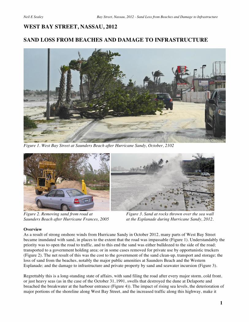
Figure 1. West Bay Street at Saunders Beach after Hurricane Sandy, October, 2102
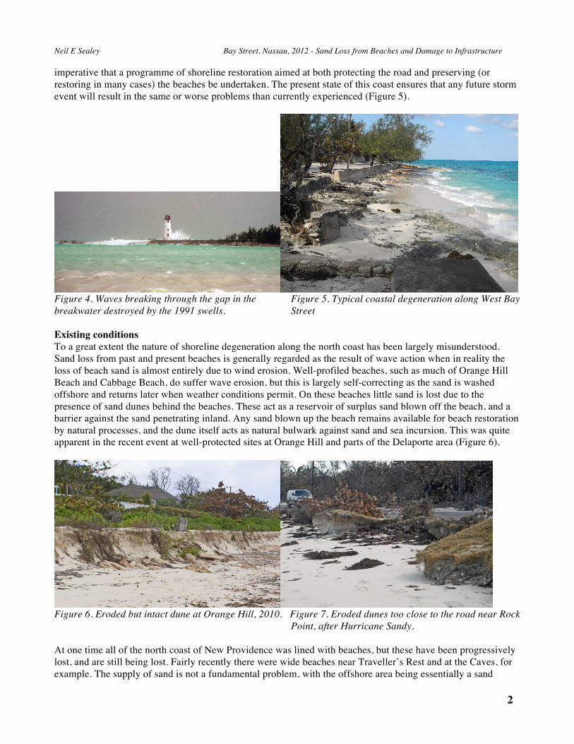
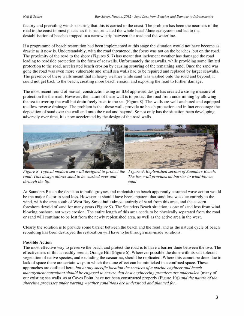
Figure 2. Removing sand from road at Figure 3. Sand at rocks thrown over the sea wall Saunders Beach after Hurricane Frances, 2005 at the Esplanade during Hurricane Sandy, 2012. Overview As a result of strong onshore winds from Hurricane Sandy in October 2012, many parts of West Bay Street became inundated with sand, in places to the extent that the road was impassable (Figure 1). Understandably the priority was to open the road to traffic, and to this end the sand was either bulldozed to the side of the road; transported to a government holding area; or in some cases removed for private use by opportunistic truckers (Figure 2). The net result of this was the cost to the government of the sand clean-up, transport and storage; the loss of sand from the beaches, notably the major public amenities at Saunders Beach and the Western Esplanade; and the damage to infrastructure and private property by sand and seawater incursion (Figure 3). Regrettably this is a long-standing state of affairs, with sand filing the road after every major storm, cold front, or just heavy seas (as in the case of the October 31, 1991, swells that destroyed the dune at Delaporte and breached the breakwater at the harbour entrance (Figure 4)). The impact of rising sea levels, the deterioration of major portions of the shoreline along West Bay Street, and the increased traffic along this highway, make it
2 2
Neil E Sealey Bay Street, Nassau, 2012 - Sand Loss from Beaches and Damage to Infrastructure
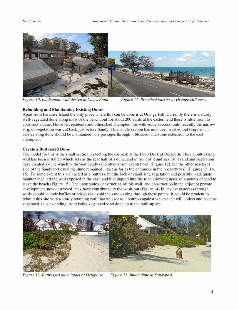
imperative that a programme of shoreline restoration aimed at both protecting the road and preserving (or restoring in many cases) the beaches be undertaken. The present state of this coast ensures that any future storm event will result in the same or worse problems than currently experienced (Figure 5).
Figure 4. Waves breaking through the gap in the Figure 5. Typical coastal degeneration along West Bay breakwater destroyed by the 1991 swells. Street Existing conditions To a great extent the nature of shoreline degeneration along the north coast has been largely misunderstood. Sand loss from past and present beaches is generally regarded as the result of wave action when in reality the loss of beach sand is almost entirely due to wind erosion. Well-profiled beaches, such as much of Orange Hill Beach and Cabbage Beach, do suffer wave erosion, but this is largely self-correcting as the sand is washed offshore and returns later when weather conditions permit. On these beaches little sand is lost due to the presence of sand dunes behind the beaches. These act as a reservoir of surplus sand blown off the beach, and a barrier against the sand penetrating inland. Any sand blown up the beach remains available for beach restoration by natural processes, and the dune itself acts as natural bulwark against sand and sea incursion. This was quite apparent in the recent event at well-protected sites at Orange Hill and parts of the Delaporte area (Figure 6).
Figure 6. Eroded but intact dune at Orange Hill, 2010. Figure 7. Eroded dunes too close to the road near Rock Point, after Hurricane Sandy. At one time all of the north coast of New Providence was lined with beaches, but these have been progressively lost, and are still being lost. Fairly recently there were wide beaches near Traveller’s Rest and at the Caves, for example. The supply of sand is not a fundamental problem, with the offshore area being essentially a sand
3
Neil E Sealey Bay Street, Nassau, 2012 - Sand Loss from Beaches and Damage to Infrastructure
factory and prevailing winds ensuring that this is carried to the coast. The problem has been the nearness of the road to the coast in most places, as this has truncated the whole beach/dune ecosystem and led to the destabilisation of beaches trapped in a narrow strip between the road and the waterline. If a programme of beach restoration had been implemented at this stage the situation would not have become as drastic as it now is. Understandably, with the road threatened, the focus was not on the beaches, but on the road. The proximity of the road to the shore (Figures 5, 7) has meant that inclement weather has damaged the road leading to roadside protection in the form of seawalls. Unfortunately the seawalls, while providing some limited protection to the road, accelerated beach erosion by causing scouring of the remaining sand. Once the sand was gone the road was even more vulnerable and small sea walls had to be repaired and replaced by larger seawalls. The presence of these walls meant that in heavy weather while sand was washed onto the road and beyond, it could not get back to the beach, creating more beach erosion and exposing the road to further damage. The most recent round of seawall construction using an IDB approved design has created a strong measure of protection for the road. However, the nature of these wall is to protect the road from undermining by allowing the sea to overtop the wall but drain freely back to the sea (Figure 8). The walls are well-anchored and equipped to allow reverse drainage. The problem is that these walls provide no beach protection and in fact encourage the deposition of sand over the wall and onto the road and beyond. So not only has the situation been developing adversely over time, it is now accelerated by the design of the road walls.
Figure 8. Typical modern sea wall designed to protect the Figure 9. Replenished section of Saunders Beach. road. This design allows sand to be washed over and The low wall provides no barrier to wind-blown through the lip. sand At Saunders Beach the decision to build groynes and replenish the beach apparently assumed wave action would be the major factor in sand loss. However, it should have been apparent that sand loss was due entirely to the wind, with the area south of West Bay Street built almost entirely of sand from this area, and the eastern foreshore devoid of sand for many years (Figure 9). The Saunders Beach situation is one of sand loss from wind blowing onshore, not wave erosion. The entire length of this area needs to be physically separated from the road or sand will continue to be lost from the newly replenished area, as well as the active area in the west. Clearly the solution is to provide some barrier between the beach and the road, and as the natural cycle of beach rebuilding has been destroyed the restoration will have to be through man-made solutions. Possible Action The most effective way to preserve the beach and protect the road is to have a barrier dune between the two. The effectiveness of this is readily seen at Orange Hill (Figure 6). Wherever possible the dune with its salt-tolerant vegetation of native species, and excluding the casuarina, should be replicated. Where this cannot be done due to lack of space there are certain ways in which the dune effect can be mimicked in a confined space. These approaches are outlined here, but at any specific location the services of a marine engineer and beach management consultant should be engaged to ensure that best engineering practices are undertaken (many of our existing sea walls, as at Caves Point, have not been constructed properly (Figure 10)) and the nature of the shoreline processes under varying weather conditions are understood and planned for.
4 4
Neil E Sealey Bay Street, Nassau, 2012 - Sand Loss from Beaches and Damage to Infrastructure
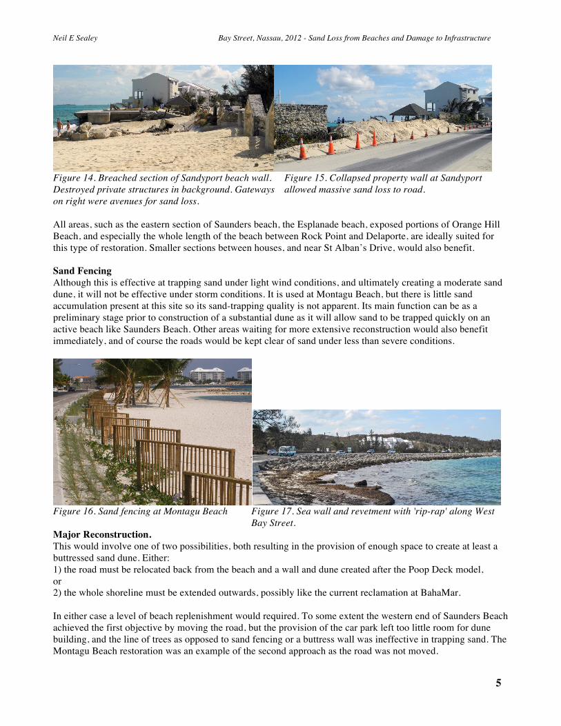
Figure 10. Inadequate wall design at Caves Point. Figure 11. Breached barrier at Orange Hill east. Rebuilding and Maintaining Existing Dunes Apart from Paradise Island the only place where this can be done is at Orange Hill. Currently there is a sturdy well-vegetated dune along most of the beach, but for about 200 yards at the eastern end there is little room to construct a dune. However, residents and others had attempted this with some success, until recently the narrow strip of vegetation was cut back just before Sandy. This whole section has now been washed out (Figure 11). The existing dune should be maintained, any passages through it blocked, and some extension to the east attempted. Create a Buttressed Dune The model for this is the small section protecting the car park at the Poop Deck at Delaporte. Here a buttressing wall has been installed which acts as the rear half of a dune, and in front of it and against it sand and vegetation have created a dune which withstood Sandy (and other storm events) well (Figure 12). On the other (eastern) side of the Sandyport canal the dune remained intact as far as the entrances in the property wall (Figures 13, 14, 15). To some extent this wall acted as a buttress, but the lack of stabilising vegetation and possibly inadequate maintenance left the wall exposed in the east, and it collapsed into the road allowing massive amounts of sand to leave the beach (Figure 15). The unorthodox construction of this wall, and construction in the adjacent private development, now destroyed, may have contributed to the wash-out (Figure 14) In any event access through walls should include baffles or bridges to avoid the sand exiting through these points. It would be prudent to rebuild this site with a sturdy retaining wall that will act as a buttress against which sand will collect and become vegetated, thus extending the existing vegetated sand dune up to the built-up area.
Figure 12. Buttressed dune intact at Delaporte. Figure 13. Intact dune at Sandyport.
5
Neil E Sealey Bay Street, Nassau, 2012 - Sand Loss from Beaches and Damage to Infrastructure
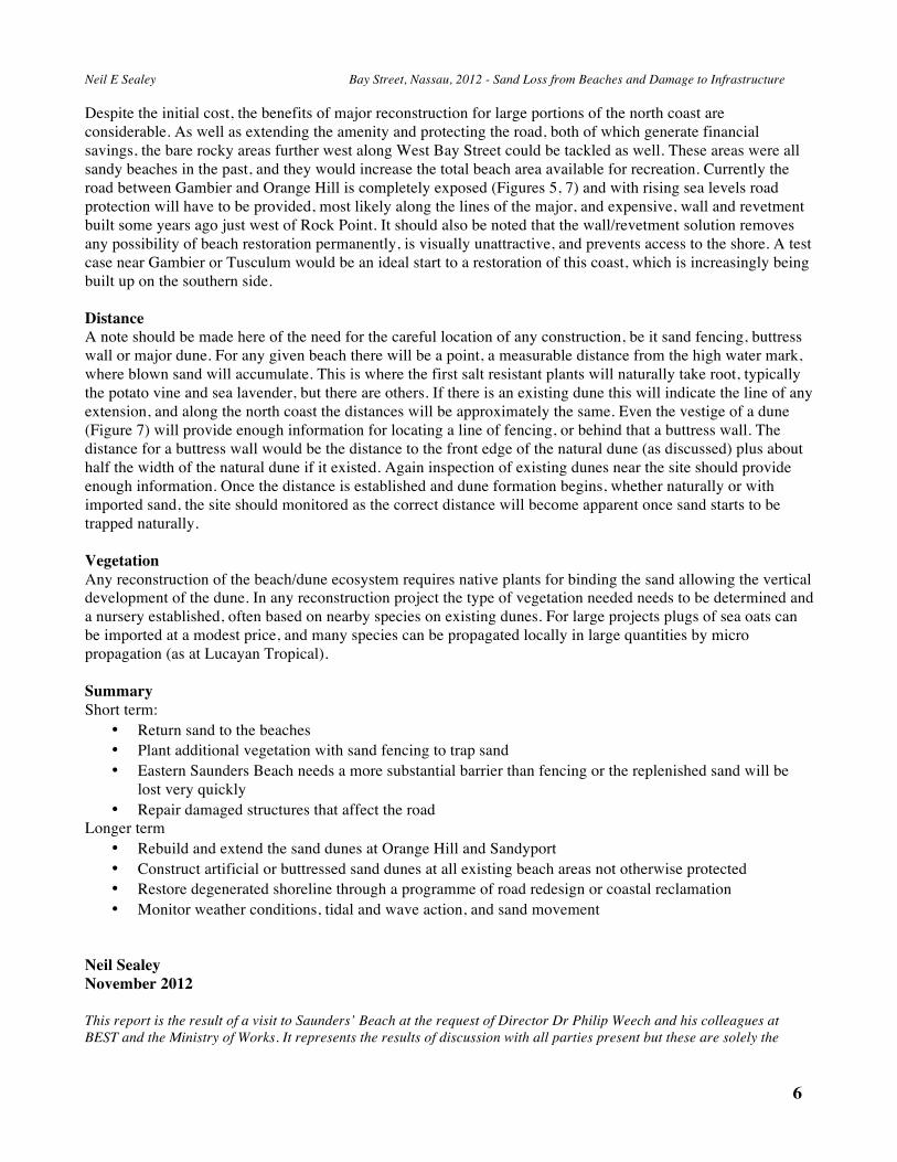
Figure 14. Breached section of Sandyport beach wall. Figure 15. Collapsed property wall at Sandyport Destroyed private structures in background. Gateways allowed massive sand loss to road. on right were avenues for sand loss. All areas, such as the eastern section of Saunders beach, the Esplanade beach, exposed portions of Orange Hill Beach, and especially the whole length of the beach between Rock Point and Delaporte, are ideally suited for this type of restoration. Smaller sections between houses, and near St Alban’s Drive, would also benefit. Sand Fencing Although this is effective at trapping sand under light wind conditions, and ultimately creating a moderate sand dune, it will not be effective under storm conditions. It is used at Montagu Beach, but there is little sand accumulation present at this site so its sand-trapping quality is not apparent. Its main function can be as a preliminary stage prior to construction of a substantial dune as it will allow sand to be trapped quickly on an active beach like Saunders Beach. Other areas waiting for more extensive reconstruction would also benefit immediately, and of course the roads would be kept clear of sand under less than severe conditions.
Figure 16. Sand fencing at Montagu Beach Figure 17. Sea wall and revetment with 'rip-rap' along West Bay Street. Major Reconstruction. This would involve one of two possibilities, both resulting in the provision of enough space to create at least a buttressed sand dune. Either: 1) the road must be relocated back from the beach and a wall and dune created after the Poop Deck model, or 2) the whole shoreline must be extended outwards, possibly like the current reclamation at BahaMar. In either case a level of beach replenishment would required. To some extent the western end of Saunders Beach achieved the first objective by moving the road, but the provision of the car park left too little room for dune building, and the line of trees as opposed to sand fencing or a buttress wall was ineffective in trapping sand. The Montagu Beach restoration was an example of the second approach as the road was not moved.
6 6
Neil E Sealey Bay Street, Nassau, 2012 - Sand Loss from Beaches and Damage to Infrastructure
Despite the initial cost, the benefits of major reconstruction for large portions of the north coast are considerable. As well as extending the amenity and protecting the road, both of which generate financial savings, the bare rocky areas further west along West Bay Street could be tackled as well. These areas were all sandy beaches in the past, and they would increase the total beach area available for recreation. Currently the road between Gambier and Orange Hill is completely exposed (Figures 5, 7) and with rising sea levels road protection will have to be provided, most likely along the lines of the major, and expensive, wall and revetment built some years ago just west of Rock Point. It should also be noted that the wall/revetment solution removes any possibility of beach restoration permanently, is visually unattractive, and prevents access to the shore. A test case near Gambier or Tusculum would be an ideal start to a restoration of this coast, which is increasingly being built up on the southern side. Distance A note should be made here of the need for the careful location of any construction, be it sand fencing, buttress wall or major dune. For any given beach there will be a point, a measurable distance from the high water mark, where blown sand will accumulate. This is where the first salt resistant plants will naturally take root, typically the potato vine and sea lavender, but there are others. If there is an existing dune this will indicate the line of any extension, and along the north coast the distances will be approximately the same. Even the vestige of a dune (Figure 7) will provide enough information for locating a line of fencing, or behind that a buttress wall. The distance for a buttress wall would be the distance to the front edge of the natural dune (as discussed) plus about half the width of the natural dune if it existed. Again inspection of existing dunes near the site should provide enough information. Once the distance is established and dune formation begins, whether naturally or with imported sand, the site should monitored as the correct distance will become apparent once sand starts to be trapped naturally. Vegetation Any reconstruction of the beach/dune ecosystem requires native plants for binding the sand allowing the vertical development of the dune. In any reconstruction project the type of vegetation needed needs to be determined and a nursery established, often based on nearby species on existing dunes. For large projects plugs of sea oats can be imported at a modest price, and many species can be propagated locally in large quantities by micro propagation (as at Lucayan Tropical). Summary Short term:
• Return sand to the beaches • Plant additional vegetation with sand fencing to trap sand • Eastern Saunders Beach needs a more substantial barrier than fencing or the replenished sand will be
lost very quickly • Repair damaged structures that affect the road
Longer term • Rebuild and extend the sand dunes at Orange Hill and Sandyport • Construct artificial or buttressed sand dunes at all existing beach areas not otherwise protected • Restore degenerated shoreline through a programme of road redesign or coastal reclamation • Monitor weather conditions, tidal and wave action, and sand movement
Neil Sealey November 2012 This report is the result of a visit to Saunders’ Beach at the request of Director Dr Philip Weech and his colleagues at BEST and the Ministry of Works. It represents the results of discussion with all parties present but these are solely the

7
Neil E Sealey Bay Street, Nassau, 2012 - Sand Loss from Beaches and Damage to Infrastructure
opinions of the author. It also includes independent current and past visits to all the sites mentioned. Distribution is unrestricted.