hunting regulations
TRANSCRIPT
wgfd.wyo.gov Wyoming Hunting Regulations | 1
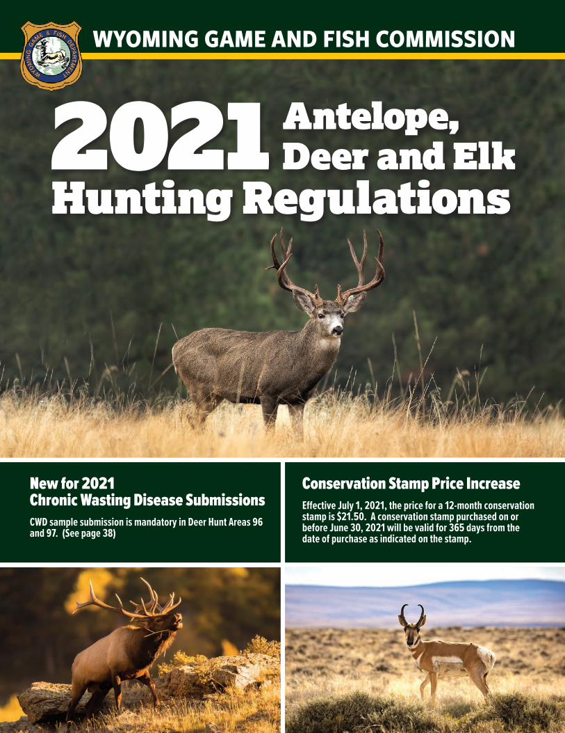
WYOMING GAME AND FISH COMMISSION
Antelope, Deer and Elk
Hunting Regulations
Conservation Stamp Price IncreaseEffective July 1, 2021, the price for a 12-month conservation stamp is $21.50. A conservation stamp purchased on or before June 30, 2021 will be valid for 365 days from the date of purchase as indicated on the stamp.
2021
New for 2021Chronic Wasting Disease SubmissionsCWD sample submission is mandatory in Deer Hunt Areas 96 and 97. (See page 38)
2 | 2021 wgfd.wyo.gov
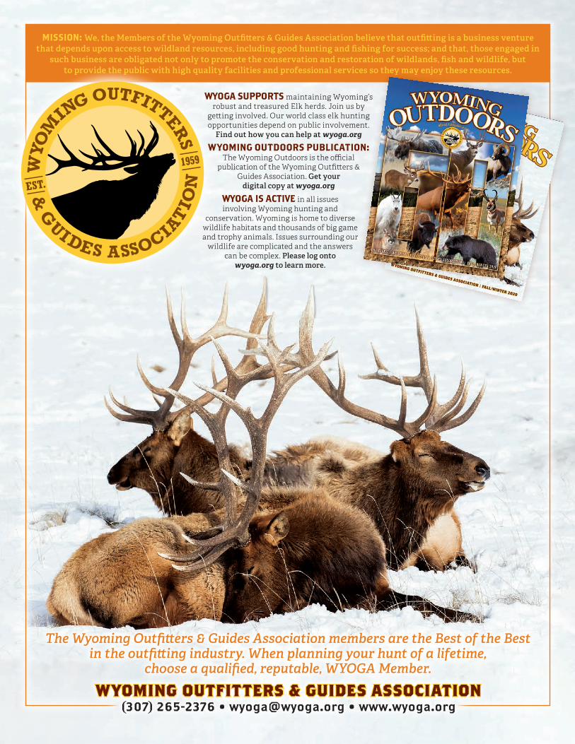
WYOMING OUTFITTERS & GUIDES ASSOCIATIONWYOMING OUTFITTERS & GUIDES ASSOCIATION(307) 265-2376 • [email protected] • www.wyoga.org
The Wyoming Outfitters & Guides Association members are the Best of the Best in the outfitting industry. When planning your hunt of a lifetime,
choose a qualified, reputable, WYOGA Member.
MISSION: We, the Members of the Wyoming Outfitters & Guides Association believe that outfitting is a business venture that depends upon access to wildland resources, including good hunting and fishing for success; and that, those engaged in
such business are obligated not only to promote the conservation and restoration of wildlands, fish and wildlife, but to provide the public with high quality facilities and professional services so they may enjoy these resources.
WYOGA SUPPORTS maintaining Wyoming’s robust and treasured Elk herds. Join us by
getting involved. Our world class elk hunting opportunities depend on public involvement.
Find out how you can help at wyoga.org
WYOMING OUTDOORS PUBLICATION: The Wyoming Outdoors is the official
publication of the Wyoming Outfitters & Guides Association. Get your
digital copy at wyoga.org
WYOGA IS ACTIVE in all issues involving Wyoming hunting and
conservation. Wyoming is home to diverse wildlife habitats and thousands of big game and trophy animals. Issues surrounding our
wildlife are complicated and the answers can be complex. Please log onto
wyoga.org to learn more.

wgfd.wyo.gov Wyoming Hunting Regulations | 3
MESSAGE FROM THE DIRECTOR
Diverse landscapes offer hunter opportunity
Dear Hunters,
We’re fortunate in Wyoming for diverse landscapes. Our state’s hunting grounds vary from arid shrublands to grassy ranges to high-alpine forests. Each unique habitat offers some advantage for the hunter and the game. On flatter lands that span for miles, it’s easy to spot pronghorn on the horizon, and, unfortunately at times, just as easy for a group of bachelor bucks to detect even a stealthy hunter. The mountains and forest offer more cover, but the steep climbs and fallen trees are often easier for elk and deer to traverse than us humans.
That balance is part of fair chase, and varied landscapes are a lot of fun. In Wyoming, you can find wildlife in many habitat types, and you can hunt them there, too. High-elevation pronghorn are not unheard of and there are certainly plains, desert elk. Deer browsing wet river bottom willows are just as respectable as the herds browsing sagebrush. And in all cases, the views across the state are spectacular, whether from the tip of a bluff or the valley bank of a river.
This year, I encourage you to explore new places in your hunt area for the best success. There’s no doubt you’ll have a great hunt this fall, but big game patterns could be different. Many parts of Wyoming are facing another year of drought, following several impactful wildfires. The risks are high for elk, deer and pronghorn in dry years — less water, less food, less cover. In turn, big game will select the best habitat. Those are the lush places with water holes and something green to eat. That’s where you should head. Our Wyoming Hunt Planner on the Game and Fish website can help you find hunting access and necessary topographical details.
It’s in the best interest of wildlife and hunters that we all maintain vigilance in taking good care of our diverse habitats. When you're on-the-ground, I urge you to remain true to the land ethic all hunters expect of each other. Use ATVs responsibly, be careful with campfires and respect private property rights.
And as far as personal safety goes, carry plenty of water and keep an eye on the sky for quickly-changing weather conditions. Make it a goal for Wyoming Search and Rescue teams to have a boring fall.
I’m looking forward to the season, and I hope you are too. Take in the land and marvel in the wonder that is the Wyoming outdoors. I wish you the best of luck in your harvest pursuits. And last but not least, don’t forget to think about our young aspiring hunters by giving them new opportunities to experience the things that keep seasoned hunters coming back season after season. Inspire a kid; it’s for life!
By Brian Nesvik, Game and Fish Director
State of WyomingGovernor Mark Gordon
Wyoming Game and Fish CommissionPresident Peter Dube, BuffaloVice President Gay Lynn Byrd, Douglas
Ralph Brokaw, ArlingtonRichard Ladwig, Manville
Kenneth Roberts, Kemmerer Mark Jolovich, Torrington
Ashlee Lundvall, PowellWyoming Game and Fish DepartmentDirector Brian Nesvik Deputy Director John Kennedy Deputy Director Angi BruceChief Game Warden /Chief of Wildlife Division Rick KingChief of Fisheries Alan OsterlandChief of Fiscal Services Greg Phipps Chief of Services Division Eric Wiltanger
Cheyenne Headquarters (307) 777-46005400 Bishop Blvd., Cheyenne, WY 82006 (800) 842-1934
Casper Region (307) 473-34003030 Energy Lane, Casper, WY 82604 (800) 233-8544
Cody Region (307) 527-71252820 State Highway 120, Cody, WY 82414 (800) 654-1178
Green River Region (307) 875-3223351 Astle, Green River, WY 82935 (800) 843-8096
Jackson Region (307) 733-2321420 North Cache, Jackson, WY 83001 (800) 423-4113Mailing Address:P.O. Box 67, Jackson, WY 83001
Lander Region (307) 332-2688 260 Buena Vista, Lander, WY 82520 (800) 654-7862
Laramie Region (307) 745-40461212 South Adams Street, Laramie WY 82070 (800) 843-2352
Pinedale Region (307) 367-4353432 East Mill Street, Pinedale, WY 82941 (800) 452-9107Mailing Address:P.O. Box 850, Pinedale, WY 82941
Sheridan Region (307) 672-7418700 Valley View Drive, Sheridan, WY 82801 (800) 331-9834
Regional offices
WYOMING OUTFITTERS & GUIDES ASSOCIATIONWYOMING OUTFITTERS & GUIDES ASSOCIATION(307) 265-2376 • [email protected] • www.wyoga.org
The Wyoming Outfitters & Guides Association members are the Best of the Best in the outfitting industry. When planning your hunt of a lifetime,
choose a qualified, reputable, WYOGA Member.
MISSION: We, the Members of the Wyoming Outfitters & Guides Association believe that outfitting is a business venture that depends upon access to wildland resources, including good hunting and fishing for success; and that, those engaged in
such business are obligated not only to promote the conservation and restoration of wildlands, fish and wildlife, but to provide the public with high quality facilities and professional services so they may enjoy these resources.
WYOGA SUPPORTS maintaining Wyoming’s robust and treasured Elk herds. Join us by
getting involved. Our world class elk hunting opportunities depend on public involvement.
Find out how you can help at wyoga.org
WYOMING OUTDOORS PUBLICATION: The Wyoming Outdoors is the official
publication of the Wyoming Outfitters & Guides Association. Get your
digital copy at wyoga.org
WYOGA IS ACTIVE in all issues involving Wyoming hunting and
conservation. Wyoming is home to diverse wildlife habitats and thousands of big game and trophy animals. Issues surrounding our
wildlife are complicated and the answers can be complex. Please log onto
wyoga.org to learn more.

4 | 2021 wgfd.wyo.gov
Access on Lands Enrolled in the Department’s Walk-in Areas or Hunter Management Areas .................................................... 6Access Yes Program .......................................................................... 6Age Restrictions ................................................................................. 6Antelope Hunt area map .............................................................................. 14 Hunting seasons ...........................................................................15 Characteristics ..............................................................................15 Special archery seasons..............................................................20 Hunting season extension permits .............................................20 Hunt area boundary descriptions ................................................21Archery Equipment ............................................................................ 6Archery Licenses and Special Archery Seasons.............................. 6Artificial Light for Hunting ................................................................ 6Automatic Weapon and Suppressors ................................................7Bag Limits and Number of Licenses ..................................................7Baiting of Big Game Animals .............................................................7Bear Spray ...........................................................................................7Carcass Coupons ............................................................................ 7-8Check Stations ....................................................................................7Chronic Wasting Disease ...................................................................7Closed Areas .......................................................................................7Clothing Requirements; Fluorescent Orange/Fluorescent Pink .... 8Conservation Stamp Required and Exemptions ............................. 8Credit Card Fee .................................................................................. 8Deer Hunt area map ............................................................................. 32 Hunting seasons .......................................................................... 33 Characteristics ........................................................................33-34 Special archery seasons...............................................................41 Hunting season extension permits ..............................................41 Youth deer hunters .......................................................................41 Hunt area boundary descriptions ............................................... 42Department Office Telephone Numbers .......................................... 3Department Website .................................................... 11, Back CoverDisabled Hunter Information ............................................................11Duplicate and Replacement License ................................................11Edible Portions of Big Game - Diagrams ..........................................11
CONTENTSElk Hunt area map ............................................................................. 52 Hunting seasons .......................................................................... 53 Characteristics ............................................................................. 53 Special archery seasons.............................................................. 63 Hunting season extension permits ............................................. 63 Elk Special Management Permit ...........................................58, 63 Youth elk hunters......................................................................... 63 Hunt area boundary descriptions ............................................... 64Emergency Closures ..........................................................................11Firearms for Hunting Big or Trophy Game.......................................11Guides Required; Resident Guide License .......................................11Harvest Survey ...................................................................................11How to Fill Out a Carcass Coupon - Diagrams ................................ 8Hunter Safety/Mentor Program ........................................................11Important Hunting Information ........................................................ 6Issuance of Antelope/Deer/Elk Licenses; Number of Licenses ......11Landowner Coupons ........................................................................12License Fraud ....................................................................................12Open Hours for Taking Big Game and Trophy Game .....................12Outfitter Information ........................................................................12Permission to Hunt, Fish, Trap or Collect Antlers or Horns...........12Precautions When Hunting in Areas Occupied by Grizzly Bears ..12Prohibited Acts .................................................................................12Retention of Evidence to Identify Sex, Species and Horn or Antler Development of Big Game Harvested ......13Retrieval of Edible Portions of Big Game Meat From the Field ....13Shipping Game Animals Out of State ..............................................13Shipping Game Animals Within Wyoming ......................................13Stop Poaching Program .................................................................... 4Taking Predatory Animals and Predacious Birds ...........................13Terms & Definitions ........................................................................... 8Use of Leashed Dogs for Tracking ..................................................13Use of Specialized Hunting Technologies ......................................13Vehicle Restrictions on Federal Land ..............................................13Wilderness Areas ..............................................................................13Wildlife Violator Compact ................................................................13Wind River Reservation ....................................................................13
1-877-WGFD-TIP
You may be eligible for a reward of up to $5,000 for information leading to the arrest and conviction of a wildlife violator.
(1-877-943-3847)(1-307-777-4330)Out-of-StateIn state
REPORT WILDLIFE VIOLATIONS! HELP US STAND WATCH
Submit Tip Online: wgfd.wyo.gov
Text keyword WGFD and message to TIP411 (847-411)
POPOAACHINGCHING
Stop poaching
wgfd.wyo.gov Wyoming Hunting Regulations | 5
CONTENTS
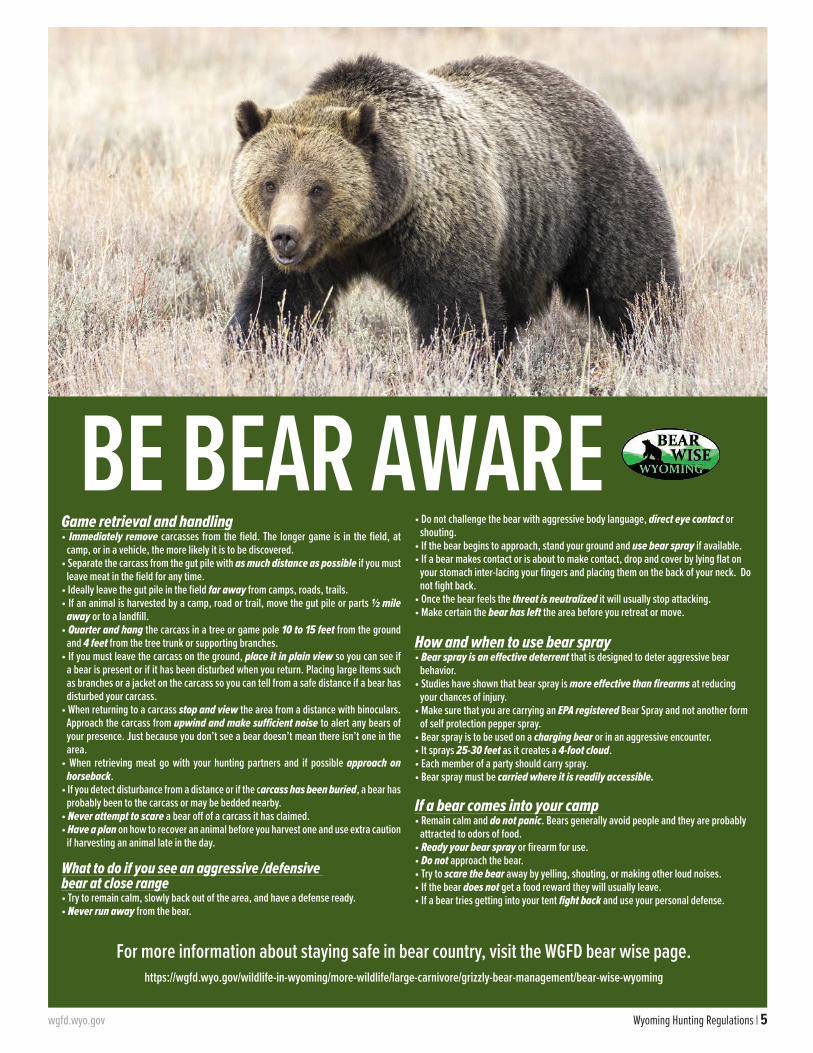
Game retrieval and handling• Immediately remove carcasses from the field. The longer game is in the field, at
camp, or in a vehicle, the more likely it is to be discovered.• Separate the carcass from the gut pile with as much distance as possible if you must
leave meat in the field for any time.• Ideally leave the gut pile in the field far away from camps, roads, trails.• If an animal is harvested by a camp, road or trail, move the gut pile or parts ½ mile
away or to a landfill.• Quarter and hang the carcass in a tree or game pole 10 to 15 feet from the ground
and 4 feet from the tree trunk or supporting branches. • If you must leave the carcass on the ground, place it in plain view so you can see if
a bear is present or if it has been disturbed when you return. Placing large items such as branches or a jacket on the carcass so you can tell from a safe distance if a bear has disturbed your carcass.
• When returning to a carcass stop and view the area from a distance with binoculars. Approach the carcass from upwind and make sufficient noise to alert any bears of your presence. Just because you don’t see a bear doesn’t mean there isn’t one in the area.
• When retrieving meat go with your hunting partners and if possible approach on horseback.
• If you detect disturbance from a distance or if the carcass has been buried, a bear has probably been to the carcass or may be bedded nearby.
• Never attempt to scare a bear off of a carcass it has claimed.• Have a plan on how to recover an animal before you harvest one and use extra caution
if harvesting an animal late in the day.
What to do if you see an aggressive /defensive bear at close range• Try to remain calm, slowly back out of the area, and have a defense ready. • Never run away from the bear.
• Do not challenge the bear with aggressive body language, direct eye contact or shouting.
• If the bear begins to approach, stand your ground and use bear spray if available.• If a bear makes contact or is about to make contact, drop and cover by lying flat on
your stomach inter-lacing your fingers and placing them on the back of your neck. Do not fight back.
• Once the bear feels the threat is neutralized it will usually stop attacking.• Make certain the bear has left the area before you retreat or move.
How and when to use bear spray• Bear spray is an effective deterrent that is designed to deter aggressive bear
behavior. • Studies have shown that bear spray is more effective than firearms at reducing
your chances of injury. • Make sure that you are carrying an EPA registered Bear Spray and not another form
of self protection pepper spray. • Bear spray is to be used on a charging bear or in an aggressive encounter.• It sprays 25-30 feet as it creates a 4-foot cloud.• Each member of a party should carry spray.• Bear spray must be carried where it is readily accessible.
If a bear comes into your camp• Remain calm and do not panic. Bears generally avoid people and they are probably
attracted to odors of food. • Ready your bear spray or firearm for use. • Do not approach the bear. • Try to scare the bear away by yelling, shouting, or making other loud noises. • If the bear does not get a food reward they will usually leave. • If a bear tries getting into your tent fight back and use your personal defense.
BE BEAR AWARE
For more information about staying safe in bear country, visit the WGFD bear wise page.https://wgfd.wyo.gov/wildlife-in-wyoming/more-wildlife/large-carnivore/grizzly-bear-management/bear-wise-wyoming
6 | 2021 wgfd.wyo.gov
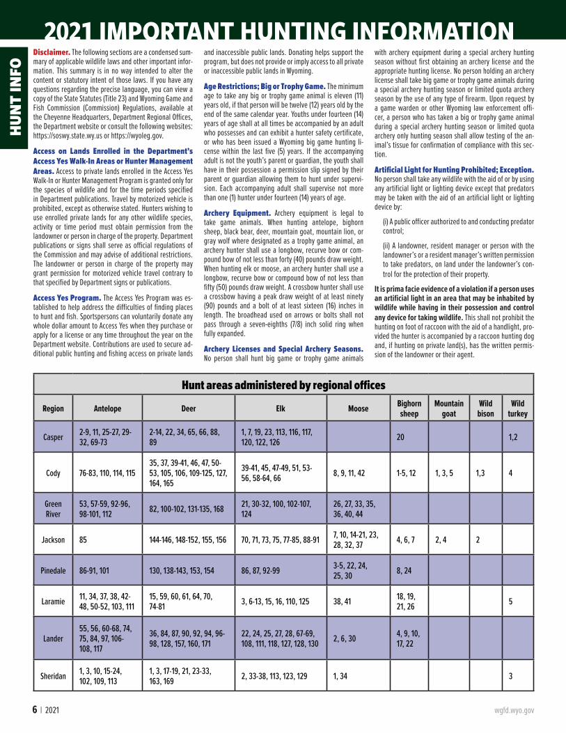
2021 IMPORTANT HUNTING INFORMATION
Hunt areas administered by regional offices
Region Antelope Deer Elk Moose Bighorn sheep
Mountain goat
Wild bison
Wild turkey
Casper 2-9, 11, 25-27, 29-32, 69-73
2-14, 22, 34, 65, 66, 88, 89
1, 7, 19, 23, 113, 116, 117, 120, 122, 126 20 1,2
Cody 76-83, 110, 114, 11535, 37, 39-41, 46, 47, 50-53, 105, 106, 109-125, 127, 164, 165
39-41, 45, 47-49, 51, 53-56, 58-64, 66 8, 9, 11, 42 1-5, 12 1, 3, 5 1,3 4
Green River
53, 57-59, 92-96, 98-101, 112 82, 100-102, 131-135, 168 21, 30-32, 100, 102-107,
12426, 27, 33, 35, 36, 40, 44
Jackson 85 144-146, 148-152, 155, 156 70, 71, 73, 75, 77-85, 88-91 7, 10, 14-21, 23, 28, 32, 37 4, 6, 7 2, 4 2
Pinedale 86-91, 101 130, 138-143, 153, 154 86, 87, 92-99 3-5, 22, 24, 25, 30 8, 24
Laramie 11, 34, 37, 38, 42-48, 50-52, 103, 111
15, 59, 60, 61, 64, 70, 74-81 3, 6-13, 15, 16, 110, 125 38, 41 18, 19,
21, 26 5
Lander55, 56, 60-68, 74, 75, 84, 97, 106-108, 117
36, 84, 87, 90, 92, 94, 96-98, 128, 157, 160, 171
22, 24, 25, 27, 28, 67-69, 108, 111, 118, 127, 128, 130 2, 6, 30 4, 9, 10,
17, 22
Sheridan 1, 3, 10, 15-24, 102, 109, 113
1, 3, 17-19, 21, 23-33, 163, 169 2, 33-38, 113, 123, 129 1, 34 3
Disclaimer. The following sections are a condensed sum-mary of applicable wildlife laws and other important infor-mation. This summary is in no way intended to alter the content or statutory intent of those laws. If you have any questions regarding the precise language, you can view a copy of the State Statutes (Title 23) and Wyoming Game and Fish Commission (Commission) Regulations, available at the Cheyenne Headquarters, Department Regional Offices, the Department website or consult the following websites: https://soswy.state.wy.us or https://wyoleg.gov.
Access on Lands Enrolled in the Department’s Access Yes Walk-In Areas or Hunter Management Areas. Access to private lands enrolled in the Access Yes Walk-In or Hunter Management Program is granted only for the species of wildlife and for the time periods specified in Department publications. Travel by motorized vehicle is prohibited, except as otherwise stated. Hunters wishing to use enrolled private lands for any other wildlife species, activity or time period must obtain permission from the landowner or person in charge of the property. Department publications or signs shall serve as official regulations of the Commission and may advise of additional restrictions. The landowner or person in charge of the property may grant permission for motorized vehicle travel contrary to that specified by Department signs or publications.
Access Yes Program. The Access Yes Program was es-tablished to help address the difficulties of finding places to hunt and fish. Sportspersons can voluntarily donate any whole dollar amount to Access Yes when they purchase or apply for a license or any time throughout the year on the Department website. Contributions are used to secure ad-ditional public hunting and fishing access on private lands
and inaccessible public lands. Donating helps support the program, but does not provide or imply access to all private or inaccessible public lands in Wyoming.
Age Restrictions; Big or Trophy Game. The minimum age to take any big or trophy game animal is eleven (11) years old, if that person will be twelve (12) years old by the end of the same calendar year. Youths under fourteen (14) years of age shall at all times be accompanied by an adult who possesses and can exhibit a hunter safety certificate, or who has been issued a Wyoming big game hunting li-cense within the last five (5) years. If the accompanying adult is not the youth’s parent or guardian, the youth shall have in their possession a permission slip signed by their parent or guardian allowing them to hunt under supervi-sion. Each accompanying adult shall supervise not more than one (1) hunter under fourteen (14) years of age.
Archery Equipment. Archery equipment is legal to take game animals. When hunting antelope, bighorn sheep, black bear, deer, mountain goat, mountain lion, or gray wolf where designated as a trophy game animal, an archery hunter shall use a longbow, recurve bow or com-pound bow of not less than forty (40) pounds draw weight. When hunting elk or moose, an archery hunter shall use a longbow, recurve bow or compound bow of not less than fifty (50) pounds draw weight. A crossbow hunter shall use a crossbow having a peak draw weight of at least ninety (90) pounds and a bolt of at least sixteen (16) inches in length. The broadhead used on arrows or bolts shall not pass through a seven-eighths (7/8) inch solid ring when fully expanded.
Archery Licenses and Special Archery Seasons. No person shall hunt big game or trophy game animals
with archery equipment during a special archery hunting season without first obtaining an archery license and the appropriate hunting license. No person holding an archery license shall take big game or trophy game animals during a special archery hunting season or limited quota archery season by the use of any type of firearm. Upon request by a game warden or other Wyoming law enforcement offi-cer, a person who has taken a big or trophy game animal during a special archery hunting season or limited quota archery only hunting season shall allow testing of the an-imal’s tissue for confirmation of compliance with this sec-tion.
Artificial Light for Hunting Prohibited; Exception. No person shall take any wildlife with the aid of or by using any artificial light or lighting device except that predators may be taken with the aid of an artificial light or lighting device by:
(i) A public officer authorized to and conducting predator control;
(ii) A landowner, resident manager or person with the landowner’s or a resident manager’s written permission to take predators, on land under the landowner’s con-trol for the protection of their property.
It is prima facie evidence of a violation if a person uses an artificial light in an area that may be inhabited by wildlife while having in their possession and control any device for taking wildlife. This shall not prohibit the hunting on foot of raccoon with the aid of a handlight, pro-vided the hunter is accompanied by a raccoon hunting dog and, if hunting on private land(s), has the written permis-sion of the landowner or their agent.
HUN
T IN
FO
wgfd.wyo.gov Wyoming Hunting Regulations | 7
2021 IMPORTANT HUNTING INFORMATION
Automatic Weapon and Suppressors. No person shall take any wildlife with any fully automatic weapon. Firearm suppressors may be used during the legal taking of any game animal.
Bag Limits and Number of Licenses. No person shall apply for or receive more than one (1) license valid for each big or trophy game species during any one (1) calendar year, except as otherwise allowed by Commission regulations. The maximum bag limit is one (1) big or trophy game animal per each valid license held, and in accordance with age, sex, spe-cies and antler or horn development limitations as specified by Commission regulation.
Baiting of Big Game Animals Prohibited; Exception for Qualified Disabled Persons. No person shall take any big game animal over, or by the use of bait, except as follows: any legally blind person, person confined to a wheel-chair, person hunting with a permit issued pursuant to Wyo-ming Statute § 23-3-304 (d) (iv) or any person hunting with a license issued pursuant to Wyoming Statute § 23-1-705 (j) may place a bait for big game or take a big game animal by the use of bait.
Bear Pepper Spray Required When Hunting in Grand Teton National Park (Elk Hunt Areas 75 and 79). All persons hunting elk in Grand Teton National Park shall carry and have readily accessible bear pepper spray.
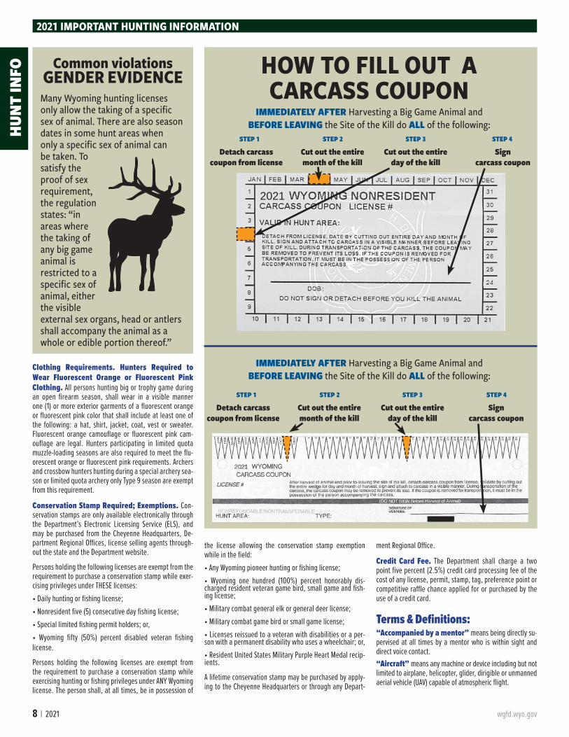
Carcass Coupons; Dating and Display. When any big game animal, trophy game animal or wild turkey is killed under a license, or sandhill crane is killed under a limited quota sandhill crane permit, the licensee shall detach, sign and date the proper carcass coupon and attach the coupon to the carcass in a readily visible manner before leaving the site of the kill. When dating a carcass coupon, the entire day and month of the kill shall be completely cut out and removed. (See page 8.) The carcass coupon shall remain on the game animal, wild turkey or sandhill crane carcass at all times until the meat undergoes processing, or on the trophy game animal hide until it reaches the hunter’s home or a taxidermist, except that during transportation of the carcass or hide, the val-idated carcass coupon may be removed to prevent its loss. If the carcass coupon is removed for transportation
of the carcass or hide, it must be completely filled out and in the possession of the person accompanying the carcass or hide at all times. While quarters or pieces of an animal are being packed from the field, the carcass coupon shall remain with the person transporting the animal.
Check Stations. Every hunter, angler or trapper enter-ing or leaving areas for which check stations have been established shall stop and report at the check station if the check station is on the hunter’s, angler’s or trapper’s route to and from the hunting or fishing area. This requirement applies even if the person does not have wildlife in posses-sion. Game and fish licensees shall produce their licenses, permits or stamps as required by regulation for any game animals, game birds, fish or furbearing animals in their possession for inspection upon request by any authorized department representative.
Closed Areas. All areas within the state of Wyoming not opened by specific order of the Commission shall be closed to the taking of game animals, furbearing animals and game birds.
2021 IMPORTANT HUNTING INFORMATION
Chronic wasting disease (CWD) is a fatal disease of the central nervous system in mule deer, white-tailed deer, elk and moose. Special regulations were adopted by the De-partment to decrease the spread of the disease. Details about CWD, where it exists in Wyoming and testing for the disease are provided on the Department website. For more information on CWD or to check your CWD sample results, please visit: https://wgfd.wyo.gov/Wildlife-in-Wyoming/More-Wildlife/Wildlife-Disease/CWD-in-Wyoming-Wildlife. For hunters wanting to collect lymph nodes from their harvested deer, elk or moose for CWD testing can watch a video on how to do so at: Wyoming Game and Fish Depart-ment - Lymph node removal videoMost animals infected with CWD show no clinical signs early on, but after a year of being infected with the dis-ease, animals will begin to show weight loss, reluctance to move, excessive salivation, droopy ears, increased drinking and urinating, lethargy and eventually death. Not all animals will show the typical signs of CWD. The majority of all CWD positive animals harvested appear completely normal. The only way to know whether your harvested animal has CWD is to have it tested.There are several ways to get your harvested animal test-ed:• Game check station – someone is normally available to sample your harvested animal for CWD. • WGFD regional office – you may have to leave the head if personnel are not immediately available. • Results from WGFD surveillance are usually available online within 3 weeks. • If you want results within 10 working days, contact the Wyoming State Veterinary Lab in Laramie at (307) 766-9925 ($30 fee). • Quarter and freeze your animal until test results are re-turned to save on meat processing costs if your animal is positive.To date, there have been no cases of CWD in humans and no direct proof that humans can get CWD. However, public health officials recommend that CWD positive animals not be consumed. Some basic precautions that hunters can take to reduce their risk to CWD include: do not consume
any animal that tests positive for CWD; do not harvest or consume any animal that appears sick; wear rubber or latex gloves when field dressing carcasses; minimize handling of brain, eyes, lymph nodes, spleen or spinal cord; and, wash your hands and utensils thoroughly after field dressing or processing game meat. Knives and other butchering equipment can be disinfected by soaking in 50% house-hold bleach for 1 hour (may rust some equipment).Transportation and Disposal of Deer, Elk and Moose Taken within Wyoming – Chronic Wasting Disease (CWD) Provisions.(a) Deer, elk and moose taken in Wyoming may be trans-ported within Wyoming to a camp, a private residence for processing, a taxidermist, a processor, or a CWD sample collection site in Wyoming, provided the head and all por-tions of the spinal column remain at the site of the kill or such parts are disposed of in any approved landfill or ap-proved incinerator in Wyoming. (b) Except as provided in subsection (a) of this section, only the following parts of any deer, elk or moose taken in Wyoming may be transported in Wyoming: edible por-tions with no part of the spinal column or head attached; cleaned hide without the head; skull or skull plate or ant-lers that have been cleaned of all meat and brain tissue; teeth; or, finished taxidermy mounts. (c) Only the following parts of any deer, elk or moose taken in Wyoming may be transported to other states, provinces or countries: edible portions with no part of the spinal col-umn or head; cleaned hide without the head; skull or skull plate or antlers that have been cleaned of all meat and brain tissue; teeth; or finished taxidermy mounts. Whole deer, elk and moose carcasses shall not be transported out of Wyoming.(d) Nothing in this section shall apply to the transportation or disposal of deer, elk and moose taken by any govern-mental agency or educational institution. Importation of Deer, Elk or Moose Taken From Outside of Wyoming(a) Deer, elk or moose taken from within any other state,
province or country may only be imported into Wyoming if carcasses are transported directly to a private residence for process-ing, to a taxidermist, to a processor or to a CWD sample collection site provided the head and all portions of the spinal column are disposed of in an approved landfill or incinerator.
Mandatory CWD Sample SubmissionThe Department may mandate hunters submit CWD sam-ples from harvested deer, elk and moose from designated hunt areas within Wyoming to evaluate testing, monitoring and management actions.If the Department mandates hunters submit CWD samples, public notice shall be given through the Department web-site, publications and news releases.(a) Mandatory submission of CWD samples from harvested deer, elk and moose may be established annually by the Department when necessary to meet its CWD testing and monitoring requirements or to implement and evaluate management actions related to CWD. Mandatory CWD sample submission of deer, elk and moose shall end when the Department achieves sampling goals for designated hunt areas, as stipulated by Department personnel prior to enacting any mandatory CWD sample submission. The Department shall determine the type, time frame and method of CWD sampling required for submission.(b) When the Department mandates hunters submit CWD samples, public notice shall be given through posting of mandatory submission requirements in Department of-fices and designated license selling agents, electronic or traditional mailings to known license holders (and other sportspersons) and through the Department website, pub-lications and news releases. (c) It shall be a violation of Commission regulation for a hunter to fail to submit mandated CWD samples in accor-dance with this sectionFor 2021, hunters are required to submit CWD sam-ples from deer harvested in hunt areas 96 & 97. See Page 38.
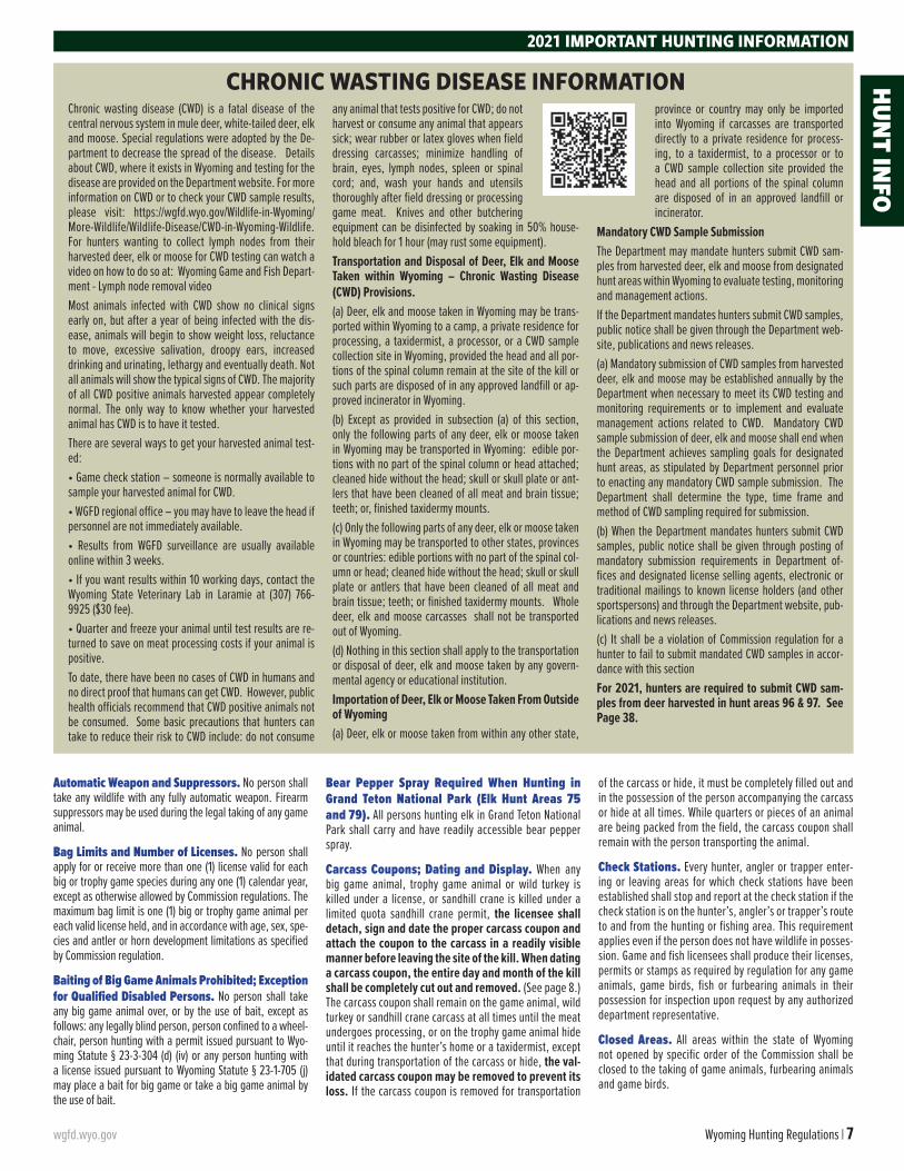
CHRONIC WASTING DISEASE INFORMATION HUNT IN
FO
8 | 2021 wgfd.wyo.gov
Clothing Requirements. Hunters Required to Wear Fluorescent Orange or Fluorescent Pink Clothing. All persons hunting big or trophy game during an open firearm season, shall wear in a visible manner one (1) or more exterior garments of a fluorescent orange or fluorescent pink color that shall include at least one of the following: a hat, shirt, jacket, coat, vest or sweater. Fluorescent orange camouflage or fluorescent pink cam-ouflage are legal. Hunters participating in limited quota muzzle-loading seasons are also required to meet the flu-orescent orange or fluorescent pink requirements. Archers and crossbow hunters hunting during a special archery sea-son or limited quota archery only Type 9 season are exempt from this requirement.
Conservation Stamp Required; Exemptions. Con-servation stamps are only available electronically through the Department’s Electronic Licensing Service (ELS), and may be purchased from the Cheyenne Headquarters, De-partment Regional Offices, license selling agents through-out the state and the Department website.
Persons holding the following licenses are exempt from the requirement to purchase a conservation stamp while exer-cising privileges under THESE licenses: • Daily hunting or fishing license;• Nonresident five (5) consecutive day fishing license;• Special limited fishing permit holders; or, • Wyoming fifty (50%) percent disabled veteran fishing license.
Persons holding the following licenses are exempt from the requirement to purchase a conservation stamp while exercising hunting or fishing privileges under ANY Wyoming license. The person shall, at all times, be in possession of
the license allowing the conservation stamp exemption while in the field: • Any Wyoming pioneer hunting or fishing license;• Wyoming one hundred (100%) percent honorably dis-charged resident veteran game bird, small game and fish-ing license;• Military combat general elk or general deer license; • Military combat game bird or small game license; • Licenses reissued to a veteran with disabilities or a per-son with a permanent disability who uses a wheelchair; or,• Resident United States Military Purple Heart Medal recip-ients.
A lifetime conservation stamp may be purchased by apply-ing to the Cheyenne Headquarters or through any Depart-
ment Regional Office.
Credit Card Fee. The Department shall charge a two point five percent (2.5%) credit card processing fee of the cost of any license, permit, stamp, tag, preference point or competitive raffle chance applied for or purchased by the use of a credit card.
Terms & Definitions:“Accompanied by a mentor” means being directly su-pervised at all times by a mentor who is within sight and direct voice contact.“Aircraft” means any machine or device including but not limited to airplane, helicopter, glider, dirigible or unmanned aerial vehicle (UAV) capable of atmospheric flight.
2021 IMPORTANT HUNTING INFORMATION
HOW TO FILL OUT A CARCASS COUPON
2021
IMMEDIATELY AFTER Harvesting a Big Game Animal and BEFORE LEAVING the Site of the Kill do ALL of the following:
IMMEDIATELY AFTER Harvesting a Big Game Animal and BEFORE LEAVING the Site of the Kill do ALL of the following:
Cut out the entiremonth of the kill
Detach carcass coupon from license
Cut out the entireday of the kill
STEP 1 STEP 2 STEP 3 STEP 4
Signcarcass coupon
Cut out the entiremonth of the kill
Detach carcass coupon from license
Cut out the entireday of the kill
STEP 1 STEP 2 STEP 3 STEP 4
Signcarcass coupon
Many Wyoming hunting licenses only allow the taking of a specific sex of animal. There are also season dates in some hunt areas when only a specific sex of animal can be taken. To satisfy the proof of sex requirement, the regulation states: “in areas where the taking of any big game animal is restricted to a specific sex of animal, either the visible external sex organs, head or antlers shall accompany the animal as a whole or edible portion thereof.”
Common violationsGENDER EVIDENCE
HUN
T IN
FO
wgfd.wyo.gov Wyoming Hunting Regulations | 9
“Antlered” means a deer, elk or moose that has visible antler growth plainly protruding from the skull. Where a minimum number of antler points are specified, points shall be counted on the side with the greater number of points.“Antlerless” means a deer, elk or moose that has no antler growth plainly protruding from the skull. Females and young-of-the-year without visible antlers are antlerless big game animals.“Approved Landfill or Incinerator” means a landfill or incinerator permitted by the State of Wyoming Depart-ment of Environmental Quality to dispose of animal carcass-es. “Artificial light or lighting device” means any man-made light or lighting device which projects a visible light outside the device, or any electronic device that provides an enhanced ability to see in the dark.“Bag limit” means the maximum number of big game or trophy game animals that may be taken by an individual pos-sessing a proper license.“Big game animal” means antelope, bighorn sheep, deer, elk, moose or mountain goat.“Buck antelope” means male antelope with visible horns and dark cheek patch at the base of the ear.“Bureau of Land Management (B.L.M.)” means the land management agency administered by the U. S. Depart-ment of the Interior.“Bureau of Reclamation Land” means lands admin-istered by the U.S. Department of the Interior Bureau of Reclamation.“Calf” means young-of-the-year elk or young-of-the-year moose.“Certificate of Competency and Safety in the Use and Handling of Firearms” means a certification issued for the completion of an approved hunter safety course.“Cow” means an adult female elk or an adult female moose.“Designated road” means an established road marked with a white arrow sign. “Doe” means an adult female antelope or adult female deer.“Domicile” means that place where a person has his true, fixed and permanent home to which whenever the person is temporarily absent the person has the intention of returning. To prove domicile as required by Wyoming Statutes § 23-1-102 and § 23-1-107 a person shall be able to establish that he: physically resides in Wyoming; has made his permanent home in Wyoming; is not residing in Wyoming for a special or temporary purpose; and, has abandoned his domicile in all other states, territories or countries.“Drainage” means all lands within the watershed of a named river or stream, including all tributaries and standing waters, which drain into that river or stream.“Edible portion of big game animal” means the meat from the front quarters as far down as the knees, meat from the hindquarters as far down as the hocks, and the meat along the backbone between the neck and hindquarters including the loins and tenderloins, excluding meat on the ribs and neck. “Established road” means any road or trail that has been graded or constructed to carry motor vehicles or on which repeated legal motor vehicle traffic has created well-defined tracks.“Expanding point bullet” means any bullet designed
by its manufacturer to create a wound channel larger than the bullet’s diameter.“Fawn” means a young-of-the-year antelope or young-of-the-year deer.“Handgun” means a firearm that has a barrel length of less than sixteen (16) inches, has a short stock, and is de-signed to be fired by the use of a single hand without shoul-der support.“Hunt area” means the area within a defined geographic boundary where a license shall be valid.“Irrigated land” means agricultural lands that are sup-plied with supplemental water by ditches, pipes, flooding or spraying.“Issue-After License” means licenses that are limited in number and that were not issued in the initial or leftover drawings; these licenses shall be issued on an as processed basis through the ELS.“Leftover Drawing” means a computer processed ran-dom drawing to issue licenses remaining after the initial drawings.“Leftover Licenses” means limited quota licenses and nonresident region general deer licenses issued in the left-over drawing.“Limited Quota Licenses” means licenses that are lim-ited in number and valid only in a specified hunt area(s) or portion(s) of a hunt area. Limited quota licenses shall be val-id only under species, sex, age class, harvest, and weapon type limitations that are in effect for each hunt area.“Mentee” means a person who has received special au-thorization from the Department to take wildlife and who has not received a certificate of competency and safety in the use and handling of firearms.“Mentor” means a person who is at least eighteen (18) years of age, can demonstrate they have a certificate of competency and safety in the use and handling of firearms, possesses a valid Wyoming hunting license and is directly supervising not more than one (1) mentee, other than imme-diate family members, at a time while in the field.“Motorized vehicle” means any vehicle powered by an internal combustion or electric engine.“Muzzle-loading firearm” means a muzzle-loading ri-fle or muzzle- loading handgun of at least .40 caliber and fir-ing an expanding point bullet or lead ball and using a charge of at least fifty (50) grains of black powder or its equivalent.“National Elk Refuge Permit” means a permit that
allows a properly licensed elk hunter to access the National Elk Refuge to take an elk.“Off National Forest” means lands other than those ad-ministered by the U.S. Forest Service.“On National Forest” means lands administered by the U.S. Forest Service.“On National Grassland” means the Thunder Basin Na-tional Grassland and Bankhead-Jones lands administered by the U.S. Forest Service.“Park permit” means a permit issued by Grand Teton Na-tional Park that allows a properly licensed elk hunter to take an elk within Grand Teton National Park.“Point” means any protrusion from an antler one (1) inch or more in length. “Predacious bird” means English sparrow and starling.“Predatory animal” means coyote, jackrabbit, porcu-pine, raccoon, red fox, skunk or stray cat. “Predatory ani-mal” also means gray wolf located outside the Wolf Trophy Game Management Area and Seasonal Wolf Trophy Game Management Area as described in Wyoming Statute § 23-1-101 (a) (xii) (B) (l) and (ll).
Online CONNECTION
Game and Fish has hundreds of videos available on its Youtube page. They offer education for
new hunters, information about the Department and interesting stories of Wyoming’s wildlife.
Check them out at youtube.com/user/wygameandfish
Stay in the loop with
HUNTING UPDATE
The Game and Fish Hunting Updates connect hunters
with the latests news from Game and Fish as well as
tips, entertaining stories and beautiful pictures from around the state. All of it is delivered to your mailbox for free monthly.
Get connected at wgfd.wyo.gov/email-sign-up
2021 IMPORTANT HUNTING INFORMATIONHUN
T INFO
10 | 2021 wgfd.wyo.gov
“Private land” means all fee title/deeded lands owned by a private individual, partnership or corporation.“Processor” means a custom meat processor licensed by the Wyoming Department of Agriculture.“Public road or highway” (except as otherwise provid-ed) means any roadway that is open to vehicular travel by the public. The road surface, the area between the fences on a fenced public road or highway, and an area thirty (30) feet perpendicular to the edge of the road surface on an unfenced public road or highway shall be considered the public road or highway. Two-track trails on public lands are not public roads.
“Real Time Video Photography Equipment” means any video or photography equipment capable of utilizing cellular or Wi-Fi technology to transmit images or video for remote viewing.“Regular hunting seasons” means seasons which de-lineate the dates and hunt areas for the taking of big game or trophy game animals with legal weapons in accordance with the license types and limitations set forth in Section 2 of Chapters 5 (Antelope), 6 (Deer), 7 (Elk) and 8 (Moose); Sections 3 and 7 of Chapter 9 (Bighorn Sheep and Mountain Goat); Section 10 of Chapter 3 (Black Bear); Section 3 of Chapter 42 (Mountain Lion); and, Section 4 of Chapter 47 (Gray Wolf) of the Commission regulations.“Resident” means a United States citizen or legal alien who is domiciled in Wyoming for at least one (1) full year immediately preceding making application for any resident game and fish license, preference point, permit or tag, shall not have claimed residency in any other state, territory or country for any other purpose during that one (1) year peri-od, and meets the requirements specified in Wyoming Stat-utes § 23-1-102 and § 23-1-107.“Site of the kill” means the location where the harvested animal died.“Special archery seasons” means seasons that delin-eate the dates and hunt areas for the taking of big game or trophy game animals with legal archery equipment, in which a hunter with the proper hunting license and an archery li-cense may hunt in addition to the regular hunting seasons in accordance with the limitations as set forth in Section 2 of Chapters 5 (Antelope), 6 (Deer), 7 (Elk), 8 (Moose), Sections 3 and 7 of Chapter 9 (Bighorn Sheep and Mountain Goat) and Section 10 of Chapter 3 (Black Bear).
“Spike elk” means an elk with at least one (1) antler con-sisting of a single unbranched beam.“State Trust Land” means lands administered by the Of-fice of State Lands and Investments.“Take” means hunt, pursue, catch, capture, shoot, fish, seine, trap, kill, or possess, or attempt to hunt, pursue, catch, capture, shoot, fish, seine, trap, kill or possess.“Trophy game animal” means black bear, grizzly bear, mountain lion, or any gray wolf within the Wolf Trophy Game Management Area and Seasonal Wolf Trophy Game Manage-ment Area as described in Wyoming Statute § 23-1-101 (a) (xii) (B) (I) and (II). “Type” means a limitation on a license in a particular hunt area for the sex of animal, the species of animal, the length of the season, the type of weapon or a portion of the hunt area in which the license shall be valid.“Waste” means to leave, abandon or allow any edible portion of meat from a big game animal, game bird, game fish or small game animal to become tainted, rotten or oth-erwise unfit for human consumption prior to processing at a person’s home or at a processor. “Youth license” means: • A big game license may be issued to a resident or non-resi-dent person who is at least eleven (11) years of age provided that person shall attain twelve (12) years of age by the end of the calendar year and who is under eighteen (18) years of age at the time of application. • For all other species, excluding furbearing animals, re-quiring a license to take, youth license means a license that may be issued to a resident or nonresident individual who is under eighteen (18) years of age.
2021 IMPORTANT HUNTING INFORMATION
Common violationFAIL TO PRODUCE
CONSERVATION STAMP
Hunters and anglers must purchase a conservation stamp
to hunt and fish in Wyoming. There are exceptions for holders of a Pioneer license or a one-day license. Those individuals should refer to regulations for details.
(See page 8)
THANK YOU HUNTERS!
You are the largest contributors to wildlife
conservation.
WYOMING GAME AND FISH
THANKS YOU
HUN
T IN
FO
wgfd.wyo.gov Wyoming Hunting Regulations | 11
• A furbearer trapping license that may be only issued to a resident under seventeen (17) years of age.Department Website. https://wgfd.wyo.gov
Disabled Hunter Information. Contact the Cheyenne Headquarters or any Department Regional Office for specific information.
Duplicate and Replacement License Issued Upon Loss or Destruction of Original; Purchase and Fees. When any license issued has been lost or destroyed, the licensee may secure a duplicate of the original license from the Cheyenne Headquarters, any Department Region-al Office or designated license selling agents. A duplicate license shall be issued if the original license contained a carcass coupon. A replacement license shall be issued if the original license did not contain a carcass coupon. The licensee may secure a replacement license at the Cheyenne Headquarters, Department Regional Offices or from ELS agents. The Department shall charge a fee of seven dollars ($7) for each duplicate or replacement license.
Emergency Closures. The Commission may institute an emergency closure by regulation to shorten the season in any area at any time if a harvest quota is reached or if an emergency arises warranting the closure. Should a closure become necessary after the season opens, no refunds will be given for unused licenses.
Firearm Calibers for Hunting Big Game, Black Bear, Mountain Lion or Gray Wolf. When hunting big-horn sheep, elk, moose, mountain goat or black bear by the use of a firearm, a hunter shall use any center-fire firearm of at least .24 caliber and firing a cartridge of at least two (2) inches in overall length and using an expanding point bullet. When hunting antelope, deer, mountain lion, or gray wolf where designated as a trophy game animal, a hunter shall use any center-fire firearm of at least .22 cali-ber (excluding .22 Hornet) and having a bullet weight of at least sixty (60) grains and firing a cartridge of at least two (2) inches in overall length and using an expanding point bullet.
Big or trophy game animals may be taken with any other cartridge of at least .35 caliber and at least one and one-half (1.5) inches in overall length and using an expanding point bullet, or any shotgun firing “00” or larger buckshot, or a slug. Any muzzle-loading rifle or muzzle-loading handgun of at least .40 caliber and firing an expanding point bullet or lead ball and using a charge of at least fifty (50) grains of black powder or its equivalent may also be used to hunt big or trophy game animals.
Wyoming has no restrictive laws concerning firearms that may be legally possessed under the law of one’s home state. Safety dictates that all firearms in a vehicle should be unloaded with the action open.
Guides Required; Exceptions. Issuance of Resi-dent Guide License. No nonresident shall hunt big or trophy game animals on any designated wilderness area, as defined by federal or state law in Wyoming unless accom-panied by a licensed professional guide or a resident guide. There shall be at least one (1) licensed professional guide or resident guide accompanying each two (2) nonresident hunters. A resident guide shall not guide more than two (2) hunters in any calendar year on any wilderness area. Any resident possessing a valid big or trophy game animal license shall apply for and receive a free resident guide license prior to guiding any nonresident in designated wil-derness areas. A resident guide license may be obtained at no charge from the Cheyenne Headquarters, Department Regional Offices and game wardens.
Harvest Survey. Each year a request to participate in the harvest survey is sent to a sample of hunters. Since a person can hunt multiple species in Wyoming, some hunters may be asked to complete more than one harvest survey ques-tionnaire. Your reply provides critical data the Department uses to evaluate the past hunting season and set future hunting seasons. Even if you did not hunt, we need to hear from you to accurately track hunter effort. We ask that you reply online, if possible, as soon as you are done hunting each species for the year. Your time and assistance is much appreciated.
Hunter Safety/Mentor Program; Exemption. Except as otherwise provided, no person born on or after January 1, 1966, may take wildlife by the use of firearms on land other than that of their own family, unless that person can demonstrate they have obtained a certificate of competency and safety in the use and handling of firearms. Attendance and successful completion of a hunter safety course offered by an association or governmental agency approved by the Commission satisfies the requirements of this section.
• A person who has not received a certificate of competency and safety in the use and handling of firearms may apply to the Department for a special authorization to take wildlife with the use of a firearm while being accompanied by a per-son acting as a mentor. A special authorization shall be valid for one (1) year from the date of issue and shall be in the possession of the recipient at all times while in the field. The application process may be completed on the Department website. Any person acting as a mentor shall be at least
eighteen (18) years of age, shall possess a valid hunting license, and shall demonstrate they have successfully com-pleted a hunter safety course. A mentor shall not provide su-pervision for more than one (1) person at a time in the field, other than immediate family members, and shall accompany the mentee at all times to provide constant supervision.
• A person under fourteen (14) years of age who has not yet received a hunter safety certificate may take small game and game birds while being accompanied by a mentor who possesses a valid Wyoming small game or game bird license and conservation stamp.
• Any active member, honorably discharged past member or veteran of the armed forces of the United States and any active or retired Wyoming peace officer qualified pursuant to Wyoming Statutes § 9-1-701 through § 9-1-707 may obtain an exemption from the hunter safety requirement. Hunter safety exemption applications are available at the Cheyenne Headquarters and Department Regional Offices. This hunt-er safety exemption is not valid for hunting elk within Grand Teton National Park (Hunt Areas 75 and 79), or for persons acting as mentors in the Hunter Mentor Program.
Issuance of Deer and Antelope Limited Quota Li-censes, Reduced Price Doe/Fawn Licenses, Elk Limited Quota Licenses and Reduced Price Cow/Calf Licenses.
(a) For deer, no person shall apply for and receive more than one (1) full price deer license (General, Type 0, 1, 2, 3, 4, 5
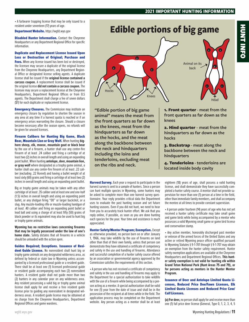
1. Front quarter - meat from the front quarters as far down as the knees
2. Hind quarter – meat from the hindquarters as far down as the hocks
3. Backstrap - meat along the backbone between the neck and hindquarters
4. Tenderloins - tenderloins are located inside body cavity
Edible portions of big game
3
21
HocksKnees
Animal on its back
Head
22
1
4
1
“Edible portion of big game animal” means the meat from the front quarters as far down as the knees, meat from the hindquarters as far down as the hocks, and the meat along the backbone between the neck and hindquarters including the loins and tenderloins, excluding meat on the ribs and neck.
2021 IMPORTANT HUNTING INFORMATIONHUN
T INFO
12 | 2021 wgfd.wyo.gov
or 9) through the initial drawing. After the initial drawing is completed, any person may apply for and receive up to two (2) full priced deer licenses provided that at least one (1) li-cense is a Limited Quota Type 3 any white-tailed deer license. However, no person shall apply for and receive more than a total of two (2) deer licenses valid for the taking of antlered or any deer, of which not more than one (1) shall be valid for antlered or any mule deer.
(b) For doe/fawn deer, any person may apply for and re-ceive a maximum of two (2) limited quota reduced price doe/fawn deer licenses (Type 6, 7 or 8) through the initial drawing. After the initial drawing is completed, any person may apply for and receive up to four (4) limited quota reduced price doe/fawn deer licenses. However, no person shall apply for and receive more than a total of four (4) limited quota reduced price doe/fawn deer licenses. In Hunt Areas 24, 27, 29, 30, 32, 33, 65 or 163 after the initial drawing is completed, any person may apply and receive an unlimited number of limited quota reduced price doe/fawn deer licenses.
(c) For antelope, no person shall apply for and receive more than one (1) full price antelope license (Type 0, 1, 2, 3, 4, 5 or 9) through the initial drawing. After the initial drawing is com-pleted, any person may apply for and receive up to two (2) full price antelope licenses. However, no person shall apply for and receive more than a total of two (2) full price antelope licenses.
(d) For doe/fawn antelope, any person may apply for and receive a maximum of two (2) limited quota reduced price doe/fawn antelope licenses (Type 6, 7 or 8) through the initial drawing. After the initial drawing is completed, any person may apply for and receive up to four (4) limited quota reduced price doe/fawn antelope licenses. However, no person shall apply for and receive more than a total of four (4) limited quo-ta reduced price doe/fawn antelope licenses.
(e) For elk, no person shall apply for and receive more than one (1) full price license (General, Type 0, 1, 2, 3, 4, 5 or 9) and one (1) reduced price cow/calf license (Type 6, 7 or 8) through the initial drawing. After the initial drawing, a person may apply for and receive up to a total of three (3) elk licenses, of which no more than one (1) shall be a General, Type 0, 1, 2, 3 or 9 license. However, no person shall apply for and receive more than a total of three (3) elk licenses which shall include not more than one (1) General, Type 0, 1, 2, 3 or 9 license in a single hunting season, except as authorized in Commission regulations.
(g) It is a violation to apply for and receive more than the spec-ified number of licenses allowed by Commission regulations.
Landowner Coupons: Antelope, Deer and Elk. An-telope, deer and elk licenses shall have two (2) coupons attached: one (1) designated “antelope, deer or elk car-cass coupon” and one (1) designated “landowner coupon”. When an antelope, deer or elk is harvested on a landown-er’s private land, the landowner coupon shall be promptly detached, dated, signed and delivered to the landowner. Landowner coupons are not transferable.
License Fraud Prohibited; Invalidation by Im-proper Fees. Department licenses, permits, stamps, tags or coupons shall not be altered by anyone other than authorized Department personnel. No license, permit, stamp, tag or coupon shall be transferred or used for the purpose of taking wildlife except by the individual to whom it was issued and therein named and while in that individual’s possession. No individual shall take or attempt to take any wildlife using another individual’s license, permit, stamp, tag or coupon. Any license, permit, stamp,
or tag shall not be valid unless the proper fees have been received by the Department. Any Wyoming Game and Fish law enforcement officer may seize as evidence any license, permit, stamp or tag that was obtained in violation of Com-mission regulations or Wyoming statutes.
Open Hours for Taking Big Game and Trophy Game Animals. Big game and trophy game animals may only be taken from one-half (1/2) hour before sunrise to one-half (1/2) hour after sunset.
Outfitter Information. Hunter responsibility when booking a big or trophy game outfitter or professional guide. No person shall directly or indirectly compensate a person holding them self out as engaging in the business of, or acting in the capacity of, an outfitter or a profession-al guide unless that person provides proof that they are a licensed outfitter or professional guide as required by statute. Before hiring an outfitter, the Department advises hunters to consult the Wyoming State Board of Outfitters and Professional Guides to verify the outfitter is licensed by the state of Wyoming. Landowners who outfit on their own deeded land, or deeded lands leased to them, are not required to be licensed as outfitters or guides. Contact: Wyoming State Board of Outfitters at 1950 Bluegrass Cir-cle Suite 280, Cheyenne, Wyoming, 82002 or call toll free 1-800-264-0981. Any license holder utilizing the services of an outfitter shall legibly print the name of the outfitter, the outfitter’s license number and the type of outfitter license on the back of licensee’s big or trophy game license.
Permission to Hunt, Fish, Trap or Collect Antlers or Horns. No person shall enter upon the private prop-erty of any person to hunt, fish, trap or collect antlers or
horns without the permission of the landowner or person in charge of the property. The license must bear the signa-ture of the landowner, lessee or agent of the landowner on whose private property the person is accessing or other legitimate proof as evidence that permission to hunt has been granted.
Precautions When Hunting in Areas Occupied by Grizzly Bears. Hunters and anglers are reminded grizzly bears occupy many areas in and around the Bridger-Teton, Shoshone and Caribou-Targhee National Forests in north-west Wyoming. The Department strongly recommends individuals working and recreating in these areas take precautions, including carrying bear pepper spray, to avoid conflicts with grizzly bears. Information about human safety and proper storage of food and other attractants in occupied grizzly habitat is available from the Cheyenne Headquarters, Department Regional Offices, U.S. Forest Service Offices and the Department website. Regulations concerning food/carcass storage in occupied grizzly hab-itat can be obtained from the U.S. Forest Service. Report all conflicts with grizzly bears to the nearest Department Regional Office.
For information about staying safe in bear country, visit the Department bear wise page: https://wgfd.wyo.gov/Bear-Wise-Print.
Prohibited Acts. It is Illegal to:
• Shoot or attempt to kill any wildlife from any public road or highway. No person shall fire any firearm from, upon, along or across any public road or highway. No person shall knowingly fire any rifle from the enclosed lands of one person onto or across the enclosed lands of another without the permission of both persons.
• Use any dog to hunt, run or harass any big or trophy game animal, protected animal or furbearing animal ex-cept as otherwise provided by statute. The Commission shall regulate the use of dogs to take mountain lions and bobcats during hunting or trapping seasons.
• Use any aircraft with the intent to spot, locate and aid in the taking of any game animal from August 1 through January 31 of the following calendar year. Additionally, no person shall use any aircraft to spot, locate and aid in the taking of any trophy game animal during any open season. This shall not apply to the operation of an aircraft in a usual manner where there is no attempt or intent to locate any game animal, such as aircraft used for the sole purpose of passenger transport.
• Take and leave, abandon or allow the edible portion of any game bird, game fish or game animal (except trophy game animal) to intentionally or needlessly go to waste.
• Transport illegally taken wildlife across state lines; such transportation is a violation of the Federal Lacey Act.
• Place any bait for the purpose of taking a big game an-imal or knowingly take a big game animal by the use of bait, except as authorized by Commission regulation or state statute.
• Allow the edible portions of a big game animal to spoil. Failure to properly dress and care for any big game animal you have killed, and, if the carcass is reasonably accessi-ble, within forty-eight (48) hours to take or transport the carcass to your camp, and there properly care for the car-cass is prima facie evidence of a violation.
• Abandon meat from a big game animal or game bird at a meat processing plant. Unless there is an express agree-
2021 IMPORTANT HUNTING INFORMATION
Common violations
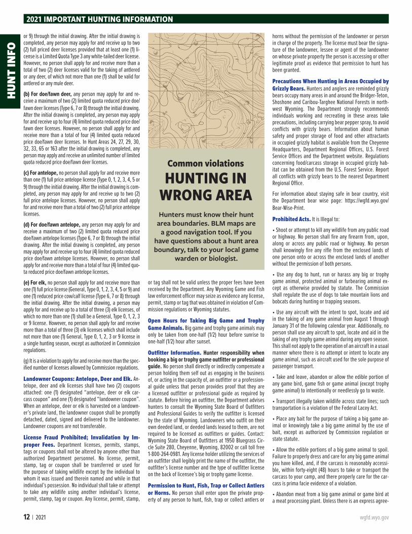
HUNTING IN WRONG AREAHunters must know their hunt
area boundaries. BLM maps are a good navigation tool. If you
have questions about a hunt area boundary, talk to your local game
warden or biologist.
HUN
T IN
FO

wgfd.wyo.gov Wyoming Hunting Regulations | 13
ment between the processing plant and the person provid-ing otherwise, any meat from a big game animal or game bird left at a meat processing plant for more than forty-five (45) days is prima facie evidence of a violation if written notice of the expiration of time has been attempted by the processing plant in accordance with rules and regulations promulgated by the Commission.
• Carry a firearm with a cartridge therein, or take any wildlife, while intoxicated or under the influence of any controlled substance.
• Harass, pursue, hunt, shoot or kill any Wyoming wildlife except predatory animals with, from or by use of any fly-ing machine, automotive vehicle, trailer, motor-propelled wheeled vehicle or vehicle designed for travel over snow. The Commission may exempt handicapped hunters from any of these provisions. It is also illegal to shoot waterfowl from a boat under power or sail.
Retention of Evidence to Identify Sex, Species and Horn or Antler Development of Big Game An-imal Harvested. Any person who takes any big game animal in a hunt area where the taking of either sex, spe-cies, or antler or horn development is controlled or pro-hibited by regulation shall comply with this section while said animal is in transportation from the site of the kill to the residence of the person taking the animal, or delivered to a processor for processing.
(a) In hunt areas where the taking of any big game animal is restricted to antler point or horn size by regulation, the antlers or horns shall accompany the carcass, or edible portions thereof.
(b) In hunt areas where the taking of any big game an-imal is restricted to a specific sex of animal by regulation, either the visible external sex organs, head or antlers shall accompany the carcass, or edible portions thereof.
(c) In hunt areas where the taking of a species of deer is controlled or prohibited by regulation, either the head or the tail of the deer shall accompany the carcass or edible portion thereof as evidence of the species taken.
Retrieval of Game Animals from the Field.
(a) The Department may require substantive proof from any person who fails to retrieve from the site of kill all edible portions of a big game animal as to why the edible portions were not removed from the field.
(b) Wounding and Retrieving. No person shall wound or kill any game animal without making a reasonable effort to retrieve it and reduce it to possession. For the purpose of this subsection, making a reasonable effort shall include a person physically going to the nearest location where the game animal was when a person attempted to take the game animal, in order to search for any sign the game animal was wounded or killed, and take the game animal into possession.
Shipping Game Animals and Game Birds out of State. Except as otherwise exempt by state statute, no game animal or game bird, or any part thereof, shall be shipped or transported from the state except by the person who harvested the animal, and in possession of the proper license, stamp and carcass coupon as required, or unless the amount does not exceed twenty five (25) pounds and is properly tagged with a Wyoming interstate game tag. Not more than twenty five (25) pounds from any one (1) big or trophy game animal may be exported from the state unless the part to be exported from the state is of a nonedible
trophy or hidelike nature and properly tagged with a Wyo-ming interstate game tag or the big or trophy game animal was legally harvested by a nonresident and is tagged with a Wyoming interstate game tag.
Shipping Game Animals and Game Birds within Wyoming. Except as otherwise exempt by state statute, no person shall ship, transport or receive for shipment or transportation within Wyoming any game animal, game bird, or any part thereof, unless tagged with a Wyoming interstate game tag, or unless the transportation of a big or trophy game animal is by a person in possession of a proper carcass coupon signed and dated by the person who harvested the animal, or the transportation of game birds or small game is by a properly licensed hunter in pos-session of not more than the daily bag or possession limit.
Taking Predatory Animals and Predacious Birds. Predatory animals and predacious birds may be taken without a license.
Use of Leashed Dogs for Tracking. A person may use one (1) leashed blood-trailing dog to track a wounded or killed big game animal within seventy-two (72) hours of shooting the animal. A person using a dog in this manner:
• Shall maintain physical control of the dog at all times by means of a maximum fifty (50) foot leash attached to the collar or harness of the dog;
• Shall wear fluorescent orange or fluorescent pink consis-tent with Wyoming Statute § 23-3-113(a);
• May kill the wounded animal using any weapon autho-rized under the hunting license; and,
• Shall, in accordance with Wyoming Statute § 23-3-104, attach the proper coupon to the carcass of any animal killed under the hunting license.
A person acting solely as a dog handler accompanying the licensed hunter that wounded the game animal is exempt from the licensing requirement of this act. Nothing in this section shall be construed to allow a dog handler to hunt without a license.
Use of Specialized Hunting Technologies and Equipment.
(a) No person shall use any device attached to a legal firearm, muzzleloader or archery equipment, capable of producing a thermal or infrared image, or other imaging outside the normal visible light spectrum, with the intent to spot, locate and aid in the taking of any big game ani-mal, trophy game animal or wild bison.
(b) No person shall use any real-time video photography equipment, thermal or infrared imaging device, or other imaging device outside the normal visible light spectrum, with the intent to spot, locate and aid in the taking of any big game animal, trophy game animal or wild bison.
(c) A trail camera, or similar device, that can only store an image, picture or video inside the device, and which does not have the capability to utilize cellular or WiFi technology to transmit images or video for remote viewing is permissible for use in the taking of any
big game animal, trophy game animal or wild bison.
(d) No person shall sell or barter any geographic location information for any big game animal, trophy game animal or wild bison to aid in the taking of any big game animal, trophy game animal or wild bison.
Vehicle Restrictions on Federal Land. Sportsper-sons are advised that many areas of National Forest and Bureau of Land Management lands are subject to travel and vehicle use limitations to protect resources. Maps and additional information regarding these limitations are available at U.S. Forest Service, Bureau of Land Manage-ment and other agency offices near these public lands.
Wilderness Areas. Nonresident big game and trophy game hunters must be accompanied by a professional or resident guide when hunting in designated wilderness areas.
Wildlife Violator Compact. Wyoming is a member of the Wildlife Violator Compact. The Compact enables a vio-lator from any member state to accept a wildlife citation and proceed on their way without being required to post an appearance bond unless the violation requires MUST APPEAR and NO BOND ACCEPTED. The Compact provides for the suspension of wildlife license privileges in the home state of any person whose license privileges have been suspended by a participating state. If you have had your privileges suspended in any of the participating states, you may lose your privileges in Wyoming, in addition to all the participating Compact states. Additional informa-tion about the Compact can be obtained by contacting the Wildlife Law Enforcement Coordinator at (307) 233-6413.
Wind River Reservation. Only non-Indian owned, fee title lands are open to the taking of wildlife with a State of Wyoming license. Land status is complicated and lawful access must be investigated thoroughly. Sportspersons are advised it is their responsibility to determine land sta-tus prior to entering these areas.
Common violations
NO FLUORESCENT ORANGE/FLUORESCENT
PINK CLOTHINGBig game and trophy game rifle and muzzleloader hunters are required
to wear one exterior garment of fluorescent orange or fluorescent pink. This also applies to archery hunters hunting during the rifle
season. This could be a hat, shirt, jacket, coat, vest or sweater.
Fluorescent orange or fluorescent pink camouflage is legal.
2021 IMPORTANT HUNTING INFORMATIONHUN
T INFO
14 | 2021 wgfd.wyo.gov
P A R KP A R K
C A M P B E L LC A M P B E L L
C R O O KC R O O K
S H E R I D A NS H E R I D A N
T E T O NT E T O N J O H N S O NJ O H N S O N
W E S T O NW E S T O N
W A S H A K I EW A S H A K I E
H O T S P R I N G SH O T S P R I N G S
F R E M O N TF R E M O N T
N A T R O N AN A T R O N AC O N V E R S EC O N V E R S E
S U B L E T T ES U B L E T T E
L I N C O L NL I N C O L N
P L A T T EP L A T T E
C A R B O NC A R B O N
A L B A N YA L B A N Y
S W E E T W A T E RS W E E T W A T E R
L A R A M I EL A R A M I E
U I N T AU I N T A
B I G H O R NB I G H O R NBuffalo
Casper
Cheyenne
Cody
Douglas
Evanston
Gillette
Glenrock
GreenRiver
Greybull
Jackson
Kemmerer
Lander
Laramie
Lovell
Lusk
Newcastle
Pinedale
Powell
Rawlins
Riverton
RockSprings
Sheridan
Sundance
Thermopolis
TorringtonWheatland
Worland
PHELPSLAKE
LEIGHLAKE
JENNYLAKE
LOSTCREEKLAKE
FLAMINGGORGE
RESERVOIR
EDEN VALLEYRESERVOIR
BOULDERLAKE
FREMONTLAKE
FONTENELLERESERVOIR
HAWKSPRINGS RES
WHEATLANDRES 3
WHEATLANDRES 2
LONGLAKE
COOPERLAKE
GLENDORESERVOIR
PATHFINDERRESERVOIR
DESMETLAKE
YELLOWSTONELAKESHOSHONE
LAKELEWISLAKE
HEART LAKE
JACKSONLAKE
BOYSENRESERVOIR
BULLLAKE
OCEANLAKE
RED LAKE
HAYRESERVOIR
BIGSANDY
RESERVOIR
WILLOWLAKE
HALFMOONLAKE
GREEN RIVERLAKES
ALCOVARESERVOIR
LAKE HATTIE
SEMINOERESERVOIR
KEYHOLERESERVOIR
BUFFALOBILL
RESERVOIR
FlamingGorge NRA
BighornCanyon NRA
Shoshone NF
Bighorn NFBlack
Hills NF
BlackHills NF
Bridger-Teton NF
Targhee NF
Caribou NF
ShoshoneNF
MedicineBow NF
MedicineBow NF
Ashley NF
MedicineBow NF
MedicineBow NF
Wasatch-CacheNF
Afton
Albin
Alpine
Baggs
Bairoil
Bar Nunn
Basin
BigPiney
Burlington
Burns
Byron
Chugwater
Clearmont
Cokeville
Cowley DaytonDeaver
Diamondville
Dixon
Dubois
Edgerton
ElkMountain
FortLaramie
Frannie
Glendo
Encampment
Granger
Guernsey
Hanna
Hartville
Hudson
Hulett
Kaycee
Kirby
La Barge
La Grange
Lingle
LostSprings
Lyman
Manderson
Manville
Marbleton
MedicineBow
Meeteetse
Midwest
Moorcroft
MountainView
Opal
Pavillion
PineBluffs
PineHaven
Ranchester
Riverside
RockRiver
RollingHills
Saratoga
Shoshoni
SinclairSuperior
TenSleep
Thayne
Upton
VanTassell
Wamsutter
Wright
Yoder
Tho mps on Cr
Sheep C
r
Wind River
Pow
de rRiver
Gre
enRiver
Horse Cr
BighornRiv
er
Hams Fk
Sweetwater River
Greyb
ull River
Clear Cr
Blacks Fk Bitter Cr
Snak
e River
LaramieRiv
er
NowoodRi
ver
Poison Cr
Lodgepole Cr
Belle
Four
che
River
DryC
r
Shell Cr
Fivemile Cr
Ro
ck Cr
Sm
iths
Fk
Antelope Cr
Dry Fk
Henrys Fk
SouthFk Po
wder
Ri v
e rMuddy Cr
Lamar River
Ra whi de
Cr
Grass Cr
Muskrat Cr
Littl
eSandy Ri
ver
De
er Cr
Cottonwood Cr
Be aver Cr
P ass Cr
Paci ficCr
Bear
Rive
r
S hute Cr
Bear Cr
E lk CrElkFk
Horseshoe Cr
La Barge Cr
Littl
e Missouri River
Bates Cr
Big Sandy River
Big Dry Cr
Mush Cr
Cow Cr
Fontenelle Cr
Box
Elde
r Cr
North Laramie River
Sybille
Cr
Medicine Bow River
Su
gar Cr
S age Cr
Cra
z yW
oman
Cr
Kir by Dr
Cast le
Cr
French Cr
HayCr
Sep
arat
ionCr
Alkali Cr
Yellowstone
River
Little Bear Cr
Old
Wom
anC
r
No rth Piney Cr
Caballo Cr
Black Thunder Cr
Littl e Muddy Cr
Little Wind River
Salt Cr
Poison Spider Cr
Middl
eFk
Casper Cr
Li ttleLar
amie River
Co on
Cr
L o stC
r
Twen
tymile
Cr
Slate Cr
Kirby Cr
BuffaloCr
Eas t Fk R iver
Wildca t C r
O sborne Dr
Trout Cr
Dutton Cr
South Fk Casper C r
RavenCr
LaPr
ele
Cr
Falls River
Cave Gulch
Wi llow Cr
Hoe Cr
Gibbon River
Cole
Cr
Porcupine Cr
Cooper Cr
Snyder Cr
Creston Dr
Little Thunder Cr
NorthBear Cr
LX
Bar Cr
Teap
otCr
BobCr
Barrel Springs Dr
Loga
nG
u lch
Bull Lake Cr
Sout h F k
NorthPopo Agie River
Twin C r
Stra
tton
Dr
Vermillion Cr
DryPiney Cr
Austin Cr
Sand
Sprin
g Cr
Tower Cr
Fortification Cr
Blac
ksFk
Cana
l
SmithC
r
Meadow Springs Wash
Spread C r
Cougar Cr
Littl
eB
igho
rnRi
ver
Lew
isR
iver
Bech
lerRiver
Wild Cow Cr
No
rthFk Little Wind River
Blackrock
Cr
Gallitin River
Little
L igh
tnin
gCr
Pelton C r
Hunton Cr
Wi llow Cr
HorseC
r
Sage Cr
GreenRiver
Cottonwood Cr
BearC
r
Beaver C r
Bear Cr
Mud
dy Cr
Dry Cr
Alka
liCr
Buffalo Cr
Mud dy Cr
Skull
Cr
Ro c
kC
r
Cow
Cr
Dry Cr
Sage Cr
Sand Cr
Sage C r
YellowstoneRiv er
Horse Cr
Dry Cr
Alkali Cr
Fivemile
Cr
Dee r Cr
Canyon Cr
Ra
whide Cr
Snak e River
Bear Cr
Sand Cr
Beaver Cr
Dry Cr
North Platte River
North
Pl a t te River
GreysRi ve r
Belle Fourch
e River
Owl Cr
Mud
dy Cr
Gooseberry Cr
Fifteenmile Cr
Crow
Cr
LittlePow
derRiver
Sa lt Wells
Cr
Tongue River
Nowater CrWig
gins Fk
Jack
Cr
Wal
ker Cr
ArchC
r
New
FkR
iver
SouthFk
Shos
hone
Riv e
r
Dry Fk Cheyenne River
Pain
t Rock Cr
Wi ld Horse
Cr
La Bonte
C r
North Fk Powder River
Iron Cr
South Piney Cr
Killp
ecke
r Cr
Buck Dr
North Fk Shoshone River
Sage
Hen
Cr
WillowCr
AlbertC
r
South Beaver Cr
Black ButteC
r
Middle Fk Powder River
Buffalo Fk
Save
ry Cr
Meetee tse Cr
Buck
horn
Can
yon
Fourmile Cr
Horse Cr
Fillm
ore
Cr
Enca
mpm
ent R
iver
L ittle Sage Cr
Deep
Cr
Morrow Cr
Paint Cr
Foster C
r
Eig
htee
nmile
Can
yon
North Horse Cr
Ishawooa Cr
Sevenmile
Cr
Medic
ine Lodge Cr
North Barrel Springs Dr
Sout
h Spring
Cr
Dead
Indian
Cr
North Fk
Little Greys Riv e r
East Fk Nowater Cr
Beartrap
CrSouth Cottonwood Cr
Alkali
Cr
Pumpkin Cr
North Fk
Madison R iver
Goose
Cr
Diam
ondSp
r ings
Dr
Mid dle Fk
Crandall Cr
Red Fk
Timber Cr
Middle Fk
North Fk
South F k
North Fk Cottonwood Cr
North Fk Box Cr
Ott e r Cr
Buffa
loCr
Be ar Cr
Sand
Cr
Sage Cr
Buffa
l oC
r
Duck Cr
Pacific Cr
SandC
r
Will
ow
Cr
Horse Cr
Beaver C
r
Cot
tonw
ood
Cr
Muddy Cr
AlkaliCr§̈¦I80
§̈¦I25
§̈¦I90
§̈¦I80
§̈¦I25
§̈¦I25
§̈¦I80
§̈¦I25
§̈¦I90
§̈¦I90
£¤26
£¤191
£¤18
£¤16
£¤85
£¤189
£¤89
£¤287
£¤14
£¤85
£¤89
£¤16
£¤20
£¤30
£¤14
£¤20 £¤16
£¤26
£¤191
£¤191
£¤191
£¤310
£¤87
£¤14A
£¤14A
£¤18
£¤18
£¤14£¤14
£¤14
£¤14
£¤85
£¤287
£¤287
£¤189
£¤20
£¤189
£¤20
£¤89
£¤191
£¤20
£¤287
£¤26
£¤85
£¤16
£¤26
£¤14
£¤85
£¤287
£¤30
£¤212
£¤30
£¤20
£¤16
£¤212
£¤14
£¤287
£¤16
£¤85
£¤26
£¤16
£¤30
£¤26
£¤89
³±487
³±59
³±34
³±430
³±50
³±789
³±120
³±530
³±70
³±270
³±135
³±116
³±192
³±32
³±24
³±387
³±585
³±310
³±28
³±372
³±431
³±351
³±313
³±93
³±22
³±433
³±94
³±132
³±352
³±71
³±215
³±190
³±211
³±253
³±156
³±374
³±319
³±320
³±232
³±114
³±11
³±410
³±294
³±225
³±233
³±238
³±10
³±111
³±335
³±92
³±295
³±290
³±214
³±161
³±314
³±157³±160
³±154
³±73
³±151
³±158
³±235
³±96
³±377
³±315
³±413
³±152
³±133
³±311
³±217
³±218
³±173
³±24
³±136
³±59
³±789
³±89
³±59
³±90
³±220
³±196
³±130
³±130
³±120
³±414 ³±230
³±230
³±450
³±91
³±77
³±150
³±434
³±112
³±12
³±412
³±291
³±216
³±51
³±37
³±316
³±138 ³±95
³±113
³±371
³±223
³±251
³±343
³±370
³±451
³±411
³±193
³±341
³±271
³±435
³±331
³±273
³±30
³±120
³±789
³±487
³±28
³±789
³±116
³±191
³±89
³±338
³±272
Y e l l o w s t o n eN a t i o n a l
P a r k
8017
1815
1109
79
2
781610 3
102 19
582 77 4
2224
23114 720110
8384 676
85
26
1172711321
75 8
25738786 2997
889
71
101
6631
30
47
89 1191
10398 63
9348
4292 62
6096 38
46100 94 56
34
50 43575859
4552
9599112 51 44 37 111
61
65
32
53
67
106
10764
10855
115
7274
6869
81
90
THIS MAP IS FOR GENERAL REFERENCE ONLY. Please use the written boundary descriptions in this regulation for detailed boundary information.
2021 ANTELOPE HUNT AREAS
Thunder Basin
NG
Thunder Basin
NG
Thunder Basin
NG
Note: Wilderness area, nonresidents must have guides
70
P A R KP A R K
C A M P B E L LC A M P B E L L
C R O O KC R O O K
S H E R I D A NS H E R I D A N
T E T O NT E T O N J O H N S O NJ O H N S O N
W E S T O NW E S T O N
W A S H A K I EW A S H A K I E
H O T S P R I N G SH O T S P R I N G S
F R E M O N TF R E M O N T
N A T R O N AN A T R O N AC O N V E R S EC O N V E R S E
S U B L E T T ES U B L E T T E
L I N C O L NL I N C O L N
P L A T T EP L A T T E
C A R B O NC A R B O N
A L B A N YA L B A N Y
S W E E T W A T E RS W E E T W A T E R
L A R A M I EL A R A M I E
U I N T AU I N T A
B I G H O R NB I G H O R NBuffalo
Casper
Cheyenne
Cody
Douglas
Evanston
Gillette
Glenrock
GreenRiver
Greybull
Jackson
Kemmerer
Lander
Laramie
Lovell
Lusk
Newcastle
Pinedale
Powell
Rawlins
Riverton
RockSprings
Sheridan
Sundance
Thermopolis
TorringtonWheatland
Worland
PHELPSLAKE
LEIGHLAKE
JENNYLAKE
LOSTCREEKLAKE
FLAMINGGORGE
RESERVOIR
EDEN VALLEYRESERVOIR
BOULDERLAKE
FREMONTLAKE
FONTENELLERESERVOIR
HAWKSPRINGS RES
WHEATLANDRES 3
WHEATLANDRES 2
LONGLAKE
COOPERLAKE
GLENDORESERVOIR
PATHFINDERRESERVOIR
DESMETLAKE
YELLOWSTONELAKESHOSHONE
LAKELEWISLAKE
HEART LAKE
JACKSONLAKE
BOYSENRESERVOIR
BULLLAKE
OCEANLAKE
RED LAKE
HAYRESERVOIR
BIGSANDY
RESERVOIR
WILLOWLAKE
HALFMOONLAKE
GREEN RIVERLAKES
ALCOVARESERVOIR
LAKE HATTIE
SEMINOERESERVOIR
KEYHOLERESERVOIR
BUFFALOBILL
RESERVOIR
FlamingGorge NRA
BighornCanyon NRA
Shoshone NF
Bighorn NFBlack
Hills NF
BlackHills NF
Bridger-Teton NF
Targhee NF
Caribou NF
ShoshoneNF
MedicineBow NF
MedicineBow NF
Ashley NF
MedicineBow NF
MedicineBow NF
Wasatch-CacheNF
Afton
Albin
Alpine
Baggs
Bairoil
Bar Nunn
Basin
BigPiney
Burlington
Burns
Byron
Chugwater
Clearmont
Cokeville
Cowley Dayton
Deaver
Diamondville
Dixon
Dubois
Edgerton
ElkMountain
FortLaramie
Frannie
Glendo
Encampment
Granger
Guernsey
Hanna
Hartville
Hudson
Hulett
Kaycee
Kirby
La Barge
La Grange
Lingle
LostSprings
Lyman
Manderson
Manville
Marbleton
MedicineBow
Meeteetse
Midwest
Moorcroft
MountainView
Opal
Pavillion
PineBluffs
PineHaven
Ranchester
Riverside
RockRiver
RollingHills
Saratoga
Shoshoni
SinclairSuperior
TenSleep
Thayne
Upton
VanTassell
Wamsutter
Wright
Yoder
Tho mps on Cr
Sheep C
r
Wind River
Pow
de rRiver
Gre
enRiver
Horse Cr
BighornRiv
er
Hams Fk
Sweetwater River
Greybull River
Clear Cr
Blacks Fk Bitter Cr
Snak
e River
LaramieRiv
er
Nowood
Rive
r
Poison Cr
Lodgepole Cr
Belle
Four
che
R
iver
DryC
r
Shell Cr
Fivemile Cr
Ro
ck Cr
Sm
iths
F k
Antelope Cr
Dry Fk
Henrys Fk
SouthFk Po
wder
Ri v
er
Muddy Cr
Lamar R
ive r
Rawh ide Cr
Grass Cr
Muskrat Cr
Littl
eSandy Ri
ver
Dee
r Cr
Cottonwood Cr
Be aver Cr
P ass Cr
Paci f icCr
Bear
Rive
r
S hute Cr
Bear Cr
E lk CrElkFk
Horseshoe Cr
La Barge Cr
Littl
e Missouri River
Bates Cr
Big Sandy River
Big Dry Cr
Mush Cr
Cow Cr
Fontene lle Cr
Box
Elde
r Cr
North Laramie River
Sybille
Cr
Medicine Bow RiverSu
gar Cr
Sage C
r
Cra
zyW
oman
Cr
Kirby Dr
Castle
Cr
French Cr
HayCr
Sepa
ratio
n Cr
Alkali Cr
Yellowstone
River
Little Bear Cr
Old
Wom
anC
r
No rth Piney Cr
Ca ballo Cr
Black Thunder Cr
Littl e Muddy Cr
L ittle Wind River
Salt Cr
Poison Spider Cr
Middl
e Fk
CasperCr
Li t tle Lar
amie River
Co on
Cr
L ost
Cr
Twen
tym
ile
Cr
Sla te Cr
Kirby Cr
BuffaloCr
Eas t Fk R ive r
Wildca t C r
O sborne Dr
Trout Cr
Dutton Cr
South Fk Casper C r
RavenCr
LaPr
ele
Cr
Falls River
Cave Gulch
Wi llow Cr
Hoe Cr
Gibbon River
Cole
Cr
Porcupine Cr
Cooper Cr
Snyder Cr
Creston Dr
Little Thunder Cr
NorthBear Cr
LX
Bar Cr
Teap
otCr
BobCr
Barrel Spring s Dr
Loga
nG
ulch
Bull Lake
Cr
Sout h F k
NorthPopo Agie River
Twin C r
Stra tton
Dr
Vermillion Cr
DryPiney Cr
AustinCr
Sand
Sprin
g Cr
Tower Cr
Fortification Cr
Blac
ksFk
Cana
l
SmithC
r
Meadow Springs Wash
Spread Cr
Cougar Cr
Littl
eB
i gho
rnRi
ver
Lew
isR
iver
Be c
hler River
Wild Cow Cr
No
rthFk L ittle Wind River
Blackrock
Cr
Gallitin River
Little
L igh
tnin
gCr
PeltonC r
Hunton Cr
Wi llow Cr
HorseC
r
Sage Cr
GreenRiver
Cottonwood Cr
BearC
r
Beaver Cr
Bear Cr
Mud
dy
Cr
Dry Cr
Alka
liCr
Buffalo Cr
Mud dy Cr
Skull
Cr
Roc
kC
r
Cow
Cr
Dry Cr
Sage Cr
S and Cr
Sage Cr
Yellowstone
Riv er
Horse Cr
Dry Cr
Alkal i Cr
Fivemile
Cr
Deer Cr
Canyon Cr
Ra
whide Cr
Snak e River
Bear Cr
Sand C r
Beaver Cr
Dry Cr
North Platte River
North
Pl a t te River
GreysR
ive r
Belle Fourch
e River
Owl Cr
Mud
dy Cr
Gooseberry Cr
Fifteenmile Cr
Cro
wCr
LittlePow
derRiver
Salt Wells
Cr
Tongue River
Nowater CrWig
gins Fk
Jack
Cr
Wal
ker Cr
ArchC
r
New
FkR
iver
SouthFk
Shos
hone
Rive
r
Dry Fk Cheyenne River
Pain
t Rock Cr
Wild Horse Cr
La B onte
Cr
North Fk Powder River
Iron Cr
South Piney Cr
Killp
e cke
r Cr
Buck Dr
North Fk Shoshone River
Sage
Hen
C r
WillowCr
AlbertC
r
South Beaver Cr
Black ButteCr
Middle Fk Powder River
Buffalo Fk
Save
ry Cr
Meeteetse Cr
Buck
horn
Can
yon
Fourmile Cr
Horse Cr
Fillm
ore
Cr
Enc
ampm
ent R
iver
L ittle Sage Cr
Deep
Cr
Morrow Cr
Paint Cr
FosterC r
Eig
htee
nmile
Can
yon
North Horse Cr
Ishawooa Cr
Sevenmile
Cr
Medic
ine Lodge Cr
North Barrel Springs Dr
Sout
h Spring
Cr
De a
d Indian Cr
North Fk
Li ttle Greys Riv e r
East Fk Nowater Cr
Beartra p
Cr
South Cottonwood Cr
Alkali
Cr
Pumpkin Cr
North Fk
Madison R iver
Goose
Cr
Diamond
Spr
ingsDr
Mid dle Fk
Crandall Cr
Red Fk
Timber Cr
Mid dle Fk
North Fk
South F k
North Fk Cottonwood Cr
North Fk Box Cr
Ott e r Cr
Buffa
loC r
Be ar Cr
Sand
Cr
Sage Cr
Buffa
l oC
r
Duck Cr
Pacific Cr
SandC
r
Will
ow
Cr
Horse Cr
Be
aver Cr
Cot
tonw
ood
Cr
Muddy Cr
AlkaliCr
§̈¦I80
§̈¦I25
§̈¦I90
§̈¦I80
§̈¦I25
§̈¦I25
§̈¦I80
§̈¦I25
§̈¦I90
§̈¦I90
£¤26
£¤191
£¤18
£¤16
£¤85
£¤189
£¤89
£¤287
£¤14
£¤85
£¤89
£¤16
£¤20
£¤30
£¤14
£¤20 £¤16
£¤26
£¤191
£¤191
£¤191
£¤310
£¤87
£¤14A
£¤14A
£¤18
£¤18
£¤14£¤14
£¤14
£¤14
£¤85
£¤287
£¤287
£¤189
£¤20
£¤189
£¤20
£¤89
£¤191
£¤20
£¤287
£¤26
£¤85
£¤16
£¤26
£¤14
£¤85
£¤287
£¤30
£¤212
£¤30
£¤20
£¤16
£¤212
£¤14
£¤287
£¤16
£¤85
£¤26
£¤16
£¤30
£¤26
£¤89
³±487
³±59
³±34
³±430
³±50
³±789
³±120
³±530
³±70
³±270³±135
³±116
³±192
³±32
³±24
³±387
³±585
³±310
³±28
³±372
³±431
³±351
³±313
³±93
³±22
³±433
³±94
³±132
³±352
³±71
³±215
³±190
³±211
³±253
³±156
³±374
³±319
³±320
³±232
³±114
³±11
³±410
³±294
³±225
³±233
³±238
³±10
³±111
³±335
³±92
³±295
³±290
³±214
³±161
³±314
³±157³±160
³±154
³±73
³±151
³±158
³±235
³±96
³±377
³±315
³±413
³±152
³±133
³±311
³±217
³±218
³±173
³±24
³±136
³±59
³±789
³±89
³±59
³±90
³±220
³±196
³±130
³±130
³±120
³±414 ³±230
³±230
³±450
³±91
³±77
³±150
³±434
³±112
³±12
³±412
³±291
³±216
³±51
³±37
³±316
³±138 ³±95
³±113
³±371
³±223
³±251
³±343
³±370
³±451
³±411
³±193
³±341
³±271
³±435
³±331
³±273
³±30
³±120
³±789
³±487
³±28
³±789
³±116
³±191
³±89
³±338
³±272
Y e l l o w s t o n eN a t i o n a l
P a r k
8017
1815
1109
79
2
781610 3
102 19
582 77 4
2224
23114 720110
8384 676
85
26
1172711321
75 8
25738786 2997
889
71
101
6631
30
47
89 1191
10398 63
9348
4292 62
6096 38
46100 94 56
34
50 43575859
4552
9599112 51 44 37 111
61
65
32
53
67
106
10764
10855
115
7274
6869
81
90
THIS MAP IS FOR GENERAL REFERENCE ONLY. Please use the written boundary descriptions in this regulation for detailed boundary information.
2020 ANTELOPE HUNT AREAS
Thunder Basin
NG
Thunder Basin
NG
Thunder Basin
NG
Note: Wilderness area, nonresidents must have guides
70
ANTELOPE2021 ANTELO
PE HUNTING SEASONS

wgfd.wyo.gov
Wyoming Hunting Regulations | 15
2021 ANTELOPE HUNTING SEASO
NS1
2
Buck
1 Yearling buck antelope
ANTELOPE CHARACTERISTICSThe ability to distinguish between buck, doe and yearling buck antelope is
critical to hunters holding licenses valid for only does and fawns.
1. Horns - Should be prominent with a prong or point between the base and tip and extend beyond the ears for adult males. Yearling bucks have shorter horns, typically at ear-length. Does often grow horns, which occasionally grow to the length of the ears.
2. Cheek patch – Both yearling bucks and adult bucks have a black cheek patch below the ear at the angle of the jaw. Even among fawns, which usually lack visible horns, the black cheek patches distinguish males from females. Females lack the black cheek patch.
1
2
Doe
2
Section 2. Antelope Hunting Seasons. Hunt areas, season dates and limitations.
ANTELOPE
1 1 Aug. 15 Sep. 30 Oct. 1 Nov. 20 250 Any antelope
1 6 Aug. 15 Sep. 30 Oct. 1 Nov. 20 100 Doe or fawn
2 1 Aug. 15 Sep. 30 Oct. 1 Nov. 20 200 Any antelope
2 6 Aug. 15 Sep. 30 Oct. 1 Nov. 20 200 Doe or fawn
3 1 Aug. 15 Sep. 30 Oct. 1 Nov. 20 200 Any antelope
3 6 Aug. 15 Sep. 30 Oct. 1 Nov. 20 50 Doe or fawn
4 1 Aug. 15 Sep. 30 Oct. 1 Nov. 20 100 Any antelope
4 6 Aug. 15 Sep. 30 Oct. 1 Nov. 20 25 Doe or fawn
5 1 Aug. 15 Sep. 30 Oct. 1 Nov. 20 100 Any antelope
5 7 Aug. 15 Sep. 30 Oct. 1 Nov. 20 75 Doe or fawn valid on private land
6 1 Aug. 15 Sep. 30 Oct. 1 Oct. 15 250 Any antelope, also valid on private land in that portion of Area 8 in Weston County
7 1 Aug. 15 Sep. 30 Oct. 1 Oct. 15 400 Any antelope
7 8 Aug. 15 Sep. 30 Oct. 1 Oct. 31 75 Doe or fawn valid east of Wyoming High-way 116 and south of Mush Creek
8 1 Aug. 15 Sep. 30 Oct. 1 Oct. 15 250 Any antelope
9 1 Aug. 15 Sep. 30 Oct. 1 Oct. 31 375 Any antelope, also valid in that portion of Area 11 in Converse or Niobrara counties
9 6 Aug. 15 Sep. 30 Oct. 1 Oct. 31 100 Doe or fawn, also valid in that portion of Area 11 in Converse or Niobrara counties
10 1 Aug. 15 Sep. 30 Oct. 1 Oct. 14 300 Any antelope
10 6 Aug. 15 Sep. 30 Oct. 1 Oct. 31 400 Doe or fawn
11 1 Aug. 15 Sep. 30 Oct. 1 Oct. 31 400 Any antelope
11 6 Aug. 15 Sep. 30 Oct. 1 Oct. 31 200 Doe or fawn
15 1 Aug. 15 Sep. 30 Oct. 1 Oct. 14 600 Any antelope
15 6 Aug. 15 Sep. 30 Oct. 1 Nov. 30 800 Doe or fawn
16 1 Aug. 15 Sep. 30 Oct. 1 Oct. 14 400 Any antelope
16 6 Aug. 15 Sep. 30 Oct. 1 Oct. 31 200 Doe or fawn
17 1 Aug. 15 Sep. 30 Oct. 1 Oct. 31 900 Any antelope
17 6 Aug. 15 Sep. 30 Oct. 1 Oct. 31 150 Doe or fawn
18 1 Aug. 15 Sep. 30 Oct. 1 Oct. 20 200 Any antelope
18 6 Aug. 15 Sep. 30 Oct. 1 Oct. 20 50 Doe or fawn
Hunt Area
LicenseType
SpecialArchery Dates
RegularSeason Dates Quota Limitations
Opens Closes Opens Closes

16 | 2021 wgfd.wyo.gov
ANTELOPE
Hunt Area
LicenseType
SpecialArchery Dates
RegularSeason Dates Quota Limitations
Opens Closes Opens Closes
Hunt Area
LicenseType
SpecialArchery Dates
RegularSeason Dates Quota Limitations
Opens Closes Opens Closes19 1 Aug. 15 Sep. 30 Oct. 1 Oct. 20 300 Any antelope
19 7 Aug. 15 Sep. 30 Oct. 1 Oct. 20 150 Doe or fawn valid on private land
20 1 Aug. 15 Oct. 14 Oct. 15 Nov. 15 500 Any antelope
20 6 Aug. 15 Oct. 14 Oct. 15 Nov. 15 500 Doe or fawn
21 1 Aug. 15 Oct. 14 Oct. 15 Oct. 31 500 Any antelope
21 6 Aug. 15 Oct. 14 Oct. 15 Oct. 31 300 Doe or fawn
22 1 Aug. 15 Sep. 30 Oct. 1 Oct. 31 1000 Any antelope
22 6 Sep. 1 Sep. 30 600 Doe or fawn valid on private land north of Crazy Woman Creek
22 6 Aug. 15 Sep. 30 Oct. 1 Oct. 31 Doe or fawn valid in the entire area
23 1 Aug. 15 Sep. 30 Oct. 1 Oct. 31 550 Any antelope
23 2 Aug. 15 Sep. 30 Oct. 1 Oct. 31 1300 Any antelope valid on private land
23 6 Aug. 15 Sep. 30 Oct. 1 Oct. 31 400 Doe or fawn
23 7 Aug. 15 Sep. 30 Oct. 1 Oct. 31 800 Doe or fawn valid on private land
24 1 Aug. 15 Sep. 30 Oct. 1 Oct. 31 250 Any antelope
24 2 Aug. 15 Sep. 30 Oct. 1 Oct. 31 425 Any antelope valid on private land
24 6 Aug. 15 Sep. 30 Oct. 1 Oct. 31 50 Doe or fawn
24 7 Aug. 15 Sep. 30 Oct. 1 Oct. 31 125 Doe or fawn valid on private land
25 1 Aug. 15 Sep. 30 Oct. 1 Oct. 14 600 Any antelope
25 6 Aug. 15 Sep. 30 Oct. 1 Oct. 14 200 Doe or fawn
26 1 Aug. 15 Sep. 23 Sep. 24 Oct. 14 1300 Any antelope
26 6 Aug. 15 Sep. 23 Sep. 24 Oct. 14 500 Doe or fawn
27 1 Aug. 15 Sep. 30 Oct. 1 Oct. 15 250 Any antelope
27 7 Aug. 15 Sep. 30 Oct. 1 Oct. 15 25 Doe or fawn valid on private land
29 1 Aug. 15 Sep. 30 Oct. 1 Oct. 15 125 Any antelope
29 2 Aug. 15 Sep. 30 Oct. 1 Oct. 31 400 Any antelope valid on private land
29 7 Aug. 15 Sep. 30 Oct. 1 Oct. 31 200 Doe or fawn valid on private land
30 1 Aug. 15 Oct. 4 Oct. 5 Oct. 31 400 Any antelope
30 6 Aug. 15 Oct. 4 Oct. 5 Oct. 31 50 Doe or fawn
31 1 Aug. 15 Sep. 24 Sep. 25 Oct. 31 75 Any antelope
32 1 Aug. 15 Sep. 24 Sep. 25 Oct. 31 600 Any antelope
32 6 Aug. 15 Sep. 24 Sep. 25 Oct. 31 400 Doe or fawn
32 7 Aug. 15 Sep. 24 Sep. 25 Oct. 31 150 Doe or fawn valid on or within one (1) mile of irrigated land
34 1 Aug. 15 Sep. 19 Sep. 20 Oct. 14 700 Any antelope
34 6 Aug. 15 Sep. 19 Sep. 20 Dec. 31 100 Doe or fawn
37 1 Aug. 15 Sep. 19 Sep. 20 Oct. 14 300 Any antelope
37 6 Aug. 15 Sep. 19 Sep. 20 Oct. 14 100 Doe or fawn
38 1 Aug. 15 Oct. 4 Oct. 5 Oct. 31 400 Any antelope
38 2 Aug. 15 Oct. 4 Oct. 5 Dec. 31 400 Any antelope south of Wyoming Highway 34
38 6 Aug. 15 Oct. 4 Nov. 1 Dec. 31 100 Doe or fawn
42 1 Aug. 15 Sep. 24 Sep. 25 Oct. 31 200 Any antelope
42 6 Aug. 15 Sep. 24 Sep. 25 Oct. 31 50 Doe or fawn
43 1 Aug. 15 Sep. 14 Sep. 15 Oct. 31 500 Any antelope
43 6 Aug. 15 Sep. 14 Sep. 15 Oct. 31 600 Doe or fawn
44 1 Aug. 15 Sep. 14 Sep. 15 Oct. 31 450 Any antelope
44 6 Aug. 15 Sep. 14 Sep. 15 Oct. 31 100 Doe or fawn
45 1 Aug. 15 Sep. 14 Sep. 15 Oct. 31 500 Any antelope
45 6 Aug. 15 Sep. 14 Sep. 15 Oct. 31 200 Doe or fawn
46 1 Aug. 15 Sep. 24 Sep. 25 Oct. 31 100 Any antelope
46 2 Aug. 15 Sep. 24 Oct. 5 Oct. 31 100 Any antelope
46 6 Aug. 15 Sep. 24 Sep. 25 Oct. 31 100 Doe or fawn
47 1 Aug. 15 Sep. 24 Sep. 25 Oct. 31 500 Any antelope
47 2 Aug. 15 Sep. 24 Oct. 5 Oct. 31 300 Any antelope
47 6 Aug. 15 Sep. 24 Sep. 25 Oct. 31 350 Doe or fawn
48 1 Aug. 15 Sep. 24 Sep. 25 Oct. 31 150 Any antelope
48 2 Aug. 15 Sep. 24 Oct. 5 Oct. 31 100 Any antelope
48 6 Aug. 15 Sep. 24 Sep. 25 Oct. 31 50 Doe or fawn
50 1 Aug. 15 Aug. 31 Sep. 16 Oct. 31 300 Any antelope
50 6 Aug. 15 Aug. 31 Sep. 16 Oct. 31 200 Doe or fawn
50 0 Sep. 1 Sep. 15 50 Any antelope, muzzle-loading firearms only
51 1 Aug. 15 Sep. 15 Sep. 16 Nov. 14 100 Any antelope
wgfd.wyo.gov
Wyoming Hunting Regulations | 17
51 6 Aug. 15 Sep. 15 150 Doe or fawn valid on private land
51 6 Aug. 15 Sep. 15 Sep. 16 Nov. 14 Doe or fawn valid in the entire area
52 1 Aug. 15 Sep. 15 Sep. 16 Oct. 31 150 Any antelope
52 2 Aug. 15 Sep. 15 Sep. 16 Nov. 14 150 Any antelope valid south of North Spring Creek
52 6 Aug. 15 Sep. 15 Sep. 16 Oct. 31 100 Doe or fawn
52 7 Aug. 15 Sep. 15 Sep. 16 Nov. 14 150 Doe or fawn valid south of North Spring Creek
53 1 Aug. 15 Sep. 19 Sep. 20 Oct. 31 200 Any antelope
53 6 Aug. 15 Sep. 19 Sep. 20 Oct. 31 25 Doe or fawn
53 7 Aug. 15 Aug. 31 Sep. 1 Oct. 31 25 Doe or fawn valid on private land
55 1 Aug. 15 Sep. 19 Sep. 20 Oct. 31 125 Any antelope
56 1 Aug. 15 Sep. 19 Sep. 20 Oct. 31 50 Any antelope
57 1 Aug. 15 Sep. 19 Sep. 20 Oct. 31 400 Any antelope
57 2 Aug. 15 Sep. 19 Sep. 20 Oct. 31 25 Any antelope valid west of Sweetwater County Road 23S and B.L.M. Road 3310, and north and east of B.L.M. Roads 4411 and 4409
57 6 Aug. 15 Sep. 19 Sep. 20 Oct. 31 50 Doe or fawn
57 7 Aug. 15 Aug. 31 Sep. 1 Oct. 31 25 Doe or fawn valid on private land within one (1) mile of Carbon County Road 603
58 1 Aug. 15 Sep. 19 Sep. 20 Oct. 31 100 Any antelope
59 1 Aug. 15 Sep. 19 Sep. 20 Oct. 31 250 Any antelope
59 6 Aug. 15 Sep. 19 Sep. 20 Oct. 31 25 Doe or fawn
60 1 Aug. 15 Sep. 17 Sep. 18 Oct. 31 50 Any antelope
61 1 Aug. 15 Sep. 10 Sep. 11 Oct. 31 125 Any antelope
62 1 Aug. 15 Sep. 10 Sep. 11 Oct. 31 50 Any antelope
62 2 Aug. 15 Sep. 10 Sep. 11 Oct. 31 50 Any antelope valid east of the Continental Divide and north of Wise Dugout Draw
63 1 Aug. 15 Sep. 17 Sep. 18 Oct. 31 125 Any antelope
63 2 Aug. 15 Sep. 17 Sep. 18 Oct. 31 250 Any antelope valid east of the Buzzard Road (Natrona County Road 410-Carbon County Road 497)
64 1 Aug. 15 Sep. 17 Sep. 18 Oct. 31 225 Any antelope
65 1 Aug. 15 Sep. 17 Sep. 18 Oct. 31 150 Any antelope
65 7 Aug. 15 Aug. 31 Sep. 1 Nov. 7 100 Doe or fawn valid north of the Little Popo Agie River, also valid in Area 66 west of the Little Popo Agie River
66 1 Aug. 15 Sep. 17 Sep. 18 Oct. 31 150 Any antelope
67 1 Aug. 15 Sep. 17 Sep. 18 Oct. 31 250 Any antelope
68 1 Aug. 15 Sep. 17 Sep. 18 Oct. 31 500 Any antelope
69 1 Aug. 15 Sep. 14 Sep. 15 Oct. 31 150 Any antelope
69 6 Aug. 15 Sep. 14 Sep. 15 Oct. 31 100 Doe or fawn
70 1 Aug. 15 Sep. 14 Sep. 15 Oct. 31 200 Any antelope
70 6 Aug. 15 Sep. 14 Sep. 15 Oct. 31 200 Doe or fawn
71 1 Aug. 15 Sep. 14 Sep. 15 Oct. 31 100 Any antelope
71 6 Aug. 15 Sep. 14 Sep. 15 Oct. 31 100 Doe or fawn
72 1 Aug. 15 Sep. 14 Sep. 15 Oct. 31 700 Any antelope
72 6 Aug. 15 Sep. 14 Sep. 15 Oct. 31 400 Doe or fawn
73 1 Aug. 15 Sep. 14 Sep. 15 Oct. 31 1200 Any antelope
73 6 Aug. 15 Sep. 14 Sep. 15 Oct. 31 500 Doe or fawn
73 7 Aug. 15 Sep. 14 Sep. 15 Oct. 31 50 Doe or fawn valid east of the Bucknum Road (Natrona County Road 125) and south of the Burlington Northern Santa Fe railroad right-of-way
74 1 Aug. 15 Sep. 17 Sep. 18 Oct. 31 200 Any antelope
75 1 Aug. 15 Sep. 17 Sep. 18 Oct. 31 325 Any antelope
75 6 Aug. 15 Sep. 17 Sep. 18 Oct. 31 175 Doe or fawn
76 1 Aug. 15 Sep. 30 Oct. 1 Oct. 31 150 Any antelope
77 1 Aug. 15 Sep. 19 Sep. 20 Oct. 14 125 Any antelope
77 2 Aug. 15 Sep. 19 25 Any antelope valid on or within one-half (1/2) mile of irrigated land
77 6 Aug. 15 Oct. 24 25 Doe or fawn valid on or within one-half (1/2) mile of irrigated land
77 7 Oct. 25 Nov. 30 25 Doe or fawn valid on or within one-half (1/2) mile of irrigated land
78 1 Aug. 15 Sep. 19 Sep. 20 Oct. 31 150 Any antelope
ANTELOPE
Hunt Area
LicenseType
SpecialArchery Dates
RegularSeason Dates Quota Limitations
Opens Closes Opens Closes
Hunt Area
LicenseType
SpecialArchery Dates
RegularSeason Dates Quota Limitations
Opens Closes Opens Closes

18 | 2021 wgfd.wyo.gov
78 6 Aug. 15 Nov. 15 100 Doe or fawn valid on irrigated land
79 1 Oct. 1 Oct. 15 25 Any antelope valid on or within one-half (1/2) mile of irrigated land
79 6 Sep. 1 Nov. 30 75 Doe or fawn valid on or within one-half (1/2) mile of irrigated land
79 9 Aug. 15 Sep. 30 50 Any antelope, archery only
80 1 Aug. 15 Sep. 19 Sep. 20 Oct. 31 100 Any antelope
80 6 Aug. 15 Sep. 19 Sep. 20 Oct. 31 100 Doe or fawn valid on irrigated land
81 1 Aug. 15 Sep. 19 Sep. 20 Nov. 15 275 Any antelope
81 6 Aug. 15 Sep. 19 Sep. 20 Nov. 15 300 Doe or fawn
82 1 Aug. 15 Sep. 19 Sep. 20 Oct. 14 200 Any antelope
82 2 Aug. 15 Sep. 19 Oct. 15 Nov. 15 100 Any antelope valid east of Wyoming Highway 120
82 6 Aug. 15 Sep. 19 Sep. 20 Oct. 14 200 Doe or fawn
82 8 Aug. 15 Sep. 19 Oct. 15 Nov. 30 100 Doe or fawn valid in Big Horn County
83 1 Aug. 15 Sep. 19 Sep. 20 Nov. 7 250 Any antelope
83 6 Aug. 15 Nov. 15 50 Doe or fawn valid on irrigated land
84 1 Aug. 15 Sep. 17 Sep. 18 Oct. 31 100 Any antelope
84 6 Aug. 15 Sep. 17 Sep. 18 Oct. 31 75 Doe or fawn
85 1 Aug. 15 Sep. 9 Sep. 10 Oct. 31 20 Any antelope
86 1 Aug. 15 Sep. 9 Sep. 10 Oct. 31 50 Any antelope
86 6 Aug. 15 Sep. 9 Sep. 10 Oct. 31 25 Doe or fawn
87 1 Aug. 15 Sep. 9 Sep. 10 Oct. 31 175 Any antelope
87 2 Aug. 15 Sep. 9 Sep. 25 Oct. 31 125 Any antelope
87 6 Aug. 15 Sep. 9 Sep. 10 Oct. 31 100 Doe or fawn
87 7 Aug. 15 Sep. 9 Sep. 25 Oct. 31 100 Doe or fawn
88 1 Aug. 15 Sep. 9 Sep. 10 Oct. 31 275 Any antelope
88 6 Aug. 15 Sep. 9 Oct. 1 Oct. 31 300 Doe or fawn
89 1 Aug. 15 Sep. 9 Sep. 10 Oct. 31 175 Any antelope
89 2 Aug. 15 Sep. 9 Oct. 10 Oct. 31 125 Any antelope
89 6 Aug. 15 Sep. 9 Oct. 1 Oct. 31 325 Doe or fawn
89 6 Nov. 1 Nov. 15 Doe or fawn valid south of Middle Piney Creek and south of Wyoming Highway 351
89 7 Aug. 15 Aug. 31 Sep. 1 Nov. 15 75 Doe or fawn valid on private land, also val-id south of Middle Piney Creek and south of Wyoming Highway 351
90 1 Aug. 15 Sep. 9 Sep. 10 Oct. 31 150 Any antelope
90 6 Aug. 15 Sep. 9 Sep. 10 Oct. 31 50 Doe or fawn
90 8 Aug. 15 Sep. 9 50 Doe or fawn valid on private land
91 1 Aug. 15 Sep. 9 Sep. 10 Oct. 31 300 Any antelope
91 6 Aug. 15 Sep. 9 Sep. 10 Oct. 31 75 Doe or fawn
91 7 Aug. 15 Oct. 31 75 Doe or fawn valid on private land and Bureau of Reclamation land within Sweet-water County
92 1 Aug. 15 Sep. 9 Sep. 10 Oct. 31 250 Any antelope
92 7 Aug. 15 Nov. 30 150 Doe or fawn valid within the Farson-Eden Irrigation Project
93 1 Aug. 15 Sep. 9 Sep. 10 Oct. 31 400 Any antelope
93 6 Aug. 15 Sep. 9 Sep. 10 Oct. 31 25 Doe or fawn
93 7 Aug. 15 Sep. 9 Oct. 1 Nov. 30 100 Doe or fawn valid on private irrigated land
94 1 Aug. 15 Sep. 9 Sep. 10 Oct. 31 500 Any antelope
94 6 Aug. 15 Sep. 9 Sep. 10 Oct. 31 100 Doe or fawn
94 7 Aug. 15 Oct. 31 200 Doe or fawn valid on or within one (1) mile of irrigated land
95 1 Aug. 15 Sep. 9 Sep. 10 Oct. 31 325 Any antelope
95 7 Aug. 15 Oct. 31 75 Doe or fawn valid on irrigated land
96 1 Aug. 15 Sep. 9 Sep. 10 Oct. 31 75 Any Antelope
96 7 Aug. 15 Nov. 30 100 Doe or fawn valid within the Farson-Eden Irrigation Project or west of the Blue Rim Road (Sweetwater County Road 5) and west of the Old Stauffer Road (Sweet-water County Road 7) and south of the OCI Entrance Road (Sweetwater County Road 6) and east of the Green River; also valid in that portion of Area 101 within the Farson-Eden Irrigation Project
ANTELOPE
Hunt Area
LicenseType
SpecialArchery Dates
RegularSeason Dates Quota Limitations
Opens Closes Opens Closes
Hunt Area
LicenseType
SpecialArchery Dates
RegularSeason Dates Quota Limitations
Opens Closes Opens Closes
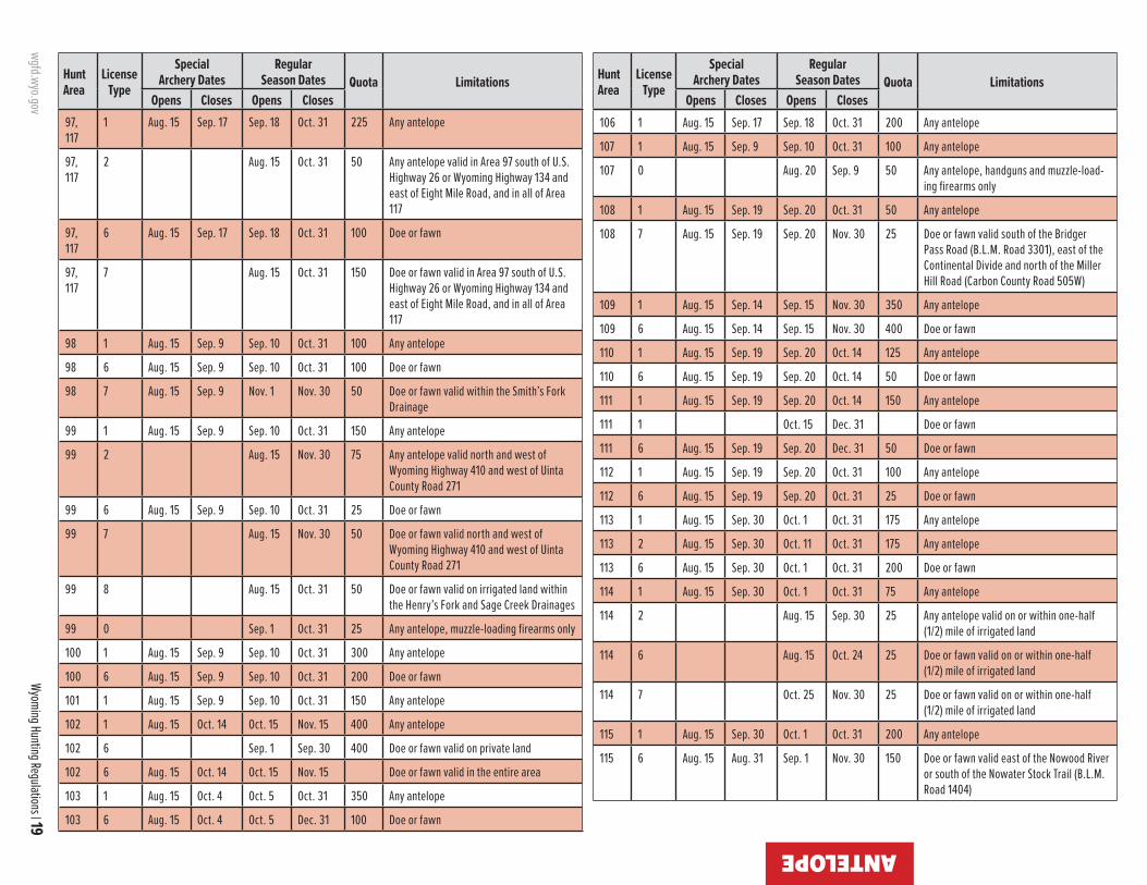
wgfd.wyo.gov
Wyoming Hunting Regulations | 19
ANTELOPE
Hunt Area
LicenseType
SpecialArchery Dates
RegularSeason Dates Quota Limitations
Opens Closes Opens Closes
Hunt Area
LicenseType
SpecialArchery Dates
RegularSeason Dates Quota Limitations
Opens Closes Opens Closes97, 117
1 Aug. 15 Sep. 17 Sep. 18 Oct. 31 225 Any antelope
97, 117
2 Aug. 15 Oct. 31 50 Any antelope valid in Area 97 south of U.S. Highway 26 or Wyoming Highway 134 and east of Eight Mile Road, and in all of Area 117
97, 117
6 Aug. 15 Sep. 17 Sep. 18 Oct. 31 100 Doe or fawn
97, 117
7 Aug. 15 Oct. 31 150 Doe or fawn valid in Area 97 south of U.S. Highway 26 or Wyoming Highway 134 and east of Eight Mile Road, and in all of Area 117
98 1 Aug. 15 Sep. 9 Sep. 10 Oct. 31 100 Any antelope
98 6 Aug. 15 Sep. 9 Sep. 10 Oct. 31 100 Doe or fawn
98 7 Aug. 15 Sep. 9 Nov. 1 Nov. 30 50 Doe or fawn valid within the Smith’s Fork Drainage
99 1 Aug. 15 Sep. 9 Sep. 10 Oct. 31 150 Any antelope
99 2 Aug. 15 Nov. 30 75 Any antelope valid north and west of Wyoming Highway 410 and west of Uinta County Road 271
99 6 Aug. 15 Sep. 9 Sep. 10 Oct. 31 25 Doe or fawn
99 7 Aug. 15 Nov. 30 50 Doe or fawn valid north and west of Wyoming Highway 410 and west of Uinta County Road 271
99 8 Aug. 15 Oct. 31 50 Doe or fawn valid on irrigated land within the Henry’s Fork and Sage Creek Drainages
99 0 Sep. 1 Oct. 31 25 Any antelope, muzzle-loading firearms only
100 1 Aug. 15 Sep. 9 Sep. 10 Oct. 31 300 Any antelope
100 6 Aug. 15 Sep. 9 Sep. 10 Oct. 31 200 Doe or fawn
101 1 Aug. 15 Sep. 9 Sep. 10 Oct. 31 150 Any antelope
102 1 Aug. 15 Oct. 14 Oct. 15 Nov. 15 400 Any antelope
102 6 Sep. 1 Sep. 30 400 Doe or fawn valid on private land
102 6 Aug. 15 Oct. 14 Oct. 15 Nov. 15 Doe or fawn valid in the entire area
103 1 Aug. 15 Oct. 4 Oct. 5 Oct. 31 350 Any antelope
103 6 Aug. 15 Oct. 4 Oct. 5 Dec. 31 100 Doe or fawn
106 1 Aug. 15 Sep. 17 Sep. 18 Oct. 31 200 Any antelope
107 1 Aug. 15 Sep. 9 Sep. 10 Oct. 31 100 Any antelope
107 0 Aug. 20 Sep. 9 50 Any antelope, handguns and muzzle-load-ing firearms only
108 1 Aug. 15 Sep. 19 Sep. 20 Oct. 31 50 Any antelope
108 7 Aug. 15 Sep. 19 Sep. 20 Nov. 30 25 Doe or fawn valid south of the Bridger Pass Road (B.L.M. Road 3301), east of the Continental Divide and north of the Miller Hill Road (Carbon County Road 505W)
109 1 Aug. 15 Sep. 14 Sep. 15 Nov. 30 350 Any antelope
109 6 Aug. 15 Sep. 14 Sep. 15 Nov. 30 400 Doe or fawn
110 1 Aug. 15 Sep. 19 Sep. 20 Oct. 14 125 Any antelope
110 6 Aug. 15 Sep. 19 Sep. 20 Oct. 14 50 Doe or fawn
111 1 Aug. 15 Sep. 19 Sep. 20 Oct. 14 150 Any antelope
111 1 Oct. 15 Dec. 31 Doe or fawn
111 6 Aug. 15 Sep. 19 Sep. 20 Dec. 31 50 Doe or fawn
112 1 Aug. 15 Sep. 19 Sep. 20 Oct. 31 100 Any antelope
112 6 Aug. 15 Sep. 19 Sep. 20 Oct. 31 25 Doe or fawn
113 1 Aug. 15 Sep. 30 Oct. 1 Oct. 31 175 Any antelope
113 2 Aug. 15 Sep. 30 Oct. 11 Oct. 31 175 Any antelope
113 6 Aug. 15 Sep. 30 Oct. 1 Oct. 31 200 Doe or fawn
114 1 Aug. 15 Sep. 30 Oct. 1 Oct. 31 75 Any antelope
114 2 Aug. 15 Sep. 30 25 Any antelope valid on or within one-half (1/2) mile of irrigated land
114 6 Aug. 15 Oct. 24 25 Doe or fawn valid on or within one-half (1/2) mile of irrigated land
114 7 Oct. 25 Nov. 30 25 Doe or fawn valid on or within one-half (1/2) mile of irrigated land
115 1 Aug. 15 Sep. 30 Oct. 1 Oct. 31 200 Any antelope
115 6 Aug. 15 Aug. 31 Sep. 1 Nov. 30 150 Doe or fawn valid east of the Nowood River or south of the Nowater Stock Trail (B.L.M. Road 1404)
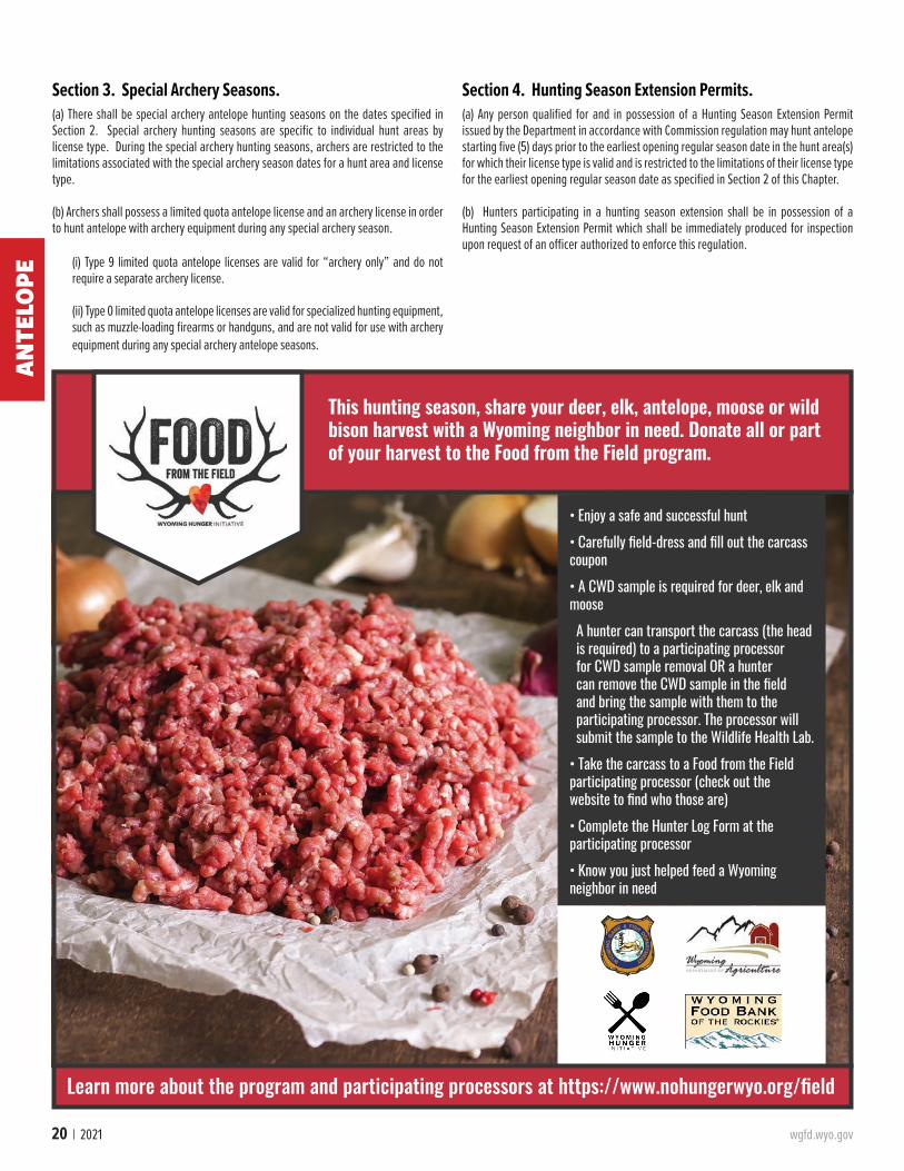
20 | 2021 wgfd.wyo.gov
Section 3. Special Archery Seasons. (a) There shall be special archery antelope hunting seasons on the dates specified in Section 2. Special archery hunting seasons are specific to individual hunt areas by license type. During the special archery hunting seasons, archers are restricted to the limitations associated with the special archery season dates for a hunt area and license type.
(b) Archers shall possess a limited quota antelope license and an archery license in order to hunt antelope with archery equipment during any special archery season.
(i) Type 9 limited quota antelope licenses are valid for “archery only” and do not require a separate archery license.
(ii) Type 0 limited quota antelope licenses are valid for specialized hunting equipment, such as muzzle-loading firearms or handguns, and are not valid for use with archery equipment during any special archery antelope seasons.
Section 4. Hunting Season Extension Permits.(a) Any person qualified for and in possession of a Hunting Season Extension Permit issued by the Department in accordance with Commission regulation may hunt antelope starting five (5) days prior to the earliest opening regular season date in the hunt area(s) for which their license type is valid and is restricted to the limitations of their license type for the earliest opening regular season date as specified in Section 2 of this Chapter.
(b) Hunters participating in a hunting season extension shall be in possession of a Hunting Season Extension Permit which shall be immediately produced for inspection upon request of an officer authorized to enforce this regulation.
ANTE
LOPE
Learn more about the program and participating processors at https://www.nohungerwyo.org/field
• Enjoy a safe and successful hunt• Carefully field-dress and fill out the carcass coupon• A CWD sample is required for deer, elk and moose A hunter can transport the carcass (the head is required) to a participating processor for CWD sample removal OR a hunter can remove the CWD sample in the field and bring the sample with them to the participating processor. The processor will submit the sample to the Wildlife Health Lab.
• Take the carcass to a Food from the Field participating processor (check out the website to find who those are)• Complete the Hunter Log Form at the participating processor• Know you just helped feed a Wyoming neighbor in need
This hunting season, share your deer, elk, antelope, moose or wild bison harvest with a Wyoming neighbor in need. Donate all or part of your harvest to the Food from the Field program.

wgfd.wyo.gov Wyoming Hunting Regulations | 21
AntelopeArea 1. Crook. Beginning where Wyoming Highway 112 crosses the Wyoming-Montana state line; southwesterly along said highway to Wyoming Highway 24 in the town of Hulett; southerly along said highway to U.S. Highway 14; westerly along said highway to the Cabin Creek Road (Crook County Road 116); northwesterly along said road to the Oshoto Road (Crook County Road 263); westerly along said road to the “D” Road (Crook County Road 68); north-erly along said road to the Rocky Point Road in Campbell County (Campbell County Road 85); northerly along said road to the Wyoming-Montana state line; easterly along said line to Wyoming Highway 112.
Area 2. Bearlodge. Beginning where Wyoming Highway 112 crosses the Wyoming-Montana state line; easterly along said line to the Wyoming-South Dakota state line; southerly along said line to Interstate Highway 90; westerly along said Interstate Highway to the town of Sundance and U.S. Highway 14; northwesterly along said highway to Wyoming Highway 24; northerly along said highway to Wyoming Highway 112 in the town of Hulett; northeasterly along said highway to the Wyoming-Montana state line.
Area 3. Keyhole. Beginning where Interstate Highway 90 intersects U.S. Highway 14 in the town of Sundance; southerly and westerly along Interstate Highway 90 to its intersection with the "D" Road (Crook County Road 68); northerly along said road to the Oshoto Road (Crook County Road 263); easterly along said road to the Cabin Creek Road (Crook County Road 116); southerly and easterly along said road to U.S. Highway 14; easterly and southerly along said highway to Interstate Highway 90 in the town of Sundance.
Area 4. Arch Creek. Beginning in the town of Upton at the junction of U.S. Highway 16 and Wyoming Highway 116; westerly and northerly along U.S. Highway 16 to Interstate Highway 90 at the town of Moorcroft; easterly along said Interstate Highway to the town of Sundance and Wyoming Highway 116; southerly and westerly along said highway to its junction with U.S. Highway 16 in the town of Upton.
Area 5. Inyan Kara. Beginning where Interstate High-way 90 crosses the Wyoming-South Dakota state line; southerly along said line to U.S. Highway 16; northerly and westerly along said highway to Wyoming Highway 116 in the town of Upton; northerly and easterly along said highway to the town of Sundance and Interstate Highway 90; easterly along said Interstate Highway to the Wyoming-South Dako-ta state line.
Area 6. South Newcastle. Beginning where U.S. High-way 16 intersects the Wyoming-South Dakota state line; southerly along said line to the Dewey Road (Weston Coun-ty Road 2); northwesterly along said road to U.S. Highway 85; southerly along said highway to Cheyenne River Road (Weston County Road 54); westerly along said road to the Lynch Road (Weston County Road 7A); northerly along said road to Wyoming Highway 450; northeasterly along said highway to U.S. Highway 16; southeasterly along said high-way to the Wyoming-South Dakota state line.
Area 7. South Upton. Beginning where Wyoming High-way 450 intersects U.S. Highway 16; southwesterly along Wyoming Highway 450 to the Keeline Road (U.S.F.S. Road 930); northwesterly along said road to Black Thunder Creek; easterly down said creek to Bacon Creek; northerly up said creek to Newel Prong; northerly up said prong to
the divide between the Cheyenne River and Belle Fourche River; northeasterly along said divide to the divide be-tween Four Horse Creek and Raven Creek; northwesterly along said divide to the Belle Fourche River; northeasterly down said river to Interstate Highway 90; easterly along said highway to U.S. Highway 16; southeasterly along said highway to Wyoming Highway 450.
Area 8. Niobrara. Beginning where the Boner Road (Niobrara County Road 18) crosses the Wyoming-South Da-kota state line; westerly along said road to U.S. Highway 85; southerly along said highway to Wyoming Highway 270; westerly along said highway to Wyoming Highway 272; northerly along said highway to the North Lance Creek Road (Niobrara County Road 14); northerly and westerly along said road to the Niobrara Converse county line and the Dull Center Road (Converse County Road 38); wester-ly along said road to the Clareton Road (Converse County Road 39); northerly along said road to the Niobrara Weston county line and the Lynch Road (Weston County Road 7A); northerly along said road to the Cheyenne River Road (Weston County Road 54); easterly along said road to U.S. Highway 85; northerly along said highway to the Dewey Road (Weston County Road 2); easterly along said road to the Wyoming-South Dakota state line; southerly along said line to the Boner Road (Niobrara County Road 18).
Area 9. Lance Creek. Beginning where U.S. Highway 20 crosses the Wyoming-Nebraska state line; westerly along said highway to the Twenty Mile Creek Road (Converse County Road 46) at Lost Springs; northerly along said road to the Manning Road (Converse County Road 53); easterly along said road to the Converse Niobrara county line and the Twenty Mile Road (Niobrara County Road 23); easterly along said road to Wyoming Highway 271; easterly along said highway to the town of Lance Creek and Wyoming Highway 270; northerly and easterly along said highway to U.S. Highway 85; northerly along said highway to the Boner Road (Niobrara County Road 18); easterly along said road to the Wyoming-South Dakota state line; southerly along said line to the Wyoming-Nebraska state line; southerly along said line to U.S. Highway 20.
Area 10. Lake De Smet. Beginning at the junction of U.S. Highways 14 and 16 at Ucross; southerly along U.S. Highway 16 to Interstate Highway 90; northwesterly along said highway to U.S. Highway 14; southeasterly along said highway to U.S. Highway 16 at Ucross.
Area 11. Rawhide Butte. Beginning where U.S. High-way 20 intersects the Wyoming-Nebraska state line; south-erly along said line to the North Platte River; northwesterly up said river to Glendo Dam; northerly along the eastern shore of Glendo Reservoir to the North Platte River; north-westerly up said river to Interstate Highway 25; northerly along said highway to U.S. Highway 20 at the Orin Junc-tion; easterly along said highway to the Wyoming-Nebraska state line.
Area 15. Clearmont. Beginning where the Powder River crosses the Wyoming-Montana state line; southerly up said river to U.S. Highway 14; westerly along said highway to In-terstate Highway 90; northwesterly along said highway to the Wyoming-Montana state line; easterly along said line to the Powder River.
Area 16. Ucross. Beginning where U.S. Highway 14 crosses the Powder River; southerly up said river to Inter-state Highway 90; northwesterly along said highway to U.S. Highway 16; northeasterly along said highway to U.S. High-way 14; easterly along said highway to the Powder River.
Area 17. Gillette. Beginning where Wyoming Highway 59 crosses the Wyoming-Montana state line; southerly along said highway to U.S. Highway 14-16; southerly along said highway to Interstate Highway 90 west of the town of Gillette; westerly along said highway to the Powder River; northerly down said river to the Wyoming-Montana state line; easterly along said line to Wyoming Highway 59.
Area 18. Rockypoint. Beginning where the Rocky Point Road crosses the Wyoming-Montana state line; southerly along said road to the “D” Road; southerly along said road to Cabin Creek; westerly up said creek to the Cabin-Mitch-ell Creek hydrographic divide; westerly along said divide to Mitchell Creek; westerly down said creek to the Spring Creek Road north of Adon; southerly and westerly along said road to the Cow Creek Road; westerly along said road to Wyoming Highway 59; northerly along said highway to the Wyoming-Montana state line; easterly along said line to the Rocky Point Road.
Area 19. Rozet. Beginning where the “D” Road crosses Cabin Creek; southerly along said road to Interstate High-way 90; westerly along said highway to U.S. Highway 14-16 west of the city of Gillette; northerly along said highway to Wyoming Highway 59; northerly along said highway to the Cow Creek Road; easterly along said road to the Spring Creek Road north of Adon; northeasterly along said road to Mitchell Creek; easterly up said creek to the Mitchell Creek Cabin Creek hydrographic divide; easterly along said divide to Cabin Creek; easterly down said creek to the “D” Road.
Area 20. Upper Powder River. Beginning at the junction of the Trabing Road (Johnson County Road 13) and Interstate Highway 25; southerly along said highway to Wyoming Highway 191; westerly along said highway to Wyoming Highway 190; southerly along said highway to the town of Barnum and the Barnum Mountain Road; wester-ly along said road to the Hazelton Road (Washakie Coun-ty Road 81-Johnson County Road 3); northerly along said road to the Gold Mine Road (U.S.F.S. Road 452); northerly along said road to the Canyon Creek Road (U.S.F.S. Road 25); northerly along said road to U.S. Highway 16; easterly along said highway to the Crazy Woman Canyon Road (John-son County Road 14); easterly along said road to Wyoming Highway 196; northerly along said highway to the Trabing Road (Johnson County Road 13); easterly along said road to Interstate Highway 25.
Area 21. Middle Fork. Beginning at the town of Kaycee and Interstate Highway 25; southeasterly along said high-way to the Midwest interchange and the Smoky Gap Road (Natrona County Road 115); westerly along said road to the Dead Horse Road (Natrona County Road 114); southwesterly along said road to the Wild Horse Trail (Natrona County Road 113); westerly along said road to the 33 Mile Road (Natro-na County Road 110); northwesterly along said road to the Hazelton Road (Washakie County Road 81); northerly along said road to the Barnum Mountain Road; easterly along said road to the town of Barnum and Wyoming Highway 190; northeasterly along said highway to Wyoming Highway 191; easterly along said highway to Interstate Highway 25.
Area 22. Crazy Woman. Beginning where Interstate Highway 90 crosses the Powder River; southerly up said riv-er to Wyoming Highway 192; westerly along said highway to Interstate Highway 25; northerly along said highway to Interstate Highway 90; southeasterly along said highway to the Powder River.
Area 23. Pumpkin Buttes. Beginning at the junction of U.S. Highway 14-16 and Wyoming Highway 59 at the city of Gillette; southerly along Wyoming Highway 59 to Wyoming
HUNT AREA BOUNDARY DESCRIPTIONSAN
TELOPE
22 | 2021 wgfd.wyo.gov
HUNT AREA BOUNDARY DESCRIPTIONS
Highway 387 at Reno Junction; southwesterly along Wyo-ming Highway 387 to Wyoming Highway 192; northwesterly along said highway to the Powder River at Sussex; northerly down said river to Interstate Highway 90; easterly along said highway to U.S. Highway 14-16 at the city of Gillette; easterly along said highway to Wyoming Highway 59.
Area 24. Thunder Basin. Beginning where Interstate Highway 90 crosses the Belle Fourche River; southwesterly up said river to the divide between Four Horse Creek and Raven Creek; southeasterly along said divide to the di-vide between the Cheyenne River and Belle Fourche River Divide; southwesterly along said divide to Newel Prong; southerly down said prong to Bacon Creek; southerly down said creek to Black Thunder Creek; westerly up said creek to the Keeline Road (U.S.F.S. Road 930); southeasterly along said road to Wyoming Highway 450; westerly along said highway to Wyoming Highway 59; northerly along said high-way to Interstate Highway 90; easterly along said highway to the Belle Fourche River.
Area 25. Ormsby. Beginning where Wyoming Highway 259 intersects Wyoming Highway 387 at the town of Mid-west; northeasterly along Wyoming Highway 387 to the top of Pine Ridge; southerly along the top of Pine Ridge to Blue Hill and the head of the West Fork of Sand Creek; southeast-erly down said creek to Sand Creek; southeasterly along said creek to the 55 Ranch Road (Converse County Road 23); southerly along said road to Wyoming Highway 95; southwesterly along said highway to the North Platte River; westerly up said river to Interstate Highway 25 in the city of Casper; northerly along said highway to Wyoming Highway 259; easterly along said highway to Wyoming Highway 387 at the town of Midwest.
Area 26. Bear Creek. Beginning where Wyoming High-way 387 intersects Wyoming Highway 59 at Reno Junction; southerly along Wyoming Highway 59 to the North Platte River at the town of Douglas; westerly up said river to Wyo-ming Highway 95; northeasterly along said highway to the 55 Ranch Road (Converse County Road 23); northerly up said road to Sand Creek; northwesterly up said creek to the West Fork of Sand Creek; northwesterly up said creek to the top of Pine Ridge at Blue Hill; northerly along the top of Pine Ridge to Wyoming Highway 387; northeasterly along said highway to Wyoming Highway 59 at Reno Junction.
Area 27. Bill. Beginning at the junction of Wyoming High-ways 59 and 450; easterly along Wyoming Highway 450 to the Lynch Road (Weston County Road 7A); southerly along said road to the Weston Converse county line and the Clar-eton Road (Converse County Road 39); southerly along said road to the Dull Center Road (Converse County Road 38); westerly along said road to the Rochelle Hills Road (U.S.F.S. Road 933); northerly along said road to the Cheyenne River; westerly up said river to its confluence with Antelope Creek and the Dry Fork of the Cheyenne River; southwesterly up the Dry Fork of the Cheyenne River to Wyoming Highway 59; northerly along said highway to the junction of Wyoming Highways 59 and 450.
Area 29. Shawnee. Beginning where Interstate High-way 25 crosses the North Platte River immediately south of Orin Junction; westerly and northerly up said river to Wyoming Highway 59 at the town of Douglas; northerly along said highway to the Dry Fork of the Cheyenne River; northeasterly down said fork to its confluence with Ante-lope Creek and the Cheyenne River; easterly down the Chey-enne River to the Rochelle Hills Road (U.S.F.S. Road 933); southerly along said road to the Dull Center Road (Converse County Road 38); easterly along said road to the Con-verse-Niobrara county line and the North Lance Creek Road
(Niobrara County Road 14); easterly and southerly along said road to Wyoming Highway 272; southerly along said highway to Wyoming Highway 270; southwesterly along said highway to the town of Lance Creek and Wyoming Highway 271; westerly along said highway to the Twenty Mile Road (Niobrara County Road 23); westerly along said road to the Converse-Niobrara County line and the Manning Road (Converse County Road 53); westerly along said road to the Twenty Mile Creek Road (Converse County Road 46); southerly along said road to U.S. Highway 18-20 at the town of Lost Springs; westerly along said highway to Interstate Highway 25 at Orin Junction; southerly along said highway to the North Platte River.
Area 30. LaPrele. Beginning at the confluence of Deer Creek and the North Platte River at the town of Glenrock; easterly and southerly down said river to the Jackalope Warm Springs and the Esterbrook Highway (Wyoming High-way 94); southerly along said highway to the Esterbrook Road (Converse County Road 5); southerly along said road to the town of Esterbrook and U.S.F.S. Road 633; easterly and southerly along said road to the divide between Soldier Creek and Horseshoe Creek; southerly along said divide to the divide between Horseshoe Creek and the North Laramie River; westerly and northerly along said divide to Blacktail Peak and the head of South Fork Creek tributary to LaBon-te Creek; northerly down said creek to U.S.F.S. Road 658; westerly along said road to the Old Fort Fetterman Road (Converse County Road 16); northerly along said road to the divide between Corduroy Creek and Rocky Ford Creek; westerly along said divide to the divide between LaPrele Creek and the Little Medicine Bow River; westerly along said divide to the Converse Albany county line; westerly along said line to the Little Medicine Road (Albany County Road 62); southwesterly along said road to U.S.F.S. Road 660; northwesterly along said road to Curry Creek; north-westerly down said creek to Deer Creek; northerly down said creek to the North Platte River at the town of Glenrock.
Area 31. Hat Six. Beginning at the intersection of Wy-oming Highway 251 (Casper Mountain Road) and Wyoming Highway 258 (Wyoming Boulevard) in the city of Casper; westerly along said highway to Poplar Street; northerly along said street to the North Platte River; easterly down said river to Deer Creek at the town of Glenrock; southerly along said creek to Sawmill Creek; southerly and westerly up said creek to the top of Reno Hill and the divide between Soldier Creek and the West Fork of Deer Creek; westerly along said divide to the divide between the East Fork of Bates Creek and the West Fork of Deer Creek; westerly along said divide to the divide between Kerfoot Creek and the West Fork of Deer Creek; westerly along said divide to the divide between the West Fork of Deer Creek, Kerfoot Creek and Smith Creek; northerly and westerly along said divide to the head of Smith Creek; northerly across Muddy Mountain along the divide of Corral Creek and Otter Creek to the divide between Red Creek and the Clear Fork of Muddy Creek; northerly along said divide to the Circle Drive Road (Natrona County Road 505); northerly along said road to Wyoming Highway 251; northerly along said highway to the intersection of Wyoming Highway 251 and Wyoming Highway 258.
Area 32. Bates Creek. Beginning where the Pathfind-er Dam crosses the North Platte River; northeasterly down said river to the bridge at Wyoming Highway 220 (Poplar Street) in the city of Casper; southerly along Poplar Street to Wyoming Highway 258 (Wyoming Boulevard); easterly along said highway to Wyoming Highway 251 (Casper Moun-tain Road); southerly along said road to the Circle Drive Road (Natrona County Road 505); southerly along said
road to the divide between Red Creek and the Clear Fork of Muddy Creek; southerly along said divide to the divide be-tween Corral Creek and Otter Creek; southerly across Mud-dy Mountain along said divide to the head of Smith Creek; southerly and easterly to the divide between Smith Creek, Kerfoot Creek and the West Fork of Deer Creek; easterly along said divide to the divide between Kerfoot Creek and the West Fork of Deer Creek; easterly along said divide to the divide between Spruce Creek and the West Fork of Deer Creek; easterly along said divide to the divide between the East Fork of Bates Creek and West Fork of Deer Creek; east-erly along said divide to the divide between Soldier Creek and the West Fork of Deer Creek; easterly along said divide to Reno Hill and the head of Sawmill Creek; easterly and northerly down said creek to Deer Creek; southerly up said creek to Curry Creek; southeasterly up said creek to U.S.F.S. Road 660; westerly along said road to its termination at the Squaw Springs Trail Road; southwesterly along said road to the Bates Creek Road (Natrona County Road 402); south-westerly along said road to the Spring Creek Road; westerly along said road to the Lone Tree Road (B.L.M. Road 3141); southerly along said road to the Shirley Ridge Road (Carbon County Road 2); southwesterly along said road to Wyoming Highway 77; southerly along said highway to the Chalk Mountain Road (B.L.M. Road 3129); westerly and norther-ly along said road to the Dry Creek Road (Carbon County Road 103); northwesterly along said road to the south fork of Canyon Creek; westerly and northerly down said fork to Canyon Creek; westerly down said creek to the east shore of Pathfinder Reservoir; northeasterly along said east shore to the Pathfinder Dam and the North Platte River.
Area 34. Goshen Hole. Beginning where Interstate Highway 25 crosses the Laramie River; northeasterly down said river to the North Platte River; southerly down said riv-er to the Wyoming-Nebraska state line; southerly along said line to Interstate Highway 80; westerly along said highway to Interstate Highway 25; northeasterly along said highway to the Laramie River.
Area 37. Harriman. Beginning at the city of Laramie and Interstate Highway 80; southeasterly along said highway to Interstate Highway 25 at the city of Cheyenne; southerly along said highway to the Wyoming-Colorado state line; west along said line to U.S. Highway 287; northerly along said highway to Interstate Highway 80.
Area 38. Iron Mountain. Beginning in the city of Lara-mie and U.S. Highway 30; northerly along said highway to where U.S. Highway 30 crosses the Laramie River; north-easterly down said river to Interstate Highway 25; south-erly along said highway to Interstate Highway 80; westerly along said highway to the city of Laramie.
Area 42. Laramie Plains. Beginning at the junction of the Marshall Road (Albany County Road 610) and U.S. Highway 30 north of the town of Rock River; northeaster-ly along said road to the second crossing of Sheep Creek; northerly up said creek to the southern boundary of the Laramie Peak Division of the Medicine Bow National Forest; northwesterly along said boundary to the Albany-Converse county line; east along said line to LaPrele Creek; souther-ly up said creek to the divide between LaPrele Creek and the Little Medicine Bow River; easterly along said divide to the divide between Corduroy Creek and Rocky Ford Creek; easterly along said divide to the Fetterman Road (Albany County Road 61); southerly along said road to U.S.F.S. Road 658; easterly along said road to South Fork Creek, tribu-tary to LaBonte Creek; southerly up said creek to the divide between Horseshoe Creek and the North Laramie River; southeasterly along said divide to the head of Friend Creek;
ANTE
LOPE

wgfd.wyo.gov Wyoming Hunting Regulations | 23
ANTELO
PEHUNT AREA BOUNDARY DESCRIPTIONS
southerly down said creek to Bear Creek; easterly down said creek to the North Laramie River; easterly down said river to the Cottonwood Park Road (Albany County Road 71); southerly down said road to its junction with Palmer Canyon Road (Albany County Road 721); easterly along said road to Ashley Creek; southerly down said creek to Duck Creek; easterly down said creek to the Big Laramie River; south-westerly up said river to U.S. Highway 30; northwesterly along said highway to the Marshall Road (Albany County Road 610).
Area 43. Cooper Lake. Beginning at the junction of Wyoming Highway 13 and U.S. Highway 30 north of the town of Rock River; southeasterly along U.S. Highway 30 to Interstate Highway 80; northwesterly along said highway to Rock Creek; northeasterly down said creek to Wyoming Highway 13 west of the town of McFadden; northeasterly along said highway to U.S. Highway 30.
Area 44. South Laramie. Beginning at the city of Lara-mie and U.S. Highway 287; southerly along said highway to the Wyoming-Colorado state line; west along said line to Wyoming Highway 230; northeasterly along said highway to U.S. Highway 287.
Area 45. West Laramie. Beginning at the city of Lara-mie and Wyoming Highway 230; southwesterly along said highway to the divide between the Laramie River and the North Platte River; northerly along said divide to the divide between the Medicine Bow River and the Laramie River at Medicine Bow Peak; northeasterly along said divide to Deep Creek; northeasterly down said creek to Rock Creek; northeasterly down said creek to Interstate Highway 80 at Arlington; southeasterly along said highway to Wyoming Highway 230.
Area 46. Kyle. Beginning where U.S. Highway 30 inter-sects Wyoming Highway 72; easterly along U.S. Highway 30 to Wyoming Highway 13; southwesterly along Wyoming Highway 13 to Rock Creek west of the town of McFadden; southwesterly up said creek to Interstate Highway 80; northwesterly along said highway to Wyoming Highway 72; northerly along said highway to U.S. Highway 30.
Area 47. Shirley Basin. Beginning at U.S. Highway 30 in the town of Medicine Bow; westerly along said highway to Wyoming Highway 72; northerly along said highway to the Hanna Leo Road (Carbon County Road 291); northerly along said road to Troublesome Creek; northerly up said creek to the Troublesome Spring Road on Shirley Mountain; northerly along said road to the B.L.M. Fire Camp Road (B.L.M. Road 3115); northwesterly along said road to the Leo Shirley Basin Road (Carbon County Road 102) at Pryor Flat; northeasterly along said road to the Dry Creek Road (Carbon County Road 103); northerly along said road to the Chalk Mountain Road (B.L.M. Road 3129); easterly along said road to Wyoming Highway 77; northerly along said highway to the Shirley Ridge Road (Carbon County Road 2), northeasterly along said road to the Lone Tree Road (B.L.M. Road 3141); northerly along said road to the Spring Creek Road; easterly along said road to the Bates Creek Road (Na-trona County Road 402); northeasterly along said road to the Squaw Springs Trail Road; northerly along said road to U.S.F.S. Road 660; southeasterly along said road to the Lit-tle Medicine Road (Albany County Road 62); northeasterly along said road to the south boundary of the Laramie Peak Division of the Medicine Bow Forest; southerly and easterly along said boundary to Sheep Creek; southerly along said creek to its second crossing with the Marshall Road (Al-bany County Road 610); southerly along said road to U.S. Highway 30; westerly along said highway to the town of Medicine Bow.
Area 48. Leo Hanna. Beginning at the junction of Wyo-ming Highway 72 and Interstate Highway 80 westerly along Interstate Highway 80to the North Platte River; northerly down said river to Canyon Creek; easterly up said creek to the south fork of Canyon Creek; southerly Pryor Flat and the B.L.M. Fire Camp Road (B.L.M. Road 3115); southeasterly along said road to the Troublesome Spring Road; souther-ly along said road to Troublesome Creek; southerly along said creek to the Hanna Leo Road (Carbon County Road 291); southerly along said road to the town of Hanna and Wyoming Highway 72; southerly along said highway to In-terstate Highway 80.
Area 50. Elk Mountain. Beginning where Interstate Highway 80 crosses the North Platte River; easterly along said highway to Rock Creek at Arlington; southerly up said creek to Deep Creek; southwesterly up said creek to the divide between the Laramie River and the North Platte Riv-er; southerly along said divide to Wyoming Highway 230; southwesterly along said highway to the Wyoming-Colora-do state line; west along said line to the North Platte River; northerly down said river to Interstate Highway 80.
Area 51. Big Creek. Beginning where the North Platte River crosses the Wyoming-Colorado state line; west along said line to the Encampment River; northeasterly down said river to the North Platte River; southerly up said river to the Wyoming-Colorado state line.
Area 52. Spring Creek. Beginning where the Conti-nental Divide crosses the Wyoming-Colorado state line; northerly along said divide to the Sage Creek Road (Carbon County Road 401); northerly along said road to Sage Creek; northeasterly down said creek to the North Platte River; southerly up said river to the Encampment River; south-westerly up said river to the Wyoming-Colorado state line; westerly along said line to the Continental Divide.
Area 53. Baggs. Beginning at the junction of Wyoming Highway 789 and the Wyoming-Colorado state line; north-erly along said highway to Muddy Creek north of Dad; easterly up said creek to the Muddy Creek Road (B.L.M. Road 3306); easterly along said road to the Miller Hill Road (B.L.M. Road 3328); southeasterly along said road to the McCarty Canyon Road (Carbon County Road 503); north-easterly along said road to the Sage Creek Road (Carbon County Road 401); southerly along said road to the Conti-nental Divide at Middlewood Hill; southerly along said di-vide to the Wyoming-Colorado state line; westerly along said line to Wyoming Highway 789.
Area 55. Red Rim. Beginning where Wyoming Highway 71 crosses Interstate Highway 80 at the city of Rawlins; southerly along said highway to the divide along Five Mile Ridge; southwesterly along the divide on Five Mile Ridge and Atlantic Rim to the crossing of the Sulphur Springs Ranch Road over Muddy Creek; westerly down said creek to Wyoming Highway 789; northerly along said highway to Interstate Highway 80; easterly along said Interstate to Wy-oming Highway 71.
Area 56. Iron Springs. Beginning where Wyoming High-way 71 crosses Interstate Highway 80 at the city of Rawlins; easterly along said Interstate to the North Platte River; southerly up said river to Sage Creek; southwesterly up said creek to the Sage Creek Road (Carbon County Road 401); northerly along said road to Wyoming Highway 71; northerly along said highway to Interstate Highway 80.
Area 57. South Wamsutter. Beginning at the junction of Wyoming Highway 789 and the Wyoming-Colorado state line; westerly along said line to the Cow Creek-Powder Wash Road north of Powder Wash, Colorado; northwest-
erly along said road to the Bitter Creek Road (Sweetwater County Road 19); northwesterly along said road to Inter-state Highway 80; easterly along said highway to Creston Junction and Wyoming Highway 789; southerly along said highway to the Wyoming-Colorado state line.
Area 58. Black Butte Kenny Rim. Beginning at the junction of Wyoming Highway 430 and the Wyoming-Col-orado state line; northwesterly along said highway to In-terstate Highway 80 in the town of Rock Springs; easterly along said highway to the Bitter Creek Road (Sweetwater County Road 19); southeasterly along said road to the Carson Springs Junction and the Cow Creek Powder Wash Road; southeasterly along said road to the Wyoming-Colo-rado state line; westerly along said line to Wyoming High-way 430.
Area 59. Aspen Mountain. Beginning where Interstate Highway 80 crosses the Green River; easterly along said highway to the town of Rock Springs and Wyoming Highway 430; southeasterly along said highway to the Mud Springs Road (Sweetwater County Road 32); westerly along said road to the Aspen Mountain Road (Sweetwater County Road 27); southerly along said road to the Clay Basin Pipeline Road (Sweetwater County Road 71); southwesterly along said road to the Ramsey Ranch Road (Sweetwater County Road 34); westerly along said road to U.S. Highway 191; westerly along said highway to the Ramsey Ranch Road (Sweetwater County Road 34); northerly along said road to the Sage Creek Road (Sweetwater County Road 36); wester-ly along said road to Sage Creek; westerly down said creek to Flaming Gorge Reservoir; northerly along the east shore of said reservoir to the Green River; northeasterly then northwesterly up said river to Interstate Highway 80.
Area 60. Table Rock. Beginning at the junction of Wam-sutter Crooks Gap Road (Sweetwater County Road 23) and Interstate Highway 80 at the town of Wamsutter; westerly along said highway to Wyoming Highway 377 at Point of Rocks; northerly along said highway to the Nine Mile Road (Sweetwater County Road 15); northerly along said road to the Bar X Road (Sweetwater County Road 21) at the Bar X Ranch; northwesterly along said road to the Oregon Buttes Road (Sweetwater County Road 74); northerly along said road to the Continental Divide Road; northeasterly along said road to the Sand Creek Road; southeasterly along said road to the Red Creek Road (B.L.M. Road 3219); southeast-erly along said road to the Cyclone Rim Road (B.L.M. Road 3216); easterly along said road to the Bison Basin Road (B.L.M. Road 3221); southerly along said road to the Hadsell Road (B.L.M. Road 3217); easterly along said road to the Os-borne Road (B.L.M. Road 3212); easterly along said road to the Wamsutter Crooks Gap Road (Sweetwater County Road 23); southerly along said road to Interstate Highway 80.
Area 61. Chain Lakes. Beginning at the junction of U.S. Highway 287 and Interstate Highway 80 at the city of Rawlins; westerly along said Interstate to the Wamsutter Crooks Gap Road (Sweetwater County Road 23); northerly along said road to Crooks Gap and the divide along Green Mountain; southeasterly along said divide to Whiskey Peak and the head of Coal Creek; northeasterly down said creek to U.S. Highway 287; southerly along said highway to Inter-state Highway 80.
Area 62. South Ferris. Beginning at the junction of U.S. Highway 287 and Interstate Highway 80 at the city of Raw-lins; northerly along said highway to Muddy Gap Junction and the divide along the Ferris Mountains; southeasterly along said divide to Ferris Peak and the northeast branch of the Continental Divide; southeasterly along said branch to Bradley Peak and the divide along the Seminoe Mountains;

24 | 2021 wgfd.wyo.gov
easterly along said divide to Seminoe Dam and the North Platte River; southerly up said river to Interstate Highway 80; westerly along said Interstate to U.S. Highway 287.
Area 63. North Ferris. Beginning at Muddy Gap Junc-tion; northeasterly along Wyoming Highway 220 to the Kortes Road (Natrona County Road 407); southerly along said road to the North Platte River; southerly up said river to Seminoe Dam and the divide along the Seminoe Moun-tains; westerly along said divide to Bradley Peak and the northeast branch of the Continental Divide; northwesterly along said divide to Ferris Peak and the divide along the Ferris Mountains; northwesterly along said divide to Muddy Gap Junction.
Area 64. Bison Basin. Beginning at the confluence of the Sweetwater River and Alkali Creek southwest of Sweet-water Station; southeasterly along the divide between Alka-li Creek and the Sweetwater River to the northeast branch of the Continental Divide; northeasterly along said divide to the Crooks Mountain Road (B.L.M. Road 2409); southeast-erly along said road to the Wamsutter Crooks Gap Road (Fre-mont County Road 318 and Sweetwater County Road 23); southerly along said road to the Osborne Road (B.L.M. Road 3212); westerly along said road to the Hadsell Road (B.L.M. Road 3217); westerly along said road to the Bison Basin Road (B.L.M. Road 3221); northerly along said road to the Cyclone Rim Road (B.L.M. Road 3216); westerly along said road to the Red Creek Road (B.L.M. Road 3219); northwest-erly along said road to the Sand Creek Road; northwesterly along said road to the Harris Slough Road; northerly along said road to the Three Forks Atlantic City Road (B.L.M. Road 2317); northwesterly along said road to the Sweetwater River at Phelps Dodge Bridge; northeasterly down said river to Alkali Creek.
Area 65. South Pass. Beginning where U.S. Highway 287 crosses the south boundary of the Wind River Reserva-tion; southeasterly along said highway to the Sweetwater River; westerly up said river to Rock Creek; northwesterly up said creek to Granite Peak and the divide between the Sweetwater River and Popo Agie River drainages; north-westerly along said divide to the Continental Divide; north-westerly along said divide to the southern boundary of the Wind River Reservation; easterly along said boundary to U.S. Highway 287.
Area 66. Lander. Beginning where U.S. Highway 287 crosses the south boundary of the Wind River Reservation at the North Popo Agie River; easterly along said boundary to Wyoming Highway 135; southerly along said highway to U.S. Highway 287; northwesterly along said highway to the south boundary of the Wind River Reservation.
Area 67. Sand Draw. Beginning where U.S. Highway 20-26 crosses the east boundary of the Wind River Reser-vation; easterly along said highway to the Castle Gardens Road (Fremont County Road 507); southerly along said road to Wyoming Highway 136 (Gas Hills Road); southeaster-ly along said road to the Ore Road (Fremont County Road 5); southerly along said road to Beaver Rim; westerly and southerly along said rim to Wyoming Highway 135; north-erly along said highway to the Wind River Reservation boundary; easterly and northerly along said boundary to U.S. Highway 20-26.
Area 68. Split Rock. Beginning at the junction of U.S. Highway 287 and the Ore Road (Fremont County Road 5); northerly along said road to Beaver Rim; northeasterly along said rim to the divide between Deer Creek and Dry Creek; northeasterly along said divide to the Dry Creek Road (Natrona County Road 321); southeasterly along said road to Wyoming Highway 220; southwesterly along said
highway to U.S. Highway 287; southerly along said highway to Coal Creek; southwesterly up said creek to Whiskey Peak and the divide along Green Mountain; northwesterly along said divide to Crooks Gap and the Crooks Gap Road (Fre-mont County Road 318); northerly along said road to U.S. Highway 287.
Area 69. South Rattlesnake. Beginning where Wyo-ming Highway 220 intersects the Dry Creek Road (Natrona County Road 321); northwesterly along said road to the Gas Hills Road (Natrona County Road 212); northeasterly along said road to the divide along the Rattlesnake Mountain range; southeasterly along said divide to the Oregon Trail Road (Natrona County Road 319); northeasterly along said road to the Kendrick Canal; southerly along said canal to Blue Gulch; southerly through Tunnel No. 2 along said canal to Wyoming Highway 220; westerly along said highway to the Dry Creek Road (Natrona County Road 321).
Area 70. Kendrick. Beginning at the crossing of the North Platte River and Poplar Street in the city of Casper; southwesterly up said river to the Kortes Road (Natrona County Road 407) below Alcova Dam; northerly along said road to Wyoming Highway 220; westerly along said highway to the Kendrick Canal; northerly along said canal through Tunnel No. 2 to Blue Gulch; northerly along said canal to U.S. Highway 20-26; easterly along said highway to Poplar Street in the city of Casper; southerly along said street to the North Platte River.
Area 71. East Poison Spider. Beginning where U.S. Highway 20-26 crosses the Kendrick Canal; southerly along said canal to the Poison Spider Road (Natrona County Road 201); westerly along said road to the Oil Camp Road (Natro-na County Road 210); northwesterly along said road to U.S. Highway 20-26 at the town of Powder River; southeasterly along said highway to the Kendrick Canal.
Area 72. West Poison Spider. Beginning at the inter-section of the Gas Hills Road (Natrona County Road 212) and U.S. Highway 20-26 at the town of Waltman; easterly along said highway to the Oil Camp Road (Natrona County Road 210) at the town of Powder River; southeasterly along said road to the Poison Spider Road (Natrona County Road 201); easterly along said road to the Kendrick Canal; southerly along said canal to the Iron Creek Oil Field and the Oregon Trail Road(Natrona County Road 319); southwesterly along said road to the divide along the Rattlesnake Mountain range at the top of Ryan Hill (Prospect Hill); northerly and westerly along said divide to the Gas Hills Road (Natrona County Road 212); northeasterly along said road to the town of Waltman and U.S. Highway 20-26.
Area 73. North Natrona. Beginning at the intersection of Interstate Highway 25 and the North Platte River in the city of Casper; southwesterly up said river to the bridge at Poplar Street; northerly along said street to U.S. Highway 20-26; westerly along said highway to Natrona County Road 104 at Waltman; northerly along said road to Natrona County Road 103; northwesterly along said road to Natro-na County Road 102; northerly along said road to Natrona County Road 101; northeasterly along said road to Badwater Creek; northeasterly along said creek to the divide between Badwater Creek, Deep Creek, and Buffalo Creek; northeast-erly along said divide to the divide between the Middle Fork and North Fork of Buffalo Creek; easterly along said divide to the North Fork of Buffalo Creek; northeasterly along said creek to Natrona County Road 109; northeasterly along said road to Washakie County Road 6215; northeasterly along said road to the 33-Mile Road (Natrona County Road 110) at Kidd Flat; southeasterly along said road to Natrona County Road 113; easterly along said road to Natrona County Road
114; northeasterly along said road to Natrona County Road 115; easterly along said road to Wyoming Highway 387; easterly along said highway to Wyoming Highway 259 in the town of Midwest; southerly along said highway to In-terstate Highway 25; southerly along said highway to the North Platte River in the city of Casper.
Area 74. Deer Creek. Beginning where the Castle Gardens Road (Fremont County Road 507) intersects U.S. Highway 20-26; easterly along said highway to the town of Waltman and the Gas Hills Road (Natrona County Road 212); southwesterly along said road to the Dry Creek Road (Natro-na County Road 321); southeasterly along said road to the divide between Deer Creek and Dry Creek; southwesterly along said divide to Beaver Rim; southwesterly along said rim to the Ore Road; northerly along said road to Wyoming Highway 136 (Gas Hills Road); westerly along said road to the Castle Gardens Road (Fremont County Road 507); north-erly along said road to U.S. Highway 20-26.
Area 75. Badwater. Beginning at the town of Shosho-ni and U.S. Highway 20-26; westerly along said highway to the east shoreline of Boysen Reservoir; northerly along said shoreline to Boysen Dam and the Wind River; northerly down said river to Gold Creek (excluding Indian tribal trust lands immediately north of U.S. Highway 20-26 near Boysen Reservoir and northeast of Boysen Dam); easterly up Gold Creek to the divide between Buffalo Creek and Badwater Creek on Copper Mountain; easterly along said divide to the divide between Badwater Creek and the Kirby Nowater Nowood Creek drainages; northeasterly then southeasterly along said divide to Cottonwood Pass and the divide be-tween Nowood Creek and Badwater Creek; easterly along said divide to the Devil's Slide Road; easterly along said road to Sioux Pass and the Oakie Trail (Natrona County Road 101); easterly along said trail to the Bighorn Trail; easter-ly along said trail to the divide between Badwater Creek, Deep Creek, and the Middle Fork of Buffalo Creek; south-westerly down Badwater Creek to Natrona County Road 101; southwesterly along said road to Natrona County Road 102; southerly along said road to Natrona County Road 103; southeasterly along said road to Natrona County Road 104; southerly along said road to the town of Waltman and U.S. Highway 20-26; westerly along said highway to the town of Shoshoni.
Area 76. Copper Mountain. Beginning where Gold Creek intersects the east boundary of the Wind River Res-ervation; northerly and westerly along said boundary to the Bighorn River; northerly down said river to Walters Draw; easterly up said draw to the divide between Nowater Creek and Kirby Creek; easterly along said divide to the Murphy Dome-Mud Creek Road (B.L.M. Road 1409); northeasterly along said road to the Nowater Stock Drive Road (B.L.M. Road 1404); easterly along said road to the divide between the Nowood River and Nowater Creek; southerly along said divide to Hawks Butte and the divide between the Nowood River/Nowater Creek/Kirby Creek and Badwater Creek; westerly along said divide to the divide between Badwa-ter Creek and Buffalo Creek on Copper Mountain; westerly along said divide to the head of Gold Creek; westerly down said creek to the east boundary of the Wind River Reser-vation.
Area 77. Fifteen Mile Creek. Beginning at the town of Meeteetse; easterly down the Greybull River to the Bighorn River; southerly up said river to Wyoming Highway 432; westerly along said highway to its junction with Wyoming Highway 431 and U.S. Highway 20; westerly along Wyoming Highway 431 to U.S. Highway 120; northwesterly along U.S. Highway 120 to the town of Meeteetse.
HUNT AREA BOUNDARY DESCRIPTIONSAN
TELO
PE
wgfd.wyo.gov Wyoming Hunting Regulations | 25
ANTELO
PEHUNT AREA BOUNDARY DESCRIPTIONS
Area 78. McCullough Peaks. Beginning at the junc-tion of U.S. Highway 120 and U.S. Highway 14-16-20 in the town of Cody; northerly along U.S. Highway 120 to the Shoshone River; easterly down said river to the Bighorn River; southerly up said river to the Greybull River; westerly up said river to Big Horn County Road 8; northerly up said road to Wyoming Highway 30; northerly up said highway to U.S. Highway 14-16-20; westerly along said highway to U.S. Highway 120.
Area 79. Big Horn. Beginning on the Bighorn River where it crosses the Wyoming-Montana state line; easterly along said line to the Bighorn National Forest boundary; southerly and easterly along said boundary to U.S. Highway 16; westerly along said highway to the Nowood River near the town of Ten Sleep; northwesterly down said river to the Bighorn River at the town of Manderson; northerly down said river to the Wyoming-Montana state line.
Area 80. Badger Basin. Beginning where the Bighorn River crosses the Wyoming-Montana state line; southerly up said river to the Shoshone River; westerly up said river to the North Fork of the Shoshone River; westerly up said river to the Shoshone National Forest boundary; easterly then northerly along said boundary to Wyoming Highway 296 (Sunlight Road); northerly along said highway to U.S. High-way 212; easterly along said highway to the Wyoming-Mon-tana state line; east along said line to the Bighorn River.
Area 81. South Fork. Beginning where Dry Creek cross-es Wyoming Highway 120 at the Halfway House historical marker; southwesterly up said creek to the divide between Meeteetse Creek and Sage Creek; westerly along said di-vide to the divide between the Greybull River and the South Fork of the Shoshone River; westerly then southwesterly along said divide to the divide between Boulder Creek and Needle Creek; westerly along said divide to the divide be-tween Boulder Creek and the South Fork of the Shoshone River; northerly along said divide to the head of Aspen Creek; northwesterly down said creek to the South Fork of the Shoshone River; northeasterly down said river to the Shoshone National Forest boundary; northerly along said boundary to the North Fork of the Shoshone River; easterly down said river to the Shoshone River; easterly along said river to Wyoming Highway 120; southerly along said high-way to U.S. Highway 14-16-20; easterly along said highway to Dry Creek; southwesterly up said creek to Wyoming High-way 120 and the Halfway House historical marker.
Area 82. North Greybull River. Beginning where Dry Creek crosses Wyoming Highway 120 at the Halfway House historical marker; northeasterly down said creek to U.S. Highway 14-16-20; easterly along said highway to the Wyoming Highway 30 (Burlington Road); southerly along said road to Big Horn County Road 8; southerly along said road to the Greybull River; westerly then southerly along said river to the divide between the Greybull River and the Wind River; northwesterly along said divide to the di-vide between the Greybull River and the South Fork of the Shoshone River; northerly then easterly along said divide to the divide between Meeteetse Creek and Sage Creek; easterly along said divide to Dry Creek; northeasterly down said creek to Wyoming Highway 120 at the Halfway House historical marker.
Area 83. Owl Creek. Beginning at the junction of Wy-oming Highway 120 and Wyoming Highway 431, easterly along Wyoming Highway 431 to the junction with Wyoming Highway 432; easterly along said highway to the Bighorn River; southerly up said river to the Wind River Reservation boundary, westerly, then northerly, then westerly along said boundary to the divide between Owl Creek and the
South Fork of the Wood River; northeasterly along said divide to the divide between Cottonwood Creek and Goose-berry Creek; northeasterly along said divide to the divide between Gooseberry Creek and Grass Creek; easterly along said divide to Wyoming Highway 120, southeasterly along said highway to the junction of Wyoming Highway 120 and Wyoming Highway 431; in addition, all non-Indian fee title lands in that portion of Hot Springs County within the exte-rior boundaries of the Wind River Reservation are included.
Area 84. Wind River. All of the drainage of the Wind River west of the western boundary of the Wind River Reser-vation including areas of the Spence and Moriarity Wildlife Management Area east of the East Fork of the Wind River.
Area 85. Gros Ventre. Beginning where U.S. Highway 191 crosses the Gros Ventre River at the northwest corner of the National Elk Refuge boundary; easterly up said bound-ary to the Bridger-Teton National Forest boundary; north-erly along said boundary to U.S. Highway 26-287; easterly along said highway to the Continental Divide at Togwotee Pass; southerly along said divide to the Union Pass Road (U.S.F.S. Road 600); southwesterly along said road to the Darwin Ranch Road (U.S.F.S. Road 620); westerly along said road to the divide between the Green River and the Gros Ventre River; southwesterly along said divide to the divide between the Gros Ventre River and the Hoback River at Hodges Peak; northwesterly along said divide to the divide between Granite Creek and Flat Creek at Pyramid Peak; southwesterly along said divide to the divide between Flat Creek and Cache Creek at Cache Peak; northwesterly along said divide to U.S.F.S. Trail 018; southwesterly along said trail to Cache Creek; northwesterly along said creek to the Bridger-Teton National Forest boundary; northerly along said boundary to the National Elk Refuge boundary; wester-ly along said boundary to U.S. Highway 191; northerly along said highway to the Gros Ventre River at the northwest cor-ner of the National Elk Refuge.
Area 86. Hoback. All of the drainage of the Hoback River.
Area 87. Pinedale. Beginning where the East Green Riv-er Road (Sublette County Road 23 110) intersects Wyoming Highway 351; northerly along said road to U.S. Highway 191 at Cora Junction; westerly then northerly along said high-way to the divide between the Hoback River and the Green River (Hoback Rim); northerly along said divide to the di-vide between the Hoback River and the Gros Ventre River at Hodges Peak; northeasterly along said divide to the Darwin Ranch Road (U.S.F.S. Road 620); easterly along said road to the Union Pass Road (U.S.F.S. Road 600); northeasterly along said road to the Continental Divide at Union Pass; southerly along said divide to the Middle Fork of Boulder Creek; southwesterly down said creek to Boulder Creek; westerly down said creek to the New Fork River; south-westerly down said river to Wyoming Highway 351; westerly along said highway to the East Green River Road (Sublette County Road 23 110).
Area 88. Beaver. Beginning where the East Green River Road (Sublette County Road 23 110) intersects Wyoming Highway 351; westerly along said highway to the Green Riv-er; northerly up said river to Cottonwood Creek; westerly up said creek to South Cottonwood Creek; westerly up said creek to the South Fork of South Cottonwood Creek; west-erly up said creek to the divide between the Green River and the Greys River; northerly along said divide to the Hoback Rim; easterly along said rim to U.S. Highway 191; southerly along said highway to the East Green River Road (Sublette County Road 23 110) at the Cora Junction; southerly along said road to Wyoming Highway 351.
Area 89. Piney. Beginning where LaBarge Creek enters the Green River; westerly up said creek to the Greys Riv-er Road; northerly up said road to the divide between the Green River and the Greys River; northerly along said divide to the South Fork of South Cottonwood Creek; easterly down said creek to the South Fork of Cottonwood Creek; easterly down said creek to Cottonwood Creek; easterly down said creek to the Green River; southerly down said river to LaBarge Creek.
Area 90. Square Top. Beginning at the intersection of U.S. Highway 191 and the Big Sandy Reservoir Road (Sweet-water County Road 28); northerly up said highway to Boul-der Creek; easterly up said creek to the Middle Fork of Boul-der Creek; northeasterly up said creek to the Continental Divide; southerly along said divide to the Big Sandy River; southerly down said river to the Big Sandy Reservoir Road (Sweetwater County Road 28); westerly along said road to U.S. Highway 191.
Area 91. Dry Sandy. Beginning at the town of Farson and U.S. Highway 191; northerly along said highway to the Big Sandy Reservoir Road (Sweetwater County Road 28); easterly along said road to the Big Sandy River at the Big Sandy Reservoir Dam; northerly up said river to the Continental Divide; southeasterly along said divide to Mt. Nystrom; easterly from Mt. Nystrom to Sweetwater Gap and the headwaters of the Sweetwater River; southerly down said river to Wyoming Highway 28; southwesterly along said highway to the town of Farson.
Area 92. Steamboat. Beginning at the junction of Inter-state Highway 80 and U.S. Highway 191 in the city of Rock Springs; northerly along U.S. Highway 191 to U.S. Highway 28; northeasterly along U.S. Highway 28 to the Oregon Buttes Road (Sweetwater County Road 74); southerly along said road to the Bar X Road (Sweetwater County Road 21); easterly along said road to the Nine Mile Road (Sweetwater County Road 15) at the Bar X Ranch; southerly along said road to Wyoming Highway 377; southerly along said high-way to Point of Rocks and Interstate Highway 80; westerly along said highway to U.S. Highway 191.
Area 93. West Green River. Beginning where U.S. Highway 30 crosses Wyoming Highway 240; northwesterly up said highway to the Ham’s Fork River; northerly up said river to Commissary Ridge; northerly along said ridge to the head of LaBarge Creek; southeasterly down said creek to the Green River; southerly down said river to the Lower Farson Cutoff Road (Sweetwater County Road 8); westerly along said road to Wyoming Highway 372; northerly then westerly along said road to U.S. Highway 189; southerly then southwesterly along said highway to Wyoming High-way 240; southerly along said highway to U.S. Highway 30.
Area 94. Carter Lease. Beginning at the junction of In-terstate Highway 80 and U.S. Highway 189; northerly along U.S. Highway 189 to U.S. Highway 30; easterly then south-erly along said highway to Interstate Highway 80; westerly along said highway to U.S. Highway 189.
Area 95. Cedar Mountain. Beginning where the Flam-ing Gorge Reservoir crosses the Wyoming-Utah state line; west along said line to the Hoop Lake Hole in the Rock Road (Uinta County Road 295); northerly along said road to Wyo-ming Highway 414 at the town of Lone Tree; northerly along said highway to Interstate Highway 80; easterly along said highway to the Green River; southerly down said river to Flaming Gorge Reservoir; southerly along the east shore of Flaming Gorge Reservoir to the Wyoming-Utah state line.
Area 96. West Farson. Beginning where the Green River crosses Interstate Highway 80; westerly along said
26 | 2021 wgfd.wyo.gov
highway to U.S. Highway 30; northwesterly along said highway to Wyoming Highway 240; northerly along said highway to U.S. Highway 189; northeasterly then northerly along said highway to Wyoming Highway 372; easterly then southerly along said road to the Lower Farson Cutoff Road (Sweetwater County Road 8); easterly along said road to the Green River; southerly down said river to Wyoming Highway 28; northeasterly along said highway to U.S. Highway 191; southerly along said highway to Interstate Highway 80; westerly along said highway to the Green River.
Area 97. Boysen. All lands within the Bureau of Recla-mation's Riverton and Boysen Unit boundaries and those lands within Boysen State Park south of Cottonwood Creek and west of Boysen Reservoir and those lands within Boy-sen State Park south of U.S. Highway 20-26.
Area 98. Sage. Beginning where U.S. Highway 30 cross-es the Ham’s Fork River; westerly along said highway to Wy-oming Highway 89 at Sage Junction; southwesterly along said highway to the Wyoming-Utah state line; northerly along said line to the Wyoming-Idaho state line; northerly along said line to the divide between the Salt River and Bear River; easterly along said divide to the divide between the Salt River and Smith's Fork; northeasterly along said divide to the divide between the Smith's Fork and Greys Riv-er; southeasterly along said divide to Commissary Ridge; southerly along said ridge to the head of the Ham's Fork River; southerly down said river to U.S. Highway 30.
Area 99. Uinta. Beginning where Interstate Highway 80 crosses the Wyoming-Utah state line; easterly along said highway to Wyoming Highway 414; southerly along said highway through the town of Lone Tree to the Hoop Lake Hole in the Rock Road (Uinta County Road 295); southerly along said road to the Wyoming-Utah state line; westerly then northerly along said line to Interstate Highway 80.
Area 100. Bear River Divide. Beginning where Inter-state Highway 80 crosses the Wyoming-Utah state line; northerly along said line to Wyoming Highway 89 west of Sage Junction; easterly along said highway to U.S. Highway 30; easterly along said highway to U.S. Highway 189; south-erly along said highway to Interstate Highway 80; westerly along said highway to the Wyoming-Utah state line.
Area 101. Yellow Point. Beginning where the Green River crosses Wyoming Highway 28; northwesterly up said river to Wyoming Highway 351; easterly along said highway to the New Fork River; northerly up said river to Boulder Creek; easterly up said creek to U.S. Highway 191; southerly along said highway to Wyoming Highway 28; southwesterly along said highway to the Green River.
Area 102. Buffalo. Beginning where Interstate High-way 90 crosses Piney Creek; southerly along said highway to Interstate Highway 25; southerly along said highway to the Trabing Road (Johnson County Road 13); westerly along said road to Wyoming Highway 196; southerly along said highway to the Crazy Woman Canyon Road (Johnson Coun-ty Road 14); westerly along said road to U.S. Highway 16; westerly along said highway to the divide along the Bighorn Mountain range at Powder River Pass; northerly along said divide to South Piney Creek; northeasterly down said creek to Piney Creek; southeasterly down said creek to Interstate Highway 90.
Area 103. Dwyer. Beginning at the confluence of the North Platte River and the Laramie River southwest of Ft. Laramie; westerly up the Laramie River to Duck Creek; westerly up said creek to Ashley Creek; northerly up said creek to the Palmer Canyon Road (Albany County Road 721); westerly along said road to its junction with the Cotton-
wood Park Road (Albany County Road 71); northerly along said road to the North Laramie River; westerly up said riv-er to Bear Creek; northerly up said creek to Friend Creek; northerly up said creek to the divide between Horseshoe Creek and the North Laramie River; northerly along said divide to the divide between Horseshoe Creek and Soldier Creek; northerly along said divide to U.S.F.S. Road 633; northerly and westerly along said road to the town of Es-terbrook and the Esterbrook Road (Converse County Road 5); northerly along said road to the Esterbrook Highway (Wyoming Highway 94); northerly along said highway to the North Platte River at Jackalope Warm Springs; easterly and southerly down said river to the Laramie River.
Area 106. Long Creek. Beginning at the junction of U.S. Highway 287 and the Crooks Gap Road (Fremont County Road 318); southerly along said road to the Crooks Moun-tain Road (B.L.M. Road 2409); northwesterly along said road to the northeast branch of the Continental Divide; southwesterly along said divide to the divide between Alkali Creek and the Sweetwater River; northwesterly along said divide to the confluence of Alkali Creek and the Sweetwater River; northeasterly down said river to U.S. Highway 287; northwesterly along said highway to Wyoming Highway 135; northerly along said highway to Beaver Rim; easterly along said rim to the Ore Road (Fremont County Road 5); southerly along said road to U.S. Highway 287.
Area 107. Upper Sweetwater. Beginning where Wyo-ming Highway 28 crosses the Sweetwater River; northwest-erly up said river to the divide between the Sweetwater Riv-er and the Popo Agie River drainages; southeasterly along said divide to Granite Peak and the head of Rock Creek; southeasterly down said creek to the Sweetwater River; westerly up said river to the Phelps Dodge Bridge and the Three Forks Atlantic City Road (B.L.M. Road 2317); southerly along said road to the Harris Slough Road; southerly along said road to the Continental Divide Road; westerly along said road to the Oregon Buttes Road (Fremont County Road 445); northerly along said road to Wyoming Highway 28; northeasterly along said highway to the Sweetwater River.
Area 108. Bridger Pass. Beginning where Wyoming Highway 71 crosses Five Mile Ridge south of the city of Rawlins; southerly along said highway to the Sage Creek Road (Carbon County Road 401); southerly along said road to the McCarty Canyon Road (Carbon County Road 503); southwesterly along said road to the Miller Hill Road (B.L.M. Road 3328); northwesterly along said road to the Muddy Creek Road (B.L.M. Road 3306); westerly along said road to Muddy Creek; westerly down said creek to the Sulphur Springs Ranch Road crossing; northeasterly from said cross-ing along the Atlantic Rim and Five Mile Ridge to Wyoming Highway 71.
Area 109. Beckton. Beginning where Interstate High-way 90 crosses the Wyoming-Montana state line; southerly along said highway to Piney Creek; northwesterly up said creek to South Piney Creek; westerly up said creek to the Bighorn National Forest boundary; northwesterly along said boundary to the Wyoming-Montana state line; easterly along said line to Interstate Highway 90.
Area 110. South Greybull River. All of the drainage of the Greybull River south of the Greybull River and west of Wyoming Highway 120; all of the drainage of Gooseberry Creek west of Wyoming Highway 120.
Area 111. Chalk Bluffs. Beginning at the junction of In-terstate Highway 80 and the Wyoming-Nebraska state line; southerly along said line to where the Wyoming-Nebraska Colorado state lines intersect; westerly along the Wyo-
ming-Colorado state line to Interstate Highway 25; north-erly along said highway to Interstate Highway 80; easterly along said highway to the Wyoming-Nebraska state line.
Area 112. Pine Mountain. Beginning where Wyoming Highway 430 crosses the Wyoming-Colorado state line; west along said line to Flaming Gorge Reservoir; northerly along the east shore of said reservoir to Sage Creek; east-erly up said creek to Sage Creek Road (Sweetwater County Road 36); easterly along said road to Ramsey Ranch Road (Sweetwater County Road 34); southerly along said road to U.S. Highway 191; easterly along said highway to Ramsey Ranch Road (Sweetwater County Road 34); easterly along said road to Clay Basin Pipeline Road (Sweetwater County Road 71); northeasterly along said road to Aspen Mountain Road (Sweetwater County Road 27); northerly along said road to Mud Springs Road (Sweetwater County Road 32); northeasterly along said road to Wyoming Highway 430; southerly along said highway to the Wyoming-Colorado state line.
Area 113. Salt Creek. Beginning at the junction of Wyo-ming Highway 192 and Wyoming Highway 387; southwest-erly along Wyoming Highway 387 to Interstate Highway 25; northwesterly along said highway to Wyoming Highway 192; easterly and southerly along said highway to Wyoming Highway 387.
Area 114. Nowater. Beginning at the confluence of Walters Draw and the Bighorn River; northerly down said river to the Nowood River; southeasterly up said river to U.S. Highway 16; westerly along said highway to the Blue Bank Road (B.L.M. Road 1411); southerly along said road to the Nowater Stock Drive Road (B.L.M. Road 1404); west-erly along said road to the Murphy Dome-Mud Creek Road (B.L.M. Road 1409); southwesterly along said road to the divide between Nowater Creek and Kirby Creek; westerly along said divide to the head of Walters Draw; westerly down said draw to the Bighorn River.
Area 115. Upper Nowood. Beginning at the junction of the Blue Bank Road and U.S. Highway 16; easterly along said highway to the Canyon Creek Road (U.S.F.S. Road 25); southerly along said road to the Gold Mine Road (U.S.F.S. Road 452); southerly along said road to the Hazelton Road (Johnson County Road 3); southerly along said road to Washakie County Road 6215 at Kidd Flat; southwesterly along said road to the Bighorn Mountain Road (Natrona County Road 109); southwesterly along said road to the North Fork of Buffalo Creek; southwesterly along said creek to the divide between the Middle Fork and North Fork of Buffalo Creek; westerly along said divide to the divide be-tween Badwater Creek, Deep Creek, and Buffalo Creek; southwesterly along said divide to the Bighorn Trail; west-erly along said trail to the Oakie Road (Natrona County Road 101); westerly along said road to Sioux Pass and the divide between the Nowood River and Badwater Creek; westerly then northerly along said divide to Hawks Butte and the divide between the Nowood River and Nowater Creek; northerly along said divide to the Nowater Stock Drive Road (B.L.M. Road 1404); northeasterly along said road to the Blue Bank Road (B.L.M. Road 1411); northerly along said road to U.S. Highway 16.
Area 117. Crowheart Butte. All non-Indian owned fee title lands within the exterior boundaries of the Wind River Reservation; excluding Antelope Hunt Area 97, those areas of the Spence and Moriarity Wildlife Management Area that lie east of the East Fork of the Wind River, and those lands within Hot Springs County.
ANTE
LOPE
HUNT AREA BOUNDARY DESCRIPTIONS

TOP SPEED:
While you’re here...
...AND HE ALREADY SEES YOU COMING.
VISITGILLETTE.COMfor outfitters, lodging, dining & entertainment info
The nation’s most The nation’s most hunter-friendly airport,hunter-friendly airport,
with daily flights to/from dia.with daily flights to/from dia.
book your flight at iflygillette.combook your flight at iflygillette.com
RIFLES, MOUNTS, AND MORE!
ROCKPILEMUSEUM.COM
After the hunt, explore thehistory of the Powder River Basin.

28 | 2021 wgfd.wyo.gov
HUNTINGWYOMING.COM
BOOKING NOW FOR 2022 AND BEYOND: ANTELOPE • DEER • ELK • ID BEARWY-BG029 • ID-11532
Watch THE LIFE at TABLE MOUNTAIN on Sportsman Channel
wgfd.wyo.gov Wyoming Hunting Regulations | 29
HUNTINGWYOMING.COM
BOOKING NOW FOR 2022 AND BEYOND: ANTELOPE • DEER • ELK • ID BEARWY-BG029 • ID-11532
Watch THE LIFE at TABLE MOUNTAIN on Sportsman Channel
Western Gateway Outfitters is fully licensed, insured and authorized for all state, BLM, and private leased lands hunted. Wyoming Outfitter BG-347
Western Gateway Outfitters • Russ Roberts • P.O. Box 220, Hulett, WY 82720605-639-1589 • [email protected] • www.westerngatewayoutfitters.com
Western Gateway OutfittersGATEWAY TO THE WEST’S FINEST HUNTING
Your Success is Our Primary Goal!Exclusive Private Leases are Hunted in Wyoming
2019
2020
2020
2019
2020
2020
2020 2020
2020
ENGAGING BUSINESSES TOHELP FUND WYOMINGWILDLIFE CONSERVATION.
WILDLIFETOURISMFORTOMORROW.ORG
2020 PROJECTS SUPPORTEDAND GRANTS INCLUDE
I-25 WILDLIFE CROSSING PROJECT
DRY PINEY WILDLIFE CROSSING PROJECT
ACCESS YES (CREATING MORE ACCESSIBLE HUNT
AREAS)
WILDLIFE FRIENDLY FENCE CONVERSION
AQUATIC INVASIVE SPECIES AWARENESS AND
PREVENTION
INSPIRE A KID (INVESTING IN OUR YOUTH AND HELPING
CREATE THE NEXT GENERATION OF OUTDOORS
ENTHUSIASTS)
307.316.3863THEWYLDLIFEFUND.ORG
30 | 2021 wgfd.wyo.gov
TROPHY RIDGEOUTFITTERS
Butte Creek Outfitters and Double R Ranch are family-run with over 50 years of experience in gorgeous Northwest Wyoming.
We specialize in wilderness, horseback adventures ranging from summer pack/fishing trips to big game hunts. We also offer lowland mule deer, cow elk, and antelope hunts out of
our lodge located 30 miles East of Yellowstone National Park.
BG 208
CONTACT US TO BOOK YOUR ONCE IN A LIFETIME TRIP!
wgfd.wyo.gov Wyoming Hunting Regulations | 31
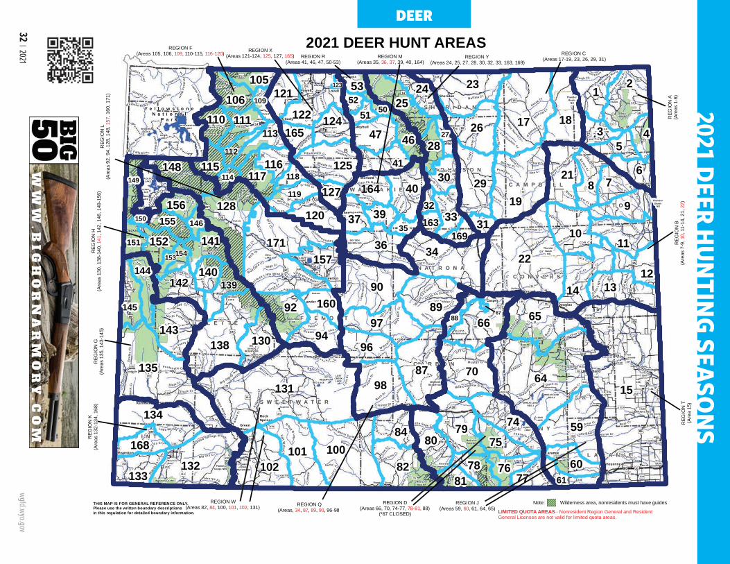
32 | 2021 wgfd.wyo.gov
P A R KP A R K
C A M P B E L LC A M P B E L L
C R O O KC R O O K
S H E R I D A NS H E R I D A N
T E T O NT E T O N J O H N S O NJ O H N S O N
W E S T O NW E S T O N
W A S H A K I EW A S H A K I E
H O T S P R I N G SH O T S P R I N G S
F R E M O N TF R E M O N T
N A T R O N AN A T R O N AC O N V E R S EC O N V E R S E
S U B L E T T ES U B L E T T E
L I N C O L NL I N C O L N
P L A T T EP L A T T E
C A R B O NC A R B O N
A L B A N YA L B A N Y
S W E E T W A T E RS W E E T W A T E R
L A R A M I EL A R A M I E
U I N T AU I N T A
B I G H O R NB I G H O R NBuffalo
Casper
Cheyenne
Cody
Douglas
Evanston
Gillette
Glenrock
GreenRiver
Greybull
Jackson
Kemmerer
Lander
Laramie
Lovell
Lusk
Newcastle
Pinedale
Powell
Rawlins
Riverton
RockSprings
Sheridan
Sundance
Thermopolis
TorringtonWheatland
Worland
PHELPSLAKE
LEIGHLAKE
JENNYLAKE
LOSTCREEKLAKE
FLAMINGGORGE
RESERVOIR
EDEN VALLEYRESERVOIR
BOULDERLAKE
FREMONTLAKE
FONTENELLERESERVOIR
HAWKSPRINGS RES
WHEATLANDRES 3
WHEATLANDRES 2
LONGLAKE
COOPERLAKE
GLENDORESERVOIR
PATHFINDERRESERVOIR
DESMETLAKE
YELLOWSTONELAKESHOSHONE
LAKELEWISLAKE
HEART LAKE
JACKSONLAKE
BOYSENRESERVOIR
BULLLAKE
OCEANLAKE
RED LAKE
HAYRESERVOIR
BIGSANDY
RESERVOIR
WILLOWLAKE
HALFMOONLAKE
GREEN RIVERLAKES
ALCOVARESERVOIR
LAKE HATTIE
SEMINOERESERVOIR
KEYHOLERESERVOIR
BUFFALOBILL
RESERVOIR
FlamingGorge NRA
BighornCanyon NRA
Shoshone NF
Bighorn NFBlack
Hills NF
BlackHills NF
Bridger-Teton NF
Targhee NF
Caribou NF
ShoshoneNF
MedicineBow NF
MedicineBow NF
Ashley NF
MedicineBow NF
MedicineBow NF
Wasatch-CacheNF
Afton
Albin
Alpine
Baggs
Bairoil
Bar Nunn
Basin
BigPiney
Burlington
Burns
Byron
Chugwater
Clearmont
Cokeville
Cowley DaytonDeaver
Diamondville
Dixon
Dubois
Edgerton
ElkMountain
FortLaramie
Frannie
Glendo
Encampment
Granger
Guernsey
Hanna
Hartville
Hudson
Hulett
Kaycee
Kirby
La Barge
La Grange
Lingle
LostSprings
Lyman
Manderson
Manville
Marbleton
MedicineBow
Meeteetse
Midwest
Moorcroft
MountainView
Opal
Pavillion
PineBluffs
PineHaven
Ranchester
Riverside
RockRiver
RollingHills
Saratoga
Shoshoni
SinclairSuperior
TenSleep
Thayne
Upton
VanTassell
Wamsutter
Wright
Yoder
Tho m ps on Cr
Sheep C
r
Wind River
Pow
d er River
Gr e
enRiver
Horse Cr
BighornRiv
er
Hams Fk
Sweetwater River
Greybull River
Clea r C r
Blacks Fk B
itte r Cr
Snak
e River
LaramieRiver
NowoodRi
ver
Poison Cr
Lodgepole Cr
Belle
Four
che
R
iver
DryC
r
Shell C r
Fivemile Cr
Rock Cr
Sm
i ths
Fk
Antelope Cr
Dry Fk
He nrys Fk
SouthFk Po
wde
r Riv
e r
Muddy Cr
Lamar R
iver
Raw
hi deCr
Grass Cr
Muskrat Cr
Littl
eSandy R
ive r
Dee
r Cr
Cottonwood Cr
B e aver Cr
P ass Cr
Pacif icCr
Bear
Riv
er
S hute Cr
Bear Cr
E lk CrE lkFk
Horseshoe Cr
La Barge Cr
Little
Missouri River
Bates Cr
Big Sandy River
Big Dry Cr
Mus h Cr
Cow Cr
Fonten elle Cr
Box
Elde
r Cr
North Laramie River
Sybille
C r
Medicine Bow River
Su
gar Cr
S age C
r
Cra
zyW
oman
Cr
Ki rby Dr
Castle
Cr
French Cr
Hay
Cr
Sepa
rat io
n Cr
Alkali Cr
Yell owstone
River
Little Bear Cr
Old
Wom
anC
r
No rth Piney Cr
Ca bal lo Cr
Black Thunder Cr
Littl e Muddy Cr
Little Wind River
Salt Cr
Poison Spider Cr
Mid
dle
Fk
Casper Cr
Li t tleLara
mie R iver
Coon
Cr
L os t
Cr
Twen
tym
il e
Cr
Slate Cr
Kirby Cr
BuffaloCr
Eas t Fk R iver
Wildcat C r
O sborne Dr
Trout Cr
Dutton Cr
South Fk Casper C r
RavenCr
LaPre
leCr
Falls River
Cave Gul ch
Wi llow Cr
Hoe Cr
Gibbon River
Cole
Cr
Porcupine C
r
Coope r Cr
Snyder Cr
Creston Dr
Little Thunder Cr
NorthBear Cr
LX
Bar Cr
Teap
otCr
BobCr
Barrel Spring s Dr
Log a
nG
ulch
Bull Lak
e Cr
Sout h F k
N orthPopo Agie River
Tw in Cr
Stra t ton
Dr
Vermillion Cr
DryPiney Cr
A ustin Cr
San
dSp
ring Cr
Tower Cr
Fortification Cr
Blac
ksFk
Can
al
Sm ithC
r
Meadow Springs Wash
Spr ead C r
Coug ar Cr
L itt
leB
igho
rnRiv
er
Lew
isR
iver
Bec
hlerRiver
Wild Cow Cr
No
rthFk L ittle Wind River
Blackrock
Cr
Gallitin R iver
Li ttle
Lig
htni
ngCr
Pe lton C r
Hunton Cr
W illow
Cr
HorseC
r
Sage Cr
Green
R iver
Cottonw ood Cr
Bear C
r
Beaver Cr
Bear Cr
Mud
dy Cr
Dry Cr
Alk
a li C
r
Buffalo Cr
Mud dy Cr
Skull
Cr
Roc
kC
r
Cow
Cr
Dry Cr
Sage Cr
S and Cr
Sage C r
Yellowstone
R ive r
Horse Cr
Dry Cr
Alkal i Cr
Fivemile
Cr
Dee r Cr
Can yon Cr
Raw
hide Cr
Snake Rive r
Bear Cr
Sand Cr
Beaver Cr
Dry Cr
North Platte River
No rth
Pla t te River
G
reysR
ive r
Bel le Fourc
he River
Owl Cr
Mud
dy Cr
Gooseberry Cr
Fifteenmile Cr
Cro
wC
r
LittleP
owderR
iver
Sal t W
ellsC
r
To ngue River
Nowater CrWig
gins Fk
Jack
Cr
Wa l
ker C r
ArchC
r
New
FkR
iver
So uthFk
Shosh
one
Riv
er
Dry Fk Cheyenne River
Pain
t Rock Cr
Wild Horse Cr
La Bonte
Cr
North Fk Powder River
Iron Cr
South Piney Cr
Killp
ecke
r Cr
Buck Dr
North Fk Shoshone River
Sage
Hen
Cr
WillowCr
AlbertC
r
South Beaver Cr
Black Butte
Cr
Middle Fk Powder Riv er
Buffalo Fk
Save
ryCr
Meetee tse Cr
Buc
kho r
nC
anyo
n
Fourmile Cr
Horse Cr
Fillm
ore
Cr
E nca
mpm
ent R
iver
Little Sage Cr
Deep
Cr
Morrow Cr
Paint Cr
Foster Cr
Eig h
teen
mile
Ca n
yon
N orth Horse Cr
Ishawo oa Cr
Sev enmile
CrM
edic
ine Lod
ge Cr
Nort h Barrel Springs Dr
Sout
h Spring
Cr
Dea
d
Indian C r
North Fk
Little Greys Riv e r
East Fk Nowater Cr
Bea rtrap
Cr
Sou th Cottonwood Cr
Alkali Cr
Pumpkin Cr
Nor th Fk
M adison R iver
Goose
Cr
Diam
ondS
pr
ingsDr
Mid dle Fk
Crandall Cr
Red Fk
Timber Cr
Mid dle Fk
North F k
South F k
North Fk Cottonwood Cr
North Fk Box Cr
Ott e r Cr
Buffa
l oC r
Be ar Cr
Sand
Cr
Sag e Cr
Buf
falo
Cr
Duck Cr
Pacific Cr
SandC
r
Wi ll
ow
Cr
Horse Cr
Be
aver Cr
Cot
t onw
ood
Cr
Muddy Cr
AlkaliC
r§̈¦I80
§̈¦I25
§̈¦I90
§̈¦I80
§̈¦I25
§̈¦I25
§̈¦I80
§̈¦I25
§̈¦I90
§̈¦I90
£¤26
£¤191
£¤18
£¤16
£¤85
£¤189
£¤89
£¤287
£¤14
£¤85
£¤89
£¤16
£¤20
£¤30
£¤14
£¤20 £¤16
£¤26
£¤191
£¤191
£¤191
£¤310
£¤87
£¤14A
£¤14A
£¤18
£¤18
£¤14£¤14
£¤14
£¤14
£¤85
£¤287
£¤287
£¤189
£¤20
£¤189
£¤20
£¤89
£¤191
£¤20
£¤287
£¤26
£¤85
£¤16
£¤26
£¤14
£¤85
£¤287
£¤30
£¤212
£¤30
£¤20
£¤16
£¤212
£¤14
£¤287
£¤16
£¤85
£¤26
£¤16
£¤30
£¤26
£¤89
³±487
³±59
³±34
³±430
³±50
³±789
³±120
³±530
³±70
³±270
³±135
³±116
³±192
³±32
³±24
³±387
³±585
³±310
³±28
³±372
³±431
³±351
³±313
³±93
³±22
³±433
³±94
³±132
³±352
³±71
³±215
³±190
³±211
³±253
³±156
³±374
³±319
³±320
³±232
³±114
³±11
³±410
³±294
³±225
³±233
³±238
³±10
³±111
³±335
³±92
³±295
³±290
³±214
³±161
³±314
³±157³±160
³±154
³±73
³±151
³±158
³±235
³±96³±377
³±315
³±413
³±152
³±133
³±311
³±217
³±218
³±173
³±24
³±136
³±59
³±789
³±89
³±59
³±90
³±220
³±196
³±130
³±130
³±120³±414 ³±230³±230
³±450
³±91
³±77
³±150
³±434
³±112
³±12
³±412
³±291
³±216
³±51
³±37
³±316
³±138 ³±95
³±113
³±371
³±223
³±251
³±343
³±370
³±451
³±411
³±193
³±341
³±271
³±435
³±331
³±273
³±30
³±120
³±789
³±487
³±28
³±789
³±116
³±191
³±89
³±338
³±272
Y e l l o w s t o n eN a t i o n a l
P a r k
30164
32163
169154
139142
105106
1725
18122
121 153 2109 52
5051110 11146
32728
4471655
29125 41115 21
19
117116
86118149
1487114
119 127
339
120 37156
40
22171
3910
146 31150
113615134
14
15712140144
145 8913
88
138
16092 67 65143
15
130
135 87
96
64131 98
155
597479
100 75101
102
80
6078 7677 6181
23
26
24
128
70
66
90
97
82
94
124
141
84
15235
134
168
132133
THIS MAP IS FOR GENERAL REFERENCE ONLY.Please use the written boundary descriptionsin this regulation for detailed boundary information.
2021 DEER HUNT AREAS
153
REGION R(Areas 41, 46, 47, 50-53)
REGION M (Areas 35, 36, 37, 39, 40, 164)
REGION Y (Areas 24, 25, 27, 28, 30, 32, 33, 163, 169)
REGION C (Areas 17-19, 23, 26, 29, 31)
REGION F(Areas 105, 106, 109, 110-115, 116-120)
REGION W(Areas 82, 84, 100, 101, 102, 131) REGION Q
(Areas, 34, 87, 89, 90, 96-98REGION D
(Areas 66, 70, 74-77, 78-81, 88)(*67 CLOSED)
REGION J(Areas 59, 60, 61, 64, 65)
REG
ION
T(A
rea
15)
REG
ION
B(A
reas
7-9
, 10,
11-
14, 2
1, 2
2)
REG
ION
A(A
reas
1-6
)
REG
ION
K(A
reas
132
-134
, 168
)R
EGIO
N G
(Are
as 1
35, 1
43-1
45)
REG
ION
H(A
reas
130
, 138
-140
, 141
, 142
, 146
, 149
-156
)
LIMITED QUOTA AREAS - Nonresident Region General and Resident General Licenses are not valid for limited quota areas.
112
Thunder Basin
NG
Thunder Basin
NG
Thunder Basin
NG
REGION X(Areas 121-124, 125, 127, 165)
113
REG
ION
L(A
reas
92,
94,
128
, 148
, 157
, 160
, 171
)
123
Note: Wilderness area, nonresidents must have guides
DEER2021 DEER HUNTING SEASO
NS
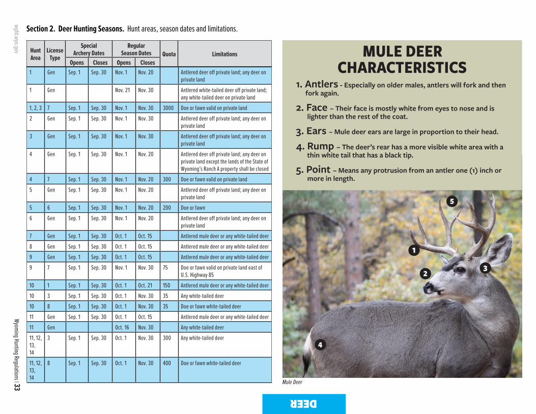
wgfd.wyo.gov
Wyoming Hunting Regulations | 33
Section 2. Deer Hunting Seasons. Hunt areas, season dates and limitations.
DEER
MULE DEER CHARACTERISTICS
1. Antlers - Especially on older males, antlers will fork and then fork again.
2. Face – Their face is mostly white from eyes to nose and is lighter than the rest of the coat.
3. Ears – Mule deer ears are large in proportion to their head.
4. Rump – The deer’s rear has a more visible white area with a thin white tail that has a black tip.
5. Point – Means any protrusion from an antler one (1) inch or more in length.
1
23
5
4
Hunt Area
LicenseType
SpecialArchery Dates
RegularSeason Dates Quota Limitations
Opens Closes Opens Closes1 Gen Sep. 1 Sep. 30 Nov. 1 Nov. 20 Antlered deer off private land; any deer on
private land
1 Gen Nov. 21 Nov. 30 Antlered white-tailed deer off private land; any white-tailed deer on private land
1, 2, 3 7 Sep. 1 Sep. 30 Nov. 1 Nov. 30 3000 Doe or fawn valid on private land
2 Gen Sep. 1 Sep. 30 Nov. 1 Nov. 30 Antlered deer off private land; any deer on private land
3 Gen Sep. 1 Sep. 30 Nov. 1 Nov. 30 Antlered deer off private land; any deer on private land
4 Gen Sep. 1 Sep. 30 Nov. 1 Nov. 20 Antlered deer off private land; any deer on private land except the lands of the State of Wyoming’s Ranch A property shall be closed
4 7 Sep. 1 Sep. 30 Nov. 1 Nov. 20 300 Doe or fawn valid on private land
5 Gen Sep. 1 Sep. 30 Nov. 1 Nov. 20 Antlered deer off private land; any deer on private land
5 6 Sep. 1 Sep. 30 Nov. 1 Nov. 20 200 Doe or fawn
6 Gen Sep. 1 Sep. 30 Nov. 1 Nov. 20 Antlered deer off private land; any deer on private land
7 Gen Sep. 1 Sep. 30 Oct. 1 Oct. 15 Antlered mule deer or any white-tailed deer
8 Gen Sep. 1 Sep. 30 Oct. 1 Oct. 15 Antlered mule deer or any white-tailed deer
9 Gen Sep. 1 Sep. 30 Oct. 1 Oct. 15 Antlered mule deer or any white-tailed deer
9 7 Sep. 1 Sep. 30 Nov. 1 Nov. 30 75 Doe or fawn valid on private land east of U.S. Highway 85
10 1 Sep. 1 Sep. 30 Oct. 1 Oct. 21 150 Antlered mule deer or any white-tailed deer
10 3 Sep. 1 Sep. 30 Oct. 1 Nov. 30 35 Any white-tailed deer
10 8 Sep. 1 Sep. 30 Oct. 1 Nov. 30 35 Doe or fawn white-tailed deer
11 Gen Sep. 1 Sep. 30 Oct. 1 Oct. 15 Antlered mule deer or any white-tailed deer
11 Gen Oct. 16 Nov. 30 Any white-tailed deer
11, 12, 13, 14
3 Sep. 1 Sep. 30 Oct. 1 Nov. 30 300 Any white-tailed deer
11, 12, 13, 14
8 Sep. 1 Sep. 30 Oct. 1 Nov. 30 400 Doe or fawn white-tailed deer
2021 DEER HUNTING SEASONS
Mule Deer

34 | 2021 wgfd.wyo.gov
DEER
Hunt Area
LicenseType
SpecialArchery Dates
RegularSeason Dates Quota Limitations
Opens Closes Opens ClosesWHITE-TAILED DEER CHARACTERISTICS
1. Antlers - White-tailed deer have one main beam from where all the tines emerge.
2. Face – Their face is mostly brown and similar to the rest of their coat, with only limited white around the nose.
3. Ears – Their ears are more proportional to their heads.
4. Rump – A dark tail covers a white patch on their rear. Startled white-tails will flash this white (flag) while running.
1
23
4
12 Gen Sep. 1 Sep. 30 Oct. 1 Oct. 15 Antlered mule deer or any white-tailed deer
12 Gen Oct. 16 Nov. 30 Any white-tailed deer
12, 13, 14
7 Sep. 1 Sep. 30 Oct. 1 Nov. 30 100 Doe or fawn valid on private land
13 Gen Sep. 1 Sep. 30 Oct. 1 Oct. 15 Antlered mule deer or any white-tailed deer
13 Gen Oct. 16 Nov. 30 Any white-tailed deer
14 Gen Sep. 1 Sep. 30 Oct. 1 Oct. 15 Antlered mule deer or any white-tailed deer
14 Gen Oct. 16 Nov. 30 Any white-tailed deer
15 Gen Sep. 1 Sep. 30 Oct. 1 Oct. 14 Antlered mule deer or any white-tailed deer
15 3 Sep. 1 Sep. 30 Oct. 1 Nov. 30 500 Any white-tailed deer
15 3 Dec. 1 Dec. 31 Antlerless white-tailed deer
15 6 Sep. 1 Sep. 30 Oct. 1 Dec. 31 300 Doe or fawn
15 8 Sep. 1 Sep. 30 Oct. 1 Dec. 31 450 Doe or fawn white-tailed deer
17 Gen Sep. 1 Sep. 30 Oct. 1 Oct. 20 Antlered mule deer or any white-tailed deer
17 Gen Nov. 1 Nov. 30 Any white-tailed deer
17 7 Sep. 1 Sep. 30 Oct. 1 Oct. 20 50 Doe or fawn valid on private land
17 8 Sep. 1 Sep. 30 Oct. 1 Nov. 30 250 Doe or fawn white-tailed deer
18 Gen Sep. 1 Sep. 30 Oct. 1 Oct. 20 Antlered mule deer or any white-tailed deer
18 7 Sep. 1 Sep. 30 Oct. 1 Oct. 20 100 Doe or fawn valid on private land
18 8 Sep. 1 Sep. 30 Oct. 1 Oct. 31 200 Doe or fawn white-tailed deer valid on private land
19 Gen Sep. 1 Sep. 30 Oct. 1 Oct. 20 Antlered mule deer or any white-tailed deer
19 Gen Nov. 1 Nov. 15 Any white-tailed deer
19 7 Sep. 1 Sep. 30 Oct. 1 Oct. 20 50 Doe or fawn valid on private land
19 8 Sep. 1 Sep. 30 Oct. 1 Nov. 15 75 Doe or fawn white-tailed deer
21 Gen Sep. 1 Sep. 30 Oct. 1 Oct. 15 Antlered mule deer or any white-tailed deer
21 7 Sep. 1 Sep. 30 Oct. 1 Oct. 31 100 Doe or fawn valid on private land
21 8 Sep. 1 Sep. 30 Oct. 1 Oct. 31 50 Doe or fawn white-tailed deer valid on private land
22 1 Sep. 1 Sep. 30 Oct. 1 Oct. 14 500 Antlered mule deer or any white-tailed deer
22 3 Sep. 1 Sep. 30 Oct. 1 Nov. 30 150 Any white-tailed deer
22 8 Sep. 1 Sep. 30 Oct. 1 Nov. 30 200 Doe or fawn white-tailed deer
White-tailed Deer
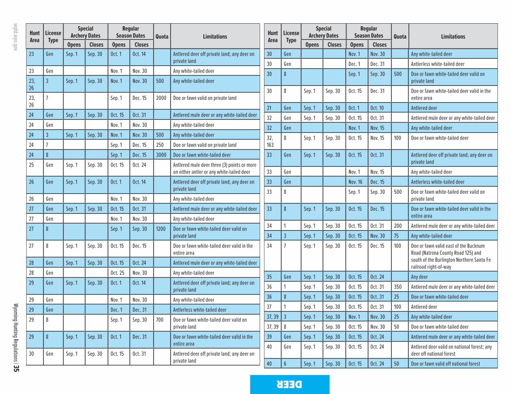
wgfd.wyo.gov
Wyoming Hunting Regulations | 35
DEER
Hunt Area
LicenseType
SpecialArchery Dates
RegularSeason Dates Quota Limitations
Opens Closes Opens Closes
Hunt Area
LicenseType
SpecialArchery Dates
RegularSeason Dates Quota Limitations
Opens Closes Opens Closes23 Gen Sep. 1 Sep. 30 Oct. 1 Oct. 14 Antlered deer off private land; any deer on
private land
23 Gen Nov. 1 Nov. 30 Any white-tailed deer
23, 26
3 Sep. 1 Sep. 30 Nov. 1 Nov. 30 500 Any white-tailed deer
23, 26
7 Sep. 1 Dec. 15 2000 Doe or fawn valid on private land
24 Gen Sep. 1 Sep. 30 Oct. 15 Oct. 31 Antlered mule deer or any white-tailed deer
24 Gen Nov. 1 Nov. 30 Any white-tailed deer
24 3 Sep. 1 Sep. 30 Nov. 1 Nov. 30 500 Any white-tailed deer
24 7 Sep. 1 Dec. 15 250 Doe or fawn valid on private land
24 8 Sep. 1 Dec. 15 3000 Doe or fawn white-tailed deer
25 Gen Sep. 1 Sep. 30 Oct. 15 Oct. 24 Antlered mule deer three (3) points or more on either antler or any white-tailed deer
26 Gen Sep. 1 Sep. 30 Oct. 1 Oct. 14 Antlered deer off private land; any deer on private land
26 Gen Nov. 1 Nov. 30 Any white-tailed deer
27 Gen Sep. 1 Sep. 30 Oct. 15 Oct. 31 Antlered mule deer or any white-tailed deer
27 Gen Nov. 1 Nov. 30 Any white-tailed deer
27 8 Sep. 1 Sep. 30 1200 Doe or fawn white-tailed deer valid on private land
27 8 Sep. 1 Sep. 30 Oct. 15 Dec. 15 Doe or fawn white-tailed deer valid in the entire area
28 Gen Sep. 1 Sep. 30 Oct. 15 Oct. 24 Antlered mule deer or any white-tailed deer
28 Gen Oct. 25 Nov. 30 Any white-tailed deer
29 Gen Sep. 1 Sep. 30 Oct. 1 Oct. 14 Antlered deer off private land; any deer on private land
29 Gen Nov. 1 Nov. 30 Any white-tailed deer
29 Gen Dec. 1 Dec. 31 Antlerless white-tailed deer
29 8 Sep. 1 Sep. 30 700 Doe or fawn white-tailed deer valid on private land
29 8 Sep. 1 Sep. 30 Oct. 1 Dec. 31 Doe or fawn white-tailed deer valid in the entire area
30 Gen Sep. 1 Sep. 30 Oct. 15 Oct. 31 Antlered deer off private land; any deer on private land
30 Gen Nov. 1 Nov. 30 Any white-tailed deer
30 Gen Dec. 1 Dec. 31 Antlerless white-tailed deer
30 8 Sep. 1 Sep. 30 500 Doe or fawn white-tailed deer valid on private land
30 8 Sep. 1 Sep. 30 Oct. 15 Dec. 31 Doe or fawn white-tailed deer valid in the entire area
31 Gen Sep. 1 Sep. 30 Oct. 1 Oct. 10 Antlered deer
32 Gen Sep. 1 Sep. 30 Oct. 15 Oct. 31 Antlered mule deer or any white-tailed deer
32 Gen Nov. 1 Nov. 15 Any white-tailed deer
32, 163
8 Sep. 1 Sep. 30 Oct. 15 Nov. 15 100 Doe or fawn white-tailed deer
33 Gen Sep. 1 Sep. 30 Oct. 15 Oct. 31 Antlered deer off private land; any deer on private land
33 Gen Nov. 1 Nov. 15 Any white-tailed deer
33 Gen Nov. 16 Dec. 15 Antlerless white-tailed deer
33 8 Sep. 1 Sep. 30 500 Doe or fawn white-tailed deer valid on private land
33 8 Sep. 1 Sep. 30 Oct. 15 Dec. 15 Doe or fawn white-tailed deer valid in the entire area
34 1 Sep. 1 Sep. 30 Oct. 15 Oct. 31 200 Antlered mule deer or any white-tailed deer
34 3 Sep. 1 Sep. 30 Oct. 15 Nov. 30 75 Any white-tailed deer
34 7 Sep. 1 Sep. 30 Oct. 15 Dec. 15 100 Doe or fawn valid east of the Bucknum Road (Natrona County Road 125) and south of the Burlington Northern Santa Fe railroad right-of-way
35 Gen Sep. 1 Sep. 30 Oct. 15 Oct. 24 Any deer
36 1 Sep. 1 Sep. 30 Oct. 15 Oct. 31 350 Antlered mule deer or any white-tailed deer
36 8 Sep. 1 Sep. 30 Oct. 15 Oct. 31 25 Doe or fawn white-tailed deer
37 1 Sep. 1 Sep. 30 Oct. 15 Oct. 31 100 Antlered deer
37, 39 3 Sep. 1 Sep. 30 Nov. 1 Nov. 30 25 Any white-tailed deer
37, 39 8 Sep. 1 Sep. 30 Oct. 15 Nov. 30 50 Doe or fawn white-tailed deer
39 Gen Sep. 1 Sep. 30 Oct. 15 Oct. 24 Antlered mule deer or any white-tailed deer
40 Gen Sep. 1 Sep. 30 Oct. 15 Oct. 24 Antlered deer valid on national forest; any deer off national forest
40 6 Sep. 1 Sep. 30 Oct. 15 Oct. 24 50 Doe or fawn valid off national forest
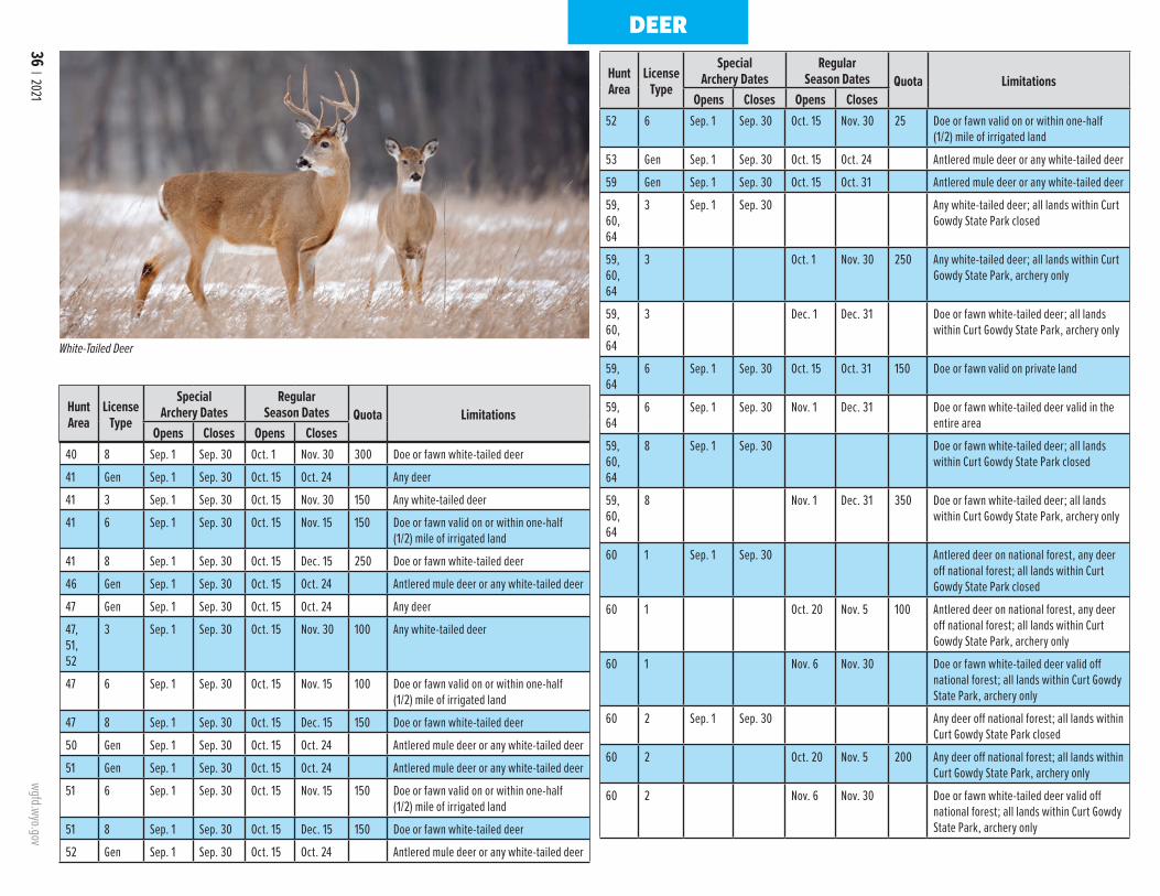
36 | 2021 wgfd.wyo.gov
DEER
White-Tailed Deer
Hunt Area
LicenseType
SpecialArchery Dates
RegularSeason Dates Quota Limitations
Opens Closes Opens Closes
Hunt Area
LicenseType
SpecialArchery Dates
RegularSeason Dates Quota Limitations
Opens Closes Opens Closes
40 8 Sep. 1 Sep. 30 Oct. 1 Nov. 30 300 Doe or fawn white-tailed deer
41 Gen Sep. 1 Sep. 30 Oct. 15 Oct. 24 Any deer
41 3 Sep. 1 Sep. 30 Oct. 15 Nov. 30 150 Any white-tailed deer
41 6 Sep. 1 Sep. 30 Oct. 15 Nov. 15 150 Doe or fawn valid on or within one-half (1/2) mile of irrigated land
41 8 Sep. 1 Sep. 30 Oct. 15 Dec. 15 250 Doe or fawn white-tailed deer
46 Gen Sep. 1 Sep. 30 Oct. 15 Oct. 24 Antlered mule deer or any white-tailed deer
47 Gen Sep. 1 Sep. 30 Oct. 15 Oct. 24 Any deer
47, 51, 52
3 Sep. 1 Sep. 30 Oct. 15 Nov. 30 100 Any white-tailed deer
47 6 Sep. 1 Sep. 30 Oct. 15 Nov. 15 100 Doe or fawn valid on or within one-half (1/2) mile of irrigated land
47 8 Sep. 1 Sep. 30 Oct. 15 Dec. 15 150 Doe or fawn white-tailed deer
50 Gen Sep. 1 Sep. 30 Oct. 15 Oct. 24 Antlered mule deer or any white-tailed deer
51 Gen Sep. 1 Sep. 30 Oct. 15 Oct. 24 Antlered mule deer or any white-tailed deer
51 6 Sep. 1 Sep. 30 Oct. 15 Nov. 15 150 Doe or fawn valid on or within one-half (1/2) mile of irrigated land
51 8 Sep. 1 Sep. 30 Oct. 15 Dec. 15 150 Doe or fawn white-tailed deer
52 Gen Sep. 1 Sep. 30 Oct. 15 Oct. 24 Antlered mule deer or any white-tailed deer
52 6 Sep. 1 Sep. 30 Oct. 15 Nov. 30 25 Doe or fawn valid on or within one-half (1/2) mile of irrigated land
53 Gen Sep. 1 Sep. 30 Oct. 15 Oct. 24 Antlered mule deer or any white-tailed deer
59 Gen Sep. 1 Sep. 30 Oct. 15 Oct. 31 Antlered mule deer or any white-tailed deer
59, 60, 64
3 Sep. 1 Sep. 30 Any white-tailed deer; all lands within Curt Gowdy State Park closed
59, 60, 64
3 Oct. 1 Nov. 30 250 Any white-tailed deer; all lands within Curt Gowdy State Park, archery only
59, 60, 64
3 Dec. 1 Dec. 31 Doe or fawn white-tailed deer; all lands within Curt Gowdy State Park, archery only
59, 64
6 Sep. 1 Sep. 30 Oct. 15 Oct. 31 150 Doe or fawn valid on private land
59, 64
6 Sep. 1 Sep. 30 Nov. 1 Dec. 31 Doe or fawn white-tailed deer valid in the entire area
59, 60, 64
8 Sep. 1 Sep. 30 Doe or fawn white-tailed deer; all lands within Curt Gowdy State Park closed
59, 60, 64
8 Nov. 1 Dec. 31 350 Doe or fawn white-tailed deer; all lands within Curt Gowdy State Park, archery only
60 1 Sep. 1 Sep. 30 Antlered deer on national forest, any deer off national forest; all lands within Curt Gowdy State Park closed
60 1 Oct. 20 Nov. 5 100 Antlered deer on national forest, any deer off national forest; all lands within Curt Gowdy State Park, archery only
60 1 Nov. 6 Nov. 30 Doe or fawn white-tailed deer valid off national forest; all lands within Curt Gowdy State Park, archery only
60 2 Sep. 1 Sep. 30 Any deer off national forest; all lands within Curt Gowdy State Park closed
60 2 Oct. 20 Nov. 5 200 Any deer off national forest; all lands within Curt Gowdy State Park, archery only
60 2 Nov. 6 Nov. 30 Doe or fawn white-tailed deer valid off national forest; all lands within Curt Gowdy State Park, archery only
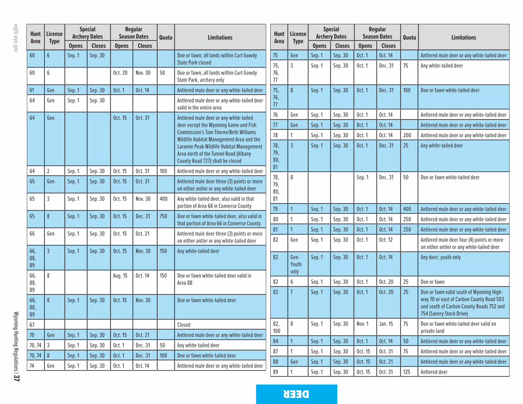
wgfd.wyo.gov
Wyoming Hunting Regulations | 37
DEER
Hunt Area
LicenseType
SpecialArchery Dates
RegularSeason Dates Quota Limitations
Opens Closes Opens Closes
Hunt Area
LicenseType
SpecialArchery Dates
RegularSeason Dates Quota Limitations
Opens Closes Opens Closes60 6 Sep. 1 Sep. 30 Doe or fawn; all lands within Curt Gowdy
State Park closed
60 6 Oct. 20 Nov. 30 50 Doe or fawn; all lands within Curt Gowdy State Park, archery only
61 Gen Sep. 1 Sep. 30 Oct. 1 Oct. 14 Antlered mule deer or any white-tailed deer
64 Gen Sep. 1 Sep. 30 Antlered mule deer or any white-tailed deer valid in the entire area
64 Gen Oct. 15 Oct. 31 Antlered mule deer or any white-tailed deer except the Wyoming Game and Fish Commission’s Tom Thorne/Beth Williams Wildlife Habitat Management Area and the Laramie Peak Wildlife Habitat Management Area north of the Tunnel Road (Albany County Road 727) shall be closed
64 2 Sep. 1 Sep. 30 Oct. 15 Oct. 31 100 Antlered mule deer or any white-tailed deer
65 Gen Sep. 1 Sep. 30 Oct. 15 Oct. 31 Antlered mule deer three (3) points or more on either antler or any white-tailed deer
65 3 Sep. 1 Sep. 30 Oct. 15 Nov. 30 400 Any white-tailed deer, also valid in that portion of Area 66 in Converse County
65 8 Sep. 1 Sep. 30 Oct. 15 Dec. 31 750 Doe or fawn white-tailed deer, also valid in that portion of Area 66 in Converse County
66 Gen Sep. 1 Sep. 30 Oct. 15 Oct. 21 Antlered mule deer three (3) points or more on either antler or any white-tailed deer
66, 88, 89
3 Sep. 1 Sep. 30 Oct. 15 Nov. 30 150 Any white-tailed deer
66, 88, 89
8 Aug. 15 Oct. 14 150 Doe or fawn white-tailed deer valid in Area 88
66, 88, 89
8 Sep. 1 Sep. 30 Oct. 15 Nov. 30 Doe or fawn white-tailed deer
67 Closed
70 Gen Sep. 1 Sep. 30 Oct. 15 Oct. 21 Antlered mule deer or any white-tailed deer
70, 74 3 Sep. 1 Sep. 30 Oct. 1 Dec. 31 50 Any white-tailed deer
70, 74 8 Sep. 1 Sep. 30 Oct. 1 Dec. 31 100 Doe or fawn white-tailed deer
74 Gen Sep. 1 Sep. 30 Oct. 1 Oct. 14 Antlered mule deer or any white-tailed deer
75 Gen Sep. 1 Sep. 30 Oct. 1 Oct. 14 Antlered mule deer or any white-tailed deer
75, 76, 77
3 Sep. 1 Sep. 30 Oct. 1 Dec. 31 75 Any white-tailed deer
75, 76, 77
8 Sep. 1 Sep. 30 Oct. 1 Dec. 31 100 Doe or fawn white-tailed deer
76 Gen Sep. 1 Sep. 30 Oct. 1 Oct. 14 Antlered mule deer or any white-tailed deer
77 Gen Sep. 1 Sep. 30 Oct. 1 Oct. 14 Antlered mule deer or any white-tailed deer
78 1 Sep. 1 Sep. 30 Oct. 1 Oct. 14 200 Antlered mule deer or any white-tailed deer
78, 79, 80, 81
3 Sep. 1 Sep. 30 Oct. 1 Dec. 31 25 Any white-tailed deer
78, 79, 80, 81
8 Sep. 1 Dec. 31 50 Doe or fawn white-tailed deer
79 1 Sep. 1 Sep. 30 Oct. 1 Oct. 14 400 Antlered mule deer or any white-tailed deer
80 1 Sep. 1 Sep. 30 Oct. 1 Oct. 14 250 Antlered mule deer or any white-tailed deer
81 1 Sep. 1 Sep. 30 Oct. 1 Oct. 14 250 Antlered mule deer or any white-tailed deer
82 Gen Sep. 1 Sep. 30 Oct. 1 Oct. 12 Antlered mule deer four (4) points or more on either antler or any white-tailed deer
82 Gen-Youth only
Sep. 1 Sep. 30 Oct. 1 Oct. 14 Any deer; youth only
82 6 Sep. 1 Sep. 30 Oct. 1 Oct. 20 25 Doe or fawn
82 7 Sep. 1 Sep. 30 Oct. 1 Oct. 20 25 Doe or fawn valid south of Wyoming High-way 70 or east of Carbon County Road 503 and south of Carbon County Roads 752 and 754 (Savery Stock Drive)
82, 100
8 Sep. 1 Sep. 30 Nov. 1 Jan. 15 75 Doe or fawn white-tailed deer valid on private land
84 1 Sep. 1 Sep. 30 Oct. 1 Oct. 14 50 Antlered mule deer or any white-tailed deer
87 1 Sep. 1 Sep. 30 Oct. 15 Oct. 31 75 Antlered mule deer or any white-tailed deer
88 Gen Sep. 1 Sep. 30 Oct. 15 Oct. 21 Antlered mule deer or any white-tailed deer
89 1 Sep. 1 Sep. 30 Oct. 15 Oct. 31 125 Antlered deer

38 | 2021 wgfd.wyo.gov
DEER
Hunt Area
LicenseType
SpecialArchery Dates
RegularSeason Dates Quota Limitations
Opens Closes Opens Closes
Hunt Area
LicenseType
SpecialArchery Dates
RegularSeason Dates Quota Limitations
Opens Closes Opens Closes90 1 Sep. 1 Sep. 30 Oct. 1 Oct. 31 75 Any deer
92 Gen Sep. 1 Sep. 30 Oct. 15 Oct. 20 Antlered mule deer three (3) points or more on either antler or any white-tailed deer
92, 94, 160
3 Sep. 1 Sep. 30 Oct. 1 Nov. 30 100 Any white-tailed deer
92 6 Sep. 1 Sep. 30 Oct. 1 Oct. 20 25 Doe or fawn valid on private land north of the Little Popo Agie River
92, 94, 160
8 Sep. 1 Sep. 30 Oct. 1 Nov. 30 150 Doe or fawn white-tailed deer
94 Gen Sep. 1 Sep. 30 Oct. 15 Oct. 20 Antlered mule deer three (3) points or more on either antler or any white-tailed deer
96 Gen Sep. 1 Sep. 30 Oct. 15 Oct. 20 Antlered mule deer three (3) points or more on either antler or any white-tailed deer
97 Gen Sep. 1 Sep. 30 Oct. 15 Oct. 20 Antlered mule deer three (3) points or more on either antler or any white-tailed deer
97 3 Sep. 1 Sep. 30 Oct. 15 Nov. 30 25 Any white-tailed deer
97 8 Sep. 1 Sep. 30 Oct. 15 Nov. 30 50 Doe or fawn white-tailed deer
98 Gen Sep. 1 Sep. 30 Oct. 15 Oct. 20 Antlered mule deer three (3) points or more on either antler or any white-tailed deer, archery or muzzle-loading firearms only
100 Gen Sep. 1 Sep. 30 Oct. 1 Oct. 6 Antlered mule deer four (4) points or more on either antler or any white-tailed deer
100 Gen-Youth only
Sep. 1 Sep. 30 Oct. 1 Oct. 8 Any deer; youth only
101 1 Sep. 1 Sep. 30 Oct. 15 Oct. 31 25 Antlered deer
102 1 Sep. 1 Sep. 30 Oct. 15 Oct. 31 200 Any deer
105 Gen Sep. 1 Sep. 30 Oct. 1 Oct. 24 Antlered mule deer or any white-tailed deer valid on national forest
105 Gen Sep. 1 Sep. 30 Nov. 1 Nov. 5 Antlered mule deer or any white-tailed deer valid off national forest
105 Gen Sep. 1 Sep. 30 Nov. 6 Nov. 17 Antlerless deer valid on private land
105, 106, 109
1 Sep. 1 Sep. 30 Nov. 1 Nov. 15 25 Any deer
106 Gen Sep. 1 Sep. 30 Oct. 1 Oct. 24 Antlered mule deer or any white-tailed deer
109 8 Sep. 1 Sep. 30 Nov. 1 Nov. 15 25 Doe or fawn white-tailed deer
110 Gen Sep. 1 Sep. 30 Oct. 15 Nov. 3 Antlered mule deer or any white-tailed deer
110, 111
1 Sep. 1 Sep. 30 Nov. 1 Nov. 15 25 Antlered mule deer or any white-tailed deer
110, 111
8 Sep. 1 Sep. 30 Oct. 15 Dec. 31 100 Doe or fawn white-tailed deer
111 Gen Sep. 1 Sep. 30 Oct. 15 Nov. 3 Antlered mule deer or any white-tailed deer
112 Gen Sep. 1 Sep. 30 Oct. 15 Nov. 3 Antlered mule deer or any white-tailed deer
112, 113, 114
1 Sep. 1 Sep. 30 Nov. 1 Nov. 15 25 Antlered mule deer or any white-tailed deer
112, 113
3 Sep. 1 Sep. 30 Nov. 1 Nov. 30 35 Any white-tailed deer
112, 113
8 Sep. 1 Sep. 30 Oct. 15 Dec. 31 175 Doe or fawn white-tailed deer
113 Gen Sep. 1 Sep. 30 Oct. 15 Nov. 3 Antlered mule deer or any white-tailed deer
113 7 Sep. 1 Sep. 14 Sep. 15 Nov. 15 75 Doe or fawn valid on private land north and east of Carter Creek
114 Gen Sep. 1 Sep. 30 Oct. 15 Nov. 3 Antlered mule deer or any white-tailed deer
115 Gen Sep. 1 Sep. 9 Sep. 10 Oct. 22 Antlered mule deer or any white-tailed deer
116 1 Sep. 1 Sep. 30 Oct. 15 Oct. 31 75 Antlered mule deer or any white-tailed deer
116, 117
3 Sep. 1 Sep. 30 Nov. 1 Nov. 30 100 Any white-tailed deer
116 6 Sep. 1 Sep. 30 Oct. 15 Nov. 30 50 Doe or fawn valid on private land
116 7 Sep. 1 Oct. 14 75 Doe or fawn white-tailed deer valid on private land in the Wood River drainage
116, 117, 118
8 Sep. 1 Sep. 30 Oct. 15 Nov. 30 150 Doe or fawn white-tailed deer
117 1 Sep. 1 Sep. 14 Sep. 15 Oct. 15 50 Antlered mule deer or any white-tailed deer
118 1 Sep. 1 Sep. 30 Oct. 15 Oct. 31 25 Antlered deer
118 1 Sep. 1 Sep. 30 Nov. 1 Nov. 30 Any white-tailed deerCWD sample submission is mandatory in Deer Hunt Areas 96 and 97. Visit the Department's website at https://wgfd.wyo.gov/Wildlife-in-Wyoming/More-Wildlife/Wildlife-Disease or call the Lander Regional Office 307-332-2688 for additional information.
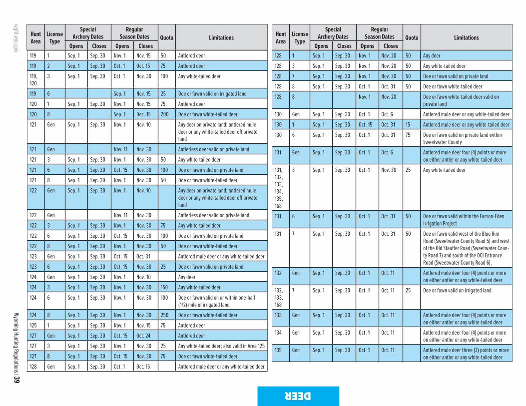
wgfd.wyo.gov
Wyoming Hunting Regulations | 39
DEER
Hunt Area
LicenseType
SpecialArchery Dates
RegularSeason Dates Quota Limitations
Opens Closes Opens Closes
Hunt Area
LicenseType
SpecialArchery Dates
RegularSeason Dates Quota Limitations
Opens Closes Opens Closes119 1 Sep. 1 Sep. 30 Nov. 1 Nov. 15 50 Antlered deer
119 2 Sep. 1 Sep. 30 Oct. 1 Oct. 15 75 Antlered deer
119, 120
3 Sep. 1 Sep. 30 Oct. 1 Nov. 30 100 Any white-tailed deer
119 6 Sep. 1 Nov. 15 25 Doe or fawn valid on irrigated land
120 1 Sep. 1 Sep. 30 Nov. 1 Nov. 15 75 Antlered deer
120 8 Sep. 1 Dec. 15 200 Doe or fawn white-tailed deer
121 Gen Sep. 1 Sep. 30 Nov. 1 Nov. 10 Any deer on private land; antlered mule deer or any white-tailed deer off private land
121 Gen Nov. 11 Nov. 30 Antlerless deer valid on private land
121 3 Sep. 1 Sep. 30 Nov. 1 Nov. 30 50 Any white-tailed deer
121 6 Sep. 1 Sep. 30 Oct. 15 Nov. 30 100 Doe or fawn valid on private land
121 8 Sep. 1 Sep. 30 Nov. 1 Nov. 30 50 Doe or fawn white-tailed deer
122 Gen Sep. 1 Sep. 30 Nov. 1 Nov. 10 Any deer on private land; antlered mule deer or any white-tailed deer off private land
122 Gen Nov. 11 Nov. 30 Antlerless deer valid on private land
122 3 Sep. 1 Sep. 30 Nov. 1 Nov. 30 75 Any white-tailed deer
122 6 Sep. 1 Sep. 30 Oct. 15 Nov. 30 100 Doe or fawn valid on private land
122 8 Sep. 1 Sep. 30 Nov. 1 Nov. 30 50 Doe or fawn white-tailed deer
123 Gen Sep. 1 Sep. 30 Oct. 15 Oct. 31 Antlered mule deer or any white-tailed deer
123 6 Sep. 1 Sep. 30 Oct. 15 Nov. 30 25 Doe or fawn valid on private land
124 Gen Sep. 1 Sep. 30 Nov. 1 Nov. 10 Any deer
124 3 Sep. 1 Sep. 30 Nov. 1 Nov. 30 150 Any white-tailed deer
124 6 Sep. 1 Sep. 30 Nov. 1 Nov. 30 100 Doe or fawn valid on or within one-half (1/2) mile of irrigated land
124 8 Sep. 1 Sep. 30 Nov. 1 Nov. 30 250 Doe or fawn white-tailed deer
125 1 Sep. 1 Sep. 30 Nov. 1 Nov. 15 75 Antlered deer
127 Gen Sep. 1 Sep. 30 Oct. 15 Oct. 24 Antlered deer
127 3 Sep. 1 Sep. 30 Nov. 1 Nov. 30 25 Any white-tailed deer; also valid in Area 125
127 8 Sep. 1 Sep. 30 Oct. 15 Nov. 30 75 Doe or fawn white-tailed deer
128 Gen Sep. 1 Sep. 30 Oct. 1 Oct. 15 Antlered mule deer or any white-tailed deer
128 1 Sep. 1 Sep. 30 Nov. 1 Nov. 20 50 Any deer
128 3 Sep. 1 Sep. 30 Nov. 1 Nov. 20 50 Any white-tailed deer
128 7 Sep. 1 Sep. 30 Nov. 1 Nov. 20 50 Doe or fawn valid on private land
128 8 Sep. 1 Sep. 30 Oct. 1 Oct. 31 50 Doe or fawn white-tailed deer
128 8 Nov. 1 Nov. 20 Doe or fawn white-tailed deer valid on private land
130 Gen Sep. 1 Sep. 30 Oct. 1 Oct. 6 Antlered mule deer or any white-tailed deer
130 1 Sep. 1 Sep. 30 Oct. 15 Oct. 31 15 Antlered mule deer or any white-tailed deer
130 6 Sep. 1 Sep. 30 Oct. 1 Oct. 31 75 Doe or fawn valid on private land within Sweetwater County
131 Gen Sep. 1 Sep. 30 Oct. 1 Oct. 6 Antlered mule deer four (4) points or more on either antler or any white-tailed deer
131, 132, 133, 134, 135, 168
3 Sep. 1 Sep. 30 Oct. 1 Nov. 30 25 Any white-tailed deer
131 6 Sep. 1 Sep. 30 Oct. 1 Oct. 31 50 Doe or fawn valid within the Farson-Eden Irrigation Project
131 7 Sep. 1 Sep. 30 Oct. 1 Oct. 31 50 Doe or fawn valid west of the Blue Rim Road (Sweetwater County Road 5) and west of the Old Stauffer Road (Sweetwater Coun-ty Road 7) and south of the OCI Entrance Road (Sweetwater County Road 6).
132 Gen Sep. 1 Sep. 30 Oct. 1 Oct. 11 Antlered mule deer four (4) points or more on either antler or any white-tailed deer
132, 133, 168
7 Sep. 1 Sep. 30 Oct. 1 Oct. 11 25 Doe or fawn valid on irrigated land
133 Gen Sep. 1 Sep. 30 Oct. 1 Oct. 11 Antlered mule deer four (4) points or more on either antler or any white-tailed deer
134 Gen Sep. 1 Sep. 30 Oct. 1 Oct. 11 Antlered mule deer four (4) points or more on either antler or any white-tailed deer
135 Gen Sep. 1 Sep. 30 Oct. 1 Oct. 11 Antlered mule deer three (3) points or more on either antler or any white-tailed deer
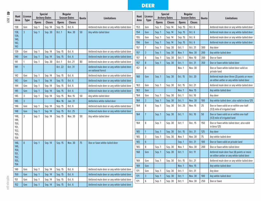
40 | 2021 wgfd.wyo.gov
Hunt Area
LicenseType
SpecialArchery Dates
RegularSeason Dates Quota Limitations
Opens Closes Opens Closes
Hunt Area
LicenseType
SpecialArchery Dates
RegularSeason Dates Quota Limitations
Opens Closes Opens Closes138 Gen Sep. 1 Sep. 14 Sep. 15 Oct. 6 Antlered mule deer or any white-tailed deer
138, 139, 140, 142, 143
3 Sep. 1 Sep. 30 Oct. 1 Nov. 30 50 Any white-tailed deer
139 Gen Sep. 1 Sep. 14 Sep. 15 Oct. 6 Antlered mule deer or any white-tailed deer
140 Gen Sep. 1 Sep. 14 Sep. 15 Oct. 6 Antlered mule deer or any white-tailed deer
141 1 Sep. 1 Sep. 30 Oct. 1 Oct. 21 80 Antlered mule deer or any white-tailed deer
141 1 Oct. 22 Oct. 31 Antlered mule deer or any white-tailed deer on national forest
142 Gen Sep. 1 Sep. 14 Sep. 15 Oct. 6 Antlered mule deer or any white-tailed deer
143 Gen Sep. 1 Sep. 14 Sep. 15 Oct. 6 Antlered mule deer or any white-tailed deer
144 Gen Sep. 1 Sep. 14 Sep. 15 Oct. 6 Antlered mule deer or any white-tailed deer
145 Gen Sep. 1 Sep. 14 Sep. 15 Oct. 6 Antlered mule deer or any white-tailed deer
145 3 Sep. 1 Sep. 14 Sep. 15 Nov. 15 50 Any white-tailed deer
145 3 Nov. 16 Jan. 31 Antlerless white-tailed deer
146 Gen Sep. 1 Sep. 14 Sep. 15 Oct. 6 Antlered mule deer or any white-tailed deer
148 Gen Sep. 1 Sep. 14 Sep. 15 Oct. 25 Antlered mule deer or any white-tailed deer
148, 149, 150, 151, 152, 155, 156
3 Sep. 1 Sep. 14 Sep. 15 Nov. 30 50 Any white-tailed deer
148, 149, 150, 151, 152, 155, 156
8 Sep. 1 Sep. 14 Sep. 15 Nov. 30 75 Doe or fawn white-tailed deer
149 Gen Sep. 1 Sep. 14 Sep. 15 Oct. 6 Antlered mule deer or any white-tailed deer
150 Gen Sep. 1 Sep. 14 Sep. 15 Oct. 6 Antlered mule deer or any white-tailed deer
151 Gen Sep. 1 Sep. 14 Sep. 15 Oct. 6 Antlered mule deer or any white-tailed deer
152 Gen Sep. 1 Sep. 14 Sep. 15 Oct. 6 Antlered mule deer or any white-tailed deer
153 Gen Sep. 1 Sep. 14 Sep. 15 Oct. 6 Antlered mule deer or any white-tailed deer
154 Gen Sep. 1 Sep. 14 Sep. 15 Oct. 6 Antlered mule deer or any white-tailed deer
155 Gen Sep. 1 Sep. 14 Sep. 15 Oct. 6 Antlered mule deer or any white-tailed deer
156 Gen Sep. 1 Sep. 14 Sep. 15 Oct. 6 Antlered mule deer or any white-tailed deer
157 1 Sep. 1 Sep. 30 Oct. 1 Oct. 31 300 Any deer
157 3 Sep. 1 Sep. 30 Nov. 1 Nov. 30 200 Any white-tailed deer
157 6 Sep. 1 Sep. 30 Oct. 1 Nov. 10 200 Doe or fawn
157 8 Sep. 1 Sep. 30 Oct. 1 Oct. 31 350 Doe or fawn white-tailed deer
157 8 Nov. 1 Nov. 30 Doe or fawn white-tailed deer valid on private land
160 Gen Sep. 1 Sep. 30 Oct. 15 Oct. 20 Antlered mule deer three (3) points or more on either antler or any white-tailed deer
163 Gen Sep. 1 Sep. 30 Oct. 15 Oct. 21 Antlered mule deer or any white-tailed deer
163 Gen Nov. 1 Nov. 15 Any white-tailed deer
164 Gen Sep. 1 Sep. 30 Oct. 1 Oct. 10 Any deer
164 3 Sep. 1 Sep. 30 Oct. 1 Nov. 30 100 Any white-tailed deer; also valid in Area 125
164 6 Sep. 1 Sep. 30 Oct. 25 Nov. 15 25 Doe or fawn valid on or within one-half (1/2) mile of irrigated land
164 7 Sep. 1 Sep. 30 Oct. 1 Oct. 10 50 Doe or fawn valid on or within one-half (1/2) mile of irrigated land
164 8 Sep. 1 Sep. 30 Oct. 1 Dec. 15 150 Doe or fawn white-tailed deer; also valid in Area 125
165 1 Sep. 1 Sep. 30 Oct. 15 Oct. 31 125 Any deer
165 3 Sep. 1 Sep. 30 Nov. 1 Nov. 30 75 Any white-tailed deer
165 6 Sep. 1 Oct. 31 100 Doe or fawn valid on private land
165 8 Sep. 1 Sep. 30 Nov. 1 Nov. 30 200 Doe or fawn white-tailed deer
168 Gen Sep. 1 Sep. 30 Oct. 1 Oct. 11 Antlered mule deer four (4) points or more on either antler or any white-tailed deer
169 Gen Sep. 1 Sep. 30 Oct. 15 Oct. 21 Antlered mule deer or any white-tailed deer
169 Gen Nov. 1 Nov. 15 Any white-tailed deer
171 Gen Sep. 1 Sep. 30 Oct. 1 Oct. 31 Any deer
171 3 Sep. 1 Sep. 30 Oct. 1 Nov. 30 100 Any white-tailed deer
171 6 Sep. 1 Sep. 30 Oct. 1 Nov. 30 250 Doe or fawn
DEER
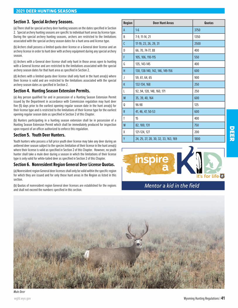
wgfd.wyo.gov Wyoming Hunting Regulations | 41
Section 3. Special Archery Seasons. (a) There shall be special archery deer hunting seasons on the dates specified in Section 2. Special archery hunting seasons are specific to individual hunt areas by license type. During the special archery hunting seasons, archers are restricted to the limitations associated with the special archery season dates for a hunt area and license type.
(b) Archers shall possess a limited quota deer license or a General deer license and an archery license in order to hunt deer with archery equipment during any special archery season.
(c) Archers with a General deer license shall only hunt in those areas open to hunting with a General license and are restricted to the limitations associated with the special archery season dates for that hunt area as specified in Section 2.
(d) Archers with a limited quota deer license shall only hunt in the hunt area(s) where their license is valid and are restricted to the limitations associated with the special archery season dates as specified in Section 2.
Section 4. Hunting Season Extension Permits.(a) Any person qualified for and in possession of a Hunting Season Extension Permit issued by the Department in accordance with Commission regulation may hunt deer five (5) days prior to the earliest opening regular season date in the hunt area(s) for their license type and is restricted to the limitations of their license type for the earliest opening regular season date as specified in Section 2 of this Chapter.
(b) Hunters participating in a hunting season extension shall be in possession of a Hunting Season Extension Permit which shall be immediately produced for inspection upon request of an officer authorized to enforce this regulation.
Section 5. Youth Deer Hunters. Youth hunters who possess a full price youth deer license may take any deer during an antlered deer season subject to the species limitation of their license in the hunt area(s) where their license is valid as specified in Section 2 of this Chapter. However, no youth hunter shall take a mule deer during a season in which the limitations of their license type is only valid for white-tailed deer as specified in Section 2 of this Chapter.
Section 6. Nonresident Region General Deer License Quotas. (a) Nonresident region General deer licenses shall only be valid within the specific region for which they are issued and for only those hunt areas in the Region as listed in this section.
(b) Quotas of nonresident region General deer licenses are established for the regions and shall not exceed the numbers specified in this section.
Region Deer Hunt Areas Quotas
A 1-6 3750
B 7-9, 11-14, 21 1350
C 17-19, 23, 26, 29, 31 2500
D 66, 70, 74-77, 88 400
F 105, 106, 110-115 550
G 135, 143-145 400
H 130, 138-140, 142, 146, 149-156 600
J 59, 61, 64, 65 900
K 132-134, 168 250
L 92, 94, 128, 148, 160, 171 250
M 35, 39, 40, 164 600
Q 96-98 125
R 41, 46, 47, 50-53 600
T 15 400
W 82, 100, 131 750
X 121-124, 127 200
Y 24, 25, 27, 28, 30, 32, 33, 163, 169 1800
2021 DEER HUNTING SEASONS
Mule Deer
Mentor a kid in the field
DEER
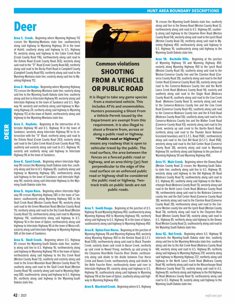
42 | 2021 wgfd.wyo.gov
HUNT AREA BOUNDARY DESCRIPTIONS
DeerArea 1. Crook. Beginning where Wyoming Highway 112 crosses the Wyoming-Montana state line; southwesterly along said highway to Wyoming Highway 24 in the town of Hulett; southerly along said highway to U.S. Highway 14; westerly along said highway to the Cabin Creek Road (Crook County Road 116); northwesterly along said road to the Oshoto Road (Crook County Road 263); westerly along said road to the “D” Road (Crook County Road 68); northerly along said road to the Rocky Point Road in Campbell County (Campbell County Road 85); northerly along said road to the Wyoming-Montana state line; easterly along said line to Wy-oming Highway 112.
Area 2. Bearlodge. Beginning where Wyoming Highway 112 crosses the Wyoming-Montana state line; easterly along said line to the Wyoming-South Dakota state line; southerly along said line to Interstate Highway 90; westerly along said Interstate Highway to the town of Sundance and U.S. High-way 14; westerly and northerly along said highway to Wyo-ming Highway 24; northerly along said highway to Wyoming Highway 112 at the town of Hulett; northeasterly along said highway to the Wyoming-Montana state line.
Area 3. Keyhole. Beginning at the intersection of In-terstate Highway 90 and U.S. Highway 14 in the town of Sundance; westerly along Interstate Highway 90 to its in-tersection with the “D” Road; northerly along said road to the Oshoto Road (Crook County Road 263); easterly along said road to the Cabin Creek Road (Crook County Road 116); southerly and easterly along said road to U.S. Highway 14; easterly and southerly along said highway to Interstate Highway 90 at the town of Sundance.
Area 4. Sand Creek. Beginning where Interstate High-way 90 crosses the Wyoming-South Dakota state line; south-erly along said line to U.S. Highway 85; southerly along said highway to Wyoming Highway 585; northwesterly along said highway to the town of Sundance and Interstate High-way 90; easterly along said Interstate Highway to the Wyo-ming-South Dakota state line.
Area 5. Inyan Kara. Beginning where Interstate High-way 90 crosses Wyoming Highway 585 in the town of Sun-dance; southeasterly along Wyoming Highway 585 to the Skull Creek Road (Weston County Road 14); westerly along said road to the Green Mountain Road (Weston County Road 11); northerly along said road to the Dry Creek Road (Weston County Road 13); northwesterly along said road to Wyoming Highway 116; southwesterly along said highway to U.S. Highway 16 in the town of Upton; northwesterly along said highway to Interstate Highway 90 at the town of Moorcroft; easterly along said Interstate Highway to Wyoming Highway 585 at the town of Sundance.
Area 6. Skull Creek. Beginning where U.S. Highway 85 crosses the Wyoming-South Dakota state line; souther-ly along said line to U.S. Highway 16; northwesterly along said highway to Wyoming Highway 116 in the town of Upton; northeasterly along said highway to the Dry Creek Road (Weston County Road 13); southerly and easterly along said road to the Green Mountain Road (Weston County Road 11); southerly along said road to the Skull Creek Road (Weston County Road 14); easterly along said road to Wyoming High-way 585; southeasterly along said highway to U.S. Highway 85; northerly along said highway to the Wyoming-South Dakota state line.
Area 7. South Osage. Beginning at the junction of U.S. Highway 16 and Wyoming Highway 450; southwesterly along Wyoming Highway 450 to Wyoming Highway 116; northerly along said highway to U.S. Highway 16 in the town of Upton; southeasterly along said highway to Wyoming Highway 450.
Area 8. Upton Four Horse. Beginning at the junction of Wyoming Highway 116 and Wyoming Highway 450; westerly along Wyoming Highway 450 to the Keeline Road (U.S.F.S. Road 930); northwesterly along said road to Black Thunder Creek; easterly down said creek to Bacon Creek; northerly up said creek to Newel Prong; northerly up said prong to the Cheyenne River/Belle Fourche River Divide; northeast-erly along said divide to the divide between Four Horse Creek and Raven Creek; northwesterly along said divide to the Belle Fourche River; northeasterly down said river to Interstate Highway 90; easterly along said highway to U.S. Highway 16; southeasterly along said highway to Wyoming Highway 116 at the town of Upton; southerly along said high-way to Wyoming Highway 450.
Area 9. Blacktail Creek. Beginning where U.S. Highway
16 crosses the Wyoming-South Dakota state line; southerly along said line to the Dewey Road (Weston County Road 2); northwesterly along said road to U.S. Highway 85; souther-ly along said highway to the Cheyenne River Road (Weston County Road 54); westerly along said road to the Lynch Road (Weston County Road 7A); northerly along said road to Wy-oming Highway 450; northeasterly along said highway to U.S. Highway 16; southeasterly along said highway to the Wyoming-South Dakota state line.
Area 10. Rochelle Hills. Beginning at the junction of Wyoming Highway 59 and Wyoming Highway 450; easterly along Wyoming Highway 450 to the Lynch Road (Weston County Road 7A); southerly along said road to the Weston-Converse County line and the Clareton Road (Con-verse County Road 39); southerly along said road to the Dull Center Road (Converse County Road 38); easterly along said road to the Converse-Niobrara County line and the North Lance Creek Road (Niobrara County Road 14); easterly and southerly along said road to the Slagle Road (Niobrara County Road 4); southerly along said road to the Cow Creek Road (Niobrara County Road 3); westerly along said road to the Converse-Niobrara County line and the Cow Creek Road (Converse County Road 45); southerly along said road to the Converse-Niobrara County line and the K-Field Road (Niobrara County Road 50); southerly along said road to the Converse-Niobrara County line and the Walker Creek Road (Converse County Road 43); westerly along said road to Dry Creek; westerly up said creek to the Iberlin Ranch Road; northerly along said road to the Thunder Basin National Grassland boundary and U.S.F.S. Road 958C; northwesterly along said road to the East Bill Road (U.S.F.S. Road 958); westerly along said road to the Dull Center Road (Converse County Road 38); westerly along said road to Wyoming Highway 59; northerly along said highway to the junction of Wyoming Highway 59 and Wyoming Highway 450.
Area 11. Mule Creek. Beginning where the Dewey Road (Weston County Road 2) crosses the Wyoming-South Dako-ta state line; southerly along said line to U.S. Highway 18; westerly along said highway to the Old Highway 85 Road (Niobrara County Road 9); southwesterly along said road to U.S. Highway 85; southerly along said highway to the Wass-erburger Road (Niobrara County Road 13); westerly along said road to the North Lance Creek Road (Niobrara County Road 14); northwesterly along said road to the Niobrara Converse county line and the Dull Center Road (Converse County Road 38); westerly along said road to the Clareton Road (Converse County Road 39); northeasterly along said road to the Con-verse Weston county line and the Lynch Road (Weston County Road 7A); northerly along said road to the Cheyenne River Road (Weston County Road 54); easterly along said road to U.S. Highway 85; northerly along said highway to the Dewey Road Weston County Road 2); southeasterly along said road to the Wyoming-South Dakota state line.
Area 12. Hat Creek. Beginning where U.S. Highway 18 intersects the Wyoming-South Dakota state line; southerly along said line to the Wyoming-Nebraska state line; southerly along said line to the Hat Creek Road (Niobrara County Road 64); westerly along said road to U.S. Highway 85; northerly along said highway to Wyoming Highway 270; westerly along said highway to Wyoming Highway 272; northerly along said highway to the North Lance Creek Road (Niobrara County Road 14); northerly along said road to the Wasserburger Road (Niobrara County Road 13); easterly along said road to U.S. Highway 85; northerly along said highway to the Old Highway 85 Road (Niobrara County Road 9); northeasterly along said road to U.S. Highway 18; easterly along said highway to the Wyoming-South Dakota state line.
Common violationsSHOOTING
FROM A VEHICLE OR PUBLIC ROAD
It is illegal to take any game species from a motorized vehicle. This
includes ATVs and snowmobiles. Hunters possessing a Shoot From
a Vehicle Permit issued by the Department are exempt from this
requirement. It is also illegal to shoot a firearm from, across or along a public road or highway.
“Public road or highway” means any roadway that is open to vehicular travel by the public. The
road surface, the area between the fences on a fenced public road or
highway, and an area thirty (30) feet perpendicular to the edge of the
road surface on an unfenced public road or highway shall be considered
the public road or highway. Two-track trails on public lands are not
public roads.
DEER
wgfd.wyo.gov Wyoming Hunting Regulations | 43
Area 13. Lusk. Beginning where the Hat Creek Road (Niobrara County Road 64) intersects the Wyoming-Nebras-ka state line; southerly along said line to U.S. Highway 20; westerly along said highway to the Twenty Mile Creek Road (Converse County Road 46) at the town of Lost Springs; northerly along said road to the Manning Road (Converse County Road 53); easterly along said road to the Twenty Mile Road (Niobrara County Road 23) at the Converse Niobrara county line; easterly along said road to Wyoming Highway 271; easterly along said highway to Wyoming Highway 270 at the town of Lance Creek; northerly and easterly along said highway to U.S. Highway 85; southerly along said highway to the Hat Creek Road (Niobrara County Road 64); easterly along said road to the Wyoming-Nebraska state line.
Area 14. Twenty Mile. Beginning at the junction of Wyo-ming Highway 59 and the Dull Center Road (Converse Coun-ty Road 38); easterly along said road to the East Bill Road (U.S.F.S. Road 958); easterly along said road to U.S.F.S. Road 958C; southeasterly along said road to the Iberlin Ranch Road; southerly along said road to Dry Creek; east-erly down said creek to the Walker Creek Road (Converse County Road 43); easterly along said road to the Converse Niobrara county line and the K-Field Road (Niobrara County Road 50); northerly along said road to the Converse Niobr-ara county line and the Cow Creek Road (Converse County Road 45); northerly along said road to the Converse-Niobr-ara county line and the Cow Creek Road (Niobrara County Road 3); easterly along said road to the Slagle Road (Niobr-ara County Road 4); northerly along said road to the North Lance Creek Road (Niobrara County Road 14); easterly and southerly along said road to Wyoming Highway 272; southerly along said highway to Wyoming Highway 270; southwesterly along said highway to the town of Lance Creek and Wyoming Highway 271; westerly along said highway to the Twenty Mile Road (Niobrara Coun-ty Road 23); westerly along said road to the Converse-Niobrara county line and the Manning Road (Converse County Road 53); southwesterly along said road to the Twenty Mile Creek Road (Converse County Road 46); southerly along said road to U.S. Highway 20 at the town of Lost Springs; southwest-erly along said highway to Interstate Highway 25; southerly along said highway to the North Platte River; westerly and northerly up said river to Wyoming Highway 59 at the town of Douglas; northerly along said highway to the Dull Center Road (Converse County Road 38).
Area 15. Southeast Wyoming. Beginning where U.S. Highway 20 intersects the Wyoming-Nebraska state line; southerly along said line to the Wyoming-Colorado state line; westerly along said line to Interstate Highway 25; northerly along said highway to U.S. Highway 26; easterly along said highway to the North Platte River; northwesterly up said river to Interstate Highway 25; northerly along said highway to U.S. Highway 20; easterly along said highway to the Wyoming-Nebraska state line.
Area 17. Northwest Gillette. Beginning where Wyo-ming Highway 59 crosses the Wyoming-Montana state line; southerly along said highway to U.S. Highway 14-16; south-erly along said highway to Interstate Highway 90 west of the town of Gillette; westerly along said highway to the Powder River; northerly down said river to the Wyoming-Montana state line; easterly along said line to Wyoming Highway 59.
Area 18. Campbell. Beginning where the Rocky Point Road crosses the Wyoming-Montana state line; southerly
along said road to the “D” Road; southerly along said road to Interstate Highway 90; westerly along said highway to U.S. Highway 14-16; northerly along said highway to Wy-oming Highway 59; northerly along said highway to the Wyoming-Montana state line; easterly along said line to the Rocky Point Road.
Area 19. Pumpkin Buttes. Beginning at the intersec-tion of Interstate Highway 90 and Wyoming Highway 59 at the city of Gillette; southerly along Wyoming Highway 59 to Wyoming Highway 387; southwesterly along said highway to Wyoming Highway 192; northwesterly along said highway to the Streeter Road (Johnson County Road 135); northerly along said road to the Powder River; northerly down said river to Interstate Highway 90; easterly along said highway to Wyoming Highway 59.
Area 21. Thunder Basin. Beginning where Interstate Highway 90 crosses the Belle Fourche River; southwesterly up said river to the divide between Four Horse Creek and Ra-ven Creek; southerly along said divide to the divide between the Cheyenne River and Belle Fourche River; southwesterly along said divide to Newel Prong; southerly down said prong to Bacon Creek; southerly down said creek to Black Thunder Creek; westerly up said creek to the Keeline Road (U.S.F.S. Road 930); southeasterly along said road to Wyoming High-way 450; westerly along said highway to Wyoming Highway 59; northerly along said highway to Interstate Highway 90 at the city of Gillette; easterly along said highway to the Belle Fourche River.
Area 22. Douglas. Beginning where Interstate Highway 25 crosses the North Platte River in the city of Casper; north-erly along said highway to Wyoming Highway 259; northerly along said highway to the town of Midwest and Wyoming Highway 387; northeasterly along said highway to Wyoming Highway 59 at Reno Junction; southerly along said highway to the North Platte River at the town of Douglas; westerly up said river to Interstate Highway 25 in the city of Casper.
Area 23. Clearmont. Beginning where the Powder River crosses the Wyoming-Montana state line; southerly up said river to U.S. Highway 14; westerly along said highway to In-terstate Highway 90; northwesterly along said highway to the Wyoming-Montana state line; easterly along said line to the Powder River.
Area 24. Sheridan. Beginning where Interstate High-way 90 crosses the Wyoming-Montana state line; southerly along said highway to the Piney Creek interchange and U.S. Highway 87; northwesterly along said highway to Wyoming Highway 193; northwesterly along said highway to South Piney Creek; westerly up said creek to the Bighorn National Forest boundary; northwesterly along said boundary to the Wyoming-Montana state line; easterly along said line to In-terstate Highway 90.
Area 25. Tongue Goose. Beginning where the Wy-oming-Montana state line and the east boundary of the Bighorn National Forest intersect; southeasterly along said
boundary to South Piney Creek; southwesterly up said creek to the divide along the Bighorn Mountain Range; northwest-erly along said divide to U.S. Highway 14 at Granite Pass; northerly along said highway to the Hunt Mountain Road (U.S.F.S. Road 10); northwesterly along said road to U.S. Highway 14A; northwesterly along said highway to the Devils Canyon Road (U.S.F.S. Road 14); northerly along said road to the Sheep Mountain Road (U.S.F.S. Road 11); northerly along said road to the Wyoming-Montana state line; easterly along said line to the east boundary of the Bighorn National Forest.
Area 26. Ucross. Beginning where U.S. Highway 14 crosses the Powder River; southerly up said river to Inter-state Highway 90; northwesterly along said highway to U. S. Highway 14; easterly along said highway to the Powder River.
Area 27. Buffalo. Beginning where Wyoming Highway 193 crosses South Piney Creek; southeasterly along said highway to U.S. Highway 87; southeasterly along said high-way to Interstate Highway 90; southerly along said highway to Interstate Highway 25; southerly along said highway to the Trabing Road (Johnson County Road 13); westerly along said road to Wyoming Highway 196; southerly along said highway to the Crazy Woman Canyon Road (Johnson County Road 14); westerly along said road to the Bighorn National Forest boundary; northerly along said boundary to South Piney Creek; easterly down said creek to Wyoming Highway 193.
Area 28. Hunter Mesa. Beginning where South Piney Creek crosses the east boundary of the Bighorn National Forest; southerly and westerly along said boundary to the Gold Mine Road (U.S.F.S. Road 452); northerly along said road to the Canyon Creek Road (U.S.F.S. Road 25); northerly along said road to U.S. Highway 16 and the divide along the Bighorn Moun-tain Range at Powder River Pass; northerly along said divide to the head of South Piney Creek; northeasterly down said creek to the east boundary of the Bighorn National Forest.
Area 29. Johnson. Beginning where Interstate Highway 90 crosses the Powder River; southerly up said river to the Streeter Road (Johnson County Road 135); southerly along said road to Wyoming Highway 192; southeasterly along said highway to the West Sussex Oil Field Road at the town of Linch; westerly along said road to old U.S. Highway 87; west from the junction of the West Sussex Oil Field Road and old U.S. Highway 87 to Interstate Highway 25; northerly along said highway to Interstate Highway 90; southeasterly along said highway to the Powder River.
Area 30. Upper Powder River. Beginning at the junction of the Trabing Road (Johnson County Road 13) and Interstate Highway 25; southerly along Interstate Highway 25 to the point east of the U.S. Highway 196 Mesa Road (Johnson County Road 115) junction; west to the U.S. High-way 196 Mesa Road junction; southwesterly along the Mesa Road to the Mayoworth Road (Johnson County Road 266) at the town of Mayoworth; westerly along said road to the Slip Road (Johnson County Road 67); westerly along said road to the Hazelton Road (Johnson County Road 3); northerly along said road to the Gold Mine Road (U.S.F.S. Road 452); northwesterly along said road to the Bighorn National For-est boundary; easterly and northerly along said boundary to the Crazy Woman Canyon Road (Johnson County Road 14); easterly along said road to Wyoming Highway 196; northerly along said highway to the Trabing Road; easterly along said road to Interstate Highway 25.
HUNT AREA BOUNDARY DESCRIPTIONS
HUNTING ETHICS
Mistakes happen – own them
DEER
44 | 2021 wgfd.wyo.gov
HUNT AREA BOUNDARY DESCRIPTIONS
Area 31. Salt Creek. Beginning at the junction of the West Sussex Oil Field Road and Wyoming Highway 192 at the town of Linch; southeasterly along said highway to Wyoming Highway 387; southwesterly along said highway to Inter-state Highway 25; northwesterly along said highway to the point on Interstate Highway 25 due west of the junction of old U.S. Highway 87 and the West Sussex Oil Field Road; east from Interstate Highway 25 to the junction of old U.S. High-way 87 and the West Sussex Oil Field Road; easterly along said road to Wyoming Highway 192 at the town of Linch.
Area 32. Beartrap Creek. Beginning where the Slip Road (Johnson County Road 67) crosses Arch Creek west of the town of Mayoworth; southerly down said creek to Beartrap Creek; southerly down said creek to the North Fork of the Red Fork of the Powder River; southeasterly down said river to the Ken Graves Ranch Road; southerly down said road to the Barnum Road (Johnson County Road 78); southerly along said road to the Barnum Mountain Road; westerly along said road to the Hazelton Road (Washakie County Road 81-Johnson County Road 3); northerly along said road to the Slip Road; southeasterly along said road to Arch Creek.
Area 33. Red Fork. Beginning at the town of Kaycee and Interstate Highway 25; southeasterly along said highway to the South Fork of the Powder River; southerly up said river to Willow Creek; southwesterly up said creek to the Lone Bear Road (Natrona County Road 112); northerly along said road to the Willow Creek Road (Natrona County Road 111); southwesterly along said road to the 33 Mile Road (Natrona County Road 110); northwesterly along said road to Buffalo Creek; northerly down said creek to the Middle Fork of the Powder River; westerly up said river to the Outlaw Cave Ac-cess Road; northerly along said road to the Barnum Road (Johnson County Road 78) at the town of Barnum; northerly along said road to the Ken Graves Ranch Road; northerly along said road to the North Fork of the Red Fork of the Pow-der River at the Ken Graves Ranch; northwesterly up said river to Beartrap Creek; northwesterly up said creek to Arch Creek; northerly up said creek to the Slip Road (Johnson County Road 67); easterly along said road to the Mayoworth Road (Johnson County Road 266); easterly along said road to the Mesa Road (Johnson County Road 115) at Mayoworth; northeasterly along said road to Wyoming Highway 196; due east from the junction of the Mesa Road and Wyoming High-way 196 to the Interstate Highway 25; southerly along said highway to the town of Kaycee.
Area 34. Natrona. Beginning at the intersection of In-terstate Highway 25 and the North Platte River in the city of Casper; southwesterly up said river to the bridge at Poplar Street; northerly along said street to U.S. Highway 20-26; westerly along said highway to Natrona County Road 104 at Waltman; northerly along said road to Natrona County Road 103; northwesterly along said road to Natrona Coun-ty Road 102; northerly along said road to Natrona County Road 101; northeasterly along said road to Badwater Creek; northeasterly along said creek to the divide between Bad-water Creek, Deep Creek, and Buffalo Creek; northeasterly along said divide to the divide between the Middle Fork and North Fork of Buffalo Creek; easterly along said divide to the North Fork of Buffalo Creek; northeasterly along said creek to Natrona County Road 109; northeasterly along said road to Washakie County Road 6215; northeasterly along said road to the 33-Mile Road (Natrona County Road 110) at Kidd Flat; southeasterly along said road to Natrona County Road 113; easterly along said road to Natrona County Road 114; northeasterly along said road to Natrona County Road 115; easterly along said road to Wyoming Highway 387; easterly
along said highway to Wyoming Highway 259 in the town of Midwest; southerly along said highway to Interstate High-way 25; southerly along said highway to the North Platte River in the city of Casper.
Area 35. Upper Nowood. Beginning at Cottonwood Pass and the Nowood Road; northeasterly along said road to Deep Creek; up said creek to Lost Creek; up said creek to the Cherry Creek Hill Stock Drive Road; northeasterly along said road to the Hazelton Road; southerly along said road to Washakie County Road 6215 at Kidd Flat; southwesterly along said road to Natrona County Road 109; southwesterly along said road to the North Fork of Buffalo Creek; south-westerly along said creek to the divide between the Middle Fork and North Fork of Buffalo Creek; westerly along said divide to the divide between Badwater Creek, Deep Creek and Buffalo Creek; southwesterly along said divide to the Bighorn Trail; westerly along said trail to the Oakie Road (Natrona County Road 101); westerly along said road to Sioux Pass and the Devil's Slide Road; westerly along said road to the divide between Nowood Creek and Badwater Creek; southwesterly then northwesterly along said divide to the Nowood Road at Cottonwood Pass.
Area 36. Badwater. Beginning at the town of Shoshoni and U.S. Highway 20-26; westerly along said highway to the east shoreline of Boysen Reservoir; northerly along said shoreline to Boysen Dam and the Wind River; northerly down said river to Gold Creek (excluding Indian tribal trust lands immediately north of U.S. Highway 20-26 near Boysen Res-ervoir and northeast of Boysen Dam); easterly up Gold Creek to the divide between Buffalo Creek and Badwater Creek on Copper Mountain; easterly along said divide to West Bridg-er Creek; easterly down said creek to the Kirby Creek Road (Hot Springs County Road 7); northerly along said road to the divide between Kirby Creek and Bridger Creek; northeaster-ly along said divide to the Packsaddle Road; southerly along said road to the Bridger Creek Road; northeasterly along said road to the Pine Creek Road at the Gardner Summer Ranch; easterly up said road to the Seaman Ranch Road; easterly, southerly, then easterly along said road to the divide be-tween Nowood Creek and Badwater Creek at Cottonwood Pass; southeasterly then northeasterly along said divide to the Devil's Slide Road; easterly along said road to Sioux Pass and the Oakie Trail (Natrona County Road 101); easterly along said trail to the Bighorn Trail; easterly along said trail to the divide between Badwater Creek, Deep Creek, and the Middle Fork of Buffalo Creek; southwesterly down Badwater Creek to Natrona County Road 101; southwesterly along said road to Natrona County Road 102; southerly along said road to Natrona County Road 103; southeasterly along said road to Natrona County Road 104; southerly along said road to Waltman and U.S. Highway 20-26; westerly along said high-way to the town of Shoshoni.
Area 37. Copper Mountain. Beginning at the conflu-ence of the Bighorn River and Walter's Draw; easterly up said draw to the divide between Nowater Creek and Kirby Creek; easterly along said divide to the Murphy Dome-Mud Creek Road (B.L.M. Road 1409); southerly along said road to Wyoming Highway 172 (Black Mountain Road); westerly along said highway to Kirby Creek Road (Hot Springs Coun-ty Road 7); southeasterly along said road to West Bridger Creek; westerly up said creek to the divide between Buffalo Creek and Badwater Creek; westerly along said divide to the head of Gold Creek; westerly down said creek to the east boundary of the Wind River Reservation; north and west along said boundary to the Bighorn River; northerly down said river to Walter's Draw.
Area 39. Bates Creek. Beginning at the intersection of
the Kirby Creek Road (Hot Springs County Road 7) and Wy-oming Highway 172 (Black Mountain Road); easterly along said highway to Murphy Dome-Mud Creek Road (B.L.M. Road 1409); northeasterly along said road to the Nowater Stock Drive Road (B.L.M. Road 1404); easterly along said road to the Upper Nowood Road; southerly along said road to the Seaman Ranch Road (Lysite Mountain Road) at Cot-tonwood Pass; westerly then northerly along said road to the Pine Creek Road; westerly along said road to the Bridger Creek Road at the Gardner Summer Ranch; southwesterly along said road to the Packsaddle Road; northerly along said road to the divide between Kirby Creek and Bridger Creek; southwesterly along said divide to the Kirby Creek Road (Hot Springs County Road 7); northerly along said road to Wyoming Highway 172.
Area 40. Buffalo Creek. Beginning at the intersection of U.S. Highway 16 and the Bluebank Road (B.L.M. Road 1411); northeasterly along said highway to the Canyon Creek Road (U.S.F.S. Road 25); southerly along said road to the Gold Mine Road (U.S.F.S. Road 452); southerly along said road to the Hazelton Road (Bighorn Divide Road); southerly along said road to the Cherry Creek Hill Stock Drive Road; westerly along said road to Lost Creek; northwesterly down said creek to Deep Creek; northerly down said creek to the Upper Nowood Road; southwesterly along said road to the Nowater Stock Drive (B.L.M. Road 1404); northwesterly along said road to the Bluebank Road (B.L.M. Road 1411); northerly along said road to the intersection with U.S. High-way 16.
Area 41. Lower Nowood. Beginning at the intersection of U.S. Highway 16-20 and Wyoming Highway 31 near the town of Manderson; easterly along Highway 31 to the Alkali Road (B.L.M. Road 1111) near the town of Hyattville; norther-ly along said road to the Cold Springs Road (Big Horn County Road 268; B.L.M. /U.S.F.S. Road 344); northeasterly along said road to the Bighorn National Forest boundary; south-easterly along said boundary to U.S. Highway 16; westerly along said highway to U.S. Highway 20 (Wyoming Highway 789); southerly along said highway to its junction with the Bighorn Canal three-quarters (3/4) of a mile south of the town of Worland; northerly on said canal to U.S. Highway 16-20; easterly along said highway to Wyoming Highway 31.
Area 46. Cloud Peak. Beginning at Granite Pass on U.S. Highway 14 and the divide along the Bighorn Mountain range; southeasterly along said divide to the U.S. Highway 16 at Powder River Pass; westerly along said highway to the Bighorn National Forest Boundary; northerly along said boundary to the Alkali Road (U.S.F.S. Road 338); easterly along said road to the Shell Ranger Station-Paint Rock Lakes Road (U.S.F.S. Road 17); northwesterly along said road to U.S. Highway 14; northerly along said highway to Granite Pass.
Area 47. Webber Canyon. Beginning at the junction of U.S. Highway 16-20 and U.S. Highway 14 in the town of Grey-bull; easterly along U.S. Highway 14 to the Paint Rock Lakes Road (U.S.F.S. Road 17); southeasterly along said road to the Alkali Road (U.S.F.S. Road 338) westerly along said road to the Bighorn National Forest boundary; southeasterly along said boundary to the Cold Springs Road (Big Horn County Road 268; B.L.M./U.S.F.S. Road 344); southwesterly along said road to Wyoming Highway 31; westerly along said high-way to U.S. Highway 16-20; northerly along said highway to U.S. Highway 14 in the town of Greybull.
Area 50. Upper Shell Beaver Creek. Beginning at the Bighorn National Forest boundary and U.S. Highway 14A; easterly along said highway to the Hunt Mountain Road
DEER
wgfd.wyo.gov Wyoming Hunting Regulations | 45
HUNT AREA BOUNDARY DESCRIPTIONS
(U.S.F.S. Road 10); southwesterly along said road to U.S. Highway 14; southerly then westerly along said highway to the Bighorn National Forest boundary; northwesterly along said boundary to U.S. Highway 14A.
Area 51. Beaver Creek. Beginning at the Bighorn River in the town of Greybull; northerly down said river to Bear Creek; northeasterly up said creek to the Bighorn National Forest boundary; southeasterly along said boundary to U.S. Highway 14; westerly along said highway to the Bighorn River.
Area 52. Crystal Creek. Beginning at the Bighorn Riv-er and U.S. Highway 14A nine (9) miles east of the town of Lovell; easterly along said highway to the Bighorn National Forest boundary; southeasterly along said boundary to Bear Creek; southwesterly down said creek to the Bighorn River; northerly down said river to U.S. Highway 14A.
Area 53. Devils Canyon. Beginning where U.S. High-way 14A crosses the Bighorn River; northerly down said river to the Wyoming-Montana state line; easterly along said line to the Sheep Mountain Road (U.S.F.S. Road 11); southerly along said road to the Devils Canyon Road (U.S.F.S. Road 14); southerly along said road to U.S. Highway 14A; westerly along said highway to the Bighorn River.
Area 59. South Laramie Mountains. Beginning at the junction of Wyoming Highway 34 and Interstate Highway 25; southerly along said Interstate Highway to Wyoming High-way 211 near the city of Cheyenne; northwesterly along said highway to the Fisher Canyon-Rogers Canyon Road (Laramie County Road 228-1-Albany County Road 17) at Horse Creek Station; westerly along said road to U.S. Highway 30; north-erly along said highway to Wyoming Highway 34; northeast-erly along said highway to Interstate Highway 25.
Area 60. Pole Mountain. Beginning in the city of Lara-mie and the Rogers Canyon Ninth Street Road (Albany Coun-ty Road 17 Laramie County Road 228); northeasterly along said road to Wyoming Highway 211 (Horse Creek Chugwater Road); southeasterly along said highway to Interstate High-way 25; southerly along said highway to Interstate Highway 80; westerly along said highway to the city of Laramie.
Area 61. Harriman. Beginning at the city of Laramie and Interstate Highway 80; southeasterly along said highway to Interstate Highway 25 near the city of Cheyenne; souther-ly along said highway to the Wyoming-Colorado state line; west along said line to U.S. Highway 287; northerly along said highway to Interstate Highway 80.
Area 64. Laramie Peak. Beginning at the junction of Interstate Highway 25 and Wyoming Highway 34; south-westerly along Highway 34 to U.S. Highway 30; north-westerly along said highway to the junction with Wyoming Highway 487 at the town of Medicine Bow; northerly along said highway to the Lone Tree Road (B.L.M. Road 3141); northerly along said road to the Spring Creek Road; easterly along said road to the Bates Creek Road (Natrona County Road 402); northeasterly along said road to the Squaw Springs Trail Road; northeasterly along said road to U.S.F.S. Road 660; southeasterly along said road to the Cold Springs Road (Converse County Road 24); easterly along said road to the divide between the Little Medicine Bow River and LaPrele Creek; easterly along said divide to the divide be-tween Corduroy Creek and Rocky Ford Creek; easterly along said divide to the Fetterman Road (Albany County Road 61); southerly along said road to U.S.F.S. Road 658; easterly along said road to South Fork Creek (a tributary to LaBonte Creek); southerly up said creek to the divide between Horse-shoe Creek and the North Laramie River; southerly and east-
erly along said divide to the Esterbrook Road (Albany County Road 710-Converse County Road 5 and 7-U.S.F.S Road 653); northeasterly along said road to the Glendo-Esterbrook Road (Ridge Road-Converse County Road 6-Platte County Road 135); easterly along said road to the Glendo Park Road (Platte County Road 17) at the town of Glendo; easterly along said road to the North Platte River; southeasterly down said river to U.S. Highway 26; westerly along said highway to Interstate Highway 25; southerly along said highway to Wy-oming Highway 34.
Area 65. South Converse. Beginning at the confluence of Deer Creek and the North Platte River at the town of Glen-rock; easterly and southerly down said river to the Glendo Reservoir Dam and the Glendo Park Road (Platte County Road 17); westerly along said road to the town of Glendo and the Glendo-Esterbrook Road (Ridge Road; Platte Coun-ty Road 135-Converse County Road 6); westerly along said road to the Esterbrook Road (Converse County Road 5 and 7-U.S.F.S. Road 653-Albany County Road 710); southwesterly along said road to the divide between Horseshoe Creek and the North Laramie River; westerly and northerly along said divide to the head of South Fork Creek, a tributary of La-Bonte Creek; northeasterly along said creek to U.S.F.S. Road 658; westerly along said road to the Fetterman Road (Albany County Road 61); northerly along said road to the divide be-tween Corduroy Creek and Rocky Ford Creek; westerly along said divide to the divide between LaPrele Creek and the Little Medicine Bow River; westerly along said divide to the Cold Springs Road (Converse County Road 24); southwester-ly along said road to U.S.F.S. Road 660; northwesterly along said road to Curry Creek; northwesterly down said creek to Deer Creek; northerly down said creek to the North Platte River at the town of Glenrock.
Area 66. Bates Hole-Hat Six. Beginning at the conflu-ence of Deer Creek and the North Platte River at the town of Glenrock; southerly along said creek to Curry Creek; south-easterly up said creek to U.S.F.S. Road 660; northwesterly along said road to its termination at the Squaw Springs Trail Road; southwesterly along said road to the Bates Creek Road (Natrona County Road 402); southwesterly along said road to the Spring Creek Road; westerly along said road to the Lone Tree Road (B.L.M. Road 3141); southerly along said road to the Shirley Ridge Road (Carbon County Road 2); southwesterly along said road to Wyoming Highway 77; southerly along said highway to the Chalk Mountain Road (B.L.M. 3129); westerly and northerly along said road to the Dry Creek Road (Carbon County Road 103); northwesterly along said road to the south fork of Canyon Creek; wester-ly and northerly down said fork to Canyon Creek; westerly down said creek to Pathfinder Reservoir and the North Platte River; northerly and easterly down said river to Wolf Creek; southerly up said creek to its head; southerly one and one-eighth (1-1/8) miles to the Casper Mountain area boundary marker; due east two and one-quarter (2-1/4) miles to the west boundary of Star Wallow; southerly along said bound-ary one and one-half (1-1/2) miles to the switchback of the Circle Drive Road (Natrona County Road 505); southerly along said road to the head of the Clear Fork of Muddy Creek; easterly down said fork to the Casper Mountain area boundary marker; north two (2) miles to the southeast cor-ner of Crimson Dawn Park; northerly and westerly along the east and north boundary of said park to the north entrance road; northerly along said road to the East End Road (Natro-na County Road 506); northeasterly along said road to the head of the East Fork of Elkhorn Creek; northerly down said creek to the lower timberline on Casper Mountain; westerly along said timberline to the Casper Mountain Road (Wyo-ming Highway 251); northerly along said road to Wyoming
Highway 258 (Wyoming Boulevard); westerly along said highway to Poplar Street; northerly along said street to the North Platte River; easterly down said river to Deer Creek at the town of Glenrock.
Area 67. Casper Mountain. Beginning where Wolf Creek enters the North Platte River; northeasterly down said river to the bridge at Poplar Street; southerly along said street to Wyoming Highway 258 (Wyoming Boulevard); east-erly along said highway to Casper Mountain Road (Wyoming Highway 251); southerly along said road to the lower tim-berline on Casper Mountain; easterly along said timberline to the East Fork of Elkhorn Creek; southerly up said creek to the East End Road (Natrona County Road 506); southwest-erly along said road to the north entrance road to Crimson Dawn Park; southerly along said road to the Crimson Dawn Park boundary; easterly and southerly along said boundary to the southeast corner of the park; southerly to the Clear Fork of Muddy Creek and the Casper Mountain area bound-ary marker; southwesterly up said creek to the Circle Drive Road (Natrona County Road 505); northerly along said road to the switchback; northerly one and one-half (1-1/2) miles along the west boundary of Star Wallow; west two and one fourth (2-1/4) miles to the Casper Mountain area boundary marker; northerly to the head of Wolf Creek; northerly down said creek to the North Platte River.
Area 70. Shirley Mountain. Beginning where Wyoming Highway 487 intersects U.S. Highway 30 at the town of Med-icine Bow; westerly along U.S. Highway 30 to Wyoming High-way 72; northerly along said highway to the town of Hanna and Big Ditch; northwesterly along Big Ditch to Seminoe Reservoir and the North Platte River; northerly down said river to where Canyon Creek enters Pathfinder Reservoir; easterly up said creek to the south fork of Canyon Creek; easterly and southerly up said fork to the Dry Creek Road (Carbon County Road 103); southeasterly along said road to the Chalk Mountain Road (B.L.M. Road 3129); easterly and southerly along said road to Wyoming Highway 77; northerly along said highway to the Shirley Ridge Road (Carbon County Road 2); northeasterly along said road to Wyoming Highway 487; southerly along said highway to the intersection with U.S. Highway 30 at the town of Medicine Bow.
Area 74. Kyle. Beginning where U.S. Highway 30 in-tersects Wyoming Highway 72; southeasterly along said highway to the city of Laramie and Interstate Highway 80; northwesterly along said highway to Wyoming Highway 72; northerly along said highway to U.S. Highway 30.
Area 75. Four Mile. Beginning at the city of Laramie and Wyoming Highway 130; westerly along said highway to the divide between the Laramie River and the North Platte River; northerly along said divide to Medicine Bow Peak and the divide between the Medicine Bow River and Brush Creek; northwesterly along said divide to U.S.F.S. Road 103; northwesterly along said road to the North Brush Creek Road (U.S.F.S. Road 100); northerly along said road to the Sand Lake Road (U.S.F.S. Road 101); northwesterly along said road to the Cedar Pass Road (U.S.F.S. Road 261); southwesterly along said road to U.S.F.S. Road 115; northerly along said road to the Pass Creek Basin Road; northerly along said road to the Pass Creek Road (Carbon County Road 404); norther-ly along said road to Wyoming Highway 72; northwesterly along said highway to Interstate Highway 80 to the west Elk Mountain interchange; southeasterly along said highway to Wyoming Highway 130.
Area 76. Sheep Mountain. Beginning at the city of Laramie and Wyoming Highway 230; southwesterly along said highway to Wyoming Highway 10 at Woods Landing;
DEER
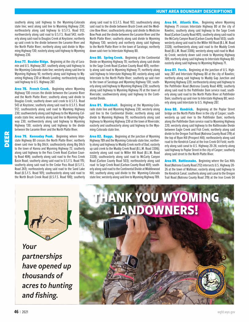
46 | 2021 wgfd.wyo.gov
HUNT AREA BOUNDARY DESCRIPTIONS
southerly along said highway to the Wyoming-Colorado state line; west along said line to Wyoming Highway 230; northeasterly along said highway to U.S.F.S. Road 512; northwesterly along said road to U.S.F.S. Road 543; north-erly along said road to Douglas Creek at Keystone; northerly up said creek to the divide between the Laramie River and the North Platte River; northerly along said divide to Wyo-ming Highway 130; easterly along said highway to Wyoming Highway 230.
Area 77. Boulder Ridge. Beginning at the city of Lara-mie and U.S. Highway 287; southerly along said highway to the Wyoming-Colorado state line; westerly along said line to Wyoming Highway 10; northerly along said highway to Wy-oming Highway 230 at Woods Landing; northeasterly along said highway to U.S. Highway 287.
Area 78. French Creek. Beginning where Wyoming Highway 130 crosses the divide between the Laramie River and the North Platte River; southerly along said divide to Douglas Creek; southerly down said creek to U.S.F.S. Road 543 at Keystone; southerly along said road to U.S.F.S. Road 512; southeasterly along said road to Wyoming Highway 230; southwesterly along said highway to the Wyoming-Col-orado state line; westerly along said line to Wyoming High-way 230; northwesterly along said highway to Wyoming Highway 130; easterly along said highway to the divide between the Laramie River and the North Platte River.
Area 79. Kennaday Peak. Beginning where Inter-state Highway 80 crosses the North Platte River; northerly down said river to Big Ditch; southeasterly along Big Ditch to the town of Hanna and Wyoming Highway 72; southerly along said highway to the Pass Creek Road (Carbon Coun-ty Road 404); southerly along said road to the Pass Creek Basin Road; southerly along said road to U.S.F.S. Road 115; southerly along said road to the Cedar Pass Road (U.S.F.S. Road 261); northeasterly along said road to the Sand Lake Road (U.S.F.S. Road 101); southeasterly along said road to the North Brush Creek Road (U.S.F.S. Road 100); southerly
along said road to U.S.F.S. Road 103; southeasterly along said road to the divide between Brush Creek and the Medi-cine Bow River; southeasterly along said divide to Medicine Bow Peak and the divide between the Laramie River and the North Platte River; southerly along said divide to Wyoming Highway 130; westerly and northerly along said highway to the North Platte River in the town of Saratoga; northerly down said river to Interstate Highway 80.
Area 80. Spring Creek. Beginning at the Continental Divide on Wyoming Highway 70; northerly along said divide to the Sage Creek Road (Carbon County Road 401); norther-ly along said road to Wyoming Highway 71; northerly along said highway to Interstate Highway 80; easterly along said Interstate to the North Platte River; southerly up said river to the town of Saratoga and Wyoming Highway 130; south-erly along said highway to Wyoming Highway 230; southerly along said highway to Wyoming Highway 70 at the town of Riverside; southwesterly along said highway to the Conti-nental Divide.
Area 81. Blackhall. Beginning at the Wyoming-Colo-rado state line and Wyoming Highway 230; westerly along said line to the Continental Divide; northerly along said divide to Wyoming Highway 70; northeasterly along said highway to Wyoming Highway 230 at the town of Riverside; easterly and southeasterly along said highway to the Wyo-ming-Colorado state line.
Area 82. Baggs. Beginning at the junction of Wyoming Highway 789 and the Wyoming-Colorado state line; norther-ly along said highway to Muddy Creek north of Dad; easterly up said creek to the Muddy Creek Road (B.L.M. Road 3306); easterly along said road to Miller Hill Road (B.L.M. Road 3328); southeasterly along said road to McCarty Canyon Road (Carbon County Road 503); northeasterly along said road to Sage Creek Road (Carbon County Road 401); south-erly along said road to the Continental Divide at Middlewood Hill; southerly along said divide to the Wyoming-Colorado state line; westerly along said line to Wyoming Highway 789.
Area 84. Atlantic Rim. Beginning where Wyoming Highway 71 crosses Interstate Highway 80 at the city of Rawlins; southerly along said highway to the Sage Creek Road (Carbon County Road 401); southerly along said road to the McCarty Canyon Road (Carbon County Road 503); south-westerly along said road to the Miller Hill Road (B.L.M. Road 3328); northwesterly along said road to the Muddy Creek Road (B.L.M. Road 3306); westerly along said road to Mud-dy Creek; westerly down said creek to Wyoming Highway 789; northerly along said highway to Interstate Highway 80; easterly along said highway to Wyoming Highway 71.
Area 87. Ferris. Beginning at the junction of U.S. High-way 287 and Interstate Highway 80 at the city of Rawlins; northerly along said highway to Muddy Gap Junction and Wyoming Highway 220; northeasterly along said highway to the Pathfinder Road (Natrona County Road 409); southerly along said road to the Pathfinder Dam service road; south-erly along said road to the North Platte River at Pathfinder Dam; southerly up said river to Interstate Highway 80; west-erly along said Interstate to U.S. Highway 287.
Area 88. Kendrick. Beginning at the Poplar Street bridge on the North Platte River in the city of Casper; south-westerly up said river to the Pathfinder Dam; northerly along the Pathfinder Dam service road to Wyoming Highway 220; westerly along said highway to the Rattlesnake Divide between Eagle Creek and Fish Creek; northerly along said divide to the Oregon Trail Road (Natrona County Road 319) at the top of Ryan Hill (Prospect Hill); northeasterly along said road to the Kendrick Canal at the Iron Creek Oil Field; north-erly along said canal to U.S. Highway 20-26; easterly along said highway to Poplar Street in the city of Casper; southerly along said street to the North Platte River.
Area 89. Rattlesnake. Beginning where the Gas Hills Road (Natrona County Road 212) intersects U.S. Highway 20-26 at the town of Waltman; easterly along said highway to the Kendrick Canal; southerly along said canal to the Oregon Trail Road (Natrona County Road 319) at the Iron Creek Oil
THANK YOU WYOMING LANDOWNERS!
Your partnerships have opened up thousands of acres to hunting and fishing.
ACCESSYES !
Partnering with landowners for walk-in and hunter
management areas
DEER
wgfd.wyo.gov Wyoming Hunting Regulations | 47
Field; southwesterly along said road to the Rattlesnake Di-vide at Ryan Hill (Prospect Hill); southerly along said divide between Eagle Creek and Fish Creek to Wyoming Highway 220; westerly along said highway to the Dry Creek Road (Natrona County Road 321); northwesterly along said road to the Gas Hills Road (Natrona County Road 212); northeast-erly along said road to U.S. Highway 20-26 at the town of Waltman.
Area 90. Muskrat. Beginning where U.S. Highway 26 intersects the Wind River Reservation boundary; easterly along said highway to the town of Waltman and the Gas Hills Road (Natrona County Road 212); southwesterly along said road to the Dry Creek Road (Natrona County Road 321); southeasterly along said road to the divide between Deer Creek and Dry Creek; southwesterly along said divide to Beaver Rim; southwesterly along said rim to the Ore Road; southerly along said road to the Beaver Rim Road (B.L.M. Road 2401); westerly along said road to the Cedar Rim Draw Road (B.L.M. Road 2301); southwesterly along said road to Wyoming Highway 135 (Sand Draw Road); northerly along said highway to the south boundary of the Wind River Res-ervation; easterly and northerly along said boundary to its intersection with U.S. Highway 26.
Area 92. South Wind River. Beginning where U.S. Highway 287 crosses the south boundary of the Wind Riv-er Reservation; southeasterly along said highway to Wy-oming Highway 28; southwesterly along said highway to the Sweetwater River; northwesterly along said river to the divide between the Sweetwater River and Popo Agie River drainages at Sweetwater Gap; westerly along said divide to the Continental Divide on Mt. Nystrom; northwesterly along said divide to the south boundary of the Wind River Reser-vation; easterly along said boundary to U.S. Highway 287.
Area 94. Twin Creek. Beginning where Wyoming High-way 28 intersects U.S. Highway 287 south of the city of Land-er; southeasterly along U.S. Highway 287 to the Bison Basin Road (Fremont County Road 281 and B.L.M. Road 3221); southerly along said road to the Three Forks – Atlantic City Road (B.L.M. Road 2317); northwesterly along said road to the Sweetwater River at the Phelps-Dodge Bridge; westerly up said river to Wy-oming Highway 28; northeasterly along said highway to U.S. Highway 287.
Area 96. Green Mountain. Beginning at the junction of U.S. Highway 287 and Wyoming Highway 73; westerly along said highway to the Bairoil Road (Sweetwater County Road 22); westerly along said road to the Wamsutter Crooks Gap Road (Sweetwater County Road 23); southerly along said road to the Osborne Road (B.L.M. Road 3212); westerly along said road to the Hadsell Road (B.L.M. Road 3217); westerly along said road to the Bison Basin Road (Fremont County Road 281 and B.L.M. Road 3221); northerly along said road to U.S. Highway 287; southeasterly along said highway to Wyoming Highway 73.
Area 97. Sweetwater Rocks. Beginning at the junction of Wyoming Highway 220 and U.S. Highway 287; wester-ly along said highway to Wyoming Highway 135; northerly along said highway to the Cedar Rim Draw Road (B.L.M. Road 2301); northeasterly along said road to the Beaver Rim Road (B.L.M. Road 2401); easterly along said road to the Ore Road (Fremont County Road 5) at Beaver Rim; northeaster-ly along said rim to the divide between Deer Creek and Dry Creek; northeasterly along said divide to the Dry Creek Road (Natrona County Road 321); southeasterly along said road to Wyoming Highway 220; southwesterly along said highway
to U.S. Highway 287.
Area 98. Chain Lakes. Beginning at the junction of U.S. Highway 287 and Interstate Highway 80 at the city of Raw-lins; westerly along said Interstate to the Wamsutter Crooks Gap Road (Sweetwater County Road 23); northerly along said road to the Bairoil Road (Sweetwater County Road 22); easterly along said road to Wyoming Highway 73; easterly along said highway to U.S. Highway 287; southerly along said highway to Interstate Highway 80.
Area 100. South Wamsutter. Beginning where Wyo-ming Highway 789 crosses the Wyoming-Colorado state line; west along said line to the Cow Creek Powder Wash Road north of Powder Wash, Colorado; northwesterly along said road to the Bitter Creek Road (Sweetwater County Road 19); northwesterly along said road to Interstate Highway 80; easterly along said highway to Wyoming Highway 789 at Creston Junction; southerly along said highway to the Wy-oming-Colorado state line.
Area 101. Black Butte. Beginning at the junction of Wy-oming Highway 430 and the Wyoming-Colorado state line; northwesterly along said highway to Interstate Highway 80 in the town of Rock Springs; easterly along said interstate to the Bitter Creek Road (Sweetwater County Road 19); south-easterly along said road to Carson Springs Junction and the Cow Creek Powder Wash Road; southeasterly along said road to the Wyoming-Colorado state line; westerly along said line to Wyoming Highway 430.
Area 102. Aspen Mountain. Beginning where Inter-state Highway 80 crosses the Green River; easterly along said highway to the town of Rock Springs and Wyoming Highway 430; southeasterly along said highway to the Wy-oming-Colorado state line; westerly along said line to the Flaming Gorge Reservoir; northerly along the east shore of said reservoir to the Green River; up the east bank of said river to Interstate Highway 80.
Area 105. Beartooth. All of the area within Wyoming north of Clark's Fork River and west of Wyoming Highway 120.
Area 106. Crandall-Sunlight. All of the drainage of Soda Butte Creek outside of Yellowstone National Park; all of the south drainage of Clark's Fork River down to and including Dead Indian Creek drainage.
Area 109. Bald Ridge. All of the drainage of Pat O'Hara Creek, Paint Creek, Trail Creek, Cottonwood Creek, Dry Creek, Newmeyer Creek and Dead Indian Gulch north of the North Fork of the Shoshone River and west of Wyoming Highway 120.
Area 110. Grinnell. All of the north and west drainage of the North Fork of the Shoshone River down to and including the drainage of Clearwater Creek; all of the south drainage of the North Fork of the Shoshone River down to the drainage of Elk Fork Creek.
Area 111. Elk Fork. All of the north drainage of the North Fork of the Shoshone River below the drainage of Clearwater
Creek; all of the south drainage of the North Fork of the Sho-shone River below and including Elk Fork Creek.
Area 112. Ishawooa. All of the north and west drainage of the South Fork of the Shoshone River up to the drainage of Fall Creek.
Area 113. Boulder. All of the east and south drainage of the South Fork of the Shoshone River up to the drainage of Needle Creek; all of the drainage of Sage Creek and Dry Creek west of Wyoming Highway 120; all of the drainage of Sulphur Creek.
Area 114. Wall Mountain. All of the drainage of the South Fork of the Shoshone River above and including the drainage of Fall Creek on the west side of the South Fork of the Shoshone River, and above and including the drainage of Needle Creek on the east side of the South Fork of the Sho-shone River.
Area 115. Thorofare. All of the drainage of the Yellow-stone River upstream from Yellowstone Lake and outside of Yellowstone National Park.
Area 116. Meeteetse. All of the Greybull and Wood River drainages off national forest west of Wyoming Highway 120.
Area 117. Franc's Peak. All of the Greybull and Wood Riv-er drainages on national forest.
Area 118. Upper Gooseberry Creek. All of the drainag-es of Gooseberry Creek and Little Buffalo Creek located west of Wyoming Highway 120.
Area 119. Anchor. Beginning where the divide between Gooseberry Creek and Grass Creek crosses Wyoming Highway 120; southerly along said highway to the Upper Cottonwood Creek Road (Hot Springs County Road 10); westerly then southerly along said road to the Lake Creek Road; southerly along said road to the Anchor Dam Road at Anchor Reser-voir (Owl Creek Road, Hot Springs County Road 1); southerly
along said road to the Wind River Reservation boundary; westerly along said boundary to the divide between Owl Creek and the South Fork of the Wood River; easterly along said divide to the divide between Cottonwood Creek and Gooseberry Creek; northeaster-ly along said divide to the divide between Gooseberry Creek and Grass Creek; easterly along said divide to Wyoming Highway 120.
Area 120. Hamilton Dome. Beginning at the junction of the Upper Cottonwood Creek Road (Hot Springs County Road 10) and Wyoming Highway 120; south-erly along said highway to the town of Thermopolis and the Broadway Street bridge over the Bighorn River; southerly up said river to the Wind River Reservation boundary; westerly, northerly, then westerly along said boundary to the Anchor Dam Road at Anchor Reservoir (Owl Creek Road-Hot Springs County Road 1); northerly and easterly along said road to the Lake Creek Road; northeasterly along said road to the Upper Cottonwood Creek Road (Hot Springs County Road 10); easterly along said road to Wyoming Highway 120; in addition, all non-Indian fee title lands in that portion of Hot Springs County within the exterior boundaries of the Wind River Reservation.
Area 121. Heart Mountain. All of the north drainage of the Shoshone River east of Wyoming Highway 120 and west of Wyoming Highway 295; all of the drainage of the Clark's Fork River east of Wyoming Highway 120 and west of Wyo-ming Highway 295 and Elk Basin Road.
HUNT AREA BOUNDARY DESCRIPTIONS
HUNTING ETHICS
Good hunting ethics are necessary to preserve hunting in the future
DEER
48 | 2021 wgfd.wyo.gov
HUNT AREA BOUNDARY DESCRIPTIONS
Area 122. Shoshone River. Beginning where the Elk Ba-sin Road (Wyoming Highway 295) crosses the Wyoming-Mon-tana state line; easterly along said line to the Bighorn River; southerly up said river to Horseshoe Bend boat ramp; wester-ly along the Horseshoe Bend Road to Wyoming Highway 37; southerly along said highway to U.S. Highway 14A; easterly along said highway to the Bighorn River; southerly up said river to Stucco (WyoBen Bentonite Plant); from Stucco south to B.L.M. Road 1138; northwesterly along said road to U.S. High-way 310; northerly along said highway to the divide between the Shoshone River and Dry Creek; southwesterly along said divide to the Park Big Horn county line; southerly along said line to U.S. Highway 14-16 20; westerly along said highway to the town of Cody and the Shoshone River; northeasterly down said river to the Willwood Road (Wyoming Highway 295); northerly along said highway to the Wyoming-Montana state line.
Area 123. Yellowtail. Beginning at the Horseshoe Bend boat ramp on the Bighorn River; southerly up said river to U.S. Highway 14A; westerly along said highway to Wyoming Highway 37; northerly along said highway to the Horseshoe Bend Road; easterly along said road to the Horseshoe Bend boat ramp.
Area 124. Emblem. Beginning in the town of Greybull; southerly along U.S. Highway 16-20 to the divide between Antelope Creek and Elk Creek; westerly along said divide to the divide between Elk Creek and Dorsey Creek; westerly along said divide to the divide between Fifteen Mile Creek and the Greybull River; westerly along said divide to Fenton Pass and the Fenton Pass Road (B.L.M. Road 1222); northerly along said road to Big Horn County Lane 40 1/2; southwesterly along said road to Park county Road 3XQ; northerly and west-erly along said road to the Lower Greybull Road (Park County Road 3LE); northeasterly along said road to the Park-Big Horn County line; northerly along said line to the divide between Dry Creek and the Shoshone River; northeasterly along said divide to U.S. Highway 310 (Wyoming Highway 789); southerly along said highway to B.L.M. Road 1138; southeasterly along said road to Stucco (WyoBen Bentonite Plant) and the Bighorn River; southerly up said river to the town of Greybull.
Area 125. Fifteen Mile. Beginning where Wyoming High-way 120 crosses the divide between the Greybull River and Fifteen Mile Creek; northerly and easterly along said divide to the divide between Dorsey Creek and Elk Creek; easterly along said divide to the divide between Elk Creek and Ante-lope Creek; easterly along said divide to U.S. Highway 16-20; southerly then easterly along said highway to its junction with the Bighorn Canal three (3) miles west of Manderson; south-erly along said canal to its junction with Wyoming Highway 20-U.S. Highway 789 three-quarters (3/4) of a mile south of Worland; southwesterly along said highway to Tie Down Gulch; westerly along said gulch to the divide between Cot-tonwood Creek and Gooseberry Creek; westerly along said divide to the divide between Gooseberry Creek and Grass Creek; westerly along said divide to Wyoming Highway 120; northwesterly along said highway to the divide between the Greybull River and Fifteen Mile Creek.
Area 127. Cottonwood. Beginning where Wyoming High-way 120 crosses the divide between Gooseberry Creek and Grass Creek; easterly along said divide to the divide between Gooseberry Creek and Cottonwood Creek; easterly along said divide to Tie Down Gulch; easterly down said gulch to the Bighorn River; southerly up said river to the Broadway Street bridge at the town of Thermopolis; westerly along said street to Wyoming Highway 120; northwesterly along said highway to the divide between Gooseberry Creek and Cottonwood Creek.
Area 128. Wind River. All of the drainage of the Wind River west of the west boundary of the Wind River Reser-vation and those areas of the Spence and Moriarty Wildlife Habitat Management Area that lie east of the East Fork of the Wind River.
Area 130. Big Sandy. Beginning at the town of Far-son and U.S. Highway 191; northerly along said highway to the Big Sandy Reservoir Road (Sweetwater County Road 28); easterly along said road to the Big Sandy River at the Big Sandy Reservoir dam; northerly up said river to the Continental Divide; southeasterly along said divide to Mt. Nystrom; easterly from Mt. Nystrom to Sweetwater Gap and the headwaters of the Sweetwater River; southerly down said river to Wyoming Highway 28; southwesterly along said highway to U.S. Highway 191 at the town of Farson.
Area 131. Steamboat. Beginning at the junction of Inter-state Highway 80 and Wyoming Highway 372; northwesterly along Wyoming Highway 372 to the Fontenelle Dam Road (Lincoln County Road 313); northerly then easterly along said road to the County Line Road (Sweetwater County Road 52); southerly along said road to the Eighteen Mile Road (Sweet-water County Road 49); northeasterly along said road to U.S. Highway 191; southerly along said highway to U.S. Highway 28; northeasterly along said highway to the Sweetwater Riv-er; easterly down said river to the Three Forks – Atlantic City Road (B.L.M. Road 2317) at the Phelps-Dodge Bridge; south-easterly along said road to the Bison Basin Road (Fremont County Road 281 and B.L.M. Road 3221); southerly along said road to the Hadsell Road (B.L.M. Road 3217); easterly along said road to the Osborne Road (B.L.M. Road 3212); easterly along said road to the Wamsutter-Crooks Gap Road (Sweet-water County Road 23); southerly along said road to Inter-state Highway 80; westerly along said highway to Wyoming Highway 372.
Area 132. Cedar Mountain. Beginning where the Flam-ing Gorge Reservoir crosses the Wyoming-Utah state line; westerly along said line to the Blacks Fork River; northerly down said river to the I-80 Business Loop; westerly along said business loop to Interstate Highway 80; easterly along said highway to the Green River; southerly down the east bank of said river to Flaming Gorge Reservoir; southerly along the east shore of said reservoir to the Wyoming-Utah state line.
Area 133. Uinta. Beginning where Interstate Highway 80 crosses the Wyoming-Utah state line; easterly along said highway to I-80 Business loop road; easterly along said road to the Blacks Fork River; southerly up said river to the Wyo-ming-Utah state line; westerly then northerly along said line to Interstate Highway 80.
Area 134. Bear River Divide. Beginning where Wy-oming Highway 89 crosses the Wyoming-Utah state line west of Sage Junction; northeasterly along said highway to Wyoming U.S. Highway 30; easterly then southerly along said highway to Interstate Highway 80; westerly along said highway to Wyoming Highway 412; northwesterly along said highway to U.S. Highway 189; southerly along said highway to Muddy Creek; westerly along said creek to the Amoco Sulfur Haul Road; southerly then westerly along said road to the Whitney Canyon Road; westerly along said road to Uinta County Road 103; southerly along said road to Wyoming High-way 89; northerly along said highway to the Wyoming-Utah state line; northerly along said line to Wyoming Highway 89.
Area 135. West Green River. Beginning at the junc-tion of Wyoming Highway 372 and Interstate Highway 80; westerly along said interstate highway to U.S. Highway 30; northwesterly along said highway to Sage Junction and Wyoming Highway 89; southwesterly along said highway to
the Wyoming-Utah state line; northerly along said line to the Wyoming-Idaho state line; northerly along said line to the divide between the Salt River and Bear River; easterly along said divide to the divide between the Salt River and Smith's Fork; northeasterly along said divide to Commissary Ridge; southeasterly along said ridge to the head of LaBarge Creek; southeasterly down said creek to the Green River; southeast-erly along said river to Fontenelle Dam and the Fontenelle Dam Road (Lincoln County Road 313); westerly along said road to Lincoln County Road 316; southerly along said road to Wyoming Highway 372; southeasterly along said highway to Interstate Highway 80.
Area 138. Boulder. Beginning at the Fontenelle Dam on the Green River; northerly up said river to Wyoming Highway 351; easterly along said highway to the New Fork River; northerly up said river to Boulder Creek; easterly up said creek to the Middle Fork of Boulder Creek; easterly up said creek to the Continental Divide; southerly along said divide to the Big Sandy River; southerly down said river to the Big Sandy Reservoir Road (Sweetwater County Road 28); west-erly along said road to U.S. Highway 191; southerly along said highway to the 18 Mile Road (Sweetwater County Road 49); southwesterly along said road to the County Line Road (Sweetwater County Road 52); northerly along said road to the Fontenelle Dam Road (Lincoln County Road 313); westerly along said road to Fontenelle Dam and the Green River.
Area 139. Pinedale. Beginning where the East Green River Road (Sublette County Road 23 110) intersects Wyoming Highway 351; northerly along said highway to Cora Junction and U.S. Highway 191; easterly along said highway to Pine Creek; northerly up said creek to Summit Lake; easterly to Mt. Helen and the Continental Divide; southerly along said divide to the Middle Fork of Boulder Creek; westerly down said creek to Boulder Creek; westerly down said creek to the New Fork River; southerly down said river to Wyoming High-way 351; westerly along said highway to the East Green River Road (Sublette County Road 23 110).
Area 140. New Fork. Beginning where U.S. Highway 191 crosses Pine Creek in the town of Pinedale; westerly and northerly along said highway to the Green River at Warren Bridge; northerly up said river to Jim Creek; easterly up said creek to the divide between the New Fork River and the Green River; southerly along said divide to the divide between the Green River and Pine Creek; southeasterly along said divide to Summit Lake and the head of Pine Creek; southerly down said creek to U.S. Highway 191.
Area 141. Green River. Beginning where U.S. Highway 191 crosses the Green River at Warren Bridge; northwesterly along said highway to the divide between the Hoback River and the Green River (Hoback Rim); northerly along said divide to the divide between the Green River and the Gros Ventre River at Hodges Peak; northeasterly along said divide to the Darwin Ranch Road (U.S.F.S. Road 620); easterly along said road to the Union Pass Road (U.S.F.S. Road 600); north-erly and easterly along said road to the Continental Divide; southerly along said divide to Mt. Helen; westerly to Summit Lake and the divide between the Green River and Pine Creek; northwesterly along said divide to the divide between the Green River and the New Fork River; northerly along said divide to the head of Jim Creek; westerly down said creek to the Green River; southerly down said river to U.S. Highway 191 at Warren Bridge.
Area 142. Piney Horse Creek. Beginning where the East Green River Road (Sublette County Road 23 110) inter-sects Wyoming Highway 351; westerly along said road to the Green River; northerly up said river to Cottonwood Creek; westerly up said creek to South Cottonwood Creek; westerly
DEER

wgfd.wyo.gov Wyoming Hunting Regulations | 49
All the information
ONE PLACEThe Wyoming Hunt Planner, available on the Game and Fish website, wgfd.wyo.gov,
revolutionizes hunt area maps and combines species-specific
hunt information, drawing odds, license details, and harvest
information.
Check it out before your hunt at wgfd.wyo.gov
HUNT AREA BOUNDARY DESCRIPTIONS
up said creek to the South Fork of South Cottonwood Creek; westerly up said creek to the divide between the Green River and the Greys River; northerly along said divide to the divide between the Hoback River and the Green River; easterly along said divide to U.S. Highway 191 at Hoback Rim; south-erly along said highway to the East Green River Road (Sublette County Road 23 110) at Cora Junction; southerly along said road to Wyoming Highway 351.
Area 143. South Piney. Beginning where LaBarge Creek enters the Green River; westerly up said creek to the divide between the Green River and Greys River; northerly along said divide to the head of the South Fork of South Cottonwood Creek; easterly down said creek to South Cot-tonwood Creek; easterly down said creek to Cottonwood Creek; easterly down said creek to the Green River; south-erly down said river to LaBarge Creek.
Area 144. Greys River. Beginning at the confluence of Greys River and the Snake River; easterly up the Snake River to Bailey Creek; southerly up said creek to Dry Wash Draw; easterly up said draw to the top of the Greyback Ridge; southerly along said ridge to the divide between the Greys River and the Green River; southerly, westerly and northerly along said divide to the divide between the Greys River and Smith Fork Creek; northerly and westerly along said divide to the divide between the Greys River and Salt River; northerly along said divide to the ridge between Squaw Creek and the Greys River; northeasterly along said ridge to the confluence of Squaw Creek and the Greys Riv-er; westerly down said river to the Snake River.
Area 145. Salt River. Beginning at the Wyoming-Ida-ho state line on the Snake River; easterly up said river to the Greys River; easterly up said river to the confluence of the Greys River and Squaw Creek; southwesterly from said confluence to the ridge between Squaw Creek and the Greys River; southerly up said ridge to the divide between the Greys River and the Salt River; southerly along said di-vide to the divide between the Bear River and the Salt Riv-er; westerly along said divide to the Wyoming-Idaho state line; northerly along said line to the Snake River.
Area 146. Fish Creek. Beginning where Kinky Creek enters the Gros Ventre River; northerly down said river to Fish Creek; northerly up said creek to the North Fork of Fish Creek; northerly up said creek to the Moccasin Basin Road (U.S.F.S. Road 30750) at Calf Creek; northerly up said road to the Continental Divide; southerly along said divide to the Union Pass Road (U.S.F.S. Road 600); southerly along said road to the Darwin Ranch Road (U.S.F.S. Road 620); westerly along said road to Kinky Creek; westerly down said creek to the Gros Ventre River.
Area 148. Teton. Beginning where U.S. Highway 26-287 crosses the western bank of the Buffalo Fork River at the private land boundary of the Pinto Ranch; southerly, westerly and northerly along said boundary to the Grand Teton National Park-Bridger Teton National Forest bound-ary; northerly along said boundary to the Grand Teton National Park-John D. Rockefeller Jr. Memorial Parkway boundary; westerly then northerly along said boundary to the Targhee National Forest boundary at the northwest corner of Grand Teton National Park; northerly along said boundary to the Yellowstone National Park boundary; east-erly along said boundary to the Continental Divide; south-erly and easterly along said divide to U.S. Highway 26-287 at Togwotee Pass; westerly along said highway to the east-ernmost boundary of Grand Teton National Park; northerly and westerly along said boundary to U.S. Highway 26-287 and the Buffalo Fork River.
Area 149. Targhee. Beginning where Wyoming Highway 22 crosses the Wyoming-Idaho state line; northerly along said line to the southern boundary of Yellowstone National Park; easterly along said boundary to the Caribou-Targhee National Forest boundary; southerly along said boundary to Teton Pass and Wyoming Highway 22; westerly along said highway to the Wyoming-Idaho state line.
Area 150. Wilson. Beginning where the Caribou-Tar-ghee National Forest boundary crosses Wyoming Highway 22 at Teton Pass; northerly along said boundary to the Grand Teton National Park boundary; northerly and south-erly along said boundary to U.S. Highway 191; southerly along said highway to its junction with Wyoming Highway 22; westerly along said highway to Teton Pass.
Area 151. Fall Creek. Beginning where Wyoming High-way 22 crosses the Snake River; southerly and westerly down said river to the Wyoming-Idaho state line; northerly along said line to Wyoming Highway 22; easterly along said highway to the Snake River.
Area 152. Lower Hoback. Beginning where U.S. High-way 191 crosses Flat Creek at the north edge of the town of Jackson; due east to the National Elk Refuge boundary; easterly along said boundary to the Bridger Teton National Forest boundary; southerly along said boundary to Cache Creek; southeasterly up said creek to U.S.F.S. Trail 018; northeasterly along said trail to the divide between Flat Creek and Cache Creek at Cache Peak; easterly along the divide between Flat Creek and Granite Creek to Pyramid Peak; southerly along the divide between the Gros Ventre River and the Hoback River to Steamboat Peak; southerly and westerly along the divide between Shoal Creek and Dell Creek to the Riling Draw road; southerly along said road to the Dell Creek Road; westerly along said road to the Hoback River; westerly down said river to Cliff Creek; southerly up Cliff Creek to the divide between the Greys River and the Hoback River; northwesterly along said divide to the divide between the Greys River and Willow Creek; northerly along said divide to the divide between Willow Creek and Bailey Creek (Greyback Ridge); northerly along said divide to Dry Wash Draw; westerly down said draw to Bailey Creek; northwesterly down said creek to the Snake River; northerly up said river to Wyoming Highway 22; east-erly along said highway to U.S. Highway 191; easterly along said highway to Flat Creek at the north edge of the town of Jackson.
Area 153. Monument Ridge. Beginning at the head of Cliff Creek; northerly down said creek to the Hoback Riv-er; southerly up said river to the South Fork of the Hoback River; easterly to the Hoback Rim and the divide between the Hoback River and the Green River; southwesterly along said divide to the divide between the Hoback River and the Greys River; northerly along said divide to the head of Cliff Creek.
Area 154. Raspberry Ridge. Beginning where U.S. Highway 191 crosses the divide between the Green River and the Hoback River on the Hoback Rim; southwesterly along said divide to a point due east of the confluence of the South Fork of the Hoback River and the Hoback River; due west to the Hoback River; northerly down said river to the Dell Creek road; easterly along said road to the Riling Draw Road; northerly along said road to the divide between Shoal Creek and Dell Creek; northeasterly along said divide to the divide between the Gros Ventre River and the Hoback River at Steamboat Peak; southeasterly along said divide to the divide between the Green River and the Hoback River at Hodges Peak; southerly along said divide to U.S. Highway 191.
Area 155. Crystal Peak. Beginning where U.S. High-way 191 crosses the Gros Ventre River at the northwest corner of the National Elk Refuge boundary; easterly up said river to Kinky Creek; easterly up said creek to the Darwin Ranch Road (U.S.F.S. Road 620); easterly along said road to the divide between the Gros Ventre River and the Green River; southwesterly along said divide to the divide between the Gros Ventre River and the Hoback River at Hodges Peak; northwesterly along said divide to the divide between Granite Creek and Flat Creek at Pyramid Peak; southwesterly along said divide to the divide between Flat Creek and Cache Creek at Cache Peak; northwesterly along said divide to U.S.F.S. Trail 018; southwesterly along said trail to Cache Creek; northwesterly along said creek to the Bridger-Teton National Forest boundary; northerly along said boundary to the National Elk Refuge boundary; wester-ly along said boundary to U.S. Highway 191; northerly along said highway to the Gros Ventre River at the northwest cor-ner of the National Elk Refuge.
Area 156. Spread Creek. Beginning where the Grand Teton National Park boundary crosses the Gros Ventre River east of Kelly; northerly along said boundary to U.S. High-way 26-287; easterly along said highway to Togwotee Pass and the Continental Divide; southerly along said divide to the Moccasin Basin Road (U.S.F.S. Road 30750); souther-ly down said road to the North Fork of Fish Creek at Calf Creek; southerly down said creek to Fish Creek; southwest-erly down said creek to the Gros Ventre River; westerly down said river to the Grand Teton National Park boundary.
Area 157. Boysen. All lands within the Bureau of Rec-lamation's Riverton and Boysen Unit boundaries and those lands within Boysen State Park south of Cottonwood Creek and west of Boysen Reservoir and those lands within Boy-sen State Park south of U.S. Highway 20-26 and all non-In-dian owned fee title lands within the following described area: Beginning where the eastern boundary of the Wind River Reservation meets the Boysen State Park Boundary south of U.S. Highway 20-26; southerly, then westerly along said boundary to Wyoming Highway 135; northwest-erly along said highway to Wyoming Highway 789; north-westerly along said highway to the Big Wind River near the City of Riverton; northwesterly up said river to Diversion Dam and the southern boundary of the Riverton Reclama-tion Unit boundary.
DEER

50 | 2021 wgfd.wyo.gov
HUNT AREA BOUNDARY DESCRIPTIONS
Area 160. Beaver Creek. Beginning where U.S. High-way 287 intersects the south boundary of the Wind River Reservation; easterly along said boundary to Wyoming Highway 135; southerly along said highway to U.S. High-way 287; northwesterly along said highway to the south boundary of the Wind River Reservation.
Area 163. Middle Fork. Beginning at the junction of the Barnum Mountain Road and the Outlaw Cave Access Road west of the town of Barnum; southerly along the Outlaw Cave Access Road to the Middle Fork of the Powder River; easterly down said river to Buffalo Creek; southerly down said creek to the 33 Mile Road (Natrona County Road 110); northwesterly along said road to the Hazelton Road (Washakie County Road 81); northerly along said road to the Barnum Mountain Road; easterly along said road to the Out-law Cave Access Road.
Area 164. Nowater. Beginning at the junction of U.S. Highway 16 and Bluebank Road (B.L.M. Road 1411); souther-ly along said road to the Nowater Stock Drive Road; westerly along said road to the Mud Creek Road; southerly along said road to the divide between Nowater Creek and Kirby Creek; westerly along said divide to the head of Walter's Draw; westerly down said draw to the Bighorn River; northerly down said river to Tie Down Gulch; northwesterly up said gulch to U.S. Highway 20; northeasterly along said highway to U.S. Highway 16; easterly along said highway to the Blue-bank Road.
Area 165. YU Bench. Beginning at the junction of Wyoming Highway 120 and U.S. Highway 14-16-20; east-erly along said highway to the Park-Big Horn County line; southerly along said line to the Lower Greybull Road (Park County Road 3LE); southwesterly along said road to Park County Road 3XQ; southerly and easterly along said road to Big Horn County Lane 40-1/2; northeasterly along said road to the Fenton Pass Road (B.L.M. Road 1222); southerly along said road to the divide between the Greybull River and Fifteen Mile Creek; southwesterly along said divide to Wyo-ming Highway 120; northwesterly along said highway to U. S. Highway 14-16-20.
Area 168. Medicine Butte. Beginning where Interstate Highway 80 crosses the Wyoming-Utah state line; northerly along said line to Wyoming Highway 89; southeasterly along said highway to its junction with Uinta County Road 103; northerly along said road to the Whitney Canyon Road; east-erly along said road to the Amoco Sulfur Haul Road; easterly then northerly along said road to Muddy Creek; easterly down said creek to U.S. Highway 189; northerly along said highway to Wyoming Highway 412; southeasterly along said highway to Interstate Highway 80; westerly along said high-way to the Wyoming-Utah state line.
Area 169. Tisdale Mountain. Beginning where Inter-state Highway 25 crosses the South Fork of the Powder Riv-er; southeasterly along said highway to the Midwest inter-change and the Smoky Gap Road (Natrona County Road 115); westerly along said road to the Dead Horse Road (Natrona
County Road 114); southwesterly along said road to the Wild Horse Trail Road (Natrona County Road 113); westerly along said road to the 33 Mile Road (Natrona County Road 110); northwesterly along said road to the Willow Creek Road (Na-trona County Road 111); northeasterly along said road to the Lone Bear Road (Natrona County Road 112); southerly along said road to Willow Creek; northwesterly down said creek to the South Fork of the Powder River; northerly down said river to Interstate 25.
Area 171. Crowheart Butte. All non-Indian owned fee title lands within the exterior boundaries of the Wind River Reservation; excluding Deer Hunt Area 157, those areas of the Spence and Moriarity Wildlife Management Area that lie east of the East Fork of the Wind River, and those lands within Hot Springs County.
Teach a kid proper hunting ethics
DEER

GROWING OUR FUTURE...GROWING OUR FUTURE...
L EA D E R SL E A D E R S H U N T E R SH U N T E R S
AN G L E R SAN G L E R SC O N S E R VA T I O N I S T SC O N S E R VA T I O N I S T S
JOIN US!JOIN US!
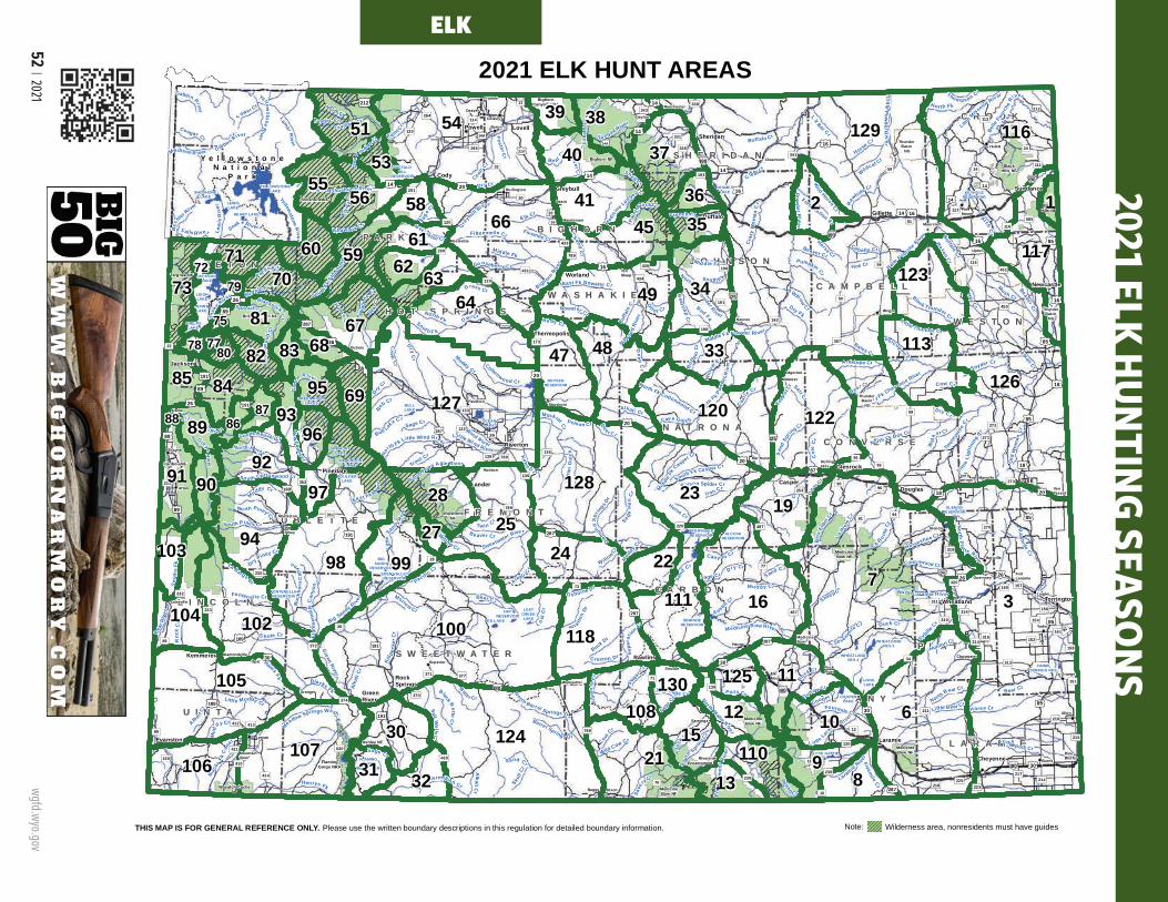
52 | 2021 wgfd.wyo.gov
P A R KP A R K
C A M P B E L LC A M P B E L L
C R O O KC R O O K
S H E R I D A NS H E R I D A N
T E T O NT E T O N J O H N S O NJ O H N S O N
W E S T O NW E S T O N
W A S H A K I EW A S H A K I E
H O T S P R I N G SH O T S P R I N G S
F R E M O N TF R E M O N T
N A T R O N AN A T R O N AC O N V E R S EC O N V E R S E
S U B L E T T ES U B L E T T E
L I N C O L NL I N C O L N
P L A T T EP L A T T E
C A R B O NC A R B O N
A L B A N YA L B A N Y
S W E E T W A T E RS W E E T W A T E R
L A R A M I EL A R A M I E
U I N T AU I N T A
B I G H O R NB I G H O R NBuffalo
Casper
Cheyenne
Cody
Douglas
Evanston
Gillette
Glenrock
GreenRiver
Greybull
Jackson
Kemmerer
Lander
Laramie
Lovell
Lusk
Newcastle
Pinedale
Powell
Rawlins
Riverton
RockSprings
Sheridan
Sundance
Thermopolis
TorringtonWheatland
Worland
PHELPSLAKE
LEIGHLAKE
JENNYLAKE
LOSTCREEKLAKE
FLAMINGGORGE
RESERVOIR
EDEN VALLEYRESERVOIR
BOULDERLAKE
FREMONTLAKE
FONTENELLERESERVOIR
HAWKSPRINGS RES
WHEATLANDRES 3
WHEATLANDRES 2
LONGLAKE
COOPERLAKE
GLENDORESERVOIR
PATHFINDERRESERVOIR
DESMETLAKE
YELLOWSTONELAKESHOSHONE
LAKELEWISLAKE
HEART LAKE
JACKSONLAKE
BOYSENRESERVOIR
BULLLAKE
OCEANLAKE
RED LAKE
HAYRESERVOIR
BIGSANDY
RESERVOIR
WILLOWLAKE
HALFMOONLAKE
GREEN RIVERLAKES
ALCOVARESERVOIR
LAKE HATTIE
SEMINOERESERVOIR
KEYHOLERESERVOIR
BUFFALOBILL
RESERVOIR
FlamingGorge NRA
BighornCanyon NRA
Shoshone NF
Bighorn NFBlack
Hills NF
BlackHills NF
Bridger-Teton NF
Targhee NF
Caribou NF
ShoshoneNF
MedicineBow NF
MedicineBow NF
Ashley NF
MedicineBow NF
MedicineBow NF
Wasatch-CacheNF
Afton
Albin
Alpine
Baggs
Bairoil
Bar Nunn
Basin
BigPiney
Burlington
Burns
Byron
Chugwater
Clearmont
Cokeville
Cowley DaytonDeaver
Diamondville
Dixon
Dubois
Edgerton
ElkMountain
FortLaramie
Frannie
Glendo
Encampment
Granger
Guernsey
Hanna
Hartville
Hudson
Hulett
Kaycee
Kirby
La Barge
La Grange
Lingle
LostSprings
Lyman
Manderson
Manville
Marbleton
MedicineBow
Meeteetse
Midwest
Moorcroft
MountainView
Opal
Pavillion
PineBluffs
PineHaven
Ranchester
Riverside
RockRiver
RollingHills
Saratoga
Shoshoni
SinclairSuperior
TenSleep
Thayne
Upton
VanTassell
Wamsutter
Wright
Yoder
Tho m pson Cr
Sheep C
r
Wind River
Powde rR
iver
Gre
enRiver
Horse Cr
BighornRiv
er
Hams Fk
Sweetwater River
Gre
ybull River
Clear Cr
Blacks Fk B
itte r Cr
Snak
e River
LaramieRive
r
Nowood
Rive
r
Poison Cr
Lodgepole Cr
Belle
Fourc
heRi
ver
DryC
r
Shell C r
Fivemile Cr
Ro
ck Cr
Sm
iths
F k
Antelope Cr
Dry Fk
Henrys Fk
SouthFk Po
wde
r Ri v
e r
Muddy Cr
Lamar
River
Raw
hi deCr
Grass Cr
Muskrat Cr
Littl
eSandyRi
ver
Dee
r Cr
Cottonwood Cr
Be aver Cr
P ass Cr
Pacif icCr
Bear
Riv
er
S hute Cr
Bear Cr
E lk CrElkFk
Horseshoe Cr
La Barge Cr
Littl
e Missouri River
Bates Cr
Big Sandy River
Big Dry Cr
Mush Cr
Cow Cr
Fonten elle Cr
Box
Elde
r Cr
North Laramie River
Sybille
Cr
Medicine Bow RiverSu
gar Cr
S age C r
Craz
yW
oma n
Cr
Kirby D r
Castle
Cr
French Cr
HayCr
Sep
arat
ion Cr
Alkali Cr
Ye llowstone
River
Little Bear Cr
Old
Wom
anC
r
No rth Piney Cr
Ca bal lo Cr
Black Thunder Cr
Littl e Muddy Cr
Little Wind River
Salt Cr
Poison Spider Cr
Middl
eFk
Casper Cr
Li ttleLara
mie River
Coon
Cr
L ost
Cr
Twen
tym
ile
Cr
S la te Cr
Kirby Cr
BuffaloCr
Eas t Fk R iver
Wildcat Cr
O sborne D r
Trout Cr
Dutton Cr
South Fk Casper C r
RavenCr
LaPre
leCr
Falls River
Cave Gulch
Willow Cr
Hoe Cr
Gibbon River
Col
eCr
Porcupine Cr
Cooper Cr
Snyder Cr
Creston Dr
Little Thunder Cr
NorthBear Cr
L XBar Cr
Teap
ot Cr
Bo
b Cr
Barrel Spring s Dr
Log a
nG
u lch
Bull Lak
e Cr
Sout h F k
NorthPopo Agie River
Twin C r
Stra
tton
Dr
Vermillion Cr
DryPiney Cr
A ustinCr
San
dSp
ring Cr
Tower Cr
Fortification Cr
Blac
ksFk
Can
al
Sm ithC
r
Meadow Springs Wash
Spread C r
Cougar Cr
Litt l
eB
igh o
rnRive
r
L ew
i sR
iver
Bec
hler River
Wild Cow Cr
No
rthFk Little Wind River
Blackrock
Cr
Gallitin River
Li ttle
Ligh
tnin
gCr
Pelton C r
Hunton Cr
Wi llow Cr
HorseC
r
Sage Cr
Green
River
Cottonwood Cr
BearC
r
Beaver Cr
Bear Cr
Mud
dy Cr
Dry Cr
Alka
liCr
Buffalo Cr
Mud dy Cr
Skull
Cr
Roc
kC
r
Cow
Cr
Dry Cr
Sage Cr
S and Cr
Sage C r
Yellowstone
Rive r
Horse Cr
Dry Cr
Alkal i Cr
Fivemile
Cr
Dee r Cr
Canyon Cr
Raw
hide Cr
Snak e River
Bear Cr
Sand Cr
Beaver Cr
Dry Cr
North Platte River
No rth
P la t te River
G re ysR
iv er
Belle Fourche River
Owl Cr
Mud
dy Cr
Go oseberry Cr
Fi fteenmile Cr
Cro
wCr
LittlePow
derRiver
Sa lt We lls
Cr
Tongue River
Nowater CrWig
gins
Fk
Jack
Cr
Wal
k er Cr
ArchC
r
New
FkR
iver
SouthFk
Shosh
one
Riv
er
Dry Fk Cheyenne River
Pain
t Rock Cr
Wil d Horse
Cr
La B onte
Cr
NorthFk Powder Ri ver
Iron Cr
South Piney Cr
Killp
ecke
r Cr
Buck Dr
North Fk Shoshone River
Sa geH
enCr
WillowCr
AlbertC
r
South Beaver Cr
Black ButteC
r
Middle Fk Powder River
Buffalo Fk
Save
ry Cr
Meetee tse Cr
Buck
h orn
Can
yon
Fourmile Cr
Horse Cr
Fillm
ore
Cr
E nca
mpm
ent R
iver
L ittle Sage Cr
De
epC
r
Morrow Cr
Paint Cr
FosterCr
Eig h
teen
mile
Can
yon
North Horse Cr
Ishawooa Cr
Sevenmile
Cr
Med
icine Lodge Cr
Nort h Barrel Springs D r
Sout
h Spring Cr
De a
d Indian C r
North Fk
L ittle Greys Riv e r
East Fk Nowater Cr
Beartrap
Cr
South Cottonwood Cr
Alkali
Cr
Pumpkin Cr
North Fk
Madison R iver
Goose
Cr
Diamond
Spr
ings Dr
Mid dle Fk
Crandall Cr
Red Fk
Ti mber Cr
Mid dle Fk
North Fk
South F k
North Fk Cottonwood Cr
North Fk Box Cr
Ott er Cr
Buffa
loCr
Be ar Cr
Sand
Cr
Sage Cr
Buf
falo
Cr
Duck Cr
Pacific Cr
SandC
r
Wil l
ow
Cr
Horse Cr
BeaverC
r
Cot
tonw
ood
Cr
Muddy Cr
AlkaliC
r§̈¦I80
§̈¦I25
§̈¦I90
§̈¦I80
§̈¦I25
§̈¦I25
§̈¦I80
§̈¦I25
§̈¦I90
§̈¦I90
£¤26
£¤191
£¤18
£¤16
£¤85
£¤189
£¤89
£¤287
£¤14
£¤85
£¤89
£¤16
£¤20
£¤30
£¤14
£¤20 £¤16
£¤26
£¤191
£¤191
£¤191
£¤310
£¤87
£¤14A
£¤14A
£¤18
£¤18
£¤14£¤14
£¤14
£¤14
£¤85
£¤287
£¤287
£¤189
£¤20
£¤189
£¤20
£¤89
£¤191
£¤20
£¤287
£¤26
£¤85
£¤16
£¤26
£¤14
£¤85
£¤287
£¤30
£¤212
£¤30
£¤20
£¤16
£¤212
£¤14
£¤287
£¤16
£¤85
£¤26
£¤16
£¤30
£¤26
£¤89
³±487
³±59
³±34
³±430
³±50
³±789
³±120
³±530
³±70
³±270³±135
³±116
³±192
³±32
³±24
³±387
³±585
³±310
³±28
³±372
³±431
³±351
³±313
³±93
³±22
³±433
³±94
³±132
³±352
³±71
³±215
³±190
³±211
³±253
³±156
³±374
³±319
³±320
³±232
³±114
³±11
³±410
³±294
³±225
³±233
³±238
³±10
³±111
³±335
³±92
³±295
³±290
³±214
³±161
³±314
³±157³±160
³±154
³±73
³±151
³±158
³±235
³±96
³±377
³±315
³±413
³±152
³±133
³±311
³±217
³±218
³±173
³±24
³±136
³±59
³±789
³±89
³±59
³±90
³±220
³±196
³±130
³±130
³±120
³±414 ³±230
³±230
³±450
³±91
³±77
³±150
³±434
³±112
³±12
³±412
³±291
³±216
³±51
³±37
³±316
³±138 ³±95
³±113
³±371
³±223³±251
³±343
³±370
³±451
³±411
³±193
³±341
³±271
³±435
³±331
³±273
³±30
³±120
³±789
³±487
³±28
³±789
³±116
³±191
³±89
³±338
³±272
Y e l l o w s t o n eN a t i o n a l
P a r k
3839
37405355
24156 365866
145 35
5960 61
341236370
71 6272
497964
678175
127
68 47 1133378
122
8569
1208786
128
8988
9197
922390 28 19
94
3
9927
103
104
24 22
118
125105 13012
124
11
30 1015
107
6
110 9106 31 32 8
96
13
111
21
25
95
83
93
108
73
77
100
98
102
8284
80 48
167
117
129 116
126
51 54
THIS MAP IS FOR GENERAL REFERENCE ONLY. Please use the written boundary descriptions in this regulation for detailed boundary information.
2021 ELK HUNT AREAS
Thunder Basin
NG
Thunder Basin
NG
Thunder Basin
NG
Note: Wilderness area, nonresidents must have guides
P A R KP A R K
C A M P B E L LC A M P B E L L
C R O O KC R O O K
S H E R I D A NS H E R I D A N
T E T O NT E T O N J O H N S O NJ O H N S O N
W E S T O NW E S T O N
W A S H A K I EW A S H A K I E
H O T S P R I N G SH O T S P R I N G S
F R E M O N TF R E M O N T
N A T R O N AN A T R O N AC O N V E R S EC O N V E R S E
S U B L E T T ES U B L E T T E
L I N C O L NL I N C O L N
P L A T T EP L A T T E
C A R B O NC A R B O N
A L B A N YA L B A N Y
S W E E T W A T E RS W E E T W A T E R
L A R A M I EL A R A M I E
U I N T AU I N T A
B I G H O R NB I G H O R NBuffalo
Casper
Cheyenne
Cody
Douglas
Evanston
Gillette
Glenrock
GreenRiver
Greybull
Jackson
Kemmerer
Lander
Laramie
Lovell
Lusk
Newcastle
Pinedale
Powell
Rawlins
Riverton
RockSprings
Sheridan
Sundance
Thermopolis
TorringtonWheatland
Worland
PHELPSLAKE
LEIGHLAKE
JENNYLAKE
LOSTCREEKLAKE
FLAMINGGORGE
RESERVOIR
EDEN VALLEYRESERVOIR
BOULDERLAKE
FREMONTLAKE
FONTENELLERESERVOIR
HAWKSPRINGS RES
WHEATLANDRES 3
WHEATLANDRES 2
LONGLAKE
COOPERLAKE
GLENDORESERVOIR
PATHFINDERRESERVOIR
DESMETLAKE
YELLOWSTONELAKESHOSHONE
LAKELEWISLAKE
HEART LAKE
JACKSONLAKE
BOYSENRESERVOIR
BULLLAKE
OCEANLAKE
RED LAKE
HAYRESERVOIR
BIGSANDY
RESERVOIR
WILLOWLAKE
HALFMOONLAKE
GREEN RIVERLAKES
ALCOVARE SERVOIR
LAKE HATTIE
SEMINOERESERVOIR
KEYHOLERESERVOIR
BUFFALOBILL
RESERVOIR
FlamingGorge NRA
BighornCanyon NRA
Shoshone NF
Bighorn NFBlack
Hills NF
BlackHills NF
Bridger-Teton NF
Targhee NF
Caribou NF
ShoshoneNF
MedicineBow NF
MedicineBow NF
Ashley NF
MedicineBow NF
MedicineBow NF
Wasatch-CacheNF
Afton
Albin
Alpine
Baggs
Bairoil
Bar Nunn
Basin
BigPiney
Burlington
Burns
Byron
Chugwater
Clearmont
Cokeville
Cowley DaytonDeaver
Diamondville
Dixon
Dubois
Edgerton
ElkMountain
FortLaramie
Frannie
Glendo
Encampment
Granger
Guernsey
Hanna
Hartville
Hudson
Hulett
Kaycee
Kirby
La Barge
La Grange
Lingle
LostSprings
Lyman
Manderson
Manville
Marbleton
MedicineBow
Meeteetse
Midwest
Moorcroft
MountainView
Opal
Pavillion
PineBluffs
PineHaven
Ranchester
Riverside
RockRiver
RollingHills
Saratoga
Shoshoni
SinclairSuperior
TenSleep
Thayne
Upton
VanTassell
Wamsutter
Wright
Yoder
Tho m ps on Cr
Sheep C
r
Wind River
Pow
d er River
Gr e
enRiver
Horse Cr
BighornRiv
er
Hams Fk
Swee twater River
Greybull River
Clea r C r
Blacks Fk B
itte r Cr
Snak
e River
LaramieRiver
NowoodRi
ver
Poison Cr
Lodgepole Cr
Belle
Four
che
R
iver
DryC
r
Shell C r
Fivemile Cr
Rock Cr
Sm
i ths
Fk
Antelope Cr
Dry Fk
He nrys Fk
SouthFk Po
wde
r Riv
e rMuddy Cr
Lamar R
iver
Raw
hi deCr
Grass Cr
Muskrat Cr
Littl
eSandy R
ive r
Dee
r Cr
Cottonwood Cr
B e aver Cr
P ass Cr
Pacif icCr
Bear
Riv
er
S hute Cr
Bear Cr
E lk CrE lkFk
Horseshoe Cr
La Barge Cr
Little
Missouri River
Bates Cr
Big Sandy River
Big Dry Cr
Mus h Cr
Cow Cr
Fonten elle Cr
Box
Elde
r Cr
North Laramie River
Sybille
C r
Medicine Bow River
Su
gar Cr
S age C
r
Cra
zyW
oman
Cr
Ki rby Dr
Castle
Cr
Fr ench Cr
Hay
Cr
Sepa
ratio
n Cr
Alkali Cr
Yell owstone
River
Little Bear Cr
Old
Wom
anC
r
No rth Piney Cr
Ca bal lo Cr
Black Thunder Cr
Littl e Muddy Cr
Little Wind River
Salt Cr
Poison Spider Cr
Middl
eFk
Casper Cr
Li t tleLara
mie R iver
Coon
Cr
L os t
Cr
Twen
tym
ile
Cr
Slate Cr
Kirby Cr
BuffaloCr
Eas t Fk R iver
Wildcat C r
O sborne Dr
Trout Cr
Dutton Cr
South Fk Casper C r
RavenCr
LaPre
leCr
Falls River
Cave Gul ch
Wi llow Cr
Hoe Cr
Gibbon River
Cole
Cr
Porcupine C
r
Coope r Cr
Snyder Cr
Creston Dr
Little Thunder Cr
NorthBear Cr
LX
Bar Cr
Teap
otCr
BobCr
Barrel Spring s Dr
Log a
nG
ulch
Bull Lak
e Cr
Sout h F k
N orthPopo Agie River
Tw in C r
Stra t ton
Dr
Vermillion Cr
DryPiney Cr
A ustin Cr
San
dSp
ring Cr
Tower Cr
Fortification Cr
Blac
ksFk
Can
al
Sm ithC
r
Meadow Springs Wash
Spr ead C r
Coug ar Cr
L itt
leB
igho
rnRiv
er
Lew
isR
iver
Bec
hlerRiver
Wild Cow Cr
No
rthFk L ittle Wind River
Blackrock
Cr
Gallitin R iver
Li ttle
Ligh
tnin
gCr
Pe lton C r
Hunton Cr
W illow
Cr
HorseC
r
Sage Cr
Green
R iver
Cottonwo od Cr
Bear C
r
Beaver Cr
Bear Cr
Mud
dy Cr
Dry Cr
Alk
a li C
r
Buffalo Cr
Mud dy Cr
Skull
Cr
Roc
kC
r
Cow
Cr
Dry Cr
Sage Cr
S and Cr
Sage C r
YellowstoneRi ve r
Horse Cr
Dry Cr
Alkal i Cr
Fivemile
Cr
Dee r Cr
Can yon Cr
Raw
hide Cr
Snake Rive r
Bear Cr
Sand Cr
Beaver Cr
Dry Cr
North Platte River
No rth
Pla t te River
G
reysR
ive r
Bel le Fourc
he River
Owl Cr
Mud
dy Cr
Gooseberry Cr
Fifteenmile Cr
Cro
wC
r
LittleP
owderR
iver
Sal t W
ellsC
r
To ngue River
Nowater CrWig
gins Fk
Jack
Cr
Wa l
ker C r
ArchC
r
New
FkR
iver
So uthFk
Shosh
one
Riv
er
Dry Fk Cheyenne River
Pain
t Rock Cr
Wild Horse Cr
La B onte
Cr
North Fk Powder River
Iron Cr
South Piney Cr
Killp
ecke
r Cr
Buck Dr
North Fk Shoshone River
Sage
Hen
Cr
WillowCr
AlbertC
r
South Beaver Cr
Black Butte
Cr
Middle Fk Powder Riv er
Buffalo Fk
Save
ryCr
Meetee tse Cr
Buc
kho r
nC
anyo
n
Fourmile Cr
Horse Cr
Fillm
ore
Cr
E nca
mpm
ent R
iver
Little Sage Cr
Deep
Cr
Morrow Cr
Paint Cr
Foster Cr
Eig h
teen
mile
Ca n
yon
N orth Horse Cr
Ishawo oa Cr
Sev enmile
Cr
Med
icine Lod
ge Cr
Nort h Barrel Springs Dr
Sout
h Spring
Cr
Dea
d
Indian C r
North Fk
Little Greys Riv e r
East Fk Nowater Cr
Bea r trap
Cr
Sou th Cottonwood Cr
Alkali
Cr
Pumpkin Cr
Nor th Fk
M adison R iver
Goose
Cr
Diam
ondS
pr
ingsDr
Mid dle Fk
Crandall Cr
Red Fk
Timber Cr
Mid dle Fk
North F k
South F k
North Fk Cottonwood Cr
North Fk Box Cr
Ott e r Cr
Buffa
l oC r
Be ar Cr
Sand
Cr
Sag e Cr
Buf
falo
Cr
Duck Cr
Pacific Cr
SandC
r
Wi ll
ow
Cr
Horse Cr
Be
aver Cr
Cot
t onw
ood
Cr
Muddy Cr
AlkaliC
r§̈¦I80
§̈¦I25
§̈¦I90
§̈¦I80
§̈¦I25
§̈¦I25
§̈¦I80
§̈¦I25
§̈¦I90
§̈¦I90
£¤26
£¤191
£¤18
£¤16
£¤85
£¤189
£¤89
£¤287
£¤14
£¤85
£¤89
£¤16
£¤20
£¤30
£¤14
£¤20 £¤16
£¤26
£¤191
£¤191
£¤191
£¤310
£¤87
£¤14A
£¤14A
£¤18
£¤18
£¤14£¤14
£¤14
£¤14
£¤85
£¤287
£¤287
£¤189
£¤20
£¤189
£¤20
£¤89
£¤191
£¤20
£¤287
£¤26
£¤85
£¤16
£¤26
£¤14
£¤85
£¤287
£¤30
£¤212
£¤30
£¤20
£¤16
£¤212
£¤14
£¤287
£¤16
£¤85
£¤26
£¤16
£¤30
£¤26
£¤89
³±487
³±59
³±34
³±430
³±50
³±789
³±120
³±530
³±70
³±270
³±135
³±116
³±192
³±32
³±24
³±387
³±585
³±310
³±28
³±372
³±431
³±351
³±313
³±93
³±22
³±433
³±94
³±132
³±352
³±71
³±215
³±190
³±211
³±253
³±156
³±374
³±319
³±320
³±232
³±114
³±11
³±410
³±294
³±225
³±233
³±238
³±10
³±111
³±335
³±92
³±295
³±290
³±214
³±161
³±314
³±157³±160
³±154
³±73
³±151
³±158
³±235
³±96
³±377
³±315
³±413
³±152
³±133
³±311
³±217
³±218
³±173
³±24
³±136
³±59
³±789
³±89
³±59
³±90
³±220
³±196
³±130
³±130
³±120
³±414 ³±230
³±230
³±450
³±91
³±77
³±150
³±434
³±112
³±12
³±412
³±291
³±216
³±51
³±37
³±316
³±138 ³±95
³±113
³±371
³±223
³±251
³±343
³±370
³±451
³±411
³±193
³±341
³±271
³±435
³±331
³±273
³±30
³±120
³±789
³±487
³±28
³±789
³±116
³±191
³±89
³±338
³±272
Y e l l o w s t o n eN a t i o n a l
P a r k
30164
32163
169154
139142
105106
1725
18122
121 153 2109 52
5051110 11146
32728
4471655
29125 41115 21
19
117116
86118149
1487114
119 127
339
120 37156
40
22171
3910
146 31150
113615134
14
15712140144
145 8913
88
138
16092 67 65143
15
130
135 87
96
64131 98
155
59747983
100 75101
10280
6078 7677 6181
23
26
24
128
70
66
90
97
82
94
124
141
84
15235
134
168
132133
THIS MAP IS FOR GENERAL REFERENCE ONLY.Please use the written boundary descriptionsin this regulation for detailed boundary information.
2020 DEER HUNT AREAS
153
REGION R(Areas 41, 46, 47, 50-53)
REGION M (Areas 35, 36, 37, 39, 40, 164)
REGION Y (Areas 24, 25, 27, 28, 30, 32, 33, 163, 169)
REGION C (Areas 17-19, 23, 26, 29, 31)
REGION F(Areas 105, 106, 109, 110-115, 116-120)
REGION W(Areas 82, 84, 100, 101, 102, 131) REGION Q
(Areas, 34, 87, 89, 90, 96-98REGION D
(Areas 66, 70, 74-77, 78-81, 83, 88)(*67 CLOSED)
REGION J(Areas 59, 60, 61, 64, 65)
REG
ION
T(A
rea
15)
REG
ION
B(A
reas
7-9
, 10,
11-
14, 2
1, 2
2)
REG
ION
A(A
reas
1-6
)
REG
ION
K(A
reas
132
-134
, 168
)R
EGIO
N G
(Are
as 1
35, 1
43-1
45)
REG
ION
H(A
reas
130
, 138
-140
, 141
, 142
, 146
, 149
-156
)
LIMITED QUOTA AREAS - Nonresident Region General and Resident General Licenses are not valid for limited quota areas.
112
Thunder Basin
NG
Thunder Basin
NG
Thunder Basin
NG
Note: Wilderness area, nonresidents must have guides
REGION X(Areas 121-124, 125, 127, 165)
113
REG
ION
L(A
reas
92,
94,
128
, 148
, 157
, 160
, 171
)
2021 ELK HUNTING SEASONS
ELK

wgfd.wyo.gov
Wyoming Hunting Regulations | 53
ELKSection 2. Elk Hunting Seasons. Hunt areas, season dates and limitations.
1
2
3
4
5
Hunt Area
LicenseType
SpecialArchery Dates
RegularSeason Dates Quota Limitations
Opens Closes Opens ClosesELK
CHARACTERISTICS1. Body - Tends to be reddish and lighter brown with darker legs.
2. Neck – The neck is usually a chestnut brown, darker than the body.
3. Snout – Their noses are slender.
4. Rump – Pale yellow in color.
5. Antlers – On bulls, two (2) years and older, the antlers have visible brown tines coming off a main beam.
1 1 Sep. 1 Sep. 30 Oct. 15 Nov. 30 100 Any elk
1 4 Sep. 1 Sep. 30 Oct. 15 Nov. 30 75 Antlerless elk
2 1 Oct. 21 Nov. 1 60 Any elk
2 4 Sep. 18 Sep. 27 80 Antlerless elk
2 4 Oct. 21 Nov. 1 Antlerless elk
2 6 Sep. 18 Sep. 27 40 Cow or calf
2 6 Oct. 21 Nov. 1 Cow or calf
3 Gen Sep. 1 Sep. 14 Sep. 15 Oct. 14 Any elk
3 Gen Oct. 15 Jan. 31 Any elk valid south of U.S. Highway 26
3 6 Aug. 15 Nov. 30 200 Cow or calf
3 6 Dec. 1 Jan. 31 Cow or calf valid south of U.S. Highway 26
6 Gen Sep. 1 Sep. 30 Oct. 1 Oct. 31 Any elk valid off national forest
6 Gen Nov. 1 Nov. 30 Antlerless elk valid off national forest
6 1 Sep. 1 Sep. 30 Oct. 15 Oct. 31 75 Any elk
6 1 Nov. 1 Jan. 31 Antlerless elk
6 4 Sep. 1 Sep. 30 Oct. 15 Jan. 31 50 Antlerless elk
6 6 Aug. 15 Jan. 31 1100 Cow or calf valid off national forest
7 1 Sep. 1 Sep. 30 Oct. 15 Nov. 20 1500 Any elk
7 1 Nov. 21 Dec. 31 Antlerless elk
7 2 Nov. 21 Dec. 31 350 Antlered elk four (4) points or less on either antler; valid in Converse County
7 4 Aug. 15 Oct. 14 1200 Antlerless elk valid on private land; valid in all of Platte County
7 4 Sep. 1 Sep. 30 Oct. 15 Dec. 31 Antlerless elk valid in the entire area
7 6 Aug. 15 Oct. 14 2250 Cow or calf valid on private land; valid in all of Platte County
7 6 Sep. 1 Sep. 30 Oct. 15 Dec. 31 Cow or calf valid in the entire area
7 7 Sep. 1 Sep. 30 Jan. 1 Jan. 31 50 Cow or calf
8 1 Sep. 1 Sep. 30 Oct. 1 Jan. 31 150 Any elk
8 6 Aug. 15 Jan. 31 200 Cow or calf Elk
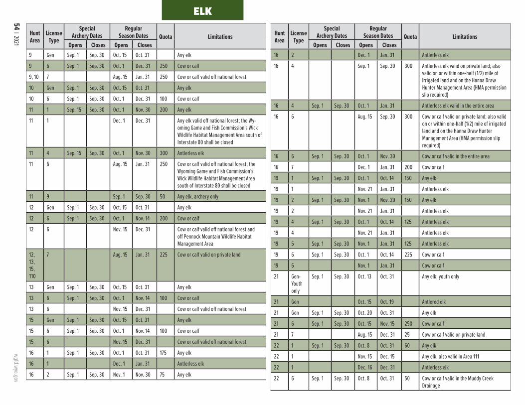
54 | 2021 wgfd.wyo.gov
ELK
Hunt Area
LicenseType
SpecialArchery Dates
RegularSeason Dates Quota Limitations
Opens Closes Opens Closes
Hunt Area
LicenseType
SpecialArchery Dates
RegularSeason Dates Quota Limitations
Opens Closes Opens Closes9 Gen Sep. 1 Sep. 30 Oct. 15 Oct. 31 Any elk
9 6 Sep. 1 Sep. 30 Oct. 1 Dec. 31 250 Cow or calf
9, 10 7 Aug. 15 Jan. 31 250 Cow or calf valid off national forest
10 Gen Sep. 1 Sep. 30 Oct. 15 Oct. 31 Any elk
10 6 Sep. 1 Sep. 30 Oct. 1 Dec. 31 100 Cow or calf
11 1 Sep. 15 Sep. 30 Oct. 1 Nov. 30 200 Any elk
11 1 Dec. 1 Dec. 31 Any elk valid off national forest; the Wy-oming Game and Fish Commission’s Wick Wildlife Habitat Management Area south of Interstate 80 shall be closed
11 4 Sep. 15 Sep. 30 Oct. 1 Nov. 30 300 Antlerless elk
11 6 Aug. 15 Jan. 31 250 Cow or calf valid off national forest; the Wyoming Game and Fish Commission’s Wick Wildlife Habitat Management Area south of Interstate 80 shall be closed
11 9 Sep. 1 Sep. 30 50 Any elk, archery only
12 Gen Sep. 1 Sep. 30 Oct. 15 Oct. 31 Any elk
12 6 Sep. 1 Sep. 30 Oct. 1 Nov. 14 200 Cow or calf
12 6 Nov. 15 Dec. 31 Cow or calf valid off national forest and off Pennock Mountain Wildlife Habitat Management Area
12, 13, 15, 110
7 Aug. 15 Jan. 31 225 Cow or calf valid on private land
13 Gen Sep. 1 Sep. 30 Oct. 15 Oct. 31 Any elk
13 6 Sep. 1 Sep. 30 Oct. 1 Nov. 14 100 Cow or calf
13 6 Nov. 15 Dec. 31 Cow or calf valid off national forest
15 Gen Sep. 1 Sep. 30 Oct. 15 Oct. 31 Any elk
15 6 Sep. 1 Sep. 30 Oct. 1 Nov. 14 100 Cow or calf
15 6 Nov. 15 Dec. 31 Cow or calf valid off national forest
16 1 Sep. 1 Sep. 30 Oct. 1 Oct. 31 175 Any elk
16 1 Dec. 1 Jan. 31 Antlerless elk
16 2 Sep. 1 Sep. 30 Nov. 1 Nov. 30 75 Any elk
16 2 Dec. 1 Jan. 31 Antlerless elk
16 4 Sep. 1 Sep. 30 300 Antlerless elk valid on private land; also valid on or within one-half (1/2) mile of irrigated land and on the Hanna Draw Hunter Management Area (HMA permission slip required)
16 4 Sep. 1 Sep. 30 Oct. 1 Jan. 31 Antlerless elk valid in the entire area
16 6 Aug. 15 Sep. 30 300 Cow or calf valid on private land; also valid on or within one-half (1/2) mile of irrigated land and on the Hanna Draw Hunter Management Area (HMA permission slip required)
16 6 Sep. 1 Sep. 30 Oct. 1 Nov. 30 Cow or calf valid in the entire area
16 7 Dec. 1 Jan. 31 200 Cow or calf
19 1 Sep. 1 Sep. 30 Oct. 1 Oct. 14 150 Any elk
19 1 Nov. 21 Jan. 31 Antlerless elk
19 2 Sep. 1 Sep. 30 Nov. 1 Nov. 20 150 Any elk
19 2 Nov. 21 Jan. 31 Antlerless elk
19 4 Sep. 1 Sep. 30 Oct. 1 Oct. 14 125 Antlerless elk
19 4 Nov. 21 Jan. 31 Antlerless elk
19 5 Sep. 1 Sep. 30 Nov. 1 Jan. 31 125 Antlerless elk
19 6 Sep. 1 Sep. 30 Oct. 1 Oct. 14 225 Cow or calf
19 6 Nov. 1 Jan. 31 Cow or calf
21 Gen-Youth only
Sep. 1 Sep. 30 Oct. 13 Oct. 31 Any elk; youth only
21 Gen Oct. 15 Oct. 19 Antlered elk
21 Gen Sep. 1 Sep. 30 Oct. 20 Oct. 31 Any elk
21 6 Sep. 1 Sep. 30 Oct. 15 Nov. 15 250 Cow or calf
21 7 Aug. 15 Dec. 31 25 Cow or calf valid on private land
22 1 Sep. 1 Sep. 30 Oct. 8 Oct. 31 60 Any elk
22 1 Nov. 15 Dec. 15 Any elk, also valid in Area 111
22 1 Dec. 16 Dec. 31 Antlerless elk
22 6 Sep. 1 Sep. 30 Oct. 8 Oct. 31 50 Cow or calf valid in the Muddy Creek Drainage
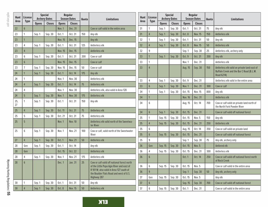
wgfd.wyo.gov
Wyoming Hunting Regulations | 55
ELK
Hunt Area
LicenseType
SpecialArchery Dates
RegularSeason Dates Quota Limitations
Opens Closes Opens Closes
Hunt Area
LicenseType
SpecialArchery Dates
RegularSeason Dates Quota Limitations
Opens Closes Opens Closes22 6 Nov. 1 Dec. 31 Cow or calf valid in the entire area
23 1 Sep. 1 Sep. 30 Oct. 1 Oct. 31 150 Any elk
23 1 Nov. 15 Dec. 15 Any elk
23 4 Sep. 1 Sep. 30 Oct. 1 Oct. 31 125 Antlerless elk
23 4 Nov. 15 Dec. 15 Antlerless elk
23 6 Sep. 1 Sep. 30 Oct. 1 Oct. 31 200 Cow or calf
23 6 Nov. 15 Dec. 15 Cow or calf
23 7 Sep. 1 Sep. 30 Nov. 15 Dec. 15 50 Cow or calf
24 1 Sep. 1 Sep. 30 Oct. 1 Oct. 14 175 Any elk
24 1 Nov. 1 Nov. 30 Antlerless elk
24 4 Sep. 1 Sep. 30 Oct. 1 Oct. 14 75 Antlerless elk
24 4 Nov. 1 Nov. 30 Antlerless elk, also valid in Area 128
24 5 Sep. 1 Sep. 30 Nov. 1 Nov. 30 175 Antlerless elk
25, 27
1 Sep. 1 Sep. 30 Oct. 1 Oct. 31 150 Any elk
25 4 Sep. 1 Sep. 30 Oct. 11 Oct. 31 75 Antlerless elk
25 5 Sep. 1 Sep. 30 Oct. 21 Oct. 31 75 Antlerless elk
25 5 Nov. 1 Nov. 10 Antlerless elk valid north of the Sweetwa-ter River
25 6 Sep. 1 Sep. 30 Nov. 1 Nov. 21 100 Cow or calf, valid north of the Sweetwater River
27 4 Sep. 1 Sep. 30 Oct. 1 Nov. 21 50 Antlerless elk
28 Gen Sep. 1 Sep. 30 Oct. 1 Oct. 14 Any elk
28 Gen Oct. 15 Oct. 22 Antlerless elk
28 4 Sep. 1 Sep. 30 Nov. 1 Nov. 21 175 Antlerless elk
28 6 Dec. 1 Jan. 31 25 Cow or calf valid off national forest north of the Little Popo Agie River and east of R 101 W; also valid in Area 127 south of the Boulder Flats Road and west of U.S. Highway 287
30 1 Sep. 1 Sep. 30 Oct. 1 Oct. 31 50 Any elk
30 4 Sep. 1 Sep. 30 Oct. 8 Nov. 15 50 Antlerless elk
31 1 Sep. 1 Sep. 30 Oct. 1 Oct. 31 75 Any elk
31 4 Sep. 1 Sep. 30 Oct. 8 Nov. 15 150 Antlerless elk
32 1 Sep. 1 Sep. 30 Oct. 1 Oct. 31 50 Any elk
32 4 Sep. 1 Sep. 30 Oct. 8 Nov. 15 50 Antlerless elk
32 9 Sep. 1 Sep. 30 25 Antlerless elk, archery only
33 1 Sep. 1 Sep. 30 Oct. 9 Oct. 31 200 Any elk
33 1 Nov. 1 Dec. 31 Antlerless elk
33 4 Aug. 15 Sep. 30 150 Antlerless elk valid on private land east of Buffalo Creek and the Bar C Road (B.L.M. Road 6214)
33 4 Sep. 1 Sep. 30 Oct. 9 Dec. 31 Antlerless elk valid in the entire area
33 6 Sep. 1 Sep. 30 Nov. 1 Dec. 31 300 Cow or calf
34 1 Sep. 1 Sep. 30 Oct. 15 Nov. 15 800 Any elk
34 1 Nov. 16 Dec. 31 Antlerless elk
34 6 Aug. 15 Oct. 14 700 Cow or calf valid on private land north of the North Fork Powder River
34 6 Sep. 1 Sep. 30 Oct. 15 Dec. 31 Cow or calf valid off national forest
35 1 Sep. 15 Sep. 30 Oct. 15 Nov. 5 150 Any elk
35 4 Sep. 15 Sep. 30 Oct. 15 Dec. 31 250 Antlerless elk
35 6 Aug. 15 Oct. 14 350 Cow or calf valid on private land
35 6 Sep. 15 Sep. 30 Oct. 15 Dec. 31 Cow or calf valid off national forest
35 9 Sep. 1 Sep. 30 75 Any elk, archery only
36 Gen Sep. 15 Sep. 30 Oct. 15 Nov. 5 Antlered elk
36 4 Sep. 15 Sep. 30 Oct. 15 Dec. 31 300 Antlerless elk
36 6 Oct. 1 Oct. 14 250 Cow or calf valid off national forest north of Rock Creek
36 6 Sep. 15 Sep. 30 Oct. 15 Nov. 5 Cow or calf valid in the entire area
36 9 Sep. 1 Sep. 30 50 Any elk, archery only
37 Gen Sep. 15 Sep. 30 Oct. 15 Nov. 5 Any elk
37 6 Sep. 15 Sep. 30 700 Cow or calf valid off national forest
37 6 Sep. 15 Sep. 30 Oct. 1 Dec. 31 Cow or calf valid in the entire area

56 | 2021 wgfd.wyo.gov
ELKELK
Hunt Area
LicenseType
SpecialArchery Dates
RegularSeason Dates Quota Limitations
Opens Closes Opens Closes
Hunt Area
LicenseType
SpecialArchery Dates
RegularSeason Dates Quota Limitations
Opens Closes Opens Closes37 9 Sep. 1 Sep. 30 150 Any elk, archery only
38 1 Oct. 15 Nov. 5 400 Any elk
38 1 Nov. 6 Nov. 15 Antlerless elk
38 4 Oct. 1 Oct. 10 550 Antlerless elk
38 4 Oct. 15 Nov. 15 Antlerless elk
38 9 Sep. 1 Sep. 30 250 Any elk, archery only
39 1 Oct. 15 Nov. 4 200 Any elk
39 1 Nov. 5 Nov. 30 Antlerless elk
39 4 Oct. 1 Oct. 10 150 Antlerless elk
39 4 Oct. 15 Nov. 30 Antlerless elk
39 6 Oct. 1 Nov. 4 50 Cow or calf valid off national forest
39 6 Nov. 5 Nov. 30 Cow or calf valid in the entire area
39 9 Sep. 1 Sep. 30 75 Any elk, archery only
40 1 Oct. 15 Nov. 4 225 Any elk
40 1 Nov. 5 Nov. 30 Antlerless elk
40 4 Oct. 15 Nov. 30 125 Antlerless elk
40 5 Oct. 1 Oct. 10 125 Antlerless elk
40 5 Oct. 15 Nov. 30 Antlerless elk
40 6 Sep. 1 Nov. 4 100 Cow or calf valid off national forest
40 6 Nov. 5 Nov. 30 Cow or calf valid in the entire area
40 9 Sep. 1 Sep. 30 100 Any elk, archery only
41 1 Sep. 15 Sep. 30 Oct. 15 Nov. 4 375 Any elk
41 4 Sep. 15 Sep. 30 Oct. 1 Oct. 10 450 Antlerless elk
41 4 Oct. 15 Nov. 30 Antlerless elk
41 6 Nov. 15 Dec. 21 300 Cow or calf
41 9 Sep. 1 Sep. 30 125 Any elk, archery only
45 1 Sep. 15 Sep. 30 Oct. 15 Nov. 4 350 Any elk
45 4 Sep. 15 Sep. 30 Oct. 15 Nov. 30 150 Antlerless elk
45 5 Sep. 15 Sep. 30 Oct. 1 Oct. 10 200 Antlerless elk
45 5 Nov. 5 Nov. 30 Antlerless elk
45 6 Aug. 15 Nov. 30 225 Cow or calf valid off national forest
45 9 Sep. 1 Sep. 30 150 Any elk, archery only
47 1 Sep. 1 Sep. 30 Oct. 9 Oct. 31 150 Any elk
47 1 Nov. 1 Nov. 30 Antlerless elk
47 6 Sep. 1 Sep. 30 Oct. 9 Nov. 30 100 Cow or calf
48 1 Sep. 1 Sep. 30 Oct. 9 Oct. 31 400 Any elk
48 1 Nov. 7 Dec. 15 Antlerless elk
48 4 Sep. 1 Sep. 30 Oct. 9 Oct. 31 100 Antlerless elk
48 4 Nov. 7 Dec. 15 Antlerless elk
48 6 Sep. 1 Sep. 30 Oct. 9 Oct. 31 650 Cow or calf
48 6 Nov. 7 Dec. 15 Cow or calf
49 1 Sep. 1 Sep. 30 Oct. 9 Oct. 31 350 Any elk
49 1 Nov. 7 Dec. 21 Antlerless elk
49 4 Sep. 1 Sep. 30 Oct. 9 Oct. 31 100 Antlerless elk
49 4 Nov. 7 Dec. 21 Antlerless elk
49 6 Sep. 1 Sep. 14 Sep. 15 Oct. 31 850 Cow or calf
49 6 Nov. 7 Dec. 21 Cow or calf
51 1 Oct. 1 Oct. 31 100 Any elk south and west of the Clarks Fork River
Spike Elk
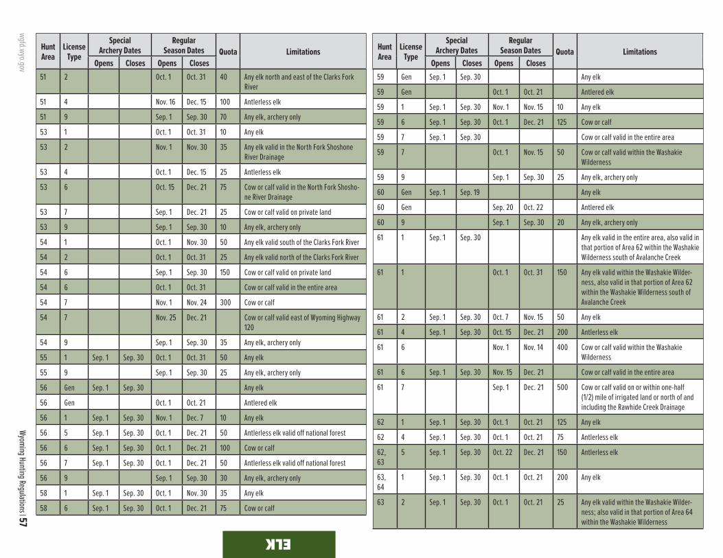
wgfd.wyo.gov
Wyoming Hunting Regulations | 57
ELK ELK
Hunt Area
LicenseType
SpecialArchery Dates
RegularSeason Dates Quota Limitations
Opens Closes Opens Closes
Hunt Area
LicenseType
SpecialArchery Dates
RegularSeason Dates Quota Limitations
Opens Closes Opens Closes51 2 Oct. 1 Oct. 31 40 Any elk north and east of the Clarks Fork
River
51 4 Nov. 16 Dec. 15 100 Antlerless elk
51 9 Sep. 1 Sep. 30 70 Any elk, archery only
53 1 Oct. 1 Oct. 31 10 Any elk
53 2 Nov. 1 Nov. 30 35 Any elk valid in the North Fork Shoshone River Drainage
53 4 Oct. 1 Dec. 15 25 Antlerless elk
53 6 Oct. 15 Dec. 21 75 Cow or calf valid in the North Fork Shosho-ne River Drainage
53 7 Sep. 1 Dec. 21 25 Cow or calf valid on private land
53 9 Sep. 1 Sep. 30 10 Any elk, archery only
54 1 Oct. 1 Nov. 30 50 Any elk valid south of the Clarks Fork River
54 2 Oct. 1 Oct. 31 25 Any elk valid north of the Clarks Fork River
54 6 Sep. 1 Sep. 30 150 Cow or calf valid on private land
54 6 Oct. 1 Oct. 31 Cow or calf valid in the entire area
54 7 Nov. 1 Nov. 24 300 Cow or calf
54 7 Nov. 25 Dec. 21 Cow or calf valid east of Wyoming Highway 120
54 9 Sep. 1 Sep. 30 35 Any elk, archery only
55 1 Sep. 1 Sep. 30 Oct. 1 Oct. 31 50 Any elk
55 9 Sep. 1 Sep. 30 25 Any elk, archery only
56 Gen Sep. 1 Sep. 30 Any elk
56 Gen Oct. 1 Oct. 21 Antlered elk
56 1 Sep. 1 Sep. 30 Nov. 1 Dec. 7 10 Any elk
56 5 Sep. 1 Sep. 30 Oct. 1 Dec. 21 50 Antlerless elk valid off national forest
56 6 Sep. 1 Sep. 30 Oct. 1 Dec. 21 100 Cow or calf
56 7 Sep. 1 Sep. 30 Oct. 1 Dec. 21 50 Antlerless elk valid off national forest
56 9 Sep. 1 Sep. 30 30 Any elk, archery only
58 1 Sep. 1 Sep. 30 Oct. 1 Nov. 30 35 Any elk
58 6 Sep. 1 Sep. 30 Oct. 1 Dec. 21 75 Cow or calf
59 Gen Sep. 1 Sep. 30 Any elk
59 Gen Oct. 1 Oct. 21 Antlered elk
59 1 Sep. 1 Sep. 30 Nov. 1 Nov. 15 10 Any elk
59 6 Sep. 1 Sep. 30 Oct. 1 Dec. 21 125 Cow or calf
59 7 Sep. 1 Sep. 30 Cow or calf valid in the entire area
59 7 Oct. 1 Nov. 15 50 Cow or calf valid within the Washakie Wilderness
59 9 Sep. 1 Sep. 30 25 Any elk, archery only
60 Gen Sep. 1 Sep. 19 Any elk
60 Gen Sep. 20 Oct. 22 Antlered elk
60 9 Sep. 1 Sep. 30 20 Any elk, archery only
61 1 Sep. 1 Sep. 30 Any elk valid in the entire area, also valid in that portion of Area 62 within the Washakie Wilderness south of Avalanche Creek
61 1 Oct. 1 Oct. 31 150 Any elk valid within the Washakie Wilder-ness, also valid in that portion of Area 62 within the Washakie Wilderness south of Avalanche Creek
61 2 Sep. 1 Sep. 30 Oct. 7 Nov. 15 50 Any elk
61 4 Sep. 1 Sep. 30 Oct. 15 Dec. 21 200 Antlerless elk
61 6 Nov. 1 Nov. 14 400 Cow or calf valid within the Washakie Wilderness
61 6 Sep. 1 Sep. 30 Nov. 15 Dec. 21 Cow or calf valid in the entire area
61 7 Sep. 1 Dec. 21 500 Cow or calf valid on or within one-half (1/2) mile of irrigated land or north of and including the Rawhide Creek Drainage
62 1 Sep. 1 Sep. 30 Oct. 1 Oct. 21 125 Any elk
62 4 Sep. 1 Sep. 30 Oct. 1 Oct. 21 75 Antlerless elk
62, 63
5 Sep. 1 Sep. 30 Oct. 22 Dec. 21 150 Antlerless elk
63, 64
1 Sep. 1 Sep. 30 Oct. 1 Oct. 21 200 Any elk
63 2 Sep. 1 Sep. 30 Oct. 1 Oct. 21 25 Any elk valid within the Washakie Wilder-ness; also valid in that portion of Area 64 within the Washakie Wilderness

58 | 2021 wgfd.wyo.gov v ELK SPECIAL MANAGEMENT PERMIT REQUIRED
ELK
Common violationsELK SPECIAL MANAGEMENT PERMIT
Elk hunters are reminded that an Elk Special Management Permit is required to hunt elk hunt areas associated with elk feedgrounds, which includes most elk hunt areas in the Jackson and Pinedale regions. Specifically, an Elk Special Management Permit is required to hunt elk in Elk Hunt Areas 70, 71, 75, 77, 78 and 80-98. These permits can be purchased for $15.50 from the Cheyenne Headquarters, Department Regional offices, the Department website and designated license selling agents.
v ELK SPECIAL MANAGEMENT PERMIT REQUIRED
v
ELKELK
Hunt Area
LicenseType
SpecialArchery Dates
RegularSeason Dates Quota Limitations
Opens Closes Opens Closes
Hunt Area
LicenseType
SpecialArchery Dates
RegularSeason Dates Quota Limitations
Opens Closes Opens Closes63 4 Sep. 1 Sep. 30 Oct. 1 Dec. 21 100 Antlerless elk
63 6 Sep. 1 Sep. 30 Cow or calf valid in the entire area
63 6 Aug. 15 Oct. 31 100 Cow or calf valid off national forest north of Gooseberry Creek
63 6 Nov. 1 Dec. 21 Cow or calf valid off national forest
64 2 Sep. 1 Sep. 30 Nov. 1 Nov. 15 75 Any elk, also valid in Area 63
64 6 Sep. 1 Nov. 14 200 Cow or calf valid in that portion of the Cottonwood Creek Drainage downstream of and including the 21-Creek Drainage, also valid within the Grass Creek Drainage downstream of the Grass Creek/Little Grass Creek confluence
64 6 Sep. 1 Sep. 30 Nov. 15 Dec. 21 Cow or calf valid in the entire area
64 7 Sep. 1 Sep. 30 Oct. 15 Dec. 21 300 Cow or calf valid south of and including the Cottonwood Creek Drainage
66 Gen Aug. 15 Dec. 21 Any elk
66 6 Aug. 15 Jan. 15 100 Cow or calf
67 Gen Sep. 15 Sep. 30 Oct. 1 Oct. 10 Antlered elk
67 Gen Oct. 11 Oct. 31 Antlered elk, spikes excluded
67 4 Sep. 15 Sep. 30 Nov. 1 Dec. 15 350 Antlerless elk
67 6 Sep. 15 Sep. 30 Nov. 15 Dec. 15 700 Cow or calf valid west of the Wiggins Fork and west of the East Fork downstream from the confluence with the Wiggins Fork
67, 68, 69
9 Sep. 1 Sep. 30 125 Any elk, archery only
68 Gen Sep. 15 Sep. 30 Oct. 1 Oct. 10 Antlered elk
68 Gen Oct. 11 Oct. 31 Antlered elk, spikes excluded
68 6 Sep. 15 Sep. 30 Nov. 1 Nov. 30 50 Cow or calf
69 Gen Sep. 15 Sep. 30 Oct. 1 Oct. 31 Any elk
69 6 Sep. 15 Sep. 30 Oct. 1 Nov. 30 25 Cow or calf
70 v Gen Sep. 1 Sep. 19 Any elk
70 v Gen Sep. 20 Oct. 31 Antlered elk, spikes excluded
71 v Gen Sep. 1 Sep. 19 Any elk
71 v Gen Sep. 20 Oct. 31 Antlered elk, spikes excluded
72 Closed
73 Gen Sep. 1 Sep. 19 Any elk
73 Gen Sep. 20 Oct. 25 Antlered elk, spikes excluded
73 6 Sep. 1 Sep. 19 Cow or calf valid in the entire area
73 6 Aug. 15 Jan. 31 35 Cow or calf valid on private land
75 v 4 Nov. 6 Nov. 21 50 Antlerless elk; the Snake River Bottom portion shall be closed, also valid in that portion of Area 81 west of the Shadow Mountain Loop Road (U.S.F.S. Road 30340)
75 v 4 Nov. 22 Dec. 12 Antlerless elk; the Snake River Bottom and Antelope Flats portions shall be closed
75 v 6 Nov. 6 Nov. 21 350 Cow or calf; the Snake River Bottom portion shall be closed
75 v 6 Nov. 22 Dec. 12 Cow or calf; the Snake River Bottom and Antelope Flats portions shall be closed
77 v Oct. 12 Oct. 25 General license and unused limited quota licenses, excluding limited quota cow or calf licenses, valid for any elk

wgfd.wyo.gov
Wyoming Hunting Regulations | 59
ELK ELK ELK
v ELK SPECIAL MANAGEMENT PERMIT REQUIRED
Hunt Area
LicenseType
SpecialArchery Dates
RegularSeason Dates Quota Limitations
Opens Closes Opens Closes
Hunt Area
LicenseType
SpecialArchery Dates
RegularSeason Dates Quota Limitations
Opens Closes Opens Closes77 v Oct. 26 Nov. 24 General license and unused limited quota
licenses; antlerless elk
77 v Youth only
Nov. 25 Nov. 27 National Elk Refuge permits shall be issued only for those in possession of a full price youth elk license, any elk; youth only
77 v Nov. 28 Dec. 12 General license and unused limited quota licenses, antlerless elk
78 v Gen Sep. 1 Sep. 25 Any elk valid in the entire area
78 v Gen Aug. 15 Oct. 31 Antlerless elk valid on private land
78 v 1 Aug. 15 Sep. 25 50 Any elk valid off national forest
78 v 1 Sep. 26 Jan. 31 Any elk valid in the entire area
78 v 2 Aug. 15 Oct. 31 50 Any elk valid on private land
78 v 6 Aug. 15 Sep. 25 175 Cow or calf valid off national forest
78 v 6 Sep. 26 Jan. 31 Cow or calf valid in the entire area
79 Closed
80 v Gen Sep. 1 Sep. 25 Sep. 26 Oct. 31 Any elk
80 v 6 Sep. 1 Sep. 25 Oct. 15 Nov. 14 300 Cow or calf
80 v 6 Nov. 15 Nov. 30 Cow or calf valid south of the Curtis Canyon and Sheep Creek Roads (U.S.F.S. Road 30440 and 30445)
81 v Gen Sep. 1 Sep. 25 Any elk
81 v Gen Sep. 26 Oct. 25 Antlered elk, spikes excluded
82 v Gen Sep. 1 Sep. 25 Any elk
82 v Gen Sep. 26 Oct. 25 Antlered elk, spikes excluded
82 v 4 Sep. 1 Sep. 9 Sep. 10 Nov. 15 35 Antlerless elk
82 v 4 Nov. 16 Jan. 31 Antlerless elk valid on private land, also valid on private land in Area 81
83 v Gen Sep. 1 Sep. 30 Any elk
83 v Gen Oct. 1 Oct. 25 Antlered elk, spikes excluded
84 v Gen Sep. 1 Sep. 25 Any elk
84 v Gen Sep. 26 Oct. 31 Any elk, spikes excluded
84 v 1 Nov. 1 Jan. 31 20 Any elk valid on private land west of U.S. Highway 191 and north and east of the Snake River starting at the South Park Bridge
84 v 6 Sep. 1 Sep. 25 Sep. 26 Nov. 10 50 Cow or calf; that portion of Area 84 east and south of Granite Creek to the Hoback River shall be closed after October 31
84 v, 85 v
7 Aug. 15 Jan. 31 225 Cow or calf valid on private land in Area 84; also valid in that portion of Area 85 on or within 200 yards of irrigated land north of Fall Creek
85 v Gen Sep. 1 Sep. 25 Any elk
85 v Gen Sep. 26 Oct. 31 Any elk, spikes excluded
85 v 6 Sep. 1 Sep. 25 Sep. 26 Oct. 31 50 Cow or calf
86 v Gen Sep. 1 Sep. 25 Sep. 26 Oct. 31 Any elk
86 v Gen Nov. 1 Nov. 12 Antlerless elk
87 v Gen Sep. 1 Sep. 30 Oct. 15 Oct. 31 Any elk
87 v Gen Nov. 1 Nov. 12 Antlerless elk
87 v 6 Dec. 1 Jan. 31 75 Cow or calf valid south and east of Dell Creek, north and east of U.S. Highway 191, and west of the North Fork Fisherman Creek
87 v 7 Sep. 1 Sep. 30 Oct. 15 Nov. 12 50 Cow or calf
88 v 1 Sep. 1 Sep. 30 Oct. 1 Oct. 31 40 Any elk
88 v 1 Nov. 1 Jan. 31 Antlerless elk valid south of Peterson Lane and south and west of the Greys River Wild-life Habitat Management Area Elk Fence
89 v Gen Sep. 1 Sep. 30 Oct. 15 Oct. 19 Any elk
89 v Gen Oct. 20 Oct. 25 Antlered elk
90 v Gen Sep. 1 Sep. 30 Oct. 15 Oct. 19 Any elk
90 v Gen Oct. 20 Oct. 25 Antlered elk
90 v 6 Sep. 1 Sep. 30 Oct. 15 Oct. 25 50 Cow or calf
91 v Gen Sep. 1 Sep. 30 Oct. 15 Oct. 31 Any elk
91 v 1 Sep. 1 Sep. 30 Oct. 1 Oct. 31 100 Any elk
91 v 1 Nov. 1 Dec. 31 Antlerless elk
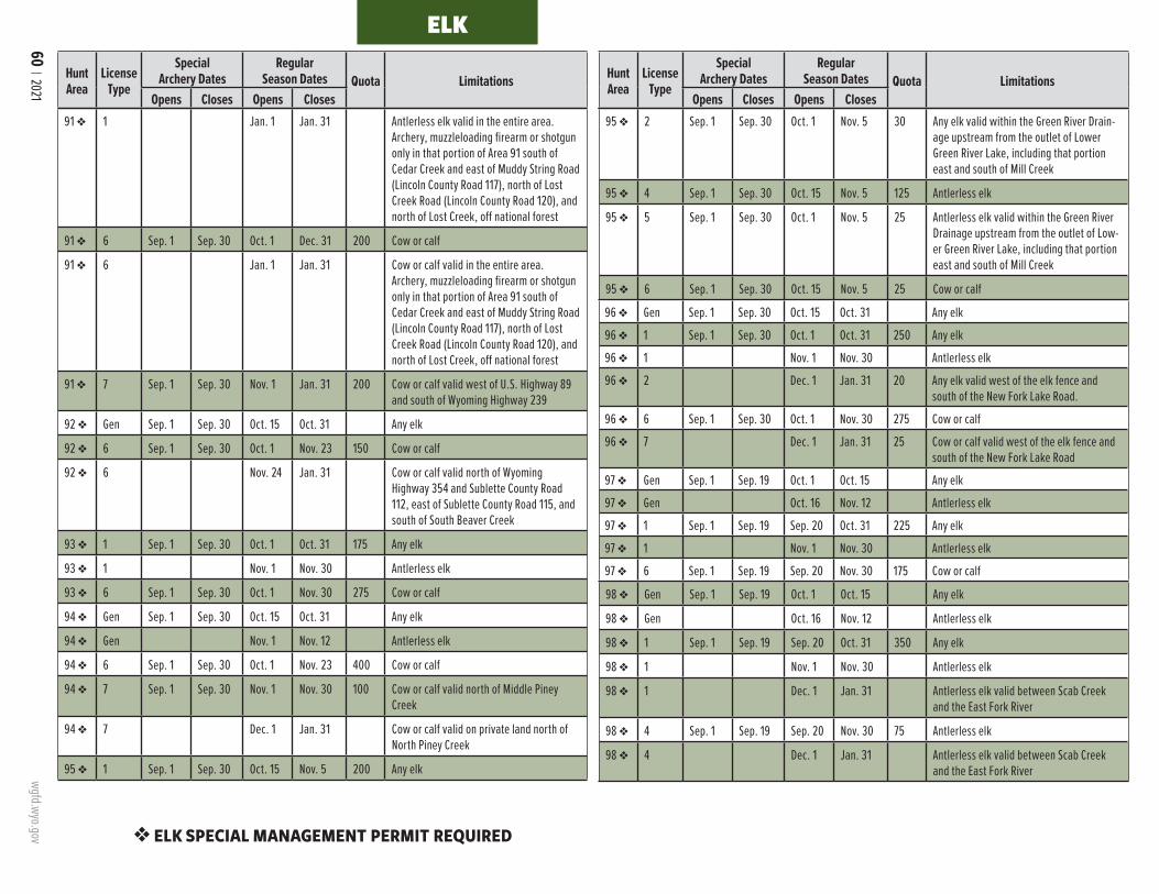
60 | 2021 wgfd.wyo.gov
ELK
v ELK SPECIAL MANAGEMENT PERMIT REQUIRED
ELK
Hunt Area
LicenseType
SpecialArchery Dates
RegularSeason Dates Quota Limitations
Opens Closes Opens Closes
Hunt Area
LicenseType
SpecialArchery Dates
RegularSeason Dates Quota Limitations
Opens Closes Opens Closes91 v 1 Jan. 1 Jan. 31 Antlerless elk valid in the entire area.
Archery, muzzleloading firearm or shotgun only in that portion of Area 91 south of Cedar Creek and east of Muddy String Road (Lincoln County Road 117), north of Lost Creek Road (Lincoln County Road 120), and north of Lost Creek, off national forest
91 v 6 Sep. 1 Sep. 30 Oct. 1 Dec. 31 200 Cow or calf
91 v 6 Jan. 1 Jan. 31 Cow or calf valid in the entire area. Archery, muzzleloading firearm or shotgun only in that portion of Area 91 south of Cedar Creek and east of Muddy String Road (Lincoln County Road 117), north of Lost Creek Road (Lincoln County Road 120), and north of Lost Creek, off national forest
91 v 7 Sep. 1 Sep. 30 Nov. 1 Jan. 31 200 Cow or calf valid west of U.S. Highway 89 and south of Wyoming Highway 239
92 v Gen Sep. 1 Sep. 30 Oct. 15 Oct. 31 Any elk
92 v 6 Sep. 1 Sep. 30 Oct. 1 Nov. 23 150 Cow or calf
92 v 6 Nov. 24 Jan. 31 Cow or calf valid north of Wyoming Highway 354 and Sublette County Road 112, east of Sublette County Road 115, and south of South Beaver Creek
93 v 1 Sep. 1 Sep. 30 Oct. 1 Oct. 31 175 Any elk
93 v 1 Nov. 1 Nov. 30 Antlerless elk
93 v 6 Sep. 1 Sep. 30 Oct. 1 Nov. 30 275 Cow or calf
94 v Gen Sep. 1 Sep. 30 Oct. 15 Oct. 31 Any elk
94 v Gen Nov. 1 Nov. 12 Antlerless elk
94 v 6 Sep. 1 Sep. 30 Oct. 1 Nov. 23 400 Cow or calf
94 v 7 Sep. 1 Sep. 30 Nov. 1 Nov. 30 100 Cow or calf valid north of Middle Piney Creek
94 v 7 Dec. 1 Jan. 31 Cow or calf valid on private land north of North Piney Creek
95 v 1 Sep. 1 Sep. 30 Oct. 15 Nov. 5 200 Any elk
95 v 2 Sep. 1 Sep. 30 Oct. 1 Nov. 5 30 Any elk valid within the Green River Drain-age upstream from the outlet of Lower Green River Lake, including that portion east and south of Mill Creek
95 v 4 Sep. 1 Sep. 30 Oct. 15 Nov. 5 125 Antlerless elk
95 v 5 Sep. 1 Sep. 30 Oct. 1 Nov. 5 25 Antlerless elk valid within the Green River Drainage upstream from the outlet of Low-er Green River Lake, including that portion east and south of Mill Creek
95 v 6 Sep. 1 Sep. 30 Oct. 15 Nov. 5 25 Cow or calf
96 v Gen Sep. 1 Sep. 30 Oct. 15 Oct. 31 Any elk
96 v 1 Sep. 1 Sep. 30 Oct. 1 Oct. 31 250 Any elk
96 v 1 Nov. 1 Nov. 30 Antlerless elk
96 v 2 Dec. 1 Jan. 31 20 Any elk valid west of the elk fence and south of the New Fork Lake Road.
96 v 6 Sep. 1 Sep. 30 Oct. 1 Nov. 30 275 Cow or calf
96 v 7 Dec. 1 Jan. 31 25 Cow or calf valid west of the elk fence and south of the New Fork Lake Road
97 v Gen Sep. 1 Sep. 19 Oct. 1 Oct. 15 Any elk
97 v Gen Oct. 16 Nov. 12 Antlerless elk
97 v 1 Sep. 1 Sep. 19 Sep. 20 Oct. 31 225 Any elk
97 v 1 Nov. 1 Nov. 30 Antlerless elk
97 v 6 Sep. 1 Sep. 19 Sep. 20 Nov. 30 175 Cow or calf
98 v Gen Sep. 1 Sep. 19 Oct. 1 Oct. 15 Any elk
98 v Gen Oct. 16 Nov. 12 Antlerless elk
98 v 1 Sep. 1 Sep. 19 Sep. 20 Oct. 31 350 Any elk
98 v 1 Nov. 1 Nov. 30 Antlerless elk
98 v 1 Dec. 1 Jan. 31 Antlerless elk valid between Scab Creek and the East Fork River
98 v 4 Sep. 1 Sep. 19 Sep. 20 Nov. 30 75 Antlerless elk
98 v 4 Dec. 1 Jan. 31 Antlerless elk valid between Scab Creek and the East Fork River
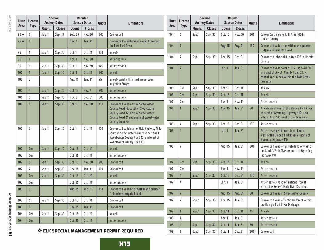
wgfd.wyo.gov
Wyoming Hunting Regulations | 61
ELK ELK
Hunt Area
LicenseType
SpecialArchery Dates
RegularSeason Dates Quota Limitations
Opens Closes Opens Closes
Hunt Area
LicenseType
SpecialArchery Dates
RegularSeason Dates Quota Limitations
Opens Closes Opens Closes98 v 6 Sep. 1 Sep. 19 Sep. 20 Nov. 30 300 Cow or calf
98 v 6 Dec. 1 Jan. 31 Cow or calf valid between Scab Creek and the East Fork River
99 1 Sep. 1 Sep. 30 Oct. 1 Oct. 31 150 Any elk
99 1 Nov. 1 Nov. 20 Antlerless elk
99 4 Sep. 1 Sep. 30 Oct. 1 Nov. 20 175 Antlerless elk
100 1 Sep. 1 Sep. 30 Oct. 8 Oct. 31 300 Any elk
100 2 Aug. 15 Jan. 31 25 Any elk valid within the Farson-Eden Irrigation Project
100 4 Sep. 1 Sep. 30 Oct. 15 Nov. 7 300 Antlerless elk
100 5 Sep. 1 Sep. 30 Nov. 8 Dec. 31 300 Antlerless elk
100 6 Sep. 1 Sep. 30 Oct. 15 Nov. 30 100 Cow or calf valid east of Sweetwater County Road 19, south of Sweetwater County Road 82, east of Sweetwater County Road 21 and south of Sweetwater County Road 20
100 7 Sep. 1 Sep. 30 Oct. 1 Oct. 31 100 Cow or calf valid east of U.S. Highway 191, south of Sweetwater County Road 17 and Sweetwater County Road 15, and west of Sweetwater County Road 19
102 Gen Sep. 1 Sep. 30 Oct. 15 Oct. 24 Any elk
102 Gen Oct. 25 Oct. 31 Antlerless elk
102 6 Sep. 1 Sep. 30 Oct. 15 Nov. 30 200 Cow or calf
102 7 Sep. 1 Sep. 30 Dec. 15 Jan. 31 100 Cow or calf
103 Gen Sep. 1 Sep. 30 Oct. 15 Oct. 24 Any elk
103 Gen Oct. 25 Oct. 31 Antlerless elk
103 6 Aug. 15 Aug. 31 150 Cow or calf valid on or within one quarter (1/4) mile of irrigated land
103 6 Sep. 1 Sep. 30 Oct. 15 Oct. 31 Cow or calf
103 6 Dec. 15 Jan. 31 Cow or calf
104 Gen Sep. 1 Sep. 30 Oct. 15 Oct. 24 Any elk
104 Gen Oct. 25 Oct. 31 Antlerless elk
104 6 Sep. 1 Sep. 30 Oct. 15 Nov. 30 300 Cow or Calf, also valid in Area 105 in Lincoln County
104 7 Aug. 15 Aug. 31 150 Cow or calf valid on or within one quarter (1/4) mile of irrigated land
104 7 Sep. 1 Sep. 30 Dec. 15 Dec. 31 Cow or calf, also valid in Area 105 in Lincoln County
104 7 Jan. 1 Jan. 31 Cow or calf valid west of U.S. Highway 30 and east of Lincoln County Road 207 or east of Rock Creek within the Twin Creek Drainage
105 Gen Sep. 1 Sep. 30 Oct. 1 Oct. 31 Any elk
106 Gen Sep. 1 Sep. 30 Oct. 15 Oct. 31 Any elk
106 Gen Nov. 1 Nov. 14 Antlerless elk
106 1 Sep. 1 Sep. 30 Nov. 15 Jan. 31 50 Any elk valid west of the Black’s Fork River or north of Wyoming Highway 410; also valid in Area 105 west of the Bear River
106 4 Sep. 1 Sep. 30 Oct. 15 Dec. 31 100 Antlerless elk
106 4 Jan. 1 Jan. 31 Antlerless elk valid on private land or west of the Black’s Fork River or north of Wyoming Highway 410
106 7 Aug. 15 Jan. 31 300 Cow or calf valid on private land or west of the Black’s Fork River or north of Wyoming Highway 410
107 Gen Sep. 1 Sep. 30 Oct. 15 Oct. 31 Any elk
107 Gen Nov. 1 Nov. 14 Antlerless elk
107 4 Sep. 1 Sep. 30 Oct. 15 Dec. 31 150 Antlerless elk
107 4 Jan. 1 Jan. 31 Antlerless elk valid off national forest within the Henry’s Fork River Drainage
107 7 Aug. 15 Aug. 31 50 Cow or calf valid in Sweetwater County
107 7 Sep. 1 Sep. 30 Dec. 15 Jan. 31 Cow or calf valid off national forest within the Henry’s Fork River Drainage
108 1 Sep. 1 Sep. 30 Oct. 11 Oct. 31 75 Any elk
108 1 Nov. 1 Jan. 31 Antlerless elk
108 4 Sep. 1 Sep. 30 Oct. 11 Jan. 31 50 Antlerless elk
108 6 Sep. 1 Sep. 30 Oct. 11 Dec. 31 200 Cow or calfv ELK SPECIAL MANAGEMENT PERMIT REQUIRED

62 | 2021 wgfd.wyo.gov Please see Important Hunting Section of this brochure regarding Chronic Wasting Disease.
ELK
Hunt Area
LicenseType
SpecialArchery Dates
RegularSeason Dates Quota Limitations
Opens Closes Opens Closes
Hunt Area
LicenseType
SpecialArchery Dates
RegularSeason Dates Quota Limitations
Opens Closes Opens Closes108 6 Jan. 1 Jan. 31 Cow or calf valid west of the Twentymile
Road (Carbon County Rd 605 N)
110 Gen Sep. 1 Sep. 30 Oct. 15 Oct. 31 Any elk
110 6 Sep. 1 Sep. 30 Oct. 1 Nov. 14 200 Cow or calf
110 6 Nov. 15 Dec. 31 Cow or calf valid off national forest
111 1 Sep. 1 Sep. 30 Oct. 10 Oct. 31 70 Any elk
111 1 Nov. 15 Dec. 15 Any elk, also valid in Area 22
111 1 Dec. 16 Dec. 31 Antlerless elk
111 4 Sep. 1 Sep. 30 Oct. 10 Dec. 31 50 Antlerless elk
111 6 Sep. 1 Sep. 30 Nov. 1 Dec. 31 150 Cow or calf
113 1 Sep. 1 Sep. 30 Nov. 5 Nov. 30 75 Any elk
113 4 Sep. 1 Sep. 30 Nov. 5 Nov. 30 75 Antlerless elk
116 Gen Sep. 1 Sep. 30 Oct. 15 Nov. 10 Any elk
116 Gen Nov. 11 Nov. 30 Antlerless elk
116 1 Sep. 1 Sep. 30 Nov. 11 Dec. 31 100 Any elk valid off national forest
116 7 Aug. 15 Jan. 31 300 Cow or calf valid off national forest
117 1 Sep. 1 Sep. 30 Oct. 15 Nov. 30 400 Any elk
117 1 Dec. 1 Jan. 31 Antlerless elk
117 2 Sep. 1 Sep. 30 Oct. 15 Jan. 31 150 Spike or antlerless elk
117 4 Sep. 1 Sep. 30 Oct. 15 Jan. 31 200 Antlerless elk
117 6 Sep. 1 Sep. 30 Oct. 15 Jan. 31 100 Cow or calf
117 7 Aug. 15 Jan. 31 500 Cow or calf valid off national forest; also valid on national grassland
118 1 Sep. 1 Sep. 30 Oct. 22 Nov. 12 25 Antlered elk
118 4 Sep. 1 Sep. 30 Oct. 22 Nov. 30 25 Antlerless elk
118 6 Sep. 1 Sep. 30 Oct. 1 Nov. 30 50 Cow or calf valid south of the Mineral X Road (Sweetwater County Road 63 and B.L.M. Road 3206)
120 1 Sep. 1 Sep. 30 Oct. 9 Oct. 31 125 Any elk
120 1 Nov. 1 Dec. 15 Antlerless elk
120 4 Sep. 1 Sep. 30 Oct. 9 Dec. 15 75 Antlerless elk
120 6 Sep. 1 Sep. 30 Oct. 9 Dec. 15 75 Cow or calf
122 1 Sep. 1 Sep. 30 Oct. 1 Nov. 30 125 Any elk
122 1 Dec. 1 Dec. 31 Antlerless elk
122 6 Sep. 1 Sep. 30 Oct. 1 Dec. 31 200 Cow or calf
123 4 Sep. 1 Sep. 9 Oct. 20 Nov. 30 75 Antlerless elk
123 6 Sep. 1 Sep. 9 Oct. 20 Nov. 30 75 Cow or calf
124 1 Sep. 1 Sep. 30 Oct. 15 Nov. 30 60 Any elk
124 4 Sep. 1 Sep. 30 Oct. 15 Nov. 30 100 Antlerless elk
124 4 Dec. 1 Dec. 31 Antlerless elk valid east of Sweetwater County Road 19, and north and east of B.L.M. Roads 4409 and 4411, and west of B.L.M. Road 3310 and Sweetwater County Road 23S
125 1 Sep. 1 Sep. 30 Oct. 1 Dec. 31 250 Any elk
125 1 Jan. 1 Jan. 31 Antlerless elk
125 6 Sep. 1 Sep. 30 Oct. 1 Jan. 31 300 Cow or calf
126 Gen Sep. 1 Sep. 30 Any elk valid in Weston County; also valid in that portion of Area 123 within the Raven Creek drainage
126 Gen Sep. 1 Sep. 30 Oct. 1 Oct. 31 Any elk valid in the entire area
126 Gen Nov. 1 Nov. 30 Antlerless elk valid in the entire area
126 6 Aug. 15 Dec. 31 150 Cow or calf
127 Gen Sep. 1 Sep. 30 Oct. 1 Oct. 31 Any elk
127 Gen Nov. 1 Jan. 31 Antlerless elk
128 Gen Sep. 1 Sep. 30 Oct. 1 Oct. 7 Any elk
128 Gen Oct. 8 Oct. 14 Antlered elk
129 Gen Sep. 1 Oct. 31 Any elk
129 Gen Nov. 1 Nov. 30 Antlerless elk
129 6 Sep. 1 Dec. 15 550 Cow or calf
130 Gen Sep. 1 Sep. 30 Oct. 1 Oct. 23 Any elk
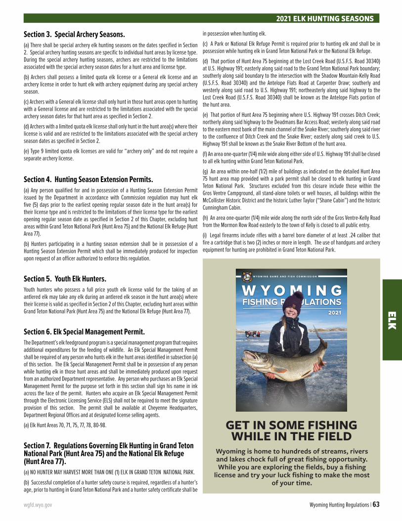
wgfd.wyo.gov Wyoming Hunting Regulations | 63
ELK
Section 3. Special Archery Seasons. (a) There shall be special archery elk hunting seasons on the dates specified in Section 2. Special archery hunting seasons are specific to individual hunt areas by license type. During the special archery hunting seasons, archers are restricted to the limitations associated with the special archery season dates for a hunt area and license type.
(b) Archers shall possess a limited quota elk license or a General elk license and an archery license in order to hunt elk with archery equipment during any special archery season.
(c) Archers with a General elk license shall only hunt in those hunt areas open to hunting with a General license and are restricted to the limitations associated with the special archery season dates for that hunt area as specified in Section 2.
(d) Archers with a limited quota elk license shall only hunt in the hunt area(s) where their license is valid and are restricted to the limitations associated with the special archery season dates as specified in Section 2.
(e) Type 9 limited quota elk licenses are valid for “archery only” and do not require a separate archery license.
Section 4. Hunting Season Extension Permits. (a) Any person qualified for and in possession of a Hunting Season Extension Permit issued by the Department in accordance with Commission regulation may hunt elk five (5) days prior to the earliest opening regular season date in the hunt area(s) for their license type and is restricted to the limitations of their license type for the earliest opening regular season date as specified in Section 2 of this Chapter, excluding hunt areas within Grand Teton National Park (Hunt Area 75) and the National Elk Refuge (Hunt Area 77).
(b) Hunters participating in a hunting season extension shall be in possession of a Hunting Season Extension Permit which shall be immediately produced for inspection upon request of an officer authorized to enforce this regulation.
Section 5. Youth Elk Hunters. Youth hunters who possess a full price youth elk license valid for the taking of an antlered elk may take any elk during an antlered elk season in the hunt area(s) where their license is valid as specified in Section 2 of this Chapter, excluding hunt areas within Grand Teton National Park (Hunt Area 75) and the National Elk Refuge (Hunt Area 77).
Section 6. Elk Special Management Permit. The Department’s elk feedground program is a special management program that requires additional expenditures for the feeding of wildlife. An Elk Special Management Permit shall be required of any person who hunts elk in the hunt areas identified in subsection (a) of this section. The Elk Special Management Permit shall be in possession of any person while hunting elk in those hunt areas and shall be immediately produced upon request from an authorized Department representative. Any person who purchases an Elk Special Management Permit for the purpose set forth in this section shall sign his name in ink across the face of the permit. Hunters who acquire an Elk Special Management Permit through the Electronic Licensing Service (ELS) shall not be required to meet the signature provision of this section. The permit shall be available at Cheyenne Headquarters, Department Regional Offices and at designated license selling agents.
(a) Elk Hunt Areas 70, 71, 75, 77, 78, 80-98.
Section 7. Regulations Governing Elk Hunting in Grand Teton National Park (Hunt Area 75) and the National Elk Refuge (Hunt Area 77).(a) NO HUNTER MAY HARVEST MORE THAN ONE (1) ELK IN GRAND TETON NATIONAL PARK.
(b) Successful completion of a hunter safety course is required, regardless of a hunter’s age, prior to hunting in Grand Teton National Park and a hunter safety certificate shall be
in possession when hunting elk.
(c) A Park or National Elk Refuge Permit is required prior to hunting elk and shall be in possession while hunting elk in Grand Teton National Park or the National Elk Refuge.
(d) That portion of Hunt Area 75 beginning at the Lost Creek Road (U.S.F.S. Road 30340) at U.S. Highway 191; easterly along said road to the Grand Teton National Park boundary; southerly along said boundary to the intersection with the Shadow Mountain-Kelly Road (U.S.F.S. Road 30340) and the Antelope Flats Road at Carpenter Draw; southerly and westerly along said road to U.S. Highway 191; northeasterly along said highway to the Lost Creek Road (U.S.F.S. Road 30340) shall be known as the Antelope Flats portion of the hunt area.
(e) That portion of Hunt Area 75 beginning where U.S. Highway 191 crosses Ditch Creek; northerly along said highway to the Deadmans Bar Access Road; westerly along said road to the eastern most bank of the main channel of the Snake River; southerly along said river to the confluence of Ditch Creek and the Snake River; easterly along said creek to U.S. Highway 191 shall be known as the Snake River Bottom of the hunt area.
(f) An area one-quarter (1/4) mile wide along either side of U.S. Highway 191 shall be closed to all elk hunting within Grand Teton National Park.
(g) An area within one-half (1/2) mile of buildings as indicated on the detailed Hunt Area 75 hunt area map provided with a park permit shall be closed to elk hunting in Grand Teton National Park. Structures excluded from this closure include those within the Gros Ventre Campground, all stand-alone toilets or well houses, all buildings within the McCollister Historic District and the historic Luther Taylor (“Shane Cabin”) and the historic Cunningham Cabin.
(h) An area one-quarter (1/4) mile wide along the north side of the Gros Ventre-Kelly Road from the Mormon Row Road easterly to the town of Kelly is closed to all public entry.
(i) Legal firearms include rifles with a barrel bore diameter of at least .24 caliber that fire a cartridge that is two (2) inches or more in length. The use of handguns and archery equipment for hunting are prohibited in Grand Teton National Park.
2021 ELK HUNTING SEASONS
GET IN SOME FISHING WHILE IN THE FIELD
Wyoming is home to hundreds of streams, rivers and lakes chock full of great fishing opportunity. While you are exploring the fields, buy a fishing
license and try your luck fishing to make the most of your time.
FISHING REGULATIONS2021
W Y O M I N G G A M E A N D F I S H C O M M I S S I O N
64 | 2021 wgfd.wyo.gov
HUNT AREA BOUNDARY DESCRIPTIONSEL
K
ElkArea 1. Black Hills. Beginning where the north boundary of the Black Hills National Forest crosses the Wyoming-South Dakota state line; southerly along said line to U.S.F.S. Road 807; northwesterly along said road to Moskee; northerly along the Moskee Road to its junction with U.S.F.S. Road 863; northerly along said road to the Black Hills National Forest boundary marker and one-quarter (1/4) mile south of Ranch A; easterly along said boundary to the Wyoming-South Dakota state line.
Area 2. Fortification. Beginning where the Wild Horse Road (Sheridan County Road 38) crosses the Powder River at Arvada; easterly along said road to the Echeta Road (Sheri-dan County Road 293); southeasterly along said road to the Montgomery Road; westerly along said road to the Kingsbury Road; southerly along said road to Interstate Highway 90; westerly along said highway to the Powder River; norther-ly down said river to the Wild Horse Road (Sheridan County Road 38).
Area 3. Rawhide. Beginning at the intersection of U.S. Highway 20 and U.S. Highway 85 in the town of Lusk; east-erly along U.S. Highway 20 to the Wyoming-Nebraska state line; southerly along said line to the Colorado state line; westerly along said state line to U.S. Interstate 25; northerly along said highway to U.S. Highway 26; easterly along said highway to the North Platte River; northerly and westerly up said river to Interstate Highway 25; northerly along said In-terstate to U.S. Highway 20; easterly along said highway to the intersection of U.S. Highway 20 and U.S. Highway 85 in the town of Lusk.
Area 6. Pole Mountain. Beginning at the city of Laramie and U.S. Highway 30-287; northerly along said highway to Wyoming Highway 34; northerly and easterly along said high-way to Interstate Highway 25; southerly along said highway to the Wyoming-Colorado state line; westerly along said line to U.S. Highway 287; northerly along said highway to the city of Laramie and U.S. Highway 30-287.
Area 7. Laramie Peak. Beginning at the confluence of Deer Creek and the North Platte River in the town of Glen-rock; easterly and southerly down said river to the town of Guernsey and U.S. Highway 26; westerly along said highway to Interstate Highway 25; southerly along said highway to Wyoming Highway 34; southwesterly along said highway to U.S. Highway 30-287; northwesterly along said highway to Wyoming Highway 487 at the town of Medicine Bow; north-erly along said highway to; the Little Medicine Bow River; northeasterly and northerly along said river to the Shirley Ridge Road (Carbon County Road 2E); northwesterly along said road to Wyoming Highway 487; northwesterly along said highway to the Lone Tree Road (B.L.M. Road 3141); northerly along said road to the Spring Creek Road; easterly along said road to the Bates Creek Road (Natrona County Road 402); northeasterly along said road to the Squaw Springs Trail Road; northeasterly along said road to U.S.F.S. Road 660; easterly along said road to Curry Creek; northwesterly down said creek to Deer Creek; northerly down said creek to the North Platte River at the town of Glenrock.
Area 8. Boulder Ridge. Beginning at the city of Laramie and U.S. Highway 287; southerly along said highway to the Wyoming-Colorado state line; westerly along said line to Wy-oming Highway 10; northerly along said highway to Wyoming Highway 230 at Woods Landing; northeasterly along said highway to U.S. Highway 287 at the city of Laramie.
Area 9. South Snowy Range. Beginning at the city of Laramie and Wyoming Highway 230; southwesterly along said highway to Woods Landing and Wyoming Highway 10; southerly along said highway to the Wyoming-Colorado state line; westerly along said line to Wyoming Highway 230; northeasterly along said highway to U.S.F.S. Road 512; northwesterly along said road to U.S.F.S. Road 543; northerly along said road to Douglas Creek at Keystone; northerly up said creek to the divide between the Laramie River and the North Platte River; northerly along said divide to Wyoming Highway 130; easterly along said highway to Wyoming High-way 230.
Area 10. Rock Creek. Beginning at the city of Laramie and Wyoming Highway 130; westerly along said highway to the divide between the Laramie River and the North Platte River; northerly along said divide to the divide between the Medicine Bow River and the Laramie River at Medicine Bow Peak; northeasterly along said divide to Sheep Lake Trail 389; northwesterly along said trail to Deep Creek; northeast-erly down said creek to Rock Creek; northeasterly down said creek to Interstate Highway 80 at Arlington; southeasterly along said highway to Dutton Creek; northeasterly down said creek to Lower Dutton Creek-Laramie River Canal; northeast-erly along said canal to U.S. Highway 30-287; southeasterly along said highway to Interstate Highway 80; northwesterly along said highway to Wyoming Highway 130.
Area 11. Medicine Bow River. Beginning where Inter-state Highway 80 crosses Rock Creek at Arlington; south-westerly up said creek to Deep Creek; southwesterly up said creek to Sheep Lake Trail 389; southeasterly along said trail to the divide between the Laramie River and the Medicine Bow River; southwesterly along said divide to Medicine Bow Peak and the divide between the Medicine Bow River and Brush Creek; northwesterly along said divide to U.S.F.S. Road 103; northwesterly along said road to the North Brush Creek Road (U.S.F.S. Road 100); northerly along said road to the Sand Lake Road (U.S.F.S. Road 101); northwesterly along said road to the Cedar Pass Road (U.S.F.S. Road 261); southwest-erly along said road to U.S.F.S. Road 115; northerly along said road to the Pass Creek Basin Road; northerly along said road to the Pass Creek Road (Carbon County Road 404); northerly along said road to Wyoming Highway 72; northwesterly along said highway to U.S. Highway 30-287; southeasterly along said highway to Lower Dutton Creek-Laramie River Canal; southwesterly along said canal to Dutton Creek; southwest-erly along said creek to Interstate Highway 80; northwesterly along said highway to Rock Creek.
Area 12. Kennaday Peak. Beginning at the junction of the North Platte River and Interstate Highway 80 at Fort Steele Bridge; easterly along said highway to Wyoming Highway 130 at the Saratoga interchange; southerly along said highway to the Pass Creek Road (Carbon County Road 404); easterly along said road to the Pass Creek Basin Road; southerly along said road to U.S.F.S. Road 115; southerly along said road to the Cedar Pass Road (U.S.F.S. Road 261); northeasterly along said road to the Sand Lake Road (U.S.F.S. Road 101); southeasterly along said road to the North Brush Creek Road (U.S.F.S. Road 100); southerly along said road to U.S.F.S. Road 103; southeasterly along said road to the divide between Brush Creek and the Medicine Bow River; southeasterly along said divide to Medicine Bow Peak and the Laramie River-North Platte River divide; southerly along said divide to Wyoming Highway 130; westerly and norther-ly along said highway to the North Platte River at Saratoga; northwesterly down said river to Interstate Highway 80.
Area 13. Encampment River. Beginning where the Continental Divide crosses the Wyoming-Colorado state line;
northerly along said divide to Wyoming Highway 70; easterly along said highway to Wyoming Highway 230; southeaster-ly along said highway to the Wyoming-Colorado state line; westerly along said line to the Continental Divide.
Area 15. Spring Creek. Beginning where Sage Creek Road (Carbon County Road 401) crosses the Continental Di-vide; northerly along said highway to Sage Creek; easterly down said creek to the North Platte River; southerly up said river to Wyoming Highway 130; southerly along said highway to Wyoming Highway 230; southeasterly along said highway to Wyoming Highway 70; westerly along said highway to the Continental Divide; northerly along said divide to Wyoming Highway 71.
Area 16. Shirley Mountain. Beginning at the junction of Interstate Highway 80 and the North Platte River; north-easterly down said river to Wyoming Highway 220 at Govern-ment Bridge; northeasterly along said highway to the Bolton Creek Road (Natrona County Road 404); southeasterly along said road to the Bates Hole Stock Trail (Natrona County Road 403); southeasterly along said road to Wyoming Highway 487; southerly along said highway to the Shirley Ridge Road (Carbon County Road 2E); easterly and southerly along said road to the Little Medicine Bow River; southerly and south-westerly along said river to Wyoming Highway 487; southerly along said highway to U.S. Highway 30-287 at the town of Medicine Bow; southwesterly along said highway to Inter-state Highway 80; westerly along said interstate to the North Platte River.
Area 19. Muddy Mountain. Beginning at the confluence of Deer Creek and the North Platte River at the town of Glen-rock; southerly up said creek to Curry Creek; southeasterly up said creek to U.S.F.S. Road 660; northwesterly along said road to the Squaw Springs Trail Road; southwesterly along said road to the Bates Creek Road (Natrona County Road 402); southwesterly along said road to the Spring Creek Road; westerly along said road to the Lone Tree Road (B.L.M. Road 3141); southerly along said road to Wyoming Highway 487; northwesterly along said highway to the Bates Hole Stock Trail (Natrona County Road 403); northwesterly along said road to the Bolton Creek Road (Natrona County Road 404); northwesterly along said road to Wyoming Highway 220; southwesterly along said highway to the North Platte River at Government Bridge; northeasterly down said river to Deer Creek in the town of Glenrock.
Area 21. Baggs. Beginning at the junction of Wyoming Highway 789 and the Wyoming-Colorado state line; northerly along said highway to Muddy Creek north of Dad; easterly up said creek to the Muddy Creek Road (B.L.M. Road 3306); east-erly along said road to Miller Hill Road (B.L.M. Road 3328); southeasterly along said road to the McCarty Canyon Road (Carbon County Road 503); northeasterly along said road to the Sage Creek Road (Carbon County Road 401); southerly along said road to the Continental Divide at Middlewood Hill; southerly along said divide to the Wyoming-Colorado state line; westerly along said line to Wyoming Highway 789.
Area 22. Ferris. Beginning where Wyoming Highway 287 intersects Wyoming Highway 220 at Muddy Gap Junction; northeasterly along Wyoming Highway 220 to the Buzzard Road (Natrona County Road 410 Carbon County Road 497); southerly along said road to the South Ferris Road (Carbon County Road 100); westerly along said road to U.S. Highway 287; northerly along said highway to Muddy Gap Junction.
Area 23. Rattlesnake. Beginning where Wyoming Highway 220 intersects the Dry Creek Road (Natrona Coun-ty Road 321); northwesterly along said road to the Gas Hills Road (Natrona County Road 212); northeasterly along said

wgfd.wyo.gov Wyoming Hunting Regulations | 65
ELKHUNT AREA BOUNDARY DESCRIPTIONS
road to U.S. Highway 20-26 at the town of Waltman; easter-ly along said highway to Poplar Street in the city of Casper; southerly along said street to the North Platte River at the city of Casper; southwesterly up said river to the Kortes Road (Natrona County Road 407); northerly along said road to Wy-oming Highway 220; westerly along said highway to the Dry Creek Road (Natrona County Road 321).
Area 24. Green Mountain. Beginning at the junction of U.S. Highway 287 and Wyoming Highway 220; southerly along U.S. Highway 287 to Wyoming Highway 73; westerly along said highway to the Bairoil Road (Sweetwater County Road 22); westerly along said road to the Wamsutter Crooks Gap Road (Fremont County Road 318 and Sweetwater Coun-ty Road 23); southerly along said road to the Osborne Road (B.L.M. Road 3212); westerly along said road to the Bison Ba-sin Road (Fremont County Road 281 and B.L.M. Road 3221); northerly along said road to U.S. Highway 287; easterly along said highway to Wyoming Highway 220.
Area 25. South Pass. Beginning where U.S. Highway 287 crosses the south boundary of the Wind River Reserva-tion; easterly along said boundary to Wyoming Highway 135; southerly along said highway to U.S. Highway 287 at Sweet-water Station; easterly along said highway to the Bison Ba-sin Road (Fremont County Road 281 and B.L.M. Road 3221); southerly along said road to the Rocky Crossing Road (B.L.M. Road 3214); westerly along said road to the Red Creek Road (B.L.M. Road 3219); northerly along said road to the Three Forks-Atlantic City Road (B.L.M. Road 2317); northwesterly along said road to the Sweetwater River at Phelps-Dodge Bridge; westerly up said river to Wyoming Highway 28; northeasterly up said highway to U.S. Highway 287; north-erly along said highway to the south boundary of the Wind River Reservation.
Area 27. Upper Sweetwater. Beginning where Wyo-ming Highway 28 crosses the Sweetwater River; northwest-erly up said river to the divide between the Sweetwater River and the Popo Agie River drainages at Sweetwater Gap; southeasterly along said divide to Granite Peak and the head of Willow Creek; southeasterly down said creek to Wyoming Highway 28; southwesterly along said highway to the Sweet-water River.
Area 28. Cony Mountain. Beginning where U.S. High-way 287 crosses the south boundary of the Wind River Reservation; southeasterly along said highway to Wyoming Highway 28; southwesterly along said highway to Willow Creek; northwesterly up said creek to the divide between the Sweetwater River and Popo Agie River drainages at Granite Peak; northwesterly along said divide to the Continental Di-vide; northwesterly along said divide to the south boundary of the Wind River Reservation; easterly along said boundary to U.S. Highway 287.
Area 30. Aspen Mountain. Beginning where Interstate Highway 80 crosses the Green River; easterly along said highway to the town of Rock Springs and Wyoming Highway 430; southeasterly along said highway to the Mud Springs Road (Sweetwater County Road 32); southwesterly along said road to Aspen Mountain Road (Sweetwater County Road 27); southerly along said road to Clay Basin Pipeline Road (Sweetwater County Road 71); southwesterly along said road to the Ramsey Ranch Road (Sweetwater County Road 34); westerly along said road to U.S. Highway 191; westerly along said highway to the Ramsey Ranch Road (Sweetwater Coun-ty Road 34); northerly along said road to Sage Creek Road (Sweetwater County Road 36); westerly along said road to Sage Creek; westerly down said creek to Flaming Gorge Res-ervoir; northerly along the east shore of said reservoir to the Green River; northeasterly then northwesterly up said river to
Interstate Highway 80.
Area 31. Little Mountain. Beginning where the east shore of Flaming Gorge Reservoir crosses the Wyoming-Utah state line; northerly along the east shore of Flaming Gorge Reservoir to its confluence with Sage Creek; easterly up said creek to the Sage Creek Road (Sweetwater County Road 36); easterly along said road to the Ramsey Ranch Road (Sweetwater County Road 34); southerly along said road to U.S. Highway 191; southerly along said highway to the Wy-oming-Utah state line; westerly along said line to the east shore of Flaming Gorge Reservoir.
Area 32. Pine Mountain. Beginning where Wyoming Highway 430 crosses the Wyoming-Colorado state line; westerly along said line to the Wyoming-Utah state line; westerly along said line to U.S. Highway 191; northerly along said highway to the Ramsey Ranch Road (Sweetwater County Road 34); easterly along said road to the Clay Basin Pipeline Road (Sweetwater County Road 71); northeasterly along said road to the Aspen Mountain Road (Sweetwater County Road 27); northerly along said road to the Mud Springs Road (Sweetwater County Road 32); northeasterly along said road to Wyoming Highway 430; southerly along said highway to the Wyoming-Colorado state line.
Area 33. Middle Fork. Beginning at the Kaycee inter-change on Interstate Highway 25; southeasterly along said highway to the Midwest interchange and the Smoky Gap Road (Natrona County Road 115); westerly along said road to the Dead Horse Road (Natrona County Road 114); south-westerly along said road to the Wild Horse Trail Road (Na-trona County Road 113); westerly along said road to the 33 Mile Road (Natrona County Road 110); northwesterly along said road to the Hazelton Road (Washakie County Road 81); northerly along said road to the Barnum Mountain Road; easterly along said road to the Barnum Road (Johnson Coun-ty Road 78) at the town of Barnum; easterly along said road to Wyoming Highway 190; northeasterly along said road to Wyoming Highway 191; easterly along said highway to Inter-state Highway 25.
Area 34. Upper Powder River. Beginning at the junc-tion of the Trabing Road (Johnson County Road 13) and Inter-state Highway 25; southerly along said highway to Wyoming Highway 191; westerly along said highway to Wyoming High-way 190; westerly along said highway to the town of Barnum and the Barnum Mountain Road; westerly along said road to the Hazelton Road (Washakie County Road 81-Johnson Coun-ty Road 3); northerly along said road to the Gold Mine Road (U.S.F.S. Road 452); northerly along said road to the Canyon Creek Road (U.S.F.S. Road 25); northerly along said road to U.S. Highway 16; easterly along said highway to the Crazy Woman Canyon Road (Johnson County Road 14); easterly along said road to Wyoming Highway 196; northerly along said highway to the Trabing Road (Johnson County Road 13); easterly along said road to Interstate Highway 25.
Area 35. Hunter Mesa. Beginning where U.S. Highway 87 business loop crosses French Creek; southerly along said highway to Wyoming Highway 196; southerly along said high-way to the Crazy Woman Canyon Road (Johnson County Road 14); westerly along said road to U.S. Highway 16; westerly along said highway to the divide along the Bighorn Mountain range at Powder River Pass; northwesterly along said divide to North Clear Creek; easterly down said creek to the North Fork Ditch; easterly down said ditch to French Creek; easterly down said creek to the U.S. Highway 87 business loop.
Area 36. Rock Creek. Beginning where Interstate High-way 90 crosses Piney Creek; southeasterly along said high-way to Interstate Highway 25; southerly along said highway
to French Creek east of the town of Buffalo; westerly up said creek to the North Fork Ditch; westerly up said ditch to the North Fork of Clear Creek; westerly up said creek to the di-vide along the Bighorn Mountain range; northerly along said divide to South Piney Creek; northeasterly down said creek to Piney Creek; easterly down said creek to Interstate Highway 90.
Area 37. Goose. Beginning at the junction of U.S. Highway 14 and Interstate Highway 90 east of the town of Ranchester; southerly along said highway to Piney Creek; westerly up said creek to South Piney Creek; southwesterly up said creek to the divide along the Bighorn Mountain range; northwest-erly along said divide to the Woodchuck Pass Road (U.S.F.S. Road 226); northerly along said road to the Goose (Red Grade) Road (U.S.F.S. Road 26); northwesterly along said road to the Black Mountain Road (U.S.F.S. Road 16); north-easterly along said road to U.S. Highway 14; easterly along said road to Interstate Highway 90.
Area 38. Tongue. Beginning where Interstate Highway 90 crosses the Wyoming-Montana state line; southeasterly along said highway to U.S. Highway 14; westerly along said highway to the Black Mountain Road (U.S.F.S. Road 16); southerly along said road to the Goose (Red Grade) Road (U.S.F.S. Road 26); southerly along said road to the Wood-chuck Pass Road (U.S.F.S. Road 226); southerly along said road to Woodchuck Pass and the divide along the Bighorn Mountain range; northwesterly along said divide to U.S. Highway 14 at Granite Pass; northerly along said highway to the Hunt Mountain Road (U.S.F.S. Road 10); northwester-ly along said road to U.S. Highway 14A; westerly along said highway to the Devils Canyon Road (U.S.F.S. Road 14); north-erly along said road to the Sheep Mountain Road (U.S.F.S. Road 11); northerly along said road to the Wyoming-Montana state line; easterly along said line to Interstate Highway 90.
Area 39. Deer Creek. Beginning where U.S. Highway 14A crosses the Bighorn River; northerly down said river to the Wyoming-Montana state line; easterly along said line to the Sheep Mountain Road (U.S.F.S. Road 11); southerly along said road to the Devils Canyon Road (U.S.F.S. Road 14); souther-ly along said road to U.S. Highway 14A; westerly along said highway to the Bighorn River.
Area 40. Horse Creek. Beginning on the Bighorn River in the town of Greybull; northerly down said river to U.S. High-way 14A; easterly along said highway to the Hunt Mountain Road (U.S.F.S. Road 10); southeasterly along said road to U.S. Highway 14 at Granite Pass; southwesterly along said high-way to the Bighorn River at the town of Greybull.
Area 41. Medicine Lodge. Beginning where U.S. High-way 14 crosses the Bighorn River in the town of Greybull; easterly along said highway to Granite Pass and the divide along the Bighorn Mountain range; southeasterly along said divide to the divide between Medicine Lodge Creek and Paint Rock Creek; southwesterly along said divide to the Cold Springs Road (U.S.F.S. Road 344) at the Upper Medicine Lodge Lake; southwesterly along said road to the Alkali Road (U.S.F.S. Road 338-B.L.M. Road 1111); southerly along said road to Wyoming Highway 31; westerly along said highway to the Bighorn River at the town of Manderson; northerly down said river to U.S. Highway 14 in the town of Greybull.
Area 45. Paint Rock Creek. Beginning where U.S. Highway 16 crosses the Bighorn River in the town of Wor-land; northerly down said river to Wyoming Highway 31 at the town of Manderson; easterly along said highway to the Cold Springs Road (B.L.M. /U.S.F.S. Road 344); northeasterly along said road to the divide between Medicine Lodge Creek and Paint Rock Creek at Upper Medicine Lodge Lake; easterly
66 | 2021 wgfd.wyo.gov
ELK
HUNT AREA BOUNDARY DESCRIPTIONS
along said divide to the divide along the Bighorn Mountain range; southeasterly along said divide to U.S. Highway 16 at Powder River Pass; westerly along said highway to the Can-yon Creek Road (U.S.F.S. Road 25); southerly along said road to the Gold Mine Road (U.S.F.S. Road 452); southerly along said road to the Bighorn National Forest boundary; westerly along said boundary to U.S. Highway 16; westerly along said highway to the Bighorn River in the town of Worland.
Area 47. Copper Mountain. Beginning where the Big-horn River intersects Wyoming Highway 172 (Black Mountain Road); easterly along said highway to the Kirby Creek Road (Hot Springs County Road 7); southerly along said road to the Bridger Creek Road (Fremont County Road 259); southerly along said road to the Badwater Road (Fremont County Road 117); southeasterly along said road to the Lysite-Moneta Road (Fremont County Road 176); southerly along said road to U.S. Highway 20-26; westerly along said highway to the town of Shoshoni; northerly along U.S. Highway 20 to the Wind River Reservation boundary; north and west along said boundary to the Bighorn River; northerly down said river to Wyoming Highway 172.
Area 48. Upper Nowood. Beginning at the town of Mo-neta and U.S. Highway 20-26; northerly along the Lysite-Mo-neta Road (Fremont County Road 176) to the Badwater Road (Fremont County Road 117) at the town of Lysite; westerly along said road to the Bridger Creek Road (Fremont County Road 259); northerly along the Bridger Creek Road to the Kir-by Creek Road (Hot Springs County Road 7); northerly along said road to Wyoming Highway 172 (Black Mountain Road); easterly along said road to the Murphy Dome-Mud Creek Road (B.L.M. Road 1409); northeasterly along said road to the Nowater Stock Drive Road (B.L.M. Road 1404); easterly along said road to the Upper Nowood Road; northeasterly along said road to Deep Creek; southerly up said creek to Lost Creek; southerly up said creek to the Cherry Creek Hill Stock Drive Road; northeasterly along said road to the Hazelton Road (Washakie County Road 6215); south-westerly along said road to Natrona County Road 109; southwesterly along said road to the North Fork of Buffalo Creek; southwest-erly along said creek to the divide between the Middle Fork and North Fork of Buffalo Creek; westerly along said divide to the di-vide between Badwater Creek, Deep Creek and Buffalo Creek; southwesterly along said divide to Badwater Creek; southwesterly along said creek to Natrona County Road 101; southwesterly along said road to Natrona County Road 102; southerly along said road to Natrona County Road 103; southeasterly along said road to Natrona County Road 104; southerly along said road to Waltman and U.S. Highway 20-26; westerly along said highway to the town of Moneta.
Area 49. Otter Creek. Beginning at the junction of U.S. Highway 16 and the Bighorn National Forest Boundary approximately nine (9) miles east of the town of Ten Sleep; easterly along said boundary to the Gold Mine Road (U.S.F.S. Road 452); southerly along said road to the Hazelton Road (Bighorn Divide Road-Johnson County Road 3); southerly along said road to the Cherry Creek Hill Stock Drive Road; southwesterly down said road to Lost Creek; northwesterly down said creek to Deep Creek; northwesterly down said creek to the Upper Nowood Road; southwesterly along said road to the Nowater Stock Drive (B.L.M. Road 1404); westerly along said road to the Murphy Dome-Mud Creek Road (B.L.M. Road 1409); southerly along said road to Wyoming Highway 172 (Black Mountain Road); westerly along said highway to the Bighorn River; northerly along said river to U.S. Highway 16; easterly along said highway to the Bighorn National For-est boundary.
Area 51. Sunlight-Crandall. Beginning at Wyoming Highway 212 where it crosses the Wyoming-Montana state line east of Twin Lakes; southwesterly along said highway to Morrison Jeep Trail (U.S.F.S. Road 120); southeasterly along said road to the Clark’s Fork River; all of the south drainage of the Clark’s Fork River north of and including the Sunlight Creek drainage, but excluding the Elk Creek drainage; north-erly up the Yellowstone National Park border to the Wyo-ming-Montana state line; easterly along said line to Wyoming Highway 212 line east of Twin Lakes.
Area 53. Trout Peak. All of the drainages of Elk Creek, Dead Indian Creek, Jim Creek, Trout Creek and Rattlesnake Creek.
Area 54. Bald Ridge. Beginning where Wyoming High-way 212 crosses the Wyoming-Montana state line on the Beartooth Plateau; southwesterly along said highway to the Morrison Jeep Trail (U.S.F.S. Road 120); southeasterly along said road to the Clark’s Fork River; westerly along said river
to the divide between Dead Indian Creek and Dead Indian Gulch; southerly along said divide to the divide between Dead Indian Creek and Paint Creek; southerly along said di-vide to the divide between Rattlesnake Creek and Pat O’Hara Creek; southerly and easterly along said divide to the divide between Rattlesnake Creek and Trail Creek; southeasterly along said divide to Wyoming Highway 14-16-20; easterly
along said highway to the Bighorn River; northerly along said river to the Wyoming-Montana state line; westerly along said line to Wyoming Highway 212 on the Beartooth Plateau.
Area 55. Grinnell. All of the north and west drainage of the North Fork of the Shoshone River down to but excluding the drainage of Sweetwater Creek; all of the south drainage of the North Fork of the Shoshone River down to but exclud-ing the drainage of Elk Fork Creek.
Area 56. Wapiti Ridge. All of the drainage of the North Fork of the Shoshone River below and including the drainage of Sweetwater Creek and above the drainage of Jim Creek; all of the south drainage of the North Fork of the Shoshone River below and including the drainage of Elk Fork Creek; all of the north and west drainage of the South Fork of the Sho-shone River below and including the drainage of Ishawooa Creek.
Area 58. Sage Creek. Beginning where Wyoming Highway 120 leaves the town of Cody; southerly along said highway to Meeteetse Rim; westerly along said rim to the divide between the Greybull River and the South Fork of the Shoshone River; westerly along said divide to the west fork of Belknap Creek; northwesterly down said creek to the South Fork of the Shoshone River; northeasterly down said river to the town of Cody.
Area 59. Boulder Basin. All of the south and east drainage of the South Fork of the Shoshone River, west of the west fork and mainstream of Belknap Creek; down to the South Fork of the Shoshone River; all of the north and west drainage of the South Fork of the Shoshone River, above the drainage of Ishawooa Creek.
Area 60. Thorofare. All of the drainage of the Yellow-stone River upstream from Yellowstone Lake outside of Yel-lowstone National Park.
Area 61. North Greybull River. All of the north and west drainage of the Greybull River west of Wyoming Highway 120.
Area 62. South Greybull River. All of the south and east drainage of the Greybull River located west of the mouth of the Wood River; all of the north and west drainage of the Wood River.
Area 63. Wood River Gooseberry Creek. All of the south and east drainage
of the Wood River; all of the south and east drainage of the Greybull River located east of the mouth of the Wood River; all of the drainage of Gooseberry Creek located west of Wy-oming Highway 120.
Area 64. Owl Creek. Beginning where the divide be-tween Gooseberry Creek and Grass Creek crosses Wyoming
HUNTING ETHICS
Know your target and what lies beyond
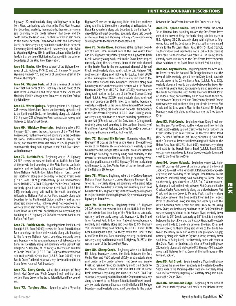
wgfd.wyo.gov Wyoming Hunting Regulations | 67
ELKHUNT AREA BOUNDARY DESCRIPTIONS
Highway 120; southeasterly along said highway to the Big-horn River; southerly up said river to the Wind River Reserva-tion boundary; westerly, then northerly, then westerly along said boundary to the divide between Owl Creek and the South Fork of the Wood River; northeasterly along said divide to the divide between Cottonwood Creek and Gooseberry Creek; northeasterly along said divide to the divide between Gooseberry Creek and Grass Creek; easterly along said divide to Wyoming Highway 120; in addition, all non-Indian fee title lands in that portion of Hot Springs County within the exterior boundaries of the Wind River Reservation.
Area 66. Basin. All of the area west of the Bighorn River; south of U.S. Highway 14-16-20 and U.S. Highway 14, east of Wyoming Highway 120 and north of Broadway Street in the town of Thermopolis.
Area 67. Wiggins Fork. All of the drainage of the Wind River that lies north of U.S. Highway 287 and west of the Wind River Reservation and those areas of the Spence and Moriarity Wildlife Management Area east of the East Fork of the Wind River.
Area 68. Warm Springs. Beginning where U.S. Highway 287 crosses Jakey's Fork Creek; southwesterly up said creek to the Continental Divide; northwesterly along said divide to U.S. Highway 287 at Togwotee Pass; southeasterly along said highway to Jakey's Fork Creek.
Area 69. Whiskey Mountain. Beginning where U.S. Highway 287 crosses the west boundary of the Wind River Reservation; southerly along said boundary to the Continen-tal Divide; northwesterly along said divide to Jakey's Fork Creek; northeasterly down said creek to U.S. Highway 287; southeasterly along said highway to the Wind River Reser-vation boundary.
Area 70. Buffalo Fork. Beginning where U.S. Highway 26-287 crosses the western bank of the Buffalo Fork River at the private land boundary at the Pinto Ranch; southerly, westerly and northerly along said boundary to the Grand Teton National Park-Bridger Teton National Forest bound-ary; northerly along said boundary to Pacific Creek Road (U.S.F.S. Road 30090); northeasterly up said road to Pacific Creek Trail (U.S.F.S. Trail 036) at the Pacific Creek Trailhead; northerly up said trail to the Gravel Creek Trail (U.S.F.S Trail 042); northerly along said trail to the south boundary of Yellowstone National Park at Fox Park; easterly along said boundary to the Continental Divide; southerly and easterly along said divide to U.S. Highway 26-287 at Togwotee Pass; westerly along said highway to the easternmost boundary of Grand Teton National Park; northerly and westerly along said boundary to U.S. Highway 26-287 at the western bank of the Buffalo Fork River.
Area 71. Pacific Creek. Beginning where Pacific Creek Road (U.S.F.S. Road 30090) crosses the Grand Teton National Park boundary; northerly and westerly along said boundary to the Targhee National Forest boundary; northerly along said boundary to the southern boundary of Yellowstone Na-tional Park; easterly along said boundary to the Gravel Creek Trail (U.S.F.S. Trail 042) at Fox Park; southerly along said trail to Pacific Creek Trail (U.S.F.S. Trail 036); southwesterly down said trail to Pacific Creek Road (U.S.F.S. Road 30090) at the Pacific Creek Trailhead; southwesterly down said road to the Grand Teton National Park boundary.
Area 72. Berry Creek. All of the drainages of Berry Creek, Owl Creek and Webb Canyon Creek and that area north of Berry Creek to the Grand Teton National Park bound-ary.
Area 73. Targhee Alta. Beginning where Wyoming
Highway 22 crosses the Wyoming-Idaho state line; northerly along said line to the southern boundary of Yellowstone Na-tional Park; easterly along said boundary to the Caribou-Tar-ghee National Forest boundary; southerly along said bound-ary to Teton Pass and Wyoming Highway 22; westerly along said highway to the Wyoming-Idaho state line.
Area 75. Snake River. Beginning at the southern bound-ary of Grand Teton National Park at the Gros Ventre River and U.S. Highway 191; northerly along said highway to Ditch Creek; westerly along said creek to the Snake River proper; northerly along the easternmost bank of the main channel of the Snake River to the northernmost channel of Spread Creek; southeasterly along said creek to U.S. Highway 191; southwesterly along said highway to U.S.F.S. Road 30310 at the Cunningham Cabin; southerly along said road to the Grand Teton National Park boundary; southerly along said boundary to the southernmost intersection with the Shadow Mountain-Kelly Road (U.S.F.S. Road 30340); southwesterly along said road to the junction of the Teton Science School Road (U.S.F.S. Road 30350); northeasterly along said road one and one-quarter (1-1/4) miles to a marked boundary; easterly one (1) mile to the Grand Teton National Park bound-ary; southerly along the Grand Teton National Park boundary to the Gros Ventre-Kelly Road (U.S.F.S. Road 30400); south-westerly along said road to a posted boundary approximate-ly one-half (1/2) mile west of the Gros Ventre Campground; southerly along said boundary to the southern boundary of Grand Teton National Park and the Gros Ventre River; wester-ly along said boundary to U.S. Highway 191.
Area 77. National Elk Refuge. Beginning where U.S. Highway 191 crosses the Gros Ventre River at the northwest corner of the National Elk Refuge boundary; easterly up said boundary to the Bridger Teton National Forest and National Elk Refuge boundary; southerly along said boundary to the town of Jackson and the National Elk Refuge boundary; west-erly along said boundary to U.S. Highway 191; northerly along said highway to the Gros Ventre River at the northwest corner of the National Elk Refuge.
Area 78. Wilson. Beginning where the Caribou-Targhee National Forest boundary crosses Wyoming Highway 22 at Teton Pass; northerly along said boundary to the Grand Teton National Park boundary; northerly and southerly along said boundary to U.S. Highway 191; southerly along said highway to its junction with Wyoming Highway 22; westerly along said highway to Teton Pass.
Area 79. Teton Park. Beginning where U.S. Highway 26-287 crosses the western bank of the Buffalo Fork River at the private land boundary of the Pinto Ranch; southerly, westerly and northerly along said boundary to the Grand Teton National Park-Bridger Teton National Forest boundary; northerly and westerly along said boundary to U.S. Highway 191; southerly along said highway to U.S.F.S. Road 30310 near Cunningham Cabin; southerly down said road to the Grand Teton National Park boundary; easterly, northerly and westerly along said boundary to U.S. Highway 26-287 at the western bank of the Buffalo Fork River.
Area 80. Sheep Creek. Beginning where the National Elk Refuge boundary crosses the divide between the Gros Ventre River and Flat Creek east of Kelly; southeasterly along said divide to the divide between Flat Creek and Granite Creek at Pyramid Peak; southwesterly along said divide to the divide between Cache Creek and Flat Creek at Cache Peak; northwesterly along said divide to U.S.F.S. Trail 018; southwesterly along said trail to Cache Creek; northwesterly along said creek to the Bridger-Teton National Forest bound-ary; northerly along said boundary to the National Elk Refuge boundary; northeasterly along said boundary to the divide
between the Gros Ventre River and Flat Creek east of Kelly.
Area 81. Spread Creek. Beginning where the Grand Teton National Park boundary crosses the Gros Ventre River east of the town of Kelly; northerly along said boundary to U.S. Highway 26-287; easterly along said highway to Tog-wotee Pass and the Continental Divide; southerly along said divide to the Moccasin Basin Road (U.S.F.S. Road 30750); southerly down said road to the North Fork of Fish Creek at Calf Creek; southerly down said creek to Fish Creek; south-easterly down said creek to the Gros Ventre River; westerly down said river to the Grand Teton National Park boundary.
Area 82. Crystal Peak. Beginning where the Gros Ven-tre River crosses the National Elk Refuge boundary near the town of Kelly; easterly up said river to Kinky Creek; easterly up said creek to the Darwin Ranch Road (U.S.F.S. Road 620); easterly along said road to the divide between the Green Riv-er and Gros Ventre River; southwesterly along said divide to the divide between the Gros Ventre River and Hoback River at Hodges Peak; northwesterly along said divide to the di-vide between Granite Creek and Flat Creek at Pyramid Creek; northwesterly and northerly along the divide between Flat Creek and the Gros Ventre River to the National Elk Refuge boundary; northerly along said boundary to the Gros Ventre River.
Area 83. Fish Creek. Beginning where Kinky Creek en-ters the Gros Ventre River; northerly down said river to Fish Creek; northeasterly up said creek to the North Fork of Fish Creek; northerly up said creek to the Moccasin Basin Road (U.S.F.S. Road 30750) at Calf Creek; northerly up said road to the Continental Divide; southerly along said divide to the Union Pass Road (U.S.F.S. Road 600); southwesterly along said road to the Darwin Ranch Road (U.S.F.S. Road 620); westerly along said road to Kinky Creek; westerly down said creek to the Gros Ventre River.
Area 84. Lower Hoback. Beginning where U.S. High-way 191 crosses Flat Creek at the north edge of the town of Jackson; due east to the National Elk Refuge boundary; east-erly along said boundary to the Bridger Teton National Forest boundary; southerly along said boundary to Cache Creek; southeasterly up said creek to U.S.F.S. Trail 018; northeaster-ly along said trail to the divide between Flat Creek and Cache Creek at Cache Peak; easterly along the divide between Flat Creek and Granite Creek to Pyramid Peak; southerly along the divide between the Gros Ventre River and the Hoback River to Steamboat Peak; southerly and westerly along the divide between Shoal Creek and Dell Creek to the Riling Draw Road; southerly along said road to the Dell Creek Road; westerly along said road to the Hoback River; westerly down said river to Cliff Creek; southerly up Cliff Creek to the divide between the Greys River and the Hoback River; northwesterly along said divide to the divide between the Greys River and Willow Creek; northerly along said divide to the divide be-tween the Bailey Creek and Willow Creek (Greyback Ridge); northerly along said divide to Dry Wash Draw; westerly down said draw to Bailey Creek; northwesterly down said creek to the Snake River; northerly up said river to Wyoming Highway 22; easterly along said highway to U.S. Highway 191; easterly along said highway to Flat Creek at the north edge of the town of Jackson.
Area 85. Fall Creek. Beginning where Wyoming Highway 22 crosses the Snake River; southerly and westerly down the Snake River to the Wyoming-Idaho state line; northerly along said line to Wyoming Highway 22; easterly along said high-way to the Snake River.
Area 86. Monument Ridge. Beginning at the head of Cliff Creek; northerly down said creek to the Hoback River;
68 | 2021 wgfd.wyo.gov
ELK
HUNT AREA BOUNDARY DESCRIPTIONS
southerly up said river to the South Fork of the Hoback Riv-er; due east to the Hoback Rim and the divide between the Hoback River and the Green River; southwesterly along said divide to the divide between the Greys River and the Hoback River; northerly along said divide to the head of Cliff Creek.
Area 87. Raspberry Ridge. Beginning where U.S. High-way 191 crosses the divide between the Green River and the Hoback River on the Hoback Rim; southwesterly along said divide to a point east of the confluence of the South Fork of the Hoback River and the Hoback River; due west to the Ho-back River; northerly down said river to the Dell Creek Road; easterly along said road to the Riling Draw Road; northerly along said road to the divide between Shoal Creek and Dell Creek; northeasterly along said divide to the divide between the Gros Ventre River and the Hoback River at Steamboat Peak; southeasterly along said divide to the divide between the Green River and the Hoback River at Hodges Peak; south-erly along said divide to U.S. Highway 191.
Area 88. Greys Feedground. Beginning at the Wyo-ming-Idaho state line on the Snake River; easterly up said riv-er to the Greys River; easterly up said river to the confluence of the Greys River and Squaw Creek; southwesterly from said confluence to the ridge between the Squaw Creek drainage and the Greys River; southerly up said ridge to the divide be-tween the Greys River and the Salt River; southerly along said divide to the Stewart Sheep Trail; westerly along said trail to the Stewart Creek Road; westerly and southerly along said road to U.S. Highway 89; northerly along said highway to the McCoy Creek Road; westerly and northerly along said road to the Wyoming-Idaho state line; north along said line to the Snake River.
Area 89. Lower Greys River. Beginning at the conflu-ence of Greys River and the Snake River near Alpine; easterly up the Snake River to Bailey Creek; southeasterly up said creek to Dry Wash Draw; easterly up said draw to the divide between Bailey Creek and Willow Creek (Greyback Ridge); southerly along said divide to the divide between Willow Creek and the Greys River; southerly along said divide to the divide between the Greys River and the Hoback River; southerly and easterly along said divide between the Greys River and the Green River; southerly along said divide to the head of Blind Bull Creek; westerly down said creek to Greys River; southerly up said river to Meadow Creek; westerly up said creek to the divide between the Greys River and the Salt River; northerly along said divide to the ridge between the Squaw Creek drainage and the Greys River; northeasterly along said ridge to the confluence of Squaw Creek and the Greys River; westerly down said river to the Snake River.
Area 90. Upper Greys River. Beginning at the point where Blind Bull Creek runs into the Greys River; easterly up said creek to the divide between the Greys River and the Green River; southerly and westerly along said divide to the divide between the Greys River and the Smith Fork Creek; northerly along said divide to the divide between the Greys River and Salt River; northerly along said divide to the head of Meadow Creek; easterly down said creek to Greys River; northerly down said river to Blind Bull Creek.
Area 91. Salt River. Beginning at the point where the McCoy Creek Road crosses the Wyoming-Idaho state line; easterly and southerly along said road to U.S. Highway 89; southerly along said highway to the Stewart Creek Road; northerly and easterly along said road to the Stewart Drive-way Trail; easterly along said trail to the divide between the Salt River and the Greys River; southerly along said divide to the divide between the Bear River and the Salt River; west-erly along said divide to the Wyoming-Idaho state line; north along said line to the McCoy Creek Road.
Area 92. Piney Horse Creek. Beginning where the East Green River Road (Sublette County Road 23 110) intersects Wyoming Highway 351; westerly along said highway to the Green River; northerly up said river to Cottonwood Creek; westerly up said creek to the South Cottonwood Creek; west-erly up said creek to the South Fork of the South Fork of Cot-tonwood Creek; westerly up said creek to the divide between the Greys River and the Green River; northerly along said divide to the divide between the Green River and the Hoback River; northwesterly along said divide (Hoback Rim) to U.S. Highway 191; southerly along said highway to the East Green River Road (Sublette County Road 23-110) at Cora Junction; southerly along said road to Wyoming Highway 351.
Area 93. Waterdog Lakes. Beginning where U.S. High-way 191 intersects with Wyoming Highway 352; northwester-ly along U.S. Highway 191 to the divide between the Hoback River and the Green River (Hoback Rim); northerly along said divide to the divide between the Green River and the Gros Ventre River at Hodges Peak; northeasterly along said divide to the Darwin Ranch Road (U.S.F.S. Road 620); easterly along said road to the Union Pass Road (U.S.F.S. Road 600); south-erly and easterly along said road to Wyoming Highway 352; southerly along said highway to U.S. Highway 191.
Area 94. South Piney. Beginning where LaBarge Creek enters the Green River; westerly up said river to the divide between the Green River and the Greys River; northerly along said divide to the head of the South Fork of South Cotton-wood Creek; easterly down said creek to South Cottonwood Creek; easterly down said creek to Cottonwood Creek; east-erly down said creek to the Green River; southerly down said river to LaBarge Creek.
Area 95. Green River. Beginning where Wyoming High-way 352 meets the Union Pass Road (U.S.F.S. Road 600); northerly and easterly along said road to the Continental Divide; southerly along said divide to Mt. Helen; westerly to Summit Lake and the divide between the Green River and Pine Creek; northwesterly along said divide to the divide between the Green River and the New Fork River; northerly along said divide to the head of Jim Creek; westerly down said creek to Wyoming Highway 352; northerly up said high-way to the Union Pass Road (U.S.F.S. Road 600).
Area 96. New Fork. Beginning where U.S. Highway 191 crosses Pine Creek in the town of Pinedale; westerly along said highway to Wyoming Highway 352; northerly up said highway to Jim Creek; easterly up said creek to the divide between the New Fork River and the Green River; southerly along said divide to the divide between the Green River and Pine Creek; southeasterly along said divide to Summit Lake and Pine Creek; southerly down said creek to U.S. Highway 191.
Area 97. Pinedale. Beginning where Wyoming Highway 351 intersects the East Green River Road (Sublette County 23-110); northerly along said road to Cora Junction and U.S. Highway 191; easterly along said highway to Pine Creek; northerly up said creek to Summit Lake; easterly to Mt. Helen and the Continental Divide; southerly along said divide to the Middle Fork of Boulder Creek; westerly down said creek to Boulder Creek; westerly down said creek to the New Fork River; southerly down said river to Wyoming Highway 351; westerly along said highway to the East Green River Road (Sublette County Road 23 110).
Area 98. Boulder. Beginning where U.S. Highway 28 crosses the Green River; northerly up said river to Wyoming Highway 351; easterly along said highway to the New Fork River; northerly up said river to Boulder Creek; easterly up said creek to the Middle Fork of Boulder Creek; easterly up said creek to the Continental Divide; southerly along said
divide to the Big Sandy River; southerly down said river to the Big Sandy Reservoir Road (Sweetwater County Road 28); westerly along said road to U.S. Highway 191; southerly along said highway to U.S. Highway 28; southwesterly along said highway to the Green River.
Area 99. Big Sandy. Beginning at the junction of Wy-oming Highway 28 and U.S. Highway 191; northerly along said highway to the Big Sandy Reservoir Road (Sweetwater County Road 28); easterly along said road to the Big Sandy River at the dam; northerly up said river to the Continental Divide; southeasterly along said divide to Mt. Nystrom; east-erly from Mt. Nystrom to Sweetwater Gap and the headwa-ters of the Sweetwater River; southerly down said river to Wyoming Highway 28; southwesterly along said highway to U.S. Highway 191.
Area 100. Steamboat. Beginning at the junction of Interstate Highway 80 and Wyoming Highway 372; north-westerly along Wyoming Highway 372 to U.S. Highway 28; northeasterly along said highway to the Sweetwater River; easterly down said river to the Three Forks-Atlantic City Road (B.L.M. Road 2317) at Phelps-Dodge Bridge; southeasterly along said road to the Red Creek Road (B.L.M. Road 3219); southerly along said road to the Rocky Crossing Road (B.L.M. Road 3214); easterly along said road to the Osborne Road (B.L.M. Road 3212); easterly along said road to the Wamsut-ter-Crooks Gap Road (Sweetwater County Road 23); southerly along said road to Interstate Highway 80; westerly along said highway to Wyoming Highway 372.
Area 102. West Green River. Beginning at the junc-tion of Interstate Highway 80 and Wyoming Highway 372; westerly along Interstate Highway 80 to U.S. Highway 30; northwesterly along said highway to the Ham’s Fork River; northerly up said river to Commissary Ridge; northerly along said ridge to the head of LaBarge Creek; southeasterly down said creek to the Green River; southerly down said river to U.S. Highway 28; southwesterly along said highway to Wy-oming Highway 372; southerly along said highway to Inter-state Highway 80.
Area 103. Raymond Mountain. Beginning where the Bear River crosses the Wyoming-Idaho state line; northerly along said line to the divide between the Salt River and Bear River; easterly along said divide to the divide between the Salt River and Smiths Fork; northeasterly along said divide to the head of Smiths Fork Creek; southerly down said creek to the Bear River at the town of Cokeville; northwesterly down said river to the Wyoming-Idaho state line.
Area 104. Lincoln. Beginning where U.S. Highway 30 crosses the Ham's Fork River; westerly along said highway to Sage Junction and Wyoming Highway 89; southwesterly along said highway to the Wyoming-Utah state line; northerly along said line to the Wyoming-Idaho state line; northerly along said line to the Bear River; southeasterly up said river to the town of Cokeville and Smith’s Fork Creek; northerly up said creek to the divide between Smith’s Fork and Greys River; southeasterly along said divide to Commissary Ridge; southerly along said ridge to the head of Ham’s Fork River; southerly down said river to U.S. Highway 30.
Area 105. Carter Lease. Beginning where Interstate Highway 80 crosses the Wyoming-Utah state line; northerly along said line to Wyoming Highway 89 west of Sage Junc-tion; easterly along said highway to U.S. Highway 30; east-erly then southerly along said highway to Interstate Highway 80; westerly along said highway to the Wyoming-Utah state line.
Area 106. Uinta. Beginning where Interstate Highway 80 crosses the Wyoming-Utah state line; easterly along said

wgfd.wyo.gov Wyoming Hunting Regulations | 69
ELKHUNT AREA BOUNDARY DESCRIPTIONS
highway to Wyoming Highway 414; southerly along said high-way to Wyoming Highway 410 at the town of Mountain View; southerly along said highway to the Stateline Dam Road (U.S.F.S. Road 072, Uinta County Road 283); southerly along said road to the Wyoming-Utah state line; west then north along said line to Interstate Highway 80.
Area 107. Hickey Mountain. Beginning where the Flaming Gorge Reservoir crosses the Wyoming-Utah state line; west along said line to the Stateline Dam Road (U.S.F.S. Road 072, Uinta County Road 283); northerly along said road to Wyoming Highway 410; northerly along said highway to Wyoming Highway 414 at the town of Mountain View; north-erly along said highway to Interstate Highway 80; easterly along said highway to the Green River; southerly down said river to Flaming Gorge Reservoir; southerly along the east shore of said reservoir to the Wyoming-Utah state line.
Area 108. South Rawlins. Beginning where Wyoming Highway 71 crosses Interstate Highway 80 at the city of Raw-lins; southerly along said highway to the Sage Creek Road (Carbon County Road 401); southerly along said road to the McCarty Canyon Road (Carbon County Road 503); south-westerly along said road to the Miller Hill Road (B.L.M. Road 3328); northwesterly along said road to the Muddy Creek Road (B.L.M. Road 3306); westerly along said road to Muddy Creek; westerly down said creek to Wyoming Highway 789; northerly along said highway to Interstate Highway 80; east-erly along said highway to Wyoming Highway 71.
Area 110. Upper Platte River. Beginning where Wy-oming Highway 130 crosses the Laramie River North Platte River Divide; southerly along said divide to Douglas Creek; southerly down said creek to U.S.F.S. Road 543 at Keystone; southerly along said road to U.S.F.S. Road 512; southeaster-ly along said road to Wyoming Highway 230; southwesterly along said highway to the Wyoming-Colorado state line; westerly along said line to Wyoming Highway 230; north-westerly along said highway to Wyoming Highway 130; east-erly along said highway to the divide between the Laramie River and the North Platte River.
Area 111. Seminoe. Beginning at the junction of U.S. Highway 287 and Interstate Highway 80 at the city of Raw-lins; northerly along said highway to the South Ferris Road (Carbon County Road 100); easterly along said road to the Buzzard Road (Carbon County Road 497 Natrona County Road 410); northerly along said road to Wyoming Highway 220; northeasterly along said highway to the Kortes Road (Natro-na County Road 407); southerly along said road to the North Platte River; southerly up said river to Interstate Highway 80; westerly along said Interstate to U.S. Highway 287.
Area 113. Rochelle Hills. Beginning at the junction of Wyoming Highway 59 and Wyoming Highway 450; easterly along Wyoming Highway 450 to the Lynch Road (Weston Coun-ty Road 7A); southerly along said road to the Weston-Con-verse County line and the Clareton Road (Converse County Road 39); southerly along said road to the Dull Center Road (Converse County Road 38); easterly along said road to the Converse-Niobrara County line and the North Lance Creek Road (Niobrara County Road 14); easterly and southerly along said road to the Slagle Road (Niobrara County Road 4); southerly along said road to the Cow Creek Road (Niobrara County Road 3); westerly along said road to the Converse-Ni-obrara County line and the Cow Creek Road (Converse County Road 45); southerly along said road to the Converse-Niobrara County line and the K-Field Road (Niobrara County Road 50); southerly along said road to the Converse-Niobrara County line and the Walker Creek Road (Converse County Road 43); westerly along said road to Dry Creek; westerly up said creek to the Iberlin Ranch Road; northerly along said road to the
Thunder Basin National Grassland boundary and U.S.F.S. Road 958C; northwesterly along said road to the East Bill Road (U.S.F.S. Road 958); westerly along said road to the Dull Center Road (Converse County Road 38); westerly along said road to Wyoming Highway 59; northerly along said high-way to the junction of Wyoming Highway 59 and Wyoming Highway 450.
Area 116. North Black Hills. Beginning where the Mon-tana-Wyoming state line crosses the Rocky Point Road (Crook County Road 145); easterly along said line to where the Mon-tana, Wyoming, and South Dakota state lines meet; southerly along the Wyoming-South Dakota state line to Interstate Highway 90; westerly along said Interstate to Wyoming High-way 116 at the town of Sundance; southwesterly along said highway to U.S. Highway 16 at the town of Upton; northerly and westerly along said highway to Interstate Highway 90; westerly along said Interstate to the D-Road (Crook County Road 68); northerly along said road to the Rocky Point Road in Campbell County (Campbell County Road 85); northerly along said road to the Wyoming-Montana state line.
Area 117. South Black Hills. Beginning where Inter-state Highway 90 crosses the Wyoming-South Dakota state line; southerly along said line to the Black Hills National Forest boundary; westerly along said boundary to the Sand Creek Road (U.S.F.S. Road 863) at the boundary marker and one-quarter (1/4) mile south of Ranch A; southerly along said road to the Moskee Road; southeasterly along said road to Moskee and the Deer Creek Road (U.S.F.S. Road 807); south-easterly along said road to the Wyoming-South Dakota state line; southerly along said line to the Dewey Road (Weston County Road 2); northwesterly along said road to U.S. High-way 85; northerly along said highway to U.S. Highway 16; northwesterly along said highway to the town of Upton and Wyoming Highway 116; northeasterly along said highway to Interstate Highway 90; easterly along said Interstate High-way to the Wyoming-South Dakota state line.
Area 118. Shamrock Hills. Beginning at the junction of U.S. Highway 287 and Interstate Highway 80 at the city of Rawlins; westerly along said Interstate to the Wamsutter Crooks Gap Road (Sweetwater County Road 23); northerly along said road to the Bairoil Road (Sweetwater County Road 22); easterly along said road to Wyoming Highway 73; east-erly along said highway to U.S. Highway 287; southerly along said highway to Interstate Highway 80.
Area 120. Buffalo Creek. Beginning at the intersection of Interstate Highway 25 and the North Platte River in the city of Casper; southwesterly up said river to the bridge at Poplar Street; northerly along said street to U.S. Highway 20-26; westerly along said highway to Natrona County road 104 at Waltman; northerly along said road to Natrona County Road 103; northwesterly along said road to Natrona County Road 102; northerly along said road to Natrona County Road 101; northeasterly along said road to Badwater Creek; northeast-erly along said creek to the divide between Badwater Creek, Deep Creek and Buffalo Creek; northeasterly along said di-vide to the divide between the Middle Fork and North Fork of Buffalo Creek; easterly along said divide to the North Fork of Buffalo Creek; northeasterly along said creek to Natrona County Road 109; northeasterly along said road to Washakie County road 6215; northeasterly along said road to the 33-Mile Road (Natrona County Road 110) at Kidd Flat; southeast-erly along said road to Natrona County Road 113; easterly along said road to Natrona County Road 114; northeasterly along said road to Natrona County Road 115; easterly along said road to Wyoming Highway 387; easterly along said high-way to Wyoming Highway 259 in the town of Midwest; south-erly along said highway to Interstate 25; southerly along said highway to the North Platte River in the city of Casper.
Area 122. Pine Ridge. Beginning at the intersection of Interstate Highway 25 and Wyoming Highway 259; norther-ly along Wyoming Highway 259 to U.S. Highway 387 at the town of Midwest; northeasterly along U.S. Highway 387 to the Ross Road (County Road 31 in Converse County); south-easterly along said road to Wyoming Highway 95; southwest-erly along said highway to the North Platte River at the town of Glenrock; westerly up said river to Interstate Highway 25 in the city of Casper; northerly along said highway to Wyo-ming Highway 259.
Area 123. Black Thunder. Beginning where the High-light Road crosses the Belle Fourche River; northeasterly down said river to the mouth of Raven Creek; southeasterly up said creek to the Raven Creek Road; southerly along said road to Wyoming Highway 116; southerly along said highway to Wyoming Highway 450; westerly along said highway to the Highlight Road; northerly along said road to the Belle Fourche River.
Area 124. Powder Rim. Beginning at the junction of Wyoming Highway 789 and the Wyoming-Colorado state line; westerly along said line to Wyoming Highway 430; northerly along said highway to Interstate Highway 80; easterly along said highway to Wyoming Highway 789; southerly along said highway to the Wyoming-Colorado state line.
Area 125. Elk Mountain. Beginning at the junction of In-terstate Highway 80 and U.S. Highway 30 at the Saratoga in-terchange; northeasterly along U.S. Highway 30 to Wyoming Highway 72 at the Hanna interchange; southeasterly along Wyoming Highway 72 to the Pass Creek Road (Carbon County Road 404) west of the town of Elk Mountain; southerly and westerly along said road to Wyoming Highway 130; northerly along said highway to Interstate Highway 80.
Area 126. Lost Springs (non-herd unit). All of Con-verse, Weston and Niobrara counties, excluding lands within other described and numbered elk hunt areas.
Area 127. Crowheart Butte. All non-Indian owned fee title lands within the exterior boundaries of the Wind River Reservation, and all lands within the Bureau of Reclamation’s Riverton and Boysen Unit boundaries, and those lands within Boysen State Park south of Cottonwood Creek, west of Boy-sen Reservoir, and south of U.S. Highway 20-26; excluding those areas of the Spence and Moriarity Wildlife Manage-ment Area that lie east of the East Fork of the Wind River, and excluding those lands within Hot Springs County.
Area 128. Muskrat. Beginning where U.S. Highway 20-26 crosses the east boundary of the Wind River Reservation; easterly along said highway to the town of Waltman and the Gas Hills Road (Natrona County Road 212); southwesterly along said road to the Dry Creek Road (Natrona County Road 321); southeasterly along said road to Wyoming Highway 220; southwesterly along said highway to U.S. Highway 287; westerly along said highway to Wyoming Highway 135; northerly along said highway to the south boundary of the Wind River Reservation; easterly and northerly along said boundary to U.S. Highway 20-26.
Area 129. Non-Herd Unit. All of Campbell, Crook, John-son, Natrona, and Sheridan counties, excluding lands within other described and numbered elk hunt areas.
Area 130. Bolten Rim. Beginning where Wyoming High-way 71 crosses Interstate Highway 80 at the city of Rawlins; easterly along said Interstate to the North Platte River; south-erly up said river to Sage Creek; southwesterly up said creek to the Sage Creek Road (Carbon County Road 401); northerly along said road to Wyoming Highway 71; northerly along said highway to Interstate Highway 80.
70 | 2021 wgfd.wyo.gov
Hunting with Heroes Wyoming is a nonprofit charitable organization founded by veteransfor veterans. It's our mission to give back to our nation's disabled veterans by honoring
them with unique big game hunting experiences in Wyoming. Hunting is healing and youcan help these fine men and women by simply donating a tag. We do the rest!
Did you know all big game tags, including antelope, deer, elk, moose, big hornsheep and mountain goat, can be donated? Did you know you can help us save
lives? If you have a tag you aren't planning to use, donate it to a disabled veteran.
Help us give back. Contact Dan Currah at [email protected] or 307.258.5880 for more information. Thank you.
huntingwithheroes.org | #huntingwithheroeswyoming
Call Northern Wyoming's Premier Real Estate Agency
WWW.WEARE307.COM"We Sell Wyoming"
Cody Office
307.587.4959
Buffalo Office
307.684.2686
Powell Office
307.587.4959
Sheridan Office
307.673.2865

wgfd.wyo.gov Wyoming Hunting Regulations | 71
MARK V COWPOKE EDITIONLoud and proud – and made right here in Wyoming! A special edition of our legendary Mark V rifle, the Cowpoke is a heavy hitter. With custom Cerakote, a hand-laid fiberglass stock, #3 fluted barrel and chambered in some of our most popular Weatherby cartridges, this rifle will reach out and poke’m. Show off that Wyoming pride no matter where your hunts might take you.
VISIT WEATHERBY.COM

Now with more than 8,200 members in Wyoming, the Rocky Mountain Elk Foundation is a force for conservation and hunting. Together, we have protected or enhanced 1.2 million acres of elk habitat,
and opened or improved access to 200,595 acres of public land, in just Wyoming alone!
WE NEED YOUR HELP TO KEEP UP THE GOOD WORK!
JOIN RMEFBECOME A MEMBER TODAY
RMEF.ORG/WY21OR CALL 800-CALL ELK
AS A MEMBER OF RMEF, YOU’LL RECEIVE: Full year (6 issues) of Bugle magazine Exclusive discounts on gear, goods and services RMEF decal and personalized membership card Satisfaction of conserving elk country and the hunt
BU
GL
E J
AN
UA
RY
• FE
BR
UA
RY
20
20
JF20_Cover.indd 1
11/8/19 4:11 PM
BU
GL
E M
AR
CH
• AP
RIL
20
20
MA20_Cover.indd 1MA20_Cover.indd 1
1/27/20 11:24 AM1/27/20 11:24 AM
BU
GL
E M
AY
• JU
NE
20
20
MJ20_Cover.indd 1MJ20_Cover.indd 1
3/24/2020 8:18:39 AM3/24/2020 8:18:39 AM
BU
GL
E J
ULY
• AU
GU
ST
20
20
JA20_Cover.indd 1JA20_Cover.indd 15/18/2020 2:54:26 PM5/18/2020 2:54:26 PM
BU
GL
E S
EP
TE
MB
ER
• OC
TO
BE
R 2
02
0
SO20_Cover_FINAL.indd 1SO20_Cover_FINAL.indd 1 7/22/2020 7:20:02 AM7/22/2020 7:20:02 AM
Michael John SisnerosMember # 12507
455-0221-001
Join one of our 5 membership levels today and you could receive a FREE gift!
Join NowWyldlife Fund Ad.indd 2Wyldlife Fund Ad.indd 2 3/10/21 3:50 PM3/10/21 3:50 PMVISIT US ONLINE AT WGFD.WYO.GOV
The Wyoming Game and Fish Department receives federal financial assistance in Sport Fish and Wildlife Restoration. Under Title VI of the 1964 Civil Rights Act, Section 504 of the Rehabilitation Act of 1973, Title II of the Americans with Disabilities Act of 1990, the Age Discrimination Act of 1975, and Title IX of the Education Amendments of 1972, the U.S. Department of the Interior prohibits discrimination on the basis of race, color, national origin, age, sex, or disability. If you believe that you have been
discriminated against in any program, activity, or facility as described above, or if you desire further information, please write to:
Office of Civil Rights, Department of the Interior, 1849 C Street, NW Washington, DC, 20240.