how does the discovery of hydrocarbon
TRANSCRIPT
HOW DOES THE DISCOVERY OF HYDROCARBON
RESOURCES IN MARITIME BOUNDARY DELIMITATION
ZONES AFFECT INTERSTATE CONFLICT?
A Master’s Thesis
by
YÜKSEL YASEMİN ALTINTAŞ
Department of International Relations
İhsan Doğramacı Bilkent University
Ankara
August 2020
YÜ
KS
EL
YA
SE
MİN
AL
TIN
TA
Ş H
OW
DO
ES
TH
E D
ISC
OV
ER
Y O
F H
YD
RO
CA
RB
ON
RE
SO
UR
CE
S IN
MA
RIT
IME
BO
UN
DA
RY
DE
LIM
ITA
TIO
N Z
ON
ES
AF
FE
CT
INT
ER
ST
AT
E C
ON
FL
ICT
? B
ilken
t Un
iversity 2
020


To The Memory of My Grandfather, Abdullah Altıntaş
HOW DOES THE DISCOVERY OF HYDROCARBON RESOURCES IN
MARITIME BOUNDARY DELIMITATION ZONES AFFECT
INTERSTATE CONFLICT?
The Graduate School of Economics and Social Sciences
of
İhsan Doğramacı Bilkent University
By
YÜKSEL YASEMİN ALTINTAŞ
In partial fulfillments of the Requirements for the Degree of
MASTER OF ARTS IN INTERNATIONAL RELATIONS
THE DEPARTMENT OF
INTERNATIONAL RELATIONS
İHSAN DOĞRAMACI BILKENT UNIVERSITY
ANKARA
August 2020
iv
v
ABSTRACT
HOW DOES THE DISCOVERY OF HYDROCARBON RESOURCES IN
MARITIME BOUNDARY DELIMITATION ZONES AFFECT
INTERSTATE CONFLICT?
Altıntaş, Yüksel Yasemin
M.A., Department of International Relations
Supervisor: Asst. Prof. Dr. Berk Esen
August 2020
This thesis analyzes how the discovery of hydrocarbon resources in the maritime territories affect
interstate conflict based on a paired comparison of: the Eastern Mediterranean Sea and the South
China Sea conflicts. According to the United Nations Convention on the Law of Sea, littoral states
have to define their exclusive economic zones to use their sovereign rights of exploring and
exploiting seabed, subsoil, and natural resources out of their territorial waters. In the existence of
an exclusive economic zone, maritime boundary delimitations states’ cannot exercise these rights
before solving their ongoing disputes. Despite their structural differences in the Eastern
Mediterranean Sea and the South China Sea maritime boundary delimitations, the existence of
abundance hydrocarbon resources intensified the existing conflict. The thesis concludes that
states’ relative gain calculations determine their actions. A direct ratio exists between the severity
of the conflict and the abundance of resources. The findings of the thesis indicate that hydrocarbon
sources affect the states' perception of relative gains when the coastal states' believe that their
expected earnings will increase; it is observed that they become more demanding in their
territorial claims.

vi
Keywords: Eastern Mediterranean, Energy, Exclusive Economic Zone, Maritime Boundary
Delimitation, South China Sea
vii
ÖZET
DENİZ SINIR BÖLGELERİNDE KEŞFEDİLEN HİDROKARBON
KAYNAKLARI DEVLETLERARASI ÇATIŞMAYI NASIL ETKİLER?
Altıntaş, Yüksel Yasemin
Yüksek Lisans, Uluslararası İlişkiler Bölümü
Tez Danışmanı: Dr. Öğr. Üyesi Berk Esen
Ağustos 2020
Bu tez Doğu Akdeniz ve Güney Çin Denizi gibi, deniz yetki alanları sınırlandırılma anlaşmazlığı
olan bölgelerde hidrokarbon kaynakları bulunmanın devletlerarası çatışmayı nasıl etkileneceğini
Doğu Akdeniz ve Güney Çin Denizi örnek vakaları üzerinden incelemektedir. Milletler Deniz
Hukuku Sözleşmesine göre kıyı devletleri kara sularının dışında kalan bölgelerde deniz
yataklarından, yer altı ve doğal kaynaklardan kendi kara sularındaymış gibi yararlanabilmek için
münhasır ekonomik bölgelerini ilan etmek zorundadır. Münhasır ekonomik bölge çatışması olan
bölgelerde taraf ülkelerin deniz yataklarından, yer altı ve doğal kaynaklardan yararlanabilmesi
için devam eden anlaşmazlıklarını çözüme kavuşturmak zorundadır. İç dinamiklerindeki
farklılıklara rağmen hem Doğu Akdeniz de hem de Güney Çin Denizin de hidrokarbon
rezervlerinin bulunması var olan bölgesel çatışmaların şiddetini arttırmıştır. Bulunan rezervlerin
büyüklükleri ile çatışma şiddetinin artması doğru orantılıdır. Tez bulguları hidrokarbon
kaynaklarının taraf devletlerin göreceli kazanç hesaplarını etkilediğini, beklenen kazancın
artacağına inanılması durumunda kıyı devletlerinin bölgesel talepleri konusunda daha talepkâr
olduğu gözlenmektedir.

viii
Anahtar Kelimeler: Deniz Yeki Alanlarının Sınırlandırılması, Doğu Akdeniz, Enerji, Güney Çin
Denizi, Münhasır Ekonomik Bölge
ix
ACKNOWLEDGMENTS
First and foremost, I would like to express my sincere gratitude to my advisor Asst. Prof. Dr. Berk
Esen, for his patience, guidance, and encouragement throughout my academic life and thesis
process. I also would like to thank the rest of my examining committee members, Asst. Prof. Dr.
Tudor A. Onea and Assoc. Prof. Dr. Tolga Demiryol for their constructive sugestions and
insightful commets.
I am thankful for the support, guidance, and teachings of all of my professors at Bilkent University
throughout my undergraduate and graduate studies.
I would also like to thank my father, S. Cumhur Altıntaş, and present my appreciation for my
supportive family members and close friends for their emotional and academic support. My
heartfelt gratuities go to three special women in my life whom I admire by their dedication and
strength: my sister Neşe Gülay Altıntaş, my mom Ayşe Gül Koçak Altıntaş and my grandmother
Yüksel Altıntaş. I am eternally grateful for their presence in my life.
x
TABLE OF CONTENTS
ABSTRACT ............................................................................................................................. V
ÖZET .................................................................................................................................... VII
ACKNOWLEDGMENTS ....................................................................................................... IX
LIST OF FIGURES .............................................................................................................. XIII
LIST OF TABLES ............................................................................................................... XIV
CHAPTER 1 ............................................................................................................................. 1
INTRODUCTION ..................................................................................................................... 1
1.1 Hypothesis ............................................................................................................... 4
1.2. Research Design and Methodology ......................................................................... 7
1.3. Data Collection and Limitations .............................................................................. 9
1.4. Role of Hydrocarbon Recourses in Interstate Disputes .......................................... 10
1.5. Comparison of the Eastern Mediterranean Sea and the South China Sea Disputes . 11
CHAPTER 2 ........................................................................................................................... 14
THEORETICAL FRAMEWORK ........................................................................................... 14
2.1. Differences between Land-Based Territorial Disputes and Maritime Territorial
Disputes ....................................................................................................................... 16
2.2. Importance of Energy Resources and Geographic Location ................................... 19
2.3. Role of Natural Resources in Territorial Disputes .................................................. 21
2.4. Theoretical Approaches to Conflict Studies ........................................................... 24
2.5. Connection of Natural Resources and Maritime Boundary Delimitations ............... 30
2.5.1 Case 1: The Eastern Mediterranean Sea Dispute .............................................. 31
2.5.2. Case 2: The South China Sea Dispute ............................................................. 32
xi
CHAPTER 3 ........................................................................................................................... 34
MARITIME BOUNDARY DELIMITATION IN THE EASTERN MEDITERRANEAN SEA
................................................................................................................................................ 34
3.1. Geographic Location and Structure of the Eastern Mediterranean Sea ................... 34
3.2. Historical Importance of the Eastern Mediterranean Sea and Cyprus ..................... 36
3.2.1. Cyprus ............................................................................................................ 37
3.3. Maritime Boundary Delimitations in the Eastern Mediterranean Sea and the Cyprus
Conflict ........................................................................................................................ 38
3.3.1. History of the Conflict .................................................................................... 38
3.4. Maritime Boundary Delimitations after the Exploration of Potential Hydrocarbon
Resources .................................................................................................................... 41
3.5. Greek Administration of Southern Cyprus ............................................................. 42
3.6. Greece ................................................................................................................... 45
3.7. Egypt .................................................................................................................... 50
3.8. Israel ..................................................................................................................... 52
3.9. Lebanon ................................................................................................................ 54
3.10. Syria ................................................................................................................... 55
3.11. Turkish Republic of Northern Cyprus (TRNC) .................................................... 56
3.12. Turkey ................................................................................................................ 57
3.13. Chapter Summary ............................................................................................... 63
CHAPTER 4 ........................................................................................................................... 68
MARITIME BOUNDARY DELIMITATIONS IN THE SOUTH CHINA SEA ...................... 68
4.1. Importance of the South China Sea........................................................................ 68
4.2. Importance of Hydrocarbon Reserves and the Role of Energy Security ................. 71
4.3. Disputed History of the Region ............................................................................. 72
4.4. Common Features of Spratly and Paracel Islands .................................................. 75
4.4.1. Spratly Islands ................................................................................................ 79
4.4.2. Paracel Islands ................................................................................................ 81
xii
4.5. China (People's Republic of China) ....................................................................... 81
4.6. Taiwan (The Republic of China) ........................................................................... 87
4.7. The Philippines ..................................................................................................... 89
4.8. Vietnam ................................................................................................................ 91
4.9. Malaysia ............................................................................................................... 93
4.10. Brunei Darussalam .............................................................................................. 94
4.11. Theoretical Analysis of States’ Actions in the South China Sea ........................... 95
CHAPTER 5 ........................................................................................................................... 97
CONCLUSION ....................................................................................................................... 97
5.1. Implications and Policy Recommendations ......................................................... 100
5.2. Recommendations for Future Studies .................................................................. 104
APPENDIX A: ABBREVIATIONS ..................................................................................... 107
APPENDIX B: UNCLOS MARITIME ZONES ................................................................... 110
BIBLIOGRAPHY ................................................................................................................. 111
xiii
LIST OF FIGURES
Figure 1 Overlapping Territories ............................................................................................. 44
Figure 2 Overlapping Territories And Licensed Areas ............................................................. 44
Figure 3 Route Of Eastmed Pipeline ........................................................................................ 47
Figure 4 Comparison Of Greek And Turkish Eez Borders ....................................................... 48
Figure 5 Map Of Israel-Lebanon Maritime Dispute ................................................................. 55
Figure 6 Trnc Claimed Disputed Territory ............................................................................... 57
Figure 7 The Exploration Licenses Granted To Tpao By The Turkish Government And TRNC
Government............................................................................................................................. 59
Figure 8 Offshore Hyrdocarbon Reserves And Eez Claims ...................................................... 75
Figure 9 What Makes An Island? ............................................................................................ 77
Figure 10 Occupation Status Of The Features In The South China Sea ................................... 78
Figure 11 Locations' Of Spratlys And Paracels ........................................................................ 79
Figure 12 Spratly Archipelago ................................................................................................. 80
Figure 13 Chinese Eez Claims: U-Shape Eez Map ................................................................... 82

xiv
LIST OF TABLES
Table 1 Major Gas Reserves Discoveries In The Eastern Mediterranean Sea Between 1999-2015
................................................................................................................................................ 52
Table 2 Maritime Disputes In South China Sea ........................................................................ 73
1
CHAPTER 1
INTRODUCTION
How does the discovery of hydrocarbon resources in maritime boundary delimitation
zones affect interstate disputes? According to UNCLOS, coastal states have to declare an
exclusive economic zone (EEZ) to gain their sovereign right to explore and exploit the
seabed and its subsoil and benefit from all living and non-living maritime resources, in
their territorial waters. However, littoral states can only exercise these rights if the other
coastal states approve their claimed EEZ. The majority of maritime boundary
delimitations are occurring as a result of overlapping EEZ claims. Disputant states can
choose to adopt a cooperative strategy to settle their ongoing disputes, which will benefit
all parties by allowing them to use seabed, subsoil, and maritime resources. However, if
disputant states believe that settling the dispute will harm their benefits in the long run, to
increase their relative gains, they will choose a delaying strategy. States’ choice of
delaying strategy can explain by greed theory.
In the Eastern Mediterranean Sea (EMS) and the South China Sea (SCS), littoral states
overlapping EEZ declarations create maritime boundary delimitations create territorial
disputes in the region. If coastal states settle their disputes, they can benefit from maritime
resources. However, in each case, states did not demonstrate a willingness to compromise
tone down their claims to settle the conflict. Disputants’ believes that increasing their
power in the region they can force their opponents to compromise. To gain control of their
claimed territory, some disputants like China and Turkey relay on their military
capabilities, more specifically their naval power. As a response to certain nations’ usage
of gunboat diplomacy, some nations like the Greek Administration of Southern Cyprus
and the Philippines prefer to forms alliances. Depending on the nations' capabilities, these
2
alliances can be formed among equivalent nations, balancing, or with a relatively stronger
nation, bandwagoning. States’ can also choose buck-passing to secure their interest in the
system, which is dominated by a strong potential threat. In the buck-passing, stronger
allies confront’ with the challenger states’ instead of a weaker nation (Richey, 2020).
Sino-US rivalry and US-led alliances in the Asia-Pacific region can be given as an
example to buck-passing. After the exploration of hydrocarbon reserves in the disputed
regions, tension increased in the last decade, especially in EMS and SCS. The duration of
these disputes harms all sides since neither state can effectively explore and have access
to these resources in the conflicted regions.
In accordance with coastal states expanding energy dependency and needs, not settling
the existing disputes prevent them from accessing energy resources that are required.
Therefore rise of tension in the maritime boundary delimitation after the exploration of
hydrocarbon reserves is a puzzle since conventional wisdom would suggest cooperation,
which could be beneficial for all parties involved. Nevertheless, as argued in this thesis,
the outcome is the opposite, in the sense that the discovery of hydrocarbon resources
intensifies interstate conflict due to maritime disputes. Exploration of hydrocarbon
resources in the conflict existed territories escalate the conflict rather than settling them.
Mearsheimer indicates that in the international arena, states compete with each other to
gain power. In the anarchic structure of the international politics, being a powerful player
is the only way to secure their survivor (Mearsheimer, 2006). States aim to expand their
aggregate power to become more powerful actors in the international arena. A nation’s
aggregate power can be measure by its resources like population, military capabilities, and
technology (Walt, 1985, p. 9). Territory provides necessary ground for population
expansion and resources for a nation to expand its technological, industrial, and material
capabilities like rare earth minerals. Therefore states’ compete with each other to expand
their aggregate power.
Gaining territory has always been a significant motivation for states to improve their
relative power by allowing them to expand their material capabilities and resources. The
regional rivalry is another factor that triggers or intensifies conflicts; when states compete
with each other to become the dominant state in their region, the intensity of the conflict
3
increases. If a state is more powerful than its opponents, in a case of conflict, its' likelihood
of achieving its' demands increases (Mearsheimer, 2014). Therefore states choose to
invest in their military capabilities or expand their military power by forming alliances.
States' choice of strategies, including their alliance formations, should be considered as a
means to an end, which is maintaining or expanding states’ power.
In general, territorial and boundary disputes are caused by material claims (Guo, 2018).
Some disputes evolve peacefully through mediation or negotiation; however, some
disputes escalate and cause violence. Disagreements over states' borders cause
intensification on the interactions of the states. Some scholars argue that the duration of
the disputes is connected with the level of hostility. The longer the dispute takes, the
likelihood of settling the dispute in a peaceful way decreases (Jones, Bremer, and Singer,
1996). Thus territorial disputes are taken as the main causes of interstate wars (Vasquez,
2000).
When states’ expected gains increase, the likelihood of interstate aggression level
increases; however, few scholars have carried out a detailed case study exploring why and
under which conditions certain interstate disputes resolve more peacefully while others
become violent. Scholars argue that geographical proximity is the most important factor
affecting the aggression level in conflicts and their likelihood of escalating into the war
(Stenberg, 2012). However, the majority of aggressive territorial conflicts occur over the
recourse rich territories. Border disputes between Bolivia and Peru, Ecuador and Peru,
Nigeria and Cameroon, Algeria and Morocco, China and Vietnam, and Iraq-Iran war can
be given as an example to territorial conflicts over recourse-rich regions. Territorial
conflicts occur not only in land-based territories. The number and intensity of maritime
boundary delimitations on the resource-rich maritime regions such as the Caspian Sea,
East China Sea, Eastern Mediterranean Sea, and the South China Sea are increasing
rapidly.
After the 1970s, the Arab oil embargo, the number of academic works that analyze the
relationship between natural resources and conflict studies increased (Bayramov, 2018,
p.74). Studies indicate that there is a positive relationship between conflict and resource
scarcity (Mildner, Lauster, and Wodni, 2011, p.157). Therefore it can be argued that
4
natural resources have a more significant impact than geographical proximities on the
duration of territorial conflicts. In ceratin conflict, existing regions like Eastern
Mediterranean, East, and South China Sea exploration of hydrocarbon resources affects
the duration of the conflict by changing states’ expected gains from the region, which they
have already been competing for.
This thesis conducts a paired comparison of the Eastern Mediterranean Sea and the South
China Sea disputes to argue that the discovery of hydrocarbon resources contributes to the
intensification of interstate disputes as a conflict escalator factor by using most different
system designs paired comparison study. In this chapter, Chapter 1, hypothesis, research
design and methodology, comparison of selected cases, and the summary of the selected
theoretical framework, realist paradigm is discussed. Chapter 2 introduces the literature
review and theoretical framework. Chapter 3 applies the main arguments of this thesis to
the Eastern Mediterranean Sea case to explore the interstate conflict in the region. In the
fourth chapter, after presenting the historical background of the SCS dispute, common
features of the selected two sub-cases are introduced: the Spratly and Paracel disputes.
This part will be followed by the examination of disputed states' actions and concluded by
the theoretical analysis of disputants' actions. Chapter 5 provides a summary of the results
in accordance with the selected hypothesis.
1.1 Hypothesis
Hypothesis: Discovery of hydrocarbon resources in conflicts existing regions does not
serve as a settling factor; in fact, by serving as a triggering factor, it intensifies the depth
of the dispute.
This study contributes to the conflict literature by examining state actions regarding their
expected gain-loss calculations in the selected cases: the Eastern Mediterranean Sea and
the South China Sea. It argues that the exploration of hydrocarbon resources in the
conflicted regions does not promote cooperation among the conflicting sides. Instead, it
serves as a triggering factor and escalates tension among the disputed actors. Exploration
of hydrocarbon resources in the conflict existed regions complicates the exiting
5
competition in the region. Whichever state gains control of the energy resources, it not
only increase its’ economic power but also by reducing its energy dependency to other
nations. Also, controlling energy reserves can significantly improve that nation’s power.
Therefore controlling energy resources creates power imbalances and security concerns
in the conflict existing regions. Nations become more demanding over their claims, and
their likelihood of compromising to settle the exiting conflict reduces. As a result of the
disputant states’ demanding attitudes conflict escalates. Hydrocarbon resources conflict
escalating effects in the conflict existing maritime territories can be measured by the
number and the tone of press releases given by the disputant states’ leaders, by comparing
the number of verbal notes (note verbale) issued by regional states regarding to each
others’ actions in the disputed region before and after the exploration of the hydrocarbon
resources and by the comparison of disputant states’ naval forces’ existence in the
disputed territories before and after the exploration of hydrocarbon reserves.
In the intensified disputes, states try to increase their power by expanding their military
capabilities, forming new alliances, and deepening their existing partnerships as a balance
of threat strategy. With the rise of global energy needs, motivated nations started to issue
drilling licenses on the disputed hydrocarbon blocks. Energy companies' attempts to
conduct operations in the disputed regions served as conflict triggering factors. Thus by
creating blocs hydrocarbon resources strengthens the exiting cooperation among the
states. Still, they do not end the current conflict among the actors by forcing them to
cooperate with each other.
Structural Realism is dominantly used in the thesis to analyze states' motives. Relative and
absolute gain perceptions of the disputants’ significantly affect their strategies. Based on
relative gain calculations, disputants may choose to settle, maintain, or act aggressively to
reach their claims in a conflict. Hydrocarbon resources are non-renewable energy sources,
and because of their limited global reserves in some studies, they are analyzed under
scarce resources category. On the contrary, based on the size of hydrocarbon reserves,
hydrocarbons are analyzed under the resource abundance category in certain regions.
Because of its' global scarcity and regional abundance by increasing disputants' expected
6
gains, energy reserves significantly increases the degree of conflict. Greed theory can be
used for explaining states demanding actions in such regions.
In the anarchic international system states concerns about their survival. To ensure their
security, states compete with each other to enhance their capabilities. According to
Mearsheimer, great powers try to maximize their power to be able to dominate the system
(Mearsheimer, 2001). Before the Great War, until the establishment of the USSR
international system carried the features of a multipolar system. In the Cold War period,
the international arena became bipolar. After the fall of the Berlin wall under the US
hegemony, unipolarity dominated the international system. However, with the rise of
regional powers, the international arena started to shift from unipolarity to multipolarity
(Muzaffar, Yaseen, and Rahim, 2017). Multipolarity increases competition among the
states; therefore, it increases the likelihood of interstate disputes (Deutsch and Singer,
1964).
Imbalance in military power can prevent the rise of conflicts in bipolar or unipolar
systems. However, in a multipolar world order, it leads to an arms race, which usually
leads to a security dilemma. In SCS, the rise of the People's Liberation Army Navy
(PLAN) reduces the other disputants' likelihood of willing to engage military
confrontations with China. On the contrary, if disputants' military capabilities are
equivalent to each other, their likelihood of avoiding military confrontations decreases.
Even though the quality and quantity of offensive military capabilities vary, all states own
offensive military capabilities (Mearsheimer, 2001). In the selected cases, disputant
nations use their offensive military capabilities as deterrent power to protect their claimed
regions, like the increasing existence of PLAN in SCS to protect its’ claimed islands or
Turkish military vessels’ sailing next to Turkish seismic vessels as deterrence in the
disputed EMS. Hence disputants try to restrain the rise or domination of a potential rival
within their region.
States can never be sure of other states' intentions; therefore, to secure their claimed
territory, they rely on their military capabilities. By investing in their military capabilities
and forming alliances, disputant states aim to improve their military and economic
weaknesses. Both in SCS and EMS, disputants try to improve their strength by forming
7
alliances. In SCS, disputant states form various alignments with the regional and non-
regional states. Alliance formation can be seen more significantly in EMS. Unlike SCS,
in EMS, two main alliance blocks were formed by the regional governments: Israel, Egypt,
GASC, Greece versus Turkey, Turkish Republic of Northern Cyprus (TRNC),
Government of National Accord (GNA).
1.2. Research Design and Methodology
In terms of methodology, the paired comparison method was used in this thesis. In the
selected cases process-tracing method is used to measure the effects of hydrocarbon
resources discoveries in the conflict in maritime territories. According to Beach and
Pedersen (2019), process tracing can be done in three ways. Theory testing process tracing
(hypothetical deductive approach), theory-building process tracing (inductive approach
for proving theoretical explanation using case-specific evidence), and explaining the
outcome process tracing. In outcome, explanation process tracing scholars can choose
deductive or inductive approaches. In this thesis, inductive reasoning is used to assess the
contribution of hydrocarbon resources discoveries in the conflict-existing maritime
boundary delimitations. By using empirical evidence, the causal mechanisms between the
independent (existence of hydrocarbon resources) and dependent variables (escalation of
conflict) are examined in the selected cases. As a part of data analysis, the frequency of
disputant states’ press releases and international objections regarding their disputants’
actions before and after the exploration of hydrocarbon resources in the disputed maritime
territory is examined. Also, disputant States’ military presence in the conflicted region
and frequency of their military exercises are analyzed.
The case study provides more specific information to the readers and allows them to
compare the developments. Such comparisons can be made among multiple cases, or
historical developments can be compared with the current situation with a single (or
multiple) case study. The paired comparison allows authors to conduct explicit analyses
that cannot be maintained with large-N studies (Tarrow, 2010, p.243). Even though it is
8
harder to generalize small-N findings, the small-N paired comparison method allows
researchers to examine their selected cases more comprehensively.
Process-tracing is one of the most common methods used in quality analysis. Scholars can
examine causal mechanism within a case or cases (Bennett, 2010). Some scholars perceive
process tracing as another form of storytelling due to its’ descriptive nature; they criticize
the process-tracing method (Tarrow, 2010, p.239). Contrary, by providing a deep
background knowledge of the examined systems or nations, it allows authors to conduct
exclusive analysis. Process tracing can be done by hoop test, smoking gun test, and straw
in the wind test (Mahoney, 2012). Hoop tests eliminate the given hypothesis, but it does
not explain why the hypothesis is rejected by providing direct supporting evidence
(Bennett, 2010). On the contrary, smoking gun test confirms hypothesis (Mahoney, 2012,
p. 572). Suppose the selected tests indicate considerable doubts and some evidence which
both in favor and against the given hypothesis, smoking gun and hoop test becomes straw
in the wind test. Straw in the wind test neither confirm nor rejects the given hypothesis
(Collier, 2011). In this thesis explaning the outcome process-tracing method, a smoking
gun test is used for exploring causal mechanisms.
Researchers tend to choose comparative methods when statistical or experimental
methods cannot be employed in the selected research. The comparative method allows for
the systemic analysis of the differences and the similarities among the selected systems.
Compared to quantitative methods, the case study method enables researchers and readers
to make interpretations during the process tracing. Researchers can obtain and present
patterns and regularities among the systems more clearly. Data collection and analyzing
large data sets takes more time in case studies. However, small-N quantitative studies
cannot be easily generalized. Since they allow researchers to make interpretations and
assumptions during the process tracing, the results of the case studies are more likely to
be subjective. Comparative studies can be conducted in cross-regional studies, global
comparisons, comparisons across institutions, to compare particular behaviors or in
thematic studies (Casey, 2012). This method is one of the most used methods in conflict
studies. Case comparison can be made among the units (communities, countries, regions,
9
etc.), which have several things in common (i.e., culture, historical background, language,
religion, and so on) or one thing in common. If the selected cases have many similarities
but differ in their outcome, this method is called the most similar system (MSSD).
On the contrary, if selected cases carry very different characteristics from each other, yet
they all have one factor in common that serves as the explanatory factor for the same
outcome this method is called the most different system design (MDSD, aka least similar
system), where the similarity is taken as a key for the research. MDSD is a theory-driven
small-N analysis method (Mills, Durepos, and Wiebe, 2012). MDSD allows researchers
to conduct multi-level analysis, comparison between, and within the system can be easily
made in this method (Anckar, 2008). MDSD is used in this study to examine the
contribution of the exploration of hydrocarbon resources' potential to ongoing maritime
territorial disputes.
1.3. Data Collection and Limitations
In the data collection, the majority of qualitative comparative academic studies are used.
Historical written documents, documentaries, reports, political statements, academic
studies (books and articles), and media sources (internet broadcastings, interview-based
videos, speeches, and newspapers) are used in this study. For accessing these resources:
EBSCO, JSTOR, Willey, Springer databases are mostly used. Because of the linguistic
limitations, only Turkish and English academic and non-academic sources are used in this
thesis. Due to the uncertainties of the potential value of the recoverable resources and the
extraction costs, explicit assessment potential of the contribution of the hydrocarbons to
the disputants’ economy could not be analyzed.
In the South China Sea disputed islands have different names. Each demander calls the
island with a different name according to their native language. For instance, one of the
rocky islands located within Paracel Island is called Pattle Island in American, Shanhu
Dao in Chinese, Shanhu Island in Taiwanese, and Dao Hoang Sa in Vietnamese
documents (Center for Strategic and International Studies, n.d.). Due to the differences
in the islands' names and the high number of disputed islands in the SCS data collection
10
become harder. Studies conducted in English uses American terminology in their
researches to identify islands. Thus, in order to avoid confusion, the most common names
of these islands, American names, will be used to identify them in this thesis.
1.4. Role of Hydrocarbon Recourses in Interstate Disputes
States need energy for economic, industrial, and technological developments. Even
though the share of renewable energy is increasing, nations still rely on hydrocarbon
resources as primary energy sources (International Renewable Energy Agency, 2019).
Globally increasing energy demands and decreasing supply of hydrocarbons causing
nations to compete with each other to access or gain control of the fossil fuels (Hall,
Tharakan, Hallock, Cleveland, and Jefferson, 2003). To protect human development and
economic growth, states have to maintain energy security (Çelikpala, 2014).
Various energy security definitions exist in the literature, yet they all emphasize the
importance of supply security and interdependencies between the exporter and importers
(Winzer, 2012). Energy security can be defined as protecting the physical security of the
supplies and inhibiting the disruption of the energy flow. Disruptions if the energy flow
can cause severe problems for energy importer nations. A nation should diversify its
energy provider to reduce its dependency on specific energy exporter nations. Such
dependencies can cause energy export nations to gain leverage over energy importer
nations in the international arena. Energy security literature is dominated by oil and natural
gas trades. Sustainability and economic efficiency of the resource have a significant
impact on states' preferences. If a state has the potential to meet its energy demands, it
will be less vulnerable in the international arena. Moreover, by exporting energy, a nation
can get specific leverages over its every receiver.
Globally, between 1965 and 1990, 73 intrastate and 18 interstate conflicts have been
occurred or triggered by states’ desire to control energy resources (STWR, 2020).
Numerous interstate conflicts occurred or intensified because of the disputant states’
claims over the oil resources in Africa (such as Angola, Cameroon, Chad, Congo-
Brazzaville, Equatorial Guinea, Gabon, Nigeria, and Sudan) (Basedau and Wegenast,
11
2009). Moreover, increasing interstate tensions in the Arctic, Eastern Mediterranean, the
East, and South China Sea can be given as an example to the hydrocarbon resources
conflict triggering effects. Historical and current competition over energy resources shows
the importance of energy for humans. For instance, despite the existing conflict, until the
early 2000s, the SCS region remained relatively stable. Post-colonial states independency
and their maritime territorial claims increase the number and the tension of the maritime
boundary delimitations. With the technological developments and economic growth
states', such as China and states which emerged as sovereign nation-states after the
delocalization, both regional and global energy demand increased. Therefore nations’
competition over energy resources increased.
1.5. Comparison of the Eastern Mediterranean Sea and the South China Sea Disputes
Eastern Mediterranean and South China Sea are both characterized as a semi-closed sea.
The maritime territorial conflict in these two regions long existed in the selected regions
before the exploration of hydrocarbon reserves. In each case, one country (Turkey in EMS
and China in SCS) is seen by its neighbours as a revisionist in comparison to other
disputant states. Apart from the decades-long maritime boundary delimitation and rising
tensions after the exploration of hydrocarbon resources, there are various structural
differences exist among EMS and SCS.
In the Eastern Mediterranean maritime boundary, delimitation coastal states do not
compete with each other to possess the rock, islet, and islands in the disputed region. The
biggest obstacle to the settlement of the dispute is the status of GASC, TRNC, and GNC.
On the contrary, in South China Sea ownership claims of reefs, islets, atolls, cays, shoals,
seamounts, islands and rock formations and their status increases the complexity of the
dispute. In SCS, numerous natural and artificial formations exist, only Spratly archipelago
consists of over 200 identified formations (McGill University Geography Department,
2007). Disputant states claim the ownership of these formations. Moreover, the Beijing
government started to build artificial islands and expanded the existing formations. These
constructions increased the tension in the region.
12
In both cases, significant actors, Turkey and China, appear as one of the most aggressive
disputants' yet their motives differ. Rising Turkish aggression is caused by the fear of
isolation from the region. Turkey serves as an energy interconnector between Asian and
European continents. After the discoveries of hydrocarbon resources around Cyprus
Island, Greece and GASC introduce new energy transit routes alternatives. In order to
protect its existing status as an energy interconnector nation and benefit from these
resources, Turkey adopted more aggressive policies. Meanwhile, as a strong regional
power, the domination of energy-rich seabed and subsoil can significantly reduce Chinese
energy dependency on other nations. As a large, industrializing, and rising nation, Chinese
energy dependency is increasing, which is increasing Chinese security concerns.
Especially in the existence of supply shortages, energy importer states become more
vulnerable to the energy exporter nations. Thus if China can control hydrocarbon reserves,
it can emerge as a stronger nation in a relatively shorter time by minimizing its energy-
related security concerns.
The amount and type of hydrocarbon resources also differ. SCS contains more abundant
oil, natural gas hydrate, and natural gas reserves than EMS. On the other hand, EMS
contains mostly hydrocarbon and a limited amount of oil reserves.
The strategic importance of a region, number of disputants, and rigidness their claims all
play an essential role in the conflict settlement. In the modern era of global politics,
territorial disputes are the leading reasons for violence and interstate conflicts (Fravel,
2010). Even though territorial conflicts usually occur among regional states; however,
because of the global impacts of certain disputes, none-regional states can involve regional
conflicts (Fravel, 2010) like the US involvement in SCS. In EMS, except for the non-
regional national oil companies' confrontation with regional states' military forces, non-
regional actors do not appear as significant third party.
According to the realist paradigm, states seek to expand their power to ensure their
existence in the anarchic world, territorial possessions, control of natural resources, and
power expansion allows states to secure their existence. This thesis analyzes state choice
of strategy in maritime territorial conflicts with the help of realist paradigm. Its findings
indicate that in maritime territorial disputes, states determine their course of action, based
13
on absolute gain calculations. If the value of disputed territory increases, states become
more motivated to dominate that territory. For example, maritime boundary delimitation
in EMS emerged as a serious topic after the failure of Turkey and Greece to resolve the
Cyprus conflict. However, EMS dispute further intensified following the discovery of the
Zohr gas field in the region in 2015 as evidenced by the arms buildup and intensification
of verbal challenges as well as military confrontations among states in the region, and
their balancing efforts.
14
CHAPTER 2
THEORETICAL FRAMEWORK
The roots of the territorial conflict can be traced back to the very beginning of history.
Since 1816 more than 800 territorial disputes occurred among nations (Mitchell, 2016).
Over the years, the importance of territory increased, and territory becomes one of the
most significant causes of disputes, for example, between 1950-1990, 129 territorial
disputes emerged in the international arena (Huth, 1996).
Territorial disputes can lead to war more often than other types of conflicts (Kim, 2019),
therefore, the territory is considered one of the most significant causes of interstate
conflicts by scholars. When a state attaches value to territory by associating it with regions
or nationalistic symbols, or because of its strategic location, states' likelihood of willing
to use violent strategies increases (Johnson and Toft, 2014, p. 9). Some territories may
have a significant connection to nations' pride and identities like Liancourt Rocks, which
causes disputes between South Korea and Japan (Schults, 2015). In some cases, interstate
disputes can be caused by natural resources like water, fisheries, and precious earth-
minerals (especially hydrocarbon resources) (Guo, 2018).
In the territorial conflict studies, one can see that the majority of the researches are
conducted in the 1990s (Diehl, 1992; Diehl and Goertz, 1988; Hensel, 1992; Gibler 1997;
Wallensteen, and Sollenberg, 1996; Kacowicz, 1994). Starting from the early 1990s,
territorial conflicts became more of the subject of intra-state cases than interstate cases.
After a period of lingering in territorial based interstate conflict studies with the change
of environment factors, maritime-based interstate conflicts started to increase again
(Djalal, 1990; Grossman 2013; O'Rourke, 2015; Nemeth, Mitchell, Nyman and Hensel,
2014; Nyman, 2015; Østhagen, 2020, Pomeroy, Parks, Mrakovcich and LaMonica, 2016;
Blake, 2002). Territorial disputes gained scholarly attention in the 1970s (Toft, 2014).
Monica Duffy Toft’s (2014) work indicates that between 1994-1997, 2003-2006, and
15
2009-2012 number of scholarly examinations on the connection of territory and war
significantly increased.
Throughout the 1970s, territorial clashes became less a subject for war, whereas national
self-determination became more prominent (Diehl, 1992, p. 337). Yet, states still tend to
confront with each other over the domination for territory (Heldt, 1999; Kocs, 1995;
Hensel, McLaughlin Mitchell, Sowers and Thyne, 2008; Hensel and Mitchell, 2005;
Hensel, 2001; Vasquez, 1993; Mitchell and Prins, 1999; Vasquez, 2004; McLaughlin
Mitchell, and Thies, 2011). Territorial borders also significantly affect the duration of the
conflicts and their likelihood of escalating to war (Hensel, 2000; Vasquez, 2001; Vasquez
and Henehan, 2010).
After World War 2 (WW2) states, especially the democratic ones, the likelihood of
engaging in war with each other decreased (Daniels and McLaughlin Mitchell, 2017).
However the literature indicates that there is an expanding militarized maritime dispute
occurs in the international arena (Daniels and McLaughlin Mitchell, 2017). According to
the United Nations Convention on the Law of the Sea 1982 (UNCLOS), coastal states
have to declare exclusive economic zone (EEZ) to expand their sovereign rights of
exploring and exploiting seabed, subsoil, and all living and non-living natural resources
which fall out of their territorial waters. UNCLOS Article 57 indicates that EEZ allows
littoral states to expand their territory up to 200 nm. States’ desire to expand their maritime
territory creates overlappings in their claimed territories. According to UNCLOS,
disputant states have to settle their disagreements to gain the right to exploration and
exploitation of maritime resources. Scholar indicate that in comparison to the first decade
of the 2000s by 2030, global energy demand will rise by 45%, and international food
demand will expand by 50% (Evans, 2009). Due to its fishery, renewable (like offshore
wind) and non-renewable (like hydrocarbon) resources, maritime territory started to
attract more coastal states. In the absence of effective international maritime laws and
regulations, due to the interpretational differences of UNCLOS, states tend to compete
with each other more for the domination of maritime territory (Pomeroy, Parks,
Mrakovcich, and LaMonica, 2016). Therefore the number of maritime conflicts increased
in the last decades with states EEZ declarations.
16
Maritime cooperation benefits coastal states by reducing illegal fishing operations,
protecting sea lanes of communication, allowing littoral states to use their sovereign rights
of exploring and exploiting maritime resources, promoting sea tourism and confronting
direct threats like drug-trafficking, piracy, illegal migration to maintain the maritime
security (Rahman, 2017; Bradford, 2005; Schofield, 2011; Damayanti, 2017). In the
conflict-existing maritime territories to benefit maritime resources like hydrocarbons,
states can sign a joint development agreement. To harmonize, cooperation seems to be the
most profitable way to for disputant states to promote regional security and secure coastal
states’ interests (Damayanti, 2017).
However, neorealists claim that states care about their absolute economic gains; therefore,
cooperation is not a common state practice (Schopmans, 2018, p. 103). Waltzian
perspective focuses on who gains what; if a state gains less than its opponent, it will be
less likely to cooperate with other nations (Waltz, 1959). If a stronger state believes that
it can gain more by not cooperating than a powerful state will force the weaker state to
settle into an agreement with unequal terms (Schopmans, 2018, p.102). Therefore states
will not prefer to settle their conflicts’ unless they perceive themselves as the strongest
actor in the dispute.
In the upcoming sections, the importance of maritime territory, the effects of exploration
of energy resources in the conflict existing territories, and the most common strategies
adopted by disputant states to expand their territory in the maritime boundary
delimitations are explained.
2.1. Differences between Land-Based Territorial Disputes and Maritime Territorial
Disputes
Territorial expansion can be seen as one way to increase state capabilities. To gain control
of natural resources and secure them, states tend to adopt more violent foreign policies
(Johnson and Toft, 2014; Sone, 2017). That is is why states used to compete with each
other more to expand their land-based territory, especially during the self-determination
period in the mid-1900s (Kocs, 1995). However, in 21st-century, land-based territorial
17
expansion without engaging in war is not a realistic option for states because, in the current
system, it is unlikely for states to find an unclaimed land to expand its territory. In the new
age, instead of expanding their power by enlarging their territory, states are trying to
expand their diplomatic and economic power in the international area (Nye, 2008;
Mitchell, 2016). As a result of that, we see a sharp decrease in interstate land-based hard
power used territorial conflicts. However, this does not mean that nations avoid engaging
in interstate disputes. Even if states' likelihood of engaging in conflicts with each other
over land-based territories reduced, they still compete with each other to expand their
control in other unclaimed territories, such as air, space, and maritime. Without engaging
in military actives or strategic trade-offs, a state can enlarge its territory by expanding its
maritime boundary if it has a coast. However, due to geographic differences and the sea's
potential in some regions, the expansion of maritime boundaries can cause disputes. In
semi-closed1 or enclosed seas, in resource-rich waters or strategically important regions
degree and the duration of the dispute can be higher. After WW2, with the establishment
of independent states after the end of colonization and augmentation on the maritime
resources, the number of maritime boundary delimitation disputes increased, and scholars
predict that such maritime delimitations will continue to occur in the future (Hasan, Md.
Wahidul Alam, and Azam Chowdhury, 2019). In general, international maritime
boundaries delimitations occurs in the non-predetermined regions. Overlapping in the
claimed territories increases the deterioration and dispute risks among the states (Otto,
2020).
In comparison to land-based territorial disputes, it can be harder to settle maritime
disputes. To begin with, a state can claim its full sovereignty within its land-based
territory. It can enforce its laws and benefit from its resources. However, a coastal state
cannot exercise its full sovereignty over its maritime boundary. International law provides
different sovereignty zones in the sea; based on these zones, states sovereignty and rights
differ. For instance, a coastal state has to allow other nations vessels to navigate thought
its territory (UNCLOS, 1982). Moreover, the state's right to explore the maritime
resources and jurisdiction varies on its TW, CS, and EEZ. States usually use topological
1 According to UNCLOS Part IX, Article 122 enclosed or semi-closed sea refers to gulf, basin or sea surrounded by at least two coastal states (UNCLOS, 1982).
18
features to draw their borders. Due to the topographical differences in the sea, it is harder
to draw maritime boundaries (Guo, 2018, p. 301). Lack of the international consensus of
the state's maritime boundaries increases the risk of conflicts.
UN Charter Article 2 paragraph 7 limits state power outside their territory. In order to
expand their power and resources, states seek alternatives. UNCLOS was created not only
for regulating usage and determination of maritime territories internationally but also for
political demand expressed by the developing nations (International Union for
Conservation of Nature, 2012). UNCLOS allows coastal states to fully befit from the
maritime resources and exercise their jurisdiction within their territorial sea, which cannot
extend more than 12 nm from the baseline (United Nations, 1982). However, UNCLOS
allows states to expand their right to benefit maritime resources by declaring an exclusive
economic zone. EEZ can be extended up to 200 nm from the baselines, which allows the
coastal state to benefit its sovereignty rights over the natural resources and exercise its
jurisdiction over some cases (United Nations, 1982). By declaring EEZ, coastal states
expand their right to exercise their sovereign rights over the living and non-living
resources' strengths, specifically economic- power.
Malawi Tanzania dispute over Lake Nyasa, Chad Libya dispute over Aouzou Strip,
Maritime delimitation dispute between Somalia and Kenya, Maritime and territorial
boundary delimitation dispute between Cameroon and Nigeria can be given as an example
to resource caused conflicts (Sone, 2017). Moreover, researches indicate a relationship
between the potential of hydrocarbon resources of territory and state the likelihood of
engaging in militarized conflicts over the hydrocarbon-rich territory (Schults, 2015, p.
1581). Conflict over hydrocarbon resource-rich territories can be analyzed under
‘resource wars’ literature. Oil resources dominate hydrocarbon related resource war
literature. The significance of natural gas in less studied, due to the scarcity of non-
renewable resources, oil (hydrocarbons), abundance, and dependence, increase the risk of
dispute initiation (Strüver and Wegenast, 2018).
Climate change and environmental degradation started to change the geography; thus, it
affected state interactions by changing baselines, clearing, or causing the appearance of
new islands. As a result of the melting of glaciers, depletion, or the rise of new rocky
19
islands, states started to compete with each other to gain control of these unclaimed
territories and resources (Goertz and Diehl, 1992). In some cases, these environmental
changes cause disputes among states. In others, states were already engaged in a dispute
with each other, but the environmental changes affect the duration and intensity of the
conflicts (Goertz and Diehl, 1992).
It is argued that mostly three environmental factors: fish, water, and soil contribute to
interstate conflict (Stalley, 2003). In natural resources caused or related conflict literature,
scholars tend to focus more on water, rare earth minerals, and oil, in comparison to these
studies, the literature lacks natural gas-related natural recourses contribution to interstate
territorial disputes. Oil explorations dominate Energy-related researches, and they usually
provide a connection between intra- and inter-state conflicts (Humphreys, 2005). Existing
works on hydrocarbon conflicts mostly focus on hydrocarbon resources contributions to
widening the gap between the developing and developed world (John, 2007) and their role
in intra-state conflicts (Tang, Xiong, and Li, 2017). Moreover, these studies are mostly
conducted in land-based territorial conflict cases. With the rise of interstate maritime
boundary delimitations, the number of works that includes a natural gas contribution to
interstate disputes started to increase the number of studies yet is not enough. On the other
hand, there is no consensus exists in the literature regarding the role of hydrocarbon
resources in the ongoing disputes. Some scholars argue that energy resources strengths
the cooperation among disputant states others reject that view (Karbuz and Baccarini,
2017). First sight is offshore gas discoveries that create greater economic interdependence,
thus contributing to the settling process of the regional outstanding political disputes
(Castlereagh Associates, 2019). On the contrary, some scholars argue that the discovery
of energy resources in conflicted regions serves as a conflict-driven factor by increasing
the aggression and competition among the states (Colgan, 2013).
2.2. Importance of Energy Resources and Geographic Location
Globally, technological advancements and growing population rates increased energy
demands. Certain nations depend on energy resources more than others to maintain their
20
position in the international system. Energy resources can be analyzed under two
categories, renewable (i.e., sun, geothermal, wind) and non-renewable (i.e., oil, natural
gas, coal) resources. Renewable energy resources need fossil-fuels; without the non-
renewable energy, alternative energy equipment like solar panels or windmills cannot be
produced (Gibbs, 2019). In the current system, the storage of alternative energy resources
is not the time or cost-efficient. Their transportation is limited compared to the storage of
non-renewable resources (World Nuclear Association, 2020). States desires to access and
control high efficient, reliable energy resources. If a state needs to import energy, the
affordability of the resources and diversification of the energy suppliers plays a crucial
role. Energy importer states avoid purchasing all of their energy from single suppliers to
reduce their dependencies on a particular nation.
In general formation process of hydrocarbon resources does not vary. However, types of
organic waste (animals, plants, and planktons), the quality of the fossils, sedimentary and
impermeable rock’s thickness and permeability (which traps these organic wastes and
provides the necessary environment for the chemical reaction to occur) varies (US Energy
Information Administration, 2019). Geographical differences, formation period of
hydrocarbon resources (70% of total reserved occurred in Mesozoic age, 20% occurs in
Cenozoic age, and 10% occurred in Paleozoic age) and external variables like heat and
pressure causes different forms of hydrocarbon resources (University of Calgary, 2019).
The seabed basins' geological structure significantly affects the potential and value of the
hydrocarbon resources (Theodos, et al., 2013). According to the formation era of the
potential of the basin and the recoverable rate of the hydrocarbons, their calorific values
vary (Lopes and Bourgoyne Jr., 1997).
Oil can be categorized based on its viscosity, sulfur content (sweet or sour), and API
(American Petroleum Institute) gravity degree (heavy, medium, or light) (Exxon Mobil,
2020). It is harder to categorize natural gas yet as a result of natural gas condensate2
2Gas condensate is a hydrocarbon liquid stream separated from natural gas. It consists of higher-molecular-weight hydrocarbons that exist in the reservoir as constituents of natural gas but which are recovered as liquids in separators, field facilities, or gas processing plants" (Speight, 2015).
21
(Barnum, Brinkman, Richardson, and Spillette, 1995) and geographical difference natural
gas can be categorized as deep natural gas, shale gas, tight gas, coalbed methane, or
methane hydrates (National Geographic, 2020). Therefore type-wise offshore and onshore
hydrocarbons extracted in the same region can show differences. These factors affect the
feasibility of the extraction of these resources (Altıntaş, et al., 2019).
2.3. Role of Natural Resources in Territorial Disputes
Interstate territorial conflicts can occur due to various reasons. Vasquez (2009) states that,
in general, states are sensitive against territorial threats and prepare to defend their
territories by using force. Contiguous states aim to continue to control their territories;
meanwhile, new states try to expand their territory to expand their capabilities. New states'
territorial expansion demand threatens contagious states' territorial unity, which may
cause significant inter and intrastate disputes that occurred (Sone, 2017). Africa and some
parts of Asia can be given as an example of these regions. The primary reason for interstate
conflicts is the nations' desire to control natural resources.
Literature indicates that scarcity of resources leads to conflict, violence, and instability in
the disputed region (Maxwell and Reuveny, 2000; Mildner, Lauster, and Wodni, 2011;
Lujala, 2018; Bannon and Collier, 2003; Strüver and Wegenast, 2018). Even if a region
contains few natural resources, states can act very aggressive strategies to gain control of
that region. The scarcity of resources can cause or trigger conflicts in two ways.
Deprivation of essential needs, grievances theory, or states desire to dominate the
resources, greed theory. According to greed theory, regardless of the amount of the
resources, resources cause interstate conflicts (Mildner, Lauster, and Wodni, 2011, p.
168). Vast hydrocarbon reserves increase the likelihood of occurrence of interstate
conflicts because greedy states desire to control abundant hydrocarbon reserves. The
abundance of resources increases the conflict potential in that region (Strüver and
Wegenast, 2018, p. 99).
Some scholars analyze non-renewable energy resources like hydrocarbon resources under
the scare resources category (Bareis, 2018), some consider them as abundant resources
22
(Koubi, Gabriele, Bohmelt, and Bemauer, 2014; Strüver and Wegenast, 2018). Since
hydrocarbon resources are non-renewable, energy resources and global hydrocarbon
reserves can be estimated. In comparison to renewable energy resources like sun or wind,
when the reserves are depleted, the formation of new hydrocarbon reserves will take a
million years to form. One may argue that hydrocarbon resources fall in to scare resources.
In the resource connected conflict studies, scholars focus on the amount of the selected
resource in the given region. Therefore, in general, literature does not consider
hydrocarbons as scare resources.
In the literature, it is argued that hydrocarbon resources cannot be taken as a direct cause
of an interstate conflict (Månsson, 2014). To begin with, due to the data limitations, it is
problematic to find the exact discovery dates of the hydrocarbon resources and their value.
Moreover, in some cases, states may suspect the potential before the discovery of the
hydrocarbon reserves (Schults, 2015, p. 1582). That is why hydrocarbon resources should
not be considered as the root causes of conflict. Nevertheless, they can affect the duration
of the conflict by influencing states' motivations. Resources scarcity, the strategic
importance of the region, disputant's domestic politics and geopolitical competition with
each other and cultural differences affect the duration of the territorial conflicts (Guo,
2018).
A significant number of studies that examine the connection between natural resources
and conflict through the resource scarcity argument use neo-Malthusian theory to explain
their arguments (Gausset, Whyte, and Birch-Thomsen, 2005; Gizelis and Wooden, 2010;
Schlosser, 2009; El-Anis, 2013). The Malthusian theory argues that a positive relationship
exists between the population growth of a nation and its increasing demand for resources
due to its excessive consumption. This competition can even lead to the occurrence or
escalation of violent disputes among states (Bareis, 2018).
Two opposing views dominate the conflict literature regarding the contribution of natural
resources effects on the ongoing conflicts. Some scholars argue that the discovery or
existence of natural resources serves as a peacebuilding opportunity in conflicted regions
(Bavinck, Pellegrini, and Mostert, 2014; Matthew, Brown, and Jensen, 2009; Mosello,
2008). These scholars tend to use water as a form of natural resource instead of non-
23
renewable energy resources. Others argue that natural resources can cause or serve as
triggering factors and intensifies conflicts (Spittaels and Hilgert, 2008; Nichols, Lujala,
and Bruch, 2011; O'Lear and Diehl, 2011). The literature lacks a consensus on resource
and conflict connections; some natural resources are the leading causes of the conflicts for
some, but they are not the root causes but only contributors (Månsson, 2014).
In some cases, natural resources serve as a setter factor in some as the triggering factor.
Disputed actors' interactions with each other, involvement of the international community,
and actor's perceptions throughout events determine their strategy. However, energy
resources related to conflict studies; the literature indicates that resources tend to serve as
an escalating conflict factor (Owen and Schofield, 2012). Natural resources like rare-earth
minerals and petroleum sources usually serve as conflict, causing or triggering factors
(Spittaels and Hilgert, 2008). Because of the security competition, states always try to
maximize their power (Mearsheimer, 2001). This power maximization can be
accomplished in various ways. These include aligning or developing both offensive and
defensive military capabilities, which always carries the potential of creating a security
dilemma in the international system (Collier and Hoeffler). To secure their interests, states
have to expand or at least maintain their power (Mearsheimer, 2001), and one way to do
that is to increase their economic resources. Economically powerful states can use their
financial power to improve their military capabilities (Hatipoglu and Palmer, 2012). Thus,
their productions, commodities, and resources play a significant role in their stance in the
international arena. For that reason, states can compete and conflict with each other to
gain control of natural resources. Due to the same reasons, third party involvement in
conflicts can serve in both ways. Third parties can serve as negotiators or outside powers,
which forces disputed states to solve their issues. At the same time, if they have any
significant cultural, historical, ethnic, or national attachments with one of the disputed
sites, they can also complicate the interactions, i.e., the involvement of Greece and Turkey
to Cyprus conflict.
24
2.4. Theoretical Approaches to Conflict Studies
In the case of disputes, based on their perceptions, states can choose to settle their disputes,
do not make any effort regarding conflict, and set the issue aside to be solved in the long
run or continue to demand their claims. It should be noted that even though a pattern can
be obtained in conflict studies, due to the differences in participants' cultural, historical
backgrounds, demands, root causes of their actions, motivations, and goals, every conflict
should be analyzed as a unique case in qualitative studies. That is why there are different
conflict resolution, and reconciliation methods exist. There are many resource scarcity
driven or triggered conflicts cases that exist in the literature. There is a consensus on
natural resources' contribution to existing conflicts (Petzold-Bradley, Carius and Vineze,
2001).
In some cases, natural resources, such water can be the main reason for the conflict, in
some as triggering factors. In general natural resources alone are not seen enough on their
own to start an interstate conflict. Various theories are used in the literature to explain the
territorial and resource conflicts. Some studies provide alternative solutions to existing
conflicts by using different theories.
Democratic peace theoretic claim argues that democracies do not engage in war with each
other. This theory has become one of the most common assumptions in 20-century
international politics (Mello, 2014). Nevertheless, it remains incapable of explaining state
behaviors and motivations in conflict studies. Measuring states’ democratic consolidation
is the primary problem. Based on the set criteria definition of democracy can be changed.
Scholars argue that theory is measuring the degree of democracies empirically untraceable
(Schedler, 2001, p. 67). Moreover, conflicts among democratic states or cooperation
between non-democratic states can be seen in the international arena. Democratic peace
can be useful for studies conducted in stable regions. However, in tension existed areas,
even if states do not engage in active war with each other by firing guns, they can easily
engage in conflicts without firing guns. According to the democratic peace, theoretic
thinking states are expected to solve their issues using diplomatic channels. However, for
states to do that first, they need to recognize each other.
25
Liberal theory indicates that the possibility of emerging conflicts can be reduced by
creating economic dependencies (Souva and Prins, 2007; Oneal and Russett, 1992).
Economic interdependencies lead to more peaceful political interactions by increasing the
cost of conflict for both sides. Souva and Prins (2007) argue that if a commercial state
confronts a conflict, its likelihood of resolving the dispute is higher than non-commercial
states because it is assumed that commercial states can emphasize negotiations and side
payments more efficiently. Moreover, by improving communication, international trade
prevents bargaining breakdowns. Using the monadic level of analysis method, Souva and
Prins examined interstate conflicts between 950 and 1999. Their findings reveal that
internationally trading states are 37% less likely to opt for military conflicts against other
states (Souva and Prins, 2007, p. 194). On the contrary, scholars who combine liberal
theory with a game-theoretic perspective indicate that states' economic interdependency
thresholds indicate their action preferences (Beriker, 2009; Crescenzi, 2003). If a state
believes that competing for resources or territory provides better gains than continuing
existing economic relations, than, despite its economic interdependency state chooses to
compete.
Due to the anarchic and self-help structure of international politics, states emphasize
relative gains (Waltz, 1959). If countries perceive each other as a potential threat, they
may be afraid that appealing to diplomatic channels will put them in a position of a weak
state in front of the other country. Thus they can avoid being the first one to approach the
other side. Instead of solving their problems with each other, states can choose an
alternative way and invest in their military and alliances. In that case, instead of solving
their problem, they can generate more significant problems because their permanent
alliances seeking actions may end up polarizing their regions, which is precisely what
happened in the Eastern Mediterranean. Examples include a warlike stage in Gaza, civil
conflict in Syria, decades’ long Cypriot dispute, astatic relations of Turkey and Syria,
Egyptian-Turkish trifle, and Egypt's approachmnet to Greece, unrest in Libya.
Liberals claim that shared economic interests can facilitate political cooperation in a
conflict-ridden region. For instance, in the case of the Eastern Mediterranean sea,
according to liberal perceptions to speed up the access of hydrocarbon resources, states
26
will be incentivized to peacefully resolve conflicts that would otherwise result in a loss of
absolute gains. On the other hand, realists argue that interdependence is irrelevant for
improving interstate cooperation; contrary, it provides a fertile ground for emerging or
escalating existing conflicts. Geopolitical Realism deduction states that "a state
competition necessarily involves all states globally and that war outcomes are a
deterministic, linear function of power disparities between states in conflict" (Duffy,
1992). According to realist perceptions, reliance poses that asymmetric gains from
cooperation are never allocated equally. This uneven distribution of resources will make
some states more vulnerable against others by leading disproportional share of power,
which will be more likely to cause further conflicts. This means the potential hydrocarbon
discoveries will not settle the disputed nature in the region; moreover, it will serve as a
conflict triggering factor and intensive disputed nature within the disputed region.
Therefore liberal-oriented theories remain incapable of explaining resources triggered
conflicts in the context of the Eastern Mediterranean and the South China Sea disputes.
The realist paradigm assumes that conflict groups exist in the anarchic structure of world
politics. Conflict groups are organized as unitary political actors that pursue rational and
distinctive goals from each other and pursue these goals; they select different strategies
(Legro and Moravcsik, 1999, p. 12). States choose the most efficient strategies by
considering external uncertainties and incomplete information to pursue their aims.
Paradigm argues that state preferences are fixed and uniformly conflictual; thus, it would
be delusional to assume that any actors have a naturally harmonious interest (Legro and
Moravcsik, 1999, p. 13). That is why states' actions occur in accordance with zero-sum or
positive-sum gains calculations (Legro and Moravcsik, 1999, p. 17). States’ decisions to
settling or continuing to demand their claims in maritime disputes can be analyzed through
their expected gains. Morgenthau argues that power is the ultimate and the universal goal
of the states. To reach that goal, states' can choose to cooperate with each other. States'
cooperation preferences or the degree of cooperation is decided by considering the relative
capabilities ensured with the cooperation (Grieco, Powell, and Snidal, 1993). States’
alliance preferences and duration can be formed to balance the interests (Schweller, 1997).
Therefore realist paradigms are the most suitable approach for analyzing energy triggered
maritime territorial disputes.
27
To use force, states must believe that the use of force is the best option that serves their
interests. If using force can negatively affect states further interests or is considered a
costly option, states will hesitate to adopt this strategy (Grieco, Powell, and Snidal, 1993).
In the maritime territorial disputes with than two disputants, by considering states
international economic interactions and international laws, the extreme level of using
force will be the last option disputants. Because, as Snidal argues, when the number of
participants increases, their expected relative gains decrease (Grieco, Powell, and Snidal,
1993, p. 732). In a system with a high number of disputants, the cost of fighting increases
(Grieco, Powell, and Snidal, 1993, p. 734).
Some states solve their disputes by using diplomatic channels, for instance, by signing
bilateral agreements, getting outside help such as carrying their case their dispute to the
International Court of Justice (ICJ)3 or asking for a mediator, which is called cooperation
strategy. This strategy does not include the threat or use of force (Fravel, 2008) in which
states either seeks to find common ground because parties believe that cooperation
benefits them more than retaining the conflict (Fearon, 2018). In general, that kind of
compromises precedes the final settlement of the conflict in a bilateral treaty or agreement.
On the contrary, if the conflict occurs over things like a territory which is highly valued
by states for its strategic importance, or economic resource potential than regardless of
states’ their regime type and alienation behavior, states the likelihood of not
compromising increases (Fravel, 2008).
Militarily stronger states are more likely to use force in order to achieve their goals. These
states aim their opponents to give up on their claims by increasing the cost of conflict or
potential war. This is called the escalation strategy, where states use force or threat to
compel the other side to drop its claims to seize whatever it wants (Fravel, 2008).
Escalation strategy indicates that disputants values to cause of conflict; thus, their
tolerance of cost increases (Carlson, 1995). Exploring hydrocarbon resources in conflict-
existing regions increases the value of that territory for the disputants, which motivates
3 The dispute between the USA and Canada over the Gulf of Maine can be an example of maritime territorial disputes settled by ICJ (International Court of Justice, n.d.)
28
them to become more demanding. Increasing the Turkish navy's existence in EMS and the
Chinese navy in SCS in the mid-2000s can be given as an example.
States can prefer to do nothing if settling, engaging in war, or other alternatives perceived
costly. Status of Cyprus or Chinese actions towards Taiwan can be given as an example
of states delaying the behavior as a strategy in the conflict, instead of ending the conflict.
In some instances, delaying strategy allows states to benefit from the conflict so that states'
may not be able to benefit if they settle their dispute. Taiwan occupies Itu Aba, the biggest
island in Spratly. Nevertheless, other disputants like the Philippines and Malaysia located
closer to the Itu Aba islands. Occupation of rocky islands, shoals and coral reefs in the
SCS by China, Taiwan, Vietnam, the Philippines, Malaysia, and Brunei regardless of their
mainlands’ distance to occupied formations can be given as another example. In a case of
negotiation, disputant states need to re-arrange the occupied islands' ownership before
settling their borders. In such environments, states may think that cooperation will be
costlier than maintaining existed conflict (Fravel, 2008). That is why actors avoid
engaging in any actions which might cause them to compromise. Delaying strategy neither
uses force nor offers concessions, and states maintain their claims over the disputed
territory (Fravel, 2008).
In some cases, states may encounter domestic social unrest and demonstrations if they are
willing to compromise to settle disputes. In the case of EEZ disputes, states may not fully
benefit from the disputed territory until they settle their dispute. However, in the period
of dispute, they also inhibit other sides' ability to benefit from that region's resources. In
these cases, states calculated their relative gaits and lost them according to their calculated
assumptions (Goertz and Diehl, 1992). Turkish opposition to GASC's unilateral drilling
activities in the disputed territory and 2018 sending its warships to prevent ENI’s
hydrocarbon drilling activities in the GASC claimed disputed territory can be given an
example to the delaying strategy.
Root causes of the conflict, parties grieve, and grievances, their persecutions about relative
gain and loss calculations affect their choice of actions, strategy. In addition to that, the
international community’s position significantly affects parties' actions (Evans, 1994).
The direct involvement of the international community (i.e., UN peacekeeping operations)
29
in non-violent conflicts will be less likely than violent conflicts. None violent states are
more likely to get international support. Threats targeting a state's relative power, thus
changing the balance among the actors, affect the likelihood of the states of compromise.
If the international community isolates a state whereas other states support its opponent,
that state may think that maintaining its position, harms its benefits in the long run. In
such an environment order to avoid sanctions, the state’s likelihood of willing to settle the
dispute increases (Brubake and Dörfler, 2017). A state which engages in a conflict can
secure its territory and maintain its economic activities for a long time as long as it does
not confront the international community. To avoid such confrontations, states tend not to
use violent tactics or frighten the international community by not fallowing international
protocols laws and regulations (Icelandic Human Rights Centre, n.d.). In the absence of
external threats, states can delay the settlement and insist on their demands. If the
international community does not support any of the parties, disputes can be settled in a
shorter time because settling the conflict will benefit sides more than maintaining the
dispute in the long run (Melin, 2015).
On the contrary, when the number of third party involvement increases, disputed sides
feel more secure due to the expansion of their alliance and potential power that its alliances
provided. The more extended third parties involved in the conflict harder it gets to settle
the dispute. After a certain period, third parties can become as one of the main parties in
the conflict (Melin, 2015). Like the Ankara and Athenian government approach to Cyprus
conflict. Thus their needs also have to be met to settle the conflict and avoid re-emergence
(Collier and Hoeffler). This means third party involvement can serve as a settling factor,
but it can also tangle up the situation. In the case of the Cyprus dispute, if neither of the
sides would receive third party or international community support, their likelihood of
settling their dispute would increase.
In every conflict, the root causes of the dispute should be identified. Diehl and Goertz’s
research indicates that states' likelihood of engaging in military actions over the territorial
disputes and making them more violent decreases if that disputed territory does not carry
any significant ethnic or national values for the participant states. Strategic location and
economic values of that territory also affect the state's actions (Goertz and Diehl, 1992).
30
South China Sea dispute can be given as an example where states' attached intangible
values to the maritime territory located in a strategically important region.
2.5. Connection of Natural Resources and Maritime Boundary Delimitations
In maritime boundary delimitations, disputants’ historical attachment to the sea (such as,
if it exists, names of the islands, or the sea), the strategic importance of the region and the
potential of natural resources plays an essential role in the indication of the intensity of
the conflict. Guo argues that sea resources and potential maritime underground recourses
have generated various international, interstate disputes over the years (Guo, 2018, p.
307). Guo’s argument is supported by resource scarcity caused by territorial conflict
literature (Bayramov, 2018).
In maritime boundary delimitations, economic interests significantly influence states
motivations. Even though military concerns generally exist in maritime boundary
delimitations, it cannot be identified as the key drivers. Geographical proximities affect
the states' willingness to engage in conflict over the territory (Brochmann, Rod, and
Gleditsch, 2012). Controlling seabed and island(s) provide significant strategic resources
(Orttung and Wenger, 2016). Being able to access hydrocarbon resources not only reduce
states' energy security concerns by reducing their dependency to energy exporter nations
but it also promotes that country's economic development, because of that reason states
competes with each other to gain the control of the resources (Månsson, 2014). Economic
developments allow states to invest more in their capabilities to increase their relative
gains (Orttung and Wenger, 2016; Månsson, 2014).
Maritime disputes can be analyzed under three sections, disputes over claimed water, or
claimed territory and conflict over the maritime activities in the claimed region. One or
more of these conflicts can be observed in maritime disputes. In comparison to territorial
disputes, the number of disputants will be relatively higher in maritime disputes. In
Eastern Mediterranean maritime boundary delimitation, disputant states claim over water
and the maritime activities in the region (Rapp-Hooper, 2020). On the contrary, in the case
31
of the South China Sea, boundary delimitations state disputes over territory, water, and
maritime activities, which were permissible by international laws and regulations.
This research argues that the exploration or potential of hydrocarbon resources in the
dispute existed territories, triggers the existing dispute instead of settling it. To testify this
hypothesis, two cases were selected in different regions. Except for the long history of
ongoing disputes and the potential of the exploration of hydrocarbon resources, other
factors differ in the selected cased, which are: The Eastern Mediterranean Sea dispute
(analyzed in the third chapter) and the South China Sea dispute (analyzed in the fourth
chapter). States' claims in the disputed region, their blue economy dependence, number of
islands, their status in the given regions, non-regional actors' influence to disputant states’
behaviors, and strategic importance of the conflicted region for regional and non-regional
states vary in both cases. This thesis argues, despite their differences, after the potential
of the existence of hydrocarbon resources became significant, disputants started to follow
more aggressive actions in their disputes, which intensified the ongoing disputes.
2.5.1 Case 1: The Eastern Mediterranean Sea Dispute
The literature analysis concerning Eastern Mediterranean maritime disputes and the
contribution of hydrocarbon resources to state interactions is not widely studied. In
general, Eastern Mediterranean politics are discussed over bilateral or multilateral
interactions. That is why Turkish-Greek relations and Cyprus conflict dominate the
majority of the Eastern Mediterranean dispute literature. When it comes to energy-related
resource-based conflict, authors usually focus on Israel, GASC, Greece, Egypt, and
Turkey as their case study. Other regional actors such as Libya and Syria were not
presented as an essential players in EEZ disputes in the Eastern Mediterranean Sea until
the recent studies. After the Libyan-Turkish alignment against Greece, GASC, Israel, and
Egypt, Libya started to be seen an important actor in the Eastern Mediterranean dispute
studies. Due to its currentness, it is hard to find academic studies that discuss Libya's status
and importance in the literature.
32
By looking at the terminology that authors use concerning Cyprus divisions, readers can
understand the authors' standpoints. As an example, scholars who support the Turkish side
uses terms like Greek Administration of Southern Cyprus, Turkish Republic of Northern
Cyprus. In contrast, Greek side supporters use the Republic of Cyprus and Turkish
occupied territory while explaining the course of events. These scholars mostly perceive
Eastern-Mediterranean energy disputes as states' national security, sovereignty problem.
Thus instead of focusing on the dispute resolution alternatives, they are either describing
the existing problem or explaining why their supported actor(s) position is right against
the other, unjust, actor(s). The amount of objectively written academic works number,
which tries to analyze states' motivations, actions are limited. It is also hard to find
objectively written non-academic works. If disputant states repeatedly failed to settle their
ongoing disputes, they will be less likely to compromise in the upcoming peace talks or
negotiations (Hensel, McLaughlin Mitchell, Sowers II, and Thyne, 2008, p. 126)
2.5.2. Case 2: The South China Sea Dispute
One of the most problematic factor in the South China Sea Dispute is the long history of
the dispute and the changes in the disputants' status. There is no consensus on the exact
date of the SCS dispute, yet it is known that the dispute started around the mid-1880s
(Buszynski, The development of the South China Sea maritime dispute, 2013). Removal
of non-regional states dominance in the region like France and emerge of independent
states. After the end of colonialization, various sovereign nations, which historically
claimes the ownership of maritime territories in the SCS region, emerged. Therefore, by
causing further overlapping in the claimed regions and by increasing the number of
disputants, decolanization increased the complexity of the SCS maritime boundary
delimitation (I.Tkachenko, 2018).
Some scholars argue that the main reason for the escalation of the SCS conflict is energy
security (Herberg, 2016). It is argued that high and volatile prices, the increasing energy
consumption of the nations, and their desire to control energy transfer routes cause and
the resources to create serious competition among the states (Herberg, 2016). However,
33
others argue that the increasing fishery competition overexploitation of the seafood
resources is another factor that intensifies the tension in the region. In the literature, it is
argued that states coast guarding their fisherman to protect them against the other nation's
coastguard vessels in the disputed zones increases the strain (Buszynski, 2013). In general,
the estimated hydrocarbon resources location overlaps with the fishery zones.
More studies have been conducted on SCS conflict concerning the region's energy
potential in comparison to EMS conflict. Thus one can find more sources in the literature
and analyze the reliability of the studies. The exact amount of hydrocarbon reserves is not
known in the SCS yet. Like EMS, different sources indicate different hydrocarbon
reserves in SCS. However, the gap in estimated reserves potentials in SCS conducted by
different nations and research institutions is more extensive. Different sources indicate
different reserve potentials, yet some experts claim that SCS hydrocarbon reserves'
potential is exaggerated (Buszynski, The development of the South China Sea maritime
dispute, 2013).
Studies conducted on SCS dispute mostly dominated by Chinese actions and claims. The
number of studies that show the claims and actions of other disputants like Taiwan,
Philippines, Brunei, Vietnam, and Malaysia is limited compared to China-oriented
studies. There are lots of rocky island alike formations that exist in SCS. Some of these
islands have different names in different languages, which complicates the researches. In
addition to that, some islands do not have English names, that is why SCS dispute
literature written in English omits analyses regarding these islands.
34
CHAPTER 3
MARITIME BOUNDARY DELIMITATION IN THE EASTERN
MEDITERRANEAN SEA
In this chapter, the developments in the Eastern Mediterranean Sea (EMS) are analyzed
as a case study to explain the main argument of the thesis: the existence of hydrocarbon
resources does not settle but rather intensifies the conflicts. Recent developments in the
region indicate that after the discovery of hydrocarbon recourses, tension among the
disputant states accelerated. This chapter starts with a description of the geographic
location of the Eastern Mediterranean Sea. Basins affect the quality and the quantity of
possible natural gas reserves; therefore, by effecting capital (CAPEX) and operational
expenses (OPEX), geographic structure determines its value. Hence states’ strategies
change in accordance with their relative gain perceptions. In the following part, historical
background of conflicts will be provided to underline the strategic importance of the
region. Then, the developments will be contextualized under the existence of the two
blocks organized by regional actors, the regional actors' strategies and policies will be
made sense within this context.
3.1. Geographic Location and Structure of the Eastern Mediterranean Sea
The Mediterranean Sea defined as the region composed of, "Italy, Slovenia, Croatia,
Lebanon, Bosnia-Herzegovina, Montenegro, Greece, Turkey, Syria, Israel, Palestine,
Egypt, Libya and Tunisia" (Yaycı, 2012, p. 2) which constitutes of 1% of the world seas.
Approximately 1/3 of the world maritime traffic passes through the Mediterranean Sea
with the passage of more than 220.000 vessels per year (Yaycı, 2012, p.7). As
intercontinental sea bypassing Mediterranean Sea vessels can access the Atlantic Ocean
35
by passing through Gibraltar strait. Only naval access to the Black Sea passes through
Dardanelles Strait, Sea of Marmara, where vessels have to cross the Mediterranean Sea.
Northeast of the Mediterranean Sea is connected to the Red Sea via Suez Canal.
Eastern Mediterranean Sea is a semi-closed sea formed by two major basins: the Ionian
Basin and the Levantine Basin (Salah 2019). Ionian Basin is located under the Ionian Sea,
and this basin ends on the western end of Crete. At the end of the Ionian Basin, on the
south of Anatolia, Levantine Basin starts (Garfunkel 1998). Formation of these basins
varies, which means depending on their formation period, the structure of the basin and
its resource potential varies (Ben-Avraham, et al. 2002). Moreover, one can find sub-
basins with different resource quality and potentials under the same main basin formation
(Ben-Avraham, et al. 2002).
There are various geophysical researches conducted to discover the structure and the
potential of Eastern Mediterranean basins. As a result of these works, researchers cannot
achieve a consensus over the nature of the age of the crust (Ben-Avraham, et al. 2002).
Because of the sea structure, it is hard and costly to gather information regarding the
geographic structure's quality. To estimate the type and hydrocarbon potentials of the
basins further researches needed (Çiner, Şengör and Khélifi, 2019).
EMS can be considered as a bridge which, links hydrocarbon-rich Middle East (ME) with
the rest of the world. Former US President Eisenhower defined the ME as the most
significant location when it comes to strategic because of its resources (Bağcı, 2004). In
total, %30 of total global maritime trade, and one-fourth of the international oil trade occur
through EMS (Özdemir, 2018, p. 230). Besides the significant place in world trade, the
region is important for European security, by constituting a buffer zone between the
unstable Middle East and Europe, which became visible during the migration crisis. In
addition to that, EMS is crucial for the Chinese One Belt One Road Initiative, whose sea
route, defined as the Road, is passing through the EMS to reach Europe.
36
3.2. Historical Importance of the Eastern Mediterranean Sea and Cyprus
Historically the Eastern Mediterranean Sea caused many disputes as a cradle of
civilizations region. Due to fertile lands, many great civilizations preferred Mesopotamia,
Anatolia, and Egypt region, aka Eastern Mediterranean region (Sağlamer, 2013). When
these civilizations compete with each other to dominate the region and secure their elves
controlling the sea was an essential factor for increasing their power (History World,
2020). From Alexander to Ottoman, Carthage to Persian Empire, EMS has attracted
regional and global actors and has become the place of competition for hegemony.
Moreover, three Abrahamic religions were born in the region around the EMS, which
increases the value of the region for certain nations. EMS has been the center of trade;
therefore historically many nations including European powers, attributed significance to
EMS. For instance, the first British ambassador to Ottoman Empire was appointed for the
sake of commerce in the Levant, and the capitulations that were granted to France by the
Sublime Porte in 1530 that would keep France in Levant until mid-1940's were about the
trade in Levant as well (Karpat, 2017, p.25-27). The continuing importance of the EMS
can be seen in the Republican Era as well, which became more obvious in developments
in the 1930s. Such as defining Italy as the main threat and Britain as the main ally,
attempting to find Mediterranean Pact, or having clauses regarding the Mediterranean on
1939 Tripartite Alliance with Turkey-Britain-France (Hale, 2000).
Eastern Mediterranean Sea provides a significant economic contribution to its’ littoral
states. The set of human activities depends or occurs on the sea like tourism, fishing,
sustainable development is called Blue Economy. After Carrabian Island, the second-
largest cruise ship tourism occurs in the Mediterranean region. The region provides more
than 353.000 direct employment in the fishery sector, aquaculture meets more than 50%
of the regional fish consumption, and region holds significant wind power potential
(Mediterranean Blue Economy Stakeholder Platform, n.d.). In addition to its’ rich fishery
resources, the region consists of abundant natural resources; for instance, Cyprus was a
cooper rich island (Phillips, 1988). Moreover, the region contains rich hydrocarbon
reserves (Vogler and Thompson, 2015).
37
3.2.1. Cyprus
Historically EMS has always been an important region for naval mobility; for a long time,
EMS was an essential location for world trade routes, and it still maintains its strategic
importance. Because of its strategic importance throughout history, many civilizations,
including Hittites, Egyptians, and Byzantium, competed with each other to dominate the
region and took control of the critical islands like Crete and Cyprus to establish or maintain
their dominance in the region. In one of his writings, in 1841, former British Prime
Minister Benjamin Disraeli emphasized the importance of Cyprus for strengthening their
power in the region. He wrote that "Cyprus is the key to Western Asia" (Mallinson, 2016,
p. 30). In the same text, Disraeli also stated that maintaining the control of Cyprus was
rigid to protect Britain's interests, thus British foreign policy in the region shaped around
the aim of not losing control of the island (Mallinson, 2016).
Cyprus and the EMS still maintain their strategic importance for regional and non-regional
states. Usage of military bases in Dhekalia and Akrotiri by the UK during the Gulf War
for carrying air attacks against Iraq or more currently airstrikes conducted against ISIS
(The Operation Shader in 2014) can be given as an example to the usage of British
Sovereign Bases and island's importance for the protection of non-regional states strategic
interests (Tossini, 2018). Joint sham battles are conducted in the region like Noble Dina
(occurs annually since 2012) exercise with the participation of GASC, the US, Israel, and
Greece (Kogan, 2020). Increasing military cooperation among GASC, Greece, and Israel
conduce to trilateral cooperation in other fields like economy, telecommunication,
environmental issues, energy, and underseas (Kogan, 2020). This trilateral approachmnet
and cooperation are supported by the US (Kogan, 2020).
In the upcoming part, the Cyprus conflict will be analyzed. Due to their historic inclusion,
some non-regional states' involvement in the conflict can be seen in the first parts of the
examination. However, since non-regional states like Britain or the US has no
geographical connection to the region, they have no right to involve in the Eastern
Mediterranean boundary delimitation. Therefore academic works usually exclude
38
concerningly discuss their effects on the Cyprus Dispute with respect to the EEZ
declaration dispute. In this study, non-regional states' effects on the change in the duration
of the conflict after the potential of hydrocarbon resources discovered in the region will
not be explicitly analyzed.
3.3. Maritime Boundary Delimitations in the Eastern Mediterranean Sea and the Cyprus
Conflict
3.3.1. History of the Conflict
Eastern Mediterranean Sea had a long history of the disputed structure. Controlling
maritime territories and trade routes were one of the strongest states' main goals due to its
geostrategic importance. For decades, states competed with each for the domination of
EMS. This race did affect not only their foreign policy decisions but also created the oldest
and ongoing conflict of the region: the Cyprus conflict.
In 1571 Cyprus was conquered and remained under defacto Ottoman control until 1878,
and official Ottoman control until 1914 (Walsh, 2010).To turn the St.Stefano Treaty,
which was signed after a significant defeat against Russians in 1877-78 Cyprus was rented
to Britain in 1878 (Safty, 2011, p. 7). On June 4, 1878, a British protectorate was
established over the Cyprus Island with the Cyprus Convention. Britain's protectorate
status remained until November 5, 1914. When the Ottoman Empire joined World War 1
on the side of Central Powers, Britain annexed the island First, in 1920 with the Treaty of
Serves, than in 1923 Treaty of Lausanne and finally in 1925 with the proclaimed
declaration of The Crown Colony of Cyprus, island's annexation verified (Safty, 2011).
The Turkish Republic officially recognized this annexation with the Peace Treaty of
Lausanne (Republic of Turkey Ministry of Foreign Affairs, 2020). With the Lausanne,
Cyprus went under British control (Deputy Prime Minister and Ministry of Foreign Affairs
Turkish Republic of Northern Cyprus, n.d.).
After Turkey accepted the status-quo on the island, for the Ankara government, the Cyprus
Question or the Cyprus Case did not emerge until the 1950s. Greeks and Turks lived
39
peacefully on the island, as relative stability and peace were prevailing under British rule,
except for some unrest in the 1930s for ENOSIS (political demand for the unification of
Cyprus Island with Greece). Starting from the mid-1950s, the Greek-Orthodox Church
launched in unification campaigns with Greece (Safty 2011, p. 116). Although Turkey
warned Greece not to do that, Greece submitted the case for Cyprus' independence to the
United Nations (UN), which started Turkish involvement in the diplomatic table with
London Conference in August-September in 1955. This problem has been the most
important problem between two NATO-allies since then, remaining still unsettled. The
island's population consisted of Turkish and Greek communities, which made Turkey and
Greece follow protective diplomacy as if the island was a part of their territory. In
comparison to Turkey, Greece followed more irridendalist policies on the case of Cyprus
(Kalelioğlu, 2008).
Greek attempts for ENOSIS were not confined with diplomatic ones, but violent tactics
and terror were used. With the support of Greece, a paramilitary group, EOKA (National
Organization of Greek Fighters) emerged in 1955, against British rule and started to
engage in paramilitary alike activities (Şahin, 2020). Within a short time, EOKA's actions
became violent against British authorities and Turkish Cypriots (Republic of Turkey
Ministry of Foreign Affairs, 2020). Many Turkish Cypriots were forced to leave their
villages between 1955 and 1958 (Republic of Turkey Ministry of Foreign Affairs, 2020).
On February 11, 1959, the Republic of Cyprus's basic structure formed via Zürich
agreement (North Cyprus, 2020). Increasing violent protests got the attention of the
international community. With the international community's support, Cyprus declared its
independence on August 6, 1960 (Deputy Prime Minister and Ministry of Foreign Affairs
Turkish Republic of Northern Cyprus, n.d.). Then Treaty of Guarantee signed at Nicosia
on August 6, 1960. The independence of Cyprus and limitations of Turkish, Greek, and
British governments' involvement in the Cypriot politics set (Treaty of Guarantee signed
by the United Kingdom, Greece and Turkey, 1960). The Cypriot constitution and internal
structure were not well designed enough to prevent conflicts among the ethnic divisions
within the Island (TBMM, 1961). After the independence of Cyprus, disagreements
between Greco and Turkish Cypriots increased gradually. On November 30, 1963, under
40
Greek Cypriot President Makarios various changes made on the Cypriot constitution to
eliminate some of the provisions (aka 13 Points), these changes were opposed by Turkish
Cypriots. On March 4, 1964, intrastate violence increased in Cyprus to prevent the further
escalation of the conflict UNSC adopted resolution 186, which allowed stationing
UNFICYP (UNFICYP, 1964). Between 1963 and 1974, certain clauses in the Cypriot
constitution violated by not allowing Turkish Cypriots to codetermination (Hadjipavlou,
2007).
In 1964 domestic unrest escalated in Cyprus among the Greco and Turkish Cypriots. To
protect the Turkish Cypriots Ankara government considered sending troops to the island
and informed the USA about their plans. By doing so, Ankara was hoping the USA to
stabilize the domestic unrest on the island. Contrary to Ankara's expectations USA warned
Turkey and stated that in case of an intervention to Cyprus, the US would not help or
protect Turkey under the obligation of NATO requirements, which means Turkey will be
left alone in the case of potential USSR invasion threat (Johnson and İnönü, 1966).
Because of its limited capabilities and security concerns, Turkey mostly supports Turkish
Cypriots in the international arena. However, within a decade, Turkish capabilities (mostly
military power) gradually improved; meanwhile, the degree of ongoing domestic tension
and violence among the Cypriots did not decline. Turkey shifted its policies towards
Cyprus from soft power-oriented involvement to hard power politics. On July 20, 1974,
Turkish innovation of Cyprus (Atilla Harekâtı is also known as Kıbrıs Barış Harekâtı),
started and a year after the Turkish Federated State of Cyprus declared (Vatansever, 2010).
The United Nations and Greek Cypriots opposed this declaration by claiming that federal
state structure contradicts with 1960 agreement (Vatansever, 2010). In 1983 the Turkish
Republic of Northern Cyprus declared its independence (Vatansever, 2010). Many states,
particularly European Union members and the USA did not recognize TRNC as a
sovereign state. Starting from that date, numerous peace talks, and negotiations conducted
among the sides.
Due to nationalistic and religious ideological similarities, there was popular domestic
support and concern for the future of their consanguine both among Turks and Greeks,
which led Turkey and Greece to involve in the Cyprus conflict as if it were was occurring
41
within their territories. This involvement started decades ago, and it still affects Turkey
and Greece's standing points. Moreover, public opinion affected Turkish and Greek
leaders so that even if they want to compromise to reach a solution, they could not. In
order not to lose their citizen's support, they fallowed aggressive policies towards each
other, which fostered the untrustable structure of Greco-Turkish relations and put the
Cyprus dispute into a deadlock.
Apart from Cyprus's status, the exploration of offshore hydrocarbon reserves influenced
state positions in the region. Exploration of hydrocarbon resources in the Eastern
Mediterranean Sea accelerated a few decades ago, and the reserves mostly remain
unexplored (Andrei 2019). Thus their actual and recoverable sized have not evaluated, yet
for some scholars' exploration of energy in the region perceived as a last chance to bring
peace to the region and argued as 'peace pipeline’ in the literature (İşeri, 2019). This
literature claims that if states become economically dependent on each other, their
likelihood of cooperation increases (Apodaca and Greensfelder, 2019). Peace pipelines
create economic interdependencies; thus, it promotes conflict mitigation and energy
security. However, for peace pipeline theory to work, as a first thing, conflicted parties
should settle their disputes. In the case of EMS, the current energy cooperation of the
regional actors creates two blocks. Dominant actors of these groups can be categorized
as GASC, Greece, Egypt, Israel versus TRNC, and Turkey. To apply peace pipeline
theory, all of these major regional actors should be able to work with each other to promote
and protect regional energy security. For some scholars in the current situation, due to the
ongoing ‘Cyprus’ conflict, it is not likely to see Turkish TRNC and GASC energy
cooperation (Pflüger, 2013).
3.4. Maritime Boundary Delimitations after the Exploration of Potential Hydrocarbon
Resources
In the case of EMS territorial dispute, serious controversies occurred among the regional
states specifically between TRNC, GASC, Greece, and Turkey after the potential of
hydrocarbon resources discovered in the region. In addition to that, bilateral disputes like
Lebanon-Israel EEZ delimitation also exist in the region. This section will focus on the
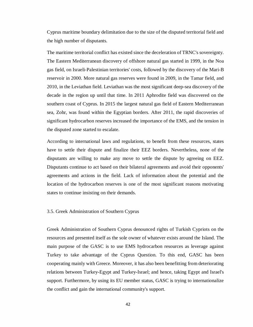
42
Cyprus maritime boundary delimitation due to the size of the disputed territorial field and
the high number of disputants.
The maritime territorial conflict has existed since the deceleration of TRNC's sovereignty.
The Eastern Mediterranean discovery of offshore natural gas started in 1999, in the Noa
gas field, on Israeli-Palestinian territories' costs, followed by the discovery of the Mari-B
reservoir in 2000. More natural gas reserves were found in 2009, in the Tamar field, and
2010, in the Leviathan field. Leviathan was the most significant deep-sea discovery of the
decade in the region up until that time. In 2011 Aphrodite field was discovered on the
southern coast of Cyprus. In 2015 the largest natural gas field of Eastern Mediterranean
sea, Zohr, was found within the Egyptian borders. After 2011, the rapid discoveries of
significant hydrocarbon reserves increased the importance of the EMS, and the tension in
the disputed zone started to escalate.
According to international laws and regulations, to benefit from these resources, states
have to settle their dispute and finalize their EEZ borders. Nevertheless, none of the
disputants are willing to make any move to settle the dispute by agreeing on EEZ.
Disputants continue to act based on their bilateral agreements and avoid their opponents'
agreements and actions in the field. Lack of information about the potential and the
location of the hydrocarbon reserves is one of the most significant reasons motivating
states to continue insisting on their demands.
3.5. Greek Administration of Southern Cyprus
Greek Administration of Southern Cyprus denounced rights of Turkish Cypriots on the
resources and presented itself as the sole owner of whatever exists around the Island. The
main purpose of the GASC is to use EMS hydrocarbon resources as leverage against
Turkey to take advantage of the Cyprus Question. To this end, GASC has been
cooperating mainly with Greece. Moreover, it has also been benefitting from deteriorating
relations between Turkey-Egypt and Turkey-Israel; and hence, taking Egypt and Israel's
support. Furthermore, by using its EU member status, GASC is trying to internationalize
the conflict and gain the international community's support.
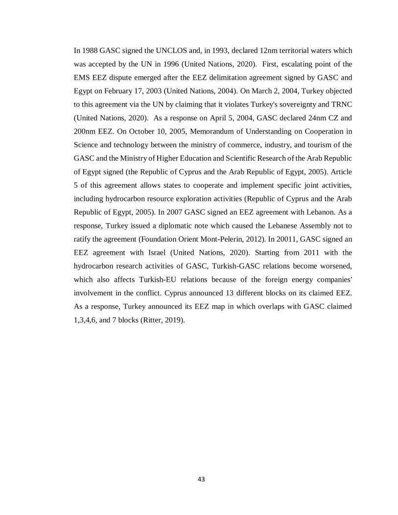
43
In 1988 GASC signed the UNCLOS and, in 1993, declared 12nm territorial waters which
was accepted by the UN in 1996 (United Nations, 2020). First, escalating point of the
EMS EEZ dispute emerged after the EEZ delimitation agreement signed by GASC and
Egypt on February 17, 2003 (United Nations, 2004). On March 2, 2004, Turkey objected
to this agreement via the UN by claiming that it violates Turkey's sovereignty and TRNC
(United Nations, 2020). As a response on April 5, 2004, GASC declared 24nm CZ and
200nm EEZ. On October 10, 2005, Memorandum of Understanding on Cooperation in
Science and technology between the ministry of commerce, industry, and tourism of the
GASC and the Ministry of Higher Education and Scientific Research of the Arab Republic
of Egypt signed (the Republic of Cyprus and the Arab Republic of Egypt, 2005). Article
5 of this agreement allows states to cooperate and implement specific joint activities,
including hydrocarbon resource exploration activities (Republic of Cyprus and the Arab
Republic of Egypt, 2005). In 2007 GASC signed an EEZ agreement with Lebanon. As a
response, Turkey issued a diplomatic note which caused the Lebanese Assembly not to
ratify the agreement (Foundation Orient Mont-Pelerin, 2012). In 20011, GASC signed an
EEZ agreement with Israel (United Nations, 2020). Starting from 2011 with the
hydrocarbon research activities of GASC, Turkish-GASC relations become worsened,
which also affects Turkish-EU relations because of the foreign energy companies'
involvement in the conflict. Cyprus announced 13 different blocks on its claimed EEZ.
As a response, Turkey announced its EEZ map in which overlaps with GASC claimed
1,3,4,6, and 7 blocks (Ritter, 2019).
44
Figure 1 Overlapping Territories
Source: Sigma Turkey, 2019
Figure 2 Overlapping Territories and Licensed Areas
Source: Pamir, 2019
In addition to bilateral maritime boundary delimitation agreements, GASC signed
different contracts with different energy companies. On January 26, 2007, GASC made
an agreement with Petroleum Geo-Services (PGS) for the exploration of underground
resources from south of Cyprus till the Egyptian border (PGS, 2020) and another
45
agreement conducted with French Petroleum Institute and Beicip-Franlap for the
analyzing the data found by PGS (Leblond, 2007). Hydrocarbon exploration and drilling
license of 2nd 3rd and 9th parcels were given to ENI, and Korea Gas Cooperation 10th and
11th were given to TOTAL and 12th were given to Noble Energy by GASC (Alhas, 2019).
In 2011 Noble Energy discovered Aphrodite Gas Field, which holds an estimated 198
billion cubic meters of natural gas (Gürel and Le Cornu 2013, p. 7). In 2017 GASC give
the 10th parcel’s license to Qatar Petroleum consortium and ExxonMobil (Alhas, 2019).
In the drilling of Glaucus-1 estimated 5-8 trillion cubic feet natural gas was discovered.
ExxonMobil's Exploration president Steve Greenle stated that after this discovery, the
likelihood of exploration of new fields evaluated; thus, they encourage further
explorations in the area (NS Energy, 2019).
Offshore hydrocarbon exploration and drilling activates are costlier than onshore resource
research and drilling activities. They require more sophisticated methods and technical
equipment (Jian, 1997). Due to its costliness, offshore hydrocarbon exploration and
drilling actives are riskier than the onshore operations. In general, coastal states sign a
contract with certain energy companies for offshore operations because only well-
equipped companies can conduct such costly operations. National energy companies may
not be able to handle such operations on their own. Multinational or energy giant
companies tend to avoid engaging any kind of operation in disputed regions if the coastal
state cannot promise their protection. Costly operations and insecure regions frighten
international energy companies and foreign direct investors (Jian, 1997, p. 601). GASC
agreements with various energy companies between 2007 and 2011 can be used as an
indicator to assess the level of tension in the EMS.
3.6. Greece
Although the Greek mainland is miles away from the EMS, Greece has been trying to take
part in EMS by its islands, such as; Meis, Crete, and Rhodes. According to Greece, islands
should be granted full maritime limitations, which would favor itself and limit Turkish
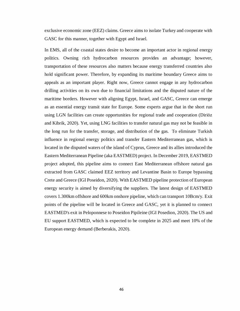
46
exclusive economic zone (EEZ) claims. Greece aims to isolate Turkey and cooperate with
GASC for this manner, together with Egypt and Israel.
In EMS, all of the coastal states desire to become an important actor in regional energy
politics. Owning rich hydrocarbon resources provides an advantage; however,
transportation of these resources also matters because energy transferred countries also
hold significant power. Therefore, by expanding its maritime boundary Greece aims to
appeals as an important player. Right now, Greece cannot engage in any hydrocarbon
drilling activities on its own due to financial limitations and the disputed nature of the
maritime borders. However with aligning Egypt, Israel, and GASC, Greece can emerge
as an essential energy transit state for Europe. Some experts argue that in the short run
using LGN facilities can create opportunities for regional trade and cooperation (Diriöz
and Kibrik, 2020). Yet, using LNG facilities to transfer natural gas may not be feasible in
the long run for the transfer, storage, and distribution of the gas. To eliminate Turkish
influence in regional energy politics and transfer Eastern Mediterranean gas, which is
located in the disputed waters of the island of Cyprus, Greece and its allies introduced the
Eastern Mediterranean Pipeline (aka EASTMED) project. In December 2019, EASTMED
project adopted, this pipeline aims to connect East Mediterranean offshore natural gas
extracted from GASC claimed EEZ territory and Levantine Basin to Europe bypassing
Crete and Greece (IGI Poseidon, 2020). With EASTMED pipeline protection of European
energy security is aimed by diversifying the suppliers. The latest design of EASTMED
covers 1.300km offshore and 600km onshore pipeline, which can transport 10Bcm/y. Exit
points of the pipeline will be located in Greece and GASC, yet it is planned to connect
EASTMED's exit in Peloponnese to Poseidon Pipileine (IGI Posedion, 2020). The US and
EU support EASTMED, which is expected to be complete in 2025 and meet 10% of the
European energy demand (Berberakis, 2020).
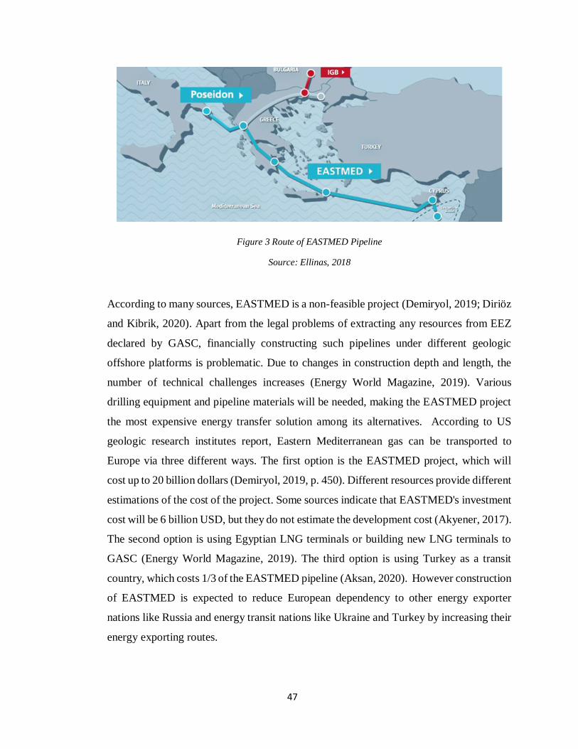
47
Figure 3 Route of EASTMED Pipeline
Source: Ellinas, 2018
According to many sources, EASTMED is a non-feasible project (Demiryol, 2019; Diriöz
and Kibrik, 2020). Apart from the legal problems of extracting any resources from EEZ
declared by GASC, financially constructing such pipelines under different geologic
offshore platforms is problematic. Due to changes in construction depth and length, the
number of technical challenges increases (Energy World Magazine, 2019). Various
drilling equipment and pipeline materials will be needed, making the EASTMED project
the most expensive energy transfer solution among its alternatives. According to US
geologic research institutes report, Eastern Mediterranean gas can be transported to
Europe via three different ways. The first option is the EASTMED project, which will
cost up to 20 billion dollars (Demiryol, 2019, p. 450). Different resources provide different
estimations of the cost of the project. Some sources indicate that EASTMED's investment
cost will be 6 billion USD, but they do not estimate the development cost (Akyener, 2017).
The second option is using Egyptian LNG terminals or building new LNG terminals to
GASC (Energy World Magazine, 2019). The third option is using Turkey as a transit
country, which costs 1/3 of the EASTMED pipeline (Aksan, 2020). However construction
of EASTMED is expected to reduce European dependency to other energy exporter
nations like Russia and energy transit nations like Ukraine and Turkey by increasing their
energy exporting routes.
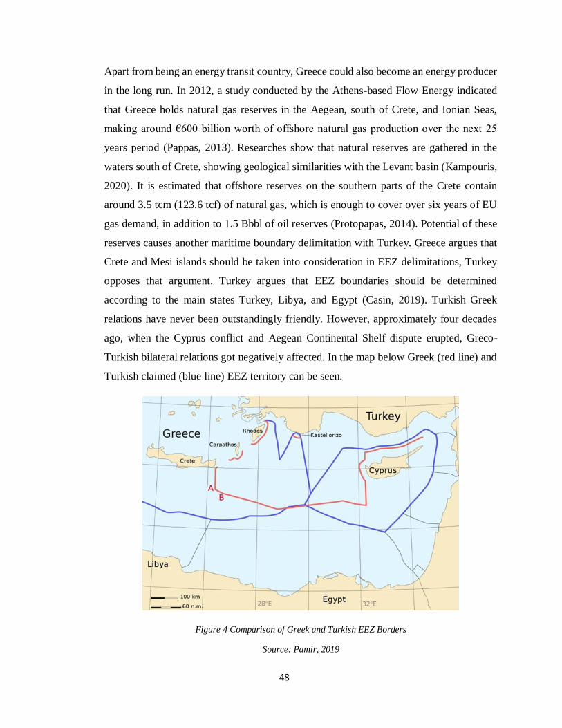
48
Apart from being an energy transit country, Greece could also become an energy producer
in the long run. In 2012, a study conducted by the Athens-based Flow Energy indicated
that Greece holds natural gas reserves in the Aegean, south of Crete, and Ionian Seas,
making around €600 billion worth of offshore natural gas production over the next 25
years period (Pappas, 2013). Researches show that natural reserves are gathered in the
waters south of Crete, showing geological similarities with the Levant basin (Kampouris,
2020). It is estimated that offshore reserves on the southern parts of the Crete contain
around 3.5 tcm (123.6 tcf) of natural gas, which is enough to cover over six years of EU
gas demand, in addition to 1.5 Bbbl of oil reserves (Protopapas, 2014). Potential of these
reserves causes another maritime boundary delimitation with Turkey. Greece argues that
Crete and Mesi islands should be taken into consideration in EEZ delimitations, Turkey
opposes that argument. Turkey argues that EEZ boundaries should be determined
according to the main states Turkey, Libya, and Egypt (Casin, 2019). Turkish Greek
relations have never been outstandingly friendly. However, approximately four decades
ago, when the Cyprus conflict and Aegean Continental Shelf dispute erupted, Greco-
Turkish bilateral relations got negatively affected. In the map below Greek (red line) and
Turkish claimed (blue line) EEZ territory can be seen.
Figure 4 Comparison of Greek and Turkish EEZ Borders
Source: Pamir, 2019
49
On May 4, 1997, Greece signed a maritime delimitation zone agreement with Italy; this
border is set by the connection of 16 points, determined by the midline (aka equidistance)
principle. UNCLOS Article 56 did not indicate any information regarding islands
allowance of EEZ declarations. However, ICJ's decision in the Tunisia-Libya case in 1997
indicates that "the continent dominates the sea" (Erciyes, 2012). Moreover, International
Court of Justice's (ICJ) British-French Continental Shelf Arbitration case in 1977 indicates
that states' claims should be in accordance with the principle of equitable or equidistance
(United Nations, 1978). ICJ, primarily, uses the equal distance principle in the EEZ
disputes between coastal states. According to this principle, coastlines' length and shape
affect the equidistance's outcome in which a median line drawn between the disputants'
shores determines their EEZ's (Maritime Boundary Office, 2018). In accordance with ICJ
preliminary cases and UNCLOS articles, as a signatory of UNCLOS, littoral states like
Greece should act based on the principle of equidistance to prevent the escalation of
existing tensions with other disputant states like the Turkish government. Greece's also
claims certain territory in the southern parts of the Crete can create further disputes with
the Tripoli government.
Due to EEZ declaration delimitations, legal, financial, and technical exiguousness, Greece
cannot conduct drilling operations under its claimed territory. In the case of the potential
discovery of a high-calorific valued natural gas in the disputed Eastern-Mediterranean
region, states have to find a way to specify their EEZ's. If Greece, Turkey, TRNC, and
GASC cannot find a way for reconciliation, legally, none of the states can extract than
natural gas. Even if international law allows states to extract that gas –which is not likely
under the existing regulations- none of the states have enough capacities to operate
offshore extraction. They need to agree with other energy firms: multinational energy
corporations or other states' national energy companies that were capable enough to
conduct the extraction on behalf of the coastal state.
The discovery of hydrocarbon resources increased cooperation among certain nations like
Egypt, Israel, Greece, and GASC in the region. However, one should not forget that these
nations were not engaged in maritime boundary delimitation disputes with each other.
50
Even though discoveries increased the regional cooperation among certain states, it also
intensified existing tension in the region by forming blocks. On November 8, 2014, the
first (Hellenic Republic Ministry of Foreign Affairs, 2014) and on April 29, 2015, the
second trilateral summit conducted between Greek Prime Minister Alexis Tsipras,
President of GASC Nikos Anastasiadis, and the President of Egypt Abdulfettah El Sisi to
strength and develop their cooperation in the EMS (Hellenic Republic Ministry of Foreign
Affairs, 2015). The final declaration of the trilateral summit conducted on October 11,
2016 (Hellenic Republic Ministry of Foreign Affairs, 2016). Security of EMS,
recognition, usage, and the cooperation of the maritime resources were the common issues
emphasized in all summits. In the first summit Turkish Republic was accused of violating
GASC EEZ and called the Ankara government to refrain any activities, like conducting
seismic reaches, which will violate the rights of GACS (Hellenic Republic Ministry of
Foreign Affairs, 2014). On January 8, 2020, Foreign Ministers of GASC, Egypt, France,
and Greece met in Cairo. It issued a joint declaration in which they accused Turkey and
the Presidency Council of Libya by violating international law by signing EEZ agreement
and infringing the sovereignty rights of coastal states in EMS (Hellenic Republic Ministry
of Foreign Affairs, 2020).
3.7. Egypt
With 552 miles, Egypt has the second largest coastal line in EMS (Central Intelligence
Agency, 2020). In 1958 Egypt declared the extension of its territorial waters from 6nm to
12nm (United Nations, 1958). Egypt started to produce natural gas in 1975 in the Abu
Madi field, which was discovered in 1967 (Egyptian Gas Association, 2020). Egyptian
production continued in the Nile Delta and different parts of the EMS. In 2003, 42 billion
m3 of natural gas reserves were found in the Nile Delta and 15 exploration licenses issued
in 2012 (İlgen, 2019). In addition to 15 exploration licenses issued in 2011 in the coasts
of Egypt (İlgen, 2019). In 2015 ENI got a license for conducting exploration activities in
Egyptian waters, and they discovered the Zohr field in the same year (Cozzi, 2020). ENI
51
officials indicated that the Zohr gas field is believed to be the most significant discovery
in the region, with 850 billion cubic meters potential (Cozzi, 2020).
Egypt was one of the first nations which supported Greek Cypriots against British colonial
rule and recognized them as an independent state, the Republic of Cyprus in 1960. It has
known that Egyptian leader Nasser established good relations with Greek Cypriot leader
Makarios and had close ties since then. In 2003 Egypt sign the EEZ delimitation
agreement with GASC; the EEZ border did not decide based on the principle of
equidistance, which caused Egypt to lose significant maritime territory. If Egypt signed a
maritime boundary agreement with Turkey, it would gain approximately 12.000km2
(İlgen, 2019). Moreover, if Egypt signs an EEZ agreement with Greece since Greece
accepts statues and the rights of islands equal to mainland Egypt will lose further territory,
7,400 km2 (İlgen, 2019). Considering the rich hydrocarbon reserves potential in the region,
exploring a rich hydrocarbon base in the region or an administrative change in one of the
nations can create tension among the nations.
Egypt was ruled under Hosni Mubarak from October 14, 1981, till February 11, 2011
(United States Institute of Peace, 2019). With emerge of the Arab Spring, he was forced
to resign, and Mohamad Morsi came into power (Kienle, 2012). Morsi government's
foreign policy perspective was different from the Morsi government. Cancellation of
Egypt-GASC EEZ agreement in March 2013 by the Morsi government can be given as an
example of administrative perception differences (Cankara, 2016). Because of their
ongoing offshore drilling activates, cancellation of the GASC-Egypt EEZ agreement made
the legality of Egyptian actives in the region questionable (Tarakçı, 2013). However, it
significantly improved Turkish-Egypt affairs (Ritter, 2019). Yet, when the Morsi
government toppled with a coup d'etat, the new government, Sisi administration, signed
another EEZ agreement with GASC on December 12, 2013 (Ritter, 2019).
In 2014, the Greek Prime Minister Antonis Samaras announced that both Greece and
GASC would use their membership in the EU to promote Egyptian-European relations
presented themselves as the ambassadors of Egypt in the EU. In the following period,
Egypt, Greece, and GASC periodically conducted trilateral summits, which were held in
Cairo (2014), Nicosia (2015), Athens (2015), Cairo (2016), Nicosia (2017), Crete (2018)
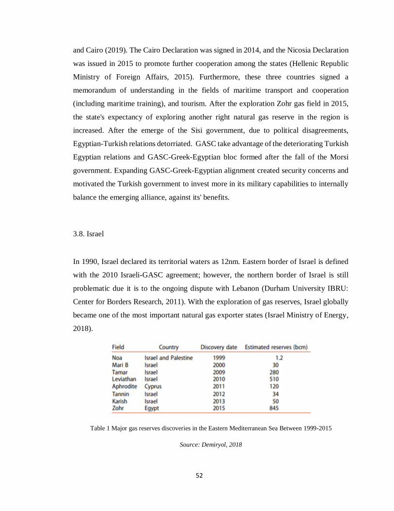
52
and Cairo (2019). The Cairo Declaration was signed in 2014, and the Nicosia Declaration
was issued in 2015 to promote further cooperation among the states (Hellenic Republic
Ministry of Foreign Affairs, 2015). Furthermore, these three countries signed a
memorandum of understanding in the fields of maritime transport and cooperation
(including maritime training), and tourism. After the exploration Zohr gas field in 2015,
the state's expectancy of exploring another right natural gas reserve in the region is
increased. After the emerge of the Sisi government, due to political disagreements,
Egyptian-Turkish relations detorriated. GASC take advantage of the deteriorating Turkish
Egyptian relations and GASC-Greek-Egyptian bloc formed after the fall of the Morsi
government. Expanding GASC-Greek-Egyptian alignment created security concerns and
motivated the Turkish government to invest more in its military capabilities to internally
balance the emerging alliance, against its' benefits.
3.8. Israel
In 1990, Israel declared its territorial waters as 12nm. Eastern border of Israel is defined
with the 2010 Israeli-GASC agreement; however, the northern border of Israel is still
problematic due it is to the ongoing dispute with Lebanon (Durham University IBRU:
Center for Borders Research, 2011). With the exploration of gas reserves, Israel globally
became one of the most important natural gas exporter states (Israel Ministry of Energy,
2018).
Table 1 Major gas reserves discoveries in the Eastern Mediterranean Sea Between 1999-2015
Source: Demiryol, 2018
53
Lebanon claims that Leviathan and the Tamar fields are located in the border between
Lebanon and Israel; thus, states need to share these resources (Kamel, 2016). UNCLOS
1982 aims to solve disputes by allowing states to carry their conflict to international
arbitration mechanisms like ICJ. If a state does not ratify UNCLOS 1982 and allows it to
be solved by arbitration, then other disputant states cannot bring their case to international
arbitration. Some experts argue that the reason for Israel's not signing UNCLOS 1982 is
its' fear of being faced with biased arbitrators in a case of dispute (Kamel, 2016). Israeli-
Lebanese tension can be given as another example to tension creator or escalator factor of
the hydrocarbon resources.
Turkey recognized Israel as a sovereign nation on March 28, 1949 (Jewish Virtual Library,
n.d.). In 1990s, various military and economic cooperation agreements signed between
Turkey and Israel. However, in the mid-2000s, after the Israeli Operation Cast Lead
Turkish Israeli relations started to deteriorate.
In 2010 Greek Prime Minister George Papandreou and Israeli Prime Minister Benjamin
Netanyahu signed a multi-dimensional cooperation agreement in Moscow. A year later, a
defense agreement was signed between Israel and Greece, which allowed Israeli air forces
and navy to be hosted on Greek bases and conduct training in their airspace. In January
2012, the GASC minister of defense, Elides, went to Israel and signed a defense agreement
with the Tel Aviv government. A month later, GASC permitted Israeli forces to use their
airspace and territories waters. As a countermove, in April 2012, Turkey started drilling
a 3000-meter-deep well near the town of Trikomo in Northern Cyprus, which is protested
by GASC and GASC authorities declared that Turkey and the TRNC are violating the law
by conducting drilling operations within their borders. Protesting declarations and
research, drilling actions, and accusing authorities by violating international law become
an expected move among the Turkish Republic, Greece, GASC, and TRNC authorities.
Whenever one side signs a bilateral agreement or conduct a drilling operation, other
parties condemn, oppose the action, and accuse each other since the 2010s; this pattern of
action became a continuity in the regional interactions.
Energy cooperation can improve states' bilateral relations; however, it can also
inadvertently harm them. GASC, Greek, Egypt, and Israeli political convergence can be
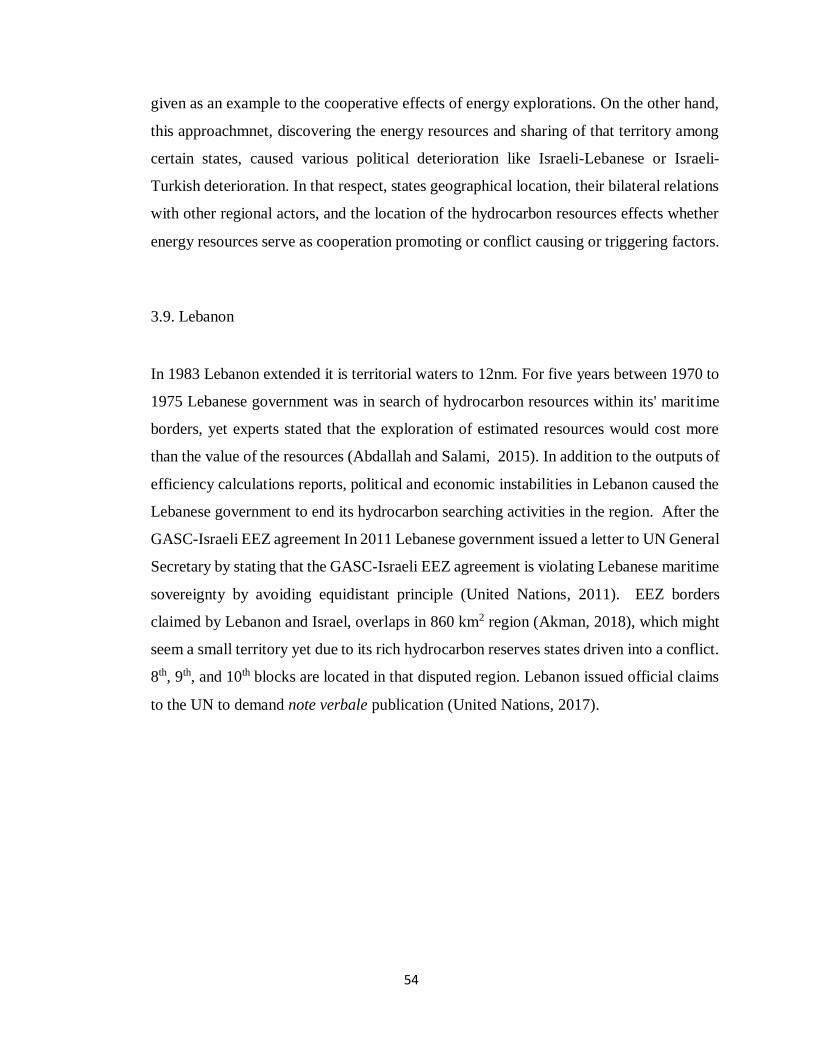
54
given as an example to the cooperative effects of energy explorations. On the other hand,
this approachmnet, discovering the energy resources and sharing of that territory among
certain states, caused various political deterioration like Israeli-Lebanese or Israeli-
Turkish deterioration. In that respect, states geographical location, their bilateral relations
with other regional actors, and the location of the hydrocarbon resources effects whether
energy resources serve as cooperation promoting or conflict causing or triggering factors.
3.9. Lebanon
In 1983 Lebanon extended it is territorial waters to 12nm. For five years between 1970 to
1975 Lebanese government was in search of hydrocarbon resources within its' maritime
borders, yet experts stated that the exploration of estimated resources would cost more
than the value of the resources (Abdallah and Salami, 2015). In addition to the outputs of
efficiency calculations reports, political and economic instabilities in Lebanon caused the
Lebanese government to end its hydrocarbon searching activities in the region. After the
GASC-Israeli EEZ agreement In 2011 Lebanese government issued a letter to UN General
Secretary by stating that the GASC-Israeli EEZ agreement is violating Lebanese maritime
sovereignty by avoiding equidistant principle (United Nations, 2011). EEZ borders
claimed by Lebanon and Israel, overlaps in 860 km2 region (Akman, 2018), which might
seem a small territory yet due to its rich hydrocarbon reserves states driven into a conflict.
8th, 9th, and 10th blocks are located in that disputed region. Lebanon issued official claims
to the UN to demand note verbale publication (United Nations, 2017).
55
Figure 5 Map of Israel-Lebanon Maritime Dispute
Source: Pileggi, 2019
3.10. Syria
As a crude oil producer, Syria owns large onshore hydrocarbon reserves. Energy
Information Administration's report Syrian proved offshore natural gas reserves estimated
potential was 8.5 trillion cubic feet (Energy Information Administration, 2011). Due to
the location of these reserves in the region and country's hydrocarbon potential, it is
forecast that there is a chance of finding valuable offshore hydrocarbon resources in the
Syrian waters. In 2003, Syria announced its territorial waters as 12nm and EEZ as 200nm.
Four years later, in 2007, official talks were conducted by Syria and GASC regarding
maritime boundary determinations, yet no agreements were signed. In 2004 Inseis Terra
and Norwegian Global Geo Services made a contract with the Syrian government for
hydrocarbon exploration activities. From 2007 to 2010, Syria issued further hydrocarbon
exploration licenses. However, neither of the companies conducted any exploration
activities in their licensed regions (İlgen, 2019, p. 60). Because of the domestic
instabilities in the country, the Syrian government was not perceived as a reliable authority
that can protect energy companies’ interests and operations in the field by the energy
companies. After the Syrian Civil War started on March 15, 2011, energy companies
willing to conduct any exploration or drilling activities in Syrian waters were significantly
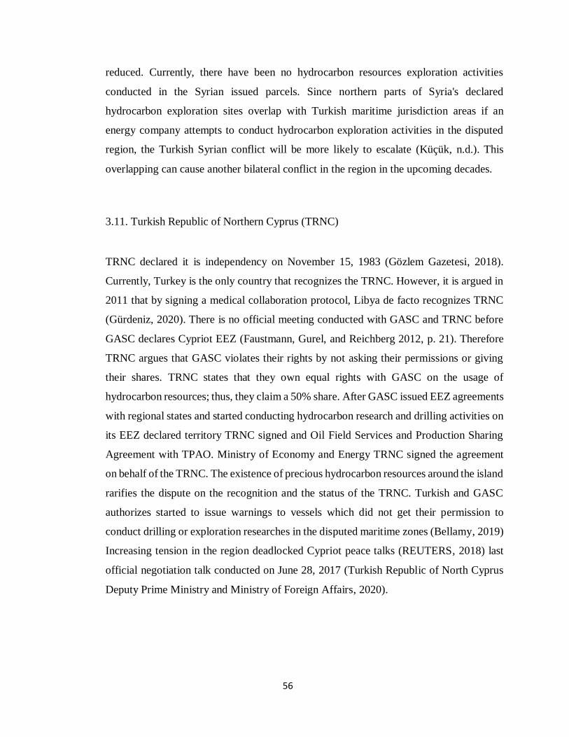
56
reduced. Currently, there have been no hydrocarbon resources exploration activities
conducted in the Syrian issued parcels. Since northern parts of Syria's declared
hydrocarbon exploration sites overlap with Turkish maritime jurisdiction areas if an
energy company attempts to conduct hydrocarbon exploration activities in the disputed
region, the Turkish Syrian conflict will be more likely to escalate (Küçük, n.d.). This
overlapping can cause another bilateral conflict in the region in the upcoming decades.
3.11. Turkish Republic of Northern Cyprus (TRNC)
TRNC declared it is independency on November 15, 1983 (Gözlem Gazetesi, 2018).
Currently, Turkey is the only country that recognizes the TRNC. However, it is argued in
2011 that by signing a medical collaboration protocol, Libya de facto recognizes TRNC
(Gürdeniz, 2020). There is no official meeting conducted with GASC and TRNC before
GASC declares Cypriot EEZ (Faustmann, Gurel, and Reichberg 2012, p. 21). Therefore
TRNC argues that GASC violates their rights by not asking their permissions or giving
their shares. TRNC states that they own equal rights with GASC on the usage of
hydrocarbon resources; thus, they claim a 50% share. After GASC issued EEZ agreements
with regional states and started conducting hydrocarbon research and drilling activities on
its EEZ declared territory TRNC signed and Oil Field Services and Production Sharing
Agreement with TPAO. Ministry of Economy and Energy TRNC signed the agreement
on behalf of the TRNC. The existence of precious hydrocarbon resources around the island
rarifies the dispute on the recognition and the status of the TRNC. Turkish and GASC
authorizes started to issue warnings to vessels which did not get their permission to
conduct drilling or exploration researches in the disputed maritime zones (Bellamy, 2019)
Increasing tension in the region deadlocked Cypriot peace talks (REUTERS, 2018) last
official negotiation talk conducted on June 28, 2017 (Turkish Republic of North Cyprus
Deputy Prime Ministry and Ministry of Foreign Affairs, 2020).
57
Figure 6 TRNC Claimed Disputed Territory
Source: South Front, 2019
3.12. Turkey
On May 15, 1964, the Ankara government set its territorial waters as 12nm in the
Mediterranean Sea (US Department of State and Bureau of Intelligence and Research,
1971). Unlike other regional coastal states, the Ankara government did not declare and
submit it as EEZ in the EMS boundaries to the UN (United Nations, 2020). On December
5, 1986, Turkey declared it is first and only EEZ in the Black Sea (Marineregions, n.d.).
Turkey shows its political, military, and legal existence in the EMS by sending Turkish
military vessels in the region, conducting national and joint military exercises in the
region, and issuing objection and information notes to UNSG.
GASC claimed EEZ boundary contradicts with Turkish and TRNC claimed maritime
territory. According to UN documents, Turkey issued various objection notes’ against
GASC’s bilateral EEZ agreements. The first Turkish agreement objection note for state
interactions in the EMS was written on March 2, 2004, and on October 2, 2005, for the
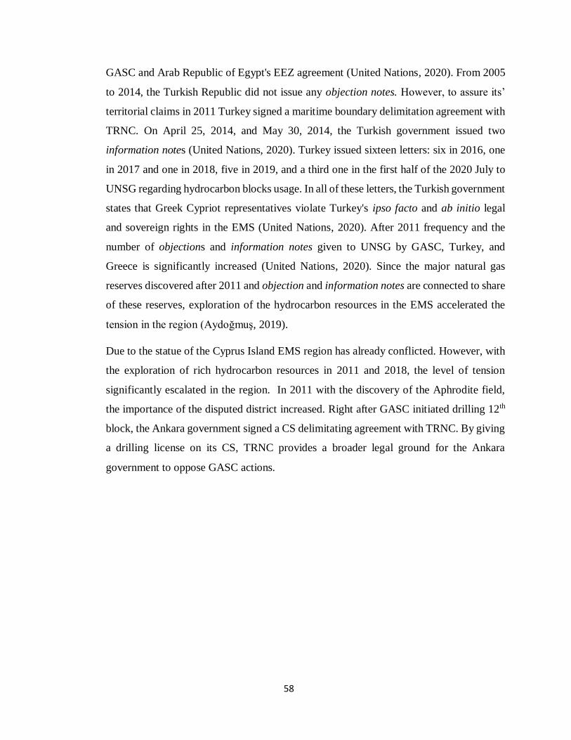
58
GASC and Arab Republic of Egypt's EEZ agreement (United Nations, 2020). From 2005
to 2014, the Turkish Republic did not issue any objection notes. However, to assure its’
territorial claims in 2011 Turkey signed a maritime boundary delimitation agreement with
TRNC. On April 25, 2014, and May 30, 2014, the Turkish government issued two
information notes (United Nations, 2020). Turkey issued sixteen letters: six in 2016, one
in 2017 and one in 2018, five in 2019, and a third one in the first half of the 2020 July to
UNSG regarding hydrocarbon blocks usage. In all of these letters, the Turkish government
states that Greek Cypriot representatives violate Turkey's ipso facto and ab initio legal
and sovereign rights in the EMS (United Nations, 2020). After 2011 frequency and the
number of objections and information notes given to UNSG by GASC, Turkey, and
Greece is significantly increased (United Nations, 2020). Since the major natural gas
reserves discovered after 2011 and objection and information notes are connected to share
of these reserves, exploration of the hydrocarbon resources in the EMS accelerated the
tension in the region (Aydoğmuş, 2019).
Due to the statue of the Cyprus Island EMS region has already conflicted. However, with
the exploration of rich hydrocarbon resources in 2011 and 2018, the level of tension
significantly escalated in the region. In 2011 with the discovery of the Aphrodite field,
the importance of the disputed district increased. Right after GASC initiated drilling 12th
block, the Ankara government signed a CS delimitating agreement with TRNC. By giving
a drilling license on its CS, TRNC provides a broader legal ground for the Ankara
government to oppose GASC actions.
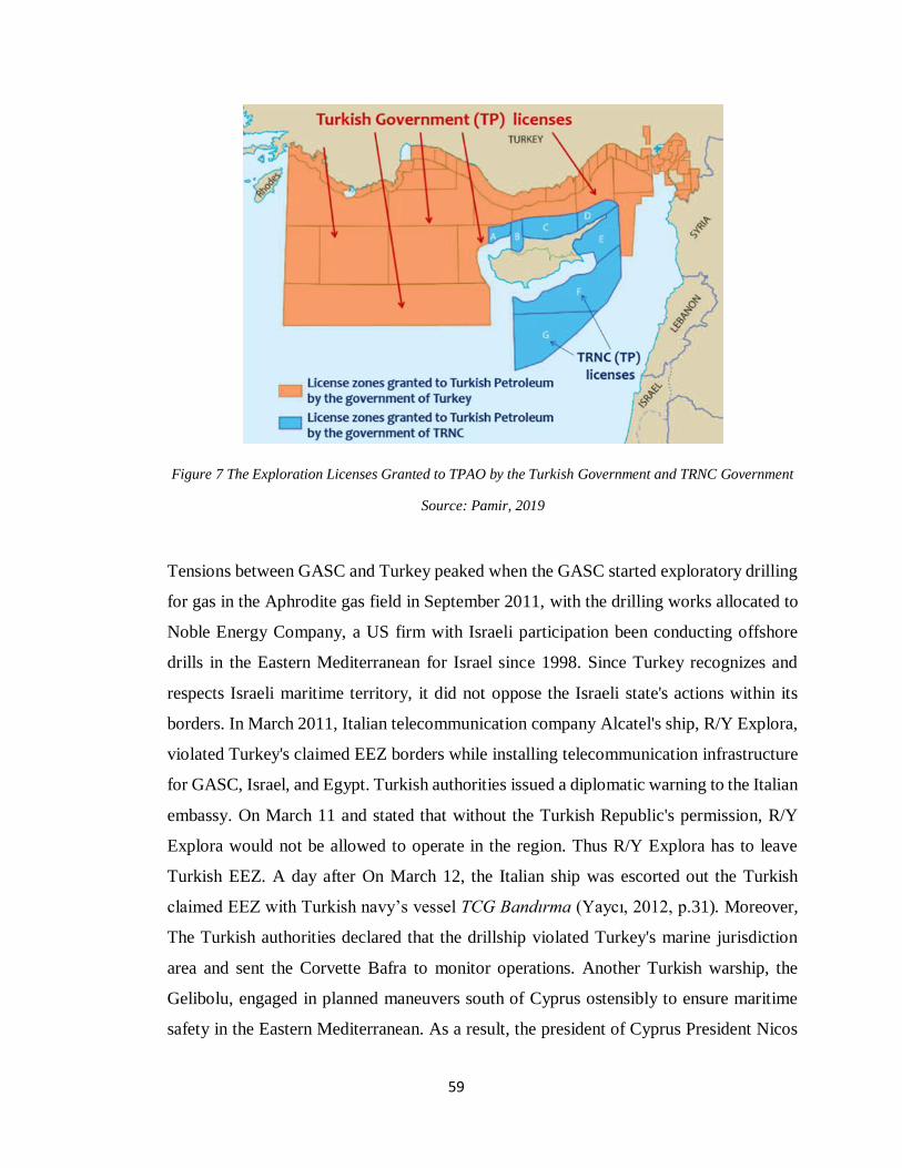
59
Figure 7 The Exploration Licenses Granted to TPAO by the Turkish Government and TRNC Government
Source: Pamir, 2019
Tensions between GASC and Turkey peaked when the GASC started exploratory drilling
for gas in the Aphrodite gas field in September 2011, with the drilling works allocated to
Noble Energy Company, a US firm with Israeli participation been conducting offshore
drills in the Eastern Mediterranean for Israel since 1998. Since Turkey recognizes and
respects Israeli maritime territory, it did not oppose the Israeli state's actions within its
borders. In March 2011, Italian telecommunication company Alcatel's ship, R/Y Explora,
violated Turkey's claimed EEZ borders while installing telecommunication infrastructure
for GASC, Israel, and Egypt. Turkish authorities issued a diplomatic warning to the Italian
embassy. On March 11 and stated that without the Turkish Republic's permission, R/Y
Explora would not be allowed to operate in the region. Thus R/Y Explora has to leave
Turkish EEZ. A day after On March 12, the Italian ship was escorted out the Turkish
claimed EEZ with Turkish navy’s vessel TCG Bandırma (Yaycı, 2012, p.31). Moreover,
The Turkish authorities declared that the drillship violated Turkey's marine jurisdiction
area and sent the Corvette Bafra to monitor operations. Another Turkish warship, the
Gelibolu, engaged in planned maneuvers south of Cyprus ostensibly to ensure maritime
safety in the Eastern Mediterranean. As a result, the president of Cyprus President Nicos
60
Anastasiades froze the latest attempt to negotiate with Turkish Cypriot leader Derviş
Eroğlu a settlement to end the island's forty-year division.
In 2005, Turkey started conducting offshore hydrocarbon exploration researches in the
EMS via TPAO. Exploration activities were mainly conducted on the coasts of Antalya,
Mersin, and İskenderun (Erciyes, 2012) and in November 2011 a joint operation
agreement signed between TPAO and Shell (T.C. Cumhurbaşkanlığı Yatırım Ofisi, 2011).
Solely when GASC started conducting hydrocarbon exploration researches on the
disputed region (on the 2nd, 3rd, 9th, and 12th parcels) (Erciyes, 2012), Turkish exploration
activities location widened. After GASC started to conduct drilling activities in the
disputed region, Turkey significantly invested in its' offshore exploration capacity. Due
to the equipment limitations, TPAO could not conduct exploration activities with its
vessels before the arrival of Barbaros Hayrettin Pasha (Anadolu Agency, 2013) and MTA
Oruç Reis seismic research ships (Kenarlı, et. al., 2019). In 2014 TPAO started to conduct
hydrocarbon exploration activities in it is licensed parcels around Cyprus Island. In
addition to Fatih (2017), Yavuz (2018) drilling vessels in 2020, Turkey gets its third
drilling vessel Sertao (Hürriyet, 2020). By using its license, the Turkish government sent
seismic research vessels to the region, which intensified the region's tension. Due to the
hostile environment, Turkish seismic, later on drilling ships were protected by the Turkish
navy. Increasing Turkish military existence around the island boosts GASC and Greece's
insecurities.
Tension in the EMS rapidly escalated, for the second time, on February 8, 2018, when
ENI and Total discovered, a giant natural gas field which is estimated nearly as big as
Zohr field, at the Calypso block off the Cypriot coast (Andrei, 2019). Three days later,
Turkish military vessels stopped ENI's drillship, Saipem 12000, before it started drilling
the 3rd block declared by GASC (Andrei, 2019). Based on UNCLOS, Part V states cannot
engage in maritime resources extraction activities if they did not declare EEZ and their
boarders are approved by the other coastal states (United Nations 1982, p. 43-53). In the
context of Turkey, GASC and TRNC because of the recognition problem, EEZ borders'
settlements cannot be expected, which means legally neither of the states can engage in
any drilling or hydrocarbon research activities. However, as if GASC claimed EEZ
61
borders were ratified by all regional coastal states Turkish navy's hamper of ENI's drilling
activities in the disputed territory created a short scale diplomatic crisis among the
participant states, including Italy (because of ENI) and France (because of Total).
In general, the Turkish government's actions were all done as retaliation responses to
GASC moves. On November 27, 2019, an EEZ agreement was signed with National
Accord Government. The agreement was ratified by the Ankara government
(Avundukluoglu, 2019) and the Tripoli administration as an UN-recognized government.
The gun boAnkara government established close relations with the Gaddafi government
up until he lost his popular support. When the regime changed in Libya, the Ankara
government sided with the new regime. After the 2011 revolution, Turkey recognized the
National Transitional Council as the "sole representative of Libyan people" (Henri J.
Barkey, 2012). Turkey was among the first nations to appoint an Ambassador to Tripoli,
on September 2, 2011, after the full control of Tripoli by the National Transitional
Council. Due to the deterioration of security, the Turkish Consulate General in Benghazi
and the Turkish Embassy in Tripoli had temporarily closed in 2014. Turkey has welcomed
the signing of the Libyan Political Agreement (Government of National Accord (GNA)).
GNA is an interim government for Libya that was formed under the terms of the Libyan
Political Agreement, a United Nations-led initiative, signed on December 17, 2015. The
agreement recognized the Government of National Accord as the sole legitimate executive
authority in Libya. Turkish Consulate in Misrata has continued its operations without
interruption; in 2017 Turkish Embassy in Tripoli resumed. Bilateral agreements signed by
GASC and its EEZ declaration motivated the Turkish government to take actions to secure
it has claimed EEZ by forming bilateral treaties. This can be seen as retaliation towards
GASC and its EEZ agreements.
Even though Ankara government usually fallows an eye to eye tooth for a tooth strategy
in the Eastern Mediterranean maritime boundary delimitation, it also tries to find common
ground. For instance before the discovery of the Aphrodite field, Turkey submitted a
proposal to the UN Secretary-General. In that proposal, Turkey recommended stopping
unilateral exploration activities and a unified committee from controlling and coordinating
exploration efforts. However, with the announcement of GASC's discovery of the
62
Aphrodite field, Turkish diplomatic attempts failed. Due to timing failure, the Turkish
proposal could not be performed; if it could have been accomplished, then the course of
events would be significantly different from today's dynamics.
A response to illegal drilling activities in the disputed Cypriot territory, Turkey adopted
gunboat diplomacy. By sending its exploration vessel to the disputed zone which was
escorted by Turkish navy and air force, the Ankara government not only started drilling
activities in the disputed region but also increased its military presence in the region.
Towards the end of 2011, Noble Energy announced the discovery of gas estimated
between 140 billion and 226 billion cubic meters in Aphrodite, after drilling procedures
began, Turkey's Minister for EU Affairs Egemen Bağış issued a veiled threat to Cyprus,
stating that for such reasons countries invests on warships, military equipment and train
their navies (Burch, 2011). Similarly, Prime Minister Erdoğan referred to the joint Israel-
Cyprus agreement and drilling as madness (REUTERS, 2011). These events served as a
push factor between Israel and Turkey, lead a stalemate between Turkish-GASC relations
while serving as a pull factor for Israel and GASC to deepened and extend their bilateral
ties. In a way, we can say that the Turkish reaction caused Israel to ally with GASC.
To maintain the maritime security littoral states conduct joint military exercises in the
region. For instance in 1998, the first Reliant Mermaid, military exercise occurred with
the participation of the US, Israeli and Turkish navies. Since 1998 states met twice a year
for Reliant Mermaid exercise, which lasts four to fourteen days. Throughout time, other
European and Arab nations also invited to the exercise. In 2010 Turkey withdrew itself
from Reliant Mermaid (Katz, 2010). With the withdrawal of Turkey, Greece fulfilled
Turkey's spot, and the joint exercise practice Noble Dina emerged. In order to protect
regional energy security since 2005 Turkish Navy conduct Mediterranean Shield sham
battles (Yaycı, 2012, p. 10). The main motivation of this sham battle was GASC’s
violation of Turkish CS by its EEZ declaration (Gürdeniz, 2020).
After the emerge of Noble Dina and bilateral military accords among Greece and Israel,
and GASC, Turkey, started to invest more in its military capabilities to build a stronger
navy and air force. 2015 Noble Dina training was the most massive exercise conducted so
far, focusing on the protection of offshore energy infrastructures from a hostile force.
63
Also, in that year, Greece and Israel signed a Status of Forces Agreement. Moreover, three
years later, in 2017, the GASC navy participated Noble Dina as an observer state. The
Israeli navy has started a program to improve its sea-to-surface missile capabilities, the
Ministry of Defense wants to procure four advance patrol vessels for the navy that will
ensure the protection of the natural gas infrastructure in the Mediterranean Sea against a
broad range of threats (Lappin and JNS, 2020).
As a response to increasing military joint operations and investments, the Ankara
government increased the frequency of simulated military operation in EMS. Turkish
Armed forces conducted operational readiness training in the EMS with special force,
navy, and air forces between 15 and 17 April 2020 (Sabah Gazetesi, 2020). On June 13,
2020, Turkish air forces conducted another military exercise in the EMS. Turkish combat
crafts fly 8 hours over 2000 km2 until the Libyan Territory (Sezer, 2020). States' increased
number of military training and existence in the region to protect their claimed EEZ and
hydrocarbon resources shows that in the EMS, hydrocarbon resources contribute to the
intensification of the existing conflict. For Ankara, government hydrocarbon resources
related developments in the region directly affected their regional power and energy hub-
energy transit state positions. To not be left out in the allocation of resources, Turkey tried
to form its block against GASC-Israel-Greece-Egypt alliances. Due to its strategic
importance and resources controlling maritime territory in EMS significantly contributes
state’s power.
3.13. Chapter Summary
The discovery of massive hydrocarbon resources in the East Mediterranean intensified the
current political tumult and security fears. The Eastern Mediterranean region in many of
the countries is at loggerheads militarily or politically. The region holds deep-rooted
conflict and competition. Depending on their political positions, states formed blocks in
the region. Energy or any natural resource cannot be taken as the only conflict generator
factor. State political standings, their perceptions about each other, and historical
interactions also play significant importance in this process. However, in a conflict
64
existing region discovery of hydrocarbon resources in disputed waters intensifies the
conflict among the contested states. If there are more than two states involved in such
disputes, which is the case in Eastern Mediterranean, hydrocarbon resources strengthen
the existing alliances in the region; by doing so, it creates sharp political dissidence among
the states. Political dissonance creates blocks by effecting states the perception of threat.
If a state thinks that other states are unifying against him or towards the ideas he supports,
he feels insecure. To balance the threats and secure itself, states try to form new alliances
and strengthen its existing alliances. By doing so, states strive to minimize the degree of
danger.
Israel's hydrocarbon research and drilling activate started in the late 1960s; however,
significant gas fields like Noa and Mari B found in 1999, more productive fields like
Tamar (discovered in January 2009) and Leviathan (discovered on October 2010)
discovered approximately a decade later. Also, since 2009 smaller fields like Dalit, Tanin,
Dolphin, and Shimson were discovered by Israel. Currently, different researches indicate
different hydrocarbon potentials in the EMS (Gürel and Le Cornu 2013, p. 5). Considering
the Israeli explorations timeline and coastal state equipment limitations disputants'
preference of delaying their dispute instead of aiming to settle, it is understandable. States
like Turkey recently started to improve its offshore research and drilling capabilities.
Also, in 2010 US Geological Research Center's report indicated that the total reserve in
EMS is equivalent to 30 billion barrels of oil, which was calculated as 1.5 trillion USD at
that time (Bilge Adamlar Stratejik Araştırmalar Merkezi, 2013). This calculation is made
by considering the Leviathan, Nil, and Heredot hydrocarbon bases potentials. However,
further reserves explored after 2010, the discovery of Aphrodite in 2011, Zohr in 2015,
and Glaucus-1 in 2019 is a sign for the region's potential. Thus states preference of not
settling their border disputes can be understandable. Since no one knows or can guarantee
the potential reserves in EMS, in order not to lose any reserves, states continue to insist
on their claimed territories. Exploring the natural gas resources or the potential of
hydrocarbon resources can increase regional cooperation and improve coastal states'
economies in the long run by creating energy producer nations. However, currently, it
65
increased the tension of the existing problems. Existing dynamics indicate that the
establishment of regional cooperation is unlikely unless the Cyprus conflict is solved.
According to UNCLOS, Article 22 and 23 states in semi-closed or enclosed seas should
cooperate and solve their disagreements by fallowing relevant UNCLOS articles (United
Nations, 1982, p. 32). Article 74 and 83 states that in the CS disputes principle of
equitability should be applied. The principle of the superiority of geography should also
take into consideration (İlgen, 2019, p. 88). This principle divides the claimed region
among the claimer states based on the length of their coastal lines proportion as a result
states with longer coastal length gets wider CS or EEZ, territory (İlgen, 2019, p.89).
Articles 246 and 300 indicates that even if states do not have any diplomatic interaction
with each other, UNCLOS obliges them to solve their disagreements by showing good
faith and not abusing their rights (United Nations, 1982, p. 119-137).
Based on the principle of proportional delamination EEZ boundaries of the coastal states
should be calculated based on their coastal lengths. GASC territory violates Syria's,
Israel's and Lebanon's territory. To begin with, UNCLOS lacks necessary guidance in the
EEZ declarations of island states. Even if UNCLOS comes up with a clarification of this
unclarified issue disputed structure of Cyprus has to be settled first. Cyprus has 1.8 times
less coastal length than Lebanon. GASC's claimed EEZ borders violated Lebanon, and
Israel's territory puts GASC in a position of illegally occupying 4600 square kilometers
of an area that should fall under Israel's and 3657 square kilometers of an area which
should fall under Lebanon's jurisdiction (Kaya, 2019). Based principle of proportional
delamination, if Zafer, Baf, and Arnauti are taken as coastal lines of the island, GASC
should get 21 thousand 500 square kilometers less of territory (Kaya, 2019). States do not
have to base their bilateral maritime boundary determination agreements on UNCLOS
principles. Yet they can use UNCLOS regulations as a guideline to avoid emerge of
potential conflicts in the future. Apart from avoiding third parties, regional coastal states'
oppositions, which is a direct cause of the treaties deemed invalid, states can renounce
their agreements if a state believes that the agreement that they signed harms their benefits
by losing territory with rich natural resources. If they can claim rights over that territory
based on UNCLOS regulations, then a conflict can occur among these nations. In the area
66
mentioned earlier Turkish coastal line is 656 miles, whereas GASC's coastal line is 32
miles long (İlgen, 2019, p. 89). Similar disputes happened and settled by ICJ before such
as Malta-Libya Continental Coast Dispute and France and Canada's dispute over Pierre
and Miquelon Islands (Erciyes, 2012). Such cases can be used as exemplary cases for
GASC-Turkey maritime boundary delimitation dispute. However, in the existence of the
TRNC-GASC dispute, GASC's recognition as a legal, sovereign state, and potential of
hydrocarbon resources in the EMS, it is not likely to achieve such settlement in the near
future.
Exploration of abundant hydrocarbon reserves in the disputed EMS motivated coastal
states to be more persistent on their regional claims by increasing their expected gains.
Until 2019, Turkey was isolated in EMS regional schemes by GASC, Greece, Egypt, and
Israel. To be able to compete with other nations, the Ankara government resorted to its
naval power to continue its drilling activities and prevent other nations from expanding
power in the region. The increasing presence of Turkish military in the EMS and
increasing Turkish military drills, like Blue Homeland (one of the biggest military
exercises conducted with 103 vessels) (Genc, 2019) motivated other littoral states like
Egypt to invest more on their military capabilities by creating insecurities (DW, 2020).
By delimiting its’ maritime zones with Libya GNA, the Ankara government tried to
strengthening its alliances. The idea of this agreement was to prevent growing Greek
influence in the EMS; by limiting Greece’s maritime territory, the Ankara government
aims to weaken GASC. After this agreement, Turkey started military support to the UN-
recognized GNA, which drastically changed the balance of power in the civil war. As a
counter move, Egypt and Greece started supporting the Hafter administration. Blocks in
the EMS and the parties of the Libyan Civil War started to become more dependent on
each other. In the existence of GASC, Greek, Egyptian, Israeli alignment Turkish
government could not find a coastal state to create its own block in the region, therefore
as a first move, Ankara government adopted gunboat diplomacy to secure its’ regional
claims. Due to the status of TRNC and uncertainties in Libya, the Turkish government
will continue to rely on its military capabilities to protect its’ regional benefits.

67
Another factor that affects tension in the region is the involvement of international oil
companies. GASC has been authorized various international oil companies to conduct
drilling in its’ claimed yet disputed territories such as Italian ENI, US Noble and Exxon
Mobil, Qatar Petroleum, Israeli Delek, and French Total (Gökçe, 2018). Turkish
opposition to these drillings and using its navy to prevent any drilling activities in the
disputed territory increasing and expands the regional tensions allowing non-regional
states to involve in the dispute. France’s sending its warships to EMS to deter the Ankara
government can be given as an example (Middle East Monitor, 2020) to increasing tension
in the region.
In sum, this chapter argues that the hydrocarbon discoveries in the EMS has not settled
the ongoing dispute, but intensified the existing conflict by added new dimensions. There
has been an unsettled conflict between Greece-GASC and Turkey, and hydrocarbon
reserves attracted new regional players. Greece-GASC has tried to isolate Turkey
regionally. The bloc is composed of GASC-Greece-Egypt-Israel, supported by the US and
the EU. Turkey's deteriorating relations with Israel and Egypt in the 2010s, after the Mavi
Marmara incident in 2010 and coup d'etat in Egypt in 2013, contributed to the foundation
of such approachmnet. It can be argued that what motivates these states to come together
is the desire to isolate regionally and by-pass Turkey in energy transfer and balance its
regional influence. Moreover, by issuing licenses to drilling blocks within the disputed
territory, GASC increased the number of disputants.
68
CHAPTER 4
MARITIME BOUNDARY DELIMITATIONS IN THE SOUTH CHINA
SEA
In this chapter, the conflict triggering effect of hydrocarbon resources will be analyzed
under the South China Sea (SCS) dispute. Due to its strategic importance SCS, various
conflicts exist in the region among the littoral states. After examining the importance of
SCS for the regional states, the importance of hydrocarbon resources for states'
development is analyzed. The definition of energy security provided before the
explanation of the history of complex interstate maritime disputes in the SCS. Among the
various territorial disputes, Spratly and Paracel Island have been selected as case studies.
Before the examination of disputant littoral states (PRC, Taiwan, The Philippines,
Vietnam, Malaysia, and Brunei Darussalam) positions, the importance of Spratly and
Paracel Island explained. The chapter ends with a theoretical analysis of states’ actions in
the South China Sea.
4.1. Importance of the South China Sea
The South China Sea is approximately 3.5 million square kilometers semi-enclosed sea
surrounded by the People’s Republic of China (PRC), Vietnam, Malaysia, the Philippines,
Brunei Darussalam, and Indonesia (Qi-zhou, Wen-zhi, Li, and Li, 1994). Due to it is a
connection to Malacca and Hormuz strait SCS plays a crucial role in energy transportation.
SCS is one of the world's busiest international seal lines, annually, 50% of the global
merchant fleet sails in SCS (Rosenberg, 2010). Approximately 60% of maritime trade
passes through Asia, and one-third of global shipping occurs in the South China Sea
(Center for Strategic and International Studies, 2020). The amount of oil and natural gas
69
transported over the SCS is three times the amount transported through the Suez Canal
and fifteen times the amount transported through the Panama Canal (Arslan, 2019, p. 41).
More than half of the global supertanker traffic passes through The South China Sea
(Global Investment and Business Center, 2011). It has significant importance in terms of
international economic activities (Global Investment and Business Center, 2011). Being
able to control these routes significantly affects coastal states' economic security. By
considering its’ population, technological developments, and growing demand for energy,
controlling these reserves matters the most for China.
In the previous decades, the hydrocarbon reserves' potentials and exploration significantly
increased the region's strategic importance. SCS contains 7.5 billion barrels of proven oil
reserves (Brandenburg, 2011). It is argued that regions contain 28 to 213 billion barrels
of oil reserves (Daiss, 2018). However, experts argue that oil comprises 30-40% of the
total hydrocarbon reserves in SCS (Dirmeikis, 2018). The region contains abundant
natural gas recourses. The majority of these hydrocarbon reserves are located around
Paracel and Spratly islands. Coastal states overlapping claims and non-cooperative
attitudes limit the extensive in-depth exploration reaches. A Chinese report estimates that
hydrocarbon reserves around the Spratly islands contain 225 barrels oil equivalent of
hydrocarbons; if 70% of these reserves consisted of natural gas, the region contains 900
trillion cubic feet natural gas (Ramkumar, et al., 2020). In 2016, more than 200 companies
were actively conducting oil and natural gas exploration researches in SCS (Morton, 2016,
p. 915).
All regional coastal states in SCS can be easily classified as large energy-consuming
countries due to their economic growth. Experts claim that in the coming years, oil
consumption of East Asian developing countries will gradually increase, and the center of
oil consumption will shift to Asia (Liu Z., 2016). PRC can be given as an example of these
developing energy needed states. Chinese energy consumption was gradually increasing,
as in 2009, China was consuming 8 million barrels of oil per day; in 2019, Chinese daily
oil consumption increased to 14 million barrels oil per day (STATISTA, 2020). In 2019
Chinese oil imports surpassed 10 million barrels per day (Barron, 2020). To reduce their
energy dependency and to strengthen their position in the region, costal states compete

70
with each other to gain control of these maritime territories. Therefore, especially after the
potential of the existence of hydrocarbon resources in the South China Sea, coastal states
competition for expanding their exclusive economic zones intensified. The coastal states
existing territorial disputes used to be caused by fishery rights or control of the
international trade routes. Lately, states' demands to enlarge their hydrocarbon resources
seem to become the dominant cause of regional conflicts.
The region provides rich fishery sources for the coastal states. Fishery resources in the
SCS negatively affected the conflict by serving as a conflict triggering factor (Greer, 2016;
Zhang H., 2016; Zhang and Bateman, 2017). For some scholars, fishery resources
contribute to the tension between PRC and the Philippines more than hydrocarbon
resources (Schofield, Sumaila, and Cheung, 2016). Approximately 12% of annual, global
fish commercial output comes from SCS (Schofield, Sumaila, and Cheung, 2016). 40%
of the world's tuna and roughly 22% of the Asian diet is provided from SCS (Dirmeikis,
2018, p. 26). Fishery resources not only meet a significant percentage of the coastal states'
food consumption, but according to the registered workers' data, it provides job
opportunities to more than 3.7 million people (Schofield, Sumaila, and Cheung, 2016). It
is hard to assess nations’ precedence of resources. However, over the last decade, with the
intensification of territorial disputes and overlapping in the oil-natural gas licensing zones
in the SCS, coastal states started to act aggressively towards other coastal states' fishers.
For instance, the Beijing government prohibited all fishing activities on its claimed waters
and started to arrest foreign fishers who engages in any fishery activates in the disputed
zones (The Korean Times, 2020). Some nations can value hydrocarbon reserves more
while others prioritize the control of fisheries; in either case, the nation's competition over
hydrocarbon resources and their hydrocarbon block declarations effects their fishery
zones. Because of the fishery dependence, if there is a possibility for a nation willing to
compromise over the hydrocarbon blocks, they cannot. By effecting the share of other
natural resources like hydrocarbon reserves, it also decreases the state's likelihood of
settling their disputes.
71
4.2. Importance of Hydrocarbon Reserves and the Role of Energy Security
For a nation, securing the energy transit routs’ is as essential as diversifying its' energy
providers. In maritime energy, transportation piracy is another crucial problem that creates
insecurities in the seas (Rosenberg and Chung, 2008). Between 1995 and 2013, 41% of
the world's maritime piracy occurred in Southeast Asia (Mccauley, 2020). Between 2015
and 2019, 83 attacks and attack attempts occurred in SCS (ICC International Maritime
Bureau, 2019, p. 5). Maritime security analysts indicate that due to the low reputation rate,
the exact number of piracy attacks in the region is unknown (Mccauley, 2020). Ships that
carry essential commodities such as LNG, LPG, and Crude oil tankers are more likely to
be attacked compared to fishing, pipelayer, or wood chips carrier vessels (ICC
International Maritime Bureau, 2019, p. 10). The majority of the piracy attacks in SCS
occur on the coasts of Singapore and Malaysia's costs, where Spratly archipelago is
located (Mccauley, 2020). Over the past decades, energy security has become one of the
most significant national security priorities for the regional states in SCS (Herberg, 2016).
The regional insecurities can justify coastal states' militarization in the SCS. Coastal states'
increasing military presence in the region may reduce piracy attempts and attacks.
However, regardless of the nations' motivations, the existence of military presence in
conflicted water creating security concerns among the disputants. A state that provides the
security of a particular region may use its' actions to strengthen its claim in the disputed
territory.
Different resources indicate different estimations about the hydrocarbon resources
potential in the South China Sea. EIA 2013 reports estimates that the South China Sea
contains 11 billion barrels of oil and 190 trillion cubic feet of natural gas reserves (Asia
Maritime Transparency Initiative, 2020 ; U.S. Energy Information Administration, 2013).
On the contrary, the Chinese government estimates that the same region contains 125
billion barrels of oil and 500 trillion cubic feet of natural gas (Saiidi, 2018). Even though
the exact amount of reserves and their areas of concentration are still unknown, some
experts claim that the Spratly islands' frontier contains 10% of the economically
recoverable potential hydrocarbon resources (Global Investment and Business Center,
2011). In most of the cases, costal states disagreements on the owners of these territories
72
turned in to a dispute among the coastal states within a short period. Due to their closeness
to the hydrocarbon reserves, strategic position in the trade routes, and the fishery richness,
the Paracel and the Spratly islands became one of the region's disputed territories.
Natural gas hydrates are ice-like solids composed of water and natural gas, mostly
composed of methane (Xie, 2020). NGH is derivate form natural gas, and a unit of
methane hydrate can release 164 units of natural gas (You and Flemings, 2020).
Depending on their formation, location, and physical properties, natural gas hydrates can
be categorized under seven types (You and Flemings, 2020). NGH is seen as an important
alternative to oil and natural gas. Apart from its' abundant oil and natural gas reserves,
SCS consists of rich NGH reserves (Liu, Yao, and Deng, 2011). In 2017, China became
the first nation who extracted gas hydrate in SCS (The Maritime Executive, 2018). Even
though the exact reservoir of NGH in SCS is unknown, researches indicate that the region
has a high potential of rich NGH resources (Owen and Schofield, 2012). Existing studies
on NGH reserves in SCS and its' effect on the exiting territorial dispute is insufficient.
Current conflicts over offshore oil and gas reverses indicate that in the discovery of NGH
reserves in the disputed regions, regional tension likely to escalate. Precious seabed energy
resources in the SCS are affecting and will continue to affect regional interactions.
4.3. Disputed History of the Region
States in the South China Sea region had a long history of territorial disputes with each
other. Over time, the disputed territories areas expanded. Unclaimed Islands and maritime
territory's share in these disputes gradually increased. As shown in the table below, various
maritime territorial disputes exist in the region.
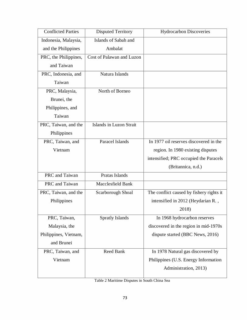
73
Conflicted Parties Disputed Territory Hydrocarbon Discoveries
Indonesia, Malaysia,
and the Philippines
Islands of Sabah and
Ambalat
PRC, the Philippines,
and Taiwan
Cost of Palawan and Luzon
PRC, Indonesia, and
Taiwan
Natura Islands
PRC, Malaysia,
Brunei, the
Philippines, and
Taiwan
North of Borneo
PRC, Taiwan, and the
Philippines
Islands in Luzon Strait
PRC, Taiwan, and
Vietnam
Paracel Islands In 1977 oil reserves discovered in the
region. In 1980 existing disputes
intensified; PRC occupied the Paracels
(Britannica, n.d.)
PRC and Taiwan Pratas Islands
PRC and Taiwan Macclesfield Bank
PRC, Taiwan, and the
Philippines
Scarborough Shoal The conflict caused by fishery rights it
intensified in 2012 (Heydarian R. ,
2018)
PRC, Taiwan,
Malaysia, the
Philippines, Vietnam,
and Brunei
Spratly Islands In 1968 hydrocarbon reserves
discovered in the region in mid-1970s
dispute started (BBC News, 2016)
PRC, Taiwan, and
Vietnam
Reed Bank In 1978 Natural gas discovered by
Philippines (U.S. Energy Information
Administration, 2013)
Table 2 Maritime Disputes in South China Sea
74
Due to its geological importance, SCS has been tried to be controlled by various nations.
However, the potential of hydrocarbon reserves and fishery resources contributed to the
intensification of the naval domination competition in the SCS (Tonnesson, 2001, p. 15).
SCS dispute has become more observable in the post-colonial era with the emerge EEZ.
In mid-1950 British and American oil companies started to pay more attention to SCS
because of the possible hydrocarbon reserves in the Spratly and Paracel area. The idea of
controlling hydrocarbon resources (particularly the oil) motivated regional states to insist
on their territorial claims (Tonnesson, 2001, p. 15).
More than 200 compact islands, reefs, and rocks exist in the South China Sea (Global
Investment and Business Center, 2011). The majority of these islands have consisted of
tiny islands where humans can hardly live, rocks, and reefs. Due to their habitat, neither
these islands nor rocks or reefs are suitable for any living habitat or economic functions.
However, because of their strategic locations, they consist of significant importance for
coastal states. The number of nationalist maritime claims increased after the post-colonial
period. New sovereign states were using irredentist claims to sustain their claims in the
overlapping region (Tonnesson, 2001, p. 23).
To conduct our analysis Paracel and Spratly islands are selected as the most suitable cases.
The majority of these territories fall under the unoccupied and terra nullius (empty land)
category (Gonzales, 2014). Coastal states were in dispute with each other to expand their
EEZ over this territory before the potential of the existence of the hydrocarbon resources.
However, during the hydrocarbon resource researches, findings showed that these islands'
surroundings contain precious hydrocarbon resources. After the exploration of
hydrocarbon reservoirs, existing territorial disputes intensified (Global Conflict Tracker,
2020).
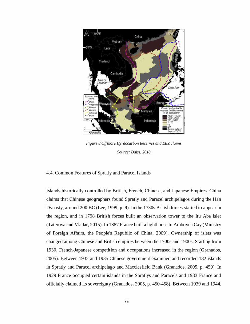
75
Figure 8 Offshore Hyrdocarbon Reserves and EEZ claims
Source: Daiss, 2018
4.4. Common Features of Spratly and Paracel Islands
Islands historically controlled by British, French, Chinese, and Japanese Empires. China
claims that Chinese geographers found Spratly and Paracel archipelagos during the Han
Dynasty, around 200 BC (Lee, 1999, p. 9). In the 1730s British forces started to appear in
the region, and in 1798 British forces built an observation tower to the Itu Aba islet
(Taterova and Vladar, 2015). In 1887 France built a lighthouse to Amboyna Cay (Ministry
of Foreign Affairs, the People's Republic of China, 2009). Ownership of islets was
changed among Chinese and British empires between the 1700s and 1900s. Starting from
1930, French-Japanese competition and occupations increased in the region (Granados,
2005). Between 1932 and 1935 Chinese government examined and recorded 132 islands
in Spratly and Paracel archipelago and Macclesfield Bank (Granados, 2005, p. 459). In
1929 France occupied certain islands in the Spratlys and Paracels and 1933 France and
officially claimed its sovereignty (Granados, 2005, p. 450-458). Between 1939 and 1944,
76
Spratlys were invaded by the Japanese empire (Tonnesson, 2002). In 1947 by giving
Chinese names to 159 islands, islets, reefs, and shores, China expanded its claims
(Ministry of Foreign Affairs, the People's Republic of China, 2009). Even though British
and French empires controlled these islands for some time, the first exercise of effective
control of the island occurred in 1939 with the Japanese invasion (Gonzales, 2014).
During the WW2 Islands in the SCS mostly used by the Japanese empire to conduct
military exercises. When the islands were started to control and dominated by Japanese
forces, none of the regional states legally opposed Japanese domination. After the end of
WW2, with the withdrawal of the Japanese Empire from the region, coastal states started
to compete with each other to control the unclaimed territories. On September 8, 1951,
Japan signed a treaty in San Francisco with Allied power, in which Japan renounces all of
its claims, rights, and titles to Spratly and Paracel Islands (Cheng, 1975, p. 275). The
Treaty of San Francisco did not specify the status of the islands.
There are no official Chinese maritime boundaries delineating sovereignty over waters
that existed in the islands region before the WW2 (Chung, 2019). However, in 1951 PRC
started to claim territory in SCS by stating that SCS historically belongs to PRC. Some
scholars argue that history plays a significant role in resolving sovereignty disputes by
providing evidence for parties to sustain their claims (Tonnesson, 2001, p. 1). However,
in the context of the SCS due to the long and complicated colonial domination of the
region state's historical claims overlap. For instance, Beijing and Taipei government
shares identical historical claims. Former French and British colonies claim overlapping
regions. That is why some scholars argue that littoral states' historical claims, including
the Chinese U shape line EEZ claim, does not fulfill the historical rationale (Beckman,
2013; United Nations Division for Ocean Affairs and the Law of the Sea Office of Legal
Affairs, 2017, p. 28).
Both Spratly and Paracel consists of islets shoals, sandbanks, rocks, and reefs. The
majority of these formations' statues are not enough to declare EEZ. According to
UNCLOS Article 121, islands' territorial sea, contiguous zone, and exclusive economic
zones are determined, depending on their positions. However, in the rocks and other small
islands where human habitation or economic life of locals cannot be sustained, exclusive
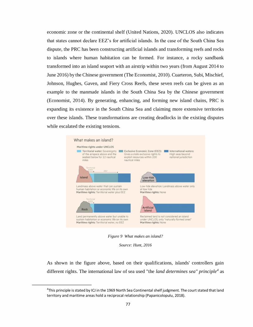
77
economic zone or the continental shelf (United Nations, 2020). UNCLOS also indicates
that states cannot declare EEZ’s for artificial islands. In the case of the South China Sea
dispute, the PRC has been constructing artificial islands and transforming reefs and rocks
to islands where human habitation can be formed. For instance, a rocky sandbank
transformed into an island seaport with an airstrip within two years (from August 2014 to
June 2016) by the Chinese government (The Economist, 2010). Cuarteron, Subi, Mischief,
Johnson, Hughes, Gaven, and Fiery Cross Reefs, these seven reefs can be given as an
example to the manmade islands in the South China Sea by the Chinese government
(Economist, 2014). By generating, enhancing, and forming new island chains, PRC is
expanding its existence in the South China Sea and claiming more extensive territories
over these islands. These transformations are creating deadlocks in the existing disputes
while escalated the existing tensions.
Figure 9 What makes an island?
Source: Hunt, 2016
As shown in the figure above, based on their qualifications, islands' controllers gain
different rights. The international law of sea used "the land determines sea" principle4 as
4This principle is stated by ICJ in the 1969 North Sea Continental shelf judgment. The court stated that land territory and maritime areas hold a reciprocal relationship (Papanicolopulu, 2018).
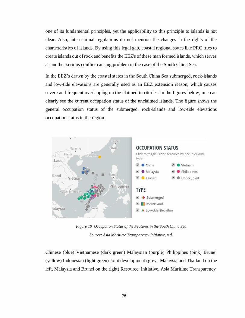
78
one of its fundamental principles, yet the applicability to this principle to islands is not
clear. Also, international regulations do not mention the changes in the rights of the
characteristics of islands. By using this legal gap, coastal regional states like PRC tries to
create islands out of rock and benefits the EEZ's of these man formed islands, which serves
as another serious conflict causing problem in the case of the South China Sea.
In the EEZ’s drawn by the coastal states in the South China Sea submerged, rock-islands
and low-tide elevations are generally used as an EEZ extension reason, which causes
severe and frequent overlapping on the claimed territories. In the figures below, one can
clearly see the current occupation status of the unclaimed islands. The figure shows the
general occupation status of the submerged, rock-islands and low-tide elevations
occupation status in the region.
Figure 10 Occupation Status of the Features in the South China Sea
Source: Asia Maritime Transparency Initiative, n.d.
Chinese (blue) Vietnamese (dark green) Malaysian (purple) Philippines (pink) Brunei
(yellow) Indonesian (light green) Joint development (grey: Malaysia and Thailand on the
left, Malaysia and Brunei on the right) Resource: Initiative, Asia Maritime Transparency
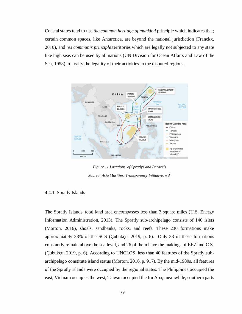
79
Coastal states tend to use the common heritage of mankind principle which indicates that;
certain common spaces, like Antarctica, are beyond the national jurisdiction (Franckx,
2010), and res communis principle territories which are legally not subjected to any state
like high seas can be used by all nations (UN Division for Ocean Affairs and Law of the
Sea, 1958) to justify the legality of their activities in the disputed regions.
Figure 11 Locations' of Spratlys and Paracels
Source: Asia Maritime Transparency Initiative, n.d.
4.4.1. Spratly Islands
The Spratly Islands' total land area encompasses less than 3 square miles (U.S. Energy
Information Administration, 2013). The Spratly sub-archipelago consists of 140 islets
(Morton, 2016), shoals, sandbanks, rocks, and reefs. These 230 formations make
approximately 38% of the SCS (Çubukçu, 2019, p. 6). Only 33 of these formations
constantly remain above the sea level, and 26 of them have the makings of EEZ and C.S.
(Çubukçu, 2019, p. 6). According to UNCLOS, less than 40 features of the Spratly sub-
archipelago constitute island status (Morton, 2016, p. 917). By the mid-1980s, all features
of the Spratly islands were occupied by the regional states. The Philippines occupied the
east, Vietnam occupies the west, Taiwan occupied the Itu Aba; meanwhile, southern parts
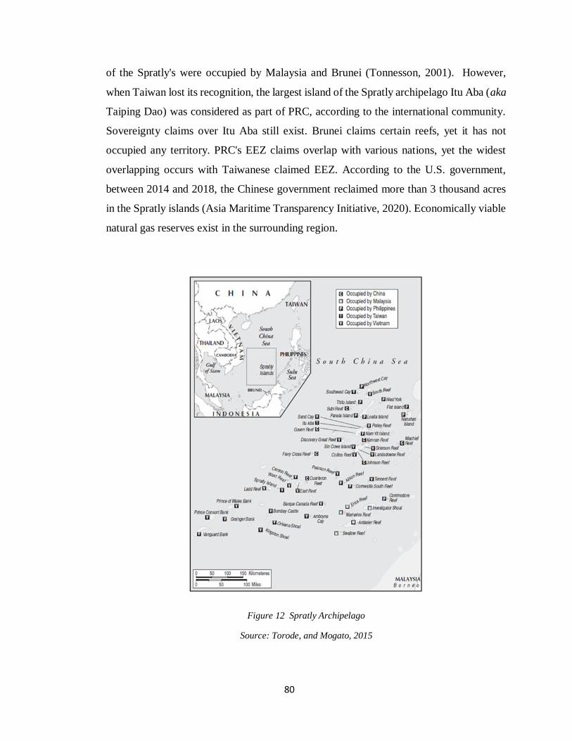
80
of the Spratly's were occupied by Malaysia and Brunei (Tonnesson, 2001). However,
when Taiwan lost its recognition, the largest island of the Spratly archipelago Itu Aba (aka
Taiping Dao) was considered as part of PRC, according to the international community.
Sovereignty claims over Itu Aba still exist. Brunei claims certain reefs, yet it has not
occupied any territory. PRC's EEZ claims overlap with various nations, yet the widest
overlapping occurs with Taiwanese claimed EEZ. According to the U.S. government,
between 2014 and 2018, the Chinese government reclaimed more than 3 thousand acres
in the Spratly islands (Asia Maritime Transparency Initiative, 2020). Economically viable
natural gas reserves exist in the surrounding region.
Figure 12 Spratly Archipelago
Source: Torode, and Mogato, 2015
81
4.4.2. Paracel Islands
Paracel islands consist of 130 small reefs coral formations; approximately 30 of these
formations considered as islands. Paracel islands are claimed by PRC, Taiwan, and
Vietnam. The biggest island in Paracel archipelago is Woody Island, occupied by China
and claimed by Taiwan and Vietnam. Woody Island has a permanent population of more
than 1.000 people (BBC, 2016). SCS has been called as "the second Persian Gulf" due to
its abundant energy reserves (Bouchat, 2014, p. 7). U.S. Energy Information
Administration did not indicate any hydrocarbon reserves in the Paracel archipelago.
However, EIA analysis indicates that, based on the geological structure and conventional
examples, hydrocarbon reservoirs are more likely to exist in shallow coastal areas
(Bouchat, 2014, p. 7). Paracel formations are located and surrounded by deeper waters,
which reduces the possibility of exploration of economically feasible hydrocarbon
resources. However, researches indicate that Paracel region promises significant NGH
reservoirs (Bouchat, 2014, p. 7; Schicun and Nong, 2006; Shicun, 2007).
4.5. China (People's Republic of China)
Since 1949 PRC has been involved in various disputes with its neighbors a total of 23
areas (Fravel, 2016). Although PRC managed to settle most of its disputes via
compromised settlements and peaceful negotiations, it still could not solve the majority of
its maritime territorial disputes.
The rise of Chinese exports and trade interactions increased Chinese energy demands.
Currently, PRC is the second-largest oil consumer after the U (Worldometer, 2020). Apart
from its' geostrategic location, SCS contains abundant hydrocarbon resources. Controlling
precious energy resources increases the nation's economic, political, and military power
significantly. PRC is the most significant actor in the SCS dispute. After China, based on
the states' claimed the territory's surface area and the aggression level Vietnam and the
Philippines can be considered the second most significant actors. Taiwan, Malaysia, and
Brunei remain relatively less aggressive disputants in the SCS.
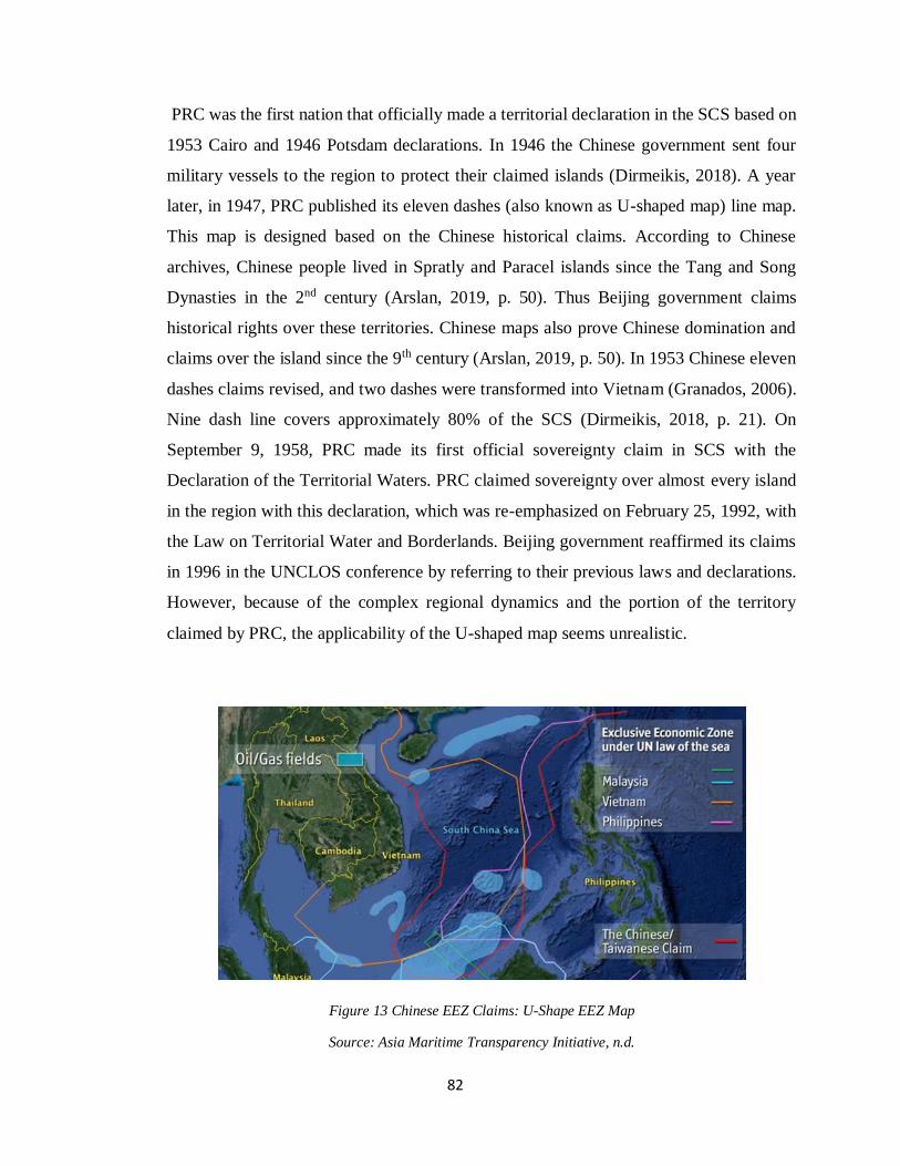
82
PRC was the first nation that officially made a territorial declaration in the SCS based on
1953 Cairo and 1946 Potsdam declarations. In 1946 the Chinese government sent four
military vessels to the region to protect their claimed islands (Dirmeikis, 2018). A year
later, in 1947, PRC published its eleven dashes (also known as U-shaped map) line map.
This map is designed based on the Chinese historical claims. According to Chinese
archives, Chinese people lived in Spratly and Paracel islands since the Tang and Song
Dynasties in the 2nd century (Arslan, 2019, p. 50). Thus Beijing government claims
historical rights over these territories. Chinese maps also prove Chinese domination and
claims over the island since the 9th century (Arslan, 2019, p. 50). In 1953 Chinese eleven
dashes claims revised, and two dashes were transformed into Vietnam (Granados, 2006).
Nine dash line covers approximately 80% of the SCS (Dirmeikis, 2018, p. 21). On
September 9, 1958, PRC made its first official sovereignty claim in SCS with the
Declaration of the Territorial Waters. PRC claimed sovereignty over almost every island
in the region with this declaration, which was re-emphasized on February 25, 1992, with
the Law on Territorial Water and Borderlands. Beijing government reaffirmed its claims
in 1996 in the UNCLOS conference by referring to their previous laws and declarations.
However, because of the complex regional dynamics and the portion of the territory
claimed by PRC, the applicability of the U-shaped map seems unrealistic.
Figure 13 Chinese EEZ Claims: U-Shape EEZ Map
Source: Asia Maritime Transparency Initiative, n.d.
83
In 1958, PRC issued a statement on the Paracel and Spratly Islands' regional waters, which
explicitly stated the Chinese domination (Tonnesson, 2002, p. 168). The Democratic
Republic of Vietnam stated that it supports this declaration (Tonnesson, 2002, p. 168).
Although PRC’s statement did not explicitly mention the islands, Vietnam’s support this
statement appears to be a legal obstacle to Vietnamese claims in the future. Details of the
Vietnam decision of endorsing then opposing Chinese claims will be discussed more detail
under the Vietnam section.
States tend to prefer delaying strategy5 in controversial regions because it allows states to
gain time while continuing their claims until they improve their power. PRC used the
delaying strategy until the 1974 military confrontation with Vietnam (Arslan, 2019, p. 53).
Chinese Law of Territorial Sea and the Contiguous Zone (1992) and Law on the Exclusive
Economic Zone and the Continental Shelf (1998) intensified the regional conflict by
creating the bases of the Beijing government's EEZ claims (Swarup and De Gurung, 2018,
p. 7). After the end of WW2, the Chinese navy was not strong enough to assert its'
territorial claims (Swarup and De Gurung, 2018).
In the 1970s, PRC started offshore oil exploration, in the past decades PRC and Vietnam
issued oil exploration licenses in their claimed regions to secure their maritime claims.
Overlapping in the license issued territory intensifies the tension among the nations. After
the Oil crisis in 1973, the importance of hydrocarbon resources significantly increased and
started global resource competition (Charney, 1999). The first significant escalation in
SCS occurred in 1974 when PRC confront with Vietnam and forcibly took control of the
Paracel Islands and the Spratly Islands. Both sides had lost troops, but Vietnam had more
fatalities in compare to PRC. In 1986 Vietnamese first successful batch of crude oil
production in the Bach Ho field caused the reescalation of the territorial competition
between China and Vietnam (Swarup and De Gurung, 2018, p. 5). In 1992 PRC adopted
5 Delaying strategy allows states' to gain time while maintaining its' claim over a territory. States can invest in their military capabilities or tries strengthening their soft power in the international arena to reach their goals if a state believes that by not settling the dispute in the given time, it can receive better payoffs than a state will be more likely to adopt delaying strategy. This strategy allows states' to expand their relative power. When a nation becomes powerful than its opponent, it can use its' power to force its opponent to compromise. Thus it can increase its relative gains by delaying the settlement of a dispute.
84
new laws and regulations for the exploration of sea sources to an area claimed by Vietnam.
In 1996 the Vietnamese government issued oil exploration concession for the same region.
Due to the region's oil potential, tension intensified among the coastal states (Tonnesson,
2001, p. 21).
In the 1990s, Chinese-Philippian tension started to be more apparent in the region. After
the hydrocarbon reserves discovery around the Kala'ya Islands in order to stop the
Philippian expansion in the Spratly formations on February 8, 1995, by sending eight
military vessels Chinese government invaded Mischief Reef (located on the eastern parts
of the Spratly’s) which was claimed by the Philippines (Meyer, 1996). In the same year,
to maintain control of the island, PRC built non-complex structures (Rae, 2014, p. 97).
Regional tension still exists and gradually increases in the SCS. PLAN's increasing power
allowing the Beijing government to act more aggressively. For instance, to protect its'
claimed territory in April 2012, the Philippian government send its warships and arrest
Chinese fishermen who were fishing in their claimed territory (BBC News, 2012). As a
response, PRC took control of the Shoal Scarborough Shoal, which falls under the
Philippian EEZ (Mangosing, 2019). In 2020 Beijing government deployed coastguards to
Scarborough Shoal and constructed an artificial island (Long, 2020). Even though
Scarborough Shoal does not fall under Spratly archipelago, this incident indicates the
Chinese aggression in the region.
In 2007, after the 19th National Congress of the Chinese Communist Party, PRC adopted
a united front strategy. This strategy aims to weaken the enemy by limiting the number of
alliances and supports that it receives. As a part of this strategy, PRC persuaded many
countries not to recognize the Taipei Government. Currently6 14 out of 193 UN member
states recognize Taiwan as a sovereign state (O'Connor, 2019). Under the One China
Policy, statues of Taiwan become problematic. In certain studies, Taiwanese territories in
the SCS are considered Beijing's territory. Since Taiwan lost its' international recognition
as a sovereign, powerful state and considered as a part of PRC by various nations,' China
614 Countries that recognize Taiwan as a sovereign nation are: Saint Vincent and the Grenadines, Tuvalu, Belize, Guatemala, Eswatini, Honduras, Haiti, the Marshall Islands, Paraguay, Nauru, Saint Kitts and Nevis, Nicaragua, Palau, and Saint Lucia. The Holy See also recognizes the legitimacy of the Taipei government.
85
can use Taiwan's status to exploit the natural resources that fall around the islands claimed
or controlled by the Taiwanese government.
Different interpretations and applications of UNCLOS Article 121, is another factor that
affects maritime disputes. The interpretive gap of the islands' status has a significant effect
on the duration of the SCS conflict (Heydarian and Liberum, 2018, p. 289). Some nations
like Taiwan and PRC claim that Spratly and Paracel formations consist of islands that can
have EEZ; meanwhile, other nations like the Philippines and Malaysia argue that these
rocky formations cannot be considered as islands (Heydarian, 2018, p. 290). The
government cannot have an EEZ. These formations should not affect coastal states' EEZ
declarations. Over the years, various note verbales have been issued by the disputant states
regarding the status of Spratly and Paracel formations (Government of China, 2019). On
March 30, 2020 Vietnam issued a note verbale to reject PRC’s territorial expansion
declarations and any regional claims which exceeds the limits provided by UNCLOS
(Diep, 2020). In the note verbale, Vietnam explicitly focuses on Spratly and Paracel
formations and their status which can be given as an example to previous note verbales’
issued by other coastal states.
On November 4, 2002, the Declaration on the Conduct of Parties in the South China Sea
was signed among disputant ASEAN states and PRC (ASEAN, 2002). Declaration aims
to promote the peaceful, cooperative, and friendly environment in the region. Three out
of ten clauses (1st, 3rd, and 4th) state that signatories should act according to UNCLOS
regulations. Although this agreement seems as a cooperation promoter, it only presents
nations' goodwill. This declaration has no formal binding; if a state violates the
agreements, there will be an implementation of deterrent consequences. Although
declaration indicates cooperation on maritime protection, navigation and communication
safety, and scientific research, it does not provide a solution to the share of hydrocarbon
or fishery resources in the disputed territories. Also, increasing military existence of the
disputant states in the SCS under the name of securing the region and protecting the
maritime safety created unrest among the disputant states. In addition to that, littoral states'
interpretations of UNCLOS regarding the status of the island can be counted among the
reasons why the conflict cannot be solved. Therefore it would be unrealistic to expect any
86
affirmative results from 1st, 3rd, and 4th clauses. There are various other multilateral and
bilateral declarations that exist in the contact of SCS. Even though some of them achieve
to promote cooperation to a certain extent in general, they remain incapable of settling the
regional tensions.
PRC used to try to avoid military confrontations in the SCS. In the 2000s, China appeared
as a risk-taker nation that does not fear to engage in military confrontations with other
disputants. PRC has always tried to occupy the most strategic locations for controlling the
naval routes and maritime resources. By expanding its claimed territory and improving its
military capabilities in these regions, the Beijing government tries to gain regional
dominance. In 2013 balance of power in the Spratlys’ shifted as a result of the Beijing
government's island construction activities. PRC occupied the Fiery Cross Reef in 1988,
which is currently considered one of the largest landmass in Spratly (Himmelman, 2020).
RRC made 2.74 square kilometers expansion to Fiery Cross Reef in 2014. Expansions
made reef to become large enough to contain tankers, warships, and a 63-hectare harbor,
in addition to 3.100 meters long airstrip (Vuving, 2016). These expansions made Fiery
Cross Reefs six-times larger than Itu Aba Island, which was the most significant natural
island among the Spraty formations (Vuving, 2016). In the 1990s, this reef was used as a
command center for maritime operations.
Over time PRC became a more aggressive player in the South China Sea; several islands
were gradually militarized by the Beijing government (Santoro, 2019). Some scholars
define PRC’s strategy in the PRC Sea as gray-zone or salami-slicing (aka divide and
conquer) strategy (Santoro, 2019). Maj. Gen. Zhang Zhaozhong of PRC’s People’s
Liberation Army (PLA) stated their strategy as cabbage strategy, “by using its coast guard
ships, naval ships and fishing boats Chinese government is surrounding, in some cases
even occupying, these islands” (Santoro, 2019). Adopting these strategies helped PRC to
increase its military presence and economic control in the South China Sea. Currently,
none of the coastal states' navy is strong enough to venture, confronting with the PLAN.
By establishing small coastguard stations' and lighthouses to its' controlled islands, the
Beijing government preparing a legal basis to claim its' sovereignty over these islands.
According to UNCLOS, islands that contain human habitations can declare EEZ. By
87
changing the status of the rocky formations, China can access larger hydrocarbon
resources.
In territorial disputes, hydrocarbon recourses serve as a conflict escalator factor
(Tonnesson, 2002; Arslan, 2019; Smith, 2010). By transforming islets and rocky islands
to the islands where human habitation can exist, PRC may aim to expand its' EEZ. Even
if expansionist construction on the rock formations and building artificial islands does not
provide EEZ to China, they can be used to provide logistic support to offshore drilling
activities. Furthermore, via troops and coastguards located in these islands, the Beijing
government can provide the security of the drilling platforms (International Crisi Group,
2016, p. 3).
1944 Convention on International Civil Aviation Law allows states to expand their
sovereignty over territorial airspace; however, this space cannot extend their EEZ
(Chicago Convention, 1944). By declaring the Air Defense Identification Zone, PRC
hopes to provide sufficient bases for its future territorial declaration. Implementation of
ADIZ can cause problems in the near future by threatening states' right to safe passage. In
2013 the Chinese Ministry of Defense indicated that the Beijing government would
establish ADIZ in the Spratly, Paracel, and Pratas region (Times of India, 2020). In 2014
and 2015, Chinese island-building activities accelerated. Beijing government built
military bases on these artificial or extended islands. PRC’s actions are gradually
increasing its presence in the South China Sea by changing the status-quo towards
Beijing's favor. Beijing governments' actions are not vivid enough to justify a war, but its
actions like militarizing islands that were claimed to be never militarized keep the
insensitivity of the disputes (Santoro, 2019).
4.6. Taiwan (The Republic of China)
Until the end of WW2, Taiwan was the colonial state of the Japanese empire. After 1945,
the ROC established in 1912 began exercising its jurisdiction over Taiwan (Government
of the Republic of China (Taiwan), 2018). In 1949 Taiwan declared its' independence.
Taiwan was among the founding members of the United Nations and recognized by
88
various states. Throughout the time, with the strengthening of PRC, the number of nations
that recognize Taiwan started to decrease. In 1971 Taiwan was withdrawn from the U.N.,
and its' seat was replaced by PRC (BBC News, 2019). The position of Taiwan is not
explicitly analyzed in contemporary SCS dispute studies because the majority of the
international actors consider Taiwan as not a sovereign entity.
Taiwan was the first nation that occupied territory within Spratlys, including the
significant islands like the Pratas Island (Dongsha Island), which is located 200 km south-
west of Hong Kong. In addition to 500 islets (Jennings, 2018). In early 1992 Taiwanese
Ministry of National Defense declared a 24 nm restricted sea 30 nm restricted air zone
around the Taipei controlled regions (Lin, 1997, p. 325). In 1995, a result of Vietnamese
violation of Taiwanese claimed maritime zone warning shots were fired (Lin, 1997, p.
325). Apart from such low-scale territory protection attempts, ROC was not engaged in
military confrontations with other coastal states like other disputant actors.
Due to its economic and military capabilities and recognition limitations, ROC seems to
be the most open disputant to the reconciliation in the region. ROC was excluded from
the tripartite regional maritime cooperation agreement signed by Vietnam, the Philippines,
and PRC in 2005 (Song, 2013). In order to be included in regional interactions, Taiwan
introduced Spratly Initiative. The first clause aims to the promotion of regional
cooperation. Whereas, the second clause of this initiative aims to prevent other disputant
states control of Taiwanese claimed maritime recourses, including the hydrocarbon
reserves (Song, 2013, p. 5). ROC avoids provoking ASEAN or Chinese disputants, yet it
still defends its' claims.
Apart from that since 1990, nineteen Workshops conducted on Managing Potential
Conflicts in the South China Sea and ROC were excluded in these workshops due to
Beijing's One China Principle (Song, 2010). In the nineteenth workshop, in November
2008, Taiwan was invited as a participant. Taiwanese alignment with U.S. and military
aid provided by the U.S. American government to the Taiwanese government's renovation
during the Obama administration caused deterioration of Chinese Taiwanese relations
(Turan, 2016).
89
4.7. The Philippines
The Philippines was ruled as Spanish, American, and Japanese control as a colonial state
until July 4, 1946 (Herrera, 2012). The Philippines' first sovereignty claim on the Spratly
Islands was submitted to the United Nations in 1946. In 1956 by referring to res nullius
(empty property) concept and geographical proximity, the Philippines claimed the full
sovereignty of the specific parts of the Spratly (Rae, 2014, p. 96; Zhao, 2012, p. 59).
In 1947 a Philippian Citizen Tomas Cloma discovered unsettled semi-island semi-islet
formations, the Kalaya’an Group Islands within Spratly formations (Zhao, 2012, p. 59).
Even though islands had Taiwanese flags in 1956, Cloma sailed to these islands with his
friends and, by creating permanent landmarks, declared his sovereign territory. In 1978
formal declaration of the control of the KGI was made by President Ferdinand Marcos
(Rowan, 2005, p. 421). Since then, this territory has been included in the administrative
jurisdiction of the Province of Palawan (Ortuoste, 2013). None of the littoral states'
opposed the Philippian settlement to KGI until the 1970s, till the region's potential of
hydrocarbon reserves came to their attention.
In 1971, to ensure its presence in the region Philippian government conducted offshore
drilling activities on the north-east of the Spratly archipelago in the ReedBank area.
During the Marcos administration, The Philippines started to occupy certain rocks,
islands, and reefs in the SCS. In 1970 Manila government send troops for taking
possession of certain islands in Spratly. Chinese overlapping claims prevent the
Philippines' expansion in the region. As a newly established sovereign state, the Philippian
economic and military capacity was not sufficient for confronting China. Capacity-wise
Beijing government was more powerful than the Manila government; therefore, any
military confrontation would harm the Philippines more than PRC. Therefore the Manila
government could not insist on its' regional demands, yet they did not withdraw their
demands. Over the decades, the Philippian economy and military capacities gradually
increased. Nonetheless, China's economic and military rise was superior to Philippian
empowerment, which was perceived as a potential threat to the Philippines. Hence, the
Manila government decelerate its expansionist actions in the SCS. Moreover, in 1975
90
diplomatic relations with China established (Baker, 2004). However, because of the
Taiwan's status and disagreements on the SCS, Sino-Philippine relations deteriorated in
the 1980s (Baker, 2004). In the 1990s, PRC and the Philippines military were confronted
on five separate occasions for the control of the ReedBank region (Hendler, 2018).
After the end of the Cold War, in 1992 American government shut down all of its military
bases (Clark Airbase and Subic Bay naval base) in the Philippines and stopped providing
economic and military aid to the Manila government. (Sanger, 1991) Withdrawal of
American aid caused the Manila government to reconsider its actions in the region. In
1995 Sino-Philippines relations intensified when the Philippine officials noticed Chinese
military base construction on the Mischief Reefs, which is located 135 miles west of the
Palawan Island claimed by the Philippines (Baker, 2004). In 1996, to secure itself Manila
government started to conduct negotiation talks with the U.S. for drafting the Visitors
Forces Agreement. This agreement would allow U.S. troops to deploy and conduct joint
military exercises with the Philippines in Philippian waters. Agreement ratified in 1999
and the first joint military exercise conducted in 2000. With the increasing Chinese
dominance in the SCS to secure its interest, the development of the Cooperative Security
Locations (CSL) depend. CSLs are heavily infrastructured American military bases that
can accommodate large troops within allied nations' (Philippines) military facilities
(Castro, 2009, p. 415). To protect its national interest in the Spratly region, the Manila
government tried to internationalize the Spratly dispute by carrying the issue to U.N. and
ASEAN Regional Forum while maintaining its diplomatic interactions with the Beijing
government (Baker, 2004).
In 2004, the Philippine National Petroleum Company and the China National Open Seas
Petroleum Company signed an agreement (The Joint Maritime Seismic Understanding) to
conduct joint seismic studies in the South China Sea. In 2005 Vietnam joined seismic
researches due to its overlapping territorial claims. The cooperation lasted until 2008
(International Crisi Group, 2016). Disputants have different motives while signing the
agreement, yet their main goal was the same. Beijing government tried to portray a less
aggressive and more cooperative state in the international arena to avoid sanctions. On the
other hand, the Manila government economically incapable of conducting seismic
91
reserves on its claimed territory. Conducting researches in the region strengthen states'
territorial claims. By not opposing their seismic researches, disputant states technically
ipso facto recognized the legality of the claims.
China and the Philippines issued various note verbale as a response to each other’s
expansionist actions in the disputed territory (Thang and Thao, 2012). In 2013 oil
resources were discovered around the Kalaya'an Group Islands, which increased the
tension in the region (Ortuoste, 2013, p. 248). Chinese claims in the Spratly and Paracels
intensified after the vast offshore oil and gas deposits (Tonnenson, 2000, p. 202). After
discovering hydrocarbon reserves, the Manila government applied to The Hague Tribunal
to oppose Chinese claims in Kalaya'an Region (Pekcan, 2017, p. 65). Court's decision
indicated that Chinese actions and claims had no legal bases, yet China rejected tribunal's
arguments (Pertez, 2016). In 2020 Manila government still demands the Beijing
government comply with the courts decision (Heydarian, 2020). Currently, 500 people
live in Kalaya'an Group of islands (Umali, 2019). The status of the island is still
problematic. Currently, the Philippines does not claim the main landmass in Spratly; it
claims eight islets (Rowan, 2005, p. 421). The Philippian government argues that these
islets are adjacent to the Philippines mainland. Moreover, due to their locations and settled
human habitation, these semi-island semi-islet formations are strategically and
economically crucial for the Philippines. In 2020 experts indicate that the U.S. navy exists
in the SCS contributing conflict (Euronews, 2020).
4.8. Vietnam
Before 1975 Vietnam was divided into North and South Vietnam. South Vietnam's
(Republic of Vietnam) claims over SCS was different from North Vietnam's claims. In
1975 after the victory of North Vietnam, North and South Vietnam unified under the
Democratic Republic of Vietnam. Until the unification, North Vietnam avoided military
confrontations with China by recognized Chinese sovereignty in SCS. Therefore when
PRC issued a declaration on its territorial sea on September 4, 1958, and claimed its
sovereignty in Xisha and Nasha groups (Chinese names of Paracels and Spratlys) the
92
Democratic Republic of Vietnam recognized and supported Chinese declaration (on
September 14, 1958) (Furtado, 1999).
Republic of Vietnam's sovereignty claims on both the Spratly and the Paracel formations
are based on a historical claim dating back to the 17th century. In the 1951 San Francisco
Peace Conference, Republic of Vietnam declared its sovereignty over Hoang Sa and
Truong Sa (Vietnamese names of Paracel and Spratly islands) (Chang, 1991, p. 401). On
July 31, 1971, the Vietnamese government published the Declaration on the Sovereignty
of the Republic of Vietnam over the Archipelagos of Paracels and Spratly. On January 19
and 20, 1974, Vietnamese troops invaded six of the fifteen major Paracel Islands (Chang,
1991, p. 416). As a response, the Taiwanese Ministry of Foreign Affairs issues series of
diplomatic protests (on January 25, August 9, August 27 and December 26, 1973) (Chang,
1991, p. 412). In addition to that, PRC sent its troops to the Paracel to force Vietnamese
forces to withdraw from the region. Despite the military confrontations, until the Republic
of Vietnam's collapse, the Vietnamese administration was not compromised (Tonnenson,
2000, p. 202-203).
After the Vietnamese unification Democratic Republic of Vietnam claimed the ownership
of the maritime territories claimed by the former Republic of Vietnam. This declaration
caused deterioration in Sino-Vietnam affairs between 1975 and 1979. Diplomatic
deterioration was followed by the Sino-Vietnamese war in 1979 (Reilly, 2017). Territorial
disputes continued in the 1980s. Apart from the 1979 territorial invasion, the second
significant territorial conflict occurred in Spratly formations in 1988 (Tonnesson, 2002).
During the maritime disputes, PRC was allied with the U.S. and some ASEAN states,
whereas USSR's navy supported Vietnam. After the end of the Cold War with the
dissolution of the USSR and the closure of American military bases in the Philippines,
tension in the SCS was reduced until the 2000s (Tonnesson, 2002).
Towards the end of the 1990s, Sino-Vietnamese relations normalized. On the contrary, in
the early 2000s, Vietnamese existence in the Spratly islands gradually increased.
Currently, Vietnam holds the second expansive claim in the Spratly and Paracel
formations after the PRC. Vietnam is making a similar irredentist argument to access an
estimated 4.4 billion barrels of proven oil and nearly 24.7 trillion cubic feet proven natural

93
gas reserves in SCS (Stout, 2014). Since 2010 Vietnam's oil refinery capacity is
increasing; on the contrary, its oil production is gradually decreasing (Tran, 2019, p. 211)
Vietnamese proven gas reserves rapidly increase in 2016 (Tran, 2019, p. 211). However,
on March 22, 2017 EIA indicated that half of these natural gas reserves were located in
the northern deepwater areas of the Paracels, in the Song Hong Basin (Tran, 2019, p. 211).
Vietnamese state-owned energy company PetroVietnam was conducting exploratory
researches on its claimed blocks while Vietnamese navy was sailing around the
PetroVietnam’s drilling ships with 40 vessels to maintain their security. However, due to
the rise of tension and Chinese pressure in the SCS Vietnam was forced to cancel its
contracts (ARCHYDE, 2020). First in July 2017, then on March 22, 2018, Vietnam had
to stop its exploration drillings in disputed blocks 135-136/03 and 07/03 (Hayton, 2020).
If Vietnam can be able to control these hydrocarbon reserves, it can significantly improve
its’ economy. However, in the given conditions, due to the existence of a stronger
disputant in the conflict, Vietnam cannot afford to confront China.
4.9. Malaysia
Federation of Malaya declared its independence on August 31, 1957, and joined
commonwealth nations. In 1963 federation was re-named as Malaysia Federation.
Malaysia had geographically separated two mainlands and consists of one federal territory
and 13 federal states (Roach, 2014). Malaysian territory is separated into two Peninsular
Malaysia and East Malaysia by 640 miles of SCS (Roach, 2014). In 1979 Malaysia
declared its CS, which included seven formations in Spratly archipelago. Like the fifth,
and last, claimer state Malaysia announced its' claims by publishing a map in 1979 (Roach,
2014).
One of Malaysian claimed islet is occupied by the Philippines (Commodore Reef/Rizal
Reef) and two (Amboyna Cay and Barque Canada Reef) occupied by Vietnam. Malaysia
occupied and constructed mini naval stations on the remaining four islets between 1983
and 1986 (Pao-Min, 1990, p. 24). Malaysian occupations created fait accompli. To inhibit
further expansions, PLAN enhanced its’ capabilities and presence in the Spratlys and
prevented Malaysian expansion. Instead of using military power to pursue its' goals,
94
Malaysia issued a joint continental shelf extension declaration to the U.N. with Vietnam
in 2009. A decade later, on December 12, 2019, Malaysia made another submission to the
U.N. to extend its continental shelf (Thao, 2019). Both of these submissions were
protested by the Beijing government via diplomatic notes. Expansion claims extended the
total area of the disputed territory.
Malaysian and Vietnamese economies heavily rely on oil exports from the SCS
(International Crisi Group, 2016, p. 2). Therefore, gaining control of hydrocarbon
resources significantly important for Malaysian economic development. Malaysian
claimed hydrocarbon blocks overlap with Chinese claimed blocks and contradict Brunei's
claimed blocks, Block K and J (Buszynski and Sazlan, 2007, p.163). Nevertheless, the
major confrontations that occur in the Chinese claimed blocks. Apart from the historical
intentions since mid-April 2020, Malaysian drilling ships in Arapaima-1 in Block ND1
and Lala-1 in Block ND2 are confronting PLAN (Evans, 2020). The arrival of the Chinese
navy and drilling vessels to Malaysian claimed territory, which falls under the U-shaped
line, intensified the region's tension. AMTI stated that: “Southeast Asian governments
and commercial operators will have to come to grips with the reality that new oil and gas
exploration anywhere in the South China Sea without Beijing’s permission will probably
face the same level of high-risk intimidation” (Acosta, 2020).
4.10. Brunei Darussalam
Brunei has no claim over anywhere on the Spratly formations; it did not occupy or
stationed troops in the Spratlys (Rowan, 2005, p. 419). However, in 1988 Brunei declared
the expansion of its C.Z. to 350nm (Arslan, 2019, p. 69). Since Brunei's claimed C.Z.
includes Spratly formations, Brunei is considered as a part of Spratly territorial dispute
(Roach, 2014). With Brunei's claim of 200nm EEZ Louisa Reef, Owen Shoal and
Rifleman Bank fall into Brunei's claimed territory (Hart, 2018). Brunei historically was
not an aggressive or demanding actor in the SCS dispute.
Hydrocarbons consists important part of Brunei’s economy. More than 95% of Brunei’s
exports and over 60% of its GDP consisted of the oil and gas sector. According to the
95
researchers conducted by U.S. Energy Information Administration and British Petroleum,
Brunei holds 1,100,000,000 barrels of oil, which consists of 0.07% share of world reserves
(Worldometer, 2020). Due to Brunei's location and its offshore reserves, it can be assumed
that the likelihood of exploration hydrocarbon reserves on the territory claimed by Brunei
and PRC is significant (Shell, 2015). Thus, PRC's possibility of abandoning its claims is
unlikely, except for issuing statements to continue its' claims on the Spratly region
(Ministry of Foreign Affairs Brunei Darussalam, 2020). Bandar Seri Begawan
government is not showing any military presence or aggressive actions in the region.
4.11. Theoretical Analysis of States’ Actions in the South China Sea
There is no consensus on the cause of states' motives in the South China Sea conflicts.
Some scholars argue that states' main motives are more security-driven; some claim that
the demand for controlling hydrocarbon resources mostly causes their actions. In light of
the arguments made by various scholars, one should not distinguish states' security
concerns and their desire to control hydrocarbon reserves. When a state imports energy
from other nations, it becomes dependent on these buyers. In addition to energy security
concerns, they spend a certain percentage of their budget on energy imports. If a state
expands its energy resources, even if its energy consumption gradually decreases, it can
still use that energy to meet its own energy needs or export its surplus. In either case,
controlling energy resources makes states stronger (Umbach, 2017).
China has always been an aggressive and powerful actor compared to the other disputant
coastal states in SCS. Due to the superiority of PLAN, disputant ASEAN nations choose
to invest in their military capacities instead of giving the priory to the use of diplomatic
channels (Gallagher, 1994). Exploration of hydrocarbon reserves in the region intensified
the existing conflict by reducing the actors' comprising possibilities to settle the dispute.
States are seeking their national interests before making any move in the region, which is
eliminating the states' possibility of compromising for settling the dispute (Tonnesson,
2001, p. 24) in the given environment.
96
Mearsheimer argues that competition leads states to try to establish hegemony by
dominating their region and eliminate the rise of a potential rival great power as a
competitor in their region (Toft, 2005). In accordance with the offensive realist
perspective, PRC tries to become a regional hegemon in its region. As a nation that shares
borders with powerful states like Russia and Japan, in order to reach its goal, PRC has to
ensure its domination in Southeast Asia. Without securing its position in SCS, PRC will
be more likely to avoid engaging hard power competition with Japan or Russia.
Moreover, regional states' insecurities motivating them to seek stronger alliances. The
Philippines' rapprochement to the U.S. can be given as an example. Increasing presence
of another stronger nation in its' claimed territory causing the Beijing government to invest
more in its' military capabilities and increase its' military presence in the region, which is
intensifying the exiting tensions by creating a security dilemma (Tang, 2009).
Apart from increasing a nation's resources, gaining control of territory allows that nation
to increase its' military existence in the region (Carter, 2010). Thus it improves the state's
military position against its opponent. When a challenger state faces a strong opponent,
its' likelihood of using military force decreases. Vietnamese decision to stopping drilling
activities in the disputed block because of the Chinese pressure can be given as an
example. Economically valuable resources increase the likelihood of militarization in the
conflict (Carter, 2010). Increased tension in the Kalay’an Islands after the exploration of
hydrocarbon potentials supports this theory.
97
CHAPTER 5
CONCLUSION
The territory has always played significant importance in international relations.
Historically various intra and interstate disputes occurred over the control of a territory.
In the current system, the number of maritime boundary delimitations started to increase.
To expand their power, states are competing with each other for domination maritime
territories'.
With technological advancements and economic improvements in the 21st century, energy
sources have become a more important factor in international relations by shaping states'
interactions and affecting their security. The scarcity of certain energy resources,
hydrocarbons, increased competition among the nations. Exploration of hydrocarbon
resources in the unclaimed maritime territories motivated states to be more demanding to
gain control of these regions. By using these abundant resources, energy-dependent
nations can reduce their dependency on energy exporter states. On the contrary, if energy
exporter states can control these regions, they can expand their influence and power on
the energy importer states.
Most of the recent controversy in the Eastern Mediterranean and the South China Sea was
triggered by the coastal states’ demands to exercise their claimed sovereign rights,
specifically their rights to explore and extract hydrocarbon resources. International
maritime laws and regulations allow coastal states to have particular sovereign rights over
the areas of sea adjacent to their territories. This includes internal waters (IW), continental
shelves (CS), territorial seas (TS), and exclusive economic zones (EEZ). Coastal states
have to declare EEZ to extend their right to benefit from the maritime resource out of their
TS. This expansion allows littoral states' to use their sovereign rights in order to explore
and exploit living and non-living maritime resources, subsoil, and seabed. According to
98
the United Nations Convention on the Law of the Sea (UNCLOS), Article 57 states can
extend their EEZ’s up to 200 nautical miles from their coasts. The right to an EEZ has to
be claimed by a state and approved by the other second or third party states by agreements.
Without the approval of neighboring, boarder sharing states, none of the state's EEZ
declaration can gain a legal, international validity. In semi-enclosed or enclosed seas'
because of the geographical limitations, coastal states' claimed territories overlap and
creates maritime boundary delimitations. According to some scholars’ existence of
abundant natural resources in disputed regions serves as a conflict setting factor by
motivating disputants to adopt cooperative policies. They claim that settling the disputes
allows disputants’ to access and allowing them to benefit from resources sooner. However,
recent discoveries in the EMS and natural gas hydrate exploration researches in the SCS
indicate that regions' may contain further potential undiscovered hydrocarbon reserves.
Thus settling the existing dispute can harm disputant states' benefits in the long run by
causing them to compromise from a resource-rich basin. Therefore in the selected cases,
by intensifying the existing maritime boundary delimitations abundance, natural resources
serve as a conflict triggering factor.
Discoveries of hydrocarbon resources in the disputed regions do not promote cooperation
among the disputed parties. In such systems, instead of promoting political approachmnet,
resources escalates the degree of the conflict. States forms alliances to balance other states'
powers or to minimize the risk of threat. In general, these alliances are established based
on excepted gain calculations. This means in order to balance threats, states try to contain
their existed alliances while trying to expand the number of their supporters. In bipolar,
unipolar, and multipolar systems, state alliances preferences show alteration. In bipolar
and multipolar systems, the more influential the state becomes, the likelihood of other
nations to be side, align, with it increases. Based on the same logic, if a state's relative
power declines, its allies' likelihood of drifting apart from their established alignment
increases. Regional politics generates different sub-systems within global politics. The
structure of the system affects states' choice of actions by contributing their expected
relative gains and losses. States' alliances' preferences may also change due to their
interactions with other states or superpowers. In the context of Eastern Mediterranean
99
alignment, the way states perceive each other plays a crucial role. Causes and effects can
be subrogating each other's position.
States try to create and preserve a strong but benignant image in the international area.
Escalating or triggering the use of force over the disputed islands harms states benignant
images. Thus to avoid the occurrence of an aggressive state image, states tend not to
engage in actions that significantly change the exited status-quo within a short span of
time. Until the mid-2010s, disputants’ states in SCS and EMS were less aggressive; they
were issuing more note verbale and depending less on their military capabilities. However,
after the recent hydrocarbon reserve explorations, disputant states, especially Turkey and
China, started to depend more on gunboat diplomacy, yet their motivations were different.
By enhancing its' military existence in the disputed maritime zones, Turkey aims to
present itself as a strong actor against GASC-Greco-Egyptian-Israeli alignment. If Turkey
could form alignments with internationally recognized, sovereign, and strong nations in
the region, then the Ankara government could adopt less hard power-based, policies.
Turkey is the only sovereign and internationally recognized nation among its allies. That
is why to protect its' claims, in the existence of regional and non-regional allies, Turkey
relies on its navy, as a deterrent power. Nevertheless, expanding Turkish military
existence in the region, causing its' opponents to unite more against Turkey and invest in
their military capabilities. Hence, its' creating a security dilemma in the region.
When a state highly values a territory (for symbolic, strategic or economic reasons) then
it might adopt a delaying strategy over the dispute by thinking that waiting and holding
out for the best possible deal instead of bargaining and compromising would profit the
state more in the long run (Fravel, 2011). In the SCS and EMS cases, disputants mostly
use delaying strategy. For the weaker states, in the current power dynamics, settling the
dispute will harm their benefits by forcing them to compromise more. Meanwhile,
powerful states' believes that by expanding their power, they can force weaker disputant
states' to compromise more or even give up on their territorial claims.
100
States' aggregate power affects their position in interstate affairs. State's resources
(military capabilities, population, technology, and industrial power), as well as its actions
in the international arena, determines the degree of the potential threat it poses to its
environment. Against an aggregate power, proximate threats can either decide to choose
balance or a bandwagon to secure their selves. Thus it determines the dynamics of the
regional blocks. Even though regional (aka sub-systems) do not contain a hegemon, the
existence of hegemon's support changes the regional alliance dynamics. In each system,
in the absence of an international superpower, at least one state falls into the category of
aggregate power holding actor. Getting the support of a hegemon or great-powers can
change the states' aggregate power capacities. This means howbeit, superpower, or
hegemon does not directly involve in sub-system interactions, and it can directly influence
the alliances' preferences of the states.
In the case of Eastern Mediterranean and the South China Sea maritime boundary
delimitations existed before the exploration of hydrocarbon reserves in the disputed
territory. After the exploration of energy reserves, the number of note verbales issues by
littoral states to each other action increased. Withal the number of disputant nations’
leaders’ press releases regarding to maritime boundary delimitations, after the exploration
of hydrocarbon resources increased. Besides the press releases tones became more
aggressive. Moreover, especially in the last half-decade disputant nations’ military
existence in the conflicted region expanded. All of these factors indicate the conflict
escalating role of hydrocarbon reserves in the maritime boundary delimitation zones.
5.1. Implications and Policy Recommendations
Territorial disputes serve as a deterrent factor over regional cooperation. According to
UNCLOS, apart from their internal waters, states cannot declare full sovereignty over their
maritime territory. In comparison to exercisable sovereignty rights in land-based
territories, states’ sovereign rights over their maritime territories is weaker. Coastal states
are expected to allow other nations to benefit from the sea by authorizing them to exercise
their freedom of passage and transit rights. To gain the upper hand, conflicted parties or
101
their allies can choose to sail their vessels on or around the conflicted waters, which
exacerbates the maritime territorial disputes. In the case of SCS, because of maritime
piracy, non-regional actors could support the PLAN's increasing power in the region to an
extent. In the existence of PLAN's patrol merchant vessels the likelihood of an attack in
the international waters is less likely. However, increasing the presence of PLAN and
expanding military base constructions on the disputed islands in the SCS pushing other
coastal states to form closer relations with the US. If China wants to reduce US presence
in the region, instead of using gunboat diplomacy, it should rely more on diplomatic
channels. For instance, it can start adopting necessary changes indicated in the ASEAN
Code of Conduct7 to reduce the tension in the region.
In general, alliances are accepted as a possible state response to a threat. Both Balance of
Power and Balance of Threat theories support this argument. Depending on the system's
nature, states either choose to balance bandwagon or buck-passing. In a system that states’
hold equivalent military capabilities, they will be more likely to choose a balancing
strategy. In the Eastern Mediterranean Sea dispute, disputant states choose balancing
strategy by forming regional and international alignments. Formation of Greek-GASC-
Egyptian-Israeli and Turkish-TRNC-GNA blocks can be given as an example of balancing
strategy. To gain the upper-hand, states’ that choose will constantly be in search of new
alliances. In the existence of third parties like French and US support to Greek-GASC-
Egyptian and Israeli block, Turkey has to form new alliances while continuing to investing
in its military capabilities.
If the sum of the states’ capabilities cannot balance the aggressor’s capabilities than
balancing strategy will not be enough to create a deterrent effect to stop the aggressor’s
actions. In such systems, ’ weaker states can choose to form alignments with the powerful-
aggressor state, by doing so weaker states creates a deterrent power against other powerful
7 ASEAN issued a Code of Conduct in order to settle the existing conflict in South China Sea in 1992 and endorsed it in 1996. Between 2002-2005 China also participated the drafting process of the code of conduct and the non-binding ‘Decleration of Conduct of Parties in the South China Sea’ is issued. However, decleration did not adopted until 2011. Despite the conduct, since 2009 tension in the SCS is gradually increasing (Asia MaritimeTransperecy Initiative, n.d.).
102
states which appear as a potential threat in the future. This strategy is called
bandwagoning. In bandwagoning, weaker states’ accept the dominance or the superiority
of challenger, hegemon (Walt, 1985, p.14). North Vietnam’s (Democratic Republic of
Vietnam) relations with China can be given as an example to bandwagoning. In the current
regional dynamics, weaker states' likelihood of choosing bandwagoning extremely
extreamly low. In such systems like SCS, weaker states tend to choose buck-passing by
aligning another stronger state. In that respect, alignments in SCS, like US-Philippian and
Taiwan-US alignment, can be given as an example to buck-passing type alignments’.
Weaker coastal states aim to establish alignment with a powerful state like the US, against
a proximate threat like China, to secure their interests by increasing military confrontation
costs for China. In buck-passing, weaker states rely on another strong state to prevent their
likelihood of an attack. Regardless of the type of alignment strategy, by increasing the
cost of engaging in a military confrontation, forming alignment helps disputant states’ to
secure their positions, at least for a certain period of time. In the context of EMS and SCS
states, perceives alignment as a way to protect their valuable resources (Tjemkes, Vos,
and Burgers 2017).
States’ alliances' preferences can change over time in accordance with their expected gain-
loss calculations. Aggressive states are more likely to provoke other nations, which causes
the formation of balancing against the aggressor state (Walt, 1985). In SCS, China is the
most aggressive actor who poses a direct threat to almost every littoral state in the SCS.
In the future, rising Chinese dominance in SCS can serve as a unifying factor among the
other disputants and motive them to settle their maritime boundary delimitations and unite
against Chinese expansion. In SCS by choosing buck-passing strategy and aligning with
US coastal states are not strengthening their positions against Chinese claims. In reality,
by relying on the US’s power, they are becoming more dependent on other powerful
states; therefore, they are becoming more vulnerable in the international arena. To reduce
their dependency on stronger nations, states' which prefer buck-passing, should negotiate
and settle their disputes bilaterally. After resolving their disputes, they can form a stronger
block against China and reduce their dependency on the US, which will allow them to
become emerge as stronger actors in their region.
103
Some states may not be seen as the dominant actors in the selected cases like in Eastern
Mediterranean maritime disputes due to their conflicted nature in their domestic politics.
For instance, Libya and Syria both struggle with civil unrest; after the end of their civil
unrest, their sovereign governments' position will change the regional power balances.
Once these civil conflicts are settled, the winning side, may drastically change the
dynamics of regional politics. According to current EEZ deceleration and maritime
boundary delimitation agreements signed between GASC-Greece-Israel and Egypt,
Turkey’s bloc can provide wider EEZ to these nations. Meanwhile, Turkey’s ties to
various regional actors will impact its influence in the region depending on these proxy
powers’ trajectories.
To peacefully settle a conflict, each disputants' needs should be met to a certain extent
(Liberman, Levy, and Segal 2009), which means nations have to compromise. States'
which involve in various similar ongoing disputes (like China in East and the South China
Sea and Turkey in Aegean and Eastern Mediterranean Sea), may think that if they
compromise in one dispute, they will be perceived as weaker actors by their opponents in
the other disputes. Thus they will be less likely to choose cooperative strategies. If these
nations' can start negotiating over the disputed regions at the same time, their likelihood
of compromising can increase in the future. For instance, historically, China engaged in
many territorial disputes, and since 1949 Beijing government managed to settle the
majority of its' border disputes, yet seven out of twenty-three disputes could not be settled
due to disputants’ greed. The majority of these unsettled disputes are located in the energy-
rich regions such as the South and the East China Sea maritime boundary delimitations.
Controlling strategically important, energy-rich maritime regions significantly reduce
Chinese energy dependency to energy exporter nations; thus, it increases China’s power.
China might think that if it compromises for settling the SCS dispute, then its’ opponents
(i.e., Japan) will perceive China as a weaker nation in the East China Sea maritime
boundary delimitation. Therefore, they will act accordingly to force China to compromise
in that dispute too. Because of that, nations that are actively involved in more than one
maritime disputes will be less likely to compromise. In the case of EMS, apart from the
104
status of the Cyprus problem, without finding common ground in the Aegean Sea between
Turkey and Greece, EMS dispute cannot be settled. The first status of the Island in the
Aegean Sea should be clarified and agreed upon by Turkey and Greece.
Turkish government needs to declare EEZ in order to strengthen its claims and activities
in its’ declared territory. The existence and status of the unclaimed rocks, islets, and
formations in the Agean Sea serve as a deterrent effect for Turkey to declare its EEZ in
EMS. Ankara government needs to create a strategy that will not harm them in either of
these disputes. Considering these formations as null and void (has no legal validity or
binding effect) serves Ankara government's interests in both cases by causing minimum
costs.
To avoid further escalation over maritime maritime territorial disputes international
maritime organizations should be established. These organizations can provide reliable
platforms for disputants’ to gather and discuss their concerns. Moreover, interpretational
problems of international maritime law and gaps in the UNCLOS, like the status of
expanded islands (semi-artificial semi-natural islands), should be clarified.
5.2. Recommendations for Future Studies
If a nation realizes that maintaining it's' existing alliance harms its' benefits in the long run
by limiting its access to natural resources, it will relinquish its alliances. On the contrary,
alliances may provide greater value to a nation than gaining the control of precious natural
resources. In the case of EMS, if Egypt had signed a maritime boundary delimitation
agreement with Turkey instead of GASC, it lost approximately 12.000km2 (İlgen, 2019)
maritime territory. Moreover, by signing another EEZ agreement with Greece, the Cairo
government lost another 7,400 km2 maritime territory (İlgen, 2019). In the given
conditions, it is hard to estimate the exact location of the hydrocarbon reserves in ESM.
By signing these agreements, Egypt is risking to lose hydrocarbon revers. Walt (1985)
states that proximate power effects states’ alignment preferences. Therefore there is an
inverse proportion that exists between states’ distance to each other and their likelihood
105
of perceived as a proximate threat. States' domestic politics effects on their foreign policy
decisions and their relative gain calculations can be analyzed in future studies.
Moreover, in the existing system, researches conduct their studies without knowing the
CAPEX and OPEX costs of offshore drilling. Geographic differences affect the extraction
costs of the reserves. Also, in offshore drillings, oil companies usually rent certain
equipment from offshore drilling manufacturers or supplier companies'; the costs of these
equipments are not accessible to the public. Hence according to literature, researchers'
were not able to access the data they need to conduct more explicit financial analysis. By
cooperating field experts and offshore drilling manufacturers or supplier companies' more
explicit researches can be conducted.
The role of energy companies and international organizations in the maritime boundary
delimitations should be analyzed more comprehensively. If energy companies reject
operating in the disputed regions, states’ can settle their maritime boundary delimitations
in a shorter time.
Recent studies on the South China Sea and Eastern Mediterranean Sea is dominated by
strategic security studies. Both academic and non-academic resources like US regional
reports on SCS or graduate thesis written by Turkish academic’ analyes state interactions
and regional dynamics from a military perspective. These studies should be backed up by
research derived from international relations theories.
It is argued that the occupation of disputed islands' by China and the existence of military
bases or personnel on these islands prevents the escalation of military confrontations in
the SCS (Fravel, 2010). When the disputed territory is occupied by a state, it increases
other actors cost for occupying the same territory. Also, since such action can easily be
perceived as a sign of revisionist behavior, any nation which attempts to control an
occupied territory will run the risk of getting international communities reaction.
Therefore in the Paracels and the Spratlys, currently disputant states are re-affirming their
claims against the foreign occupation but not attempting to take over their claimed islands,
which are currently occupied by other states. Due to its geographical similarities, to
examine the role and importance of hydrocarbon resources in the conflict existing
106
maritime territories, most similar system studies can be conducted by using the Aegean
Sea and South China Sea cases.
Due to the linguistic and environment limitations (COVID'19 pandemic), government
archives could not use in this study. If the same study can be conducted after the
examination of disputant nations' government archives, and by conducting interviews with
experts and politicians, a more comprehensive analysis can be made.
107
Appendix A: Abbreviations
ADIZ: Air Defense Identification Zone
AMTI: Advanced Medical Technology Institute
ASEAN: The Association of South East Asian Nations
CAPEX: Capital Expenditures
CCP: Chinese Communist Party
CHS: Convention on the High Seas
CNOOC: China National Offshore Oil Company
CS: Continental Shelf
CSL: Cooperative Security Locations
CZ: Contiguous Zone
EASTMED/EastMed: Eastern Mediterranean Pipeline
EEZ: Exclusive Economic Zone
EIA: U.S. Energy Information Administration
EMS: Eastern Mediterranean Sea
EMS: the Eastern Mediterranean Sea
EOKA: National Organization of Greek Fighters
EU: European Union
GASC: Greek Administration of Southern Cyprus
GCCS: The Geneva Convention on the Continental Shelf
GCLS: Geneva Conventions on the Law of the Sea
GNA: Government of National Accord
108
ICJ: International Court of Justice
IEA: International Energy Agency
IGI: Interconnector Greece Italy
KGI: Kalaya’an Group Islands
MDSD: Most Different System Design
ME: Middle East
MID: Military Interstate Disputes
MSSD: Most Similar System Design
NATO: North Atlantic Treaty Organization
NGH: Natural Gas Hydrate
OPEX: Operating Expenses
PGS: Petroleum Geo-Services
PLA: People’s Liberation Army
PLAN: People’s Liberation Army Navy
SCS: the South China Sea
TPAO: Turkish Petroleum Corporation
TRNC: Turkish Republic of Northern Cyprus
TS: Territorial Sea
TW: Territorial Waters
UK: United Kingdom
UN: United Nations
UNCLOS: United Nations Convention on Law of Sea
UNFICYP: United Nations Peacekeeping Force in Cyprus
109
UNSC: United Nations Security Council
US: United States of America
USSR: Union of Soviet Socialist Republics
WW1: World War 1
WW2: World War 2
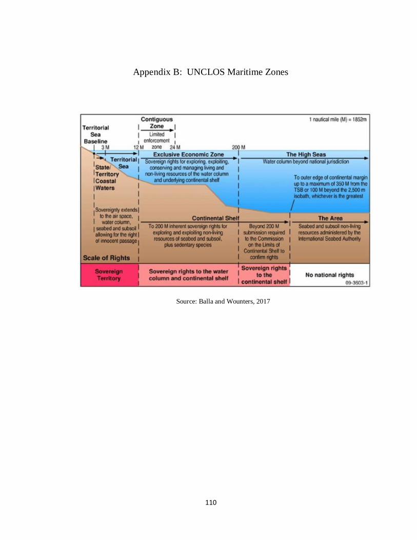
110
Appendix B: UNCLOS Maritime Zones
Source: Balla and Wounters, 2017
111
Bibliography
—. «Doğu Akdeniz Kıta Sahanlığı Sorunsalı Üzerinden Doğalgaz Paylaşımı.»
TÜCAUM 30. Yıl Uluslararası Coğrafya Sempozyumu. Ankara, 2018. 597-607.
—. «Doğu Akdeniz'dki Enerji Kaynakalarına İlişkin Hukuki ve Siyasi Sorunlar.» 2015.
—. «Operation Mediterranean Shield endures: protecting Turkey’s Blue Homeland.»
United World. 2020. Retrieved from https://uwidata.com/10608-operation-
mediterranean-shield-endures-protecting-turkeys-blue-homeland/.
—. «Turkish-Libyan maritime pact a game changer in E.Med.» Anadolu Agency. 2019.
Retrieved from https://www.aa.com.tr/en/politics/turkish-libyan-maritime-pact-a-
game-changer-in-emed/1671447.
—. «Türkiye-Libya Arasında İmzalanan Münhasır Ekonomik Bölge Andlaşmasının
Sonuç ve Etkileri.» KRITER. 2020. Retrieved from
https://kriterdergi.com/dosya/turkiye-ve-libya-arasindaki-anlasmanin-sonuc-ve-
etkileri.
—. Communication dated 20 March 2017 from the Permanent Mission of Lebanon to
the United Nations addressed to the office of the Secretary-General of the United
Nations -. 2017.
https://www.un.org/Depts/los/LEGISLATIONANDTREATIES/PDFFILES/com
munications/2017_03_20_lbn.pdf.
—. Doğu Akdeniz'de Hukuk ve Siyaset. 2013.
—. Egypt-Greece-Cyprus Trilateral Summit Cairo Declaration. 2014. Retrieved from
https://www.mfa.gr/en/current-affairs/news-announcements/egypt-greece-
cyprus-trilateral-summit-cairo-declaration.html.
—. How Did the Situation Change after July 1974? (n.d.). Retrieved from
http://www.mfa.gov.tr/how-did-the-situation-change-after-july-1974-_.en.mfa.
112
—. Lebanon: A letter dated 3 September 2011 from the Minister for Foreign Affairs and
Emigrants of Lebanon addressed to the Secretary-General of the United Nations
concerning the geographical coordinates of the northern limit of the territorial
sea and the e. 2011. Retrieved from
https://www.un.org/Depts/los/LEGISLATIONANDTREATIES/PDFFILES/com
munications/lbn_re_isr__listofcoordinates_e.pdf.
—. Turkish PM calls Cyprus, Israel drilling "madness". 2011. Retrieved from
https://www.reuters.com/article/turkey-cyprus/turkish-pm-calls-cyprus-israel-
drilling-madness-idUSL5E7KL40Z20110921.
—. United Nations Convention on the Law of the Sea. 1982. Retrieved from
https://www.un.org/depts/los/convention_agreements/texts/unclos/unclos_e.pdf.
—. United Nations Legislations and Treaties: Turkey. 2020. Retrieved from
https://www.un.org/Depts/los/LEGISLATIONANDTREATIES/STATEFILES/T
UR.htm.
—. What Happened in 1959 - 1960. (n.d.). Retrieved from http://www.mfa.gov.tr/what-
happened-in-1959---1960.en.mfa.
—. Where do the Parties Stand in Terms of a Negotiated Settlement? (n.d.). Retrieved
from http://www.mfa.gov.tr/where-do-the-parties-stand-in-terms-of-a-
negotiated-settlement_.en.mfa.
—. Why and How Did the 1960 Order Collapse? (n.d.). Retrieved from
http://www.mfa.gov.tr/why-and-how-did-the-1960-order-collapse_.en.mfa.
—. Why Greece and the Greek Cypriots do not Want Peace in the Island? (n.d.).
Retrieved from http://www.mfa.gov.tr/why-greece-and-the-greek-cypriots-do-
not-want-peace-in-the-island_.en.mfa.
“Can Hydrocarbons Catalyse New Out of the Box Thinking on Cyprus? A Turkish
Cypriot Perspective.” Sigma Turkey, 21 May 2019, www.sigmaturkey.com/can-
hydrocarbons-catalyse-new-out-of-the-box-thinking-on-cyprus-a-turkish-cypriot-
perspective/.
113
Abdallah, Mirvat, ve Houssam Salami. Overview of the Oil and Gas exploration in
Lebanon. 2015.
Acar, Işılay, ve Mutlu Yılmaz. «Doğu Akdeniz Kıta Sahanlığı Sorunsalı Üzerinden
Doğalgaz Paylaşımı.» International Geography Symposium on the 30th
Anniversary of TUCAUM. Ankara, 2018.
Acosta, R. (2020). China harassment of oil-exploring boats signal to claimants–AMTI.
Bussines Monitor. Retrieved from
https://businessmirror.com.ph/2020/05/04/china-harassment-of-oil-exploring-
boats-signal-to-claimants-amti/
Adamson, Fiona B. «Democratization and the Domestic Sources of Foreign Policy:
Turkey in the 1974 Cyprus Crisis.» Political Science Quarterly, 2001: 277-303.
Affairs, Republic of Turkey Ministry of Foreign. How Did the Greek Cypriots Persecute
the Turks of Cyprus Between 1963-1974? (n.d.). Retrieved from
http://www.mfa.gov.tr/how-did-the-greek-cypriots-persecute-the-turks-of-
cyprus-between-1963-1974_.en.mfa.
Akman, Muhammed Ali. «Lübnan ile İsrail Arasında Deniz Sınırı Anlaşmazlığı.»
Anadolu Agency. 2018. Retrieved from https://www.aa.com.tr/tr/dunya/lubnan-
ile-israil-arasinda-deniz-siniri-anlasmazligi/1059490.
Aksan, Sertaç. «’EastMed’ Türkiye olmadan zor.» TRT Haber. 2020. Retrieved from
https://www.trthaber.com/haber/gundem/eastmed-turkiye-olmadan-zor-
451253.html.
Alfaleh, F. M. (2010). The Role of Naval Forces in the Non-Military Maritime Domain.
Alhas, Ali Murat. «Energy resources in Eastern Mediterranean: an overview.» Anadolu
Agency. 2019. Retrieved from https://www.aa.com.tr/en/economy/energy-
resources-in-eastern-mediterranean-an-overview/1504786.
Alhas, Ali Murat. «Energy resources in Eastern Mediterranean: an overview.» Anadolu
Agency. 2019. Retrieved from https://www.aa.com.tr/en/economy/energy-
resources-in-eastern-mediterranean-an-overview/1504786.
114
Alptekin, Gökhan. «Doğu Akdeniz Enerji Keşiflerinden Sonra Akdeniz Uyumu Fırsatı
ve Bölge Devletlerinin Politikaları (2009 – 2015).» Academia. (n.d.). Retrieved
from
https://www.academia.edu/10219760/Do%C4%9Fu_Akdeniz_Enerji_Ke%C5%
9Fiflerinden_Sonra_Akdeniz_Uyumu_F%C4%B1rsat%C4%B1_ve_B%C3%B6l
ge_Devletlerinin_Politikalar%C4%B1_2009_2015_.
Altıntaş, Y. Y., Bacak, B., Eken , Z., Ertürk, E., Tengilimoğlu, S., and Tümer, İ. (2019).
A Possible Found Natural Gas Filed in Turkey Economic Zone in East
Medeteranian: Merih. (n.d.). Retrieved from http://berument.bilkent.edu.tr/:
http://berument.bilkent.edu.tr/No027
Anadolu Agency. «Barbaros Hayreddin Paşa göreve başladı.» Hürriyet. 2013. Barbaros
Hayreddin Paşa göreve başladı.
Anckar, C. (2008). On the Applicability of the Most Similar Systems Design and the
Most Different Systems Design in Comparative Research. International Journal
of Social Research Methodology, 389-401.
Andrei, Roxana. «The Cyprus Issue and Natural Gas in the Eastern Mediterranean.»
Geoplitical Monitor. 2 09 2019. Retrieved from
https://www.geopoliticalmonitor.com/the-cyprus-issue-and-natural-gas-in-the-
eastern-mediterranean/
Andrei, Roxana. «The Cyprus Issue and Natural Gas in the Eastern Mediterranean.»
Geoplitical Monitor. 2 09 2019. Retrieved from
https://www.geopoliticalmonitor.com/the-cyprus-issue-and-natural-gas-in-the-
eastern-mediterranean/
Apodaca, Afton J., and Julia Greensfelder. «Pipeline or Pipe Dream: The Potential of
Peace Pipelines as a Solution to Fragmentation and Energy Insecurity in the
European Union.» Claremont-UC Undergraduate Research Conferance on the
European Union. 2019. 1-8.
115
ARCHYDE. (2020). Repsol transferred to three exploratory blocks in Vietnam to the
pressures of China. Retrieved from https://www.archyde.com/repsol-transferred-
to-three-exploratory-blocks-in-vietnam-to-the-pressures-of-china/
Arı, Tayyar. «Kıta Sahanlığı Sorunu ve Türk-Yunan İlişkileri.» Uludağ Üniversitesi
İktisadi ve İdari Bilimler Fakültesi Dergisi, 1992: 167-184.
Arıboğan, D. Ü., and Bilgin, M. (2009). New Energy Order Politics Neopolitics: From.
Uluslararası İlişkiler Dergisi, 109-132.
Arslan, H. (2019). Deniz Egemenliği Teorisi Çerçevesinde Güney Çin Denizi Sorunu.
Yüksek Lisans Tezi.
ASEAN. (2002). Declaration on the Conduct of Parties in the South China Sea.
ASEAN. Retrieved from https://asean.org/?static_post=declaration-on-the-
conduct-of-parties-in-the-south-china-sea-2
Asia Maritime Transparency Initiative. (2020). South China Sea Energy Exploration and
Development. Center for Strategic and International Studies. Retrieved from
https://amti.csis.org/south-china-sea-energy-exploration-and-development/
Atatürkçü Düşünce Derneği. «Doğu Akdeniz’de Rum-Yunan İkilisinin Yeni Stratejik
Denge Girişimleri Ve Hedefleri.» 2018. Retrieved from https://add.org.tr/wp-
content/uploads/2018/05/Do%C4%9Fu-Akdeniz%E2%80%99de-Rum-Yunan-
%C4%B0kilisi.pdf.
Avundukluoglu, Emin. «Turkey: Parliament ratifies maritime pact with Libya.» Anadolu
Agency. 2019. Retrieved from https://www.aa.com.tr/en/turkey/turkey-
parliament-ratifies-maritime-pact-with-libya/1665108.
Aydın, Aydın. « The Interelation Between Power Of Natural Resources-Energy Lines
Owning Countries And The Level Of Conflicts They Engage In.» 2014.
Aydoğmuş, Hale. «Doğu Akdeniz Bilmecesi.» TRT Haber. 2019. Retrieved from
https://www.trthaber.com/haber/gundem/dogu-akdeniz-bilmecesi-423599.html.
116
B.Hattendorf, John. Naval Policy and Strategy In The Mediterranean Past, Present and
Future. 2000.
Bağcı, Hüseyin. "Demokrat Parti'nin Ortadoğu Politikası stanbul: Der Yayınevi, 2004),
177.)." In Türk Dış Politikasının Analizi, by Faruk Sönmezoğlu, 177-204.
Islanbul: Der Yayinevi, 2004.
Bahar R. (2014). Peace Anxieties: Ontological Security and Conflict Resolution.
Baker, C. (2004). China-Philippines Relations: Cautions Cooperation. Asia-Pacific
Center for Security Studies.
Balık, İsmet. «Türkiye'nin Deniz Yetki Alanları ve Kıyıdaş Ülkelerle Yetki Alnı
Anlaşmazlıkları.» Kent Akademisi, 2018: 86-98.
Balla, Evangella, and Rik Wounters. “2017 World Bank Conference on Land and
Property.” Marine Cadastre in Europe: State of Play (NR 355), 2017.
Bannon, I., and Collier, P. (2003). Natural Resources and Violent Conflict: Options and
Actions. World Bank Goup Publications.
Bareis, L. (2018). Interstate Resource Conflicts: International Networks and the
Realpolitik of Natural Resource Acquisition. PhD. dissertation.
Barnum, R., Brinkman, F., Richardson, T., and Spillette, A. (1995). Gas Condensate
Reservoir Behaviour: Productivity and Recovery Reduction Due to
Condensation.
Basedau, M., and Wegenast, T. C. (2009). Oil and Diamonds as Causes of Civil War in
Sub-Saharan Africa Under What Conditions? Colombia Internacional, 35-59.
Başeren, Sertaç Hami. Doğu Aakdeniz Yetki Alanları Uyuşmazlığı. 2010.
Bavinck, M., Pellegrini, L., and Mostert, E. (2014). Conflicts over Natural Resources in
the Global South: Conceptual Approaches. CRC Press.
Bayıllıoğlu, Uğur. «Birleşmiş Milletler Deniz Hukuku Sözleşmesi’nin 121. Maddesinin
Doğu Akdeniz'de Etkisi: Meis, Karaada ve Fener Adası'nın Statüsüne İlişkin Bir
117
Değerlendirme.» Ankara Hacı Bayram Veli Üniversitesi Hukuk Fakültesi
Dergisi, 2019: 185-223.
Bayraklı, Enes. «Türkiye'nin Kıbrıs Politikası 2018.» Türk Dış Politika Yıllığı, 2018:
261-286.
Bayramov, A. (2018). Review: Dubious Nexus Between Natural Resourcesand Conflict.
Journal of Eurasian Studies, 72-81.
BBC News. (2012). Philippine warship 'in stand-off' with Chinese vessels. BBC News.
Retrieved from https://www.bbc.com/news/world-asia-17673426
BBC News. (2016). What does disputed Paracel island look like?
BBC News. (2016, 07 12). Why is the South China Sea contentious? BBC News.
Retrieved from https://www.bbc.com/news/world-asia-pacific-13748349
BBC News. (2019). Taiwan profile - Timeline. BBC News. Retrieved from
https://www.bbc.com/news/world-asia-16178545
Beach, D., and Pedersen, R. B. (2019). Process-tracing methods: Foundations and
guidelines. University of Michigan Press.
Beckman, R. (2013). The UN Convention on the Law Of The Sea And The Maritime
Disputes In The South China Sea. The American Journal of International Law,
142-163.
Bell, S. R. (2017). Power, Territory, and Interstate Conflict. Conflict Management and
Peace Science, 160-175.
Bellamy, Daniel. «U Mediterranean states back Cyprus in dispute with Turkey over
offshore gas reserves.» Euro News. 2019. Retrieved from
https://www.euronews.com/2019/06/15/eu-mediterranean-states-back-cyprus-in-
dispute-with-turkey-over-offshore-gas-reserves.
Ben-Avraham, Zvi, Avihu Ginzburg, Jannis Markis, ve Lev Eppelbaum. «Crustal
structure of the Levant Basin, Eastern Mediterranean.» Tectonophysics, 2002:
23-43.
118
Bennett, A. (2010). Process tracing and causal inference.
Bennett, A. (2010). Process tracing and causal inference.
Berberakis, Stelyo. «Doğu Akdeniz - EastMed doğalgaz boru hattı anlaşması Atina'da
imzalandı.» BBC News. 2020. Retrieved from
https://www.bbc.com/turkce/haberler-dunya-50973890.
Beriker, N. (2009). Conflict resolution: the missing link between liberal international
relations theory and realistic practice. D. J. Sandole, S. Byrne, I. Sandole-
Staroste, and J. Senehi içinde, Handbook of Conflict Analysis and Resolution,.
Routledge.
Beyaz, Zelal. «Doğal Kaynaklar ve İç Çatışmalar Etkileşiminin Ekonomik Analizi.»
2014.
Bilge Adamlar Stratejik Araştırmalar Merkezi. Doğu Akdeniz'de Enerji Keşifleri ve
Türkiye. İstanbul: Bilge Adamlar Stratejik Araştırmalar Merkezi, 2013.
Bitzinger, R. A. (2013). China’s ADIZ: South China Sea Next?.
Blake, G. H. (Ed.). (2002). Maritime Boundaries: World Boundaries Volume 5.
Routledge.
Bouchat, C. J. (2014). The Paracel Islands and U.S. Interests and Approaches in the
South China Sea. Strategic Studies Institute and U.S. Army War College Press.
Bradford, L. J. F. (2005). The growing prospects for maritime security cooperation in
Southeast Asia. Naval War College Review, 58(3), 63-86.
Brandenburg, J. A. (2011). China's Energy Insecurity and the South China Sea Dispute.
United States Air Force Strategy Research Project for the Master of Strategic
Studies Degree.
Britannica. (n.d.). Paracel Islands. Britannica. Retrieved from
https://www.britannica.com/place/Paracel-
Brochmann, M., Rod, J. K., and Gleditsch, N. P. (2012). International Borders and
Conflict. Conflict Management and Peace Science, 170–194.
119
Brubake, R., and Dörfler, T. (2017). UN Sanctions and the Prevention of Conflict A
Thematic Paper for the United Nations - World Bank Study on Conflict
Prevention. United Nations University Centre for Policy Research.
Bueger, C. (2015). What is Maritime Security? Marine Policy, 159-164.
Burch, Jonathon. «Turkey to freeze EU ties if Cyprus gets EU presidency.» Reuters.
2011. Retrieved from https://www.reuters.com/article/us-turkey-cyprus/turkey-
to-freeze-eu-ties-if-cyprus-gets-eu-presidency-idUSTRE78H20L20110918.
Buszynski, L. (2015). The development of the South China Sea maritime dispute.
National Security College.
Buszynski, L., and Sazlan, I. (2007). Maritime Claims and Energy Cooperation in the
South China Sea. Contemporary Southeast Asia, 143-171.
Cankara, Yavuz. «Doğu Akdeniz'in Artan Petropolitik Önemi ve Türkiye'nin Kuzey
Kıbrıs Siyaseti.» Dumlupınar Üniversitesi Sosyal Bilimler Dergisi, 2016: 18-35.
Carlson, L. J. (1995). A Theory of Escalation and International Conflict. The Journal of
Conflict Resolution, 511-534.
Carter, D. B. (2010). The Strategy of Territorial Conflict. American Journal of Political
Science, 969-987.
Casey, W. (2012). Political Science and Comparative Politics.
Casin, Mesut Hakki. «ANALYSIS - Strategic, legal aspects of Turkey-Libya deal.»
Anadolu Agency. 2019. Retrieved from https://www.aa.com.tr/en/africa/analysis-
strategic-legal-aspects-of-turkey-libya-deal/1673079.
Castlereagh Associates. (2019). East Mediterranean Gas: an opportunity for closer
cooperation. Castlereagh Associates: Retrieved from https://castlereagh.net/east-
mediterranean-gas-an-opportunity-for-closer-cooperation/
Castro, R. C. ( 2009). The US-Philippine Alliance: An Evolving Hedge against an
Emerging China Challeng. Contemporary Southeast Asia: A Journal of
International and Strategic Affairs, 399-423.
120
Çelik, Okan. «1982 Bm Deniz Hukuku Perspektifinde Doğu Akdeniz Kıta Sahanlığı Ve
Enerji Kaynakları Paylaşıma Sorunun Hakkaniyet İlkesiyle Çözüm Yolları.»
2016.
Çelikpala, M. (2014). Enerji Güvenliği: NATO’nun Yeni Tehdit Algisi. Uluslararsi
Iliskiler , 75-99.
Center for Strategic and International Studies. (2020). ChinaPower Project.
Center for Strategic and International Studies. (2020). Pattle Island. Asia Maritime
Transparency Initiative. Retrieved from https://amti.csis.org/pattle-island/
Center, T. W. (n.d.). Environmental Change and Security Program Report 8: Reviews of
New Publications. Scribd. Retrieved from
https://www.scribd.com/document/105032255/Environmental-Change-and-
Security-Program-Report-8-Reviews-of-New-Publications
Central Intelligence Agency. «The World Factbook: Costline.» Central Intelligence
Agency. 2020. Retrieved from https://www.cia.gov/library/publications/the-
world-factbook/fields/282.html.
Ceylan, F. A. (2018). Doğu Akdeniz Enerji Keşiflerinin Bölgeyi Jeopolitik ve
Jeostratejik Açıdan Değiştirme Potansiyeli.
Chan, M. (2020). Beijing’s plans for South China Sea air defense identification zone
cover Pratas, Paracel and Spratly islands, PLA source says. South China
Morning Post. Retrieved from
https://www.scmp.com/news/china/military/article/3086679/beijings-plans-
south-china-sea-air-defence-identification-zone
Chang, T.-K. (1991). China's Claim of Sovereignty over Spratly and Paracel Islands: A
Historical and Legal Perspective. Case Western Reserve Journal of International
Law, 339-420.
Charney, J. I. (1999). Rocks that Cannot Sustain Human Habitation. The American
Journal of International Law, 863-878.
121
Checkel, J. T. (2008). Process tracing. In A. Klotz, and D. Prakash, Qualitative methods
in International Relations (pp. 114-127.). London: Palgrave Macmillan.
Cheng, T. (1975). The Dispute over the South China Sea. Texas International Law
Journal, 256-277.
Chicago Convention. (1944). Convention on International Civil Aviation Law.
Chung, C. (2009). Southeast Asia and the South China Sea dispute. In, S. Bateman, and
R. Emmers, Security and International Politics in the South China Sea (s. 95-
109). Routledge.
Çiner, Attila, A. M. Celâl Şengör, ve Nabil Khélifi. «Mediterranean Geoscience
Reviews: a Mediterranean perspective to geosciences.» Mediterranean
Geoscience Reviews, 2019: 1-4.
Colgan, J. D. (2013). Oil, Conflict, and U.S. National Interests. Quarterly Journal:
International Security.
Collier, D. (2011). Understanding Process Tracing. Political Science and Politics, 823-
830.
Collier, P., and Hoeffler, A. (n.d.). Greed and Grievance in Civil War. World Bank
Policy Research Working Paper No. 2355, s. 1-44.
Cozzi, Andrea. ENI Operations. 2020. Retrieved from https://www.eni.com/en-
IT/operations/egypt-zohr.html.
Crescenzi, M. J. (2003). Economic Exit, Interdependence, and Conflict. The Journal of
Politics.
Cronin, P. M., Dutton, P. A., Fravel, M. T., Holmes, H. R., Kaplan, R. D., Rogers, W.,
and Storey, I. (2012). Cooperation from Strength The United States, China and
the South China Sea. Center for a New American Security.
Çubukçu, S. (2019). Güney Çin Denizi Sorunu ve Uluslararsı Rekabete Etkileri. Yüksek
Lisans Tezi. T.C. Milli Savunma Üniversitesi.
122
Daiss, T. (2018, 03 14). How Oil Drives The South China Sea Conflict. Oil Price.
Retrieved from https://oilprice.com/Energy/Energy-General/How-Oil-Drives-
The-South-China-Sea-Conflict.htm
Damayanti, A. (2017). Regional maritime cooperation in maintaining maritime security
and stability: a test case for ASEAN unity and centrality. Journal of ASEAN
Studies, 5(2), 119-134.
Daniels, K., & Mitchell, S. M. (2017). Bones of democratic contention: Maritime
disputes. International Area Studies Review, 20(4), 293-310.
Daxecker, U. E. (2011). Rivalry, Instability, and the Probability of International
Conflict. Conflict Management and Peace Science, 543-565.
Dean, P., and Vasquez, J. A. (1976). From Power Politics to Issue Politics: Bipolarity
and Multipolarity in Light of a New Paradigm. Political Research Quarterly.
Demetriou, Chares. «Divide and rule Cyprus? Decolonization as process.»
Commonwealth and Comparative Politics, 2019: 403-420.
Demir, Nesrin, ve Osman Tekir. «Sharing Energy Resources of Eastern Mediterranean:
Regional and Global Dynamics.» Economic Environmental Studies, 2017: 651-
674.
Demirci, Murat. «Oil and gas exploration to start offshore N. Cyprus.» Anadolu Agency.
2019. Retrieved from https://www.aa.com.tr/en/economy/oil-and-gas-
exploration-to-start-offshore-n-cyprus/1391548.
Demiryol, Tolga. «Between Security and Prosperity: Turkey and the Prospect of Energy
Cooperation in the Eastern Mediterranean.» Turkish Studies, 2019: 442-464.
Deutsch, K. W., and Singer, J. (1964). Karl W. Deutsch. World Politics, 390-406.
Diehl, P. F. (1992). What are they fighting for? The importance of issues in international
conflict research. Journal of Peace Research, 29(3), 333-344.
Diehl, P. F. (Ed.). (1999). A road map to war: Territorial dimensions of international
conflict. Vanderbilt University Press.
123
Diep, V. N. (2020). Vietnam's Note Verbale on the South China Sea. Asia Maritime
Transparency Initiative. Retrieved from https://amti.csis.org/vietnams-note-
verbale-on-the-south-china-sea/
Dilaver, Tutku. «Doğu Akdeniz Enerjisi: Fırsat Mı? Tehlike Mi?» AVİM. 2018.
Diriöz, Ali Oğuz, and Roee Kibrik. «Forget the East-Med Pipeline: Advantages of
Alternative Options to Transport the Easter Mediterranean Gas.» ECONFO.
2020. Retrieved from http://econfo.org/2020/04/17/dr-ali-oguz-dirioz-forget-the-
east-med-pipeline-advantages-of-alternative-options-to-transport-the-easter-
mediterranean-gas/.
Dirmeikis, A. (2018). U.S. Role In Conflict Resolution: The Case of South China Sea
Territorial Disputes. Master Thesis.
Djalal, H. (1990). Managing potential conflicts in the South China Sea. International
Challenges, 10(2), 39.
Djalal, H. (2011). Conflict Management Experiences in Southeast Asia: Lessons and
Implications for the South China Sea Disputes. Asian Politics and Policy, 627-
642.
Doğru, Sami. «Doğu Akdeniz’de Hidrokarbon Kaynaklari Ve Uluslararasi Hukuka Göre
Bölgedeki Kita Sahanliği Ve Münhasir Ekonomik Bölge Alanlarinin
Sinirlandirilmasi Doğu Akdeniz’de Hidrokarbon Kaynaklari Ve Uluslararasi
Hukuka Göre Bölgedeki Kita Sahanliği Ve Münhasir E.» TBB Dergisi, 2015:
504-554.
Dokuz Eylül Üniversitesi. History of Cyprus. 2020. Retrieved from
http://web.deu.edu.tr/kibris/history/6474.html.
Dolven, B., Elsea , J. K., Lawrence , S. V., O'Rourke , R., and Rinehart , I. E. (2015).
Chinese Land Reclamation in the South China Sea: Implications and Policy
Options. Congressional Research Service.
Duffy, G. (1992). Concurrent interstate conflict simulations: Testing the effects of the
serial assumption. Mathematical and Computer Modelling , 241-270.
124
Durham University IBRU: Center for Borders Research . «Israel unilaterally defines the
northern limit of its maritime space.» Durham University. 2011. Retrieved from
https://www.dur.ac.uk/ibru/news/boundary_news/?itemno=12445andrehref=%2F
ibru%2Fnews%2Fandresubj=Boundary+news+Headlines.
Dutton, P. (2011). Three Disputes and Three Objectives: China and the South China Sea.
Naval War College Review, s. 42-67.
DW. Mısır Dünyanın En Güçlü Orduları Arasına Girdi. 2020. Retrieved from
https://www.dw.com/tr/m%C4%B1s%C4%B1r-d%C3%BCnyan%C4%B1n-en-
g%C3%BC%C3%A7l%C3%BC-ordular%C4%B1-aras%C4%B1na-girdi/a-
52302944.
Ece, Nur Jale. «Doğu Akdeniz’de Münhasır Ekonomik Bölge: Sınırlandırma
Anlaşmaları, Paydaşlar ve Stratejiler.» Journal of ETA Maritime Science, 2017:
81-94.
Ece, Nur Jale. «Doğu Akdeniz’de Münhasır Ekonomik Bölge: Sınırlandırma
Anlaşmaları, Paydaşlar ve Stratejiler.» Journal of ETA Maritime Science, 2017:
81-94.
Economist, T. (2014, 08 27). Why China is building islands in the South China Sea.
Retrieved from https://www.youtube.com/watch?v=SscQBrJbiN0
Ediger, Volkan Ş., Balkan Devlen, ve Deniz Bingöl McDonald. «Levant’ta Büyük
Oyun: Doğu Akdeniz’in Enerji.» Uluslararası İlişkiler, 2012: 73-92.
Egyptian Gas Association. Egyptian Gas Association. 2020. Retrieved from
https://www.ega.org.eg/#:~:text=In%201967%20Egypt%20discovered%20its,fro
m%20Abu%20Madi%20in%201975.
El-Anis, I. (2013). Freshwater scarcity, interdependence and institutionalism in
Jordanian foreign policy: towards conflict or cooperation? Journal of
International Affairs, 195-213.
Elleman, B. A. (2009). Maritime territorial disputes. In, S. Bateman, and R. Emmers
Security and International Politics in the South China Sea, 41-60. Routledge.
125
Ellinas, C. (2018, December 2). EastMed gas pipeline increasingly doubtful. Retrieved
from http://www.cypriot.org.uk/Documents/Haber18/01-Aralik.htm
Emmers, R. (2005). Maritime Disputes in the South China Sea: Strategic and
Diplomatic Status Quo. Institute of Defense and Strategic Studies Singapore.
Emmers, R. (2009). The de-escalation of the Spratly dispute in Sino-Southeast Asian
relations. In, S. Bateman, and R. Emmers, Security and International Politics in
the South China Sea (s. 128-139). Routledge.
Energy Information Administration. «Country Analysis Briefs Syria .» 2011.
Energy World Magazine. East Med pipeline: Prospects and challenges. 2019. Retrieved
from https://www.energyworldmag.com/east-med-pipeline-prospects-and-
challenges/.
Environment Foundation New Zealand. (n.d.). Environment Guide. Retrieved 2020,
from http://www.environmentguide.org.nz/issues/marine/marine-
management/areas/
Erciyes, Çağatay. Maritime Delimitation and Offshore Activities in the Eastern
Mediterranean Legal and Political Perspectives Recent Developments. 2012.
Euronews. (2020). Filipinler,ABD ile imzalanan Ziyaretci Kuvvetler Anlasmasi'ni
feshettigini duyurdu.
European Commission. «ITALY: Country reports. » (n.d).
Evans, A. (2009). Managing scarcity: the institutional dimensions. Presentation at: DPA
Non-Traditional Security Threats Program, Center on International Cooperation.
Evans, D. (2020). Tensions boil in South China Sea as Petronas drills. Energy Voice.
Retrieved from https://www.energyvoice.com/oilandgas/asia/240336/tensions-
boil-in-south-china-sea-as-petronas-drills/
Evans, G. (1994). Cooperative Security and Intrastate Conflict. Foreign Policy, 3-20.
126
Exxon Mobil. (2020). Crude oil blends by API gravity and by sulfur content. Retrieved
from https://corporate.exxonmobil.com/Crude-oils/Crude-trading/Crude-oil-
blends-by-API-gravity-and-by-sulfur-content#APIgravity
EXXON Mobile. (2019, February 27). ExxonMobil makes natural gas discovery
offshore Cyprus. Retrieved from
https://corporate.exxonmobil.com/News/Newsroom/News-
releases/2019/0228_ExxonMobil-makes-natural-gas-discovery-offshore-Cyprus
Faustmann, Hubert, Ayla Gurel, ve Gregory M. Reichberg. Cyprus Offshore
Hydrocarbons: Regional Politics and Wealth Distribution. Friedrich Ebert
Stiftung, 2012.
Fearon, J. D. (2018). Cooperation, Conflict, and the Costs of Anarchy. International
Organization, 523-559.
Fearon, J. D. (2018). Cooperation, Conflict, and the Costs of Anarchy. International
Organization, 523-559.
Forbes, V. L. (2001). Conflict and cooperation in managing maritime space in semi-
enclosed seas. University of Chicago Press Economics Books.
Force, R., and Mavronicolas, A. J. (1991). Two Models of Maritime Dispute Resolution:
Litigation and Arbitration.
Forsberg, T. (1996). Explaining Territorial Disputes: From Power Politics to Normative
Reasons. Journal of Peace Research, 433-449.
Foundation Orient Mont-Pelerin. «The Legal Framework of Lebanon's Maritime
Boundaries: The Exclusive Economic Zone and Offshore Hydrocarbon
Resources.» 2012. Retrieved from http://orientmontpelerin.ch/the-legal-
framework-of-lebanons-maritime-boundaries-the-exclusive-economic-zone-and-
offshore-hydrocarbon-resources/.
Franckx, E. (2010). The International Seabed Authority and the Common Heritage of
Mankind: The Need for States to Establish the Outer Limits of their Continental
Shelf. The International Journal of Marine and Coastal Law, 543–567.
127
Fravel, M. T. (2008). Strong Boarders Secure Nation: Cooperation and Conflict in
China's Territorial Disputes. Princeton University Press.
Fravel, M. T. (2010). Explaining Stability in the Senkaku (Diaoyu) Islands Dispute.
Fravel, M. T. (2011). China's Strategy in the South China Sea. Contemporary Southeast
Asia, 292-319.
Fuat Aksu. Doğu Akdeniz Deniz Yetki Alanları Sorunu ve Türkiye - AB İlişkileri. (n.d.).
Furtado, X. (1999). International Law and the Dispute over the Spratly Islands: Whither
UNCLOS? Contemporary Southeast Asia, 386-404.
Gallagher, M. G. (1994). China's Illusory Threat to the South China Sea. International
Security, 169-164.
Garfunkel, Zvi. «Constrains on the origin and history of the Eastern Mediterranean
basin.» Tectonophysics, 1998: 5-35.
Gartzke, E., and Westerwinter, O. (2016). The complex structure of commercial peace
contrasting trade interdependence, asymmetry, and multipolarity. Journal of
Peace Research, 325-343.
Gausset, Q., Whyte, M. A., and Birch-Thomsen, T. (2005). Beyond Territory and
Scarcity: Exploring Conflicts Over Natural Resource Management.
Genc, Durmus. 'Mavi Vatan'daki dev tatbikat göz kamaştırdı. 2019. Retrieved from
https://www.aa.com.tr/tr/turkiye/mavi-vatandaki-dev-tatbikat-goz-
kamastirdi/1411433.
Geropoulos, Kostis. «Greece-Cyprus-Israel EastMed gas pipeline reaches Washington.»
New Europe. 2019. Retrieved from https://www.neweurope.eu/article/greece-
cyprus-israel-eastmed-gas-pipeline-reaches-washington/.
Gertz, B. (2005). China builds up strategic sea lanes. Washington Times.
Gibbs, J. (2019). Planet of the Humans.
128
Gibler, D. M. (1997). Control the issues, control the conflict: The effects of alliances
that settle territorial issues on interstate rivalries. International Interactions,
22(4), 341-368.
Gisselquist, R. M. (2014). Paired comparison and theory development: considerations
for case selection. PS: Political Science and Politics, 47(2), 477-484.
Gizelis, T.-I., and Wooden, A. E. (2010). Water Resources, Institutions, and Intrastate
Conflict. Political Geography, 444-453.
Global Conflict Tracker. (2020). Territorial Disputes in the South China Sea. Global
Conflict Tracker. Retrieved from https://www.cfr.org/global-conflict-
tracker/conflict/territorial-disputes-south-china-sea
Global Investment and Business Center. (2011). China Investment and Business Guide
Volume 1 Strategic and Practical Information. Washington.
Glynn, A. N. (2009). Does Oil Cause Civil War Because It Causes State Weakness?
Goertz, G., and Diehl, P. F. (1992). Territorial Changes and International Conflict.
Routledge, Taylor and Francis.
Gökçe, Gökhan. «Değişen Dünyanın Yeni Mücadele Alanı Doğu Akdeniz.» Türk Dış
Politikası Yıllığı, 2018.
Goldstein, L. (2011). Chinese Naval Strategy in the South China Sea: An Abundance of
Noise and Smoke, but Little Fire. Contemporary Southeast Asia, 320–347.
Gompert, D. C. (1979). China’s Punitive War Against Vietnam, 1979. In, D. C. Gompert
Blinders, Blunders, and Wars: What America and China Can Learn (s. 117-128).
RAND Cooperation.
Gonzales, R. (2014). The Spratly Islands Dispute: International Law, Conflicting
Claims,. Thesis.
Governmnet of China. (2019). Note Verbale No. cml/17/2009. United Nations. Retrieved
from
129
https://www.un.org/Depts/los/clcs_new/submissions_files/mys85_2019/CML_14
_2019_E.pdf
Governmnet of the Republic of China (Taiwan). (2018). History. Retrieved from
https://www.taiwan.gov.tw/content_3.php
Gözen, M. P. (2005). Disputes, Claims And Settlement Proposals Related To The
Territorial Sea Issue In Greek-Turkish Relations.
Gözlem Gazetesi. Rauf Denktaş KKTC kuruluş İlanı ve KKTC tanıyan ülkeler 2018.
2018. https://gozlemgazetesi.com/HaberDetay/252/1107415/rauf-denktas-kktc-
kurulus-ilani-ve-kktc-taniyan-ulkeler-2018.html.
Granados, U. (2005). As China Meets the Southern Sea Frontier: Ocean Identity in the
Making, 1902-1937. Pacific Affairs, 443-461.
Granados, U. (2006). Chinese Ocean Policies Towards the South China Sea in a
Transitional Period, 1946—1952. China Review, 153-181.
Greer, A. (2016). The South China Sea Is Really a Fishery Dispute. The Diplomat.
Retrieved from https://thediplomat.com/2016/07/the-south-china-sea-is-really-a-
fishery-dispute/
Grieco, J., Powell , R., and Snidal, D. (1993). The Relative-Gains Problem for
International Cooperation. The American Political Science Review, 727-743.
Grossman, N. (2013). Territorial and Maritime Dispute (Nicaragua v. Colombia).
American Journal of International Law, 107(2), 396-403.
Guney, Nurşin Ateşoglu. New Balance of Power in the Eastern Mediterranean and
Turkey. SAM, 2019.
Guo, R. (2018). Chapter 11: What are the Bad Boundaries. Rongxing Guo içinde,
Territorial Disputes and Cross-Border Management (s. 299-336). Elsevier.
Gürdeniz, Cem. Akdeniz Kalkanı Harekâtı. 2020.
Gürel, Ayla, ve Laura Le Cornu. Turkey and Eastern Mediterranean Hydrocarbons.
Istanbul Kültür Üniversitesi, 2013.
130
Haber7com. KKTC'yi fiilen tanıyan ikinci ülke. 2011. Retrieved from
https://www.haber7.com/hukuk/haber/801170-kktcyi-fiilen-taniyan-ikinci-ulke.
Hadjipavlou, Maria. «The Cyprus Conflict: Root Causes and Implications for
Peacebuilding.» Journal of Peace Research, 2007: 349–365.
Hale, William. Turkish Foreign Policy since 1774. Routledge, 2000.
Hall, C., Tharakan, P., Hallock, J., Cleveland, C., and Jefferson, M. (2003).
Hydrocarbons and the evolution of human culture. Nature Publishing Group, s.
318-322.
Haller-Trost, R. (1994). The Brunei-Malaysia Dispute over Territorial and Maritime
Claims in International Law. International Boundaries Research Unit Maritime
Briefing. University of Durham.
Hart, M. (2018). Brunei’s claims and ASEAN discord on the South China Sea dispute.
Geopolitical Monitor. Retrieved from
https://www.geopoliticalmonitor.com/brunei-abandons-south-china-sea-claim-
for-chinese-finance/ adresinden alındı
Hasan, M. M., Md. Wahidul Alam, H., and Azam Chowdhury, K. (2019). Protracted
maritime boundary disputes and maritime laws. Journal of International
Maritime Safety, Environmental, 89-96.
Hatipoglu, E., and Palmer, G. (2012). Interstate Conflict: Recent Findings and
Controversies. Terrorism and Political Violence, 601-616.
Hayton, B. (2020). China’s Pressure Costs Vietnam $1 Billion in the South China Sea.
The Diplomat. Retrieved from https://thediplomat.com/2020/07/chinas-pressure-
costs-vietnam-1-billion-in-the-south-china-sea/
Heldt, B. (1999). Domestic politics, absolute deprivation, and the use of armed force in
interstate territorial disputes, 1950-1990. Journal of Conflict Resolution, 43(4),
451-478.
131
Hellenic Republic Ministry of Foreign Affairs. Communique Meeting of the Foreign
Ministers of Egypt, France, Cyprus and Greece Cairo – January 8th 2020. 2020.
Retrieved from https://www.mfa.gr/en/current-affairs/statements-
speeches/communique-meeting-of-the-foreign-ministers-of-egypt-france-cyprus-
and-greece-cairo-january-8th-2020.html.
Hellenic Republic Ministry of Foreign Affairs. Cyprus–Egypt–Greece 2nd Trilateral
Summit Nicosia Declaration (29 April 2015). 2015. Retrieved from
https://www.mfa.gr/en/current-affairs/news-announcements/cyprusegyptgreece-
2nd-trilateral-summit-nicosia-declaration-29-april-2015.html.
Hellenic Republic Ministry of Foreign Affairs. Final Declaration The Trilateral Summit
of Egypt, Greece and Cyprus (Cairo, 11 October 2016). 2016. Retrieved from
https://www.mfa.gr/en/current-affairs/statements-speeches/final-declaration-the-
trilateral-summit-of-egypt-greece-and-cyprus-cairo-11-october-2016.html.
Hendler, B. (2018). Duterte’s Pivot to China, and Prospects for Settling the South
Prospects for Settling the South. Contexto Internacional, 319-337.
Henri J. Barkey. «The Evolution of Turkish Foreign Policy in the Middle East.» TESEV.
2012. Retrieved from http://www.scpss.org/libs/spaw/uploads/files/Policy/07-18-
2012%20The%20Evolution%20of%20Turkish%20Foreign%20Policy%20in%20
the%20Middle%20East.pdf.
Hensel, P. R. (1996). Charting a course to conflict: Territorial issues and interstate
conflict, 1816-1992. Conflict Management and Peace Science, 15(1), 43-73.
Hensel, P. R. (2001). Contentious issues and world politics: The management of
territorial claims in the Americas, 1816–1992. International Studies
Quarterly, 45(1), 81-109.
Hensel, P. R., and Mitchell, S. M. (2005). Issue indivisibility and territorial claims.
GeoJournal, 64(4), 275-285.
Hensel, P. R., and Vasquez, J. A. (2000). What Do We Know About War?.
132
Hensel, P. R., McLaughlin Mitchell, S., Sowers II, T. E., and Thyne, C. L. (2008).
Bones of Contention Comparing Territorial, Maritime, and River Issues. Journal
of Conflict Resolution, 117-143.
Hensel, P. R., McLaughlin Mitchell, S., Sowers, T. E., and Thyne, C. L. (2008). Bones
of contention: Comparing territorial, maritime, and river issues. Journal of
Conflict Resolution, 52(1), 117-143.
Herberg, M. E. (2016). The Role of Energy in Disputes over the South China Sea.
Maritime Awareness Project.
Herrera, D. R. (2012). The Philippines: An Overview of the Colonial Era. Southeast
Asia in the Humanities and Social Science Curricula.
Heydarian, R. (2018, 06 23). How the Scarborough Shoal came back to haunt China-
Philippines relations. Retrieved from South China Morning Post. Retrieved from
https://www.scmp.com/news/china/diplomacy-defence/article/2151923/how-
scarborough-shoal-came-back-haunt-china-philippines
Heydarian, R. J. (2018). Mare Liberum: Aquino, Duterte, and The Philippines’ Evolving
Lawfare Strategy in the South China Sea. Asian Politics and Policy, 283-299.
Heydarian, R. J. (2020). Philippines calls out China on the South China Sea. Asian
Times. Retrieved from https://asiatimes.com/2020/07/philippines-calls-out-
china-on-the-south-china-sea/
Himmelman, J. (2020). A Game of Shark And Minnow. New York Times. Retrieved
from http://www.nytimes.com/newsgraphics/2013/10/27/south-china-
sea/index.html
Hiro, T. N. (2014). The Regime of Islands in International Conventions (Part 1). Island
Studies, 1-14.
History World. History of the Mediterranean. 2020. Retrieved from
http://www.historyworld.net/wrldhis/plaintexthistories.asp?historyid=ab44.
133
Hong, Z. (2003). The South China Sea Dispute and China-ASEAN Relations. The Royal
Society for Asian Affairs, 27-43.
Hong, Z. (2010). Energy security concerns of China and ASEAN: trigger for conflict or
cooperation in the South China Sea? The Asia-Europe Journal, 413–426.
Humphreys, M. (2005). Natural Resources, Conflict, and Conflict Resolution. Journal of
Conflict Resolution, 508-537.
Hunt, K. (2016, July 12). Court Rules In Favor Of Philippines Over China. Retrieved
from https://maybienvh.wordpress.com/2016/07/12/court-rules-in-favor-of-
philippines-over-china/
Hürriyet Daily News . «Turkish Cypriot leader says EastMed project costly, not
conducive to Cyprus settlement.» Hürriyet Daily News . 2020. Retrieved from
https://www.hurriyetdailynews.com/turkish-cypriot-leader-says-eastmed-project-
costly-not-conducive-to-cyprus-settlement-150517.
Hürriyet. «Son dakika haberler: Doğu Akdeniz'deki çalışmaya 'Sertao' da dahil oldu!»
Hürriyet Ekonomi. 2020. Retrieved from
https://www.hurriyet.com.tr/ekonomi/ucuncu-sondaj-gemisi-yolda-41443220.
Huth, P. K. (1996). Enduring rivalries and territorial disputes, 1950-1990. Conflict
Management and Peace Science, 15(1), 7-41.
I.Tkachenko, B. (2018). Territoril Disputes in the South China Sea Paracel Islands. Asia-
Pacific Journal of Marine Science and Education, 56-72.
ICC International Maritime Bureau. (2019). Piracy and Armed Robbery against Ships.
London, UK: ICC International Maritime Bureau.
Icelandinc Human Rights Centre. (n.d.). Human Rights and Armed Conflict. Icelandinc
Human Rights Centre. Retrieved from http://www.humanrights.is/en/human-
rights-education-project/human-rights-concepts-ideas-and-fora/human-rights-in-
relation-to-other-topics/human-rights-and-armed-conflict
134
IGI Posedion. «A direct link to new sources for Europe.» IGI Poseidon. 2020.
http://www.igi-poseidon.com/en/eastmed.
IGI Poseidon. «EastMed-Poseidon Pipeline Project: Start Of Activities To Reach Fid
Within Two Years.» IGI Poseidon. 2020. Retrieved from http://www.igi-
poseidon.com/en/media/eastmed-poseidon-pipeline-project-start-activities-reach-
fid-within-two-years.
İlgen, Ferhat. «Border Issues in the Eastern Mediterranean An Assessment on Turkey.»
Dissertation. Yeditepe University, 2019.
Institute for Middle East Understanding. «Operation Cast Lead.» Institute for Middle
East Understandin. 2012. Retrieved from https://imeu.org/article/operation-cast-
lead#:~:text=On%20December%2027%2C%202008%2C%20Israel,assault%20o
n%20the%20Gaza%20Strip.andtext=In%20the%20aftermath%20of%20the,Israe
li%20military%20and%20Palestinian%20militias.
International Court of Justice. (n.d.). Delimitation of the Maritime Boundary in the Gulf
of Maine Area (Canada/United States of America). Retrieved from
https://www.icj-cij.org/en/case/67
International Crisi Group. (2016). Stirring up the South China Sea (IV): Oil in Troubled
Waters. Asia Report.
International Renewable Energy Agency. (2019). A New World The Geoplotics of the
Energy Transformation. Global Commission on the Geopolitics of Energy
Transformation.
International Union for Conservation of Nature. (2012, 09 25). IUCN. Exclusive
Economic Zone (EEZ). Retrieved from https://www.iucn.org/content/exclusive-
economic-zone-eez
İşeri, E. (2019). Turkey’s entangled (energy) security concerns and the Cyprus question
in the Eastern Mediterranean. In Greece and Turkey in Conflict and Cooperation.
Retrieved from Europeanization to De-Europeanization. Routledge.
135
Israel Ministry of Energy. «Oil and Gas Exploration in Israel.» Ministry of Energy.
2018. Retrieved from https://www.gov.il/en/departments/general/gas_oil_history.
Japan, M. o. (2014, April 4). Situation of the Senkaku Islands. Ministry of Foreign
Affairs of Japan. Retrieved from
https://www.mofa.go.jp/a_o/c_m1/senkaku/page1we_000010.html
Jennings, R. (2018). Analysts: Taiwan's Sea Drills to Raise South China Sea Tensions.
Retrieved from https://www.voanews.com/east-asia-pacific/analysts-taiwans-sea-
drills-raise-south-china-sea-tensions
Jervis, R. (1999). Realism, neoliberalism, and cooperation: understanding the debate.
International Security, 24(1), 42-63.
Jewish Virtual Library. Israel International Relations: Turkey-Israel Relations. (n.d.).
Retrieved from https://www.jewishvirtuallibrary.org/turkey-israel-relations.
Jian, S. (2007). Multinational oil companies and the spratly dispute. Journal of
Contemporary China, 591-601.
Jian, Sanqiang. «Multinational Oil Companies and the Spratly Dispute.» Journal of
Contemporary China, 1997: 591-601.
John, J. D. (2007). Oil abundance and violent political conflict: A critical assessment.
The Journal of Development Studies, 961-986.
Johnson, D. D., and Toft, M. D. (2014). Grounds for War The Evolution of Territorial
Conºict. International Security, 7-38.
Jones, D. M., Bremer, S. A., and Singer, D. J. (1996). Militarized Interstate Disputes,
1816–1992: Rationale, Coding Rules, and Empirical Patterns. Conflict
Management and Peace Science, 163-213.
Joyner, C. C. (1999). The Spratly Islands Dispute in the South China Sea Problems,
Policies, and Prospects for Diplomatic Accommodation. Stimson Center.
Jr, Mancur O., and Richard Z. «An Economic Theory of Alliances.» The Review of
Economics and Statistics, 1966: 266-279.
136
Kacowicz, A. M. (1994). Peaceful territorial change. Univ of South Carolina Press.
Kadera, K. M. (2004). The Power-Conflict Story: A Dynamic Model of Interstate
Rivalry. University of Michigan Press.
Kahveci Özgür, H. (2017). Eastern Mediterranean Hydrocarbons: Regional Potential,
Challenges Ahead, and the ‘Hydrocarbon-ization’ of the Cyprus Problem.
Perceptıons, 31-56. Retrieved from http://sam.gov.tr/wp-
content/uploads/2018/02/31-56.pdf
Kalelioğlu, Oğuz. «Türk-Yunan İlişkileri ve Megali İdea .» Ankara Üniversitesi Türk
inkılâp Tarihi Enstitüsü Atatürk Yolu Dergisi, 2008: 105-123.
Kamel, Olfat. «Maritime Borders in the Eastern Mediterranean .» Egypt Oil and Gas
Newspaper . 2016. Retrieved from https://egyptoil-gas.com/features/maritime-
borders-in-the-eastern-mediterranean/.
Kampouris, Nick. «Greek Experts Indicate Possibility of Large Hydrocarbon Deposit
South of Crete.» Greek Reporter. 2020. Retrieved from
https://greece.greekreporter.com/2020/01/10/greek-experts-indicate-possibility-
of-large-hydrocarbon-deposit-south-of-crete/.
Kaplan, R. D. (2011). The South China Sea Is the Future of Conflict.
Karbuz, S., and Baccarini, L. (2017). East Mediterranean Gas: Regional Cooperation or
Source of Tensions? Barcelona Centre for International Affairs. Retrieved from
https://www.cidob.org/en/publications/publication_series/notes_internacionals/n
1_173/east_mediterranean_gas_regional_cooperation_or_source_of_tensions
Kariotis, Theodore C. «Hydrocarbons and the Law of the Sea in the Eastern
Mediterranean: Implications for Cyprus, Greece, and Turkey.» Mediterranean
Quarterly,, 2011: 45-56.
Karpat, Kemal. Türk Dış Politikası Tarihi. Istanbul: Timaş Yayıncılık, 2017.
137
Katter, D. H. (2017). The sovereignty of islands: a contemporary methodology for the
determination of rights over natural maritime resources. PhD Thesis, Queensland
University of Technology.
Katz, Yaakov. «Turkey pulls out of navy exercise.» The Jerusalem Post. 2010.
Retrieved from https://www.jpost.com/international/turkey-pulls-out-of-navy-
excercise.
Kaya, İslam Safa. «Turkey's Legal Position in the Eastern Mediterranean.» Politics
Today. 2019. Retrieved from https://politicstoday.org/turkeys-legal-position-in-
the-eastern-mediterranean/.
Kayan, İlhan. «Türkiye'nin ege ve Akdeniz Kıyılarında Deniz Seviyesi ve Kıyı Çizgisi
Değişimleri.» Türkiye'nin Kıyı ve Deniz Alanları 1. Ulusal Konferansı. Ankara,
1997. 735-746.
Kedilikli, Umut, ve Taşkın Deniz. «Enerji Kaynaklari Mücadelesinde Doğu Akdeniz
Havzasi Ve Deniz Yetki Alanlari Uyuşmazliği.» Alternatif Politika, 2015.
Kenarlı, Gürseli, Ali Aksoyer, Güven Usta, ve Cemal Yurttaş. «İşte Türkiye'nin ilk yerli
ve milli sismik araştırma gemisi.» Hürriyet. 2019. Retrieved from
https://www.hurriyet.com.tr/gundem/iste-turkiyenin-ilk-yerli-ve-milli-sismik-
arastirma-gemisi-41226993.
Keyuan, Z. (2009). Cooperative development of oil and gas resources in the South China
Sea. In, S. Bateman, and R. Emmers, Security and International Politics (80-92).
Routledge.
Kienle, Eberhard. «Egypt without Mubarak, Tunisia after Bin Ali: theory, history and
the ‘Arab Spring’.» Economy and Society, 2012: 532-557.
Kim, N. K. (2019). Territorial disputes and individual willingness to fight. Journal of
Peace Research, 406-421.
King, G., Keohane, R. O., and Verba, S. (1994). Designing social inquiry: Scientific
inference in qualitative research. Princeton university press
138
Klare, M. T. (2014). Twenty-first century energy wars: how oil and gas are fuelling
global conflicts. Energypost.eu. Retrieved from https://energypost.eu/twenty-
first-century-energy-wars-oil-gas-fuelling-global-conflicts/
Kliot, N. (1989). Cooperation and Conflicts in Maritime Issues in the Mediterranean
Basin. Geo-Journal, 263-272.
Kocs, S. A. (1995). Territorial disputes and interstate war, 1945-1987. The Journal of
Politics, 57(1), 159-175.
Kocs, S. A. (1995). Territorial Disputes and Interstate War, 1945-1987. The Journal of
Politics, 159-175.
Kogan, Eugene. «Military Cooperation between Israel, Greece and Cyprus.» European
Security and Defence. 2020. Retrieved from https://euro-
sd.com/2020/03/allgemein/16506/military-cooperation-between-israel-greece-
and-cyprus/.
Kok, A., Lotze, W., and Van Jaarsveld, S. (2009). Natural Resources, the Environment
and Conflict.
Koubi, V., Gabriele, S., Bohmelt, T., and Bemauer, T. (2014). Do natural resources
matter for interstate and intrastate armed conflict? Journal of Peace Research,
227-243.
Kreuzer, P. (2016). A Comparison of Malaysian and Philippine Responses to China in
the South China Sea. The Chinese Journal of International Politics,, 239-276.
Küçük, Ferhat. «Maritime codes covering the gas dispute in East Med.» Daily Sabah.
(n.d.). Retrieved from https://www.dailysabah.com/op-ed/2019/09/30/maritime-
codes-covering-the-gas-dispute-in-east-med.
Kütükçü, Mehmet Akif, ve İslam Safa Kaya. «Uluslararası Deniz Hukuku Kapsamında
Doğu Akdeniz’deki Petrol ve Doğalgaz Kaynakları ile Türkiye’nin Hukuki
Durumu.» Yaşam Bilimleri Dergisi, 2016: 81-96.
139
Lai, H. H. (2007). China's oil diplomacy: is it a global security threat? Third World
Quarterly, 519-537.
Lappin, Yaakov, ve JNS. «Israel Navy's 'startup' department develops combat systems in
record time.» Israel Hayom. 2020. Retrieved from
https://www.israelhayom.com/2020/02/28/israel-navys-startup-department-
develops-combat-systems-in-record-time/.
Latest developments: Delimitation of the Maritime Boundary in the Gulf of Maine Area
(Canada/United States of America): International Court of Justice. (n.d.)..
Retrieved from https://www.icj-cij.org/en/case/67
Leblond, Doris. «Greek Cyprus receives bids for offshore licenses.» Oil and Gas
Journal. 2007. Retrieved from https://www.ogj.com/exploration-
development/article/17286518/greek-cyprus-receives-bids-for-offshore-licenses.
Lee, L. T. (1999). China and the South China Sea Dialogues. Greenwood Publishing
Group.
Lee, W.-c. (2017). Taiwan, the South China Sea Dispute, and the 2016 Arbitration
Decision. Journal of Chinese Political Science volume, 229-250.
Legro, J. W., and Moravcsik, A. (1999). Is Anybody Still a Realist? International
Security, 5-55.
Leigh, Michael. «Energy – A Geopolitical Game Changer?» The International
Spectator, 2014.
Lesser, Ian O. «The United States and the Future of Mediterranean Security: Reflections
from GMF’s Mediterranean Strategy Group.» 2015.
Levy, J. S. (2011). Theories and causes of war. In, C. J. Coyne, and R. L. Mathers, The
Handbook on the Political Economy of War. 13-33. Edward Elgar Publishing
Inc.
Liberman, Etty, Yael Foux Levy, and Peretz Segal. "Designing an Internal
Organizational System for Conflict Management: Based on a Needs
Assessment." Dispute Resolution Journal, 2009: 62-74.
140
Lin, C.-y. (1997). Taiwan's South China Sea Policy. Asian Survey, 323-339.
Liu, H., Yao, Y., and Deng, H. (2011). Geological and Geophysical Conditions for
Potential Natural Gas Hydrate Resources in Southern South China Sea Waters.
Journal of Earth Science,, 718-725.
Liu, Z. (2016). Chapter 4: Supply and Demand of Global Energy and Electricity. In, Z.
Liu, Global Energy Interconnection, 101-181. Elsevier.
Long, D. (2020). China Sends Coast Guard Ship to Scarborough Shoal. Retrieved from
https://www.benarnews.org/english/news/philippine/scarborough-boat-
04092020160555.html
Long, D. (2020). China Sends Coast Guard Ship to Scarborough Shoal. Retrieved from
https://www.benarnews.org/english/news/philippine/scarborough-boat-
04092020160555.html
Lopes, C. A., and Bourgoyne Jr., A. (1997). Feasibility Study of a Dual Density Mud
System for Deepwater Drilling Operations. Offshore Technology Conference.
Houston, Texas.
Lujala, P. (2018). Deadly Combat over Natural Resources: Gems, Petroleum, Drugs, and
the Severity of Armed Civil Conflict. Journal of Conflict Resolution, 50-71.
Mahoney, J. (2012). The Logic of Process Tracing Tests in the Social Sciences.
Sociological Methods and Research, 570-597.
Maks, H. (2018). Natural Resources as the Main Driver of Maritime Territorial Disputes
in the Case of South China Sea Dispute - Case Studies on Scarborough Shoal and
Spratly Islands. Journal of Social and Political Science, 485-493.
Mallinson, William. «Chapter Two: The Asset.» In, Kissinger and the Invasion of
Cyprus: Diplomacy in the Eastern Mediterranean Cambridge Scholar
Publishing, 2016.
Mangosing, F. G. (2019). Carpio: China to try to reclaim Scarborough Shoal before
Duterte term ends. Retrieved from
141
https://globalnation.inquirer.net/180234/carpio-china-to-try-to-reclaim-
scarborough-shoal-before-duterte-term-ends
Mansson, A. (2014). Energy, conflict and war: Towards a conceptual framework.
Energy Research and Social Science, 106-116.
Marineregions.org. Turkey · MRGID 5697. (n.d.). Retrieved from
https://www.marineregions.org/eezdetails.php?mrgid=5697andzone=eez.
Maritime Boundary Office. The Law of the Sea. 2018. Retrieved from
http://www.gfm.tl/learn/the-law-of-the-sea/.
Masarogullari, N. (2011). Nationalism in Cyprus: the effects of institutionalization on
nationalist mobilizations and political conflicts as reflected in Turkish Cypriot
nationalism and Greek Cypriot nationalism.
Matthew, R. A., Brown, O., and Jensen, D. (2009). From Conflict to Peacebuilding: The
Role of Natural Resources and the Environment. United Nations Environment
Programme.
Matthew, R. A., Brown, O., and Jensen, D. (2009). Retrieved from Conflict to
Peacebuilding: The Role of Natural Resources and the Environment. United
Nations Environment Programme.
Maxwell, J. W., and Reuveny, R. (2000). Resource Scarcity and Conflict in Developing
Countries. Journal of Peace Research, 301-322.
Mccauley, A. (2020). The Most Dangerous Waters in the World. Time. Retrieved from
https://time.com/piracy-southeast-asia-malacca-strait/
McGill University Geography Department. (2007). South China Sea.
McLaughlin Mitchell, S., and Thies, C. G. (2011). Issue rivalries. Conflict Management
and Peace Science, 28(3), 230-260.
Mearsheimer, J. (2001). The Tragedy of Great Power Politics. New York: W. W. Norton
and Company.
142
Mearsheimer, J. J. (2001). The Tragedy of Great Power Politics. W. W. Norton and
Company.
Mearsheimer, J. J. (2006). China's Unpeaceful Rise. Current History, 160-162.
Mearsheimer, J. J. (2014). Can China Rise Peaceefully? The National Interest, 1-40.
Mediterranean Blue Economy Stakeholder Platform. Blue Economy. (n.d.). Retrieved
from https://medblueconomyplatform.org/blue-economy/#.
Melin, M. M. (2015). Escalation in International Conflict Management: A Foreign
Policy Perspective. Conflict Management and Peace Science, 28-49.
Mello, P. A. (2014). Democratic Peace Theory. The SAGE Encyclopedia of War: Social
Science Perspectives, 1-5.
Meyer, S. E. (1996). Incident at Mischief Reef: Implications for the Philippines, China
and the United States. United States Army.
Middle East Monitor. France sends warships to Mediterranean to deter Turkey. 2020.
Retrieved from https://www.middleeastmonitor.com/20200130-france-sends-
warships-to-mediterranean-to-deter-turkey/.
Mildner, S.-A., Lauster, G., and Wodni, W. (2011). Scarcity and Abundance Revisited:
A Literature Review on Natural Resources and Conflict. International Journal of
Conflict and Violence, 155-172.
Mills, A. J., Durepos, G., and Wiebe , E. (2012). Most Different Systems Design. SAGE
Research Methods. Retrieved from
https://methods.sagepub.com/base/download/ReferenceEntry/encyc-of-case-
study-research/n211.xml
Mingjiang, L. (2009). China’s South China Sea dilemma: Balancing sovereignty,
development, and security. In, S. Bateman, and R. Emmers, Security and
International Politics in the South China Sea (140-154). Routledge.
Ministry of Foreign Affairs Brunei Darussalam. (2020). 20 July 2020 - Statement on the
South China Sea. Retrieved from
143
http://www.mfa.gov.bn/Lists/Press%20Room/news.aspx?id=841andsource=http:
//www.mfa.gov.bn/site/home.aspx
Ministry of Foreign Affairs, the People's Republic of China. (2009). Spratlys - Nansha
Islands (Spratly Islands) of China. Retrieved from
https://www.spratlys.org/history/spratly-islands-history-timeline.htm
Mitchell, S. (2016). Territorial Disputes. Oxford Bibliographies: International Relations.
Retrieved from https://www.oxfordbibliographies.com/view/document/obo-
9780199743292/obo-9780199743292-0178.xml
Mitchell, S. M., and Prins, B. C. (1999). Beyond territorial contiguity: Issues at stake in
democratic militarized interstate disputes. International Studies Quarterly, 43(1),
169-183.
Morris, L. J. (2018). Assessing Recent Developments in Indonesian Maritime Security.
Morton, K. (2016). China’s ambition in the South China Sea: International Affairs, 909-
940.
Mosello, B. (2008). Water in Central Asia: a prospect of conflict or cooperation?
Journal of Public and International Affairs, 152-174.
Murinson, Alexander. «Strategic Realignment and Energy Security in the Eastern
Mediterranean.» BESA Perspectives Paper No:159, 2012.
Muzaffar, M., Yaseen, Z., and Rahim, N. (2017). Changing dynamics of global politics:
Transition from unipolar to multipolar world. Liberal Arts and Social Sciences
International Journal, 49-61.
National Geographic. (2020). Natural Gas. Resource Library. Retrieved from
https://www.nationalgeographic.org/encyclopedia/natural-gas/
Nations, U. (n.d.). Reportary of Practice of United Nations Organs. Retrieved from
https://legal.un.org/repertory/art2_7.shtml
144
Nemeth, S. C., Mitchell, S. M., Nyman, E. A., and Hensel, P. R. (2014). Ruling the sea:
Managing maritime conflicts through UNCLOS and exclusive economic zones.
International Interactions, 40(5), 711-736.
Nguyen, D. M. (2005). Settlement of disputes under the 1982 United Nations
Convention on the Law of the Sea The case of the South China Sea dispute. UN-
Nippon Foundation.
Nichols, S. S., Lujala, P., and Bruch, C. (2011). When Peacebuilding Meets the Plan:
Natural Resource Governance and Post-Conflict Recovery. Whitehead Journal of
Diplomacy and International Relations, 11-26.
North Cyprus. Republic of Cyprus: History. 2020. Retrieved from
http://www.cypnet.co.uk/ncyprus/history/republic/agmt-zurich.html.
NS Energy. ExxonMobil, Qatar Petroleum make gas discovery offshore Cyprus. 2019.
Retrieved from https://www.nsenergybusiness.com/news/exxonmobil-gas-
discovery-cyrpus/.
Nye, J. S. (2008). Public Diplomacy and Soft Power. The American Academy of
Political and Social Science.
Nyman, E. (2015). Offshore oil development and maritime conflict in the 20th century:
A statistical analysis of international trends. Energy research and social science,
6, 1-7.
O’Shea, P. (2013). How Economic, Strategic, and Domestic Factors Shape Patterns of
Conflict and Cooperation in the East China Sea Dispute. Asian Survey, 548-571.
O'Connor, T. (2019, September 20). Newsweek. Which Countries Still Recognize
Taiwan? Two More Nations Switch To China in Less Than A Week. Retrieved
from https://www.newsweek.com/who-recognizes-taiwan-two-change-china-
1460559
Oğuzhan Akyener. «Doğu Akdeniz (EASTMED) Boru Hattı Projesi.» TESPAM. 2017.
https://www.tespam.org/dogu-akdeniz-eastmed-boru-hatti-projesi/.
145
O'Lear, S., and Diehl, P. F. (2011). The Scope of Resource Conflict: A Model of Scale.
Whitehead Journal of Diplomacy and International Relations, 27-38.
Oneal, J. R., and Russett, B. (1992). Assessing the Liberal Peace with Alternative
Specifications: Trade Still Reduces Conflict. Journal of Peace Research, 423-
442.
Orazgaliyev, Serik, ve Eduardo Araral. «Conflict and Cooperation in Global Commons:
Theory and Evidence from the Caspian Sea.» international Journal of the
Commons, 2019.
Ördek, Serdar, ve Baransel Mızrak. «Bir Güvenlik Sorunu Olarak Kıbrıs’ın Enerji
Kaynakları ve Uluslararası Aktörlerin Politikaları.» Bilge Strateji, 2016: 13-32.
Orhun, Fatma Çalik. «Doğu Akdeniz Enerji Kaynaklarının Kıbrıs Sorununa Muhtemel
Etkileri.» Uluslararası Tarih Araştırmaları Dergisi, 2017: 36-54.
Orttung, R. W., and Wenger, A. (2016). Explaining Cooperation and Conflict in Marine
Boundary Disputes Involving Energy Deposits. REGION: Regional Studies of
Russia, Eastern Europe, and Central Asia, 75-96.
Ortuoste, M. (2013). The Philippines in the South China Sea Out of Time, Out of
Options? Southeast Asian Affair, 240-253.
Østhagen, A. (2020). Maritime boundary disputes: What are they and why do they
matter?. Marine Policy, 120, 104118.
Otto, L. (2020). Introducing Maritime Security: The Sea as a Geostrategic Space. In,
Global Challanges in Maritime Security An Introduction (1-12). Springter.
Owen, N. A., and Schofield, C. H. (2012). Disputed South China Sea hydrocarbons in
perspective. Marine Policy, 809-822.
Özdemir, Çağatay. «Rusya'nın Doğu Akdeniz Stratejisi.» SETA, 2018.
Özgen, Cenk. «Doğu Akdeniz’de Enerji Güvenliğine Yönelik Bir Girişim:.» Akademik
Orta Doğu, 2013.
146
Özkan, Arda. «Doğu Akdeniz'de Münhasır Ekonomik Bölge'nin Sınırlandırılması
Uyuşmazlığı.» 2. Bölgesel Sorunlar ve Türkiye Sempozyumu. 2012. 374-380.
Pamir, N. (2019, May 20). Cyprus and Its Natural Resources are a Vital Part of Our Blue
Homeland. Retrieved from https://www.sigmaturkey.com/cyprus-natural-
resources-vital-part-blue-homeland/
Pan, Z. (2007). Sino-Japanese Dispute over the Diaoyu/Senkaku Islands: The Pending
Controversy from the Chinese Perspective. Journal of Chinese Political Science,
71-92.
Pao-Min, C. (1990). A New Scramble for the South China Sea Islands. Contemporary
Southeast Asia, 20-39.
Papanicolopulu, I. (2018). The land dominates the sea (dominates the land dominates the
sea).
Pappas, John. «Mediterranean Sea plays offer new opportunities.» Offshore. 2013.
Retrieved from https://www.offshore-mag.com/regional-
reports/article/16761337/mediterranean-sea-plays-offer-new-opportunities.
Parameswaran, P. (2016). Malaysia's Approach to the South China Sea Dispute after the
Arbitral Tribunal's Ruling. Contemporary Southeast Asia, 375-381.
Pazarcı, H. (2015). Türk Dış Politikasını Başlıca Sorunları (1st ed.). Turhan Kitapevi.
Peace Anxieties: Ontological Security and Conflict Resolution. Yöneten: Bahar
Rumelili. 2014.
Pekcan, C. (2017). Assessment of South China Sea Crisis within the Framework of
International Law. Uluslararası Kriz ve Siyaset Araştırmaları Dergisi, 54-80.
Pemmaraju, S. R. (2016). The South China Sea Arbitration (The Philippines v. China):
Assessment of the Award on Jurisdiction and Admissibility. Chinese Journal of
International Law, 265-307.
Pepple, S., and Baker, M. (2019). Border Disputes and Gas Fields in The Eastern
Mediterranean. Foreign Affairs. Retrieved from
147
https://www.foreignaffairs.com/border-disputes-and-gas-fields-eastern-
mediterranean
Pertez, J. (2016). Tribunal Rejects Beijing’s Claims in South China Sea. New York
Times. Retrieved from https://www.nytimes.com/2016/07/13/world/asia/south-
china-sea-hague-ruling-philippines.html
Petzold-Bradley, E., Carius, A., and Vineze, A. (2001). Responding to Environmental
Conflicts: Implications for Theory and Practice. Springer.
Pflüger, Friedbert. «Eastern Mediterranean Gas – Plea for a peace pipeline!» Energy
Post EU. 2013. Retrieved from https://energypost.eu/eastern-mediterranean-gas-
plea-peace-pipeline/.
PGS. Multi-client Geophysical Data – PGS. 2020. Retrieved from
http://www.mcit.gov.cy/mcit/hydrocarbon.nsf/All/96C810D20D6BEB3FC22584
73002BD3B3?OpenDocument.
PGS. Multi-client Geophysical Data – PGS. 2020. Retrieved from
http://www.mcit.gov.cy/mcit/hydrocarbon.nsf/All/96C810D20D6BEB3FC22584
73002BD3B3?OpenDocument.
Phillips, William Revell. Ancient Civilizations and Geology of the Eastern
Mediterranean. 1988.
Pileggi, T. (2019, April 23). Lebanon 'ready' to demarcate maritime border with Israel
under UN supervision. Retrieved from https://www.timesofisrael.com/lebanon-
ready-to-demarcate-maritime-border-with-israel-under-un-supervision/
Pomeroy, R., Parks, J., Mrakovcich, K. L., & LaMonica, C. (2016). Drivers and impacts
of fisheries scarcity, competition, and conflict on maritime security. Marine
Policy, 67, 94-104.
Pomeroy, R., Parks, J., Mrakovcich, K. L., and LaMonica, C. (2016). Drivers and
impacts of fisheries scarcity, competition, and conflict on maritime security.
Marine Policy, 67, 94-104.
148
Protopapas, George X. «The Case for an Energy Alliance between Greece, Cyprus, and
Israel.» Geopolitical Monitor. 2014. Retrieved from
https://www.geopoliticalmonitor.com/case-energy-alliance-greece-cyprus-israel/.
Qingua, X. (2007). China’s Energy Diplomacy and its Implications for Global Energy
Security. Friedrich Ebert Stiftung Briefing Paper.
Qi-zhou, H., Wen-zhi, W., Li, Y. S., and Li, W. C. (1994). Current Characteristics Of
The South China Sea. Oceanology of China Seas, 39-47.
Rae, J. (2014). Planting Flags on the Tide: Sovereignty, Containment, and Conflict
Resolution in the East and South China Seas. İstanbul Gelişim Üniversitesi
Sosyal Bilimler Dergisi, 93-116.
Rahman, M. R. (2017). Blue economy and maritime cooperation in the Bay of Bengal:
Role of Bangladesh. Procedia engineering, 194, 356-361.
Raine, S. (2011). Beijing's South China Sea Debate. Global Politics and Strategy, 69-88.
Ramkumar, M., Santosh, M., Mathew, M. J., Menier, D., Nagarajan, R., and Sautter, B.
(2020). Hydrocarbon reserves of the South China Sea: Implications for regional
energy security. Energy Geoscience, 1-7.
Rapp-Hooper, M. (2020). Top Conflicts to Watch in 2020: An Armed Confrontation in
the South China Sea. Council on Foreign Relations. Retrieved from
https://www.cfr.org/blog/top-conflicts-watch-2020-armed-confrontation-south-
china-sea
Rasmussen, J. A., and Piette, M. J. (1984). A Comparison of the Costs and the Results in
the Onshore and Offshore Search for Oil and Gas. The Energy Journal, 159-164.
Ray, J. L. (203). Explaining Interstate Conflict and War: What Should Be Controlled
For? Conflict Management and Peace Science, 1-31.
Reilly, J. (2017). The Demise of the Sino-Vietnamese Relationship. E-International
Relations. Retrieved from https://www.e-ir.info/2017/04/19/the-demise-of-the-
sino-vietnamese-relationship/
149
Republic of Cyprus and the Arab Republic of Egypt. Memorandum of Understanding
between the Ministry of Commerce, Industry and Tourism of the Republic of
Cyprus and the Ministry of Communications and Information Technology of the
Arab Republic of Egypt on Cooperation in Information Technology and Services.
2005.
Republic of Turkey Ministry of Foreign Affairs. Cyprus in the period 1571 - 1959. 2020.
Retrieved from http://www.mfa.gov.tr/cyprus-in-the-period-1571---1959.en.mfa.
REUTERS. «International Deadlocked peace talks in focus as Cyprus votes for new
president.» The Hindu. 2018. International Deadlocked peace talks in focus as
Cyprus votes for new president.
Richardson, M. (2008). A Southward Thrust for China's Energy Diplomacy in the South
China Sea. The Asia-Pacific Journal.
Richey, M. (2020). Buck-passing, Chain-ganging and Alliances in the Multipolar Indo-
Asia-Pacific. The International Spectator, 55(1), 1-17.
Ritter, Scott. Turkey's Mediterranean Gas Game. 2019.
http://www.energyintel.com/pages/worldopinionarticle.aspx?DocID=1057497.
Roach, J. A. (2014). Malaysia and Brunei: An Analysis of their Claims in the South
China Sea . A CNA Occasional Paper.
Rosecrance, R. (1966). Bipolarity, multipolarity, and the future. Journal of Conflict
Resolution, 314-327.
Rosenberg, D. (2010). Governing the South China Sea: From Freedom of the Seas to
Ocean Enclosure Movements. Harvard Asia Quarterly, 4-12.
Rosenberg, D., and Chung, C. (2008). Maritime Security in the South China Sea:
Coordinating Coastal and User State Priorities. Ocean Development and
International Law, 51-68.
150
'Rourke, R. (2015). Maritime territorial and exclusive economic zone (EEZ) disputes
involving China: Issues for congress. LIBRARY OF CONGRESS
WASHINGTON DC CONGRESSIONAL RESEARCH SERVICE.
Rowan, J. P. (2005). The U.S.-Japan Security Alliance, ASEAN, and the South China
Sea Dispute. Asian Survey, 414-436.
Sabah Gazetesi. «Doğu Akdeniz'de dev tatbikat! Düşmana gözdağı...» Sabah Gazetesi.
2020. Retrieved from https://www.sabah.com.tr/galeri/turkiye/dogu-akdenizde-
dev-tatbikat-dusmana-gozdagi.
Şafak, Erdi. Doğu Akdeniz'de Enerji Bağlamında Değişen Dengeler. Yakın Doğu
Üniversitesi, 2019.
Safty, Adel. The Cyprus Question: Diplomacy and International Law. 2011.
Sağlamer, Gülsün. «The Mediterranean Sea: Cradle of Civilization.» UN Chronicle,
2013.
Saiidi, U. (2018). Here’s why the South China Sea is highly contested. CNBC. Retrieved
from https://www.cnbc.com/2018/02/07/heres-why-the-south-china-sea-is-
highly-contested.html
Salah, Mostafa. Britannica: Mediterranean Sea. 2019. Retrieved from
https://www.britannica.com/place/Mediterranean-Sea/Physiographic-and-
geologic-features.
Sanger, D. E. (1991). Philippines Orders U.S. to Leave Strategic Navy Base at Subic
Bay.
Santoro, D. (2019, September 19). Beijing’s South China Sea Aggression Is a Warning
to Taiwan. Foreign Policy. Retrieved from
https://foreignpolicy.com/2019/09/16/beijings-south-china-sea-aggression-is-a-
warning-to-taiwan/
Schedler, A. (2001). Measuring Democratic Consolidation. Studies in Comparative
International Development volume, 66-92.
151
Schicun, W., and Nong, H. (2006). The energy security of China and oil and gas
exploitation in the South China Sea. Recent Developments in the Law of the Sea
and China, 145-154.
Schildknecht, J., Dickey, R., Fink, M., and Ferris, L. (2018). Operational Law in
International Straits and Current Maritime Security Challenges.
Schlosser, K. (2009). Malthus at mid-century: neo-Malthusianism as bio-political
governance in the post-WWII United States. Cultural Geographies, 465-484.
Schofield, C. (2009). Dangerous Ground: A geopolitical overview of the South China
Sea. In, S. Bateman, and R. Emmers Security and International Politics in the
South China Sea (s. 7-25). Routledge.
Schofield, C. H. (2011). From Disputed Waters to Seas of Opportunity: Overcoming
Barriers to Maritime Cooperation in East and Southeast Asia. National Bureau of
Asian Research.
Schofield, C. H., Sumaila, R., and Cheung, W. (2016). Fishing, not oil, is at the heart of
the South China.
Schofield, C., and Storey, I. (2009). The South China Sea Dispute: Increasing Stakes
and Rising Tensions. The Jamestown Foundation.
Schopmans, H. R. (2018). Explaining (non-) cooperation on disputed maritime
resources: joint development agreements, disputed territory, and lessons from the
Falkland Islands. Australian Journal of Maritime & Ocean Affairs, 10(2), 98-
117.
Schults, K. A. (2015). Mapping Interstate Territorial Conflict: A New Data Set and
Applications. Journal of Conflict Resolution, 1565-1590.
Schweller, R. L. (1997). New Realist Research on Alliances: Refining, Not Refuting,
Waltz's Balancing Proposition. American Political Science Review, 927-930.
Schweller, R. L. (1997). New Realist Research on Alliances: Refining, Not Refuting,
Waltz's Balancing Proposition. American Political Science Review, 927-930.
152
Şengül, Ebru. «Egypt, southern Cyprus sign deal for gas pipeline.» Anadolu Agency.
2016. Retrieved from https://www.aa.com.tr/en/energy/energy-diplomacy/egypt-
southern-cyprus-sign-deal-for-gas-pipeline/5551.
Sezer, Kıymet. «Akdeniz'de büyük tatbikat: TSK gövde gösterisi yaptı.» Yeni Safak .
2020. Retrieved from https://www.yenisafak.com/dunya/akdenizde-buyuk-
tatbikat-tsk-govde-gosterisi-yapti-3544577.
Shell. (2015). Brunei History of Oil and Gas.
Shicun, W. (2007). Joint Development: An Ad Hoc Solution to the South China Sea
Dispute.
Shyam, M. R. (1981). Extended maritime jurisdiction and its impact on South Asia.
Ocean Development and International Law, 10(1-2), 93-112.
Sigma Archive. «Can Hydrocarbons Catalyse New Out of the Box Thinking on Cyprus?
A Turkish Cypriot Perspective.» 2019. Retrieved from
https://www.sigmaturkey.com/can-hydrocarbons-catalyse-new-out-of-the-box-
thinking-on-cyprus-a-turkish-cypriot-perspective/.
Simon, S. W. (2012). Conflict and Diplomacy in the South China Sea. Asian Survey,
995-1018.
Simpson, A. (2007). The environment – Energy security nexus: critical analysis of an
energy ‘love triangle’ in Southeast Asia. Third World Quarterly, 539-554.
Smith, R. W. (2010). Maritime Delimitation in the South China Sea: Potentiality and
Challenges. Ocean Development and International Law, 214-236.
Sone, P. M. (2017). Interstate border disputes in Africa: Their Resolution and
Implications for Human Rights and Peace. African Security Review, 325-339.
Song, Y.-H. (2010). The South China Sea Workshop Process and Taiwan's Participation.
Ocean Development and International Law, 253-269.
Song, Y.-h. (2013). Recent Developments in the South China Sea: Taiwan’s Policy,
Response, Challenges and Opportunities., 1-18.
153
South China Sea Expert Working Group. (2018, October 12). A Blueprint for a South
China Sea Code of Conduct. Retrieved August, 2020, from
https://amti.csis.org/blueprint-for-south-china-sea-code-of-conduct/
South Front. (2019, July 17). Disputes In Eastern Mediterranean (Map, Satellite
Images). Retrieved from https://southfront.org/disputes-in-eastern-
mediterranean-map-satellite-images/
Souva, M., and Prins, B. (2007). The Liberal Peace Revisited: The Role of Democracy,
Dependence, and Development in Militarized Interstate Dispute Initiation, 1950–
1999. International Interactions, 183-200.
Speight, J. G. (2015). Chapter 1: Occurrence and Formation of Crude Oil and Natural
Gas. In, Handbook of Offshore Oil and Gas Operations, 1-45.
Spittaels, S., and Hilgert, F. (2008). Handbook: Mapping Conflict Motives in War Areas.
IPIS from, https://www.ipisresearch.be/maps/Handbook_Aug2008.pdf
Spittaels, S., and Hilgert, F. (2008). Handbook: Mapping Conflict Motives in War Areas.
IPIS. Retrieved from https://www.ipisresearch.be/maps/Handbook_Aug2008.pdf
Stalley, P. (2003). Environmental Scarcity and International Conflict. Conflict
Management and Peace Science, 33-58.
STATISTA. (2020). Oil consumption in China from 1998 to 2019. Retrieved from
https://www.statista.com/statistics/265235/oil-consumption-in-china-in-
thousand-barrels-per-day/
Stenberg, M. (2012). The Causes of Interstate Dispute Escalation. Doctoral Dissertation.
Central European University.
Stetter, S. (2007). Territorial Conflict in World Society. Routledge.
Stout, D. (2014). The Last Time China Got Into a Fight With Vietnam, It Was a Disaster.
Time. Retrieved from https://time.com/100417/china-vietnam-sino-vietnamese-
war-south-china-sea/
154
Stratfor. What Does the New Caspian Sea Agreement Mean For the Energy Market?
(n.d.). Retrieved from https://worldview.stratfor.com/article/what-does-new-
caspian-sea-agreement-mean-energy-
market#:~:text=What%20Does%20the%20New%20Caspian%20Sea%20Agree
ment%20Mean%20For%20the%20Energy%20Market%3F,-
6%20MINS%20READandtext=A%20landmark%20agreement%20signed%20be
t.
Strüver, G., and Wegenast, T. (2018). The Hard Power of Natural Resources: Oil and the
Outbreak of Militarized Interstate Disputes. Foreign Policy Analysis, 86–106.
Struver, Georg, and Tim Wegenast. «The Hard Power of Natural Resources: Oil and the
Outbreak of Militarized Interstate Disputes.» Foreign Policy Analysis, 2018: 86-
106.
STWR. (2020). Conflict over resources. From https://www.sharing.org/why-nations-
need-to-share/conflict-over-resources
Sünnetçi, İbrahim. «Gas Conflict in the Eastern Mediterranean and the Role of Turkish
Naval Forces in Protecting Turkey’s Sovereignty Rights.» 2019.
Sünnetçioğlu, Mehmet Akif. Doğu Akdenizin Hidrokarbon Potansiyeli ve Son
Gelismeler. 2011.
Swarup, A., and De Gurung, B. (2018). China, Vietnam, and the South China Sea.
Indian Journal of Asian Affairs, 1-20.
T.C. Cumhurbaşkanlığı Yatırım Ofisi. «TPAO, Shell'le ortak petrol arama ve üretimi
için imza attı.» Türkiye'den Haberler. 2011. Retrieved from
https://www.invest.gov.tr/tr/news/news-from-turkey/sayfalar/241111-turkey-
tpao-shell-ink-deal-oil-gas-exploration.aspx.
Tamas, G., Huntington, S. P., Kaplan, R., and Tuchman Mathews, J. (1995).
Peaceworks. Source of Conflict Highlights From the Managing Chaos
Conference, 1-22. Washington: United States Institute of Peace.
155
Tang, S. (2009). The Security Dilemma: A Conceptual Analysis. Security Studies, 587-
623.
Tang, S., Xiong, Y., and Li, H. (2017). Does Oil Cause Ethnic War? Comparing
Evidence from Process-tracing with Quantitative Results. Security Studies, 359-
390.
Tarakçı, Nejat. «Mesele Mısır ve Suriye Değil: Doğu Akdeniz.» TASAM. 2013.
Retrieved from https://tasam.org/tr-
TR/Icerik/5077/mesele_misir_ve_suriye_degil_dogu_akdeniz_.
Tarrow, S. (2010). The strategy of paired comparison: toward a theory of
practice. Comparative political studies, 43(2), 230-259.
Taşçıoğlu, Ömer Lütfi. « Petroleum and Natural Gas Explorations And Exclusive
Economic Zone Agreements Of GCASC In The Maritime Zones Of Republic Of
Turkey And TRNC.» Social Sciences Studies Journal, 2018: 5697-5709.
Taşçıoğlu, Ömer Lütfi. «GKRY’nin Türkiye Cumhuriyeti’ne ve Kuzey Kibris Türk
Cumhuriyeti’ne Ait Deniz Yetki Alanlarindaki Petrol Ve Doğal Gaz Arama
Çalişmalari ve Münhasir Ekonomik Bölge Anlaşmalari.» Social Sciences Studies
Journal, 2018: 5697-5709.
Taterova, E., and Vladar, J. (2015). Chinese Foreign Policy towards the Dispute of
Spratley Islands. X. International Conference on Applied Business Research (s.
1008-1015). Mendel University in Brno.
Tearfund. (2003). Roots 4: Peace-Building within Our Communities.
Thang, N.-D., and Thao, N. (2012). China's Nine Dotted Lines in the South China Sea:
The 2011 Exchange of Diplomatic Notes Between the Philippines and China.
Ocean Development and International Law, 35-56.
Thao, N. H. (2019). Malaysia’s New Game in the South China Sea. The Diplomat.
Retrieved from https://thediplomat.com/2019/12/malaysias-new-game-in-the-
south-china-sea/
156
The Economist. (2010, 02 24). The Economist. China's territorial claims | The
Economist. Retrieved from https://www.youtube.com/watch?v=8JS4VZbCWj8
The Korean Times. (2020). Beijing's South China Sea fishing ban threatens to raise
tensions.
The Korean Times. Retrieved from
https://www.koreatimes.co.kr/www/world/2020/05/672_289251.html
The Maritime Executive. (2018). China Searches for More Gas Hydrates in South China
Sea.
Theodos, C., Parinos, C., Gogou, A., Kokotos, A., Stavrakakis, S., Lykousis, V.,
Mihalopoulos, N. (2013). Downward fluxes of elemental carbon, metals and
polycyclicaromatic hydrocarbons in settling particles from the deep Ionian Sea
(NESTOR site), Eastern Mediterranean Sea (NESTOR site), Eastern
Mediterranean. Biogeosciences, 4450-4464.
Tibi, Bassam. (1998). Conflict and War in the Middle East: From Interstate War to New
Security. London: Macmillan.
Tibi, Bassam. «The 1973 October War: The Regional Dynamic of the Middle East
Conflict and the Superpowers. Arms, Oil and Shifts in Regional and and Shifts in
Regional and.» In, Conflict and War in the Middle East From Interstate War to
New Security, 107-144. Palgrave Macmillan, 1998.
Till, G. (2009). The South China Sea dispute. In, S. Bateman, and R. Emmers, Security
and International Politics in the South China Sea (s. 26-41). Routledge.
Times of India. (2020). Risks and possibilities of China imposing ADIZ in South China
Sea. Retrieved from
https://timesofindia.indiatimes.com/blogs/ChanakyaCode/risks-and-possibilities-
of-china-imposing-adiz-in-south-china-sea/
Tjemkes, Brian, Pepijn Vos, and Koen Burgers. Strategic Alliance Management.
Routledge, 2017.
157
Tkachenko, B. I. (2018). Territorial Disputes in the South China Sea Paracel Islands.
Asia-Pacific Journal of Marine Science and Education, 56-72.
Toft, P. (2005). John J. Mearsheimer: an offensive realist between. Journal of
International Relations and Development, 381-408.
Toktassynov, Temirtay. « Caspian Sea Convention: the settlement of the long lasting
dispute and its implications.» European Journal of Economics, Law and Politics,
2019: 1-9.
Tonnenson, S. (2000). Vietnam's Objective in the South China Sea: National or
Regional Security? Contemporary Southeast Asia, 199-220.
Tonnesson, S. (2001). An International History of the Dispute in The South China Sea.
EAI Working Paper No.71.
Tonnesson, S. (2002). The Paracels: The "Other" South China Sea Dispute. Asian
Perspective, 145-169.
Torell, M., & Salamanca, A. M. (2002). Institutional issues and perspectives in the
management of fisheries and coastal resources in Southeast Asia. WorldFish.
Torode, G., and Mogato, M. (2015, May 29). One thing people don't realize about the
disputed islands on the South China Sea. Retrieved from
https://www.businessinsider.com/r-civilians-emerge-as-pawns-in-south-china-
sea-legal-chess-game-2015-5
Tossini, J. Vitor. The UK in Cyprus – The Importance of the Sovereign Bases of Akrotiri
and Dhekelia. 2018. Retrieved from https://ukdefencejournal.org.uk/the-uk-in-
cyprus-the-importance-of-the-sovereign-bases-of-akrotiri-and-dhekelia/.
Tran, Q. M. (2019). Projection of fossil fuel demands in Vietnam to 2050 and climate
change implications. Asia and the Pacific Policy Studies, 208-221.
Treaty of Guarantee signed by United Kingdom, Greece and Turkey. Treaty of
Guarantee. Signed at Nicosia, on 16 August 1960. 1960. Retrieved from
158
https://peacemaker.un.org/sites/peacemaker.un.org/files/CY%20GR%20TR_600
816_Treaty%20of%20Guarantee.pdf.
Trigg, R. S. (1950). National Sovereignty over Maritime Resources. University of
Pennsylvania Law Review, 82-97.
Tsakiris, T., Ulgen, S., and Han, A. K. (2018). Gas Developments in the Eastern
Mediterranean: Trigger or Obstacle for EU-Turkey Cooperation? FEUTURE
Online Paper.
Turan, İ. (2016). ABD-Cin Iliskileri Baglamainda Tayvan Sorunu. Düzce Üniversitesi
Sosyal Bilimler Enstitüsü Dergisi,, 80-105.
Turkish Maritime Research Foundation. Black Sea Exclusive Economic Zone. (n.d.).
Retrieved from http://tudav.org/en/our-fields/sea-areas/exlusive-economic-
zone/black-sea-exclusive-economic-zone-eez/.
Turkish Naval Forces. Operation Mediterranean Shield. 2015. Retrieved from
https://www.dzkk.tsk.tr/icerik.php?dil=0andicerik_id=28.
Turkish Republic of North Cyprus Deputy Prime Ministry and Ministry of Foreign
Affairs. Latest Developments. 2020. Retrieved from https://mfa.gov.ct.tr/cyprus-
negotiation-process/recent-developments/.
Türkiye Büyük Millet Meclisi. TBMM Tutanaklari. 1961.
https://www.tbmm.gov.tr/tutanaklar/TUTANAK/MM__/d01/c034/mm__010340
39ss0387.pdf.
U.S. Energy Information Administration. (2013). South China Sea. Retrieved from
https://www.eia.gov/international/analysis/regions-of-interest/South_China_Sea
U.S. Energy Information Administration. (2019). Natural Gas Explained. EIA Data and
Statistics. Retrieved from https://www.eia.gov/energyexplained/natural-gas/
Umali, J. (2019). Tomas Cloma, the Modern Magellan of the Philippines, Conquered
Kalayaan Islands. Retrieved from https://www.esquiremag.ph/long-
reads/features/tomas-cloma-a2212-20190520-lfrm
159
Umbach, F. (2017). The South China Sea Disputes: The Energy Dimensions. RSIS
Commentary.
UN Division for Ocean Affairs and Law of the Sea. (1958). Convention on the High
Seas. Convention on the High Seas. Retrieved from
https://www.gc.noaa.gov/documents/8_1_1958_high_seas.pdf
UNFICYP. United Nations Peacekeeping Force In Cyprus. 1964. Retrieved from
https://unficyp.unmissions.org/about.
United Nations Division for Ocean Affairs and the Law of the Sea Office of Legal
Affairs. (2017). Law of Sea Bulletin No.91. New York: United Nations.
United Nations. (1982). United Nations Convention on the Law of the Sea. Retrieved
from
https://www.un.org/depts/los/convention_agreements/texts/unclos/unclos_e.pdf
United Nations. (2005). Optional Protocol of Signature concerning the Compulsory
Settlement of Disputes 1958. UN Diplomatic Conferences. Retrieved from
https://legal.un.org/docs/?path=../ilc/texts/instruments/english/conventions/8_1_1
958_optional_protocol.pdfandlang=EF
United Nations. (2020). Codification Division Publications Diplomatic Conferences.
Retrieved from https://legal.un.org/diplomaticconferences/1958_los/
United Nations. (2020). United Nations Law of the Sea. United Nations Convention on
the Law of the Sea. Retrieved from
https://www.un.org/depts/los/convention_agreements/texts/unclos/unclos_e.pdf
United Nations. «Agreement between the Republic of Cyprus and the Arab Republic of
Egypt on the Delimitation of the Exclusive Economic Zone 17 February 2003.»
Delimitation Treaties Infobase. 2004. Retrieved from
https://www.un.org/Depts/los/LEGISLATIONANDTREATIES/PDFFILES/TRE
ATIES/EGY-CYP2003EZ.pdf.
United Nations. «Agreement between the Republic of Cyprus and the Arab Republic of
Egypt on the Delimitation of the Exclusive Economic Zone 17 February 2003.»
160
Delimitation Treaties Infobase. 2004.
https://www.un.org/Depts/los/LEGISLATIONANDTREATIES/PDFFILES/TRE
ATIES/EGY-CYP2003EZ.pdf.
United Nations. «Decree concerning the Territorial Waters of the Arab Republic of
Egypt of 15 January 1951, as amended by Presidential Decree of 17 February
1958.» National Legislations United Nations. 1958. Retrieved from
https://www.un.org/Depts/los/LEGISLATIONANDTREATIES/PDFFILES/EG
Y_1958_Decree.pdf.
United Nations. «Reports of International Arbitral Awards: Delimitation of the
Continental Shelf between the United Kingdom of Great.» 1978.
United States Institute of Peace. Egypt Timeline: Since the Arab Uprising. 2019.
Retrieved from https://www.usip.org/publications/2019/07/egypt-timeline-arab-
uprising.
University of Calgary. (2019). Oil Formation. Energy Education. Retrieved from
https://energyeducation.ca/encyclopedia/Oil_formation
US Department of State and Bureau of Intelligence and Research. «No32 Straight
Baselines Turkey.» Washington, 1971.
USGS. (2010). Assessment of Undiscovered Oil and Gas Resources of Southeast Asia,
2010. World Petroleum Resources Assessment Project.
USGS. «Assessment of Undiscovered Oil and Gas Resources of the Nile Delta Basin
Province, Eastern Mediterranean.» 2010.
Vasquez, J. A. (1993). The war puzzle (Vol. 27). Cambridge University Press.
Vasquez, J. A. (2000). What Do We Know About War? Rowman and Littlefield
Publishers.
Vasquez, J. A. (2001). Mapping the probability of war and analyzing the possibility of
peace: The role of territorial disputes. Conflict Management and Peace Science,
18(2), 145-173.
161
Vasquez, J. A. (2004). The probability of war, 1816–1992: Presidential address to the
International Studies Association, March 25, 2002, New Orleans. International
Studies Quarterly, 48(1), 1-27.
Vasquez, J. A. (2009). The War Puzzle. Cambridge University Press.
Vasquez, J. A., and Henehan, M. T. (2010). Territory, war, and peace. Routledge.
Vogler, Sarah, and Eric V. Thompson. «Gas Discoveries in the Eastern Mediterranean:
Implications for Regional Maritime Security.» Policy Brief. GMF, 2015.
Vuving, A. (2016). ADIZ in the South China Sea: Nine-Dash Line 2.0. The National
Interest.
Vuving, A. L. (2016). South China Sea Strategies. Retrieved from
https://ipdefenseforum.com/2016/08/south-china-sea-strategies/
Wallensteen, P., and Sollenberg, M. (1996). The end of international war? Armed
conflict 1989-95. Journal of Peace Research, 33(3), 353-370.
Walsh, Michael JK. «"The Vile Embroidery of Ruin”: Historic Famagusta Between
Ottoman and British Empires in Fin de Siècle Cyprus: 1878–1901.» Journal of
Intercultural Studies, 2010: 247-269.
Walt, S. (1987). The Origins of Alliance. Cornell University Press.
Walt, S. M. (1985). Alliance Formation and the Balance of World Power. International
Security, 9(4), 3-43.
Waltz, K. N. (1959). Man, the State and War. Columbia University Press.
Wegenast, T. (2016). Oil, Natural Gas, and Intrastate Conflict: Does Ownership Matter?
International Interactions, 31-55.
Wei, Y. (2019). Issues Decisive for China’s Rise or Fall An International Law
Perspective. Springer.
Wilsin, J. D. (2017). International Resource Politics in the Asia-Pacific. Edward Elgar
Publishing Limited.
162
Wilson, Brian. «An Avoidable Maritime Conflict: Disputes Regarding Military
Activities in the Exclusive Economic Zone.» Journal of Maritime Law and
Commerce, 2010.
Wilson, C., and Tisdell, C. (2003). Conflicts over Natural Resources and the
Environment: Economics and Security.
Winzer, C. (2012). Conceptualizing energy security. Energy Policy, 36-48.
Wollebæk Toset, H. P., Gleditsch, N. P., and Hegre, H. (2000). Shared Rivers and
Interstate Conflict. Political Geography, 971-996.
Womack, B. (2006). Asymmetry theory and China's concept of multipolarity. Journal of
Contemporary China, 351-366.
World Nuclear Association. (2020). Renewable Energy and Electricity.
Worldometer. (2020). China Oil. Worldometer. Retrieved from
https://www.worldometers.info/oil/china-
oil/#:~:text=China%20consumes%2012%2C791%2C553%20barrels%20per,of%
2097%2C103%2C871%20barrels%20per%20day.
Worldometer. (2020). Oil Reserves in Brunei Darussalam. Retrieved from
https://www.worldometers.info/oil/brunei-darussalam-
oil/#:~:text=Brunei%20Darussalam%20holds%201%2C100%2C000%2C000%2
0barrels,188.4%20times%20its%20annual%20consumption.
Wu, K., and Storey, I. (2007). Energy security in China's capitalist transition: Import
dependence, oil diplomacy, and security imperatives.
Xie, E. (2020). China extracts 861,400 cubic meters of natural gas from ‘flammable ice’
in South China Sea. South China Morning Post. Retrieved from
https://www.scmp.com/news/china/society/article/3077156/china-extracts-
861400-cubic-metres-natural-gas-flammable-ice
Xu, B. (2014). South China Sea Tensions.
163
Yaycı, C. (2019). Maritime Exclusive Economic Zone (EEZ) in Eastern Mediterranean
(2nd ed.). Turkish Naval Forces.
Yaycı, Cihat (2009). Dogu Akdeniz’de Deniz Yetki Alanlarının Sınırlandırılmasında
Libya'nın Rolü ve Etkisi. Güvenlik Stratejileri, 17-41.
Yaycı, Cihat (2012). The Problem of Delimitation of Maritime Areas in Eastern
Mediterranean and Turkey.
Yaycı, Cihat (2020). Türkiye-Libya Arasında İmzalanan Münhasır Ekonomik Bölge
Anlaşması’nın Sonuç ve Etkileri. Kriter, 2020: 34-37.
You, K., and Flemings, P. (2020). Where Do Natural Gas Hydrates Come from and Why
Should We Care?
Zhang, H. (2016). Fisheries Cooperation in the South China Sea: Evaluating the
Options. Maritime Policy, 67-76.
Zhang, H., and Bateman, S. (2017). Fishing Militia, the Securitization of Fishery and the
South China Sea Dispute. Contemporary Southeast Asia, 288-314.
Zhang, X. (2005). China's 1979 War with Vietnam: A Reassessment. The China
Quarterly, 851-874.
Zhao, H. (2012). Sino-Philippines Relations: Moving Beyond South China Sea Dispute?
The Journal of East Asian Affairs, 57-76.
Zhao, S. (2008). China's Global Search for Energy Security: cooperation and
competition in Asia–Pacific. Journal of Contemporary China, 207-227.
Ziegler, C. E. (2006). The energy factor in China’s foreign policy. Journal of Chinese
Political Science, 1-23.