geoservices, ltd. - records collections
TRANSCRIPT

GeoServices, Ltd.l * • earth resource implications
114 South Street • Harrbburg, PA 17101 • (717) 232-2340
REVIEW OF TRACE METAL HYDROGEOCHEMISTRY AND
COMMENT AND REVIEW OF CC JOHNSON AND MALHOTRA
REMEDIAL INVESTIGATION/FEASIBILITY STUDY
KEYSTONE LANDFILL, ADAMS COUNTY, PENNSYLVANIA
PrepaVed for:
ALLOY RODS, INC.
Submitted to:
US ENVIRONMENTAL PROTECTION AGENCY
September 20, 1990
Reviewed by: ;; Prepared by
Peter G. Robe 1 en Charles M. SuhrPresident Geostatistician
1137/7
,''.AjR3?!*22*eulR,.Mlll.r'v j Principal Hydrogeologist
A CET Company

TABLE OF CONTENTS
PREFACE
1.0 CONCLUSIONS
2.0 INTRODUCTION
PART I - EVALUATION OF EXISTING INFORMATION
3.0 BACKGROUND INFORMATION
3.1 Site Setting3.2 Site History
3.2.1 Site Operational History3.2.2 Previous Reports
3.3 Hydrologic Framework3.4 Geologic and Hydrogeologic Framework
4.0 REGIONAL AND LOCAL METALS DISTRIBUTION
4.1 Surface Water4.2 Bedrock and Soils4.3 Ground Water4.4 Landfill Materials
5.0 CHROMIUM/LEAD MOBILITY -
5.1 Chromium Adsorption5.2 Lead Adsorption
6.0 STATISTICAL ANALYSIS
6.1 Approach6.2 Geostatistical Analysis
6.2.1 Time Semivariograms6.2.2 Geographic Semivariograms
6.3 Distribution Analysis6.4 Statistical Outliers
6.4.1 Chromium Outliers6.4.2 Lead Outliers
6.5 Risk Assessment
6.5.1 Previous Reports6.5.2 Background Exposure Levels6.5.3 Contaminant Exposure Levels flR30U2286.5.4 Identification of Contaminants of Concern
GeoServices, Ltd.
PART II - ADDITIONAL INFORMATION
7.0 TRACE METALS ORIGIN AND BEHAVIOR' ;:;,•'-.'.:..:. !
7.2 Bench Testing
7.2.1 Influence of pH on Dissolved AqueousConcentrations
7.2.2 pH/Chromium7.2.3 pH/Lead7.2.4 pH/Nickel
7.3 Adsorption/Desorption Characteristics
7.3.1 Chromium Adsorption Characteristics7.3.2 Lead7.3.3 Nickel
7.1 Mineralogical Analyses
7.1.1 Virgin Soilr '7.1.2 Leachate Residual Characterization
8.0 PREDICTIVE MODEL ''"•""
8.1 Assumptions and Approximations8.2 Boundary Configuration8.3 Input Parameters8.4 Model Calibration8.5 Static Water Level Simulation8.6 Simulation of CCJM Alternatives
8.6.1 Alternative 3; Ground Water Extraction8.6.2 Alternative 4; Single Layer Cap with Ground Water
Extraction8.6.3 Alternative 5; Multi-Media Cap with Ground Water
Extraction
PART III - SPECIFIC COMMENTS CCJM REMEDIALINVESTIGATION/FEASIBILITY STUDY
9.0 SPECIFIC-COMMENTS
9.1 General Comments9.2 Review of CCJM Remedial Investigation9.3 Review of CCJM Feasibility Study
10.0 BIBLIOGRAPHY
Resumes of Key GeoServices, Ltd. Professional StaffAR30I4229
GeoServices, Ltd.

LIST OF TABLES
Table 1 - Chromium (Cr) and Lead (Pb) Ranges in Bedrock, Soils,Surface Water and Ground Water
Table 2 - Key to Sample Locations Plotted on Figure 4
Table 3 - Chromium Statistics
Table 4 - Lead Statistics
Table 5 - Nickel Statistics
Table 6 - Chromium Outliers
Table 7 - Lead Outliers
Table 8 - Identification of Contaminants of Concern, Well Samples
Table 9 - pH vs. Dissolved Aqueous Equilibrium Concentration Unitsppb (ug/L)
Table 10 - Original vs. Aqueous Equilibrium Concentration Units ppb(ug/L)
AR30l*230
GeoServices, Ltd.
TABLE OF FIGURES
i , Figure 1 - Site Map
Figure 2 - Hydrologic Boundaries ;
Figure 3 - Sample Location Map i
Figure 4 - Statistical Zones * • S:
Figure 5 - Chromium vs. pH ]
Figure 6 - Lead vs. pH .
Figure 7 - Nickel vs. pH " ..vj s
Figure 8 - Chromium vs. Original Concentration
Figure 9 - Lead vs. Original Concentration
Figure 10 - Nickel vs. Original Concentration
Figure 11 - Boundary Configuration
Figure 12 - Error Distribution; Theoretical vs. MeasuredPotentiometric Surface Elevations
Figure 13 - Hydraulic Conductivity Distribution
Figure 14 - Steady State Simulation
Figure 15 - Ground Water Extraction/Single Layer Cap
Figure 16 - Single Layer Cap/Inactive Ground Water ExtractionSystem
Figure 17 - Multimedia Cap/Ground Water Extraction
Figure 18 - Multimedia Cap/Inactive Ground Water Extraction System
Figure 19 - Ground Water Extraction/No Cap
AR30U23I
GeoServices, Ltd.

LIST OF APPENDICES
APPENDIX A:
A-l - Trace Metal Concentrations
A-2 - Trace Metal Concentrations in Site Bedrock
A-3 - Trace Metal Analysis of Site Ground Water
On-Site Monitoring WellsMaryland (Off-Site) Monitoring WellsMaryland Residential Wells
A-4 - Trace Metal Analysis of Landfill Materials
APPENDIX B: Analytical Data
APPENDIX C: Mineralogical Analysis
APPENDIX D: Bench Testing Protocol and Analytical Results
ftR30l*232GeoSer vices, Ltd.
PREFACE
V^GeoServices, Ltd. has been specifically retained by the Alloy
Rods Corporation of Hanover, Pennsylvania. This report is filed
by GeoServices, Ltd. on behalf of Alloy Rods as comments on the
Remedial Investigation/Feasibility Study (RI/FS) for the Keystone
Sanitary Landfill Superfund cite: We request that the EPA include
this report in the administrative record of decision. It should
be noted that this report is supplemental to the report filed on
behalf of Alloy Rods and Keystone group organization by R.E. Wright
Associates, Inc. ",v?}
GeoServices, Ltd. is a hydrogeological consulting firm serving
municipal, industrial, and private clients in problems involving
i environmental, remediation end ; assessment, water resource
development, and natural resource management. In conjunction with
our affiliated firm, Commonwealth 'Engineering & Technology, Inc.,
our combined professional staff consists of more than 40
geologists, hydrogeologists, statisticians, engineers, and
chemists, along with full support staff. While GeoServices, Ltd.
was formed in 1989, Commonwealth Engineering & Technology, Inc. has
been in existence for more than a decade providing engineering
design and construction services to industrial and municipal
clients. Currently, GeoServices, Ltd. projects include soil and
ground water remediation at major industrial facilities in
Pennsylvania, New Jersey, and Ohio.—Additionally, GeoServices,
AR30l*233
GeoServices, Ltd.

2
Ltd. is active in six Mid-Atlantic and Mid-Western states inW
projects involving mineral exploration and mine planning;
dewatering projects for both mineral development and municipal
clients; ground water development and water supply management for
municipal clients; ground water development and resource management
for new subdivisions; preacquisition and post acquisition of
environmental site evaluations; oversight services for remediation
of contaminated soils in connection with hydrocarbon product
spills; review and preparation of RCRA closure plans; and
evaluation of a number of CERCLA (Superfund) sites on behalf of
industrial clients named as principal responsible parties by the
US EPA.
The GeoServices, Ltd. RI /FS evaluation team was led by Mr. .
Paul R. Miller, Principal Hydrogeologist with the firm. Mr. Miller
has over 10 years of acquired experience in geological and
hydrogeological projects in New England, the Pacific Northwest, and
in the Mid Atlantic states region. Additionally, Mr. Miller has
been involved in remedial investigations conducted under CERCLA and
in the evaluation of RI/FS conducted by EPA contractors in both
Pennsylvania and New Jersey.
Statistical analyses of the existing database were conducted
by Mr. Charles M. Suhr, Database Manager and Geostatistician for
GeoServices, Ltd. Mr. Suhr holds a Master of Science in MiningRR30U23U
GeoServices, Ltd.
3
. Engineering and a Bachelor of Science in Mineral Economics. Mr.
Suhr has been involved in-numerous projects involving contaminant
distribution, movement and fate, which have included an evaluation
of the distribution and movement of aromatic hydrocarbons in ground
water; geostatistical evaluation of metals distribution in soils;
statistical evaluation of sampling procedure and analytical
results; and various other statistical evaluations of chemical end
physical data. :;
Ground water modeling was conducted by Mr. Thomas M. Madden,
Jr., Project Hydrogeologist1'With GeoServices, Ltd. Mr. Madden
holds a Bachelor of Science degree in Petroleum and Natural Gas
Engineering. Mr. Madden has over three years of professional work
l ; experience in water resource projects including evaluations of
surface water, ground water, end water quality. Before joining
GeoServices, Ltd., Mr. Madden was employed as a hydrologist for the
Water Resources Division of the US Geological Survey in Harrisburg,
Pennsylvania.
Mineraloglcal and geochemical analyses were conducted by Mr.
Kenneth J.T. Livi, Johns Hopkins University. Mr. Livi holds
degrees in Geology and Geochemistry end is currently pursuing Ph.D.
at Johns Hopkins University where he has been employed for the past
six years as a Senior Staff Scientist. Mr. Livi has an extensive
background of research in mineralogy, metamorphic petrology, and
0 AR30l*235GeoServices, Ltd.

4
materials science. Additionally, Mr. Livi has published more than
two dozen papers and abstracts on mineralogy and geochemistry in
both National and International Scientific journals.
Finally, Mr. Peter G. Robelen, President and Senior Geologist
of GeoServices, Ltd., provided review of the final report. Mr.
Robelen has more than 17 years of experience in the field of
hydrogeology, mining, and engineering geology, has worked on
numerous projects involving ground water resource development
protection, hazardous and toxic waste management and clean up,
landfill siting, design and remediation, subsurface and foundation
evaluation, and geologic and regulatory aspects of mining. Mr.
Robelen holds professional registrations in North and South
Carolina. Resumes of the project members are included herein ,
following the text of this report.
AR30U236GeoServices, Ltd.

1 1.0 CONCLUSIONSV_>
Available data concerning metals occurrence in the vicinity
of the Keystone Landfill clearly indicetes that a release of metals
to the environment as a result of disposal activity by Alloy Rods
Corporation has not occurred. Furthermore, given the physical end
chemical conditions of the site:there is no threat of a release of
metals from wastes disposed ofsby Alloy Rods. Four discrete sets
of data demonstrate that neither e release nor a threat of release
from the Keystone Landfill from metals waste disposal by Alloy Rods
Corp. has occurred. This evidence is as follows;
" . " •' • - • I1' "o Background Metals Concentrations. Concentrations of
t , heavy metals (esp. lead and chromium) in ground water are
consistent with na-fcurelly occurring concentrations of
those metals in site .soils and bedrock, and in some
cases,, with levels present regionally in rainwater.
o Immobility of Metal ffons. The chemistry of lead and
chromium is such that under the chemical environment of
site soils and ground-water, lead and chromium mobility
is exceedingly lowt Lead and chromium in wastes are
simply not mobile under the chemical conditions extant
at the site. Migration of these metals leading to off-
site contamination offground water can not occur given
the chemical environment. . «*_; AR30t*237
GeoServices, Ltd.

6
Statistical Distribution of Inorganic Contaminants. , ;
Statistical evaluation of the spatial and temporal
distribution of inorganic contaminants indicates that
contamination of either surface or ground water by lead
or chromium has not occurred.
EPA Contractor Errors^ EPA contractors have committed
numerous errors in both data collection and evaluation
which have resulted in erroneous Inclusion of Alloy Rods
as a party responsible for ground water contamination.
Had these errors not been made. Alloy Rods could not be
even remotely considered responsible. These errors
include:
wSampling; Unfiltered samples were used by EPA
contractors for analysis, resulting in spurious
indications of metals contamination.
Analytical Bias; No consideration of naturally
occurring concentrations of lead and chromium was
included in any of the EPA sampling schemes.
Judgement Errors; Conclusions were drawn by CC
Johnson and Malhotra (CCJM) based on acceptance and
interpretation of evaluations of site conditions
which were clearly demonstrated to be in error.
Major conclusions drawn by EPA and the subsequentAR30U238
GeoServices, Ltd.

7
I i site listing were based on work which was shown to
be faulty during review by .both State Reguletory
Agencies and others.
Therefore, given the fact that environmental degradation by
Inorganic substances has never been measured (except for
questionable circumstances), the identification of Alloy Rods as
a potential responsible party is in error. This is especially
apparent considering that much of the information regarding the
site setting was collected from a source described es minimally
credible by the Pennsylvania State Geologist. The naming of Alloy
Rods as a PRP is therefore considered the result of en errant
technical and regulatory process.
With respect to review of the CCJM site RI/FS, GeoServices,
Ltd. comments focus specifically on risks posed by trace metals
purportedly present in landfill material and the degree to which
a remedial response to metals concentrations in ground water is
warranted. The following general comments ere offered:
o Although the collection of unf iltered samples throughout
the study has led to e random end sporadic occurrence of..'- :' l1.:.' :. -
high levels of v metals concentrations throughout the• i ' , :,H, -
database, these . metals concentrations have been
conclusively identified as statistical outliers relative
fiR30li239
GeoServices, Ltd.

8
to the remainder of the database. The source and
mechanism by which these outliers have found their way
into the database has been thoroughly documented during
the course of bench testing and mineralogical studies
conducted during the GeoServices, Ltd. investigation.
o No risk to human health or the environment has resulted
from dissolved trace metals migrating from the landfill.
Comparison with metals concentrations in the Immediate
vicinity of the landfill with metals concentrations from
samples collected from background settings clearly
establishes that no release from the landfill of metal
concentrations has been observed. This follows an
analysis of hundreds of samples collected for metals
analyses over more than a decade of site investigations
conducted at the landfill. These samples, when compared
to background samples, are not statistically different
to background samples.
o Although considerable fault can be found with the
technical approach employed by CCJM during the course of
data collection on which the remedial investigation is
founded, these data gaps do not warrant the collection
of additional data in order to evaluate the technical
feasibility of a no-action response to metals
contamination.
GeoServices, Ltd.

9
o Based on information,summarized in preceding sections of• : - • ••
this report, the absence of eny clearly identified threat
to human health or the environment as a result of metals\, '• •• • •contamination from the landfill, clearly warrants that
- • .. , h
no remedial action need be undertaken at the site.
Finally, although no release of metals has been observed, some
migration from the landfill of volatile organic compounds (VOCs)
may be indicated by the data. In order to eliminate the
possibility of discharge of VOCs from the landfill, some form of
ground water capture may be necessary. Ground water capture could
be readily implemented by means of a minimal number of leachate
collection wells.
Capping of the landfill is an undesirable remedial measure
which results in a reduction in the volume of leachate which is
generated. Capping further counteracts the natural flushing action
of infiltrating precipitation to the landfill. In fact, if
anything, a spray irrigation system should be installed utilizing
treated water in order to enhance the rate of infiltration through
the landfill. This alternative was not mentioned by CCJM.
Additionally, with regards to capping, the risk to humen health and
to the environment due to truck transport of the immense volume of
capping materials required by the capping would elmost undoubtedly
result in en Increase of negative impacts on human health due to
AR30U2UGeoServices, Ltd.

10
vehicle accidents. The threat posed by trucking appears to greatly , j
outweigh the potential impacts resulting from minimal escape of
VOCs from the landfill. Additionally, wear and tear on state and
county roads represent a cost which was not included in the
finencial assessment of capping.
GeoServices, Ltd.

11, 2.0 INTRODUCTIONW • - ' "'•'•; • • * ' • •
This report has been prepared to eveluate purported
environmental contamination by inorganic compounds (specifically
heavy metals) in the vicinity of the Keystone Landfill es e result
of permitted weste disposal by the Keystone Sanitation Company.
The purpose of the work was to comment on the CCJM RI/FS, to
determine whether there has been a release or threat of release of
substances sent by Alloy Rods to the Keystone Landfill, and to
determine the potential role Alloy Rods may have played relative
to alleged environmental contamination by inorganic substances (if
present ) .
i ; The report consists of three parts, each of which evaluates
different aspects of the purported metals release. These parts
are:
o Evaluation of data available prior to publication of the| ; li, ' '•' "':' ' • . ' " • - .
RI/FS dated July, 3.990.
o Newly acquired data based on original research by
GeoServices, Ltd. including mineralogical analyses and
bench testing of soils end landfill leachate particulate• i'.< 'i.fc :;. •;,.'..' .:
matter collected from on- site monitoring wells; and based
on hydrogeologic modeling of ground water conditions at,
AR3QU2U3GeoServices, Ltd.

12
and in the vicinity of, the landfill under the various
remedial alternatives developed by CCJM.
o Deteiled review of the RI/FS prepared by CCJM.
Keystone Landfill is an ective, privetely owned fecility
loceted in Union Township, Adams County, Pennsylvania, just north
of the Maryland-Pennsylvanie border. In 1982, routine ground water
sampling for VOCs disclosed on-site contamination of ground water»
by VOCs at the facility. During 1984, at the request of the
Pennsylvania Department of Environmental Resources ( PA DER ) , a
spray irrigation system was constructed in order to treat VOC
contaminated water pumped from a monitoring well at the site.
In the spring of 1985, the state of Maryland installed a
series of ground water monitoring wells along the Pennsylvania-
Maryland border. Low concentrations of VOCs detected in the
Maryland monitoring wells were attributed to the Keystone facility.
The following April, Keystone Landfill was proposed for inclusion
on the National Priorities List (NPL). In response to discovery
of organic chemicals in water supply wells at the site, an
investigation of the hydrogeology and water quality in the vicinity
of the landfill was conducted by both a local consultant and by the
US Environmental Protection Agency (US EPA). During the US EPA
evaluation, low concentrations of inorganic chemical compounds were
AR30l»2l»i»
GeoServices, Ltd.

13
i detected in en on-site private well. During February, 1987,
Keystone signed a consent adjudication agreement with the PA DER
and agreed to Implement e program of environmental remedietion of
on-site end off-site ground water conteminetlon essocieted with the
facility.
Because of the contamination detected at the site and the
number of parties which had utilized the facility for disposal of
waste chemical compounds, all former industrial users et the site
were considered by the US EPA as Potential Responsible Parties
(PRP) bearing equal responsibility for environmental restoration
of the site. Two separate_groups of PRPs were recognized: those
routinely using or handling organic chemicals and those routinely
\^j using or handling inorganic chemicals. Based on the available
information and upon the results of additional investigations
conducted by GeoServices, Ltd., and presented in subsequent
sections of this report, the presumption that inorganic
contamination .is present at the site is clearly in error.
Alloy Rods, a manufacturer of welding rods situated in
Hanover, Pennsylvanie, wes subsequently included emongst the PRPs
named by the US EPA based on the,disposal of welding rod waste at
the Keystone Landfill. However, no^substantive evidence exists to
indicate that ground water in Jthe vicinity of the landfill is
contaminated by inorganic constituents or that a release has
^ ARSONSGeoServices, Ltd.

14
occurred or is likely to occur. The theory that environmental
degradation has occurred due to the release of inorganic chemicals
from the landfill has been seriously questioned by both independent
consultants end state agencies which have reviewed the original
data. In light of evidence presented below regarding ground water
contamination by inorganic substances, the development of a
remedial alternative regarding inorganic chemicals is not
justified.
In order to evaluate the potential environmental contamination
by inorganic compounds in the vicinity of Keystone Landfill, Alloy
Rods retained GeoServices, Ltd. in March, 1989 to review the
existing analytical data base. During the course of the
evaluation, available files were reviewed by GeoServices, Ltd.
including those of the US EPA, the PA DER, the Maryland Department
of Health and Mental Hygiene, as well as various consultants*
reports. Additionally, a literature review was conducted to
determine likely background inorganic compound concentration levels
in the vicinity of the landfill. Following compilation of the
data, a statistical analysis was performed in order to evaluate the
validity of the data base and to determine if existing chemical
analytical results indicate the presence of inorganic constituents
above background levels. Following these analyses, a program of
sampling and analysis of site ground water, soils, end particulate
matter collected from an on-site monitor well (leachate residuum)
GeoServices, Ltd.
.; -,. 15
i was completed to evaluete the nature and source of metals in
samples anelyzed during previous work. This program included bench
testing of the behavior of leachote residuum and background soils
to determine response to changes in pH and to eveluete the cepecity
of the materials tested to adsorb metels from solutions of varying
concentrations. In addition, the Johns Hopkins University was
contracted to provide a thorough eveluetion of the mineralogy of
particulete matter to identify adsorption sites for heavy metals.
Finally, a hydrogeologic model* was prepared to evaluate migration
pathways end the efficiency of^remedial elternatives developed.by
CCJM. The results of the investigation have been directly applied
during review of the RI/FS completed in July 1990 by CCJM.
GeoServices, Ltd.

16
3.0 BACKGROUND INFORMATION
Background information was compiled from a number of sources,
including published descriptions of the geology and hydrogeology
of Adams County; PA DER files; and consultant's reports.
3.1 Site Setting
The Keystone Landfill is located in south central Pennsylvania
within Union Township, Adams County, Pennsylvania. The site,
operated by Keystone Sanitation, Inc., is situated approximately
100 yards north of the Maryland-Pennsylvania border. The area is
characterized by rolling topography with regional relief on the
order of 150 ft. Relief at the site is on the order of 40 ft. . j
The surrounding area is largely rural or under agricultural usage.
The operator of the landfill owns all of the adjoining property to
the north and lives in a residence situated at the center of the
landfill. Sludge from Penn Township, York County, and the
Littlestown Water Authority, was applied to two farms approximately
3500 ft NW of the landfill. Surface application of municipal
sludge represents an additional potential trace metals source in
the area which is not associated with the landfill. Figure 1 is
a site map showing the location of the landfill and adjacent
landmarks.
ARSONS
GeoServices, Ltd.

Bas« Map: LKttestown. Md.-Pa. USGS 7.5 Minute Tyographic Quadranglel
Figure 1
OCCKED IT
Site Map: Keystone Landfill, Adams County. Pa. .. * , *\R30U2U9GeoServicea. Ltd
earth, resource applications, PA
DATE KCV1SONS
Htt I ORAMMC NO.

18f
3.2 Site History \J
During the course of the GeoServices, Ltd. evaluation,
numerous reports and documentation were reviewed. These Include
the following:
b PA DER files
o MD Department of Health and Mental Hygiene files
o Maryland Department of Environment Keystone Landfill
Maryland Monitoring System Investigation Report, June
1986
0>
o Keystone Area Ground Water Monitoring System proposal.
Maryland Department of Health and Mental Hygiene,
opposite Environmental Programs Waste Management
Administration, February 1985
o Aquifer Evaluation data, Maryland Waste Management
Administration, May 1986
o Site Inspection of Keystone Sanitation Landfill, NUS
Corp., Superfund Division, Project for Performance of
Remedial Response Activities and Uncontrolled Hazardous
Substance Facilities - Zone 1, October 25, 1984
GeoServices, Ltd.
19
i • o Report on Site Suitability Findings and Related Matters
Pertaining to Solid Waste Permit Application in Keystone
Sanitetion Co., Union Township, Pennsylvenia; Ecology end
Environment, Inc., January 1987
o Review of Phase II Permit Application #101387, Keystone
Sanitery Landfill, Union Township, Adams County,
Pennsylvania; Ecology and Environment, Inc., December
1988 f:
o Letter Review of Keystone Permit Application to Lewis
Hillard, Chairman Union Township Board of Supervisors
from James Rickendorfer, Tethys Consultants, Inc.,
V^y September 20, 1988 !
o Letter to Leon Oberdlck, Regional Water Quality Manager,
PA DER, Bureau of Water Quality Management, Regarding
Application Keystone^Sanitation Co. for issuance of and
NPDES Permit from Howrey end Sinon, attorneys on behalf
of Citizens Urgent.Rescue of the Environment (CURE).
o Letter to Leon Oberdick, Regional Water Quality Manager,
PA DER, Bureau of"Water Quality Management, Regarding
surfece water sampling in the vicinity of Keystone
Landfill from Ecology end Environment, Inc., 1987
0 AR30l}25lGeoServices, Ltd.

20
o Miscellaneous reports and communications included within
PA DER records and included as report appendices in the
above noted references
o Litereture pertaining to the mobility of chromium and
lead compounds in the natural environment
o RI/FS, Keystone Sanitation Company Site; US EPA Region
III, Philadelphia PA; C.C. Johnson and Malhotra, July
1990.
The US EPA utilizes a ranking procedure which, under ideal
conditions, incorporates site hydrogeology and an evaluation of the
population potentially affected by release of contaminants to the , j
environment in the identification of sites specifically warranting
federal remedial action. Sites ranking above a score of 28.5 using
the ranking system are placed on the National Priorities List (NPL)
and are formally brought under the full weight of Superfund
jurisdiction. Review of file data demonstrates that placement of
the landfill on the NPL, and the subsequent designation of the site
as under Superfund jurisdiction was largely a result of the efforts
of various citizens groups that had become aware of alleged
contamination within the site boundaries.
flR30l*252
GeoServices, Ltd.

21
I j Placement of the site on the NPL occurred, even though the
velidity of enalytical results end scientific conclusions upon
which the proposed NPL status wes based had been seriously
questioned by both Marylend end Pennsylvenie Stete Reguletory
Agencies. Nevertheless, although the release of inorganic
conteminants from the site into the environment end the measurement
of environmental degradation beyond the limits of the landfill was
never actually measured or observed, the site was placed on the
NPL. A summary of the history of the site and a review of previous
reports describing the process -which led to placement of the site
on the NPL is presented below. ,
3.2.1 Site Operational History
W . . . , , , .
The landfill began operation in 1966 prior to the existence
of the PA DER. The landfill was originally permitted by the
Pennsylvania Department of Health, and an operating permit was
issued in June, 1980. The landfill was permitted to receive
municipal wastes and various Industrial solid wastes, including
phosphorous contaminated sand, dried latex paint, potato sludge,
resin sludge, and wastewater treatment plant incinerator ash. The
landfill'permit- allowed receipt of97,752 tons/year of municipal
solid waste at a rate of 376 tons/day. During the course of
operation, lendfilling was performed by the trenching method, in
which an 'excavated .trench was opened, filled, and finelly capped
AR30l*253
GeoServices, Ltd.
22
with the material excavated from the trench. The landfilled area i j
has no impervious liner and the fill area design did not include
a leachate collection system.
During the October 1984 site inspection by NUS Corp. conducted
i under their EPA contract, the finished portion of the lendfill
extended over epproximately 20 ecres. At the time of the visit,
* the working area consisted of a trench approximately 50 ft wide,
\ 250 ft long, and 40 ft deep. In response to detection of ground
t water contamination, a remedial action had been implemented which
v consisted of pumping water from an existing monitoring well and
spraying the pumped water onto the finished portion of the landfill
in order to volatilize any VOCs contained in the well discharge.
Additionally, as directed by the PA DER, a second well was pumped \^J
once weekly between June and October.
3.2.2 Previous Reports
> Numerous studies have been conducted regarding the suspected
presence of environmental contaminants in the vicinity of Keystone
Landfill. Existing reports range from desktop data reviews to
; collection of stream sediment and ground water samples for
laboratory analysis. The most exhaustive and credible of the
reports to date was prepared by the State of Maryland during 1986.
During this time, multilevel piezometers were constructed and
GeoServices, Ltd.
23
ground water end bedrock were collected from the borings.
Additionally, the Merylend report reviewed the geologic end
hydrogeologlc setting of the site. The primary conclusion of the
Maryland Investigation was that inorganic compounds detected in
ground water in the vicinity Of the landfill represent naturally
occurring substances at background concentretions.
- " .. .; • U-••!•(.*;•' " '
With respect to elevated trace metals concentretions measured
in samples collected from recently-constructed monitoring wells,
the Maryland study concluded that the presence of heavy metals in
unfiltered samples was e result'of the presence of pulverized rock
fragments within the well which . were not removed by well
development. Additionally, the Maryland Report concluded that the
observed sample bias should be "regarded as characteristic of
samples collected from newly constructed wells. Resultant elevated
concentrations of metals in water, therefore, represent trace metal
concentrations present in the /bedrock rather than trace metal
concentrations within ground Water as a result of any landfill
influence. Additionally, residential wells located outside of the
hydraulic influence of the landfill were sampled and provide
background information regarding metals concentrations. One of the
wells which was sampled is situated ecross a ground water flow
divide and in a direction opposite of ground water flow from the
landfill. Lead was detected in the well at concentretions in
excess of the US EPA MCL of 50 ppb. This measurement indicates r, j-c
GeoServices, Ltd.

24
that naturally occurring lead concentrations can and do exceed MCL i j
concentrations within the same formation which underlies the
landfill.
Finally, during evaluetion of the aquifer by the Maryland
Waste Management Administration during May, 1986, it was recognized
that permeability within the intermediate and deeper zones of the
bedrock underlying the site ranges from 23 to 250 times less than
the permeability in overlying rocks. Furthermore, the MD
Department of Health and Metal Hygiene estimated that the deeper
zones- of the bedrock sequence are capable of transmitting no more
than 4% of the ground water flow relative to shallower zones.
Based on this observation, potential leachate migration from the
landfill, if present, would be highly localized and confined to the \^J
shallow ground water flow system.
Much of the information that ultimately resulted in placement
of the Keystone Landfill site on the NPL was based on reports
prepared by Wallace Koster, a consulting geologist operating from
Chambersburg, Pennsylvania. Mr. Koster had been retained by CURE
to offer his opinion relative to the potentiel for contemination
of the environment from the Keystone Landfill, and his opinion was
repeatedly cited by NUS in their 1989 site inspection report.
Analytical data which resulted in naming of the landfill es a
Superfund site was collected during the field inspection phase of
the NUS site investigation.
GeoServices, Ltd.
25
Under his contract to CURE, Koster had prepared a series of
reports dealing with various ; aspects of the geologic and
hydrogeologic fremework in the vicinity of Keystone Landfill*
Comments and criticisms of Koster 's work ere voluminous end
therefore, a reiteration of those criticisms is not necessary.
However, based on review of Koster 's work by Arthur Socolow, the
Pennsylvania State Geologist and other members of the Pennsylvania
State Geological and Topographic Survey, the credibility of
Koster's report was described as "minimal" (Socolow, 1986). Based
on review of Koster's work by -others, little credibility can be
ascribed to either Koster's .reports or to conclusions drawn by
others based on information presented in his reports. Examples of
incorrect conclusions drawn by;Mr. Koster include ground water flow
directions which ere contrary /to topographic slope end the
assumption that background chloride levels represent the influence
of leachate from the landfill* -?•* t . ..
Review of the NUS site i [Inspection report and associated
documentation indicates that the NUS site inspection occurred over
a two-day period which included significant rainfall, resulting in
a high concentration of suspended part icul ate matter in the aqueous
samples. Because these samples were unfiltered, suspended silt or
clay size mineral particles, present as a naturally occurring
component of the suspended load of the sampled water were
undoubtedly part of the sample submitted for analysis. As
ftR30U257GeoServices, Ltd.

26
documented below, these suspended particles which contain high
concentrations of trace metals, represent the source of the
measured metals concentrations, rather than any metels present in
solution in the aqueous phase of the sample.
Based on reports which have been published to-date and on
recent testing end analysis, it is clear that inorganic chemicals
originating at the Keystone Landfill have not resulted in
degradation of the surrounding environment. Elevated levels of
heavy metals which have been randomly detected at various sampling
points are clearly related to the turbidity of the water during
sampling. Turbid water contains a high degree of suspended
sediments and if an unflltered sample is tested, the metals
concentration reflects the presence of naturally occurring metals
present in the suspended sediments rather than those introduced by
the landfill. Samples collected from streams draining the area
immediately following rainfall events or from monitoring wells
which have been inadequately developed or which have been sampled
for the first time, characteristically contain high levels of
suspended sediments. If, in fact, elevated metals concentrations
are present above those which are naturally encountered, then
elevated metals concentrations would be detected routinely and non-
randomly. Subsequent sections of this report describe a complete
statlsticel enalysis of the existing data base concerning trace
metals concentrations and presents the results of mineralogic
RR30U258GeoServices, Ltd.

_ . 27
L^> identification of the source >pf metals disclosed in ground water
* ' samples. , :' '
I ' '•: ' - ' v->r-V '. • ' -.3.3 HvdroloQic Framework •'> -^ •- ; < ;
' " '? \ "' ' - -
Surface runoff from the landfill is generally northward,
following the topographic slope. A limited portion flows southward
and is diverted westward by anunnamed tributary of Piney Creek.
A drelnage divide separating northerly and southerly drainage
; trends through the southernmost margin of the landfill1 '. ^ *
approximately parallel to Line Road. A second drainage divideI . . '<"'-.I trends approximately parallel, to, and contiguous with, the
^ """-ueasternmost boundary of the landfill. Additional hydrologic
boundaries are established by streams draining the area which are
( p r e s e n t on the northwest, southeast, and south sides of .the"L . '' !
landfill. As a result, the-'landfill is more or less enclosed by
| hydrologic boundaries, including itnose established by streams and
localized drainage divides.,- Drainage divides and shallow ground
water flow directions are presented on Figure 2.
Typically, the area receives approximately 45 inches of
precipitation each year. Of this, approximately 78% is returned
to the hydrologic system as surface runoff to streams and/or
evapotranspiration. The remaining 22% of precipitation infiltrates
I through surficial materials into the ground water regime, • •

Bate Map: Littlestown. Mrt -Pa. USGS 7.5 Minute Topographic Quadrangle
ILeOend Scale
10QO QConvergent Flow Boundaries M iHu rf
0 F e e tDivergent Flow Boundaries I
Landfill Area
Qroundwater Flow Direction Figure 2
OCCMED IY
«Y
Hydrologic Boundaries. Keystpne Landfill, Adams County. Pa.
GeoSerrices, Ltdearth reeource applications
Hurltburg, PA
o*n HCVI90HS
PROJECT Ma I DRAMN8 H&

29
Reportedly, recharge to the ground water regime based on the- . . . , - .regional llthology of the Adams County area is approximately 0.46
mgd/mi2. t ,,,,
Because it is situated on e topographic high, the landfill
represents a recharge eree within the local hydrologic regime. As
is typicel in the area, the surrounding topographically low lying
areas host numerous springs and .seeps fed by ground water discharge
from the shallow ground water flow system.
3.4 Geologic and Hvdrooeologlc Frameworki . - . - - . . - „ . . • : , ; . ' . -Keystone Landfill is located in the Piedmont upland division
' V^y of the western Piedmont physiographic province of south central
j Pennsylvania and northern Maryland, Rocks underlying the site are
composed of metamorphosed schists and basalt of the Wlssahickon
Formation. . These rocks have been decomposed by weathering over an
extended period of time :to a^tehick sequence of saprolite which
regionally mantles the underlying Jjedrock. The saprolite reaches
a maximum thickness of approximately 40 ft. Major water bearing
zones are typically localized jet or near the interface between
fresh bedrock and the overlying saprolite.
The dominant bedrock structural orientation is northeast to
southwest. Cleavage orientation is approximately N60°E and dipsAR30l*26l
GeoServices, Ltd.
{ 30
steeply at approximately 80° to the south. Dominant fracture
orientations are N60°E and N10°E with dips at 74° south and 756
southwest or northeast. An additional fracture set is present at
approximately N40°W which dips at approximately 75° either towards
the southwest or northeast.
Based on review of existing well logs, geophysical logs,
monitoring well observations, pumping tests, and resistivity
surveys, water bearing zones typically occur between 12 and 130 ft
below ground surface. Minimal additional yields occur at depths
in excess of 130 ft below the ground surface. Maximum yields
I within the Wissahickon Formation are typically on the order of 5
to 10 gpm. Based on numerous pumping tests conducted within the
• unit, saprolite transmissivity is on the order of 1500 gpd/ft. ^-^
I Similarly, bedrock transmissivity is on the order of 150 gpd/ft.
Ground water flow is anisotropic as a result of the preferred
fracture orientation of the aquifer. However, fractures are
commonly clay filled at shallow depths. Underflow of streams
draining the area is unlikely due to opposing directions of ground
water flow from adjacent and opposite ridges within the shallow
regional ground water flow system. The lack of structural features
which are continuous on a regional scale and the amount of ground
water flow occurring at depths in excess of regional topographic
relief further limits the possibility of underflow transverse to
stream valleys which drain the area. Ht\OUlr£U
i _______• GeoServices, Ltd.

4.0 REGIONAL AND LOCAL METRES DISTRIBUTION
."' ' ' V'\Vv • ' "- { "'"'In order to provide a meaningful evaluation of analytical data
, , . * • ' , " . ' ' :
concerning inorganic compounds, it Is of critical importance to. - * - \ • : •
establish the range of concentretions over which the compounds
occur under natural conditions: Establishment of these benchmark
data is particularly necessary when extremely small concentrations
of specific chemical elements are to be evaluated. In previous-•' \ ,
reports, the presence of metals measured in unfiltered samples
collected from soils, surface water, stream sediments, and ground
water within the study aree';; were attributed to migration of• ' " . > " !!
leachate from Keystone Landfill. This assessment is without
technical merit as it was formulated without completion of an• .'"'•'''-, 9 '
evaluation of naturally occurring background levels or of the- , / j
potential for alternative sources of the metals. The following
text presents a discussion of;naturally occurring metals levels in'; \.
the bedrock and waters of the, study area. Sample collectionj""1
locations are plotted on Figure 3„
4.1 Surface Water
Between April, 1984 and March, 1989, dozens of surface water
samples were collected, both in the immediate vicinity of theI f - , _ • ; , ' .
Keystone Landfill and from surface water bodies which drain the
i surrounding area. Results of those analyses ere included.es
"!r flR 301*2 63GeoServices, Ltd.

^ ^ ^
MONITORING WELLS
"" l|\l "" FEETSURFACE WATER SAMPLING LOCATION
PRIVATE RESIDENCES
DA it
CHICKED BY
BY
Sample Location Map. Keystone Landfill, Adams County, Pa.
gefc GeoServices, Ltdearth resource applications
HarrUbur*. PA
DATE Rt VISIONS
PftOJLCl NO. I DKAMNC NO.

, - v • , > „ . , . • • 3 3
Appendix A. Based on the analytical results, chromium
concentrations in surface waters surrounding the landfill range
from below detection limits to a maximum of 300 parts per billion
(ppb). Lead concentrations renged from below detection levels to
e maximum of 390 ppb. The highest concentration of both chromium
and lead in surface weter wes collected by NUS during April, 1984
et the Line Road seep. Reportedly, this sampling event involved
collection of. an unfiltered Sample following a rainfall event.
Subsequent samples have not been collected at this location against
which the'validity of the 1984 sample could be judged.
Other than the sample from the Line Road seep collected in
April, 1984, chromium and lead concentrations in excess of 50 ppb
were only detected at a single locality. This location, sampling
I point MD-S5, is located downstream of two other Maryland Department. <,:.*: ;;.; -.
of the Environment sampling points, and upstream of one other
Maryland sampling point. Metals were not detected in any of the
samples collected at these adjacent locations.
Analyses of surface water samples collected from MD-S5 have
been conducted on a quarterly basis between October, 1985 and
j March, 1989. During thi s time, both chromium and lead
concentretions have ranged from below detection limits to the aboveI ' ; • . ' ' - ' ' - ' \ " "*•'.,: ' \ ' \'.'.,' .
mentioned maximum. ,Therefore, the reported range of metals
I concentrations indicates that elevated metals concentrations, ifAR30l}265
GeoServices, Ltd.

34
indeed present, are a transient event. Transient concentration
mexima reflects turbulence of the water immediately following
precipitation events. Therefore, elevated concentrations of metals
at this locetion represent extremely localized events in terms of
both time and space.
Although little direct information is available concerning
mass balance of heavy metals within the Keystone Landfill erea, a
study addressing environmental pathways of lead, cadmium, and zinc
has been conducted in a physiographically and geologically similar
area of Delaware (Biggs et el., 1973). During the course of this
I study, a mass balance of selected metals, including lead but not
including chromium, was calculated based on analysis of rain water
* and stream sampling within a number of drainage basins. This study
I reported a seasonal variation in lead concentration in rainwater,
with highest values occurring in November - December and again in
February and April. The maximum values of lead concentration in
rainwater reported were on the order of 38 ppb.
In the Delaware study area (underlain by micaceous crystalline
rocks) stream sediments collected from within the same basin as the
rainwater showed a maximum concentration of slightly less than 11
ppb. In most cases, stream sediments contained significantly lower
metals concentrations than the associated rain water samples. The
authors of the study reported that there was an apparent net; flR30l»266
GeoServices, Ltd.

: ' . - • ' 3 5
i addition of trece metels to the wetershed, elthough an evaluation
of the quantities of metal escaping as suspended particulate matter
was not conducted. These authors specifically note that the metels
cen be strongly edsorbed onto perticulete matter, leaving the- . * .:•"'•''";" .' "''' ',',' . : . " , ' , . •
reader to conclude that the missing metals leave the basin adsorbed
onto particles carried as the suspended loed of streems draining
the erea. Adsorption of chromium and lead onto solid media is
discussed in a subsequent section of this report.
j 4.2 Bedrock and Soils* ' -• • - ..!. ',.» " . . ' ' , : . . . . ' , ' .
I - • . • • ' - .V.M • , , : ' - ; ; . . • -Unfortunately, no analytical results were available in the
existing database relative to concentrations of heavy metals inI • • ' • "i ->M ;::,:,•^y soils present within the vicinity of the Keystone Landfill. Soils
I represent the -primary source of particulate matter within a given
watershed. Therefore, naturally occurring concentrations of metals
in the soils of the region reflect the potential contribution of
suspended particles present in an aqueous sample to the total
quantity of heavy metals measured, during laboratory enelysis.- ' -' - . ..•,> V;
Reportedly, chromium in soils commonly renges between 1 ppm
end 1000 parts per million (ppm) with average values on the order
of 100 ppm (Lindsay, 1979; Baker end Dregun, 1982; Elliot end
Singer, 1982). Similerly, the estimated range of lead in soils
• falls between 2 ppm end 200 ppm with average concentretions on the
1 RR30U267
GeoServices, Ltd.
36
order of 20 ppm (Lindsay, 1979; Baker and Dragun, 1982; Elliot and
Singer, 1982). Similar values were reported by the US Geological
Survey (Shacklette, et el., 1971) besed on en evaluation of
surficial materials in the conterminous United States.
A similar distribution of bedrock chromium and lead levels is
reported by Kroskoff (1967). The range of trivalent chromium in
rock types characterized by medium to high levels of iron and
magnesium ranges from 50 to 2000 ppm, respectively. Lead
concentrations in rocks characterized by low to intermediate
concentrations of iron and magnesium range between 8 ppm and 20
j ppm on average. These reported values are consistent with values
I measured at the University of Maryland for bedrock samples
* collected within the study area.
iFinally, it is noted that some 250,000 tons of chromite were
mined from southeastern Pennsylvania and Maryland during the late
19th and early 20th centuries. At that time, the area represented
one of the most prolific sources of chromium ore in the world. The
area supplied the chromium needs of the United States and served
a large European export market in the latter half of the 19th
century. Chromium ores mined in the area consisted of as much as
55 percent by weight of chromite (Lapham, 1958; Pearre and Heyl,
1959).
AR30U268
GeoServices, Ltd.

I 37
lV_y Chromium bearing units form a northeast-southwest trending
' band extending from Philedelphia, Pennsylvania to Rockville,
I Maryland. The closest reported minable chromite deposit proximate. , , . . . . . .to the landfill is ebout 20 miles. Lead has also been mined within
the Piedmont province end is typically associated with deposits of
zinc found in association with carbonate rocks such es limestone
and dolomite. The closest known economic deposits of lead to
Keystone Landfill are in the vicinity of York, Pennsylvenie.
Finally, although economic deposits of heavy metals are by
definition localized, anomolously high concentrations of heavy
metals are widespread within the host rock type. Reportedly, lead
I levels as high as 1,000 ppm have been detected in soils developed
• „ on the host rock types. Based on analyses of bedrock collected
^~/ during drilling of monitoring wells by MD Department of Health and
I Mental Hygiene, measured chromium ,levels within bedrock in the
vicinity of the landfill ranged from 48 ppm to 188 ppm. Measured
lead concentrations ranged from ,,10 ppm to 54 ppm. Trace metal
concentrations in site bedrock ..are summarized in Appendix II.
Based on the preceding discussion, naturally occurring
concentrations of chromium and. lead in site soils and bedrock
represent a likely source of elevated trece metel concentretions.
Chromium and lead concentrations on the order of 100 ppm have been
directly measured in bedrock:.underlying the study erea. These
i levels of chromium and lead are undoubtedly present at similari " ' "l "" " ' " • '
concentrations in site soils. ,, ,iO- AR30U269
GeoServices, Ltd.

38
Unfiltered aqueous samples, especially those collected from ^«X
surface water bodies, reflect the presence of chromium and lead in
solid phase Site media, especially if collected following a
significant precipitation event. Because of residence contact
time, the presence of trece metals in ground water semples reflect
the presence of trace metals in the surrounding geologic media
rather than a contribution from Keystone Landfill.
4.3 Ground Water
Ground water samples have been collected from monitoring wells
at and in the vicinity of the landfill between January, 1981 and
March, 1989. Results of this testing are included as Appendix III.
Reported concentrations of chromium range from below detection ^-^
limits to a maximum of 505 ppb. The maximum reported value
represents a single isolated event and was part of the same April,
1984 sampling round conducted by NUS which yielded maximum levels
of metals in stream samples. Subsequent sampling at the same
location over the next five years failed to yield similar results
with all subsequent analyses falling below 4 ppb. Similarly, the
maximum lead concentration measured (330 ppb) was from a sample
collected by NUS during their April, 1984 round of sampling.
Again, subsequent samples failed to substantiete the initially
reported velue, with all subsequent samples falling below 30 ppb
of lead at that location. These subsequently measured levels are
consistent with lead levels regionally present in rainwater.
GeoServices, Ltd,
I 39^_y Between 1984 and 1989, the State of Maryland also collected
J samples from residential wells located outside of the hydraulic
. flow domain of Keystone Landfill. Lead concentrations in thesei1 wells followed a similar pattern es those measured within the
hydraulic influence of the landfill, with values typically falling
below the laboratory detection limits but with occasional elevated
values. A case in point is the Eddy residential well which is
located across the Pennsylvania-Maryland state line and on the
opposite side of e ground water/flow barrier provided by a westward
flowing creek. The well is situated atop a ridge and is surrounded
to the north, east, and west by^slopes leading 80 ft or more down
to the surrounding drainage routes.,
N—' The Eddy well is clearly; hydraulically isolated from the
landfill. However, on two sampling occasions (April, 1984 and
July, 1985), lead concentrations of 120 ppb were measured at the
well. Analysis of a sample taken in June, 1985 indicated lead
below detection limits. Since the July, 1985 sampling event, all
subsequent analyses indicated lead concentrations near or below
detection limits. Because the welliis hydraulically isolated from
the landfill, this variation in concentrations must be regarded as
a reflection of either, natural phenomenon or anelytical error,
bringing the entire date set into question relative to the presumed
effects of the landfill at any specific sample collection point.
A statistical evaluation of the analytical results collected over
ftR30U27l
GeoServices, Ltd.

40
the five year period constitutes a subsequent section of this
report.
4.4 Landfill Materials
Chemical analyses of materials deposited in the Keystone
Lendfill ere available for a period extending from March, 1977 to
May, 1987 for some 13 source industries and municipalities. A
compilation of these analyses is included as Appendix A-4.
Landfill materials include industrial metals processing waste and
municipal sewage sludge. Concentrations of chromium and lead reach
j as high as a tenth of a percent by weight of the constituent
. material. Even so, these values at their maximum are less than
• those reported for chromium ores which were formerly mined nearby.
I Therefore, it is difficult to distinguish between naturally
occurring and man-made chromium bearing materials based on absolute
chromium content.
The actual concentration of heavy metals in a given material
does not necessarily reflect the ultimate role of the material as
a source of metals. In order to measure the potential rete of
release of metals into the environment, various analytical
methodologies have been developed, including extraction procedure
toxicity (EP Toxicity) and ASTM leachate anelyses. EP Toxicity was
: developed as a means to classify waste and should not be used to<
AR3Ql*272
GeoServices, Ltd.
I\^y estimate leachate solution chemistry (Roy, et el., 1987). ASTM
1 methods A end B, however, do prpvide e reasonable approximation of
> leachate chemistry. These procedures ere e measure of mobility ofi
the metallic ions under a range of conditions which could be
present in the natural environment.
Although leachate analyses of material deposited by Alloy Rods
and Keystone Landfill indicate maximum EP Toxicity velues of 260
ppb of chromium and 190 ppb of lead, ASTM leachates indicate lead
and chromium concentrations near or below the detection limits of
the compounds. These values represent en approximation of the
j maximum source area concentrations for leachate draining the
landfill. Review of EP Toxicity values for materials deposited by
r^s others at the landfill indicate a maximum EP Toxicity value of 670
I ppb of chromium derived from municipal incinerator ash. This
contrasts to the maximum reported EP Toxicity value for lead of 190
ppb for leachate of waste rod coating deposited by Alloy Rods.
ASTM leachate values, where available, are at or near detection
limits for both chromium and lead.
In general, the EP Toxicity values indicate a solid/aqueous
phase partition coefficient between 10s end 10* even under the
extreme conditions of that analytical procedure. This value
reflects en extremely limited mobility of chromium relative to the
parent compound. Finally, in most cases, leachate anelyses ofi
flR30lt273
GeoServices, Ltd.

42
materials deposited in the landfill fell below US EPA MCL for the
metals for approximately 50% of the analyses. In many cases,
leechate values for chromium and lead were at or below the
naturally occurring concentrations for these metels. A comparison
of the range of trace metal concentrations meesured during the
course of the Keystone Landfill study with those measured in
various media during regional or worldwide studies is presented as
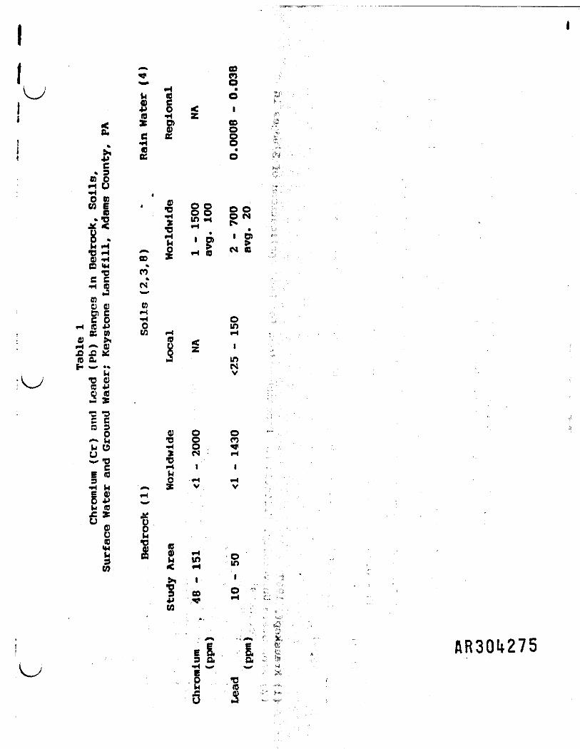
Table 1.
GeoServices, Ltd.
^ <
GOenoW h (0
i * gj a -* sr §c
s'S^ «O 0) mME * J O O o o• 2 o o 2 S*T? X m M gN*
A 2 ~ 0 _ S C4*D H _ £ ^ Ofl) -H 00 *C3 *H *
•D COc c•H (0 c a»a ^COo 0) nen c *H ^c o -i otc 4J 0 inen u <; *H o v z£ £ x Qno. J in
t* '"* •* C*4U V•I ; *o oi V_X (C JJs* .
« *H£ cra 30 0) O O
*-* In *D O COU O H O . ^ii -o *o
C H I I -.* * fe — _ • -g O «-< ^ ,•H h ^ » V vBO) ^
*» ^w (0 ;6* *O no CBD *O _.*" cp 5 -I s I a s
si ' ;,- "1 ® S v'Li " 'W : , - , " . "
EI I ! AR30t*275*jj Qi Qrf -.,.•'i ; -H s_* _ '.4
V-^ E /O T3 rC (0• j3 m -. j-(_) tj - ••»...

*2 *>a 2to
to Wi 8 ^ 2 §•H , 3 O & SO «-J CO W Pto . ffl ; • Tt
>M ia 'o 0
» .m ** O r-» o™U >i <0 C ° ° *0C S 4J S < C• ** "tf m ^m C V iJW S -H Om * O ffl C3 US»*0 -H M-« D) „ Oe £ > c ^ 2 «5Q 3 300 OKO » w as • • w" 2 V O O C— o •* ^ . o „o w o i i •* n§ 1 ^ o a I S I% z * 1 1g * r- 0) £
38 I S*> i w"2 S in
i • ' ; oI s § 3 H.5N. H 55u 0 •* .Ho Ei u
-4tg w c s - • u o» 0.0** * O O Q ) H > i H O73 ^ r* > E H HCO (0 I I \ £ > < H J J Q » a > C p *u ^ „ o i e « i * * o . e u o•H Q a ~ H a f o < * < - 4 v o 0 o to. z z o Is* w co o -H «>i * « j ; i n o ^ < V H i i
f- t w V J J * J » H ( O f O Ja to w • a) HZi-i yo P o a * o £— — ^ c o z a - u e < aEg to n o o a *oa 3 c Q) w o>a *H u w o)3 a a (OCfOOt -M O <&•H^ ^ u f l j ^ t o - H Q i o w t o 8s u: B. offlgzsp fflo -o pM (0 ^ "^ '™1* <—1* M- ior^eo cu

I 44
\- 5.0 CHROMIUM/LERD MOBILITY '.-
j The local or regional natural occurrence of heavy metals at
levels on the order of 100 ppm .reflects the limited mobility of
these compounds. Adsorption of metallic ions within the mineral
structure of geologic materials (most commonly in iron oxides and
clays) typically results in an almost complete immobilization of
the metallic ions. Furthermore, because of the importance of
adsorption in limiting mobility, and because of its function as a
• dominant mechanism controlling the environmental fate of trace
metals, the process has been studied in depth by numerous
j researchers.
I " - , : . , , - . , , 1 1 1
• -" 5.1 Chromium Adsorption
Chromium exists in two forms in nature - trivalent chromium
and hexavalent chromium. Hexavelent chromium (regarded as a toxich i • . . . i
metal by the US EPA) is en oxidized form of chromium and requires
a specific assemblage of chemical and physical conditions in order
to be stable. - Trivalent chromium reflects ,a reduced form ofi
chromium and is essential in human nutrition, in fact, countries
i with high levels of soil chromium have low death rates from
cardiovascular malfunctions (Cannon and Hopps, 1970). Because
I trivalent chromium is not hazardous to human health, the US EPA
I d e l i s t e d chromium as a hazardous waste in waste discharged by the.
i ______GeoServices, Ltd.
"">"""'• BR301.277

I «Reduction of chromium is favored by low pH values (acidic
conditions), oxygen deficiency, an abundance of easily oxidized
organic matter, and the drying of soils (Pennsylvania State
University, 1981). With the exception of soil drying, these
criteria are all present in Keystone Landfill leachate, suggesting
the predominance of trivalent chromium relative to hexavalent
chromium. Established guidelines for the disposal of chromium in
soils by means of land application of sludges assume that the
extremely low solubility of chromium hydroxide at a pH greater than
5.5 prevents the leaching of trivalent"chromium into the ground
water regime (Pennsylvania State University, 1981).iI Based on a study by Griffin et al., (1987), adsorption of
* chromium by clay minerals is a function of the pH of the
| environment, and of the physical and chemical properties of the* *<
respective clay minerals present in the environment. Adsorption
of hexavalent chromium is found to decrease with increasing pH
while the reverse was found to be true relative to adsorption of
trivalent chromium. Trivalent chromium is preferentially adsorbed
: by clay minerals relative to hexavalent chromium, with the ratio
of trivalent to hexavalent chromium adsorption ranging between 30
; to 300.
1 Below a pH of approximately 6.0, the amount of chromium
i adsorbed is a function of the initial concentration. At pH levels
i AR30U278
GeoServices, Ltd.I
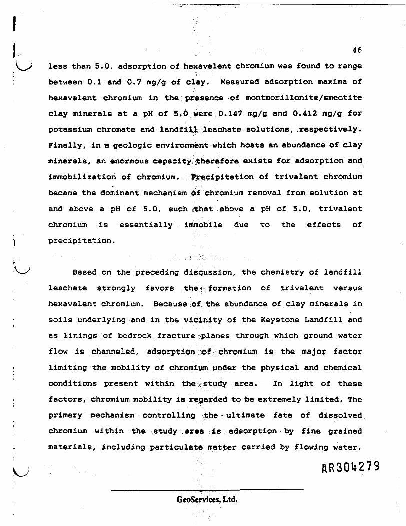
; 46
less than 5.0, adsorption of hexavalent chromium was found to range
between 0.1 and 0.7 mg/g of clay. Measured adsorption maxima of
hexavalent chromium in the presence of montmorillonite/smectite
clay minerals at a pH of 5,0 were 0.147 mg/g and 0.412 mg/g for
potassium chromate and landfill leachate solutions, .respectively.
Finally, in a geologic environment which hosts an abundance of clay
minerals, an enormous capacity therefore exists for adsorption and
immobilization of chromium. Precipitation of trivalent chromium
became the dominant mechanism of chromium removal from solution at
and above a pH of 5.0, such iithat, above a pH of 5.0, trivalent
chromium is essentially immobile due to the effects of
precipitation.
Based on the preceding discussion, the chemistry of landfill
leachate strongly favors the'-i, formation of trivalent versus
hexavalent chromium. Because of the abundance of clay minerals in
soils underlying and in the vicinity of the Keystone Landfill and
as linings of bedrock fracture planes through which ground water
flow is channeled, adsorption ;;ofr-chromium is the major factor
limiting the mobility of chromium under the physical and chemical
conditions present within the u study area. In light of these
factors, chromium mobility is regarded to be extremely limited. The
primary mechanism controlling the ultimate fate of dissolved
chromium within the study area is adsorption by fine grained
materials, including particulate matter carried by flowing water.
RR30U279
GeoServices, Ltd.

i 475.2 Lead Adsorption
The behavior of lead in the natural environment is similar to
the behavior of chromium as previously described, except that lead
is considerably less mobile than chromium. In fact, there has been
relatively little concern about lead contamination in soils because
of the relative insolubility of adsorbed lead in soils. The strong
adsorption in soils also means that lead additions to soils are
essentially permanent and irreversible (Pennsylvania State
• University, 1981). Much of the lead added to soil is bound in
organic matter, clay minerals, or iron oxides.iThe mobility of lead was directly evaluated at a waste
* disposal site in Illinois by means of soil coring and monitoring
| well techniques (Gibb and Cartwright, 1982). Source materials of
lead included highly mineralized liquid waste from stack scrubbers,t. smelter furnace ash, and solid waste materials. Lead
concentrations were observed to decrease logarithmically from a
high of 10,000 ppm to less than 100 ppm within 5 ft of the land
surface as a result of adsorptive processes. Bedrock in the area
consisted of micaceous shales with unconsolidated sediments
consisting of glacial tills. Many of the conclusions developed
during the Illinois leachate study mirror'those presented herein.
The principal mechanism cited as controlling the distribution of
t metals at the Illinois site are cation exchange and precipitation1
flR3Ql*280
GeoServices, Ltd.

48
\^y of metal compounds as a result, of pH changes in the infiltrating
I solutions. The study also noted that variations as great as 45 to
80 percent in the chemical constituents of water samples couldi1 result from improper sampling, techniques. The Illinois study
i concluded that geologic environments consisting predominantly of
clay and silt are extremely effective in retarding the movement of
lead from very concentrated inorganic sources. Finally, during the
study, lead adsorption relationships measured in a soil with a pHi
of 5.6 indicated lead adsorption on the order of 1 mg/g of soil for
; equilibrium concentrations ranging between 4 and 6 ppm at a pH of
5.6 (Roy, et al., 1987). ...i , ' . . . - , . , - , : : .Based on the preceding, lead:mobility is limited by many of
IVX the same parameters which limit chromium mobility. In addition,
( lead mobility is significantly less than that of chromium. Both
metals are strongly adsorbed by particulate matter present as
suspended sediment in an aqueous environment.
Based on published data and results of studies conducted for
this report, it is clear that neither chromium nor lead travels any
significant distance beyond the boundaries of the Keystone Landfill
due to the pronounced effects of precipitation and adsorption by
soil, clay minerals, and iron oxide within the natural environment.
Similarly, transport as particulate matter within the ground water
. regime does not occur because of the filtering effects of the
i , RR30U28I
GeoServices, Ltd.

j 49
subsurface environment, and because of the lack of sufficient flow
' velocities within that environment for entrainment of particulate
j matter. Adsorbed metals may, however, be present on the abundant
fine grained particulate material generated in the vicinity of a
; ' well during the well construction process, or within a surface
" stream following a rainfall event. The presence of these adsorbed
metals would lead to an exaggeration of measured dissolved trace
metal levels as a result of any analytical procedure involving acid
preservation of an unfiltered sample. Our conclusions that heavy
; metals are not mobile - and therefore cannot represent either a
release or a threat or release - is further supported by the
I statistical analyses and evaluation of trace metal origin and
I behavior discussed in the following sections.
AR30t}282
GeoServices, Ltd.
50
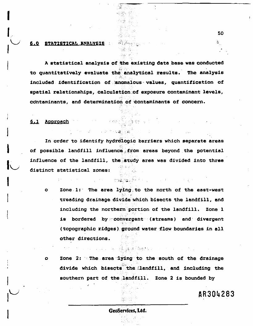
6.0 STATISTICAL ANALYSIS i
A statistical analysis of the existing data base was conducted
to quantitatively evaluate the analytical results. The analysis
included identification of. 'anomalous values, quantification of
spatial relationships, calculation of exposure contaminant levels,
cdntaminants, and determination of contaminants of concern.
6.1 Approach ; - . . • : : ' - .
In order to identify hydrologic barriers which separate areas
I of possible landfill influence ; from areas beyond the potential
influence of the landfill, the study area was divided into three
distinct statistical zones:
o Zone 1: The area lying to the north of the east-west
treading drainage divide which bisects the landfill, and
including the northern portion of the landfill. Zone 1
is bordered by convergent (streams) and divergent
(topographic ridges) ground water flow boundaries in allother directions.
o Zone 2: The area lying to the south of the drainage
divide which bisects the landfill, and Including the
southern part of the landfill. Zone 2 is bounded by
AR30t*283
GeoServices, Ltd.

51
streams and/or topographic flow divides in all other
directions.
o Zone 3: The area for which analytical results are
available, but which is not included in either Zone 1 or
2. Zone 3 is, therefore, representative of background
conditions.
The delineation of the three geographic zones is shown on
Figure 4 while Table 2 is a summary of sample location
designations. Analytical data within each zone have been treated
I both independently and together with data collected within other
statistical zones.II Prior to beginning the statistical analysis, the data within
each zone was compiled. During this compilation, several
1 guidelines and/or procedures were followed. These include:
o All reported contaminant concentrations were reduced to
units of parts per billion (ppb.)
o All values reported as less than the detection limit
(which is variable) were tabulated at a value of one-
half the detection limit.
AR30U281*
GeoServices, Ltd.

Base Map: Uttlestown, Md.-Pa. USQS 7.5 Minute Topographic Quadrangle
LegendI Scale
Keystone Landfill Property Uneti
FeetStatistical Zone Boundary
[25] Sample Collection Location (See Following Page for Well Designation)_____Figure 4
OCOCED *Y
4*1*0*0 IT
OA1EStatistical Zones. Keystone Landfill; Adams County. Pa.
GeoServices. Ltdearth resource applications
Barrliburc. PA
[R3.0'i285
MtOJCCT Ha I MAMM6 Ha

Table 2Key to Sample Locations Plottedon Figure 4; Keystona LandfillAdams County, Pennsylvania
Sample SampleLocation Kama
1 MDW12 MDW23 MDW34 MDW45 MDW56 MDW67 MDW78 KDW89 MDW910 MW111 MW212 MW313 MW414 MW515 MW616 MW717 MW818 SI19 S220 S321 S422 S523 S624 S325 Matthas Res/Ml26 Crawford Res/M227 Eddy R6S/M328 Gilbert Hes/M429 Conway Res/MS30 Minor Well31 Willow Spring32 Background Stream33 Brown Stream34 Downstream35 Brown Seep36 Line Road
AR301.286

54i j o Reported values were tabulated as the logarithm of the
reported value. -
'bn-J " , I • ' H
o Assigning duplicate sample values the value from the
sample which reported the highest contaminant
concentration.
The contaminant values within each group were tested for the
presence of statistical outliers. A sampled value is a statistical
outlier if, when plotted on probability (or log-probability) paper,
the sample value plots well outside of the predominant trend
followed by the remainder of values which represents the sample
population. This procedure assumes that all reported contaminants
\^J represent sample values from an underlying distribution which
includes both high and low values. If a sample value was
identified as a statistical outlier, the sample value was adjusted
so as to fall along the remaining distribution, established by the
bulk of the samples. Finally, the history of the sample value
(i.e., the sampling conditions) was studied to provide an
evaluation of the anomalous behavior of the sample. .
The spatial analysis of the data consisted of constructing a
model which quantifies the cpatial distribution of the data
relative to both temporal and geographic space. In the presence
of an active contaminant source area or a leachate plume, the
, AR30l*287
GeoServices, Ltd.

55~ "*,
spatial distribution of the contaminants can be modeled by a v j
mathematical function called the semivariogram. The semivariogram
is defined as the expected squared difference between sampled
concentration values separated by a given distance.
Exposure levels of contaminants are determined by the 0.95
quantile of the distribution of sample contaminant values reported
within statistical zones (background zone and zones within the
influence of the Keystone Landfill.) Therefore 95% of all reported
values for the respective zone fell below this value. This
determination of exposure levels was chosen due to the high
occurrence of values reported below the detection limit, which
biasses the standard deviation values which are used in other
confidence limit estimators. \ J
Finally, -contaminants of concern were determined based on the
previously described statistical analysis. Specific criterion were
identified to determine if either chromium, lead or nickel could
reportedly be considered as a contaminant of concern. As a result,
no inorganic substance was recognized as a contaminant of concern
following the rigorous application of the statistical analysis
presented below.
GeoServices, Ltd. A R 3 0 2 8 8
56
i 6.2 Geostatistical Analysis
i.,'!'
In order to quantify the relationship between measured
concentrations at specific locations and those measured either
subsequently or at adjacent locations, Semivariograms were
calculated. A semivariogram is e plot of the semivariogram
function, which is the expected squared difference between paired
sample measurements against either the temporal or geographic
distance between the samples* For a population of spatially1 . , . • . r: '-:','• - . -
distributed analytical data (either through time or geographic
space), the semivariogram function would follow a distinct trend,
with the semivariogram function Increasing with either increasing
time or distance. This reflects a commonly observed relationship
i that closely spaced samples have similar concentrations compared
to those samples spaced farther apart.
Data collected within statistical zones 1 and 2 were used to
calculate Semivariograms relative to both time and geographic
space. Data from statistical zone 3 (background) were not used in
the statistical analysis. By definition, the background samples
are independent of samples collected within the possible hydraulic
Influence of Keystone Landfill end therefore can not be combined
into the geostatistical analysis.
AR30l*289GeoServices, Ltd.

57
In the presence of a contaminant plume, the temporal and vv
spatial relationships between data collected within the influence
of the plume would follow predictable mathematical model with
samples collected over progressively shorter distances of either
time or space showing progressively increasing similarity. These
temporal relationships occur due to the extremely slow movement of
ground water. The extremely slow temporal variability occurs since
contaminants move considerably slower than the ground water due to
the combined effects of retardation and adsorption. Furthermore,
the effects on contaminant concentrations due to seasonal
variations in hydraulic recharge rates (i.e., dilution) under the
current flow regime are small of insufficient magnitude to obscure
relationship present.
oDue to the nature of contaminant transport within a leachate
plume, spatial relationships between data points vary as a function
of the orientation of the two data points being compared relative
to the orientation of the plume axis to the direction under
analysis. Samples located parallel to the major leachate plume
axis should be more similar to those perpendicular to the major
axis and hence bear a stronger spatial relationship. The angle of
the strongest spatial relationship should coincide with the
direction of the migration of the leachate plume.
AR30l»29Q
GeoServices, Ltd.

58
i , Semivariograms were calculated for chromium and lead.
Semivariograms were not calculated for nickel due to insufficient
data... •.. ;,. , j.
6.2.1 Time Semlvarioorams , d
Semivariograms for chromium and lead relative to the time
interval in days between subsequent analyses at specific locations
are included in Appendix B-l es Figures B.I and B.2. In both
cases, no relationship is observed between the sample values. This
is shown by the random scatter of points on the semivariogram
plots. Therefore, the concentrations of both chromium and lead are
randomly distributed with respect to time. This indicates that a
^y sample taken at a given location bears no relationship to a
subsequent sample taken at some different time at the same location
regardless of the elapsed time between the two sampling events.
Such a relationship clearly indicates the absence of a contaminant
plume within the study area. 1
. .• : " • - ,;,.,„.*, 5' ...,J: ••'";• .; .6.2.2 Geographic Semlvarloorams
Semivariograms were calculated for chromium and lead with
respect to geographic space. During the course of the analyses,
the data set was evaluated for anisotropy. Anisotropy occurs when
the range of influence (the point at which the sample values become
AR30t*29lGeoServices, Ltd.

59
independent of each other) varies with the geographic angle of the
calculation of each semivariogram function. In the presence of a
contaminant plume, the range of influence would be greatest
parallel to the direction of ground water flow, and would be
smallest perpendicular to the direction of ground water flow.
The semivariogram function was calculated at 45° intervals
within zones 1 and 2. The range of influence for all of these
semivariogram functions did not vary. Therefore, no anisotropy was
detected within the data set for chromium or lead. Hence omni-
directional (all directions combined to give one composite
semivariogram function) Semivariograms were calculated. These
Semivariograms are shown in Figures B.3 and B.4 for chromium and
lead, respectively.
The chromium semivariogram follows a random pattern with
values scattered about a horizontal line defined by the sample
variance. Therefore, chromium concentrations are randomly
distributed within zones 1 and 2. indicating the absence of a
contaminant plume within the potential hydraulic Influence of the
landfill.
The lead semivariogram follows a distinct pattern with a range
of influence of 500 feet between sample values. Beyond a distance
of 500 ft, concentrations become independent of each other and
represent random events. flR3QU292
GeoServices, Ltd.

60
: . Several interpretations are possible for the observed 500 ft
distance limitation. The first is that the limitation represents
a geological factor such as bedding thickness or maximum fracture
length which controls an extremely localized distribution of lead
concentrations. A second interpretation Is that localized sources
of lead may be present. However, the distance of migration is
limited to less than 500 ft by existing chemical and physical
parameters within the natural environment at the site. Finally,
correlation between samples collected at less than 500 ft distances
may represent a hydraulic function of the sample collection
protocol. In this case, purging of well volumes during sample
collection may result In a cone of depression extending 500 ft or
less from the sample collection point with samples collected at
distances less than 500 ft apart sharing the same sample domain.
6.3 Distribution Analysis
Chromium, lead and nickel concentrations were evaluated by
means of an analysis of the distribution of measured metal
concentrations within the various zones previously described end
sample type either well or stream. This analysis encompasses
summary statistics of the data es well as probability plotting of
the distribution.
AR30l*293GeoServices, Ltd.

61
Summary statistics included calculations of the sample mean,
median, variance and various quantiles of the distribution. These
statistics are used to quantify the distribution of the population
of reported metals concentration. Probability plotting is a
graphical method of evaluating the distribution of the data. Using
this technique, the concentration (or log concentration) is plotted
against Its respective cumulative percentlie. Samples drawn from
a normal distribution will fall along a straight line when
concentration is plotted against cumulative percent. Samples drawn
from'a lognormal distribution will fall along a straight line when
log concentration is plotted against cumulative percent.
Typically, sample values which collectively represent a single
population follow a normal or lognormal distribution. Samples that
are anomalous to the distribution will be out of line with the
other samples and will show up as an anomaly on the probability
plot. These samples are then candidates for further inspection
regarding their origin (i.e., collection method and/or analytical
technique).
Distribution analysis of chromium and lead concentrations were
conducted on the well and stream samples contained within the three
statistical zones. A distribution analysis of nickel
concentrations was conducted on the well and stream samples for
zones 3 and a composite of zones 1 and 2. Individual analyses of
GeoServices, Ltd.
62
zones 1 and 2 was not possible due to the limited analytical
results. The results of the distribution analysis for chromium,
lead and nickel are summarized in Table 3, Table 4 and Table 5
respectively. The figure number for the probability plot for each
metal and media are referenced in the tables.
Based on the results of the distribution analysis of the
available data, the following conclusions are presented:
o The arithmetic average and median for all sample groups
falls below the US EPA MCL of 50 ppb for chromium, lead* -' i
and nickel. ^ 3 >
o The sample values from all three metals are lognormally
distributed when there are sufficient values measured
precisely (greater than the detection limit). This is
shown in the well samples for zone 1 (e.g.. Figures B.5
and B.6 for chromium}. For the remaining data sets, no
distribution, either normal or lognormal can be
determined. This ie due to the large number of values
being reported as less than the detection limit (plotted
as a vertical line on the probability plot). However,
the values that have exact measurements do follow a
lognormal distribution -(e.g.. Figures B.I 1 - B.12 and
B. 13 - B . 23 ) , further supporting the thesis that the
contaminants have an underlying lognormal distributJfWi OQC
GeoServices, Ltd.

.<
w .i-
cc
-
i
cz
•4m -M0> A*0 S
s|e j
Ma
Median
£
B
£V*It
o
.M
§,., *< m * o *» w r* oE •> « M o o ii o ** o 5~ M •< m N ft •« m N
10 m m 10 in in in*• *4 • • • MI «t » i . • • «r* o O o O *i M
|S • RRSS •* SK55
2g . .... . . ....
!!• mi is JH2in *i * m m ui in .1 inminin
vr««o p, B »n O |, r« p, » o
»- -s.t ..'aa»m« r.v»0 - N n**n«
ti 4 *•> S« « 4 > « C ' D « 4 4 Vi i _ • * 5« * _ t ***v ** » a *i *« T) 9 v• C • i -i • • • ••«««S *• 9«'09 *« 9 ** fl 9«*t* v i M f v i 59 -!•*->
14 ffiS ^3 ]|S313 1 "II *- IS 1 1M >* i i IH ii • yu IM *5 *M « 4 h v 4 M b b •• »4 -N C C*4IM * fc 4J *i MM • * ** **S « 5 S M m fiu i i CT «
W W < W
----
§ '
-a
M "1" r*
tfi i
. i
!•»S
-S
s~
0.
£ £X tn
g? t*» B O3 tf>£ k.•HO M
» C O> t.X) • O US &E-1t) 1
C b ft. 3 l»^ 9 e 5 * b A« o «« o ^n *•»*"*
i 'So.7l*'<S'-6 • 5 T *
T l3'*e'*'*'S5"* «2»*35t!'6£ M •« a i• « f « ^ Q , ^ - « U *
o 5cjJ!|*•a »• M <H 9 •• 41 cfi ^ v O M f r j * * t.» - s > : « r * B 5 3 i<*•**&* N JD t> 9 « u • «» »»

co
en U
•-S^ £tf *6.5 "OL <
1C
o
4*
1
BX
Vt M
e 3
**
sI
•
K
|h.
1O
IM
s. ssss
o — o B) e «<•HE n * « in*^ ft W W
8 * S S S S
2 i i i . i
!• IJJIrf B C £ B
^ * p o in m
mm "<* M e> 10
a- 18*'*
m « p *< n*
Hell
strcaa
Well Vnad justed
Well Adjusted
Streasi Vnad justed
Stream Adjusted
...- ««,,«;
.. III! »
* * SS P S S •
I I t i l l . 1
ii HIM-
« • S8RR £~
• * S S S 2 £ N
" i inl 1 W 4 W ni *-Uf «M ^ feA fA «A *
rf * l«
r; : 1^
Si: "i i io y u m i H i t i M*'. • • *^ »N 6 6 . .»* 6HK ****** * «WH 5 5 M « 5tf>
J "^ ?hr N N ft (SI
M <N * • * •• M in;TI v «M *• M «
T«
li Ji *5 i n » 5 R P i R « K * * - " l H S i S i - 5 f N I «^
O ' " C
2 "I'
* sin
O C
•*•ji b
o.
o
<
« a a ."5 " *• *<* e ' S & * ** T o
5 . ' i I- •• t * z * ». « i *• 5 li-Si! Stlc'3
* t. » ft r e ** s * »I i £ S J i 5
AR30lf297

*
0,
Xca
u u** i•il, ••*
IS?= 5.. >»" 19j.
S "*< *
weo4Jto
8.
*»
H
eX
•4
0» **
°s£ c• -4
**
a
c•B
£
f*
B
C
&
1D
1
S£ § •
-s ssM -i "* N
^•A tfl tfl •»
"*
51 * (
2 8 i i
« » i
c 2 m *
KS »S
O IA <0
e M <M
a! =?$n iS
W fJ#44 m
]|h M« *
5 f•o —•M
—— . « £
!! **• B Q3 f.
t "s* *s ^
C -4 e «
a §* o v.B E « a* » f £ J* > J J £
3 f c ? 1 * ££ P rs P . •* _ 1Bl t t i T
a i "S ** S1 " 4p • M <B « Bl
• • b V t t J Z f i v C
T g** ^ i, b S o —5 o 5 * ** ? ? *"
o -^ e I ^ x . b t i M** O i - ^ a a v * > « « a* * • & & , & > »
** S * S1 • " S u ? •|£££h-4M a jO « 4 6 . * a . o a « * «M C P i > ff a > « < M M I HAba •• fl*4&o.&ofl*68*1!!!'!!«« « i • i • **5 :c|ISi " gli §**T*J'*"1™— £?l *
|£K5 Si! 58-09 — — XXk. fr -o a
AR30I*298

66
6.4 Statistical Outliers
Based on the probability plotting, the distribution of sample
values was evaluated for the presence of statistical outliers. For
a lognormal distribution, statistical outliers, if present, occur
as data points plotting off of the linear trend followed by the!'
remainder of the data set falls when plotted on probability paper.
Statistical outliers were treated by horizontally projecting the{•
anomalous value to the observed distribution line as defined by the
remainder of the sample population. This procedure retains theI
rank ordering of the data, (i.e., the highest value remains the
highest value). Statistical outliers were determined for chromium
and lead. No nickel samples were determined to be statistical
outliers.
6.4.1 Chromium Outliers
The adjustment of outliers for chromium is shown in Figures
B.5 - B.6 for Zone 1 and Figures 3.11 - B.12 for Zone 2. Table 6-
is a summary of data points identified as statistical outliers.
A total of seven chromium outliers were determined during the
course of the analysis. * Two I of these samples fall within
statistical Zone 1 and were collected by NUS in April, 1984 from
wells constructed within the property boundary of the landfill andAR30l*299
GeoServices, Ltd.

isE'fti>_ir ~™
fcl
O
1a
Adjusted
Value
M|
Reported
Value
Location
*im
1
IM
•M •* «N •* •**4 «4 MM ••«a a a a a+4 <M ft **
«• •« *ri *4 4 « *a a 00 a * •*" » 9 C Bt. h ? ? k £ B
II * <M M * » f** tf «>4 X M S •M IH e. (k taa a If a^<2•8-8 ": "835H= = 13 g*• •* 4 Q Qk h. « 3 3
>* t- O E * 8°>m« • •» 2* S'**'
»MN * B It***
einn M.« r*OOSon «£ o — »•"mw w1^ mNN
«5C S« SSBEX£ |1 £gg
•HJ
oi » mm <rr>f)ttBB OO DBw— O O rtm O » r-O « •< NN t-INK*
£35 33 SoS
1 1 1$** *i sss;
•.M^ NN MNM
"5 I U "* '" 3"!6 •
_ _ _ _ _ _ *c " "
X" 5*1 i
& •: f :» a -NS ** -B
1- *E* --
1= :ii i]•4 *M Xi. a1:£5 K Sjs S . s** 6 "S *2n r?*• p * #o u ^ Da v a o• a a e«* a t _k. J a «* * * Sa -H e **
AR30l*300

• » • v r " 68
i , sampled after a rainfall event. These two analyses represent the
highest concentrations of chromium measured within the entire data
Set. - . • : ; . . , '•", - • , -
Two additional samples determined to be statistical outliers
were collected In April, 1985 during the first sampling of wells
constructed by the State of Maryland. Of the analyses available
from the Maryland monitoring .well series, the highest chromium
values (if detected) were collected during the first sampling
event, indicating that reported chromium concentrations are
representative of metals present in pulverized mineral fragments
rather than these present as a dissolved phase in ground water
samples. The remaining four statistical outliers were collected
V^y from stream samples. One of these was collected by NUS during its
April, 1984 site inspection under the previously described
conditions. Three of the stream sample outliers were collected
from sampling location MD-S5. During the same sampling event which
produced the anomolously high values analyses of the two nearest
sampling locations (both less than 800 ft away, one upstream and
one downstream) analysis reported no chromium. Therefore,. these
concentrations are recognized as either an anomalous a localized
event as opposed to an indication of the presence of significantly
elevated chromium concentrations. ; i
___________________ AR30li30lGeoServices, Ltd.

69
High values of chromium are clearly associated with the
presence of particulate matter in the sample. Evaluation of
existing analytical results, clearly indicates the absence of a
chromium-bearing contaminant plume emanating from the Keystone
Landfill. Direct evaluation of the mineralogy of particulate
matter both with the landfill and beyond the possible influence of
the landfill conclusively identify the role of particulate matter
relative to metals analyses of unfiltered samples. A complete
discussion of the results of the evaluation is presented in a
subsequent section of this report.
6.4.2 Lead Outliers
Lead outliers were identified during the course of the
frequency analyses by application of the same procedure previously
described for chromium. The adjustment of outliers for lead is
shown in Figures B.23 - B.24 for Zone 2. Table 7 is a summary of
the statistical outliers determined for lead,
A total of eight statistical outliers were identified within
the analytical database for lead. The highest measured lead
concentrations were collected from Maryland Sampling Location MD-
S5. Again, reported trace metals in samples collected from the two
nearest sampling locations, both located less than 800 ft away,
AR30l*302
GeoServices, Ltd.

s
cu
_o8£
•B
i!i5i£
•or s
g*/1
|
lH
25 ee *b «
• JJP"M & f4S O.
•_ H
J i• ssKS*
in *> *» r* * -w
: ' !
e * o o o o
i Hill» in <o r* !*• tB) 10 V CD •> Be - o * • m f** f^ O * "8O N n «o *o5; r> o S e ,
• : -
1 * * * 1 1
I1
I1
;• ;„ •*
1^
M «•
'.'.-•* 1
m K• i,... '• '• ,
» .
II
??
-?*
JP« Ift
' f il; •
' •
c(0CAft)Co
w .
• S
fi*4 E
sllI flR30^303

71
reported only minimal amounts of lead during the same sampling
event indicating that the reported levels represent a localized
occurrence.
The third highest lead concentration was collected from MW-
3, situated within the property boundaries of Keystone Landfill and
sampled by NUS during the same April, 1984 sampling event which
yielded the highest measured chromium concentrations. As before,
this sampling event was conducted following a rainfall and
undoubtedly included a significant quantity of particulate matter
in the unfiltered sample which was analyzed. The remainder of the
statistical outliers were all measured in Maryland Monitoring Well
Series wells. The State of Maryland concluded that the high
concentrations represented pulverized mineral fragments rather than
actual ground water concentrations.
Based on an evaluation of statistical lead outliers, measured
concentrations of lead above the US EPA MCL for the compound
reflect the inclusion of particulate matter in the samples rather
than the presence of a contaminant plume emanating from Keystone
Landfill. These concentrations, therefore. In no way represent anv
release of trace metals Into the surrounding environment from the
landfill.
GeoServices, Ltd.
* • • 72
, 6.5 Risk AssessmentO* ' ' ""-"v<- '.
6.5.1. Previous Reports
A detailed risk assessment relating to the Keystone Landfill
has been compiled by the US EPA in the July 1990 Keystone Landfill
RI/FS report. • The RI/FS report has been given considerable review
by both R.E. Wright Associates (R.E. Wright Associates Inc.,
Response to RI/FS Keystone Sanitation Company Site, Sept., 1990),
and an EPA toxicologlst. Dr. D.L. Foreman (Memorandum to Deborah
Dewsbery, EPA Region III Remedial Project Manager, July 1990).
CeoServices, Ltd. is in full agreement with the comments by
t / both Wright Associates and Dr. Foreman regarding the inadequacies^ — ' • n f - . • : : '
and technical flaws of the RI/FS. In addition the following
specific comments are raised relative to the Risk Assessment:
•• •-.; . >:,}, , •!:o Statistically unfounded estimators of the estimated
.- , \. '" '"Ui •
exposure concentrations. The estimated exposure
concentrations were based on the calculated 95-
percent lie confidence mean (calculated as the smaller of• -. . ' v:7i £',"!" } • ..." ' •
twice the arithmetic average, or the detected maximum
concentration), This approach does not address the. ,. ;.,'. i:'. ,i'""
distribution of the sampled data. The decision to double
the mean value appears to have been arbitrarily chosen;
AR30l*305
GeoServices, Ltd.
73
would an exposure concentration of three times the mean
been more accurate? Standard estimates of the calculated
95 percentile confidence mean (mean ± 1.96 * standard
deviation) are not accurate due to the biassed estimate
of the standard deviation arising from the large
percentage of less than detected values.
GeoServices, Ltd. recommends that the 0.95 quantile of the
sampled values be used to estimate the exposure concentrations.
This is a nonparametric estimator (or distribution free estimator)
since the validity of the estimate of the quantile does not depend
on the data being drawn from any particular distribution.
o Sensitivity of the formula used in the Risk Assessment
to changes in concentration level or other parameters.
This is due to the mathematical structure of the risk
formula. For example, following the calculations for
chronic daily intake (GDI) for Uptake via Ingestion of
Contaminated Groundwater (page 7-53), a 70 kg person
consuming 2 liters of ground water per day contaminated
with 80 ppb chromium (the RI/FS exposure concentration
for chromium), every day for 30 years averaged over 70
years gives a GDI of 2.2 x 10"3 mg/kg-day. However if
that person drinks only 1 liter of the same contaminated
ground water every day for the same duration, the CDI
AR30l*306
GeoServices, Ltd.

74
would be 1.1 x 10° mg/kg-day, which is below the CDI of
1.4 x 10"s mg/kg-day, calculated with the US EPA MCL of
50 ppb chromium (everything else as in the former
calculation).
This illustrates that even if accurate measurements are made
for the exposure concentrations, these numbers are • often
mathematically overshadowed in the numerical calculations by other
broadly based estimates such as body weight, daily ingestion, skin
surface exposed, events per year, etc. Therefore, any risk
assessment results must be viewed within the context of actual site
conditions. Most importantly, in this case, is the condition that
no observed release of metals'has ever occurred.
6.5.2. Background Exposure Levels
Background exposure levels for chromium, lead and nickel were
determined from the existing database (Appendix A) in order to
provide a measure of naturally occurring exposure concentrations
outside the possible influence of the landfill. Background
exposure levels were calculated as the 0.95 quantile of the sample
distribution or the largest reported value, whichever is less.
flR3Ql,307

75
Background concentrations for chromium, lead and nickel are
presented for both well and stream samples below:
Group Chromium Lead Nickel
Well 5 60 37
Stream 25 2 12.5
Based on the preceding, the following conclusions have beendeveloped :
o The background exposure of lead is above the US EPA MCL
of 50 ppb indicating high, naturally occurring, lead
levels.
o Background levels reported for the stream samples have
been calculated with only 2 sample values for chromium,
lead , and nickel . Therefore , calculations and/or
conclusions utilizing these results could be inaccurate.
For the remainder of the risk assessment, no comparisons
with stream background concentration levels will be made.
6.5.3. Contaminant Exposure Levels
Exposure levels of chromium, lead and nickel were estimated
from all sampled data excluding the background data. This
j
GeoServices, Ltd.

76f
\ j estimated exposure concentrations for possible contaminant
emanating from the Keystone Landfill. The exposure level was
calculated at the 0.95 quantile of the sample distribution, or
largest value, whichever is less.
: ' ' I,.' ' " ' . " "
Exposure concentration levels for chromium, lead and nickel
for well and stream samples for the combined statistical zones 1
and 2 are presented below: : ;:.,-. H
Group Chromium Lead Nickel
Well 34 vU ; 60 140
Stream 43 70 100
Based on the preceding, the following conclusions are^ . . , - v :-,. ,,••••: .- •
presented:
o The contaminant exposure concentration levels for
chromium are below the US EPA MCL of 50 ppb for both welland stream samples.
o The•contaminant exposure concentration levels for lead
well samples (60 ppb) is equal to the background exposure
level for lead. In the presence of a leachate plume
containing lead, the lead concentration within the plume
would be considerably higher than within the background
area. This is not the case here, indicating the absence
of a leachate plume. AR3Qlf309
GeoServices, Ltd.

77
6.5.4. Identification of Contaminants of Concern
The final stage of the statistical analysis conducted by
GeoServices , Ltd . was the identification of contaminants of
concern. Normally, once a compound has been identified as a
contaminant of concern, it is subsequently included in the Risk
Assessment and the respective health risks are determined. As will
be demonstrated below, trace metals do not represent contaminants
of concern at the Keystone Site.
The procedures used to identify a contaminant of concern are
as follows:
o The contaminant exposure concentration (CEC) must be
greater than the background exposure level (BEL).
o The contaminant exposure concentration must be greater
than the US EPA MCL for that substance.
o A statistical difference must exist between the
distribution of the sampled values within the influence
of the landfill and the distribution of sampled values
outside the influence of the landfill (background).
. j
GeoServices, Ltd.

78
i j In the case that either chromium, lead or nickel were to meet
the criteria listed above, then listing as a contaminant of concern
would be considered justifiable by GeoServices. As will be
developed below, none of these metals can be considered a
contaminant of concern. This conclusion is consistent with the
results of other analyses of metals mobility presented elsewhere
in this text. '
The statistical test used to test for differences is a test
of proportions (ref. Statistical Analysis of Ground Water
Monitoring Data at RCRA Facilities, Interim Final Guidance, Aprilf . i ,:,
1990, p. 8-3). This statistical test provides statistical evidence
if the proportion of a detected compound (i.e., values reported as
V_y greater than the detection limit) differs between samples in
background and areas under the influence of a potential contaminant
source. . . ,,•.,.., „.,,
Based on the preceding, the identification of contaminants of
concern is shown in Table 8. ,,.. .
GeoServices, Ltd.

79
Table 8
Identification of Contaminants of Concern, Well Samples
Keystone Sanitary Landfill, Adams County, PA
Criterion Assessment
Compound CEC > BEL CEC > MCL Stat Diff. Contaminantof Concern
Chromium YES NO -- NO
Lead NO YES NO NO
Nickel YES YES NO NO
Footnotes:
Compound - possible contaminant
CEC > BEL - test if the contaminant exposure concentration
is greater than the background exposure limit
CEC > MCL - test if the contaminant exposure concentration
is greater than the US EPA MCL, (50 ppb for
chromium, lead and nickel)
Stat Diff.« results of the tests of proportions at the 5%
significance level if a statistical difference
exists between the background and zones 1 and
2.
AR30U312
GeoServices, Ltd.

80x"I/ The following conclusions relative to the identification of
contaminants of concern can be made:
o Chromium is not a contaminant of concern as the
contaminant exposure concentration is less than the US
EPA MCL. Note that no statistical test for chromium
relative to background could be performed as all of the
background samples are reported as less than the
detection limit, invalidating the test.
o Lead is not a contaminant of concern as there is no
statistical difference between the sampled values within
the area of influence of the landfill and the background.
Furthermore, the contaminant exposure concentration is
not greater then the background concentration of lead.
o Nickel is not a contaminant of concern as there is no
statistical difference between the sampled values within
the area of influence of the landfill and the background.
Based on the results or the preceding section and the entire
statistical analysis, it has been quantitatively demonstrated that
there is no contamination by chromium, lead or nickel within the
area under the possible influence of the Keystone Landfill.
A R S O S
GeoServices, Ltd.

PART II
ADDITIONAL INFORMATION
GeoServices, Ltd.
81
AR30I_3II»

82
7.0 TRACE METAL ORIGIN AND BEHAVIOR
Based on previous discussions, it is evident that trace metals
are relatively immobile in the natural environment surrounding the
Keystone Landfill due to the combined effects of precipitation and
adsorption and due to the limitations of particulate matter
transport within the ground water regime. Statistical analysis of
the existing analytical database has demonstrated that high
concentrations of chromium, nickel, and lead represent statistical
outliers relative to the remainder of the analytical data base as
a direct consequence of aqueous sample collection and preservation
protocol employed by the EPA contractors responsible for sample
collection. This protocol imparts a strong random element to the
i ; analytical procedure, allowing high concentrations of trace metals>«—f • - ' • . . . - .. .t ,: f
measured during a specific sampling event to be followed by the
complete absence of trace metals during an immediately subsequent
sampling event. It is evident from a review of conditions
surrounding the sample collection procedure that the random element
in question is the volume and type of particulate matter collected
along with the unfiltered sample submitted to the laboratory.
In order to substantiate and further explore this
Interpretation, a comprehensive program involving the mineralogical
and geochemical analyses of particulate matter present (or
potentially present) within samples collected from the study area
AR3Q!*3I5
GeoServices, Ltd.

83
points was developed. Additionally, an investigation of \J
particulate matter adsorption and desorption characteristics and
the behavior of the particulate matter under various conditions of
pH associated with sample preservation was initiated.
In order to fully evaluate the behavior of landfill leachate
relative to aqueous samples unrelated to the landfill, two samples
of particulate matter were collected. First, a virgin soil sample
was collected from a road cut several miles northwest of the
landfill. Second, a sample of particulate matter was collected
directly from well K-5, situated at the southern end of the
landfill. Particulate matter from well K-5 was collected by
discharging well K-5 into a 425 gallon plastic tank and
subsequently decanting the clear liquid to waste following settling \*J
of the particulate matter. In this manner, particulate matter was
collected for laboratory analysis.
7.1 Mineralooical Analyses
In order to characterize the suite of solid phases present
within both the virgin soil and leachate residuum samples,
particulate matter in both media were examined using transmission
electron microscopy (TEM) and electronic microprobe analyses
(EMPA). The mineralogical study was conducted by Ken J.T. Livi,
Senior Research Scientist, Department of Earth and Planetary
AR3QI»3I6
GeoServices, Ltd.

84
Sciences, Johns Hopkins University in Baltimore, Maryland. TEM was
utilized to identify mineral structure and morphology in much the
same way as ordinary light microscopy is utilized. Energy
dispersive x-ray analysis was utilized in order to evaluate trace
metal levels in conjunction with the TEM survey. Electron
microprobe analyses (EMA) was utilized to quantitate minor and
trace element concentrations present within the solid phase in
question. Detailed procedure and additional discussion of the
details of the mlneralogical analyses is presented in Appendix C
of this report. , , ; - j: .r,;: c. ;•
7.1.1 Virgin Soil
In order to evaluate trace metals occurrence within the virgin
soil material, TEM examination pf a soil sample collected several
miles beyond the landfill was conducted. Minerals identified using
TEM included a variety of clay minerals, as well as several iron
rich minerals Including chloride, pyrite, and various iron oxides.
During the subsequent electron microprobe analysis, chromium,
nickel, and lead were routinely Identified at levels in excess of
.001 weight percent (1000 ppm) in many of the phases present. The
highest levels of chromium were detected in iron oxide and clay
mineral phases, while the highest levels of nickel were found in
association with chlorlte minerals. Lead levels in excess of 0.10
weight percent were detected in iron oxide mineral phases. These
ARSONS I 7GeoServices, Ltd.
85
data Indicate an abundance of trace metals in naturally occurring
soils materials. These data are consistent with levels measured
on bedrock samples analyzed by the University of Maryland and
referenced in a previous section of this report. Because the EMPA
survey focused upon specific mineral particles, higher
concentrations were recognized than those of the whole rockanalyses reported by the University of Maryland.
Preservation of an aqueous sample containing naturally derived
particulate matter under an initial condition of a pH of 2
therefore, could only be expected to result in an elevated
equilibrium concentration of the trace metals as previously
described in the discussion of bench testing using the virgin soil.
Therefore any sample collected, regardless of proximity to the
landfill, could potentially contain elevated concentrations of
trace metals as a result of the sample collection and preservation
protocol employed by the sample collector. The association of high
metals concentrations with sampling events conducted following
heavy precipitation or with samples collected from newly developed
or improperly constructed wells is a direct result of the inclusion
of naturally occurring particulate matter within the sample.
Inclusion of a sufficient volume of naturally occurring mineral
particles containing normal background levels of lead, nickel, and
chromium, during sample collection, particulate materials would
AR30l*3!8
GeoServices, Ltd.
86
yield measured metals concentration far beyond that actually
present as a dissolved phase given EPA sample collection and
preservation protocol. r: i .
This information clearly and definitively establishes the
origin of statistical outliers ; Identified in previous report
sections. Based on the preceding discussion, hazardous levels of
trace metals are simply not present.
7.1.2 Leachate Residual- Characterization ,
As a result of the TEM analysis of particulate matter present
within the landfill, the majority of solid phase material is
composed of en iron oxide precipitate which typically occurs in
association with an amorphous silica phase (presumably alpha
quartz). Other minerals include hematite, goethite, quartz,
lllite/smectite, kaolinite, chlorite, muscovite, anatase, brookite,
and organic matter. With the exception of the hydrous iron oxides
hematite and goethite, r the mineralogy of the leachate sample is
extremely similar to the mineralogy of the virgin soil previously
described. : r ;•; e L ,
Following TEM; characterization for mineral structure and
morphology, electron microprobe analysis was conducted to quantify
levels of chromium, nickel, and lead present within the specific
AR30l*3l9
GeoServices, Ltd.
87
solid phase particles present. Although not a predominant phase
within the overall particulate matter population, a sulfide phase
was present which contained more than 2.0 weight percent lead.
This same phase contained 0.86 percent nickel and 0.52 percent
chromium. High levels of lead were typically also associated with
this phase although lead occurred in some of the oxide particles
which were evaluated as well. Nickel levels were typically on the
order of 0.01 to 0.001 weight percent while chromium was present
at levels of 0.010 to <0.001 weight percent in the oxide phases
which constituted the bulk of the sample. In any case, substantiallevels of chromium, nickel and lead occurred in all solid phase
particles evaluated. Again, based on previous evaluations,
subjection of any aqueous sample containing a similar suite of
particulate matter to pH's on the order of 2 would result in
artificially high aqueous phase trace metal concentrations
depending on the type of the particle collected and on the quantity
of particles collected.
Because the suite of individual particles is pronouncedly
heterogeneous, there is a random factor in the sample collection
process by which the inclusion of a single sulfide particle within
the aqueous sample could result in significantly higher metals
concentration than that actually present. In either case, any
metals detected in the sample following preservation at a pH of 2.0
would reflect the solid phase metal concentration rather than any
AR30t»320GeoServices, Ltd.

:---.- 88i j dissolved trace metal concentrations. This is especially apparent
in light of the extremely strong adsorption affinity of iron oxides
for chromium and nickel and for the complete absence of any
dissolved lead phases at pH's which approach the ambient pH of the
Keystone environment. ;,n.. •
7.2 Bench Testing !
In order to evaluate the: effects of preservation pH on
measured dissolved.aqueous concentration, particulate matter was
collected from well K-5 and progressively concentrated by decanting
the supernatant liquid from a series of progressively smaller
sample containers. Following sufficient reduction of sample
volume, a series of aliquots was prepared by mixing an equal mass
of leachate residuum with e set volume of distilled water.
Similarly, a second solution was prepared by mixing equal masses
of the fine-grained fraction (less than 0.125 mm) of a virgin soil
and distilled water. Identical tests were then performed using the
two solutions in order to provide direct comparison of the behavior
of the ambient soil material with.the landfill leachate. Specific
laboratory protocol is included as Appendix D.
-.'.'4
AR30I»32I
GeoServices, Ltd.
89
7.2.1 Influence of PH on Dissolved Aqueous Concentrations \J
In the first test, although the pH was Initially adjusted to
incremental values by addition of either acid or base as necessary,
some buffering was noted during the equilibration process,
particularly for the more neutral solutions. Initial pH values of
2, 3, and 4 increased by approximately 1 pH unit during the
equilibration process (samples 1A & B through 3A & B). The samples
initially adjusted to a pH of 5 increased slightly (5A & B) while
samples initially adjusted to a pH of 6 and 7 decreased slightly.
This behavior reflects the strong buffering capacity of site soils,
indicating that, regardless of the initial leachate pH, ground
water flow in contact with the surrounding geologic media would
quickly equilibrate to the ambient pH. Table 9 is a summary of ^_>
trace metal concentrations in each of the samples and specific
Initial and final pH conditions.
7.2.2 pH/Chromium
Elevated concentrations of chromium were only found in samples
preserved to a pH of 2 for all leachate residuum solutions. The
absence of dissolved chromium phases at pH values greater than 3
in the leachate residuum solution, is a reflection of the extremely
strong affinity of chromium for the hydrous iron oxides which
comprise the leachate residuum. Clearly, under circumstances of
AR30l*322
GeoServices, Ltd.

O)3 _,
7 .8 o g o § io S o 8 o g 22•g, ' o oa$; ioco NO coo; cog; 3"
CO
- < T2 o o o o; o o oo oo oo ooS 0« S OJM f>aio NN NN NM rara cacsO ji vv too* vv vv vv vv vvJj » • " - - :"'"- ] ' •'.^ -P
Cr* • "B °° °° °° °° °o °°ftW E «H<H rHfO •-( iH IOH ^2 ^^/<E H . 'V V V N V V , f - I V i^" VV*^ to H : - - j: „ .•IS 6
^2 -4 CO * iH Ji NO* 0* CO <(S O» *O NO•H M >3 •• •* • * *• •• •* *•3 g in tn N N — (*> w ;** in 10 10 in so so^ 3 2g .8 « a .-•......,,-.,3^ ^ «nin COt^ & & COO^ iflCO NCO ^IS&" * ^W O^ 0\ ^ Ch W O* OO OO
' *i M * IM ,n * * "'" ? * ' - ! • ' • • • ** * •r^ 4, • « in -^ H ' "'C N ' «0 CO ^^ lO^O
•D W "H£ Q) • £ ' • " ' - ' <r.w^ i- '- •
O S E E E E E E Em tl 3 3 ' - ' ! s> 5 »,t ; 3 3 33JgW g 33 3 3 3 3Msf *O *0 . <J 'O *O *D *OQ QJ : -H -H f;»|, -rt -H -H -H« co (0 H 03 n to to to
Q) 0) 0) 0) 0) 0} $CO 0- C ---v^1,,^., K t£ K B^ . i H H H H r t i H f - T
H H H H • H i-l
^ *O ^H *O rt*O f 'D *H*O ^*O ^^3• H C ' H C - H C ' H C ' H C - H C - H Cc\ ore " Q v v " ^ o w OID OIDW *J 10*4 (0*4 COM C/}M (0*4 (0*4
| ; , , , , , , AR30U323O s j -. « « ^ » «CO CO CO CO 01 0)O) flj (I) 0) Q) Q)ff^ . , . pi iinii|ii, I|MI IIMIM|I .pi _ ipH p^ pK

91
either less strongly acidic sample preservation or if sample
filtration was employed, elevated levels of chromium in actual
samples would be absent.
The behavior of chromium in samples prepared from the virgin
soil resulted in high chromium levels at initial pH's of 4 and 5.
Final pH's in these samples ranged from 4.8 to 5.4 as a result of
natural buffering of the solution. Maximum concentrations measured
were 150 ppb for the sample of pH 4 and 140 ppb for the sample of
pH 5.
Based on these results, the virgin soils developed from
weathering of bedrock which underlies the region represent a much
more prolific source of chromium than the landfill leachate v^
material. This phenomenon is important particularly where the
highest concentrations were measured in soil solutions at pH levels
approaching ambient levels. Additionally, these data reflect the
high degree to which chromium is Immobilized by the iron oxides
which volumetrically comprise the bulk of the solid phase present
within the landfill leachate. Only under extremely low pH
conditions is the chromium released to a dissolved aqueous phase.
Figure 5 is a summary of measured chromium levels under various pH
levels.
AR30l*32i_
GeoServices, Ltd.

n••* t>—• toD ft)W _J
{ • • - . . . ' . • . : • I , f r , , ; ' . . • ' i
T '•
O =3o -gOc_
8 6o
1II
1 i i i i 1 i i t i 1 i i i i I t i i i 1 t i i i 1 i 1 t t i i 1 i i i i
ID
n
- - H ,- . , - . - . .
I § 1 § i R30lf325
to
G:
(qdd) uon8J;u_3uo3 tnovnby
93
7.2.3 pH/Lead
Lead in the leachate solutions behaved similarly to chromium
as previously described in that high concentrations of lead were
only present at pH levels of 2. At initial pH levels in excess of
2, measured lead concentrations were uniformly below the detection
limits of 20 ppb. Unlike chromium, ambient soils did not provide
a release of lead at Intermediate pH's and, in fact, behaved much
like landfill leachate materials with high levels limited to soil
solutions preserved at a pH of 2. Figure 6 summarizes the
relationship of equilibrium aqueous lead concentrations relative
to pH over the range of pH analyzed for the soil and leachate. it
is immediately obvious that little difference exists between the
behavior of lead relative to the virgin soil or the leachate *j
sample. Based on this observation, landfill leachate solutions
represent a similar potential lead source as the natural occurring
soils of the region.
7.2.4 pH/Nickel
The behavior of nickel in leachate residuum solutions is
significantly different than the behavior of either chromium or
lead. Although the highest concentrations of nickel were present
in samples collected from the low pH solutions, measurable lead
levels were detected in all samples regardless of the initial pH.
AR3Ql*326
GeoServices, Ltd.

u
I f
I C «^ £oQ)
1o>E
i
» -* - . , :-.v s. •;' ,,,.p^ • - • fi m|M . , ,
I I I I I t t I 1__I
ID
AR30U327^ t
fodtf] uotasjiuaauoD tnoonby
95
Nevertheless, dissolved phase nickel concentrations are an order
of magnitude higher when preserved at an initial pH of 2 relative
to levels which would be present at the ambient site pH of 6.0 to
6.5. A sample preserved to a pH of 2 and yielding a nickel
concentration of 1 ppm could be expected to yield a concentration
of less than 100 ppb if preserved under more natural conditions.
Lead levels in the soil solution increased from a pH of 3 to
an initial pH of 5 with values ranging between 20 and 80 ppb. At
an initial pH of 6 and 7, however, nickel concentrations were below
detection limits. The relatively high values measured at initial
pH's of 4 and 5 correspond with the high values of chromium at the
same pH values. As will be discussed in a subsequent section,
chromium and nickel are closely associated, both in naturally
occurring soils and in leachate residuum. This behavior may
therefore reflect the heterogeneity of particulate matter within
the solids fraction rather than representing distinct trends as a
function of pH. Figure 7 is a summary of nickel concentration as
a function of pH.
7.3 Adsorption/Desorption Characteristics
Adsorption and desorption characteristics control the degree
to which trace metals migration is limited by direct adsorption on
particulate substances present in association with the aqueousAR30t*328
GeoServices, Ltd.

COO_ooCO8o
«>*J t - •' . • n' ,!! • •0 - • '- -i^ •! •
«M U
•£ £ . . - •> i,, .,, , • <• -y> 3 9:
1 • ' >. - J . v '• /If . /...... .,.,... . . . J. ..::.,,:: ,, ,: .. ,
. /
•• - . , . . „ , */J
!-r'-7" •- ' • /
• ,,:,:-: -, - / -. /
/
.- :.••. .: . .. _i(/^ - •• ' -•-— •• i: • - • /a /Jb<i . • / - * - r • •: • /
s- .- /.;- „, .... • - • /
' ' " . " . " ' *."-IVE.V, v: /
- . V--,; ,. /- -T.,. /,. ,.; ,.,/ ..' - . / ' • •/
" " ' J^"1!'""'":' ': . . • /* *„..„,.,../ '" " ' " " "
'• / :',.•::,- , , . . . - . .///^ J
1 1 1 1 1 1 f t 1 \ \ 1 1 1 1 1 1 1 1 1 1 t 1 1 1 1 1 1 1 1
-
-
-
-
«-I
S
E
h-
ID
in
I
*r
n
**4V«*.
' ' * * II 1 s ftR30l»329 *- — 6*>«n>*
£(Qddl uotiftj usauoa tnosnby vn(jqtnnb3

97
phase. In order to evaluate these phenomenon, bench testing was .
employed to evaluate the mobility of chromium, lead, and nickel
both within the leachate environment and within the ground water
regime which surrounds Keystone Landfill. Sample preparation was
conducted as previously described, except that a uniform pH of 6.5
was maintained throughout the test in order to simulate natural
conditions. Additionally, the individual samples were mixed with
a synthetic leachate solution to original concentrations of 200
ppb, and 1, 2, 5, and 10 ppm of chromium, lead, and nickel.
Because of the relationship of metals solubility to solution
pH, a portion of the synthetic leachate metals concentration
precipitated out immediately upon ad j ustment of a pH to 6.5.
Whereas migrating landfill leachate would also quickly assume the \J
pH of the ambient ground water due to mixing and buffering effects
of natural soil material, removal from solution by direct
precipitation was assumed to represent a natural process.
Consistent with this assumption, no attempt was made to distinguish
between metals which were removed by solution by way of direct
precipitation, and metals removed from solution by direct
adsorption. The behavior of each separate trace metal is discussed
separately below.
AR30l*330
GeoServices, Ltd.

98
7.3.1 Chromium
The behavior of chromium differed drastically in the presence
of suspended soil and leachate residuum particulate matter.
Adsorption was a significant process in the soil suspension with
dissolved chromium concentrations being approximately half that of
the original synthetic leachate concentration. An approximately
linear relationship between original concentration and equilibrium
aqueous concentration was observed (Figure 8). Based on this
trend, aqueous phase chromium present in landfill leachate would
be rapidly adsorbed by the fine-grained minerals associated with
the ground water flow system. Given the extremely slow rate "of
ground water migration, an exponential decrease in chromium
concentrations with distance from the landfill would occur. This
phenomenon explains the absence of dissolved chromium in ground
water samples collected adjacent to the landfill.
More importantly, chromium was not detectable in any of the
leachate residuum solutions regardless of original concentration
of chromium. This Phenomenon indicates that anv chromium present
within the landfill environment could only be present as an
adsorbed solid phase. Again, because of the extremely slow
velocity of ground water flow, insufficient velocity is available
to entrain such particles. Additionally, natural filtration
tendencies of the ground water regime would lead to rapid removalAR30li33l
GeoServices, Ltd.

** u
1
of
o0)O
I .1. I _L I I I__I t I__I I
CO§O)
P \ 3i" "S
. i
u
1
S
cu
' 'dR'3j3lf332 Ig g g g - .*- •-— sO O O O •"^ in Ki •« v
e«
uDi;Bj u»3uo3 cnoanbf ontjqntnbg

100
of particulate matter during the course of migration away from the
landfill by simple clogging and particle capture within the minute
openings which collectively constitute the ground water flow
system.
Based on the preceding, the abundance of hydrous iron oxides
favors immediate adsorption of dissolved chromium. The net result
is complete immobilization of chromium and elimination of dissolved
aqueous chromium concentrations. Under reducing conditions,- - H ,""
formation of trivalent chromium, an element essential to human
health, is favored. Trivalent chromium has an extremely strong
affinity for clay minerals because of its positive charge.
Therefore, the mobility of that compound is also equally minimal.
'- -. i• - ^ <e • •'. • .
As reported in previous studies (including the CCJM RI),
fracture zones through which ground water flow is concentrated are
commonly associated with clay mineral formation. Additionally,
these zones are commonly well oxidized and contain an abundance of
iron oxide minerals. Again, adsorption by iron oxides serves to
remove any hexavalent chromium from solution. Based on these
relationships, the possibility of chromium migration beyond the
Keystone Landfill property is clearly non-existent.
GeoServices, Ltd.

101
7.3.2 Lead
Detectable levels of lead were absent in all solutions
regardless of origin or original concentration (Figure 9). This
phenomenon is due to either direct precipitation of lead compounds
under the pH conditions of the bench test, or due to complete
adsorption by solid phases present within the solutions. In either
case, lead must be regarded as immobile in the Keystone Landfill
environment as well as in the surrounding around water regime.
Therefore, no risk can be ascribed due to lead migration from the
landfill via either the ground water or surface water regime. As
has been described in previous portion of the report, lead levels
in rain water may represent a more significant source of lead
concentrations, reaching as high as 38 ppb.
7.3.3 Nickel
As previously described, nickel behavior differs markedly from
that of either chromium or lead. At the same time, the behavior
of nickel is similar in both leachate residuum and soil solutions.
Each sample group was characterized by a relatively flat
equilibrium aqueous nickel concentration distribution relative to
the original concentration (Figure 10). Regardless of the original
concentration, the equilibrium aqueous concentration did not exceed
150 ppb in the leachate residuum solution and did not exceed 80 ppbAR30U331*in the virgin soil solution.
GeoServices, Ltd.
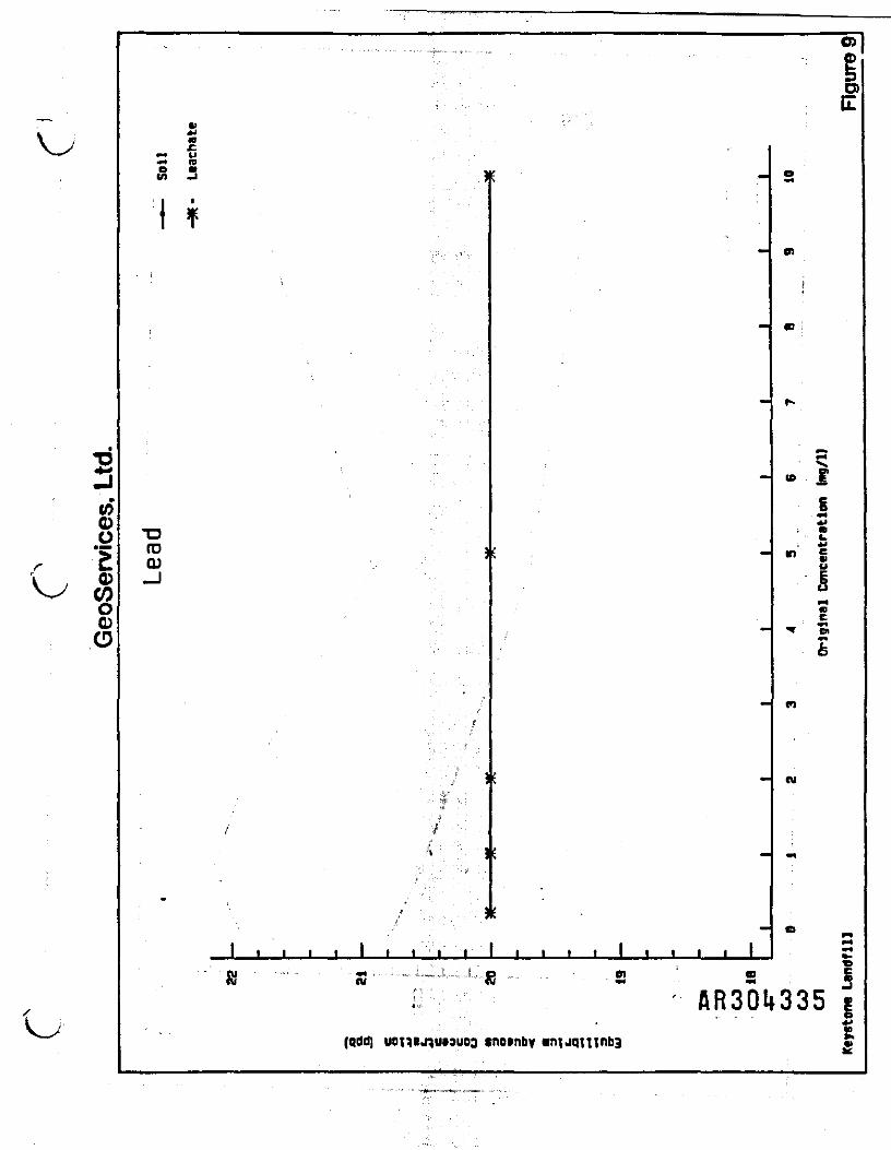
_ f5enoo0)COoOO
O)
o>C
£^* y•P4 IQa a j1 f
• :
!
TDfD 3Q)-J
j
A . . !
s
•
,
^
••
m
S
H
H
f
S
B
1 1 1 1 t 1 t 1 f f | 1 1 1 1 1 1 1 1 1
e
I
m :
' X^
w ^
g**4JIDU*l
n c•f g,ui<DC••»
™ WV4
-5
cu
-
r
^
S"" ' " - rt i • - - -<- -I, .„.,„*. „,': .. . ,. | , C| , ' B) 0 &ni R SM S! 5
i; AR30k335 g... - . O**
£(qddi uonej^u»3uoo «n»nby •nijqTiinbB •>M
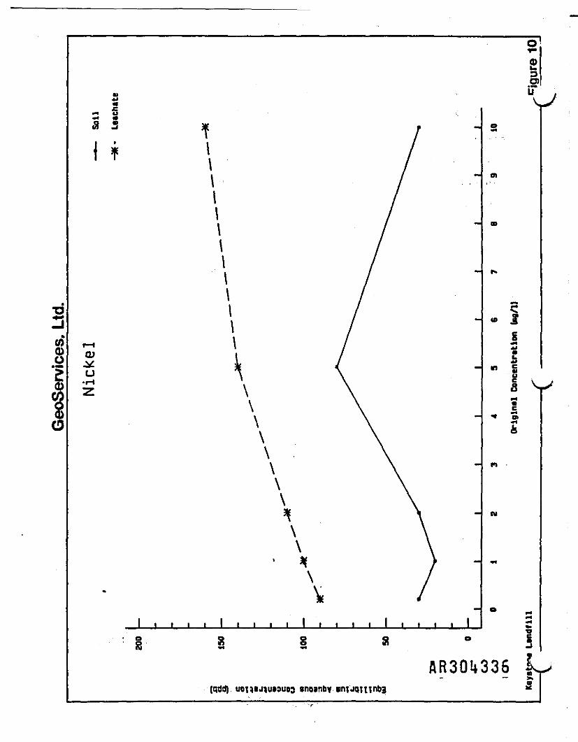
o
i.5?O
uVa
M U•4 V
U
II\I\\\\\
$ ~ I0? QJ \n
o\\\
" \\ - 01
\\
1 1
O)
1II•Iu
V
e o o o o Sg a s 8 5AR30J.336 1
(qddj uoiM*>)u»9UD3 snoanby

104
^5 «h «h ^ «B dh*M ^ L» «h •fe«fe«h.rffc>* ^bdMi 4M^» *A A. flh* A A. «_ J __ J ^ f* m •••* *t ^' Based on the bench test results, it is assumed that
equilibrium nickel concentrations represent a precipitation of
nickel as a result of the pH of the environment. Bench test
results indicated that nickel migration is strongly limited by the
combined effects of precipitation and adsorption in either the
landfill or aquifer environment. Again, the potential for nickel
migration beyond the Keystone Landfill property as either a solid
phase or as a dissolved phase is not possible due to adsorption by
naturally occurring materials and the natural filtering effects of
the ground water flow system as previously described.
AR3CU337
105
8.0 PREDICTIVE MODEL
Of the five remedial alternatives developed by CCJM in their
feasibility study of remedial alternatives for abatement of
potential contamination of the Keystone Landfill, three involve
some combination of ground water extraction and recharge
diminution. While the results of our evaluation clearly indicate
that a no-action alternative is the only reasonable alternative
which could be applied in the absence of a potential or observed
trace metals release from the landfill, the remaining alternatives
are also quantitatively evaluated. This evaluation is included as
a comment in the event that abatement of potential VOC release from
the landfill is deemed necessary by the EPA during review of the
CCJM RI/FS.
In order to quantitatively integrate measured hydrologic and
hydraulic parameters collected during previous hydrogeologic
investigations at and in the vicinity of Keystone Landfill, a
numerical model has been constructed. Model construction was
employed to evaluate ground water flow dynamics under the scenarios
developed by CCJM which incorporate limiting of recharge (site
capping) and/or ground water extraction. The model allows
estimation of the hydraulic response to various remedial scenarios
while satisfying all hydraulic conditions encountered during this
and previous .studies, including water table configurfltagrQ jjrfflo o
measured hydraulic parameters.
GeoServices, Ltd.

106
L Since the thickness of hydrostratigraphic units at the site
were well defined during piezometer and monitor well construction,
and since both aquifer recharge and potentiometric surface
configuration have been firmly established during the course of
previous studies, the only poorly defined parameter is the
hydraulic conductivity of the constituent hydrostratigraphic units.
During the course of model calibration, hydraulic conductivity was
adjusted within the range of measured values until the
potentiometric surface was .accurately simulated. In thatsimulations were, limited to steady state conditions, it was not
- f „, ' .
necessary to estimate aquifer storetivity. Using this approach,
the model provides an accurate estimation of hydraulic conductivity
values in each unit because during the course of model calibration
V, the value derived for that parameter is simply the value required
to allow the observed volume of recharge to pass through the system
under the observed hydraulic,gradient. This procedure fills the
data gap left by the failure of the CCJM pumping test.
8.1 Assumptions and Approximations
As indicated above, the model described herein was utilized
in order to provide quantitative integration of the many hydraulic
and hydrologic variables, affecting ground water flow in the
vicinity of the Keystone Sanitation Company site. The US
Geological Survey model, entitled "A Modular Three Dimensional .. ^^^AR30l}339
GeoServices, Ltd.
107
Finite Difference Ground Water Flow Model" (McDonald and Harbaugh,
1988) was developed in order to simulate 3-dimensional ground water
flow through and between the layers of a heterogeneous anisotropic
ground water flow system.
Because of the ability to address various hydraulic phenomena,
and because of the volume of site specific hydraulic parameters
available, application of the model during the course of this
study required few assumptions. However, as is necessary in any
simulation of natural phenomenon, certain basic assumptions were
applied. Assumptions are as follows:
o The water table configuration established is based on
measurements collected during August through October,
1985, and represents a reasonable approximation of the
regional static water table configuration.
o Dominant structural features of the aquifer (fine
continuous cleavage and minor fractures) can be
represented as a porous medium at the scale of the model
by the use of anisotropic and vertically and areally
heterogeneous hydraulic conductivity arrays. The results
of aquifer tests completed during previous studies in the
Wissahickon Formation substantiates the validity of this
assumption.
AR30't»3i»0
GeoServices, Ltd.

t ,I ,
N—
f; 108..••' ' 1 11 • " ;
8.2 Boundary Configuration -. !:'* ——— ———————— 3-= ———————————— ; ., .,. ... . .
. . . : ; • " ; l : •
The distribution of hydrogeologic boundaries in the study area• "• i . i • '
has been described in a preceding section. In order to simulate
these boundaries, the model, was constructed using a combination of. '! P'i ,.'; i ,;
no-flow and general head boundaries situated around the perimeter
of the model (Figure 11). These boundaries simulate flow barriers
and head dependant zones of ground water flow.
No-flow boundaries correspond with the position of ground
water flow divides coincident with topographic drainage divides.• , .J;ii'}< ' i 'Since ground water flow is in opposing directions on opposite sides
of the divide, zero flow velocity occurs along a vertical plane
which intersects the . topographic divide at the ground surface .
Therefore, ground water cannot flow across these planes.
The remainder of marginal model cells are completed as general
head boundaries such that flow into or out of a model cell from an
external source can occur in proportion to the difference between
the head in the cell and the head assigned to the external source
( McDonald and Harbaugh, 1988 ) » In this model , general head
boundaries are primarily used to provide avenues for ground water
underflow coincident with drainage by surface streams . The
locations of both no-flow and general head boundaries are constant
throughout all three layers.
AR30U3UI
GeoServices, Ltd.
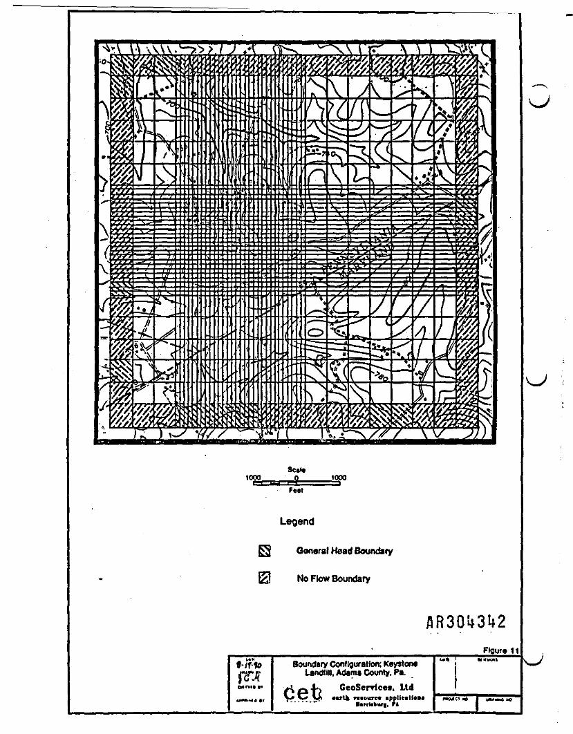
Sctti1000__ tOOO
Legend
General Head Boundary
No Flow Boundary
Figure 11Boundary Configuration; Keystor*
rfTjPff Landfill, Adama County. Pa.CeoSerrices, Ltd
. Ft

' 110
V ; Stream cells were included in layer 1 to represent the small
streams present in the area modeled. Flux conditions along each
stream require an estimate of surface water level for every cell
the stream passes through. ?hese elevations were approximated
using the USGS Littlestown Quadrangle Maryland-Pennsylvania 7.5minute topographic map. • .
8.3 Input Parameters
Initial - estimates of hydraulic conductivity were based
primarily on published US Geological Survey data (Gerhart and
Lazorchick, 1984). These - jdata address both the specific
hydrostratigraphic unit and . its relative physiographic setting.
For ridge forming units the input hydraulic conductivity value was
towards the lower range of the reported spectrum. Similarly, for
valley settings, the estimated hydraulic conductivity was input
towards the upper range of the reported spectrum of measured
values. .f . . .
Finally, 'the model was separated into three layers based on
information developed during piezometer and monitor well
construction. Layer thickness errays were developed following a
statistical analysis of layer thickness/surface elevation derived
from the boring results. Bounding planes of each layer were then
calculated based on average layer thickness as related to specificH < M «.« ARSONSphysiographic setting. -
GeoServices, Ltd.

IllLayer 1 represents the uppermost layer of topsoil which covers
the mantled bedrock. The base of layer 1 was calculated as the
average soil thickness as determined by the average thickness
occurring in measured test holes for each respective physiographic
setting (hilltop, valley, slope), as shown in Table 10. Layer 2
represents the saprolite unit which mantles the underlying bedrock.
The base of layer 2 was calculated in a similar fashion as
described for layer 1 with the actual thickness being a function
of physiographic setting. Layer 3 consists of unweathered bedrock
of the Wissahickon Group. Finally, the three layers were
hydraulically linked by means of a vertical conductance term as
described in McDonald and Harbaugh (1988). The term was calculated
in such a fashion as to mathematically simulate full hydraulic
communication between the three separate layers.
8.4 Model Calibratipn
Model calibration is a process by which model input parameters
are modified within the range of reasonable values until the model
provides an accurate simulation of observed conditions. The model
described herein was calibrated against the water table
configuration measured during August through October 1985. Water
table map construction was based on data from the Keystone Landfill
and the Maryland monitoring system.
GeoServices, Ltd.

* g O S 8 O S O O 2 O O g §00
o o o g o o g o o gO N N N M N N N N Offl ** E • • « o v v x ;v y .55 v • v V v v N " v
g 10 M *H *" ' ™ '"o -S 5§§;< . ,:,:,,:•O1 03 »H • E
Bo O O *-s O*-* fS rS *--1
o ^ 8 S •V vC
^ C <0 X ^ffl 5 J •" --' <"»':/', J< i
C C C C Co s o o " i . o o o.j t* IW _• _j "' ...... . ^- -«i ii i> i M i n .Mr*J 4J 4 -M *i 4JO S ? ID <D (0 CD (Dg S M E M E M E M E M E
. . « _ § _ § _ § _ § _ §r j u " H W ^ w ^ n w < " W " r t
W Q Q) rO> Q G) O Oto c to c »
03 S!f.< g * H H H H H H p H H i - t f H
W C - H C - H C j H C - H C - H
CJ) H *O ' O> f*4 *D .ii C3> M *O O) H *O O) H "Drt«rtC -H-HC -H-HC - H M CO (D h Q (Q l-( O (D MOO fct O (0
O W J•H -H C -rt
O (D h O (D .. _O CO
......,« • ' '„!.,.,,!:.,:. . ^ ^
CO O rH rH
03 <Q CO 03 03
S S S
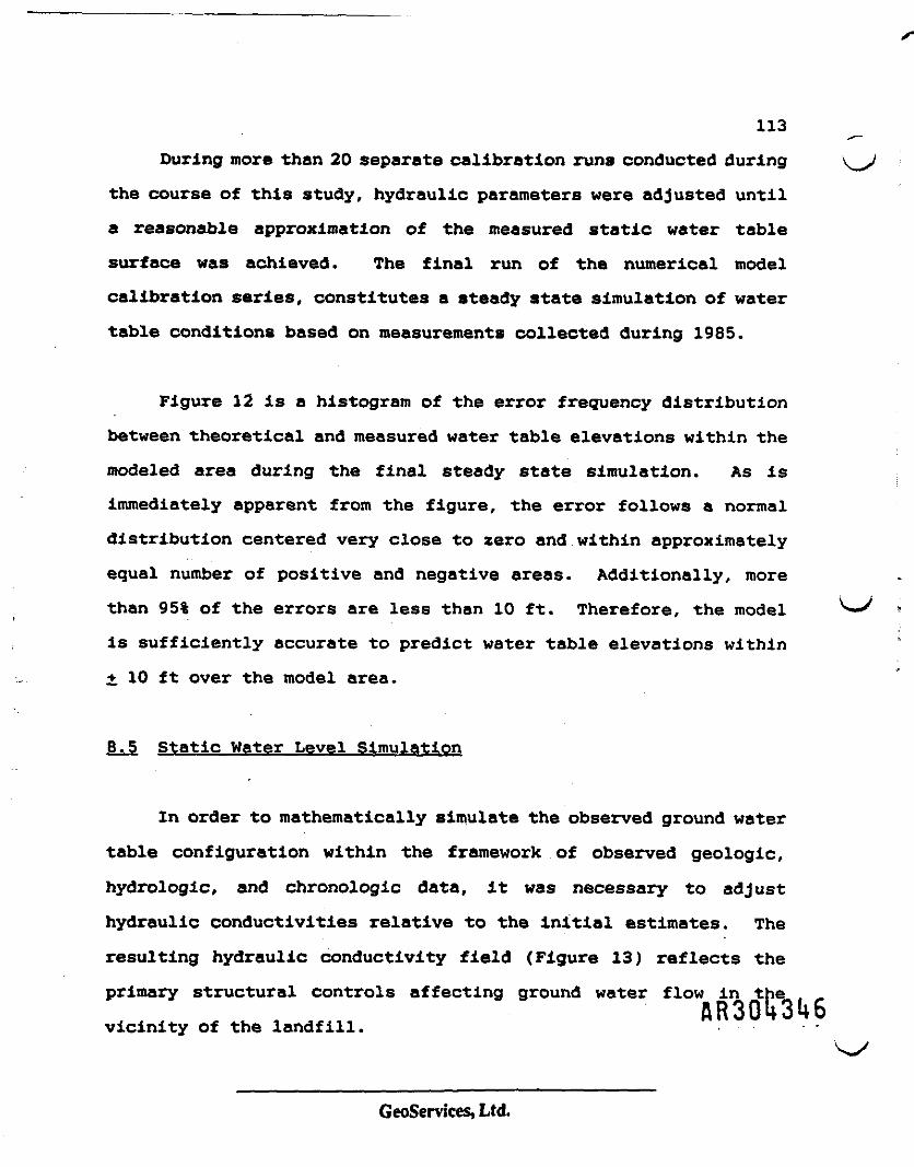
113
During more than 20 separate calibration runs conducted during
the course of this study, hydraulic parameters were adjusted until
a reasonable approximation of the measured static water table
surface was achieved. The final run of the numerical model
calibration series, constitutes a steady state simulation of water
table conditions based on measurements collected during 1985.
Figure 12 is a histogram of the error frequency distribution
between theoretical and measured water table elevations within the
modeled area during the final steady state simulation. As is
immediately apparent from the figure, the error follows a normal
distribution centered very close to zero and within approximately
equal number of positive and negative areas. Additionally, more
than 95% of the errors are less than 10 ft. Therefore, the model
is sufficiently accurate to predict water table elevations within
i 10 ft over the model area.
8.5 Static Water Level Simulation
In order to mathematically simulate the observed ground water
table configuration within the framework of observed geologic,
hydrologic, and chronologic data, it was necessary to adjust
hydraulic conductivities relative to the initial estimates. The
resulting hydraulic conductivity field (Figure 13) reflects the
primary structural controls affecting ground water flow in the
vicinity of the landfill.
GeoServices, Ltd.
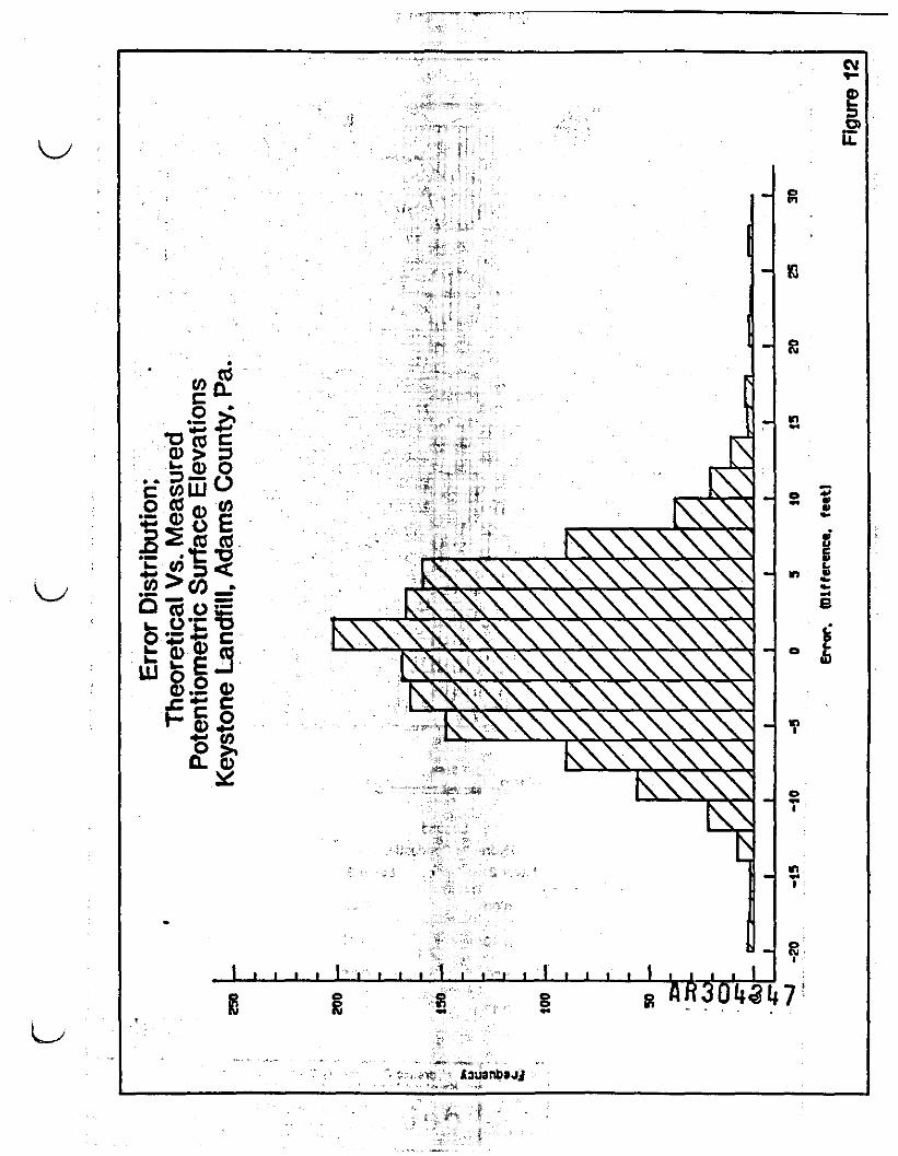
•2*•gji
iisisCO
g?
\\xxx
X\\\\\\\\\\\\N\\\\\\\\\\\\\V
\\\\\\\\\\\\\\\\\
v\\\\\\
l l 1 1 1 1 I I 1 1 1 1 I t I |
s g
evr
D)U.
n
-.*e
o*•i
in
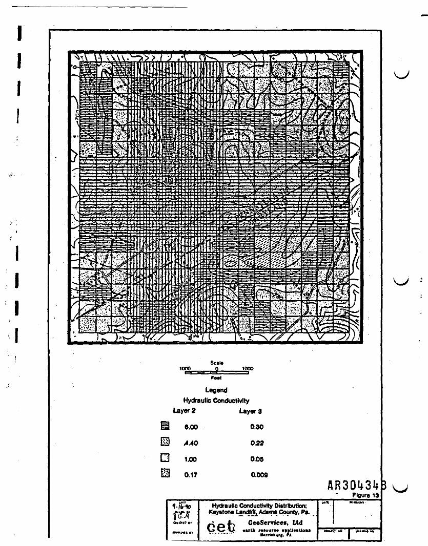
Seal*1000 1000
LegendHydraulic Conductivity
Layer 2 Layer 3
6.00 0.30
4.40 0.22
1.00 0.05
0.17 0.009
Figure 13
1-ft*fWc*«,p ..
Hydraulic Conductivity Attribution;K«y»torw Lantf III, Adama County. Pa.f^ — I J»t CeoScrricet. LtdV* V? Vi earth r-»ourc» •pplieiUou
M-rtUb ,. FA
!»«
HOJ
«-«**
||H*«hS hO
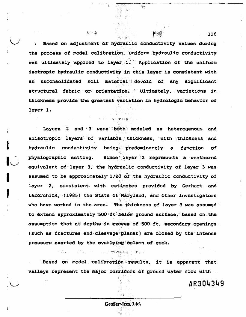
'*'•"<* IW 116;if
\~x , Based on adjustment of hydraulic conductivity values during
! the process of model calibration, uniform hydraulic conductivity
was ultimately applied to layer 1. Application of the uniform
isotropic hydraulic conductivity in this layer is consistent with
an unconsolidated soil material devoid of any significant
structural fabric or orientation. Ultimately, variations in
thickness provide the greatest variation in hydrologic behavior of
layer 1.
; Layers 2 and 3 were both modeled as heterogenous and
anisotropic layers of variable thickness, with thickness and
I hydraulic conductivity being predominantly a function of
• physiographic setting. Since" layer 2 represents a weathered
equivalent of layer 3, the hydraulic conductivity of layer 3 was
I assumed to be approximately 1/20 of the hydraulic conductivity of
layer 2, consistent with estimates provided by Gerhart and
I Lazorchick, (1985) the State of Maryland, and other investigators
who have worked in the area. The thickness of layer 3 was assumed
to extend approximately 500 ft below ground surface, based on the
assumption that at depths in excess of 500 ft, secondary openings
(such as fractures and cleavage planes) are closed by the intense
pressure exerted by the overlying column of rock.
Based on model calibration results, it is apparent that
valleys represent the major corridors of ground water flow with
GeoServices, Ltd.
117
permeability approximately 20.times higher than the permeability
of ridge forming sequences. This relationship is particularly
: significant in that the landfill is situated along the crest of a
prominant ridge. Based on model results, both hydraulic
conductivity and ground water flow velocity are relatively reduced
in the vicinity of the landfill limiting the rate of leachate flux
.-. from the landfill.
-Hydraulic conductivities between the ridge crests and the
adjacent valley floors decrease gradationally in the direction oftthe valley floor. This distribution of hydraulic conductivity is
I consistent with the reported yield of wells drilled in various
I physiographic settings within the area. Wells drilled in valley
floor settings in the Wissahickon may yield as much as 60 gpm,
I while wells completed within ridgetop settings are typically
limited to yields of only a few gpm. Similarly, wells completed
J in slopes developed in the Wissahickon Formation typically provide
, intermediate yields on the order of 10 to 15 gpm. Finally,t
consistent with conclusions developed during the course of previous
investigations, the ground water flow system within the Keystone
area is strongly controlled by the topographic setting, with ground
water flow occurring predominantly through the uppermost layers.
Hilltop settings, although characteristically only weakly
permeable, serve as recharge areas while the adjacent valley bottom
are areas of ground water discharge. Ground water flow from the
flR3'OU350
GeoServices, Ltd.
If 118
(• region is predominantly through!discharge to streams draining the." ..
area along with associated underflow through the aquifer and
[ parallel to the stream channel.
Within the immediate area , of Keystone Landfill, hydraulic
conductivity is extremely low, as would be expected in a hilltop
setting formed in the Wissahickon, A high permeability area does,
however, appear as a salient into the north-central sector of the
landfill. This relatively high permeability corridor provides the
j primary avenue of ground water flow from the landfill. The
relatively low permeability of the remainder of the site is
• . reflected in the extremely low yields of monitoring wells reported
(by CCJM. . , ;;t:: ;—/
I Based on steady state simulation of the ground water flow
regime under non-pumping conditions, the Keystone Landfill site is
I transected by two separate ground water flow divides, one trending
east-northeast through the southernmost quarter of the landfill,
and the second trending northerly through the extreme western tip
of the landfill. The two divides intersect just west of the
western landfill boundary such that the bulk of ground water flow
is towards the relatively high permeability salient directed
towards the north central portion of the landfill. Additionally,
a drainage divide more, or less parallel with the eastern site
boundary also'intersects the cast-northeasterly drainage divide.
O AR30435I
GeoServices, Ltd.

119
Based on this configuration, a well designed ground water capture
system would be designed within the context of the natural flow
system and ground water capture would be focused near the north
central portion of the landfill. Additional capture would be
required for ground water to the extreme west or south of the major
flow divides which transect the landfill as previously described.
Figure 14 is a detail of model simulation results depicting the
potentiometric surface configuration in the immediate vicinity ofthe landfill.
8.6 Simulation of CCJM Remediation Alternatives
The three remediation alternatives developed by CCJM which
involve modifications to the hydraulic regime at the landfill were
each simulated in order to evaluate their relative efficiency.
During the course of the simulations, estimated parameters provided
by CCJM were directly input into the model, including recharge
diminution due to capping and estimates of recovery well pumping
rates. Pumping of the 20 recovery wells at the 1 gpm rate
estimated by CCJM resulted in dewatering of model cells in which
the pumping wells were situated. Because pumping from a dewatered
zone is not possible, discharge rates of the specific wells were
reduced until dewatering did not occur in the respective model
cell. In some cases, it was necessary to completely eliminate
certain pumping wells from the simulation. This adjustment.«.. co
GeoServices, Ltd.

Steady State Simulation;• k'AV/C*,* • Keystone Landfill, Adams CoUrtty, Pa,
3350 4350 5350 6350
6850 A f? f \ \ V \ - - / / / S \/~\ ——— - / 6850
LandfillBoundary
15850 h \ ^8 - ^ *oi -———— \- ' / A —— H 58501
-~ IiI
4B5C3350 4350 5350 6350
OAlt<?- /f - f.?OfU«N §Tg.t.jtf.OCCKCD IV
AffROVD IT
- • • . : . . . . - - Scatelogo o 1900Feet
*
Af\4*> GeoServic.es, Ltd\£ ££2L£ «urth resource tpplioaUona
"""- u* Hft-riiburf. PA
Figure 14DATE MCVtSQNS
flKi GU353
ntojccr na • WUMHO NO.

J 121
accommodates the natural process of development of a constant x_x
drawdown and associated pumping rate stabilization at the recovery
wells placed around the margins of the landfill. Results of each
of the simulations are discussed separately below.
8.6.1 Sinole Laver Cap with Ground Water Extraction (CCJM
Alternative 4)
Based on estimates provided by CCJM, it is assumed that
; establishment of a single layer cap would result in a 50 percent
reduction of recharge through the landfill. Additionally, the 20
I wells estimated by CCJM were placed around the southern and eastern
I fringes of the landfill and simulated at a pumping rate of 1 gpm
each. Those wells which resulted in dewatering of their respective
I cells were either completely deactivated or reduced to a pumping
rate of between 0.5 and 0.2 gpm in order to evaluate establishment
I of equilibrium constant pumping rates at these specific locations.
, Wells which required this adjustment include all of the wellsi
situated along the eastern site border and three of the wells along
the southern site border. Following adjustment, the simulated rate
of leachate capture is 11.7 gpm. Figure 15 is a water table
elevation map at the close of the simulation.
Comparison with the potentiometric surface present under
steady state conditions (Figure 14) indicates that, while the
GeoServices, Ltd.

Groundwater Extraction/Single Layer CapKeystone Landfill, Adams County, Pa.
3358 4350 5350 6350
6850 -/ / / \ \ I \ *, Ht Vx-\ > — 4\ 6850
5850 - :* ^ >_ ^ ———— I _ X " SB50
|-,850 "——————————-^——————V / / I—————I————I———————==*————I———^J 4850]3350 4350 5350 6350
_ o*n •*f" /c'lO5*7 iYi/>? • v •>/* .ocotro tt
APfUOVW BY
. • Legend 1000C3L ^
..T - . Active Pumping WellV ; Inactive Pumping Well-HJ Dewatered Layer 2 Cell
•*""\ tf ^ j-iC* *i-rrl f> fli P U _ I* O C CJr* f^l) wCOocrVlt^HIn «y*4 J u jV> ;><.''?A «*rth rtvouree tppUc*Uoni
f itrrumrg. PA
Scalej) 1000
Figure 15DATC RDA90NS
ntcgtci »a i ftupwo na1

123
• overall potentiometric surface is decreased by approximately 10 ft, ~
uniformly over the landfill area, drainage divides which transect
'; the landfill remain almost unaffected. Leachate capture appearsi
to be satisfactory at the eastern and southern margin of the site,
although the extreme westernmost tip of the landfill remains active
as a source of potential leachate due to the absence of any wells
at that location. No provision for collection of leachate from the
western half of the landfill is provided by the CCJM alternative
because recovery wells are limited to the eastern and southern
I landfill boundaries. Additionally, since a naturally occurring
drainage divide is present parallel to the eastern site boundary,
I the establishment of collection wells along this divide is
• unnecessary. These eastern wells serve to intercept a total of 1.2 / ,
gpm of leachate which would normally flow towards collection wells
I situated along primary flow routes from the landfill, as well as
ground water not affected by the landfill at all. Based on theI* results of the simulation, the distribution of recovery wells CCJM
alternative 3 is poorly conceived and extremely inefficient.
Finally, following termination of pumping, portions of the landfill
would become resaturated, potentially reactivating dormant
contaminant source areas within the landfill. Source reactivation
would also be favored by the gradual failure of the cap over time.
Figure 16 is a simulation of the potentiometric surface following
cessation of recovery well operation.
HR30U356
GeoServices, Ltd.
ISingle Layer Cap/Inactive
I Groundwater Extraction SystemKeystone Landfill, Adams County, Pa.
3350 4350 „ 5350 6350"
6B5C -
58B0 - V ^ ^ ">.. :- rr———< / \ —— r 6BBi
48503350 4350 6350 ' 6350
*
: ; .,, ;Leoend 1000
"T" Acthre Pumping WellY , Inactive Pumping Well
, *— L! Dewatered Layer 2 Cell
_S-ffioV*^MVV1 • I.
9.6. .OCCKEDIY
«m«>«o.r
fl FT *C 1 1 P* V ••h r
• it *
A f fo GeoServIcea, Ltd\ f-:Jfc*f-:- JA earth reaource ftppllcatlont
-- ' • HirrtiDurf, fA
Scale0 1000
Figure 16DATE REASONS
fROJECT HO. I OftAMNC ttO.

125
8.6.2 Multi-Media Cap with Ground Water Extraction (CCJM
Alternative 5)>*
Establishment of a multi-media cap as opposed to a single
layer cap results in an additional uniform decrease in ground water
surface elevation to that associated with reduction of recharge by
50 percent with the single layer cap. At the same time, the
overall configuration'of the potentiometric surface remains little
changed with drainage divides transecting the western and southern
: portions of the landfill (Figure 17). The easternmost drainage
divide is shifted to the west on the landfill side of the line of
I collection wells paralleling the eastern landfill border.
i As described in the preceding section, recovery well
I production capacity along the eastern boundary is extremely
limited. This limitation is increased by recharge diminution
I associated with the multi-media cap, such that the total pumping
? rate of eastern section wells is only 0.4 gpm. Again, wells
paralleling the eastern border are unnecessary in that ground water
flow which would normally be intersected along the northern site
border by wells placed at that location serves no additional
purpose. Additionally, the western tip will continue to generate
minor amounts of leachate while the relatively permeable north
central hydraulic salient remains incompletely covered. As
; described in the previous section, cessation of recovery well
GeoServices, Ltd.

" Multimedia Cap/Groundwater ExtractionKeystone Landfill, Adams County, Pa.!
W 3350 -4350 5350 6350
ii
II
6850 -
5850 -
4850 i————————————^——«^J—' f '———-^———————'——————————-===*————'———-^ 485013350
Feet
Active Pumping WellV" Inactive Pumping Well
Dewatered Layer 2 CellFigure 17fln3Dl.fl59DATt
OCQCED BY
/' OA1C
GeoSerrices, Ltd•artb resource application!
, PANO. 1 MAMNC Ma

127
I operation results in resaturation of a significant volume of ^"^
' material which comprises the base of layer 2 (Figure 18).
! Resaturation constitutes potential reactivation of sources madei
dormant by recharge diminution and interception of ground . watert
flow, leading to an extended period of remediation and potential
complications at the intended close of recovery system operation.
Again, the alternative developed by CCJM is technically and
hydraulically inefficient and poorly conceived.i
I 8.6.3 Ground Water Extraction (CCJM Alternative 3)
I The third remedial alternative developed by CCJM involves
• ground water extraction in the absence of either a multi-media or / \
single layer landfill cap, by way of a network of 20 wells located
1 along the southern, eastern, and part of the northern site
boundaries. The design pumping rate of each well is 1.0 gpm. As
J was necessary during the course of the previous simulations,
reduction of simulated pumping rates was necessary for specific
wells. Pumping rates in all wells located along the eastern site
boundary were reduced to either 0.5 or 0.2 gpm to eliminate
dewatering of the constituent cell.
As might be expected, based on the previous simulations,
ground water extraction in the absence of either type of cap
provides little modification to the configuration of the . _flR30I*360-
GeoServices, Ltd.
Multimedia Cap/Inactive Groundwater Extraction SystemKeystone Landfill, Adams County, Pa.
3350 435C E3S0 6350
BS50
'4850 I———————————————*—————«T f t——^———————————I ——————I———^J 4856!3350 4350 • ,. . . . - , . S350 6350
OA1EQ. /f . <JQDRAM* »Y.9> W• C. */!•OCCKED IT
-P«0«DiY
Legend 1000 <?* 1000Feet.
T Xctive Pumping WellV" Inactive Pumping Well
-SJ Dewatered Layer 2 CellFigure 18
AR30l*36l
A p\fo GeoServices, LtdiMRcfetf-g-SA «arth resource application* „ .
, , 1 HtBMTtttur|, PA
DATE NCWONS
FXOJCCT HO, I pUMNQ MX

129
potentiometric surface (Figure 19). This results in the same
weaknesses as previously recognized relative to the configuration
of the leachate collection system network. However, the amount of
water available to the extraction system wells is significantly
greater than under either capping scenario. Therefore, a greater
volume of leachate (15.6 gpm) is treated during system operation
and soil flushing by infiltration of precipitation is operable as
a natural process, thereby accelerating the remediation of the
landfill.
Finally, charging of the landfill environment with oxygenated
I atmospheric water provides a necessary source of biological
• nutrients necessary for bioremedlation and degradation of organic
compounds by organic processes. This process also maintains a high
I oxidation capacity within the landfill favoring the formation of
hydrous iron oxides which serve to sequester trace metals by virtue
I of adsorption and other attenuation processes. Therefore.
establishment of any type of cap represents a counter-productive
element in the remedial system design and should be eliminated from
anv further consideration. Additionally, the simulation indicated
that the configuration of the recovery well network developed by
CCJM is extremely inefficient as it focuses excessively on areas
underlain by ground water divides and omits areas of ground water
convergence, thereby focusing areas of minimal leachate production,
the exclusion of areas of maximum potential leachate flux.
GeoServices, Ltd.
Groundwater Extraction/No CapKeystone Landfill, Adams County, Pa.
3350 4350 5350 6350
4850]3350 4350 5350 6350
J DRAWN |Y9/* it. C/.tAVCHECKED tY
APf*>*OiY
Legend
T Active Pumping WellV" Inactive Pumping Well
Scale1000 0 tPOQ
Feet.- . - - * • -. -•.
*A f 4-*\ GeoServices, Ltd\>rl> i aarlh r«touree appllcatlona
Htrrtiturf, FA
oAicf R3Q»t«$afc j—
MOJCCT Na i IMAMNQ HO.

131 OThis design error results in leaving flow generated from much
of the western half of the landfill uncaptured. Additionally,
construction of a recovery network as a series of two lines of
wells along opposite sides of the landfill results in the net
stagnation of ground water at points in between the two recovery
zones. Stagnation results in decreased ground water flow velocity
and hence in a reduction in pore volume exchange and subsequent
transport of contaminants through the landfill into the treatment
system. Lastly, assuming that ground water capture is ultimately
required to address VOCs present within the landfill, enhancement
of recharge by spray irrigation utilizing treatment system effluent
I at the landfill surface should be evaluated. As opposed to,*•
• capping, this process enhances remediation by increasing the rate (j
of pore volume exchange within the aquifer. Pore volume exchange
I within the landfill materials increases the flushing of landfill
materials, while the increased flux of infiltrating water increases
I the amount of oxygen available for microbial degradation and
favorable mineralogical reactions as previously described. It is
beyond the scope of this report to provide design of an optimal
recovery system, since the intention of ground water extraction
system could only be to provide capture of VOCs potentially present
at the site. As previously demonstrated, no such remedy is
required to eliminate the risk of trace metals migration beyond
Keystone Sanitation Company property. Nevertheless, CCJM has
clearly failed to develop any such optimal ground water extractionAR30I436U
GeoServices, Ltd.

132
system. A more detailed evaluation and comprehensive design study
should, therefore, be initiated should a ground water collection
alternative be needed for attenuation of landfill leachate to
remove VOCs. We strongly reiterate that no remediation is
necessary for inorganic compounds whose release or potential
release has not been demonstrated during the course of any of the
several studies conducted at the landfill. Regarding trace metals
then, the only reasonable alternative which could be applied is
alternative 1 -no action.
BR30I(365
GeoServices, Ltd.

133
PART III
>: SPECIFIC COMMENTS
CCJM REMEDIAL INVESTIGATION/FEASIBILITY STUDY
flR30l»366 , ,
GeoServices, Ltd.
134
GENERAL COMMENTS -
During the course of our evaluation of the CCJM RI/FS, we have
also reviewed comments prepared by other consultants and by Deborah
Foreman of the US EPA regarding the risk assessment. We agree with
comments indicating that the only remedial alternative supported
by the CCJM RI/FS is the no-action alternative (Alternative 1).
Specifically, we agree that the work was based on an inadequate
work plan which was not followed in the field. Additionally, the
j complete Inadequacy and erroneous conclusions developed from
collection of unfiltered samples subsequently analyzed for metals
• contents has. lead to total misunderstanding concerning the
ff potential for trace metals release from the landfill. Finally, the
erroneous nature of the assumptions used in the development of the
I risk assessment and the consequent overstatement of risks to human
health and the environment has called into question conclusions
I developed during the course of the CCJM RI/FS.
9.1 CCJM RI Review <
The following specific comments are offered relative to
statements.included in the CCJM final remedial investigation report
for the Keystone Sanitation Company site. The report was issued
July, 1990 and was reviewed by GeoServices, Ltd. during August and
early September, 1990 during the 60-day comment period allowed byAR30lt367
GeoServices, Ltd.

135
EPA for review. Specific comments are - presented below and are
related to specific areas of the CCJM report such that each CCJM
report.
3Paoe ES-1 Paragraph 3i CCJM states that the RI was
implemented to supplement previous reports.' However, data from
previous reports were not Included in the RI or the FS.
Therefore,the purpose of the RI was not met by subsequent activity
on the project. In the same paragraph, it is stated that the
primary objectives were to evaluate impacts although existing
laboratory data were not included in the evaluation. The CCJM
study relied completely on samples which were collected during the
single sampling event and which included a limited number of wells )
relative to those sampled during previous investigations. Had CCJM
included the existing database in the analysis, the significance
of anomolously high trace metals concentrations could have been
evaluated and subsequent mistakes and erroneous conclusions founded
upon this data could have been avoided. In addition, had CCJM
relied on existing data, the RI/FS process and subsequent report
would have been more thorough, more accurate and less costly.
Pace ES-3 Paragraph 5: It is stated that surficial and
subsurface shallow soils were sampled to determine if off-site
soils had been affected by contaminant migration from the site.
Additionally, it is stated in the same paragraph that surface waterRR30U368
GeoServices, Ltd.

I 136
i and sediment samples were taken along with ground water samples 'to
determine the extent of contamination emanating from the site.j . • . ': ; , : : . •
The report concludes that no site related contaminants were
detected in off-site soils near the site or along surface
drainages. Additionally, 'the report concludes that no site-
related BNAs, pesticides, or PCBs were detected in surface water
or sediments, and that metals which were detected above fresh water
chronic water quality criteria bore no direct connection to the
Keystone site. The report also concluded that no site related
pesticides or PCBs were detected in ground water from off site
I monitor wells. Although several metals were detected in off site
I monitoring wells, CCJM concluded that their occurrence was random"•s—J
and apparently not site-related. The report further concluded that
I the relative abundance of metals in shallow monitor wells may
result from natural weathering processes. The report also
J concluded that 'there was no indication of metal contamination
emanating from the Keystone site" and in nearby residential wells.
Finally, metals contamination was not detected in any on site
surface soils. '" • -" " L"-r io C ' - '. - -
Clearly, in accordance1 with this Information, the most recent
soils and ground water sampling data indicate that no release or
threat of release of metals has occurred, either to on-site soils,
to off-site soils, or to either ground water, surface water, or
AR30li369GeoServices, Ltd.

' . 137
stream sediments. In the absence of any observed release or threat
of release, there is no need to consider design of a remedial
system although under the circumstances, monitoring or other
precautionary measures may be considered prudent. Additionally,
assessment of risks to human populations or to the environment must
be carefully evaluated within the overall context of the actual
site conditions.
c
, Pace ES-5/ES-6 Paragraph 8; The report states that exposure
I pathways include ground water, surface water, and soils routes by
means of inhalation of airborne particles originating from site
• soil waste or due to dermal contact. We have clearly shown in
I previous sections of the report that metals concentrations are not
present as a dissolved phase but rather as a particulate phase
I within the aqueous regime. Therefore, dermal contact could only
• be established due to showering, bathing, or swimming in extremely
" turbid water.—Additionally, metals concentrations in particulate
matter within the leachate are little different from naturally
occurring metals concentrations in soils and rock materials which
constitute the geologic setting of the region.
Page ES-6 Paragraph 2; Several metals are listed as major
contaminants which include chromium, nickel, cadmium, and
beryllium. These compounds are immobile in the natural environment
due to their existence as a solid phase. Therefore, trace metalsRR30U370
GeoServices. Ltd.

present no more of a potential risk to human health than does
naturally occurring bedrock or soil particulates derived from the
regional bedrock. * I
Paoe 1-1; One of the stated objectives of the RI was to
develop a cost effective remedial action plan. Development of a
more than $10 million remedial alternative involving ground water
extraction, capping, and construction of a water treatment plant
to treat contaminants in which neither a contaminant release nor
j threat of release has been observed, can hardly be regarded as costeffective.i
I Page 1-9 Paragraph 1; • :The CCJM states that EPA/NUS found•-—'
elevated levels of lead, chromium, cadmium and mercury in on site
I monitor wells during the 1984 investigation. These sample results
have been conclusively identified as statistical outliers
representing the concentrations of particulate matter within an
unfiltered sample. Furthermore; subsequent sampling demonstrated
that these measurements "were 2 entirely non-reproducible and
therefore unreliable. Therefore,'no such elevated levels of lead,
chromium, cadmium, or mercury7 can be considered to have been
detected when included with the sampling and preservation protocol
which was employed.
ftR30l*37l
GeoServices, Ltd.

i
139
Page 1-11 Paragraph 3: .„, CCJM states that review of the
existing database shows that there is Insufficient information to
define the hydrogeologic regime and to characterize the extent of
existing contamination. This statement immediately follows the
conclusions developed by the State of Maryland in its 1986 report
which provides a number of conclusions regarding the three-
dimensional configuration of the ground water flow system
dominating the area. The Maryland report provides a detailed
discussion of the vertical and horizontal extent of the flow system
relative to discharge of ground water derived from Keystone
Landfill.
Additionally, CCJM offers no explanation for omission of the
data from hundreds of ground water samples which had been collected
I at the time of report preparation and prior to the sampling event
conducted by CCJM. As will be developed below, the stated purpose
f of collecting*- additional information (to determine potential
contaminant migration routes) was not served by the subsequent
investigations since CCJM failed to conduct a single successful
test of aquifer characteristics or to provide any meaningful
additional data by which the Keystone ground water flow system
could be further refined.
Page 2-9 Paragraphs 1 and 2; CCJM states that aquifer tests
; by Keystone and the State of Maryland, as well as a pumping test
AR30I.372
GeoServices, Ltd.
140
conducted by Buchart-Horn, -•• .were used to determine aquifer
properties or to characterize the hydraulic behavior of wells
completed within the site aquifer at the site. Although CCJM claim
that the existing database was insufficient to define the
hydrogeologic regime at the site, the existing database is
repeatedly cited to define the Bite hydrogeologic regime. This is
in contrast to the almost complete omission of any assessment
completed by CCJM. We therefore question the need for the
additional work completed by CCJM embodied in the RI or, in fact,
the need for any additional worktat the present time.
' Paoes 3-1 to 3-20; An extensive program of surface and
I borehole geophysics was conducted, presumably for the purpose of^
monitor well siting and delineation of aquifer characteristics.
I Whereas no evaluation of the three-dimensional ground water flow
regime or the vertical distribution of ground water contaminants
' is presented anywhere within the report, we see the completion of
the extensive geophysical program described in this section to be
wholly unnecessary and blindly extravagant.
Page 3-20 Paragraph 3; The teport states that, although the
wells were fully developed,, some wells continued to produce pale
yellowish-brown water indicating a high percentage of particulate
matter. When sampled under the protocol employed by CCJM, such
: samples could only produce-anomolously high metals concentrations
i \ not representative of dissolved aqueous phase metals.
GeoServices, Ltd.

141
Page 3-28 Paragraph 1: CCJM states that surface water samples ^ ^
were collected from well-mixed (flowing) reaches of streams or
springs by direct immersion of a sample container. While CCJM
states that some effort was made to avoid collection of suspended
materials by sampling surface water prior to sampling sediment,
streams draining the region characteristically contained
r significant quantities of suspended materials due to the fine
grained nature of the soils which mantle the region and which are
drained by the.streams. Suspended materials are especially present
| - following rainfall events. The presence of suspended materials in
stream water (particularly those in well flowing reaches of streams
I or springs) imparts a characteristic green or brown color to the
• streams of Southeastern Pennsylvania. Again, unfiltered samples i
collected from streams draining the area and preserved using a pH
I of 2 could only be expected to contain elevated levels of metals.
Actual concentrations of metals is dependant on the volume of
f particulate matter collected along with the sample and processed
during laboratory analyses.
Page 3-29 Paragraph 2: During a description of the sample
collection procedure. It is noted that the well, in some cases, was
pumped dry rather than fully purged. Cavitation of the well
normally results in a significant increase of the volume of
particulate matter in the well water. This would again lead to
excessive metals concentrations due to sample collection procedure
GeoServices, Ltd.
142. . . . ,,. , „ ,rather than as en accurate measure of metals content of ground
- *water in the vicinity of the Well.
Page 3-33 Paragraph 3s - A 'seventy-two hour constant rate
pumping test was conducted to determine aquifer characteristics at
the site. During the test, response of water levels in 11 wells
and a spring were monitored continuously. The results of the
pumping test were reported in a subsequent section with the success
of the test characterized by distorted drawdown results. During' . . .| the test, only the pumped* well an<3 a single observation well
displayed decreasing water levels. Other wells showed an increase
I . In water levels due to rainfall effects. Additional comments
( r e l a t i v e to the inadequacy and folly of the RI pumping test are^ - . . , ,.,.,„ .included in a subsequent comment.| ..,,,.- .,,. . . . . ..
Page 4-1 Paragraphs 2 and 3; The report states that
? precipitation/falling on the landfill can flow northward over
ground surface or seep downward into the landfill to the ground
water below. In following paragraph, it is stated that no eroded
gullies or seeps were visible at the landfill. It is presumed
therefore, that CCJM envisions precipitation draining the landfill
as a sheet of water over the ground surface rather than collecting
in any gullies, seeps or swales. This circumstance is highly
unlikely and actual site conditions provide little potential for
transport of surficlal materials from the landfill by sheet wash.'.: . . , , AR30U375
v , . . . . ,GeoServices, Ltd.

143
Paces 4-5 to 4-15t .Surface geophysics are discussed in order
to identify the three-dimensional structural framework in the
I vicinity of the landfill. As would be expected, discrete fracture
zones are present within the area and the depth to fresh bedrock
varies significantly throughout the area. The summary presented
at the end of the section states that weathered near surface rock
may be the dominant aquifer until major fractured/weathered zones
are encountered. In both cases, the report concluded that major
avenues of ground water migration are through significantly
weathered zones presumably containing an abundance of clay minerals
and iron oxides which are the normal weathering products of the
I rocks which underlie the area. Both materials have been previously
I cited as primary adsorption sites for metals adsorption.
Significant mobility of trace metals through these materials is,
I therefore, not possible under these conditions.
IPaoe 4-16. Figure 4-3; The figure summarizes the geology of
the area indicating that the saprolite is composed of weathered
schist and that the schist itself is composed of chlorite,
muscovite, and finely disseminated pyrite along with other
minerals. Chlorite, muscovite, and pyrite have been shown to
contain extremely high concentrations of trace metals, These
concentrations are high enough to be expressed as weight percent
rather than as ppm. Therefore, the entire saprolitic sequence must *
i be regarded as a source of trace metals which are elsewhere
identified as contaminants of concern by CCJM. AR30^376
GeoServices, Ltd.

' 144Oj Page 4-19; Fracture zones are characterized as ranging in
thickness from 1-inch to approximately 1-foot and containing
I crushed schist with small amounts of finely braided rock material
(clayey gouge). Additionally (in the third paragraph of Page 4-
19), saprolith is characterized as a pale yellowish brown clayey
soil containing remnant schist and quartz fragments* In the
following sentence it is characterized as consisting of reddish-
brown, brownish-gray and pale greyish-green clay and heavily
weathered schist. In all cases, the areas through which ground
} water migration is focused is associated with clay minerals and
. iron oxides (imparting the reddish or brownish coloration to the
• clayey sequences). Materials underlying the site represent an
f enormous volume of potential adsorption sites for any trace metals
which would be transported as a dissolved phase in ground water
I migrating through these areas. Furthermore, not only are
adsorption sites found everywhere within the aquifer, but the
• aquifer itself represents an enormous source of trace metals by
virtue of the minerals contained within the sequence.
Page 4-20 Paragraph It ^ The report states that chemical
analyses were performed on rock cores from boreholes and that these
analyses indicated that only barium and chloride were readily
leachable from-rock. During bench testing by GeoServices, Ltd/,
soils present within the area Were Shown to represent a significant
; source of chromium, lead, and nickel when leached with a strongly
AR301.377
J GebServices, Ltd.

145
acidic solution such as the solution in. which the samples were
preserved. Therefore, although the minerals are present in the
materials which were cored by CCJM, their own analyses demonstrate
that those minerals are immobile. Finally, trace metals are
present both in the landfill leachate and in virgin soils within
the same naturally occurring minerals and mineral phases which are
present in the rocks underlying the site.
Page 4-21 Table 4-2; Chromium and lead were detected in the«; two cored intervals at maximum concentrations of 77.6 and 73.5 ppmi
respectively. These data are consistent with those reported by theII State of Maryland for similar analyses. As was previously
demonstrated, digestion of these samples as a consequence of the
preservation process employed by CCJM causes anomolously high
I dissolved metals concentrations in aqueous samples when particulate
matter is Included in the samples which are analyzed.
IPage 4-22 Table 4-3; Table 4-3 is a summary of the EP
Toxicity analyses of selected core intervals which indicates that
chromium and lead were not present in the leachate. EP Toxicity
analyses of materials deposited in the landfill by Alloy Rods
showed similar results. Again, little difference exists between
the behavior of materials placed in the landfill by Alloy Rods and
naturally occurring materials which characterize the environment.
There is no justification, therefore, to conclude that materials
RR30U378
GeoServices. Ltd.

146
placed in the landfill by Alloy Rods represent any potential threat
I to human health or the environment. Such thinking would require
J one to conclude that similar ;, threat is present throughout the
region as a result of the chemical composition of the rocks through
which ground water flow is concentrated.
Section 4.6 Page 4-20 to 4-28: The entire section is a
discussion of the results of a borehole geophysics survey conducted
on monitoring wells drilled by .CCJM. The discussion is largely
1 academic and duplicates information concerning water bearing zones
which should have been available from well logs from the geologist
I who logged the borings. Normally, water bearing zones are
( r e c o g n i z e d and logged by .the .geologist present during well-*—-'
construction and are recognized by the appearance of additional
I water emanating from the hole, tthe physical characteristics of the
cuttings produced during drilling, and other features.i ,,,,..Page 4-29; : The comparison of geophysical logs with core
descriptions was based on the relationship between various
geophysical factors to features observed during core examination.
No new information was provided by the application of borehole
geophysics and therefore, this application represents an
unnecessary and extravagant expense.
AR30U379
GeoServices. Ltd.
I
147 vJSection 4.7 Hvdrogeolocrv; As a general comment to this
section, CCJM concludes that most of the water occurs at depths
generally less than 45 ft and is contained in the saturated
saprolite and weathered schist. Additionally, CCJM concludes that
porosity and hydraulic conductivity decrease significantly with
depth and that little water is contained within the unweathered
schist. Therefore, the ground water flow system emanating from
Keystone Landfill is strongly controlled by topographic divides
(both ridge crests and valley axes) which limits any recharge
migration regardless of its chemical makeup.
Page 4-53; An attempt 1 s made to estimate ground water
| velocity in the absence of any direct measurement by CCJM of i
porosity or hydraulic conductivity of any of the units present at
I the site. CCJM assumes that hydraulic conductivity ranges between
10~2 to 103 gpd/ft2 (a range of 5 orders of magnitude) and that
I porosity is 0.«38 percent. Under these conditions, CCJM estimates
that ground water velocity ranges between 4.4 X 10"4 to 4.4 ft/day.
This range of estimated velocity (between 2-inches and nearly a
third of a mile/year) represents little more than a guess at ground
water velocity. Such an estimation of the critical hydraulic
parameters upon which any risk assessment or subsequent remedial
system design is based constitutes a blatant misapplication of
scientific, method and is completely inappropriate to remedial
system design. This is especially onerous where the primary stated
I _____1 GeoServices, Ltd.
I - 148
— motivation of the design is to; protect human health and tne
environment. • I : , •
Pace 4-54 Paragraph 2; CCJM discuss the Buchart-Horn pumping
test and concludes that the storage values reported by Buchart-
Horn are low for unconfined Aquifers. On the contrary, the
storativity values reported by iBuchart-Horn ere typical for
unconfined bedrock aquifer or where flow through fractures affects
the numerical magnitude of the storativity value. In such
| situations, storativity is a reflection of a degree to .which
observation wells are hydraulleally connected to the pumping well,
I rather than reflecting the storage capacity of the aquifer.
Page 4-54 Paragraph 3;: The CCJM study further summarizes the
I Buchart-Horn report stating that the flow regime of the pumping
well was linear along strike rather than radial across strike. It
I is unclear what CCJMiis attempting to indicate by this statement
; in that the flow system in , the; immediate vicinity of a single
fracture is linear within a discrete distance from the fracture,
and thereafter becomes radial. There is no relationship between
flow system configuration and bedrock strike as indicated by this
statement. Statements offered by CCJM in this and the preceding
paragraph indicate an extremely ilimited understanding of the
hydraulic system in the vicinity of a pumping well in fractured
rock terrain. Furthermore, CCJM's demonstrated lack of AR3QU38I
GeoServices, Ltd.
149
understanding of fractured rock hydraulics is a direct precursor —'
of problems with design of a ground water capture system in such
terrain.
Page 4-54. Section 4.7.2.1 - RI Pumping Test: During the CCJM
pumping test, only the pumping well and a single observation well
displayed decreasing water levels due to pumping. All other wells
showed a significant increase in water levels during the pumping
test as a result of a rainfall event. If the rainfall event was
; the sole failing of the test, the test should have been rescheduled*in that the characterization of the hydrogeologic regime was the
I stated reason for conducting the remedial investigation. Data is
• not presented in the CCJM report concerning the pumping rate which
was employed at the pumping well nor were any calculations offered "
I in data that was available. It is therefore difficult to assess
what the actual cause of the pumping test failure was, although
f based on review of Buchart-Horn pumping test data results and upon
GeoServices, Ltd. experience within the Wissahickon Formation, the
observation well configuration relative to the discharge rate at
the pumping well was probably too widely spaced to allow any
significant drawdown results to occur in the observation wells as
a result of pumping. Therefore, failure of the CCJM pumping test
was based on an improper pumping test design as opposed to an
untimely rainfall event.
HR30U382GeoServices, Ltd.

150
Page 4-56 Paragraph 2; /• CCJM postulates that a hydraulic
connection exists between well K-l and Mundorf Spring on the basis
j of topographic and potentiometric relations. The placement of this
conjecture in the section on pumping test analysis results is!; curious in that the statement is not supported by any quantitative
measurements developed by CCJM, especially not by the pumping test
completed by CCJM. Therefore, there is no basis for this
statement. • •- " - - •,.;•:•:.•'-• \ ^ -.:.-. • -
j Pace 4-62; CCJM states that no signs of stressed vegetation,
I damaged crops, or extreme environmental concerns were observed
* during a site visit to the site and surrounding area. This is not
( s u r p r i s i n g and is consistent with the absence of any observed-J
release of contaminants from the landfill.I - - _ > . . ,I
Page 4-62 Paragraph 4: CCJM reports that the streams are less
' than three ft wide and only a few inches deep. Therefore, risks
associated with swimming in streams which drain the area, dermal
contact with stream water, and ingestlon of stream water appear
non-existent. - It ;;
Page 4-65 Paragraph 1; : CCJM notes that stream sediment
contains a significant portion of clay sized particles with
relatively strong exchange capacities. The sediments also contain
AR30l»383
GeoServices, Ltd.

151
high contents of total organic carbon. Again, any aqueous phased —
metals present in stream water would be quickly and irreversibly
adsorbed onto stream sediments, if such materials were present.
Page 5-9 Table 5-1 Entitled "Compound/Analvtes Detected In On
Site Soil Samples"; CCJM indicates that the range of chromium in
site soil samples fell between 13.4 and 22.6 ppb. Lead ranged
between 9.2 and 80 ppb and nickel ranged between 6.1 and 29.1 ppb.
These concentrations should be evaluated in the context of
I naturally occurring metals levels in off-site soils and bedrock as
reported by both CCJM, and the University of Maryland. In all
I cases, trace metals concentrations in on-site soils were at least
I an order of magnitude less than those in background samples.
Therefore, trace metals in site soils can hardly be considered to ^"^
I represent a release or to constitute any threat to the human health
or environment. Furthermore, it is noted that these samples were
I collected (or include samples collected) in the spray irrigation
area in which landfill leachate was directly discharged in an
attempt to control VOCs. Therefore, these soils represent worst
case circumstances relative to metals contamination.
Paoe 5-12 Paragraph 5; The report states that all Toxic
Analyte List (TAL) metals except cadmium, silver, and cyanide were
detected In on-site soil samples. The report correctly notes that
all metals detected on site were also detected in core samples.
AR30l*38U
GeoServices, Ltd.

152
However, the report states that metals were detected in similar
concentration ranges in core samples, which is inaccurate. Metals
present in core samples were measured at the ppm range while metals
present in soils were measured at the ppb range. Therefore, metals
concentrations in the cores with three orders of magnitude (1000
times) higher than those in on site soils. CCJM's failure to
distinguish between ppm and ppb is symptomatic of the carelessness
which characterizes the entire remedial investigation.
Page 5-13 Paragraph 2 : Concentration ranges for off -site
samples are noted to be similar to those for on-site samples.
Therefore, there is no difference between metals concentrations in
soils on-slte or off -site indicating that no release has occurred
to soils at either location, r -
Page 5-14 Paragraph 4; CCJN notes that surface water samples
were taken from locations witf* clear flowing water. The water
depths were between 6 and 12 .inches* As has been previously
described, stream sediment samples characteristically contain a
significant portion of clay as well as other fine grained
materials. Therefore, even though the water may have appeared
clear during sampling, the presence of the flowing water indicates
that sufficient entrainment velocity was present to suspend fine
grained particles in the stream water sample. Additionally, in
that these samples were unaltered, it is obvious that the sample
AR301.385GeoServices, Ltd.

153
also contained particulate matter. As has been previously
described, particulate matter, especially chlorite and other clay
minerals which are platy in nature and easily suspended, contain
significant concentrations of trace metals. Assuming that the
stream samples were preserved in a solution of pH 2, it is only
natural that metals concentrations would appear in laboratory*? ' analyses.
Page 5-18 Section 5.4.3; The report states that chromium,
copper, and lead were all detected at sample location SW-16. In
the case of lead at sample locations SW-11 and SW-15 lead
I concentrations were less than 20 ppb. CCJM states that these
(concentrations of these metals were above the fresh water chronic \Owater quality criteria (AWQC). Additionally, mercury was detected
| at several sample locations and zinc was also detected at SW-16 at
nearly 68 ppb. The report concludes that the pattern of metalst1 occurrence indicates that the source is not site related.
Therefore, the occurrence of metals as a result of laboratory
analyses and the exceedance of the AWQC is completely immaterial
to an evaluation of a release of contaminants to surface waters in
the vicinity of the site. We are gratified to find that, in at
least one case, CCJM has correctly recognized that minor metals
concentrations in a sampling media are not site related. We do
note, however, that CCJM felt it necessary to qualify this
statement with the modifiers "not likely" (5-22) and "probably" (5-
23). The word "clearly" should be substituted for both m°4i{f*£!ftf_f'2 P & v j
GeoServices, Ltd.

{ •:• -\ - 154
^ Paoe 5-23 Paragraph 4; CCJM correctly states that Keystone
wells were constructed as open boreholes with 20 ft of surficiai
! slotted casing. Therefore, wells K-l through K-8 provide a direct
communication between unconsolidated fine grained landfill
materials, soils, and the well bore. Vigorous pumping of the well
in order to purge the well bore prior to sample collection could
only result in entralnment of a significant volume of particulate
matter. Inclusion of such particulate matter in the sample,
indicates that this process has occurred. This has been
1 substantiated both by direct observation by GeoServices, Ltd.; in
previous sections of the CCJM report; and by mineralogical analysis
I of the particulate matter. Again, preservation in an acidic media
( r e s u l t s in generation of dissolved phase metals which are not/ • ' •"'' i '" ''• : ' /
present within the ground water regime.iPages 5-24 and 5-29; Tables 5-5 and 5-6: These tables
( 1 - ' - " ' • ' ' • " H i-. '
summarize analytes detected in on-site and off-site monitor wells- . - , ' • . - > • - - - 1 ,-i ••••' ••:•'' - - ' - -
respectively. We note that the magnitude of maximum metals
concentration is similar in both settings indicating little
difference between sample populations. However, the presentation
of the range' of all measured concentrations overshadows the
anomalous nature of metals concentration maxima. In all cases, the
concentration maxima listed by CCJM represent anomalous and
irreproducable events. These events are related to inclusion of
particulate matter in samples extracted from the wells and the
AR30U387

: 155
preservation protocol employed by CCJM. Therefore, any conclusions
based on these results must be regarded with extreme caution and
in context of the artificial nature of the analytical results.
Paoe 5-27; Figure 5.5t Chromium concentrations in excess of
,, r the MCL are Indicated at wells MW-AS and well K-5. Well K-5 is a
well from which the leachate residuum sample was collected.
.. Because of the method of casing, the well induces fine grained soil
materials into the sample. This well contains an abundance of
particulate matter when pumped. Additionally, the low yield of the
well results in cavitation of the pump during the course of sample
I collection further leading to introduction of a high volume of
• particulate matter. Well MW-AS was constructed during the course . )
of the CCJM study.iAs noted by the State of Maryland report, and from the
I . statistical analyses presented in this report, newly constructed
wells typically contain significant volumes of particulate matter
as a result of incomplete well development following construction.
Unfiltered samples reflect the inclusion of particulate matter in
, the sample during laboratory analysis. Finally, mercury is
indicated at well K-8 at a concentration of 3 ppb. Mercury
concentrations in rain water are also within this order of
magnitude.• In all three cases, the data are not reproducible which*
would be the case if a plume containing dissolved metals was
GeoServices, Ltd.

i , 156
present at the landfill.' These data further demonstrate that no
observed release of metals from the landfill has occurred.J . . . , -;,.. . ' • ; ] - ;
Pace 5-31 'Paragraph St" Thte report states that chromium was
the only metal that exceeds the federal MCL and was collected at
well K-5. We again reference 'previous comments regarding the
volume of particulate matter present in well K-5 and the lack of
reproducability of any analytical results from that location. A
filtered sample from well K-5 collected at the time of leachate
; residuum collection yielded ; a concentration of chromium below
detection limits. ; Lri ,.,, ,iVj Pace 5-32 Paragraph 1; CCJM correctly acknowledged that
metals were randomly distributed in off-site areas. This is an
I indication that no metals' bearing plume is emanating from the
landfill. High concentrations represent point source anomalies.
I These specific metals maxima have been identified with statistical
f outliers resulting from inclusion of particulate matter in water
samples. " ' . :fvv": • ' • ' " : " - • " • ., .
Paoe 5-32 Paragraph 2; *he!occurrence of mercury, chromium,
and copper at Keystone wells K-8 and K-5 has been previously
referenced. These concentrations are due to the fact that samples
were not filtered prior to collection and were preserved at a pH
of 2. Additionally,- observed mercury levels were within the same
\**J range of mercury measured in normal rainfall.
GeoServices, Ltd.

Pace 5-33 Paragraph 3; The CCJM report concludes that metals
detected in off-site monitor wells are random and apparently not
site related. The report further concludes that the relative
abundance of metals in shallow monitor wells may result from
* natural weathering processes. We agree with this conclusion but
1 T again would omit any indefinite modifiers in that the mlneralogical
"' 4 .analyses and chemical analyses previously described in this report
clearly indicate that metals originate from naturally occurring
* materials in the Keystone environment or exist as a solid phase due•| to adsorption from solution. In this case, no difference exists
between particles containing metals which originate from adsorption
I or metals that originate from natural processes.
iPage 5-39 Paragraph 2: CCJM states that chromium, copper, and
I zinc were detected in the RW-1 sample. Although RW-1 is a
residential well, it is completed near the geographic center of the
I landfill and therefore, can not be considered as representative of
* potential residential well conditions. Any risk assessment based
on the chemistry of well RW-1 should be considered as a risk
assessment of -exposure to landfill leachate. The well is operated
by the owner of the landfill. Chromium concentration was 3 ppb
while copper and zinc were 26 and 3300 respectively. Considering
the location of the well, metals levels are extremely low,
supporting the non-existent mobility of chromium demonstrated in
previous sections of this report. CCJM notes that copper and zinc
157
AR30U390GeoServices, Ltd.

'r- ' 158- were detected .in all residential Well samples. Additionally, the
report had previously stated that off-site occurrence of metals was
random and not site related. Therefore, it is interpreted that the
presence of copper and zinc in RW-1 and in other off site
residential wells reflects the-presence copper and zinc plumbing
fixtures rather than copper and zinc in ground water. Finally, the
inclusion of well RW-1 as a residential well is questioned in that
it is similar to the monitoring wells located at the landfill and
is completed in the heart of the1 area for which leachate generation
J is assumed. V- -
II Page 5-40 Paragraph 5; CCJM states that no indication was
/"~ found of metal contamination emanating from the Keystone site in
the nearby residential wells. This further demonstrates that no
I release of contaminants has been observed under any circumstances
or by any investigator. Therefore, it is clear that no direct
i remedial action for metals is necessary.
Page 6-5 Paragraph 7; CCJM lists five potential contaminant
transport routes. Because of the physical and chemical nature of
metals behavior in the environment, none of the transport routes
postulated by CCJM are realistic. Each one is examined below:
o CCJM: "Leaching from contaminated landfill wastes to the
underlying ground water." As has been demonstrated
AR301.39I
GeoServices, Ltd.

59during both mineralogical analyses and bench testing,
metals present within the landfill environment jare
strongly bound to hydrous iron oxide particles or to
mineral particles which are present within the leachate
:- solution. Therefore, metals can only migrate adsorbed
: " onto a particulate phase. Metal concentrations present
• ' are quickly adsorbed on the particles of the landfill
leachate. However, in the absence of these particles,
metals would be quickly removed from solution by
I adsorption onto iron oxides and clay minerals which have
been documented to line fractures through which bedrock
I flow is concentrated. Therefore, no route exists between
I landfill leachate and the ground water regime.
I o CCJM: "Volatilization of contaminants from the landfill
waste to the atmosphere." Metals are not volatile and
| therefore will not, under any conditions, volatilize to
the atmosphere.
o CCJM: "Discharge from ground water into nearby surface
water." Again, discharge transport by ground water could
only be as an adsorbed phase on particulate matter
because of the volume of aquifer between the landfill and
any surface water body to which discharge would occur.i
Any particulate matter present within the ground water
GeoServices, Ltd.

*,- 160
v^ regime will be filtered out by the aquifer.1 , •!"
Additionally, the extremely slow rate of ground water
migration is insufficient to entrain particulate matter.
Finally, whereas fracture planes are lined with clay
minerals and hydrous iron oxides as a result of
weathering along those surfaces, any metals present in
solution will be directly adsorbed by those materials
limiting migration in the ground water regime.
1 o CCJM: "Surface water/sediment interaction." As opposed
to a leaching from sediments to surface water the reverse
I process would occur even if metals were present as a
• dissolved phase in Surface water. This phenomenon is
. caused by the presence of organic materials, clays, and
I iron oxides within the stream sediments. These materials
have an extremely strong affinity for trace metal( . , , , • • ' . . , , .
adsorption and " attenuation.
Is
o CCJM: "Discharge from ground water to surface soil."
It is assumed that CCJM is referencing volatilization of
organic compounds from ground water to overlying surface
soils. However, as previously stated, metals are not
volatile. CCJM may also be referencing discharge from
ground water to soils surrounding springs or seeps.
HR304393GeoServices, Ltd.
161
However, we offer the same comments as referenced above. , ,
No known mechanism could lead to a discharge of metals
from ground water to surficlal soils.
Paoe 6-6 Paragraph 4; CCJM states that clays tend to absorb
anions and that metals such as chromium and arsenic tend to be
mobile in the environment. As demonstrated in our evaluation of
mineralogy and chemical behavior of metals, hydrous iron oxides
bear a strong affinity for anions such as chromium or arsenic and
therefore, results in the adsorption in these compounds from
solution. Finally, it has been demonstrated that metals are
immobile in the Keystone landfill site environment as well as in
the surrounding ground water regime.
OPace 6-8 Paragraphs 1 and 4; CCJM states that chromium was
detected in monitor wells and surface water samples, above federal
MCLs and AWQC. Lead was detected in all media sampled and was
above AWQC in three surface water samples. We question these
statements in that CCJM themselves acknowledged that off-site
occurrence in metals in off-site media is random and not site
related even though AWQC is locally exceeded. Finally, we have
demonstrated in several different ways that chromium maxima are
limited to monitor wells improperly completed in fine-grained
sediments and directly open to the landfill (Keystone monitoring
wells) or in recently constructed wells. Again, it has been
AR30I.39U
GeoServices, Ltd.

: 162
k . conclusively demonstrated that r no such chromium release has
occurred. i .
Pace 6-11 Paragraph 5: CCJM states that there are indications
that contaminants from the landfill are migrating into surface
water as a result of ground water discharge or surface runoff. As
previously stated and conclusively demonstrated, this has never
been observed in any media, including surface water in the vicinity
of the site, or as surface runoff.
Paoe 6-12 Section 6.3.5: CCJM states that it is probable that
contaminants adsorb onto and desorb from sediments in springs and
tributary channels. Again, no release of metals from surface water
or stream sediments has been observed nor is there any likelihood
of any such a release as previously described.
Page 7-1 Paragraph it CCJM-states that risk assessments are
performed to evaluate the impact of the no action remedial
alternative and to assess if,actual or threatened releases pose
risks to individuals under current or future exposure
circumstances. As has been demonstrated, no actual release of
hazardous substances from the landfill has been observed to date,
even though monitoring of ground water and other site media has
been conducted for nearly a decade. At the present time, the
landfill is Inactive indicating that no new mechanisms or
AR301.395GeoServices, Ltd.
163
contaminants will be introduced into the landfill. Therefore, in > -
that no release has been observed during the period when the
landfill was active, or in the ensuing time during which monitoring
has been conducted, there is no reason to believe that such a
release of metals could occur. Additionally, CCJM has failed to
identify plausible routes of metals migration from the landfill or
to cite any plausible mechanism of contaminant release. As stated
by CCJM, the purposes for conducting a risk assessment are not
present at Keystone Landfill. Therefore, such an assessment. If
motivated by these criteria, is unwarranted. -
Page 7-1 Paragraph 6: CCJM states that data used in the
evaluation were limited to those collected by CCJM. No reasons
were given for excluding the hundreds of chemical analyses \.?
collected over previous investigations. The limitation of
analytical measurements to a single sampling event eliminates the
possibility of evaluating the data for reproducibility,
significance, -or in the context of the temporal framework. As has
been demonstrated, evaluation of specific concentration maxima
within the temporal and spatial framework of the existing database
is critical in developing a reasonably accurate understanding of
metals behavior in the environment and the effects of sample
collection procedures and preservation protocol on reported values.
Additionally, the omission of previously collected data results in
an order of magnitude decrease in the number of values included in
AR30I.396 WGeoServices, Ltd.

the sample population* This prohibits a statistically significant
evaluation of background levels or the development of statistical
parameters such as - concentration percentile values at specific
locations or within specific populations. .
Page 7-3 Paragraph 3! Background concentration levels of
Inorganic contaminants were developed r(according to CCJM) by
averaging naturally occurring levels. These average background
concentrations were then multiplied by two and(Compared with site
concentration levels to Identify contaminants as those of concern.
In all cases, regardless of media, background samples were limited
to between two and five samples. Very little statistical
significance can be ascribed to such a small sample population.
-Pace 7-4 Paragraph 2; -CCJM states that inorganic analytes
known to be required human trace or macronutrients were not
included in the selection of contaminants of concern. However,
chromium, which is an essential human nutrient,- was included.
• . -,. - -. ;. - \ ' - •' r ----r t.l-ai,;-, -v,'; '* ; ' ' • '- • - " •
Paoe 7-5 Paragraph 2; Two of the three samples identified by
CCJM as background samples are -referenced as minor hot spots by
CCJM. - We fail to understand how e background sample .could also
represent-.,a'hot-spot. :';--'i:-^"r;^-f'rr5 =r/, -'v^,- -*-• '. *:'\ •-•";.; .-'- -•.-•
AR30l*397
GeoServices, Ltd.

165
Pages 7-6 to 7-12; Applying an erroneous procedure for
identification of contaminants of concern, CCJM identifies some 15
metals as contaminants of concern for the Keystone site even though
most have never been observed in excess of the MCL for ground
water. In fact, most of the metals identified as contaminants of
concern by CCJM have not been previously mentioned in the RI
(outside of listing of analytes).
Page 7-25 Section 7.3; Section 7.3 is a discussion of a
selection of exposure pathways in identification of populations at
risk. It is important to recognize in reviewing this entire
section that, where metals have been observed at elevated levels,
they have been present in either naturally occurring solid phases
or adsorbed onto hydrous iron oxides, present as a solid phase. ''
Therefore, exposure pathways must include an avenue by which
contact is established with turbid water. Metals concentration in
naturally occurring minerals outside the influence of the site are
similar to those present in particulate matter suspended in wells
completed at the site (for example well K-5). Exposure to such
compounds simply constitutes exposure to muddy turbid water. This
is particularly important when considering any of the routes
involved Including intake of ground water or surface water by
ingestion; showering or swimming in ground water or surface water;
inhalation of particles; or intake as food. Because most humans
are generally wary of turbid water, exposure to such discolored or
RR30U398-
GeoServices, Ltd.
166
turbid water in any of the aforementioned circumstances is
extremely unlikely. Furthermore, since metals concentration in
solid phases present in landfill leachate are similar to those
present in naturally occurring materials, exposure to landfill
leachate represents no more of a threat than does exposure to
naturally occurring turbid, water, although most people wouldprobably avoid both. ^\ „
Page 7-28: CCJM states that the most likely potential exposed
population Includes the family ..residing on site. Keystone site
employees, trespassers on site, remedial workers, and .nearby
residents. Exposure to the family residing on site end Keystone
site employees presumably is via drinking of water generated from
well RW-1 which is completed in -the landfill. Although common
sense should preclude use of such a well as a drinking water
source, a more than S10 million remedial alternative Is hardly•-> ... ...K-' , - • . * L
justified In order to renovate well RW-1. Additionally, such en• • • , • ; . f f a i j . , . - , ' . , . . .expenditure is clearly not warranted for the sake of keeping
Keystone Sanitation Company in business or to protect the health
of trespassers on site, beyond issuing warnings, fencing the sites,
and taking other precautionary measures.
Exposure of a trespasser on the site to ground water is
extremely unlikely in .that monitoring wells are locked. No power
is supplied to pumps in the wells and access is otherwise not
___________________ AR30l*399GeoServices, Ltd.

167
provided to the site ground water regime. Furthermore, site soils
are not contaminated with metals (as documented by CCJM and other
studies) and, therefore, dermal contact with soils by site
trespassers is also unlikely. This unlikelihood is further
strengthened by the fact that the site is completely covered by
grass and bare soils are not exposed. Finally, whereas no release
of contaminated ground water is likely, nor has such a release been
observed, no route exists between the site and residences
surrounding the site. Therefore, exposure to off site residences
is simply not possible. Even if such exposure was possible,
monitoring and point source treatment could be employed to limit
such exposure.
Section 7.5 - Risk Characterization: The risk assessment was
performed to evaluate the risk to on-site adults (Page 7-43
Paragraph 8). Additionally, although no on-site ground water is
consumed by residents, on-site ground water samples were used in
the risk assessment when calculating ground water exposure
concentrations. It should, therefore, be remembered that the risk
assessment is based on direct consumption of landfill leachate.
Pages 7-46 to 7-50: These subsections are presented by CCJM
to discuss risks posed by exposure to soils, sediments, and surface
water. However, no release of metals to any of these media, either
on-site or off-site, has been observed. The identification of
ARSOljljOOGeoServices, Ltd.
168
risks through these routes indicates the misapplication of the risk
assessment process by CCJM. ?
Page 7-52; This discussion is presented to estimate the risks
due to Inhalation during showering with contaminated ground water.
This section must be taken into context that the ground water in
question is landfill leachate and that risks presented in this
section refer to showering in landfill leachate for 30 years for
adults and 5 years for children under 6. Such an assessment is
clearly not reasonable in that' showering in landfill leachate is
outside of the realm of conceivable possibilities.1 Til H ,r'
Paoe 7-53: Similarly, :- an'••' evaluation Is presented for
ingestion of contaminated ground water (drinking landfill leachate)'
which is based on consumption of two liters of landfill leachate
every day for 30 years. It is difficult to Imagine a circumstance
where an individual would drink two liters of landfill leachate and
happily shower in landfill leachate1 for a 30 year period.
Paoe 7*55; The quantitative risk characterizations identify
various metals as posing risks to human health. It must be
remembered that these risks are based on showering and consuming
liberal quantities of landfill leachate over a 30 year period.
That such an estimate is based oh an almost comical circumstance,
reflects failure by CCJM to integrate analytical measurements and
AR30t»l*OI
GeoServices, Ltd.

169
other technical data involving potential exposure routes to yie d
a reasonable evaluation of the risks posed by actual site
conditions. The process of risk characterization employed by CCJM
involves a progressive and consistent distancing of the assessment
from reality by subsequent layers of erroneous assumptions. Under
these circumstances, the entire risk assessment must be regarded
as- suspect,
Page 7-77 - Site Trespassers: CCJM indicates that adult
trespassers could be exposed to inhalation, ingestion, or dermal
contact with surface soil and surface water. First, there is no
surface water at the site: secondly, it is likely that should such
surface water be present it is unlikely an adult trespasser would
choose to swim in it. Finally, there is no path between inhalation
or ingestion of soils by an accidental process. Again, the
circumstances cited by CCJM are, at best, ludicrous.
Page 7-92 Table 7-26: Metals are identified as chemicals of
concern in the surface soil, surface water, and sediment
environments although no elevated concentrations of any of the
metals cited has been measured in any case in any of the media
cited by CCJM. Identification of these metals as chemicals of
concern defies reality and indicates the reckless application of
the risk assessment process by CCJM.
GeoServices, Ltd.
170
9.2 CCJM Feasibility Study Review
In light of the extensive comments made concerning the
Inadequacies and technical errors which plague the entire RI report
prepared by CCJM, a similarly exhaustive review of the feasibility
study will not be presented here. Under normal conditions, the
feasibility study should be a natural extension of the RI and
should be founded upon the technical information collected during
the remedial investigation process. •• Any remedial system design
based upon the remedial investigation completed by CCJM could only
suffer from the same flaws reviewed in the remedial Investigation.
Additionally, combined errors present in various sections of the
remedial investigation would only serve to compound the technical
inadequacy of the feasibility fitudy.
An evaluation of CCJM remedial system alternatives was
conducted during the course of "numerical model evaluation and
presented in a previous section of this report. No additional
comment is, therefore, necessary to demonstrate the technical
inadequacy of any remedial design based on this RI. In that CCJM
based the treatment system design, in part, upon limited ground
water sampling results in which metals were entrained in the sample
during monitor well purging, treatment was designed under the
erroneous assumption that particulate matter represents a dissolved
phase which must be accommodated by treatment.
GeoServices, Ltd.

171
Whereas metals present within the landfill environment are
present as a solid phase, subsequent precipitation, or other
treatment system design elements are unnecessary. In fact, given
the fact that there has been no observed release of metals from the
landfill, and that such a release is not possible by any means
other than direct extraction of particulate matter during the
course of monitoring and recovery well pumping, the treatment
process itself represents the only possible route by which metals
could escape from the landfill environment to environments outside
of the landfill. If treatment is required, it would only be
required as a by product of VOC treatment which, in light of the
type of compounds present, should be limited to air stripping.
Relative to the alleged presence of trace metals at the
Keystone Landfill site, the RI/FS firmly supports one and only one
conclusion - the only reasonable remedial action supported by the
evidence is the no-action alternative.
GeoServices, Ltd.

BIBLIOGRAPHY
Attenuation of Pollutants in Municipal Landfill Leachate by ClayMinerals: Part 1 - Column Leaching and Field Verification.Environmental Geology Notes, November 1976, Number 78.Illinois State Geological Survey, p. 10-17.
Baker, D.E., Dragun, J.; 1982; Unpublished data; Department ofAgronomy, the Pennsylvania State University, University Park.
Biggs, R.B., J.C. Miller, N.J. Otley and C.L. Shields; A MassBalance Model of Trace Metals in Several Delaware Watersheds;University of Delaware Water Resources Center, Newark,Delaware, 1973. -' •--
Bonazountas, M. and J. Wagner, 1984, Modeling Mobilization and Fateof Leachate Below Uncontrolled Hazardous Waste Sites; The 5thNational Conference on Management of Uncontrolled HazardousWaste Sites, Washington, DC. proceedings p. 97-102.
Cannon, H.L. and H.C. Hopps, 19?6, Geochemical Environment inRelation to Health and Disease? The Geological Society ofAmerica, Boulder, Colorado. Special Paper #140.
Clark, I., Statistical Tables for Mineral Reserve Evaluation,Geostokos, London, 1987. ;
Doran, F.J. and J.E; Thresher/: Jr.,1985, Prediction of the Fateof Chromium from a Proposed Municipal Sanitary Landfill;Solving Ground Water Problems With Models, proceedings p. 253-
" ' ' " 'Elliott, H.A. and L.M. Singer, 1982. Disposal of Water Treatment
Sludges by Land Application, In: Industrial Waste. J.E.Alleman and'J.T. Cavehau^h ; (£DS). Proceedings 14th Mid-Atlantic Conference, College £ark, MD. pp. 545-552.
EPRI, 1984, Chemical AttenuationRates, Coefflcents, and Constantsin Leachate Migration; Volume 2. Annotated Bibliography.
Fie, M. and M. Isenbeck, 1986, Batch Studies for the Investigationof the Mobility of-the Heavy Cdr Cr, Cu and Zn; 19th Congressof the International Association of Hydrogeologists, KarlovyVary 8.-15.9, Czechoslovakia, proceedings p. 415-423.
.'t . '. • r , .•r.J'1!1!:'" ..T,: .'••: ' -.
Fitchko, J., Criteria for Contaminated Soil/Sediment Cleanup:Pudvan Publishing Co., Northbrook, IL.
Fogg, T.R., R.F. Shokes, A. Mulier, and B. Damlata. 1988,Contaminant Migration and Cleanup Time Estimation at theStringfellow Hazardous Waste Site; Proceedings of the GroundWater Geochemistry Conference, February 16-18, p. 559-577.
AR30l»l»05GeoServices, Ltd.

Freedman, J., 1972, Geochemical Prospecting for Zinc, Lead, Copper, \-Sand Silver, Lancaster Valley,, Southeastern Pennsylvania; USGeological Survey, Bulletin 1314-C, United States GovernmentPrinting Office, Washington.
Gibb, J.P. and K. Kartwright, 1982, Retention of Zinc, Cadmium,Copper, and Lead by Geologic Materials; Illinois StateGeological Survey. Champaign, Illinois.
Griffin, R.A., A.K. Au, and R.R. Frost, 1977; Effective pH onAdsorption of Chromium Landfilled Leachate by ClayMinerals; J. Environ. Science Health, A12 (8), 431-449.
Hermann, R. and P. Neumann-Mahlkau, 1985, Mobility of Zinc,Cadmium, Copper, Lead, Iron and Arsenic in Ground Water as aFunction of Redox Potential and pH, Essen University, Scienceof the Total Enviroment, vol. 43, no. 1-2, p. 1-12.
Kent, D. C. et al, 1982, Methods for the Prediction of LeachatePlume Migration. Proceedings of the Second National Symposiumon Aquifer Restoration and Ground Water Monitoring, May 26-28, p. 246-261.
Kent, D. C., W. A- Pettyjohn and T. A. Pickett, 1985, AnalyticalMethods for the Prediction of Leachate Plume Migration; GroundWater Monitoring Review, vol. 5, no. 2, p. 46-57. , j
Keystone Landfill Maryland Monitoring System Investigation andReport, State of Maryland, Department of Health and MentalHygeine, Office of Environmental Programs, Waste ManagementAdministration, June 1986.
Krauskopf, K.B., 1967, Introduction to Geochemistry, McGraw HillBook Company, New York, New York.
Krige, D. G., 1981, Lognormal de Wijsian Geostatlstics for OreEvaluation, South African Institute of Mining and Metallurgy,Johannesburg, p. 4-13.
LaBauve, J.M., J. Kotuby-Amacher, and R. P. Gambrell, 1988, Theeffect of Soil Properties and a Synthetic Municipal LandfillLeachate on the Retention of Cd, Ni, Pb, and Zn in soil andsediment materials; Journal WPCF, vol. 60, no. 3, p. 379-385.
Lapham, D.M., 1958, Preliminary Report on the Chromite Occurrenceat the Woodmine, Pennsylvania, PA DER Topographic andGeologic Survey Progress Report 153.
Lindsay, W.L. 1979. Chemical Equilibria in Soils. Wiley, NewYork. 449pp. AR30M06
GeoServices, Ltd.
Loch, J.P.G., P. Lagas and B.J.A.M. ;Haring, 1981, Behavior of HeavyMetals in Soil Beneath a Landfill; Results of 'ModelExperiments, Studies in Environmental Science, vol. 17, p.545-555. , v ••,
NUS Corp., Superfund Division; Project for Performance of RemedialResponse Activities and Uncontrolled Hazardous SubstanceFacilities - Zone 1, Site Inspection of Keystone SanitationLandfill Prepared Under EPA Contract by NUS Corp., October 25,1984.
Pearr, N.C. and A.B. Heyl, 1959,: The History of Chromite Mining inPennsylvania Maryland; PA DER Topographic and Geologic SurveyInformation Circular 14.f „ ;
Penn State University, 1981; Criteria and Recommendations for LandApplication of Sludges in the Northeast, State College,Pennsylvania. .».•••,• :
Puls, R.W. and M.J. Barcelona, 1989, Filtration of Ground WaterSamples for Metals Analysis; Hazardous Waste and HazardousMaterial, vol. 6, no. 4, p, 385-393.
Ouigley R.M. and R. Kerry Rowe, 1986, Leachate Migration ThroughClay Below a Domestic Waste Landfill, Sarnia, Ontario, Canada.Hazardous and Industrial Solid Waste Testing and Disposal:Sixth Vol. ASTM STP 933, pp. 93-103.
Reeves, M. and J.O. Duguid, 1973, Soil and Ground Water PollutantTransport Model; Proceedings of the First Annual NSF traceContaminats Conference, Oak Ridge, Tenn. Publ. by U.S. AtomicEnergy Commission, p. 266-272. abstr.
Roy, W.R., I.G. Krapac, S.F.J. Chou, and R.A. Griffin, 1987,Batch-Type Adsorption Procedures for Estimating SoilAttenuation of Chemicals Draft Technical Resource Document forPublic Comment; Illinois State Geological Survey. Champaign,Illinois.
Shacklette, H.T., J.C. Hamilton, J.G. Boerngen, and J.N. Bowles,1971, Elemental Composition of SurfIciel Materials in theConterminous United States, US Geological Survey ProfessionalPaper 574-D.
Socolow, A. A., April 1, 1987, Letter to Francis Fair, HarrlsburgRegional Office, PA DER; Memo regarding Koster Ground. WaterStudy, Keystone Landfill, Adams County.
Stollenwerk, K.G. and D. B. Grove, 1985, Adsorption and Desorptionof Hexavalent Chromium in an Alluvial Aquifer Near Telluride,Colorado; Journal of Environmental Quality, vol.p. 150-155. abstr.
GeoServices, Ltd.

US EPA, 1978, Investigation of Landfill Leachate Pollution by \Soils, 218 p.
US EPA, Office of Drinking Water, Fact Sheet, National PrimaryDrinking Water Standards, Spring 1989.
Wong, K.V., S. Sengupta, D. Dasgupta, E.L. Daly, Jr., and N.Nemerow, 1983, Heavy Metal Migration in Soil Leachate Systems,Miami University, Florida; BioCycle, vol. 24, no. 1, p. 30-33. abstr.
Yong, R.N., 1985, Interaction of Clay and Industrial Waste: ASummary Review; Proceedings Second Canadian/AmericanConference on Hydrogeology, p. 13-25.
Zachara, J. M., D. C. Girvin, R. L. Schmidt, and C. Thomas Resen,1987, Chromate Adsorption of Amorphous Iron Oxyhydroxide inthe Presence of Major Groundwater Ions; Environmental Sci.Technology, vol. 21, no, 6. p. 589-554.
AR30H08
GeoServices, Ltd.

Paul R. MillerPrincipal Hydrogeologist
GeoServices Ltd.
Mr. Miller has more than ten years of experience in geologicalsciences. His work experience includes both regional and localstudies focusing on aquifer evaluation, management and protection.Specific experience includes equifer restoration and remediationprojects; water resource exploration, development and management;geologic and structural napping; .and site evaluation for a majordam construction project. Additionally, Mr. Miller has extensiveexperience in the mathematical modeling of ground water flow andsolute transport systems, ' and in statistical analysis ofhydrogeochemical data. Mr. Miller's experience also includesnatural resource exploration, evaluation and management.
Mr. Miller has completed detailed regional water supplyassessment projects. Under contract to the New Jersey Departmentof Enviormental Protection. Mr. Miller evaluated the dependableyield of two major regional aquifers and developed severalregional water resource management strategies Involving bothconjunctive use and. aquifer/ injection programs. For eachmanagement strategy, Optimal system design and configurationmodels were developed based on detailed regional hydrogeologicassessment and numerical ground water flow modeling. In aseparate study, Mr. Miller; evaluated both ground wateravailability and quality over a six county wide area in northernNew Jersey.
Mr. Miller has conducted water resource development studiesfor a number of municipalities in Pennsylvania and New Jersey.These studies have included the hydraulic characterization ofexisting municipal wells, and the Identification of new oralternate municipal water sources. In some cases, water resourcestudies have been conducted in conjunction with aquiferrestoration programs where existing municipal sources have beenthreatened or directly impacted by ground water contamination.Mr. Miller has also conducted preacquisition surveys for clientswishing an environmental audit Of property being considered forpurchase, and has performed hydrogeologic evaluations and Impactanalyses for proposed developments, quarrying operations, and forprivate parties for use in litigation.
Finally, Mr. Miller has conducted detailed hydrogeologicinvestigations focusing on ground water flow and contaminanttransport dynamics at more than two dozen sites in Pennsylvania,New Jersey, and Maryland. Based on aquifer characterization by abroad variety of state-of-the-art hydrogeologlcal techMiller has designed and Implemented comprehensive envi

Mr. Paul R. Miller 2Resume'
restoration programs ranging from in-place treatment ofcontaminated soils to site-wide ground water recovery andtreatment systems. Other aquifer restoration systems designed byMr. Miller have included surfactant-assisted . flushing,bioreclamation and vacuum extraction. Through numerical andstatistical analyses of ground water flow and solute transportdynamics based on detailed hydrogeologic site evaluations, Mr.Miller has developed effective solutions to ground watercontamination problems which have emphasized system efficiency interms of both cost and expediency. At one location, an 80 to 90percent decrease in contaminant levels occurred over a large areaof the site during the first three months of remedial systemoperation.
Mr. Miller has completed 40 hours of Health and SafetyTraining for Hazardous Waste Operations as required by the FederalOccupational Safety and Health Administration (OSHA 1910.120),which included instruction on respiratory protection equipment.
EDUCATION; M.S. in Geology (Sedimentology and Stratigraphy) 1984University of Oregon
B.A. in Geology and in Geography 1981University of Maine
MEMBER: Association of Ground Water Scientists & EngineersNational Water Well Association

Paul R. MillerPrincipal Hydrogeologist
GeoServices, Ltd. . . .
Professional Background and Education;
Principal Hydrogeologist (1989 to Present) - GeoServices, Ltd.,Harrlsburg, PA.
Project Manager ( 1987-1989 ) - R. E. Wright Associates, Inc. ,Middletown, PA. ... , ,t,;| , ,, ,
Project Geologist (1986-1987) "-rR. E. Wright Associates, Inc.,Middletown, PA. ; H, "„;,
Staff Geologist (1986) - R. E. Wright Associates, Inc., Middletown,-PA, . . - . . . . v ,,-.,,. , ,
Teaching Associate (1985-1986) - University of Wisconsin, Madison,WI.
Geologist (1985) - U.S. Army of Corps of Engineers, Portland, OR.
Geologist (1984) - Union Oil Co., Geothermal Division, Santa Rosa,• CA. . ... ....... i>[r ,, - , .
Research/Teaching Positions../ . ;
(1978-1986) - Various Research and Teaching Positions includingUniversity of Wisconsin, Madison, Wisconsin; Chemeketa communityCollege, Salem, Oregon; University of Oregon, Eugene, Oregon;University of Southern Maine, Gorham, Maine; and University ofMaine, Portland, Maine.
Graduate Studies in Geophysics A;* "University of Wisconsin, Ph. D.Program Madison, Wisconsin; 1985.
M^S. Geology - University, of Oregon, Eugene, Oregon; 1984.- ' - , . .* .- -t f-- - . '••- - - = -
B.A. Geology and Geography/Anthropology - University of Maine,Portland, Maine; :1981. ', , VT ., -
Professional Societies ^1 r jU! :( ->l-.-'".:-. t-f ' - f" 1H "Association of Ground Water Scientists & Engineers
National Water Well Association ;; -Pennsylvania Aggregates and Concrete Association .

Mr. Paul R. Miller 2Resume' . .
Honors and Awards
University of Maine: Sxinuna Cum Laude; Phi Kappa Phi National HonorSociety; Louis B. Woodward Award for "Outstanding ScienceMajor".
University of Oregon: Graduate Teaching and Research Fellow, 1981-1984.
Prolect Experience
Hazardous Waste/Ground Water Pollution Problems: Because of thesensitive nature of these types of problems, the identity ofprivate clients has been withheld. On request, sufficient detailcan be provided to demonstrate the depth of activity whileretaining client confidentiality.
(a) Client Confidential. Glen Rock. Pennsylvania - Evaluationof alternative water supply system options for impactedoff-site area.
(b) Client Confidential. Glen Rock. Pa - Contaminated groundwater remedial system maintenance and performancemonitoring.
(c) Client Confidential. York County. Pa - Investigation ofhydrogeological conditions affecting contaminantmigration, delineation of contaminant plume geometry.Identification of source areas, development of siteground water remediation program, and statisticalanalyses of hydrologic data. Also included pumping testsanalyses and hydraulic characterization of existingwells.
(d) Client Confidential. Northern Dauphin County. Pa -Investigation of hydrogeological conditions affectingcontaminant migration, delineation of plume geometry,identification of contaminant source areas.Investigation included evaluation of terrain conductivityand seismic refraction data, color infrared aerialphotographs, and regional and local fracture analyses.Included supervision of contaminated soil excavation,siting and construction of ground water recovery andmonitoring wells and design of hydrocarbon recoverysystem. Also included design and implementation ofcombined - ground water recovery and vacuum extractionsystem, and evaluation of remedial system efficiency viaanalyses of pumping test and ground water monitoringdata. Additionally, contaminant transport velocitieswere evaluated using numerical solute transport Jflp$3 ngr 1 O
Mr. Paul R. Miller 3Resume'
' ,(e) Client Confidential, Southern York County. Pa - Ground
water monitoring, delineation and surveillance ofcontaminant plume geometry, statistical evaluation ofcontaminant level variations, site hydrogeology.Included numerical modeling of solute transport and site-wide contamination levels, and collection and analysisof recovery well pumping test data. Also Includedanalysis of ground water recovery system efficiency andpreparation of response document to potential Superfundranking. ,
(f) Client Confidential. Ellzabethtown, Lancaster County. Pa- Surveillance of ground water contaminant levels andvariations in plume,, geometry, site remediationsupervision of underground storage tank (UST) removal,construction of ground water monitoring wells, andnumerical modeling of solute transport dynamics.
(9) Client Confidential! 'Southern York County. PaHydrogeologic site evaluation for contaminant recoveryprogram, analysis of pumping test data. Assessment ofhydrogeologic impact' Of ground water recovery system onneighboring wells and study of remedial systemefficiency. Also Included finite difference numericalmodeling of ground water flow and contaminant transportsystem to evaluate potential of contamination from off-site sources and for remedial system design optimization.
(h) Client Confidential i. Central York County. PaSupervision of contaminated soil excavation, siting andconstruction of ground water monitoring wells and USTremoval. Design of in-situ contaminated soil treatmentsystem, pumping test data analysis and site hydrogeologiccharacterization. .= ?,,,,.'
r(i) Client Confidential.* Southern York County. Pa -Predictive numerical .transport modeling for remedialsystem design, operation ,r, and alternate water sourcefeasibility analysis, design of soil and ground waterremediation system.
(j) New Jersey Department of Environmental Protection. (NJpEP) Deerfleld Township. NJ - Numerical modeling ofcontaminant plume geometry emphasizing delineation ofplume limits, hydrogeologic site characterization, andassessment of alternate water sources.
(k) NJ PEP. Lakehurst Borough. NJ - Alternate water sourceassessment, technical and financial evaluation of aquiferremediation strategies, for water supply impacted bygasoline contamination.

Mr. Paul R. Miller 4Resume1 ,
(1) Client Confidential. Marvsville. OH - Remedialinvestigation and system design for environmentalrestoration of 100 acre industrial site in Central Ohio.Project Involved comprehensive site hydrogeologicevaluation, vertical and horizontal delineation ofextensive soil contamination and negotiation ofacceptable response with regulatory agency.
( m ) Client Confidential. Wooster. OH - Remedial Investigationand system design for environmental restoration ofcontaminated Industrial site. Project involvementincluded review of existing data base, design of groundwater sampling and site assessment program, determinationof available remediation strategies, and conceptualremedial system design.
(n) Archer and Grelner . P . C . . Pomona Oaks . N J - Review ofhydrogeological and hydrochemical data base regardingidentification of potential responsible party named inSuper fund enforcement action. Project involved modelingof contaminant transport dynamics to quantitativelydefine migration pathways and to demonstrate actualresponsible parties.
(o) Klrkpatrlck and Lockhart. P.C. . Adams County. Pa - Reviewof hydrogeological and hydrochemical data base regardingimpacts of inorganic chemicals on surface and groundwater surrounding landfill in south central Pa .Statistical evaluation of site ground water chemistryover time was employed to demonstrate absence of impactson of f -site ground water in defense of corporation namedas responsible party in CERCLA action.
(p) Reefer. Wood. Alien and Rahal. P.C.. Middletown, Pa -Review of documents generated during CERCLA enforcementaction as related to client named as a potentialresponsible party. Purpose of project was to offerprofessional opinion to counsel regarding clientcontribution to environmental contamination at site.
(q) Archer and Greiner. P.C.. Lakehurst. NJ - Review of dataconcerning origin and extent of contaminant distributionin site soils and development of expert testimony duringlegal proceedings.
(r) Client Confidential. Carlisle. Pa - Fracture traceanalysis, determination of potential regional contaminanttransport routes, and analytical vadose/phreatic zonecontaminant1 transport modeling.
v j
Mr. Paul R. Miller '' , 5« . Resume'
{s) Client Confidential.'' Eastern Minnesota - Evaluation ofsite remediation alternatives, design of ground watercontaminant recovery and treatment system. Statisticaland hydrogeologic evaluation of site hydrologic andchemical data.
(t) Client Confidential. Strasburo, Pa - Conceptualevaluation of pumping test data including recognition ofhydrogeologic boundary conditions, and an evaluation ofboth unsaturated and saturated zone contaminant transport
. ' dynamics i ";' • _ _ ;" ; _ /v , ; . . '. •'
(u) Archer and Grelner. PtC.. Succasunna, NJ - Review of dataconcerning contaminant distribution in two sites adjacentto client property in which soil and ground watercontamination had been detected. Performance of acomprehensive risk assessment by means of constructioncontaminant transport modeling, and review and evaluationof off-site remedial system construction impacts onclient property. ,V ;r ;,;'" i j • v'. '*• :
Preacoulsitlon/Dlvestiture Surveys
(a) Client Confidential, HarrlsburQ. Dauphin Countvf Pa -I; preacquisition survey, hydrogeological site evaluation
and environmental audit. Surveillance of site-widecontaminant levels; construction of ground watermonitoring wells. -l-v"'V'1
. . ; . i V 1 . ! ; ' , " '(b) Client Confidential/1 Central Dauphin County. Pa -
Preacquisition survey, hydrogeological evaluation andenvironmental audit, ground water monitoring well siteselection and well construction.
(c) Client Confidential. : Dauphin Co.. Pa - Preacquisitionsurvey involving review of regulatory agency files, airphoto analysis, and 4 implementation of soils boringprogram focused upon Underground storage tanks at site.
(d) Client Confidential. Hazelton. Pa - Preacquisition surveyreview of regulatory;agency files, air photo evaluation,site reconnaissance, cite soil vapor survey, evaluationof site drainage.
(e) Shearer, Mette. Evans end Woodslde. P.C.. HammondLandfill Closure - Reconnaissance evaluation end samplecollection for closure of construction materials landfill
• in Central Pa.'; :•--".'' :':',•.-'•
Mr. Paul R. Miller 6Resume * .
(f) Tower Sales. Inc.. Underground Storage Tank Closures;Enola. Mlllersburo. Vallev View. Pa - Observation andgeologic/hydrogeologic assessment of underground storagetank excavations focusing on compliance with state andfederal regulatory criteria.
Water Resource Studies
(a) Murray Associates. Conewaoo Industrial Park - Evaluationof commercial water supply involving development of asite hydrologic budget, design of wellheadinstrumentation system for production monitoring, designand evaluation of well performance by means of pumpingtest evaluation, siting of additional wells anddevelopment of wellhead protection criteria,
(b) Elizabethtown Borough. Rehabilitation of Municipal Well#4 - Comprehensive rehabilitation of an existingmunicipal well involving acid treatment, chlorination,geophysical logging, evaluation of geophysical loggingresults, evaluation of well efficiency by means ofpumping test analysis, and assessment of site hydrologicbudget.
(c) Allensvllle Borough. Allensvllle Municipal Water Supply vjSystem - Evaluation of municipal water supply system by ^^direct inspection of pumping and transmission system,evaluation of regional hydrologic budget, and developmentof municipal water supply alternatives. Also includedpreparation of specific recommendations for systemmodifications to meet state water supply systemrequirements.
(d) Pennsylvania State University. Stone Vallev RecreationalArea - Evaluation of site water supply includingevaluation of production and transmission system,development of specific recommendations for productionmonitoring instrumentation, design an implementation ofpumping tests, and definition of wellhead protectionareas. Also included evaluation of potential impacts ofsewage system construction on ground water quality bymeans of chemical mass loading calculations.
(e) NJ PEP. East Hanover Township - Finite differencenumerical modeling of ground water flow system andcontaminant transport dynamics, assessment of potentialfor ground water contamination at pumping municipal well,assessment of alternate water sources and regional andlocal hydrogeologic site characterization.

Mr. Paul R. Miller -r 7, Resume*
(f) Middletown Borough Authority. Middletown. Pa - Hydrauliccharacterization of existing municipal wells, assessmentof municipal water system requirements, hydrogeologicevaluation of municipal well field.
(g) NJ PEP. AtlantiG County. NJ - Water resource evaluationof unconfined Kirkwood-Cohansey and confined 800 footsand member of the Kirkwood Formation. Study Involveddependable yield evaluation of each of the two aquifersand development of ground water resource managementstrategy. Also included feasibility study of aquiferrecharge augmentation by means of injection using finitedifference numerical modeling.
(h) Ellzabethtown Borough. Elizabethtown, Pa - Hydrogeologicevaluation of municipal well field emphasizing long-termsustainable yield, Jground water resource managementstrategy. : i •
(i) Jack Frost/Blue Rldoe Real Estate Company - Developmentof work scope for extensive hydrologic/hydrogeologicevaluation of site, including water resource developmentand management,
(3) NJ PEP. Eastern Rarltan Basin, NJ - Evaluation ofpotentially available ground water resources and regionalground water quality" throughout a six county area inNorthern New Jersey. Study Involved assessment of saltwater intrusion. Industrial and agricultural ground watercontamination, and;determination of formation specificrecharge values throughout the study area.
(k) Glen Rock Borough. Glen Rock. Pa - Evaluation ofmunicipal water supplies by means of pumping test andspring flow analyses, development of preliminary wellheadprotection strategy. •'••'*•>•"•
(1) Adamstown Borouoh. Adamstown. Pa - Evaluation ofavailable water supplies,- and development of preliminarywellhead protection program.
Engineering Geoloov and Hydrology .'•''*
(a) Osteopathlc HospltalV Harrisburo. Pa - Foundationdewaterlng study, design and implementation of dewatering
•' system. • - . - . . . • • r. ".xo?- •;'.•••

Mr. Paul R. Miller 8Resume'
(b) U.S. Armv Corps of -Engineers. Mt. St. Helens. Washington•Construction of numerous ground water monitoring wellsin basaltic rocks of Cascade Range. Also included corelogging and hydrogeological evaluation, detailed andregional geologic and structural mapping during sedimentretention structure site evaluation program, ToutleRiver, Washington.
(c) F. 0. Dav Company, Mart insburg. West Va - Geologicevaluation and permit preparation for limestone quarry.Included pumping test design and implementation, detailedgeologic and structural evaluation, and development ofpreliminary dewatering system design.
HvdrooeoloQic Impact Assessments
(a) Borough of Carlisle. Carlisle, Pa r__Detailed evaluationof sinkhole development potential due to dry well stormwater disposal in a residential area of the Borough.Study involved analysis and evaluation of published andunpublished geologic information, aerial photography, anddata from air track drilling program.
(b) F. O. Day Company, Frederick. Md - Hydrogeologicevaluation of proposed quarry focusing upon environmental . jimpact of quarrying operations, preliminary design of "dewatering system and evaluation of hydrogeologic budgetfor site and surrounding areas.
(c) Eagle Lake Development Corporation, Eaale Lake. Pa -Evaluation of hydrogeologic Impact of additional wellsfor subdivision on local hydrologic system, hydrogeologicsite characterization.
(d) Kenneth Young. East Berlin. Pa - Evaluation of hydraulicimpacts of adjacent municipal production well on privatewell and springs.
(e) McGooey and Mauser/Village of Warwick. Pa - Review ofdraft environmental impact statement.
(f) Elmer Powell. Martinsburo. West Va - Hydrogeologicevaluation of potential impacts of community sewagetreatment effluent discharge on ground .water quality.Project included detailed evaluation of regional andlocal hydrogeology by means of published information, airphoto analysis, and field reconnaissance. The potentialfor subsurface migration by way of solutionspecifically addressed during the study.
Mr. Paul R. Miller 9Resume1
• •(0) Hanover Brands. Incvv Centre Hall. Pa - Evaluation of
impacts of food processing sludge application onlimestone terrain. Specific attention focused uponevaluation of hydrogeologic setting, design of groundwater monitoring and campling program.
(h) Keystone Protein. Fredericksburg, Pa - Evaluation ofhydrogeologic Impact of rendering plant sludge disposalon plant property.! /Included detailed geologic andhydrogeologic evaluation of the site, evaluation of sitesoils and evaluation of potential impact on ground waterquality by means of chemical mass balance calculations.
Regional Geologic Investigations t ""
(a) State of Oregon, Department of Geology end MineralIndustries; Portland. Oregon - Detailed geologicalmapping of more than 500 km2 of volcanic terrain. CentralWestern Cascade Range, Oregon. Study included detailedevaluation of both terrestrial and oceanic volcanicsuites, supervision of shallow drilling program, airphoto interpretation, end geomorphologic analysis.
(b) Sicma XI. Hartford. Connecticut (research grant) - MidTertiary Depositlonal environments of the Central WesternCascade Range, Oregon, included detailed stratigraphicanalysis of volcanic end volcanogenic terrain in WesternOregon. > :
(c) Geological Society pf America, Boulder, Colorado. . (research grant) - Mid Tertiary depositional environments
of the Central Western Cascade Range, Oregon, includeddetailed stratigraphic analysis of volcanic andvolcanogenic terrain in Western Oregon.
Cultural Resource Investigations A.
(a) Casco Bav Archaeological Survey? Southwestern Maine •' -• Geological controls on aboriginal settlement patterns(structural control of cove formation), sitegeochemistry, air photo interpretation, detailedstructural, geologic end topographic mapping, and
. geomprphologic analysis;
Energy Resource Evaluations" - '"' ff ''';•'.''' »••' 1" " ' •" ' '
(a) Union Oil Company, Oeothermal Division. Santa Rosa.California - Evaluation of geothermal resource potentialat selected areas in Western Nevada. Includedconstruction of dozens of ground water monitoring wells.
AR30UU9

Mr. Paul R. Miller 10Resume '
and reconnaissance and detailed mapping ofhydrogeothermal alteration products.
(b) Chlasma Consultants. South Portland. Maine - Uraniumdistribution study in Northern New England.
(c) Marathon Oil Company. Houston. Texas (research grant) -Stratigraphy and depositional environments of the CentralWestern Cascade Range, Oregon.
Selected Publications
Miller, P.R., and Suhr, C.M., 1990, The Usage and Limitation ofGaussian Geostatistical Techniques in the Development of a 3-Dimensional Ground Water Flow Model, Special Session - Spring,1990 AGU Meeting, Baltimore, MD; May 31, 1990,
Miller, P.R., 1988, Mid Tertiary Transgressive Rocky CoastSedimentation, Central Western Cascade, Range, Oregon; Journalof Sedimentary Petrology.
Miller, P.R., 1984a, Petrology, Stratigraphy, and Paleogeographyof the Central Western Cascade Range, Oregon; University MS.thesis (unpublished), 192 p.
Miller, P.R., and Orr, W.N., 1983a, Mid Tertiary emergent basalticshoal complexes. Central Western Cascades, Oregon; S.E.P.M.Ann. Mtg., Sacramento, Calif.
Miller, P.R., and Orr, W.N., 1983b, Mid Tertiary Geologic Historyof the Oregon Western Cascades; A.G.U. Pacific N.W. AnnualMeeting, Bellingham, Washington
Miller, P.R., and Orr, W.N., 1983c, Depositional environments ofthe "Butte Creek beds", Western Oregon; Oregon Academy ScienceAnnual Meeting, Salem, Oregon
Miller, P.R., and Orr, W.N., 1983d, Biofacies mapping in WesternOregon Tertiary Marine Rocks; Geol. Soc. America Ann. Mtg.,Indianapolis, Ind.
Miller, P.R., and Orr, W.N., 1984a, Geologic map of the ScottsMills 7.5* quadrangle, Oregon; Oregon Department of Geologyand Mineral Industries Geologic Map GMP-32
Miller, P.R., and Orr, W.N., 1984b, Geologic map of the Wllhoit7.5* quadrangle, Oregon; Oregon Department of Geology andMineral Industries Geologic Map GMP-33
RR3QIA2Q

Mr. Paul R. Miller " . , - , ' IIResume1 ;!, • - . - , : . • - " - - ' " ' ' ' , . . • ; .Miller, P.R., and Orr, W.N., 1986a, Geologic map of the 7.5*
quadrangle, Oregon; Oregon Department of Geology and MineralIndustries Geologic Map CMS-50
Miller, P.R., and Orr, W.N., 1986b, Geologic map of the Elk Prairie7.5' quadrangle, Oregon; Oregon Department of Geology andMineral Industries Geologic Map GMS-51
Miller, P.R., and Orr, W.N., 1986c, The Scotts Mills and KollalaFormations: Mid Tertiary Paleogeography of the CentralWestern Cascades Range, Oregon; Oregon Geology V48, No. 12,Oregon Department of Geology and Mineral Industries
Miller, P.R., and Suhr, C.M., 1990, The Usage and Limitation ofGaussian Geostatistical Techniques in the Development of a 3-Dimensional Ground Water : Flow Model; EOS Transactions,American Geophysical Union, Vol. 71, No. 17, April 1990
Linder, R.L., Orr, W.N., and Killer, P.R., 1983, Mid TertiaryEchlnoids from the Oregon Western Cascades; Oregon Acad. Sci.,Ann. Mtg, Salem, Oregon. ;;L ,,v
Novok, I.D., Miller, P.R., and Yesner, D.Y., 1982, StructuralControl of Cove Formation, Two Examples from Maine; GlaciatedCoasts Symposium, N.E. Second Annual Meeting, GeologicalSociety of America
Orr, W.N., and Miller, P.R., 1982s, Middle Tertiary stratigraphyof the Oregon Western Cascades? Cordilleran Section Ann. Mtg.,Geol. Soc. America, Anaheim, Calif.
Orr, W.'N., and. Miller, P.R., 1982b, Mid Tertiary carbonates ofWestern Oregon; A.A.P.G., Ann. Mtg., Calgary, Alberta
Orr, W.N., and Miller, P.R., 1983a, A primitive Mysticeta from theOregon Oligocene, Oregon Geology, V. 44, No. 4
Orr, W.N., and Miller, P.R., 1983b, The trace fossil Cvlindrichnusin the Oregon Oligocene; Oregon Geology, V. 46, No. 5, p. SI-52
Orr, W.N., and Miller, P.R., 1984, Geologic map of the Stayton N.E.7.5* quadrangle, Oregon; Oregon Department of Geology andMineral Industries Geologic Map CMS-34

Charles M. SuhrData Base Manager/Geostatistician
GeoServices, Ltd.Mr. Suhr has more than three years of professional experience
in the statistical and geostatistical analysis of geologic data.Mr. Suhr has adapted his geostatistical experience dealing with thedistribution of element concentrations (principally gold andplatinum) to problems associated with distribution and movement ofcontaminants in soil and ground water.
Since joining GeoServices, Ltd. in 1989, Mr. Suhr has beenInvolved with numerous projects involving contaminant distribution,movement and fate. Project activity includes statisticalevaluation of the distribution and movement of aromatichydrocarbons in ground water in Coastal Plain aquifers;geostatistical evaluation of metals distribution in soils in alandfill in a metamorphic terrain; statistical evaluation ofsampling procedures and analytical results; geostatisticalevaluation of ground water flow data; geostatistical evaluation ofsoil thicknesses in carbonate terrains; and geostatisticalevaluation of physiographic data used in ground water modeling.
Mr. Suhr * s academic experience includes study and trainingwith one of the world's foremost geostatisticlans. Dr. D. G. Krige.
EDUCATION:
MSc in Mining Engineering 1986University of the Witwatersrand, Johannesburg,Johannesburg, RSA
BS in Mineral Economics 1985Penn State University
PROFESSIONAL SOCIETIES:
International Geostatistical SocietyGeostatistical Society of South AfricaAmerican Statistical Association

Charles M. SuhrV^> Data Base Manager/Geostatistician
GeoServices, Ltd.Professional Background and "Education
Data Base Manager/Geostat 1stIclan (1989 to Present) GeoServices,Ltd.; Harrisburg, Pa. ; ;J
Geostatlstlclan (1988 to 1969) Anglovaal Ltd.; Johannesburg, RSA.
Engineer (1987 to 1988) Chamber of Mines of South Africa ResearchOrganization; Johannesburg, RSA.
". ' , .;'''. :.- i:B.S. Mineral Economics, Penn State University, 1985MSc Mining Engineering, University of the Witwatersrand,
Johannesburg, Johannesburg, RSA, 1986.Professional Societies t c ;.'•••.-
International Geostatistical SocietyGeostatistical Society of South AfricaAmerican Statistical Association
Professional Experience - -
Mr. Suhr has over three years professional experience in thegeostatistical and statistical analysis of element concentrationsIn geologic settings. Emphasis was on the quantification of thedistribution of precious metals related to large scale miningoperations so as to determine geologic patterns and quantity ofmetals recoverable. Considerable computer expertise was gainedranging from data base management, program writing in FORTRAN andBASIC of statistical.and geostatistical routines and developmentof ore evaluation routines for on-eite analysis of mining reserves.Mr. Suhr routinely performs statistical and geostatistical analyseson the distribution and movement of soil and ground watercontaminants and topographic data used in the generation andInterpretation of three-dimensional ground water flow models.
Pro-feet Experience
(a) Client Confidential Adams County. Pa •'- Statistical andgeostatistical evaluation Of soils, stream sediment, andground water chemistry in the vicinity of an unllnedwaste disposal area, pursuant to litigation associatedwith Superfund action; Development of model input arraysfor a three dimensional ground water flow model.

Mr. Charles M. Suhr 2 -Resume' , ,
(b) Brlgham & Dav Paving Company. Inc.. Kearnevsville. W. VA-Geostatistical evaluation of overburden data for aproposed limestone quarry. Management of field pumpingtest data and development of model input arrays for a 3-dimensional ground water flow model.
(c) Elizabethtown Borough. Elizabethtown. PA - Geostatisticalanalysis of topographic data used in the development ofa 3-dlmensional ground water flow model.
(d) Client Confidential. Succasunna. NJ - Statistical andgeostatistical analysis of potential ground water andsoil pollution emanating from underground storage tanks.
(e) Client Confidential. Pomona Oaks. NJ - Statisticalanalysis of soil gas samples collected in the vicinityof a reported contaminant source area pursuant tolitigation associated to a Superfund action.
(f) Client Confidential. Wooster. OH - Management of fieldpumping test data.
(g) Client Confidential. Harrisburg. PA - Hydrogeochemicaland data base management for statistical assessment ofcontaminant occurrences in site soils and ground water. \ j
(h) Client Confidential. Palmyra. PA - Statistical movingaverage analysis of water level data in Dauphin County.
(i) Client Confidential. Harrisburg. PA - Statistical andgraphic analysis of the spatial distribution ofpesticides for site assessment.
(j) Eastern Transvaal Consolidated Gold Mine, Barberton. RSA(Analovaal Ltd.) - Geostatistical and statisticalevaluation of the series of gold bearing Archaen agefractures. Projects included:
o ' Design of sampling programs, and data capture,
o Generation of point maps of the variables (such asgold grade (g/t), accumulations (cmg/t), mining with(cm), and reef thickness (cm),
o Statistical and geostatistical analysis of thevariables via distribution analysis, and treatmentof statistical outliers,
o Structural Analysis/ including semi-variogramcalculations, semi-variogram modeling and treatmentof variographic outliers,

Mr. Charles M. Suhr ^ 3Resume'
.: o Estimation of recoverable reserves (including goldgrade and mining widths) in mining blocksusing kriging, TJ :
o Recommendation of development of future mining areasand exploration activity.
Geostatistical analysis was done on the following projects:
' Clutha ;.. -. ,v''. V,''-, . .. • . - - Woodbine •--', t-<vv";:-"•- . • ' -
• - ." '. Princeton *: V^J".'. i ."" ' MRC. . - « . . . .*;;. i '- -
PioneerRoyal Sheba
(JO Eastern Transvaal Consolidated Gold Mine. Barberton. RSA(Anglovaal Ltd.) -Statistical analysis of theconcentration of gold in waste dumps at the Agnes and NewConsort section. Boreholes were drilled into the dumpsand chemical results were statistically analyzed todetermine the concentration of gold and to determine theneed for further sampling.
i • . ; . -, . .\,:v^-<-•;.* " •^ ^ (1) Eastern Transvaal Consolidated Gold Mine. Barberton. RSA
(Analovaal Ltd.) - i.peostatistical analysis into thedrilling pattern for the proposed Lilly section. Theoptimum number of boreholes and deflections per borehole.were calculated for the proposed drilling program.
(m) Sun Exploration. Orange Free State, RSA. (Anglovaal Ltd>-Geostatistical evaluation for one of the deepest andlargest potential gold mines world wide * Analysis ofborehole results to determine gold grade on multiplereefs over the project area.
(n) Anglovaal Ltd./ Johannesburg, RSA - Geostatisticalevaluation of potential platinum deposits on Merensky andUG2 reefs for three.areas.
(o) Anglovaal Ltd.. Johannesburg. RSA - Geostatisticalevaluation of potential tungsten deposits.
(p) Anglovaal Ltd.. Johannesburg. RSA - Geostatisticalevaluation of potential chromium deposits.
AR30H25

Mr. Charles M. SuhrResume'
(q) Anglovaal Ltd.. Johannesburg. RSA - Geostatisticalevaluation into the prediction of seismic events relatedto mining in the Klerksdorp region. Seismic events weregeostatistically analyzed through temporal and geographicspace so as to lead to a procedure to predict futureevents .
(r ) Chamber of Mines of South Africa Research Organization.Johannesburg , RSA - Development of a sampling strategyfor the Chamber Developed portable XRF gold analyzer.Experiments were developed, carried out at various goldmines in the Witwatersrand and Orange Free State andanalyzed using geostatistical methods.
Publications
Suhr, C.M., A Validation Study of Gold Borehole EvaluationProcedures Based on a Simulated Ore Body. Unpublished master'sthesis. University of the Witwatersrand, Johannesburg,Johannesburg, RSA, 1986.
Suhr, C.M., "A Validation Study of Gold Borehole ValuationProcedures Based on a Simulated Orebody" , APCOM 87 .Proceedings of the Twentieth International Symposium on theApplication of Computers and Mathematics in the MineralIndustries. Volume 3: Geostatlstlcs. Johannesburg, SAIMM,1987. pp. 245-255.
Miller, P.R., and Suhr, C.M., 1990, The Usage and Limitation ofGausslan Geostatistical Techniques in the Development of a 3-Dimenslonal Ground Water Flow Model ; EOS Transactions,American Geophysical Union, Vol. 71, No. 17, April 1990.
Courses
"Mining Geostatistlcs and its Practice", Andre Journel, (StanfordUniversity) Johannesburg, RSA, July, 1989.
"Fortran Programming", Harrisburg Area Community College,Harrisburg, PA, June, 1990.
, ,
AR30H26

Thomas M. Madden, Jr.i . Project Hydrogeologist
GeoServices, Ltd.professional Education and Background
Project Hydrogeologist (1990 to Present) - . GeoServices, Ltd.,Harrisburg, PA. >:
Hydrologist (1987 - 1990) - United States Department of Interior,U.S. Geological Survey, Water Resources Division, Harrisburg,PA. . ^ • f ;
B.S., Petroleum and Natural Gas Engineering, Pennsylvania StateUniversity, University Park,PA; 1988
Graduate Studies in Civil Engineering (Environmental PollutionControl) Pennsylvania State University, Harrisburg, PA; 1988-Present
Completed Courses •' :; i
Water Pollution Control Processes JWater Resources Engineering !: Ground Water Flow and Contaminant Transport
, Site Remediation Technologies: Theory and Applicationsv«> . ; ;vl 1|"" •''•'-'
Professional Experience ' •
Mr. Madden has over three years professional experience inwater resource projects. He has worked on surface water, groundwater, and water quality projects. He has extensive hydrologicexperience including a wide range of field work. He has experiencewith a'number of water flow and water quality models includingMODFLOW, MODPATH, MAC, RESSQ, WHPA, and THWELLS. Mr. Madden hasexperience in evaluation and analysis of various aquifer tests.
Prelect Experience
(a) Delineation of Flood Prone Areas - Used step backwaterand/or depth frequency analysis to develop flood hazardboundary for the 100 year flood for municipalitiesthroughout Pennsylvania. This project was contracted bythe Federal Emergency Management Agency.
(b) Abatement of Acid Mine Drainage - Study Included analysisof hydrogeologic and geochemical phenomenon to evaluateeffectiveness of reclamation techniques.
AR30H27

Mr. Thomas M. Madden, Jr. 2Resume * i j
(c) Evaluation of Best Management Practices - Analyzed theeffect of BMPs in different geologic settings on nutrientloads in Lower Susquehanna River Basin.
(d) Delaware River Basin Climatological Study - Used surfacewater records to develop and calibrate a stream flowrouting model for the Delaware River and its principaltributaries in New York, New Jersey, and Pennsylvania.
(e) Wellhead Protection Project - Analyzed and Investigatedmethods used to determine contributing areas to publicsupply wells in different geologic settings includingvalley fill aquifers and fractured carbonate aquifers.Included numerical modeling of various aquifer.
Publications
Flippo, Jr., H.N., Madden, Jr., T.M., "Calibration of a Stream FlowRouting Model for the Delaware River and its PrincipalTributaries in New York, New Jersey, and Pennsylvania", WaterResources Investigations Report (In Press).
Risser, D.W., Madden, Jr., T.M,, "Evaluation of Methods toDelineate the Area of Ground Water Contribution to Wells inUnconsolidated Aquifers in Pennsylvania" Water ResourcesReport (In Press).
AR30l»i»28
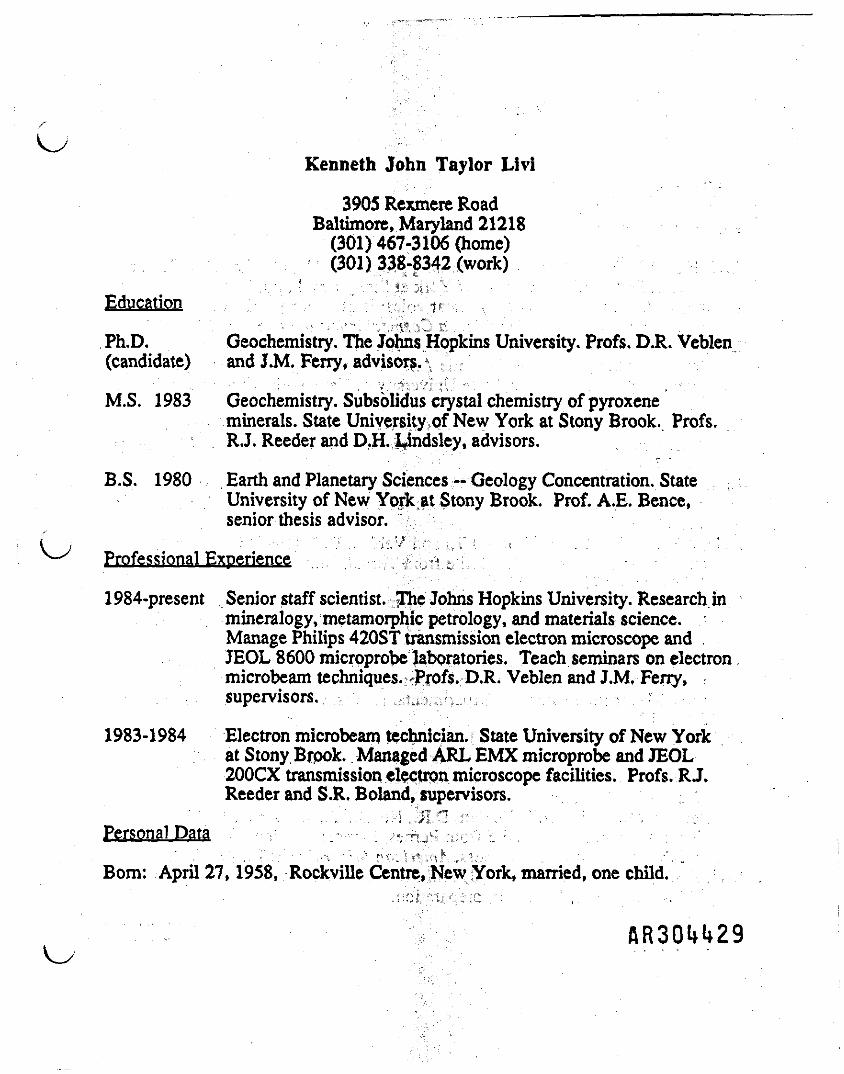
Kenneth John Taylor Livi
3905 Rexmere RoadBaltimore, Maryland 21218(301) 467-3106 (home)(301) 338-8342 (work)
Education
Ph.D. Geochemistry. The Johns Hopkins University. Profs. D.R. Veblen(candidate) and J.M. Ferry, advisors. ,
M.S. 1983 Geochemistiy. Subsolidus ciystal chemistry of pyroxeneminerals. State University of New York at Stony Brook. Profs.RJ. Reeder and D.H. JJndsley, advisors.
B.S. 1980 . Earth and Planetary Sciences -- Geology Concentration. StateUniversity of New Yprk.at Stony Brook. Prof. A.E. Bence,senior thesis advisor.
( j . : • " - ' V .. '".I::,''- i / ., ,,, i = r ' ' '. . . .'• 'V*- Professional Experience r j »
1984-present Senior staff scientist. .Ifee Johns Hopkins University. Research inmineralogy, metamorphic petrology, and materials science.Manage Philips 420ST transmission electron microscope andJEOL 8600 microprobe laboratories. Teach seminars on electronmicrobeam techniques.; Profs. D.R. Veblen and J.M. Ferry,supervisors. u;
1983-1984 Electron microbeam technician. State University of New Yorkat Stony Brook. Managed ARL EMX microprobe and JEOL200CX transmission electron microscope facilities. Profs. RJ.Reeder and S.R. Boland, supervisors.
Personal Data v • — -•- ; /--r^' r:''1:'' :; : .- -
Bom: April 27, 1958, Rockville Centre, New York, married, one child.
AR30H29

Publications
Papers and Theses:
Livi, KJ. (1980) Highland data processing programs. Unpublished B.S. SeniorThesis, State University of New York at Stony Brook, pp. 24.
Delano, J.W., and Livi, K. (1981) Lunar volcanic glasses and their constraintson mare petrogenesis. Geochimica Cosmochimica Acta 45,2137-2149.
Livi, KJ.T. (1983) Electron microscope investigation of exsolved pyroxenesfrom the ferromonzonite, Laramie Anorthosite Complex, Wyoming.Unpublished M.S. Thesis, State University of New York at Stony Brook, pp.172.
Livi, KJ.T. (1987) Geothermometry of exsolved augites from the LaramieAnorthosite Complex, Wyoming. Contributions to Mineralogy and Petrology96, 371-380.
Livi, KJ.T., and Veblen, D.R. (1987) "Eastonite" from Easton, Pennsylvania: Amixture of phlogopite and a new form of serpentine. American Mineralogist72, 113-125.
Rule, A.C., Bailey, S.W., Livi, KJ.T., and Veblen, D.R. (1987) Complexstacking sequences in a lepidolite from T0rdal, Norway. AmericanMineralogist 72, 1163-1169.
Livi, K.J.T., and Veblen, D.R. (1989) Transmission electron microscopy ofinterfaces and defects in intergrown pyroxenes. American Mineralogist 74,1070-1083.
Veblen, D.R., Guthrie, G.D., Livi, KJ.T. and Reynolds, R.C. (1990) High-resolution transmission electron microscopy and electron diffraction ofmixed-layer illite/smectite: Experimental results. Clays and Clay Minerals38, 1-13.
Gislason, S.R., Veblen, D.R., and Livi, KJ.T. (1990) Experimental meteoricwater/basalt interactions: TEM characterization and thermodynamicinterpretation of alteration products. Submitted to GeochemicaCosmochemica Acta.
Le Gleuher, M., Livi, KJ.T, Veblen, D.R., Noack, Y., and Amouric, M. (1989)Serpentinization of enstatite from Femes, France: reaction microstructuresand the role of system openness. American Mineralogist.! 5 > 813-824.
Livi, KJ.T., and Ferry, J.M. (1990) Fluid-rock interactions in metamorphosedMn-rich pelites, Maine. In preparation.

. , ,Livi, KJ.T., and Veblen, D.R. (1990) Analytical electron microscopy of the
pyroxene to pyroxenoid reaction; In preparation.Livi, KJ.T., Veblen, D.R., and Ferry, J.M- (1990) Segregation of K-Na
dioctahedral sheet silicates during prbgrade low-temperaturemetamoiphism. In preparation. ;
Abstracts:
Livi, KJ.T, Brande, S.O., and Bence, A.E. (1979) Highland chemistry:Preliminary synthesis and analysis of major and trace element relationshipsusing statistical methods. Lunar Highland Conference, The Lunar andPlanetary Science Institute, Houston, 102-104.
Delano, J.W., and Livi, K. (1981) Mare volcanic glasses: A tale of two arrays.Lunar Science XII t The Lunar and Planetary Science Institute, Houston, 226-228.
Livi, K.J., Brande, S., and Bence A.E. (1981) Highland chemistry: Major andtrace element classification of rock types. Lunar Science XIIt Tlie Lunar andPlanetary Science Institute, Houston, 441-442.
Livi, KJ.T. (1983) Geothermometry of pyroxenes from the ferromonzonite,Laramie Anorthosite Complex (LAC), Wyoming. Transactions, AmericanGeophysical Union 64, 327.
Livi, KJ.T., and Veblen, D.R. (1984) Strain-directed growth and coherency inpigeonite exsolution from augite. Geological Society of America, Abstractswith programs 16, 577.
Livi, KJ.T., and Veblen, D.R. (1985) Serpentine and phlogopite intergrowths in"eastonite" from Easton, Pennsylvania. Geological Society of America,Abstracts with programs 17, 645.
Livi, KJ.T., and Veblen, D.R. (1987) Analytical electron microscopy (AEM) ofa pyroxene to pyroxenoid reaction, Transactions, American GeophysicalUnion 68, 433.
Gislason, S.R., Veblen, D.R., and Livi, KJ.T. (1988) Experimental meteoricwater/basalt interactions: TEM characterization and thermodynamicinterpretation of alteration products. European Geochemical Societymeeting, August, 1988.
Livi, KJ.T., Veblen, D.R., and Ferry, J.M. (1988) Electron microbeam study ofanchizone and epizone metamorphosed shales from the central Swiss Alps.Geological Society of America, Abstracts with programs 20, A244.

Livi, KJ.T., Veblen, D.R., and Ferry, J.M. (1989) Highly organized iron-sulfideframboids from the Liassic Black Shale.Glaurus Alps, Switzerland.Geological Society of America, Abstracts with programs 21,
Livi, KJ.T., Veblen, D.R., and Ferry, J.M. (1990) Segregation of K- and Na-rich micas in low-grade metamorphosed shale from the Liassic BlackShale, Switzerland. IGCP Conference on Low-TemperatureMetamorphism, Manchester, England.
AR30H32

Peter G. Robeleni President/Sr. Geologist
GeoServices, Ltd.Mr. Robelen has 17 years of consulting experience in the
fields of hydrogeology, mining end engineering geology and hasworked on numerous projects involving ground water resourcedevelopment and'protection; hazardous and toxic waste managementand cleanup; landfill siting, design, end remediation; subsurfaceand foundation evaluation; and geologic and regulatory aspects ofmining.
Mr. Robelen routinely directs investigations of known orsuspected contamination of earth or ground water. As an engineergeologist, his expertise includes geophysical surveys, evaluationof field conditions and directions of ground water contaminationflow, and design of monitoring systems. As project manager/seniorscientist, he has been in responsible charge of studies atabandoned, proposed and active waste sites. His experienceIncludes government policy and liaison and expert testimony. Heis experienced in identification, evaluation, and remediationphases of soil and water contamination studies and enviormental,geologic and production of mining. He has performed as principalinvestigator in evaluation of known and suspected contamination atlandfills. Work Included detailed hydrogeology, remediationdesign and Implementation, construction management, and testimony.
OMr. Robelen has been active in and has directed several
regional water supply studies. Most recently, he has completedseveral regional ground water studies in divers areas of NewJersey in both fractured bedrock aquifers and confined andunconfined Coastal Plain aquifers. Work included evaluation ofground water availability; impacts on quality from hazardous wastesites and from salt water intrusion; and development of technicalmethods and management strategies to assure adequate supplies for50-year projections.
Mr. Robelenfs comprehensive background in evaluating geologicaspects of geotechnical and engineering problems includesfoundation studies, dams and impoundments, flood damage andhydraulic systems, and solid and hazardous waste siting andremediation. His broad experience in hydrogeology extends fromfracture trace analysis of ground water sources and ground watercontamination studies to hydologlc evaluations for permitapplications and other environmental regulatory matters. In statemining associations, he has been a key member of legislative andenvironmental committees, active in promoting regulations that arescientifically and economically compatible.

Mr. Peter G. Robelen 2Resume'
Mr. Robelen has provided expert testimony on numerousoccasions on subjects dealing with ground water flow andcontamination, environmental and production aspects of the miningindustry and subsurface conditions In both soil and rock.
EDUCATION: Ph.D. candidate in Geology 1968-1972The John Hopkins University
M.A. in Geology 1968Bryn Mawr College
B.A. in Geology 1966Franklin and Marshall College
Additional graduate studies in Advanced SoilMechanics
REGISTRATION: Professional Geologist- North Carolina #687- South Carolina #432
MEMBER: Society of Economic Paleontologist and MineralogistsAssociation of Groundwater Scientists and EngineersNational Water Well Association

Peter G. Robelen* President/Sr. Geologist
GeoServices, Ltd.Professional Background and^Education;
President and Sr. Geologist (1989 - Present) -GeoServices, Ltd.,Harrisburg, PA , -
1 -e - L, | ' ' .
Group Manager/Project Director (1985-1989) - R.E.Wright Associates,Inc., Middletown, PA
Senior Scientist and Manager ipf sjthe PA Office (1978-1985) - DunnGeoscience Corporation, Camp Hill, PA
Geologist, Dam Section, Hydraulic Division (1973-1978) - GannettFleming Corddry and Carpenter, Camp Hill, PA
Assistant Professor in Geology .(1972-1973) - Dlckinson CollegeCarlisle, PA _ ;: ; ;
B.A. - Geology, Franklin and ,Marshall College 1966M.A. - Geology, Bryn Mawr College1 , 1968Ph.D.- Candidate in Geology, The Johns Hopkins University 1968-1972
The Pennsylvania State University, 'Additional Graduate Studies in{^J Advanced Soil Mechanics ,/..v,- h
- j. •.'•£"' f, ' . : - - '
Professional Societies and Certificationst
Registered Professional Geologist, State of North Carolina #687Association of Ground Water Scientists and EngineersNational Water Well AssociationSociety of Economic Paleontologists and MineralogistsRegistered Professional Geologist, State of South Carolina #432Pennsylvania Aggregates and Concrete Association
Professional Experience ^ £%V * /
Mr. Robelen has 17 years of consulting experience in the areasof ground water resource development and management; ground watercontaminant evaluation and _, remediation; solid waste facilitysiting and evaluation; environmental site assessment; foundationexploration; end industrial mineral exploration and mine planning.Mr. Robelen has more ' than a : decade of responsible technicalmanagement experience dealing with a diverse professional staffIncluding geologists, hydrogeologists, engineers, biologists, soilscientists, archaeologists, and toxicologists on a wide variety ofprojects with costs ranging \ up to $1,000,000+. In foundingGeoServices, Ltd., total emphasis has been placed on providingoutstanding technical expertise, cost effectively wit*k rfft}!. or
i accountability to every client regardless of project sizeflnOu4U35

Peter G. Robelen 2Resumef
Project Experience
1. Hydrogeology and Ground Water Development
a. Municipalities and Surveyors
1) Middletown (PA) Borough Authority - Groundwater resource evaluation, well siting,drilling and testing.
2) Elizabethtown Borough (PA) - Ground waterresource evaluation, water supply development,well siting,drilling, and testing.
3) The Gettysburg Water Authority, Gettysburg, PA- water supply development.
4) City of Bethlehem Water Authority, Bethlehem,PA - ground water resource evaluation.
5) Center Square Water Company - Aquifer testingand permit preparation for additional supplyfor this small water company, CumberlandCounty, PA.
6) Town of Ridgewood, N.J. - Evaluation of ^-^declining production in existing well field,design and implementation of rehabilitationtechniques, testing and well siting.
7) Borough of Ramsey, N.J. - Ground water resourceevaluation, evaluation of declining wellyields, well rehabilitation, testing and wellsiting.
8) Borough of Glen Rock, PA - Evaluation ofexisting and potential ground wateravailability, well and aquifer testing, andpreliminary wellhead protection study.
9) Princeton University, Princeton, N.J.Development of ground water supplies forpotable and irrigation uses, well siting,drilling, testing, permitting, and facilitytreatment design.
10) Stratton Woods, Mt. Olive, N.J. - Ground waterresource development, nitrate loadingevaluation, well siting, drilling, and testing.
ARSONS

Peter G. Robelen4 j Resume'
11) Dover Township, Dover, PA - Wellhead protectionevaluation.
12) Bethel Heights Association; Portland, PA -Ground water resource evaluation.
13) Brady Contracting Co., Camp Hill, PA - Groundwater resource evaluation and well siting .
14) Carroll County Planning Commission, CarrollCounty, MD, -»•';-" Evaluation of water supplyavailability and demands in Carroll County forthe year 2040 - preliminary project work insupport of Gillls Falls Dam.
15) Random Woods; West Milford, N.J. - Ground waterresource evaluation, well siting, drilling, andtesting.. • . :f£"w_:
16) Franklin Commons, Franklin, N.J. - Ground waterresource evaluation, well siting, drilling, andtesting.
' . • -•: . ;•• ) iTf ;. "' '".17) Tamiment Resorts, Pike County, PA - Ground
water resource evaluation, well siting,drilling> and "testing.
Industries - Ground water exploration and supplydevelopment for the following entities:
1) The Masonic-Homes, Elizabethtown, PA, ' : -2) Hooke-Suter Associates, Carlisle, PA
3) Dutch Pantry, Inc. , Camp Hill, PA
4) Duffy-Mott, Xnc, . Aspers, PA
5) American Argo Corporation, Pottsville, PA
6) Gettys Mobile Home Sales, Lewisberry, PA
7) Ephrata Diamond Springs Water CompanyEvaluation of cite ground water availability,pumping tests and hydrogeologic evaluation.
8) Eagle Lake Development - Assessment of groundwater availability for proposed development,Covington Township, Lackawanan Co., PA.
AR30M37
Peter G. Robelen 4Resume'
9) Alfred Crew Consulting Engineers - Ground waterresource evaluation, well siting, drilling and .aquifer testing in the Crystal SpringsDevelopment near Hamburg, N.J.
c. Land Development - Evaluation of ground water supplypotential and nitrate loading assessment fromon-site wastewater disposal facilities for thefollowing entities (existing and proposed):
1) Clay Township, Lancaster County, PA.
2) Melody Lake Development, Morris County, N.J.
3) Stanford Commons; West Milford, N.J.
4) Middle Paxton Township, Dauphin County, PA.
5) Kardon Development Corp., Reading, PA.
6) Maiden Creek Township, Monroe County, PA.
7) Oak Trail Dev. (Meriden Corp.), Meriden, N.J.
8) Patten Corp., Numerous projects for various i joffices in Mid-Atlantic District. -
9) Briar Crest Woods, Tunkhannock Township,Wyoming County, PA.
10) Breezewood Development, Middle Smith Township,Bedford County, PA.
11) Pioneer Development Corp., York County, PA.
12) Apple Acres Development, W. Milford, N.J.
13) Belvidere Heights, Warren County, PA.
14) Rockledge, S. Middleton Township, CumberlandCounty, PA.
d. Regional Water Resource Projects
1) New Jersey Department of EnvironmentalProtection-Water supply study, Atlantic County,N.J.
\J

Peter G. Robelen 5Resume*
2) New Jersey Department of EnvironmentalProtection-Water supply study. Eastern RaritanRiver Basin. :
2. Environmental Geology r
. a. Hazardous Waste Site Investigations
1) NUS - Geophysical Investigation to determinelimits of contaminant plume and location and
. quantity of buried drums at Maryland Sand andGravel site. Elkton, MD.
- ,• • ' , "jf: '"' ''--"* "" '"' .
2) RCRA Research - Investigation of proposeddisposal sites at Niagara Falls, NY; Divisionof CECOS.
3) Confidential Client - Contaminant assessmentof building' and grounds. Development ofclosure plan for this RCRA licensed facility.
4): Prince William County Service Authority -Investigation; of PERC contamination of wellfield and preparation of remedial measure tocleanup and protect this large well field,Manassas, VA* '
- " \r-: !.'.. - -5) Pennsylvania Power & Light Company - Evaluation
of AMD from coal stockpile seepage, SunburySES, PA.
6) Olivetti Corporation - Environmental assessmentof i manufacturing facility and grounds,
i Harrisburg ;:v PA, r
7) Swatara Township Board of SupervisorsEvaluation of potential well and aquifercontamination by VOCs, Swatara Township, PA.
8) Reading Body: Works - Design of passiveremediation and monitoring system at site ofVOC disposal site. Completion of environmentalaudit at this Pennsylvania facility.
9) Smith Land and Development Company - Evaluationand remediation of asbestos - bearing wastepiles, Plymouth Meeting, PA.
10) Huntingdon -Corporation-Investigation of AMD. contamination of Lake Louise, Grantvill Jtp.

Peter G. Robelen 6Resume' ,
11) Confidential Client; Reading, PA - Evaluationand remediation of site contaminated by VOC'sas a result of Illicit drug manufacture.
12) York County Solid Waste and Refuse Authority- Hydrogeologic investigation, geophysicalstudy, computer modeling and remediation designfor cleanup of VOC contaminated ground water,Hopewell Township, PA.
b. Hydrocarbon Spill Investigation and Cleanup
1) Gulf Oil Corporation - Evaluation ofhydrocarbon contamination adjacent to storageand transfer terminal, Baltimore, MD.
2) Client Confidential - Investigation ofhydrocarbon contamination of ground water infractured rock aquifer, Schuylkill County, PA.
3) New Jersey Department of EnvironmentalProtection - Investigation of alternate groundwater supply strategies for the LakehurstBorough well field contaminated by gasoline incoastal plain aquifer, Lakehurst Borough, N.J, \t
4) Arcata Graphics, Fairfield, PA - Investigationand cleanup of fuel oil contamination fromleaking buried fuel oil tanks, Fairfield, PA.
5) Appalachian Lamb Corporation, Chambersburg, PA- Evaluation and cleanup of fuel oil spill Inkarstic limestone terrain. Siting, drilling,development and testing of alternate watersupplies.
6) Client Confidential, York County, PA -Evaluation and cleanup of product spill atconvenience gasoline station. Work includeddesign and implementation of ongoing groundwater remediation efforts.
c. Solid Waste Disposal
1) Ford - New Holland, Inc. - Evaluation of wastecharacteristics and design of disposal facilityfor foundry wastes. Disposal facilitylogistics required integration into and plannedclosure of existing site.
RRSOUUw
Peter G. RobelenResume1
2 ) Hanover Brands, Inc. - Hydrogeologic evaluationand ground water monitoring program design forfood process treatment system sludge disposalsite; Centre County, PA.
3 ) Pennsylvania Power & Light Company - Sitingstudy to evaluate and rank seven sites forsuitability as potential ash disposalfacilities, York County, PA.
4 ) Keystone Portland Cement Company - Evaluationof waste characteristics and design of disposalfacility meeting DER requirements for cementplant kiln wastes.
5) Hamilton Excavating Company - Preliminarydesign of multiuse residual waste disposalfacility. \
6) Martin's Potato Chips - Soils and hydrogeologicevaluation of proposed food process sludgedisposal site in York County, PA.
7) Martin Stone Quarries, Inc. - Hydrogeologic andregulatory revaluation of quarry site forsuitability as solid waste disposal facility,Bechtelsvllle, PA.
8) Kibblehouse Quarries ~ Evaluation of quarrysite for suitability as solid waste disposalfacility, Perkiomenville, PA.
9) Clayton S£ine > Design, permitting, andimplementation:: of demolition waste disposalfacility near Martin's Creek, Northampton Co.PA.
10) Frog Switch -fc Manufacturing CompanyModifications to permit for disposal of wastefoundry sand at the plant, Carlisle, PA.
* , - --- -.-,-J. t, A: '•'
11) Preston County Coal 6 Coke Company - Siting,planning, design and permitting of a coalrefuse disposal facility. Cascade, W. VA.
•, • , -:-;-; .* . \ '. . .d. Sewage Disposal . - . r
. . ' : : • • • •. ' .".-^ !;'•::'.", :','' . • •1) Musselman Fruit Products - Evaluation of soil
and ground water conditions at threewastewater disposal utilizingirrigation operations, Biglerville, PA.

Peter G. Robelen 8Resume'
2) Possum Valley Sewer Authority - Hydrogeologicinvestigation and permit preparation for siteof proposed community subsurface sewagedisposal facility, Adams County, PA.
3) Outdoor World, Inc. - Hydrogeologic and soilsevaluation at site of proposed communitysubsurface sewage disposal facility, Lancaster,PA.
4) Berrysburg Borough - Evaluation of sitesuitability for community subsurface sewagedisposal.
5) Hooke - Suter Associates, Inc. - Planning andevaluation of site for suitability as communitysubsurface sewage disposal facility,Plainfleld, PA.
6) Hewlett-Packard Corp. - Evaluation of impactsof off-premises septic disposal and developmentinduced erosion and sedimentation on privatelyowned lake.
e. Ground Water Resources , j
1) New Jersey Department of EnvironmentalProtection - Investigation of alternate groundwater sources for residential suppliescontaminated by mercury in Coastal Plainaquifers of New Jersey.
2) Rohrer's Quarry, Inc. - Hydrogeologicevaluation of expanded mining operation uponneighboring private water supplies.
3) New Jersey Department of EnvironmentalProtection - Evaluation of strategies to meetwater supply needs where major supply wells inthe Buried Valley aquifer were contaminated byVOCs, base neutral compounds, and acidextractables; East Hanover Township, MorrisCounty, N.J.
4) New Jersey Department of EnvironmentalProtection - Evaluation of the extent andseverity of saltwater intrusion into the major
. unconsolidated aquifers. South River Basin,N.J.,

Peter G. Robelen : 9Resume'
' - ;•:.•"- 5) P.O. Day Company - Ground water evaluation to
' determine potential for Increase of contaminanttransport from quarry operation. Work includedpump testing, aquifer analysis, and a regionalhydrogeologic study; Buckeystown, KD.
6) Derry Township Board of SupervisorsEvaluation of effectiveness of ground watermanipulation programs at 27 sanitary wastedisposal cites Within PA.
7) F.O. Day Company - Analysis of carbonateaquifer to determine potential for contaminanttransport; evaluation of off-site impacts onexisting neighboring wells; determination ofpotential for sinkhole development as a resultof pumping; completion of ground water budgetsto surface flow.
3. Engineering Geology ':• f I ' " ! • ' , ; • '•H « • : . • ' . .
a. Consolidated Energy Company - Preliminary design andfoundation investigation of proposed dam site.Marshall County, W. VA.
b. City of Greenwich, Conn. - Foundation evaluationand field investigation of proposed storm waterdisposal facilities.
c. Hampton Roads1 Regional Authority - Foundationinvestigation and design for purposed regionalsanitation facility, Hampton, VA.
d. South Carolina "Department of Transportation -Preliminary design and foundation investigation ofdual purpose dam and Interstate highway crossing,Winnsboro, S.C. "•'< '
.•• JXiU' ,:';:J,,:;; . 'e. U.S. Army Corps of Engineers - Flood damage survey
within the Cumberland River Basin, KY and TN.
f. U.S. Army Corps of Engineers - Preliminary designand foundation investigation of proposed floodcontrol structures for the Cleveland Zoo, Cleveland,
-• OH. . " I - - • :V.t .f r L: •
g. Carroll County" -Maryland Planning Commission -Evaluation of ground iGlllls Fall Reservoir4Evaluation of ground water supply alternatives. too

Peter G. Robelen 10Resume'
h. F.O. Day Company - Evaluation for potential sinkholedevelopment and for the potential for increasedcontaminant transport from a new quarry,Buckeystown, MD.
4. Mining
a. Pennsylvania Glass Sand Corporation - Environmentalimpact assessment of proposed and active miningsites, Cumberland County, N.J.
b. Milville Quarries, Inc. - Evaluation of naturalasbestos concentrations in dolomite and the effectson marketability at this quarry operation, W.Va.
c. Rohrer's Quarry, Incorporated - Mine planning,reserve studies, permitting and study of alternatemarkets at this quarry operation, Lititz, PA.
d. Commercial Stone Company, Inc. - Reserve studies,permitting, mapping, and mine planning for thetransition from surface to underground operations,Fayette County, PA.
e. Greer Limestone Company, Inc. - Efficiency study, i jreserve analysis and mine planning at this large ^-^underground mine, W.VA.
f. Preston County Coal 6 Coke Company - Mapping andreserves evaluation of upper, middle, and lowerKittanning coal, Morgantown, W. VA.
g. Compass Quarries, Inc. - Evaluation, reserveanalysis and permitting of this quarry, Paradise,PA.
h. New Enterprise Stone & Lime Company - Overburdenstudies, mine planning, reserves evaluation, andgeophysical investigation at two large reserveholdings in Central PA.
i. PA Aggregates and Concrete Association -.Evaluationof quality problems associated with absorption andsoundness of gravel and performance insurface-wearing courses in northwestern PA.
j. Columbia Asphalt, Inc. - Geophysical investigationand reserve analysis of sand and gravel d£r>ositsColumbia County, PA.

Peter G. Robelen 11Resume'
k. New Enterprise Stone and Lime Company - Geophysicalinvestigation and geographic mapping to delineatediabase dike in AG-lime source.
1. Wyoming Sand and Stone Company, Inc. - Geophysicalinvestigation and geologic mapping to define limitsof recoverable sand and gravel deposits at sevensites, Wyoming County, PA.
m. Fooks Sand and Gravel - Mine and reclamationplanning and permitting of sand and graveloperation, Hurlock, MD.
n. Medusa Cement Company, Inc. - Preparation of coalmine drainage permit application for non-coal miningoperation with incidental coal.
o. Pbhoqualine Fish Association - Evaluation of Impactsof mine expansion on cold water natural troutstream.
p. The Nellie Webb Estate - Market Evaluation,geophysical investigation and reserve study of sandand gravel holdings, Cambridge, MD.
q. Martin Stone Quarries, inc. - Mine planning, zoning,and permitting of quarry site, Bechtelsvllle, PA.
r. Shufelt Farms, Inc. - Mine and reclamation planningand permitting of sand and gravel operation,secretary, MD.
s. F.O; Day Company - Mine planning, environmentalimpact assessment, and reserve analysis for proposednew quarry, Buckeystown, MD.
t. F.O. Day Company - Aggregate exploration in MD, VA,• and West VA for suitable materials for proposedaggregate production/
5. Court and Hearing Testimony.: ' • " "- ( AL.i j • ';. .
a. EPA - Fact finding hearing - Testimony regardingdelisting from proposed superfund list of YorkCounty Solid waste and Refuse Authority's landfill,Hopewell Township, PA.
AR30W5

r
Peter G. Robelen 12Resume*
b. York County (PA) Court - Testimony regarding groundwater reversal, proposed ground water treatment, andlikelihood of continued containment flow fromlandfill operated by York County Solid Waste andRefuse Authority, Hopewell Township, PA.
c. State of New Jersey - Civil - Deposition testimonyregarding aquifer contamination by gasoline.Testimony involved aquifer remediation techniques,development of alternate water supplies and cost ofcleanup and improvements.
d. Center County (PA) Court - Testimony regardinginformation of sinkholes resulting fromimplementation and operation of storm water andrecreation impoundment facilities.
e. Dauphin County (PA) Court - Testimony regardingunsuitability of soils for subsurface sewagedisposal.
f. Federal District Court (Reading, PA) - Impact ofindividual subsurface sewage disposal systems uponnitrate and chloride loading of ground water anddistribution of impacts on private water supplies. i j
g. City of Lancaster (PA) Zoning Hearing Board -Testimony regarding impacts of continued mining andproposed reclamation of quarry operation onresidential portion of city.
h. Colebrookdale Township (PA) Zoning Hearing Board -Testimony regarding hydrogeologic effects ofexpanded mining upon neighboring private watersupplies.
1. Fayette County (PA) Commissioners - Testimonyregarding environmental impacts of mining andtransition from surface to underground miningmethods.
j. Fayette County (PA) Zoning Board - Testimonyregarding reclamation and dust problems associatedwith expansion of surface mining operation.
k. Frederick County (MD) Planning CommissionTestimony regarding compatibility of proposed miningoperation in relation to existing agricultural usesincluding evaluation of hydrogeologic effects andmining/quarry problems in general, Buckeystown, MD.

i >Peter G. Robelen 13Resume1
1. Frederick County (MD) Commissioners Zoning HearingTestimony regarding environmental impacts,
suitability and compatibility of proposed quarryingoperation. Buckeye town, MD.
m. Covington Township ( PA ) Board of Supervisors -Zoning and Planning commission Hearing - Testimonyregarding capacity of ground water to provide forproposed new development and potential impacts uponthe ground water system in relation to existinguses, Covington' Township, Lackawana County, PA• -- ^ - -
Publications and Presentations h
1 . "Welhead Protection" ^Realities in Fractured RockAquifers . " Presented to Wellhead Protection Seminarsponsored by The Leeque of Women Voters and the PADepartment of Environmental Resources; October, 1988.
2. "Ground Water Resource Management ." Presented to theannual meeting of the PA Association of Water WorksOperators; August, 1988.
3. "Determination of Asbestos Concentrations in Dolomite -An Indirect Approach," Presented to the PennsylvaniaAggregates and Concrete Association Joint Meeting ofEnvironmental and Safety Committees, September, 1986.
4. "Affordable Overburden Mapping Using Geophysics." Pitand Quarry, April, '1983.
5. "Reality of Non-coal Surface Mining Law - Rational forLegislative Change . " Presented to Pennsylvania HouseMines and Energy Committee, 1984.
6. "Problems with All-inclusive Surface Mining Law - TheNeed for Legislative Relief." Presented to thePennsylvania Aggregates and Concrete Association, AnnualMeeting, 1983.
7. "Geologic Controls on the Quality of Aggregates andChemical Stone in Limestone Quarries." Presented to thePennsylvania Aggregates and Concrete Association PlantOperations Workshop, 1983.
8. "Rewriting Pennsylvania's Non-coal Surface MiningRegulations - A Status Report." Presented toPennsylvania Aggregates and Concrete Association, 1982.
AR30W7
Peter G. Robelen 14Resume'
W9. "Lectures in Aqueous Geochemistry." Presented to
graduate students in Geology, Harrisburg Area CommunityCollege, winter-spring term, 1981.
10. "Petrography and Genesis of Recent, Multi-provenanceStream Sands in the Piedmont of North Carolina."Unpublished Ph.D dissertation. The Johns HopkinsUniversity, 1973.
11. "Roundness of Quartz Grains in Piedmont Stream Sands ofNorth Carolina" (abstract), G.S.A. Abstracts withPrograms, Volume 4, No. 7, P. 639, 1972.
12. "The Honeybrook Anorthosite" (with Crawford andKalmbach), American Journal of Science, Volume 271, pp.333-349, 1971.
13. "Composition and Distribution of Surface Sediments inCastle Harbor, Bermuda." In Ginsburg and Stanley,"Report on Seminar on Organism - SedimentInterrelationships." Bermuda Biological Station forResearch, Special Publication No. 6, 1969.
Continued Education and Training
Additional graduate studies in Advanced Soil Mechanics, v-xPennsylvania State University.
48 hours of Health and Safety Training for Hazardous WasteOperation (OSHA 1910.120) with annual updates.
Private, Instrument Rated Pilot (ASEL)
ARSONS

flR3Qlji*i»9