geomorphological evolution of marine heads on the eastern coast of red sea at saudi arabian region,...
TRANSCRIPT
ORIGINAL PAPER
Geomorphological evolution of marine heads on the eastern coastof Red Sea at Saudi Arabian region, using remote sensingtechniques
Ramadan Nofal1 & Iyad A. Abboud2
Received: 31 March 2015 /Accepted: 23 November 2015# Saudi Society for Geosciences 2016
Abstract The eastern coast of the Red Sea is characterized bythe presence of numerous marine heads that differ in terms ofshape, size, geological setting, structures, and composition.This difference directly affects geomorphological evolution.In the present study, Ras Al-Shabaan was chosen as a mostimportant area in this coast. Field investigations supportedwith photo-interpretation techniques were performed forstudying of geomorphological features of Ras Al-Shabaan.On the other hand, the remotely sensed imagery data has beenused extensively in the identification of geological and geo-morphological details of Ras Al-Shabaan. The geomorpho-logical studies showed that depositional processes of wadisand channels are predominant at the Ras Al-Shabaan coast.The changes in geomorphological and geological data of RasAl-Shabaan were identified by remote sensing image soft-ware. Two Landsat ETM+ images from 1990 and 2010 havebeen processed. The analysis of remote sensing data com-bined with field investigations and reference data were usedto monitor, delineate, and describe the geomorphologicalchanges of Ras Al-Shabaan coast during proceedings of su-pervised classification of ground units. Hence, the changedetection statistics have been used in ground units.Geological and geomorphological maps were digitized byusing ArcGIS software. Remote sensing techniques and geo-graphic information system (GIS) were employed in order to
monitor the results of changes occurred in the line of the coast.The satellite image processing and water index data weretransferred to the ArcGIS program to draw the coast linesand to stand on the changes occurred. Thereby, it was possibleto identify the most prominent landforms and geomorphicunits of this area. Results showed that platforms, barriers,rocky heads, islands, coral reefs, submerged reefs, tidal chan-nels, dissolution grooves, sabkhas, inlet system, waves work,and shoreline processes were included in coastal prominentlandforms. The circumstances that formed this coast are notpermanent, as it is changing rapidly and continuously due toerosion and uplift processes.
Keywords Ras Al-Shabaan .Marine heads . Red Sea .
Geomorphology . Remote sensing
Introduction
Geomorphological or geological setting of eastern coastalplain of the Red Sea has limited research studies and publica-tions. Although, few of these studies were related to issues thathave been implemented, they did not include a complete andcomprehensive coverage of the large extension area. Recently,little interest of the research studies has been conducted on theeastern coastal plain of the Red Sea, especially in the southregion and in particular on the coast of Jeddah city to Yemencoast. The most important studies about southern part of theRed Sea were published by Al-Washmi et al. (2005) andMoufaddal and Rifaat (2006). Moreover, the studies that havebeen performed by Gheith and Abou Ouf (1996) and Nabhan(2004) were some of the most prominent published studiesthat include data about the geomorphological features, char-acteristics, and distribution of the Red Sea coast. On the otherhand, there were other studies focused on sedimentary
* Ramadan [email protected]
Iyad A. [email protected]; [email protected]
1 Geography Department, Collage of Art and Human Sciences, TaibahUniversity, Yanbu’ Branch, Al-Madina 41911, Saudi Arabia
2 Biology Department, Collage of Sciences, Taibah University, Yanbu’Branch, Al-Madina 41911, Saudi Arabia
Arab J Geosci (2016) 9:163 DOI 10.1007/s12517-015-2234-4
characteristics and its interactions affecting the distribution ofgeomorphological forms in the south region (Tag 1986; AbouOuf and El-Shater 1992; Basyoni 1997).
The classification processes that led to form and growthsedimentary environments over time have been additionallystudied by Al-Sayari and Zotl 1978; Jado and Zotl 1984;Davis 1985; Bahafzullah et al. 1993; Arvidson et al. 1994;Manaa 2011. The geology of the Red Sea coast and ArabianNubian Shield has been also studied by many researchers(Brown and Jackson 1960; Brown 1970; Braithwaite1987; Brown et al. 1989; Al-Shanti 1993; Al-Welaie1996). Coleman (1993) studied the historical develop-ment and formation mechanism of the Red Sea coastand geological development in details and discussedthe geomorphological zones.
The northern part of the coastal plain of the Red Sea ap-peared as a narrower bar compared to the south. These char-acteristics suggested and demonstrated continuing liftingoperations that happened to the Red Sea coast in thenorth while the southern part of the Red Sea coastwas plunged and covered in the sediments faster thanthe north (Coleman 1993).
Many relief and geomorphic terrain formed on the coastalplain of the Red Sea as a result of tectonic movements oc-curred during the late Quaternary in the region. The arid cli-mate prevailing in the region with erosional processes playedan important role in the evolution of the current scenegeomorphology of alluvial plain (Coleman 1993). Themain geomorphological features distributed along themarginal shelf of coastal plain of the Red Sea are com-posed of coral banks, coral reefs, and reef limestoneoverspreading a thin veneer of carbonate beach sand.Away from the beach to landward, the most prevalentgeomorphological forms were pediment with alluvium,outwash sands, and gravels on old crystalline rocks tothe basement hills (Al-Washmi et al. 2005).
Al-Washmi et al. (2005) studied the classification of themain forms of geomorphological features spread in the AshShuqayq–Al Huraydah coastal area, south coast of JeddahCity. The authors found that the main forms were composedof marsh system, inlet, swamps, wave wash, dunes, shorelineprocesses, beach bars, spit system, wadi systems, and sabkhasystems. However, Moufaddal and Rifaat (2006) identifiedthe geomorphic features between Ras Gemsha and Safaga ofRed Sea coast using remote sensing techniques. The authorsfound that the most prominent forms are fluvial terraces, fos-siliferous reefs, alluvial fans, desert wadis, salt pans, sabkhas,spits, sand bars, and submerged reefs.
The present study focuses on geomorphological and geo-logical aspects of one of the most important marine headsdistributed along the east cost of the Red Sea. Detailed fieldinvestigations combined with aerial photographs have beenperformed to figure out the main reasons causing such
phenomenon along the eastern coast of the Red Sea and inturn to understand the mechanisms of its development.
Study area
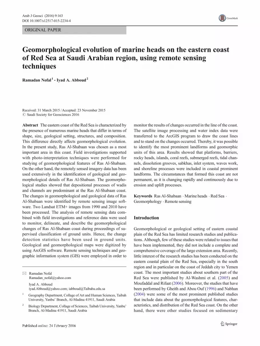
The study area, Ras Al-Shabaan area, is located along thewestern coastline strip of the Kingdom of Saudi Arabia RedSea and located between Umluj city and Ra’s Al Lakk, 30 kmnorth and about 60 km south, respectively. Moreover, thestudy area is located between latitudes 37° 00′ to 37° 30′WE and 24° 20′ to 25° 00′ SN with distance of about 90 km(Fig. 1). The coastal plain of the study area is crossed bymanywadis, lagoonal outlets, tidal inlets, and tidal channels. Thesegeomorphological systems act as protected areas (Al-Washmiet al. 2005), where mainly coarse to very coarse grained ma-terial is deposited along the borders of these systems.
The average width of Ras Al-Shabaan from the Radwamountain series to the seacoast is about 10 km. The averagewidth of the head of Ras Al-Shabaan is about 20 km. As aresult of physical and chemical weathering processes, the ig-neous rocks of this area supply the coast with different sedi-ments (Fig. 1).
The main prominent geomorphological feature of the RasAl-Shabaan coast area is mostly semi-flat, with some smallhills and mountain formations. It also contains some low ele-vations leading to the emergence of sabkhas and low wet-lands. The lagoons in Ras Al-Shabaan coast area consist ofmany small isolated offshore islands. Additionally, there wasan emergence of sedimentary formations, recent wadi sedi-ments, wadi terraces, eolian sand, sand dunes, gravel spreads,
Fig. 1 Location map of the Red Sea and Ras Al-Shabaan region
163 Page 2 of 15 Arab J Geosci (2016) 9:163
reef limestone, fringing, submerged reefs, raised fossiliferousreefs, coral terraces, coastline headlands, and embayment.
Geology of Ras Al-Shabaan
General setting
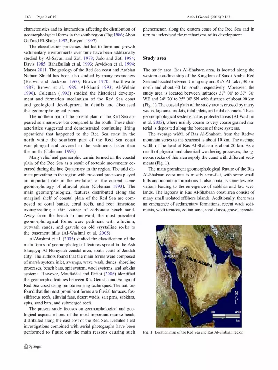
Geologically, Saudi Arabia is divided into four different ter-rains: Arabian platform, Arabian Shield, Al Harrats, and theRed Sea rift basin (Geukens 1966; Chapman 1978; Brown etal. 1989; Al-Shanti 1993; Al-Welaie 1996). The study arealocated at the first quarter of the Red Sea coastal plain(Fig. 2) marked the eastern edge of the Red Sea Rift, borderedby older escarpments and recent Oligocene sediments(Vincent 2008). Red Sea Rift is bordered by a semi-flat areaand small hills distributed between the coast and series ofparallel mountains along the coastal plain, from Aqaba(Jordan) at the north to Yemen in the south, about 1550 kmwith varying width (Sagga 2004).
The study coast area is bordered by a series of mountainscomposed of granite, amphibole, gabbro, diorite, gneiss, andschist and considered durable and resistant to erosion process-es (Fig. 2). Some types of rocks were covered by basalt flood(Al-Harrats). Tertiary and Quaternary deposits were formedrecently and extend throughout the Arabian Shield and
covering the plain of Red Sea coast from north to south. Thewidth of coastal plain along study area is mostly narrow, about35 km, and contained thick sequences of sedimentary rocksand deposits. During the Miocene, marine beds formed withinthe opening of the Red Sea overlain by Pliocene clastic sedi-ments and reefs and enclosed by Quaternary reefs (Vincent2008). The Red Sea shoreline shaped meanders, spikes, andcurves, and due to these structures, some lagoons (Sharms)were formed. On the other hand, some coral reef terracesappear because of uplifted processes and clastic sediment ac-cumulation with coral reefs along the coast (Al-Shanti 1993).
Sediments in the study area
Sediment distribution along the coastal plain of the study areacan be divided into three categories:
1. Beach sediments: These sediments are spread along thecoast and on the shore lines of lagoons (Sharms). Themain constituent of these sediments is limestone and/orsandy limestone deposits rich in coral reefs, materialshells, and skeletal of organisms. They consist of calcar-eous sand, silt, and a little clay that may extend a fewmeters in water depth. The coastal sediments of Ras Al-Shabaan were siliciclastic–carbonate sediments depositedas a result of complex processes of climatic factors and
Fig. 2 Geological map of the coast of the Red Sea and Ras Al-Shabaan
Arab J Geosci (2016) 9:163 Page 3 of 15 163

ocean processes (Basaham 2008). Chemical weatheringwas very active at the oxic surface sediments in the mudfractions and developed as a final product from a mixtureof carbonate and silicate materials (terrigenous sediments)(Manaa 2011). Aeolian deposits (terrestrial sediments)were transported during dry periods when the physicalweathering was very active (Basaham 2008).
2. Calcareous sediments: A large area from the coast is cov-ered with this type of sediment, especially sandy and siltylimestone mixed with clay minerals from the wadis floodsin different seasons. This may be originated from physicalerosion of the terraces of costal limestone reefs (Al-Washmi 1999).
3. Flood deposits: Alluvial deposits appear at the mouth ofwadis, and they consist of clay, silt, and fine sand.Generally, the alluvial deposits originated from waterand wind erosion of igneous rocks from near mountainsand transported to different distances depending on topog-raphy (Manaa 2011) and wind or water energy source.
Data and methods
This study aims to shed light on the terrestrial heads phenome-non, which is considered as one of the characteristic phenomenaof the eastern andwestern coastal area of the Red Sea.Moreover,the study aims at monitoring the impact of geomorphologicalprocesses on major geological and geomorphological units inthe study area, where a combination of methods such as satelliteimages, remote sensing data analysis, and field investigationswas used to monitor the areas exposed to erosion processes.
Field data
Many field trip reconnaissance and comprehensive surveys wereperformed to study the area under investigation (Ras Al-Shabaan, Ras Al Lakk, Ras Bridi, and Ras Al-Abyad).Additionally, the areas stretching between investigated areaswere studied in order to carefully describe the most importantgeomorphic environments along the coast. The changes and thefinal development process of the constituted heads were alsoinvestigated to determine the type of rocks, the sediments, andgeomorphologic forms distributed through them. The geomor-phological forms included were beaches, shorelines, bars, bays,lagoons, sabkhas, sand dunes, marshes, wadis, barriers, and otherforms. Collections of data and selected sites have been appointedby the use of receiver Global Positioning System (GPS).
Many photographs have been taken for accurate identifica-tion and description of the different terrain types. Sedimenttypes, geological structure, rock composition, and organic ma-terial constituents were also identified in order to determinetheir impacts on the evolution of such terrain and thus the
formation of marine heads. Many rock samples were collectedto identify the sediments and sizes of particles in order todetermine and interpret the optimal reaction mechanisms inthe marine heads formation through the waves, tides, currents,wind, and weathering. Therefore, the early mentioned closeinvestigation aimed to compare and link those results withwhatever findings that come out of the study and present adescription of the geomorphological characteristics of Ras Al-Shabaan, Ras al Mekhref, Ras Bridi, and Ras Al-Abyad withdata analysis of remote sensing, images from Landsat ETM+that correspond to the WRS-2 path 171, row 44, and WRS-2Path 172, row 43. In addition, different forms of collateral datawere utilized with topographic maps scale 1:50,000 and geo-logic maps scale 1:250,000 and SRTM Data.
Remote sensing data processing and techniques
The Environment for Visualizing Images (ENVI) program (ver-sion 5.2) was used for characterizing all the taken images of thestudy area. Geometric correction and geo-referencing(Transverse Mercator Projection (UTM) and wgs1984 datum)were performed by using the Ground Control Points (GCPs)and achieved by 32 well-distributed GCPs extracted from 14bases for topographic maps (scale 1:50,000). A second-orderpolynomial transformation at root-mean-square error of0.13 pixels was used with the nearest neighbor sampling algo-rithm. The method of nearest neighbor was used in order tomaintain the brightness values of the original pixels and to re-form the spacing of 30 m in both directions. Result evaluation ofthe patch has been corrected geometrically using another set ofGCPs, as well as through the overlap of each data set with an-other to ensure that sub-images cover all land area and identicalwith others.
Image analysis In order to determine the efficiency of geo-morphological characteristics of the study area, several tech-niques for integrating grayscale panchromatic band (15 m)with many other multispectral bands (30 m) merged. Theproduct was a combination between two types of input data,where it becomes possible to get an image of multispectraldetails (15-m resolution) and clarity of the best details. Allof integration techniques were integrated by principal compo-nent analysis (PCA) and overlying of panchromatic band asintensity layer (IL) over the red-green-blue (RGB) fordisplaying the best method and the most effective techniques.
Two types of input data were used for image processing ofthis product, and application of the most effective techniqueswas performed in order to enhance and improve the overallappearance of the images and its information. Among othertechniques used, the technique of false color composite (FCC)and principal component analysis (PCA) was found to be themost effective way to identify and draw maps of the terrainand geomorphological characteristics of the study area. At the
163 Page 4 of 15 Arab J Geosci (2016) 9:163
end of each phase of the work, landforms and rock units havebeen identified and distinguished mainly by their distinctivespectral signatures such as color, tone, texture, pattern, size,and shape. Ambiguity or lack of clarity for any land featuresoverlapping by reference to the field was resolved. In addition,ENVI (5.2) was used to study the change detection for beacherosion. It is considered as the most important and commonpart of the remote sensing studies to determine the differencesbetween the two dates.
First, the differences in the images were compared visuallyand then unsupervised classifications were used in order toclassify and distinguish the values of similar pixels in theirown groups and give it a name. Technique (ISODATA) algo-rithm was used in this study, where it was processed under thesupervision of the following identification and classificationof the pixels that have similar characteristics from the signa-ture of unsupervised classes. The potential recognized andidentified classes were calculated statistics of these pixels tocreate a parametric features and signature of the class. Allclasses obtained were checked to the lack of clarity or anymisidentification. Finally, a technique to determine the chang-es in order to calculate the difference in maps and detect sta-tistical changes was performed.
Digital processes for the optical images using water indexmethod was operated after geometric and radiometric correc-tions. The water index (one of the band ratios) was calculatedbymeans of dividing the sums of visible bands by the sum of theinfra-red bands (Braud and Feng 1998). For gain, the water indexwas used with LOC line of communication-water extension inENVI software. This procedure aimed at earning the sharp edgebetween classification of water and land, whereas water reflec-tance was more pronounced in visible bands, while absorptionwas prevailing in the infra-red band. This technique was used onthe images, and threshold scale slicing was done to totally sepa-rate landmass from the water. The sharp and clear edge betweenthe two classes indicates to the coastline. Then, in the GIS envi-ronment, the sharp shorelines were digitized and prepared for thelayers of multi-dates for 1990 and 2010 in the line feature class.Using the overlaying operations and spatial description tools, theanalysis for spatial and temporal modifications detection hadbeen done (Santra et al. 2013).
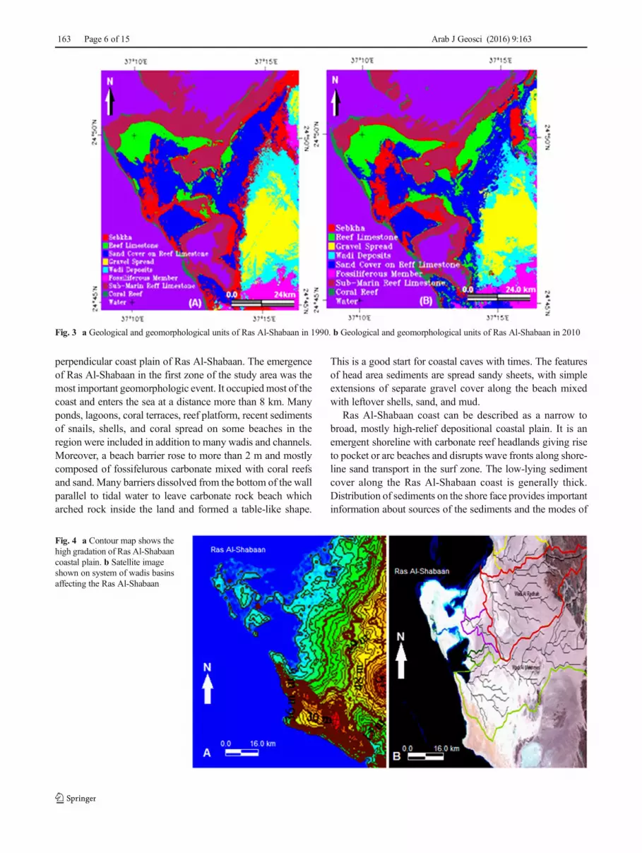
Through the analysis of satellite images for 1990 (Fig. 3a)and 2010 (Fig. 3b), geological and geomorphological unitshave been classified for Ras Al-Shabaan using change detec-tion technique (Fig. 3).
Development of the Red Sea Heads
In the Quaternary period (Pliocene and Pleistocene), very dif-ferent sediments were deposited over the older salt depositsalong the coast of Red Sea. This process was the reason offorming new sediments frommetamorphic rocks and volcanic
debris of about more than 300-m thickness at several placesthroughout the length of the Red Sea (Behairy et al. 1992;UNEP – United Nation Environment Programme/ PERSGA1992).
During the early Quaternary, extensive carbonate deposi-tion developed on the earlier formations and provided theimmediate living reefs. Depending on Behairy et al. (1992),two series of events were noted: (1) Quaternary climaticchanges including sea level changes and periods of heavyrainfall, and (2) uplifting along the margins of the Red Seacoast. Both events had an important impact on the formationof the recent reef, as well as continuing effect on the compo-sition, formation, and evolution of marine heads along the RedSea coast (e.g., Ras Al-Shabaan, Ras Al Lakk, Ras Bridi, andRas Al-Abyad).
General description of Ras Al-Shabaan
The study area of Red Sea coast, which is located between theYanbu and Umluj, proved that, at the age from middle to lateMiocene, a small escarpment was formed between 50 and 75 mhigh and separated the erosional surface from the modern coastalplain by uplifted middle Miocene carbonate reefs. Emotionalsurface likely represented a major wave-cut platform associatedwith the middle Miocene tectonic reorganization in the Red Seacoast (Chapman 1978; Brown et al. 1989; Al-Shanti 1993; Al-Washmi 1999; Sagga 2004; Vincent 2008).
Coastal area of Ras Al-Shabaan
The display coastal plain of Ras Al-Shabaan ranged between10 and 15 km. On the other hand, its height ranged between 1and 15 m and may increase in height up to 45 m especially atthe feet of Jabal Albonah (Fig. 4a). Jabal Albonah contributedin the development of Ras Al-Shabaan believed to be theorigin of many Miocene wadis. This is because a lot of clasticsediments have been transferred to the coastal plain at thenorth of Ras Al-Shabaan. Moreover, the drainage system ofthese wadis and basins, or at least the lower parts of them, isconsidered to be one of the geomorphological phenomenacontributing in the development of coastal plain of Ras Al-Shabaan. There are two large wadis basins, namely, WadiAlmkhmas and Wadi Al-Rudhah, that contribute significantlyto the development of the Ras Al-Shabaan with little effect ofsome small wadis (Fig. 4b).
The Ras Al-Shabaan coast extends about 50 km along theRed Sea coast with variable width, distinguished by a mixtureof sand sheets, eolain sand, reef limestone, gravel spread, wadideposits, terraces, tidal flat, and sabkhas on the south easternside of Umluj City. The shoreline along of Ras Al-Shabaancoast was not linear. It is mainly curve to smooth, where arcbeaches, sharms, lagoons, inlets, hills, barrier, spits, and fansare observed. However, many wadis and channels also cut
Arab J Geosci (2016) 9:163 Page 5 of 15 163
perpendicular coast plain of Ras Al-Shabaan. The emergenceof Ras Al-Shabaan in the first zone of the study area was themost important geomorphologic event. It occupiedmost of thecoast and enters the sea at a distance more than 8 km. Manyponds, lagoons, coral terraces, reef platform, recent sedimentsof snails, shells, and coral spread on some beaches in theregion were included in addition to many wadis and channels.Moreover, a beach barrier rose to more than 2 m and mostlycomposed of fossifelurous carbonate mixed with coral reefsand sand. Many barriers dissolved from the bottom of the wallparallel to tidal water to leave carbonate rock beach whicharched rock inside the land and formed a table-like shape.
This is a good start for coastal caves with times. The featuresof head area sediments are spread sandy sheets, with simpleextensions of separate gravel cover along the beach mixedwith leftover shells, sand, and mud.
Ras Al-Shabaan coast can be described as a narrow tobroad, mostly high-relief depositional coastal plain. It is anemergent shoreline with carbonate reef headlands giving riseto pocket or arc beaches and disrupts wave fronts along shore-line sand transport in the surf zone. The low-lying sedimentcover along the Ras Al-Shabaan coast is generally thick.Distribution of sediments on the shore face provides importantinformation about sources of the sediments and the modes of
Fig. 3 a Geological and geomorphological units of Ras Al-Shabaan in 1990. b Geological and geomorphological units of Ras Al-Shabaan in 2010
Fig. 4 a Contour map shows thehigh gradation of Ras Al-Shabaancoastal plain. b Satellite imageshown on system of wadis basinsaffecting the Ras Al-Shabaan
163 Page 6 of 15 Arab J Geosci (2016) 9:163

transport (Al-Washmi et al. 2005). The sediments on reef plat-form beach had very thin to intermittent layers.
The geomorphology features of Ras Al-Shabaan coastalarea had nested and complex landforms. These included sanddune processes, sand sheet processes, marsh, inlet systems,sabkha systems, carbonate systems, wadi systems, sea cliffs,and wave swash processes. Carbonate systems and coastalmarshes, as well as sand sheets, absence of sabkha systems,and/or sand dune processes, were the most common compo-nents of Ras Al-Shabaan coast.
The coast sediments in most part of the Ras Al-Shabaancoast were mostly eolian sands distributed in the form ofyoungest recent sand sheets or in the form of longitudinalridge parallel to the shoreline. Other main deposits were reeflimestone form as a bar parallel to the shoreline line. However,gravel beach is spread in many parts along the beach area.Coastal sediments were formed due to the fact that the energyinput by waves, currents, and tides is linked to the landforms(Al-Washmi et al. 2005; Al-Hatrushi 2013), and by the mor-phological and topographic factors of the coastal zone and thechanges on them (Al-Hatrushi 2013). Coastal landformschanged depending on the material components and changeof sea level (Al-Washmi et al. 2005), the sediment availability,and the intensity of wave processes (Carter 1991).
The coastal plain of Ras Al-Shabaan was characterized byvast areas of wadis structures intensively drowned in thecoastal area. This contributed to the vast majority of the totalsediments of mud in the coastal zone that thought to be rem-nant of flood plain, during the late Quaternary period at thetime of lowered sea level (Al-Washmi et al. 2005).
Coastal processes of Ras Al-Shabaan
Themost important geomorphologic features that appeared onthe Red Sea shoreline as natural resources for the normalgrowth and for the evolution of life diversity were sea heads,sharms, lagoons, sea cliffs, reef platforms, reef limestone,drainage wadis, channels, wadi terraces, sabkhahs, alluvialfans, caves, grooves, ridges, beaches, wildlife, and plants.
These environmental features not only were economicallyvaluable for sea life or for navigation but also include alsosome of the most ecologically important environments in theRed Sea coast. Sharms, lagoons, and protected beaches wereproductive ecosystems, providing food, refuge, and nursery toa large variety of biota including corals, fish, shellfish, andbirds, in addition to the aesthetic view formed through thedistribution of shoreline, dunes, reefs, small islands, terraces,and barriers that protect the inland coast topography fromstorms and waves.
Usually, coastline formed through the interface betweenland and water depend on a particular array of geomorphicprocesses and on a range of landforms such as waves,
currents, tides, erosion processes, wadi deposits, and organicactivity.
For understanding the mechanism of growth and develop-ment of the marine heads along the coast of the Red Seaparticularly in the Ras Al-Shabaan, the mechanism of actionof coastal systems through an integrative and holistic ap-proach to coastal investigations taking into account the com-plex interactions between coastal processes and materialsshould be understood. This is explained in ore details in thefollowing sections.
The factors working on rocky coasts were similar to thoseon other types of coasts (i.e. waves, tides, winds, currents, andbiological activity). Although the physical and chemical pro-cesses and biological activities were similar, their effects andresults were rather different depending on the relatedoperations.
Physical processes
Wave action The major agents affecting coastal processesalong the study coastal plain were winds and waves. Waveswere characterized by their length, amplitude, velocity, andwave period. These properties, and the relationships betweenthem, vary greatly depending on the nature of the mechanismgenerating the wave, the intensity of this generating mecha-nism, and the environment in which the wave exists (http://www.nature.nps.gov/views/KCs/CoastalG/HTML/ET_Intro.htm).
Increasing in wave numbers and their intensity or theirheights made the beaches more susceptible to weatheringand erosion. This leads to dismantling and moves a lot of sandparticles from the beaches of reefs, carbonates, and sand. Thisin turn made the beaches more prone to erosion and to theemergence of various geomorphologic forms such as marineheads, lagoons, barriers reefs, and others. The increasing inthe intensity or frequency of the waves resulted in climatechange, accompanied by changes in sea level. This increaseimpacted on the effectiveness of erosion and corrosion of theshores as a result of wave reaction.
Coastal beaches, ridges, and terraces were predominantlydistorted by the wave action, currents, and by of littoral drift(Kaliraj et al. 2015). In general, beach sediments consist ofmaterials eroded from coastal rocks through the movement ofwaves and currents, and also partly from fluvial sedimentcarried to the coast (Bird 1984). Likely, beaches appeared indifferent regions and intermittent zones along Ras Al-Shabaandue to the emergence of many of the features of topographythat prevent the vast expanse of such beaches. The most im-portant of those features preventing the extension of the sand-stone beaches were the existence of coral reefs, barriers, reefplatform, pockets, cliffs, lagoons, and others features.
Wave energy was high on coasts exposed to the strong windsof the north and middle coast of the Red Sea. Ras Al-Shabaan
Arab J Geosci (2016) 9:163 Page 7 of 15 163

had been shown along heads of shorelines and a moderate cliffbetween 1 and 2m high (Fig. 5a) with its morphological featuressuch as raised marine benches (Fig. 5a), and distorted of ancienttidal notch (Fig. 5b). The profile of cliff beach indicated a prom-inent raised shore platform with the same sea level and an asso-ciated notch having about 1.5 m roof height (Fig. 5c). The notchfloor extended for more than 50 m along the cliff indicating adistinct raised shore platform. The top surface of the notchchanged bench between 30- and 80-cm depth from the cliff face.The lithology of the cliff was a plainer bedding of recrystalliza-tion limestone and fossifilrous, porous, coarse-grained limestonewith mega shell fragments of gastropods and pelecypods, barna-cles, and older limestone gravels. An important feature of thenotch was a well-preserved floral pattern biological encrustationof seaweed and marine algae (Fig. 5d). The notch face in someplaces was moderately polished and in others appears wrinkly,coarse grained, uneven, crispy encrustation, rich in grooves, bor-ings, porous, and holes result practically dissolved by wave’sactions and aqueous solutions. Moreover, beach rocks wereconsisting of carbonate rich in organic matter, which appearedmostly in black color. They were formed as a result of the
oxidation of organic matter and bacteria on the outside of thebeach rocks (Fig. 5e). It should be noted that thewaves prevailingalong the Red Sea coast in the study area were from the north andnorthwest, and rise in the average of about 50 cm and up to 1.5mwith strong winds (Figs. 4 and 5). So, the marine heads, and as aresult of its extension from east to west, were more susceptible toweathering and erosion through waves’ work.
Tidal processes Many factors may complicate the overallpicture concerning the formation of tides. These factors in-cluded shape, size, depth, and topography of the sea basins,components of shoreline, and finally weather conditions pre-vailing at the coast (Summerfield 1991).
Tidal range had a high effect on coastal landforms. Barrierbeaches and salt marshes or sabkhas tend to be restricted to areaswith low tidal range. This was similar to the apparent events onthe coast area around Ras Al-Shabaan. The erosion of the coastresulting from water currents along the shoreline might form theemergence of RasAl-Shabaan to growmany kilometers in lengthinside the Red Sea of about 8 km. This due to currents and wave
Fig. 5 Morphological features along Ras Al-Shabaan Beach. a Cliffbetween 1 and 2 m high with a raise of marine benches. b Notch and cliffdistorted from ancient tidal. cRaised shore platform associated with notchand having about 1.5 m roof height. d Notch with well-preserved floral
pattern, biological encrustation of sea weed, and marine algae. e Notchface appears wrinkly, coarse grained, uneven, crispy encrustation, rich ingrooves, borings, porous, holes, and mostly rich in organic matter andpresence of black color
163 Page 8 of 15 Arab J Geosci (2016) 9:163

processes that efficiently focused on a vertical direction besidethe heads.
Tidal inlets along the coast of the study area intersectthrough weakness areas of the beach and mouths of ancientwadis. During tidal processes, salt marshes, and sabkha werecommon in the study area coast as a process of short-term courses on the scope of the tides. In general, theentrances that join the lakes of Ras Al-Shabaan to the Red Seawere just a hole in the weak section of the beach known aslow-lying tidal inlets.
Tidal phenomenon along the Red Sea coast played an im-portant role in reshaping the limits of the coastline, particular-ly in the central regions of the Red Sea coast. The fluctuationof daily tides between 50 and 130 cm was a high value com-pared with the tides ratio of the north coast of the Red Sea(Aqaba and Suez Gulfs) according to Morcos (1970) andEdwards (1987). The reported values were about 0.6 m inthe north and 0.9 m in the south. The highest value of tidesreached to limits of about 1.8 m. This range was much higherthan that recorded by Morcos (1970) and Edwards (1987) inthe Gulf of Suez and Aqaba north of Red Sea.
In winter, mean sea level was over 0.5 m higher than thatrecorded in summer. The mechanism behind the change of theRed Sea level from winter to summer was partly due to thegreater evaporation in the summer (Behairy et al. 1992; UNEP– United Nation Environment Programme/ PERSGA 1992).This type of currents lead to the difference in sea level be-tween summer and winter, working on wide reshaping in theform of marine heads on the shores of the Red Sea, e.g., RasAl-Shabaan.
Biological processes
There were wide fluctuations in the level of the Red Sea in thepast, ranging from −30 to −80 m as a result of the substantialrain. These changes have allowed the formation of karst andalluvial flows with reef growth on shallow platforms formingterraces (Behairy et al. 1992; UNEP – United NationEnvironment Programme/ PERSGA 1992). Many organismswere either directly or indirectly responsible for the construc-tion of some coastal landforms. The most spectacular exampleof direct construction was due to corals and other carbonate-secreting organisms that form coral reefs.
Many parts of Ras Al-Shabaan are composed of high bar-riers from limestone platform. Other areas exhibit low-lyingreefal limestone platform covered by terrigenous materials,composed mainly of sand, silt, and mud sediments with littlefragments of coral, algae, and mollusks (Al-Washmi et al.2005). These extend from the closed nearshore zone towardthe beach. Reef platforms formed from the remnants of organ-ic materials (coral, shells, skeletons, teeth,…) and carbonatesolutions, during the period of late Pleistocene (Skipwith1973; Behairy 1983).
The most active area of the coast was the nearshore shelfzone of the Red Sea coast that was composed of calciumcarbonate deposits with widespread fringing coral reefs. RasAl-Shabaan nearshore zones represented a dynamic lagoon,which receives much quantity of detrital constituents.
Changes in sea level
During the Pleistocene, the Red Sea coast was a suitable place forcoral reef growth. Barrier reefs formed from limestone depositsobserved today along the study area in the central coast of RedSea (Behairy et al. 1992; UNEP – United Nation EnvironmentProgramme/ PERSGA 1992). The sea level also changedthrough climate factors. Themost important of these factors wereincreased rain and alluvial flow. Extensive rain caused karst ero-sion of the limestone. Because of the increasing coastal erosionand alluvial flow during the periods of lowest sea level, it cutsgrooves through the elevated reefs down to the sea level. Thisprocess was the origin of many wadis and sharms seen todayalong the Red Sea coast. The increasing in rains duringPleistocene worked to increase the amount of alluvial flows ofterrigenous material into the Red Sea. The result of alluvial flowdeposits in these quantities to the coast of the Red Sea broadlyworked on to cover the shoreline and may kill reefs colonies(Behairy et al. 1992; UNEP – United Nation EnvironmentProgramme/ PERSGA 1992).
Results and discussion
Geomorphological phenomena of Ras Al-Shabaan
A general description of the main geomorphologic phenomenaand landforms of the study area, as revealed by integration offield investigations and remote sensing survey processes, isexplained.
First: weathering and erosion phenomena
Shoreline weathering The shoreline of study area was divid-ed into two principal geomorphic zones: (i) north zone—theshoreline of Ras Al-Shabaan coast, stretching from Umluj Cityto Al-Shabaan area characterized by Ras Al-Shabaan head. Thisarea was semi-rugged with multiple wadis formed of hilly sedi-ments or rocks, some cliffs, and alluvial barriers with small pock-et beaches or lagoons. The second is the (ii) southern zone, theshoreline after Ras Al-Shabaan coast, which is generally a nar-row and flat to semi-flat zone, containing sandy to coarse-grainedbeaches backed by off-coast reef limestone and old terraces.Many wide and extended wadis covered the shoreline. Thiswas responsible for the formation of vast majority of the totalinput of thick recent wadi deposits and recent wadi terraces onthe coastal zone. In general, southern zone included wide wadi
Arab J Geosci (2016) 9:163 Page 9 of 15 163

deposits interrupted in many parts by reef platform as low-lyingterraces.
Transport of sediment along shore was achieved by wavesand the currents that induced within the breaker zone (May andHansom 2003). Sediments on the Red Sea coast varied consid-erably in their texture where they range from silt and sand toboulders. They were also varying in lithology where they rangefrom shelly sandy carbonate to igneous cobbles. The sizes ofmaterials reflected the source type of local supply. Coarse sedi-ments were brought to the Red Sea coast by numerous wadis,which spread along the coast of Ras Al-Shabaan. Hence, gradi-ents were gently steep and coarse-grained deposits easilytransported by flush floods. However, fine-grained sedimentfrom clay and silt were brought to lowland and flat coast. Thus,in areas with more gentle inland relief like southern zone of theRasAl-Shabaan coast. The delivery of sediment from offshore aswell as from retreating cliffs providedmost of thematerial for thelocal beaches. Boulders and coarse gravel were derived fromerosion of resistant igneous rocks in the study areas such asgranite, gabbro, diorite, and others, and deposited at the coast.
Ras Al-Shabaan coast and gravels included a range oferosion-resistant lithologies alongside igneous and metamor-phic rocks with high quartz content. Unstable rocks under thechemical weathering conditions such as granites and lime-stones were common as clastic sediments. Thus, it was anassemblage of resistant gravel (igneous and metamorphic)and sand that dominated along most beaches of the coast ofstudy area. Along the coast of two heads and nearshore shelf,the source of the remnants of the biogenic shells and the coralreefs blended with sand and carbonates spread onto beaches.
The changes that have occurred within the scope of the shore-line were monitored through the water index method, which wealready referred to; the result is shown in Fig. 6. The differencebetween erosion in 1990 and 2010was about 7.86 km, where theerosion in land area was 115.31 km while in 2010 was107.45 km, respectively. The disappearance of some rocky areasby erosion processes was shown in the satellite image of 1990. Inthe northern part, a group of rocky tongues faded away whichranged in size from 100 to 500m, while in southwestern part, therocky tongue marine head disappeared and extended about285.4 m parallel to the marine head.Moreover, the areas affectedby erosion were not completely removed where it was notedduring the field investigation. The presence of rocky remnantsstill appeared above sea level, and turning the bulk of rocks to thebarriers under seawater level. The southern part of the head wasalso marked by increasing penetration of water in the head asnoted in the satellite image of 1990 where the existing canal didnot exceed 50 m, and displayed in the satellite image of 2010recording is an increasing in some sectors over 500 m. Thesesectors noted during the field investigation turned into whatlooked like a lake (Fig. 6).
This study recorded high erosion rates in the northern andwestern parts of investigated area. However, the retreat of the
shoreline was at differentiated rates, the retreat recorded at someparts reached to 15 m in 20 years, and in other parts, a retreatrecorded more than 250 m in 20 years. This can be explained byexposure of shoreline to direct waves. Moreover, the speed ofweathering and erosion processes was observed in the limestonerocks, which were considered the basic component of the headrocks. Also, low rates of erosion can be observed in the southernpart of the study area with the occurrence of deposition processesin other areas; this can be explained as this area was exposed tothe work of the coastal currents that transport and/or depositsome sediments at this region.
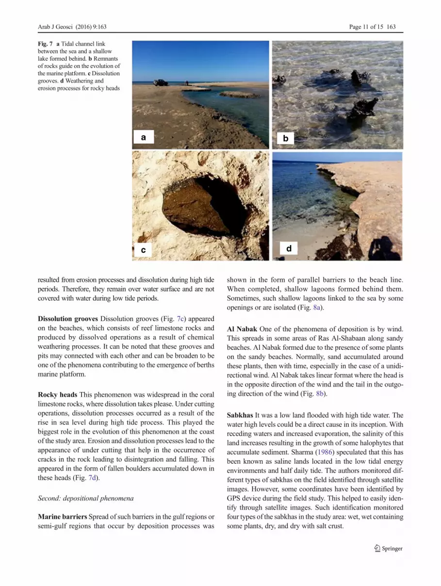
Tidal channels Tidal channels (Fig. 7a) were considered frommajor phenomena geomorphological deployed in the studyarea. Many channels were observed and monitored in rockyand sedimentary areas along the coastal area. The displayranges between 1 and 4 m and associated always with exis-tence of shallow lagoons often stretching behind and coveringspaces exceeding a kilometer.
Marine platformsMarine platforms (Fig. 7b) arise in regres-sion areas and cliffs due to higher erosion rates and chemicaldissolution rates of reef limestone. It is considered from themain geomorphology phenomena along the coast. It is also con-sidered as one of the important evidence for the erosion cliffs atthe coast areas. Such cliffs sometimes may extend underwater togreat distances. They are left from some small protrusions whichare the remnants of the erosion of physical and chemical process-es.Moreover, sometimes, these appeared in the formof platforms
Fig. 6 Changes in the Ras Al-Shabaan area from 1990 to 2010
163 Page 10 of 15 Arab J Geosci (2016) 9:163
resulted from erosion processes and dissolution during high tideperiods. Therefore, they remain over water surface and are notcovered with water during low tide periods.
Dissolution grooves Dissolution grooves (Fig. 7c) appearedon the beaches, which consists of reef limestone rocks andproduced by dissolved operations as a result of chemicalweathering processes. It can be noted that these grooves andpits may connected with each other and can be broaden to beone of the phenomena contributing to the emergence of berthsmarine platform.
Rocky heads This phenomenon was widespread in the corallimestone rocks, where dissolution takes please. Under cuttingoperations, dissolution processes occurred as a result of therise in sea level during high tide process. This played thebiggest role in the evolution of this phenomenon at the coastof the study area. Erosion and dissolution processes lead to theappearance of under cutting that help in the occurrence ofcracks in the rock leading to disintegration and falling. Thisappeared in the form of fallen boulders accumulated down inthese heads (Fig. 7d).
Second: depositional phenomena
Marine barriers Spread of such barriers in the gulf regions orsemi-gulf regions that occur by deposition processes was
shown in the form of parallel barriers to the beach line.When completed, shallow lagoons formed behind them.Sometimes, such shallow lagoons linked to the sea by someopenings or are isolated (Fig. 8a).
Al Nabak One of the phenomena of deposition is by wind.This spreads in some areas of Ras Al-Shabaan along sandybeaches. Al Nabak formed due to the presence of some plantson the sandy beaches. Normally, sand accumulated aroundthese plants, then with time, especially in the case of a unidi-rectional wind. Al Nabak takes linear format where the head isin the opposite direction of the wind and the tail in the outgo-ing direction of the wind (Fig. 8b).
Sabkhas It was a low land flooded with high tide water. Thewater high levels could be a direct cause in its inception. Withreceding waters and increased evaporation, the salinity of thisland increases resulting in the growth of some halophytes thataccumulate sediment. Sharma (1986) speculated that this hasbeen known as saline lands located in the low tidal energyenvironments and half daily tide. The authors monitored dif-ferent types of sabkhas on the field identified through satelliteimages. However, some coordinates have been identified byGPS device during the field study. This helped to easily iden-tify through satellite images. Such identification monitoredfour types of the sabkhas in the study area: wet, wet containingsome plants, dry, and dry with salt crust.
Fig. 7 a Tidal channel linkbetween the sea and a shallowlake formed behind. b Remnantsof rocks guide on the evolution ofthe marine platform. cDissolutiongrooves. d Weathering anderosion processes for rocky heads
Arab J Geosci (2016) 9:163 Page 11 of 15 163

After classification of satellite images of 1990 and 2010(Fig. 3), Change Detection Statistic was performed for thecoastal area, and noted low in sabkhas area. This representedin more than 5 % in 1990 from the total area decreased to1.3 % in 2010.
Third: other phenomena
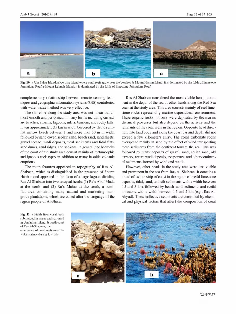
Islands There were many scattered islands in the study area.The three most important islands were found at north of Ras Al-Shabaan (Fig. 9). The most prominent islands were Um Sahar,Jabal Hassan, and Island of Jabal Lubnah (Fig. 10a–c), respec-tively. Coral reefs spread as coral frameworks parallel to thecoasts of some islands as coral circles surround the entire island,e.g., Um Sahar Island, or spread in the form of barriers of coralreef rise with time until composed of island barriers. The threeislands were similar to themost islands scattered near the coast of
the Red Sea fromwhere the rock composition was predominant-ly composed of coral limestone in the form of amountain folds ina variety of elevation (Fig. 10c). It should be noted that therewere low parts of these islands covered by much tidewater andthat appeared in the form of shallow pools in low-lying areas.Moreover, mangrove plants grow in these ponds reaching almostcomplete covering in some cases.
Coral reefs Coral reefs were spread in the nearshore area inthe form of framework reefs parallel to the coast. Theyspread around all the islands distributed in the studyarea. They were also extended over large areas awayfrom the coast. These found to be flooded on the sur-face of sea water (Fig. 11).
It should be noted that the Red Sea was one of the richestworld seas with coral reefs of different types, forms, andcolors. The Red sea is home tomore than 200 species of corals(Saudi Geological Survey 2012).
Some coral reefs appear in the form of footnotes of coraladjacent to the shores of the islands. This may sometimesrepresent an obstacle to navigation operations because of na-kedness or ruggedness in addition to its proximity to the sur-face of the water. Moreover, some of the coral reefs appearedon water surface in the form of uneven and tapered heads.Some of them appeared away from the coast in the form ofcoral barriers and pose points berthing some ships and boats.Coral formations appeared frequently in the form of ringsconfining shallow lagoons inside it, sometimes incomplete.It forms bays.
Depending on the work of Change Detection Statistic to thestudy area, and through classification of satellite images of1990 and 2010 (Fig. 3), a slight increase in coral reef areawas noted: 0.9 % in 1990 and 0.97 % in 2010.
Summary and conclusions
The measurement of geomorphological changes that have oc-curred on coastline associated with its coral reefs and the iden-tification of geological and geomorphological units by using
Fig. 8 a Formed some lakesbehind freely barriers. bAl Nabakin its early stages of thecomposition
Fig. 9 Ras Al-Shabaan islands
163 Page 12 of 15 Arab J Geosci (2016) 9:163
complementary relationship between remote sensing tech-niques and geographic information systems (GIS) contributedwith water index method was very effective.
The shoreline along the study area was not linear but al-most smooth and performed in many forms including curved,arc beaches, sharms, lagoons, inlets, barriers, and rocky hills.It was approximately 35 km in width bordered by flat to semi-flat narrow beach between 1 and more than 30 m in widthfollowed by sand cover, aeolain sand, beach sand, sand sheets,gravel spread, wadi deposits, tidal sediments and tidal flats,sand dunes, sand ridges, and sabkhas. In general, the bedrocksof the coast of the study area consist mainly of metamorphicand igneous rock types in addition to many basaltic volcaniceruptions.
The main features appeared in topography of Ras Al-Shabaan, which is distinguished in the presence of SharmHabban and appeared in the form of a large lagoon dividingRas Al-Shabaan into two unequal heads: (1) Ra’s Abu’Maddat the north, and (2) Ra’s Mahar at the south, a semi-flat area containing many natural and marketing man-grove plantations, which are called after the language of theregion people of Al-Shura.
Ras Al-Shabaan considered the most visible head, promi-nent in the depth of the sea of other heads along the Red Seacoast at the study area. This area consists mainly of reef lime-stone rocks representing marine depositional environment.These organic rocks not only were deposited by the marinechemical processes but also depend on the activity and theremnants of the coral reefs in the region. Opposite head direc-tion, into land body and along the coast bar and depth, did notexceed a few kilometers away. The coral carbonate rocksoverspread mainly in sand by the effect of wind transportingthese sediments from the continent toward the sea. This wasfollowed by many deposits of gravel, sand, eolian sand, oldterraces, recent wadi deposits, evaporates, and other continen-tal sediments formed by wind and wadis.
However, other heads in the study area were less visibleand prominent in the sea from Ras Al-Shabaan. It contains abroad off-white strip of coast in the region of reefal limestonedeposits, tidal, sand, and silt sediments with a width between0.5 and 3 km, followed by beach sand sediments and reefallimestone with a width between 0.5 and 2 km (e.g., Ras Al-Abyad). These collective sediments are controlled by chemi-cal and physical factors that affect the composition of coral
Fig. 10 a Um Sahar Island, a low-rise island where coral reefs grow near the beaches. bMount Hassan Island; it is dominated by the folds of limestoneformations Reef. c Mount Lubnah Island; it is dominated by the folds of limestone formations Reef
Fig. 11 a Fields from coral reefssubmerged in water and surroundin Um Sahar Island. b north coastof Ras Al-Shabaan, theemergence of coral reefs over thewater surface during low tide
Arab J Geosci (2016) 9:163 Page 13 of 15 163

reefs. Openwaves and continuous water currents also played amajor role.
Corals and continuous action of waves, tides, and opencurrents along the beach contributed to the formation of thechemical and physical marine sediments.
Whole erosion appears in the rocks in the center of the RasAl-Shabaan formation formed by continuous movement ofwaves and currents ending with lagoon formation or sharm(Sharm Habban), in addition to the effect of the water abun-dance of wadi Khumas. As a final result, the formation of thelagoon (sharm) was worked to mitigate the erosion of therocks of the head, and focused corrosion reaction in sharmdepth to form the current basin.
Moreover, the reaction of waves and currents along thecoasts of other minor heads was less influential and invisiblecompared with the Ras Al-Shabaan coast, in addition to thegeological structures of fractures, faults, joints, and cracks thatare less obvious in the formation of those heads than Ras Al-Shabaan. Due to the low prevalence of geological structuresand the simple water action that work along the coasts of otherminor heads in the study area to mitigate the degree and ero-sion speed of head rocks and the coast, the emergence of allheads in the study area is much less than in the Ras Al-Shabaan. The action of waves and currents helped in the emer-gence of the head strikingly at sea.
In conclusion, the most abundant of geomorphological fea-tures and terrain have been explored in the study area throughfield surveys and analysis of Landsat images including marineplatforms, marine barriers, cliffs, rocky heads, offshoreislands, basement shield rocks, coral reefs platforms, sub-merged reefs, tidal channels, dissolution grooves, inlet system,fluvial terraces, Al Nabak, and sabkhas.
Acknowledgments This research has been sponsored by a grant fromTaibah University, Department of Geology and Geography, YanbuBranch. The present study has been carried out under support of theresearch project No. 3501, 2014. We are thankful to Dr. Rashad Kebeishand Dr. Ahmed Khalil, Taibah University, Faculty of Science - Yanbu forthe help with valuable reading and correcting of the manuscript.
References
Abou Ouf M, El-Shater A (1992) Sedimentology and Mineralogy ofJizan Shelf Sediments, Red Sea, Saudi Arabia, Red Sea Coast.JKAU 4:133–141
Al-Hatrushi SM (2013) Monitoring of the shoreline change using remotesensing andGIS: a case study of Al Hawasnah tidal inlet, Al Batinahcoast, Sultanate of Oman. Arab J Geosci 6:1479–1484. doi:10.1007/s12517-011-0424-2
Al-Sayari SS, Zotl JG (1978) Quaternary period in Saudi Arabia.Springer, Wien, p 335
Al-Shanti A (1993) Geology of the Arabian Shield (in Arabic). KingAbdulaziz University Publishing, Jeddah
Al-Washmi HA (1999) Sedimentological aspects and environmental con-ditions recognized from the bottom sediments of Al-Kharrar
Lagoon, eastern Red Sea coastal plain, Saudi Arabia. JKAU: MarSci 10:71–87
Al-Washmi HA, Gheith AM, Nabhan AI (2005) GeomorphologicalFeatures, Sediment Distribution and Transport Along AshShuqayq-Al Huraydah Coastal Area, Southern Red Sea, SaudiArabia. JKAU: Mar Sci 16:57–80
Al-Welaie A (1996) Geology and Geomorphology of the Kingdom ofSaudi Arabia (in Arabic). Riyadh, King Fahad National Library, p526
Arvidson R, Becker R, Shanabrook A, Luo W, Sturchio N, Sultan M,Lotfy Z, Mahmood AM, El Alfy Z (1994) Climatic, eustatic, andtectonic controls on Quaternary deposits and landforms, Red Seacoast, Egypt. J Geophys Res 99(B6) 12:175–190
Bahafzullah A, Fayed LA, Kazi A, Al-Saify M (1993) Classification anddistribution of the Red Sea coastal sabkhas near Jeddah, SaudiArabia. Carbonates Evaporites 81:23–38
Basaham SA (2008) Mineralogical and chemical composition the mudfraction from the surface sediments of Sharm Al-Kharrar, a Red Seacoastal lagoon. Oceanologia 50(4):557–575
Basyoni MH (1997) Sedimentological and HydrochemicalCharacteristics of Al- Lith Sabkha, Saudi Arabia. J KAU: EarthSci 9:75–86
Behairy AKA (1983) Marine Transgression in the West Coast of SaudiArabia (Red Sea) Between Mid-Pleistocene and Present. MarGeology 52:M25–M31
Behairy AKA, Sheppard CRC, EI-Sayed MK (1992) A Review of theGeology of Coral Reefs in the Red Sea. Report under UNEPRegional Seas Reports and Studies No. 152. Prepared in Co-operation with PERSGA, p 41
Bird ECE (1984) Coasts, an introduction to coastal geomorphology, 3rdedn. Black-well Publisher Limited, Basil, p 320
Braithwaite CJR (1987) Geology and Geography of the Red Sea Region.In: Edwards AJ, Head SM (eds) Key environments: the Red Sea.Pergamon Press, Oxford, pp 22–44
Braud JDH, FengW (1998) Semi-automated construction of the Luisianacoastline digital land/water boundary using Landsat ThematicMapper satellite imagery. Technical Report 97-002, Department ofGeography & Anthropology, Luisina State University. LuisianaApplied Oil Spill Research and Development Program, OSRAPD
Brown GW (1970) Eastern Margin of the Red Sea and Coastal Structuresin Saudi Arabia. Phil Trans Roy Soc London A267:75–78, CentralTexas: Bur of Ecom Geol Austin, Texas, 10–30 pp
Brown GF, Jackson RO (1960) The Arabian Shield. 215th Internat. GeolCongr Copenhagen 9:69–77
Brown GF, Schmidt DL, Huffman AC (1989) Geology of the ArabianPeninsula, shield area of western Saudi Arabia. US GeologicalSurvey Professional Paper, 560-A,188
Carter RWG (1991) Coastal Environments. An Introduction to thePhysical Ecological and Cultural Systems of Coastlines.Academic, London, p 617
Chapman RW (1978) General information on the Arabian Peninsula geo-morphology. In SS Al-Sayari and JG Zoti Quaternary Period inSaudi Arabia, 19–30
Coleman RG (1993) Geologic Evolution of the Red Sea. OxfordUniversity Press, New York, p 186
Davis JR (1985) Coastal sedimentary environments. Springer, NewYork,p 716
Edwards AJ (1987) Climate and oceanography. In: Edwards AJ, HeadSM (eds) Red Sea. Pergamon Press, Oxford, pp 45–69
Geukens F (1966) Geology of the Arabian Peninsula, Yemen. US GeolSurvey, Numbered Series 560, Services No. 50, Chapter B, p B1-B23. Translated from the French by S.D. Bowers, United StatesGovernment Printing Office, Washington
Gheith AM, Abou Ouf M (1996) Geomorphological Features andSedimentological Aspects of Some Coastal and Inland Sand
163 Page 14 of 15 Arab J Geosci (2016) 9:163
Dunes, Jeddah Region, Saudi Arabia, Arab Gulf. J Scient Res 14(3):569–593
Jado AR, Zotl JG (1984) Quaternary Period in Saudi Arabia, Vol 2.Springer, Wien, p 360
Kaliraj S, Chandrasekar N, Magesh NS (2015) Evaluation of coastalerosion and accretion processes along the southwest coast ofKanyakumari, Tamil Nadu using geospatial techniques. Arab JGeosci 8:239–253. doi:10.1007/s12517-013-1216-7
Manaa A (2011) Late Pleistocene raised coral reefs in the eastern Red Sea- Rabigh, Saudi Arabia. Research Online, University ofWollongong, Thesis collection, Master Thesis, pp 190. http://ro.uow.edu.au/theses/3501
May VJ, Hansom JD (2003) Coastal Geomorphology of Great Britain,Geological Conservation Review Series, No 28, Joint NatureConservation Committee, Peterborough, 754 pages, illustrations,A4 hardback, ISBN 1 86107 4840
Morcos SA (1970) Physical and chemical oceanography of the Red Sea.Oceanogr Mar Biol Ann Rev 8:73–202
Moufaddal W, Rifaat AE (2006) Identifying Geomorphic Featuresbetween Ras Gemsha and Safaga, Red Sea Coast, Egypt,Using Remote Sensing Techniques. JKAU: Mar Sci 17:105–128
Nabhan AES (2004) Geomorphological, Sedimentological andMineralogical Studies on the Coastal Zone of Ash Shuqayq,Southern Red Sea, Kingdom of Saudi Arabia, M.Sc. Thesis. FacMarine Sci King Abdulaziz University, Jeddah
Sagga AM (2004) Physical Geography of the Kingdom of Saudi Arabia(in Arabic), 3rd edn. Kunoz Al Maarefa Publishing, Jeddah
Santra MS, Santra A, Mitra D (2013) Change detection analysis of theshoreline using Toposheet and Satellite Image: A case study of the
coastal stretch of Mandarmani-Shankarpur, West Bengal, India.International Journal of Geomatics and Geosciences 3(3):425–437
Saudi Geological Survey (2012) Saudi Arabia; Facts and Figures, http://www.sgs.org.sa/arabic/news/sgsnews/pages
Sharma VK (1986) Geomorphology: Earth Surface Processes and Forms.Tata McGraw-Hill Publishing Company Limited, New Delhi, p 244
Skipwith P (1973) The Red Sea and Coastal Plain of the Kingdom ofSaudi Arabia. A Review, Technical Record TR 1973–1. Ministry ofPetroleum and Mineral Resources, Saudi Arabia, p 149
Summerfield MA (1991) Subaerial denudation of passive margins: re-gional elevation versus local relief models. Earth Planet Sci Lett102:460–469
Tag RJ (1986) Sedimentology and Mineralogy of Red Sea Coast RecentSediment between Wadi Al-Fagh and Wadi Al Qunfudah, SaudiArabia, M.Sc. Thesis. Faculty of Earth Sciences, King AbdulazizUniversity, Jeddah
Vincent P (2008) Saudi Arabia: an environmental overview. Taylor andFrancis, London
UNEP – United Nation Environment Programme/ PERSGA (1992) AReview of the Geology of Coral Reefs in the Red Sea. UNEPRegional Seas Reports and Studies No. 152. prepared in co-operation with PERSGA, UNEP 1992
Electronic reference
http://www.nature.nps.gov/views/KCs/CoastalG/HTML/ET_Intro.htm
Arab J Geosci (2016) 9:163 Page 15 of 15 163