geodynamic context of the taiwan orogen
TRANSCRIPT
Geodynamic Context of the Taiwan Orogen
Jean-Claude Sibuet
Ifremer Centre de Brest, Plouzané, France
Shu-Kun Hsu
Institute of Geophysics, National Central University, Chung-Li, Taiwan
Eric Debayle
Institut de Physique du Globe de Strasbourg, CNRS and Université Louis Pasteur, Strasbourg,France
Four independent arguments suggest that the Ryukyu subduction zone extended fromJapan to southwest Taiwan (118"E) from the late Cretaceous to early Miocene (17-18 Ma):i) An analysis of the structure and timing of rifting in the basins of the East Asia continen-tal shelf and west of Taiwan shows that they are located within four belts parallel to themainland Chinese shoreline, which becomes younger oceanward since earlyTertiary. Ridgeswith volcanic products are present between these belts.
.We interpret these basins and asso-
ciated ridges as relict backarc basins and arcs of the Ryukyu subduction system. ii) Subsi-dence curves across west Taiwan Basins show that rifting ceased 17-l 8 Ma. iii) A new shearwave velocity model suggests that the Ryulryu slab extended in the past southwest of Tai-wan, beneath the northern China Sea margin. iv) A deep seismic line shot across the north-eastern South China Sea margin also suggests that this margin was active in the past. Weconclude that about 15-20Ma, the southwestern extremity of the Ryukyu subduction zonejumped from 1 18oE (southwest of the Tainan Basin) to 126"8 (where the present-day trendof the Ryukyu subduction zone changes direction). Since that time, the southwestem extrem-ity of the Ryukyu subduction zone continuously moved westwards to its present-day loca-tion at l22oE. Since the beginning of formation of proto-Taiwan during late Miocene (9Ma), the subducting PH Sea plate moved continuously through time in a N307' direction at5.6 cm/yr with respect to EU, tearing the EU plate.
1.INTRODUCTION
The collision of the Luzon volcanic arc with the SouthChina Sea (SCS) margin is probably one of the best exam-ples of modern arc-continent collision associated with theTaiwan uplift. The geology of the island as well as the mech-anisms of deformation are quite well understood but in gen-
Continent-Ocean Interactions Within East Asian Mareinal SeasGeophysical Monograph Series 149Copyright 2004by the American Geophysical Union10.1029/149GM08
eral, most of the geodynamic context in which this upliftoccurs is largely unknown or at least oversimplified. For exam-ple, the continental margin before collision is widely consid-ered as a typical passive margin and shelf basins are consideredto be tensional basins formed during the rifting of the adjacentcontinental margin. In this paper, we define the geologicaland kinematic contexts of the formation of Taiwan not onlyduring the collision of the Luzon arc with the Eurasian plate,which results in the formation of the proto-and presenfday Tai-wan, but also before the Taiwan uplift. This work is partlybased on a series ofpapers published during recent yearslHsu
t27

128 GEODYNAMIC CONTEXT OFTHETAIWAN OROGEN
and Sibuet,1995; Sibuet et al.,1998; Sibuet and Hsu,1997;Sibuet and Hsu,2004; Sibuet et a1.,2002; Sibuet et al.,19951.We demonstrate that the Tertiary shelf basins, located betweenJapan and southwest Taiwan, were formed as backarc basinslinked to the Ryukyu subduction zone. Backarc basins olderIhan 15-20 Ma are linked to the subduction of the Philippineand Taiwan Seas, which are bounded to the south by the Luzon-Ryukyu transform plate boundary GRTPB) now located in thenortheastern part of the SCS. South of the LRTPB, the SCSwas opening between 37 and 15 Ma. The Pearl River shelfbasins were formed by extension during the rifting of the SCScontinental margins lClift and Lin,200ll. A major issue inunderstanding the tectonics ofTaiwan is the local plate kine-matic configwation, which is partly hidden by extensive defor-mation. We here establish that the kinematic pattern controlsthe formation of proto- and present-day Taiwan, in particularwhere and how the newly formed LuzonArc started to collidewith the Eurasian margin.
.We also demonstrate that the upper
portion of the Luzon Arc is accreted along the Eurasian mar-gin while the lower crust is subducted with the Philippine(PH) Sea plate beneath Eurasia (EU). We define the locationof the western boundary of the PH Sea plate (Point A) thatbounds the western termination of the Ryukyu Benioffzoneand triggers the occurrence and development ofa tear faultwithin the EU plate. To the south, the PH Sea plate boundaryextends along the Longitudinal Valley of Taiwan and thenruns east of the Manila accretionary prism. The PH Sea platehas been moving westward through time with respect to the EUplate in the northwestern direction (e.g. Seno and Maruyama
[1984]). We attempt to explain the process of Taiwan upliftwithin a simple plate tectonic context, which includes a com-prehensive history of the westward migration of the collision.For that purpose, we clarify a series ofpoints concerning thegeometry of plate boundaries, as well as the nature of thedeformation and the associated stress patterns.
2. PRE-COLLISIONAL GEOLOGY R\'UKYUSUBDUCTION ZONE AND ASSOCIATED BACKARC
BASINS
The Tertiary basins of the Chinese continental shelf aroundTaiwan are roughly oriented NE-SW fletouzey et al., 1988], i.e.parallel to the East China shoreline and margin (Plate 1). Thetectonic history of these basins shows that rifting generallyoccurred between early Paleocene and middle Miocene (65-15 Ma), except for the active Okinawa Trough (OT), which ismostly in the rifting slage lSibuet et al., 1987f. From the geo-logical evolution of a continental shelf basin, it is impossible todecipher if its tensional environment is related to the rifting ofthe nearby continental margin or if it is abackarc basin linkedto the presence ofa subduction zone. This is true for the con-
tinental shelf basins of the East and South China Seas, whichare traditionally considered as having formed dwing the riftingof the adjacent continental margins. For example, Teng and Lin
12004,it press] consider that the Ryukyu subduction zone,which extended at least from Japan to Indochina, ceased in lateCretaceous and resumed during early Miocene in order toexplain the formation of the OT backarc basin. In this scenariothe Ryukyu subduction zone was not active dwing most of theTertiary which is in opposition with all published kinematicworks. For example, Teng and Lin 12004, in press] also sug-gest that the Paleogene rifting ofall the other continental shelfbasins ofthe East and South China Seas continental shelfoccurred during the simultaneous Paleogene extensive crustalattenuation of the adjacent continental margin (rifting episodefor us). However, such a hypothesis does not take into accountany ofthe recent data acquired in the deep ocean. Here wedescribe these shelf basins, distinguish thefu rifting from post-rifting periods and identifli what basins are backarc basins orrifted shelf basins on the basis of the geodynamic context estab-lished from the interpretation of marine data.
2.1. Taiwan and Surrounding Basins
2.1.1. Pearl River Basins. The Pearl River Basins are acontinuous succession of connected basins (ZhujiangkouBasins), which extend from the island of Hainan to west ofthe Tainan Basin (west of the LRTPB, Plate la). V/ell dataindicate that basement rocks comprise Paleozoic metasedi-mentary rocks and Jurassic and upper Cretaceous forma-tions consisting mainly of non-marine sequences, graniticintrusions and volcanic rocks [Saz, I98l; Sun,1985]. Thebasins are mostly Paleogene NE-SW trending half-grabensor grabens bounded by normal faults with some tilted faultblocks. Sediments are composed of non-marine sediments,mostly shallow lake mudstones overlain by synrift Eocenedeep lake mudstones with some fluvial sandstones interbed-ded with shales [,R2, 1988]. Deposition of these sediments iscontrolled by the throw of normal faults, mostly strikingNE-SW lRu and Pigott,19861. A regional late Eocene-earlyOligocene unconformity separates synrift from flat and unde-formed postrift sediments, which display the late Oligocene-early Miocene thin layers of limestone indicative of the firstmarine transgression s lZhao, 1 988]. Continuous marine dep-osition was interrupted in the middle Miocene by a signifi-cant tensional event characteized by E-W trending normalfaults, a major unconformity and widespread basaltic exhu-sions [Ia, 1994]. The principal rifting event seems to haveoccurred mostly during Eocene and early Oligocene (Platelb) perhaps during the rifting of the northeastern SCS mar-gin, before the onset ofseafloor spreading (e.g. lBriais et al.,1993; Hayes et al., 19951) @late 1a).
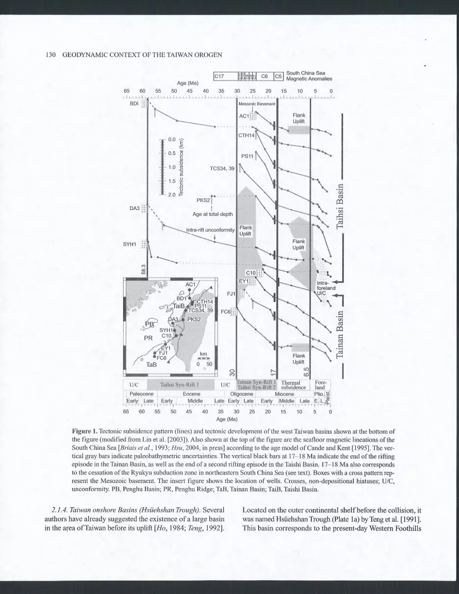
2.1.2. West Taiwan Basins. The Tainan Basin is located at thenortheastern end of the SCS continental margin and extendsonshore into southwestern Taiwan (Plate 1a). Numerous seis-mic and well data obtained by the Chinese Petroleum Companyshow that, although the basin is ENE-WSW trending, roughlyparallel to the continental slope, the main boundary of thenorthern side of the basin is composed of EV/ segments whicheither lie together in an en-échelon pattern or are connectedby orthogonal transfer faults with strike-slip motion flee et al.,1993; Tzeng et al.,1996; Yang et al.,19911. These transferfaults do not seem to be related to pre-existing features. Inthe basin itself. normal faults are also discontinuous and EW-oriented, though the direction of opening of the basin is NNW-SSE fYang et al.,l99l]. This structural pattern is similar to theone of the OT backarc basin where en-échelon normal faultsdo not trend in the direction ofthe trough itselffsibuet et al.,1995]. The reconstruction ofthe different evolutionary stagesand seismic sequences developed in the Tainan Basin showthat, although the basin was relatively symmetrical during itsformation, the bounding horst limiting the basin to the southand whose southern flank corresponds to the conlinenûal slope,has continuously subsided since the early Pliocene fLee etal.,19931. This explains the present-day asymmetrical shapeof the basin and the relative depth of the horst (3 km, Figure3), which limits the Tainan Basin on the shelf edge side. Rift-ing occurred from early Oligocene to early middle Miocene(Plate 1b). Fault-controlled subsidence is the dominant tectonicmechanism for the deposition of sedimentary sequencesfLeeet al.,19931. The rifting phase was followed by a thermalsubsidence phase followed by a rapid flexural subsidencephase linked to the uplift ofTâiwan since the Pliocene (6.5 Ma)
lLin et a1.,20031.The Taishi Basin located northwest of Taiwan (Plate la)
seems to differ from the NE-SW trend of most of the otherbasins. A series of horsts and grabens are trending N080'
fHuang et al.,19931. Two rifting phases seem to occur in theTaishi Basin (Figure l). The first one started during late Pale-ocene (58 Ma) and seems to terminate during middle Eocene(37 Ma). The second one started in early Oligocene (30 Ma)and seems to terminate during late early Miocene (17-18 Ma)(Plate 1b and Figure 1). Since this period, several compres-sional or transpressional regimes have caused the tectonicinversion of the basin.
The Nanjihtao Basin is separated from the Taishi Basin bythe Nanjihtao Ridge (Plate 1a), which is a NE-SW trendinghalf-graben limited in the southeast by a major boundary faultwith more than 3-km normal displacement. Stratigraphic cor-relations indicate that rifting occurred between the early Pale-ocene and late Eocene (Plate 1b), after which time a majorunconformity char acterized by erosional truncation repre-sents the late Eocene to late Oligocene fChow et al., 19911.
SIBUET ETAL. 129
The Penghu Basin, located between the Nanjihtao and PearlRiver Basins (Plate la), is also NE-SW trending, with bound-ing faults approximately oriented inthe same direction lLetouzgtet al.,19881. Though poorly described in the published litera-ture, the main rifting period in the Penghu Basin seems to haveoccurred from Paleocene to middle Eocene times and possi-bly during late Eocene ${siao et al.,l99lf (Plate lb).
2. L 3. North and northeast Taiwan B as ins. The Tungyintaoand Tahchentao Basins, located close to Mainland China, arehalf-grabens (Plate 1a). From seismic and well data, the base-ment is known to be late Cretaceous, with rifting mostly datedas Paleocene (3.5 km of synrift sediments) (Plate 1b), afterwhich subsidence slowed considerably during the Eocene andearly Oligocene lHuang et al.,19921.
The north and south Pengchiahsu Basins, located southeastof the basins already mentioned, are characteizedby NE-SWtrending normal faults (Plate 1a). Prerift sequences are Pale-ocene or slightly older, and the synrift sequences are Eoceneor slightlyyoungerfHuang et al.,l992l (Plate 1b). The Eocenes1mrift sequence is more than 3-kn thick, with a lower sectionshowing chaotic reflections suggestive of deposition in a semi-enclosed environment overlain by an upper section depositedin a more marine environment fHuang et al.,1992].
The NE-SW trending Taipei Basin is located between thePengchiahsu Basins and the Taiwan-Sinzi Ridge @late 1a). Theprerift sequences are dated as Eocene, and the s1mrift sequencesas Oligocene fHuang et al.,19921(Plate lb), although middleMiocene and late Miocene to Pliocene/Pleistocene tensionalphases, post-dating the main rifting phase, are also observedlHuang et al.,1992). The Oligocene s1nrift sequence is morethan 4-lqî thick and composed of a prograding lower Oligocenedeltaic sequence overlain by strongly stratified sandstone andshale alternations, and an extensive late Oligocene deep marinemudstone sequence lHuang et al.,19921.
The OT backarc basin extends from Taiwan to KyushuIsland and is separated from the Taipei Basin by the Taiwan-Sinzi Ridge (Plate 1a). Rifting of the OT started during latemiddle Miocene times fLetouzey and Kimura, 1986; Sun,19811 and is still active today lSibuet et al.,l987f (Plate 1b).However, the beginning of extension could be much morerecent (6 Ma) as suggested by Kimura 11996l. Three mainphases ofopening have been identified, and poles and anglesofrotation have been determined fSibuet et al.,1998; Sibuetet al.,19951. The first phase of rifting is the most importantone with 50 to 75 km of extension from the southern to thenorthern OT lSibuet et al.,19951. This extension started inthe middle Miocene (12 Ma) or late Miocene (6 Ma). Thetwo most recent phases of rifting are dated as late Pliocene-Pleistocene andlate Pleistocene to Recent, with only a totalof a few tens of kilometers of extensionfSibuet et al-, 19981.
130 GEODYNAMIC CONTEXT OF THE TAIWAN OROGEN
F;;------HS;ERT- ^-1 South China Sea
4 0 3 5 3 0 2 5 2 0 1 5 1 0 5 0
lllgTCS34, 39
ùrPKS2 I
IAge at total depth
t -Htra-tiftunconformity
l
FlankUplift
é(A
(t)r-l
r-.
\ T
l , : . . . r . Il : ' ; : I I
lntrâ- -foreland
tÎtl(-an
al
-i
t-.
I
SYHl
UlC I Thermal Fore-l subsidence landUIC TathslSfn-RiÊ I
Paleocene Eocene
2. I . 4. Taiwan ons hore B asins (Hsùehshan Trough). Severalauthors have already suggested the existence ofa large basinin the alea of Taiwan before its uplift lHo,1984; Teng,7992l.
Oligocene
, ,Eq'r.v, , f?19, , ,EE'r,v, , , , , Yl9d.rç , , ,1319 .E?'l{ , \1tî , . F."iry, , rl/,iqqg, ,!u}? , :f: 1.,È,
65 60 55 50 45 40 35 30 25 20 15 10 5 0Age (Ma)
Figure l. Tectonic subsidence pattern (lines) and tectonic development ofthe westTaiwan basins shown at the bottom ofthe figure (modified from Lin et al. [2003]). Also shown at the top of the figure are the seafloor magnetic lineations of theSouth China SeafBriais et al.,1993; Hsu,2004, in pressl according to the age model ofCande and Kent [1995]. The ver-tical gray bars indicate paleobath)'rnetric uncertainties. The vertical black bars aI 17*18 Ma indicate the end ofthe riftingepisode in the Tainan Basin, as well as the end of a second rifting episode in the Taishi Basin. 17-18 Ma also correspondsto the cessation ofthe Ryulqru subduction zone in northeastern South China Sea (see text). Boxes with a cross pattern rep-resent the Mesozoic basement. The insert figure shows the location of wells. Crosses, non-depositional hiatuses; U/C,unconformity. PB, Penghu Basin; PR, Penghu Ridge; TaB, Tainan Basin; TaiB, Taishi Basin.
Located on the outer continental shelfbefore the collision. itwas named Hsûehshan Trough (Plate I a) by Teng et al. I I 99 I ].This basin corresponds to the present-day Western Foothills
t?rn:1,

and the Slate Belt (Hsûehshan and Backbone Ranges). In theHsiiehshan Range, Eocene and Oligocene shallow marinesediments are estimated to be up to 15-km thick and early tomiddle Miocene sediments are about l-km thick. Syn-sedi-mentary growth faults trend nearly in an E-.W directionlLu etal.,l99ll, as in the offshore Tainan and Taishi Basins. How-ever, no such tensional feafures were found in the BackboneRange. There, Oligocene sediments seem to be absent, sug-gesting to Teng l1992lthat the Mesozoic basement had alwaysbeen closer to the surface there. Before coll ision, theHsùehshanTrough, which was floored with a Mesozoic base-ment, was at least 250-km long, as shown by the north-southextension ofthe Hsùehshan and Backbone Ranges, and about200-km wide, taking into account compressional features inthe Western Foothills and the Hsùehshan and Backbone Ranges
lSuppe,1980; Teng et al.,l99lf. The main rifting episodeoccurred during middle Eocene to early Miocene lLu andHsù,1992; Teng and Lin,2004, in pressl (Plate la).
We propose that the Hsûehshan Trough corresponds to twoparallel basins: a northwestem one, which was very deep, filledwith more than l5-km of sediment and corresponding to theHsùehshan Range and the eastern part of the Western Foothills;and a southeastern one, a few kilometers deep, correspondingto the westem Backbone Range. These basins were probably sep-aratedby a linear topographic high, which forced Oligoceneturbidites derived from the Chinese platform first to fill thewestern depression. Sediments in the southeastern depressioneither bypassed the westem basin after the late Oligocene and/orwere derived from the adjacent RyukyuArc. Igneous rockssuch as pillow lavas, diorite and gabbros are common in theHsùehshan Trough. Subordinate andesites and dolerites arepresent within the Backbone Range sedimentary rocks, but arenot found in the Hsùehshan Range fChen,199ll. The LishanFault, which limits the Hsûehshan and Backbone Ranges, wasoriginally a normal, listric fault located between the north-western and southeastern depressions and bounded the lineartopographic feature to the west. It was reactivated as a reversefault during later arc-continent collision.
2.2. Structure, Nature and Timing of the Rifting of ShelfBqsins
2 .2 . I . Structure and timing of rifting of shelf basins. Platela shows that basins of the continental shelf around Taiwan areNE-SW oriented and are parallel to the mainland Chineseshoreline. Howeveq the trend of normal faults is significantlydifferent from the mean direction of the basins and is gener-ally EW oriented. This is true for the Tainan and Taishi Basins,the OT, and also for the Pearl River Basins, where two fami-lies of normal faults are present. One set of faults was activeduring almost the entire rifting phase and runs parallel to the
SIBUET ETAL. 131
northern border of the basins, while the other is E-IV-orientedand dates from the end ofthe rifting phase [Ru,1988; Ru andPigott, 1986; Sun, I98l; Sun, 19851.
Plate lb shows the timing of rifting in continental basinsaround Taiwan. Some uncertainty exists about the exact begin-ning and end of their main rifting phase, mostly because theshutdown tensional rifting activity could be interpreted as partofthe postrift thermal subsidence phase, or subsequent lessintense extensional tectonic phases that could complicate theinterpretation. However, we identiff four belts of basins cor-responding to fow main rifting phases: (1) the oldest belt (Belt1) formed during the late Cretaceous-Paleogene and consistsof the Penghu, Nanjihtao, Tungyintao andTahchentao Basins;(2) Belt 2 formed during the Eocene. Extension decreased andceased in the older basins but started further southeast in thesouth and north Pengchiahsu andTaishi Basins (Plate 1a); (3)Belt 3 formed during Oligocene-early middle Miocene consistsof the Tainan and Taishi Basins, the Hsùehshan Trough andthe Taipei Basin, i.e. in basins located southeast of those thatwere previously active; (4) rifting ceased in all basins butstarted in the OT (Belt 4) during the late middle Miocene (12Ma) or later during late Miocene (6 Ma).
To summarize, the age of rifting episodes and the orienta-tion of all continental shelfbasins of the East and South ChinaSeas located northeast of the Pearl River Basins, includingthe Hsiiehshan Trough, are consistent with the idea that theseshelf basins were formed in the same backarc basin tectonicsetting. In opposition with Teng and Lin 12004, in pressl, wesuggest that the Ryukyu subduction process occurring north-east of the LRTPB was continuous from the earlyTertiary tomiddle Miocene during the formation of the three oldest beltsofshelfbasins.
2.2.2. kctonic subsidence pattern of the west Taiwan Basins.Figure l, adapted from Lin et al. [2003], shows the tectonicsubsidence pattern of a series of wells drilled along a NE-SW profile in the Tainan and Taishi Basins. Rifting occurredduring Paleogene/early Eocene (58-37 Ma) in the Taishi Basinand during Oligocene/early Miocene (30-17/18 Ma) in theTainan Basin. A second Oligocene/early Miocene phase ofrifting occurred in the Taishi Basin. l7-1 8 Ma, a major changein slope occurred in the subsidence curves of all wells (Fig-ure l) that we interpret as the end of active extension and thebeginning of thermal subsidence in the Tainan and TaishiBasins. Since 6.5 Ma, the concave-down subsidence patternis interpreted as the result of flexure driven by Taiwan moun-tain loading fLin and Watts,2002f. As described in previoussections, the first rifting episode in the Taishi Basin started inlate Cretaceous/Paleocene and its duration is poorly defined.In the Tainan Basin, the duration of the rifting episode is welldefined, lasting from early Oligocene to late early Miocene (30-

132 GEODYNAMIC CONTEXT OFTHETAIWAN OROGEN
l7l18 M.y.). Interestingly, the second rifting phase in theTaishi Basin is synchronous with the first rifting phase of theTainan Basin. Lin et al. [2003] link the early Oligocene upliftfollowed by the rapid Oligocene/early Miocene subsidence(that we identify as a rifting phase in the Tainan Basin) to theappearance and disappearance of induced mantle convectionunder the newly created SCS. In fact, the western Taiwanbasins are facing an old portion of oceanic domain (proto-
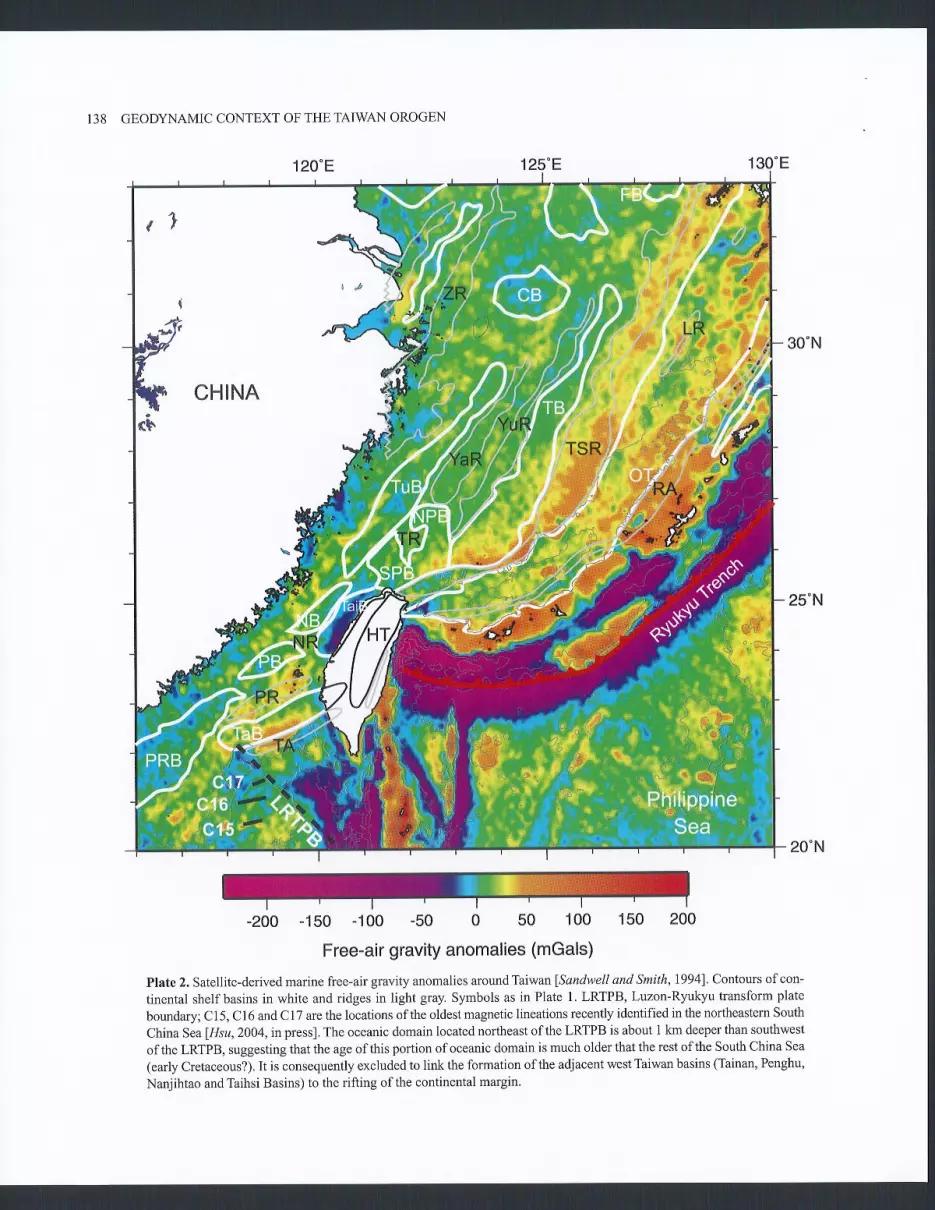
SCS, early Cretaceous?) lSibuet et a1.,20021 and the PearlRiver Basins are facing the SCS oceanic domain where mag-netic lineations C15 to Cl7 (37 Ma) @late 2 and Figure 2)havebeen identifi ed fHsu, 2004, in pressl. Rifting of the passivecontinental margins adjacent to the west Taiwan Basins andPearl River Basins occurred during the early Cretaceous andPaleogene respectively, that is before the rifting ofadjacentshelf basins. Consequently, it is impossible to link the rifting
118'E 122'E
1B'N
Figure 2. Geody'namic interpretation of the South China Sea (SCS), Huatung Basin and surrounding areas in terms ofpiecesofocean belonging to different plates (adapted from Sibuet eT al.12002]). The SCS ocean-continent transition (OCT) hasbeen approximately drawn from bathymehic, gravity and magnetic data. Magnetic lineations, {iacture zones (FZl,FZ2 andFZ3) and plate boundaries are identified in the northeastern SCS (proto-SCS), beneath the Manila accretionary prism(old Taiwan Sea plate) and in the Huatung Basin sensu striclo as well as in the SCS fBriars et al., 7993; Hsu,2004, in press].The southern part of the Huatung Basin might belong to the proto-SCS. The three black circles correspond to locations whereearly Cretaceous rocks have been discovered lDeschamps et al., 20001. Point B is the surface projection of the Eurasianocean-continent transition (OCT), which subducts eastward beneath the Philippine Sea plate; CR, Coastal Range; LRTPB,Luzon-Ryukyu transform plate boundary; L! Longitudinal Valley; PB, Penghu Basin; PR, Penghu Ridge; PRB, PearlRiver Basins; TA, Tainan Arc; TaB, Tainan Basin; TaiB, Taishi Basin. Note that the west Taiwan basins are facing an oldportion ofoceanic domain (proto-SCS, early Cretaceous) and that the Pearl River Basins are facing the SCS oceanicdomain where magnetic lineations Cl5 to C17 (37 Ma) have been identified 1Hsu,2004, in pressl. Rifting of the passivecontinental margins adjacent to the west Taiwan Basins and Pearl River Basins occurred during early Cretaceous andPaleogene times respectively.
ofthe shelfbasins to the rifting ofthe adjacent continentalmargins. We propose here that the rifting phases in the westTaiwan Basins are linked to backarc extension relative to theRyukyu subduction zone, which extended at that time south-westward to the LRIPB (Figure 2) and that the early Oligoceneuplift is correlated to the collision of ridges or asperitiesbelonging to the subducting oceanic domain with the EU mar-gin. We suggest that the Ryukyu subduction zone and theassociated backarc basins ceased to be active l'1 /18 Ma.
2.2.3. Shear wave tomography. We present in Plate 3 tomo-graphic results for the studied region from the global surfacewave inversion of Debayle et a1. 120041. This global shearwave velocity model is constrained by the waveform inversionof 100,466 fundamental and higher mode Rayleigh wave seis-mograms analyzed in the 50-200 s period range. The waveforminversion is performed using the approach described in Caraand Lévêque [ 1 987] and Debayle I I 999]. Debayle et al. [2004]extended the data set compiled by Debayle and Sambridge
120041to a global data set with a majority of seismogramscorresponding to epicenter-station paths shorter than 6000km. The use of these relatively short paths in a global surfacewave inversion allows to minimize some spurious effects nottaken into account in the theory and to improve the horizon-tal resolution to a few hundred of kilometers in the uppermantle fDebayle and Sambridge,2004]. This is especiallytrue in well-sampled regions of the model. The area sur-rounding southeast China and the northern Philippine Seacorresponds to one ofthe highest ray density region in theglobal model of Debayle et al.120041. Over almost the entireregion covered by the present study the mrmber ofrays per 400by 400 km boxes exceeds 2000 (Plate 3) and the azimuthalcoverage is excellent. Possible decrease in horizontal resolu-tion may occur in the dark blue regions where the number ofrays is smaller than 1200. However, excepted in the dark blueregions on the border of the maps, it is likely that the horizontalresolution is rather homogeneous and the high velocity sig-nature of the Ryukyu slab on the maps at 150 and 200 kmdepths suggests that heterogeneities with horizontal wave-lengths of few hundred of kilometers are detected by the tomo-graphic inversion. Teleseismic body wave tomography allowsus to sample the upper mantle with vertical rays beneath thestations, locally providing a better honzontal resolution in theupper mantle but failing to maintain this resolution in oceanicregions where the number of stations decreases. Spike tests perLévêque formed in the body wave model of Bijwaard et al.
[1998] suggest that resolution strongly decreases southwest ofTaiwan fLallemand et al.,200lf although this should not bethe case in the surface wave model.
The map at 50 km depth emphasizes the contrast betweenthe oceanic lithosphere ofthe PH Sea and ofthe younger
SIBUET ETAL. 133
SCS, and the EU continental lithosphere. On the map at 150km depth, the Ryukyu slab is imaged beneath the EU and PHSea lithospheres. It extends continuously from Japan to westof Taiwan, in a region where the Ryukyu slab is now inac-tive. On the map at200l<n depth, the slab extends even morewestwards. Cross-sections AA' to DD' (Plate 3) aligned onthe PH Sea and SCS margins clearly show that the high veloc-ity 'slabs'in blue are also aligned, even ifthis correspondenceis questionable for section DD'. In opposition to the bodywave tomography fLallemand et a1.,2001], which providespoor resolution in the upper mantle southwest of Taiwan, theshear wave tomography enlightens for the first time the extentofthe Ryukyu extinct slab beneath the northeastern SCS mar-gin, even ifthe resolution ofdata cannot allow us to properlylocate its western extremity.
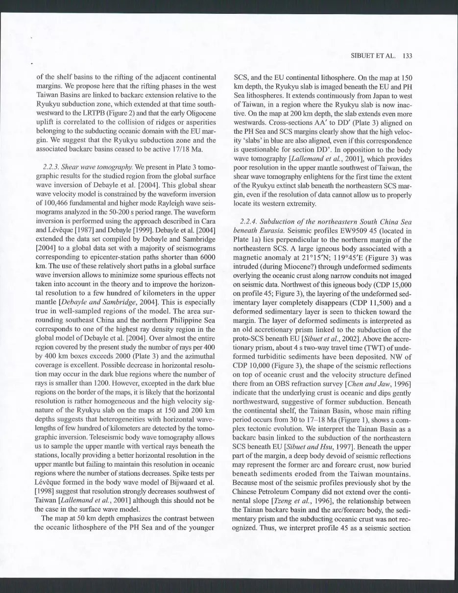
2.2.4. Subduction of the northeastern South China Seabeneath Eurasia. Seismic profiles EW9509 45 (located inPlate la) lies perpendicular to the northern margin of thenortheastern SCS. A large igneous body associated with amagnetic anomaly at 2lol5'N; 119"45'E (Figure 3) wasintruded (during Miocene?) through undeformed sedimentsoverlying the oceanic crust along narrow conduits not imagedon seismic data. Northwest of this igneous body (CDP 15,000on profile 45; Figure 3), the layering of the undeformed sed-imentary layer completely disappears (CDP 11,500) and adeformed sedimentary layer is seen to thicken toward themargin. The layer of deformed sediments is interpreted asan old accretionary prism linked to the subduction oftheproto-SCS beneath EU fSibuet et al.,2002l.Above the accre-tionary prism, about 4 s two-way travel time (TWT) of unde-formed turbiditic sediments have been deposited. NW ofCDP 10,000 (Figure 3), the shape of the seismic reflectionson top of oceanic crust and the velocity structure definedthere from an OBS refraction survey fChen and Jaw,1996lindicate that the underlying crust is oceanic and dips gentlynorthwestward, suggestive of former subduction. Beneaththe continental shelf, the Tainan Basin, whose main riftingperiod occurs from 30 to 17-18 Ma (Figure 1), shows a com-plex tectonic evolution. We interpret the Tainan Basin as abackarc basin linked to the subduction ofthe northeasternSCS beneath EU lSibuet and Hsu,19971. Beneath the upperpart of the margin, a deep body devoid of seismic reflectionsmay represent the former arc and forearc crust, now buriedbeneath sediments eroded from the Taiwan mountains.Because most of the seismic profiles previously shot by theChinese Petroleum Company did not extend over the conti-nental slope lTzeng et al.,1996], the relationship betweenthe Tainan backarc basin and the arclforearc body, the sedi-mentary prism and the subducting oceanic crust was not rec-ognized. Thus, we interpret profile 45 as a seismic section
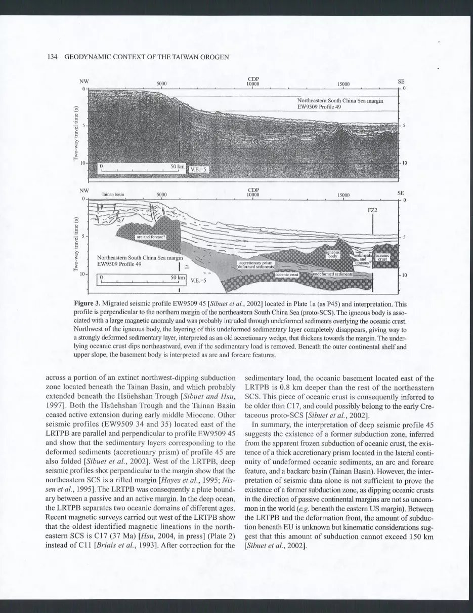
134 GEODYNAMIC CONTEXT OFTHETAIWAN OROGEN
Figure 3. Migrated seismic profile EW9509 45 lSibuet et a1.,20021located in Plate 1a (as P45) and interpretation. Thisprofile is perpendicular to the northern marlin ofthe northeastern South China Sea (proto-SCS). The igneous body is asso-ciated with a large magnetic anomaly and was probably intruded through undeformed sediments overlying the oceanic crust.Northwest of the igneous body, the layering of this undeformed sedimentary layer completely disappears, giving way toa sfongly deformed sedimentary layer, interpreted as an old accretionary wedge, that thickens towards the margin. The under-lying oceanic crust dips northeastward, even ifthe sedimentary load is removed. Beneath the outer continental shelfandupper slope, the basement body is interpreted as arc and forearc features.
across a portion of an extinct northwest-dipping subductionzone located beneath the Tainan Basin, and which probablyextended beneath the Hsiiehshan Trough lSibuet and Hsu,19971. Both the Hsùehshan Trough and the Tainan Basinceased active extension during early middle Miocene. Otherseismic profi les (EW9509 34 and 35) located east of theLRTPB are parallel and perpendicular to profile EW9509 45and show that the sedimentary layers corresponding to thedeformed sediments (accretionary prism) of profile 45 arealso folded lSibuet et a1.,2002). West of the LRTPB, deepseismic profiles shot perpendicular to the margin show that thenortheastern SCS is a rifted margin fHayes et al.,1995; Nis-sen et a|.,1995]. The LRTPB was consequent$ a plate bound-ary between a passive and an active margin. In the deep ocean,the LRTPB separates two oceanic domains of different ages.Recent magnetic surveys carried out west of the LRTPB showthat the oldest identified magnetic lineations in the north-eastern SCS is Cl7 (37 Ma) 1Hsu,2004, in pressl (Plate 2)instead of Cl I fBriais et al., 19931. After correction for the
sedimentary load, the oceanic basement located east of theLRTPB is 0.8 km deeper than the rest of the northeasternSCS. This piece ofoceanic crust is consequently inferred tobe older than Cl7, and could possibly belong to the early Cre-taceous proto-SCS lSibuet et a1.,20021.
In summary, the interpretation of deep seismic profile 45suggests the existence of a former subduction zone, inferredfrom the apparent frozen subduction of oceanic crust, the exis-tence ofa thick accretionary prism located in the lateral conti-nuity of undeformed oceanic sediments, an arc and forearcfeature, and a backarc basin (Tainan Basin). However, the inter-pretation of seismic data alone is not sufficient to prove theexistence of a former subduction zone, as dipping oceanic crustsin the direction of passive continental margins are not so uncom-mon in the world (e.g. beneath the eastern US margin). Betweenthe LRTPB and the deformation front, the amount of subduc-tion beneath EU is unknown but kinematic considerations sug-gest that this amount of subduction cannot exceed 150 kmlSibuet et a1.,20021.
ilortheastem-Sîtft Cftinu S* -.nin8W9509 Profile 49
NW
Northeastem South China Sea marginEW9509 Profile 49 |
50 lff
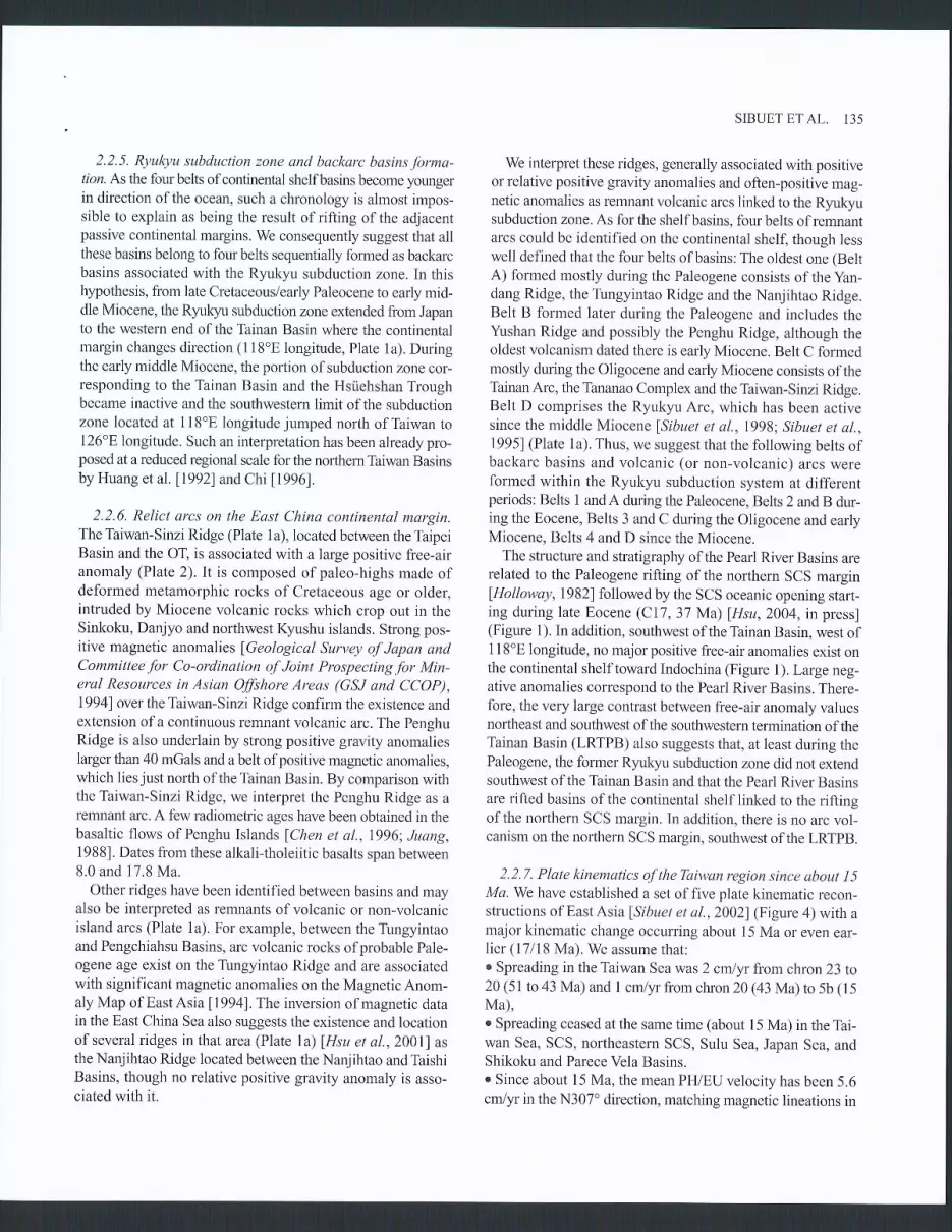
2.2.5. Ryulryu slûduction zone and backarc basins forma-tion. Aslhe four belts of continental shelfbasins become youngerin direction of the ocean, such a chronology is almost impos-sible to explain as being the result ofrifting ofthe adjacentpassive continental margins. We consequently suggest that allthese basins belong to fourbelts sequentially formed as backarcbasins associated with the Ryukyu subduction zone. In thishypothesis, from late Cretaceous/early Paleocene to early mid-dle Miocene, the Ryulryu subduction zone extended from Japanto the western end of the Tainan Basin where the continentalmargin changes direction (1 18'E longitude, Plate 1a). Duringthe early middle Miocene, the portion of subduction zone cor-responding to the Tainan Basin and the Hsùehshan Troughbecame inactive and the southwestem limit of the subductionzone located at 1 1 8'E longitude jumped north of Taiwan to126'E longitude. Such an interpretation has been already pro-posed at a reduced regional scale for the northem Thiwan Basinsby Huang et al. [1992] and Chi 119961.
2.2.6. Relict arcs on the East China continental margin.The Taiwan-Sinzi Ridge (Plate 1a), located berween the TaipeiBasin and the OT, is associated with a large positive free-airanomaly (Plare2).It is composed of paleo-highs made ofdeformed metamorphic rocks of Cretaceous age or older,intruded by Miocene volcanic rocks which crop out in theSinkoku, Danjyo and northwest Kyushu islands. Strong pos-itive magnetic anomalies lGeological Survey of Japan andCommitteefor Co-ordination of Joint Prospectingfor Min-eral Resources in Asian Offshore Areas (GSJ and CCOP),19941 over the Taiwan-Sinzi Ridge confirm the existence andextension ofa continuous remnant volcanic arc. The PenghuRidge is also underlain by strong positive gravity anomaliesIarger than 40 mGals and a belt ofpositive magnetic anomalies,which lies just north of the Tâinan Basin. By comparison withthe Taiwan-Sinzi Ridge, we interpret the Penghu Ridge as aremnant arc. A few radiometric ages have been obtained in thebasaltic flows of Penghu Islands fChen et a1.,7996; Juang,1988]. Dates from these alkali-tholeiitic basalts span between8.0 and 17.8 Ma.
Other ridges have been identified between basins and mayalso be interpreted as remnants of volcanic or non-volcanicisland arcs (Plate 1a). For example, between the Tungyintaoand Pengchiahsu Basins, arc volcanic rocks ofprobable Pale-ogene age exist on the Tungyintao Ridge and arc associatedwith significant magnetic anomalies on the Magnetic Anom-aly Map of EastAsia U9941. The inversion of magnetic datain the East China Sea also suggests the existence and locationof several ridges in that area (Plate 1 a) lHsu et al., 20011 asthe Nanjihtao Ridge located between the Nanjihtao and TaishiBasins, though no relative positive gravity anomaly is asso-ciated with it.
SIBUET ET AL. 135
We interpret these ridges, generally associated with positiveor relative positive gravity anomalies and often-positive mag-netic anomalies as remnant volcanic arcs linked to the Ryukyusubduction zone. As for the shelf basins, four belts of remnantarcs could be identified on the continental shelf, though lesswell defined that the four belts of basins; The oldest one (BeltA) formed mostly during the Paleogene consists of the yan-dang Ridge, the Tungyintao Ridge and the Nanjihtao Ridge.Belt B formed later during the Paleogene and includes theYushan Ridge and possibly the Penghu Ridge, although theoldest volcanism dated there is early Miocene. Belt C formedmostly during the Oligocene and ear$ Miocene consists of theTainanArc, the Tananao Complex and the Taiwan-Sinzi Ridge.Belt D comprises the Ryukyu Arc, which has been activesince the middle Miocene lSibuet et al., 7998; Sibuet et al.,19951 (Plate 1a). Thus, we suggesr that the following belts ofbackarc basins and volcanic (or non-volcanic) arcs wereformed within the Ryukyu subduction system at differentperiods: Belts 1 and A during the Paleocene, Belts 2 and B dur-ing the Eocene, Belts 3 and C during the Oligocene and earlyMiocene, Belts 4 and D since the Miocene.
The structure and stratigraphy of the Pearl River Basins arerelated to the Paleogene rifting of the northern SCS marginfHolloway,l982l followed by the SCS oceanic opening starr-ing during late Eocene (C17, 31 Ma) [,Hsu,2004, in press](Figure 1). In addition, southwest of the Tainan Basin, west of1 18'E longitude, no major positive free-air anomalies exist onthe continental shelf toward Indochina (Figure 1). Large neg-ative anomalies correspond to the Pearl River Basins. There-fore, the very large contrast between free-air anomaly valuesnoftheast and southwest of the southwestern termination of theTainan Basin (LRTPB) also suggests that, at least during thePaleogene, the former Ryukyu subduction zone did not extendsouthwest of the Tainan Basin and that the Pearl River Basinsare rifted basins ofthe continental shelflinked to the riftingof the northern SCS margin. In addition, there is no arc vol-canism on the northern SCS margin, southwest of the LRTpB.
2.2.7. Plate kinematics of the Thiwan region since about I 5Ma. We have established a set of five plate kinematic recon-structions of EastAsia lSibuet et a|.,20021(Figure 4) with amajor kinematic change occurring about 15 Ma or even ear-lier (17l18 Ma). We assume that:. Spreading in the Taiwan Sea was 2 cmlyr from chron 23 to20 (51 to 43 Ma) and 1 crn/yr from chron 20 (43 Ma) ro 5b (15Ma),r Spreading ceased at the same time (about 15 Ma) in the Tai-wan Sea, SCS, northeastern SCS, Sulu Sea, Japan Sea, andShikoku and Parece Vela Basins.o Since about 15 Ma, the mean PH/EU velocity has been 5.6crn/yr in the N307" direction, matching magnetic lineations in
136 GEOD\AIAMIC CONTEXT OF THE TAIWAN OROGEN
Kinematic reconstructionsof East Asia since
about 15 Ma
Figure 4. Plate kinematic reconstructions of East Asia (adapted from Sibuet et al. [2002]): a) Early middle Miocene (15
Ma+); b) Early middle Miocene (15 Ma); c) Late Miocene (8 Ma); d) Pliocene (3 Ma); e) Present-day. Light gray, conti-
nental domain; white, oceanic domain; dark gray, intra-oceanic arcs; thick lines, active plate boundaries; large arrows, WPHÆU
or PH/EU motions; large black dot, pole of rotation. Fracture zones and main magnetic lineations with their identifications
are shown. Spreading ceased at the same time (about 15 Ma) in the Taiwan Sea, South China Sea, Sulu Sea, Japan Sea, and
Shikoku and Parece Vela Basins. CR, Cagayan Ridge; GR, Gagua Ridge ; JS, Japan Sea; Ml Manila Trench;L,Ltzon
Island; LMPB, Luzon-Ryukyu transform plate boundary;LA,LuzonArc; O! Okinawa Trough; PB, Philippine Sea
Basin; QNR, Qui Nhon Ridge; RRF, Red River Fault; SB, Shikoku Basin; SCS, South China Sea; T, Taiwan; CA, Cagayan
plate; CE, Celebes plate; EPH, east Philippine Sea plate; EU, Eurasia plate; IC, Indochina plate; LU, Luzon plate; NTA,
north Taiwan Sea plate; Ol Okinawa-Japan plate; PA, Pacific plate; PH, Philippine Sea plate; PSCS, proto-south China
Sea plate; SSCS, southern south China Sea plate; STA, south Taiwan Sea plate; WPH, west Philippine Sea plate.
o
@
l5 Me- (Ë. Middlê Miocene)
@
@
3 M6 (Pllocono)/i\w
/îï\7 u
{i,Vl 7ï (
l5 Me- (È. Mlddlê Miocen.)
^Q'
@
@
@

SIBUET ETAL. 137
e t $ 9 ! 1
Plate 1. (A) Chinese continental shelf basins (colored areas) with their main controlling normal faults lHsu et a1.,2001;Sibuet and Hsu,19971. Colors denote the time during which the main rifting phase occurred (see Plate 1b). Ridges betweenbasins are marked in gray. P45, seismic line EW9509 45 CB, Changjiang Basin; FB, Fujiang Basin; H! HsûehshanTrough; LR, Longwan Ridge; NB, Nanjihtao Basin; NPB, North Pengchiahsu Basin; NR, Nanjihtao Ridge; OT, OkinawaTrough; PB, Penghu Basin; PR, Penghu Ridge; PRB, Pearl River Basins; RA, Ryukyu Arc; SpB, South pengchiahsuBasin; TA, Tainan Arc; TB, Taipei Basin; TaiB, Taishi Basiry TaB, Tainan Basin; TR, Tungyintao Ridge; TSR, Taiwan-Sinzi Ridge; TuB, Tungyintao and Tahchentao Basins; TW, Taiwan;YaR, Yandang Ridge; yuR, yushan Ridge; ZR, ZheminRidge. (B) Diagram showing the main rifting phases of each continental basin arorlnd Taiwan including the Hsriehshan Trough,the basin lying before the uplift ofTaiwan (adapted from Sibuet and Hsu ]l997l). Detailed explanations and references inthe text. In color, main rifting phases; hachured areas, possible extension ofmain rifting phases; white areas, posterior ten-sional activity. Four main rifting periods have been identified. Periods during which rifting occurs appear for each basin.
e &
$scËË$$
g g g g g o o&.9,a @
o
, È ô; E s ÊË - d $ s -ë Ë Ë s
138 GEODYNAMIC CONTEXT OF THE TAIWAN OROGEN
130"E120"E 't25"E
25'N
20"N
-200 -150 -100 -50 0 50 100 150 200
Free-air gravity anomalies (mGals)
Ptate 2. Satellite-derived marine free-air gravity anomalies around Taiwanlsandwell and Smith,1994]. Contours of con-
tinental shelf basins in white and ridges in light gray. Symbols as in Plate 1. LRTPB, Luzon-Ryukyu transform plate
boundary; C15, C16 and C17 are the locations of the oldest magnetic lineations recently identified in the northeastern South
China Sea 1Hsu,2004, in press]. The oceanic domain located northeast ofthe LRTPB is about 1 km deeper than southwest
of the LMPB, suggesting that the age of this portion of oceanic domain is much older that the rest of the South China Sea
(early Cretaceous?). It is consequently excluded to link the formation ofthe adjacent west Taiwan basins (Tainan, Penghu,
Nanjihtao and Taihsi Basins) to the rifting of the continental margin.

SIBUET ET AL. 139
32'N
28"N
24"N
20"N
'16'N
12 'N
8'N
Nb of paths
[f ,uool f 2600ll z+oolL >>oo| - ---+ 2000
Jf raoo
tt:33f ';:3
32"N
28"N
24"N
20'N
16 'N
12 'N
I 'N
ltut<t1tA or
ttrencn A
^ 1 l l
Bathtnrelrt a' - k m
6VsVa200
400km
6
--._e-
KyuKyuslab
' 6@
\u
.B or P:P: B'
32'N
28'N
24"N
20'N
16 'N
1 2 " N
8"N
400K M
o ,L = phitippine Sea C',
l(m -
Kyuk)1u
0
K M
___=æ.Çt;
400km
28'N
24'N
20'N
16 'N
-10 -5 0 5 10%
112"E 120 'E 128. E 136.E
Plate 3. S-E Asia shear wave velocity distribution in the upper mantle from the global shear wave tomography of Debayleet a1. [2004]. Velocity perturbations from the reference velocity are given at each chosen depth (50, 100, 150 and,200km) in percent. The 1 and 4-km isobaths (thin dark lines) underline oceanic basins. Present-day plate boundaries are ln green.The blue-white color scale on the path density map indicates the number ofpaths in each 400x400 km cell. Vertical cross-sections AA'to DD' located on the four maps are aligned on the Philippine and South China Sea margins. purple circlescorresponding to seismicity in a 10-km bandwidth on each side of cross-sections underline the location of the Rwlcvu slab.
12 "N
I 'N
Path density
112"E 120'E 128'E 136'E

140 GEOD\'NAMIC CONTEXT OF THE TAIWAN OROGEN
the Huatung Basin and beneath the Manila accretionary prism'
However, large uncertainties remain in these reconstructions'Amongst them, the location of the Luzon plate is crucial, as
is the age of emplacement of the northem LuzonArc, assumed
here to follow the seafloor spreading extinction in the Taiwan
Sea (about 15 Ma). As the PH Sea plate was mostly bounded
by subduction zones since about 15 Ma, a special attention wasgiven to paleomagnetic constraints concerning the PH/EU
rotation parameters lHall et al., 1995). Since 15 Ma, we have
assumed that the PH Sea plate rotated 15o clockwise with
respect to EU. This assumption falls within the error bars of
rotations given by Hall et al. [1995] and Hall U996;20021.The key constraints to the proposed kinematic reconstruc-
tions are:o The Gagua Ridge was a major transform plate boundary
during the opening of the Taiwan and South China Seas' It
was an about 1000-km long linear feature which accommo-
dated the northwestward shear motion of the west PH Seaplate with respect to EU.o Before about 15 Ma, the Ryukyu subduction zone extended
southward ofTaiwan to the LRTPB. Backarc basins and rem-
nant arcs formed on the continental shelf as a succession of par-
allel belts of basins. About 15 Ma, the western end of the
Ryulryu subduction zone moved from southwest of the Tainan
Basin (118'E) to east of Taiwan (126"8).r The construction of the intra-oceanic Luzon Arc, located
north of the Philippine islands, is linked to SCS subduction at
the Manila Trench and is younger than about 15 Ma. There is
a large debate about the sense of vergence of the subductionzone before 1 5 Ma. Maleterre [1989] and Wolfe [1 98 1] linked
the construction ofLuzon Island to an east-verging subduc-
tion zone. However, recent tomographic inversions clearly
show a deep westdipping subduction zone named the Sangihe
subduction zone lRangin et a|.,19991, which ceased activity
near Luzon Island, suggesting prior to about 15 Ma a con-
vergent motion evolving northwards into a transform motion.
The internal consistency of the kinematic reconstructions pre-
sented below supports such a change ofplate vergence.
North of Luzon Island, 15 radiometric dates available on
volcanic rocks collected on the islands ofthe Luzon Arc areyounger than 9.4 Ma lLo et al., 1994; Maury et al., 1998;
Yang et al., 1996]. In the Coastal Range of Taiwan, the onshoreportion of the Luzon Arc, fission track age determinationsgive ages younger than 16 Ma. However, K-Ar dates on out-
cropping andesites give some ages between 15 and 29 Ma
lRichard et al.,19861 but the effects ofvarious alteration
reactions as delineated by Lo et al. I I 994] have not been taken
into account. Samples analyzedby Richard et al. [1986] are
characterized by very low K2O content, which could artificially
increase radiometric ages by loss of potassium. Vy'e suggest that
the change ofplate vergence couldhave occurred about 15 Ma,
simultaneously with the onset of the northward extension of
the Manila Trench connecting the Ryukyu Trench through
the Taiwan Sea. However, because the younger identified
magnetic lineation is chron 7 (27 l;4a) in the Taiwan Sea, we
cannot exclude an earlier change ofvergence in the Philippine
islands from east to west, sometime between 15 and 27 Ma.
2.2.8. Summary of the geodynamic environment of Taiwan
before its uplift. Before about 15 Ma, well before the forma-
tion of the Taiwan mountains, the Ryukyu subduction zone
extended from Japan to southwest ofTaiwan (LRIPB, west ofTainan Basin). This is particularly well imaged on the global
shear wave velocity model of Plate 3, The oldest magnetic
anomaly identified in the SCS is C17 (37 Ma) [Hsu, 2004,
in press] (Figure 2). The portion of oceanic crust presently
located between the LRTPB and the Manila Trench is much
older than the rest of the SCS (Figure 2), and might have
belonged to the proto-SCS, possibly being as old as the early
Cretaceous (115-125 Ma) [Deschamps et a1., 2000]. Thus,
the west Taiwan Basins are facing an old portion of oceanicdomain (proto-SCS, early Cretaceous) and the Pearl River
Basins are facing a young oceanic domain (37 Ma, late
Eocene). Rifting of the passive continental margins adjacentto the west Taiwan Basins and Pearl River Basins occurred
at different periods: during the early Cretaceous east oftheLRTPB and during early Tertiary (Paleogene?) west of the
LRTPB. Thus, it is unlikely that shelf basins located west ofTaiwan can be considered as tensional basins linked to an
early Tertiary rifting episode of the adjacent portion of the
SCS continental margin, as proposed by Lin et al. [2003].However, southwest of the LRTPB, the formation of the Pearl
River Basins could be reasonably linked to the rifting episodeof the adjacent margin prior to chron C17 (37 Ma).
Since the early Tertiary, four belts oftensional basins sep-
arated by volcanic ridges were formed on the East and SouthChina Seas continental shelves, the youngest being located
at the oceanward edge, We suggest that these continental shelfbasins were formed as backarc basins in liaison with the
Ryukyu subduction zone. Rifting in the oldest backarc basin
started in late Cretaceous-Paleocene time, close to mainland
China. As soon as these backarc basins became too wide and
the depth of the slab too big beneath the axes of backarc
basins, the extensionalbackarc rift systems jumped eastward,probably within the active Ryukyu Arc system. In the Tainan
Basin, the end of rifting occurred at 17-18 Ma (Figure 1),
approximately at the time of the major plate kinematic re-
organization, when subduction ceased southwest of Taiwan.Thus in our model, the geological settings of the west Tai-
wan and Pearl River Basins are completely different: the west
Taiwan Basins are backarc basins linked to the Ryukyu sub-
duction zone and the Pearl River Basins are tensional rifted

basins linked to the early Tertiary rifting ofthe southeasternSCS continental margin.
3. THE UPLIFT OFTAIWAN
The Taiwan mountain belt is one of the youngest orogens inthe world.
.Whatever are the proposed models to interpret the
formation of Taiwan, all authors agree that the uplift of Tai-wan results from the collision of the Luzon Arc with the EUmargin. The Luzon Arc is an intra-oceanic volcanic arc thatbelongs to the PH Sea plate. Exposures of the Luzon Arcoccur in the Coastal Range of Taiwan and the contact befweenthe arc and the EU margin is marked by the Longitudinal Val-ley (Figure 5). Debate continues regarding the nature of the col-lided margin: whether a sedimentary monocline belonged tothe EU plate and was deformed by the collision of the LuzonArc lSuppe, l98l; Suppe,1984l, by l ithospheric coll isionbetween the LuzonArc and EU lithosphere lWu et al.,19971,by the accretion of an exotic block against the EU marginlLuand Hsii, 19921 or was part of a previously formed RyukyoArc/backarc basin system fHsu and Sibuet,1995 Sibuet andHsu, 19971 subsequently deformed by Luzon Arc collision.Davis et al. [1983] and Suppe [1984] demonstrated rhat the col-lision was propagating southward slightly faster than that ofthe convergence rate, which means that moving south 90 kmalong the collision is analogous to viewing development of thecollision 1 m.y. earlier. Thus, most authors (e.g. Teng [1990],Malavieille eI al. [2002] and Clift et al. [2003]) suggest thatthe evolution through time of Taiwan mountain building is acontinuum represented by a series of cross-sections from thepresent-day Manila subduction system to the south (beforecollision), through middle Taiwan (collision) and northeastofTaiwan, across the southern OkinawaThrough and Ryulç.usubduction system (post-collision).
Starting from East Asia plate kinematic reconstructions(Figure 4), we define the location of the western boundaryof the PH Sea plate (point A) that bounds the termination ofthe Ryukyu Benioff zone and triggers the occurrence anddevelopment of a tear fault within the EU plate. Vy'e try toexplain the process of Taiwan mountain building within asimple plate tectonic context, which includes a comprehensivehistory of westward migration of the collision. For that pur-pose, we first clarify a series of points concerning the geom-etry of plate boundaries, as well as the nature of deformationand associated stress patterns.
3.1. Location ofWestern Philippine Sea Plate Boundary(PointA)
At about 15 Ma, the vergence and location of the Luzonsubduction zone shifted from east to west of the Philippine
SIBUETETAL. I4I
archipelago lMaleterre, 7989; Wolfe, 19811, giving rise to theManila subduction zone. Later on, the Luzon Arc started toform as an intra-oceanic arc. At first the newly created LuzonArc was probably a modest topographic feature and its north-ern part subducted beneath EU as part ofthe PH Sea plate. Itwas only at9-6Ma that the young LuzonArc acquired a sig-nificant topographic expression, resisting subduction andstarted to collide with EQ giving rise to the proto-Taiwanchain as part ofthe deformed EU border fsibuet et a\.,2002].In Taiwan, the Coastal Range corresponds to the outcroppingportion of the Luzon Arc, and the Longitudinal Valley is theplate boundary between the PH Sea and EU plates (Figure5). The proto-Taiwan chain was located at the position of thepresent-day southwestern OT and adjacent northern conti-nental shelf [1siao et al.,1999; Sibuet et a\.,1998] (Figure 6).Its eastern termination has been carefully mapped lHsiao etal.,19991. In this scheme, the eastern limit of thrust faults(at 124'E) is located in the N307' direction with respect to thelocation where the Ryukyu Trench changes direction fromNE-SW to E-V/ (at 726"8, Figure 6). From the PH/EU kine-matic parameters, the mean westward motion of the LuzonArc is 4.5 cmlyr for the last 8 M.y. and the colliding point ofthe LuzonArc with EU continuously migrated westwards fora total amount of 400 km (Figures 4 and 5).
The Ryukyu Trench terminates in its westward direction at122F, but the subducted slab is recognized further west,beneath northern Taiwan lKao et a1.,20001(Figure 6). Theboundary of the PH Sea plate follows the subducted plateedge. If PointA is the surface projection of the western limitof the Ryukyu slab, one can delineate it from either the dis-tribution of intermediate-depth and/or deep focus seismicity,or a high velocity anomaly on tomographic images. Globaltomographic models (e.g. Lallemand et al. [2001] and Ranginet al. [1999]) are too coarse to shed light on such a smallregion, while local tomographic models do not extend deepenough into the lithosphere (e.g. lCheng et a\.,2002; Hsu,2001]). Thus, PointA is not well constrained in northernTai-wan, but corresponds to the western boundary ofthe deepseismicity [Font et aL.,19991@late 4) and extends approxi-mately from Hualien to somewhere between Chungli and theTaitun volcano (Figure 5).
Northeast of Point A, focal mechanisms show that earth-quakes belonging to the Ryukyu seismogenic zoîe are assocl-ated with low-angle thrust faults over depths of 10 to 35 km.Above the BenioffZone, within the EU plate, shallow crustalextensional earthquakes occur in the southwestern OT andunder the Ilan Plain. On land several active faults with a nor-mal component have been identified (Figure 5). The NE-SW ori-ented Shanjiao Fault is a transtensional fault lLee and Wang,1987], conjugate to the transpressional NW-SE oriented NankanFault lHsu and Chang, 1979; Tsai,1986l. Further north, the

142 GEODYNAMIC CONTEXT OFTHETAIWAN OROGEN
24"N
1 20"E 122'E
Figure 5. Geodynamic context ofthe Taiwan area established from Deffontaines et al. [2001], Teng and Lee [1996] for nofih-
ern Taiwan, Huang et aL l1992l for the prolongation of these features on the continental shelf north of Okinawa Trough,
Sibuet et al. [1998] for the Okinawa Trough, Lallemand et al. [1999] for the Ryukyu accretionary wedge and forearc
basins, Malavieille et a1. [2002] for the Coastal Range, Luzon Arc, southern Longitudinal Trough (SLT) and North Luzon
Trough (NLT) forearc basins, Liu et aL. 119911for the Manila accretionary prism. Point A is the western boundary of the
PH Sea plate and Point B is the ocean-continent transition (OCT) zone within the EU subducted slab (in the prolongation
of the South China Sea OCT). East of Point A, in northern Taiwan and on the northeastern continental shelf, normal faults
are reactivated thrust faults lHsiao et aI., 19991. Between Points A and B and south of Point B, features are compres-
sional. In light gray, Manila oceanic accretionary prism above the EU oceanic slab; in dark gray,Taiwan continental accre-
tionary prism above the EU continental slab. HR Hengchun peninsula; HR, Huatung Ridge; LF, Lishan Fault and its
extensionintheOkinawaTrough. I ,ChinshanFault;2,ShanjiaoFault;3,NankanFadtlTengandLee,T996l.
Taitun volcano is cut by a set of Quaternary normal and strike-
slip faults lLee and Wang, 1988f and the modern ChinshanFault is in fact a series of normal faults with a strike-slip com-ponent lChen andYeh,1991; Lee and Wang,1988l.
West of PointA, earthquakes show a consistent orientationof P-axes in the direction of collision, with crustal thrust fault-ing mechanisms mostly oriented in the N290o direction. Fromthe Longitudinal Valley to the western coast ofTaiwan, earth-

quakes correspond to shallow thrust events (<20 km) gener-ally of lower magnitude than east of Taiwan, suggesting thatthe Central Range is relatively aseismic lKao et al., l99g].According to the above observations, compressive earthquakesmechanisms and reverse faults testifii to contractional motionswithin the upper plate, west of Point A.
Consequently, in northem Taiwan, the surface projection ofthe PH Sea plate boundary @ointA) is associated with a zoneof strain change in the EU crust (extensional in the OT andnorthern Taiwan and compressional in the rest of Tâiwan).
South of Hualien, the PH Sea plate boundary follows at thesurface the Longitudinal Valley (Figure 5) (e.5. l"Lu and Hsù,1992; Malavieille et a1.,2002]). By convention, we have takenthe surface expression of this timit as the pH Sea plate bound-ary. South ofTaitung, the location of pointA is poor$ defined.Arbitrarily, this boundary has been located west of the LuzonArc and adjacent forearc basins. In this scheme. the Manilaaccretionary prism corresponds to deformed sediments belong-ing to the EU plate (South China Sea), with the rest of theEU plate subducting beneath the PH Sea plate. The ManilaTrench continues northwards by the deformation front con-sidered as the western boundary of the Taiwan deformed zone.Similarly, the Central Range and Foothills are considered asa continental accretionary prism, which includes sediments andupper crust material belonging to the EU plate, the rest of the
SIBUET ETAL. 143
EU plate subducting beneath the pH Sea plate. Thus, a majoraccretionary prism has been identified west ofthe boundaryof the rigid PH Sea plate and consists of deformed sedimentspreviously belonging to the EU plate, whose nature is conti-nental in the north and oceanic in the south.
3.2. Ocean-Continent Transition Zone Within the EurasianStab (B)
Recent studies of the sûucture of the lithosphere and mantlein EastAsia based on seismic tomographic images [Bijwaard etal. , 1998; Kuo et al. ,2003; Lallemand et al. , 2001; Rangin et al. ,1999; Tajima et al.,19971show that the Manila slab is a con_tinuous feature extending nofihwards up to the latitude of Hualien(northern end of the Coastal Range) where it can be followeddown to 500-600 lrtlRangin et a\.,19991. However, the deepseismicity associated with the Manila slab essentially occurssouth of Point B (Plate 4) and is almost absent north of B. pointB extends from the ManilaTrench to south of the LongitudinalValley and terminates at 721.8E. On tomographic images, aslight change in the orientation ofthe slab occurs at its inter_section with Point B, as well as an increase of the slab steepnessnorlh of B. South of Point B, the distribution of seismicity atdepths >80 lcl represents the geometry of the Manila SCS sub-ducted slab (Plate 4). South ofPoint B, there is a good corre-
1 1B"E 122"8 126'E
28'N
Figure 6' Simplified bathymetry (isobath spacing, 1 km) near Taiwan with the portion of Eurasian continental crust (indark gray) subducted beneath the Luzon Arc, during its coilision with Eurasia lsibuet and Hsu,2004l.proto-Taiwan thrustfaultsnortheastofTaiwanfromHsiaoetal. [ i999].Theposit ionofEurasiancrustboundarybeforetheOkinawaTroughopening is with respect to Eurasia supposed to be fixed (75 km of extension, except west of I24"Elongitude where exten-sion decreases to zero lsibuet et a|.,19951). cR, coastal Range; L! Longitudinal valley.
w
*-Gasua Rid& J
initial point olcollisionA . of Luion arc with EU\:(before Okinawa Trough opening)
Q s -

144 GEODYNAMIC CONTEXT OFTHETAIWAN OROGEN
120 'E 121"8
o
15-30 30-50 50-80. . . o o2 3 4 5 6
122"8
o o80-120 120-300 (km)
25'N
24'N
23"N
a0-15
Mr=
plate 4. Seisrnicity map of Taiwan with earthquakes recorded during the 199I-1997 period by the Central Weather Bureau
in Taiwan lsibuet and Hsu, 2004]. Deeper earlhquakes are plotted above shallower earthquakes in order to underline the Ryulqu
and Manila slabs. point A is the western boundary ofthe PH Sea plate and Point B the ocean-continent transition zone
within the EU subducted slab. Isobaths of subducted slabs are every 50 km. South of Point B, the Luzon Arc is fotming; between
points A and B, the Luzon Arc is colliding with the Eurasia margin. There are only a few deep slab events east of the Lon-
gitudinal Va11ey (LV); East of Point A, the upper portion of the Luzon Arc is accreted against the Ryukl'u forearc.

spondence between the geometries of the slab deduced fromboth tomographic images and the location of deep earth-quakes. However, north of B, the paucity of deep earthquakes(Plate 4) suggests that the portion of the slab imaged on tomo-graphic data might be detached lLallemand et at.,200ll.pointB is approximately located in the northeastward prolongationof the northern continental margin of the SCS, suggestingthat the slab might be of continental and oceanic nature northand south of Point B, respectively. In other words, within theEU slab, Point B would follow the ocean-continent transitionand might underline the southern limit of the possible north-ward-detached portion of the SCS slab. The considerableintraplate deformation occurring north of point B would beconsistent with the tectonic setting of the regional collision ofthe LuzonArc with EU, and a continental subduction, whereasthe seismicity pattern in the south would correspond to thesubduction ofthe oceanic part ofthe EU lithosphere (SouthChina Sea) and the formation of the intra-oceanic Luzon Arc.
According to Malavieille et al. [20021, an important tec-tonic boundary corresponding to the location ofpoint B existsoffshore, south of the Coastal Range (Figwe 6). Although theLongifudinal Valley is bounded by the Coastal Range west-ver-gent thrusts, the Southern Longitudinal Trough is controlledby the east-verging antiformal sedimentary structures of theHuatung Ridge, the offshore equivalent of the Lichi Mélangeinterpreted as a syntectonic mélange formed during the col-lision of the LuzonArc with EU [Sibuet and Hsu,1997]. TheHuatung Ridge is thrusting over the Luzon Arc. Thus, accord-ing to Malavieille et aI. [2002], the Southern LongitudinalTrough is the offshore equivalent ofthe collisional basin inwhich the Lichi Mélange was deposited earlier to the north andthe Huatung Ridge consists of folded and faulted sedimentsbelonging to this basin.
In summary, Point B lies in the prolongation of the base ofthe northeastern SCS continental margin. We suggest that theoceanic SCS slab might be of different nature (continentalversus oceanic) north and south ofPoint B, the Luzon intra-oceanic arc being formed only south of point B, above thesubducting EU oceanic lithosphere. With a PH/EU conver-gent motion in the N307' direction, i.e. with a westward com-ponent of the PH Sea plate with respect to EU, the Manilasubduction zone would progressively move in the southwest-ward direction with respect to EU. We now discuss the natureand geographical extension of the portion of subducted slablocated north of Point B.
3.3. Nature and Origin of the Portion of East Dipping SlabLocated East of the Coastal Range
What is the nature of the slab located north of point B? Itis now widely accepted that the lower part of the Eurasian
SIBUET ETAL. 145
continental lithosphere subducted since the beginning ofcol-lision while the sediments and the upper part of the crust weredeformed and uplifted to form the Taiwan orogen (e.g. Suppeet al. [1981], Brusset et al. [1999]) and then were eroded.Several alternatives to this model have been proposed: slabbreak-offto account for a flipping ofsubduction polarity innorthern Taiwan lkng et a1.,2000] or rapid subduction andretreat ofthe continental lithosphere to explain the high pres-sure, low temperature terranes of the Tananao ComplexfMalavieille et a\.,2002f. This last mechanism implies thesubduction of buoyant continental lithosphere as a conse-quence of several factors. Subduction of the indian platebeneath the Himalaya, dragged continental lithosphere intothe subductionzone due to the force ofpreviously subductedoceanic lithosphere, eclogitized at 70-90 km, and resultingin a density increase and scraping off the upper part of thecontinental crust. Hsu and Sibuet [1995] have also shown thatthe portion of the Ryukyu Trench presently located east of126"8 longitude (before OT opening) is located along thesame regular trend as the former Ryukyu Trench located on thenortheastern SCS margin, and suggesting a smoothed shapefor the Eurasian margin before collision (Figure 6).
Assuming that the EU continental lithosphere started tosubduct at the onset ofthe Luzon Arc-EU collision, there arethree different ways to estimate the shape and the surface ofcontinental lithosphere subducted during the Taiwan Orogeny:
1) Sibuet et al.120021 suggest that the Luzon Arc started tocollide with the EU margin at9 Ma, at 126o8 longitude withrespect to the present-day position ofthe Rlukyu subductionzone, where the Ryukyu Trench changes direction from NE-SV/ to ENE-WSW Since that time, the Luzon Arc has movedwestward atameanvelocity of 4.5 cnlyrLsibuet et at.,2002].If the width of the subducted continental lithosphere regu-lar$ increased from a zeroJength at 9 Ma to 150 km today (thepresent-day length of the Coastal Range), the whole surfaceof subducted continental lithosphere would be 30,000 km2.
2) Using tomographic resulrs, Lallemand et al. [2001] haverestored the horizontal shape ofthe subducted pH Sea andEU (South China Sea) slabs. To estimate the geometries ofthe EU and PH Sea plates, they infer the existence of a majorlithospheric tear, which follows the base of the Ryulqu mar-gin, propagating through the EU continental lithosphere. Thefragment of subducted EU continental crust is of triangularshape with its narrow summit located at the base of the Ryukyuforearc (near 126"E longitude), and the opposite side corre-sponding approximately to the length of the Longitudinal Val-ley. Its surface is about 30,000 km2.
3) Figure 6 shows a simplified bathymetric map of the Tai-wan area with: i) the approximate boundary of the present-dayEU continental crust, which is assumed to be of constantthickness (approximating the 3000-m isobath east ofTaiwan
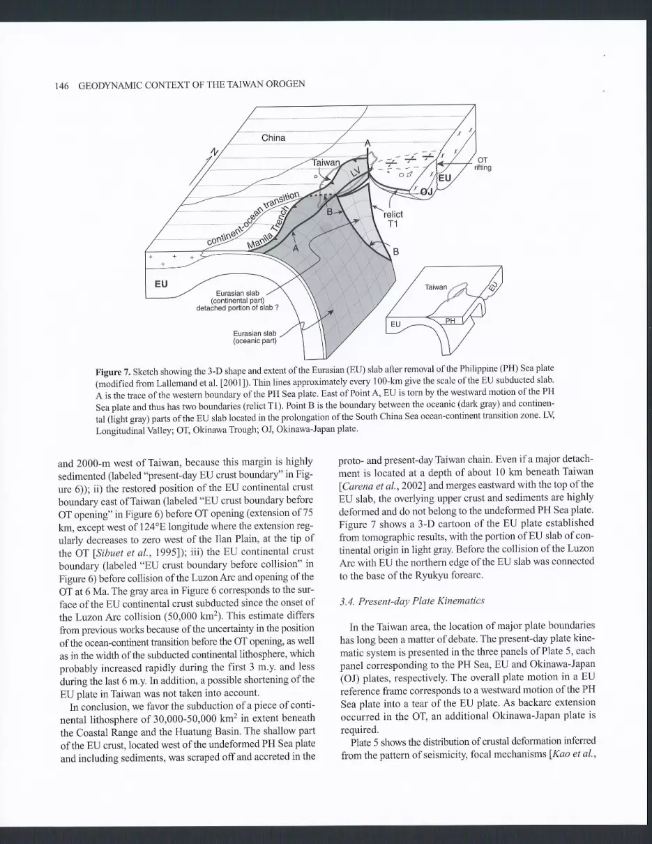
146 GEOD\'NAMIC CONTEXT OF THE TAIWAN OROGEN
Eurasian slab(continental part)
detached portion of slab ?
Eurasian slab(oceanic part)
Figure 7. Sketch showing the 3-D shape and extent of the Eurasian (EU) slab after removal of the Philippine (PH) Sea plate
1m-"oOifieO from Lallemand et al. [2001]). Thin lines approximately every 100-km give the scale of the EU subducted slab.
A is the trace of the western boundary of the PH Sea plate. East of PointA, EU is torn by the westward motion of the PH
Sea plate and thus has two boundaries (relict T1). Point B is the boundary between the oceanic (dark gray) and continen-
tal (light gray) parts ofthe EU slab located in the prolongation ofthe South China Sea ocean-continent transition zone. LY
Longitudinal Valley; OT, Okinawa Trough; Ol Okinawa-Japan plate'
and 2000-m west of Taiwan, because this margin is highly
sedimented (labeled "present-day EU crust boundary" in Fig-
ure 6)); ii) the restored position ofthe EU continental crust
boundary east ofTaiwan (labeled "EU crust boundary before
OT opening" in Figure 6) before OT opening (extension of75
km, except west of 124"8 longitude where the extension reg-
ularly decreases to zero west of the Ilan Plain, at the tip of
the OT [sibuet et a1.,1995)); iii) the EU continental crust
boundary (labeled "EU crust boundary before collision" in
Figure 6) before collision ofthe LuzonArc and opening ofthe
OT at 6 Ma. The gray areain Figure 6 corresponds to the sur-
face ofthe EU continental crust subducted since the onset of
the Luzon Arc collision (50,000 kmz)' This estimate differs
from previous works because of the uncertainty in the position
of the ocean-continent transition before the OT opening, as well
as in the width of the subducted continental lithosphere, which
probably increased rapidly during the first 3 m.y. and less
during the last 6 m.y. In addition, apossible shortening of the
EU plate in Taiwan was not taken into account.
In conclusion. we favor the subduction ofa piece ofconti-
nental lithosphere of 30,000-50,000 km2 in extent beneath
the Coastal Range and the Huatung Basin. The shallow part
of the EU crust, located west of the undeformed PH Sea plate
and including sediments, was scraped off and accreted in the
proto- and present-day Taiwan chain. Even if a major detach-
ment is located at a depth of about 10 km beneath Taiwan
fCarena et al.,2002land merges eastward with the top of the
EU slab, the overlying upper crust and sediments are highly
deformed and do not belong to the undeformed PH Sea plate.
Figure 7 shows a 3-D cartoon of the EU plate established
from tomographic results, with the portion of EU slab of con-
tinental origin in light gray. Before the collision of the Luzon
Arc with EU the northern edge of the EU slab was connected
to the base ofthe Ryukyu forearc.
3.4. Present-day Plate Kinematics
In the Taiwan area, the location of major plate boundaries
has long been a matter of debate. The present-day plate kine-
matic system is presented in the three panels of Plate 5, each
panel corresponding to the PH Sea, EU and Okinawa-Japan(OJ) plates, respectively. The overall plate motion in a EU
reference frame corresponds to a westward motion of the PH
Sea plate into a tear of the EU plate. As backarc extension
occurred in the OT, an additional Okinawa-Japan plate is
required.Plate 5 shows the distribution of crustal deformation inferred
from the pattern of seismicity, focal mechanisms fKao et al',
- 2- -'-

2000; Kao et aL.,1998; Ilu et al.,19971, andthe velocity fieldcalculated from Taiwan GPS stations beforc lYu et al.,l997l andafter the Chi-Chi earthquake (e.g.Yu et al. [2001], and Loeven-bruck et al. [2001]). The development of a tear fault within theEU lithosphere is triggered through time by the western motionof the PH Sea plate with respect ro EU (Plate 5). East of pointA, the edge of the EU plate is torn and thus has two bound-aries (relict T1 in Figure 7). One is the upper plate, trench edgeofthe Ryukyu forearc, the other is the deeply subducted borderof the EU slab, underlying the PH Sea plate. In this schemethe OJ plate is not only increasing in size in the N-S directiondue to the OT opening but also in the westward direction. As thetip of the OT axis is moving westward a portion of the EUplate located west of PointA is progressively incorporated in theOJ plate, becoming part of the Ryukyu Arc and forearc.
The Rlukyu accretionary prism, about 50 km wide, displaysnumerous slope breaks corresponding to the emergence ofthrust ramps and a pronounced thrust front (Figure 5). TheRyukyu accretionary prism cannot be considered as a rigidplate or part of the rigid OJ plate. A major righr-lateral strike-slip fault, localized at the rear of the wedge, accommodates thestrain partitioning caused by the 40" PH/EU oblique conver-gence lLallemand et a1.,1999]. The Ryukyu accretionary wedgeis moving laterally along this transcurrent fault mapped from122"8 to 124"E longitude and located at the toe of the rigidarc and forearc backstop (relict T1 in Plate 5c). Recently pub-lished swath bathymetric data east of T2L.EfMatsumoto et al.,2001] suggest that the transcurrent fault likely extends east-ward to 126"8, merging with the Ryukyu Trench where itchanges direction (Figure 5). We assume that the relict tearfault T1 extends from 722Bto 126"8longitude.
Plate 5 shows synthetic profiles across each of the three maindomains and from the OT to the Manila accretionary prism.The nature and geometry of the EU slab differ on each side ofPoint B: south of Point B, the EU slab is oceanic (plate 5, pro-file 3) and the Manila accretionary prism consists of sedimentsscraped offthe EU plate, but also derived from the erosion ofTaiwan; north of Point B, the EU slab is continental (plate 5, pro-flle 2). Thrust faults in the Western Foothills merge with a l0-km deep flat main detachment beneath Taiwan, which divesdown to 30-60 km depth beneath eastern Taiwan (e.g. Brussetet aI.ll999l, Lallemand et al. [2000] and Carena et al. [2002]).As for the Manila accretionary prism, the material above this flatramp initially belonged to the EU plate (Plate 5, profile 2).TheLongitudinal Valley represents the contact between the EU andPH Sea plates. The deep portion ofthe EU slab located east ofthe Coastal Range is believed to be detached from the rest of theEU continental plate (Figure 7) lCarena et a\.,2002; Lalle-mand et al., 20011. However, it is not clear whether the slab iscompletely detached between relict Fault Tl and point B assuggested by Lallemand et al. [2001] or whether it is partially
SIBUET ET AL. 147
torn. Solving this question has consequences for the type ofmotion within the EU slab, along its former OCT. In Figure 7,we have adopted the model of Lallemand et al. [2001]. As pointB is a significant boundary within the EU slab, the notion thatthe orogen records a continuum from subduction to collision hasto be questioned even if the result is only minor difTerences inthe surface geology.
3.5. Arc-arc Collision: What Is the Fate of the Luzon ArcNorth of the Coastal RangeT
There is a large debate about the prolongation ofthe CoastalRange (emerged portion of Luzon Arc) north of Hualien (Fig-ures 5 and 6). Although some authors fCheng et a1.,1996; Wangand Chiang,1998] suggest that the Luzon Arc is not consideredto exist north ofHualien, others argue that the northern pro-longation of the Coastal Range is subducted beneath Taiwan(e.g. Chemenda et al. 119971).In this paper, we suggest thatthe upper portion ofthe northern Luzon Arc is accreted againstthe Ryukyu forearc while the lower portion subducted with thePH Sea slab.
PH/EU parameters of rotationfSibuet et a\.,2002] show thatthe oblique LuzonArc collision started during the late Miocene(6-9 Ma) near 726oE longitude, where the present-day Ryulq.uTrench changes direction. Since that time, the northward com-ponent of the LuzonArc motion with respect to EU totals about400 km and the colliding point of the Luzon Arc has movedthrough time along the Ryuklu margin from 126"F, to 1 2 I .5.Elongitude. The uplift ofproto-Taiwan is the consequence ofLuzon Arc collision with the Eurasian margin fHsiao et al.,19991. Huang et al.ll992l and Hsiao et al. [1999] have clearlydemonstrated that proto-Taiwan existed between 124"8 longi-tude and Taiwan, beneath the continental shelf and northernOT slope. Therefore, before the OT opening, the eastemmost endof proto-Taiwan (at 124"8) and the initial Luzon Arc collisionpoint with the Ryukyu forearc (at 126"E) were aligned along theN307' direction (Figure 6).
As soon as the Luzon Arc collision point with EU shiftedwestward the eastern part of the proto-Taiwan chain was nomore under compression, was eroded and subsided mostly as aconsequence of the westward propagation of the OT backarcbasin into proto-Taiwan fsibuet et al., 1998]. Note that Teng[1996] and Clift et al. [2003] link the erosion ofrhe proro-Tai-wan to gravitational collapse, not to the westward propagationof the OT. If the LuzonArc collision with EU is quite well under-stood through time, the fate of the 400-km long portion of LuzonArc, which has disappeared since 9-6 Ma and has not been iden-tified north of the Coastal Range remains unclear. Clift et al.[2003] indicate that it must be accreted to the EU margin.
A decoupled-wedge structure has been recently imaged on adeep multichannel seismic profile shot across the Hidaka col-

GEOD\'NAMIC CONTEXT OF THE TAIWAN OROGEN
26
Prôfil€ 4oT { Nanso Relict
+ug::i,i" E> Fgracs$c T1 H,iài
I DU contineDtâl Liilt
; (ê1T) Lv SSE
EU Occânic Crust
EU Oc€anic t,ilh

lision zone, which was created by the convergent motion of theKuril Arc with respect to Central Hokkaido lTsumura et al.,I 9991. The upper half (upper crusr and upper portion of thelower crust, 5.5 to 6.0 km/s) of the Kuril Arc was thrust west-ward over the northeast arc while the lower half (lower portionof the lower crust (6.6 km/s) and the upper mantle) descendedflto et a1.,2000]. The geometry of reflectors is thus consrstentwith the decoupling of the lower crust of the colliding KurilArc during active collision with Japan fTsumura et a1.,1999f.This example of arc-arc collision supports a model of conti-nental growth by arc accretion with decoupling and subduc-tion of the lower crust. Continental material is believed toform by arc magmatism. Howeveq the geochemical compo-sition of the continental crust requires both the loss of lowercrustal cumulates in the mantle and crystal fractionation inthe upper arc crust fDraut et a|.,2002]. Such a geochemicalmodel is in agreement with the Tsumura et al. [19991 modelofarc accretion.
P-wave arrival times obtained from seismic land stationsin Taiwan and in the western Ryulq'o islands were inverted toderive the velocity structure down to 50 km beneath Taiwanand the western Ryolqru subduction zotelHsu,200lj. A220-
Plate 5. (a, b and c): Present-day plate tectonic context and typesof deformation for each of the three philippine Sea, Eurasia andOkinawa-Japan plates lsibuet and Hsu,20041. EU, Eurasia; NLT,Northern Luzon Trough; OC! ocean-continent transition; OJ, Oki-nawa-Japan; PH, Philippine; SLI, Southern Longitudinal Trough.Point A is the western boundary ofthe PH Sea plate and point B isthe OCT zone within the EU slab (in the prolongation of the SouthChina Sea OCT). Relict fault T1 is located beneath the transcurrentfault localized at the rear of the present-day Ryukyu accretionaryprism. Based on the distribution and magnitude of earthquakeslKaoet a1.,20001 and GPS displacements lyu et a\.,19971, areas ofdif-fuse extension exist in northern Taiwan, OT and in the Manila accre-tionary prism. The portion of Taiwan Island west of point A and thenorthern part of the Manila accretionary prism are moderatelydeformed by compressive stress. The northern Luzon, the CoastalRange and the Maniia forearc basins (SLT and NLT) are severelydeformed by compressive stress; the Okinawa Trough, northern Tai-wan (east of Point A) and the southern portion of the Manila accre_tionary prism are under extension fKao et al. , 2000; Teng and Lee,19961. The PH Sea plate is in blue and the philippines islands tonorthern Taiwan accretionary prism is in light blue. The EU plate isin green for its oceanic part and in yellow for its continental part. TheOJ plate is in orange and the Ryukyu accretionary prism in lightorange. (d) Green dashed lines are locations ofthe four syntheticprofiies, which show the nature and boundaries ofEU, pH Sea andOJ plates fSibuet and Hsu,2004]. In green, EU oceanic lithosphere;in yellow, EU continental lithosphere; in blue, pH Sea oceanic lith-osphere, in orange, OJ lithosphere. In light blue, Manila to northernTaiwan accretionary prism; in light orange, Ryukyu accretionaryprism. The scale of profile 4 is half that of the other profiles.
SIBUET ET AL. 149
km long linear feature was shown east ofTaiwan beneath theupper Ryukyu forearc slope and the Nanao Basin (plate 6), butnot further east due to a lack ofdata. This feature is about 50km wide and is located at a depth between 15 and 45 km. Itsthickness of 30 km is similar to that seen in the accreted nor-tion of the Hidaka collision zone fTsumura et al..lgggl.Wirhrespect to the adjacent velocity structure ofthe Ryukyu sub-duction zone, this feature presents a slight high-velocity zonein its upper part (15-20 km) and a low velocity zone in itslower part (30-45 km), as seen in the Hidaka collision zone.
A low-velocity zone (5.5 km/s compared to 7.0 km/s in theadjacent terranes) has been also seen at the same location ona N-S wide angle and refraction profile shot at 122.5"8lon-gilude [Wang et a1.,2002]. The low velocity zone has beenidentified within the upper plate beneath the upper Ryukyuforearc slope and the Nanao Basin. Though this light body isless well located on tomographic results, both tomographicand refraction data suggest the existence of such a bodybeneath the Nanao Basin and upper Ryukyu forearc slope.
An elongated -180 mGals free-air gravity anomaly lowexists in this region lHsu et al.,1998l.Its minimum axis islocated 1O-km north of the Nanao Basin axis and extends to125'E longitude, where it abuts against a 200-km long pos_itive feature located north of the Ryukyu Trench (pIate 2).Forward modeling suggests that the gravity low might beassociated both with the 10-25 km deep low-density body(accreted upper part of the Luzon Arc) and the overlyingNanao forearc Basin, a topographic depression partly filledwith sediments, and located seaward of the accreted upperLuzon Arc and north of the Ryukyu accretionary wedge.Thus, both the Nanao Basin and the underlying low-densitybody are parallel features, which disappear east of 125"Elongitude.
In summary, we propose to apply the lithospheric modelof Tsumura et al. [999] since the beginning of the colli-sion of the Luzon Arc with the Eurasian margin. Brittledeformation occurred in the Luzon Arc until decouplingtook place in the upper lower crust, similar to that seen innofihern Hokkaido llto et a\.,2000; Tsumura et al.,1999f andin the Aleutian islands lKlemperer and Fliedner, 20001. Assoon as the northern portion of the Luzon Arc started to col_lide with EU, the upper pafi of the arc (25-30 km), whichseems to be there less dense than the adjacent continentalcrust lHsu, 2001; Wang et al., 2002), accreted against theRyukyu forearc. The lower part ofthe arc subducted beneathEU together with the underlying pH Sea oceanic crust. TheNanao Basin is thus a partly filled depression created seawardof the accreted upper LuzonArc and north of the Ryukluaccretionary prism.
Profiles 7 and 2 (Plate 5) show the difference in fate of theLuzonArc: accretion ofthe upperparl ofthe Luzonarc against

150 GEOD\'NAMIC CONTEXT OFTHETAIWAN OROGEN
26"N
25'N
24'N
2s'N
22'N
2 1 " N
.,- .É
, A.V. = 7.67 km/s
120"E 121'E 122'E
-0.7 -0.6
A
< ( " i ^ -m ;I - C U
> ^ o
( Û r -m - - b
123"8 124"E 125'E 120"8 121"É 122'E 123'E 124'E 125"E
Vo variation (km/s)
-0.5 -0.4 -0.2 -0.1 0.0 0.1 0.2 0.3 0.4
A'
0.5 0.6
Ryukyu Arc, ru Sea levelNanao tsasln
+24.5 N
. + +24.0 N 23.5 N
a
Y
---o
_ 1 0
.ll
E -"no_o/.\ -40
-50
J
-
o
150 100 50Distance (km)
8.3
7 .8
7 .5
6 .0
5 .5
5 .0
I
8
7
6
4
z
- 1 0
-20
-30
-40
-50
, $Ëlplate 6. p-wave seismic tomography in the Taiwan-Ryukyu region adapted from Hsu [2001] showing the presence of a light
crustal body parallel to the Nanao forearc basin. A.V, averaged velocity for the two top figures' This light body is inter-
preted as the relict ofthe upper portion ofthe Luzon Arc accreted against the Ryulryu forearc.

the Ryukyu forearc (profile 1) and collisional stage of theLuzonarc with EU inTaiwan, and subsequent shortening anduplift of the upper crust and overlying sediments initiallybelonging to the EU plate (profile 2\The Suao Basin (Figure5), an offshore basin located 50 km northeast ofHualien, hasbeen recently tilted and upliftedlFont et aI.,20011. Lately, thedepression created during the tilting of the Suao Basin waspartly filledwith sediments coming from the Lanyanghsi Riverthrough the Ilan Plain, giving rise to the Hoping Basin, lyingunconformably on top of the Suao Basin lFont et a1.,2001]. Wesuggest that the uplift of the basement located beneath thetilted Suao Basin could be the result of the recent collisionand accretion of the northernmost segment of the LuzonArc.
3.6. Geodynamic Context of the Formation of Taiwan
Although the process of formation ofproto-Taiwan is nowquite well understood, the geological time constraints remainpoor. Collision started at 12Ma for Lu and Hsù [1992], 8 Mafor Chang and Chi [983], Huang [984] and Delcaillau etal. [1994], 6. 5 Ma for Huang et aL [1997 1 and Lin and Watts
[2002],6-4Ma for Barrier andAngelier [1986], 5-3 Ma agoforTeng U9961, 4 Ma for Suppe [1984] and even more recentlyfor Malavieille et al. 120021. On the northern OT margin, theyoungest rock strata deformed by thrust faulting are lateMiocene, with the collapse linked to OT opening occurringduring the late Pliocene fHsiao et al.,1999; Teng et a|.,2000f.In the following geodynamic context, collision is assumed tostart at 9 Ma (Figure 8), which seems reasonable in light ofthe6.5 Ma age of emplacement of the foreland basin created bythe Taiwan mountain load lLin and Watts,2002].
In the conceptual geodynamic context discussed below' wemake the following assumptions:o The PIVEU convergent rate in the N307o direction has beenconstant (5.6 cm/yr) since the beginning of collision (9 Ma).o The western PH Sea plate boundary has moved continu-ously westward at a constant 4.5 cm/yr westward velocitywith respect to EU. Simultaneously, the Manila Trench con-tinuously moved with respect to EU, in the direction of thenorthern SCS margin (N250").o The main Taiwan collision occurred between Points A andB. Simultaneously, the EU continental lithosphere subductedeastward between the relict T1 and B. Since 9 Ma, the lengthof subducted EU continental lithosphere (lengh ofthe CoastalRange) has increased from 0 to 150 km.. As soon as the northern portion of the Luzon Arc started tocollide with the Ryulcyu subduction zone,the upper part of theLuzonArc accreted against the Ryukyu forearc and its lowerpart was subducted with the underlying PH Sea plate.. As soon as the OT started to open, its western tip has movedwestward with PointA.
SIBUET ETAL, 151
3.6.L Arc-continent collision at 9 Ma. About l5 Ma. theManila Trench became active, extending northwards to theRyulcyu subduction zone. Since that time, the PH Sea plate,including the Ryukyu slab, the LuzonArc and the PH Sea oceanicdomain simultaneously moved westward with respect to EU.
From 15 to 9 Ma, extension did not occur in the OT. PointB was located at the base of the Ryukyu continental slope,in the southwestern prolongation of the active RyukyuTrench. As soon as the EU subducted slab reached a depthof 100-150 km, the Luzon Arc started to form as an intra-oceanic arc. However, due to its minor initial relief, theLuzon Arc was at first subducted beneath EU as part of thePH Sea plate.
By 9 Ma, the topography of the LuzonArc was sufficient$developed and buoyanl to resist subduction and thus started tocollide with the Eurasian marsin near 126"8lonsitude.
3.6.2. Arc-continent collision at 6 Ma. Because the LuzonArc continuously moved westward along the Chinese mar-gin, the northern part of the akeady formed mountain belt(proto-Taiwan) progressively shifted to the eastern side ofPoint A, becoming an inactive part of the mountain chain.Since 9 Ma, the subduction of EU oceanic lithosphere con-tinued south of Point B, simultaneous with the formation ofthe intra-oceanic Luzon Arc. Simultaneously, the eastwardsubduction of EU continental lithosphere occurred beneaththe LuzonArc between the relict Fault T1 and Point B features.Thrust faults in western Foothills were probably merging witha deep flat ramp beneath Taiwan. The western portion of theRyukyu Arc and forearc stafted to slightly bend northwardas a consequence ofthe subduction ofan increased width ofEurasian continental lithosphere between the divergent relictFault Tl and Point B. At the same time, the northern portionof the LuzonArc was subducted but with its upper part beingaccreted against the Ryukyu forearc.
3.6.3. Arc-continent collision at 3 Ma. The EU continentalsubduction process continued between the relict Fault Tl andPoint B with the length of the Coastal Range increasingbetween. A continental accretionary wedge continued todevelop due to thin-skinned tectonics. Since 6 Ma, the proto-Taiwan chain (northeast of Point A) increased in length butcontinuously subsided due to both erosional and extensionalprocesses in the incipient OT backarc basin, which started toopen at 6MafKimura,1996; Sibuet et al.,19981. The west-ern tip of the OT moved together with Point A. Because bathy-metric data show a V-shape for the western termination of theOT fSibuet et a1.,79981, we assumed that the westward motionofthe PH Sea plate might have occurred at a constant veloc-ity. The bending of the western Ryukyu Trench is now notonly due to the oblique propagation of the tear fault inside

152 GEODYNAMIC CONTEXT OFTHETAIWAN OROGEN
the EU continental domain but also due to the simultaneouswestward propagation and opening of the OT. As Taiwan upliftprogressed, erosion increased, with some of the erosionalproducts being deposited on the continental margin south of
Point B and in the ManilaTrench. These sediments were laterincorporated into the Manila accretionary wedge as a conse-quence of the westward motion of the PH Sea plate withrespect to EU.
South China Ssa Manila
!,.rr';;*;'"{11,,"*.o"r1i"utt'""" i,ti
locrt
.1,/ tuzon-Xr I
which subducts South of BSouth China Manila
podion of Luzon
.+{' @Ér"r=u
5.6 cm/vrHualung
Bâsln
d'@
Eroded
s.uA P'oto;r1tuÎI
--1<-\relicl
C!;jT1
Érr,ru,Ë::ilt s.6 cmtyr
0 300 t(m
Figure 8. Sketch of the geodynamic evolution ofTaiwan. Eurasia @tI) is fixed (adapted fiom Sibuet and Hsu [2004]). PointA is the western boundary of the Philippine (PH) Sea plate. Since 9 Ma, the PH Sea plate has moved in the N307" direc-tion at a constant 5.6 cmlyr velocity. The uplift of proto-Taiwan is controlled by the westward motion of the PH Sea plateconveying the Luzon Arc. The westward displacement of the PH Sea slab with respect to EU triggers the development ofa tear fault inside the EU lithosphere. East ofPointA, EU is torn and has two boundaries (relict faultTl). B is the bound-ary between the oceanic and continental parts ofthe EU slab (in the prolongation ofthe South China Sea ocean-continenttransition (OCT) zone). Thin continuous lines indicate depths of the Ryukyu slab (in km). Since 6 Ma, the beginning ofOkinawa Trough (OT) opening, the OT tip is located above and move along with Point A, explaining the development ofthe southwestern OT within proto-Taiwan and the triangular shape of its western extremity. 1 and 2 are two fixed pointsof the Luzon Arc whose tracks can be followed through time. As soon as a portion of the Luzon Arc enters in the Ryukyusubduction zone, its upper part is accreted against the Ryukyu forearc while the lower part is subducted beneath EU. Vol-canoes of the old Miocene volcanic arc located south of relict fault T1 have subducted simultaneously with the underly-ing EU continental lithosphere. DR deformation front; LV Longitudinal Valley; OJ, Okinawa-Japan plate. PH Sea plate indark gray and Manila to northern Taiwan accretionary prism in light gray.

3.6.4. Present-day configuration. The width of the sub-ducted EU continental lithosphere continued to increasebetween the relict Fault Tl and Point B. The proto-Taiwanchain has been severely eroded, although it may have partlysubsided in response to OT opening. The backarc openingprocess enhanced the subsidence ofthe eastern part ofthemountain chain, leaving only 50 km of the proto-Taiwan chainabove sealevel (present-day portion ofTaiwan located east ofPoint A) (Figure 5). The curvature of the western RyukyuTrench is now more than 90o and the accreted portion of theLuzon Arc present in the Ryukyu forearc runs 400 km alongstrike. The amount of erosional products coming from Tai-wan and deposited on the margin south of Point B and in theManila Trench is such that 60 km of Taiwan was built southof Point B.
3.7. Discussion and Geodvnamic Impliccttions of theProposed Model
The aim of this work was to present a conceptual model ofthe formation ofTaiwan, not a detailed geological model of theemplacement and deformation of uplifted terranes. However,simple implications come from our model.
1) The notion ofcontinuum from subduction to collisionand finally to collapse might be taken with caution. Crustalstrain shows a change from extension to compression in the EUcrust on each side of PointA. However, compression occurs onboth sides of Point B, even if the strain direction slightlychanges at that place. In addition, the Southern LongitudinalTrough (Figure 5) is not the offshore equivalent ofthe Longi-tudinal YaIley lMalavieille et a1.,20021, implying that geo-logical features differ north and south of Point B. On land ifcompression was considered by most field geologists to becontinuous along the whole Central Range to south of theHengchun peninsula, one exception was provided by Lin andChen [1998] who suggested that the geometry of folds andthrusts differs on each side ofa boundary located near 22.7oNlatitude (our Point B). Our model suggests that the accretionaryprism is continuous from the Philippines to northern Taiwan.However, the slight change in strain and geometry of foldsand thrusts across Point B might be linked to the oceanic-to-continental change in nature ofthe underlying EU slab.
2) A second implication of our model concerns the way inwhich the southwestern OT formed. By simply looking at thetriangular shape of the Ilan Plain, it has been already pro-posed that the OT propagated westward lSibuet and Hsu,1998; Wang et al.,19991 but most ofthe authors suggest thatthe southwestern OT results from the OJ/EU rotation arounda pole located near the tip ofthe Ilan Plain fLee et al.,1998;Miki et al.,19901. Miki et al. [1990] tried to avoid too muchextension in the northern OT due to a location of the pole of
SIBUET ETAL. 153
rotation at the tip of the Ilan Plain, by decoupling the openingof the northem and southwestern OT, although no evidence forthis has been advanced. In our model, the tip of the OT isalways located above Point A and moves at a constant veloc-ity with PointA during the formation of the entire OT (6 m.y.).This mechanism provides a simple explanation of the triangularshape of the Ilan Plain and southwestern OT by regular west-ward rifting propagation. In addition, our model explains thecurved shapes of the southwestern RyukyuArc and forearc bytwo factors: the subduction of an increased width of EU con-tinental lithosphere through time and the westward propaga-tion of OT opening. In this fashion the 150-km bending ofthe western extremity of the Ryukyu subduction zone couldbe explained without requiring a pre-existing bayonet shapeof the Eurasian margin, as initially proposed by Pelletier andStéphan [986].
3) V/hat was the fate of the 150-km wide PH Sea oceanicdomain located between the Manila Trench and the LuzonArc? This crust does not exist west of the Coastal Range,although some may have been incorporated into the LichiMélange, a mixture of ophiolitic blocks and Miocene sedi-ments formed about 15 Ma and uplifted during the Pliocene
lJahn, 1986; Suppe et al., I 98 I ] . For some authors, the basaltsof the Lichi Mélange represent near-ridge seamount productswhose origin was within the SCS oceanic crust lChung andSun,1992; Liou et a1.,19771. In contrast we suggest that thePH Sea oceanic crust located between the Manila Trench andthe Luzon Arc was progressively incorporated into the EUplate as a consequence of the N307' PIVEU motion and thensubducted north of Point B, beneath the Coastal Range, alongwith the adjacent EU continental crust. In this scheme, thesubducted portion of this oceanic domain would lie as a stripelocated between the continental and oceanic parts ofthe EUslab. Finally, the Lichi Mélange can be viewed as a peculiar-ity, which corresponds to the accretion against the CoastalRange (Luzon Arc) of a small piece of oceanic crust, whichbelonged to the Taiwan Sea, a former oceanic plate that waslocated between the PH Sea plate and the SCS lSibuet et al.,20021.
4) Our model addresses the issue of why there is noMiocene arc volcanism west l24oE. Because no arc vol-canic rocks have been reported in theYeyaema islands, mostmodels infer that the Ryukyu subduction zone was onlyactive east of 126'E during Miocene and earlier. West ofl26oE, the margin is considered to have been passive (e.g.Lallemand et al. [2001]). In contrast, Sibuet et al: |997;2002] demonstrated that this portion of margin was activebecause, prior to 15 Ma, the Ryukyu subduction zoneextended from Japan to west of Taiwan. Our model recon-ciles these two opposite interpretations, We suggest thatthe portion ofEU continental crust, which subducted east-
154 GEODYNAMIC CONTEXT OFTHETAIWAN OROGEN
ward between the relict Fault T1 and Point B included theportion of Ryukyu Miocene volcanic arc previously formedwest of 126'E (Figure 8).
4. CONCLUSIONS
The main conclusions of this study are as follows;1) Basins of the East and South China Sea continental
shelves are located within four belts, which run parallel tothe Chinese margin. Rifting occurred at the same time withinthe basins belonging to each ofthese four belts, and the beltsbecome younger oceanwards. The four rifting phases occurredduring Paleocene, Eocene, Oligocene to early Miocene andearly middle Miocene to Present. The basins are separated byvolcanic ridges that are the same age as the basins locatedimmediately northwest. We interpret these basins and asso-ciated ridges as backarc basins and portions ofrelict arcslinked to the Ryukyu subduction zone. The Ryukyu subduc-tion zone extended from Japan to southwest Taiwan until theearly middle Miocene (about 15 Ma) where the southeastpor-tion of the subduction zone facing the Tainan Basin and futureTaiwan became inactive. Southwest of the Tainan Basin, thePearl River Basins formed during the rifting of the northernSCS margin.
Subsidence curves show that rifting ceased 17-18 Ma inthe west Taiwan Basins. The new shear wave velocity modelsuggests that the Ryukyu slab extended in the past southwestof Taiwan, beneath the northern China Sea margin. A deepseismic line shot across the northeastern South China Seamargin also suggests that this margin was active in the past.We conclude that about 15-20 Ma, the southwestern extrem-ity of the Ryukyu subduction zone jumped from I l8oE(southwest of the Tainan Basin) to l26E (where the trend ofthe Ryukyu subduction zone changes direction). Since thattime, the southwestern extremity of the Ryukyu subductionzone has moved progressively westwards to its present-daylocation at I22oE.
2) The plate kinematic reconstructions of East Asia sinceabout 15 Ma takes into account the following constraints:spreading in the Taiwan Sea (northern Huatung Basin andoceanic domain beneath the Manila accretionary prism) was2 cmlyr from chron 23 to 20 (51-43 Ma) and I cm/yr fromchron 20 (a3 Ma) to 5b (15 Ma); spreading ceased at the sametime (about 15 Ma) in the Taiwan Sea, SCS, northeasternSCS, Sulu Sea, Japan Sea, and Shikoku and Parece VelaBasins; since about 15 Ma, the mean PH/EU velocity hasbeen 5.6 crrlyr in a N307o direction.
3) Since 9 Ma, the formation ofTaiwan has been controlledby the westward migration of the PH Sea plate into a tear inthe fixed EU plate. The PH Sea plate boundary (Point A),which bounds the Ryukyu subduction zone to the west, cor-
responds to a diftrse crustal boundary feature which limitspresent-day extensional processes east ofPoint A (northern Tai-wan and OT) from compressional processes west of Point A.The westward motion of the PH Sea slab triggered the devel-opment of a tear fault inside the Eurasian continent. East ofPoint A, EU is torn and thus has two boundaries. One is theupper plate, trench edge ofthe Ryukyu forearc; the other is thenorthern boundary ofthe deeply subducted EU slab underly-ing the PH Sea plate. Point B corresponds to the limit betweenthe oceanic and continental portions ofthe EU slab. The intra-oceanic LuzonArc formed south of Point B above the oceanicportion of the subducting Eurasian lithosphere. North of PointB, the Luzon Arc collided with EU, driving the subductionof a continental portion of Eurasian lithosphere. East of PointA, we suggest that the upper part of the Luzon Arc accretedagainst the Ryukyu forearc while its lower part subductedbeneath EU.
4) One ofthe consequences ofsuch a geodynamic contextis that the widely accepted notion of continuum from sub-duction to collision and finally to collapse has to be ques-tioned. The crustal strain changes from extension tocompression across Point A might be linked to the presenceof the underlying PH Sea slab edge. However, only faint shainand tectonic changes occw on each side ofPoint B, the ocean-continent transition of the EU slab. Furthermore, during theformation of the Ol its western tip moved simultaneouslywith PointA. The OT propagated westward in the proto-Tai-wan orogen at the assumed{.S cm/yr westward velociry giv-ing rise to the triangular shape of its southwestem extremity.The bending ofthe southwestern Ryukyu subduction zonemay be due to the combination of two processes: the sub-duction ofa portion ofEurasian continental lithosphere whosewidth increased through time and the westward propagationof the OT backarc basin. Miocene arc volcanic rocks werenever found in the southwestern part of the Ryukyu Arc. Wesuggest that the portion of EU continental lithosphere, whichsubducted south of relictTl, included the portion of MioceneRyukyu volcanic arc previously formed west of 126'E lon-gitude.
Acknowledgmen rs. This work was carried out within the frame ofthe Sino-French cooperation in Geosciences. We thank the InstitutFrançais à Taipei (IFT) and the National Science Council G.ISC) ofTaiwan for their financial contribution and constant support duringthis cooperation. The GMT software package was used to displaysome of the figures lWessel and Smith, l99l]. Many ideas wereimproved during stimulating discussions with Benoît Deffontaines,Anne Deschamps,Yvonne Font, Robert Hall, Serge Lallemand, GregMoore, Xavier Le Pichon, Andrew Lin, Char-Shine Liu, JacquesMalavieille, Louis Teng and Sean Willett. We want to particularlyacknowledge Peter Clift and Jonathan Lewis forproviding very valu-able reviews.
REFERENCES
Barrier, 8., and J. Angelier, Active collision in eastern Taiwan: theCoastal Range, Tectonophysics, 1 2 5, 39-7 2, 1986.
Bijwaard, H., W. Spakman, and E.R. Engdahl, Closing the gapbetween regional and g1obal travel time topography, J. Geophys.Res., t 03, 30055-30078, 1998.
Briais,4., P. Patriat, and P Tapponnier, Updated interpretation ofmagnetic anomalies and seafloor spreading stages in South ChinaSea: implications for the Tertiary tectonics of Southeast Asia, IGeophys. Res., 98, 6299-6328, 1993.
Brusset, S., P Souquet, J. Déramond J.-C. Sibuet, S.-K. Hsu, B. Def-fontaines, and H.-T. Chu, Partition between collision and sub-duction accretionary prisms along an inherited transcwrent faultzone: New insights on the Taiwan fold and thrust belt, Tectono-physics, I 8, 546-558, 1999.
Cande, S. C., and D. V Kent, Revised calibration of the geomag-netic polarity timescale for the Late Cretaceous and Cenozoic, J.Geophys. Res., I 00, 6093-6095, 1995.
Cara, M., and J. J. Lévêque, Waveform inversion using secondaryobservables, Geophys. Res. Lett., 1 4, 1046-1049, 1987 .
Carena, S., J. Suppe, and H. Kao, Active detachment ofTaiwan illu-minated by small earthquakes and its conhol of first-oder topog-raphy, Geo logt, 3 0, 93 5*938, 2002.
Chang, S.-L., and W. R. Chi, Neogene nanoplankton biostratigra-phy in Taiwan and the tectonic implications, Pen Geol. Taiwan, 19,93-t47,1983.
Chemenda, A. I., R. K. Yang, C.-H. Hsieh, and A. L. Groholsky,Evolutionary model for the Taiwan collision based on physicalmodelling, Tectonophysics, 2 7 4, 253-27 4, 1997 .
Chen, A. T., andY.-S. Jaw, Velocity sûucture near the northern Manilatrench: an OB S refraction suwey, TAO, 7, 27 7 -297, 199 6.
Chen, K.-J., and Y.-H. Yeh, Gravity and microearthquakes studiesin the Chinchan-Tanshui area, northern Taiwan, TAO, 2,35-50,t99t.
Chen, P.-Y., H.-S. Chang, and T.-Y. Chuang, Alcalic and tholeiiticbasalts from the Penghu islands, Geological conference in mem-ory of Pr T. P Yen, University of Chungli, Taiwan, 24-25 May1996.241245. 1996.
Chen, P. Y., Basaltic-andesite volcanic rocks from the areas ofChang-shihchiao and Hsiangyang, southern eastern highway, Taiwan,Spec. Publ. Centr. Geol. Suw., 5, 127-159,1991.
Cheng, W.-8., C. Wang, and C.-T. Shyu, Crustal structure of thenortheastern Taiwan area from seismic refraction data and its tec-tonic implicati ons, TAO, 7, 467 48'7, 1996.
Cheng, W-B., C. Wang, C.-T. Shyu, and T.-C. Shin, Crustal structureofthe convergent plate boundary zone, eastern Taiwan, assessed byseismic tomography, Geol. Soc. Am. Special paper,358169,2002.
Chi, W-R., Basin characterizatron, tectonic evolution and hydro-carbon potential of the offshore and onshore Taiwan sedimentaybasins, Exploration and research reports, S2-1I4 (in Chinesewith English abstract), 1996.
Chow, J., H.-M. Chen, T.-Y. Chang, C.-L. Kuo, and S.-F. Tsai, Pre-liminary study on hydrocarbon plays around Nanjihtao basin, Tai-wan Strait, Petr Geol. Taiwan, 26,45-56, 1991.
SIBUET ETAL. 155
Chung, S.-L., and S.-S. Sun, A new genetic model for the east Tai-wan ophiolite and its implications for Dupal domains in the north-ern hemisphere, Earth Planet. Sci. Lett., 109,133-145,1992.
Clift, P., and J. Lin, Preferential mantle lithospheric extension underthe South China margin, Mar Petrol. Geol., 18,929-945,2001.
Clift, P. D., H. Schouten, andA. E. Draut,Ageneralmodel of arc-con-tinent collision and subduction polarity reversal from Taiwan andthe Irish Caledonides, tn Intra-oceanic subduction systems: tectonicand magmatic processes, edited by R. D. Larter, and P. T. Leat,pp. 81-98, Geol. Soc. London, Special Publications, 2003.
Davis, D., J. Suppe, and F.A. Dahlen, Mechanics of fold-and-thrustbelts and accretionary wedge, I Geophys. Res.,88, 1153-1172,1983.
Debayle, E., SV-waves azimuthal anisotropy in the Australian uppermantle: preliminary results from automated Rayleigh waveforminversion, Geophys. J. Int., I j 7, 7 47 -7 5 4, 1999.
Debayle, E., J. J. Lévêque, K. Priestley, and Cara M., Global uppermantle shear velocity from fundamental and higher mode Rayleighwaves, EUG Assembly, 6-1 I April. 2003, Nice, abstract,2004.
Debayle, E., and M. Sambridge, Inversion of massive swface wavedata sets: Model construction and resolution assessment, J. Geo-phys. Res., I 0 9 (82), 23 1 6, doi: I 0. I 029 I 2003J8002652, 2004.
Deffontaines,8., C.-S. Liu, J. Angelier, C.-T. Lee, J.-C. Sibuet,Y.-8.Tsaï, S. Lallemand, C.-Y. Lu, C.-S. Lee, S.-K. Hsu, H.-T. Chu,J.-C. Lee, E. Pathier, R.F. Chen, C.T. Cheng, C.W. Liao, andH.-H.Hsu, Preliminary neotectonic map of onshore-offshore Taiwan,TAO, Supplementary Issue, 339149, 2001.
Delcaillau, B., J. Déramond, P. Souquet, J. Angelier, H.-T. Chu, J.-C.Lee, T.-Q. Lee, P.-M. Liew, and T.-S. Lin, Enregistrement tectono-sédimentaire de deux collisions dans I'avant-pays nord-occiden-tal de la chaîne de Taiwan, C. R. Acad. Sci. Paris, 3 18,985-991,1994.
Deschamps,A., P Monié, S. E. Lallemand, S.-K. Hsu, andK. Y. Yeh,Evidence for early Cretaceous oceanic crust trapped in the Philip-pine Seaplate, Earth Planet. Sci. Lett., 179,503-516,2000.
Draut,A. E., P. D. Clift, R. E. Hannigan, G. Layne, andN. Shimizu,A model for continental crust genesis by arc accretion: rare earthelement evidence from the Irish Caledonides, Earth Planet. Sci.Lett., 203, 861*877 ,2002.
Font, Y., S. Lallemand" and J. Angelier, Etude de la transition entreI'orogène actifde Taiwan et la subduction des Ryukyu - Apport dela sismicité, Bull. Soc. géol. France, 170,271-283,1999.
Font, Y., C.-S. Liu, P. Schnurle, and S. Lallemand Constraints onbackstop geometry ofthe southwest Ryukyu subduction basedon reflection seismic data, Tectonophysics, 3j3,135-158, 2001.
Geological Survey of Japan and Committee for Co-ordination ofJoint Prospecting for Mineral Resources in Asian Offshore Areas(GSJ and CCOP), MagneticAnomaly Map of EastAsia, Miscel-laneous Map Series 32, 1994.
Hall, R., Reconstructing Cenozoic SEAsia, inTëctonic evolution ofSoutheast Asia, edited by R. Hall, and D. Blundell, pp. 153-184,Geol. Soc. London Special publication, 1996.
Hall, R., Cenozoic geological and plate tectonic evolution of SEAsia and the SW Pacific: computer-based reconstructions, mod-e1s and animations, J. Asian Earth Sci., 2 0, 353431, 2002.

156 GEODYNAMIC CONTEXT OFTHETAIWAN OROGEN
Hall, R., M. Fuller, J. R. Ali, and C. D. Anderson, The PhilippineSea plate: magnetism and reconstructions, in Active margins andmarginal basins of the western Pacific, edited by B. Taylor, andJ. Natland, pp.371404, Geophysical Monograph 88, AmericanGeophysical Union, Washington, D.C., 1995.
Hayes, D. E., S. S. Nissen, P. Buhl, J. Diebold,Y. Bochu, Z. Weijun,and C. Yongqin, Trough-going crustal faults along the northernmargin of the South China Sea and their role in crustal extension,J. Geophys. Res., 100,22,435-22,446, 1995.
Ho, C. S., An introduction to the geology of Taiwan: Explanatorytext of the geologic map of Taiwan, 192pp., 1984.
Holloway, N. H., North Palawan block, Philippines-its relation toAsian mainland and role in evolution of South ChinaSea,AAPGBull . , 66, 1355-1383, 1982.
Hsiao, L.-Y., K.-4. Lin, S.T. Huang, and L.S. Teng, Structural char-acteristics ofthe southern Tâiwan-Sinzi folded zone, Petr Geol. Tai-wan, 32,133-153,1999.
Hsiao, P. T., C. C. Hu, K.A. Lin, S. H. Hsu, S. C. Fuh, T. Y. Chang,T. H. Hsiuan, H. C. Sheen, C. L. Kuo, and C. J. Lee, Hydrother-mal potential of the Penghu Bastn, Petr Geol. Taiwan,26,215-230,1 9 9 1 .
Hsu, S.-K., Subductior/collision complexities in the Taiwan-Ryukyujunction area: Tectonics ofthe northwestern corner ofthe Philip-pine Sea plate , TAO, Supplementary issue, 209-230, 2001.
Hsu, S.-K., C.-S. Liu, C.-T. Shyu, S.-Y. Liu, J.-C. Sibuet, S. Lalle-mand, C. Wang, and D. Reed, New gravity and magnetic anomalymaps in the Taiwan-Luzon region and their preliminary interpre-tation, TAO, 9, 509-532, 1998.
Hsu, S.-K., and J.-C. Sibuet, Is Taiwan the result of arc-continent orarc-arc collision?, Earth Planet. Sci. Lett., I 36, 315-324, 1995.
Hsu, S.-K., J.-C. Sibuet, and T.-C. Shyu, Magnetic inversion of theEast China Sea and Okinawa Trough: tectonic implications,Tectonophysics, 3 3 3, 7 | l-122, 2001.
Hsu, S. K., Magnetic lineations in the South China Sea, Mar. Geo-phys. Res.,2004, in press.
Hsu, T.-L., and H.-C. Chang, Quaternary faulting inTaiwan, Geol.Soc. China, 3, 155-165, 1979.
Huang, C.-Y., Some planktic foraminifera from the olistostromes ofthe Kenting formation, Acta Geologica Taiwanica, 22,22-34,1984.
Huang, C.-Y., W.-Y. Wu, C.-P. Chang, S. Tsao, PB. Yuan, C.-W. Lin,and X. Kuan-Yuan, Tectonic evolution of the accretionary prismin the arc continent-collision terrane ofTaiwan, Tëctonophysics,281"31-51, t997.
Huang, S.-T., R.-C. Chen, and W-R. Chi, Inversion Tectonics and evo-lution of the northern Taishi basin, Taiwan, Petr Geol. Taiwan,28 ,1546,1993.
Huang, S.-T., H.-H. Ting, R.-C. Chen, W-R. Chi, C.-C. Hu, andH.-C. Shen, Basinal framework and tectonic evolution of offshorenorthern Taiwan, Petr Geol. Taiwan, 27,4712, 1992.
Ito, T., K. Arita, T. Moriya, G. Kimura, N. Tsumwa, T. Ikawa, andT. Kawanake, Delamination wedge subduction system in an arc-arc collision zorLe as a factory ofcontinental crust: an excellentexample in the Hidaka collision zone, Hokkaido, Japan, Eos Trans.AGU,8I, WP123, 2000.
Jahn, B. M., Mid-ocean ridge or marginal basin origin of the eastTaiwan ophiolite: chemical and isotopic evidence, Contrib, Min-eral. Petrol., 9 2, 194-206, 1986.
Juang, W 5., Geochronology and chemical variations oflate Ceno-zoic volcanic rocks in Taiwan,23l pp., National Taiwan Univer-sity, Taiwan, 1988.
Kao, H., G.-C. Huang, and C.-S. Liu, Transition {iom oblique sub-duction to collision in the northem Luzon arc-Taiwan region: con-straints from bathymetry and seismic observations, J. Geophys.Res., I 0 5, 3059-307 9, 2000.
Kao, H., S. J. Shen, and K.-F. Ma, Transition from oblique subduc-tion to collision: earthquakes in the southernmost Ryukyu arc-Taiwan region, I Geophys. Res., I 0 3, 7 21 l-7 229, 1998.
Kimura, M., Active rift system in the Okinawa Trough and its north-ern continuation, Bull. Disaster Prevention Res. Inst., Kyoto Uni-versity, 45, 27-38, 1996
Klemperer, S. L., and M. M. Fliedner, Seismic velocity structure ofcontinental and oceanic arcs. What does it take to make conti-nents., Eos Trans. AGU,8/, WPl23, 2000.
Kuo, B.-Y., A. Li, D. Forsyth, H. Kao, H.-H. Pan, and C.-R. Chen,Lithospheric structure beneath Taiwan: array analysis ofRayleighw aves, Europ e an Ge op hys. So c. 2 0 0 3, Ge op hy s. Re s. Ab s tract s, 5,5405,2003.
Lallemand, S., Was lhe 1999 Chi-Chi earthquake in Taiwan a "sub-duction earthquake", TAO, I l, 7 09-7 20, 2000.
Lallemand, S.,Y. Font, H. Bijwaard, and H. Kao, New insights on 3-Dplates interaction near Taiwan from tomography and tectonicimplications, Tectonophysics, 3 3 5 , 229253 , 2001 .
Lallemand, S., C.-S. Liu, S. Domingæz,P. Schniirle, J. Malavieille,and the ACT scientific crew, Trench-parallel stretching and fold-ing of forearc basins and lateral migration of the accretionnarywedge in the southern Ryukyus: a cause ofstrain partition causedby oblique convergence, Tectonics, I 8,231-247 , 1999.
Lee, C.-T., andY. Wang, Paleostress due to the Pliocene-Quaternaryarc-continent collision in Taiwan , Geol. Soc. China, 9, 63-86, 1987 .
Lee, C.-T., andY. Wang, Quaternar:y stress changes in northemTaiwanandtheirtectonic significance, Geol. Soc. China,jI, 154-168, 1988.
Lee, T.-Y., C.-S. Chiang, F. Kong, S.-L. Chung, and C.-H. Lo, Kine-matics for the opening of the southernmost part of the OkinawaTrough (SPOT), Eos Trans. AGU,79,W109,1998.
Lee, T.-Y., C.-H. Tang, J.-S. Ting, andY.-Y. Hsu, Sequence stratig-raphy ofthe Tainan basin, offshore southwestern Taiwan, Petr.Geol. Taiwan, 28,119-158, 1993.
Letouzey, J., and M. Kimura, The Okinawa Trough: Genesis of aback-arc basin developing along a continental margin, Tectono-physics, I 2 5, 209130, 1986.
Letouzey, J., L. Sage, and C. Mùller, Geological and structural mapof Eastern Asia : Introductory notes, 52 pp., AAPG Bull., Specialpublication, 1988.
Lin, A. T., andA. B. Watts, Origin of the west Taiwan basin by oro-genic loading and flexure of a rifted continental margin, J. Geo-phys. Res., I 07 (ETG2-I-2-19), 2002.
Lin, A. T., A. B. Watts, and S. P. Hesselbo, Cenozoic stratigraphyand subsidence history of the South China Sea margin in the Tai-wan region, Basin Res., 15,453478,2003.
Lin, C. W, and C. H. Chen, Geological structures of the acoetionarywedge: an example from the southern central mountain range,Eos Trans. AGU, 79,W120,7998.
Liou, J.-G., C.-Y. Lan, J. Suppe, and W G. Ernst, The eastern Taiwanophiolite, its occurrence, petrology, metamorphism, and tectonicseltrng, Mining Research and Seryice Organization, Special report,I , t -212,1977.
Liu, C.-S., I.L. Huang, and L. S. Teng, Structural features offsouth-western Taiwan, Marine Geology, I 3 7, 305-3 19, 1997 .
Lo, C.-H., T. Onstott, C.-H. Chen, and T. Lee, An assessment of40Arl39{r dating for the whole-rock volcanic samples from theLuzon arc near Taiwan, Chem. Geol., I I 4, 1 57 -17 8, 1994.
Loevenbruck, A., R. Cattin, X. Le Pichon, M.-L. Courty, and S.-B.Yu, Seismic cycle in Tatwan derived from GPS measurements,C. R. Acad. Sci. Paris, 333,57-64,2001.
Lu, C.-Y., and K.J. Hsù, Tectonic evolution of the Taiwan mountainbell, Petr. Geol. Taiwan, 27,2146, 1992.
Lu, C.-Y., J.C. Lee, and J. F. Lee, Extensional and compressionaltectonics in central Taiwan, in Neotectonics and Resources, editedby J. Cosgrove, and M. Jones, pp. 85-92, Belhaven Press, LondonandNewYork, 1991.
Malavieille, J., S. Lallemand, S. Dominguez,A. Deschamps, C.-Y Lu,C.-S. Liu, P Schniirle, andACT scientific crew, Geology ofthe arc-continent collision in Taiwan: marine observations and geody-namic model, Geol. Soc. Am. Special issue,358,187-211,2002.
Maleterre, P., Histoire sédimentaire, magmatique, tectonique et métal-logénique d'un arc cénozoïque déformé en régime de transpres-sion: cordillère centrale de Luzon, Thesis, Université de BretagneOccidentale, Brest, France, 313 p, 1989.
Matsumoto, T., M. Kimura, M. Nakamura, and T. Ono, Large-scaleslope failure and active erosion occurring in the southwest Ryukyufore-arc arca, Nat. Hazards Earth System Sci., 1,203-211,2001.
Maury, R. C., M. J. Defant, H. Bellon, D. Jacques, J.-L. Joron,F. McDermott, and P Vidal, Temporal geochemical trends in north-ern Luzon arc lavas (Philippines): implications on metasomaticprocesses in the island arc mantle, Bull. Soc. géol. France, 169,69-80, 1998.
Miki, M., T. Matsuda, andY. Otofuji, Opening mode of the Oki-nawa trough: paleomagnetic evidence from the South Ryukyu arc,Tectonophysics, 17 5,335147 , 1990.
Nissen, S. S., D. E. Hayes, P Buhl, J. Diebold,Y. Bochu,Z. Weijun,and C. Yongqin, Deep penetrationseismic soundings across thenorthern margin ofthe South China Sea,J. Geophys. Res., 100,22,407-22,433, 1995 .
Pelletieg B., and J.-F. Stéphan, Middle Miocene obduction and lateMiocene beginning of collision registered in the Hengchun penin-sula: geodl.namic implications for the evolution of Taiwan, Tëctono-physics, I 2 5, 133-160, 1986.
Rangin, C., W. Spakman, M. Pubellier, and H. Bijwaard, Tomo-graphic and geological constraints on subduction along the east-ern Sundaland continental margin (South-East Asia), Bull. Soc.gëol. France, I 7 0, 7 55-7 88, 1999.
Richard" M., H. Bellon, R. C. Maury, E. Barrier, and W.-S. Juang,Miocene to Recent calc-alkalic volcanism in eastern Taiwan:K-Ar ages and petrography, Tectonophysics, I 2 5, 87 -102, 1986.
SIBUET ETAL. 157
Ru, K., The development of superimposed basins on the northernmargin of the south China Sea and its tectonic significance, Oil GasGeoL.,9,22_31 (in Chinese with English abstract), 1988.
Ru, K., and J. D. Pigott, Episodic rifting and subsidence in the SouthChina Sea, AAPG Bull., 7 0, 1 l3Çl 1 55, 1986.
Sandwell, D. T., and W. H. F. Smith, New global marine gravitymaplgrid based on stacked ERSI, Geosat and Topex altimetry,Eos Trans. 4GU, 7 5, 321, 1994.
Seno, T., and S. Maruyama, Paleogeographic reconstruction and ori-gin of the Philippine Sea, Tectonophysics, I 02, 53-54, 1984.
Sibuet, J.-C., B. Deffontaines, S.-K. Hsu, N. Thareau, J.-P Le Formal,and C.-S. Liu, The southwesûem Okinawa Trough backarc basin: tec-tonics and volcanism, -{ Geophys. Res., 103,30245-30267,1998.
Sibuet, J.-C., and S.-K. Hsu, Geodynamics of the Taiwan arc-arccollision, Tëctonophysics, 2 7 4, 221-251, 1997 .
Sibuet, J.-C., and S.-K. Hsu, Tectonic evolution of the OkinawaTrough backarc basin, Eos Trans, AGU,79,108,1998.
Sibuet, J.-C., and S.-K. Hsu, How was Taiwan created?, Tectono-phys ics, 3 7 9, 1 59-181, 2004.
Sibuet, J.-C., S.-K. Hsu, X. Le Pichon, J.-P. Le Formal, D. ReedG. Moore, and C.-S. Liu, EastAsia plaûe tectonics since 15 Ma: con-shaints from the Taiwan region, Tëctonophysics, 344, 103-134,2002.
Sibuet, J.-C., S.-K. Hsu, C.-T. Shyu, and C.-S. Liu, Structural andkinematic evolution of the Okinawa trough backarc basin, inBaclrarc Basins: Tëctonics and Magmatism,editedby B. Taylor, pp.343178, Plenum Press, NewYork, 1995.
Sibuet, J.-C., J. Letouzey, F. Barbier, J. Charvet, J.-P. Foucher, T.WC.Hilde, M. Kimura, L.-Y. Chiao, B. Marsset, C. Muller, and J.-F.Stéphan, Backarc extension in the Okinawa Trough, J. Geophys.Res., 9 2, 14041-14063, 1987 .
Sun, S. C., The Tertiary basins of off-shore Taiwan, in Proc. 2ndASCOPE Conf., pp. 125-135, Manila, 198 1.
Sun, S. C., The Cenozoic tectonic evolution of offshore Taiwan,Energy, I 0, 421432, 1985.
Suppe, J., A retrodeformable cross section ofnorthern Taiwan, Geol.Soc. China, 23, 46-55, 1980.
Suppe, J., Mechanics of mountain building and metamorphism inTaiwan, Geol. Soc. China,4,67-89, 1981.
Suppe, J., Kinematics of arc-continent collision, flipping of sub-duction, and back-arc spreading near Taiwan, Geol. Soc. China, 6,2 l -34,1984.
Suppe, J., J. G. Liou, andVl G. Ernst, Paleogeographic origin of theMiocene east Taiwan ophi,olite, Am. J. Sci., 2 8 1, 228-246, 1981.
Tajima, F., Y. Fukao, T. Sakurai, and F. Niu, Characteristics of theupper mantle transition zone structure in the northwestern Pacificand a comparison with ISC P-wave tomographic images, -EosTrans. AGU, 7 8, 456, 1997 .
Teng, L. S., Late Cenozoic arc-continent collision in Taiwan , Tectono-physics, I 83, 57-7 6, 1990.
Teng, L. S., Geotectonic evolution of Tertiary continental marginbasins of Taiwan, Petr. Geol. Taiwan,27,l-19,1992.
Teng, L. S., Extensional collapse of the northern Taiwan mountainbelt, Geology, 2 4, 949-9 52, 199 6.
Teng, L. S., and C.-T. Lee, Geodynamic appraisal of seismogenicfaults in northeast Taiwan, Geol. Soc. China, 39,125-142,1996.

158 GEODYNAMIC CONTEXT OFTHETAIWAN OROGEN
Teng, L. S., C.-T. Lee, Y.-8. Tsai, and L.-Y. Hsiao, Slab breakoffasa mechanism for flipping of subduction polaity inTaiwag Geol-ogy, 28,155-158, 2000.
Teng, L. S., and A. T. Lin, Cenozoic tectonics of the Southeast Chinacontinental margin: insights from Taiwan, Geol. Soc. London,Special issue,2004, in press.
Teng, L. S.,Y. Wang, C. H. Tang, T. C. Huang, M. S.Yu, andA. Ke,Tectonic aspects ofthe Paleogene deposition basin ofnorthernTaiwan, Geol. Soc. China,34,313136, 1991.
ZWang, C., M.-L.Young, C.-P. Chou, and C.-S. Lee, Tectonic struc-ture at the western end of Ryukyu subduction zone for westwardextension of OkinawaTrough,Active subduction and collision insoutheastAsia: data andmodels. Int. conf. and 4th France-Taiwansymp., Montpellier, 10-12 May 1999. Mémoires GéosciencesMontpellier, Institut des Sciences de laTerre, 14,137*138,1999.
Wang, T. K., and C.-H. Chiang, Imaging of arc-arc collision in theRyukyu forearc region offshore Hualien from TAICRUST OBS line16, TAO, 9, 329144, 1998.
Wang, T. K., K. Mctntosh, Y. Nakamura, C.-S. Liu, and H.-W. Chen,Velocity-interface structure of the southwestern Ryukyu subduc-tion zone from EW9509-l OBS^{CS data, Mar Geophys. Res.,22.265-287.2002.
Wessel, P., andWi M. F. Smith, Free software helps map and displaydata, Eos Trans. AGU, 72,441446, 1991.
Wolfe, J. A., Philippine geochronology, J. Geol. Soc. Philippines,35, l -30,1981.
Wu, F. T., R.-J. Rau, and D. Salzberg, Taiwan orogeny: thin-skinnedor lithospheric collision?, Tectonophysics, 2 7 4, l9l-220, 1997 .
Yang, K.-M., H.-H. Ting, and J. Yuan, Structural styles and tectonic
modes of Neogene extensional tectonics in southwesternTaiwan:Implications for hydrocarbon exploration, Petr Geol. Taiwan,26,l -31, 1991.
Yang, T. F., T. Lee, C.-H. Chen, S.-N. Cheng, U. Knittel, R. S. Punong-bayan, andA.R. Rasdas,A double island arc betweenTaiwan andLuzon: consequence of ridge subduction, Tectonophysics, 2 5 8,85-101. 1996.
Yu, H.-S., Structure, stratigraphy and basin subsidence ofTertiarybasins along the Chinese southeastern continental margin, Tectono-physics, 2 3 5, 631 6, 7994.
Yu, S.-8., H. Y. Chen, and L.-C. Kuo, Velocity field of GPS stationsin the Taiwan area, Tectonophysics, 274, 4l-59, 1997 .
Yu, S.8., L.-C. Kuo,Y.-J. Hsu, H.-H. Su, C.-C. Liu, C.-S. Hou, J.-F.Lee, T.-C. Lai, C.-C. Liu, C.-L. Liu, T.-F. Tseng, C.-S. Tsai, andT.-C. Shin, Preseismic deformation and coseismic displacementsassociated with the 1999 Chi-Chi, Taiwan earthqtake, Bull. Seism.Soc. Am., 9 l, 995-1012, 2001.
Zhao,L.,The condition of formation of oil (gas) field and oil (gas)accumulation in Zhujiangkou basin, Petr. Explor Develop., 15,1-9 (in Chinese with English abstract), 1988.
Eric Debayle, Institut de Physique du Globe de Strasbourg, Ecoleet Observatoire des Sciences de la Terre, CNRS and Université LouisPasteur, 5 rue René Descartes, 67084 Strasbourg Cedex, France.(eric. [email protected])
Shu-Kun Hsu, Institute of Geophysics, National Central Univer-sity, Chung-Li, Taiwan 32054. ([email protected])
Jean-Claude Sibuet, Ifremer Centre de Brest, B.P. 70,29280Plouzané Cedex, France. ([email protected])