focusing seismic energy along faults through time-variable rupture modes: wenchuan earthquake, china
TRANSCRIPT
Journal of Earth Science, Vol. 21, No. 6, p. 910–922, December 2010 ISSN 1674-487X Printed in China DOI: 10.1007/s12583-010-0144-7
Focusing Seismic Energy along Faults through Time-Variable Rupture Modes: Wenchuan
Earthquake, China
Timothy M Kusky* Three Gorges Research Center for Geo-hazard, Ministry of Education and State Key Laboratory of Geological
Processes and Mineral Resources, China University of Geosciences, Wuhan 430074, China Abduwasit Ghulam
Center for Environmental Sciences, Saint Louis University, St. Louis MO, USA Wang Lu (王璐)
Three Gorges Research Center for Geo-hazard, Ministry of Education, China University of Geosciences, Wuhan 430074, China; Department of Marine Geology, Ocean University of China, Qingdao 266100, China
Liu Jianguo (刘建国) Department of Earth Science and Engineering, Imperial College, London, UK
Li Zhongquan (李中全), Chen Xiao (陈骁) Department of Geosciences, Chengdu University of Technology, Chengdu 610059, China
ABSTRACT: Field analysis and differential interferometry derived from Synthetic Aperture Radar
(PALSAR) of the epicentral area of the May 12 2008 Mw 8.0 Wenchuan (汶川) earthquake zone reveal
details about fault ruptures and ground displacements, with field-documented vertical offsets reaching
12 m along the trace of the main fault rupture, and PALSAR-measured horizontal displacements
reaching 12.3 m. We document slip indicators on the fault scarp that show initially sub-horizontal then
progressively steeper slip increments with time along the same fault during the 2 min earthquake, sug-
gesting that the rupture propagated as a mixed Mode II–III fracture, with strike-slip movement at the
tip directing energy from the initial rupture to points north of the epicenter, followed by vertical dis-
placement in the interior of the slipped region. Field, seismic, and PALSAR-measured displacements
are dominantly thrust near the epicentral region, and dextral in northeasterly areas, showing that slip
This study was supported by NASA to Abduwasit Ghulam and
Timothy M Kusky (No. 08-182), the National Natural Science
Foundation of China (No. 40821061), and Ministry of Educa-
tion of China (No. B07039).
*Corresponding author: [email protected]
© China University of Geosciences and Springer-Verlag Berlin
Heidelberg 2010
Manuscript received July 15, 2010.
Manuscript accepted September 20, 2010.
was partitioned along the fault in space and time
during the earthquake. The changing slip direc-
tions may correlate with three main pulses of
energy release at 0, 23, and 57 s during the
earthquake as recorded by seismograms. The
earthquake generated massive landslides >100
km north of the epicenter along the trace of the
fault. These massive sturzstroms formed where
entire mountainsides collapsed and moved at
high velocity down populated mountain valleys,
jumping smaller mountains and ricocheting off
steep canyon walls. These avalanches rode on
Focusing Seismic Energy along Faults through Time-Variable Rupture Modes: Wenchuan Earthquake, China
911
cushions of water and compressed air that generated air blasts from beneath the debris, knocking down
trees high on opposing mountain slopes. The concentration of massive landslides and ground deforma-
tion so far north of the epicenter was related to the Mode II–III fracture propagation focusing seismic
energy along the fault towards the north, explaining why so much devastation occurred >100 km from
the epicenter, such as in the destroyed city of Beichuan (北川). Understanding near-surface earthquake
processes and geological hazards associated with massive earthquakes in populated mountainous areas
has the potential to save many lives in the future.
KEY WORDS: China, Wenchuan earthquake, Longmenshan, neotectonics, PALSAR.
INTRODUCTION Giant earthquakes may cause significant disrup-
tion of the ground surface but many key features such as slip indicators on surface ruptures, indications of surface tilting, and evidence about the rupture initia-tion, velocity, and relative displacements of the ground surface are quickly eroded by surface proc-esses. The Wenchuan Mw 8.0 (Mw=seismic moment, whereas the ML or Richter magnitude was 7.9) earth-quake of May 12 2008 occurred in a moderately populated rugged mountainous area of Sichuan Prov-ince, China and has an official death toll of 87 652 (12th deadliest in recorded history (Kusky, 2008a; USGS, 2008)). The main shock was followed by more than ten thousand aftershocks with 30 greater than Mw 5.0 along the Longmenshan fault zone extending NE for ~300 km from the epicentral Yingxiu Town toward the border of Sichuan, Shaanxi and Gansu provinces (Fig. 1a). The major quake lasted for 2 min, signifi-cantly longer than typical earthquakes, and some of the damage was extraordinarily intense in locations far from the epicenter. Analysis of seismograms (Xu Y et al., 2009; USGS, 2008) shows that most energy was released in three distinct pulses at 0, 23, and 57 s after the initial rupture (Fig. 2). In this article we correlate, for the first time, the geophysical signal with field ob-servation of specific structures on exposed fault rup-ture surfaces, and the regional ground deformation pattern as determined by PALSAR interferometric studies, and then consider the implications this corre-lation has on rupture mechanisms and seismic hazards.
REGIONAL GEOLOGY
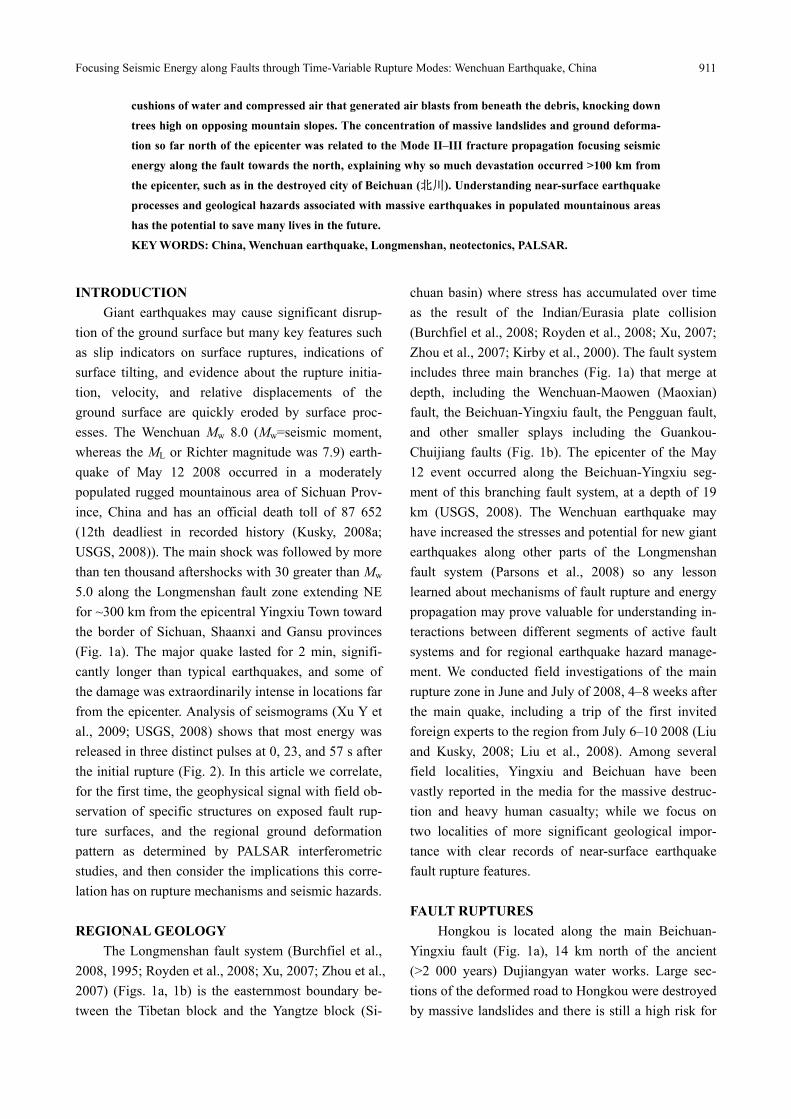
The Longmenshan fault system (Burchfiel et al., 2008, 1995; Royden et al., 2008; Xu, 2007; Zhou et al., 2007) (Figs. 1a, 1b) is the easternmost boundary be-tween the Tibetan block and the Yangtze block (Si-
chuan basin) where stress has accumulated over time as the result of the Indian/Eurasia plate collision (Burchfiel et al., 2008; Royden et al., 2008; Xu, 2007; Zhou et al., 2007; Kirby et al., 2000). The fault system includes three main branches (Fig. 1a) that merge at depth, including the Wenchuan-Maowen (Maoxian) fault, the Beichuan-Yingxiu fault, the Pengguan fault, and other smaller splays including the Guankou- Chuijiang faults (Fig. 1b). The epicenter of the May 12 event occurred along the Beichuan-Yingxiu seg-ment of this branching fault system, at a depth of 19 km (USGS, 2008). The Wenchuan earthquake may have increased the stresses and potential for new giant earthquakes along other parts of the Longmenshan fault system (Parsons et al., 2008) so any lesson learned about mechanisms of fault rupture and energy propagation may prove valuable for understanding in-teractions between different segments of active fault systems and for regional earthquake hazard manage-ment. We conducted field investigations of the main rupture zone in June and July of 2008, 4–8 weeks after the main quake, including a trip of the first invited foreign experts to the region from July 6–10 2008 (Liu and Kusky, 2008; Liu et al., 2008). Among several field localities, Yingxiu and Beichuan have been vastly reported in the media for the massive destruc-tion and heavy human casualty; while we focus on two localities of more significant geological impor-tance with clear records of near-surface earthquake fault rupture features. FAULT RUPTURES
Hongkou is located along the main Beichuan- Yingxiu fault (Fig. 1a), 14 km north of the ancient (>2 000 years) Dujiangyan water works. Large sec-tions of the deformed road to Hongkou were destroyed by massive landslides and there is still a high risk for
Timothy M Kusky, Abduwasit Ghulam, Wang Lu, Liu Jianguo, Li Zhongquan and Chen Xiao
912
Songpan-Ganzi
terrain
Songpan
Donghekou
Beichuan
Wenchuan
Hongkou
Yingxiu
Dujiangyan
Sichuan
basin
Chengdu
A
B
(a)
102°
32
°3
1°
1
2
3
Longmenshan
Beichuan-Yingxiu
fault
Pengguan
fault
Guankou
fault
LongmenshanBeichuan-Yingxiu
fault Pengguan
faultGuankou
fault
Sichuan
basin
Sichuan
basin
4
2
Ele
vati
on (
km
)
-2
-4
-6
-8
Profile A
Profile B
(b)
Precambrian basement
Indosinian intrusive
Foreland basin sediment
Epicenter
Wenchuan-Maoxian fault
Pengguan fault
Beichuan-Yingxiu fault
Seismic profileB
Quaternary
Triassic Songpan-Ganzi flysch
Late Protozoic-Devonian
Cambrian-Silurian of Longmenshan
fold-thrust belt
West Qinling metamorphic rock
1
2
3
Sichuan
Gansu
Shaanxi
Guizhou
Gansu
Qinghai
Yunnan
Chengdu
Ya’an
Aloa
Tewo
Yibin
Anyue
Luzhou
Baisha
Zigong
Xinjin
Hejiang
Fushun
Hechuan
Meishan
Suining
Shehong
DaxianHanwang
Xixiang
Pingshan
Gongjing
Neijiang
Pengshan
Qionglai
Nanchong
Mianyang
Jiangyou
Hanzhong
Huixian
Chongqing
TongliangShiyang
Langzhong
Guangyuan
Wutongqiao
Zhongxian
108?106°E104°102°34°N
32°
30°
Earthquakes
Main shock
4 - 4.9
5 - 5.9
6 - 6.9
0525 6M 0527 5.7M
0512 7.9M
0512 5.6M0516 5.6M
0513 5.8M
0517 5.7M
0512 6M
(No FM)
Aftershocks
0
4
2
Ele
vati
on (
km
)
-2
-4
-6
-8
0
33°N
104°E
Figure 1. (a) Geology of the Longmenshan, showing the location of the Wenchuan-Maowen fault (1), Beichuan-Yingxiu fault (2), and Pengguan fault (3) in relationship to regional geology (modified from Xu, 2007; Bureau of Geology and Mineral Resources of Sichuan Province, 1989). Map (inset) showing the loca-tion of the May 12 Mw 8.0 Wenchuan earthquake, and significant aftershocks (from USGS, 2008). (b) Cross-sections across the Longmenshan fold-thrust belt (after Xu, 2007) on either side of the epicenter show the structural style of the belt. The May 12 2008 earthquake had a hypocenter at ~19 km depth along the Beichuan-Yingxiu fault (near the bottom left corner of profile A), and showed both thrust and dextral strike slip components (USGS, 2008).
Focusing Seismic Energy along Faults through Time-Variable Rupture Modes: Wenchuan Earthquake, China
913
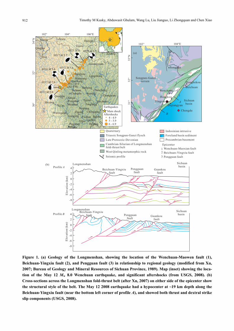
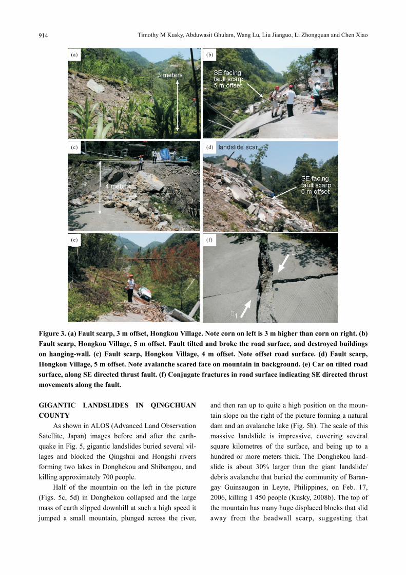
Figure 2. Plot of beam energy vs. time (from Xu Y et al., 2009) showing main peaks of energy release at 0, 23, and 57 s after the initial shock. These en-ergy pulses may correlate with changing slip direc-tions noted on the main fault plane. new landslides, especially in rainy weather and during aftershocks. Spectacular surface rupture features were induced from the faulting in this location (Fig. 3). Cornfields and road surfaces are displaced vertically by 3–5 m (Fig. 3a), and one concrete road oriented along the N40ºE oriented fault was strongly tilted to the SE (Figs. 3b–3e). The thrust fault plane dips NW with the hanging wall (the side the road is on) thrust SE, toward the Sichuan basin. The hanging wall was uplifted by 3–5 m according to the elevation differ-ence of broken road surfaces across the fault line (Figs. 3b–3d). Conjugate fractures in the road surface (Fig. 3f) are consistent with SE-directed thrust motion to-gether with right-lateral slip along the Beichuan- Yingxiu fault.
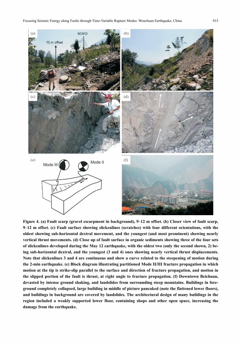
The thrust plane preserves features critical to un-derstand the mode of rupture propagation about 700 m NE in an exposure of the surface rupture in soft allu-vial muddy organic materials. Field measurements suggest that the fault scarp in this location has 9–12 m of offset (Figs. 4a, 4b), and the high pressure and temperature produced by the thrust made the surface of the thrust plane relatively hard and formed a carbon-rich skin. Fault rupture and slip directions are indicated by slickenside scratches along the fault sur-faces with slickenlines denoting the direction of movement on the slickenside planes. Slickenlines on
the fault plane (Fig. 4c) indicate that the major motion is thrust uplift of the western block, with 3–4 sets of older slickenlines that are cut by the major scratches. This indicates that a component of right-lateral movement oriented 20° from the horizontal preceded the major thrust motion (Fig. 4d). According to these changing slickenline orientations, the direction of slip on the fault was partitioned from sub-horizontal to sub-vertical during the 2 min long earthquake. This is a critical piece of information for understanding how the fault rupture propagated from the epicenter at Yingxiu to Hongkou and further to Beichuan and Donghekou (Fig. 1a). Cracks that propagate by com-bined Mode II/Mode III (Fig. 4e) failure mechanisms show displacements parallel to the fracture propaga-tion at their tips, followed by a progressive change to displacements at right angles to the direction of frac-ture propagation in the interior of the slipped region. The slip directions recorded on the fault plane in Hongkou show sub-horizontal dextral displacements replaced by oblique dextral thrust motion, replaced in turn by west over east thrusting. These observations are consistent with the complex seismic signal in the first 17 s of the rupture event reported by the USGS (2008) and the slightly oblique dextral thrust fault plane solution obtained for the sense of movement during the 2-min long rupture event. We speculate that the three main slickenline formation events may cor-relate with the three main bursts of energy docu-mented during the earthquake, at 0, 23, and 57 s after the origin time documented by the seismic signal (Xu Y et al., 2009).
The same dextral-SE-directed thrust sense of mo-tion, consistent with a combined Mode II/Mode III rupture propagation can also be observed along the concrete road leading into Beichuan County. The road section more or less along the 30ºN -40ºE direction of the major fault was badly damaged by faulting and landslides (Huang and Xu, 2008; Kusky, 2008b; Liu et al., 2008) (Fig. 4f). The road surface was tilted to the north-west and uplifted and bulged on its eastern edge indicating that the major movement was thrust from west to east, though some minor bulges and fractures also indicate a strike-slip component of motion.
Timothy M Kusky, Abduwasit Ghulam, Wang Lu, Liu Jianguo, Li Zhongquan and Chen Xiao
914
Figure 3. (a) Fault scarp, 3 m offset, Hongkou Village. Note corn on left is 3 m higher than corn on right. (b) Fault scarp, Hongkou Village, 5 m offset. Fault tilted and broke the road surface, and destroyed buildings on hanging-wall. (c) Fault scarp, Hongkou Village, 4 m offset. Note offset road surface. (d) Fault scarp, Hongkou Village, 5 m offset. Note avalanche scared face on mountain in background. (e) Car on tilted road surface, along SE directed thrust fault. (f) Conjugate fractures in road surface indicating SE directed thrust movements along the fault. GIGANTIC LANDSLIDES IN QINGCHUAN COUNTY
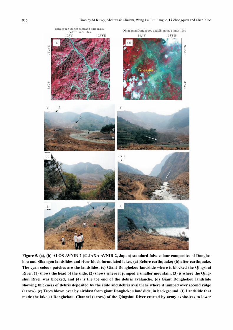
As shown in ALOS (Advanced Land Observation Satellite, Japan) images before and after the earth-quake in Fig. 5, gigantic landslides buried several vil-lages and blocked the Qingshui and Hongshi rivers forming two lakes in Donghekou and Shibangou, and killing approximately 700 people.
Half of the mountain on the left in the picture (Figs. 5c, 5d) in Donghekou collapsed and the large mass of earth slipped downhill at such a high speed it jumped a small mountain, plunged across the river,
and then ran up to quite a high position on the moun-tain slope on the right of the picture forming a natural dam and an avalanche lake (Fig. 5h). The scale of this massive landslide is impressive, covering several square kilometres of the surface, and being up to a hundred or more meters thick. The Donghekou land-slide is about 30% larger than the giant landslide/ debris avalanche that buried the community of Baran-gay Guinsaugon in Leyte, Philippines, on Feb. 17, 2006, killing 1 450 people (Kusky, 2008b). The top of the mountain has many huge displaced blocks that slid away from the headwall scarp, suggesting that
Focusing Seismic Energy along Faults through Time-Variable Rupture Modes: Wenchuan Earthquake, China
915
Figure 4. (a) Fault scarp (gravel escarpment in background), 9–12 m offset. (b) Closer view of fault scarp, 9–12 m offset. (c) Fault surface showing slickenlines (scratches) with four different orientations, with the oldest showing sub-horizontal dextral movement, and the youngest (and most prominent) showing nearly vertical thrust movements. (d) Close up of fault surface in organic sediments showing three of the four sets of slickenlines developed during the May 12 earthquake, with the oldest two (only the second shown, 2) be-ing sub-horizontal dextral, and the youngest (3 and 4) ones showing nearly vertical thrust displacements. Note that slickenlines 3 and 4 are continuous and show a curve related to the steepening of motion during the 2-min earthquake. (e) Block diagram illustrating partitioned Mode II/III fracture propagation in which motion at the tip is strike-slip parallel to the surface and direction of fracture propagation, and motion in the slipped portion of the fault is thrust, at right angle to fracture propagation. (f) Downtown Beichuan, devasted by intense ground shaking, and landslides from surrounding steep mountains. Buildings in fore-ground completely collapsed, large building in middle of picture pancaked (note the flattened lower floors), and buildings in background are covered by landslides. The architectural design of many buildings in the region included a weakly supported lower floor, containing shops and other open space, increasing the damage from the earthquake.
Timothy M Kusky, Abduwasit Ghulam, Wang Lu, Liu Jianguo, Li Zhongquan and Chen Xiao
916
Figure 5. (a), (b) ALOS AVNIR-2 (© JAXA AVNIR-2, Japan) standard false colour composites of Donghe-kou and Sibangou landslides and river block formulated lakes. (a) Before earthquake; (b) after earthquake. The cyan colour patches are the landslides. (c) Giant Donghekou landslide where it blocked the Qingshui River. (1) shows the head of the slide, (2) shows where it jumped a smaller mountain, (3) is where the Qing-shui River was blocked, and (4) is the toe end of the debris avalanche. (d) Giant Donghekou landslide showing thickness of debris deposited by the slide and debris avalanche where it jumped over second ridge (arrow). (e) Trees blown over by airblast from giant Donghekou landslide, in background. (f) Landslide that made the lake at Donghekou. Channel (arrow) of the Qingshui River created by army explosives to lower
Focusing Seismic Energy along Faults through Time-Variable Rupture Modes: Wenchuan Earthquake, China
917
lake level and reduces the threat of catastrophic flood. (g) Shibangou landslide head (at (1) in background), and toe ((3) in foreground). Note large slide blocks (2) near head of slide. This landslide blocked the river a second time, forming a higher avalanche lake. Note that this slide is the smaller of the two lobes (the one closer to the river) shown in the satellite image of Fig. 4b. (h) Trees blown over by airblast ricocheting off opposing mountain slope. the event started as a massive rock slide/fall, and as the mass moved downhill it quickly became a debris avalanche as the material in the fall was pulverized into a mixture of large boulders and finer material.
Tang et al. (2010) studied this landslide, and con-cluded that it was initiated as an ejection landslide, in which a huge mass of limestone debris was ejected from the top of the mountain during the earthquake, and flew through the air for 300–400 m before landing on the loose debris already on the slope, which then merged to form the giant landslide that blocked the Qingshui and Hongshi rivers, and destroyed the inter-vening villages.
Massive rockfall avalanches and rockflow rubble streams that travel at high speeds over large distances are termed sturzstroms (Heim, 1932), and require for their formation a minimum of 500 000 m3 of rock to fall at least 150 m onto a slope equal to or exceeding 25º. Recent works (Iverson, 2003; Legros, 2002) sug-gest that sturzstroms travel so far since they must conserve mass and momentum. Our observations of the Donghekou sturzstrom suggest that the momentum is maintained by a loss of friction along the base of the sturzstrom, by having the falling mass ride on a cush-ion of water and compressed air. The Donghekou and Shibangou sturzstroms were associated with air blasts that shot out from beneath the falling debris. Rapidly falling rock and soil compressed the air beneath the avalanches, allowed the material to move downhill quickly on this cushion of compressed air for great distance, and as the avalanches came to a halt the air was ejected out of from beneath the debris in strong jets that knocked down trees in radial patterns reach-ing several hundred meters up opposing mountain slopes from the site of the avalanche tongues, in pat-terns reminiscent of bomb blasts (Fig. 5e). We venture a preliminary estimate of the volume of material that collapsed in the Donghekou landslide. Considering the thickness of the toe of the deposit, the length of the slide (>3 km) and width (average 1 km), we estimate
that at least 15–25 million m3 (20–30 million cubic yards) of material raced down the slopes in this single sturzstrom. The staggering reality is that during the earthquake, there were hundreds, if not thousands of similar giant rock avalanches.
The dam blocking the course of Qingshui River was channelled by the army using explosives to allow water to discharge gently avoiding catastrophic dam collapse and flooding (Fig. 5f). The devastating con-sequence of landslides in the region is obvious, with several villages and schools buried by this slide. The landslide in Shibangou (Fig. 5g) buried a village and blocked the Qingshui River a second time forming another lake up stream. The landslide at Shibangou is interesting in that the amphitheatre-shaped headscarp detachment surface at the top of the slide is visible, and it shows a typical slump-like crown with trans-verse cracks and fault zones, large slide blocks mov-ing into the main slide, back rotation of slump blocks on the upper part of the slide (Fig. 5g), then a transi-tion where the slide turns into a debris avalanche grading into a sturzstrom debris field. This slide was also associated with powerful airblasts, as the trees are blown over in complex patterns going up hill and down valley away from the toe of the avalanche (Figs. 5g, 5h). PALSAR INTERFEROMETRIC ANALYSIS
Japan Aerospace Exploration Agency (JAXA) started to acquire the Phased Array type L-band Syn-thetic Aperture Radar (PALSAR) data immediately after the Wenchuan earthquake using the Advanced Land Observation Satellite (ALOS). JAXA provided across event interferometric pairs of PALSAR Level 1.0 raw data covering nearly all the Longmenshan fault zone region along the tracks shown in Table 1. As an active, low frequency (L-band) microwave sensor, PALSAR not only is day/night all weather op-erational but also has great coherence tolerance that enables effective interferometric SAR analysis for
Timothy M Kusky, Abduwasit Ghulam, Wang Lu, Liu Jianguo, Li Zhongquan and Chen Xiao
918
ground deformation measurement in this mountainous area covered by thick forest (Hao et al., 2009; Xu C et al., 2009). All of the data used in this study are Fine Beam Single polarization (FBS, HH-polarization) collected with look angle of 34.3° (Table 1).
Table 1 PALSAR data used in this study
Path Pre-earthquake Post-earthquake Collection mode
472 01/08/2007 06/17/2008 FBS–34.3°
473 02/17/2008 05/24/2008 FBS–34.3°
474 05/05/2008 06/05/2008 FBS–34.3°
475 06/20/2007 05/19/2008 FBS–34.3°
476 04/08/2008 06/10/2008 FBS–34.3°
477 04/25/2008 06/22/2008 FBS–34.3°
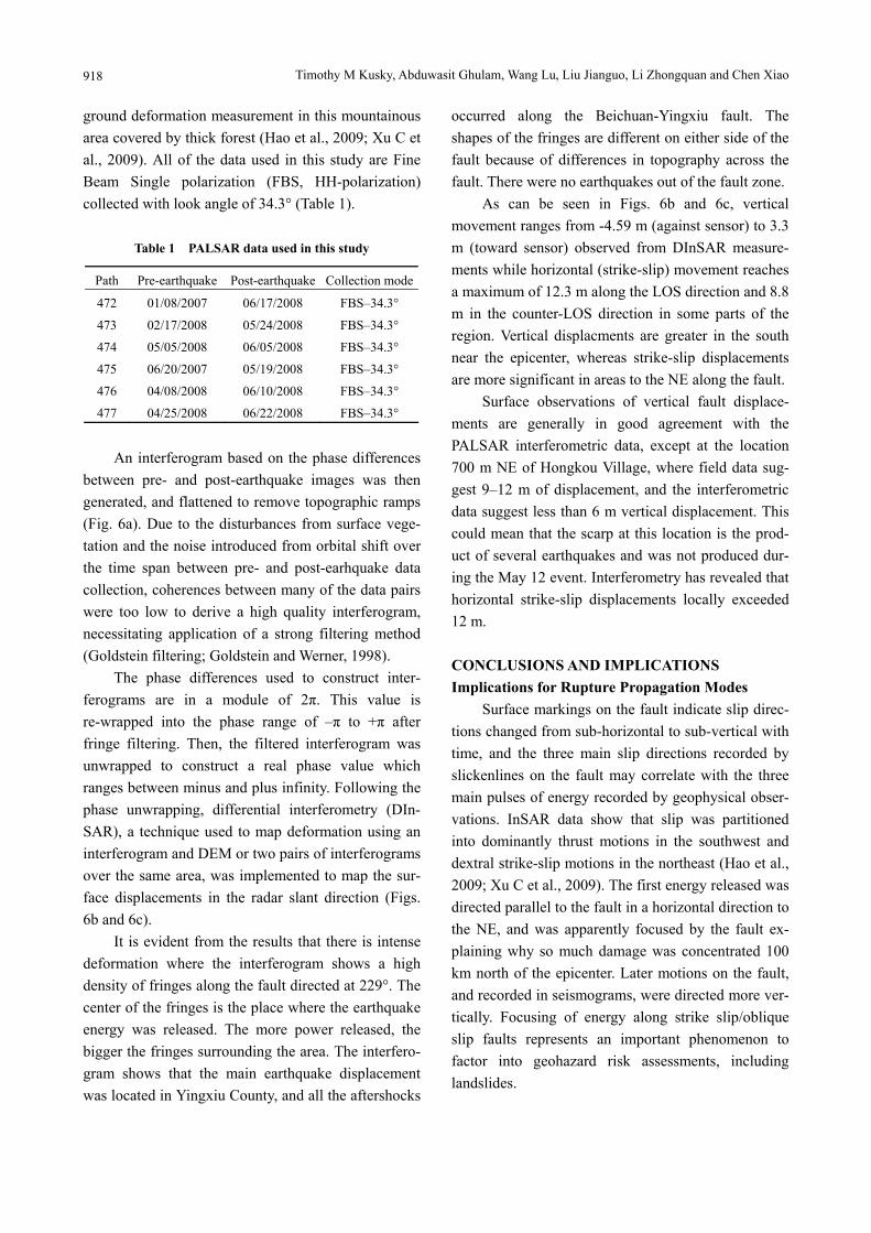
An interferogram based on the phase differences
between pre- and post-earthquake images was then generated, and flattened to remove topographic ramps (Fig. 6a). Due to the disturbances from surface vege-tation and the noise introduced from orbital shift over the time span between pre- and post-earhquake data collection, coherences between many of the data pairs were too low to derive a high quality interferogram, necessitating application of a strong filtering method (Goldstein filtering; Goldstein and Werner, 1998).
The phase differences used to construct inter-ferograms are in a module of 2π. This value is re-wrapped into the phase range of –π to +π after fringe filtering. Then, the filtered interferogram was unwrapped to construct a real phase value which ranges between minus and plus infinity. Following the phase unwrapping, differential interferometry (DIn-SAR), a technique used to map deformation using an interferogram and DEM or two pairs of interferograms over the same area, was implemented to map the sur-face displacements in the radar slant direction (Figs. 6b and 6c).
It is evident from the results that there is intense deformation where the interferogram shows a high density of fringes along the fault directed at 229°. The center of the fringes is the place where the earthquake energy was released. The more power released, the bigger the fringes surrounding the area. The interfero-gram shows that the main earthquake displacement was located in Yingxiu County, and all the aftershocks
occurred along the Beichuan-Yingxiu fault. The shapes of the fringes are different on either side of the fault because of differences in topography across the fault. There were no earthquakes out of the fault zone.
As can be seen in Figs. 6b and 6c, vertical movement ranges from -4.59 m (against sensor) to 3.3 m (toward sensor) observed from DInSAR measure-ments while horizontal (strike-slip) movement reaches a maximum of 12.3 m along the LOS direction and 8.8 m in the counter-LOS direction in some parts of the region. Vertical displacments are greater in the south near the epicenter, whereas strike-slip displacements are more significant in areas to the NE along the fault.
Surface observations of vertical fault displace-ments are generally in good agreement with the PALSAR interferometric data, except at the location 700 m NE of Hongkou Village, where field data sug-gest 9–12 m of displacement, and the interferometric data suggest less than 6 m vertical displacement. This could mean that the scarp at this location is the prod-uct of several earthquakes and was not produced dur-ing the May 12 event. Interferometry has revealed that horizontal strike-slip displacements locally exceeded 12 m.
CONCLUSIONS AND IMPLICATIONS Implications for Rupture Propagation Modes
Surface markings on the fault indicate slip direc-tions changed from sub-horizontal to sub-vertical with time, and the three main slip directions recorded by slickenlines on the fault may correlate with the three main pulses of energy recorded by geophysical obser-vations. InSAR data show that slip was partitioned into dominantly thrust motions in the southwest and dextral strike-slip motions in the northeast (Hao et al., 2009; Xu C et al., 2009). The first energy released was directed parallel to the fault in a horizontal direction to the NE, and was apparently focused by the fault ex-plaining why so much damage was concentrated 100 km north of the epicenter. Later motions on the fault, and recorded in seismograms, were directed more ver-tically. Focusing of energy along strike slip/oblique slip faults represents an important phenomenon to factor into geohazard risk assessments, including landslides.
Focusing Seismic Energy along Faults through Time-Variable Rupture Modes: Wenchuan Earthquake, China
919
Slip and rupture modes were partitioned in both space and time during the Wenchuan earthquake. Slip directions on the surface fault rupture associated with the May 12, 2008 Wenchuan Mw 8.0 earthquake changed from sub-horizontal to sub-vertical during the two minute long earthquake. This reflects a change from Mode II to Mode III fracture propagation, where the tip initially migrates parallel to the slip direction but then as the fracture tip moves past any point the motion changes to perpendicular to the main rupture propagation direction. Total displacements are domi-nantly oblique-thrust in the SW near the epicenter, and oblique dextral-slip further NE along the fault rupture. The combined Mode II/Mode III fracture propagation
explains the complex seismic signature in the first 17 s of the rupture event (USGS, 2008), which was fol-lowed by a more consistent oblique-thrust motion of up to 12 m in the following 100 s. Such a Mode II/III propagation would initially direct energy from the epicenter towards the north, perhaps explaining why so much damage was located >100 km away from the epicenter in areas to the north, such as in the devas-tated Beichuan County. Based on damage patterns (Liu and Kusky, 2008, Liu et al., 2008) this energy was focused along the pre-existing faults, and ampli-fied by local effects such as thickness of alluvial fill. The change from Mode II to Mode III propagation is recorded in the changing orientations of slickenlines
Timothy M Kusky, Abduwasit Ghulam, Wang Lu, Liu Jianguo, Li Zhongquan and Chen Xiao
920
on the fault plane during the earthquake, and may also be associated with the three main energy pulses at 0, 23, and 57 s after the initial shock (Xu Y et al., 2009). The seismic data and structural features on the fault both show that initial motion from 0–17 s was dextral strike-slip, and the second and third energy bursts were associated with the long oblique dextral-thrust movement along the fault plane, consistent with the ground deformation patterns determined from the PALSAR interferometry. Similar patterns of distal fo-cusing of seismic energy release and ground deforma-tion effects are known from other large earthquake events, such as the 2002 Mw 7.9 Denali (Alaska) thrust-dextral earthquake (Eberhart-Phillips et al., 2003), suggesting that focusing of seismic energy by slip-partitioned Mode II/III propagating oblique-slip strike-slip faults may be a common phenomenon.
Sturzstroms, or giant landslides associated with the earthquake rode on cushions of water and com-pressed air, which were released in giant air blasts as slides came to rest. These air blasts may exceed hurri-cane strength, knocking down trees, buildings, and all in their path and represent a significant and underap-preciated earthquake hazard. Areas of potential sturzstrom formation should be mapped in future seismic risk assessments along with other potential
earthquake hazards.
Implications for Geohazards The direct destruction by the earthquake was
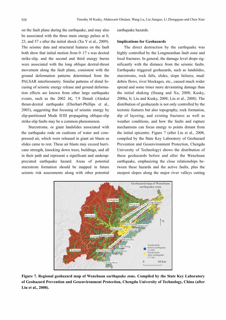
highly controlled by the Longmenshan fault zone and local fractures. In general, the damage level drops sig-nificantly with the distance from the seismic faults. Earthquake triggered geohazards, such as landslides, sturzstroms, rock falls, slides, slope failures, mud/ debris flows, river blockages, etc., caused much wider spread and some times more devastating damage than the initial shaking (Huang and Xu, 2008; Kusky, 2008a, b; Liu and Kusky, 2008; Liu et al., 2008). The distribution of geohazards is not only controlled by the tectonic features but also topography, rock formation, dip of layering, and existing fractures as well as weather conditions, and how the faults and rupture mechanisms can focus energy to points distant from the initial epicentre. Figure 7 (after Liu et al., 2008, compiled by the State Key Laboratory of Geohazard Prevention and Geoenvironment Protection, Chengdu University of Technology) shows the distribution of these geohazards before and after the Wenchuan earthquake, emphasizing the close relationships be-tween these hazards and the active faults, plus the steepest slopes along the major river valleys cutting
Figure 7. Regional geohazard map of Wenchuan earthquake zone. Compiled by the State Key Laboratory of Geohazard Prevention and Geoenvironment Protection, Chengdu University of Technology, China (after Liu et al., 2008).
Focusing Seismic Energy along Faults through Time-Variable Rupture Modes: Wenchuan Earthquake, China
921
the Longmenshan range. As the current landscape is built by neotectonic
deformation together with surface geological process, high relief terrain co-exists with active tectonic zones in this earthquake-prone region (Fig. 7). This combi-nation unfortunately ensures that the areas hit most hard by the earthquake are also most vulnerable to landslides and debris avalanches. Areas of high tec-tonic activities in high relief terrain are actually lim-ited in area and these areas should be avoided for residential, commercial and industrial development. This poses a challenge for local government leaders, as there is considerable pressure to rebuild towns and villages in exactly the same, geologically hazardous sites, to preserve the history and nostalgia of the local people, and to keep the political balance between counties. This should be avoided and towns need to be relocated in less hazardous areas away from active faults and out of the path of potential slope failures. For a vast region that might be struck by earthquakes, the most effective way so far to reduce the loss of hu-man life and properties is to build earthquake resistant buildings and infrastructure, and to avoid the style of building so prominent in Sichuan where the lower floor of tall buildings have a great amount of open space that easily collapses during the passage of seis-mic waves.
ACKNOWLEDGMENTS
We acknowledge Prof. Tang Chuan and the State Key Laboratory of Geohazard Prevention, Chengdu University of Technology who provided emergency research funds to support our field study. The in-terometric analysis was funded by NASA to Abdu-wasit Ghulam and Timothy M Kusky (No. 08-182). Level 1.0 data were processed by the Alaska Satellite Facility SAR Data Center, one of NASA’s Distributed Active Archive Centers. Additional funds were pro-vided by the National Natural Science Foundation of China (No. 40821061), and Ministry of Education of China (No. B07039).
REFERENCES CITED Burchfiel, B. C., Chen., Z. L., Liu, Y. P., et al., 1995. Tectonics
of the Longmen Shan and Adjacent Regions. Int. Geol.
Rev., 37(8): 661–735
Burchfiel, B. C., Royden, L. H., van der Hilst, R. D., et al.,
2008. A Geological and Geophysical Context for the
Wenchuan Earthquake of 12 May 2008, Sichuan, People’s
Republic of China. GSA Today, 18(7): 4–11
Bureau of Geology and Mineral Resources of Sichuan Province,
1989. Atlas of Sichuan Geology, China. Geological Pub-
lishing House, Beijing (in Chinese)
Eberhart-Phillips, D., Haeussler, P. J., Freymueller, J. T., et al.,
2003. The 2002 Denali Fault Earthquake, Alaska: A
Large-Magnitude, Slip-Partitioned Event. Science,
300(5622): 1113–1118
Goldstein, R. M., Werner, C. L., 1998. Radar Interferogram
Filtering for Geophysical Applications. Geophys. Res.
Lett., 25(21): 4035–4038
Hao, K. X., Si, H. J., Fujiwara, H., et al., 2009. Coseismic
Surface-Ruptures and Crustal Deformations of the 2008
Wenchuan Earthquake Mw 7.9, China. Geophys. Res. Lett.,
36(L11303), doi: 10.1029/2009GL037971
Heim, A., 1932. Bergsturz und Menschenleben. Fretz and
Wasmuth Verlag, Zurich. 218 (in German)
Huang, R. Q., Xu, Q., 2008. The Representative Catastrophic
Landslides in China. Science Press, Beijing. 553 (in Chi-
nese)
Iverson, R. M., 2003. How should Mathematical Models of
Geomorphic Processes be Judged? Geophysical Mono-
graph, 135: 83–94
Kirby, E., Whipple, K. X., Burchfiel, B. C., et al., 2000. Neo-
tectonics of the Min Shan, China: Implications for
Mechanisms Driving Quaternary Deformation along the
Eastern Margin of the Tibetan Plateau. Geol. Soc. Am.
Bull., 112: 375–393
Kusky, T. M., 2008a. Earthquakes: Plate Tectonics and Earth-
quake Hazards, Hazardous Earth Series. Facts on File, 169
Kusky, T. M., 2008b. Landslides: Mass Wasting, Soil, and
Mineral Hazards. Hazardous Earth Series, Facts on File,
128
Legros, F., 2002. The Mobility of Long-Runout Landslides.
Engineering Geology, 63(3–4): 301–331
Liu, J. G., Kusky, T. M., 2008. After the 8.0 Mw Wenchuan
Earthquake: A Report on an International Field Excursion
to Investigate the Earthquake Induced Geohazards (6–10
July 2008). Earth Mag., 48: 48–51
Liu, J. G., Tang, C., Kusky, T. M., 2008. Emergency Geohazard
Mapping for Wenchuan Earthquake Disaster in China Us-
ing ALOS Imagery Data. Proceedings of the 2008 Joint PI
Symposium of the ALOS Data Nodes. Rhodes, Greece,
Timothy M Kusky, Abduwasit Ghulam, Wang Lu, Liu Jianguo, Li Zhongquan and Chen Xiao
922
Nov. 3
Parsons, T., Ji, C., Kirby, E., 2008. Stress Changes from the
2008 Wenchuan Earthquake and Increased Hazard in the
Sichuan Basin. Nature, 454(7203): 509–510
Royden, L. H., Burchfiel, B. C., van der Hilst, R. D., 2008. The
Geological Evolution of the Tibetan Plateau. Science,
321(5892): 1054–1058
Tang, H. M., Jia, H. B., Hu, X. L., et al., 2010. Characteristics
of Landslides Induced by the Great Wenchuan Earthquake.
Journal of Earth Science, 21(1): 104–113
U.S. Geoloigc Survey (USGS), 2008. http://earthquake.usgs.
gov/eqcenter/eqinthenews/2008/ us2008ryan/
Xu, C., Liu, Y., Wen, Y., et al., 2009. Coseismic and Postseis-
mic Deformation of the 2008 Mw 7.9 Wenchuan Earth-
quake Using GPS and InSAR. Geophys. Res. Abst., 11:
EGU2009–3636–1
Xu, Y., 2007. Structural and Stratigraphic Evolution of the
Longmenshan Fold-Thrust Belt and Sichuan Basin: Com-
plex Interplay between Extensional and Contractional
Tectonics and Basin Formation: [Dissertation]. St. Louis
University, St. Louis
Xu, Y., Koper, K. D., Sufri, O., et al., 2009. Rupture Imaging of
the Mw 7.9 12 May 2008 Wenchuan Earthquake from Back
Projection of Teleseismic P Waves. Geochem. Geophys.
Geosys., 10, doi: 1029/2008GC002335
Zhou, R. J., Li, Y., Densmore, A. L., et al., 2007. Active Tec-
tonics of the Longmenshan Region and the Eastern Margin
of the Tibetan Plateau. Acta Geologica Sinica, 81(4):
593–604