final report on the 2013 season of the mayapán taboo cenote project
TRANSCRIPT
Final Report on the 2013 Season of
The Mayapán Taboo Cenote Project
Edited by Bradley W. Russell
Principle Investigator: Bradley W. Russell (College of St. Rose and SUNY Albany)
Co-directors: Carlos Peraza Lope (INAH Yucatan), Eunice Uc González (INAH Yucatan)
and Marilyn A. Masson (SUNY – Albany)
Lead Diver: Rait Kütt
Underwater Archaeologist: Lisseth Pedroza Fuentes
National Geographic Society/Waitt Grant #W264-13
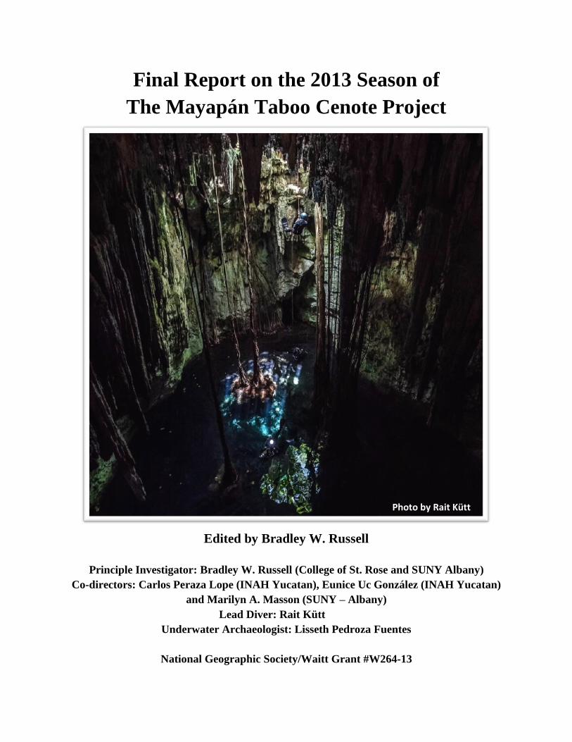
Photo by Rait Kütt

Contents
Chapter One – Introduction Page 1
Bradley W. Russell, Carlos Peraza Lope, Eunice Uc González and
Marilyn A. Masson
Chapter Two – Jeets’ Lu’um Permission Ceremony Page 17
Bradley W. Russell and Marilyn A Masson
Chapter 3 – Research Methods Page 23
Bradley W. Russell
Chapter 4 – Cenote Sac Uayum’s Chamber One Page 29
Bradley W. Russell, Rait Kütt and Lisseth Pedroza Fuentes
Chapter 5 – Cenote Sac Uayum’s Chamber Two Page 35
Bradley W. Russell, Lisseth Pedroza Fuentes and Rait Kütt
Chapter 6 – Conclusions Page 39
Bradley W. Russell, Eunice Uc González and Carlos Peraza Lope
Appendix A – Registration Photos Page 45
Appendix B – Bone Samples Collected Page 77
Appendix C – Ceramic Samples Collected Page 87

Abstract
With support from The National Geographic Society and The Waitt Foundation, the
Mayapán Taboo Cenote Project concluded its first season of exploration at Cenote Sac Uayum
in the summer of 2013. Sac Uayum is a sacred, water-bearing sinkhole located at the Postclassic
Maya political capital of Mayapán, Yucatán, Mexico (1150-1450AD). The work brought
together an international collaboration of researchers from the United States, Mexico and
Estonia. Principle Investigator Bradley W. Russell (College of St. Rose) and Co-Directors
Carlos Peraza Lope (INAH Centro Yucatan), Eunice Uc González (INAH Centro Yucatan) and
Marilyn A. Masson (SUNY Albany) enlisted the help of lead diver Rait Kütt and underwater
archaeologist Lisseth Pedroza Fuentes. The study yielded significant new insights into the
cenote that many modern inhabitants consider to be “alive” and believe is guarded by a large
feathered serpent with the head of a horse. The feature has drawn the attention of researchers
working at the site since the first archaeological work began at the ancient city because of its
conspicuous and apparently intentional exclusion by the large defensive wall surrounding the
bulk of the settlement. Caves and sinkholes were/are especially important to the Maya as they
are believed to be accesses to the underworld and homes of gods. Sac Uayum remains sacred
today and local residents both respect and fear it and the supernatural serpent said to guard it. In
order to enter the cenote, we hosted a traditional Maya Jeets’ Lu’um or “calming of the earth”
ceremony to petition the gods of the sky, earth and winds as well as its serpent guardian for
permission to perform the work. Doing so provided new ethnographic data on modern Maya
cave ritual and beliefs. Our team of divers and underwater archaeologists focused on detailed
underwater mapping and photography of the cenote and its contents. During the study, we
located 15 human crania and a large number of other bones, attesting to the use of the site as a
burial location. Early data suggests that the site contains burials of both sexes and a range of
ages, including one as young as six or seven years old. Ceramic fragments show a mix of
Preclassic and Postclassic Maya use of the feature. We recovered a small sample of the bones
(two femurs, a mandible and a tibia) that we will use to obtain radiocarbon dates for the burials
themselves. We were surprised and excited to find that the cenote’s main chamber is connected
to a second even larger and deeper cavern that contained five of the best preserved skulls
identified along with many other bones. While connected, submerged cave systems are common
near the coast, they are rare this far inland.

1
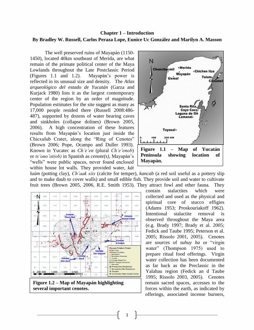
Chapter 1 – Introduction
By Bradley W. Russell, Carlos Peraza Lope, Eunice Uc González and Marilyn A. Masson
The well preserved ruins of Mayapán (1150-
1450), located 40km southeast of Merida, are what
remain of the primate political center of the Maya
Lowlands throughout the Late Postclassic Period
(Figures 1.1 and 1.2). Mayapán’s power is
reflected in its unusual size and density. The Atlas
arqueológico del estado de Yucatán (Garza and
Kurjack 1980) lists it as the largest contemporary
center of the region by an order of magnitude.
Population estimates for the site suggest as many as
17,000 people resided there (Russell 2008:486-
487), supported by dozens of water bearing caves
and sinkholes (collapse dolines) (Brown 2005,
2006). A high concentration of these features
results from Mayapán’s location just inside the
Chicxulub Crater, along the “Ring of Cenotes”
(Brown 2006; Pope, Ocampo and Duller 1993).
Known in Yucatec as Ch’e’en (plural Ch’e’enob)
or ts’ono’ot(ob) in Spanish as cenote(s), Mayapán’s
“wells” were public spaces, never found enclosed
within house lot walls. They provided water, kát
luúm (potting clay), Ch’aak xiix (calcite for temper), kancab (a red soil useful as a pottery slip
and to make daub to cover walls) and small edible fish. They provide soil and water to cultivate
fruit trees (Brown 2005, 2006, R.E. Smith 1953). They attract fowl and other fauna. They
contain stalactites which were
collected and used as the physical and
spiritual core of stucco effigies
(Adams 1953; Proskouriakoff 1962).
Intentional stalactite removal is
observed throughout the Maya area
(e.g. Brady 1997; Brady et al. 2005;
Fedick and Taube 1995; Peterson et al.
2005; Rissolo 2001, 2005). Cenotes
are sources of suhuy ha or “virgin
water” (Thompson 1975) used to
prepare ritual food offerings. Virgin
water collection has been documented
as far back as the Preclassic in the
Yalahau region (Fedick an d Taube
1995; Rissolo 2003, 2005). Cenotes
remain sacred spaces, accesses to the
forces within the earth, as indicated by
offerings, associated incense burners,
Figure 1.1 – Map of Yucatán
Peninsula showing location of
Mayapán.
Figure 1.2 – Map of Mayapán highlighting
several important cenotes.
2
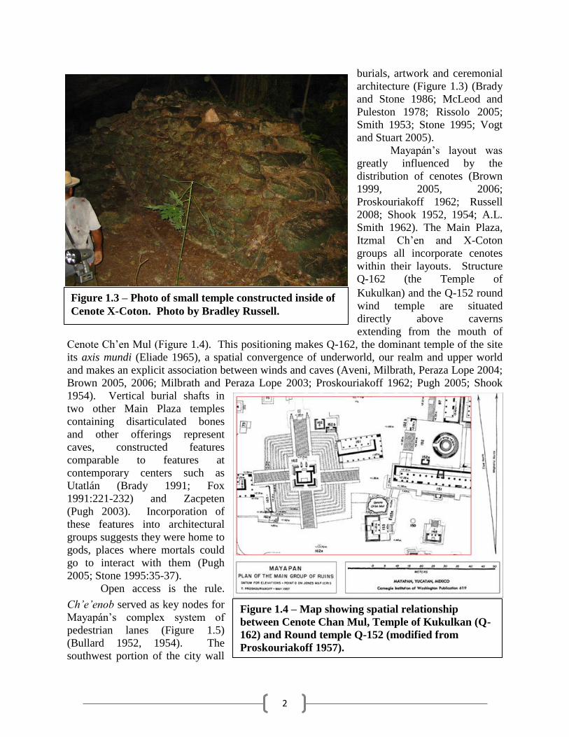
burials, artwork and ceremonial
architecture (Figure 1.3) (Brady
and Stone 1986; McLeod and
Puleston 1978; Rissolo 2005;
Smith 1953; Stone 1995; Vogt
and Stuart 2005).
Mayapán’s layout was
greatly influenced by the
distribution of cenotes (Brown
1999, 2005, 2006;
Proskouriakoff 1962; Russell
2008; Shook 1952, 1954; A.L.
Smith 1962). The Main Plaza,
Itzmal Ch’en and X-Coton
groups all incorporate cenotes
within their layouts. Structure
Q-162 (the Temple of
Kukulkan) and the Q-152 round
wind temple are situated
directly above caverns
extending from the mouth of
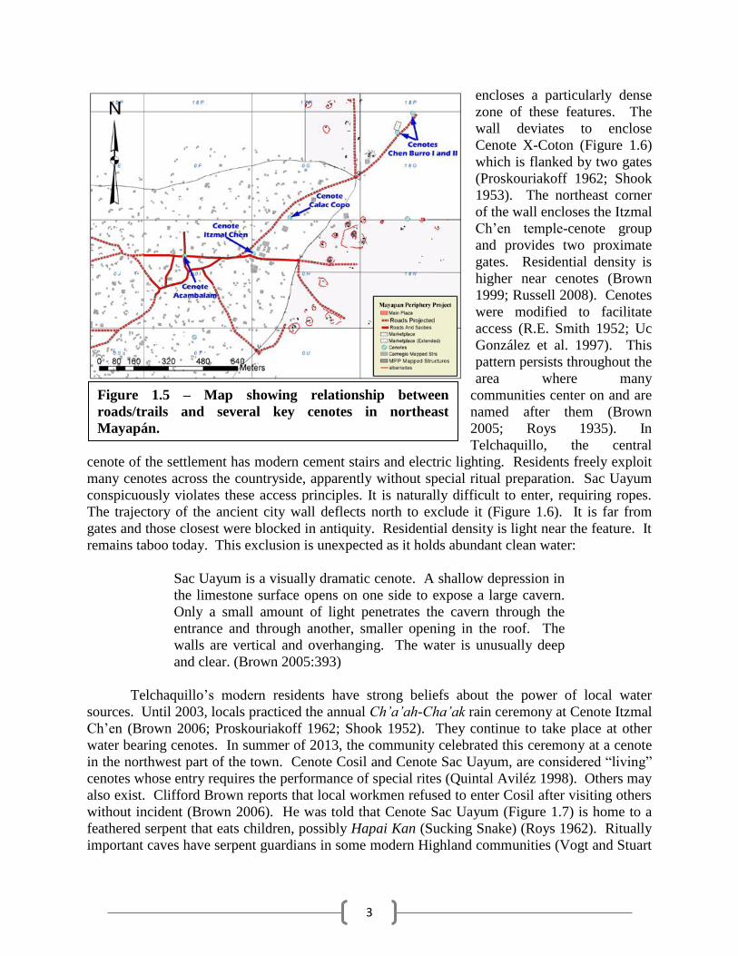
Cenote Ch’en Mul (Figure 1.4). This positioning makes Q-162, the dominant temple of the site
its axis mundi (Eliade 1965), a spatial convergence of underworld, our realm and upper world
and makes an explicit association between winds and caves (Aveni, Milbrath, Peraza Lope 2004;
Brown 2005, 2006; Milbrath and Peraza Lope 2003; Proskouriakoff 1962; Pugh 2005; Shook
1954). Vertical burial shafts in
two other Main Plaza temples
containing disarticulated bones
and other offerings represent
caves, constructed features
comparable to features at
contemporary centers such as
Utatlán (Brady 1991; Fox
1991:221-232) and Zacpeten
(Pugh 2003). Incorporation of
these features into architectural
groups suggests they were home to
gods, places where mortals could
go to interact with them (Pugh
2005; Stone 1995:35-37).
Open access is the rule.
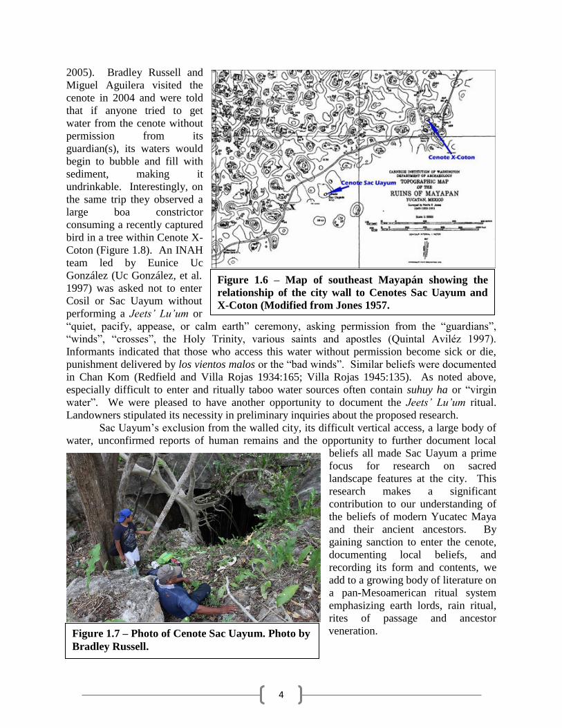
Ch’e’enob served as key nodes for
Mayapán’s complex system of
pedestrian lanes (Figure 1.5)
(Bullard 1952, 1954). The
southwest portion of the city wall
Figure 1.3 – Photo of small temple constructed inside of
Cenote X-Coton. Photo by Bradley Russell.
Figure 1.4 – Map showing spatial relationship
between Cenote Chan Mul, Temple of Kukulkan (Q-
162) and Round temple Q-152 (modified from
Proskouriakoff 1957).
3
encloses a particularly dense
zone of these features. The
wall deviates to enclose
Cenote X-Coton (Figure 1.6)
which is flanked by two gates
(Proskouriakoff 1962; Shook
1953). The northeast corner
of the wall encloses the Itzmal
Ch’en temple-cenote group
and provides two proximate
gates. Residential density is
higher near cenotes (Brown
1999; Russell 2008). Cenotes
were modified to facilitate
access (R.E. Smith 1952; Uc
González et al. 1997). This
pattern persists throughout the
area where many
communities center on and are
named after them (Brown
2005; Roys 1935). In
Telchaquillo, the central
cenote of the settlement has modern cement stairs and electric lighting. Residents freely exploit
many cenotes across the countryside, apparently without special ritual preparation. Sac Uayum
conspicuously violates these access principles. It is naturally difficult to enter, requiring ropes.
The trajectory of the ancient city wall deflects north to exclude it (Figure 1.6). It is far from
gates and those closest were blocked in antiquity. Residential density is light near the feature. It
remains taboo today. This exclusion is unexpected as it holds abundant clean water:
Sac Uayum is a visually dramatic cenote. A shallow depression in
the limestone surface opens on one side to expose a large cavern.
Only a small amount of light penetrates the cavern through the
entrance and through another, smaller opening in the roof. The
walls are vertical and overhanging. The water is unusually deep
and clear. (Brown 2005:393)
Telchaquillo’s modern residents have strong beliefs about the power of local water
sources. Until 2003, locals practiced the annual Ch’a’ah-Cha’ak rain ceremony at Cenote Itzmal
Ch’en (Brown 2006; Proskouriakoff 1962; Shook 1952). They continue to take place at other
water bearing cenotes. In summer of 2013, the community celebrated this ceremony at a cenote
in the northwest part of the town. Cenote Cosil and Cenote Sac Uayum, are considered “living”
cenotes whose entry requires the performance of special rites (Quintal Aviléz 1998). Others may
also exist. Clifford Brown reports that local workmen refused to enter Cosil after visiting others
without incident (Brown 2006). He was told that Cenote Sac Uayum (Figure 1.7) is home to a
feathered serpent that eats children, possibly Hapai Kan (Sucking Snake) (Roys 1962). Ritually
important caves have serpent guardians in some modern Highland communities (Vogt and Stuart
Figure 1.5 – Map showing relationship between
roads/trails and several key cenotes in northeast
Mayapán.
4
2005). Bradley Russell and
Miguel Aguilera visited the
cenote in 2004 and were told
that if anyone tried to get
water from the cenote without
permission from its
guardian(s), its waters would
begin to bubble and fill with
sediment, making it
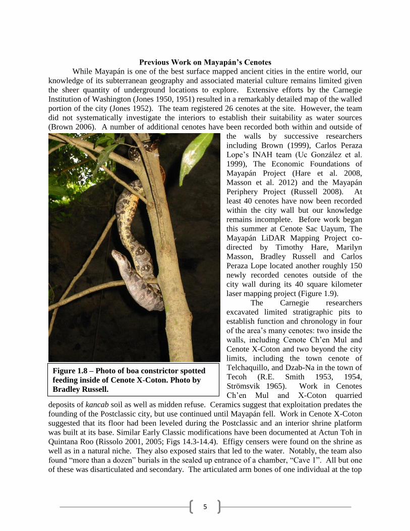
undrinkable. Interestingly, on
the same trip they observed a
large boa constrictor
consuming a recently captured
bird in a tree within Cenote X-
Coton (Figure 1.8). An INAH
team led by Eunice Uc
González (Uc González, et al.
1997) was asked not to enter
Cosil or Sac Uayum without
performing a Jeets’ Lu’um or
“quiet, pacify, appease, or calm earth” ceremony, asking permission from the “guardians”,
“winds”, “crosses”, the Holy Trinity, various saints and apostles (Quintal Aviléz 1997).
Informants indicated that those who access this water without permission become sick or die,
punishment delivered by los vientos malos or the “bad winds”. Similar beliefs were documented
in Chan Kom (Redfield and Villa Rojas 1934:165; Villa Rojas 1945:135). As noted above,
especially difficult to enter and ritually taboo water sources often contain suhuy ha or “virgin
water”. We were pleased to have another opportunity to document the Jeets’ Lu’um ritual.
Landowners stipulated its necessity in preliminary inquiries about the proposed research.
Sac Uayum’s exclusion from the walled city, its difficult vertical access, a large body of
water, unconfirmed reports of human remains and the opportunity to further document local
beliefs all made Sac Uayum a prime
focus for research on sacred
landscape features at the city. This
research makes a significant
contribution to our understanding of
the beliefs of modern Yucatec Maya
and their ancient ancestors. By
gaining sanction to enter the cenote,
documenting local beliefs, and
recording its form and contents, we
add to a growing body of literature on
a pan-Mesoamerican ritual system
emphasizing earth lords, rain ritual,
rites of passage and ancestor
veneration.
Figure 1.6 – Map of southeast Mayapán showing the
relationship of the city wall to Cenotes Sac Uayum and
X-Coton (Modified from Jones 1957.
Figure 1.7 – Photo of Cenote Sac Uayum. Photo by
Bradley Russell.
5
Previous Work on Mayapán’s Cenotes
While Mayapán is one of the best surface mapped ancient cities in the entire world, our
knowledge of its subterranean geography and associated material culture remains limited given
the sheer quantity of underground locations to explore. Extensive efforts by the Carnegie
Institution of Washington (Jones 1950, 1951) resulted in a remarkably detailed map of the walled
portion of the city (Jones 1952). The team registered 26 cenotes at the site. However, the team
did not systematically investigate the interiors to establish their suitability as water sources
(Brown 2006). A number of additional cenotes have been recorded both within and outside of
the walls by successive researchers
including Brown (1999), Carlos Peraza
Lope’s INAH team (Uc González et al.
1999), The Economic Foundations of
Mayapán Project (Hare et al. 2008,
Masson et al. 2012) and the Mayapán
Periphery Project (Russell 2008). At
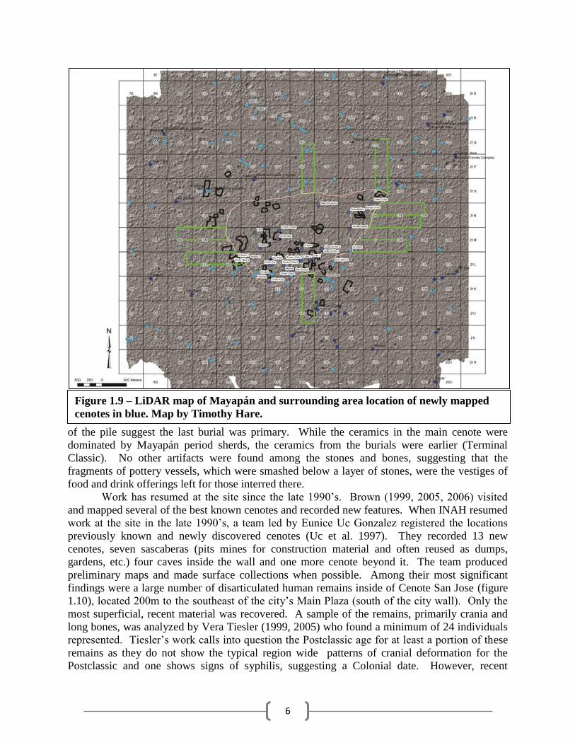
least 40 cenotes have now been recorded
within the city wall but our knowledge
remains incomplete. Before work began
this summer at Cenote Sac Uayum, The
Mayapán LiDAR Mapping Project co-
directed by Timothy Hare, Marilyn
Masson, Bradley Russell and Carlos
Peraza Lope located another roughly 150
newly recorded cenotes outside of the
city wall during its 40 square kilometer
laser mapping project (Figure 1.9).
The Carnegie researchers
excavated limited stratigraphic pits to
establish function and chronology in four
of the area’s many cenotes: two inside the
walls, including Cenote Ch’en Mul and
Cenote X-Coton and two beyond the city
limits, including the town cenote of
Telchaquillo, and Dzab-Na in the town of
Tecoh (R.E. Smith 1953, 1954,
Strömsvik 1965). Work in Cenotes
Ch’en Mul and X-Coton quarried
deposits of kancab soil as well as midden refuse. Ceramics suggest that exploitation predates the
founding of the Postclassic city, but use continued until Mayapán fell. Work in Cenote X-Coton
suggested that its floor had been leveled during the Postclassic and an interior shrine platform
was built at its base. Similar Early Classic modifications have been documented at Actun Toh in
Quintana Roo (Rissolo 2001, 2005; Figs 14.3-14.4). Effigy censers were found on the shrine as
well as in a natural niche. They also exposed stairs that led to the water. Notably, the team also
found “more than a dozen” burials in the sealed up entrance of a chamber, “Cave 1”. All but one
of these was disarticulated and secondary. The articulated arm bones of one individual at the top
Figure 1.8 – Photo of boa constrictor spotted
feeding inside of Cenote X-Coton. Photo by
Bradley Russell.
6
of the pile suggest the last burial was primary. While the ceramics in the main cenote were
dominated by Mayapán period sherds, the ceramics from the burials were earlier (Terminal
Classic). No other artifacts were found among the stones and bones, suggesting that the
fragments of pottery vessels, which were smashed below a layer of stones, were the vestiges of
food and drink offerings left for those interred there.
Work has resumed at the site since the late 1990’s. Brown (1999, 2005, 2006) visited
and mapped several of the best known cenotes and recorded new features. When INAH resumed
work at the site in the late 1990’s, a team led by Eunice Uc Gonzalez registered the locations
previously known and newly discovered cenotes (Uc et al. 1997). They recorded 13 new
cenotes, seven sascaberas (pits mines for construction material and often reused as dumps,
gardens, etc.) four caves inside the wall and one more cenote beyond it. The team produced
preliminary maps and made surface collections when possible. Among their most significant
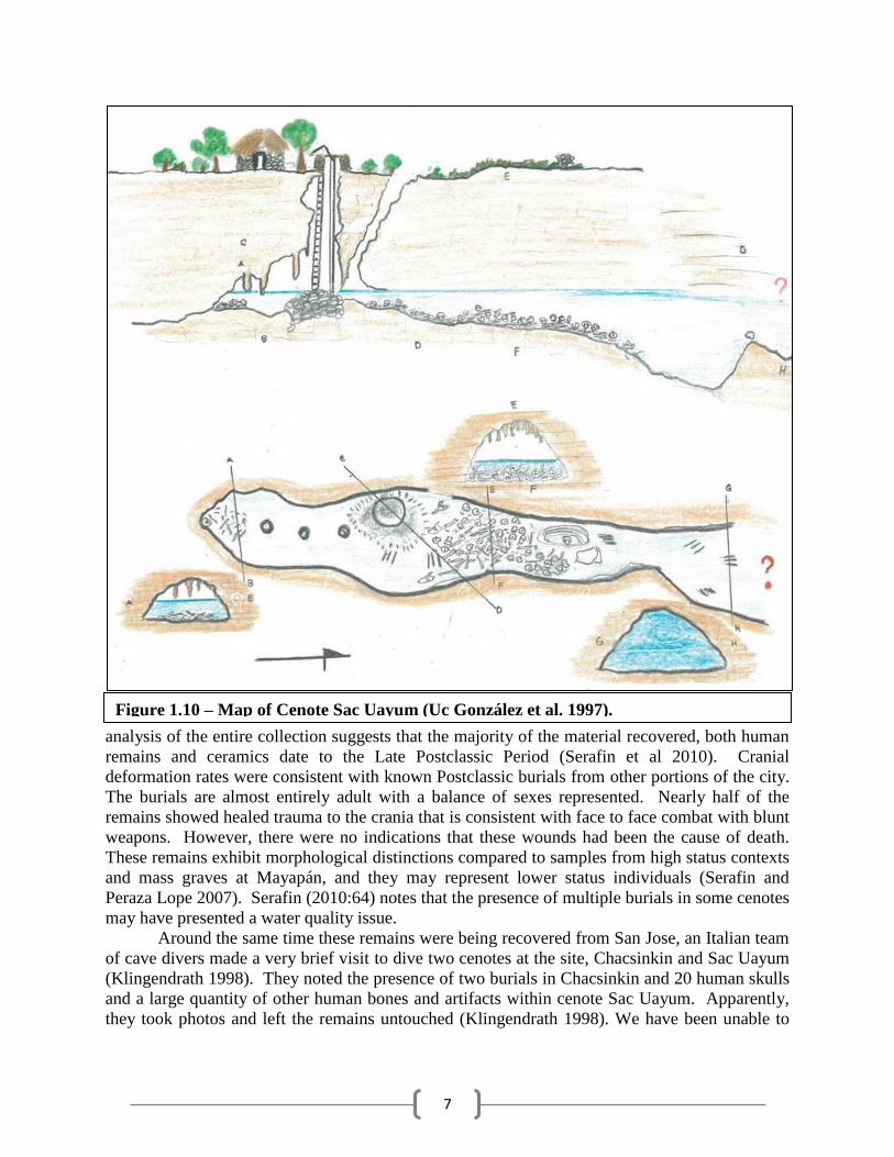
findings were a large number of disarticulated human remains inside of Cenote San Jose (figure
1.10), located 200m to the southeast of the city’s Main Plaza (south of the city wall). Only the
most superficial, recent material was recovered. A sample of the remains, primarily crania and
long bones, was analyzed by Vera Tiesler (1999, 2005) who found a minimum of 24 individuals
represented. Tiesler’s work calls into question the Postclassic age for at least a portion of these
remains as they do not show the typical region wide patterns of cranial deformation for the
Postclassic and one shows signs of syphilis, suggesting a Colonial date. However, recent
Figure 1.9 – LiDAR map of Mayapán and surrounding area location of newly mapped
cenotes in blue. Map by Timothy Hare.
7
analysis of the entire collection suggests that the majority of the material recovered, both human
remains and ceramics date to the Late Postclassic Period (Serafin et al 2010). Cranial
deformation rates were consistent with known Postclassic burials from other portions of the city.
The burials are almost entirely adult with a balance of sexes represented. Nearly half of the
remains showed healed trauma to the crania that is consistent with face to face combat with blunt
weapons. However, there were no indications that these wounds had been the cause of death.
These remains exhibit morphological distinctions compared to samples from high status contexts
and mass graves at Mayapán, and they may represent lower status individuals (Serafin and
Peraza Lope 2007). Serafin (2010:64) notes that the presence of multiple burials in some cenotes
may have presented a water quality issue.
Around the same time these remains were being recovered from San Jose, an Italian team
of cave divers made a very brief visit to dive two cenotes at the site, Chacsinkin and Sac Uayum
(Klingendrath 1998). They noted the presence of two burials in Chacsinkin and 20 human skulls
and a large quantity of other human bones and artifacts within cenote Sac Uayum. Apparently,
they took photos and left the remains untouched (Klingendrath 1998). We have been unable to
Figure 1.10 – Map of Cenote Sac Uayum (Uc González et al. 1997).
8
locate any of the photos. Despite this tantalizing observation, Sac Uayum had not been
investigated by professional underwater archaeologists to date.
Maya cave ritual in the dry, karst Yucatán Peninsula is most often linked to water and
rain rituals. Indeed, caves have been viewed as the source of water and rain by traditional
cultures throughout Mesoamerica as far back as the Olmecs at Chalcatzingo (Grove 1984, 1987).
Based on ethnohistoric sources such as the Books of the Chilam Balam (Edmondson 1982;
Miram and Miram 1988; Roys 1935; Roys 1962), Clifford Brown (2005) argues that cenotes at
Mayapán were linked to specific lineages and ancestor veneration analogous to activity
documented in Zinacantan, Chiapas where individual patrilineages or groups of patrilocal
patrilineages residing in close proximity form a sna and maintain mountaintop and cave shrines
(Vogt 1969). Timothy Pugh (2005) also discussed the importance of geographic markers within
Mayapán’s subterranean landscape. The well-known Sacred Cenote at Chichen Itza has been
extensively studied (Coggins 1992; Coggins and Shane 1984; Lothrup 1952, Sievert 1992;
Willard 1926). Cenote rituals such as those practiced at Chichen Itza and recorded by Landa
(Tozzer 1941) were rain ceremonies. Early attempts to identify indications of similar rites at
Mayapán centered on explorations of Cenote Ch’en Mul in the Main Plaza, but results were
ambiguous (Smith 1954). However, the lack of water at Ch’en Mul makes this feature a poor
choice for a ritual of the type demonstrated at Chichen Itza, where Landa suggests that the
submersion of offerings was important (Tozzer 1941:109, 181-182). Human remains were
abundant in the cenote at Chichen Itza. Few similar deposits of have been documented for the
site of Mayapán to date with the exception of Cenote San Jose, where ubiquitous human remains
were found 60cm below the water surface (Uc González et al. 1997), and now Sac Uayum. The
Cenote X-Coton burial chamber predates the city and contained what are clearly secondary
burials. As a cenote with “unusually deep and clear” water, Sac Uayum may have been more
suitable for the deposition of remains. Most cenotes at the city have only shallow pools of water
at their base.
Brown (2005, 2006) argues that the southern location of Cenote Sac Uayum is ritually
significant and that the alignment of other ritually important cenotes at the site may reflect
cosmological principles. For example, the sun emerges from the underworld in the east, travels
across the sky, peaking at zenith (associated with the north), descending into the underworld in
the west and traveling through the dangerous underworld to a nadir conceptually represented as
the south and linked with death. In this model, an eastern cenote such as Itzmal Ch’en or X-
Coton (both ritually important) could serve as place of sun emergence. The west may be
represented by Ch’en Mul in the main Plaza or a still undocumented cenote to the west of the
wall. A northern cenote has yet to be identified but several possibilities exist within the wall and
beyond. The southern accesses may be represented by Cenote San Jose or Cenote Sac Uayum,
both of which are known to contain multiple burials. It seems significant that the both of the
cenotes containing large numbers of burials, which may date to the main site occupation, lie to
the south and beyond the formal wall.
Previous Work in Mesoamerican Cave Archaeology
The Early Period (1840-1914) (Brady 1989, Brady and Prufer 2005b) of investigation of
Mesoamerican caves began with the pioneering explorations of John Lloyd Stephens and
Frederick Catherwood who visited and documented several caves including Bolonchen. Serious
9
archaeological work on caves sites in the Maya area continued around the turn of the century
with the exploration of numerous caves in the region by the Corwith Expedition from the
University of Pennsylvania (Mercer 1896, 1975), documentation of Loltun Cave (E.H.
Thompson 1897), caverns at Copan (Gordon 1898) and Quen Santo (Seller 1901) followed.
Much of this early work was interested in finding very early habitation of Mesoamerican cave
sites and found little to support it. Work on Maya cave sites waned over the first half of the 20th
century, the Middle Period (1914-1950) in Mesoamerican cave research. J. Eric Thompson took
up the task in 1959, reviewing the existing archaeological, ethnographic and ethnohistoric data.
This more synthetic study marked the beginning of the Post-War Period (1950-1980). The 1975
reissue of Mercer’s volume contained an updated review of existing knowledge of Maya cave
use. This review found far more ritual uses for caves than utilitarian ones (drinking water,
refuge). Thompson, reflecting on the High Priest’s Grave at Chichen Itza, was also among the
first to note the Mesoamerican association between subterranean caves and surface level temples,
so evident at Mayapán. That relationship became more widely appreciated with the discovery of
a cavern beneath Teotihuacan’s Temple of the Sun (Heyden 1973, 1975; Millon 1981). These
caves are seen as associated with creation events like those described in Maya and Aztec origin
myths and often as places of emergence for mythical ancestors and supernaturals (Brown 1999;
Freidel, Schele and Parker 1993:123-172; Pugh 2005; Schele and Mathews 1998:36-40). This
theme is also demonstrated by early references to the Teotihuacan cave as a possible
“Chicomoztoc” (Heyden 1973), an allusion to the seven chambered cave said to have given birth
to various Nahuatl groups that migrated to central Mexico from the north to found the Aztec
empire (Smith 2012:34-37).
A body of literature on Maya cave rituals has been growing rapidly in recent decades
(e.g. Bassie-Sweet 1991, 1996; Bonor Villarejo 1989; Brady 1997, 1999; Prufer and Brady 2005,
2005a; Stone 1995, 1997). The Foundation Period (1980-1997) marked a significant turn in our
thinking about how caves were being used. This re-evaluation began with work at Naj Tunich
(Brady 1989; Brady and Stone 1986; Stone 1995). During this period James E. Brady produced
45 publications that established new methods and interpretive approaches that have greatly
influenced a generation of cave researchers. This new approach has been called “The
Mesoamerican Cave Paradigm” (Brady 2007; Kieffer and Scott 2012; Nicolay 2007) and has
four basic propositions. First, the primary use of caves in the area is for ritual. Second, caves
must be understood from an indigenous (emic) perspective. Third, that caves played a very
significant role in ancient Mesoamerican societies. Lastly, that cave archaeology as a discipline
can address wider theoretical concerns. The first point is a final recognition that caves in this
region did not hold evidence of long term occupational use analogous to that seen in Paleolithic
sites across Europe. The second stresses the degree to which regional cave deposits are imbued
with symbolic meaning, best understood by understanding indigenous beliefs, both ancient and
modern. The third proposition emphasizes the degree to which subterranean features influenced
activity (settlement patterning, etc.) of those living at the surface. The final point is a reaction to
processual archaeologists who rather broadly rejected the study of ideology and religion in favor
of more quantifiable issues such as economy. It is predicated on studies that have used data
derived from cave studies to address a wide range of non-ideological questions.
The Recent Period (1997-Present) has seen a wealth of new studies employing this new
paradigm. Of particular note, Keith Prufer and James Brady released two edited volumes in
2005, In the Maw of the Earth Monster and Stone Houses and Earth Lords which set a new and
more useful direction for Mesoamerican cave archaeology by advancing our knowledge of cave
10
ritual and the patterning of material remains found in Mesoamerican caves. The first volume is
comparative and looks at cave use in Central Mexico, Oaxaca and the Maya area. The second
looks at new approaches to understanding sacred landscapes, reconstructing ritual and the
interpretation of human remains from these contexts. Excavation and documentation the cave art
of Naj Tunich fostered broader comparative studies of the geographic variation in Maya cave art
themes, styles and meaning (Brady and Stone 1986; Stone 1995, 1997). Andrea Stone has
championed cognitive archaeological approaches to the interpretation of the contexts,
particularly directionality and relative heights of deposits (Stone 2005; Stone and Bahn 1993).
Doris Heyden has moved from early investigations of the cave below the Temple of the Sun at
Teotihuacan (Heyden 1975) to fully explore how Central Mexican caves have served in rites of
passage from ancient through to modern times (Heyden 2005). This and other recent work has
drawn heavily from ethnographic studies, some as old as Sapper’s (1925) work with the Q’eqchi’
Maya, Parson’s (1936) work in Oaxaca and Redfield and Villa Rojas’ (1934) classic study in
Chan Kom, just outside of Chichen Itza. Insights from these and other more recent sources
(Barrera Vásquez 1970; Blaffer 1972; Gossen 1974; Vogt 1969, 1976, 1981) have led many
researchers to conclude that Maya earth ritual was and is far more complex than previously
recognized. This has, in turn, led to new wave of ethnoarchaeological studies focused on the
types of ritual still carried out today, the offerings involved, their specific placement, methods of
deposition and meaning (L. Brown 2004; Ishihara-Brito and Guerra 2012; Scott 2009).
Taken together the work of the past three decades, beginning with studies at Naj Tunich
has resulted in a very new and different approach to studying cave use in Mesoamerica. This
work provides a powerful new basis for interpreting ancient deposits and their cultural meaning.
Beliefs in a complex array of supernaturals have been revealed, some originally from the bowels
of the earth, others revered ancestors who reside in caves. Entities are associated with almost
every cave and hill and ritual landscapes are now understood to be vast and intricate. Symbols
and features linked to earth rituals are now recognized as a pan-Mesoamerican phenomenon.
While caves functioned as utilitarian water sources in Mesoamerica, they very rarely served as
habitation sites: their importance as ritual facilities is clear, but the use of individual caves was
not uniform (Pugh 2005; Stone 1995:35-37; Prufer and Brady 2005:11). For this reason, the
nearly unique characteristics and contents of Sac Uayum at the site of Mayapán merited
investigation. This investigation contributes to a more advanced understanding of the variation in
cave use, resources, and symbolic importance for Mayapán and beyond.
This Investigation
This season’s work by the Mayapán Taboo Cenote Project was very productive. We
were able to collect numerous new accounts about the beliefs surrounding the sacred cenote and
witness a modern Yucatec Maya Jeets’ Lu’um ceremony. That was followed by an investigation
of the form and contents of the cenote itself. A detailed photo and video record was recorded
along with a significant amount of preliminary mapping data. We also collected several samples
of human bone from the cenote for carbon dating of the burials and several ceramic sherds for
stylistic dating of the associated artifacts. The chapters that follow detail the initial stage of
ethnoarchaeological investigation of Cenote Sac Uayum’s form and contents as well as modern
Maya beliefs about it. Chapter 2 details our observations of the ceremony to request ritual
permission to explore and document the feature. Chapter 3 outlines our research methods for the
11
recording and documentation of the cenote. Chapters 4 and 5 respectively discuss our findings in
the first and second cenote chambers. These findings provide a basis for further more detailed
work at the site which will be discussed in the final chapter.
References Cited
Adams, Robert M.
1953 Some Small Ceremonial Structures of Mayapán. Carnegie Institution of
Washington Current Reports, No. 9, Washington DC.
Aveni, Anthony F., Susan Milbrath and Carlos Peraza Lope
2004 Chichén Itzá's Legacy in the Astronomically Oriented Architecture of
Mayapán. RES 45:123-143.
Brady, James E.
1991 Caves and Cosmovision at Utatlan. California Anthropologist 18(1):1-10.
1997 Settlement Configuration and Cosmology: The Role of Caves at Dos Pilas.
American Anthropologist 99(3):602-618.
2007 The Mesoamerican Paradigm in the Southwest. Paper presented at the 72nd
Annual Meeting of the Society for American Archaeology, Austin.
Brady, James E. and Keith M. Prufer (editors)
2005 In the Maw of the Earth Monster. University of Texas Press, Austin.
2005 Introduction: A History of Mesoamerican Cave Interpretation. In In The
Maw of the Earth Monster, edited by J. E. Brady and K. M. Prufer, pp. 1-17. Universoty
of Texas Press, Austin.
Brady, James E. and Andrea Stone
1986 Naj Tunich: Entrance to the Maya Underworld. Archaeology 39(6):18-25.
Brown, Clifford T.
1999 Mayapán Society and Ancient Maya Social Organization. Ph. D.
dissertation, Department of Anthropology. Tulane University, New Orleans.
Brown, Clifford T.
2005 Caves, Karst, and Settlement at Mayapán, Yucatán. In In the Maw of the
Earth Monster, edited by J. E. Brady and K. M. Prufer, pp. 373-402. University of Texas
Press, Austin.
2006 Water Sources at Mayapan. In Precolumbian Water Management:
Ideology, Ritual and Power, edited by L. J. Lucero and B. W. Fash, pp. 171-185. The
12
University of Arizona Press, Tuscon.
Bullard, William R. Jr.
1952 Residential Property Walls at Mayapán. Carnegie Institution of
Washington Current Reports, No. 3, Washington DC.
1954 Boundary Walls and House Lots at Mayapán. Carnegie Institution of
Washington Current Reports, No. 13, Washington DC.
Eliade, Mircae
1965 The Myth of the Eternal Return or, Cosmos and History. Translated by W.
R. Trask. Bollingen Series 46. Princeton University Press, Princeton.
Fedick, Scott L. and Karl A. Tabue (editors)
1995 The View from Yalahua: 1993 Archaeological Investigations in Northern
Quintana Roo, Mexico. Field Report Series, No. 2. Latin American Studies Program,
University of California, Riverside.
Fox, John W.
1991 Lords of the Light Versus Lords of the Dark: The Postclassic Highland
Ballgame. In The Mesoamerican Ballgame, edited by V. Scarborough and D. R. Wilcox,
pp. 213-238. The University of Arizona Press, Tucson.
Garza, Silvia T. and Edward B. Kurjack
1980 t as a ueo i o e sta o e u at n. SEP, Instituto Nacional de
Antropolog a e Historia, Centro Regional del Sureste, México, .F.
Kieffer, C.L. and Ann M. Scott
2012 The Mesoamerican Cave Paradigm: Its Historical Development. AMCS
Bulletin 23:17-28.
Klingendrath, Toni
1998 Messico 1998. Progressione 39(Dec.):39-40.
MacLeod, Barbara and Dennis E. Pulleston
1978 Pathways Into Darkness: The Search For The Road To Xibalbá. In
Tercera Mesa Redonda de Palenque, edited by M. G. Robertson and D. C. Jeffers, pp.
71-77. Hearld Peters, Monterey.
Milbrath, Susan and Carlos Peraza Lope
2003 Revisiting Mayapán: Mexico's Last Maya Capital. Ancient Mesoamerica
14:1-46.
Nicolay, Scott
2007 Water from a Stone: A Reexamination of the Feather Cave Archaeological
Complex in Lincon County, New Mexico. Paper presented at the 72nd Annual Meeting
13
of the Society for American Archaeology, Austin.
Peterson, Polly, A., Patricia A. McAnany and Allan B. Cobb
2005 De-Fanging the Earth Monster: Speleothem Transport to Surface Sites in
the Sibun Valley. In Stone Houses and Earth Lords: Maya Religion in the Cave Context,
edited by K. M. Prufer and J. E. Brady, pp. 225-247. University Press of Colorado,
Boulder.
Pollock, H.E.D., Ralph L. Roys, Tatiana Proskouriakoff and A. Ledyard Smith (editors)
1962 Mayapan, Yucatan, Mexico. Carnegie Institution of Washington,
Washington.
Pope, Kevin O., Adriana C. Ocampo and Charles E. Duller
1993 Surficial Geology of the Chicxulub Impact Crater, Yucatan, Mexico.
Earth, Moon and Planets (63):93-104.
Proskoriakoff, Tatiana
1957 Mayapan: Plan of the Main Group of Ruins. Publication 619. Carnegie
Institution of Washington, Washington.
Proskouriakoff, Tatiana
1962 Civic and Religious Structures at Mayapan. In Mayapan Yucatan Mexico,
edited by H. E. D. Pollock, R. L. Roys, T. Proskoriakoff and A. L. Smith, pp. 87-164.
Occasional Publication 619. Carnegie Institution of Washington, Washington.
Pugh, Timothy W.
2003a A Cluster and Spatial Analysis of Ceremonial Architecture at Late
Postclassic Mayapán. Journal of Archaeological Science 30:941-953.
2003b The Exemplary Center of The Late Postclassic Kowoj Maya. Latin
American Antiquity 14(4):408-430.
2005 Caves and Artificial Caves in Late Postclassic Maya Ceremonial Groups. In Stone
Houses and Earth Lords: Maya Religion in the Cave Context, edited by K. M. Prufer and
J. E. Brady, pp. 47-69. University Press of Colorado, Boulder.
Quintinal Avilés, Ella F.
1997 Peticion de Licencia Para Entrar al Cenote Cosil. Instituto Nacional de
Antropologia e Historia, Merida, Mexico (report on file).
Redfield, Robert and Alfonso Villa Rojas
1934 Chan Kom, a Maya village. Carnegie Institution of Washington
publication no. 448, Washington, D.C.
Rissolo, Dominique
2001 Ancient Maya Cave Use in the Yalahau Region, Northern Quintant Roo,
14
Mexico. Ph. D. dissertation, Department of Anthropology. University of California,
Riverside.
2005 Beneath the Yalahau: Emerging Patterns of Ancient Maya ritual Cave Use
from Northern Quintana Roo, Mexico. In In the Maw of the Earth Monster, edited by J.
E. Brady and K. M. Prufer, pp. 342-372. University of Texas Press, Austin.
Roys, Ralph L.
1935 Place-Names of Yucatan. Maya Research 2(1):1-10.
1962 Literary Sources for the History of Mayapan. In Mayapan Yucatan
Mexico, edited by H. E. D. Pollock, R. L. Roys, T. Proskouriakoff and A. L. Smith, pp.
25-86. Occasional Publication 619. Carnegie Institution of Washington, Washington.
Russell, Bradley W.
2008 Postclassic Maya Settlement on the Rural Urban Fringe of Mayapán,
Yucatán, Mexico. Ph. D. dissertation, Department of Anthropology. The University at
Albany-SUNY, Albany.
Shook, Edwin M.
1952 The Great Wall of Mayapán. Carnegie Institution of Washington Current
Reports, No. 2, Wahsington DC.
1953 The X-Coton Temples at Mayapán. Carnegie Institution of Washington
Current Reports, No. 11, Washington.
1954 The Temple of Kukulcan at Mayapán. Carnegie Institution of Washington
Current Reports, No. 20, Washington DC.
Smith, A. Ledyard
1962 Residential and Associated Structures at Mayapan. In Mayapan Yucatan
Mexico, edited by H. E. D. Pollock, R. L. Roys, T. Proskouriakoff and A. L. Smith, pp.
165-320. Occasional Publication 619. Carnegie Institution of Washington, Washington.
Smith, Robert E.
1953 Cenote X'Coton at Mayapan. Carnegie Institution of Washington Current
Reports, No. 5, Washington DC.
1954 Cenote Explorations at Mayapán and Telchaquillo. Carnegie Institution of
Washington Current Reports, No. 12, Washington DC.
Stone, Andrea
1995 Images from The Underworld: Naj Tunich and the Tradition of Maya
Cave Painting. University of Texas Press, Austin.
Thompson, J. Eric S.
15
1975 Introduction. In The Hill-Caves of Yucatan: A Search for Evidence of
Man's Antiquity in the Caverns of Central America, edited by H. C. Mercer, pp. vii-xliv.
University of Oklahoma Press, Norman.
Uc González, Eunice, Rafael Arjonilla Carballo, Mario Novelo Doantes, Susana Echeverría
Castillo and Georgina Delgado Sánchez
1997 Informe del Registro de Evidencias Culturales Prehispánicas en Cenotes
de la Amurallada Mayapán. Instituto Nacional de Antropología e Historia, Mérida,
Mexico (report on file).
Villa Rojas, Alfonso
1945 The Maya of East Central Quintana Roo. Publication 559. Carnegie
Institution of Washington, Washington DC.
Vogt, Evon Z. and David Stuart
2005 Some Notes on Ritual Caves among the Ancient and Modern Maya. In In
the Maw of the Earth Monster, edited by J. E. Brady and K. M. Prufer, pp. 155-185.
University of Texas Press, Austin.

16
17
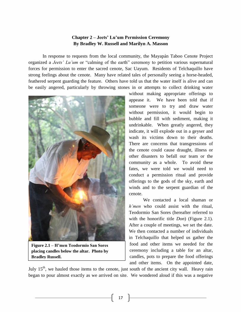
Chapter 2 – Jeets’ Lu’um Permission Ceremony
By Bradley W. Russell and Marilyn A. Masson
In response to requests from the local community, the Mayapán Taboo Cenote Project
organized a Jeets’ Lu’um or “calming of the earth” ceremony to petition various supernatural
forces for permission to enter the sacred cenote, Sac Uayum. Residents of Telchaquillo have
strong feelings about the cenote. Many have related tales of personally seeing a horse-headed,
feathered serpent guarding the feature. Others have told us that the water itself is alive and can
be easily angered, particularly by throwing stones in or attempts to collect drinking water
without making appropriate offerings to
appease it. We have been told that if
someone were to try and draw water
without permission, it would begin to
bubble and fill with sediment, making it
undrinkable. When greatly angered, they
indicate, it will explode out in a geyser and
wash its victims down to their deaths.
There are concerns that transgressions of
the cenote could cause draught, illness or
other disasters to befall our team or the
community as a whole. To avoid these
fates, we were told we would need to
conduct a permission ritual and provide
offerings to the gods of the sky, earth and
winds and to the serpent guardian of the
cenote.
We contacted a local shaman or
h’men who could assist with the ritual,
Teodormio San Sores (hereafter referred to
with the honorific title Don) (Figure 2.1).
After a couple of meetings, we set the date.
We then contacted a number of individuals
in Telchaquillo that helped us gather the
food and other items we needed for the
ceremony including a table for an altar,
candles, pots to prepare the food offerings
and other items. On the appointed date,
July 15th
, we hauled those items to the cenote, just south of the ancient city wall. Heavy rain
began to pour almost exactly as we arrived on site. We wondered aloud if this was a negative
Figure 2.1 – H’men Teodormio San Sores
placing candles below the altar. Photo by
Bradley Russell.
18
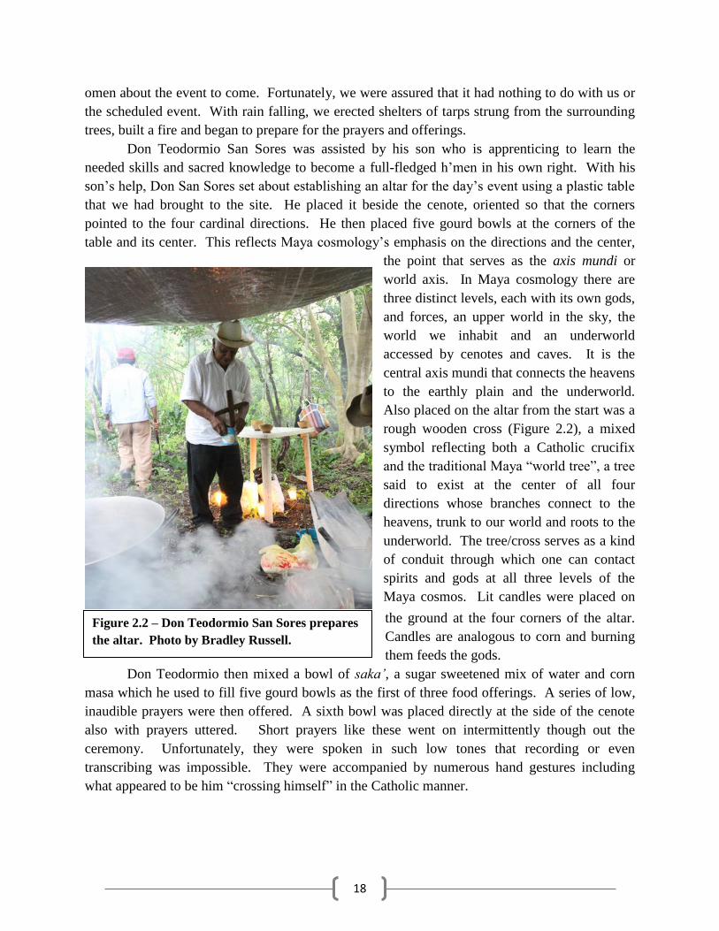
omen about the event to come. Fortunately, we were assured that it had nothing to do with us or
the scheduled event. With rain falling, we erected shelters of tarps strung from the surrounding
trees, built a fire and began to prepare for the prayers and offerings.
Don Teodormio San Sores was assisted by his son who is apprenticing to learn the
needed skills and sacred knowledge to become a full-fledged h’men in his own right. With his
son’s help, on San Sores set about establishing an altar for the day’s event using a plastic table
that we had brought to the site. He placed it beside the cenote, oriented so that the corners
pointed to the four cardinal directions. He then placed five gourd bowls at the corners of the
table and its center. This reflects Maya cosmology’s emphasis on the directions and the center,
the point that serves as the axis mundi or
world axis. In Maya cosmology there are
three distinct levels, each with its own gods,
and forces, an upper world in the sky, the
world we inhabit and an underworld
accessed by cenotes and caves. It is the
central axis mundi that connects the heavens
to the earthly plain and the underworld.
Also placed on the altar from the start was a
rough wooden cross (Figure 2.2), a mixed
symbol reflecting both a Catholic crucifix
and the traditional Maya “world tree”, a tree
said to exist at the center of all four
directions whose branches connect to the
heavens, trunk to our world and roots to the
underworld. The tree/cross serves as a kind
of conduit through which one can contact
spirits and gods at all three levels of the
Maya cosmos. Lit candles were placed on
the ground at the four corners of the altar.
Candles are analogous to corn and burning
them feeds the gods.
Don Teodormio then mixed a bowl of saka’, a sugar sweetened mix of water and corn
masa which he used to fill five gourd bowls as the first of three food offerings. A series of low,
inaudible prayers were then offered. A sixth bowl was placed directly at the side of the cenote
also with prayers uttered. Short prayers like these went on intermittently though out the
ceremony. Unfortunately, they were spoken in such low tones that recording or even
transcribing was impossible. They were accompanied by numerous hand gestures including
what appeared to be him “crossing himself” in the Catholic manner.
Figure 2.2 – Don Teodormio San Sores prepares
the altar. Photo by Bradley Russell.
19
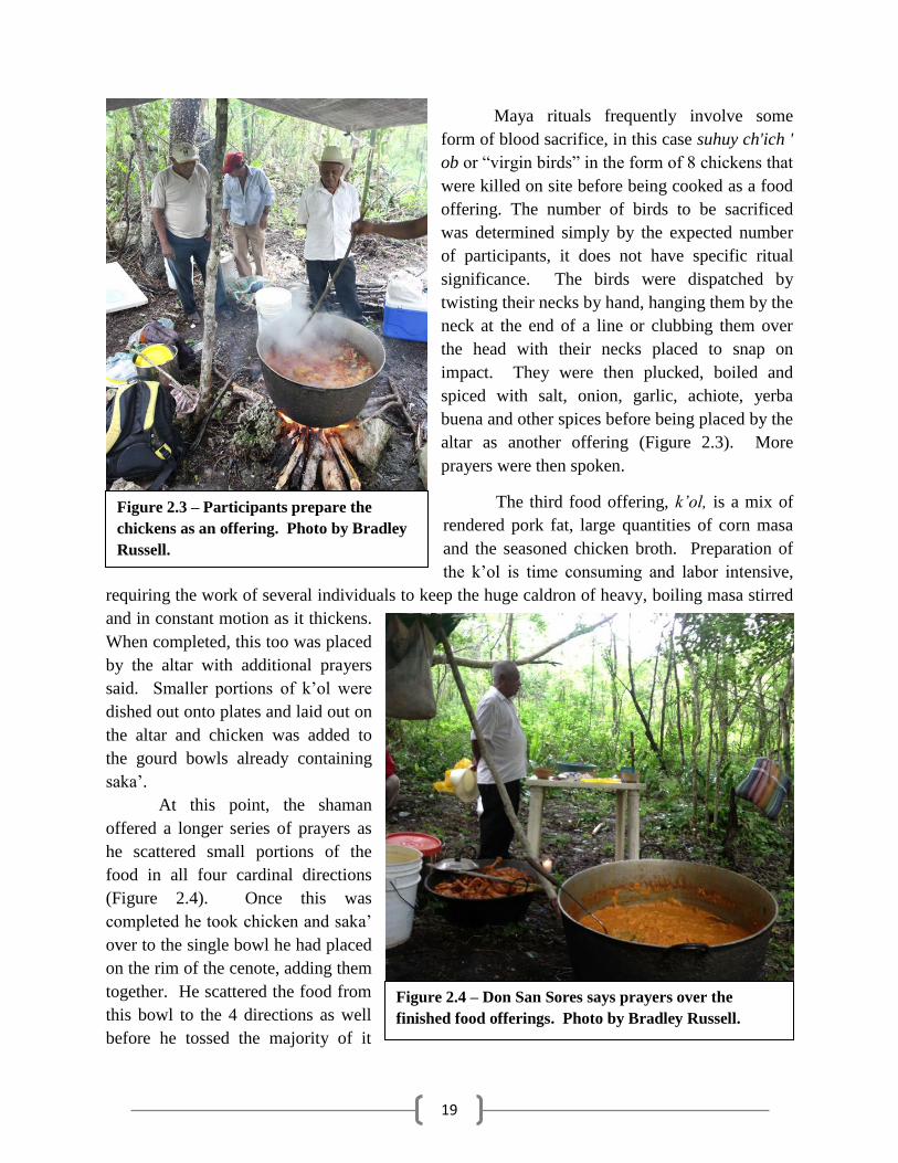
Maya rituals frequently involve some
form of blood sacrifice, in this case suhuy ch'ich '
ob or “virgin birds” in the form of 8 chickens that
were killed on site before being cooked as a food
offering. The number of birds to be sacrificed
was determined simply by the expected number
of participants, it does not have specific ritual
significance. The birds were dispatched by
twisting their necks by hand, hanging them by the
neck at the end of a line or clubbing them over
the head with their necks placed to snap on
impact. They were then plucked, boiled and
spiced with salt, onion, garlic, achiote, yerba
buena and other spices before being placed by the
altar as another offering (Figure 2.3). More
prayers were then spoken.
The third food offering, k’o , is a mix of
rendered pork fat, large quantities of corn masa
and the seasoned chicken broth. Preparation of
the k’ol is time consuming and labor intensive,
requiring the work of several individuals to keep the huge caldron of heavy, boiling masa stirred
and in constant motion as it thickens.
When completed, this too was placed
by the altar with additional prayers
said. Smaller portions of k’ol were
dished out onto plates and laid out on
the altar and chicken was added to
the gourd bowls already containing
saka’.
At this point, the shaman
offered a longer series of prayers as
he scattered small portions of the
food in all four cardinal directions
(Figure 2.4). Once this was
completed he took chicken and saka’
over to the single bowl he had placed
on the rim of the cenote, adding them
together. He scattered the food from
this bowl to the 4 directions as well
before he tossed the majority of it
Figure 2.3 – Participants prepare the
chickens as an offering. Photo by Bradley
Russell.
Figure 2.4 – Don San Sores says prayers over the
finished food offerings. Photo by Bradley Russell.
20
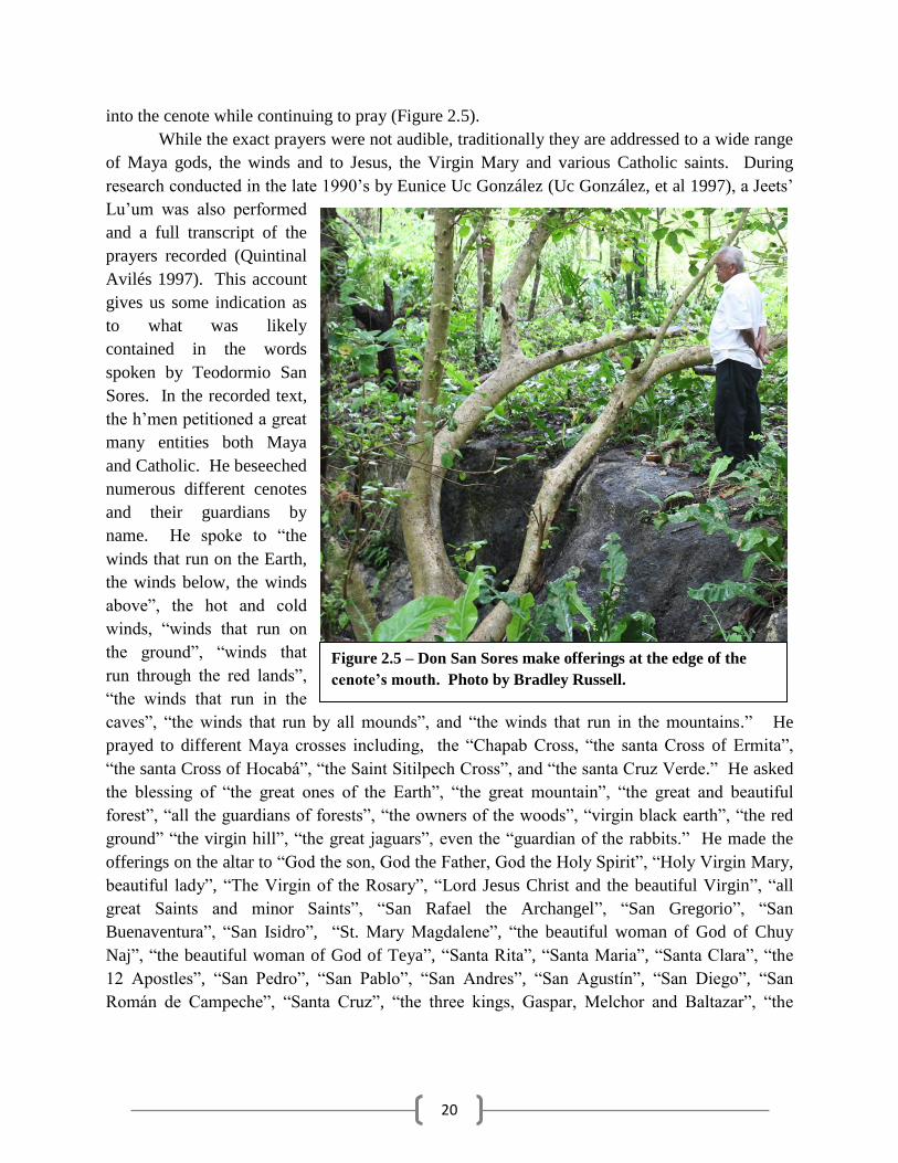
into the cenote while continuing to pray (Figure 2.5).
While the exact prayers were not audible, traditionally they are addressed to a wide range
of Maya gods, the winds and to Jesus, the Virgin Mary and various Catholic saints. During
research conducted in the late 1990’s by Eunice Uc González (Uc González, et al 1997), a Jeets’
Lu’um was also performed
and a full transcript of the
prayers recorded (Quintinal
Avilés 1997). This account
gives us some indication as
to what was likely
contained in the words
spoken by Teodormio San
Sores. In the recorded text,
the h’men petitioned a great
many entities both Maya
and Catholic. He beseeched
numerous different cenotes
and their guardians by
name. He spoke to “the
winds that run on the Earth,
the winds below, the winds
above”, the hot and cold
winds, “winds that run on
the ground”, “winds that
run through the red lands”,
“the winds that run in the
caves”, “the winds that run by all mounds”, and “the winds that run in the mountains.” He
prayed to different Maya crosses including, the “Chapab Cross, “the santa Cross of Ermita”,
“the santa Cross of Hocabá”, “the Saint Sitilpech Cross”, and “the santa Cruz Verde.” He asked
the blessing of “the great ones of the Earth”, “the great mountain”, “the great and beautiful
forest”, “all the guardians of forests”, “the owners of the woods”, “virgin black earth”, “the red
ground” “the virgin hill”, “the great jaguars”, even the “guardian of the rabbits.” He made the
offerings on the altar to “God the son, God the Father, God the Holy Spirit”, “Holy Virgin Mary,
beautiful lady”, “The Virgin of the Rosary”, “Lord Jesus Christ and the beautiful Virgin”, “all
great Saints and minor Saints”, “San Rafael the Archangel”, “San Gregorio”, “San
Buenaventura”, “San Isidro”, “St. Mary Magdalene”, “the beautiful woman of God of Chuy
Naj”, “the beautiful woman of God of Teya”, “Santa Rita”, “Santa Maria”, “Santa Clara”, “the
12 Apostles”, “San Pedro”, “San Pablo”, “San Andres”, “San Agust n”, “San iego”, “San
Román de Campeche”, “Santa Cruz”, “the three kings, Gaspar, Melchor and Baltazar”, “the
Figure 2.5 – Don San Sores make offerings at the edge of the
cenote’s mouth. Photo by Bradley Russell.
21
Christ of Chumayel”, “the Christ of Teabo”, among others. Perhaps most succinctly he
petitioned “all the gods of the world at large.”
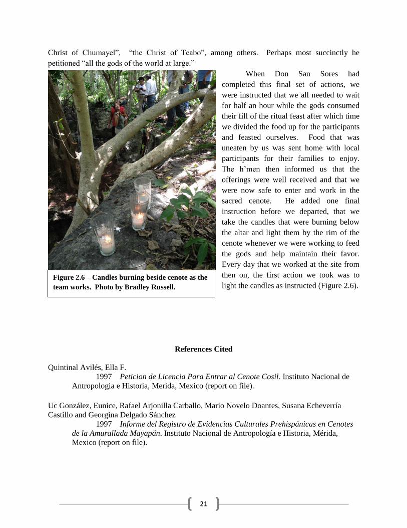
When Don San Sores had
completed this final set of actions, we
were instructed that we all needed to wait
for half an hour while the gods consumed
their fill of the ritual feast after which time
we divided the food up for the participants
and feasted ourselves. Food that was
uneaten by us was sent home with local
participants for their families to enjoy.
The h’men then informed us that the
offerings were well received and that we
were now safe to enter and work in the
sacred cenote. He added one final
instruction before we departed, that we
take the candles that were burning below
the altar and light them by the rim of the
cenote whenever we were working to feed
the gods and help maintain their favor.
Every day that we worked at the site from
then on, the first action we took was to
light the candles as instructed (Figure 2.6).
References Cited
Quintinal Avilés, Ella F.
1997 Peticion de Licencia Para Entrar al Cenote Cosil. Instituto Nacional de
Antropologia e Historia, Merida, Mexico (report on file).
Uc González, Eunice, Rafael Arjonilla Carballo, Mario Novelo Doantes, Susana Echeverría
Castillo and Georgina Delgado Sánchez
1997 Informe del Registro de Evidencias Culturales Prehispánicas en Cenotes
de la Amurallada Mayapán. Instituto Nacional de Antropología e Historia, Mérida,
Mexico (report on file).
Figure 2.6 – Candles burning beside cenote as the
team works. Photo by Bradley Russell.

22
23
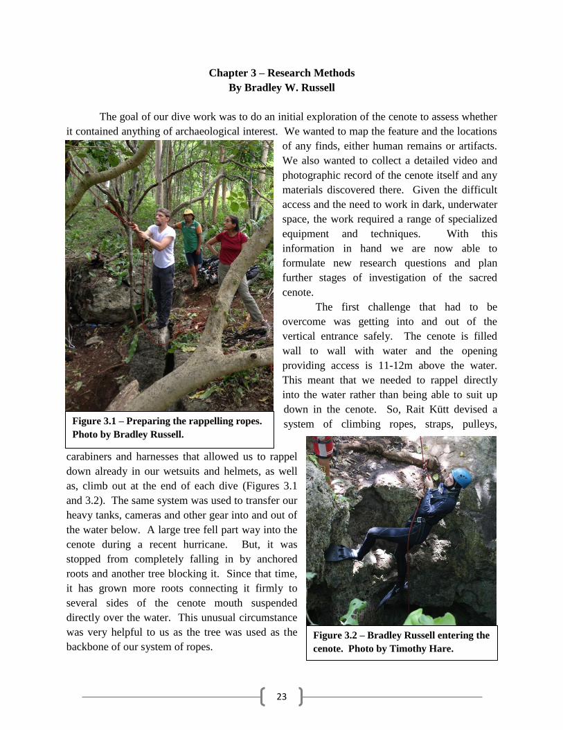
Chapter 3 – Research Methods
By Bradley W. Russell
The goal of our dive work was to do an initial exploration of the cenote to assess whether
it contained anything of archaeological interest. We wanted to map the feature and the locations
of any finds, either human remains or artifacts.
We also wanted to collect a detailed video and
photographic record of the cenote itself and any
materials discovered there. Given the difficult
access and the need to work in dark, underwater
space, the work required a range of specialized
equipment and techniques. With this
information in hand we are now able to
formulate new research questions and plan
further stages of investigation of the sacred
cenote.
The first challenge that had to be
overcome was getting into and out of the
vertical entrance safely. The cenote is filled
wall to wall with water and the opening
providing access is 11-12m above the water.
This meant that we needed to rappel directly
into the water rather than being able to suit up
down in the cenote. So, Rait Kütt devised a
system of climbing ropes, straps, pulleys,
carabiners and harnesses that allowed us to rappel
down already in our wetsuits and helmets, as well
as, climb out at the end of each dive (Figures 3.1
and 3.2). The same system was used to transfer our
heavy tanks, cameras and other gear into and out of
the water below. A large tree fell part way into the
cenote during a recent hurricane. But, it was
stopped from completely falling in by anchored
roots and another tree blocking it. Since that time,
it has grown more roots connecting it firmly to
several sides of the cenote mouth suspended
directly over the water. This unusual circumstance
was very helpful to us as the tree was used as the
backbone of our system of ropes.
Figure 3.1 – Preparing the rappelling ropes.
Photo by Bradley Russell.
Figure 3.2 – Bradley Russell entering the
cenote. Photo by Timothy Hare.
24
Once floating in the shallow water below the mouth of the cenote, we put on our dive
gear. All divers used a twin tank setup with Apeks long hose and secondary short hose
regulators to provide maximum air and bottom time during the work. Buoyancy control was
provided by a wing with air bladder. The tanks were refilled each night in advance of the next
day’s work. All lights, cameras, etc. were charged nightly as well. Chamber One of the cenote
was an open water diving environment,
meaning that we could access the
surface at any time simply by swimming
vertically. This environment requires
less redundancy in certain equipment
such as lights, allowing divers to work
with a primary light and just one back
up. Chamber Two was a fully
submerged and deeper cave
environment with exit only available
after returning to Chamber One through
a narrow connecting passage. This
required additional equipment and
precautions such as double redundancy
for back up lighting and the use of dive
lines with directional markers pointing
back to the exit. All divers adopted a
standardized Hogarthian equipment set-
up which emphasizes a clean equipment
configuration designed to reduce issues
like snags and possible failure points
while providing the necessary
redundancy. When diving in the second
chamber all dives were planned based
on the “rule of thirds”, with one third of
the air supply allowed for entering the
cave, the next third used to exit and one
third remaining in the tanks as a possible
shared backup for any member of the team that experiences an equipment failure. All dives
were planned and all dive data recorded using Suunto D6 or D6i dive computers. These
provided compass, depth gauge and other features key for the work.
The team employed a mix of photographic equipment to document the research.
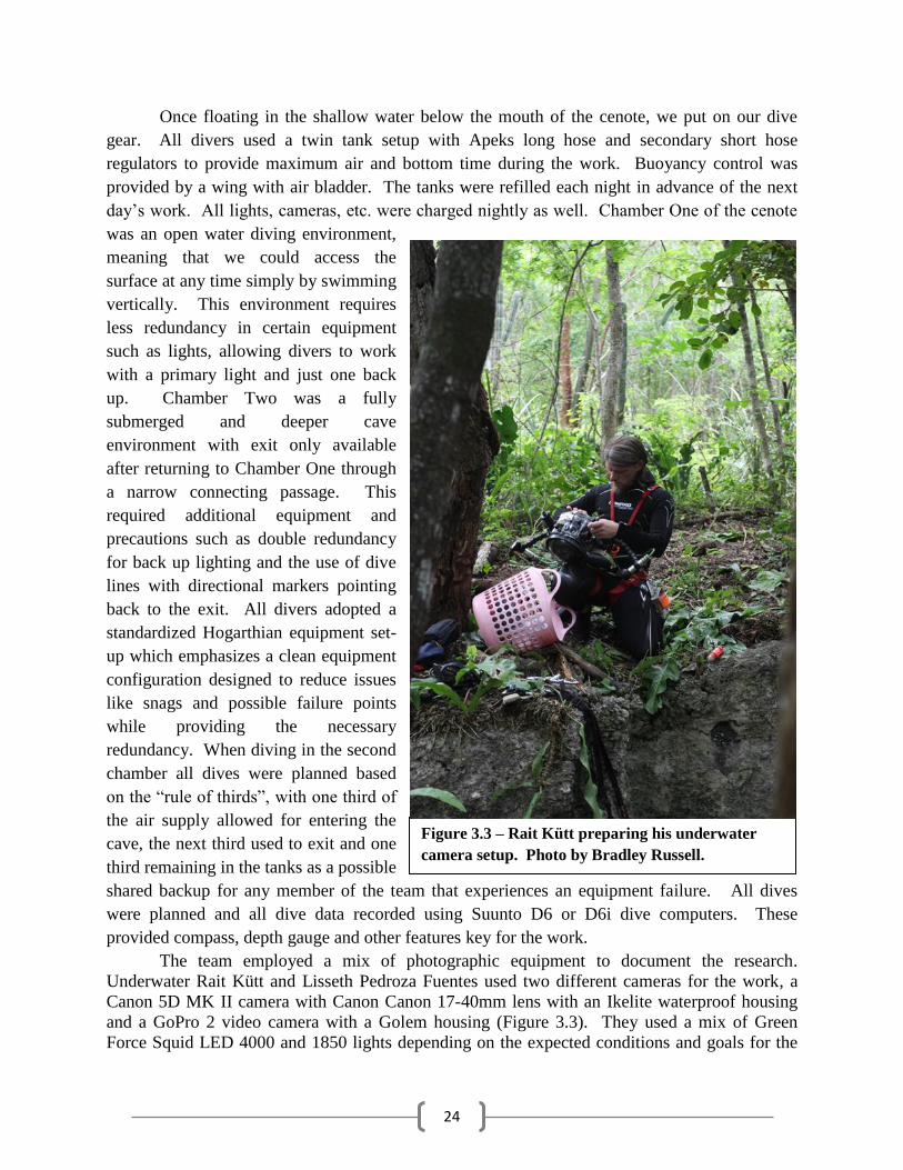
Underwater Rait Kütt and Lisseth Pedroza Fuentes used two different cameras for the work, a
Canon 5D MK II camera with Canon Canon 17-40mm lens with an Ikelite waterproof housing
and a GoPro 2 video camera with a Golem housing (Figure 3.3). They used a mix of Green
Force Squid LED 4000 and 1850 lights depending on the expected conditions and goals for the
Figure 3.3 – Rait Kütt preparing his underwater
camera setup. Photo by Bradley Russell.
25
day. They used the same Canon
camera with a Canon 16-35mm lens
for dry conditions. Bradley Russell
used a Canon Eos M camera with a
25mm pancake lens inside of a
Nauticam housing for dive work. He
employed Sea&Sea YS-D1 lights. He
used the same Canon Eos M with a
Canon 16-35mm lens for dry
shots/video. Using this equipment,
we documented the exploration of the
cenote’s two chambers and registered
all finds made.
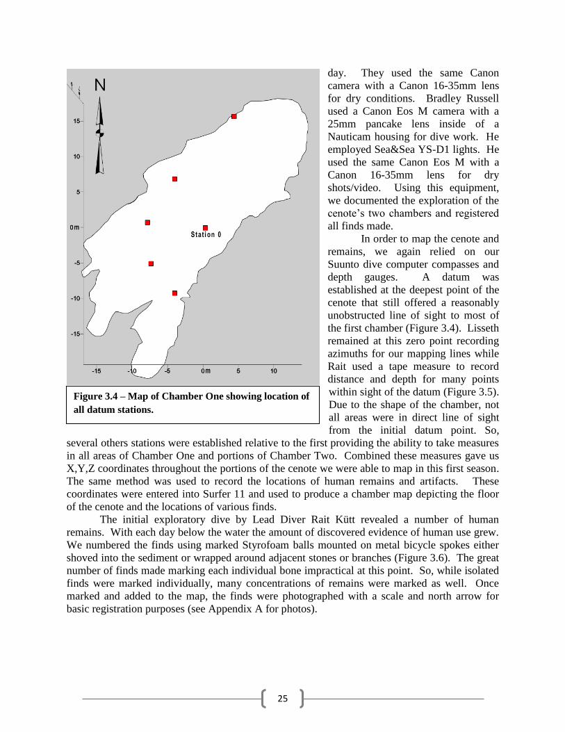
In order to map the cenote and
remains, we again relied on our
Suunto dive computer compasses and
depth gauges. A datum was
established at the deepest point of the
cenote that still offered a reasonably
unobstructed line of sight to most of
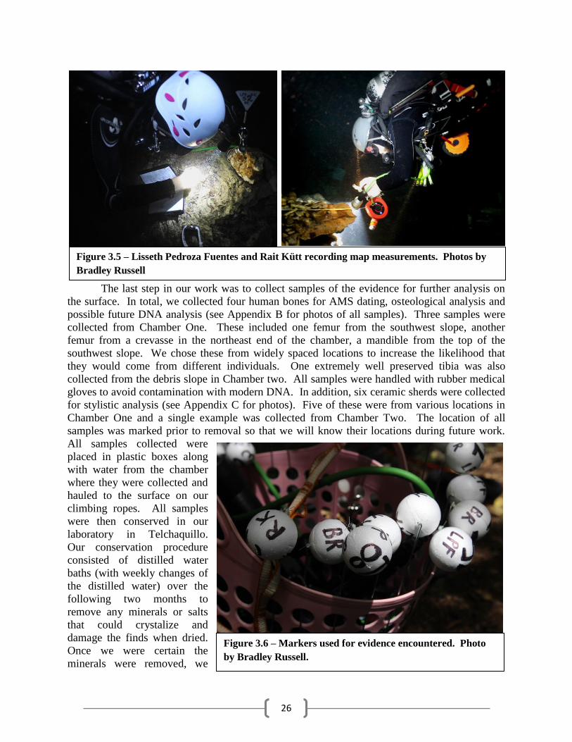
the first chamber (Figure 3.4). Lisseth
remained at this zero point recording
azimuths for our mapping lines while
Rait used a tape measure to record
distance and depth for many points
within sight of the datum (Figure 3.5).
Due to the shape of the chamber, not
all areas were in direct line of sight
from the initial datum point. So,
several others stations were established relative to the first providing the ability to take measures
in all areas of Chamber One and portions of Chamber Two. Combined these measures gave us
X,Y,Z coordinates throughout the portions of the cenote we were able to map in this first season.
The same method was used to record the locations of human remains and artifacts. These
coordinates were entered into Surfer 11 and used to produce a chamber map depicting the floor
of the cenote and the locations of various finds.
The initial exploratory dive by Lead Diver Rait Kütt revealed a number of human
remains. With each day below the water the amount of discovered evidence of human use grew.
We numbered the finds using marked Styrofoam balls mounted on metal bicycle spokes either
shoved into the sediment or wrapped around adjacent stones or branches (Figure 3.6). The great
number of finds made marking each individual bone impractical at this point. So, while isolated
finds were marked individually, many concentrations of remains were marked as well. Once
marked and added to the map, the finds were photographed with a scale and north arrow for
basic registration purposes (see Appendix A for photos).
Figure 3.4 – Map of Chamber One showing location of
all datum stations.
26
The last step in our work was to collect samples of the evidence for further analysis on
the surface. In total, we collected four human bones for AMS dating, osteological analysis and
possible future DNA analysis (see Appendix B for photos of all samples). Three samples were
collected from Chamber One. These included one femur from the southwest slope, another
femur from a crevasse in the northeast end of the chamber, a mandible from the top of the
southwest slope. We chose these from widely spaced locations to increase the likelihood that
they would come from different individuals. One extremely well preserved tibia was also
collected from the debris slope in Chamber two. All samples were handled with rubber medical
gloves to avoid contamination with modern DNA. In addition, six ceramic sherds were collected
for stylistic analysis (see Appendix C for photos). Five of these were from various locations in
Chamber One and a single example was collected from Chamber Two. The location of all
samples was marked prior to removal so that we will know their locations during future work.
All samples collected were
placed in plastic boxes along
with water from the chamber
where they were collected and
hauled to the surface on our
climbing ropes. All samples
were then conserved in our
laboratory in Telchaquillo.
Our conservation procedure
consisted of distilled water
baths (with weekly changes of
the distilled water) over the
following two months to
remove any minerals or salts
that could crystalize and
damage the finds when dried.
Once we were certain the
minerals were removed, we
Figure 3.5 – Lisseth Pedroza Fuentes and Rait Kütt recording map measurements. Photos by
Bradley Russell
Figure 3.6 – Markers used for evidence encountered. Photo
by Bradley Russell.

27
dried them and stored them for future lab work and dating. Small sections of each of the long
bones and a single tooth from the mandible have been sent to Douglas Kennett of Pennsylvania
State University for AMS dating. We are currently awaiting those results.

28
29
Chapter 4 – Cenote Sac Uayum’s Chamber One
By Bradley W. Russell, Rait Kütt and Lisseth Pedroza Fuentes
Chamber One of Cenote Sac Uayum is fairly typical of cenotes in the area. It is a
solution feature measuring roughly 45m by 15m and is oriented from northeast to southwest
(Figure 4.1). The entrance is a collapse feature located at the northeast end of the chamber and is
roughly round measuring approximately 8m across. There is a second round entrance near the
center of the chamber that is only about 1m across. The distance from the ceiling to the water is
11-12m and the maximum depth
is 16m below the water surface.
It is just a few meters deep at
each end, sloping down to the
maximum depth in the center.
The end slopes consist of rubble
collapsed from the ceiling at some
time in the past covered in dark,
organic rich sediments. The
ceiling is made of a layer of more
durable limestone cap rock. It is
covered in stalactites ranging
from massive to very small
(Figures 4.2 and 4.3). Stalactites
near the mouth of the cenote
show evidence of breakage and
removal, a common feature in the
cenotes of Mayapán. Those
further inside of the cavern
remain largely intact due to their
inaccessibility. The sidewalls are
almost totally vertical from
ceiling to the floor and stained
dark from the decomposing
organics in the water. There are a
number of fallen trees and
branches below the main opening.
The northeast end is rounded and
the southwest end contains
several small rooms/crevasses.
We found that there is a slow water flow from northeast to southwest that likely accounts for the
highest concentration of remains being found in the southwest away from the main opening. All
indications are that there are a good number of remains located below the sediment, some
partially visible and others completely buried. We assumed incorrectly that this would be the
only chamber present in Sac Uayum.
The first of our team to enter the cenote was Lead Diver Rait Kütt, who conducted a solo
exploratory dive on July 22. The dive was short, just 15 minutes, and he recorded it with his
Figure 4.1 – Map of Cenote Sac Uayum Chamber One.
30
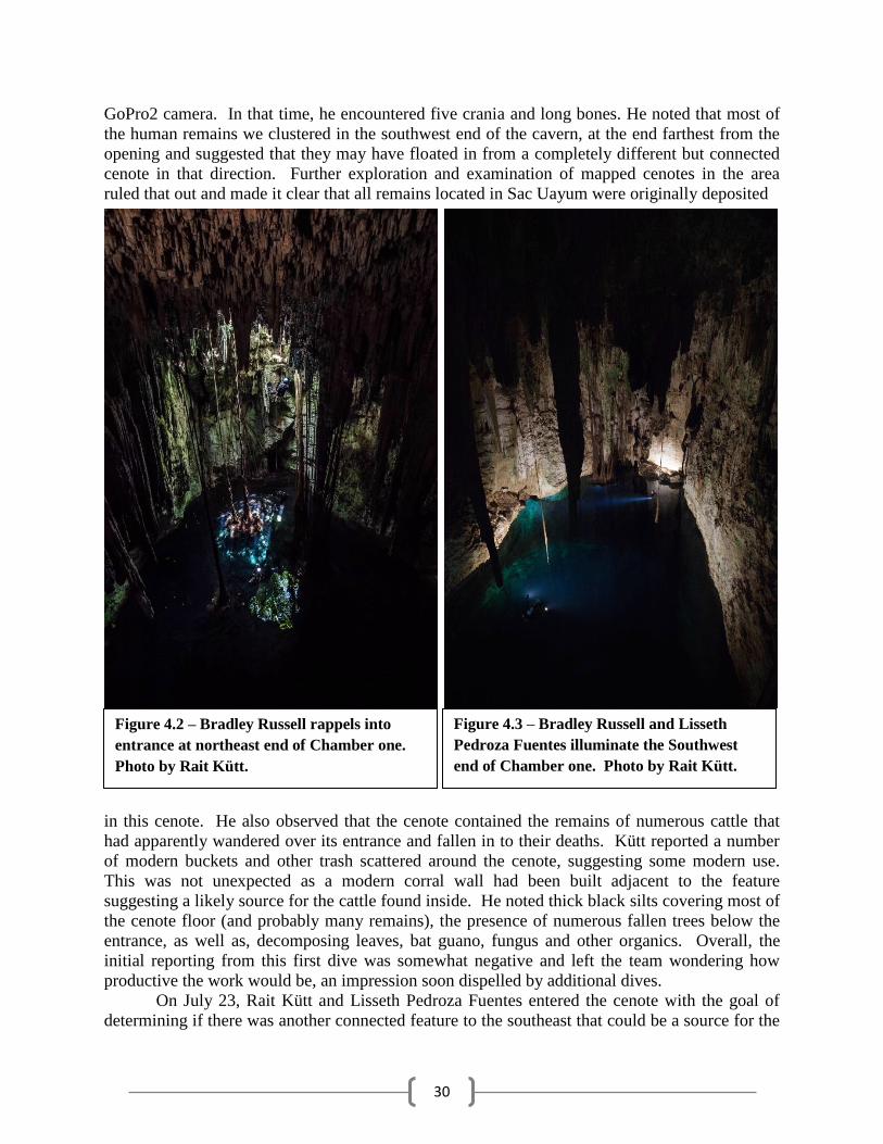
GoPro2 camera. In that time, he encountered five crania and long bones. He noted that most of
the human remains we clustered in the southwest end of the cavern, at the end farthest from the
opening and suggested that they may have floated in from a completely different but connected
cenote in that direction. Further exploration and examination of mapped cenotes in the area
ruled that out and made it clear that all remains located in Sac Uayum were originally deposited
in this cenote. He also observed that the cenote contained the remains of numerous cattle that
had apparently wandered over its entrance and fallen in to their deaths. Kütt reported a number
of modern buckets and other trash scattered around the cenote, suggesting some modern use.
This was not unexpected as a modern corral wall had been built adjacent to the feature
suggesting a likely source for the cattle found inside. He noted thick black silts covering most of
the cenote floor (and probably many remains), the presence of numerous fallen trees below the
entrance, as well as, decomposing leaves, bat guano, fungus and other organics. Overall, the
initial reporting from this first dive was somewhat negative and left the team wondering how
productive the work would be, an impression soon dispelled by additional dives.
On July 23, Rait Kütt and Lisseth Pedroza Fuentes entered the cenote with the goal of
determining if there was another connected feature to the southeast that could be a source for the
Figure 4.2 – Bradley Russell rappels into
entrance at northeast end of Chamber one.
Photo by Rait Kütt.
Figure 4.3 – Bradley Russell and Lisseth
Pedroza Fuentes illuminate the Southwest
end of Chamber one. Photo by Rait Kütt.
31
bones we were finding.
Kütt climbed up and out
of the water at the far end
of the cenote searching
for another possible
entrance in a crevasse
found in the southeast end
of the chamber. He made
his way up the crevasse to
the ceiling of the chamber
but, found no additional
opening or any additional
remains to suggest that
material was entering
there. The two divers
continued to explore the
chamber locating a
number of additional
bones and the first
ceramics that we
encountered in the study, one of the sherds was judged to be Preclassic in date. They observed a
number of small but well preserved bones (phalanges and a patella) among the larger and more
obvious remains. Some sediment was cleared to more fully expose some of the remains that had
been recorded in the initial exploratory dive.
The sediment turned out to be very heavy
and large-grained, a positive development as
disturbed sediment settled out quickly and
did not cloud the water. Silted up water is a
significant problem in cenotes given that the
very limited flow results in slow clearing of
fouled water. At the end of the dive, we
attempted to haul out one of the many tree
trunks present below the mouth to make
entry and exit safer. It proved to be a very
difficult task as the waterlogged trunk was
extremely heavy. Plans to remove more of
them were abandoned. The total dive lasted
roughly 90 minutes.
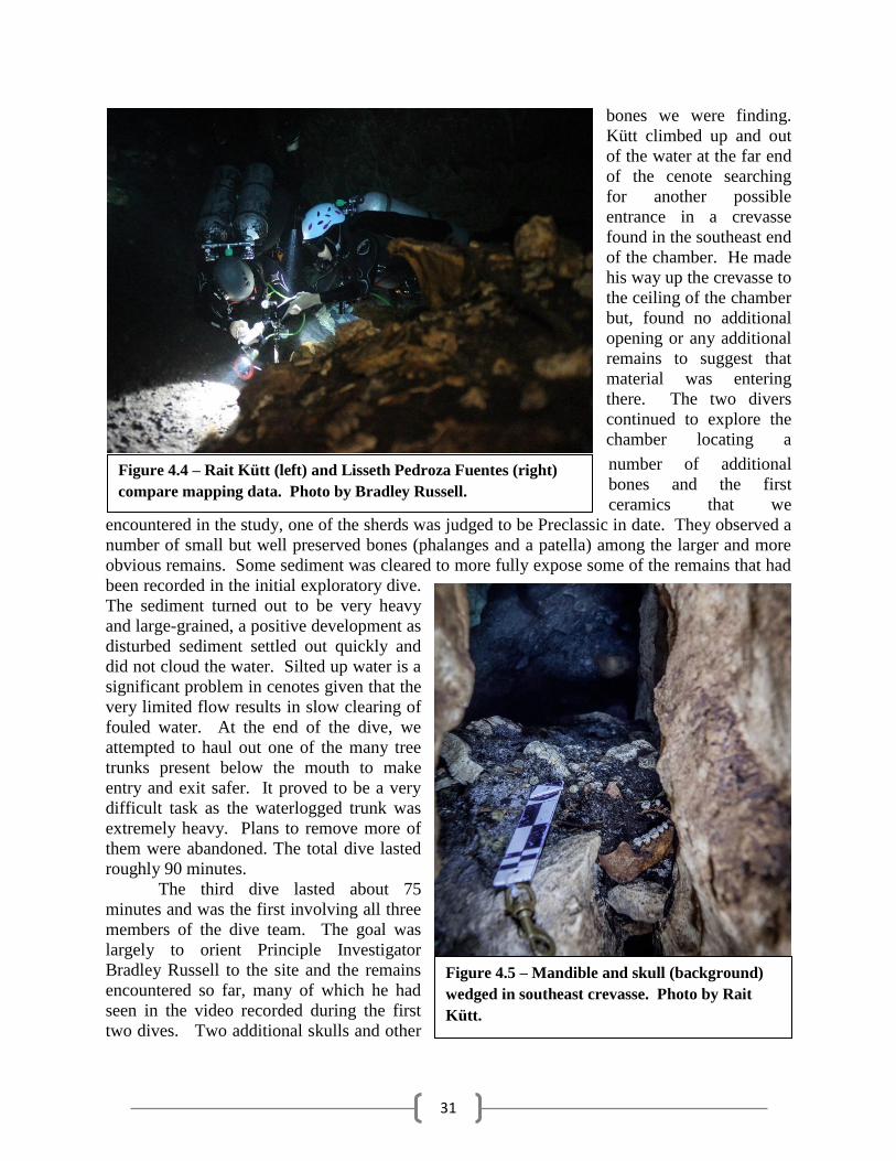
The third dive lasted about 75
minutes and was the first involving all three
members of the dive team. The goal was
largely to orient Principle Investigator
Bradley Russell to the site and the remains
encountered so far, many of which he had
seen in the video recorded during the first
two dives. Two additional skulls and other
Figure 4.4 – Rait Kütt (left) and Lisseth Pedroza Fuentes (right)
compare mapping data. Photo by Bradley Russell.
Figure 4.5 – Mandible and skull (background)
wedged in southeast crevasse. Photo by Rait
Kütt.
32
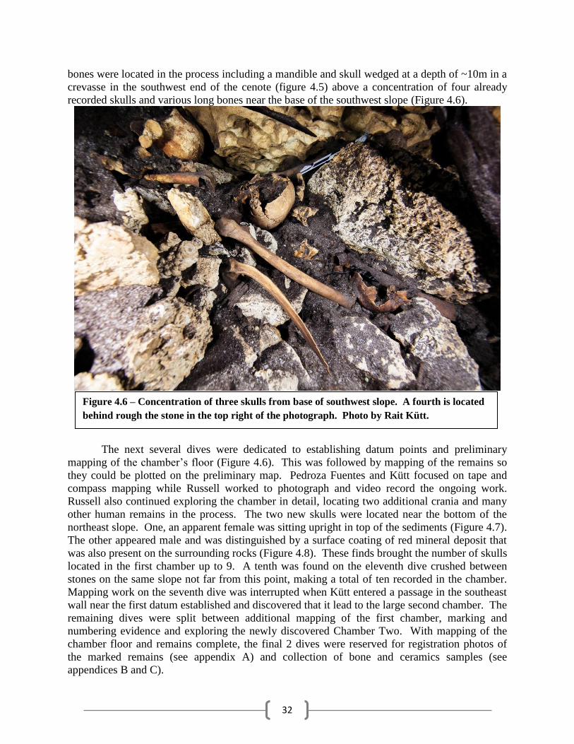
bones were located in the process including a mandible and skull wedged at a depth of ~10m in a
crevasse in the southwest end of the cenote (figure 4.5) above a concentration of four already
recorded skulls and various long bones near the base of the southwest slope (Figure 4.6).
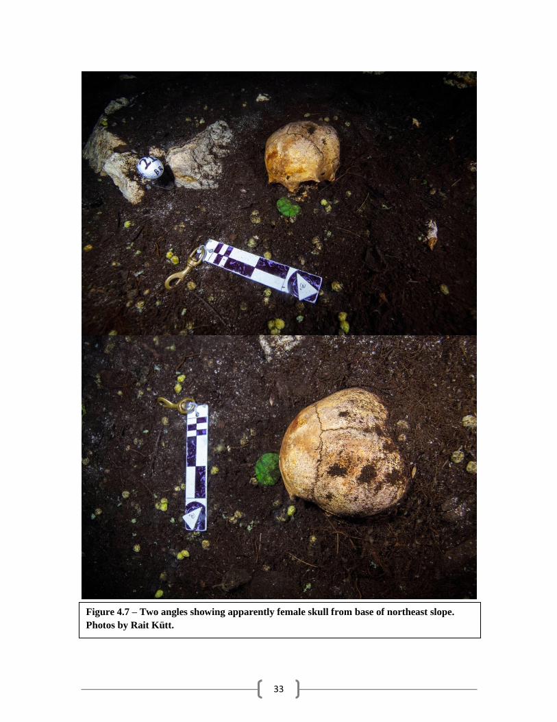
The next several dives were dedicated to establishing datum points and preliminary
mapping of the chamber’s floor (Figure 4.6). This was followed by mapping of the remains so
they could be plotted on the preliminary map. Pedroza Fuentes and Kütt focused on tape and
compass mapping while Russell worked to photograph and video record the ongoing work.
Russell also continued exploring the chamber in detail, locating two additional crania and many
other human remains in the process. The two new skulls were located near the bottom of the
northeast slope. One, an apparent female was sitting upright in top of the sediments (Figure 4.7).
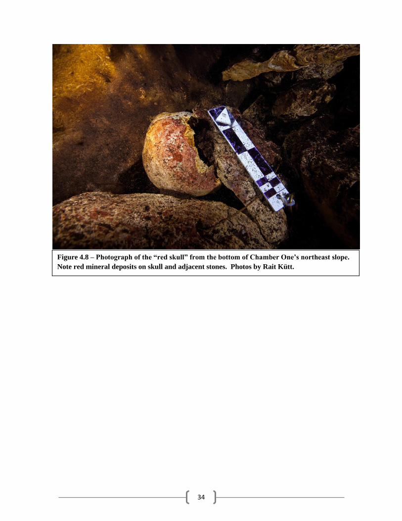
The other appeared male and was distinguished by a surface coating of red mineral deposit that
was also present on the surrounding rocks (Figure 4.8). These finds brought the number of skulls
located in the first chamber up to 9. A tenth was found on the eleventh dive crushed between
stones on the same slope not far from this point, making a total of ten recorded in the chamber.
Mapping work on the seventh dive was interrupted when Kütt entered a passage in the southeast
wall near the first datum established and discovered that it lead to the large second chamber. The
remaining dives were split between additional mapping of the first chamber, marking and
numbering evidence and exploring the newly discovered Chamber Two. With mapping of the
chamber floor and remains complete, the final 2 dives were reserved for registration photos of
the marked remains (see appendix A) and collection of bone and ceramics samples (see
appendices B and C).
Figure 4.6 – Concentration of three skulls from base of southwest slope. A fourth is located
behind rough the stone in the top right of the photograph. Photo by Rait Kütt.
33
Figure 4.7 – Two angles showing apparently female skull from base of northeast slope.
Photos by Rait Kütt.
34
Figure 4.8 – Photograph of the “red skull” from the bottom of Chamber One’s northeast slope.
Note red mineral deposits on skull and adjacent stones. Photos by Rait Kütt.
35
Chapter 5 – Cenote Sac Uayum’s Chamber Two
By Bradley W. Russell, Lisseth Pedroza Fuentes and Rait Kütt
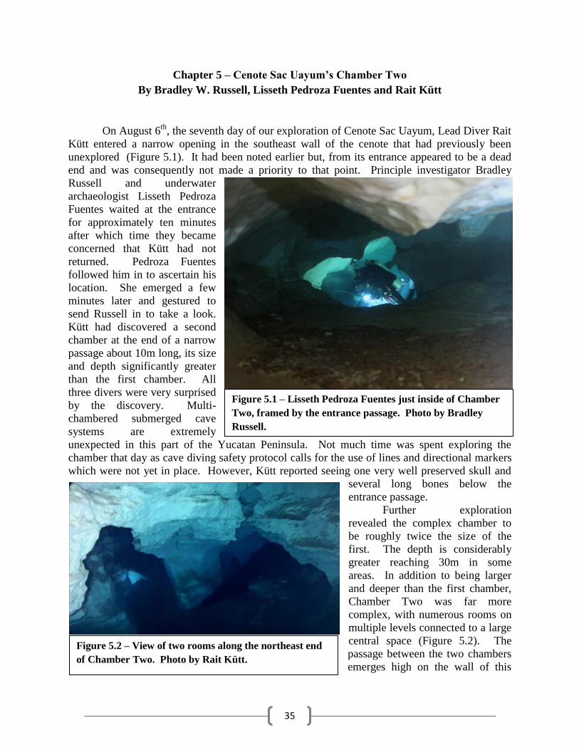
On August 6th
, the seventh day of our exploration of Cenote Sac Uayum, Lead Diver Rait
Kütt entered a narrow opening in the southeast wall of the cenote that had previously been
unexplored (Figure 5.1). It had been noted earlier but, from its entrance appeared to be a dead
end and was consequently not made a priority to that point. Principle investigator Bradley
Russell and underwater
archaeologist Lisseth Pedroza
Fuentes waited at the entrance
for approximately ten minutes
after which time they became
concerned that Kütt had not
returned. Pedroza Fuentes
followed him in to ascertain his
location. She emerged a few
minutes later and gestured to
send Russell in to take a look.
Kütt had discovered a second
chamber at the end of a narrow
passage about 10m long, its size
and depth significantly greater
than the first chamber. All
three divers were very surprised
by the discovery. Multi-
chambered submerged cave
systems are extremely
unexpected in this part of the Yucatan Peninsula. Not much time was spent exploring the
chamber that day as cave diving safety protocol calls for the use of lines and directional markers
which were not yet in place. However, Kütt reported seeing one very well preserved skull and
several long bones below the
entrance passage.
Further exploration
revealed the complex chamber to
be roughly twice the size of the
first. The depth is considerably
greater reaching 30m in some
areas. In addition to being larger
and deeper than the first chamber,
Chamber Two was far more
complex, with numerous rooms on
multiple levels connected to a large
central space (Figure 5.2). The
passage between the two chambers
emerges high on the wall of this
Figure 5.1 – Lisseth Pedroza Fuentes just inside of Chamber
Two, framed by the entrance passage. Photo by Bradley
Russell.
Figure 5.2 – View of two rooms along the northeast end
of Chamber Two. Photo by Rait Kütt.
36
central space (Figure 5.3). It has no
direct opening to the surface which
means that very little organic
material has entered it, leaving it a
much different environment than
Chamber One. The walls for the
most part are clean white limestone.
The floor is covered in some areas
by a layer of orange clay which is
compact and cracked like a dry lake
bed (Figure 5.4). Pedroza Fuentes
and Kütt have seen this in other
cenotes in the area and suggest that
it indicates that at some as of yet
undetermined point in the past the
chamber dried out. This would
have to have been a very significant drought event as the water table currently reaches the
ceiling, some nine stories above the floor level clay deposits. Stalactites do not form in fully
submerged caves as they are created when mineral rich water enters and evaporates. Where
Chamber One is home to many stalactites, the second chamber lacks such formations, with one
exception. A single formation (Figure 5.5) exists near a point in the cave where the opening
exceeds the current height of the water table, creating a small pocket of air below meters of intact
limestone. If the chamber did dry out entirely, creating the cracked layer of clay, no significant
stalactites formed during the drying
event. This may suggest it was a
very brief event or simply that there
was a total lack of water entering
through the porous limestone
overhead. So, the form of the cave
and the clay at its base suggest that
this chamber has been almost
continuously filled with water except
for a period where it apparently
dried out completely. Further study
would be required to determine
when and for how long this dry
episode lasted.
The remains that were
located in Chamber Two were
unexpected as the likelihood of anything floating onto the second chamber from the first is
minimal. They were all located on close proximity to each other on a slope of cobbles. The area
where they are located is unusual as it does have a layer of the heavy, black organic silt seen in
the first chamber. This room extends under the first chamber. Combined these clues suggest
that, while not currently visible because it is filled with silt and cobbles, there must be a collapse
feature in the floor of the first chamber that has fallen in bringing cobbles, organic silt and the
remains with it. Many of the remains in this chamber sit on top of the cobbles and silt suggesting
Figure 5.3 – Lisseth Pedroza Fuentes entering Chamber
Two. Note the small, albino crawfish at top left. Photo by
Rait Kütt.
Figure 5.4 – Rait Kütt swims past a boulder covered in
cracked clay suggesting an extreme dry period in the
past. Photo by Lisseth Pedroza Fuentes.
37
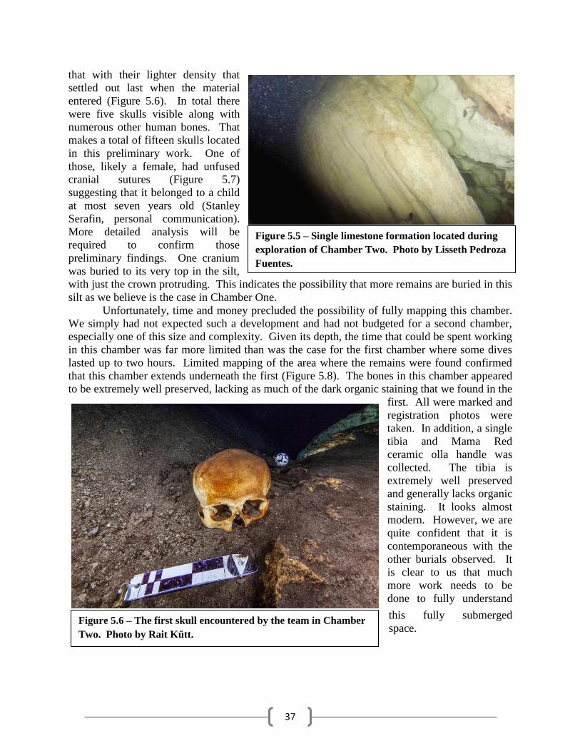
that with their lighter density that
settled out last when the material
entered (Figure 5.6). In total there
were five skulls visible along with
numerous other human bones. That
makes a total of fifteen skulls located
in this preliminary work. One of
those, likely a female, had unfused
cranial sutures (Figure 5.7)
suggesting that it belonged to a child
at most seven years old (Stanley
Serafin, personal communication).
More detailed analysis will be
required to confirm those
preliminary findings. One cranium
was buried to its very top in the silt,
with just the crown protruding. This indicates the possibility that more remains are buried in this
silt as we believe is the case in Chamber One.
Unfortunately, time and money precluded the possibility of fully mapping this chamber.
We simply had not expected such a development and had not budgeted for a second chamber,
especially one of this size and complexity. Given its depth, the time that could be spent working
in this chamber was far more limited than was the case for the first chamber where some dives
lasted up to two hours. Limited mapping of the area where the remains were found confirmed
that this chamber extends underneath the first (Figure 5.8). The bones in this chamber appeared
to be extremely well preserved, lacking as much of the dark organic staining that we found in the
first. All were marked and
registration photos were
taken. In addition, a single
tibia and Mama Red
ceramic olla handle was
collected. The tibia is
extremely well preserved
and generally lacks organic
staining. It looks almost
modern. However, we are
quite confident that it is
contemporaneous with the
other burials observed. It
is clear to us that much
more work needs to be
done to fully understand
this fully submerged
space.
Figure 5.5 – Single limestone formation located during
exploration of Chamber Two. Photo by Lisseth Pedroza
Fuentes.
Figure 5.6 – The first skull encountered by the team in Chamber
Two. Photo by Rait Kütt.
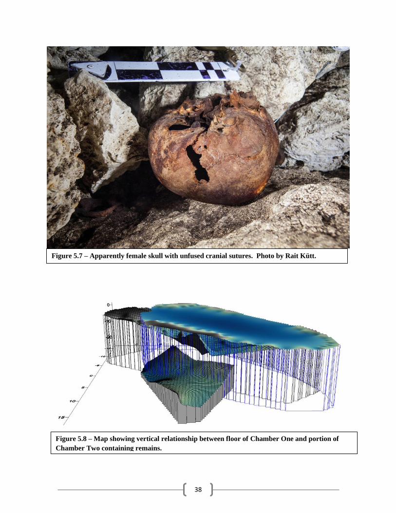
38
Figure 5.8 – Map showing vertical relationship between floor of Chamber One and portion of
Chamber Two containing remains.
Figure 5.7 – Apparently female skull with unfused cranial sutures. Photo by Rait Kütt.
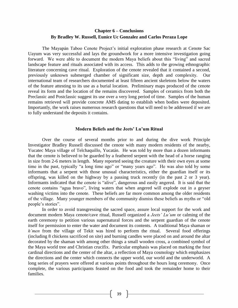
39
Chapter 6 – Conclusions
By Bradley W. Russell, Eunice Uc Gonzalez and Carlos Peraza Lope
The Mayapán Taboo Cenote Project’s initial exploration phase research at Cenote Sac
Uayum was very successful and lays the groundwork for a more intensive investigation going
forward. We were able to document the modern Maya beliefs about this “living” and sacred
landscape feature and rituals associated with its access. This adds to the growing ethnographic
literature concerning cave ritual. Exploration of the cenote revealed that it contained a second,
previously unknown submerged chamber of significant size, depth and complexity. Our
international team of researchers documented at least fifteen ancient skeletons below the waters
of the feature attesting to its use as a burial location. Preliminary maps produced of the cenote
reveal its form and the location of the remains discovered. Samples of ceramics from both the
Preclassic and Postclassic suggest its use over a very long period of time. Samples of the human
remains retrieved will provide concrete AMS dating to establish when bodies were deposited.
Importantly, the work raises numerous research questions that will need to be addressed if we are
to fully understand the deposits it contains.
Modern Beliefs and the Jeets’ Lu’um Ritual
Over the course of several months prior to and during the dive work Principle
Investigator Bradley Russell discussed the cenote with many modern residents of the nearby,
Yucatec Maya village of Telchaquillo, Yucatán. He was told by more than a dozen informants
that the cenote is believed to be guarded by a feathered serpent with the head of a horse ranging
in size from 2-6 meters in length. Many reported seeing the creature with their own eyes at some
time in the past, typically “a long time ago” or “many years ago”. He was also told by some
informants that a serpent with those unusual characteristics, either the guardian itself or its
offspring, was killed on the highway by a passing truck recently (in the past 2 or 3 year).
Informants indicated that the cenote is “alive”, dangerous and easily angered. It is said that the
cenote contains “agua bravo”, living waters that when angered will explode out in a geyser
washing victims into the cenote. These beliefs are far more common among the older residents
of the village. Many younger members of the community dismiss these beliefs as myths or “old
people’s stories”.
In order to avoid transgressing the sacred space, assure local support for the work and
document modern Maya cenote/cave ritual, Russell organized a Jeets’ Lu’um or calming of the
earth ceremony to petition various supernatural forces and the serpent guardian of the cenote
itself for permission to enter the water and document its contents. A traditional Maya shaman or
h’men from the village of Tekit was hired to perform the ritual. Several food offerings
(including 8 chickens sacrificed on site) and burning candles were placed on and around the altar
decorated by the shaman with among other things a small wooden cross, a combined symbol of
the Maya world tree and Christian crucifix. Particular emphasis was placed on marking the four
cardinal directions and the center of the altar, a reflection of Maya cosmology which emphasizes
the directions and the center which connects the upper world, our world and the underworld. A
long series of prayers were offered at various points throughout the hours long ceremony. Once
complete, the various participants feasted on the food and took the remainder home to their
families.
40
The Form of Cenote Sac Uayum
Cenote Sac Uayum is located in the forest just south of Mayapán’s city wall close to the
modern highway that bisects the ancient city. It contains two distinct chambers separated by a
narrow 10m passage just large enough for a diver to pass through without removing tanks and
other equipment. The two chambers are very different environments. Chamber One is open to
the surface through a collapse window in the overlying cap rock that has allowed a large quantity
of organic material including leaves, tree branches, and even numerous cattle to fall into the
water. These decomposing organics have created heavy, black sediments throughout the
chamber and darkly stained its walls and stones. It is only partially filled with a large open
cavern above water level. The ceiling of the chamber is covered in dozens of stalactites of
varying sizes. Chamber Two is deeper, sealed at the surface and completely filled with water.
Lacking the organics of the first chamber, its limestone walls are generally a bright white.
Sediments at the base of the chamber are fine grained, orange clay. The clay deposits are
cracked and resemble a dried lakebed, suggesting a very significant drying even at some time on
the past, one capable of lowering the area’s water table at least 30 meters from present levels.
Chamber One measures approximately 45m by 15m and is oriented northeast to
southwest, essentially parallel to the nearby defensive wall. Water fills the feature from wall to
wall. The main entrance is a large collapse feature at the northeast end of the first chamber. A
second small opening is located in the cap rock near the center of the chamber. To enter divers
rappelled 11m from the opening directly into the water below. The chamber has debris slopes at
both ends reducing the water depth in those areas to just a couple of meters. These piles of
cobbles and silt slope downward to a maximum depth of 16m near the center of the chamber,
which generally lacks collapse cobbles. The southwest slope densely is littered with human
bones and ceramics. Several crania are clustered together near its base. A large fallen stone sits
in this low, central area near the northwest wall. Sitting on top of the rock are a single human
skull in two parts, many broken off stalactites and portions of a cow pelvis and spine, which led
to it being dubbed “the cow rock”. Several more crania were located near the base of the
northeast slope. But the density of other bones observed in that area was much less than the
southwest. The northwest and southeast walls of the chamber are tall, vertical and unusually flat.
The northeast end of the cenote is rounded while the opposing end contains three small
crevasses/rooms, each with bones present. Overall, Chamber One is shaped like a large bathtub
or swimming pool. The passage leading to the second chamber is located in the southeast wall
just above the lowest point in the center of the chamber.
Chamber Two is significantly larger, deeper and more complicated than the first, roughly
twice as long and deep. The entrance passage emerges high on the north wall of the center room
of the chamber. Around this central room are arranged several smaller rooms or grottos on three
vertical levels. The deepest of these levels reaches the floor at ~30m in depth. There is a second
vertical level roughly in the middle of the floor and ceiling and a third near the ceiling.
Importantly, one room extends underneath the floor of Chamber One. This is the chamber that
contains remains. Is contains a slope of large cobbles and black, organic silt of the type found in
the first chamber. No other black silt was seen in the rest of the second chamber. This slope also
contains a scatter of very well preserved human bones including five crania. It appears that slope
formed when a portion of the floor of the first chamber collapsed through bringing with it the silt
as well as human bones and ceramic sherds. The collapse hole itself seems to be filled in by
41
cobbles from above. One room near the ceiling contains a small pocket of air at its apex, the
only portion of the chamber exceeding the water table. This is where the chamber’s only
stalactite was located. Much more exploration and mapping work will be required to fully
understand the form of this chamber as it was discovered late in our work and not adequately
documented by the end of this season’s work.
Human Remains
Based on the crania observed so far, ten in Chamber One and five more in Chamber Two,
we can say that there are at minimum fifteen burials present (see Appendix B for registration
photos). The apparent collapse of materials from one chamber into the other suggests that we
should treat these as a single related assemblage. We believe that there are many more bones
buried below the silt and expect the actual number to be higher. The overall the condition of the
remains that were observed was very good. Almost all skulls appear to be entirely or mostly
intact with just one badly damaged by cobbles. Teeth are present in many of the crania,
including one with two adjacent teeth very badly damaged by dental caries and infection.
Preliminary observations made with the help of osteologist Stanley Serafin (working
from project photographs) suggest that a mix of ages and sexes are present. The youngest
appears to be 6-7 years old based on the unfused sutures on the skull. Most appear to be adults.
However, the top of the age range cannot be estimated at this point. Tabular erect cranial
deformation is seen on many of the skulls observed, including the young child. This type of
modification was fairly common in the Postclassic Period and the dominant form seen at
Mayapán, suggesting they are likely contemporaneous with the site occupation. However, two
thirds of the ceramics we were able to collect have Preclassic dates as discussed below. AMS
dates will be obtained from the samples that were collected for lab analysis.
Researchers collected just four bone samples at this stage of the study, two femurs from
opposite ends of Chamber One, a mandible from the top of the southwest slope in Chamber One
and a tibia from the collapse slope in Chamber Two. The mandible appears to be that of a young
adult based on eruption of the second molar combined with the lack of evident wear. Serafin
indicates that its form suggests it belonged to a female. But we stress that is just a preliminary
conclusion until more work can be done. The femurs and tibia appear to be adolescent/adult
sizes. But little else can be said at this point.
Ceramic Artifacts
Researchers were able to locate just six sherds of pottery in the cenote, five in the first
chamber and one more in the second (see Appendix C for photos). These were identified with
the help of ceramicist Wilberth Cruz and Carlos Peraza Lope. Of the six samples, only two were
Postclassic in date, both Mama rojo olla fragments. The remaining four were different Preclassic
types, Sabán Burdo, Unto negro estriado, Tzutzuquil crema a bayo and one from the Chunhinta
negro group. All but the last of these also came from ollas. They may reflect intentional
offerings. But, they may also be common water jars dropped accidentally. The last of these, the
Chunhinta example, was the only fragment that did not come from a possible water jar. It
belonged to a serving plate, far more appropriate to holding food offerings associated with a
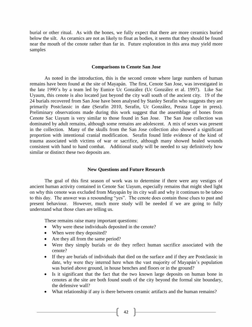
42
burial or other ritual. As with the bones, we fully expect that there are more ceramics buried
below the silt. As ceramics are not as likely to float as bodies, it seems that they should be found
near the mouth of the cenote rather than far in. Future exploration in this area may yield more
samples
Comparisons to Cenote San Jose
As noted in the introduction, this is the second cenote where large numbers of human
remains have been found at the site of Mayapán. The first, Cenote San Jose, was investigated in
the late 1990’s by a team led by Eunice Uc González (Uc González et al. 1997). Like Sac
Uyaum, this cenote is also located just beyond the city wall south of the ancient city. 19 of the
24 burials recovered from San Jose have been analysed by Stanley Serafin who suggests they are
primarily Postclassic in date (Serafin 2010, Serafin, Uc González, Peraza Lope in press).
Preliminary observations made during this work suggest that the assemblage of bones from
Cenote Sac Uayum is very similar to those found in San Jose. The San Jose collection was
dominated by adult remains, although some remains are adolescent. A mix of sexes was present
in the collection. Many of the skulls from the San Jose collection also showed a significant
proportion with intentional cranial modification. Serafin found little evidence of the kind of
trauma associated with victims of war or sacrifice, although many showed healed wounds
consistent with hand to hand combat. Additional study will be needed to say definitively how
similar or distinct these two deposits are.
New Questions and Future Research
The goal of this first season of work was to determine if there were any vestiges of
ancient human activity contained in Cenote Sac Uayum, especially remains that might shed light
on why this cenote was excluded from Mayapán by its city wall and why it continues to be taboo
to this day. The answer was a resounding “yes”. The cenote does contain those clues to past and
present behaviour. However, much more study will be needed if we are going to fully
understand what those clues are telling us.
These remains raise many important questions:
Why were these individuals deposited in the cenote?
When were they deposited?
Are they all from the same period?
Were they simply burials or do they reflect human sacrifice associated with the
cenote?
If they are burials of individuals that died on the surface and if they are Postclassic in
date, why were they interred here when the vast majority of Mayapán’s population
was buried above ground, in house benches and floors or in the ground?
Is it significant that the fact that the two known large deposits on human bone in
cenotes at the site are both found south of the city beyond the formal site boundary,
the defensive wall?
What relationship if any is there between ceramic artifacts and the human remains?
43
In order to answer these and other questions, additional research will be required. In
particular, the bones need to be collected and preserved for detailed laboratory study. This
would allow detailed comparisons to be made between this deposit and others found at
Postclassic Mayapán, including those from Cenote San Jose. More mapping data is required
before firm conclusions can be made about the depositional history and taphonomy of these
remains.
References Cited
Serafin, Stanley
2010 Bioarchaeological Investigation of Violence at Mayapan. Ph.D. dissertation,
Department of Anthropology, Tulane University.
Serafin, Stanley, Uc González, E., & Peraza Lope, C.
In press Prácticas Funerarias y Rituales en el Cenote San José de Mayapán. In The
Archaeology of Yucatán: New Directions and Data, edited by Travis W. Stanton. British
Archaeological Reports, International Series.

44
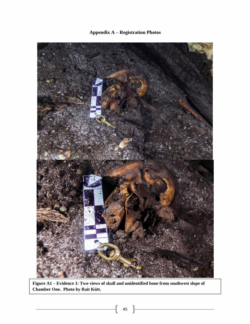
45
Appendix A – Registration Photos
Figure A1 – Evidence 1: Two views of skull and unidentified bone from southwest slope of
Chamber One. Photo by Rait Kütt.
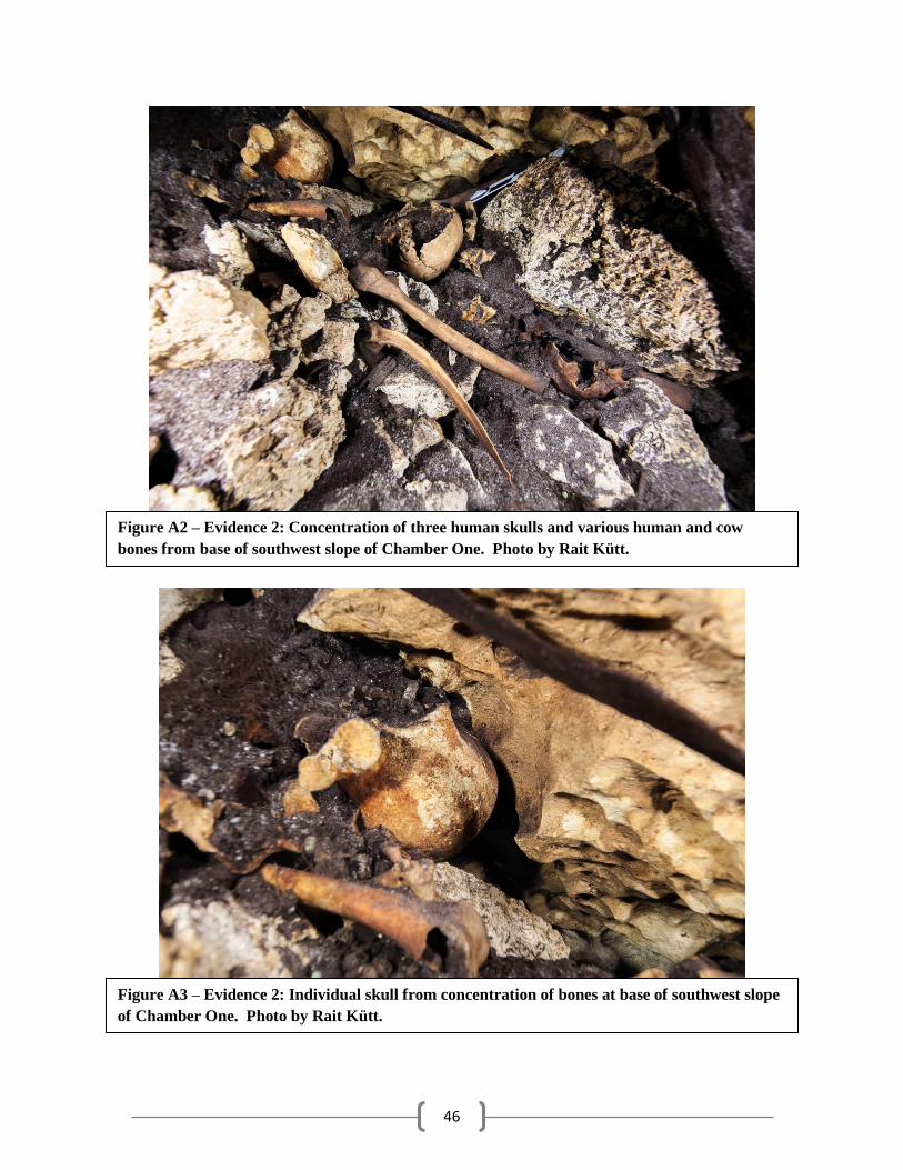
46
Figure A2 – Evidence 2: Concentration of three human skulls and various human and cow
bones from base of southwest slope of Chamber One. Photo by Rait Kütt.
Figure A3 – Evidence 2: Individual skull from concentration of bones at base of southwest slope
of Chamber One. Photo by Rait Kütt.
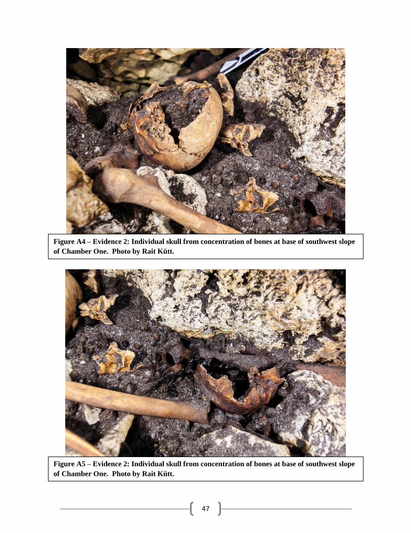
47
Figure A4 – Evidence 2: Individual skull from concentration of bones at base of southwest slope
of Chamber One. Photo by Rait Kütt.
Figure A5 – Evidence 2: Individual skull from concentration of bones at base of southwest slope
of Chamber One. Photo by Rait Kütt.
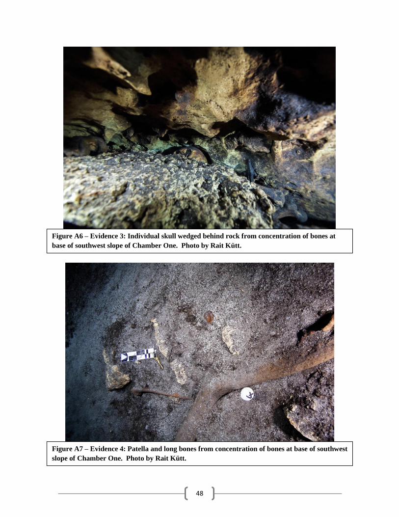
48
Figure A6 – Evidence 3: Individual skull wedged behind rock from concentration of bones at
base of southwest slope of Chamber One. Photo by Rait Kütt.
Figure A7 – Evidence 4: Patella and long bones from concentration of bones at base of southwest
slope of Chamber One. Photo by Rait Kütt.
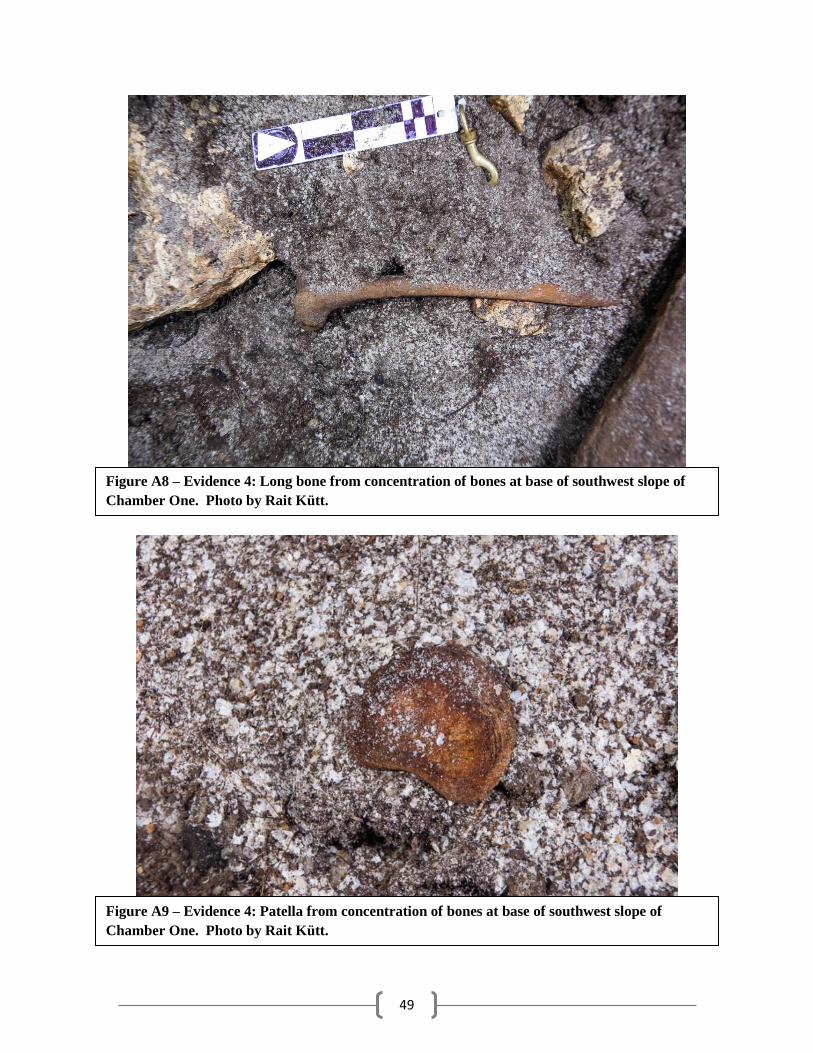
49
Figure A8 – Evidence 4: Long bone from concentration of bones at base of southwest slope of
Chamber One. Photo by Rait Kütt.
Figure A9 – Evidence 4: Patella from concentration of bones at base of southwest slope of
Chamber One. Photo by Rait Kütt.
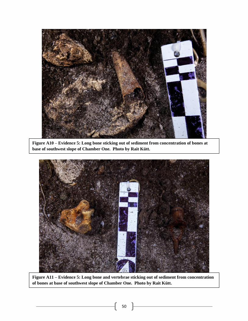
50
Figure A10 – Evidence 5: Long bone sticking out of sediment from concentration of bones at
base of southwest slope of Chamber One. Photo by Rait Kütt.
Figure A11 – Evidence 5: Long bone and vertebrae sticking out of sediment from concentration
of bones at base of southwest slope of Chamber One. Photo by Rait Kütt.
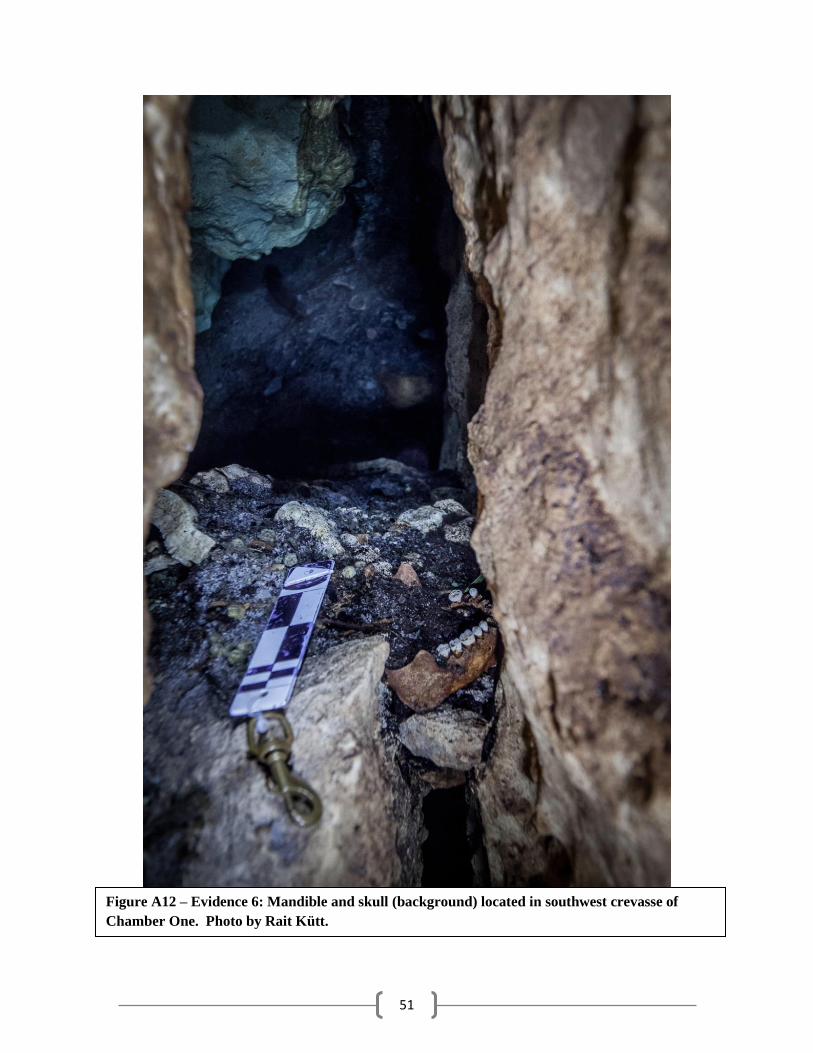
51
Figure A12 – Evidence 6: Mandible and skull (background) located in southwest crevasse of
Chamber One. Photo by Rait Kütt.
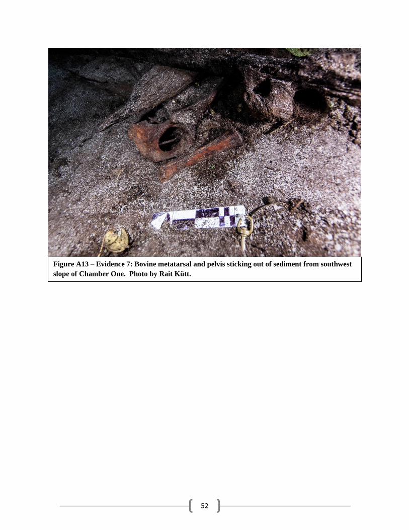
52
Figure A13 – Evidence 7: Bovine metatarsal and pelvis sticking out of sediment from southwest
slope of Chamber One. Photo by Rait Kütt.
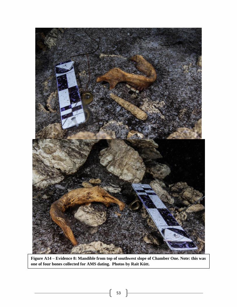
53
Figure A14 – Evidence 8: Mandible from top of southwest slope of Chamber One. Note: this was
one of four bones collected for AMS dating. Photos by Rait Kütt.
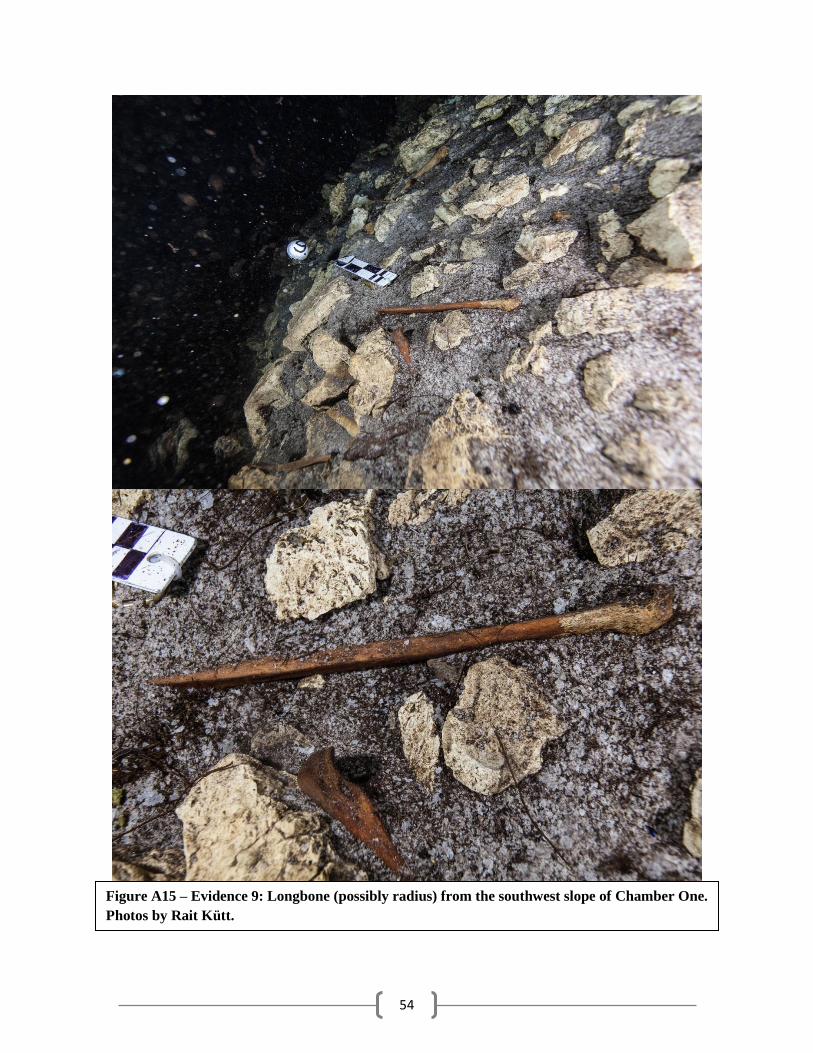
54
Figure A15 – Evidence 9: Longbone (possibly radius) from the southwest slope of Chamber One.
Photos by Rait Kütt.
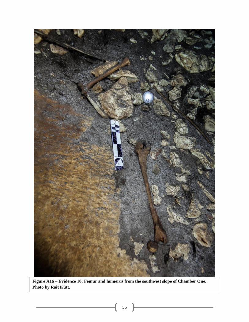
55
Figure A16 – Evidence 10: Femur and humerus from the southwest slope of Chamber One.
Photo by Rait Kütt.
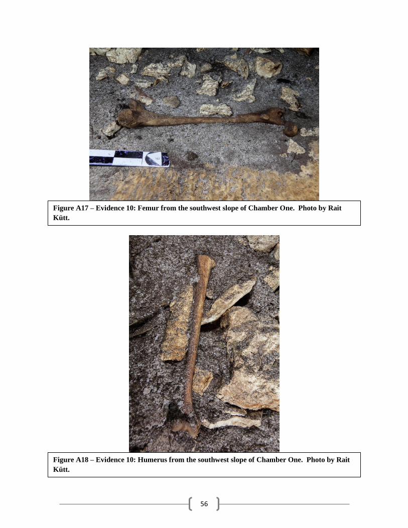
56
Figure A17 – Evidence 10: Femur from the southwest slope of Chamber One. Photo by Rait
Kütt.
Figure A18 – Evidence 10: Humerus from the southwest slope of Chamber One. Photo by Rait
Kütt.
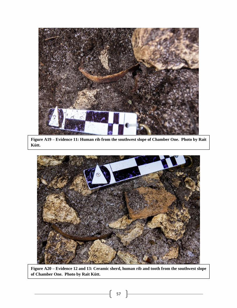
57
Figure A19 – Evidence 11: Human rib from the southwest slope of Chamber One. Photo by Rait
Kütt.
Figure A20 – Evidence 12 and 13: Ceramic sherd, human rib and tooth from the southwest slope
of Chamber One. Photo by Rait Kütt.
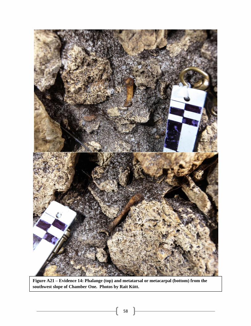
58
Figure A21 – Evidence 14: Phalange (top) and metatarsal or metacarpal (bottom) from the
southwest slope of Chamber One. Photos by Rait Kütt.
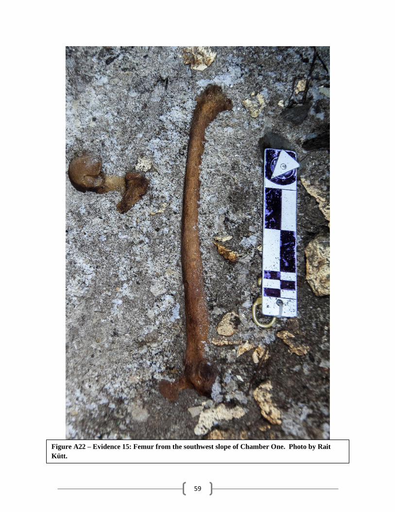
59
Figure A22 – Evidence 15: Femur from the southwest slope of Chamber One. Photo by Rait
Kütt.
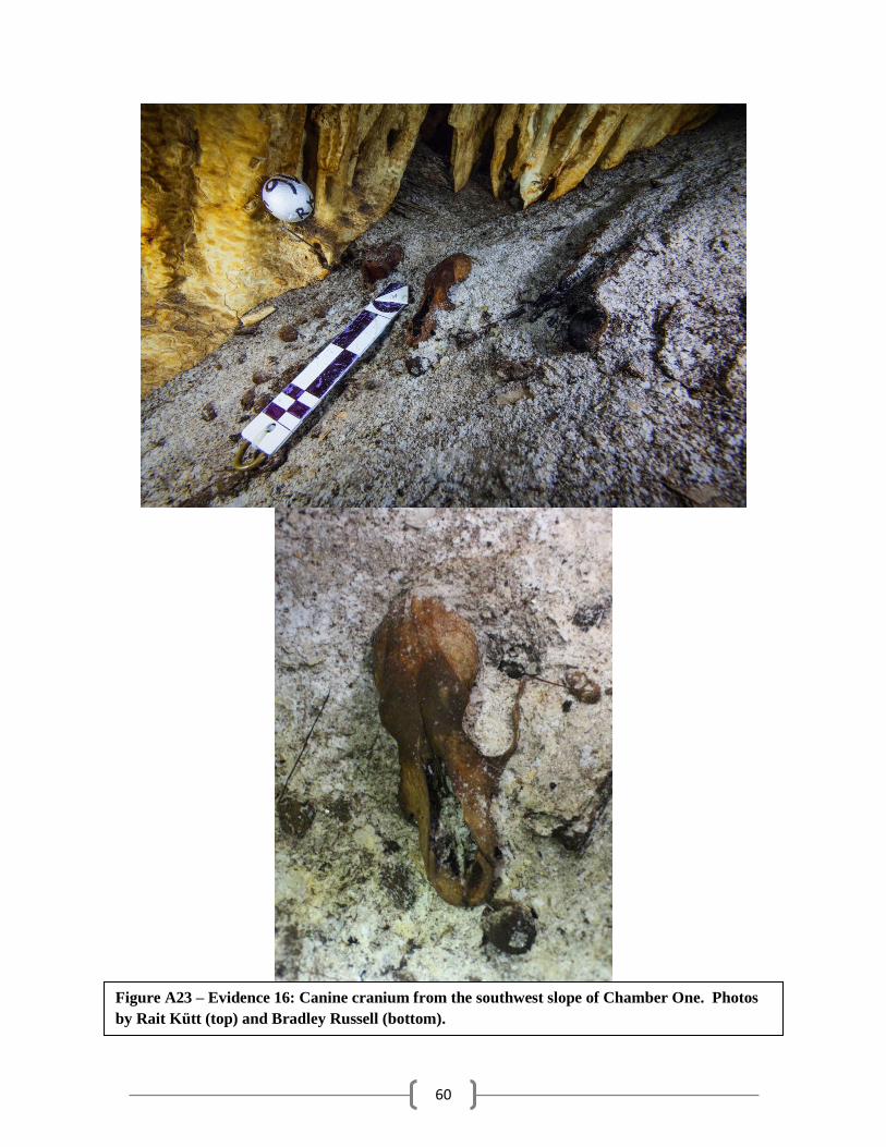
60
Figure A23 – Evidence 16: Canine cranium from the southwest slope of Chamber One. Photos
by Rait Kütt (top) and Bradley Russell (bottom).
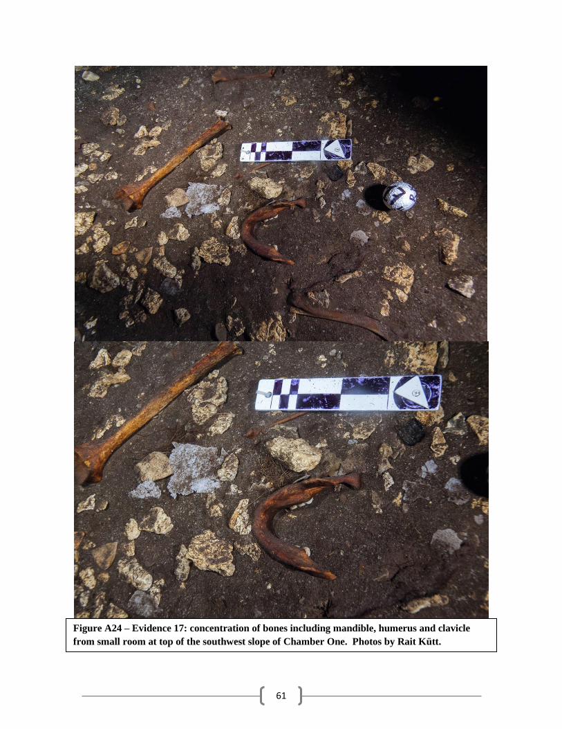
61
Figure A24 – Evidence 17: concentration of bones including mandible, humerus and clavicle
from small room at top of the southwest slope of Chamber One. Photos by Rait Kütt.
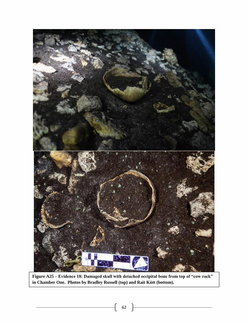
62
Figure A25 – Evidence 18: Damaged skull with detached occipital bone from top of “cow rock”
in Chamber One. Photos by Bradley Russell (top) and Rait Kütt (bottom).
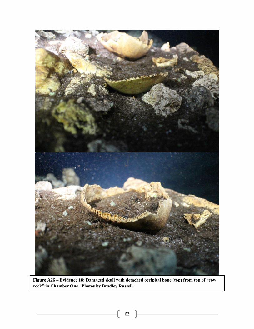
63
Figure A26 – Evidence 18: Damaged skull with detached occipital bone (top) from top of “cow
rock” in Chamber One. Photos by Bradley Russell.
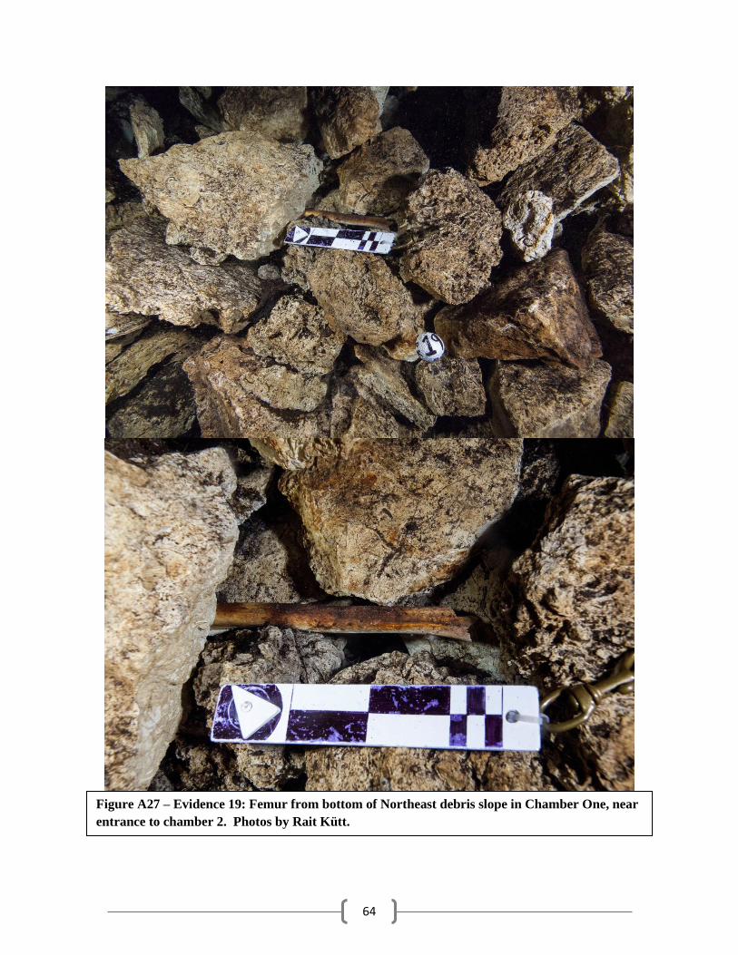
64
Figure A27 – Evidence 19: Femur from bottom of Northeast debris slope in Chamber One, near
entrance to chamber 2. Photos by Rait Kütt.
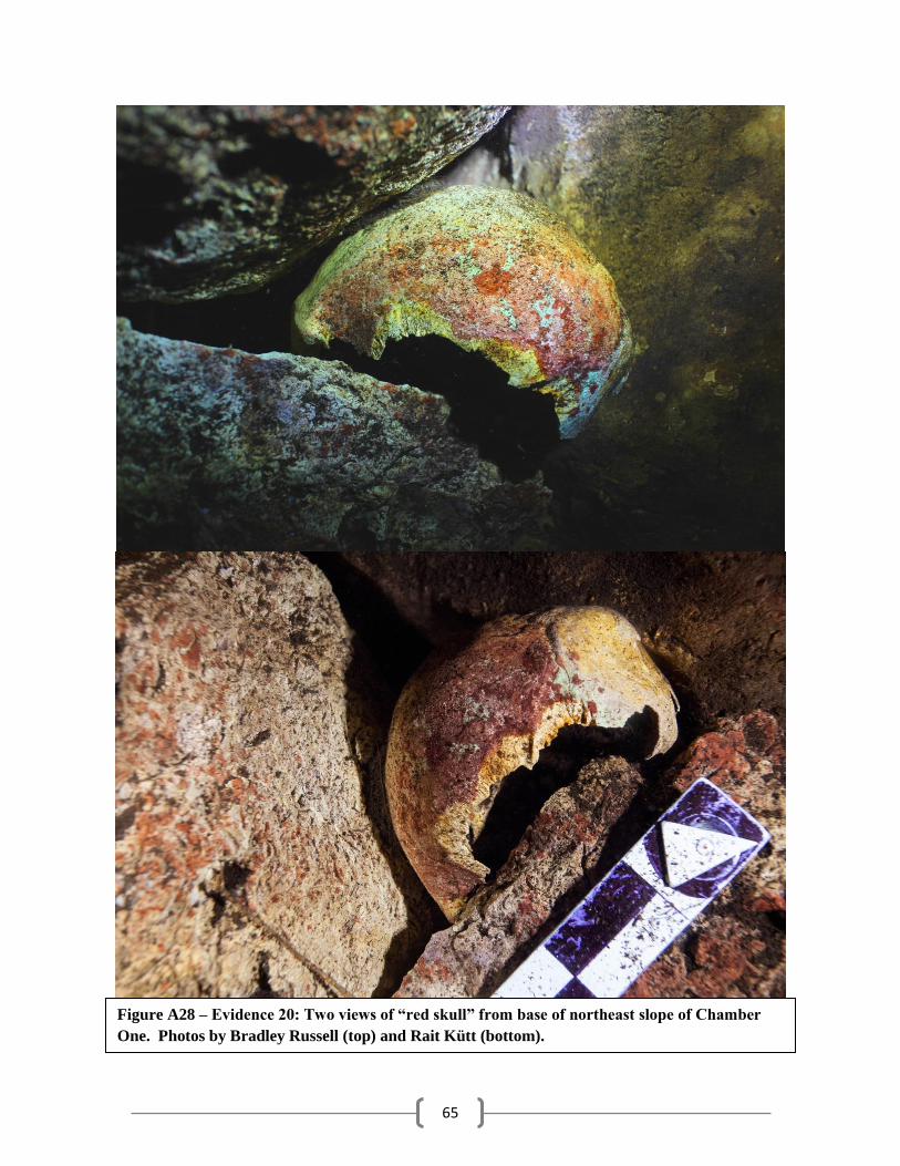
65
Figure A28 – Evidence 20: Two views of “red skull” from base of northeast slope of Chamber
One. Photos by Bradley Russell (top) and Rait Kütt (bottom).
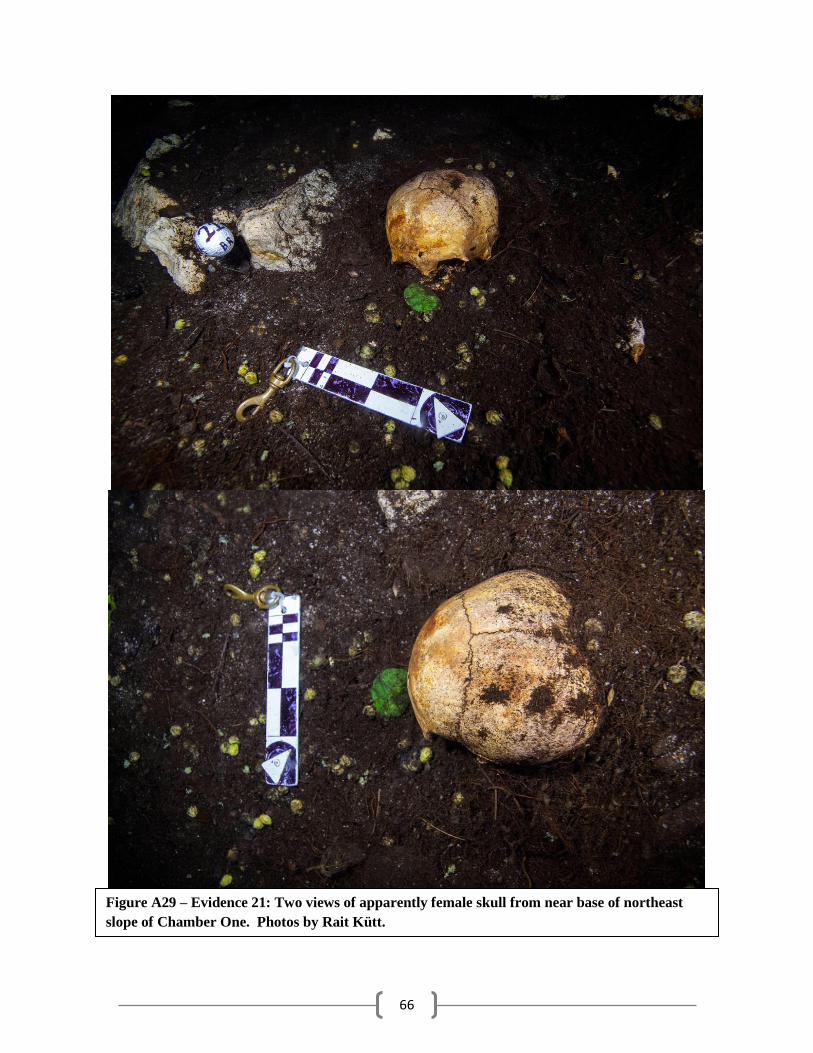
66
Figure A29 – Evidence 21: Two views of apparently female skull from near base of northeast
slope of Chamber One. Photos by Rait Kütt.
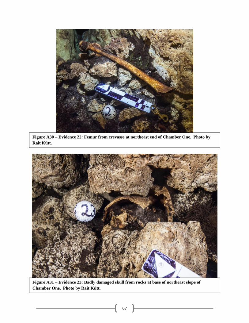
67
Figure A30 – Evidence 22: Femur from crevasse at northeast end of Chamber One. Photo by
Rait Kütt.
Figure A31 – Evidence 23: Badly damaged skull from rocks at base of northeast slope of
Chamber One. Photo by Rait Kütt.
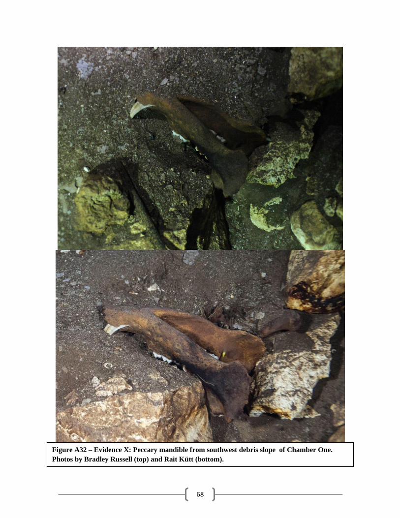
68
Figure A32 – Evidence X: Peccary mandible from southwest debris slope of Chamber One.
Photos by Bradley Russell (top) and Rait Kütt (bottom).
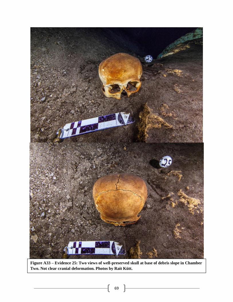
69
Figure A33 – Evidence 25: Two views of well-preserved skull at base of debris slope in Chamber
Two. Not clear cranial deformation. Photos by Rait Kütt.
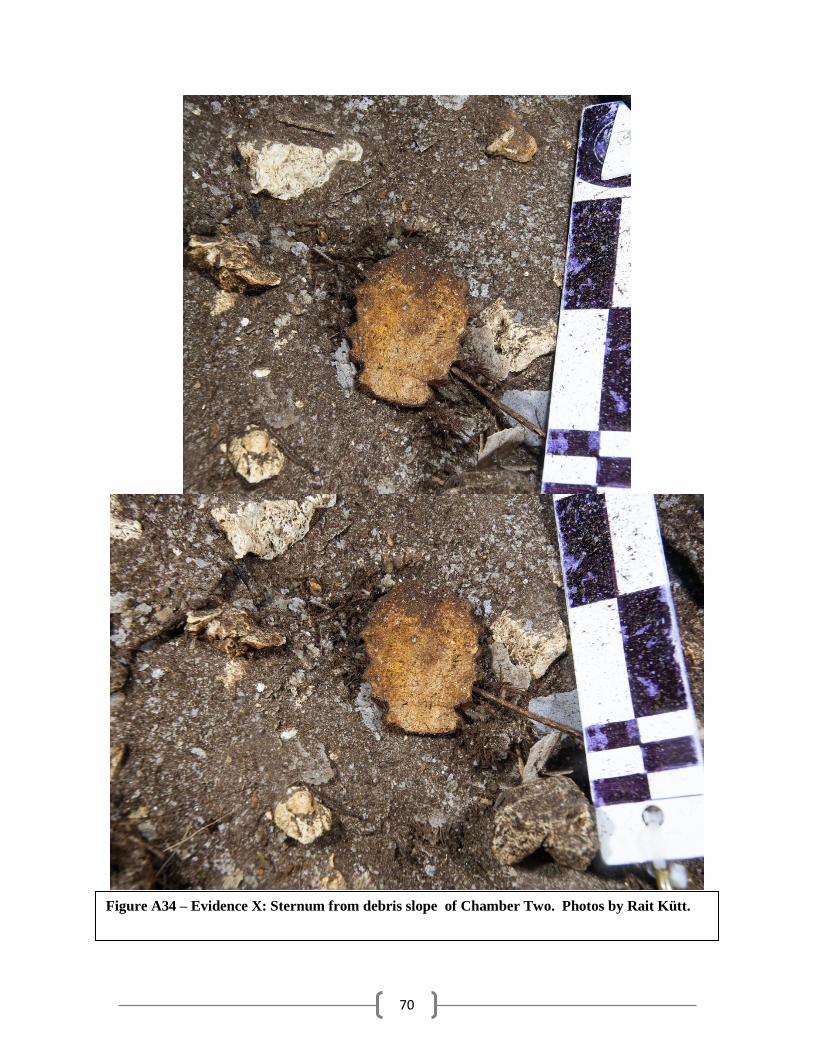
70
Figure A34 – Evidence X: Sternum from debris slope of Chamber Two. Photos by Rait Kütt.
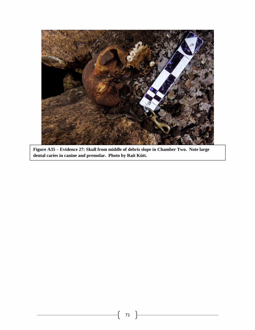
71
Figure A35 – Evidence 27: Skull from middle of debris slope in Chamber Two. Note large
dental caries in canine and premolar. Photo by Rait Kütt.
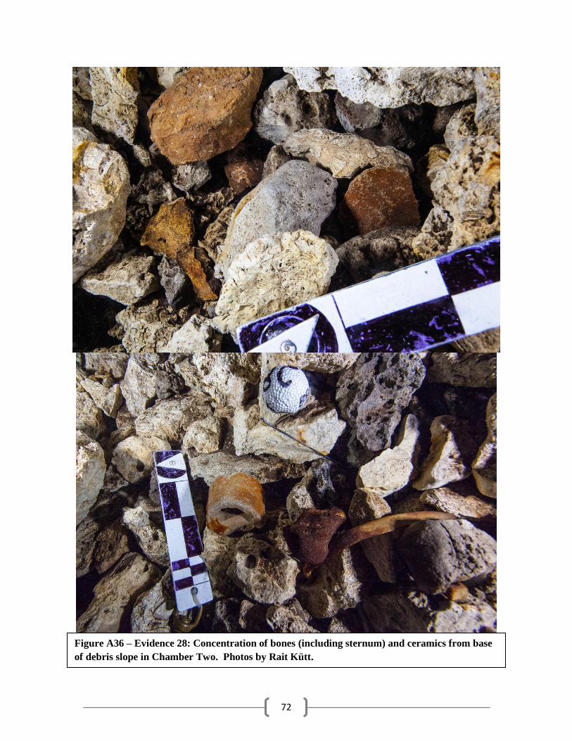
72
Figure A36 – Evidence 28: Concentration of bones (including sternum) and ceramics from base
of debris slope in Chamber Two. Photos by Rait Kütt.
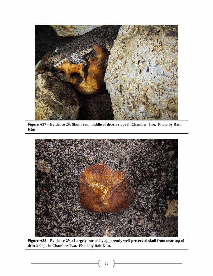
73
Figure A37 – Evidence 29: Skull from middle of debris slope in Chamber Two. Photo by Rait
Kütt.
Figure A38 – Evidence 29a: Largely buried by apparently well-preserved skull from near top of
debris slope in Chamber Two. Photo by Rait Kütt.
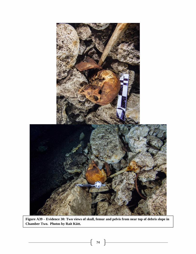
74
Figure A39 – Evidence 30: Two views of skull, femur and pelvis from near top of debris slope in
Chamber Two. Photos by Rait Kütt.
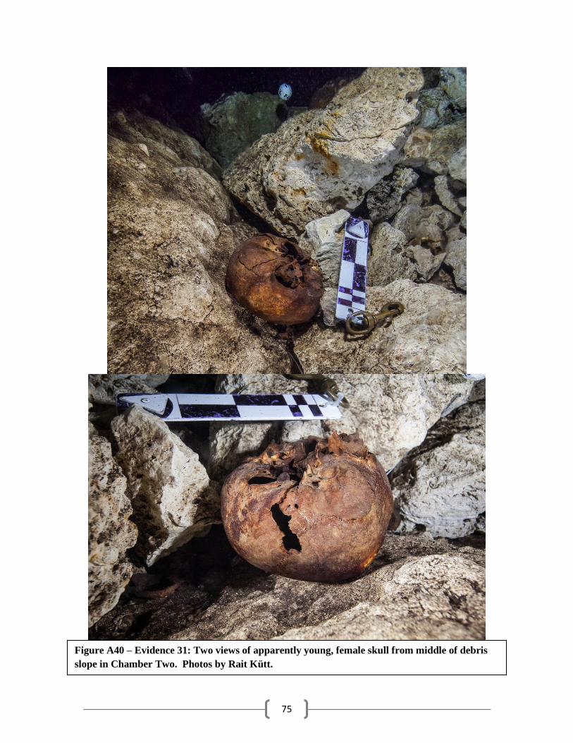
75
Figure A40 – Evidence 31: Two views of apparently young, female skull from middle of debris
slope in Chamber Two. Photos by Rait Kütt.

76
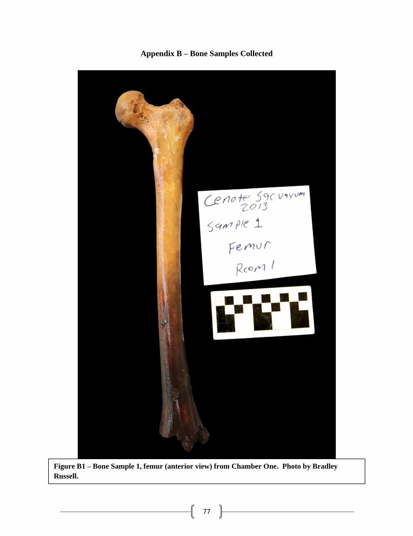
77
Appendix B – Bone Samples Collected
Figure B1 – Bone Sample 1, femur (anterior view) from Chamber One. Photo by Bradley
Russell.
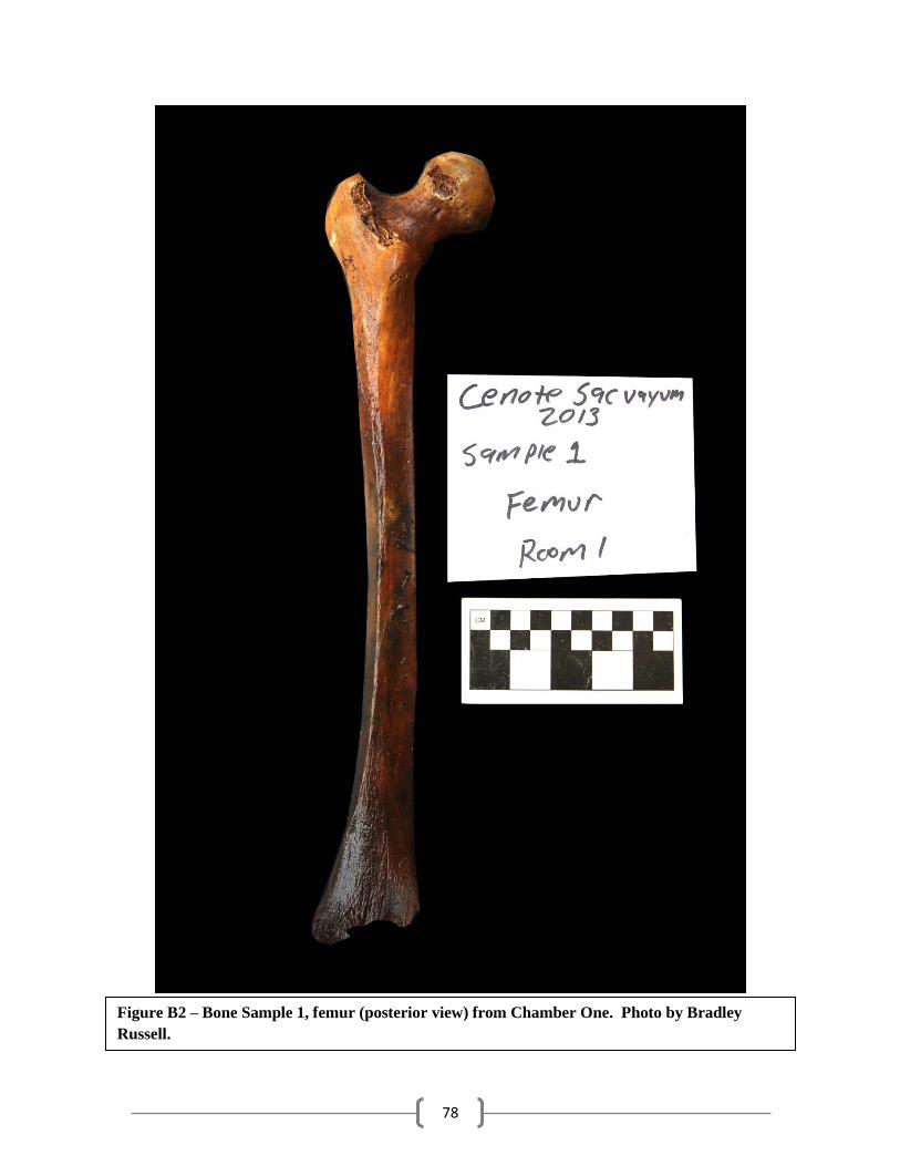
78
Figure B2 – Bone Sample 1, femur (posterior view) from Chamber One. Photo by Bradley
Russell.
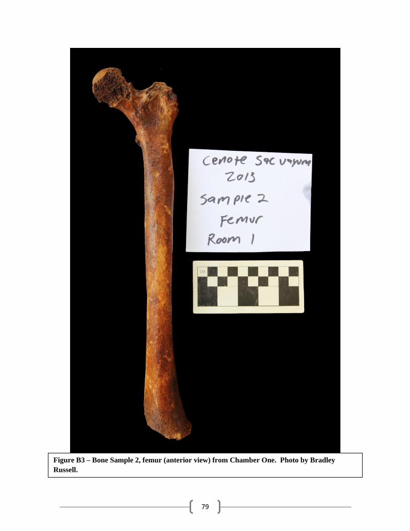
79
Figure B3 – Bone Sample 2, femur (anterior view) from Chamber One. Photo by Bradley
Russell.
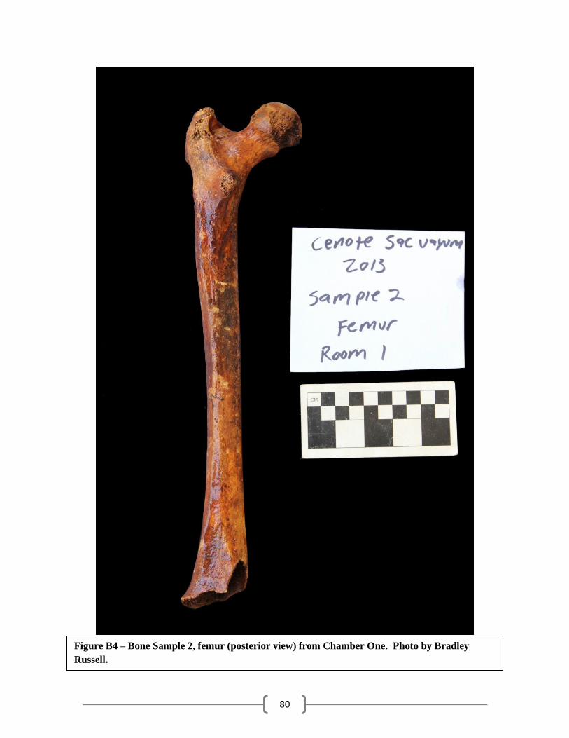
80
Figure B4 – Bone Sample 2, femur (posterior view) from Chamber One. Photo by Bradley
Russell.
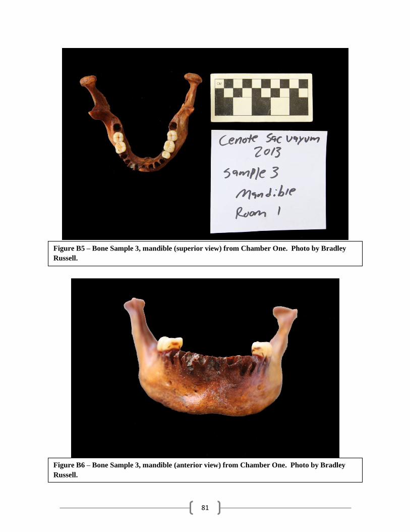
81
Figure B5 – Bone Sample 3, mandible (superior view) from Chamber One. Photo by Bradley
Russell.
Figure B6 – Bone Sample 3, mandible (anterior view) from Chamber One. Photo by Bradley
Russell.
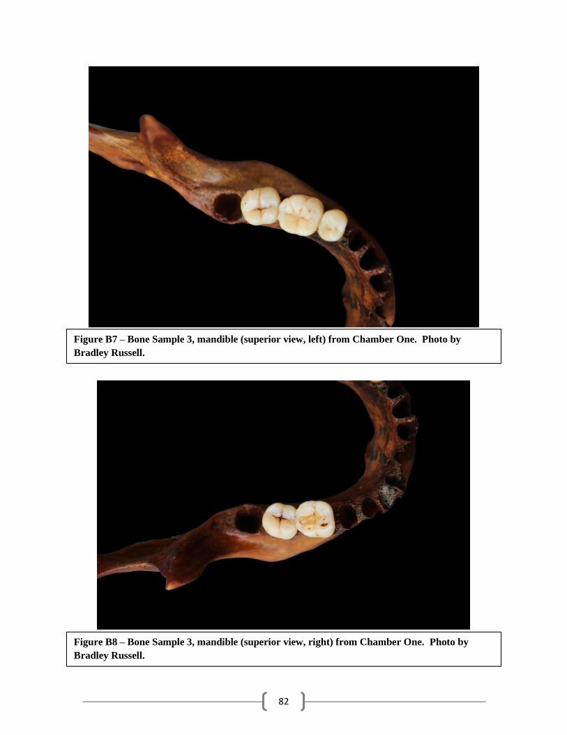
82
Figure B7 – Bone Sample 3, mandible (superior view, left) from Chamber One. Photo by
Bradley Russell.
Figure B8 – Bone Sample 3, mandible (superior view, right) from Chamber One. Photo by
Bradley Russell.
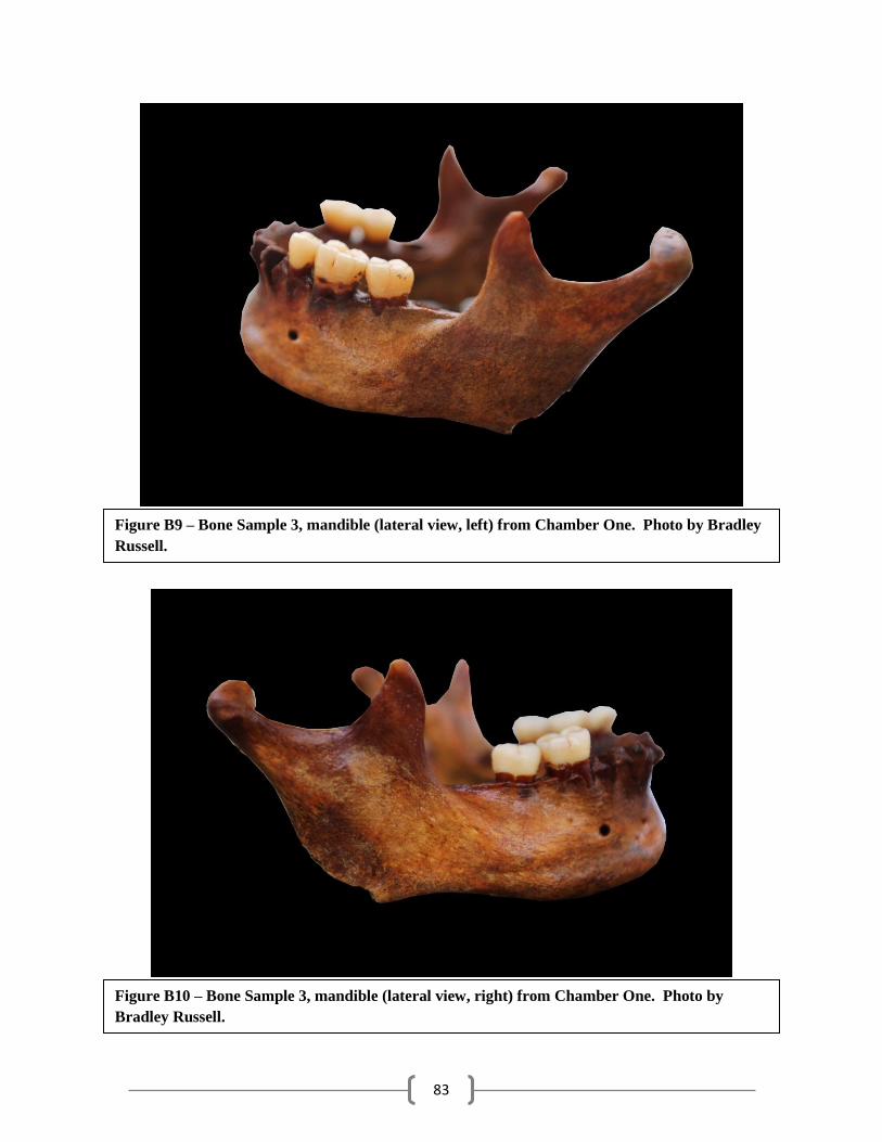
83
Figure B9 – Bone Sample 3, mandible (lateral view, left) from Chamber One. Photo by Bradley
Russell.
Figure B10 – Bone Sample 3, mandible (lateral view, right) from Chamber One. Photo by
Bradley Russell.
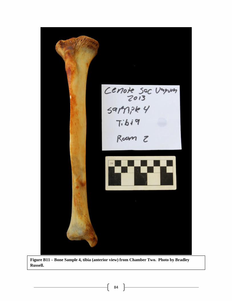
84
Figure B11 – Bone Sample 4, tibia (anterior view) from Chamber Two. Photo by Bradley
Russell.
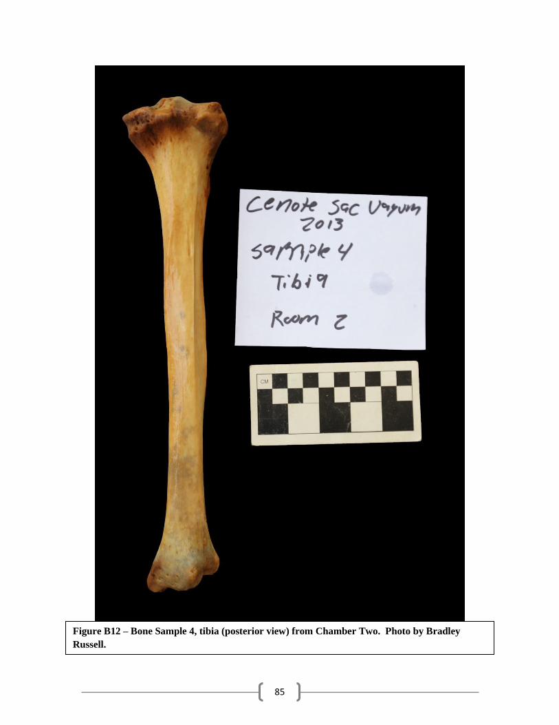
85
Figure B12 – Bone Sample 4, tibia (posterior view) from Chamber Two. Photo by Bradley
Russell.

86
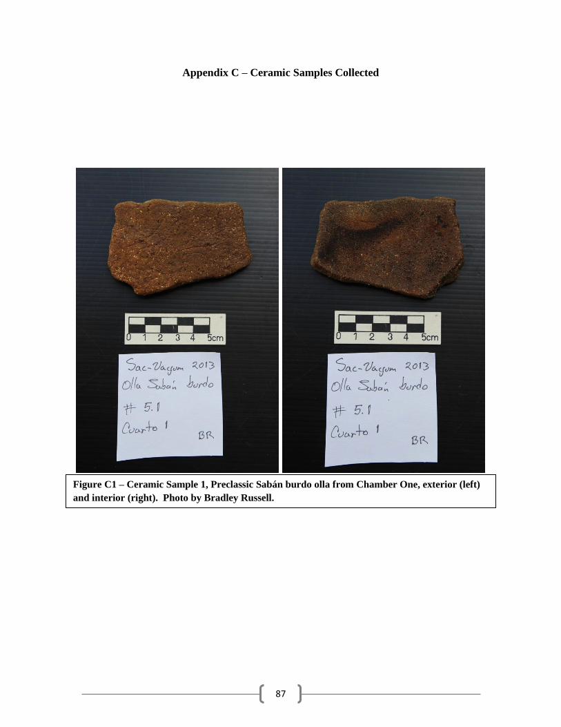
87
Appendix C – Ceramic Samples Collected
Figure C1 – Ceramic Sample 1, Preclassic Sabán burdo olla from Chamber One, exterior (left)
and interior (right). Photo by Bradley Russell.
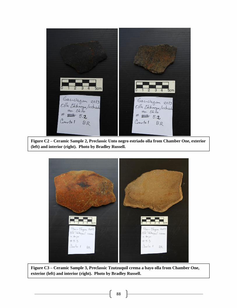
88
Figure C2 – Ceramic Sample 2, Preclassic Unto negro estriado olla from Chamber One, exterior
(left) and interior (right). Photo by Bradley Russell.
Figure C3 – Ceramic Sample 3, Preclassic Tzutzuquil crema a bayo olla from Chamber One,
exterior (left) and interior (right). Photo by Bradley Russell.
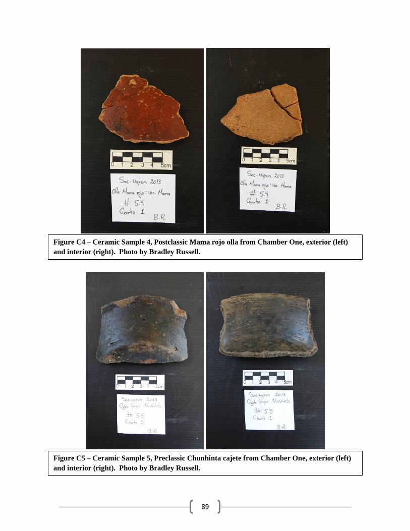
89
Figure C4 – Ceramic Sample 4, Postclassic Mama rojo olla from Chamber One, exterior (left)
and interior (right). Photo by Bradley Russell.
Figure C5 – Ceramic Sample 5, Preclassic Chunhinta cajete from Chamber One, exterior (left)
and interior (right). Photo by Bradley Russell.
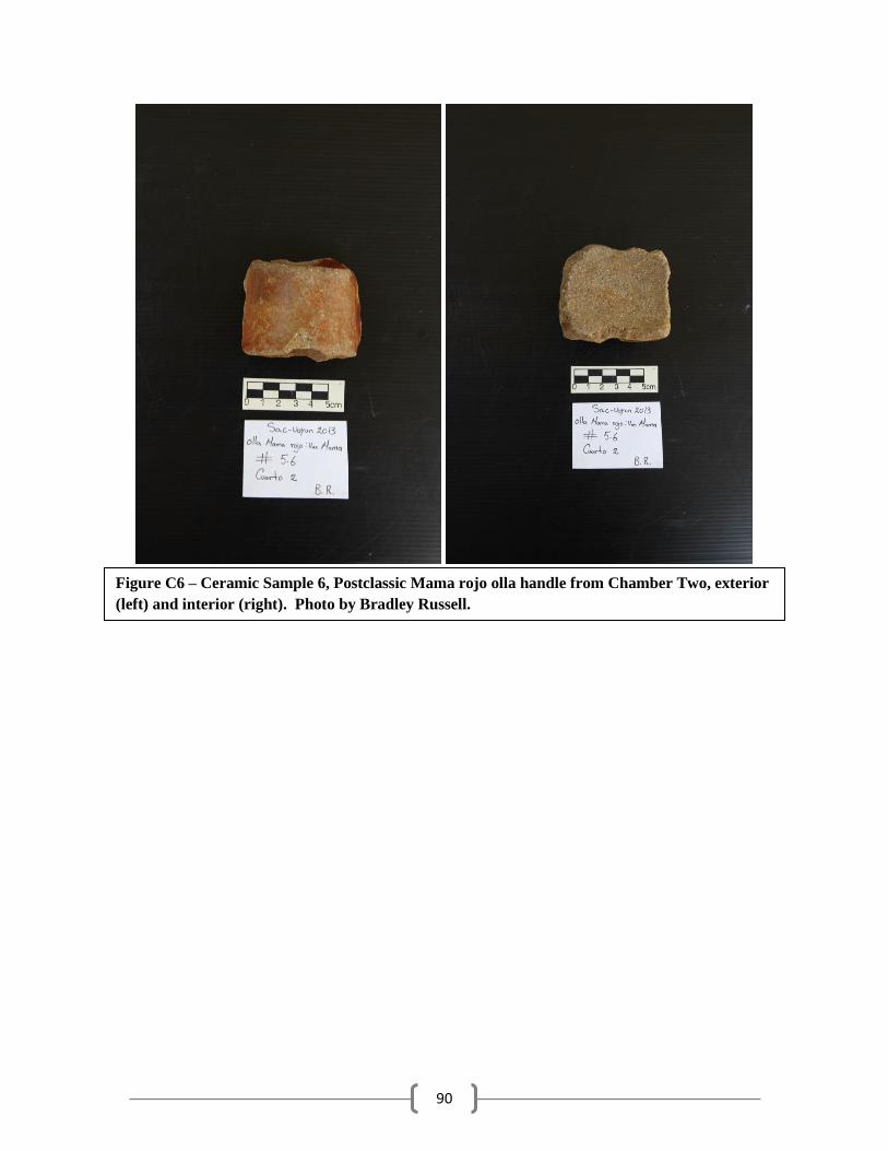
90
Figure C6 – Ceramic Sample 6, Postclassic Mama rojo olla handle from Chamber Two, exterior
(left) and interior (right). Photo by Bradley Russell.