extension in mona passage, northeast caribbean - core
TRANSCRIPT
Tectonophysics 493 (2010) 74–92
Contents lists available at ScienceDirect
Tectonophysics
j ourna l homepage: www.e lsev ie r.com/ locate / tecto
Extension in Mona Passage, Northeast Caribbean
Jason D. Chaytor ⁎, Uri S. ten BrinkU.S. Geological Survey, Woods Hole Coastal and Marine Science Center, Woods Hole, MA 02543, USA
⁎ Corresponding author. Tel.: +1 508 457 2351; fax:E-mail address: [email protected] (J.D. Chaytor).
0040-1951/$ – see front matter. Published by Elsevierdoi:10.1016/j.tecto.2010.07.002
a b s t r a c t
a r t i c l e i n f oArticle history:Received 21 October 2009Received in revised form 1 July 2010Accepted 5 July 2010Available online 15 July 2010
Keywords:BathymetrySeismic reflectionEarthquakesOblique extensionGeomorphology
As shown by the recent Mw 7.0 Haiti earthquake, intra-arc deformation, which accompanies the subductionprocess, can present seismic and tsunami hazards to nearby islands. Spatially-limited diffuse tectonicdeformation within the Northeast Caribbean Plate Boundary Zone likely led to the development of thesubmerged Mona Passage between Puerto Rico and the Dominican Republic. GPS geodetic data and amoderate to high level of seismicity indicate that extension within the region is ongoing. Newly-collectedhigh-resolution multibeam bathymetry and multi-channel seismic reflection profiles and previously-collected samples are used here to determine the tectonic evolution of the Mona Passage intra-arc region.The passage is floored almost completely by Oligocene–Pliocene carbonate platform strata, which haveundergone submarine and subaerial erosion. Structurally, the passage is characterized by W- to NNW-trending normal faults that offset the entire thickness of the Oligo–Pliocene carbonate platform rocks. Theorientation of these faults is compatible with the NE-oriented extension vector observed in GPS data. Faultgeometry best fits an oblique extension model rather than previously proposed single-phase, poly-phase,bending-moment, or rotation extension models. The intersection of these generally NW-trending faults inMona Passage with the N–S oriented faults of Mona Canyon may reflect differing responses of the brittleupper-crust, along an arc–forearc rheological boundary, to oblique subduction along the Puerto Rico trench.Several faults within the passage, if ruptured completely, are long enough to generate earthquakes withmagnitudes on the order of Mw 6.5–7.
+1 508 457 2310.
B.V.
Published by Elsevier B.V.
1. Introduction
The January 12, 2010Mw 7.0 Haiti earthquake provided a reminderof the considerable seismic hazard associated with intra-arc defor-mation within the northeast Caribbean plate boundary. Obliquesubduction along this boundary zone is manifested in the develop-ment of a complex deformation environment, characterized bycompressional, strike–slip, and extensional processes.
Mona Passage (in this paper we use the term Mona Passage inreference to the crust beneath the waters of the passage), locatedwithin the volcanically-inactive Greater Antilles arc between PuertoRico and Hispaniola (Fig. 1), is an area of considerable shallowcrustal earthquake activity. Seismicity is commonly characterized bysmall magnitude events, but the passage is also the site of thedestructive 1918 earthquake and tsunami (Reid and Tabor, 1919;Lopez-Venegas et al., 2008). The passage has for some time beenconsidered a region of extension resulting from oblique subductionalong the northern Caribbean plate boundary. Published analyses ofgeodetic data from Hispaniola to the Virgin Islands show thatextension in this region continues today, with Puerto Rico moving
northeasterly away from Hispaniola at a rate of approximately 5±3 mm/yr (Jansma and Mattioli, 2005).
Extensional deformation within compressive tectonic settingshas been recognized as a common process along modern andancient convergent margins worldwide. The causes of extension inthese settings vary widely [see Doglioni (1995) for an overview],and include retreating subduction boundaries or roll-back (e.g.,Royden, 1993), arc lengthening and increasing arc curvature (e.g.,Wessel et al., 1994), lower plate bending at the subduction front(e.g., Chapple and Forsyth, 1979), and orogenic collapse (e.g.,Dewey, 1988). Along subduction zones, extensional deformation iscommonly observed within forearc and backarc regions, and in thedown-going plate, but less often in the intra-arc zone (e.g., Geist et al.,1988; Mann and Burke, 1990; Suter et al., 1995; Busby and Bassett,2007).
Intra-arc extension in Mona Passage is spatially-limited to a 100-km-long segment of the arc, and does not affect the entire arc as in theabove examples. The driving force for this extension is therefore likelyto be local. Several hypotheses for the formation of Mona Passagebased predominantly on widely-spaced seismic reflection profileshave been proposed including single-phase extension across the plateboundary (e.g., Vogt et al., 1976; Speed and Larue, 1991), extensiondue to counter-clockwise rotation of Puerto Rico (e.g., Schell and Tarr,1978; Masson and Scanlon, 1991; Mann et al., 2005a), poly-phaseextension due to rotating axis of tensile stresses (e.g., Hippolyte et al.,
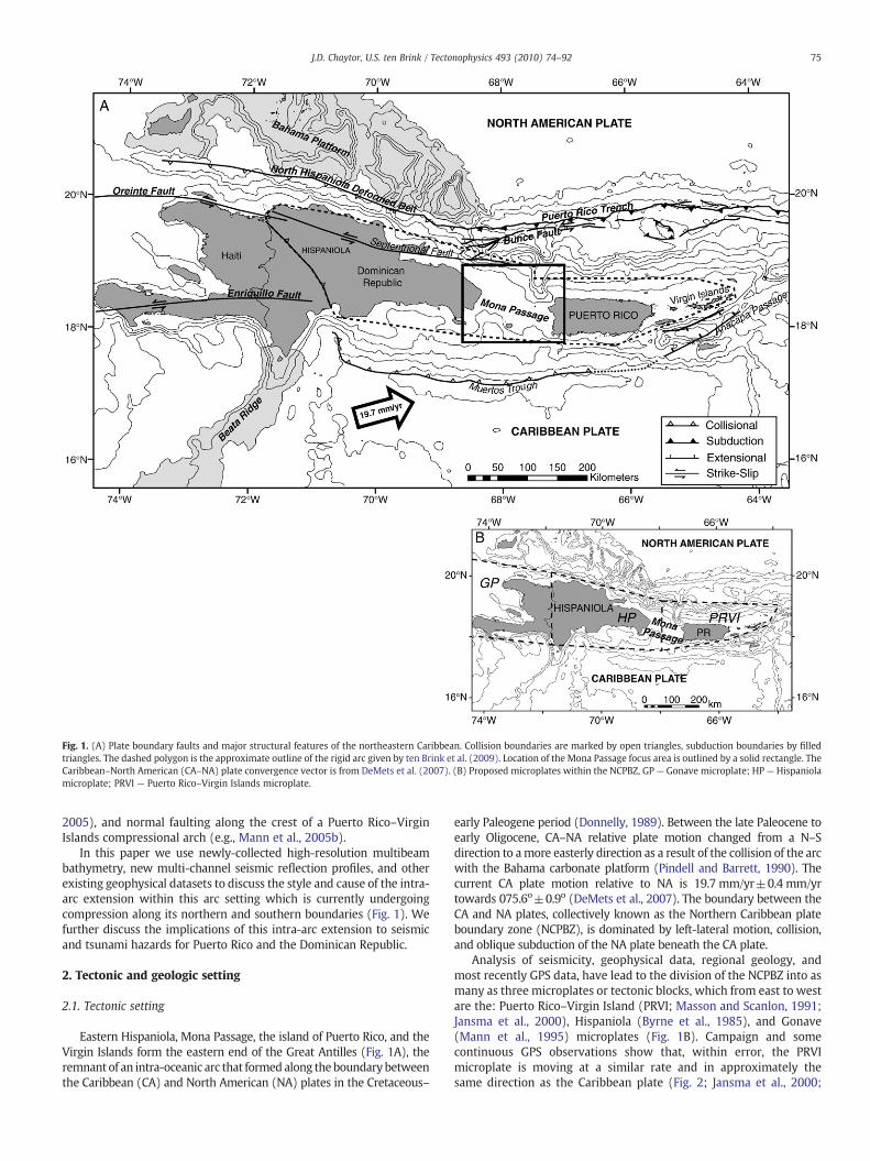
Fig. 1. (A) Plate boundary faults and major structural features of the northeastern Caribbean. Collision boundaries are marked by open triangles, subduction boundaries by filledtriangles. The dashed polygon is the approximate outline of the rigid arc given by ten Brink et al. (2009). Location of the Mona Passage focus area is outlined by a solid rectangle. TheCaribbean–North American (CA–NA) plate convergence vector is from DeMets et al. (2007). (B) Proposed microplates within the NCPBZ, GP— Gonave microplate; HP — Hispaniolamicroplate; PRVI — Puerto Rico–Virgin Islands microplate.
75J.D. Chaytor, U.S. ten Brink / Tectonophysics 493 (2010) 74–92
2005), and normal faulting along the crest of a Puerto Rico–VirginIslands compressional arch (e.g., Mann et al., 2005b).
In this paper we use newly-collected high-resolution multibeambathymetry, new multi-channel seismic reflection profiles, and otherexisting geophysical datasets to discuss the style and cause of the intra-arc extension within this arc setting which is currently undergoingcompression along its northern and southern boundaries (Fig. 1). Wefurther discuss the implications of this intra-arc extension to seismicand tsunami hazards for Puerto Rico and the Dominican Republic.
2. Tectonic and geologic setting
2.1. Tectonic setting
Eastern Hispaniola, Mona Passage, the island of Puerto Rico, and theVirgin Islands form the eastern end of the Great Antilles (Fig. 1A), theremnant of an intra-oceanic arc that formedalong theboundary betweenthe Caribbean (CA) and North American (NA) plates in the Cretaceous–
early Paleogene period (Donnelly, 1989). Between the late Paleocene toearly Oligocene, CA–NA relative plate motion changed from a N–Sdirection to amore easterly direction as a result of the collision of the arcwith the Bahama carbonate platform (Pindell and Barrett, 1990). Thecurrent CA plate motion relative to NA is 19.7 mm/yr±0.4 mm/yrtowards 075.6o±0.9o (DeMets et al., 2007). The boundary between theCA and NA plates, collectively known as the Northern Caribbean plateboundary zone (NCPBZ), is dominated by left-lateral motion, collision,and oblique subduction of the NA plate beneath the CA plate.
Analysis of seismicity, geophysical data, regional geology, andmost recently GPS data, have lead to the division of the NCPBZ into asmany as three microplates or tectonic blocks, which from east to westare the: Puerto Rico–Virgin Island (PRVI; Masson and Scanlon, 1991;Jansma et al., 2000), Hispaniola (Byrne et al., 1985), and Gonave(Mann et al., 1995) microplates (Fig. 1B). Campaign and somecontinuous GPS observations show that, within error, the PRVImicroplate is moving at a similar rate and in approximately thesame direction as the Caribbean plate (Fig. 2; Jansma et al., 2000;
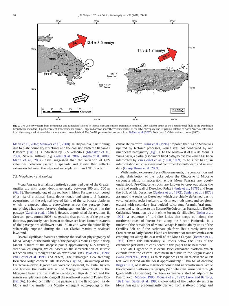
Fig. 2. GPS velocity vectors from continuous and campaign stations in Puerto Rico and eastern Dominican Republic. Only stations south of the Septentrional fault in the DominicanRepublic are included. Ellipses represent 95% confidence (error). Large red arrows show the velocity vectors of the PRVI microplate and Hispaniola relative to North America, calculatedfrom the average velocities of the stations shown on each island. The CA–NA plate motion vector is from DeMets et al. (2007). Data from E. Calais, written comm. (2007).
76 J.D. Chaytor, U.S. ten Brink / Tectonophysics 493 (2010) 74–92
Mann et al., 2002; Manaker et al., 2008). In Hispaniola, partitioningdue to plate boundary structures and the collision with the BahamasPlatform (Fig. 1) is indicated by GPS velocities (Manaker et al.,2008). Several authors (e.g., Calais et al., 2002; Jansma et al., 2000;Mann et al., 2002) have suggested that the variation of GPSvelocities between eastern Hispaniola and Puerto Rico reflectsextension between the adjacent microplates in an ENE direction.
2.2. Morphology and geology
Mona Passage is an almost entirely submerged part of the GreaterAntilles arc with water depths generally between 100 and 700 m(Fig. 3). The morphology of the seafloor in Mona Passage is composedof a mix of erosional, karst, depositional, and structural features,overprinted on the original layered fabric of the carbonate platformwhich is exposed almost everywhere across the passage. Karstmorphology has been observed during submersible dives within thepassage (Gardner et al., 1980; B. Heezen, unpublished observations; B.Greeson, pers. comm. 2008), suggesting that portions of the passagefloor may previously have been at or above sea level. Numerous areasof the passage are shallower than 150 m and were therefore likelysubaerially exposed during the Last Glacial Maximum sealevellowstand.
Several significant features dominate the seafloor physiography ofMona Passage. At the north edge of the passage is Mona Canyon, a deep(about 5000 m at the deepest point) approximately N–S trending,steep-walled canyon, which, based on the interpretation of seismicreflection data, is thought to be an extensional rift (Dolan et al., 1998;van Gestel et al., 1998; and others). The submerged E–W trendingDesecheo Ridge connects Isla Desecheo (Fig. 3A), an outcrop of theCretaceous–lower Oligocene arc volcanic basement, to Punta Higueroand borders the north side of the Mayagüez basin. South of theMayagüez basin are the shallow reef-topped Bajo de Cinco and theinsular reef platform extending off the southwest corner of Puerto Rico(Fig. 3A). Located centrally in the passage are the flat-topped Isla deMona and the smaller Isla Monito, emergent outcroppings of the
carbonate platform. Frank et al. (1998) proposed that Isla de Mona wasuplifted by tectonic processes, which was not confirmed by ourmultibeam bathymetry (Fig. 3). To the southwest of Isla de Mona isYuma basin, a partially sediment filled bathymetric lowwhich has beeninterpreted by van Gestel et al. (1998, 1999) to be a rift basin, aninterpretationwhich also was not confirmed bymultibeam and seismicdata (Granja Bruna et al., 2009).
With limited exposure of pre-Oligocene units, the composition andspatial distribution of the rocks below the Oligocene to Miocenecarbonate platform succession across Mona Passage are poorlyunderstood. Pre-Oligocene rocks are known to crop out along thecrest and south wall of Desecheo Ridge (Nagle et al., 1978) and formthe bulk of Isla Desecheo (Seiders et al., 1972). Seiders et al. (1972)assigned the rocks on Desecheo, which are chiefly deformed daciticvolcanoclastics rocks (volcanic sandstones, mudstones, and conglom-erates) with secondary interbedded calcareous foraminiferal mud-stones and sandstone, to the Eocene Río Culebrinas Formation. The RíoCulebrinas Formation is a unit of the Eocene Cerrillos Belt (Dolan et al.,1991), a sequence of turbidite facies that crops out along thenorthwest coast of Puerto Rico along the Rincon Peninsula. It isunclear if the remainder of Mona Passage is underlain by units of theCerrillos Belt or if the carbonate platform lies directly over theCretaceous to Early Eocene island arc basement or metavolcanics seencropping out along the east wall of the Mona Canyon (Heezen et al.,1985). Given this uncertainty, all rocks below the units of thecarbonate platform are considered in this paper to be basement.
The late Oligocene to Pliocene PRVI carbonate platform whichextends from the eastern Dominican Republic to the Virgin Islands(van Gestel et al., 1998) is a thick sequence (1706 m thick in the 4 CPRtest well located on the coast approximately 10 km NE of Arecibo;Briggs, 1961) of shallowmarine carbonate and siliciclastic units.Whilethe carbonate platform stratigraphy (San Sebastian Formation throughQuebradillas Limestone) has been extensively studied adjacent toPuerto Rico (Monroe, 1980; Moussa et al., 1987; Larue and Berrong,1991; van Gestel et al., 1998), knowledge of the carbonate units inMona Passage is predominantly derived from scattered dredge and
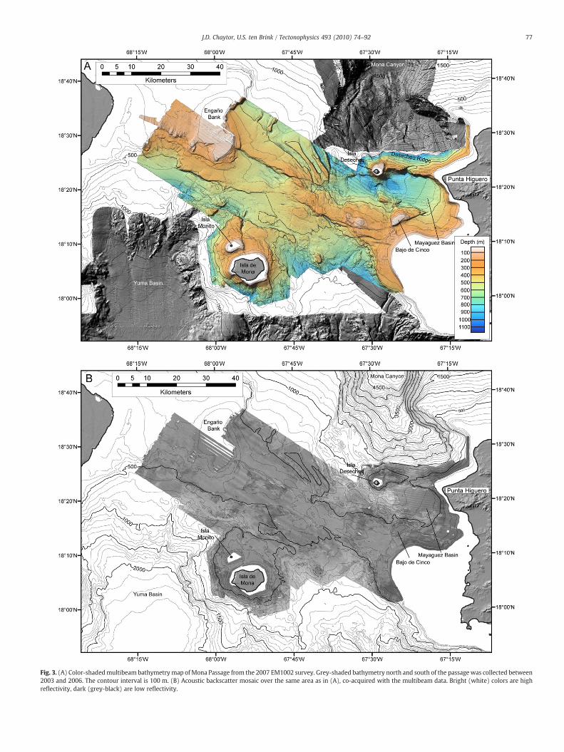
Fig. 3. (A) Color-shadedmultibeam bathymetrymap of Mona Passage from the 2007 EM1002 survey. Grey-shaded bathymetry north and south of the passagewas collected between2003 and 2006. The contour interval is 100 m. (B) Acoustic backscatter mosaic over the same area as in (A), co-acquired with the multibeam data. Bright (white) colors are highreflectivity, dark (grey-black) are low reflectivity.
77J.D. Chaytor, U.S. ten Brink / Tectonophysics 493 (2010) 74–92
78 J.D. Chaytor, U.S. ten Brink / Tectonophysics 493 (2010) 74–92
dive samples. Disruption of the carbonate platform by Mona Canyonand Desecheo Ridge has precluded definitive correlation of seismichorizons identified from northern Puerto Rico (Moussa et al., 1987;van Gestel et al., 1998) to Mona Passage. Correlation with the coastalstratigraphy of the eastern Dominican Republic is limited by a lack ofdetailed information in that area.
Using the North Coast basin of Puerto Rico (Briggs, 1961) as ananalog, the base of the platform carbonate succession inMona Passageis likely the siliciclastic San Sebastian Formation. The San SebastianFormation unconformably overlies Cretaceous arc and Eocene basinformations, reflecting the shift from Eocene deformation to a longperiod of tectonic stability. Overlying the San Sebastian Formation is aconformable sequence of late Oligocene to late Miocene or earlyPliocene limestones. Late Miocene to Pliocene age dolomite (Isla deMona dolomite) and limestone (Lirio limestone) are exposed on Islade Mona (Kaye, 1959; Briggs and Seiders, 1972; Gonzalez et al., 1997).These limestones and dolomites do not correlate compositionally withthe units of northern and southern Puerto Rico and are likely theresult of localized reef build up (Ruiz, 1993). Although the thickness ofthe carbonate sequence exceeds 1000 m in some locations, estimatesof true carbonate platform thickness across the passage cannot bemade because of erosion and movement of fault blocks.
The platform carbonates are capped in places by post Miocene reefsequences and variable thicknesses of Quaternary sediments. Modernreefs are found along the crests of most shallow banks and the insularshelves of Puerto Rico and the Dominican Republic and areidentifiable on the bathymetry and in the seismic reflection profiles.Quaternary sediments are predominantly restricted to basins adjacentto western Puerto Rico, the largest of which is the Mayagüez basin.
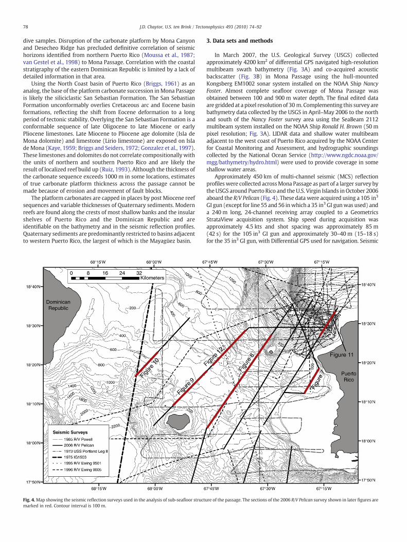
Fig. 4.Map showing the seismic reflection surveys used in the analysis of sub-seafloor structmarked in red. Contour interval is 100 m.
3. Data sets and methods
In March 2007, the U.S. Geological Survey (USGS) collectedapproximately 4200 km2 of differential GPS navigated high-resolutionmultibeam swath bathymetry (Fig. 3A) and co-acquired acousticbackscatter (Fig. 3B) in Mona Passage using the hull-mountedKongsberg EM1002 sonar system installed on the NOAA Ship NancyFoster. Almost complete seafloor coverage of Mona Passage wasobtained between 100 and 900 m water depth. The final edited dataare gridded at a pixel resolution of 30 m. Complementing this survey arebathymetry data collected by the USGS in April–May 2006 to the northand south of the Nancy Foster survey area using the SeaBeam 2112multibeam system installed on the NOAA Ship Ronald H. Brown (50 mpixel resolution; Fig. 3A). LIDAR data and shallow water multibeamadjacent to the west coast of Puerto Rico acquired by the NOAA Centerfor Coastal Monitoring and Assessment, and hydrographic soundingscollected by the National Ocean Service (http://www.ngdc.noaa.gov/mgg/bathymetry/hydro.html) were used to provide coverage in someshallow water areas.
Approximately 450 km of multi-channel seismic (MCS) reflectionprofiles were collected acrossMona Passage as part of a larger survey bytheUSGS around Puerto Rico and the U.S. Virgin Islands in October 2006aboard the R/V Pelican (Fig. 4). These data were acquired using a 105 in3
GI gun (except for line 55 and 56 inwhich a 35 in3 GI gunwas used) anda 240 m long, 24-channel receiving array coupled to a GeometricsStrataView acquisition system. Ship speed during acquisition wasapproximately 4.5 kts and shot spacing was approximately 85 m(42 s) for the 105 in3 GI gun and approximately 30–40 m (15–18 s)for the 35 in3 GI gun, with Differential GPS used for navigation. Seismic
ure of the passage. The sections of the 2006 R/V Pelican survey shown in later figures are
79J.D. Chaytor, U.S. ten Brink / Tectonophysics 493 (2010) 74–92
processing included normal moveout correction, bandpass filtering(Ormsby zero phase bandpass), common depth point (CDP) stacking,and Stolts F-K post-stack migration. Additional seismic lines from R/VEwing cruises EW9501 and EW 9605, R/V Ida Green cruise IG1501, 1973USS Portland cruise (Gardner et al., 1980; Heezen, unpublished data),and single-channel airgun profiles from the 1985 P-3-85 R/V Powellcruise (Edgar and Scanlon, 1987) are used to complement the newseismic reflection data (Fig. 4).
4. Results
4.1. Morphology
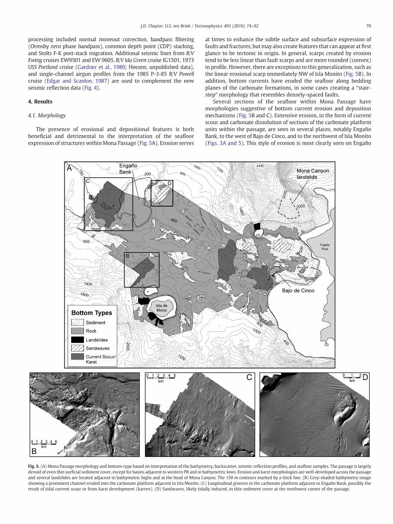
The presence of erosional and depositional features is bothbeneficial and detrimental to the interpretation of the seafloorexpression of structures withinMona Passage (Fig. 5A). Erosion serves
Fig. 5. (A)Mona Passagemorphology and bottom-type based on interpretation of the bathymdevoid of even thin surficial sediment cover, except for basins adjacent to western PR and in band several landslides are located adjacent to bathymetric highs and at the head of Mona Cshowing a prominent channel eroded into the carbonate platform adjacent to Isla Monito. (Cresult of tidal current scour or from karst development (karren). (D) Sandwaves, likely tida
at times to enhance the subtle surface and subsurface expression offaults and fractures, butmay also create features that can appear atfirstglance to be tectonic in origin. In general, scarps created by erosiontend to be less linear than fault scarps and aremore rounded (convex)in profile. However, there are exceptions to this generalization, such asthe linear erosional scarp immediately NW of Isla Monito (Fig. 5B). Inaddition, bottom currents have eroded the seafloor along beddingplanes of the carbonate formations, in some cases creating a “stair-step” morphology that resembles densely-spaced faults.
Several sections of the seafloor within Mona Passage havemorphologies suggestive of bottom current erosion and depositionmechanisms (Fig. 5B and C). Extensive erosion, in the form of currentscour and carbonate dissolution of sections of the carbonate platformunits within the passage, are seen in several places, notably EngañoBank, to the west of Bajo de Cinco, and to the northwest of Isla Monito(Figs. 3A and 5). This style of erosion is most clearly seen on Engaño
etry, backscatter, seismic reflection profiles, and seafloor samples. The passage is largelyathymetric lows. Erosion and karst morphologies arewell-developed across the passageanyon. The 150 m contours marked by a thick line. (B) Grey-shaded bathymetry image) Longitudinal grooves in the carbonate platform adjacent to Engaño Bank, possibly thelly induced, in thin sediment cover at the northwest corner of the passage.
80 J.D. Chaytor, U.S. ten Brink / Tectonophysics 493 (2010) 74–92
Bank, where closely-spaced, elongated grooves have been cut into theflanks and top of the south-side of the bank (Fig. 5C), similar tolongitudinal grooves created by rapid, high-volume water flow (e.g.,Baker, 1978) or karren (clint and grike karst) landforms (Ford andWilliams, 2007). Smoothing of the seafloor is also noted in a numberof locations and in most cases exposes subtle structural featuresmasked in adjacent areas that have rougher surface textures. Except inthe deeper structural basins (e.g., Mayagüez basin), the backscatterdata (Fig. 3B) indicates only minor sediment accumulation, predom-inately in lows adjacent to fault scarps andwithin depressions createdby seafloor erosion (Fig. 5A and D).
4.2. Structural framework
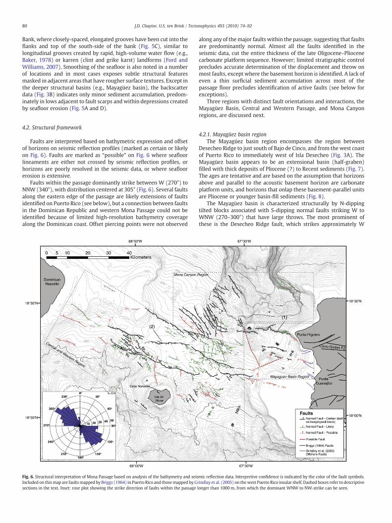
Faults are interpreted based on bathymetric expression and offsetof horizons on seismic reflection profiles (marked as certain or likelyon Fig. 6). Faults are marked as “possible” on Fig. 6 where seafloorlineaments are either not crossed by seismic reflection profiles, orhorizons are poorly resolved in the seismic data, or where seafloorerosion is extensive.
Faults within the passage dominantly strike between W (270°) toNNW (340°), with distribution centered at 305° (Fig. 6). Several faultsalong the eastern edge of the passage are likely extensions of faultsidentified on Puerto Rico (see below), but a connection between faultsin the Dominican Republic and western Mona Passage could not beidentified because of limited high-resolution bathymetry coveragealong the Dominican coast. Offset piercing points were not observed
Fig. 6. Structural interpretation of Mona Passage based on analysis of the bathymetry and seisIncluded on thismap are faultsmapped by Briggs (1964) in Puerto Rico and thosemapped byGsections in the text. Inset: rose plot showing the strike direction of faults within the passage
along any of themajor faults within the passage, suggesting that faultsare predominantly normal. Almost all the faults identified in theseismic data, cut the entire thickness of the late Oligocene–Pliocenecarbonate platform sequence. However; limited stratigraphic controlprecludes accurate determination of the displacement and throw onmost faults, except where the basement horizon is identified. A lack ofeven a thin surficial sediment accumulation across most of thepassage floor precludes identification of active faults (see below forexceptions).
Three regions with distinct fault orientations and interactions, theMayagüez Basin, Central and Western Passage, and Mona Canyonregions, are discussed next.
4.2.1. Mayagüez basin regionThe Mayagüez basin region encompasses the region between
Desecheo Ridge to just south of Bajo de Cinco, and from the west coastof Puerto Rico to immediately west of Isla Desecheo (Fig. 3A). TheMayagüez basin appears to be an extensional basin (half-graben)filled with thick deposits of Pliocene (?) to Recent sediments (Fig. 7).The ages are tentative and are based on the assumption that horizonsabove and parallel to the acoustic basement horizon are carbonateplatform units, and horizons that onlap these basement-parallel unitsare Pliocene or younger basin-fill sediments (Fig. 8).
The Mayagüez basin is characterized structurally by N-dippingtilted blocks associated with S-dipping normal faults striking W toWNW (270–300°) that have large throws. The most prominent ofthese is the Desecheo Ridge fault, which strikes approximately W
mic reflection data. Interpretive confidence is indicated by the color of the fault symbols.rindlay et al. (2005) on thewest Puerto Rico insular shelf. Dashed boxes refer to descriptivelonger than 1000 m, from which the dominant WNW to NW-strike can be seen.
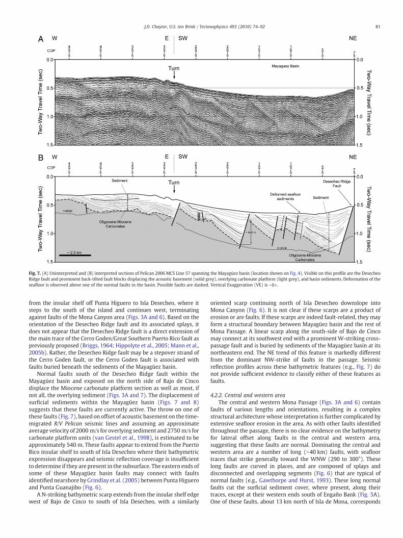
Fig. 7. (A) Uninterpreted and (B) interpreted sections of Pelican 2006 MCS Line 57 spanning the Mayagüez basin (location shown on Fig. 4). Visible on this profile are the DesecheoRidge fault and prominent back-tilted fault blocks displacing the acoustic basement (solid grey), overlying carbonate platform (light grey), and basin sediments. Deformation of theseafloor is observed above one of the normal faults in the basin. Possible faults are dashed. Vertical Exaggeration (VE) is ~6×.
81J.D. Chaytor, U.S. ten Brink / Tectonophysics 493 (2010) 74–92
from the insular shelf off Punta Higuero to Isla Desecheo, where itsteps to the south of the island and continues west, terminatingagainst faults of the Mona Canyon area (Figs. 3A and 6). Based on theorientation of the Desecheo Ridge fault and its associated splays, itdoes not appear that the Desecheo Ridge fault is a direct extension ofthe main trace of the Cerro Goden/Great Southern Puerto Rico fault aspreviously proposed (Briggs, 1964; Hippolyte et al., 2005; Mann et al.,2005b). Rather, the Desecheo Ridge fault may be a stepover strand ofthe Cerro Goden fault, or the Cerro Goden fault is associated withfaults buried beneath the sediments of the Mayagüez basin.
Normal faults south of the Desecheo Ridge fault within theMayagüez basin and exposed on the north side of Bajo de Cincodisplace the Miocene carbonate platform section as well as most, ifnot all, the overlying sediment (Figs. 3A and 7). The displacement ofsurficial sediments within the Mayagüez basin (Figs. 7 and 8)suggests that these faults are currently active. The throw on one ofthese faults (Fig. 7), based on offset of acoustic basement on the time-migrated R/V Pelican seismic lines and assuming an approximateaverage velocity of 2000 m/s for overlying sediment and 2750 m/s forcarbonate platform units (van Gestel et al., 1998), is estimated to beapproximately 540 m. These faults appear to extend from the PuertoRico insular shelf to south of Isla Desecheo where their bathymetricexpression disappears and seismic reflection coverage is insufficientto determine if they are present in the subsurface. The eastern ends ofsome of these Mayagüez basin faults may connect with faultsidentified nearshore byGrindlay et al. (2005) between Punta Higueroand Punta Guanajibo (Fig. 6).
A N-striking bathymetric scarp extends from the insular shelf edgewest of Bajo de Cinco to south of Isla Desecheo, with a similarly
oriented scarp continuing north of Isla Desecheo downslope intoMona Canyon (Fig. 6). It is not clear if these scarps are a product oferosion or are faults. If these scarps are indeed fault-related, they mayform a structural boundary between Mayagüez basin and the rest ofMona Passage. A linear scarp along the south-side of Bajo de Cincomay connect at its southwest end with a prominent W-striking cross-passage fault and is buried by sediments of the Mayagüez basin at itsnortheastern end. The NE trend of this feature is markedly differentfrom the dominant NW-strike of faults in the passage. Seismicreflection profiles across these bathymetric features (e.g., Fig. 7) donot provide sufficient evidence to classify either of these features asfaults.
4.2.2. Central and western areaThe central and western Mona Passage (Figs. 3A and 6) contain
faults of various lengths and orientations, resulting in a complexstructural architecture whose interpretation is further complicated byextensive seafloor erosion in the area. As with other faults identifiedthroughout the passage, there is no clear evidence on the bathymetryfor lateral offset along faults in the central and western area,suggesting that these faults are normal. Dominating the central andwestern area are a number of long (N40 km) faults, with seafloortraces that strike generally toward the WNW (290 to 300°). Theselong faults are curved in places, and are composed of splays anddisconnected and overlapping segments (Fig. 6) that are typical ofnormal faults (e.g., Gawthorpe and Hurst, 1993). These long normalfaults cut the surficial sediment cover, where present, along theirtraces, except at their western ends south of Engaño Bank (Fig. 5A).One of these faults, about 13 km north of Isla de Mona, corresponds
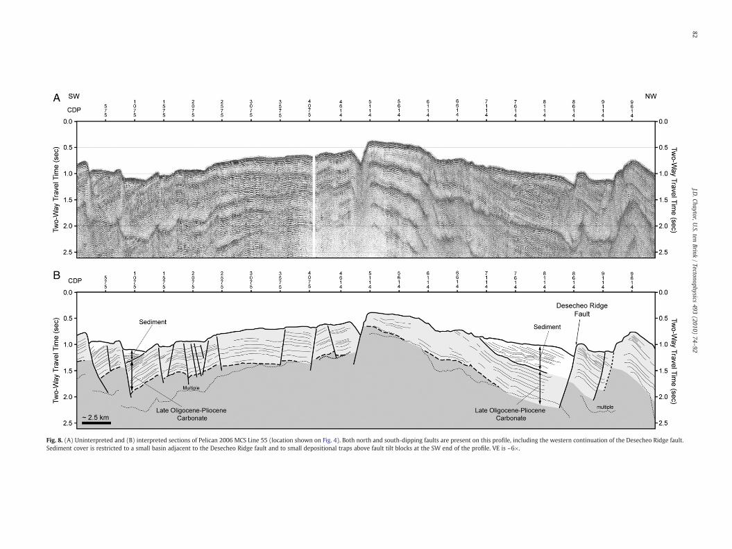
Fig. 8. (A) Uninterpreted and (B) interpreted sections of Pelican 2006 MCS Line 55 (location shown on Fig. 4). Both north and south-dipping faults are present on this profile, including the western continuation of the Desecheo Ridge fault.Sediment cover is restricted to a small basin adjacent to the Desecheo Ridge fault and to small depositional traps above fault tilt blocks at the SW end of the profile. VE is ~6×.
82J.D
.Chaytor,U.S.ten
Brink/Tectonophysics
493(2010)
74–92
83J.D. Chaytor, U.S. ten Brink / Tectonophysics 493 (2010) 74–92
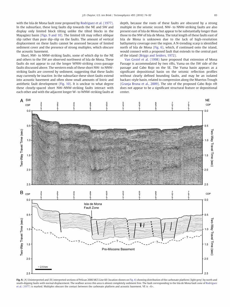
with the Isla de Mona fault zone proposed by Rodriguez et al. (1977).In the subsurface, these long faults dip towards the NE and SW anddisplay only limited block tilting unlike the tilted blocks in theMayagüez basin (Figs. 9 and 10). The limited tilt may reflect obliqueslip rather than pure dip–slip on the faults. The amount of verticaldisplacement on these faults cannot be assessed because of limitedsediment cover and the presence of strong multiples, which obscurethe acoustic basement.
Short, NW- to NNW-striking faults, some of which dip to the NEand others to the SW are observed northwest of Isla de Mona. Thesefaults do not appear to cut the longer WNW-striking cross-passagefaults discussed above. The western ends of these short NW- to NNW-striking faults are covered by sediment, suggesting that these faultsmay currently be inactive. In the subsurface these short faults extendinto acoustic basement and often show small amounts of listric andantithetic fault development (Fig. 10). It is unclear to what degreethese closely-spaced short NW–NNW-striking faults interact witheach other andwith the adjacent longerW- toWNW-striking faults at
Fig. 9. (A) Uninterpreted and (B) interpreted sections of Pelican 2006MCS Line 60 (location ssouth-dipping faults with normal displacement. The seafloor across this area is almost complet al. (1977) is marked. Multiples obscure the contact between the carbonate platform and
depth, because the roots of these faults are obscured by a strongmultiple in the seismic record. NW- to NNW-striking faults are alsopresent east of Isla de Mona but appear to be substantially longer thanthose to the NW of Isla de Mona. The total length of these faults east ofIsla de Mona is unknown due to the lack of high-resolutionbathymetry coverage over the region. A N-trending scarp is identifiednorth of Isla de Mona (Fig. 6), which, if continued onto the island,would connect with a proposed fault that extends to the central partof the island (Briggs and Seiders, 1972).
Van Gestel et al. (1998) have proposed that extension of MonaPassage is accommodated by two rifts, Yuma on the SW side of thepassage and Cabo Rojo on the SE. The Yuma basin appears as asignificant depositional basin on the seismic reflection profileswithout clearly defined bounding faults, and may be an isolatedbackarc-style basin, related to compression along the Muertos Trough(Granja Bruna et al., 2009). The site of the proposed Cabo Rojo riftdoes not appear to be a significant structural feature or depositionalcenter.
hown on Fig. 4) showing distribution of the carbonate platform (light grey) by north andetely sediment free. The fault corresponding to the Isla de Mona fault zone of Rodriguezacoustic basement. VE is ~6×.
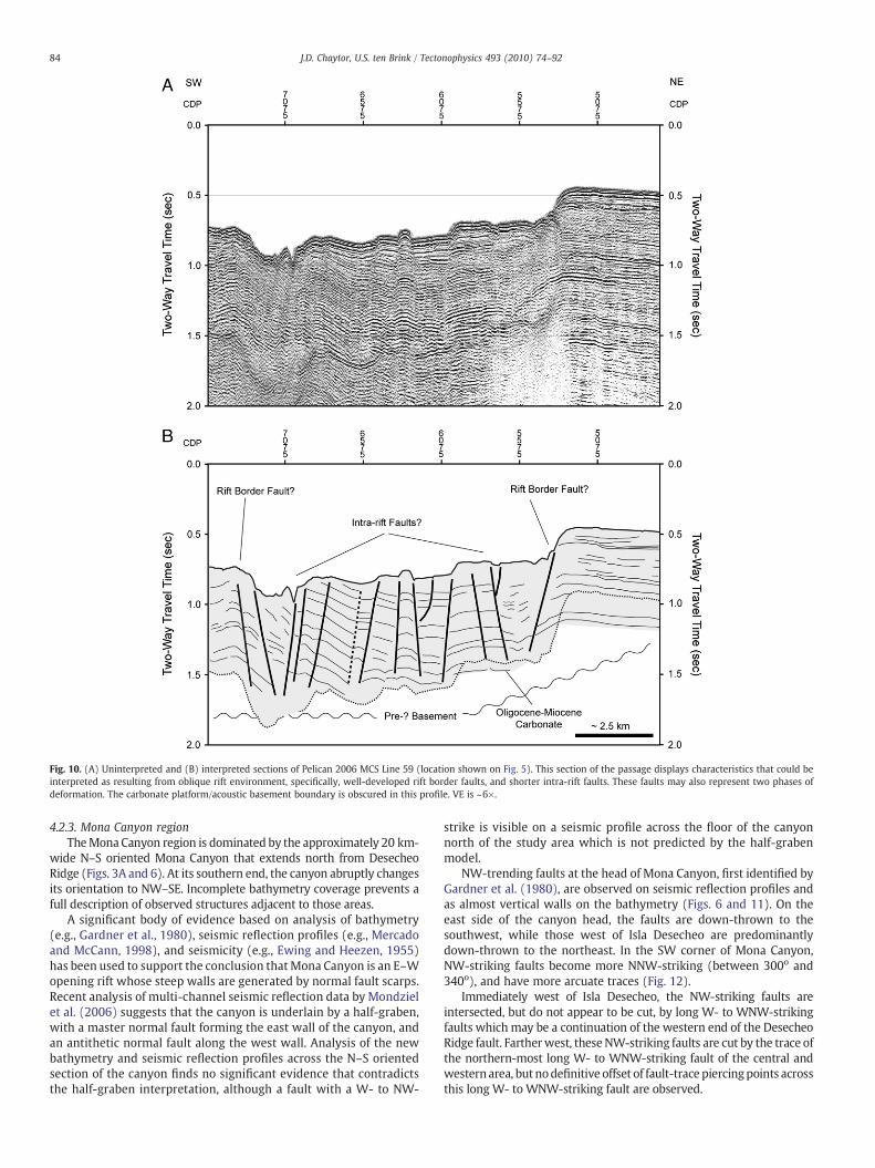
Fig. 10. (A) Uninterpreted and (B) interpreted sections of Pelican 2006 MCS Line 59 (location shown on Fig. 5). This section of the passage displays characteristics that could beinterpreted as resulting from oblique rift environment, specifically, well-developed rift border faults, and shorter intra-rift faults. These faults may also represent two phases ofdeformation. The carbonate platform/acoustic basement boundary is obscured in this profile. VE is ~6×.
84 J.D. Chaytor, U.S. ten Brink / Tectonophysics 493 (2010) 74–92
4.2.3. Mona Canyon regionTheMona Canyon region is dominated by the approximately 20 km-
wide N–S oriented Mona Canyon that extends north from DesecheoRidge (Figs. 3A and 6). At its southern end, the canyon abruptly changesits orientation to NW–SE. Incomplete bathymetry coverage prevents afull description of observed structures adjacent to those areas.
A significant body of evidence based on analysis of bathymetry(e.g., Gardner et al., 1980), seismic reflection profiles (e.g., Mercadoand McCann, 1998), and seismicity (e.g., Ewing and Heezen, 1955)has been used to support the conclusion thatMona Canyon is an E–Wopening rift whose steep walls are generated by normal fault scarps.Recent analysis of multi-channel seismic reflection data by Mondzielet al. (2006) suggests that the canyon is underlain by a half-graben,with a master normal fault forming the east wall of the canyon, andan antithetic normal fault along the west wall. Analysis of the newbathymetry and seismic reflection profiles across the N–S orientedsection of the canyon finds no significant evidence that contradictsthe half-graben interpretation, although a fault with a W- to NW-
strike is visible on a seismic profile across the floor of the canyonnorth of the study area which is not predicted by the half-grabenmodel.
NW-trending faults at the head of Mona Canyon, first identified byGardner et al. (1980), are observed on seismic reflection profiles andas almost vertical walls on the bathymetry (Figs. 6 and 11). On theeast side of the canyon head, the faults are down-thrown to thesouthwest, while those west of Isla Desecheo are predominantlydown-thrown to the northeast. In the SW corner of Mona Canyon,NW-striking faults become more NNW-striking (between 300o and340o), and have more arcuate traces (Fig. 12).
Immediately west of Isla Desecheo, the NW-striking faults areintersected, but do not appear to be cut, by long W- to WNW-strikingfaults which may be a continuation of the western end of the DesecheoRidge fault. Fartherwest, theseNW-striking faults are cut by the trace ofthe northern-most long W- to WNW-striking fault of the central andwestern area, but nodefinitive offset of fault-trace piercingpoints acrossthis long W- to WNW-striking fault are observed.
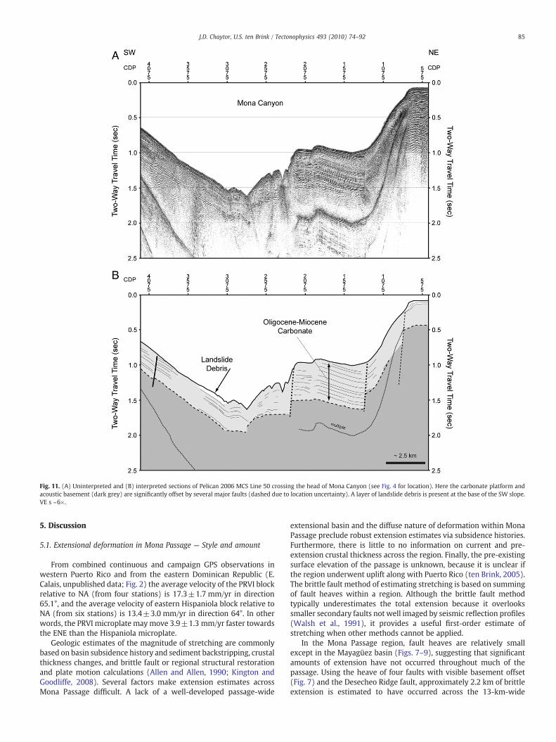
Fig. 11. (A) Uninterpreted and (B) interpreted sections of Pelican 2006 MCS Line 50 crossing the head of Mona Canyon (see Fig. 4 for location). Here the carbonate platform andacoustic basement (dark grey) are significantly offset by several major faults (dashed due to location uncertainty). A layer of landslide debris is present at the base of the SW slope.VE s ~6×.
85J.D. Chaytor, U.S. ten Brink / Tectonophysics 493 (2010) 74–92
5. Discussion
5.1. Extensional deformation in Mona Passage — Style and amount
From combined continuous and campaign GPS observations inwestern Puerto Rico and from the eastern Dominican Republic (E.Calais, unpublished data; Fig. 2) the average velocity of the PRVI blockrelative to NA (from four stations) is 17.3±1.7 mm/yr in direction65.1°, and the average velocity of eastern Hispaniola block relative toNA (from six stations) is 13.4±3.0 mm/yr in direction 64°. In otherwords, the PRVI microplate may move 3.9±1.3 mm/yr faster towardsthe ENE than the Hispaniola microplate.
Geologic estimates of the magnitude of stretching are commonlybased on basin subsidence history and sediment backstripping, crustalthickness changes, and brittle fault or regional structural restorationand plate motion calculations (Allen and Allen, 1990; Kington andGoodliffe, 2008). Several factors make extension estimates acrossMona Passage difficult. A lack of a well-developed passage-wide
extensional basin and the diffuse nature of deformation within MonaPassage preclude robust extension estimates via subsidence histories.Furthermore, there is little to no information on current and pre-extension crustal thickness across the region. Finally, the pre-existingsurface elevation of the passage is unknown, because it is unclear ifthe region underwent uplift along with Puerto Rico (ten Brink, 2005).The brittle fault method of estimating stretching is based on summingof fault heaves within a region. Although the brittle fault methodtypically underestimates the total extension because it overlookssmaller secondary faults not well imaged by seismic reflection profiles(Walsh et al., 1991), it provides a useful first-order estimate ofstretching when other methods cannot be applied.
In the Mona Passage region, fault heaves are relatively smallexcept in the Mayagüez basin (Figs. 7–9), suggesting that significantamounts of extension have not occurred throughout much of thepassage. Using the heave of four faults with visible basement offset(Fig. 7) and the Desecheo Ridge fault, approximately 2.2 km of brittleextension is estimated to have occurred across the 13-km-wide
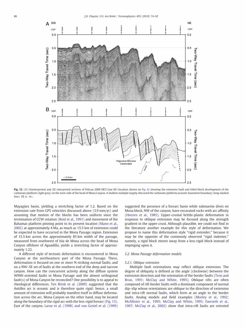
Fig. 12. (A) Uninterpreted and (B) interpreted sections of Pelican 2006 MCS Line 60 (location shown on Fig. 4) showing the extensive fault and titled block development of thecarbonate platform (light grey) on the west-side of the head of Mona Canyon. A shallowmultiple largely obscured the carbonate platform/acoustic basement boundary (long-dashedline). VE is ~6×.
86 J.D. Chaytor, U.S. ten Brink / Tectonophysics 493 (2010) 74–92
Mayagüez basin, yielding a stretching factor of 1.2. Based on theextension rate from GPS velocities discussed above (3.9 mm/yr) andassuming that motion of the blocks has been uniform since thetermination of CCW rotation (Reid et al., 1991) and movement of theBahamas platform pinning point to its present location (Mann et al.,2002) at approximately 4 Ma, as much as 15.5 km of extension couldbe expected to have occurred in the Mona Passage region. Extensionof 15.5 km across the approximately 85 km width of the passage,measured from southwest of Isla de Mona across the head of MonaCanyon offshore of Aguadilla, yields a stretching factor of approxi-mately 1.22.
A different style of tectonic deformation is encountered in MonaCanyon at the northeastern part of the Mona Passage. There,deformation is focused on one or more N-striking normal faults, andon a NW–SE set of faults at the southern end of the deep and narrowcanyon. How can the concurrent activity along the diffuse systemWNW-oriented faults in Mona Passage and the almost orthogonalfault(s) of Mona Canyon be reconciled? One possibility is to appeal torheological differences. Ten Brink et al. (2009) suggested that theAntilles arc is oceanic and is therefore quite rigid; hence, a smallamount of extension will probably manifest itself in diffuse deforma-tion across the arc. Mona Canyon on the other hand, may be locatedalong the boundary of the rigid arc with the less-rigid forearc (Fig. 13).East of the canyon, Larue et al. (1998) and van Gestel et al. (1999)
suggested the presence of a forearc basin while submarine dives onMona block, NW of the canyon, have excavated rocks with arc affinity(Heezen et al., 1985). Upper-crustal brittle-plastic deformation inresponse to oblique extension may be focused along the strengthgradient in the upper-crust. Although plausible, we could not find inthe literature another example for this style of deformation. Wepropose to name this deformation style “rigid extender,” because itmay be the opposite of the commonly observed “rigid indenter,”namely, a rigid block moves away from a less-rigid block instead ofimpinging upon it.
5.2. Mona Passage deformation models
5.2.1. Oblique extensionMultiple fault orientations may reflect oblique extension. The
degree of obliquity is defined as the angle (clockwise) between theextension direction and the orientation of the border faults (Tron andBrun, 1991; McClay and White, 1995). Oblique rifts are oftencomposed of rift border faults with a dominant component of normaldip–slip whose orientations are oblique to the direction of extensionand intra-rift normal faults, which form at an angle to the borderfaults. Analog models and field examples (Morley et al., 1992;McAllister et al., 1995; McClay and White, 1995; Faerseth et al.,1997; McClay et al., 2002) show that intra-rift faults are oriented
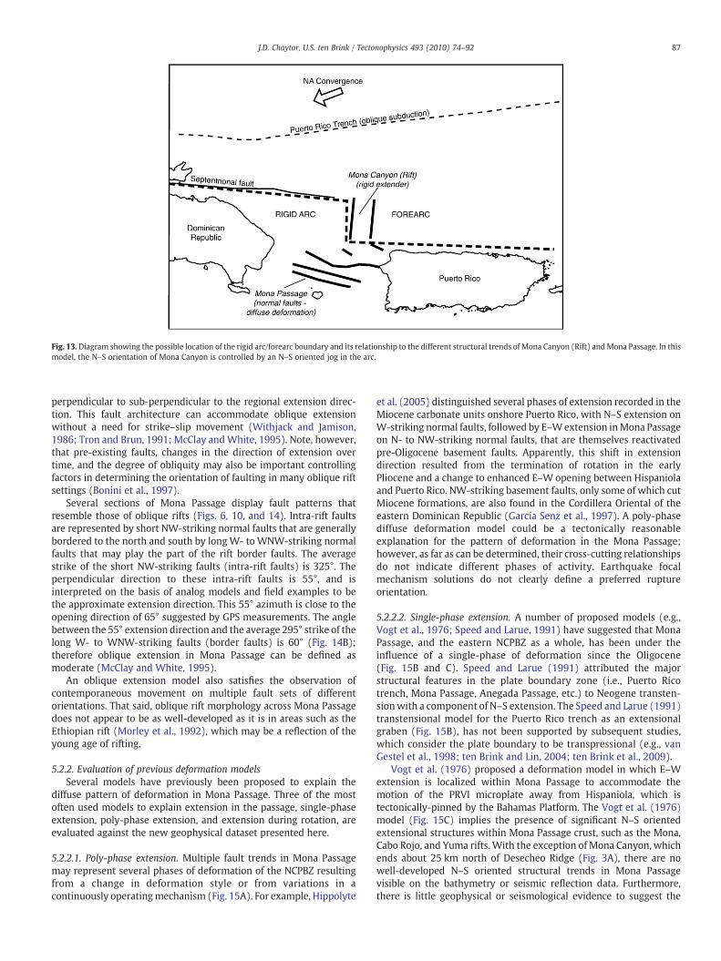
Fig. 13.Diagram showing the possible location of the rigid arc/forearc boundary and its relationship to the different structural trends of Mona Canyon (Rift) andMona Passage. In thismodel, the N–S orientation of Mona Canyon is controlled by an N–S oriented jog in the arc.
87J.D. Chaytor, U.S. ten Brink / Tectonophysics 493 (2010) 74–92
perpendicular to sub-perpendicular to the regional extension direc-tion. This fault architecture can accommodate oblique extensionwithout a need for strike–slip movement (Withjack and Jamison,1986; Tron and Brun, 1991; McClay andWhite, 1995). Note, however,that pre-existing faults, changes in the direction of extension overtime, and the degree of obliquity may also be important controllingfactors in determining the orientation of faulting in many oblique riftsettings (Bonini et al., 1997).
Several sections of Mona Passage display fault patterns thatresemble those of oblique rifts (Figs. 6, 10, and 14). Intra-rift faultsare represented by short NW-striking normal faults that are generallybordered to the north and south by longW- to WNW-striking normalfaults that may play the part of the rift border faults. The averagestrike of the short NW-striking faults (intra-rift faults) is 325°. Theperpendicular direction to these intra-rift faults is 55°, and isinterpreted on the basis of analog models and field examples to bethe approximate extension direction. This 55° azimuth is close to theopening direction of 65° suggested by GPS measurements. The anglebetween the 55° extension direction and the average 295° strike of thelong W- to WNW-striking faults (border faults) is 60° (Fig. 14B);therefore oblique extension in Mona Passage can be defined asmoderate (McClay and White, 1995).
An oblique extension model also satisfies the observation ofcontemporaneous movement on multiple fault sets of differentorientations. That said, oblique rift morphology across Mona Passagedoes not appear to be as well-developed as it is in areas such as theEthiopian rift (Morley et al., 1992), which may be a reflection of theyoung age of rifting.
5.2.2. Evaluation of previous deformation modelsSeveral models have previously been proposed to explain the
diffuse pattern of deformation in Mona Passage. Three of the mostoften used models to explain extension in the passage, single-phaseextension, poly-phase extension, and extension during rotation, areevaluated against the new geophysical dataset presented here.
5.2.2.1. Poly-phase extension. Multiple fault trends in Mona Passagemay represent several phases of deformation of the NCPBZ resultingfrom a change in deformation style or from variations in acontinuously operatingmechanism (Fig. 15A). For example, Hippolyte
et al. (2005) distinguished several phases of extension recorded in theMiocene carbonate units onshore Puerto Rico, with N–S extension onW-striking normal faults, followed by E–Wextension inMona Passageon N- to NW-striking normal faults, that are themselves reactivatedpre-Oligocene basement faults. Apparently, this shift in extensiondirection resulted from the termination of rotation in the earlyPliocene and a change to enhanced E–W opening between Hispaniolaand Puerto Rico. NW-striking basement faults, only some of which cutMiocene formations, are also found in the Cordillera Oriental of theeastern Dominican Republic (García Senz et al., 1997). A poly-phasediffuse deformation model could be a tectonically reasonableexplanation for the pattern of deformation in the Mona Passage;however, as far as can be determined, their cross-cutting relationshipsdo not indicate different phases of activity. Earthquake focalmechanism solutions do not clearly define a preferred ruptureorientation.
5.2.2.2. Single-phase extension. A number of proposed models (e.g.,Vogt et al., 1976; Speed and Larue, 1991) have suggested that MonaPassage, and the eastern NCPBZ as a whole, has been under theinfluence of a single-phase of deformation since the Oligocene(Fig. 15B and C). Speed and Larue (1991) attributed the majorstructural features in the plate boundary zone (i.e., Puerto Ricotrench, Mona Passage, Anegada Passage, etc.) to Neogene transten-sionwith a component of N–S extension. The Speed and Larue (1991)transtensional model for the Puerto Rico trench as an extensionalgraben (Fig. 15B), has not been supported by subsequent studies,which consider the plate boundary to be transpressional (e.g., vanGestel et al., 1998; ten Brink and Lin, 2004; ten Brink et al., 2009).
Vogt et al. (1976) proposed a deformation model in which E–Wextension is localized within Mona Passage to accommodate themotion of the PRVI microplate away from Hispaniola, which istectonically-pinned by the Bahamas Platform. The Vogt et al. (1976)model (Fig. 15C) implies the presence of significant N–S orientedextensional structures within Mona Passage crust, such as the Mona,Cabo Rojo, and Yuma rifts. With the exception of Mona Canyon, whichends about 25 km north of Desecheo Ridge (Fig. 3A), there are nowell-developed N–S oriented structural trends in Mona Passagevisible on the bathymetry or seismic reflection data. Furthermore,there is little geophysical or seismological evidence to suggest the
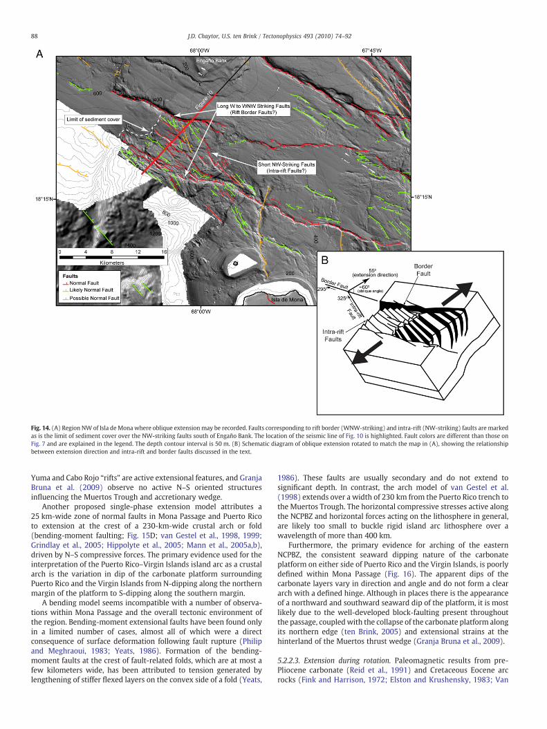
Fig. 14. (A) Region NW of Isla de Mona where oblique extension may be recorded. Faults corresponding to rift border (WNW-striking) and intra-rift (NW-striking) faults are markedas is the limit of sediment cover over the NW-striking faults south of Engaño Bank. The location of the seismic line of Fig. 10 is highlighted. Fault colors are different than those onFig. 7 and are explained in the legend. The depth contour interval is 50 m. (B) Schematic diagram of oblique extension rotated to match the map in (A), showing the relationshipbetween extension direction and intra-rift and border faults discussed in the text.
88 J.D. Chaytor, U.S. ten Brink / Tectonophysics 493 (2010) 74–92
Yuma and Cabo Rojo “rifts” are active extensional features, and GranjaBruna et al. (2009) observe no active N–S oriented structuresinfluencing the Muertos Trough and accretionary wedge.
Another proposed single-phase extension model attributes a25 km-wide zone of normal faults in Mona Passage and Puerto Ricoto extension at the crest of a 230-km-wide crustal arch or fold(bending-moment faulting; Fig. 15D; van Gestel et al., 1998, 1999;Grindlay et al., 2005; Hippolyte et al., 2005; Mann et al., 2005a,b),driven by N–S compressive forces. The primary evidence used for theinterpretation of the Puerto Rico–Virgin Islands island arc as a crustalarch is the variation in dip of the carbonate platform surroundingPuerto Rico and the Virgin Islands from N-dipping along the northernmargin of the platform to S-dipping along the southern margin.
A bending model seems incompatible with a number of observa-tions within Mona Passage and the overall tectonic environment ofthe region. Bending-moment extensional faults have been found onlyin a limited number of cases, almost all of which were a directconsequence of surface deformation following fault rupture (Philipand Meghraoui, 1983; Yeats, 1986). Formation of the bending-moment faults at the crest of fault-related folds, which are at most afew kilometers wide, has been attributed to tension generated bylengthening of stiffer flexed layers on the convex side of a fold (Yeats,
1986). These faults are usually secondary and do not extend tosignificant depth. In contrast, the arch model of van Gestel et al.(1998) extends over a width of 230 km from the Puerto Rico trench tothe Muertos Trough. The horizontal compressive stresses active alongthe NCPBZ and horizontal forces acting on the lithosphere in general,are likely too small to buckle rigid island arc lithosphere over awavelength of more than 400 km.
Furthermore, the primary evidence for arching of the easternNCPBZ, the consistent seaward dipping nature of the carbonateplatform on either side of Puerto Rico and the Virgin Islands, is poorlydefined within Mona Passage (Fig. 16). The apparent dips of thecarbonate layers vary in direction and angle and do not form a cleararch with a defined hinge. Although in places there is the appearanceof a northward and southward seaward dip of the platform, it is mostlikely due to the well-developed block-faulting present throughoutthe passage, coupledwith the collapse of the carbonate platform alongits northern edge (ten Brink, 2005) and extensional strains at thehinterland of the Muertos thrust wedge (Granja Bruna et al., 2009).
5.2.2.3. Extension during rotation. Paleomagnetic results from pre-Pliocene carbonate (Reid et al., 1991) and Cretaceous Eocene arcrocks (Fink and Harrison, 1972; Elston and Krushensky, 1983; Van
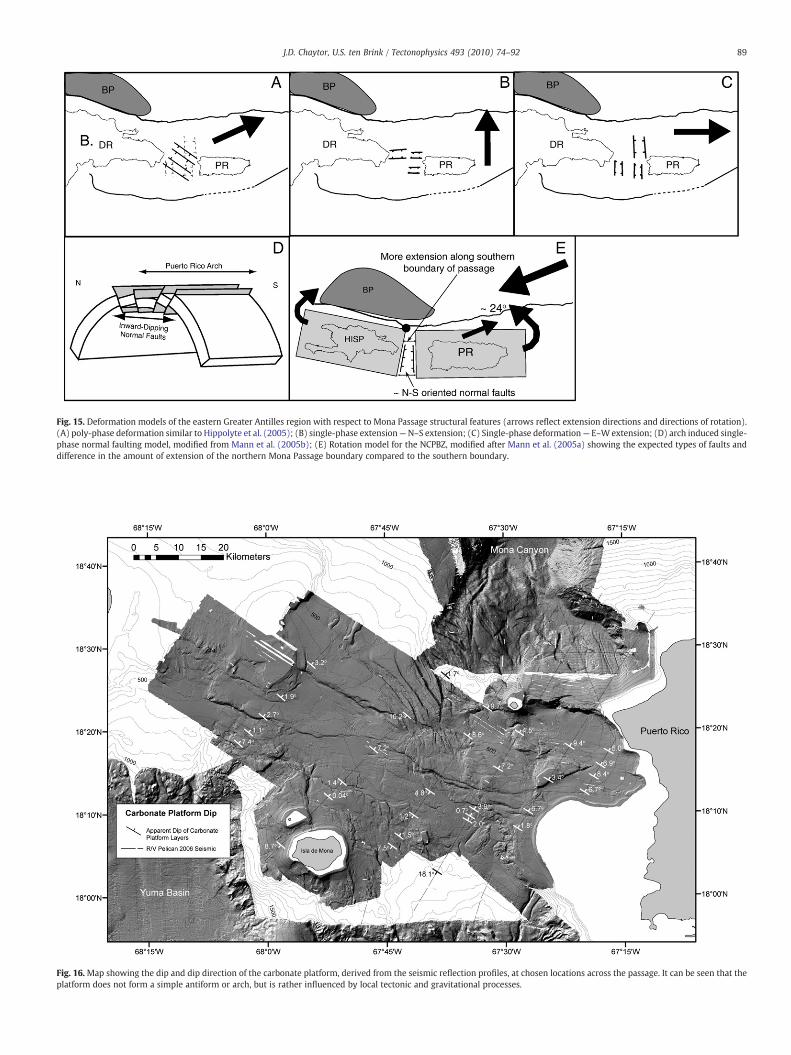
Fig. 15. Deformation models of the eastern Greater Antilles region with respect to Mona Passage structural features (arrows reflect extension directions and directions of rotation).(A) poly-phase deformation similar to Hippolyte et al. (2005); (B) single-phase extension—N–S extension; (C) Single-phase deformation— E–Wextension; (D) arch induced single-phase normal faulting model, modified from Mann et al. (2005b); (E) Rotation model for the NCPBZ, modified after Mann et al. (2005a) showing the expected types of faults anddifference in the amount of extension of the northern Mona Passage boundary compared to the southern boundary.
Fig. 16. Map showing the dip and dip direction of the carbonate platform, derived from the seismic reflection profiles, at chosen locations across the passage. It can be seen that theplatform does not form a simple antiform or arch, but is rather influenced by local tectonic and gravitational processes.
89J.D. Chaytor, U.S. ten Brink / Tectonophysics 493 (2010) 74–92
90 J.D. Chaytor, U.S. ten Brink / Tectonophysics 493 (2010) 74–92
Fossen et al., 1989) suggest that Puerto Rico has undergonesignificant counter-clockwise (CCW) rotation in the post-Cretaceous.Counter-clockwise rotation of the PRVI microplate was used toexplain extension in the Mona Passage (Fig. 15E) and elsewhere inthe eastern NCPBZ (e.g., Schell and Tarr, 1978; Masson and Scanlon,1991; Mann et al., 2005a). A CCW rotation model fits with a numberof general observations, including compression in the Puerto Ricotrench and western Muertos Trough, and extension in the AnegadaPassage and Mona Canyon. However, paleomagnetic measurementsfrom northern Puerto Rico indicate that the CCW rotation of the PRVImicroplate ceased approximately 4 Ma (Reid et al., 1991).
The recent GPS data summarized above indicate that a counter-clockwise rotation model is incompatible with ongoing deformationin the western Puerto Rico and the Mona Passage. No clear rotationsignal is currently seen in these GPS vectors as has been seen inseveral other regions worldwide (e.g., McCaffrey et al., 2000).Furthermore, if the extension recorded in Mona Passage is the resultof the 24° of rotation, two diagnostic features would be expected:significant development of N–S oriented structures and greaterextension along the southern boundary of the passage compared tothe northern boundary (Fig. 15E). Neither of these diagnostic featuresis observed in the new geophysical data set.
5.3. Earthquake hazard from Mona Passage
Frequent low-magnitude seismicity (M≤6) occurs from thesurface down to depths over 200 km throughout the Greater Antillesbetween the Muertos trough and Puerto Rico trench at the latitude of
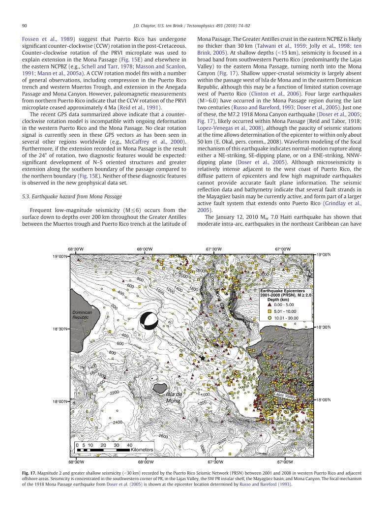
Fig. 17. Magnitude 2 and greater shallow seismicity (b30 km) recorded by the Puerto Ricooffshore areas. Seismicity is concentrated in the southwestern corner of PR, in the Lajas Valleof the 1918 Mona Passage earthquake from Doser et al. (2005) is shown at the epicenter lo
Mona Passage. The Greater Antilles crust in the eastern NCPBZ is likelyno thicker than 30 km (Talwani et al., 1959; Jolly et al., 1998; tenBrink, 2005). At shallow depths (b15 km), seismicity is focused in abroad band from southwestern Puerto Rico (predominantly the LajasValley) to the eastern Mona Passage, turning north into the MonaCanyon (Fig. 17). Shallow upper-crustal seismicity is largely absentwithin the passage west of Isla de Mona and in the eastern DominicanRepublic, although this may be a function of limited station coveragewest of Puerto Rico (Clinton et al., 2006). Four large earthquakes(MN6.0) have occurred in the Mona Passage region during the lasttwo centuries (Russo and Bareford, 1993; Doser et al., 2005). Just oneof these, the M7.2 1918 Mona Canyon earthquake (Doser et al., 2005;Fig. 17), likely occurred within Mona Passage (Reid and Tabor, 1918;Lopez-Venegas et al., 2008), although the paucity of seismic stationsat the time allows determination of the epicenter to within only about50 km (E. Okal, pers. comm., 2008). Waveform modeling of the focalmechanism of this earthquake indicates normal-motion rupture alongeither a NE-striking, SE-dipping plane, or on a ENE-striking, NNW-dipping plane (Doser et al., 2005). Although microseismicity isrelatively intense adjacent to the west coast of Puerto Rico, thediffuse pattern of epicenters and few high magnitude earthquakescannot provide accurate fault plane information. The seismicreflection data and bathymetry indicate that several fault strands inthe Mayagüez basin may be currently active, and form part of a largeractive fault system that extends onto Puerto Rico (Grindlay et al.,2005).
The January 12, 2010 Mw 7.0 Haiti earthquake has shown thatmoderate intra-arc, earthquakes in the northeast Caribbean can have
Seismic Network (PRSN) between 2001 and 2008 in western Puerto Rico and adjacenty, the SW PR insular shelf, the Mayagüez basin, and Mona Canyon. The focal mechanismcation determined by Russo and Bareford (1993).
91J.D. Chaytor, U.S. ten Brink / Tectonophysics 493 (2010) 74–92
devastating effects. Using the empirical relationship between faultdimensions, displacement, and magnitude of Wells and Coppersmith(1994), estimates of potential earthquake magnitude can be made fortwo faults in the passage if they ruptured their entire lengths. The firstfault (marked as 1 on Fig. 6), the Desecheo Island fault, from PuntaHiguero to Desecheo Island is approximately 20 km long, and,assuming a conservative down-dip fault width of 15 km couldgenerate an earthquake ≤Mw 6.5. The second fault (marked as 2 onFig. 6), is approximately 75 km long and, again assuming a width of15 km, could generate an earthquake ≤Mw 7. Both these hypotheticalearthquakes could cause significant damage in Puerto Rico andHispaniola similar to the 1918 earthquake.
6. Conclusions
This paper presents observations and discussions of diffuseextension within the northern Caribbean oceanic island arc. MonaPassage, between Puerto Rico and the Dominican Republic, is a zone ofactive, intra-arc oblique extension. Structural interpretations of thepassage have previously been based on limited spatial data coverage,constrained in most cases to widely-spaced seismic reflection profiles.The combined interpretation of newly acquired multibeam bathym-etry and seismic reflection profiles has revealed the complexmorphologic and structural fabric of Mona Passage.
Deformation across Mona Passage as reflected by GPS (ENE-directed extension), is being accommodated by numerous normalfaults with W to NNW strikes. Several major faults are identified thatcross almost the entire width of the passage and, in some instancessuch as the Desecheo Ridge fault and faults within Mayagüez basin,may connectwith faults identified on land in Puerto Rico. Although thekinematics of the deformation are still not completely resolved, thestructural architecture within the passage based on the available dataappears to bemost compatiblewith an oblique extensionmodel. Otherproposedkinematicmodels such as single-phase extensionwith eitherN–S or E–W oriented structures, poly-phase extension, extensionrelated to continued rotation of Puerto Rico, and arching-relatedfaulting models are not supported by the structural interpretation.Because of the general absence of young sediment accumulation andfault piercingpoints, the actual amount of extension across the passageand the relative role and timing of Mona Passage, Mona Canyon, andother adjacent major tectonic features (e.g., Muertos Trough, Septen-trional fault, etc.) in accommodating the extension cannot beadequately resolved. Within certain sections of Mona Passage, suchas the Mayagüez basin/half-graben, there is evidence for morematurerift development and hence a greater level of extension. GPS data havelarge uncertainties, but across Mona Passage appear to indicate anENE-directed extension, in accord with the N55°E extension directiondeduced from the structural analysis.
Finally, Mona Passage and adjacent areas are associated withseismic activity and a history of damaging earthquakes, landslides,and tsunamis. Several faults within the passage, if they were torupture along their entire length, could generate earthquakes withmagnitudes on the order of Mw 6.5–7.0. A better understanding of therupture history and potential of active faults in the passage wouldimprove seismic hazard assessment for the region.
Acknowledgments
We wish to thank the captains and crews of the NOAA Ship NancyFoster and R/V Pelican. We thank the science parties of both cruises(Brian Andrews, Wayne Baldwin, Roy Barkan, Emile Bergeron, KellyCarignan, Chris Chamberlin, Bill Danforth, Claudia Flores, Barry Irwin,Alberto Lopez, Brooke McMahon, Thomas O'Brien, and ChuckWorley), Claudia Flores and Dave Foster for technical assistance anddata processing, and Eric Calais for providing processed GPS data.Discussions with Jian Lin, Mark Behn, and Roger Buck helped focus
some of our ideas. Reviews by Bill Dillon, Tom Pratt, and ananonymous reviewer greatly improved this manuscript. Any use oftrade, product, or firm names is for descriptive purposes only and doesnot imply endorsement by the U.S. Government.
References
Allen, P.A., Allen, J.R., 1990. Basin Analysis: Principles and Applications. Blackwell,Oxford. 451 pp.
Baker, V.R., 1978. Large-scale erosional and depositional features of the ChanneledScabland. In: Baker, V.R., Nummedal, D. (Eds.), The Channeled Scabland, National.Aeronautics and Space Administration, Washington, D.C. , pp. 81–115.
Bonini, M., Souriot, T., Boccaletti, M., Brun, J.-P., 1997. Successive orthogonal andoblique extension episodes in a rift zone; laboratory experiments with applicationto the Ethiopian Rift. Tectonics 16, 347–362.
Briggs, R.P., 1961. Geology of Kewanee Interamerican Oil Company test well number4CRP, northern Puerto Rico. Oil and Gas possibilities of northern Puerto Rico, PuertoRico Mining Commission, San Juan, pp. 1–23.
Briggs, R.P., 1964. Provisional geologic map of Puerto Rico and adjacent islands.Miscellaneous Geologic Investigations Map I-392. US Geological Survey 1, 240,000.
Briggs, R.P., Seiders, V.M., 1972. Geologicmap of the Isla deMonaQuadrangle, Puerto Rico.Miscellaneous Geologic Investigations Map I-718. US Geological Survey 1, 20,000.
Busby, C.J., Bassett, K.N., 2007. Volcanic facies architecture of an intra-arc strike–slipbasin, Santa Rita Mountains, Southern Arizona. Bulletin of Volcanology 70, 85–103.
Byrne, D.B., Suarez, G., McCann, W.R., 1985. Muertos trough subduction-microplatetectonics in the northern Caribbean. Nature 317, 420–421.
Calais, E., Mazabraud, Y., Mercier de Lépinay, B., Mann, P., Mattioli, G., Jansma, P., 2002.Strain partitioning and fault slip rates in the northeastern Caribbean from GPSmeasurements. Geophysical Research Letters 29, 1856. doi:10.1029/2002GL015397.
Chapple, W.M., Forsyth, D.W., 1979. Earthquakes and bending of plates at trenches.Journal of Geophysical Research 84, 6729–6749.
Clinton, J.F., Cua, G., Huerfano, V., von Hillebrandt-Andrade, C.G., Cruzardo, J.M., 2006.The current state of seismic monitoring in Puerto Rico. Seismological ResearchLetters 77, 532–543.
DeMets, C., Mattioli, G.S., Jansma, P.E., Rogers, R., Tenorios, C., Turner, H.L., 2007. Presentmotion and deformation of the Caribbean Plate; constraints from new GPS geodeticmeasurements from Honduras and Nicaragua. In: Mann, P. (Ed.), Geologic andTectonic Development of the Caribbean Plate Boundary in Northern CentralAmerica: Geological Society of America Special Paper, 428, pp. 21–36.
Dewey, J.F., 1988. Extensional collapse of orogens. Tectonics 7, 1123–1139.Doglioni, C., 1995. Geological remarks on the relationships between extension and
convergent geodynamic settings. Tectonophysics 252, 253–267.Dolan, J., Mann, P., de Zoeten, R., Heubeck, C., Shiroma, J., 1991. Sedimentological,
stratigraphic, and tectonic synthesis of Eocene–Miocene sedimentary basins,Hispaniola and Puerto Rico. In: Mann, P., Draper, G., Lewis, J.F. (Eds.), Geologicand Tectonic Development of the North American–Caribbean Plate Boundary inHispaniola: GSA Special Paper, 262, pp. 217–263.
Dolan, J., Mullins, H., Wald, D., 1998. Active tectonics of the northcentral Caribbean:oblique collision, strain partitioning, and opposing subducting slabs. In: Dolan, J.,Mann, P. (Eds.), Active Strike–slip and Collisional Tectonics of the NorthernCaribbean plate boundary zone: Geological Society of America Special Paper, 326,pp. 1–61.
Donnelly, T.W., 1989. Geologic history of the Caribbean and Central America. In: Bally,A.W., Palmer, A.R. (Eds.), An Overview, Geology of North America: A. GeologicalSociety of America, Boulder, CO, pp. 299–321.
Doser, D.I., Rodriguez, C.M., Flores, C., 2005. Historical earthquakes of the Puerto Rico–Virgin Islands region; 1915–1963. In: Mann, P. (Ed.), Active Tectonics and SeismicHazards of Puerto Rico, the Virgin Islands, and Offshore Areas: Geological Society ofAmerica Special Paper, 385, pp. 103–114.
Edgar, N.T., Scanlon, K.M., 1987. Single-channel seismic-reflection profiles collected aboardR/VPowell, Cruises P-2-85, p-3-85, andP-4-85, in thenear-shorewaters aroundPuertoRico and the Virgin Islands: U.S. Geological Survey Open-File Report, 87-147. 3 pp.
Elston, D.P., Krushensky, R.D., 1983. Puerto Rico: a translated terrane exotic to theCaribbean. Proceedings of the 10th Caribbean Geological Conference, p. 81.
Ewing, M., Heezen, B.C., 1955. Puerto Rico trench topographic and geophysical data.Crust of the Earth: Geological Society of America Special Paper, 62, pp. 255–267.
Faerseth, R.B., Knudsen, B.-E., Liljedahl, T., Midbøe, P.S., Søderstrøm, B., 1997. Obliquerifting and sequential faulting in the Jurassic development of the northern NorthSea. Journal of Structural Geology 19, 1285–1302.
Fink, L.K., Harrison, C.G.A., 1972. Paleomagnetic investigations of selected lava units onPuerto Rico. Proceedings of the 6th Caribbean Geological Conference, p. 379.
Ford, D.C., Williams, P., 2007. Karst Hydrogeology and Geomorphology. John Wiley &Sons, West Sussex. 576 pp.
Frank, E.F., Wicks, C.M., Mylroie, J., Troester, J.W., Alexander Jr., E.C., Carew, J.L., 1998.Geology of Isla de Mona, Puerto Rico. Journal of Cave and Karst Studies 60, 69–72.
García Senz, J., Monthel, J., Díaz de Neira, J.A., Hernáiz Huerta, R.P., Escuder Viruete, J.,Pérez Estaun, A., 1997. La estructura de la Cordillera Oriental de la RepúblicaDominicana. Boletín geológico y minero 118, 293–312.
Gardner, W.D., Glover, L.K., Hollister, C.D., 1980. Canyons off Northwest Puerto Rico;studies of their origin and maintenance with the nuclear research submarine NR-1.Marine Geology 37, 41–70.
Gawthorpe, R.G., Hurst, J.M., 1993. Transfer zones in extensional basins: their structuralstyle and influence on drainage development and stratigraphy. Journal of theGeological Society of London 150, 1137–1152.
92 J.D. Chaytor, U.S. ten Brink / Tectonophysics 493 (2010) 74–92
Geist, E.L., Childs, J.R., Scholl, D.W., 1988. The origin of summit basins of the AleutianRidge; implications for block rotation of an arc massif. Tectonics 2, 327–341.
Gonzalez, L.A., Ruiz, H.A., Taggart, B.E., Budd, A.F., Monell, V., 1997. Geology of Isla deMona, Puerto Rico. In: Vacher, H.L., Wuinn, T. (Eds.), Geology and Hydrogeology ofCarbonate Islands: Developments in Sedimentology, 54, pp. 327–358.
Granja Bruna, J.L., ten Brink, U.S., Carbo-Gorosabel, A., Munoz-Martin, A., GomezBallesteros, M., 2009. Morphotectonics of central Muertos thrust belt and MuertosTrough (northeast Caribbean). Marine Geology 263, 7–33.
Grindlay, N.R., Abrams, L.J., Del Greco, L., Mann, P., 2005. Toward an integratedunderstanding of Holocene fault activity in western Puerto Rico; constraints fromhigh-resolution seismic and sidescan sonar data. In: Mann, P. (Ed.), ActiveTectonics and Seismic Hazards of Puerto Rico, the Virgin Islands, and OffshoreAreas: Geological Society of America Special Paper, 385, pp. 139–160.
Heezen, B.C., Nesteroff, W.D., Rawson, M., Freeman-Lynde, R.P., 1985. Visual evidencefor subduction in the western Puerto Rico Trench. Géodynamique des CaraïbesSymposium, Paris 5–8 février: Éditions Technip, 27, pp. 287–304.
Hippolyte, J.-.C., Mann, P., Grindlay, N.R., 2005. Geologic evidence for the prolongationof active normal faults of the Mona rift into northwestern Puerto Rico. In: Mann, P.(Ed.), Active Tectonics and Seismic Hazards of Puerto Rico, the Virgin Islands, andOffshore Areas: Geological Society of America Special Paper, 385, pp. 161–171.
Jansma, P.E., Mattioli, G.S., 2005. GPS results from Puerto Rico and the Virgin Islands;constraints on tectonic setting and rates of active faulting. In: Mann, P. (Ed.), ActiveTectonics and Seismic Hazards of Puerto Rico, the Virgin Islands, and OffshoreAreas: Geological Society of America Special Paper, 385, pp. 13–30.
Jansma, P.E., Mattioli, G.S., Lopez, A., DeMets, C., Dixon, T.H., Mann, P., Calais, E., 2000.Neotectonics of Puerto Rico and the Virgin Islands, northeastern Caribbean, fromGPS geodesy. Tectonics 19, 1021–1037.
Jolly, W.T., Lidiak, E.G., Schelleckens, H.S., Santos, S., 1998. Volcanism, tectonics, andstratigraphic correlations in Puerto Rico. In: Lidiak, E.G., Larue, D.K. (Eds.), Tectonicsand Geochemistry of the Northeast Caribbean: Geological Society of America,Special Paper, 322, pp. 1–34.
Kaye, C.A., 1959. Geology of Isla Mona, Puerto Rico, and notes on age of Mona Passage.U. S. Geological Survey Professional Paper 317C, 141–178.
Kington, J.D., Goodliffe, A.M., 2008. Plate motions and continental extension at therifting to spreading transition in Woodlark Basin, Papua New Guinea: can oceanicplate kinematics be extended into continental rifts. Tectonophysics 458, 82–95.
Larue, D.K., Berrong, B., 1991. Cross section through the Toa Baja drillsite; evidence fornorthward change in late Eocene deformation intensity. Geophysical ResearchLetters 18, 561–564.
Larue, D.K., Torrini Jr., R., Smith, A.L., Joyce, J., 1998. North Coast Tertiary basin of PuertoRico: from arc basin to carbonate platform to arc-massif slope. In: Lidiak, E.G.,Larue, D.K. (Eds.), Tectonics and Geochemistry of the Northeast Caribbean:Geological Society of America, Special Paper, 322, pp. 155–176.
Lopez-Venegas, A.M., ten Brink, U.S., Geist, E.L., 2008. Submarine landslide as the sourcefor the October 11, 1918 Mona Passage tsunami: observations and modeling.Marine Geology 254, 35–46.
Manaker, D.M., Calais, E., Freed, A.M., Ali, S.T., Przybylski, P., Mattioli, G., Jansma, P.,Prépetit, C., de Chabalier, J.B., 2008. Interseismic plate coupling and strainpartitioning in the Northeastern Caribbean. Geophysical Journal International174, 889–903.
Mann, P., Burke, K., 1990. Transverse intra-arc rifting; Palaeogene Wagwater Belt,Jamaica. Marine and Petroleum Geology 7, 410–427.
Mann, P., Taylor, F.W., Edwards, R.L., Kuc, T., 1995. Actively evolving microplateformation by oblique collision and sideways motion along strike–slip faults: anexample from the northeastern Caribbean plate margin. Tectonophysics 246,1–69.
Mann, P., Calais, E., Ruegg, J.-C., DeMets, C., Jansma, P.E., Mattioli, G.S., 2002. Obliquecollision in the northeastern Caribbean from GPS measurements and geologicalobservations. Tectonics 21. doi:10.1029/2001TC001304.
Mann, P., Hippolyte, J.-C., Grindlay, N.R., Abrams, L.J., 2005a. Neotectonics of southernPuerto Rico and its offshore margin; active tectonics and seismic hazards of PuertoRico, the Virgin Islands, and offshore areas. In: Mann, P. (Ed.), Active Tectonics andSeismic Hazards of Puerto Rico, The Virgin Islands, and Offshore Areas: GeologicalSociety of America Special Paper, 385, pp. 173–214.
Mann, P., Prentice, C.S., Hippolyte, J.-C., Grindlay, N.R., Abrams, L.J., Lao-Davila, D.,2005b. Reconnaissance study of late Quaternary faulting along Cerro Goden faultzone, western Puerto Rico. In: Mann, P. (Ed.), Active Tectonics and Seismic Hazardsof Puerto Rico, the Virgin Islands, and Offshore Areas: Geological Society of AmericaSpecial Paper, 385, pp. 115–137.
Masson, D.G., Scanlon, K.M., 1991. The neotectonic setting of Puerto Rico. GeologicalSociety of America 103, 144–154.
McAllister, E., Cann, J., Spencer, S., 1995. The evolution of crustal deformation in anoceanic extensional environment. Journal of Structural Geology 17, 183–199.
McCaffrey, R., Johnson, C.K., Zwick, P.C., Long, M.D., Goldfinger, C., Nabelek, J.L., Smith,C., 2000. Rotation and plate locking along the southern Cascadia subduction zone.Geophysical Research Letters 21, 3117–3120.
McClay, K.R., White, M.J., 1995. Analogue modelling of orthogonal and oblique rifting.Marine and Petroleum Geology 12, 137–151.
McClay, K.R., Dooley, T., Whitehouse, P., Mills, M., 2002. 4-D evolution of rift systems:insights from scaled physical models. American Association of PetroleumGeologists Bulletin 86, 935–959.
Mercado, A., McCann, W., 1998. Numerical simulation of the 1918 Puerto Rico tsunami.Natural Hazards 18, 57–76.
Mondziel, S.A., Grindlay, N.R., Mann, P., Escalona, A., 2006. Multi-channel seismicimages of Neogene rifting in the northern Mona Passage between Puerto Rico andHispaniola. Eos Trans. AGU, 87 (52), Fall Meet. Suppl., Abstract T43D-1679.
Monroe, W.H., 1980. Geology of the middle Tertiary formations of Puerto Rico. U.S.Geological Survey Professional Paper, 953. 93 pp.
Morley, C.K., Cunningham, S.M., Harper, R.M., Wescott, W.A., 1992. Geology andgeophysics of the Rukwa Rift, East Africa. Tectonics 11, 69–81.
Moussa, M.T., Seiglie, G.A., Meyerhoff, A.A., Taner, I., 1987. The Quebradillas Limestone(Miocene–Pliocene), northern Puerto Rico, and tectonics of the northeasternCaribbean margin. Geological Society of America Bulletin 99, 427–439.
Nagle, F., Erlich, R.N., Canovi, C.J., 1978. Caribbean dredge haul compilation: summaryand implications. Transactions of the 8th Caribbean Geological Conference:Geologie en Minjbouw, 57, pp. 267–270.
Philip, H., Meghraoui, M., 1983. Structural analysis and interpretation of the surfacedeformations of the El Asnam earthquake of October 10, 1980. Tectonics 2, 17–49.
Pindell, J.L., Barrett, S.F., 1990.Geological evolution of theCaribbean region; a plate tectonicperspective. In: Dengo, G., Case, J.E. (Eds.), The Caribbean, Volume H, Decade of NorthAmerican Geology. Geological Society of America, Boulder, CO, pp. 404–431.
Reid, H.F., Tabor, S., 1919. The Porto Rico earthquakes of October–November, 1918.Bulletin of the Seismological Society of America 9, 95–127.
Reid, J.A., Plumley, P.W., Schellekens, J.H., 1991. Paleomagnetic evidence for lateMiocene counterclockwise rotation of North Coast carbonate sequence, PuertoRico. Geophysical Research Letters 18, 565–568.
Rodriguez, R.W., Trumbull, J.V.A., Dillon, W.P., 1977. Marine geologic map of Isla deMona area, Puerto Rico. Miscellaneous Investigation Series Map I-1063: U.S.Geological Survey, 1, p. 40,000.
Royden, L.H., 1993. The tectonic expression slabpull at continental convergentboundaries.Tectonics 12, 303–325.
Ruiz, H.M., 1993. Sedimentology and diagenesis of Isla de Mona, Puerto Rico. M. S.thesis, University of Iowa, Iowa City, 86pp.
Russo, R.M., Bareford, C., 1993. Historical Seismicity of the Caribbean Region, 1933–1963.Caribbean Conference on Volcanism, Seismicity and Earthquake Engineering.University of the West Indies, Trinidad.
Schell, B.A., Tarr, A.C., 1978. Plate tectonics of the northeastern Caribbean Sea region. In:MacGillavry, H.J., Beets, D.J. (Eds.), Geologie en Mijnbouw: Netherlands Journal ofGeosciences, pp. 319–324.
Seiders, V.M., Briggs, R.P., Glover, L., 1972. Geology of Isla Desecheo, Puerto Rico, withnotes on the Great Southern Puerto Rico Fault Zone and Quaternary stillstands ofthe sea. U.S. Geological Survey Professional Paper, 739. 22 pp.
Speed, R., Larue, D.K., 1991. Extension and transtension in the plate boundary zone ofthe northeastern Caribbean. Geophysical Research Letters 18, 573–576.
Suter, M., Quintero-Legorreta, O., Lopez-Martinez, M., Aguirre-Diaz, G., Farrar, E., 1995.The Acambay Graben; active intraarc extension in the Trans-Mexican volcanic belt,Mexico. Tectonics 14, 1245–1262.
Talwani, M., Sutton, G.H., LamarWorzel, J., 1959. A crustal section across the Puerto RicoTrench. Journal of Geophysical Research 64, 1545–1555.
ten Brink, U., 2005. Vertical motions of the Puerto Rico Trench and Puerto Rico and theircause. Journal of Geophysical Research 110. doi:10.1029/2004JB003459.
ten Brink, U., Lin, J., 2004. Stress interaction between subduction earthquakes andforearc strike–slip faults; modeling and application to the northern Caribbean plateboundary. Journal of Geophysical Research 109. doi:10.1029/2004JB003031.
ten Brink, U.S., Marshak, S., Granja, J.L., 2009. Bivergent thrust wedges surroundingisland arcs: insights from observations and sandbox models of the northeasternCaribbean plate. Geological Society of America Bulletin 121, 1522–1536.
Tron, V., Brun, J.-P., 1991. Experiments on oblique rifting in brittle–ductile systems.Tectonophysics 188, 71–84.
van Fossen, M.C., Channell, J.E.T., Schellekens, J.H., 1989. Paleomagnetic evidence fortertiary anticlockwise rotation in southwest Puerto Rico. Geophysical ResearchLetters 16, 819–822.
van Gestel, J., Mann, P., Dolan, J.F., Grindlay, N.R., 1998. Structure and tectonics of theupper Cenozoic Puerto Rico–Virgin Islands carbonate platform as determined fromseismic reflection studies. Journal of Geophysical Research 103, 30505–30530.
van Gestel, J.P., Mann, P., Grindlay, N.R., Dolan, J.F., 1999. Three-phase tectonic evolutionof the northern margin of Puerto Rico as inferred from an integration of seismicreflection, well, and outcrop data. Marine Geology 161, 257–286.
Vogt, P.R., Lowrie, A., Bracey, D.R., Hey, R.N., 1976. Subduction of aseismic oceanicridges: effects on shape, seismicity, and other characteristics of consuming plateboundaries. Geological Society of America Special Paper 172 59 pp..
Walsh, J., Watterson, J., Yielding, G., 1991. The importance of small-scale faulting inregional extension. Nature 351, 391–393.
Wells, D.L., Coppersmith, J.J., 1994. New empirical relationships among magnitude,rupture length, rupture width, rupture area, and surface displacement. Bulletin ofthe Seismological Society of America 84, 974–1002.
Wessel, J.K., Fryer, P., Wessel, P., Taylor, B., 1994. Extension in the northern Marianainner forearc. Journal of Geophysical Research 99, 15,181–15, 203.
Withjack, M.O., Jamison, W.R., 1986. Deformation produced by oblique rifting.Tectonophysics 126, 99–124.
Yeats, R.S., 1986. Active faults related to folding. In: Wallace, R.E. (Ed.), Active Tectonics.Studies in Geophysics, National Academy Press, Washington, D.C., pp. 45–62.