gulf catchments fish passage assessment
TRANSCRIPT

Queensland the Smart State
GULF CATCHMENTS FISH PASSAGE ASSESSMENT
October 2005 Tim Marsden and Richard Stewart

DEPARTMENT OF PRIMARY INDUSTRIES AND FISHERIES 2005
Information Series QO 03033
GULF CATCHMENTS FISH PASSAGE ASSESSMENT
Final Report
October 2005
Tim Marsden Richard Stewart
GULF CATCHMENTS FISH PASSAGE ASSESSMENT i
DEPARTMENT OF PRIMARY INDUSTRIES AND FISHERIES 2005
QO 03033
ISSN 0727-6281
Agdex 471/ 700
Information contained in this publication is provided as general advice only. For application to specific circumstances, professional advice should be sought.
The Queensland Department of Primary Industries and Fisheries has taken all reasonable steps to ensure the information contained in this publication is accurate at the time of publication. Readers should ensure that they make appropriate enquiries to determine whether new information is available on the particular subject matter.
For further information contact:
Tim Marsden
Fisheries Biologist
Queensland Department of Primary Industries and Fisheries
Ph: (07) 49670 724
© The State of Queensland, Department of Primary Industries and Fisheries 2005
Copyright protects this publication. Except for purposes permitted by the Copyright Act, reproduction by whatever means is prohibited without the prior written permission of the Department of Primary Industries and Fisheries, Queensland.
Enquiries should be addressed to:
Deputy Director General
Queensland Department of Primary Industries and Fisheries
GPO Box 46
BRISBANE QLD 4001 Cover Photograph: Causeway crossing with pipe across the Bynoe River near Normanton.
GULF CATCHMENTS FISH PASSAGE ASSESSMENT ii
DEPARTMENT OF PRIMARY INDUSTRIES AND FISHERIES 2005
Contents
Introduction....................................................................................................................... 1
Study Area ...................................................................................................................... 1
Fish Communities of Southern Gulf River Systems....................................................... 2
Migratory Species in Southern Gulf Rivers.................................................................... 2
Review of Sites Visited...................................................................................................... 4
Site 1: East Leichhardt Dam ........................................................................................... 4
Site 2: Lake Moondarra Spillway ................................................................................... 5
Site 3: Lake Moondara Road Causeway......................................................................... 8
Site 4: Lake Julius Spillway.......................................................................................... 10
Site 5: Escott Causeway................................................................................................ 11
Site 6: Gin Arm Causeway ........................................................................................... 13
Site 7: Burketown – Doomadgee Road Causeway ....................................................... 14
Site 8: Doomadgee Causeway ...................................................................................... 15
Site 9: Doomadgee Weir ............................................................................................... 16
Site 10: Doomadgee Falls ............................................................................................. 17
Site 11: Burketown – Normanton Road Causeway, Flinders River. ............................ 18
Site 12: Burketown – Normanton Road Causeway, Bynoe River ................................ 19
Site 13: Burketown – Normanton Road Causeway, Little Bynoe River ...................... 20
Site 14: Glenore Weir ................................................................................................... 21
Site 15: Old Normanton – Cloncurry Road Causeway, Flinders River........................ 22
Conclusions...................................................................................................................... 23
Fish Passage Requirements for Gulf streams................................................................ 23
Sites Requiring Fish Passage ........................................................................................ 24
Fishway Options for Sites Requiring Fish Passage ...................................................... 24
Recommendations ........................................................................................................... 27
Acknowledgments ........................................................................................................... 28
References........................................................................................................................ 29
GULF CATCHMENTS FISH PASSAGE ASSESSMENT iii
DEPARTMENT OF PRIMARY INDUSTRIES AND FISHERIES 2005
Introduction At the request of the Mount Isa Stocking Group and with funding provided by this group, the Department of Primary Industries and Fisheries conducted a brief survey of fish passage issues at specifically identified sites in the rivers of the Southern Gulf of Carpentaria. The aim of the study was to identify any potential barriers to either upstream or downstream migration of fishes in these streams and outline potential options to help reduce the impact that these barriers have on the fish of these streams. Specific project outlines will highlight potential options for rehabilitation that can be submitted to the local Natural Resource Management Group or structure owners for funding consideration.
Study Area
The Queensland portion of the Southern Gulf covers an area of approximately 200,000 km2 and is comprised of five major catchment areas. These including: the Norman and Clara Rivers, Flinders, Saxby and Cloncurry Rivers, Morning Inlet, Leichhardt and Alexandra Rivers, Nicholson, Gregory and Albert Rivers (SGC 2005).
The topography of the Southern Gulf is generally very flat, with large coastal plains that open up into extensive floodplains surrounding the major rivers of the region. In the Far East and South the rivers rise into the low ranges of the Gregory and Selwyn ranges, while the in the southwest section are the more substantial Mt Godkin and Smiths Ranges surrounding Mt Isa. Within this region there are three distinctly recognised bioregions that include, Gulf Plains, Mitchell Grass Downs and the North West Highlands. Also represented are parts of the Einasleigh Uplands and the Desert Uplands in the east. The Gulf Plains, which cover approximately 12 per cent of Queensland, contains a variety of ecosystems from coastal salt flats and mangroves to huge areas of grasslands and woodlands. The Mitchell Grass Downs form large undulating plains dominated by Mitchell Grass tussock grassland and deep, heavy grey or brown clay soils. The North West Highlands are characterised by snappy gum and spinifex vegetation in hilly country with mostly red skeletal soils. (SGC 2005)
The southern gulf catchments have a typical tropical monsoon climate with highly variable rainfall throughout the year, high evaporation rates and generally warm to hot temperatures. Rainfall in the region is significantly influenced by seasonal monsoons. Average annual rainfall ranges from about 480 mm in the southern sections of the area to 1250 mm in the coastal areas. Variability is high, within any year and from year to year. On average, about 80 per cent of annual rain falls during the four months from December to March. Mean annual pan evaporation in the region is generally between 2500 and 3800 millimetres. The highest evaporation rates occur in the southwest, with Cloncurry averaging more than 3700 millimetres per annum, while near coastal centres such as Burketown average less than 2600 millimetres per annum. Average maximum temperatures of around 36°C occur throughout the region in the wet season, while overnight minimums average 12°C in the dry season. Mean minimum and maximum temperature ranges of 13.2oC to 35.5oC have been recorded in Burketown, 10.3oC to 38.1oC in Cloncurry, 8.7oC to 37.9oC in Richmond and 12.1oC to 36.5oC in Georgetown (SGC 2005).
The fish community of the Southern Gulf Rivers has been impacted by developments within the catchment such as river regulation, agricultural practices and mining development. However due to the limited nature of this development and the huge area that is covered by these systems the streams of the Southern Gulf Region remain in relatively good condition. Barriers to migration do exist in the region and these may
GULF CATCHMENTS FISH PASSAGE ASSESSMENT 1
DEPARTMENT OF PRIMARY INDUSTRIES AND FISHERIES 2005
impact negatively on the fish communities found there, although this impact in likely to be lessened by the large areas of habitat still available to fish of Southern Gulf Rivers and the high flow levels that do occur during the wet season. The impact of these barriers is more specific in nature, affecting specific species in specific ways. An example of this is the Moodarra Dam spillway whose design is leading to the injury and death of large numbers of fish, particularly barramundi, during and after flow events at the site. Another example is the reduced passage time for large fish at the Glenore Weir in the lowland section of the Norman River. Although this weir does drown out, it significantly shortens the already short (maximum 6 weeks) period available for migration in the Norman River. This may restrict the period large fish such as sawfish have available to migrate past this structure to one or two days per year, instead of the weeks that would occur if the weir was not present. The affect this has on the ability of such a large species to distribute evenly in the waterholes upstream of the weir may negatively impact on the long-term survival of this species in this system.
Fish Communities of Southern Gulf River Systems
A previous study into the fish communities of the Gulf Rivers has identified 50 native and no introduced fish species in the freshwater reaches of rivers draining the Southern Gulf region (Hogan and Vallance 2005). The Flinders River recorded the highest diversity of fish species in this study with a total of 41 species collected (Hogan and Vallance 2005). The number of species present is low by world standards (Bishop and Forbes, 1991), but in fact represents high species richness for an Australian river. Species found in Southern Gulf Rivers includes two naturally endemic species: Elongate Glassfish (Ambassis elongatus) and Gilbert’s grunter (Pingalla gilberti) (Allen et. al. 2002), while barramundi populations in the Southern Gulf Rivers make up one of seven genetically distinct stocks throughout Queensland (Shaklee et al. 1993). A number of new undescribed species were also collected during the Hogan and Vallance study, illustrating the remote nature of the streams of the Sourthern Gulf region and their potential to contain species previously unknown to science (Hogan and Vallance 2005). This highlights the need to ensure habitat degradation and inhibition of fish movement does not occur within these catchments that may threaten known and unrecorded species.
Migratory Species in Southern Gulf Rivers.
Of the species found in this and other studies, twenty four have been identified as migratory from previous studies (Stuart, 1999, McGill and Marsden 2000, Marsden et. al. 2005), requiring fish passage to maintain healthy populations. Twenty three of the remaining twenty six species are likely to be migratory, but there is insufficient information to determine their status, although similar species are recognised as undertaking migrations.
The size of fish migrating in Gulf Rivers varies greatly. Both large fish (> 1 metre in length) and small or juvenile fish (15 mm) require fish passage in these systems (Stuart, 1999, McGill and Marsden 2000, Marsden et. al. 2005). Adult sawfish and barramundi have been recorded migrating in this system and they make up the largest species passing any barrier. Smaller fish that will require fish passage include perchlets, bony bream, rainbowfish, gudgeons and juvenile barramundi. These species can be as small as 10mm when they are migrating, but mostly range from 20-150mm long.
GULF CATCHMENTS FISH PASSAGE ASSESSMENT 2
DEPARTMENT OF PRIMARY INDUSTRIES AND FISHERIES 2005
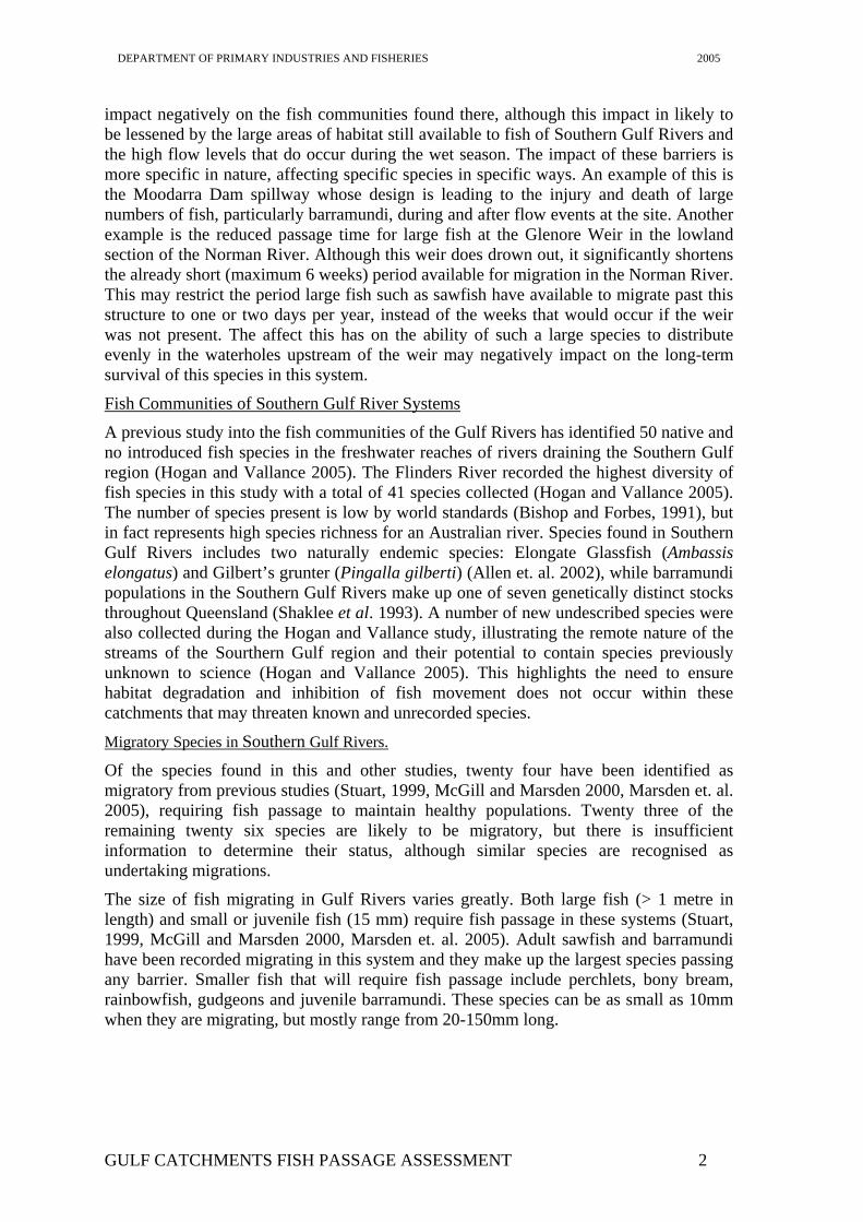
Figure 1. Location of sites (1-15) visited during the survey of barriers to migration in the Western Gulf Region.
GULF CATCHMENTS FISH PASSAGE ASSESSMENT 3
DEPARTMENT OF PRIMARY INDUSTRIES AND FISHERIES 2005
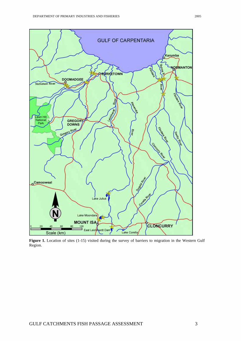
Review of Sites Visited Site 1: East Leichhardt Dam
Stream Name: East Leichhardt River
Location: 50km East Mount Isa
Barrier Type: Large Dam
Height: Approximately 30m
Drownout Characteristics:
Dam does not drown out, however spillway outlet may drown out and provide some passage.
Other Barriers U/S and/or D/S:
D/S - Lake Julius and then Leichardt Falls
Catchment U/S Barrier:
Habitat in good condition although seasonally drys.
Fish Passage Requirements:
Spillway needs to be surveyed to determine any areas that may prevent upstream passage. A number of small jump-ups could be modified easily to allow passage of sooty grunter into and above the dam for breeding
Photographs:
GULF CATCHMENTS FISH PASSAGE ASSESSMENT 4
DEPARTMENT OF PRIMARY INDUSTRIES AND FISHERIES 2005
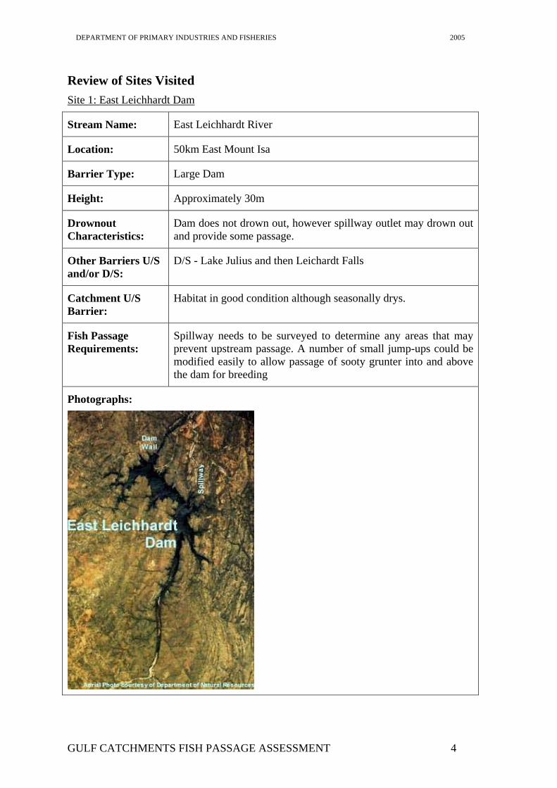
Site 2: Lake Moondarra Spillway
Stream Name: Leichhardt River
Location: 20km North Mount Isa
Barrier Type: Large Dam
Height: Approximately 40m
Drownout Characteristics:
Does not drown out.
Other Barriers U/S and/or D/S:
D/S - Lake Julius and then Leichardt Falls
U/S – Moondarra causeway
Catchment U/S Barrier:
Large storage areas supports healthy fishery
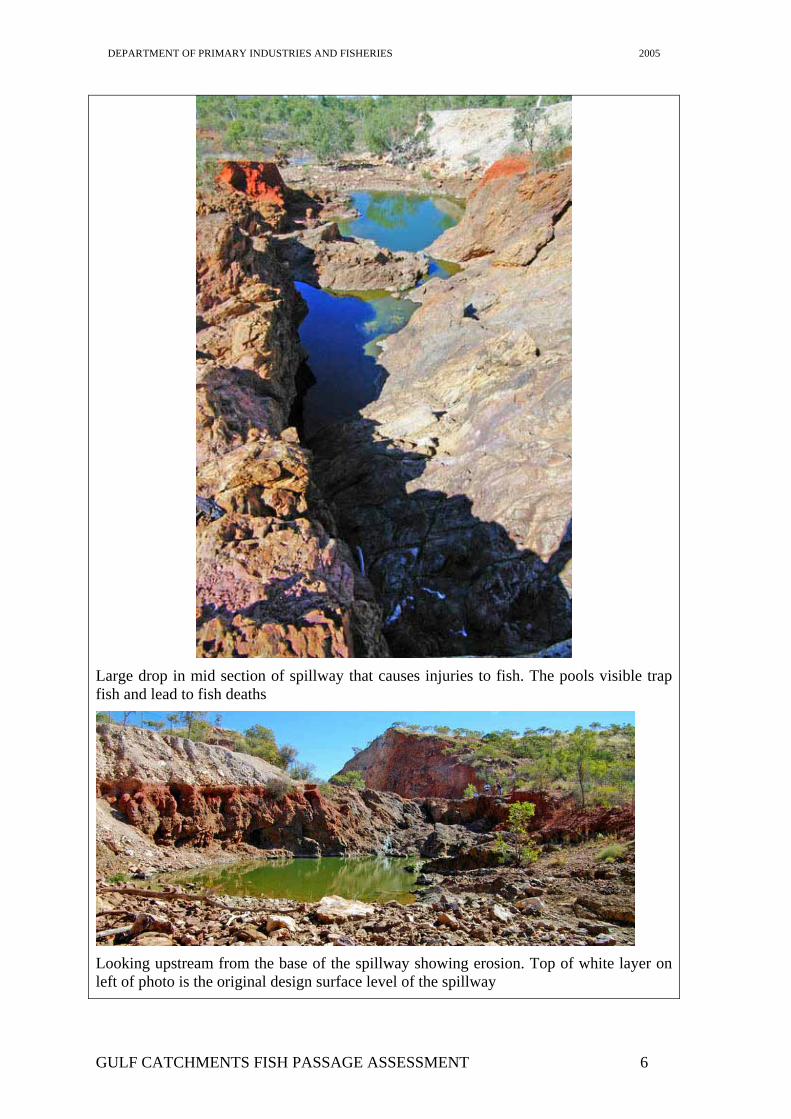
Fish Passage Requirements: Main issue at this site is the accumulation and death of fish migrating to the base of the spillway from the river downstream and the damage and death of fish exiting the dam over the spillway, particularly large barramundi. The provision of safe downstream passage of fish out of the dam and the refuge of accumulating fish at the base of the dam after flows have ceased are the highest priority aspects of passage at this site. Bringing the spillway floor back to the design levels and thus removing the areas that damage fish is a priority as is enlarging and connecting the pools at the base of the dam to ensure the survival of fish that accumulate in this area.
Photographs:
Upstream end of Moondarra Spillway
GULF CATCHMENTS FISH PASSAGE ASSESSMENT 5
DEPARTMENT OF PRIMARY INDUSTRIES AND FISHERIES 2005
Large drop in mid section of spillway that causes injuries to fish. The pools visible trap fish and lead to fish deaths
Looking upstream from the base of the spillway showing erosion. Top of white layer on left of photo is the original design surface level of the spillway
GULF CATCHMENTS FISH PASSAGE ASSESSMENT 6
DEPARTMENT OF PRIMARY INDUSTRIES AND FISHERIES 2005
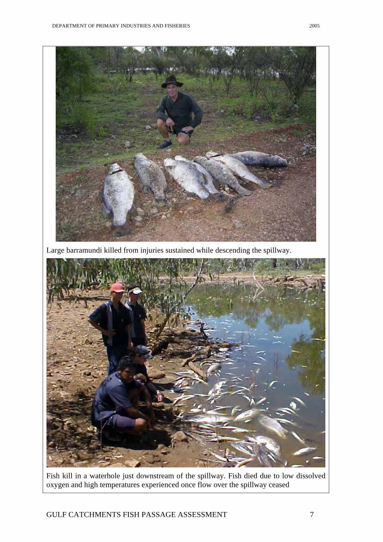
Large barramundi killed from injuries sustained while descending the spillway.
Fish kill in a waterhole just downstream of the spillway. Fish died due to low dissolved oxygen and high temperatures experienced once flow over the spillway ceased
GULF CATCHMENTS FISH PASSAGE ASSESSMENT 7
DEPARTMENT OF PRIMARY INDUSTRIES AND FISHERIES 2005
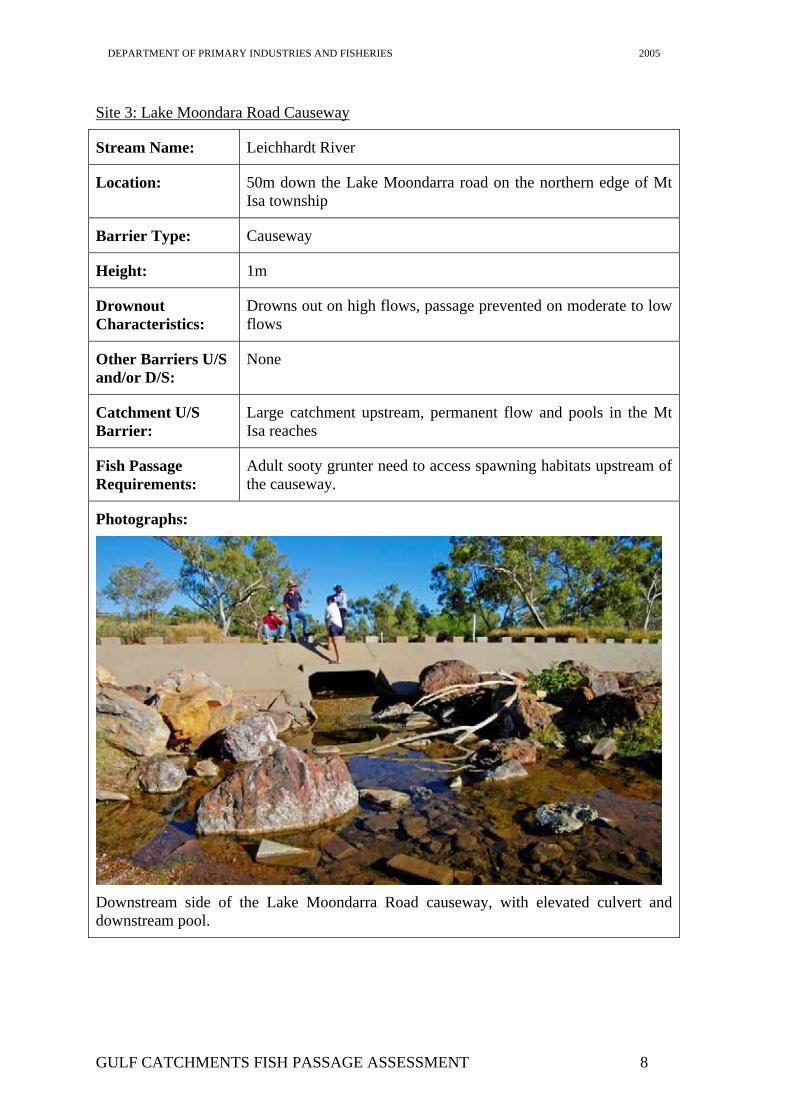
Site 3: Lake Moondara Road Causeway
Stream Name: Leichhardt River
Location: 50m down the Lake Moondarra road on the northern edge of Mt Isa township
Barrier Type: Causeway
Height: 1m
Drownout Characteristics:
Drowns out on high flows, passage prevented on moderate to low flows
Other Barriers U/S and/or D/S:
None
Catchment U/S Barrier:
Large catchment upstream, permanent flow and pools in the Mt Isa reaches
Fish Passage Requirements:
Adult sooty grunter need to access spawning habitats upstream of the causeway.
Photographs:
Downstream side of the Lake Moondarra Road causeway, with elevated culvert and downstream pool.
GULF CATCHMENTS FISH PASSAGE ASSESSMENT 8
DEPARTMENT OF PRIMARY INDUSTRIES AND FISHERIES 2005
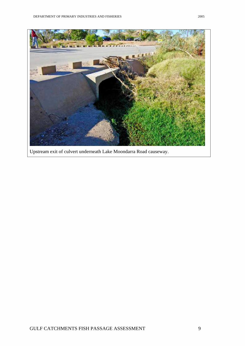
Upstream exit of culvert underneath Lake Moondarra Road causeway.
GULF CATCHMENTS FISH PASSAGE ASSESSMENT 9

DEPARTMENT OF PRIMARY INDUSTRIES AND FISHERIES 2005
Site 4: Lake Julius Spillway
Stream Name: Leichhardt River
Location: 80km NE Mt Isa
Barrier Type: Large Dam
Height: Approximately 30m
Drownout Characteristics:
Does not drown out
Other Barriers U/S and/or D/S:
Lake Moondarra and East Leichardt Dams
Catchment U/S Barrier:
Large areas of permanent good condition habitat below upstream dams
Fish Passage Requirements:
Upstream passage required for a number of species. Relatively safe downstream passage of adult barramundi provided during high flows.
Photographs:
Overfall spillway of Lake Julius.
GULF CATCHMENTS FISH PASSAGE ASSESSMENT 10
DEPARTMENT OF PRIMARY INDUSTRIES AND FISHERIES 2005
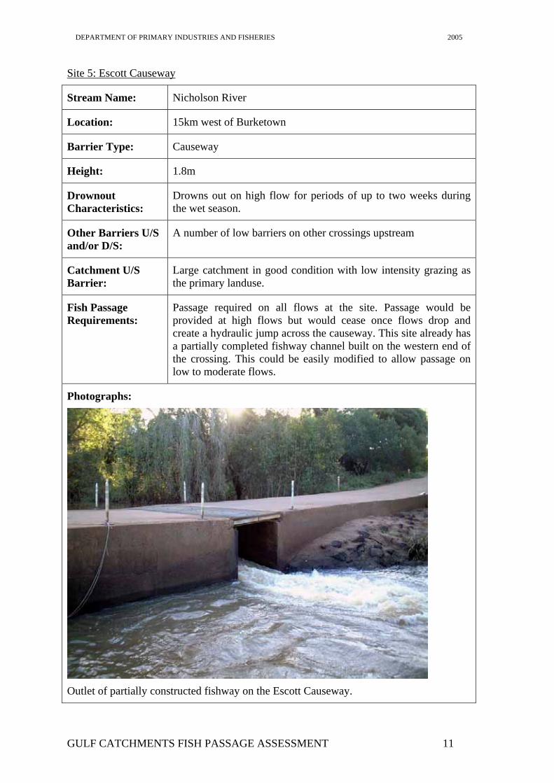
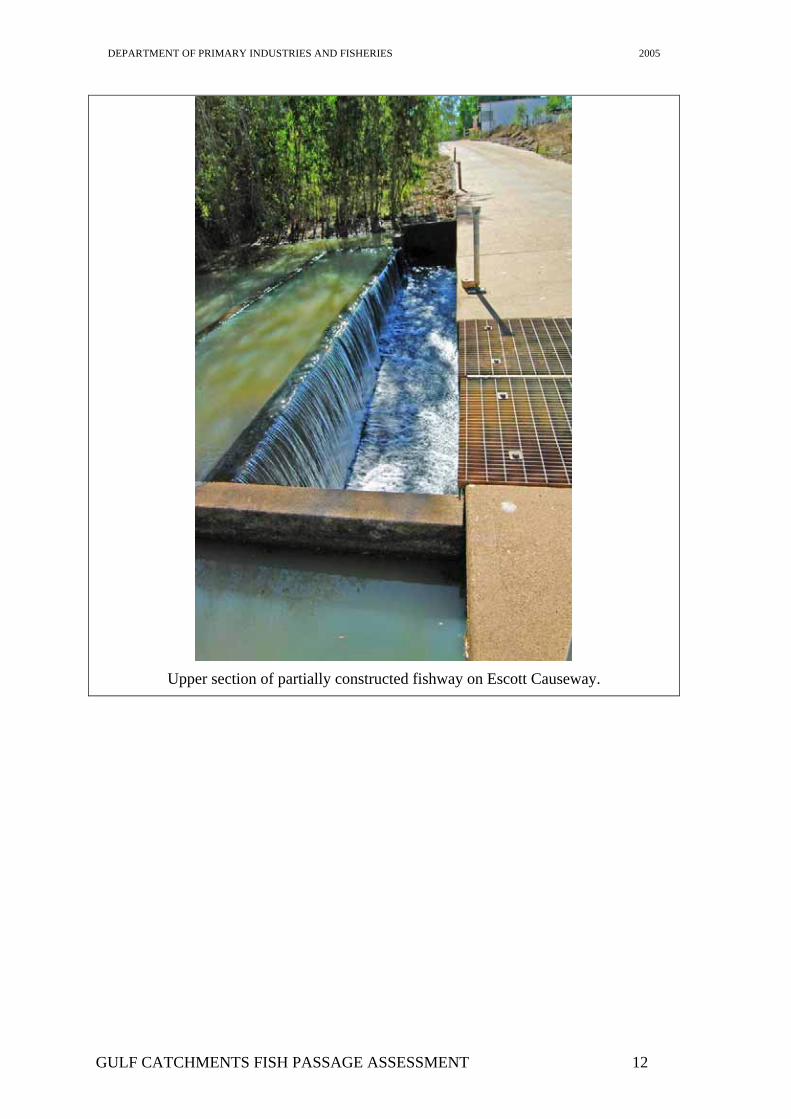
Site 5: Escott Causeway
Stream Name: Nicholson River
Location: 15km west of Burketown
Barrier Type: Causeway
Height: 1.8m
Drownout Characteristics:
Drowns out on high flow for periods of up to two weeks during the wet season.
Other Barriers U/S and/or D/S:
A number of low barriers on other crossings upstream
Catchment U/S Barrier:
Large catchment in good condition with low intensity grazing as the primary landuse.
Fish Passage Requirements:
Passage required on all flows at the site. Passage would be provided at high flows but would cease once flows drop and create a hydraulic jump across the causeway. This site already has a partially completed fishway channel built on the western end of the crossing. This could be easily modified to allow passage on low to moderate flows.
Photographs:
Outlet of partially constructed fishway on the Escott Causeway.
GULF CATCHMENTS FISH PASSAGE ASSESSMENT 11
DEPARTMENT OF PRIMARY INDUSTRIES AND FISHERIES 2005
Upper section of partially constructed fishway on Escott Causeway.
GULF CATCHMENTS FISH PASSAGE ASSESSMENT 12
DEPARTMENT OF PRIMARY INDUSTRIES AND FISHERIES 2005
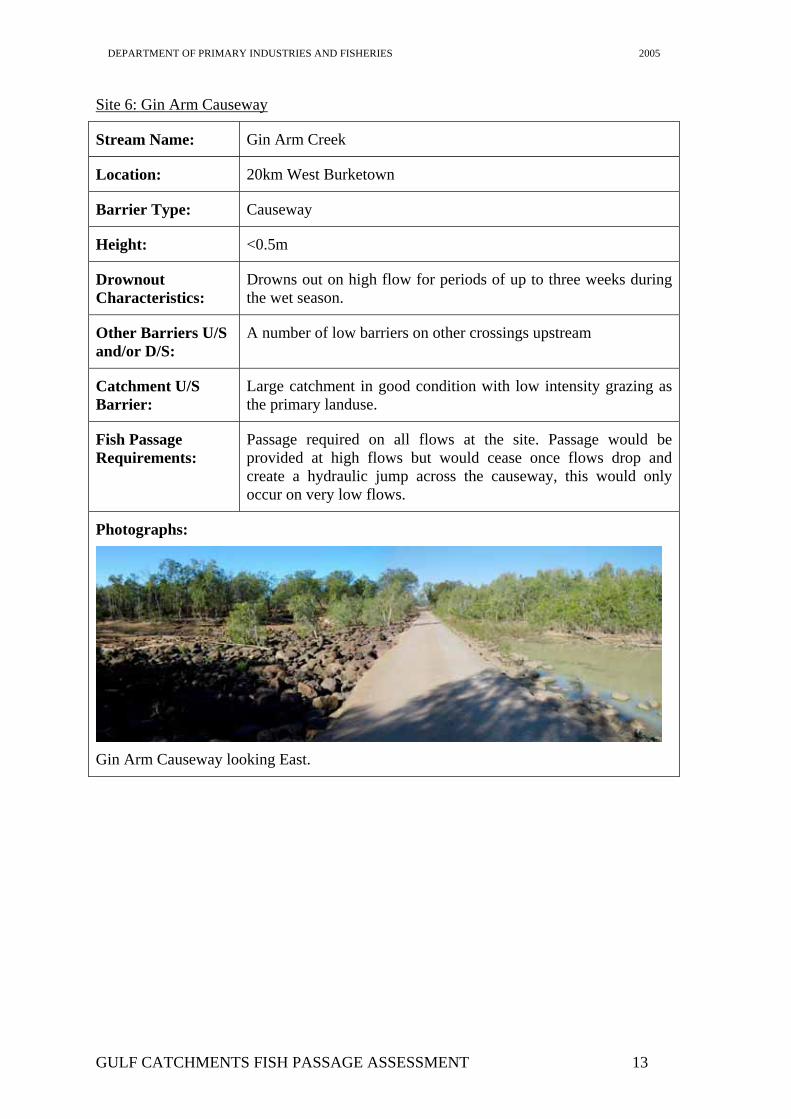
Site 6: Gin Arm Causeway
Stream Name: Gin Arm Creek
Location: 20km West Burketown
Barrier Type: Causeway
Height: <0.5m
Drownout Characteristics:
Drowns out on high flow for periods of up to three weeks during the wet season.
Other Barriers U/S and/or D/S:
A number of low barriers on other crossings upstream
Catchment U/S Barrier:
Large catchment in good condition with low intensity grazing as the primary landuse.
Fish Passage Requirements:
Passage required on all flows at the site. Passage would be provided at high flows but would cease once flows drop and create a hydraulic jump across the causeway, this would only occur on very low flows.
Photographs:
Gin Arm Causeway looking East.
GULF CATCHMENTS FISH PASSAGE ASSESSMENT 13
DEPARTMENT OF PRIMARY INDUSTRIES AND FISHERIES 2005
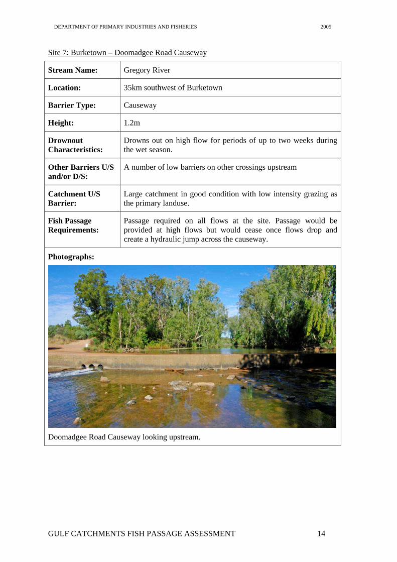
Site 7: Burketown – Doomadgee Road Causeway
Stream Name: Gregory River
Location: 35km southwest of Burketown
Barrier Type: Causeway
Height: 1.2m
Drownout Characteristics:
Drowns out on high flow for periods of up to two weeks during the wet season.
Other Barriers U/S and/or D/S:
A number of low barriers on other crossings upstream
Catchment U/S Barrier:
Large catchment in good condition with low intensity grazing as the primary landuse.
Fish Passage Requirements:
Passage required on all flows at the site. Passage would be provided at high flows but would cease once flows drop and create a hydraulic jump across the causeway.
Photographs:
Doomadgee Road Causeway looking upstream.
GULF CATCHMENTS FISH PASSAGE ASSESSMENT 14
DEPARTMENT OF PRIMARY INDUSTRIES AND FISHERIES 2005
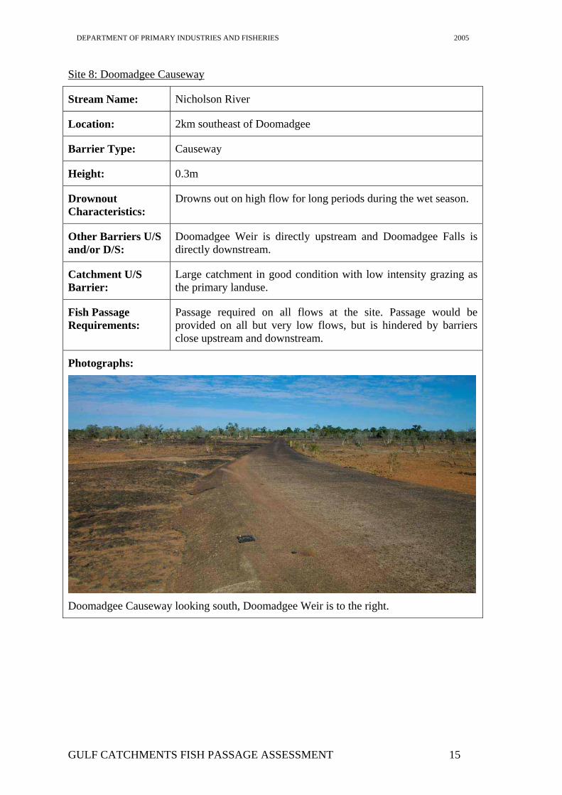
Site 8: Doomadgee Causeway
Stream Name: Nicholson River
Location: 2km southeast of Doomadgee
Barrier Type: Causeway
Height: 0.3m
Drownout Characteristics:
Drowns out on high flow for long periods during the wet season.
Other Barriers U/S and/or D/S:
Doomadgee Weir is directly upstream and Doomadgee Falls is directly downstream.
Catchment U/S Barrier:
Large catchment in good condition with low intensity grazing as the primary landuse.
Fish Passage Requirements:
Passage required on all flows at the site. Passage would be provided on all but very low flows, but is hindered by barriers close upstream and downstream.
Photographs:
Doomadgee Causeway looking south, Doomadgee Weir is to the right.
GULF CATCHMENTS FISH PASSAGE ASSESSMENT 15
DEPARTMENT OF PRIMARY INDUSTRIES AND FISHERIES 2005
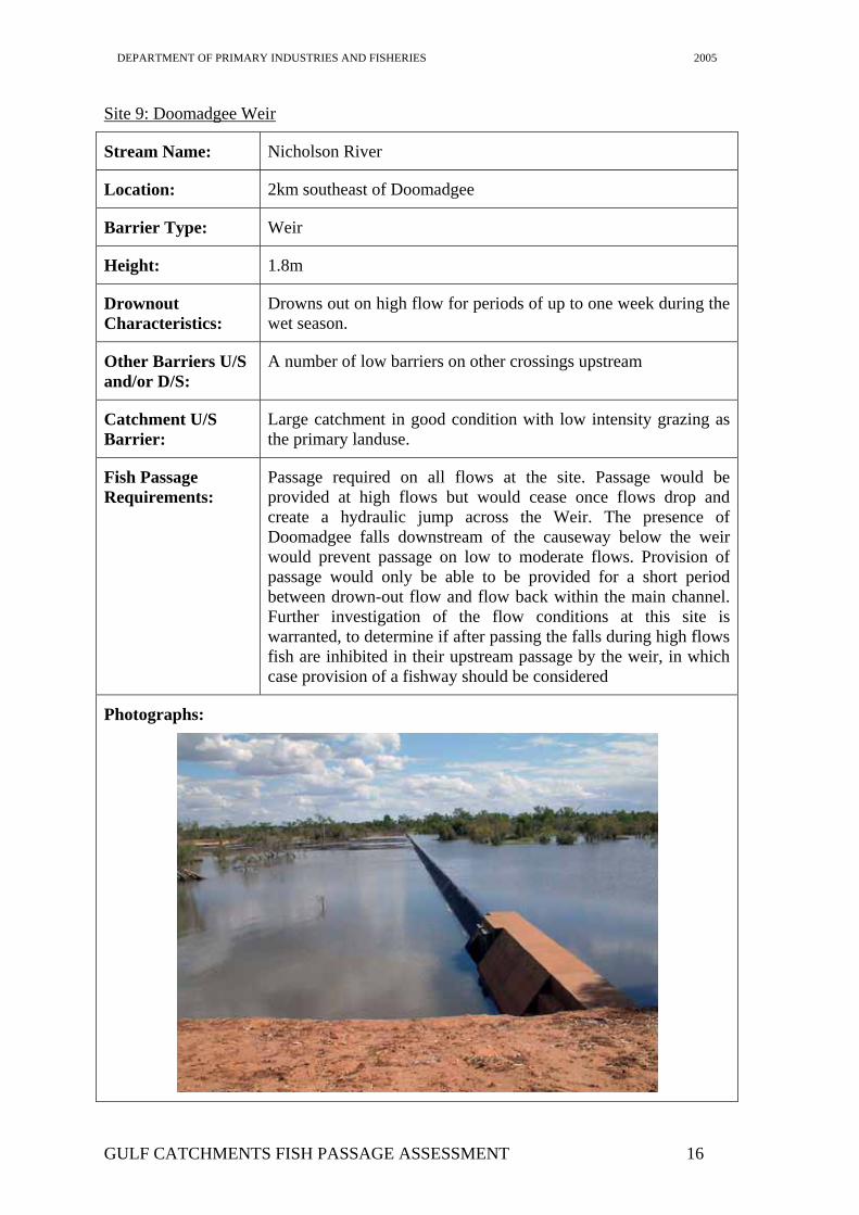
Site 9: Doomadgee Weir
Stream Name: Nicholson River
Location: 2km southeast of Doomadgee
Barrier Type: Weir
Height: 1.8m
Drownout Characteristics:
Drowns out on high flow for periods of up to one week during the wet season.
Other Barriers U/S and/or D/S:
A number of low barriers on other crossings upstream
Catchment U/S Barrier:
Large catchment in good condition with low intensity grazing as the primary landuse.
Fish Passage Requirements:
Passage required on all flows at the site. Passage would be provided at high flows but would cease once flows drop and create a hydraulic jump across the Weir. The presence of Doomadgee falls downstream of the causeway below the weir would prevent passage on low to moderate flows. Provision of passage would only be able to be provided for a short period between drown-out flow and flow back within the main channel. Further investigation of the flow conditions at this site is warranted, to determine if after passing the falls during high flows fish are inhibited in their upstream passage by the weir, in which case provision of a fishway should be considered
Photographs:
GULF CATCHMENTS FISH PASSAGE ASSESSMENT 16
DEPARTMENT OF PRIMARY INDUSTRIES AND FISHERIES 2005
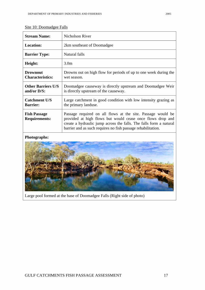
Site 10: Doomadgee Falls
Stream Name: Nicholson River
Location: 2km southeast of Doomadgee
Barrier Type: Natural falls
Height: 3.0m
Drownout Characteristics:
Drowns out on high flow for periods of up to one week during the wet season.
Other Barriers U/S and/or D/S:
Doomadgee causeway is directly upstream and Doomadgee Weir is directly upstream of the causeway.
Catchment U/S Barrier:
Large catchment in good condition with low intensity grazing as the primary landuse.
Fish Passage Requirements:
Passage required on all flows at the site. Passage would be provided at high flows but would cease once flows drop and create a hydraulic jump across the falls. The falls form a natural barrier and as such requires no fish passage rehabilitation.
Photographs:
Large pool formed at the base of Doomadgee Falls (Right side of photo)
GULF CATCHMENTS FISH PASSAGE ASSESSMENT 17
DEPARTMENT OF PRIMARY INDUSTRIES AND FISHERIES 2005
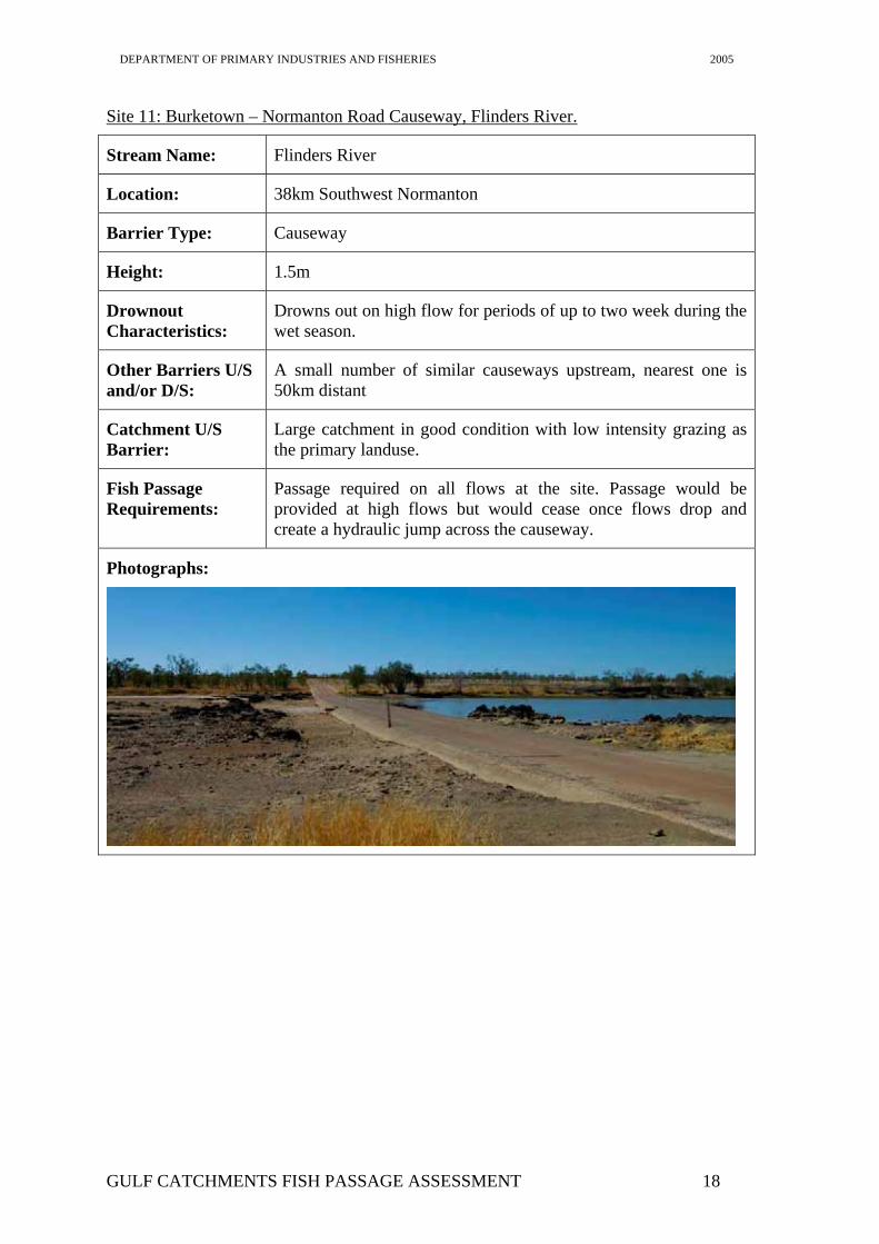
Site 11: Burketown – Normanton Road Causeway, Flinders River.
Stream Name: Flinders River
Location: 38km Southwest Normanton
Barrier Type: Causeway
Height: 1.5m
Drownout Characteristics:
Drowns out on high flow for periods of up to two week during the wet season.
Other Barriers U/S and/or D/S:
A small number of similar causeways upstream, nearest one is 50km distant
Catchment U/S Barrier:
Large catchment in good condition with low intensity grazing as the primary landuse.
Fish Passage Requirements:
Passage required on all flows at the site. Passage would be provided at high flows but would cease once flows drop and create a hydraulic jump across the causeway.
Photographs:
GULF CATCHMENTS FISH PASSAGE ASSESSMENT 18
DEPARTMENT OF PRIMARY INDUSTRIES AND FISHERIES 2005
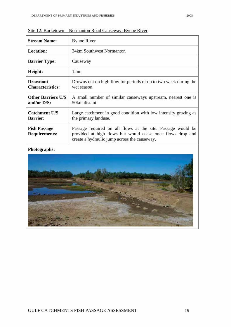
Site 12: Burketown – Normanton Road Causeway, Bynoe River
Stream Name: Bynoe River
Location: 34km Southwest Normanton
Barrier Type: Causeway
Height: 1.5m
Drownout Characteristics:
Drowns out on high flow for periods of up to two week during the wet season.
Other Barriers U/S and/or D/S:
A small number of similar causeways upstream, nearest one is 50km distant
Catchment U/S Barrier:
Large catchment in good condition with low intensity grazing as the primary landuse.
Fish Passage Requirements:
Passage required on all flows at the site. Passage would be provided at high flows but would cease once flows drop and create a hydraulic jump across the causeway.
Photographs:
GULF CATCHMENTS FISH PASSAGE ASSESSMENT 19
DEPARTMENT OF PRIMARY INDUSTRIES AND FISHERIES 2005
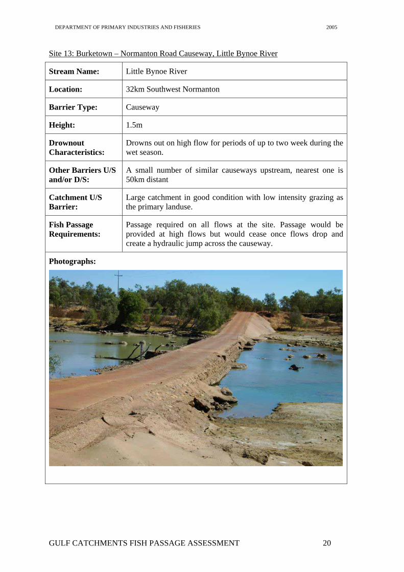
Site 13: Burketown – Normanton Road Causeway, Little Bynoe River
Stream Name: Little Bynoe River
Location: 32km Southwest Normanton
Barrier Type: Causeway
Height: 1.5m
Drownout Characteristics:
Drowns out on high flow for periods of up to two week during the wet season.
Other Barriers U/S and/or D/S:
A small number of similar causeways upstream, nearest one is 50km distant
Catchment U/S Barrier:
Large catchment in good condition with low intensity grazing as the primary landuse.
Fish Passage Requirements:
Passage required on all flows at the site. Passage would be provided at high flows but would cease once flows drop and create a hydraulic jump across the causeway.
Photographs:
GULF CATCHMENTS FISH PASSAGE ASSESSMENT 20
DEPARTMENT OF PRIMARY INDUSTRIES AND FISHERIES 2005
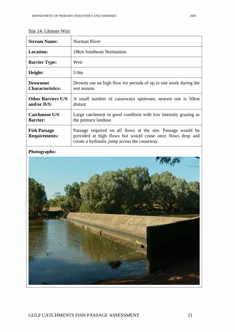
Site 14: Glenore Weir
Stream Name: Norman River
Location: 18km Southeast Normanton
Barrier Type: Weir
Height: 3.0m
Drownout Characteristics:
Drowns out on high flow for periods of up to one week during the wet season.
Other Barriers U/S and/or D/S:
A small number of causeways upstream, nearest one is 50km distant
Catchment U/S Barrier:
Large catchment in good condition with low intensity grazing as the primary landuse.
Fish Passage Requirements:
Passage required on all flows at the site. Passage would be provided at high flows but would cease once flows drop and create a hydraulic jump across the causeway.
Photographs:
GULF CATCHMENTS FISH PASSAGE ASSESSMENT 21
DEPARTMENT OF PRIMARY INDUSTRIES AND FISHERIES 2005
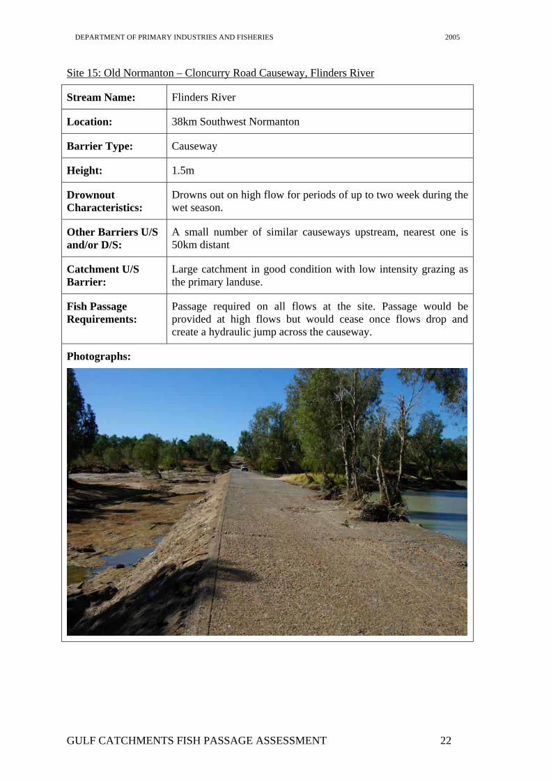
Site 15: Old Normanton – Cloncurry Road Causeway, Flinders River
Stream Name: Flinders River
Location: 38km Southwest Normanton
Barrier Type: Causeway
Height: 1.5m
Drownout Characteristics:
Drowns out on high flow for periods of up to two week during the wet season.
Other Barriers U/S and/or D/S:
A small number of similar causeways upstream, nearest one is 50km distant
Catchment U/S Barrier:
Large catchment in good condition with low intensity grazing as the primary landuse.
Fish Passage Requirements:
Passage required on all flows at the site. Passage would be provided at high flows but would cease once flows drop and create a hydraulic jump across the causeway.
Photographs:
GULF CATCHMENTS FISH PASSAGE ASSESSMENT 22
DEPARTMENT OF PRIMARY INDUSTRIES AND FISHERIES 2005
Conclusions Fish Passage Requirements for Gulf streams
Free fish passage in all streams of the gulf is an essential element for the ongoing sustainability of freshwater fish populations of these rivers. Without free movement significant gaps will appear in the fish communities of the upstream reaches of these systems, throwing these systems out of balance. The lack of access to upstream habitats will also affect the productivity of estuarine and near shore systems by reducing diversity and numbers of recruits of important commercial and recreational species such as barramundi. In essence the restriction of movement of native fish in these systems will have a detrimental impact on all fisheries in the region, not just the freshwater ones.
The systems of the gulf are however blessed with relatively low levels of urban and agricultural development that has meant that there has been minimal impact made on the fish communities of these systems. Other studies have found that the fish communities of the Gulf Rivers are in good condition with a normal distribution and abundance of fish throughout the systems (Hogan and Vallance 2005). These studies highlight the need to maintain migration pathways and available habitat to ensure ongoing survival of all species within these systems.
The present study has highlighted a number of barriers which although having relatively minor impact on fish communities, are still having an impact. It is no accident that the majority of locals know to fish upstream of causeways/weirs in the lead-up to the wet and below the same barriers during the wet season to target migrating barramundi accumulating at these barriers. It is only through the low density of population that these activities are having only minor impacts. Provision of fish passage at these sites is therefore necessary to reduce the accumulation of fish awaiting suitable high flow passage conditions and prevent targeting of these fish by anglers. There is a misconception amongst the community in North Queensland that by installing a fishway we will provide an ideal spot for anglers to catch fish. However experience has shown that the reduction in accumulating fish below barriers after fishway installation has led to reduced angler visitation, as the site is no longer the fishing heaven it was previously. This has reduced the need for compliance activities being undertaken at these sites (usually weirs have a closed section downstream where fishing is prohibited) and greatly increased the survival rate of fish as they are spread more evenly throughout the river.
Another aspect of fish movement that needs to be considered in the gulf streams is the downstream movement of stocked fish, particularly barramundi, out of stocked impoundments. When barramundi reach spawning age they undertake a downstream migration to spawning grounds at the mouth of the river system that they are in on the first high flow event possible. This generally occurs when the barramundi reach at least 800mm. After spawning, due their large size, they remain in the lower reaches of river. With the increase in the number of barramundi that are being stocked into impoundments, it has become an increasing problem to ensure safe downstream passage of these large fish to the spawning grounds. Due to their large size, passage over the large drops that occur at most dams can lead to injuries to the barramundi. This can damage the fish and prevent spawning or lead to its death. The provision of free passage that does not injure large fish as they travel downstream at stocked dams is therefore a priority. These fish may provide a significant boost to the adult population in some systems, increasing the recruitment to the system and providing a real boost to future populations of this species.
GULF CATCHMENTS FISH PASSAGE ASSESSMENT 23
DEPARTMENT OF PRIMARY INDUSTRIES AND FISHERIES 2005
Sites Requiring Fish Passage
All of the sites visited during this study and the many other sites similar to those visited that no doubt exist in the study area, require the provision of free passage whenever there is flow in the river. Although passage is provided past all but the largest structures during wet season floods, it should be recognised that this not the only time that migration occurs. Throughout the year on a variety of low and moderate flows significant migrations of a wide variety of fish occur (Stuart, 1999, McGill and Marsden 2000, Marsden et. al. 2005). Many identical or similar species to those found in Gulf Rivers have been recorded migrating on low to moderate flows at fishways in coastal Queensland streams (Stuart, 1999, McGill and Marsden 2000, Marsden et. al. 2005). It is highly likely that these species are undertaking the same migrations within the streams of the gulf region. While passage is provided past most of the barriers visited during high flows and this appears to be sustaining populations in Gulf Rivers, further development or exploitation may put enough pressure on populations to make the impact of these barriers significant. The provision of low-moderate flow passage at the many barriers in the region should be considered to enhance the opportunities for fish to access habitats upstream. In many of the systems with relatively short flow periods during the wet season, a barrier can effectively halve the time available for migration upstream into new habitats. This can significantly affect the numbers of fish able to access upstream habitat. Given that most fishways in tropical regions of Queensland often pass tens of thousands of fish per day, reducing the period of migration from 40 days to 20 days through construction of a barrier could potentially deny hundreds of thousands of fish access to habitat essential for survival.
Fishway Options for Sites Requiring Fish Passage
Site 1: East Leichhardt Dam – A bypass channel fishway could be installed along the spillway channel with some simple modifications of the channel to remove any large steps. Examination of the spillway area revealed that there were at least two significant jump-ups along the creek channel created by the spillway that could prevent fish ascending into the dam. Modification of these jump-ups by an excavator or explosives would remove the significant drops that they create and allow fish to enter the dam and the river upstream.
Site 2: Lake Moondarra Spillway – This is the largest fish passage problem in the region, with two different aspects of fish passage needing to be catered for, downstream migration of adult barramundi and upstream migration of wide range of species.
The downstream passage of large barramundi out of the dam is essential to stop overcrowding in the dam that leads to reduced catch rates in the stocked fishery. This has happened in Tinaroo Dam, where non recruitment of newly stocked fish occurs due to predation by relatively low numbers of large fish (Pers. Comm. Mal Pearce). A barrier net would be considered inappropriate at the site (as well as most likely being technically unfeasible) and as such there is no physical way of keep fish in the dam. Therefore the importance of maintaining a spillway that does not injure fish is of high importance. To assist is this, the current spillway should be modified to prevent injury during overtopping events. Ideally the spillway should be returned to its design profile which provided a smooth sloped design that would not greatly injure fish. If this is not possible then modification of the current spillway shape should be undertaken to smooth areas where fish are likely to be injured. This can be done by ensuring that water is concentrated into smooth channels with considerable depth. At the top of the spillway low walls could be erected to funnel most of the flow into the centre of the spillway, providing a greater
GULF CATCHMENTS FISH PASSAGE ASSESSMENT 24
DEPARTMENT OF PRIMARY INDUSTRIES AND FISHERIES 2005
depth across this section of the spillway and backing up water to the base of the weir at the top of the spillway, reducing injuries to fish through this section. In the middle section of the spillway works should be undertaken to smooth out the passage along the rock channels/shutes that have formed in this area with a plan to maintain relatively deep, smooth walled shutes that can transport the fish into the pools at the base of the spillway. These pools then need to be enlarged to dissipate the flows they receive, buffering the impact of the fish as they enter from the shutes.
These pools at the base of the spillway are also the furthest upstream that fish from downstream are able to ascend and so large accumulations of fish occur there. These fish then die shortly after the flow ceases as their large numbers overwhelm the small pools in which they are found. As provision of upstream passage into the dam would be expensive (In the order of $3Millon), it is unlikely that it will be provided. To ensure that long term survival of these fish accumulating at the base of the dam it is essential that over dry season refuges are created at the base of the dam. This could be done by excavating the existing pools so that they are greatly enlarged and interconnected. In this way when flows cease the fish can spread out into the pools downstream rather than being stuck in the most upstream pools. This is likely to reduce the stress on these waterholes, leading to reduced mortality of the fish within them. If this is found to still be insufficient then consideration of aeration of the interconnected waterholes should be considered, as reduced oxygen levels when flows cease is the most likely cause of fish kills. This aeration may only need to be undertaken for a short period after the cessation of flow as once the waterhole is stabilised at dry season levels biological oxygen demand (The cause of oxygen stripping in the waterholes) will reduce to a level that can be sustained through the dry season. Another option would be to siphon water from the dam in low quantities (5Ml/day) to provide fresh water to the pools, maintaining their water and oxygen levels.
Site 3: Lake Moondara Road Causeway – Passage on high flow is provided at this site as it drowns out, passage should be provided on low to moderate flows through provision of fish passage through the existing culvert. This can be done through construction of a rock ramp fishway at the entrance to the culvert barrel. This allows fish to gain access to the culvert barrel and also backs up water through the culvert to allow easy passage through the culvert. The upstream end of the culvert should also be cleaned out the ensure free access to the pools upstream
Site 5: Escott Causeway - Passage on high flow is provided at this site as it drowns out, passage should be provided on low to moderate flows through provision of fish passage through the partially constructed fishway channel that exists at this site. Around ten years ago plans were drawn up for a vertical slot fishway to be constructed on this site. The fishway channel was partially completed at this time before being abandoned. Fish passage could easily be reinstated at this site utilising the existing fishway plan, or a modified version of that plan. To complete the full plan would require extensive concrete works downstream of the crossing with the construction of the remainder of the vertical slot fishway channel, this option would be relatively expensive, in the order of $200K. A cheaper option would be to build a rock-ramp fishway on the downstream side of the existing fishway channel and a complete the vertical slot fishway within the existing channel. This option would cost in the order of $50K depending on the availability of rock and machinery locally.
Site 7: Burketown – Doomadgee Road Causeway – Again passage would be provided past this site on high flows, however as the causeway has a significant drop (around 1.2m), once flow decreased this site it would become a barrier to migration. Passage
GULF CATCHMENTS FISH PASSAGE ASSESSMENT 25
DEPARTMENT OF PRIMARY INDUSTRIES AND FISHERIES 2005
should be provided at this site through the construction of a rock ramp fishway at an appropriate low spot in the crossing. Consideration could also be given to the installation of culverts through the crossing to allow passage on low flows without leaving water across the road. The cost of provision of passage at this site would be in the order of $30K dependant on rock and machinery availability.
Site 11: Burketown – Normanton Road Causeway, Flinders River - Passage would be provided past this site on high flows, however as the causeway has a significant drop (around 1.4m), once flow decreased this site it would become a barrier to migration. Passage should be provided at this site through the construction of a rock ramp fishway at an appropriate low spot in the crossing. Consideration could also be given to the installation of culverts through the crossing to allow passage on low flows without leaving water across the road. The cost of provision of passage at this site would be in the order of $30K dependant on rock and machinery availability.
Site 12: Burketown – Normanton Road Causeway, Bynoe River - Passage would be provided past this site on high flows, however as the causeway has a significant drop (around 1.4m), once flow decreased this site it would become a barrier to migration. Passage should be provided at this site through the construction of a rock ramp fishway at an appropriate low spot in the crossing. Consideration could also be given to the installation of culverts through the crossing to allow passage on low flows without leaving water across the road. The cost of provision of passage at this site would be in the order of $30K dependant on rock and machinery availability.
Site 13: Burketown – Normanton Road Causeway, Little Bynoe River - Passage would be provided past this site on high flows, however as the causeway has a significant drop (around 1.4m), once flow decreased this site it would become a barrier to migration. Passage should be provided at this site through the construction of a rock ramp fishway at an appropriate low spot in the crossing. Consideration could also be given to the installation of culverts through the crossing to allow passage on low flows without leaving water across the road. The cost of provision of passage at this site would be in the order of $30K dependant on rock and machinery availability.
Site 14: Glenore Weir – This weir is a significant barrier on the Norman River and should be a high priority site for the restoration of fish passage. Due to the flow characteristics of this site, passage is only provided for very short periods each wet season. Extension of the period of passage at this site is required to give fish time to undertake the long migrations into the upper river lagoons. Delay at this site would reduce the period of time that fish have to take advantage of flows in the river to migrate upstream, reducing populations upstream. Provision of fish passage could be provided through a variety of fishways such as a rock ramp or vertical slot fishway, however further investigation into the migratory habits of sawfish is required to determine when they move within this system and whether a fish lock system would provide them with the best opportunity for upstream passage. Any consideration of a fishway at this site should be done in conjunction with local council who currently has a Waterway Barrier Works application in place for the further raising of this weir.
Site 15: Old Normanton – Cloncurry Road Causeway, Flinders River – This large causeway requires fish passage provision as it would only pass fish on high flows. Removal of a section of the causeway should be considered as this would be the easiest way of providing passage on low to moderate flows at the site. If this is not viable, a rock ramp or vertical slot fishway should be constructed at the site. Further information on the
GULF CATCHMENTS FISH PASSAGE ASSESSMENT 26
DEPARTMENT OF PRIMARY INDUSTRIES AND FISHERIES 2005
water levels both upstream and downstream would be required before a final design could be completed.
Recommendations
The following recommendations are made to address fish passage issues in Gulf Rivers:
1. Further surveys should be carried out by the local community to determine all barriers to migration in the region as this survey only addressed a small proportion of what is probably out there.
2. The following fish passage solutions should be implemented to provide free passage for migratory fish in the region.
Site 1: East Leichhardt Dam – A bypass channel fishway should be installed through the current spillway
Site 2: Lake Moondarra Spillway – The spillway and downstream pools should be modified to ensure survival of downstream migrating adult barramundi and reduce over dry season deaths of accumulating upstream migrating fish
Site 3: Lake Moondara Road Causeway – a small rock ramp fishway should be constructed below the outlet culvert
Site 5: Escott Causeway – The old vertical slot fishway should be completed or a modified rock ramp/vertical slot fishway constructed at the site
Site 7: Burketown – Doomadgee Road Causeway – A rock ramp fishway should be constructed for low to moderate flows.
Site 11: Burketown – Normanton Road Causeway, Flinders River. - A rock ramp fishway should be constructed for low to moderate flows.
Site 12: Burketown – Normanton Road Causeway, Bynoe River - A rock ramp fishway should be constructed for low to moderate flows.
Site 13: Burketown – Normanton Road Causeway, Little Bynoe River - A rock ramp fishway should be constructed for low to moderate flows.
Site 14: Glenore Weir –Discussions should be held with council to determine the appropriate fishway option at the site in light of their Waterway Barrier Works application.
Site 15: Old Normanton – Cloncurry Road Causeway, Flinders River –Removal of a section of this disused causeway should considered, otherwise a vertical slot or rock ramp fishway should be constructed.
3. Funding for fish passage solutions should be sort from appropriate local sources such as Southern Gulf Catchments NRM group, mining companies, local councils and water managers
4. Before commencing any fish passage works, fish passage and engineering experts should be consulted to ensure designs are appropriate and likely to pass fish and survive the high flows of the area.
GULF CATCHMENTS FISH PASSAGE ASSESSMENT 27
DEPARTMENT OF PRIMARY INDUSTRIES AND FISHERIES 2005
Acknowledgments The Mount Isa Fish Stocking Group and the Century Mine Environment Committee funded this study. Mark Van Ryt and other members of the Mount Isa Stocking Group provided valuable information on sites and Mark Van Ryt organised access to sites around Doomadgee.
Special mention should also go to Carpentaria Land Council and who helped organise a guide for us to visit the Nicholson River at Doomadgee.
The authors are grateful to Mark Van Ryt and the Mount Isa Fish Stocking Group for initiating the study and their overall support for fishway research in North West Queensland.
GULF CATCHMENTS FISH PASSAGE ASSESSMENT 28
DEPARTMENT OF PRIMARY INDUSTRIES AND FISHERIES 2005
References Allen, G. R., Midgley, S. H., and Allen, M. (2002). Field Guide to the Freshwater Fishes of Australia. (Western Australian Museum: Perth.)
Bishop, K.A., and Forbes, M.A. (1991). The freshwater fishes of Northern Australia. In. ‘Monsoonal Australia, landscape, ecology and man in the northern lowlands. (Eds. C.D. Haynes., M.G. Ridpath., and M.A.J. Williams.) pp. 79-107. A.A. Balkema, Rotterdam.
Hogan, A. and Vallance, T. (2005). Rapid assessment of fish biodiversity in southern Gulf of Carpentaria catchments. Queensland Department of Primary Industries Internal Report. 148 pp.
McGill, D.A. and Marsden, T.J. (2000). Dumbleton Weir Fishlock Assessment. Queensland Department of Primary Industries Internal Report. 31 pp.
Marsden, T.J., McGill, D.A. and Thorncraft, G.A. (2005). Neville Hewitt Weir Fish Lock Assessment. Queensland Department of Primary Industries, Fisheries. 38 pp.
Southern Gulf Catchments (2005). Southern Gulf Catchments, Natural Resource Management Plan – State of the Region. Southern Gulf Catchments Report. 349pp.
Stuart, I.G. (1999) Assessment of a vertical-slot fishway for non-salmonid fish at a tidal barrier on the subtropical Fitzroy River, Queensland. Msc. Thesis. Central Queensland University. 208 pp.
Shaklee, J.B., Salini, J.P., and Garrett, R.N. (1993). Electrophoretic characterisation of multiple genetic stocks of the barramundi perch in Queensland, Australia. Transactions of the American Fisheries Society 122, 685-701.
GULF CATCHMENTS FISH PASSAGE ASSESSMENT 29