episodic flood inundations of the northern plains of mars
TRANSCRIPT
s
e and theese outflowd Noachiant sculpted thes decreased
the Marsproposed
ern plainsistributed
ated to minor
www.elsevier.com/locate/icaru
Episodic flood inundations of the northern plains of Mars
Alberto G. Fairén,a,b,∗ James M. Dohm,c Victor R. Baker,c,d Miguel A. de Pablo,b,e Javier Ruiz,f
Justin C. Ferris,g and Robert C. Andersonh
a CBM, CSIC-Universidad Autónoma de Madrid, 28049 Cantoblanco, Madrid, Spainb Seminar on Planetary Sciences, Universidad Complutense de Madrid, 28040 Madrid, Spain
c Department of Hydrology and Water Resources, University of Arizona, Tucson, AZ 85721, USAd Lunar and Planetary Laboratory, University of Arizona, Tucson, AZ 85721, USA
e ESCET, Universidad Rey Juan Carlos, 28933 Móstoles, Madrid, Spainf Departamento de Geodinámica, Universidad Complutense de Madrid, 28040 Madrid, Spain
g US Geological Survey, Denver, CO 80225, USAh Jet Propulsion Laboratory, Pasadena, CA 91109, USA
Received 19 December 2002; revised 20 March 2003
Abstract
Throughout the recorded history of Mars, liquid water has distinctly shaped its landscape, including the prominent circum-Chrysnorthwestern slope valleys outflow channel systems, and the extremely flat northern plains topography at the distal reaches of thchannel systems. Paleotopographic reconstructions of the Tharsis magmatic complex reveal the existence of an Europe-sizedrainage basin and subsequent aquifer system in eastern Tharsis. This basin is proposed to have sourced outburst floodwaters thaoutflow channels, and ponded to form various hypothesized oceans, seas, and lakes episodically through time. These floodwaterin volume with time due to inadequate groundwater recharge of the Tharsis aquifer system. Martian topography, as observed fromOrbiter Laser Altimeter, corresponds well to these ancient flood inundations, including the approximated shorelines that have beenfor the northern plains. Stratigraphy, geomorphology, and topography record at least one great Noachian-Early Hesperian northocean, a Late Hesperian sea inset within the margin of the high water marks of the previous ocean, and a number of widely dminor lakes that may represent a reduced Late Hesperian sea, or ponded waters in the deepest reaches of the northern plains relTharsis- and Elysium-induced Amazonian flooding. 2003 Elsevier Inc. All rights reserved.
Keywords:Mars; Tharsis floods; Oceans; Lakes
ofem.t isp,
fea-andterswell,.g.,82;
and
est,thea-andan
cur-llesaka,
elyr theanigh-92;allythe
1. Introduction
Elucidating the hydrogeological cycle of Mars is onethe main challenges in the exploration of the Solar SystLong-term aqueous activity on the surface of the planeindicated by fluvial (e.g., Mars Channel Working Grou1983; Malin and Edgett, 2000a, 2000b) and lacustrinetures (e.g., Squyres, 1989; Scott et al., 1995; CabrolGrin, 1999, 2001); phased degradation of impact cra(e.g., Chapman and Jones, 1977; Craddock and Max1993); permafrost (e.g., Lucchitta, 1981); periglacial (eSquyres, 1979) and glacial landforms (e.g., Lucchitta, 19Kargel et al., 1995); and outflow channels (e.g., Baker
* Corresponding author.E-mail address:[email protected] (A.G. Fairén).
0019-1035/$ – see front matter 2003 Elsevier Inc. All rights reserved.doi:10.1016/S0019-1035(03)00144-1
Milton, 1974; Scott and Tanaka, 1986; Greeley and Gu1987). The outflow channels began to form as early asNoachian, and their activity extended to the Early Amzonian (Rotto and Tanaka, 1991a; Dohm et al., 2001a),even to the latest Amazonian in Elysium Planitia (Bermand Hartmann, 2002; Burr et al., 2002a, 2002b), with rerent flooding for some of the systems, including Kasei Va(Scott, 1993) and Mangala Valles (Chapman and Tan1993).
Diverse geologic and geochemical evidence collectivpoint towards the previous existence of wide oceans oveMartian northern lowlands, which include: (1) the Martidichotomy boundary, which separates the southern hlands from northern lowlands (e.g., Tanaka et al., 19Smith and Zuber, 1996), and provides a topographiclower area in the plains for water accumulation; (2)
54 A.G. Fairén et al. / Icarus 165 (2003) 53–67
arynovyserth-1a)ityom-rlowelyan-e okedivedges(5)ins,ex-pu-om99;diesvol-lianndryssethe
er-ars86;ker
994;l ett al.onlyclo-ds.on-ighclo-un-ive,
(seeout999ibletactt etr thecheughstedtionhy-
ion
a)
dic91,
thatun-Anhar-tionshereeredSVsneded toans,rker95;d-
f thering
avys re-and001;
ysio-ust.eredred,rialserialanic,cott987;02).thatec-cott987;avergel
outflow channels, which either terminate at the bound(Parker et al., 1993) or fade into the northern plains (Ivaand Head, 2001), including the prominent circum-Chr(e.g., Rotto and Tanaka, 1995) and recently identified nowestern slope valleys (NSVs, Dohm et al., 2000, 200outflow channel systems; (3) the relatively low densof superposed impact craters in the northern plains cpared to the southern densely cratered highlands (Baand Bradley, 1990; Parker et al., 1993), and its extremflat topography at the distal reaches of the outflow chnel systems (Head et al., 1999); (4) the broad occurrencwide age-ranging glaciers that are interpreted to be linto magmatic-triggered flooding and associated short-l(tens of thousands of years) environmental/climatic chan(Baker, 2001; Cabrol et al., 2001a, 2001b, 2001c); andthe chemical signatures reported for the northern plaincluding high abundances of S and Cl or the possibleistence of sulphate minerals and chloride salts, making atative andesite-rich component or weathered basalt the dinant material type in the lowlands (McSween et al., 19Zuber, 2001; Wyatt and McSween, 2002). Standing boof water, therefore, best explain such evidence, thoughcanism (Head et al., 2002), tectonism (Sleep, 1994), eomodification (Malin and Edgett, 2000a), ground volatile adebris flow activity along the highland-lowland bounda(Tanaka, 1997; Tanaka et al., 2002), and/or glacial proce(Baker et al., 1991) also probably contributed to shapingMartian lowlands.
The presence of large bodies of water during diffent periods of time on the northern lowlands of Mhave been previously proposed (McGill, 1985; Jöns, 19Lucchitta et al., 1986; Parker et al., 1987, 1989, 1993; Baet al., 1991; Scott et al., 1991a, 1991b; Chapman, 1Scott et al., 1995; Scott and Chapman, 1995; Kargeal., 1995; Head et al., 1999). For example, Parker e(1987, 1989) described seven different boundaries, buttwo of them could be approximately traced as completesures within and on the margins of the northern lowlanParker et al. (1993) proposed an outer boundary, or Ctact 1, located along the Martian dichotomy, as the hwater mark of a primitive ocean. The later second ensured boundary, or Contact 2, which occurs several hdreds of kilometers north of the dichotomy, is less extensand would indicate a younger high-stand water markClifford and Parker, 2001, for a complete discussion abthe contacts). A subsequent analysis by Head et al. (1pointed out that Contact 2 could represent the only possshoreline, because the variations of the elevation in Con1 do not reflect an equipotential surface. In addition, Scoal. (1995) present geologic and geomorphic evidence fopossible existence of mid-sized lakes in the deeper reaof the lowlands as recent as the Amazonian Period, thothey also indicate that a larger water body may have exiif the lakes had been earlier connected at a similar eleva
Supported by published geologic, geomorphic, paleodrologic, and topographic information, and in conjunct
f
-
s
)
t
s
.
Table 1Absolute age estimates for the surface of Mars
Epoch Absolute age range (G
Late Amazonian 0.6–0.3 to presentMiddle Amazonian 2.1–1.4 to 0.6–0.3Early Amazonian 3.1–2.9 to 2.1–1.4Late Hesperian 3.6 to 3.1–2.9Early Hesperian 3.7 to 3.6Late Noachian 3.82 to 3.7Middle Noachian 3.95 to 3.82Early Noachian > 3.95
Condensed from Fig. 14 of Hartmann and Neukum, 2001.
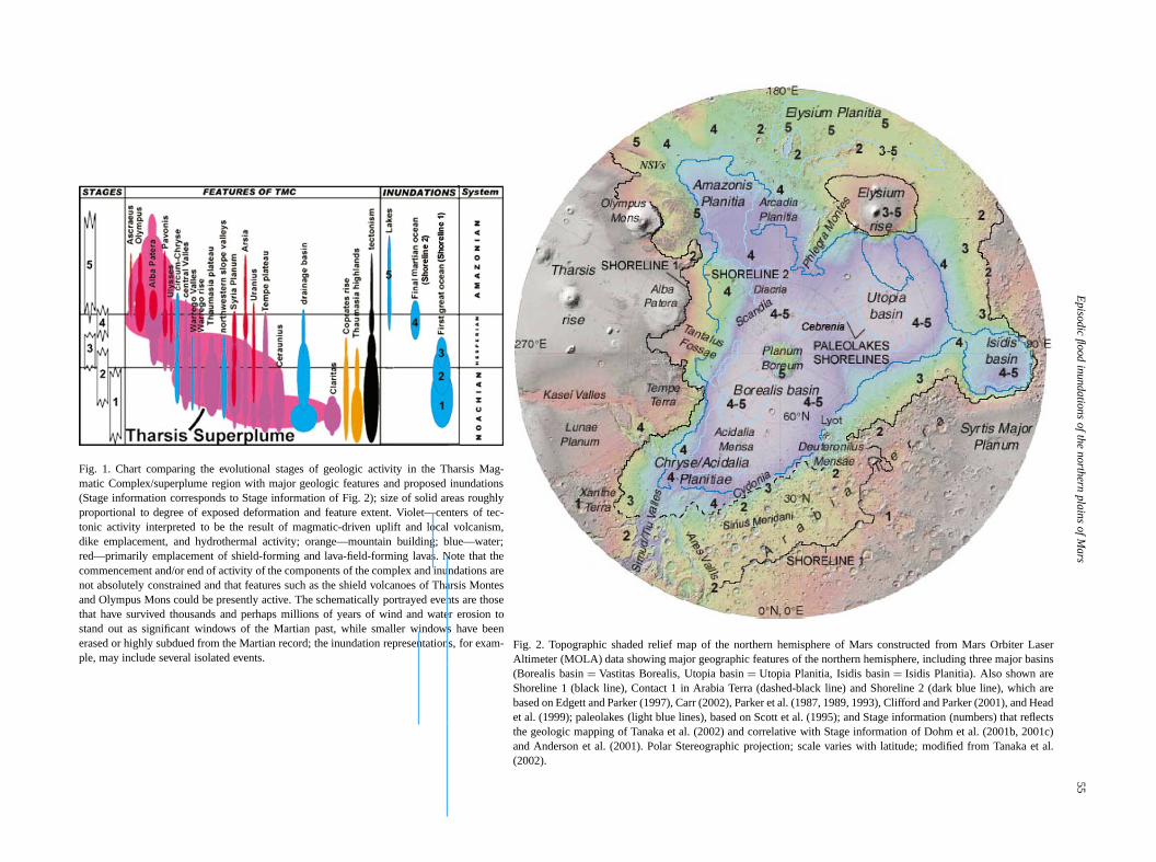
with the MEGAOUTFLO hypothesis that explains episowater stability in the lowlands of Mars (Baker et al., 192000; Baker, 1999), we propose a conceptual model herepoints out the direct impact of Tharsis-triggered flood indations in the shaping of the northern lowlands (Fig. 1).enormous Noachian basin/aquifer system in eastern Tsis has been revealed by paleotopographic reconstrucof the Tharsis magmatic complex in the western hemispof Mars, proposed to have sourced the Tharsis-triggoutburst floods that sculpted the circum-Chryse and Noutflow channel systems (Dohm et al., 2001b), entraiboulders, rock, and sediment during passage, and pondform sequentially through time various hypothesized oceseas, and lakes (e.g., McGill, 1985; Jöns, 1986; Paet al., 1987, 1993; Baker et al., 1991; Scott et al., 19Head et al., 1999) (Fig. 2). The dwindling of these floowaters through time, due to an inadequate recharge oNoachian drainage basin/aquifer system, is expected duthe time of noted low erosion rates following the late hebombardment. Note that we use inferred absolute agecently condensed from models of impactor populationsstudies of martian meteorites (Hartmann and Neukum, 2see Table 1).
2. Physiographic setting
The northern and southern provinces represent a phgraphic and geomorphologic dichotomy of the martian crThe boundary clearly separates relatively young, uncratsurface materials of the lowlands from the highly crateancient highland rock assemblages. The lowland mateare interpreted to have been emplaced by both subaand subaqueous processes, which include eolian, volcfluvial, mass-wasting, lacustrine, and marine (e.g., Sand Tanaka, 1986; Tanaka, 1986; Greeley and Guest, 1Parker et al., 1993; Scott et al., 1995; Tanaka et al., 20The ancient highlands consist of a mélange of rocksare interpreted to mainly include lava flows, impact brcias, and eolian, fluvial, and colluvial deposits (e.g., Sand Tanaka, 1986; Tanaka, 1986; Greeley and Guest, 1Dohm and Tanaka, 1999), although glacial deposits halso been proposed (e.g., Kargel and Strom, 1992; Kaet al., 1995).
Episo
dic
flood
inundatio
ns
ofth
enorth
ern
pla
ins
ofM
ars
55
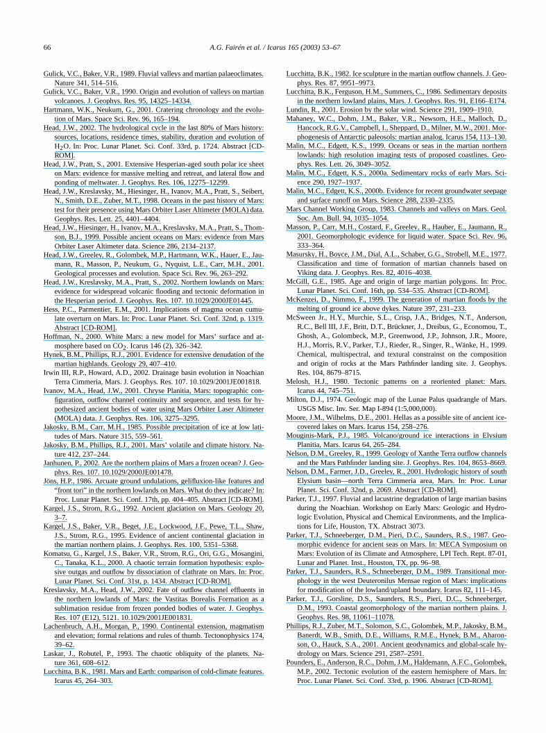
Fig. 1. Chart comparing the evolutional stages of geologic activity in the Tharsis Mag-matic Complex/superplume region with major geologic features and proposed inundations(Stage information corresponds to Stage information of Fig. 2); size of solid areas roughlyproportional to degree of exposed deformation and feature extent. Violet—centers of tec-tonic activity interpreted to be the result of magmatic-driven uplift and local volcanism,dike emplacement, and hydrothermal activity; orange—mountain building; blue—water;red—primarily emplacement of shield-forming and lava-field-forming lavas. Note that thecommencement and/or end of activity of the components of the complex and inundations arenot absolutely constrained and that features such as the shield volcanoes of Tharsis Montesand Olympus Mons could be presently active. The schematically portrayed events are thosethat have survived thousands and perhaps millions of years of wind and water erosion tostand out as significant windows of the Martian past, while smaller windows have beenerased or highly subdued from the Martian record; the inundation representations, for exam-ple, may include several isolated events.
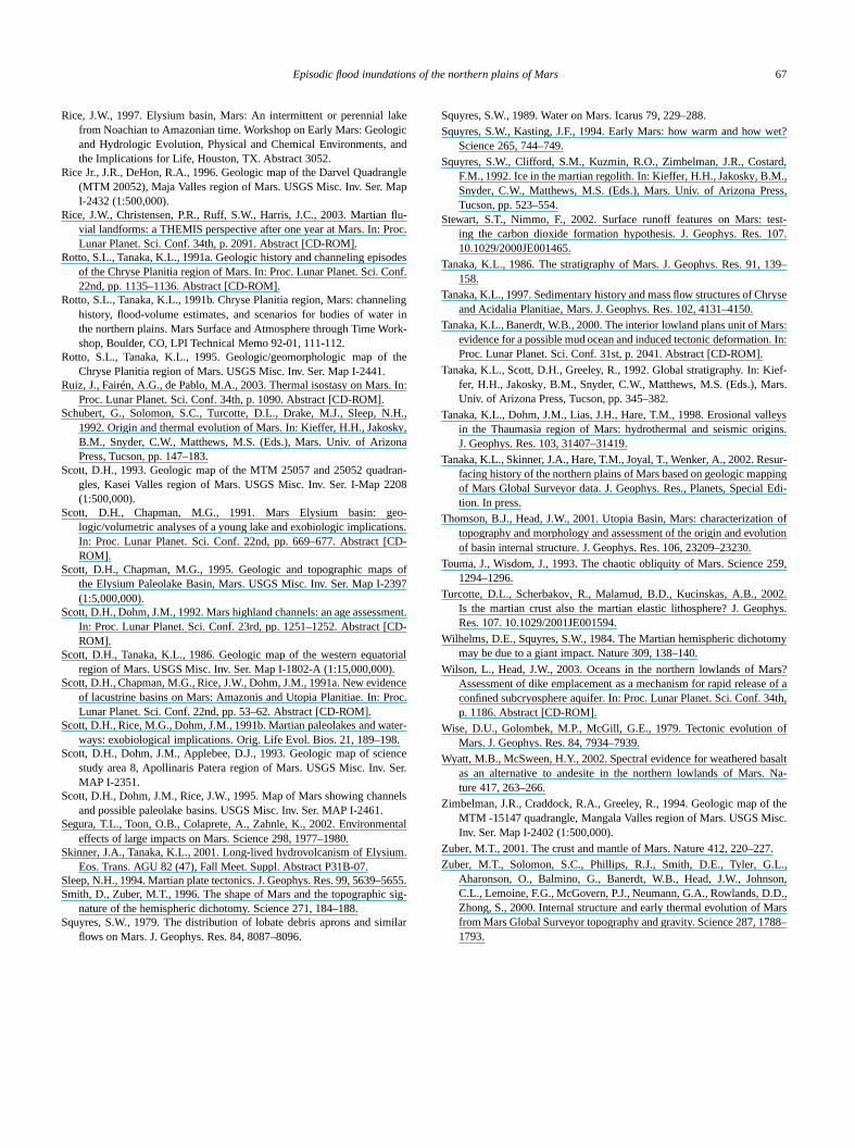
Fig. 2. Topographic shaded relief map of the northern hemisphere of Mars constructed from Mars Orbiter LaserAltimeter (MOLA) data showing major geographic features of the northern hemisphere, including three major basins(Borealis basin= Vastitas Borealis, Utopia basin= Utopia Planitia, Isidis basin= Isidis Planitia). Also shown areShoreline 1 (black line), Contact 1 in Arabia Terra (dashed-black line) and Shoreline 2 (dark blue line), which arebased on Edgett and Parker (1997), Carr (2002), Parker et al. (1987, 1989, 1993), Clifford and Parker (2001), and Headet al. (1999); paleolakes (light blue lines), based on Scott et al. (1995); and Stage information (numbers) that reflectsthe geologic mapping of Tanaka et al. (2002) and correlative with Stage information of Dohm et al. (2001b, 2001c)and Anderson et al. (2001). Polar Stereographic projection; scale varies with latitude; modified from Tanaka et al.(2002).
56 A.G. Fairén et al. / Icarus 165 (2003) 53–67
r-redanshasaryal.,ori-
ome ort al.,ma
and-lt o94),2;w-
arlycep
byrel-me
gesses
inse tooreevi-ug-horeal.,rim-rra,
uph asgettity)n-,ternenaduehavethee 1;andarr,s togra-
atedore-
oveConelow
en-
toac-
lueelsa-
t
Vsaxi-
rger
therog-outd.be
in,
hestaldif-990;nal
pro-sedet’stiontricuiz2 isolderto beallerces
acep-ant,ate986;
ruc-estentsrsisocalis-ting
tecre-
erra
The origin of the generally smooth plains-forming Matian northern lowlands, the locality where Tharsis-triggefloodwaters may have ponded to form the putative oceand small water bodies, remains uncertain. However, itbeen proposed that the Martian highland/lowland boundbegan to form at least since the Noachian (Dohm et2001b). Several hypotheses have been invoked for itsgin, which include either subcrustal erosion resulting frmantle convection (Wise et al., 1979), excavation by onmore large impacts (Wilhelms and Squyres, 1984; Frey e2002), or overturn of unstable cumulates in an initial magocean (Hess and Parmentier, 2001). Alternately, the lscape of the northern lowlands may have been the resusea-floor spreading, linked to plate tectonism (Sleep, 19during the Early into Middle Noachian (Baker et al., 200Dohm et al., 2002; Fairén et al., 2002). In fact, although lolands’ basement is old, perhaps dating from the final ENoachian (Frey et al., 2002), the cratered highlands (exfor the northwestern part of Arabia Terra; an area notedZuber et al. (2000) to be related to the lowlands due to itsatively thin crust) are older indeed (Frey, 2003). Thus, sohundreds of millions of years during the embryonic staof Mars’ development may have allowed for inner procesto shape the lowlands.
Of the two shorelines proposed for the northern pla(Parker et al., 1987, 1993), the inner younger one is closan equipotential line (Contact 2, hereafter referred as Shline 2), whereas the outer older shoreline (Contact 1) dates from equipotentiallity (Head et al., 1999). Here, we sgest the existence of a greater shoreline (referred to as Sline1 from the previously reported position by Parker et1987, 1993), which may represent the high stand of the pitive Martian ocean (Figs. 2 and 3). In western Arabia Tethe coastline may have been some thousands of kmwards in the cratered terrain, which includes regions sucnorthern Sinus Meridiani and western Arabia Terra (Edand Parker, 1997). Elevation variations (equipotentialldecrease from∼ 11 km using the previously mapped Cotact 1 (Head et al., 1999) to only∼ 2.5–3 km in Shoreline 1which transects across northern Sinus Meridiani, wesArabia Terra, northeast Arabia Terra, and north Thyrr(Tharsis and Elysium rises are not taken into accountto the abundant post-Noachian activity those structuresexperienced). In addition, valley networks formed duringNoachian in Arabia Terra surround and empty at Shorelinand there are only isolated valleys between Shoreline 1the previous position of Contact 1 in northeast Arabia (C2002; see Fig. 3B). Moreover, Shoreline 1 correspondthe crustal thickness dichotomy, as deduced from topophy and gravity data (Zuber et al., 2000; see Fig. 3C).
The volumetric extent of the earliest and largest estimwater body, in our opinion, can be best portrayed by Shline 1 through several lines of evidence, including:
(1) MOLA data, which shows rougher surfaces abContact 1, less rougher surfaces at all scales betweentact 1 and Shoreline 2, and generally smooth surfaces b
f
t
-
-
-
-
Shoreline 2 (Head et al., 1999). (Note that Shoreline 1closes the previously mapped Contact 1; see Fig. 2).
(2) Total water capacity below Shoreline 1 (estimatedbe more than 108 km3 compared to the approximated capity below the previously mapped Contact 1 of 9.6×10⁷ km3
by Head et al., 1999), which lies between the minimum vafor water that flowed through the Chryse outflow chann(0.6 × 10⁷ km3; Carr, 1996a) and the maximum water cpacity estimated for regolith (5 to 20× 107 km3; Squyres eal., 1992).
(3) The newly identified Noachian-Early Hesperian NSoutflow channel system, with an enormous estimated mmum peak discharge rate of about 2× 10¹⁰ m3/s, which isproposed to be a significant source of water for the la(Shoreline 1) ocean (Dohm et al., 2001a) (Fig. 2).
Nevertheless, magmatism and tectonism among ocontributors likely modified ancient (e.g., Noachian) topraphy, including Shoreline 1, where a deviation of ab2–3 km from an equipotential line most likely occurreSpecifically, these deviations from equipotentiallity mayexplained by:
(1) The influx of water throughout time (Cabrol and Gr2001).
(2) Local variations of the thermal structure of tlithosphere (due to variations in mantle heat flow or cruheat generation, for example) that generate elevationferences between regions (Lachenbruch and Morgan, 1Turcotte et al., 2002; Ruiz et al., 2003). If there were regiodifferences in heat flow in early Mars, the subsequentgressive decline of heat flow through time might have caudifferential thermal subsidence (relaxation) of the planlithosphere. This could have contributed to the distorof the original Noachian topography in an even kilomescale, including the equipotentiallity of Shoreline 1 (Ret al., 2003). The original topography along Shorelineexpected to be less deformed when compared to theShoreline 1 because mantle temperature is expectedless through time (e.g., Schubert et al., 1992). This smheat flow following the Late Hesperian (smaller differenin heat flow or crustal heat production) would includedecrease in magmatic-driven uplifts and subsidence. Extions include Elysium rise and Alba Patera where significconcentrated magmatic-driven activity is noted for the LHesperian and Amazonian (e.g., Scott and Tanaka, 1Greeley and Guest, 1987; Anderson et al., 2001).
(3) Pre-oceanic tectonic structural fabrics, such as stturally controlled cliffs in the hypothesized oldest and largocean and post tectonically-controlled elevation adjustmto putative Shoreline 1, related to the evolution of Thaand/or other elevational adjustments associated with lvolcanism, wind and/or glacial activity, groundwater dcharge and surface runoff, and tectonism (including fauland impact cratering).
(4) A possible Early into Middle Noachian martian platectonism episode, with convergent plate margins and action of terranes (e.g., northwards Terra Cimmeria and T

Episodic flood inundations of the northern plains of Mars 57
(A)
(B)
(C)
Fig. 3. A: Topographic map of Mars. Note the equipotentiallity of Shoreline 1 in northern Sinus Meridiani and western Arabia Terra. Arrows indicate thepossible Noachian coastline, both in (A) and (B). Marked is the area showed in detail in (C) (IEG0062T.IMG MOLA image, both shaded and coloredaccording to topography. Produced by Tayfun Oner). B: Valley channels appear to debouch along Shoreline 1, even in northeast and southwest Arabia Terra.(In Carr, 2002.) (C) Inferred crustal thickness from MOLA data, running from the north pole (left) to the south pole (right), along the 0◦ longitude region,including Arabia Terra. Crustal thickness does not correlate with the dichotomy boundary or Contact 1, but appears to be related with Shoreline 1. This couldrepresent the first great ocean that occupied the northern plains of Mars. (Image from MOLA Science Team).
58 A.G. Fairén et al. / Icarus 165 (2003) 53–67
ismetre-
sec-sedd th
u-atic-on
andaleofter1c).ns
(seeac-
est,
lexnthe. 1)ave
s. 2ely
arlyic-r-ichism,ity,nneem-d to
thein-, ande-lso
ted1a,
nlycan-ian
vere,the
lymi-sonom-thecord, itisebed-
ringmo2).pa-ape
rom02;uldOthewa-
seasaydur-andan,thanlong-ean
toouldamiceen1),
ivedandateto aandandave
arkerateds cy-
3),riaasiarth-ernod-heat
Sirenum; Fairén et al., 2002). The proposed plate tectonfor early Mars (first hundreds of millions of years, Bakeral., 2002) would greatly modify the topography along Sholine 1.
(5) The approximated values of the hypothesizedondary and smaller water-masses, whose associatedmentary deposits and water resources could have altereprimitive geomorphological features of Shoreline 1.
3. Inundation model
In our model, the Tharsis Magmatic Complex (TMC)/Sperplume development, which includes pulses of magmdriven hydrological activity, directly influences the evolutiof the atmosphere and climate, as well as subsurfacesurface water processes as observed in geologic and phydrologic records. Figure 1 reflects Stage information aAnderson et al. (2001) and Dohm et al. (2001b, 200This model highlights Tharsis-triggered flood inundatioand their direct impact on shaping the northern plainsFig. 2), and other contributors such as magmatic-driventivity at Elysium rise (Tanaka, 1986; Greeley and Gu1987; Skinner and Tanaka, 2001).
3.1. Noachian to Early Hesperian (Stages 1–3): the firstgreat ocean
Incipient development of the Tharsis magmatic comp(TMC) during the Early into Middle Noachian (Andersoet al., 2001; Dohm et al., 2001b) to as late as possiblyEarly Hesperian (Stages 1–3 of Dohm et al., 2001b) (Figresulted in the first inundation; an ocean that would hcovered the northern plains (approximately 1/3 of the totalsurface area of Mars, see location of Shoreline 1 on Figand 3). Dohm et al. (2001b) show evidence that collectivindicate that the TMC began to form sometime around Einto Middle Noachian with significant pulses of magmatdriven activity during Stages 1–3, including the growth Asia, Syria Planum, and central Valles Marineris rises, whare interpreted to be centers of magmatic-driven tectonvolcanism, dike emplacement, local hydrothermal activand associated NSVs and circum-Chryse outflow chaactivity. The development of Thaumasia plateau and theplacement of intercrater materials, which are interpretebe the result of phreatomagmatic explosions such as inValles Marineris region where magma/water/water-iceteractions have been proposed (Chapman et al., 1991)older wrinkle ridged materials interpreted to representformed lava plains (Dohm et al., 2001c), may have abeen influential on outflow channel activity, and relaflood inundations during Stages 1–3 (Dohm et al., 2002001b, 2001c). In addition, valley networks are maiNoachian in age (e.g., Carr, 2002), and so excellentdidates to contribute to the filling of the first great martocean.
i-e
-
l
d
The incipient development of TMC’s Stage 1 may haoccurred from Early into Middle Noachian. Furthermoa magnetic field may have been operative on Mars ininitial Early into Middle Noachian (from approximate4.4 to 4.0 Gyr), since one of the oldest and most donant Noachian centres of activity, Claritas rise (Anderet al., 2001), spatially corresponds with a magnetic anally (Acuña et al., 1999, 2001), but not subsequent toHellas impact event, since the Hellas basin does not remagnetic anomalies (Acuña et al., 1999). Importantlyis difficult to determine for sure whether the Claritas rrecords incipient TMC development or whether it mayrelated to magmatic activity independent from TMC. In adition, plate tectonism may have been in operation duthe Early into Middle Noachian, surviving the inner dynafor some tens of millions of years (Fairén et al., 200If at least the first pulse of TMC magmatism accomnied plate tectonism, then the northern lowlands’ landsccould have resulted from seafloor spreading (lasting fabout 4.4–4.3 to approximately 3.9 Gyr; Baker et al., 20Dohm et al., 2002); and possible carbonate recycling wohave accounted for the reinjection of large amounts of C2into the atmosphere. Subducted hydrous material oflithosphere would have represented an ample supply ofter for later Tharsis volcanism, and its water release toand/or lakes (Baker et al., 2002). In addition, Mars mhave been more volatile-enriched than Earth, especiallying its embryonic stages of development (CraddockHoward, 2002). Therefore, until at least Middle Noachithe Martian atmosphere could have been much thickerat present, capable of sustaining a considerable andstanding liquid ocean. As stated before, this primitive ocis best portrayed by Shoreline 1.
Without the magnetic field protection since the MiddleLate Noachian (Stage 2), the atmospheric erosion rate whave increased, as well as the loss of water to hydrodynescape. Surface water stability, however, could have bpossible during hundreds of million of years (Lundin, 200especially if local remanent magnetic anomalies survin the crust once the inner dynamo shut off (JakoskyPhillips, 2001). Additionally, if Mars passed through a pltectonic phase, its termination would have contributedbreak-up of the atmospheric equilibrium between addingretiring carbonates; the result would be thinner, dryercolder atmospheric conditions. The ocean would thus hbeen reduced and ice-covered during Late Noachian (Pet al., 1993), and its possible geomorphologic-associfeatures would be erased by subsequent major hydroucles.
An Early Hesperian pulse of Tharsis activity (Stagewhich includes further development of the Arsia, SyPlanum, central Valles Marineris rises, and Thaumplateau, may have triggered more flood waters to the noern plains adding to the potentially already existing northplains ocean and/or ice body/ground ice. As the new flowaters washed over the northern plains, the additional
Episodic flood inundations of the northern plains of Mars 59
uenro-lse
(ap-91,
tores-ka,001ereig-ing91;gni-999an
.g.,
sesaveericlyhenanic
rlylume
is risavefuldmil-
t
es-f theriansienTheeddefindereez-an
ati-ndinnd
a-c-
ummor-els.
n-andndwa-owott
992;95;lsonaka,994;ded
es in. 2mi-erdt,edese
sis-an-
tillse-es
ust,anicase
may have melted the upper layers of ice and the subseqgradients would allow the melt water to cycle into the hydlogic system (Dohm et al., 2001a). This third major puof TMC activity may have contributed enough CO2 andother volatiles to the atmosphere to induce a short-livedproximately tens of thousands of years; Baker et al., 192002) climatic perturbation. Another potential contributo the flood inundation hypothesis during the Early Hperian is incipient development of the Elysium rise (Tana1986; Greeley and Guest, 1987; Skinner and Tanaka, 2Tanaka et al., 2002). If both Tharsis and Elysium wconcurrently active during the Early Hesperian, then snificant climatic responses would be expected, includgrowth of ice sheets at the poles (Baker et al., 19Head and Pratt, 2001), outflow events of enormous matudes to the northern plains (e.g., Nelson and Greeley, 1Dohm et al., 2001a), and spring-fed discharge alongunvegetated (instable) highland-lowland boundary (eTanaka et al., 2002).
When compared to today’s conditions, water and gareleased during such Tharsis Superplume activity could hresulted in thicker post-heavy-bombardment atmosphconditions. The first inundation originated from a highproductive aquifer system, and may have occurred wenvironmental conditions were more clement; the oceenvironment of the initialOceanus Borealismay have per-sisted from the Early to Middle Noachian into the EaHesperian, related to episodic, pulsating Tharsis superpactivity. For example, an amount of∼ 3× 10⁸ km3 of mag-mas has been proposed as the total release of the Tharsduring the Noachian, and their volatile content would hproduced the equivalent of 1.5-bar CO2 and a global layer owater of 120 m thickness (Phillips et al., 2001). Water coso have extended over the lowlands during hundreds oflions of years (e.g., Clifford and Parker, 2001).
3.2. Late Hesperian/Early Amazonian (Stage 4): the lasMartian ocean
Between the disappearance of the Noachian-Early Hperian great ocean and the temporary establishment oLate Hesperian minor sea, a cold and dry Late Hespeintermediate period occurred, perhaps related to a tranpause of the Tharsis development (Dohm et al., 2001b).first clear discontinuity in TMC development is observbetween stages 3 and 4, when Thaumasia Plateau wasitively established (see Fig. 1). The transition to this colclimate, and the decline in crustal heat flow, caused the fring of the primordial ocean, which presumably developedice cover that thickened with both time and increasing ltude (Clifford and Parker, 2001). In addition, the colder adryer conditions might account for the significant declinethe rate of valley network formation in the Hesperian aAmazonian (Fig. 4).
Following the period of magmatic quiescence, a mjor pulse of Late Hesperian/Early Amazonian TMC’s a
t
;
;
e
t
-
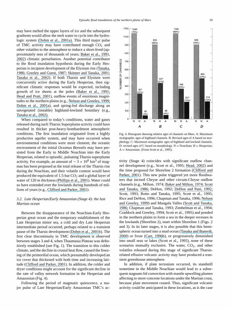
Fig. 4. Histogram showing relative ages of channels on Mars. A: Maximstratigraphic ages of highland channels. B: Revised ages of A based onphology. C: Maximum stratigraphic ages of highland and lowland channD: revised ages of C based on morphology. N= Noachian; H= Hesperian;A = Amazonian. (From Scott et al., 1995).
tivity (Stage 4) coincides with significant outflow chanel development (e.g., Scott et al., 1995; Head, 2002)the time proposed for Shoreline 2 formation (Clifford aParker, 2001). This new pulse triggered yet more floodters that incised Chryse and other circum-Chryse outflchannels (e.g., Milton, 1974; Baker and Milton, 1974; Scand Tanaka, 1986; DeHon, 1992; DeHon and Pani, 1Scott, 1993; Rotto and Tanaka, 1995; Scott et al., 19Rice and DeHon, 1996; Chapman and Tanaka, 1996; Neand Greeley, 1999) and Mangala Valles (Scott and Tan1986; Chapman and Tanaka, 1993; Zimbelman et al., 1Craddock and Greeley, 1994; Scott et al., 1995) and ponin the northern plains to form a sea in the deeper recessthe lowlands (Shoreline 2), inset within Shoreline 1 (Figsand 3). In its later stages, it is also possible that this hespheric ocean turned into a mud ocean (Tanaka and Ban2000) or froze (Carr, 1996b), or progressively diminishinto small seas or lakes (Scott et al., 1995), none of thscenarios mutually exclusive. The water, CO2, and othervolatiles released during this stage of significant Tharrelated effusive volcanic activity may have produced a trsient greenhouse atmosphere.
In addition, if plate tectonism occurred, its standssometime in the Middle Noachian would lead to a subquent stagnant-lid convection with mantle upwelling plumaffecting to more concrete locations under the Martian crbecause plate movement ceased. Thus, significant volcactivity could be anticipated in these locations, as is the c
60 A.G. Fairén et al. / Icarus 165 (2003) 53–67
arlyt ofandentthe
ur-re-an
fromin-kin-an-har-riod987
wthtesac-
01;easewarm
end
heO
ma-edith
tingar-
91),malan-ernbe-thethe
02).eats-
rr,of
lineianex-in-rsis
argeetely
e off the
achory.bleof a
hy-ules,thedin,oxi-thebe-malosky
nceern
suf-up-mentletetings ofkes,
tionapstedn-aterlikeunts, orcticty.s orans,
iese ofldandlting
sisar-for
ationanden-93)ver
for both Tharsis and Elysium; such Late Hesperian and EAmazonian activity is recorded in the early developmenthe giant shield volcanoes, Olympus Mons, Alba Paterathe Tharsis Montes during Stage 4 of TMC developm(Dohm et al., 2001b), as well as the shield volcanoes ofElysium rise (Greeley and Guest, 1987).
3.3. Amazonian (Stage 5): temporary lacustrineenvironments
Finally, generally cold and dry desert conditions ding the Amazonian were punctuated by small outflowleases such as at and near Kasei and Mangala Vallesthe channels systems that debouch into Utopia basinthe northwestern flank of Elysium rise, Hrad, Apsus, Tjar, and Granicus Valles (Greeley and Guest, 1987; Sner and Tanaka, 2001) to form a number of minor trsient seas or lakes (Fig. 2). Various isolated pulses of Tsis magmatism are documented for the Amazonian Pe(e.g., Scott and Tanaka, 1986; Greeley and Guest, 1Anderson et al., 2001), including the continuous groof Olympus Mons, Alba Patera and the Tharsis Monshield volcanoes (see Fig. 1). Late-stage Elysium Monstivity during the Amazonian (Skinner and Tanaka, 20Pounders et al., 2002) also may have contributed to relcarbonates and water into atmosphere. In any case, theperiods were infrequent and short (103 to 105 years) asrecorded in the low cumulative rates of erosion since theof the Noachian (Baker, 1999, 2001; Carr, 2002).
High heat flux originating in magmatic activities near tsurface is proposed to be responsible for the melting of C2clathrate, causing rapid outflows of water and so the fortion of chaotic terrains (Komatsu et al., 2000); the mobilizwater-sediment mixture would create outflow channels, wages ranging from Noachian to Amazonian. Equally, melof ground and surface ice by volcanic activity has beengued for the origin of the channels (e.g., Baker et al., 19the melting possibly being accompanied by hydrothercirculation (Gulick, 1998). In fact, it is possible that substtial remnants of the floodwaters that inundated the northlowlands during Noachian and Hesperian could remainneath thin mantles of dust and volcanics emplaced inHesperian and Amazonian, as potentially indicated fromlatest results of the Odyssey mission (Boynton et al., 20
Nevertheless, the long-term decline in planetary hflow and sequestering CO2 in carbonates and the progresive trapping of H2O into clays in the cryosphere (Ca2002) would have greatly depleted the original inventorygroundwater. This could well explain the apparent decin outflow channel activity observed during the Amazon(Scott et al., 1995). Floods and water bodies are alsopected to be progressively smaller with time due to a dwdling Noachian water supply (e.g., Noachian eastern Thabasin/aquifer system) and the related insufficient rechafter each endogenically-driven hydrologic event (Dohmal., 2001b). So, the Late Hesperian–Amazonian extrem
d
;
cold and dry conditions could even include the presenca mantled, thin frozen ocean in the deeper reaches onorthern plains (Janhunen, 2002).
In addition, the environmental conditions between eperiod ensures the loss of water from the global inventThe comparatively lower martian gravity prevents a stathick atmosphere (Baker et al., 1991) and the absencemagnetic field allows energetic solar particles to forcedrodynamic dissociation upon near-surface water molecreleasing the heavier oxygen into the soil and allowinglighter hydrogen to escape into the exosphere (e.g., Lun2001). The released oxygen may have contributed to thedation of the regolith, hydrolysis of silicate minerals, andformation of carbonate minerals. Also, impact events arelieved to have contributed to atmospheric erosion or therescape during the period of heavy bombardment (Jakand Phillips, 2001).
4. Discussion
Contrary to the numerous works that present evidefor the possible occurrence of water bodies in the northplains, Malin and Edgett (1999) suggest that there is inficient Mars Orbital Camera (MOC)-based evidence to sport the existence of coastlines. This apparent disagreemay be attributed to several factors, including incompMOC coverage of the Martian surface, inadequate tesof the features described (actually, common expressionthe shorelines associated with large terrestrial paleolasee Clifford and Parker, 2001), wind and water modificaover a prolonged geologic time period (millions to perha billion years of resurfacing), ill-defined shorelines relato rapidly diminishing water bodies shortly following inudation through the sublimation and the transferral of winto the ground and/or to freezing, the lack of an Earth-moon to cause tidal forces responsible for the large amoof energy available for erosion at terrestrial shorelinespersistant environmental conditions similar to the Antar(Mahaney et al., 2001), which would inhibit wave activiIn this sense, searching for lines of boulders, scour markgravel bars, associated to the action of ice-covered ocemight evidence Artic and Antartic-like shore morpholog(Fig. 5). Since at least the Late Noachian, no evidencwarm, but episodic milder conditions in a long-term coand dry climate, are reported for Mars; so, morphologieslandforms related to temperate-climate shorelines, resufrom the action of waves, may be hard to found.
The inundation hypothesis is not the only hypothewhich offers explanations for some of the significant chacteristics described above. An alternative mechanismproducing a dense atmosphere, for example, is the variof Martian orbital parameters (see Carr, 1990; ToumaWisdom, 1993; Laskar and Robutel, 1993) and relatedvironmental/climatic changes. Touma and Wisdom (19proposed that an obliquity of the Martian rotation axis o
Episodic flood inundations of the northern plains of Mars 61
OCby
rthern
barerethisvedandar-
on-uldge.
aveinglo-unddingFer-
x-ed ams
euidmil-nddoys-
galasuf-
gthse.g.,
they-in-
d tor et
nsrtedner-ter
ver-lly-igh-thcon-rig-esswet
sug-taryard-actere.at-
eadsena-
ub-on-her-el-
othereraka
Theesise oc-lleyian991;ottan
n orPa-ribu-llesthessess notthe
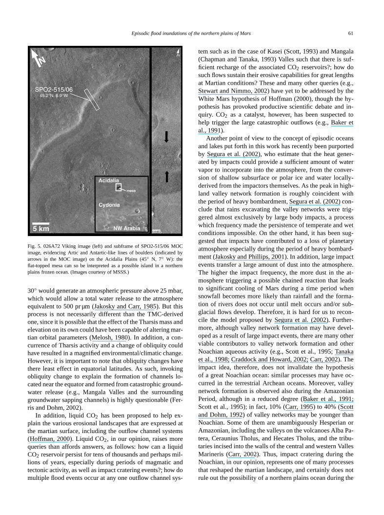
Fig. 5. 026A72 Viking image (left) and subframe of SPO2-515/06 Mimage, evidencing Artic and Antartic-like lines of boulders (indicatedarrows in the MOC image) on the Acidalia Plains (45◦ N, 7◦ W): theflat-topped mesa can so be interpreted as a possible island in a noplains frozen ocean. (Images courtesy of MSSS.)
30◦ would generate an atmospheric pressure above 25 mwhich would allow a total water release to the atmosphequivalent to 500 pr µm (Jakosky and Carr, 1985). Butprocess is not necessarily different than the TMC-derione, since it is possible that the effect of the Tharsis masselevation on its own could have been capable of altering mtian orbital parameters (Melosh, 1980). In addition, a ccurrence of Tharsis activity and a change of obliquity cohave resulted in a magnified environmental/climatic chanHowever, it is important to note that obliquity changes hthere least effect in equatorial latitudes. As such, invokobliquity change to explain the formation of channelscated near the equator and formed from catastrophic growater release (e.g., Mangala Valles and the surroungroundwater sapping channels) is highly questionable (ris and Dohm, 2002).
In addition, liquid CO2 has been proposed to help eplain the various erosional landscapes that are expressthe martian surface, including the outflow channel syste(Hoffman, 2000). Liquid CO2, in our opinion, raises morqueries than affords answers, as follows: how can a liqCO2 reservoir persist for tens of thousands and perhapslions of years, especially during periods of magmatic atectonic activity, as well as impact cratering events?; howmultiple flood events occur at any one outflow channel s
,
-
t
tem such as in the case of Kasei (Scott, 1993) and Man(Chapman and Tanaka, 1993) Valles such that there isficient recharge of the associated CO2 reservoirs?; how dosuch flows sustain their erosive capabilities for great lenat Martian conditions? These and many other queries (Stewart and Nimmo, 2002) have yet to be addressed byWhite Mars hypothesis of Hoffman (2000), though the hpothesis has provoked productive scientific debate andquiry. CO2 as a catalyst, however, has been suspectehelp trigger the large catastrophic outflows (e.g., Bakeal., 1991).
Another point of view to the concept of episodic oceaand lakes put forth in this work has recently been purpoby Segura et al. (2002), who estimate that the heat geated by impacts could provide a sufficient amount of wavapor to incorporate into the atmosphere, from the consion of shallow subsurface or polar ice and water locaderived from the impactors themselves. As the peak in hland valley network formation is roughly coincident withe period of heavy bombardment, Segura et al. (2002)clude that rains excavating the valley networks were tgered almost exclusively by large body impacts, a procwhich frequency made the persistence of temperate andconditions impossible. On the other hand, it has beengested that impacts have contributed to a loss of planeatmosphere especially during the period of heavy bombment (Jakosky and Phillips, 2001). In addition, large impevents transfer a large amount of dust into the atmosphThe higher the impact frequency, the more dust in themosphere triggering a possible chained reaction that lto significant cooling of Mars during a time period whsnowfall becomes more likely than rainfall and the formtion of rivers does not occur until melt occurs and/or sglacial flows develop. Therefore, it is hard for us to reccile the model proposed by Segura et al. (2002). Furtmore, although valley network formation may have devoped as a result of large impact events, there are manyviable contributors to valley network formation and othNoachian aqueous activity (e.g., Scott et al., 1995; Tanet al., 1998; Craddock and Howard, 2002; Carr, 2002).impact idea, therefore, does not invalidate the hypothof a great Noachian ocean: similar processes may havcurred in the terrestrial Archean oceans. Moreover, vanetwork formation is observed also during the AmazonPeriod, although in a reduced degree (Baker et al., 1Scott et al., 1995); in fact, 10% (Carr, 1995) to 40% (Scand Dohm, 1992) of valley networks may be younger thNoachian. Some of them are unambiguously HesperiaAmazonian, including the valleys on the volcanoes Albatera, Ceraunius Tholus, and Hecates Tholus, and the ttaries incised into the walls of the central and western VaMarineris (Carr, 2002). Thus, impact cratering duringNoachian, in our opinion, represents one of many procethat reshaped the martian landscape, and certainly doerule out the possibility of a northern plains ocean during
62 A.G. Fairén et al. / Icarus 165 (2003) 53–67
r et
ofereaterter-ra-ionallyater/orx-
ntlypingphicd inesisLateion
ofForaterhapswa-us,
sibletua
onshis-
suandar-
ghly
onordenc
hym-ardsersoneby
ioneanr the
t itstheare
nnd
ol-es-
ane 1lsomsthereas02).difi-01;nd
e.portheing:rad-ds,.g.,allyationero-highsec-bleityice
the00),the0–
theiesorynd
ore-ntialre-of
d inityodedl-
ernpablean
out-d etore-d etinsin
Noachian by MEGAOUTFLO-related phenomena (Bakeal., 1991).
Clifford (1993) proposed that if the planetary inventoryoutgassed H2O exceeded the pore volume of the cryosphby more than a few percent, a subpermafrost groundwsystem of global extent would necessarily result. This inconnected global aquifer would allow the downward migtion of polar basal melt to result in the upward migratof water at temperate and equatorial latitude, theoreticsufficient enough to replenish regions that have lost wby magmatic and tectonic activity (including impact) andsublimation. Although Clifford’s model can adequately eplain recharge of water to Tharsis, it does not sufficieaddress the surface morphology ranging from small sapchannels, mid-size valley network systems, to catastrooutflow channel systems, which are largely concentratethe Tharsis region. In our opinion, the inundation hypothbest explains the diverse evidence, especially from theNoachian until present. Now we will discuss the inundathypothesis.
We cannot accurately define the exact numberMEGAOUTFLO events the planet has passed through.example, it is possible that two large-scale standing wbodies may have existed in very close periods, or pereven overlapping periods, allowing almost the sameter amount to stand at similar topographic positions. Thtopographic data may be inadequate to detect all posshorelines. In consequence, this work offers a concepmodel that highlights the Tharsis-induced flood inundatiin the northern plains that are recorded in the geologictory. These are the events that have appeared to havevived thousands and perhaps millions of years of windwater erosion to stand out as significant windows of the Mtian past, while smaller windows have been erased or hisubdued from the Martian record.
4.1. The early ocean
Long-term stability of a primordial hemispheric oceanthe lowlands of Mars has been recently argued by Cliffand Parker (2001), who established that the former presof such an ocean can be deduced by considering thedraulic conditions needed to explain the origin of the circuChryse outflow channels, and extrapolating them backwin time. Furthermore, if the outflow channel flood watwere derived from a subpermafrost aquifer, as much asthird of the planet’s surface would have been coveredstanding bodies of water and ice throughout its first billyears of evolution. Their conclusions indicate that an ocon Mars (as on Earth) may have condensed shortly afteplanet was formed.
The total water amount on Mars’ surface throughouhistory remains uncertain. But, if the average depth ofTharsis basin is between 2 and 7 km, and its measuredis approximately 9× 10⁶ km2 (Dohm et al., 2001b), thethe fill volume for an average depth of 5 km is arou
l
r-
e-
a
4.5 × 10⁷ km3, much more than the equivalent to the vume of water required to create the secondary Late Hperian ocean (1.4×10⁷ km3, Head et al., 1999), but less ththe volume required to filling the mean level of Shorelin(> 108 km3). Thus, other hydrologic activities may have acontributed water to the primitive ocean, by mechanissuch as mobilization of large quantities of ground ice insouthern highlands and spring-fed activity along many aof the highland/lowland boundary (e.g., Tanaka et al., 20In this sense, there is evidence of great landscape mocation rates on Mars during Noachian (Phillips et al., 20Hynek and Phillips, 2001) and Early Hesperian (Irwin aHoward, 2002) due to the erosion by water at the surfac
There are a large number of observations that supthe potential stability of this large body of water during tNoachian and possibly into the Early Hesperian, includthe higher erosion rates estimated for the lowlands (Cdock et al., 1997); the valley networks in the highlanwhich major activity is documented through Noachian (eSquyres and Kasting, 1994; Carr, 2002), and which typicV or U-shaped cross-section suggests a gradual formprocess, transitioning from water-related to ice-relatedsional mechanisms (Baker and Partridge, 1986); theerosion rates during the Noachian and the extensive distion of Noachian terrains by valley networks, comparato terrestrial erosion rates, in a long-term fluvial activrecently suggested by Mars Odyssey-THEMIS data (Ret al., 2003), dropping 4–6 orders of magnitude intoHesperian and Amazonian (Golombek and Bridges, 20and in particular the timing of extensive denudation ofhighlands, approximated to be limited to an interval of 35500 myr in the Noachian (Hynek and Phillips, 2001); orhigher early heat flow (Zuber et al., 2000), which implthat a much larger fraction of the planet’s total inventof H2O would have been present as a liquid (Clifford aParker, 2001).
4.2. The later ocean
For the case of the secondary and inner ocean, Shline 2 represents a surface of nearly constant equipote(Head et al., 1999), which is consistent with its interptation as a paleoshoreline. In fact, the equipotentiallitythis Late Hesperian ocean’s shoreline is only disrupteTharsis and Elysium, where Amazonian volcanic activhave taken place. So, Shoreline 2 should have been erby a fluid in hydrostatic equilibrium, and it remains amost completely equipotential, due to its relatively modage and the presence of less energetic processes caof deformation. Additional supporting to Shoreline 2 asancient shoreline are: debouching altitude of Chryseflow channels is close to contact 2 mean level (Heaal., 1999; Ivanov and Head, 2001); surface under Shline 2 is smoother at all scales than that above (Heaal., 1998); the northern lowlands are covered with plaunits that are mostly Late Hesperian–Early Amazonian
Episodic flood inundations of the northern plains of Mars 63
987im-osearge02)hesid-
2) asatervol-eana-
ds
rian
u-002;yseave01).tedowent77;nedtion
of-ageulse1b)icehe991;len-.
actingesbrorel-s amerge.la-
and2.5leap-encEly-a-rian-
asinted8).a-
995;out-he5;dur-noffrly
ow-the
s oftiednisrged
ghtdiesemalsothe
ar-deasf thenels
clud-nicac-
89;1a,rian
sec-ma-aterhinentd of
onsandnd
lec-a-dry
p-cott
entlow-ilarandand
age (e.g., Scott and Tanaka, 1986; Greeley and Guest, 1Tanaka et al., 2002); the contact itself is close to the lits of the late Hesperian Vastitas Borealis Formation, whsedimentary deposits strongly suggest the stability of a lbody of water at the level of Shoreline 2 (Head et al., 20at the time of peak of outflow channel activity during tLate Hesperian (Tanaka, 1986), and which are also conered by some authors (e.g., Kreslavsky and Head, 200possibly originated as a sublimation residue of a large wbody; and topography of features interpreted as sub-icecanoes suggests an ice top in a level very close to the melevation of the Shoreline 2, which is consistent with a wter body totally or partially frozen in the northern lowlan(Chapman, 2003). Its estimated age is∼ 2–3 Gyr. (Cliffordand Parker, 2001), also consistent with the Late Hespeage postulated here.
A distinct episode of outflow channel activity is docmented for the Late Hesperian (Tanaka, 1986; Carr, 2Fig. 4), the majority concentrated on the margin of ChrPlanitia. In fact, outflow channel formation seems to hpeaked at this time (Head et al., 2001; Masson et al., 20This and earlier outflow channel activity, especially relato the incipient development of the cirum-Chryse outflchannels, is probably driven by the continued developmof Tharsis and Valles Marineris (e.g., Masursky et al., 19Dohm et al., 2001a), and the release of water from confiaquifers due to cracking of the cryosphere by dike injec(Wilson and Head, 2003). In addition, complex networksdrainage channels have been described in Hesperianterrains (Scott et al., 1995). Therefore, the fourth great p(Stage 4) of Tharsis magmatic activity (Dohm et al., 200probably triggered a massive regional melting of groundand the heating of CO2-charge groundwater that started tdischarge of groundwater to the surface (Baker et al., 1McKenzei and Nimmo, 1999; Head and Pratt, 2001), repishing the lowlands with a secondary and smaller ocean
4.3. Late Hesperian to Amazonian paleolakes
Cabrol and Grin (1999) have catalogued 179 impcrater lakes at Viking resolution for the whole planet;this study, a relative age was suggested for the 30 larand these were mostly Late Hesperian to Amazonian. Caand Grin (2001) proposed a method to narrow down theative age for all of the 179 crater lakes, which includesummary of their findings that suggests periods of warand wetter climatic conditions and environmental chanAlso, Cabrol and Grin (2001) estimate that the maincustrine activity is placed between 3.1 and 1.8 Gyr,rises to a maximum in the Early Amazonian (aboutto 2.1 Gyr). Aqueous activity continues into the Middand Late Amazonian, though during a time when lakespear to be less numerous. Rice (1997) presented evidfor wide age-ranging aqueous sedimentary deposits insium Basin, pointing to the stability of Noachian to Amzonian lacustrine environments. Such Noachian/Hespe
;
d
tl
e
aqueous activity is also noted for Gusev impact crater bwhere recurrent Ma’adim Vallis flooding may have resulin episodic lakes (Scott et al., 1993; Cabrol et al., 199In addition, the presence of a significant volume of wter in Utopia Basin has been proposed (Scott et al., 1Thomson and Head, 2001), as well as the subsurfaceflow and surface runoff from the northwest flanks of tElysium rise into the Utopia basin (Mouginis-Mark, 198Greeley and Guest, 1987; Skinner and Tanaka, 2001)ing the Late Hesperian and Amazonian and surface ruin north Terra Cimmeria from the Late Noachian to EaAmazonian (Nelson et al., 2001).
Scott et al. (1995) relative age-dated highland and lland channels to determine their possible contribution tosize and stability of the paleolakes. The main supplierwater to the lowlands were the outflow channels that empinto Chryse Basin, and the ones that flowed into Amazoand Elysium basins. Water and sediment volumes dischaby the Chryse outflow channels, several millions of km3 ina short period of time (Rotto and Tanaka, 1991b), mihave been enough to have filled large-standing water-bowithin the basin. Floods from the Elysium channel systand the valley networks around the lowlands may havecontributed to a depositional sedimentary environment innorthern plains.
In any case, Scott et al. (1995) found that 56% of the mtian channels are Noachian in age, consistent with the istated here about the first great ocean. Therefore, 44% ochannels are younger than Noachian (Fig. 4); these chanare interpreted to have formed by several processes, ining local hydrothermal activity due to impacts or tectodeformation (Brakenridge et al., 1985) and magmatictivity (Baker and Partridge, 1986; Gulick and Baker, 19Gulick, 1998; Tanaka et al., 1998; Dohm et al., 2002001b, 2001c). Most of these channels are Late Hespe(31%), consistent with the emplacement epoch for theondary ocean; but the wide range in age (Hesperian to Azonian) of the channels that supplied the basins with wmark long periods of intermittent presence of water witthe northern lowlands of Mars. In fact, valley developmseems to have substantially decreased when the periolate heavy bombardment ceased, including a∼ 2-km declinein the mean elevation of outflow channel source regibetween the Late Hesperian and Amazonian (CliffordParker, 2001); but it did not cease completely (Gulick aBaker, 1990), as the post-Noachian valley formation coltively point towards brief warm, wet Hesperian and Amzonian excursions from prevailing, present-day cold anddesert conditions (Baker, 2001).
In particular, extensive flooding in the lowlands, suported by channel-meander features in many areas (Set al., 1995), which would have flowed over the ancisea-floor plains are described. The channels on thelands were formed during the Amazonian Period, simto those on the flanks of volcanoes in Tharsis (GulickBaker, 1989) or Elysium (Skinner and Tanaka, 2001),
64 A.G. Fairén et al. / Icarus 165 (2003) 53–67
manaverob-
rredow-anda-
por-in thaccu
ple-al.,hick97;
(latly
ore-
thed to
f dif-landSo,ex-d/orions
nsisob-imer
ere
inghoutach-ars;in than;ayersino
meEly-
ma-the
om-ffer-
n toand
lingpertic-
inbylpful
son,es,talex-
D.,, C.,fieldbits.
.C.,tersest-
on-
–236.and
de-
ale,le on
2.der,on,
o-cient
in the Medusae Fossae Formation (Scott and Chap1991). By this time, outflow channel activity appears to hdeclined and become more localized around regions of pable geothermal activity (e.g., Baker et al., 1992).
5. Highland features
Water-associated processes could have similarly occuin the highlands at the same time as those in the llands (e.g., Baker et al., 1991; Baker, 2001; HeadPratt, 2001). Impact cratering that resulted in the formtion of large basins appears to be one of the most imtant processes on Mars to produce closed depressionscratered highlands. In some of these basins, massivemulation of sediments have been described. For examGusev impact crater (15◦, 184◦) is rounded by the remnants of deltaic deposits from Ma’adim Vallis (Cabrol et1996), and sediments in Argyre are hundreds of meters tand as much as kilometres thick in Hellas (Parker, 19Moore and Wilhelms, 2001). In addition, Cassini Crater24◦ N., long 328◦) shows well-defined terraces in its highconserved rim morphology, similar to terrestrial paleoshlines.
Basin broadening by lakeshore degradation duringlate Noachian and early Hesperian has been proposeexplain these features (Parker et al., 1989). Channels oferent ages are equally bordering some of these highpaleolakes in impact craters (e.g., Scott et al., 1995).also in the highlands, when suitable conditions may haveisted on Mars perhaps related to Tharsis activity, lakes anice bodies may have occupied local topographic depresssuch as in impact crater/tectonic basins.
6. Conclusions
The hydrogeological hypothesis presented here, cotent with available data, provides an explanation forserved geological patterns of water evolution through ton the surface of Mars, and should help to motivate furtheinsitu investigations. The hydrological model articulated hfor the water evolution on the surface of Mars isconsistentwith:
(1) The compelling evidence for a potentially long-lastand great ocean covering the martian lowlands througthe Noachian and possibly into the Early Hesperian, reing a duration close to several hundreds of millions of yea Late Hesperian sea extending over the deeper areaslowlands inset within the boundary of the first great oceand a number of widely distributed minor lakes, which mrepresent a reduced Late Hesperian sea, or ponded watthe deeper reaches of the northern plains, related to mAmazonian Tharsis and Elysium reduced flooding.
(2) The five specific stages of the Tharsis Superpludevelopment, as well as possible contributions from the
,
e-,
,
-
e
inr
sium rise development during the Hesperian into the Azonian, and their influence on the water evolution onsurface of Mars.
The modelexplains:
(1) Why only two coastlines can be roughly traced as cplete closures of ancient oceanic basins; and the diences in equipotentiallity between them.
(2) Paleolake recurrent formation during Late HesperiaAmazonian, even in almost contemporary times,their wide range in level and in age.
And the modelpredicts:
(1) If the two Superplumes have not reached their coothreshold, future water refilling may occur in the deelowlands, when they begin another stage of magmadriven activity.
Acknowledgments
We thank Kenneth Tanaka for the topographic mapFig. 2, and Tayfun Oner for Fig. 3A production. ReviewsNathalie Cabrol and James Skinner were extremely hein the work of this paper.
References
Acuña, M.H., Connerney, J.E.P., Ness, N.F., Lin, R.P., Mitchell, D., CarlC.W., McFadden, J., Anderson, K.A., Rème, H., Mazelle, C., VignD., Wasilewski, P., Cloutier, P., 1999. Global distribution of crusmagnetization discovered by the Mars Global Surveyor MAG/GRperiment. Science 284, 790–793.
Acuña, M.H., Connerney, J.E.P., Wasilewski, P., Lin, R.P., Mitchell,Anderson, K.A., Carlson, C.W., McFadden, J., Réme, H., MazelleVignes, D., Bauer, S.J., Cloutier, P., Ness, N.F., 2001. Magneticof Mars: summary of results from the aerobraking and mapping orJ. Geophys. Res. 106, 23403–23417.
Anderson, R.C., Dohm, J.M., Golombek, M.P., Haldemann, A.FFranklin, B.J., Tanaka, K.L., Lias, J., Peer, B., 2001. Primary cenand secondary concentrations of tectonic activity through time in wern hemisphere of Mars. J. Geophys. Res. 106, 20563–20585.
Baker, V.R., 1999. The MEGAOUTFLO hypothesis for long-term envirmental change on Mars. Bull. Am. Astron. Soc. 31, 1133.
Baker, V.R., 2001. Water and the martian landscape. Nature 412, 228Baker, V.R., Milton, D.J., 1974. Erosion by catastrophic floods on Mars
Earth. Icarus 23, 27–41.Baker, V.R., Partridge, J.B., 1986. Small martian valleys: pristine and
graded morphology. J. Geophys. Res. 91, 3561–3572.Baker, V.R., Strom, R.G., Gulick, V.C., Kargel, J.S., Komatsu, G., K
V.S., 1991. Ancient oceans, ice sheets and the hydrological cycMars. Nature 352, 589–594.
Baker, V.R., Carr, M.H., Gulick, V.C., Williams, C.R., Marley, M.S., 199Channels and valley networks. In: Kieffer, H.H., Jakosky, B.M., SnyC.W., Matthews, M.S. (Eds.), Mars. Univ. of Arizona Press, Tucspp. 493–522.
Baker, V.R., Strom, R.G., Dohm, J.M., Gulick, V.C., Kargel, J.S., Kmatsu, G., Ori, G.G., Rice, J.W., 2000. Mars’ Oceanus Borealis, an
Episodic flood inundations of the northern plains of Mars 65
net.
icalnar
ofain.
dc-
rfaceand2.ingstian
tedy ex-
ous. 29.
ar-
nts.d
lake.
n:
a.iolog-
rs:ars.
c.gical55.
cts
lley
uresi. 44,
pli-131.
olake
a ma
y of
andInv.
062an-er.
nceGS
of
ere:e of
ian453–
ad-ap
wet
tryns of
TM03
gh aonf.
ars:net.
om,Sys-entrth-
are,.R.,rs:
314.om,.H.,ntialakes.
and. Inv.
are,geo-39.
eousrabia
eticdy-
Wet
ars:rn-th,
to,29.
lica-site.
egion
ial
glaciers, and the MEGAOUTFLO hypothesis. In: Proc. Lunar PlaSci. Conf. 31st, p. 1863. Abstract [CD-ROM].
Baker, V.R., Maruyama, S., Dohm, J.M., 2002. A theory for the geologevolution of Mars and related synthesis (GEOMARS). In: Proc. LuPlanet. Sci. Conf. 33rd, p. 1586. Abstract [CD-ROM].
Barlow, N.G., Bradley, T.L., 1990. Martian impact craters: correlationsejecta and interior morphologies with diameter, latitude, and terrIcarus 87, 156–179.
Berman, D.C., Hartmann, W.K., 2002. Recent fluvial, volcanic, and tetonic activity on the Cerberus plains of Mars. Icarus 159, 1–17.
Boynton, W., Feldman, W., Prettyman, T., Hamara, D., 2002. Subsuice content in the polar region of Mars: comparison between northsouth. Eos Trans. AGU 83 (47). Fall Meet. Suppl., Abstract P11B-0
Brakenridge, G.R., Newsom, H.E., Baker, V.R., 1985. Ancient hot spron Mars: origin and paleoenvironmental significance of small marvalleys. Geology 13, 859–862.
Burr, D.M., Grier, J.A., McEwen, A.S., Keszthely, L.P., 2002a. Repeaaqueous flooding from Cerberus Fossae: evidence for very recentltant, deep groundwater in Mars. Icarus 159, 53–73.
Burr, D.M., McEwen, A.S., Sakimoto, S.E., 2002b. Recent aquefloods from the Cerberus Fossae, Mars. Geophys. Res. Lett10.1029/2001GL013345.
Cabrol, N.A., Grin, E.A., 1999. Distribution, classification and ages of mtian impact crater lakes. Icarus 142, 160–172.
Cabrol, N.A., Grin, E.A., 2001. The evolution of lacustrine environmeon Mars: is Mars only hydrologically dormant? Icarus 149, 291–328
Cabrol, N.A., Grin, E.A., Dawidowicz, G., 1996. Ma’adim Vallis revisitethrough new topographic data: evidence for an ancient intravalleyIcarus 123, 269–284.
Cabrol, N.A., Grin, E.A., Landheim, R., 1998. Ma’adim Vallis evolutiogeometry and models of discharge rate. Icarus 132, 362–377.
Cabrol, N.A., Wynn-Williams, D.D., Crawford, D.A., Grin, E.A., 2001Recent aqueous environments in martian impact craters: an astrobical perspective. Icarus 154, 98–113.
Cabrol, N.A., Grin, E.A., Dohm, J.M., 2001b. From gullies to glaciea continuum of evidence supporting a recent climate change on MEOS Trans. AGU 82 (47). Abstract F694.
Cabrol, N.A., Wynn-Williams, D.D., Crawford, D.A., Grin, E.A., 2001Recent aqueous environments in impact craters and the astrobioloexploration of Mars. In: Proc. Lunar Planet. Sci. Conf. 32nd, p. 12Abstract [CD-ROM].
Carr, M.H., 1990. D/H on Mars: The effect of floods, volcanism, impaand polar processes. Icarus 87, 210–227.
Carr, M.H., 1995. The martian drainage system and the origin of vanetworks and fretted channels. J. Geophys. Res. 100, 7478–7507.
Carr, M.H., 1996a. Water on Mars. Oxford Univ. Press, New York.Carr, M.H., 1996b. Channels and valleys on Mars: cold climate feat
formed as a result of a thickening cryosphere. Planet. Space Sc1411–1423.
Carr, M.H., 2002. Elevations of water-worn features on Mars: imcations for circulation of groundwater. J. Geophys. Res. 107, 510.1029/2002JE001845.
Chapman, M.G., 1994. Evidence, age, and thickness of a frozen palein Utopia Planitia, Mars. Icarus 109, 393–406.
Chapman, M.G., 2003. Sub-ice volcanoes and ancient oceans/lakes:tian challenge. Global Planet. Change 35, 185–198.
Chapman, C.R., Jones, K.L., 1977. Cratering and obliteration historMars. Ann. Rev. Earth Planet. Sci. 5, 515–540.
Chapman, M.G., Tanaka, K.L., 1993. Geologic map of the MTM-05152-10152 quadrangles, Mangala Valles region of Mars. USGS Misc.Ser. Map I-2294 (1:500,000).
Chapman, M.G., Tanaka, K.L., 1996. Geologic maps of the MTM 25quadrangle (digital compilation) and the MTM 25067 quadrangle (mual compilation), Kasei Valles region of Mars. USGS Misc. Inv. SMap I-2398 (1:500,000).
Chapman, M.G., Masursky, H., Scott, D.H., 1991. Geologic map of sciestudy area 2, north Kasei Valles, Mars (MTM 25072 quadrangle). USMisc. Inv. Ser. Map I-2107 (1:500,000).
r-
Clifford, S.M., 1993. A model for the hydrologic and climate behaviourwater on Mars. J. Geophys. Res. 98, 10973–11016.
Clifford, S.M., Parker, T.J., 2001. The evolution of the martian hydrosphimplications for the fate of a primordial ocean and the current statthe northern plains. Icarus 154, 40–79.
Craddock, R.A., Maxwell, T.A., 1993. Geomorphic evolution of the marthighlands through ancient fluvial processes. J. Geophys. Res. 98, 33468.
Craddock, R.A., Greeley, R., 1994. Geologic map of the MTM-20147 qurangle, Mangala Valles region of Mars. USGS Misc. Inv. Ser. MI-2310 (1:500,000).
Craddock, R.A., Howard, A.D., 2002. The case for rainfall on a warm,early Mars. J. Geophys. Res. 107. 10.1029/2001JE001505.
Craddock, R.A., Maxwell, T.A., Howard, A.D., 1997. Crater morphomeand modification in the Sinus Sabaeus and Margaritifer Sinus regioMars. J. Geophys. Res. 102, 13321–13340.
DeHon, R.A., 1992. Geologic map of the Pompeii quadrangle (M20057), Maja Valles region of Mars. USGS Misc. Inv. Ser. Map I-22(1:500,000).
DeHon, R.A., Pani, E.A., 1992. Duration and rates of discharge throumartian outflow system: Maja Valles. In: Proc. Lunar Planet. Sci. C23rd, pp. 297–298. Abstract [CD-ROM].
Dohm, J.M., Tanaka, K.L., 1999. Geology of the Thaumasia region, Mplateau development, valley origins, and magmatic evolution. PlaSpace Sci. 47, 411–431.
Dohm, J.M., Anderson, R.C., Baker, V.R., Ferris, J.C., Hare, T.M., StrR.G., Rudd, L.P., Rice, J.W., Casavant, R.R., Scott, D.H., 2000.tem of gigantic valleys northwest of Tharsis Montes, Mars: latcatastrophic flooding, northwest watershed, and implications for noern plains ocean. Geophys. Res. Lett. 27 (21), 3559–3562.
Dohm, J.M., Anderson, R.C., Baker, V.R., Ferris, J.C., Rudd, L.P., HT.M., Rice Jr., J.W., Casavant, R.R., Strom, R.G., Zimbelman, JScott, D.H., 2001a. Latent outflow activity for western Tharsis, Masignificant flood record exposed. J. Geophys. Res. 106, 12301–12
Dohm, J.M., Ferris, J.C., Baker, V.R., Anderson, R.C., Hare, T.M., StrR.G., Barlow, N.G., Tanaka, K.L., Klemaszewski, J.E., Scott, D2001b. Ancient drainage basin of the Tharsis region, Mars: Potesource for outflow channel systems and putative oceans or paleolJ. Geophys. Res. 106, 32943–32958.
Dohm, J.M., Tanaka, K.L., Hare, T.M., 2001c. Geologic, paleotectonic,paleoerosional maps of the Thaumasia region of Mars. USGS MiscSer. Map I-2650, scale 1:5,000,000.
Dohm, J.M., Maruyama, S., Baker, V.R., Anderson, R.C., Ferris, J.C., HT.M., 2002. Plate tectonism on early Mars: diverse geological andphysical evidence. In: Proc. Lunar Planet. Sci. Conf. 33rd, p. 16Abstract [CD-ROM].
Edgett, K.S., Parker, T.J., 1997. Water on early Mars: possible subaqusedimentary deposits covering ancient cratered terrain in western Aand Sinus Meridiani. Geophys. Res. Lett. 24, 2897–2900.
Fairén, A.G., Ruiz, J., Anguita, F., 2002. An origin for the linear magnanomalies on Mars through accretion of terranes: implications fornamo timing. Icarus 160, 220–223.
Ferris, J.C., Dohm, J.M., 2002. Comparative Hydrogeomorphology ofBeaver Creek, Arizona, and Abus Vallis, Mars. Icarus. Submitted.
Frey, H.V., 2003. Large-diameter visible and buried impact basins on Mimplications for age of the highlands and (buried) lowlands and tuoff of the global magnetic field. In: Proc. Lunar Planet. Sci. Conf. 34p. 1838. Abstract [CD-ROM].
Frey, H.V., Roark, J.H., Shockey, K.M., Frey, E.L., SakimoS.H., 2002. Ancient lowlands on Mars. Geophys. Res. Lett.10.1029/2001GLO13832.
Golombek, M.P., Bridges, N.T., 2000. Erosion rates on Mars and imptions for climate change: constraints from the Pathfinder landingJ. Geophys. Res. 105, 1841–1853.
Greeley, R., Guest, J.E., 1987. Geologic map of the eastern equatorial rof Mars. USGS Misc. Inv. Ser. Map I-1802B (1:15,000,000).
Gulick, V.C., 1998. Magmatic intrusions and hydrothermal origin for fluvvalleys on Mars. J. Geophys. Res. 103, 19365–19387.
66 A.G. Fairén et al. / Icarus 165 (2003) 53–67
tes.
ian
olu-
ory:n ofD-
sheeand
ert,ars:ata.
m-Mars
Jau-01.
.ars:n in5.
umu-319.
at-
f the
ian818.con-r hy-eter
ati-
Na-
. Geo
andIn:M].20,
haw,n in
gini,plo-roc.
s inas ahys.
tism174,
Na-
res.
eo-
osits174.
.D.,or-–130.herneo-
Sci-
page
eol.
n, R.,. 96,
77.on
oc.
the
on,T.,oore,999.itionhys.
ars.
ars.
ice-
ium
nels8669.uthnar
asinsro-
ica-
Geo-on
-01,
l mor-ons5.erger,s. J.
.M.,n-
hy-
bek,. In:
Gulick, V.C., Baker, V.R., 1989. Fluvial valleys and martian palaeoclimaNature 341, 514–516.
Gulick, V.C., Baker, V.R., 1990. Origin and evolution of valleys on martvolcanoes. J. Geophys. Res. 95, 14325–14334.
Hartmann, W.K., Neukum, G., 2001. Cratering chronology and the evtion of Mars. Space Sci. Rev. 96, 165–194.
Head, J.W., 2002. The hydrological cycle in the last 80% of Mars histsources, locations, residence times, stability, duration and evolutioH2O. In: Proc. Lunar Planet. Sci. Conf. 33rd, p. 1724. Abstract [CROM].
Head, J.W., Pratt, S., 2001. Extensive Hesperian-aged south polar iceon Mars: evidence for massive melting and retreat, and lateral flowponding of meltwater. J. Geophys. Res. 106, 12275–12299.
Head, J.W., Kreslavsky, M., Hiesinger, H., Ivanov, M.A., Pratt, S., SeibN., Smith, D.E., Zuber, M.T., 1998. Oceans in the past history of Mtest for their presence using Mars Orbiter Laser Altimeter (MOLA) dGeophys. Res. Lett. 25, 4401–4404.
Head, J.W., Hiesinger, H., Ivanov, M.A., Kreslavsky, M.A., Pratt, S., Thoson, B.J., 1999. Possible ancient oceans on Mars: evidence fromOrbiter Laser Altimeter data. Science 286, 2134–2137.
Head, J.W., Greeley, R., Golombek, M.P., Hartmann, W.K., Hauer, E.,mann, R., Masson, P., Neukum, G., Nyquist, L.E., Carr, M.H., 20Geological processes and evolution. Space Sci. Rev. 96, 263–292
Head, J.W., Kreslavsky, M.A., Pratt, S., 2002. Northern lowlands on Mevidence for widespread volcanic flooding and tectonic deformatiothe Hesperian period. J. Geophys. Res. 107. 10.1029/2000JE0144
Hess, P.C., Parmentier, E.M., 2001. Implications of magma ocean clate overturn on Mars. In: Proc. Lunar Planet. Sci. Conf. 32nd, p. 1Abstract [CD-ROM].
Hoffman, N., 2000. White Mars: a new model for Mars’ surface andmosphere based on CO2. Icarus 146 (2), 326–342.
Hynek, B.M., Phillips, R.J., 2001. Evidence for extensive denudation omartian highlands. Geology 29, 407–410.
Irwin III, R.P., Howard, A.D., 2002. Drainage basin evolution in NoachTerra Cimmeria, Mars. J. Geophys. Res. 107. 10.1029/2001JE001
Ivanov, M.A., Head, J.W., 2001. Chryse Planitia, Mars: topographicfiguration, outflow channel continuity and sequence, and tests fopothesized ancient bodies of water using Mars Orbiter Laser Altim(MOLA) data. J. Geophys. Res. 106, 3275–3295.
Jakosky, B.M., Carr, M.H., 1985. Possible precipitation of ice at low ltudes of Mars. Nature 315, 559–561.
Jakosky, B.M., Phillips, R.J., 2001. Mars’ volatile and climate history.ture 412, 237–244.
Janhunen, P., 2002. Are the northern plains of Mars a frozen ocean? Jphys. Res. 107. 10.1029/2000JE001478.
Jöns, H.P., 1986. Arcuate ground undulations, gelifluxion-like features“front tori” in the northern lowlands on Mars. What do they indicate?Proc. Lunar Planet. Sci. Conf. 17th, pp. 404–405. Abstract [CD-RO
Kargel, J.S., Strom, R.G., 1992. Ancient glaciation on Mars. Geology3–7.
Kargel, J.S., Baker, V.R., Beget, J.E., Lockwood, J.F., Pewe, T.L., SJ.S., Strom, R.G., 1995. Evidence of ancient continental glaciatiothe martian northern plains. J. Geophys. Res. 100, 5351–5368.
Komatsu, G., Kargel, J.S., Baker, V.R., Strom, R.G., Ori, G.G., MosanC., Tanaka, K.L., 2000. A chaotic terrain formation hypothesis: exsive outgas and outflow by dissociation of clathrate on Mars. In: PLunar Planet. Sci. Conf. 31st, p. 1434. Abstract [CD-ROM].
Kreslavsky, M.A., Head, J.W., 2002. Fate of outflow channel effluentthe northern lowlands of Mars: the Vastitas Borealis Formationsublimation residue from frozen ponded bodies of water. J. GeopRes. 107 (E12), 5121. 10.1029/2001JE001831.
Lachenbruch, A.H., Morgan, P., 1990. Continental extension, magmaand elevation; formal relations and rules of thumb. Tectonophysics39–62.
Laskar, J., Robutel, P., 1993. The chaotic obliquity of the planets.ture 361, 608–612.
Lucchitta, B.K., 1981. Mars and Earth: comparison of cold-climate featuIcarus 45, 264–303.
t
-
Lucchitta, B.K., 1982. Ice sculpture in the martian outflow channels. J. Gphys. Res. 87, 9951–9973.
Lucchitta, B.K., Ferguson, H.M., Summers, C., 1986. Sedimentary depin the northern lowland plains, Mars. J. Geophys. Res. 91, E166–E
Lundin, R., 2001. Erosion by the solar wind. Science 291, 1909–1910Mahaney, W.C., Dohm, J.M., Baker, V.R., Newsom, H.E., Malloch,
Hancock, R.G.V., Campbell, I., Sheppard, D., Milner, M.W., 2001. Mphogenesis of Antarctic paleosols: martian analog. Icarus 154, 113
Malin, M.C., Edgett, K.S., 1999. Oceans or seas in the martian nortlowlands: high resolution imaging tests of proposed coastlines. Gphys. Res. Lett. 26, 3049–3052.
Malin, M.C., Edgett, K.S., 2000a. Sedimentary rocks of early Mars.ence 290, 1927–1937.
Malin, M.C., Edgett, K.S., 2000b. Evidence for recent groundwater seeand surface runoff on Mars. Science 288, 2330–2335.
Mars Channel Working Group, 1983. Channels and valleys on Mars. GSoc. Am. Bull. 94, 1035–1054.
Masson, P., Carr, M.H., Costard, F., Greeley, R., Hauber, E., Jauman2001. Geomorphologic evidence for liquid water. Space Sci. Rev333–364.
Masursky, H., Boyce, J.M., Dial, A.L., Schaber, G.G., Strobell, M.E., 19Classification and time of formation of martian channels basedViking data. J. Geophys. Res. 82, 4016–4038.
McGill, G.E., 1985. Age and origin of large martian polygons. In: PrLunar Planet. Sci. Conf. 16th, pp. 534–535. Abstract [CD-ROM].
McKenzei, D., Nimmo, F., 1999. The generation of martian floods bymelting of ground ice above dykes. Nature 397, 231–233.
McSween Jr., H.Y., Murchie, S.L., Crisp, J.A., Bridges, N.T., AndersR.C., Bell III, J.F., Britt, D.T., Brückner, J., Dreibus, G., Economou,Ghosh, A., Golombeck, M.P., Greenwood, J.P., Johnson, J.R., MH.J., Morris, R.V., Parker, T.J., Rieder, R., Singer, R., Wänke, H., 1Chemical, multispectral, and textural constrainst on the composand origin of rocks at the Mars Pathfinder landing site. J. GeopRes. 104, 8679–8715.
Melosh, H.J., 1980. Tectonic patterns on a reoriented planet: MIcarus 44, 745–751.
Milton, D.J., 1974. Geologic map of the Lunae Palus quadrangle of MUSGS Misc. Inv. Ser. Map I-894 (1:5,000,000).
Moore, J.M., Wilhelms, D.E., 2001. Hellas as a possible site of ancientcovered lakes on Mars. Icarus 154, 258–276.
Mouginis-Mark, P.J., 1985. Volcano/ground ice interactions in ElysPlanitia, Mars. Icarus 64, 265–284.
Nelson, D.M., Greeley, R., 1999. Geology of Xanthe Terra outflow chanand the Mars Pathfinder landing site. J. Geophys. Res. 104, 8653–
Nelson, D.M., Farmer, J.D., Greeley, R., 2001. Hydrologic history of soElysium basin—north Terra Cimmeria area, Mars. In: Proc. LuPlanet. Sci. Conf. 32nd, p. 2069. Abstract [CD-ROM].
Parker, T.J., 1997. Fluvial and lacustrine degradation of large martian bduring the Noachian. Workshop on Early Mars: Geologic and Hydlogic Evolution, Physical and Chemical Environments, and the Impltions for Life, Houston, TX. Abstract 3073.
Parker, T.J., Schneeberger, D.M., Pieri, D.C., Saunders, R.S., 1987.morphic evidence for ancient seas on Mars. In: MECA SymposiumMars: Evolution of its Climate and Atmosphere, LPI Tech. Rept. 87Lunar and Planet. Inst., Houston, TX, pp. 96–98.
Parker, T.J., Saunders, R.S., Schneeberger, D.M., 1989. Transitionaphology in the west Deuteronilus Mensae region of Mars: implicatifor modification of the lowland/upland boundary. Icarus 82, 111–14
Parker, T.J., Gorsline, D.S., Saunders, R.S., Pieri, D.C., SchneebD.M., 1993. Coastal geomorphology of the martian northern plainGeophys. Res. 98, 11061–11078.
Phillips, R.J., Zuber, M.T., Solomon, S.C., Golombek, M.P., Jakosky, BBanerdt, W.B., Smith, D.E., Williams, R.M.E., Hynek, B.M., Aharoson, O., Hauck, S.A., 2001. Ancient geodynamics and global-scaledrology on Mars. Science 291, 2587–2591.
Pounders, E., Anderson, R.C., Dohm, J.M., Haldemann, A.F.C., GolomM.P., 2002. Tectonic evolution of the eastern hemisphere of MarsProc. Lunar Planet. Sci. Conf. 33rd, p. 1906. Abstract [CD-ROM].
Episodic flood inundations of the northern plains of Mars 67
akegicand
ngleap
flu-roc.
odesonf.
lingr inork-
the
. In:
.H.,ky,na
ran-08
eo-ns.D-
s of397
mentCD-
orial.nceroc.
ter-.nce
Ser.
nels
ntal
m.
5655sig-
ilar
wet?
rd,.,ss,
test-107.
139–
ryse
rs:n. In:
ief-rs.
eysins.
sur-pingl Edi-
n ofution
259,
02.phys.
omy
ars?e of a4th,
of
asaltNa-
f theisc.
7.L.,son,.D.,ars88–
Rice, J.W., 1997. Elysium basin, Mars: An intermittent or perennial lfrom Noachian to Amazonian time. Workshop on Early Mars: Geoloand Hydrologic Evolution, Physical and Chemical Environments,the Implications for Life, Houston, TX. Abstract 3052.
Rice Jr., J.R., DeHon, R.A., 1996. Geologic map of the Darvel Quadra(MTM 20052), Maja Valles region of Mars. USGS Misc. Inv. Ser. MI-2432 (1:500,000).
Rice, J.W., Christensen, P.R., Ruff, S.W., Harris, J.C., 2003. Martianvial landforms: a THEMIS perspective after one year at Mars. In: PLunar Planet. Sci. Conf. 34th, p. 2091. Abstract [CD-ROM].
Rotto, S.L., Tanaka, K.L., 1991a. Geologic history and channeling episof the Chryse Planitia region of Mars. In: Proc. Lunar Planet. Sci. C22nd, pp. 1135–1136. Abstract [CD-ROM].
Rotto, S.L., Tanaka, K.L., 1991b. Chryse Planitia region, Mars: channehistory, flood-volume estimates, and scenarios for bodies of watethe northern plains. Mars Surface and Atmosphere through Time Wshop, Boulder, CO, LPI Technical Memo 92-01, 111-112.
Rotto, S.L., Tanaka, K.L., 1995. Geologic/geomorphologic map ofChryse Planitia region of Mars. USGS Misc. Inv. Ser. Map I-2441.
Ruiz, J., Fairén, A.G., de Pablo, M.A., 2003. Thermal isostasy on MarsProc. Lunar Planet. Sci. Conf. 34th, p. 1090. Abstract [CD-ROM].
Schubert, G., Solomon, S.C., Turcotte, D.L., Drake, M.J., Sleep, N1992. Origin and thermal evolution of Mars. In: Kieffer, H.H., JakosB.M., Snyder, C.W., Matthews, M.S. (Eds.), Mars. Univ. of ArizoPress, Tucson, pp. 147–183.
Scott, D.H., 1993. Geologic map of the MTM 25057 and 25052 quadgles, Kasei Valles region of Mars. USGS Misc. Inv. Ser. I-Map 22(1:500,000).
Scott, D.H., Chapman, M.G., 1991. Mars Elysium basin: glogic/volumetric analyses of a young lake and exobiologic implicatioIn: Proc. Lunar Planet. Sci. Conf. 22nd, pp. 669–677. Abstract [CROM].
Scott, D.H., Chapman, M.G., 1995. Geologic and topographic mapthe Elysium Paleolake Basin, Mars. USGS Misc. Inv. Ser. Map I-2(1:5,000,000).
Scott, D.H., Dohm, J.M., 1992. Mars highland channels: an age assessIn: Proc. Lunar Planet. Sci. Conf. 23rd, pp. 1251–1252. Abstract [ROM].
Scott, D.H., Tanaka, K.L., 1986. Geologic map of the western equatregion of Mars. USGS Misc. Inv. Ser. Map I-1802-A (1:15,000,000)
Scott, D.H., Chapman, M.G., Rice, J.W., Dohm, J.M., 1991a. New evideof lacustrine basins on Mars: Amazonis and Utopia Planitiae. In: PLunar Planet. Sci. Conf. 22nd, pp. 53–62. Abstract [CD-ROM].
Scott, D.H., Rice, M.G., Dohm, J.M., 1991b. Martian paleolakes and waways: exobiological implications. Orig. Life Evol. Bios. 21, 189–198
Scott, D.H., Dohm, J.M., Applebee, D.J., 1993. Geologic map of sciestudy area 8, Apollinaris Patera region of Mars. USGS Misc. Inv.MAP I-2351.
Scott, D.H., Dohm, J.M., Rice, J.W., 1995. Map of Mars showing chanand possible paleolake basins. USGS Misc. Inv. Ser. MAP I-2461.
Segura, T.L., Toon, O.B., Colaprete, A., Zahnle, K., 2002. Environmeeffects of large impacts on Mars. Science 298, 1977–1980.
Skinner, J.A., Tanaka, K.L., 2001. Long-lived hydrovolcanism of ElysiuEos. Trans. AGU 82 (47), Fall Meet. Suppl. Abstract P31B-07.
Sleep, N.H., 1994. Martian plate tectonics. J. Geophys. Res. 99, 5639–Smith, D., Zuber, M.T., 1996. The shape of Mars and the topographic
nature of the hemispheric dichotomy. Science 271, 184–188.Squyres, S.W., 1979. The distribution of lobate debris aprons and sim
flows on Mars. J. Geophys. Res. 84, 8087–8096.
.
.
Squyres, S.W., 1989. Water on Mars. Icarus 79, 229–288.Squyres, S.W., Kasting, J.F., 1994. Early Mars: how warm and how
Science 265, 744–749.Squyres, S.W., Clifford, S.M., Kuzmin, R.O., Zimbelman, J.R., Costa
F.M., 1992. Ice in the martian regolith. In: Kieffer, H.H., Jakosky, B.MSnyder, C.W., Matthews, M.S. (Eds.), Mars. Univ. of Arizona PreTucson, pp. 523–554.
Stewart, S.T., Nimmo, F., 2002. Surface runoff features on Mars:ing the carbon dioxide formation hypothesis. J. Geophys. Res.10.1029/2000JE001465.
Tanaka, K.L., 1986. The stratigraphy of Mars. J. Geophys. Res. 91,158.
Tanaka, K.L., 1997. Sedimentary history and mass flow structures of Chand Acidalia Planitiae, Mars. J. Geophys. Res. 102, 4131–4150.
Tanaka, K.L., Banerdt, W.B., 2000. The interior lowland plans unit of Maevidence for a possible mud ocean and induced tectonic deformatioProc. Lunar Planet. Sci. Conf. 31st, p. 2041. Abstract [CD-ROM].
Tanaka, K.L., Scott, D.H., Greeley, R., 1992. Global stratigraphy. In: Kfer, H.H., Jakosky, B.M., Snyder, C.W., Matthews, M.S. (Eds.), MaUniv. of Arizona Press, Tucson, pp. 345–382.
Tanaka, K.L., Dohm, J.M., Lias, J.H., Hare, T.M., 1998. Erosional vallin the Thaumasia region of Mars: hydrothermal and seismic origJ. Geophys. Res. 103, 31407–31419.
Tanaka, K.L., Skinner, J.A., Hare, T.M., Joyal, T., Wenker, A., 2002. Refacing history of the northern plains of Mars based on geologic mapof Mars Global Surveyor data. J. Geophys. Res., Planets, Speciation. In press.
Thomson, B.J., Head, J.W., 2001. Utopia Basin, Mars: characterizatiotopography and morphology and assessment of the origin and evolof basin internal structure. J. Geophys. Res. 106, 23209–23230.
Touma, J., Wisdom, J., 1993. The chaotic obliquity of Mars. Science1294–1296.
Turcotte, D.L., Scherbakov, R., Malamud, B.D., Kucinskas, A.B., 20Is the martian crust also the martian elastic lithosphere? J. GeoRes. 107. 10.1029/2001JE001594.
Wilhelms, D.E., Squyres, S.W., 1984. The Martian hemispheric dichotmay be due to a giant impact. Nature 309, 138–140.
Wilson, L., Head, J.W., 2003. Oceans in the northern lowlands of MAssessment of dike emplacement as a mechanism for rapid releasconfined subcryosphere aquifer. In: Proc. Lunar Planet. Sci. Conf. 3p. 1186. Abstract [CD-ROM].
Wise, D.U., Golombek, M.P., McGill, G.E., 1979. Tectonic evolutionMars. J. Geophys. Res. 84, 7934–7939.
Wyatt, M.B., McSween, H.Y., 2002. Spectral evidence for weathered bas an alternative to andesite in the northern lowlands of Mars.ture 417, 263–266.
Zimbelman, J.R., Craddock, R.A., Greeley, R., 1994. Geologic map oMTM -15147 quadrangle, Mangala Valles region of Mars. USGS MInv. Ser. Map I-2402 (1:500,000).
Zuber, M.T., 2001. The crust and mantle of Mars. Nature 412, 220–22Zuber, M.T., Solomon, S.C., Phillips, R.J., Smith, D.E., Tyler, G.
Aharonson, O., Balmino, G., Banerdt, W.B., Head, J.W., JohnC.L., Lemoine, F.G., McGovern, P.J., Neumann, G.A., Rowlands, DZhong, S., 2000. Internal structure and early thermal evolution of Mfrom Mars Global Surveyor topography and gravity. Science 287, 171793.