environmental stratification to model climate change impacts on biodiversity and rubber production...
TRANSCRIPT

Biological Conservation 170 (2014) 264–273
Contents lists available at ScienceDirect
Biological Conservation
journal homepage: www.elsevier .com/locate /b iocon
Environmental stratification to model climate change impactson biodiversity and rubber production in Xishuangbanna, Yunnan, China
0006-3207/$ - see front matter � 2013 Elsevier Ltd. All rights reserved.http://dx.doi.org/10.1016/j.biocon.2013.11.028
⇑ Corresponding author at: Center for Mountain Ecosystem Studies, KunmingInstitute of Botany, Heilongtan, Kunming 650201, China. Tel.: +86 871 5223014.
E-mail addresses: [email protected] (R.J. Zomer), [email protected](A. Trabucco), [email protected] (M. Wang).
Robert J. Zomer a,b,⇑, Antonio Trabucco c,g, Mingcheng Wang a,b, Rong Lang a,b, Huafang Chen a,b,Marc J. Metzger d, Alex Smajgl e, Philip Beckschäfer f, Jianchu Xu a,b
a Key Laboratory for Plant Biodiversity and Biogeography of East Asia (KLPB), Kunming Institute of Botany, Chinese Academy of Science, Kunming 650201, Yunnan, Chinab Centre for Mountain Ecosystem Studies, World Agroforestry Center, East Asia, Kunming 650201, Chinac Euro-Mediterranean Center on Climate Change, IAFENT Division, Sassari, Italyd School of GeoSciences, The University of Edinburgh, Drummond Street, Edinburgh EH8 9XP, UKe CSIRO Ecosystem Sciences, Townsville, Qld 4814, Australiaf Chair of Forest Inventory and Remote Sensing, Georg-August-Universität Göttingen, Göttingen, Germanyg KULeuven, Division Forest, Nature and Landscape, Celestijnenlaan 200E, 3001 Leuven, Belgium
a r t i c l e i n f o
Article history:Received 25 March 2013Received in revised form 7 November 2013Accepted 18 November 2013Available online xxxx
Keywords:Climate changeBioclimatic stratificationBiodiversity conservationHimalaya
a b s t r a c t
An analysis and multi-model approach, based on a statistically derived Global Environmental Stratification(GEnS) and using a downscaled ensemble (n = 63) of CIMP5 Earth System Models applied across fourrepresentative concentration pathways (RCP), has been used to project the impact of climate change onspatial distribution of bioclimatic zones and ecosystems within the biodiverse rich XishuangbannaPrefecture, Yunnan Province, by the year 2050. Four bioclimatic zones and 9 strata were identified,overlaid with protected areas, and associated with on-going landuse change, i.e. a rapid increase inrubber plantation from 8% to 22% of total area between 2002 and 2010. Significant changes in the arealextent and distribution of all zones and strata are projected, with an averaged mean annual temperatureincrease ranging from 1.6 �C to 2.4 �C. By 2050, there are significant geographical shifts in all identifiedstrata, with an average upward shift of 309 m of elevation for all strata. On average, more than 75% ofXishuangbanna is predicted to shift to a different zone, with 96% shifting to a different stratum. The areaconducive to rubber plantations, currently limited by climatic conditions, expands to nearly 75% of thetotal area. Climatic change potentially removes the bioclimatic barriers to further expansion of rubberplantations within the area and increases pressure on remaining biodiversity both within and outside ofprotected areas. The analysis provides the basis for understanding potential impacts of changing biocli-matic conditions on managed and unmanaged ecosystems and landuse change trends, within the contextof ongoing rapid change and agricultural expansion in the area. Current efforts to conserve forests, biodi-versity and traditional landuse systems require an improved understanding of both the projected climaticchanges and the responses of biodiversity and traditional agricultural systems to changing conditions.
� 2013 Elsevier Ltd. All rights reserved.
1. Introduction
1.1. Overview
Improved understanding of the impact of climate change onlanduse change processes in Xishuangbanna, Yunnan, China isrequired for effective conservation planning within the context ofa rapidly changing environment. Habitat loss through landuseand landcover change is a major driving factor acceleratingbiodiversity loss across the globe, as it is within Xishuangbanna
(Xu et al., 2012), an area recognized as China’s ‘‘Treasure House’’of biological diversity, and one of the richest in number of flower-ing species in the world. At the same time, it is generally agreedthat climate change will have major impacts on ecosystemsthroughout this mountainous region (Xu et al., 2009, 2012).Although more than 12% of Xishuangbanna’s land area is desig-nated as various types of protected areas (Guo et al., 2002), the im-pacts of climate change could undermine current and futureconservation efforts if changing conditions, such as shifts in speciesranges (Körner, 2007; La Sorte and Jetz, 2010, 2012) are not consid-ered in planning and implementation of conservation policies andinitiatives. Likewise, understanding the impact climate might haveon agricultural suitability and landcover change, particularly theexpansion of agricultural land area, is required if sustainable

R.J. Zomer et al. / Biological Conservation 170 (2014) 264–273 265
development and climate adaptation policies are to be effectively‘‘biodiversity friendly’’ upon implementation.
Integration and coordination of environmental and biodiversitydata, in conjunction with an understanding of landuse changetrends, have been highlighted as being essential to respond tothe major challenges of climate change and biodiversity decline(Beier and Brost, 2010). The Global Environmental Stratification(GEnS) (Metzger et al., 2013) is a globally consistent classificationof land into relatively homogenous units, based upon a statisticalclustering of climate variables (Metzger et al., 2013). It was devel-oped in support of the Global Earth Observation – BiodiversityObservation Network (GEO-BoN) (GEOBON, 2010; Scholes et al.,2008, 2012) to provide a framework for comparison and analysisof ecological and environmental data across large heterogeneousareas, and to facilitate the integration of global biodiversity datacollection and monitoring efforts. In this paper, a geospatial mod-eling approach (Zomer et al., 2013) based upon the GEnS is used toanalyze projected climate changes and their impact on bioclimaticconditions within Xishuangbanna by the year 2050. The geo-graphic shift of bioclimatic strata as a result of changed climaticconditions can be used as a surrogate measure for inferring poten-tial impacts on the spatial distribution of biomes, ecoregions, eco-systems, vegetation communities or wildlife habitat. An analysis ofremote sensing data from 2002 to 2010 is used to assess the direc-tion and magnitude of the landuse and landcover changes in Xishu-angbanna. The potential impact of projected climate change onlanduse, particularly expansion of rubber plantation area, as wellas on efforts to conserve forests, biodiversity, and traditional land-use systems, is examined and compared with current and historiclanduse change. The analysis provides a geospatially articulatedbasis for discerning potential impacts of medium-term climatechange (i.e. by 2050) on terrestrial ecosystems, rubber production,and biodiversity conservation efforts in Xishuangbanna.
1.2. Xishuangbanna Autonomous Dai Prefecture
Xishuangbanna Prefecture is located on the southern margins ofChina’s Yunnan Province, bordering Laos and Myanmar (Fig. 1a).Xishuangbanna lies in a transition zone from sub-tropical to trop-ical climates, and like the whole of Yunnan, it is within the transi-tion zone from the Eastern Himalaya flora and fauna to the biota ofmainland Southeast Asia. The region is dominated by mountains,with an elevation range from 542 to 2415 m asl (Fig. 1b), has agenerally warm and moist climate, and harbors exceptionally highlevels of biodiversity. There are over 5000 flowering plant and fern
Fig. 1. Location of Xishuangbanna in Southern Yunnan, bordering Myan
species, accounting for approx. 35% of all of Yunnan’s higher plants,including 153 endemic species and 56 rare and endangered species(Zhang and Cao, 1995). The region contains China’s largest area ofdiverse types of mature tropical forest, which mainly lie within theXishuangbanna Biosphere Reserve. This reserve features eight veg-etation types and twelve sub-types, including tropical rain forest,tropical monsoon forest, and sub-tropical monsoon evergreenbroadleaf forest. It is home to the northernmost tropical rainforestin the world. Various measures have been adopted by the govern-ment to preserve biodiversity in the area, e.g. the expansion of for-mally protected areas. Nevertheless, forest area has beendecreasing and forest patches have become increasingly frag-mented, with the populations of many species reduced (Zhangand Cao, 1995; Pu et al., 2007; Li et al., 2008). There have been dra-matic changes in landuse and landcover since the 1950s, withmany forests in this area heavily impacted and converted to rubberplantations and other cash crops (Xu et al., 2012).
In conjunction with these landuse changes, Xishuangbanna,being one of the poorest regions in China, is also experiencing arapid socioeconomic transformation. However, much of the popu-lation is still living in relatively poor conditions. Deforestation,fragmentation of forests, and landuse changes, particularly theexpansion of agricultural and industrial crops such as rubber,occurring over the last sixty years, led to severe negative impactson biodiversity and ecosystem services throughout Yunnan,including Xishuangbanna (Chapman, 1991; Fox and Vogler, 2005;Li and Fox, 2012). Rubber (Hevea brasiliensis) is the main cropreplacing traditional agriculture and forest vegetation in Xishu-angbanna (Fox and Vogler, 2005; Xu et al., 2005; Li et al., 2006),and is among the major drivers of deforestation and biodiversityloss throughout Southeast Asia (Li et al., 2006; Hu et al., 2007).The impacts of this landuse change, beyond decreasing biodiversity(Li et al., 2006; Hu et al., 2007), include deterioration of watershedservices (Guardiola-Claramonte et al., 2008), and a decline in live-lihood options (Xu et al., 2005). Rubber production in Xishuangb-anna has increased dramatically in the last decades, and iscontinuing to increase, heavily impacting natural ecosystems (Liet al., 2008). Climate change has the potential to substantiallyexacerbate the impacts of these processes, undermining currentlanduse planning and conservation efforts (Dale, 1997; Hannah,2010). The average temperature over Yunnan Province has beenincreasing since the late 1980s and it has become markedlywarmer since the 1990s (Cheng and Xie, 2008). The trend of tem-perature increase in Yunnan is parallel to the trends for the global,northern hemisphere, and China as a whole, with temperatures in
mar and Laos (panel a). Elevation map of Xishuangbanna (panel b).

266 R.J. Zomer et al. / Biological Conservation 170 (2014) 264–273
Yunnan changing slightly more than the global average and a littleless than the averages for the northern hemisphere and China (Linet al., 2007). As a result of this warming trend, the elevational dis-tribution of bioclimatic zones in this mountainous region is likelyto shift markedly (Xu et al., 2009).
Traditionally managed agro-ecosystems, supporting high levelsof biodiversity, are found throughout Xishuangbanna, primarilyswidden-fallow systems, but also agroforestry systems such asthe Dai home gardens, traditional firewood management systemsbased on Cassia siamea, sacred forests, and forest-based tea produc-tion (Yu et al., 1985; Guo, 1993; Long, 1993; Cui et al., 2000; Zenget al., 2001). The area is considered a center of diversity for rice, withover 400 varieties of upland rice found (Dai, 1998). The areal extentof traditional swidden-fallow systems decreased considerably overthe past decades due to changes in economic policies, demographicprocesses, and conservation actions (Ye and Dai, 2000). In recentyears, there has been a very large increase in the land devoted torubber production (Guo et al., 2002; Xu et al., 2012). Rubber plant-ing began in the late 1950s, and by 2010 rubber plantations occu-pied over 424,000 ha in Xishuangbanna (Xu et al., 2012). Beforethe 1980s, rubber was grown almost exclusively on state farms. Un-der new economic and land polices beginning in 1980s local small-holder farmers started to cultivate rubber. While in 1965 only 42 hawere managed as smallholder plantations (0.5% of total rubberplantation area), by 1998 this area had already increased to over41,000 ha (45% of total rubber plantation). Much of these planta-tions were established on lands designated as collective forest orswidden-fallow successional forest. In turn, these subsistence activ-ities have been displaced to higher elevations less suitable for grow-ing rubber. Recently, the transition to a market–driven economyhas encouraged a transition from swidden-fallow, upland rice,and other subsistence crops to industrial and market oriented cropssuch as tea, and in particular, rubber.
2. Methods
2.1. Global Environmental Stratification (GEnS)
The GEnS global classification (Metzger et al., 2013) is a statisit-ical stratification of the world’s land surface into homogeneousbioclimatic strata facilitated by high resolution global climatedatasets, representing a considerable advance (Metzger et al.,2013, 2012) over earlier global attempts at bioclimatic or ecosys-tems mapping (Holdridge, 1947; Thornthwaite, 1948; Peel et al.,2007). Based on a statistical clustering of significant climate vari-ables, the GEnS provides a global stratification that can: a) quanti-tatively relate the spatial distribution of ecosystems to anidentified set of bioclimatic parameters, b) provide a consistentmethodology across landscapes and countries that have so farmostly been studied using different protocols, approaches andtaxonomies, and c) allow for a statistical modeling of bioclimaticzonal shifts that can be used to estimate the direction and magni-tude of impacts on ecosystems due to climatic changes.
The GEnS, based on high resolution geospatial monthly climatedatasets averaged from 1960 to 2000 (Hijmans et al., 2005), char-acterizes recent conditions to stratify the globe into 125 strata,aggregated into 18 zones. This quantitative approach allows forthe use of the identified set of statistically significant parametersand the statistical profiles of the various strata to reconstruct thestratification based on projected future conditions (i.e. using theparameter values derived from modeled climate scenarios). Thestrata continue to represent bioclimatic conditions similar to theoriginal strata (i.e. recent climatic conditions), but may shift inareal extent or location. The change in distribution of thebioclimatic strata is analyzed and used as a surrogate measure to
describe the potential projected macro-level impacts of climatechange on terrestrial ecosystems (Metzger et al., 2008; Zomeret al., 2013). When combined with other ecosystem, vegetation,or landuse data, these shifts in spatial distribution can be inter-preted in terms of projected impacts on ecosystems services, land-use, wildlife habitats, risks to endemic or threatened species, or therisks and opportunities associated with future agricultural produc-tion. For this study, the zonal nomenclature has been slightly mod-ified to account for conditions as they occur in Xishuangbanna.However, as both strata and zones are labeled by unique alpha-nu-meric identifiers, the ability to use these for comparative purposesremains.
The geospatial analysis was performed in ArcGIS 10.1 (ESRI2012) using the global datasets listed below, along with variousnational and local secondary datasets and information collectedon landuse and biodiversity, and a remote sensing based landusechange analysis described below, to corroborate and interpretresults:
� GEnS: Global Environmental Stratification v. 1 (Metzger et al.,2013).� WorldClim v. 1.4: Global high-resolution climate surfaces in
1960–2000(Hijmans et al., 2005).� CIMP-5: Ensemble of downscaled CIMP5 ESM models (Taylor
et al., 2012)� CGIAR-CSI PET: CGIAR-CSI Global Aridity and PET database
(Zomer et al., 2008).� SRTM: CGIAR-CSI SRTM Digital Elevation Model Database v. 4.1
(Jarvis et al., 2008).
2.2. Landcover change analysis
Landcover change in Xishuangbanna was analyzed based on acomparison of two sets of interpreted remote sensing imagery. ALandsat Enhanced Thematic Mapper image (30 m resolution) clas-sified by object-oriented methods using ENVI EX (ITT Visual Infor-mation Solutions, U.S) provided a baseline map depictinglandcover in March 2002. A Support Vector Machine and a FuzzyLogic Model were employed for grouping pixels into landuse clas-ses. Supplementary data such as a vegetation index (NDVI) and aSRTM digital elevation model were applied for land use identifica-tion. Ground truthing points, collected using a GPS during field-work in 2003, were used for accuracy assessment.
RapidEye satellite images (5 m resolution) captured betweenJanuary to June 2010 were classified using object-oriented meth-ods, with eCognition 8.0 (Definiens, Germany). All classified imageswere mosaicked to a regional map of Xishuangbanna. Samplepoints located within all land use types, randomly generated fromhigh resolution images on Google Earth (Digital Globe, U.S; GoogleInc., U.S), were used to assess classification accuracy along withGPS points collected on the ground. The land use categories foundin Xishuangbanna are agricultural land, tree plantation, forest land,grassland, water, wetland, built-up land, and bare land.
2.3. Modeling of projected future climate conditions
Metzger et al. (2013) identified a set of significant bioclimaticparameters, based on a statistical screening of the various globalclimate datasets. Principal Component Analysis (PCA) of the globaldataset revealed that 99.9% of the total variation was determinedby four variables:
� Tmean DD>0 is defined as the annual sum of daily mean tempera-ture degrees of days with a mean temperature above 0 �C,reflecting latitudinal and altitudinal temperature gradients,and plant growth periods (Hijmans et al., 2005);

R.J. Zomer et al. / Biological Conservation 170 (2014) 264–273 267
� Aridity Index (AI), is defined as the ratio of annual precipitationover annual potential evapotranspiration (PET) and forms anexpression of plant available moisture (Zomer et al., 2008);� Monthly Mean Temperature Seasonality is defined as the stan-
dard deviation of the monthly temperature means, and is ameasure of temperature seasonality (Hijmans et al., 2005);� PET Seasonality is defined as the standard deviation of the
monthly PET means, and is a measure of seasonality of plantavailable moisture (Zomer et al., 2008).
These four bioclimatic variables were used as the input to theISODATA clustering routine in ArcGIS to classify the GEnS environ-mental strata (Metzger et al., 2013). Projected impacts are modeledby reconstructing the stratification based upon future climate con-ditions, as modeled by an ensemble of 19 Earth System Models(ESM) provided by the Coupled Model Intercomparison Project –Phase 5 (CIMP5; (Taylor et al., 2012)), using the same set of signif-icant bioclimatic variables. The statisitical signature profiles of thestrata have been reconstructed for Xishuangbanna, based upon amultivariate analysis (maximum likelihood classication) of thesefour bioclimatic variables. These signature profiles were then usedto project the future spatial distribution of the GEnS strata basedupon the CIMP5 modeled future climate conditions in 2050.
Four emission scenarios, or representative concentration path-ways (RCP; Vuuren et al., 2011) were analyzed using the CIMP5model predictions for the year 2050 (average of 2040–2060), rang-ing from RCP 2.6 (aggressive mitigation/lowest emissions) to RCP8.5 (highest emission scenario). CIMP5 model results were down-scaled using the Delta method (Ramirez and Jarvis, 2010) to 30 arc-sec resolution (equivalent to �1 km2 at the equator). TheMaximum Likelihood Classification algorithm in ArcGIS 10.1 wasused to construct the projected future spatial distribution of strataand zones, using the modeled future climate conditions as pre-dicted by each of the emission scenario combinations (n = 63) asinput parameters (Table 1). All models within each RCP were com-bined into a majority ensemble result, using the class with themajority of occurrence within any particular grid cell as the classfor that location. The rate of occurrence of other classes is usedas a measure of the uncertainty among models. Mora et al., 2013tested the robustness of the CIMP5 model ensemble based on his-torical observation data (1985–2005) and found a high correlationwhen using multi-model averages. Other sources of uncertainty inour analysis include the difficulties associated with model predic-tions in highly heterogeneous terrain and landscape, such as themountains of SW Yunnan.
3. Results and discussion
3.1. Environmental stratification of Xishuangbanna
Four bioclimatic zones were identified as currently found with-in Xishuangbanna (Fig. 2), ranging from Extremely Hot/Moist atlow elevations, to Warm Temperate/Mesic at high elevations (Ta-ble 2). Mean annual temperatures for these zones are correlatedwith their average elevation, and range from 16.5 �C for the coolestzone at an average elevation of 1756 asl, to 23.4 �C for the warmestzone at an average elevation of 574 m asl. Both the average annualtemperature and the average elevation of each of these zones dem-onstrate an ordered and coherent placement along their respectivegradients, indicating the robustness of the GEnS stratificationwhen applied in Xishuangbanna. Annual precipitation increaseswith elevation in a similarly ordered fashion. By far the largestzone is the Hot/Mesic, comprising 11,737 km2 at an averagemiddle zone elevation of 1209 m asl. Southern river valleys andlower elevations are mostly Extremely Hot/Mesic with a small area
of Extremely Hot/Moist, moist being less humid than mesic in thisclassification. This is evidenced by the ordered range of the AridityIndex (AI) with decreasing elevation from the wetter Warm Tem-perate/Mesic (1.22) to the drier Extremely Hot/ Moist zone(0.75). There is a relatively small area (913 km2) of Warm Temper-ate/Mesic at the higher elevations.
A similar ordered and environmentally consistent result is evi-dent amongst the 9 strata (Fig. 3), along all these climate gradients(Table 2). Average annual temperature ranges from 14.9 �C for thehighest elevation stratum (avg. elev. 2,049 m asl) to 23.4 �C for thelowest stratum (avg. elev. 574 m asl). Annual mean precipitationranges from 1,624 mm for the highest elevation strata to1,222 mm in the lowest elevation strata. AI indicates moistureand plant growth conditions conducive for vegetation growth(e.g., AI > .65), with many higher elevation areas exhibiting a sur-plus of moisture at or above full PET (AI > 1.0). AI values range fromfairly moist (0.75) in the Extremely Hot/Mesic zone (1222 mm an-nual precipitation with high evapotranspiration) to very mesic(1.29) in the highest elevation strata in the Warm Temperate/Me-sic zone.
3.2. Projected climate change in Xishuangbanna
Results of the CIMP5 multimodel ensemble of RCP scenarios forXishuangbanna are in general agreement with projections cited bythe China National Assessment Report on Climate Change (Heet al., 2006; Lin et al., 2006, 2007), and correspond with observedrecent climate trends for the Himalaya region (Shrestha et al.,2012). An overview of the projected future mean annual tempera-ture and precipitation as predicted by each of the CIMP5 models forXishuangbanna in 2050 (Fig. 4), shows that the climate is likely toaccelerate current warming trends, on average becoming generallyhotter within all RCP emission scenarios (Table 3). Mean annualtemperature averaged across Xishuangbanna is predicted to in-crease from 1.6� to 2.4 �C, by 2050, or 1.9� on average for all RCP.These result corresponds closely, but are slightly lower than Linet al. (2007), who reviewed over 40 combinations of various mod-els for China as a whole under various emission scenarios, andfound the country-averaged annual mean temperature for Chinais projected to increase by 2.3–3.3 �C by 2050, and 3.9–6.0 �C by2100, as compared to the 30-year average of 1961–1990. Wengand Zhou (2006) using a regional climate model (RCM) and weath-er station data for China from 1951 to 1980, estimated air temper-ature would increase by 2 �C under the SERS-A2 scenario, with anincrease in precipitation of 11–17%.
On average (across the RCP) precipitation is projected to in-crease very slightly (23 mm or 1.5%), however RCP 6.0 predicts avery slight decrease. Variability among the models is high with awide spread (Fig. 4) so that confidence in the projections forprecipitation appears to be less than the general consensus on anincrease in temperature. Recent models (CIMP-4) have generallypredicted substantial increases in rainfall for this area, whereasrecent years have not substantiated this trend (Peng et al., 2009).However, when temperature and precipitation trends are inte-grated as AI, it becomes evident that changes associated withPET could be substantial, trending toward increasingly humid trop-ical growing conditions. Generally, for all of Xishuangbanna, anaverage AI of 1.03 over the period 1960–2000 indicates already rel-atively mesic conditions for plant growth, however expansion ofthe Extremely Hot/ Moist indicates somewhat drier conditions inlower elevations.
There are substantial changes in both the areal extent (Fig. 2)and the average elevation of the bioclimatic zones, as predictedfor 2050 (Table 4). Even when averaged for all RCP’s, there is a largeexpansion in the extent of the Extremely Hot/Moist zone (from 35to 6750 km2) and to a lesser extent, the Extremely Hot/Mesic zone

Table 1List of CIMP5 ESM used within each of the RCP analyses.
Center Country CIMP5 – ESM RCP 2.6 RCP 4.5 RCP 6.0 RCP 8.5
Commonwealth Scientific and Industrial ResearchOrganization and Bureau of Meteorology
Australia ACCESS1-0 � �
Beijing Climate Center, China Meteorological Administration China BCC-CSM1-1 � � � �National Center for Atmospheric Research United States CCSM4 � � � �National Science Foundation United States CESM1-CAM5-1-FV2 �Centre National de Recherches Meteorlogiques/Centre
Europeen de Recherche et Formation Avancee en CalculScientifique
France CNRM-CM5 � � �
NOAA Geophysical Fluid Dynamics Laboratory United States GFDL-CM3 � � �NOAA Geophysical Fluid Dynamics Laboratory United States GFDL-ESM2G � � �NASA Goddard Institute for Space Studies United States GISS-E2-R � � � �Met Office Hadley Centre UK HadGEM2-AO � � � �Met Office Hadley Centre UK HadGEM2-CC � �Met Office Hadley Centre UK HadGEM2-ES � � � �Institute for Numerical Mathematics Russia INMCM4 � �Institut Pierre-Simon Laplace France IPSL-CM5A-LR � � � �Ocean Research Institute and National Institute for
Environmental StudiesJapan MIROC-ESM-CHEM � � � �
Japan Agency for Marine-Earth Science and Technology Japan MIROC-ESM � � � �Atmosphere and Ocean Research Institute (The University of
Tokyo), National Institute for Environmental Studies, andJapan Agency for Marine-Earth Science and Technology
Japan MIROC5 � � � �
Ma� Planck Institut für Meteorologic Germany MPI-ESM-LR � � �Meteorological Research Institute Japan MRI-CGCM3 � � � �Norwegian Climate Centre Norway NorESM1-M � � � �
Fig. 2. Predicted impact of climate change on bioclimatic zones in Xishuangbanna Prefecture in southern Yunnan Province. By 2050 almost 75% of the region will be withinthe Extremely Hot And Moist or Extremely Hot And Mesic zone, providing optimal climatic conditions for rubber production.
268 R.J. Zomer et al. / Biological Conservation 170 (2014) 264–273
(from 6370 to 7492 km2). There is a drastic a decrease in the WarmTemperate/Mesic zone (from 913 km2 to 67 km2), signaling apotential threat for species, and ecosystems, adapted to thesemid-elevation zones. All zones exhibit an upward shift in averageelevation (280 m average for all zones), ranging from 224 m forthe low elevation Extremely Hot/Moist, to 322 m for the next high-er elevation Extremely Hot/Mesic zone, while the average eleva-tion of the Warm Temperate/Mesic zone increases 309 m, but itsareal extent is reduced by 93%.
Likewise, the finer resolution GEnS strata (Fig. 3) shift signifi-cantly (Table 4). One small strata (K7) is no longer present in theregion by 2050. Generally, all the higher elevation strata are dras-tically reduced in area as warmer conditions move upslope. All thestrata shift substantially upwards in their average elevation (309 maverage for all zones), ranging from a upward shift of 224–370 m.
On average across all emission scenarios, more than 75% ofXishuangbanna is predicted to shift to a different zone, with 96%shifting to a different stratum. However, at the higher emission

Table 2Characteristics of the bioclimatic stratification of Xishuaungbanna Prefecture, Yunnan Province, based on climate data from 1960 to 2000, showing the area, average elevation,mean average annual temperature, mean annual precipitation, and mean average annual Aridity Index (AI) of the delineated GEnS zones and strata.
Zone GEnS Strata Area (km2) Avg Elev (m asl) Mean temp (�C) Mean precip (mm/yr) Mean AI
Warm temperate and mesic 913 1756 16.5 1625 1.22K7 53 2,049 14.94 1624 1.29K13 860 1,738 16.62 1626 1.22
Hot and mesic 11737 1209 19.4 1550 1.07N3 3525 1,419 18.25 1592 1.14N8 7234 1,138 19.87 1538 1.04N11 978 978 20.93 1418 0.93
Extremely hot and mesic 6370 796 21.8 1469 0.94M2 1619 893 21.05 1575 1.04M4 3912 792 22.09 1419 0.90M7 839 626 22.95 1395 0.87
Extremely hot and moist 35 574 23.4 1222 0.75R1 35 574 23.4 1222 0.75
Xishuangbanna (all) 19,104 1098 20.1 1525 1.03
R.J. Zomer et al. / Biological Conservation 170 (2014) 264–273 269
scenarios (RCP 4.5 and 8.5) nearly all strata shift to a different stra-tum, and, more than 80% to a different zone., Overall, these resultsshow a quick and drastic change in the spatial distribution of bio-climatic conditions indicating significant biological perturbance by2050, with implications for protected areas, threatened biodiver-sity, and narrow niche endemic species, which may not have tovelocity to keep up with the rapid pace of change (Pu et al.,2007; Corlett and Westcott, 2013).
3.3. Landcover change in Xishuangbanna Prefecture
From our results it is evident that landcover patterns in Xishu-angbanna (Fig. 5) changed rapidly between 2002 and 2010 (Xuet al., 2012). Change detection analysis for the landcover datafrom 2002 and 2010 (Table 5) shows a 29% increase in forest
Fig. 3. Predicted impact of climate change on bioclimatic strata in Xishuangbanna Pconservation areas. Substantial shifts by 2050 are indicated, with most biodiversity con
area, likely a result of the on-going reforestation efforts, andthe conservation and sloping land conversion policies institutedbefore and during this period (Xu et al., 2005; Willson, 2006).Although the accuracy assessment of the landcover classificationindicated a reasonable level of accuracy (Kappa Index = 0.77 for2002; 0.83 for 2010, with an overall accuracy of 88% for all clas-ses), it is likely that some farmland areas having high tree covermay be misclassified as forest. However, this would most likelyconstitute a relatively small area composed of home gardensand intercropped tree crops. At the same time, there is a 38%decrease in farmland area. Likewise, the area classified as grass-land decreases substantially (79% decrease). Within the relativelyshort eight-year span investigated here, the area devoted to rub-ber production increased by 2706 km2 (176%), to cover 4242 km2
(22%) of Xishuangbanna.
refecture in southern Yunnan Province, showing location of current biodiversityservation areas being substantially affected by changes in growing conditions.

Fig. 4. Average mean annual temperature and mean annual precipitation for Xishuangbanna in the recent past (WorldClim 2000: 1960–2000), and as projected for the year2050 by four representative conservation pathways (RCP). WorldClim 2000 shows the average for the observed climate data (1960–2000). Each CIMP5-Earth System Modelwithin each RCP is shown, along with the average for each RCP (bigger size marker).
270 R.J. Zomer et al. / Biological Conservation 170 (2014) 264–273
3.4. Impact of climate change on biodiversity and rubber production
There is a distinct correspondence between the rubber growingareas in the 2010 landuse classification and the Extremely Hot/Me-sic zone, as well as including the small area of Extremely Hot/Moistzone. Almost all of the rubber plantations are found in these zones,
Table 3Average mean annual temperature and mean annual precipitation for Xishuangbanna Pre2000) show the average from 1960 to 2000. Projected climate conditions for the year 2050 irepresentative conservation pathways (RCP) representing a range of emission scenariosgrowth in emissions at currently high rate), and the overall average for all RCP (RCP Aver
Mean annual temperature
Increase
RCP �C �C
WorldClim 2000 20.1
RCP 2.6 21.7 1.6RCP 4.5 22.1 2.0RCP 6.0 21.7 1.6RCP 8.5 22.5 2.4
RCP Average 22.0 1.9
Table 4Bioclimatic stratification of Xishuangbanna Prefecture, showing the area, areal change, aveconditions (1960–2000 averaged data) to 2050.
Bioclimatic zone GEnS Strata Area (km2)
2000 2050
Warm Temperate/Mesic 913 67K7 53 0K13 860 66
Hot/Mesic 11,737 4847N3 3525 869N8 7234 3034N11 978 913
Extremely Hot/Mesic 6370 7492M2 1619 2322M4 3912 4903M7 839 267
Extremely Hot/Moist 35 6750R1 35 6750
mostly in the M4 and M7 strata. Optimal conditions for rubberwithin Xishuangbanna are found at elevations below 800 to900 m asl (Jiang, 1988; Wu et al., 2001), i.e., generally correspond-ing to the Extremely Hot/Mesic zone. Above this altitude, rubber inXishuangbanna experiences lower yields due to lower than opti-mal temperatures and a high incidence of cold weather losses
fecture under current and future climate conditions. Current conditions (WorldClims shown by averaged results from all CIMP5 – Earth System Models within each of fourfrom RCP 2.6 (aggressive mitigation – lowering of emissons) to RCP 8.5 (continuingage).
Mean annual precipitation
Increase
mm/yr mm/yr %
1525
1558 33 2.11563 38 2.41507 �18 �1.21564 39 2.5
1548 23 1.5
rage elevation, and average elevational change of GEnS zones and strata, from current
Area change (%) Avg Elev. (m asl) Elev shift (m)
2000–2050 2000 2050 2000–2050
�93 1756 2065 309�100 2049 – –�92 1738 2065 327
�59 1209 1472 263-75 1419 1739 320-58 1138 1437 299�7 978 1334 356
18 796 1118 32243 893 1145 25225 792 1113 321�68 626 996 370
19,186 574 798 22419,186 574 798 224Average Upward Shift – Zones 280Average Upward Shift – Strata 309
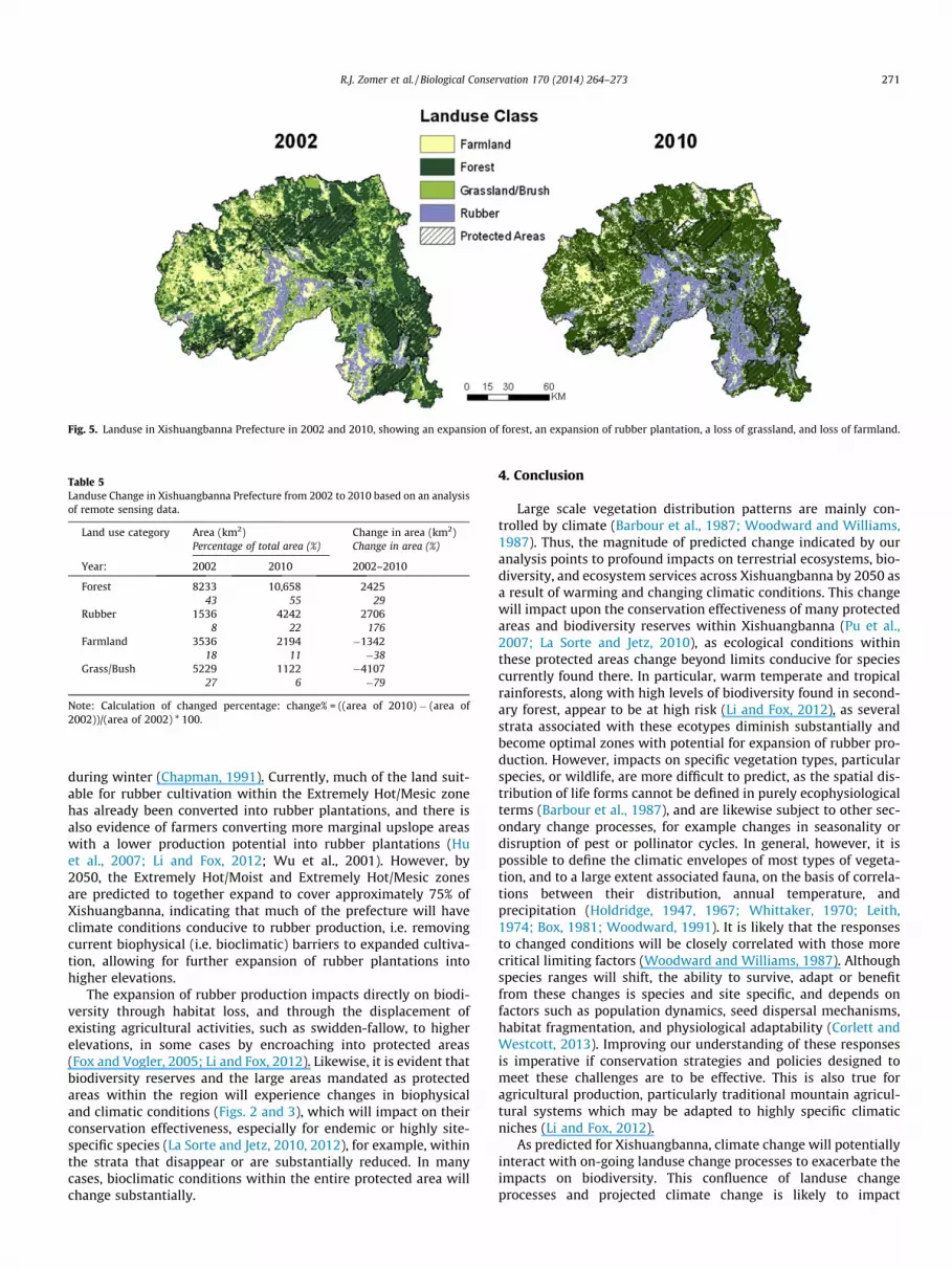
Fig. 5. Landuse in Xishuangbanna Prefecture in 2002 and 2010, showing an expansion of forest, an expansion of rubber plantation, a loss of grassland, and loss of farmland.
Table 5Landuse Change in Xishuangbanna Prefecture from 2002 to 2010 based on an analysisof remote sensing data.
Land use category Area (km2) Change in area (km2)Percentage of total area (%) Change in area (%)
Year: 2002 2010 2002–2010
Forest 8233 10,658 242543 55 29
Rubber 1536 4242 27068 22 176
Farmland 3536 2194 �134218 11 �38
Grass/Bush 5229 1122 �410727 6 �79
Note: Calculation of changed percentage: change% = ((area of 2010) � (area of2002))/(area of 2002) * 100.
R.J. Zomer et al. / Biological Conservation 170 (2014) 264–273 271
during winter (Chapman, 1991). Currently, much of the land suit-able for rubber cultivation within the Extremely Hot/Mesic zonehas already been converted into rubber plantations, and there isalso evidence of farmers converting more marginal upslope areaswith a lower production potential into rubber plantations (Huet al., 2007; Li and Fox, 2012; Wu et al., 2001). However, by2050, the Extremely Hot/Moist and Extremely Hot/Mesic zonesare predicted to together expand to cover approximately 75% ofXishuangbanna, indicating that much of the prefecture will haveclimate conditions conducive to rubber production, i.e. removingcurrent biophysical (i.e. bioclimatic) barriers to expanded cultiva-tion, allowing for further expansion of rubber plantations intohigher elevations.
The expansion of rubber production impacts directly on biodi-versity through habitat loss, and through the displacement ofexisting agricultural activities, such as swidden-fallow, to higherelevations, in some cases by encroaching into protected areas(Fox and Vogler, 2005; Li and Fox, 2012). Likewise, it is evident thatbiodiversity reserves and the large areas mandated as protectedareas within the region will experience changes in biophysicaland climatic conditions (Figs. 2 and 3), which will impact on theirconservation effectiveness, especially for endemic or highly site-specific species (La Sorte and Jetz, 2010, 2012), for example, withinthe strata that disappear or are substantially reduced. In manycases, bioclimatic conditions within the entire protected area willchange substantially.
4. Conclusion
Large scale vegetation distribution patterns are mainly con-trolled by climate (Barbour et al., 1987; Woodward and Williams,1987). Thus, the magnitude of predicted change indicated by ouranalysis points to profound impacts on terrestrial ecosystems, bio-diversity, and ecosystem services across Xishuangbanna by 2050 asa result of warming and changing climatic conditions. This changewill impact upon the conservation effectiveness of many protectedareas and biodiversity reserves within Xishuangbanna (Pu et al.,2007; La Sorte and Jetz, 2010), as ecological conditions withinthese protected areas change beyond limits conducive for speciescurrently found there. In particular, warm temperate and tropicalrainforests, along with high levels of biodiversity found in second-ary forest, appear to be at high risk (Li and Fox, 2012), as severalstrata associated with these ecotypes diminish substantially andbecome optimal zones with potential for expansion of rubber pro-duction. However, impacts on specific vegetation types, particularspecies, or wildlife, are more difficult to predict, as the spatial dis-tribution of life forms cannot be defined in purely ecophysiologicalterms (Barbour et al., 1987), and are likewise subject to other sec-ondary change processes, for example changes in seasonality ordisruption of pest or pollinator cycles. In general, however, it ispossible to define the climatic envelopes of most types of vegeta-tion, and to a large extent associated fauna, on the basis of correla-tions between their distribution, annual temperature, andprecipitation (Holdridge, 1947, 1967; Whittaker, 1970; Leith,1974; Box, 1981; Woodward, 1991). It is likely that the responsesto changed conditions will be closely correlated with those morecritical limiting factors (Woodward and Williams, 1987). Althoughspecies ranges will shift, the ability to survive, adapt or benefitfrom these changes is species and site specific, and depends onfactors such as population dynamics, seed dispersal mechanisms,habitat fragmentation, and physiological adaptability (Corlett andWestcott, 2013). Improving our understanding of these responsesis imperative if conservation strategies and policies designed tomeet these challenges are to be effective. This is also true foragricultural production, particularly traditional mountain agricul-tural systems which may be adapted to highly specific climaticniches (Li and Fox, 2012).
As predicted for Xishuangbanna, climate change will potentiallyinteract with on-going landuse change processes to exacerbate theimpacts on biodiversity. This confluence of landuse changeprocesses and projected climate change is likely to impact

272 R.J. Zomer et al. / Biological Conservation 170 (2014) 264–273
conservation efforts and ecosystem services, and more generally,terrestrial ecosystems, biodiversity, and agricultural productionacross Xishuangbanna over the next twenty to fifty years (Yuet al., 2006). Opportunities to anticipate, and to some extentmitigate these impacts may exist if the nature and magnitude ofthese impacts can be better understood. Biodiversity conservationefforts and landuse polices need to consider the implications ofenvironmental change as they relate to specific conservation orproduction goals (Xu et al., 2012).
Traditional agricultural systems, which have been shown toconserve agricultural biodiversity and maintain high levels of bio-diversity, will also likely be impacted. Global and regional pro-cesses, notably the commercialization and globalization ofagriculture, have already undermined the viability of these sys-tems. The decline of diverse and cyclic land use systems will affectbiodiversity at genetic, species, landscape, and cultural levels (Guoet al., 2002). The warming of Xishuangbanna, while likely to im-prove the productivity of rubber plantations (Jiang, 1988), maypromote their expansion and exacerbate the conversion of agricul-tural land and forest to rubber plantations, with serious implica-tions for biodiversity and conservation efforts, as well as for localcommunities dependent upon that diversity. Driven by a predictedincrease in demand for rubber (Li et al., 2006), the increase in avail-able areas conducive to rubber production has the potential toencourage large scale conversion of agricultural, grassland, and for-est areas across Xishuangbanna, to the point of affecting such largescale ecosystem services as watershed protection and carbonsequestration. If conservation of biodiversity in Xishuangbanna isto be effective in the future, it is important that policies, strategies,and conservation programs consider the challenges and implica-tions of climate change on the environment and landuse changeprocesses. Improved understanding of the ecophysiological adap-tation responses of threatened species to changing conditionsand the socio-economic context of landuse change is needed tocreate and provide the knowledge base required to meet thesechallenges.
Acknowledgements
Partial funding for this work was generously provided by theInternational Development Research Centre (IDRC) - Canadathrough the "Building Effective Water Governance in the AsianHighlands Project (107085-002)", the CSIRO Exploring MekongRegion Futures 2009–2010 2009–2010 Project and theProject‘‘Making the Mekong Connected’’ – MMC (project number08.7860.3-001.00) both funded by the German Ministry for Eco-nomic Cooperation and Development (BMZ), as well as CGIAR Re-search Program 6 on Forests, Trees and Agroforestry. Weacknowledge the German National Space Agency DLR (DeutschesZentrum für Luft- und Raumfahrt e.V.) for the delivery of RapidEyeimages as part of the RapidEye Science Archive (Proposal No. 390).The provision of RapidEye images was funded by the German Fed-eral Ministry of Economics and Technology (BMWi). The responsi-bility for any use of the results presented in this paper lies with theuser.
References
Barbour, M., Burk, J., Pitts, W., Gilliam, F., 1987. Terrestrial Plant Ecology, second ed.Benjamin/Cummunings Publishing, Menlo Park, California.
Beier, P., Brost, B., 2010. Use of land facets to plan for climate change: conservingthe arenas, not the actors. Conserv. Biol. 24 (3), 701–710.
Box, E., 1981. Macroclimate and plant forms: an introduction to predictivemodeling in phytogeography. Junk, The Hague.
Chapman, E., 1991. The expansion of rubber in southern Yunnan, China.Geographical J., 36–44.
Cheng, J., Xie, M., 2008. The analysis of regional climate change features overYunnan in recent 50 years. Progr. Geography.
Corlett, R.T., Westcott, D.A., 2013. Will plant movements keep up with climatechange? Trends Ecol. Evol. (Amst.) 28, 482–488.
Cui, J., Fu, Y., Guo, H., Chen, A., 2000. Household based agrobiodiversity assessment(HH/ABA) on Homegardens in Daka, Xishuangbanna. Acta Bot. Yunnan 12(Suppl.), 81–90.
Dai, L., 1998. Crop diversity of Yunnan. In: Guo, H., Long, C. (Eds.), Yunnan’sBiodiversity. Yunnan Science and Technology Press, Kunming, pp. 243–250.
Dale, V.H., 1997. The relationship between land-use change and climate change.Ecol. Applic. 7, 753–769.
Fox, J., Vogler, J.B., 2005. Land-use and land-cover change in montane mainlandsoutheast Asia. Environ. Manage. 36, 394–403.
GEOBON, 2010. Group on Earth Observations (GEOBON): Biodiversity ObservationNetwork. Group on Earth Observations.
Guardiola-Claramonte, M., Troch, P.A., Ziegler, A.D., Giambelluca, T.W., Durcik, M.,Vogler, J.B., et al., 2008. Hydrologic effects of the expansion of rubber (Heveabrasiliensis) in a tropical catchment. Ecohydrology 3, 306–314.
Guo, H., 1993. From natural forest to homegarden. In: Cai, Y., Feng, C. (Eds.), China’sHomegardens and Homegarden Economy. China Science and Technology Press,Beijing, pp. 243–250.
Guo, H., Padoch, C., Coffey, K., Aiguo, C., Yongneng, F., 2002. Economic development,land use and biodiversity change in the tropical mountains of Xishuangbanna,Yunnan, Southwest China. Environ. Sci. Policy 5, 471–479.
Hannah, L., 2010. A global conservation system for climate-change adaptation.Conserv. Biol. 24, 70–77.
He, J., Liu, B., Chen, Y., Xu, H., Guo, Y., Hu, X., Zhang, X., Li, Y., Zhang, A., Chen, W.,2006. National assessment report on climate change (III): integrated evaluationof strategies on response to climate change in China. Adv. Climate Change Res.4.
Hijmans, R., Cameron, S., Parra, J., 2005. Very high resolution interpolated climatesurfaces for global land areas. Int. J. Climatol. 25 (15), 1965–1978.
Holdridge, L.R., 1947. Determination of world plant formations from simple climaticdata. Science 105, 367–368.
Holdridge, L.R., 1967. Life zone ecology. Tropical Science Center, San Jose, Costa Rica,p. 206.
Hu, H., Liu, W., Cao, M., 2007. Impact of land use and land cover changes onecosystem services in Menglun, Xishuangbanna, Southwest China. Environ.Monit. Assess. 146, 147–156.
Jarvis, A., Reuter, H., Nelson, A., Guevara, E., 2008. Hole-filled SRTM for the globe –Version 4. CGIAR. srtm.csi.cgiar.org.
Jiang, A., 1988. Climate and natural production of rubber (Hevea brasiliensis) inXishuangbanna, southern part of Yunnan province, China. Int. J. Biometeorol.32, 280–282.
Körner, C., 2007. The use of ‘‘altitude’’ in ecological research. Trends Ecol. Evol.(Amst.) 22, 569–574.
La Sorte, F.A., Jetz, W., 2010. Projected range contractions of montane biodiversityunder global warming. Proc. Biol. Sci. 277, 3401–3410.
La Sorte, F.A., Jetz, W., 2012. Tracking of climatic niche boundaries under recentclimate change. J. Anim. Ecol. http://dx.doi.org/10.1111/j.1365-2656.2012.01958.x.
Leith, H., 1974. Phenology and Seasonality Modeling. Springer-Verlag, Berlin.Li, Z., Fox, J.M., 2012. Mapping rubber tree growth in mainland Southeast Asia using
time-series MODIS 250 m NDVI and statistical data. Appl. Geography 32, 420–432.
Li, H., Aide, T.M., Ma, Y., Liu, W., Cao, M., 2006. Demand for rubber is causing the lossof high diversity rain forest in SW China. Biodivers. Conserv. 16, 1731–1745.
Li, H., Ma, Y., Aide, T.M., Liu, W., 2008. Past, present and future land-use inXishuangbanna, China and the implications for carbon dynamics. For. Ecol.Manage. 255, 16–24.
Lin, E., Xu, Y., Jiang, J., Li, Y., Yang, X., Zhang, J., Li, C., Wu, S., Zhao, Z., Wu, J., 2006.National assessment report of climate change (II): climate change impacts andadaptation. Adv. Climate Change Res. 2, 51–56.
Lin, E., Xu, Y., Jiang, J., Li, Y., Yang, X., et al., 2007. China’s National assessment reporton climate change (I): climate change in China and t future trend. Adv. ClimateChange Res. 3.
Long, C., 1993. Study on Plants in Homegarden in Xishuangbanna. YunnanUniversity Press.
Metzger, M.J., Schröter, D., Leemans, R., Cramer, W., 2008. A spatially explicit andquantitative vulnerability assessment of ecosystem service change in Europe.Reg. Environ. Change 8, 91–107.
Metzger, M.J., Brus, D.J., Carey, P.D., Gonçalves, J., Honrado, J.P., Jongman, R.H.G.,Trabucco, A., Zomer, R.J., et al., 2012. Environmental stratifications as the basisfor national, European and global ecological monitoring. Biodivers. Monit.,http://dx.doi.org/10.1016/j.ecolind.2012.11.009.
Metzger, M., Bunce, R.G.H., et al., 2013. A high resolution bioclimate map of theworld. A unifying framework for global biodiversity research. Global Ecol.Biogeogr. http://dx.doi.org/10.1111/geb.12022.
Mora, C., Frazier, A.G., Longman, R.J., Dacks, R.S., Walton, M.M., Tong, E.J., Sanchez,J.J., Kaiser, L.R., Stender, Y.O., Anderson, J.M., Ambrosino, C.M., Fernandez-Silva,I., Giuseffi, L.M., Giambelluca, T.W., 2013. The projected timing of climatedeparture from recent variability. Nature 502, 183–187.
Peel, M.C., Finlayson, B.L., Mcmahon, T.A., 2007. Updated world map of the Köppen-Geiger climate classification.
Peng, G., Liu, Y., Zhang, Y., 2009. Research on characteristics of drought and climatictrend in Yunnan Province. J. Catastrophology 24, 40–44.
Pu, Y.-S., Zhang, Z.-Y., Pu, L.-N., Hui, C.-M., 2007. Biodiversity and its fragility inYunnan, China. J. For. Res. 18, 39–47.

R.J. Zomer et al. / Biological Conservation 170 (2014) 264–273 273
Ramirez, J., Jarvis, A., 2010. Downscaling global circulation model outputs: The deltamethod decision and policy analysis working paper no. 1. Cali, Colombia:International Center for Tropical Agriculture.
Scholes, R.J., Mace, G.M., Turner, W., Geller, G.N., Jurgens, N., Larigauderie, A.,Muchoney, D., Walther, B.A., Mooney, H.A., 2008. Toward a global biodiversityobserving system. Science 321, 1044–1045.
Scholes, R.J., Walters, M., Turak, E., Saarenmaa, H., Heip, C.H.R., Tuama, É.Ó., Faith,D.P., Mooney, H.A., Ferrier, S., Jongman, R.H.G., 2012. Building a global observingsystem for biodiversity. Curr. Opin. Environ. Sust. 4, 139–146.
Shrestha, U.B., Gautam, S., Bawa, K.S., 2012. Widespread climate change in theHimalayas and associated changes in local ecosystems. PLoS ONE 7 (5), e36741.
Taylor, K.E., Stouffer, R.J., Meehl, G.A., 2012. An overview of CMIP5 and theexperiment design. Bull. Am. Meteorol. Soc. 93, 485–498.
Thornthwaite, C., 1948. An approach toward a rational classification of climate.Geographic Rev. 38, 55–94.
Whittaker, R., 1970. Communities and Ecosystems. Macmillan Co., New York.Willson, A., 2006. Forest conversion and land use change in rural Northwest
Yunnan, China. Mountain Res. Dev. 26, 227–236.Woodward, F., 1991. ScienceDirect.com – Environment International – Vegetation
and climate. Environment International.Woodward, F.I., Williams, B.G., 1987. Climate and plant distribution at global and
local scales. Vegetatio 69, 189–197.Wu, Z.L., Liu, H.M., Liu, L.Y., 2001. Rubber cultivation and sustainable development
in Xishuangbanna. Int. J. Sust. Dev. World Ecol. 8, 337–345.Xu, J., Fox, J., Vogler, J.B., Yongshou, Z.P.F., Lixin, Y., Jie, Q., Leisz, S., 2005. Land-use
and land-cover change and farmer vulnerability in Xishuangbanna prefecture insouthwestern China. Environ. Manage. 36, 404–413.
Xu, J., Grumbine, R., Shrestha, A., 2009. The melting Himalayas: cascading effects ofclimate change on water, biodiversity, and livelihoods – XU – 2009. Conserv.Biol. 23 (3), 520–530.
Xu, J., Grumbine, R., Bechschäfer, P., 2012. Landscape transformation through theuse of ecological and socioeconomic indicators in Xishuangbanna, SouthwestChina Mekong Region. Ecol. Indicators. http://dx.doi.org/10.1016/j.ecolind.2012.08.023.
Ye, C., Dai, L., 2000. Genetic resource and sustainable agriculture development. ActaBot. Yunnan. XII (Suppl.), 129–133.
Yu, P., Xu, Z., Huang, Y., 1985. Traditional cultivated plants in Dai villages inXishuangbanna. Acta Bot. Yunnan 7, 169–186.
Yu, L., Cao, M., Li, K., 2006. Climate-induced changes in the vegetation pattern ofChina in the 21st century. Ecol. Res. 21, 912–919.
Zeng, Y., Guo, H., Yin, S., Chen, A., 2001. Causes and dynamism of agroforestrypractices change in Baka, Xishuangbanna. Acta Bot. Yunnan 13 (Suppl.), 66–77.
Zhang, J., Cao, M., 1995. Tropical forest vegetation of Xishuangbanna, SW China andits secondary changes, with special reference to some problems in local natureconservation. Biol. Conserv. 73, 229–238.
Zomer, R.J., Trabucco, A., Bossio, D., Verchot, L.V., 2008. Climate change mitigation: aspatial analysis of global land suitability for clean development mechanismafforestation and reforestation. Agriculture Ecosystems and Environment 126,67–80.
Zomer, R.J., Trabucco, A., Metzger, M., Oli, K.P., 2013. Environmental Stratificationand Projected Climate Change Impacts on Ecosystems in the Kailash SacredLandscape of China, India, Nepal. ICIMOD. Kathmandu, Nepal.