environmental impact assessment - saruna
TRANSCRIPT
ENVIRONMENTAL IMPACT
ASSESSMENT
FOR THE PROPOSED
SLIPWAY PROJECT IN KUDAHUVADHOO,
DHAALU ATOLL
December 2016
Prepared for
Job Market Maldives Pvt Ltd
Maldives
Consultant
CDE Consulting, Maldives
މަޝްރޫޢުން ގެހެދުމު ސްލިޕްވޭއެއް ދ.ކުޑަހުވަދޫގައި
ރިޕޯޓް ބަޔާންކުރާ މިންވަރު އަސަރުކުރާނެ ތިމާވެއްޓަށް
2016 ޑިސެމްބަރ
އެދިޔާރު: މަޝްރޫޢުގެ
ލޓޑ ޕވޓ މޯލްޑިވްސް މާކެޓް ޖޮބް
:ކޮންސަލްޓަންޓް އޭ .އައި .އީ މަޝްރޫޢުގެ
ލިމިޓެޑް ޕްރައިވެޓް އީ.ޑީ.ސީ
EIA for the Proposed Slipway Project in Kudahuvadhoo Island, Dhaalu Atoll
Prepared by: CDE Consultancy Page|i
Table of Contents Table of Contents ............................................................................................................................. i List of Figures ................................................................................................................................ vi List of Tables ................................................................................................................................ vii List of Abbreviations ................................................................................................................... viii Acknowledgements ........................................................................................................................ ix
Lead Consultant’s Declaration ........................................................................................................ x
Proponent’s Declaration................................................................................................................. xi Executive Summary ...................................................................................................................... xii 1 INTRODUCTION ................................................................................................................... 1
1.1 Purpose of the EIA ........................................................................................................... 1
1.2 Project Proponent ............................................................................................................. 1
1.3 Project Background and Rationale ................................................................................... 1
1.4 Project Scope .................................................................................................................... 2
1.5 Aim and Objectives .......................................................................................................... 2
1.6 Project Location ............................................................................................................... 3
1.7 Consultants, Contractors and Government Institutions.................................................... 7
1.8 Project Financing.............................................................................................................. 7
1.9 Scope and Terms of Reference of EIA ............................................................................. 7
1.10 Summary of Assessment Methodology............................................................................ 8
1.10.1 The Study Area.............................................................................................................. 8
1.10.2 Field Observations ....................................................................................................... 9
1.10.3 Desk Study Review ...................................................................................................... 12
1.10.4 Public and Key Stakeholder Consultation .................................................................. 13
1.10.5 Data Analysis .............................................................................................................. 13
1.10.6 Report Format ............................................................................................................ 13
1.11 Study Team Members .................................................................................................... 13
1.12 Limitations of the study.................................................................................................. 14
2 PROJECT DESCRIPTION ................................................................................................... 15
2.1 Project Outline and Project Site Plan ............................................................................. 15
2.2 Detailed Project Outline and Work Methodology.......................................................... 18
2.2.1 Mobilization of construction equipment ..................................................................... 18
2.2.2 Site setup ..................................................................................................................... 18
2.2.3 Dredging and Reclamation ......................................................................................... 19
EIA for the Proposed Slipway Project in Kudahuvadhoo Island, Dhaalu Atoll
Prepared by: CDE Consultancy Page|ii
2.2.4 Slipway Development ................................................................................................. 23
2.3 Work Methodology ........................................................................................................ 24
2.3.1 Mobilisation of equipment and materials ................................................................... 24
2.3.2 Dredging and Reclamation ......................................................................................... 25
2.3.3 Shore Protection ......................................................................................................... 25
2.3.4 Constructing the slipway winches and steel ramp...................................................... 25
2.3.5 Constructing the auxiliary buildings .......................................................................... 25
2.4 Project Schedule and Life Span ..................................................................................... 25
2.5 Labour Requirements and Availability .......................................................................... 26
2.6 Waste Management, Logistics and Safety Measures ..................................................... 27
2.6.1 Construction Waste Management and Disposal ........................................................ 27
2.6.2 Pollution and Emission Control Measures ................................................................. 27
2.6.3 Sediment Containment and Turbidity Control Measures ........................................... 27
2.6.4 Health and Safety Measures ....................................................................................... 27
2.6.5 Utilities ....................................................................................................................... 28
2.7 Summary of Project Inputs and Outputs ........................................................................ 28
2.8 Demobilization ............................................................................................................... 29
3 POLICY AND LEGAL FRAMEWORK .............................................................................. 30
3.1 Relevant Environment Legislation ................................................................................. 30
3.1.1 Environment Protection and Preservation Act (Act no. 4/93).................................... 30
3.2 Relevant Regulations and Guidelines ............................................................................ 31
3.2.1 Environmental Impact Assessment Regulations 2012 ................................................ 31
3.2.2 Regulation on Sand and Coral Mining ....................................................................... 32
3.2.3 Regulation on Dredging and Land Reclamation ........................................................ 32
3.2.4 Regulation on Urban Planning and Implementation – Annex 2 ................................ 33
3.2.5 Waste Management Regulation 2013 ......................................................................... 33
3.2.6 The Environmental Liability Regulation (Regulation 2011/R-9) ............................... 34
3.2.7 Compliance ................................................................................................................. 34
3.3 Environmental Permits Required for the Project ........................................................... 35
3.3.1 Environmental Impact Assessment (EIA) Decision Note ........................................... 35
3.3.2 Dredging and Reclamation Permit ............................................................................. 35
3.4 Responsible Institutions ................................................................................................. 35
3.4.1 Ministry of Environment ............................................................................................. 35
3.4.2 Atoll Council ............................................................................................................... 36
3.5 Guiding Policies and Documents ................................................................................... 36
EIA for the Proposed Slipway Project in Kudahuvadhoo Island, Dhaalu Atoll
Prepared by: CDE Consultancy Page|iii
3.5.1 National Environmental Action Plan II (NEAP II) .................................................... 36
3.5.2 Waste Management Policy 2015 ................................................................................ 37
3.6 International Conventions .............................................................................................. 37
3.6.1 Convention on Biological Diversity ........................................................................... 37
3.6.2 UNFCCC and Kyoto Protocol .................................................................................... 38
4 EXISTING ENVIRONMENT .............................................................................................. 39
4.1 Physical Environment .................................................................................................... 39
4.1.1 Meteorology ................................................................................................................ 39
4.1.2 Hydrology ................................................................................................................... 45
4.1.3 Beach .......................................................................................................................... 50
4.1.4 Bathymetry .................................................................................................................. 54
4.1.5 Marine water quality assessment ............................................................................... 54
4.1.6 Ground water quality assessment ............................................................................... 55
4.1.7 Soil .............................................................................................................................. 55
4.2 Biological Environment ................................................................................................. 56
4.2.1 Terrestrial Environment ............................................................................................. 56
4.2.2 Marine Environment ................................................................................................... 62
4.2.3 Marine protected areas and sensitive sites ................................................................. 67
4.2.4 Breeding or nursery grounds for protected or endangered species ........................... 68
4.3 Natural Hazard Assessment for the Site ......................................................................... 68
4.4 Dhaalu Kudahuvadhoo Social Socio-Economic Setting ................................................ 70
4.4.1 Population Characteristics ......................................................................................... 70
4.4.2 Sex ratio ...................................................................................................................... 71
4.4.3 Annual Population Growth Rate ................................................................................ 71
5 IMPACTS IDENTIFICATION ............................................................................................. 74
5.1 Introduction .................................................................................................................... 74
5.2 Boundaries of Affected Areas ........................................................................................ 74
5.3 Impact Identification and Evaluation ............................................................................. 74
6 SIGNIFICANT IMPACTS AND MITIGATION MEASURES ........................................... 79
6.1 Impacts on Natural Environment during Construction Phase ........................................ 79
6.1.1 Ambient Noise Level, Air Quality and Greenhouse Gas Emissions ........................... 79
6.1.2 Groundwater and Soil Condition ............................................................................... 79
6.1.3 Terrestrial Flora and Fauna ...................................................................................... 80
6.1.4 Marine Water Quality ................................................................................................. 81
6.1.5 Coastal Processes ....................................................................................................... 82
EIA for the Proposed Slipway Project in Kudahuvadhoo Island, Dhaalu Atoll
Prepared by: CDE Consultancy Page|iv
6.1.6 Marine Biodiversity .................................................................................................... 82
6.2 Impacts on the Natural Environment during Operational Phase .................................... 85
6.2.1 Coastal Processes ....................................................................................................... 85
6.2.2 Marine Water Quality ................................................................................................. 85
6.2.3 Marine Biodiversity .................................................................................................... 85
6.2.4 Ground Water Quality and Quantity .......................................................................... 86
6.2.5 Terrestrial Environment ............................................................................................. 86
6.2.6 Ambient Noise Level and Air Quality ......................................................................... 86
6.3 Impacts on the Socio-economic Environment during construction ............................... 87
6.3.1 Business and Employment Opportunities ................................................................... 87
6.3.2 Health and Safety........................................................................................................ 87
6.4 Impacts on the Socio-economic Environment during operation .................................... 87
6.4.1 Business and Employment Opportunities ................................................................... 87
6.4.2 Resource Use Conflict ................................................................................................ 88
6.4.3 Demand for Resources and Services .......................................................................... 88
6.5 Cumulative Impacts........................................................................................................ 89
6.6 Recommended Mitigation Measures .............................................................................. 90
6.6.1 Air and Noise Pollution .............................................................................................. 90
6.6.2 Contamination of Marine Water, Groundwater and Land ......................................... 90
6.6.3 Groundwater Depletion .............................................................................................. 92
6.6.4 Existing and Predicted Changes to Coastal Processes .............................................. 92
6.6.5 Increased Turbidity and Sedimentation ...................................................................... 92
6.6.6 Loss of Terrestrial Vegetation and Fauna .................................................................. 92
6.6.7 Removal of Marine Organisms / Marine Habitat Destruction ................................... 93
6.6.8 Occupational Health Impacts ..................................................................................... 93
6.6.9 Increased Demand on Waste Disposal Facilities ....................................................... 94
6.6.10 Resource Conflicts ...................................................................................................... 94
6.6.11 Social Conflicts ........................................................................................................... 94
7 ALTERNATIVES ................................................................................................................. 95
7.1 “No-project” Alternative ................................................................................................ 95
7.2 Alternative Erosion Mitigation Plan .............................................................................. 96
7.3 Alternative Sediment Control Measures ........................................................................ 97
7.4 Alternative Construction Material for Breakwater......................................................... 97
8 ENVIRONMENTAL MANAGEMENT PLAN ................................................................... 98
8.1 Environmental management system............................................................................... 98
EIA for the Proposed Slipway Project in Kudahuvadhoo Island, Dhaalu Atoll
Prepared by: CDE Consultancy Page|v
8.2 Management structure and responsibilities .................................................................... 99
8.2.1 Project proponent ....................................................................................................... 99
8.2.2 Environmental Consultant ........................................................................................ 100
8.2.3 Environmental Protection Agency ............................................................................ 100
8.3 Non-Conformances and Corrective Action .................................................................. 100
8.4 Reporting requirements ................................................................................................ 100
9 ENVIRONMENTAL MONITORING PLAN .................................................................... 104
9.1 Introduction .................................................................................................................. 104
9.2 Objectives of the Monitoring Plan ............................................................................... 104
9.3 Before Construction ..................................................................................................... 104
9.4 Monitoring during Construction Phase ........................................................................ 104
9.5 Monitoring during Operational Phase .......................................................................... 105
9.6 Monitoring report ......................................................................................................... 110
9.7 Cost of monitoring ....................................................................................................... 110
9.8 Commitment to monitoring .......................................................................................... 110
10 STAKEHOLDER CONSULTATIONS .............................................................................. 111
10.1 Consultation with Dhaalu Atoll Council ...................................................................... 111
10.2 Consultation with Dhaalu Kudahuvadhoo Council ...................................................... 112
10.3 Public Consultation ...................................................................................................... 113
10.4 Ministry of Housing and Infrastructure – Maldives Land and Survey Authority ........ 114
10.5 Health Protection Agency ............................................................................................ 115
11 Potential Data Gaps and Assessment Limitations ............................................................... 117
11.1 Gaps in Information ..................................................................................................... 117
11.2 Uncertainties in Impact Prediction ............................................................................... 117
12 Conclusions ......................................................................................................................... 118
REFERENCES ........................................................................................................................... 120
APPENDIX A – Terms of Reference ..................................................................................... 121
APPENDIX B – Site Plan ....................................................................................................... 122
APPENDIX C – Detailed drawings ........................................................................................ 123
APPENDIX D – Approvals..................................................................................................... 124
APPENDIX E – Survey Locations.......................................................................................... 125
APPENDIX F – Beach Profiles .............................................................................................. 126
EIA for the Proposed Slipway Project in Kudahuvadhoo Island, Dhaalu Atoll
Prepared by: CDE Consultancy Page|vi
APPENDIX G – Water Quality Results .................................................................................. 128
APPENDIX H – Bathychart .................................................................................................... 129
APPENDIX I – CV’s of Consultants ...................................................................................... 130
APPENDIX J – Commitment Letter ....................................................................................... 131
List of Figures
Figure 1.1: Location map of Kudahuvadhoo .................................................................................. 4
Figure 1.2: Satellite image of Kudahuvadhoo Island and project location ..................................... 5
Figure 1.3: Locality map showing nearby islands and declared environmentally sensitive areas . 6
Figure 1.1: Study Area boundary .................................................................................................... 9
Figure 2.1: Project Site Plan (reduced version) ............................................................................ 16
Figure 2.2: Slipway Site Plan........................................................................................................ 17
Figure 2.3: Cross-section of entrance channel .............................................................................. 21
Figure 2.4: Preliminary design details of the breakwater ............................................................. 22
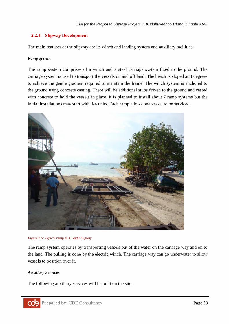
Figure 2.5: Typical ramp at K.Gulhi Slipway............................................................................... 23
Figure 4.1: Monthly Frequencies of Wind Direction in Central Maldives based on National Meteorological Center 10 year Data (adapted from Naseer, 2003). ............................................. 41
Figure 4.2: 24 Year Wind Frequency Recorded at National Meteorological Center. .................. 42
Figure 4.3: Mean Daily Wind Speed and Direction Recorded at National Meteorological Centre (1978 – 2004) ................................................................................................................................ 42
Figure 4.4: Mean Monthly Rainfall in Hulhule’ (1975-2004) ...................................................... 43
Figure 4.5: Maximum daily rainfall by year in Hulhule’ (1975-2005) - (Source: Hay, 2006) ..... 44
Figure 4.6: Maximum Temperature by year in Hulhule’- 1975-2005 (Source: Hay, 2006) ........ 45
Figure 4.7: Estimated wave regime around Kudahuvadhoo Island .............................................. 48
Figure 4.8: Observed current flow patterns from high to low tide ............................................... 49
Figure 4.9: Eastern side beach (project site) ................................................................................. 51
Figure 4.10: Harbor Area located on the northern side ................................................................ 51
Figure 4.11: Coastal modifications in Kudahuvadhoo Island ....................................................... 52
Figure 4.12: Medium-term erosion and accretion trends in Kudahuvadhoo ......................... 53
Figure 4.13: Dhaalu Kudahuvadhoo Slipway Site Soil Profile .................................................... 56
Figure 4.14: Aerial Image of the proposed site (imagery date: 4th October 2016) ....................... 59
Figure 4.15: large amounts of waste observe along the coastal side of the site ........................... 60
Figure 4.16: Coastal area of the proposed site .............................................................................. 60
Figure 4.17: Existing volleyball court observed on site ............................................................... 61
Figure 4.18: Existing shed observed on site ................................................................................. 61
Figure 4.19: Select images showing benthic composition along transect 1 ................................. 62
EIA for the Proposed Slipway Project in Kudahuvadhoo Island, Dhaalu Atoll
Prepared by: CDE Consultancy Page|vii
Figure 4.20: Benthic substrate composition along transect 1 ....................................................... 63
Figure 4.21: Select images showing benthic substrate composition along transect 2 .................. 63
Figure 4.23: Select images showing benthic composition along transect 3 ................................. 64
Figure 4.24: Benthic substrate composition along transect 3 ....................................................... 65
Figure 4.25: Lagoon at the proposed Site for Slipway Construction ........................................... 67
Figure 4.26: Population Size by locality, Dhaalu Atoll, Census Preliminary Results 2014 ........ 70
Figure 4.27: Sex ratio by locality, Dhaalu Atoll, Census Preliminary Results 2014 ................... 71
Figure 4.28: Number of students in Kudahuvadhoo by level of education and by gender in March 2015............................................................................................................................................... 72
Figure 4.29: Employment sectors in Kudahuvadhoo in 2006...................................................... 73
Figure 5.1: Estimated Affected Area – Combined for both seasons ............................................. 76
Figure 8.1: Environmental Management Strategy flow diagram................................................. 99
Figure 8.2: Environmental Management Plan for construction and operation phase ................. 101
List of Tables
Table 1-1 Weather conditions during the field survey period ...................................................... 10
Table 4-1: Key Meteorological Information of the Maldives ....................................................... 39
Table 4-2: Summary of General Wind Conditions from Hanimaadhoo Meteorological Center .. 41
Table 4-3: Tidal Variations at Male’ International Airport (Source: MEC, 2004) ....................... 44
Table 4-4: Tidal Variations at Male’ International Airport (Source: MEC, 2004) ....................... 47
Table 4-5: Marine water quality assessment results from MWSC laboratory .............................. 54
Table 4-6: Ground water quality assessment results from MWSC laboratory ............................. 55
Table 7-1: Summary of “No Project” Alternative ........................................................................ 95
Table 7-2: Summary of sediment control measures ..................................................................... 97
Table 7-3: Summary of sediment control measures ..................................................................... 97
Table 8-1 Environmental Management Plan for construction and operation phase ................... 102
Table 10-1 List of Council members consulted .......................................................................... 112
Table 10-2 List of Council members consulted .......................................................................... 113
Table 10-3 List of Council members consulted .......................................................................... 114
Table 10-4 List of Council members consulted .......................................................................... 115
Table 10-5 List of Council members consulted .......................................................................... 116
EIA for the Proposed Slipway Project in Kudahuvadhoo Island, Dhaalu Atoll
Prepared by: CDE Consultancy Page|viii
List of Abbreviations
COADS Comprehensive Ocean-Atmosphere Data Set DO Dissolved Oxygen EIA Envrionmental Impact Assessment GPS Global Positioning System IPCC Intergovernmental Panel on Climate Change IPPC International Plant Protection Convention IUCN International Union for Conservation of Nature MEE Ministry of Environment and Energy MHI Ministry of Housing and Infrastructure MoTAC Ministry of Tourism, Arts and Culture MoTCA Ministry of Tourism and Civil Aviation MSL Mean Sea Level MWSC Maldives Water and Sewerage Company NAPA National Adaptation Programme of Action NE North East NEAP II National Environmental Action Plan II NW North West SAP Strategic Action Plan SE South East SW South West TDS Total Suspended Solids ToR Term of Reference UNFCCC United Nations Framework Convention on Climate Change and the Kyoto
Protocol
EIA for the Proposed Slipway Project in Kudahuvadhoo Island, Dhaalu Atoll
Prepared by: CDE Consultancy Page|ix
Acknowledgements
The lead author of this report is Dr. Ahmed Shaig.
Additional assessments were undertaken by the following team members.
Mr. Ali Nishaman (Terrestrial assessment)
Mr. Mohamed Faizan (Marine assessment)
Field assistance was provided by the following members
Mr. Ali Moosa Didi (Surveying and cartography)
Mr. Ahmed Haiman Rasheed (Marine Surveying)
Mr. Mohamed Ali (Marine surveying)
Ms. Shahdha (Stakeholder Consultations)
Ms. Hana Saeed (Report Writing)
The curriculum vitae’s of the EIA consultants are attached in Appendix I of this report.
EIA for the Proposed Slipway Project in Kudahuvadhoo Island, Dhaalu Atoll
Prepared by: CDE Consultancy Page|x
Lead Consultant’s Declaration
I certify that statements made in this Environment Impact Assessment are true, complete and correct to the best of my knowledge and available information.
Dr. Ahmed Shaig
EIA for the Proposed Slipway Project in Kudahuvadhoo Island, Dhaalu Atoll
Prepared by: CDE Consultancy Page|xi
Proponent’s Declaration
Intentionally Left Blank
Please refer to Appendix J
EIA for the Proposed Slipway Project in Kudahuvadhoo Island, Dhaalu Atoll
Prepared by: CDE Consultancy Page|xii
Executive Summary
The purpose of this document is to fulfil the requirements to get necessary environmental clearance from the Environmental Protection Agency to carry out the proposed slipway construction in Kudahuvadhoo, Dhaalu atoll. The proponent of this project is Job Market Maldives Pvt Ltd.
The main rationale for the project is to provide a safe environment for vessel mooring, repair and maintenance works at Kudahuvadhoo, while providing a source of employment and income for the island.
The project involves construction of slipway on the north east side of Kudahuvadhoo island. Main components of the project include dredging and deepening of existing entrance channel and boat landing area, construction of slipway and construction of auxiliary service buildings. The development is designed based on environmental best practices suitable for slipway construction in Maldives.
Kudahuvadhoo has a moderately large number of fishing and passenger vessels. At present, lack of availability of a slipway in Kudahuvadhoo and within Dhaalu atoll means that boat owners are required to use slipways in other atolls for vessel maintenance, which involves a substantial cost. Construction of a slipway in Kudahuvadhoo will reduce the cost of boat repair maintenance for Kudahuvadhoo locals and for boat owners in Dhaalu atoll in general.
All project activities will be in conformance to the laws and regulations of the Maldives, and relevant international conventions that Maldives is party to. The key laws and regulations applicable to this project are: Environmental Protection and Preservation Act, Dredging and Reclamation regulation and Environmental Impact Assessment Regulation 2012. Dredging and reclamation approval from EPA is required before commencement of project activities.
Significant impacts of this project during construction phase of the project are potential significant impacts on coastal processes, impacts on the terrestrial flora and fauna, significant impacts on marine environment due to excessive sedimentation, turbidity and direct excavation related to deepening of the existing reef entrance, and impacts on marine water quality. Positive impacts of the construction phase include improved business and employment opportunities for the public. Significant impacts during operation of the slipway include impact of intense boating activities on marine biodiversity, degradation of air quality from dust-born particles and vessel emissions, noise, adverse impacts of solid waste and waste oil on terrestrial environment and increased demand for resources especially waste management services. Socioeconomic impacts of the operation phase include improvement in employment and business opportunities, adverse
EIA for the Proposed Slipway Project in Kudahuvadhoo Island, Dhaalu Atoll
Prepared by: CDE Consultancy Page|xiii
impacts on health and safety of workers and general public, and potential resource use conflict due to loss of recreational beach and volleyball court.
Key mitigation measures for the construction and operation stage include construction of a 15 feet tall wall along the boundary to reduce the amount of dust-borne particles, undertaking beach monitoring and beach replenishment to mitigate beach erosion, use of biodegradable cleaning and disinfecting agents for service and maintenance, preparation and use of standard operation manual for handling hazardous materials, and specifying the routes for excavator movement.
Consultations were undertaken with kudahuvadhoo public, Kudahuvadhoo Island Council, Dhaalu Atoll council, Ministry of Housing and Infrastructure and Health Protection Agency. Stakeholders consulted in Kudahuvadhoo were generally in favour of slipway construction project.
The alternatives evaluated for the project were the no project option, alternative erosion mitigation plan, alternative measures for sediment containment and use of alternative material for construction of breakwater. The no project option is not viable socially as there will be significant public discontent if the project is stopped. Options proposed for erosion mitigation include doing nothing, undertaking beach replenishment and building a groyne field. It was recommended to monitor the coastal changes before considering erosion mitigation.
The monitoring plan has been designed with a focus to analyse the significant impacts over time, particularly the effect on coastal processes, water quality and impacts on marine life.
A management framework has been proposed and it is essential that this framework be used in the construction stage of the project. The operation stage management can fall within the overall environmental management framework.
In conclusion, project mainly has beneficial socio-economic impacts.
EIA for the Proposed Slipway Project in Kudahuvadhoo Island, Dhaalu Atoll
Prepared by: CDE Consultancy Page|xiv
ސާދާ ހުލާސާ
މި ދިރާސާ ރިޕޯޓަކީ ދ.ކުޑަހުވަދޫގައި ސްލިޕްވޭ އެއް ހެދުމުގެ މަޝްރޫޢުއާއި ގުޅިގެން ތިމާވެއްޓަށް ކޮށްފާނެ އަސަރު
ވަޒަންކުރުމުގެ ގޮތުން ކުރެވިފައިވާ ދިރާސާއެކެވެ. މިމަޝްރޫޢުގެ އެދިޔާރަކީ ޖޮބް މާރކެޓް މޯލްޑިވްސް ޕްރައިވެޓް ލިމިޓެޑްއެވެ.
ނޑު ބޭނުމަީކ މަޝްރޫޢު ހިންގުމަްށޓަކަިއ ބޭނުންވާ ތިމާވެށީގެ ހުއްަދއަށް ބޭުނންވާ މައުލޫމާތުތައް މިރިޕޯޓުގެ މައިގަ
އެންވަޔަރަމެންޓް ޕްރޮޓެކްޝަން އެޖެންސީއަށް ހުށަހެޅުމެވެ.
ނޑު ޓު މަރާމާތުކުރުމުެގ މަޤްސަދަކީ ކުޑަހުވަދޫގެ ރައްޔިތުންނަށް ބޯޓު އެޅުމަށާއި، ބޯ މިމަޝްރޫޢު ކުރިއަށްގެންދިއުމުގެ މައިގަ
މަސައްކަތްތަކަށް އެކަށީގެންވާ ސަރަހައްދެއް ތައްޔާރުކުރުމުގެ އިތުރުން ރަށުގެ ރައްޔިތުންނަށް ވަޒީފާއާއި އިޤްތިޞާދީ ފުރުސަތު
މިމަޝްޫރއުގެ ދަށުން ރަށުގެ ނެރާއި ފަޅުފުންކޮށް، ސްލިޕްވޭއެއް ތަްއޔާރުކުރުން އަދި ސްލިޕްވޭގެ ތަނަވަސްކޮށްދިނުމެވެ.
މި މަޝްރޫއުގެ މަސައްކަތްތައް ރާވާލެވިފައިވަނީ ރާއްޖޭގެ މަސައްކަތާއި ގުޅުންހުރި އިމާރާތްތައް ތައްޔާރުކުރެވިގެންދާނެއެވެ.
ނޑުދޮށުގެ ސަރަޙައްދުތަކުގައި ކުރެވޭ ތަރައްޤީގެ މަސައްކަތްތަކަށް އެންމެ އެކަށީގެންވާގޮަތށެވެ .މޫދާއި ގޮ
މިވަގުތު ސްލިޕްވޭއެއް ނެތުމުގެ ސަބަބުން ބޯތު މަރާމާތުކުރުމުގެ މަސައްކަތްތައް މިހާރު ކުރަން ކުޑަހުވަދޫއާއި ދާލުއަތޮޅުގައިވެސް
ޖެހެނީ އެހެން އަތޮޅުތަކުގައެެވ. އަދި މިކަމަށްޓަކާ ބޯޓު ގެންގުޅޭ ފަރާތްތަކަށްވަނީ ބޮުޑ ހަރަދުތަކާއި ދަތިތަކާިއ
ލިޕްވޭއެއް ހެދުމުގެ ސަބަބުން ކުޑަހުވަދޫ ަރއްޔިތުންނަށާއި އަތޮޅުގެ އެހެްނ ކުރިމަތިލާންޖެހިފައެވެ. އެހެންކަުމން ކުޑަހުވަދޫގައި ސް
ރަށްތަކަށް ބޯުޓފަހަރު މަރާމާތުކުރުމުގެ މަސައްކަތުގައި ބޮޑު ލުއިފަސޭހައެއް ލިބިގެންދާނެއެވެ.
ބައިވެރިވާ ބައިނަލްއަޤްވާމީ މިމަޝްރޫއުގެ މަސައްކަތްތައް ޖުމްލަގޮތެއްގައި ރާއްޖޭގެ ޤާނޫނުތަކާއި ގަވައިދުތައް އަދި ރާއްޖެ
މުއާހަދާތަކަށް ފެތެއެވެ. މީގެ އިތުރުން މަޝްރޫއުގެ މަސައްކަތް ފެށުމުގެ ކުރިން ނެރާއި ފަޅުފުންކުރުމުގެ މަސައްކަތަށް ބޭނުންވާ
ހުއްދަ އެންވަޔަރަމެންޓަލް ޕްރޮޓެކްޝަން އޭޖެންސީއިން ހޯދަން ެޖހެއެވެ.
ޖެހިފައިވާ ސަރަހައްދަކީ މިހާރުވެސް އެސަރަހައްދުގެ ބޮޑުބައި ސާފުކޮށް ވޮލީކުޅުމުށްޓަާކ މަޝްރޫއުގެ މަސައްކަތް ކުރުމަށް ހަމަ
ރަށުގެ އަންހެނުން ބޭުނންކުރަމުން އަންނަ ސަރަހައްދެކެވެ. ހޭޅިފަށުގައި ހުރި ބައެއް ގަސްގަހުގެ އިތުރުން ބޯކޮށް ހެދިފައިާވ
ގަސްތަކެއް މިސަރަހައްދުގައި ނެތެވެ.
ރާއަސަރު ދެެނގަތުމަށްޓަކައި ކުރާދިރާސާ ރިޕޯޓް ކަމާއި ބެހޭ އިދާރާތަުކްނ ފާސްކޮށް ހުއްދަލިބުމާއިއެކު ތިމާވެއްޓަށް ކު
ކުޑަހުވަދޫއަށް ފޮނުވޭނެއެވެ. މިމަޝްރޫއުއަށް ހިނގާނެކަމަށް މަސައްކަތަށް ބޭނުންާވ ތަކެއްާޗއި ސާމާނު އަދިމަސައްކަތުމީހުން
ނޑަލަފާކުރެވިފައިވާ މުއްދަތަކީ ބާރަ މަސްދުވަހެވެ. ކަށްގާތްގަ
EIA for the Proposed Slipway Project in Kudahuvadhoo Island, Dhaalu Atoll
Prepared by: CDE Consultancy Page|xv
މިދިރާސާއިން ފާހަގަކުރެވުނުގޮތުގައި މިމަޝްރޫއުގެ ސަބަބުން އަމަލީ މަސައްކަތުގެ މަރުހަލާގައި ތިމާވެއްޓަށް ކޮށްފާނެ ނޭދެޭވ
ންކުރުމުގެ އަސަރުތަކުގެ ތެރޭގައި ރަށުގެ ޮގނޑުދޮށަށް ބަަދލުއައުމާއި، އެއްަގމުގެ މާހައުލާއި ދިރުންތަކަްށ ައސަރުކުރުން، ފަޅުފު
މަސައްކަތުގެ ސަބަބުން މަސައްކަތުގެ ސަބަބުން މޫދުގެ ދިރުންތަކަށް އަސަރުކުރުމާއި، މޫދުގެ ފެން ތަޣައްޔަރުވުން ހިމެނެއެވެ.
ސަތުވެސް ތަނަވަސްވެގެންދިއުން ހިމެނެއެވެ. ސްލިޕްވޭ ރަށުގެ ރައްޔިތުންނަށް ވިޔަފާރިއާއި ވަޒީފާގެ ފުރު ލިބޭ ފައިދާގެ ތެރޭގައި
ނުޑ ގޮތެއްގައި ކުރާނެކަމަށް ލަފާކުެރވޭ އަސަރުތަކަކީ މިސަރަހައްދުގައ ގިނައިން ބޯުޓފަހަރު ދުއްވާ ބޭނު ންކުރަން ެފށުމުން މައިގަ
ނޑިއާއި ބޯޓުތަކުން ހެދުމުގެ ސަބަބުުބން މޫދުގެ ިދރުންތަކަށް އަސަރުކުރުން، ބޯުޓ މަރާމާތުކުރުމުގެ މަސައްކަތުން އުފެދޭ ކު
ްނ ރަށުެގ ވައި ތަޣައްޔަރުވުން، އަޑު ަގދަވުން އަދި ކުނި އުފެޭދ މިންަވރުއިތުރުވުމެވެ. މީގެ އިތުރުން އުފެދޭ ދުމުގެ ސަބަބު
ސަތުވެސް ތަނަވަސްވެގެންދާނެއެވެ. އަދި މަްޝރޫއު ހިންގުމަށް ހަމަޖެހިފައިާވ ވިޔަފާރިާއއި ވަޒީފާގެ ފުރު ރަށުގެ ރައްޔިތުންނަށް
ނަ ފަރާްތތަކަށް ިއތުރަށް ބޭުނންކުރަން ނުިލބުުމގެ ސަބަބުން މިފަރާްތތަކުން ސަރަހައްދު މިހާރު ބޭނުންކުަރމުން އަން
ހިތްހަމަނުޖެހުމަކީވެސް އެކަށީގެްނވާ ކަމެކެވެ.
މިމަޝްރޫއު އާއި ބެހޭގޮތުން ކުޑަހުވަދޫ ރަށު ކައުންސިލް، ދާލު އަތޮޅު ކައުންސިލް، ކުޑަހުވަދޫ ރައްޔިތުން، މިނިސްޓްރީ އޮފް
އިންފްރާސްޓްރަކްޗާ އަދި ހެލްތް ޕްރޮޓެކްޝަން އޭޖެންސީއާއި މަޝްވަރާކުރެވުނެވެ. މިމަޝްރޫއަކީ ޖުމްަލ ހައުސިންގް އެންޑް
ގޮތެއްގައި ކުޑަ ހުވަދޫ ރައްޔިތުންނާއި ރަށު ކައުންސިލްގެ ތާއީދުއޮތް މަޝްރޫއެއްކަން މަޝްވަރާތަކުން ފާހަގަވިއެވެ.
ަތފާތު ގޮތަކަްށ ަބލާލާފަިއވާނެއެވެ. މިގޮތުން މަޝްރޫޢު ނުހިންގުމާއި، މި ދިރާސާގައި މަޝްރޫއަށް ގެނެވިދާނެ ބަދަުލތަކަށް
ނޑު ކިލަނުބވުން ހުއްޓުވާނެ ތަާފތު ގޮތަާކއި، އަދި ބޭރު ތޮށިލުމުގައި ރަށްގިރުން ހުއްޓުވުމާއި، ވެިލނެގުމުން ފެންގަ
ބޭނުންކުރެވިދާނެ އެެހން ތަކެއްޗަށް ބަލާފައިވާނެއެވެ.
ފައިވާ ތިާމވެއްޓަށް ކޮށްާފނެ އަސަރުތަށް ުކރާމިންވަރު ދެނެގަތުމަށާއި އެަފަދ ކަމަކުން ލިބިާދނެ ގެއްލުްނ ގައި ބަޔާންކޮށްޓުމިރިޕޯ
ކުޑަކުރުމަށާއި އަދި މި ރިޕޯޓުގައި ބަޔާންކުރެވިފައިނެތް ކަމެއް ކުރިމަތިވެއްޖެ ހާލަތެއްގައި އެކަންކަން ދެނެގަތުމަށްޓަކައި
ފަދަ ކަންކަމަށް ސްކްރީންކުރުމަށް ހަމަޖެހިފައިވެއެވެ. މިގޮތުން ބެލުމަށް ހަމަޖެހިފައިާވ މަޝްރޫއުގެ އެކި މަރުހަލާތަކުގައި މި
ނޑާއި ދިރުމަށް ނޑު ކަންތައްތަކުގެ ތެރޭގައި ރަށުގެ އައްސޭރިފަށަށް އަންނަ ބަދަލުތައް ބަލާ ދިރާސާކުރުމާއި މޫދުގެ ލޮނުގަ މައިގަ
އަންނަ ބަދަލު ދިރާސާކުރުން ހިެމނެއެވެ.
ރޫއުގެ ސަބަބުން ރަށުގެ ވެއްޓަށްކޮންމެވެސް ބަދަލުތަކެއް އައުން އެކަށީގެންވެއެވެ. އެހެންނަމަވެސް މިދެންނެވި މި މަޝް
އަސަރުތައް ކުޑަކުރުމުގެ ގޮތުން ފާހަގަކުރެވިފައިވާ ކަންކަމަށް ސަމާލުވެ މަޝްރޫޢު ކުރިއަށް ގެންގޮސްފިނަމަ ދެންނެުވނުފަަދ
އަސަރުތަށް ވަރަށް މަތީ ދަރަޖައަކަށް ކުޑަކުރެވިދާނެއެވެ. އެހެންކަމުން މަތީގައި ދެންނެިވ ބަދަލުތަކުގެ ސަބަބުން ކުރާ ނޭދެވޭ
ރައްޔިތުންނަށް ނުހަނު ފައިދާ ބަޔާންކުރެވިފައިވާ ކަންކަމަށް ރިޢާޔަތްކޮށް ބަލާއިރު ޖުމްލަގޮތެއްގައި މިމަޝްރޫޢުއަކީ ކުޑަހުވަދޫ
.ހުރި މަޝްރޫޢުއެކެވެ
EIA for the Proposed Slipway Project in Kudahuvadhoo Island, Dhaalu Atoll
Prepared by: CDE Consultancy Page|1
1 INTRODUCTION
1.1 Purpose of the EIA
This Environment Impact Assessment (EIA) report is an evaluation of the potential environmental, socio-economic and natural impacts of the proposed slipway project in Kudahuvadhoo, Dhaalu Atoll. The project is proposed by Job Market Maldives Pvt Ltd and the project contractor is yet to be determined. The EIA consultant is CDE Consulting.
This document has been developed based on the Terms of Reference (Appendix A) issued by the Environmental Protection Agency (EPA) on 16 October 2016. This document is submitted to EPA by the proponent to fulfil the requirements of Environmental Protection and Preservation Act (EPPA) of the Maldives (4/93), more specifically the clause 5 of the Act which states that a report should be submitted before implementation of any project that may have a potential impact on the environment.
1.2 Project Proponent
The proponent of this project is Job Market Maldives Pvt Ltd.
Contact details for the proponent are: Job Market Maldives Pvt Ltd G. Sunset, Husnuheenaa Magu, Malé Republic of Maldives. Tel: +(960) 332 9110, Fax: +(960) 333 3897 Email: [email protected]
1.3 Project Background and Rationale
Kudahuvadhoo is the capital of Dhaalu Atoll and the proponent, Job Market Maldives Pvt Ltd has leased a piece of land from the island to develop a slipway. The island has a population of 2300 and a slipway venture would help develop the local economy by introducing jobs and indirect benefits related material and service purchases, and rental income.
Appendix D shows the approvals from the island council and the Ministry of Housing and Infrastructure for this project.
Kudahuvadhoo contains a number fishing and passenger vessels. Vessel maintenance a present requires a slipway from another atoll to be used resulting in substantial costs. Locals try to avoid these costs by using the ever-shrinking beach space to ground the vessels. Currently the local
EIA for the Proposed Slipway Project in Kudahuvadhoo Island, Dhaalu Atoll
Prepared by: CDE Consultancy Page|2
community uses an area adjacent to the existing harbour to land vessels for maintenance and repair works. One the main existing ‘Haruge’ in Kudahuvadhoo was severly damaged by squally showers with winds of up to 55 Knots on 21st July 2008 (Miadhu News, 2008).
The second main rationale for a slipway is to support boat maintenance activities in the Atoll. Most of the islands in Dhaalu Atoll are known for fishing and contains moderately large fleet. There is demand for boat repair in the Atoll and slipway in the atoll would reduce the cost or boat maintenance in the atoll. Kudavuvadhoo is the Atoll Capital and the ideal location for a slipway given its access to a commercial and social services.
At present, there is an entrance channel and an area have been dredged for vessel access and landing but it is not maintained and has become shallow over time. The area needs to be dredged for larger vessels.
1.4 Project Scope
This project mainly involves the construction of a slipway on Kudahuvadhoo Island.
The main components of the project are:
− Mobilization
− Dredging and deepening of existing entrance channel and boat landing area
− Construction of slipway and auxiliary service buildings
− Finalizing and demobilization
See next chapter for more details.
1.5 Aim and Objectives
The aim of this project is to develop a slipway on the island and the objective is to provide a safe environment for vessel mooring, repair and maintenance works, while providing a source of employment and income for the island.
and detailed design is underway.
EIA for the Proposed Slipway Project in Kudahuvadhoo Island, Dhaalu Atoll
Prepared by: CDE Consultancy Page|3
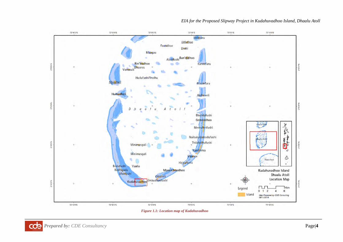
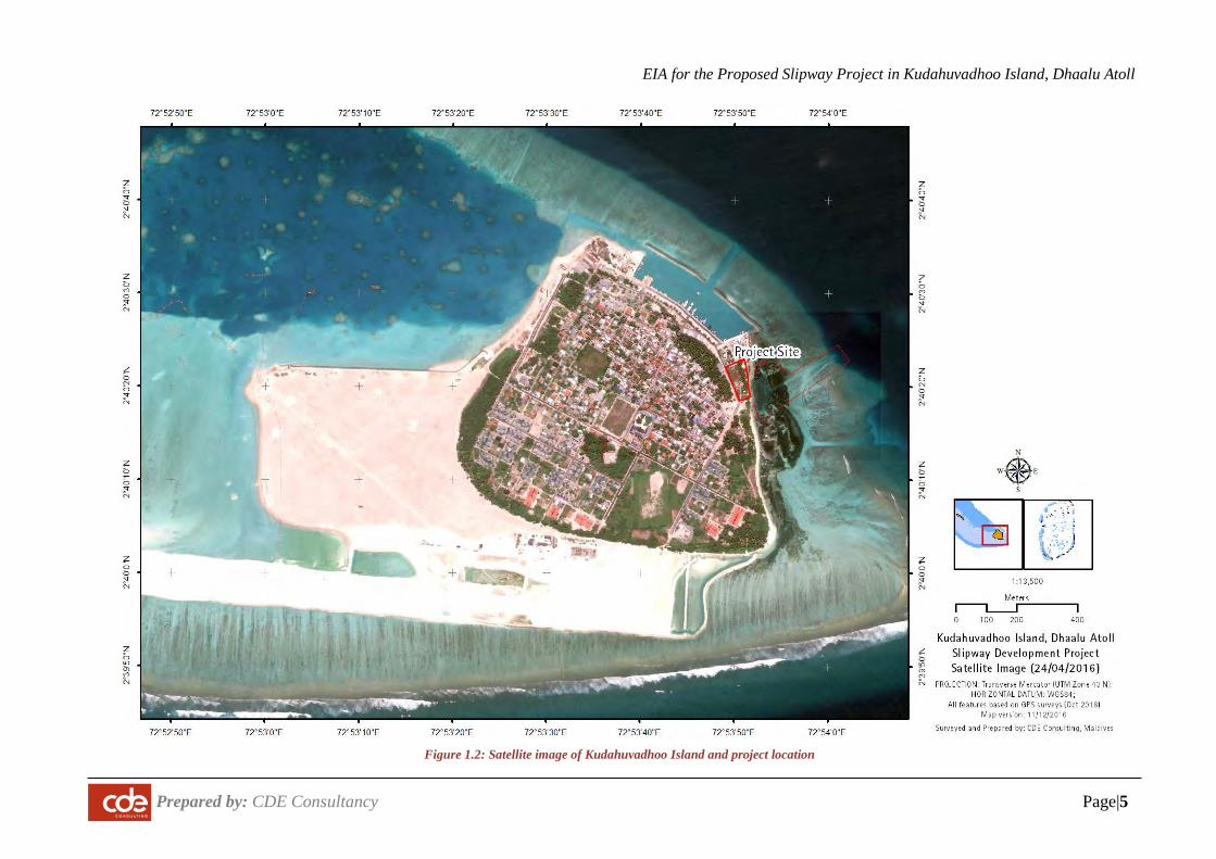
1.6 Project Location
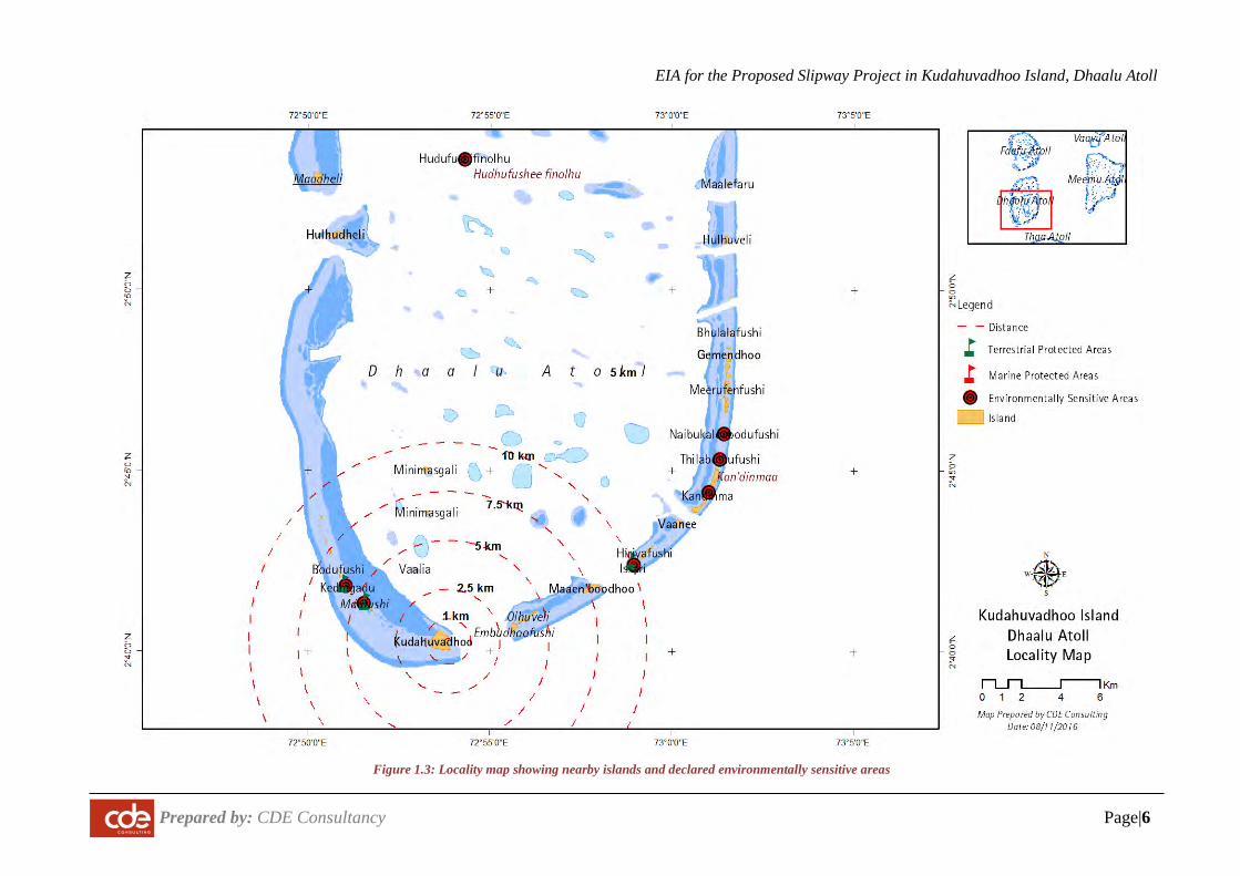
The proposed project site is the eastern side of Kudahuvadhoo Island. Site location map and satellite image is presented in Figure 1.1 and Figure 1.2 respectively. Figure 1.3 shows the sensitive environments with in the vicinity. The table below summarizes some key information on the proposed reef.
The island of Kudahuvadhoo is located on the southern rim Nilandhe Atoll Dhekunuburee Atoll lagoon at approximately 72.894172°"E and 2.671090°"N (see Figure 1.1). Kudahuvadhoo is a large island with a land area of 160 Ha, length of 2200 m and width of 950 m. The island occupies about 3.5% of one of the largest the reef systems (4600m~) of the Maldives and is the eastern most island within the reef.
The nearest island is Maafushi Island (uninhabited island) just 3 km W. The nearest inhabited island is Maaemboodhoo (7.5 km). Niyaama by Per Aquum is the nearest resort, and lies within 3.5 km on the NE. An airport is currently undergoing construction at Kudahuvadhoo Island.
There are two marine sensitive or protected areas; namely Maafushi and Kendigandu, within 10 km of the island (see Figure 1.3).
The project site is located on the NE side of the island (see Figure 1.2).
EIA for the Proposed Slipway Project in Kudahuvadhoo Island, Dhaalu Atoll
Prepared by: CDE Consultancy Page|4
Figure 1.1: Location map of Kudahuvadhoo
EIA for the Proposed Slipway Project in Kudahuvadhoo Island, Dhaalu Atoll
Prepared by: CDE Consultancy Page|5
Figure 1.2: Satellite image of Kudahuvadhoo Island and project location
EIA for the Proposed Slipway Project in Kudahuvadhoo Island, Dhaalu Atoll
Prepared by: CDE Consultancy Page|6
Figure 1.3: Locality map showing nearby islands and declared environmentally sensitive areas
EIA for the Proposed Slipway Project in Kudahuvadhoo Island, Dhaalu Atoll
Prepared by: CDE Consultancy Page|7
1.7 Consultants, Contractors and Government Institutions
All the EIA related work is undertaken by consultants from CDE Consulting. Design criteria and technical specifications have been developed by CDE Consulting and Proponent. The project contractor is Job Market Maldives Private Limited.
No donor agencies are involved in this project. The project will be financed and executed by the proponent.
1.8 Project Financing
The project is financed by the proponent.
1.9 Scope and Terms of Reference of EIA
The scope of this EIA is broadly based on the Environmental Impact Assessment Regulations 2012. The assessment more specifically adheres to the Terms of Reference (ToR) issued by the Environmental Protection Agency on 16 October 2016. The ToR is based on scoping meetings held between the stakeholders at the EPA. A copy of the ToR is attached in Appendix A.
The EIA report contains the following main aspects.
A description of the project including the need for the project, how the project will be undertaken, full description of the relevant parts of the project, implementation schedules, site plans and summary of project inputs and outputs (Chapter 1&2).
A description of the pertinent national and international legislation, regulations and policies that are relevant and applicable to the project and a demonstration of how the project conforms to these aspects (Chapter 3)
Information about the exiting baseline environmental conditions of the site. These include coastal and marine environment of the site and natural hazard vulnerability of the site (Chapter 4).
An assessment of the potential impacts during both construction and operational stages of the project as well as identification and cost of the potential mitigation measures to prevent or reduce significant negative impacts during both construction and operation stages of the project(Chapter 5).
Assessment of alternatives for the proposed project (Chapter 6)
Details of the environmental monitoring plan (Chapter 7).
EIA for the Proposed Slipway Project in Kudahuvadhoo Island, Dhaalu Atoll
Prepared by: CDE Consultancy Page|8
Potential gaps in information (Chapter 8)
Main conclusions (Chapter 9)
1.10 Summary of Assessment Methodology
This EIA is broadly guided by the EIA Regulations 2012.
This report has been prepared to ensure that the significant environmental and social impacts of the proposed project at the preconstruction, construction, operation and demobilising stages have been considered and assessed at the project planning phase.
The process followed in the preparation of this EIA report consists of six parts. These are: scoping consultations; literature review; field surveys; stakeholder consultations; analysis of results; and compilation of the assessment in the form of a report.
In order to conduct a broad based and inclusive study, the proponent and the consultant have from the onset ensured the exercise is participatory. As such, discussions have been held with community members in the projects area and relevant stakeholders with the assistance and coordination of the proponent.
Much of the baseline information for this study is based on the original EIA. The rest of this section summarises the methods used in the original EIA.
1.10.1 The Study Area
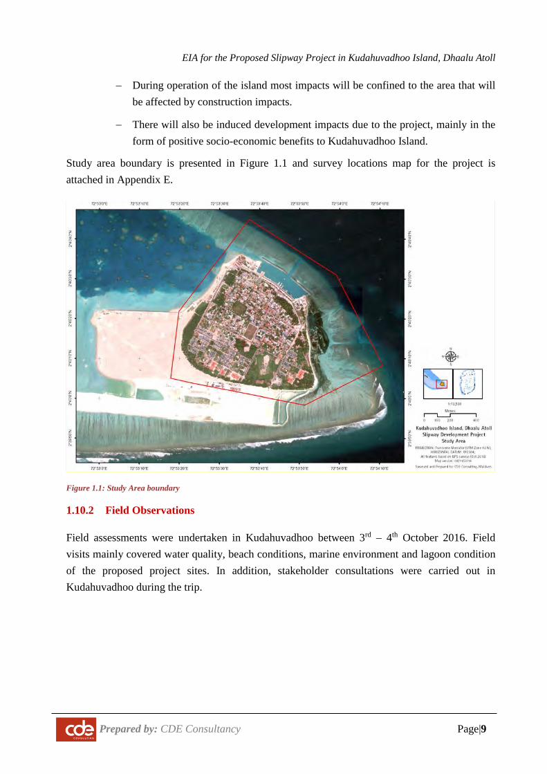
The area impacted by projects like these can be quite wide particularly when the socio-economic impacts are considered. The study area of this project considers that the entire island and the east-side reef system of the island will be affected by the development and that Kudahuvadhoo Island will experience the bulk of the socio-economic change.
Based on the results of the initial scoping of potential environmental impacts and the identification of sensitive aspects of the environment we have identified the following geographical areas likely to be affected at the various stages of the Project:
− During construction temporary and permanent impacts will occur primarily on Kudahuvadhoo Island and the reef system with 500 m radius of the shoreline. The most direct physical impact will be on-site in the area of the actual physical interventions, particularly coastal development footprints and temporary sand bed areas. To ensure the impacts are fully covered the entire island environment system is studied.
EIA for the Proposed Slipway Project in Kudahuvadhoo Island, Dhaalu Atoll
Prepared by: CDE Consultancy Page|9
− During operation of the island most impacts will be confined to the area that will be affected by construction impacts.
− There will also be induced development impacts due to the project, mainly in the form of positive socio-economic benefits to Kudahuvadhoo Island.
Study area boundary is presented in Figure 1.1 and survey locations map for the project is attached in Appendix E.
Figure 1.1: Study Area boundary
1.10.2 Field Observations
Field assessments were undertaken in Kudahuvadhoo between 3rd – 4th October 2016. Field visits mainly covered water quality, beach conditions, marine environment and lagoon condition of the proposed project sites. In addition, stakeholder consultations were carried out in Kudahuvadhoo during the trip.
EIA for the Proposed Slipway Project in Kudahuvadhoo Island, Dhaalu Atoll
Prepared by: CDE Consultancy Page|10
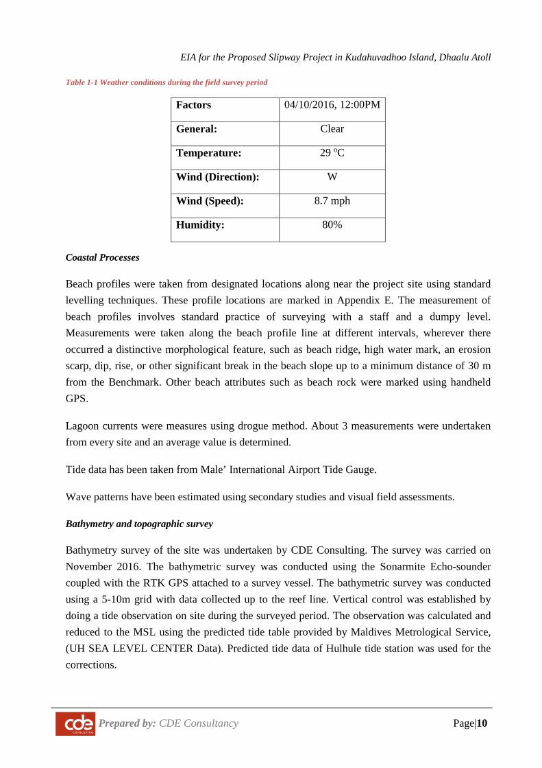
Table 1-1 Weather conditions during the field survey period
Factors 04/10/2016, 12:00PM
General: Clear
Temperature: 29 oC
Wind (Direction): W
Wind (Speed): 8.7 mph
Humidity: 80%
Coastal Processes
Beach profiles were taken from designated locations along near the project site using standard levelling techniques. These profile locations are marked in Appendix E. The measurement of beach profiles involves standard practice of surveying with a staff and a dumpy level. Measurements were taken along the beach profile line at different intervals, wherever there occurred a distinctive morphological feature, such as beach ridge, high water mark, an erosion scarp, dip, rise, or other significant break in the beach slope up to a minimum distance of 30 m from the Benchmark. Other beach attributes such as beach rock were marked using handheld GPS.
Lagoon currents were measures using drogue method. About 3 measurements were undertaken from every site and an average value is determined.
Tide data has been taken from Male’ International Airport Tide Gauge.
Wave patterns have been estimated using secondary studies and visual field assessments.
Bathymetry and topographic survey
Bathymetry survey of the site was undertaken by CDE Consulting. The survey was carried on November 2016. The bathymetric survey was conducted using the Sonarmite Echo-sounder coupled with the RTK GPS attached to a survey vessel. The bathymetric survey was conducted using a 5-10m grid with data collected up to the reef line. Vertical control was established by doing a tide observation on site during the surveyed period. The observation was calculated and reduced to the MSL using the predicted tide table provided by Maldives Metrological Service, (UH SEA LEVEL CENTER Data). Predicted tide data of Hulhule tide station was used for the corrections.
EIA for the Proposed Slipway Project in Kudahuvadhoo Island, Dhaalu Atoll
Prepared by: CDE Consultancy Page|11
Static GNSS data was processed by using MAGNET Tools. RTK data was downloaded and adjusted using the Carlson X-port software and the data was uploaded to AutoCAD Civil3D. All bathymetry data was post-processed in Sonar Vista software. The equipment’s used in the survey were:
a. SonarMite 3 echo sounder b. ComNavT300 GNSS System c. Trimble geo7x handheld GPS d. Dinghy
Terrestrial Assessments
Floral Survey
The vegetation of the site was studied using ground observations. Vegetation types along the observation walks were recorded for their abundance, types of species and successional patterns.
Faunal Survey
Terrestrial fauna was not surveyed in detail as the occurrence of fauna was found to be minimal during the brief survey period. However, based on similar conditions found elsewhere in the Maldives, and local accounts on species found at the location, an approximate list of the faunal species have been compiled.
Marine Assessments
Photo Quadrat Survey
The composition of the substrate was assessed by taking twenty high-resolution images every 5 m (pictures covering 0.5 m2 of the seabed) along the same transect line used for the fish surveys. These were later analysed using CPCe. CPCe, or Coral Point Count with excel extension, developed by the National Coral Reef Institute, is software designed to determine coral community coverage and diversity using transect photographs. Underwater photographic frames are overlaid by a matrix of randomly generated points, and the fauna/flora of species or substrate type lying beneath each point is identified. 20 random points per picture were analysed to characterize the substrate composition (sample size: 200 points per transect).
Fish Census
Fish and invertebrates species assemblages and abundance was surveyed using 50 m line transects, whereby the monitor swam along transect and recorded the number and the different species of fish and invertebrates observed within 2.5 m either side of the transect line.
EIA for the Proposed Slipway Project in Kudahuvadhoo Island, Dhaalu Atoll
Prepared by: CDE Consultancy Page|12
A category-based methodology was adopted to estimate fish abundance and the mean number of fish per category and observation was extracted to estimate species and family abundance. The categories used to estimate abundance is displayed in Table 1.2.
Table 1-2 Fish abundance categories
Category Number of fish 1 1 2 2 - 4 3 5 - 16 4 17 - 64 5 65 - 256
Visual Snorkelling Survey
Visual snorkelling surveys were carried out at select locations of the lagoon. General status of these sites were recorded, special attention was given to types of corals and fishes present at these sites and the environmental conditions that could affect growth such as suspended solids, depth, and other threats to coral life.
Water Quality
Water quality was assessed from MWSC laboratory. Water quality samples were taken at different locations selected based on proposed developments. Parameters measured include electrical conductivity, total dissolved solids (TDS), salinity, pH, temperature, and dissolved oxygen (DO). Nitrates, nitrites and phosphates were analysed at the Public Health Laboratory which uses methods prescribed in “Standard Methods for Examining Water and Wastewater”. Samples were collected in clean 1.5L PET bottles after washing them with the water to be sampled. Water samples were collected at mid depth. Biological samples were collected in sterilized 100 ml glass bottles provided by the Public Health Laboratory.
1.10.3 Desk Study Review
A literature review was conducted to acquire background information on the site and its environment as well as to identify possible environmental impacts of similar developments in island settings. In this context, the EIA Regulations 2012, best practices from similar development activities, scientific studies undertaken in similar settings around Maldives and previous documents/historical publications was considered.
The literature review comprised of, but is not limited to, the following:
• Island development plans of Kudahuvadhoo.
• Kudahuvadhoo Airport Construction project EIA
EIA for the Proposed Slipway Project in Kudahuvadhoo Island, Dhaalu Atoll
Prepared by: CDE Consultancy Page|13
• Relevant regulations, including dredging and reclamation regulation, Dewatering Regulation and Regulation on cutting down and uprooting trees.
1.10.4 Public and Key Stakeholder Consultation
Stakeholder consultations were undertaken with the following stakeholders:
• Kudahuvadhoo Island Council
• Kudahuvadhoo Public
• Dhaalu Atoll Council
• The Contractor
1.10.5 Data Analysis
The EIA experts used their experience and knowledge in their respective fields to analyze the data from the previous studies and field visits in order to determine the potential impacts of the proposed projects, the severity of effects arising from these impacts and how any adverse impacts can be best mitigated and positive impacts enhanced. This analysis provides the framework for the recommendations on corrective actions and remedial measures and provides the basis for the formulation of the environmental management plan which forms part of this EIA.
1.10.6 Report Format
The report format and structure presented here follows the report formatting guidelines issued by EPA.
1.11 Study Team Members
The team members of this EIA are: Dr. Ahmed Shaig (EIA and coastal environment Specialist) Mr. Ali Nishaman (Terrestrial Environment Specialist) Mr. Mohamed Faizan (Marine Environment Specialist) Mr. Mohamed Ali (Marine Environment Specialist) Mr. Ahmed Haiman Rasheed (Marine Surveys) Mr. Ali Moosa Didi (Terrestrial surveying and bathymetry) Ms. Shahdha (Environment Specialist) Ms. Hana Saeedh (Environment Specialist)
The curriculum vitae’s of the EIA consultants are attached in Appendix I of this report
EIA for the Proposed Slipway Project in Kudahuvadhoo Island, Dhaalu Atoll
Prepared by: CDE Consultancy Page|14
1.12 Limitations of the study
Project information and planning and background data were not fully prepared or decided during the conduct of this study. However, available documents in connection with data provided particularly the concept plan, experiences of CDE in other islands, particularly in the numerous dredging and shore protection assessments were used as the basis for preparation of this document. Therefore, it will be possible to analyse, implement mitigation and suggest monitoring measures to the most relevant negative impacts.
Environmental impact prediction involves a certain degree of uncertainty as the natural and anthropogenic impacts can vary from place to place due to even slight differences in ecological, geomorphological or social conditions in a particular place. As note earlier, there is also no long term data and information regarding the particular site under consideration, which makes it difficult to predict impacts. However, the level of uncertainty is partially minimised due to the experience of shore protection project in similar settings in the Maldives. Nevertheless, it is important to consider that there will be uncertainties and voluntary monitoring of natural processes as described in the monitoring programme is absolutely essential.
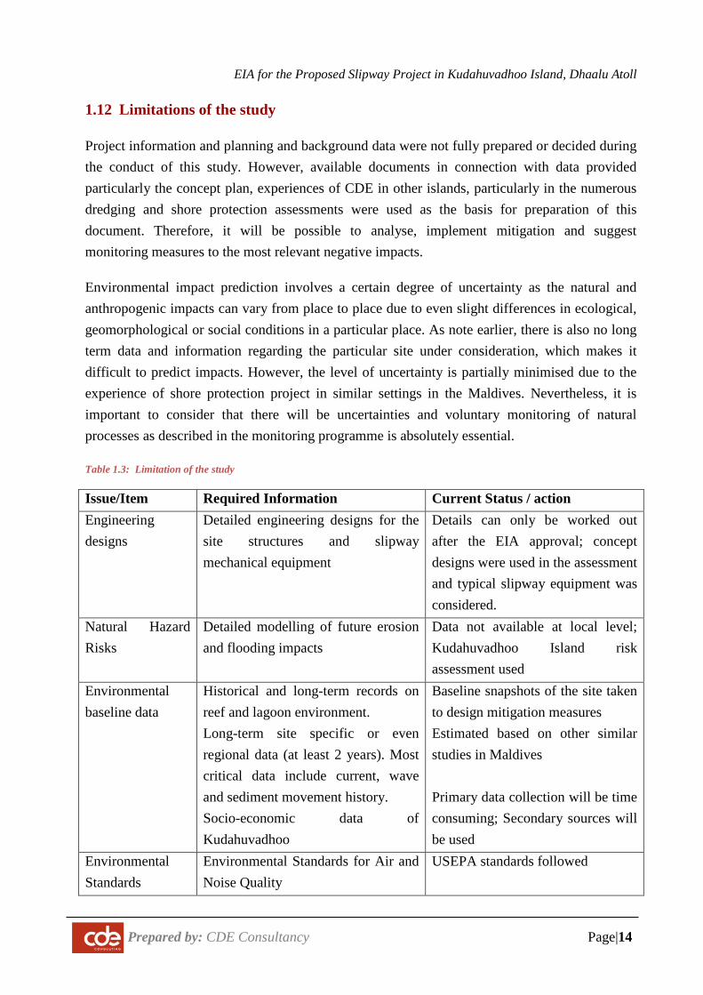
Table 1.3: Limitation of the study
Issue/Item Required Information Current Status / action Engineering designs
Detailed engineering designs for the site structures and slipway mechanical equipment
Details can only be worked out after the EIA approval; concept designs were used in the assessment and typical slipway equipment was considered.
Natural Hazard Risks
Detailed modelling of future erosion and flooding impacts
Data not available at local level; Kudahuvadhoo Island risk assessment used
Environmental baseline data
Historical and long-term records on reef and lagoon environment. Long-term site specific or even regional data (at least 2 years). Most critical data include current, wave and sediment movement history. Socio-economic data of Kudahuvadhoo
Baseline snapshots of the site taken to design mitigation measures Estimated based on other similar studies in Maldives Primary data collection will be time consuming; Secondary sources will be used
Environmental Standards
Environmental Standards for Air and Noise Quality
USEPA standards followed
EIA for the Proposed Slipway Project in Kudahuvadhoo Island, Dhaalu Atoll
Prepared by: CDE Consultancy Page|15
2 PROJECT DESCRIPTION
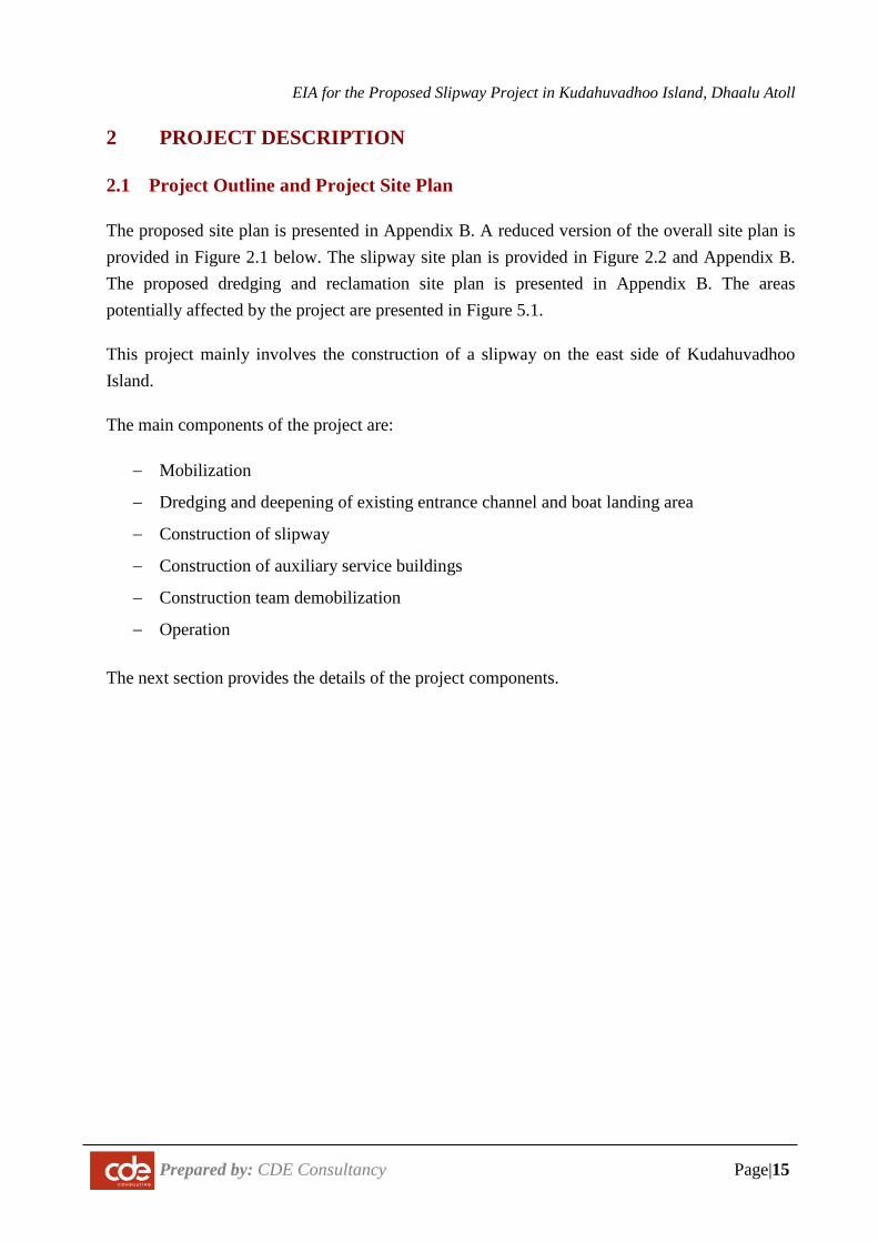
2.1 Project Outline and Project Site Plan
The proposed site plan is presented in Appendix B. A reduced version of the overall site plan is provided in Figure 2.1 below. The slipway site plan is provided in Figure 2.2 and Appendix B. The proposed dredging and reclamation site plan is presented in Appendix B. The areas potentially affected by the project are presented in Figure 5.1.
This project mainly involves the construction of a slipway on the east side of Kudahuvadhoo Island.
The main components of the project are:
− Mobilization
− Dredging and deepening of existing entrance channel and boat landing area
− Construction of slipway
− Construction of auxiliary service buildings
− Construction team demobilization
− Operation
The next section provides the details of the project components.
EIA for the Proposed Slipway Project in Kudahuvadhoo Island, Dhaalu Atoll
Prepared by: CDE Consultancy Page|16
Figure 2.1: Project Site Plan (reduced version)
EIA for the Proposed Slipway Project in Kudahuvadhoo Island, Dhaalu Atoll
Prepared by: CDE Consultancy Page|17
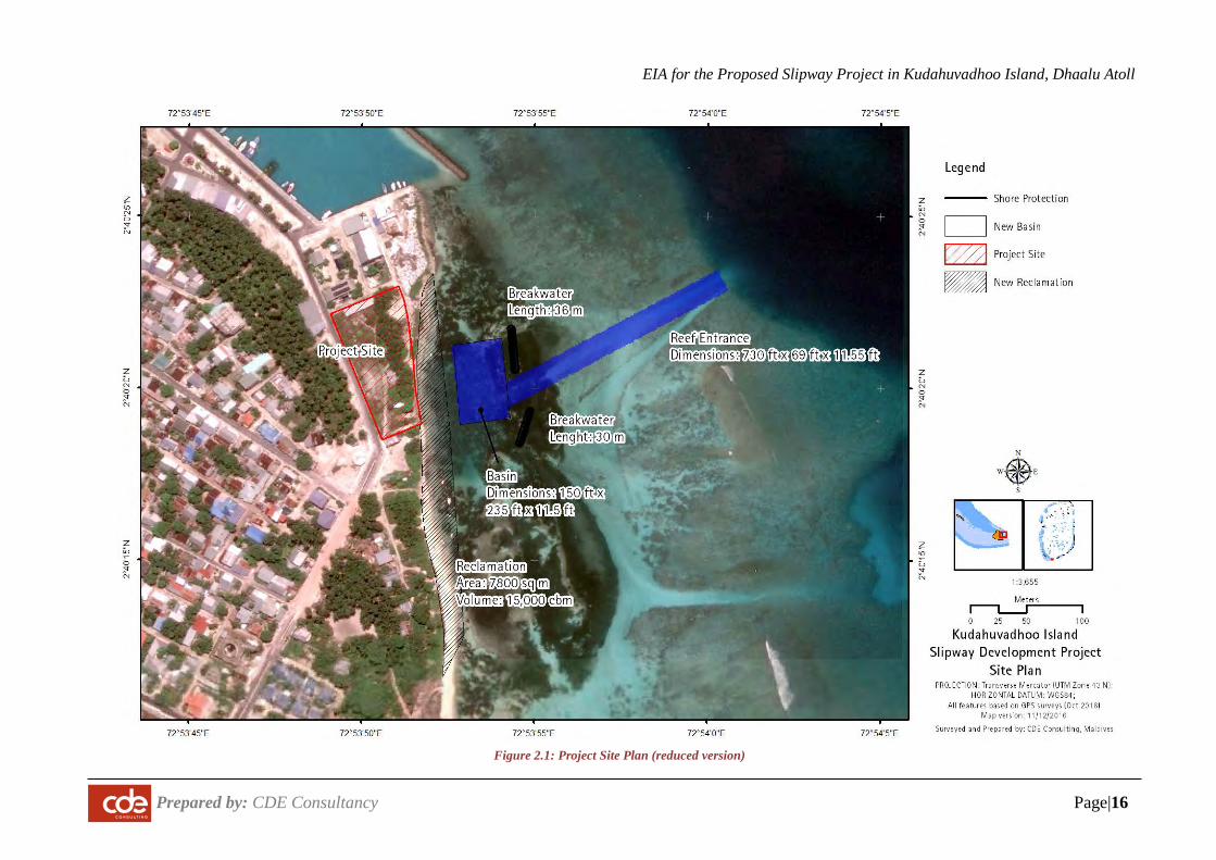
Figure 2.2: Slipway Site Plan
EIA for the Proposed Slipway Project in Kudahuvadhoo Island, Dhaalu Atoll
Prepared by: CDE Consultancy Page|18
2.2 Detailed Project Outline and Work Methodology
2.2.1 Mobilization of construction equipment
The equipment is expected to arrive in via barges and other transport vessels. As the contractor
for the project is yet to be determined, the location from which the equipment will be mobilised
is not yet clear.
Table 2.1: List of anticipated equipment
Equipment Quantity Component
Excavators 4 Dredging and reclamation; slip way installation;
breakwater construction
Trucks 2 Reclamation and general transportation
Loader 1 Reclamation and general lifting
Barge 2 Dredging and reclamation; material transport and
breakwater installation
Concrete mixers 2 General construction
2.2.2 Site setup
The first step in the project will be to establish a worksite. The Island Council has identified the boundary of the project site as a base for storing the equipment. The final locations will be determined in consultation with the contractor. Additional temporary sites may be granted by Island Council depending on need but these areas must be empty open areas in the vicinity.
Workers will be accommodated in houses rented from the house.
All armour rock will be dumped directly on or near the work site in the lagoon.
Sand beds will need to be constructed in the lagoon for dredging and to facilitate the construction of the breakwater. The sand bed will be placed as shown in construction site plan presented in Figure 2.6. The sand bed will be 3 m wide and 1 m above Mean Sea Level.
Sand for the sand beds will be sourced from the lagoon just immediate of the sand bed. The sand borrow details are presented in Figure 2.6 and Appendix B.
EIA for the Proposed Slipway Project in Kudahuvadhoo Island, Dhaalu Atoll
Prepared by: CDE Consultancy Page|19
2.2.3 Dredging and Reclamation
Scope of Works
This component mainly involves dredging a 220 m reef entrance and a harbour basin. The harbour basin will have 70 m x 46 m area. The dredged 15,000 cbm of sand will be disposed along the shoreline as shown in Figure 2.1. Shoreline will be constructed as a beach and shore protection is not proposed. Two breakwater units are proposed to protect the basin. Details of the dredging and reclamation area are presented in Appendix B and Figure 2.1.
Justifications
Need for a reef entrance
Detailed bathymetric survey of the area shows that the reef along the proposed access areas is between -1.5 and -2.2 m MSL within the previously dredged channel and around -1.2 m MSL on other areas. The width of the existing channel is also about 10 m. While this may be suitable for the lighter and shallow draught speed boats to access, these depths are not suitable for the larger 100ft vessels for which the slipway is being designed for. Moreover, the wave conditions in the lagoon may pose a safety risk for vessels when trying to access the lagoon during the NE monsoon and during low tide periods. The alternative option is to wait for high tide to enter the lagoon. Even so, widening the channel is required to safely allow vessels to access the site. Thus, according to the developer, a reef entrance is required based on safety concerns and practicality of operating a slipway.
Need for a basin
A basin is require to ground and launch the vessel in and out of water. Without the required depth, the boats can be easily damaged. There is an existing dredged area in front of the proposed site, which is partly the reason why this site was chosen. However, the depths in this area now stands at -1.5 to -2.0 m. According to the developer, these depths are not suitable for operating a slipway throughout the year.
Need for a breakwater
The proposed area is subject to NE monsoon strong waves making it difficult to operate the slipway throughout the year. A breakwater is proposed to mitigate wave activity.
EIA for the Proposed Slipway Project in Kudahuvadhoo Island, Dhaalu Atoll
Prepared by: CDE Consultancy Page|20
Location
The proposed location has been finalised based on the presence of past boat building activities and due to the presence of an already dredged area. This site has also been finalised by Atoll Council and Ministry of Housing based on the land use plan.
Design
The proposed design is based on the basic requirement of the facility with a view to minimize frequent maintenance dredging. The alignment and foot print of the reef entrance and basin follows the existing channel and basin.
Equipment
Dredging will be undertaken with an excavator as it is the only practical option for a small scale job such as this. The excavator will be mounted on a barge when dredging the reef entrance and transported to the beach via the barge. Excavator will be mounted on a temporary sand bed when dredging the harbour basin and removed once constructed. Sand beds may also be used when dredging the channel, depending on the wave conditions on the site.
Design Details
General Specifications
The entrance channel and harbour basin shall be dredged to a minimum depth of -3.5 meters below Mean Sea Level (MSL) where required.
Channel design layout shall consider minimum sediment accumulation inside the basin to allow for a maintenance dredging period of not less than 5 years.
Dredge Area and Volume
A summary of the dredge area details are presented in the table below.
Table 2.2: Dredging specifications
Feature Specification Reef Entrance Dimensions Reef entrance dredge area Reef Entrance Dredge depth
222 m x 21 m ~4500 sq m -3.5 m MSL
Habour Basin Dimensions 70 m x 46 m Basin Dredge Area 3,200 sq m
EIA for the Proposed Slipway Project in Kudahuvadhoo Island, Dhaalu Atoll
Prepared by: CDE Consultancy Page|21
Feature Specification Basin Dredge Depth -3.5 m MSL Total Dredge Volume (Reef entrance, and basin dredging)
15,660 cbm
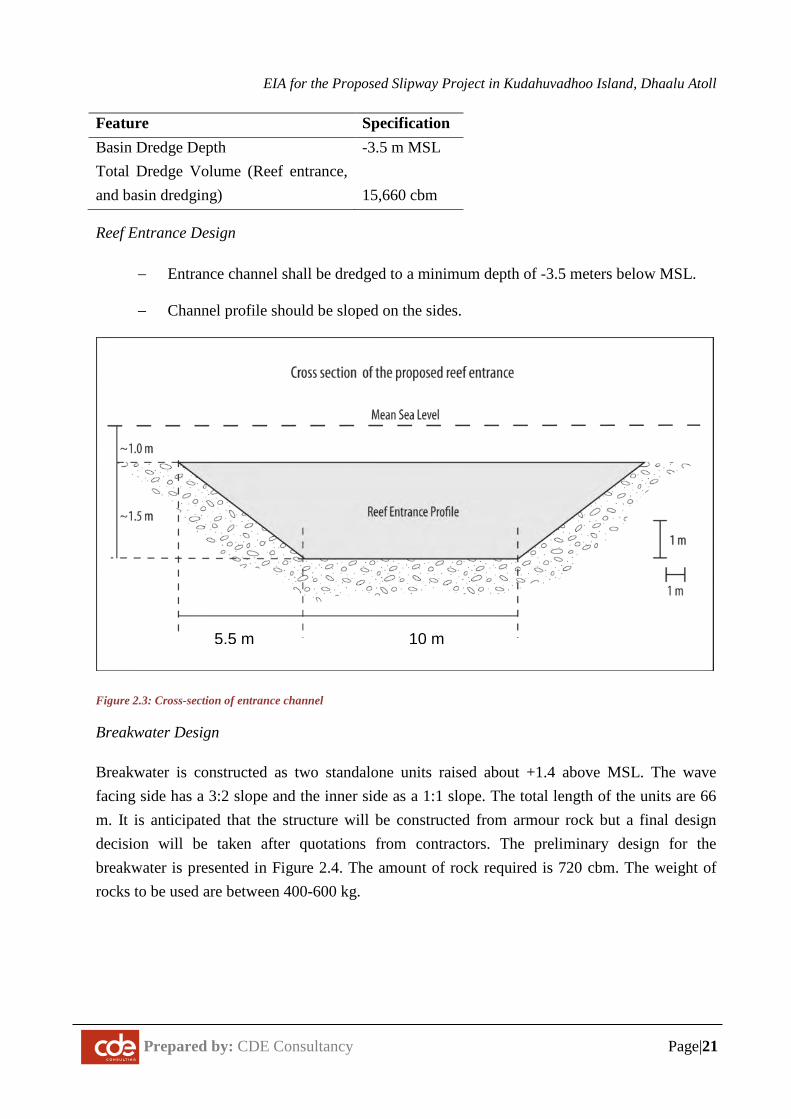
Reef Entrance Design
− Entrance channel shall be dredged to a minimum depth of -3.5 meters below MSL.
− Channel profile should be sloped on the sides.
Figure 2.3: Cross-section of entrance channel
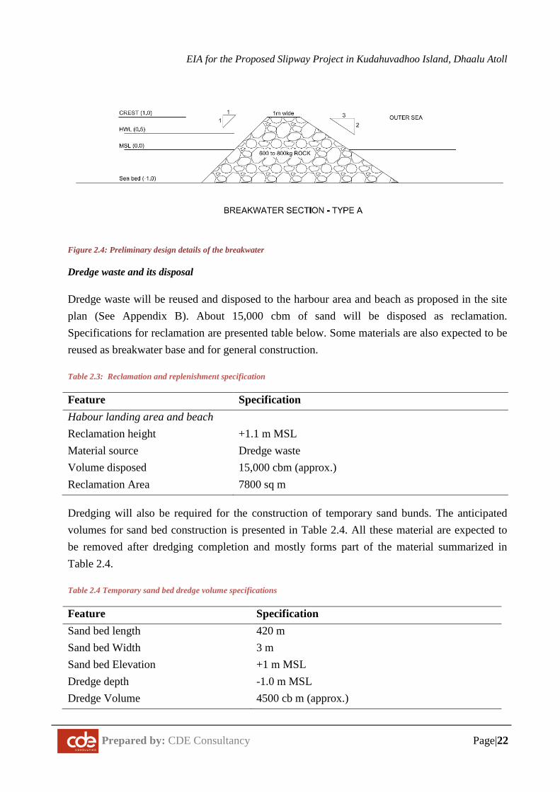
Breakwater Design
Breakwater is constructed as two standalone units raised about +1.4 above MSL. The wave facing side has a 3:2 slope and the inner side as a 1:1 slope. The total length of the units are 66 m. It is anticipated that the structure will be constructed from armour rock but a final design decision will be taken after quotations from contractors. The preliminary design for the breakwater is presented in Figure 2.4. The amount of rock required is 720 cbm. The weight of rocks to be used are between 400-600 kg.
10 m 5.5 m
EIA for the Proposed Slipway Project in Kudahuvadhoo Island, Dhaalu Atoll
Prepared by: CDE Consultancy Page|22
Figure 2.4: Preliminary design details of the breakwater
Dredge waste and its disposal
Dredge waste will be reused and disposed to the harbour area and beach as proposed in the site plan (See Appendix B). About 15,000 cbm of sand will be disposed as reclamation. Specifications for reclamation are presented table below. Some materials are also expected to be reused as breakwater base and for general construction.
Table 2.3: Reclamation and replenishment specification
Feature Specification Habour landing area and beach Reclamation height
+1.1 m MSL
Material source Dredge waste Volume disposed 15,000 cbm (approx.) Reclamation Area 7800 sq m
Dredging will also be required for the construction of temporary sand bunds. The anticipated volumes for sand bed construction is presented in Table 2.4. All these material are expected to be removed after dredging completion and mostly forms part of the material summarized in Table 2.4.
Table 2.4 Temporary sand bed dredge volume specifications
Feature Specification Sand bed length Sand bed Width Sand bed Elevation Dredge depth
420 m 3 m +1 m MSL -1.0 m MSL
Dredge Volume 4500 cb m (approx.)
EIA for the Proposed Slipway Project in Kudahuvadhoo Island, Dhaalu Atoll
Prepared by: CDE Consultancy Page|23
2.2.4 Slipway Development
The main features of the slipway are its winch and landing system and auxiliary facilities.
Ramp system
The ramp system comprises of a winch and a steel carriage system fixed to the ground. The carriage system is used to transport the vessels on and off land. The beach is sloped at 3 degrees to achieve the gentle gradient required to maintain the frame. The winch system is anchored to the ground using concrete casting. There will be additional stubs driven to the ground and casted with concrete to hold the vessels in place. It is planned to install about 7 ramp systems but the initial installations may start with 3-4 units. Each ramp allows one vessel to be serviced.
Figure 2.5: Typical ramp at K.Gulhi Slipway
The ramp system operates by transporting vessels out of the water on the carriage way and on to the land. The pulling is done by the electric winch. The carriage way can go underwater to allow vessels to position over it.
Auxiliary Services
The following auxiliary services will be built on the site:
EIA for the Proposed Slipway Project in Kudahuvadhoo Island, Dhaalu Atoll
Prepared by: CDE Consultancy Page|24
Staff accommodation building: A separate building will be constructed for the staffs. It will have 5 rooms and will have the capacity to accommodate 2 people in each room. The building will also have a TV room, common dining area and a kitchen.
Workshop building: This building will mainly consist of equipments and machineries required for building and maintenance of boats and dhoni. Daily maintenance and building works will be conducted in this building.
Hardware storage building: The hardware storage building will be located next to the work shop and it will contain material stocks in small quantities including wood, fibre glass, etc.
Fuel tanks (Diesel and petrol): Not required now and an arrangement has been made with a local supplier to supply directly to the site. Fuel tanks will not be constructed on the site.
Powerhouse: One generator set of 50 kVA will be installed in the powerhouse. The powerhouse will be specially designed to be noise and vibration proof as much as possible with floor padding and wall insulations, among other measures.
Warehouse: The warehouse will be used to store materials in bulk quantities. Materials that will be stored in the warehouse include wood, fibre glass and other equipments required for boat building and maintenance.
One Haruge: The ‘Haruge’ will be a covered place where most of the maintenance works will be carried out.
Waste Management: This project will produce large quantities of waste including domestic waste and hazardous waste, which include fibreglass. All non-hazardous waste will be segregated, stored temporarily and transferred to the existing waste management site and domestic sewage generated will be dealt through the existing sewerage system All hazardous waste including fibreglass will be sent to Thilasfushi waste site.
2.3 Work Methodology
2.3.1 Mobilisation of equipment and materials
Site mobilisation involves the mobilisation of construction equipment, materials and workforce to the island and providing necessary storage for materials and site access and services for the workforce. This activity has its environmental consequences including transport-related impacts, site-access related impacts and workforce related impacts.. All site mobilisation and construction related activities would be undertaken in a planned manner in order to avoid excessive cost and environmental implications.
EIA for the Proposed Slipway Project in Kudahuvadhoo Island, Dhaalu Atoll
Prepared by: CDE Consultancy Page|25
2.3.2 Dredging and Reclamation
Dredging will begin by excavator mounted on a sand bed. The dredge material will be transported to the reclamation site via trucks. First the reef entrance area will be constructed. The excavator will have a bucket size of about 1.5 m3.
Dredging the harbour basin will begin from the land wards side. A temporary sand bed will be constructed to transport the sand to the proposed reclamation area. The bed will be removed as soon as dredging the channel is completed.
2.3.3 Shore Protection
If rock boulders are used, breakwater will be constructed using a crane or two excavators. Cranes will be placed on a temporary sand bed created parallel to the structure. The excavators will be used profile the structure and make finer adjustments. If it is practical the excavator will be mounted on a barge to place the armour rock in place. This is the common and the preferred method but will depend on the wave conditions at the time.
Boulders will be transported to Kudahuvadhoo on barges. Transportation to the sites will be undertaken on trucks.
If construction using sand-cement bags, it will require manual construction on the site using sand-cement filled bags. No equipment will be deployed on the reef for this purpose.
2.3.4 Constructing the slipway winches and steel ramp
Construction of the winches and steel ramp will be handled with the help of excavators when heavy lilting is involved. The winches will require in-situ concrete casting. Similarly the base of the landing steel frames will be need to be mounted on casted concrete blocks. Concrete mixers will be used to prepare and mix the concrete.
2.3.5 Constructing the auxiliary buildings
General manual construction methods will be used in building the auxiliary buildings..
2.4 Project Schedule and Life Span
Mobilisation for the project will begin after the EIA is approved. It is anticipated that the completion of the whole project will take approximately 12 months.
The preliminary work plan is provided below. The actual details may be dependent on the final contractor.
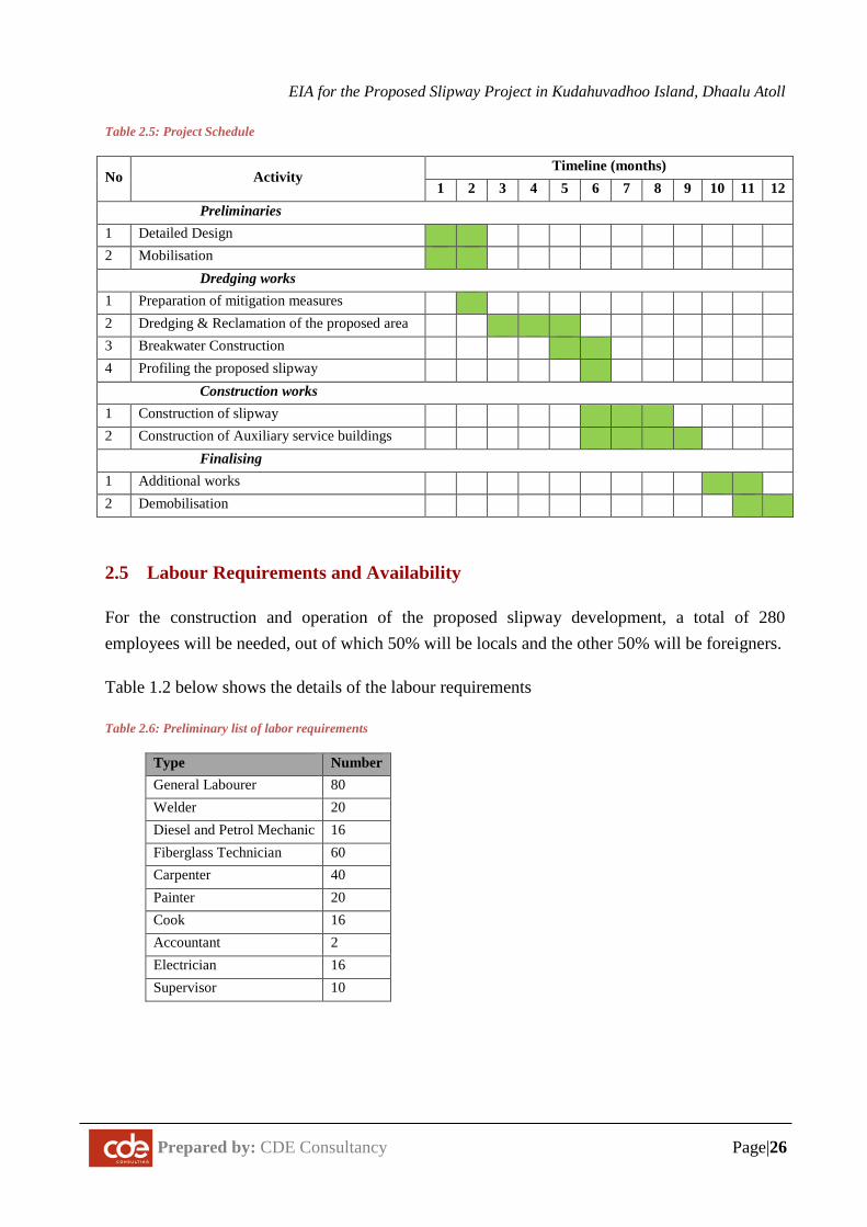
EIA for the Proposed Slipway Project in Kudahuvadhoo Island, Dhaalu Atoll
Prepared by: CDE Consultancy Page|26
Table 2.5: Project Schedule
No Activity Timeline (months)
1 2 3 4 5 6 7 8 9 10 11 12 Preliminaries 1 Detailed Design 2 Mobilisation Dredging works 1 Preparation of mitigation measures 2 Dredging & Reclamation of the proposed area 3 Breakwater Construction 4 Profiling the proposed slipway Construction works 1 Construction of slipway 2 Construction of Auxiliary service buildings Finalising 1 Additional works 2 Demobilisation
2.5 Labour Requirements and Availability
For the construction and operation of the proposed slipway development, a total of 280 employees will be needed, out of which 50% will be locals and the other 50% will be foreigners.
Table 1.2 below shows the details of the labour requirements
Table 2.6: Preliminary list of labor requirements
Type Number General Labourer 80 Welder 20 Diesel and Petrol Mechanic 16 Fiberglass Technician 60 Carpenter 40 Painter 20 Cook 16 Accountant 2 Electrician 16 Supervisor 10
EIA for the Proposed Slipway Project in Kudahuvadhoo Island, Dhaalu Atoll
Prepared by: CDE Consultancy Page|27
2.6 Waste Management, Logistics and Safety Measures
2.6.1 Construction Waste Management and Disposal
Construction wastes that will be created are mainly dredge material and construction debris.
Small amounts of waste oil may be generated from the operation and maintenance of vehicles. All waste oil will be disposed as per the approved standards of the Environment Ministry.
All general packaging, food and green waste can be disposed at the Island Waste Management Centre. All the rest must be taken to Thilafushi by the contractor upon demobilization.
2.6.2 Pollution and Emission Control Measures
The following measures will be taken to ensure minimal pollution during construction stage.
− Machinery will be properly tuned and maintained to reduce emissions and minimize
risk of spills/leaks.
− All paints, lubricants, and other chemicals used on site will be stored in secure and
bunded location to minimize risk of spill.
2.6.3 Sediment Containment and Turbidity Control Measures
The proponent is committed to preventing any sedimentation of the reef system from this proposed project. However, given the depths in the area, the short time frame and the small scale of the project, stringent measures have not been deployed. The following specific measures will be undertaken during the project.
− Undertake dredging work during calm weather conditions.
2.6.4 Health and Safety Measures
− The contractor would ensure that Health and Safety procedures are complied with at
all times.
− Construction activities would be carried out under the supervision of a suitably
experienced person.
− All reasonable precautions will be taken for the safety of employees, and equipment
will be operated by competent persons.
EIA for the Proposed Slipway Project in Kudahuvadhoo Island, Dhaalu Atoll
Prepared by: CDE Consultancy Page|28
− Warning signs, barricades or warning devices will be provided and used. Necessary
safety gear will be worn at all times.
− Fire extinguishing equipment would be readily available and employees will be
trained in its use. In general, water-based fire extinguishers would be used.
− Oxygen, acetylene or LPG bottles will not be left free-standing. All welding and
cutting will be done in accordance to high safety regulations by experienced
personnel.
2.6.5 Utilities
− Water, Electricity and sanitation facilities will be provided for construction workers
from the existing facilities on the island.
2.7 Summary of Project Inputs and Outputs
The types of materials that will go into the development and from where and how this will be obtained are given in Table 2.7 and the type of outputs (products and waste streams) and what is expected to happen to the outputs are given in Table 2.8.
Table 2.7: Major Project Inputs
Input resource(s) Source/Type How to obtain resources Construction workers Local and foreign Contractor’s employees or by
announcement Engineers and Site supervisors
Local Contractor’s employees or by announcement
Water supply (during construction)
Bottled water; portable desalination plant
Purchased from local businesses; contractor equipment
Machinery Excavators, loaders, trucks, barges, concrete mixers,.etc
Contractor’s machinery or hire locally where available
Maintenance material Maintenance parts and fluids required for the machinery and equipment, wood, fibre glass
Import or purchase locally where available
Operational material Boat repair fluids, spare parts, fibre glass related chemicals and material, wood, steel, aluminium etc..
Import or purchase locally where available
Accommodation Existing houses (during construction) or purpose built accommodation on site
Hire locally or construct
EIA for the Proposed Slipway Project in Kudahuvadhoo Island, Dhaalu Atoll
Prepared by: CDE Consultancy Page|29
Input resource(s) Source/Type How to obtain resources Fire fighting equipment Fire Extinguishers...etc. Contractor’s equipment Fuel Light Diesel, Petrol, Lubricants Local suppliers Food and beverage bottles
PET bottles, glass bottles, packaging waste, plastic bags and various frozen, packaged and fresh food.
Contractor’s equipment
Table 2.8: Major Project Outputs
Products and waste materials
Anticipated quantities
Method of disposal
Dredge waste Large quantity Used for land reclamation. Remaining materials used as base material for breakwater
Construction waste Moderate quantity Disposed to Thilafushi
Waste oil Small quantities Barrelled and sent to Thilafushi site during demobilisation.
Hazardous waste (diesel)
Moderate quantities Barrelled and sent to Thilafushi site.
Noise Only localised Excavator and truck operation will be noisy. No option available.
Food waste Small quantities Managed under existing waste management system of the island
Plastic and packaging wastes
Small quantities Managed under existing waste management system of the island
2.8 Demobilization
The proponent advocates a phased demobilization plan to commence in the last week of the contract. The actual demobilisation plan depends on the contractor preferences.
EIA for the Proposed Slipway Project in Kudahuvadhoo Island, Dhaalu Atoll
Prepared by: CDE Consultancy Page|30
3 POLICY AND LEGAL FRAMEWORK
These legal and policy provisions have to be fully respected in carrying out the proposed development. All contractors and sub-contractors will be informed of these requirements. This project conforms to all relevant laws and regulations of the Maldives.
3.1 Relevant Environment Legislation
3.1.1 Environment Protection and Preservation Act (Act no. 4/93)
The Environmental Protection and Preservation Act (4/93) enacted on 19 March 1993 is the framework law related to environment protection in the Maldives. The authority responsible for the Environment Act is the Ministry of Environment and Energy.
Articles 2, 4, 5, 6, 7, and 8 of the law are relevant to the Kudahuvadhoo Slipway Project.
Article 2 states that the concerned government authorities shall provide the necessary guidelines and advise on environmental protection in accordance with the prevailing conditions and needs of the country. All concerned parties shall take due considerations of the guidelines provided by the government authorities.
The project developers and contractors shall abide by any guidelines or advice given by the concerned Government authorities for the project.
Article 4 states that the Ministry of Environment shall be responsible for identifying protected areas and natural reserves and for drawing up the necessary rules and regulations for their protections and preservation.
The project developers and contractors shall ensure that there is no negative impact from the proposed project on sensitive environments in the vicinity or protected species.
According to Article 5 (a) of the Act, an Environmental Impact Assessment study shall be submitted to the Ministry of Environment before implementing any development project that may have a potential impact on the environment.
According to Article 5 (b), The Ministry of Environment shall formulate the guidelines for EIA and shall determine the projects that need such assessment as mentioned in paragraph (a) of this clause.
This report is prepared to fulfil this clause.
EIA for the Proposed Slipway Project in Kudahuvadhoo Island, Dhaalu Atoll
Prepared by: CDE Consultancy Page|31
According to Article 6, the Ministry of Environment has the authority to terminate any project that has any undesirable impact on the environment. A project so terminated shall not receive any compensation.
All project developer and contractors shall be aware of this provision and contractors shall take all practical measures to ensure there is no irreversible and significant negative impact of the projects on the environment
Article 7 of the EPPA (4/93) states that any type of waste, oil, poisonous gases or any substances that may have harmful effects on the environment shall not be disposed within the territory of the Maldives. In cases where the disposal of the substances becomes absolutely necessary, they shall be disposed only within the areas designated for the purpose by the government. If such waste is to be incinerated, appropriate precaution should be taken to avoid any harm to the health of the population.
All project contractors shall comply with the Environmental Management Plan presented in this report, which specifies how the wastes, oil and gases generated by the project will be disposed.
Article 8 of the EPPA (4/93) states that Hazardous/ Toxic or Nuclear Wastes that is harmful to human health and the environment shall not be disposed anywhere within the territory of the country.
Any hazardous wastes that may be generated from this project shall be transferred to the designated waste site in Thilafushi for disposal according to Government regulations and standards. It should not be disposed on the Island, as it does not have the necessary facility.
3.2 Relevant Regulations and Guidelines
3.2.1 Environmental Impact Assessment Regulations 2012
Environmental Impact Assessment regulations were issued by Environment Environmental Impact Assessment regulations were issued by Environment Ministry on 8 May 2012. The first step in environmental assessment process involves screening of the project to be classified as one that requires an EIA or not. Based on this decision, the Ministry then decides the scope of the EIA, which is discussed with the proponent and the EIA consultants in a “scoping meeting”. The consultants then undertake the EIA starting with baseline studies, impact prediction and finally reporting the findings with impact mitigation and monitoring programme. This report follows the principles and procedures for EIA outlined in the EIA regulations.
The EIA report is reviewed by MEE following which an EIA Decision Note is given to the proponent who will have to implement the Decision Note accordingly. As a condition of
EIA for the Proposed Slipway Project in Kudahuvadhoo Island, Dhaalu Atoll
Prepared by: CDE Consultancy Page|32
approval, appropriate environmental monitoring may be required and the proponent shall have to report monitoring data at required intervals to the Ministry. The project proponent is committed to implement all impact mitigation measures that are specified in this EIA report. Furthermore, the proponent is committed to environmental monitoring and shall fulfil environmental monitoring requirements that may be specified in the EIA decision note as a condition for project approval.
This report complies with the EIA regulations
3.2.2 Regulation on Sand and Coral Mining
Regulation on sand mining covers sand mining from uninhabited islands that have been leased; sand mining from the coastal zone of other uninhabited islands; and aggregate mining from uninhabited islands that have been leased and from the coastal zone of other uninhabited islands.
Coral mining from house reef and atoll rim has been banned through a directive from President’s Office dated 26 September 1990.
Sand should not be mined from any part of an existing island. Sand should also not be mined from within 100 ft. of the shoreline of the existing Kudahuvadhoo Island. Please see regulation on dredging and reclamation for further controls.
3.2.3 Regulation on Dredging and Land Reclamation
The regulation of Dredging and Land Reclamation was published on 2 April 2013 with the aim of minimising environmental impacts associated with dredging activities in islands and reefs across Maldives.
− The regulation defines the rationales acceptable for dredging as those related to approved development activities on inhabited islands and economic islands. It defines that those activities should be if utmost necessity for dredging to be considered.
− All dredging and reclamation activities must be approved by EPA in writing. The process includes the submission of project information to EPA along with a scaled before and after map.
− The regulation defines rationales for reclamation as those absolutely necessary for social, economic or safety purposes.
− Beach replenishment is restricted from 10 m of the registered shoreline in resort islands
− Dredging is restricted in the following areas:
EIA for the Proposed Slipway Project in Kudahuvadhoo Island, Dhaalu Atoll
Prepared by: CDE Consultancy Page|33
o 500 m from the ocean side reef edge o 50 m from any island vegetation line o An environmentally sensitive site
− Land reclamation is restricted within 200 m of a sensitive area. − Land reclamation cannot exceed 30% of the house reef area
The dredging application for this project will be submitted along with the EIA report. The project needs dredging and reclamation approval from EPA before undertaking any dredging works.
3.2.4 Regulation on Urban Planning and Implementation – Annex 2
The Annex 2 of Regulation on Urban Planning and Implementation provide boundaries within which construction of fibreglass boats can be undertaken. The proposed “Odi Haruge” of the slipway falls into Category 2 of the regulation, where construction and boat repairs are undertaken within an enclosed space, and all dust produced it removed using an industrial scale exhaust.
The proposed slipway should be within the boundaries set in the Annex 2 of the regulation.
3.2.5 Waste Management Regulation 2013
Waste Management Regulation (WMR) was published on August 2013 and came into effect in February 2014. It will be implemented by EPA. The aim of WMR is to implement the national waste policy, which contains specific provisions to:
- Implement measures to minimize impacts on human health - Formulate and implement waste management standards - Implement an integrated framework for sustainable waste management - Encourage waste minimisation, reuse and recycling - Implement Polluter-Pays Principle - Introduce Extended Producer Responsibility
WMR contains four main sections:
- Waste management standards: Defines standards for waste collection, transfer, treatment, storage, waste site management, landfills and managing hazardous waste.
- Waste management Permits: Defines approval procedures for waste sites - Waster transfer: Standards and permits required for waste transport on land and sea,
including trans-boundary movements. - Reporting requirements: Defines reporting and monitoring requirements and procedures.
EIA for the Proposed Slipway Project in Kudahuvadhoo Island, Dhaalu Atoll
Prepared by: CDE Consultancy Page|34
- Enforcement: Defines procedures to implement WRM and penalties for non-compliance.
The proponent shall use registered vessels under this regulation for transporting waste to Thilafushi or Vandhoo.
The proponent should also ensure compliance from the subcontractors in handling and transport of waste from the island to the designated waste site.
3.2.6 The Environmental Liability Regulation (Regulation 2011/R-9)
This law is pursuant to Article 22 of national constitution that states that protection, preservation and maintenance of the Maldivian natural environment, the richness of the living species, the natural resources and the beauty of the Maldives for the present generations as well as for the future generations is a basic obligation of the Maldivian government. The government shall enforce that the activities conducted in order to gain economic and social development should be of sustainable nature that protect the environment and such activities shall not deteriorate the environment, endanger any species, damage the environment, and shall not waste any natural resources.
This regulation is also pursuant to Environment Protection and Preservation Act of Maldives (4/93). The regulation is aimed at maintaining equal standards for reprimanding and enforcing environmental liabilities, fines for those who violate the rules and regulations and give guidance to those who are involved in the implementation process of the regulations pursuant to Preservation Act of Maldives (4/93).
One of the key objectives of the environmental liability regulation is also to practice polluter-pay-principles in the Maldives.
All project developer and contractors shall be aware of this provision and contractors shall take all practical measures to ensure that all relevant laws and regulations, and the EMP proposed in this EIA is followed.
3.2.7 Compliance
In general, the proposed developments are in compliance with the laws and regulations described above. Where there is a special requirement to comply, the EMP identifies measures and mechanisms required to comply.
EIA for the Proposed Slipway Project in Kudahuvadhoo Island, Dhaalu Atoll
Prepared by: CDE Consultancy Page|35
3.3 Environmental Permits Required for the Project
3.3.1 Environmental Impact Assessment (EIA) Decision Note
The most important environmental permit to initiate project work would be a decision regarding this EIA. The EIA Decision Note, as it is referred to, shall govern the manner in which the project activities must be undertaken. This EIA report assists decision makers in understanding the existing environment and potential impacts of the project. Therefore, the Decision Note may only be given to the Proponent after a review of this document following which the Ministry may request for further information or provide a decision if further information is not required. In some cases, where there are no major environmental impacts associated with the project, the Ministry may provide the Decision Note while at the same time requesting for further information.
3.3.2 Dredging and Reclamation Permit
Prior to any coastal work that requires dredging or reclamation, a special permit has to be taken from the EPA. A specific form published by EPA has to be completed and submitted for the approval. Application for dredging approval can be submitted to EPA with the EIA report. Dredging permit from EPA is required before the dredging works of the project can be undertaken.
Dredging application for this project will be submitted to EPA with the EIA report. The proponent shall ensure that the dredging permit is issued by EPA before undertaking dredging works.
3.4 Responsible Institutions
The main government institutions that have roles and responsibilities relevant to this project are summarised below.
3.4.1 Ministry of Environment
The Ministry of Environment and Energy (formed in 2012) formerly the Ministry of Housing and Environment is mandated for the effective implementation of the Environmental Protection Act of the country and has the statutory power over issues related to the environment. It has the central control over the environment protection, management, conservation and environmental emergencies. The Ministry operates mainly at a policy level and the more regulatory and technical assessment activities are mandated to the Environmental Protection Agency (EPA). In this respect EPA has now been mandated to manage all issues relating to Environmental Impact Assessment of individual projects.
EIA for the Proposed Slipway Project in Kudahuvadhoo Island, Dhaalu Atoll
Prepared by: CDE Consultancy Page|36
The Ministry of Environment also seeks the advice of National Commission for the Protection of Environment (NCPE) on all significant environmental matters. The commission is appointed by the president and is mandated to advice the Minister of Environment on environmental matters such as environment assessment, planning and management, and political decisions with regard to the protection of environment.
3.4.2 Atoll Council
The Maldives is grouped into 20 administrative areas under a new local governance system Dhaalu Atoll has an elected Atoll Council located in Kudahuvadhoo. The Atoll Council Office is the main focal point of Government Ministries in Male’ and they co-ordinate and liaise with government ministries and elected island councils on all issues relating to the Atoll. A copy of this EIA will be submitted to the Atoll Council.
3.5 Guiding Policies and Documents
3.5.1 National Environmental Action Plan II (NEAP II)
The aim of NEAP II is to protect and preserve the environment of the Maldives and to sustainably manage the country’s natural resources for the collective benefit and enjoyment of present and future generations.
Accordingly, the key strategies of the NEAP II are:
− Continuous assessment of the state of the environment in the Maldives, including impacts of human activities on land, atmosphere, freshwater, lagoons, reefs and the ocean; and the effects of these activities on human well-being
− Development and implementation of management methods suitable for the natural and social environment of the Maldives and maintain or enhance environmental quality and protect human health, while at the same time using resources on a sustainable basis
− Ensure stakeholder participation in the decision making process by consultation and collaboration with all relevant sectors of society
− Preparation and implementation of comprehensive national environmental legislation in order to provide for responsible and effective management of the environment
− Adhering to international and regional environmental conventions and agreements and implementation of commitments embodied in such conventions.
Furthermore, NEAP II specifies priority actions in the following areas:
EIA for the Proposed Slipway Project in Kudahuvadhoo Island, Dhaalu Atoll
Prepared by: CDE Consultancy Page|37
− Climate change and sea level rise; coastal zone management; − Biological diversity conservation; integrated reef resources management; − Integrated water resources management; − Management of solid waste and sewerage; − Pollution control and management of hazardous waste; − Sustainable tourism development; − Land resources management and sustainable agriculture − Human settlement and urbanization.
3.5.2 Waste Management Policy 2015
The aim of the waste management policy is to formulate and implement guidelines and means for solid waste management in order to maintain a healthy environment. Accordingly, the key elements of the policy include:
− Ensure safe disposal of solid waste and encourage recycling and reduction of waste generated;
− Develop guidelines on waste management and disposal and advocate to enforce such guidelines through inter-sectoral collaboration;
− Ensure safe disposal of chemical, hazardous and industrial waste.
The proponents of this project must be aware of the policy and all solid and hazardous waste produced in this project should be disposed according to the Environmental Management Plan for the project, which reflects the principles of the Waste Management Policy.
3.6 International Conventions
3.6.1 Convention on Biological Diversity
The Maldives is a party to the United Nations Convention on Biological Diversity. The objective of the convention is “the conservation of biological diversity, the sustainable use of its components and the fair and equitable sharing of the benefits arising out of the utilization of genetic resources, including by appropriate access to genetic resources and by appropriate transfer of relevant technologies, taking into account all rights over those resources and to technologies, and by appropriate funding”. The proposed development activities outlined in this project does not fall on any area recognised for its ecological value. Therefore it is unlikely there will be a major loss of biodiversity. The loss is not going to be significant at atoll or national level. Yet, it is recommended that the developer ensures that silt screens are used during dredging and construction works to minimise any impact on the marine biodiversity.
EIA for the Proposed Slipway Project in Kudahuvadhoo Island, Dhaalu Atoll
Prepared by: CDE Consultancy Page|38
3.6.2 UNFCCC and Kyoto Protocol
The Maldives is a party to the United Nations Framework Convention on Climate Change and the Kyoto Protocol to the UNFCCC. The objective of the Convention is to achieve, in accordance with the relevant provisions of the Convention, stabilization of greenhouse gas concentrations in the atmosphere at a level that would prevent dangerous anthropogenic interference with the climate system. Such a level should be achieved within a time-frame sufficient to allow ecosystems to adapt naturally to climate change, to ensure that food production is not threatened and to enable economic development to proceed in a sustainable manner.
The IPCC defines mitigation “as an anthropogenic intervention to reduce the sources or enhance the sinks of greenhouse gases.” The greenhouse gas inventory of the Maldives forms an integral part of the First National Communication of the Maldives to the UNFCCC. In March 2009, the President of the Maldives has announced the target to make Maldives carbon neutral by 2020. Hence, in the implementation of the project, careful attention needs to be given to ensure energy efficiency and reduce transport related fuel consumption. Furthermore, planting of beach vegetation would help in mitigation of greenhouse gas emissions from the project.
The IPCC defines adaptation “as an adjustment in natural or human systems in response to actual or expected climatic stimuli or their effects.” Various type of adaptation include anticipatory and reactive adaptation; private and public adaptation; and autonomous and planned adaptation. The adaptation policies and strategies of the Maldives are given in the Maldives National Adaptation Programme of Action (NAPA).
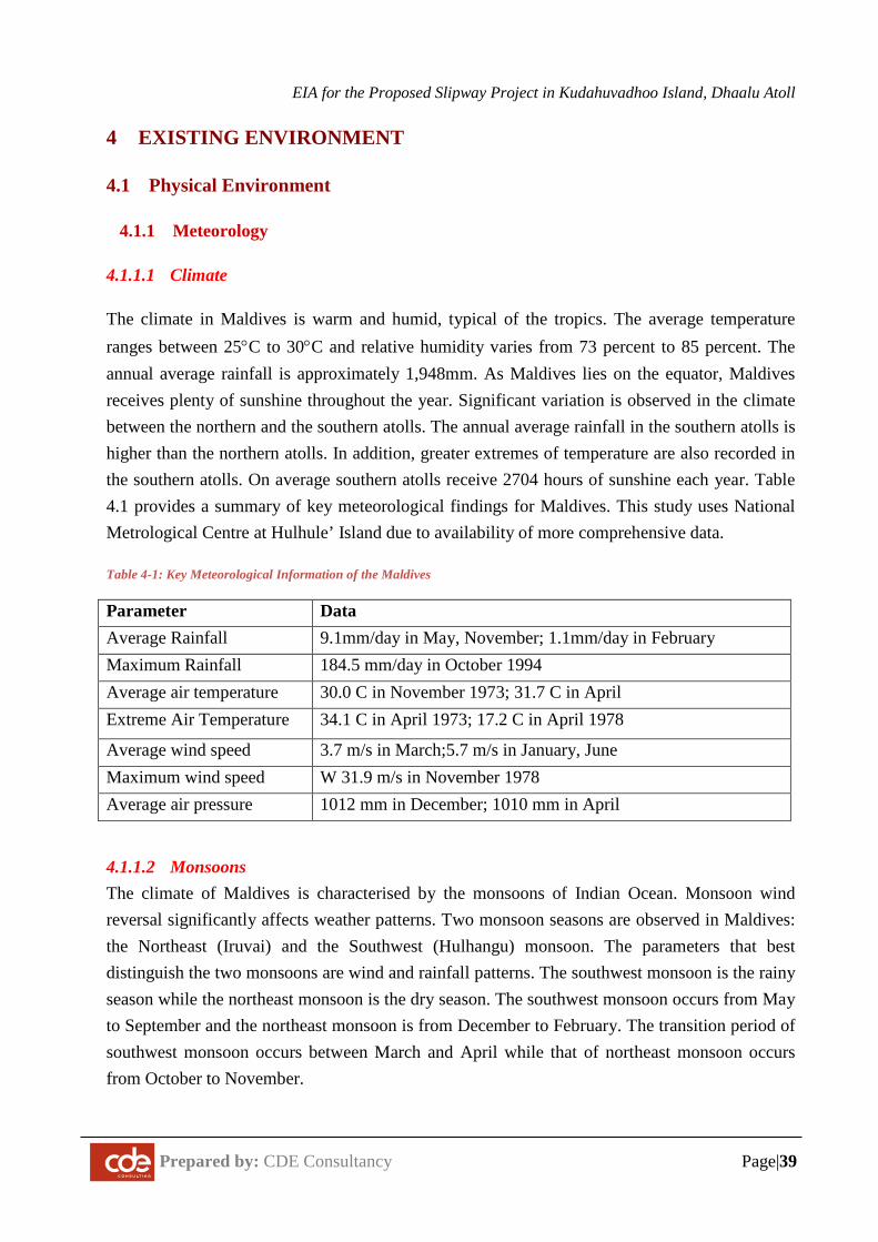
EIA for the Proposed Slipway Project in Kudahuvadhoo Island, Dhaalu Atoll
Prepared by: CDE Consultancy Page|39
4 EXISTING ENVIRONMENT
4.1 Physical Environment
4.1.1 Meteorology
4.1.1.1 Climate
The climate in Maldives is warm and humid, typical of the tropics. The average temperature ranges between 25°C to 30°C and relative humidity varies from 73 percent to 85 percent. The annual average rainfall is approximately 1,948mm. As Maldives lies on the equator, Maldives receives plenty of sunshine throughout the year. Significant variation is observed in the climate between the northern and the southern atolls. The annual average rainfall in the southern atolls is higher than the northern atolls. In addition, greater extremes of temperature are also recorded in the southern atolls. On average southern atolls receive 2704 hours of sunshine each year. Table 4.1 provides a summary of key meteorological findings for Maldives. This study uses National Metrological Centre at Hulhule’ Island due to availability of more comprehensive data.
Table 4-1: Key Meteorological Information of the Maldives
Parameter Data Average Rainfall 9.1mm/day in May, November; 1.1mm/day in February Maximum Rainfall 184.5 mm/day in October 1994 Average air temperature 30.0 C in November 1973; 31.7 C in April Extreme Air Temperature 34.1 C in April 1973; 17.2 C in April 1978
Average wind speed 3.7 m/s in March;5.7 m/s in January, June Maximum wind speed W 31.9 m/s in November 1978 Average air pressure 1012 mm in December; 1010 mm in April
4.1.1.2 Monsoons The climate of Maldives is characterised by the monsoons of Indian Ocean. Monsoon wind reversal significantly affects weather patterns. Two monsoon seasons are observed in Maldives: the Northeast (Iruvai) and the Southwest (Hulhangu) monsoon. The parameters that best distinguish the two monsoons are wind and rainfall patterns. The southwest monsoon is the rainy season while the northeast monsoon is the dry season. The southwest monsoon occurs from May to September and the northeast monsoon is from December to February. The transition period of southwest monsoon occurs between March and April while that of northeast monsoon occurs from October to November.
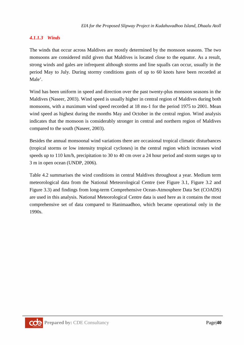
EIA for the Proposed Slipway Project in Kudahuvadhoo Island, Dhaalu Atoll
Prepared by: CDE Consultancy Page|40
4.1.1.3 Winds
The winds that occur across Maldives are mostly determined by the monsoon seasons. The two monsoons are considered mild given that Maldives is located close to the equator. As a result, strong winds and gales are infrequent although storms and line squalls can occur, usually in the period May to July. During stormy conditions gusts of up to 60 knots have been recorded at Male’.
Wind has been uniform in speed and direction over the past twenty-plus monsoon seasons in the Maldives (Naseer, 2003). Wind speed is usually higher in central region of Maldives during both monsoons, with a maximum wind speed recorded at 18 ms-1 for the period 1975 to 2001. Mean wind speed as highest during the months May and October in the central region. Wind analysis indicates that the monsoon is considerably stronger in central and northern region of Maldives compared to the south (Naseer, 2003).
Besides the annual monsoonal wind variations there are occasional tropical climatic disturbances (tropical storms or low intensity tropical cyclones) in the central region which increases wind speeds up to 110 km/h, precipitation to 30 to 40 cm over a 24 hour period and storm surges up to 3 m in open ocean (UNDP, 2006).
Table 4.2 summarises the wind conditions in central Maldives throughout a year. Medium term meteorological data from the National Meteorological Centre (see Figure 3.1, Figure 3.2 and Figure 3.3) and findings from long-term Comprehensive Ocean-Atmosphere Data Set (COADS) are used in this analysis. National Meteorological Centre data is used here as it contains the most comprehensive set of data compared to Hanimaadhoo, which became operational only in the 1990s.
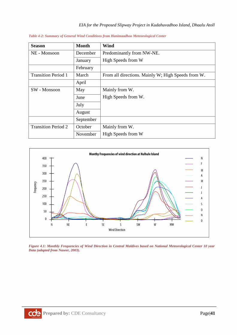
EIA for the Proposed Slipway Project in Kudahuvadhoo Island, Dhaalu Atoll
Prepared by: CDE Consultancy Page|41
Table 4-2: Summary of General Wind Conditions from Hanimaadhoo Meteorological Center
Season Month Wind NE - Monsoon December Predominantly from NW-NE.
High Speeds from W January February Transition Period 1 March From all directions. Mainly W; High Speeds from W. April SW - Monsoon May Mainly from W.
High Speeds from W. June July August
September Transition Period 2 October Mainly from W.
High Speeds from W November
Figure 4.1: Monthly Frequencies of Wind Direction in Central Maldives based on National Meteorological Center 10 year Data (adapted from Naseer, 2003).
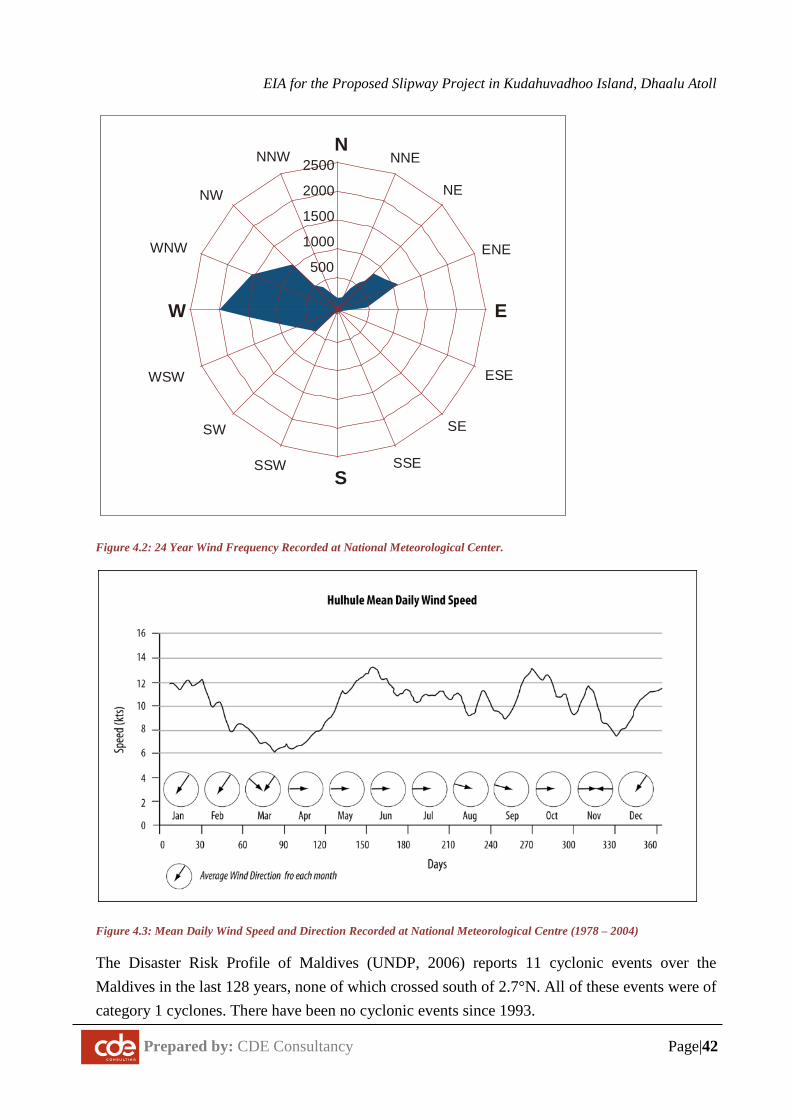
EIA for the Proposed Slipway Project in Kudahuvadhoo Island, Dhaalu Atoll
Prepared by: CDE Consultancy Page|42
Figure 4.2: 24 Year Wind Frequency Recorded at National Meteorological Center.
Figure 4.3: Mean Daily Wind Speed and Direction Recorded at National Meteorological Centre (1978 – 2004)
The Disaster Risk Profile of Maldives (UNDP, 2006) reports 11 cyclonic events over the Maldives in the last 128 years, none of which crossed south of 2.7°N. All of these events were of category 1 cyclones. There have been no cyclonic events since 1993.
N
S
EW
NE
SESW
NW
NNE
ENE
ESE
SSESSW
WSW
NNW
WNW500
1000
1500
2000
2500
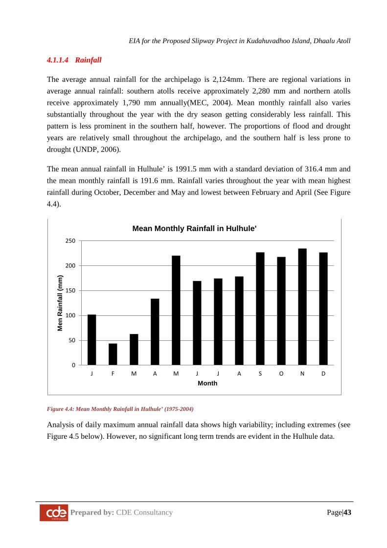
EIA for the Proposed Slipway Project in Kudahuvadhoo Island, Dhaalu Atoll
Prepared by: CDE Consultancy Page|43
4.1.1.4 Rainfall
The average annual rainfall for the archipelago is 2,124mm. There are regional variations in average annual rainfall: southern atolls receive approximately 2,280 mm and northern atolls receive approximately 1,790 mm annually(MEC, 2004). Mean monthly rainfall also varies substantially throughout the year with the dry season getting considerably less rainfall. This pattern is less prominent in the southern half, however. The proportions of flood and drought years are relatively small throughout the archipelago, and the southern half is less prone to drought (UNDP, 2006).
The mean annual rainfall in Hulhule’ is 1991.5 mm with a standard deviation of 316.4 mm and the mean monthly rainfall is 191.6 mm. Rainfall varies throughout the year with mean highest rainfall during October, December and May and lowest between February and April (See Figure 4.4).
Figure 4.4: Mean Monthly Rainfall in Hulhule’ (1975-2004)
Analysis of daily maximum annual rainfall data shows high variability; including extremes (see Figure 4.5 below). However, no significant long term trends are evident in the Hulhule data.
0
50
100
150
200
250
J F M A M J J A S O N D
Men
Rai
nfal
l (m
m)
Month
Mean Monthly Rainfall in Hulhule'
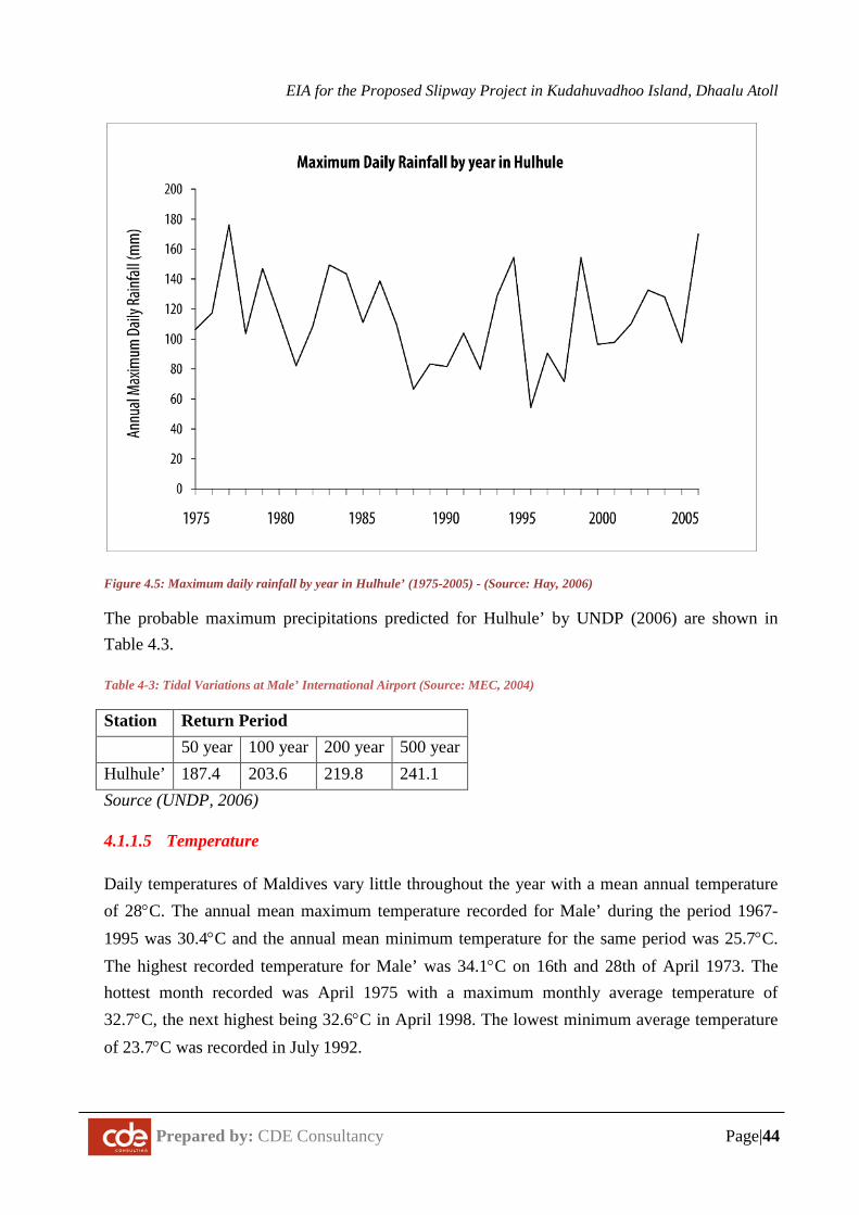
EIA for the Proposed Slipway Project in Kudahuvadhoo Island, Dhaalu Atoll
Prepared by: CDE Consultancy Page|44
Figure 4.5: Maximum daily rainfall by year in Hulhule’ (1975-2005) - (Source: Hay, 2006)
The probable maximum precipitations predicted for Hulhule’ by UNDP (2006) are shown in Table 4.3.
Table 4-3: Tidal Variations at Male’ International Airport (Source: MEC, 2004)
Station Return Period 50 year 100 year 200 year 500 year Hulhule’ 187.4 203.6 219.8 241.1 Source (UNDP, 2006)
4.1.1.5 Temperature
Daily temperatures of Maldives vary little throughout the year with a mean annual temperature of 28°C. The annual mean maximum temperature recorded for Male’ during the period 1967-1995 was 30.4°C and the annual mean minimum temperature for the same period was 25.7°C. The highest recorded temperature for Male’ was 34.1°C on 16th and 28th of April 1973. The hottest month recorded was April 1975 with a maximum monthly average temperature of 32.7°C, the next highest being 32.6°C in April 1998. The lowest minimum average temperature of 23.7°C was recorded in July 1992.
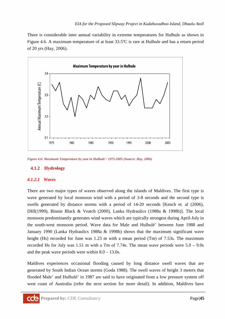
EIA for the Proposed Slipway Project in Kudahuvadhoo Island, Dhaalu Atoll
Prepared by: CDE Consultancy Page|45
There is considerable inter annual variability in extreme temperatures for Hulhule as shown in Figure 4.6. A maximum temperature of at least 33.5oC is rare at Hulhule and has a return period of 20 yrs (Hay, 2006).
Figure 4.6: Maximum Temperature by year in Hulhule’- 1975-2005 (Source: Hay, 2006)
4.1.2 Hydrology
4.1.2.1 Waves
There are two major types of waves observed along the islands of Maldives. The first type is wave generated by local monsoon wind with a period of 3-8 seconds and the second type is swells generated by distance storms with a period of 14-20 seconds [Kench et. al (2006), DHI(1999), Binnie Black & Veatch (2000), Lanka Hydraulics (1988a & 1998b)]. The local monsoon predominantly generates wind waves which are typically strongest during April-July in the south-west monsoon period. Wave data for Male and Hulhulé’ between June 1988 and January 1990 (Lanka Hydraulics 1988a & 1998b) shows that the maximum significant wave height (Hs) recorded for June was 1.23 m with a mean period (Tm) of 7.53s. The maximum recorded Hs for July was 1.51 m with a Tm of 7.74s. The mean wave periods were 5.0 – 9.0s and the peak wave periods were within 8.0 – 13.0s.
Maldives experiences occasional flooding caused by long distance swell waves that are generated by South Indian Ocean storms (Goda 1988). The swell waves of height 3 meters that flooded Male’ and Hulhulé’ in 1987 are said to have originated from a low pressure system off west coast of Australia (refer the next section for more detail). In addition, Maldives have
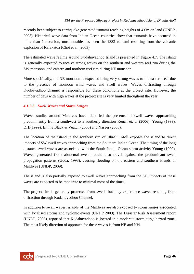
EIA for the Proposed Slipway Project in Kudahuvadhoo Island, Dhaalu Atoll
Prepared by: CDE Consultancy Page|46
recently been subject to earthquake generated tsunami reaching heights of 4.0m on land (UNEP, 2005). Historical wave data from Indian Ocean countries show that tsunamis have occurred in more than 1 occasion, most notable has been the 1883 tsunami resulting from the volcanic explosion of Karakatoa (Choi et al., 2003).
The estimated wave regime around Kudahuvadhoo Island is presented in Figure 4.7. The island is generally expected to receive strong waves on the southern and western reef rim during the SW monsoon, and eastern and northern reef rim during NE monsoon.
More specifically, the NE monsoon is expected bring very strong waves to the eastern reef due to the presence of monsoon wind waves and swell waves. Waves diffracting through Kudhuvadhoo channel is responsible for these conditions at the project site. However, the number of days with high waves at the project site is very limited throughout the year.
4.1.2.2 Swell Waves and Storm Surges
Waves studies around Maldives have identified the presence of swell waves approaching predominantly from a southwest to a southerly direction Kench et. al (2006), Young (1999), DHI(1999), Binnie Black & Veatch (2000) and Naseer (2003).
The location of the island in the southern rim of Dhaalu Atoll exposes the island to direct impacts of SW swell waves approaching from the Southern Indian Ocean. The timing of the long distance swell waves are associated with the South Indian Ocean storm activity Young (1999). Waves generated from abnormal events could also travel against the predominant swell propagation patterns (Goda, 1998), causing flooding on the eastern and southern islands of Maldives (UNDP, 2009).
The island is also partially exposed to swell waves approaching from the SE. Impacts of these waves are expected to be moderate to minimal most of the times.
The project site is generally protected from swells but may experience waves resulting from diffraction through Kudahuvadhoo Channel.
In addition to swell waves, islands of the Maldives are also exposed to storm surges associated with localised storms and cyclonic events (UNDP 2009). The Disaster Risk Assessment report (UNDP, 2006), reported that Kudahuvadhoo is located in a moderate storm surge hazard zone. The most likely direction of approach for these waves is from NE and NW.
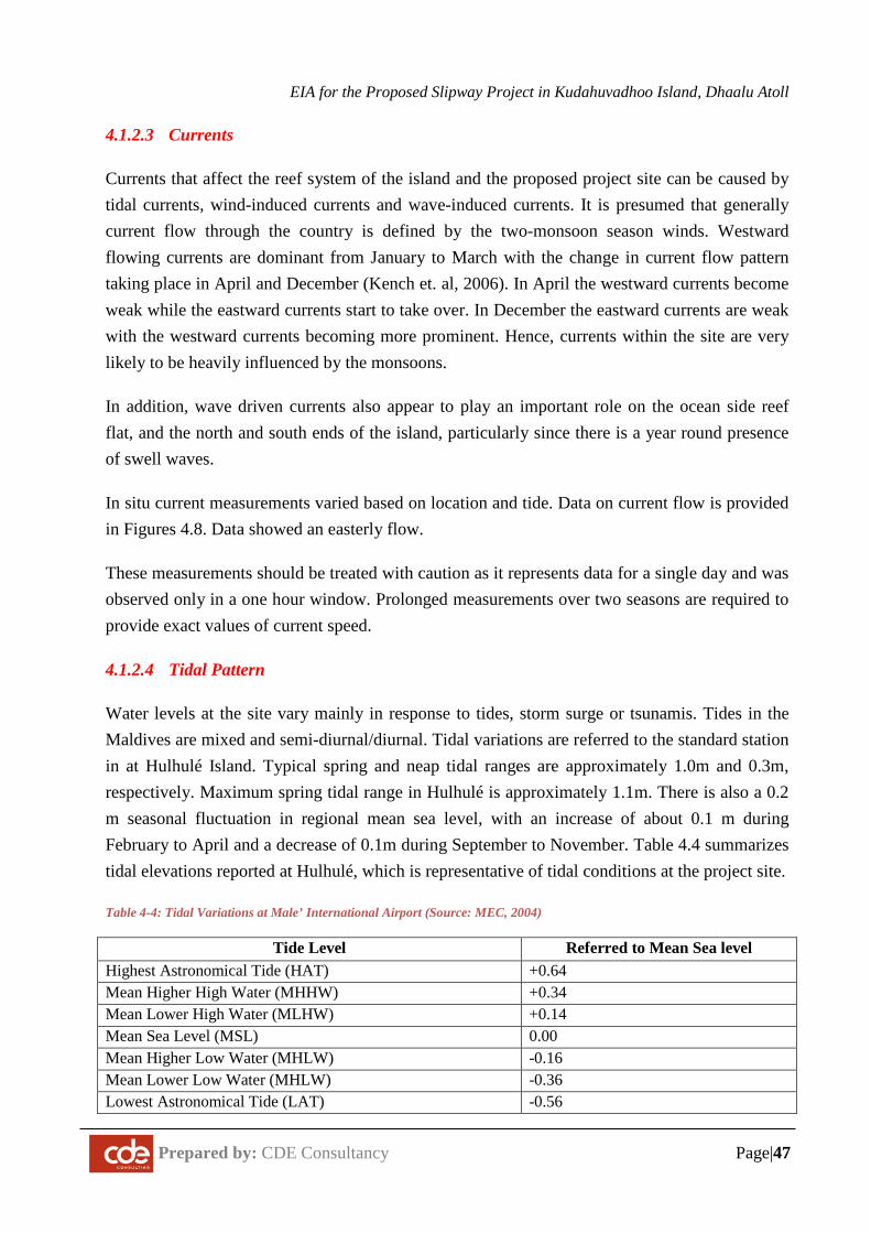
EIA for the Proposed Slipway Project in Kudahuvadhoo Island, Dhaalu Atoll
Prepared by: CDE Consultancy Page|47
4.1.2.3 Currents
Currents that affect the reef system of the island and the proposed project site can be caused by tidal currents, wind-induced currents and wave-induced currents. It is presumed that generally current flow through the country is defined by the two-monsoon season winds. Westward flowing currents are dominant from January to March with the change in current flow pattern taking place in April and December (Kench et. al, 2006). In April the westward currents become weak while the eastward currents start to take over. In December the eastward currents are weak with the westward currents becoming more prominent. Hence, currents within the site are very likely to be heavily influenced by the monsoons.
In addition, wave driven currents also appear to play an important role on the ocean side reef flat, and the north and south ends of the island, particularly since there is a year round presence of swell waves.
In situ current measurements varied based on location and tide. Data on current flow is provided in Figures 4.8. Data showed an easterly flow.
These measurements should be treated with caution as it represents data for a single day and was observed only in a one hour window. Prolonged measurements over two seasons are required to provide exact values of current speed.
4.1.2.4 Tidal Pattern
Water levels at the site vary mainly in response to tides, storm surge or tsunamis. Tides in the Maldives are mixed and semi-diurnal/diurnal. Tidal variations are referred to the standard station in at Hulhulé Island. Typical spring and neap tidal ranges are approximately 1.0m and 0.3m, respectively. Maximum spring tidal range in Hulhulé is approximately 1.1m. There is also a 0.2 m seasonal fluctuation in regional mean sea level, with an increase of about 0.1 m during February to April and a decrease of 0.1m during September to November. Table 4.4 summarizes tidal elevations reported at Hulhulé, which is representative of tidal conditions at the project site.
Table 4-4: Tidal Variations at Male’ International Airport (Source: MEC, 2004)
Tide Level Referred to Mean Sea level Highest Astronomical Tide (HAT) +0.64 Mean Higher High Water (MHHW) +0.34 Mean Lower High Water (MLHW) +0.14 Mean Sea Level (MSL) 0.00 Mean Higher Low Water (MHLW) -0.16 Mean Lower Low Water (MHLW) -0.36 Lowest Astronomical Tide (LAT) -0.56

EIA for the Proposed Slipway Project in Kudahuvadhoo Island, Dhaalu Atoll
Prepared by: CDE Consultancy Page|48
Figure 4.7: Estimated wave regime around Kudahuvadhoo Island
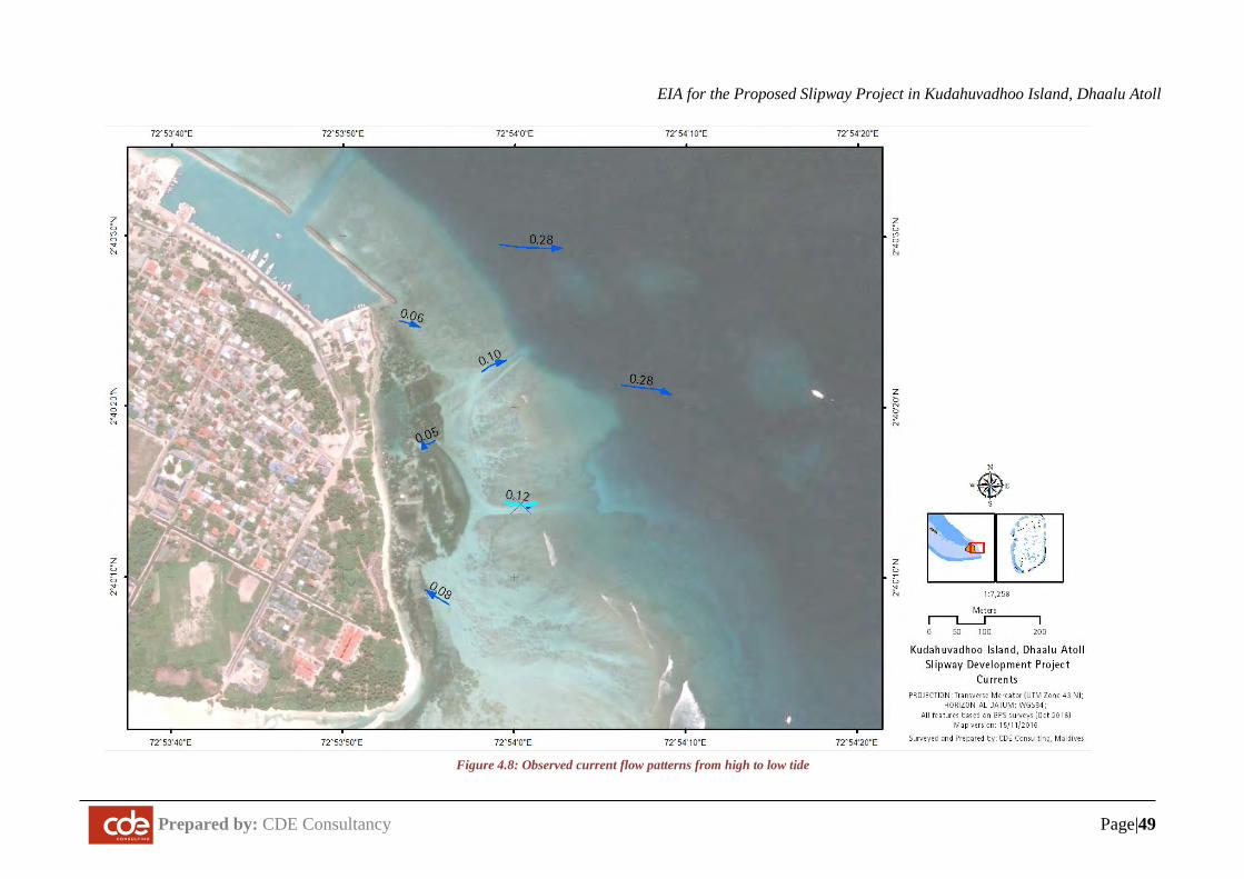
EIA for the Proposed Slipway Project in Kudahuvadhoo Island, Dhaalu Atoll
Prepared by: CDE Consultancy Page|49
Figure 4.8: Observed current flow patterns from high to low tide
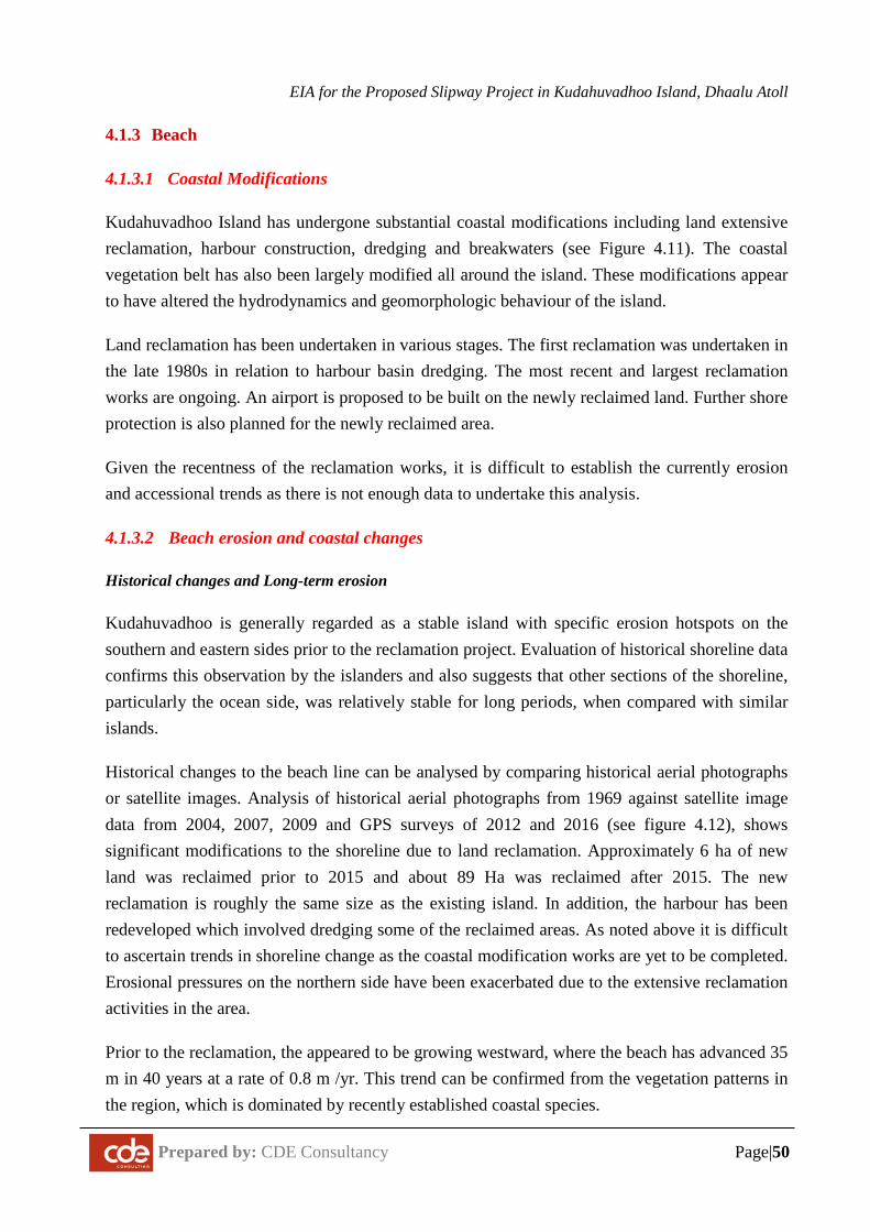
EIA for the Proposed Slipway Project in Kudahuvadhoo Island, Dhaalu Atoll
Prepared by: CDE Consultancy Page|50
4.1.3 Beach
4.1.3.1 Coastal Modifications
Kudahuvadhoo Island has undergone substantial coastal modifications including land extensive reclamation, harbour construction, dredging and breakwaters (see Figure 4.11). The coastal vegetation belt has also been largely modified all around the island. These modifications appear to have altered the hydrodynamics and geomorphologic behaviour of the island.
Land reclamation has been undertaken in various stages. The first reclamation was undertaken in the late 1980s in relation to harbour basin dredging. The most recent and largest reclamation works are ongoing. An airport is proposed to be built on the newly reclaimed land. Further shore protection is also planned for the newly reclaimed area.
Given the recentness of the reclamation works, it is difficult to establish the currently erosion and accessional trends as there is not enough data to undertake this analysis.
4.1.3.2 Beach erosion and coastal changes
Historical changes and Long-term erosion
Kudahuvadhoo is generally regarded as a stable island with specific erosion hotspots on the southern and eastern sides prior to the reclamation project. Evaluation of historical shoreline data confirms this observation by the islanders and also suggests that other sections of the shoreline, particularly the ocean side, was relatively stable for long periods, when compared with similar islands.
Historical changes to the beach line can be analysed by comparing historical aerial photographs or satellite images. Analysis of historical aerial photographs from 1969 against satellite image data from 2004, 2007, 2009 and GPS surveys of 2012 and 2016 (see figure 4.12), shows significant modifications to the shoreline due to land reclamation. Approximately 6 ha of new land was reclaimed prior to 2015 and about 89 Ha was reclaimed after 2015. The new reclamation is roughly the same size as the existing island. In addition, the harbour has been redeveloped which involved dredging some of the reclaimed areas. As noted above it is difficult to ascertain trends in shoreline change as the coastal modification works are yet to be completed. Erosional pressures on the northern side have been exacerbated due to the extensive reclamation activities in the area.
Prior to the reclamation, the appeared to be growing westward, where the beach has advanced 35 m in 40 years at a rate of 0.8 m /yr. This trend can be confirmed from the vegetation patterns in the region, which is dominated by recently established coastal species.
EIA for the Proposed Slipway Project in Kudahuvadhoo Island, Dhaalu Atoll
Prepared by: CDE Consultancy Page|51
4.1.3.3 Detailed description of Coastal Conditions
Project Site
The proposed project site is located on the eastern side of the island and have narrow but gently sloping beaches. The high tide level in these areas reaches well into the vegetation. The area is characterised by the presence of a dense seagrass (Thalassa testudinum) patches. This area is in need of urgent beach replenishment or other erosion mitigation measures.
Southern and Western side
The southern and western side of the island has been largely reclaimed to build an airport and additional residential zones with revetments being built as shore protection measures.
Harbour area
The harbor is located on the northern side of the island, approximately 90m north of the proposed project site.
Figure 4.9: Eastern side beach (project site)
Figure 4.10: Harbor Area located on the northern side
4.1.3.4 Beach profiles
Beach profiles for the island are presented in Appendix F.
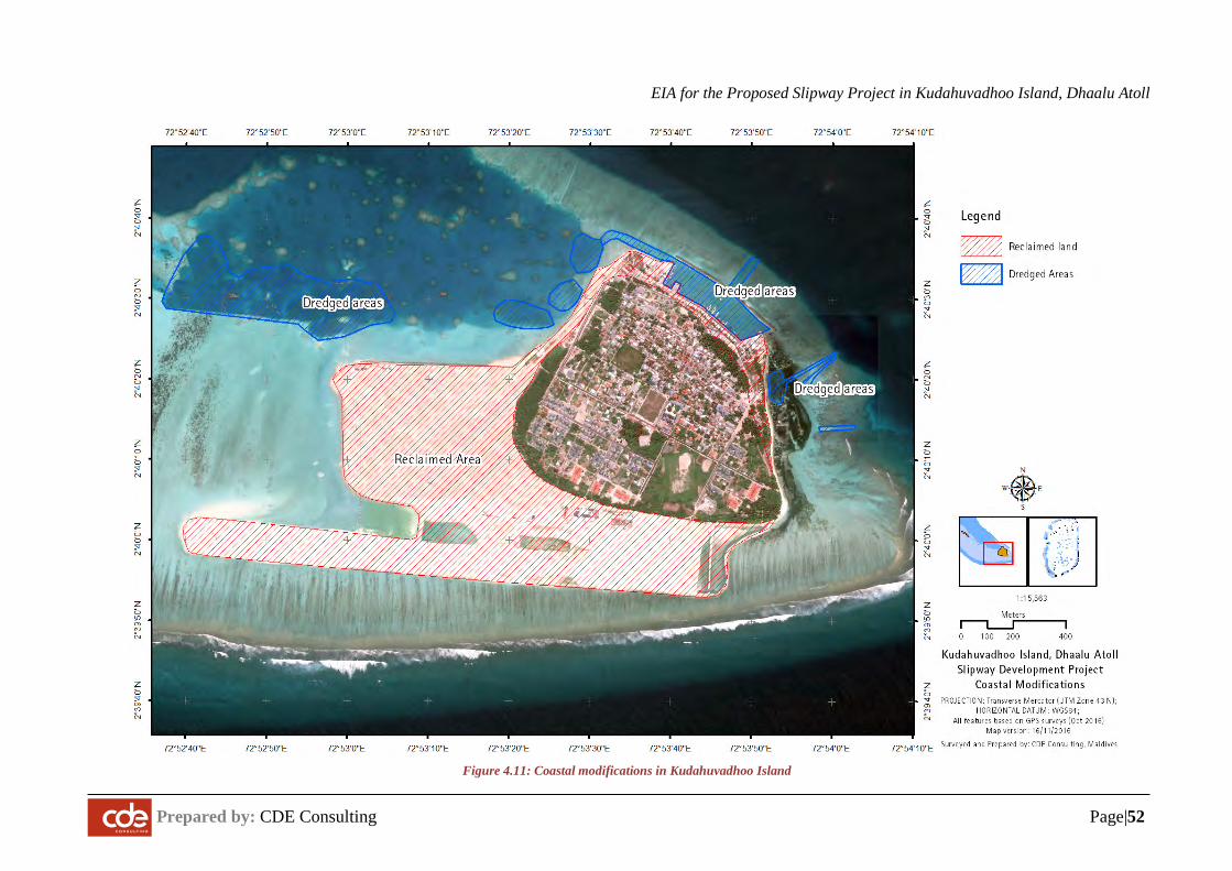
EIA for the Proposed Slipway Project in Kudahuvadhoo Island, Dhaalu Atoll
Prepared by: CDE Consulting Page|52
Figure 4.11: Coastal modifications in Kudahuvadhoo Island

EIA for the Proposed Slipway Project in Kudahuvadhoo Island, Dhaalu Atoll
Prepared by: CDE Consulting Page|53
Figure 4.12: Medium-term erosion and accretion trends in Kudahuvadhoo
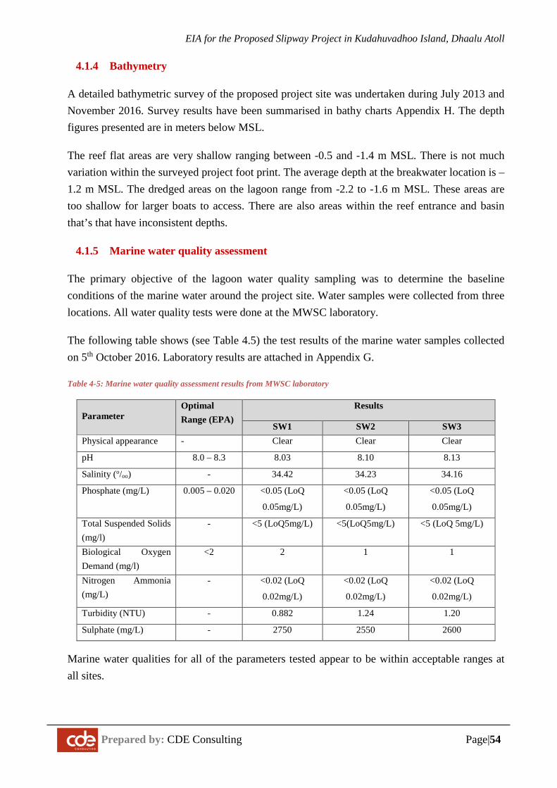
EIA for the Proposed Slipway Project in Kudahuvadhoo Island, Dhaalu Atoll
Prepared by: CDE Consulting Page|54
4.1.4 Bathymetry
A detailed bathymetric survey of the proposed project site was undertaken during July 2013 and November 2016. Survey results have been summarised in bathy charts Appendix H. The depth figures presented are in meters below MSL.
The reef flat areas are very shallow ranging between -0.5 and -1.4 m MSL. There is not much variation within the surveyed project foot print. The average depth at the breakwater location is –1.2 m MSL. The dredged areas on the lagoon range from -2.2 to -1.6 m MSL. These areas are too shallow for larger boats to access. There are also areas within the reef entrance and basin that’s that have inconsistent depths.
4.1.5 Marine water quality assessment
The primary objective of the lagoon water quality sampling was to determine the baseline conditions of the marine water around the project site. Water samples were collected from three locations. All water quality tests were done at the MWSC laboratory.
The following table shows (see Table 4.5) the test results of the marine water samples collected on 5th October 2016. Laboratory results are attached in Appendix G.
Table 4-5: Marine water quality assessment results from MWSC laboratory
Parameter Optimal Range (EPA)
Results
SW1 SW2 SW3 Physical appearance - Clear Clear Clear
pH 8.0 – 8.3 8.03 8.10 8.13
Salinity (o/oo) - 34.42 34.23 34.16
Phosphate (mg/L) 0.005 – 0.020 <0.05 (LoQ
0.05mg/L)
<0.05 (LoQ
0.05mg/L)
<0.05 (LoQ
0.05mg/L)
Total Suspended Solids (mg/l)
- <5 (LoQ5mg/L) <5(LoQ5mg/L) <5 (LoQ 5mg/L)
Biological Oxygen Demand (mg/l)
<2 2 1 1
Nitrogen Ammonia (mg/L)
- <0.02 (LoQ
0.02mg/L)
<0.02 (LoQ
0.02mg/L)
<0.02 (LoQ
0.02mg/L)
Turbidity (NTU) - 0.882 1.24 1.20
Sulphate (mg/L) - 2750 2550 2600
Marine water qualities for all of the parameters tested appear to be within acceptable ranges at all sites.
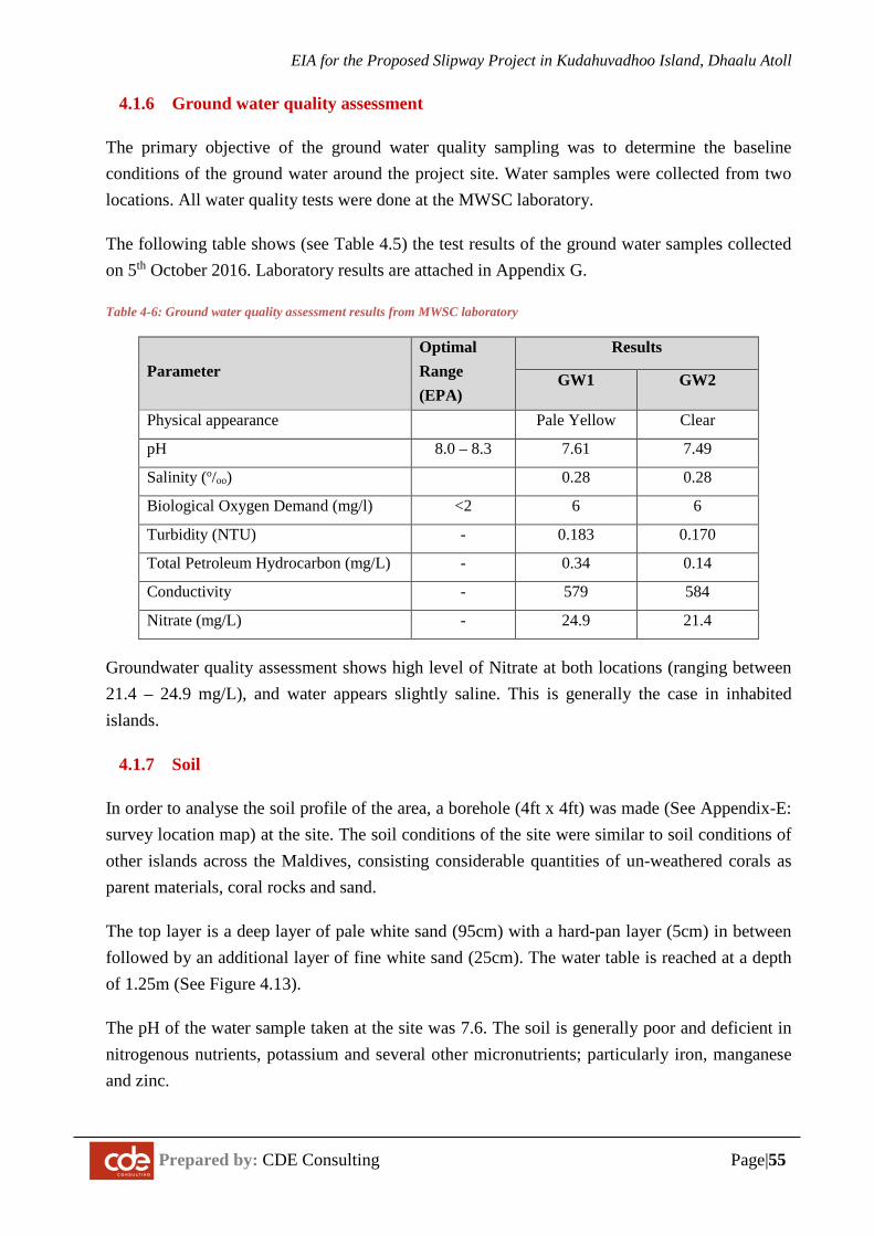
EIA for the Proposed Slipway Project in Kudahuvadhoo Island, Dhaalu Atoll
Prepared by: CDE Consulting Page|55
4.1.6 Ground water quality assessment
The primary objective of the ground water quality sampling was to determine the baseline conditions of the ground water around the project site. Water samples were collected from two locations. All water quality tests were done at the MWSC laboratory.
The following table shows (see Table 4.5) the test results of the ground water samples collected on 5th October 2016. Laboratory results are attached in Appendix G.
Table 4-6: Ground water quality assessment results from MWSC laboratory
Parameter Optimal Range (EPA)
Results
GW1 GW2
Physical appearance Pale Yellow Clear
pH 8.0 – 8.3 7.61 7.49
Salinity (o/oo) 0.28 0.28
Biological Oxygen Demand (mg/l) <2 6 6
Turbidity (NTU) - 0.183 0.170
Total Petroleum Hydrocarbon (mg/L) - 0.34 0.14
Conductivity - 579 584
Nitrate (mg/L) - 24.9 21.4
Groundwater quality assessment shows high level of Nitrate at both locations (ranging between 21.4 – 24.9 mg/L), and water appears slightly saline. This is generally the case in inhabited islands.
4.1.7 Soil
In order to analyse the soil profile of the area, a borehole (4ft x 4ft) was made (See Appendix-E: survey location map) at the site. The soil conditions of the site were similar to soil conditions of other islands across the Maldives, consisting considerable quantities of un-weathered corals as parent materials, coral rocks and sand.
The top layer is a deep layer of pale white sand (95cm) with a hard-pan layer (5cm) in between followed by an additional layer of fine white sand (25cm). The water table is reached at a depth of 1.25m (See Figure 4.13).
The pH of the water sample taken at the site was 7.6. The soil is generally poor and deficient in nitrogenous nutrients, potassium and several other micronutrients; particularly iron, manganese and zinc.
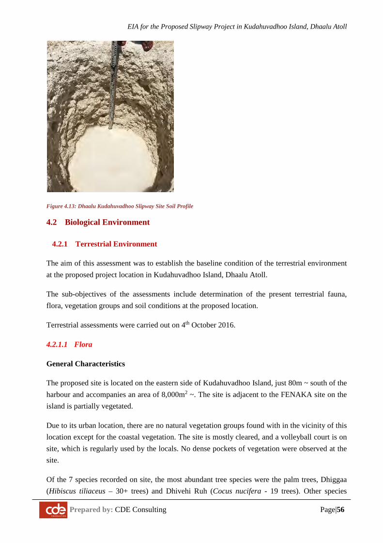
EIA for the Proposed Slipway Project in Kudahuvadhoo Island, Dhaalu Atoll
Prepared by: CDE Consulting Page|56
Figure 4.13: Dhaalu Kudahuvadhoo Slipway Site Soil Profile
4.2 Biological Environment
4.2.1 Terrestrial Environment
The aim of this assessment was to establish the baseline condition of the terrestrial environment at the proposed project location in Kudahuvadhoo Island, Dhaalu Atoll.
The sub-objectives of the assessments include determination of the present terrestrial fauna, flora, vegetation groups and soil conditions at the proposed location.
Terrestrial assessments were carried out on 4th October 2016.
4.2.1.1 Flora
General Characteristics
The proposed site is located on the eastern side of Kudahuvadhoo Island, just 80m ~ south of the harbour and accompanies an area of 8,000m2 ~. The site is adjacent to the FENAKA site on the island is partially vegetated.
Due to its urban location, there are no natural vegetation groups found with in the vicinity of this location except for the coastal vegetation. The site is mostly cleared, and a volleyball court is on site, which is regularly used by the locals. No dense pockets of vegetation were observed at the site.
Of the 7 species recorded on site, the most abundant tree species were the palm trees, Dhiggaa (Hibiscus tiliaceus – 30+ trees) and Dhivehi Ruh (Cocus nucifera - 19 trees). Other species
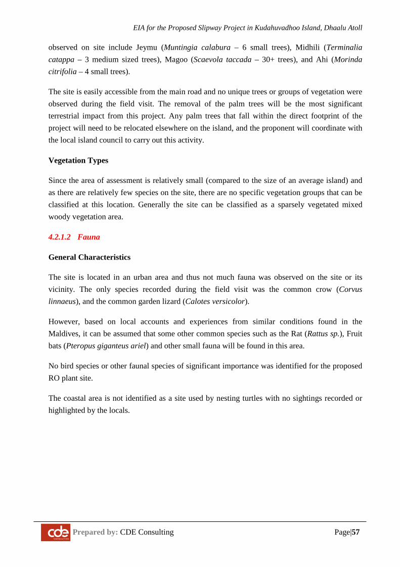
EIA for the Proposed Slipway Project in Kudahuvadhoo Island, Dhaalu Atoll
Prepared by: CDE Consulting Page|57
observed on site include Jeymu (Muntingia calabura – 6 small trees), Midhili (Terminalia catappa – 3 medium sized trees), Magoo (Scaevola taccada – 30+ trees), and Ahi (Morinda citrifolia – 4 small trees).
The site is easily accessible from the main road and no unique trees or groups of vegetation were observed during the field visit. The removal of the palm trees will be the most significant terrestrial impact from this project. Any palm trees that fall within the direct footprint of the project will need to be relocated elsewhere on the island, and the proponent will coordinate with the local island council to carry out this activity.
Vegetation Types
Since the area of assessment is relatively small (compared to the size of an average island) and as there are relatively few species on the site, there are no specific vegetation groups that can be classified at this location. Generally the site can be classified as a sparsely vegetated mixed woody vegetation area.
4.2.1.2 Fauna
General Characteristics
The site is located in an urban area and thus not much fauna was observed on the site or its vicinity. The only species recorded during the field visit was the common crow (Corvus linnaeus), and the common garden lizard (Calotes versicolor).
However, based on local accounts and experiences from similar conditions found in the Maldives, it can be assumed that some other common species such as the Rat (Rattus sp.), Fruit bats (Pteropus giganteus ariel) and other small fauna will be found in this area.
No bird species or other faunal species of significant importance was identified for the proposed RO plant site.
The coastal area is not identified as a site used by nesting turtles with no sightings recorded or highlighted by the locals.
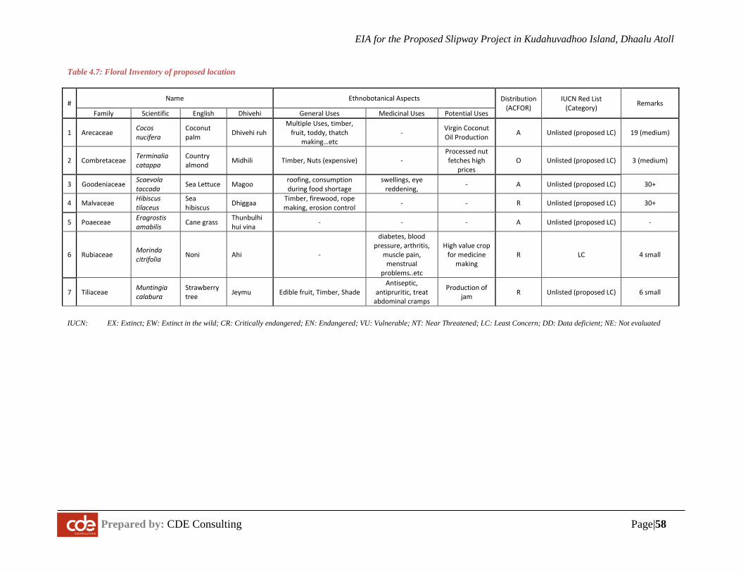
EIA for the Proposed Slipway Project in Kudahuvadhoo Island, Dhaalu Atoll
Prepared by: CDE Consulting Page|58
Table 4.7: Floral Inventory of proposed location
# Name Ethnobotanical Aspects Distribution
(ACFOR) IUCN Red List
(Category) Remarks Family Scientific English Dhivehi General Uses Medicinal Uses Potential Uses
1 Arecaceae Cocos nucifera
Coconut palm Dhivehi ruh
Multiple Uses, timber, fruit, toddy, thatch
making…etc - Virgin Coconut
Oil Production A Unlisted (proposed LC) 19 (medium)
2 Combretaceae Terminalia catappa
Country almond Midhili Timber, Nuts (expensive) -
Processed nut fetches high
prices O Unlisted (proposed LC) 3 (medium)
3 Goodeniaceae Scaevola taccada Sea Lettuce Magoo roofing, consumption
during food shortage swellings, eye
reddening, - A Unlisted (proposed LC) 30+
4 Malvaceae Hibiscus tilaceus
Sea hibiscus Dhiggaa Timber, firewood, rope
making, erosion control - - R Unlisted (proposed LC) 30+
5 Poaeceae Eragrostis amabilis Cane grass Thunbulhi
hui vina - - - A Unlisted (proposed LC) -
6 Rubiaceae Morinda citrifolia Noni Ahi -
diabetes, blood pressure, arthritis,
muscle pain, menstrual
problems..etc
High value crop for medicine
making R LC 4 small
7 Tiliaceae Muntingia calabura
Strawberry tree Jeymu Edible fruit, Timber, Shade
Antiseptic, antipruritic, treat
abdominal cramps
Production of jam R Unlisted (proposed LC) 6 small
IUCN: EX: Extinct; EW: Extinct in the wild; CR: Critically endangered; EN: Endangered; VU: Vulnerable; NT: Near Threatened; LC: Least Concern; DD: Data deficient; NE: Not evaluated
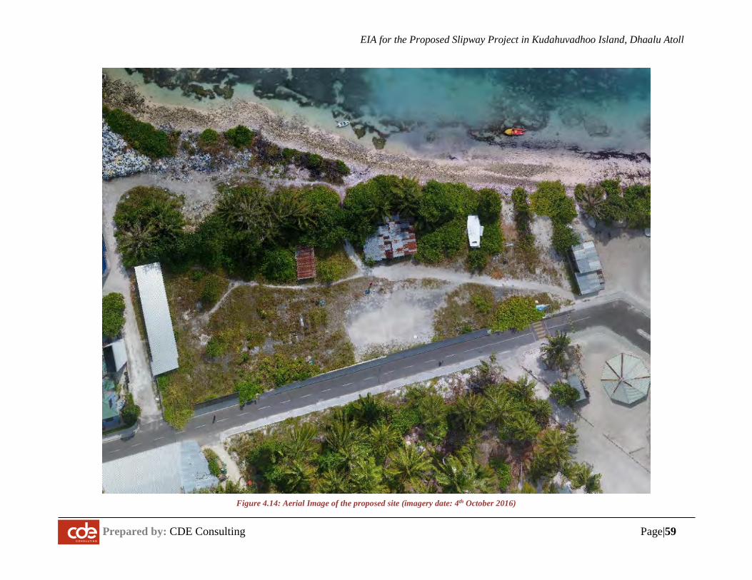
EIA for the Proposed Slipway Project in Kudahuvadhoo Island, Dhaalu Atoll
Prepared by: CDE Consulting Page|59
Figure 4.14: Aerial Image of the proposed site (imagery date: 4th October 2016)
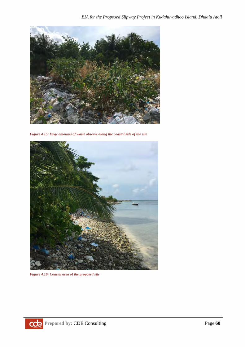
EIA for the Proposed Slipway Project in Kudahuvadhoo Island, Dhaalu Atoll
Prepared by: CDE Consulting Page|60
Figure 4.15: large amounts of waste observe along the coastal side of the site
Figure 4.16: Coastal area of the proposed site
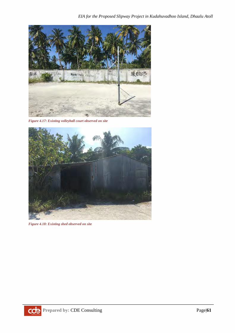
EIA for the Proposed Slipway Project in Kudahuvadhoo Island, Dhaalu Atoll
Prepared by: CDE Consulting Page|61
Figure 4.17: Existing volleyball court observed on site
Figure 4.18: Existing shed observed on site
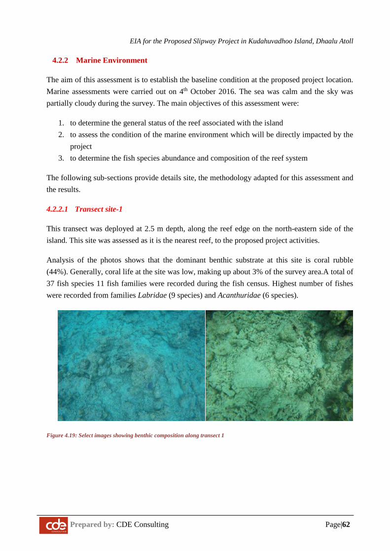
EIA for the Proposed Slipway Project in Kudahuvadhoo Island, Dhaalu Atoll
Prepared by: CDE Consulting Page|62
4.2.2 Marine Environment
The aim of this assessment is to establish the baseline condition at the proposed project location. Marine assessments were carried out on 4th October 2016. The sea was calm and the sky was partially cloudy during the survey. The main objectives of this assessment were:
1. to determine the general status of the reef associated with the island 2. to assess the condition of the marine environment which will be directly impacted by the
project 3. to determine the fish species abundance and composition of the reef system
The following sub-sections provide details site, the methodology adapted for this assessment and the results.
4.2.2.1 Transect site-1
This transect was deployed at 2.5 m depth, along the reef edge on the north-eastern side of the island. This site was assessed as it is the nearest reef, to the proposed project activities.
Analysis of the photos shows that the dominant benthic substrate at this site is coral rubble (44%). Generally, coral life at the site was low, making up about 3% of the survey area.A total of 37 fish species 11 fish families were recorded during the fish census. Highest number of fishes were recorded from families Labridae (9 species) and Acanthuridae (6 species).
Figure 4.19: Select images showing benthic composition along transect 1
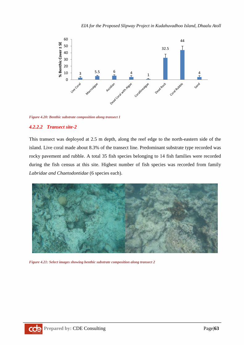
EIA for the Proposed Slipway Project in Kudahuvadhoo Island, Dhaalu Atoll
Prepared by: CDE Consulting Page|63
Figure 4.20: Benthic substrate composition along transect 1
4.2.2.2 Transect site-2
This transect was deployed at 2.5 m depth, along the reef edge to the north-eastern side of the
island. Live coral made about 8.3% of the transect line. Predominant substrate type recorded was
rocky pavement and rubble. A total 35 fish species belonging to 14 fish families were recorded
during the fish census at this site. Highest number of fish species was recorded from family
Labridae and Chaetodontidae (6 species each).
Figure 4.21: Select images showing benthic substrate composition along transect 2
3 5.5 6 4 1
32.5
44
4
0
10
20
30
40
50
60
% B
enth
ic C
over
±SE
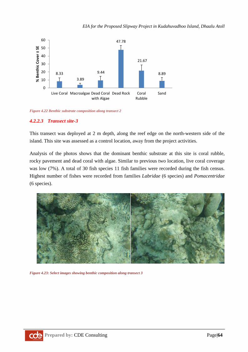
EIA for the Proposed Slipway Project in Kudahuvadhoo Island, Dhaalu Atoll
Prepared by: CDE Consulting Page|64
Figure 4.22 Benthic substrate composition along transect 2
4.2.2.3 Transect site-3
This transect was deployed at 2 m depth, along the reef edge on the north-western side of the island. This site was assessed as a control location, away from the project activities.
Analysis of the photos shows that the dominant benthic substrate at this site is coral rubble, rocky pavement and dead coral with algae. Similar to previous two location, live coral coverage was low (7%). A total of 30 fish species 11 fish families were recorded during the fish census. Highest number of fishes were recorded from families Labridae (6 species) and Pomacentridae (6 species).
Figure 4.23: Select images showing benthic composition along transect 3
8.333.89
9.44
47.78
21.67
8.89
0
10
20
30
40
50
60
Live Coral Macroalgae Dead Coralwith Algae
Dead Rock CoralRubble
Sand
% B
enth
ic C
over
±SE
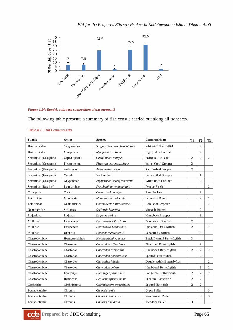
EIA for the Proposed Slipway Project in Kudahuvadhoo Island, Dhaalu Atoll
Prepared by: CDE Consulting Page|65
Figure 4.24: Benthic substrate composition along transect 3
The following table presents a summary of fish census carried out along all transects.
Table 4.7: Fish Census results
Family Genus Species Common Name T1 T2 T3
Holocentridae Sargocentron Sargocentron caudimaculatum White-tail Squirrelfish 2
Holocentridae Myripristis Myripristis pralinia Big-eyed Soldierfish 2
Serranidae (Groupers) Cephalopholis Cephalopholis argus Peacock Rock Cod 2 2 2
Serranidae (Groupers) Plectropomus Plectropomus pessuliferus Indian Coral Grouper 2
Serranidae (Groupers) Aethaloperca Aethaloperca rogaa Red-flushed grouper 2
Serranidae (Groupers) Variola Variola louti Lunar-tailed Grouper 1
Serranidae (Groupers) Anyperedon Anyperodon leucogrammicus White-lined Grouper 2
Serranidae (Basslets) Pseudanthias Pseudanthias squamipinnis Orange Basslet 2
Carangidae Caranx Caranx melampygus Blue-fin Jack 3
Lethrinidae Monotaxis Monotaxis grandoculis Large-eye Bream 2 2
Lethrinidae Gnathodentex Gnathodentex aurolineatus Gold-spot Emperor 2
Nemipteridae Scolopsis Scolopsis bilineata Monacle Bream 2
Lutjanidae Lutjanus Lutjanus gibbus Humpback Snapper 3
Mullidae Parupeneus Parupeneus trifasciatus Double-bar Goatfish 2
Mullidae Parupeneus Parupeneus barberinus Dash-and-Dot Goatfish 2 2
Mullidae Upeneus Upeneus taeniopterus Schooling Goatfish 3
Chaetodontidae Hemitaurichthys Hemitaurichthys zoster Black Pyramid Butterflyfish 3
Chaetodontidae Chaetodon Chaetodon trifasciatus Pinstriped Butterflyfish 2
Chaetodontidae Chaetodon Chaetodon trifascialis Chevroned Butterflyfish 2 2 2
Chaetodontidae Chaetodon Chaetodon guttatissimus Spotted Butterflyfish 2
Chaetodontidae Chaetodon Chaetodon falcula Double-saddle Butterflyfish 2
Chaetodontidae Chaetodon Chaetodon collare Head-band Butterflyfish 2 2
Chaetodontidae Forcipiger Forcipiger flavissimus Long-nose Butterflyfish 2 2 2
Chaetodontidae Heniochus Heniochus pleurotaenia Phantom Bannerfish 2 2
Cirrhitidae Cirrhitichthys Cirrhitichthys oxycephalus Spotted Hawkfish 2 2
Pomacentridae Chromis Chromis virdis Green Puller 3
Pomacentridae Chromis Chromis ternatensis Swallow-tail Puller 3 3
Pomacentridae Chromis Chromis dimidiata Two-tone Puller 3
7 7.5
24.5
2
25.531.5
205
10152025303540
% B
enth
ic C
over
±SE
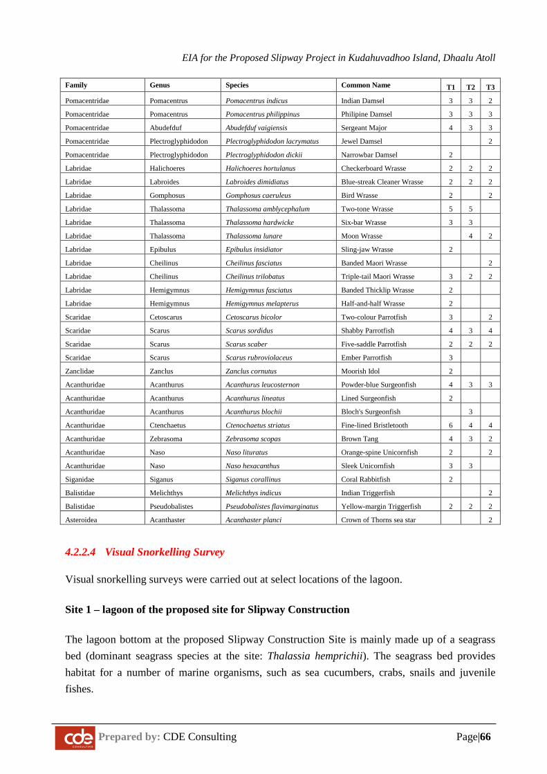
EIA for the Proposed Slipway Project in Kudahuvadhoo Island, Dhaalu Atoll
Prepared by: CDE Consulting Page|66
Family Genus Species Common Name T1 T2 T3
Pomacentridae Pomacentrus Pomacentrus indicus Indian Damsel 3 3 2
Pomacentridae Pomacentrus Pomacentrus philippinus Philipine Damsel 3 3 3
Pomacentridae Abudefduf Abudefduf vaigiensis Sergeant Major 4 3 3
Pomacentridae Plectroglyphidodon Plectroglyphidodon lacrymatus Jewel Damsel 2
Pomacentridae Plectroglyphidodon Plectroglyphidodon dickii Narrowbar Damsel 2
Labridae Halichoeres Halichoeres hortulanus Checkerboard Wrasse 2 2 2
Labridae Labroides Labroides dimidiatus Blue-streak Cleaner Wrasse 2 2 2
Labridae Gomphosus Gomphosus caeruleus Bird Wrasse 2 2
Labridae Thalassoma Thalassoma amblycephalum Two-tone Wrasse 5 5
Labridae Thalassoma Thalassoma hardwicke Six-bar Wrasse 3 3
Labridae Thalassoma Thalassoma lunare Moon Wrasse 4 2
Labridae Epibulus Epibulus insidiator Sling-jaw Wrasse 2
Labridae Cheilinus Cheilinus fasciatus Banded Maori Wrasse 2
Labridae Cheilinus Cheilinus trilobatus Triple-tail Maori Wrasse 3 2 2
Labridae Hemigymnus Hemigymnus fasciatus Banded Thicklip Wrasse 2
Labridae Hemigymnus Hemigymnus melapterus Half-and-half Wrasse 2
Scaridae Cetoscarus Cetoscarus bicolor Two-colour Parrotfish 3 2
Scaridae Scarus Scarus sordidus Shabby Parrotfish 4 3 4
Scaridae Scarus Scarus scaber Five-saddle Parrotfish 2 2 2
Scaridae Scarus Scarus rubroviolaceus Ember Parrotfish 3
Zanclidae Zanclus Zanclus cornutus Moorish Idol 2
Acanthuridae Acanthurus Acanthurus leucosternon Powder-blue Surgeonfish 4 3 3
Acanthuridae Acanthurus Acanthurus lineatus Lined Surgeonfish 2
Acanthuridae Acanthurus Acanthurus blochii Bloch's Surgeonfish 3
Acanthuridae Ctenchaetus Ctenochaetus striatus Fine-lined Bristletooth 6 4 4
Acanthuridae Zebrasoma Zebrasoma scopas Brown Tang 4 3 2
Acanthuridae Naso Naso lituratus Orange-spine Unicornfish 2 2
Acanthuridae Naso Naso hexacanthus Sleek Unicornfish 3 3
Siganidae Siganus Siganus corallinus Coral Rabbitfish 2
Balistidae Melichthys Melichthys indicus Indian Triggerfish 2
Balistidae Pseudobalistes Pseudobalistes flavimarginatus Yellow-margin Triggerfish 2 2 2
Asteroidea Acanthaster Acanthaster planci Crown of Thorns sea star 2
4.2.2.4 Visual Snorkelling Survey
Visual snorkelling surveys were carried out at select locations of the lagoon.
Site 1 – lagoon of the proposed site for Slipway Construction
The lagoon bottom at the proposed Slipway Construction Site is mainly made up of a seagrass bed (dominant seagrass species at the site: Thalassia hemprichii). The seagrass bed provides habitat for a number of marine organisms, such as sea cucumbers, crabs, snails and juvenile fishes.
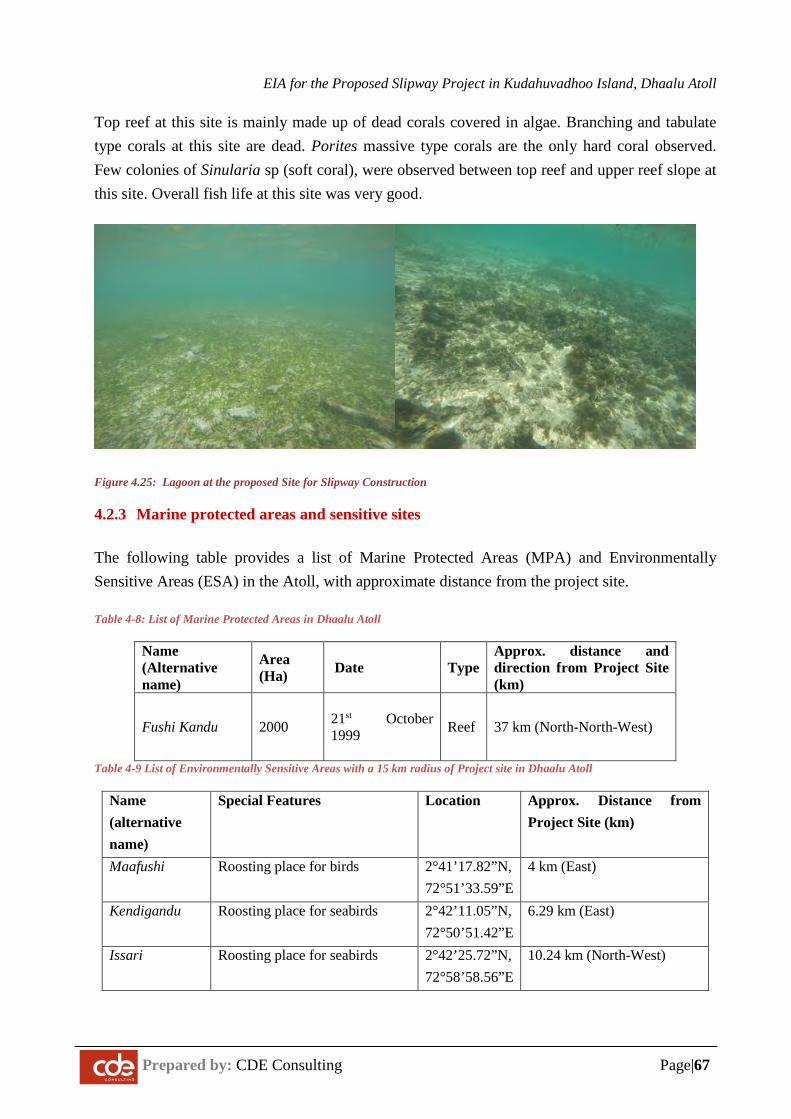
EIA for the Proposed Slipway Project in Kudahuvadhoo Island, Dhaalu Atoll
Prepared by: CDE Consulting Page|67
Top reef at this site is mainly made up of dead corals covered in algae. Branching and tabulate type corals at this site are dead. Porites massive type corals are the only hard coral observed. Few colonies of Sinularia sp (soft coral), were observed between top reef and upper reef slope at this site. Overall fish life at this site was very good.
Figure 4.25: Lagoon at the proposed Site for Slipway Construction
4.2.3 Marine protected areas and sensitive sites
The following table provides a list of Marine Protected Areas (MPA) and Environmentally Sensitive Areas (ESA) in the Atoll, with approximate distance from the project site.
Table 4-8: List of Marine Protected Areas in Dhaalu Atoll
Name (Alternative name)
Area (Ha) Date Type
Approx. distance and direction from Project Site (km)
Fushi Kandu 2000
21st October 1999
Reef 37 km (North-North-West)
Table 4-9 List of Environmentally Sensitive Areas with a 15 km radius of Project site in Dhaalu Atoll
Name (alternative name)
Special Features Location Approx. Distance from Project Site (km)
Maafushi Roosting place for birds 2°41’17.82”N, 72°51’33.59”E
4 km (East)
Kendigandu Roosting place for seabirds 2°42’11.05”N, 72°50’51.42”E
6.29 km (East)
Issari Roosting place for seabirds 2°42’25.72”N, 72°58’58.56”E
10.24 km (North-West)
EIA for the Proposed Slipway Project in Kudahuvadhoo Island, Dhaalu Atoll
Prepared by: CDE Consulting Page|68
4.2.4 Breeding or nursery grounds for protected or endangered species
All coral reef areas have the potential to be used as breeding/nurseries for reef fishes. No literature is available to indicate that reef system of Kudahuvadhoo is used as breeding/nursery for fishes, crustaceans, marine mammals, sharks or turtles. Further studies are required to determine the specificity of the sites.
4.3 Natural Hazard Assessment for the Site
According to the UNDP Disaster Risk Assessment Reports of Maldives in 2006 and 2009, Kudahuvadhoo is located in an area exposed to tsunamis, wind storms, storm surges, swell waves and rainfall flooding. The 2004 tsunami did impact the island and a future severe magnitude tsunami along specific points of the Sumatran Ridge is likely to flood large sections of the island.
A detailed risk assessment study was undertaken on K. Kudahuvadhoo by UNDP in 2009. The tables below summarises the findings from the report.
Table 4.10 Predicted disaster risks in Dh. Kudahuvadhoo Island (Source DHRAM 2 – UNDP & MPND)
Rapid onset flooding hazards
Hazard Max
Prediction
Impact thresholds Probability of Occurrence
Low Moderate Severe Low
Impact
Moderate
Impact
Severe
Impact
Swell Waves
(wave heights on reef flat – Average Island ridge height +1.9m above reef flat)
NA < 2.3m
> 2.3m > 3.0m High Moderate Low
Tsunami
(wave heights on reef flat)
3.7m < 2.3m
> 2.3m > 3.0m Moderate
Low Very low
SW monsoon high seas
(wave heights on reef flat)
1.5m < 2.3m
> 2.3m > 3.0m High Very low Unlikely
Heavy Rainfall
(For a 24 hour period)
241mm <60mm > 60mm >175mm
High Moderate Low
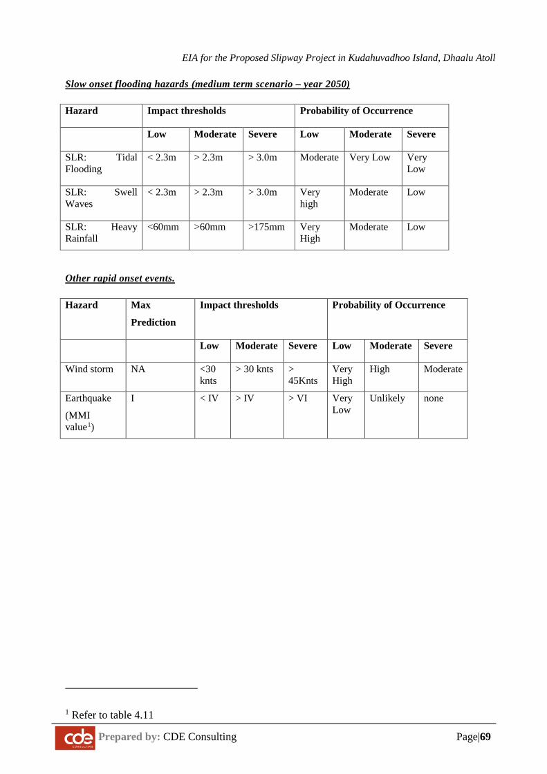
EIA for the Proposed Slipway Project in Kudahuvadhoo Island, Dhaalu Atoll
Prepared by: CDE Consulting Page|69
Slow onset flooding hazards (medium term scenario – year 2050)
Hazard Impact thresholds Probability of Occurrence
Low Moderate Severe Low Moderate Severe
SLR: Tidal Flooding
< 2.3m
> 2.3m > 3.0m Moderate Very Low Very Low
SLR: Swell Waves
< 2.3m
> 2.3m > 3.0m Very high
Moderate Low
SLR: Heavy Rainfall
<60mm >60mm >175mm Very High
Moderate Low
Other rapid onset events.
Hazard Max
Prediction
Impact thresholds Probability of Occurrence
Low Moderate Severe Low Moderate Severe
Wind storm NA <30 knts
> 30 knts > 45Knts
Very High
High Moderate
Earthquake
(MMI value1)
I < IV
> IV > VI Very Low
Unlikely none
1 Refer to table 4.11
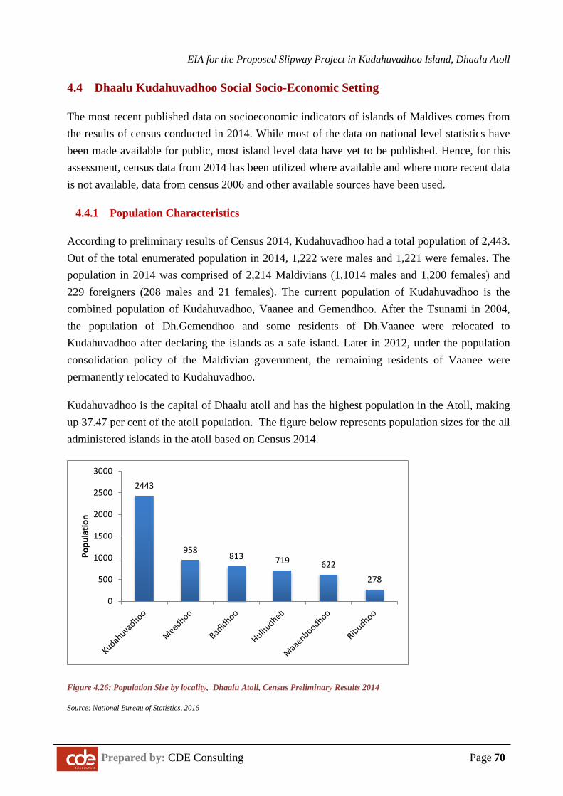
EIA for the Proposed Slipway Project in Kudahuvadhoo Island, Dhaalu Atoll
Prepared by: CDE Consulting Page|70
4.4 Dhaalu Kudahuvadhoo Social Socio-Economic Setting
The most recent published data on socioeconomic indicators of islands of Maldives comes from the results of census conducted in 2014. While most of the data on national level statistics have been made available for public, most island level data have yet to be published. Hence, for this assessment, census data from 2014 has been utilized where available and where more recent data is not available, data from census 2006 and other available sources have been used.
4.4.1 Population Characteristics
According to preliminary results of Census 2014, Kudahuvadhoo had a total population of 2,443. Out of the total enumerated population in 2014, 1,222 were males and 1,221 were females. The population in 2014 was comprised of 2,214 Maldivians (1,1014 males and 1,200 females) and 229 foreigners (208 males and 21 females). The current population of Kudahuvadhoo is the combined population of Kudahuvadhoo, Vaanee and Gemendhoo. After the Tsunami in 2004, the population of Dh.Gemendhoo and some residents of Dh.Vaanee were relocated to Kudahuvadhoo after declaring the islands as a safe island. Later in 2012, under the population consolidation policy of the Maldivian government, the remaining residents of Vaanee were permanently relocated to Kudahuvadhoo.
Kudahuvadhoo is the capital of Dhaalu atoll and has the highest population in the Atoll, making up 37.47 per cent of the atoll population. The figure below represents population sizes for the all administered islands in the atoll based on Census 2014.
Figure 4.26: Population Size by locality, Dhaalu Atoll, Census Preliminary Results 2014
Source: National Bureau of Statistics, 2016
2443
958813 719 622
278
0
500
1000
1500
2000
2500
3000
Popu
latio
n
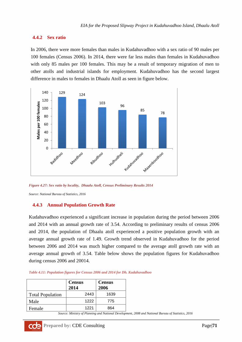
EIA for the Proposed Slipway Project in Kudahuvadhoo Island, Dhaalu Atoll
Prepared by: CDE Consulting Page|71
4.4.2 Sex ratio
In 2006, there were more females than males in Kudahuvadhoo with a sex ratio of 90 males per 100 females (Census 2006). In 2014, there were far less males than females in Kudahuvadhoo with only 85 males per 100 females. This may be a result of temporary migration of men to other atolls and industrial islands for employment. Kudahuvadhoo has the second largest difference in males to females in Dhaalu Atoll as seen in figure below.
Figure 4.27: Sex ratio by locality, Dhaalu Atoll, Census Preliminary Results 2014
Source: National Bureau of Statistics, 2016
4.4.3 Annual Population Growth Rate
Kudahuvadhoo experienced a significant increase in population during the period between 2006 and 2014 with an annual growth rate of 3.54. According to preliminary results of census 2006 and 2014, the population of Dhaalu atoll experienced a positive population growth with an average annual growth rate of 1.49. Growth trend observed in Kudahuvadhoo for the period between 2006 and 2014 was much higher compared to the average atoll growth rate with an average annual growth of 3.54. Table below shows the population figures for Kudahuvadhoo during census 2006 and 20014.
Table 4.11: Population figures for Census 2006 and 2014 for Dh. Kudahuvadhoo
Census 2014
Census 2006
Total Population 2443 1639
Male 1222 775
Female 1221 864 Source: Ministry of Planning and National Development, 2008 and National Bureau of Statistics, 2016
129 124
10396
8578
0
20
40
60
80
100
120
140
Mal
es p
er 1
00 fe
mal
es
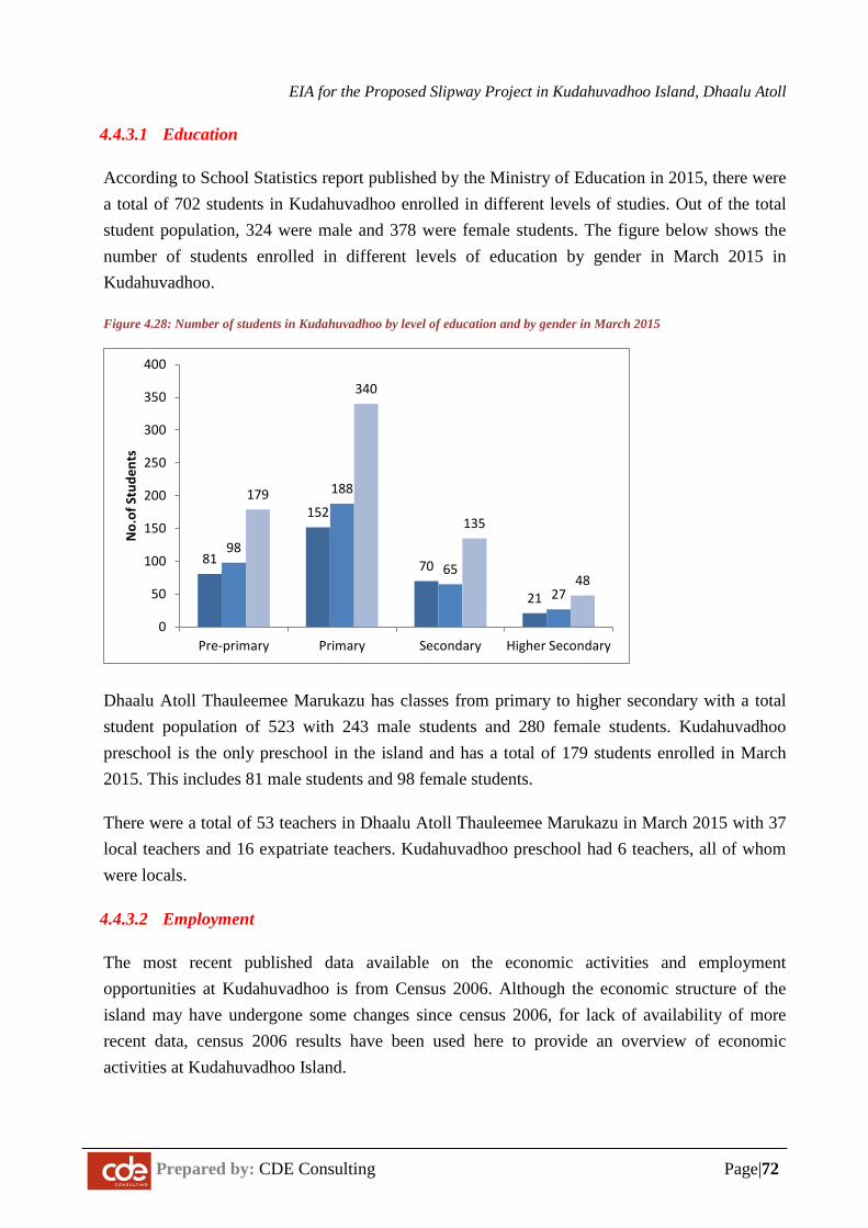
EIA for the Proposed Slipway Project in Kudahuvadhoo Island, Dhaalu Atoll
Prepared by: CDE Consulting Page|72
4.4.3.1 Education
According to School Statistics report published by the Ministry of Education in 2015, there were a total of 702 students in Kudahuvadhoo enrolled in different levels of studies. Out of the total student population, 324 were male and 378 were female students. The figure below shows the number of students enrolled in different levels of education by gender in March 2015 in Kudahuvadhoo.
Figure 4.28: Number of students in Kudahuvadhoo by level of education and by gender in March 2015
Dhaalu Atoll Thauleemee Marukazu has classes from primary to higher secondary with a total student population of 523 with 243 male students and 280 female students. Kudahuvadhoo preschool is the only preschool in the island and has a total of 179 students enrolled in March 2015. This includes 81 male students and 98 female students.
There were a total of 53 teachers in Dhaalu Atoll Thauleemee Marukazu in March 2015 with 37 local teachers and 16 expatriate teachers. Kudahuvadhoo preschool had 6 teachers, all of whom were locals.
4.4.3.2 Employment
The most recent published data available on the economic activities and employment opportunities at Kudahuvadhoo is from Census 2006. Although the economic structure of the island may have undergone some changes since census 2006, for lack of availability of more recent data, census 2006 results have been used here to provide an overview of economic activities at Kudahuvadhoo Island.
81
152
70
21
98
188
65
27
179
340
135
48
0
50
100
150
200
250
300
350
400
Pre-primary Primary Secondary Higher Secondary
No.
of S
tude
nts
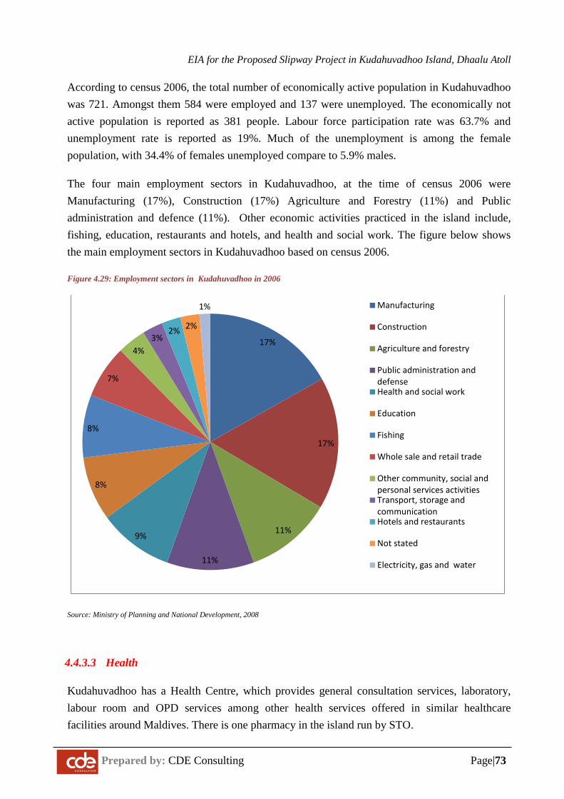
EIA for the Proposed Slipway Project in Kudahuvadhoo Island, Dhaalu Atoll
Prepared by: CDE Consulting Page|73
According to census 2006, the total number of economically active population in Kudahuvadhoo was 721. Amongst them 584 were employed and 137 were unemployed. The economically not active population is reported as 381 people. Labour force participation rate was 63.7% and unemployment rate is reported as 19%. Much of the unemployment is among the female population, with 34.4% of females unemployed compare to 5.9% males.
The four main employment sectors in Kudahuvadhoo, at the time of census 2006 were Manufacturing (17%), Construction (17%) Agriculture and Forestry (11%) and Public administration and defence (11%). Other economic activities practiced in the island include, fishing, education, restaurants and hotels, and health and social work. The figure below shows the main employment sectors in Kudahuvadhoo based on census 2006.
Figure 4.29: Employment sectors in Kudahuvadhoo in 2006
Source: Ministry of Planning and National Development, 2008
4.4.3.3 Health
Kudahuvadhoo has a Health Centre, which provides general consultation services, laboratory, labour room and OPD services among other health services offered in similar healthcare facilities around Maldives. There is one pharmacy in the island run by STO.
17%
17%
11%
11%
9%
8%
8%
7%
4%3%
2% 2%
1% Manufacturing
Construction
Agriculture and forestry
Public administration anddefenseHealth and social work
Education
Fishing
Whole sale and retail trade
Other community, social andpersonal services activitiesTransport, storage andcommunicationHotels and restaurants
Not stated
Electricity, gas and water
EIA for the Proposed Slipway Project in Kudahuvadhoo Island, Dhaalu Atoll
Prepared by: CDE Consulting Page|74
5 IMPACTS IDENTIFICATION
5.1 Introduction
Potential adverse and beneficial impacts of construction and operation stage of slipway are identified and evaluated in this section. Significant impacts are identified and evaluated in two stages. The first stage identifies the environmental and socio-economic components that may be impacted from key project activities. The second stage determines the significance of impacts of each component. The following sections provide details of the evaluation of impacts.
5.2 Boundaries of Affected Areas
The estimated boundaries of affected areas are summarised in Figure 5.1 below. These boundaries are based physical conditions and work methods proposed in the project without any mitigation measures. The extents shown are not absolute and should be treated as the best-guess scenario based on past projects.
The works being undertaken in the neighbouring islands, if continued at the same time as this project, will involve cumulative impacts (See Section 6.5).
5.3 Impact Identification and Evaluation
Environmental and socio-economic aspects that may be impacted by the project are identified in the impact matrices in Table 5.1 to 5.3. Assessments of the impacts are conducted based on the following criteria.
1. Magnitude: Refers to the quantum of change that will be experienced as a consequence of the impact. It is defined by the severity of each potential impact based on impact reversibility, irreversibility and potential rate of recovery. Impacts of high magnitude are those that cannot be mitigated substantially or involve substantial residual impacts.
2. Nature: Where the activity or component has direct, indirect or cumulative impacts from multiple projects or activities.
3. Duration: Refers to the temporal scale (i.e. duration, frequency) of the impact. It does not take into account the duration of the impact’s effects.
4. Distribution: Refers to the spatial scale of the area impacted. An impact can be site specific or limited to the project area; locally occurring within the immediate vicinity of the project locality; atoll level; or at a national level. The four criteria are detailed using the following scale and attributes given in table 5.2.
5. Significance: Refers to the importance of the impact’s consequence or implications (ecological social, economic). An impact of small magnitude could have a very high
EIA for the Proposed Slipway Project in Kudahuvadhoo Island, Dhaalu Atoll
Prepared by: CDE Consulting Page|75
significance and vice-versa (e.g. siltation of a small reef area with rare coral species has low magnitude but very high significance). Once an impact has been identified it needs to be evaluated using set of criteria. The key criterion considered in this study are:
a. The degree of reversibility of an impact (i.e. duration of its effects) is considered part of its significance.
b. Threats to sensitive eco-systems. For example, those leading to loss of key habitats and extinction of species, or those affecting Protected Areas.
c. Threats to key resources leading to depletion of resources or loss of livelihood associated with those resources.
d. Geographic extent of impact. For example, national or trans-boundary impacts
e. Duration and timing of the impact
f. Likelihood or probability of the impact occurrence
g. Reversibility
h. Resource use conflicts
i. Public views and complaints
j. Cumulative impacts on an area due to multiple projects
k. Uncertainty in impact predictions
l. Cost of mitigation
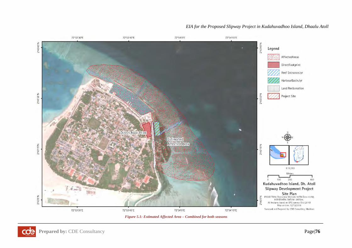
EIA for the Proposed Slipway Project in Kudahuvadhoo Island, Dhaalu Atoll
Prepared by: CDE Consultancy Page|76
Figure 5.1: Estimated Affected Area – Combined for both seasons
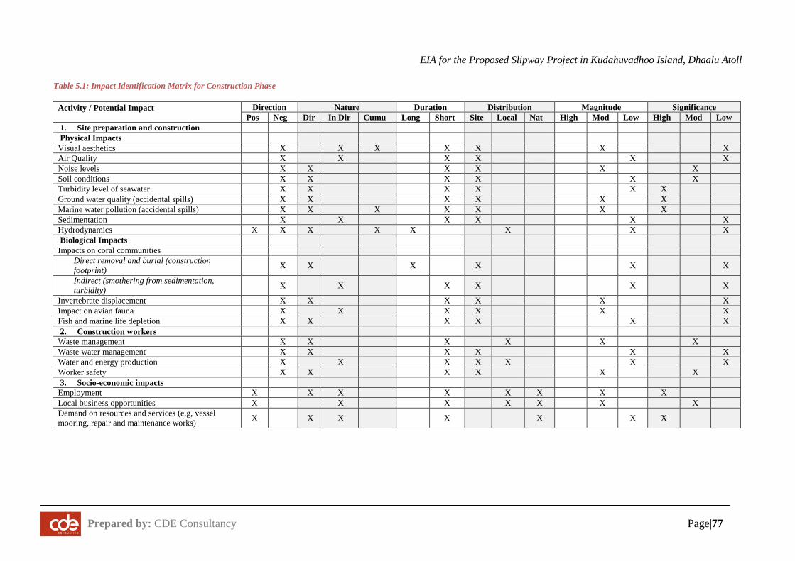
EIA for the Proposed Slipway Project in Kudahuvadhoo Island, Dhaalu Atoll
Prepared by: CDE Consultancy Page|77
Table 5.1: Impact Identification Matrix for Construction Phase
Activity / Potential Impact
Direction Nature Duration Distribution Magnitude Significance Pos Neg Dir In Dir Cumu Long Short Site Local Nat High Mod Low High Mod Low
1. Site preparation and construction Physical Impacts Visual aesthetics X X X X X
X X
Air Quality X X X X X X Noise levels X X
X X X
X Soil conditions X X X X X X Turbidity level of seawater X X
X X X X Ground water quality (accidental spills) X X X X X X
Marine water pollution (accidental spills) X X X X X X X Sedimentation X X X X X X Hydrodynamics X X X X X X X X Biological Impacts Impacts on coral communities
Direct removal and burial (construction footprint) X X X X X X
Indirect (smothering from sedimentation, turbidity) X X X X X X
Invertebrate displacement X X X X X X Impact on avian fauna X X X X X X Fish and marine life depletion X X X X X X 2. Construction workers
Waste management X X X X X X Waste water management X X X X X X Water and energy production X X X X X X X Worker safety X X X X X X 3. Socio-economic impacts
Employment X X X X X X X X Local business opportunities X X X X X X X Demand on resources and services (e.g, vessel mooring, repair and maintenance works) X X X X X X X
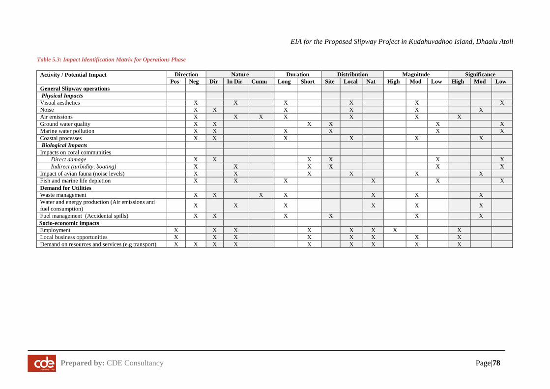
EIA for the Proposed Slipway Project in Kudahuvadhoo Island, Dhaalu Atoll
Prepared by: CDE Consultancy Page|78
Table 5.3: Impact Identification Matrix for Operations Phase
Activity / Potential Impact
Direction Nature Duration Distribution Magnitude Significance Pos Neg Dir In Dir Cumu Long Short Site Local Nat High Mod Low High Mod Low
General Slipway operations Physical Impacts Visual aesthetics X X X
X X
X Noise X X X X X X Air emissions X X X X X X X Ground water quality X X X X X X Marine water pollution X X X X X X Coastal processes X X X X X X Biological Impacts Impacts on coral communities
Direct damage X X X X X X Indirect (turbidity, boating) X X X X X X
Impact of avian fauna (noise levels) X X X X X X Fish and marine life depletion X X X X X X Demand for Utilities Waste management X X X X X X X Water and energy production (Air emissions and fuel consumption) X X X X X X
Fuel management (Accidental spills) X X X X X X Socio-economic impacts Employment X X X X X X X X Local business opportunities X X X X X X X X Demand on resources and services (e.g transport) X X X X X X X X X
EIA for the Proposed Slipway Project in Kudahuvadhoo Island, Dhaalu Atoll
Prepared by: CDE Consultancy
6 SIGNIFICANT IMPACTS AND MITIGATION MEASURES
6.1 Impacts on Natural Environment during Construction Phase
6.1.1 Ambient Noise Level, Air Quality and Greenhouse Gas Emissions
During the mobilisation of equipment and operation of heavy machinery, it is anticipated that significant noise will be generated. Noise vibrations may alter species behaviour. In addition, dust and emissions, including greenhouse gases, from vehicle and machinery exhausts will degrade the air quality. However, these adverse impacts will be short term and can be mitigated to avoid nuisance to the resident local community. With proper mitigation measures, it is unlikely that noise and air pollution impacts will cause long term effects such as human health risks leading to increased public and private health costs. While emitted greenhouse gases can persist in the atmosphere in the long term, the level of emission from this project is expected to be negligible.
Since the project is implemented in a local community island with no other settlements or resorts in close proximity, impacts will be localised and not felt in the outer islands.
6.1.2 Groundwater and Soil Condition
The construction of the slipway is expected to have minimal impacts on the quality and quantity of groundwater and soil condition due to the small size of the site. However, impacts are expected to be severe in the event of accidental spills.
The relatively small size of the ground water lens is of particularly concern in terms of vulnerability to negative impacts.
During the construction phase oil, paint or other chemicals will need to be handled properly. Mishandling of fuel has led to serious pollution of soil and groundwater aquifer in some of the other construction projects. This sort of pollution may sometimes have long-term irreversible effects, extending through the operations stage, since such contamination does not degrade itself and is expensive to clean up. The clean-up itself may require extensive ground water extraction, which will have impacts such as salt-water intrusion.
During the construction stage, civil works including excavation will be undertaken to make way for foundations for infrastructure development. Erection of these structures will require removal of sand and possibly dewatering of groundwater for concrete foundations. Therefore, this stage of construction will affect the soil and groundwater and may potentially cause saline intrusion. The extent and level of salinization will often depend on the location of the structure being built. In general, excavation and dewatering in areas close to the Vadose zone or areas close to the
EIA for the Proposed Slipway Project in Kudahuvadhoo Island, Dhaalu Atoll
Prepared by: CDE Consultancy
beach such as the proposed site for the slipway, makes the groundwater vulnerable to salinization.
Removal of vegetation for construction will expose the soil to wind erosion. The risk is minimal as the shoreline at the proposed site will be developed to allow easy mooring and hauling of vessels.
Excavation for building foundations and utility pipelines can also expose groundwater and the deeper sections of the soil to more harmful contaminants such as oils and hydrocarbons from vehicles and other machineries used during the construction.
Solid waste and wastewater generation during the construction stage can also affect the groundwater, if they are mishandled and mismanaged during the construction stage. The risk is moderate as construction will be well supervised and managed by project staff to ensure that waste is handled and disposed properly.
6.1.3 Terrestrial Flora and Fauna
Development of the slipway at Kudahuvadhoo would inevitably involve some changes to the terrestrial environment, including flora and fauna of the north-eastern side of the island. However, these changes will be minimal in comparison to the overall environment of the island. All of the vegetation falling within the footprint will need to be removed. Since the site will e an industrial site, it is unlikely that any large vegetation will be kept upon completion of the construction phase. The numbers of moderately large trees to be relocated or cut down are between approximately 20 to 25 trees. Most of the coconut palms will be relocated where possible. The impact or affected area footprint is summarised in Figure 6.1.
Impacts on terrestrial flora will be limited to the site, while impacts on terrestrial fauna will be incurred along the entire north-eastern side of the island.
Construction of facilities on the site will require trees and shrubs to be cut down. In the process, some of the peripheral vegetation is removed or the natural ecological succession of the vegetation is altered. With the removal or change to coastal vegetation, the habitat for many coastal dwelling species is lost. In the absence of an environmental management plan, removal of or damage to coastal vegetation is particularly likely during construction.
Influx of workers to the island would inevitably have negative impacts on the terrestrial environment. Lack of awareness or concern to preserve the environment may lead to deliberate or inadvertent damages to the trees in order to speed up their work.
In the absence of adequate data on the faunal species of Kudahuvadhoo it would not be appropriate to draw conclusions on detailed impacts on the fauna. However, general impacts
EIA for the Proposed Slipway Project in Kudahuvadhoo Island, Dhaalu Atoll
Prepared by: CDE Consultancy
could be identified through experience in such activities. Generally, any clearing of vegetation will either displace or eliminate certain animals since their habitats are destroyed. The clearings combined with heavy machinery operation may temporarily force them to look for alternate sites.
Wastes and residue arising from construction activities such as oil spills and other wastes may also affect the terrestrial environment. Dumping of construction debris or remains of earth works or temporary waste mounds on or near scrubby vegetation could destroy them easily. Hence, strict measures need to be considered on deposition and monitoring of the refuse as well as other materials produced during the construction phase. Haphazard deposition of waste could destroy several habitats and microhabitats that are crucial for the dynamic island environment.
The site was not identified as an area of importance for any unique terrestrial flora or fauna species of the Maldives, nor is an area used by nesting turtles.
6.1.4 Marine Water Quality
Construction activities will involve significant adverse impacts on the marine water quality. The most significant will be the turbidity and sedimentation impacts from coastal modification activities of the slipway. Turbidity higher than certain threshold levels for longer periods of time will have significant impacts on marine life.
Suspended sediments are carried by water and/or accumulate in a loose unconsolidated form on the reef bottom. While large particles settle on the bottom of the water body, sediment particles less than 0.063 mm in size (mostly clay and silt) will remain suspended in the water column. Suspended sediment will be easily dispersed thereby causing sedimentation on the reef.
Construction activities require the use of chemical substances such as fuel, oil and paints. Accidental spillage of such substances, particularly during transportation or offloading, and the construction of coastal structures, can lead to marine water contamination. The spillage of construction material during construction of the coastal area is a particular concern, given the probable longer length of construction period.
Sediment dispersal will occur at a moderate scale. The marine environment is likely to be moderately affected.
Furthermore, significant quantities of waste will be generated from all construction related activities where any mishandling of solid (non-biodegradable) waste and hazardous waste will also contaminate the marine water. Therefore, special care should be taken when handling oil, solid waste and hazardous waste to entirely avoid any accidental spills and leakage.
EIA for the Proposed Slipway Project in Kudahuvadhoo Island, Dhaalu Atoll
Prepared by: CDE Consultancy
6.1.5 Coastal Processes
The following activities and structures are located along the coastline and lagoon, and are likely to have direct and indirect impacts on the coastal environment.
• Dredging harbour basin and widening of reef entrance channel • Construction of coastal structures of the slipway • Breakwater construction
Coastal process around the island may be affected due to the nearshore hydrodynamic changes associated with deepening the entrance channel. Changes to wave propagation patterns due to diffraction around the channel opening may lead to extra pressure in the immediate vicinity of the eastern beach. Increase in water flow speed between the channels will also put pressure on the existing beach areas. However, this impact is expected to be moderately small due to the narrow opening on the channel and the angle of the channel.
Construction work involves creating sand bunds which may further affect wave propagation patterns and reducing the wave energy received on the eastern shoreline when the bund is in place. This impact can be minimised if the work is undertaken during the SW monsoon. The proposed reclamation areas are likely to stabilize the beach in the short term and the areas proposed for replenishment are present severe erosion zones. The replenished areas are also likely to undergo severe erosion in the months immediately after the works as the beach tries adjust to the prevailing hydrodynamic conditions.
The material dredged from the lagoon are likely to contain large quantities of rubble, based on the evidence form past dredging activities. Once the fine material are eroded, the beach may be left with rubble, as it is now.
The construction of offshore breakwater to protect the harbour basin will affect the wave propagation patterns around the area. Beach tombolo may form behind the breakwater, and beach may try to protrude into the dredged basin.
The presence of the dredged basin close to the beach may result in sand being lost into the deep lagoon leading erosion and gradual infilling of the basin. However, the process is expected to be slow due to the installation of breakwater.
6.1.6 Marine Biodiversity
Construction stage of the project is expected to have direct and indirect adverse impacts on the flora and fauna of the marine environment.
EIA for the Proposed Slipway Project in Kudahuvadhoo Island, Dhaalu Atoll
Prepared by: CDE Consultancy
The benthic organisms and biological structures in the footprint of reef entrance, the area where the coastal structures are to be constructed and the excavator operations zone will be completely removed According to the field survey, live coral colonies are rare in the footprint of the proposed activities as most of the good coral cover is on the reef slopes.
Apart from the live corals, lagoon bottom is a habitat for certain organisms such as worms, molluscs, amphipod etc., which are important food sources for bottom feeders such as certain species of fishes. Lagoon bottom at the proposed project sites will be affected by reef clearing through direct removal of benthic communities and habitats and disturbing habitats of lagoon bottom organisms. However, it has been found elsewhere that lagoon bottom dwelling organisms re-establish within few months after such disturbances.
The proposed reclamation and dredging sites contain a seagrass bed which is will be damaged during construction. All seagrass within the footprint of the project will be removed or cleared. Additional area may die due to extensive sedimentation.
Degradation of the water quality due to spillage of substance used in construction and construction waste, and sedimentation due to disturbance of bottom sediments and generation of sediment plumes would degrade the habitat of marine organisms. In particular, significant increases in the level of suspended and bedded sediment within the water column for a prolonged period will alter the habitat and adversely affect the living organisms at the site.
A moderately significant amount of siltation and sedimentation of the lagoon waters is anticipated. Similarly, increased turbidity of the lagoon water is expected. These factors will cause adverse impacts such as smothering of corals and reduced light penetration to the coral and benthic communities. Under normal circumstances, corals have a self-cleansing mechanism and can withstand a certain rate of sedimentation. Hence, detrimental impacts such as reduced coral growth and recruitment rate and decreased visibility can be short term effects. However, if the sedimentation exceeds the rate at which corals can self-clean then it may lead to serious detrimental impacts such as coral mortality and alteration of habitat and species composition within the lagoon.
Frequent short-term exposures or chronic long-term exposure to sedimentation and turbidity will result in mortality for many coral species. If moderate levels of impacts on a coral reef persist for particularly long periods of time, the coral reef may undergo changes in diversity, with more sensitive coral species gradually being replaced by more tolerant ones. This may result in an overall reduction in the biodiversity of the coral reef. The risk and severity of impacts from dredging activities on coral reefs are directly related to both the intensity and duration of impacts causing stress.
EIA for the Proposed Slipway Project in Kudahuvadhoo Island, Dhaalu Atoll
Prepared by: CDE Consultancy
Foraging behaviour of fishes may be impeded by turbid conditions as well; gills maybe clogged by sediment particles and sediment deposition may cover and suffocate eggs and larvae of benthic spawning fishes. Prolonged exposure to high sediment levels can lead to a decrease in fish immunity against parasites and diseases. As fishes can readily disperse they are likely to relocate to nearby reefs if high sediment conditions persist.
In addition, sedimentation is likely to cause major shifts in invertebrate populations as sediment is deposited at the crevices/crannies blocking their habitat. This favours domination of invertebrate populations that are more tolerant of the condition. The overall population diversity, size and quality of reef ecosystem are likely to decline due to increased and prolonged sedimentation arising from the proposed activities.
Potential impacts on the Marine protected area (MPA) were evaluated. The nearest MPA is located along the northern rim of Dhaalu atoll. No significant impacts are expected to be incurred on this area from the proposed project.
EIA for the Proposed Slipway Project in Kudahuvadhoo Island, Dhaalu Atoll
Prepared by: CDE Consultancy Page|85
6.2 Impacts on the Natural Environment during Operational Phase
6.2.1 Coastal Processes
As in the construction stage, it is highly likely that there will be considerable changes to beach conditions during the operation stage. It is likely that up to 5 m of the beach will be eroded within one year of construction. This erosion is related to natural adaptation of shoreline to wave conditions and does not pose an issue for the island infrastructure.
During the operation phase, slipway area will be heavily used. The increased approach of mechanised vessels cause some disturbance to the currents and waves in the area speeding up sediment transport on the eastern side. The movements on the beach may also increase the speed of sediment transport.
Erosion mitigation measures may not be required in the near future as this area does not have any buildings. The beach in front of the slipway is expected to be stable due to the presence of breakwater. The area should be monitored for erosion regularly. Soft adaptation measures such as beach replenishment may be practical in the short-term.
6.2.2 Marine Water Quality
Operational stage activities that can potentially lead to degradation of the marine water quality include improper disposal of solid waste into the marine environment (including waste generated on land and littering from boats), improper anchoring and spillages of hazardous materials.
The Environmental Management Plan presented in Chapter 8 of the report includes methods for proper disposal of solid waste, thereby mitigating the risk of marine environment degradation due to solid waste.
6.2.3 Marine Biodiversity
Operational activities of the slipway can have adverse impacts on the marine biodiversity, through physical damage and habitat degradation.
Intensity of boating activities would be relatively high when the slipway is in full operation. Intense boating activities have proven chronically detrimental to marine environment especially coral reefs both resulting from direct and indirect impacts such as physical damage to the benthos especially to corals through anchor damage and littering by boat crew and indirectly through disturbances to the lagoon bottoms especially in shallow areas. Boat grounding and anchor damage to the reef are potential risks especially during bad weather conditions and boat operations after dark.
EIA for the Proposed Slipway Project in Kudahuvadhoo Island, Dhaalu Atoll
Prepared by: CDE Consultancy Page|86
Degradation of the marine environment due to solid waste can affect the marine biodiversity in the area as well. However, as discussed above, these impacts are highly unlikely, given the measures taken to mitigate the risk of such impacts.
6.2.4 Ground Water Quality and Quantity
Usage of groundwater may have dramatic impacts on the scarce ground water lens. Similarly groundwater can easily be contaminated due to any hazardous chemicals handled on the site.
Hazardous materials will have proper labels and material safety datasheets (MSDS) clearly labelled. Access and use of these substances will also be strictly controlled and monitored by specially trained personnel. Therefore, with these mitigation measures, the likelihood of any groundwater contamination is not expected.
Once the slipway is in operation, no groundwater will be used for any activity other than cleaning purposes and flush toilets. Existing desalination plants operated by FENAKA will provide fresh water for most of the site’s activities. Therefore groundwater will be positively impacted in that the overall quantity will be maintained by not using it.
Furthermore, environmental technologies will be incorporated, so as to conserve water during operation. Water efficient taps will be installed at bathrooms and toilets and all operational areas. Low-flush and dual-flushing toilets will be used at bathrooms.
6.2.5 Terrestrial Environment
The main operational activities of the slipway that are expected to have potential adverse impacts on the terrestrial environment are solid waste and waste oil generation.
Operational stage of the slipway will generate large quantities of solid waste as almost all supplies will be imported. Likely types of waste generated include hazardous waste (chemicals used in repair and maintenance works, used fuels etc.). The Environmental Management Plan includes measures to effectively manage solid waste and waste oil in a manner that is least harmful to the environment. Hence, major adverse impacts on the terrestrial environment due to solid waste and waste oils are not expected.
6.2.6 Ambient Noise Level and Air Quality
Outdoor air pollution is a major environmental health problem affecting everyone in developed and developing countries. A 2013 assessment by WHO’s International Agency for Research on Cancer (IARC) concluded that outdoor air pollution is carcinogenic to humans, with the particulate matter component of air pollution most closely associated with increased cancer
EIA for the Proposed Slipway Project in Kudahuvadhoo Island, Dhaalu Atoll
Prepared by: CDE Consultancy Page|87
incidence, especially cancer of the lung. An association also has been observed between outdoor air pollution and increase in cancer of the urinary tract/bladder.
Dust-borne particles (fibreglass, wood etc.) and emissions from vessels are expected to be the significant source of air quality degradation at the site. Activities that are expected to generate high noise levels are vessel movement, carpentry and mechanical workshops.
Operational stage of the slipway will generate large amounts of dust-borne particles as well as increased noise levels. The Environmental Management Plan includes measures to effectively manage air pollution that is least harmful to the environment. Hence, major adverse impacts on the ambient air quality are not expected.
6.3 Impacts on the Socio-economic Environment during construction
6.3.1 Business and Employment Opportunities
The proposed project has strong potential for beneficial impacts on the society and local economy, particularly for the community of Kudahuvadhoo. The project provides direct employment opportunities for locals while demand for skilled local workers such as carpenters, craftsmen, welders etc. is expected to increase further over the operations phase.
Demand for resources such as food and accommodation for construction workers, equipment, machinery, vehicles and vessels hire will also likely benefit the local suppliers and businesses.
6.3.2 Health and Safety
Health and safety risks arising from construction work is high, especially due to the use of specialised equipment and machinery. Accidents related to equipment use can lead to injury, and fatalities. Materials used in construction, in addition to the equipment and machinery, also involve risks to health and safety. Accidental spills/ leakage of hazardous substances can contaminate the site and pose risks to human health, including workers on the site and the local population. The project activities include measures to minimize risks to health and safety of workers.
6.4 Impacts on the Socio-economic Environment during operation
6.4.1 Business and Employment Opportunities
The development of the slipway is likely to have positive impacts on the island and atoll community. Economic benefits anticipated from slipway operation include,
EIA for the Proposed Slipway Project in Kudahuvadhoo Island, Dhaalu Atoll
Prepared by: CDE Consultancy Page|88
• Easy vessel repair and maintenance works • Easy mooring of vessels • Affordable access to hardware materials • Additional income from ancillary services tendered from the island and atoll
Out of these benefits, employing the poor is the highest priority for the people of the atoll. The slipway is a labour-intensive business and offers opportunity for private sector to provide additional paid employment to the poor. In order to successfully implement such a programme, attention needs to be given to proper awareness-raising as well as reliable and sustainable employment, and involvement of the people hired as much as possible.
The second most important impact area identified by the public is the impact on trade of local goods. It would be important for the management to determine in advance the policies for purchase of local products from islands while encouraging free and fair trade.
6.4.2 Resource Use Conflict
The proposed site has been lease by the proponent to develop a slipway. The existing uses of the site is to moor small dinghy boats near the area and to access a recreational volleyball court used by local women. Development of the slipway will prevent the use of the site for these purposes. Loss of access to the volleyball court may cause some public dissatisfaction, especially among women. However, since the benefits of developing the slipway outweigh the benefits of current uses, it is unlikely that any significant conflicts may arise between the management team and the locals.
Part of the proposed reclamation area contains recreational beach. The conditions on the beach are at present poor with waste and seagrass along the area. Reclamation in the proposed area will result in the area converting to a rubble beach. However, there is also potential for beach to form further eastward with the finer material eroded from the reclamation area.
6.4.3 Demand for Resources and Services
Once the slipway is operational, there will be additional burden on the local waste management site, or Thilafushi waste management facility. Most of the waste generated will be handled at the local waste site, but certain materials like non-combustible and hazardous waste will need to be handled at the waste management site at Thilafushi. There will be an overall long-term moderate impact as a result.
The site will pose an additional burden upon the existing utility services of the island in terms of Power, Sewerage and Water. These facilities will be provided by FENAKA.
EIA for the Proposed Slipway Project in Kudahuvadhoo Island, Dhaalu Atoll
Prepared by: CDE Consultancy Page|89
The site will also have access to the recently improved transport infrastructure of Kudahuvadhoo (new and improved roads) including the under-construction airport.
In addition, there will be additional demand from local business as more people get stationed on the island during the time their vessels are hauled for repairs.
6.5 Cumulative Impacts
There is a major development project on the southern and western side of the island (Airport Development Project). The reclamation phase of the project has already been completed and substantial damage has been incurred on the reef. Further dredging for this project will add cumulative stress on the reef.
The shoreline of Kudahuvadhoo Island has been completely reshaped and more shore protection is yet to come. Thus, the island will undergo substantial coastal process adjustment in the coming years. The works under this project forms a small percent of the overall shoreline but is expected to play a role in the shoreline adjustment process. Natural beach may no longer exist on the island as almost all areas are nor reclaimed.
Increase in slipway services in Dhaalu Atoll will involve cumulative benefits for the workforce and income levels in the atoll and neighbouring atolls.
EIA for the Proposed Slipway Project in Kudahuvadhoo Island, Dhaalu Atoll
Prepared by: CDE Consultancy Page|90
6.6 Recommended Mitigation Measures
This chapter describes the mitigation measures recommended for the project based on the main adverse impacts identified in Chapter 6.
6.6.1 Air and Noise Pollution
Project activities that can lead to air and noise pollution are vessel repair and maintenance works during operations and the operation of equipment and machinery both during construction and operations.
Mitigation Measures
• Properly tune and maintain all vehicles and machinery
• Keep ground/ soil damp to minimize dust/ topsoil erosion by wind
• Conduct construction activities during daytime to minimize nuisance to humans and fauna
• Monitor all occupational areas to ensure noise levels do not exceed WHO standards • Avoid heavy duty work during night hours, and during periods of strong wind activity • Construct 15 feet tall wall along the boundary to reduce the amount of dust-borne
particles
The main cost would be for construction of the boundary wall and these costs are to be included in the contract value and are mainly the responsibility of the contractor.
6.6.2 Contamination of Marine Water, Groundwater and Land
Contamination of marine water, groundwater and land can occur both during construction and operation. Construction activities have a particularly high potential for pollution. Contaminants can include construction materials, fuel, chemicals used for different purposes (including land clearing) and construction waste. Exposure of groundwater and deeper soil sections by excavation for construction increases the risk of groundwater contamination. Improper disposal of solid waste can also result in contamination during operations.
6.6.2.1 Construction Activities
Construction activities that can lead to contamination of groundwater, soil and marine waters include:
• Accidental spillage of construction materials • Improper storage of chemicals and raw materials used for construction • Improper stockpiling and disposal of construction stage waste
Mitigation Measures
EIA for the Proposed Slipway Project in Kudahuvadhoo Island, Dhaalu Atoll
Prepared by: CDE Consultancy Page|91
• Oil, solid waste & hazardous waste handled carefully & transported in sealed containers.
• All paints, lubricants, and other chemicals used on site stored in a secure and bunded location
• General refuse stockpiled in one central area
• Keep spill cleanup materials readily available
• Train workers in spill prevention and cleanup, and designate responsible individuals
• Properly tune and maintain all machinery
• Carry out construction activities user the supervision of a suitably experienced person
Costs are to be included in the contract value and are mainly the responsibility of the contractor.
6.6.2.2 Solid Waste
Improper disposal of solid waste during construction and operation, including from vessels using the slipway, can contaminate the receiving environment. Strategic measures and actions proposed for effective solid waste management are included in the Environmental Management Plan (Section 8).
Mitigation Measures
• All vessels should be equipped with trash bins within easy reach and sign should be displayed to encourage use of trash bins
6.6.2.3 Slipway Operations
Project activities specific to the operational stage of the slipway that can lead to contamination of the receiving environment include improper storage and handling of chemicals used for cleaning, vessel repair and maintenance during operation.
Mitigation Measures • Biodegradable cleaning and disinfecting agents will be used for service and maintenance
purposes • Standard operations manuals will be prepared and made available to all users of the site,
to ensure proper guidelines are followed when handling hazardous materials These mitigation measures involve procurement policy decisions and operations manuals, and do not include significant additional costs.
EIA for the Proposed Slipway Project in Kudahuvadhoo Island, Dhaalu Atoll
Prepared by: CDE Consultancy Page|92
6.6.3 Groundwater Depletion
Groundwater depletion can occur due to dewatering for construction of building foundations and excavation purposes.
Mitigation Measures
• Discharge extracted water within the island to assist aquifer recharge
No additional cost is expected to be incurred by discharging extracted water back to ground.
6.6.4 Existing and Predicted Changes to Coastal Processes
Mitigation Measures
• Undertake beach monitoring for one year to see if the area infront of the slipway is eroding.
• Undertake beach replenishment to mitigate short-term erosion (See Alternative beach rejuvenation options).
The cost of replenishment is likely to be between Rf 100,000-150,000.
6.6.5 Increased Turbidity and Sedimentation
Construction activities near the coastline and within the island lagoon can disturb the bottom sediment, leading to turbidity of the water column and sedimentation in nearby lagoon and reef habitats.
Mitigation Measures
• Complete works in shortest time period possible
• Carry out work in low tide hours and in calm condition • Excavator movement should stick to predefined routes for travel along
the reef.
6.6.6 Loss of Terrestrial Vegetation and Fauna
Activities that can lead to loss of terrestrial vegetation and fauna are:
• Vegetation removal for construction • Inadvertent and deliberate damage by construction workers
Mitigation Measures • Where possible, leave mature trees intact during construction. • Clearly mark vegetation to be retained and communicate to workers
EIA for the Proposed Slipway Project in Kudahuvadhoo Island, Dhaalu Atoll
Prepared by: CDE Consultancy Page|93
• Only the sites of building and footpaths will be cleared for construction purposes and removal of scrubs and shrubs will be limited to the minimum extent required
• Plants and trees that have to be removed from construction sites will be used for landscaping other areas (if possible)
• Signs to guide workers to proper environmental care
• Clear green waste to prevent pest infestations
6.6.7 Removal of Marine Organisms / Marine Habitat Destruction
Coastal activities such as construction of coastal structures can lead to direct removal of benthic organisms and destruction of marine habitat.
Mitigation Measures
• Minimize affected area and preserve areas not in direct footprint • Specify the routes for excavator movement and prevent excavator operators from
straying into other zones.
6.6.8 Occupational Health Impacts
Occupational health impacts may occur due to:
• Accidents during machine and equipment operation • Exposure to chemical contamination in water/ air • Respiratory health impacts due to air pollution during construction and operations • High noise level during construction
Mitigation Measures
• All health and safety precautions described in Chapter 2 will be implemented. They include the following.
o Health checks will be administered before work commences o Warning signs, barricades or warning devices will be provided and used. o Necessary safety gear will be worn at all times. These include safety gloves,
construction boots, facemasks, earmuffs, etc. o Fire extinguishing equipment would be readily available and employees will be
trained in its use. o Oxygen, acetylene or LPG bottles will not be left freestanding. o First aid kits will be made available on site o The construction site will be properly closed to unauthorised personnel
Costs are to be included in the contract value and are mainly the responsibility of the contractor.
EIA for the Proposed Slipway Project in Kudahuvadhoo Island, Dhaalu Atoll
Prepared by: CDE Consultancy Page|94
6.6.9 Increased Demand on Waste Disposal Facilities
Solid waste generation during construction and operation will put extra burden on the existing waste management facility of Kudahuvadhoo and on Thilafushi Island.
Mitigation Measures
• Waste minimization and recycling ventures included in Environmental Management Plan (Chapter 8)
6.6.10 Resource Conflicts
Conflicts over resources can occur due to:
• Requirement to preserve reef ecosystem
Mitigation Measures
• Promote awareness on non-extractive value of ecosystems, and long-term benefits of ecosystem conservation and sustainable use
6.6.11 Social Conflicts
Social conflicts may arise due to the:
• Influx of expatriate workforce • Loss of job opportunity for locals in construction stage • Disagreement regarding project components and their effects on locals
Mitigation Measures • Employ local residents as far as possible
• Provide proper orientation to all workers regarding local values and customs
• Inform and consult all stakeholders at all stages of the project
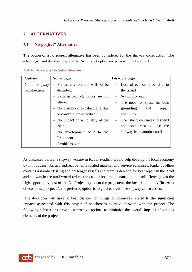
EIA for the Proposed Slipway Project in Kudahuvadhoo Island, Dhaalu Atoll
Prepared by: CDE Consulting Page|95
7 ALTERNATIVES
7.1 “No-project” Alternative
The option of a no project alternative has been considered for the slipway construction. The advantages and disadvantages of the No Project option are presented in Table 7.1.
Table 7-1: Summary of “No Project” Alternative
Options Advantages Disadvantages No slipway
construction − Marine environment will not be
disturbed − Existing hydrodynamics are not
altered − No disruption to island life due
to construction activities − No impact on air quality of the
island − No development costs to the
Proponent − Avoid erosion
− Loss of economic benefits to the island
− Social discontent − The need for space for boat
grounding and repair continues
− The island continues to spend additional cost to use the slipway from another atoll
As discussed before, a slipway venture in Kudahuvadhoo would help develop the local economy by introducing jobs and indirect benefits related material and service purchases. Kudahuvadhoo contains a number fishing and passenger vessels and there is demand for boat repair in the Atoll and slipway in the atoll would reduce the cost or boat maintenance in the atoll. Hence given the high opportunity cost of the No Project option to the proponent, the local community (in terms of economic prospects), the preferred option is to go ahead with the slipway construction.
The developer will have to bear the cost of mitigation measures related to the significant impacts associated with this project if he chooses to move forward with the project. The following subsections provide alternative options to minimize the overall impacts of various elements of the project.
EIA for the Proposed Slipway Project in Kudahuvadhoo Island, Dhaalu Atoll
Prepared by: CDE Consulting Page|96
7.2 Alternative Erosion Mitigation Plan
As described in the impacts chapter, there is likely to be erosion around the reclaimed area. Options that could be considered are as follows.
Option A: Do nothing
The proposed reclamation is an added land to the island. Erosion in this area while the beach undergoes adjustment should not be considered a major issue in the short term. The most critical area is in front of the slip way area but this area is likely to remain more stable due to the presence of breakwater. Thus, there is a case to consider monitoring the changes to the site before considering erosion mitigation measures.
Option B: Beach replenishment
Soft engineering measures are more suitable for the area as there are no major buildings in the area. Should there be major erosion in the area, particularly in front of the slipway area, beach replenishment can be undertaken by dredging the immediate basin area.
Option C: Groyne field
A permanent solution to contain the sand in the area will be to build a groyne field. G A groyne field 50 m apart with a length of 15 m each should suffice for the reclaimed area.
PREFERRED OPTIONS
Based on the above evaluations, the most environmentally suitable option is OPTION A (do nothing) and to monitor the changes before considering erosion mitigation. It is highly likely that erosion mitigation may not be required in the near-future.
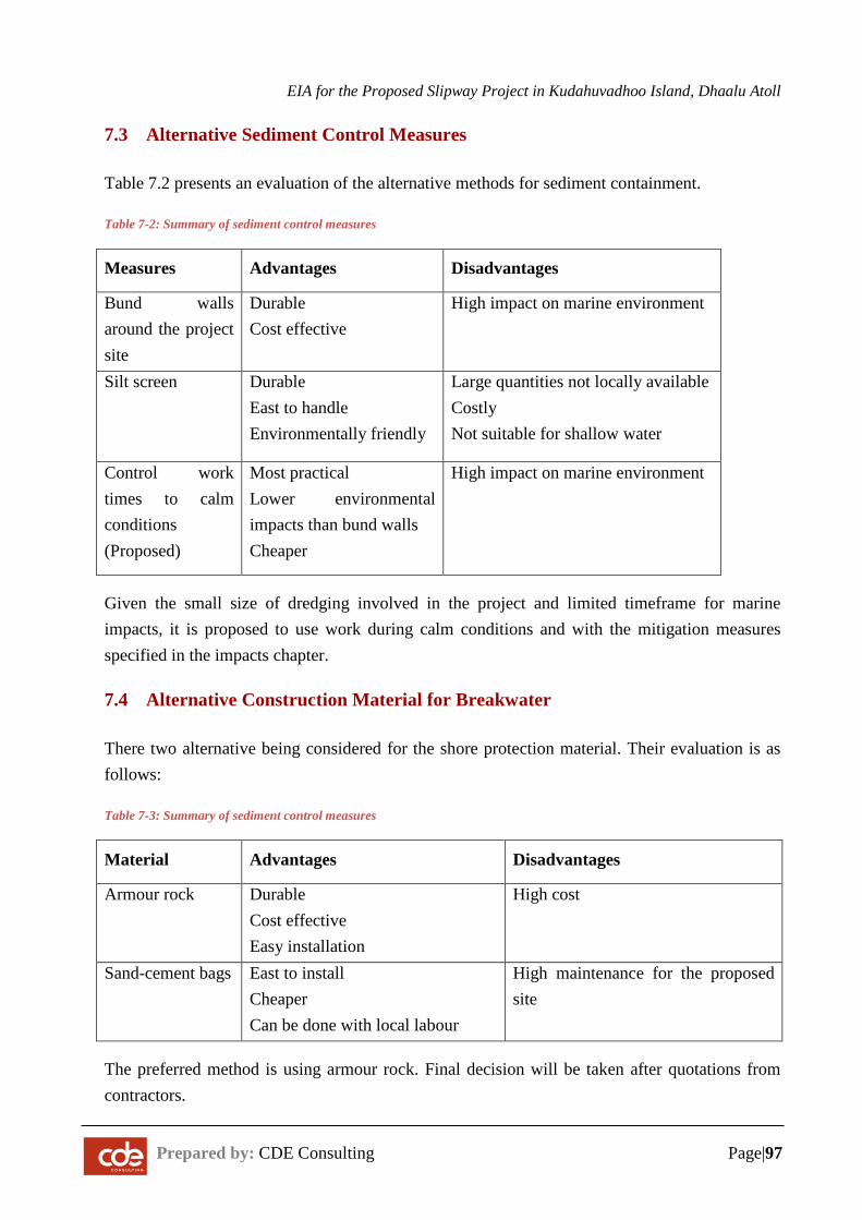
EIA for the Proposed Slipway Project in Kudahuvadhoo Island, Dhaalu Atoll
Prepared by: CDE Consulting Page|97
7.3 Alternative Sediment Control Measures
Table 7.2 presents an evaluation of the alternative methods for sediment containment.
Table 7-2: Summary of sediment control measures
Measures Advantages Disadvantages
Bund walls around the project site
Durable Cost effective
High impact on marine environment
Silt screen Durable East to handle Environmentally friendly
Large quantities not locally available Costly Not suitable for shallow water
Control work times to calm conditions (Proposed)
Most practical Lower environmental impacts than bund walls Cheaper
High impact on marine environment
Given the small size of dredging involved in the project and limited timeframe for marine impacts, it is proposed to use work during calm conditions and with the mitigation measures specified in the impacts chapter.
7.4 Alternative Construction Material for Breakwater
There two alternative being considered for the shore protection material. Their evaluation is as follows:
Table 7-3: Summary of sediment control measures
Material Advantages Disadvantages
Armour rock Durable Cost effective Easy installation
High cost
Sand-cement bags East to install Cheaper Can be done with local labour
High maintenance for the proposed site
The preferred method is using armour rock. Final decision will be taken after quotations from contractors.
EIA for the Proposed Slipway Project in Kudahuvadhoo Island, Dhaalu Atoll
Prepared by: CDE Consultancy Page|98
8 ENVIRONMENTAL MANAGEMENT PLAN
The Environmental Management Plan (EMP) is an important component of the EIA process, needed to determine the accuracy of impact prediction, the adequacy of mitigation measures, and level of compliance with commitments regarding implementation of mitigation measures and monitoring of relevant environmental aspects.
The main objectives of the environmental management plan are to:
− Produce a framework for managing anticipated impacts, including practicable and achievable performance requirements and systems for monitoring, reporting and implementing corrective actions.
− Provide evidence of compliance to legislation, policies, guidelines and requirements of relevant authorities.
8.1 Environmental management system
The environmental management framework for the proposed project is based on the standards and policies set out by the Environmental Protection Agency of the Maldives.
- Environmental Management Planning and establishment of key performance indicators: The EMP specifies environmental management measures and required performance standards
- Monitoring and corrective action: The implementation of EMP measures will be monitored. Any inconsistencies between the EMP and its on-site implementation will be identified and addressed through corrective actions
- Auditing, reviews and improvement: The EMP will be reviewed. Improvements to the EMP will be made as necessary to achieve desired environmental outcomes.
The environmental management strategy is demonstrated in the following figure.
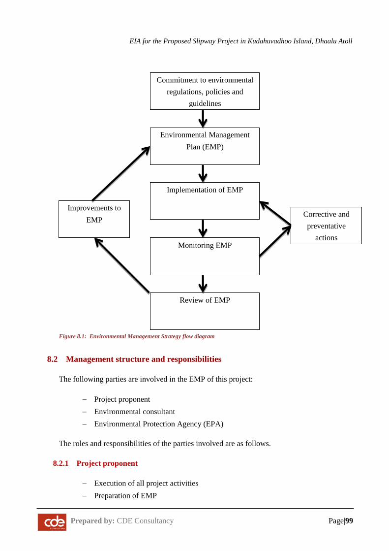
EIA for the Proposed Slipway Project in Kudahuvadhoo Island, Dhaalu Atoll
Prepared by: CDE Consultancy Page|99
8.2 Management structure and responsibilities
The following parties are involved in the EMP of this project:
− Project proponent − Environmental consultant − Environmental Protection Agency (EPA)
The roles and responsibilities of the parties involved are as follows.
8.2.1 Project proponent
− Execution of all project activities − Preparation of EMP
Commitment to environmental regulations, policies and
guidelines
Environmental Management Plan (EMP)
Implementation of EMP
Monitoring EMP
Review of EMP
Improvements to EMP
Corrective and preventative
actions
Figure 8.1: Environmental Management Strategy flow diagram
EIA for the Proposed Slipway Project in Kudahuvadhoo Island, Dhaalu Atoll
Prepared by: CDE Consultancy Page|100
− Detailed designs of dredging − Detailed designs of structures − Monitoring of the project activities − Submission of annual environmental monitoring reports as required by the EPA
8.2.2 Environmental Consultant
− Preparation of EMP − Monitoring of performance of project activities according to the EMP − Auditing the EMP to ensure desired outcomes are achieved − Making amendments to the EMP according to the results of the audits − Preparation of environmental monitoring report as required by the EPA (detailed
in Chapter 9 of this report)
8.2.3 Environmental Protection Agency
− Review environmental monitoring report − Intervention in the event of a breach in environmental permit conditions − Site visit and inspection
8.3 Non-Conformances and Corrective Action
All non-conformances to the environmental permit conditions, observed during monitoring will be documented.
Necessary corrective actions and preventative actions will be identified
Corrective actions will be implemented, with systematic follow-ups to ensure effectiveness of these measures.
8.4 Reporting requirements
Reporting shall be undertaken to provide evidence of the ongoing implementation of the EMP and will cover any training activities, site conditions and operations, monitoring data, details of non-conformances, incidents, complaints and follow up action, results of audits and reviews. Reporting shall be undertaken by the project proponent and the Environmental Consultant.
The environmental reporting process is summarized in the figure below. All non-compliances and complaints during the execution of the project are to be reported to the EPA. The environmental management plan for execution of the project is provided below.
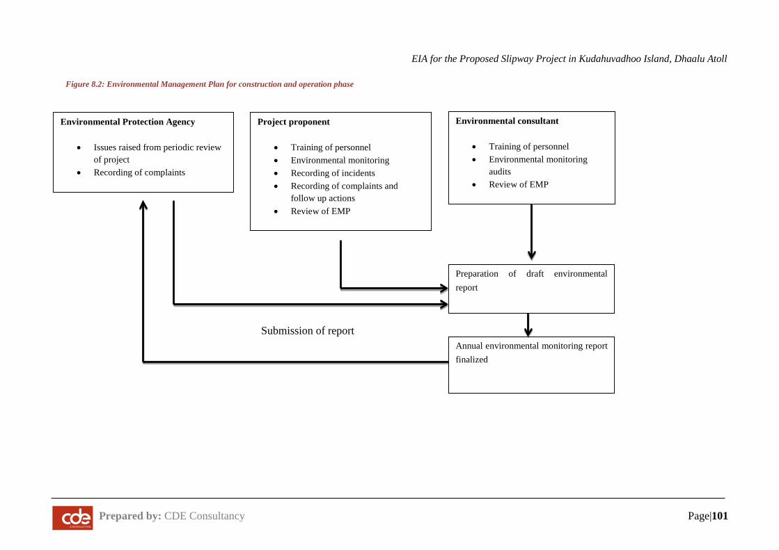
EIA for the Proposed Slipway Project in Kudahuvadhoo Island, Dhaalu Atoll
Prepared by: CDE Consultancy Page|101
Figure 8.2: Environmental Management Plan for construction and operation phase
Environmental consultant
• Training of personnel • Environmental monitoring
audits • Review of EMP
Preparation of draft environmental report
Annual environmental monitoring report finalized
Environmental Protection Agency
• Issues raised from periodic review of project
• Recording of complaints
Project proponent
• Training of personnel • Environmental monitoring • Recording of incidents • Recording of complaints and
follow up actions • Review of EMP
Submission of report
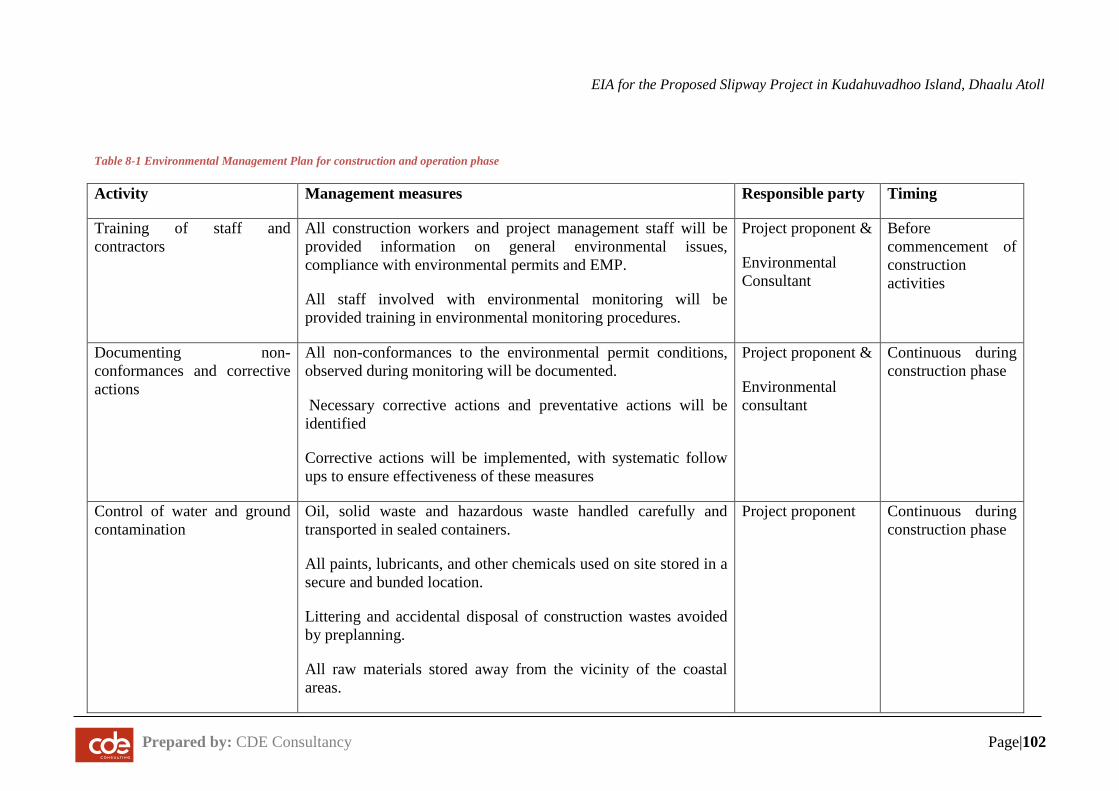
EIA for the Proposed Slipway Project in Kudahuvadhoo Island, Dhaalu Atoll
Prepared by: CDE Consultancy Page|102
Table 8-1 Environmental Management Plan for construction and operation phase
Activity Management measures Responsible party Timing
Training of staff and contractors
All construction workers and project management staff will be provided information on general environmental issues, compliance with environmental permits and EMP.
All staff involved with environmental monitoring will be provided training in environmental monitoring procedures.
Project proponent &
Environmental Consultant
Before commencement of construction activities
Documenting non-conformances and corrective actions
All non-conformances to the environmental permit conditions, observed during monitoring will be documented.
Necessary corrective actions and preventative actions will be identified
Corrective actions will be implemented, with systematic follow ups to ensure effectiveness of these measures
Project proponent &
Environmental consultant
Continuous during construction phase
Control of water and ground contamination
Oil, solid waste and hazardous waste handled carefully and transported in sealed containers.
All paints, lubricants, and other chemicals used on site stored in a secure and bunded location.
Littering and accidental disposal of construction wastes avoided by preplanning.
All raw materials stored away from the vicinity of the coastal areas.
Project proponent Continuous during construction phase
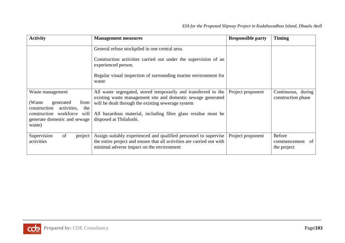
EIA for the Proposed Slipway Project in Kudahuvadhoo Island, Dhaalu Atoll
Prepared by: CDE Consultancy Page|103
Activity Management measures Responsible party Timing
General refuse stockpiled in one central area.
Construction activities carried out under the supervision of an experienced person.
Regular visual inspection of surrounding marine environment for waste
Waste management
(Waste generated from construction activities, the construction workforce will generate domestic and sewage waste)
All waste segregated, stored temporarily and transferred to the existing waste management site and domestic sewage generated will be dealt through the existing sewerage system
All hazardous material, including fibre glass residue must be disposed at Thilafushi.
Project proponent Continuous, during construction phase
Supervision of project activities
Assign suitably experienced and qualified personnel to supervise the entire project and ensure that all activities are carried out with minimal adverse impact on the environment
Project proponent Before commencement of the project
EIA for the Proposed Slipway Project in Kudahuvadhoo Island, Dhaalu Atoll
Prepared by: CDE Consulting Page| 104
9 ENVIRONMENTAL MONITORING PLAN
9.1 Introduction
This chapter will outline the monitoring plan for the proposed project. Environmental monitoring is essential because, although with proper mitigation measures, the overall environmental damage can be significantly minimized, an unforeseen impact may still occur. Furthermore, some of the impacts predicted may turn out to be far greater than predicted, making mitigation measures ineffective. Therefore, in order to avoid or reduce the chances of such events, regular and frequent environmental monitoring is vital.
9.2 Objectives of the Monitoring Plan
The main objectives of the monitoring plan are:
− To identify whether the predicted impacts are accurate and mitigation measures taken are effective
− To identify any unforeseen impacts so that appropriate mitigation measures can be taken at the earliest
− To identify and resolve any issues of social unrest at the earliest − To eliminate or reduce environmental costs
9.3 Before Construction
The monitoring assessments prescribed in Table 9.1 are required before construction, if the construction activities begin 12 months after this EIA.
9.4 Monitoring during Construction Phase
Table 9.2 shows the details of the different monitoring attributes and parameters must be monitored during the construction stage.
Additionally, the following aspects will be monitored during the construction stage to ensure that environmental impacts are minimized.
1. Daily monitoring to ensure that the cleared areas and other construction processes are not creating any significant dust nuisance for the local environment.
2. Daily monitoring of vehicle refuelling and repair should be undertaken to ensure that these exercises are carried out on hardstands and to ensure that they are done properly.
EIA for the Proposed Slipway Project in Kudahuvadhoo Island, Dhaalu Atoll
Prepared by: CDE Consulting Page| 105
This is to reduce the potential of soil contamination from spills. Spot checks will be conducted by the site supervisor.
3. Daily inspection of site clearance activities to ensure that the proposed building plans are followed.
4. Weekly assessment to determine that toilets are in proper working order. This will ensure that sewage disposal will be adequately maintained.
5. Monitor and ensure that approved suppliers and sources of local materials are used.
9.5 Monitoring during Operational Phase
Operational phase monitoring programs will be carried out for a period of 2 years from the completion date of the construction phase of the project (unless specified as otherwise in this chapter). Table 9.3 provides the schedule for operational phase monitoring.
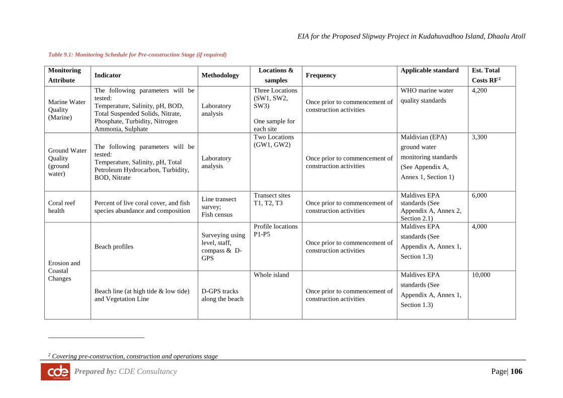
EIA for the Proposed Slipway Project in Kudahuvadhoo Island, Dhaalu Atoll
Prepared by: CDE Consultancy Page| 106
Table 9.1: Monitoring Schedule for Pre-construction Stage (if required)
Monitoring Attribute
Indicator Methodology Locations &
samples Frequency
Applicable standard Est. Total Costs RF2
Marine Water Quality (Marine)
The following parameters will be tested: Temperature, Salinity, pH, BOD, Total Suspended Solids, Nitrate, Phosphate, Turbidity, Nitrogen Ammonia, Sulphate
Laboratory analysis
Three Locations (SW1, SW2, SW3) One sample for each site
Once prior to commencement of construction activities
WHO marine water quality standards
4,200
Ground Water Quality (ground water)
The following parameters will be tested: Temperature, Salinity, pH, Total Petroleum Hydrocarbon, Turbidity, BOD, Nitrate
Laboratory analysis
Two Locations (GW1, GW2)
Once prior to commencement of construction activities
Maldivian (EPA) ground water monitoring standards (See Appendix A, Annex 1, Section 1)
3,300
Coral reef health
Percent of live coral cover, and fish species abundance and composition
Line transect survey; Fish census
Transect sites T1, T2, T3 Once prior to commencement of
construction activities
Maldives EPA standards (See Appendix A, Annex 2, Section 2.1)
6,000
Erosion and Coastal Changes
Beach profiles
Surveying using level, staff, compass & D-GPS
Profile locations P1-P5
Once prior to commencement of construction activities
Maldives EPA standards (See Appendix A, Annex 1, Section 1.3)
4,000
Beach line (at high tide & low tide) and Vegetation Line
D-GPS tracks along the beach
Whole island
Once prior to commencement of construction activities
Maldives EPA standards (See Appendix A, Annex 1, Section 1.3)
10,000
2 Covering pre-construction, construction and operations stage
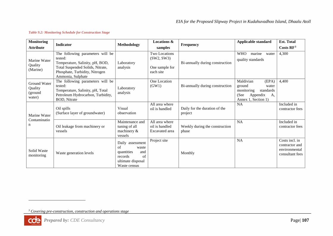
EIA for the Proposed Slipway Project in Kudahuvadhoo Island, Dhaalu Atoll
Prepared by: CDE Consultancy Page| 107
Table 9.2: Monitoring Schedule for Construction Stage
Monitoring Attribute
Indicator Methodology Locations &
samples Frequency
Applicable standard Est. Total Costs RF3
Marine Water Quality (Marine)
The following parameters will be tested: Temperature, Salinity, pH, BOD, Total Suspended Solids, Nitrate, Phosphate, Turbidity, Nitrogen Ammonia, Sulphate
Laboratory analysis
Two Locations (SW2, SW3) One sample for each site
Bi-annually during construction
WHO marine water quality standards
4,300
Ground Water Quality (ground water)
The following parameters will be tested: Temperature, Salinity, pH, Total Petroleum Hydrocarbon, Turbidity, BOD, Nitrate
Laboratory analysis
One Location (GW1) Bi-annually during construction
Maldivian (EPA) ground water monitoring standards (See Appendix A, Annex 1, Section 1)
4,400
Marine Water Contamination
Oil spills (Surface layer of groundwater)
Visual observation
All area where oil is handled Daily for the duration of the
project
NA Included in contractor fees
Oil leakage from machinery or vessels
Maintenance and tuning of all machinery & vessels
All area where oil is handled Excavated area
Weekly during the construction phase
NA Included in contractor fees
Solid Waste monitoring Waste generation levels
Daily assessment of waste quantities and records of ultimate disposal Waste census
Project site
Monthly
NA Costs incl. in contractor and environmental consultant fees
3 Covering pre-construction, construction and operations stage
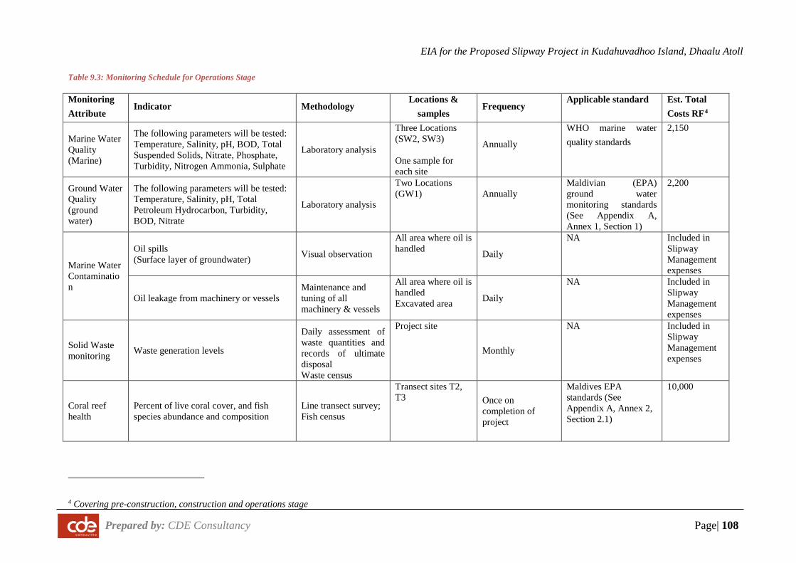
EIA for the Proposed Slipway Project in Kudahuvadhoo Island, Dhaalu Atoll
Prepared by: CDE Consultancy Page| 108
Table 9.3: Monitoring Schedule for Operations Stage
Monitoring Attribute
Indicator Methodology Locations &
samples Frequency
Applicable standard Est. Total Costs RF4
Marine Water Quality (Marine)
The following parameters will be tested: Temperature, Salinity, pH, BOD, Total Suspended Solids, Nitrate, Phosphate, Turbidity, Nitrogen Ammonia, Sulphate
Laboratory analysis
Three Locations (SW2, SW3) One sample for each site
Annually
WHO marine water quality standards
2,150
Ground Water Quality (ground water)
The following parameters will be tested: Temperature, Salinity, pH, Total Petroleum Hydrocarbon, Turbidity, BOD, Nitrate
Laboratory analysis
Two Locations (GW1) Annually
Maldivian (EPA) ground water monitoring standards (See Appendix A, Annex 1, Section 1)
2,200
Marine Water Contamination
Oil spills (Surface layer of groundwater) Visual observation
All area where oil is handled Daily
NA Included in Slipway Management expenses
Oil leakage from machinery or vessels Maintenance and tuning of all machinery & vessels
All area where oil is handled Excavated area Daily
NA Included in Slipway Management expenses
Solid Waste monitoring Waste generation levels
Daily assessment of waste quantities and records of ultimate disposal Waste census
Project site
Monthly
NA Included in Slipway Management expenses
Coral reef health
Percent of live coral cover, and fish species abundance and composition
Line transect survey; Fish census
Transect sites T2, T3 Once on
completion of project
Maldives EPA standards (See Appendix A, Annex 2, Section 2.1)
10,000
4 Covering pre-construction, construction and operations stage
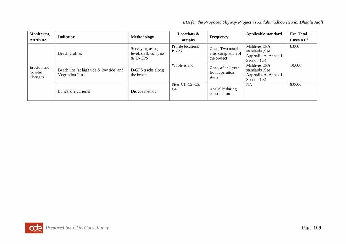
EIA for the Proposed Slipway Project in Kudahuvadhoo Island, Dhaalu Atoll
Prepared by: CDE Consultancy Page| 109
Monitoring Attribute
Indicator Methodology Locations &
samples Frequency
Applicable standard Est. Total Costs RF4
Erosion and Coastal Changes
Beach profiles Surveying using level, staff, compass & D-GPS
Profile locations P1-P5 Once, Two months
after completion of the project
Maldives EPA standards (See Appendix A, Annex 1, Section 1.3)
6,000
Beach line (at high tide & low tide) and Vegetation Line
D-GPS tracks along the beach
Whole island Once, after 1 year from operation starts
Maldives EPA standards (See Appendix A, Annex 1, Section 1.3)
10,000
Longshore currents Drogue method
Sites C1, C2, C3, C4 Annually during
construction
NA 8,0000
EIA for the Proposed Slipway Project in Kudahuvadhoo Island, Dhaalu Atoll
Prepared by: CDE Consulting Page|110
9.6 Monitoring report
A detailed environmental monitoring report is required to be compiled and submitted to Environmental Protection Agency annually based on the data collected for monitoring the parameters included in the monitoring plan given in the EIA. This report may be submitted to the relevant Government agencies in order to demonstrate compliance. The report will include details of the site, strategy of data collection and analysis, quality control measures, sampling frequency and monitoring analysis and details of methodologies and protocols followed. In addition, more frequent reporting of environmental monitoring will be communicated among the environmental consultant, project proponent, the contractors and supervisors to ensure possible negative impacts are mitigated appropriately during and after the project.
9.7 Cost of monitoring
The cost of monitoring is estimated to be Rf50,000 annually. Professional consultants will be hired to undertake the monitoring and the necessary equipment for monitoring will be procured.
For pre-construction and construction stage monitoring, individual parameter costs are provided in the relevant tables above.
9.8 Commitment to monitoring
The proponent is fully committed to undertake the monitoring programme given in this chapter (see Appendix J).
EIA for the Proposed Slipway Project in Kudahuvadhoo Island, Dhaalu Atoll
Prepared by: CDE Consulting Page|111
10 STAKEHOLDER CONSULTATIONS
Stakeholder consultation sessions were held between 4th October 2016 and 21st October 2016. Stakeholder consultations were held with the island council of Dh. Kudahuvadhoo, Dhaalu Atoll Council, public of Kudahuvadhoo, Ministry of Housing and Infrastructure and Health Protection Agency.
The section below summarizes the meetings and their findings.
10.1 Consultation with Dhaalu Atoll Council
Location: Dhaalu Atoll Council Office
Date/ Time: 4 October 2016, 11:00 -12:00 am
Participants: Atoll council members and EIA team (see Table 10.1)
Summary of Discussions
• Views and Opinions o Likely to benefit a large share of the population, especially boat owners/ operators
both locals and from the tourism industry o Job opportunities would increase, however preference to locals from the atoll and the
island is encouraged o The introduction of a hardware store would enable locals to access better supplies
more conveniently o Indirect income from the users of the slipway who will reside on the island is also
expected o Overall, considered a very good project for the atoll and the island
• Concerns o Major concern regarding wind-blown particles from the Slipway, especially during the
north-east monsoon, when most of the particles would probably be blown right into the island. These are dangerous particles and the council hopes that proper mitigation measures are in place to avoid such scenarios.
o No existing waste management facility on the island, so additional waste created from the slipway (especially hazardous materials) will be a major concern for disposal. In addition, it is important to ensure that the proponent keeps the lagoon clean and free from waste.
o Noise pollution – odd working hours may cause disturbances to the local population o Strong currents near the proposed location, hence proper shore protection measures
should be in place to ensure the safety of the users of the slipway
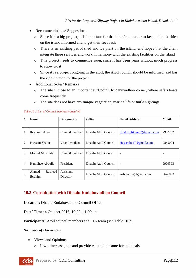
EIA for the Proposed Slipway Project in Kudahuvadhoo Island, Dhaalu Atoll
Prepared by: CDE Consulting Page|112
• Recommendations/ Suggestions o Since it is a big project, it is important for the client/ contractor to keep all authorities
on the island informed and to get their feedback o There is an existing petrol shed and ice plant on the island, and hopes that the client
integrate these services and work in harmony with the existing facilities on the island o This project needs to commence soon, since it has been years without much progress
to show for it o Since it is a project ongoing in the atoll, the Atoll council should be informed, and has
the right to monitor the project. • Additional Notes/ Remarks o The site is close to an important surf point; Kudahuvadhoo corner, where safari boats
come frequently o The site does not have any unique vegetation, marine life or turtle sightings.
Table 10-1 List of Council members consulted
# Name Designation Office Email Address Mobile
1 Ibrahim Fikree Council member Dhaalu Atoll Council [email protected] 7992252
2 Hussain Shakir Vice President Dhaalu Atoll Council [email protected] 9840094
3 Moosal Musthafa Council member Dhaalu Atoll Council - -
4 Hamdhee Abdulla President Dhaalu Atoll Council - 9909393
5 Ahmed Rasheed Ibrahim
Assistant Director
Dhaalu Atoll Council [email protected] 9646003
10.2 Consultation with Dhaalu Kudahuvadhoo Council
Location: Dhaalu Kudahuvadhoo Council Office
Date/ Time: 4 October 2016, 10:00 -11:00 am
Participants: Atoll council members and EIA team (see Table 10.2)
Summary of Discussions
• Views and Opinions o It will increase jobs and provide valuable income for the locals
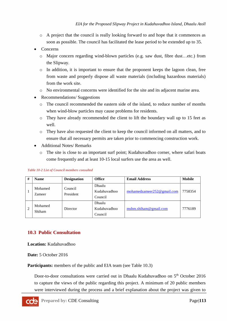
EIA for the Proposed Slipway Project in Kudahuvadhoo Island, Dhaalu Atoll
Prepared by: CDE Consulting Page|113
o A project that the council is really looking forward to and hope that it commences as soon as possible. The council has facilitated the lease period to be extended up to 35.
• Concerns o Major concern regarding wind-blown particles (e.g. saw dust, fibre dust…etc.) from
the Slipway. o In addition, it is important to ensure that the proponent keeps the lagoon clean, free
from waste and properly dispose all waste materials (including hazardous materials) from the work site.
o No environmental concerns were identified for the site and its adjacent marine area. • Recommendations/ Suggestions o The council recommended the eastern side of the island, to reduce number of months
when wind-blow particles may cause problems for residents. o They have already recommended the client to lift the boundary wall up to 15 feet as
well. o They have also requested the client to keep the council informed on all matters, and to
ensure that all necessary permits are taken prior to commencing construction work. • Additional Notes/ Remarks o The site is close to an important surf point; Kudahuvadhoo corner, where safari boats
come frequently and at least 10-15 local surfers use the area as well.
Table 10-2 List of Council members consulted
# Name Designation Office Email Address Mobile
1 Mohamed Zameer
Council President
Dhaalu Kudahuvadhoo Council
[email protected] 7758354
2 Mohamed Shiham
Director Dhaalu Kudahuvadhoo Council
[email protected] 7776189
10.3 Public Consultation
Location: Kudahuvadhoo
Date: 5 October 2016
Participants: members of the public and EIA team (see Table 10.3)
Door-to-door consultations were carried out in Dhaalu Kudahuvadhoo on 5th October 2016 to capture the views of the public regarding this project. A minimum of 20 public members were interviewed during the process and a brief explanation about the project was given to
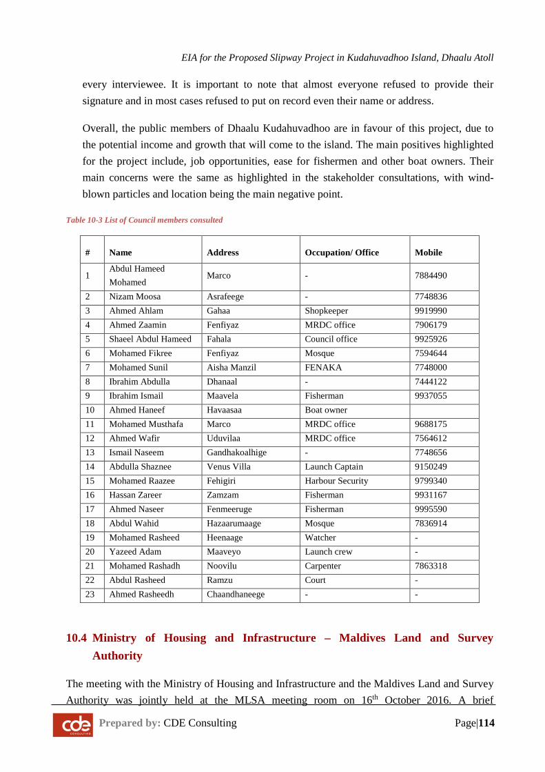
EIA for the Proposed Slipway Project in Kudahuvadhoo Island, Dhaalu Atoll
Prepared by: CDE Consulting Page|114
every interviewee. It is important to note that almost everyone refused to provide their signature and in most cases refused to put on record even their name or address.
Overall, the public members of Dhaalu Kudahuvadhoo are in favour of this project, due to the potential income and growth that will come to the island. The main positives highlighted for the project include, job opportunities, ease for fishermen and other boat owners. Their main concerns were the same as highlighted in the stakeholder consultations, with wind-blown particles and location being the main negative point.
Table 10-3 List of Council members consulted
# Name Address Occupation/ Office Mobile
1 Abdul Hameed Mohamed
Marco - 7884490
2 Nizam Moosa Asrafeege - 7748836 3 Ahmed Ahlam Gahaa Shopkeeper 9919990 4 Ahmed Zaamin Fenfiyaz MRDC office 7906179 5 Shaeel Abdul Hameed Fahala Council office 9925926 6 Mohamed Fikree Fenfiyaz Mosque 7594644 7 Mohamed Sunil Aisha Manzil FENAKA 7748000 8 Ibrahim Abdulla Dhanaal - 7444122 9 Ibrahim Ismail Maavela Fisherman 9937055 10 Ahmed Haneef Havaasaa Boat owner 11 Mohamed Musthafa Marco MRDC office 9688175 12 Ahmed Wafir Uduvilaa MRDC office 7564612 13 Ismail Naseem Gandhakoalhige - 7748656 14 Abdulla Shaznee Venus Villa Launch Captain 9150249 15 Mohamed Raazee Fehigiri Harbour Security 9799340 16 Hassan Zareer Zamzam Fisherman 9931167 17 Ahmed Naseer Fenmeeruge Fisherman 9995590 18 Abdul Wahid Hazaarumaage Mosque 7836914 19 Mohamed Rasheed Heenaage Watcher - 20 Yazeed Adam Maaveyo Launch crew - 21 Mohamed Rashadh Noovilu Carpenter 7863318 22 Abdul Rasheed Ramzu Court - 23 Ahmed Rasheedh Chaandhaneege - -
10.4 Ministry of Housing and Infrastructure – Maldives Land and Survey Authority
The meeting with the Ministry of Housing and Infrastructure and the Maldives Land and Survey Authority was jointly held at the MLSA meeting room on 16th October 2016. A brief
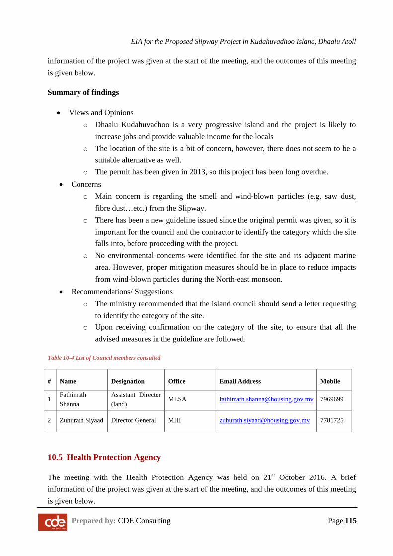
EIA for the Proposed Slipway Project in Kudahuvadhoo Island, Dhaalu Atoll
Prepared by: CDE Consulting Page|115
information of the project was given at the start of the meeting, and the outcomes of this meeting is given below.
Summary of findings
• Views and Opinions o Dhaalu Kudahuvadhoo is a very progressive island and the project is likely to
increase jobs and provide valuable income for the locals o The location of the site is a bit of concern, however, there does not seem to be a
suitable alternative as well. o The permit has been given in 2013, so this project has been long overdue.
• Concerns o Main concern is regarding the smell and wind-blown particles (e.g. saw dust,
fibre dust…etc.) from the Slipway. o There has been a new guideline issued since the original permit was given, so it is
important for the council and the contractor to identify the category which the site falls into, before proceeding with the project.
o No environmental concerns were identified for the site and its adjacent marine area. However, proper mitigation measures should be in place to reduce impacts from wind-blown particles during the North-east monsoon.
• Recommendations/ Suggestions o The ministry recommended that the island council should send a letter requesting
to identify the category of the site. o Upon receiving confirmation on the category of the site, to ensure that all the
advised measures in the guideline are followed.
Table 10-4 List of Council members consulted
# Name Designation Office Email Address Mobile
1 Fathimath Shanna
Assistant Director (land)
MLSA [email protected] 7969699
2 Zuhurath Siyaad Director General MHI [email protected] 7781725
10.5 Health Protection Agency
The meeting with the Health Protection Agency was held on 21st October 2016. A brief information of the project was given at the start of the meeting, and the outcomes of this meeting is given below.
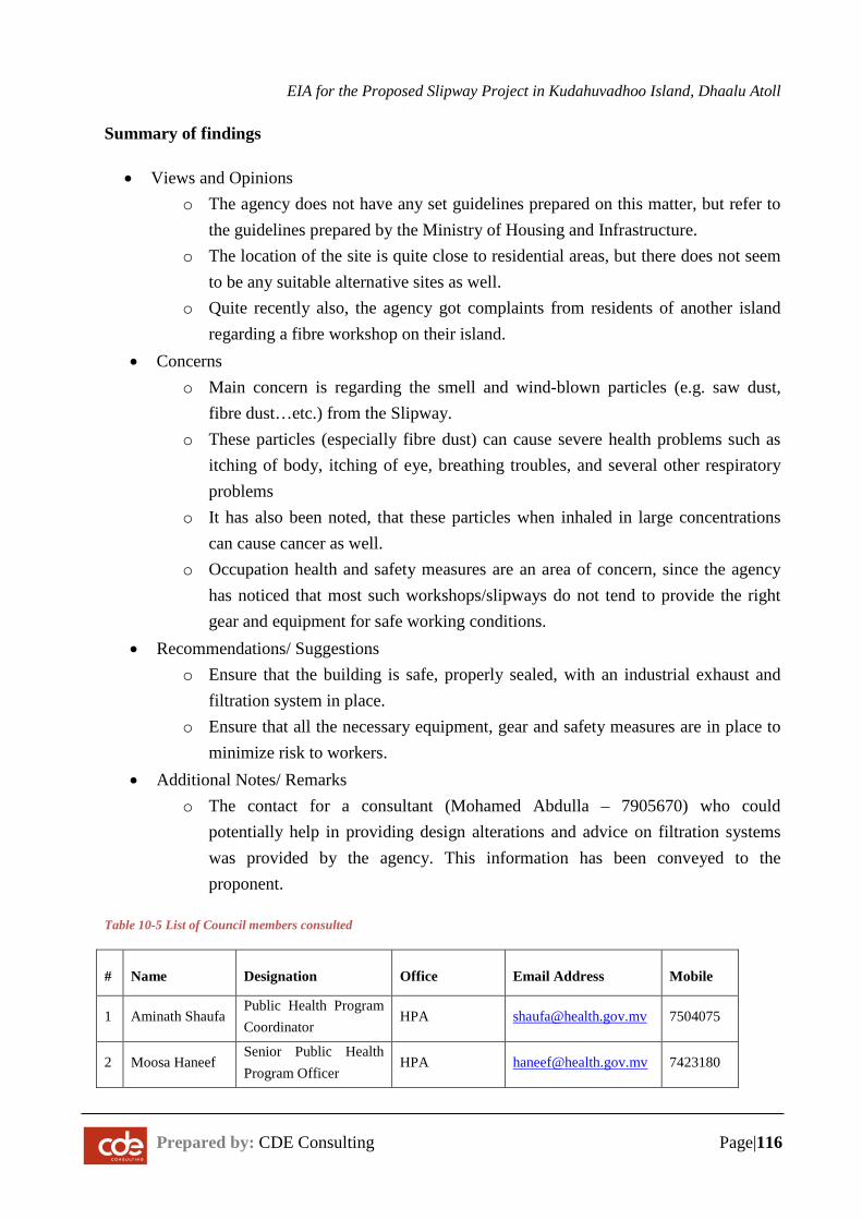
EIA for the Proposed Slipway Project in Kudahuvadhoo Island, Dhaalu Atoll
Prepared by: CDE Consulting Page|116
Summary of findings
• Views and Opinions o The agency does not have any set guidelines prepared on this matter, but refer to
the guidelines prepared by the Ministry of Housing and Infrastructure. o The location of the site is quite close to residential areas, but there does not seem
to be any suitable alternative sites as well. o Quite recently also, the agency got complaints from residents of another island
regarding a fibre workshop on their island. • Concerns
o Main concern is regarding the smell and wind-blown particles (e.g. saw dust, fibre dust…etc.) from the Slipway.
o These particles (especially fibre dust) can cause severe health problems such as itching of body, itching of eye, breathing troubles, and several other respiratory problems
o It has also been noted, that these particles when inhaled in large concentrations can cause cancer as well.
o Occupation health and safety measures are an area of concern, since the agency has noticed that most such workshops/slipways do not tend to provide the right gear and equipment for safe working conditions.
• Recommendations/ Suggestions o Ensure that the building is safe, properly sealed, with an industrial exhaust and
filtration system in place. o Ensure that all the necessary equipment, gear and safety measures are in place to
minimize risk to workers. • Additional Notes/ Remarks
o The contact for a consultant (Mohamed Abdulla – 7905670) who could potentially help in providing design alterations and advice on filtration systems was provided by the agency. This information has been conveyed to the proponent.
Table 10-5 List of Council members consulted
# Name Designation Office Email Address Mobile
1 Aminath Shaufa Public Health Program Coordinator
HPA [email protected] 7504075
2 Moosa Haneef Senior Public Health Program Officer
HPA [email protected] 7423180
EIA for the Proposed Slipway Project in Kudahuvadhoo Island, Dhaalu Atoll
Prepared by: CDE Consulting Page|117
11 Potential Data Gaps and Assessment Limitations
11.1 Gaps in Information
The environment of Maldives is generally poorly understood. This may be due to the lack of detailed studies in the Maldives. Much of the literatures on coral islands are derived from studies done in the Pacific which unfortunately has very different climatic and geologic settings.
Detailed environmental analysis for an EIA is often required to be undertaken in a relatively short period of time. Give the seasonal climatic variations in Maldives and the differences in local geomorphologic and climate settings in individual islands such a short time frame is often too little to assess selected aspects of the environment. This problem is compounded by the absence of long-term studies in other parts of Maldives. Hence, most EIA’s end up being based on an environmental snapshot of specific point in time. However, experienced EIA specialists can deliver a close match to reality based on a number of similar assessments. In this regard, the following gaps could be identified in information.
− Absence of long-term site specific or even regional data (at least 2 years). Most critical data include current, wave and terrestrial modification history.
− Absence of historical and long-term records on reef and lagoon environment. − Lack of detailed data on geology and soil due to time limitation in EIA
submission.
These gaps are seriously considered in the assessment and care has been taken to address the issue in designing mitigation measures and the monitoring programme.
11.2 Uncertainties in Impact Prediction
Environmental impact prediction involves a certain degree of uncertainty as the natural and anthropogenic impacts can vary from place to place due to even slight differences in ecological, geomorphological or social conditions in a particular place. As note earlier, there is also no long term data and information regarding the particular site under consideration, which makes it difficult to predict impacts. It is important to consider that there will be uncertainties and voluntary monitoring of natural processes as described in the monitoring programme is absolutely essential.
EIA for the Proposed Slipway Project in Kudahuvadhoo Island, Dhaalu Atoll
Prepared by: CDE Consulting Page|118
12 Conclusions
The key conclusions of this EIA are summarized below.
− The proposed developments are generally in conformance to the laws and regulations of the Maldives. Dredging and reclamation approval is required from EPA before commencement of project activities.
− The proposed project aims to develop a slipway on the north east side of Kudahuvadhoo island to provide a safe environment for vessel mooring, repair and maintenance works, while providing a source of employment and income for the island.
− Main components of the project include dredging and deepening of existing entrance channel and boat landing area, construction of slipway and construction of auxiliary service buildings. The development is designed based on environmental best practices suitable for marine and coastal constructions in Maldives.
− Kudahuvadhoo has a moderately large number of fishing and passenger vessels. At present, lack of availability of a slipway in Kudahuvadhoo and within Dhaalu atoll means that boat owners are required to use slipways in other atolls for vessel maintenance, which involves a substantial cost. Construction of a slipway in Kudahuvadhoo will reduce the cost of boat repair maintenance for Kudahuvadhoo locals and for boat owners in Dhaalu atoll in general.
− Majority of the proposed project site is already cleared land with the exception of a belt of coastal vegetation. There is an existing volleyball court on the project site used by locals for playing volleyball. No dense pockets of vegetation were observed at the site.
− Significant impacts of this project during construction phase of the project are potential significant impacts on coastal processes, impacts on the terrestrial flora and fauna, significant impacts on marine environment due to excessive sedimentation, turbidity and direct excavation related to deepening of the existing reef entrance, and impacts on marine water quality. Positive impacts of the construction phase include improved business and employment opportunities for the public. Significant impacts during operation of the slipway include impact of intense boating activities on marine biodiversity, degradation of air quality from dust-born particles and vessel emissions, noise, adverse impacts of solid waste and waste oil on terrestrial environment and increased demand for resources especially waste management services. Socioeconomic impacts of the operation phase include improvement in employment and business opportunities, adverse impacts on health and safety of workers and
EIA for the Proposed Slipway Project in Kudahuvadhoo Island, Dhaalu Atoll
Prepared by: CDE Consulting Page|119
general public, and potential resource use conflict due to loss of recreational beach and volleyball court.
− Key mitigation measures for the construction and operation stage include construction of a 15 feet tall wall along the boundary to reduce the amount of dust-borne particles, undertaking beach monitoring and beach replenishment to mitigate beach erosion, use of biodegradable cleaning and disinfecting agents for service and maintenance, preparation and use of standard operation manual for handling hazardous materials, and specifying the routes for excavator movement.
− Consultations were undertaken with kudahuvadhoo public, Kudahuvadhoo Island Council, Dhaalu Atoll council, Ministry of Housing and Infrastructure and Health Protection Agency. Stakeholders consulted in Kudahuvadhoo were generally in favour of slipway construction project.
− The alternatives evaluated for the project were the no project option, alternative erosion mitigation plan, alternative measures for sediment containment and use of alternative material for construction of breakwater. The no project option is not viable socially as there will be significant public discontent if the project is stopped. Options proposed for erosion mitigation include doing nothing, undertaking beach replenishment and building a groyne field. It was recommended to monitor the coastal changes before considering erosion mitigation.
− The monitoring plan has been designed with a focus to analyse the significant impacts over time, particularly the effect on coastal processes, water quality and impacts on marine life.
− A management framework has been proposed and it is essential that this framework be used in the construction stage of the project. The operation stage management can fall within the overall environmental management framework.
− This project mainly has beneficial socio-economic impacts.
EIA for the Proposed Slipway Project in Kudahuvadhoo Island, Dhaalu Atoll
Prepared by: CDE Consulting Page|120
REFERENCES
BINNIE BLACK & VEATCH 2000.Enviromental / Technical study for dredging / reclamation works under Hulhumale' Project - Final Report. Male': Ministry of Construction and Public Works.
DHI 1999.Physical modelling on wave disturbance and breakwater stability, Fuvahmulah Port Project. Denmark: Port Consult.
GODA, Y. 1998. Causes of high waves at Maldives in April 1987. Male': Asia Development Bank.
KENCH, P. S., BRANDER, R. W., PARNELL, K. E. & MCLEAN, R. F. 2006. Wave energy gradients across a Maldivian atoll: Implications for island geomorphology. Geomorphology, 81, 1-17.
MEC 2004. Maldives: State of the Environment 2004, Male', Ministry of Envrionment and Construction.
NASEER, A. 2003. The integrated growth response of coral reefs to environmental forcing: morphometric analysis of coral reefs of the Maldives. PhD, Dalhousie University.
UNDP 2006. Developing a Disaster Risk Profile for Maldives, Male', United Nations Development Programme and Government of Maldives.
YOUNG, I. R. 1999. Seasonal variability of the global ocean wind and wave climate. International Journal of Climatology, 19, 931–950.

EIA for the Proposed Slipway Project in Kudahuvadhoo Island, Dhaalu Atoll
Prepared by: CDE Consulting Page|121
APPENDIX A – Terms of Reference
F$4?P
EnvironmenBl Protection Agency20t6
roR No: 203-EIARES/PRtv /2016l55l
Terms of Reference for EnvironmentalImpact Assessment for a Slipway Project at
Kudahuvadhoo lsland, Dhaalu AtollThe following is the Ierms of Reference (ToR) fouowing the scoping meeting held on !51JU4)!A fotundertaking the f,IA oflhe proposed Slipway Project at Kudrhuvadhoo lsland, Dhaelu Atoll
While every attempt has been made lo ensure that this TOR addresses all of the major issues associated withdevelopment proposal, they are not necessarily exhaustive. They should not be interpreted as excluding fromconsideration matten deemed to be significant but not incorporated in them, or matters currently unfores€en, thalemerge as important or significant from cnvironmental studies, or otherwise, during the course ofpreparation ofthe EIA repo(
[. Introduction to the proiect - Describe the purpose of the project and, ifapplicable, the background informationof the project/activity and the tasks slready completed. Objectives of the development acrivities should b€specific and ifpossible quantified Define the arrangements required for the environmenral assessmenr includinghow work carried out under this contract is linked to oder aclivities that are carried out or that is b€ing carriedout withm the project boundary. Identify the donors and the instirutional afianSements relevant to this project
2 S!gd]3I99 - Submit a minimumA] size scaled plan with indications ofall the proposed infrastructures. Specifythe agreed boundaries of the $udy area for the environmenlal impact ass€ssment highliShting $e proposeddevelopment location and size, The study area should include adjacent or nemote areas, such as relevantdevelopments and nearby environmentally sensilive sites (e.9. coml ree[, sea grass, mangroves, marine protectedareas, special birds site, sensitivc species nursery and feeding grounds) Relevant developments in the areas mustalso be addressed including residenlial areas, all economic ventures alld cultural sites.
3. Scope of work - Identiry and number tasks of the project including site preparalion, consEuclion anddecommissioning phas€sTrsk l. Description of the proposed project - Provide a full description and justification of the relevant partsofthe projec! using maps at appropriate scales where necessary. The following should be provided (all inputsand outputs related to the proposed activities shall be justified): Dredging of material from burrow area anddepositinS at appropriate site(s);
The main activities of the project arel. Clelring dredSed mate.ial fiom temporery site(s). Slipway area construction ard surrounding infrastructure which may include land reclamation works. Access to island and site including channel dredging andjetty construction, ifrequired;. Operational plan including transpor! water quslity monitoring;. Measures to proteq environmental values during construcrion and once the new slipway has been
established;. Project management: lnclude communication ofconstruction details, progress, target dates and duration
of works, construction/operatiodclosure of labor camps, acc€ss to site, safety, equipmenr and materialstomSe, water supply, waste management from construction operations (mainly dredged materials),power and fuel supply
tdlonm.dJPlol.d'onA{.ncY
c ren su irdi.a ri rhor {.nd hw.e8l^au n
rid. , r4 oi MtrdB6, 20192
T.r: lr9aol 3!3 59a9 lr!{ot 333 1951
-i i.Jiij iiiririi)
lore! .i2t,ia ittmir cdrde.pa .d R -i:t:
,f)
EPA
STMr/.
Envrronmental Protection Agency EPA20t
Details of the slipway. Location ofthe slipway on an AJ scaled map. Design parameters ofthe slipway (size, depth, pmfile). Justification for the location ofthe slipway
Dredeinq and Excavation. Location and siz€ of burrow 6reas (s) on a scsled map;. Justi fication for the selection of the location, depth and size of burrow are4s);. Method and equipment us€d for dredgin& including description of positioning system, depth control
system and operational conhol procedures;. Exact method and proc-ess(es) of dredging/excavation (egr details ofthe use ofsand beds or use of barge
mounted excavation). Dredged material disposayusage details, e.g. for land reclamarion, beach replenishment or coEstal
protection works;. Juslification for selecting the methods al|d equipment;. Duration ofdrcdging activiryl. Lebour .equirements and (local) labour availability;. Housing oftemporary labour, and. Emergency plan in clse ofspills (dies€|, gre{se, oil)
Coastal structures. l,ocations and designs ofthe seawalland quay wall(ifrequired). Locations and designs ofadditional coastal protection measures (ifrequired). Juslification and dctails of flood mitigation measures( ifrequired). Melhod and equipment used for construction ofcoastal structures
Tssk 2. D6criprion of the envimnment Assemble. evaluate and present the environmental bas€linestudy/data regarding lhe s(udy area and riming of the project (e g monsoon season). Idenrib baseline data gapsand identiry studies and the level of detail to be carried out by consultant Consideration of likelv monitorine
baseline- As such all baseline data must be presented in such a way that they will be usefully applied to futuremoniroring The.epon should outline detailed methodolog,v ofdata collection utilized
The baseline dala will be collected before construction and from at least two benchmark. All surveyIocations shall be referenced with GeogBphic Positioning System (CPS) including water sampling points, reefransects. vegetation transects and manta tows sites for posterior data comparison Information should be dividedinlo the catego.ies shown b€low:
Climate. Temperature, rainfall, wind, waves (including extreme conditions). Risk of slorm ev€nts;
Phvsical Darameters (use maDs where sDDroDriate). Tidal ranges and tidal curents;. Wave climate and wave induced currents:. Wind induced (sersonal) currents;
t&nonm. rl Pddion Ae...y
G.en .u ndn!, 3'3 rloor, N rndhuvr.. H rnlun
M.k, i.D ol MddE.' 20]92
rcr, l+e6ot3!r 5e.e lte6ol!]r '95r
-ii, )r:trj jirittir.,,:-, atir ,i_,ii ,t!,tii,,7i
2orD.itt,ia itEm.s: rEt d.rC.F!.!o,. i:i:w.6in:ffi..p4am i:-i
€uP
EPAEnvronmental Protecrion Agency
. Badymetry (bottom morphology) ofdredge areas (us€ maps)i
. Shoreline and th€ vegetation line
. (Seasonal) pattems ofcoastal erosion and accretion (see appendix for monito.ing details), and
. Characteristics of s€abed sediments to assess direct habitat destruction and iurbidity impacts durin8consmtctrcn;
. Ground waterquality essessment (se€ appendix for guidelines);
. See water quality measuring these parameters: temperatur€, pH, sslinity, turbidity, sedimentation rate,phosphatc, nitrate, ammonia, sulphote, BOD and COD.
Bioloeical parameters: :
. Identiry marine protected areas (MPAS) and sensitive sites such as breeding or nursery grounds forprorecbd or endangered species (e.g coml reefs, spawning fish sites, nurseries for crustac€ans orspecific sites for marine marnmals, sharks and turtles). Include description of commercial species,sp€cies with polenrial to t€come nuisances or vcctor.
. Benthic ard fish community monitoring around the island (s€e appendix for monitoring guidelines);
. Landscape integrity
Socio-economic environment. Demography: total population, sex mtio, density, groMh and pressure on land and marine resources;. Income situstion and distribution. Economic activities of both men and women (e.9. frsheries, home gardenin& fish processing,
employment in indusfy, govemment);. Seasonal changcs in activilies;. Lrnd use planning, natural resource use and zoning ofactivities al s€a;r Accessibility and (public) transporr to other island,. Services quality and accessibility (waler supply, wastdwate. disposal, ener$/ supply, social services like
health and education);. Community ne€ds;. Sites with historical orcultural interest or sacred places (mosques, graveyard).
Haza rd vulnerabiliw:. Vulnerability ofarea to flooding and storm surge
Etunom.tur ftddbn Alln y
6n.. ouildrn, 3i tlooi H..dhuv.r..Hhaun
M.l. , i.P ol Mrd.v6, 20]92
T.r, I+s6ot3n se.e t€sol lrr $s1
ii., aiit ,;/rii ,rt,tt:i, ta,20i91iii2, 'ii
anEil: krarhC.p.-ai tu j:j:
w.bsn. w,.p.,t@6v ;Fi
Absence of facilities in the country 10 carry out the water quality lesls will not exempt the proponent from theobligation to provide necessary data- The repo( should oulline rhe delailed methodolog/ ofdata collectionutilrzed to describ€ the existrnS envrronment.
Tark 3, Legfuhtive ,nd regulalory considerations Identiry the pertinent legislation. regulations andstandards, alld environmental policies that are relevant and applicable to the proposed project and identirythe appropriate authorityjurisdictions that will specifically apply to the project. Legal requirements:. Approval from Ministry ofHousing and lnfrLstructure;. Dredging and Reclamation permit Iiom EPA:
UP
EPAEnvrronmental Prolecton Agency
lmpafis on the na[ural enviaonment. Changes in flow velocities/direclions, resulting in changes in erosior/sedimentation pattems, which may
impact shore zone confi guration/coastal morpholoSl;. Loss of merine bottom habilat, both in the bonow area as well as due to enlargement of the islands,
resulting in loss of bottom life. which may impact fish stocks and species diversity and density ofcrabs,shellfish etc.;
. Sediment dispersal in water column (turbidity at the dredging site (overflow), the reclamation arcas andrelated to shore protection activities), possibly resulting in changes in visibility. smothering ofcoral reefsand benthic communities and afrecting fish and shellfish etc.;
. Impacts ofnoise, vibration and disturbance;
. Impac6 on ground water table and quality (leaching of salts in the deposited sediments and change in
Sround water quantity);. Impacts on unique or threatened habirats or species (coral reefs, sea turtles etc.), and. Impacrs on landscape integrity/scenery-
Imoacts on the socio-€conomic environment. Benefits and impacts ofthe works in fishing activities;. Impacts of lhe drEdging and rcclamation works on rcsource users (adjacent businesses, nearby resorts
and dive sites);. lmpacts on employment and income, potential for local people to hsve (tempomry) iob opportunfties
(and whal kind) in the execution of the works;. Impacts ofthe recl6mation works (diminished) access to groundwater and risks ofcovering up hazardous
materials. and. Level of protection against hazrds like sea level rise, stom surSes, etc.. Social destabilization ofthe island community, and. Monitoring of socioeconomic and demogmphic development.. lmpacts of inc.eased demands on natural resouces and services especially water supply, land
availability, waste management, enerB/ supply;. Visual and smoke impacts on neighbourinS resorts
Construction related hazzrds and risks. Pollution ofthe natural environment (e.g. oil spills, discharge ofuntreated waste water and solid waste,
including consfuction waste);. Risk ofaccidents and pollution on workers and local population, a.nd
. lmpacts on social values, norms and beliefdue to presence of workers of dredging company on localpopulation
The methods used to identiry the significance of the impacts shall be outlined. One or more of the followingmethods must be utilized in determining impacts; checklists, matrices, overlays, networks, expert systems andprofessional judgment Justification must be provided !o the selected methodologies. The repon should outlinethe uncertainties in impacl prediction and also outline all positive and negative/sho( and long{erm impactsIdentiry impacts that are cumulative and unavoidable. Use inrcracrion matrices (E.9. Leopold Mafix) to assess
the magnitude and significrnce ofthe impacts-
trcnmalkot.tEonr..mY
M,l. , R.p orMrldts.s,20392
r.l I'96{1 33r 5e.e l+$ol r3r 5s51
-i,t .r-;iti ;arirtt;t:.: aii.,i.r.ri rit.iti,: rat
.^r, **O*.* * -
+=w.bi/t tw.p.ad ov iat-:i
Trsk 4. Pol€nti{l impects (€nvircnm€ntel end socio{ulturel) of proposed pmiect, incl. all stages The EIAreport should identify all the impacts. direcl and indirect. during and alier construction. and evaluate themagnitude and significance ofeach. Panicular attention shall be given to impacts associated with the followrng:
l'l'1-,'.
2ot6Envrronmental Protection Agency
Tssk 5. AlterDativas to proposed proiect Describe altematives including the 'no dclion oplion shollld bepres€nted. Detemine the best practical enviroomental options. Altematives examined for the proposedproject that would achieve the same objective including the "no action alternative" This should includeahemative location, technoloSies, takinS into account environmental, social and economic factors. Thereport should highlight how the location was determined. All altematives must be compared according tointemational standards and commonly accepted standards as much as possrble. The comparison should yieldthe prefemed altemative for implementation Mitigation options should be specified for each component ofthe proposed project.
T.sk 6. Mitig.tion erd mrDrgement of negrtive impacts ldentiry possible measurcs to prevent or reducesignificant negative impacts to acceptable levels. These will include both environmental and socio-economic mitigarion measures with particular attention paid to sedimentation control and futule chanSes incoastal processes Mitigation measures to avoid or compensate habitat destruction caused by dredging willhave to be considered. Measures for both construction and operation phase shall be identified. Cost themiligation measures, equipment and resources required to implement those measures. The confirmation ofcommitment of the developer to implement the proposed mitigation rneasures shall also be included. AnEnvironmental management plan for the proposed projecl, identiryinS responsible persons, their duties andcommitments shall also be given. ln cases where impac6 are unavoidable arrangements to comp€nsate forthe environmental effect shall be given.
Tssk 7. D€velopmert of moritoring phn Idenliry the critical issues requiring monitoring ro ensurecompliance 10 mitigation measures and present impact management and monitoring plan for coastalmodification, beach morphology. sediment movement around the island. Ecological monitoring will besubmined to the EPA to evaluarc rhe damages during construclion, after project completion and every threemonths thereafter, up to one year and l1len on a yearly basis for five years after. The baseline studydescribed in task 2 of section 2 ofthis document is required for data comparison. Detail of the monitoringproSram including the physical and biological parameters for monitorin& cost commitment fromresponsible person to conduct moniroring in the form of a commitment letter, detaiied reponing scheduling,costs and methods ofundenaking the monitoring progmm must be provided
Task 8. Srakeholder coDsult tion, IDter-Ageocy coordin.tioo.trd public/Nco prrticipetior) EIA reportshould include a list of p€ople consulted ard what were rhe major outcomes. Identiry appropriatemechanisms to supply stakeholders and lhe public with information about the development proposal and itsproSress. Major sta.keholder consultation shall includ€ Ministry of Housing an Infiastructure, Dhaalu.Kudaluvadhoo Council and HPA
II9!9!tUti94_- The environmental impact assessment report, to be presented in digital format, will be conciseand focus on signrficant environmental issues. It wrll contain the findings, conclusions and recommended actionssupported by summaries ofthe data collected and citations f or any references used in interpreting those data.Thc environmental assessment rcpo( will be organized according to, bul nol necessarily limited by, the oullinegiven in the Environmental Impacr Assessment Regularions 2012.
Timefrrme for subEittitrs tbe EIA rcoon lhe de\eloper musr lubmil lhe complered EIA repon raithin omonths from rhe date ofthis Term ofReference
tnvro.mcnr.l Prcr.dion &.nry6r... Borldrna !dFrry, Hrndhuv.rEHrirui
M.r.', R.p o, M.rdG, mre2
,.r I+1601
'13 5e.e t+em) trt 5e51
z0te1.ittrt itr.,.r: l.funae.p. ad fr 4r:w.h{.: rw .e. rd fr :+i
EPA
=T
PIP
-,21 ,4E,J
Environmenlal Protection Agency
l6d Ocrober 2016
Envko.m.nr.l ft d.dlo6 tulncy
c.4n rundrna Irf 18, H..rthuv.rEH'n3!n
Icl, l+9601 rr ee.e lr!{ol 333 5s51
mJr.i:trt ittm'r ftn.!,.p. !6 fr i:jtw.t6n:ffi-.tsade irrt

EIA for the Proposed Slipway Project in Kudahuvadhoo Island, Dhaalu Atoll
Prepared by: CDE Consulting Page|122
APPENDIX B – Site Plan
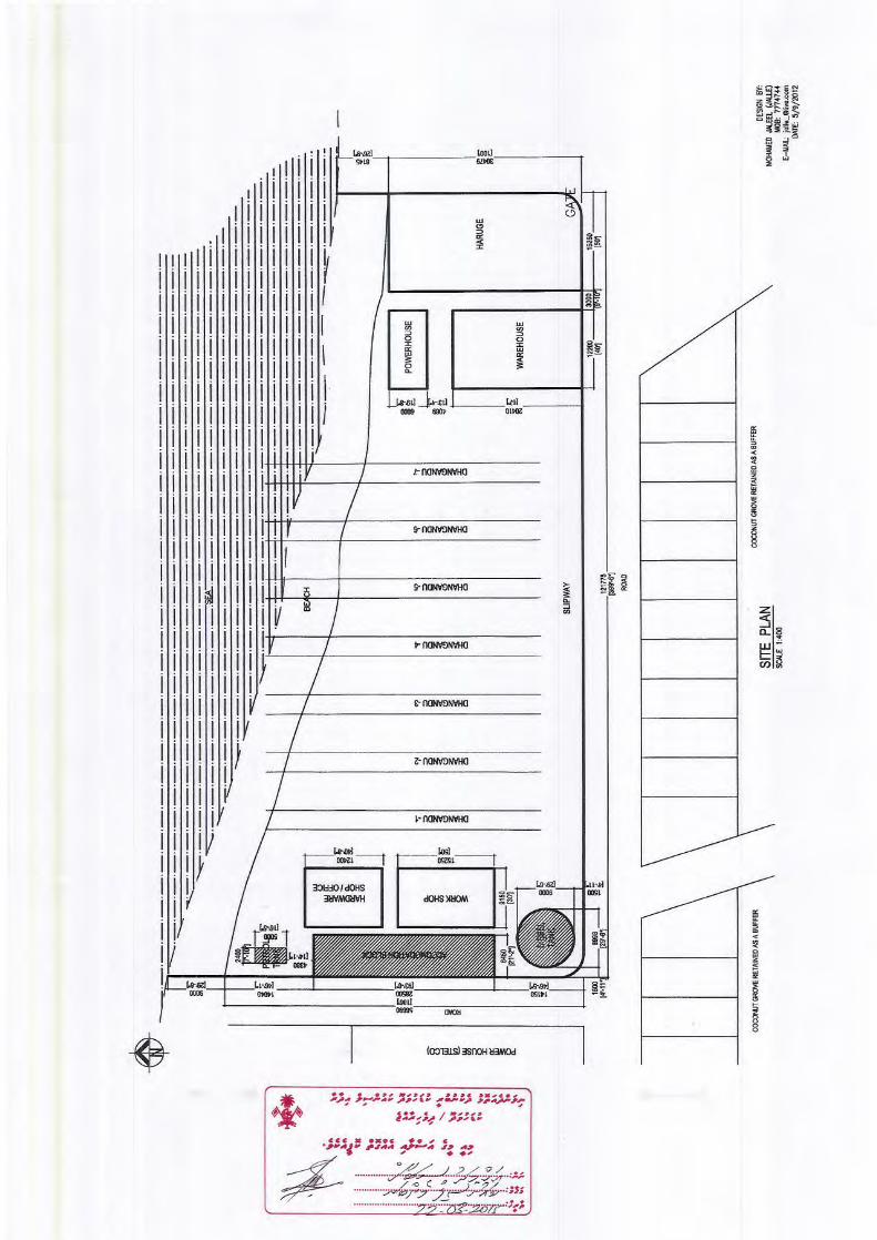
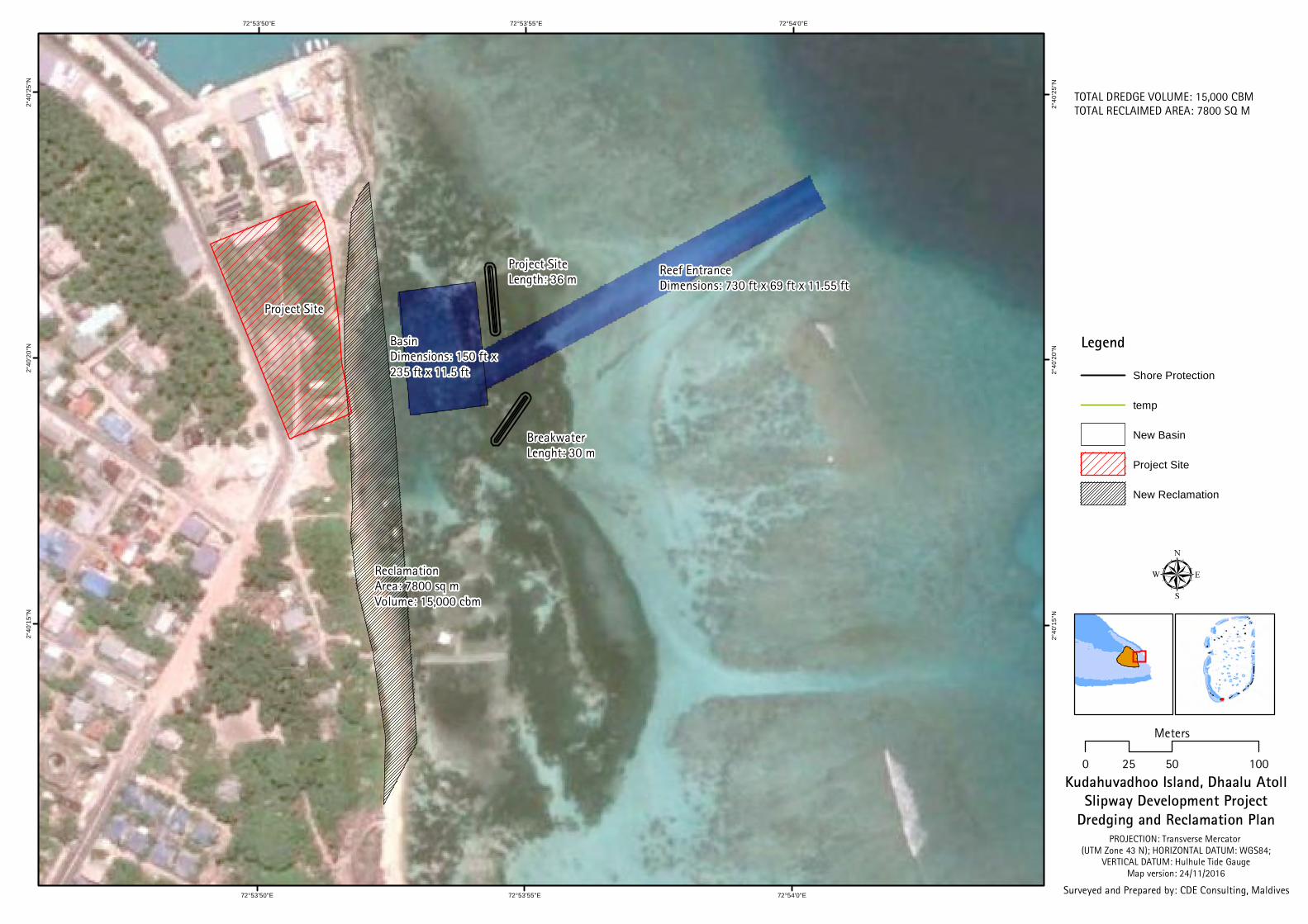
72°54'0"E
72°54'0"E
72°53'55"E
72°53'55"E
72°53'50"E
72°53'50"E2°
40'2
5"N
2°40
'25"
N
2°40
'20"
N
2°40
'20"
N
2°40
'15"
N
2°40
'15"
N
Kudahuvadhoo Island, Dhaalu AtollSlipway Development Project
Dredging and Reclamation Plan
µ
PROJECTION: Transverse Mercator (UTM Zone 43 N); HORIZONTAL DATUM: WGS84;
VERTICAL DATUM: Hulhule Tide GaugeMap version: 24/11/2016
Surveyed and Prepared by: CDE Consulting, Maldives
0 50 10025
Meters
Legend
Shore Protection
temp
New Basin
Project Site
New Reclamation
Project Site
BasinDimensions: 150 ft x 235 ft x 11.5 ft
Reef EntranceDimensions: 730 ft x 69 ft x 11.55 ft
ReclamationArea: 7800 sq mVolume: 15,000 cbm
TOTAL DREDGE VOLUME: 15,000 CBMTOTAL RECLAIMED AREA: 7800 SQ M
Project SiteLength: 36 m
Breakwater Lenght: 30 m

EIA for the Proposed Slipway Project in Kudahuvadhoo Island, Dhaalu Atoll
Prepared by: CDE Consulting Page|123
APPENDIX C – Detailed drawings
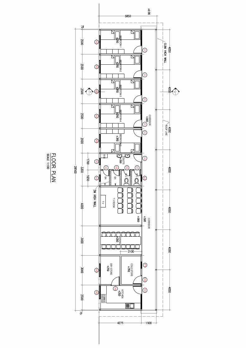

EIA for the Proposed Slipway Project in Kudahuvadhoo Island, Dhaalu Atoll
Prepared by: CDE Consulting Page|124
APPENDIX D – Approvals
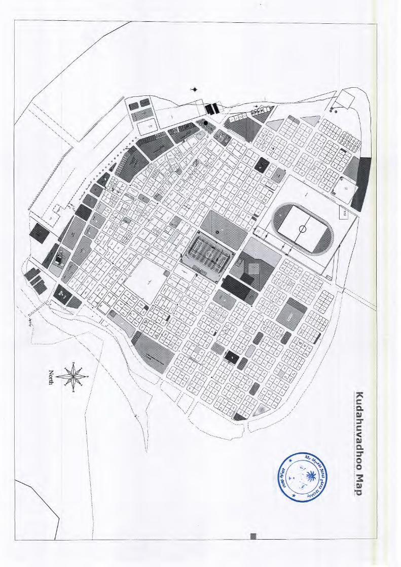
Secretariat of the ~udahuvadhoo ~o"nci1, South ~ilandheatholhu
Republic of Maldives
P R O / O O / O % C O / / o o c ;&:iz li::Ss; (2007 cG2 15) 1 3 8 - F ~ / 2 0 0 7 / 1 1 i w (y rgv~t W* 0
4 09/ O / / / P C 4 C C C C O P O C / M O / O % L L U O M 4 4 P / O / Y C 0 6 W ? ,"S$? VAA '-2 'PP/A ~-P@,"P/A/ P--9 /#/'A2 ./pgWff& F, , / //
C C C C O P O C P P P / O * 0 ./2/& ?P# v9-32#5/,"
C O P C &#/.F/
0 /
S,:;;: /2;:; L O P
.CA+< /;;).cr. O O I O I L 0 O I L OID 0 0 eCaJ9Y L -yea ../A 2 5
v - 0 . 0 ,
-->a ~ Y A & W -2
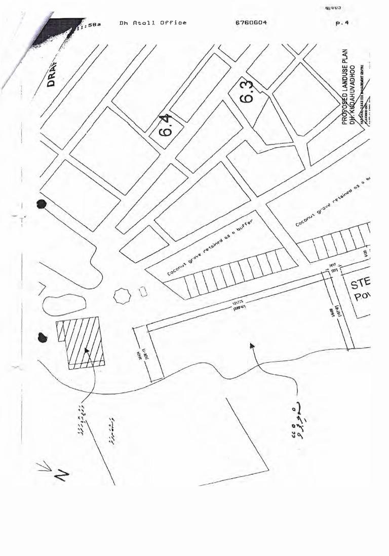
D h Rtoll Office

EIA for the Proposed Slipway Project in Kudahuvadhoo Island, Dhaalu Atoll
Prepared by: CDE Consulting Page|125
APPENDIX E – Survey Locations
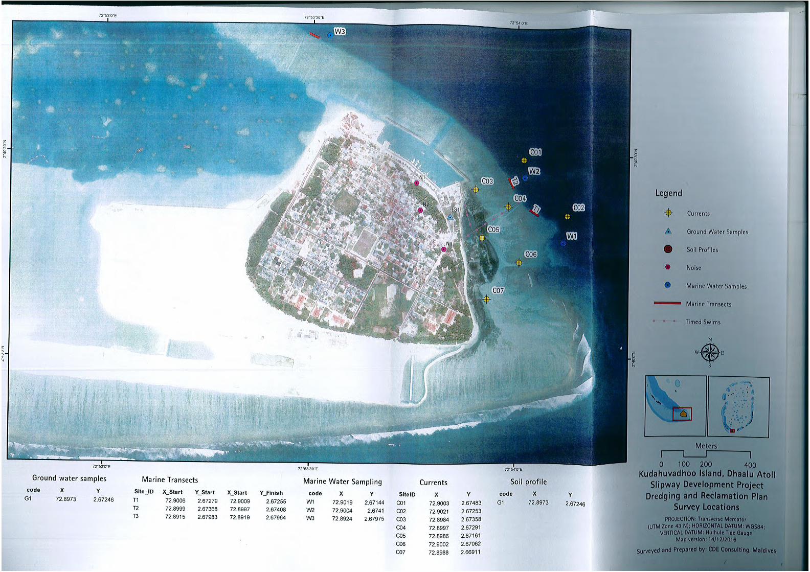
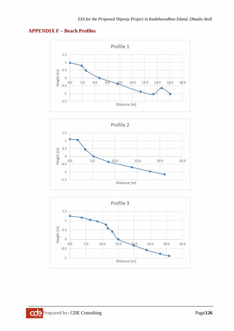
EIA for the Proposed Slipway Project in Kudahuvadhoo Island, Dhaalu Atoll
Prepared by: CDE Consulting Page|126
APPENDIX F – Beach Profiles
-1.5
-1
-0.5
0
0.5
1
1.5
0.0 2.0 4.0 6.0 8.0 10.0 12.0 14.0 16.0 18.0
Heig
ht [m
]
Distance [m]
Profile 1
-1.5
-1
-0.5
0
0.5
1
1.5
0.0 5.0 10.0 15.0 20.0 25.0
Heig
ht [m
]
Distance [m]
Profile 2
-1
-0.5
0
0.5
1
1.5
0.0 5.0 10.0 15.0 20.0 25.0 30.0 35.0Heig
ht [m
]
Distance [m]
Profile 3
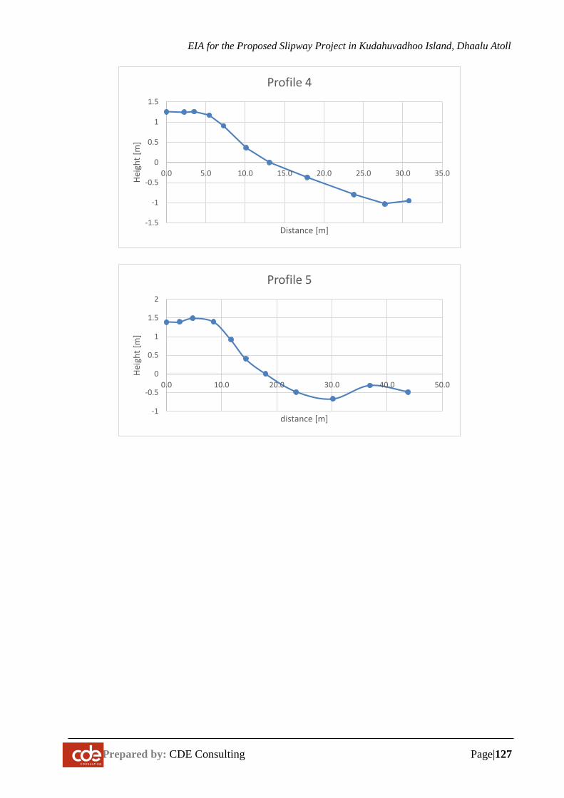
EIA for the Proposed Slipway Project in Kudahuvadhoo Island, Dhaalu Atoll
Prepared by: CDE Consulting Page|127
-1.5
-1
-0.5
0
0.5
1
1.5
0.0 5.0 10.0 15.0 20.0 25.0 30.0 35.0
Heig
ht [m
]
Distance [m]
Profile 4
-1
-0.5
0
0.5
1
1.5
2
0.0 10.0 20.0 30.0 40.0 50.0
Heig
ht [m
]
distance [m]
Profile 5

EIA for the Proposed Slipway Project in Kudahuvadhoo Island, Dhaalu Atoll
Prepared by: CDE Consulting Page|128
APPENDIX G – Water Quality Results
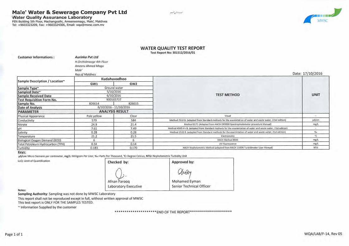
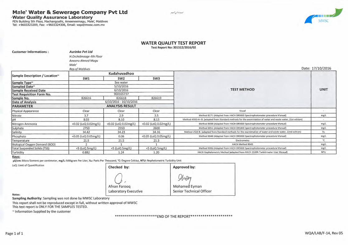

EIA for the Proposed Slipway Project in Kudahuvadhoo Island, Dhaalu Atoll
Prepared by: CDE Consulting Page|129
APPENDIX H – Bathychart
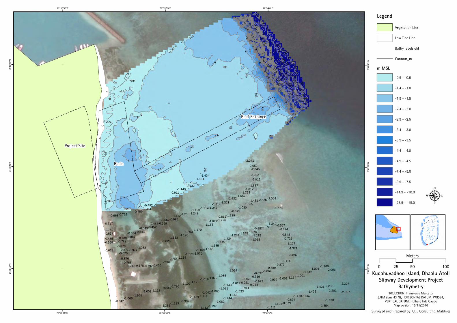
-3
-16
-17
-5.5
-3.5
-15.5
0
-9
-17.5
-8
-7
-22
-23
-8.5
-5
-21.5
-7.5
-9.5
-12
-4
-22.5
-19
-10
-6.5
-18.5
-15
-14
-2
-13
-16.5
-1
-6
-18
-10.5
-20.5
-19.5-1
1
-2.5
-20
-4.5
-21
-1.5
-13.5
-23.5
-12.5
-0.5
-11.5
-14.5
-22
-1
-0.5
-2
-6
-15
-7
-0.5
-13.5
-5
-1
-21
-0.5
-3-1
-4
-0.5
-1
-1
-19
-0.5
-1
-9
-1
-1
-1
-22
-2.5
-0.5
-12
-8.5
-1
-1.5
-12.5
0
-1
-1
-1.5
0
-1.5
-1
-9
-1.5
-1
-1 -1
-1
-2
-17.5
-14
-9
-1.5
-1
-1
-0.5
-0.5
0
-1.5
-22
-1.5
-1.5
-1.5
-4
-1
-2
-5
-1
-1.5
-1.12
-2.041-2.052
-2.045
-2.032-2.012
-1.887-1.812
-1.768-1.657
-1.432-1.321-1.214
-1.243-1.214-1.120-1.243-1.213-1.112
-0.998-0.667-0.569-0.457
-0.452-0.543-0.543-0.654
-0.887-0.789-0.789-0.876
-0.871-0.675
-0.876-0.765
-0.743-0.678-0.792-0.456-0569.
-0.754-1.134-1.178-1.570
-1.169-1.165-1.135
-1.145-1.234
-1.234-1.245-1.678-0.987-0.723
-1.342-0.567-0.874
-0.543-0.729
-1.127-1.321
-0.897
-1.114-0.879
-0.789-0.869-0.897
-0.789-0.876
-0.921-1.011-1.143-1.031
-1.065-1.042-1.114-1.163
-1.129-0.997
-1.236 -1.111-1.121-0.679
-0.674-1.478-1.567
-1.423-1.431-2.209
-2.201
-1.558
-1.554
-1.434-1.161
-1.132-1.149
-0.911
-0.492-0.461
-0.459-0.769-0.968
-0.737
-0.769-0.637-0.485-0.368
-0.633 -0.977-1.268
-0.826-1.133
-1.195-1.293
-1.179-1.155
-1.077-1.276-0.852-1.229
-0.675-1.030
-1.535-1.431-2.425 -2.054
-1.773
-1.175-1.013
-1.064-1.085
-1.072-1.016-1.109
-0.790-0.833-2.128-2.001
-1.965-1.066
-0.647
-1.113-1.197-1.082
-1.244-1.168
-1.033-0.941
-0.924-0.923 -0.932 -1.001-1.154-1.001
-1.042-1.001
-1.980-2.006
-2.207
-2.357
72°54'0"E
72°54'0"E
72°53'55"E
72°53'55"E
72°53'50"E
72°53'50"E2°
40'2
5"N
2°40
'25"
N
2°40
'20"
N
2°40
'20"
N
2°40
'15"
N
2°40
'15"
N
Kudahuvadhoo Island, Dhaalu AtollSlipway Development Project
Bathymetry
µ
PROJECTION: Transverse Mercator (UTM Zone 43 N); HORIZONTAL DATUM: WGS84;
VERTICAL DATUM: Hulhule Tide GaugeMap version: 15/11/2016
Surveyed and Prepared by: CDE Consulting, Maldives
0 50 10025
Meters
Legend
Vegetation Line
Low Tide Line
Bathy labels old
Contour_m
m MSL
-0.9 - -0.5
-1.4 - -1.0
-1.9 - -1.5
-2.4 - -2.0
-2.9 - -2.5
-3.4 - -3.0
-3.9 - -3.5
-4.4 - -4.0
-4.9 - -4.5
-7.4 - -5.0
-9.9 - -7.5
-14.9 - -10.0
-23.9 - -15.0
Project Site
Basin
Reef Entrance

EIA for the Proposed Slipway Project in Kudahuvadhoo Island, Dhaalu Atoll
Prepared by: CDE Consulting Page|130
APPENDIX I – CV’s of Consultants
Ahmed Shaig Phone: (+960) 77 88 758 [email protected]
Personal Details
Date of Birth: 19/02/1976 Nationality: Maldivian Gender: Male Marital Status: Married
Permanent Address: Maldives Present Address: M. Muleege, Orchid Magu, Male’, Maldives.
Education PhD, Environmental Science, 2009 James Cook University, Townsville, Australia Research degree on ‘Settlement Planning for Natural Hazard Resilience in Small Island States: The Population and Development Consolidation Approach’
BSc Land and Spatial Information Studies/Information Science. (double major), 1999-2001 University of Otago, Dunedin, New Zealand
Diploma in project planning, implementation, monitoring and evaluation, 1995 ILO training Centre, Turin, Italy
Employment History Director, Environmental Services CDE Consulting Republic of Maldives Head of environmental wing Assistant Under-secretary, Spatial Planning
2008 to present Supervisor: Dr. Simad Saeed Phone: +(960) 7777445 2002-2004
Ministry of Planning and National Development Supervisor: Hon. Hamdun Hameed Republic of Maldives Phone: +(960) 332-3919 Head of Spatial Planning Unit. Relevant Tasks include: ♦ Oversee environment related projects and application of environmental guidelines for planned projects. ♦ Plan, implement and oversee the development of a National GIS; ♦ Aid/facilitate/oversee urban planning, housing, land use planning, natural resource planning and
environment related projects; Provide assistance in project planning (includes urban and regional planning, natural resources planning)
Project Manager, National Digital Mapping Project 2005 (8 months) Ministry of Planning and National Development Supervisor: Hon. Hamdun Hameed Republic of Maldives Phone: +(960) 332-3919 ♦ Project involved aerial photography and satellite imagery of entire Maldives, ground surveying of key
settlements, digital conversion of data and setting up a Mapping Unit. Assistant Planning Officer/Planning Officer 1994-1999 Ministry of Planning and National Development Supervisor: Mr. Mohamed Hunaif Republic of Maldives Phone +(960) 331-3040 Relevant tasks involved: ♦ Assisting in the National GIS Development Programme (Junior GIS developer) ♦ Facilitate urban planning, housing, land use planning, natural resource planning and environment related
projects.
Ahmed Shaig page 1
Experience in Consultancy September 2002: Member of the team appointed for environmental surveying and carrying capacity
assessment of islands for tourism development in the southern atolls of Maldives for Ministry of Tourism Maldives.
October 2002: Developed the Census GIS for United National Population Fund December 2002: Developed the Maldives Protected Areas Systems GIS for Maldives Home Affairs
Housing and Environment. February 2003: Participated in the preparation of Royal Island and Spa Resort Annual Environmental
Monitoring Report for Royal Island and Spa. April 2003: Member of the team selected for developing town plans for urban centres in Northern and
Southern Regional Development Zones, looking specifically into environmental control measures, for Ministry of Planning and National Development.
April 2003: Participated in the preparation of Environmental Impact Statement for Coastal Modifications on Rihiveli, South Malé Atoll, Maldives.
April 2003: Participated in the surveying and preparation of Environmental Impact Statement for the proposed coastal improvements to address coastal erosion concerns on Royal Island Spa Resort, Baa Atoll, Maldives.
May 2003: Participated in the bathymetry survey and preparation of Initial Environmental Examination for Deepening of Existing Entrance Channel to Service Jetty, Soneva Gili Resort and Spa, North Malé Atoll, Maldives
May 2003: Participated in the preparation of Initial Environmental Examination for development of an access channel into the natural inner lagoon (Vilu) of Mayafushi resort, North Ari Atoll.
May 2003: Participated in the preparation of Environmental Impact Assessment for Landaa Giraavaru Pvt. Ltd. for the development of a Four Season’s Tourist Resort on the island of Landaa Giraavaru in Baa Atoll, Maldives.
June 2003: Participated in survey and preparation of Initial Environmental Examination for the Development of a Mooring Area and Associated Beach Replenishment in, Boduhithi Club, North Malé Atoll, Maldives.
July 2003: Participated in the surveying and preparation of Initial Environmental Examination for Short-term and Long-term Shore Protection Measures at Alimatha Tourist Resort, Vaavu Atoll, Maldives.
July 2003: Conducted shoreline and vegetation line of Alimatha Tourist Resort, Vaavu Atoll, Maldives. July 2003: Participated in the surveying for Initial Environmental Examination for Short-term and Long-
term Shore Protection Measures at Dhiggiri Tourist Resort, Vaavu Atoll, Maldives. July 2003: Participated in conducting and preparation of Fun Island Resort Annual Environmental
Monitoring Report. July 2003: Participated in conducting and preparation of Sun Island Resort Annual Environmental
Monitoring Report. July 2003: Participated in conducting and preparation of Holiday Island Resort Annual Environmental
Monitoring Report. August 2003: Developed the Initial Environmental Examination for the construction of Sun Decks
along the southern beach of Kudarah Island Resort. September 2003: Participated in surveying and preparation of Fonaddoo Environmental Impact
Assessment Report for the development of fisheries complex, Fonaddoo, Maldives. October 2003: Participated in surveying and preparation of Kuda Rah Erosion Study and
recommendations for shore protection and erosion prevention November 2003: Conducted vegetation and shoreline survey of Dhonveli Beach and Spa and Four
Seasons Report for the Boundary Delineation between the two islands. December 2003: Contributed to the Landuse Planning Guidelines of Maldives (environmental aspects) for
Ministry of Housing and Urban Development. December 2003: Contributed to the Development of a Building Code of Maldives for Ministry of
Housing and Urban Development. January 2004: Co-author to the Environmental Guidelines for the Development of Resort Islands in
Maldives, Ministry of Tourism. February 2004: Developed the Baa Atoll Spatial Development Plan for Ministry of Planning and
National Development.
Ahmed Shaig page 2
April-July 2004: Participated in the preparation of the Environmental aspects of the 8 bid proposals for
resort Development for various proponents. November 2005: Participated in the preparation of EIA for L.Gan Resettlement Project for Ministry of
Housing. December 2005: Participated in the surveying and preparation of EIA for Gn Fuvahmulaku Tourist Hotel
Development November 2005: Developed a GIS for strategic planning to select islands for tourism development for
Ministry of Tourism. January 2006: Local consultant for the Strategic Environmental Assessment (SEA) of Maldives Regional
Development Plan, for AGRIFOR Consult Consortium, Belgium. June 2006: Developed the Baa Atoll Resource Management GIS for Ministry of Environment and
Energy. August 2006: Consultant to the Integrated Climate Change System (ICCS) project – Assessment of
vulnerability of Maldives Islands and Beaches to climate change September 2006: Consultant to the ICCS project – Assessment of vulnerability of Maldives Infrastructure
to climate change November 2006: Consultant to the preparation of National Adaptation Programme of Action in Maldives
for Ministry of Environment. December 2006: Environmental Consultant to the United Nations Development Programme (UNDP)
Project: Disaster Risk Assessment of Selected nine Safe Islands in Maldives. April 2007: Prepared the Coastal Erosion Assessment and Management Report for Ga.Meradhoo
Island. May 2007: Participated in the preparation of EIA for N. Randheli Resort Development Project, I&T
Management group. June 2007: Participated in the preparation of Millennium Development Goals, Maldives Country Report. October 2007: Natural Hazard Assessment consultant to the UNDP Project: Disaster Risk Assessment of
Selected Safe Islands in Maldives. November 2007: Prepared the EIA for proposed coastal protection, beach replenishment and access
improvement of Elaa, Thaa Atoll, for Mr Abbas Mohamed, H. Merry Rose. May 2009: Participated in the preparation of EIA for sand sourcing and beach replenishment project of
Viligilli Island, Addu Atoll, for Shangri-La at Viligilli.. April 2009: Participated in the preparation of EIA for N. Maafaru Airport Development Project for
Noonu Hotels Pvt Ltd. May 2009: Participated in the preparation of EIA for resort development in Huvandhumaavattaru,
Noonu Atoll June 2009: Prepared a status of the environment report Randheli Island, Noonu Atoll. July 2009: Prepared the Environmental EIA for harbour development in Fiyoari, Gaafu Dhaalu Atoll. July 2009: Participated in the preparation of EIA for Jetty and arrival lounge development project in
Gan, Addu Atoll, for Island Aviation Services Private Limited. July 2009: Team Leader for the socio-economic risk assessment of Selected Safe Islands in Maldives. August 2009: Coastal erosion data synthesis for selected islands of Maldives, for World Bank Maldives
Environmental Management Project. September 2009: Prepared the beach management plan and development control measures for
Reethibeach Island Resort, Baa Atoll. September 2009: Participated in the preparation of EIA for agricultural island development in Felivaru,
Noonu Atoll, for Fantasy Private Limited. September 2009: Consultant to review the safer islands programme and cost benefit study of mitigation
measures in three islands in the Maldives for UNDP. October 2009: Consultant to the Maldives Environmental Management Project for waste management
technical assistance for World Bank. December 2009: Environmental consultant for advising on resort development and development control
measures in Randheli Island, Noonu Atoll. January 2010: Prepared the beach management plan and development control measures for Shangri-La
Island Resort, Addu Atoll. January 2010: Consultant to the Atoll Ecosystem Conservation project conservation component defining
conservation areas and development controls. February 2010: Prepared the environmental audit of Thunbafushi Island, Kaafu Atoll, for Champa
Brothers Private Limited.
Ahmed Shaig page 3
March 2010: Prepared the beach management plan and development control for Herathera Island
Resort, Addu Atoll. March 2010: Lead author in the preparation of EIA for power plant upgrading project in Palm Beach
Island in Lhaviyani Atoll. April 2010: Lead author in the preparation of EIA for Seagrass removal and beach replenishment
project in Olhuveli Island Resort and Spa, Kaafu Atoll. April 2010: Prepared an EIA addendum for resort development in Gaakoshibee Island, Shaviyani Atoll. May 2010: Consultant to undertake island environmental scoping studies in 30 islands in North
Maldives to determine islands with resort development potential for GMR Group of India. May 2010: Lead author in the preparation of EIA for harbour development project in Madidhoo Island,
Shaviyani Atoll. June 2010: Lead author in the preparation of EIA for deep piling project in Olhuveli Island Resort and
Spa, Kaafu Atoll. July 2010: Lead author in the preparation of EIA for the development of an aquaculture site in
Kanduoigiri, Kaafu Atoll. July 2010: Environmental planning consultant for Shangri-La at Viligilli Maldives, Addu Atoll. July 2010: Environmental planning consultant to the Addu Land Use Planning project (including
defining development controls) in Addu Atoll Maldives for South Province Office. August 2010: Environmental Consultant for the Atoll Ecosystem Conservation Project to declare Baa
Atoll as a UNESCO Biosphere reserve. September 2010: Lead author in the EIA for Seagrass removal and beach replenishment project in
Herathera Island, Addu Atoll. September 2010: Lead author in the EIA for resort redevelopment in Vilamendhoo Island Resort, Ari
Atoll. September 2010: Lead author in the preparation of EIA for Gulhifalhu land reclamation project in
Gulhifalhu, Male’ Atoll, for Capital Investment and Finance Limited, UK. September 2010: Participated in the preparation of EIA for sewerage system development project in
Miladhoo, Noonu Atoll. October 2010: Consultant to undertake the coastal adaptation survey of 40 islands in Maldives for
Ministry of Housing and Environment. November 2010: Environmental consultant for advising on resort development and development control
measures in Maamigili Island, Raa Atoll January 2011: Lead author in the preparation of EIA for sewerage and water system development project
in Hithadhoo Island, Addu City for Bi-water International Private Limited. February 2011: Lead author in the preparation of EIA for sewerage and water system development
project in Maradhoo Island, Addu City for Bi-water International Private Limited. March 2011: Lead author in the preparation of EIA for sewerage and water system development project
in Feydhoo Island, Addu City for Bi-water International Private Limited. April 2011: Lead author in the preparation of EIA for sewerage and water system development project
in Maradhoo-Feydhoo Island, Addu City for Bi-water International Private Limited. May 2012: Coastal erosion mitigation assessment and planning for Six Senses Laamu, Laamu Atoll January 2012: Lead author in the preparation of EIA for sewerage and water system development project
in Fuvahmulah Island, Addu City for Bi-water International Private Limited. February 2012: Coastal erosion mitigation assessment and planning for Fushivelavaru Island March 2012: EIA for the proposed resort redevelopment project in Conrad Rangali Island for Champa
and Crown Resorts March 2012: EIA for the proposed resort redevelopment project in Gasfinolhu Island Resort, Champa
and Crown Resorts May 2012: Environmental consultant for advising on resort development and development control
measures in Gasfinolhu Island, Male’ Atoll June 2012: Environmental consultant for advising on resort development and development control
measures in Nakachchaa Huraa Island, Male’ Atoll April 2012: Member of the consultant team that prepared the Tourism Opinion and Profile Survey
2011, Ministry of Tourism. October 2012: Environmental consultant to the preparation of 4th Tourism Master plan for Ministry of
Tourism, Maldives. November 2013: Environmental consultant for advising on land reclamation, resort development and
development control measures in Dhiffushi Island Reef, Male’ Atoll.
Ahmed Shaig page 4

January 2013: Environmental consultant for advising on resort development and development control
measures in Hankede Island, Addu Atoll January 2013: Environmental consultant for advising on resort development and development control
measures in Hankede Island, Addu Atoll June 2013: Local Environment consultant to the WCCM project, HIDRIA and Aquatica, Spain.
Ahmed Shaig page 5
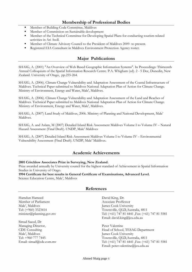
Membership of Professional Bodies Member of Building Code Committee, Maldives Member of Commission on Sustainable development Member of the Technical Committee for Developing Spatial Plans for conducting tourism related
activities in Ari Atoll. Member of Climate Advisory Council to the President of Maldives 2009- to present. Registered EIA Consultant in Maldives Environment Protection Agency roster.
Major Publications
SHAIG, A. (2001) "An Overview of Web Based Geographic Information Systems". In Proceedings: Thirteenth Annual Colloquium of the Spatial Information Research Centre. P.A. Whigham (ed). 2 - 5 Dec, Dunedin, New Zealand. University of Otago, pp.255-264.
SHAIG, A. (2006). Climate Change Vulnerability and Adaptation Assessment of the Coastal Infrastructure of Maldives. Technical Paper submitted to Maldives National Adaptation Plan of Action for Climate Change. Ministry of Environment, Energy and Water, Male', Maldives.
SHAIG, A. (2006). Climate Change Vulnerability and Adaptation Assessment of the Land and Beaches of Maldives. Technical Paper submitted to Maldives National Adaptation Plan of Action for Climate Change. Ministry of Environment, Energy and Water, Male', Maldives.
SHAIG, A. (2007) Land Study of Maldives, 2006. Ministry of Planning and National Development, Male’ Maldives.
SHAIG, A. and Aslam, M (2007) Detailed Island Risk Assessment Maldives Volume I to Volume IV – Natural Hazard Assessment (Final Draft). UNDP, Male’ Maldives
SHAIG, A. (2007) Detailed Island Risk Assessment Maldives Volume I to Volume IV – Environmental Vulnerability Assessment (Final Draft). UNDP, Male’ Maldives.
Academic Achievements 2001 Critchlow Associates Prize in Surveying, New Zealand. Prize awarded annually by University council for the highest standard of Achievement in Spatial Information Studies in University of Otago. 1994 Certificate for best results in General Certificate of Examinations, Advanced Level. Science Education Centre, Male’, Maldives
References Hamdun Hameed Member of Parliament Male’, Maldives Tel: (+960) 3323414 [email protected] Simad Saeed, Dr Managing Director, CDE Consulting Male’, Maldives Tel: +960 777 7445 Email: [email protected]
David King, Dr. Associate Proffessor James Cook University Townsville, QLD,Australia, 4811 Tel: (+61) 747 81 4441 ,Fax: (+61) 747 81 5581 Email: [email protected] Peter Valentine Head of School, TESAG Department James Cook University Townsville, QLD,Australia, 4811 Tel: (+61) 747 81 4441 ,Fax: (+61) 747 81 5581 Email: [email protected]
Ahmed Shaig page 6
Clarification
I, the undersigned, certify that to the best of my knowledge and belief, this CV correctly describes myself, my qualifications and my experience. I understand that any willful misstatement described herein may lead to my disqualification or dismissal, if engaged.
Signature Date: 15 July 2013
Ahmed Shaig page 7
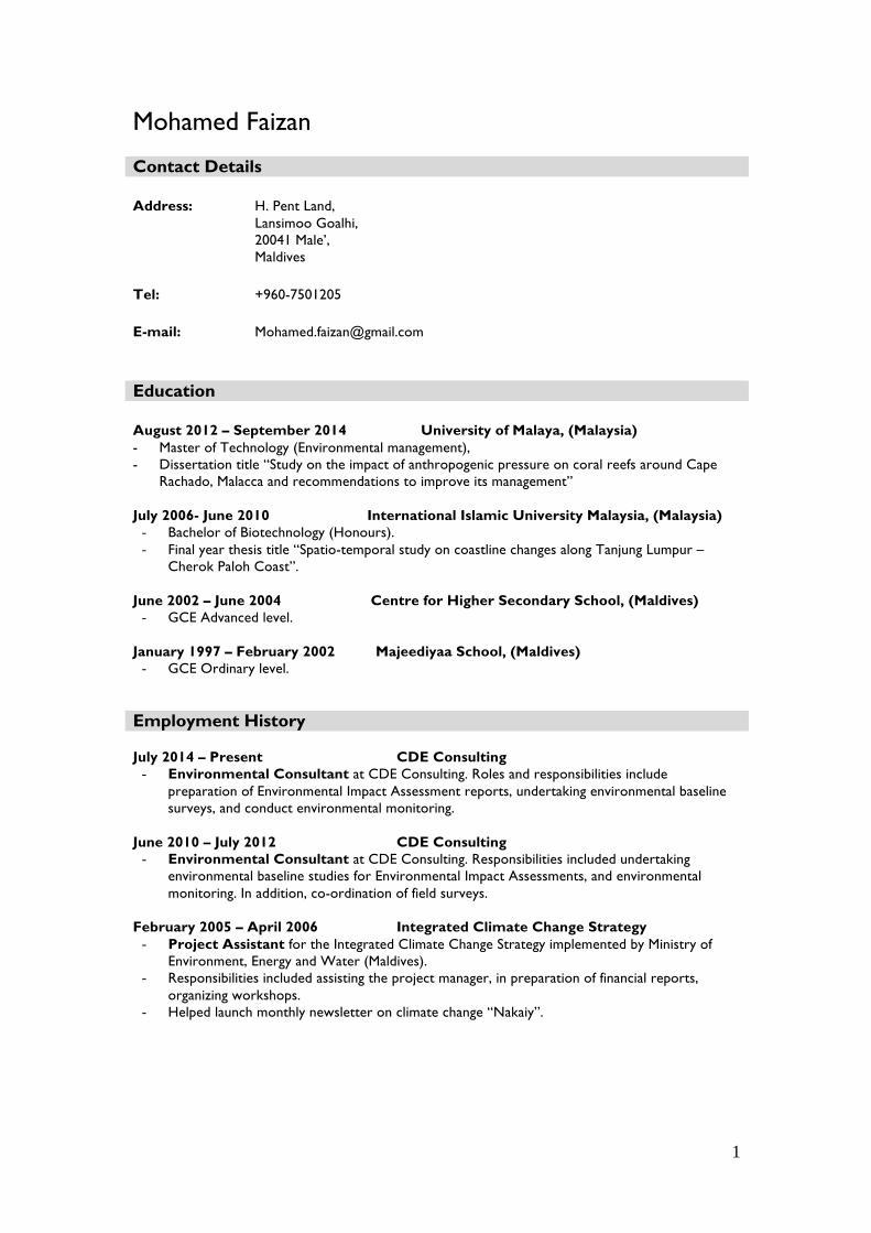
1
Mohamed Faizan Contact Details Address: H. Pent Land,
Lansimoo Goalhi, 20041 Male’, Maldives
Tel: +960-7501205
E-mail: [email protected]
Education August 2012 – September 2014 University of Malaya, (Malaysia) - Master of Technology (Environmental management), - Dissertation title “Study on the impact of anthropogenic pressure on coral reefs around Cape
Rachado, Malacca and recommendations to improve its management” July 2006- June 2010 International Islamic University Malaysia, (Malaysia)
- Bachelor of Biotechnology (Honours). - Final year thesis title “Spatio-temporal study on coastline changes along Tanjung Lumpur –
Cherok Paloh Coast”. June 2002 – June 2004 Centre for Higher Secondary School, (Maldives)
- GCE Advanced level. January 1997 – February 2002 Majeediyaa School, (Maldives)
- GCE Ordinary level. Employment History July 2014 – Present CDE Consulting
- Environmental Consultant at CDE Consulting. Roles and responsibilities include preparation of Environmental Impact Assessment reports, undertaking environmental baseline surveys, and conduct environmental monitoring.
June 2010 – July 2012 CDE Consulting - Environmental Consultant at CDE Consulting. Responsibilities included undertaking
environmental baseline studies for Environmental Impact Assessments, and environmental monitoring. In addition, co-ordination of field surveys.
February 2005 – April 2006 Integrated Climate Change Strategy
- Project Assistant for the Integrated Climate Change Strategy implemented by Ministry of Environment, Energy and Water (Maldives).
- Responsibilities included assisting the project manager, in preparation of financial reports, organizing workshops.
- Helped launch monthly newsletter on climate change “Nakaiy”.
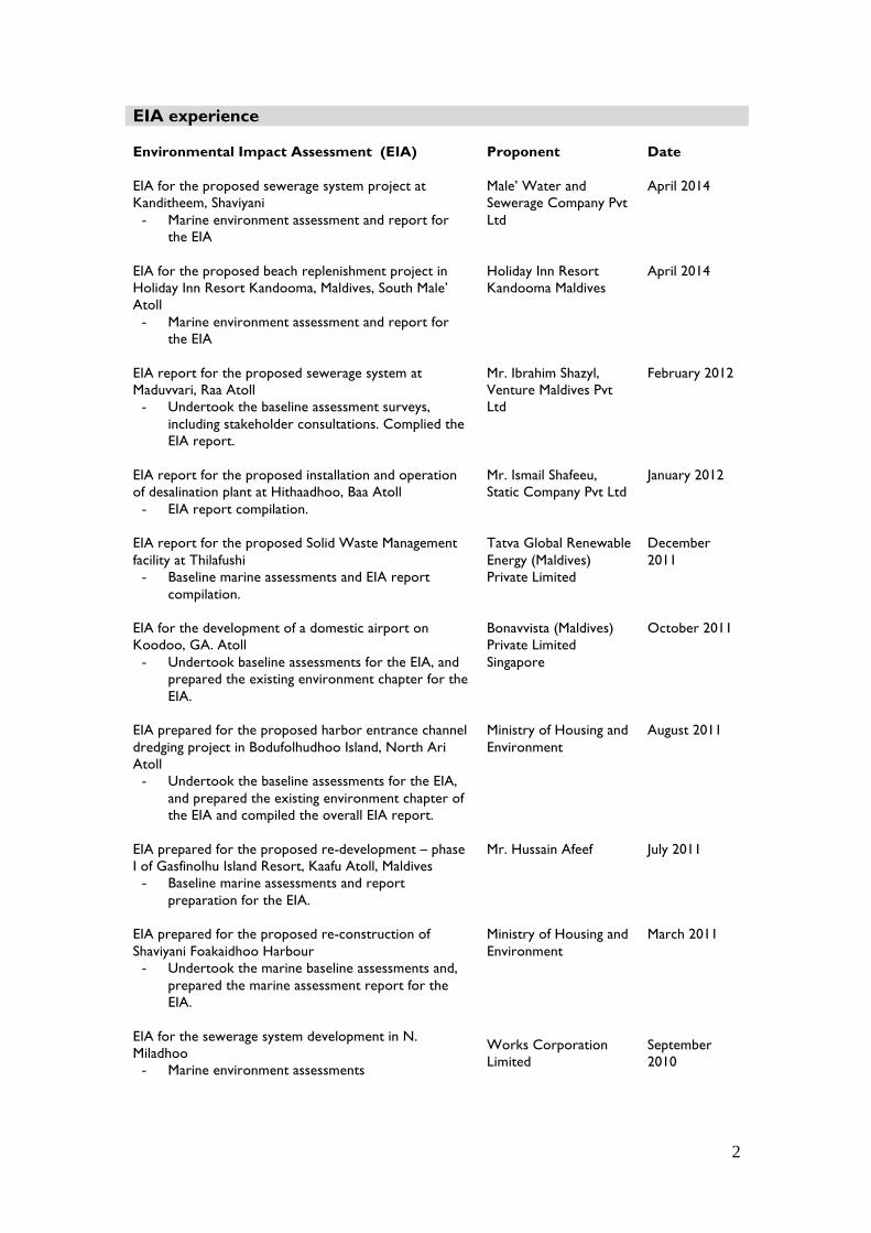
2
EIA experience Environmental Impact Assessment (EIA) Proponent Date EIA for the proposed sewerage system project at Kanditheem, Shaviyani
- Marine environment assessment and report for the EIA
Male’ Water and Sewerage Company Pvt Ltd
April 2014
EIA for the proposed beach replenishment project in Holiday Inn Resort Kandooma, Maldives, South Male’ Atoll
- Marine environment assessment and report for the EIA
Holiday Inn Resort Kandooma Maldives
April 2014
EIA report for the proposed sewerage system at Maduvvari, Raa Atoll
- Undertook the baseline assessment surveys, including stakeholder consultations. Complied the EIA report.
Mr. Ibrahim Shazyl, Venture Maldives Pvt Ltd
February 2012
EIA report for the proposed installation and operation of desalination plant at Hithaadhoo, Baa Atoll
- EIA report compilation.
Mr. Ismail Shafeeu, Static Company Pvt Ltd
January 2012
EIA report for the proposed Solid Waste Management facility at Thilafushi
- Baseline marine assessments and EIA report compilation.
Tatva Global Renewable Energy (Maldives) Private Limited
December 2011
EIA for the development of a domestic airport on Koodoo, GA. Atoll
- Undertook baseline assessments for the EIA, and prepared the existing environment chapter for the EIA.
Bonavvista (Maldives) Private Limited Singapore
October 2011
EIA prepared for the proposed harbor entrance channel dredging project in Bodufolhudhoo Island, North Ari Atoll
- Undertook the baseline assessments for the EIA, and prepared the existing environment chapter of the EIA and compiled the overall EIA report.
Ministry of Housing and Environment
August 2011
EIA prepared for the proposed re-development – phase I of Gasfinolhu Island Resort, Kaafu Atoll, Maldives
- Baseline marine assessments and report preparation for the EIA.
Mr. Hussain Afeef July 2011
EIA prepared for the proposed re-construction of Shaviyani Foakaidhoo Harbour
- Undertook the marine baseline assessments and, prepared the marine assessment report for the EIA.
Ministry of Housing and Environment
March 2011
EIA for the sewerage system development in N. Miladhoo
- Marine environment assessments
Works Corporation Limited
September 2010
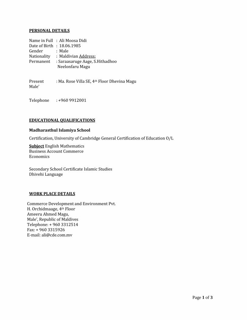
Page 1 of 3
PERSONAL DETAILS
Name in Full : Ali Moosa Didi Date of Birth : 18.06.1985 Gender : Male Nationality : Maldivian Address: Permanent : Saraasaruge Aage, S.Hithadhoo Neelonfaru Magu
Present : Ma. Rose Villa SE, 4th Floor Dhevina Magu Male’
Telephone : +960 9912001
EDUCATIONAL QUALIFICATIONS
Madharasthul Islamiya School
Certification, University of Cambridge General Certification of Education O/L
Subject English Mathematics Business Account Commerce Economics
Secondary School Certificate Islamic Studies Dhivehi Language
WORK PLACE DETAILS
Commerce Development and Environment Pvt. H. Orchidmaage, 4th Floor Ameeru Ahmed Magu, Male’, Republic of Maldives Telephone: + 960 3312514 Fax: + 960 3315926 E-mail: [email protected]
Page 2 of 3
EMPLOYMENT RECORD
January 2004 – December 2008 Commerce Development & Environment Pvt Assistant Surveyor January 2009 – December 2009 Ryco Investment Pvt HR. Officer January 2010 – To Current Date Commerce Development & Environment Pvt Surveyor
WORK EXPERIENCE Assistant Surveying Officer (Sep 2008 – To Current Date) -Survey proposed areas for the new projects under the instruction of survey officer. -Determine precise location and measurements of points, elevations, lines, areas, contours for the construction studying the morphology of the seabed mapmaking and for construction staking, defining and managing parcels data, as‐built and profiling. -Utilize recourses to the optimum level. -Use company civil/ survey software for contouring, setting alignments, setting points construction, land division. ‐Edits and troubleshoot incoming data collector files in accordance with company procedures. Processing Survey Data’s Using Topcon Tools, Surfer, Sonar XP, etc -Reviews and utilize survey crew field notes. -Imports verified data into the appropriate CAD drawing file, using company standards point layer management and description keys.
-Prepares survey drawings and documents using company standards, prototypes, templates and blocks.
Page 3 of 3
-Operate digital cameras and download photo files into database and/ or CAD drawings.
‐Utilize company scanners to transfer reference maps into CAD files to facilitate utility mapping and property line. -To perform bathymetric and topographical survey before start of the Projects -Plotting survey data using AutoCAD 2006‐2009 -Processing Survey Data’s Using Topcon Tools, Surfer, Sonar XP, etc.
-Modeling accurate contours -Advanced at ESRI ArcGIS (ArcMap, Arc Catalogue) -GPS, wetland vegetation species identification, extensive geological identification skills -Preparation of survey maps -Make sure all the survey instruments are working in good condition.
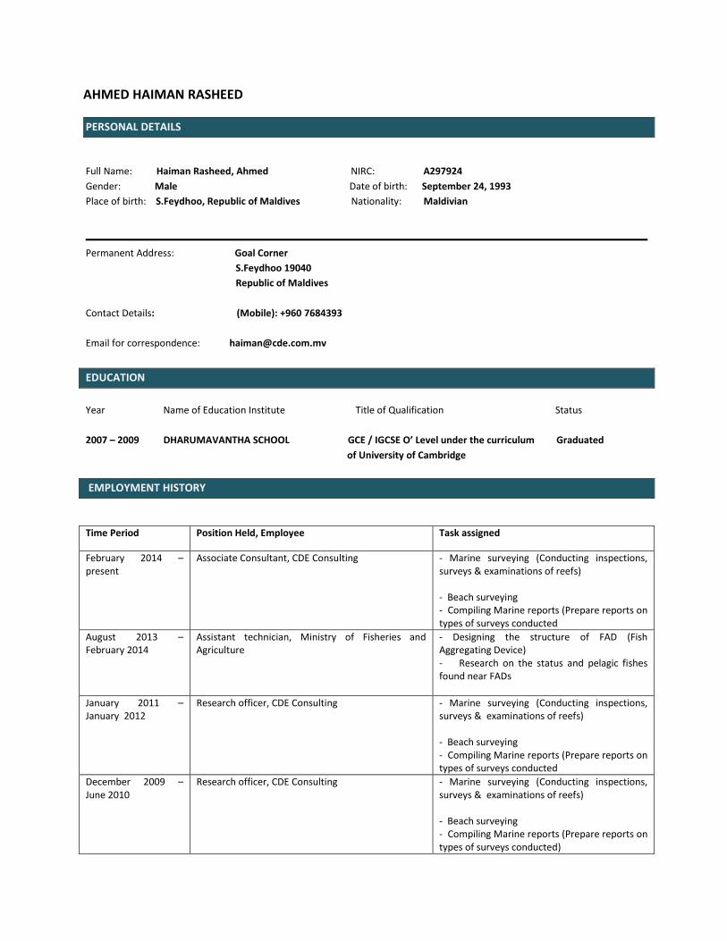
AHMED HAIMAN RASHEED
PERSONAL DETAILS
Full Name: Haiman Rasheed, Ahmed NIRC: A297924
Gender: Male Date of birth: September 24, 1993
Place of birth: S.Feydhoo, Republic of Maldives Nationality: Maldivian
Permanent Address: Goal Corner
S.Feydhoo 19040
Republic of Maldives
Contact Details: (Mobile): +960 7684393
Email for correspondence: [email protected]
EDUCATION
Year Name of Education Institute Title of Qualification Status
2007 – 2009 DHARUMAVANTHA SCHOOL GCE / IGCSE O’ Level under the curriculum Graduated
of University of Cambridge
EMPLOYMENT HISTORY
Time Period Position Held, Employee Task assigned
February 2014 – present
Associate Consultant, CDE Consulting - Marine surveying (Conducting inspections, surveys & examinations of reefs) - Beach surveying - Compiling Marine reports (Prepare reports on types of surveys conducted
August 2013 – February 2014
Assistant technician, Ministry of Fisheries and Agriculture
- Designing the structure of FAD (Fish Aggregating Device) - Research on the status and pelagic fishes found near FADs
January 2011 – January 2012
Research officer, CDE Consulting - Marine surveying (Conducting inspections, surveys & examinations of reefs) - Beach surveying - Compiling Marine reports (Prepare reports on types of surveys conducted
December 2009 – June 2010
Research officer, CDE Consulting - Marine surveying (Conducting inspections, surveys & examinations of reefs) - Beach surveying - Compiling Marine reports (Prepare reports on types of surveys conducted)
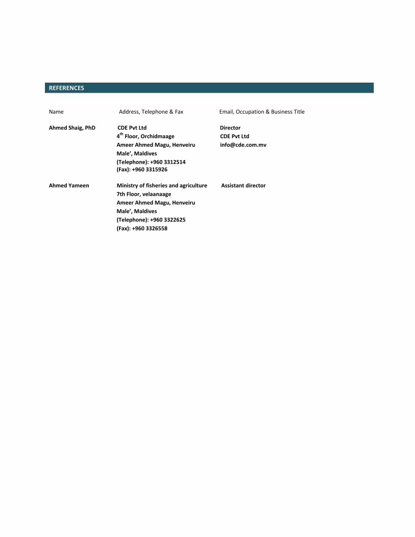
REFERENCES
Name Address, Telephone & Fax Email, Occupation & Business Title
Ahmed Shaig, PhD CDE Pvt Ltd Director
4th
Floor, Orchidmaage CDE Pvt Ltd
Ameer Ahmed Magu, Henveiru [email protected]
Male’, Maldives
(Telephone): +960 3312514 (Fax): +960 3315926
Ahmed Yameen Ministry of fisheries and agriculture Assistant director
7th Floor, velaanaage
Ameer Ahmed Magu, Henveiru
Male’, Maldives
(Telephone): +960 3322625
(Fax): +960 3326558
Mohamed Ali
ID #: A 094918
Nationality: Maldivian
Languages: English, Sinhalese, Dhivehi
Date of Birth: 13/09/1983
Telephone: 960-790-6007
Email: [email protected]
Experience
Marine Environmental Specialist June 2011- Present
CDE Consulting
Marine Environment Officer July 2008 – May 2011
Banyan Tree Vabbinfaru
Freelance Lobster Hunter, Shark Fisherman Jan 2007 - July 2008
Laamu Atoll
Dock Assistant Sep 2006 - Jan 2007
Tourist Submarine Maldives
Education and Certifications
PADI Rescue Diver June 2011
PADI Enriched Air Diver June 2011
Emergency First Responder May 2011
Basic Computer Science 2001 - 2006
Singapore Informatics, Colombo Sri Lanka
Profile
I am very passionate about protecting the marine environment. After having
worked as both a fisherman and a marine environment officer I am aware of
the impact that human activity has on our fragile marine environment. My
favorite activities are reef monitoring and planting coral gardens. With my
undying passion for the underwater world and also with my vast experience
diving all over the Maldives, educating people on the marine environment is
my greatest mission, to ensure the preservation and protection of our most
valuable treasure. Furthermore, I have got the opportunity to work besides the
greatest marine experts in the world namely Prof. J.E.N. Veron,Dr. Norman
Queen and Dr. Daphne G. Fautin.
References
N.D. Abdul Azeez Abdul Hakeem
Former Director of Conservation
Mobile: + 960 7784263
Banyan Tree Maldives
Dr. Steve Newman
Former Marine Lab Manager at Banyan Tree
Robert James
Former Marine Lab Manager at Banyan Tree
Shahdha Sustainable Development Consultant CDE Consulting Pvt Ltd Phone: +960 9700169 E-Mail: [email protected]
Professional Experience
Sustainable Development Consultant
CDE Consulting Private Limited, Male’, Republic of Maldives. 1 March 2015- Present
n Experience
Environmental Impact Assessments
• EIA for the proposed test drilling For Hulhule’-Male’ Bridge construction project • EIA for the proposed redevelopment of Nasandhura Palace Hotel, Male’ • EIA for the proposed Hulhule’-Male’ Bridge Project • EIA for the proposed construction of a 9-storey building at the compound of ADK Hospital, Sosun Magu,
Male’, Maldives • EIA for the proposed tourist development project at Madivaru Island, Kaafu Atoll • EIA for the proposed land reclamation and resort development project in Ithaafushi Reef, South Male’ Atoll • EIA for the proposed resort development in Bodukaashihuraa, Alifu Dhaalu Atoll, Maldives
Surveys
• Maldives Visitor Survey 2015 for the Ministry of Tourism • Maldives Democracy Survey 2015 for International Foundation for Electoral Systems (IFES)
Environmental Monitoring Projects
• Environmental and Social Performance Annual Monitoring 2014 for Shangri-La’s Vilingili Resort & Spa, Addu Atoll, Maldives
n Key Skills and Competencies
• Ability to interpret environmental laws and regulations and act accordingly • Sound knowledge of environmental management procedures and assessment of risk • Solid understanding of waste management, climate change, disaster prevention and mitigation, and coastal
environment and processes • Profound knowledge of sustainable development issues • Ability to assess and analyze complex social problems • Competent in identifying and communicating with stakeholders • Skilled in data collection, analysis and report writing
Clinical Assistant
Indhira Gandhi Memorial Hospital, Male, Republic of Maldives February 2010- December 2011
Relief Teacher
HDh. Atoll School, HDh. Vaikaradhoo, Republic of Maldives July 2009- November 2009
Academic Qualifications
Bachelor of Environments 2012-2014
Major: Environmental Geographies, Politics and Cultures,
The University of Melbourne, Melbourne, Victoria, Australia.
Advanced Level Edexcel Examination
Higher Secondary Certificate (HSC) Examinations 2007-2009
Center for Higher Secondary Education, Male’, Republic of Maldives
Cambridge GCE O-level
IGCSE Examinations
Secondary School Certificate (SSC) Examination 2004-2006
Cener for Higher Secondary Education, Male’, Republic of Maldives
Achievements
§ Dean’s Honours Award for outstanding academic achievement in 2014 (University of Melbourne) 2014
§ Australian Development Scholarship 2011
§ Fourth place among the National Top 10 Achievers in the Higher Secondary School Completion Examinations 2009 2009
§ Second place among the National Top 10 Achievers in the Secondary School Completion Examinations 2006
§ Best All Round Student of H Dh. Atoll School 2006
§ Haveeru Atolls Scholarship Award 2007-2009
§ School Captain at H Dh. Atoll School.
§ Student Association’s Vice President in 2006 at H Dh. Atoll School 2006
§ Deputy and Acting School Captain in 2005 at H Dh. Atoll School
§ Student Association’s President in 2005 at H Dh. Atoll School 2005

Professional Development and Memberships
§ Member of the University of Melbourne Australian Awards Club 2013- 2014
§ Participated in the Women’s Mentoring Network at the University of Melbourne 2013
§ Completed a 21 hours course on Standard First Aid at the Faculty of Health Sciences, Maldives College of Higher Education 2010
§ Member of the Science Club at the Center for Higher Secondary Education 2007-2009
§ School Prefect Board member at the H Dh. Atoll School 2004-2006
Computer Skills
§ Experienced in using Microsoft office Word, Excel, Powerpoint and Project.
Language Skills
Understanding Speaking Writing
§ English Excellent Excellent Excellent
§ Dhivehi Excellent Excellent Excellent
Ali Nishaman Nizar G. Dhoores Villa, 20132
06th March 1988 (00) 960 778 5767
A strategic and creative thinker who has effective communication and writing skills, and is ready and willing to use my skills and knowledge to add significant value to aid in your
organization’s development and enhance its values. EDUCATION Cyprus Forestry College (2006 - 2008)
Ø Adv. Diploma in Forestry Center for Higher Secondary Education (2004 - 2006)
Ø Edexcel - G.C.E. A’levels (Statistics, Business, Accounts) Ø Cambridge - Certificate in Advanced English
Majeedhiyya School (2001 - 2003)
Ø Cambridge - O’levels (Mathematics, Economics, Commerce, English, Accounts) EXPERIENCE Terrestrial Environment Consultant – CDE Consulting, (July 13 – Present)
Ø Provides technical assistance to various national and international projects, specifically providing input in areas such as; wetlands, agriculture, forestry, vegetation mapping, mangroves, waste management, composting…etc.
Ø Working on and contributing to several Environmental Impact Assessment studies. Ø In charge of sourcing/developing innovative tools and methodologies for improving teamwork and
cohesion at the office. Ø Lead designer for iPad based surveys and in charge of the Data Management System for surveys.
Local Consultant – Vegetation Expert – Hidria, Spain, (May 13 – Aug 13)
Ø Worked as a local consultant for Hidria, on developing the Wetland Management Plan for Addu Hithadhoo Eidhigali Kilhli and Gn.Fuvahmulah Bandaara & Dhandimagu Kilhi.
Ø Specifically on the areas of terrestrial biodiversity and vegetation mapping.
CSR Consultant – Secure Bag Maldives Pvt Ltd (Jan 12 – Jan 13) Ø In charge of all activities of the company to improve its CSR image. Ø In charge of handling all the activities carried out on the company owned Private Island. This
includes doing various agricultural activities such as hydroponics, goat keeping, poultry, orchid farming, land-based agriculture and agro-tourism. The task involves leading staff personnel of 13 employees on the island.
Ø Developed a home-based CSR project to organize and reduce household waste. Ø Developed a school program to increase awareness of recycling.
Agriculture Implementation Officer (AIO) – Project Implementation Unit, MOFA (Oct 10 – Jun 13) Ø Worked on the “Post-Tsunami Agriculture and Fisheries Rehabilitation Programme” & the
“Fisheries and Agriculture Diversification Programme” Ø In charge of planning, organizing and implementing all the activities under the agriculture
component of the project. Ø Planning and coordinating all agriculture and cooperative related training programs. Ø Focal point for forming and mobilizing agriculture cooperatives in island based communities. Ø Lead instructor for conducting Enumerator Training Programs and the Team leader for conducting
baseline surveys for FADIP project Ø Established 5 agricultural cooperatives in the Maldives and working closely towards the formation
of several additional cooperatives. Head of Agriculture Research & Extension – Ministry of Fisheries and Agriculture (Jan 10 – Sept 10)
Ø Lead a team of 5 staff at the Agriculture Research and Extension Section in the Capital city and an additional 15 staff at our regional research centers in the North and South
Ø Devised agricultural research programs that develop and improve agriculture in a sustainable manner in the country.
Ø Conducted training programs, workshops and awareness session at various venues. Marketing Manager – BCube Signage Pvt Ltd (Aug 08 – Present)
Ø In charge of handling all marketing and client relations for the company. Ø Designed layouts and concept notes for various publications and marketing campaigns. Ø Lead focal point for all communications with the company’s foreign suppliers and local clients.
Agriculture Officer – Ministry of Fisheries and Agriculture (Aug 08 – Dec 09)
Ø Handled the “Training & Extension Unit” (Agriculture Division). Ø Planned and coordinated all agriculture related training programs in the Maldives on a daily basis
according to the staff availability. Ø Promoted general agriculture and other related activities using modern extension methodologies. Ø Conducted training programs, workshops and awareness session at various venues.
National Project Assistant – F.A.O, United Nations (Aug 06 – Oct 06)
Ø Worked on a Post-Tsunami forest rehabilitation project. Ø Worked with international consultants on several aspects of Maldivian forestry, agriculture and
especially focusing upon Maldivian Mangrove ecosystems. Ø Worked closely with community members, local officials and visiting consultants in understanding
local environments. Ø Studied the different vegetation types in the Maldives (30 islands, mostly including wetlands).
Graphic Designer – BCube Signage Pvt Ltd (Jan 04 – Oct 06)
Ø Designed various logos and graphics for several clients. Ø Created layouts and concept designs for several clients Ø Create routine layouts for signboards. Ø Design graphic advertisements ready for print, billboard and signboards.
WORKSHOPS / SHORT-TERM TRAININGS ATTENDED
Ø 2009, § Workshop on Strengthening Plant Quarantine and Inspection, Male’, Maldives, 15-16 July
2009 § “Awareness of Food Security” Workshop, Male’, Maldives, 22nd October 2009 § Workshop on Updating and Finalization of the Agriculture Development Master Plan
(ADMP), Male, Maldives, 21st December 2009
Ø 2010, § Fisheries & Agriculture Diversification Programme, Financial, Procurement & M&E
Training, Male’, Maldives, 26-28 January 2010 § Team Leaders Meeting, 8th Virtual University for Small States of the Commonwealth’s
(VUSSC) International Training and Materials Development Workshop, Singapore, 14-20 April 2010
§ Prevention, Control and Management of Forest Invasive Species in South Asia, (by APFSIN), Male’, Maldives, 29th April 2010
§ 8th Virtual University for Small States of the Commonwealth’s (VUSSC) International Training and Materials Development Workshop, Male’, Maldives, 15-31 March 2011
§ Loan Administration Training, Hdh.Kulhudhuhfushi, Maldives, 3-8 July 2010 § Workshop to Finalize the Draft Pesticides and Plant Protection Bill, Male’, Maldives, 12-13
July 2010 § International Workshop on Climate Change Extreme Events Adaptation Practices and
Technological Solutions, New Delhi, 16-18 August 2010
Ø 2011, § FADIP “Rolling Baseline Survey” Workshop, Male, Maldives, 2-3 March 2011 § Knowledge Sharing in Asia Workshop #3: Participatory Techniques in the Field, Godavri,
Nepal, 30th March 2011 – 2nd April 2011 § Knowledge Sharing in Asia Workshop #2: Writing to Share Knowledge Effectively,
Godavri, Nepal, 3-6 April 2011 § Consultation Workshop for Facilitators on Cooperatives and Business Development, UNDP
Building, Male, Maldives, 21st April 2011 § AFE’s Workshop on “Value Chain Program Design”, Chiang Mai, Thailand, 12-16
September 2011 § Training of Trainers Workshop on Systematization, Nepal, 8-10 December 2011
Ø 2012,
§ Workshop on Knowledge Management, tools and techniques (as a trainer for the programme), Maldives, 29th November 2012 – 02nd December 2012
§ Partnering 4 Development Forum, UNDP, Paradise Island Resort, 2nd December 2012
Ø 2013, § Consultative Workshop on ICRAF’s Capacity Development Strategy & ICRAF’s South
Asian Partner’s Capacity Needs Assessment, BRAC (Bangladesh Rural Advancement Committee) Centre, 30-31 January 2013
§ Certificate in Co-operative Poverty Reduction, Co-operative College of Malaysia, Malaysia, 3-21 March 2013
ENVIRONMENT IMPACT ASSESSMENT WORK
Ø Was a member of the team, and provided contributions to both the field work and report writing of the following EIA’s:
Ø Tourism Development Projects: § Adh. Bodukaashihuraa Resort Development EIA § B. Dhigufaruvinagandu Resort Development EIA § K. Madivaru Resort Development EIA § Lh. Fushifaru Resort Development EIA § N. Thanburudhuffushi Picnic Island Development EIA § K. Gasfinolhu Addendum EIA (Palm transplanting) § K. Taj Vivanta Resort Shore Protection EIA
Ø Agricultural Development Projects: § Sh. Madidhoo Agricultural Development EIA § Lh. Maduvarri Agricultural Development EIA
Ø Airport Development Projects: § R. Ifuru Airport Development EIA § N. Maafaru Airport Development EIA
Ø Major public/ private sector Projects: § Tree Top Hospital Development EIA § Nasandhura Palace Hotel Redevelopment EIA § Male-Hulhule Bridge, Borehole Drilling EIA § Male-Hulhule Bridge EIA § Addu and Fuvahmulah ESIA for Wetland Project
ACADEMIC ACHIEVEMENTS
Cyprus Forestry College (2006 - 2008) Ø Highest Overall Performance: Presidential Prize (2nd prize) Ø Best Academic Performance: Nature Conservation Ø Best Academic Performance: Ecology Ø Best Botanical Collection Ø Best Fire Protection Project Ø Best Forest Management Project Ø Best Nursery Management Project
Center for Higher Secondary Education (2004 - 2006)
Ø 10th place in the national Top Ten. Majeedhiyya School (2001 - 2003)
Ø 8th place in the national Top Ten. Ø A Prefect
PROFESSIONAL ACHIEVEMENTS
Ø Designed and structured an online system to coordinate training programs and staff travel plans. This lead to an overall increase in the number of trainings by 400% from 2008 to 2009.
Ø Played active roles in the planning and organizing of key events and workshops such as; § Agriculture Fair 2009, Hdh.Kulhudhuhfushi § Farmers Day 2009, F.Nilandhoo § Food Security Workshop 2009, (In collaboration with Department of National Planning)
Ø Worked with a team from the Sultanate of Oman on a research program focusing on the local mango variety “Dhivehi Anbu”. The discovery of the Maldivian mango variety having a polyembryonic seed structure was one of the key findings of the research.
Ø Co-director and technical advisor for the Agriculture TV program, “dhanduveriya” for a full season, featuring over 13 episodes.
Ø Group leader in a materials development workshop for a course titled “Diploma in Sustainable Agriculture for Small States” for the Commonwealth of Learning, collaborating with 20 other experts from different parts of the world. My work was focused on writing specifically the chapters of “Agriculture Production Systems” and the “Importance of Working Together (CBPO’s)”.
Ø Team leader for the “Fisheries and Agriculture Diversification Program” (FADiP) baseline survey on the RIM’S Impact Questionnaires and the Project Questionnaire which included over 450 households in 4 different islands.
Ø Introduced an iPad-based real-time data entry system in 2014, that eliminated the need for paper-based questionnaire forms, reduced survey times, improved security features and provided real-time partial analytics on the data for our clients, at CDE. This system has since been replicated in over 5 separate surveys carried out by CDE.
SKILLS
Ø ICT Competent (MS Applications, Corel Suite…etc) Ø Flexible to travel at any time Ø Able to Multi-task and work in stressful conditions Ø Able to co-ordinate and work with CBPO’s / Co-operatives / NGO’s Ø Decision Making Skills Ø Logistical Planning Skills Ø Good Interpersonal Skills (Community Consultation Expert, specifically on participatory
approaches and conflict resolution exercises) Ø Training Skills in “Agri-Business”, “General Agriculture”, “Hydroponics”, “Agro-Forestry”,
“Home-gardening”, “Baseline Surveys” and “Co-operatives”.

MEMBERSHIPS IN PROFESSIONAL ASSOCIATIONS
Ø Bluepeace - an Environmental NGO o Advisor on environmental and agricultural issues since the year 2009. o Participated in several beach and reef cleanup programs. o A member since the year 2008.
Ø United Artists of Maldives - an association focusing on Maldivian Art and Artisans o Sits in the Steering committee of UAM as the Media Coordinator, since January 2013 o Participated in the International Hay Festival Activities held in the Maldives in 2010. o A member since the year 2008.
Ø UN Global Compact Maldives Network - a network of local private sector parties o Representative for Addu Meedhoo Cooperative Society o Representative for CDE Consulting
REFEREES
Ø Dr. Ahmed Shaig, Director of Environment, CDE Consulting, [email protected] +9607788758
Ø Dr. Aminath Shafia, Former State Minister, Ministry of Fisheries and Agriculture, [email protected] +9607792458
LANGUAGE PROFICIENCY
Ø Fluent in both writing and reading of Dhivehi (mother tongue) Ø Fluent in both writing and reading of English
ADDRESS
G. Quest, Alikilegefaanu Magu
Galolhu, 20118, Malé
Republic of Maldives
ACADEMIC QUALIFICATIONS
Bachelor of Environments
University of Melbourne, Parkville Victoria
Recipient of Australia Awards Scholarship
Majored in Environmental Geographies, Politics and Culture
Higher Secondary Education, Edexcel A’ Level
Centre for Higher Secondary Education, Male’ Maldives
Achieved Fourth Place among the National Top 10 Achievers in 2010
LANGUAGES
English
Fluent
Dhivehi
Fluent
SKILLS
É Excellent customer service skills
É Expert knowledge in environment and
development field
É Familiar with the concept of
environmental psychology
É Knowledge on coastal landforms and
processes
É Familiar with risk assessment projects
CONTACTS
960 797 0022
NATIONALITY
Maldivian
MARIYAM HANA SAEED
2014
2010
2007
December
June
November
Maths (Mechanics)
Chemistry
Islam
Maths
Biology
Chemistry
English (IGCSE)
English (GCE)
Islam
Biology
Physics
Dhivehi
Physics
Computer Studies
Dhivehi
A
A
A
A
A
A
B
A
A
B
B
B
A
A
A
Secondary Education, GCE O’ Level
Aminiya School, Male’ Maldives
Achieved First Place among the National Top 10 Achievers in 2007
É Experience in communicating
effectively with key decision
makers and clients
É Ability to learn quickly and
understand complex work
É Excellent organisation skills
É Excellent computer skills
EMPLOYMENT HISTORY
March 2015 to Present
Sustainable Development Consultant | CDE Consulting, Malé, Maldives
Specialised Work Areas | Renewable energy, Water, Sewerage and Housing
Duties
É Involved in cross-business, community and regulatory agencies
É Contribute to development plans, policy analysis, institutional and sectoral reviews, project
appraisals and designs
É Planning and designing of strategies and programs of intervention on key social issues,
major economic sectors and environmental issues
É Conduct consultation, education and outreach programs
É Prepare baseline, suitability analysis, due diligence, consultation, impact assessment, moni-
toring and evaluation and audit reports
É Research and maintain up to date knowledge about current policies, best practices and
potential future policies.
February 2011 to January 2012
Administrative Assistant | The President’s Office, Malé, Maldives
Duties
É Monitored the policies under governance section in the Policy Office
É Organised meetings of Narcotics Control Council board and updated the progress of the
policies and actions under the council
É Managed all admin-oriented work in the section, updating minutes of each council meeting,
updating databases, and filing
É Led administrative work to organise the 17th SAARC Summit in November 2011 and worked
in coordination with other government bodies, private agencies and key decision makers to
organise meetings and circulate information
EXPERIENCE
EIA for the proposed development of a tertiary hospital
Year . 2015
Location . Hulhumalé
Client . Tree top Health Pvt Ltd
Position . Team leader
Activities Performed
Stakeholder consultations, socioeconomic impact assessment and contributed to report writing
EIA for the proposed redevelopment of Nasandhura Palace Hotel
Year . 2015
Location . Malé
Client . NPH Investments Pvt Ltd
Position . Consultant for Water and Energy
Activities Performed
Stakeholder consultations, conducted baseline surveys and contributed to report writing
EIA for the proposed construction of a 9-storey building at the compound of ADK Hospital
Year . 2015
Location . Malé
Client . ADK Hospital Pvt Ltd
Position . Consultant for Water and Energy
Activities Performed
Contributed to report writing
EIA for the proposed land reclamation and resort development project at Ithaafushi Reef
Year . 2015
Location . South Malé Atoll
Client . Sumaiyya Holdings Pvt Ltd
Position . Team Leader
Activities Performed
Designed stakeholder consultations, socioeconomic assessment and contributed to report writing
EIA for the proposed land reclamation and resort development project at Bodukaashihuraa
Year . 2015
Location . Adh. Atoll
Client . Millennium Capital Management Pvt Ltd
Position . Consultant for Water and Energy
Activities Performed
Undertook baseline surveys, Stakeholder consultations, and contributed to report writing
EIA for the channel dredging and beach replenishment activities at Canareef Resort Maldives
Year . 2015
Location . Addu City
Client . Canareef Resort Pvt Ltd
Position . Consultant for Water and Energy
Activities Performed
Contributed to report writing
EIA for the proposed resort development project at Kudadhoo Island
Year . 2015
Location . Lhaviyani Atoll
Client . Champalars Pvt Ltd
Position . Consultant for Water and Energy
Activities Performed
Contributed to report writing
EIA for the proposed land reclamation and resort development project at Madivaru Island
Year . 2015
Location . Kaafu Atoll
Client . Shuaz Investments Pvt Ltd
Position . Consultant for Water and Energy
Activities Performed
Undertook baseline surveys, Stakeholder consultations, and contributed to report writing
EIA for the proposed Hulhule’ – Male’ bridge project
Year . 2015
Location . Malé
Client . Ministry of Housing and Environment
Position . Consultant for Water and Energy
Activities Performed
Contributed to report writing
EIA for the proposed test drilling for Hulhule’ - Male’ bridge construction project
Year . 2015
Location . Malé
Client . Ministry of Housing and Environment
Position . Consultant
Activities Performed
Stakeholder consultations and contributed to report writing
EIA for the proposed harbour maintenance project at Cheval Blanc Randheli
Year . 2015
Location . Noonu Atoll
Client . Cheval Blanc Randheli Maldives
Position . Consultant
Activities Performed
Designed questionnaire for stakeholder consultations, undertook baseline surveys, socioeconomic
impact assessment and contributed to report writing
EIA for the proposed resort development project at Miriandhoo island
Year . 2016
Location . Baa Atoll
Client . Miriandhoo Maldives Resorts Pvt Ltd
Position . Consultant for Water and Energy
Activities Performed
Designed questionnaire for stakeholder consultations, undertook baseline surveys, socioeconomic
impact assessment and contributed to report writing
EIA for the proposed land reclamation and resort development project at Maagaa reef
Year . 2016
Location . North Ari Atoll
Client . Big Stone Investments Pvt Ltd
Position . Consultant for Water and Energy
Activities Performed
Designed questionnaire for stakeholder consultations, undertook baseline surveys, socioeconomic
impact assessment and contributed to report writing
EIA for the proposed resort development project at Aluvifushi island
Year . 2016
Location . Dhaalu Atoll
Client . Ocean Islands Pvt Ltd
Position . Consultant for Water and Energy
Activities Performed
Contributed to report writing
EIA for the proposed land reclamation and resort development project at Rasdhoo Madivaru
Year . 2016
Location . North Male’ Atoll
Client . Veli Madivaru Pvt Ltd
Position . Consultant for Water and Energy
Activities Performed
Socioeconomic impact assessment and contributed to report writing
EIA for the proposed Raffalhuhuraa land reclamation and resort development project
at Mai Falhu Reef
Year . 2016
Location . Kaafu Atoll
Client . Mesa RF Pvt Ltd
Position . Consultant for Water and Energy
Activities Performed
Socioeconomic impact assessment and contributed to report writing
EIA for the proposed nationwide submarine cable by Ooredoo Maldives
Year . 2016
Location . Maldives
Client . Ooredoo Maldives
Position . Consultant for Water and Energy
Activities Performed
Socioeconomic impact assessment and contributed to report writing
EIA for the proposed development of plot N3-55 under 3,000 housing units project
Year . 2016
Location . Hulhumalé
Client . Sea Life Global Inc Pvt Ltd
Position . Consultant for Water and Energy
Activities Performed
Designed methodology and survey questionnaires for public consultations, stakeholder consulta-
tions, socioeconomic impact assessment and contributed to report writing
EIA for the proposed development of plot N3-56 and N3-57 under 3,000 housing units project
Year . 2016
Location . Hulhumalé
Client . Sea Life Global Inc Pvt Ltd
Position . Consultant for Water and Energy
Activities Performed
Designed methodology and survey questionnaires for public consultations, stakeholder consulta-
tions, socioeconomic impact assessment and contributed to report writing
Maldives visitor survey 2015
Year . 2015
Location . Hulhule
Client . Ministry of Tourism
Position . Team leader and Enumerator
Activities Performed
Supervised survey enumerators and conducted the survey
Maldives democracy survey 2015
Year . 2015
Location . Maldives
Client . International Foundation for Electoral Systems (IFES) and Transparency Maldives
Position . Team leader and Enumerator
Activities Performed
Supervised survey enumerators and conducted the survey
Environmental and social performance annual monitoring report
of Shangri-La’s Vilingili Resort & Spa 2014
Year . 2015
Location . Addu City
Client . Shangri-La’s Vilingili Resorts & Spa
Position . Consultant for Water and Energy
Activities Performed
Quantifying energy production and consumption rate, water quality assessment and analysis
advice and reporting.
Environmental and social performance annual monitoring report
of Shangri-La’s Vilingili Resort & Spa 2015
Year . 2016
Location . Addu City
Client . Shangri-La’s Vilingili Resorts & Spa
Position . Consultant for Water and Energy
Activities Performed
Quantifying energy production and consumption rate, water quality assessment and analysis
advice and reporting.
Environmental monitoring of Vilamendhoo Resort & Spa
Year . 2015
Location . Alifu Dhaal Atoll
Client . Vilamendhoo Resort & Spa
Position . Consultant for Water and Energy
Activities Performed
Water quality assessment, beach profiling, coastal area surveying, Energy audit
Finolhu Villas energy audit 2015
Year . 2015
Location . Kaafu Atoll
Client . Finolhu Villas
Position . Consultant for Energy
Activities Performed
Conducted an onsite comprehensive energy audit of the resort, quantified energy consumption
and production patterns, data analysis and report writing.
Feasibility study for solar panel installation in F.Nilandhoo
Year . 2015
Location . Faafu Atoll
Client . F.Nilandhoo
Position . Consultant for Energy
Activities Performed
Conducted baseline surveys of potential buildings for solar panel installation, gathered baseline
information about the existing power generation capacity, demand and expenditure for fuel and
powerhouse maintenance, data analysis and contributed to report writing.
Understanding the risks to and vulnerability of energy sector to climate change
in tourist resorts of the Maldives
Year . 2015 - 2016
Location . Maldives
Client . Tourism Adaptation Platform / UNDP
Position . Consultant for Energy
Activities Performed
Undertook baseline studies on dependency of the Maldives to fuel and its vulnerability; designed
methodology and energy audit questionnaire; conducted a comprehensive energy audit in Vila-
mendhoo Resort & Spa, Kurumba Maldives, Bandos Island Resort,The Sun Siyam Irufushi Maldives,
Embudu Village; data analysis and presentation of audit findings. Conducted workshops with
engineers in each of the 5 resorts on climate change awareness and vulnerability of tourist resorts
to climate change. Conducted a workshop to present the findings of the project to stakeholders.
Introducing green healing hospital concept at Adh. Atoll Hospital
Year . 2016
Location . Adh. Mahibadhoo
Client . Adh. Atoll Hospital
Position . Consultant for Energy and Water
Activities Performed
Conducted the energy and water audits of the hospital, consulted hospital engineers and utility
providers of the island, conducted a feasibility assessment of the hospital roofs for solar panel
installation, data analysis and presentation of findings with recommendations, conducted a work-
shop to present the findings of the baseline study to hospital staff and community member.
Desalination plant registration at Conrad Maldives Rangali Island
Year . 2015
Location . Alifu Dhaal Atoll
Client . Conrad Maldives Rangali Island
Position . Consultant for Water
Activities Performed
Undertook baseline studies and facilitated the registration process
Desalination plant registration at Kudarah Island Resort
Year . 2016
Location . Alifu Dhaal Atoll
Client . Kudarah Island Resort
Position . Consultant for Water
Activities Performed
Undertook baseline studies and facilitated the registration process
Desalination plant registration at Mirihi Island Resort
Year . 2015
Location . Alifu Dhaal Atoll
Client . Mirihi Island Resort
Position . Consultant for Water
Activities Performed
Undertook baseline studies and facilitated the registration process
Terminal Evaluation for the project titled increasing climate resilience through an integrated
water resource management programme in Ha.Ihavandhoo, Adh.Mahibadhoo Gdh.Gadhdhoo
Year . 2015
Location . Ha. Ihavandhoo, Adh. Mahibadhoo and Gdh.Gadhdhoo
Client . UNDP
Position . National consultant
Activities Performed
Reviewed project documents, conducted stakeholder consultations, logistics management, de-
signed survey methodology and questionnaire for consultations in coordination with the interna-
tional consultant, visited the three islands and conducted council meetings and public consulta-
tions with focused groups. Contributed to report writing and presented preliminary findings to
stakeholders.

EIA for the Proposed Slipway Project in Kudahuvadhoo Island, Dhaalu Atoll
Prepared by: CDE Consulting Page|131
APPENDIX J – Commitment Letter