final environmental assessment/ environmental impact report
TRANSCRIPT

Maintenance Dredging of the Federal Navigation Channels in
San Francisco BayFiscal Years 2015–2024
Final Environmental Assessment/Environmental Impact Report
United States Army Corps of EngineersSan Francisco District
Regional Water Quality Control BoardSan Francisco Bay Region
April 2015


Final
Environmental Assessment/ Environmental Impact Report
Maintenance Dredging of the Federal Navigation Channels in San Francisco Bay
Fiscal Years 2015 – 2024
Prepared for United States Army Corps of Engineers
San Francisco District 1455 Market Street
San Francisco, California 94103
and
Regional Water Quality Control Board San Francisco Bay Region
1515 Clay Street, Suite 1400 San Francisco, California 94612
Prepared by URS Group, Inc.
One Montgomery Street, Suite 900 San Francisco, California 94104-4538
April 2015


Final Environmental Assessment/Environmental Impact Report Maintenance Dredging of the Federal Navigation Channels in San Francisco Bay
Fiscal Years 2015 – 2024
(State Clearinghouse No. 2013022056)
National Environmental Policy Act Lead Agency: United States Army Corps of Engineers, San Francisco District
California Environmental Quality Act Lead Agency: Regional Water Quality Control Board, San Francisco Bay Region
The United States Army Corps of Engineers (USACE) and the San Francisco Bay Regional Water Quality Control Board (Regional Water Board) have prepared this Environmental Assessment (EA)/Environmental Impact Report (EIR) to address the potential environmental effects of the maintenance dredging of federal navigation channels in San Francisco Bay and the associated placement of dredged materials from 2015 to 2024. The USACE proposes to continue maintenance dredging of the federal navigation channels in San Francisco Bay to maintain the navigability of the channels. The Regional Water Board proposes to issue a Clean Water Act Section 401 water quality certification for USACE’s continued maintenance dredging operations in San Francisco Bay, and may also issue waste discharge requirements.
This EA/EIR evaluates in detail the potential environmental impacts of four alternatives: the No Action/No Project Alternative, the Proposed Action/Project, and two reduced hopper dredge use alternatives. The analysis will support decision making by USACE, the Regional Water Board, and other agencies regarding implementation of the proposed project, and will satisfy compliance with the National Environmental Policy Act, the California Environmental Quality Act, and other pertinent laws and regulations.
The Draft EA/EIR and Notice of Availability were published on December 5, 2014, and were available for public review for a 45-day period. Comments received on the Draft EA/EIR are addressed in Appendix C of this Final EA/EIR.
FOR ADDITIONAL INFORMATION CONCERNING THIS DOCUMENT, CONTACT:
Cynthia Jo Fowler Elizabeth Christian United State Army Corps of Engineers San Francisco Bay Regional Water Quality Control Board 1455 Market Street 1515 Clay Street, Suite 1400 San Francisco, CA 94103 Oakland, CA 94612 [email protected] [email protected] (415) 503-6870 (510) 622-2335


FINDING OF NO SIGNIFICANT IMPACT
(33 C.F.R. pt. 230-325)
Maintenance Dredging of the Federal Navigation Channels in San Francisco Bay
Fiscal Years 2015 – 2024
1. Introduction: The United States Army Corps of Engineers, San Francisco District, proposes to continue operations and maintenance dredging of the federal navigation channels in San Francisco Bay, California, for a period of 10 years (2015 through 2024). The navigation channels and associated placement sites span eleven counties, including Alameda, Contra Costa, Marin, Napa, Sacramento, San Joaquin, Santa Clara, San Francisco, San Mateo, Solano, and Sonoma. However, the geographic scope is limited to the ten federally-authorized channels and associated placement sites in San Francisco Bay.
2. Action: The Proposed Action is to continue maintenance dredging the federal navigation channels in the San Francisco Bay as described under the Proposed Action/Project (Proposed Action). Specifically, the Main Ship, Pinole Shoal, Outer Richmond, and Suisun Bay Channels will be dredged annually using a hopper dredge. In instances where a hopper dredge is not available, a mechanical dredge may be used for these channels. Richmond Inner, Oakland Inner and Outer Harbor, and Redwood City will be dredged annually using a mechanical dredge. Petaluma River Channel, Napa River Channel, San Rafael Creek, San Leandro Marina, and San Bruno Shoal will be maintained every 4 to 10 years during the 10-year planning period. Dredged material will be placed at the respective project’s federal standard, or at a site secondary site, as discussed under the Proposed Action.
Under the Proposed Action, additional best management practices not currently used during maintenance dredging will be employed to minimize potential impacts to fish resources. These include: hydraulic dredging in Central Bay channels (i.e., Pinole Shoal and Outer Richmond) later in the work window, between August 1 and November 30; completing dredging in the Suisun Bay channels (i.e., Suisun Bay Channel and New York Slough) between August 1 and September 30; monitoring hopper drag heads such that they maintain contact with the bay floor; and keeping the water intake doors on the hopper drag heads closed to the extent practicable. In addition, mitigation is proposed to compensate for potential entrainment of special status fishes, including delta smelt and longfin smelt. Up to 0.92 acre of mitigation credits will be purchased annually at an approved mitigation bank for hydraulic dredging of the Outer Richmond Channel (0.34 acre), Pinole Shoal Channel (0.19 acre), and Suisun Bay Channel/New York Slough (0.39 acre).
Using the existing best management practices and the additional best management practices identified under the Proposed Action, as well as purchasing compensatory mitigation bank credits will ensure that the Proposed Action does not adversely affect special status fish.
3. Factors Considered: Factors considered for this Finding of No Significant Impact were direct, indirect, and cumulative impacts on geology, soils, and sediment quality; hydrology and water quality; air quality and global climate change; biological resources, including special status species; cultural and paleontological resources; land use; hazards and hazardous materials; and transportation (i.e., navigation).
4. Conclusion: Based on a review of the information incorporated in the Environmental Assessment and supported by the administrative record, the United States Army Corps of Engineers concludes the proposed activity will not significantly affect the quality of the physical, biological, and human environment. In addition, avoidance, minimization, and mitigation measures are proposed to further support this determination. Pursuant to the provisions of the National Environmental Policy Act of 1969, the preparation of an additional Environmental Impact Statement will therefore, not be required. Approved by: John C. Morrow Date Lieutenant Colonel, US Army District Engineer

Federal Navigation Channels EA/EIR Table of Contents
R:\15 USACE\FNC Fin Apr\toc.docx Page i April 2015
TABLE OF CONTENTS Page
EXECUTIVE SUMMARY ...................................................................................................... ES-1 INTRODUCTION ..................................................................................................................... ES-1 PROJECT PURPOSE, NEED, AND OBJECTIVES ................................................................ ES-2 ALTERNATIVES...................................................................................................................... ES-4
No Action/No Project Alternative ................................................................................ ES-4 Proposed Action/Project ............................................................................................... ES-6 Reduced Hopper Dredge Use Alternatives ................................................................... ES-9
ENVIRONMENTAL CONSEQUENCES .............................................................................. ES-11 EVALUATION OF ALTERNATIVES................................................................................... ES-12 COORDINATION AND CONSULTATION ......................................................................... ES-13
CHAPTER 1 PURPOSE AND NEED .....................................................................................1-1 1.1 INTRODUCTION ........................................................................................................... 1-1 1.2 PROJECT PURPOSE, NEED, AND OBJECTIVES ...................................................... 1-2 1.3 RELATIONSHIP TO OTHER PLANS AND POLICIES .............................................. 1-3
1.3.1 LTMS Planning Context ..................................................................................... 1-4 1.3.2 Management of Dredged Material ...................................................................... 1-7 1.3.3 Overdepth and Advance Maintenance Dredging ................................................ 1-9
1.4 USACE MAINTENANCE DREDGING BUDGET PROCESS AND PRIORITIZATION .......................................................................................................... 1-9
1.5 LOCATION AND DESCRIPTION OF FEDERAL NAVIGATION CHANNELS AND PLACEMENT SITES .......................................................................................... 1-10 1.5.1 Regional Context .............................................................................................. 1-10 1.5.2 Description of USACE Maintained Federal Navigation Channels ................... 1-10 1.5.3 Description of Existing Placement Sites ........................................................... 1-33 1.5.4 Future Placement Sites ...................................................................................... 1-37
1.6 REGULATORY AUTHORITIES ................................................................................. 1-39 1.6.1 Federal Laws ..................................................................................................... 1-39 1.6.2 State Laws ......................................................................................................... 1-41
1.7 ADDITIONAL ENVIRONMENTAL COMPLIANCE REQUIREMENTS ................ 1-42
CHAPTER 2 ALTERNATIVES ..............................................................................................2-1 2.1 NEPA AND CEQA REQUIREMENTS FOR EVALUATION OF
ALTERNATIVES ........................................................................................................... 2-1 2.2 ALTERNATIVES DEVELOPMENT AND SCREENING PROCESS .......................... 2-2 2.3 PROPOSED ACTION/PROJECT AND ALTERNATIVES .......................................... 2-2
2.3.1 General Description of Dredging and Disposal Practices ................................... 2-3 2.3.2 No Action/No Project Alternative .................................................................... 2-13 2.3.3 Proposed Action/Project ................................................................................... 2-19 2.3.4 Reduced Hopper Dredge Use Alternatives ....................................................... 2-24
2.4 ALTERNATIVES CONSIDERED BUT ELIMINATED FROM FURTHER CONSIDERATION ....................................................................................................... 2-26 2.4.1 No Maintenance Dredging ................................................................................ 2-26 2.4.2 Maintenance Dredging of Select Federal Channels .......................................... 2-27 2.4.3 Eliminate the Use of Hydraulic Dredging ........................................................ 2-27 2.4.4 Eliminate the Use of Mechanical Dredging ...................................................... 2-27 2.4.5 Screening Water Intakes on USACE Hopper Dredges ..................................... 2-27 2.4.6 Modification of the Federal Navigation Channels ............................................ 2-28

Federal Navigation Channels EA/EIR Table of Contents
R:\15 USACE\FNC Fin Apr\toc.docx Page ii April 2015
CHAPTER 3 AFFECTED ENVIRONMENT AND ENVIRONMENTAL CONSEQUENCES ........................................................................................ 3.1-1
3.1 SCOPE OF ENVIRONMENTAL ANALYSIS ............................................................ 3.1-1 3.1.1 Resources Not Applicable to the Project Alternatives ..................................... 3.1-1 3.1.2 Resources Not Considered in Detail ................................................................ 3.1-2 3.1.3 Resources Considered in Detail ....................................................................... 3.1-6 3.1.4 Potential Impacts of Deferred Dredging .......................................................... 3.1-8
3.2 DOCUMENTS INCORPORATED BY REFERENCE ............................................... 3.2-1 3.3 GEOLOGY, SOILS, AND SEDIMENT QUALITY.................................................... 3.3-1
3.3.1 Regulatory Setting ........................................................................................... 3.3-1 3.3.2 Environmental Setting ..................................................................................... 3.3-3 3.3.3 Methodology and Thresholds of Significance ................................................. 3.3-8 3.3.4 Impacts and Mitigation Measures .................................................................. 3.3-10
3.4 HYDROLOGY AND WATER QUALITY .................................................................. 3.4-1 3.4.1 Regulatory Setting ........................................................................................... 3.4-1 3.4.2 Environmental Setting ..................................................................................... 3.4-5 3.4.3 Methodology and Thresholds of Significance ............................................... 3.4-10 3.4.4 Impacts and Mitigation Measures .................................................................. 3.4-11
3.5 AIR QUALITY AND GLOBAL CLIMATE CHANGE .............................................. 3.5-1 3.5.1 Regulatory Setting ........................................................................................... 3.5-1 3.5.2 Environmental Setting ..................................................................................... 3.5-4 3.5.3 Thresholds of Significance ............................................................................ 3.5-12 3.5.4 Methodology .................................................................................................. 3.5-14 3.5.5 Impacts and Mitigation Measures .................................................................. 3.5-19
3.6 BIOLOGICAL RESOURCES ...................................................................................... 3.6-1 3.6.1 Regulatory Setting ........................................................................................... 3.6-1 3.6.2 Environmental Setting ..................................................................................... 3.6-5 3.6.3 Methodology and Thresholds of Significance ............................................... 3.6-25 3.6.4 Impacts and Mitigation Measures .................................................................. 3.6-26
3.7 CULTURAL AND PALEONTOLOGICAL RESOURCES ........................................ 3.7-1 3.7.1 Regulatory Setting ........................................................................................... 3.7-1 3.7.2 Environmental Setting ..................................................................................... 3.7-3 3.7.3 Methodology and Thresholds of Significance ................................................. 3.7-5 3.7.4 Impacts and Mitigation Measures .................................................................. 3.7-11
3.8 LAND USE ................................................................................................................... 3.8-1 3.8.1 Regulatory Setting ........................................................................................... 3.8-1 3.8.2 Environmental Setting ..................................................................................... 3.8-6 3.8.3 Methodology and Thresholds of Significance ................................................. 3.8-7 3.8.4 Impacts and Mitigation Measures .................................................................... 3.8-7
3.9 HAZARDS AND HAZARDOUS MATERIALS......................................................... 3.9-1 3.9.1 Regulatory Setting ........................................................................................... 3.9-1 3.9.2 Environmental Setting ..................................................................................... 3.9-4 3.9.3 Methodology and Thresholds of Significance ................................................. 3.9-6 3.9.4 Impacts and Mitigation Measures .................................................................... 3.9-7
3.10 TRANSPORTATION ................................................................................................. 3.10-1 3.10.1 Regulatory Setting ......................................................................................... 3.10-1 3.10.2 Environmental Setting ................................................................................... 3.10-3 3.10.3 Methodology and Thresholds of Significance ............................................... 3.10-5 3.10.4 Impacts and Mitigation Measures .................................................................. 3.10-5
CHAPTER 4 PUBLIC AND AGENCY INVOLVEMENT .........................................................4-1 4.1 ALTERNATIVES DEVELOPMENT ............................................................................. 4-1

Federal Navigation Channels EA/EIR Table of Contents
R:\15 USACE\FNC Fin Apr\toc.docx Page iii April 2015
4.2 SCOPING ........................................................................................................................ 4-1 4.3 SMELT WORKING GROUP.......................................................................................... 4-1 4.4 REVIEW OF THE DRAFT EA/EIR ............................................................................... 4-4 4.5 LIST OF AGENCIES AND ORGANIZATIONS CONTACTED .................................. 4-4
CHAPTER 5 SUMMARY OF IMPACTS AND OTHER REQUIRED ANALYSES ...................5-1 5.1 COMPARISON OF THE ENVIRONMENTAL CONSEQUENCES OF THE
ALTERNATIVES ........................................................................................................... 5-1 5.2 ENVIRONMENTALLY PREFERABLE/SUPERIOR ALTERNATIVE .................... 5-16
5.2.1 NEPA Environmentally Preferable Alternative ................................................ 5-16 5.2.2 CEQA Environmentally Superior Alternative .................................................. 5-17
5.3 SIGNIFICANT IMPACTS ............................................................................................ 5-17 5.4 IRREVERSIBLE AND IRRETRIEVABLE COMMITMENT OF RESOURCES ....... 5-18 5.5 RELATIONSHIP BETWEEN LOCAL SHORT-TERM USES OF THE
ENVIRONMENT AND LONG-TERM PRODUCTIVITY .......................................... 5-18
CHAPTER 6 LIST OF PREPARERS AND CONTRIBUTORS ...............................................6-1
CHAPTER 7 REFERENCES .................................................................................................7-1

Federal Navigation Channels EA/EIR Table of Contents
R:\15 USACE\FNC Fin Apr\toc.docx Page iv April 2015
TABLES
Table ES-1 No Action/No Project Alternative Summary ................................................................ ES-5 Table ES-2 Proposed Action/Project Summary ............................................................................... ES-7 Table ES-3 Summary of Impacts, Mitigation Measures, and NEPA and CEQA Findings for
the Action Alternatives ............................................................................................... ES-14 Table 1-1 USACE Maintenance Dredging Projects in San Francisco Bay .................................... 1-15 Table 1-2 Environmental Compliance Requirements .................................................................... 1-43 Table 2-1 Federally Owned Hopper Dredges ................................................................................... 2-6 Table 2-2 No Action/No Project Alternative Summary ................................................................. 2-14 Table 2-3 Proposed Action/Project Summary ................................................................................ 2-20 Table 2-4 Bulls Head Reach Critical Dredging Episodes (2000-2012) ......................................... 2-24 Table 3.1-1 Cumulative Scenario – Present and Reasonably Foreseeable Projects ......................... 3.1-9 Table 3.3-1 2013-2018 Sampling and Testing Schedule for Federal Navigation Channels
Maintained by USACE Annually ................................................................................. 3.3-6 Table 3.5-1 Relevant Federal and California Ambient Air Quality Standards ................................ 3.5-6 Table 3.5-2 Federal and State Attainment Status for the San Francisco Bay Area .......................... 3.5-8 Table 3.5-3 Mass Thresholds of Criteria Pollutants ....................................................................... 3.5-13 Table 3.5-4 Dredge Equipment Specifications ............................................................................... 3.5-15 Table 3.5-5 Summary of Dredge Equipment Changes Under Reduced Hopper Dredge Use
Alternatives ................................................................................................................. 3.5-16 Table 3.5-6 Calculation of Horsepower Hour per Cubic Yard Material Dredged ......................... 3.5-17 Table 3.5-7 Total Mass Emissions to Dredge 575,000 Cubic Yards (tons/year) ........................... 3.5-18 Table 3.7-1 Shipwreck Data from the State Lands Commission Database ...................................... 3.7-6 Table 3.10-1 Existing Regional Network of Ferry Transit Services and Operators ......................... 3.10-4 Table 4-1 Summary of Comments Received ................................................................................... 4-2 Table 5-1 Summary of Impacts, Mitigation Measures, and NEPA and CEQA Findings for
the Action Alternatives .................................................................................................... 5-2

Federal Navigation Channels EA/EIR Table of Contents
R:\15 USACE\FNC Fin Apr\toc.docx Page v April 2015
FIGURES
Figure ES-1 Study Area .................................................................................................................... ES-3 Figure 1-1 Regional Location .......................................................................................................... 1-11 Figure 1-2 Authorized Projects ........................................................................................................ 1-12 Figure 1-3 Study Area ..................................................................................................................... 1-13 Figure 1-4 Richmond Harbor .......................................................................................................... 1-19 Figure 1-5 San Francisco Harbor ..................................................................................................... 1-20 Figure 1-6 Napa River Channel ....................................................................................................... 1-21 Figure 1-7 Petaluma River Channel ................................................................................................ 1-23 Figure 1-8 San Rafael Creek ........................................................................................................... 1-24 Figure 1-9 San Pablo Bay and Mare Island Strait ........................................................................... 1-26 Figure 1-10 Suisun Bay Channel ....................................................................................................... 1-27 Figure 1-11 Oakland Harbor .............................................................................................................. 1-29 Figure 1-12 San Leandro Marina (Jack D. Maltester Channel) ......................................................... 1-31 Figure 1-13 Redwood City Harbor .................................................................................................... 1-32 Figure 2-1 Typical Dredge Equipment .............................................................................................. 2-4 Figure 2-2 Hopper Drag Head Schematic ......................................................................................... 2-5 Figure 2-3 Essayons Drag Head and Water Intake Doors ................................................................. 2-7 Figure 2-4 Cutterhead Dredge Schematic.......................................................................................... 2-9 Figure 2-5 Clamshell Dredge .......................................................................................................... 2-11 Figure 2-6 LTMS Maintenance Dredging Work Windows by Area and Species ........................... 2-16 Figure 3.3-1 San Rafael Creek .......................................................................................................... 3.3-9 Figure 3.7-1 Shipwrecks .................................................................................................................... 3.7-8 Figure 3.9-1 Proximity of United Heckathorn Superfund Site to Richmond Harbor ........................ 3.9-5
LIST OF APPENDICES
Appendix A Clean Water Act Section 404(b)(1) Analysis Appendix B Air Quality Appendix C Response to Comments

Federal Navigation Channels EA/EIR Table of Contents
R:\15 USACE\FNC Fin Apr\toc.docx Page vi April 2015
ACRONYMS AND ABBREVIATIONS
AB Assembly Bill ABAG Association of Bay Area Governments ACHP Advisory Council on Historic Preservation AEP Archaeological Evaluation Plan Anchor Anchor Environmental, C.A., L.P. BAAQMD Bay Area Air Quality Management District Basin Plan Water Quality Control Plan for the San Francisco Basin Bay Plan San Francisco Bay Plan BCDC San Francisco Bay Conservation and Development Commission BDCP Bay Delta Conservation Plan BMP best management practice °C degrees Celsius CAA Clean Air Act Caltrans California Department of Transportation CARB California Air Resources Board CCAA California Clean Air Act CCC California Coastal Commission CCMP California Coastal Management Program CCSF Planning City and County of San Francisco Planning Department CDF confined disposal facility CDFG California Department of Fish and Game CDFW California Department of Fish and Wildlife CEC California Energy Commission CECW-OD Headquarters, Civil Works Construction, Operations and Readiness Division CEQ Council on Environmental Quality CEQA California Environmental Quality Act CEQAnet online environmental database of the State Clearinghouse CESA California Endangered Species Act CH4 methane CMA Critical Maneuvering Area CO carbon monoxide CO2 carbon dioxide CO2e carbon dioxide-equivalent 72 COLREGS International Regulations for Preventing Collision at Sea CRHR California Register of Historical Resources CSCC California State Coastal Conservancy CSLC California State Lands Commission CWA Clean Water Act CY cubic yard CY/day cubic yards per day CZMA Coastal Zone Management Act dB decibel dBA A-weighted decibel DDT dichloro-diphenyl-trichloroethane Delta Sacramento-San Joaquin River Delta DMMO Dredged Material Management Office DMMP Dredged Material Management Plan DMMS Dredged Material Management Site DoD United States Department of Defense DPM diesel particulate matter DPS Distinct Population Segment

Federal Navigation Channels EA/EIR Table of Contents
R:\15 USACE\FNC Fin Apr\toc.docx Page vii April 2015
DTSC Department of Toxic Substances Control EA Environmental Assessment EFH Essential Fish Habitat EIR Environmental Impact Report EIS Environmental Impact Statement ESA Endangered Species Act (federal) Estuary San Francisco Bay/Delta Estuary ESU Evolutionarily Significant Unit FMP fisheries management plan FR Federal Register FTA Federal Transit Administration FY fiscal year GHG greenhouse gas gpm gallons per minute GWP measure of the estimated contribution to global warming of a given mass of
greenhouse gas HWRP Hamilton Wetlands Restoration Project hp horsepower ID indefinite deferral IPCC Intergovernmental Panel on Climate Change ITM Inland Testing Manual lbs/day pounds per day LTMS Long-Term Management Strategy Magnuson-Stevens Act Magnuson-Stevens Fishery Conservation and Management Act MALSF Marine Aggregate Levy Sustainability Fund MARPOL 73/78 International Convention for the Prevention of Pollution from Ships, 1973 Master SAP Master Sampling and Analysis Plan MET Modified Elutriate Test µg/m3 micrograms per cubic meter mg/L milligrams per liter mg/m3 milligrams per cubic meter MHEA Middle Harbor Enhancement Area MLD Most Likely Descendant MLLW mean lower low water mm millimeter MPRSA Marine, Protection, Research and Sanctuaries Act MSC Main Ship Channel MTC Metropolitan Transportation Commission MWRP Montezuma Wetlands Restoration Project NAAQS National Ambient Air Quality Standards NEPA National Environmental Policy Act NHPA National Historic Preservation Act NMFS National Marine Fisheries Service NOA Notice of Availability NOAA National Oceanic and Atmospheric Administration NOP Notice of Preparation N2O nitrogen dioxide NOX nitrogen oxides NRHP National Register of Historic Places NTU Nephelometric Turbidity Unit NUAD not suitable for unconfined aquatic disposal Ocean Beach Onshore Onshore Ocean Beach placement site OES California Office of Emergency Services

Federal Navigation Channels EA/EIR Table of Contents
R:\15 USACE\FNC Fin Apr\toc.docx Page viii April 2015
OR&R Office of Response and Restoration OTM Ocean Testing Manual PAH polycyclic aromatic hydrocarbon PCB polychlorinated biphenyl PBDE polybrominated diphenyl ether pH measure of the acidity or basicity of an aqueous solution PM particulate matter PM2.5 particulate matter with a diameter of 2.5 micrometers or less PM10 particulate matter with a diameter of 10 micrometers or less ppb parts per billion ppm parts per million Porter-Cologne Act Porter-Cologne Water Quality Control Act of 1969 PRC Public Resources Code PVA Population Viability Analysis Regional Water Board San Francisco Bay Regional Water Quality Control Board RMP Regional Monitoring Program RMS root mean square RNA regulated navigation area ROG reactive organic gas SCC State Coastal Commission SF-8 San Francisco Bar Channel Disposal Site SF-9 Carquinez Strait placement site SF-10 San Pablo Bay placement site SF-11 Alcatraz Island placement site SF-16 Suisun Bay placement site SF-17 Ocean Beach placement site SFBAAB San Francisco Bay Area Air Basin SF-DODS San Francisco Deep Ocean Disposal Site SFEI San Francisco Estuary Institute SFEP San Francisco Estuary Project SIP State Implementation Plan SO2 sulfur dioxide SPL sound pressure level SRDWSC Sacramento River Deep Water Ship Channel SVP Society of Vertebrate Paleontology SWRCB State Water Resources Control Board TAC toxic air contaminant TMDL Total Maximum Daily Load tpy tons per year TSS Total suspended solids U.S. Army ERDC United States Army Engineer Research and Development Center USACE United States Army Corps of Engineers USCG United States Coast Guard USDOT United States Department of Transportation USEPA United States Environmental Protection Agency USFWS United States Fish and Wildlife Service USGS United States Geological Survey UTM Upland Testing Manual VTS Vessel Traffic Service WDR waste discharge requirement WETA San Francisco Bay Area Water Emergency Transportation Authority Winter Island Beneficial reuse site on Delta Island WQC water quality certification

Federal Navigation Channels EA/EIR Executive Summary
R:\15 USACE\FNC Fin Apr\Exec Sum.docx Page ES-1 April 2015
EXECUTIVE SUMMARY
INTRODUCTION
The United States Army Corps of Engineers (USACE) proposes to continue maintenance dredging of the federal navigation channels in San Francisco Bay to maintain the navigability of the channels. The San Francisco Bay Regional Water Quality Control Board (Regional Water Board) proposes to issue a Clean Water Act (CWA) Section 401 water quality certification (WQC), and may also issue waste discharge requirements (WDRs) pursuant to the state Porter-Cologne Water Quality Control Act, for USACE’s continued maintenance dredging operations in San Francisco Bay. This authorization is referenced throughout as “WQC.”
The USACE and Regional Water Board have prepared this Environmental Assessment (EA)/Environmental Impact Report (EIR) to address the environmental effects of the maintenance dredging of federal navigation channels in San Francisco Bay and the associated placement of dredged materials for a period of 10 years. This EA/EIR is prepared in accordance with the National Environmental Policy Act (NEPA) of 1969, 42 U.S.C. § 4321 et seq.; the Council on Environmental Quality regulations for implementing NEPA, 40 C.F.R. pt. 1500-1508; USACE Procedures for Implementing NEPA (Engineer Regulation 200-2-2); USACE regulations for operation and maintenance of civil works projects (33 C.F.R. pt. 335-338); Section 404 of the CWA (33 U.S.C. § 1344 and 33 C.F.R. pt. 320-330); the California Environmental Quality Act (CEQA) of 1970, California Public Resources Code, Section 21000 et seq., as amended, and the Guidelines for Implementation of CEQA, Title 14, California Code of Regulations, Section 15000 et seq. The USACE is the NEPA lead agency, and the Regional Water Board is the CEQA lead agency.
The dredging process involves the excavation of accumulated sediment from the channel bed, and the subsequent transportation and placement of the sediment at a permitted facility or location in a manner consistent with the permit conditions established by applicable regulatory agencies, after determination of suitability for placement at that site. The environmental impacts of maintenance dredging of the federal navigation channels were initially described in USACE’s Final Composite Environmental Impact Statement for Maintenance Dredging of Existing Navigation Projects, San Francisco Bay Region in December 1975. The environmental effects of dredged material placement activities associated with dredging the federal navigation channels in San Francisco Bay were analyzed in the Long-Term Management Strategy for Placement of Dredged Material in the San Francisco Bay Region, Final Policy Environmental Impact Statement/Programmatic Environmental Impact Report in 1998. Subsequent to the publication of these documents, USACE has conducted NEPA compliance review, and the Regional Water Board has conducted CEQA compliance review, for maintenance dredging activities on an individual channel basis; this NEPA and CEQA1 compliance has been conducted periodically as warranted by operation and dredging maintenance needs. This document is intended to fulfill USACE’s NEPA compliance requirements for maintenance dredging of federal navigation channels it maintains in San Francisco Bay for the federal fiscal years2 2015 through 2024. This document is also intended to fulfill the Regional Water Board’s CEQA compliance requirements for issuance of a 10-year WQC to USACE. Additionally, for those maintenance dredging projects that involve discharge of dredged or fill material into waters of the United States, this document is intended to serve as the Section 404(b)(1) analysis for maintenance dredging in compliance with the CWA.
1 “Maintenance dredging where the spoil is deposited in a spoil area authorized by all applicable state and federal regulatory
agencies” is a Class 4 Categorical Exemption under CEQA (CEQA Guidelines, Section 15304). Past WDRs were issued under this Categorical Exemption. The listings of longfin smelt and green sturgeon, noted in the following paragraph, warranted the preparation of an EIR under CEQA.
2 The federal fiscal year begins October 1 and ends September 30.

Federal Navigation Channels EA/EIR Executive Summary
R:\15 USACE\FNC Fin Apr\Exec Sum.docx Page ES-2 April 2015
Longfin smelt and green sturgeon were not protected under the federal or state Endangered Species Acts at the time the Long-Term Management Strategy (LTMS) Environmental Impact Statement (EIS)/EIR was completed. Longfin smelt is a state-listed threatened species, and the green sturgeon southern distinct population segment is a federally listed threatened species. Delta smelt was addressed in the LTMS Final EIS/EIR as a federally listed and state-listed threatened species; however, the state elevated its listing status from threatened to endangered in 2010. Listed salmonids were addressed in the LTMS EIS/EIR. Subsequent to the completion of the LTMS EIS/EIR and to the listing of longfin smelt, USACE implemented monitoring to determine whether dredging operations were resulting in take of listed fish species. In 2011, there were occurrences of delta smelt and longfin smelt becoming entrained in hopper dredging equipment during USACE maintenance dredging at certain locations. To minimize the potential for future impacts to listed fish species, the proposed project would address aspects of USACE’s maintenance dredging and dredged materials placement program that could result in injury or mortality of these species.
The federal navigation channels and associated placement sites are in the San Francisco Bay LTMS Program Planning Area, which spans 11 counties, including Alameda, Contra Costa, Marin, Napa, Sacramento, San Joaquin, Santa Clara, San Francisco, San Mateo, Solano, and Sonoma.3 However, the geographic scope of potential impacts of the proposed project are limited to 10 federally authorized navigation channels and associated placement sites in San Francisco Bay (Figure ES-1).
PROJECT PURPOSE, NEED, AND OBJECTIVES
The USACE, as mandated by Congress, is responsible for maintaining navigability of federal navigation channels to authorized depth or lesser regulatory depth.4 Accumulation of sediment that settles in these channels can impede navigability. Maintenance dredging removes this sediment and returns the channels to regulatory depths to provide safe, reliable, and efficient waterborne transportation systems (channels, harbors, and waterways) for the movement of commerce, national security needs, and recreation. Therefore, USACE’s purpose of the project is to continue maintenance dredging of the federal navigation channels in San Francisco Bay consistent with the goals and adopted plans of the LTMS, while adequately protecting the environment, including listed species. The Regional Water Board’s overall project objective is to ensure USACE’s consistency with the water quality objectives and beneficial uses adopted in the Water Quality Control Plan for the San Francisco Bay Basin, as will be addressed through the Section 401 WQC process.
The USACE’s specific project objectives are to:
Provide safe, reliable, and efficient navigation through federal channels in San Francisco Bay in a feasible manner. This objective is considered the underlying fundamental purpose of the proposed project;
Ensure consistency, to the maximum extent practicable, with the goals of the LTMS program as described in the 1998 LTMS Final EIS/EIR and the 2001 LTMS Management Plan; and
Conduct dredging in a manner that adequately protects the environment, including listed species.
The Regional Water Board has authority under CWA Section 401 and the Porter-Cologne Act to issue permits governing dredge and fill activities. The Regional Water Board will consider USACE’s application for a multi-year WQC for continued maintenance dredging of San Francisco Bay federal channels and associated dredged materials placement. To issue a WQC to USACE, the Regional Water Board, in compliance with CEQA, must analyze and disclose potential water quality and other environmental impacts of the project; consider alternatives that would avoid or substantially reduce 3 Although portions of Sacramento and San Joaquin counties were part of the Planning Area for the LTMS EIS/EIR, they are
not part of the LTMS Program. 4 Regulatory depth is the depth to which federal environmental compliance has been completed.

#S1
#S1
#S2
#S3
#S4
#S4
#S5
#S6 #S7
#S9
#S10
#S10
#S1
#S6
#S7
#S11
#S10
#S2
#S2
#S2
#S2
#S2
#S2#S8
#S8
WinterIsland
SF-10
SF-9SF-16
SF-8
Montezuma
SF-17
San LeandroDredge MaterialManagement Site
SF-11
Cullinan Ranch
Bel Marin Keys
South Bay Salt Ponds (Eden Landing)
South Bay Salt Ponds (Alviso)
South Bay Salt Ponds (Ravenswood)
VA/Alameda
Ocean Beach Onshore
Edgerly Island
Imola Avenue
SF-DODSb
SA
NF
RA
NC
I SC
OB
AY
SA
NP
AB
L OB A Y
S UI S
U NB A Y
PA
CI
FI
CO
CE
AN
AntiochDunes
ShermanIsland
PetalumaRiver Farm
SONOMA
COUNTY
NAP A
COUNTY
SOLANO
COUNTY
MARIN
COUNTY
CONTRA
COSTA
COUNTY
SAN
FRANCISCO
COUNTY
ALAMEDA
COUNTY
SAN
MATEO
COUNTY
Benicia
Fairfield
Vacaville
Vallejo
PaloAlto
Pacifica
SanMateo
SanFrancisco
AntiochConcord
Danville
Lafayette
Martinez
Orinda
PinolePittsburg
Richmond
SanRamon
Berkeley
Dublin
Fremont
HaywardLivermore
Newark
Oakland
Pleasanton
SanLeandro
Union City
GR
E E NVALL E Y
C RE E K
AR R O Y O V A L L E
S A N A N T O N I O C RE E KM O N TEZ U M A SL O U G H
S O NO MA
C REE K
C O N T R A C O S T A C A N A L
Petaluma
Napa
MillValley
Novato
¬S4¬S101
¬S680
¬S380
¬S238¬S880
¬S13
¬S580
¬S280
¬S92
¬S24
¬S121
¬S114¬S262
¬S1
¬S112
¬S29
¬S160
¬S141
¬S237
¬S37
¬S185
¬S80
¬S221
¬S242
¬S131
¬S12
¬S123
¬S35
¬S780
¬S82
¬S116
¬S84
¬S113
NA P ARI
VER
N A PAR
I V E R
P E TA L U MA
R I V E RS A N J O A Q U IN R I V E R
L A G U N I T A S C R E E K
SUI S UNS LO
U GH
0 4 8Miles
!°
lcd U
:\GIS\
USAC
E_Fe
dCha
nnel_
EA_E
IR\P
rojec
ts\AP
RIL_
2015
\FigE
S_1_
study
_area
.mxd
4/1/
2015
1:25
:00 P
M
ExistingP la ce m e nt SiteP ote ntia l FutureP la ce m e nt Site
Dre dg e Loca tionsInclude d in EA/EIRNot Include d in EA/EIRSh oa ling Are a –Not include d in EA/EIR
"S1 Rich m ond Ha rb or
"S2 Sa n Fra ncisco Ha rb or
"S3 Na pa Rive r Ch a nne l
"S4 P e ta lum a Rive r Ch a nne l
"S5 Sa n Ra fa e l Cre e k Ch a nne l
"S6 Sa n P a b lo Ba y/Ma re Isla nd Stra it
"S7 Suisun Ba y Ch a nne l
"S8 Oa kla nd Ha rb or
"S9 Sa n Le a ndro Ma rina(Ja ck D. Ma lte ste rCh a nne l)
"S01 Re dwood City Ha rb or
"S11 Suisun Sloug h Ch a nne l
STUDY AREA
April 2015
FIGURE ES-1
Source : URS, 2013.
Fe de ra l Na vig a tion Ch a nne ls EA/EIRU.S. Arm y Corps of Eng ine e rs
Ba y Are a , Ca lifornia

Federal Navigation Channels EA/EIR Executive Summary
R:\15 USACE\FNC Fin Apr\Exec Sum.docx Page ES-4 April 2015
potentially significant impacts of the project as approved; adopt or make a condition of approval all feasible mitigation for potentially significant impacts; and demonstrate that all applicable state water quality requirements are met.
ALTERNATIVES
Typical methods of maintenance dredging include hydraulic or mechanical dredging. Hydraulic dredging usually involves hopper dredges (a ship with a hopper bin to store and transport material dredged) or suction/cutterheads attached to hydraulic pipelines that convey the dredged material to a scow or directly to a placement site. Mechanical dredging usually involves bucket or clamshell dredges, which scoop material directly into a scow for transport to a placement site. Once the material is dredged, it is transported to, and placed at, a designated dredged material placement site.
This EA/EIR evaluates in detail four alternatives for USACE’s maintenance dredging of the federal navigation channels in San Francisco Bay: the No Action/No Project Alternative, the Proposed Action/Project, and two action alternatives involving reduced use of hopper dredge equipment (Reduced Hopper Dredge Use Alternatives 1 and 2).
No Action/No Project Alternative
Under NEPA, in cases where the project involves modification of an existing program or management plan, No Action may be defined as no change from current program implementation, or no change in management direction or intensity. Therefore, the No Action Alternative may be thought of in terms of continuing with the present course of action until that action is changed. Similarly, Section 15126.6 (e)(3)(A) of the CEQA Guidelines states that “when the project is the revision of an existing land use or regulatory plan, policy or ongoing operation, the no project alternative will be the continuation of the existing plan, policy or operation into the future.” Therefore, under the No Action/No Project Alternative, USACE would continue current maintenance dredging practices for the projects it maintains in San Francisco Bay, and the Regional Water Board would consider issuing a WQC based on USACE’s current dredging practices. Current maintenance dredging practices were determined through a review of maintenance dredging activities for fiscal year 2000 through fiscal year 2012 to determine the typical dredge equipment type, frequency of dredging, volumes dredged, and placement site(s) for each specific maintenance dredging project. Table ES-1 describes maintenance dredging and placement activities that would occur under the No Action/No Project Alternative, based on these current practices.5
Under the No Action/No Project Alternative, dredging and placement would be conducted in accordance with previously established permit conditions and minimization measures, as detailed in Chapter 2. Dredging and disposal activities would continue to be limited to the LTMS Program work windows (USFWS, 1999; USFWS, 2004a; NMFS, 1998)6, unless through an additional consultation process, the appropriate agencies provide written authorization to work outside these windows.
5 Under any alternative, the channels proposed for dredging with a hydraulic dredge could also be dredged with a mechanical
dredge, with the exception of the San Francisco Bay Main Ship Channel; however, for the purpose of the analysis in the EA/EIR, use of a hydraulic dredge was assumed because that is the equipment typically used.
6 NMFS is revising the 1998 LTMS programmatic biological opinion; the updated biological opinion (expected 2015) will supersede the 1998 document. The USACE will comply with the terms and conditions of the updated biological opinion. The revised biological opinion may expand the salmonid work windows to year-round if dredging is conducted with a clamshell dredge and dredged material is placed at a beneficial reuse site that NMFS agrees will provide aquatic habitat benefits, such as a tidal wetlands restoration. Should the updated biological opinion allow for this, USACE may opt to dredge certain federal navigation channels with a clamshell dredge outside the work windows and place sediment at a beneficial reuse site. All other dredging outside the work window (i.e., hydraulic dredging or clamshell dredging with placement at a non-beneficial reuse site) would require consultation with NMFS.

Federal Navigation Channels EA/EIR Executive Summary
R:\15 USACE\FNC Fin Apr\Exec Sum.docx Page ES-5 April 2015
Table ES-1 No Action/No Project Alternative Summary
Channel Dredge Type Typical Dredging Frequency (years)
Range of Volume Dredged per
Episode (CY)1
Median Volume Dredged Per
Episode (CY)2 Placement Site Richmond – Inner Harbor
Outer Harbor Clamshell-Bucket 1 11,000 – 631,000 390,000 SF-DODS, SF-113 Hopper 1 78,000 – 318,000 190,000 SF-11
San Francisco Harbor – Main Ship Channel Hopper 1 78,000 – 613,000 306,000 SF-8, SF-17 Napa River Channel* Cutterhead-Pipeline 6-10 140,0004 140,0004 Upland (Sponsor Provided) Petaluma River Channel (and Across the Flats*) Cutterhead-Pipeline
(River Channel) Clamshell-Bucket (Across the Flats)
4-7 250,0004 250,0004 Upland (Sponsor Provided) for the River Channel SF-10 for Across the Flats
San Rafael Creek Channel Clamshell-Bucket 4-7 78,000 – 87,0004 83,0004 SF-11 Pinole Shoal Hopper 1 80,000 – 487,000 146,000 SF-10 Suisun Bay Channel and New York Slough Hopper 1 21,000 – 423,000 159,000 SF-16 Oakland Inner and Outer Harbor Clamshell-Bucket 1 122,000 – 1,055,0005 330,000 SF-DODS, MWRP San Leandro Marina (Jack D. Maltester Channel) Cutterhead-Pipeline 4-6 121,000 – 187,0004 154,0004 Upland (Sponsor Provided) Redwood City Harbor Clamshell-Bucket
(Harbor Channels) Hopper (San Bruno Channel)
1-2 10,000 – 560,000 179,000 SF-11
Notes: * For areas not dredged since 2000, the last dredging event is reported. 1 Range of volume dredged per fiscal year since 2000 (USACE, 2014). For areas not dredged since 2000, the last dredging event is reported. 2 Median volume dredged per fiscal year since 2000. For areas not dredged since 2000, the last dredging event is reported. 3 SF-11 was used for Richmond Inner Harbor during the 2000 to 2012 baseline period but is no longer approved as a placement option for Richmond Inner Harbor. 4 Due to the lower frequency at which these channels are dredged, future dredge volumes could be greater. 5 Due to the deepening of Oakland Harbor completed in 2010, future dredge volumes could be greater. CY = cubic yards MWRP = Montezuma Wetlands Restoration Project (in Solano County) SF-8 = San Francisco Bar Channel Disposal Site (ocean site) SF-10 = San Pablo Bay placement site (in-Bay site) SF-11 = Alcatraz Island placement site (in-Bay site) SF-16 = Suisun Bay placement site (in-Bay site) SF-17 = Ocean Beach placement site (nearshore site, includes the Ocean Beach demonstration site) SF-DODS = San Francisco Deep Ocean Disposal Site (approximately 55 miles [48 nautical miles] west of Golden Gate)

Federal Navigation Channels EA/EIR Executive Summary
R:\15 USACE\FNC Fin Apr\Exec Sum.docx Page ES-6 April 2015
The USACE would meet all federal environmental compliance requirements (e.g., CWA Section 404, Endangered Species Act), including those federal requirements implemented by state agencies (e.g., Clean Water Act Section 401, Coastal Zone Management Act). The USACE would undertake mitigation, as appropriate, in meeting its compliance requirements.
Proposed Action/Project
Under USACE’s Proposed Action/Project, USACE would perform dredging practices for the projects it maintains in San Francisco Bay. The dredge equipment type, frequency of dredging, and volumes dredged would be the same as under the No Action/No Project Alternative. Table ES-2 identifies the federal standard placement site and proposed alternate placement sites that would be used for each location as well as expected dredge volumes. The USACE would beneficially reuse dredged material to the maximum extent its authorities allow. Although it is assumed, for the purpose of this EA/EIR, that placement would occur at the identified federal standard7 sites.8 USACE would place dredged material at beneficial reuse sites when costs are equivalent to the federal standard or a cost-sharing partner is supporting beneficial reuse.
Dredging and placement would be conducted in accordance with the conditions described under the No Action/Project Alternative. In addition, USACE would implement the following best management practices (BMPs) to minimize impacts to longfin smelt and delta smelt:
Completing hydraulic dredging in the Central Bay later in the year (from August 1 to November 30) during the June-to-November environmental dredging window, to the extent feasible,9 to allow young-of-the-year longfin smelt to grow large, and spawning adults to return upstream;
Completing hydraulic dredging in Suisun Bay between August 1 and September 30, to the extent feasible, to avoid impacts to spawning adult longfin and delta smelt;
Maintaining contact of drag head, cutterheads, and pipeline intakes with the seafloor during suction dredging;10 and
Closing the drag head water intake doors in locations most vulnerable to entraining or entrapping smelt. In circumstances when the doors need to be opened to alleviate clogging, the doors would be opened incrementally (i.e., the doors would be opened in small increments and tested to see if the clog is removed) to ensure that doors are not fully opened unnecessarily. It may take multiple iterations to fine tune the exact intake door opening necessary to prevent clogging. For each project, the intake door opening will be different because the sediment in each location is different. The sediment physical characteristics (e.g., sand versus mud) determine how much water is needed to slurry the sediment adequately. Typically, the drag arms do not clog when dredging areas composed mostly of sand.
7 The federal standard is defined as the least-costly dredged material disposal or placement alternative consistent with sound
engineering practices, and meeting the environmental standards established by the Section 404(b)(1) evaluation process or ocean dumping criteria (33 C.F.R. § 335.7).
8 The USACE may be forced by logistical constraints to use the alternate placement sites. Examples of logistical constraints include: 1) unsafe condition at the placement site (e.g., weather/wave conditions); 2) an event blocking access to a placement site (this occurred during America's Cup 34); and 3) the federal standard site reaching its monthly disposal limit (as established by the Bay Plan and Basin Plan).
9 Feasibility is contingent upon the availability of federal funds (e.g., timing of Congressional appropriations) to execute the dredging work, as well as the availability of dredging equipment to perform the dredging work at the referenced time and locations.
10 The seafloor surface is not uniform and is undulating, which could cause the drag head to temporarily lose contact with the seafloor. The hopper dredge also has to contend with sea state (i.e., swells and wave action) in the bay which also affects the drag head’s contact with the channel bottom. The dredge’s swell compensator provides an opposing force to maintain contact with the seafloor when the bottom is uneven or there is wave/swell action.

Federal Navigation Channels EA/EIR Executive Summary
R:\15 USACE\FNC Fin Apr\Exec Sum.docx Page ES-7 April 2015
Table ES-2 Proposed Action/Project Summary
Channel Dredge Type
Typical Dredging
Frequency (years)
Range of Volume Dredged per
Episode (CY)1
Median Volume Dredged Per
Episode (CY)2
Federal Standard
Placement Site3
Placement Site
Alternate 14 Placement Site
Alternate 24
Placement Site
Alternate 34 Richmond
Inner Harbor Outer Harbor
Clamshell-Bucket
1 11,000 – 631,000 390,000 SF-DODS Upland Beneficial Reuse
Other In-Bay Site N/A
Hopper 1 78,000 – 318,000 190,000 SF-11 Other In-Bay Site
Upland Beneficial Reuse
N/A
San Francisco Harbor – Main Ship Channel
Hopper 1 78,000 – 613,000 306,000 SF-8 SF-17 Ocean Beach Onshore
SF-11
Napa River Channel* Cutterhead-Pipeline
6-10 140,0005 140,0005 Upland (Sponsor Provided)
Other Upland Site
SF-9 for downstream reach only
N/A
Petaluma River Channel (and Across the Flats*)
Cutterhead-Pipeline (River Channel) Clamshell-Bucket (Across the Flats)
4-7 250,0005 250,0005 Upland (Sponsor Provided) for the River Channel; SF-10 for Across the Flats
Upland Beneficial Reuse
Other In-Bay Site N/A
San Rafael Creek Channel
Clamshell-Bucket
4-7 78,000 – 87,0005 83,0005 SF-11 Other In-Bay Site
Upland Beneficial Reuse
N/A
Pinole Shoal Hopper 1 80,000 – 487,000 146,000 SF-10 Other In-Bay Site
Upland Beneficial Reuse
Ocean Beach Onshore
Suisun Bay Channel and New York Slough6
Hopper 1 21,000 – 423,000 159,000 SF-16 Other In-Bay Site
Upland Beneficial Reuse
Ocean Beach Onshore for New York Slough only
Oakland Inner and Outer Harbor
Clamshell-Bucket
1 122,000 – 1,055,0007
330,000 SF-DODS Upland Beneficial Reuse
In-Bay Site N/A
San Leandro Marina (Jack D. Maltester Channel)
Cutterhead-Pipeline
4-6 121,000 – 187,0005 154,0005 Upland (Sponsor Provided such as San Leandro DMMS)
In-Bay Site Upland Beneficial Reuse
N/A

Federal Navigation Channels EA/EIR Executive Summary
R:\15 USACE\FNC Fin Apr\Exec Sum.docx Page ES-8 April 2015
Table ES-2 Proposed Action/Project Summary (Continued)
Channel Dredge Type
Typical Frequency
(years)
Range of Volume Dredged per
Episode (CY)1
Median Volume Dredged Per
Episode (CY)2
Federal Standard
Placement Site3
Placement Site
Alternate 14 Placement Site
Alternate 24
Placement Site
Alternate 34 Redwood City Harbor Clamshell-
Bucket (Harbor Channels) Hopper (San Bruno Channel)
1-2 10,000 – 560,000 179,000 SF-11 Other In-Bay Site
Upland Beneficial Reuse except for San Bruno Channel; SF-DODS for San Bruno Channel
Upland Beneficial Reuse for San Bruno Channel only
Notes: * For areas not dredged since 2000, the last dredging event is reported. 1 Range of volume dredged per fiscal year since 2000. For areas not dredged since 2000, the last dredging event is reported. 2 Median volume dredged per fiscal year since 2000. For areas not dredged since 2000, the last dredging event is reported. 3 The federal standard is defined as the least-costly dredged material disposal or placement alternative consistent with sound engineering practices, and meeting the environmental standards
established by the 404(b)(1) evaluation process or ocean dumping criteria (33 C.F.R. pt. 335.7). 4 The USACE would not use the future placement sites identified in Section 1.5.4 until supplemental environmental review under NEPA and/or CEQA and acquisition of required environmental
approvals from resource and regulatory agencies is completed. 5 Due to the lower frequency at which these channels are dredged, future dredge volumes could be greater. 6 Aside from regularly scheduled maintenance of this navigation project, USACE would take urgent action outside the work window, as needed, to remove the hazardous shoaling at Bulls Head
Reach, as described in Section 2.3.3. 7 Due to the deepening of Oakland Harbor completed in 2010, future dredge volumes could be greater. CEQA = California Environmental Quality Act CY = cubic yards NEPA = National Environmental Policy Act Ocean Beach Onshore = Onshore Ocean Beach placement site San Leandro DMMS = Upland San Leandro Dredged Material Management Site SF-8 = San Francisco Bar Channel Disposal Site (ocean site) SF-9 = Carquinez Strait placement site (in-Bay site) SF-10 = San Pablo Bay placement site (in-Bay site) SF-11 = Alcatraz Island placement site (in-Bay site) SF-16 = Suisun Bay placement site (in-Bay site) SF-17 = Ocean Beach placement site (nearshore site, includes the Ocean Beach demonstration site) SF-DODS = San Francisco Deep Ocean Disposal Site (approximately 55 miles [48 nautical miles] west of Golden Gate) USACE = United States Army Corps of Engineers

Federal Navigation Channels EA/EIR Executive Summary
R:\15 USACE\FNC Fin Apr\Exec Sum.docx Page ES-9 April 2015
The USACE would purchase 0.92 acre mitigation credit at the Liberty Island Conservation Bank, or other approved site, annually for potential impacts to listed species. The 0.92 acre mitigation credit was calculated from an equation (3.0 million acre-feet/800 acres = volume dredged/X acres of mitigation habitat) that was developed by resource agencies to determine mitigation requirements for other projects with entrainment impacts as a result of pumping water, including the State Water Project. For volume dredged, available government-hopper-dredge–pumped total sediment and water volumes for 2006 through 2012 were reviewed. The highest volume for each of the in-Bay channels (Pinole Shoal, Richmond Outer Harbor, and Suisun Bay Channel/New York Slough) from this period was used in the calculation. Of the 0.92 acre mitigation credit, 0.19 acre mitigation credit would be for Pinole Shoal, 0.34 acre mitigation credit would be for Richmond Outer Harbor, and 0.39 acre mitigation credit would be for Suisun Bay Channel and New York Slough.
To the extent feasible, hydraulic dredging in the Napa and Petaluma rivers and San Leandro Marina would occur when water temperatures are above 22 degrees Celsius. If hydraulic maintenance dredging occurs when water temperatures are less than 22 degrees Celsius, USACE would coordinate mitigation, as appropriate, with USFWS, NMFS, and CDFW at the times such dredging episodes occur. For hydraulic dredging of San Bruno Shoal, USACE would conduct compensatory mitigation using the equation above; however, because this channel is so rarely dredged and volumes are not known, USACE would determine the amount of mitigation when/if this channel is dredged.
In addition, an approximate ½-mile portion of Bulls Head Reach, just east of the Benicia-Martinez Bridge in Suisun Bay Channel, shoals rapidly and becomes a navigation hazard that requires urgent action by USACE to maintain navigational safety in a critical maneuvering area. In the past, USACE has been requested by the United States Coast Guard to make an emergency11 declaration to conduct maintenance dredging of this area outside of the LTMS work window, and completed NEPA and other environmental compliance requirements pursuant to the CWA, federal Endangered Species Act, and the Coastal Zone Management Act after the maintenance dredging occurred. Under the Proposed Action, USACE would take urgent12 action outside the LTMS work window, as needed, to remove the hazardous shoal. Removal of the shoal would likely involve 1 to 5 days of dredging to clear the hazard area. Past critical dredging episodes13 have not occurred at a regular or predictable frequency; therefore, USACE estimates urgent removal of this shoal may be required in any given year within the 10-year planning horizon. Analysis of impacts related to the removal of this shoal in this EA/EIR is intended to fulfill USACE’s NEPA requirements related to these episodes, and preclude emergency declaration. Because the extent and frequency of critical dredging episodes cannot be predicted, appropriate mitigation for these episodes—if warranted based on expected impacts—would be determined in coordination with regulatory agencies at the times they occur.
Reduced Hopper Dredge Use Alternatives
Two alternatives were considered under which USACE’s use of a hopper dredge for maintenance dredging of the federal channels would be reduced, compared to the Proposed Action/Project and No Action/No Project Alternative. The costs for implementing these alternatives are beyond the currently programmed operation and maintenance budget for San Francisco Bay (estimated at an additional $3 to $10 million per year). Therefore, before USACE could accomplish the preferred alternatives, should they
11 As defined in USACE’s Raise the Flag Procedure (Headquarters, Civil Works Construction, Operations and Readiness
Division [CECW-OD], Revised January 22, 2002), an emergency is a situation that would result in an unacceptable hazard to life, a significant loss of property, or an immediate, unforeseen, and significant economic hardship if corrective action is not undertaken in a time period less than the normal contract procurement process.
12 As defined in USACE’s Raise the Flag Procedure (CECW-OD, Revised January 22, 2002), an urgent dredging requirement is a situation that may be time-sensitive for providing a safe navigation channel that requires prompt action, but does not meet the definition of an emergency.
13 Critical dredging episodes occur outside the regular annual maintenance dredging of Suisun Bay Channel to remove a hazard to navigation when the channel is less than 35 feet mean lower low water in the area of the shoal.

Federal Navigation Channels EA/EIR Executive Summary
R:\15 USACE\FNC Fin Apr\Exec Sum.docx Page ES-10 April 2015
be adopted by the Regional Water Board, three things typically should occur: first, higher executive branch authority must agree that the increased cost is consistent with the federal standard; second, the additional costs must be included in the annual budget submitted to Congress; and third, Congress must appropriate or reprogram the additional funds. NEPA and CEQA do not restrict consideration of alternatives that are outside the jurisdiction or capability of the lead agency to implement if the alternatives are otherwise reasonable. For the purpose of this EA/EIR, it is assumed that either reduced hopper dredge use alternative would be implemented by fiscal year 2017, as required by a condition of the WQC issued by the Regional Water Board. For both reduced hopper dredge use alternatives, implementation of dredging in fiscal years 2015 and 2016, including purchase of mitigation credit, would be as described under the Proposed Action/Project.
Although it is assumed for the purpose of analysis that the reduced hopper dredge use alternatives could be implemented, it should be noted that if USACE is unable to obtain both the necessary authorization and funding to implement these alternatives, USACE would follow the regulations at 33 C.F.R. pt. 335-338. The process described in these regulations could potentially result in deferred dredging at certain channels (i.e., Richmond Outer, Pinole Shoal, and Suisun Bay Channel and New York Slough). Deferred dredging means that these channels may not be fully maintained by USACE. Funding historically appropriated for dredging the deferred channels may be diverted to other navigation and maintenance projects nationwide, and the USACE San Francisco District may be unable to recover the funding for dredging these channels at future date. In addition, because of scheduling constraints with the government-owned hopper dredges, limiting hopper dredge use to the San Francisco Bay Main Ship Channel (MSC) under Reduced Hopper Dredge Use Alternative 2 could increase the risk that full dredging of the MSC would not be completed within the scheduled availability of the hopper dredge when inclement weather precludes dredging of the MSC.
In the interest of disclosing the potential environmental impacts of deferred or incomplete dredging, such impacts are noted in this EA/EIR. Because it is unknown whether, to what extent, or for how long dredging could be deferred, the impacts of deferred dredging would be speculative and variable. Therefore, discussion of the potential impacts associated with deferred dredging is presented as a brief qualitative assessment in Chapter 3 of this EA/EIR.
Reduced Hopper Dredge Use Alternative 1
Under Reduced Hopper Dredge Use Alternative 1, the government hopper dredge Essayons, or similarly sized hopper dredge, would only be used to dredge the MSC, and either the Richmond Outer Harbor or the Pinole Shoal Channel, annually. Because of the strong currents and waves at the MSC, a hopper dredge is the only method that can safely dredge the channel. At times, inclement weather and strong currents at this location create conditions that may preclude safe dredging with a hopper dredge. During such times, dredging at an in-Bay channel would allow for efficient use of the hopper dredge, whereby the dredge would move into San Francisco Bay and work on the identified channel, then return to the MSC as soon as conditions allow. If dredging of the MSC is able to be completed without interruption by inclement weather, then the in-Bay channel (i.e., Richmond Outer Harbor or Pinole Shoal) would be dredged subsequent to the completion of dredging at the MSC. Dredging of the in-Bay channel would occur within the LTMS work window, or after an individual consultation is conducted with the appropriate regulatory agencies to allow dredging to be performed outside the work window.
Selection of the in-Bay channel to be dredged by a hopper, in any given year, would depend on: (a) the amount of shoaled material present at the respective channel; (b) timing and impact to sensitive resources (e.g., compliance with LTMS work windows); and (c) project-specific availability of funds. The additional channel would be identified by USACE in its initial annual maintenance dredging plan, which is prepared at the beginning of each fiscal year, and would be subject to change based on the actual available funds prior to maintenance dredging. Therefore, this alternative would reduce hopper dredge use for maintenance dredging compared to the Proposed Action/Project and No Action/No Project

Federal Navigation Channels EA/EIR Executive Summary
R:\15 USACE\FNC Fin Apr\Exec Sum.docx Page ES-11 April 2015
Alternative, but it would not change the total amount of dredging in the channels, placement sites used, or standard operating procedures.
The MSC is typically dredged in the months of May and June; however, depending on the condition of the channel, equipment availability, and availability of funds, dredging has occurred as late as September. Maintenance dredging of the MSC using a hopper dredge (i.e., the Essayons, or similarly sized dredge) typically requires 10 to 14 days. If Pinole Shoal was selected as the additional channel, 5 to 15 days of additional hopper dredge use would occur, for a total of 15 to 29 days of hopper dredge use under this alternative, depending on the duration of dredging at each channel. If Richmond Outer Harbor was selected as the additional channel, 5 to 8 days of additional hopper dredge use would occur, for a total of 15 to 22 days of hopper dredge use under this alternative, depending on the duration of dredging at each channel.
The channel not selected as the additional hopper dredge channel (i.e., either Pinole Shoal or Richmond Outer Harbor) would be dredged with a mechanical dredge. Additionally, Suisun Bay Channel and New York Slough Channel and San Bruno Channel in Redwood City Harbor would be dredged with a mechanical dredge under this alternative, instead of a hopper dredge. The USACE would purchase 0.19 acre mitigation credit at the Liberty Island Conservation Bank annually for potential impacts to listed species if Pinole Shoal is dredged with a hopper. If Richmond Outer Harbor is dredged with a hopper, USACE would purchase 0.34 acre mitigation credit at the Liberty Island Conservation Bank annually for potential impacts to listed species.
All other dredging, placement activities, and BMPs would be as described for the Proposed Action/Project, including urgent action to remove the hazardous shoal at Bulls Head Reach as needed. If feasible, this activity would be completed with a mechanical dredge; however, because of the urgent nature of this activity, a hopper dredge may be used. Regular maintenance dredging of this area would be completed with a mechanical dredge.
Reduced Hopper Dredge Use Alternative 2
Under Reduced Hopper Dredge Use Alternative 2, the government hopper dredge Essayons, or similarly sized hopper dredge, would be used to dredge the MSC. The MSC is typically dredged in the months of May and June; however, as stated above, depending on the condition of the channel, equipment availability, and availability of funds, dredging has occurred as late as September. Maintenance dredging of the MSC using a hopper dredge (i.e., the Essayons, or similar-sized dredge) typically requires 10 to 14 days; this would be the only hopper dredge use under this alternative, except potential use at Bulls Head Reach as noted below.
Pinole Shoal, Richmond Outer Harbor, Suisun Bay Channel and New York Slough Channel, and San Bruno Channel in Redwood City Harbor would be dredged with a mechanical dredge under this alternative, instead of a hopper dredge. All other dredging, placement activities, and applicable BMPs would be as described for the Proposed Action/Project, including urgent action to remove the hazardous shoal at Bulls Head Reach. If feasible, this activity would be completed with a mechanical dredge; however, because of the urgent nature of this activity, a hopper dredge may be used. Regular maintenance dredging of this area would be completed with a mechanical dredge.
ENVIRONMENTAL CONSEQUENCES
Table ES-3 (at the end of this Executive Summary) presents a summary of impacts for the action alternatives, mitigation measures, and the NEPA and CEQA impact levels for each alternative after mitigation. Impacts of the No Action/No Project Alternative are presented in Chapter 3.0 for comparison to those of the action alternatives. As noted under the reduced hopper dredge use alternatives, the

Federal Navigation Channels EA/EIR Executive Summary
R:\15 USACE\FNC Fin Apr\Exec Sum.docx Page ES-12 April 2015
analysis of impacts is based on the assumption that USACE has obtained the authorization and funding to implement these alternatives by 2017.
EVALUATION OF ALTERNATIVES
Because the No Action/No Project Alternative represents a continuation of USACE’s current maintenance dredging practices, adverse impacts of the No Action/No Project Alternative would be similar to those of the Proposed Action/Project, because both alternatives involve use of the same dredge equipment type. However, adverse impacts to longfin smelt and delta smelt would be greater under the No Action/No Project Alternative, because there would be fewer measures implemented to minimize entrainment impacts to these species; these impacts would be significant under CEQA.
Under the action alternatives, no impacts are expected related to land use plans and hazards and hazardous materials.
Under the Proposed Action/Project and both reduced hopper dredge use alternatives, dredging and placement activities would have equivalent minor adverse impacts on sediments. Although not expected, inadvertent discovery of archaeological or paleontological resources could result in adverse cultural resource impacts under all alternatives; with implementation of the identified mitigation measures, these impacts would not be significant.
All action alternatives would have impacts on water quality, primarily from increased turbidity. Impacts would be greater under the reduced hopper dredge use alternatives compared to the Proposed Action/Project, because mechanical dredging, which would be conducted in place of hopper dredging at certain locations, generates more turbidity than hopper dredging over a longer period of time. Nonetheless, under all alternatives, impacts would be short-term and minor.
Under the reduced hopper dredge use alternatives, there would be a minor increase of emissions compared to the Proposed Action/Project from increased mechanical dredge equipment use; however; the increase would not exceed the Bay Area Air Quality Management District significance thresholds.
All action alternatives would have minor adverse impacts on biological resources including: temporary, localized turbidity impacts on aquatic species and habitat, including eelgrass; temporary, localized disturbance of benthic habitat; temporary adverse effects on fish and marine mammals from underwater noise; temporary, localized interference with the movement or migration of fish and wildlife species (with the exception of entrainment risks discussed below); temporary, and localized impacts on avian foraging and roosting. Under all action alternatives the potential for project activities to result in biotoxicity impacts to aquatic organisms or increase the spread of invasive nonnative species would be minimal. Turbidity impacts on aquatic species from dredging would be longer in duration under the reduced hopper dredge use alternatives than under the Proposed Action/Project, but they would still be less than significant under NEPA and CEQA.
Entrainment of delta smelt and longfin smelt could occur during hopper dredging. Under the Proposed Action/Project, a hopper dredge would be used to dredge three in-bay channels and the Main Ship Channel annually; therefore, of the action alternatives, the Proposed Action/Project would have the greatest potential to result in entrainment impacts. The potential for entrainment impacts would be less under Reduced Hopper Dredge Use Alternative 1 because only one in-Bay channel and the Main Ship Channel would be maintained with a hopper dredge. The potential for entrainment impacts would be largely eliminated under Reduced Hopper Use Dredge Alternative 2 because hopper dredges would not be used for maintaining in-Bay channels after 2016. Under NEPA, project and cumulative impacts to delta smelt and longfin smelt from entrainment would be less than significant under all action alternatives. Under CEQA, project and cumulative impacts to delta smelt and longfin smelt from entrainment would be significant under the Proposed Action/Project, significant but reduced to less than significant with

Federal Navigation Channels EA/EIR Executive Summary
R:\15 USACE\FNC Fin Apr\Exec Sum.docx Page ES-13 April 2015
reduced hopper dredging and minimization and mitigation measures under Reduced Hopper Dredge Use Alternative 1, and less than significant under Reduced Hopper Dredge Use Alternative 2.
Entrainment of other special-status or commercially and recreationally important marine species also could occur during hopper dredging. Under NEPA, these impacts would be less than significant under all alternatives. Under CEQA, these impacts would be significant under all alternatives, but reduced to less than significant with implementation of the LTMS work windows and other standard practices intended to reduce the potential for entrainment.
Under all action alternatives, dredging activities may occasionally delay or temporarily impede some vessels using the federal navigation channels, resulting in short-term minor impacts on navigation. Mechanical dredges have a greater potential to impact navigation compared to hopper dredges, because they are stationary while operating and involve use of multiple vessels. Therefore, potential navigation impacts would be greatest under Reduced Hopper Dredge Use Alternative 2, because it maximizes use of mechanical dredges, and least under the Proposed Action/Project, but less than significant under any alternative.
In addition to the analysis contained this Environmental Assessment/Environmental Impact Report (EA/EIR), as summarized above, public comments on the Draft EA/EIR related to navigational safety concerns (see Appendix C) were considered in the evaluation and comparison among alternatives.
As noted above, under CEQA, the Proposed Action/Project would have significant cumulative impacts to delta smelt and longfin smelt from entrainment. Under NEPA, the Proposed Action/Project would have less than significant cumulative impacts to delta smelt and longfin smelt from entrainment. Under NEPA and CEQA, the reduced hopper dredge use alternatives would have less than significant cumulative impacts to delta smelt and longfin smelt from entrainment. For all other resource areas under all action alternatives, the project, in combination with other past, present, and reasonably foreseeable future projects, would not contribute to adverse cumulative impacts, or the project’s contribution to cumulative impact would not be cumulatively considerable or significant.
COORDINATION AND CONSULTATION
Since early 2013, public and agency participation has occurred as a part of the environmental review process, pursuant to the requirements of the NEPA and CEQA. Stakeholders and public agencies, including those with permitting authority for the project, have been engaged and involved in scoping and alternatives development as detailed in Chapter 4.

Federal Navigation Channels EA/EIR Executive Summary
R:\15 USACE\FNC Fin Apr\Exec Sum.docx Page ES-14 April 2015
Table ES-3 Summary of Impacts, Mitigation Measures, and NEPA and CEQA Findings for the Action Alternatives
Impact Mitigation Measure Proposed Action
Reduced Hopper Dredge Use Alternative 1
Reduced Hopper Dredge Use Alternative 2
Geology, Soils, and Sediment Quality Impact 3.3-1: Potential for Dredging, Transport, and Placement Activities to Result in Substantial Soil Erosion Minimal erosion of the channel sides from sloughing could occur after the channels are dredged due to the disturbance of sediments. Placement of dredged material at beneficial reuse sites would have beneficial impacts on soil resources.
No mitigation necessary. NEPA Finding: Less-than-significant adverse impacts; beneficial impacts. CEQA Finding: Less-than-significant adverse impacts.
NEPA Finding: Less-than-significant adverse impacts; beneficial impacts. CEQA Finding: Less-than-significant adverse impacts.
NEPA Finding: Less-than-significant adverse impacts; beneficial impacts. CEQA Finding: Less-than-significant adverse impacts.
Impact 3.3-2: Potential for Dredging, Transport, and Placement Activities to Substantially Degrade Sediment Quality The USACE’s conformance with established sediment testing and analysis protocols for dredged material would ensure that dredged material placement activities would not substantially degrade sediment quality at the placement sites.
No mitigation necessary. NEPA Finding: Less-than-significant adverse impacts. CEQA Finding: Less-than-significant adverse impacts.
NEPA Finding: Less-than-significant adverse impacts. CEQA Finding: Less-than-significant adverse impacts.
NEPA Finding: Less-than-significant adverse impacts. CEQA Finding: Less-than-significant adverse impacts.
Impact 3.3-3: Potential for Dredging, Transport, and Placement Activities to Result in Cumulative Impacts on Sediments and Soils The project would not result in adverse cumulative impacts on sediments and soils.
No mitigation necessary. NEPA Finding: Project would not contribute to adverse cumulative impacts. CEQA Finding: Project would not contribute to adverse cumulative impacts.
NEPA Finding: Project would not contribute to adverse cumulative impacts. CEQA Finding: Project would not contribute to adverse cumulative impacts.
NEPA Finding: Project would not contribute to adverse cumulative impacts. CEQA Finding: Project would not contribute to adverse cumulative impacts.
Hydrology and Water Quality Impact 3.4-1: Potential to Substantially Degrade Water Quality through Alteration of Water Temperature, Salinity, pH, and Dissolved Oxygen Impacts to water quality temperature, salinity, pH, and dissolved oxygen from project activities would be minor, short-term, and localized.
No mitigation necessary. NEPA Finding: Less-than-significant adverse impacts. CEQA Finding: Less-than-significant adverse impacts.
NEPA Finding: Less-than-significant adverse impacts. CEQA Finding: Less-than-significant adverse impacts.
NEPA Finding: Less-than-significant adverse impacts. CEQA Finding: Less-than-significant adverse impacts.

Federal Navigation Channels EA/EIR Executive Summary
R:\15 USACE\FNC Fin Apr\Exec Sum.docx Page ES-15 April 2015
Table ES-3 Summary of Impacts, Mitigation Measures, and NEPA and CEQA Findings for the Action Alternatives (Continued)
Impact Mitigation Measure Proposed Action
Reduced Hopper Dredge Use Alternative 1
Reduced Hopper Dredge Use Alternative 2
Impact 3.4-2: Potential to Substantially Degrade Water Quality Because of Increased Turbidity Dredging and placement activities would have minor, short-term, and localized impacts to water quality due to short-term increases in turbidity. Placement of dredged materials at habitat restoration beneficial reuse projects could have long-term beneficial effects on water quality.
No mitigation necessary. NEPA Finding: Less-than-significant adverse impacts; beneficial impacts. CEQA Finding: Less-than-significant adverse impacts.
NEPA Finding: Less-than-significant adverse impacts; beneficial impacts. CEQA Finding: Less-than-significant adverse impacts.
NEPA Finding: Less-than-significant adverse impacts; beneficial impacts. CEQA Finding: Less-than-significant adverse impacts.
Impact 3.4-3: Potential to Substantially Degrade Water Quality Because of Mobilization of Contaminated Sediments or Release of Hazardous Materials Dredging and placement activities would not be expected to increase contaminant concentrations in the water column above baseline conditions, or result in violation of a water quality standard.
No mitigation necessary. NEPA Finding: Less-than-significant adverse impacts. CEQA Finding: Less-than-significant adverse impacts.
NEPA Finding: Less-than-significant adverse impacts. CEQA Finding: Less-than-significant adverse impacts.
NEPA Finding: Less-than-significant adverse impacts. CEQA Finding: Less-than-significant adverse impacts.
Impact 3.4-4: Potential to Result in Cumulative Impacts to Hydrology or Water Quality The project, in combination with other past, present, and reasonably foreseeable future projects, could result in adverse cumulative impacts on water quality; however, the project’s contribution to these cumulative impact would not be cumulatively considerable or significant.
No mitigation necessary. NEPA Finding: Less-than-significant adverse impacts. CEQA Finding: Less-than-significant adverse impacts.
NEPA Finding: Less-than-significant adverse impacts. CEQA Finding: Less-than-significant adverse impacts.
NEPA Finding: Less-than-significant adverse impacts. CEQA Finding: Less-than-significant adverse impacts.

Federal Navigation Channels EA/EIR Executive Summary
R:\15 USACE\FNC Fin Apr\Exec Sum.docx Page ES-16 April 2015
Table ES-3 Summary of Impacts, Mitigation Measures, and NEPA and CEQA Findings for the Action Alternatives (Continued)
Impact Mitigation Measure Proposed Action
Reduced Hopper Dredge Use Alternative 1
Reduced Hopper Dredge Use Alternative 2
Air Quality and Global Climate Change
Impact 3.5-1: Conflict with or Obstruct BAAQMD Air Quality Plan Implementation, Exceed Applicable Air Quality Standards, or Contribute Substantially to an Air Quality Violation The project would not result in emissions level increases that exceed BAAQMD mass significance thresholds. Therefore, the project would not conflict with or obstruct BAAQMD Air Quality Plan Imple-mentation, exceed applicable air quality standards, or contribute substantially to an air quality violation.
No mitigation necessary. NEPA Finding: Less-than-significant adverse impacts. CEQA Finding: Less-than-significant adverse impacts.
NEPA Finding: Less-than-significant adverse impacts. CEQA Finding: Less-than-significant adverse impacts.
NEPA Finding: Less-than-significant adverse impacts. CEQA Finding: Less-than-significant adverse impacts.
Impact 3.5-2: Expose Sensitive Receptors to Substantial Pollutant Concentrations The impacts of short-term intermittent emissions on sensitive receptors from dredging and dredged material placement activities would be minimal.
No mitigation necessary. NEPA Finding: Less-than-significant adverse impacts. CEQA Finding: Less-than-significant adverse impacts.
NEPA Finding: Less-than-significant adverse impacts. CEQA Finding: Less-than-significant adverse impacts.
NEPA Finding: Less-than-significant adverse impacts. CEQA Finding: Less-than-significant adverse impacts.
Impact 3.5-3: Create Objectionable Odors The project would not create objectionable odors affecting a substantial number of people.
No mitigation necessary. NEPA Finding: Less-than-significant adverse impacts. CEQA Finding: Less-than-significant adverse impacts.
NEPA Finding: Less-than-significant adverse impacts. CEQA Finding: Less-than-significant adverse impacts.
NEPA Finding: Less-than-significant adverse impacts. CEQA Finding: Less-than-significant adverse impacts.
Impact 3.5-4: Result in Cumulatively Considerable Air Quality Impacts The project alternatives would not cause mass emission increases above the BAAQMD significance thresholds, would not be cumulatively considerable, and would not result in significant cumulative air quality impacts.
No mitigation necessary. NEPA Finding: Less-than-significant adverse impacts. CEQA Finding: Less-than-significant adverse impacts.
NEPA Finding: Less-than-significant adverse impacts. CEQA Finding: Less-than-significant adverse impacts.
NEPA Finding: Less-than-significant adverse impacts. CEQA Finding: Less-than-significant adverse impacts.

Federal Navigation Channels EA/EIR Executive Summary
R:\15 USACE\FNC Fin Apr\Exec Sum.docx Page ES-17 April 2015
Table ES-3 Summary of Impacts, Mitigation Measures, and NEPA and CEQA Findings for the Action Alternatives (Continued)
Impact Mitigation Measure Proposed Action
Reduced Hopper Dredge Use Alternative 1
Reduced Hopper Dredge Use Alternative 2
Impact 3.5-5: Generate Greenhouse Gas Emissions, Either Directly or Indirectly, that May Have a Significant Impact on the Environment or Conflict with an Applicable Plan, Policy, or Regulation Adopted for the Purpose of Reducing the Emissions of Greenhouse Gases The project alternatives would not cause greenhouse gas emission increases above the BAAQMD significance thresholds or conflict with an applicable plan, policy, or regulation for reducing the emissions of greenhouse gases.
No mitigation necessary. NEPA Finding: Less-than-significant adverse impacts. CEQA Finding: Less-than-significant adverse impacts.
NEPA Finding: Less-than-significant adverse impacts. CEQA Finding: Less-than-significant adverse impacts.
NEPA Finding: Less-than-significant adverse impacts. CEQA Finding: Less-than-significant adverse impacts.
Biological Resources
Impact 3.6-1: Potential Adverse Effects of Increased Turbidity Resulting from Maintenance Dredging and Dredged Material Placement on Special-Status Species, Critical Habitat, and Commercially Valuable Marine Species Localized and temporary increases in turbidity resulting from dredging and the placement of dredged material may affect marine organisms and aquatic wildlife during various life stages. Impacts may include impaired respiration; reduced visibility and the ability to forage or avoid predators; and alteration of movement patterns. Increases in turbidity from the project are not expected to have substantial effects on special-status species, their critical habitat, or EFH.
No mitigation necessary. NEPA Finding: Less-than-significant adverse impacts. CEQA Finding: Less-than-significant adverse impacts.
NEPA Finding: Less-than-significant adverse impacts. CEQA Finding: Less-than-significant adverse impacts.
NEPA Finding: Less-than-significant adverse impacts. CEQA Finding: Less-than-significant adverse impacts.

Federal Navigation Channels EA/EIR Executive Summary
R:\15 USACE\FNC Fin Apr\Exec Sum.docx Page ES-18 April 2015
Table ES-3 Summary of Impacts, Mitigation Measures, and NEPA and CEQA Findings for the Action Alternatives (Continued)
Impact Mitigation Measure Proposed Action
Reduced Hopper Dredge Use Alternative 1
Reduced Hopper Dredge Use Alternative 2
Impact 3.6-2: Potential Adverse Effects of Maintenance Dredging Resulting from the Disturbance of Benthic Habitat on Special-Status Species, Critical Habitat, and Commercially Valuable Marine Species Dredging would have localized, direct impacts on benthic communities through physical disruption and direct removal of benthic organisms. Effects would be temporary because benthic habitat is quickly recolonized.
No mitigation necessary. NEPA Finding: Less-than-significant adverse impacts. CEQA Finding: Less-than-significant adverse impacts.
NEPA Finding: Less-than-significant adverse impacts. CEQA Finding: Less-than-significant adverse impacts.
NEPA Finding: Less-than-significant adverse impacts. CEQA Finding: Less-than-significant adverse impacts.
Impact 3.6-3: Potential Adverse Effects of Underwater Noise Generated During Maintenance Dredging on Special-Status Fish and Marine Mammals Underwater noise produced during dredging may have temporary adverse effects on fish and marine mammals, include fleeing, the cessation of feeding, or other behavioral changes; but would not be expected to cause injury to fish and marine mammals.
No mitigation necessary. NEPA Finding: Less-than-significant adverse impacts. CEQA Finding: Less-than-significant adverse impacts.
NEPA Finding: Less-than-significant adverse impacts. CEQA Finding: Less-than-significant adverse impacts.
NEPA Finding: Less-than-significant adverse impacts. CEQA Finding: Less-than-significant adverse impacts.
Impact 3.6-4: Potential Adverse Effects from Entrainment on Special-Status or Commercially and Recreationally Important Marine Species, Not Including Delta Smelt and Longfin Smelt During dredging, organisms on the dredged material may be entrained, in addition to organisms in the water column near the dredging apparatus. With implementation of the LTMS work windows and other standard practices intended to reduce the potential for entrainment, effects to special-status and commercially important species, not including delta smelt and longfin smelt, would not be significant.
No mitigation necessary. NEPA Finding: Less-than-significant adverse impacts. CEQA Finding: Significant adverse impacts, reduced to less than significant with implementation of the LTMS work windows and other standard practices intended to reduce the potential for entrainment.
NEPA Finding: Less-than-significant adverse impacts. CEQA Finding: Significant adverse impacts, reduced to less than significant with implementation of the LTMS work windows and other standard practices intended to reduce the potential for entrainment.
NEPA Finding: Less-than-significant adverse impacts. CEQA Finding: Significant adverse impacts, reduced to less than significant with implementation of the LTMS work windows and other standard practices intended to reduce the potential for entrainment.

Federal Navigation Channels EA/EIR Executive Summary
R:\15 USACE\FNC Fin Apr\Exec Sum.docx Page ES-19 April 2015
Table ES-3 Summary of Impacts, Mitigation Measures, and NEPA and CEQA Findings for the Action Alternatives (Continued)
Impact Mitigation Measure Proposed Action
Reduced Hopper Dredge Use Alternative 1
Reduced Hopper Dredge Use Alternative 2
Impact 3.6-5: Potential Substantial Adverse Effects and Cumulative Impacts to Delta Smelt from Entrainment Entrainment of delta smelt could occur during hopper dredging. Under the Proposed Action/Project, a hopper dredge would be used to dredge three in-bay channels and the Main Ship Channel annually; therefore, this alternative would have the greatest potential to result in entrainment impacts. The potential for entrainment impacts would be less under Reduced Hopper Dredge Use Alternative 1 because only one in-Bay channel and the Main Ship Channel would be maintained with a hopper dredge. The potential for entrainment impacts would be largely eliminated under Reduced Hopper Use Dredge Alternative 2 because hopper dredges would not be used for maintaining in-Bay channels.
Minimization measures proposed as part the project description for all action alternatives. Compensatory mitigation (i.e., conservation credit) proposed as part of the project description for the Proposed Action/Project and Reduced Hopper Dredge Use Alternative 1. No additional measures proposed as mitigation.
NEPA Finding: Less-than-significant adverse impacts. CEQA Finding: Significant adverse impacts.
NEPA Finding: Less-than-significant adverse impacts. CEQA Finding: Significant adverse impacts, reduced to less than significant with the implementation of reduced hopper dredging.
NEPA Finding: Less-than-significant adverse impacts. CEQA Finding: Less-than-significant adverse impacts.
Impact 3.6-6: Potential Substantial Adverse Effects and Cumulative Impacts to Longfin Smelt from Entrainment Entrainment of delta smelt could occur during hopper dredging. Under the Proposed Action/Project, a hopper dredge would be used to dredge three in-bay channels and the Main Ship Channel annually; therefore, this alternative would have the greatest potential to result in entrainment impacts. The potential for entrainment impacts would be less under Reduced Hopper Dredge Use Alternative 1 because only one in-Bay channel and the Main Ship Channel would be maintained with a hopper dredge. The potential for entrainment impacts would be largely eliminated under Reduced Hopper Use Dredge Alternative 2 because hopper dredges would not be used for maintaining in-Bay channels.
Minimization measures proposed as part the project description for all action alternatives. Compensatory mitigation (i.e., conservation credit) proposed as part of the project description for the Proposed Action/Project and Reduced Hopper Dredge Use Alternative 1. No additional measures proposed as mitigation.
NEPA Finding: Less-than-significant adverse impacts. CEQA Finding: Significant adverse impacts.
NEPA Finding: Less-than-significant adverse impacts. CEQA Finding: Significant adverse impacts, reduced to less than significant with the implementation of reduced hopper dredging.
NEPA Finding: Less-than-significant adverse impacts. CEQA Finding: Less-than-significant adverse impacts.

Federal Navigation Channels EA/EIR Executive Summary
R:\15 USACE\FNC Fin Apr\Exec Sum.docx Page ES-20 April 2015
Table ES-3 Summary of Impacts, Mitigation Measures, and NEPA and CEQA Findings for the Action Alternatives (Continued)
Impact Mitigation Measure Proposed Action
Reduced Hopper Dredge Use Alternative 1
Reduced Hopper Dredge Use Alternative 2
Impact 3.6-7: Dredging and Placement Activities Could Result in the Disturbance of Essential Fish Habitat and “Special Aquatic Sites,” Including Eelgrass Beds and Mudflats. Eelgrass near the Richmond Inner Harbor Channel and Oakland Inner Harbor may be indirectly impacted by turbidity and increased sedimentation from dredging operations. Turbidity plumes from dredging operations may temporarily reduce light penetration in waters adjacent to the plumes. Sediment near areas of dredging may settle on eelgrass blades and affect the viability of the eelgrass in beds adjacent to dredging operations.
No mitigation necessary. NEPA Finding: Less-than-significant adverse impacts. CEQA Finding: Less-than-significant adverse impacts.
NEPA Finding: Less-than-significant adverse impacts. CEQA Finding: Less-than-significant adverse impacts.
NEPA Finding: Less-than-significant adverse impacts. CEQA Finding: Less-than-significant adverse impacts.
Impact 3.6-8: Interference with the Movement of Resident or Migratory Fish or Wildlife Species During Dredging and Placement Activities The noise and in-water disturbance associated with dredging and placement activities could cause fish and wildlife species to temporarily avoid the immediate dredging or placement area when work is being conducted. However, the affected area would be limited to the immediate dredging or placement zone, and would not substantially limit the available habitat or movement of fish, seabirds, or marine mammals.
No mitigation necessary. NEPA Finding: Less-than-significant adverse impacts. CEQA Finding: Less-than-significant adverse impacts.
NEPA Finding: Less-than-significant adverse impacts. CEQA Finding: Less-than-significant adverse impacts.
NEPA Finding: Less-than-significant adverse impacts. CEQA Finding: Less-than-significant adverse impacts.
Impact 3.6-9: Dredging and Placement Activities Could Disturb Roosting and Foraging by Avian Species Dredging may disturb avian foraging and resting behaviors, decrease time available for foraging, and increase energetic costs as a result of increased flight times and startling responses. Impacts would be temporary, localized, and minor.
No mitigation necessary. NEPA Finding: Less-than-significant adverse impacts. CEQA Finding: Less-than-significant adverse impacts.
NEPA Finding: Less-than-significant adverse impacts. CEQA Finding: Less-than-significant adverse impacts.
NEPA Finding: Less-than-significant adverse impacts. CEQA Finding: Less-than-significant adverse impacts.

Federal Navigation Channels EA/EIR Executive Summary
R:\15 USACE\FNC Fin Apr\Exec Sum.docx Page ES-21 April 2015
Table ES-3 Summary of Impacts, Mitigation Measures, and NEPA and CEQA Findings for the Action Alternatives (Continued)
Impact Mitigation Measure Proposed Action
Reduced Hopper Dredge Use Alternative 1
Reduced Hopper Dredge Use Alternative 2
Impact 3.6-10: Contaminated Sediments Could Become Resuspended During Dredging and Placement Activities, and Could Be Toxic to Aquatic Organisms, Including Plankton, Benthos, Fish, Birds, and Marine Mammals Sediment testing results for previous USACE maintenance dredging episodes indicate that, in general, dredged materials from the subject federal navigation channels have been suitable for unconfined aquatic disposal. Dredging, transport, and placement of dredged material would be conducted in cooperation with the DMMO. This process would identify contaminated sediments and appropriate placement site options for dredged materials, based on the characteristics of the sediment and criteria for each placement site. Adherence to best management practices and conditions in regulatory approvals would minimize the potential for water quality degradation that could impact aquatic organisms.
No mitigation necessary. NEPA Finding: Less-than-significant adverse impacts. CEQA Finding: Less-than-significant adverse impacts.
NEPA Finding: Less-than-significant adverse impacts. CEQA Finding: Less-than-significant adverse impacts.
NEPA Finding: Less-than-significant adverse impacts. CEQA Finding: Less-than-significant adverse impacts.
Impact 3.6-11: Dredging and Placement Could Substantially Increase the Spread of Invasive Nonnative Species Dredge equipment would comply with United Stated Coast Guard regulations for vessels intended to minimize the spread of invasive nonnative species. Beneficial reuse and upland placement site operators are responsible for managing the placement of dredged materials at the placement sites in accordance with conditions of their permits and other regulatory approval, which include measures to minimize the spread of invasive nonnative species. Therefore, project activities would not be expected to substantially increase the spread of invasive nonnative species.
No mitigation necessary. NEPA Finding: Less-than-significant adverse impacts. CEQA Finding: Less-than-significant adverse impacts.
NEPA Finding: Less-than-significant adverse impacts. CEQA Finding: Less-than-significant adverse impacts.
NEPA Finding: Less-than-significant adverse impacts. CEQA Finding: Less-than-significant adverse impacts.

Federal Navigation Channels EA/EIR Executive Summary
R:\15 USACE\FNC Fin Apr\Exec Sum.docx Page ES-22 April 2015
Table ES-3 Summary of Impacts, Mitigation Measures, and NEPA and CEQA Findings for the Action Alternatives (Continued)
Impact Mitigation Measure Proposed Action
Reduced Hopper Dredge Use Alternative 1
Reduced Hopper Dredge Use Alternative 2
Impact 3.6-12: Potential to Result in Cumulative Impacts on Biological Resources, Not Including Entrainment Impacts on Delta Smelt and Longfin Smelt The project, in combination with other past, present, and reasonably foreseeable future projects, could result in adverse cumulative impacts on biological resources; however, the project’s contribution to these cumulative impacts would not be cumulatively considerable or significant.
No mitigation necessary. NEPA Finding: Less-than-significant adverse impacts. CEQA Finding: Less-than-significant adverse impacts.
NEPA Finding: Less-than-significant adverse impacts. CEQA Finding: Less-than-significant adverse impacts.
NEPA Finding: Less-than-significant adverse impacts. CEQA Finding: Less-than-significant adverse impacts.
Cultural and Paleontological Resources
Impact 3.7-1: Substantial Adverse Change to a Historical Resource or Disturb Unique Archaeological Resources Although unlikely, given the repeated dredging and dredged material placement activities that have historically occurred at the federal navigation channels and existing placement sites, there remains the potential that archaeological materials could be inadvertently uncovered by project activities. Such inadvertently discovered archaeological materials could represent historical resources or unique archaeological resources, and their disturbance could adversely change their condition. As such, the inadvertent discovery of archaeological materials represents a potential project impact. Implementation of Mitigation Measure CUL-1, Inadvertent Archaeological Discovery Measures, would reduce potential impacts.
Mitigation Measure CUL-1: Inadvertent Archaeological Discovery Measures Measures will be implemented to avoid potential adverse effects on inadvertently discovered NRHP- and/or CRHR-eligible or unique archaeological resources. Refer to Section 3.7 for complete mitigation measure.
NEPA Finding: Less-than-significant adverse impacts with mitigation. CEQA Finding: Less-than-significant adverse impacts with mitigation.
NEPA Finding: Less-than-significant adverse impacts with mitigation. CEQA Finding: Less-than-significant adverse impacts with mitigation.
NEPA Finding: Less-than-significant adverse impacts with mitigation. CEQA Finding: Less-than-significant adverse impacts with mitigation.

Federal Navigation Channels EA/EIR Executive Summary
R:\15 USACE\FNC Fin Apr\Exec Sum.docx Page ES-23 April 2015
Table ES-3 Summary of Impacts, Mitigation Measures, and NEPA and CEQA Findings for the Action Alternatives (Continued)
Impact Mitigation Measure Proposed Action
Reduced Hopper Dredge Use Alternative 1
Reduced Hopper Dredge Use Alternative 2
Impact 3.7-2: Disturb Human Remains, including those Interred Outside of Formal Cemeteries There are no known cemeteries, formal or otherwise, or other evidence of human internment in the federal navigation channels or existing placement sites. Although unlikely, given the repeated dredging and dredged material placement activities that have historically occurred at the federal navigation channels and existing placement sites, there remains the potential that previously unidentified human remains could be inadvertently uncovered with project implementation. Such disturbance of human remains represents a potential project impact. Implementation of Mitigation Measure CUL-1, Inadvertent Archaeological Discovery Measures, and Mitigation Measure CUL-2, Treatment of Human Remains, would reduce potential impacts.
Mitigation Measure CUL-1: Inadvertent Archaeological Discovery Measures Mitigation Measure CUL-2: Treatment of Human Remains The treatment of human remains and associated or unassociated funerary objects discovered during any soil-disturbing activity will comply with applicable state laws. Refer to Section 3.7 for complete mitigation measure.
NEPA Finding: Less-than-significant adverse impacts with mitigation. CEQA Finding: Less-than-significant adverse impacts with mitigation.
NEPA Finding: Less-than-significant adverse impacts with mitigation. CEQA Finding: Less-than-significant adverse impacts with mitigation.
NEPA Finding: Less-than-significant adverse impacts with mitigation. CEQA Finding: Less-than-significant adverse impacts with mitigation.
Impact 3.7-3: Disturb Unidentified Significant Paleontological Resources Disturbance of paleontological resources would not be expected. Although unlikely, there remains the potential that paleontological materials could be inadvertently uncovered by project activities. Such disturbance of paleontological resources represents a potential project impact. Implementation of Mitigation Measure CUL-3, Inadvertent Paleontological Discovery, would reduce potential impacts.
Mitigation Measure CUL-3: Inadvertent Paleontological Discovery Measures will be implemented to avoid potential adverse effects on inadvertently discovered paleontological resources. Refer to Section 3.7 for complete mitigation measure.
NEPA Finding: Less-than-significant adverse impacts with mitigation. CEQA Finding: Less-than-significant adverse impacts with mitigation.
NEPA Finding: Less-than-significant adverse impacts with mitigation. CEQA Finding: Less-than-significant adverse impacts with mitigation.
NEPA Finding: Less-than-significant adverse impacts with mitigation. CEQA Finding: Less-than-significant adverse impacts with mitigation.

Federal Navigation Channels EA/EIR Executive Summary
R:\15 USACE\FNC Fin Apr\Exec Sum.docx Page ES-24 April 2015
Table ES-3 Summary of Impacts, Mitigation Measures, and NEPA and CEQA Findings for the Action Alternatives (Continued)
Impact Mitigation Measure Proposed Action
Reduced Hopper Dredge Use Alternative 1
Reduced Hopper Dredge Use Alternative 2
Impact 3.7-4: Potential to Result in Cumulative Impacts on Archaeological or Paleontological Resources Project activities would not result in impacts to known historic or unique archaeological resources or to significant paleontological resources, and therefore would not contribute to any cumulative impact to these resources. If previously undiscovered archaeological resources are inadvertently exposed by the project or other reasonably foreseeable projects, an incremental effect to archaeological resources may occur.
No mitigation necessary. NEPA Finding: Less-than-significant adverse impacts. CEQA Finding: Less-than-significant adverse impacts.
NEPA Finding: Less-than-significant adverse impacts. CEQA Finding: Less-than-significant adverse impacts.
NEPA Finding: Less-than-significant adverse impacts. CEQA Finding: Less-than-significant adverse impacts.
Land Use
Impact 3.8-1 Conflict with Applicable Plans and Policies The project would not conflict with plans, regulations, or policies considered under the Coastal Zone Management Act, including the California Coastal Management Program and the San Francisco Bay Plan. As a result of the California Coastal Commission and the San Francisco Bay Conservation and Development Commission review of USACE’s consistency determination for the project, the project would be implemented in a manner consistent with applicable plans and policies, and would be consistent with the Coastal Zone Management Act to the maximum extent practicable.
No mitigation necessary. NEPA Finding: No impact. CEQA Finding: No impact.
NEPA Finding: No impact. CEQA Finding: No impact.
NEPA Finding: No impact. CEQA Finding: No impact.

Federal Navigation Channels EA/EIR Executive Summary
R:\15 USACE\FNC Fin Apr\Exec Sum.docx Page ES-25 April 2015
Table ES-3 Summary of Impacts, Mitigation Measures, and NEPA and CEQA Findings for the Action Alternatives (Continued)
Impact Mitigation Measure Proposed Action
Reduced Hopper Dredge Use Alternative 1
Reduced Hopper Dredge Use Alternative 2
Hazards and Hazardous Materials
Impact 3.9-1: Potential Public or Environmental Exposure from the Transport, Use, and Disposal of Hazardous Materials All federal, state, and local regulations regarding the use, transport, and disposal of hazardous materials would be adhered to during project activities. Human health and safety impacts would be avoided through adherence to these procedures, conditions, and regulations. Project activities would not interfere with cleanup activities at contaminated sites.
No mitigation necessary. NEPA Finding: No impact. CEQA Finding: No impact.
NEPA Finding: No impact. CEQA Finding: No impact.
NEPA Finding: No impact. CEQA Finding: No impact.
Impact 3.9-2: Potential Impacts to Implementation of an Adopted Emergency Response Plan The project would not impair implementation of, or interfere with, any emergency operation or evacuation plans in the study area. Dredging would have a long-term beneficial impact by removing shoaled sediment and maintaining the navigability of the federal channels for use by vessels during emergency response operations.
No mitigation necessary. NEPA Finding: No adverse impacts; beneficial impacts. CEQA Finding: No impact.
NEPA Finding: No adverse impacts; beneficial impacts. CEQA Finding: No impact.
NEPA Finding: No adverse impacts; beneficial impacts. CEQA Finding: No impact.

Federal Navigation Channels EA/EIR Executive Summary
R:\15 USACE\FNC Fin Apr\Exec Sum.docx Page ES-26 April 2015
Table ES-3 Summary of Impacts, Mitigation Measures, and NEPA and CEQA Findings for the Action Alternatives (Continued)
Impact Mitigation Measure Proposed Action
Reduced Hopper Dredge Use Alternative 1
Reduced Hopper Dredge Use Alternative 2
Transportation
Impact 3.10-1: Potential to Disrupt or Impede Marine Navigation Maintenance dredging and placement activities would add to vessel movement in the study area; however, this vessel traffic would be similar to that which has occurred during USACE’s past maintenance dredging operations. Dredging activities may occasionally delay or temporarily impede some vessels. Adverse impacts to navigation would be minimal and short-term. Dredging would have long-term beneficial impacts by removing shoaled sediment and maintaining the navigability of the federal channels.
No mitigation necessary. NEPA Finding: Less-than-significant adverse impacts; beneficial impacts. CEQA Finding: Less-than-significant adverse impacts.
NEPA Finding: Less-than-significant adverse impacts; beneficial impacts. CEQA Finding: Less-than-significant adverse impacts.
NEPA Finding: Less-than-significant adverse impacts; beneficial impacts. CEQA Finding: Less-than-significant adverse impacts.
Impact 3.10-2: Potential to Create Navigational Safety Risks Dredging and placement activities would comply with applicable vessel traffic and safety requirements; therefore, there would be no impacts related to navigational safety risks. Dredging would have long-term beneficial impacts by removing shoaled sediment that could pose a navigation hazard, and allowing for safe navigation in the federal channels.
No mitigation necessary. NEPA Finding: Beneficial impacts. CEQA Finding: No impact.
NEPA Finding: Beneficial impacts. CEQA Finding: No impact.
NEPA Finding: Beneficial impacts. CEQA Finding: No impact.

Federal Navigation Channels EA/EIR Executive Summary
R:\15 USACE\FNC Fin Apr\Exec Sum.docx Page ES-27 April 2015
Table ES-3 Summary of Impacts, Mitigation Measures, and NEPA and CEQA Findings for the Action Alternatives (Continued)
Impact Mitigation Measure Proposed Action
Reduced Hopper Dredge Use Alternative 1
Reduced Hopper Dredge Use Alternative 2
Impact 3.10-3: Potential to Result in Cumulative Impacts on Navigation The project would not result in adverse cumulative impacts on navigation.
No mitigation necessary. NEPA Finding: Project would not contribute to adverse cumulative impacts. CEQA Finding: Project would not contribute to adverse cumulative impacts.
NEPA Finding: Project would not contribute to adverse cumulative impacts. CEQA Finding: Project would not contribute to adverse cumulative impacts.
NEPA Finding: Project would not contribute to adverse cumulative impacts. CEQA Finding: Project would not contribute to adverse cumulative impacts.
Notes: AB = Assembly Bill AEP = Archaeological Evaluation Plan BAAQMD = Bay Area Air Quality Management District CEQA = California Environmental Quality Act CRHR = California Register of Historical Resources EFH = Essential Fish Habitat MLD = Most Likely Descendant NEPA = National Environmental Policy Act NRHP = National Register of Historic Places PRC = Public Resources Code SVP = Society of Vertebrate Paleontology USACE = United States Army Corps of Engineers


Federal Navigation Channels EA/EIR 1.0 Purpose and Need
R:\15 USACE\FNC Fin Apr\1_0_Purpose.docx Page 1-1 April 2015
CHAPTER 1 PURPOSE AND NEED
1.1 INTRODUCTION
The United States Army Corps of Engineers (USACE) proposes to continue maintenance dredging of the federal navigation channels in San Francisco Bay to maintain the navigability of the channels. The San Francisco Bay Regional Water Quality Control Board (Regional Water Board) proposes to issue a Clean Water Act (CWA) Section 401 water quality certification (WQC), and may also issue waste discharge requirements (WDRs) pursuant to the state Porter-Cologne Water Quality Control Act, for USACE’s continued maintenance dredging operations in San Francisco Bay. This authorization is referenced throughout as “WQC.”
The USACE and Regional Water Board have prepared this Environmental Assessment (EA)/Environmental Impact Report (EIR) to address the environmental effects of the maintenance dredging of federal naviga-tion channels in San Francisco Bay and the associated placement of dredged materials for a period of 10 years. This EA/EIR is prepared in accordance with the National Environmental Policy Act (NEPA) of 1969, 42 U.S.C. § 4321 et seq.; the Council on Environmental Quality (CEQ) regulations for implementing NEPA, 40 C.F.R., pt. 1500-1508; USACE Procedures for Implementing NEPA (Engineer Regulation 200-2-2); USACE regulations for operation and maintenance of civil works projects (33 C.F.R. pt. 335-338); Section 404 of the CWA (33 U.S.C. § 1344 and 33 C.F.R. pt. 320-330); the California Environmental Quality Act (CEQA) of 1970, California Public Resources Code, Section 21000 et seq., as amended, and the Guidelines for Implementation of CEQA, Title 14, California Code of Regulations, Section 15000 et seq. The USACE is the NEPA lead agency, and the Regional Water Board is the CEQA lead agency. The Proposed Action/Project and alternatives are described in Chapter 2.
The dredging process involves the excavation of accumulated sediment from the channel bed, and the subsequent transportation and placement of the sediment at a permitted facility or location in a manner consistent with the permit conditions established by applicable regulatory agencies, after determination of suitability for placement at that site. The environmental impacts of maintenance dredging of the federal navigation channels were initially described in USACE’s Final Composite Environmental Impact Statement for Maintenance Dredging of Existing Navigation Projects, San Francisco Bay Region in December 1975. The environmental effects of dredged material placement activities associated with dredging the federal navigation channels in San Francisco Bay were analyzed in the Long-Term Management Strategy for Placement of Dredged Material in the San Francisco Bay Region, Final Policy Environmental Impact Statement/Programmatic Environmental Impact Report in 1998. Subsequent to the publication of these documents, USACE has conducted NEPA compliance review, and the Regional Water Board has conducted CEQA1 compliance review, for maintenance dredging activities on an individual channel basis; this NEPA and CEQA compliance has been conducted periodically as warranted by maintenance dredging needs. This document is intended to fulfill USACE’s NEPA compliance requirements for maintenance dredging of federal navigation channels it maintains in San Francisco Bay for the federal fiscal years2 2015 through 2024. This document is also intended to fulfill the Regional Water Board’s CEQA compliance requirements for issuance of a 10-year WQC to USACE.
Longfin smelt and green sturgeon were not protected under the federal or state Endangered Species Acts at the time the Long-Term Management Strategy (LTMS) Environmental Impact Statement (EIS)/EIR was completed. Longfin smelt is a state-listed threatened species, and the green sturgeon southern distinct population segment is a federally listed threatened species. Delta smelt was addressed in the
1 “Maintenance dredging where the spoil is deposited in a spoil area authorized by all applicable state and federal regulatory
agencies” is a Class 4 Categorical Exemption under CEQA (CEQA Guidelines, Section 15304). Past WDRs were issued under this Categorical Exemption. The listings of longfin smelt and green sturgeon, noted in the following paragraph, warranted the preparation of an EIR under CEQA.
2 The federal fiscal year begins October 1 and ends September 30.

Federal Navigation Channels EA/EIR 1.0 Purpose and Need
R:\15 USACE\FNC Fin Apr\1_0_Purpose.docx Page 1-2 April 2015
LTMS Final EIS/EIR as a federally listed and state-listed threatened species; however, the state elevated its listing status from threatened to endangered in 2010. Listed salmonids were addressed in the LTMS EIS/EIR. Subsequent to the completion of the LTMS EIS/EIR and to the listing of longfin smelt, USACE implemented monitoring to determine whether dredging operations were resulting in take of listed fish species. In 2011, there were occurrences of delta smelt and longfin smelt becoming entrained in hopper dredging equipment during USACE maintenance dredging at certain locations (refer to Section 2.3.1 for a description of hopper dredges). To minimize the potential for future impacts to listed fish species, the proposed project would address aspects of USACE’s maintenance dredging and dredged materials placement program that could result in injury or mortality of these species.
Additionally, for those maintenance dredging projects that involve discharge of dredged or fill material into waters of the United States, this document is intended to serve as the Section 404(b)(1) analysis for maintenance dredging in compliance with the CWA.3 The USACE implements Section 404 of the CWA, and although it does not issue itself permits, USACE must demonstrate compliance with Section 404 of the CWA.
The federal navigation channels and associated placement sites are in the San Francisco Bay LTMS Program Planning Area, which spans 11 counties, including Alameda, Contra Costa, Marin, Napa, Sacramento, San Joaquin, Santa Clara, San Francisco, San Mateo, Solano, and Sonoma.4 However, the geographic scope of potential impacts of the proposed project are limited to 10 federally authorized navigation channels and associated placement sites in San Francisco Bay.
Chapter 1 of this EA/EIR, Purpose and Need, describes the project need and objectives, the project’s relationship to other plans and policies, the federal channels and placement sites, and the regulatory framework. Chapter 2, Alternatives, describes the alternatives development process for the project, and the Proposed Action/Project and its alternatives. Chapter 3, Affected Environment and Environmental Consequences, presents the regulatory and environmental setting for the project, and the environmental impacts of the project alternatives. Chapter 4, Public and Agency Involvement, describes the public scoping and public review process, including agency coordination. Chapter 5, Findings, presents a summary of impacts and mitigations, and a comparison of the project alternatives; it also describes the environmentally superior alternative. Chapter 6, List of Preparers, provides a list of agency and consultant staff who prepared the EA/EIR.
1.2 PROJECT PURPOSE, NEED, AND OBJECTIVES
The CEQ’s regulations for implementing NEPA require that an EA include a statement of the need to which the federal agency is responding in proposing the project. The CEQA Guidelines require that an EIR contain a “statement of the objectives sought by the proposed project.” Under the CEQA Guidelines, “[a] clearly written statement of objectives will help the Lead Agency develop a reasonable range of alternatives to evaluate in the EIR and will aid the decision makers in preparing findings or a statement of overriding considerations. The statement of objectives should include the underlying fundamental purpose of the project” (CEQA Guidelines Section 15124[b]).
The USACE, as mandated by Congress, is responsible for maintaining navigability of federal navigation channels to authorized depth or lesser regulatory depth.5 Accumulation of sediment that settles in these channels can impede navigability. Maintenance dredging removes this sediment and returns the channels to regulatory depths to provide safe, reliable, and efficient waterborne transportation systems (channels,
3 Sediment testing will occur in the future, pursuant to the Section 404(b)(1) sediment testing guidelines, per approved sediment
sampling and analysis plans. 4 Although portions of Sacramento and San Joaquin counties were part of the Planning Area for the LTMS EIS/EIR, they are
not part of the LTMS Program. 5 Regulatory depth is the depth to which federal environmental compliance has been completed.

Federal Navigation Channels EA/EIR 1.0 Purpose and Need
R:\15 USACE\FNC Fin Apr\1_0_Purpose.docx Page 1-3 April 2015
harbors, and waterways) for the movement of commerce, national security needs, and recreation. Therefore, USACE’s purpose of the project is to continue maintenance dredging of the federal navigation channels in San Francisco Bay consistent with the goals and adopted plans of the LTMS, while adequately protecting the environment, including listed species. The Regional Water Board’s overall project objective is to ensure USACE’s consistency with the water quality objectives and beneficial uses adopted in the Water Quality Control Plan for the San Francisco Basin (Basin Plan), as will be addressed through the Section 401 WQC process.
The USACE’s specific project objectives are to:
Provide safe, reliable, and efficient navigation through federal channels in San Francisco Bay in a feasible manner. This objective is considered the underlying fundamental purpose of the proposed project;
Ensure consistency, to the maximum extent practicable, with the goals of the LTMS program as described in the 1998 LTMS Final EIS/EIR and the 2001 LTMS Management Plan (refer to Section 1.3.1); and
Conduct dredging in a manner that adequately protects the environment, including listed species.
The Regional Water Board has authority under CWA Section 401 and the Porter-Cologne Act to issue permits governing dredge and fill activities. The Regional Water Board will consider USACE’s application for a multi-year WQC for continued maintenance dredging of San Francisco Bay federal channels and associated dredged materials placement. To issue a WQC to USACE, the Regional Water Board, in compliance with CEQA, must analyze and disclose potential water quality and other environmental impacts of the project; consider alternatives that would avoid or substantially reduce potentially significant impacts of the project as approved; adopt or make a condition of approval all feasible mitigation for potentially significant impacts; and demonstrate that all applicable state water quality requirements are met.
1.3 RELATIONSHIP TO OTHER PLANS AND POLICIES
The USACE’s regulations for its operation and maintenance dredging projects involving the discharge of dredged materials into waters of the United States or ocean waters are detailed in 33 C.F.R. pt. 335-338. The regulations describe the procedures that USACE must follow to conduct dredged material disposal in compliance with Section 404 of the CWA (for disposal in waters of the United States) and the Marine, Protection, Research and Sanctuaries Act (MPRSA) (for disposal in ocean waters). In addition, pursuant to the federal Coastal Zone Management Act (CZMA), USACE’s maintenance dredging and dredged material placement needs to be consistent with the state’s coastal zone management program and policies to the maximum extent practicable (16 U.S.C. § 1456). The USACE’s regulations identify factors to be considered in evaluating the discharge of dredged material into waters of the United States, including navigation and the federal standard;6 water quality; coastal zone consistency; wetlands; endangered species; and fish and wildlife (35 C.F.R. pt. 336.1[c]). The USACE’s evaluation of discharges (i.e., placement) of dredged material in San Francisco Bay and ocean placement sites and compliance with Section 404 of the CWA, the MPRSA, and the CZMA is guided by the LTMS Program, and other plans and policies described in the following sections.
6 The federal standard is defined as the least-costly dredged material disposal or placement alternative consistent with sound
engineering practices, and meeting the environmental standards established by the Section 404(b)(1) evaluation process or ocean dumping criteria (33 C.F.R. § 335.7).

Federal Navigation Channels EA/EIR 1.0 Purpose and Need
R:\15 USACE\FNC Fin Apr\1_0_Purpose.docx Page 1-4 April 2015
1.3.1 LTMS Planning Context
The LTMS program was formed in the 1990s in response to the public’s growing concern over the potential direct, indirect and cumulative effects of dredging and dredged material disposal activities on the already stressed resources of the San Francisco Bay/Sacramento-San Joaquin Delta Estuary. The 50-year LTMS program comprises state and federal regulatory agencies with primary authority to review and permit dredging and disposal activities in the San Francisco Bay Area. Participating agencies include USACE, United States Environmental Protection Agency (USEPA), Regional Water Board, State Water Resources Control Board, San Francisco Bay Conservation and Development Commission (BCDC), and State Lands Commission.
The LTMS program spans nine counties, including: Marin, Sonoma, Napa, Solano, Contra Costa, Alameda, Santa Clara, San Mateo, and San Francisco. It does not include the mountainous areas or inland areas far removed from navigable waters. The geographic scope of the LTMS program comprises the estuarine waters of the San Francisco Bay region, portions of the Sacramento-San Joaquin Delta west of Sherman Island, and the western portion of the Sacramento River Deep Water Ship Channel and Stockton Deep Water Ship Channel. It also includes the wetlands and shallow intertidal areas that form a margin around the San Francisco Bay and the tidal portions of its tributaries. Lastly, it includes the San Francisco Deep Ocean Disposal Site (SF-DODS), the San Francisco Bar Channel Disposal Site (SF-8) and the nearshore zone off Ocean Beach, as well as the waters that are used by vessels en route to these sites. This geographical area defines the region where navigational dredging covered by the LTMS program may occur, and where dredged material placement sites are located. In some cases, dredged material may be transported outside the region for use in landfills, levee repair, or other beneficial reuse projects.
Formal implementation of the LTMS began in 2001 with the adoption of the LTMS Management Plan. The Management Plan was preceded by an extensive 8-year federal and state planning effort that culminated in the LTMS Final EIS/EIR in October 1998. The environmentally preferred alternative identified in the LTMS Final EIS/EIR includes beneficial reuse of at least 40 percent of material dredged in the San Francisco Bay region, no more than 40 percent placement at SF-DODS, and no more than 20 percent placement at in-Bay sites. The Management Plan was based on average annual dredged material disposal volumes from 1991 through 1999. The Management Plan called for reversing the historic practice of disposing 80 percent or more of all material dredged from San Francisco Bay at in-Bay disposal sites, and requires that at least 80 percent of all dredged material be placed at beneficial reuse sites, upland, or at ocean disposal sites, with only limited volumes of material being placed in-Bay. Over the life of the LTMS, the selected alternative aims to:
Maintain, in an economically and environmentally sound manner, those channels necessary for navigation in San Francisco Bay, and eliminate unnecessary dredging activities;
Conduct dredged material disposal in the most environmentally sound manner; Maximize the use of dredged material as a resource; and Maintain the cooperative permitting framework for dredging and disposal applications.
To implement these goals, the LTMS agencies have instituted an aggressive reduction of in-Bay disposal volumes; worked to establish new beneficial reuse options, including habitat creation benefitting sensitive and listed species; encouraged beneficial reuse where practicable; worked with projects to avoid environmental impacts by dredging only during established environmental work windows as much as possible; continuously improved dredged material testing practices to ensure that contaminant-related impacts to the aquatic environment are minimized; and streamlined the permitting process for the dredging community.
The LTMS agencies adopted a program that created a 12-year transition period for reduction of in-Bay disposal and the development of beneficial reuse sites; this transition period ended on December 31,
Federal Navigation Channels EA/EIR 1.0 Purpose and Need
R:\15 USACE\FNC Fin Apr\1_0_Purpose.docx Page 1-5 April 2015
2012. The in-Bay disposal volume reduction targets were successfully met for each 3-year period of the 12-year transition, despite overall dredging volumes being greater than during the baseline planning period for the LTMS program (LTMS, 2013a).
As part of the implementation of the LTMS, the agencies initiated state and federal Endangered Species Act consultation with the National Marine Fisheries Service (NMFS), the United States Fish and Wildlife Service (USFWS), and the California Department of Fish and Wildlife (CDFW) for maintenance dredging and disposal projects, covering threatened and endangered species and species of special concern, such as the Pacific herring. These consultations reduced the need for individual consultation for dredging projects through the establishment of programmatic work windows. These programmatic work windows are based on presence/absence information for various sensitive species, and establish times and locations wherein dredging and disposal activities may take place without further (formal or informal) consultation.
In the event that a project cannot be completed during the work window, individual consultations with the appropriate resource agencies would occur. The outcome of the individual consultation would determine whether any additional dredging period for that project is appropriate; and if necessary, provide a “take authorization.”
The programmatic biological opinions issued by NMFS and USFWS provide federal endangered or threatened species “incidental take” authorization for projects operating in the environmental work window for their area. This “take authorization” protects the dredger from enforcement action in the event of accidental harm to a listed species as a result of the dredging project. The programmatic biological opinions7 issued by NMFS and USFWS do not address incidental take of state-listed species. Coordination with CDFW is necessary if take of state-listed species is expected. As a federal agency, USACE is not required to obtain authorization from CDFW for incidental take of state-listed species but would be required to consult with NMFS and USFWS under the federal Endangered Species Act (ESA) if take of federally listed species is expected. Since 2011, USACE has been required to consult on impacts to delta smelt during dredging of Suisun Bay Channel and New York Slough because of documented occurrences of entrainment during monitoring of hopper dredge use.
In 2012, the LTMS agencies completed a comprehensive 12-year review of the program. The review process involved collecting, analyzing, disseminating, and presenting data about the LTMS program’s performance as well as a series of public meetings (each focused on a different key topic suggested by stakeholders) and preparation of a Final 12-Year Review Report summarizing the review findings. Based on this review process, the LTMS agencies concluded that the LTMS goals remain appropriate and largely implementable, and that the program has been successfully implemented to date. The LTMS agencies recommended that the basic program continue. This continuation requires approximately 80 percent of dredged sediment to be targeted for beneficial reuse or out-of-Bay disposal and only 20 percent targeted for in-Bay disposal. Given the changed conditions since establishment of the program, the LTMS agencies recommended adopting increased flexibility and innovation in implementing the program’s goals. Specifically, the LTMS agencies are assessing potential changes in the program’s implementation to accommodate changing or adding flexibility to in-Bay disposal volume limits, encouraging more beneficial reuse and new kinds of beneficial reuse (LTMS, 2013b).
LTMS Program Relationship to San Francisco Bay Plan
The BCDC regulates dredging and dredged material placement in San Francisco Bay. Under authority of the state McAteer-Petris Act of 1965, the BCDC prepared the San Francisco Bay Plan; and in 1968, adopted regulations and policies regarding dredging and placement in San Francisco Bay. The San
7 NMFS is revising the 1998 LTMS programmatic biological opinion; the updated biological opinion (expected 2015) will
supersede the 1998 document. USACE would comply with the terms and conditions of the updated biological opinion.

Federal Navigation Channels EA/EIR 1.0 Purpose and Need
R:\15 USACE\FNC Fin Apr\1_0_Purpose.docx Page 1-6 April 2015
Francisco Bay Plan dredging policies were amended to adopt the LTMS findings, including reducing in-Bay disposal, maximizing beneficial reuse, and an allocation strategy to reduce in-Bay disposal. The BCDC is also the state coastal management agency pursuant to the federal CZMA for the San Francisco Bay segment of the California coastal zone. Under the federal consistency provisions of the CZMA, federal projects need to be determined to be consistent with the state’s coastal zone management program and policies to the maximum extent practicable (16 U.S.C. § 1456). The consistency determination is made by the lead federal agency, and concurrence is sought from the CZMA managing agency, which has the ability to concur, condition the project to find consistency, or object to the project. The Commission’s law and policies are the basis for its federally approved state coastal management program for San Francisco Bay. Dredging and placement projects must be consistent with all Bay Plan policies, to the maximum extent practicable, and USACE requests BCDC’s concurrence on USACE’s consistency determination prior to commencing dredging activities.
LTMS Program Relationship to Regional Water Quality Control Plan
The Basin Plan, which can be found at the Regional Water Board’s website at http://www.waterboards.ca.gov/sanfranciscobay/basin_planning.shtml, is the primary document used by the Regional Water Board for the regulation of in-Bay dredging. In 2008, the Basin Plan was amended to identify the LTMS strategy as the key process for addressing dredging operations in San Francisco Bay, and for achieving the LTMS goals. The Basin Plan implements the LTMS Management Plan by setting a long-term overall target for in-Bay disposal of dredged material at designated disposal sites of 1.25 million cubic yards (or less) per year, adopting the guidelines contained in the 1998 USACE/USEPA Inland Testing Manual and local implementation procedures developed through the Dredged Material Management Office (DMMO) as the appropriate framework for evaluating the suitability of dredged material for disposal at in-Bay disposal sites, and providing revised permit conditions to reflect requirements of the resource agencies (CDFG, USFWS, and NMFS).
LTMS Program Relationship to the Clean Water Act
San Francisco Bay, along with its tributary rivers, streams, adjacent wetlands, and the Pacific Ocean out to the 3-mile limit, are “waters of the United States” in CWA Section 404 jurisdiction. The USACE, USEPA, and Regional Water Board regulate placement of dredged material in San Francisco Bay pursuant to the CWA through the LTMS DMMO, as described in Section 1.3.2. The USACE implements Section 404 of the CWA, and the USEPA has oversight authority. Section 404(b)(1) of the CWA establishes procedures for the evaluation of permits for discharge of dredged or fill material into waters of the United States. Guidelines (40 C.F.R. pt. 230) were promulgated specifically pursuant to Section 404(b)(1) of the Act. The Section 404(b)(1) Guidelines govern, in part, the issuance of permits by USACE. The USACE’s 1986 Regulation 33 C.F.R. pt. 320.4(a)(1) states, “For activities involving 404 discharges, a permit will be denied if the discharge that would be authorized by such permit would not comply with the Environmental Protection Agency’s 404(b)(1) Guidelines.” In situations where USACE is proposing work that involves discharge of dredged or fill material into waters of the United States, USACE must comply with the requirements of the Section 404(b)(1) Guidelines, although it does not issue itself permits. Discharge of dredged materials into waters of the United States is regulated under Section 404 of the CWA.
Subpart B of the Section 404(b)(1) Guidelines (40 C.F.R. pt. 230.10) establishes the Alternatives Analysis requirements that must be met. In particular, 40 C.F.R. pt. 230.10(a) states that “[N]o discharge of dredged or fill material shall be permitted if there is a practicable alternative to the proposed discharge which would have less adverse impact on the aquatic ecosystem, so long as the alternative does not have other significant adverse environmental consequences”.
In addition to consideration of logistics and existing technology, USACE and USEPA application of the Section 404(b)(1) Guidelines allows for consideration of the reasonableness of the cost of an alternative

Federal Navigation Channels EA/EIR 1.0 Purpose and Need
R:\15 USACE\FNC Fin Apr\1_0_Purpose.docx Page 1-7 April 2015
relative to the nature of the project, the type of project proponent, and the “market” in which the project exists. The market for different kinds of projects, and therefore the range of alternatives and reasonable costs of doing business in that market, varies widely. For maintenance dredging in the San Francisco Bay region, the range of placement options is limited to those that are relatively near the larger and medium-sized dredge projects, and those that are technically feasible and cost effective for larger and medium-sized operations.
1.3.2 Management of Dredged Material
Authorization to discharge dredged material in the open ocean, enclosed coastal waters, upland sites, or for beneficial reuse is provided through a variety of federal and state permitting processes. The USACE and USEPA jointly regulate the discharge of dredged material into waters of the United States and the transportation of dredged material for the purpose of disposal in ocean waters pursuant to Section 404 of the CWA, and the MPRSA (also refer to Sections 1.4.3 and 1.5.1). The Section 404(b)(1) Guidelines at 40 C.F.R. pt. 230 and ocean dumping criteria at 40 C.F.R. pt. 220 implement the environmental protection provisions of the CWA and MPRSA, respectively. As stated above, USACE does not issue itself a CWA Section 404 permit to authorize its discharges of dredged material into waters of the United States, but does apply the Section 404(b)(1) Guidelines and other substantive requirements of the CWA and other environmental laws.
The CWA requires USACE to seek state water quality certification for discharges of dredged or fill material into waters of the United States. Under Section 401 of the CWA, the Regional Water Board must certify that the activity will not violate state water quality standards and other applicable requirements before USACE is authorized to commence dredging. Pursuant to the consistency provisions of the CZMA, BCDC has authority over dredging and disposal of dredged material in San Francisco Bay.
Dredged Material Management Office
In 1996, the DMMO was created to establish a comprehensive and consolidated approach to eliminate redundancy and delays in the dredged material disposal permitting process. The DMMO reviews dredging projects to determine if they comply with the applicable federal and state laws (depending on if the applicant is a federal or non-federal agency), including the CWA, CZMA, federal ESA, and the California Endangered Species Act (CESA). The DMMO is a joint program composed of USACE, USEPA, BCDC, Regional Water Board, and the State Lands Commission. Participating agencies include CDFW, NMFS, and USFWS.
Testing Requirements for Placement and Beneficial Reuse of Dredged Material
Material proposed to be dredged and placed at ocean, inland aquatic, or upland/beneficial reuse sites requires sediment characterization to predict the environmental impacts associated with dredging and dredged material placement activities. The objective of the sediment testing requirements is to determine whether disposal of dredged material at designated disposal sites can occur without causing unreasonable degradation to the surrounding environment. Generally, sediments are tested for physical and chemical attributes and/or the potential for biological toxicity. The extent of sediment characterization necessary to ensure compliance with applicable environmental laws and regulations is generally site-specific. The type and extent of testing depends on the physical characteristics of the sediment, as well as the characteristics of the dredged material placement site. The entire dredge prism, which includes 2 feet of overdepth, is characterized. The DMMO reviews sediment testing plans and results, and determines suitability for placement of dredged material at a given location, based on sediment testing results and the LTMS program goals.
For ocean disposal to take place, the material must be acceptable for deep-ocean placement, as regulated by the MPRSA. The standards under CWA and MPRSA for determining the need for testing differ. The

Federal Navigation Channels EA/EIR 1.0 Purpose and Need
R:\15 USACE\FNC Fin Apr\1_0_Purpose.docx Page 1-8 April 2015
requirement for testing under the CWA is based on reason to believe that contaminants are present in the proposed discharge, and have the potential to result in unacceptable adverse impact (40 C.F.R. pt. 230.60). Testing under the MPRSA is required when the material does not meet the exclusionary criteria in 40 C.F.R. pt. 227.13(b). Once it is determined that testing is required, the physical, chemical, and biological tests relied on for evaluating the material are similar for in-Bay and ocean placement sites.
For placement of dredged material in inland waters, including San Francisco Bay, Section 404 of the CWA, including the Section 404 (b)(1) Guidelines, and the regulations at 40 C.F.R. pt. 230 define the testing requirements. Current guidance for implementing inland aquatic disposal is provided in Evaluation of Dredged Material Proposed for Disposal in Waters of the U.S. – Testing Manual for Discharge in Inland and Near Coastal Water – Testing Manual (USACE and USEPA, 1998), referred to as the Inland Testing Manual. The regulations allow some temporary effects to the environment, and these effects are based on water quality criteria and Limiting Permissible Concentrations (concentrations of chemicals of concern present in dredged material must be lower than concentrations that cause significant impacts to certain species).
The Section 404 (b)(1) Guidelines at 40 C.F.R. pt. 230 and ocean dumping criteria at 40 C.F.R. pt. 220(a) provide general regulatory guidance and objectives, but not a specific technical framework for evaluating or managing contaminated sediment that must be dredged. If the USACE District Engineer determines the dredged material to be contaminated, USACE will follow the guidance provided in the most current published version of the technical manual for contaminant testing and controls.
In late 1997, NMFS published regulations requiring consultation for projects or programs that may adversely affect Essential Fish Habitat (EFH). Consequently, in 2004, the LTMS agencies and NMFS began preparing a programmatic EFH consultation for the LTMS program. The programmatic EFH agreement was completed in 2011 (USACE and USEPA, 2011). The EFH agreement includes a number of Conservation Measures that enhance the environmental protectiveness of the LTMS program. Conservation Measures 7 and 8, in particular, further improve the sediment testing program for projects proposing in-Bay disposal. Specifically, these Conservation Measures make the requirements for bioaccumulation testing, and “residual” (post-dredge sediment surface) sampling and characterization, more systematic and predictable. These conservation measures also tie the sediment testing program to San Francisco Bay’s existing Total Maximum Daily Loads for mercury and polychlorinated biphenyls, as well as to the established Regional Monitoring Program for San Francisco Bay. This ensures that dredging and dredged material placement will be managed in a manner that directly complements other key pollution-reduction programs for San Francisco Bay.
In the San Francisco Bay Area, placement of dredged material at upland sites or for beneficial reuse is regulated under California’s Porter-Cologne Act and McAteer-Petris Act. Screening guidance is provided in Regional Water Board’s May 2000 staff summary report, Beneficial Reuse of Dredged Materials: Sediment Screening and Testing Guidelines, or most current revised version. There are two levels of screening guidelines for beneficial reuse of sediments for wetland restoration: guidelines for cover material; and guidelines for foundation material. Cover material is a class of material that is not expected to pose a threat to water quality or the aquatic environment, even in places where the material is in direct contact with surface waters or aquatic organisms, and is suitable for unconfined aquatic disposal. Wetland foundation material is not of a quality that constitutes a hazardous or listed waste but has a potential for biological effects if directly exposed to organisms. Wetland foundation material is not expected to be a threat to water quality when an adequate amount of cover material is used to reduce the risk of foundation material coming into contact with the aquatic environment. The amount of cover material needed to adequately reduce this risk depends on site-specific characteristics. Placement of dredged sediment at beneficial reuse sites is also often governed by acceptance criteria included in project-specific biological opinions.

Federal Navigation Channels EA/EIR 1.0 Purpose and Need
R:\15 USACE\FNC Fin Apr\1_0_Purpose.docx Page 1-9 April 2015
1.3.3 Overdepth and Advance Maintenance Dredging
The federal navigation channels have Congressionally authorized maximum depths. Not all of the federal navigation channels are dredged to their authorized depth. In these cases, the channels are maintained by USACE to the previously dredged (i.e., regulatory) depth, not the Congressionally authorized depth. Deepening these channels beyond their previously dredged depth would not be considered maintenance dredging, and would require additional regulatory approval. At times, advance maintenance dredging is conducted, which dredges channels slightly deeper than their authorized or regulatory depth, as described below. Overdepth and advance maintenance dredging are part of the USACE's maintenance dredging program and are not considered deepening.
For some projects, overdepth dredging can account for a substantial proportion of the total quantity dredged, while for other projects it may be relatively minor. Overdepth is a total of 2 feet beyond the historically maintained depth for the entirety of the dredged area.8 The volume represented by overdepth material is fully characterized in pre-dredge sediment testing.
Advance maintenance dredging is dredging to a specified depth and/or width beyond the previously dredged channel dimensions in critical and fast-shoaling areas of a channel to avoid frequent re-dredging, and to ensure the reliability and least overall cost of operating and maintaining the channel’s design dimensions. This material is also subject to full characterization as discussed above. The USACE usually decides whether or not to perform advance maintenance after condition surveys are completed in the second quarter of the fiscal year. If the shoaling is light and there is sufficient budget, USACE elects to include advance maintenance. If the shoaling is heavy, USACE typically does not have enough funding for the additional advance maintenance volumes.
1.4 USACE MAINTENANCE DREDGING BUDGET PROCESS AND PRIORITIZATION
The USACE has a 3-year budget process for its operations and maintenance program. Year 1 consists of development of the budget within USACE. In Year 2, Congress reviews and appropriates the budget. In Year 3, USACE spends that portion of its Year 1 budget request that has been appropriated by Congress. For example, in spring of 2014, USACE was developing its Fiscal Year (FY) 2016 budget, Congress was reviewing the FY 2015 budget, and USACE was spending the FY 2014 budget.
Various factors are weighed in determining which channels receive funding. Value to the nation in terms of tonnage is considered. In recent years, because of federal budget constraints, Congress has focused appropriation of funding on the highest value projects. In 2012, of 1,067 federally maintained navigation projects nationwide, only 41 received full funding and only 159 projects received partial funding, including 59 high-use projects and 100 moderate-use projects.
Increasing federal fiscal constraints makes maintaining the San Francisco Bay federal navigation channels to their regulatory depths more challenging for USACE. The majority of the San Francisco District’s maintenance dredging budget is allotted to high-use annually maintained projects: Oakland Harbor, Richmond Harbor, Pinole Shoal, Suisun Bay Channel and New York Slough, and the Main Ship Channel. Although the San Francisco District has seen an increase in its total maintenance dredging budget over the past decade, the costs of maintenance dredging have also increased. Beginning in 2009, the San Francisco District has only received 32 to 38 percent of its annual maintenance dredging funding needs.
To maximize the effectiveness of its reduced budget nationally (i.e., complete more dredging with appropriated funds), USACE has attempted to increase the use of government-owned hopper dredges in its fleet, as opposed to increasing the use of commercial hopper and clamshell dredges. Government hopper dredges are, on average, 15 to 25 percent less costly than equivalent commercial hopper dredge
8 Overdepth dredging is only allowed in areas where sediment is present above the project regulatory depth.

Federal Navigation Channels EA/EIR 1.0 Purpose and Need
R:\15 USACE\FNC Fin Apr\1_0_Purpose.docx Page 1-10 April 2015
equipment. Also, analysis completed by the San Francisco District indicates the government-owned hopper dredge Essayons can dredge certain channels in San Francisco Bay at approximately one-third the cost of a clamshell dredge.
The USACE also has a process for reprogramming (or transferring) funds appropriated to other operations and maintenance projects. For reprogramming to occur, the USACE must first identify a project with excess funds to serve as the donor project. Congressional approval is typically required for the reprogramming of funds to occur. It is not typical that projects have excess funds available for reprogramming.
1.5 LOCATION AND DESCRIPTION OF FEDERAL NAVIGATION CHANNELS AND PLACEMENT SITES
1.5.1 Regional Context
The San Francisco Bay/Delta Estuary (Figure 1-1) is one of the critical maritime thoroughfares in the nation, supporting international trade, commercial and recreational fishing, and recreation. For over a century, navigational channels were created, deepened, and maintained by dredging to enable ships to navigate safely into and out of ports, harbors, and marinas without running aground. A vital USACE mission is to provide a safe, reliable, and efficient waterborne transportation system (federal channels, harbors, and waterways) for the movement of commerce, national security, and recreation. Successfully accomplishing this mission, which requires maintaining the federal channels to their regulatory depths, is critical to the region’s maritime trade and to the regional and national economies. In 2010, approximately 63 million tons of commodities, valued at approximately $68 billion, moved through the federal channels in San Francisco Bay. Dredging the region’s channels, ports and associated docking, and berthing and other facilities will continue to be necessary to maintain adequate depths for vessels to maneuver in a safe and efficient manner.
1.5.2 Description of USACE Maintained Federal Navigation Channels
The USACE’s maintenance dredging program provides for annual maintenance of six federal channels in the San Francisco Bay Area. The total authorized surface area of these federal channels is 4,866 acres, which is 1.98 percent of the total surface area of San Francisco Bay. There are eleven federal channels in total in San Francisco Bay. They include the six channels dredged annually, and five channels with non-annual dredging cycles, and have a combined surface area of 5,699 acres, which is 2.22 percent of the total surface of San Francisco Bay.
The USACE’s Congressionally-authorized maintenance dredging projects in San Francisco Bay are shown on Figures 1-2 and 1-3, and are described below. As further described in Chapter 2, elements of these dredging projects make up USACE’s proposed project. Each authorized project comprises individual components, such as channels and turning basins. In general terms, a channel is a deeper course through a river, bay, or other water body. A navigational channel is a deeper channel cut into a river, bay, or other water body to enable vessels to pass through to a port or other destination. Channels are characterized as shallow draft (i.e., equal to or less than 15 feet deep) or deep draft (i.e., greater than 15 feet deep). A turning basin is a wider area of water at the end of a channel to permit vessels to turn around or to enable long barges in a channel to turn a sharp corner.

PA
CI
FI
CO
CE
AN
BUTT ECOUNT Y
M ENDO CIN OCOUNT Y
GLEN NCOUNT Y
YUBACOUNT YLAKE
COUNT Y
NEVADACOUNTY
COLU SACOUNT Y SUTT ER
COUNT Y PLAC ERCOUNT Y
EL DORA DOCOUNT Y
YOLOCOUNT Y
ALPI NECOUNT YSONOM A
COUNT YNAPA
COUNTY SACRA M ENTOCOUNT Y M ONO
COUNT Y
AM ADO RCOUNT Y
SOLA NOCOUNT Y CALAVER AS
COUNTY
TUOL UM NECOUNT Y
SAN JO AQUI NCOUNT Y
STANI SLAUSCOUNTY
M ARI POS ACOUNT Y
M ADER ACOUNT Y
SANM AT EO
COUNTY M ERCE DCOUNT Y
FRES NOCOUNT Y
SANTACLARA
COUNTYSANTA CRUZCOUNTY
SAN BEN ITOCOUNT Y
M ONTE REYCOUNT Y
KIN GSCOUNT Y
¬S101
¬S50
¬S80
¬S280
¬S1
¬S101 ¬S505
¬S580¬S205
¬S5
¬S5
¬S101
¬S80
¬S395
¬S680
¬S1
SanFrancisco
Napa
Ukiah
Petaluma
Sacramento
Stockton
Salinas
Oakland
San Jose
Fresno
Truckee
S A CR
AM
EN
TO
RI V
ER
SA
NJ
O A QU I N
RI V
ER
0 20 40Miles
°
kl U
:\GIS
\US
AC
E_F
edC
hann
el_E
A_E
IR\P
roje
cts\
AP
RIL
_201
5\Fi
g1_1
_reg
iona
l_lo
catio
n.m
xd 4
/1/2
015
1:39
:15
PM
Sacramento and San Joaquin RiversOther waterwayProject vicinityCounty boundary
REGIONAL LOCATIONFederal Navigation Channels EA/EIR
U.S. Army Corps of EngineersBay Area, CaliforniaApril 2015
FIGURE 1-1
Source: URS, 2013.

"S10
"S1
"S2
"S5
"S2
"S3"S4
"S2
"S6
"S2
"S2
"S2
"S1
"S8
"S2
"S9"S10
"S6 "S7
"S4
"S11
"S7
SA
NF
RA
NC
I SC
OB
AY
SA
NP
AB
L OB A Y
S UI S
U NB A Y
PA
CI
FI
CO
CE
AN
S O N O M A
C O U N T Y
N A P A
C O U N T Y
S O L A N O
C O U N T Y
M A R I N
C O U N T Y
C O N T R A
C O S T A
C O U N T Y
S A N
F R A N C I S C O
C O U N T Y
A L A M E D A
C O U N T Y
S A N
M A T E O
C O U N T Y
Benicia
Fairfield
Vacaville
Vallejo
PaloAlto
Pacifica
SanMateo
SanFrancisco
AntiochConcord
Danville
Lafayette
Martinez
Orinda
PinolePittsburg
Richmond
SanRamon
Dublin
Fremont
HaywardLivermore
Newark
Oakland
Pleasanton
SanLeandro
Union City
GR
E E NVALL E Y
C RE E K
AR R O Y O V A L L E
S A N A N T O N I O C RE E KM O N TEZ U M A SL O U G H
S O NO MA
C REE K
C O N T R A C O S T A C A N A L
Petaluma
Napa
MillValley
Novato
¬S77
¬S4¬S101
¬S680
¬S980
¬S380
¬S238
¬S880
¬S13
¬S580
¬S280
¬S92
¬S24
¬S121
¬S260
¬S114¬S262
¬S1
¬S112
¬S29
¬S160
¬S141
¬S237
¬S37
¬S185
¬S80
¬S221
¬S242
¬S131
¬S12
¬S123
¬S35
¬S780
¬S82
¬S116
¬S84
¬S113NAP A
R IVE
R
N A PAR
I V E R
P E TA L U MA
R I V E RS
A N
J O A Q U I N R I V E RL A G U N I T A S C R E E K
SUI S UNS LO
U GH
0 4 8Miles
!°
lcdl
U:\G
IS\U
SA
CE
_Fed
Cha
nnel
_EA
_EIR
\Pro
ject
s\A
PR
IL_2
015\
Fig1
_2_a
utho
rized
_pro
ject
s.m
xd 4
/1/2
015
1:26
:00
PM
"S4 HighwayCounty boundary
"S1 Richmond Harbor
"S2 San Francisco Harbor
"S3 Napa River Channel
"S4 Petaluma River Channel
"S5 San Rafael Creek Channel
"S6 San Pablo Bay/Mare Island Strait
"S7 Suisun Bay Channel
"S8 Oakland Harbor
"S9 San Leandro Marina(Jack D. MaltesterChannel)
"S01 Redwood City Harbor
"S11 Suisun Slough Channel
AUTHORIZED PROJECTS
April 2015
FIGURE 1-2
Source: URS, 2013.
Federal Navigation Channels EA/EIRU.S. Army Corps of Engineers
Bay Area, California

#S1
#S1
#S2
#S3
#S4
#S4
#S5
#S6 #S7
#S9
#S10
#S10
#S1
#S6
#S7
#S11
#S10
#S2
#S2
#S2
#S2
#S2
#S2#S8
#S8
WinterIsland
SF-10
SF-9SF-16
SF-8
Montezuma
SF-17
San LeandroDredge MaterialManagement Site
SF-11
Cullinan Ranch
Bel Marin Keys
South Bay Salt Ponds (Eden Landing)
South Bay Salt Ponds (Alviso)
South Bay Salt Ponds (Ravenswood)
VA/Alameda
Ocean Beach Onshore
Edgerly Island
Imola Avenue
SF-DODSb
SA
NF
RA
NC
I SC
OB
AY
SA
NP
AB
L OB A Y
S UI S
U NB A Y
PA
CI
FI
CO
CE
AN
AntiochDunes
ShermanIsland
PetalumaRiver Farm
SONOMA
COUNTY
NAP A
COUNTY
SOLANO
COUNTY
MARIN
COUNTY
CONTRA
COSTA
COUNTY
SAN
FRANCISCO
COUNTY
ALAMEDA
COUNTY
SAN
MATEO
COUNTY
Benicia
Fairfield
Vacaville
Vallejo
PaloAlto
Pacifica
SanMateo
SanFrancisco
AntiochConcord
Danville
Lafayette
Martinez
Orinda
PinolePittsburg
Richmond
SanRamon
Berkeley
Dublin
Fremont
HaywardLivermore
Newark
Oakland
Pleasanton
SanLeandro
Union City
GR
E E NVALL E Y
C RE E K
AR R O Y O V A L L E
S A N A N T O N I O C RE E KM O N TEZ U M A SL O U G H
S O NO MA
C REE K
C O N T R A C O S T A C A N A L
Petaluma
Napa
MillValley
Novato
¬S4¬S101
¬S680
¬S380
¬S238¬S880
¬S13
¬S580
¬S280
¬S92
¬S24
¬S121
¬S114¬S262
¬S1
¬S112
¬S29
¬S160
¬S141
¬S237
¬S37
¬S185
¬S80
¬S221
¬S242
¬S131
¬S12
¬S123
¬S35
¬S780
¬S82
¬S116
¬S84
¬S113
NA P ARI
VER
N A PAR
I V E R
P E TA L U MA
R I V E RS A N J O A Q U IN R I V E R
L A G U N I T A S C R E E K
SUI S UNS LO
U GH
0 4 8Miles
!°
lcd U
:\GIS\
USAC
E_Fe
dCha
nnel_
EA_E
IR\P
rojec
ts\AP
RIL_
2015
\Fig1
_3_s
tudy_
area.m
xd 4
/1/20
15 1:
25:14
PM
ExistingP la ce m e nt SiteP ote ntia l FutureP la ce m e nt Site
Dre dg e Loca tionsInclude d in EA/EIRNot Include d in EA/EIRSh oa ling Are a –Not include d in EA/EIR
"S1 Rich m ond Ha rb or
"S2 Sa n Fra ncisco Ha rb or
"S3 Na pa Rive r Ch a nne l
"S4 P e ta lum a Rive r Ch a nne l
"S5 Sa n Ra fa e l Cre e k Ch a nne l
"S6 Sa n P a b lo Ba y/Ma re Isla nd Stra it
"S7 Suisun Ba y Ch a nne l
"S8 Oa kla nd Ha rb or
"S9 Sa n Le a ndro Ma rina(Ja ck D. Ma lte ste rCh a nne l)
"S01 Re dwood City Ha rb or
"S11 Suisun Sloug h Ch a nne l
STUDY AREA
April 2015
FIGURE 1-3
Source : URS, 2013.
Fe de ra l Na vig a tion Ch a nne ls EA/EIRU.S. Arm y Corps of Eng ine e rs
Ba y Are a , Ca lifornia

Federal Navigation Channels EA/EIR 1.0 Purpose and Need
R:\15 USACE\FNC Fin Apr\1_0_Purpose.docx Page 1-14 April 2015
Table 1-1 provides the authorized or regulatory dimensions,9 type of dredge equipment commonly used, dredging cycle (i.e., frequency of dredging), last fiscal year the project was dredged, and the historic dredged material placement site for each project. Placement sites are described in Sections 1.4.3 and 1.4.4. General descriptions of dredging and disposal practices are presented in Section 2.3.1.
Whether or not dredging is needed at a given site is dependent on shoaling; whether or not dredging is executed is dependent on funding. Shoaling is not constant. Different areas of San Francisco Bay will experience sedimentation at different rates, and sedimentation in any one area will be different from year to year. Similarly, costs and funding for USACE’s maintenance dredging program may vary annually. Nationwide, costs for dredging and dredged material management have increased in recent years. USACE’s Navigation Construction Index (i.e., measure of cost escalation) has increased by approximately 70 percent since 2000 (LTMS, 2013b), but the cost evaluation conducted for the LTMS 12-year review process did not identify clear patterns or causes for specific costs incurred in the San Francisco Bay Area. For example, USACE’s overall costs for contract dredging have followed a trend similar to the national pattern, but there is great variability in costs from project to project, and even from year to year on the same project. Every dredging project has different challenges that can affect cost. Typical issues that can affect cost for any dredging project include design depth; project volume; dredging equipment type; dredge timing; local constraints (such as the ability to work 24 hours per day); competition issues (including equipment availability); distance to disposal or placement sites; and any offloading or placement site costs. A host of other project-specific issues may also be relevant, including, but not limited to, whether sediment rehandling would be involved; special dredging techniques or equipment are needed (e.g., for contaminated sediment or when dredging adjacent to sensitive resources); compensatory mitigation is required (such as when eelgrass is destroyed or take of special status species would occur); or contractors demand a premium for last-minute projects (LTMS, 2013b). Budget availability often affects how early in the dredging window a project can start. Therefore, although USACE’s maintenance program includes prescribed dredging cycles for each channel, it is difficult to predict the frequency of dredging for all projects.
Richmond Harbor
Richmond Harbor consists of the Inner Harbor and Outer Harbor. Construction of the federal channel in Richmond Inner Harbor was authorized by the Rivers and Harbors Act of 1917, as amended. Construction of the Outer Harbor was authorized under the Rivers and Harbors Act of 1935, as amended. The Port of Richmond is the nonfederal sponsor10 for the Richmond Harbor project.
Richmond Outer Harbor is on the eastern side of central San Francisco Bay within the boundaries of Contra Costa County, with the exception of the Southampton Shoal Channel, which is predominately in San Francisco County. Project maintenance provides for annual dredging of the Outer Harbor Channel 600 feet wide to a depth of 45 feet mean lower low water (MLLW), from Southampton Shoal in central San Francisco Bay to the Richmond Long Wharf, including the Maneuvering Area. Richmond Outer Harbor was last deepened in 1965 to 45 feet MLLW. Richmond Outer Harbor provides deep-draft navigation access to the Richmond Long Wharf and Port of Richmond marine terminals. Deep-draft tankers use the harbor for loading and off-loading petroleum products at the Chevron Long Wharf facility. Last dredged in 2014, Richmond Outer Harbor is typically dredged annually using a hopper dredge, although bucket-clamshell equipment has been used on occasion. Dredged material from the Outer Harbor has typically been less than 80 percent sand, and placed at the Alcatraz Island placement site (SF-11).
9 Authorized dimensions are the depth and width of the channel authorized by Congress to be constructed and maintained by
USACE. These authorized channel dimensions are generally based on maximizing net transportation savings. 10 The non-federal sponsor is responsible for obtaining the non-federal share of project costs.

Federal Navigation Channels EA/EIR 1.0 Purpose and Need
R:\15 USACE\FNC Fin Apr\1_0_Purpose.docx Page 1-15 April 2015
Table 1-1 USACE Maintenance Dredging Projects in San Francisco Bay
Dredge Location
Authorized or Regula-tory Depth (feet below
MLLW) 1 Length (feet)
Width (feet)
Area (acre)
Dredge Type
Frequency (years)
Last Dredged
(FY)
Historic Placement
Site Richmond Harbor Southampton Shoal 45 6,000 600 550
Hopper/Clamshell-
Bucket
1 2014
SF-11 Outer Harbor at Longwharf 45 Maneuvering area 600 — 1 2014
Inner Harbor Entrance Channel 412 20,000 500 – 600 459 1 2014
SF-DODS Inner Harbor Approach Channel 412 8,000
500 – 850, plus 1,260-foot radius
turning basin at Point Potrero
101 1 2014
Santa Fe Channel 30 1,000 200 4.6 12 1999 Point San Pablo Channel3 20 2,000 150 6.9 ID — San Francisco Harbor Main Ship Channel (Bar Channel) 55 16,000 2,000 734.6 Hopper 1 2014
SF-8/ SF-17
Marinship Channel (Richardson Bay)3 20 ID 1982 Larkspur Ferry Channel3 13 13,500 232 4 2002 Alameda Point Navigation Channel3 37 ID 1994 Berkeley Marina Channel3 ID — Northship Channel3 45 ID — West Richmond Channel3 45 ID — Islais Creek Shoal3 40 2,000 500 23 — ID 1977 Presidio Shoal4 40
Varying widths and lengths
— — — — Black Point Shoal4 40 — — — — Alcatraz Shoal4 40 — — — — Point Knox Shoal4 35 — — — — Napa River Channel Mare Island Strait Causeway to Asylum Slough 15
84,480 100 193.9 Cutterhead- Pipeline 6-10 1999 Upland
Asylum Slough to Third Street 10

Federal Navigation Channels EA/EIR 1.0 Purpose and Need
R:\15 USACE\FNC Fin Apr\1_0_Purpose.docx Page 1-16 April 2015
Table 1-1 USACE Maintenance Dredging Projects in San Francisco Bay (Continued)
Dredge Location
Authorized or Regula-tory Depth (MLLW) 1
Length (feet)
Width (feet)
Area (acre)
Dredge Type
Frequency (years)
Last Dredged
(FY)
Historic Placement
Site Petaluma River Channel Across the Flats 8 25,000 200 114.8 Cutterhead -
Pipeline (River)/Clamshell –
Bucket (Across the Flats)
4-7 1998 SF-10
River Channel 8 77,000 100 353.5 4-7 2003 Upland
San Rafael Creek Across the Flats 8 10,000 100 23.0 Clamshell-
Bucket/Cutterhead-
Pipeline
7 2011 SF-11 Inner Canal Channel 6 8,900 60 12.3 4 2011 SF-11/
Winter Island Turning Basin 6 200 100 0.46 4 2003
San Pablo Bay/Mare Island Strait Pinole Shoal 35 40,000 600 798.9 Clamshell-
Bucket/Hopper 1 2014
SF-10 Mare Island Strait3 35 17,000 600 – 1,000 331.7 ID 1994 Suisun Bay Channel (and upper portion of New York Slough) Main Channel (including Bulls Head Reach) 35 25,000 300-600 594
Hopper 1 2014
SF-16, SF-9 South Seal Island Channel3 25 5,600 250 32.1 Infrequent 1994
New York Slough 35 23,200 400 212 1 2014 Oakland Harbor Entrance Channel 50 3,600 900 86.9
Clamshell-Bucket
1 2014 SF-DODS/ MWRP/ HWRP
Outer Harbor Channel 50 16,500 900 373.9 1 2014 Inner Harbor Channel 50 20,000 800 402.1 1 2014 Brooklyn Basin South Channel 35 14,300 600 186.6 — — — — Brooklyn Basin North Channel 25 5,000 450 53.5 — — — — Tidal Canal 18 7,900 300 56.4 — — — — San Leandro Marina (Jack D. Maltester Channel) Main Access Channel 8 11,088 200 50.9 Cutterhead-
Pipeline 4-6 2009 Upland
Interior Access Channel 8 2,112 140 6.8 4-6 2009 Upland North and Eastern Auxiliary Channels **De-authorized (Water Resources Development Act, 1992).

Federal Navigation Channels EA/EIR 1.0 Purpose and Need
R:\15 USACE\FNC Fin Apr\1_0_Purpose.docx Page 1-17 April 2015
Table 1-1 USACE Maintenance Dredging Projects in San Francisco Bay (Continued)
Dredge Location
Authorized or Regula-tory Depth (MLLW) 1
Length (feet)
Width (feet)
Area (acre)
Dredge Type
Frequency (years)
Last Dredged
(FY)
Historic Placement
Site Redwood City Harbor Entrance Channel 30 13,900 300 – 350 103.7
Clamshell-Bucket/Hopper (San
Bruno Channel)
2 2014
SF-11
Outer Turning Basin 30 2,200 400 – 900 30.3 2 2014 Connecting Channel 30 1,300 400 11.9 2 2014 Inner Turning Basin 30 1,700 900 35.1 2 2014 Inner Channel5 30 7,000 150 24.1 1 2011 San Bruno Channel 30 1,800 510 21.1 Infrequently 2005 Suisun Slough Channel
Suisun Slough Channel3 8 68,640 125 197.0 Pipeline and Bucket ID 1991 Upland
Notes: — = Information not available; however, the San Francisco Bay Long-Term Management Strategy is working to provide missing information. EA/EIR = Environmental Assessment/Environmental Impact Report FY = fiscal year HWRP = Hamilton Wetlands Restoration Project (in Marin County, and currently full and closed) ID = indefinite deferral MLLW = mean lower low water MWRP = Montezuma Wetlands Restoration Project (in Solano County) SF-8 = San Francisco Bar Channel Disposal Site (ocean site) SF-9 = Carquinez Strait placement site (in-Bay site) SF-10 = San Pablo Bay placement site (in-Bay site) SF-11 = Alcatraz Island placement site (in-Bay site) SF-16 = Suisun Bay placement site (in-Bay site) SF-17 = Ocean Beach placement site (nearshore site, includes the Ocean Beach demonstration site) SF-DODS = San Francisco Deep Ocean Disposal Site (approximately 55 miles [48 nautical miles] west of Golden Gate) USACE = United States Army Corps of Engineers Winter Island = Beneficial reuse site on Delta Island 1 Some federally authorized channels are not maintained to their authorized depth. 2 Channel is authorized to 41 feet MLLW, but, maintained to 38 feet MLLW.
3 Represents dredge locations that are not anticipated to require maintenance dredging in the planning horizon and therefore, will not be included in the EA/EIR. 4 Shoal location where rocks were removed. 5 Channel not presently maintained by USACE. Indicates dredge project location that will not be dredged by USACE in the planning horizon of this EA/EIR

Federal Navigation Channels EA/EIR 1.0 Purpose and Need
R:\15 USACE\FNC Fin Apr\1_0_Purpose.docx Page 1-18 April 2015
The Richmond Inner Harbor (Figure 1-4) is on the eastern side of central San Francisco Bay within the boundaries of Contra Costa County. The Inner Harbor consists of the Inner Harbor Entrance Channel, Inner Harbor Approach Channel, and Santa Fe Channel. Project maintenance provides for annual dredging of the Inner Harbor Entrance Channel 600 feet wide to 38 feet MLLW to Point Richmond; the Inner Harbor Approach Channel 500 feet wide to 38 feet MLLW to a 1,260-foot-diameter turning basin at Point Potrero, and then 850 feet wide to 38 feet MLLW to the Santa Fe Channel; and the Santa Fe Channel, which is 200 feet wide and 30 feet MLLW deep. Richmond Inner Harbor was last deepened in 1998. The current depth of the entire Inner Harbor is 38 feet MLLW, with an allowable overdepth of 2 feet; the Inner Harbor has not previously been dredged to—nor is it maintained at—its federally authorized depth of 41 feet MLLW. The Inner Harbor Channel provides commercial navigation access to privately owned and City of Richmond-owned marine terminals, including the Point Potrero Marine Terminal. Richmond Inner Harbor, with the exception of the Santa Fe Channel, is typically dredged annually using clamshell-bucket equipment. Richmond Inner Harbor was last dredged in 2014, except for the Santa Fe Channel, which has not been dredged since 1999. Dredged material from the Inner Harbor has typically been less than 80 percent sand, and placed at SF-DODS and SF-11. The Santa Fe Channel is not anticipated to be dredged within the planning horizon (i.e., 2015 through 2024), and therefore is not a part of the proposed project, and not addressed in this EA/EIR.
San Francisco Harbor – Main Ship Channel (Bar Channel)
San Francisco Harbor consists of a deep-draft navigation channel (the Main Ship Channel) immediately offshore San Francisco Bay on the San Francisco Bar; and in-Bay components.
Construction of a federal channel on the San Francisco Bar was authorized by the Rivers and Harbors Act of 1935, as amended, Pub. L. No. 74-409, 49 Stat. 1028 (August 30, 1935). The Main Ship Channel (MSC) was last deepened in 1974. Current project depth is 55 feet MLLW, with an allowable overdepth of 2 feet. As a regional multi-user channel, the MSC does not have a nonfederal sponsor.
The MSC (Figure 1-5) is approximately 5 miles west of the Golden Gate Bridge, and extends across the arc-shaped, submerged, San Francisco Bar in the Gulf of the Farallones. It is approximately 16,000 feet long and 2,000 feet wide. The MSC is the only deep-draft ocean entrance to San Francisco Bay, and is used by all ocean-going shippers to San Francisco Bay and inland ports. It is typically dredged annually, and was last dredged in 2014. The MSC must be dredged with a hopper dredge because it is the only type of dredge that can safely operate at this channel, because of the combination of the depth of the channel and open-sea wave conditions. Even with the hopper dredge, bad weather conditions can preempt dredging of the MSC because of safety considerations. Dredged material from the MSC is greater than 80 percent sand, and has been placed at SF-8 and the nearshore Ocean Beach placement site (SF-17).
In-Bay components of San Francisco Harbor include Marinship Channel in Richardson Bay, Larkspur Ferry Channel, Alameda Point Navigation Channel, Berkeley Marina Channel, Northship Channel, West Richmond Channel, and several shoal areas. These areas are not anticipated to be dredged within the planning horizon, and therefore are not a part of the proposed project, and not addressed in this EA/EIR.
Napa River
The Napa River consists of a downstream reach from Mare Island Strait Causeway to Asylum Slough, and an upstream reach from Asylum Slough to Third Street. This project (Figure 1-6) is a shallow-draft, predominately light commercial and recreational channel. The Rivers and Harbors Acts of August 30, 1935 and July 24, 1946 authorized construction and maintenance of the navigation channel in the Napa River. The Napa County Flood Control and Water Conservation District is the nonfederal sponsor for the Napa River project.

S A N P A B L O B A Y
S A N F R A N C I S C O B A Y
SouthamptonShoal
OuterHarbor at
Longwharf
Inner HarborEntranceChannel
Santa FeChannel
Inner HarborApproachChannel
MARIN
COUNTY
CONTRA
COSTA
COUNTYRichmond
¬S131
¬S580
0 0.5 1Miles
lcd U
:\GIS\
USAC
E_Fe
dCha
nnel_
EA_E
IR\P
rojec
ts\AP
RIL_
2015
\Fig1
_4_R
ichmo
nd_h
arbor.
mxd 4
/1/20
15 1:
26:14
PM
"S4 Highw ayCo un ty bo un daryDredge Lo catio n s In cluded in EA/EIRDredge Lo catio n s No t In cluded in EA/EIRSho alin g Dredge Area – No t in cluded in EA/EIR
RICHMOND HARBOR
April 2015
FIGURE 1-4
So urce: URS, 2013.
Federal Navigatio n Chan n els EA/EIRU.S. Army Co rps o f En gin eers
Bay Area, Califo rn ia
!°

SA
NF
RA
NC
I SC
OB
AY
PA
CI
FI
CO
CE
AN
SF-10 SanPabloBay
SF-8 ChannelBar
SF-8Channel Bar CWA
Portion
SF-17Ocean BeachNear Shore
SF-11 Alcatraz
Ocean Beach Onshore
VA/AlamedaMain ShipChannel
MarinshipChannel
LarkspurFerry
Channel
IslaisCreekShoal
NorthshipChannel
WestRichmondChannel
BerkeleyMarina
Channel
Alameda PointNavigation
Channel
MARIN
COUNTY
CONTRA
COSTA
COUNTY
SAN
FRANCISCO
COUNTY
ALAMEDA
COUNTY
SAN MATEO
COUNTY
Brisbane
ColmaDalyCity
PacificaSouth SanFrancisco
SanFrancisco
Belvedere
CorteMadera
Fairfax
Larkspur
MillValley
Ross
SanAnselmo
SanRafael
Sausalito
Tiburon
El Cerrito
Hercules
Pinole
Richmond
SanPablo
Albany
Berkeley
Emeryville
Oakland¬S80
¬S880
¬S280
¬S101
¬S35
¬S13
¬S82
¬S131 ¬S123
¬S580
¬S1
C O RTEM A D E R A C R E E K
S A N AN S E L M O C RE E K
L A G U N I TA S
C RE E K
0 1.5 3Miles
lcd U
:\GIS\
USAC
E_Fe
dCha
nnel_
EA_E
IR\P
rojec
ts\AP
RIL_
2015
\Fig1
_5_S
an_fr
ancis
co_h
arbor.
mxd 4
/1/20
15 1:
26:08
PM
"S4 HighwayExistin gPlacem en t SitePoten tial FuturePlacem en t SiteCoun ty boun dary
Dredge Location s In cluded in EA/EIRDredge Location s Not In cluded in EA/EIRShoalin g Dredge Area – Not in cluded in EA/EIR
SAN FRANCISCO HARBOR
April 2015
FIGURE 1-5
Source: URS, 2013.
Federal Navigation Chan n els EA/EIRU.S. Arm y Corps of En gin eers
Bay Area, Californ ia
!°

S A NP A B L O
B A Y
Mare Island Strait Causewayto Asylum Slough
MARE ISLAND STRAIT CAUSEWAY
ASYLUM SLOUGH
THIRD STREET
Asylum Sloughto Third Street
Napa
Cullinan Ranch
ImolaAvenue
EdgerlyIsland
S O N O M A
C O U N T Y
N A P A
C O U N T Y
S O L A N O
C O U N T Y
¬S80
¬S29
¬S37
¬S221
¬S12
¬S121
S O NOMA
CR EE K
MI L
L IK E
NCR E E K
N A P AR
I VER
C A R N E R O S CR E E K
N A P A R I V ER
0 1 2Miles
lcd
U:\G
IS\U
SA
CE
_Fed
Cha
nnel
_EA
_EIR
\Pro
ject
s\A
PR
IL_2
015\
Fig1
_6_N
apa_
river
_cha
nnel
.mxd
4/1
/201
5 1:
25:4
6 P
M
"S4 Highway
ExistingPlacement SitePotential FuturePlacement SiteCounty boundaryDredge Locations Included in EA/EIR
NAPA RIVER CHANNEL
April 2015
FIGURE 1-6
Source: URS, 2013.
Federal Navigation Channels EA/EIRU.S. Army Corps of Engineers
Bay Area, California
!°

Federal Navigation Channels EA/EIR 1.0 Purpose and Need
R:\15 USACE\FNC Fin Apr\1_0_Purpose.docx Page 1-22 April 2015
Project maintenance provides for dredging of the Napa River Channel to a depth of 15 feet MLLW from Mare Island Strait Causeway to Asylum Slough, and to a depth of 10 feet MLLW to the head of navigation at the Third Street Bridge in the City of Napa; the channels were deepened to these depths in 1952. The project is approximately 100 feet wide and 16 miles long. Dredging has historically been conducted using a hydraulic cutterhead dredge. Dredged material from the Napa River has typically been less than 80 percent sand, and placed at the sponsor-provided upland sites. The Napa River is on a 6-year dredging cycle. The Napa River has not been dredged since 1999 because of insufficient funds, and is considered overdue for dredging.
Petaluma River
The Petaluma River project consists of two segments: one known as “Across the Flats” starting in San Pablo Bay and going up to the mouth of the river; and another in the river channel. The Petaluma River Channel was authorized by the Rivers and Harbors Act of 1930, as amended. The Petaluma River (Figure 1-7) is in Sonoma and Marin counties, California, on San Pablo Bay. The City of Petaluma is the nonfederal sponsor for the Petaluma River project.
Project maintenance provides for dredging the channel 200 feet wide to a depth of 8 feet MLLW for the Across the Flats segment, and 100 feet wide to 8 feet MLLW thereafter to Western Avenue in Petaluma (River Channel), including a turning basin 300 to 400 feet wide to 8 feet MLLW. Both segments were initially dredged to a depth of 8 feet MLLW in 1933. Dredging has been conducted using clamshell-bucket equipment for Across the Flats, and a hydraulic cutterhead dredge for the upriver channel. Dredged material from Across the Flats has typically been less than 80 percent sand, and placed at the San Pablo Bay placement site (SF-10). Dredged material from the upriver channel has typically been less than 80 percent sand, and placed at sponsor-provided upland sites. The Across the Flats Channel is on a 3-year dredging cycle, and the River Channel is on a 4-year dredging cycle. The Petaluma River Channel has not been dredged since 2003 because of insufficient funds, and Across the Flats has not been dredged since 1998; these areas are considered overdue for dredging.
San Rafael Creek
San Rafael Creek consists of the Across the Flats Channel, Inner Canal Channel, and a 200-foot-wide turning basin near the western terminus of the Inner Canal Channel. San Rafael Creek (Figure 1-8) is north of San Francisco Bay in Marin County. This project is a shallow-draft, predominately light commercial and recreational channel. The existing federal project for the construction and maintenance of the Across the Flats Channel, the Inner Canal Channel, and the turning basin was authorized by the Rivers and Harbors Act of March 2, 1919. The channels were deepened in 1925. The City of San Rafael is the nonfederal project sponsor.
Project maintenance provides for dredging the Across the Flats Channel in San Francisco Bay to the mouth of San Rafael Creek to a depth of 8 feet MLLW (plus 2 feet of allowable overdepth); and 6 feet MLLW (plus 2 feet of allowable overdepth) for the Inner Canal Channel to the head of navigation at the Grand Street Bridge in the City of San Rafael. On average, Across the Flats is dredged every 7 years, and the Inner Canal Channel and turning basin are dredged every 4 years. Across the Flats was last dredged in 2012 to a depth of 5 feet MLLW. The Inner Canal Channel was last dredged in 2011; the turning basin was last dredged in 2003. Dredging has historically been conducted using clamshell-bucket equipment or a hydraulic cutterhead dredge. Dredged material has typically been less than 80 percent sand, and placed at SF-11. In 2002 and 2010, sampling and testing of the shoaled sediment revealed that upstream of Station 175+00 in the Inner Canal Channel, pesticide and PCB concentrations were at levels that are not suitable for in-Bay placement; this material was placed at Winter Island in 2002. Downstream of Station 175+00, the shoaling is relatively “clean,” and deemed suitable for in-Bay placement. Follow-up analysis in June 2011 confirmed that there has been no downstream migration of the contaminated sediment beyond Station 175+00 since the 2010 sampling and testing event.

SA
NP
AB
LO
BA
Y
Petaluma
Novato
S O N O M A
C O U N T Y
M A R I N
C O U N T Y
BelMarin Keys
PetalumaRiverFarm
¬S121
¬S12
¬S37
¬S101
¬S116
Across theFlats
RiverChannel
P E T A L U M A RI VE R
S C H U LT Z S L O UGH
SON O M
A
C R E EK
N O V A T O C R E E K
S A N A N T O N I O CRE E K
N O V AT O C R E E K
0 1 2Miles
lcd
U:\G
IS\U
SA
CE
_Fed
Cha
nnel
_EA
_EIR
\Pro
ject
s\A
PR
IL_2
015\
Fig1
_7_P
etal
uma_
river
_cha
nnel
.mxd
4/1
/201
5 1:
25:2
7 P
M
"S4 Highway
Potential FuturePlacement SiteCounty boundaryDredge Locations Included in EA/EIR
PETALUMA RIVER CHANNEL
April 2015
FIGURE 1-7
Source: URS, 2013.
Federal Navigation Channels EA/EIRU.S. Army Corps of Engineers
Bay Area, California
!°

S A N P A B L O B A Y
Acrossthe
Flats
TurningBasin
InnerCanal
Channel
SF-10 SanPabloBayM A R I N
C O U N T Y
C O N T R A
C O S T A
C O U N T Y
MillValley
SanRafael
¬S101
¬S580
C O R T E M A DE RA C R E E K
0 0.5 1Miles
lcd
U:\G
IS\U
SA
CE
_Fed
Cha
nnel
_EA
_EIR
\Pro
ject
s\A
PR
IL_2
015\
Fig1
_8_S
an_r
afae
l_cr
eek.
mxd
4/1
/201
5 1:
25:2
1 P
M
"S4 Highway
County boundaryDredge Locations Included in EA/EIRExisting Placement Site
SAN RAFAEL CREEK
April 2015
FIGURE 1-8
Source: URS, 2013.
Federal Navigation Channels EA/EIRU.S. Army Corps of Engineers
Bay Area, California
!°

Federal Navigation Channels EA/EIR 1.0 Purpose and Need
R:\15 USACE\FNC Fin Apr\1_0_Purpose.docx Page 1-25 April 2015
San Pablo Bay and Mare Island Strait
The San Pablo Bay and Mare Island Strait project consists of the Pinole Shoal Channel and Mare Island Strait. The Pinole Shoal Channel (Figure 1-9) is in Contra Costa County, in southern San Pablo Bay. The federal Pinole Shoal Channel was authorized by the Rivers and Harbors Act of 1917, as amended. As a regional multi-user channel, the Pinole Shoal project does not have a nonfederal sponsor.
Pinole Shoal Channel provides deep-draft navigation in and through San Pablo Bay, and is an integral part of the San Francisco Bay to Stockton project (i.e., navigation channel). Shipping operations out of the Port of Stockton, Port of Sacramento, Suisun Bay, San Pablo Bay, and Carquinez Strait make the channel a significant waterway. In addition to being a major link in the navigation system to inland ports of Sacramento and Stockton, the Pinole Shoal Channel allows deep-draft access to several oil refineries adjacent in the vicinity of Carquinez Strait. Pinole Shoal Channel is used for commercial traffic, including deep-draft, merchant, and oil tanker vessels. It also provides navigational access for recreational boaters to many marinas and small individual docks.
The San Pablo Bay project provides for maintenance dredging of: (1) a 600-foot-wide channel to a depth of 35 feet MLLW, which is approximately 11 miles long, in San Pablo Bay across Pinole Shoal with a maneuvering area adjacent to Oleum Pier at the mouth of Carquinez Strait (i.e., the Pinole Shoal Channel); (2) a 600-foot-wide channel to 30 feet MLLW through Mare Island Strait, flaring to a turning basin generally 1,000 feet wide, from former dike number 6 to within 75 feet south of the causeway between Mare Island and Vallejo; (3) a channel to 30 feet MLLW up the Napa River, except (4) at the northerly end, at the City of Vallejo Marina, where the project depth is 26 feet MLLW.
The Pinole Shoal Channel is typically dredged annually using a hopper dredge; however, bucket-clamshell equipment has occasionally been used to dredge the channel. Pinole Shoal Channel was last dredged in 2014. The sediment composition of dredged material from Pinole Shoal Channel varies along the channel, with the eastern and western ends of the channel typically being sandy. Dredged material from Pinole Shoal Channel is typically placed at SF-10.
The channel is authorized for a depth of 45 feet MLLW, but is only maintained to a depth of 35 feet MLLW plus 2 feet of allowable overdepth (i.e., total maintained depth of 37 feet MLLW). In 2009 and 2010, USACE conducted 2 feet of advance maintenance in areas that tended to aggressively shoal. This included the southern edge of the channel, between buoy markers 10 and 12; and further east along the northern edge of the channel, starting at buoy marker 11 to just east of buoy 13. The extent of the advance maintenance dredging in these two areas was 200 feet wide and 2 feet deep.
Beginning in 2011, the lower end of Pinole Shoal Channel was slightly realigned to the north. The realigned channel experiences substantially less shoaling than the old alignment, and thus requires less dredging. Since the realignment of the channel, advance maintenance has not been required.
The Mare Island Strait portion of this authorized project is not anticipated to be dredged within the planning horizon, and therefore is not a part of the proposed project, and not addressed in this EA/EIR.
Suisun Bay Channel and New York Slough
Suisun Bay Channel consists of Bulls Head Reach, Suisun Bay Main Channel, New York Slough, and the South Seal Island Channel. The Suisun Bay Channel (Figure 1-10) is in Suisun Bay, 30 miles northeast of San Francisco, in the counties of Contra Costa and Solano. The Rivers and Harbors Act of 1919 authorized the construction of a federal channel in Suisun Bay. Construction of the New York Slough Channel was authorized by the Rivers and Harbors Act of 1927, as amended. Suisun Bay Channel was deepened to 35 feet MLLW in 1960; Bulls Head Reach and New York Slough were deepened to 35 feet MLLW in 1968. Contra Costa County is the nonfederal project sponsor.

S A NP A B L O
B A Y
Point SanPablo
Channel
MareIslandStrait
Pinole Shoal
SF-10 SanPabloBay
SF-9 CarquinezStraits
CullinanRanch
S O N O M A
C O U N T Y
N A P A
C O U N T Y
S O L A N O
C O U N T Y
C O N T R A
C O S T A
C O U N T Y
Vallejo
Pinole
¬S4
¬S121
¬S29
¬S141
¬S37
¬S780
¬S80
S ON O M
AC
REE
K
N A P A R I V E R
0 1 2Miles
lcd
U:\G
IS\U
SA
CE
_Fed
Cha
nnel
_EA
_EIR
\Pro
ject
s\A
PR
IL_2
015\
Fig1
_9_P
inol
e_sh
oal_
mar
e_is
land
_stra
it.m
xd 4
/1/2
015
1:26
:21
PM
"S4 Highway
Placement siteCounty boundaryDredge Locations Included in EA/EIRDredge Locations Not Included in EA/EIR
SAN PABLO BAY ANDMARE ISLAND STRAIT
April 2015
FIGURE 1-9
Source: URS, 2013.
Federal Navigation Channels EA/EIRU.S. Army Corps of Engineers
Bay Area, California
!°

SU
I S UN
B A Y
Antioch Dunes
BullsheadReach
{Winter Island
SF-16 SuisunBay
MontezumaWetlands
Rehandling SiteMontezuma WetlandsRestoration Project
Main Channel
South SealIsland
Channel
New YorkSlough
S A C R A M E N T O
C O U N T Y
S O L A N O
C O U N T Y
C O N T R A
C O S T A
C O U N T Y
Benicia
Antioch
MartinezPittsburg
¬S80
¬S680
¬S780
¬S12
¬S242
¬S4
¬S113
S A N
J O A Q U I N R I V E R
MO N TE ZU M A SLOUGH
G R E ENV A L L E Y
CRE EK
PAC H E C O C R E E K
SU I SU
NC R EE K
0 1.5 3Miles
lcd
U:\G
IS\U
SA
CE
_Fed
Cha
nnel
_EA
_EIR
\Pro
ject
s\A
PR
IL_2
015\
Fig1
_10_
Suis
un_b
ay_c
hann
el.m
xd 4
/1/2
015
1:24
:30
PM
"S4 Highway
ExistingPlacement SitePotential FuturePlacement SiteCounty boundaryDredge Locations Included in EA/EIRDredge Locations Not Included in EA/EIR
SUISUN BAY CHANNEL
April 2015
FIGURE 1-10
Source: URS, 2013.
Federal Navigation Channels EA/EIRU.S. Army Corps of Engineers
Bay Area, California
!°

Federal Navigation Channels EA/EIR 1.0 Purpose and Need
R:\15 USACE\FNC Fin Apr\1_0_Purpose.docx Page 1-28 April 2015
The channel is an integral part of the San Francisco Bay to Stockton project, providing deep-draft access to the Pacific Ocean from the inland ports of Stockton and Sacramento. The 300-foot-wide Main Channel runs 25,000 feet along the southern shore of Suisun Bay through Point Edith and Middle Ground Shoals to the mouth of New York Slough at Pittsburg, and includes Bulls Head Reach, which extends from the Benicia Bridge to the Avon Pier. New York Slough stretches from Pittsburg to Antioch, a distance of approximately 4 miles. The Suisun Bay Channel and New York Slough are maintained to a depth of 35 feet MLLW. The Main Channel and New York Slough are typically dredged annually using a hopper dredge and were last dredged in 2014. Dredged material from Suisun Bay Channel has typically been greater than 80 percent sand, and placed at the Suisun Bay placement site (SF-16) and occasionally the Carquinez Strait placement site (SF-9).
At Bulls Head Reach, past maintenance has included dredging up to 4 feet of advance maintenance material to accommodate rapid shoaling. Because of the variable shoaling rate at this location, this practice is reviewed annually to determine if it remains effective. In the case of Bulls Head Reach Shoal, USACE typically elects to perform advance maintenance every year because that area shoals faster than the annual dredging cycle, and it is essential for USACE to maintain the utility of the channel as long as possible before needing to address any shoaling issues outside of the work window. In recent years, advance maintenance at Bulls Head Reach has reduced USACE’s critical dredging episodes outside of the work window.
The South Seal Island portion of this project is not anticipated to be dredged within the planning horizon; it therefore is not a part of the proposed project, and not addressed in this EA/EIR.
Oakland Harbor
Oakland Harbor includes the Entrance Channel, Outer Harbor Channel, Inner Harbor Channel, Brooklyn Basin South Channel, Brooklyn Basin North Channel, and Tidal Canal. Oakland Harbor (Figure 1-11) is in the City of Oakland, on the eastern shore of central San Francisco Bay immediately south of the San Francisco-Oakland Bay Bridge. Construction of, improvements to, and maintenance dredging of the federal project were accomplished pursuant to the following authorities: Rivers and Harbors Act of 1910; Rivers and Harbors Appropriations Act of 1917; Rivers and Harbors Act of 1927; Rivers and Harbors Act of 1930; Rivers and Harbor Acts of 1945; Rivers and Harbors Act of 1962; and the Water Resources Development Act of 1986. Deepening of the Entrance Channel, Outer Harbor Channel, and Inner Harbor Channel to 50 feet MLLW was completed early in 2010. The Port of Oakland is the nonfederal sponsor for the Oakland Harbor project.
The Entrance Channel, Outer Harbor Channel, and Inner Harbor Channel are typically dredged annually using clamshell-bucket equipment; these areas were last dredged in 2014. Dredged material from Oakland Harbor has typically been less than 80 percent sand. Prior to 1999, all dredged material from Oakland Harbor was placed at SF-11; since 1999, it has been placed at SF-DODS, Montezuma Wetlands Restoration Project, Hamilton Wetlands Restoration Project and SF-11.
Brooklyn Basin was historically used as a turning basin. It has an authorized depth of 35 feet MLLW. While in use, it required little dredging as a result of the number of ships that used it for turning, which created currents to push sediment out of the area. When the Oakland Channel was deepened to 42 feet MLLW in 1998 and a new turning basin was dredged near Howard Terminal, the use of Brooklyn Basin diminished. The basin has not been used by commercial deep-draft vessels since the Oakland channel was deepened to 50 feet MLLW. As a result, Brooklyn Basin has not required dredging. The primary vessels using the Inner Harbor Channel beyond the Howard Terminal are operated by the U.S. Coast Guard. The U.S. Coast Guard has requested that USACE maintain the Brooklyn Basin South Channel to the authorized depth of 35 feet MLLW in support of the fleet of National Security Cutters. The USACE would dredge Brooklyn Basin based on shoaling and the availability of funding in the 10-year planning horizon.

SA
NF
RA
NC
I SC
OB
AY
Tidal Canal
Brooklyn BasinNorth Channel
Brooklyn BasinSouth Channel
EntranceChannel
Outer HarborChannel
Inner HarborChannel
BerkeleyMarina
Channel
VA/Alameda
SAN
FRANCISCO
COUNTYALAMEDA
COUNTY
SAN
MATEO
COUNTY
¬S101
¬S880
¬S80
¬S13
¬S77
¬S980
¬S580
¬S280
¬S260
¬S123¬S24
¬S112
0 0.75 1.5Miles
lcd U
:\GIS\
USAC
E_Fe
dCha
nnel_
EA_E
IR\P
rojec
ts\AP
RIL_
2015
\Fig1
_11_
Oakla
nd_h
arbor.
mxd 4
/1/20
15 1:
24:01
PM
"S4 HighwayPo ten tial Future Placemen t SiteCo un ty bo un dary
Dredge Lo catio n sIn cluded in EA/EIRNo t In cluded in EA/EIRSho alin g Dregde Area – No t in cluded in EA/EIR
OAKLAND HARBOR
April 2015
FIGURE 1-11
So urce: URS, 2013.
Federal Navigatio n Chan n els EA/EIRU.S. Army Co rps o f En gin eers
Bay Area, Califo rn ia
!°

Federal Navigation Channels EA/EIR 1.0 Purpose and Need
R:\15 USACE\FNC Fin Apr\1_0_Purpose.docx Page 1-30 April 2015
The North Channel and Tidal Canal portions of the Oakland Harbor project are not anticipated to be dredged within the planning horizon, and therefore are not a part of the proposed project, and not addressed in this EA/EIR.
San Leandro Marina (Jack D. Maltester Channel)
The Jack D. Maltester federally authorized channels are located in the San Leandro Marina, on the eastern shore of South San Francisco Bay, in the city of San Leandro, Alameda County (Figure 1-12). The project includes the Main Access Channel and Interior Access Channel. The City of San Leandro is the nonfederal sponsor for the San Leandro Marina project. Authorization to construct the San Leandro Marina federal channels was provided by Section 201 of the Flood Control Act of 1965, 89 Pub. L. No. 298, and approved by resolution adopted by the Committee on Public Works and Transportation of the House of Representatives on June 22, 1971, and by the Committee on Environment and Public Works of the Senate on December 15, 1970; the authorization was modified by Section 102 of the Water Resources Development Act of 1992. The channels were last deepened in 1965. The authorized project depth is 8 feet MLLW. However, because of the sponsor’s inability to contribute the full amount of matching funds required to dredge to authorized depths during the initial deepening project, the channels are federally maintained at depths proportionate to the sponsor’s matching funds.
Project maintenance provides for dredging of the 200-foot-wide Main Access Channel to 6 and 7 feet MLLW, and the 140-foot-wide Interior Access Channel to 7 feet MLLW. Last dredged in 2009, these channels are typically dredged every 4 to 6 years using a cutterhead dredge. Dredged material has typically been less than 80 percent sand, and placed at a sponsor-provided upland site.
The federally authorized channels provide maintenance access to the 2-mile-long, 8-foot-diameter East Bay Authority sanitary outfall, and provide waterborne search and rescue access to Oakland International Airport. The project area is a designated point of emergency response supporting the combined efforts of the City of San Leandro, County of Alameda, Port of Oakland, and the U.S. Coast Guard Aircraft Accident Readiness Team. In addition, the project provides for recreational boating.
The Jack D. Maltester federally authorized channels originally included the North and Eastern Auxiliary Channels, but these channels were de-authorized in 1992, are not a part of the proposed project, and not addressed in this EA/EIR.
Redwood City Harbor
The Port of Redwood City (Figure 1-13) is approximately 18 nautical miles south of San Francisco on the western side of South San Francisco Bay. It provides deep-draft access to the mid-Peninsula and San Jose metropolitan areas. Redwood City Harbor is situated within the confines of Redwood Creek, and consists of San Bruno Channel, the harbor Entrance Channel, the Outer Turning Basin, Connecting Channel, the Inner Turning Basin, and Inner Channel. The Inner Channel mainly supports recreational craft, and is currently not maintained by the federal government. The federal channels were authorized the Rivers and Harbors Acts of 1884, 1902, 1910, 1930, 1945, and 1950. The Port of Redwood City is the nonfederal project sponsor.
Redwood City Harbor was last deepened in 1962. Project maintenance provides for dredging of the channels and turning basins, which range in width from 300 feet to 900 feet, to 30 feet MLLW. The Entrance Channel, Outer Turning Basin, Connecting Channel, and Inner Turning Basin are typically dredged every 1 to 2 years using clamshell-bucket equipment; these areas were partially dredged in 2014. San Bruno Channel is dredged using a hopper dredge at 10-year intervals or greater, and was last dredged in 2005. Dredged material from Redwood City Harbor has typically been less than 80 percent sand, and placed at SF-11.

SA
NF
RA
NC
I SC
OB
AY
Main AccessChannel
Interior AccessChannel
North and EasternAuxiliary Channels
San LeandroDredge Material Management Site
A L A M E D A
C O U N T Y
Alameda
Hayward
Oakland
SanLeandro
¬S77
¬S112
¬S238
¬S880
¬S185 ¬S580
¬S92
S A N L E A N D R O C R E E K
S A N L O R E N Z O C R E E K
0 0.75 1.5Miles
!°
lcd
U:\G
IS\U
SA
CE
_Fed
Cha
nnel
_EA
_EIR
\Pro
ject
s\A
PR
IL_2
015\
Fig1
_12_
San_
lean
dro_
mar
ina.
mxd
4/1
/201
5 1:
24:3
8 P
M
"S4 Highway
Placement siteCounty boundaryDredge Locations Included in EA/EIRDredge Locations Not Included in EA/EIR
SAN LEANDRO MARINA(JACK D. MALTESTER CHANNEL)
April 2015
FIGURE 1-12
Source: URS, 2013.
Federal Navigation Channels EA/EIRU.S. Army Corps of Engineers
Bay Area, California

SA
NF
RA
NC
I SC
OB
AY
A L A M E D A
C O U N T Y
EntranceChannel
InnerChannel
San BrunoChannel San Leandro
Dredge MaterialManagement Site
South Bay SaltPonds (Eden
Landing)
South Bay Salt Ponds(Ravenswood)
South Bay Salt Ponds(Alviso)
A L A M E D A
C O U N T Y
S A N M A T E O
C O U N T Y
S A N T A
C L A R A
C O U N T Y
Los AltosLos Altos
Hills
MountainView
PaloAlto
San Jose
SantaClara
Sunnyvale
Atherton
Belmont
Burlingame
EastPaloAlto
FosterCityHillsborough
Menlo Park
PortolaValley
RedwoodCity
SanCarlos
SanMateo
Woodside
SanRamon
Alameda
Dublin
Fremont
Hayward
Newark
Oakland
Pleasanton
SanLeandro
UnionCity
¬S101
¬S85
¬S238
¬S84
¬S92
¬S237
¬S109¬S114
¬S112
¬S185
¬S880
¬S280
¬S580
¬S82
¬S35
A L A M E D A C R E E K
STEV
E NS
C RE E
K
C O Y O T E C R E E K
G UA DA L U P E R I V E R
UN I O NCRE E K
B E AR CR E EK
S A N L E A N D R O C R E EK
SAN
F R A NC I S Q U I TO
C RE E K
S A N L O RE N Z O CR E E K
SAR AT O G A C R E E K
0 1 2Miles
lcd
U:\G
IS\U
SA
CE
_Fed
Cha
nnel
_EA
_EIR
\Pro
ject
s\A
PR
IL_2
015\
Fig1
_13_
Red
woo
d_ci
ty_h
arbo
r.mxd
4/1
/201
5 1:
24:4
6 P
M
"S4 Highway
ExistingPlacement SitePotential FuturePlacement SiteCounty boundaryDredge Locations Included in EA/EIRDredge Locations Not Included in EA/EIR
REDWOOD CITY HARBOR
April 2015
FIGURE 1-13
Source: URS, 2013.
Federal Navigation Channels EA/EIRU.S. Army Corps of Engineers
Bay Area, California
!°
EntranceChannel
OuterTurningBasin
ConnectingChannelInnerTurningBasin
InnerChannel
S A N M A T E O
C O U N T Y
MenloPark
RedwoodCity
¬S101
¬S82 ¬S84

Federal Navigation Channels EA/EIR 1.0 Purpose and Need
R:\15 USACE\FNC Fin Apr\1_0_Purpose.docx Page 1-33 April 2015
Suisun Slough Channel
Suisun Slough Channel connects the City of Suisun near Fairfield, California to Grizzly Bay, and then to Suisun Bay 30 miles northeast of San Francisco. Project maintenance provides for an entrance channel in Grizzly Bay that is 13 miles long, 200 feet wide, with a depth of 8 feet MLLW, a channel to the head of navigation at Suisun City that is 100 to 125 feet wide, with a depth of 8 feet MLLW, and a turning basin. Last dredged in 1991, this channel is maintained on an infrequent basis. This project is not anticipated to require dredging within the planning horizon, and therefore is not a part of the proposed project, and not addressed in this EA/EIR.
1.5.3 Description of Existing Placement Sites
Descriptions of in-Bay, ocean, and beneficial reuse placement sites that are currently being used (and expected to be used under the proposed project) for USACE’s maintenance dredging program during the 10-year planning horizon are provided below. The placement sites in this section are already permitted, and/or sites for which the site owners have completed environmental review.
There are costs associated with use of all sites; these costs vary depending on the dredge equipment used, proximity of the dredged channel to the placement site, and any applicable tipping fees. Typically, the federal standard placement site is used; however, dredging contractors may propose to use other permitted upland locations as an alternative to the disposal site or sites identified in a given solicitation for maintenance dredging contracts, as long as the cost of the site is comparable to the cost of the federal standard. All necessary environmental documentation, including regulatory and resource agency review and approvals, must be completed for a site prior to it receiving any dredged material from the federal channels maintained by USACE.
The open-water disposal that occurs at in-Bay and ocean placement sites is considered unconfined, meaning the dredged materials are in direct contact with aquatic environs. Only dredged material determined suitable for unconfined aquatic disposal may be placed at these sites. Open-water disposal sites can be either predominantly nondispersive (i.e., dredged materials largely remain at the placement location), or predominantly dispersive (i.e., dredged materials disperse from the site during placement or over time). With the exception of SF-DODS, all in-Bay and open water placement sites below are considered dispersive (LTMS, 1998). Confined disposal is placement of dredged material in diked nearshore or upland confined disposal facilities so that dredged materials are not in direct contact with aquatic environs. Some beneficial reuse sites, such as Montezuma, may allow for both unconfined and confined placement, as noted below. Open water/unconfined disposal, confined disposal, and beneficial reuse are further described in Section 2.3.1.
The USEPA and USACE jointly regulate dredged material disposal under federal authorities provided by the MPRSA, which is also known as the Ocean Dumping Act, and Section 404 of the CWA. Section 102 of the MPRSA requires USEPA, in consultation with USACE, to develop environmental criteria that must be met before any proposed ocean disposal activity is allowed to proceed. Section 102 also gives USEPA authority to designate ocean disposal sites in and beyond the territorial sea, and directs USACE to use such EPA-designated sites, as opposed to other ocean disposal locations, to the maximum extent feasible (MPRSA Section 102[c] and Section 103[b]). SF-DODS and SF-8 are designated disposal sites under MPRSA Section 102. The Section 404(b)(1) Guidelines for Specification of Disposal Sites for Dredged or Fill Material (40 C.F.R. pt. 320) are applicable to the specification of disposal sites for discharges of dredged or fill material into waters of the United States, and authorize the USEPA and USACE to designate disposal sites. SF-9, SF-10, SF-11, and SF-16 are designated disposal sites pursuant to CWA Section 404. SF-9, SF-10, and SF-11 are available to multiple users, while SF-16 is for use by USACE only. The Ocean Beach nearshore placement site (SF-17) is in the process of being formally designated as a disposal site under Section 404 of the CWA. Under Section 103 of the MPRSA, USACE regulates the transportation of dredged material for the purpose of dumping it into ocean waters. USACE

Federal Navigation Channels EA/EIR 1.0 Purpose and Need
R:\15 USACE\FNC Fin Apr\1_0_Purpose.docx Page 1-34 April 2015
regulations at 33 C.F.R. § 324.4(b) state, in part, “Applications for permits for the transportation of dredged material for the purpose of dumping it in ocean waters will be evaluated to determine whether the proposed dumping will unreasonably degrade or endanger human health, welfare, amenities, or the marine environment, ecological systems or economic potentialities.”
Sediment testing requirements under the CWA and MPRSA, used to determine the suitability of dredged material for ocean disposal, inland aquatic disposal, or upland/beneficial reuse, are described in Section 1.3.2.
The sites are shown on Figure 1-3. The proposed project’s use of placement sites is described under the description of the alternatives in Chapter 2.
In-Bay Placement Sites
SF-9 Carquinez Strait Placement Site
The SF-9 placement site is a 1,000-foot by 2,000-foot rectangle, approximately 10 to 55 feet deep, 0.9 mile west of the entrance to Mare Island Strait in eastern San Pablo Bay in Solano County (Figure 1-9). Disposal is limited to 1.0 million cubic yards (CY) of dredged material per month and a maximum of 3.0 million CY per year during wet or above-normal water flow years; and 2.0 million CY per year during all other years.
SF-10 San Pablo Bay Placement Site
The SF-10 placement site is a 1,500-foot by 3,000-foot rectangle, approximately 30 to 45 feet deep, 3.0 miles northeast of Point San Pedro in southern San Pablo Bay in Marin County (Figure 1-9). Disposal is limited to 500,000 CY of dredged material per year.
SF-11 Alcatraz Placement Site
The SF-11 placement site is a 1,000-foot-radius circular area, approximately 40 to 70 feet deep, approximately 0.3 mile south of Alcatraz Island in the Central Bay (Figure 1-5). Since at least 1972, SF-11 has been the most heavily used disposal site in San Francisco Bay. Placement is currently regulated at a maximum of 400,000 CY per month from October to April; and 300,000 CY per month from May to September. Disposal is limited to 4.0 million CY of dredged material per year.
SF-16 Suisun Bay Placement Site
The SF-16 placement site is a single-user in-Bay unconfined disposal site reserved for sand dredged from the Suisun Channel and New York Slough projects only. SF-16 is a 500-foot by 11,200-foot rectangle adjacent to the northern side of Suisun Bay Channel, approximately 1 mile upstream of the Interstate 680 Bridge (Figure 1-10). The depth at this site is approximately 30 feet MLLW. Currently, the site is authorized to receive 200,000 CY of dredged sand per year.
Ocean Placement Sites
San Francisco Deep Ocean Disposal Site
Approximately 55 miles (48 nautical miles) west of the Golden Gate Bridge, SF-DODS is the farthest offshore and deepest (8,000 to 10,000 feet) dredged material placement site in the United States. SF-DODS is authorized to receive up to 4.8 million CY of dredged material per year; however since 2000, annual disposal at SF-DODS for all dredging projects in San Francisco Bay, not just the federal navigation channels maintained by USACE, has averaged less than 1 million CY (LTMS, 2013b). From 2006 through 2013, the amount of dredged material placed annually at SF-DODS by USACE ranged

Federal Navigation Channels EA/EIR 1.0 Purpose and Need
R:\15 USACE\FNC Fin Apr\1_0_Purpose.docx Page 1-35 April 2015
from 0 CY to 1,473,200 CY, and averaged 471,590 CY. Annual monitoring by USACE has confirmed that disposal at SF-DODS has occurred without causing significant impacts to the ocean and the marine biology in and around SF-DODS.
Sediment disposed at SF-DODS can have levels of contaminants slightly above that of sediment disposed at in-Bay disposal sites. Therefore, the LTMS EIS/EIR determined disposal at SF-DODS to be environmentally superior to disposal of the same material at the traditional unconfined disposal sites in the more sensitive San Francisco Bay and Delta Estuary.
SF-8 San Francisco Bar Channel Disposal Site
The SF-8 disposal site is a 15,000- by 3,000-foot-wide rectangle 7,500 feet south of the San Francisco Bar Channel in the Pacific Ocean (Figure 1-5). Depths at SF-8 range from approximately 30 to 45 feet MLLW. Disposal is limited to sandy material dredged by USACE from the San Francisco Bar Channel. However, the easternmost portion of SF-8 is within the 3-mile limit, and sand from other San Francisco Bay Area dredging projects can be permitted there as beneficial reuse for beach nourishment. The trapezoidal portion of SF-8 that is within the 3-mile limit is approximately 3,000 feet long by 430 feet at its northern end; and 1,000 feet wide at its southern end. There is no set limit on disposal at SF-8.
It was expected that sand placed at SF-8 would eventually move shoreward to the surf zone and beach; however, surveys indicate that spreading occurs at a much slower rate than expected. Operation reports from the captain of USACE’s hopper dredge Essayons state that vessel maneuverability is impaired during times of rough seas because sand is being placed faster than it disperses. Instead of dispersing, sand has mounded and remained on site to the point that safe operation of the Essayons (and other large hopper dredges) in much of SF-8 is often restricted or precluded during the rough seas that commonly occur on the San Francisco Bar. Shoaling at SF-8 was unexpected because pre-site-designation studies concluded that the area would be dispersive, meaning that waves would spread the sand at such a rate that accumulation would be minimal. SF-8 remains a placement site option; however, because of this shoaling, USACE limits the use of SF-8 to the extent feasible.
SF-17 Ocean Beach Nearshore Placement Site and Ocean Beach Demonstration Site
The Ocean Beach demonstration site, which is encompassed by the SF-17 placement site, is in waters of the Pacific Ocean adjacent to the south-of-Sloat-Boulevard stretch of Ocean Beach, and outside of the southern section of the San Francisco Bar (Figure 1-5). SF-17’s eastern boundary is approximately 0.35 mile offshore from the back-beach bluff; its center is 4 miles southwest of SF-8; and the site’s area is 3.3 square miles. Water depths along the shoreward boundary range from approximately 25 to 35 feet MLLW, and depths along the seaward boundary ranges from approximately 37 to greater than 50 feet MLLW. Although SF-8 was established to disperse sandy material dredged from the San Francisco Bar Channel within the littoral cell, sufficient material has not reached the southern reach of Ocean Beach to protect infrastructure from storm damage. The Ocean Beach demonstration site was chosen as a demonstration site because it is in a location where waves can potentially feed sediment toward that reach of Ocean Beach, which may ultimately help mitigate ongoing shoreline erosion in the area that threatens expensive municipal infrastructure, including segments of the Great Highway. SF-17 is in the process of being proposed as a beneficial use placement site for sand, primarily from the MSC (i.e., as an alternative to SF-8).
Beneficial Reuse Placement Sites
Cullinan Ranch
The 1,575-acre Cullinan Ranch Restoration Project is part of the San Pablo Bay National Wildlife Refuge (Figure 1-6). The USFWS operates the site for the purpose of increasing habitat for salt marsh harvest

Federal Navigation Channels EA/EIR 1.0 Purpose and Need
R:\15 USACE\FNC Fin Apr\1_0_Purpose.docx Page 1-36 April 2015
mouse and Ridgway’s rail by restoring diked baylands to historic tidal marsh conditions. The southern property boundary is a naturally formed levee that is the base for State Highway 37. Cullinan Ranch is permitted to restore approximately 290 acres of tidal marsh habitat through the importation of approximately 2.8 million cubic yards of dredged material via an offloading facility temporarily located in the Napa River near its confluence with Dutchman Slough, which will accommodate deep draft barges.
Montezuma Wetlands Restoration Project
The Montezuma Wetlands Restoration Project (MWRP) is a privately owned and operated, approximately 1,800-acre site adjacent to Montezuma Slough in Solano County (Figure 1-10); the owner/operator is Montezuma Wetlands LLC. MWRP has a remaining capacity of approximately 12 million CY. Imported material is being used to create wetlands. The site can accept both cover and foundation quality material (as described in Section 1.3.2). The site has deep-water access, as well as a docking area and dredged material off-loading equipment. The offloading equipment can accommodate most dredged material transport scows with 1,000 CY or greater capacity. Montezuma Wetlands LLC cannot guarantee complete offloading of flat-bottom scows or scows with capacity less than 1,000 CY or, and pocket scows are not allowed at this site.
Winter Island
Winter Island is a privately owned and operated site located at the confluence of the Sacramento and San Joaquin rivers and Suisun Bay in Contra Costa County (Figure 1-10). Dredged material suitable for unconfined aquatic disposal is imported onto the site to re-nourish the island and maintain 5 miles of perimeter levees. Winter Island has the capacity to take up to 200,000 CY of material a year, but only 50,000 CY can be sand.
Sponsor Provided Upland Placement Sites
Imola Avenue, Napa
The Napa County Flood Control and Water Conservation District’s Imola Avenue dredged material beneficial reuse site is in the City of Napa (Figure 1-6) on the eastern bank of the Napa River, at the previous location of the Napa Sanitation District. The accumulated dredged material placed at the Imola Avenue site was used by USACE in 2006 as part of the Napa River/Napa Creek Flood Protection Project. The overall capacity of the Imola Avenue site is 60,000 CY. During placement of dredged materials, any decant water is discharged into Tulocay Creek, which is connected to the Napa River to the west.
San Leandro Dredged Material Management Site
The City of San Leandro owns and operates the San Leandro Dredged Material Management Site (DMMS), a 100-acre onshore facility used for drying sediment dredged from the San Leandro Marina prior to offsite reuse. The DMMS is south of the Estudillo Flood Control Channel, in the Roberts Landing area of southwestern San Leandro (Figure 1-12). It is bordered on the west by the Monarch Bay Golf Course (formerly Tony Lema Golf Course), and on the south and east by restored tidal and nontidal salt marshlands. The DMMS was first used in 1973 for the management of dredged material from the maintenance dredging of the San Leandro Marina, and Jack D. Maltester approach channel. The site was reconfigured in 1993 according to a management plan approved by Regional Water Board staff. In addition to providing adequate capacity to contain and dry the dredged material for ultimate removal and reuse while meeting water quality criteria, a goal of the reconfiguration of the DMMS is to provide resting habitat for migrating shorebirds during high tide periods in San Francisco Bay, when mudflats used by the birds for foraging are unavailable.

Federal Navigation Channels EA/EIR 1.0 Purpose and Need
R:\15 USACE\FNC Fin Apr\1_0_Purpose.docx Page 1-37 April 2015
1.5.4 Future Placement Sites
The USACE, Regional Water Board, USEPA, and BCDC have identified the following placement sites as reasonably foreseeable future sites. The sites are shown on Figure 1-3. Because the environmental review process has not been completed for these sites, insufficient information was available on these sites to fully analyze the potential impacts of placing dredged materials at these locations in this EA/EIR. Potential impacts related to use of these sites are disclosed on a broad level in Chapter 3 because these sites may become authorized placement sites within the 10-year planning horizon for this document. Use of these sites by USACE would be conditioned upon the completion of supplemental environmental review under NEPA and/or CEQA, and acquisition of required environmental approvals from resource and regulatory agencies.11 The ability of USACE to use a given site for placement would be dependent on the accessibility of the site to different dredge equipment; types of dredged materials authorized for placement at the site; cost; and other parameters.
Antioch Dunes
The Antioch Dunes National Wildlife Refuge, managed by the USFWS, is in the San Francisco Bay-Delta area, along the southern shore of the San Joaquin River (Figure 1-3). The sand dunes on the refuge provide habitat for endangered plants and insects. The refuge accepts dredged material to reconstruct the sand dunes in areas where sand was previously mined down to the clay substrate. The dredged material placement area is approximately 10 acres.
Bel Marin Keys Addition to Hamilton Wetland Restoration Project (Beneficial Reuse)
The roughly 1,000-acre Hamilton Wetland Restoration Project (HWRP) is 25 miles north of San Francisco in the City of Novato, Marin County, on the western shore of San Pablo Bay (Figure 1-7). The former airfield portion of HWRP stopped accepting dredged material in 2011 and the outboard levees were breeched in 2014. The adjacent Bel Marin Keys Unit V site, authorized by the Water Resources Development Act of 2007, would expand HWRP by 1,576 acres, for a total of nearly 2,600 acres of restored wetlands. The Bel Marin Keys Unit V site was converted from salt marsh habitat to agricultural use over the past 150 years. The site would add an additional 13 million CY of capacity for dredged material into wetlands.
Edgerly Island (Sponsor-Provided Upland Site)
The Napa County Flood Control and Water Conservation District’s Edgerly Island dredged material beneficial reuse site is in Napa County (Figure 1-6) on the northeastern side of the island. In 1981, the Napa County Flood Control and Water Conservation District developed a 45-acre wetland mitigation site adjacent to the Edgerly Island disposal site. Dredged materials were placed at the site in 1987 and 1988. In 1994, the dredged material was removed. In 2002, the site was reconstructed by raising the levees and increasing the overall capacity of the site to approximately 330,000 CY. During placement of dredged materials, any decant water would be discharged into Mud Slough, which is connected to the Napa River to the south.
Ocean Beach Onshore Placement (Beneficial Reuse)
The USACE and City and County of San Francisco, in coordination with Golden Gate National Recreation Area, are evaluating beneficially using sediment from maintenance dredging of the San Francisco MSC for direct beach nourishment at Ocean Beach between Sloat Boulevard and Fort Funston, (Figure 1-4). The proposed beach nourishment project includes the construction of a 4,000-foot–long
11 The USACE would also consider use of other beneficial reuse sites not identified in Section 1.5.4 that may become available
by FY 2024, and that have obtained required environmental approvals from regulatory agencies.

Federal Navigation Channels EA/EIR 1.0 Purpose and Need
R:\15 USACE\FNC Fin Apr\1_0_Purpose.docx Page 1-38 April 2015
sacrificial dune, using approximately 270,000 to 300,000 CY of dredged sand. Placement of material on the beach is contingent upon availability of funds, approvals from applicable resource and regulatory agencies, and the availability of appropriate dredging equipment.
Petaluma River Farm
Petaluma River Farm, previously known as Carneros River Ranch, is in southern Sonoma County, near the mouth of the Petaluma River, approximately 1,500 feet upstream from the State Highway 37 overpass (Figure 1-7). Dredged material would be hydraulically pumped from barges to a portion of the bermed property, where it would be dried, tilled, and subsequently farmed. Because of significant subsidence and the need for raised elevations required to create a root zone above brackish groundwater (to optimize crop production), the site operator estimates that Petaluma River Farm has a potential sediment capacity of approximately 18 million CY.
Sherman Island (Beneficial Reuse)
Sherman Island is one of eight islands in the Delta on which the Department of Water Resources was directed to develop and implement flood protection projects (Figure 1-3). The Sherman Island Demonstration Project began in late 1990 under a permit from the Central Valley Regional Water Quality Control Board, which required an extensive monitoring and testing program.
Shollenberger Park (Sponsor-Provided Upland Site)
The City of Petaluma (the City) purchased this 165-acre ranch along the Petaluma River for the purpose of using it as a dredged materials placement site. In 1975, an agreement was reached between the City and the former California Department of Fish and Game (now CDFW) regarding management of the site. Pursuant to this agreement, the City dedicated, in perpetuity, the 80-acre Alman Marsh for open space and fish and wildlife uses. The City also executed an open-space deed restriction for approximately 65 acres of the dredged material placement site. The City continues to protect and maintain Alman Marsh and the 65-acre area for the agreed upon uses. In 2002, the City began the formal process to continue using the Shollenberger site as a decant area for dredged materials. In response to resource agency requirements pertaining to salt marsh harvest mouse habitat on the site, the City proposed development and implementation of a management, maintenance, and monitoring plan to operate a 48-acre mitigation site adjacent to the dredged materials placement site. The City prepared the Shollenberger Marsh Plan and constructed a berm to separate the mitigation area from the dredged material placement area.
South Bay Salt Ponds (Beneficial Reuse)
The South Bay Salt Pond Restoration Project (Figure 1-13) proposes to convert 15,100 acres of commercial salt ponds at the southern end of San Francisco Bay to a mix of tidal marsh, mudflat, and other wetland habitats. The property was purchased by the State of California and the federal government from Cargill Salt as part of a larger land transaction which includes 1,400 acres of salt crystallizer ponds on the eastern side of the Napa River; construction of the Napa River restoration portion of the project is complete. The acquisition of the South Bay salt ponds provides an opportunity for landscape-level wetlands restoration, improving the physical, chemical, and biological health of San Francisco Bay. The goals of the project are to restore and enhance a mix of wetland habitats, to provide wildlife-oriented public access and recreation, and to provide for flood management in the South Bay.
VA/Alameda (Beneficial Reuse)
The Department of Veterans Affairs Northern California Health Care System and National Cemetery Administration are seeking to establish a single location at the former Naval Air Station Alameda (Figure 1-11) to construct and operate facilities to serve, care for, honor, and memorialize San Francisco

Federal Navigation Channels EA/EIR 1.0 Purpose and Need
R:\15 USACE\FNC Fin Apr\1_0_Purpose.docx Page 1-39 April 2015
Bay Area veterans. It is anticipated that more than 400,000 CY of fill material would be needed to prepare the site for construction. The development site, in close proximity to the San Francisco Bay and Oakland Inner Harbor Channel, provides an opportunity for beneficial reuse of dredged material.
1.6 REGULATORY AUTHORITIES
Key federal and state laws applicable to the development of this EA/EIR, the proposed dredging and dredged material placement activities, and the protection of aquatic resources are summarized below. Additional details on these laws, as well as other laws governing the protection of environmental resources, are presented in the Regulatory Setting section for each environmental resource topic analyzed in detail in Chapter 3.
1.6.1 Federal Laws
33 C.F.R. pt. 335-338
Implementation of USACE’s maintenance dredging program is governed by 33 C.F.R. pt. 335-338. Part 335 describes the applicable laws and definitions, including the federal standard. Part 336 outlines factors to be considered in the evaluation of USACE dredging projects involving the discharge of dredged material into waters of the United States and ocean waters, including compliance with Section 404(b)(1) of the CWA, and Section 103 of the MPRSA. Part 337 outlines the procedures to be followed in implementing state requirements, emergency actions, and identification and use of disposal sites. Procedures applicable to other USACE activities (e.g., erosion protection along the banks of navigation channels) are addressed in Part 338.
Clean Water Act
The federal CWA (33 U.S.C. § 1257 et seq.) requires states to set standards to protect water quality. The objective of the federal CWA is to restore and maintain the chemical, physical, and biological integrity of the nation’s waters. Specific sections of the CWA control discharge of pollutants and wastes into marine and aquatic environments, as further discussed in Section 3.4.1. Following public review of the Draft EA/EIR, USACE submitted an application to the Regional Water Board for a Section 401 water quality certification.
Coastal Zone Management Act
The CZMA, established in 1972 and administered by the NOAA’s Office of Ocean and Coastal Resource Management, provides for management of the nation’s coastal resources through a state and federal partnership. Under the federal consistency provisions of the CZMA, federal projects need to be consistent with the state’s coastal zone management program and policies to the maximum extent practicable (16 U.S.C. § 1456); this determination is made by the lead federal agency, and concurrence is requested from the state or local agency responsible for implementing the CZMA. For San Francisco Bay, the BCDC is the state’s coastal zone management agency responsible for issuing concurrence with consistency determinations under the CZMA. The San Francisco Bay Plan is BCDC’s policy document specifying goals, objectives, and policies for BCDC jurisdictional areas. For portions of the study area outside of San Francisco Bay, concurrence with consistency determinations is issued by the California Coastal Commission. The USACE requests consistency determination concurrence from the BCDC or California Coastal Commission prior to commencing dredging activities. Following public review of the Draft EA/EIR, USACE submitted a CZMA federal consistency determination to BCDC.

Federal Navigation Channels EA/EIR 1.0 Purpose and Need
R:\15 USACE\FNC Fin Apr\1_0_Purpose.docx Page 1-40 April 2015
Endangered Species Act
Under the federal ESA (16 U.S.C. §§ 1531-1544), all federal agencies shall, in consultation with the Secretary of the Interior or Secretary of Commerce, use their authorities to ensure that any action authorized, funded, or carried out by such agency is not likely to jeopardize the continued existence of any endangered or threatened species, or result in the destruction or adverse modification of habitat determined under the ESA to be critical. The ESA provides a program for conserving threatened and endangered plants and animals, and the habitats in which they are found. It is designed to protect critically imperiled species from extinction. The ESA is administered by the USFWS and the NMFS. In general, NMFS is responsible for protection of ESA-listed marine species and anadromous fishes, while other species are under USFWS jurisdiction. Under the ESA, USFWS and NMFS must authorize the take of listed species, and the federal action agency must implement all reasonable and prudent measures necessary to minimize the impacts of take. As described in Section 1.3.1, programmatic federal ESA consultation was completed for the LTMS (USFWS, 1999; USFWS, 2004a; NMFS 1998). No further ESA consultation is required for USACE maintenance dredging in San Francisco Bay performed within the work windows established through the formal programmatic federal ESA consultations for the LTMS, with the exception of impacts to delta smelt during dredging of Suisun Bay Channel and New York Slough. The USFWS has indicated that a 10-year programmatic biological opinion would not be provided. Rather, it plans to issue annual biological opinions for each year. Therefore, the USACE will request consultation under Section 7 annually, and the USFWS would issue a biological opinion each year prior to maintenance dredging of Suisun Bay and New York Slough. Pursuant to the ESA, any projects proposing deviation from the work windows for federally listed species are required to undergo consultation with NMFS and/or USFWS, as appropriate.
NMFS is revising the 1998 LTMS programmatic biological opinion; the updated biological opinion (expected 2015) will supersede the 1998 document. USACE will comply with the terms and conditions of the updated biological opinion.
Magnuson-Stevens Fishery Conservation and Management Act
The Magnuson-Stevens Fishery Conservation and Management Act (Magnuson-Stevens Act) establishes a management system for national marine and estuarine fishery resources. This legislation mandates the identification, conservation, and enhancement of EFH, which is defined as “waters and substrate necessary to fish for spawning, breeding, feeding, or growth to maturity,” for all managed species. Federal agencies consult with NMFS on proposed actions that may adversely affect EFH. The main purpose of the EFH provisions of the act is to avoid loss of fisheries due to disturbance and degradation of the fisheries habitat. No further EFH consultation is required for USACE maintenance dredging in San Francisco Bay performed in accordance with the provisions established through the formal programmatic federal EFH consultations for the LTMS (USACE and USEPA, 2011).
Marine Protection, Resources, and Sanctuaries Act
The MPRSA is the United States’ implementation of an international treaty, the Convention on the Prevention of Marine Pollution by Dumping of Waste and Other Matter (also known as the “London Convention”). Section 102 of the MPRSA authorizes USEPA to establish criteria for evaluating all dredged material proposed for ocean dumping. These criteria are published separately in the Ocean Dumping Regulations at 40 C.F.R. pt. 220-228. Section 102 also authorizes the USEPA to designate permanent ocean-dredged material disposal sites in accordance with specific site selection criteria designed to minimize the adverse effects of ocean disposal of dredged material. Section 103 of the MPRSA authorizes USACE to issue permits, subject to USEPA concurrence or waiver, for dumping dredged materials into the ocean waters. It requires public notice, opportunity for public hearings, compliance with criteria developed by the USEPA (unless a waiver is granted), and the use of designated sites whenever feasible. Although USACE does not issue itself permits, USACE and USEPA apply these

Federal Navigation Channels EA/EIR 1.0 Purpose and Need
R:\15 USACE\FNC Fin Apr\1_0_Purpose.docx Page 1-41 April 2015
standards to USACE projects as well. This EA/EIR evaluates the impacts of the ocean disposal of dredged material from USACE-maintained federal navigation channels in San Francisco Bay, and incorporates impact analysis on ocean disposal from the LTMS EIS/EIR (1998).
National Environmental Policy Act
Under NEPA, federal agencies must consider the environmental consequences of proposed major federal actions. The spirit and intent of NEPA is to protect and enhance the environment through well-informed federal decisions, based on sound science. NEPA is premised on the assumption that providing timely information to the decision maker and the public about the potential environmental consequences of proposed actions would improve the quality of federal decisions. Thus, the NEPA process includes the systematic interdisciplinary evaluation of potential environmental consequences expected to result from implementing a proposed action. The CEQ sets forth regulations implementing NEPA. This document is intended to fulfill the requirements of NEPA, the CEQ regulations (40 C.F.R. pt. 1500-1508), and USACE Procedures for Implementing NEPA (Engineer Regulation 200-2-2).
Rivers and Harbors Act
Rivers and Harbors Act refers to a conglomeration of many pieces of legislation and appropriations passed by Congress since the first such legislation in 1824. The Rivers and Harbors Act of 1899 was the first federal water pollution act in the United States. It focuses on protecting navigation, protecting waters from pollution, and acted as a precursor to the CWA of 1972. Section 10 of the Rivers and Harbors Act of 1899 regulates alteration of and prohibits unauthorized obstruction of navigable waters of the United States. Original construction of the federal navigation channels was authorized under the Rivers and Harbors Act, and USACE’s maintenance dredging maintains the navigability of the channels in accordance with their authorized dimensions.
1.6.2 State Laws
California Endangered Species Act
The CESA (California Fish and Game Code 2050-2116) operates in a similar fashion to the federal ESA, but is administered by CDFW. Certain species that are federally listed may not be listed on the CESA or vice-versa, or may have a different listing status. Similar to the federal ESA, CESA and the Native Plant Protection Act authorize CDFW to designate, protect, and regulate the taking of protected species in the State of California. Section 2080 of the California Fish and Game Code prohibits the taking of state-listed plants and animals. CEQA lead agencies considering the approval of proposed projects that may adversely impact state-listed threatened or endangered species must consult with CDFW as a trustee agency. There has been no clear and explicit waiver of federal sovereignty with respect to CESA. Accordingly, as a federal agency, USACE is not seeking incidental take authorization or other authorization under CESA. In issuing a WQC, however, the Regional Water Board must comply with CESA. In addition, pursuant to the Porter-Cologne Act and the CWA, the Regional Water Board’s environmental review must give consideration to rare and endangered species, as protected by the Basin Plan in the beneficial uses protecting Preservation of Rare and Endangered Species, and Fish Migration. Similarly, in the NEPA significance criteria, USACE must consider special-status species and whether the action threatens the violation of federal, state, or local law or requirements imposed for the protection of the environment (40 C.F.R. § 1508.27[b][9-10]). For these reasons, this document analyzes impacts to species listed under CESA to facilitate issuance of a WQC.
California Environmental Quality Act
The CEQA was closely modeled on NEPA, and requires public agencies to consider and disclose to the public the environmental implications of proposed actions. CEQA applies to all discretionary activities
Federal Navigation Channels EA/EIR 1.0 Purpose and Need
R:\15 USACE\FNC Fin Apr\1_0_Purpose.docx Page 1-42 April 2015
that are proposed or approved by California public agencies, including state, regional, county, and local agencies, unless an exemption applies. Unlike NEPA, CEQA imposes an obligation to implement measures or project alternatives to avoid or mitigate significant adverse environmental effects, when feasible. When avoiding or mitigating significant environmental impacts of a proposed project is not feasible, CEQA requires that agencies either disapprove of the project, or prepare a written statement of the overriding considerations with approval of such project. Under the direction of CEQA, the California Natural Resources Agency has adopted regulations, known as the Guidelines for Implementation of the CEQA (CEQA Guidelines, California Code of Regulations Title 14, Section 15000 et seq.), which provide detailed procedures that agencies must follow to implement the law. This document is intended to fulfill the requirements of CEQA and the CEQA Guidelines with respect to the Regional Water Board’s issuance of a WQC. As a federal agency, USACE is not required to comply with CEQA.
McAteer-Petris Act
The McAteer-Petris Act (California Government Code Section 66000, et seq.), first enacted in 1965, created the BCDC to prepare a plan to protect the San Francisco Bay and shoreline, and provide for appropriate development and public access. The Act directs BCDC to exercise its authority to issue or deny permit applications for placing fill, dredging, or changing the use of any land, water, or structure in the area of its jurisdiction (San Francisco Bay waters and within 100 feet of the shoreline). As stated above, the BCDC also reviews determinations of consistency with the CZMA for federally sponsored projects. The San Francisco Bay Plan, first adopted in 1969, and most recently updated in 2011, is BCDC’s policy document specifying goals, objectives, and policies for BCDC jurisdictional areas. Pursuant to the federal CZMA, USACE is required to be consistent, to the maximum extent practicable, with the enforceable policies of the San Francisco Bay Plan.
Porter-Cologne Act
The Porter-Cologne Water Quality Control Act of 1969 (Porter-Cologne Act), and associated regulations found in California Code of Regulations Title 23, establish a comprehensive program for the protection of water quality and the beneficial uses of waters of the state. It addresses both point and nonpoint source discharges, to both surface and ground waters. The State Water Resources Control Board and nine regional water quality control boards are the principal state agencies with primary responsibility for water quality control. The Porter-Cologne Act provides for the adoption of water quality control plans to designate beneficial uses of water, set water quality objectives to protect beneficial uses, and provide for a program to achieve those objectives. The plans may include prohibitions against the discharges of waste or certain types of waste, in specified areas or under specified conditions. The Basin Plan is the San Francisco Bay Regional Water Board's master water quality control planning document. Pursuant to the Porter-Cologne Act and Title 23, the Regional Water Board is authorized to issue WDRs and WQCs (i.e., permits) for activities that may affect water quality. These permits must implement the Basin Plan, the Clean Water Act for point source discharges to waters of the United States, and statewide plans and policies, including, but not limited to, Resolution No. 68-16, “Statement of Policy with Respect to Maintaining High Quality of Water in California,” which generally restricts dischargers from degrading water quality. As a federal agency, USACE is not required to apply for WDRs; however, the Regional Water Board may issue WDRs with the WQC.
1.7 ADDITIONAL ENVIRONMENTAL COMPLIANCE REQUIREMENTS
In addition to complying with NEPA and CEQA, USACE and the Regional Water Board, as the lead agencies, are responsible for documenting compliance with relevant federal and state environmental laws and regulations, as well as permit requirements needed to implement the chosen alternative. Table 1-2 lists agencies and their permit and authorizing responsibilities. Coordination with the issuing agencies is discussed below as appropriate.

Federal Navigation Channels EA/EIR 1.0 Purpose and Need
R:\15 USACE\FNC Fin Apr\1_0_Purpose.docx Page 1-43 April 2015
Table 1-2 Environmental Compliance Requirements
Permits and Approvals Agency
Section 404, Clean Water Act USACE
Section 401, Clean Water Act Water Quality Certification
Regional Water Board
Endangered Species Act Section 7 consultation United States Fish and Wildlife Service, National Marine Fisheries Service
Essential Fish Habitat consultation; Sections 305(b)(1)(D) and 305(b)(2-4) of the Magnuson-Stevens Fishery Conservation and Management Act
National Marine Fisheries Service
California Endangered Species Act coordination1 California Department of Fish and Wildlife
Coastal Zone Management Act Consistency Determination
Bay Conservation and Development Commission
Notes: Regional Water Board = San Francisco Bay Regional Water Quality Control Board USACE = United States Army Corps of Engineers 1State law that the Regional Water Board is required to comply with, but that USACE is not.


Federal Navigation Channels EA/EIR 2.0 Alternatives
R:\15 USACE\FNC Fin Apr\2_0_Alternatives.docx Page 2-1 April 2015
CHAPTER 2 ALTERNATIVES
This Environmental Assessment (EA)/Environmental Impact Report (EIR) includes four alternatives for detailed evaluation: the No Action/No Project Alternative, the Proposed Action/Project, and two Reduced Hopper Dredge Use Alternatives. These alternatives are described in Section 2.3. This chapter also describes the alternatives development process and screening criteria, and the alternatives that were considered but not carried forward for detailed evaluation in this EA/EIR.
2.1 NEPA AND CEQA REQUIREMENTS FOR EVALUATION OF ALTERNATIVES
Both the National Environmental Policy Act (NEPA) and California Environmental Quality Act (CEQA) Guidelines emphasize the need for an evaluation of a range of alternatives. The federal NEPA lead agency and the CEQA lead agency are responsible for selecting the range of alternatives.
NEPA requires that federal agencies explore and objectively evaluate a range of reasonable alternatives to a Proposed Action to provide a clear basis for choice among options by the decision-makers and the public (Title 40 C.F.R. pt. 1502.14). Project alternatives and the No Action Alternative must be evaluated. The No Action Alternative examines the future without project conditions; that is, the future if the Proposed Action is not implemented. The No Action Alternative is used as a point of comparison for the action alternatives, providing a baseline against which the impacts of pursuing a particular action may be compared with the consequences of taking no action, and thereby requires decision-makers to consider not moving ahead with any action,.
The CEQA Guidelines (Section 15126.6[c]) state that an EIR should briefly describe the rationale for selecting the alternatives to be discussed; identify any alternatives that were considered by the lead agency but were eliminated as infeasible; and briefly explain the reasons underlying the lead agency’s determination.
The CEQA Guidelines (Section 15126.6) require that an EIR “describe a range of reasonable alternatives to the project, or to the location of the project, which would feasibly attain most of the basic objectives of the project but would avoid or substantially lessen any of the significant effects.” Every conceivable alternative does not need to be considered, but a reasonable range of potentially feasible alternatives should be considered to foster informed decision-making and public participation. Similar to NEPA, CEQA requires analysis of the No Project Alternative in an EIR to allow decision-makers to compare the impacts of approving a project against the impacts of not approving a project.
The range of alternatives required to be evaluated in an EIR is governed by a “rule of reason” that requires the EIR to consider only those alternatives necessary to permit a reasoned choice. The EIR need examine in detail only those alternatives that the lead agency determines could avoid or substantially reduce a potentially significant impact of the proposed project while feasibly attaining most of the basic project objectives, taking into account factors that include site suitability; economic viability; availability of infrastructure; general plan consistency; other plans or regulatory limitations; jurisdictional boundaries; and whether the proponent can reasonably acquire, control, or otherwise have access to an alternative site (CEQA Guidelines Section 15126.6[f]).
Consistent with NEPA regulations and the CEQA Guidelines, United States Army Corps of Engineers (USACE) and the San Francisco Bay Regional Water Quality Control Board (Regional Water Board) considered a range of alternatives that: 1) could feasibly attain most of the basic project objectives; and 2) would avoid or substantially lessen any of the potentially significant impacts of the project.

Federal Navigation Channels EA/EIR 2.0 Alternatives
R:\15 USACE\FNC Fin Apr\2_0_Alternatives.docx Page 2-2 April 2015
2.2 ALTERNATIVES DEVELOPMENT AND SCREENING PROCESS
One of the most important aspects of the environmental review process is the identification and assessment of reasonable alternatives that could potentially avoid or minimize the impacts of a project. The USACE and the Regional Water Board formulated a reasonable range of alternatives that would achieve the specific project objectives through consideration of the following:
Changes in environmental resource conditions in the study area and the regulatory setting since the publication of the Long-Term Management Strategy (LTMS) Final Environmental Impact Statement/EIR;
Input from regulatory agencies; and Comments received during the public scoping process.
The USACE and Regional Water Board engaged regulatory agencies early in the planning process to obtain input on the development of alternatives. Regulatory agencies were invited to participate in an alternatives development workshop on February 20, 2013. The meeting was attended by representatives of USACE, the Regional Water Board, the United States Environmental Protection Agency, the United States Fish and Wildlife Service (USFWS), the California Department of Fish and Wildlife (CDFW), and the San Francisco Bay Conservation and Development Commission. Discussion at the workshop focused on potential modifications to USACE’s equipment use and dredging operations that could be considered in the development of alternatives.
The USACE and Regional Water Board used an assessment framework matrix to refine possible alternatives. The matrix included various equipment, operation, timing, and placement options for each dredge location. Once all the options were identified, a range of alternatives was generated by selecting from the options available for each channel.
Under NEPA, USACE is required to consider in detail a range of alternatives that is considered “reasonable,” usually defined as alternatives that are realistic (not speculative), technologically and economically feasible, and that respond to the purpose of and need for the Proposed Action. Similarly, CEQA requires a “reasonable range” of alternatives that is feasible and that satisfies most of the project sponsor’s objectives. Section 15126.6(f)(1) of the CEQA Guidelines states that factors to be considered when addressing the feasibility of alternatives are site suitability, economic viability, availability of infrastructure, general plan consistency, other plans or regulatory limitations, and jurisdictional boundaries.
Alternatives considered by USACE and the Regional Water Board, along with those suggested by the public during the scoping process, were evaluated using the following criteria:
Does the alternative fulfill the purposes, needs, and objectives identified in Chapter 1? Does the alternative avoid or minimize effects on human/environmental resources? Is the alternative feasible for USACE to implement?
Alternatives that met the criteria described above were carried forward for analysis, and are detailed in Section 2.3. Those that were eliminated from detailed analysis are described in Section 2.4, along with the reasons for elimination.
2.3 PROPOSED ACTION/PROJECT AND ALTERNATIVES
This section provides a general description of dredging and disposal practices that would be implemented under the project alternatives, followed by descriptions of the four alternatives that are analyzed in detail in this EA/EIR.

Federal Navigation Channels EA/EIR 2.0 Alternatives
R:\15 USACE\FNC Fin Apr\2_0_Alternatives.docx Page 2-3 April 2015
2.3.1 General Description of Dredging and Disposal Practices
Maintenance dredging typically involves four steps: 1) testing for sediment quality; 2) excavating recently shoaled sediment from the dredging site to restore previously dredged channel dimensions; 3) transporting the dredged material via scows, hopper dredges, or pipeline to the disposal, placement, or beneficial reuse site; and 4) placing and managing the dredged material at the designated site for disposal or reuse at that site, or transfer to another permitted location for disposal or reuse.
Prior to conducting dredging activities, sediment sampling is conducted and results are reviewed by the Dredged Material Management Office to determine if the sediment is suitable for aquatic or upland disposal, or beneficial reuse (sediment testing requirements are discussed in Section 1.3.2).
Typical methods of maintenance dredging include hydraulic or mechanical dredging. Hydraulic dredging usually involves hopper dredges (a ship with a hopper bin to store and transport material dredged) or suction/cutterheads attached to hydraulic pipelines that convey the dredged material to a scow or directly to a placement site. Mechanical dredging usually involves bucket or clamshell dredges, which scoop material from the channel bed and place it directly into a scow for transport to a placement site. The various methods of dredging and equipment used are discussed below.
Once the material is dredged, it is transported to, and placed at, a designated dredged material placement site. Dredged material placement in the San Francisco Bay Area includes unconfined aquatic placement at designated in-Bay and ocean disposal sites, beneficial reuse, and transfer or rehandling sites; these sites are described in Sections 1.4.3 and 1.4.4.
Barring and knockdowns may be implemented complementary to dredging, but are not cost-effective practices for large areas. Barring, which involves pulling a weighted bar (e.g., an I-beam) across a channel bottom, may be used as part of a dredging episode to smooth out high-spots as needed after dredging has occurred; during mechanical dredging, the bucket can also be used to smooth out small peaks. Similar to barring, knockdowns (i.e., knocking down isolated shoals or high-spots) provide an additional method to alleviate shoaling in marinas, ports, and in some navigation channels; however, knockdowns are typically conducted to improve channel conditions between dredging episodes. Knockdowns use the same equipment and procedures as barring.
Dredge Equipment and Methods
Dredging methods for a specific area are typically based upon site-specific characteristics, such as substrate type, water quality, site bathymetry, wave energy, dredging depth, desired production rate (i.e., cubic yards per hour), method of disposal, distance to disposal area, levels of constituents of concern, and spatial feasibility. Additionally, costs and availability of dredge equipment factor into selection of a type of dredging method. Dredging equipment and techniques vary; however, for the purposes of this EA/EIR, dredging equipment is categorized by two mechanisms:
1. Hydraulic dredging – Removal of loosely compacted materials by cutterheads, dustpans, hoppers, hydraulic pipeline, plain suction, and sidecasters.
2. Mechanical dredging – Removal of loose- or hard-compacted materials by clamshell, bucket, excavator, dipper, or ladder dredges. Unlike hydraulic dredging, mechanical dredges use mechanical systems to remove sediments from the dredging site.
The schematics of the various dredge types are presented on Figure 2-1, and further discussed below.

Federal Navigation Channels EA/EIR 2.0 Alternatives
R:\15 USACE\FNC Fin Apr\2_0_Alternatives.docx Page 2-4 April 2015
Figure 2-1 Typical Dredge Equipment
Source: USACE Engineer Research and Development Center
Hydraulic Dredges
Hydraulic dredges remove and transport sediment in liquid slurry form (generally a ratio of 80 percent water and 20 percent sediment by weight). Hopper dredges are included in the category of hydraulic dredges, even though the dredged material is hydraulically pumped into the self-contained hopper in the dredge, rather than through a pipeline or to a scow. Hopper dredges are a type of hydraulic dredge that hydraulically pumps sediment into a self-contained hopper bin for temporary storage and transport. Other hydraulic dredges, including cutterhead dredges, are usually barge-mounted and carry diesel or electric-powered centrifugal pumps with discharge pipes ranging in diameter from 6 to 48 inches. The pump produces a vacuum on its intake side, which forces water and sediments through the suction pipe. The slurry is then transported by a pipeline or scow to the dredged material placement site.
Hopper Dredges
Hopper dredges are seagoing vessels designed to dredge and transport material from navigation channels to open-water disposal areas. Hopper dredges are equipped with a drag arm on each side of the dredge. The drag arms are long suction pipes with drag heads attached to their ends (Figure 2-2). During active dredging, the drag arms are lowered through the water column until the drag heads are on the channel bottom; next the suction is turned on, and the drag heads are slowly dragged across the shoaled material by the forward motion of the vessel. Sediment and water slurry are drawn up through the drag heads and drag arms by on-board pumps, and deposited in the hopper bin, in the vessel’s midsection. When the hopper bin is full, the dredge raises the drag arms and moves to a designated disposal area to empty the dredged material through large doors at the bottom of the dredge.

Federal Navigation Channels EA/EIR 2.0 Alternatives
R:\15 USACE\FNC Fin Apr\2_0_Alternatives.docx Page 2-5 April 2015
Figure 2-2 Hopper Drag Head Schematic
Source: USACE Engineer Research and Development Center.
Advantages of a hopper dredge include the ability to work in rough, open water; the ability to move quickly to a project site under its own power; and the ability to not interfere with or obstruct vessel traffic during operation. The use of a hopper dredge also generally reduces the sediment resuspension at the dredging site, compared to mechanical dredging. Limitations include draft and maneuvering requirements that preclude use in shallow water and narrow channels; continuously interrupted production while transiting to and from placement sites; and difficulty dredging around structures.
Although USACE sometimes uses contract hopper dredges, USACE primarily uses two federally owned hopper dredges in the San Francisco Bay Area: the Essayons and the Yaquina. The Essayons is the larger of the two dredges, and commonly works in San Francisco Bay. The Yaquina does not often dredge in San Francisco Bay, but did dredge in San Francisco Bay in 2012 through 2014. Table 2-1 provides the specifications of USACE’s hopper dredges.
Both the Essayons and the Yaquina function similarly, with only minor differences. When positioned over a shoal, the drag head is slowly lowered to just above the sediment surface. The drag heads are primed, meaning the pumps are turned on and water is hydraulically vacuumed through the drag head, up the drag arm, and into the hopper of the dredge. Once water begins to flow into the hopper, the drag head is immediately lowered into the sediment (often referred to as being buried in the sediment) for active dredging. Priming the dredge takes approximately 15 to 40 seconds, and occurs no more than 3 feet above the surface of the sediment. The purpose of priming is to fill the pipeline from the drag head to the pump with water to remove all of the air from the system. The drag arms on the Essayons are self-priming so there is no separate priming pump on the Essayons. The Yaquina has a priming system, and once the system is full of water, the main pump can be activated, and will have a ready load of water to push against (i.e., pump). On the Yaquina, the priming pump continues to operate until the main pump is operating normally. If there is any air in the system when the main pump is activated, a process called cavitation takes place and prevents the main pump from operating smoothly or at all. Cavitation is also harmful to the machinery and can cause the main pump to fail. Given that the priming operation and the main pump activation overlap each other, it does not provide an opportunity to divert any of the priming water before it is picked up by the main pump.

Federal Navigation Channels EA/EIR 2.0 Alternatives
R:\15 USACE\FNC Fin Apr\2_0_Alternatives.docx Page 2-6 April 2015
Table 2-1 Federally Owned Hopper Dredges
Parameter Essayons Yaquina
Length 350 feet 200 feet
Drag arm extension 94 feet MLLW 45 to 55 feet MLLW
Hopper capacity 6,000 CY 1,050 CY
Draft (when fully loaded) 27 feet MLLW 14 feet MLLW
Max speed (when fully loaded) 13.5 knots 10.5 knots
Size of intake pipe 28 inches 20 inches
Size of drag head 100 × 100 inches 54 × 54 inches
Pump size (gpm) 2 at 28,500 2 at 15,000
Water: Sediment1 80:20 80:20
Production Rate2 43,000 CY/day 13,000 CY/day
Locations dredged Annually
San Francisco Harbor (Main Ship Channel) Richmond Outer Harbor Pinole Shoal Suisun Bay Channel and New York Slough
Varies annually3
Volume dredged Annually
800,000 – 1,000,000 CY (annual average) Varies annually3
Notes: 1 Average ratio; actual ratio varies by sediment type. 2 Average Daily Production 3 The Yaquina does not often dredge in the San Francisco Bay Area. At times, it is scheduled to dredge the federal navigation
channels in place of the Essayons. As such, volumes of dredged material vary annually. CY = cubic yard CY/day = cubic yards per day gpm = gallons per minute FY = fiscal year MLLW = mean lower low water
With the drag head buried in the sediment, the dredge moves forward cutting the shoaled sediment, thereby removing the sediment, along with water, in a slurry. The slurry is hydraulically vacuumed through drag arm to the hopper where it is temporarily stored. If the drag head or the drag arm become clogged during dredging, the drag head may be temporarily lifted out of the sediment, allowing water to be pumped through the drag arm to clear the clog. Once a cut is finished, the drag head is lifted out of the sediment, and water is pumped through the drag arm to clear sediment from the drag arm. Similar to priming, clearing clogs and sediment from the drag arm takes approximately 15 to 40 seconds, and occurs no more than 3 feet above the surface of the sediment. If the main pump is run in reverse to back flush a clog, the system will have to be re-primed.
The drag head does not have a watertight door or valve at the end that would prevent water from leaving the pipe. Once the drag head is lifted out of the water and the pipe reaches an angle that lets air into the pipe, the system is no longer closed (i.e., watertight). Sometimes, the drag heads must be lifted out of the water to manually open or close the water intake doors on the drag head; this requires the system to be re-primed before dredging can resume.

Federal Navigation Channels EA/EIR 2.0 Alternatives
R:\15 USACE\FNC Fin Apr\2_0_Alternatives.docx Page 2-7 April 2015
Both the Essayons and the Yaquina are equipped with four water intake doors directly on top of each of the drag heads (Figure 2-3). Each door is approximately 6 inches square. If the drag arms become clogged during dredging, one or more of the doors can be opened to draw water through the drag arm to facilitate flow. Dredging with all of the doors closed is preferable because it results in increased production; therefore, the doors are only temporarily opened to alleviate clogging. The doors are operated manually. To open the doors, the drag heads are lifted out of the water and the doors are tied back. Typically, the drag arms do not clog when dredging areas composed mostly of sand; however, in areas with more silt or mud, one or two doors may need to be opened.
Figure 2-3 Essayons Drag Head and Water Intake Doors
Once the hopper is full, or the 15-minute overflow limitation is met (discussed below), the drag heads are completely raised out of the water and positioned in their resting place on the side of the dredge, and the dredge transits to a placement site.
At the placement site, the hopper doors (at the bottom of the dredge’s hull) open, and dredged material falls through the doors and settles on the floor of the placement site. Sandy material settles more quickly than finer-grained material (silts and clays), which tends to stay suspended in the water column longer. Water is used to flush the hopper bin. The water that is taken in at the bottom of the ship1 and stored in the sea chest2 is used to both cool the engines and flush the bins. On the Yaquina or a contractor hopper dredge, the water to flush the bin could also come from the drag arms. In conditions where the water is drawn from the drag arms, the drag arms are placed in the water just below the surface. In general, for drawing water in, the drag head must be maintained near the surface of the water because lowering it too
1 The Essayons and Yaquina have screened water intake ports at the bottom of the hull which draw up water to cool the ship’s
engines; such water intake ports are typical features on ships for the purpose of obtaining engine cooling water. 2 A sea chest is a water tank that is used with systems that use more than one pump to move water to flush the hopper and cool
the engines. It compensates for the differences in inflow rate versus outflow rate, and allows for water to be pumped out at a constant rate without overrunning the rate at which water enters the tank, or being overrun by the rate at which water is supplied. Sea chests are typical features on ships for pumping engine-cooling water.

Federal Navigation Channels EA/EIR 2.0 Alternatives
R:\15 USACE\FNC Fin Apr\2_0_Alternatives.docx Page 2-8 April 2015
deep would compromise the maneuverability of the vessel, and pose a safety concern. The Yaquina uses a jetting system with a screened water intake on its sea chest. The Yaquina has four sea chests, two forward and two aft. The depth of the sea chests varies because of displacement. On the bow, it can vary from 8 to 16 feet deep, and on the stern, it can vary from 11 to 14 feet deep. The Essayons has six sea chests. Four are for flushing the hopper and two are for cooling the engines. The forward location varies from 12 to 25 feet deep, and the aft location varies from 18 to 29 feet deep. For both Yaquina and Essayons, the hopper is flushed after each in-Bay placement occurrence; this process takes 5 to 10 minutes.
It is often advantageous to overflow, or decant, excess water from hopper dredges to increase the sediment load carried; however, because of water quality concerns near the dredging site, overflow may be restricted. Overflow dredging occurs when the hopper is full of sediment slurry, and pumping continues to fill the hopper with water and sediment. The heavier, coarser material settles out to the bottom of the hopper; and lighter, finer sediments remain suspended in the water. For the first 6 to 7 minutes of dredging, all material dredged is retained in the hopper, then overflow begins. As dredging continues, excess water begins to fall back into San Francisco Bay. This excess water is called overflow, and is where fine material is returned to the water column. The amount of fine-grained material that is returned to the water column depends on the type of sediment being dredged. For hopper maintenance dredging in San Francisco Bay, overflow dredging is limited to 15 minutes at all times for fine-grained sediments; overflow is unrestricted for sandy sediments (i.e., greater than 80 percent sand) because there is little fine-grained material that remains suspended in the overflow.
The Essayons overflow falls into overflow weirs (tubes that span from the top of the hopper bin to the bottom of the vessel) and into the water column at the level of the draft of the vessel. On the Yaquina, a skimmer, or pipe that floats on top of the sediment slurry inside of the sediment collection bin, removes excess water and drains it internally inside the ship’s hull and into a collection tank, which then releases the water through a valve in the ship’s hull below the surface of the water. Unlike the Yaquina, the Essayons is equipped with anti-turbidity valves on its overflow weirs, which reduce the water quality impacts caused by the dredging overflow process. Once the hopper is filled with water and sediment slurry, water and fine-grained sediment fall into the overflow weirs. The process of loading the hopper and overflow from the hopper tends to entrap air into the overflowed materials. This entrapment of air causes many fine materials, which might otherwise sink, to become buoyant and rise; or remain on the surface of the water. The anti-turbidity valves are butterfly-type valves that restrict the volume of water that can pass through the overflow tube. The anti-turbidity valves reduce the amount of air that is entrained in the overflow slurry water and cause the water level to back up the tube over the top of the weir. Instead of the water falling uncontrolled down into the overflow tube, the top half of the overflow tube and the weir become filled with water, then the water runs down the side of the overflow tube more evenly, without drawing in large amounts of air. By reducing the quantity of entrapped air in the overflows, the materials will more readily sink below the surface and settle back to the bottom more quickly, reducing turbidity.
When using a diesel-powered hopper dredge in California, the diesel generators on the hopper dredge must be equipped with timing retards and turbo charging to reduce nitrogen oxide emissions. The Essayons’ and Yaquina’s engines meet applicable (Tier II) standards. The USACE maintains the necessary air resource agency permits for operation of the Essayons and the Yaquina.
Cutterhead-Pipeline Dredges
Cutterhead-pipeline dredges are hydraulic dredges that use a cutterhead at the end of a pipeline (Figure 2-4). A cutterhead-pipeline dredge has onboard pumps that suction material through one end, the intake pipe, and then push it out the discharge pipeline directly onto the placement site. Because cutterhead-pipeline dredges pump directly to the placement site, they operate continuously and can be more cost‐efficient than other types of dredges.

Federal Navigation Channels EA/EIR 2.0 Alternatives
R:\15 USACE\FNC Fin Apr\2_0_Alternatives.docx Page 2-9 April 2015
Figure 2-4 Cutterhead Dredge Schematic
Source: USACE Engineer Research and Development Center.
A cutterhead is a mechanical device that has rotating blades or teeth to break up or loosen the bottom material so that it can be suctioned through the dredge. Some cutterheads are rugged enough to break up and remove rock. Cutterhead-pipeline dredges work best in areas with deep shoals where the cutterhead is buried in the sediment. The pipeline is constructed of durable plastic material and is slightly buoyant, designed to float approximately 2 inches above the water’s surface when empty, and to sink to the bottom when filled with the dredge slurry mixture. Water pumped with the dredged material must be contained in the placement site until the solids settle out. It is then discharged, usually back into the waterway. Cutterhead-pipeline dredges are not suitable for use in areas where sediments are contaminated with chemicals that would dissolve in the dredge water, and be spread to the environment during discharge.
Pipeline dredges are mounted on barges. Usually, they are not self-powered, and therefore are towed to the dredging site and secured in place by special anchor pilings, called spuds or pivot pipes. Once the dredge is positioned, the pipeline and cutterhead are lowered to the bottom of the channel by the ladder. The cutterhead then begins to slowly rotate, at about 30 revolutions per minute, breaking up the sediment. As it becomes buried in the sediment, the dredge pumps are on, and sediment slurry is suctioned through the pipeline to the placement site. During operation, the cutterhead swings from side to side, alternately using the port and starboard spuds as a pivot. Cables attached to anchors on either side of the dredge control its lateral movement and help “walk” the dredge forward.
Federal Navigation Channels EA/EIR 2.0 Alternatives
R:\15 USACE\FNC Fin Apr\2_0_Alternatives.docx Page 2-10 April 2015
Advantages of a cutterhead-pipeline dredge include the ability to excavate most types of material and pump it long distances; to operate continuously, and therefore economically; and to dredge some rock formations using larger machines without blasting. Limitations include being unsuitable for open, rough water projects; increased turbidity over ambient conditions during dredging; requiring towboats to move between locations; difficulties working in strong currents; and navigation impacts caused by the pipeline from the dredge to the disposal site, especially in areas of confined, heavy traffic.
Mechanical Dredges
Mechanical dredges remove bottom sediments by direct application of mechanical force to dislodge sediments, scooping the sediments from the bottom and placing them into a barge or scow for transport to a dredged material placement site. Mechanical dredges can work in tightly confined areas, because they are mounted on a barge, towed to the dredging site, and secured in place by a system of anchors or anchor piling (i.e., spuds). Mechanical dredges allow for accuracy in the positioning of the equipment and the dredge cut. They are often used in harbors, around docks and piers, and in relatively protected channels, but may be less effective when dredging areas with high traffic or rough seas, because they can become unstable in these conditions. Additionally, mechanical dredges are effective for removal of moderately compacted materials, and are able to pick up large particles and debris; however, they are inefficient and unsuitable for light, free-flowing materials, and are unable to dig in relatively hard material.
Generally, two or more scows or barges are used in conjunction with the mechanical dredge. While one barge is being filled, another is being towed to the dredged material placement site. Using multiple barges, work can proceed continuously, only interrupted by changing scows/barges or moving the dredge. This makes mechanical dredges particularly well-suited for dredging projects where the disposal site is many miles away.
Often, water quality at dredging and disposal sites is a particularly important consideration in the choice of dredge equipment used. Hydraulic dredging can reduce disturbance and resuspension of sediments at the dredging site, and is often the first choice when dredging occurs in enclosed water bodies or in locations near aquatic resources that are especially sensitive to temporary increases in suspended solids or turbidity. However, because hydraulic dredging typically entrains additional water that is many times the volume of sediment removed, water management and water quality must be controlled at the placement site (hopper dredges are an exception). In contrast, mechanical dredging creates little additional water management concern at the disposal site, because little water is entrained by mechanical dredging equipment. However, typical mechanical dredge equipment often creates more disturbance and resuspension of sediment along the bottom of the dredging site as a result of mechanical force against the substrate. In addition, as the dredge is raised through the water column, sediment-laden water can leak from the clamshell, dipper, or other type of bucket, generating increased suspended solids throughout the vertical water column.
Clamshell Dredge
A clamshell dredge employs a vertical-loading grabber connected to a wire rope (see Figure 2-5). Bucket, dipper, and backhoe dredges are also considered mechanical dredges, and operate similarly to clamshell dredges. Clamshells have the capability of using several diverse bucket configurations that optimize removal of different sediment types (e.g., silt, mud, clay, sand, gravel, rock, boulders). The dredge operates by lowering the vertical-loading grabber in the open position; the weight of the grabber penetrates the substrate; and the bucket is closed around the material, then raised above the level of the scow or barge and placed inside.

Federal Navigation Channels EA/EIR 2.0 Alternatives
R:\15 USACE\FNC Fin Apr\2_0_Alternatives.docx Page 2-11 April 2015
Figure 2-5 Clamshell Dredge
Source: USACE Engineer Research and Development Center.
The loading grabbers/buckets can be sized up to 50 cubic yards (CY); however, most often 10- to 20-CY grabbers are used, and 1-CY buckets can be used for smaller projects. Larger, custom-fabricated sizes exist for special dredging projects. The depth at which a clamshell dredge can operate is determined by the length of the wire rope. Production rate is generally determined by cycle time, bucket size, dredging depth, type of material, thickness of cut, and transport equipment. Based on a study completed by USACE San Francisco District, dredging a channel with a clamshell bucket dredge can take up to ten times longer than dredging with a hopper dredge (USACE, 2013d).
Environmental buckets are used mainly for maintenance dredging because they are not configured for digging or excavating hard material. They resemble and operate like a regular clamshell bucket except they do not have digging teeth. They have a seal where the teeth would be on a normal clamshell bucket. This allows environmental buckets to retain most of the water and fine sediment that would typically escape a normal clamshell bucket. Although typically not required for USACE maintenance dredging contracts in San Francisco Bay, use of environmental buckets on mechanical dredges is at the discretion of the contractor; in some circumstances (e.g., dredging of contaminated sediments), use of environmental buckets may be required.
Barring and Knockdown Dredging
Barring
The USACE implements “barring” as a routine part of dredging episodes to smooth out high-spots as needed after dredging has occurred. This method involves using a tug to pull a weighted blade across the channel bottom. As the blade encounters material, it scrapes the material into the adjoining areas with deeper depressions, redistributing the shoaled material in each channel. Barring is restricted to the dredging footprint and the project depth, including the over-dredge depth allowance.
Knockdowns
Separate from barring, which is implemented at the end of dredging episodes, “knockdown” events may be implemented to improve channel conditions between dredging episodes. Knockdowns use the same equipment and procedures as barring, but apply to isolated shoals or high-spots, rather than the entire dredging footprint. Knockdowns are most useful when time constraints may not allow for normal dredging, or when a

Federal Navigation Channels EA/EIR 2.0 Alternatives
R:\15 USACE\FNC Fin Apr\2_0_Alternatives.docx Page 2-12 April 2015
shoal threatening navigation covers a small portion of a project area that is otherwise at or below its permitted depth. Conducting separate knockdown operations is often more efficient than mobilizing dredging equipment and transporting the material to a disposal site. Because knockdowns typically create less resuspension than full dredging episodes (especially in the upper water column), they have at times been approved in the San Francisco Bay Area to minimize necessary work outside environmental work windows.
Transportation of Dredged Material
Transportation methods generally used to move dredged material include the following: pipelines, hopper dredges, barges or scows, and rarely trucks or trains. Pipeline transport is the method most commonly associated with cutterhead, dustpan, and other hydraulic dredges. Dredged material may be directly transported by hydraulic dredges through pipelines for distances of up to several miles, depending on a number of conditions. Longer pipeline pumping distances are feasible with the addition of booster pumps, but the cost of transport greatly increases. Hopper dredges are capable of transporting the material for long distances in a self-contained hopper. Hopper dredges normally discharge the material from the bottom of the vessel by opening the hopper doors; however, some hopper dredges are equipped to pump out the material from the hopper,3 much like a hydraulic pipeline dredge. Barges and scows, used in conjunction with mechanical dredges, are one of the most widely used methods of transporting large quantities of dredged material over long distances. Truck and train transport is typically more expensive than barge transport; it is generally only used for transport of material not suitable for unconfined aquatic disposal that requires rehandling (i.e., movement of the material to a secondary placement site after it has dried).
Material Placement or Disposal Operations
Selection of proper dredging and transport equipment and techniques must be compatible with disposal site and other management requirements. Disposal or placement options are open-water disposal, confined disposal, and beneficial reuse. Although some placement sites are primarily characterized as open-water or confined disposal, they may also provide for beneficial reuse (e.g., the Ocean Beach nearshore placement site [SF-17]). Each of these options involves its own set of unique considerations, and selection of an option is based on environmental, technical, and economic considerations.
Open-Water Disposal
Dredged material can be placed in open-water sites using direct pipeline discharge, direct mechanical placement, or release from hopper dredges or scows. The potential for environmental impacts is affected by the physical behavior of the open-water discharge. The physical behavior of the discharge depends on the type of dredging and disposal operation used, the nature of the material (its physical characteristics), and the hydrodynamics of the disposal site. For San Francisco Bay dredging projects, open-water disposal, also referred to as unconfined aquatic disposal, occurs at both designated in-Bay sites and open-ocean locations west of the Golden Gate Bridge.
Open-water disposal sites can be either predominantly nondispersive or predominantly dispersive. At predominantly nondispersive sites, most of the material is intended to remain on the bottom following placement, and may be placed to form mounds. At predominantly dispersive sites, the material may be dispersed either during placement, or eroded from the bottom over time and transported away from the disposal site by currents and/or wave action. However, both predominantly dispersive and predominantly nondispersive sites can be managed in a number of ways to achieve environmental objectives or reduce potential operational conflicts.
Confined Disposal
Confined disposal is placement of dredged material in diked nearshore or upland confined disposal facilities (CDFs) by way of pipeline or other means. CDFs may be constructed as upland sites;
3 The Essayons and Yaquina do not currently have pump-out capabilities.

Federal Navigation Channels EA/EIR 2.0 Alternatives
R:\15 USACE\FNC Fin Apr\2_0_Alternatives.docx Page 2-13 April 2015
nearshore sites with one or more sides in water (sometimes called intertidal sites); or as an island containment area. There are presently no CDFs in the San Francisco Bay area.
The main objectives inherent in design and operation of CDFs are to provide for adequate storage capacity for meeting dredging requirements; to maximize efficiency in retaining solids; and to control the release of any contaminants present in the dredged material.
When the dredged material is initially deposited in the CDF, it may occupy several times its original volume because of water content. The settling process is a function of time, but the sediment will eventually consolidate to its in situ volume or less if desiccation (drying) occurs. Adequate volume must be provided during the dredging operation to contain both the original volume of sediment to be dredged, and any water added during dredging and placement.
Beneficial Reuse
For a project to be considered a beneficial reuse site, it must demonstrate that what it proposes to accomplish is needed, that its benefits outweigh any environmental impacts or trade-offs, and that these impacts will be mitigated. Generally, beneficial reuse includes habitat development (restoration and enhancement), levee maintenance and rehabilitation, various uses at existing sanitary landfills; agricultural use; development of commercial products (e.g., low-density aggregate, soil supplements), and general construction uses. Use categories other than habitat restoration or levee maintenance and stabilization often require dredged material processing at a rehandling facility prior to reuse. Rehandled/processed dredged material can be used for habitat restoration and levee maintenance and rehabilitation when direct barge access is not possible, or material stockpiling capacity is limited. Beneficial reuse placement sites are present in the uplands, diked former baylands, and wetlands surrounding the margins of San Francisco Bay.
2.3.2 No Action/No Project Alternative
Under NEPA, in cases where the project involves modification of an existing program or management plan, No Action may be defined as no change from current program implementation, or no change in management direction or intensity. As such, the No Action Alternative may be thought of in terms of continuing with the present course of action until that action is changed. Similarly, Section 15126.6 (e)(3)(A) of the CEQA Guidelines states that “when the project is the revision of an existing land use or regulatory plan, policy or ongoing operation, the no project alternative will be the continuation of the existing plan, policy or operation into the future.” Therefore, under the No Action/No Project Alternative, USACE would continue current maintenance dredging practices for the projects it maintains in San Francisco Bay (Table 2-2), and the Regional Water Board would consider issuing a water quality certification (WQC) based on USACE’s current dredging practices. Current maintenance dredging practices were determined through a review of maintenance dredging activities for fiscal year (FY) 2000 through FY 2012 to determine the typical dredge equipment type, frequency of dredging, volumes dredged, and placement site(s) for each specific maintenance dredging project. Table 2-2 and the following sections describe maintenance dredging and placement activities that would occur under the No Action/No Project Alternative, based on these current practices.4 Some historic placement sites have reached capacity and would not be available for use; these sites are not included under the No Action/No Project Alternative. For all dredged material determined not suitable for unconfined aquatic disposal (NUAD), placement options include upland sites, and in some cases the Montezuma Wetlands Restoration Project (MWRP).
Under the No Action/No Project Alternative, dredging and placement would be conducted in accordance with the following:
Dredging at each project location would continue to be limited to the design (i.e., regulatory) depth, with no more than 2 feet of over-depth allowance;
4 Under any alternative, the channels proposed for dredging with a hydraulic dredge could also be dredged with a mechanical
dredge, with the exception of the San Francisco Bay Main Ship Channel; however, for the purpose of the analysis in the EA/EIR, use of a hydraulic dredge was assumed because that is the equipment typically used.

Federal Navigation Channels EA/EIR 2.0 Alternatives
R:\15 USACE\FNC Fin Apr\2_0_Alternatives.docx Page 2-14 April 2015
Table 2-2 No Action/No Project Alternative Summary
Channel Dredge Type
Typical Dredging Frequency
(years)
Range of Volume Dredged per
Episode (CY)1
Median Volume Dredged Per
Episode (CY)2 Placement Site Richmond – Inner Harbor
Outer Harbor Clamshell-Bucket 1 11,000 – 631,000 390,000 SF-DODS, SF-113 Hopper 1 78,000 – 318,000 190,000 SF-11
San Francisco Harbor – Main Ship Channel Hopper 1 78,000 – 613,000 306,000 SF-8, SF-17 Napa River Channel* Cutterhead-Pipeline 6-10 140,0004 140,0004 Upland (Sponsor Provided) Petaluma River Channel (and Across the Flats*)
Cutterhead-Pipeline (River Channel) Clamshell-Bucket (Across the Flats)
4-7 250,0004 250,0004 Upland (Sponsor Provided) for the River Channel SF-10 for Across the Flats
San Rafael Creek Channel Clamshell-Bucket 4-7 78,000 – 87,0004 83,0004 SF-11 Pinole Shoal Hopper 1 80,000 – 487,000 146,000 SF-10 Suisun Bay Channel and New York Slough Hopper 1 21,000 – 423,000 159,000 SF-16 Oakland Inner and Outer Harbor Clamshell-Bucket 1 122,000 –
1,055,0005 330,000 SF-DODS, MWRP
San Leandro Marina (Jack D. Maltester Channel)
Cutterhead-Pipeline 4-6 121,000 – 187,0004 154,0004 Upland (Sponsor Provided)
Redwood City Harbor Clamshell-Bucket (Harbor Channels) San Bruno Channel (Hopper)
1-2 10,000 – 560,000 179,000 SF-11
Notes: * For areas not dredged since 2000, the last dredging event is reported. 1 Range of volume dredged per fiscal year since 2000 (USACE, 2014). For areas not dredged since 2000, the last dredging event is reported. 2 Median volume dredged per fiscal year since 2000. For areas not dredged since 2000, the last dredging event is reported. 3 SF-11 was used for Richmond Inner Harbor during the 2000 to 2012 baseline period, but is no longer approved as a placement option for Richmond Inner Harbor. 4 Due to the lower frequency at which these channels are dredged, future dredge volumes could be greater. 5 Due to the deepening of Oakland Harbor completed in 2010, future dredge volumes could be greater. CY = cubic yards MWRP = Montezuma Wetlands Restoration Project (in Solano County) SF-8 = San Francisco Bar Channel Disposal Site (ocean site) SF-10 = San Pablo Bay placement site (in-Bay site) SF-11 = Alcatraz Island placement site (in-Bay site) SF-16 = Suisun Bay placement site (in-Bay site) SF-17 = Ocean Beach placement site (nearshore site, includes the Ocean Beach demonstration site) SF-DODS = San Francisco Deep Ocean Disposal Site (approximately 55 miles [48 nautical miles] west of Golden Gate)

Federal Navigation Channels EA/EIR 2.0 Alternatives
R:\15 USACE\FNC Fin Apr\2_0_Alternatives.docx Page 2-15 April 2015
Knockdowns may be performed in all locations except the San Francisco Main Ship Channel;
No overflow would be discharged from any barge, with the exception of spillage incidental to clamshell dredge operations;
Overflow from hopper-type suction dredges would continue to be limited to no longer than 15 minutes at the dredge site during any one excavation action (cut). Overflow would be unrestricted when dredging material is greater than 80 percent sand;
Dredging and disposal activities would continue to be limited to the work windows set out by CDFW, the National Marine Fisheries Service (NMFS), and the USFWS in their Biological Opinions on the LTMS (USFWS, 1999; USFWS, 2004a; NMFS 1998)5 (Figure 2-6). Work conducted outside of the work windows would require written approval from the appropriate agencies;
Dredging would stop immediately following any fuel or hazardous waste leaks or spills, and cleanup actions would be implemented; and
During dredging and disposal activities, notes to mariners and navigational warning markers would continue to be used as needed to prevent navigational hazards for recreational boaters.
Additionally, as determined through previous coordination with CDFW and USFWS, the following measures would continue to be implemented for hydraulic dredging to protect longfin smelt and delta smelt:
Dredging may proceed anywhere when water temperature exceeds 22.0 degrees Celsius;6
No dredging would occur in water ranging from 0 to 5 parts per thousand salinity between December 1 and June 30;
At the beginning and end of each hopper load, pump priming, drag head clearing, and suction of water would be conducted within 3 feet of the seafloor.
Hopper drag head suction pumps would be turned off when raising and lowering the dragarms from the seafloor when turning the dredge vessel; and
The USACE would implement a worker education program for listed fish species that could be adversely impacted by dredging. The program would include a presentation to all workers on biology, general behavior, distribution and habitat needs, sensitivity to human activities, legal protection status, and project-specific protective measures. Workers would also be provided with written materials containing this information.7
5 NMFS is revising the 1998 LTMS programmatic biological opinion; the updated biological opinion (expected 2015) will supersede
the 1998 document. The USACE will comply with the terms and conditions of the updated biological opinion. The revised biolo-gical opinion may expand the salmonid work windows to year-round if dredging is conducted with a clamshell dredge and dredged material is placed at a beneficial reuse site that NMFS agrees will provide aquatic habitat benefits, such as a tidal wetlands restoration. Should the updated biological opinion allow for this, USACE may opt to dredge certain federal navigation channels with a clamshell dredge outside the work windows and place sediment at a beneficial reuse site. All other dredging outside the work window (i.e., hydraulic dredging or clamshell dredging with placement at a non-beneficial reuse site) would require consultation with NMFS.
6 To the extent feasible, hydraulic dredging in the Napa and Petaluma rivers and San Leandro Marina would only occur when water temperatures are above 22 degrees Celsius. If hydraulic maintenance dredging occurs when water temperatures are less than 22 degrees Celsius, USACE would coordinate mitigation, as appropriate, with USFWS, NMFS, and CDFW at the times such dredging episodes occur.
7 The USACE has implemented this program in compliance with a condition in the San Francisco Bay Conservation and Development Commission’s Letter of Agreement for USACE’s coastal zone consistency determination for maintenance dredging in San Francisco Bay. Although the condition in the Letter of Agreement was specific to longfin smelt, USACE’s worker education program, overseen by a USACE regional fisheries biologist, also includes information on other special-status fish species that could be impacted by dredging activities (i.e., those fish species considered in the LTMS work windows).

April 2015
Federal Navigation Channels EA/EIRU.S. Army Corps of Engineers
Bay Area, California
LTMS MAINTENANCE DREDGING WORKWINDOWS BY AREA AND SPECIES
FIGURE 2-6
4/22
/15
vsa/
hk ..
T:\U
SA
CE
Fed
Cha
nnel
\Fig
2_6_
LTM
S_w
ork_
win
dow
s_fe
b15.
ai
SF Bay Bridge to Sherman Island Chinook Salmonand Steelhead
Delta SmeltWater ≤ 10' (1)
Carquinez Bridge to Collinsville Delta Smelt
Water >10' (1)
Napa and Petaluma Rivers,Sonoma Creek Steelhead
Napa River Delta Smelt
North SF Bay & San PabloBay shallow berthing areas Dungeness Crab
Richardson BayNorth and South Bay Pacific Herring
Waters of Marin County fromthe Golden Gate Bridge toRichmond-San Rafael Bridge
Coho Salmon
Berkeley Marina to San LorenzoCreek within 1 mile of coastline
CaliforniaLeast Tern
CaliforniaLeast TernCaliforniaLeast Tern
Central Bay Pacific Herring
South of Highway 92 Bridge(San Mateo-Hayward)
In Areas with Eelgrass Beds
Baywide in Areas of Salt MarshHabitatBaywide within 250 feetof Salt Marsh Habitat Ridgway’s Rail
Ridgway’s Rail
In and Adjacent to Salt Marsh Habitat
Salt MarshHarvest Mouse
Within 300' of known roost site CaliforniaBrown Pelican
Note:This chart is for operations and maintenance dredging of existing navigational facilities. Other species may be affected by work in other areas. For more detailed information, see Appendix F of the LTMS Management Plan or the LTMS EIR/EIS.
Source: (USFWS, 1999; USFWS, 2004a; NMFS 1998)
Work Window
Consultation Required
(1) Depths are represented in MLLW, and are project depth, not including over dredge allowance.
Jan Jan Feb Feb Mar Mar Apr Apr May May Jun Jun Jul Jul Aug Aug Sep Sep Oct Oct Nov Nov Dec DecSite Species 1-15 16-31 1-15 16-28 1-15 16-31 1-15 16-30 1-15 16-31 1-15 16-30 1-15 16-31 1-15 16-31 1-15 16-30 1-15 16-31 1-15 16-30 1-15 16-31

Federal Navigation Channels EA/EIR 2.0 Alternatives
R:\15 USACE\FNC Fin Apr\2_0_Alternatives.docx Page 2-17 April 2015
The USACE would meet all federal environmental compliance requirements (e.g., Clean Water Act Sections 401 and 404, Endangered Species Act), including those federal requirements implemented by state agencies (e.g., Clean Water Act Section 401, Coastal Zone Management Act). The USACE would undertake mitigation, as appropriate, in meeting its compliance requirements. In the past, USACE purchased a total of 1.4 mitigation credits at the Liberty Island Conservation Bank for potential impacts to listed species for 2011 and 2012 maintenance dredging activities in San Francisco Bay.
Richmond Harbor
Inner Harbor (excluding the Santa Fe Channel)
The inner reaches of Richmond Channel, excluding the Santa Fe Channel, would be dredged annually using clamshell-bucket equipment. Placement of the dredged material normally would occur at the San Francisco Deep Ocean Disposal Site (SF-DODS). Maintenance dredging activities would occur for a period of approximately 45 days between June 1 and November 30, as feasible. Annually, the volume of dredged material generated by the Inner Harbor Channel would range between 11,000 and 631,000 CY; the median volume of dredged material for the 10-year planning horizon would be approximately 390,000 CY. The Santa Fe Channel is not anticipated to be dredged within the planning horizon (i.e., 2015 through 2024).
Outer Harbor Channel (Long Wharf and Southampton Shoal)
The Long Wharf and Southampton Shoal portions of the Outer Harbor would be dredged annually using a hopper dredge. Placement of the dredged material normally would occur at SF-11. Maintenance dredging activities would occur for a period of approximately 5 to 8 days between June 1 and November 30, as feasible. Annually, the volume of dredged material generated by the Outer Harbor Channel would range between 78,000 and 318,000 CY; the median volume of dredged material for the 10-year planning horizon would be approximately 190,000 CY.
San Francisco Harbor – Main Ship Channel
The San Francisco Harbor Main Ship Channel would be dredged annually using a hopper dredge. Maintenance dredging activities would occur for a period of approximately 10 to 14 days in the months of May and June, but may occur as late as September. Dredging of the Main Ship Channel typically occurs with USACE’s hydraulic dredge, Essayons, with the precise timing dependent on the sea conditions being such that this large hopper dredge can safely operate. Dredged material normally would be transported to either the San Francisco Bar Channel Disposal Site (SF-8) or SF-17 via a hopper dredge and deposited by open-water dumping. Annually, the volume of dredged material generated by the San Francisco Harbor Main Ship Channel would range between 78,000 and 613,000 CY; the median volume of dredged material for the 10-year planning horizon would be approximately 306,000 CY.
Napa River Channel
The Napa River Channel would be dredged every 6 to 10 years. Dredging normally would be accomplished using a cutterhead attached to hydraulic pipelines that convey the dredged material to a scow, or directly to a permitted upland placement site provided by the project sponsor (e.g., Imola Avenue). Maintenance dredging activities would occur for a period of approximately 40 days between August 1 and October 15, if feasible. The volume of dredged material generated by the Napa River Channel per dredge event would be approximately 140,000 CY; however, because of the lower frequency at which this channel is dredged, future dredge volumes could be greater than historical volumes.
Petaluma River Channel (River Channel and Across the Flats)
The Petaluma River Channel would be dredged every 4 to 7 years. Dredging of the River Channel normally would be accomplished using a cutterhead attached to hydraulic pipelines that convey the

Federal Navigation Channels EA/EIR 2.0 Alternatives
R:\15 USACE\FNC Fin Apr\2_0_Alternatives.docx Page 2-18 April 2015
dredged material to a scow, or directly to a permitted upland placement site provided by the project sponsor. Dredging of Across the Flats would be accomplished using a clamshell dredge, and placement would occur at the San Pablo Bay placement site (SF-10). Maintenance dredging of the River Channel would occur for a period of approximately 65 days between August 1 and October 15, if feasible. Maintenance dredging of Across the Flats would occur for a period of approximately 45 days between June 1 and November 30, if feasible. The volume of dredged material generated by the Petaluma River Channel per dredge event would be approximately 250,000 CY; however, because of the lower frequency at which this channel is dredged, future dredge volumes could be greater than historical volumes.
San Rafael Creek Channel (Across the Flats Channel and Inner Canal Channel)
The San Rafael Creek Channel, which includes Across the Flats Channel and Inner Canal Channel, would be dredged every 4 to 7 years using a clamshell dredge. Placement of dredged material normally would occur at SF-11. Maintenance dredging activities would occur for a period of approximately 35 days between June 1 and November 30, if feasible. The volume of dredged material generated by the San Rafael Creek Channel would range between 78,000 and 87,000 CY; the median volume of dredged material for the 10-year planning horizon would be approximately 83,000 CY.
Inner Canal Channel has a known area of NUAD material. If this area is dredged, the NUAD material would be placed at a placement site approved for receipt of NUAD material, as determined by the Dredged Material Management Office. If necessary based on sediment testing results, the NUAD material would ultimately be placed at a landfill.
Pinole Shoal Channel
The Pinole Shoal Channel would be dredged annually using a hopper dredge. Placement of dredged material normally would occur at SF-10. Maintenance dredging activities would occur for a period of approximately 5 to 15 days between June 1 and November 30, if feasible. Annually, the volume of dredged material generated by the Pinole Shoal Channel would range between 80,000 and 487,000 CY; the median volume of dredged material for the 10-year planning horizon would be approximately 146,000 CY.
Advance maintenance may be performed in areas where it has previously been conducted. This includes the southern edge of the channel, between buoy markers 10 and 12; and further east along the northern edge of the channel starting at buoy marker 11 to just east of buoy 13. The extent of the advance maintenance dredging in these two areas would be 200 feet wide and 2 feet deep.
Suisun Bay Channel and New York Slough Channel
The Suisun Bay Channel and New York Slough Channel would be dredged annually using a hopper dredge. Placement of dredged material normally would occur at the Suisun Bay placement site (SF-16). Maintenance dredging activities would occur for a period of up to 30 days between August 1 and November 30, if feasible. Annually, the volume of dredged material generated by the Suisun Bay Channel and the New York Slough Channel would range between 21,000 and 423,000 CY; the median volume of dredged material for the 10-year planning horizon would be approximately 159,000 CY.
At Bulls Head Reach, past maintenance has included dredging up to 4 feet of advance maintenance material to accommodate rapid shoaling. This practice would continue to be reviewed annually, and implemented as warranted during the regularly scheduled maintenance dredging with a hopper dredge. In the case of Bulls Head Reach Shoal, USACE typically elects advance maintenance every year because that area shoals faster than the annual dredging cycle, and it is essential for USACE to maintain the utility of the channel as long as possible before needing to address any shoaling issues outside of the work

Federal Navigation Channels EA/EIR 2.0 Alternatives
R:\15 USACE\FNC Fin Apr\2_0_Alternatives.docx Page 2-19 April 2015
window. In recent years, advance maintenance at Bulls Head Reach has reduced USACE’s critical dredging episodes8 outside of the work window.
Oakland Harbor (Inner and Outer Harbor)
The Oakland Inner and Outer Harbor would be dredged annually using a clamshell. Placement of dredged material normally would occur at the SF-DODS and MWRP or other upland beneficial reuse sites. Dredging activities would occur for a period of approximately 60 days between August 1 and November 30, if feasible. Annually, the volume of dredged material generated by the Oakland Harbor would range between 122,000 and 1,055,000 CY; the median volume of dredged material for the 10-year planning horizon would be 330,000 CY.
San Leandro Marina (Jack D. Maltester) Channel
The San Leandro Marina Channel would be dredged every 4 to 6 years using a cutterhead and pipeline. Placement of dredged material normally would occur at a permitted upland location (e.g., San Leandro Dredged Material Management Site), which would likely be provided by the nonfederal sponsor, the City of San Leandro. Maintenance dredging activities would occur for a period of approximately 45 days between August 1 and November 30, if feasible. Annually, the volume of dredged material generated by the San Leandro Marina would range between 121,000 and 187,000 CY; the median volume of dredged material for the 10-year planning horizon would be approximately 154,000 CY.
Redwood City Harbor Channel
The Redwood City Harbor Channel would be dredged every 1 to 2 years, except for the San Bruno Channel, which would be dredged every 10 years. Dredging of the San Bruno Channel would be accomplished using a hopper dredge. Dredging of the remainder of the harbor would be accomplished using a clamshell dredge. Placement of dredged material normally would occur at SF-11. Maintenance dredging activities would occur for a period of approximately 45 days between August 1 and November 30, if feasible, for San Bruno Channel; and between September 16 and November 30, if feasible, for the remainder of the harbor. Annually, the volume of dredged material generated by the Redwood City Harbor Channel would range between 10,000 and 560,000 CY; the median volume of dredged material for the 10-year planning horizon would be approximately 179,000 CY.
2.3.3 Proposed Action/Project
Under USACE’s Proposed Action/Project Alternative, USACE would perform dredging practices for the projects it maintains in San Francisco Bay. The dredge equipment type, frequency of dredging, and volumes dredged would be the same as under the No Action/No Project Alternative. Table 2-3 identifies the federal standard placement site and proposed alternate placement sites that would be used for each location, as well as expected dredge volumes. The USACE would beneficially reuse dredged material for to the maximum extent its authorities allow. Although it is assumed, for the purpose of this EA/EIR, that placement would occur at the identified federal standard9 sites,10 USACE would place dredged material at beneficial reuse sites when costs are equivalent to the federal standard or a cost-sharing partner is 8 Critical dredging episodes occur outside the regular annual maintenance dredging of Suisun Bay Channel to remove a hazard
to navigation when the channel is less than 35 feet MLLW in the area of the shoal. 9 The federal standard is defined as the least-costly dredged material disposal or placement alternative consistent with sound
engineering practices, and meeting the environmental standards established by the Section 404(b)(1) evaluation process or ocean dumping criteria (33 C.F.R. § 335.7).
10 The USACE may be forced by logistical constraints to use the alternate placement sites. Examples of logistical constraints include: 1) unsafe condition at the placement site (e.g., weather/wave conditions); 2) an event blocking access to a placement site (this occurred during America's Cup 34); and 3) the federal standard site reaching its monthly disposal limit (as established by the Bay Plan and Basin Plan).

Federal Navigation Channels EA/EIR 2.0 Alternatives
R:\15 USACE\FNC Fin Apr\2_0_Alternatives.docx Page 2-20 April 2015
Table 2-3 Proposed Action/Project Summary
Channel Dredge Type
Typical Dredging
Frequency (years)
Range of Volume Dredged per
Episode (CY)1
Median Volume Dredged Per
Episode (CY)2
Federal Standard
Placement Site3
Placement Site
Alternate 14
Placement Site
Alternate 24
Placement Site
Alternate 34 Richmond
Inner Harbor Outer Harbor
Clamshell-Bucket
1 11,000 – 631,000 390,000 SF-DODS Upland Beneficial Reuse
Other In-Bay Site N/A
Hopper 1 78,000 – 318,000 190,000 SF-11 Other In-Bay Site
Upland Beneficial Reuse
N/A
San Francisco Harbor – Main Ship Channel
Hopper 1 78,000 – 613,000 306,000 SF-8 SF-17 Ocean Beach Onshore
SF-11
Napa River Channel* Cutterhead-Pipeline
6-10 140,0005 140,0005 Upland (Sponsor Provided)
Other Upland Site
SF-9 for downstream reach only
N/A
Petaluma River Channel (and Across the Flats*)
Cutterhead-Pipeline (River Channel) Clamshell-Bucket (Across the Flats)
4-7 250,0005 250,0005 Upland (Sponsor Provided) for the River Channel; SF-10 for Across the Flats
Upland Beneficial Reuse
Other In-Bay Site N/A
San Rafael Creek Channel
Clamshell-Bucket
4-7 78,000 – 87,0005 83,0005 SF-11 Other In-Bay Site
Upland Beneficial Reuse
N/A
Pinole Shoal Hopper 1 80,000 – 487,000 146,000 SF-10 Other In-Bay Site
Upland Beneficial Reuse
Ocean Beach Onshore
Suisun Bay Channel and New York Slough6
Hopper 1 21,000 – 423,000 159,000 SF-16 Other In-Bay Site
Upland Beneficial Reuse
Ocean Beach Onshore for New York Slough only
Oakland Inner and Outer Harbor
Clamshell-Bucket
1 122,000 – 1,055,0007
330,000 SF-DODS Upland Beneficial Reuse
In-Bay Site N/A

Federal Navigation Channels EA/EIR 2.0 Alternatives
R:\15 USACE\FNC Fin Apr\2_0_Alternatives.docx Page 2-21 April 2015
Table 2-3 Proposed Action/Project Summary (Continued)
Channel Dredge Type
Typical Dredging
Frequency (years)
Range of Volume Dredged per
Episode (CY)1
Median Volume Dredged Per
Episode (CY)2
Federal Standard
Placement Site3
Placement Site
Alternate 14
Placement Site
Alternate 24
Placement Site
Alternate 34 San Leandro Marina (Jack D. Maltester Channel)
Cutterhead-Pipeline
4-6 121,000 – 187,0005 154,0005 Upland (Sponsor Provided such as San Leandro DMMS)
In-Bay Site Upland Beneficial Reuse
N/A
Redwood City Harbor Clamshell-Bucket (Harbor Channels) Hopper (San Bruno Channel)
1-2 10,000 – 560,000 179,000 SF-11 Other In-Bay Site
Upland Beneficial Reuse except for San Bruno Channel; SF-DODS for San Bruno Channel
Upland Beneficial Reuse for San Bruno Channel only
Notes: * For areas not dredged since 2000, the last dredging event is reported. 1 Range of volume dredged per fiscal year since 2000. For areas not dredged since 2000, the last dredging event is reported. 2 Median volume dredged per fiscal year since 2000. For areas not dredged since 2000, the last dredging event is reported. 3 The federal standard is defined as the least-costly dredged material disposal or placement alternative consistent with sound engineering practices, and meeting the
environmental standards established by the 404(b)(1) evaluation process or ocean dumping criteria (33 C.F.R. pt. 335.7). 4 The USACE would not use the future placement sites identified in Section 1.5.4 until supplemental environmental review under NEPA and/or CEQA and acquisition of
required environmental approvals from resource and regulatory agencies are completed. 5 Due to the lower frequency at which these channels are dredged, future dredge volumes could be greater. 6 Aside from regularly scheduled maintenance of this navigation project, USACE would take urgent action outside the work window, as needed, to remove the hazardous
shoaling at Bulls Head Reach, as described in Section 2.3.3. 7 Due to the deepening of Oakland Harbor completed in 2010, future dredge volumes could be greater. CEQA = California Environmental Quality Act CY = cubic yards NEPA = National Environmental Policy Act Ocean Beach Onshore = Onshore Ocean Beach placement site San Leandro DMMS = Upland San Leandro Dredged Material Management Site SF-8 = San Francisco Bar Channel Disposal Site (ocean site) SF-9 = Carquinez Strait placement site (in-Bay site) SF-10 = San Pablo Bay placement site (in-Bay site) SF-11 = Alcatraz Island placement site (in-Bay site) SF-16 = Suisun Bay placement site (in-Bay site) SF-17 = Ocean Beach placement site (nearshore site, includes the Ocean Beach demonstration site) SF-DODS = San Francisco Deep Ocean Disposal Site (approximately 55 miles [48 nautical miles] west of Golden Gate) USACE = United States Army Corps of Engineers

Federal Navigation Channels EA/EIR 2.0 Alternatives
R:\15 USACE\FNC Fin Apr\2_0_Alternatives.docx Page 2-22 April 2015
supporting the beneficial reuse. For all NUAD material, placement options include upland sites, and in some cases MWRP. The USACE would not use the future placement sites identified in Section 1.5.4 until supplemental environmental review under NEPA and/or CEQA, and acquisition of required environmental approvals from resource and regulatory agencies is completed.
Dredging and placement would be conducted in accordance with the conditions described under the No Action/Project Alternative. In addition, USACE would implement the following best management practices (BMPs) to minimize impacts to longfin smelt and delta smelt:
Completing hydraulic dredging in the Central Bay later in the year (from August 1 to November 30) during the June-to-November environmental dredging window, to the extent feasible,11 to allow young-of-the-year longfin smelt to grow large and spawning adults to return upstream;
Completing hydraulic dredging in Suisun Bay between August 1 and September 30, to the extent feasible, to avoid impacts to spawning adult longfin and delta smelt;
Maintaining contact of drag head, cutterheads, and pipeline intakes with the seafloor during suction dredging;12 and
Closing the drag head water intake doors in locations most vulnerable to entraining or entrapping smelt. In circumstances when the doors need to be opened to alleviate clogging, the doors would be opened incrementally (i.e., the doors would be opened in small increments and tested to see if the clog is removed) to ensure that doors are not fully opened unnecessarily. It may take multiple iterations to fine tune the exact intake door opening necessary to prevent clogging. For each project, the intake door opening will be different because the sediment in each location is different. The sediment physical characteristics (e.g., sand versus mud) determine how much water is needed to slurry the sediment adequately. Typically, the drag arms do not clog when dredging areas composed mostly of sand.
The USACE would purchase 0.92 acre mitigation credit at the Liberty Island Conservation Bank, or other approved site, annually for potential impacts to listed species. The 0.92 acre mitigation credit was calculated from an equation (3.0 million acre-feet/800 acres = volume dredged/X acres of mitigation habitat) that was developed by resource agencies to determine mitigation requirements for other projects with entrainment impacts as a result of pumping water, including the State Water Project. For volume dredged, available government-hopper-dredge–pumped total sediment and water volumes for 2006 through 2012 were reviewed. The highest volume for each of the in-Bay channels (Pinole Shoal, Richmond Outer Harbor, and Suisun Bay Channel/New York Slough) from this period was used in the calculation. Of the 0.92 acre mitigation credit, 0.19 acre mitigation credit would be for Pinole Shoal, 0.34 acre mitigation credit would be for Richmond Outer Harbor, and 0.39 acre mitigation credit would be for Suisun Bay Channel and New York Slough.
To the extent feasible, hydraulic dredging in the Napa and Petaluma rivers and San Leandro Marina would only occur when water temperatures are above 22 degrees Celsius. If hydraulic maintenance dredging occurs when water temperatures are less than 22 degrees Celsius, USACE would coordinate mitigation, as appropriate, with USFWS, NMFS, and CDFW at the times such dredging episodes occur. For hydraulic dredging of San Bruno Shoal, USACE would conduct compensatory mitigation using the
11 Feasibility is contingent upon the availability of federal funds (e.g., timing of Congressional appropriations) to execute the dredging
work, as well as by the availability of dredging equipment to perform the dredging work at the referenced time and locations. 12 The seafloor surface is not uniform and is undulating, which could cause the drag head to lose contact with the seafloor. The hopper
dredge also has to contend with sea state (i.e., swells and wave action) in the bay which also affects the drag head’s contact with the channel bottom. The dredge’s swell compensator provides an opposing force to maintain contact with the seafloor when the bottom is uneven or there is wave/swell action.

Federal Navigation Channels EA/EIR 2.0 Alternatives
R:\15 USACE\FNC Fin Apr\2_0_Alternatives.docx Page 2-23 April 2015
equation above; however, because this channel is so rarely dredged and volumes are not known, USACE would determine the amount of mitigation when/if this channel is dredged.
In addition, an approximate 1/2-mile portion of Bulls Head Reach, just east of the Benicia-Martinez Bridge in Suisun Bay Channel, shoals rapidly and becomes a navigation hazard that requires urgent action by USACE to maintain navigational safety in a critical maneuvering area. Knockdown and barring activities in lieu of dredging have not been effective tools in managing the rapid shoaling in this area. Because of the channel configuration, sediment type, and currents, the sediment that is dislodged during knockdown/barring gets trapped in the eddy that creates the shoal and is re-deposited in the same shoal area. If the shoaling is allowed to progress unabated, it would naturally develop into a sand bar that would stretch across the channel. The shoal restricts the available draft and handling of ships that transit to the Ports of Stockton and West Sacramento, and other locations along the channel.
The shoal becomes a hazard to navigation when the channel is shallower than 35 feet mean lower low water (MLLW) because of the increased risk of a ship grounding or allision,13 which could result in an oil spill or release of other hazardous material into the environment. The shoal has developed to hazardous levels in the spring and early summer, outside the Suisun Bay Channel dredging work window of August 1 through November 30.
The United States Coast Guard considers shoaling in Bulls Head Reach to be a hazard to navigation for deep draft vessels transiting Suisun Bay when the channel is shallower than 35 feet MLLW, particularly because it is in the Benicia-Martinez Railroad Drawbridge Regulated Navigation Area where it is critical for vessels to be in the center of the 350-foot-wide channel to safely pass under the bridge (USCG, 2012a). In the past, USACE has been requested by the United States Coast Guard to make an emergency14 declaration to conduct maintenance dredging of this area outside of the LTMS work window, and completed NEPA and other environmental compliance requirements pursuant to the Clean Water Act, federal Endangered Species Act, and the Coastal Zone Management Act after the maintenance dredging occurred. Table 2-4 presents the critical dredging episodes at Bulls Head Reach from 2000 through 2012.
Under the Proposed Action, USACE would take urgent15 action outside the work window, as needed, to remove the hazardous shoal at Bulls Head Reach, in a manner consistent with USACE’s Raise the Flag Procedure.16 Removal of the shoal would likely involve 1 to 5 days of dredging to clear the hazard area to authorized depth (35 feet MLLW) plus 2 feet of overdepth (i.e., total maintained depth of 37 feet MLLW). The dredge equipment used would be based on availability, and could be completed by either mechanical or hopper equipment. Because the extent and frequency of critical dredging episodes cannot be predicted, appropriate mitigation for these episodes, if warranted based on expected impacts, would be determined in coordination with regulatory agencies at the times they occur.
13 As defined by maritime law, the running of one vessel against another that is stationary. It is distinguished from collision in
that collision means the running of two vessels against each other. 14 As defined in USACE’s Raise the Flag Procedure (Headquarters, Civil Works Construction, Operations and Readiness
Division [CECW-OD], Revised January 22, 2002), an emergency is a situation that would result in an unacceptable hazard to life, a significant loss of property, or an immediate, unforeseen, and significant economic hardship if corrective action is not undertaken in a time period less than the normal contract procurement process.
15 As defined in USACE’s Raise the Flag Procedure (CECW-OD, Revised January 22, 2002), an urgent dredging requirement is a situation that may be time-sensitive for providing a safe navigation channel that requires prompt action, but does not meet the definition of an emergency.
16 The Raise the Flag (CECW-OD, Revised January 22, 2002) procedure provides a systematic method to identify and respond to the nation’s urgent or emergency dredging needs. This procedure is applicable to all USACE navigation projects that may be maintained by hopper dredges.

Federal Navigation Channels EA/EIR 2.0 Alternatives
R:\15 USACE\FNC Fin Apr\2_0_Alternatives.docx Page 2-24 April 2015
Table 2-4 Bulls Head Reach Critical Dredging Episodes (2000-2012)
Year Dredge Type Volume (CY) 2000 Hopper 21,000 2001, Episode 1 Cutterhead-Pipeline and Clamshell-Bucket 28,000 2001, Episode 2 Hopper 17,000 2009 Clamshell-Bucket 12,000 2010 Hopper 9,000 2012 Hopper 16,000 Notes: CY = cubic yards
Material dredged from Bulls Head Reach would be placed at either SF-16 or the Carquinez Strait placement site (SF-9). As the baseline data in Table 2-4 indicates, the past critical dredging episodes have not occurred at a regular or predictable frequency; therefore, USACE estimates urgent removal of this shoal may be required in any given year within the 10-year planning horizon. Analysis of impacts related to the removal of this shoal in this EA/EIR is intended to fulfill USACE’s NEPA requirements related to these episodes, and possibly preclude emergency declaration. USACE would complete environmental compliance requirements under authorities (e.g., federal Endangered Species Act) separately.
2.3.4 Reduced Hopper Dredge Use Alternatives
This section presents two alternatives under which USACE’s use of a hopper dredge for maintenance dredging of the federal channels would be reduced, compared to the Proposed Action/Project and No Action/No Project Alternative. The costs for implementing these alternatives are beyond the currently programmed operation and maintenance budget for San Francisco Bay (estimated at an additional $3 to $10 million per year). Therefore, before USACE could accomplish the preferred alternatives, should they be adopted by the Regional Water Board, three things typically should occur: first, higher executive branch authority must agree that the increased cost is consistent with the federal standard; second, the additional costs must be included in the annual budget submitted to Congress; and third, Congress must appropriate or reprogram the additional funds. NEPA and CEQA do not restrict consideration of alternatives that are outside the jurisdiction or capability of the lead agency to implement if the alternatives are otherwise reasonable.
For the purpose of analysis in this EA/EIR, it is assumed that either reduced hopper dredge use alternative would be implemented by FY 2017, as required by a condition of the WQC issued by the Regional Water Board. Because USACE has a 3-year budget process, as described in Section 1.4, the earliest USACE could implement these alternatives would be FY 2017. For both reduced hopper dredge use alternatives, implementation of dredging in FY 2015 and FY 2016, including purchase of mitigation credit, would be as described under the Proposed Action/Project.
Although it is assumed for the purpose of analysis that the reduced hopper dredge use alternatives could be implemented, it should be noted that if USACE is unable to obtain both the necessary authorization and funding to implement these alternatives, USACE would follow the regulations at 33 C.F.R. pt. 335-338. The process described in these regulations could potentially result in deferred dredging at certain channels (i.e., Richmond Outer, Pinole Shoal, and Suisun Bay Channel and New York Slough). Deferred dredging means that these channels may not be fully maintained by USACE. Funding historically appropriated for dredging the deferred channels may be diverted to other navigation and maintenance projects nationwide, and the USACE San Francisco District may be unable to recover the funding for dredging these channels at future date. In addition, because of scheduling constraints with the

Federal Navigation Channels EA/EIR 2.0 Alternatives
R:\15 USACE\FNC Fin Apr\2_0_Alternatives.docx Page 2-25 April 2015
government-owned hopper dredges, limiting hopper dredge use to the San Francisco Bay Main Ship Channel (MSC) under Reduced Hopper Dredge Use Alternative 2 could increase the risk that full dredging of the MSC would not be completed within the scheduled availability of the hopper dredge when inclement weather precludes dredging of the MSC.
In the interest of disclosing the potential environmental impacts of deferred or incomplete dredging, such impacts are noted here, and discussed further in Chapter 3 for resources where adverse impacts could result. Because it is unknown whether, to what extent, or for how long dredging could be deferred, the impacts of deferred dredging would be speculative and variable. Therefore, discussion of the potential impacts associated with deferred dredging is presented as a brief qualitative assessment.
Reduced Hopper Dredge Use Alternative 1
Under Reduced Hopper Dredge Use Alternative 1, the government hopper dredge Essayons, or similarly sized hopper dredge, would only be used to dredge the MSC, and either the Richmond Outer Harbor or the Pinole Shoal Channel, annually. As described earlier, because of the strong currents and waves at the MSC, a hopper dredge is the only method which can safely dredge the channel. At times, inclement weather and strong currents at this location create conditions that may preclude safe dredging with a hopper dredge. Conditions that may inhibit USACE’s ability to dredge the MSC include rough seas, strong tides, fog, heavy rain, strong winds, heavy vessel traffic, or a combination of these factors. For example, in 2013 and 2014, dredging of the MSC was delayed on four different days, for a total of 25 hours, because of unfavorable wind and sea conditions. During such times, dredging at an in-Bay channel would allow for efficient use of the hopper dredge, whereby the dredge would move into San Francisco Bay and work on the identified channel, then returns to the MSC as soon as conditions allow. If dredging of the MSC is able to be completed without interruption by inclement weather, then the in-Bay channel (i.e., Richmond Outer Harbor or Pinole Shoal) would be dredged subsequent to the completion of dredging at the MSC. Dredging of the in-Bay channel would occur within the LTMS work window (Figure 2-6), or after an individual consultation is conducted with the appropriate regulatory agencies to allow dredging to be performed outside the work window.
Selection of the in-Bay channel to be dredged by a hopper, in any given year, would depend on: (a) the amount of shoaled material present at the respective channel; (b) timing and impact to sensitive resources (e.g., compliance with LTMS work windows); and (c) project-specific availability of funds. The additional channel would be identified by USACE in its initial annual maintenance dredging plan, which is prepared at the beginning of each fiscal year, and would be subject to change based on the actual available funds prior to maintenance dredging. Therefore, this alternative would reduce hopper dredge use for maintenance dredging compared to the Proposed Action/Project and No Action/No Project Alternative, but it would not change the total amount of dredging in the channels, placement sites used, or standard operating procedures.
The MSC is typically dredged in the months of May and June; however, depending on the condition of the channel, equipment availability, and availability of funds, dredging has occurred as late as September. Maintenance dredging of the MSC using a hopper dredge (i.e., the Essayons, or similarly sized dredge) typically requires 10 to 14 days. If Pinole Shoal was selected as the additional channel, 5 to 15 days of additional hopper dredge use would occur, for a total of 15 to 29 days of hopper dredge use under this alternative, depending on the duration of dredging at each channel. If Richmond Outer Harbor was selected as the additional channel, 5 to 8 days of additional hopper dredge use would occur, for a total of 15 to 22 days of hopper dredge use under this alternative, depending on the duration of dredging at each channel.
The channel not selected as the additional hopper dredge channel (i.e., either Pinole Shoal or Richmond Outer Harbor) would be dredged with a mechanical dredge. Additionally, Suisun Bay Channel and New

Federal Navigation Channels EA/EIR 2.0 Alternatives
R:\15 USACE\FNC Fin Apr\2_0_Alternatives.docx Page 2-26 April 2015
York Slough Channel and San Bruno Channel in Redwood City Harbor17 would be dredged with a mechanical dredge under this alternative, instead of a hopper dredge. The USACE would purchase 0.19 acre mitigation credit at the Liberty Island Conservation Bank annually for potential impacts to listed species if Pinole Shoal is dredged with a hopper. If Richmond Outer Harbor is dredged with a hopper, USACE would purchase 0.34 acre mitigation credit at the Liberty Island Conservation Bank annually for potential impacts to listed species.
All other dredging, placement activities, and BMPs would be as described for the Proposed Action/Project, including urgent action to remove the hazardous shoal at Bulls Head Reach as needed. If feasible, this activity would be completed with a mechanical dredge; however, because of the urgent nature of this activity, a hopper dredge may be used. Regular maintenance dredging of this area would be completed with a mechanical dredge.
Reduced Hopper Dredge Use Alternative 2
Under Reduced Hopper Dredge Use Alternative 2, the government hopper dredge Essayons, or similarly sized hopper dredge, would be used to dredge the MSC. The MSC is typically dredged in the months of May and June; however, as stated above, depending on the condition of the channel, equipment availability, and availability of funds, dredging has occurred as late as September. Maintenance dredging of the MSC using a hopper dredge (i.e., the Essayons, or similar-sized dredge) typically requires 10 to 14 days; this would be the only hopper dredge use under this alternative, except potential use at Bulls Head Reach as noted below.
Pinole Shoal, Richmond Outer Harbor, Suisun Bay Channel and New York Slough Channel, and San Bruno Channel in Redwood City Harbor would be dredged with a mechanical dredge under this alternative, instead of a hopper dredge. All other dredging, placement activities, and applicable BMPs would be as described for the Proposed Action/Project, including urgent action to remove the hazardous shoal at Bulls Head Reach. If feasible, this activity would be completed with a mechanical dredge; however, because of the urgent nature of this activity, a hopper dredge may be used. Regular maintenance dredging of this area would be completed with a mechanical dredge.
2.4 ALTERNATIVES CONSIDERED BUT ELIMINATED FROM FURTHER CONSIDERATION
Several other alternatives to the Proposed Action were identified and evaluated during project planning and development, but were eliminated from detailed analysis and are therefore not analyzed in detail in this EA/EIR. These alternatives were eliminated from analysis because one or more of the following criteria apply, as discussed for each alternative below:
It is ineffective (it would not respond to project purpose and need); Its implementation would not minimize effects on human/environmental resources; It is technologically infeasible; or Its implementation is remote or speculative.
2.4.1 No Maintenance Dredging
Under this scenario, USACE would cease all maintenance dredging of the federal navigation channels in San Francisco Bay, which would eventually leave the channels unnavigable for commerce and recreation. This alternative was eliminated from further consideration because it would not meet the purpose and need of the project to maintain safe navigation of all the federal navigation channels, and would be expected to have significant economic and safety impacts.
17 San Bruno Channel is dredged at intervals of 10 years or greater.

Federal Navigation Channels EA/EIR 2.0 Alternatives
R:\15 USACE\FNC Fin Apr\2_0_Alternatives.docx Page 2-27 April 2015
2.4.2 Maintenance Dredging of Select Federal Channels
Under this scenario, USACE would conduct maintenance dredging for some, but not all, of the federal navigation channels in San Francisco Bay during the 10-year planning period to reduce the impacts from maintenance dredging. This would leave the unmaintained channels unusable. Similar to the no maintenance dredging of all channels alternative above, this alternative was eliminated from further consideration because it would not meet the purpose and need of the project to maintain safe navigation of all the federal navigation channels, and would be expected to have significant economic and safety impacts.
2.4.3 Eliminate the Use of Hydraulic Dredging
Under this scenario, USACE would cease use of hydraulic equipment for any maintenance dredging. This alternative is not feasible. Primarily, this alternative would not allow for dredging of the Main Ship Channel, which requires use of a hopper dredge because it is the only type of dredge that can safely operate at this channel, as explained under Section 2.3.4. Therefore, this alternative was eliminated because it would not meet the purpose and need of the project to maintain safe navigation of all the federal navigation channels.
2.4.4 Eliminate the Use of Mechanical Dredging
Under this scenario, USACE would use hydraulic equipment only for maintenance dredging of the federal navigation channels in San Francisco Bay. This alternative is not feasible because it would limit USACE’s ability to complete maintenance dredging of all the channels because of channel features (e.g., depth, sediment characteristics, and environmental conditions), current placement practices, and costs. Increased use of hydraulic dredge equipment could also increase the likelihood of entrainment of protected fish species. Therefore, this alternative was eliminated because it would not meet the purpose and need of the project.
2.4.5 Screening Water Intakes on USACE Hopper Dredges
The USACE considered the addition of screening the grating at the bottom of the drag heads and the water intake doors on top of the drag heads on hopper dredges to protect small fish from being entrained. CDFW established velocity criterion of 0.2 foot per second to protect small fish from being impinged.
The USACE’s hopper dredges Essayons and Yaquina use California drag heads. The basic operating principle of a California drag head is erosion (i.e., creating high water velocity at the solid/water interface to entrain solids). The dredge pumps create the pressure difference across the drag head, inducing high entrance velocities around the periphery of the bottom grating and into the intake doors on the drag head (if opened). The pumps are large enough to maintain sufficient velocity of the solids/water mixture once it has passed through the drag head into the dredge suction and discharge piping to keep the solids in suspension. That velocity is called the depositional velocity. For the Yaquina, the depositional velocity is 16.4 feet per second; for the Essayons, the depositional velocity is 20 feet per second.
For the opened vacuum-relief doors to perform their intended function, the water velocity through them could exceed CDFW’s criteria by up to 50 times. Attaching a pipe or screen of sufficient area to the drag head doors to reduce water velocity to meet CDFW’s criterion would be extremely impractical or unworkable for the following reasons:
• The dredge operates at varying water depths, in heavy sea states, over undulating bottom contours, all of which change the angle of the drag head with respect to the drag arm, requiring a robust, flexible connection between the screen appendage and drag head.

Federal Navigation Channels EA/EIR 2.0 Alternatives
R:\15 USACE\FNC Fin Apr\2_0_Alternatives.docx Page 2-28 April 2015
• The screen appendage would need to be very large to achieve an open area sufficient to reduce water velocity to 0.2 foot per second (i.e., 165 square feet for the Yaquina and 595 square feet for the Essayons).
• The screen support would need to be of sufficient strength to withstand the severe environment in which the drag arms operate. The drag arms operate in a very physical environment, often physically impacting with the dredge's bottom, sideshell, and/or davit/cradle when being breasted-in/out. The drag arms often experience impact with floating and submerged debris such as logs, rope, cable, chain, etc.
• The appendage would add significant weight to the drag arm, jeopardizing sufficiency of the drag arm lifting infrastructure.
• Sediment would create blockage on the screens, and it would be extremely impractical to create a cross-flow or to stop dredging every few minutes to clean the screens.
Therefore, this alternative was eliminated from further consideration as technologically infeasible.
2.4.6 Modification of the Federal Navigation Channels
The USACE considered modification of the federal navigation channels, including realignment of the channels to different location(s), and the institution of scouring systems or other structural channel modifications. These alternative options were eliminated because they are outside the current scope of USACE’s maintenance program for the existing federally authorized channels. Moreover, such an undertaking would require years of study, modeling, and more funding than USACE currently has available in its budget. Realigning channels and other options considered here would result in an unacceptable level of impact on benthic and aquatic habitats. The degree of environmental impact and the time necessary to implement this alternative were inconsistent with the basic project objectives, so this alternative was eliminated from consideration.

Federal Navigation Channels EA/EIR 3.0 Affected Environment and Environmental Consequences
R:\15 USACE\FNC Fin Apr\3_1_Scope.docx Page 3.1-1 April 2015
CHAPTER 3 AFFECTED ENVIRONMENT AND ENVIRONMENTAL CONSEQUENCES
3.1 SCOPE OF ENVIRONMENTAL ANALYSIS
This chapter describes the affected environment and the environmental impacts associated with the alternatives, as well as mitigation—where applicable—to reduce potential impacts.
The affected environment sections provide an environmental baseline of each resource category, describing the conditions in the study area at the time this document was prepared. The environmental conditions described in the affected environment sections constitute the baseline conditions against which impacts are assessed. The California Environmental Quality Act (CEQA) Guidelines, Section 15125, describe the baseline as “the physical environmental conditions in the vicinity of the project, as they exist at the time the notice of preparation is published.” Because maintenance dredging of the federal navigation channels has occurred on a regular basis for several decades, the action of the United States Army Corps of Engineers’ (USACE’s) maintenance dredging and the environmental impacts that have occurred on a regular basis over time from the maintenance dredging of the federal navigation channels are considered part of the existing conditions that comprise the baseline. Accordingly, USACE’s existing maintenance dredging practices, as represented by the No Action/No Project Alternative, and the environmental impacts of these practices, are part of the baseline conditions to which the impacts of the action alternatives are compared.
The environmental consequences discussion provides an analysis of the potential adverse and beneficial environmental impacts that could result from implementing the Proposed Action/Project and action alternatives1 compared to the No Action/No Project Alternative. Impacts from dredging, transport of dredged materials, and placement of dredged materials are evaluated. Specific analysis of dredged material placement is limited to the existing placement sites listed in Section 1.5.3. Where possible, potential impacts associated with the use of future placement sites identified in Section 1.5.4 are broadly discussed; however, use of these sites by the USACE would be conditioned upon the completion of separate, site-specific supplemental environmental review under the National Environmental Policy Act (NEPA) and/or CEQA, and acquisition of required environmental approvals from resource and regulatory agencies.
3.1.1 Resources Not Applicable to the Project Alternatives
The following resources were considered, but were not addressed in the detailed impact analysis, because the resources are not present in the federal navigation channels or dredged material placement sites, and therefore have no potential to be adversely impacted by the project alternatives.
Forestry
The proposed dredging and dredged material placement activities would be in offshore waters, waters in San Francisco Bay, and at coastal and upland sites approved for the placement of dredged materials. The San Francisco Bay Area has a variety of forest types throughout the region. Forests are generally at higher elevations of the Coastal Range in areas with sufficient moisture. Forest resources are not present in the federal navigation channels or placement sites, and therefore would not be impacted by dredging and placement activities.
1 For fiscal years 2015 and 2016, before reduced hopper dredge use is implemented, impacts under the reduced hopper dredge
use alternatives would be the same as under the Proposed Action/Project.

Federal Navigation Channels EA/EIR 3.0 Affected Environment and Environmental Consequences
R:\15 USACE\FNC Fin Apr\3_1_Scope.docx Page 3.1-2 April 2015
3.1.2 Resources Not Considered in Detail
The following resources were considered, but were not addressed in the detailed impact analysis, because the project alternatives would have no or negligible impacts on these resources.
Agriculture
The proposed dredging and dredged material placement activities would be in offshore waters, waters in San Francisco Bay, and at coastal and upland sites approved for the placement of dredged materials. Agricultural resources are not present in the channels or existing placement areas, and therefore would not be impacted by dredging and placement activities.
Part of one of the potential future placement sites, Bel Marin Keys V, is presently used for agriculture. Additionally, beneficial reuse at Petaluma River Farm would support agricultural production. The USACE would not use this or the other future placement sites identified in Section 1.5.4 until appropriate environmental review is completed, including evaluation of impacts to agricultural resources.
Public Services
Evaluation of impacts to public services typically involves determining whether the proposed dredging and dredged material placement activities would affect level of service and the need for facility expansion for fire protection, police enforcement, school capacity, parks, and libraries. Public services are predominately land-based services; however, the waters of San Francisco Bay are used for maritime enforcement and emergency response. The USACE’s continued dredging of the federal navigation channels would maintain the safe navigability of the channels, providing a beneficial impact to maritime enforcement or emergency response actions. Refer to Section 3.10, Transportation, for additional detail regarding navigation policy and procedures in San Francisco Bay. The proposed dredging and dredged material placement activities under all action alternatives would not increase the service population in the San Francisco Bay Area, and therefore would not result in increased demand on public services, the need for construction of new public facilities, or the expansion of existing public facilities. Therefore, implementation of the project alternatives would have no adverse impacts on public services, and this resource is not evaluated further in this Environmental Assessment (EA)/Environmental Impact Report (EIR).
Minerals
The considered alternatives would not involve construction or operation of any facilities on or adjacent to any land-based mineral resource areas delineated on land use plans, and therefore would not result in the loss of availability of a land-based mineral resource. Sand is mined from the San Francisco Bay for industrial and agricultural uses. Geographically, mining activity occurs in three areas: the Central Bay west of Angel Island; at Middle Ground Shoal just east of Port Chicago; and in the eastern portion of Suisun Channel (USACE, 2012e). The USACE’s continued maintenance of the federal navigation channels, and placement of dredged materials under any of the action alternatives would not adversely impact sand mining because it would not interfere with sand mining activities. Sediments in the San Francisco Main Ship, Pinole Shoal, and Suisun Bay channels are primarily sand. The federal standard placement site for each of these channels is in water and adjacent to or very near the channel. Therefore, USACE’s continued maintenance dredging and placement activities would not be expected to deplete sand mineral resources, because dredged material would be redeposited relatively close to the location where it was removed. Beneficial impacts could result if USACE contracted maintenance dredging of a federal channel with sand mineral resources (e.g., Suisun Bay Channel) to a sand mining contractor, thereby facilitating mining of this resource. Sand miners would be responsible for meeting all legal requirements, obtaining any necessary permits or licenses, and adhering to all provisions and contractual

Federal Navigation Channels EA/EIR 3.0 Affected Environment and Environmental Consequences
R:\15 USACE\FNC Fin Apr\3_1_Scope.docx Page 3.1-3 April 2015
obligations in any agreement with USACE. Because the project alternatives would not result in adverse impact on minerals, this resource is not evaluated further in this EA/EIR.
Noise
The majority of the federal navigation channels are not near sensitive receptors (e.g., residences, schools, and hospitals). Commercial and recreational ship traffic is an ambient noise source at the federal navigation channels. Several of the channels (e.g., Richmond Harbor, Oakland Harbor) are also in areas with surrounding commercial and industrial operations that are additional sources of ambient noise; noise from dredging at these locations would not be expected to exceed ambient conditions. Noise during transport of dredged materials would not be noticeable in the context of other vessel traffic in San Francisco Bay.
However, there are sensitive receptors in close proximity to some of the federal channels, specifically those along the San Rafael Creek, Napa River, and Petaluma River. Sensitive receptors typically include land uses such as recreational areas, residential homes, schools, hospitals, and churches where noise may cause an annoyance and affect daily activities.
Given that project activities could occur in several different jurisdictions, the Federal Transit Administration (FTA) for assessment of noise impacts for construction activity can be used as thresholds. Using the FTA guidelines provides a uniform method for analyzing noise impacts, and is a commonly accepted industry standard for analysis of noise impacts. Under the FTA guidelines, for residential land uses, the daytime noise standard during construction is 90 A-weighted decibels (dBA) equivalent continuous sound level over a 1-hour period and for an industrial area 100 dBA equivalent continuous sound level over a 1-hour period (FTA, 2006).
Noise from dredging equipment such as an excavator and a dredging ship can generate noise levels of approximately 78 to 82 dBA. Based on these levels, construction noise thresholds in the FTA guidelines would not be exceeded (Department for Environment Food and Rural Affairs, 2005). In addition, in consideration of the ambient noise from existing vessel traffic and the lower frequency at which these channels are dredged, the impacts of short-term intermittent noise from dredging would be negligible. The in-Bay and offshore placement sites are over open waters, there are no sensitive receptors in close proximity to these sites. Short-term noise impacts may occur during placement at upland and beneficial re-use site. However, the placement of dredged materials has occurred regularly in the past at these locations, and ongoing noise from placement activities is part of the existing condition. In this context, noise impacts specific to placement of dredged materials from the federal navigation channels would be negligible. The USACE would not use the future placement sites identified in Section 1.5.4 until appropriate environmental review is completed, including evaluation of noise impacts.
Therefore, implementation of the project alternatives would have no adverse impacts on the human noise environment, and this resource is not evaluated further in this EA/EIR. Noise impacts on biological resources are discussed in Section 3.6, Biological Resources.
Utilities
Evaluation of impacts to public utilities includes analysis of whether the proposed dredging and dredged material placement activities would result in the expansion of landfills or facilities that treat or convey wastewater, stormwater, or potable water. The project alternatives would not create residences or commercial facilities that would increase the service population in the San Francisco Bay Area. The maintenance dredging of the federal channels to previously dredged depths and use of existing approved placement sites would not disturb existing utilities. The USACE would not use the future placement sites identified in Section 1.5.4 until appropriate environmental review is completed, including evaluation of noise impacts.

Federal Navigation Channels EA/EIR 3.0 Affected Environment and Environmental Consequences
R:\15 USACE\FNC Fin Apr\3_1_Scope.docx Page 3.1-4 April 2015
Placement of dredged material at the Ocean Beach nearshore placement site (SF-17) is ultimately anticipated to have indirect benefits of protecting the infrastructure at Ocean Beach, including the Southwest Ocean Outfall, by providing additional protection to the eroding shoreline.
Therefore, the project alternatives would not adversely impact utilities, and this resource is not evaluated further in this EA/EIR.
Energy
Although dredging and placement activities do require consumption of nonrenewable energy resources, the project alternatives would not require substantially more energy than USACE’s historic and current maintenance dredging operations in San Francisco Bay. Therefore, energy impacts are considered negligible, and this resource is not evaluated further in this EA/EIR.
Recreational Resources
The proposed dredging and dredged material placement activities would not involve the construction of recreation facilities, would not create demand for new recreational facilities, and would not result in increased use and deterioration of existing recreational facilities.
The project alternatives may occasionally delay or temporarily impede recreational water craft during dredging and placement activities. In most locations, there would be sufficient room for recreational vessels to maneuver around dredge equipment, and therefore, impacts are expected to be negligible. During dredging and placement activities, notes to mariners and navigational warning markers would be used as needed to prevent navigational hazards. In addition, dredging would create a long-term positive effect for small craft by allowing for safe navigation.
The SF-17 placement site boundary is adjacent to the outer boundary of the National Park Service’s Golden Gate National Recreation Area, which is one-quarter of a mile seaward of mean sea level. Use of SF-17 as a nearshore beneficial use dredged material placement site would involve either movement of a hydraulic dredge (e.g., USACE-operated Essayons) for the purpose of placing thin layer of sand along this nearshore area, or use of an alternate hydraulic dredge with pump-off capabilities. Placement of sandy dredged material at the Ocean Beach Demonstration Site has not shown any adverse impacts or physical degradation of existing recreational resources, change in use of existing recreational resources, or any potential harm to the integrity of the Golden Gate National Recreation Area’s cultural and natural resources (USACE, 2013a). Placement of dredged material in a thin layer would not change the existing surf breaks; therefore, no change in wave patterns is expected to occur. Although the surface area of SF-17 is greater than that of the Ocean Beach demonstration site, adverse direct impacts to recreational resources and uses are not expected. Conversely, indirect beneficial effects to recreational activities from the creation of a wider beach area are expected to occur because of the placement of sandy material at this site.
With the exception of SF-17, land-based recreational resources near the existing placement sites identified in Section 1.5.3 are extremely limited; offshore placement at SF-17 would not impact land-based recreation, and nearshore placement of dredged material would have beneficial impacts, as described above. The placement of dredged materials at existing placement sites is an ongoing activity; therefore, dredged material placement at these locations is part of the existing condition, and would not result in any new impacts on recreation.
If onshore placement were to occur at Ocean Beach in the future, beach access may be temporarily restricted during placement activities. Placement activities would be short in duration, and recreationists would have access to other beach areas nearby; therefore, impacts are expected to be negligible. The

Federal Navigation Channels EA/EIR 3.0 Affected Environment and Environmental Consequences
R:\15 USACE\FNC Fin Apr\3_1_Scope.docx Page 3.1-5 April 2015
USACE would not use Ocean Beach and other the future placement sites identified in Section 1.5.4 until appropriate environmental review is completed, including evaluation of impacts on recreation.
Therefore, the project alternatives would not adversely impact recreational resources, and this resource is not evaluated further in this EA/EIR.
Aesthetics and Visual Resources
Although aesthetic evaluations are inherently subjective, certain views are widely held to be scenic. Such vistas typically comprise or partially encompass natural landscapes and notable landmarks of the built environment. In the project study area, the important natural scenic resources include the Pacific Coast, San Francisco Bay, Mount Tamalpais, and Mount Diablo. Scenic features of the built environment include the San Francisco skyline, several large buildings in the East Bay Hills, and San Francisco Bay Area bridges. To some observers, the aesthetics may be considered to be slightly degraded during dredging and placement activities from the presence of dredge equipment and turbidity produced during dredging and placement activities. These impacts would be temporary and would occur in locations where dredging and placement activities have occurred regularly in the past. In addition, the waters of San Francisco Bay already include similar uses and equipment, such as ferry terminals, ports, barges, and industrial and commercial shipping operations that are part of the existing visual landscape. In this context, impacts to aesthetics and visual resources from the project alternatives would be negligible. The USACE would not use the future placement sites identified in Section 1.5.4 until appropriate environmental review is completed, including evaluation of impacts on visual resources and aesthetics.
Therefore, the project alternatives would not adversely impact aesthetics and visual resources, and this resource is not evaluated further in this EA/EIR.
Population and Housing, Socioeconomics, and Environmental Justice
The proposed dredging and dredged material placement activities would not result in construction or modification of residences or commercial facilities, and would not require a large workforce. Therefore, the project alternatives would have no adverse effect on population and housing or socioeconomics. The USACE’s dredging of the federal navigation channels provides a beneficial socioeconomic impact by maintaining navigability of the channels and access to local ports and harbors that is critical to maritime commerce and the regional economy.
Based on the nature and location of the proposed dredging and dredged material placement activities, no adverse impacts resulting from the project alternatives would be disproportionately borne by minority or low-income populations. The project represents a continuation of USACE’s current activities, for which there are no known environmental justice impacts. Therefore, no environmental justice impacts would occur under the project alternatives. The USACE would not use the future placement sites identified in Section 1.5.4 until appropriate environmental review is completed, including evaluation of environmental justice impacts.
Therefore, the project alternatives would not adversely impact population and housing, or socioeconomics, and would not result in disproportionately high and adverse impacts to environmental justice populations. Therefore, these resources are not evaluated further in this EA/EIR.
Regional Growth
The proposed dredging and dredged material placement activities would not result in any new residences or infrastructure that could facilitate growth in the San Francisco Bay Area. Maintenance dredging, transport, and placement would not require the expansion of water or energy conveyance, nor would the project alternatives require construction of new roads. The project alternatives would not remove any

Federal Navigation Channels EA/EIR 3.0 Affected Environment and Environmental Consequences
R:\15 USACE\FNC Fin Apr\3_1_Scope.docx Page 3.1-6 April 2015
existing obstacles to growth. Therefore, the project alternatives would have no impact on regional growth, and this topic is not further evaluated in this EA/EIR.
3.1.3 Resources Considered in Detail
The resources discussed in the sections that follow are:
Geology, soils, and seismicity Hydrology and water quality Air quality, climate change, and greenhouse gases Biological resources Cultural and paleontological resources Land use Hazards and hazardous materials Transportation and circulation, including navigation
For each resource section, the analysis is presented as follows:
1. Under “Regulatory Setting,” the federal, state, and local regulatory framework applicable to implementation of the project alternatives is described. Section 1.6 provides an additional overview of legal authorities relevant to the project alternatives.
2. Under “Environmental Setting,” the existing environmental conditions in the study area are described. The region of influence varies by resource, and is defined—where appropriate—for each resource.
3. Under “Methodology and Thresholds for Significance,” there is a discussion of the scope considered in the analysis; the approach to the analysis; and those areas where none of the alternatives would have an impact, and which are therefore not discussed in more detail in that section.
4. Under “Impacts and Mitigation Measures,” direct, indirect, and cumulative impacts are then analyzed, and a full description is provided of the mitigation measures that are recommended or required to reduce project impacts for that resource area.
Direct, indirect, and cumulative impacts were evaluated. Direct impacts are the primary effects that are caused by the alternative, and occur at the same time and place. Indirect impacts are secondary effects that are reasonably foreseeable and caused by the alternative, but occur at a different time or place. Cumulative impacts result from the incremental impact of the proposed project alternatives when added to other past, present, and reasonably foreseeable future actions, regardless of what agency or person undertakes such other actions (see below for further discussion of cumulative impacts).
Significance criteria for each resource topic were used to assess the severity of the environmental impacts of the proposed project alternatives and, for CEQA compliance purposes, determine when mitigation measures to avoid or substantially reduce the significant impact may be required. Unlike CEQA, NEPA does not have specific impact thresholds that are used to assess the significance of impacts on a given resource topic, but rather states that when assessing whether a proposed action would significantly affect the quality of the human environment, the environmental impacts should be evaluated in terms of their context, intensity, and duration (40 C.F.R. pt. 1508.27). Context refers to the geographic area (spatial extent) of impact, which varies with the physical setting of the activity and the nature of the resource being analyzed. Intensity refers to the severity of the impact; evaluation of the intensity of an impact considers the sensitivity of the resource, as well as other factors. The duration of the impact is described as short-term or long-term. For CEQA, the mandatory findings of significance (California Public Resources Code Sections 21001(c), 21083; 14 California Code of Regulations Section 15065) and the

Federal Navigation Channels EA/EIR 3.0 Affected Environment and Environmental Consequences
R:\15 USACE\FNC Fin Apr\3_1_Scope.docx Page 3.1-7 April 2015
Environmental Checklist (Appendix G of the CEQA Guidelines) are the primary tools used to define thresholds for determining significance for each environmental topic.
The significance criteria presented in this chapter were developed to satisfy the requirements of both NEPA and CEQA, when feasible, and are primarily adapted from Appendix G of the CEQA Guidelines and relevant agency thresholds. Where possible, significance criteria are based on state or federal standards. For example, air quality criteria, or thresholds, are based on the state and federal ambient air quality standards. In other cases where there are no formal regulatory standards, such as geology, soils, and seismicity, the analysis is based on professional standards. When warranted, different significance criteria are identified for NEPA and CEQA because of different regulatory standards or compliance requirements for USACE as a federal agency and the Regional Water Board as a state agency. In addition, because of differences between NEPA and CEQA guidance, a significant impact under CEQA does not necessarily equate to significant impact under NEPA (i.e., some impacts determined to be significant under CEQA may not be of sufficient context and intensity to be determined significant under NEPA).
In each resource section, discussion of impacts is organized according to the impact type. Under each impact type title, impacts are analyzed for each alternative, and a determination of the level of the impact pursuant to NEPA and CEQA is presented. Where impacts would be the same for one or more alternatives, the impact discussion for these alternatives is combined to avoid redundancy.
Impacts analyzed pursuant to NEPA are classified as beneficial, negligible, less than significant, or significant, which are defined as follows:
A beneficial impact would generally be regarded as an improvement over current conditions;
A negligible impact would cause a slight adverse change in the environment, but one that generally would not be noticeable;
A less-than-significant impact would cause an adverse change in the environment that would likely be noticeable, but does not meet or exceed the defined significance criteria; and
A significant impact would cause a substantial adverse change in the environment that would exceed the defined significance criteria;
Impacts analyzed pursuant to CEQA are classified as having no impact, less-than-significant impact, less-than-significant impact with mitigation, or potentially significant impact. CEQA specifically refers to effects and impacts as synonymous referring to them as a “physical change,” and directs the lead agency to focus its analysis on the project’s potential to cause an “adverse change in any of the physical conditions within the area affected by the project” (14 California Code of Regulations Sections 15358, 15378, 15382). CEQA does not specifically recognize beneficial effects as an impact.
Avoidance or mitigation measures are identified to reduce the project’s impacts, where feasible. Mitigation measures in this EA/EIR are formulated to be consistent with the definitions of mitigation found in the Council on Environmental Quality NEPA regulations, Section 1508.20, and the CEQA Guidelines Section 15370.
“Cumulative impacts” refers to two or more individual effects that, when combined, are considerable; or that compound or increase other environmental impacts (CEQA Section 15355). Cumulative impacts can result from individually minor but collectively significant impacts taking place over time (Council on Environmental Quality NEPA regulations, Section 1508.7). The discussion of cumulative impacts provides an analysis of cumulative impacts of the project, taken together with other past, present, and reasonably foreseeable future projects producing related impacts. The goal of this analysis is twofold:

Federal Navigation Channels EA/EIR 3.0 Affected Environment and Environmental Consequences
R:\15 USACE\FNC Fin Apr\3_1_Scope.docx Page 3.1-8 April 2015
first, to determine whether the overall long-term impacts of all such projects would be cumulatively significant; and second, to determine whether the project itself would cause a “cumulatively considerable” incremental contribution to any such cumulatively significant impacts. In other words, the required analysis first creates a broad context in which to assess the project’s incremental contribution to anticipated cumulative impacts, viewed on a geographic scale beyond the project site itself; and then determines whether the project’s incremental contribution to any significant cumulative impacts from all projects is itself significant (i.e., “cumulatively considerable”).
Table 3.1-1 identifies the other past, present, and reasonably foreseeable projects considered in the cumulative analysis. This list includes projects that are likely to result in impacts similar to those of the project alternatives. The list of projects generally includes those in close proximity to the federal channels and placement site (i.e., those that could result in overlapping impacts, such as navigation and air quality), or other projects along San Francisco Bay that could result in overlapping impacts to resources such as biological resources and water quality.
3.1.4 Potential Impacts of Deferred Dredging
For the purpose of analysis in this EA/EIR, it is assumed that either reduced hopper dredge use alternative would be implemented by fiscal year 2017. As explained in Section 2.3.4, the costs for implementing these alternatives are beyond the currently programmed operation and maintenance budget for San Francisco Bay. Therefore, before USACE could accomplish the preferred alternatives, should they be adopted by the Regional Water Board, three things typically should occur: first, higher executive branch authority must agree that the increased cost is consistent with the federal standard; second, the additional costs must be included in the annual budget submitted to Congress; and third, Congress must appropriate or reprogram the additional funds. If USACE was unable to obtain both the necessary authorization and funding to implement these alternatives, USACE would follow the regulations at 33 C.F.R. pt. 335-338. The process described in these regulations could potentially result in deferred dredging at certain channels (i.e., Richmond Outer, Pinole Shoal, and Suisun Bay Channel and New York Slough). Deferred dredging means that these channels may not be fully maintained by USACE. In the interest of disclosing the potential environmental impacts of deferred or incomplete dredging, such impacts are noted here, and discussed further in this chapter for resources where adverse impacts could result. Because it is unknown whether, to what extent, or for how long, dredging could be deferred, the impacts of deferred dredging would be speculative and variable. Therefore, discussion of the potential impacts associated with deferred dredging is presented as a brief qualitative assessment for resources areas where potentially adverse impacts could occur.
Due to an overall reduction in dredging activities in San Francisco Bay with the deferral of dredging, impacts from dredging operations on geology and soils, water quality, air quality and greenhouse gases, biological resources (including listed species), and cultural resources would be reduced, compared to the Proposed Action/Project and No Action/No Project Alternative. However, with the reduced, or lack of, maintenance of certain channels, there would be an increased risk of a navigational hazard that would result in vessel groundings, allisions, or collisions, as well as an oil spill that could result from such incidents. Furthermore, the lack of or reduced maintenance of the Main Ship Channel, Richmond Outer Harbor, Pinole Shoal Channel, and Suisun Bay Channel, and New York Slough could impact access to the ports these channels serve and could result in adverse economic impacts. Refer to Sections 3.9 and 3.10 for additional discussion of potential impacts related to hazards, hazardous materials, navigation, and the economy.

Federal Navigation Channels EA/EIR 3.0 Affected Environment and Environmental Consequences
R:\15 USACE\FNC Fin Apr\3_1_Scope.docx Page 3.1-9 April 2015
Table 3.1-1 Cumulative Scenario – Present and Reasonably Foreseeable Projects
Project Number
Project Name/Location
Status/Anticipated
Timeline Project Summary Source
1 Nonfederal Maintenance Dredging in San Francisco Bay
Ongoing More than 100 marinas, ports, and berthing slips are maintenance dredged in the San Francisco Bay/Estuary. Most of the nonfederal maintenance projects are along the shorelines and in the tributaries of the Estuary.
USACE and USEPA, 2009
2 Hamilton-Bel Marin Keys Aquatic Transfer Facility
Planning phase could occur within 10-year planning horizon
The California State Coastal Conservancy and USACE are the project sponsors for a 58-acre in-water basin that would be used for stockpiling and transporting dredged sediment to the Bel Marin Keys Unit V Expansion portion of the Hamilton Wetlands Restoration Project in San Pablo Bay.
CSCC, 2013
3 San Francisco Bay and Delta Sand Mining Project
10-year leases to continue mining sand (until 2022)
The California State Lands Commission action is a 10-year General Lease through December 31, 2022. Hanson Marine Operations proposed new 10-year mineral extraction leases to enable the continuation of dredge mining of construction-grade sand from certain delineated areas of Central San Francisco Bay, Suisun Bay, and the western Sacramento-San Joaquin River Delta area.
CSLC, 2012; CEQAnet, 2013
4 South San Francisco Shoreline Study
Planning phase; construction could begin in 2017
Congressionally authorized study by USACE together with the Santa Clara Valley Water District and the CSCC to identify and recommend flood risk management and ecosystem restoration projects along South San Francisco Bay for federal funding.
South Bay Shoreline, 2013
5 South Bay Salt Pond Restoration
Expected completion of 230 acres of pond reconfiguring in 2014; trail construction and public use slated by 2015
The CSCC, the California Department of Fish and Wildlife, and the United States Fish and Wildlife Service are the project sponsors for this tidal wetland restoration project that, when complete, will restore approximately 15,000 acres of industrial salt ponds to tidal wetlands, mudflats, and other wetland habitats.
South Bay Salt Pond, 2013a and 2013b

Federal Navigation Channels EA/EIR 3.0 Affected Environment and Environmental Consequences
R:\15 USACE\FNC Fin Apr\3_1_Scope.docx Page 3.1-10 April 2015
Table 3.1-1 Cumulative Scenario – Present and Reasonably Foreseeable Projects (Continued)
Project Number
Project Name/Location
Status/Anticipated
Timeline Project Summary Source
6 Sacramento Deep Water Ship Channel
Planning phase could occur within 10-year planning horizon
The USACE is the project sponsor for the Sacramento River Deep Water Ship Channel, a 43-mile-long channel in Contra Costa, Solano, Sacramento, and Yolo Counties that serves the marine terminal facilities at the Port of West Sacramento. The 30-foot-deep SRDWSC joins the 35-foot-deep John F. Baldwin Ship Channel, allowing access to the San Francisco Bay Area harbors and the Pacific Ocean. The project involves resuming construction of the 35-foot-deep channel, as authorized in 1986. A Limited Reevaluation Report and Supplemental Environmental Impact Statement/Report are being prepared.
USACE, 2013b
7 San Francisco Bay to Port of Stockton John F. Baldwin Ship Channel Phase III Navigation Improvement Project
Planning phase The USACE is the project sponsor for deepening the original channel to 45 feet MLLW and the Stockton Deep Water Channel to 40 feet MLLW for draft navigation.
USACE, 2012f
8 Stockton Deep Water Ship Channel Operations and Maintenance
Ongoing Maintenance dredging of the Stockton portion of the channel to 35 MLLW by USACE Sacramento District.
USACE, 2012f
9 Brooklyn Basin (formerly called Oak-to-Ninth District)
Construction planned for 2015
The California Department of Toxic Substances Control is leading the development of the Brooklyn Basin project, which would create 3,100 housing units, 200,000 square feet of retail and commercial space, 30 acres of parks and trails, and a marina with up to 200 boat slips on a 64-acre former marine industrial area. The Port of Oakland owns the property.
DTSC, 2013
10 Marine Ocean Terminal Concord
Planning phase The U.S. Department of the Navy is the project sponsor for proposed modernization and repair of Piers 2 and 3 of the Military Ocean Terminal Concord due to structural decay, marine borer damage, and fungal decay. Piers 2 and 3 are used to transport military supplies in the Pacific region.
DoD, 2013

Federal Navigation Channels EA/EIR 3.0 Affected Environment and Environmental Consequences
R:\15 USACE\FNC Fin Apr\3_1_Scope.docx Page 3.1-11 April 2015
Table 3.1-1 Cumulative Scenario – Present and Reasonably Foreseeable Projects (Continued)
Project Number
Project Name/Location
Status/Anticipated
Timeline Project Summary Source
11 Redwood City Deepening Project
Planning phase Joint studies under way by the Port of Redwood City and USACE to deepen and improve Redwood City Channel and San Bruno Channel to a depth of 34 to 35 feet.
Caltrans, 2013
12 Napa Salt Marsh Restoration Project
Ongoing USACE, CSLC, and the CDFW are implementing the Napa Sonoma Marsh Restoration project. The first two phases are complete, with the last phase restoring the final 1,900 acres of wetlands and associated habitats in the 10,000-acre project.
Napa Sonoma Marsh, 2013
13 Suisun Marsh Restoration Plan
Planning phase The United States Department of the Interior is the project sponsor for tidal restoration targets of 5,000 to 7,000 acres and 44,000 to 46,000 acres of managed wetlands during the 30-year implementation period.
U.S. Department of the Interior, USFWS, and CDFW, 2011
14 San Francisco Bay Area Water Emergency Transportation Authority (WETA) Berkeley Ferry Terminal
Planning phase WETA is the project sponsor. The Locally Preferred Alternative includes the construction of a new ferry pier on the Berkeley waterfront between the existing Berkeley Fishing Pier and Hs Lordships restaurant. The proposed improvements include a pier for berthing two vessels, and for loading and unloading ferry passengers and dredged channels.
WETA, 2013a
15 WETA Downtown San Francisco Ferry Terminal Expansion Project
Planning phase; construction activities as early as 2016 and completed by 2020
WETA is the project sponsor for the proposed expansion of berthing capacity (new gates and overwater berthing facilities, additional passenger waiting and queuing areas, circulation improvements, and other water-transit–related amenities) at the Downtown San Francisco Ferry Terminal to accommodate future planned water transit services between San Francisco and Antioch, Berkeley, Martinez, Hercules, Redwood City, Richmond, and Treasure Island, as well as emergency operation needs.
WETA, 2013b

Federal Navigation Channels EA/EIR 3.0 Affected Environment and Environmental Consequences
R:\15 USACE\FNC Fin Apr\3_1_Scope.docx Page 3.1-12 April 2015
Table 3.1-1 Cumulative Scenario – Present and Reasonably Foreseeable Projects (Continued)
Project Number
Project Name/Location
Status/Anticipated
Timeline Project Summary Source
16 WETA Central Bay Operations and Maintenance Facility Project
Construction activities as early as 2015
The Central Bay Operations and Maintenance Facility project is being developed by WETA to provide a central San Francisco Bay base for WETA’s ferry fleet. The project site is near Pier 3 of the Naval Air Station Base Realignment and Closure area known as Alameda Point. The project would include construction of a multi-story building that would provide for WETA’s operational needs such as light repair work, diesel fuel storage, spare parts storage, concession supply, administrative staff office space, records storage and deliveries. The facility will also include a system of floating docks and gangways that would provide daytime and overnight berthing capacity for up to 11 vessels.
WETA, 2013c
17 WETA Richmond Ferry Terminal and Service
Planning phase WETA is proposing to establish a new ferry route between the existing San Francisco Ferry Terminal and a new ferry terminal on the Ford Peninsula in the City of Richmond. The proposed new terminal would replace an existing ferry facility consisting of a gangway, float, ramping system and piles.
WETA, 2013d
18 WETA Vallejo-Baylink Ferry Maintenance Facility Project
Construction phase The Vallejo-Baylink Ferry Maintenance Facility Project would replace the existing maintenance facility at a location approximately half a mile downstream from the existing maintenance facility. The project site is in the former Mare Island Naval Shipyard, which is on the western edge of the City of Vallejo. The project includes an administration office, maintenance and fueling facilities, and berthing.
Winzler and Kelly, 2011
19 WETA Treasure Island Terminal
Planning phase Ferry service between the west side of Treasure Island and the San Francisco Ferry building is planned as part of the project. A new Ferry Terminal would be constructed, including a Ferry Terminal building, a ferry quay and docks, breakwaters, and the ferry basin enclosed by the breakwaters.
CCSF Planning, 2010

Federal Navigation Channels EA/EIR 3.0 Affected Environment and Environmental Consequences
R:\15 USACE\FNC Fin Apr\3_1_Scope.docx Page 3.1-13 April 2015
Table 3.1-1 Cumulative Scenario – Present and Reasonably Foreseeable Projects (Continued)
Project Number
Project Name/Location
Status/Anticipated
Timeline Project Summary Source
20 Dutra Haystack Landing Asphalt and Recycling Facility
Operations anticipated to commence Summer 2015
Operate an asphalt batch plant, an asphalt and concrete recycling facility, and an aggregate materials off-loading, storage, and distribution facility for Dutra Materials. The proposal includes the construction and operation of new dock facilities in and adjacent to the Petaluma River.
Sonoma County, 2008
21 San Pablo Bay Restoration Project
Ongoing operation The USACE is the project sponsor for efforts to support construction of replacement wetlands, protection from additional pollution, and creation of habitats to increase the biodiversity and habitat values in the watershed in the San Pablo Bay area.
USACE, 2013c
22 Sears Point Wetland and Watershed Restoration Project
First phase: September 2012 through September 2015
The 2,327-acre Sears Point property is in southern Sonoma County, just north of San Pablo Bay. The Sonoma Land Trust, in cooperation with CDFW and the USFWS, proposes to restore tidal wetlands and rehabilitate diked wetlands and upland habitats, and to develop public access and educational opportunities.
USFWS, 2012a
23 San Leandro Shoreline Development
Planning phase; construction anticipated to start in May 2016
The City of San Leandro is proposing to develop an approximately 40-acre portion of the 1,800-acre publically owned shoreline, which would include a 250,000-square-foot office campus, 225 room hotel, 15,000-square-foot conference center, 188 units of housing, three new restaurants (total 21,000 square feet), 40,000 square feet of mixed-use office and retail, a library, and a parking structure.
City of San Leandro, 2013a; 2013b
24 Cullinan Ranch Tidal Restoration Project
Construction phase The USFWS and the CDFW propose to construct a levee for portions of Highway 37, provide erosion protection on highway embankment slopes, construct access improvements, construct public use facilities (trails, a fishing pier, and a kayak launching dock), and breach and lower of tidal levees.
Restore Cullinan, 2013

Federal Navigation Channels EA/EIR 3.0 Affected Environment and Environmental Consequences
R:\15 USACE\FNC Fin Apr\3_1_Scope.docx Page 3.1-14 April 2015
Table 3.1-1 Cumulative Scenario – Present and Reasonably Foreseeable Projects (Continued)
Project Number
Project Name/Location
Status/Anticipated
Timeline Project Summary Source
25 WesPac Energy Pittsburg Marine Terminal Renovation
Construction planned for late 2014
WesPac Energy proposes to modernize and reactivate an existing oil storage and transfer facility at the Pittsburg Generating Station. The project site is at 696 West 10th Street in Pittsburg, and consists of approximately 125 acres of land stretching from the existing West 10th Street north, to the southern shoreline of the Suisun Bay. In addition, approximately 39 acres of submerged tidelands would be leased from the City of Pittsburg for the marine terminal portion of the facility.
City of Pittsburg, 2012 and CSLC, 2013b
26 Brooklyn Basin Deepening
Planning phase The Brooklyn Basin Deepening project would likely entail widening and deepening of the segment of Oakland Inner Harbor from Washington Bridge to Park Street to a depth of 35 feet MLLW. In addition, the deepening project could include deepening and widening of the North Channel to 25 feet and 35 feet MLLW in various locations. The Brooklyn Basin Harbor is primarily used by USCG for use by the National Security Cutters. In the 1980s when the environmental documentation for the deepening the entire Oakland Inner Harbor was evaluated, deepening of the Brooklyn Basin Harbor was not carried through mainly because of the lack of economic justification. As of this writing, deepening of the Brooklyn Basin Harbor remains a project with low probability of occurrence due to lack of funding and environmental documents. However, because national security needs for this portion of the Inner Oakland Harbor may change abruptly, the project is considered for cumulative impact analysis.
USACE San Francisco District
Notes: CDFW = California Department of Fish and Wildlife SRDWSC = Sacramento River Deep Water Ship Channel CEQA = California Environmental Quality Act WETA = San Francisco Bay Area Water Emergency Transportation Authority CSCC = California State Coastal Conservancy USACE = United States Army Corps of Engineers CSLC = California State Lands Commission USCG = United States Coast Guard EIR = Environmental Impact Report USFWS = United States Fish and Wildlife Service MLLW = mean lower low water

Federal Navigation Channels EA/EIR 3.0 Affected Environment and Environmental Consequences
R:\15 USACE\FNC Fin Apr\3_2_Documents.docx Page 3.2-1 April 2015
3.2 DOCUMENTS INCORPORATED BY REFERENCE
Incorporation of previous analysis by reference is encouraged by both the National Environmental Policy Act (NEPA) and the California Environmental Quality Act (CEQA). For NEPA, the Council on Environmental Quality regulations (40 C.F.R. §§ 1500.4, 1502.21) state that agencies shall incorporate material by reference when the effect will be to reduce bulk without impeding agency and public review of the project alternatives. The incorporated material shall be cited, and its content summarized. No material may be incorporated by reference unless it is reasonably available for inspection by potentially interested persons within the time allowed for comment. Material based on proprietary data which are themselves not available for review and comment shall not be incorporated by reference. Under CEQA, incorporation by reference is authorized (California Public Resources Code Sections 21093 and 21094; State CEQA Guidelines Section 15150).
This Environmental Assessment (EA)/Environmental Impact Report (EIR) incorporates by reference information contained in the following documents:
The Final Composite Environmental Statement for Maintenance Dredging of Existing Navigation Projects, San Francisco Bay Region was issued by the San Francisco District in 1975 (USACE, 1975). This document analyzed the environmental impacts associated with maintenance dredging of 20 federal navigation projects in San Francisco Bay, including the ten federal navigation projects that are the subject of this EA/EIR.
Final Policy Environmental Impact Statement/Programmatic Environmental Impact Report (EIS/EIR), Long Term Management Strategy (LTMS) for the Placement of Dredged Material in the San Francisco Bay Region (LTMS, 1998). The LTMS EIS/EIR was jointly published by the LTMS agencies to select the overall long-range approach to conduct necessary dredging and dredged material disposal in an environmentally sound and economically prudent manner, to maximize the beneficial reuse of dredged material, and to develop a coordinated permit review process for dredging projects. Three alternative long-term approaches were evaluated in the LTMS EIS/EIR that would achieve the LTMS goals to various extents.
Record of Decision, LTMS for the Placement of Dredged Material in the San Francisco Bay Region (USACE et al., 1999). The Record of Decision identified, from the alternatives considered in the LTMS EIS/EIR, the alternative selected by the United States Army Corps of Engineers (USACE) and United States Environmental Protection Agency to guide dredged material placement decisions in the San Francisco Bay Region for a period of 50 years.
Final Long Term Management Strategy Management Plan for Placement of Dredged Materials in the San Francisco Bay Region (USACE et al., 2001). This document describes the detailed measures by which the LTMS agencies are implementing the EIS/EIR’s long-term plan.
LTMS National Marine Fisheries Service Biological Opinion (NMFS, 1998). This document transmits the National Marine Fisheries Service (NMFS) biological opinion for the LTMS Program and its effects on federally listed species under NMFS’ jurisdiction at the time the consultation was completed. The biological opinion outlines implementing procedures and minimization measures. NMFS is revising the 1998 biological opinion; the updated biological opinion (expected 2015) will supersede the 1998 document.
LTMS U.S. Fish and Wildlife Service Biological Opinion (USFWS, 1999). This document transmits the United States Fish and Wildlife Service Biological (USFWS) biological opinion for the LTMS Program and its effects on federally listed species under USFWS’ jurisdiction at the time the consultation was completed. The biological opinion outlines criteria for inclusion of projects under the programmatic consultation, implementing procedures, and minimization measures. The

Federal Navigation Channels EA/EIR 3.0 Affected Environment and Environmental Consequences
R:\15 USACE\FNC Fin Apr\3_2_Documents.docx Page 3.2-2 April 2015
biological opinion was amended in 2004 to modify certain restrictions and minimization measures (USFWS, 2004).
LTMS California Department of Fish and Game Concurrence on Biological Opinions (CDFG, 1998). In this document, the California Department of Fish and Game (now the California Department of Fish and Wildlife) concurred with the USFWS and NMFS biological opinions on the LTMS Program.
Delta Smelt: 2004 Formal Programmatic Consultation with the U.S. Fish and Wildlife Service (USFWS, 2004). The USFWS issued a programmatic biological opinion on the issuance of Rivers and Harbors Act Section 10 permits and Clean Water Act Section 404 permits for projects with relatively small effects on delta smelt and its critical habitat in the jurisdiction of USFWS’ Sacramento Field Office. It should be noted that since 2011, USACE has been required to consult on impacts to delta smelt during dredging of Suisun Bay Channel and New York Slough because of documented occurrences of entrainment during monitoring of hopper dredge use. Since 2011, USACE has received nonjeopardy opinions from USFWS to maintain Suisun Bay Channel with a hopper or clamshell dredge.
Programmatic Essential Fish Habitat (EFH) Assessment for the Long-Term Management Strategy for the Placement of Dredged Material in the San Francisco Bay Region (USACE and USEPA, 2009). Pursuant to Section 305(b)(2) of the Magnuson-Stevens Fishery Conservation and Management Act of 1976 (16 U.S.C. § 1855[b]), USACE and USEPA submitted a Programmatic EFH Assessment to NMFS for the San Francisco Bay Region LTMS. This document provides an assessment of the potential effects to EFH from the ongoing dredging and dredged material placement activities of all federal and nonfederal maintenance dredging projects in the San Francisco Bay Region.
Agreement on Programmatic EFH Conservation Measures for Maintenance Dredging Conducted Under the LTMS Program (USACE and USEPA, 2011). This document identified a comprehensive suite of EFH conservation measures developed in coordination with NMFS and completed the programmatic EFH consultation covering all maintenance dredging projects under the LTMS Program.
Relevant portions of all documents incorporated by reference into this EA/EIR are summarized throughout this EA/EIR where specifically noted.

Federal Navigation Channels EA/EIR 3.0 Affected Environment and Environmental Consequences
R:\15 USACE\FNC Fin Apr\3_3_Geology and Soils.docx Page 3.3-1 April 2015
3.3 GEOLOGY, SOILS, AND SEDIMENT QUALITY
This section evaluates the project alternatives’ potential effects related to erosion and sediment quality. Sediment-related impacts on water quality (e.g., turbidity, contaminant suspension) from dredging and placement activities are discussed in Section 3.4, Hydrology and Water Quality. Potential impacts associated with sediment quality impacts on fisheries and other aquatic species are addressed in Section 3.6, Biological Resources.
3.3.1 Regulatory Setting
As detailed in Section 1.3.2, authorization to discharge dredged material in the open ocean, enclosed coastal waters, upland sites, or for beneficial reuse is provided through a variety of federal and state permitting processes. The United States Army Corps of Engineers (USACE) and United States Environmental Protection Agency (USEPA) jointly regulate the discharge of dredged material into waters of the United States and the transportation of dredged material for the purpose of disposal of ocean waters pursuant to Section 404 of the Clean Water Act (CWA), and the Marine Protection, Research and Sanctuaries Act (MPRSA) (also refer to Sections 1.4.3 and 1.5.1). Under Section 401 of the CWA, the Regional Water Board must certify that the disposal will not violate state water quality standards and other applicable requirements; and the state further has the authority to regulate disposal of dredged material into state waters under the Porter-Cologne Act. In addition, pursuant to the federal Coastal Zone Management Act, USACE’s maintenance dredging and dredged material placement needs to be consistent with the state’s coastal zone management program and policies to the maximum extent practicable (16 U.S.C. § 1456).1 In San Francisco Bay, state and regional regulations also apply to dredged material disposal. In 1996, the Dredged Material Management Office (DMMO) was created as part of the Long Term Management Strategy (LTMS) Program to establish a comprehensive and consolidated approach to eliminate redundancy and delays in the dredged material placement permitting process in the San Francisco Bay Area. Sediment testing requirements are dictated by a combination of federal and state guidance, as overseen by the DMMO.
Dredged Material Management Office
The DMMO is a joint program of USACE, USEPA, the Regional Water Board, San Francisco Bay Conservation and Development Commission, and California State Lands Commission. Participating agencies include the California Department of Fish and Wildlife, National Marine Fisheries Service, and the U.S. Fish and Wildlife Service. The purpose of the DMMO is to cooperatively review sediment quality sampling plans, analyze the results of sediment quality sampling, and make suitability determinations for material proposed for placement in San Francisco Bay, ocean placement, and beneficial reuse. The DMMO promotes use of beneficial reuse sites in support of the LTMS goals of beneficial reuse of at least 40 percent of material dredged in the San Francisco Bay region; no more than 40 percent placement at the San Francisco Deep Ocean Disposal Site (SF-DODS); and no more than 20 percent placement at in-Bay sites.
The process for obtaining approvals for dredging or dredged materials placement has three phases: (1) suitability determination; (2) permit process; and (3) episode approval. The suitability determination phase occurs at the DMMO level. The DMMO provides a venue for group discussion regarding material suitability for reuse or disposal based on sediment testing data.
The applicant must submit results from recent sediment testing, or provide sufficient data to support a finding by the agencies that the subject sediments are suitable for the proposed placement environment.
1 Pursuant to the federal Coastal Zone Management Act, USACE is required to be consistent to the maximum extent practicable
with the enforceable policies of the California Coastal Act and the San Francisco Bay Plan, including those on water quality and dredging. The proposed project’s consistency with the Coastal Zone Management Act is discussed in Section 3.8, Land Use.

Federal Navigation Channels EA/EIR 3.0 Affected Environment and Environmental Consequences
R:\15 USACE\FNC Fin Apr\3_3_Geology and Soils.docx Page 3.3-2 April 2015
The applicant submits to the DMMO either a sediment Sampling and Analysis Plan and Quality Assurance Project Plan, or a written request (with supporting information) for an exclusion from testing requirements based on factors such as previous testing history, and physical characteristics of the material proposed for dredging (e.g., Tier I analysis). The applicant must submit the sampling results to the DMMO for review, and the DMMO will make a determination regarding suitability for placement at the proposed placement site, or recommend alternate sites.
Although the DMMO provides initial review of permit applications and suitability recommendations, applicants must obtain separate approval from the appropriate DMMO member agencies (such as a CWA Act Section 401 Water Quality Certification from the Regional Water Board); each agency issues permit conditions and specific requirements associated with how the project is to be performed.
In February 2004, the DMMO adopted a Master Sampling and Analysis Plan (Master SAP) to streamline the process for composing and reviewing sampling and analysis plans for individual USACE maintenance dredging projects. The Master SAP describes the manner in which material should be collected, shipped, stored, handled, and tested for certain physical, chemical, and biological analyses. An updated Master SAP was approved by the DMMO in 2014.
Sediment Testing Requirements
Material proposed to be dredged and placed in ocean, inland aquatic, or upland/beneficial reuse sites requires sediment characterization to predict the environmental impacts associated with dredging and dredged material placement activities. The objective of the sediment testing requirement is to determine whether placement of dredged material at designated placement sites can occur without causing unacceptable degradation to the surrounding environment. Most sediments undergo physical, chemical, and biological (i.e., benthic and water column toxicity) testing. The extent of sediment characterization necessary to ensure compliance with applicable environmental laws and regulations is generally site-specific.
For ocean placement, the material must be acceptable for deep-ocean placement, as regulated by the MPRSA. Section 102 of the MPRSA authorizes USEPA to establish criteria for evaluating all dredged material proposed for ocean dumping. These criteria are published separately in the Ocean Dumping Regulations at 40 C.F.R. pt. 220-228. Section 103 of the MPRSA authorizes USACE to issue permits, subject to USEPA concurrence or waiver, for dumping dredged materials into the ocean waters. The Ocean Testing Manual (OTM) (USACE and USEPA, 1991), commonly referred to as the Green Book, provides national guidance for determining the suitability of dredged material for ocean disposal.
For placement of dredged material in inland waters, including San Francisco Bay, Section 404 of the CWA and the regulations at 40 C.F.R. pt. 230 define the testing requirements. Current guidance for implementing inland aquatic dredged material placement is provided in Evaluation of Dredged Material Proposed for Disposal in Waters of the U.S. – Testing Manual for Discharge in Inland and Near Coastal Water – Testing Manual (USACE and USEPA, 1998), referred to as the Inland Testing Manual (ITM). In 2001, the DMMO released Guidelines for Implementing the Inland Testing Manual in the San Francisco Bay Region (USACE, 2001). The DMMO agencies apply these guidelines, or the most current version, when determining the dredged material testing that will be required for dredging projects proposing disposal at designated sites in waters of the United States in San Francisco Bay. These local guidelines supplement the more detailed information in the ITM, and are not intended to be used on their own.
In the San Francisco Bay Area, screening guidance for placement of dredged material at upland sites or for beneficial reuse is provided in the Regional Water Board’s May 2000 staff summary report, Beneficial Reuse of Dredged Materials: Sediment Screening and Testing Guidelines, or most current revised version. For upland placement that is not beneficial reuse, or for material not suitable for aquatic placement, guidance may also come from the Upland Testing Manual (UTM) (USACE, 2003). Other criteria for upland beneficial reuse are contained in the permit conditions for each placement site.

Federal Navigation Channels EA/EIR 3.0 Affected Environment and Environmental Consequences
R:\15 USACE\FNC Fin Apr\3_3_Geology and Soils.docx Page 3.3-3 April 2015
Sediment testing is conducted in accordance with a tiered sampling framework for projects ranging from low- to high-potential impacts. Testing requirements increase from Tier I up to Tier IV. The terms Tier I, Tier II, Tier III and Tier IV are defined in the OTM, ITM and UTM; however, the DMMO also uses the terms.
The term Tier I is an evaluation system used by the DMMO to determine suitability of sediment for unconfined aquatic placement without additional testing. This determination is granted when the existing sediment data are sufficient for regulatory agencies to determine placement suitability. Criteria that may preclude the need for further testing include:
1) The dredged material is composed predominantly of sand, gravel, rock, or any other naturally occurring bottom material with particle sizes larger than silt, and the material is found in areas of high current or wave energy; or
2) The dredged material is for beach nourishment or restoration and is composed predominantly of sand, gravel, or shell with particle sizes compatible with material on the receiving beaches; or
3) When:
a. The material proposed for dumping is substantially the same as the substrate at the proposed site; and
b. The proposed dredging site is far removed (by distance or depth) from known existing and historical sources of pollution so as to provide reasonable assurance that such material has not been contaminated by such pollution.
Tier II testing typically requires physical and chemical analysis such as total solids, total organic carbon, grain size, metals, butyltins, pesticides, polychlorinated biphenyls (PCBs), and polycyclic aromatic hydrocarbons. Tier III testing may require biological evaluations, such as water column toxicity, benthic toxicity, and benthic bioaccumulation tests, in addition to physical and chemical analysis. Tier IV testing requires more comprehensive, case-specific evaluations. The programmatic essential fish habitat agreement for the LTMS program also includes requirements for bioaccumulation testing (USACE and USEPA, 2011, Item E7).
Additional testing requirements may include confirmatory grain size analysis, and the Modified Elutriate Test. Confirmatory grain size analysis is a physical analysis of sediment grain size, total organic carbon, and total solids. The Modified Elutriate Test is designed to measure and predict the release of contaminants from sediment into the water column, and any toxicity associated with decant water that could be discharged from upland placement sites to adjacent surface waters..
3.3.2 Environmental Setting
Study Area
The study area is the geologic and tectonic setting of the San Francisco Bay Area. From the edge of the continental shelf near the Farallon Islands, it extends inland to the western margin of the Sacramento-San Joaquin Valley; and from the southern end of the Santa Clara Valley, it extends northward to the northern end of the Sonoma Valley. This region incorporates the major tectonic elements that define the structure and geologic characteristics of, or affecting, the San Francisco Bay Area.
Regional Geological Setting
The San Francisco Bay Area has a structurally controlled topography that consists primarily of north- to northwest-trending mountain ranges and intervening valleys that are characteristic of the Coast Ranges geomorphic province. The Coast Ranges are composed of a thick sequence of late Mesozoic (200 to 70 million years old) and Cenozoic (less than 70 million years old) sedimentary strata. The northern part of the Coast Range is dominated by the Franciscan assemblage.

Federal Navigation Channels EA/EIR 3.0 Affected Environment and Environmental Consequences
R:\15 USACE\FNC Fin Apr\3_3_Geology and Soils.docx Page 3.3-4 April 2015
San Francisco Bay is a topographic trough formed by a combination of warping and faulting, and is underlain by a down-dropped or tilted block (the Bay Block) (Olson and Zoback, 1998). This trough in the Coast Ranges allows the San Joaquin and Sacramento rivers to drain to the ocean. San Francisco Bay is about 55 miles long, and from 3 to 5 miles wide. Constrictions divide San Francisco Bay into Suisun, San Pablo, and the Central and South San Francisco bays.
The geology of the San Francisco Bay Area is made up primarily of three different geologic provinces: the Salinian block, the Franciscan complex, and the Great Valley sequence. The Salinian block is west of the San Andreas Fault. It is composed primarily of granitic plutonic rocks, which are similar to those found in the Sierra Nevada, and are believed to be rocks of the Sierra Nevada Batholith that have been displaced along the San Andreas Fault. To the east of the San Andreas Fault, and bounded on the east by the Hayward Fault, is the Mesozoic Franciscan complex. The Franciscan rocks represent pieces of former oceanic crust that have accreted to North America by subduction and collision. These rocks are primarily deep marine sandstone and shale. However, chert and limestone are also found in the assemblage. To the east of the Hayward Fault is the Great Valley sequence. This is composed primarily of Cretaceous and Tertiary marine sedimentary rocks in the San Francisco Bay Area.
The trough-like depression that underlies San Francisco Bay has been nearly filled with sediments, some of which have come from erosion of surrounding hills, and some of which consist of later marine deposits. For example, the marine clay-silt deposit termed “Bay Mud” is present throughout most of San Francisco Bay, several feet beneath the soft, more recently deposited muds. An ancient fine-grained sand deposit known as Merritt Sand occurs in the vicinity of Oakland and Alameda, in places relatively close to the sediment surface. Also, natural peat deposits can be found underlying more recent San Francisco Bay sediments in some areas of the San Pablo Bay, Suisun Bay, and the Delta. The thickness of the various historic sediment formations varies throughout the Estuary, but they can be several hundred feet thick overall. The upper several feet of the sediment profile in most locations consists of more recently deposited marine and riverine sediments. Sediments in the Estuary fall into three categories: sandy bottoms in the channels; shell debris over a wide expanse of the South Bay (derived from remnants of oyster beds); and soft deposits (known as Bay Mud) underlying the vast expanses of shallow water. Regions of the Estuary where currents are strong, including the deep channels of San Francisco Bay and the central channels of the major rivers in the Delta, generally have coarser sediments (i.e., fine sand, sand, or gravel). Areas where current velocities are lower, such as the shallow fringes of each subembayment of San Francisco Bay, are covered with Bay Mud (LTMS, 1998).
Recent Geologic History
The present Estuary formed less than 10,000 years ago as the global climate warmed and sea levels rose. Marine water re-entered San Francisco Bay approximately 10,000 years ago, and by about 4,000 years ago had reached its present level. With the establishment of estuarine conditions, sedimentation in San Francisco Bay changed from alluvial sands and silts to dark-colored estuarine clays and silts, commonly called Bay Mud. Deposition of sandier sediment was confined to channels.
Since approximately 1850, human activities have made significant modifications to San Francisco Bay, causing changes in the patterns of circulation and sedimentation. Between 1856 and 1900, hydraulic mining in the Sierra foothills deposited several feet of sediment throughout San Francisco Bay. Starting in the 1800s, the construction of levees and dikes altered the patterns of drainage and annual flooding in the Sacramento River Delta. Also, the placement of fill at numerous localities around the San Francisco Bay margins has dramatically altered the shoreline profile during historic time.
In general, the surficial sediments in San Francisco Bay have been deposited since industrialization began in California, and therefore may have been exposed to anthropogenic sources of pollutants. These “industrial age” sediments can be encountered in maintenance dredging. Recent sand deposits—either riverine sand in portions of San Pablo and Suisun bays and the lower Sacramento River, or sand bars maintained by strong currents in central San Francisco Bay and the San Francisco Bar—also may be exposed to anthropogenic

Federal Navigation Channels EA/EIR 3.0 Affected Environment and Environmental Consequences
R:\15 USACE\FNC Fin Apr\3_3_Geology and Soils.docx Page 3.3-5 April 2015
sources of pollutants, but typically do not accumulate significant concentrations of them. There have been several programs in San Francisco Bay that have monitored concentrations of contaminants in sediments from various embayments. Data indicate that, overall, the peripheral industrialized areas indeed have higher mean contaminant concentrations than do the central basins (LTMS, 1998).
Whether of terrestrial or marine origin, the older deposits that pre-date European settlement in California generally are very hard-packed, low in moisture content, low in organic carbon (except for peat deposits), and have low concentrations of chemicals such as heavy metals and organic compounds. The chemical levels that are measurable in these historic deposits represent natural concentrations for the sediment type. These deposits are not typically dredged during maintenance dredging (LTMS, 1998).
Regional Sediment Quality
San Francisco Bay. Since 1993, the San Francisco Estuary Institute has administered a Regional Monitoring Program (RMP) for the Regional Water Board and major San Francisco Bay dischargers. The San Francisco Estuary Institute’s RMP includes sampling and testing of sediments from San Francisco Bay since 1993. Sediment samples are collected during the wet season and the dry season in alternating years, and analyzed for conventional sediment quality, trace metals, and trace organics. Samples are collected from the near surface (top 2 inches of sediment). Additional information on the RMP related to water quality is presented in Section 3.4, Hydrology and Water Quality.
RMP monitoring results indicate that sediment toxicity in San Francisco Bay has consistently been observed in a large proportion of samples tested, but varies over time (SFEI, 2006). These variations probably reflect changes in sediment contamination and toxicity related to seasonal and annual changes in run-off, salinity, and contaminant loadings.
The Bay Protection and Toxic Cleanup section of the California Water Code (Division 7, Sections 13390-13396.5) established a program to identify and plan remediation of toxic hot spots in bays and estuaries. The Consolidated Toxic Hot Spots Cleanup Plan (SWRCB, 2003) identified sediments in the entire San Francisco Bay as a high-priority toxic hot spot for mercury, selenium, polycyclic aromatic hydrocarbons, and dieldrin.
The continual re-suspension of sediments in the San Francisco Estuary system also means it can be expected that sediments accumulating in navigation channels may have been exposed to pollutant sources in several locations, far removed from the dredging site. This helps to explain why almost all maintenance dredging projects from throughout San Francisco Bay show at least some degree of elevated (above ambient or “background”) concentrations of trace contaminants. However, particles carrying pollutants also may get diluted with particles from other areas that settle in the same location that have lower concentrations of associated contaminants. Thus, the sediment from many dredging projects, even when trace pollutants are present, is not contaminated to a degree that causes toxicity, or that otherwise represents any significant environmental risk (LTMS, 1998).
Offshore. Based on sampling conducted between 1996 and 2007, measured chemical concentrations in the sediment at SF-DODS have generally not exceeded those background values found either at the site prior to disposal or at a SF-DODS reference area; the few chemical compounds whose concentrations have exceeded background values have still been well below any value to cause any potential concern for biological effects (Germano and Associates, 2008).
Sediments in the Federal Navigation Channels
Sediment dredged from most of the federal navigation channels is typically characterized as Bay Mud—the exceptions being the San Francisco Main Ship Channel (MSC), Suisun Bay Channel and New York Slough, and portions of Pinole Shoal Channel, which have historically been greater than 80 percent sand.

Federal Navigation Channels EA/EIR 3.0 Affected Environment and Environmental Consequences
R:\15 USACE\FNC Fin Apr\3_3_Geology and Soils.docx Page 3.3-6 April 2015
Sediments in all remaining channels (Richmond Harbor, San Rafael Creek, Oakland Harbor, Napa River, Petaluma River, San Leandro Marina, Redwood City Harbor, and remaining portions of Pinole Shoal) contain less than 80 percent sand.
DMMO requirements for sediment testing conducted prior to each maintenance dredging episode are based on a tiered structure, and depend on the placement sites being considered, and past testing results. Table 3.3-1 presents the DMMO-approved 5-year sediment testing schedule through 2018 for the federal shipping channels in and around San Francisco Bay. The schedule only includes channels that are dredged annually, not those dredged at less-frequent intervals. Assuming future sediment testing results are consistent with historic results, it is expected that the schedule represented in Table 3.3-1 would continue through the 2024 planning horizon for this EA/EIR.
Table 3.3-1 2013-2018 Sampling and Testing Schedule for
Federal Navigation Channels Maintained by USACE Annually
Channel 2013
Completed 2014 2015 2016 2017 2018 Oakland Outer Harbor*
Tier III, MET (3-year cycle,
samples collected prior to 2012 dredging)
Tier I (No testing)
Tier I (No testing)
Tier III, MET (3-year cycle)
Tier I (No testing)
Tier I (No testing)
Oakland Inner Harbor*
Tier I (No testing)
Tier I (No testing)
Tier III, MET (3-year cycle)
Tier I (No testing)
Tier I (No testing)
Richmond Inner Harbor*
Tier I (No testing) Tier I (No testing)
Tier III, MET (3-year cycle)
Tier I (No testing)
Tier I (No testing)
Tier III, MET (3-year cycle)
Richmond Outer Harbor*
Tier III, MET (Only for
material in the Longwharf Area)
Tier I (No testing)
Tier III, MET (3-year cycle)
Tier I (No testing)
Tier I (No testing)
Tier III, MET (3-year cycle)
Suisun Bay Tier I (No testing) Confirmatory Grain Size Analysis
(5-year cycle)
Tier I (No testing)
Tier I (No testing)
Tier I (No testing)
Tier I (No testing)
New York Slough
Tier I (No testing) Confirmatory Grain Size Analysis
(5-year cycle)
Tier I (No testing)
Tier I (No testing)
Tier I (No testing)
Tier I (No testing)
SF Main Ship Tier I (No testing) Tier I (No testing)
Tier I (No testing)
Tier I (No testing)
Tier I (No testing)
Confirmatory Grain Size Analysis
(8-year cycle) Redwood City Harbor*
Tier I (No testing) Tier III, MET (3-year cycle, depending on
dredging cycle)
Tier I (No testing)
Tier I (No testing)
Tier III, MET (3-year cycle, depending on
dredging cycle)
Tier I (No testing)
Pinole Shoal (San Pablo Bay)*
Tier I (No testing, Testing Cycle
Extended 1 Year)
Tier III, MET (3-year cycle)
Tier I (No testing)
Tier I (No testing)
Tier III, MET (3-year cycle)
Tier I (No testing)
Notes: Tier III = Physical/Chemical Analysis, Benthic and Water Column Toxicity Tests and Bioaccumulation when necessary. Inland Testing Manual (ITM) or Ocean Testing Manual (OTM) requirements will be determined based on placement locations. Confirmatory Grain Size Analysis = Physical Analysis (grain size, total organic carbon, and total solids) MET = Modified Elutriate Test * These projects have potential placement at upland wetland restoration projects. If placement at a wetland restoration project is
being proposed, then the sediments shall be analyzed for the constituents required by those projects’ permits.

Federal Navigation Channels EA/EIR 3.0 Affected Environment and Environmental Consequences
R:\15 USACE\FNC Fin Apr\3_3_Geology and Soils.docx Page 3.3-7 April 2015
Recent sampling results are summarized for each of the federal navigation projects below. Results are reported with respect to whether or not they were determined to be suitable for placement at the placement site(s) being considered that year. Because the Petaluma River Channel and Napa River Channel have not been dredged in over 10 years, no recent sampling results are available for these channels; USACE would conduct sediment testing prior to dredging these channels.
The summary for each federal navigation project below only presents the most recent results for the baseline evaluation period (2000 through 2012) based on analysis conducted for placement sites USACE was considering for the year reported. Table 1-1 in Chapter 1 provides a review of the type of dredge equipment commonly used, dredging cycle (i.e., frequency of dredging), last fiscal year the project was dredged, and the historic dredged material placement site for each navigation project, which includes additional sites for which dredged materials from each navigation project have been found suitable for placement.
Richmond Harbor
Based on sediment testing conducted for the 2012 calendar year dredging episode, the DMMO determined that material to be dredged from Richmond Inner Harbor was suitable for placement at SF-DODS, the Montezuma Wetlands Restoration Project site, and Winter Island. Sediment from the Richmond Inner Harbor federal channel has historically been 73 percent to 99 percent fines (USACE, 2012c).
Based on the 2012 sediment testing, dredged material from Richmond Outer Harbor was determined suitable to be placed at one or a combination of the following locations: the Alcatraz Island placement site (SF-11), the San Pablo Bay placement site (SF-10), Cullinan Ranch, or at other upland sites with criteria similar to or less-stringent than Cullinan Ranch. Sediment grain size from the Richmond Outer Harbor has historically varied between 10 percent and 67 percent sand and gravel, depending on sample location and the sampling year (USACE, 2012c).
The United Heckathorn Superfund site is in Richmond Harbor, and includes 5 acres of land and approximately 15 acres of marine sediments in the Parr and Lauritzen channels. Unacceptable levels of dichloro-diphenyl-trichloroethane (DDT) and dieldrin remain in the waters and sediments of the Lauritzen channel (refer to Section 3.9, Hazards and Hazardous Materials). During the baseline evaluation period (2000-2012), USACE avoided dredging portions of the federal channel adjacent to the Heckathorn site.
San Francisco Main Ship Channel
Sediment collected from MSC in 2010 ranged from 93 percent to 99 percent sand, which is consistent with the historical results of 90 percent to 99 percent sand. The total organic carbon levels in composite samples (total of two composites) ranged from 0.11 percent to 0.35 percent for samples collected in 2010. This is considered to be low, and in the highly suitable range for beneficial reuse. Throughout the years that MSC has been tested for maintenance dredging purposes, the sediment has been determined to be suitable for unconfined aquatic placement at the San Francisco Bar Channel Disposal Site (SF-8) or the Ocean Beach Demonstration Site. Based on the 2010 testing results, the DMMO’s determination and recommendations for suitability determination of MSC sediments has been that a Tier I exclusion from testing is appropriate for the sediment proposed for dredging of the MSC (USACE, 2013).
Sediment sampling by the U.S. Geological Survey in 2010 indicated that the mean grain size in most of the San Francisco Bight (i.e., coastal and offshore area) falls in the fine-sand range (0.125 to 0.250 millimeters [mm]) with fine to medium sand (0.250 to 0.500 mm) occurring along Ocean Beach and on the inner part of the bar. Coarse sand (0.500 to 1.000 mm) was restricted to areas closest to the Golden Gate, where strong tidal currents effectively wash away finer sand. The physical characteristics of material dredged from the MSC are generally compatible with the sand in the Ocean Beach nearshore environment (USACE, 2013).

Federal Navigation Channels EA/EIR 3.0 Affected Environment and Environmental Consequences
R:\15 USACE\FNC Fin Apr\3_3_Geology and Soils.docx Page 3.3-8 April 2015
San Rafael Creek
In 2002 and 2010, sampling and testing of the shoaled sediment revealed that upstream of Station 175+00 (Figure 3.3-1) in the Inner Canal Channel, pesticide and PCB concentrations were at levels that rendered the sediment not suitable for in-Bay placement. Downstream of Station 175+00, the sediment was deemed suitable for in-Bay placement. The 2011 sampling event confirmed that, at that time, there was no downstream migration of the contaminated sediment beyond Station 175+00, and sediments were determined to be suitable for unconfined aquatic placement at SF-10 and SF-11 (USACE, 2011a). Dredged material has typically been less than 80 percent sand.
Pinole Shoal
Testing of the Pinole Shoal took place in 2010, and sediments were determined to be suitable for unconfined aquatic placement at the Carquinez Strait placement site (SF-9) and SF-10. Historically, physical analysis of the channel bottom sediments has determined a highly varied sand content, ranging between 10 percent and 98 percent. Sandier sediment is generally found along the eastern portion of the channel and in the maneuvering area, closer to where high-energy currents flow out of the Carquinez Strait (USACE, 2012d).
Suisun Bay Channel and New York Slough
Grain-size testing of Suisun Bay Channel and New York Slough sediments has historically shown that shoaling in these areas ranges between 94 percent and 99 percent sand. Historically, the sediment has been deemed suitable for in-Bay placement at SF-9 and Suisun Bay placement site (SF-16). In 2009, confirmatory chemistry tests were run, in addition to the usual grain-size testing; these tests showed that no potential contaminant exceeded acceptable limits. Since 2009, USACE has sought—and annually received—a Tier I exclusion from sediment testing from the DMMO for its annual maintenance dredging of these channels (USACE, 2012e).
Oakland Harbor
Sediment testing for the Oakland Inner and Outer Harbors channels for the 2009, 2010, and 2011 dredging episodes indicated that dredged material from these channels was suitable for placement at SF-11, SF-DODS, and certain upland beneficial reuse sites for which the placement criteria were met (USACE, 2012b). Dredged material from Oakland Harbor has typically been less than 80 percent sand.
San Leandro Marina (Jack D. Maltester Channel)
Sediment testing for the San Leandro Marina/Jack D. Maltester Channel was last conducted in 2009. Sediment in this channel is composed of silt and clay, and has been demonstrated to be suitable for upland placement since 1978, and for in-Bay placement in 1997. Because in-Bay placement was not considered in 2009, it was only evaluated for upland placement at that time (USACE, 2009).
Redwood City Harbor
Testing of the Redwood City Harbor channels took place in 2011, and sediments were determined to be suitable for unconfined aquatic placement at SF-11 and SF-DODS. The sediment is predominantly silt and clay, with 2 percent or less sand and gravel (USACE, 2011b).
3.3.3 Methodology and Thresholds of Significance
The project alternatives neither propose construction of new structures nor introduce elements that would increase potential risks related to rupture of a known earthquake fault; seismic shaking; or seismic-related

InnerCanal
Channel
Acrossthe
Flats
TurningBasin
STATION175+00
SanRafael
¬S101
¬S580C O R T E M A D E R A C R E E K
0 1,500 3,000Feet
lcd
U:\G
IS\U
SA
CE
_Fed
Cha
nnel
_EA
_EIR
\Pro
ject
s\A
PR
IL_2
015\
Fig3
_3_1
_San
_raf
ael_
cree
k_st
atio
ning
.mxd
4/1
/201
5 1:
24:5
2 P
M
"S4 Highway
Dredge Locations Included in EA/EIR
SAN RAFAEL CREEK
April 2015
FIGURE 3.3-1
Source: URS, 2013.
Federal Navigation Channels EA/EIRU.S. Army Corps of Engineers
Bay Area, California
!°

Federal Navigation Channels EA/EIR 3.0 Affected Environment and Environmental Consequences
R:\15 USACE\FNC Fin Apr\3_3_Geology and Soils.docx Page 3.3-10 April 2015
ground failure, including liquefaction; or landsides. Similarly, because channels would be dredged to previously maintained depths, the project alternatives would not involve activities that would cause geologic units or soils to become unstable, and potentially result in onsite or offsite landslide, lateral spreading, subsidence, liquefaction, or collapse; this excludes minor erosion of the channel sides from sloughing that may occur after the channels are dredged (see Impact 3.3-1). Placement of dredged material at existing permitted placement sites would not be expected to result in onsite or offsite landslide, lateral spreading, subsidence, liquefaction, or collapse because the placement of dredged material at these sites is managed and monitored to avoid such impacts. Because the project alternatives would have no potential impacts related to seismic risks or unstable geologic resources, these topics are not further addressed in this section. Additionally, as described in Section 3.1.2, because the proposed project would not result in adverse impact on minerals, this resource is not evaluated further in this EA/EIR.
Therefore, the analysis considers whether the proposed project would:
Result in substantial soil erosion, or Substantially degrade sediment quality (i.e., substantially increase sediment contaminant
concentrations above ambient conditions).
3.3.4 Impacts and Mitigation Measures
Impact 3.3-1: Potential for Dredging, Transport, and Placement Activities to Result in Substantial Soil Erosion
No Action/No Project Alternative, Proposed Action/Project, and Reduced Hopper Dredge Use Alternatives 1 and 2
Under all alternatives, dredging would remove sediment that has accumulated since the prior dredging event. The design dimensions of the channels are intended to preclude sloughing of the channel sides. Although the alternatives may result in minimal erosion of the channel sides from sloughing after the channels are dredged due to the disturbance of sediments, historic patterns of erosion and sediment accumulation would not be expected to change. Transport of dredged materials would not disturb sediments, and therefore would not result in any erosion impacts.
The potential for erosion impacts due to placement activities would be minimal. Open-water placement sites can be either predominantly nondispersive (i.e., dredged materials largely remain at the placement location), or predominantly dispersive (i.e., dredged materials disperse from the site during placement or over time). With the exception of SF-DODS, all of the other open-water placement sites, both inside and outside San Francisco Bay, are considered dispersive (LTMS, 1998). Therefore, although sediments placed at in-Bay locations may disperse, no erosion impacts would be expected. As noted in Section 1.5.3, some shoaling has occurred at SF-8; however, USACE limits the use of SF-8 to the extent feasible. The disposition of dredged material at beneficial reuse and upland placement sites is managed by site operators so that substantial erosion impacts do not occur. Furthermore, at beneficial reuse sites, placement of dredged material would have beneficial impacts on soil resources by providing sediments needed to implement the site-specific intended beneficial reuse (e.g., habitat restoration, flood protection).
Additional beneficial impacts would result from the placement of dredged material at Ocean Beach nearshore placement site (SF-17), which includes the Ocean Beach demonstration site and Ocean Beach. Sand placed in SF-17 is expected to stay in the nearshore, slowly moving shoreward while dispersing, and creating shallower depths. This scenario could lead to a slowing of bluff erosion as more wave energy is dissipated further offshore. Also, having a larger volume of sand at or inside the breaker zone (i.e., where wave and tidal currents can drive shore-normal and shore-parallel sand transport) is expected to extend the length of time sand remains on the beach. This is because each storm has the potential to erode a

Federal Navigation Channels EA/EIR 3.0 Affected Environment and Environmental Consequences
R:\15 USACE\FNC Fin Apr\3_3_Geology and Soils.docx Page 3.3-11 April 2015
given volume of sand from the nearshore, beach, and bluffs; therefore, having more sand in the nearshore would likely result in a smaller cross-shore transport potential for beach erosion and bluff failure (USACE, 2013). Newly placed sand at both SF-17 and the Ocean Beach nourishment site would immediately start dispersing. Post-placement surveys show that the elevation of the mound above the pre-placement bottom decreases by 1 to 2 feet in the year between placements. Consequently, placement of additional sand in the littoral zone would temporarily change existing erosion and accretion patterns offshore and along the beaches of Ocean Beach. However, those changes are not considered to be significant given the small placement footprint. Overall, the purpose of placement at SF-17 and Ocean Beach is to alleviate the beach erosion occurring along Ocean Beach by having more sand in the littoral system off of the south of Sloat Boulevard stretch of Ocean Beach. The changes to erosion and accretion patterns from both options are considered to be temporary and not significant (USACE, 2013), and would be outweighed by the beneficial effects on shoreline stabilization.
NEPA Determination: Under all alternatives, erosion impacts would be less than significant. The placement of dredged material at beneficial reuse sites would have beneficial impacts on soil resources.
CEQA Determination: Under all alternatives, erosion impacts would be less than significant.
Impact 3.3-2: Potential for Dredging, Transport, and Placement Activities to Substantially Degrade Sediment Quality
No Action/No Project Alternative, Proposed Action/Project, and Reduced Hopper Dredge Use Alternatives 1 and 2
Generally, based on historic sediment testing data, dredged material from the federal navigation channels has been determined suitable for placement at the federal standard, and proposed potential alternate placement sites identified for each channel in Chapter 2. Over time, some isolated areas in, or adjacent to, the channels have been identified as containing sediment that is not suitable for unconfined aquatic disposal (NUAD); USACE would continue to avoid dredging areas (e.g., portions of the Richmond Harbor federal channel adjacent to the United Heckathorn site) that it has been able to avoid dredging in the past. Under all alternatives, USACE would continue to conduct testing following guidelines in the Master SAP, OTM, ITM, UTM, and the Guidelines for Implementing the Inland Testing Manual in the San Francisco Bay Region; obtain suitability determinations from the DMMO for the placement of dredged materials; and conduct placement in accordance with the LTMS goals to ensure beneficial reuse, as appropriate and feasible. If future testing identifies NUAD material that must be dredged, all NUAD dredged material would be placed at upland sites, and in some cases Montezuma Wetlands Restoration Project, as determined during DMMO review. Conformance with the above processes would ensure that dredged material placement activities would not substantially degrade sediment quality at the placement sites.
The USACE would also implement sediment bioaccumulation testing as detailed in the Agreement on Programmatic EFH Conservation Measures for Maintenance Dredging Conducted Under the LTMS Program (USACE and USEPA, 2011). Per this agreement, if residual layer contamination that would be exposed after maintenance dredging is greater than that in the overlying sediment, and exceeds the bioaccumulation trigger values established in the agreement, consideration of the need for potential management actions to address the residual contamination would be taken on a case-by-case basis.
NEPA Determination: Under all alternatives, impacts to sediment quality would be less than significant.
CEQA Determination: Under all alternatives, impacts to sediment quality would be less than significant.

Federal Navigation Channels EA/EIR 3.0 Affected Environment and Environmental Consequences
R:\15 USACE\FNC Fin Apr\3_3_Geology and Soils.docx Page 3.3-12 April 2015
Impact 3.3-3: Potential for Dredging, Transport, and Placement Activities to Result in Cumulative Impacts on Sediments and Soils
No Action/No Project Alternative, Proposed Action/Project, and Reduced Hopper Dredge Use Alternatives 1 and 2
The reasonably foreseeable actions in Table 3.1-1 include several projects that would involve dredging and dredged material placement that could result in the same type of impacts on sediments and soils as the proposed project. The cumulative effect of dredging activities in San Francisco Bay, particularly new dredging projects and deepening of channels, could impact sediment volume and transport in San Francisco Bay by modifying historic patterns of sediment movement. As stated under Impact 3.3-1, USACE’s maintenance dredging would not be expected to change historic patterns of erosion and sediment accumulation. In addition, it is expected that other dredging projects would comply with the guidelines of the DMMO for dredged material testing and placement. Therefore, there would be no adverse cumulative impacts to sediments and soils.
NEPA Determination: The project alternatives would not result in cumulative impacts on sediments and soils.
CEQA Determination: The project alternatives would not result in cumulative impacts on sediments and soils.

Federal Navigation Channels EA/EIR 3.0 Affected Environment and Environmental Consequences
R:\15 USACE\FNC Fin Apr\3_4_Hydrology and WQ.docx Page 3.4-1 April 2015
3.4 HYDROLOGY AND WATER QUALITY
This section describes the existing hydrologic and water quality regulatory and environmental setting of San Francisco Bay and the offshore ocean environment, and analyzes the potential impacts of the project alternatives on water resources. Existing conditions and potential impacts associated with plans and water quality policies pursuant to compliance with the Coastal Zone Management Act (CZMA) are addressed in Section 3.8, Land Use. Existing conditions and potential impacts associated with water quality impacts on fisheries and other aquatic species are addressed in Section 3.6, Biological Resources.
3.4.1 Regulatory Setting
Federal
Clean Water Act
The federal Clean Water Act (CWA) (33 U.S.C. § 1257 et seq.) requires states to set standards to protect water quality. The objective of the federal CWA is to restore and maintain the chemical, physical, and biological integrity of the nation’s waters. Specific sections of the CWA control discharge of pollutants and wastes into marine and aquatic environments, as further discussed below.
Section 303 – Water Quality Standards and Implementation Plans. Title 40 of the C.F.R. pt. 131.2, describes water quality standards as the water quality goals for a particular water body. These water quality goals are the designated uses for the water and the criteria to protect those uses.
A water quality standard defines the water quality goals of a water body, or portion thereof, by designating the use or uses to be made of the water, and by setting criteria necessary to protect the uses. States adopt water quality standards to protect public health or welfare, enhance the quality of water, and serve the purposes of the CWA. To serve the purposes of the CWA, as defined in sections 101(a)(2) and 303(c), means that water quality standards should, wherever attainable, provide water quality for the protection and propagation of fish, shellfish, and wildlife, and provide water quality for recreation in and on the water. The standards should consider the use and value of public water supplies, propagation of fish, shellfish, and wildlife, recreation in and on the water, and agricultural, industrial, and other uses including navigation. Such standards serve the dual purposes of both establishing the water quality goals for a specific water body and also serving as the regulatory basis for the establishment of water-quality–based treatment controls and strategies beyond the technology-based levels of treatment required by sections 301(b) and 306 of the CWA.
Title 40 of the C.F.R. § 131.4, states: “Water quality standards consist of a designated use and water quality criteria for such waters based upon such uses.” CWA Section 303 states that water quality standards adopted by the state and approved by the United States Environmental Protection Agency (USEPA) govern actions that affect navigable waters. Pursuant to the CWA, the San Francisco Bay Regional Water Quality Control Board (Regional Water Board) adopted the Water Quality Control Plan for the San Francisco Bay Basin (Basin Plan). The Basin Plan includes rare and endangered species as a protected beneficial use, stating that: “The water quality criteria to be achieved that would encourage development and protection of rare and endangered species should be the same as those for protection of fish and wildlife habitats generally. However, where rare or endangered species exist, special control requirements may be necessary to assure attainment and maintenance of particular quality criteria, which may vary slightly with the environmental needs of each particular species. Criteria for species using areas of special biological significance should likewise be derived from the general criteria for the habitat types involved, with special management diligence given where required.” The Basin Plan also includes fish migration as a beneficial use, defined as: “Uses of water that support habitats necessary for migration, acclimatization between fresh water and salt water, and protection of aquatic organisms that are temporary inhabitants of waters within the region.”

Federal Navigation Channels EA/EIR 3.0 Affected Environment and Environmental Consequences
R:\15 USACE\FNC Fin Apr\3_4_Hydrology and WQ.docx Page 3.4-2 April 2015
Finally, the Basin Plan’s water quality objective relating to population and community ecology states: “[T]he health and life history characteristics of aquatic organisms in waters affected by controllable water quality factors shall not differ significantly from those for the same waters in areas unaffected by controllable water quality factors.”
Section 303 – Impaired Water Bodies and Total Maximum Daily Loads. Under Section 303(d) of the CWA, each state is required to identify those waters within its boundaries for which effluent limits required by Section 301 are not stringent enough to meet water quality standards. The state must establish priority rankings for these waters, and develop Total Maximum Daily Loads (TMDLs) to maintain beneficial uses and improve water quality. Seasonal variations in loading and a margin of safety are considered when TMDLs are established. In California, the State Water Resources Control Board (SWRCB) and Regional Water Quality Control Boards prepare the CWA Section 303(d) List of Water Quality Limited Segments Requiring TMDLs.
San Francisco Bay is listed as impaired for pesticides (e.g., chlordane, dichloro-diphenyl-trichloroethane (DDT), dieldrin, dioxin, and furan compounds), mercury, invasive species, polychlorinated biphenyls (PCBs), selenium, and trash. In greater San Francisco Bay, Suisun Bay and San Pablo Bay are listed for these same parameters, except for trash. The Napa River is listed as impaired for nutrients, pathogens, and sedimentation/siltation. The tidal portion of the Petaluma River, which extends upstream of the City of Petaluma’s urban core to the confluence of the river with Lynch Creek, is listed as impaired for diazinon, nutrients, pathogens, and nickel (SWRCB, 2010).
Section 311 – Oil Pollution Act. CWA Section 311, as amended by the Oil Pollution Act of 1990, provides for spill prevention requirements, spill reporting obligations, and spill response planning and authorities. It regulates the prevention of, and response to, accidental releases of oil and hazardous substances into navigable waters, on adjoining shorelines, or affecting natural resources belonging to or managed by the United States. The United States Coast Guard is responsible for regulations and enforcement related to vessels and marine transportation, and the USEPA is responsible for non-transportation–related facilities and onshore operations.
Section 313(a) – Federal Facilities Pollution Control. Congress expressly authorizes state regulation of federal activities that result in discharge or water pollution.
Section 401 – Water Quality Certification. Under Section 401 of the CWA, water quality certification (WQC) is required for any activity that requires a federal permit or license, and that may result in discharge into navigable waters. To receive certification under Section 401, an application must demonstrate that activities or discharges into waters are consistent with state effluent limitations (CWA Section 301), water quality effluent limitations (CWA Section 302), water quality standards and implementation plans (CWA Section 303), national standards of performance (CWA Section 306), toxic and pretreatment effluent standards (CWA Section 307), and “any other appropriate requirements of State law set forth in such certification” (CWA Section 401). In California, the authority to grant water quality certification is delegated to the SWRCB, and in the San Francisco Bay area, applications for certification under CWA Section 401 are processed by the Regional Water Board. The CWA and United States Army Corps of Engineers (USACE) regulations (33 C.F.R. § 336.1[a][1]) require USACE to seek state WQC for discharges of dredged or fill material into waters of the United States.
The Regional Water Board reviews a proposed project before granting or denying certification. Pursuant to 33 C.F.R. § 337.8(a)(4), action is required by the USACE Division Engineer or Chief of Engineers when “...the state denies or unreasonably delays a water quality certification or issues the certification with conditions or controls not related to maintenance or enforcement of state water quality standards or significantly exceeding the federal standard.” Based on a report prepared by the District, the Chief of Engineers would make a determination as to whether to defer the dredging and seek Congressional appropriations for the added expense. Alternatively, the issue could be referred to the Secretary of the

Federal Navigation Channels EA/EIR 3.0 Affected Environment and Environmental Consequences
R:\15 USACE\FNC Fin Apr\3_4_Hydrology and WQ.docx Page 3.4-3 April 2015
Army to determine whether it is appropriate to maintain navigation, as provided by sections 511(a) and 404(t) of the CWA.
Section 404 – Discharge of Dredged or Fill Material. Section 404 of the CWA regulates the discharge of dredged or fill material (e.g., fill, pier supports, and piles) into waters of the United States, which includes San Francisco Bay. The USACE implements Section 404 of the CWA, and USEPA has oversight authority. Section 404(b)(1) of the CWA establishes procedures for the evaluation of permits for discharge of dredged or fill material into waters of the United States. In situations where USACE is proposing work that involves discharge of dredged or fill material into waters of the United States, USACE must comply with the requirements of the Section 404(b)(1) Guidelines, although it does not issue itself permits.
Marine Protection, Resources, and Sanctuaries Act
The Marine Protection, Resources, and Sanctuaries Act (MPRSA) is the United States’ implementation of an international treaty, the Convention on the Prevention of Marine Pollution by Dumping of Waste and Other Matter (also known as the “London Convention”). Section 102 of the MPRSA authorizes USEPA to establish criteria for evaluating all dredged material proposed for ocean dumping. These criteria are published separately in the Ocean Dumping Regulations at 40 C.F.R. pt. 220-228. Section 102 also authorizes USEPA to designate permanent ocean-dredged material disposal sites in accordance with specific site selection criteria designed to minimize the adverse effects of ocean disposal of dredged material. Section 103 of the MPRSA authorizes USACE to issue permits, subject to USEPA concurrence or waiver, for the transport and placement of dredged material at a designated ocean disposal site. It requires public notice, opportunity for public hearings, compliance with criteria developed by USEPA (unless a waiver has been granted), and the use of designated sites whenever feasible. Although USACE does not issue itself permits, USACE and USEPA apply these standards to USACE projects as well.
Rivers and Harbors Act
Rivers and Harbors Act refers to a conglomeration of many pieces of legislation and appropriations passed by Congress since the first such legislation in 1824. The Rivers and Harbors Act of 1899 was the first federal water pollution act in the United States. It focuses on protecting navigation, protecting waters from pollution, and acted as a precursor to the CWA of 1972. Section 10 of the Rivers and Harbors Act of 1899 regulates alteration of, and prohibits unauthorized obstruction of, navigable waters of the United States. Original construction of the federal navigation channels was authorized under the Rivers and Harbors Act, and USACE’s maintenance dredging maintains the navigability of the channels in accordance with their authorized dimensions. The USACE, as the implementing authority of Section 10 of Rivers and Harbors Act, ensures its work or structures do not impede navigation in waters of the United States, and, therefore, does not need to issue itself a permit pursuant to Section 10.
International Convention for the Prevention of Pollution from Ships
Prevention of pollution from ships is regulated under Prevent Pollution from Ships, 1980 (33 U.S.C. §§ 1901–1911); and the International Convention for the Prevention of Pollution from Ships, 1973, as modified by the Protocol of 1978 (referred to as MARPOL 73/78). The regulations cover the prevention of pollution by oil, noxious liquids, harmful substances, and garbage from operational measures, as well as from accidental discharges. The U.S. Coast Guard is the responsible enforcement agency.
Coastal Zone Management Act
The CZMA, established in 1972 and administered by the National Oceanic and Atmospheric Administration’s Office of Ocean and Coastal Resource Management, provides for management of the nation’s coastal resources, including water quality. The overall purpose of the act is to balance competing

Federal Navigation Channels EA/EIR 3.0 Affected Environment and Environmental Consequences
R:\15 USACE\FNC Fin Apr\3_4_Hydrology and WQ.docx Page 3.4-4 April 2015
land and water issues in the coastal zone. For San Francisco Bay, the San Francisco Bay Conservation and Development Commission (BCDC) is the regional coastal zone management agency, and is responsible for issuing concurrence with consistency determinations under the CZMA. The San Francisco Bay Plan (Bay Plan), first adopted in 1969 and most recently updated in 2011, is BCDC’s policy document specifying goals, objectives, and policies for BCDC jurisdictional areas. Pursuant to the federal CZMA, USACE is required to be consistent to the maximum extent practicable with the enforceable policies of the Bay Plan. For activities outside of the Golden Gate, consistency determinations are issued by the California Coastal Commission. The proposed project’s consistency with the CZMA is discussed in Section 3.8, Land Use.
Floodplain Management
Executive Order 11988 requires that federal agency construction, permitting, or funding of a project must avoid incompatible floodplain development, be consistent with the standards and criteria of the National Flood Insurance Program, and restore and preserve natural and beneficial floodplain values. As described in Section 3.4.3, the project alternatives are not expected to result in adverse impacts on floodplain management.
State
Porter-Cologne Act
The Porter-Cologne Water Quality Control Act of 1969 (Porter-Cologne Act), and associated regulations found in California Code of Regulations Title 23, establish a comprehensive program for the protection of water quality and the beneficial uses of waters of the state. It addresses both point and nonpoint source discharges, to both surface and ground waters. The SWRCB and nine regional water quality control boards are the principal state agencies with primary responsibility for water quality control. The Porter-Cologne Act provides for the adoption of water quality control plans to designate beneficial uses of water, set water quality objectives to protect beneficial uses, and provide for a program to achieve those objectives. The plans may include prohibitions against the discharges of waste or certain types of waste, in specified areas or under specified conditions. The Basin Plan is the Regional Water Board’s master water quality control planning document. Pursuant to the Porter-Cologne Act and Title 23, the Regional Water Board is authorized to issue waste discharge requirements (WDRs) and WQCs (i.e., permits) for activities that may affect water quality. These permits must implement the Basin Plan, the Clean Water Act for point source discharges to waters of the United States, and statewide plans and policies, including, but not limited to, Resolution No. 68-16, “Statement of Policy with Respect to Maintaining High Quality of Water in California,” which generally restricts dischargers from degrading water quality. As a federal agency, USACE is not required to apply for WDRs; however, the Regional Water Board may issue WDRs with the WQC.
Regional
McAteer-Petris Act
The McAteer-Petris Act (California Government Code Section 66000, et seq.), first enacted in 1965, created BCDC to prepare a plan to protect the San Francisco Bay and shoreline, and provide for appropriate development and public access. The Act directs BCDC to exercise its authority to issue or deny permit applications for placing fill, dredging, or changing the use of any land, water, or structure in the area of its jurisdiction (i.e., San Francisco Bay waters and within 100 feet of the shoreline). As stated above, BCDC also carries out determinations of consistency with the CZMA for federally sponsored projects. As noted above, the Bay Plan is BCDC’s policy document specifying goals, objectives, and policies for BCDC jurisdictional areas. Pursuant to the federal CZMA, USACE is required to be

Federal Navigation Channels EA/EIR 3.0 Affected Environment and Environmental Consequences
R:\15 USACE\FNC Fin Apr\3_4_Hydrology and WQ.docx Page 3.4-5 April 2015
consistent to the maximum extent practicable with the enforceable policies of the Bay Plan. The proposed project’s consistency with the Bay Plan is discussed in Section 3.8, Land Use.
Dredged Material Management Office
The Dredged Material Management Office (DMMO) is a joint program of USACE, USEPA, the Regional Water Board, BCDC, and California State Lands Commission. Participating agencies include the California Department of Fish and Wildlife, National Marine Fisheries Service, and the U.S. Fish and Wildlife Service. The purpose of the DMMO is to cooperatively review sediment quality sampling plans, analyze the results of sediment quality sampling, and make suitability determinations for material proposed for placement in San Francisco Bay.
Applicants must submit results from recent sediment testing, or submit sufficient data to support a finding by the agencies that the sediments are suitable for the proposed placement environment. An applicant submits to the DMMO either a sediment Sampling and Analysis Plan and Quality Assurance Project Plan, or a written request (with supporting information) for an exclusion from testing requirements. The exclusion request can be based on the exclusion criteria in the testing manuals and DMMO guidelines or existing data sufficient to make a determination (refer to Section 3.3, Geology, Soils, and Sediment Quality for additional information on sediment testing requirements). The applicant must submit the sampling results to the DMMO for review, and the DMMO will make a determination about where the materials can be disposed.
Although the DMMO provides initial review of permit applications, applicants must eventually obtain separate approval from the appropriate DMMO member agencies (e.g., CWA Section 401 WQC from the Regional Water Board); each agency issues permit conditions and specific requirements about how the project is to be performed.
3.4.2 Environmental Setting
Study Area
The study area for hydrology and water quality is the San Francisco Bay hydrologic region, which covers an area of approximately 4,603 square miles, extending from southern Santa Clara County north to Tomales Bay in Marin County, and inland to the confluence of the Sacramento and San Joaquin rivers (Regional Water Board, 2010). Rivers and streams in the region flow to San Francisco Bay or directly to the Pacific Ocean. The dominant feature is the San Francisco Bay/Delta Estuary (Estuary), where fresh water from the Central Valley mixes with saline water from the Pacific Ocean.
San Francisco Bay is composed of distinct hydrographic regimes: the South Bay, which extends from the Bay Bridge to the southern terminus of San Francisco Bay in San Jose; and the Central, Suisun, and San Pablo bays, which connect the Delta and the Pacific Ocean.
Outside of the Golden Gate, the study area includes the San Francisco Main Ship Channel, the San Francisco Bar Channel Disposal Site (SF-8), and the nearshore zone off Ocean Beach, as well as the waters that are used by vessels en route to these sites. The Main Ship Channel is approximately 5 miles west of the Golden Gate Bridge, and extends across the arc-shaped, submerged, San Francisco Bar in the Gulf of the Farallones. Further offshore, the study area also includes waters in the proximity of the San Francisco Deep Ocean Disposal Site (SF-DODS). The SF-DODS is in the open ocean on the lower continental slope approximately 55 miles (48 nautical miles) west of San Francisco. The SF-DODS is approximately 6 nautical miles west of the outer boundary of the Gulf of Farallones National Marine Sanctuary, and approximately 25 nautical miles west of the Farallon Islands. Water depth at the site ranges between approximately 2,500 meters and 3,000 meters (LTMS, 1998).

Federal Navigation Channels EA/EIR 3.0 Affected Environment and Environmental Consequences
R:\15 USACE\FNC Fin Apr\3_4_Hydrology and WQ.docx Page 3.4-6 April 2015
The existing hydrologic setting and water quality conditions for San Francisco Bay and the offshore ocean environment are described below.
Hydrologic Setting
San Francisco Bay. The northern reach of the San Francisco Bay (comprising Suisun Bay, Carquinez Strait, and San Pablo Bay) is geographically and hydrologically distinct from the Central and South bays. The South Bay is a tidally oscillating, lagoon-type estuary, where variations are determined by water exchange between the northern reach and the ocean. Water residence times are much longer in the South Bay than in Suisun and San Pablo bays. The northern reach is a partially to well-mixed estuary (depending on the season) that is dominated by seasonally varying river inflow. The timing and magnitude of the highly seasonal river inflow modulates permanent estuarine circulation, which is largely maintained by salinity controlled density differences between river and ocean waters. Water flows in the Estuary follow complex daily and seasonal patterns. Circulation is affected by tides, local winds, basin bathymetry, and the local salinity field (LTMS, 1998).
Suisun and San Pablo bays receive the majority of freshwater input, where density/salinity-driven currents show ebb dominance of the surface water and flood dominance of the bottom water. Thus, waters in these embayments are characterized as being oxygenated, of low to moderate salinity, and high in suspended solids. Central Bay is most strongly influenced by tidal currents because of its proximity to the Pacific Ocean. The Central Bay is characterized by Pacific waters that are cold, saline, and low in total suspended sediment. The South Bay receives less than 10 percent of the freshwater budget of San Francisco Bay. It also receives the majority of wastewater discharged to San Francisco Bay (greater than 75 percent). Because the South Bay receives only minor amounts of freshwater in-flow from the surrounding watershed, it is essentially a tidal lagoon with a relatively constant salinity (LTMS, 1998).
The bathymetry of San Francisco Bay is an important factor affecting sediment dynamics. San Pablo Bay, Suisun Bay, and the South Bay are characterized by broad shallows that are incised by narrow channels, which are typically 33 to 66 feet deep. These shallower areas are more prone to wind-generated currents and sediment resuspension than deeper areas such as the Central Bay. Net circulation patterns in San Francisco Bay are influenced by Delta inflows, gravitational currents, and by tide- and wind-induced horizontal circulation (LTMS, 1998).
Offshore Ocean Environment. Outside of San Francisco Bay, the California Current is a broad offshore flow that transports cold, low-salinity, subarctic waters toward the equator. However, because of the proximity of Point Reyes, two northerly flows—the Coastal Countercurrent and the California Undercurrent—dominate the flow regime in the vicinity of the Farallon Islands throughout most of the year. The Coastal Countercurrent generally moves nutrient-poor surface water over the continental shelf northward. The California Undercurrent is a strong northerly flow over the slope that dominates in depths ranging from 100 to 1,000 meters. Semidiurnal and diurnal tides together account for 35 to 60 percent of the total variability in the currents on the shelf. These tidal currents can affect the resuspension of material deposited on the seabed and dispersion of material suspended in the water column. However, studies by USEPA indicate that the ocean bottom in the vicinity of SF-DODS (and generally across the region at depths greater than 600 to 800 meters) is depositional. In addition, currents in the vicinity of SF-DODS are generally slow, which aids in minimizing the spread of water column plumes during and immediately following placement events. The wave climate is seasonally variable. Wave heights are usually greater during the late fall, winter, and spring because of the presence of storms and generally stronger, sustained winds (LTMS, 1998).

Federal Navigation Channels EA/EIR 3.0 Affected Environment and Environmental Consequences
R:\15 USACE\FNC Fin Apr\3_4_Hydrology and WQ.docx Page 3.4-7 April 2015
Water Quality
Physical and Chemical Characteristics
San Francisco Bay. Temperature exerts a major influence on biological activity and growth in San Francisco Bay. Temperature is also important because of its influence on water chemistry. The seasonal range of water temperature in San Francisco Bay is from about 8 degrees Celsius to about 23 degrees Celsius. At a given location, there can be small, irregular temperature changes with depth.
The salinity of the Estuary’s northern reach varies considerably, and increases along a gradient from the Delta to Central Bay. In the southern reach, salinities remain at near-ocean concentrations (i.e., 32 parts per thousand) during much of the year. However, during the summer, high evaporation rates may cause salinity in South Bay to actually exceed that of ocean water. The pH (measure of the acidity or basicity of an aqueous solution) of waters in San Francisco Bay is relatively constant and typically ranges from 7.8 to 8.2 (LTMS, 1998; SFEI, 2013).
The water in San Francisco Bay is considered to be generally well oxygenated, except during the summer in the extreme southern end of the South Bay, where concentrations are reduced by poor tidal mixing and high water temperature. Typical concentrations of dissolved oxygen in most of San Francisco Bay range from 9 to 10 milligrams per liter (mg/L) during high periods of river flow, 7 to 9 mg/L during moderate river flow, and 6 to 9 mg/L during the late summer months, when flows are lowest (SFEI, 2008).
Offshore Ocean Environment. Offshore surface waters show a great deal of variability in temperature-salinity properties. Water discharged from San Francisco Bay into the Gulf of the Farallones has a higher temperature and lower salinity, and therefore lower density, than water in the Gulf (LTMS, 1998).
Dissolved oxygen concentrations in surface waters are approximately 8 mg/L. Concentrations decline through the mixed layer, and reach minimum values of about 0.5 mg/L at a depth of 800 meters. Below 800 meters, dissolved oxygen concentrations increase to over 3 mg/L at depths greater than 2,000 meters (LTMS, 1998).
Suspended Sediments/Turbidity
San Francisco Bay. Turbidity is an optical property related to clarity of water; it causes light to be scattered and absorbed rather than transmitted in straight lines. Turbidity is caused by the presence of suspended and dissolved matter such as clay, silt, finely divided organic matter, plankton, other microscopic organisms, organic acids, and dyes. Factors affecting turbidity include shape, size, refractive index, color, and absorption spectra of particles. Turbidity is expressed in Nephelometric Turbidity Units (NTUs).
Total suspended solids, on the other hand, are a measure of the amount of dry-weight mass of nondissolved solids suspended per unit of water (often measured in mg/L). Total suspended solids include inorganic solids (clay, silt, and sand) and organic solids (algae and detritus). Increased suspended solids affect aquatic ecosystems in three ways: (1) physical impacts related to the physical properties of suspended sediments (i.e., reduced light transmission-or increased turbidity-and biological effects); (2) chemical impacts, related to the chemicals associated with suspended solids (including effects on biological receptors); and (3) resettling effects that can smother aquatic benthic habitats and organisms. Fine sediments (clay and silt) remain suspended in the water column longer than coarse sediments (sand).
Sources of new sediment into the Estuary system include the Sacramento River, which flows through the Carquinez Strait into the northeastern end of San Pablo Bay; the Napa, Sonoma, and Petaluma rivers; and a variety of smaller streams and other drainages (including storm drains and flood control channels). As observed in a study from 1995-2010, small tributaries adjacent to San Francisco Bay, supply 61 percent

Federal Navigation Channels EA/EIR 3.0 Affected Environment and Environmental Consequences
R:\15 USACE\FNC Fin Apr\3_4_Hydrology and WQ.docx Page 3.4-8 April 2015
of the new suspended sediment to San Francisco Bay (McKee et al., 2013). This represents a shift in the primary source of new sediment to the Estuary, which had previously been the Sacramento River. The shift likely reflects the effect of dams on the Sacramento-San Joaquin watershed. The dams effectively block sediment transport from nearly half of the watershed area and reduce peak flows during floods (McKee et al., 2013). Recent research also reinforces that episodic sediment loads, primarily during storm events, dominate the sediment supply to San Francisco Bay (Barnard et al, 2013). Over the last half-century, sediment loss trends have been documented in San Pablo Bay, Suisun Bay, and Central Bay, while the South Bay has shown net accretion (Barnard et al, 2013). An overall decrease in suspended sediment concentrations in the Estuary has been broadly attributed to a reduction in sources of erodible sediment due to the cessation of hydraulic mining, urbanization, river bank protection, and sediment trapping behind dams and flood control by-passes (Barnard et al, 2013). Aside from new sediment, existing deposits of typical fine-grained surface sediments in the extensive shallow areas of the Estuary are subject to hydraulic movement (resuspension) by riverine, tidal, and wind-driven currents, and are the primary source of suspended particulate matter and turbidity throughout the Estuary.
Total suspended solids (TSS) levels in the Estuary vary greatly, ranging from 10 mg/L to over 100 mg/L (SFEI, 2011). In general, higher TSS results in more turbid water. There is also variability in TSS concentrations, depending on the specific location in the Estuary, with shallow areas—and channels adjacent to shallow areas—having the highest suspended sediment concentrations. TSS levels vary throughout the Estuary, depending on season, tidal stage, and depth. The Central Bay generally has the lowest TSS concentrations; however, wind-driven wave action and tidal currents, as well as dredged material placement and sand mining operations, cause elevations in suspended solids concentrations throughout the water column (LTMS, 1998).
Offshore Ocean Environment. Turbidity conditions on the continental shelf near the Golden Gate are affected by seasonal and tidal flows of turbid waters from San Francisco Bay. In the vicinity of SF-DODS, the background TSS values are variable, but mean values range from 1 to 3 mg/L (LTMS, 1998).
Contaminants
Suspension of sediment can mobilize sediment-bound contaminants into the water column, where they have the potential to become dissolved into the water itself. However, most contaminants bind to finer sediment, such as silt, clay, and organic matter, and are not readily water soluble (LTMS, 1998).
San Francisco Bay. Since 1993, the San Francisco Estuary Institute (SFEI) has administered a Regional Monitoring Program (RMP) for the Regional Water Board and major San Francisco Bay dischargers. In order to comply with the receiving water monitoring requirements of their permits, most dischargers to San Francisco Bay, including dredgers, choose to participate in the RMP. SFEI conducts monitoring to assess spatial patterns and long-term trends in contamination. The RMP measures concentrations of various constituents in water, sediment, bivalves, bird eggs, and fish at various locations in the Estuary.
To assess water quality, trace metals (including copper, mercury, nickel, selenium, silver, and zinc) and trace organics are measured in water samples collected during the dry season. Water samples have been analyzed for polybrominated diphenyl ethers (PBDEs) annually, and all other organic parameters (e.g., pesticides, polycyclic aromatic hydrocarbons [PAHs], and PCBs) on a biennial basis; however, beginning in 2014, monitoring to evaluate open Bay status and trends will be conducted at a reduced frequency of sampling for selected parameters in the various matrices. According to the 2011 Pulse of the Estuary (SFEI, 2011), results of the RMP show significant improvements in basic water quality conditions due to investments in wastewater treatment. Contamination due to toxic chemicals has also generally declined since the 1950s and 1960s.

Federal Navigation Channels EA/EIR 3.0 Affected Environment and Environmental Consequences
R:\15 USACE\FNC Fin Apr\3_4_Hydrology and WQ.docx Page 3.4-9 April 2015
Other trends noted by SFEI (SFEI, 2011; 2012) include:
In addition to historic industrial sources along the San Francisco Bay margins, increasing population and motor vehicle use in the San Francisco Bay Area suggest that PAH concentrations could increase over the next 20 years, as a result of deposition of combustion products from the air directly into San Francisco Bay, and from roadway runoff and into San Francisco Bay via stormwater.
Small tributaries are the dominant loading pathway for suspended sediments, PCBs, and mercury.
Mercury concentrations in striped bass, a key mercury indicator species for the Estuary, have shown little change since 1970.
Average PCB concentrations in San Francisco Bay sediment have been highest in the southern reach of the Estuary (Central Bay, South Bay, and Lower South Bay).
Concentrations of DDT, chlordane, and other legacy pesticides have declined. On the other hand, concentrations of chemicals used in more recent years, such as pyrethroid insecticides and PBDEs, have increased; however, the rate of increase appears to be leveling off.
Sediment cores from open-water sites exhibited total mercury and PCB concentrations in deeper sediments that were generally similar to surface sediments, suggesting diminished concern for prolonged recovery due to erosion of contaminated subsurface material.
Since the LTMS Management Plan took effect, new limitations on discharges of mercury and PCBs into San Francisco Bay have been instituted by the Regional Water Board and approved by the USEPA. The LTMS agencies worked with the Regional Water Board to clarify how the TMDLs would apply to dredged material management. Through this process, the Regional Water Board recognized that dredging projects managed under the LTMS program were “net removers” of mercury and PCBs from San Francisco Bay. As a result, dredging does not have a waste load allocation for these pollutants; rather, dredged material containing mercury and PCBs is regulated based on current “ambient” levels in San Francisco Bay sediment (LTMS, 2013b).
Offshore Ocean Environment. Studies have documented trace amounts of contaminants, including PAHs, PCBs, pesticides, and trace metals in waters over the continental shelf and shelf edge (LTMS, 1998); however, waters offshore typically contain low concentrations of contaminants compared to sites along the California coast near urban areas or discrete sources of pollutants.
Sea Level Rise
Sea levels along California’s coast have risen about 7 inches over the past century (CEC, 2008 and 2009). Sea level rise occurred at a rate of approximately 0.07 inch per year from 1961 to 2003, with an accelerated average rate of about 0.12 inch per year during the last decade (CEC, 2009).
Studies that account for climate change as a result of global warming predict that sea level rise will accelerate and proceed at significantly higher rates than previously thought. The Intergovernmental Panel on Climate Change (IPCC) published projections on global sea level rise in 2001, and refined estimates in 2007. The projections considered thermosteric sea level change (expansion of sea water as it warms), and eustatic sea level changes due to increased freshwater inflows from melting sea and glacial ice, under a range of emission scenarios. These earlier studies had estimated that sea level would rise by as much as 20 inches by 2100, which corresponds to an average rate of approximately 0.2 inch per year, or about twice the historical average rate.

Federal Navigation Channels EA/EIR 3.0 Affected Environment and Environmental Consequences
R:\15 USACE\FNC Fin Apr\3_4_Hydrology and WQ.docx Page 3.4-10 April 2015
Recent studies focus on two of the emission scenarios from the earlier studies, and include adjustments that consider the effects of dams on sea level rise. These current studies predict that sea level rise may accelerate faster than the earlier IPCC studies had indicated (BCDC, 2009; CEC, 2009). In addition, an Independent Science Board contracted by the State of California has recommended that the state adopt conservative estimates for sea level rise to account for accelerating contributions from ice sheet melting, and use the most conservative methodologies. Based on these emission scenarios, sea level rise estimates range from 20 to 55 inches by 2100. It should be noted that the estimated increase of 55 inches is more than 2.5 times the IPCC’s 2007 estimate.
Beneficial reuse that has occurred at some of the existing placement sites provides protection against sea level rise. For example, the beneficial reuse of dredged material for wetland restoration provides additional protection against rising water levels because wetlands function as natural sponges that trap and slowly release surface and flood waters.
3.4.3 Methodology and Thresholds of Significance
This section includes an analysis and determination of the impacts of the project alternatives on hydrology and water quality. Water quality variables that can be affected by dredging operations include turbidity, suspended solids, and other variables that affect light transmittance; dissolved oxygen; nutrients; salinity; temperature; pH; and concentrations of trace metals and organic contaminants if they are present in the sediments.
The analysis considered whether the project would:
Substantially degrade water quality through alteration of temperature, salinity, pH, and dissolved oxygen;
Substantially degrade water quality because of increased turbidity; or
Violate any water quality standards, or substantially degrade water quality because of mobilization of contaminated sediments or release of hazardous materials during dredging and placement activities.
Actions required under existing regulations and programs, and best management practices (BMPs) that address potential water resource impacts, are described as appropriate.
Because of the nature of the proposed project, there would be no project impacts that would:
Substantially deplete groundwater supplies or interfere with groundwater recharge. The alternatives would not involve excavation to depths that would affect aquifer systems or groundwater movement, and would not involve the construction of substantial new impervious surfaces that would impede groundwater recharge. Therefore, no impacts related to groundwater would occur.
Substantially alter currents or existing drainage patterns. Given the frequent modifications to current and circulation from large-vessel traffic, the project alternatives would not significantly impact existing currents or circulation patterns. Maintenance dredging would not alter the course of any of the waterways. Dredged material placement at existing placement sites would not impact existing current and circulation patterns. Additionally, data collection and modeling results demonstrate placement of dredged sand at the Ocean Beach nearshore placement site (SF-17), or beach nourishment would not significantly alter nearshore current and circulation patterns (USACE, 2013). The alternatives would not involve the construction of substantial new impervious surfaces that would increase the amount of runoff, resulting in erosion or siltation, or affecting flooding on or off placement sites. Therefore, impacts related to alteration of existing drainage patterns are not discussed further.

Federal Navigation Channels EA/EIR 3.0 Affected Environment and Environmental Consequences
R:\15 USACE\FNC Fin Apr\3_4_Hydrology and WQ.docx Page 3.4-11 April 2015
Create or contribute runoff water that would exceed the capacity of existing or planned stormwater drainage systems. The alternatives would not involve the construction of substantial new impervious surfaces that would increase the amount of runoff, and would not result in any new sources of runoff.
Expose people or structures to a significant risk of loss, injury, or death involving flooding, including future flood risks (sea level rise induced by climate change). The project would not place within a 100-year flood hazard area structures that would impede or redirect flood flows which could result in increased risk of flooding. The beneficial reuse of dredged material for wetland restoration (e.g., Cullinan Ranch, Montezuma Wetlands Restoration Project) or levee protection (e.g., Winter Island) would have beneficial impacts by providing additional protection against rising water levels. As stated above, wetlands function as natural sponges that trap and slowly release surface and flood waters. Although the primary function of levees is to provide flood protection, they could also serve as a physical barrier against rising sea levels.
Place housing within a 100-year flood hazard area as mapped on a federal Flood Hazard Boundary or Flood Insurance Rate Map. The project would not include the construction of housing.
Expose people or structures to a significant risk of loss, injury, or death involving mudflow, inundation by tsunami, failure of a levee, or failure of a dam. The project is not near geologic or topographic conditions that would generate mudflows. The project would not involve the construction of any new structures or public use areas that result in increased risk of inundation by a tsunami. The alternatives would not involve any activities that would potentially result in the failure of a levee or dam.
Substantially degrade water quality because of nutrient loading. Based on current scientific understanding, in-Bay dredged material placement is not a significant contributor to San Francisco Bay nutrient loading relative to other sources. However, the Regional Water Board, in conjunction with other agencies and interested parties, is further evaluating this contribution as a part of the ongoing Bay Nutrient Science Strategy, initiated in 2011.
3.4.4 Impacts and Mitigation Measures
Impact 3.4-1: Potential to Substantially Degrade Water Quality through Alteration of Water Temperature, Salinity, pH, and Dissolved Oxygen
No Action/No Project Alternative, Proposed Action/Project, and Reduced Hopper Dredge Use Alternatives 1 and 2
Studies have shown placement of dredged material from hopper, cutterhead, and clamshell-bucket dredges into the water column does not cause substantial short- or long-term changes in salinity, temperature, or pH (USACE, 1976a; 1976b). A USACE study (USACE, 1976a) found that changes in these parameters were localized and short in duration; ambient concentrations of these parameters were usually regained within 10 minutes following material release (USACE, 1998).
Localized minor and temporary dissolved oxygen level reductions (1 to 2 parts per million) may occur during dredging, including barring and knockdown practices, and placement; however, the ambient conditions are shortly regained following settlement of the suspended sediment (USACE, 1976a).
The movement of vessels for transport of dredged materials would not be expected to impact water temperature, salinity, pH, or dissolved oxygen.
National Environmental Policy Act (NEPA) Determination. The project alternatives’ impact to water quality temperature, salinity, pH, and dissolved oxygen would be short-term and less than significant.
Federal Navigation Channels EA/EIR 3.0 Affected Environment and Environmental Consequences
R:\15 USACE\FNC Fin Apr\3_4_Hydrology and WQ.docx Page 3.4-12 April 2015
California Environmental Quality Act (CEQA) Determination. The project alternatives’ impact to water quality temperature, salinity, pH, and dissolved oxygen would be short-term and less than significant.
Impact 3.4-2: Potential to Substantially Degrade Water Quality Because of Increased Turbidity
No Action/No Project Alternative and Proposed Action/Project
Under all project alternatives, dredging would cause a local resuspension of sediments, and a temporary decrease in water clarity. Fine sediments (clay and silt) remain suspended in the water column longer than coarser sediments (sand); therefore, turbidity returns to ambient levels more quickly during dredging of sandy materials. Increased turbidity effects from dredging are short term, minor, and greatly diminish with distance from the activity. Generally, hydraulic dredging (i.e., hopper and cutterhead-pipeline dredges) reduces disturbance and resuspension of sediments at a dredging site compared to mechanical dredges.
Because hydraulic dredges operate by suction, sediment resuspension at the channel bottom is minimized. Both hopper and cutterhead-pipeline dredges contain sediment as it is pumped to the surface. With hopper dredges, turbidity may increase during overflow operations as fine sediment is returned to the water column in the overflow (refer to the description of hopper dredge operations in Section 2.3.1). The USACE’s hopper dredge Essayons is equipped with an anti-turbidity valve on its overflow weirs, which reduces the water quality impacts caused by the dredging overflow process. Because cutterhead-pipeline dredges pump directly to the placement site and the pipeline is monitored to avoid leakage; typically, turbidity from this method of dredging primarily occurs from sediment resuspension caused by bottom disturbance.
During mechanical dredging, sediments may become suspended because of the clamshell bucket’s impact to the channel bottom, material washing from the top and side of the bucket as it passes through the water column, sediment spillage as it breaks the water surface, spillage of material during barge loading, and intentional overflow in an attempt to increase the barge’s effective load (permissible only for material that is 80 percent or more sand). A study characterizing the spatial extent of turbidity plumes during mechanical dredging operations in Oakland Harbor (MEC Analytical Systems, 2004) found that in both ebb and flood surveys, plumes were distinct above background TSS concentrations for distances up to 400 meters from the source. Ambient concentrations varied throughout the study area, but were generally less than 50 mg/L. TSS concentrations exceeding 275 mg/L were measured only in immediate proximity (within 110 meters) to the source. TSS concentrations tended to decay fairly rapidly with increasing distance. In general, TSS concentrations above 100 mg/L were distributed in small pockets that primarily flowed just above the channel bottom, but occasionally dispersed into midwater depths (MEC Analytical Systems, 2004). Generally, mechanical dredges result in greater suspended sediment during dredging activities than hydraulic dredges, and therefore result in greater increases in turbidity (Anchor, 2003).
Short-term increases in turbidity generated by knockdown and barring operations are typically concentrated in the lower portion of the water column in the local area of disturbance (U.S. Army ERDC and Weston Solutions, 2005).
Because sediment resuspension from dredging vessel movement would be limited, the movement of vessels for transport of dredged materials would not be expected to increase turbidity above ambient ranges generated by natural hydrologic processes, weather, and existing vessel traffic.
Some degree of increased turbidity will occur with placement of dredged material in any of the placement environments, and at any placement volume. Water quality effects from ocean or in-Bay placement could be associated with plumes from the initial placement event; or in some cases, from subsequent

Federal Navigation Channels EA/EIR 3.0 Affected Environment and Environmental Consequences
R:\15 USACE\FNC Fin Apr\3_4_Hydrology and WQ.docx Page 3.4-13 April 2015
resuspension (from dispersive sites). In most cases, such effects would be limited to the area of the plume following placement, and would be temporary and localized. The USACE studies show turbidity plumes at placement sites last only 20 minutes, and plume duration is even less during placement of sandy material because there coarse sediments settle out of the water column more quickly than fine sediments (USACE 1976a; LTMS, 1998; Anchor, 2003). Therefore, effects on turbidity from placement of dredged material would be minor and temporary.
Both computer modeling and real-time field monitoring of dredged material placement at SF-DODS have shown that sediment plumes dissipate quickly to background levels, and that this occurs entirely within the boundaries of the placement site. Because SF-DODS is a depositional site (in contrast to in-Bay sites), disposed material is not expected to resuspend into the water column, and therefore would not continue to affect water quality after its initial placement. All of the existing in-Bay placement sites are dispersive sites in shallow, estuarine waters, so dredged material may resuspend in the water column following initial placement. Therefore, compared to in-water placement at SF-DODS, there is greater potential for turbidity impacts to be associated with placement at any of the in-Bay sites (LTMS, 1998).
Placement of dredged materials at habitat restoration beneficial reuse projects (particularly wetland restoration) could result in a net benefit to water quality by increasing sediment retention, filtration of pollutants, and shoreline stabilization over the long term. However, short-term, localized increases in turbidity levels could result during placement activities.
NEPA Determination. The No Project/No Action Alternative and Proposed Action/Project’s impact to water quality due to short-term increases in turbidity would be less than significant. Placement of dredged materials at habitat restoration beneficial reuse projects could have long-term beneficial effects on water quality.
CEQA Determination. The No Project/No Action Alternative and Proposed Action/Project’s impact to water quality due to short-term increases in turbidity would be less than significant.
Reduced Hopper Dredge Use Alternatives 1 and 2
Water quality impacts resulting from increased turbidity during dredging would be greater under Reduced Hopper Dredge Use Alternatives 1 and 2, as compared to the No Action/No Action Alternative and Proposed Action/Project, because there would be increased use of mechanical dredges. Under Reduced Hopper Dredge Use Alternative 1, Suisun Bay Channel/New York Slough and either Pinole Shoal or Richmond Outer Harbor would be dredged with clamshell-bucket equipment instead of a hopper dredge. Under Reduced Hopper Dredge Use Alternative 2, Suisun Bay Channel/New York Slough, Pinole Shoal and Richmond Outer Harbor would all be dredged with clamshell-bucket equipment instead of a hopper dredge. Under both alternatives, San Bruno Channel in Redwood City Harbor would also be dredged with clamshell-bucket equipment instead of a hopper dredge.1 Short-term increases in turbidity at Pinole Shoal, Richmond Outer Harbor, and San Bruno Channel would be higher when they are dredged with a clamshell-bucket dredge instead of a hopper dredge because mechanical dredging generates more turbidity than hopper dredging, as described above. In addition, turbidity impacts would be longer in duration at these locations because dredging a channel with a clamshell bucket dredge can take up to ten times longer than dredging with a hopper dredge (USACE, 2013d). Nonetheless, as described under the No Action/No Project Alternative and Proposed Action/Project, impacts from dredging would be temporary and minor. Dredging Suisun Bay Channel/New York Slough with a mechanical dredge instead of a hopper dredge would not be expected to result in a noticeable increase in turbidity because the material is greater than 80 percent sand.
1 San Bruno Channel is dredged at intervals of 10 years or greater.

Federal Navigation Channels EA/EIR 3.0 Affected Environment and Environmental Consequences
R:\15 USACE\FNC Fin Apr\3_4_Hydrology and WQ.docx Page 3.4-14 April 2015
Impacts from the transport and placement of dredged material would be similar to those under the No Action/No Project Alternative and Proposed Action Project.
NEPA Determination. The Reduced Hopper Dredge Use Alternatives 1 and 2 impacts to water quality due to short-term increases in turbidity would be less than significant. Placement of dredged materials at habitat restoration beneficial reuse projects could have long-term beneficial effects on water quality.
CEQA Determination. The Reduced Hopper Dredge Use Alternatives 1 and 2 impacts to water quality due to short-term increases in turbidity would be less than significant.
Impact 3.4-3: Potential to Substantially Degrade Water Quality Because of Mobilization of Contaminated Sediments or Release of Hazardous Materials
No Action/No Project Alternative, Proposed Action/Project, and Reduced Hopper Dredge Use Alternatives 1 and 2
Dredging of contaminated sediments does present the potential for release of contaminants to the water column. However, most contaminants are tightly bound in the sediments and are not easily released during short-term resuspension. Sediments are tested prior to dredging, and the results are reviewed by the DMMO prior to dredging and placement, including evaluation of the potential for water quality impacts. As in Section 3.3.2, sediment testing results for previous USACE maintenance dredging episodes indicate that, in general, dredged materials from the subject federal navigation channels have been suitable for unconfined aquatic disposal. Over time, some isolated areas in, or adjacent to, the channels have been identified as containing sediment that is not suitable for unconfined aquatic disposal (NUAD); USACE would continue to avoid dredging areas (e.g., portions of the Richmond Harbor federal channel adjacent to the United Heckathorn site) that it has been able to avoid dredging in the past. If future testing identifies NUAD material that must be dredged, USACE would place all NUAD material at would be placed at upland sites, and in some cases the Montezuma Wetlands Restoration Project, as determined during DMMO review. Therefore, dredging and placement activities would not be expected to increase contaminant concentrations in the water column above baseline conditions, or result in violation of a water quality standard.
Dredging, transport, and placement of dredged material would be conducted in cooperation with the DMMO. This process would identify contaminated sediments and appropriate placement site options for dredged materials based on the characteristics of the sediment and criteria for each placement site. Additionally, USACE would implement BMPs and comply with water quality protection measures included as conditions to the WQC issued by the Regional Water Board and the letter of agreement issued by the BCDC for USACE’s consistency determination. Adherence to these measures and BMPs would minimize the potential for water quality degradation.
Vessels would be operated in compliance with all applicable regulations related to the prevention of water pollution by fuel, harmful substances, and garbage, as well as from accidental discharges. During transport, the dredged material would be secured, with precautions in place to minimize any risk of spills. Therefore, the potential for the release of hazardous substances from vessel operations during dredging, transport, and placement activities would be minimal.
NEPA Determination. The project alternatives’ impact to water quality as a result of potential mobilization of contaminated sediments or hazardous materials release would be less than significant.
CEQA Determination. The project alternatives’ impact to water quality as a result of potential mobilization of contaminated sediments or hazardous materials release would be less than significant.

Federal Navigation Channels EA/EIR 3.0 Affected Environment and Environmental Consequences
R:\15 USACE\FNC Fin Apr\3_4_Hydrology and WQ.docx Page 3.4-15 April 2015
Impact 3.4-4: Potential to Result in Cumulative Impacts to Hydrology or Water Quality
No Action/No Project Alternative, Proposed Action/Project, and Reduced Hopper Dredge Use Alternatives 1 and 2
Any alternative would result in minor, short-term water quality impacts during dredging and placement activities due to short-term turbidity increases or the potential for releases of contaminants from sediments or vessel into the water. Other dredging projects and waterfront construction projects listed in Table 3.1-1 would also involve activities that could result in similar short-term impacts. Cumulative water quality impacts could include increases in turbidity; disturbance and release of contaminated sediments; or accidental release of hazardous materials such as diesel fuel from vessels. As stated above, the proposed project’s potential impacts on water quality due to mobilization of contaminated sediments and release of hazardous materials would be minimal. Although USACE’s maintenance dredging and placement activities could overlap with other projects that would disturb sediments and result in increased turbidity, impacts would be isolated and short-term, and would not be substantial in the greater geographic context of the study area. Additionally, other projects involving dredging and construction in the marine environment would be subject to permitting/regulatory approval processes similar to those for the proposed project, and would be required to implement similar measures to minimize water quality impacts.
NEPA Determination. The project alternatives would not contribute to significant cumulative water quality impacts.
CEQA Determination. The project alternatives would not contribute to significant cumulative water quality impacts.


Federal Navigation Channels EA/EIR 3.0 Affected Environment and Environmental Consequences
R:\15 USACE\FNC Fin Apr\3_5_AQ.docx Page 3.5-1 April 2015
3.5 AIR QUALITY AND GLOBAL CLIMATE CHANGE
This section describes the air quality and climate change regulations applicable to the proposed project; summarizes the existing air quality conditions in the local air basin; identifies the analysis methodology; and discusses the potential impacts that the project alternatives may have on air quality and climate change.
3.5.1 Regulatory Setting
Federal
Federal Clean Air Act
At the federal level, the United States Environmental Protection Agency (USEPA) has been charged with implementing national air quality programs. USEPA’s air quality mandates are drawn primarily from the federal Clean Air Act (CAA).
The CAA required the USEPA to establish primary and secondary National Ambient Air Quality Standards (NAAQS). The CAA also required each state to prepare an air quality control plan, referred to as a State Implementation Plan (SIP). The CAA Amendments of 1990 added requirements for states with nonattainment areas to revise their SIPs to incorporate additional control measures to reduce air pollution. The SIP is periodically modified to reflect the latest emissions inventories, planning documents, and rules and regulations of the air basins, as reported by their jurisdictional agencies. USEPA has responsibility to review all state SIPs for conformity with the mandates of the CAA, and to determine whether implementation will achieve air quality goals (BAAQMD, 2012a).
The Bay Area Air Quality Management District (BAAQMD) prepares plans to attain ambient air quality standards in the San Francisco Bay Area Air Basin (SFBAAB). The BAAQMD implements programs and regulations required by the CAA, CAA amendments, and the California Clean Air Act (CCAA) (BAAQMD, 2012a). The clean air strategy of the BAAQMD includes preparing plans for the attainment of ambient air quality standards, adopting and enforcing rules and regulations concerning sources of air pollution, and issuing permits for stationary sources of air pollution. As part of these plans, BAAQMD developed project-level thresholds and guidance for use during the California Environmental Quality Act (CEQA) evaluation process such that projects would not violate the CAA, as discussed in more detail below.
General Conformity Regulations The USEPA promulgated the General Conformity Regulations to implement Section 176(c) of the CAA. Under the General Conformity Regulations, federal agencies must work with state, tribal, and local governments in a nonattainment or maintenance area to ensure that federal actions conform to the air quality plans established in the applicable state or tribal implementation plan. Federal actions that are exempt from the General Conformity Regulations include (USEPA, 2012a):
Actions covered by transportation conformity; Actions with emissions clearly at or below de minimis levels; Actions listed as exempt in the rule; or Actions covered by a Presumed-to-Conform approved list.
Title 40 of the C.F.R. § 51.853(c)(2)(ix) states that “Maintenance dredging and debris disposal where no new depths are required, applicable permits are secured, and disposal will be at an approved disposal site” is exempt from conformity analyses. In accordance with 40 C.F.R. § 51.853(c)(2)(ix), USACE has determined the proposed agency action is exempt from the requirement to prepare a conformity

Federal Navigation Channels EA/EIR 3.0 Affected Environment and Environmental Consequences
R:\15 USACE\FNC Fin Apr\3_5_AQ.docx Page 3.5-2 April 2015
determination with the SIP under the CAA because the project consists of maintenance dredging, no new depths are required, and placement would be at approved placement sites.
National Environmental Policy Act
On February 18, 2010, the Council on Environmental Quality released, for public consideration and comment, draft guidance on the ways in which federal agencies can improve their consideration of the effects of greenhouse gas (GHG) emissions and climate change in their evaluation of proposals for federal actions under the National Environmental Policy Act (NEPA). The memorandum (CEQ, 2010) stated that if a proposed action would be reasonably anticipated to cause direct emissions of 25,000 metric tons or more of carbon dioxide-equivalent (CO2e) GHG emissions on an annual basis, agencies should consider this an indication that a quantitative and qualitative assessment may be meaningful to decision makers and the public; this threshold was also included in the Council on Environmental Quality’s revised guidance for analyzing GHG emissions and climate change, dated December 18, 2014. For long-term actions that have annual direct emissions of less than 25,000 metric tons of CO2e, the Council on Environmental Quality encourages federal agencies to consider whether the action’s long-term emissions should receive similar analysis. Section 3.5.5 includes analysis of the GHG emission effects of the project alternatives.
Supreme Court Ruling on California Clean Air Act Waiver
On April 2, 2007, the U.S. Supreme Court ruled that carbon dioxide (CO2) is an air pollutant as defined under the CAA, and that the USEPA has the authority to regulate emissions of GHGs. However, there are no federal thresholds regarding GHG emissions directly applicable to the proposed project. In June 2009, the USEPA granted California a waiver under the CAA, allowing the state to impose its own, stricter GHG regulations for vehicles beginning in 2009.
State Regulations
California Clean Air Act
The California Air Resources Board (CARB) is the agency responsible for coordination and oversight of state and local air pollution control programs in California, and for implementing the CCAA. The CCAA requires that all air districts in the state endeavor to achieve and maintain the California Ambient Air Quality Standards by the earliest practical date. The act specifies that districts should focus particular attention on reducing the emissions from transportation and area-wide emission sources, and provides districts with the authority to regulate indirect sources.
CARB is primarily responsible for developing and implementing air pollution control plans to achieve and maintain the NAAQS. CARB is primarily responsible for statewide pollution sources, and produces a major part of the SIP. Local air districts are still relied on to provide additional strategies for sources under their jurisdiction. CARB combines these data and submits the completed SIP to the USEPA.
Other CARB duties include monitoring air quality (in conjunction with air monitoring networks maintained by air pollution control and air quality management districts); establishing the California Ambient Air Quality Standards (CAAQS), which in many cases are more stringent than the NAAQS; determining and updating area designations and maps; and setting emissions standards for new mobile sources, consumer products, small utility engines, and off-road vehicles (BAAQMD, 2012a).
Executive Order S-3-05
Executive Order S-3-05 sets forth a series of target dates by which statewide GHG emissions would be progressively reduced: by 2010, reduce emissions to 2000 levels; by 2020, reduce emission to 1990

Federal Navigation Channels EA/EIR 3.0 Affected Environment and Environmental Consequences
R:\15 USACE\FNC Fin Apr\3_5_AQ.docx Page 3.5-3 April 2015
levels; and by 2050, reduce GHG emissions to 80 percent below 1990 levels. Section 3.5.5 includes analysis of the GHG emission effects of the project alternatives.
Assembly Bill 32 and the California Climate Change Scoping Plan
The California Global Warming Solutions Act of 2006 and Assembly Bill (AB) 32 establish a cap on statewide GHG emissions, and set forth the regulatory framework to achieve the corresponding reduction in statewide emission levels. Under AB 32, GHG are defined as CO2, methane (CH4), nitrogen dioxide (N2O), hydrofluorocarbons, perfluorocarbons, and sulfur hexafluoride.
Pursuant to AB 32, CARB adopted a Scoping Plan in 2008, outlining measures to meet the 2020 GHG reduction limits (CARB, 2008). To meet these goals, California must reduce its GHG emissions by 30 percent below projected 2020 business-as-usual emission levels, or about 15 percent from today’s levels. The Scoping Plan estimates a reduction of 174 million metric tons of CO2e from the transportation, energy, agriculture, forestry, and high global warming potential (GWP) sections. Section 3.5.5 includes analysis of the GHG emission effects of the project alternatives.
Executive Order S-1-07
Executive Order S-1-07 established a goal of reducing the carbon intensity of transportation fuels sold in California by 10 percent by 2020. CARB determined that a Low Carbon Fuel Standard could be adopted as a discrete, early-action measure to meet the mandates in AB 32. CARB adopted the Low Carbon Fuel Standard on April 23, 2009.
Senate Bill 97
Senate Bill 97 acknowledges that climate change is an important environmental issue that requires analysis under CEQA. The bill directed the California Office of Planning and Research to prepare and develop guidelines for the feasible mitigation of GHG emissions or the effects of GHG emissions, and transmit those guidelines to the California Natural Resources Agency by July 1, 2009. The California Natural Resources Agency certified those CEQA guidelines on December 30, 2009, and they became effective March 18, 2010 (CNRA, 2012). Section 3.5.5 includes analysis of the GHG emission effects of the project alternatives.
Regional Regulations
Bay Area Air Quality Management District Air Quality Regulations
The BAAQMD manages air quality conditions in the SFBAAB through a comprehensive program of planning, regulation, enforcement, technical innovation, and promotion of the understanding of air quality issues. The clean air strategy of the BAAQMD includes preparing plans for the attainment of ambient air quality standards, adopting and enforcing rules and regulations concerning sources of air pollution, and issuing permits for stationary sources of air pollution. The BAAQMD also inspects stationary sources of air pollution and responds to citizen complaints; monitors ambient air quality and meteorological conditions; and implements programs and regulations required by the CAA, CAA amendments, and the CCAA (BAAQMD, 2012a).
As stated above, the BAAQMD prepares plans to attain ambient air quality standards in the SFBAAB. The BAAQMD prepares ozone attainment plans for the national ozone standard, and clean air plans for the California standard, in coordination with both the Metropolitan Transportation Commissions (MTC) and the Association of Bay Area Governments. As part of these plans, BAAQMD developed project-level thresholds and guidance for use during the CEQA evaluation process as discussed in more detail below.

Federal Navigation Channels EA/EIR 3.0 Affected Environment and Environmental Consequences
R:\15 USACE\FNC Fin Apr\3_5_AQ.docx Page 3.5-4 April 2015
BAAQMD CEQA Guidelines
On June 2, 2010, the BAAQMD’s Board of Directors unanimously adopted thresholds of significance to assist in the review of projects under CEQA. These thresholds are designed to establish the level at which the BAAQMD believed air pollution emissions would cause significant environmental impacts under CEQA, and were posted on BAAQMD’s website and included in the BAAQMD's May 2011 updated CEQA Guidelines (BAAQMD, 2012b).
On March 5, 2012, the BAAQMD’s Air Quality CEQA Thresholds of Significance were challenged by an order issued in California Building Industry Association v. BAAQMD, Alameda Superior Court Case No. RGI0548693. The order requires the BAAQMD thresholds to be subject to further environmental review. The claims made in the case concerned the CEQA impacts of adopting the thresholds (i.e., how the thresholds would affect land use development patterns), and petitioners argued that the thresholds for Health Risk Assessments encompassed issues not addressed by CEQA. On August 13, 2013, a court of appeal rejected the challenge to the BAAQMD’s Air Quality CEQA Thresholds of Significance. This decision is under further appeal. The California Supreme Court is reviewing this matter and an opinion may be issued prior to the conclusion of this Environmental Assessment/Environmental Impact Report.
In response to the court’s order, BAAQMD stated that lead agencies will need to determine appropriate air quality thresholds of significance based on substantial evidence in the record. BAAQMD has indicated that although lead agencies may rely on the May 2011 updated CEQA Guidelines for assistance in calculating air pollution emissions, obtaining information regarding the health impacts of air pollutants, and identifying potential mitigation measures, BAAQMD has been ordered to set aside the thresholds, and is no longer recommending that these thresholds be used as a general measure of a project’s significant air quality impacts. Lead agencies may continue to rely on the Air District’s 1999 Thresholds of Significance, and they may continue to make determinations regarding the significance of an individual project’s air quality impacts based on the substantial evidence in the record for that project (BAAQMD, 2012b). However, as discussed in more detail below, in Section 3.5.3, Methodology and Thresholds of Significance, the BAAQMD’s significance thresholds and recommended analysis methodologies were used in this analysis. The vacated guidelines included conventional air quality (i.e., criteria pollutants and toxic air contaminants [TACs]), GHG, and odor thresholds. The thresholds include: mass emission thresholds of criteria pollutants, a risk-based threshold for TACs, a mass or efficiency metric for GHGs, and a screening threshold for odors.
3.5.2 Environmental Setting
For the purpose of this analysis, the project’s study area is the SFBAAB, which encompasses all or portions of the following nine counties: Marin, Sonoma, Napa, Solano, Contra Costa, Alameda, Santa Clara, San Mateo, and San Francisco. The study area is within the jurisdiction of the BAAQMD. BAAQMD is the primary agency responsible for air quality regulation in the nine-county SFBAAB. While the Long Term Management Strategy program planning area included small portions of Sacramento and San Joaquin counties, the study area is limited to the SFBAAB because almost all project activities would occur within the SFBAAB. Sherman Island, which is in San Joaquin County and outside the SFBAAB, could be used by USACE as a placement site in the future. However, USACE would not use Sherman Island or the other future placement sites identified in Section 1.5.4 until appropriate environmental review is completed, including evaluation of air quality and GHG impacts. Therefore, this assessment does not include the potential use of Sherman Island and other future placement sites identified in Section 1.5.4.
This section describes the air quality setting in the study area. Meteorological data are discussed, including temperature and precipitation; and ambient concentrations for the appropriate criteria pollutants are summarized. TACs are also discussed.

Federal Navigation Channels EA/EIR 3.0 Affected Environment and Environmental Consequences
R:\15 USACE\FNC Fin Apr\3_5_AQ.docx Page 3.5-5 April 2015
The environmental setting constitutes the baseline physical conditions used to determine whether implementation of the proposed project would cause changes in air pollutant emissions that would result in significant air quality impacts according to applicable thresholds. It is important to note that because the project alternatives involve continuation of an existing operation, the projected impacts are compared to the impacts that have occurred under the existing dredging program, which are the same as the No Action/No Project Alternative, as further described in Section 3.5.5.
Air Quality Setting in the Study Area
Climate and Meteorology
The SFBAAB is characterized by complex terrain consisting of coastal mountain ranges, inland valleys, and bays, which distort normal wind flow patterns. The Coast Range splits wind flows, resulting in a western coast gap (Golden Gate) and an eastern coast gap (Carquinez Strait), which allows air to flow in and out of the SFBAAB and the Central Valley.
The air flowing in from the coast to the Central Valley, called the sea breeze, begins developing at or near ground level along the coast in late morning or early afternoon. As the day progresses, the sea breeze layer deepens and increases in velocity while spreading inland. The depth of the sea breeze depends in large part upon the height and strength of the inversion. If the inversion is low and strong (and hence stable), the flow of the sea breeze will be inhibited, and stagnant conditions are likely to result.
The climate is dominated by the strength and location of a semi-permanent, subtropical high-pressure cell. During the summer, the Pacific high-pressure cell is centered over the northeastern Pacific Ocean, resulting in stable meteorological conditions and a steady northwesterly wind flow. In the winter, the Pacific high-pressure cell weakens and shifts southward, resulting in wind flow offshore, curtailing upwelling, and causing storms. Weak inversions, coupled with moderate winds, result in low air pollution potential.
The SFBAAB is characterized by moderately wet winters and dry summers. Winter rains account for about 75 percent of the average annual rainfall. The amount of annual precipitation can vary greatly from one part of the SFBAAB to another, even within short distances. In general, total annual rainfall can reach 40 inches in the mountains, but it is often less than 16 inches in sheltered valleys (BAAQMD, 2012a).
Ambient Air Quality – Criteria Air Pollutants
Table 3.5-1 lists the state and federal ambient air quality standards. Table 3.5-2 shows the current attainment status for each criteria air pollutant. A description of each criteria pollutant is provided below.
Ozone
Ozone, or smog, is not emitted directly into the environment, but is formed in the atmosphere by complex chemical reactions between reactive organic gases (ROG) and nitrogen oxides (NOX) in the presence of sunlight. Ozone formation is greatest on warm, windless, sunny days. The main sources of NOX and ROG, often referred to as ozone precursors, are combustion processes (including motor vehicle engines); the evaporation of solvents, paints, and fuels; and biogenic sources. Automobiles are the single largest source of ozone precursors in the SFBAAB. For ozone, the SFBAAB is classified as a nonattainment area for the state and federal standards.

Federal Navigation Channels EA/EIR 3.0 Affected Environment and Environmental Consequences
R:\15 USACE\FNC Fin Apr\3_5_AQ.docx Page 3.5-6 April 2015
Table 3.5-1 Relevant Federal and California Ambient Air Quality Standards
Pollutant Averaging
Time California Standards1 Federal Standards2
Concentration3 Primary3,4 Secondary3,5
Ozone 1-Hour 0.09 ppm (180 µg/m3) — Same as Primary
Standard 8-Hour 0.070 ppm (137 µg/m3) 0.075 ppm (147 µg/m3)
Respirable Particulate Matter (PM10)6
24-Hour 50 µg/m3 150 µg/m3
Same as Primary Standard Annual
Arithmetic Mean 20 µg/m3 —
Fine Particulate Matter (PM2.5)6
24-Hour No Separate State Standard 35 µg/m3 Same as Primary Standard
Annual Arithmetic Mean 12 µg/m3 12 µg/m3
15 µg/m3
Carbon Monoxide
8-Hour 9.0 ppm (10 mg/m3) 9 ppm (10 mg/m3) —
1-Hour 20 ppm (23 mg/m3) 35 ppm (40 mg/m3)
Nitrogen Dioxide
Annual Arithmetic Mean 0.030 ppm (57 µg/m3) 53 ppb (100 µg/m3)7 Same as Primary
Standard
1-Hour 0.18 ppm (339 µg/m3) 100 ppb (188 µg/m3) 7 —
Sulfur Dioxide
24-Hour 0.04 ppm (105 µg/m3) — —
3-Hour — — 0.5 ppm (1,300 µg/m3)8
1-Hour 0.25 ppm (655 µg/m3) 75 ppb (196 µg/m3) (see footnote 8) —
Lead9
30-Day Average 1.5 µg/m3 — —
Calendar Quarter — 1.5 µg/m3 Same as Primary Standard Rolling 3-Month
Average9 — 0.15 µg/m3
Visibility-Reducing Particles
8-Hour
Extinction coefficient of 0.23 per kilometer — visibility of 10 miles or more (0.07 — 30 miles or more for Lake Tahoe). Method: Beta Attenuation and Transmittance through Filter Tape.
No Federal Standards Sulfates 24-Hour 25 µg/m3 Hydrogen Sulfide 1-Hour 0.03 ppm (42 µg/m3)
Vinyl Chloride8 24-Hour 0.01 ppm (26 µg/m3)

Federal Navigation Channels EA/EIR 3.0 Affected Environment and Environmental Consequences
R:\15 USACE\FNC Fin Apr\3_5_AQ.docx Page 3.5-7 April 2015
Table 3.5-1 Relevant Federal and California Ambient Air Quality Standards (Continued)
Pollutant Averaging
Time California Standards1 Federal Standards2
Concentration3 Primary3,4 Secondary3,5 Source: CARB, 2013a. Notes: 1 California standards for ozone, carbon monoxide (except Lake Tahoe), sulfur dioxide (1-hour and 24-hour), nitrogen
dioxide, suspended particulate matter—PM10, PM2.5, and visibility-reducing particles—are values that are not to be exceeded. All others are not to be equaled or exceeded. California ambient air quality standards are listed in the Table of Standards in Section 70200 of Title 17 of the California Code of Regulations.
2 National standards (other than ozone, particulate matter (PM10 and PM2.5), and those based on annual averages or annual arithmetic mean) are not to be exceeded more than once a year. The ozone standard is attained when the fourth-highest 8-hour concentration in a year, averaged over 3 years, is equal to or less than the standard. For PM10, the 24-hour standard is attained when the expected number of days per calendar year with a 24-hour average concentration above 150 µg/m3 is equal to or less than 1. For PM2.5, the 24-hour standard is attained when 98 percent of the daily concentrations, averaged over 3 years, are equal to or less than the standard. Contact USEPA for further clarification and current federal policies.
3 Concentration expressed first in units in which it was promulgated. Equivalent units given in parentheses are based upon a reference temperature of 25 °C and a reference pressure of 760 torr. Most measurements of air quality are to be corrected to a reference temperature of 25 °C and a reference pressure of 760 torr; ppm in this table refers to ppm by volume, or micromoles of pollutant per mole of gas.
4 National Primary Standards: The levels of air quality necessary, with an adequate margin of safety to protect the public health. 5 National Secondary Standards: The levels of air quality necessary to protect the public welfare from any known or
anticipated adverse effects of a pollutant. 6 On December 14, 2012, the national annual PM2.5 primary standard was lowered from 15 μg/m3 to 12.0 μg/m3. The
existing national 24-hour PM2.5 standards (primary and secondary) were retained at 35 μg/m3, as was the annual secondary standard of 15 μg/m3. The existing 24-hour PM10 standards (primary and secondary) of 150 μg/m3 also were retained. The form of the annual primary and secondary standards is the annual mean, averaged over 3 years.
7 To attain this standard, the 3-year average of the 98th percentile of the daily maximum 1-hour average at each monitor within an area must not exceed 0.100 ppm (effective January 22, 2010). Note that the USEPA standards are in ppb. California standards are in ppm. To directly compare the national standards to the California standards, the units can be converted from ppb to ppm. In this case, the national standards of 53 ppb and 100 ppb are identical to 0.053 ppm and 0.100 ppm, respectively.
8 On June 2, 2010, a new 1-hour SO2 standard was established and the existing 24-hour and annual primary standards were revoked. To attain the 1-hour national standard, the 3-year average of the annual 99th percentile of the 1-hour daily maximum concentrations at each site must not exceed 75 ppb. The 1971 SO2 national standards (24-hour and annual) remain in effect until 1 year after an area is designated for the 2010 standard, except that in areas designated nonattainment for the 1971 standards, the 1971 standards remain in effect until implementation plans to attain or maintain the 2010 standards are approved. Note that the 1-hour national standard is in units of ppb. California standards are in units of ppm. To directly compare the 1-hour national standard to the California standard, the units can be converted to ppm. In this case, the national standard of 75 ppb is identical to 0.075 ppm.
9 The California Air Resources Board has identified lead and vinyl chloride as “toxic air contaminants,” with no threshold level of exposure for adverse health effects determined. These actions allow for the implementation of control measures at levels below the ambient concentrations specified for these pollutants.
10 The national standard for lead was revised on October 15, 2008 to a rolling 3-month average. The 1978 lead standard (1.5 μg/m3 as a quarterly average) remains in effect until 1 year after an area is designated for the 2008 standard, except that in areas designated nonattainment for the 1978 standard, the 1978 standard remains in effect until implementation plans to attain or maintain the 2008 standard are approved.
°C = degrees Celsius µg/m3 = micrograms per cubic meter mg/m3 = milligrams per cubic meter PM2.5 = particulate matter equal to or less than 2.5 micrometers in diameter PM10 = particulate matter equal to or less than 10 micrometers in diameter ppb = parts per billion ppm = parts per million SO2 = sulfur dioxide USEPA= United States Environmental Protection Agency

Federal Navigation Channels EA/EIR 3.0 Affected Environment and Environmental Consequences
R:\15 USACE\FNC Fin Apr\3_5_AQ.docx Page 3.5-8 April 2015
Table 3.5-2 Federal and State Attainment Status for the San Francisco Bay Area
Pollutant Averaging
Time
California Attainment
Status1
Federal Attainment
Status2,3
Ozone 8-Hour Nonattainment9 Nonattainment4
1-Hour Nonattainment N/A5
Carbon Monoxide 8-Hour Attainment Attainment6
1-Hour Attainment Attainment
Nitrogen Dioxide 1-Hour11 Attainment Unclassified
Annual Arithmetic Mean N/A Attainment
Sulfur Dioxide12
24-Hour Attainment Attainment
1-Hour Attainment Attainment
Annual Arithmetic Mean N/A Attainment
Particulate Matter Annual Arithmetic Mean Nonattainment 7 N/A
24-Hour Nonattainment Unclassified
Particulate Matter – Fine Annual Arithmetic Mean Nonattainment 7 Attainment
24-Hour N/A Nonattainment10
Sulfates 24-Hour Attainment N/A
Lead13
30-day Average N/A Attainment
Calendar Quarter N/A Attainment
Rolling 3-Month Average14 N/A N/A 14
Hydrogen Sulfide 1-Hour Unclassified N/A
Vinyl Chloride (chloroethene) 24-Hour No information available N/A
Visibility-Reducing particles8 8-Hour (10:00 to 18:00 PST) Unclassified N/A
Source: CARB, 2013a. Notes: 1 California standards for ozone, carbon monoxide (except Lake Tahoe), sulfur dioxide (1-hour and 24-hour), nitrogen dioxide,
suspended particulate matter – PM10, and visibility reducing particles are values that are not to be exceeded. The standards for sulfates, Lake Tahoe carbon monoxide, lead, hydrogen sulfide, and vinyl chloride are not to be equaled or exceeded. If the standard is for a 1-hour, 8-hour, or 24-hour average (i.e., all standards except for lead and the PM10 annual standard), then some measurements may be excluded. In particular, measurements are excluded that CARB determines would occur less than once per year on the average.
2 National standards shown are the "primary standards" designed to protect public health. National standards other than for ozone, particulates, and those based on annual averages are not to be exceeded more than once a year. The 1-hour ozone standard is attained if, during the most recent 3-year period, the average number of days per year with maximum hourly concentrations above the standard is equal to or less than one. The 8-hour ozone standard is attained when the 3-year average of the fourth highest daily concentrations is 0.075 ppm (75 ppb) or less. The 24-hour PM10 standard is attained when the 3-year average of the 99th percentile of monitored concentrations is less than 150 µg/m3. The 24-hour PM2.5 standard is attained when the 3-year average of 98th percentiles is less than 35 µg/m3.

Federal Navigation Channels EA/EIR 3.0 Affected Environment and Environmental Consequences
R:\15 USACE\FNC Fin Apr\3_5_AQ.docx Page 3.5-9 April 2015
Table 3.5-2 Federal and State Attainment Status for the San Francisco Bay Area (Continued)
Notes: (Continued) Except for the national particulate standards, annual standards are met if the annual average falls below the standard at every site. The national annual particulate standard for PM10 is met if the 3-year average falls below the standard at every site. The annual PM2.5 standard is met if the 3-year average of annual averages, spatially averaged across officially designed clusters of sites, falls below the standard.
3 National air quality standards are set by USEPA at levels determined to be protective of public health, with an adequate margin of safety.
4 Final designations effective July 20, 2012. 5 The national 1-hour ozone standard was revoked by USEPA on June 15, 2005. 6 In April 1998, the San Francisco Bay Area was redesignated to attainment for the national 8-hour carbon monoxide standard. 7 In June 2002, CARB established new annual standards for PM2.5 and PM10. 8 Statewide VRP Standard (except Lake Tahoe Air Basin): Particles in sufficient amount to produce an extinction coefficient of
0.23 per kilometer when the relative humidity is less than 70 percent. This standard is intended to limit the frequency and severity of visibility impairment due to regional haze, and is equivalent to a 10-mile nominal visual range.
9 The 8-hour California ozone standard was approved by the CARB on April 28, 2005 and became effective on May 17, 2006. 10 USEPA lowered the 24-hour PM2.5 standard from 65 µg/m3 to 35 µg/m3 in 2006. The USEPA designated the San Francisco Bay
Area as nonattainment of the PM2.5 standard on October 8, 2009. The effective date of the designation is December 14, 2009, and the Air District has 3 years to develop a plan, the SIP, that demonstrates the San Francisco Bay Area will achieve the revised standard by December 14, 2014. The SIP for the new PM2.5 standard must be submitted to the USEPA by December 14, 2012.
11 To attain this standard, the 3-year average of the 98th percentile of the daily maximum 1-hour average at each monitor within an area must not exceed 0.100 ppm (effective January 22, 2010).
12 On June 2, 2010, the USEPA established a new 1-hour SO2 standard, effective August 23, 2010, which is based on the 3-year average of the annual 99th percentile of 1-hour daily maximum concentrations. The existing 0.030 ppm annual and 0.14 ppm 24-hour SO2 NAAQS must continue to be used until 1 year following USEPA initial designations of the new 1-hour SO2 NAAQS. The USEPA expects to designate areas by June 2012.
13 CARB has identified lead and vinyl chloride as ‘toxic air contaminants’ with no threshold level of exposure below which there are no adverse health effects determined.
14 National lead standard, rolling 3-month average: final rule signed October 15, 2008. Final designations effective December 31, 2011.
CARB = California Air Resources Board µg/m3 = micrograms per cubic meter N/A = not applicable NAAQS = National Ambient Air Quality Standards PM2.5 = particulate matter equal to or less than 2.5 micrometers in diameter PM10 = particulate matter equal to or less than 10 micrometers in diameter ppb = parts per billion ppm = parts per million PST = Pacific Standard Time SIP = State Implementation Plan SO2 = sulfur dioxide USEPA= U.S. Environmental Protection Agency VRP = visibility-reducing particle

Federal Navigation Channels EA/EIR 3.0 Affected Environment and Environmental Consequences
R:\15 USACE\FNC Fin Apr\3_5_AQ.docx Page 3.5-10 April 2015
Particulate Matter
Particulate matter (PM) refers to a wide range of solid or liquid particles in the atmosphere, including smoke, dust, aerosols, and metallic oxides. Respirable PM with an aerodynamic diameter of 10 micrometers or less is referred to as PM10. PM2.5 includes a subgroup of finer particles that have an aerodynamic diameter of 2.5 micrometers or less. Some PM, such as pollen, are naturally occurring. In the SFBAAB, most PM is caused by combustion, factories, construction, grading, demolition, agricultural activities, and motor vehicles. Motor vehicles are currently responsible for about half of particulates in the SFBAAB. Wood burning in fireplaces and stoves is another large source of fine particulates (BAAQMD, 2012a). As indicated in Table 3.5-2, the SFBAAB is classified as a nonattainment area for the state and federal PM10 and PM2.5 standards.
Carbon Monoxide
Carbon monoxide (CO) is an odorless, colorless gas. It is formed by the incomplete combustion of fuels. The single largest source of CO in the SFBAAB is motor vehicles. The SFBAAB is classified as an attainment area for the state and federal CO standards.
Nitrogen Dioxide
Nitrogen dioxide (NO2) is a reddish-brown gas that is a byproduct of combustion processes. Automobiles and industrial operations are the main sources of NO2. NO2 may be visible as a coloring component of a brown cloud on high pollution days, especially in conjunction with high ozone levels (BAAQMD, 2012a). In 2010, the USEPA implemented a new 1-hour NO2 standard, which is presented in Table 3.5-1. The SFBAAB has been designated as an unclassified area1 for the new federal NO2 standard (BAAQMD, 2013).
Sulfur Dioxide
Sulfur dioxide (SO2) is a colorless acid gas with a pungent odor. It is produced by the combustion of sulfur-containing fuels, such as oil, coal, and diesel. As indicated in Table 3.5-2, the SFBAAB is classified as an attainment area for the state and federal SO2 standards.
Lead
Lead is a metal found naturally in the environment, as well as in manufactured products. The major sources of lead emissions have historically been mobile and industrial sources. As a result of the phase-out of leaded gasoline, metal processing is currently the primary source of lead emissions. The highest levels of lead in air are generally found near lead smelters. Other stationary sources are waste incinerators, utilities, and lead-acid battery manufacturers. As indicated in Table 3.5-2, the SFBAAB is classified as an attainment area for the federal lead standards. There is no additional state standard.
Hydrogen Sulfide, Vinyl Chloride (chloroethene), and Visibility-Reducing particles
As indicated in Table 3.5-2, the SFBAAB is either unclassified, or there is no information available for ambient levels of these three pollutants. There are no federal attainment standards associated with these three pollutants.
Toxic Air Contaminants
In addition to the criteria air pollutants listed above, another group of pollutants, commonly referred to as TACs or hazardous air pollutants, can result in health effects that can be quite severe. 1 An unclassified area is an area in which compliance with the NAAQS cannot be determined with current information.

Federal Navigation Channels EA/EIR 3.0 Affected Environment and Environmental Consequences
R:\15 USACE\FNC Fin Apr\3_5_AQ.docx Page 3.5-11 April 2015
Industrial facilities and mobile sources are significant sources of TACs. Various common urban facilities produce TAC emissions, such as gasoline stations (benzene), hospitals (ethylene oxide), and dry cleaners (perchloroethylene). Automobile exhaust also contains TACs such as benzene and 1,3-butadiene. Most recently, diesel particulate matter (DPM) was identified as a TAC by CARB. DPM differs from other TACs in that it is not a single substance, but rather a complex mixture of hundreds of substances. BAAQMD research indicates that mobile-source emissions of DPM, benzene, and 1,3-butadiene represent a substantial portion of the ambient background risk from TACs in the SFBAAB.
Ambient standards have not been developed for TACs. Instead, the BAAQMD uses a risk-based approach to regulate TACs. In addition to monitoring criteria pollutants, both the BAAQMD and CARB operate TAC monitoring networks in the SFBAAB.
Sensitive Receptors
Sensitive receptors refer to those segments of the population most susceptible to poor air quality: children, the elderly, and those with pre-existing serious health problems affected by air quality. Examples of receptors include people at residences, schools and school yards, parks and playgrounds, daycare centers, nursing homes, and medical facilities.
A majority of the federal navigation channels and existing placement sites are not located near sensitive receptors. The USACE would not use any of the future placement sites identified in Section 1.5.4 until appropriate environmental review is completed. Commercial and recreational ship traffic is an ambient air emissions source at the federal navigation channels and throughout the study area. Several of the channels (e.g., Richmond Harbor, Oakland Harbor) are also located in areas with surrounding commercial and industrial operations, which are additional sources of ambient emissions. There are sensitive receptors in close proximity (i.e., within 1,000 feet) to portions of some of the federal channels, including San Rafael Creek, Napa River, Petaluma River, Oakland Harbor, and Richmond Inner Harbor.
Global Climate Change Setting
This section describes the causes and consequences of global climate change.
Causes of Climate Change
Global climate change is caused by anthropogenic emissions of GHGs released into the atmosphere through combustion of fossil fuels, and other GHG-producing activities such as deforestation and land use change.
GHGs play a critical role in the Earth’s radiation budget by trapping infrared radiation emitted from the Earth’s surface and which could have otherwise escaped to space. The “greenhouse effect” keeps the Earth’s atmosphere near the surface warmer than it would be otherwise, and allows for successful habitation by humans and other forms of life.
Prominent GHGs contributing to this process include CO2, CH4, N2O, and fluorocarbons. Emissions of CO2 and N2O are byproducts of fossil fuel combustion, among other sources. CH4, a highly potent GHG, results from off-gassing associated with agricultural practices and landfills. Fluorocarbons are commonly used in refrigeration systems.
GWP is a measure of the estimated contribution to global warming of a given mass of GHG. It is a relative scale that compares the gas in question to that of the same mass of CO2 (whose GWP is by definition 1). For example, emitting 1 ton of CH4 causes the same amount of global warming as emitting 25 tons of CO2; therefore the CH4 GWP is 25. To account for the GWP of GHGs, GHG emissions are often required to be multiplied by their GWP and then reported as CO2e. As such, emissions of CO2, CH4, and N2O are typically converted into CO2e by multiplying their emissions by their respective GWP.

Federal Navigation Channels EA/EIR 3.0 Affected Environment and Environmental Consequences
R:\15 USACE\FNC Fin Apr\3_5_AQ.docx Page 3.5-12 April 2015
Effects of Climate Change
The combustion of fossil fuels releases carbon that has been stored underground into the active carbon cycle, thus increasing concentrations of GHGs in the atmosphere. Emissions of GHGs in excess of natural ambient concentrations are theorized to be responsible for the enhancement of the greenhouse effect, and contribute to what is termed “global warming,” a trend of unnatural warming of the Earth’s natural climate. Increases in these gases lead to more absorption of radiation, and warm the lower atmosphere further, thereby increasing evaporation rates and temperatures near the surface. Climate change is a global problem, and GHGs are global pollutants, unlike criteria pollutants (such as ozone, CO, and PM) and TACs, which are pollutants of regional and local concern.
Climate change could affect California’s natural environment in the following ways (CEC, 2005):
Rising sea levels along the California coastline, particularly in San Francisco and the Sacramento-San Joaquin River Delta, due to ocean expansion;
Extreme heat conditions, such as heat waves and very high temperatures, which could last longer and become more frequent;
An increase in heat-related human deaths and infectious diseases, and a higher risk of respiratory problems caused by deteriorating air quality;
Reduced snow pack and stream flow in the Sierra Nevada mountains, affecting winter recreation and water supplies;
Potential increase in the severity of winter storms, affecting peak stream flows and flooding;
Changes in growing season conditions that could affect California agriculture, causing variations in crop quality and yield; and
Changes in distribution of plant and wildlife species due to changes in temperature, competition of colonizing species, changes in hydrologic cycles, changes in sea levels, and other climate-related effects.
These changes in California’s climate and ecosystems could occur at a time when California’s population is expected to increase from approximately 37 million in 2010 to 50 million by the year 2050 (California Department of Finance, 2012).
Transportation generates 38 percent of California’s GHG emissions, followed by the industrial sector (21 percent), in-state electricity generation (12 percent), imported electricity generation (11 percent), residential (7 percent), agriculture and forestry (7 percent), commercial (3 percent), and other sources (3 percent) (CARB, 2013b). Sinks of CO2 include uptake by vegetation, and dissolution into the ocean. In 2010, California generated 451 million metric tons of GHG, measured as CO2e emissions (CARB, 2013c).
3.5.3 Thresholds of Significance
Maintenance dredging under any alternative would be conducted with mechanical dredges, hopper dredges, and cutterhead-pipeline dredges. Methods used to transport dredged materials would include pipelines, hopper dredges, barges, and scows. The analysis considered CEQA Appendix G thresholds, as well as the BAAQMD thresholds, when evaluating significance. Based on these thresholds, the impacts would be significant if the project would:
Conflict with or obstruct implementation of the applicable air quality plan;
Violate any air quality standard or contribute substantially to an existing or projected air quality violation;

Federal Navigation Channels EA/EIR 3.0 Affected Environment and Environmental Consequences
R:\15 USACE\FNC Fin Apr\3_5_AQ.docx Page 3.5-13 April 2015
Result in a cumulatively considerable net increase of any criteria pollutant for which the project region is in nonattainment under an applicable federal or state ambient air quality standard (including releasing emissions that exceed quantitative thresholds for ozone precursors);
Expose sensitive receptors to substantial pollutant concentrations; or
Create objectionable odors affecting a substantial number of people.
In addition, a project would have a potentially significant GHG or global climate change impact if it:
Generates GHG emissions, either directly or indirectly, that may have a significant impact on the environment; or
Conflicts with an agency’s applicable plan, policy, or regulation designed to reduce GHG emissions.
The BAAQMD’s Air Quality CEQA Thresholds of Significance provide reference thresholds for considering whether a project would have an air quality impact, and recommend procedures for evaluating potential air quality impacts. The issues identified in the BAAQMD CEQA Air Quality Guidelines court case are not considered relevant to the scientific soundness of the BAAQMD’s analysis of the level at which a pollutant would potentially significantly affect air quality or human health. Therefore, even though the guidelines have been suspended by the BAAQMD until the issues identified in the case are resolved, the analysis in this Environmental Assessment/Environmental Impact Report was conducted in accordance with the BAAQMD CEQA Air Quality Guidelines. The lead agencies have reviewed and agree with BAAQMD’s criteria pollutant and GHG thresholds and are using them for this Environmental Assessment/Environmental Impact Report analysis.
A project’s emissions would constitute a less-than-significant air quality impact if they meet the mass thresholds of criteria pollutants. The BAAQMD thresholds for criteria pollutants emissions from construction and operation of projects are summarized in Table 3.5-3.
Table 3.5-3 Mass Thresholds of Criteria Pollutants
ROG NOX PM10 PM2.5 Average Daily Emissions (lbs/day)
54 54 82 54
Maximum Annual Emissions (tpy)
10 10 15 10
Notes: lbs/day = pounds per day NOX = nitrogen oxides PM10 = particulate matter less than or equal to 10 microns in diameter PM2.5 = particulate matter less than or equal to 2.5 microns in diameter ROG = reactive organic gas tpy = tons per year
The BAAQMD has also adopted CEQA thresholds for GHGs. A project’s GHG emissions would constitute a less-than-significant GHG impact if they meet any one of these criteria:
Complies with a qualified GHG Reduction Strategy; For stationary source projects, has operational emissions of less than 10,000 metric tons CO2e units
per year; For land-use projects, has operational emissions of less than 1,100 metric tons CO2e units per year; or

Federal Navigation Channels EA/EIR 3.0 Affected Environment and Environmental Consequences
R:\15 USACE\FNC Fin Apr\3_5_AQ.docx Page 3.5-14 April 2015
For land-use projects, has average emission of less than 4.6 metric tons per service population per year (where service population refers to the total number of residents and employees for the project).
The lead agencies agree with BAAQMD’s guidance regarding treatment of existing emissions; therefore, if a proposed project involves the removal of existing emission sources, the existing emissions levels are subtracted from the emissions levels estimated for the new proposed land use. This net calculation is permissible only if the existing emission sources were operational at the time that the Notice of Preparation (NOP) for the CEQA project was circulated, or in the absence of an NOP when environmental analysis begins, and would continue if the proposed redevelopment project is not approved. This net calculation is not permitted for emission sources that ceased to operate, or where the land uses were vacated and/or demolished, prior to circulation of the NOP or the commencement of environmental analysis. This approach is consistent with the definition of baseline conditions pursuant to CEQA (BAAQMD, 2012a).
Per the requirements of NEPA and CEQA, the proposed project is compared to baseline conditions, which is equivalent to the conditions under the No Action/No Project Alternative. The federal standard placement site and amount dredged for each navigation channel would remain the same under all alternatives. Additionally, the type of dredge equipment that would be used to dredge each navigation channel would be the same under the No Action/No Project Alternative and Proposed Action/Project. Therefore, the difference in dredge equipment type (i.e., replacement of hopper dredges with mechanical dredges and tugs under the Reduced Hopper Dredge Use Alternatives) was the basis for evaluating differences in emissions among the action alternatives. The analysis included calculations to determine the change in total air pollutant emissions resulting from dredging material and transporting the dredged material, using a mechanical dredge compared to using a hopper dredge in certain channels in the San Francisco Bay Area. The difference in emissions between the two proposed methods was estimated, and was compared to CEQA thresholds to determine level of significance. Because the type of dredge equipment for each channel would be the same under the No Action/No Project Alternative and Proposed Action/Project, the difference in emissions between these alternatives would be zero. The use of alternative placement sites could affect the distances traveled by vessels, and therefore result in differing emission amounts. The use of these sites is not expected to result in a substantial net change in air emissions because some of the sites are closer to the areas dredged, while others are farther away. Under USACE’s operations and maintenance program, USACE regulations require dredged materials to be placed at the federal standard site, which is defined as the least-costly dredged material disposal or placement alternative consistent with sound engineering practices, and meeting the environmental standards established by the Clean Water Act Section 404(b)(1) evaluation process or ocean dumping criteria (33 C.F.R. § 335.7). Transport costs factor largely into determining the federal standard; therefore, generally placement sites closest to the dredge site are the federal standard unless environmental considerations dictate selection of another location. The USACE would make every effort to use the federal standard disposal locations, but may be forced by logistical constraints to use the alternate locations. However, because deviation from the federal standard placement sites are expected to be infrequent, and cost, and therefore transport distance, would factor into the selection of an alternate placement site, the use of alternate placement sites would not result in substantial differences in transport emissions. The USACE would continue to generally minimize distances traveled in an effort to minimize operational costs; therefore, emissions are not expected to increase or decrease because the same cost and distance minimizing drivers would still be in place.
3.5.4 Methodology
Because the lead agencies are using BAAQMD guidance, this analysis addressed project emissions of the following air pollutants: ROG, NOX, PM, and CO2. To quantify the difference in emissions under the two Reduced Hopper Dredge Use Alternatives, the analysis quantitatively assessed emissions from dredging and transit operations associated with hopper and mechanical dredge equipment.

Federal Navigation Channels EA/EIR 3.0 Affected Environment and Environmental Consequences
R:\15 USACE\FNC Fin Apr\3_5_AQ.docx Page 3.5-15 April 2015
The analysis converted calculations for emissions per unit of material dredged for each dredge equipment type to total annual pollutant emissions from dredging activities and compared them to local and federal annual air quality pollutant thresholds (i.e., the BAAQMD’s air quality pollutant thresholds).
Data Sources
The analysis identified potential air pollutant emission sources (engines/pumps) for each dredge type (hopper and mechanical). Because comparative data for USACE’s hopper dredge Essayons and a representative mechanical dredge (i.e., the Paula Lee) were available, the analysis was performed using specifications and data from those two ships.
The Essayons has two main engines, three ship service engines, and two pump engines (USACE, n.d.). The analysis used the Paula Lee mechanical barge as a representative model for mechanical barge specifications; the Paula Lee has two different main engines, one deck engine, and four deck winch engines (USACE, n.d.). In addition, mechanical dredging operations are supported by a tug boat that has one main engine. Emissions from the tug boat that is used to position the barge were also included in this analysis. The dredge-specific inputs used to calculate each dredge type’s emissions include engine horsepower, engine load, and barge dredging rate (i.e., amount of material dredged per pumping hour). Engine load varies depending on the activity being performed, such as pumping versus transport of pumped material. Therefore, equipment specifications and calculations are shown for both the pumping portion of dredging activities as well as the transit portion. Table 3.5-4 provides the mechanical and hopper dredges’ specifications.
Table 3.5-4 Dredge Equipment Specifications
Dredge Type Engine Horsepower1
Number of Engines Per
Barge1
Dredge Rate (Cubic Yards /
Hour)2 Load3 Year1
Hopper (Essayons) – Pumping
Main engine 4,640 2 2,657 0.1 2007
Ship service 1,207 3 2,657 0.6 2007
Pump 4,640 2 2,657 0.8 2007
Mechanical (Paula Lee) – Pumping
Tug – main engine3 1,800 1 257 0.1 1970
Main 1,200 1 257 0.1 2007
Main 895 1 257 0.1 2002
Deck 300 1 257 0.8 2004
Deck Winch 300 4 257 0.8 2007
Sources: USACE, n.d.; USACE, 2013d. Notes: 1. The horsepower, year, and quantity of each hopper dredge engine were obtained from the specifications sheet for the
Essayons. The horsepower, year and quantity of each mechanical dredge engine, except for the tug boat, were obtained from the specifications sheet for the Paula Lee. Both specification sheets were provided by USACE.
2. Cubic yards dredged per hour (dredging rate) is an average rate that was calculated from data provided in a mechanical versus hydraulic dredge study provided by USACE.
3. Load of all engines and all tug boat specifications were provided by USACE. Zero load indicates that the activity is not part of the corresponding phase (e.g., pumping is not used in transport of material).

Federal Navigation Channels EA/EIR 3.0 Affected Environment and Environmental Consequences
R:\15 USACE\FNC Fin Apr\3_5_AQ.docx Page 3.5-16 April 2015
Emission factors of ROG, NOX, PM, and CO2 were other inputs used in the calculations of the total annual emissions for each engine. Emission factors associated with a piece of equipment could vary depending on the model year assumed. The emission factors of ROG, NOX, PM and CO2 used in calculations are included in Appendix B; the calculations are further explained below.
Calculation Methodology
Under the action alternatives, the maximum amount of material to be dredged by a mechanical dredge, as opposed to the currently operated hopper barge, is 575,000 cubic yards per year.2 Under Reduced Hopper Dredge Use Alternative 1, Suisun Bay Channel and New York Slough, plus either Richmond Outer Harbor or Pinole Shoal Channel, would be dredged with a mechanical dredge as opposed to the currently operated hopper dredge, which would be used under the No Action/No Project Alternative and Proposed Action/Project; therefore, approximately 375,000 cubic yards per year would be dredged with a mechanical dredge instead of a hopper dredge under Reduced Hopper Dredge Alternative 1. Under Reduced Hopper Dredge Use Alternative 2, Richmond Outer Harbor, Pinole Shoal Channel, Suisun Bay Channel and New York Slough would be all dredged with a mechanical dredge as opposed to the currently operated hopper dredge; therefore, approximately 575,000 cubic yards per year would be dredged with a mechanical dredge instead of a hopper dredge under Reduced Hopper Dredge Alternative 2. These alternatives are summarized in Table 3.5-5.
Table 3.5-5 Summary of Dredge Equipment Changes Under Reduced Hopper Dredge Use
Alternatives
Alternative Dredging Area Dredging Method
Volume of Material Dredged (Cubic Yards per Year)
No Action and Proposed Action
Suisun Bay Channel and New York Slough; Richmond Outer Harbor; Pinole Shoal Channel
Hopper 575,000
Reduced Hopper Dredge Use Alternative 1
Suisun Bay Channel and New York Slough; plus either Richmond Outer Harbor or Pinole Shoal Channel
Mechanical 375,000
Richmond Outer Harbor or Pinole Shoal Channel Hopper 200,000
Reduced Hopper Dredge Use Alternative 2
Suisun Bay Channel and New York Slough; Richmond Outer Harbor; Pinole Shoal Channel Mechanical 575,000
Using the engine specification inputs and emission factors described above, maximum pollutant emissions during annual dredging activities were calculated for No Action and Proposed Action, and for Reduced Hopper Alternative 2 because this alternative represents the maximum replacement of hopper dredges with mechanical dredges. The average dredging rate for pumping activities of each barge was calculated using data from a recent study in the Richmond Harbor, in which the average amount of material dredged per pumping hour was recorded daily. The Essayons pumped, on average, 2,657 cubic yards per hour, and the Paula Lee dredged, on average, 257 cubic yards per hour (USACE, 2013d). The transit activities of each barge were based on the standard capacity of dredges with comparable engine sizes, and an estimated average speed (10 miles per hour) and transport distance (4.5 miles one-way).
2 Based on estimated volumes for the federal navigation channels that are typically dredged annually.

Federal Navigation Channels EA/EIR 3.0 Affected Environment and Environmental Consequences
R:\15 USACE\FNC Fin Apr\3_5_AQ.docx Page 3.5-17 April 2015
Based on these assumptions, the Essayons and the scow that accompanies the Paula Lee are each able to transport, on average, 5,000 cubic yards per hour (USACE, n.d.).
To calculate emissions from dredging a specified amount of material, emission factors were converted to the units of pounds per cubic yard of dredged material. First, as shown in Table 3.5-6, engine specifications, along with the average dredging rate of each barge type, were used to convert engine power to the units of horsepower-hour/cubic yard.
Table 3.5-6 Calculation of Horsepower Hour per Cubic Yard Material Dredged
Dredge Type Engine hp
Number of Engines Per
Barge Load1
Dredge Rate2
(Cubic yards/hour)
Horsepower-Hour/Cubic Yard)1,3
Hopper (Essayons) – Pumping
Main engine 4,640 2 0.1 2,657 0.35
Ship service 1,207 3 0.6 2,657 0.82
Pump 4,640 2 0.8 2,657 2.79
Mechanical (Paula Lee) - Pumping
Tug – main engine 1,800 1 0.1 257 0.70
Main 1,200 1 0.1 257 0.47
Main 895 1 0.1 257 0.35
Deck 300 1 0.8 257 0.93
Deck Winch 300 4 0.8 257 3.74
Hopper (Essayons) – Transit
Main engine 4,640 2 0.8 5,000 1.48
Ship service 1,207 3 0.5 5,000 0.36
Pump 4,640 2 0 5,000 0
Mechanical (Paula Lee) - Transit
Tug – main engine 1,800 1 0.8 5,000 0.29
Main 1,200 1 0.2 5,000 0.05
Main 895 1 0.2 5,000 0.04
Deck 300 1 0 5,000 0
Deck Winch 300 4 0 5,000 0 Notes: 1 Zero value indicates that the activity is not part of the corresponding phase. 2 .Cubic yards per hour for pumping specifications (dredging rate) is an average rate that was calculated from data provided in a
mechanical versus hydraulic dredge study provided by USACE. Cubic yards per hour for transit specifications, is an average rate based on 5,000-cubic-yard capacity for either the Essayons or the scow that accompanies the Paula Lee filled to 90 percent and a 0.9-hour round trip time.
3 Calculation: [(hp) * (number of engines per barge) * (load)]/(cubic yards/hour) hp = horsepower
Subsequently, pounds of emissions per cubic yard of dredged material were calculated by multiplying the emission factors [grams per horsepower-hour] by [horsepower-hour/cubic yard]. Appendix B includes the conversion of emission factors from the units provided in the specification sheets to the units of pounds per cubic yard dredged material.

Federal Navigation Channels EA/EIR 3.0 Affected Environment and Environmental Consequences
R:\15 USACE\FNC Fin Apr\3_5_AQ.docx Page 3.5-18 April 2015
Finally, total emissions of each pollutant from each dredge were calculated by multiplying the emissions per cubic yard dredged by the 575,000 cubic yards of material per year, as shown in Table 3.5-7 below.
Table 3.5-7 Total Mass Emissions to Dredge 575,000 Cubic Yards (tons/year)
ROG NOX PM10 CO2
1 Hopper (Essayons) – Pumping 0.8 15 0.5 1,296
Mechanical (Paula Lee) – Pumping 1.3 23 0.9 2,024
Hopper (Essayons) – Transit 0.4 7 0.2 604
Mechanical (Paula Lee) – Transit 0.3 3 0.1 122
Hopper (Essayons) – Total 1.2 22 0.7 1,900
Mechanical (Paula Lee) – Total 1.6 26 1 2,146
Difference in Emissions Between Hopper and Mechanical Dredging Methods 2
0.4 4 0.3 246
Significance Threshold (BAAQMD)
10 10 15 1,100 (N/A – land use) 10,000 (N/A – stationary)
Exceeds Thresholds? No No No No
Notes: BAAQMD = Bay Area Air Quality Management District CO2 = carbon dioxide N/A = not applicable NOX = nitrogen oxides PM10 = particulate matter equal to or less than 10 micrometers in diameter ROG = reactive organic gas 1. CO2 emissions and thresholds are presented in metric tons per year. 2. This is the difference in emissions between the Proposed Action (equivalent to No Action) and the Reduced Hopper
Alternative 2 (equivalent to the maximum impact), and indicates that emissions would increase slightly with the increased use of mechanical dredges.
Analysis for SO2 was not included because the area is in attainment for federal and state ambient air quality standards (i.e., NAAQS and CAAQS) for SO2 and therefore, BAAQMD does not have any mass emissions significance thresholds for SO2. Furthermore, the use of ultra-low sulfur diesel fuel requirement makes SO2 emissions adequately low to be considered negligible for impact analyses.
The major sources of lead emissions have historically been from fuels in on-road motor vehicles (such as cars and trucks) and industrial sources. The major sources of lead emissions to the air today are ore and metals processing and piston-engine aircraft operating on leaded aviation gasoline. The project area is in attainment for lead based on the NAAQS and CAAQS, and BAAQMD does not have any mass emissions significance thresholds for lead. The proposed project alternatives do not include any major sources of airborne lead, and lead emissions from diesel fuel combustion are considered to be negligible.
Because SO2 and lead emissions would be negligible, they are not further discussed in the analysis.

Federal Navigation Channels EA/EIR 3.0 Affected Environment and Environmental Consequences
R:\15 USACE\FNC Fin Apr\3_5_AQ.docx Page 3.5-19 April 2015
3.5.5 Impacts and Mitigation Measures
Impact 3.5-1: Conflict with or Obstruct BAAQMD Air Quality Plan Implementation, Exceed Applicable Air Quality Standards, or Contribute Substantially to an Air Quality Violation
No Action/No Project Alternative
Dredging and the associated transport and placement activities have occurred in the waters of San Francisco Bay for decades, and the No Action/No Project Alternative would involve continuation of USACE’s current maintenance dredging program for the federal navigation channels in San Francisco Bay. Although dredge equipment and vessel use produce ROG, NOX, PM, and CO2 emissions, these activities would only occur for short durations. The No Action/No Project Alternative would allow for the same level of dredging and vessel traffic in the San Francisco Bay that currently occurs. There are no construction activities associated with the No Action/No Project Alternative. Thus, there are no expected increases in annual emissions due to the No Action/No Project Alternative.
Project-level emission increases above the BAAQMD mass significance thresholds would potentially conflict with or obstruct the BAAQMD Air Quality Plan Implementation. Because there are no expected increases in annual emissions due to the No Action/No Project Alternative, the emissions level increase is less than the BAAQMD mass significance thresholds. Therefore, the project would not conflict with or obstruct BAAQMD Air Quality Plan Implementation, exceed applicable air quality standards, or contribute substantially to an air quality violation.
NEPA Determination. The No Action Alternative’s potential to conflict with or obstruct BAAQMD Air Quality Plan Implementation, exceed applicable air quality standards, or contribute substantially to an air quality violation would be less than significant.
CEQA Determination. The No Project Alternative’s potential to conflict with or obstruct BAAQMD Air Quality Plan Implementation, exceed applicable air quality standards, or contribute substantially to an air quality violation would be less than significant.
Proposed Action/Project
Implementation of the Proposed Action/Project would be very similar to the No Action/No Project Alternative; it would involve use of the same type of dredge equipment for each channel, the same volume of dredged material, and the same dredging frequency and durations. Further, there are no construction activities associated with the Proposed Action/Project. However, the use of alternative placement sites could affect the distances traveled by vessels, and thus result in differing emissions amounts. The use of these sites is not expected to result in a substantial net change in air emissions because some of the sites are closer to the areas dredged, while others are further away. As described above (Section 3.5.3), USACE would continue to generally minimize distances traveled in an effort to minimize operational costs; therefore, emissions are not expected to increase or decrease because the same cost and distance minimizing drivers would still be in place.
NEPA Determination. The Proposed Action’s potential to conflict with or obstruct BAAQMD Air Quality Plan Implementation, exceed applicable air quality standards, or contribute substantially to an air quality violation would be less than significant.
CEQA Determination. The proposed project’s potential to conflict with or obstruct BAAQMD Air Quality Plan Implementation, exceed applicable air quality standards, or contribute substantially to an air quality violation would be less than significant.

Federal Navigation Channels EA/EIR 3.0 Affected Environment and Environmental Consequences
R:\15 USACE\FNC Fin Apr\3_5_AQ.docx Page 3.5-20 April 2015
Reduced Hopper Dredge Use Alternatives 1 and 2
Under Reduced Hopper Dredge Use Alternatives 1 and 2, certain channels would be dredged with a mechanical dredge instead of a hopper dredge, but the overall volume of dredging would not change, and the increase of emissions from reduced hopper/increased mechanical dredge equipment use is not expected to exceed the BAAQMD significance thresholds, as shown in Table 3.5-7. There are no construction activities associated with Reduced Hopper Dredge Use Alternatives 1 and 2.
NEPA Determination. The Reduced Hopper Dredge Use Alternatives 1 and 2 potential to conflict with or obstruct BAAQMD Air Quality Plan Implementation, exceed applicable air quality standards, or contribute substantially to an air quality violation would be less than significant.
CEQA Determination. The Reduced Hopper Dredge Use Alternatives 1 and 2 potential to conflict with or obstruct BAAQMD Air Quality Plan Implementation, exceed applicable air quality standards, or contribute substantially to an air quality violation would be less than significant.
Impact 3.5-2: Expose Sensitive Receptors to Substantial Pollutant Concentrations
No Action/No Project Alternative
Dredging and the associated transport and placement activities have occurred in the waters of San Francisco Bay for decades, and the No Action/No Project Alternative would involve continuation of USACE’s current maintenance dredging program.
As stated above, most of the federal navigation channels and existing placement sites are not located near sensitive receptors. The in-Bay and offshore placement sites are located over open waters, and there are no sensitive receivers in close proximity to these sites. Placement would also occur at existing upland at beneficial re-use sites. However, the placement of dredged materials has occurred regularly in the past at these locations, and ongoing emission from placement activities is part of the existing condition. In this context, emissions increases specific to placement of dredged materials from the federal navigation channels compared to baseline conditions would be negligible. There are sensitive receptors in close proximity to portions of some of the federal channels, including San Rafael Creek, Napa River, Petaluma River, Oakland Harbor, and Richmond Inner Harbor. Because dredges move along a channel, the duration a dredge would be operating in close proximity to any one sensitive receptor would be limited. There are no construction activities associated with the No Action/No Project Alternative. Therefore, the impacts of short-term intermittent emissions on sensitive receptors would be minimal.
NEPA Determination. The No Action Alternative’s potential to expose sensitive receptors to substantial pollutant concentrations would be less than significant.
CEQA Determination. The No Project Alternative’s potential to expose sensitive receptors to substantial pollutant concentrations would be less than significant.
Proposed Action/Project
Implementation of the Proposed Action/Project would be very similar to the No Action/No Project Alternative; it would involve use of the same type of dredge equipment for each channel, the same volume of dredged material, and the same dredging frequency and durations. The USACE would not use any of the future placement sites identified in Section 1.5.4 until appropriate environmental review and permitting is completed. There are no construction activities associated with the Proposed Action/Project. Therefore, the potential to expose sensitive receptors to substantial pollutant concentrations would be the same as described above for the No Action/No Project Alternative.

Federal Navigation Channels EA/EIR 3.0 Affected Environment and Environmental Consequences
R:\15 USACE\FNC Fin Apr\3_5_AQ.docx Page 3.5-21 April 2015
NEPA Determination. The Proposed Action’s potential to expose sensitive receptors to substantial pollutant concentrations would be less than significant.
CEQA Determination. The Project’s potential to expose sensitive receptors to substantial pollutant concentrations would be less than significant.
Reduced Hopper Dredge Use Alternatives 1 and 2
Under Reduced Hopper Dredge Use Alternatives 1 and 2, certain channels would be dredged with a mechanical dredge instead of a hopper dredge, but the overall volume of dredging would not change, and the amount of emissions produced by different dredge equipment types is not expected to differ substantially from those under the No Action/No Project Alternative and Proposed Action/Project, as summarized in Table 3.5-7. There are no construction activities associated with the Reduced Hopper Dredge Use Alternative. Therefore, the potential to expose sensitive receptors to substantial pollutant concentrations would be minimal.
NEPA Determination. The Reduced Hopper Dredge Use Alternatives 1 and 2 potential to expose sensitive receptors to substantial pollutant concentrations would be less than significant.
CEQA Determination. The Reduced Hopper Dredge Use Alternatives 1 and 2 potential to expose sensitive receptors to substantial pollutant concentrations would be less than significant.
Impact 3.5-3: Create Objectionable Odors
No Action/No Project Alternative, Proposed Action, and Reduced Hopper Dredge Use Alternatives 1 and 2
Dredging and the associated transport and placement activities have occurred in the waters of San Francisco Bay for decades. These past activities are not known to have had any confirmed odor complaints. Additionally, the activities are not listed as BAAQMD source types that are likely to have odor impacts.
NEPA Determination. The potential for the No Action Alternative Action, the Proposed Action, or the Reduced Hopper Dredge Use Alternatives to create objectionable odors affecting a substantial number of people would be less than significant.
CEQA Determination. The potential for the No Project Alternative, Project, or the Reduced Hopper Dredge Use Alternatives to create objectionable odors affecting a substantial number of people would be less than significant.
Impact 3.5-4: Result in Cumulatively Considerable Air Quality Impacts
The cumulative air quality impacts considered are:
A net increase of any criteria pollutant for which the project region is in nonattainment under an applicable federal or state ambient air quality standard (including releasing emissions that exceed quantitative thresholds for ozone precursors);
Expose sensitive receptors to cumulatively substantial pollutant concentrations;
Create cumulatively considerable objectionable odors.
In developing thresholds of significance for air pollutants, BAAQMD has established limits for pollutant emission levels, above which a project’s individual emissions would be cumulatively considerable.

Federal Navigation Channels EA/EIR 3.0 Affected Environment and Environmental Consequences
R:\15 USACE\FNC Fin Apr\3_5_AQ.docx Page 3.5-22 April 2015
Based on BAAQMD guidance, if a project exceeds the identified significance thresholds, its emissions would be cumulatively considerable, resulting in significant adverse air quality impacts to the region’s existing air quality conditions.
As described under Impacts 3.5-1 through 3.5-3, the emissions from dredge equipment and vessel use under all alternatives would have minimal adverse impacts on air quality. The reasonably foreseeable actions in Table 3.1-1 include activities that would produce construction and/or operational emissions that could overlap with USACE’s maintenance dredging activities and contribute to cumulative air quality impacts in the study area. Under any of the alternatives, emissions from USACE’s dredging, transport, and placement activities would not cause mass emission increases above the BAAQMD significance thresholds (see Table 3.5-7) from those that resulted from past operations and contributed to baseline conditions, and significance thresholds would not be exceeded. Therefore, the project alternatives’ emissions would not be cumulatively considerable, and would not result in significant cumulative air quality impacts.
NEPA Determination. Under the project alternatives, cumulative air quality impacts would be less than significant.
CEQA Determination. The potential for the project alternatives to result in cumulatively considerable impacts would be less than significant.
Impact 3.5-5: Generate Greenhouse Gas Emissions, Either Directly or Indirectly, that May Have a Significant Impact on the Environment or Conflict with an Applicable Plan, Policy, or Regulation Adopted for the Purpose of Reducing the Emissions of Greenhouse Gases
No Action/No Project Alternative
Dredging and the associated transport and placement activities have occurred in the waters of San Francisco Bay for decades, and the No Action/No Project Alternative would involve continuation of USACE’s current maintenance dredging program. Although dredge equipment and vessel use produce emissions, these activities would only occur for short durations. The No Action/No Project Alternative would allow for the same level of dredging and vessel traffic in the San Francisco Bay that currently occurs. There are no construction activities associated with the No Action/No Project Alternative. Thus, there are no expected increases in annual emissions due to the No Action/No Project Alternative.
NEPA Determination. The No Action Alternative’s GHG emissions impacts would be less than significant.
CEQA Determination. The No Project Alternative’s GHG emissions impacts would be less than significant.
Proposed Action/Project
Implementation of the Proposed Action/Project would be very similar to the No Action/No Project Alternative; it would involve use of the same type of dredge equipment for each channel, the same volume of dredged material, and the same dredging frequency and durations. However, the use of alternative placement sites could affect the distances traveled by vessels, and therefore emissions amounts.
The use of these sites is not expected to result in a substantial net change in air emissions because some of the sites are closer to the areas dredged, while others are further away. Generally, USACE would minimize distances traveled in an effort to minimize operational costs; therefore, any increases in

Federal Navigation Channels EA/EIR 3.0 Affected Environment and Environmental Consequences
R:\15 USACE\FNC Fin Apr\3_5_AQ.docx Page 3.5-23 April 2015
emissions would be expected to be minimal. There are no construction activities associated with the Proposed Action/Project.
NEPA Determination. The Proposed Action’s GHG emissions impacts would be less than significant.
CEQA Determination. The Project’s GHG emissions impacts would be less than significant.
Reduced Hopper Dredge Use Alternatives 1 and 2
Under Reduced Hopper Dredge Use Alternatives 1 and 2, certain channels would be dredged with a mechanical dredge instead of a hopper dredge, but the overall volume of dredging would not change, and increase of emissions from reduced hopper/increased mechanical dredge equipment is not expected to exceed the BAAQMD significance thresholds, as shown in Table 3.5-7. There are no construction activities associated with Reduced Hopper Dredge Use Alternatives 1 and 2.
NEPA Determination. The Reduced Hopper Dredge Use Alternatives 1 and 2 GHG emissions impacts would be less than significant.
CEQA Determination. The Reduced Hopper Dredge Use Alternatives 1 and 2 GHG emissions impacts would be less than significant.


Federal Navigation Channels EA/EIR 3.0 Affected Environment and Environmental Consequences
R:\15 USACE\FNC Fin Apr\3_6_Bio.docx Page 3.6-1 April 2015
3.6 BIOLOGICAL RESOURCES
This section describes the existing regulatory and environmental setting in the study area for biological resources. Existing species, including special-status species, and habitats, including designated critical habitat, are described. The potential impacts of the project alternatives on these resources are analyzed.
3.6.1 Regulatory Setting
Federal
Endangered Species Act
Under the Endangered Species Act (ESA) (16 U.S.C. §§ 1531-1544), all federal agencies shall, in consultation with the Secretary of the Interior, use their authority to ensure that any action authorized, funded, or carried out by such agency is not likely to jeopardize the continued existence of any endangered or threatened species, or result in the destruction or adverse modification of habitat determined under the ESA to be critical. The ESA provides a program for conserving threatened and endangered plants and animals, and the habitats in which they are found. It is designed to protect critically imperiled species from extinction. The ESA is administered by the United States Fish and Wildlife Service (USFWS) and the National Marine Fisheries Service (NMFS). In general, NMFS is responsible for protection of ESA-listed marine species and anadromous fishes, while other species are under USFWS jurisdiction.
The ESA provides protection for federally listed special-status species, and requires conservation of the critical habitat for those species. An “endangered” species is a species in danger of extinction throughout all or a significant portion of its range. A “threatened” species is one that is likely to become “endangered” in the foreseeable future without further protection. Other federally listed special-status species include “proposed” and “candidate” species. Proposed species are those that have been officially proposed (in the Federal Register) for listing as threatened or endangered. Candidate species are those for which enough information is on file to propose listing as endangered or threatened. A “delisted” species is one whose population has reached its recovery goal and is no longer in jeopardy.
Areas of habitat considered essential to the conservation of a listed endangered or threatened species may be designated as critical habitat (referred to above), which is protected under the ESA. Critical habitat designations are the USFWS and NMFS method of identifying, for federal agencies, those physical or biological features believed to be essential to the conservation of the species (such as space, food, cover, and protected habitat), focusing on the principal biological or physical constituent elements in an area considered essential (such as roost sites, nesting grounds, seasonal wetlands, water quality, tide, and soil type). Primary constituent elements are the elements of physical or biological features that—when laid out in the appropriate quantity and spatial arrangement to provide for a species’ life-history processes—are considered to be essential to the conservation of the species. Critical habitat designations are intended as a tool to be used by the USFWS and NMFS in helping federal agencies comply with their obligations under Section 7 of the ESA.
Section 9 of the ESA prohibits the “take” of federally listed endangered or threatened species. Section 7 of this act requires federal agencies to formally consult with USFWS or NMFS for projects that may affect those species that are either listed as or proposed for listing as endangered or threatened, to ensure that the proposed action will not jeopardize the continued existence of federally listed species or destroy or adversely modify designated critical habitat. The Section 7 consultation process provides a means of authorizing the “take” of federally listed special-status species. Taking is defined by the ESA (Section 3[19]) to mean “to harass, harm, pursue, hunt, shoot, wound, kill, trap, capture, or collect, or attempt to engage in any such conduct.”

Federal Navigation Channels EA/EIR 3.0 Affected Environment and Environmental Consequences
R:\15 USACE\FNC Fin Apr\3_6_Bio.docx Page 3.6-2 April 2015
As part of the implementation of the Long-Term Management Strategy (LTMS), the LTMS agencies initiated ESA consultation with NMFS and USFWS for maintenance dredging and disposal projects. These consultations reduced the need for individual consultation for maintenance dredging projects through the establishment of programmatic work windows (refer to Figure 2-6 in Chapter 2). These programmatic work windows are based on presence/absence information for various sensitive species, and establish times and locations wherein dredging and disposal activities may take place without further (formal or informal) consultation.
Pursuant to the ESA, any projects proposing deviation from the work windows for federally listed species are required to undergo consultation with NMFS and/or USFWS, as appropriate. The outcome of the individual consultation would determine whether any additional dredging period for that project is appropriate; and if necessary, provide a “take authorization.”
In addition, the programmatic biological opinions issued by NMFS and USFWS provide federal endangered or threatened species “incidental take” authorization for projects operating within the environmental work window for their area. This “take authorization” protects the dredger from enforcement action in the event of accidental harm to a listed species as a result of the dredging project.
Since 2011, the United States Army Corps of Engineers (USACE) has been required to consult on impacts to delta smelt during dredging of Suisun Bay Channel and New York Slough because of documented occurrences of entrainment during monitoring of hopper dredge use. Since 2011, USACE has received non-jeopardy opinions from USFWS to maintain Suisun Bay Channel with a hopper or clamshell dredge. The USACE will continue to complete annual consultations for hopper dredging of Suisun Bay Channel and New Slough, as required by USFWS.
NMFS is revising the 1998 LTMS programmatic biological opinion; the updated biological opinion (expected 2015) will supersede the 1998 document. USACE would comply with the terms and conditions of the updated biological opinion.
Magnuson-Stevens Fishery Conservation and Management Act
The Magnuson-Stevens Fishery Conservation and Management Act (Magnuson-Stevens Act) establishes a management system for national marine and estuarine fishery resources. This legislation mandates the identification, conservation, and enhancement of essential fish habitat (EFH), which is defined as “waters and substrate necessary to fish for spawning, breeding, feeding, or growth to maturity,” for all managed species. The Amended Magnuson-Stevens Fishery Conservation and Management Act of 1996, also known as the Sustainable Fisheries Act (Public Law 104-297), requires all federal agencies to consult with the Secretary of Commerce on proposed projects authorized, funded, or undertaken by that agency that may adversely affect EFH. The main purpose of the EFH provisions of the Sustainable Fisheries Act is to avoid loss of fisheries due to disturbance and degradation of the fisheries habitat.
In late 1997, NMFS published regulations requiring consultation for projects or programs that may adversely affect EFH. Consequently, in 2004, the LTMS agencies and NMFS began preparing a programmatic EFH consultation. The programmatic EFH agreement was completed in 2011 (USACE and USEPA, 2011). The EFH agreement includes a number of Conservation Measures that enhance the environmental protectiveness of the LTMS program. No further EFH consultation is required for USACE maintenance dredging in San Francisco Bay performed in accordance with the provisions established through the formal programmatic federal EFH consultations for the LTMS.
Migratory Bird Treaty Act
The Migratory Bird Treaty Act (16 U.S.C. §§ 703-712) established special protection for migratory birds by regulating hunting or trade in migratory birds. Furthermore, this act prohibits anyone to take, possess,

Federal Navigation Channels EA/EIR 3.0 Affected Environment and Environmental Consequences
R:\15 USACE\FNC Fin Apr\3_6_Bio.docx Page 3.6-3 April 2015
buy, sell, purchase, or barter any migratory bird listed in 50 C.F.R. pt. 10, including feathers or other parts, nests, eggs, or products, except as allowed by implementing regulations (50 C.F.R. pt. 21). Definition of “take” includes any disturbance that causes nest abandonment and/or loss of reproductive effort (e.g., killing or abandonment of eggs or young), and such activity is potentially punishable by fines and/or imprisonment. As described in Section 3.6.4, the project alternatives are not expected to result in the “take” of migratory birds.
Marine Mammal Protection Act
The Marine Mammal Protection Act (16 U.S.C. §§ 1361-1421h), adopted in 1972, makes it unlawful to take or import any marine mammals and/or their products. Under Section 101(a)(5)(D) of this act, an incidental harassment permit may be issued for activities other than commercial fishing that may impact small numbers of marine mammals. An incidental harassment permit covers activities that extend for periods of not more than 1 year, and that will have a negligible impact on the impacted species. Amendments to this act in 1994 statutorily defined two levels of harassment. Level A harassment is defined as any act of pursuit, torment, or annoyance that has the potential to injure a marine mammal in the wild. Level B harassment is defined as harassment having potential to disturb marine mammals by causing disruption of behavioral patterns including, but not limited to, migration, breathing, nursing, breeding, feeding, or sheltering. As described in Section 3.6.4, the project alternatives are not expected to result in impacts to marine mammals that would require an incidental harassment permit.
Clean Water Act Section 404
Under Section 404 of the Clean Water Act (CWA), USACE regulates the discharge of dredged and fill materials into “waters of the United States,” which include intrastate lakes, rivers, streams (including intermittent streams), bayflats, sandflats, wetlands, sloughs, prairie potholes, wet meadows, playa lakes, or natural ponds, and wetlands adjacent to any water of the United States [33 C.F.R. pt. 328]. In areas subject to tidal influence, Section 404 jurisdiction extends to the high tide line or boundary of any adjacent wetlands.
The USACE implements Section 404 of the CWA, and the U.S. Environmental Protection Agency (USEPA) has oversight authority. Section 404(b)(1) of the CWA establishes procedures for the evaluation of permits for discharge of dredged or fill material into waters of the United States. The 1980 USEPA Guidelines (40 C.F.R. pt. 230) were promulgated specifically pursuant to Section 404(b)(1) of the CWA. The Section 404(b)(1) Guidelines govern, in part, the issuance of permits by USACE. The USACE’s 1986 Regulation 33 C.F.R. § 320.4(a)(1) states, “[F]or activities involving 404 discharges, a permit will be denied if the discharge that would be authorized by such permit would not comply with [USEPA’s] 404(b)(1) Guidelines.” In situations where USACE is proposing work that involves discharge of dredged or fill material into waters of the United States, USACE must comply with the requirements of the Section 404(b)(1) Guidelines, although it does not issue itself permits.
Subpart B of the Section 404(b)(1) Guidelines (40 C.F.R. § 230.10) establishes the Alternatives Analysis requirements that must be met. In particular, 40 C.F.R. § 230.10(a) states in relevant part that “[N]o discharge of dredged or fill material shall be permitted if there is a practicable alternative to the proposed discharge which would have less adverse impact on the aquatic ecosystem, so long as the alternative does not have other significant adverse environmental consequences.”
Clean Water Act Section 401
Under Section 401 of the CWA, water quality certification (WQC) is required for any activity which requires a federal permit or license that may result in discharge into navigable waters. To receive certification under Section 401, an application must demonstrate that activities or discharges into waters are consistent with state effluent limitations (CWA Section 301), water quality effluent limitations (CWA

Federal Navigation Channels EA/EIR 3.0 Affected Environment and Environmental Consequences
R:\15 USACE\FNC Fin Apr\3_6_Bio.docx Page 3.6-4 April 2015
Section 302), water quality standards and implementation plans (CWA Section 303), national standards of performance (CWA Section 306), toxic and pretreatment effluent standards (CWA Section 307), and “any other appropriate requirements of State law set forth in such certification” (CWA Section 401), including protection of the beneficial use of state waters for uses such as special status species habitat and fish migration. In California, the authority to grant WQCs is delegated to the State Water Resources Control Board, and in the San Francisco Bay Area, applications for certification under CWA Section 401 are processed by the San Francisco Bay Regional Water Quality Control Board (Regional Water Board). The CWA and USACE regulations (33 C.F.R. § 336.1[a][1]) require USACE to seek a state WQC for discharges of dredged or fill material into waters of the United States.
The Regional Water Board reviews a proposed project before granting or denying certification. Pursuant to 33 C.F.R. § 337.8(a)(4), action is required by the USACE Division Engineer or Chief of Engineers when “...the state denies or unreasonably delays a WQC or issues the certification with conditions or controls not related to maintenance or enforcement of state water quality standards or significantly exceeding the federal standard.” Based on a report prepared by the District, the Chief of Engineers would make a determination as to whether to defer the dredging and seek Congressional appropriations for the added expense. Alternatively, the issue could be referred to the Secretary of the Army to determine whether it is appropriate to maintain navigation, as provided by sections 511(a) and 404(t) of the CWA.
Executive Order 11990: Protection of Wetlands
This order (42 Federal Register [FR] 26961, May 25, 1977) requires federal agencies to minimize destruction of wetlands when managing lands, when administering federal programs, or when undertaking construction. Agencies are also required to consider the effects of federal actions on the health and quality of wetlands. As described in Section 3.6.4, the project alternatives are not expected to result in adverse impacts on wetlands.
Executive Order 13112: Invasive Species
The purpose of this order is to prevent the introduction of invasive species, and to provide control for the spread of invasive species that have already been introduced. This order states that the federal government “shall, to the extent practicable and permitted by law, not authorize, fund, or carry out actions that it believes are likely to cause or promote the introduction or spread of invasive species in the United States or elsewhere unless, pursuant to guidelines that it has prescribed, the agency has determined and made public its determination that the benefits of such actions clearly outweigh the potential harm caused by invasive species; and that all feasible and prudent measures to minimize risk of harm will be taken in conjunction with the actions.” As described in Section 3.6.4, the project alternatives are not expected to cause the introduction or substantial spread of invasive nonnative plants or wildlife.
State
California Endangered Species Act
Similar to the federal ESA, the California Endangered Species Act (CESA) (California Fish and Game Code 2050-2116), along with the Native Plant Protection Act, authorizes the California Department of Fish and Wildlife (CDFW) to designate, protect, and regulate the taking of special-status species in the state of California. CESA defines “endangered” species as those whose continued existence in California is jeopardized. State-listed “threatened” species are those not currently threatened with extinction, but which may become endangered if their environments change or deteriorate. Any proposed projects that may adversely impact state-listed threatened or endangered species must formally consult with CDFW as a trustee agency.

Federal Navigation Channels EA/EIR 3.0 Affected Environment and Environmental Consequences
R:\15 USACE\FNC Fin Apr\3_6_Bio.docx Page 3.6-5 April 2015
Section 2080 of the California Fish and Game Code prohibits the taking of state-listed plants and animals. The CDFW also designates “fully protected” or “protected” species as those that may not be taken or possessed. Species designated as fully protected or protected may or may not be listed as endangered or threatened.
In addition to state-listed special-status species, CDFW also maintains a list of “Species of Special Concern,” most of which are species whose breeding populations in California may face extirpation. To avoid the future need to list these species as endangered or threatened, CDFW recommends consideration of these species, which do not as yet have any legal status, during analysis of the impacts of proposed projects.
The programmatic biological opinions issued by NMFS and USFWS for the LTMS Program do not address incidental take of state-listed species. There has been no clear and explicit waiver of federal sovereignty with respect to CESA. Accordingly, as a federal agency, USACE is not required to seek incidental take authorization or other authorization under CESA. In issuing a WQC, however, the Regional Water Board must comply with CESA.
3.6.2 Environmental Setting
For the purpose of this analysis, the project’s study area in San Francisco Bay encompasses the shoreline and in-water areas in the following 11 counties: Marin, Sonoma, Napa, Solano, Sacramento, San Joaquin, Contra Costa, Alameda, Santa Clara, San Mateo, and San Francisco. The geographic scope of the study area includes the estuarine waters of the San Francisco Bay region (including the tidally influenced portion of tributaries of San Francisco Bay), portions of the Sacramento-San Joaquin River Delta (Delta) west of Sherman Island, and the western portion of the Sacramento River Deep Water Ship Channel and Stockton Deep Water Ship Channel. Outside of the Golden Gate, the study area includes the San Francisco Deep Ocean Disposal Site (SF-DODS), the San Francisco Main Ship Channel (MSC), San Francisco Bar Channel Disposal Site (SF-8), and the nearshore zone off Ocean Beach, as well as the waters that are used by vessels en route to these sites.
The following sections describe habitat types, fauna, and special-status species for both the San Francisco Bay Estuary and the offshore portions of the study area.
Habitat Types
San Francisco Bay Estuary
Estuarine habitats around San Francisco Bay include the tidally influenced fringe of San Francisco Bay, such as mud flats, rocky shores, tidal marshes, and subtidal mud, sand, and cobble, as well as the open Bay itself. For the purposes of this discussion, the San Francisco Bay Estuary (the Estuary) includes the tidally influenced portions of its tributaries, such as the Petaluma and Napa rivers. The habitat types around the Estuary often blend with one another and with nearby upland habitats in transition zones called ecotones. Species found in these areas often occur in more than one habitat type.
Mud Flats, Sand Flats, and Beaches. Mud flats and sand flats are sparsely vegetated intertidal areas that occur from approximately mean lower low water (MLLW) to mean tide level. Beaches occur where sand flats extend above the mean tide level. In the Estuary, mud flats are far more common than sand flats or beaches. They provide banks and upland shoreline with protection from wave energy and capture suspended sediment. Mud flats, sand flats, and beaches around the Estuary provide habitat for many types of invertebrates, including diatoms (microscopic algae), polychaetes (marine bristleworms), oligochaetes (earthworms and relatives), amphipods (shrimp-like organisms), isopods (sow bugs and relatives), and crustaceans (shrimps, crabs, barnacles, etc.).

Federal Navigation Channels EA/EIR 3.0 Affected Environment and Environmental Consequences
R:\15 USACE\FNC Fin Apr\3_6_Bio.docx Page 3.6-6 April 2015
During low tide, mud flats, sand flats, and beaches provide crucial foraging and roosting areas for almost one million shorebirds that use the Estuary during the spring migration. Shorebirds frequently found on mud flats, sand flats, and beaches in the Estuary include western sandpiper (Calidris mauri), least sandpiper (Calidris minutilla), dunlin (Calidris alpina), long- and short-billed dowitcher (Limnodromus griseus, and L. scolopaceus, respectively), long-billed curlews (Numenius americanus), whimbrels (Numenius phaeopus), and American avocet (Recurvirostra americana). During high tide, mud flats, sand flats, and beaches provide foraging habitat for fish, including longfin smelt (Spirinchus thaleichthys), staghorn sculpin (Leptocottus armatus), starry flounder (Platichthys stellatus), and leopard shark (Triakis semifasciata). One of the few mammals occasionally present on mudflats, sand flats, and beaches is the Pacific harbor seal (Phoca vitulina).
Rocky Intertidal and Subtidal Habitat. The rock intertidal and subtidal habitat in the Estuary occurs around the margins of Central and San Pablo bays, and is primarily found around Yerba Buena, Angel, and Alcatraz islands, and the shoreline of the Tiburon peninsula and the Golden Gate. Rocky intertidal and subtidal habitat supports a wide diversity of wildlife, which varies with depth and the intensity of wave action and tidal currents. Invertebrates such as bryozoans, tunicates, anemones, and sponges, as well as algae, colonize these habitats in high densities. Mussels and many species of gastropods (snails and limpets) are common in these rocky habitats.
Rocky habitat is used as foraging and shelter habitat by rockfish (Sebastes sp.), surfperch (Embiotocidae), and other fishes. Pacific herring (Clupea harengus) spawn on rocky habitat and the algae attached to rocky substrates (SCC, 2010). Other wildlife species that use these habitats include shorebirds, brown pelican (Pelecanus occidentalis), double-crested cormorants (Phalacrocorax auritus), gulls (Larus sp.), and harbor seals, which often haul out on rock shores.
Subtidal Mud, Sand, and Cobble. The majority of the subtidal habitat in the Estuary is associated with mobile sediments, which range in size from clay (0.001 to 0.0039 millimeters [mm]) to silt (0.0039 to 0.0625 mm) to sand (0.0625 to 2 mm) to gravel (2 to 64 mm) and cobble (64 to 256 mm), and also includes deposits of shell fragments. “Mud” refers to clay and silt dominated substrate. All of these substrates can be moved and are sorted by tidal currents as they move through the estuary, as it takes more tidal current to move larger particles. Sandy subtidal habitat is generally limited to the deepwater channels of San Francisco Bay, and around the Golden Gate Bridge where current velocities are higher (SCC, 2010). Sandy subtidal habitat is generally limited to the deepwater channels of San Francisco Bay, and around the Golden Gate Bridge where current velocities are higher (SCC, 2010). Mud (including silt and clay) deposits make up the majority of the subtidal habitat in the Estuary. Shell deposits are mostly limited to a few areas in the south-central bay, and gravel and cobble deposits are found in the vicinity of Angel Island and the Golden Gate Bridge (SCC, 2010). The size, depth, and position of subtidal substrate in the Estuary determine the community of organisms present (SCC, 2010), which may include a variety of marine worms, amphipods, mollusks, crustaceans, and fish. Recreationally important species that use these habitats include halibut (Paralichthys californicus), white sturgeon (Acipenser transmontanus), striped bass (Morone saxatilis), and leopard shark. These habitats are also used as foraging areas for marine mammals such as harbor seal and California sea lion (Zalophus californianus), and fish such as green sturgeon (Acipenser medirostris) and bat ray (Myliobatis californica). Many of the invertebrate species that use subtidal mud, sand, and gravel are species that have been introduced to the Estuary (SCC, 2010).
Tidal Marshes. Tidal marshes are extremely productive and diverse ecological communities that provide important habitat and resources, both to organisms that live solely in the marsh and to species more commonly found in upland and aquatic areas. Tidal marshes occur at scattered locations along the margins of the South Bay, along the waterways of the delta, at the mouths of the Petaluma and Napa rivers, at the margins of San Pablo Bay, and in Suisun Marsh. These marshes can be segregated into salt, brackish, and freshwater types based on water and soil salinity. The vegetative cover in tidal marshes is

Federal Navigation Channels EA/EIR 3.0 Affected Environment and Environmental Consequences
R:\15 USACE\FNC Fin Apr\3_6_Bio.docx Page 3.6-7 April 2015
largely controlled by salinity. Saltwater tidal marshes are dominated by saltgrass (Distichlis spicata) and pickleweed (Salicornia virginica), while freshwater tidal marshes are dominated by cattails (Typha sp.) and tules (Schoenoplectus acutus).
The composition of the invertebrate community in tidal marsh habitats is primarily influenced by salinity, the frequency and duration of tidal inundation, and the type and density of emergent vegetation. Common invertebrate species in tidal marsh habitats include the ribbed horse mussel (Geukensia demissa); clams (including Baltic clams [Macoma balthica], Tapes japonica, Potamocorbula amurensis, and soft-shelled clams [Mya arenaria]); isopods such as (Sphaeroma quoyana); amphipods such as (Corophium spinicorne and Grandidierella japonica); snails (such as California hornsnails [Cerithidea californica], Assiminea californica, and Ovatella myosotis); polychaete worms; and the yellow shore crab (Hemigrapsus oregonensis). Of these species, only Baltic clams, the yellow shore crab, and the three snail species are native (LTMS, 1998).
The sloughs and tidal channels in tidal marshes provide critical cover, forage, and nursery areas for adults and juveniles of a number of sportfish and special-status fishes. The distribution of fish communities in tidal marsh habitats is influenced by the same factors that influence the composition of invertebrate communities. Common fishes include native species such as arrow goby (Clevelandia ios), topsmelt (Atherinops affinis), staghorn sculpin, and tule perch (Hysterocarpus traskii); and introduced species such as yellowfin goby (Acanthogobius flavimanus), inland silverside (Menidia beryllina), and mosquitofish (Gambusia affinis). Commercially important species that rear and forage in these habitats include native Chinook salmon (Oncorhynchus tshawytscha) and the introduced striped bass. Certain life stages of special-status species that use tidal marshes include winter-run Chinook salmon, steelhead (Oncorhynchus mykiss), delta smelt (Hypomesus transpacificus), longfin smelt, Sacramento splittail (Pogonichthys macrolepidotus), and green sturgeon.
Tidal marshes also provide a variety of resources for birds and other terrestrial wildlife, including resting, nesting, escape cover, and—most importantly—foraging habitat. A diversity of wildlife, including reptile, bird, and mammal species use tidal marshes. In addition to other habitat types, tidal marshes in the study area are very important for migratory birds, providing foraging habitat and roosting sites. Special-status birds and mammals that use tidal marshes include Ridgway’s rail (Rallus longirostris obsoletus), black rail (Laterallus jamaicensis), and salt marsh harvest mouse (Reithrodontomys raviventris).
Open Bay. The Goals Report (Goals Project, 1999) subdivides the open bay habitats into two habitat subunits: deep bay and shallow bay. Deep bay habitat is defined as those portions of San Francisco Bay deeper than 18 feet below MLLW, including the deepest portions of San Francisco Bay and the largest tidally influenced channels. Shallow bay, which includes the vast majority of San Francisco Bay, is defined as that portion of San Francisco Bay between 18 feet below MLLW and MLLW.
Species that use the deep bay habitat include several species of free-swimming invertebrates such as California Bay shrimp (Crangon fransicorum), and fishes such as brown rockfish (Sebastes auriculatus), halibut, and sturgeon (Asipenser sp.), delta smelt, and longfin smelt. This habitat provides important roosting and “loafing” habitat for waterbirds, especially in areas protected from intense wind fetch or wave action. Waterbirds, such as surf scoter (Melanitta perspicillata), scaups (Aythya spp.), brown pelican, and terns (Sterna spp.), and marine mammals, such as Pacific harbor seal and California sea lion, can be found using this habitat type. Anadromous fish, such as Chinook salmon and steelhead, use the deep bay habitat as a migratory pathway to and from upstream spawning areas.
The shallow bay habitat is a feeding area for Pacific herring, northern anchovy (Engraulis mordax), bat ray, and jacksmelt (Atherinopsis californiensis), as well as at least 40 other species of fish, crabs, and shrimp. Pacific herring spawn on hard substrates and eelgrass (Zostrea marina) along the shallow margins of the Central Bay. Shallow bay habitat is also a nursery area for juvenile halibut and sanddabs

Federal Navigation Channels EA/EIR 3.0 Affected Environment and Environmental Consequences
R:\15 USACE\FNC Fin Apr\3_6_Bio.docx Page 3.6-8 April 2015
(Citharichthys stigmaeus), shiner perch (Cymatogaster aggregata), herring, and other fishes. Anadromous fish use the shallow bay area as migratory pathways to and from upstream spawning areas. This habitat is in the depth range of many diving birds, and therefore provides important avian foraging habitat. Marine mammals such as Pacific harbor seals also forage in this habitat type. Eelgrass, San Francisco Bay’s only rooted seagrass, is present in some areas of this habitat type. Eelgrass is particularly important to many species of fish such as Pacific herring, which deposit eggs on the blades of this plant; and to the endangered least tern (Sterna antillarum browni), which can forage on small fishes associated with the eelgrass. It is also considered an EFH habitat area of particular concern.
Ocean Environment
The MSC is west of Golden Gate in deep subtidal waters (greater than 50 feet MLLW) of the Pacific Ocean. The MSC comprises subtidal habitats of the open coastal waters off the San Francisco coast. The Ocean Beach nearshore placement site (SF-17) and SF-8 also consist of subtidal habitats of the Pacific Ocean, with depths ranging from 20 to 50 feet MLLW. The habitat of the beach nourishment site, along beaches of Ocean Beach, consists of both terrestrial and aquatic environments (i.e., sandy beach and cliff, as well as intertidal habitat). The subtidal habitat of the MSC, SF-17, and SF-8, as well as the intertidal and beach habitat of Ocean Beach support communities of benthic (bottom-dwelling) invertebrates, plankton (drifting organisms in the water column), fish, birds, and marine mammals.
The SF-DODS is in the open ocean on the lower continental slope, approximately 55 miles (48 nautical miles) west of San Francisco; approximately 6 nautical miles west of the outer boundary of the Gulf of Farallones National Marine Sanctuary; and approximately 25 nautical miles west of the Farallon Islands. Water depth at the site ranges between approximately 2,500 meters and 3,000 meters (LTMS, 1998). Biological resources in the SF-DODS can be separated into three basic communities: the shallow pelagic community, the deep water pelagic community, and the continental slope benthic community. Each community contains numerous species with different life history strategies, and each community is interlinked with the others in the overall food web. The shallow pelagic community includes various sea birds that forage in the open waters of the ocean, as well as marine mammals, migratory fish, and pelagic invertebrates. The deepwater pelagic community includes fish and invertebrates such as squid that are adapted to deepwater conditions, as well as some marine mammals that dive to great depths while foraging. The continental slope benthic community is sparsely populated by fish and invertebrates that are adapted to the harsh conditions of the deep sea.
Fauna
Plankton
Representing the lower levels of the food chain, plankton is important to many marine community members, including benthic organisms, fish, and mammals. As described below, there are three major groups of plankton: phytoplankton, zooplankton, and ichthyoplankton.
San Francisco Bay. Phytoplankton are simple, often microscopic, plants or algae suspended in the water column that represent the base of the marine food web. The dominant species found in San Francisco Bay are diatoms, dinoflagellates, and cryptophytes (Cloern and Dufford, 2005). Studies have shown that plankton growth and distribution in San Francisco Bay can be attributed to the amount of sunlight, turbidity, and influx of fresh water (Cloern et al., 1985; Alpine and Cloern, 1988; Cloern, 1999; Jassby et al., 2002; May et al., 2003; NOAA, 2007). The productivity of other organisms, including clams, worms, mussels, and zooplankton, depends on the growth of phytoplankton (SFEP, 1992). Phytoplankton, which rely on photosynthesis for energy generation, are vulnerable to light attenuation caused by turbidity plumes.

Federal Navigation Channels EA/EIR 3.0 Affected Environment and Environmental Consequences
R:\15 USACE\FNC Fin Apr\3_6_Bio.docx Page 3.6-9 April 2015
Zooplankton consist of microscopic and macroscopic animals that either free-float or feebly swim in open water. Their distribution is controlled largely by tides, current, and wind. Common zooplankton found in San Francisco Bay include species of copepods, rotifers, tintinnids, and meroplankton (larval forms of gastropods, bivalves, barnacles, polychaetes, and crustaceans such as the Dungeness crab [Cancer magister]) (Ambler et al., 1985; NOAA, 2007). Zooplankton also provide an ecologically important food source for many types of fish, such as anchovies, smelt, and striped bass.
Ichthyoplankton are the eggs and larval forms of marine fishes, such as Pacific herring, northern anchovy, goby (family Gobiidae), white sea bass (Cynoscion nobilis), staghorn sculpin, and diamond turbot (Hypsopsetta guttulata). Seasonal abundance and distribution of individual ichthyoplankton species are dependent on the reproductive cycles of the adult fish species and their circulation in San Francisco Bay.
Ocean Environment. During the upwelling season in March through August, phytoplankton abundance increases dramatically in the ocean in response to higher nutrient levels. Nutrient input from San Francisco Bay also leads to high primary production in the area. The phytoplankton community in the open ocean primarily comprises diatoms, silicoflagellates, coccolithophores (Chrysophyta), and dinoflagellates. Zooplankton are an extremely important component of the food web in the epipelagic zone. More than 1,000 species of ichthyoplankton are known to occur in the California current systems. The abundance of larval fish changes substantially on a seasonal and annual basis. However, in general, higher densities of larval fish are found in shallower water than occurs at the SF-DODS (LTMS, 1998).
Benthic Communities
Benthic communities are largely composed of macro-invertebrates, such as mollusks and crustaceans. These organisms inhabit the bottom substrates of aquatic habitats, and play a vital role in maintaining sediment and water quality. They are also an important food source for bottom-feeding fish, invertebrates, and birds. Communities of benthic organisms are important indicators of environmental stress because they are particularly sensitive to pollutant exposure. This sensitivity arises from the close relationship between benthic organisms and sediments that accumulate contaminants over time, and the fact that these organisms receive prolonged exposure to contaminants because they live in the sediment and filter sediment-laden water.
San Francisco Bay Estuary. Three major benthic species assemblages (groups of organisms that inhabit a location or locations at a certain time or over a period of time) are present in the Estuary: fresh-brackish, estuarine, and marine assemblages. Assemblage characteristics, such as species composition and abundance, are affected by many physical factors, including salinity and sediment grain size, or by biological factors such as competition and predation (Thompson et al., 2000). In general, diversity is lowest in the delta (LTMS, 1998). In Suisun Bay and the western part of the delta, the benthos found are mostly fresh-brackish assemblages, with a transition assemblage extending into Suisun Bay. Fresh-brackish water species include oligochaetes, chironomids (midges), soft-shelled clams, so-called Asian clam species in the genus Corbicula, and amphipods (SFEP, 1992; Thompson et al., 2000). Farther west into San Pablo Bay, more estuarine conditions exist, and intertidal mud flats and marshes are extensive. Here, estuarine assemblages are prevalent. Common benthic species include ribbed mussels, Baltic clams, the introduced clam Potamocorbula. amurensis, California hornsnails, yellow shore crabs, amphipods, polychaete worms, and Bay mussels (Mytilus spp.). In the Central Bay marine conditions exist. Benthic species common in these areas consist of clams (including the overbite clam, C. Amurensis or Corbula), amphipods such as Monocorophium and Ampelisca, polychaete worms, and Bay mussels (SFEP, 1992). Corbula has a higher salinity tolerance, and is found throughout the Bay. The less saline-tolerant Asian clam, Corbicula, is often the most abundant, and often dominant in the eastern and fresher water areas of the Delta and Suisun Bay. In the South Bay, where there are several substrate types, diversity is even greater. Mollusks comprise the greatest biomass of larger benthic species in the Bay (LTMS, 1998).

Federal Navigation Channels EA/EIR 3.0 Affected Environment and Environmental Consequences
R:\15 USACE\FNC Fin Apr\3_6_Bio.docx Page 3.6-10 April 2015
Some benthic invertebrates also live on hard substrates, which are much less common in the Estuary compared to sedimentary habitats. Structures such as piers, breakwaters, rip rap, and other hard substrates function as habitat for colonization of benthic invertebrates. These artificial intertidal habitats are populated by algae, barnacles (Balanus glandula and Chthamalus fissus), mussels, tunicates, bryozoans, cnidarians, and crabs. Additionally, these structures can serve as habitat for invasive species such as the alga (Undaria pinnatifida) (California Coastal Conservancy, 2010).
Several of the more common benthic species in the Estuary today were accidentally or intentionally introduced species (SFEP, 1992). Some of these nonindigenous species serve ecological functions similar to those of the native species that they have displaced. Examples of these include the eastern oyster (Crassostrea virginica), the Japanese littleneck clam (Tapes philippinarum), and the soft-shelled clam, all of which have supported commercial or sport fisheries. However, other species, such as the introduced clam C. amurensis, have reduced phytoplankton populations, and have consequently impacted the zooplankton populations and organisms that depend on them. The benthos also provide an important food source for many species of fish, birds, and mammals in the marine environment.
Ocean Environment. In the shallower sand and mud bottom, the benthic fauna includes various assemblages of polychaete worms, crustaceans (amphipods, crabs, and ostracods), molluscs (pelecypods, gastropods, and scaphopods); echinoderms (starfish, brittle stars, heart urchins, sea cucumber, and sea pens). Other phyla that may be present include nematodes, coelenterates, echiuridans, and rhychocoels. Overall, the benthic community in the ocean portion of the study area is similar to those typically found in high-energy environments along the coast of Northern California.
Seasonal epibenthic surveys conducted in late winter and fall off Ocean Beach showed arthropods, such as crabs, dominated the intertidal and subtidal habitat, while echinoderms, mainly sand dollar (Dendraster exentricus), were the dominant species in the benthic surveys (USACE, 2013a). The surveys found the most characteristic infaunal species of the beach and intertidal habitat are great beach hopper (Orchistoidea corniculata), mole crab (Emerita analoga), Pismo clam (Tivela stultorum), razor clam (Siliqua patula), short-spined starfish, a nephtyid polychaete worm (Nephtys californensis), and various species of jellyfish (USACE, 2013a).
The benthic community in the SF-DODS is composed of invertebrates that burrow in the substrate (benthic infauna), invertebrates that live on the surface of the substrate (epifauna), and fish that are closely associated with the substrate (demersal fish). The benthic community in the SF-DODS is found in depths ranging between 2,500 meters and 3,000 meters, where environmental conditions are relatively harsh due to low oxygen, low food abundance, no light, high pressure, and low temperature. As a result, the number of species and overall abundance of organisms in this area is relatively low compared to shallower areas on the continental shelf (LTMS, 1998). Benthic infauna at SF-DODS is dominated by polychaete worms and crustaceans such as amphipods. The epibenthic community is predominately composed of sea cucumbers, brittlestars, seastars (echinoderms), and sea pens (cnidarians). Fifteen species of demersal fish have been collected in the SF-DODS region (LTMS, 1998). The most common species are rattails (Macrouridae), thornyheads (Sebastolobus sp.), finescale codling (Antimora microlepis), and eelpouts (Zoarcidae). Monitoring of stations within the SF-DODS boundary that are affected by large volumes of dredged material has shown that these areas are recolonized rapidly, and by the same taxa that are normally found in the adjacent ambient sediments (Germano and Associates, 2008).
Shrimp and Crabs
San Francisco Bay Estuary. The Estuary is home to many species of shrimp and crab that are important for their recreational fishery and ecological values. The California bay shrimp is the most common shrimp reported by CDFW in San Francisco Bay (Baxter et al., 1999). Shrimp species are an important food source for virtually all species of fish, marine mammals, and water birds.

Federal Navigation Channels EA/EIR 3.0 Affected Environment and Environmental Consequences
R:\15 USACE\FNC Fin Apr\3_6_Bio.docx Page 3.6-11 April 2015
Although distributed widely throughout the Estuary, the various species of shrimp have differing centers of distribution. For example, C. franciscorum are more commonly collected in the northern reach of the Estuary (San Pablo to the west Delta) than in the Central or South bays, while C. nigromaculata are usually found in the Central and South bays (Baxter et al., 1999).
Crabs are both recreationally and ecologically important in the Estuary. The most common species is the Dungeness crab, which supports an important commercial fishery. Other commonly found species include the red rock crab (C. productus), Pacific rock crab (C. antennarius), and the graceful rock crab (C. gracilis). These species are typically abundant in the more marine waters of the Central Bay, but are also found in the South Bay and San Pablo Bay (Baxter et al., 1999).
Ocean Environment. SF-DODS does not support populations of commercially important crabs or shrimp, such as Dungeness crab. Deep water species of crab and shrimp are expected to be present in low numbers.
Fish
San Francisco Bay Estuary. More than 100 species of fish inhabit the Estuary. The majority of species are native, but there are also many introduced species. Many complete all stages of life in the Estuary; a smaller portion, anadromous fish, migrate from ocean waters, through the Estuary, and into a series of freshwater streams where they spawn. As adults or young-of-the-year, they migrate back to the ocean. Most of the anadromous species spend 4 to 8 months in San Francisco Bay before entering the ocean. Four anadromous species—steelhead, Chinook salmon, striped bass, and green sturgeon—are known to occur in San Francisco Bay. Other common fish species include the Pacific sardine (Sardinops sagax), northern anchovy, topsmelt, jacksmelt, striped bass, white croaker (Genyonemus lineatus), and Pacific herring (NOAA, 2007). Some of these species spawn offshore and are carried into San Francisco Bay by currents (i.e., Pacific sardine), or spawn directly in San Francisco Bay (i.e., Pacific herring).
Pacific herring are of note, because they are an important component of the San Francisco Bay ecosystem, and support one of the few remaining urban fisheries on the Pacific Coast. Although the Pacific herring is neither a protected species under the ESA or CESA nor a managed fish species under the Magnuson‐Stevens Act, as a state fishery it is regulated under Sections 8550-8559 of the California Fish and Game Code. Pacific herring spawn in San Francisco Bay, broadcasting their adhesive eggs over kelp, rocks, or other structures. In past years, peak spawning has occurred along the San Francisco shore from December to March (USFWS, 1988).
Fish species typically found in Suisun and San Pablo bays include sharks, rays, white sturgeon, halibut, longfin smelt, staghorn sculpin, starry flounder, topsmelt, arrow goby, yellowfin goby, stickleback (Gasterosteus sp.), mosquitofish, green sunfish (Lepomis cyanellus), Pacific herring, Chinook salmon, and steelhead. Typical fish species occurring in the Central Bay include Chinook salmon, striped bass, white croaker, Pacific herring, and northern anchovy (Baxter et al., 1999; SFEP, 1992). Typical fish species occurring in the South Bay include staghorn sculpin, arrow goby, yellowfin goby, stickleback, Pacific herring, jacksmelt, topsmelt, and northern anchovy (Hobbs et al., 2012).
A discussion of fish species with either federal or state protection status is provided below under Special-Status Species.
Ocean Environment. The ocean area off the coast at Ocean Beach provides habitat to 50 to 100 species of fish in a given period. Fish sampling conducted 3 to 4 miles offshore of Ocean Beach show species of sharks, skates, ratfish, midshipman (Porichthys sp.), pipefish (Syngnathidae), poachers, sculpins, surfperch, goby, ling cod (Ophiodon elongates), snailfish (Liparis sp.), rockfish, halibut, sole, flounder, and turbot (Scophthalmus maximus) (USACE, 2013a). Other surveys have found demersal fish species such as speckled sanddab (Citharichthys stigmaeus), redtail surfperch (Amphistichus rhodoterus), English

Federal Navigation Channels EA/EIR 3.0 Affected Environment and Environmental Consequences
R:\15 USACE\FNC Fin Apr\3_6_Bio.docx Page 3.6-12 April 2015
sole (Parophrys vetulus), shiner surfperch (Cymatogaster aggregate), and Pacific sanddab (Citharichthys sordidus) (USACE, 2013a).
Some of the planktivorous pelagic fish that may occur in the vicinity of the SF-DODS include Pacific herring, Northern anchovy, Pacific sardine, pacific mackerel (Scomber australasicus), market squid (Doryteuthis opalescens), and juvenile rockfish. Migratory pelagic species such as anchovy and sardine spawn in Southern California Bight and migrate into waters off Central and Northern California. Predatory fish moving into the area to feed on schools of planktivorous fish include tuna, mackerel, and salmon. Members of the family of deep-sea smelt (Bathylagidae), lanternfish (Myctophidae), and viperfishes (Stomiidae) commonly migrate into the upper surface waters at night to feed on plankton and planktivorous fish (LTMS, 1998).
Birds
San Francisco Bay Estuary. Roughly 120 waterbird species from 16 families occur in the Estuary. Of these birds, approximately two-thirds are represented by three families: Anatidae (waterfowl), Laridae (gulls and terns), and Scolopacidae (sandpipers and phalaropes).
The Estuary serves as an important staging and wintering ground on the Pacific Flyway for numerous species of waterbirds, both common and uncommon. The Pacific Flyway is a bird migration corridor along the Pacific Coast that stretches as far north as northern Canada and Alaska, and as far south as the southern tip of South America (SFEP, 1992). In San Francisco Bay region, the greatest waterbird abundance and species diversity is seen in winter, as birds migrate along the flyway. Each year, nearly one million waterfowl and more than one million shorebirds pass through this area.
Some of the most common birds in the open waters of the Estuary are diving ducks, including canvasback (Aythya valisineria), scoters, and scaup. The Estuary supports the largest population of canvasback along the Pacific coast; 46 percent of the midwinter population in the Pacific Flyway (Goals Project, 2000). Additionally, the Estuary provides crucial wintering habitat for surf scoter (Goals Project, 2000). Any of these species has the potential to occasionally be found in the project area. The project area could also be used for foraging by brown pelicans, double-crested cormorant, and Forester’s tern (Sterna forsteri); and other fish-eating birds, such as osprey (Pandion haliaetus) and belted kingfisher (Megaceryle alcyon).
Tidal flats are a primary foraging habitat for shorebirds in the Estuary. The North Bay supports approximately 20 percent of the shorebirds in the Estuary, while the South Bay supports the majority of shorebirds because of its extensive tidal flats and salt ponds (SFEP, 1992). Western sandpipers and dunlins comprise the majority of shorebirds in the Estuary, but dowitchers, marbled godwits (Limosa fedoa), willets (Tringa semipalmata), and American avocets also occur in large numbers.
Ocean Environment. Waterbird species in the vicinity of Ocean Beach and the MSC include many of the species present in the open San Francisco Bay, such as brown pelican, western gulls (Larus occidentalis), surf scooters, and cormorants.
The Farallon Islands are the most important marine bird breeding site on the west coast of the continental United States. There are 16 species of marine birds known to breed along the Pacific coast. Twelve of these species, including the American black oystercatcher (Haematopus bachmani), ashy storm-petrel (Oceanodroma homochroa), Brandt’s cormorant (Phalacrocorax penicillatus), Cassin’s auklet (Ptychoramphus aleuticus), common murre (Uria aalge), double-crested cormorant, Leach’s storm-petrel (Oceanodroma leucorhoa), pelagic cormorant (Phalacrocorax pelagicus), pigeon guillemot (Cepphus columba), rhinoceros auklet (Cerorhinca monocerata), tufted puffin (Fratercula cirrhata), and western gull, have colonies on the Farallon Islands. The Farallon Islands serve as the nesting grounds for a significant portion (up to 85 percent) of the world populations of ashy storm-petrels, Brandt’s cormorants, and western gulls, as well as 80 percent of California’s nesting Cassin’s auklets. In addition, large

Federal Navigation Channels EA/EIR 3.0 Affected Environment and Environmental Consequences
R:\15 USACE\FNC Fin Apr\3_6_Bio.docx Page 3.6-13 April 2015
numbers of California brown pelicans roost on the Farallon Islands regularly during summer and autumn. Endangered peregrine falcons (Falco peregrinus) also winter on the islands. Aquatic birds also are found in the Sanctuary’s lagoon, coastal bay, and four estuaries. Breeding species include the American coot (Fulica americana), cinnamon teal (Anas cyanoptera), gadwall (Anas strepera), great blue heron (Ardea herodias), great egret (Ardea alba), killdeer (Charadrius vociferus), mallard (Anas platyrhynchos), pied-billed grebe (Podilymbus podiceps), and snowy plover (Charadrius nivosus). An additional 20 aquatic bird species summer in the region, and seven species occur as spring and fall migrants (LTMS, 1998). The majority of these bird species feed in the coastal and open waters of the Pacific Ocean, including SF-DODS. They forage for a variety of prey in near surface waters.
Marine Mammals
San Francisco Bay Estuary. The most common marine mammals in the Estuary are the Pacific harbor seal, harbor porpoise (Phocoena phocoena), and the California sea lion. Other marine mammal species that have been seen occasionally in San Francisco Bay include the gray whale (Eschrichtius robustus), northern elephant seal (Mirounga angustirostris), Steller sea lion (Eumetopias jubatus), northern fur seal (Callorhinus ursinus), and, less frequently, the southern sea otter (Enhydra lutris). On rare occasions, individual humpback whales (Megaptera novaeangliae) have entered San Francisco Bay.
Pacific harbor seals are nonmigratory and use the Estuary year-round, where they engage in limited seasonal movements associated with foraging and breeding activities (Kopec and Harvey, 1995). Harbor seals haul out (come ashore) in groups ranging in size from a few individuals to several hundred. Habitats used as haul-out sites include tidal rocks, bayflats, sandbars, and sandy beaches (Zeiner et al., 1990). No haul-out sites are located in the federal navigation channels or placement sites.
Pacific harbor porpoises have been regularly sighted in San Francisco Bay in recent years, indicating that the species has likely recolonized the area after a long absence. Studies are currently underway to determine the size and status of this population. The majority of the sightings have occurred near the Golden Gate, with some sightings occurring in the vicinity of Angel Island and Alcatraz (Keener, 2011). Harbor porpoises feed on fishes such as herring, sardines, and whiting, and on squid.
California sea lions breed in Southern California and along the Channel Islands. After the breeding season, males migrate up the Pacific Coast and enter the Estuary. In San Francisco Bay, sea lions are known to haul out at Pier 39 in the Fisherman’s Wharf area. During anchovy and herring runs, approximately 400 to 500 sea lions (mostly immature males) feed almost exclusively in the North and Central bays (USFWS, 1992).
Offshore Ocean Environment. Species of marine mammals such as Pacific harbor seals, northern elephant seals, California sea lions, Pacific white-sided dolphins (Lagenorhynchus obliquidens), and harbor porpoise are present offshore Ocean Beach and in the vicinity of the MSC. Blue whales (Balaenoptera musculus), humpback whales, and gray whales have been observed offshore Ocean Beach in their migration route through the Gulf of the Farallones.
Seventeen species of cetaceans (whales, dolphins, and porpoises) are frequently observed near the SF-DODS in the Gulf of the Farallones. Of these, Dall’s porpoise (Phocoenoides dalli), harbor porpoise, and Pacific white-sided dolphin are considered common resident species. In general, the highest densities of cetaceans occur in the continental slope waters at depths between 200 meters and 2,000 meters, whereas the depth at the SF-DODS ranges from 2,500 meters to 3,000 meters. The highest densities of cetaceans in the vicinity of SF-DODS occur from March through May. This time period corresponds to the period of upwelling in the overall region when high phytoplankton and zooplankton production attracts many fish (LTMS, 1998).

Federal Navigation Channels EA/EIR 3.0 Affected Environment and Environmental Consequences
R:\15 USACE\FNC Fin Apr\3_6_Bio.docx Page 3.6-14 April 2015
Sea Turtles
Sea turtles are pelagic species but may forage in coastal waters. The Loggerhead turtle (Carretta caretta) and green sea turtle (Chelonia mydas) have the potential to occur in the study area; however, they are generally found in warmer waters. The leatherback turtle (Dermochelys coriacea) has the potential to occur near the Gulf of Farallones; though its occurrence is typically in deep waters (greater than 55 feet MLLW). The nesting of these species occurs in temperate waters; therefore, juveniles and eggs would not occur in the study area. Adult leatherback sea turtles occurrence in the study area is rare.
Aquatic Plants
San Francisco Bay Estuary. Substrate in much of San Francisco Bay consists of soft mud, making it difficult for many macroalgal species to colonize. Some types can initially attach to a hard substrate such as a small rock or piece of shell, and, as they become larger, move with the small attachment (Josselyn and West, 1985). Common plant species of the Estuary include the green algae Enteromorpha clathrata, E. intestinalis, U. lactuca, and Cladophora sericea, and the aquatic plant eelgrass.
Eelgrass is a native marine vascular plant indigenous to the soft-bottom bays and estuaries of the Northern Hemisphere. The species is found from middle Baja California and the Sea of Cortez to northern Alaska along the west coast of North America and is common in healthy shallow bays and estuaries. Eelgrass serves as a food source for a number of invertebrates, fish, and some migratory birds. It also provides habitat for many commercially and recreationally important finfish and shellfish species. Pacific herring regularly spawn on eelgrass leaves, and juvenile salmonid and smelt often spend extensive amounts of time in eelgrass habitats prior to heading for the open ocean (Wyllie-Echeverria and Rutten, 1989).
Distribution of eelgrass in the Estuary is limited by sediment in the water (turbidity) and the depth to which light can penetrate at levels high enough to sustain eelgrass growth. In San Francisco Bay, eelgrass is limited to depths of about 10 feet or less along the shoreline.
Eelgrass is protected under the CWA Section 404(b) (1) “Guidelines for Specification of Disposal Sites for Dredged or Fill Material,” Subpart E, “Potential Impacts on Special Aquatic Sites.”
Eelgrass has also been identified as EFH for various life stages of fish species managed by fisheries management plans (FMPs) under the Magnuson-Stevens Act, as established by NMFS.
Although eelgrass does exist near the Richmond Inner Harbor Channel and Oakland Inner Harbor, there is no known eelgrass in any of the channel boundaries.
The Richmond Inner Harbor channels are 38 feet deep and protected by a training wall. There is eelgrass adjacent to the channel along the training wall. In 2010, 2011, and 2012, USACE conducted three sets of eelgrass surveys both before and after maintenance dredging. A reduction in the density of turions (i.e., new shoots) in eelgrass along the channel margin near the training wall was detected; the survey crews, however, did not find excessive sedimentation or any other evidence that it was the dredging that had caused loss of eelgrass. Losses during winter months, known as seasonal diebacks, are, in fact, common in eelgrass meadows. Examination of surveys done over the last 15 years indicates that eelgrass has persisted in essentially the same locations and densities around Richmond Harbor (USACE, 2012c).
Pre-dredge eelgrass surveys conducted in 2009 for Oakland Harbor revealed several patches of eelgrass along the channel of the Inner Harbor within the 200-foot zone of the federal channel. The USACE did not dredge the Inner Harbor in 2009, and therefore did not conduct post-dredge surveys (USACE, 2010). Pre- and post-dredge surveys of eelgrass were conducted at Oakland Harbor in 2010 and 2011. The pre- and post-dredge surveys found an increase in eelgrass habitat area and in the density of existing beds, in comparison with several reference sites (USACE, 2012b).

Federal Navigation Channels EA/EIR 3.0 Affected Environment and Environmental Consequences
R:\15 USACE\FNC Fin Apr\3_6_Bio.docx Page 3.6-15 April 2015
Ocean Environment. The depth of SF-DODS (2,500 to 3,000 meters) precludes the establishment of any aquatic plants or kelp, because the benthic environment is in complete darkness.
The substrate at the MSC consists of shifting sands, which largely prohibit the establishment of aquatic plants. Cyanobacteria or blue-green algae may be rarely present where rocks or debris provide an attachment site.
Terrestrial Habitat and Organisms
The upland and non-tidal environment in the study area includes beneficial reuse and other upland dredged material placement sites. This section describes the habitats and resources in these upland and non-tidal aquatic areas.
San Francisco Bay Region. Upland and non-tidal aquatic environments in the San Francisco Bay portion of the study area include managed wetlands, sand dunes at the Antioch Dunes National Wildlife Refuge, and delta levees. Like tidal marshes described earlier in this section, managed wetlands provide an important habitat for wildlife, particularly migratory birds, but receive no tidal influence from the Estuary. In the delta levees, wildlife species and population differ by location and from island to island, varying with the extent of remnant natural habitat and extent and type of past agricultural cultivation. The sand dunes at the Antioch Dunes National Wildlife Refuge provide habitat for endangered plants and insects, including the Lange’s metalmark butterfly (Apodemia mormo langei) and Antioch Dunes Evening Primrose (Oenothera deltoides spp. howellii), and Contra Costa wallflower (Erysimum capitatum) (USFWS, 2013).
Outside of the Bay. Shoreward of SF-17 is the thin strand of Ocean Beach with steep cliffs leading to the fully urbanized City of San Francisco. The sandy beach consists of rocky or sandy shores above the intertidal zone. The sandy beaches of the Ocean Beach in the project area are immediately abutted by steep sandy cliffs or dunes. Portions of the beach are covered by rock or rubble mounds placed mainly for protection of the cliffs and the infrastructure. Because of these human and natural disturbances, the majority of the dunes are sparsely vegetated and degraded. Vegetation on the dunes mainly consists of the introduced European beach grass (Ammophila arenaria); however, native dune vegetation may also be found on this portion of the dunes. Despite the disturbed nature of this area, Ocean Beach provides habitat to a number of terrestrial and avian species. Terrestrial mammals in the proposed dune nourishment area of Ocean Beach are not diverse or abundant. The most common of these species include California ground squirrel (Otospermophilus beecheyi), western gray squirrel (Sciurus griseus), and house mouse (Mus musculus). Reptiles and amphibians such as western toad (Anaxyrus boreas), western fence lizard (Sceloporus occidentalis), gopher snake (Pituophis catenifer), and common garter snake (Thamnophis sirtalis) may also inhabit the dune area. Both the open coastal waters of the Pacific Coast and the intertidal habitat along the beach serve as foraging habitat for shorebirds and waterbirds.
An important component of biological resources in the SF-DODS and in adjacent areas are marine mammals and birds whose activities are centered around the Farallon Islands. The Farallon Islands are commonly used for nesting or resting habitat. In years when juvenile rockfish are highly abundant, most foraging activity of marine birds is concentrated around breeding and resting sites on the Farallon Islands, far from the SF-DODS. In years when juvenile rockfish are less abundant, marine birds are more widely scattered throughout the gulf. The Farallon Islands are important haul-out areas for many species of pinnipeds (sea lions and seals); these species have rarely been observed in the vicinity of the SF-DODS (LTMS, 1998).
Special-Status Species, Critical Habitat, and Essential Fish Habitat
Special-status species, designated critical habitat, and EFH with the potential to occur in the areas where dredging and placement activities would occur are described below. Because of the large geographic

Federal Navigation Channels EA/EIR 3.0 Affected Environment and Environmental Consequences
R:\15 USACE\FNC Fin Apr\3_6_Bio.docx Page 3.6-16 April 2015
extent of the study area, only species that likely inhabit areas in or adjacent to the federal navigations channels or placement sites (and which therefore would be potentially impacted by the project alternatives) are discussed, rather than all special-status species that may occur in the greater San Francisco Bay area.
There are no state-listed or federally listed benthic epifauna and infauna1 likely to occur in the federal navigation channels and in-water placement sites.
Special-status reptiles and amphibians (e.g., Alameda whipsnake (Masticophis lateralis) and California red-legged frog (Rana draytonii)) could inhabit certain land-based placement sites. These species are not expected to be impacted by placement activities because dredged materials would be placed in a sterile area scraped clean of all growth and possible habitat. In accordance with their permits for receiving dredged materials, site operators are responsible for coordinating protected species issues with resources agencies, and managing the placement of dredged materials at the placement sites in accordance with conditions of their permits and other regulatory approval. For these reasons, these species are not further discussed in this section.
As described in earlier sections, marine mammals may occasionally be found in the vicinity of project dredging and placement areas. Marine mammals are frequently exposed to vessel traffic, are highly mobile, and can easily avoid dredging and placement activities. As discussed in Section 3.6.4, no impact is expected to these species; therefore, profiles for federally listed and state-listed marine mammals are not presented this section. The impact analysis in Section 3.6.4 addresses marine mammals in general terms as a group (i.e., not on an individual species-specific basis).
Fish
Central California Coast Steelhead Distinct Population Segment (DPS) and Central Valley Steelhead DPS. Central California Coast steelhead was federally listed as threatened on August 18, 1997, and is a CDFW species of concern. The Central Valley steelhead was initially listed as threatened under the ESA by National Oceanic and Atmospheric Administration (NOAA) Fisheries on March 19, 1998 (63 Fed. Reg. 13,347); this listing was reaffirmed on January 5, 2006 (71 Fed. Reg. 834).
Steelhead historically ranged throughout the northern Pacific Ocean, from Baja California to Kamchatka Peninsula. Currently, their range extends from Malibu Creek in southern California to Kamchatka Peninsula (Busby et al., 1996). San Francisco Bay and its tributary streams support migrating steelhead populations. O. mykiss can be either anadromous or can complete their entire life cycle in fresh water. Those fish that remain in fresh water are referred to as rainbow trout. Steelhead, the anadromous form of O. mykiss, can spend several years in fresh water prior to smoltification, and can spawn more than once before dying, unlike most other salmonids (Busby et al., 1996). Adult steelhead typically migrate from the ocean to fresh water between December and April, peaking in January and February (Fukushima and Lesh, 1998). Juvenile steelhead migrate as smolts to the ocean from January through May, with peak migration occurring in April and May (Fukushima and Lesh, 1998). Central California Coast Steelhead DPS spawns in tributaries of San Francisco Bay, including the watersheds of the Petaluma and Napa rivers, and several tributaries of the South Bay. Central Valley steelhead DPS spawn in the Sacramento and San Joaquin watersheds.
Sacramento Winter-Run, Central Valley Spring-Run, and Central Valley Fall/Late–Fall-Run Chinook Salmon Evolutionarily Significant Units (ESUs). Three Chinook salmon ESUs migrate through San Francisco Bay: Sacramento River winter-run, Central Valley spring-run, and Central Valley fall/late–fall-run. The Sacramento River winter-run Chinook salmon was initially listed as endangered under the ESA on January 4, 1994 (59 Fed. Reg. 440); this listing was reaffirmed on June 28, 2005
1 Epifauna live attached on a surface and infauna live in the substrate.

Federal Navigation Channels EA/EIR 3.0 Affected Environment and Environmental Consequences
R:\15 USACE\FNC Fin Apr\3_6_Bio.docx Page 3.6-17 April 2015
(70 Fed. Reg. 37,160). The CDFW listed the Sacramento River winter-run Chinook salmon as endangered under CESA on September 22. The Central Valley spring-run Chinook salmon ESU was initially listed as threatened under the ESA by NOAA Fisheries on September 16, 1999 (64 Fed. Reg. 50,394) and re-listed as threatened on June 28, 2005 (70 Fed. Reg. 37,160). The CDFW designated the Central Valley spring-run Chinook salmon as threatened under CESA on February 5, 1999. The fall/late–fall-run is a state-listed and federally listed species of special concern.
The species historically ranged from the Ventura River in California to Point Hope, Alaska, on the eastern edge of the Pacific; and in the western portion of the Pacific Ocean from Hokkaido, Japan, to the Anadyr River in Russia (Healey, 1991). Factors used in determining ESUs include spatial, temporal, and genetic isolation, maturation rates, and other life history traits. Chinook salmon have been categorized into 17 ESUs. Each ESU is considered a distinct race and has been given its own management status.
Both winter-run and spring-run Chinook salmon tend to enter freshwater as immature fish, migrate far upriver, and delay spawning for weeks or months. For comparison, fall-run Chinook salmon enter fresh water at an advanced stage of maturity, move rapidly to their spawning areas on the main stem or lower tributaries of rivers, and spawn within a few days or weeks of freshwater entry (Healey, 1991).
The winter-run enter San Francisco Bay from November through June and spawn in the spring and summer, primarily in the Sacramento River. The fall/late–fall-run spawns in the Sacramento and San Joaquin River basins (Myers et al., 1998). Central Valley spring-run Chinook salmon spawn in the Sacramento River Basin. All three runs are most commonly found migrating through the northern and central portions of San Francisco Bay (CDFG, 1987).
Central California Coast Coho Salmon ESU. Central California Coast coho salmon (Oncorhynchus kisutch) are listed as endangered under the ESA and endangered under the CESA. This species ranges from Baja California, Mexico, north to Alaska, and southwest to Japan (McGinnis, 1984). This species exhibits a simple 3-year anadromous life cycle (Federal Register, 1999), rearing in fresh water for up to 15 months before migrating to the ocean. Coho salmon typically spend two growing seasons in the ocean before returning to their natal streams to spawn (Federal Register, 1996). The Central California Coast coho salmon ESU occurs from Punta Gorda in Northern California south to, and including, the San Lorenzo River in central California (Weitkamp et al., 1995). Coho generally return to their natal streams between November and December. This species has been extirpated from tributaries of San Francisco Bay; therefore, coho are rare in San Francisco Bay.
North American Green Sturgeon Southern DPS. On April 7, 2006, the Southern DPS of the North American green sturgeon was listed as threatened under the ESA by NOAA Fisheries (71 Fed. Reg. 17,757). Green sturgeon is also considered a species of special concern by CDFW. Green sturgeon are not abundant along the Pacific Coast, but are known to exist in the Estuary (Pycha, 1956; Skinner, 1962; Moyle, 2002). Green sturgeon are anadromous fish that spend most of their lives in estuarine or marine waters, and return to natal rivers to spawn. Adult southern DPS green sturgeon spawn in the reaches of the Sacramento River watershed with swift currents and large cobble. Adult green sturgeon enter San Francisco Bay between late February and early May, as they migrate to spawning grounds in the Sacramento River (Heublein et al., 2009). Post-spawning adults may be present in San Francisco Bay Estuary during the spring and early summer for months prior to migrating to the ocean. Green sturgeon larvae begin feeding approximately 10 to 15 days after hatching, and approximately 35 days later metamorphose into juveniles. After hatching, young-of-the-year (i.e., first-year juvenile) green sturgeon move into the Delta and Estuary where they may remain for 2 to 3 years before migrating to the ocean (Allen and Cech, Jr., 2007; Kelly et al., 2007). Sub-adult and nonspawning adult green sturgeon use both ocean and estuarine environments for rearing, foraging, and feeding on benthic invertebrates, crustaceans, and fish (Moyle, 2002).

Federal Navigation Channels EA/EIR 3.0 Affected Environment and Environmental Consequences
R:\15 USACE\FNC Fin Apr\3_6_Bio.docx Page 3.6-18 April 2015
Longfin Smelt. Longfin smelt are listed as threatened under the CESA, and a candidate species under the ESA. The longfin smelt is a relatively small plantivorous fish in the family Osmeridae, with adults measuring 3.5 to 5.9 inches long. It is adapted to a wide range of salinities, and travels from fresh to marine waters over its life cycle (i.e., anadromous). The geographic range of the species extends from Alaska to California, with longfin smelt in the Estuary representing the southernmost spawning population in the species range (Robinson and Greenfield, 2011).
Longfin smelt usually live for 2 years, spawn, and then die, although some individuals may spawn as 1- or 3-year-old fish before dying (Moyle, 2002). In the Bay-Delta, longfin smelt are believed to spawn primarily in freshwater in the lower reaches of the Sacramento and San Joaquin rivers (USFWS, 2012b). Longfin smelt in the Bay-Delta may spawn as early as November and as late as June, although spawning typically occurs from January to April (USFWS, 2012b).
Larval longfin smelt less than 12 mm (0.5 inch) in length are buoyant because they have not yet developed an air bladder; as a result, they occupy the upper one-third of the water column (USFWS, 2012b). Longfin smelt develop an air bladder at approximately 12 to 15 mm (0.5 to 0.6 inch) in length, and are able to migrate vertically in the water column. At this time, they shift habitat and begin living in the bottom two-thirds of the water column (CDFG, 2009a).
Water quality must support longfin smelt growth, maturity, and successful reproduction. Water quality in the Sacramento-San Joaquin Delta and Suisun Bay is most critical for the San Francisco Estuary population, because those are longfin smelt incubation and early nursery areas. Longfin smelt larvae and small juveniles are rarely found in water warmer than 22 degrees Celsius (ºC). Competent-swimming young juveniles disperse toward more-saline and deeper-water habitats. Mature longfin smelt require cool-to-cold (less than 16ºC) freshwater habitats for spawning (CDFG, 2009b).
In the Bay-Delta, most young-of-the-year longfin smelt are in Suisun Bay and Marsh, although surveys conducted by the City of San Francisco collected some young-of-the-year longfin in coastal waters (USFWS, 2012b). Because of their anadromous life cycle, the distribution and abundance of the species in the Estuary varies seasonally. During the winter and spring months (December through May), larval longfin smelt are concentrated in Suisun and San Pablo bays, but are present in the Central and South bays in lower densities. Second-year juveniles and adults are present throughout the Estuary at all times of year, but the majority is concentrated in the Suisun, San Pablo, and Central bays, as well as nearshore waters outside of the Golden Gate during the summer months (June through August) (Robinson and Greenfield, 2011). In the autumn months (September through November), sexually mature adults head up into the Delta to spawn (Robinson and Greenfield, 2011). As a result, the densities of longfin smelt in the Estuary are lowest in the autumn, when spawning adults have moved upstream and before larval smelt have moved down into the Estuary.
The longfin smelt has experienced significant declines in abundance in the Estuary and throughout California in the past two decades (CDFG, 2009a). Population estimates for this species are generally measured in terms of an abundance index as measured by yearly fish sampling studies (e.g., CDFW Bay Study Midwater and Otter Trawl surveys). Actual population size for this species naturally fluctuates widely from year to year, with freshwater outflow through the delta being an important factor in abundance (USFWS, 2012b). Determining the numeric size of the population is an inexact process, but the population been estimated to be around 3 million adults on average in San Francisco Bay (ERDC, 2013). Based on data from 1975 through 2004 from the fall midwater trawl survey, the abundance of juvenile longfin smelt declined by 90 percent during that time period (USFWS, 2012b). In addition to other factors, the introduction of the overbite clam (C. amurensis) in 1987 is considered to have negatively influenced abundance of the species (USFWS, 2012b). The most recent abundance index (for the 2012 sampling year) found the abundance index of longfin smelt to be at a near-record low (CDFW, 2014a). Water export facilities in the delta may also be partially responsible for decline of this species. These facilities entrain 5,000 to 150,000 longfin smelt when delta outflow is low (approximately 1 out of

Federal Navigation Channels EA/EIR 3.0 Affected Environment and Environmental Consequences
R:\15 USACE\FNC Fin Apr\3_6_Bio.docx Page 3.6-19 April 2015
3 years), but do not entrain many longfin smelt on years with high delta outflow (Rosenfield, 2010). The majority of the entrained longfin smelt are young-of-the-year, but some of the entrained fish are adults, which reduces not only fecundity but survivorship of all age classes.
On March 4, 2009, longfin smelt was listed as threatened under the CESA (CESA; Fish and Game Code §§ 2050 et seq.). Under the CESA listing, the species is protected throughout its range in California. In response to the state listing of this species, CDFW has stated that longfin smelt “take” assessments must be conducted for dredging projects in San Francisco Bay.
Previously the USFWS declined to list the Estuary population of the longfin smelt, citing a lack of evidence demonstrating the population’s genetic distinction from other populations within the species range (USFWS, 2012b). In November 2009, a suit was filed by the Center for Biological Diversity, The Bay Institute, and the Natural Resources Defense Council to challenge the federal decision not to list the longfin smelt (Robinson and Greenfield, 2011).
In February 2011, USFWS agreed to conduct a range-wide 12-month review of the longfin smelt status, to determine if the population met the criteria of a DPS under the ESA, and if listing of the population is warranted under the ESA.
On April 2, 2012, the USFWS released the 12-month review of longfin smelt, determining that the San Francisco Bay-Delta Population meets the requirements of a DPS. The USFWS found that the limited swimming capabilities of the longfin smelt, existing ocean current patterns, and the great distances between the Bay-Delta and other known breeding populations, make it unlikely that regular interchange occurs between the Bay-Delta and other longfin smelt breeding populations (USFWS, 2012b).
Additionally, the USFWS determined that the population meets the criterion of significance because it resides in a unique environment and the loss of the population would result in a significant gap in the range of the species. The temperature and geography associated with the San Francisco Bay-Delta are unique to estuaries where the longfin smelt resides, and the loss of the San Francisco Bay-Delta longfin smelt would result in a loss of the southernmost population of the species (USFWS, 2012b).
In the 12-month review findings, the USFWS concluded that the listing of the longfin smelt as a threatened species is warranted, but is currently precluded by other higher priority listing actions. As a result, the longfin smelt is currently a candidate species (USFWS, 2012b).
Delta Smelt. The planktivorous delta smelt occurs only in the upper portion of the San Francisco Bay Estuary. This species is listed as threatened under the ESA and endangered under the CESA. This euryhaline species primarily inhabits the open surface waters of the Delta and Suisun Bay (USFWS, 1995). The delta smelt population is centered in Suisun Bay, Grizzly Bay, Suisun Marsh, and the Sacramento River, but delta smelt also occur in lower numbers in San Pablo Bay and the Lower Napa River (Merz et al., 2011). The species is found in the highest concentrations near the fresh and salt water-mixing zone. Abundance is generally higher on the freshwater side of the mixing zone, in salinity of less than 2 parts per thousand. The position of the mixing zone changes seasonally and annually, depending on outflow through the Delta. In dry years, the mixing zone can be found near the confluence of the Sacramento and San Joaquin Rivers; in wet years, the mixing zone usually is in Suisun Bay, but it can occur as far downstream as San Pablo Bay. Although delta smelt tolerate a wide range of temperatures (8 to 25ºC), warmer water temperatures restrict their distribution more than colder water temperatures (USFWS, 2004b).
Delta smelt have an unusual life history pattern relative to other fishes because they have a small geographic range compared with other smelt, generally live only one year, have relatively low fecundity, and have pelagic larvae (Moyle, 2002). Their short life span and low reproductive output makes them especially sensitive to inter-annual perturbation (i.e., variability).

Federal Navigation Channels EA/EIR 3.0 Affected Environment and Environmental Consequences
R:\15 USACE\FNC Fin Apr\3_6_Bio.docx Page 3.6-20 April 2015
Adult delta smelt migrate upstream in the fall to spawn in the upper Delta. Spawning takes place between February and July, peaking in early April through May. Most spawning occurs at temperatures between 12 and 18ºC (USFWS, 2014). Delta smelt spawn in sloughs and shallow edge water habitat in channels in the upper Delta and in the Sacramento River above Rio Vista (Moyle, 2002). Spawning has also been recorded in Montezuma Slough and Suisun Slough in Suisun Bay, as well as in the Napa River estuary. Spawning takes place primarily at night during a full or new moon, presumably at low tide (Moyle, 2002). Females lay 1,200 to 2,600 eggs, which are broadcast over the substrate in a single spawning event. The eggs are laid near the bottom and are adhesive, using a stalk to attach to hard substrates (Moyle, 2002). The majority of delta smelt die after spawning. However, a small number of adults survive and continue to grow, reaching lengths of 90 to 120 mm. These second year adults then die after spawning the following year.
Newly hatched larvae are semi-buoyant, allowing them to remain just off the bottom until their swim bladder and fins are fully developed. Within a few weeks, the swim bladder and fins develop; the smelt are able to move up into the water column, and are then washed downstream into the freshwater/saltwater mixing zone or the area immediately above it. They remain in the general vicinity of the mixing zone, migrating vertically in the water column in response to day/night cycles along with their zooplankton prey (Moyle, 2002). The location of this mixing zone varies depending on the volume of freshwater output from the Sacramento and San Joaquin Rivers, as well as the volume of freshwater exports from the Delta.
The USFWS listed the delta smelt as threatened on March 5, 1993 (58 Fed. Reg. 12,863) and designated critical habitat for this species on December 19, 1994 (59 Fed. Reg. 65,256). On April 7, 2010, the USFWS submitted a 12-month petition finding to reclassify the delta smelt as endangered. They found that reclassification is warranted, but precluded by other higher priority listing actions (75 Fed. Reg. 17,667). The CDFW listed the delta smelt as threatened under CESA on December 9, 1993, and reclassified it as endangered on January 20, 2010. Although research interest has increased substantially since the species was listed, many aspects of delta smelt biology are still not well understood. The threats or combinations of threats that are directly responsible for the decrease in abundance and possible danger of extinction are still yet to be determined.
Information on the current status of delta smelt abundance is limited; however, the short form 5-Year Review released on March 25, 2009, stated that delta smelt abundance indices decreased since 2002 (USFWS, 2009). Like the longfin smelt, population estimates for this species are generally measured in terms of an abundance index as measured by yearly fish sampling, which varies widely from year to year. The 2009 fall midwater trawl abundance index was less than one-tenth the level of the 2003 fall midwater trawl, making the 2009 index the lowest ever recorded (USFWS, 2009). Determining the numeric size of the population is an inexact process, but the population has been estimated to be around 400,000 adults on average (Bennett, 2005). The population had not recovered greatly as of 2011, and continues to be well below recovery goal levels set by USFWS (Adib-Samii, 2011). The most recent abundance index (for the 2012 sampling year) found the abundance index to be at a near-record low (CDFW, 2014b). Water export facilities in the delta are likely contributing to the decline of this species. These facilities entrain, on average, 2,500 to 10,000 delta smelt, depending on delta outflow and time of spawning (Bennett, 2005; Kimmerer, 2008). For delta smelt, adult losses due to entrainment in water export facilities have been estimated at 4 to 50 percent of the population (Kimmerer, 2008). As a result of these entrainment rates, water export facilities have been identified as “the most conspicuous and controversial factor contributing to mortality in delta smelt” (Bennett, 2005).
Sacramento Splittail. The Sacramento splittail is a large, endemic minnow found in the San Joaquin Valley River system that is a California species of special concern, but is not listed as under the ESA or CESA. The species is tolerant of brackish water and can be found in Suisun Bay, San Pablo Bay, the Napa River, and the Carquinez Strait following high fresh water outflows from the Delta Region. The Sacramento splittail was formerly widespread in the Sacramento-San Joaquin river system, and occurred in various parts of San Francisco Bay as well. At present, its range includes the main channel of the

Federal Navigation Channels EA/EIR 3.0 Affected Environment and Environmental Consequences
R:\15 USACE\FNC Fin Apr\3_6_Bio.docx Page 3.6-21 April 2015
Sacramento River, the lower part of the Delta, the Napa and Petaluma Rivers, and sloughs adjoining Suisun Bay and San Pablo Bay (USFWS, 2010).
Sacramento splittail are benthic foragers that mainly feed in the daytime. Composition of gut contents has revealed that they feed almost exclusively on aquatic invertebrates. Since the introduction of the Asian overbite clam into the Estuary, Sacramento splittail have shifted their diet from prey items such as mysid shrimp to a diet increasingly focused on bi-valves, in particular the overbite clam. Sacramento splittail spawn over submerged vegetation in flooded areas, typically where the water depth is at least 3 feet. Spawning habitat includes the natural and newly restored floodplains of the Cosumnes River, managed floodplains such as the Yolo and Sutter bypasses, and disjunct segments of floodplain adjacent to the Sacramento and San Joaquin rivers and tributaries (USFWS, 2010).
In October of 2010, the USFWS issued a 12-month finding, determining that listing of the Sacramento splittail under the ESA was not warranted at the time (USFWS, 2010).
Mammals
Salt Marsh Harvest Mouse. The salt marsh harvest mouse was listed by the federal government as endangered on October 13, 1970 (35 Fed. Reg. 16,047). The CDFG listed the salt marsh harvest mouse as endangered under CESA on June 27, 1971. In addition, the state considers the salt marsh harvest mouse a fully protected species. Two subspecies of the harvest mouse are endemic to the salt and brackish marshes bordering San Francisco Bay. The northern subspecies (R. r. halicoetes) inhabits saline emergent wetlands bordering Suisun and San Pablo bays, while the southern subspecies (R. r. raviventris) occurs in central and south San Francisco Bay.
Trapping efforts in 1997, 1998, and 1999 verified the presence of the salt marsh harvest mouse in the San Leandro Shoreline Marshlands, immediately south and southeast and adjacent to the San Leandro Dredged Materials Management Site. Although a lack of nesting and foraging habitat (in particular, a lack of pickleweed) makes the disposal site unsuitable for this species, individual harvest mice may occasionally stray into the Dredged Materials Management Site (USACE, 2009).
Extensive salt marsh harvest mouse habitat exists in Phases II through IV of the Montezuma Wetlands Restoration Project (MWRP), and surveys conducted between 2000 and 2009 have confirmed the presence of salt marsh harvest mouse habitat in these areas (Acta Environmental, 2011). Salt marsh harvest mouse may also be present at Cullinan Ranch, because this placement site is adjacent to a known source population (i.e., the Guadalcanal Village Marsh Restoration).
Birds
California Least Tern. The California least tern (Sterna antillium) is a federally listed and state-listed endangered species. This species feeds primarily in shallow estuaries or lagoons where small fish are abundant. The least tern breeds in California from mid-May to August. Nesting sites for least terns exist along the runway apron at the former Naval Air Station Alameda in the city and county of Alameda. Least terns have been observed to forage primarily along the breakwaters and shallows of the southern shoreline of Naval Air Station Alameda and in Ballena Bay during May through August. Least terns are known to use a restoration site (i.e., the Middle Harbor Enhancement Area [MHEA]) in the middle harbor area of Oakland Harbor for foraging and roosting. The least tern generally migrates from the San Francisco Bay Area in August and winters south of the United States.
Documented sightings of the tern in the Suisun Bay area are relatively recent. In 2005, least terns were observed at MWRP site for the first time. Since this sighting, Montezuma Wetlands, LLC, has been working with CDFW and USFWS staff to create suitable nesting habitat for the tern outside of areas of the site that would be impacted by planned restoration activities (USACE, 2012b). It is the sole

Federal Navigation Channels EA/EIR 3.0 Affected Environment and Environmental Consequences
R:\15 USACE\FNC Fin Apr\3_6_Bio.docx Page 3.6-22 April 2015
responsibility of Montezuma Wetlands, LLC, to coordinate with CDFW and USFWS on least tern issues for MWRP. Proposed dredged material placement actions for the site must first be in compliance with the ESA, and with other federal, state, and local wildlife protection laws, before USACE can use MWRP as a beneficial use site for dredged material.
Western Snowy Plover. The western snowy plover (Charadrius alexandrinus nivosus) is listed as threatened under the ESA. Western snowy plovers are one of two recognized subspecies of snowy plovers in North America. The coastal population, about 2,000 birds, breeds along the Pacific coast from southern Washington to southern Baja California, Mexico. Plovers forage for invertebrates on wet sand areas of intertidal zones, in dry, sandy areas above high tide lines, on salt pans and along the edges of salt marshes and salt ponds. They nest on coastal sand spits, dune-packed beaches, gravel bars, beach strands with little or no vegetation, open areas around estuaries, and on beaches at river mouths and gravel bars from early March to the third week in July. Both eggs and nests are extremely difficult to see even at close range. Chicks leave the nest within hours of hatching, but cannot fly for about a month. Western snowy plovers are site-faithful nesters, returning to successful nesting sites year after year.
Habitat for the western snowy plover is found on Ocean Beach, but it is not designated critical habitat. In 2008, the National Park Service, through formal rulemaking, established a Snowy Plover Protection Area on Ocean Beach, providing a protection zone for western snowy plovers overwintering on Ocean Beach (no known nesting of snowy plover occurs on Ocean Beach) (SFPUC, 2012).
Ridgway’s Rail. Ridgway’s rail (previously known as the California Clapper rail) was listed as endangered under the ESA by the USFWS on October 13, 1970 (35 Fed. Reg. 16047). Ridgway’s rail is also listed as endangered under CESA by CDFW, and is considered a fully-protected species. The species formerly occurred in salt marshes along the California coast from Humboldt Bay to San Luis Obispo County, but at present it is only found in salt marshes around San Francisco, San Pablo, and Suisun bays. Ridgway’s rail inhabits tidal salt marshes, especially where they include tidal channel, which are preferred foraging habitat during low tides. This species feeds mainly on invertebrates. Breeding occurs from March to August.
Ridgway’s rail is a permanent resident of salt and brackish marshes around San Francisco Bay. The only remaining populations occur in San Francisco Bay. Since the mid-1800s, about 80 percent of San Francisco Bay’s marshlands have been eliminated through filling, diking, or conversion to salt evaporation ponds. As a result, Ridgway’s rail lost most of its former habitat, and the population declined severely. These birds also require shallow areas or mudflats for foraging, particularly channels with overhanging banks and vegetation (Goals Project, 2000). Ridgway’s rails forage on crabs, mussels, clams, snails, insects, spiders, worms, and occasionally mice and dead fish. As a refuge from extreme high tides and as a supplementary foraging area, rails move to the upper marsh vegetation where it intergrades with upland vegetation. These birds have no requirement for fresh water. Ridgway’s rails nest from early March through August in the tallest vegetation along tidal sloughs, particularly in California cordgrass and marsh gumplant. They are nonmigratory, although juveniles disperse during late summer and autumn.
Individual Ridgway’s rails may nest near the San Leandro Marina, in the adjacent salt marsh, and wander into or along Estudillo Canal immediately north of the Dredged Materials Management Site (USACE, 2009). In addition, Ridgway’s rails are known to be present within a tidal marsh near the San Rafael Creek Inner Canal Channel (USACE, 2011a). The USFWS has indicated that Ridgway’s rail may be sensitive to loud noise while it is nesting if the noise intensity is unusually high. For this reason, the USFWS Biological Opinion for the LTMS program specifies that dredging shall not occur within 250 feet of potential habitat for this species from February 1 through August 31. The USFWS considers all potential habitat to actually be occupied by this species unless surveys that year document its absence.
Bank Swallow. The CDFG listed the bank swallow (Riparia riparia) as threatened under CESA on June 11, 1989. The bank swallow occurs as a breeding species in California in a hundred or so widely

Federal Navigation Channels EA/EIR 3.0 Affected Environment and Environmental Consequences
R:\15 USACE\FNC Fin Apr\3_6_Bio.docx Page 3.6-23 April 2015
distributed nesting colonies in alluvial soils along rivers, streams, lakes, and ocean coasts. There are nesting colonies in vertical banks or bluffs in friable soils, and these colonies can support dozens to thousands of nesting birds. Nesting habitat is particularly prone to erosion. Bank swallows arrive on their breeding grounds in California beginning in late March and early April, and the bulk of breeding birds arrive in late April and early May. Birds vacate their breeding grounds as soon as juveniles begin dispersing from the colonies around late June and early July. The bank swallow forages predominantly on flying or jumping insects that it captures almost exclusively on the wing (Garrison, 1998).
Bank swallows are known to breed on the sandy bluffs in the southern portion of the beach nourishment site at Ocean Beach; the Fort Funston colony of bank swallows is in this area. A survey conducted in 2010 showed the southernmost 1,000 feet of the proposed beach nourishment area coinciding with this colony (USACE, 2013a). In 2009, the City and County of San Francisco constructed a revetment to protect its infrastructure from the imminent storm damage. The 2010 survey showed the bank swallow colony residing on top half of this revetment in the sandy areas of the cliff.
Invertebrates
Monarch Butterfly. The monarch butterfly (Danaus plexippus) is not a federal or state protected species; however, overwintering grounds are considered significant and unique by the State of California, and the City of San Leandro Municipal Code prohibits interference with these butterflies during the entire time they remain in the areas of the San Leandro Marina, Tony Lema Golf Course, and Marina Golf Course, in whatever spot therein they may choose to stop. There is a monarch overwintering site at the eastern end of the Monarch Bay Golf complex, west of the San Leandro Dredged Material Management site, where they congregate in large numbers from October through January (USACE, 2009).
Critical Habitat
Steelhead. Critical habitat was established for the Central California Coast steelhead DPS on September 2, 2005 (70 C.F.R. pt. 52488-52626). Designated critical habitat for this species includes all portions of San Francisco Bay below the ordinary high water line. The designation includes natal spawning and rearing waters, migration corridors, and estuarine areas that serve as rearing areas. In tidally influenced waters, the lateral extent of this critical habitat is defined by the mean higher high water line (NOAA, 2005).
Chinook Salmon. Critical habitat for the Sacramento River winter-run Chinook salmon was designated by the NMFS (50 C.F.R. pt. 226) in 2005. The designation includes natal spawning and rearing waters, migration corridors, and estuarine areas that serve as rearing areas. Designated critical habitat for this species includes the waters of San Francisco Bay north of the San Francisco – Oakland Bay Bridge. The lateral extent of this critical habitat is defined by the mean higher high water line (NOAA, 2005).
Delta Smelt. Critical habitat was established for the delta smelt on January 18, 1995 (50 C.F.R. pt. 65256-65279). Designated critical habitat for this species includes all water and submerged lands below ordinary high water, and the entire water column bounded by and contained in Suisun Bay (including the contiguous Grizzly and Honker bays); the length of Goodyear, Suisun, Cutoff, First Mallard (Spring Branch), and Montezuma sloughs; and the existing contiguous waters contained in the Delta, as defined in Section 12220 of the California Water Code. The downstream limit of critical habitat for delta smelt is the Carquinez Bridge.
Green Sturgeon. On October 9, 2009, the NMFS issued a final designation of critical habitat for green sturgeon (74 C.F.R. pt. 52300-52351). This includes the designation of specific rivers, estuaries, and coastal areas as critical habitat for this species. Under this ruling, the entire San Francisco Bay below mean higher high water is designated as critical habitat, which includes the portion of San Francisco Bay in the project area (NMFS, 2009).

Federal Navigation Channels EA/EIR 3.0 Affected Environment and Environmental Consequences
R:\15 USACE\FNC Fin Apr\3_6_Bio.docx Page 3.6-24 April 2015
Leatherback Turtle. In 1979, NMFS designated critical habitat for leatherback turtles to include the coastal waters adjacent to Sandy Point, St. Croix, U.S. Virgin Islands. In January 2012, NMFS designated additional critical habitat to provide protection for endangered leatherback sea turtles along the west coast of the United States (77 FR 4170). This designation includes approximately 16,910 square miles (43,798 square kilometers) stretching along the California coast from Point Arena to Point Arguello, east of the 3,000-meter depth contour. A portion of this critical habitat lies in the ocean portion of the study area.
Essential Fish Habitat
San Francisco Bay and the portions of the project area in the Pacific Ocean (including SF-DODS) are classified as EFH under the Magnuson-Stevens Act. The project area serves as habitat for species of commercially important fish and sharks that are federally managed under three FMPs: the Pacific Groundfish FMP, the Coastal Pelagic FMP, and the Pacific Coast Salmonid FMP.
The Pacific Groundfish FMP is designed to protect habitat for more than 90 species of fish, including rockfish, flatfish, groundfish, some sharks and skates, and other species that associate with the underwater substrate. This includes both rocky and soft substrates.
The Coastal Pelagic FMP is designed to protect habitat for a variety of fish species that are associated with open coastal waters. Fish managed under this plan include planktivores and their predators.
The Pacific Salmon FMP is designed to protect habitat for commercially important salmonid species, including Chinook salmon, and coho salmon.
The Estuary, including any eelgrass beds contained within, is identified as a “habitat of particular concern” under these FMPs. These habitats are of particular importance to certain life stages of species managed under the FMPs, and are more sensitive to degradation.
Although they are not a state-listed or federally listed species, native oysters (Ostrea conchaphila) are considered a historical keystone species for San Francisco Bay, and contribute to EFH where oyster beds occur. A century ago, native oysters were a highly visible component of San Francisco Bay ecosystems, supporting industries from cement-making to gourmet dining. Oysters require hard substrate for larval settlement, preferably other oyster shells, and this settling habit led to the formation of oyster reefs, the nooks and crannies of which support communities of fish, crab, and other invertebrates. By the early 1900s, however, overfishing, habitat degradation, and the introduction of nonnative shellfish led to the decline of native oysters. Oyster beds are not known to occur in the federal navigation channels or in-water placement sites.
Other Special Designated Habitat Areas
There are two approved regional conservation plans that apply to locations of dredging and placement activities: the Suisun Marsh Habitat Management, Preservation, and Restoration Plan; and the Bay Delta Conservation Plan (BDCP).
The Suisun Marsh Habitat Management, Preservation, and Restoration Plan (Bureau of Reclamation et al., 2011) is being implemented by the Suisun Principal Agencies, a group of agencies with primary responsibility for Suisun Marsh management. The 30-year plan is intended to balance the benefits of tidal wetland restoration with other habitat uses in Suisun Marsh by achieving certain specific changes in marsh‐wide land uses affecting values such as salt marsh harvest mouse habitat, managed wetlands, public use, and upland habitat. This involves implementing a broad array of activities covering ESA and CESA compliance, managed wetland activities, restoration activities, and maintenance activities related to certain State Water Project and Central Valley Project mitigation commitments. The central component of the plan is the restoration of 7,000 acres of tidal salt marsh in Suisun Bay.

Federal Navigation Channels EA/EIR 3.0 Affected Environment and Environmental Consequences
R:\15 USACE\FNC Fin Apr\3_6_Bio.docx Page 3.6-25 April 2015
The BDCP sets out a comprehensive conservation strategy for the Delta, designed to restore and protect ecosystem health, water supply, and water quality within a stable regulatory framework. The BDCP reflects the outcome of a multiyear collaboration between public water agencies; state and federal fish and wildlife agencies; nongovernment organizations; agricultural interests; and the general public. The BDCP is intended to result in a permit decision concerning long‐term regulatory authorizations under state and federal endangered species laws for the operations of the State Water Project and the Central Valley Project. The BDCP will further provide the basis for durable regulatory assurances. Specifically, the BDCP serves as a natural community conservation plan under the state’s Natural Community Conservation Planning Act, and a habitat conservation plan under Section 10 of the ESA. The BDCP will support the issuance of permits from CDFW under Section 2835 of the Natural Community Conservation Planning Act, and permits from the USFWS and the NMFS pursuant to Section 10 of the ESA. The BDCP will also provide the basis for a biological assessment that supports new ESA Section 7 consultations between the U.S. Department of the Interior, Bureau of Reclamation, USFWS, and NMFS.
3.6.3 Methodology and Thresholds of Significance
Under the National Environmental Policy Act (NEPA), the analysis of potential impacts considered whether the project alternatives would have a substantial adverse effect on any species identified as a proposed, threatened, or endangered species under the ESA. The Council on Environmental Quality’s NEPA Regulations, 40 C.F.R. § 1508.27(b)(9), generally equate whether an action significantly affects the quality of the human environment with “the degree to which the action may adversely affect an endangered or threatened species.” Therefore, an alternative may result in a significant impact if it would directly or indirectly (e.g., through habitat modification) result in a substantial population decline of any proposed, threatened, or endangered species protected under the ESA. Furthermore, a project impact may be significant if it would result in the decline of a non-federally listed species such that populations would fall below self-sustaining levels.
Under the California Environmental Quality Act (CEQA), the analysis of potential impacts of the proposed project considered whether the project alternatives would have a substantial adverse effect, either directly or through habitat modifications, on any species identified as a candidate, proposed, or listed species under, or otherwise protected by, the ESA or the CESA, or where they would otherwise meet the CEQA Guidelines’ definition of “endangered or threatened” (14 California Code of Regulations 15380). In addition, Section 15065 of the CEQA Guidelines states that a project would have a significant effect if it has the potential to “substantially reduce the habitat of a fish or wildlife species,” “cause a fish or wildlife population to drop below self-sustaining levels,” “threaten to eliminate a plant or animal community,” or “substantially reduce the number or restrict the range of an endangered, rare or threatened species.”
In addition, under both NEPA and CEQA, the analysis of the potential effects of the proposed project on biological resources considered whether the project alternatives would:
Alter or diminish critical habitat, EFH, or a special aquatic site, including eelgrass beds, mudflats, and wetlands;
Interfere substantially with the movement of resident or migratory fish or wildlife species; Cause the introduction or substantial spread of invasive nonnative plants or wildlife; or Cause substantial or sustained impact to spawning habitat of commercially important species (e.g.,
Pacific herring);
Discussions are provided below for direct impacts (e.g., entrainment) and indirect impacts (e.g., turbidity and other water quality effects). These impacts are evaluated by comparing proposed project methods with impacts observed and reported in scientific literature.

Federal Navigation Channels EA/EIR 3.0 Affected Environment and Environmental Consequences
R:\15 USACE\FNC Fin Apr\3_6_Bio.docx Page 3.6-26 April 2015
Because of the nature of the proposed project, there would be no project impacts that would:
Result in the reduction of protected wetland habitat as defined in Section 404 of the CWA, or result in alteration of desirable functions and values through direct removal, filling, hydrological interruption, or other means. Maintenance dredging of the federal channels would not result in a reduction of protected wetland habitat or alteration of desirable functions. Placement of dredged material at wetland restoration beneficial reuse sites (e.g., Cullinan Ranch, MWRP) would provide beneficial impacts by increasing wetlands in the study area, creating additional habitat for fish and wildlife, including special-status species and migratory birds, that depend on wetlands.
Conflict with the provisions of an adopted Habitat Conservation Plan, Natural Community Conservation Plan, or other applicable Habitat Conservation Plan. The project alternatives only include dredging within the established federal shipping channels, and placement at permitted placement sites. Additionally, the LTMS strategy for dredged material management, which would be used under all project alternatives, includes the beneficial reuse of dredged materials for restoration and conservation projects such as those included in the above plans. Therefore, no conflicts with the provisions of an adopted Habitat Conservation Plan, Natural Community Conservation Plan, or other applicable Habitat Conservation Plan would occur.
Potential impacts associated with California Coastal Act and Bay Plan policies protecting biological resources are addressed in Section 3.8, Land Use.
3.6.4 Impacts and Mitigation Measures
Maintenance dredging would disturb bottom sediments, which would temporarily increase turbidity; disturb benthic habitat and associated communities of organisms living in or on the mud bottom; and generate underwater noise. This disturbance could result in the temporary loss or reduction of habitat suitable for fish foraging for sensitive species such as steelhead, Chinook salmon, green sturgeon, delta smelt, and longfin smelt, as well as fish managed under the Magnuson-Stevens Act. In addition, entrainment of fish in dredging equipment could occur. Pacific herring, a commercially important species, could also be affected if spawning had occurred in the area just before or during maintenance dredging activities. The behavior of marine mammals, such as harbor seals and sea lions, is not likely to be affected by dredging activities. Dredged material placement also would result in temporary increases in turbidity, which could result in similar effects on habitat, benthic habitat, and wildlife behavior. These effects are discussed in more detail below.
Because sediment resuspension from dredging vessel movement would be limited, the movement of vessels for transport of dredged material would not be expected to increase turbidity above ambient ranges generated by natural hydrologic processes, weather, and existing vessel traffic. Vessel traffic for transport of dredged material would be similar to that which has occurred during USACE’s past maintenance dredging operations, would occur in areas with frequent vessel movement, and would be negligible considering the existing volume of vessel movement in the study area. Therefore, the transport of dredged material is not expected to impact biological resources.
Impact 3.6-1: Potential Adverse Effects of Increased Turbidity Resulting from Maintenance Dredging and Dredged Material Placement on Special-Status Species, Critical Habitat, and Commercially Valuable Marine Species
During any type of dredging operations, the interaction of the dredge equipment with the dredged material resuspends sediment into the water column. The placement of dredged material in the aquatic environment also creates a plume of turbidity as the material travels downward. The turbidity resulting from dredging and the placement of dredged material may affect marine organisms and aquatic wildlife during various life stages by affecting respiration (clogging gills); reducing visibility and the ability to forage or avoid predators; and altering movement patterns (due to avoidance of turbid waters). Suspended sediments have

Federal Navigation Channels EA/EIR 3.0 Affected Environment and Environmental Consequences
R:\15 USACE\FNC Fin Apr\3_6_Bio.docx Page 3.6-27 April 2015
been shown to affect fish behavior, including avoidance responses, territoriality, feeding, and homing behavior. Wilber and Clarke found that suspended sediments result in cough reflexes, changes in swimming activity, and gill flaring. Suspended sediments can have other impacts, including abrasion to the body and gill clogging (Wilber and Clarke, 2001). Generally, bottom-dwelling fish species are the most tolerant of suspended solids, and filter feeders are the most sensitive. The effect of dredging on fish can vary with life stage; early life stages tend to be more sensitive than adults. For example, pelagic eggs and larvae of fishes and shellfishes depend on local hydrodynamic conditions for transport into and out of dredging activity areas, and have limited avoidance capabilities. Demersal eggs (eggs sinking to the bottom) and sessile, or nonmotile life history stages, are perceived as particularly susceptible because of their longer exposure to elevated suspended sediments or due to smothering by increased sedimentation. Motile organisms can generally avoid unsuitable conditions in the field (Clarke and Wilber, 2000).
Pacific herring, a commercially important species, could be affected if spawning occurred in the area just before or during maintenance dredging activities. Exposure of Pacific herring eggs to suspended San Francisco Bay dredged sediments at ecologically relevant concentrations of 250 or 500 milligrams per liter (mg/L) within their first 2 hours of contact with water has been documented to result in higher percentages of abnormal larvae, as well as an increase in larval mortality (Griffin et al., 2009).
It should be noted that the eggs or larval life stages of steelhead, Chinook salmon, or green sturgeon are not expected to be present in any of the federal navigation channel or placement locations. Large adult and juvenile fish (including steelhead, Chinook, and green sturgeon) as well as marine mammals would be motile enough to avoid areas of high turbidity plumes caused by dredging. The USACE Waterways Experiment Station Technical Report DS-78-5 (Effects of Dredging on Aquatic Organisms) reports that: “Most organisms tested are very resistant to the effects of sediment suspensions in the water, and aside from natural systems requiring clear water such as coral reefs and some aquatic plant beds, dredging induced turbidity is not a major ecological concern” (Hirsch et al., 1978).
Brief plumes caused by in-water placement has the potential to reduce food availability and foraging success for fish and marine mammals that might be in the vicinity of the placement sites. It is expected that these species will avoid the plumes, which are ephemeral in nature (LTMS, 1998). Species that might be affected can forage in the unaffected areas surrounding the placement site, so any temporary reduction in food supply and foraging success would be minor. No significant long‐term effects to pelagic-based food resources are expected, because of the fairly rapid recovery expected in these communities and the small area affected.
Increased turbidity and activity during dredging may disturb marine mammal foraging activities by temporarily decreasing visibility or causing the relocation of mobile prey from the area affected by the sediment plume. Marine mammals would not be substantially affected by dredging operations because they forage over large areas of San Francisco Bay and the ocean, and can avoid areas of temporarily increased turbidity and dredging disturbance.
Total suspended solids levels in the Estuary vary greatly, ranging from 10 mg/L to more than 100 mg/L (SFEI, 2011). In general, higher total suspended solids result in more turbid water. Waters in the study area are naturally turbid because of the resuspension of sediments from wind, waves, and tides. Light penetration is generally limited to a few feet from the surface, which in turn limits phytoplankton productivity. Increased sediment concentrations in the upper water column can reduce sunlight penetration, and therefore reduce phytoplankton productivity. Turbid plumes from dredging that could limit productivity would be localized, and would be small in relation to surrounding areas of similar habitat, as well as short in duration. The impact of turbidity on phytoplankton productivity due to decreased light transmission would depend largely on the difference between background turbidity and increased turbidity from dredged material when dredging takes place. Increased turbidity effects from dredging are short term, minor, and greatly diminished with distance from the activity. In San Francisco Bay, turbidity plumes would be quickly diluted to near or within background particulate concentrations.

Federal Navigation Channels EA/EIR 3.0 Affected Environment and Environmental Consequences
R:\15 USACE\FNC Fin Apr\3_6_Bio.docx Page 3.6-28 April 2015
Generally, hydraulic dredging (i.e., hopper and cutterhead-pipeline dredges) reduces disturbance and resuspension of sediments at a dredging site compared to mechanical dredges. The USACE studies show that turbidity plumes at placement sites last only 20 minutes, and plume duration is even less during placement of sandy material, because their coarse sediments settle out of the water column more quickly than fine sediments (USACE 1976a; LTMS, 1998; Anchor, 2003). Increased turbidity from dredging and placement activities is expected to have a negligible effect on plankton productivity.
Although leatherback turtle designated critical habitat along the west coast of the United States also coincides with part of the ocean portion of the study area, occurrence of leatherback turtle in the study area is rare. For this reason, impacts to this species and its critical habitat are not expected.
No Action/No Project Alternative, Proposed Action/Proposed Project
Under the No Action/No Project Alternative and Proposed Action/Project, the amount and effects of increased turbidity as a result of dredging and placement would be similar because the dredge equipment type, frequency of dredging, volumes dredged, and federal standard placement site would be the same. As described in Chapter 2, USACE would continue to implement standard practices intended to minimize increases in turbidity from dredging and placement activities. Dredging and placement would continue to be limited to the work windows for the LTMS program, including the work window for Pacific herring. In the past, dredging schedules have occasionally slipped for logistical or financial reasons, and dredging occurred outside of the LTMS work window for one or more species. In the event that this should occur in any year covered by this Environmental Assessment (EA)/Environmental Impact Report (EIR), USACE would initiate an additional consultation process with the appropriate agencies to obtain written authorization to work outside these windows, and implement consultation recommendations as necessary.
Dredging would result in localized and temporary increases in turbidity at both the dredge locations and placement sites. As described above, this is not expected to have substantial effects on special-status species, their critical habitat, or EFH.
NEPA Determination. Under the No Acton Alternative and Proposed Action, impacts on special-status species, critical habitat, and commercially valuable marine species from localized and temporary increases in turbidity would be less than significant.
CEQA Determination. Under the No Project Alternative and Project, impacts on special-status species, critical habitat, and commercially valuable marine species from localized and temporary increases in turbidity would be less than significant.
Reduced Hopper Dredge Use Alternatives 1 and 2
Impacts to marine organisms and aquatic wildlife resulting from increased turbidity during dredging would be slightly greater under Reduced Hopper Dredge Use Alternatives 1 and 2 in comparison with the No Action/No Project Alternative and Proposed Action/Project, because there would be increased use of mechanical dredges. Impacts from the placement of dredged material would be similar to those under the No Action/No Project Alternative and Proposed Action/Project. Under Reduced Hopper Dredge Use Alternative 1, Suisun Bay Channel/New York Slough and either Pinole Shoal or Richmond Outer Harbor would be dredged with clamshell-bucket equipment instead of a hopper dredge. Under Reduced Hopper Dredge Use Alternative 2, Suisun Bay Channel/New York Slough, Pinole Shoal, and Richmond Outer Harbor would all be dredged with clamshell-bucket equipment instead of a hopper dredge. Under both alternatives, San Bruno Channel in Redwood City Harbor would also be dredged with clamshell-bucket equipment instead of a hopper dredge.2 Short-term increases in turbidity at Pinole Shoal, Richmond Outer Harbor, and San Bruno Channel would be higher when they are dredged with a clamshell-bucket dredge
2 San Bruno Channel is dredged at intervals of 10 years or longer.

Federal Navigation Channels EA/EIR 3.0 Affected Environment and Environmental Consequences
R:\15 USACE\FNC Fin Apr\3_6_Bio.docx Page 3.6-29 April 2015
instead of a hopper dredge, because mechanical dredging generates more turbidity than hopper dredging, as described in Section 3.3, Hydrology and Water Quality, and can take up to ten times longer than hopper dredging (USACE, 2013d). Nonetheless, as described above, impacts from increased turbidity during dredging and placement would be temporary and minor. Dredging Suisun Bay Channel/New York Slough with a mechanical dredge instead of a hopper dredge would not be expected to result in a noticeable increase in turbidity, because sandy material settles out of the water column quickly (Anchor, 2003).
These alternatives would reduce hopper dredge use for maintenance dredging compared to the No Action/No Project Alternative and Proposed Action/Project, but it would not change the volume of material dredged, standard placement sites used, or standard operating procedures. As noted above under the No Action/No Project Alternative and Proposed Action/Project, in the event USACE should need to dredge outside the LTMS work windows, USACE would initiate an additional consultation process with the appropriate agencies to obtain written authorization to work outside these windows, and implement consultation recommendations as necessary.
NEPA Determination. Under Reduced Hopper Dredge Use Alternatives 1 and 2, turbidity increases during dredging are expected to be greater than under the No Action Alternative and Proposed Action; however, impacts on special-status species, critical habitat, and commercially valuable marine species from localized and temporary increases in turbidity would still be considered less than significant.
CEQA Determination. Under Reduced Hopper Dredge Use Alternatives 1 and 2, turbidity increases during dredging are expected to be greater than under the No Project Alternative and Project; however, impacts on special-status species, critical habitat, and commercially valuable marine species from localized and temporary increases in turbidity would still be considered less than significant.
Impact 3.6-2: Potential Adverse Effects of Maintenance Dredging Resulting from the Disturbance of Benthic Habitat on Special-Status Species, Critical Habitat, and Commercially Valuable Marine Species
Dredging would directly impact benthic communities through physical disruption and direct removal of benthic organisms, resulting in the potential loss of most, if not all, organisms in the dredged area. Generally, benthic habitat within the federal channels is highly disturbed because of regular maintenance dredging and the propeller wash of ship traffic. Organisms immediately adjacent to the dredged channels may be also be lost because of smothering or burial from sediments resuspended in the water column during the dredging. Similarly, organisms in or immediately adjacent to the placement sites may be also be lost because of smothering or burial from sediments during dredged material placement.
As described in Section 3.6.2, critical habitat for steelhead, Chinook salmon, delta smelt, green sturgeon, and leatherback turtle overlaps with some or all of the estuarine/marine portions of the project areas. Benthic habitat can be an important part of critical habitat for some species by providing foraging areas, especially for steelhead, Chinook salmon, and green sturgeon. Because delta smelt feed in the water column, benthic habitat provides less of a function. Similarly, leatherback turtles forage in open waters and do not rely on benthic habitat. The loss of benthic invertebrates during dredging activities may decrease the forage value of critical habitat at the dredge location. There are no state listed or federally listed benthic epifauna and infauna likely to occur in the federal navigation channels and in-water placement sites.
The proposed activities may impact two primary constituent elements3 of delta smelt critical habitat: rearing habitat and adult migration. Rearing habitat includes shallow water river and tributary habitat 3 A physical or biological feature essential to the conservation of a species for which its designated or proposed critical habitat
is based on, such as space for individual and population growth, and for normal behavior; food, water, air, light, minerals, or other nutritional or physiological requirements; cover or shelter; sites for breeding, reproduction, rearing of offspring, germination, or seed dispersal; and habitats that are protected from disturbance or are representative of the species historic geographic and ecological distribution.

Federal Navigation Channels EA/EIR 3.0 Affected Environment and Environmental Consequences
R:\15 USACE\FNC Fin Apr\3_6_Bio.docx Page 3.6-30 April 2015
extending eastward from Carquinez Strait, including Suisun Bay, Grizzly Bay, Honker Bay, Montezuma Slough and its tributary sloughs, up the Sacramento River to its confluence with Three Mile Slough, and south along the San Joaquin River including Big Break. Protection of this habitat is most important from February through the summer. The entire action area is within the rearing habitat primary constituent element. With the exception of August, the work window (August 1 through November 30) is mostly protective of the delta smelt rearing life stage. However, rearing delta smelt may be affected by the proposed action. With respect to adult migration, adults must be provided unrestricted access to suitable spawning habitat from December through July. Spawning areas include areas of the Sacramento and San Joaquin Rivers and tributaries, Cache Slough, Montezuma Slough, and tributaries. Although spawning habitat is not found in the action area, adult delta smelt begin migrating from the action area to spawning grounds September and October. The proposed action may affect adults migrating from the action area to spawning grounds during this timeframe; however, the affected area would be limited to the immediate dredging or placement zone, and would not substantially limit the available habitat or movement of fish (see also Impact 3.6-8).
Following sediment-disturbing activities such as dredging or the placement of dredged materials, disturbed areas are usually recolonized quickly by benthic organisms (Newell et al., 1998). The species that recolonize first are usually characterized by rapid growth and reproduction rates. Marine benthic invertebrates often colonize disturbed sedimentary habitats via pelagic larvae that settle from the water column. Crustaceans, such as amphipods that are abundant in San Francisco Bay, brood young to much more advanced stages than pelagic larvae, releasing what are essentially miniature adults into the sediment, and can rapidly colonize adjacent disturbed areas. Recovery may be slower in deep water channels; therefore, there is potential for some loss of habitat and forage to organisms that use deep water channels. This potential is minimal, because the federal deep-draft navigation channels are in a constant state of disturbance by deep-draft vessels that travel through the channels at a maximum of 15 knots under their own power. At a minimum, oil tankers can be as close as 3 feet to the channel bottom, and other vessels as close as 2 feet. Annually, approximately 3,800 vessel trips occur on Oakland Harbor channels; 2,300 vessel trips occur on Richmond Harbor channels; 2,300 to 4,000 vessel trips occur on Pinole Shoal Chanel; 800 vessel trips occur on Suisun Bay and New York Slough channels; and 250 vessel trips occur on Redwood City Harbor channels. Under these conditions, the benthos of these highly-used channels, which are dredged annually, is in a constant state of disruption. The potential for habitat loss in channels that are dredged less frequently would be slightly greater, but still small due to disruption of benthos from frequent vessel traffic.
Studies have indicated that even relatively large areas disturbed by dredging activities are usually recolonized by benthic invertebrates within 1 month to 1 year, with original levels of biomass and abundance developing within a few months to between 1 and 3 years (Newell et al., 1998). Following dredging, disturbed areas are recolonized, beginning with mobile and opportunistic species (Oliver et al., 1977; Lenihan and Oliver, 1995). These species, characterized by rapid growth and reproduction, may or may not be the same species that were present in the area prior to the disturbance. San Francisco Bay harbors more nonindigenous benthic invertebrate species than any other aquatic ecosystem in North America (Cohen and Carlton, 1995). The introduced species range from approximately 20 to 80 percent of all species present (Lee et al., 1999), depending on the area of San Francisco Bay; recolonization would likely include nonindigenous species already present in the area.
During in-water placement in San Francisco Bay, benthic organisms would suffer burial followed by prolonged exposure to anaerobic conditions after the dumping has ceased. This would result in mortality of most of the organisms in the burial footprint; however, this would be a short‐term effect because benthic habitat is quickly recolonized. The existing benthic communities at the in-Bay disposal sites have, over the years, reached an equilibrium that adjusts to the periodic disposal of dredged material.
Similarly, placement of dredged material (i.e., sand) at SF-17, SF-8, and along beach and intertidal habitat of Ocean Beach would cause temporary disturbance to benthic organisms; however, both the nearshore and the

Federal Navigation Channels EA/EIR 3.0 Affected Environment and Environmental Consequences
R:\15 USACE\FNC Fin Apr\3_6_Bio.docx Page 3.6-31 April 2015
shore environment along the coast of Ocean Beach are dynamic and high-energy environments that experience rapid sediment flux. Organisms that inhabit sandy intertidal and subtidal habitat have adaptations for surviving in areas of high sediment flux. Although placement operations would cause burial of the less mobile benthic community, the impact of those operations will be episodic and short term. Since 1972, similar types of impacts to the benthic community and other communities have been regularly occurring at SF-8; and at the Ocean Beach Disposal Sites since 2005. Studies on impacts of beach nourishment activities on the invertebrate community have shown that recovery of the benthic community at the beach and intertidal habitat generally takes place in on the order of a few weeks to months (USACE, 2013a).
At SF-DODS, physical alterations to benthic habitat at the disposal site could result from deposition of dredged sediments whose grain size and other physical characteristics differ from the native sediments at the site. These physical changes ultimately alter the community of benthic infaunal species at the site. However, these changes would not affect any unique or limiting habitats, would only occur within the boundaries of SF-DODS, and would affect only a very small proportion of the extensive, similar habitat throughout the region (LTMS, 1998). Therefore, benthic habitat effects at SF-DODS are considered to be negligible and would be similar to those that have occurred historically. Annual monitoring by USACE has confirmed that this disposal has occurred without causing significant impacts to the ocean and the marine biology in and around SF-DODS.
No Action/No Project Alternative, Proposed Action/Project, and Reduced Hopper Dredge Use Alternatives 1 and 2
Under all alternatives, USACE would continue maintenance dredging and dredged material placement for the projects it maintains in San Francisco Bay, and the frequency of dredging, volumes dredged, and federal standard placement site would be the same. Regardless of the dredging methods used, similar amounts of benthic habitat would be disturbed by dredging and dredged material placement. The USACE would continue to implement standard practices described in Chapter 2 that are intended to minimize the impacts of dredging and placement on the marine environment. As described above, the potential effects of benthic habitat disturbance would be short term and localized.
NEPA Determination. Under all alternatives, impacts on special-status species, critical habitat, and commercially valuable marine species from localized and temporary disturbances of benthic habitat would be less than significant.
CEQA Determination. Under all alternatives, impacts on special-status species, critical habitat, and commercially valuable marine species from localized and temporary disturbances of benthic habitat would be less than significant.
Impact 3.6-3: Potential Adverse Effects of Underwater Noise Generated During Maintenance Dredging on Special-Status Fish and Marine Mammals
Mechanical and hydraulic dredges produce a complex combination of repetitive sounds that may be intense enough to cause adverse effects on fish and marine mammals, though the intensity, periodicity, and spectra of emitted sounds differ among the dredge types and the substrate being dredged. Clamshell dredges have a repetitive sequence of sounds generated by the winches, bucket impact with the substrate, closing and opening the bucket, and sounds associated with dumping the dredged material into the barge. The most intense sound impacts are produced during the bucket’s impact with the substrate, with peak sound pressure levels (SPL) of 124 decibels (dB) measured 150 meters from the bucket strike location (Reine et al., 2002; Dickerson et al., 2001). Underwater noise is generated by hydraulic dredging equipment, including rotating cutter heads, pumps, propellers, suction pipes, and the drag head contacting the channel bottom. Noise produced by hopper dredges fluctuates; the most intense sounds are produced during loading or unloading. While underway, continuous noise from hopper dredges operating in a variety of environments has been measured to range from 125 to 150 dB (Reine et al., 2012). A hydraulic

Federal Navigation Channels EA/EIR 3.0 Affected Environment and Environmental Consequences
R:\15 USACE\FNC Fin Apr\3_6_Bio.docx Page 3.6-32 April 2015
cutterhead dredge can produce continuous noise in the range of 150 to 170 dB when measured 10 meters from the cutterhead (California Department of Water Resources, 2013), with noise levels varying with dredge size and sediment type. This is comparable to underwater noise levels of 160 to 180 dB root mean square (RMS)4 produced by small boats and ships (MALSF, 2009).
The scientific knowledge of the effects of dredge-generated noise and sound waves on fishes is limited, and varies depending on the species. Effects may include behavioral changes, neurological stress, and temporary shifts in hearing thresholds. Studies on the effects of noise on anadromous Pacific coast fishes are primarily related to pile-driving activities. The interagency Fisheries Hydraulic Working Group has established interim criteria for noise impacts from pile driving on fishes. A peak SPL of 206 dB is considered injurious to fishes. Accumulated SPLs of 187 dB for fishes that are greater than 2 grams, and 183 dB for fishes below that weight, are considered to cause temporary shifts in hearing, resulting in temporarily decreased fitness (i.e., reduced foraging success, reduced ability to detect and avoid predators). The NMFS uses 150 dB as the threshold for adverse behavioral effects.
For marine mammals, NMFS criteria define exposure to underwater noises from impulse sounds at or above 160 dB RMS and continuous sounds at or above 120 dB as constituting harassment to marine mammals. NMFS has also determined that noises with SPLs above 180 dB RMS can cause injury to cetaceans (whales, dolphins, and porpoises), and SPLs above 190 dB RMS can cause injury to pinnipeds (seals and sea lions).
Injury to fish from peak noise (e.g., rupture of swim bladder) is not expected to occur, but behavioral effects (e.g., changes in feeding behavior, fleeing, startle responses) could occur. All fish, listed or otherwise, would experience the same effects. In comparison, commercial shipping vessels can produce continuous noise in the range of 180 to 189 dB (Reine and Dickerson, 2013). Although dredging could produce underwater noise that is considered to be harassment for marine mammals, it is comparable to that produced by commercial shipping vessels, which are common in the study area. Marine mammals are highly motile and would likely avoid areas of noise and disturbance from dredging operations.
The project alternatives’ potential impact on the movement or migration of fish or wildlife species is addressed under Impact 3.6-7.
No Action/No Project Alternative and Proposed Action/Project
As discussed above, underwater noise produced during dredging may have temporary adverse effects on fish and marine mammals, but would not be expected to cause injury to fish and marine mammals. These effects include fleeing, the cessation of feeding, or other behavioral changes. Additionally, fish exposed to underwater noise above the NMFS sound exposure level thresholds may experience temporary hearing threshold shifts. All dredging activities would take place in the federal navigation channels, which receive regular boat traffic, and therefore have high background levels of underwater noise.
NEPA Determination. Under the No Action Alternative and Proposed Action, temporary adverse effects to special-status fish and marine mammals from underwater noise would be less than significant.
CEQA Determination. Under the No Project Alternative and Project, temporary adverse effects to special-status fish and marine mammals from underwater noise would be less than significant.
Reduced Hopper Dredge Use Alternatives 1 and 2
Impacts on fish and marine mammals from underwater noise during dredging would be lower in intensity but longer in duration under Reduced Hopper Dredge Use Alternatives 1 and 2, in comparison with the
4 Root-mean-square measures the average noise energy measured over a 35-millisecond period. Note that this is a different type
of measurement than the peak sound or sound exposure level used to measure impacts to fish (NOAA, 2012).

Federal Navigation Channels EA/EIR 3.0 Affected Environment and Environmental Consequences
R:\15 USACE\FNC Fin Apr\3_6_Bio.docx Page 3.6-33 April 2015
No Action/No Project Alternative and Proposed Action/Project, because there would be increased use of mechanical dredges. As discussed above, mechanical dredges usually generate lower levels of underwater noise than hydraulic dredges; however, because dredging with a mechanical dredge and can take up to ten times longer than dredging with a hopper dredge, impacts would be longer in duration (USACE, 2013d). Under Reduced Hopper Dredge Use Alternative 1, Suisun Bay Channel/New York Slough and either Pinole Shoal or Richmond Outer Harbor would be dredged with clamshell-bucket equipment instead of a hopper dredge. Under Reduced Hopper Dredge Use Alternative 2, Suisun Bay Channel/New York Slough, Pinole Shoal, and Richmond Outer Harbor would all be dredged with clamshell-bucket equipment instead of a hopper dredge. Under both alternatives, San Bruno Channel in Redwood City Harbor would also be dredged with clamshell-bucket equipment instead of a hopper dredge.5 All dredging activities would take place in the federal navigation channels, which receive regular boat traffic, and therefore have high background levels of underwater noise.
NEPA Determination. Under Reduced Hopper Dredge Use Alternatives 1 and 2, temporary adverse effects to fish and marine mammals from underwater noise would be less than significant.
CEQA Determination. Under Reduced Hopper Dredge Use Alternatives 1 and 2, temporary adverse effects to fish and marine mammals from underwater noise would be less than significant.
Impact 3.6-4: Potential Adverse Effects from Entrainment on Special-Status or Commercially and Recreationally Important Marine Species, Not Including Delta Smelt and Longfin Smelt
All forms of dredging have the potential to incidentally remove organisms from the environment with the dredged material, a process referred to as entrainment. Organisms on the dredged material may be entrained, in addition to organisms in the water column near the dredging apparatus. In general, smaller organisms with limited or no swimming capabilities are more susceptible to dredge entrainment. Mechanical dredging is generally accepted to entrain far fewer fish than hydraulic dredging, because little water is removed along with the sediment; but it still may remove demersal fish and crustaceans that live in or on the sediment. Entrained fish are likely to suffer mechanical injury or suffocation during dredging, resulting in mortality. Organisms that can survive entrainment, such as small crustaceans, would be transported and released with the dredged material, which may be at an upland location or in habitat unsuitable for the species.
No Action/No Project Alternative and Proposed Action/Project
Under the No Action/No Project Alternative, dredging and placement would continue to be limited to the work windows set out by NMFS, USFWS, and CDFW for the LTMS program—unless, through an additional consultation process, the appropriate agencies provide written authorization to work outside these windows. The agreed-upon LTMS work windows include seasonal avoidance of Dungeness crab, Pacific herring, delta smelt, steelhead, coho salmon, and Chinook salmon for dredging conducted in various portions of San Francisco Bay (Figure 2-6). The work windows have been established to avoid sensitive periods for these species (i.e., migration periods, spawning periods). In the past, dredging schedules have occasionally slipped for logistical or financial reasons, and dredging occurred outside of the LTMS work window for one or more species. In the event that this should occur in any year covered by this EA/EIR, USACE would initiate an additional consultation process with the appropriate agencies to obtain written authorization to work outside these windows.
Dredging would be conducted in accordance with the standard practices described in Section 2.3.2, which include measures to reduce the potential for entrainment. The USACE would also implement appropriate measures to minimize impacts to EFH, as detailed in the Agreement on Programmatic EFH Conservation Measures for Maintenance Dredging Conducted Under the LTMS Program (USACE and USEPA, 2011).
5 San Bruno Channel is dredged at intervals of 10 years or greater.

Federal Navigation Channels EA/EIR 3.0 Affected Environment and Environmental Consequences
R:\15 USACE\FNC Fin Apr\3_6_Bio.docx Page 3.6-34 April 2015
There is currently no work window approved for green sturgeon; this species is presumed present throughout the Estuary year-round. Green sturgeon spawn in the Sacramento River, which is outside the study area. Although juvenile and adult green sturgeon are expected to be present in the Estuary during dredging, it is generally believed they would be motile enough to avoid entrainment. The LTMS agencies are in the process of updating the LTMS Programmatic ESA consultation with NMFS to include green sturgeon. The updated consultation would satisfy ESA compliance for green sturgeon for USACE future maintenance dredging under the LTMS program.
Demersal fish species (e.g., Pacific staghorn sculpin, Pacific sanddab), which live and feed on and near the bottom, have a higher potential to be entrained with the sediment. Although some of these fish may be entrained, these are not special-status species. The minimum mortality to these bottom species, if any, would have no significant effect on their population numbers or species survival.
Under the Proposed Action/Project, USACE would dredge a ½-mile portion of Bulls Head Reach (just east of the Benicia-Martinez Bridge in Suisun Bay Channel) outside the LTMS work window, as warranted by conditions, to remove the hazardous shoal that can form quickly at this location. Removal of the shoal would likely involve 1 to 5 days of dredging to clear the hazard area to the authorized depth (35 feet MLLW), plus 2 feet of overdepth. The dredge equipment used would be based on availability, and dredging could be completed by either mechanical or hopper equipment. Dredging that occurs outside of the LTMS windows is more likely to result in entrainment, or to have other adverse effects on special-status or commercially important species. The potential for entrainment would be reduced with the use of a mechanical dredge. All other maintenance dredging under the Proposed Action would be scheduled to occur during the LTMS work windows.
NEPA Determination. With implementation of the LTMS work windows and other standard practices intended to reduce the potential for entrainment, effects to special-status and commercially important species resulting from entrainment would be less than significant under the No Action Alternative and Proposed Action.
CEQA Determination. Effects to special-status and commercially important species resulting from entrainment would be significant under the No Project Alternative and Project, but would be reduced to less than significant with implementation of the LTMS work windows, and other standard practices intended to reduce the potential for entrainment.
Reduced Hopper Dredge Use Alternatives 1 and 2
Impacts to special-status and commercially valuable marine species resulting from entrainment during dredging would be slightly lower under Reduced Hopper Dredge Use Alternatives 1 and 2, in comparison with the No Action/No Project Alternative and Proposed Action/Project, because there would be a decreased use of hopper dredges. Mechanical dredges are less likely to entrain fish and other animals when compared to hopper dredges. Under Reduced Hopper Dredge Use Alternative 1, Suisun Bay Channel/New York Slough and either Pinole Shoal or Richmond Outer Harbor would be dredged with clamshell-bucket equipment instead of a hopper dredge. Under Reduced Hopper Dredge Use Alternative 2, Suisun Bay Channel/New York Slough, Pinole Shoal, and Richmond Outer Harbor would all be dredged with clamshell-bucket equipment instead of a hopper dredge. Under both alternatives, San Bruno Channel in Redwood City Harbor would also be dredged with clamshell-bucket equipment instead of a hopper dredge.6
As described under the No Action/No Project Alternative and Proposed Action/Project, impacts to special-status and commercially valuable marine species from entrainment during dredging would be
6 San Bruno Channel is dredged at intervals of 10 years or longer.

Federal Navigation Channels EA/EIR 3.0 Affected Environment and Environmental Consequences
R:\15 USACE\FNC Fin Apr\3_6_Bio.docx Page 3.6-35 April 2015
minor with implementation of the LTMS work windows and other standard practices intended to reduce the potential for entrainment.
NEPA Determination. With implementation of the LTMS work windows and other standard practices intended to reduce the potential for entrainment, effects to special-status and commercially important species resulting from entrainment would be less than significant under Reduced Hopper Dredge Use Alternatives 1 and 2. The potential for impacts would be reduced compared to the No Action Alternative and Proposed Action.
CEQA Determination. Effects to special-status and commercially important species resulting from entrainment would be significant under Reduced Hopper Dredge Use Alternatives 1 and 2, but would be reduced to less than significant with implementation of reduced hopper dredge use, the LTMS work windows, and other standard practices intended to reduce the potential for entrainment. Impacts would be less than under the No Project Alternative and Project.
Impact 3.6-5: Potential Substantial Adverse Effects and Cumulative Impacts to Delta Smelt from Entrainment
Delta smelt are not strong swimmers, and are presumed susceptible to entrainment in the flow fields created around drag heads of trailing suction dredges. There is also a potential for entrainment during water intake for flushing of hopper dredges. Although entrainment may impact the numbers of delta smelt, because entrainment does not permanently impact or remove habitat, dredging is not likely to impact the species’ range. All dredge areas that are part of the proposed project are currently maintained for boat traffic, have been maintained for several decades, and therefore are regularly disturbed. For this reason, continued dredging is not expected to further reduce habitat quality for the species.
As described in Section 3.6.2, delta smelt have potential to occur in the portions of the Estuary that include the Napa River Channel, San Pablo Bay/Mare Island Straight, and Suisun Bay Channel dredge areas during certain seasons. Delta smelt occur in San Pablo Bay in lower numbers than in the Napa River or Suisun Bay; however, they may be present in San Pablo Bay in increased numbers during high water outlflow years. Delta smelt are not expected to occur in the other federal channels. Entrained fish would likely be killed either through physical injury during entrainment or suffocation in the collected dredged material. Because delta smelt typically occur in the upper portion of the water column, entrainment is more likely when dredging in shallow waters or when the drag head is lifted from the bottom (Sweetnam and Stevens, 1993). To reduce delta smelt entrainment, LTMS uses a depth of 10 feet to distinguish between “shallow” and deeper waters when implementing work windows for delta smelt.
Overall abundances of delta and longfin smelt in the environment were analyzed for spatial and temporal patterns using CDFW monitoring database from 2002 to 2011. CDFW conducts monthly otter trawls (San Francisco Bay Study) and midwater trawl (San Francisco Bay Study and Fall Midwater Trawl Study) surveys at both channel and shoal stations throughout San Francisco Estuary. This trawl data is used to build yearly abundance indices for delta smelt. Delta smelt abundance in San Francisco Bay was relatively high in 2011 when the smelt entrainment study, discussed below, was conducted,7 compared to data from recent years (ERDC, 2013). The delta smelt abundance index for 2011 was 234, more than ten times higher than the preceding 6 years (CDFW 2014b). The 2012 monitoring data indicated a population drop, with an abundance index of 42 (CDFW 2014b). The 2011 entrainment levels could be
7 The ERDC study was based on entrainment data collected during a year (i.e., 2011) with higher than normal outflow, pushing
the low salinity zone further downstream into the Suisun Bay region. Between January and March 2011, the mean water outflow was approximately 57,200 cubic feet per second, which was significantly higher than previous years, except 2006 (ERDC, 2013). The mean outflow during September and October was also high, averaging 12,200 cubic feet per second. The high outflows resulted in approximately 8,366 hectares of low salinity zone habitat and an increased habitat suitability index (USGS, 2014), compared to typical years with less outflow.

Federal Navigation Channels EA/EIR 3.0 Affected Environment and Environmental Consequences
R:\15 USACE\FNC Fin Apr\3_6_Bio.docx Page 3.6-36 April 2015
correlated to the higher overall abundance of delta smelt in Suisun Bay. In years with normal or below average outflow, delta smelt entrainment could be lower.
Entrainment Estimates. An entrainment modeling study of delta and longfin smelt in San Francisco Bay by hydraulic dredges was prepared by the United States Army Engineer Research and Development Center (ERDC) (ERDC, 2013). In the study, the risk of smelt entrainment was assessed by comparing fish abundances in the environment (CDFW monthly trawls described above) to fish collections in entrainment monitoring samples (screened sub-samples of dredged material). Fish entrainment samples were collected during dredging in San Francisco Bay in 2010 and 2011. In June 2010, 62 samples were collected from 32 hopper loads during dredging of Pinole Shoal in San Pablo Bay by the hopper dredge Essayons (McGowan, 2010). In 2011, 228 samples were collected during dredging by the hopper dredge Essayons in the Central Bay (Richmond Harbor), San Pablo Bay (Pinole Shoal), and Suisun Bay (Suisun Bay Channel and New York Slough) (Gold et al., 2011).
Four delta smelt were collected in entrainment samples (each consisting of less than one percent of the total sediment in a load) from four hopper loads in 2011, all of which occurred in Suisun Bay. No delta smelt were collected during the 2010 entrainment sampling. There were no obvious associations between the collection of delta smelt in entrainment samples and environmental parameters; as noted in the study, a larger sample size of dredged sediment, including any entrained fish, may allow clearer associations between environmental factors and entrainment susceptibility (ERDC, 2013).
As part of the entrainment modeling study, the number of delta smelt entrained in 2011 was extrapolated using a variety of analytical techniques8 based on the number of smelt collected in the 2011 entrainment samples and the percentage of hopper loads that were monitored; the 2010 monitoring results were not used in the modeling study.
Although the numbers of fish collected in the entrainment monitoring are fixed values, the appropriate volume of dredged material used to extrapolate the entrainment rate estimate varies depending on what dredging and environmental scenarios are considered relevant. For this reason, a range of entrainment rate estimates (low, moderate, and high entrainment scenarios) were calculated using the 2011 entrainment monitoring data. Low, moderate, and high entrainment rate estimate calculations are defined as:
Low – number of smelt collected divided by the total volume of all entrainment samples (includes zero catches) in each embayment for the month of sampling
Moderate (i.e., Medium) – number of smelt collected divided by the total volume sampled on days delta smelt were entrained (includes zero catches) for each embayment.
High – number of smelt collected divided by the volume of that sample.
Many factors are associated with the accuracy of these projections. The small sample size of entrained fish (18 longfin smelt and 4 delta smelt), combined with the overall low percentage of dredge material sampled result in uncertainty as to the accuracy of the entrainment estimates. In addition, there may be unidentified factors that influence entrainment. Modeled estimates of delta smelt entrainment during hydraulic dredging in 2011 based on 2011 abundance indices are 394 for the low entrainment scenario, 1,444 for the medium entrainment scenario, and 3,694 for the high entrainment scenario.
8 The ERDC’s study assesses entrainment risk using three methods: 1) dredged material volume extrapolation based on the
number of fish entrained during the 2011 entrainment monitoring and percentage of material sampled; 2) flow-field models using hopper suction velocities at varying distances from the drag head and smelt swimming performance; and 3) a Poisson distribution analysis.

Federal Navigation Channels EA/EIR 3.0 Affected Environment and Environmental Consequences
R:\15 USACE\FNC Fin Apr\3_6_Bio.docx Page 3.6-37 April 2015
Population-Level Effects. As part of the entrainment modeling study, the impact of the low, medium, and high levels of entrainment on the future of the delta smelt population was further modeled using Population Viability Analysis (PVA). This technique is often used to forecast the probability of future declines in population size, taking into consideration the significant variability of natural processes and substantial knowledge gaps. Case histories show that PVA-predicted results do not differ significantly from observed trends in population trajectories (Brook et al., 2000). Because dredging of the federal channels has been ongoing for many years, population projections with losses due to dredging entrainment are considered to be the baseline. The baseline is compared to projections with reduced losses due to dredge entrainment, either through the cessation of dredging or successful implementation of entrainment reduction measures. The difference between these projections provides an estimate of the population level effects of dredging over the next 30 years. With baseline conditions (dredging continues as it has in the past), the modeling predicts a 50 percent chance that delta smelt populations will be reduced by more than 60 percent in 30 years. If a high level of current entrainment (3,694 delta smelt) is assumed, and entrainment was completely eliminated in future dredging, the modeling predicts a 38 percent chance that delta smelt populations will still be reduced by more than 60 percent in 30 years (ERDC, 2013).
For delta smelt, dredging impacted abundance and probability of decline under the medium and high estimates of entrainment. For low estimates of entrainment, reductions in population numbers were less than 2 percent, and there was no increase in the probability of a population decline. For medium and high estimates of entrainment, dredging resulted in a 9 to 29 percent reduction in median population abundance and increased the probability of observed decline (greater than 60 percent over 30 years) by 3 to 12 percent. However, for medium and high estimates of entrainment, the proposed entrainment reduction measures reduced impacts to abundance by approximately one third, and probability of decline by approximately half; additional entrainment reduction measures have been included under the action alternatives.
Because inter-annual variation in population size is high, in both nature and in the model simulations, and is highly correlated with freshwater flow, changes in median abundance less than 60 percent may not be functionally significant because abundance naturally fluctuates more than an order of magnitude (ERDC, 2013). Importantly, the results of the entrainment study highlight that the risk of populations decline is due to factors other than dredging-related entrainment. For delta smelt, under any estimate of entrainment, abundance declines greater than 75 percent are attributable to factors other than dredging.
In its 2014 biological opinion for maintenance dredging the Suisun Bay Channel using a hopper dredge, the USFWS analyzed the ERDC entrainment risk assessment and concluded that the high entrainment levels are potentially overstated because delta smelt are patchily distributed in the Estuary, which would limit their exposure. The risk assessment assumed fish are uniformly distributed in the dredged material and process water. Furthermore, the risk assessment used all 2011 dredge samples to extrapolate the number of entrained delta smelt, rather than only the Suisun Bay Channel samples where the fish are most likely to be present. The USFWS concluded that the 2014 dredging of the Suisun Bay Channel would not jeopardize the continued existence of delta smelt and provided measures to further minimize potential entrainment, including:
Lowering the drag head to at least 3 feet from the bottom of the channel prior to turning on pumps (which is included as a best management practice [BMP] under all alternatives), and
Keeping the drag head water intake doors closed to the maximum extent practicable (this measure is included under the action alternatives) (USFWS, 2014).
Potential Impacts from Cutterhead Dredging. Cutterhead dredges would be used to dredge the Napa River Channel, Petaluma River Channel, and San Leandro Marina. Cutterheads used to dredge the federal navigation channels in San Francisco Bay are small—with a pipe diameter of only 10 inches

Federal Navigation Channels EA/EIR 3.0 Affected Environment and Environmental Consequences
R:\15 USACE\FNC Fin Apr\3_6_Bio.docx Page 3.6-38 April 2015
(ERDC, 2013). The entrainment study assumed, because the volume of entraining flow generated by a cutterhead dredge is 1 to 2 orders of magnitude lower than that generated by a hopper dredge, that entrainment of smelt by cutterhead is inconsequential (ERDC, 2013). This contention is supported by a 2006 monitoring study conducted in a smaller body of water (i.e., Port Sonoma Marina), in which smelt were present and rate of entrainment by a 10-inch cutterhead dredge was negligible (ERDC, 2013). During that study, entrainment of a single longfin smelt was documented in 2006, and no longfin smelt were entrained in 2007, during a fourfold increase in the sampling effort. The conclusion by the researchers was that “risk of longfin smelt entrainment is very low” from cutterhead dredging. In addition, entrainment impacts from cutterhead dredging in the Napa and Petaluma rivers and San Leandro Marina would be avoided by conducting hydraulic dredging in these locations when water temperatures are above 22 degrees Celsius, in accordance with the existing avoidance measure identified in coordination with CDFW, to the extent feasible. Therefore, potential entrainment during cutterhead dredging operations is not further analyzed in this EA/EIR.
No Action/No Project Alternative
Under the No Action/No Project Alternative, USACE would continue current maintenance dredging practices for the projects it maintains in San Francisco Bay, as described in Section 2.3.2. These practices include the following measures to reduce the potential for entrainment of delta smelt from hydraulic dredging:
Dredging may proceed anywhere when water temperature exceeds 22.0ºC; 9
No dredging would occur in water ranging from 0 to 5 parts per thousand salinity between December 1 and June 30;
At the beginning and end of each hopper load, pump priming, drag head clearing, and suction of water would be conducted within 3 feet of the seafloor;
Hopper drag head suction pumps would be turned off when raising and lowering the drag arms from the seafloor when turning the dredge vessel; and
The USACE would implement a worker education program for listed fish species that could be adversely impacted by dredging. The program would include a presentation to all workers on biology, general behavior, distribution and habitat needs, sensitivity to human activities, legal protection status, and project-specific protective measures. Workers would also be provided with written materials containing this information.10
These measures reduce the likelihood of delta smelt being present during dredging, and reduce the potential for delta smelt to become entrained through the drag heads.
The USACE would undertake mitigation, as appropriate, in meeting its compliance requirements. In the past, USACE purchased a total of 1.4 mitigation credits at the Liberty Island Conservation Bank for potential impacts to listed species for 2011 and 2012 maintenance dredging activities in San Francisco Bay.
9 If hydraulic maintenance dredging occurs when water temperatures are less than 22 degrees Celsius, USACE would
coordinate mitigation, as appropriate, with USFWS, NMFS, and CDFW at the times such dredging episodes occur. 10 The USACE has implemented this program in compliance with a condition in the San Francisco Bay Conservation and
Development Commission’s Letter of Agreement for USACE’s coastal zone consistency determination for maintenance dredging in San Francisco Bay. Although the condition in the Letter of Agreement was specific to longfin smelt, USACE’s worker education program, overseen by a USACE regional fisheries biologist, also includes information on other special-status fish species that could be impacted by dredging activities (i.e., those fish species considered in the LTMS work windows).

Federal Navigation Channels EA/EIR 3.0 Affected Environment and Environmental Consequences
R:\15 USACE\FNC Fin Apr\3_6_Bio.docx Page 3.6-39 April 2015
Dredging and placement would continue to be limited to the work windows set out by NMFS, USFWS, and CDFW for the LTMS program—unless, through an additional consultation process, the appropriate agencies provide written authorization to work outside these windows. The agreed-upon LTMS work windows include seasonal avoidance of delta smelt for dredging conducted between the Carquinez Bridge and Collinsville and in the Napa River (Figure 2-6). Although USACE would dredge Suisun Bay Channel and New York Slough during the LTMS work window for delta smelt in this area (August 1 through November 30), because entrainment of delta smelt has been documented during past USACE maintenance dredging, USACE would consult annually with USFWS to address incidental take of delta smelt during dredging of Suisun Bay Channel and New York Slough.
NEPA Determination. Under the No Action Alternative, hopper dredging would continue in Richmond Outer Harbor, Pinole Shoal, and Suisun Bay Channel and New York Slough using BMPs and mitigation identified above.11 ERDC’s entrainment study was modeled on the No Action Alternative, which concludes that entrainment impacts to the population would not be significant. The ERDC study was based on entrainment data collected during a year with higher-than-normal outflow, pushing the low-salinity zone further downstream into the Suisun Bay region, and delta smelt abundances were also higher in Suisun Bay during the entrainment monitoring. It is likely that during typical outflow years, delta smelt entrainment risk would be reduced because fish are likely to be congregating further upstream. The entrainment study also likely overstates the levels of entrainment, because delta smelt are patchily distributed in the Estuary, which would limit their exposure; and because the risk assessment uses all 2011 dredge samples to extrapolate the number of entrained delta smelt, rather than only the Suisun Bay Channel samples where the fish are most likely to be present.
In addition to continuing to employ BMPs to reduce entrainment risk, the USACE proposes to continue purchasing compensatory mitigation credits at the Liberty Island Conservation Bank, or other approved site, to mitigate for fish entrainment. As noted above, USACE purchased a total of 1.4 mitigation credits at the Liberty Island Conservation Bank for potential impacts to listed species for 2011 and 2012 maintenance dredging activities in San Francisco Bay.
Based on ERDC’s conclusion that entrainment impacts under the No Action Alternative would result in negligible impacts to delta smelt populations, and with the continued purchase of compensatory mitigation credits, the potential entrainment impacts on delta smelt are expected to be less than significant. Although the project could contribute to cumulative impacts on delta smelt, the project’s contribution, compared to that from water export facilities and other factors, to cumulative impacts would not be significant.
CEQA Determination. The ERDC entrainment modeling study, using 2011 entrainment monitoring data, estimated the annual range of entrainment due to hopper dredging to be 394 to 3,694 delta smelt, or up to approximately 29 percent of the median annual population abundance. The study also concluded that the medium and high estimates of dredging entrainment increased the probability of observed population decline by 3 to 12 percent. Over the past decade, abundance indices for various life stages of delta smelt have hit record lows as indicated by CDFW survey data.12 Based on this survey data indicating that the species is in imminent danger of extinction, the state elevated its listing status from threatened to endangered in 2010.
Based on the administrative record and the discussion above, there is a significant impact to delta smelt under CEQA. In addition, the No Project Alternative includes 10 years of dredging operations, which, as proposed, and as summarized above, are likely to substantially reduce the number of delta smelt. In
11 Although San Bruno Channel in Redwood City Harbor would also be dredged with a hopper dredge under the No Action
Alternative, this channel is outside the range of delta smelt. 12 Annual abundance indices of delta smelt from 20 mm survey (larvae and juveniles, 1995-2012); summer townet survey
(juveniles; 1959-2012); and fall midwater trawl survey (subadults; 1967-2012).

Federal Navigation Channels EA/EIR 3.0 Affected Environment and Environmental Consequences
R:\15 USACE\FNC Fin Apr\3_6_Bio.docx Page 3.6-40 April 2015
addition to the project’s impacts being individually significant, other activities are also causing significant take of delta smelt, as described above. Therefore, the cumulative impacts of this project, considered with the impacts of other projects causing related impacts, are significant.
Proposed Action/Project
Under the Proposed Action/Project, the dredge equipment type, frequency of dredging, and volumes dredged would be the same as under the No Action/No Project Alternative. Over the next 10 years, dredging and placement of dredged materials would be conducted in accordance with the conditions described under the No Action/Project Alternative to protect delta smelt, as well as the following additional conditions identified in Section 2.3.3:
Completing hydraulic dredging in Suisun Bay between August 1 and September 30, to the extent feasible, to avoid impacts to spawning adult longfin and delta smelt;
Maintaining contact of drag head, cutterheads, and pipeline intakes with the seafloor during suction dredging;13 and
Closing the drag head water intake doors in locations most vulnerable to entraining or entrapping smelt. In circumstances when the doors need to be opened to alleviate clogging, the doors would be opened incrementally (i.e., the doors would be opened in small increments and tested to see if the clog is removed) to ensure that doors are not fully opened unnecessarily. It may take multiple iterations to fine tune the exact intake door opening necessary to prevent clogging. For each project, the intake door opening will be different because the sediment in each location is different. The sediment physical characteristics (e.g., sand versus mud) determine how much water is needed to slurry the sediment adequately. Typically, the drag arms do not clog when dredging areas composed mostly of sand.
These measures would further reduce the likelihood of delta smelt being present during dredging, and the potential for delta smelt to become entrained compared to the No Action/No Project Alternative.
The USACE would purchase 0.92 acre mitigation credit at the Liberty Island Conservation Bank annually for potential impacts to listed species. The 0.92 acre mitigation credit was calculated from CDFW formula (3.0 million acre-feet/800 acres = volume dredged*/X acres of mitigation habitat) used by the Central Valley Water Project and State Water Project to determine the mitigation requirements for hydraulically pumping water from the Delta, which is considered adequate mitigation for the water projects. For volume dredged, available government-hopper-dredge–pumped water volumes for 2006 through 2012 were reviewed. The highest volume for each of the in-Bay channels (Pinole Shoal, Richmond Outer Harbor, and Suisun Bay Channel/New York Slough) from this period was used in the calculation. Of the 0.92 acre mitigation credit, 0.19 acre mitigation credit would be for Pinole Shoal, 0.34 acre mitigation credit would be for Richmond Outer Harbor, and 0.39 acre mitigation credit would be for Suisun Bay Channel and New York Slough. The 0.92 acre mitigation credit per year is expected to be more than the credit needed based on actual future annual maintenance dredging volumes.
The Bulls Head Reach is located in critical habitat for the delta smelt, and delta smelt are expected to occur in that location, at least seasonally. Because urgent action dredging of the Bulls Head Reach may occur at any time of year and would not conform to the LTMS work windows for delta smelt, it is likely that some delta smelt would be entrained during some dredging episodes when a hopper dredge is used. The potential for entrainment would be reduced with the use of a mechanical dredge. Because the extent 13 The seafloor surface is not uniform and is undulating, which could cause the drag head to loose contact with the seafloor. The
hopper dredge also has to contend with sea state (i.e., swells and wave action) in the bay which also affects the drag heads contact with the channel bottom. The dredge’s swell compensator provides an opposing force to maintain contact with the seafloor when the bottom is uneven or there is wave/swell action.

Federal Navigation Channels EA/EIR 3.0 Affected Environment and Environmental Consequences
R:\15 USACE\FNC Fin Apr\3_6_Bio.docx Page 3.6-41 April 2015
and frequency of critical dredging episodes cannot be predicted, appropriate mitigation for these episodes, if warranted based on expected impacts, would be determined in coordination with regulatory agencies at time they occur.
NEPA Determination. Although delta smelt could be entrained by hopper dredging, the anticipated entrainment is not expected to result in substantial declines in populations. Impacts would be reduced, compared to the No Action Alternative, by the additional minimization measures and compensatory mitigation under the Proposed Action. The entrainment study was based on existing hopper dredging practices in San Francisco Bay (i.e., not the Proposed Action); therefore, it does not account for the avoidance and minimization measures identified by USFWS, or for additional minimization measures identified in the ERDC report to further reduce the risk of entrainment. The Proposed Action includes these avoidance and minimization measures to reduce the risk of delta smelt entrainment. The ERDC study also does not account for compensatory mitigation proposed in the Draft EA/EIR. In its March 14, 2014, letter to the Regional Water Board, CDFW indicated that the proposed 0.92 acre mitigation credit of restored and managed tidal wetlands per year as compensatory mitigation to reduce impacts to fish is generally consistent with mitigation to other projects that cause take of delta smelt associated with water diversions or extractions. Therefore, with the proposed minimization measures and compensatory mitigation, it is expected that the Proposed Action would result in a less-than-significant impact on delta smelt. Although the project could contribute to cumulative impacts on delta smelt, the project’s contribution, compared to that from water export facilities and other factors, to cumulative impacts would not be significant.
CEQA Determination. The ERDC entrainment modeling study, using 2011 entrainment monitoring data, estimated the annual range of entrainment due to hopper dredging to be 394 to 3,694 delta smelt, or up to approximately 29 percent of the median annual population abundance. The study also concluded that the medium and high estimates of dredging entrainment increased the probability of observed population decline by 3 to 12 percent. Over the past decade, abundance indices for various life stages of delta smelt have hit record lows, as indicated by CDFW survey data.14 Based on survey data indicating that the species is in imminent danger of extinction, the state elevated its listing status from threatened to endangered in 2010. In a letter to the Regional Water Board dated March 14, 2014, the CDFW noted the above figures concerning entrainment, and stated that “the Project, as proposed, would substantially reduce the number of an endangered, rare, or threatened species.”
Based on the administrative record and the discussion above, there is a significant impact to delta smelt under CEQA. In addition, the Proposed Action/Project includes 10 years of dredging operations, which, as proposed, and as summarized above, are likely to substantially reduce the number of delta smelt. In addition to the project’s impacts being individually significant, other activities are also causing significant take of delta smelt, as described above. Therefore, the cumulative impacts of this project, considered with the impacts of other projects causing related impacts, are significant.
Reduced Hopper Dredge Use Alternative 1
Under this alternative, use of a hopper dredge for maintenance dredging of the federal navigation channels would be reduced, compared to the No Action/No Project Alternative and Proposed Action/Project. Under Reduced Hopper Dredge Use Alternative 1, a hopper dredge would only be used to dredge the MSC, and either the Richmond Outer Harbor or the Pinole Shoal Channel, annually. Dredging of the in-Bay channel would occur within the LTMS work window (Figure 2-6), or after an individual consultation is conducted with the appropriate regulatory agencies to allow dredging to be performed outside the work window.
14 Annual abundance indices of delta smelt from 20 mm survey (larvae and juveniles, 1995-2012); summer townet survey
(juveniles; 1959-2012); and fall midwater trawl survey (subadults; 1967-2012).

Federal Navigation Channels EA/EIR 3.0 Affected Environment and Environmental Consequences
R:\15 USACE\FNC Fin Apr\3_6_Bio.docx Page 3.6-42 April 2015
The channel not selected as the additional hopper dredge channel (i.e., either Pinole Shoal or Richmond Outer Harbor) would be dredged with a mechanical dredge. Because Richmond Outer Harbor is outside the range of delta smelt, the potential for impacts would be less when this channel is dredged with hopper dredge than when Pinole Shoal is dredged with a hopper dredge, especially during high outflow years when delta smelt may be present in San Pablo Bay in increased numbers. In addition, Suisun Bay Channel and New York Slough Channel would be dredged with a mechanical dredge under this alternative, instead of a hopper dredge; the potential exception being urgent action dredging of the Bulls Head Reach, which could be conducted with either a mechanical or hopper dredge. All other dredging, placement activities, and minimization measures would be as described for the Proposed Action/Project.
Because reduced hopper use would not be implemented until fiscal year 2017, as described in Section 2.3.4, USACE would purchase 0.92 acre mitigation credit at Liberty Island Conservation Bank for potential impacts to listed species in fiscal years 2015 and 2016. Beginning in fiscal year 2017, the USACE would purchase 0.19 acre mitigation credit at the Liberty Island Conservation Bank annually for potential impacts to listed species if Pinole Shoal is dredged with a hopper. If Richmond Outer Harbor is dredged with a hopper, USACE would purchase 0.34 acre mitigation credit at the Liberty Island Conservation Bank annually for potential impacts to listed species. This is expected to be more than the credit needed based on actual future annual maintenance dredging volumes.
As discussed above, mechanical dredges are unlikely to cause entrainment of delta smelt, and hopper dredges are expected to entrain delta smelt. A reduction in the use of hopper dredges in the Suisun Bay Channel/New York Slough, which is within the range of delta smelt, would further reduce the effects to delta smelt resulting from dredge entrainment compared to the Proposed Action/Project. Because the MSC, Pinole Shoal Channel, and Richmond Outer Harbor are not within the typical range of the delta smelt, the potential adverse effects to delta smelt resulting from dredge entrainment would be largely eliminated under this alternative. Because urgent action dredging of the Bulls Head Reach may occur at any time of year and would not conform to the LTMS work windows for delta smelt, it is likely that some delta smelt would be entrained during some dredging episodes when a hopper dredge is used. The potential for entrainment would be reduced with the use of a mechanical dredge. Because the extent and frequency of critical dredging episodes at Bulls Head Reach cannot be predicted, appropriate mitigation for these episodes, if warranted based on expected impacts, would be determined in coordination with regulatory agencies at time they occur.
NEPA Determination. Although delta smelt could be entrained by hopper dredging, the anticipated entrainment is not expected to result in substantial declines in populations. In its March 14, 2014, letter to the Regional Water Board, CDFW indicated that USACE’s proposed compensatory mitigation is generally consistent with mitigation to other projects that cause take of delta smelt. Therefore, with the proposed minimization measures and compensatory mitigation, it is expected that the Proposed Action would result in a less-than-significant impact on delta smelt. Although the project could contribute to cumulative impacts on delta smelt, the project’s contribution, compared to that from water export facilities and other factors, would not be significant. Under Reduced Hopper Dredge Use Alternative 1, any project and cumulative impacts would be reduced compared to the No Action Alternative and Proposed Action.
CEQA Determination. This Alternative reduces hopper dredging to one in-Bay channel per year, implements specific minimization measures, and provides compensatory mitigation for the one channel that is hopper-dredged. Hopper dredging of Richmond Outer Harbor as the sole in-Bay channel, which is outside the normal range of delta smelt, would result in greater impact reduction than hopper dredging in Pinole Shoal Channel, which is near the western extent of their range. Hopper dredging in Pinole Shoal could result in a significant and unavoidable impact to delta smelt, both individually and cumulatively with other activities causing take of delta smelt over the 10-year life of the Project. This impact, however, would be mitigated to a less-than-significant level with minimization of hopper dredge use, as

Federal Navigation Channels EA/EIR 3.0 Affected Environment and Environmental Consequences
R:\15 USACE\FNC Fin Apr\3_6_Bio.docx Page 3.6-43 April 2015
contemplated by this alternative, and successful implementation of the proposed minimization measures and compensatory mitigation described above.
Reduced Hopper Dredge Use Alternative 2
Under Reduced Hopper Dredge Use Alternative 2, a hopper dredge would only be used to dredge the MSC. Pinole Shoal, Richmond Outer Harbor, Suisun Bay Channel, and New York Slough would be dredged with a mechanical dredge under this alternative, instead of a hopper dredge; the potential exception being urgent action dredging of the Bulls Head Reach in Suisun Bay Channel, which could be conducted with either a mechanical or hopper dredge. All other dredging, placement activities, and minimization measures would be as described for the Proposed Action/Project. Because reduced hopper use would not be implemented until fiscal year 2017, as described in Section 2.3.4, USACE would purchase 0.92 acre mitigation credit at Liberty Island Conservation Bank for potential impacts to listed species in fiscal years 2015 and 2016.
As discussed above, mechanical dredges are unlikely to cause entrainment of delta smelt, although hopper dredges are expected to entrain delta smelt. Because the MSC is not within the range of the delta smelt, the potential adverse effects to delta smelt resulting from dredge entrainment would be largely eliminated under this alternative. Therefore, no compensatory mitigation is proposed for fiscal years 2017 through 2024.
Because urgent action dredging of the Bulls Head Reach may occur at any time of year and would not conform to the LTMS work windows for delta smelt, it is likely that some delta smelt would be entrained during some dredging episodes when a hopper dredge is used. The potential for entrainment would be reduced with the use of a mechanical dredge. Because the extent and frequency of critical dredging episodes at Bulls Head Reach cannot be predicted, appropriate mitigation for these episodes, if warranted based on expected impacts, would be determined in coordination with regulatory agencies at time they occur.
NEPA Determination. With the elimination of hopper dredging inside San Francisco Bay, the potential for entrainment of delta smelt would be largely eliminated under Reduced Hopper Dredge Use Alternative 2. Project and cumulative impacts would be less than significant.
CEQA Determination. This alternative eliminates hopper dredging inside San Francisco Bay, thus largely eliminating the potential for entrainment of delta smelt. Project and cumulative impacts would be less than significant.
Impact 3.6-6: Potential Substantial Adverse Effects and Cumulative Impacts to Longfin Smelt from Entrainment
Smelt are not strong swimmers, and longfin smelt in particular are known to occur near the bottom of the water column (CDFG, 2009a). As a result, they are presumed susceptible to entrainment in the flow fields created around drag heads of trailing suction dredges. Longfin smelt have potential to occur, at least in low numbers, in any of the project dredge areas during any season. Although entrainment may impact the numbers of longfin smelt, because entrainment does not permanently impact or remove habitat, dredging is not likely to impact the species’ range.
As described in Section 3.6.2, longfin smelt have potential to occur throughout much of the San Francisco Bay Estuary, and populations are seasonally concentrated in certain portions of the estuary. The densities of longfin smelt in Estuary are lowest in the autumn, when spawning adults have moved upstream and before larval smelt have moved down into the Estuary. During the winter and spring months, larval longfin smelt are concentrated in Suisun and San Pablo bays, but are present in the Central and South bays in lower densities. Juveniles and adults are present throughout the Estuary at all times of year, but

Federal Navigation Channels EA/EIR 3.0 Affected Environment and Environmental Consequences
R:\15 USACE\FNC Fin Apr\3_6_Bio.docx Page 3.6-44 April 2015
the majority of the population is concentrated in the Suisun, San Pablo, and Central bays, as well as nearshore waters during the summer months. As described under Impact 3.6-5, a study of entrainment of delta and longfin smelt in San Francisco Bay by hydraulic dredges was prepared by the ERDC (ERDC, 2013).
As described under Impact 3.6-5, abundances of delta and longfin smelt in the environment were analyzed for spatial and temporal patterns using CDFW monitoring trawl data from 2002 to 2011. This trawl data is used to build yearly abundance indices for longfin smelt. Longfin smelt abundances in San Francisco Bay were relatively high in 2011 and low in 2010 when the smelt monitoring study was conducted (ERDC, 2013), which is consistent with the corresponding high and low delta outflows for the respective years.
Entrainment Estimates. As described under Impact 3.6-5, an entrainment modeling study of delta and longfin smelt in San Francisco Bay by hydraulic dredges was prepared by the ERDC (ERDC, 2013). Entrainment sampling was conducted in 2010 and 2011, though no smelt were collected in the 2010 sampling. During the 2011 entrainment sampling, 228 hopper loads were sampled. Eighteen longfin smelt were collected from 12 hopper loads. For the each load sampled, including the 12 hopper loads where smelt were entrained, less than 1 percent of the total load was sampled. Entrainment of approximately one-third of the individuals during the 2011 monitoring occurred when the pumps were running with the drag heads at mid water column; typically, the dredge is only suctioning when the drag heads are just above (within 3 feet) of the bottom or on the bottom. Longfin smelt were collected in the 2011 entrainment samples in the Central Bay, San Pablo Bay, and Suisun Bay, but only during the portion of the tidal cycle when tidal currents are strongest. The majority were entrained in the Central Bay (12 fish), while three fish were entrained in San Pablo Bay, and three fish in Suisun Bay. No correlations were found between tidal direction (ingoing or outgoing) or time of day (day versus night) and the incidence of longfin smelt entrainment. The percentages of samples with entrained fish of any species were positively correlated with daily tidal range in Central Bay, with more fish being entrained on days where the tidal range is greatest (i.e., spring tides) and tidal currents strongest; it should be noted that this result is based on only one sampling year(2011). Fish may respond to stronger tidal currents by orienting to bottom habitat, therefore becoming more susceptible to entrainment. Alternatively, more fish may be carried into channels from shallow water habitat during outgoing spring tides.
As part of the entrainment study, the projected number of longfin smelt entrained was extrapolated using a variety of analytical techniques based on the number of smelt collected in the 2011 entrainment samples and the percentage of hopper loads that monitored; the 2010 monitoring results were not used in the modeling study. Although the numbers of fish collected in the entrainment monitoring are fixed values, the appropriate volume of dredged material used to extrapolate the entrainment rate estimate varies depending on what dredging and environmental scenarios are considered relevant. For this reason, a range of entrainment rate estimates (low, moderate, and high entrainment scenarios) were calculated using 2011 entrainment monitoring data. Low, moderate, and high entrainment rate estimate calculations are defined as:
Low – number of smelt collected divided by the total volume of all entrainment samples (includes zero catches) in each embayment for the month of sampling
Moderate (i.e., Medium) - number of smelt collected divided by the total volume sampled on days longfin smelt were entrained (includes zero catches) for each embayment.
High – number of smelt collected divided by the volume of that sample.
As with the modeling for delta smelt entrainment, many factors are associated with the accuracy of these projections. The small sample size of entrained fish (18 longfin smelt and 4 delta smelt), combined with the overall low percentage of dredge material sampled result in uncertainty as to the accuracy of the

Federal Navigation Channels EA/EIR 3.0 Affected Environment and Environmental Consequences
R:\15 USACE\FNC Fin Apr\3_6_Bio.docx Page 3.6-45 April 2015
entrainment estimates. Additionally, there may be yet unidentified factors that influence entrainment. Modeled estimates of longfin smelt entrainment during hydraulic dredging in 2011 based on 2011 abundance indices are 3,848 for the low entrainment scenario, 6,528 for the medium entrainment scenario, and 10,260 for the high entrainment scenario.
Population-Level Effects. As with delta smelt, the implications of the low, medium, and high levels of entrainment on the future of the longfin smelt population was further modeled using PVA. As the dredging of the federal channels has been ongoing for many years, population projections with losses due to dredging entrainment are considered to be the baseline. The baseline is compared to projections with reduced losses due to dredge entrainment, either through the cessation of dredging or successful implementation of entrainment reduction measures. The difference between these two projections provides an estimate of the population-level effects of dredging over the next 22 years. Low and medium estimates of entrainment resulted in less than 5 percent reduction in median population abundance. The high estimate of entrainment indicated greater reductions of median population abundance, but this was still less than 9 percent. For low, medium, and high estimates of entrainment, the study found that successful implementation of entrainment reduction measures would reduce impacts to abundance by approximately one third (ERDC, 2013); additional entrainment reduction measures have been included under the action alternatives. With baseline conditions (dredging continues as it has in the past), the modeling predicts a 50 percent chance that longfin smelt populations will be reduced by more than 90 percent in 22 years. Even if a high current level of entrainment (10,260 longfin smelt) is assumed, and entrainment were completely eliminated in future dredging, the probability that longfin smelt populations would be reduced by 90 percent in 22 years remains the same; therefore, the study concluded that future dredging would have no effect on the probability of longfin smelt population decline (ERDC, 2013).
Because inter-annual variation in population size is high, in both nature and in the model simulations and highly correlated with freshwater flow, changes in median abundance less than 30 percent may not be functionally significant because abundance naturally fluctuates more than an order of magnitude (ERDC, 2013). Importantly, the results of the entrainment study highlight that the risk of population decline risk is largely due to factors other than dredging-related entrainment. Under any estimate of entrainment, decline in abundance of longfin smelt is more than 90 percent attributable to factors other than dredging.
No Action/No Project Alternative
Under the No Action/No Project Alternative, USACE would continue current maintenance dredging practices for the projects it maintains in San Francisco Bay as described in Section 2.3.2, which include the following measures to reduce the potential for entrainment of longfin smelt from hydraulic dredging:
Dredging may proceed anywhere when water temperature exceeds 22.0ºC;15
No dredging would occur in water ranging from 0 to 5 parts per thousand salinity between December 1 and June 30;
At the beginning and end of each hopper load, pump priming, drag head clearing, and suction of water would be conducted within 3 feet of the seafloor;
Hopper drag head suction pumps would be turned off when raising and lowering the drag arms from the seafloor when turning the dredge vessel; and
15 To the extent feasible, hydraulic dredging in the Napa and Petaluma rivers and San Leandro Marina would only occur when
water temperatures are above 22 degrees Celsius. If hydraulic maintenance dredging occurs when water temperatures are less than 22 degrees Celsius, USACE would coordinate mitigation, as appropriate, with USFWS, NMFS, and CDFW at the times such dredging episodes occur.

Federal Navigation Channels EA/EIR 3.0 Affected Environment and Environmental Consequences
R:\15 USACE\FNC Fin Apr\3_6_Bio.docx Page 3.6-46 April 2015
The USACE would implement a worker education program for listed fish species that could be adversely impacted by dredging. The program would include a presentation to all workers on biology, general behavior, distribution and habitat needs, sensitivity to human activities, legal protection status, and project-specific protective measures. Workers would also be provided with written materials containing this information.16
These measures reduce the likelihood of longfin smelt being present during dredging, and reduce the potential for longfin smelt to become entrained through the drag heads.
The USACE would undertake mitigation, as appropriate, in meeting its compliance requirements. In the past, USACE purchased a total of 1.4 mitigation credits at the Liberty Island Conservation Bank for potential impacts to listed species for 2011 and 2012 maintenance dredging activities in San Francisco Bay.
The LTMS work windows do not currently include seasonal avoidance measures for longfin smelt.
NEPA Determination. Under the No Action Alternative, hopper dredging would continue in Richmond Outer Harbor, Pinole Shoal, and Suisun Bay Channel and New York Slough using BMPs identified above.17 ERDC’s entrainment study was modeled on the No Action Alternative, which concludes that entrainment impacts to the population would not be significant.
ERDC concluded that longfin smelt entrainment impacts occurred only at the highest estimated level of entrainment, yet the impacts are still negligible, and that the probability of population declines resulting from dredging is not anticipated.
ERDC noted that longfin smelt abundances in the Central Bay (where most longfin smelt were entrained in 2011) were relatively high, which was consistent with the corresponding high delta outflows. Therefore, ERDC determined that the level of entrainment estimated is a very conservative estimate and is likely higher than during typical outflows.
Based on ERDC’s conclusion that entrainment impacts under the No Action Alternative would result in negligible impacts to delta smelt populations and with the continued purchase of compensatory mitigation credits, the potential entrainment impacts on longfin smelt are expected to be less than significant. Although the project could contribute to cumulative impacts on longfin smelt, the project’s contribution, compared to that from water export facilities and other factors, to cumulative impacts would not be significant.
CEQA Determination. The ERDC entrainment modeling study, using 2011 entrainment monitoring data, estimated the annual range of entrainment due to hydraulic hopper dredging to be 3,848 to 10,260 longfin smelt, or approximately 3 to 8 percent of the median annual population abundance. In a letter to the Regional Water Board dated March 14, 2014, CDFW found this take to be a significant impact to a special-status species. According to CDFW annual abundance indices from the fall midwater trawl surveys from 1967 to 2013, the population of longfin smelt has declined 99 percent or more in the last 45 years, with record lows in the past decade.
16 The USACE has implemented this program in compliance with a condition in the San Francisco Bay Conservation and
Development Commission’s Letter of Agreement for USACE’s coastal zone consistency determination for maintenance dredging in San Francisco Bay. Although the condition in the Letter of Agreement was specific to longfin smelt, USACE’s worker education program, overseen by a USACE regional fisheries biologist, also includes information on other special-status fish species that could be impacted by dredging activities (i.e., those fish species considered in the LTMS work windows.
17 Under the No Action/No Project Alternative and Proposed Action/Project, San Bruno Channel in Redwood City Harbor would also be dredged with a hopper dredge; however, this channel is dredged at intervals of 10 years or greater and is in South San Francisco Bay, where longfin smelt occur in lower densities. The analysis focuses on the federal navigation channels that are dredged annually and where longfin smelt are more likely to occur.

Federal Navigation Channels EA/EIR 3.0 Affected Environment and Environmental Consequences
R:\15 USACE\FNC Fin Apr\3_6_Bio.docx Page 3.6-47 April 2015
Based on the administrative record and the discussion above, there is a significant impact to longfin smelt under CEQA. In addition, the Project includes 10 years of dredging operations, which, as proposed, and as summarized above, are likely to substantially reduce the number of longfin smelt. In addition to the project’s impacts being individually significant, other activities are also causing significant take of longfin smelt, as described above. Therefore, the cumulative impacts of the No Project Alternative, considered with the impacts of other projects causing related impacts, are significant.
Proposed Action/Project
Under the Proposed Action/Project, the dredge equipment type, frequency of dredging, and volumes dredged would be the same as under the No Action/No Project Alternative. Over the next 10 years, dredging and placement of dredged materials would be conducted in accordance with the conditions described under the No Action/Project Alternative to protect longfin smelt, as well as the following additional conditions identified in Section 2.3.3:
Completing hydraulic dredging in the Central Bay later in the year (from August 1 to November 30) during the June-to-November environmental dredging window, to the extent feasible, to allow young-of-the-year longfin smelt to grow large and spawning adults to return upstream;
Completing hydraulic dredging in Suisun Bay between August 1 and September 30, to the extent feasible, to avoid impacts to spawning adult longfin and delta smelt;
Maintaining contact of drag head, cutterheads, and pipeline intakes with the seafloor during suction dredging;18 and
Closing the drag head water intake doors in locations most vulnerable to entraining or entrapping smelt. In circumstances when the doors need to be opened to alleviate clogging, the doors would be opened incrementally (i.e., the doors would be opened in small increments and tested to see if the clog is removed) to ensure that doors are not fully opened unnecessarily. It may take multiple iterations to fine tune the exact intake door opening necessary to prevent clogging. For each project, the intake door opening will be different because the sediment in each location is different. The sediment physical characteristics (e.g., sand versus mud) determine how much water is needed to slurry the sediment adequately. Typically, the drag arms do not clog when dredging areas composed mostly of sand.
These measures would reduce the likelihood of longfin smelt being present during dredging, and the potential for longfin smelt to become entrained compared to the No Action/No Project Alternative.
The USACE would purchase 0.92 acre mitigation credit at the Liberty Island Conservation Bank annually for potential impacts to listed species. The 0.92 acre mitigation credit was calculated from CDFW formula (3.0 million acre-feet/800 acres = volume dredged*/X acres of mitigation habitat) used by the Central Valley Water Project and State Water Project to determine the mitigation requirements for hydraulically pumping water from the Delta, which is considered adequate mitigation for the water projects. For volume dredged, available government-hopper-dredge–pumped water volumes for 2006 through 2012 were reviewed. The highest volume for each of the in-Bay channels (Pinole Shoal, Richmond Outer Harbor, and Suisun Bay Channel/New York Slough) from this period was used in the calculation. Of the 0.92 acre mitigation credit, 0.19 acre mitigation credit would be for Pinole Shoal, 0.34 acre mitigation credit would be for Richmond Outer Harbor, and 0.39 acre mitigation credit would
18 The seafloor surface is not uniform and is undulating, which could cause the drag head to loose contact with the seafloor. The
hopper dredge also has to contend with sea state (i.e., swells and wave action) in the bay which also affects the drag heads contact with the channel bottom. The dredge’s swell compensator provides an opposing force to maintain contact with the seafloor when the bottom is uneven or there is wave/swell action.

Federal Navigation Channels EA/EIR 3.0 Affected Environment and Environmental Consequences
R:\15 USACE\FNC Fin Apr\3_6_Bio.docx Page 3.6-48 April 2015
be for Suisun Bay Channel and New York Slough. The 0.92 acre mitigation credit per year is expected to be more than the credit needed based on actual future annual maintenance dredging volumes.
The LTMS work windows do not currently include seasonal avoidance measures for longfin smelt. Longfin smelt is not a federally listed species under the ESA.
Because dredging of the Bulls Head Reach may occur at any time of year, longfin smelt would likely be entrained during some dredging episodes when a hopper dredge is used. The potential for entrainment would be reduced with the use of a mechanical dredge. Because the extent and frequency of critical dredging episodes cannot be predicted, appropriate mitigation for these episodes, if warranted based on expected impacts, would be determined in coordination with regulatory agencies at time they occur.
NEPA Determination. Although longfin smelt could be entrained by hopper dredging, the anticipated entrainment is not expected to result in substantial declines in longfin smelt populations. Impacts would be reduced, compared to the No Action Alternative, by the additional minimization measures and compensatory mitigation under the Proposed Action. In its March 14, 2014, letter to the Regional Water Board, CDFW indicated that the proposed 0.92 acre mitigation credit of restored and managed tidal wetlands per year as compensatory mitigation to reduce impacts to fish is generally consistent with mitigation to other projects that cause take of longfin smelt associated with water diversions and extraction. Therefore, with the proposed minimization measures and compensatory mitigation, it is expected that the Proposed Action would result in a less-than-significant impact on longfin smelt. Although the project could contribute to cumulative impacts on longfin smelt, the project’s contribution, compared to that from water export facilities and other factors, to cumulative impacts would not be significant.
CEQA Determination. The ERDC entrainment modeling study, using 2011 entrainment monitoring data, estimated the annual range of entrainment due to hydraulic hopper dredging to be 3,848 to 10,260 longfin smelt, or approximately 3 to 8 percent of the median annual population abundance. According to CDFW annual abundance indices from the fall mid-water trawl surveys from 1967 to 2013, the population of longfin smelt has declined 99 percent or more in the last 45 years, with record lows in the past decade. In a letter to the Regional Water Board dated March 14, 2014, the CDFW noted the above figures concerning entrainment, and stated that “the Project, as proposed, would substantially reduce the number of an endangered, rare, or threatened species.”
Based on the administrative record and the discussion above, there is a significant impact to longfin smelt under CEQA. In addition, the Proposed Action includes ten years of dredging operations, which, as proposed, and as summarized above, are likely to substantially reduce the number of longfin smelt. In addition to the project’s impacts being individually significant, other activities are also causing significant take of longfin smelt, as described above. Therefore, the cumulative impacts of this project, considered with the impacts of other projects causing related impacts, are significant.
Reduced Hopper Dredge Use Alternative 1
Under this alternative, use of a hopper dredge for maintenance dredging of the federal navigation channels would be reduced, compared to the No Action/No Project Alternative and Proposed Action/Project. Under Reduced Hopper Dredge Use Alternative 1, a hopper dredge would only be used to dredge the MSC, and either the Richmond Outer Harbor or the Pinole Shoal Channel, annually.
The channel not selected as the additional hopper dredge channel (i.e., either Pinole Shoal or Richmond Outer Harbor) would be dredged with a mechanical dredge. Additionally, Suisun Bay Channel and New York Slough Channel would be dredged with a mechanical dredge under this alternative, instead of a hopper dredge; the potential exception being urgent action dredging of the Bulls Head Reach, which

Federal Navigation Channels EA/EIR 3.0 Affected Environment and Environmental Consequences
R:\15 USACE\FNC Fin Apr\3_6_Bio.docx Page 3.6-49 April 2015
could be conducted with either a mechanical or hopper dredge. All other dredging, placement activities, and minimization measures would be as described for the Proposed Action/Project.
Because reduced hopper use would not be implemented until fiscal year 2017, as described in Section 2.3.4, USACE would purchase 0.92 acre mitigation credit at Liberty Island Conservation Bank for potential impacts to listed species in fiscal years 2015 and 2016. Beginning in fiscal year 2017, the USACE would purchase 0.19 acre mitigation credit at the Liberty Island Conservation Bank annually for potential impacts to listed species if Pinole Shoal is dredged with a hopper. If Richmond Outer Harbor is dredged with a hopper, USACE would purchase 0.34 acre mitigation credit at the Liberty Island Conservation Bank annually for potential impacts to listed species. This is expected to be more than the credit needed based on actual future annual maintenance dredging volumes.
As discussed above, mechanical dredges are unlikely to cause entrainment of longfin smelt, although hopper dredges are expected to entrain longfin smelt. A reduction in the use of hopper dredges in the Estuary under this alternative would reduce the effects to longfin smelt resulting from dredge entrainment. Because dredging of the Bulls Head Reach may occur at any time of year, longfin smelt would likely be entrained during some dredging episodes when a hopper dredge is used. The potential for entrainment would be reduced with the use of a mechanical dredge. Because the extent and frequency of critical dredging episodes cannot be predicted, appropriate mitigation for these episodes, if warranted based on expected impacts, would be determined in coordination with regulatory agencies at time they occur.
NEPA Determination. Although longfin smelt could be entrained by hopper dredging, the anticipated entrainment is not expected to result in substantial declines in populations. In its March 14, 2014, letter to the Regional Water Board, CDFW indicated that USACE’s proposed compensatory mitigation is generally consistent with mitigation to other projects that cause take of longfin smelt. Therefore, with the proposed minimization measures and compensatory mitigation, it is expected that the proposed project would result in a less-than-significant impact on longfin smelt. Although the project could contribute to cumulative impacts on longfin smelt, the project’s contribution, compared to that from water export facilities and other factors, to cumulative impacts would not be significant. Under Reduced Hopper Dredge Use Alternative 1, any project and cumulative impacts could be reduced compared to the No Action Alternative and Proposed Action, depending upon where longfin smelt are congregating when dredging occurs.
CEQA Determination. This Alternative reduces hopper dredging to one in-Bay channel per year, implements specific minimization measures, and provides compensatory mitigation for the one channel that is hopper-dredged. Hopper dredging of either Richmond Outer Harbor or Pinole Shoal as the sole in-Bay channel could result in a significant and unavoidable impact to longfin smelt, both individually and cumulatively with other activities causing take of longfin smelt over the 10-year life of the Project. This impact, however, would be mitigated to a less-than-significant level with minimizing hopper dredge use, as contemplated by this alternative, and with successful implementation of the proposed minimization measures and compensatory mitigation described above.
Reduced Hopper Dredge Use Alternative 2
Under Reduced Hopper Dredge Use Alternative 2, a hopper dredge would only be used to dredge the MSC. Pinole Shoal, Richmond Outer Harbor, Suisun Bay Channel, and New York Slough Channel would be dredged with a mechanical dredge under this alternative, instead of a hopper dredge; the potential exception being urgent action dredging of the Bulls Head Reach in Suisun Bay Channel, which could be conducted with either a mechanical or hopper dredge. All other dredging, placement activities, and minimization measures would be as described for the Proposed Action/Project. Because reduced hopper use would not be implemented until fiscal year 2017, as described in Section 2.3.4, USACE would

Federal Navigation Channels EA/EIR 3.0 Affected Environment and Environmental Consequences
R:\15 USACE\FNC Fin Apr\3_6_Bio.docx Page 3.6-50 April 2015
purchase 0.92 acre mitigation credit at Liberty Island Conservation Bank for potential impacts to listed species in fiscal years 2015 and 2016.
As discussed above, mechanical dredges are unlikely to cause entrainment of longfin smelt, although hopper dredges are expected to entrain longfin smelt. Limiting the use of hopper dredges to the MSC would largely eliminate the potential adverse effects to longfin smelt resulting from dredge entrainment. Therefore, no compensatory mitigation is proposed for fiscal years 2017 through 2024.
Because urgent action dredging of the Bulls Head Reach may occur at any time of year, it is likely that some longfin smelt would be entrained during some dredging episodes when a hopper dredge is used. The potential for entrainment would be reduced with the use of a mechanical dredge. Because the extent and frequency of critical dredging episodes cannot be predicted, appropriate mitigation for these episodes, if warranted based on expected impacts, would be determined in coordination with regulatory agencies at time they occur.
NEPA Determination. With the elimination of hopper dredging inside San Francisco Bay, the potential for entrainment of longfin smelt would be largely eliminated under Reduced Hopper Dredge Use Alternative 2. Project and cumulative impacts would be less than significant.
CEQA Determination. This alternative eliminates hopper dredging inside San Francisco Bay, thus largely eliminating the potential for entrainment of longfin smelt. Project and cumulative impacts would be less than significant.
Impact 3.6-7: Dredging and Placement Activities Could Result in the Disturbance of Essential Fish Habitat and “Special Aquatic Sites,” Including Eelgrass Beds and Mudflats.
No Action/No Project Alternative, Proposed Action/Project, Reduced Hopper Dredge Use Alternatives 1 and 2
All portions of the project area in the Estuary or Pacific Ocean are designated as EFH under one or more FMPs. The programmatic EFH agreement completed in 2011 includes a number of Conservation Measures that enhance the environmental protectiveness of the LTMS program. No further EFH consultation is required for USACE maintenance dredging in San Francisco Bay performed in accordance with the provisions established through the formal programmatic federal EFH consultations for the LTMS.
Eelgrass beds and mudflats are considered special aquatic sites, and are subject to jurisdiction under Section 404 of the CWA, and San Francisco Bay Conservation and Development Commission (BCDC) jurisdiction under Section 66605 of the McAteer-Petris Act. Additionally, eelgrass beds and estuarine areas such as San Francisco Bay are considered “habitat areas of particular concern” with regard to EFH designations.
Mudflats serve as important foraging areas for shorebirds species, and provide shallow water habitat for juvenile fish. No loss of mudflat acreage would occur as a result of maintenance dredging and placement activities. Sensitive habitats (such as marshes and mud flats) that occur in the vicinity of some of the federal navigation channels (e.g., Napa River) would not be disturbed.
Eelgrass in San Francisco Bay provides spawning habitat for herring, and serves as a nursery ground and shelter for juvenile fish, among other functions. Eelgrass has been identified as EFH for various life stages of fish species managed by FMPs under the Magnuson-Stevens Act, as established by NMFS. Although eelgrass does exist near the Richmond Inner Harbor Channel and Oakland Inner Harbor, there is no known eelgrass in any of the channel boundaries. Because these two locations would be dredged mechanically under all alternatives, there would be no difference in the turbidity generated by dredging, and impacts under all alternatives would be the same.

Federal Navigation Channels EA/EIR 3.0 Affected Environment and Environmental Consequences
R:\15 USACE\FNC Fin Apr\3_6_Bio.docx Page 3.6-51 April 2015
Eelgrass may be indirectly impacted by turbidity and increased sedimentation in areas adjacent to, or down current from, dredging operations. Turbidity plumes from dredging operations may temporarily reduce light penetration in waters adjacent to the plumes. Sediment near areas of dredging may settle on eelgrass blades and affect the viability of the eelgrass in beds adjacent to dredging operations. Eelgrass beds are easily affected by changes in water quality and turbidity, because their growth and survival is a direct function of light penetration in the water column. However, as discussed under Impact 3.6-1, turbidity effects from dredging are expected to be localized and short-term.
Examination of surveys done over the last 15 years indicates that eelgrass has persisted in essentially the same locations and densities around Richmond Harbor (USACE, 2012c). Pre- and post-surveys of eelgrass conducted at Oakland Harbor in 2010 and 2011 found an increase in eelgrass habitat area and in the density of existing beds, in comparison with several reference sites (Merkel & Associates, 2011 and 2012). These results indicate that there does not appear to be any adverse effect to, or decline in, eelgrass habitat as a result of annual maintenance dredging activities Richmond Harbor and Oakland Harbor.
Placement of dredged materials would not impact the Gulf of Farallones National Marine Sanctuary if placement takes place at SF-DODS; the barge route is south of the Sanctuary boundary to preclude scow spillage in the special aquatic site.
NEPA Determination. The project alternatives’ potential impact on EFH or special aquatic sites, including eelgrass beds and mudflats, would be less than significant.
CEQA Determination. The project alternatives’ potential impact on EFH or special aquatic sites, including eelgrass beds and mudflats, would be less than significant.
Impact 3.6-8: Interference with the Movement of Resident or Migratory Fish or Wildlife Species During Dredging and Placement Activities
No Action/No Project Alternative, Proposed Action/Project, Reduced Hopper Dredge Use Alternatives 1 and 2
No solid structures, such as breakwaters, are proposed; therefore, the project would not permanently interfere with the movement of resident or migratory fish or other wildlife species. To the extent that dredging activities impede migration because of entrainment, those impacts are discussed above in Impacts 3.6-4 through 3.6-6.
The noise and in-water disturbance associated with dredging and placement activities could cause fish and wildlife species to temporarily avoid the immediate dredging or placement area when work is being conducted. Placement activities can cause temporary displacement of fish from the vicinity of the placement site, especially during high-frequency placement activity (whether due to cumulative water quality effects or due to the physical disturbance of placement). Fish tend to exhibit avoidance behavior for about 2 to 3 hours after dredged material placement, and fish community densities generally return to pre-disposal levels after about 3 hours (ECORP, 2009). Localized effects of this type have been documented around the Alcatraz Island placement site (SF-11), where behavioral avoidance of the area by some fish species was seen to last from 2 to 3 hours following dredged material placement events (LTMS, 1998). Portions of the study area are major corridors used by fish and marine mammals as they move between different habitats in the open ocean, San Francisco Bay, and upstream tributaries. However, the affected area would be limited to the immediate dredging or placement zone, and would not substantially limit the available habitat or movement of fish, seabirds, or marine mammals. Impacts would be slightly greater, but still less than significant, under the reduced hopper dredge use alternatives, because mechanical dredges would be present up to ten times longer in areas previously typically dredged with a hopper, potentially causing migrating species to avoid the areas of dredging and the associated turbidity plumes for a longer period of time.

Federal Navigation Channels EA/EIR 3.0 Affected Environment and Environmental Consequences
R:\15 USACE\FNC Fin Apr\3_6_Bio.docx Page 3.6-52 April 2015
Salt marsh harvest mouse has been documented at MWRP and may be present at Cullinan Ranch. This species is not expected to be impacted by placement activities at these sites because dredged materials would be placed in a sterile area scraped clean of all growth and possible habitat. In accordance with their permits for receiving dredged materials, site operators for MWRP and Cullinan Ranch are responsible for coordinating protected species issues with resources agencies, and managing the placement of dredged materials at the placement sites in accordance with conditions of their permits and other regulatory approval.
Also, although it is highly unlikely that any salt marsh harvest mice occur at the upland Dredged Material Management Site near the San Leandro Marina, the dredge contractor would be trained to identify salt marsh harvest mice, and to do a spot check for these endangered mice when beginning each day’s work; before moving or repositioning any materials or machinery; and before beginning to pipe the slurry into a settling pond. In the unlikely event that a salt marsh harvest mouse is found at the Dredged Material Management Site, work would be stopped until authorized personnel has removed the mouse from the project area. These are standard practices that USACE has implemented at the Dredged Material Management Site. No impacts are anticipated.
The City of San Leandro Municipal Code prohibits interference with monarch butterflies during the entire time they remain in the areas of the San Leandro Marina, Tony Lema Golf Course, and Marina Golf Course, in whatever spot therein they may choose to stop. There is a monarch overwintering site at the eastern end of the Monarch Bay Golf complex, where they congregate in large numbers from October through January. Project activities would not occur at the time of butterfly migration, or at the time of overwintering. However, consistent with USACE standard practices, the contractor would be instructed to ensure that dredging and disposal operations do not interfere with the monarch butterflies. Therefore, no impacts are anticipated.
NEPA Determination. The project alternatives’ potential impact on the movement or migration of fish or wildlife species would be less than significant.
CEQA Determination. The project alternatives’ potential impact on the movement or migration of fish or wildlife species would be less than significant.
Impact 3.6-9: Dredging and Placement Activities Could Disturb Roosting and Foraging by Avian Species
No Action/No Project Alternative, Proposed Action/Project, Reduced Hopper Dredge Use Alternatives 1 and 2
San Francisco Bay is an important stopover for many species of migratory waterfowl in the Pacific Flyway. Several of the federal navigation channels and existing placement sites are in areas where human activity is consistent and ongoing. Birds in these areas are accustomed to human activity and noise, including that from vessel traffic. Dredging temporarily may disturb foraging and resting behaviors, decrease time available for foraging, and increase energetic costs as a result of increased flight times and startling responses. Birds that might be found in or near the federal navigation channels or placement sites are highly mobile and can avoid the open water project activity. Indirect effects on waterbirds and shorebirds would occur from the temporary loss of intertidal community from dredged material placement in the nearshore zone at Ocean Beach, where temporary disruption to foraging patterns could occur. Any impact on food availability and foraging success as a result of increased turbidity in the water column and burial of the benthic community caused from placement will be short term and localized. Sediment placement (both in SF-8 and the Ocean Beach Disposal Site) has been a regular occurrence in the past four decades, and there has been very minimal disturbance to avian species recorded in this time period (USACE, 2013a). Additionally, it is expected that waterbirds and shorebirds would be able find other forage resources nearby. Therefore, birds are not expected to be adversely affected by dredging and placement activities.

Federal Navigation Channels EA/EIR 3.0 Affected Environment and Environmental Consequences
R:\15 USACE\FNC Fin Apr\3_6_Bio.docx Page 3.6-53 April 2015
Least Tern. There is insufficient monitoring data of California least tern use in Oakland Outer Harbor. It is known, however, that terns use a restoration site (i.e., the MHEA) in the middle harbor area of Oakland Harbor for foraging and roosting. Dredging the Oakland Entrance Channel and Outer Harbor shipping channels is not expected to impact tern activity in MHEA, but may temporarily deter terns from foraging in the Outer Harbor and Entrance Channel. The noise associated with the dredging would not be expected to substantially impact least terns, due to the ambient noise levels associated with the activity at the Port of Oakland (H.T. Harvey and Associates, 2012). Interviews with Alameda tern colony site biologists and researchers revealed that, based on observations, least tern adults and fledglings use MHEA in July annually for foraging and roosting (USACE, 2010). The LTMS work window for California least tern from within 1 mile of the coastline from the Berkeley Marina south to San Lorenzo Creek is August 1 through March 15 each year. In the event that USACE should need to dredge outside the LTMS work window for least tern in any year covered by this EA/EIR, USACE would initiate additional consultation with USFWS to obtain written authorization to work outside this window.
Because Montezuma Wetlands, LLC, is managing potential nesting habitat for the least tern outside of areas of MWRP that would be impacted by planned restoration activities, placement of dredged material at MWRP would not be expected to impact least tern. As stated in Section 3.6.2, it is the sole responsibility of Montezuma Wetlands, LLC, to coordinate with CDFW and USFWS on least tern issues for MWRP. Proposed dredged material placement actions for the site must first be in compliance with the ESA, and with other federal, state, and local wildlife protection laws before USACE can use MWRP as a beneficial use site for dredged material.
Western Snowy Plover. Beach nourishment at Ocean Beach would be designed not to interfere with the Snowy Plover Protection Area. If placement activities were to occur during the snowy plover season (July 1 through May 15), haul activities would be limited to a narrow corridor along the eastern edge of the Snowy Plover Protection Area—within 50 feet of the O’Shaughnessy Seawall between Stairwells 21 and 28. This travel corridor was determined by National Park Service biologist and Golden Gate Audubon Society representative Dan Murphy to be the best location for truck haul traffic to minimize interaction with snowy plovers (and other shorebirds), based on historical monitoring information and habitat preferences (SFPUC, 2012).
Ridgway’s Rail. Individual Ridgway’s rails may nest near the San Leandro Marina, in the adjacent salt marsh, and wander into or along Estudillo Canal immediately north of the Dredged Materials Management Site. In addition, Ridgway’s rails are known to be present within a tidal marsh near the San Rafael Creek Inner Canal Channel. The USFWS has indicated Ridgway’s rail may be sensitive to loud noise while it is nesting if the noise intensity is unusually high. For this reason, the USFWS Biological Opinion the LTMS Program specifies that dredging shall not occur within 250 feet of potential habitat for this species from February 1 through August 31. The USFWS considers all potential habitat to actually be occupied by this species unless surveys that year document its absence.
The proposed upland placement at the Dredged Materials Management Site would require laying pipe across an area that has the potential to house Ridgway’s rail nesting sites. Prior to dredging and placement activities, consistent with USACE standard practices, USACE will contract with ornithologists to conduct a survey for Ridgway’s rail nests. The survey would begin in February and be completed by mid-March, and would determine the best route for the pipe to go over the levee into the containment and overflow ponds without impacting any Ridgway’s -rail nesting sites. Installation of the dredged material pipeline would take place prior to the dredging episode. The pipe would be submerged, except for the portion that will cross the marsh into the containment pond. The contractor will adhere to all applicable environmental laws, regulations, and procedures specified in the contract with USACE. Therefore, no impacts to Ridgway’s rail are expected.
Bank Swallow. Beach nourishment at Ocean Beach would be designed not to interfere with nesting of the bank swallow. For instance, the sand would be placed to cover the existing revetment, and not extend to the

Federal Navigation Channels EA/EIR 3.0 Affected Environment and Environmental Consequences
R:\15 USACE\FNC Fin Apr\3_6_Bio.docx Page 3.6-54 April 2015
top of this bluff where the bank swallow nests may occur. In general, placement of dredged material at SF-17 is not expected to have differing effects from those annually occurring at SF-8 or the Ocean Beach Demonstration Site. Although the bankswallow colony overlaps with the southern 1,000 feet segment of the beach nourishment site, no sand is expected to be placed above the revetment area where the bank swallows nest. According to the National Park Service, bank swallows forage for invertebrates mainly over Lake Merced; therefore, no impacts to this species’ foraging is expected (USACE, 2013a).
NEPA Determination. The project alternatives’ impacts on avian roosting and foraging would be less than significant.
CEQA Determination. The project alternatives’ impacts on avian roosting and foraging would be less than significant.
Impact 3.6-10: Contaminated Sediments Could Become Resuspended During Dredging and Placement Activities, and Could Be Toxic to Aquatic Organisms, Including Plankton, Benthos, Fish, Birds, and Marine Mammals
No Action/No Project Alternative, Proposed Action/Project, Reduced Hopper Dredge Use Alternatives 1 and 2
Dredging can disturb aquatic habitats by resuspending bottom sediments, thereby recirculating toxic metals, hydrocarbons, pesticides, pathogens, and nutrients into the water column. Any toxic metals and organics, pathogens, and viruses, absorbed or adsorbed to fine-grained particulates in the sediment may become biologically available to organisms either in the water column or through food chain processes. However, most contaminants are tightly bound in the sediments, and are not easily released during short-term resuspension. Most available studies suggest that there is no significant transfer of metal concentrations into the dissolved phase during dredging, even though release of total metals associated with the suspended matter may be large (Jabusch et al., 2008). Organic contaminants such as pesticides, polychlorinated biphenyls, and polyaromatic hydrocarbons are generally not very soluble in water, and direct toxicity by exposure to dissolved concentrations in the water column is not very likely (Jabusch et al., 2008).
Sediments are tested prior to dredging, and the results are reviewed by the Dredged Material Management Office (DMMO) prior to dredging and placement, including evaluation of the potential for impact to aquatic organisms. As described in Section 3.3.2, sediment testing results for previous USACE maintenance dredging episodes indicate that, in general, dredged materials from the subject federal navigation channels have been suitable for unconfined aquatic disposal. Over time, some isolated areas in or adjacent to the channels have been identified as containing sediment that is not suitable for unconfined aquatic disposal (NUAD); USACE would continue to avoid dredging areas (e.g., portions of the Richmond Harbor federal channel adjacent to the United Heckathorn site) that it has been able to avoid dredging in the past. If future testing identifies NUAD material that must be dredged, USACE would place all NUAD material at upland sites, and in some cases MWRP, as determined during DMMO review. The USACE would also implement sediment bioaccumulation testing, as detailed in the Agreement on Programmatic EFH Conservation Measures for Maintenance Dredging Conducted Under the LTMS Program (USACE and USEPA, 2011). Therefore, dredging and placement activities would not be expected to increase contaminant concentrations in the environment above baseline conditions.
As directed by the LTMS agencies, a study on the short-term water quality impacts of dredging and dredged material placement on sensitive fish species in San Francisco Bay was completed by the San Francisco Estuary Institute (Jabusch et al., 2008). The review considered five fish species: Chinook salmon, coho salmon, delta smelt, steelhead trout, and green sturgeon. Water quality impacts of concern include dissolved oxygen reduction, pH decrease, and releases of toxic components such as heavy metals, hydrogen sulfide, ammonia, and organic contaminants (including polyaromatic hydrocarbons, polychlorinated biphenyls, and pesticides). Potential short-term effects include acute toxicity, subacute toxicity, and biological and other

Federal Navigation Channels EA/EIR 3.0 Affected Environment and Environmental Consequences
R:\15 USACE\FNC Fin Apr\3_6_Bio.docx Page 3.6-55 April 2015
indirect effects, such as avoidance. The study concluded that direct short-term effects on sensitive fish by contaminants associated with dredging plumes are minor. The study identified a need to better study the potential of ammonia releases during dredging in San Francisco Bay.
Ammonia toxicity studies have been done in freshwater, but none have been done replicating estuarine conditions. Under freshwater conditions, swimming performance was adversely affected. Slower swimming speeds and reaction times would make fish more vulnerable to predation. Saltwater-adapted species are believed to be more susceptible to ammonia, because their gills are more permeable to ammonia (Jabusch et al., 2008). Ammonia found in sediments is mostly attributable to bacterial action on decaying organic matter. Aside from the natural production of ammonia by decomposition of organic material, there are other contributors, such as waste water treatment facilities, fertilizers, and livestock wastes, that enter into San Francisco Bay. Since 1968, the United States Geological Survey (USGS) has been studying ammonia concentrations in San Francisco Bay. The results of these studies show ammonia concentrations declining dramatically after implementation of improved wastewater-treatment methods mandated by state and federal legislation. One result of the implementation of these improved methods has been a large reduction in the input of ammonia-nitrogen from some municipal wastewater-treatment facilities. According to the USGS, advanced wastewater treatment in 1979 immediately reduced the input of ammonia-nitrogen to South San Francisco Bay (USGS, 1997). In prior decades, the South San Francisco Bay had repeated episodes of oxygen depletion and animal die-offs. USGS measurements have shown a complete cessation of these episodes since 1980 (USGS, 1997). Yearly dredging activities have likely limited the accumulation of organic material in the federal navigation channels, therefore limiting the amount of ammonia produced by the decomposition actions of microorganisms. Considering the facts that San Francisco Bay no longer suffers from the condition of elevated background levels of ammonia; most aqueous ammonia is metabolized to nitrates and used by microorganisms; and the federal channels are regularly dredged, limiting the accumulation of organic material, the amount of ammonia released by maintenance dredging is expected to be minimal and the consequent effects short term and minor.
Dredging, transport, and placement of dredged material would be conducted in cooperation with the DMMO. This process would identify contaminated sediments and appropriate placement site options for dredged materials, based on the characteristics of the sediment and criteria for each placement site. Additionally, USACE would implement BMPs and comply with water quality protection measures included as conditions to the Water Quality Certification issued by the Regional Water Board and the letter of agreement issued by the BCDC for USACE’s consistency determination. The USACE would also implement sediment bioaccumulation testing in accordance with the LTMS Programmatic EFH agreement. Adherence to these measures and BMPs would minimize the potential for water quality degradation that could impact aquatic organisms.
NEPA Determination. The project alternatives’ potential impacts would be less than significant.
CEQA Determination. The project alternatives’ potential impacts would be less than significant.
Impact 3.6-11: Dredging and Placement Could Substantially Increase the Spread of Invasive Nonnative Species
No Action/No Project Alternative, Proposed Action/Project, Reduced Hopper Dredge Use Alternatives 1 and 2
Under all alternatives, dredging vessels would come from areas outside of the study area. There is the potential that nonnative species could be introduced to San Francisco Bay. Larval forms of nonnative species can be carried in the ballast water of vessels, and if ballast water is released in San Francisco Bay, larvae can be introduced into the San Francisco Bay ecosystem. The United States Coast Guard has mandatory regulations in effect that require ships carrying ballast water to have a ballast water management and reporting program in place and, without jeopardizing the safety of the crew, exchange ballast water with

Federal Navigation Channels EA/EIR 3.0 Affected Environment and Environmental Consequences
R:\15 USACE\FNC Fin Apr\3_6_Bio.docx Page 3.6-56 April 2015
mid-ocean water or use an approved form of ballast water treatment, prior to releasing any ballast water in a port in the United States. Dredge equipment would comply with these regulations, as applicable.
Beneficial reuse and upland placement site operators are responsible for managing the placement of dredged materials at the placement sites in accordance with conditions of their permits and other regulatory approval, which include measures to minimize the spread of invasive nonnative species.
Therefore, project activities would not be expected to substantially increase the spread of invasive nonnative species.
NEPA Determination. The project alternatives’ potential to substantially increase the spread of invasive nonnative species would be less than significant.
CEQA Determination. The project alternatives’ potential to substantially increase the spread of invasive nonnative would be less than significant.
Cumulative Impacts
Impact 3.6-12: Potential to Result in Cumulative Impacts on Biological Resources, Not Including Entrainment Impacts on Delta Smelt and Longfin Smelt19
Under all alternatives, maintenance dredging and placement of dredged materials would have adverse effects on biological resources, including temporary impacts to foraging and species health due to temporary increases in turbidity; disturbance of benthic habitat; temporary loss or reduction of habitat suitable for sensitive fish species; alteration of behavior of marine mammals and birds; and potential exposure to contaminants in resuspended sediments. Other dredging projects and waterfront construction projects listed in Table 3.1-1 would also involve activities that could result in similar impacts. These activities could cumulatively impact biological resources by impacting water quality and habitat. The USACE would comply with existing regulations, requirements, and conditions in permits approvals from NMFS, USFWS, the Regional Water Board, and BCDC for dredging, which would minimize and/or avoid adverse impacts associated with dredging. Additionally, other projects involving dredging and construction in the marine environment would be subject to permitting/regulatory approval processes similar to those for the proposed project, and would be required to implement similar measures to minimize water quality and biological impacts.
NEPA Determination. The proposed project would not contribute to significant cumulative impacts on biological resources.
CEQA Determination. The proposed project would not contribute to significant cumulative impacts on biological resources.
19 Cumulative impacts related to entrainment of delta smelt and longfin smelt are discussed under Impacts 3.6-5 and 3.6-6,
respectively.

Federal Navigation Channels EA/EIR 3.0 Affected Environment and Environmental Consequences
R:\15 USACE\FNC Fin Apr\3_7_Cultural.docx Page 3.7-1 April 2015
3.7 CULTURAL AND PALEONTOLOGICAL RESOURCES
This section describes existing conditions for cultural and paleontological resources, including applicable plans and policies, and evaluates the potential impacts to these resources from implementation of the alternatives. Because the project alternatives neither propose demolition of existing structures nor introduce elements that could affect the historic setting of the built environment, only the potential effects of project implementation to archaeological and paleontological resources are considered in this analysis.
3.7.1 Regulatory Setting
Federal
National Historic Preservation Act, as Amended
The National Historic Preservation Act (NHPA) declares federal policy to protect historic sites and values, in cooperation with other nations, states, and local governments. Subsequent amendments designated the State Historic Preservation Officer as the individual responsible for administering state-level programs. The act also created the President’s Advisory Council on Historic Preservation (ACHP). Federal agencies are required to consider the effects of their undertakings on historic resources, and to give the ACHP a reasonable opportunity to comment on those undertakings. Federal agencies are required by statute to “take into account” the effects of their actions and undertakings on “historic properties.” A historic property is the federal term that refers to cultural resources (e.g., prehistoric or historical archaeological sites, maritime historical resources including shipwrecks, buildings and structures on the shore or in the water, and cultural artifacts) that are 50 or more years old, possess integrity, and meet the criteria of the National Register of Historic Places (NRHP). The NRHP eligibility criteria are found at 36 C.F.R. § 60.4. A lead federal agency is responsible for project compliance with Section 106 of the NHPA and its implementing regulations, set forth by the ACHP at 36 C.F.R. pt. 800. As detailed further in this section, because there are no known historical resources at the federal navigation channels or existing placement sites that could be impacted by the project alternatives, the United States Army Corps of Engineers (USACE) has no further obligations under Section 106 of the NHPA.
National Environmental Policy Act
Under the National Environmental Policy Act, 42 U.S.C. §§ 4321-4327, federal agencies are required to consider potential environmental impacts—including those to cultural resources—and appropriate mitigation measures for projects with federal involvement. This document has been prepared in compliance with National Environmental Policy Act (NEPA) and Council on Environmental Quality regulations.
Submerged Lands Act
The Submerged Lands Act established state jurisdiction over offshore lands within 3 miles of shore (or 3 marine leagues for Texas and the Gulf Coast of Florida). The act did reaffirm the federal claim to the Outer Continental Shelf, which consists of those submerged lands seaward of state jurisdiction. However, the act limited states’ claims to the submerged lands inside the landward boundary of the Outer Continental Shelf. Several federal courts rejected, for various reasons, state positions on historic preservation laws that pertained to shipwrecks within this 3-mile zone. Judicial conclusions from cases involving the Submerged Lands Act were inconsistent, yet shipwrecks in state waters were still at risk from damage and destruction. These circumstances provided the momentum for the passage of the Abandoned Shipwreck Act, which largely superseded the Submerged Lands Act. In compliance with this act, the California State Land Commission (CSLC) will receive a copy of this Environmental Assessment/

Federal Navigation Channels EA/EIR 3.0 Affected Environment and Environmental Consequences
R:\15 USACE\FNC Fin Apr\3_7_Cultural.docx Page 3.7-2 April 2015
Environmental Impact Report and will have the opportunity to comment on its potential impacts to submerged lands.
Abandoned Shipwreck Act
The Abandoned Shipwreck Act, 43 U.S.C. §§ 2101–2106, is a federal legislative act, but does protect shipwrecks found in state waters. The Abandoned Shipwreck Act also states that the laws of salvage and finds do not apply to abandoned shipwrecks protected by the act. Under the Abandoned Shipwreck Act, the United States asserts title to abandoned shipwrecks in state waters that are either:
Embedded in state-submerged lands; Embedded in the coralline formations protected by a state on submerged lands; or Resting on state-submerged lands and are either included in or determined eligible for the NRHP.
The Abandoned Shipwreck Act also has a provision for the simultaneous transfer, by the federal government, of title for those abandoned shipwrecks to the state(s) in whose waters the wrecks are located. As detailed further in this section, because there are no known shipwrecks within the federal navigation channels or existing placement sites, no impacts are expected to result from the project alternatives.
State
California Environmental Quality Act
In California, cultural resources include archaeological and historical objects, sites and districts, historic buildings and structures, cultural landscapes, and sites and resources of concern to local Native American and other ethnic groups. Compliance procedures are set forth in California Environmental Quality Act (CEQA) Sections 15064.5 and 15126.4.
Section 15064.5 of CEQA also assigns special importance to human remains, and specifies procedures to be used when Native American remains are discovered. These procedures are detailed under California Public Resources Code (PRC) Section 5097.98.
CEQA also requires evaluation if a project will directly or indirectly destroy a unique paleontological resource, site, or unique geological feature. This document is intended to fulfill the requirements set forth in the CEQA Guidelines.
California Public Resources Code, Section 5097.9
PRC Section 5097.9 details procedures to be followed for whenever Native American remains are discovered. It states that no public agency, and no private party using or occupying public property, or operating on public property, under a public license, permit, grant, lease, or contract made on or after July 1, 1977, shall interfere with the free expression or exercise of Native American religion as provided in the United States Constitution and the California Constitution. It further states that no such agency or party shall cause severe or irreparable damage to any Native American sanctified cemetery, place of worship, religious or ceremonial site, or sacred shrine on public property, except on a clear and convincing showing that the public interest and necessity so require. This document recognizes the potential for inadvertent discovery of such resources, and proposes mitigation for the treatment of human remains and associated or unassociated funerary objects discovered during any soil-disturbing activity.
California Public Resources Code, Section 7050.5
Every person who knowingly mutilates or disinters, wantonly disturbs, or willfully removes any human remains in or from any location other than a dedicated cemetery without authority of law is guilty of a

Federal Navigation Channels EA/EIR 3.0 Affected Environment and Environmental Consequences
R:\15 USACE\FNC Fin Apr\3_7_Cultural.docx Page 3.7-3 April 2015
misdemeanor, except as provided in Section 5097.99 of the PRC. In the event of discovery or recognition of any human remains in any location other than a dedicated cemetery, the PRC states that there shall be no further excavation or disturbance of the site, or any nearby area reasonably suspected to overlie adjacent remains, until the coroner of the county in which the human remains are discovered has determined the remains to be archaeological. If the coroner determines that the remains are not subject to his or her authority, and if the coroner recognizes the human remains to be those of a Native American or has reason to believe that they are those of a Native American, he or she shall contact the Native American Heritage Commission by telephone within 24 hours. This document recognizes the potential for inadvertent discovery of human remains, and proposes mitigation for the treatment of human remains discovered during any soil-disturbing activity.
California Public Resources Code, Section 7051
PRC Section 7051 states that it is a public offense to remove any part of any human remains from any place where it has been interred, or from any place where it is deposited while awaiting interment or cremation, with intent to sell it or to dissect it, without authority of law, or written permission of the person or persons having the right to control the remains under Section 7100, or with malice or wantonness. This document recognizes the potential for inadvertent discovery of human remains, and proposes mitigation for the treatment of human remains discovered during any soil-disturbing activity.
Administrative Code, Title 14, Section 4307
Under this state preservation law, no person shall remove, injure, deface, or destroy any object of paleontological, archaeological, or historical interest or value. As detailed further in this section, because there are no known paleontological, archaeological, or historical resources within the federal navigation channels or existing placement sites, no impacts are expected to result from the project alternatives.
3.7.2 Environmental Setting
The USACE has established policy and procedures for conducting underwater surveys for maintenance dredging and disposal activities (Dredging Guidance Letter No. 89-01, USACE, March 13, 1989). The USACE is directed to make a reasonable and good faith effort to identify submerged cultural resources that may be affected by project implementation. Typically, the review of project documents and research of historical records and other sources is sufficient to determine what the potential is for submerged sites to be present and whether there would be an effect. The policy states that underwater surveys to identify archaeological sites are not required within the boundaries of previously dredged channels or previously used disposal areas unless USACE determines that there is a good reason to believe that such resources exist, and that they would be altered or destroyed as a result of project implementation.
There are two types of cultural resources of interest for the project: (a) archaeological sites from Native American settlement that may be situated on the shoreline or submerged beneath the waters of San Francisco Bay, or on the continental shelf as a result of post-Ice Age rise in sea levels, and (b) vessels that have sunk offshore, and shoreline structures associated with the historic-era maritime industry. The investigation for this project consisted of reviewing the environmental documents from previous dredging projects, reviewing archaeological literature and survey reports, and reviewing information on shipwrecks produced by the CSLC.
Historic Maritime Background
In San Francisco Bay, the study area spans the shoreline and marine areas of the following 11 counties: Marin, Sonoma, Napa, Solano, Sacramento, San Joaquin, Contra Costa, Alameda, Santa Clara, San Mateo, and San Francisco. It does not include the landside areas far removed from navigable waters. The geographic scope of the study area comprises the estuarine waters of the San Francisco Bay region,

Federal Navigation Channels EA/EIR 3.0 Affected Environment and Environmental Consequences
R:\15 USACE\FNC Fin Apr\3_7_Cultural.docx Page 3.7-4 April 2015
portions of the Sacramento-San Joaquin Delta west of Sherman Island, and the western portion of the Sacramento River Deep Water Ship Channel and Stockton Deep Water Ship Channel. Outside the Golden Gate, the study area includes the San Francisco Deep Ocean Disposal Site (SF-DODS), the San Francisco Bar Channel Disposal Site (SF–8), and the nearshore zone off Ocean Beach, as well as the waters that are used by vessels en route to these sites. As such, the cultural setting is presented with a maritime focus. Although it is well-documented that aboriginal inhabitants of the region used watercraft constructed of tule (Levy, 1978:406), given the poor preservation qualities of this material, it is not anticipated that such craft remain preserved in the submarine environment. As such, only a discussion of historic-period maritime activities that could manifest in the archaeological record is provided.
The Hispanic Period. Jose de Ortega may have observed the entrance to San Francisco Bay in 1769; however, the first undisputed identification of the entrance by nonnative peoples occurred on November 28, 1770, by the expedition of Pedro Fages. Entry into San Francisco Bay from the sea first occurred in August of 1775, when Juan Manuel de Ayala began his 2-month-long nautical survey of San Francisco Bay aboard the San Carlos (Beck and Haase, 1974:17).
With Mexico’s independence from Spain in 1821, previous trade restrictions enforced by the Spanish were relaxed. Merchant vessels from the United States and Europe began freely entering San Francisco Bay. In addition to the merchant vessels, an occasional whaler or man-of–war would enter San Francisco Bay to restock provisions, including wood, food, and water (Kemble, 1957:1).
American Period. With the discovery of gold at Sutter’s Mill in 1848, ship traffic into San Francisco Bay increased dramatically. By July 1850, more vessels entered San Francisco Bay than departed. Some 500 ships, inside and outside the anchorage, lay abandoned by their crews, who had deserted them in hopes of finding a better life, mostly in the gold fields.
San Francisco became a major city and port almost overnight, and grew at a phenomenal rate, replacing Monterey as the coast’s principal port. Maritime traffic arrived through three major shipping channels approaching San Francisco. These lanes converge outside the Golden Gate to form the single channel entering San Francisco Bay. Through this channel came lumber schooners from the Mendocino coast, along with sealers, whalers, fishermen, traders, and passenger ferries. Large docks were built so that cargo could be discharged directly onto the wharves instead of being ferried to shore by rowboats. From those docks, the cargo was distributed and sometimes reloaded onto smaller vessels to transport to various settlements.
In the 1850s, commercial fishing in San Francisco Bay began with whaling and salmon fishing. Throughout California’s coastal waters, shrimp were harvested and sold. After 1870, shrimp fishing evolved into a major industry along the shores of San Pablo and San Francisco bays. Approximately 26 fishing camps or villages have been recorded in this region. During the 1870s, a significant expansion of the fishing industry occurred due to the increased immigration of fisherman from Italy, Greece, China, and Portugal (Hart, 1978).
Ferry enterprises traveling to Oakland, San Pablo Bay, and San Francisco flourished during the late nineteenth century and the first half of the twentieth century. San Francisco Bay was a transportation corridor for both local and international traffic. During the early part of the American period, the ferries united the sparsely populated rural communities and ranches with San Francisco. By the early 1870s, the railroad companies owned the ferries operating on San Francisco Bay. As communities in the area grew larger, local trade produced a demand for more frequent ferry schedules and for inter-urban lines to feed the ferry terminals. Despite all this success, the needs of the San Francisco Bay Area were rapidly changing. Most ferry service ceased in 1939 with the completion of several bridges spanning San Francisco Bay, and the opening of the Bay Bridge to electric trains.

Federal Navigation Channels EA/EIR 3.0 Affected Environment and Environmental Consequences
R:\15 USACE\FNC Fin Apr\3_7_Cultural.docx Page 3.7-5 April 2015
Shipwrecks
The title to all abandoned shipwrecks, archaeological sites, and historic or cultural resources on or in the tide and submerged lands of California is vested in the State and under the jurisdiction of the CSLC. The online CSLC Shipwreck Database is a list of shipwrecks by county, and is based primarily on historical accounts of these incidents. It should be noted that most of the location data thus refer to where the ship went down, and not necessarily where it came to rest on the sea floor, which may be in a different location. These data are therefore not to be interpreted as definitive resource locations, only potential resource locations in the vicinity of various project components. The database indicates 43 shipwrecks in the vicinity of several of the project components (Table 3.7-1). Figure 3.7-1 depicts the location of the reported shipwrecks.
It should be noted that the CSLC database does not indicate whether the wrecked vessel was ultimately salvaged. Vessels close to the shoreline would likely have been salvaged or demolished, to minimize navigational hazards to the ship traffic. Furthermore, repeated dredging has historically taken place in the study area to accommodate facilities and historic ship traffic; this dredging would have likely dislodged any remnants of these vessels.
Paleontological Setting
Paleontological resources are fossils (the remains of ancient plants and animals) and trace fossils (such as burrows or tracks) that can provide scientifically significant information on the history of life on earth. Assessments of the scientific significance of these remains are based on whether they can provide data on the taxonomy and phylogeny of ancient organisms, the paleoecology and nature of paleoenvironments in the geologic past, or the stratigraphy and age of geologic units.
The San Francisco Bay region contains a diverse record of geologic and biologic history, which spans more than 100 million years, dating from the Upper Cretaceous period. Under the combined influences of regional tectonic events ranging from creation of the Sacramento Basin to uplift of the Coast Range foothill region, deposition of sedimentary sequences and fluctuating worldwide sea level changes, fossils of marine and terrestrial organisms have accumulated to produce a significant record of prehistoric life.
Much of the paleontological interest in San Francisco Bay stems from the well-known discoveries of Pleistocene age (10,000 to 1 million years ago) fossil vertebrate faunas derived from Quaternary age units (present to 1 million years ago) in other parts of the San Francisco Bay region. Identification and scientific description of both of these diverse fossil vertebrate assemblages provides one of the best-known records of Pleistocene faunas in California (Stirton, 1939, 1951; Savage, 1951; Wolf, 1971; and Jefferson, 1991). Preservation of specimens buried by estuarine and river sediments and other continental volcanoclastic deposits provided favorable conditions for preserving vertebrate fossil remains in these geologic units.
3.7.3 Methodology and Thresholds of Significance
This section presents federal and state criteria used to determine the significance of cultural resources; federal and state criteria used to evaluate impacts to cultural resources; and criteria for evaluating impacts to paleontological resources.
Significance Criteria for Evaluation of Cultural Resources
Federal Significance Criteria
The four evaluation criteria to determine a resource’s eligibility to the NRHP, in accordance with the regulations outlined in 36 C.F.R. pt. 800, are identified at 36 C.F.R. § 60.4. These evaluation criteria, listed below, are used to determine what properties should be considered for protection from destruction or impairment resulting from project-related activities (36 C.F.R. § 60.2).

Federal Navigation Channels EA/EIR 3.0 Affected Environment and Environmental Consequences
R:\15 USACE\FNC Fin Apr\3_7_Cultural.docx Page 3.7-6 April 2015
Table 3.7-1 Shipwreck Data from the State Lands Commission Database
Channel/Placement Site Ship Name
Year Sunk County Latitude Longitude
Oakland Harbor Whitesboro NA Alameda 37deg 47’20’N 122deg 15’40’W
Ranger 1854 Alameda 37deg 46’30’N 122deg 15’00’W
Friedeberg 1881 Alameda 37deg 47’40’N 122deg 16’30’W
Great Western 1882 Alameda 37deg 47’40’N 122deg 16’30’W
Trilby 1911 Alameda 37deg 47’40’N 122deg 16’30’W
Herald 1912 Alameda 37deg 48’00”N 122deg 22’00’W
Ruth 1924 Alameda 37deg 47’10’N 122deg 15’09’W
Alven Besse 1929 Alameda 37deg 47’10’N 122deg 15’09’W
Edwin May 1929 Alameda 37deg 47’10’N 122deg 15’09’W
Golden Gate 1929 Alameda 37deg 47’10’N 122deg 15’09’W
James Rolph Jr. 1929 Alameda 37deg 47’10’N 122deg 15’09’W
Simla 1930 Alameda 37deg 47’10’N 122deg 15’09’W
Star of Vancouver 1938 Alameda 37deg 47’10’N 122deg 15’09’W
Petaluma River Channel1
Agnes Jones 1889 Sonoma 38deg 14’08’N 122deg 38’15’W
Gold 1920 Sonoma 38deg 14’08’N 122deg 38’15’W
Redwood City Harbor
City of Glendale 1921 San Mateo 37deg 31’00’N 122deg 12’20’W
Richmond Harbor Buenos Dias 1867 Contra Costa 37deg 55’35’N 122deg 25’30’W
Alpha 1869 Contra Costa 37deg 54’30’N 122deg 22’30’W
Adele Hobson 1934 Contra Costa 37deg 54’30’N 122deg 23’20’W
Associated Oil 8 1952 Contra Costa 37deg 54’30’N 122deg 23’20’W
San Pablo Bay/Mare Island Strait
Harry 1904 Contra Costa 38deg 03’20’N 122deg 15’20’W
San Rafael Creek Channel
Novato 1884 Marin 37deg 58’00’N 122deg 29’16’W
Maryland 1913 Marin 37deg 58’00’N 122deg 29’16’W
Annie 1920 Marin 37deg 58’00’N 122deg 29’16’W
Suisun Bay Channel Leader 1893 Contra Costa 38deg 01’42’N 121deg 51’24’W
Golden Shore 1922 Contra Costa 38deg 02’10’N 121deg 52’50’W
Charles B Kennedy 1926 Contra Costa 38deg 02’10’N 121deg 52’50’W
Golden Shore 1928 Contra Costa 38deg 02’10’N 121deg 52’50’W
E A Bryan 1944 Contra Costa 38deg 03’30’N 122deg 01’00’W
Quinault Victory 1944 Contra Costa 38deg 03’30’N 122deg 01’00’W
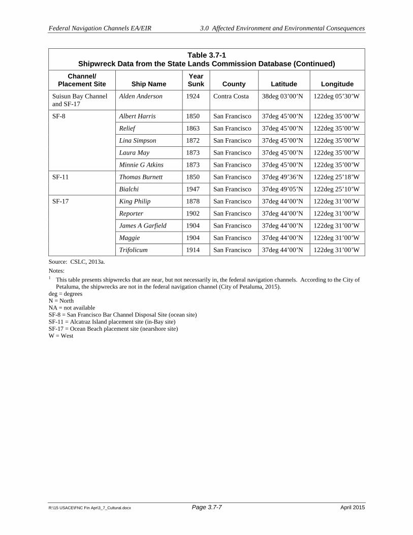
Federal Navigation Channels EA/EIR 3.0 Affected Environment and Environmental Consequences
R:\15 USACE\FNC Fin Apr\3_7_Cultural.docx Page 3.7-7 April 2015
Table 3.7-1 Shipwreck Data from the State Lands Commission Database (Continued)
Channel/Placement Site Ship Name
Year Sunk County Latitude Longitude
Suisun Bay Channel and SF-17
Alden Anderson 1924 Contra Costa 38deg 03’00’N 122deg 05’30’W
SF-8 Albert Harris 1850 San Francisco 37deg 45’00’N 122deg 35’00’W
Relief 1863 San Francisco 37deg 45’00’N 122deg 35’00’W
Lina Simpson 1872 San Francisco 37deg 45’00’N 122deg 35’00’W
Laura May 1873 San Francisco 37deg 45’00’N 122deg 35’00’W
Minnie G Atkins 1873 San Francisco 37deg 45’00’N 122deg 35’00’W
SF-11 Thomas Burnett 1850 San Francisco 37deg 49’36’N 122deg 25’18’W
Bialchi 1947 San Francisco 37deg 49’05’N 122deg 25’10’W
SF-17 King Philip 1878 San Francisco 37deg 44’00’N 122deg 31’00’W
Reporter 1902 San Francisco 37deg 44’00’N 122deg 31’00’W
James A Garfield 1904 San Francisco 37deg 44’00’N 122deg 31’00’W
Maggie 1904 San Francisco 37deg 44’00’N 122deg 31’00’W
Trifolicum 1914 San Francisco 37deg 44’00’N 122deg 31’00’W
Source: CSLC, 2013a. Notes: 1 This table presents shipwrecks that are near, but not necessarily in, the federal navigation channels. According to the City of
Petaluma, the shipwrecks are not in the federal navigation channel (City of Petaluma, 2015). deg = degrees N = North NA = not available SF-8 = San Francisco Bar Channel Disposal Site (ocean site) SF-11 = Alcatraz Island placement site (in-Bay site) SF-17 = Ocean Beach placement site (nearshore site) W = West

!
!!!!!!!!!!!
!
!!!!
!!!
!
!!!
!
!!!
!
!!
!!!!!
!!!!!
!
!
SF-DODSb
SA
NF
RA
NC
I SC
OB
AY
SA
NP
AB
L OB A Y
S UI S
U NB A Y
PA
CI
FI
CO
CE
AN
S O N O M A
C O U N T Y
N A P A
C O U N T Y
S O L A N O
C O U N T Y
M A R I N
C O U N T Y
C O N T R A
C O S T A
C O U N T Y
S A NF R A N C I S C O
C O U N T Y
A L A M E D A
C O U N T Y
S A N
M A T E O
C O U N T Y
#S1
#S1
#S2
#S3
#S4
#S4
#S5
#S6#S7
#S8
#S9
#S10
#S10
Winter Island
SF-10San Pablo Bay
SF-9Carquinez
StraitsSF-16 Suisun
Bay
SF-8Channel
Bar
SF-8 Channel BarCWA Portion
MontezumaWetlands
Rehandling Site
Montezuma WetlandsRestoration Project
SF-17 OceanBeach Near Shore
San LeandroDisposal Site
SF-11Alcatraz
CullinanRanch
ImolaAvenue
PetalumaRiver Farm
Ranger
Alven Besse
Edwin MayGolden GateJames Rolph Jr.
RuthSimla
Star of VancouverWhitesboro
FriedebergGreat WesternTrilbyHerald
LeaderCharles B KennedyGolden ShoreGolden Shore
E A BryanQuinault Victory
Alden AndersonHarry
AlphaAdele HobsonAssociated Oil #8
Buenos Dias
AnnieMarylandNovato
City of Glendale
Agnes JonesGold
Albert HarrisLaura May
Lina SimpsonMinnie G Atkins
Relief James A GarfieldKing Philip
Maggie
ReporterTrifolicum
BialchiThomas Burnett
Fairfield
Vacaville
Vallejo
PaloAlto
Pacifica
SanMateo
SanFrancisco
AntiochConcord
Danville
Lafayette
Martinez
Orinda
PinolePittsburg
SanRamon
Berkeley
Dublin
Fremont
Hayward
Livermore
Newark
Oakland
Pleasanton
SanLeandro
Union City
Petaluma
Napa
MillValley
Novato
¬S4¬S101
¬S242
¬S680
¬S380
¬S238¬S880
¬S13
¬S580
¬S280
¬S92
¬S24
¬S109
¬S121
¬S262
¬S1
¬S112
¬S29
¬S160
¬S141
¬S237
¬S37
¬S185
¬S80
¬S221
¬S131
¬S12
¬S123
¬S35
¬S82
¬S116
¬S84
¬S113
S A N A N T O N I O CR E E K
L I ND S E Y S L O U G H
N O VAT O C R EE K
SONO M
AC R
E
E K
G U A D A L U P ER I V E R
MA R S H C R EE K
C O Y O TE C R EEK
C U LLC R EEK
A R R O Y O L E O N
S A N A N T O N I O C R E E K
S A N A N S E L M O C RE EK
A R R O Y O M OC H O
C O RDE L I ASLOU
GH
U N I ON C R E E K
D E N V E R T ON
S LO UG
H
A R R O Y O V A L L E
GREEN
VALL E Y
C R E E K
A R R O Y O L A S P O S I T A S
S A N D C R E E K
NAP A
R IVE
R
A R R OY O HO N D O
MI L
L ER
C R E E K
L I N D S E Y S L O U G H
C A R NE R O SC R E E K
SU
I S U NC
RE EK
S AN F R A N C I SQU I TO C R E E K
WALN
UT
CR
E E K
T AS
SAJA
RAC
RE
EK
I N D I A N CR E E K
NAP A
R I V E R
P E TA L U MA
R I V E R
L A G U N I T A S C R E E K
S UISUNS LO
UG
H
0 4 8Miles
!°
lcd
U:\G
IS\U
SA
CE
_Fed
Cha
nnel
_EA
_EIR
\Pro
ject
s\A
PR
IL_2
015\
Fig3
_7_1
_Shi
pwre
cks_
lette
r.mxd
4/1
/201
5 1:
25:5
3 P
M
! Shipwreck Within 1/4-mileof ChannelExistingPlacement SiteDredge LocationsIncluded in EA/EIR
"S1 Richmond Harbor
"S2 San Francisco Harbor
"S3 Napa River Channel
"S4 Petaluma River Channel
"S5 San Rafael Creek Channel
"S6 San Pablo Bay/Mare Island Strait
"S7 Suisun Bay Channel
"S8 Oakland Harbor
"S9 San Leandro Marina(Jack D. MaltesterChannel)
"S01 Redwood City Harbor
SHIPWRECKS
April 2015
FIGURE 3.7-1
Source: URS, 2013.
Federal Navigation Channels EA/EIRU.S. Army Corps of Engineers
Bay Area, California

Federal Navigation Channels EA/EIR 3.0 Affected Environment and Environmental Consequences
R:\15 USACE\FNC Fin Apr\3_7_Cultural.docx Page 3.7-9 April 2015
The quality of significance in American history, architecture, archaeology, engineering, and culture is present in districts, sites, buildings, structures, and objects that possess integrity of location, design, setting, materials, workmanship, feeling, and association, and:
a. Resources that are associated with events that have made a significant contribution to the broad patterns of our history; or
b. Resources that are associated with the lives of persons significant in our past; or
c. Resources that embody the distinctive characteristics of a type, period, or method of construction, or that represent the work of a master, or that possess high artistic values, or that represent a significant and distinguishable entity whose components may lack individual distinction; or
d. Resources that have yielded, or may be likely to yield, information important in prehistory or history (36 C.F.R. § 60.4).
State Significance Criteria
At the state level, consideration of significance as a “historical resource” is measured by cultural resource provisions considered under CEQA Sections 15064.5 and 15126.4, and the criteria regarding resource eligibility to the California Register of Historical Resources (CRHR).
Generally under CEQA, a historical resource (these include built-environment historic and prehistoric archaeological resources) is considered significant if it meets the criteria for listing on the CRHR. These criteria are set forth in CEQA Section 15064.5 and defined as any resource that:
a. Is associated with events that have made a significant contribution to the broad patterns of California’s history and cultural heritage;
b. Is associated with lives of persons important in our past;
c. Embodies the distinctive characteristics of a type, period, region, or method of construction, or represents the work of an important creative individual, or possesses high artistic values; or
d. Has yielded, or may be likely to yield, information important in prehistory or history.
Section 15064.5 of CEQA also assigns special importance to human remains and specifies procedures to be used when Native American remains are discovered. These procedures are detailed under California PRC Section 5097.98.
“Unique” archaeological resources are also considered under CEQA, as described under PRC 21083.2. A unique archaeological resource implies an archaeological artifact, object, or site about which it can be clearly demonstrated thatwithout merely adding to the current body of knowledgethere is a high probability that it meets one of the following criteria:
a. The archaeological artifact, object, or site contains information needed to answer important scientific questions, and there is a demonstrable public interest in that information;
b. The archaeological artifact, object, or site has a special and particular quality, such as being the oldest of its type or the best available example of its type; or
c. The archaeological artifact, object, or site is directly associated with a scientifically recognized important prehistoric or historic event or person.

Federal Navigation Channels EA/EIR 3.0 Affected Environment and Environmental Consequences
R:\15 USACE\FNC Fin Apr\3_7_Cultural.docx Page 3.7-10 April 2015
A nonunique archaeological resource indicates an archaeological artifact, object, or site that does not meet the above criteria. Impacts to nonunique archaeological resources and resources that do not qualify for listing on the CRHR receive no further consideration under CEQA.
Conformity of Federal and State Evaluation Criteria
The criteria for eligibility for the CRHR are very similar to those that qualify a property for the NRHP. A property that is eligible for the NRHP is also eligible for the CRHR. All potential impacts to significant resources under a federal agency must be assessed and addressed under the procedures of Section 106 of the NHPA, set forth at 36 C.F.R. pt. 800.
Criteria for Evaluation of Cultural Resource Impacts
The criteria for determining an adverse effect under Section 106 of the NHPA are applied to assess what impacts a federal undertaking (i.e., federal action) would have on the historic integrity of a historic property, and how the undertaking would affect those features of a historic property that contribute to its eligibility for listing in the NRHP. Similarly, the criteria of significant impacts to historic resources under CEQA are applied to assess a project’s impacts on the historic integrity of a historical resource, and whether the project impacts would materially impair the historical significance of the resource.
The federal definition of effect is contained in 36 C.F.R. pt. 800: “Effect means alteration to the characteristics of a historic property qualifying it for inclusion in or eligibility for the National Register.” An adverse effect occurs “when an undertaking may alter, directly or indirectly, any of the characteristics of a historic property that qualify the property for inclusion in the National Register in a manner that would diminish the integrity of the property’s location, design, setting, materials, workmanship, feeling, or association . . . Adverse effects may include reasonably foreseeable effects caused by the undertaking that may occur later in time, be farther removed in distance, or be cumulative.”1
The California Code of Regulations, beginning with 15064.5(b), defines significant impacts for historical resources as: “[S]ubstantial adverse change in the significance of a historical resource means physical demolition, destruction, relocation, or alteration of the resource or its immediate surroundings such that the significance of a historical resource would be materially impaired.”
In addition to those cultural resources determined eligible for listing to the NRHP and/or CRHR, CEQA (Section 15064.5) also contains provisions for the treatment of human remains (PRC Section 5097.98) and “unique” archaeological resources (PRC Section 21083.2).
Therefore, the analysis of impacts to cultural resources considers whether the project would:
Result in a substantial adverse change in the significance of a historical resource (NRHP and/or CRHR Listed, or Eligible to be Listed), or a unique archaeological resource as defined under California PRC Section 21083.2; or
Result in disturbance of any human remains, including those interred outside of formal cemeteries as considered under PRC Section 5097.9.
As stated at the beginning of this section, the project alternatives neither propose demolition of existing structures nor introduce elements that could affect the historic setting of the built environment. Therefore, there would be no potential for impacts to historic architectural resources, and such impacts are not further addressed in this analysis.
1 36 C.F.R. § 800.5(a)(1).

Federal Navigation Channels EA/EIR 3.0 Affected Environment and Environmental Consequences
R:\15 USACE\FNC Fin Apr\3_7_Cultural.docx Page 3.7-11 April 2015
Criteria for Evaluation of Paleontological Resource Impacts
Assessments of the scientific significance of paleontological remains are based on whether they can provide data on the taxonomy and phylogeny of ancient organisms, the paleoecology and nature of paleoenvironments in the geologic past, or the stratigraphy and age of geologic units. Significant paleontological resources are defined in this analysis to include the interpretation outlined by the Society of Vertebrate Paleontology (SVP) (SVP, 1994), wherein vertebrate fossils are considered significant.
The evaluation of impacts on paleontological resource is conducted consistent with the standards and guidelines recommended for the assessment and mitigation of impacts to paleontological resources recommended by the SVP (SVP, 1995). Therefore, the analysis of impacts to paleontological resources considers whether the project would result in disturbance or destruction of a sensitive and/or unique paleontological resource or site.
3.7.4 Impacts and Mitigation Measures
Under all alternatives, USACE would continue to conduct maintenance dredging, transport of dredged materials, and placement of dredged materials. Dredged material transport would not involve sediment disturbance, and would therefore not be expected to disturb archaeological or paleontological resources. Therefore, the area of potential effects is limited to the federal navigation channels and placement sites.
Impact 3.7-1: Substantial Adverse Change to a Historical Resource or Disturb Unique Archaeological Resources
No Action/No Project Alternative, Proposed Action/Project, and Reduced Hopper Dredge Use Alternatives 1 and 2
It has been generally accepted that the initial construction of shipping lanes and maneuvering areas and the repeated maintenance dredging of these areas alter the seafloor to a point that submerged cultural resources, if present prior to the work, would be severely damaged or destroyed. Maintenance dredging that would occur under all alternatives would be confined to the removal of sediments accumulated since the last dredging effort. Sediments deposited since the previous dredging activities would not contain in situ archaeological resources. Furthermore, given the extent of past dredging in the channels, the likelihood of any intact remains in these areas is negligible.
The dredged material would be placed at existing placement sites on previously placed dredged material. Therefore, placement activities would not result in impacts to historical resources or unique archaeological resources, because the underlying native deposits would not be disturbed. The USACE would not use future placement sites identified in Section 1.5.4 until appropriate environmental review is completed, including evaluation and mitigation of archaeological impacts.
Per 36 C.F.R. pt. 800.3(1), because there are no known historical resources at the federal navigation channels or existing placement sites that could be impacted by the project alternatives, USACE has no further obligations under Section 106 of the NHPA.
Although unlikely, given the repeated dredging and dredged material placement activities that have historically occurred at the federal navigation channels and existing placement sites, there remains the potential that archaeological materials could be inadvertently uncovered by project activities. Such inadvertently discovered archaeological materials could represent historical resources or unique archaeological resources, and their disturbance could adversely change their condition. As such, the inadvertent discovery of archaeological materials represents a potential project impact. Implementation of Mitigation Measure CUL-1, Inadvertent Archaeological Discovery Measures, would reduce potential

Federal Navigation Channels EA/EIR 3.0 Affected Environment and Environmental Consequences
R:\15 USACE\FNC Fin Apr\3_7_Cultural.docx Page 3.7-12 April 2015
impacts to archaeological material by identifying the procedures to be followed by USACE in the event archaeological resources are inadvertently exposed during project activities.
Mitigation Measure CUL-1: Inadvertent Archaeological Discovery Measures To avoid potential adverse effects on inadvertently discovered NRHP- and/or CRHR-eligible or unique archaeological resources, should any indication of an archeological resource, including—but not limited to—encountering fragments of bone, stone tools, structural remains, ship remnants, or historic refuse during any soil-disturbing activity of the project, USACE will immediately suspend any soils-disturbing activities in the vicinity of the discovery.
In the event of such a discovery, USACE will consult a qualified archaeologist. The archaeologist will advise USACE as to whether the discovery is an archaeological resource that retains sufficient integrity and is of potential scientific/historical/cultural significance. If an archaeological resource is present, the archaeologist will identify and evaluate the archaeological resource. The archaeologist will make a recommendation to USACE as to what action or additional measures, if any, are warranted.
Measures might include: an archaeological monitoring program, or an archaeological evaluation program. If an archaeological resource cannot be avoided by project activities, the archaeologist will prepare an Archaeological Evaluation Plan (AEP). The AEP will create a program to determine the potential of the expected resource to meet the NRHP and CRHR criteria, and the archaeologist will submit this plan to USACE for approval. The archaeologist will then conduct an evaluation consistent with the USACE-approved AEP. The methods and findings of the evaluation will be presented in an Archaeological Evaluation and Effects Report, which will be submitted to USACE for review upon completion.
NEPA Determination: Under all alternatives, the inadvertent discovery of archaeological materials during project activities represents a potential impact; however; implementation of Mitigation Measure CUL-1 would reduce the potential to result in impacts to archaeological resources to a less-than-significant level.
CEQA Determination: Under all alternatives, the inadvertent discovery of archaeological materials during project activities represents a potential impact; however; implementation of Mitigation Measure CUL-1 would reduce the potential to result in impacts to archaeological resources to a less-than-significant level.
Impact 3.7-2: Disturb Human Remains, including those Interred Outside of Formal Cemeteries
No Action/No Project Alternative, Proposed Action/Project, and Reduced Hopper Dredge Use Alternatives 1 and 2
There are no known cemeteries, formal or otherwise, or other evidence of human internment in the federal navigation channels or existing placement sites. Furthermore, USACE would not use the future placement sites identified in Section 1.5.4 until appropriate environmental review and permitting are completed. Although unlikely, given the repeated dredging and dredged material placement activities that have historically occurred at the federal navigation channels and existing placement sites, there remains the potential that previously unidentified human remains could be inadvertently uncovered with project implementation. Such disturbance of human remains represents a potential project impact. Implementation of Mitigation Measure CUL-1, Inadvertent Archaeological Discovery Measures (above) and Mitigation Measure CUL-2, Treatment of Human Remains, would reduce potential impacts by identifying the procedures to be followed by the applicant in the event human remains are inadvertently exposed during project implementation.

Federal Navigation Channels EA/EIR 3.0 Affected Environment and Environmental Consequences
R:\15 USACE\FNC Fin Apr\3_7_Cultural.docx Page 3.7-13 April 2015
Mitigation Measure CUL-2: Treatment of Human Remains The treatment of human remains and associated or unassociated funerary objects discovered during any soil-disturbing activity will comply with applicable state laws. In the event the discovery is composed entirely of—or includes—human skeletal remains, construction activities will immediately cease and USACE’s project representative will immediately contact the local coroner (county in which discovery is made) to evaluate the remains, and follow the procedures and protocols set forth in Section 15064.5 (e)(1) of the CEQA Guidelines. If the coroner determines that the remains are Native American, USACE will contact the Native American Heritage Commission, who will appoint a Most Likely Descendant (MLD), in accordance with Health and Safety Code Section 7050.5, subdivision (c), and PRC 5097.98 (as amended by AB 2641). In accordance with PRC 5097.98, USACE shall ensure that, according to generally accepted cultural or archaeological standards or practices, the immediate vicinity of the Native American human remains is not damaged or disturbed by further development activity until USACE has discussed and conferred, as prescribed in this section (PRC 5097.98), with the MLD regarding their recommendations, if applicable, taking into account the possibility of multiple human remains. The USACE and the MLD will make all reasonable efforts to develop an agreement for the treatment of, with appropriate dignity, human remains and associated or unassociated funerary objects (CEQA Guidelines Sec. 15064.5[d]). The agreement should take into consideration the appropriate recordation, analysis, custodianship, curation, and final disposition of the human remains and associated or unassociated funerary objects. PRC allows 48 hours to reach agreement on these matters. If the MLD and the other parties do not agree on the reburial method, the project will follow Section 5097.98(b) of the PRC, which states, “the landowner or his or her authorized representative will re-inter the human remains and items associated with Native American burials with appropriate dignity on the property in a location not subject to further subsurface disturbance.”
NEPA Determination: Under all alternatives, the inadvertent disturbance of human remains represents a potential impact; however, implementation of Mitigation Measures CUL-1 and CUL-2 would reduce the potential to result in impacts to human remains to a less-than-significant level.
CEQA Determination: Under all alternatives, the inadvertent disturbance of human remains represents a potential impact; however, implementation of Mitigation Measures CUL-1 and CUL-2 would reduce the potential to result in impacts to human remains to a less-than-significant level.
Impact 3.7-3: Disturb Unidentified Significant Paleontological Resources
No Action/No Project Alternative, Proposed Action/Project, and Reduced Hopper Dredge Use Alternatives 1 and 2
As described under Impact 3.7-1, maintenance dredging and placement at existing placement sites would not disturb native sediments; therefore, disturbance of paleontological resources would not be expected. The USACE would not use the future placement sites identified in Section 1.5.4 until appropriate environmental review and permitting are completed. Although unlikely, there remains the potential that paleontological materials could be inadvertently uncovered by project activities. Such disturbance of paleontological resources represents a potential project impact. Implementation of Mitigation Measure CUL-3, Inadvertent Paleontological Discovery, would reduce potential impacts due to disturbance of paleontological resources by identifying the procedures to be followed by USACE in the event human remains are inadvertently exposed.
Mitigation Measure CUL-3: Inadvertent Paleontological Discovery In the event that paleontological resources are discovered during sediment-disturbing activities, work will be temporarily halted or diverted. The USACE will consult a qualified paleontologist (in accordance with SVP standards). The paleontologist will document the discovery as needed,

Federal Navigation Channels EA/EIR 3.0 Affected Environment and Environmental Consequences
R:\15 USACE\FNC Fin Apr\3_7_Cultural.docx Page 3.7-14 April 2015
evaluate the potential resource, and assess the significance of the find under the criteria set forth in CEQA Guidelines Section 15064.5. The paleontologist will consult USACE to determine procedures that would be followed before work is allowed to resume at the location of the find. If USACE determines that avoidance is not feasible, the paleontologist will prepare a salvage plan in accordance with the SVP and CEQA Guidelines for mitigating the effect of the project on the qualities that make the resource important. The plan will be submitted to USACE for review and approval prior to implementation.
NEPA Determination: Under all alternatives, with implementation of proposed Mitigation Measure CUL-3, the potential to result in impacts to paleontological resources would be reduced to a less-than-significant level.
CEQA Determination: Under all alternatives, with implementation of proposed Mitigation Measure CUL-3, the potential to result in impacts to paleontological resources would be reduced to a less-than-significant level.
Impact 3.7-4: Potential to Result in Cumulative Impacts on Archaeological or Paleontological Resources
Under all alternatives, project activities would not result in impacts to known historic or unique archaeological resources or to significant paleontological resources, and therefore would not contribute to any cumulative impact to these resources. Dredging and placement activities could result in the inadvertent discovery of a buried archaeological resource, buried human remains, or paleontological resources. The other ongoing and reasonably foreseeable projects shown in Table 3.1-1, which include dredging to deepen channels, would also have the potential to inadvertently uncover previously unidentified buried archaeological resources, buried human remains, or paleontological resources.
If previously undiscovered archaeological resources are inadvertently exposed during construction activities, an incremental effect to archaeological resources may occur. However, other ongoing and reasonably foreseeable future projects would be subject environmental review under NEPA and/or CEQA, and would be required to consider mitigation for impacts to historical or unique archaeological resources and paleontological resources. If these resources are properly evaluated and managed according to mitigation measures, no adverse cumulative impact to archaeological resources is expected to occur.
NEPA Determination. Cumulative impacts to archaeological and paleontological resources would be less than significant.
CEQA Determination. Cumulative impacts to archaeological and paleontological resources would be less than significant.

Federal Navigation Channels EA/EIR 3.0 Affected Environment and Environmental Consequences
R:\15 USACE\FNC Fin Apr\3_8_Land Use.docx Page 3.8-1 April 2015
3.8 LAND USE
This section describes the land use planning context, including applicable plans and policies, and evaluates the potential land use impacts from implementation of the alternatives. The proposed dredging, transport, and placement activities would not require any new land-based construction or facilities, and would not result in any new residences or infrastructure that could indirectly induce growth or development in the study area. Therefore, this land use evaluation focuses on land use polices that affect shoreline development and the waters in the study area. Habitat conservation plans are addressed in Section 3.6, Biological Resources.
3.8.1 Regulatory Setting
Federal
Coastal Zone Management Act
The Coastal Zone Management Act (CZMA), established in 1972 and administered by the National Oceanic and Atmospheric Administration’s Office of Ocean and Coastal Resource Management, provides for management of the nation’s coastal resources. The overall purpose is to balance competing land and water issues in the coastal zone. The CZMA encourages states to develop coastal management programs. The federal government certified the California Coastal Management Program (CCMP) in 1977. Under the CZMA, any federal agency conducting or supporting activities directly affecting the coastal zone must proceed in a manner consistent with the federally approved state coastal zone management programs, to the maximum extent practicable. The processes established to implement this requirement are called a consistency determination for federal activities and development projects; and a consistency certification for federal permits and licenses and federal support to state and local agencies (CCC, 2012a). In lieu of a consistency determination, pursuant to 15 C.F.R. § 930.35, a federal agency may submit a negative determination for an activity that “is the same as or is similar to activities for which consistency determinations have been prepared in the past.” The enforceable policies of the CCMP are in Chapter 3 of the California Coastal Act of 1976. However, as described below, the California Coastal Act covers a much broader jurisdiction beyond implementation of the federal CZMA.
Commerce Clause of the Constitution
Navigable servitude is a United States constitutional doctrine that gives the federal government the right to regulate navigable waterways as an extension of the Commerce Clause of the Constitution. The federal navigational servitude entitles the government to exert a dominant servitude in all lands below the ordinary high water mark of navigable waters.
Navigable waters of the United States are those waters that are subject to the ebb and flow of the tide and/or are presently used, or have been used in the past, or may be susceptible for use to transport interstate or foreign commerce (33 C.F.R. § 329.4). For rivers, lakes and marshlands, federal regulatory jurisdiction and powers of improvement for navigation extend laterally to the entire water surface and bed of a navigable waterbody, which includes all the land and waters below the ordinary high water mark (33 C.F.R. § 329.11).
Submerged Lands Act
The Submerged Lands Act of 1953 (43 U.S.C. § 1301 et seq.) grants states title to all submerged navigable lands within their boundaries. This includes navigable waterways, such as rivers, as well as marine waters within the state’s boundaries, generally three geographical miles from the coastline. Section 1311(d) of the Submerged Lands Act provides that nothing in the act shall affect the use, development, improvement, or control by or under the constitutional authority of the United States for the

Federal Navigation Channels EA/EIR 3.0 Affected Environment and Environmental Consequences
R:\15 USACE\FNC Fin Apr\3_8_Land Use.docx Page 3.8-2 April 2015
purposes of navigation or be construed as the release or relinquishment of any rights of the United States arising under the constitutional authority of Congress to regulate or improve navigation. In compliance with this act, the California State Land Commission will receive a copy of this Environmental Assessment/Environmental Impact Report and will have the opportunity to comment on its potential impacts to submerged lands.
State
California Environmental Quality Act
The California Environmental Quality Act (CEQA) (California Public Resources Code Sections 21000-21178) and the CEQA Guidelines (14 California Code of Regulations 15000-15387) are the primary policies that require projects to analyze potential impacts to land use, as well as to analyze the project’s consistency with land use planning policies applicable to the project. This document is intended to fulfill the requirements of CEQA and the CEQA Guidelines.
Public Trust Doctrine (California State Lands Commission)
The California State Lands Commission (CSLC) manages lands in California according to the Public Trust Doctrine. Several of the guiding principles of the Public Trust are:
I. Lands under the ocean and under navigable streams are owned by the public and held in trust for the people by government. These are referred to as public trust lands, and include filled lands formerly under water. Public trust lands cannot be bought and sold like other state-owned lands. Only in rare cases may the public trust be terminated, and only where consistent with the purposes and needs of the trust.
II. Uses of trust lands, whether granted to a local agency or administered by the state directly, are generally limited to those that are water dependent or related, and include commerce, fisheries, and navigation, environmental preservation and recreation. Public trust uses include, among others, ports, marinas, docks and wharves, buoys, hunting, commercial and sport fishing, bathing, swimming, and boating. Public trust lands may also be kept in their natural state for habitat, wildlife refuges, scientific study, or open space. Ancillary or incidental uses are also permitted—that is, uses that directly promote trust uses; are directly supportive and necessary for trust uses; or that accommodate the public’s enjoyment of trust lands. Although trust lands cannot generally be alienated from public ownership, uses of trust lands can be carried out by public or private entities by lease from the CSLC or a local agency grantee.
III. Because public trust lands are held in trust for all citizens of California, they must be used to serve statewide, as opposed to purely local, public purposes (CSLC, 2010).
California Coastal Act
The California Coastal Act includes specific policies (Division 20 of the California Public Resources Code) for planning and regulatory decisions made by the California Coastal Commission (CCC) and local governments. The CCC works with coastal cities and counties to regulate the use of land and water in the coastal zone. The California Coastal Act regulates development activities, such as the construction of buildings, divisions of land, and activities that change the intensity of use of land or public access to coastal waters. On land, the coastal zone varies in width from several hundred feet in highly urbanized areas up to 5 miles in certain rural areas; offshore, the coastal zone includes a 3-mile-wide band of ocean. The coastal zone established by the California Coastal Act does not include San Francisco Bay, where development is regulated by the San Francisco Bay Conservation and Development Commission (BCDC) (CCC, 2012a), as further described below.

Federal Navigation Channels EA/EIR 3.0 Affected Environment and Environmental Consequences
R:\15 USACE\FNC Fin Apr\3_8_Land Use.docx Page 3.8-3 April 2015
The CCC developed the CCMP, pursuant to the requirements of the CZMA, described above. If a proposed activity affects water use in the coastal zone (i.e., the territorial sea and inland), the federal agency must determine that its project is consistent—to the maximum extent practicable—with the CCMP. The BCDC, further described below, is the state’s coastal zone management agency responsible for reviewing consistency determinations under the CZMA in San Francisco Bay. For activities outside of the Golden Gate, consistency determinations are reviewed by the CCC.
Article 4 of the California Coastal Act requires that marine resources be maintained, enhanced, and where feasible, restored. The act also requires that special protection be given to areas and species of special biological or economic significance. It further requires that uses of marine environments be such that habitat function, biological productivity, healthy species populations, and fishing and recreational interests of coastal waters are maintained for long-term commercial, recreational, scientific, and educational purposes; and that marine resources are protected against the spillage of crude oil, gas, petroleum products, and hazardous substances.
McAteer-Petris Act
The McAteer-Petris Act (California Government Code Section 66000, et seq.), first enacted in 1965, created the BCDC to prepare a plan to protect the San Francisco Bay and shoreline, and provide for appropriate development and public access. This act directs BCDC to exercise its authority to issue or deny permit applications for placing fill; dredging; or changing the use of any land, water, or structure in the area of its jurisdiction. The BCDC also reviews determinations of consistency with the CZMA for federally sponsored projects. The San Francisco Bay Plan (Bay Plan) is BCDC’s policy document specifying goals, objectives, and policies for BCDC jurisdictional areas. Pursuant to the federal CZMA, USACE is required to be consistent to the maximum extent practicable with the enforceable policies of the Bay Plan.
Regional
San Francisco Bay Conservation and Development Commission San Francisco Bay Plan
BCDC has permit authority over development of San Francisco Bay and the shoreline pursuant to the McAteer-Petris Act (California Government Code Section 66000 et seq.). The act requires BCDC to prepare a “comprehensive and enforceable plan for the conservation of the water of San Francisco Bay and the development of its shoreline.” BCDC’s jurisdiction includes all tidal areas of San Francisco Bay up to the line of mean high tide; all areas formerly subject to tidal action that have been filled since September 17, 1965; and the “shoreline band,” which extends 100 feet inland from and parallel to the San Francisco Bay shoreline.
BCDC is also the regional coastal zone management agency for San Francisco Bay. Therefore, under the provisions of Section 307 of the federal CZMA, federal agencies must assess whether their actions are consistent with BCDC’s regulations and policies to the maximum extent practicable. BCDC has jurisdiction over all filling, dredging, and changes in use in San Francisco Bay.
The Bay Plan, first adopted in 1969, and last updated in 2011, is BCDC’s policy document specifying goals, objectives, and policies for BCDC jurisdictional areas (BCDC, 2007). Policies in the Bay Plan applicable to the proposed project include those in the following categories: Dredging; Fish, Other Aquatic Organisms, and Wildlife; Water Quality; Tidal Marshes and Tidal Flats; Subtidal Areas; and Navigational Safety and Oil Spill Prevention.

Federal Navigation Channels EA/EIR 3.0 Affected Environment and Environmental Consequences
R:\15 USACE\FNC Fin Apr\3_8_Land Use.docx Page 3.8-4 April 2015
Dredging policies in the Bay Plan relevant to the proposed project are summarized below:
Dredging Policy 1. Dredging and dredged material disposal should be conducted in an environmentally and economically sound manner. Dredgers should reduce disposal in San Francisco Bay and certain waterways over time to achieve the Long-Term Management Strategy (LTMS) goal of limiting in-Bay disposal volumes to a maximum of one million cubic yards per year. The LTMS agencies should implement a system of disposal allotments to individual dredgers to achieve this goal only if voluntary efforts are not effective in reaching the LTMS goal. In making its decision regarding disposal allocations, the BCDC should confer with the LTMS agencies and consider the need for the dredging and the dredging projects, environmental impacts, regional economic impacts, efforts by the dredging community to implement and fund alternatives to in-Bay disposal, and other relevant factors.
Dredging Policy 2. Dredging should be authorized when the BCDC can find: (a) the applicant has demonstrated that the dredging is needed to serve a water-oriented use or other important public purpose, such as navigational safety; (b) the materials to be dredged meet the water quality requirements of the Regional Water Board; (c) important fisheries and Bay natural resources would be protected through seasonal restrictions established by the California Department of Fish and Wildlife (CDFW), the United States Fish and Wildlife Service (USFWS), and/or the National Marine Fisheries Service (NMFS), or through other appropriate measures; (d) the siting and design of the project will result in the minimum dredging volume necessary for the project; and (e) the materials would be disposed of in accordance with Policy 3.
Dredging Policy 3. Dredged materials should, if feasible, be reused or disposed outside San Francisco Bay and certain waterways. Except when reused in an approved fill project, dredged material should not be disposed in San Francisco Bay and certain waterways unless disposal outside these areas is infeasible and the BCDC finds: (a) the volume to be disposed is consistent with applicable dredger disposal allocations and disposal site limits adopted by the BCDC by regulation; (b) disposal would be at a site designated by the BCDC; (c) the quality of the material disposed of is consistent with the advice of the Regional Water Board and the Dredged Material Management Office; and (d) the period of disposal is consistent with the advice of the CDFW, the USFWS, and the NMFS.
Dredging Policy 4. If an applicant proposes to dispose dredged material in tidal areas of San Francisco Bay and certain waterways that exceeds either disposal site limits or any disposal allocation that the BCDC has adopted by regulation, the applicant must demonstrate that the potential for adverse environmental impact is insignificant, and that nontidal and ocean disposal is infeasible because there are no alternative sites available or likely to be available in a reasonable period, or because the cost of disposal at alternate sites is prohibitive. In making its decision whether to authorize such in-Bay disposal, the BCDC should confer with the LTMS agencies and consider the factors listed in Policy 1.
Dredging Policy 5. To ensure adequate capacity for necessary Bay dredging projects and to protect Bay natural resources, acceptable nontidal disposal sites should be secured and the San Francisco Deep Ocean Disposal Site should be maintained. Furthermore, dredging projects should maximize use of dredged material as a resource consistent with protecting and enhancing Bay natural resources, such as creating, enhancing, or restoring tidal and managed wetlands, creating and maintaining levees and dikes, providing cover and sealing material for sanitary landfills, and filling at approved construction sites.
Dredging Policy 6. Dredged materials disposed in San Francisco Bay and certain waterways should be carefully managed to ensure that the specific location, volumes, physical nature of the material, and timing of disposal do not create navigational hazards; adversely affect Bay

Federal Navigation Channels EA/EIR 3.0 Affected Environment and Environmental Consequences
R:\15 USACE\FNC Fin Apr\3_8_Land Use.docx Page 3.8-5 April 2015
sedimentation, currents, or natural resources; or foreclose the use of the site for projects critical to the economy of the San Francisco Bay Area.
Policies in the Bay Plan pertaining to Fish, Other Aquatic Organisms, and Wildlife that are relevant to the proposed project are summarized below:
Fish, Other Aquatic Organisms, and Wildlife Policy 1. To assure the benefits of fish, other aquatic organisms, and wildlife for future generations, to the greatest extent feasible, San Francisco Bay’s tidal marshes, tidal flats, and subtidal habitat should be conserved, restored, and increased.
Fish, Other Aquatic Organisms, and Wildlife Policy 2. Specific habitats that are needed to conserve, increase, or prevent the extinction of any native species, species threatened or endangered, species that the CDFW has determined are candidates for listing as endangered or threatened under the California Endangered Species Act, or any species that provides substantial public benefits, should be protected, whether in San Francisco Bay or behind dikes.
Fish, Other Aquatic Organisms, and Wildlife Policy 4. The BCDC should not authorize projects that would result in the “taking” of any plant, fish, other aquatic organism or wildlife species listed as endangered or threatened pursuant to the state or federal endangered species acts, or the federal Marine Mammal Protection Act, or species that are candidates for listing under the California Endangered Species Act, unless the project applicant has obtained the appropriate “take” authorization from the USFWS, NMFS, or CDFW. The BCDC should give appropriate consideration to the recommendations of the CDFW, NMFS, or USFWS to avoid possible adverse effects of a proposed project on fish, other aquatic organisms, and wildlife habitat.
Water Quality policies in the Bay Plan relevant to the proposed project are summarized below:
Water Quality Policy 1. Bay water pollution should be prevented to the greatest extent feasible. The Bay’s tidal marshes, tidal flats, and water surface area and volume should be conserved, and whenever possible, restored and increased to protect and improve water quality.
Water Quality Policy 2. Water quality in San Francisco Bay should be maintained at a level that will support and promote the beneficial uses of San Francisco Bay as identified in the Regional Water Board’s Water Quality Control Plan for the San Francisco Bay Basin, and should be protected from all harmful or potentially harmful pollutants. The policies, recommendations, decisions, advice, and authority of the State Water Resources Control Board and the Regional Water Board should be the basis for carrying out the BCDC’s water quality responsibilities.
Policies in the Bay Plan pertaining to Tidal Marshes and Tidal Flats relevant to the proposed project are summarized below:
Tidal Marshes and Tidal Flats Policy 1. Tidal marshes and tidal flats should be conserved to the fullest possible extent. Filling, diking, and dredging projects that would substantially harm tidal marshes or tidal flats should be allowed only for purposes that provide substantial public benefits, and only if there is no feasible alternative.
Tidal Marshes and Tidal Flats Policy 2. Any proposed fill, diking, or dredging project should be thoroughly evaluated to determine the effect of the project on tidal marshes and tidal flats, and designed to minimize—and if feasible—avoid any harmful effects.

Federal Navigation Channels EA/EIR 3.0 Affected Environment and Environmental Consequences
R:\15 USACE\FNC Fin Apr\3_8_Land Use.docx Page 3.8-6 April 2015
Policies for Subtidal Areas in the Bay Plan that are relevant to the proposed project are summarized below:
Subtidal Areas Policy 1. Any proposed filling or dredging project in a subtidal area should be thoroughly evaluated to determine the local and Bay-wide effects of the project on: (a) the possible introduction or spread of invasive species; (b) tidal hydrology and sediment movement; (c) fish, other aquatic organisms, and wildlife; (d) aquatic plants; and (e) San Francisco Bay’s bathymetry. Projects in subtidal areas should be designed to minimize—and if feasible—avoid any harmful effects.
Subtidal Areas Policy 2. Subtidal areas that are scarce in San Francisco Bay or have an abundance and diversity of fish, other aquatic organisms, and wildlife (e.g., eelgrass beds, sandy deep water, underwater pinnacles) should be conserved. Filling, changes in use; and dredging projects in these areas should therefore be allowed only if: (a) there is no feasible alternative; and (b) the project provides substantial public benefits.
Navigational Safety and Oil Spill Prevention policies in the Bay Plan relevant to the proposed project are summarized below:
Navigational Safety and Oil Spill Prevention Policy 1. Physical obstructions to safe naviga-tion, as identified by the U.S. Coast Guard and the Harbor Safety Committee of the San Francisco Bay Region, should be removed to the maximum extent feasible when their removal would contribute to navigational safety, and would not create significant adverse environmental impacts. Removal of obstructions should ensure that any detriments arising from a significant alteration of Bay habitats are clearly outweighed by the public and environmental benefits of reducing the risk to human safety; or the risk of spills of hazardous materials, such as oil.
Navigational Safety and Oil Spill Prevention Policy 3. To ensure navigational safety and help prevent accidents that could spill hazardous materials, such as oil, the BCDC should encourage major marine facility owners and operators, USACE and the National Oceanic and Atmospheric Administration to conduct frequent, up-to-date surveys of major shipping channels, turning basins, and berths used by deep-draft vessels and oil barges. Additionally, the frequent, up to-date surveys should be quickly provided to the U.S. Coast Guard Vessel Traffic Service San Francisco, masters and pilots.
3.8.2 Environmental Setting
For the purpose of this analysis, the project’s study area in San Francisco Bay encompasses the shoreline and in-water areas in the following 11 counties: Marin, Sonoma, Napa, Solano, Sacramento, San Joaquin, Contra Costa, Alameda, Santa Clara, San Mateo, and San Francisco. The geographic scope of the study area includes the estuarine waters of the San Francisco Bay region, portions of the Sacramento-San Joaquin Delta west of Sherman Island, and the western portion of the Sacramento River Deep Water Ship Channel and Stockton Deep Water Ship Channel. Outside of the Golden Gate, the study area includes the San Francisco Deep Ocean Disposal Site, the San Francisco Main Ship Channel (MSC), San Francisco Bar Channel Disposal Site (SF-8) and the nearshore zone off Ocean Beach, as well as the waters that are used by vessels en route to these sites.
BCDC’s jurisdiction extends over most of the in-Bay portion of the study area, with the exception of a small portion of the eastern extent of the study area east of Pittsburg. The Winter Island, Antioch Dunes, and Sherman Island placement sites are outside of BCDC’s jurisdictional boundary. Outside of San Francisco Bay, the coastal zone extends approximately 3,000 feet into the eastern end of the Main Ship Channel and includes the SF-8 and the Ocean Beach nearshore placement site (SF-17) in-water placement

Federal Navigation Channels EA/EIR 3.0 Affected Environment and Environmental Consequences
R:\15 USACE\FNC Fin Apr\3_8_Land Use.docx Page 3.8-7 April 2015
sites and Ocean Beach onshore beach nourishment placement area; this area of the coastal zone is under the jurisdiction of the CCC.
3.8.3 Methodology and Thresholds of Significance
The proposed project would involve the maintenance dredging of existing federal navigation channels and placement of dredged materials at existing placement sites. These activities would have no potential to divide an existing community or substantially affect existing land uses and land use patterns in the study area, because no new land uses, types of activities, or improvements would be implemented. In addition, the use of future placement sites identified in Section 1.5.4 would be unlikely to result in such impacts based on their location and existing surrounding land uses; however, USACE would not use the future placement sites identified in Section 1.5.4 until appropriate environmental review is completed, including evaluation of impacts on land use.
Therefore, this land use evaluation focuses on consistency with coastal land use policies and plans. The analysis considered whether the project would conflict with applicable land use plans, policies, or regulations that an agency with jurisdiction over the project has adopted to avoid or mitigate environmental effects.
3.8.4 Impacts and Mitigation Measures
Impact 3.8-1 Conflict with Applicable Plans and Policies
No Action/No Project Alternative
Under the No Action/No Project Alternative, dredging and placement activities would be similar to numerous USACE annual maintenance dredging operations previously concurred with by the CCC and BCDC. Therefore, for the most part, continuation of these activities would not be expected to conflict with plans, regulations, or policies considered under the CZMA, including the CCMP and the Bay Plan; the exception being policies pertaining to the protection of listed species due to the entrainment of delta smelt and longfin smelt during hopper dredging operations at in-Bay locations. Pursuant to the CZMA, the BCDC and the CCC would review USACE’s consistency determination for dredging and placement activities that occur within each agency’s jurisdictional boundaries. The No Action/No Project Alternative’s consistency with the applicable policies from each plan is evaluated below.
Bay Plan. The USACE’s dredging, transport, and placement activities would be consistent with Bay Plan Dredging Policies and Water Quality Policies as described below:
Per Dredging Policy 1, USACE would conduct dredging and dredged material placement in an environmentally and economically sound manner in accordance with LTMS goals, to the extent that funding and authority allows. The USACE, as one of the LTMS managing agencies, is committed to the LTMS goal of reducing the placement of dredged material at in–Bay placement sites. Dredged material placement by USACE would support the goals of the Bay Plan.
Per Dredging Policy 2 and Water Quality Policies 1 and 2, maintenance dredging is needed for safe navigation; USACE would abide by the conditions of the Water Quality Certification issued by the Regional Water Board; Bay fisheries and natural resources would be protected; only the minimum volumes necessary would be dredged; and the sediment would be disposed of in accordance with the Policy 3 guidelines. The dredging activities would maintain the navigational safety of federal channels for commercial and recreational vessels, all serving valuable water-oriented uses.
Per Dredging Policy 3, dredged materials placed in BCDC’s jurisdiction would be placed in accordance with the Bay Plan guidelines unless it is found infeasible to comply with established

Federal Navigation Channels EA/EIR 3.0 Affected Environment and Environmental Consequences
R:\15 USACE\FNC Fin Apr\3_8_Land Use.docx Page 3.8-8 April 2015
regulations. The volumes proposed for placement at each designated site would be within placement site target values; the material would be determined suitable by the Dredged Material Management Office (which includes the Regional Water Board); and the dredging of sediments would be completed within the LTMS work windows, or USACE would consult with the appropriate resource agencies for work outside the windows. Because the use of in-Bay sites would continue for some projects, site-management strategies and monitoring activities for placement sites would continue to be implemented to lessen the cumulative impacts on San Francisco Bay’s aquatic habitats, and to ensure that the dispersion of dredged material is maximized.
Per Dredging Policy 4, the total volume of dredged material placed at in-Bay sites would fall within the LTMS target limits for in-Bay sites, and would not exceed disposal site limits.
Per Dredging Policy 5, USACE would maximize, to the extent feasible, the use of dredged sediment as a resource, in accordance with the goals of the LTMS Management Plan. In addition, adequate placement capacity for these dredging projects is continually being researched by USACE. For example, following a pilot project at the Ocean Beach Demonstration Site, SF-17 was proposed as a placement site and is presently undergoing the designation process.
Per Dredging Policy 6, all in-Bay sites would continue to be carefully managed (by performing regular bathymetric surveys) to ensure that the amount and timing of placement do not create navigational hazards, adversely affect Bay currents or natural resources of San Francisco Bay, or foreclose the use of the sites by projects critical to the economy of the San Francisco Bay Area.
The USACE’s dredging, transport, and placement activities would be consistent with Bay Plan Fish, Other Aquatic Organisms, and Wildlife Policies:
For Fish, Other Aquatic Organisms, and Wildlife Policy 1, USACE would place dredged materials in the most cost-efficient and environmentally responsible fashion. Dredged material would continue to be evaluated for—and used in the restoration of—tidal wetlands, or other habitat types wherever possible.
For Fish, Other Aquatic Organisms, and Wildlife Policies 2 and 4, the schedule for maintenance dredging projects in San Francisco Bay would be developed and followed in a manner protective of threatened or endangered species and special-status species in accordance with LTMS work windows. The dredging and disposal of sediments would be completed within these work windows, or USACE would consult with the appropriate resource agencies. The USACE would meet all federal environmental compliance requirements (e.g., Clean Water Act Section 404, Endangered Species Act), including those federal requirements implemented by state agencies (e.g., Clean Water Act Section 401). The USACE would undertake mitigation, as appropriate, in meeting its compliance requirements.
The USACE’s dredging, transport, and placement activities would be consistent with Bay Plan Tidal Marshes and Tidal Flats Policies:
Per Tidal Marshes and Tidal Flats Policy 1, USACE maintenance dredging would remove only the minimum volume necessary to ensure safe navigation in San Francisco Bay and the continuance of economic development benefiting the public.
Per Tidal Marshes and Tidal Flats Policy 2, USACE has and would continue to minimize and avoid to the extent feasible potentially harmful effects on tidal marshes.
For the two projects that are dredged through tidal mudflat—Petaluma River Across the Flats, and San Rafael Across the Flats—only the minimum material necessary to ensure safe navigation would be

Federal Navigation Channels EA/EIR 3.0 Affected Environment and Environmental Consequences
R:\15 USACE\FNC Fin Apr\3_8_Land Use.docx Page 3.8-9 April 2015
dredged. Although these projects cross the tidal mudflats, the channels are not considered to be tidal mudflat because of the channel depths.
No known tidal marsh habitat exists within the current channel boundaries; however, several projects may require work in, or near enough, to potentially impact tidal marsh areas. Projects that may require work in the tidal marsh habitats are Redwood City Harbor, San Leandro Marina, Petaluma River, and the Napa River channels. The dredging of these channels would provide public benefits of navigational safety and economic benefits to the communities who use them, and proposed dredging and placement activities would not substantially harm tidal marshes. These projects have nearby upland placement sites that may require transport of the material through the marsh habitat. This transport is typically accomplished through pipelines temporarily crossing the habitat to place the material. Through coordinated efforts, USACE has avoided impacts to special-status species in these habitats in the past; these efforts have included surveying for the species of concern, and then implementing the project in a manner that does not affect them. The USACE would continue to coordinate with the appropriate resource agencies on any work that may affect the tidal marsh habitat or its species.
Although eelgrass does exist near the Richmond Inner Harbor Channel, there is no known eelgrass within any of the channel boundaries. In 2010, 2011, and 2012 USACE conducted three sets of eelgrass surveys, conducted both before and after maintenance dredging. A reduction in the density in eelgrass along the channel margin was detected; the survey crews, however, did not find excessive sedimentation or any other evidence indicating that dredging had caused loss of eelgrass. Losses during winter months, known as seasonal diebacks, are, in fact, common in eelgrass meadows. Examination of surveys done over the last 15 years indicates that eelgrass has persisted in essentially the same locations and densities around Richmond Harbor. Minimization measures are always included in contract specifications. For Richmond Inner Harbor, a closed or “environmental” clamshell bucket is required, and contractors are prohibited from anchoring or placing any equipment in locations that could possibly disturb eelgrass habitat (USACE, 2012a). The USACE would also comply with the programmatic Essential Fish Habitat conservation measures for the LTMS Program (June 2011).
Therefore, the dredging, transport, and placement activities would be consistent, to the maximum extent feasible, with Tidal Marshes and Tidal Flats Policies 1 and 2.
The USACE’s dredging, transport, and placement activities would be consistent with Bay Plan Subtidal Areas Policies:
Per Subtidal Areas Policy 1, only short-term impacts result from the maintenance dredging and placement actions. There is no feasible alternative to maintaining the federal navigation channels through dredging and placement. The maintenance of these channels is essential to providing safe navigation and access to the ports and recreational marinas in San Francisco Bay.
Per Subtidal Areas Policy 2, the federal channels are not considered scarce or unique habitat in San Francisco Bay, and there is no feasible alternative to maintaining them through dredging and placement.
The USACE’s dredging, transport, and placement activities would be consistent with Bay Plan Navigational Safety and Oil Spill Prevention Policies:
Per Navigational Safety and Oil Spill Prevention Policy 1, USACE’s maintenance dredging program would remove obstructions to safe navigation, thereby ensuring the safe movement of maritime vessels, the protection of the surrounding habitat, and the continuation of the economic well-being and national defense of the nation.

Federal Navigation Channels EA/EIR 3.0 Affected Environment and Environmental Consequences
R:\15 USACE\FNC Fin Apr\3_8_Land Use.docx Page 3.8-10 April 2015
Per Navigational Safety and Oil Spill Prevention Policy 3, USACE would continue to perform surveys of all maintenance dredging project areas, and make these surveys available for public use.
The BCDC would review USACE’s consistency determination for dredging and placement activities that would occur within BCDC’s jurisdiction, to verify that the activities would be consistent, to the maximum extent practicable, with the Bay Plan.
California Coastal Management Plan. The MSC is the only federal navigation channel addressed in this Environmental Assessment/Environmental Impact Report that is within the jurisdiction of the CCC. Of the placement sites, SF-17 and a portion of SF-8 are within CCC’s jurisdiction. In 2012, USACE submitted a negative determination to the CCC for maintenance dredging at the MSC and placement of dredged material at SF-8, SF-17, and onshore at Ocean Beach for a 5-year period from 2012 through 2016. As stated in Section 3.8.1, a federal agency may submit negative determination for an activity that “is the same as or is similar to activities for which consistency determinations have been prepared in the past.” The negative determination demonstrated that the proposed dredging and placement activities for the MSC would be consistent—to the maximum extent practicable—with the CCMP and Article 4 of the California Coastal Act; and that the proposed activities were consistent with the annual maintenance dredging program for the MSC implemented by USACE, and previously concurred with by the CCC (USACE, 2012a). The CCC concurred with USACE’s negative determination on May 9, 2012. For dredging of the MSC from 2017 through 2024, USACE would request concurrence from the CCC on a negative determination to verify that continuing activities would be consistent, to the maximum extent practicable, with the CCMP and California Coastal Act. The dredging and placement activities under the No Action/No Project Alternative would be the same as those previously proposed by USACE for 2012 through 2016, and therefore would continue to be consistent with the CCMP and Article 4 of the California Coastal Act.
Because the federal navigation channels addressed in this Environmental Assessment/Environmental Impact Report are congressionally authorized navigation projects, dredging and placement activities would not require a lease agreement from the CSLC for use of public trust lands based on the navigational servitude provisions of the Submerged Lands Act. Although the Submerged Land Act grants CSLC title to all submerged navigable lands in the state, the act provides that nothing in the act shall affect the federal government’s constitutional authority for the purposes of navigation.
NEPA Determination: The No Action Alternative would not conflict with applicable land use plans and policies.
CEQA Determination: The No Project Alternative would not conflict with applicable land use plans and policies.
Proposed Action/Project
Implementation of the Proposed Action/Project would be very similar to the No Action/No Project Alternative; it would involve use of the same type of dredge equipment for each channel, the same volume of dredged material, and the same dredging frequency and durations. As described in Section 2.3.3, USACE would implement additional best management practices to minimize impacts to longfin smelt and delta smelt. Dredging and placement activities would not require a lease agreement from the CSLC for use of public trust lands.
Bay Plan. Under the Proposed Action/Project, USACE may use alternate placement sites for in-Bay Channels than those identified under the No Action/No Project Alternative; however, placement would still be conducted in support of the goals of the LTMS, and therefore consistent with the Bay Plan. The USACE would not use any of the future placement sites identified in Section 1.5.4 until appropriate environmental review and permitting is completed. Under the Proposed Action/Project, consistency with

Federal Navigation Channels EA/EIR 3.0 Affected Environment and Environmental Consequences
R:\15 USACE\FNC Fin Apr\3_8_Land Use.docx Page 3.8-11 April 2015
Bay Plan Policies would be the same as described for the No Action/No Project Alternative. The USACE would meet all federal environmental compliance requirements (e.g., Clean Water Act Section 404, Endangered Species Act), including those federal requirements implemented by state agencies (e.g., Clean Water Act Section 401). The USACE would purchase 0.92 mitigation credit at the Liberty Island Mitigation Bank annually for potential impacts to listed species. The BCDC would review USACE’s consistency determination for dredging and placement activities that would occur within BCDC’s jurisdiction, to verify that the activities would be consistent, to the maximum extent practicable, with the Bay Plan.
California Coastal Management Plan. Under the Proposed Action/Project, dredging and placement activities for the MSC would be the same as under the No Action/No Project Alternative, and therefore would be consistent with the CCMP and California Coastal Act. Dredging through 2016 would be covered under the existing negative determination and CCC concurrence. For dredging of the MSC from 2017 through 2024, USACE would request concurrence from the CCC on a negative determination to verify that the activities would be consistent, to the maximum extent practicable, with the CCMP and California Coastal Act.
NEPA Determination. The Proposed Action would not conflict with applicable land use plans and policies.
CEQA Determination. The Project would not conflict with applicable land use plans and policies.
Reduced Hopper Dredge Use Alternative 1
Implementation of the Reduced Hopper Dredge Use Alternative 1 would be very similar to the Proposed Action/Project Alternative, except that Suisun Bay Channel, New York Slough Channel, San Bruno Channel in Redwood City Harbor,1 and either Pinole Shoal or Richmond Outer Harbor, would be dredged with a mechanical dredge instead of a hopper dredge. Dredging and placement activities would not require a lease agreement from the CSLC for use of public trust lands.
Bay Plan. Reducing in-Bay hopper dredge use would likely reduce occurrences of entrainment of longfin smelt and delta smelt, pursuant to Fish, Other Aquatic Organisms, and Wildlife Policy 4. Consistency with Bay Plan Policies would be the same as described for the No Action/No Project Alternative and Proposed Action/Project. The USACE would meet all federal environmental compliance requirements (e.g., Clean Water Act Section 404, Endangered Species Act), including those federal requirements implemented by state agencies (e.g., Clean Water Act Section 401). The USACE would purchase 0.19 mitigation credit at the Liberty Island Mitigation Bank annually for potential impacts to listed species if Pinole Shoal is dredged with a hopper. If Richmond Outer Harbor is dredged with a hopper, USACE would purchase 0.34 mitigation credit at the Liberty Island Mitigation Bank annually for potential impacts to listed species. The BCDC would review USACE’s consistency determination for dredging and placement activities that would occur within BCDC’s jurisdiction, to verify that the activities would be consistent, to the maximum extent practicable, with the Bay Plan.
California Coastal Management Plan. Under Reduced Hopper Dredge Alternative 1, dredging and placement activities for the MSC would be the same as under the No Action/No Project Alternative, and therefore would be consistent with the CCMP and California Coastal Act. Dredging through 2016 would be covered under the existing negative determination and CCC concurrence. For dredging of the MSC from 2017 through 2024, USACE would request concurrence from the CCC on a negative determination to verify that the activities would be consistent, to the maximum extent practicable, with the CCMP and California Coastal Act.
1 San Bruno Channel is dredged at intervals of 10 years or greater.

Federal Navigation Channels EA/EIR 3.0 Affected Environment and Environmental Consequences
R:\15 USACE\FNC Fin Apr\3_8_Land Use.docx Page 3.8-12 April 2015
NEPA Determination. Reduced Hopper Dredge Use Alternative 1 would not conflict with applicable land use plans and policies.
CEQA Determination. Reduced Hopper Dredge Use Alternative 1 would not conflict with applicable land use plans and policies.
Reduced Hopper Dredge Use Alternative 2
Implementation of the Reduced Hopper Dredge Use Alternative 2 would be very similar to the Proposed Action/Project Alternative, except a hopper dredge would not be used for the regular maintenance dredging of in-Bay channels.
Bay Plan. Under this alternative, the potential for hopper dredge entrainment impacts to longfin smelt and delta smelt would be minimized. The USACE would meet all federal environmental compliance requirements (e.g., Clean Water Act Section 404, Endangered Species Act), including those federal requirements implemented by state agencies (e.g., Clean Water Act Section 401). Because no in-Bay channels would be dredged with a hopper dredge, the purchase of mitigation credit at the Liberty Island Mitigation Bank would not be warranted. Consistency with Bay Plan Policies would be the same as described for the No Action/No Project Alternative and Proposed Action/Project. The BCDC would review USACE’s consistency determination for dredging and placement activities that would occur within BCDC’s jurisdiction, to verify that the activities would be consistent, to the maximum extent practicable, with the Bay Plan.
California Coastal Management Plan. Under Reduced Hopper Dredge Alternative 2, dredging and placement activities for the MSC would be the same as under the No Action/No Project Alternative, and would be consistent with the CCMP and California Coastal Act. Dredging through 2016 would be covered under the existing negative determination and CCC concurrence. For dredging of the MSC from 2017 through 2024, USACE would request concurrence from the CCC on a negative determination to verify that the activities would be consistent, to the maximum extent practicable, with the CCMP and California Coastal Act.
NEPA Determination. Reduced Hopper Dredge Use Alternative 2 would not conflict with applicable land use plans and policies.
CEQA Determination. Reduced Hopper Dredge Use Alternative 2 would not conflict with applicable land use plans and policies.
Cumulative Impacts
Because the project would not result in any land use impacts (i.e., the project would not conflict with applicable land use plans and policies), it would not contribute to cumulative land use impacts.
NEPA Determination. The project would not contribute to cumulative land use impacts.
CEQA Determination. The project would not contribute to cumulative land use impacts.

Federal Navigation Channels EA/EIR 3.0 Affected Environment and Environmental Consequences
R:\15 USACE\FNC Fin Apr\3_9_Hazards.docx Page 3.9-1 April 2015
3.9 HAZARDS AND HAZARDOUS MATERIALS
This section describes the existing conditions for hazards, including emergency planning, and hazardous materials in the San Francisco Bay Area region, and evaluates the potential hazard and hazardous materials impacts related to human health. Potential hazardous materials impacts on sediments are addressed in Section 3.3, Geology, Soils, and Sediment Quality. Potential hazardous materials impacts on water quality are addressed in Section 3.4.4 under Hydrology and Water Quality. Hazards related to marine navigation are evaluated in Chapter 3.10, Transportation and Circulation.
3.9.1 Regulatory Setting
Federal
United States Environmental Protection Agency
The United States Environmental Protection Agency (USEPA) is the lead agency responsible for enforcing federal laws and regulations governing hazardous materials that affect public health or the environment. The major federal laws and regulations enforced by the USEPA include: the Resource Conservation and Recovery Act; the Toxic Substances Control Act; the Comprehensive Environmental Response, Compensation, and Liability Act; and the Superfund Amendments and Reauthorization Act. In California, the USEPA has granted most enforcement authority over federal hazardous materials regulations to the California Environmental Protection Agency.
United States Army Corps of Engineers
The United States Army Corps of Engineers (USACE) regulates water quality and potentially hazardous discharges through the Rivers and Harbors Acts of 1890 (superseded) and 1899 (33 U.S.C. § 401, et seq.), and the Clean Water Act (33 U.S.C. § 1257, et seq.). The provisions of each are described in Section 3.4, Hydrology and Water Quality.
Oil Pollution Act
The Oil Pollution Act, Title 33 U.S.C. § 2701 et seq., establishes a liability system for oil spills into navigable waters or adjacent shorelines that injure or are likely to injure natural resources, and/or the services that those resources provide to the ecosystem or humans. Pursuant to this act, federal and state agencies and Indian tribes may act as Trustees on behalf of the public to assess the injuries, scale restoration to compensate for those injuries, and implement restoration.
U.S. Department of Commerce, National Oceanic and Atmospheric Administration, Office of Response and Restoration
The National Oceanic and Atmospheric Administration (NOAA) Office of Response and Restoration (OR&R) is charged with responding to oil spills, chemical accidents, and other emergencies in coastal areas. Under the National Contingency Plan, NOAA is responsible for providing scientific support to the Federal On-Scene Coordinator for oil and hazardous material spills. To support this mandate, OR&R provides 24-hour, 7-day-a-week response to spills. During an oil spill in coastal waters, OR&R’s role is to provide scientific support to the U.S. Coast Guard officers in charge of response operations. In addition to spill response software and mapping tools, OR&R provides standard techniques and publishes guidelines for observing oil, assessing shoreline impact, and evaluating accepted cleanup technologies (NOAA, 2013a).

Federal Navigation Channels EA/EIR 3.0 Affected Environment and Environmental Consequences
R:\15 USACE\FNC Fin Apr\3_9_Hazards.docx Page 3.9-2 April 2015
Transportation of Hazardous Materials and Waste
Transportation of hazardous materials and hazardous waste is carried out by individuals or entities that move hazardous materials and waste from one site to another by highway, rail, water, or air (refer to 40 C.F.R. § 260.10). This includes transporting hazardous waste from a generator’s site to a facility that can recycle, treat, store, or dispose of the waste. It can also include transporting treated hazardous waste to a site for further treatment or disposal. Transportation of hazardous materials is required by law to occur in accordance with the Hazardous Waste Manifest System, which is a set of forms, reports, and procedures that track hazardous waste from the time it leaves the generator facility until it reaches the waste management facility that receives it.
Transportation of hazardous materials by truck and rail is regulated by the United States Department of Transportation). The United States Department of Transportation regulations establish criteria for safe handling procedures.
State
California Environmental Protection Agency
Under the authority of the California Environmental Protection Agency, the Department of Toxic Substances Control and the San Francisco Bay Regional Water Quality Control Board (Regional Water Board) are responsible for overseeing the cleanup of contaminated sites in the San Francisco Bay Area. The Department of Toxic Substances Control also regulates disposal of hazardous wastes under California’s Hazardous Waste Control Law. This law requires the filing of a Hazardous Waste Manifest detailing the hauling and disposal of the hazardous waste materials.
Oil Spill Prevention and Response Programs in California
In 1990, California passed the Lempert-Keene-Seastrand Oil Spill Prevention and Response Act (California Government Code 8670.1 et seq., California Public Resources Code 8750 et seq.) in response to lessons learned from the 1989 Exxon Valdez oil spill offshore Alaska and the 1990 American Trader oil spill offshore Orange County, California. Pursuant to this act, California has developed a comprehensive oil spill prevention and response program that requires all marine facilities and vessels to comply with an integrated system of statewide regulations, operation manuals, inspections, training and drill programs in order to provide the “best achievable protection” of the state’s coastal and marine resources through the use of “best achievable technologies” and practices.
The California Coastal Commission (CCC) staff works in partnership with seven other California state agencies and five federal agencies to ensure that California and federal regulations and programs for safe oil and gas exploration and development operations, and for oil spill prevention and response, are consistent with California Coastal Act policies.
The California Office of Spill Prevention and Response is the state’s lead agency for oil spill prevention, preparedness, response, and natural resource damage assessment. The Office of Spill Prevention and Response’s responsibilities include development and enforcement of California’s regulations and programs for oil spill prevention and response planning requirements for marine facilities; identification of sensitive shoreline areas and response strategies; oil spill drill and training requirements for vessels and marine facilities; and natural resource damage assessment requirements for the restoration of ecological and human use losses caused by an oil spill.
The CCC Oil Spill Program is part of the Energy, Ocean Resources, and Federal Consistency Division of the CCC. Under this program, the CCC reviews regulations for oil spill prevention and response, and provides input on these regulations’ consistency with California Coastal Act regulations and policies;

Federal Navigation Channels EA/EIR 3.0 Affected Environment and Environmental Consequences
R:\15 USACE\FNC Fin Apr\3_9_Hazards.docx Page 3.9-3 April 2015
reviews oil spill contingency plans for marine facilities in the coastal zone, and oil spill response plans for facilities on the outer continental shelf; and participates in the State Interagency Oil Spill Committee (CCC, 2012b).
The San Francisco Bay Conservation and Development Commission (BCDC) has responsibilities for oil spill prevention and response in San Francisco Bay. The Lempert-Keene-Seastrand Oil Spill Prevention and Response Act specified that BCDC must carry out certain responsibilities critical to the achievement of the goals of the state oil spill act. BCDC actively participates in planning to reduce the risk of oil spills in California waters through its membership on the San Francisco Bay Harbor Safety Committee (navigation safety), and to better respond if a spill does occur by its participation on the San Francisco Bay Delta Area Committee (contingency planning). Through its statutory permit authority, BCDC can condition a project in its jurisdiction to meet the objectives of the McAteer-Petris Act and policies of the San Francisco Bay Plan equivalent to achieving “best achievable protection” against an oil spill for San Francisco Bay. During a spill event, BCDC assists the response by monitoring activities and providing technical expertise. When required, BCDC can authorize emergency response activities that meet its laws and policies.
California Office of Emergency Services
The California Office of Emergency Services was established as part of the Governor’s Office on January 1, 2009, merging the duties, powers, purposes, and responsibilities of the former Governor’s Office of Emergency Services with those of the Governor’s Office of Homeland Security. The California Office of Emergency Services is responsible for the coordination of overall State agency response to major disasters in support of local government. The Agency is responsible for assuring the State’s readiness to respond to, and recover from, all hazards—natural, man-made, and war-caused emergencies and disasters—and for assisting local governments with emergency preparedness, response, recovery, and hazard mitigation efforts (OES, 2011).
Each county has a local Office of Emergency Services, which coordinates with the State during emergency situations. When local and mutual aid resources are exhausted, the State coordinates its emergency resources through its State Operations Center in Sacramento, and its multiple Emergency Operations Centers throughout the region.
Regional
Dredged Material Management Office
The Long-Term Management Strategy program for San Francisco Bay provides the basis for uniform federal and state dredged material disposal policies and regulations. The Dredged Material Management Office (DMMO) was established as part of the Long-Term Management Strategy program to consolidate the processing of dredging permit applications. The process for obtaining approvals for dredging or dredged material disposal has three phases: (1) suitability determination; (2) permit process; and (3) episode approval. The suitability determination process occurs at the DMMO level.
The applicant must submit results from recent sediment testing, or submit sufficient data to support a finding by the agencies that the sediments are suitable for the proposed disposal environment. The applicant should submit to the DMMO either a sediment Sampling and Analysis Plan and Quality Assurance Project Plan, or a written request (with supporting information) for an exclusion from testing requirements based on factors such as previous testing history and physical characteristics of the material proposed for dredging. The applicant must submit the sampling results to the DMMO for review, and the DMMO will make a determination about where the materials can be disposed.

Federal Navigation Channels EA/EIR 3.0 Affected Environment and Environmental Consequences
R:\15 USACE\FNC Fin Apr\3_9_Hazards.docx Page 3.9-4 April 2015
Although the DMMO provides initial review of permit applications and suitability recommendations, applicants must eventually obtain separate approval from the appropriate DMMO member agencies (such as a Clean Water Act Section 401 Certification from the Regional Water Board); each agency issues permit conditions and specific requirements about how the project is to be performed.
San Francisco Bay Area Water Emergency Transportation Authority
The San Francisco Bay Area Water Emergency Transportation Authority (WETA) was established by Senate Bill 976 in 2007 to replace the San Francisco Bay Water Transit Authority, which was created in 1999. WETA has been authorized by the State of California to oversee and operate a public water transit system in the San Francisco Bay Area. WETA created and adopted an Emergency Water Transportation System Management Plan for the San Francisco Bay Area in 2009. This plan integrates and complements the emergency plans of other agencies, to ensure mobility in the San Francisco Bay Area following a major disaster.
3.9.2 Environmental Setting
Study Area
In San Francisco Bay, the study area spans the shoreline and marine areas of the following 11 counties: Marin, Sonoma, Napa, Solano, Sacramento, San Joaquin, Contra Costa, Alameda, Santa Clara, San Mateo, and San Francisco. The geographic scope of the study area comprises the estuarine waters of the San Francisco Bay region, portions of the Sacramento-San Joaquin Delta west of Sherman Island, and the western portion of the Sacramento River Deep Water Ship Channel and Stockton Deep Water Ship Channel. Outside the Golden Gate, the study area includes the San Francisco Deep Ocean Disposal Site (SF-DODS), the San Francisco Bar Channel Disposal Site (SF-8), and the nearshore zone off Ocean Beach, as well as the waters that are used by vessels en route to these sites.
The NOAA Office of Response and Restoration “At Work Where You Live” database provides information regarding oil spills, chemical spills, ship grounding, hazardous waste sites, and marine debris projects for marine areas in the United States (NOAA, 2013b). The following hazard sites are in the study area:
Cosco Busan, CA: The container ship Cosco Busan struck one of the towers of the San Francisco-Oakland Bay Bridge in San Francisco Bay on November 7, 2007. The impact created a gash in the hull of the vessel, and 53,000 gallons of fuel oil were released into the water. The oil quickly spread to other parts of San Francisco Bay. Wind and currents carried some of the oil contamination outside of the San Francisco Bay, where it impacted the outer coast from approximately Half Moon Bay to Point Reyes. Inside the San Francisco Bay, the oil contamination impacted waters and shoreline in the central portion of San Francisco Bay, from Tiburon to San Francisco on the western side, and from Richmond to Alameda on the eastern side (CDFW et al., 2012). A Final Restoration Plan was approved in 2012, and restoration is under way.
United Heckathorn Company: The United Heckathorn Superfund site (Superfund Site EPA # CAD981436363) is in Richmond Harbor, and includes 5 acres of land and approximately 15 acres of marine sediments in the Parr and Lauritzen channels. The Parr channel is immediately north of the Richmond Inner Harbor dredging channel; and the Lauritzen channel is slightly northwest of the Richmond Inner Harbor dredging channel (Figure 3.9-1). The historical use of the Heckathorn Superfund site was to package and ship pesticides. Since 1997, the removal of contaminated soils and sediments has greatly reduced the potential for exposure to pesticide contaminants from the United Heckathorn site. However, unacceptable levels of dichloro-diphenyl-trichloroethane (DDT) and dieldrin remain in the waters and sediments of the Lauritzen channel. Because these pesticides

Lauritz
en Ch
annel
Parr C
anal
Approximate Location of theFormer United Heckathorn Facility
Inner HarborApproachChannel
Santa Fe Channel
0 500 1,000Feet
lcd
U:\G
IS\U
SA
CE
_Fed
Cha
nnel
_EA
_EIR
\Pro
ject
s\A
PR
IL_2
015\
Fig3
_9_1
_uni
ted_
heck
atho
rn.m
xd 4
/1/2
015
1:25
:07
PM
Dredge Locations Included in EA/EIRDredge Locations Not Included in EA/EIR
PROXIMITY OFUNITED HECKATHORN SUPERFUND
SITE TO RICHMOND HARBOR
April 2015
FIGURE 3.9-1
Source: URS, 2013; superfund site, EPA 2012.
Federal Navigation Channels EA/EIRU.S. Army Corps of Engineers
Bay Area, California
!°

Federal Navigation Channels EA/EIR 3.0 Affected Environment and Environmental Consequences
R:\15 USACE\FNC Fin Apr\3_9_Hazards.docx Page 3.9-6 April 2015
bio-accumulate in fish, people who fish in the area run the risk of exposure to unacceptably high levels of DDT and dieldrin. As such, the state of California issued an advisory against eating fish from the Lauritzen channel. In October 2012, the USEPA installed a flap gate on the stormwater outfall in the Lauritzen channel to prevent DDT and dieldrin-contaminated sediment from moving in and out of the system during high tide. The USEPA also completed multiple phases of field work in 2013 to further delineate the contamination, investigate sources, and assess sediment movement in the channel. The USEPA is currently preparing a Focused Feasibility Study to evaluate additional cleanup options, and expects to propose a cleanup plan in 2015 (Thompson, 2014).
Suisun Bay Reserve Fleet: The U.S. Maritime Administration historically moored a fleet of vessels north of the Suisun Bay Channel to serve as a reserve of ships for national defense and national emergency purposes (NOAA, 2013b). In response to concerns about heavy metals and anti-fouling agents in paint peeling off the decaying vessels, as well as other hazardous materials that may have been released, NOAA completed a year-long study to characterize contaminant levels in sediments, and in tissues of mussels and clams, near the Reserve Fleet. NOAA's findings concluded that contaminant concentrations in the vicinity of the Reserve Fleet are comparable to those at other locations throughout the greater San Francisco Bay. Consequently, NOAA scientists did not recommend specific cleanup actions (NOAA, 2013c). In 2010, the Maritime Administration conceded to a consent decree with the Regional Water Board and coplaintiffs San Francisco Baykeeper, Natural Resources Defense Council, and ArcEcology, that required a strict schedule for the removal and recycling of the vessels, and the aggressive management of the discharges associated with exfoliating paint containing heavy metals. The Maritime Administration has succeeded in practically eliminating the paint discharges, and has removed and recycled all but five of the 54 polluting vessels. At this rate, they will complete their obligations regarding ship removal years ahead of their 2017 deadline.
3.9.3 Methodology and Thresholds of Significance
The following analysis evaluates the proposed project’s potential effects related to hazards and hazardous materials. The project alternatives would involve maintenance dredging of federal navigation channels, transport of dredged materials, and placement of dredged materials at permitted placement sites. Based on the nature of these activities and the locations at which they would occur, the following California Environmental Quality Act (CEQA) Appendix G thresholds do not apply to the project alternatives, because there would be no potential for impacts relative to these thresholds:
Emit hazardous emissions or handle hazardous or acutely hazardous materials, substances, or waste within 1/4 mile of an existing or proposed school;
Be on a site that is included on a list of hazardous material sites compiled pursuant to Government Code Section 65962.5; and as a result, create a significant hazard to the public or the environment;
Result in a safety hazard for people residing and working in the vicinity of a public-use airport;
Result in a safety hazard for people residing and working in the vicinity of a private airstrip; and
Expose people or structures to a significant risk of loss, injury, or death involving wildland fires.
The analysis evaluated whether the alternatives would:
Create a significant hazard to the public or the environment through the routine transport, use, or disposal of hazardous materials or wastes;

Federal Navigation Channels EA/EIR 3.0 Affected Environment and Environmental Consequences
R:\15 USACE\FNC Fin Apr\3_9_Hazards.docx Page 3.9-7 April 2015
Create a significant hazard to the public or the environment through reasonably foreseeable upset and accident conditions involving the release of hazardous materials into the environment; and
Impair implementation of or physically interfere with an adopted emergency response plan or emergency evacuation plan.
Placement of dredged material not suitable for unconfined aquatic disposal would only occur at locations permitted to accept such material. Contaminated dredged sediments that do not meet the criteria for placement at permitted beneficial re-use or upland placement sites ultimately would be disposed at a facility approved by the DMMO, and permitted for the receipt of such material (e.g., a landfill); therefore, the potential impacts related to release of hazardous materials to land are anticipated to not be adverse, and are not further evaluated.
Because dredging, transport, and placement activities would take place over open water, releases of hazardous materials could adversely affect water quality in the study area; these potential effects are discussed in Section 3.4.4 under Hydrology and Water Quality. Therefore, impact analysis in this section focuses on potential adverse effects to human health associated with hazardous materials handling.
3.9.4 Impacts and Mitigation Measures
Impact 3.9-1: Potential Public or Environmental Exposure from the Transport, Use, and Disposal of Hazardous Materials
No Action/No Project Alternative, Proposed Action/Project, and Reduced Hopper Dredge Use Alternatives 1 and 2
Under all alternatives, the DMMO would require sediment analysis and approval. Requirements would include development of a sampling plan, sediment characterization, a sediment removal plan, and handling and disposal in accordance with applicable permit conditions. All federal, state, and local regulations regarding the use, transport, and disposal of hazardous materials would be adhered to during project activities. Human health and safety impacts would be avoided through adherence to these procedures, conditions, and regulations.
Although existing hazard sites exist in the study area, these releases or potential releases are considered not adverse because the proposed dredge and placement operations would not interfere with cleanup activities at the Cosco Busan and Heckathorn hazard sites. In addition, the project alternatives do not involve fishing operations or waterborne recreation in contaminated areas; therefore, the project alternatives would not pose a human health risk.
Dredged material is not usually transported by land because this method is more expensive and inefficient compared to in-water transport. Transport of dredged material by truck or train would only occur in rare circumstances, where dredged material that is not suitable for unconfined aquatic disposal is initially placed via dredge or barge at a rehandling site, and requires land-based transport for secondary placement at a land-based facility, such as a landfill, after the material has dried. The transport of dried sediment via truck or train is not expected to result in emissions of hazardous materials that would pose a human health concern, because in a dried state, the sediment would be easily contained, and there be no expected release of contaminants. Therefore, impacts from land transport would be negligible.
National Environmental Policy Act (NEPA) Determination: The No Action Alternative, Proposed Action, and Reduced Hopper Dredge Use Alternatives 1 and 2 would have no impact on hazards and hazardous materials.

Federal Navigation Channels EA/EIR 3.0 Affected Environment and Environmental Consequences
R:\15 USACE\FNC Fin Apr\3_9_Hazards.docx Page 3.9-8 April 2015
CEQA Determination: The No Project Alternative, Project, and Reduced Hopper Dredge Use Alternatives 1 and 2 would have no impact on hazards and hazardous materials.
Note Regarding Potential Impacts of the Reduced Hopper Dredge Use Alternatives: In the event that the budget process does not include a funding request, or Congress does not authorize additional funding or reprogramming of funding for these alternatives, then there is a possibility that certain channels (i.e., Richmond Outer, Pinole Shoal, and Suisun Bay Channel and New York Slough) would not be dredged at all or would not be fully maintained. As discussed in Section 3.10, with the reduced or lack of maintenance of certain channels, there would be an increased risk in groundings, allisions, or collisions of vessels, including those transporting hazardous materials. Navigational regulations and controls would reduce the potential for such incidents, but the agencies acknowledge that there would be an increased risk under this scenario. Because the risk of these incidents is speculative, the agencies do not evaluate it in any detail beyond this qualitative notation.
Impact 3.9-2: Potential Impacts to Implementation of an Adopted Emergency Response Plan
No Action/No Project Alternative, Proposed Action/Project, and Reduced Hopper Dredge Use Alternatives 1 and 2
None of the alternatives would be expected to impair implementation of, or interfere with, any emergency operation or evacuation plans in the study area. In the event of an emergency, dredge equipment would be removed from the federal navigation channel(s), or positioned in such a manner as to not impede the navigation of emergency response or evacuation vessels.
Under all alternatives, dredging would have a long-term beneficial impact by removing shoaled sediment and maintaining the navigability of the federal channels for use by vessels during emergency response operations.
NEPA Determination: The No Action Alternative, Proposed Action, and Reduced Hopper Dredge Use Alternatives 1 and 2 would have a beneficial impact on emergency operation.
CEQA Determination: The No Project Alternative, Project, and Reduced Hopper Dredge Use Alternatives 1 and 2 would have no impact on emergency operation.
Note Regarding Potential Impacts of the Reduced Hopper Dredge Use Alternatives: In the event that the budget process does not include a funding request, or Congress does not authorize additional funding or reprogramming of funding for these alternatives, then there is a possibility that certain channels (i.e., Richmond Outer, Pinole Shoal, and Suisun Bay Channel and New York Slough) would not be dredged at all or would not be fully maintained. Because Richmond Outer, Pinole Shoal, and Suisun Bay Channel and New York Slough are deep water channels and have project depths of 35 feet mean low lower water or greater, these channels would likely remain navigable to most emergency response or evacuation vessels, depending on the extent accumulation of sediment, under a deferred dredging scenario. However, there is a possibility that some adverse impacts on emergency response operations, and consequently on public safety, could occur.
Cumulative Impacts
Because the project would not cause adverse impacts related to hazards and hazardous materials, it would not contribute to cumulative hazards and hazardous materials use impacts.
NEPA Determination. The project would not contribute to cumulative hazards and hazardous materials impacts.
CEQA Determination. The project would not contribute to cumulative hazards and hazardous materials impacts.

Federal Navigation Channels EA/EIR 3.0 Affected Environment and Environmental Consequences
R:\15 USACE\FNC Fin Apr\3_10_Transportation.docx Page 3.10-1 April 2015
3.10 TRANSPORTATION
As described in Chapter 2, Alternatives, the project alternatives would involve maintenance dredging of the federal navigation channels, and transport and placement of the dredged materials, at a combination of in-water and adjacent landward placement sites.
Dredged material is rarely transported by land, because this method is more expensive and inefficient compared to in-water transport. Transport of dredged material by truck or train would only occur in circumstances where dredged material that is not suitable for unconfined aquatic disposal requires secondary placement. For example, not suitable for unconfined aquatic disposal material would be placed initially by way of dredge or barge at a rehandling site, and then transported by truck or train for secondary placement at a land-based facility, such as a landfill, after the material has dried. Based on United States Army Corps of Engineers (USACE) data regarding sediment quality in the federal navigation channels, it is anticipated that occurrences of secondary transport of dredged material by way of truck or train would be rare. As discussed in Section 3.3.2, sediment testing results for previous USACE maintenance dredging episodes indicate that, in general, dredged materials from the subject federal navigation channels have been suitable for unconfined aquatic disposal. Land-based transport of dredged material from USACE’s maintenance dredging projects in San Francisco Bay did not occur during the 2000-2012 baseline period. Considering the extensive roadway and railway infrastructure in the study area, and existing levels of vehicle traffic and rail use, the project alternatives would not result in noticeable impacts on vehicle traffic or rail use, especially because occurrences of land-based transport of dredged material would be rare. Additionally, no impacts to pedestrian and bicycle movement would be expected because land-based transport would be infrequent and would not be expected to impact pedestrian and bicycle facilities. Because impacts on land-based transportation and transit would be negligible, these modes of transportation are not further discussed in this section.
Therefore, this section evaluates the potential impact of the project alternatives on marine navigation in the study area.
3.10.1 Regulatory Setting
This section provides a regulatory framework describing the federal, state, and regional policies and plans applicable to navigation in the study area.
Federal
United States Coast Guard
Under 14 U.S.C. and 33 U.S.C., and other portions of the Code of Federal Regulations, the United States Coast Guard (USCG) has authority for maritime law enforcement on the navigable waters of the United States, as well as responsibilities for search and rescue. Title 33: Navigation and Navigable Waters, Part 162: Inland Waters Navigation Regulations identifies regulations for navigation by both commercial and noncommercial vessels.
Inland Navigational Rules Act of 1980
The Inland Navigational Rules Act of 1980 (Public Law 96-591, 94 Stat. 3415, 33 C.F.R. pt. 83), more commonly known as the Inland Rules, governs many rivers, lakes, harbors, and inland waterways. Directly applicable to the proposed project is Rule 27 – Vessels Not Under Command or Restricted in Their Ability to Maneuver, which specifies lighting and safety requirements for vessels engaged in dredging or underwater operations that are restricted in their ability to maneuver (USCG, 1980). In addition, Title 33 C.F.R. § 88.15 contains requirements for lighting on floating or supported dredge pipelines that must be displayed at night and in periods of restricted visibility.

Federal Navigation Channels EA/EIR 3.0 Affected Environment and Environmental Consequences
R:\15 USACE\FNC Fin Apr\3_10_Transportation.docx Page 3.10-2 April 2015
Regulated Navigation Areas
The USCG has established regulated navigation areas (RNAs) in the San Francisco Bay region to reduce vessel congestion where maneuvering room is limited. These RNAs increase navigational safety by organizing traffic flow patterns; reducing meeting, crossing, and overtaking situations between large vessels in constricted channels; and limiting vessel speed (USCG, 2013a). The RNAs apply to all large vessels (defined as any power-driven vessels of 1,600 or more gross tons, or tugs with a tow of 1,600 or more gross tons).
Ports and Waterways Safety Act of 1972
The Ports and Waterways Safety Act of 1972 (Title 33, Chapter 25, Section 1221) authorized the USCG to establish, operate, and maintain vessel traffic services for ports, harbors, and other waters subject to congested vessel traffic. As a result, in 1972, the USCG established the Vessel Traffic Service (VTS) for San Francisco Bay and designated traffic lanes for inbound and outbound vessel traffic, specified separation zones between vessel traffic lanes, and set up rules to govern vessels entering and leaving ports (USCG, 2012b). The VTS, which is on Yerba Buena Island, controls marine traffic throughout the San Francisco Bay Area. Although some small and private vessels are not required to coordinate their movements by contacting the VTS, the USCG monitors all commercial, United States Navy, and private marine traffic in San Francisco Bay and local coastal waters. VTS San Francisco is responsible for the safe movement of approximately 133 miles of waterway from offshore to the ports of Stockton and Sacramento. VTS San Francisco averages 250 vessel movements a day (USCG, 2013b).
The International Regulations for Preventing Collision at Sea
The International Regulations for Preventing Collision at Sea (Public Law 95-75, 91 Stat. 308, 33 U.S.C. §§ 1-8), also known as the Rules of the Road or International Navigation Rules, or 72 COLREGS, govern open bodies of water in which foreign shipping traffic is possible, and are a set of statutory requirements designed to promote navigational safety. The most recently adopted version of these regulations took effect on July 15, 1977. These rules include requirements for navigation lights, dayshapes, and steering, as well as sound signals for both good and restricted visibility. The boundaries between where the Inland Rules and the International Rules apply are displayed as Demarcation Lines on navigational charts.
Energy Independence and Security Act of 2007
The Energy Independence and Security Act of 2007 established The America’s Marine Highway Program, which is a Department of Transportation initiative to expand the use of waterborne transportation to relieve landside congestion and to reduce carbon emissions. The Marine Highway Program was fully implemented in April 2010 through publication of a Final Rule in the Federal Register. The Secretary’s designations were made pursuant to the Final Rule, as required by the Energy Independence and Security Act of 2007. The Energy Independence and Security Act defines America’s Marine Highways as navigable waterways that have demonstrated the ability to provide additional capacity to relieve congested landside routes serving freight and passenger movement (USDOT, 2013a). The study area includes the Marine Highway 580 Connector, which includes the San Joaquin River, Sacramento River, and connecting commercial navigation channels, ports, and harbors in Central California from Sacramento to Oakland. The Marine Highway 580 Connector also connects to the Marine Highway 5 Corridor at Oakland, which spans Washington, Oregon, and California along the West Coast (USDOT, 2013b).

Federal Navigation Channels EA/EIR 3.0 Affected Environment and Environmental Consequences
R:\15 USACE\FNC Fin Apr\3_10_Transportation.docx Page 3.10-3 April 2015
America’s Marine Highway Program
The Marine Highway Program was established by Section 1121 of the Energy Independence and Security Act of 2007 to reduce landside congestion through the designation of Marine Highway Routes. Section 405 of the Coast Guard and Maritime Transportation Act of 2012 further expanded the scope of the program beyond reducing landside congestion to efforts that generate public benefits by increasing the use or efficiency of domestic freight or passenger transportation on Marine Highway Routes between ports in the United States. The Marine Highway Program does not develop or operate Marine Highway services. The private sector or state/local governments develop and operate Marine Highway services.
State
California Harbors and Navigation Code
The California Harbors and Navigation Code vests authority with the Department of Boating and Waterways to regulate matters of navigational safety for the state’s boating public. The California Department of Boating and Waterways was formed in 1979 through the consolidation of functions previously held by a number of divisions in the Departments of Natural Resources, Motor Vehicles, and Parks and Recreation. The code established a comprehensive set of state laws and regulations governing the equipment and operation of vessels on all waters of the state.
Regional
The San Francisco Bay Area Seaport Plan
The San Francisco Bay Area Seaport Plan, first adopted in 1996 and last amended in 2012, is the product of a cooperative planning effort of the Metropolitan Transportation Commission (MTC) and the San Francisco Bay Conservation and Development Commission (BCDC). The Seaport Plan constitutes the maritime element of MTC’s Regional Transportation Plan, and is incorporated into BCDC’s San Francisco Bay Plan, where it is the basis of the Bay Plan port policies. The MTC uses the Seaport Plan to assist in making project funding decisions and managing the metropolitan transportation system; and BCDC uses the Seaport Plan to help guide its regulatory decisions on permit applications, consistency determinations, and related matters.
San Francisco Bay Area Water Emergency Transportation Authority
The San Francisco Bay Area Water Emergency Transportation Authority (WETA) was established by Senate Bill 976 in 2007 to replace the San Francisco Bay Water Transit Authority, which was created in 1999. WETA has been authorized by the State of California to oversee and operate a public water transit system in the San Francisco Bay Area. WETA created and adopted an Emergency Water Transportation System Management Plan for the San Francisco Bay Area in 2009. This plan integrates and complements the emergency plans of other agencies, to ensure mobility in the San Francisco Bay Area following a major disaster.
3.10.2 Environmental Setting
Study Area
In San Francisco Bay, the study area spans the shoreline and marine areas of the following 11 counties: Marin, Sonoma, Napa, Solano, Sacramento, San Joaquin, Contra Costa, Alameda, Santa Clara, San Mateo, and San Francisco. It does not include the landside areas far removed from navigable waters. The geographic scope of the study area comprises the estuarine waters of the San Francisco Bay region, portions of the Sacramento-San Joaquin Delta west of Sherman Island, and the western portion of the

Federal Navigation Channels EA/EIR 3.0 Affected Environment and Environmental Consequences
R:\15 USACE\FNC Fin Apr\3_10_Transportation.docx Page 3.10-4 April 2015
Sacramento River Deep Water Ship Channel and Stockton Deep Water Ship Channel. Outside the Golden Gate, the study area includes the San Francisco Deep Ocean Disposal Site (SF-DODS), the San Francisco Bar Channel Disposal Site (SF-8) and the nearshore zone off Ocean Beach, as well as the waters that are used by vessels en route to these sites.
Vessel Movement in the Study Area
Vessel traffic in the San Francisco Bay consists of inbound and outbound vessels and wholly in-Bay vessel movements. This vessel traffic includes tugs, government vessels, passenger ferry ships, commercial shipping vessels, recreational boats, commercial and sport fishing boats, board sailors, and personal watercraft.
Water transit is a small but growing part of the San Francisco Bay Area’s transportation network. Although it carries only a fraction of the total San Francisco Bay Area travelers, water transit plays a meaningful role in reducing congestion and providing mobility in the key transbay bridge corridors throughout the San Francisco Bay Area. Existing ferry service is summarized in Table 3.10-1. Services to Oakland and Vallejo use the federal navigation channels.
Table 3.10-1 Existing Regional Network of Ferry Transit Services and Operators
Corridor/Ferry Route Operator(s) San Francisco – Alameda (Harbor Bay Island) WETA (Blue and Gold Fleet) 1
San Francisco – Oakland – Alameda (Main Street) WETA (Blue and Gold Fleet) 1
San Francisco – Angel Island Blue and Gold Fleet
Oakland – Alameda – Angel Island Blue and Gold Fleet
Tiburon – Angel Island Angel Island-Tiburon Ferry Company
San Francisco – Larkspur Golden Gate Bridge, Highway, and Transportation District
San Francisco – Sausalito Blue and Gold Fleet Golden Gate Bridge, Highway, and Transportation District
San Francisco – Tiburon Blue and Gold Fleet
San Francisco – Vallejo WETA (Blue and Gold Fleet) 1
South San Francisco – Oakland – Alameda WETA (Blue and Gold Fleet) 1 Source: 511 Transit, 2013; WETA, 2013d. Note: 1 Blue & Gold Fleet operates these services under an Operations and Maintenance contract with WETA. WETA = San Francisco Bay Area Water Emergency Transportation Authority
The Bay Area is served by five seaports. The Port of Oakland, the largest of the five, is the third largest seaport on the West Coast of the United States. Other seaports in the San Francisco Bay Area include the Port of San Francisco, the Port of Richmond, the Port of Benicia, and the Port of Redwood City (MTC and ABAG, 2013). The federal navigation channels are used for commercial traffic, including deep-draft, merchant, and oil tanker vessels. Waterborne transportation through the Petaluma River, Suisun Bay and Redwood City is important for the regional movement of aggregates, gravel, oyster shell and building materials. In addition, the proposed dredging activities would support the continued operation of the Port of Sacramento and the Port of Stockton. Individual barges are able to transport larger quantities of materials than individual tractor trailer trucks; therefore, use of the above seaports avoids a substantial number of truck trips on the regional roadway network.

Federal Navigation Channels EA/EIR 3.0 Affected Environment and Environmental Consequences
R:\15 USACE\FNC Fin Apr\3_10_Transportation.docx Page 3.10-5 April 2015
Regionally, the Marine Highway Initiative is an effort to establish a “container on barge” service stretching from West Sacramento to Oakland, with stops in Stockton, to provide a viable marine highway that facilitates short sea shipping service between regional ports to improve goods movement throughout Northern California. In addition, this initiative will decrease congestion on major roadways, and significantly reduce the number of truck emissions associated with the current distribution system. Service started in July 2013 between the Port of Stockton and the Port of Oakland (Port of Oakland, 2013). The Port of Stockton anticipates six to eight trips per week by the end of 2013 (Wingfield, 2013).
Deep-draft vessels in San Francisco Bay are often constrained to navigate only within the main shipping channels. Groundings have been reported in many areas of the region, in part due to the narrow width of many of the channels. Groundings can result in damage to vessels and property, with the potential for serious environmental consequences. A ship aground in a channel can block the transit of other vessels or create new shoaling, and may cause serious delays to commerce. Maneuvering deep-draft ships in narrow channels with minimal underkeel clearance poses high navigational risks, given the complexities of tides, currents, and weather conditions in the Bay (HSC, 2014).
Critical Maneuvering Areas (CMAs) are areas within the Bay where additional standards of care are required due to the restrictive nature of the channel, proximity of hazards, or the prevalence of adverse currents. Tugs with tows should not transit through CMAs when visibility is less than 0.25 nautical mile. Tugs with tows in petroleum service should not transit through CMAs when visibility is less than 0.5 nautical mile. Locations in the Bay identified as CMAs are Redwood Creek, San Mateo-Hayward Bridge, Oakland Bar Channel, Islais Creek Channel, Richmond Inner Harbor, the east span of Richmond-San Rafael Bridge, Union Pacific Bridge, up-bound New York Slough, and Rio Vista Lift Bridge (HSC, 2014).
3.10.3 Methodology and Thresholds of Significance
Maintenance dredging would be conducted with clamshell-bucket dredges, hopper dredges, and cutterhead-pipeline dredges. Methods used to transport dredged materials would include pipelines, hopper dredges, barges, and scows. Because this transportation evaluation focuses on marine navigation, many of the California Environmental Quality Act (CEQA) Appendix G thresholds for transportation/traffic, as written, do not apply to the project alternatives because they are focused on land-based or air transportation. Therefore, the following project-specific thresholds were established to evaluate the potential for navigation impacts under the National Environmental Policy Act (NEPA) and CEQA, considering the topics addressed in the transportation/traffic CEQA thresholds that could be applied to navigation:
a) Would the project alternatives disrupt or substantially impede marine navigation? For the purposes of this analysis, a marine traffic disruption would occur if dredging or placement activities substantially interfered with vessel navigation, and/or substantially increased the volume of vessel movement in the study area.
b) Would the project alternatives create substantial navigational safety risks?
3.10.4 Impacts and Mitigation Measures
Impact 3.10-1: Potential to Disrupt or Impede Marine Navigation
No Action/No Project Alternative
Dredging—and the associated transport and placement activities—have occurred in the waters of San Francisco Bay for decades; the No Action/No Project Alternative would be a continuation of USACE’s current maintenance dredging program for the federal navigation channels in San Francisco Bay.

Federal Navigation Channels EA/EIR 3.0 Affected Environment and Environmental Consequences
R:\15 USACE\FNC Fin Apr\3_10_Transportation.docx Page 3.10-6 April 2015
Dredging is a temporary activity that varies in duration depending on the amount of shoaled sediment in each channel, the frequency at which a channel is dredged, and the equipment used for dredging and dredged material transport. The typical duration of dredging for each channel varies, and ranges from 5 to 65 days for the federal channels addressed in this Environmental Assessment/Environmental Impact Report; however, because dredges move along a channel, the duration a dredge would be operating in any one specific location would be limited. The federal navigation channels are generally wide enough to accommodate dredge equipment and allow passage of other vessel traffic, and dredges would move out of the way to allow passage of larger vessels. However, the dredging activities may occasionally delay or temporarily impede some vessels. Hopper dredges generally have less impact on navigation because they are continually moving, while clamshell-bucket dredges and cutterhead-pipeline dredges are stationary during operation, and may need to temporarily cease dredging activities to move out of the way of larger passing vessels. Compared to a hopper dredge, which is self-propelled, clamshell-bucket dredge and cutterhead-pipeline dredge operations may occupy more space in a channel, because these methods require the use of support vessels to tow and position the dredge. Cutterhead and clamshell-bucket dredge operations require the use of a dredge plant, on which the dredge equipment is located, plus four to five support vessels in the immediate dredge area for maneuvering the dredge plant and providing equipment support. Clamshell-bucket dredging also involves the use of one or two dredged material transport placement vessel, whereas hopper dredges store and transport the dredged material. Cutterhead dredging does not involve transport of dredged material by vessel. As described above, the USCG is responsible for organizing vessel traffic and maintaining RNAs to reduce vessel congestion where maneuvering room is limited. The dredging and placement activity for this alternative would comply with all applicable vessel traffic and safety requirements, including specifications for dredge pipelines.
Maintenance dredging and placement activities would add to vessel movement in the study area, particularly during transport to placement sites; however, this vessel traffic would be similar to that which has occurred during USACE’s past maintenance dredging operations, and would be negligible considering the existing volume of vessel movement in the study area.
Therefore, adverse impacts to navigation under No Action/No Project Alternative would be minimal and short-term.
Dredging would have a long-term beneficial impact by removing shoaled sediment and maintaining the navigability of the federal channels.
NEPA Determination: The No Action Alternative would have a short-term, less-than-significant adverse impact and long-term beneficial impact on navigation.
CEQA Determination: The No Project Alternative would have a less-than-significant impact on navigation.
Proposed Action/Project
Implementation of the Proposed Action/Project would be very similar to the No Action/No Project Alternative; it would involve use of the same type of dredge equipment for each channel, the same volume of dredged material, and the same dredging frequency and durations. This alternative would also comply with applicable vessel traffic and safety requirements. Therefore, impacts related to disruption of navigation from dredging would be the same as under the No Action/No Project Alternative.
Depending on the placement site selected for each channel, patterns of vessel movement could differ from the No Action/No Project Alternative, but the overall volume of vessel traffic would be similar to that under the No Action/No Project Alternative. Hopper dredging only involves the use of one vessel (i.e., the hopper dredge) to transport dredged material to the placement site. Clamshell-bucket dredging involves the use of one or two scows to transport dredged material from the federal channel to the

Federal Navigation Channels EA/EIR 3.0 Affected Environment and Environmental Consequences
R:\15 USACE\FNC Fin Apr\3_10_Transportation.docx Page 3.10-7 April 2015
placement site. Cutterhead dredging does not involve transport of dredged material by vessel. The effect of this small amount of vessel movement would be negligible, considering the existing volume of vessel movement in the study area, and historic vessel traffic to existing placement sites. The USACE would not use the future placement sites identified in Section 1.5.4 until appropriate environmental review is completed, including evaluation of impacts on navigation.
As under the No Action/No Project Alternative, dredging would have a long-term beneficial impact by removing shoaled sediment and maintaining the navigability of the federal channels.
NEPA Determination: The Proposed Action would have a short-term, less-than-significant adverse impact and long-term beneficial impact on navigation.
CEQA Determination: The Project would have a less-than-significant impact on navigation.
Reduced Hopper Dredge Use Alternative 1
Implementation of Reduced Hopper Dredge Use Alternative 1 would be very similar to the Proposed Action/Project Alternative, except that either Richmond Outer Harbor or Pinole Shoal and Suisun Bay Channel would be dredged with a clamshell-bucket dredge instead of a hopper dredge. San Bruno Channel in Redwood City Harbor would also be dredged with a clamshell-bucket dredge instead of a hopper dredge; however, this channel is dredged at intervals of 10 years or longer. As noted above, clamshell-bucket dredges have a greater potential to impact navigation compared to hopper dredges because they are stationary while operating. Clamshell-bucket dredge operations also involve the use of multiple vessels in the dredge area, whereas hopper dredge operations only require one vessel, so there would be four to five additional vessels in or near the federal channel during dredging. In addition, dredging a channel with a clamshell bucket dredge can take up to ten times longer than dredging with a hopper dredge (USACE, 2013d). Although clamshell-bucket dredges would stop dredging and move out of the way of larger vessels as necessary, impacts to navigation related to temporary delays of other vessel traffic could be slightly greater than under the No Action/No Project Alternative or the Proposed Action/Project at the channels where a mechanical dredge would be used instead of a hopper dredge. Moving clamshell-bucket dredges out of the way of deep draft vessels would take longer, because the dredges are mounted on barges and secured into the bay floor by spuds; moving mechanical dredges would require removing the spuds and moving the barge buy tugs. Under this alternative, USACE would also comply with all applicable vessel traffic and safety requirements.
As under the other alternatives, dredging would have a long-term beneficial impact by removing shoaled sediment and maintaining the navigability of the federal channels.
NEPA Determination: Reduced Hopper Dredge Use Alternative 1 would have a short-term, less-than-significant adverse impact and long-term beneficial impact on navigation.
CEQA Determination: Reduced Hopper Dredge Use Alternative 1 would have a less-than-significant impact on navigation.
Reduced Hopper Dredge Use Alternative 2
Under Reduced Hopper Dredge Use Alternative 2, impacts would be very similar to the Proposed Action/Project Alternative, except that Richmond Outer Harbor, Pinole Shoal, and Suisun Bay Channel would be dredged with a clamshell-bucket dredge instead of a hopper dredge. San Bruno Channel in Redwood City Harbor would also be dredged with a clamshell-bucket dredge instead of a hopper dredge; however, this channel is dredged at intervals of 10 years or longer. As noted above, clamshell-bucket dredges have a greater potential to impact navigation compared to hopper dredges, because they are stationary while operating and clamshell-bucket dredges typically take longer than hopper dredges to dredge a particular

Federal Navigation Channels EA/EIR 3.0 Affected Environment and Environmental Consequences
R:\15 USACE\FNC Fin Apr\3_10_Transportation.docx Page 3.10-8 April 2015
channel. Clamshell-bucket dredge operations also involve the use of multiple vessels in the dredge area, whereas hopper dredge operations only require one vessel, so there would be four to five additional vessels in or near the federal channel during dredging. Although mechanical dredges would stop dredging and move out of the way of larger vessels as necessary, temporary impacts to navigation related to temporary delays of other vessel traffic could be slightly greater than under the No Action/No Project Alternative or the Proposed Action/Project at these channels. Impacts could also be greater than under Reduced Hopper Dredge Alternative 1, because both Pinole Shoal and Richmond Outer Harbor would be dredged with a mechanical dredge instead of a hopper dredge. Under this alternative, USACE would also comply with applicable vessel traffic and safety requirements.
As under the other alternatives, dredging would have a long-term beneficial impact by removing shoaled sediment and maintaining the navigability of the federal channels.
NEPA Determination: Reduced Hopper Dredge Use Alternative 2 would have a short-term, less-than-significant adverse impact and long-term beneficial impact on navigation.
CEQA Determination: The Reduced Hopper Dredge Use Alternative 2 would have a less-than-significant impact on navigation.
Note Regarding Potential Impacts of the Reduced Hopper Dredge Use Alternatives: In the event that the budget process does not include a funding request, or Congress does not authorize additional funding or reprogramming of funding for these alternatives, then there is a possibility that certain channels (i.e., Richmond Outer, Pinole Shoal, and Suisun Bay Channel and New York Slough) would not be dredged at all or would not be fully maintained. Cargo ships are loaded to maximize the amount of cargo transported. If the federal channels in San Francisco Bay are not fully maintained and cannot be safely navigated by larger cargo vessels, commercial shippers may have to use more ships with lighter loads. There could be additional deep draft traffic, including tankers, bulk, and containerized vessels, navigating a constrained channel to carry the same amount of cargo. Because it is not expected that traffic would significantly increase above current vessel traffic volumes, the agencies do not evaluate it in any detail beyond this qualitative notation.
CEQA does not require consideration of economic impacts; however, such impacts are considered under NEPA. If commercial shippers have to use more ships with lighter loads, this may increase the cost of transporting cargo. An increase in cargo transportation costs could result in an adverse impact on the regional economy.
Impact 3.10-2: Potential to Create Navigational Safety Risks
No Action/No Project Alternative, Proposed Action/Project, and Reduced Hopper Dredge Alternatives 1 and 2
Under all of the alternatives, dredging and placement activities would comply with applicable vessel traffic and safety requirements, including specifications for dredge pipelines. Notes to mariners and navigational warning markers would be used as needed to prevent navigational hazards. Therefore, there would be no impacts related to navigational safety risks.
Dredging would have a long-term beneficial impact by removing shoaled sediment that could pose a navigation hazard, and allowing for safe navigation in the federal channels.
NEPA Determination: The No Action Alternative, Proposed Action, and Reduced Hopper Dredge Use Alternatives 1 and 2 would have a beneficial impact on navigational safety.

Federal Navigation Channels EA/EIR 3.0 Affected Environment and Environmental Consequences
R:\15 USACE\FNC Fin Apr\3_10_Transportation.docx Page 3.10-9 April 2015
CEQA Determination: The No Project Alternative, Project, and Reduced Hopper Dredge Use Alternatives 1 and 2 would not impact navigational safety.
Note Regarding Potential Impacts of the Reduced Hopper Dredge Use Alternatives: In the event that the budget process does not include a funding request, or Congress does not authorize additional funding or reprogramming of funding for these alternatives, then there is a possibility that certain channels (i.e., Richmond Outer, Pinole Shoal, and Suisun Bay Channel and New York Slough) would not be dredged at all or would not be fully maintained. With the reduced or lack of maintenance in these channels, there would be an increased risk of a navigational hazard that could result in vessel groundings, allisions, or collisions. Navigational regulations and controls would reduce the potential for such incidents, but the agencies acknowledge that there would be an increased risk under this scenario. Because the risk of these incidents is speculative, the agencies do not evaluate it in any detail beyond this qualitative notation.
Impact 3.10-3: Potential to Result in Cumulative Impacts on Navigation
The project alternatives would have minimal, short-term, adverse impacts on navigation due to the presence of dredge equipment in the federal channels, which may temporarily delay or impede other vessels. Although the reasonably foreseeable actions in Table 3.1-1 may result in vessel use of the federal channels, most of the vessels associated with these actions would be mobile, and therefore would not be expected to result in cumulative impacts related to disruption of navigation. Other activities that are included on the cumulative project list include dredging to deepen channels, including the Redwood City and San Bruno channels. Although deepening of a federal channel would involve the presence of dredge equipment in the channel, maintenance dredging and dredging for deepening of a channel would not be conducted concurrently, and therefore would not result in cumulative impacts to navigation.
NEPA Determination: The project alternatives would not result in cumulative impacts on navigation.
CEQA Determination: The project alternatives would not result in cumulative impacts on navigation.


Federal Navigation Channels EA/EIR 4.0 Public and Agency Involvement
R:\15 USACE\FNC Fin Apr\4_0_Public Inv.docx Page 4-1 April 2015
CHAPTER 4 PUBLIC AND AGENCY INVOLVEMENT
Since early 2013, public and agency participation has occurred as a part of the environmental review process, pursuant to the requirements of the National Environmental Policy Act and the California Environmental Quality Act (CEQA). Stakeholders and public agencies, including those with permitting authority for the project, have been engaged and involved as described below.
4.1 ALTERNATIVES DEVELOPMENT
On February 20, 2013, the United States Army Corps of Engineers (USACE) and San Francisco Bay Regional Water Quality Control Board (Regional Water Board) conducted an alternatives workshop to provide natural resource agencies with an opportunity to provide input on the alternatives to be analyzed in the Environmental Assessment (EA)/Environmental Impact Report (EIR). Representatives of the United States Environmental Protection Agency, United States Fish and Wildlife Service (USFWS), California Department of Fish and Wildlife (CDFW), and San Francisco Bay Conservation and Development Commission (BCDC) participated in the workshop. Although invited, the National Marine Fisheries Service was unable to participate in the workshop.
4.2 SCOPING
As required by CEQA for the preparation of an EIR, the Regional Water Board submitted a Notice of Preparation to the California State Clearinghouse on February 26, 2013. The purpose of the notice was to alert potentially interested parties of the project, and to invite participation in the environmental review process.
On February 26, 2013, copies of the notice were sent to 63 interested parties, which included agencies, landowners, and residents in the project vicinity; community organizations; public agencies and representatives; and interested parties from a list developed in coordination with the Regional Water Board and USACE. A scoping meeting was held on March 12, 2013, at 1333 Broadway, Suite 800, in Oakland, California. Two members of the public and two agency staff representatives attended the scoping meeting. Comments were received at the meeting and throughout the scoping period, which ended on March 27, 2013.
The USACE and Regional Water Board received four e-mail messages and ten letters during the scoping period. Four correspondents were property owners or businesses in the project vicinity. Eight correspondents were public resource agencies. Two correspondents were nongovernmental organizations. All comments received were considered in the preparation of the EA/EIR. Table 4-1 provides a summary of all comments received, organized by applicable resource area. Although all comments were considered, some comments pertained to items beyond the scope of this EA/EIR, and therefore were not addressed in the content of this document.
4.3 SMELT WORKING GROUP
Agency coordination to minimize impacts to longfin smelt and delta smelt commenced prior to the initiation of this EA/EIR. In an April 2010 letter to USACE, CDFW requested that USACE convene a working group to develop and standardize minimization, mitigation, funding, and effectiveness monitoring measures by July 31, 2010. The measures developed were to minimize and fully mitigate the impacts of the taking of longfin smelt. The mitigation was to be proportional in extent to the impact of the taking, and measures should be capable of successful implementation.

Federal Navigation Channels EA/EIR 4.0 Public and Agency Involvement
R:\15 USACE\FNC Fin Apr\4_0_Public Inv.docx Page 4-2 April 2015
Table 4-1 Summary of Comments Received
Resource Area
Agency/Nongovernmental Organization Comments Public Comments
Aesthetics None None Air Quality and Greenhouse Gases
• Evaluate the project’s contribution to greenhouse gases.
• Consider the potential effects on sea level rise.
• Consider air quality impacts between tug traffic and the CO2 sequestered in tidal marshes.
• Consider air quality impacts of hydraulic versus mechanical dredging.
• Analyze emissions for deep ocean disposal, in-Bay disposal, and transport to restoration sites.
• Assess carbon offset programs.
• Analyze emissions for deep ocean disposal, in-Bay disposal, and transport to restoration sites.
Alternatives • Consider including the Edgerly Island and Imola Avenue placement sites in the EA/EIR.
• Reexamine the result of the 1998 LTMS EIR, which picked as a preferred alternative a mix of ocean disposal and beneficial reuse.
• Consider a smaller scope other than the no project alternative, which may entail fewer channels.
• Request dredging of Richardson Bay • Consider including the Edgerly Island and
Imola Avenue placement sites in the EA/EIR.
• Consider the institution of scouring systems to reduce the costs of maintaining the channels.
Biological Resources
• Evaluate seasonal work windows. • Evaluate the impact on aquatic and marine
species and habitat, including special-status species likely to be present in the project areas.
• Consider the potential impact of encouraging the establishment or proliferation of aquatic invasive species.
• Evaluate the potential for dredging activities to create noise and vibration that could impact fish and birds.
• Consider studies of fish movement and fish entrainment with respect to dredging projects and disposal sites.
• Analyze the beneficial use of dredged material to construct new habitat for federal and state listed species.
• Consider re-initiating Section 7 consultation to obtain a more current biological opinion.
None
Cultural Resources
• Evaluate archaeological sites, historic resources, and cultural resources, including submerged wharves or shipwrecks.
None
Economic Impacts • Evaluate the cost of the alternative dredge methods and the related impacts.
• Consider that scouring systems in San Francisco Bay Ports/Marina/Terminal facilities could result in cost reductions to maintain the channels over dredging.
• Provide economic valuation on the alternatives, dredge methods, and impacts assessed.

Federal Navigation Channels EA/EIR 4.0 Public and Agency Involvement
R:\15 USACE\FNC Fin Apr\4_0_Public Inv.docx Page 4-3 April 2015
Table 4-1 Summary of Comments Received (Continued)
Resource Area
Agency/Nongovernmental Organization Comments Public Comments
Energy • Consider the trade-offs between suction and clamshell in terms of energy use.
None
Environmental Justice
None None
Flood Protection • Consider beneficial reuse of soil for wetland restoration as a strategy to minimize the effects of climate-change-related storm surges on private property and key infrastructure projects.
• Analyze the need for dredged material in construction of new flood management levees and structures.
None
Geology/Soils • Evaluate how the removal of sediments affects the San Francisco Bay sediment deficit.
• Evaluate the nutrient content of disposed materials.
None
Land Use • Determine if USACE needs a lease from the CSLC.
None
Noise and Vibration
• None None
Recreation • Evaluate potential impacts to recreation and public access from project activities.
None
Utilities • Requested project activities not impact San Bruno Water Quality Control Plant outfall.
None
Transit Service Impacts
None None
Water Quality • Consider measures to minimize the potential release of contaminants into waterways.
• Analyze contaminant loading from San Francisco Bay aquatic disposal in light of TMDLs and sediment disposal criteria implemented since 1998.
None
Notes: CO2 = carbon dioxide CSLC = California State Lands Commission EA = Environmental Assessment EIR = Environmental Impact Report LTMS = Long-Term Management Strategy TMDL = Total Maximum Daily Load USACE = United States Army Corps of Engineers

Federal Navigation Channels EA/EIR 4.0 Public and Agency Involvement
R:\15 USACE\FNC Fin Apr\4_0_Public Inv.docx Page 4-4 April 2015
Following this request, the USACE convened a longfin smelt and delta smelt working group, consisting of CDFW, USFWS, BCDC, Regional Water Board, and USACE. The group assisted in the development of the hopper dredging entrainment monitoring conducted in 2010 (McGowan, 2010) and 2011 (Gold et al., 2011). They also participated in the development of the Engineer Research and Development Center 2012-2013 entrainment monitoring risk assessment. In addition, the group agreed that hopper dredge smelt fish entrainment would be fully mitigated by using the CDFW-developed fish entrainment mitigation ratio equation, which is used by other projects that entrain fish through pumping of water, including the State Water Project (see Section 2.3.3). Since then, the USACE has continued to provide mitigation based on the previous year’s hydraulic pumping ratio.
4.4 REVIEW OF THE DRAFT EA/EIR
The Draft EA/EIR was published on December 5, 2014. On that date, the Notice of Availability (NOA) for the Draft EA/EIR was published in the Contra Costa Times and Oakland Tribune, mailed to the project mailing list, and emailed to the Long-Term Management Strategy stakeholders email distribution list and the Harbor Safety Committee of the San Francisco Bay Region email distribution list. In addition, the NOA and CEQA Notice of Completion were submitted to the State Clearinghouse on December 5, 2014.
The Draft EA/EIR was made available for download on USACE’s website (http://www.spn.usace.army.mil/Missions/ProjectsandPrograms/Navigation.aspx) and the Regional Water Board’s website (http://www.waterboards.ca.gov/sanfranciscobay/public_notices/). Printed copies of the Draft EA/EIR were made available for public review at the following locations during normal business hours:
Regional Water Quality Control Board, San Francisco Region, 1515 Clay Street, Oakland; Napa Main Library, 580 Coombs Street, Napa; Petaluma Regional Library, 100 Fairgrounds Drive, Petaluma; Oakland Public Library, 125 14th Street, Oakland; Pittsburg Library, 80 Power Avenue, Pittsburg; Redwood City Public Library, 1044 Middlefield Road, Redwood City; Richmond Public Library, 325 Civic Center Plaza, Richmond; and San Francisco Public Library, 100 Larkin Street, San Francisco.
Agencies and the general public had the opportunity to review and comment on the Draft EA/EIR during a formal 45-day comment period, which ended on January 20, 2015.
A public meeting was held on January 7, 2015, at 1333 Broadway, Suite 800, Oakland, to receive comments on the Draft EA/EIR. The public meeting was announced in the NOA and through the same notifications described above. At the public meeting, an overview of the proposed project and the findings of the Draft EA/EIR were presented and the public was given the opportunity to provide verbal comments or submit written comments on comment cards. Appendix C, Response to Comments, includes a summary of comments provided at the public meeting, written comments received on the Draft EA/EIR, and responses to comments received.
4.5 LIST OF AGENCIES AND ORGANIZATIONS CONTACTED
The following federal, state, and local agencies, and other organization were contacted during the preparation of this EA/EIR.
Federal Agencies
National Marine Fisheries Service United States Coast Guard

Federal Navigation Channels EA/EIR 4.0 Public and Agency Involvement
R:\15 USACE\FNC Fin Apr\4_0_Public Inv.docx Page 4-5 April 2015
United States Environmental Protection Agency USFWS United States Geological Survey
State Agencies
California Department of Boating and Waterways CDFW California Department of Water Resources California Coastal Conservancy California State Lands Commission Central Valley Regional Water Quality Control Board
Local Agencies
Alameda County Association of Bay Area Governments BCDC City and County of San Francisco Planning Department City of Alameda City of American Canyon City of Antioch City of Belvedere City of Benicia City of Berkeley City of Emeryville City of Fairfield City of Foster City City of Larkspur City of Martinez City of Napa City of Oakland City of Petaluma City of Pittsburg City of Redwood City City of San Leandro City of San Rafael City of Sausalito City of Suisun City City of Tiburon City of Vallejo Contra Costa County Department of Public Works Marin County Department of Public Works Napa County Napa County Flood Control and Water Conservation District Port of Oakland Port of Redwood City Port of Richmond Port of San Francisco Port of Stockton Sacramento County San Francisco Bay Area Water Emergency Transportation Authority

Federal Navigation Channels EA/EIR 4.0 Public and Agency Involvement
R:\15 USACE\FNC Fin Apr\4_0_Public Inv.docx Page 4-6 April 2015
San Francisco Public Utilities Commission San Joaquin County San Mateo County Santa Clara County Board of Supervisors Santa Clara County Planning Office Solano County Department of Environmental Management Sonoma County Department of Public Works
Other Organizations
Bay Area Council Bay Planning Coalition Delta Stewardship Council Harbor Safety Committee of the San Francisco Bay Region

Federal Navigation Channels EA/EIR 5.0 Summary of Impacts and Other Required Analyses
R:\15 USACE\FNC Fin Apr\5_0_Summary Impacts.docx Page 5-1 April 2015
CHAPTER 5 SUMMARY OF IMPACTS AND OTHER REQUIRED ANALYSES
This chapter presents a summary of impacts and mitigation measures, and a comparison of the project alternatives. It also includes additional analysis required under the National Environmental Policy Act (NEPA) and California Environmental Quality Act (CEQA).
5.1 COMPARISON OF THE ENVIRONMENTAL CONSEQUENCES OF THE ALTERNATIVES
As stated in Section 3.1, the project would have no or negligible impacts on forestry, agriculture, public services, minerals, noise, utilities, energy, recreation, aesthetic and visual resources, population and housing, socioeconomics, environmental justice, and regional growth.
For each resource topic evaluated in detail, Table 5-1 presents a summary of impacts for the action alternatives, mitigation measures, and the NEPA and CEQA impact levels for each alternative after mitigation.
Impacts of the No Action/No Project Alternative are presented in Chapter 3.0 for comparison to those of the action alternatives. Because the No Action/No Project Alternative represents a continuation of the United States Army Corps of Engineers’ (USACE) current maintenance dredging practices, adverse impacts of the No Action/No Project Alternative would be similar to those of the Proposed Action/Project, because both alternatives involve use of the same dredge equipment type. However, adverse impacts to longfin smelt and delta smelt would be greater under the No Action/No Project Alternative, because there would be fewer measures implemented to minimize entrainment impacts to these species; these impacts would be significant under CEQA.
Under the action alternatives, no impacts are expected related to land use plans and hazards and hazardous materials.
Under the Proposed Action/Project and both reduced hopper dredge use alternatives, dredging and placement activities would have equivalent minor adverse impacts on sediments. Although not expected, inadvertent discovery of archaeological or paleontological resources could result in adverse cultural resource impacts under all alternatives; with implementation of the identified mitigation measures, these impacts would not be significant.
All action alternatives would have impacts on water quality, primarily from increased turbidity. Impacts would be greater under the reduced hopper dredge use alternatives compared to the Proposed Action/Project, because mechanical dredging, which would be conducted in place of hopper dredging at certain locations, generates more turbidity than hopper dredging over a longer period of time. Nonetheless, under all alternatives, impacts would be short-term and minor.
Under the reduced hopper dredge use alternatives, there would be a minor increase of emissions compared to the Proposed Action/Project from increased mechanical dredge equipment use; however; the increase would not exceed the Bay Area Air Quality Management District significance thresholds.
All action alternatives would have minor adverse impacts on certain biological resources, including: temporary, localized turbidity impacts on aquatic species and habitat; temporary, localized disturbance of benthic habitat; temporary adverse effects on fish and marine mammals from underwater noise; temporary, localized interference with the movement or migration of fish and wildlife species (with the exception of entrainment risks discussed below); and temporary, and localized impacts on avian foraging and roosting. Under all action alternatives, the potential for project activities to result in biotoxicity impacts to aquatic organisms or increase the spread of invasive nonnative species would be minimal. Turbidity impacts on aquatic species from dredging would be longer in duration under the reduced hopper dredge use alternatives than under the Proposed Action/Project, but they would still be less than significant under NEPA and CEQA.

Federal Navigation Channels EA/EIR 5.0 Summary of Impacts and Other Required Analyses
R:\15 USACE\FNC Fin Apr\5_0_Summary Impacts.docx Page 5-2 April 2015
Table 5-1 Summary of Impacts, Mitigation Measures, and NEPA and CEQA Findings for the Action Alternatives
Impact Mitigation Measure Proposed Action
Reduced Hopper Dredge Use Alternative 1
Reduced Hopper Dredge Use Alternative 2
Geology, Soils, and Sediment Quality Impact 3.3-1: Potential for Dredging, Transport, and Placement Activities to Result in Substantial Soil Erosion Minimal erosion of the channel sides from sloughing could occur after the channels are dredged due to the disturbance of sediments. Placement of dredged material at beneficial reuse sites would have beneficial impacts on soil resources.
No mitigation necessary. NEPA Finding: Less-than-significant adverse impacts; beneficial impacts. CEQA Finding: Less-than-significant adverse impacts.
NEPA Finding: Less-than-significant adverse impacts; beneficial impacts. CEQA Finding: Less-than-significant adverse impacts.
NEPA Finding: Less-than-significant adverse impacts; beneficial impacts. CEQA Finding: Less-than-significant adverse impacts.
Impact 3.3-2: Potential for Dredging, Transport, and Placement Activities to Substantially Degrade Sediment Quality The USACE’s conformance with established sediment testing and analysis protocols for dredged material would ensure that dredged material placement activities would not substantially degrade sediment quality at the placement sites.
No mitigation necessary. NEPA Finding: Less-than-significant adverse impacts. CEQA Finding: Less-than-significant adverse impacts.
NEPA Finding: Less-than-significant adverse impacts. CEQA Finding: Less-than-significant adverse impacts.
NEPA Finding: Less-than-significant adverse impacts. CEQA Finding: Less-than-significant adverse impacts.
Impact 3.3-3: Potential for Dredging, Transport, and Placement Activities to Result in Cumulative Impacts on Sediments and Soils The project would not result in adverse cumulative impacts on sediments and soils.
No mitigation necessary. NEPA Finding: Project would not contribute to adverse cumulative impacts. CEQA Finding: Project would not contribute to adverse cumulative impacts.
NEPA Finding: Project would not contribute to adverse cumulative impacts. CEQA Finding: Project would not contribute to adverse cumulative impacts.
NEPA Finding: Project would not contribute to adverse cumulative impacts. CEQA Finding: Project would not contribute to adverse cumulative impacts.
Hydrology and Water Quality Impact 3.4-1: Potential to Substantially Degrade Water Quality through Alteration of Water Temperature, Salinity, pH, and Dissolved Oxygen Impacts to water quality temperature, salinity, pH, and dissolved oxygen from project activities would be minor, short-term, and localized.
No mitigation necessary. NEPA Finding: Less-than-significant adverse impacts. CEQA Finding: Less-than-significant adverse impacts.
NEPA Finding: Less-than-significant adverse impacts. CEQA Finding: Less-than-significant adverse impacts.
NEPA Finding: Less-than-significant adverse impacts. CEQA Finding: Less-than-significant adverse impacts.

Federal Navigation Channels EA/EIR 5.0 Summary of Impacts and Other Required Analyses
R:\15 USACE\FNC Fin Apr\5_0_Summary Impacts.docx Page 5-3 April 2015
Table 5-1 Summary of Impacts, Mitigation Measures, and NEPA and CEQA Findings for the Action Alternatives (Continued)
Impact Mitigation Measure Proposed Action
Reduced Hopper Dredge Use Alternative 1
Reduced Hopper Dredge Use Alternative 2
Impact 3.4-2: Potential to Substantially Degrade Water Quality Because of Increased Turbidity Dredging and placement activities would have minor, short-term, and localized impacts to water quality due to short-term increases in turbidity. Placement of dredged materials at habitat restoration beneficial reuse projects could have long-term beneficial effects on water quality.
No mitigation necessary. NEPA Finding: Less-than-significant adverse impacts; beneficial impacts. CEQA Finding: Less-than-significant adverse impacts.
NEPA Finding: Less-than-significant adverse impacts; beneficial impacts. CEQA Finding: Less-than-significant adverse impacts.
NEPA Finding: Less-than-significant adverse impacts; beneficial impacts. CEQA Finding: Less-than-significant adverse impacts.
Impact 3.4-3: Potential to Substantially Degrade Water Quality Because of Mobilization of Contaminated Sediments or Release of Hazardous Materials Dredging and placement activities would not be expected to increase contaminant concentrations in the water column above baseline conditions, or result in violation of a water quality standard.
No mitigation necessary. NEPA Finding: Less-than-significant adverse impacts. CEQA Finding: Less-than-significant adverse impacts.
NEPA Finding: Less-than-significant adverse impacts. CEQA Finding: Less-than-significant adverse impacts.
NEPA Finding: Less-than-significant adverse impacts. CEQA Finding: Less-than-significant adverse impacts.
Impact 3.4-4: Potential to Result in Cumulative Impacts to Hydrology or Water Quality The project, in combination with other past, present, and reasonably foreseeable future projects, could result in adverse cumulative impacts on water quality; however, the project’s contribution to these cumulative impact would not be cumulatively considerable or significant.
No mitigation necessary. NEPA Finding: Less-than-significant adverse impacts. CEQA Finding: Less-than-significant adverse impacts.
NEPA Finding: Less-than-significant adverse impacts. CEQA Finding: Less-than-significant adverse impacts.
NEPA Finding: Less-than-significant adverse impacts. CEQA Finding: Less-than-significant adverse impacts.

Federal Navigation Channels EA/EIR 5.0 Summary of Impacts and Other Required Analyses
R:\15 USACE\FNC Fin Apr\5_0_Summary Impacts.docx Page 5-4 April 2015
Table 5-1 Summary of Impacts, Mitigation Measures, and NEPA and CEQA Findings for the Action Alternatives (Continued)
Impact Mitigation Measure Proposed Action
Reduced Hopper Dredge Use Alternative 1
Reduced Hopper Dredge Use Alternative 2
Air Quality and Global Climate Change
Impact 3.5-1: Conflict with or Obstruct BAAQMD Air Quality Plan Implementation, Exceed Applicable Air Quality Standards, or Contribute Substantially to an Air Quality Violation The project would not result in emissions level increases that exceed BAAQMD mass significance thresholds. Therefore, the project would not conflict with or obstruct BAAQMD Air Quality Plan Imple-mentation, exceed applicable air quality standards, or contribute substantially to an air quality violation.
No mitigation necessary. NEPA Finding: Less-than-significant adverse impacts. CEQA Finding: Less-than-significant adverse impacts.
NEPA Finding: Less-than-significant adverse impacts. CEQA Finding: Less-than-significant adverse impacts.
NEPA Finding: Less-than-significant adverse impacts. CEQA Finding: Less-than-significant adverse impacts.
Impact 3.5-2: Expose Sensitive Receptors to Substantial Pollutant Concentrations The impacts of short-term intermittent emissions on sensitive receptors from dredging and dredged material placement activities would be minimal.
No mitigation necessary. NEPA Finding: Less-than-significant adverse impacts. CEQA Finding: Less-than-significant adverse impacts.
NEPA Finding: Less-than-significant adverse impacts. CEQA Finding: Less-than-significant adverse impacts.
NEPA Finding: Less-than-significant adverse impacts. CEQA Finding: Less-than-significant adverse impacts.
Impact 3.5-3: Create Objectionable Odors The project would not create objectionable odors affecting a substantial number of people.
No mitigation necessary. NEPA Finding: Less-than-significant adverse impacts. CEQA Finding: Less-than-significant adverse impacts.
NEPA Finding: Less-than-significant adverse impacts. CEQA Finding: Less-than-significant adverse impacts.
NEPA Finding: Less-than-significant adverse impacts. CEQA Finding: Less-than-significant adverse impacts.
Impact 3.5-4: Result in Cumulatively Considerable Air Quality Impacts The project alternatives would not cause mass emission increases above the BAAQMD significance thresholds, would not be cumulatively considerable, and would not result in significant cumulative air quality impacts.
No mitigation necessary. NEPA Finding: Less-than-significant adverse impacts. CEQA Finding: Less-than-significant adverse impacts.
NEPA Finding: Less-than-significant adverse impacts. CEQA Finding: Less-than-significant adverse impacts.
NEPA Finding: Less-than-significant adverse impacts. CEQA Finding: Less-than-significant adverse impacts.

Federal Navigation Channels EA/EIR 5.0 Summary of Impacts and Other Required Analyses
R:\15 USACE\FNC Fin Apr\5_0_Summary Impacts.docx Page 5-5 April 2015
Table 5-1 Summary of Impacts, Mitigation Measures, and NEPA and CEQA Findings for the Action Alternatives (Continued)
Impact Mitigation Measure Proposed Action
Reduced Hopper Dredge Use Alternative 1
Reduced Hopper Dredge Use Alternative 2
Impact 3.5-5: Generate Greenhouse Gas Emissions, Either Directly or Indirectly, that May Have a Significant Impact on the Environment or Conflict with an Applicable Plan, Policy, or Regulation Adopted for the Purpose of Reducing the Emissions of Greenhouse Gases The project alternatives would not cause greenhouse gas emission increases above the BAAQMD significance thresholds or conflict with an applicable plan, policy, or regulation for reducing the emissions of greenhouse gases.
No mitigation necessary. NEPA Finding: Less-than-significant adverse impacts. CEQA Finding: Less-than-significant adverse impacts.
NEPA Finding: Less-than-significant adverse impacts. CEQA Finding: Less-than-significant adverse impacts.
NEPA Finding: Less-than-significant adverse impacts. CEQA Finding: Less-than-significant adverse impacts.
Biological Resources
Impact 3.6-1: Potential Adverse Effects of Increased Turbidity Resulting from Maintenance Dredging and Dredged Material Placement on Special-Status Species, Critical Habitat, and Commercially Valuable Marine Species Localized and temporary increases in turbidity resulting from dredging and the placement of dredged material may affect marine organisms and aquatic wildlife during various life stages. Impacts may include impaired respiration; reduced visibility and the ability to forage or avoid predators; and alteration of movement patterns. Increases in turbidity from the project are not expected to have substantial effects on special-status species, their critical habitat, or EFH.
No mitigation necessary. NEPA Finding: Less-than-significant adverse impacts. CEQA Finding: Less-than-significant adverse impacts.
NEPA Finding: Less-than-significant adverse impacts. CEQA Finding: Less-than-significant adverse impacts.
NEPA Finding: Less-than-significant adverse impacts. CEQA Finding: Less-than-significant adverse impacts.

Federal Navigation Channels EA/EIR 5.0 Summary of Impacts and Other Required Analyses
R:\15 USACE\FNC Fin Apr\5_0_Summary Impacts.docx Page 5-6 April 2015
Table 5-1 Summary of Impacts, Mitigation Measures, and NEPA and CEQA Findings for the Action Alternatives (Continued)
Impact Mitigation Measure Proposed Action
Reduced Hopper Dredge Use Alternative 1
Reduced Hopper Dredge Use Alternative 2
Impact 3.6-2: Potential Adverse Effects of Maintenance Dredging Resulting from the Disturbance of Benthic Habitat on Special-Status Species, Critical Habitat, and Commercially Valuable Marine Species Dredging would have localized, direct impacts on benthic communities through physical disruption and direct removal of benthic organisms. Effects would be temporary because benthic habitat is quickly recolonized.
No mitigation necessary. NEPA Finding: Less-than-significant adverse impacts. CEQA Finding: Less-than-significant adverse impacts.
NEPA Finding: Less-than-significant adverse impacts. CEQA Finding: Less-than-significant adverse impacts.
NEPA Finding: Less-than-significant adverse impacts. CEQA Finding: Less-than-significant adverse impacts.
Impact 3.6-3: Potential Adverse Effects of Underwater Noise Generated During Maintenance Dredging on Special-Status Fish and Marine Mammals Underwater noise produced during dredging may have temporary adverse effects on fish and marine mammals, include fleeing, the cessation of feeding, or other behavioral changes, but would not be expected to cause injury to fish and marine mammals.
No mitigation necessary. NEPA Finding: Less-than-significant adverse impacts. CEQA Finding: Less-than-significant adverse impacts.
NEPA Finding: Less-than-significant adverse impacts. CEQA Finding: Less-than-significant adverse impacts.
NEPA Finding: Less-than-significant adverse impacts. CEQA Finding: Less-than-significant adverse impacts.
Impact 3.6-4: Potential Adverse Effects from Entrainment on Special-Status or Commercially and Recreationally Important Marine Species, Not Including Delta Smelt and Longfin Smelt During dredging, organisms on the dredged material may be entrained, in addition to organisms in the water column near the dredging apparatus. With implementation of the LTMS work windows and other standard practices intended to reduce the potential for entrainment, effects to special-status and commercially important species, not including delta smelt and longfin smelt, would not be significant.
No mitigation necessary. NEPA Finding: Less-than-significant adverse impacts. CEQA Finding: Significant adverse impacts, reduced to less than significant with implementation of the LTMS work windows and other standard practices intended to reduce the potential for entrainment.
NEPA Finding: Less-than-significant adverse impacts. CEQA Finding: Significant adverse impacts, reduced to less than significant with implementation of the LTMS work windows and other standard practices intended to reduce the potential for entrainment.
NEPA Finding: Less-than-significant adverse impacts. CEQA Finding: Significant adverse impacts, reduced to less than significant with implementation of the LTMS work windows and other standard practices intended to reduce the potential for entrainment.

Federal Navigation Channels EA/EIR 5.0 Summary of Impacts and Other Required Analyses
R:\15 USACE\FNC Fin Apr\5_0_Summary Impacts.docx Page 5-7 April 2015
Table 5-1 Summary of Impacts, Mitigation Measures, and NEPA and CEQA Findings for the Action Alternatives (Continued)
Impact Mitigation Measure Proposed Action
Reduced Hopper Dredge Use Alternative 1
Reduced Hopper Dredge Use Alternative 2
Impact 3.6-5: Potential Substantial Adverse Effects and Cumulative Impacts to Delta Smelt from Entrainment Entrainment of delta smelt could occur during hopper dredging. Under the Proposed Action/Project, a hopper dredge would be used to dredge three in-bay channels and the Main Ship Channel annually; therefore, this alternative would have the greatest potential to result in entrainment impacts. The potential for entrainment impacts would be less under Reduced Hopper Dredge Use Alternative 1 because only one in-Bay channel and the Main Ship Channel would be maintained with a hopper dredge. The potential for entrainment impacts would be largely eliminated under Reduced Hopper Use Dredge Alternative 2 because hopper dredges would not be used for maintaining in-Bay channels.
Minimization measures proposed as part the project description for all action alternatives. Compensatory mitigation (i.e., conservation credit) proposed as part of the project description for the Proposed Action/Project and Reduced Hopper Dredge Use Alternative 1. No additional measures proposed as mitigation.
NEPA Finding: Less-than-significant adverse impacts. CEQA Finding: Significant adverse impacts.
NEPA Finding: Less-than-significant adverse impacts. CEQA Finding: Significant adverse impacts, reduced to less than significant with the implementation of reduced hopper dredging.
NEPA Finding: Less-than-significant adverse impacts. CEQA Finding: Less-than-significant adverse impacts.
Impact 3.6-6: Potential Substantial Adverse Effects and Cumulative Impacts to Longfin Smelt from Entrainment Entrainment of delta smelt could occur during hopper dredging. Under the Proposed Action/Project, a hopper dredge would be used to dredge three in-bay channels and the Main Ship Channel annually; therefore, this alternative would have the greatest potential to result in entrainment impacts. The potential for entrainment impacts would be less under Reduced Hopper Dredge Use Alternative 1 because only one in-Bay channel and the Main Ship Channel would be maintained with a hopper dredge. The potential for entrainment impacts would be largely eliminated under Reduced Hopper Use Dredge Alternative 2 because hopper dredges would not be used for maintaining in-Bay channels.
Minimization measures proposed as part the project description for all action alternatives. Compensatory mitigation (i.e., conservation credit) proposed as part of the project description for the Proposed Action/Project and Reduced Hopper Dredge Use Alternative 1. No additional measures proposed as mitigation.
NEPA Finding: Less-than-significant adverse impacts. CEQA Finding: Significant adverse impacts.
NEPA Finding: Less-than-significant adverse impacts. CEQA Finding: Significant adverse impacts, reduced to less than significant with the implementation of reduced hopper dredging.
NEPA Finding: Less-than-significant adverse impacts. CEQA Finding: Less-than-significant adverse impacts.

Federal Navigation Channels EA/EIR 5.0 Summary of Impacts and Other Required Analyses
R:\15 USACE\FNC Fin Apr\5_0_Summary Impacts.docx Page 5-8 April 2015
Table 5-1 Summary of Impacts, Mitigation Measures, and NEPA and CEQA Findings for the Action Alternatives (Continued)
Impact Mitigation Measure Proposed Action
Reduced Hopper Dredge Use Alternative 1
Reduced Hopper Dredge Use Alternative 2
Impact 3.6-7: Dredging and Placement Activities Could Result in the Disturbance of Essential Fish Habitat and “Special Aquatic Sites,” Including Eelgrass Beds and Mudflats. Eelgrass near the Richmond Inner Harbor Channel and Oakland Inner Harbor may be indirectly impacted by turbidity and increased sedimentation from dredging operations. Turbidity plumes from dredging operations may temporarily reduce light penetration in waters adjacent to the plumes. Sediment near areas of dredging may settle on eelgrass blades and affect the viability of the eelgrass in beds adjacent to dredging operations.
No mitigation necessary. NEPA Finding: Less-than-significant adverse impacts. CEQA Finding: Less-than-significant adverse impacts.
NEPA Finding: Less-than-significant adverse impacts. CEQA Finding: Less-than-significant adverse impacts.
NEPA Finding: Less-than-significant adverse impacts. CEQA Finding: Less-than-significant adverse impacts.
Impact 3.6-8: Interference with the Movement of Resident or Migratory Fish or Wildlife Species During Dredging and Placement Activities The noise and in-water disturbance associated with dredging and placement activities could cause fish and wildlife species to temporarily avoid the immediate dredging or placement area when work is being conducted. However, the affected area would be limited to the immediate dredging or placement zone, and would not substantially limit the available habitat or movement of fish, seabirds, or marine mammals.
No mitigation necessary. NEPA Finding: Less-than-significant adverse impacts. CEQA Finding: Less-than-significant adverse impacts.
NEPA Finding: Less-than-significant adverse impacts. CEQA Finding: Less-than-significant adverse impacts.
NEPA Finding: Less-than-significant adverse impacts. CEQA Finding: Less-than-significant adverse impacts.
Impact 3.6-9: Dredging and Placement Activities Could Disturb Roosting and Foraging by Avian Species Dredging may disturb avian foraging and resting behaviors, decrease time available for foraging, and increase energetic costs as a result of increased flight times and startling responses. Impacts would be temporary, localized, and minor.
No mitigation necessary. NEPA Finding: Less-than-significant adverse impacts. CEQA Finding: Less-than-significant adverse impacts.
NEPA Finding: Less-than-significant adverse impacts. CEQA Finding: Less-than-significant adverse impacts.
NEPA Finding: Less-than-significant adverse impacts. CEQA Finding: Less-than-significant adverse impacts.

Federal Navigation Channels EA/EIR 5.0 Summary of Impacts and Other Required Analyses
R:\15 USACE\FNC Fin Apr\5_0_Summary Impacts.docx Page 5-9 April 2015
Table 5-1 Summary of Impacts, Mitigation Measures, and NEPA and CEQA Findings for the Action Alternatives (Continued)
Impact Mitigation Measure Proposed Action
Reduced Hopper Dredge Use Alternative 1
Reduced Hopper Dredge Use Alternative 2
Impact 3.6-10: Contaminated Sediments Could Become Resuspended During Dredging and Placement Activities, and Could Be Toxic to Aquatic Organisms, Including Plankton, Benthos, Fish, Birds, and Marine Mammals Sediment testing results for previous USACE maintenance dredging episodes indicate that, in general, dredged materials from the subject federal navigation channels have been suitable for unconfined aquatic disposal. Dredging, transport, and placement of dredged material would be conducted in cooperation with the DMMO. This process would identify contaminated sediments and appropriate placement site options for dredged materials, based on the characteristics of the sediment and criteria for each placement site. Adherence to best management practices and conditions in regulatory approvals would minimize the potential for water quality degradation that could impact aquatic organisms.
No mitigation necessary. NEPA Finding: Less-than-significant adverse impacts. CEQA Finding: Less-than-significant adverse impacts.
NEPA Finding: Less-than-significant adverse impacts. CEQA Finding: Less-than-significant adverse impacts.
NEPA Finding: Less-than-significant adverse impacts. CEQA Finding: Less-than-significant adverse impacts.
Impact 3.6-11: Dredging and Placement Could Substantially Increase the Spread of Invasive Nonnative Species Dredge equipment would comply with United Stated Coast Guard regulations for vessels intended to minimize the spread of invasive nonnative species. Beneficial reuse and upland placement site operators are responsible for managing the placement of dredged materials at the placement sites in accordance with conditions of their permits and other regulatory approval, which include measures to minimize the spread of invasive nonnative species. Therefore, project activities would not be expected to substantially increase the spread of invasive nonnative species.
No mitigation necessary. NEPA Finding: Less-than-significant adverse impacts. CEQA Finding: Less-than-significant adverse impacts.
NEPA Finding: Less-than-significant adverse impacts. CEQA Finding: Less-than-significant adverse impacts.
NEPA Finding: Less-than-significant adverse impacts. CEQA Finding: Less-than-significant adverse impacts.

Federal Navigation Channels EA/EIR 5.0 Summary of Impacts and Other Required Analyses
R:\15 USACE\FNC Fin Apr\5_0_Summary Impacts.docx Page 5-10 April 2015
Table 5-1 Summary of Impacts, Mitigation Measures, and NEPA and CEQA Findings for the Action Alternatives (Continued)
Impact Mitigation Measure Proposed Action
Reduced Hopper Dredge Use Alternative 1
Reduced Hopper Dredge Use Alternative 2
Impact 3.6-12: Potential to Result in Cumulative Impacts on Biological Resources, Not Including Entrainment Impacts on Delta Smelt and Longfin Smelt The project, in combination with other past, present, and reasonably foreseeable future projects, could result in adverse cumulative impacts on biological resources; however, the project’s contribution to these cumulative impacts would not be cumulatively considerable or significant.
No mitigation necessary. NEPA Finding: Less-than-significant adverse impacts. CEQA Finding: Less-than-significant adverse impacts.
NEPA Finding: Less-than-significant adverse impacts. CEQA Finding: Less-than-significant adverse impacts.
NEPA Finding: Less-than-significant adverse impacts. CEQA Finding: Less-than-significant adverse impacts.
Cultural and Paleontological Resources
Impact 3.7-1: Substantial Adverse Change to a Historical Resource or Disturb Unique Archaeological Resources Although unlikely, given the repeated dredging and dredged material placement activities that have historically occurred at the federal navigation channels and existing placement sites, there remains the potential that archaeological materials could be inadvertently uncovered by project activities. Such inadvertently discovered archaeological materials could represent historical resources or unique archaeological resources, and their disturbance could adversely change their condition. As such, the inadvertent discovery of archaeological materials represents a potential project impact. Implementation of Mitigation Measure CUL-1, Inadvertent Archaeological Discovery Measures, would reduce potential impacts.
Mitigation Measure CUL-1: Inadvertent Archaeological Discovery Measures Measures will be implemented to avoid potential adverse effects on inadvertently discovered NRHP- and/or CRHR-eligible or unique archaeological resources. Refer to Section 3.7 for complete mitigation measure.
NEPA Finding: Less-than-significant adverse impacts with mitigation. CEQA Finding: Less-than-significant adverse impacts with mitigation.
NEPA Finding: Less-than-significant adverse impacts with mitigation. CEQA Finding: Less-than-significant adverse impacts with mitigation.
NEPA Finding: Less-than-significant adverse impacts with mitigation. CEQA Finding: Less-than-significant adverse impacts with mitigation.

Federal Navigation Channels EA/EIR 5.0 Summary of Impacts and Other Required Analyses
R:\15 USACE\FNC Fin Apr\5_0_Summary Impacts.docx Page 5-11 April 2015
Table 5-1 Summary of Impacts, Mitigation Measures, and NEPA and CEQA Findings for the Action Alternatives (Continued)
Impact Mitigation Measure Proposed Action
Reduced Hopper Dredge Use Alternative 1
Reduced Hopper Dredge Use Alternative 2
Impact 3.7-2: Disturb Human Remains, including those Interred Outside of Formal Cemeteries There are no known cemeteries, formal or otherwise, or other evidence of human internment in the federal navigation channels or existing placement sites. Although unlikely, given the repeated dredging and dredged material placement activities that have historically occurred at the federal navigation channels and existing placement sites, there remains the potential that previously unidentified human remains could be inadvertently uncovered with project implementation. Such disturbance of human remains represents a potential project impact. Implementation of Mitigation Measure CUL-1, Inadvertent Archaeological Discovery Measures, and Mitigation Measure CUL-2, Treatment of Human Remains, would reduce potential impacts.
Mitigation Measure CUL-1: Inadvertent Archaeological Discovery Measures Mitigation Measure CUL-2: Treatment of Human Remains The treatment of human remains and associated or unassociated funerary objects discovered during any soil-disturbing activity will comply with applicable state laws. Refer to Section 3.7 for complete mitigation measure.
NEPA Finding: Less-than-significant adverse impacts with mitigation. CEQA Finding: Less-than-significant adverse impacts with mitigation.
NEPA Finding: Less-than-significant adverse impacts with mitigation. CEQA Finding: Less-than-significant adverse impacts with mitigation.
NEPA Finding: Less-than-significant adverse impacts with mitigation. CEQA Finding: Less-than-significant adverse impacts with mitigation.
Impact 3.7-3: Disturb Unidentified Significant Paleontological Resources Disturbance of paleontological resources would not be expected. Although unlikely, there remains the potential that paleontological materials could be inadvertently uncovered by project activities. Such disturbance of paleontological resources represents a potential project impact. Implementation of Mitigation Measure CUL-3, Inadvertent Paleontological Discovery, would reduce potential impacts.
Mitigation Measure CUL-3: Inadvertent Paleontological Discovery Measures will be implemented to avoid potential adverse effects on inadvertently discovered paleontological resources. Refer to Section 3.7 for complete mitigation measure.
NEPA Finding: Less-than-significant adverse impacts with mitigation. CEQA Finding: Less-than-significant adverse impacts with mitigation.
NEPA Finding: Less-than-significant adverse impacts with mitigation. CEQA Finding: Less-than-significant adverse impacts with mitigation.
NEPA Finding: Less-than-significant adverse impacts with mitigation. CEQA Finding: Less-than-significant adverse impacts with mitigation.

Federal Navigation Channels EA/EIR 5.0 Summary of Impacts and Other Required Analyses
R:\15 USACE\FNC Fin Apr\5_0_Summary Impacts.docx Page 5-12 April 2015
Table 5-1 Summary of Impacts, Mitigation Measures, and NEPA and CEQA Findings for the Action Alternatives (Continued)
Impact Mitigation Measure Proposed Action
Reduced Hopper Dredge Use Alternative 1
Reduced Hopper Dredge Use Alternative 2
Impact 3.7-4: Potential to Result in Cumulative Impacts on Archaeological or Paleontological Resources Project activities would not result in impacts to known historic or unique archaeological resources or to significant paleontological resources, and therefore would not contribute to any cumulative impact to these resources. If previously undiscovered archaeological resources are inadvertently exposed by the project or other reasonably foreseeable projects, an incremental effect to archaeological resources may occur.
No mitigation necessary. NEPA Finding: Less-than-significant adverse impacts. CEQA Finding: Less-than-significant adverse impacts.
NEPA Finding: Less-than-significant adverse impacts. CEQA Finding: Less-than-significant adverse impacts.
NEPA Finding: Less-than-significant adverse impacts. CEQA Finding: Less-than-significant adverse impacts.
Land Use
Impact 3.8-1 Conflict with Applicable Plans and Policies The project would not conflict with plans, regulations, or policies considered under the Coastal Zone Management Act, including the California Coastal Management Program and the San Francisco Bay Plan. As a result of the California Coastal Commission and the San Francisco Bay Conservation and Development Commission review of USACE’s consistency determination for the project, the project would be implemented in a manner consistent with applicable plans and policies, and would be consistent with the Coastal Zone Management Act to the maximum extent practicable.
No mitigation necessary. NEPA Finding: No impact. CEQA Finding: No impact.
NEPA Finding: No impact. CEQA Finding: No impact.
NEPA Finding: No impact. CEQA Finding: No impact.

Federal Navigation Channels EA/EIR 5.0 Summary of Impacts and Other Required Analyses
R:\15 USACE\FNC Fin Apr\5_0_Summary Impacts.docx Page 5-13 April 2015
Table 5-1 Summary of Impacts, Mitigation Measures, and NEPA and CEQA Findings for the Action Alternatives (Continued)
Impact Mitigation Measure Proposed Action
Reduced Hopper Dredge Use Alternative 1
Reduced Hopper Dredge Use Alternative 2
Hazards and Hazardous Materials
Impact 3.9-1: Potential Public or Environmental Exposure from the Transport, Use, and Disposal of Hazardous Materials All federal, state, and local regulations regarding the use, transport, and disposal of hazardous materials would be adhered to during project activities. Human health and safety impacts would be avoided through adherence to these procedures, conditions, and regulations. Project activities would not interfere with cleanup activities at contaminated sites.
No mitigation necessary. NEPA Finding: No impact. CEQA Finding: No impact.
NEPA Finding: No impact. CEQA Finding: No impact.
NEPA Finding: No impact. CEQA Finding: No impact.
Impact 3.9-2: Potential Impacts to Implementation of an Adopted Emergency Response Plan The project would not impair implementation of, or interfere with, any emergency operation or evacuation plans in the study area. Dredging would have a long-term beneficial impact by removing shoaled sediment and maintaining the navigability of the federal channels for use by vessels during emergency response operations.
No mitigation necessary. NEPA Finding: No adverse impacts; beneficial impacts. CEQA Finding: No impact.
NEPA Finding: No adverse impacts; beneficial impacts. CEQA Finding: No impact.
NEPA Finding: No adverse impacts; beneficial impacts. CEQA Finding: No impact.

Federal Navigation Channels EA/EIR 5.0 Summary of Impacts and Other Required Analyses
R:\15 USACE\FNC Fin Apr\5_0_Summary Impacts.docx Page 5-14 April 2015
Table 5-1 Summary of Impacts, Mitigation Measures, and NEPA and CEQA Findings for the Action Alternatives (Continued)
Impact Mitigation Measure Proposed Action
Reduced Hopper Dredge Use Alternative 1
Reduced Hopper Dredge Use Alternative 2
Transportation
Impact 3.10-1: Potential to Disrupt or Impede Marine Navigation Maintenance dredging and placement activities would add to vessel movement in the study area; however, this vessel traffic would be similar to that which has occurred during USACE’s past maintenance dredging operations. Dredging activities may occasionally delay or temporarily impede some vessels. Adverse impacts to navigation would be minimal and short-term. Dredging would have long-term beneficial impacts by removing shoaled sediment and maintaining the navigability of the federal channels.
No mitigation necessary. NEPA Finding: Less-than-significant adverse impacts; beneficial impacts. CEQA Finding: Less-than-significant adverse impacts.
NEPA Finding: Less-than-significant adverse impacts; beneficial impacts. CEQA Finding: Less-than-significant adverse impacts.
NEPA Finding: Less-than-significant adverse impacts; beneficial impacts. CEQA Finding: Less-than-significant adverse impacts.
Impact 3.10-2: Potential to Create Navigational Safety Risks Dredging and placement activities would comply with applicable vessel traffic and safety requirements; therefore, there would be no impacts related to navigational safety risks. Dredging would have long-term beneficial impacts by removing shoaled sediment that could pose a navigation hazard, and allowing for safe navigation in the federal channels.
No mitigation necessary. NEPA Finding: Beneficial impacts. CEQA Finding: No impact.
NEPA Finding: Beneficial impacts. CEQA Finding: No impact.
NEPA Finding: Beneficial impacts. CEQA Finding: No impact.

Federal Navigation Channels EA/EIR 5.0 Summary of Impacts and Other Required Analyses
R:\15 USACE\FNC Fin Apr\5_0_Summary Impacts.docx Page 5-15 April 2015
Table 5-1 Summary of Impacts, Mitigation Measures, and NEPA and CEQA Findings for the Action Alternatives (Continued)
Impact Mitigation Measure Proposed Action
Reduced Hopper Dredge Use Alternative 1
Reduced Hopper Dredge Use Alternative 2
Impact 3.10-3: Potential to Result in Cumulative Impacts on Navigation The project would not result in adverse cumulative impacts on navigation.
No mitigation necessary. NEPA Finding: Project would not contribute to adverse cumulative impacts. CEQA Finding: Project would not contribute to adverse cumulative impacts.
NEPA Finding: Project would not contribute to adverse cumulative impacts. CEQA Finding: Project would not contribute to adverse cumulative impacts.
NEPA Finding: Project would not contribute to adverse cumulative impacts. CEQA Finding: Project would not contribute to adverse cumulative impacts.
Notes: AB = Assembly Bill BAAQMD = Bay Area Air Quality Management District CEQA = California Environmental Quality Act CRHR = California Register of Historical Resources EFH = Essential Fish Habitat LTMS = Long-Term Management Strategy NEPA = National Environmental Policy Act NRHP = National Register of Historic Places USACE = United States Army Corps of Engineers

Federal Navigation Channels EA/EIR 5.0 Summary of Impacts and Other Required Analyses
R:\15 USACE\FNC Fin Apr\5_0_Summary Impacts.docx Page 5-16 April 2015
Entrainment of delta smelt and longfin smelt could occur during hopper dredging. Under the Proposed Action/Project, a hopper dredge would be used to dredge three in-bay channels and the Main Ship Channel annually; therefore, of the action alternatives, the Proposed Action/Project would have the greatest potential to result in entrainment impacts. The potential for entrainment impacts would be less under Reduced Hopper Dredge Use Alternative 1 because only one in-Bay channel and the Main Ship Channel would be maintained with a hopper dredge. The potential for entrainment impacts would be largely eliminated under Reduced Hopper Use Dredge Alternative 2 because hopper dredges would not be used for maintaining in-Bay channels after 2016. Under NEPA, project and cumulative impacts to delta smelt and longfin smelt from entrainment would be less than significant under all action alternatives. Under CEQA, the project and cumulative impacts to delta smelt and longfin smelt from entrainment would be significant under the Proposed Action/Project; significant but reduced to less than significant with reduced hopper dredging and minimization and mitigation measures under Reduced Hopper Dredge Use Alternative 1; and less than significant under Reduced Hopper Dredge Use Alternative 2.
Entrainment of other special-status or commercially and recreationally important marine species also could occur during hopper dredging. Under NEPA, these impacts would be less than significant under all alternatives. Under CEQA, these impacts would be significant under all alternatives, but reduced to less than significant with implementation of the LTMS work windows and other standard practices intended to reduce the potential for entrainment.
Under all action alternatives, dredging activities may occasionally delay or temporarily impede some vessels using the federal navigation channels, resulting in short-term minor impacts on navigation. Mechanical dredges have a greater potential to impact navigation compared to hopper dredges, because they are stationary while operating and involve use of multiple vessels. Therefore, potential navigation impacts would be greatest under Reduced Hopper Dredge Use Alternative 2 because it maximizes use of mechanical dredges, and least under the Proposed Action/Project, but less than significant under any alternative.
In addition to the analysis contained in this Environmental Assessment/Environmental Impact Report (EA/EIR), as summarized above, public comments on the Draft EA/EIR related to navigational safety concerns (see Appendix C) were considered in the evaluation and comparison among alternatives.
As noted above, under CEQA, the Proposed Action/Project would have significant cumulative impacts to delta smelt and longfin smelt from entrainment. Under NEPA, the Proposed Action/Project would have less-than-significant cumulative impacts to delta smelt and longfin smelt from entrainment. Under both NEPA and CEQA, the reduced hopper dredge use alternatives would have less than significant cumulative impacts to delta smelt and longfin smelt from entrainment. For all other resource areas under all action alternatives, the project, in combination with other past, present, and reasonably foreseeable future projects, would not contribute to adverse cumulative impacts, or the project’s contribution to cumulative impacts would not be cumulatively considerable or significant.
5.2 ENVIRONMENTALLY PREFERABLE/SUPERIOR ALTERNATIVE
5.2.1 NEPA Environmentally Preferable Alternative
Section 1505.2(b) of the NEPA regulations (40 C.F.R. § 1505.2) requires that a Record of Decision for an Environmental Impact Statement identify the environmentally preferred alternative; however, NEPA does not require that an Environmental Assessment and Finding of No Significant Impact identify the environmentally preferred alternative. Regardless, the environmentally preferred alternative under NEPA is presented here. Under NEPA, the environmentally preferred alternative is the alternative that “…promotes the national environmental policy as expressed in NEPA’s Section 101” (42 U.S.C. § 4331). Section 101 of NEPA outlines Congress’ policy of restoring and maintaining environmental quality for the overall welfare and development of man, and to create and maintain conditions under which man and

Federal Navigation Channels EA/EIR 5.0 Summary of Impacts and Other Required Analyses
R:\15 USACE\FNC Fin Apr\5_0_Summary Impacts.docx Page 5-17 April 2015
nature can exist in productive harmony. NEPA also allows lead agencies to consider “…relevant factors including economic and technical considerations and agency statutory missions” (33 C.F.R. pt. 1505.2). One of the USACE’s statutory missions is to maintain navigation.
As described in Section 5.1, the type and degree of environmental impacts among all the alternatives is similar; differences in impacts are directly correlated to the degree of hopper dredge use versus mechanical dredging use under each alternative. Adverse impacts of the No Action/No Project Alternative would be similar to those of the Proposed Action/Project, because both alternatives would use the same dredge equipment. However, adverse impacts to longfin smelt and delta smelt would be greater under the No Action/No Project Alternative, because there would be fewer measures implemented to minimize entrainment impacts to these species. Increased use of mechanical dredges under the reduced hopper dredge use alternatives would have greater impacts on water quality, air quality, navigation, and underwater noise as a result of the increased duration of dredging operations (up to ten times longer), when compared to the Proposed Action/Project Alternative. Comparing the overall impacts of each alternative, rather than a single impact area, the Proposed Action/Project and reduced hopper dredge use alternatives could result in similar overall impacts to the environment. Therefore, the NEPA environmentally preferred alternative could be any one of the action alternatives (i.e., Proposed Action/Project, Reduced Hopper Dredge Alternative 1, or the Reduced Hopper Dredge Alternative 2). Because of the increased cost and time required to dredge the federal navigation channels with a mechanical dredge, the preferred alternative under NEPA is the Proposed Action/Project. The Proposed Action/Project provides a necessary balance between the quality of the environment, economic considerations, and USACE’s statutory missions.
5.2.2 CEQA Environmentally Superior Alternative
CEQA does not provide specific direction regarding the methodology of comparing alternatives and the proposed project. Each project must be evaluated for the issues and impacts that are most important; this will vary depending on the project type and the environmental setting.
The CEQA Guidelines (Section 15126.6[e][2]) state that “If the environmentally superior alternative is the “No Project” alternative, the EIR shall also identify an environmentally superior alternative among the other alternatives.”
As described in Section 5.1, the type and degree of environmental impacts among all the alternatives is similar; differences in impacts are directly correlated to the degree of hopper dredge use versus mechanical dredge use under each alternative. Adverse impacts of the No Action/No Project Alternative would be similar to those of the Proposed Action/Project, because both alternatives involve the same dredge equipment type use. However, adverse impacts to longfin smelt and delta smelt would be greater under the No Action/No Project Alternative, because there would be fewer measures implemented to minimize entrainment impacts to these species. Although both reduced hopper dredge use alternatives would have slightly greater impacts on water quality, air quality, navigation, and underwater noise than the No Action/No Project Alternative and Proposed Action/Project, none of those increased impacts would exceed their respective significance thresholds or criteria. The reduction in the potential for entrainment of delta smelt and longfin smelt afforded under the reduced hopper dredge use alternatives substantially reduces or eliminates the impacts to these species. Therefore, Reduced Hopper Dredge Use Alternative 2, which would minimize hopper dredge use and the potential for entrainment and adverse effects on special-status fish species, is considered to be the environmentally superior alternative under CEQA.
5.3 SIGNIFICANT IMPACTS
Section 15126(b) of the CEQA Guidelines requires that an EIR “describe any significant impact, including those which can be mitigated, but not reduced to a level of insignificance. Where there are

Federal Navigation Channels EA/EIR 5.0 Summary of Impacts and Other Required Analyses
R:\15 USACE\FNC Fin Apr\5_0_Summary Impacts.docx Page 5-18 April 2015
impacts that cannot be alleviated without imposing an alternative design, their implications and the reasons why the project is being proposed, notwithstanding their effect, should be described.”
Under CEQA, the Proposed Action/Project would have significant project-level and cumulative impacts to delta smelt and longfin smelt from entrainment. Although the Proposed Action/Project includes additional measures to minimize impacts to delta smelt and longfin smelt, as well as compensatory mitigation for potential impacts to listed fish species, the proposed extent of hopper dredge use under the Proposed Action/Project would substantially reduce the number of delta and longfin smelt. In consideration of the present status of these species’ populations, there would be significant project and cumulative impacts under the Proposed Action/Project under CEQA.
5.4 IRREVERSIBLE AND IRRETRIEVABLE COMMITMENT OF RESOURCES
Under 40 C.F.R. § 1502.16, NEPA requires description of the irreversible and irretrievable resource commitments related to the use of nonrenewable resources that could result from the implementation of the proposed project. Irreversible effects would primarily result from the use or destruction of a specific resource, such as energy and minerals that could not be replaced within a reasonable time frame. Irretrievable resource commitments would involve the loss in value of an affected resource that could not be restored as a result of the action; an example of this is the extinction of a threatened or endangered species, or the disturbance of a cultural resource.
Dredging and placement activities would require the use of fossil fuels for the operation of vessels and equipment. The commitment of these resources would apply irrespective of the alternative. Under all alternatives, the fossil fuel consumption would be similar to that under USACE’s historic and current maintenance dredging operations in San Francisco Bay.
An irreversible loss of special-status species could occur, should the project result in incidental take of federally listed fish species. However, measures have been identified that would minimize impacts to these species; therefore, USACE determined that an irretrievable loss of these species’ populations is not expected.
5.5 RELATIONSHIP BETWEEN LOCAL SHORT-TERM USES OF THE ENVIRONMENT AND LONG-TERM PRODUCTIVITY
Under 40 C.F.R. § 1502.16, NEPA requires consideration of the relationship between local short-term uses of the environment, and the maintenance and enhancement of long-term productivity.
Maintenance dredging and the placement of dredged material would result in short-term impacts on sediments, water quality, biological resources, air quality, and navigation. Short-term adverse impacts include increases in turbidity, disturbance of benthic communities, effects on fish and wildlife behavior, emissions of criteria pollutants, and delayed navigation of vessels; these impacts would be minor, localized, and temporary during dredging and placement activities. Entrainment of special-status fish species would result in permanent effects.
However, USACE determined that these potential adverse effects would be minimized by implementing the standard practices identified in Chapter 2 and the mitigation measures discussed in Chapter 3. Moreover, these short-term impacts are expected to be outweighed by long-term beneficial effects of maintaining the federal navigation channels to accommodate commercial, recreational, and emergency vessels. In addition, the beneficial reuse of dredged materials would contribute to the long-term productivity of the environment.
Therefore, the project would not be expected to adversely impact the long-term productivity of the environment.

Federal Navigation Channels EA/EIR 6.0 List of Preparers
R:\15 USACE\FNC Fin Apr\6_0_Preparers.docx Page 6-1 April 2015
CHAPTER 6 LIST OF PREPARERS AND CONTRIBUTORS
PREPARERS
United States Army Corps of Engineers
Jessica Burton Evans David Doak Daniel Dykstra Cynthia Jo Fowler Edward Keller Laurie Suda Fari Tabatabai
San Francisco Bay Regional Water Quality Control Board
Tamarin Austin Ken Bogdan Elizabeth Christian Naomi Feger Keith Lichten
URS Group, Inc.
Jon Amdur Kelly Bayer Nisha Been Michael Carbiener Mark Hale David Pecora Linda Peters Maria Wada David Weaver
Hydroplan
Paula Gagnon Kent Loftin
CONTRIBUTORS
United States Environmental Protection Agency
Brian Ross
San Francisco Bay Conservation and Development Commission
Brenda Goeden


Federal Navigation Channels EA/EIR 7.0 References
R:\15 USACE\FNC Fin Apr\7_0_References.docx Page 7-1 April 2015
CHAPTER 7 REFERENCES
511 Transit, 2013. List of Ferry Transit Providers. Available online at: http://transit.511.org/schedules/index.aspx#m1=A&m2=ferry&cid=VB.
Acta Environmental, Inc., 2011. Report on Biological Surveys, 2008/2009. Montezuma Wetlands Project. August.
Adib-Samii, J., 2011. USFWS Delta Smelt Recovery Index California Department of Fish and Game.
Allen, P.J., and J.J. Cech, Jr., 2007. Age/size effects on juvenile green sturgeon, Acipenser medirostris, oxygen consumption, growth, and osmoregulation in saline environments. Env. Biol. Fish. 79:211-229.
Alpine, A.E., and J.E. Cloern, 1988. Phytoplankton growth rate in a light-limited environment. San Francisco Bay Mar. Ecol. Prog. Ser. 44:167-173.
Ambler, J.W., J.E. Cloern, and A. Hutchinson, 1985. Seasonal cycles of zooplankton from San Francisco Bay, California, USA. Hydrobiologia 129:177-198.
Anchor (Anchor Environmental, C.A., L.P.), 2003. Literature Review of Effects of Resuspended Sediments Due to Dredging Operations. Prepared for Los Angeles Contaminated Sediments Task Force, Los Angeles, California. June.
Barnard, P.L., D.H. Schoellhammer, B.E. Jaffe, and L.J. McKee, 2013. Sediment transport in the San Francisco Bay Coastal System: an overview. Marine Geology, Special Issue San Francisco Bay, Volume 345, p. 3-17. Available online at: http://dx.doi.org/10/1016/j.margeo.2013.04.005.
Baxter, R., K. Hieb, S. DeLeon, K. Fleming, and J. Orsi, 1999. Report on the 1980-1995 fish, shrimp, and crab sampling in the San Francisco Estuary, California. California Department of Fish and Game Technical Report 63. Interagency Ecological Program for the Sacramento-San Joaquin Estuary.
BAAQMD (Bay Area Air Quality Management District), 2012a. CEQA Air Quality Guidelines. Update May 2012. Available online at: http://www.baaqmd.gov/~/media/Files/Planning%20and%20Research/CEQA/BAAQMD%20CEQA%20Guidelines_Final_May%202012.ashx?la=en.
BAAQMD (Bay Area Air Quality Management District), 2012b. CEQA Air Quality Guidelines webpage. April 13, 2012. Last accessed on August 8, 2013. Available online at: http://www.baaqmd.gov/Divisions/Planning-and-Research/CEQA-GUIDELINES/Updated-CEQA-Guidelines.aspx
BAAQMD (Bay Area Air Quality Management District), 2013. Bay Area Air Quality Management District, Air Quality Standards and Attainment Status, August. Available online at: http://hank.baaqmd.gov/pln/air_quality/ambient_air_quality.htm.
BCDC (San Francisco Bay Conservation and Development Commission), 2007. San Francisco Bay Plan. Available online at: http://www.bcdc.ca.gov/laws_plans/plans/sfbay_plan#2. Accessed July 24, 2013.
BCDC (San Francisco Bay Conservation and Development Commission), 2009. Living with a Rising Bay: Vulnerability and Adaptation in San Francisco Bay and on its Shoreline. Draft Staff Report. April 7.

Federal Navigation Channels EA/EIR 7.0 References
R:\15 USACE\FNC Fin Apr\7_0_References.docx Page 7-2 April 2015
Beck, Warren A. and Ynez D. Haase, 1974. Historical Atlas of California. University of Oklahoma Press. Norman, Oklahoma.
Bennett, W.A., 2005. Critical assessment of the delta smelt population in the San Francisco Estuary, California. San Francisco Estuary and Watershed Science 3(2):1-71.
Brook, B.W., J.J. O’Grady, A.P. Chapman, M.A. Burgman, H. Resit Akçakaya, and Richard Frankham, 2000. Predictive accuracy of population viability analysis in conservation biology. Nature 404: 385-387.
Bureau of Reclamation, USFWS (United States Fish and Wildlife Service), and CDFG (California Department of Fish and Game), 2011. Suisun Marsh Habitat Management, Preservation, and Restoration Plan Final Environmental Impact Statement/Environmental Impact Report. November.
Busby, P.J., T.C. Wainwright, and G.J. Bryant, 1996. Status Review of West Coast Steelhead from Washington, Oregon and California. NOAA Technical Memorandum NMFS-NWFSC-27. National Marine Fisheries Service. Seattle, Washington.
California Coastal Conservancy, 2010. San Francisco Bay Subtidal Habitat Goal Report. Prepared by the National Oceanic and Atmospheric Administration, National Marine Fisheries, Santa Rosa, California.
California Department of Finance, 2012. Interim Projections for California and Counties: July 1, 2015 to 2050 in 5-year Increments. Available online at: http://www.dof.ca.gov/research/demographic/reports/projections/interim/view.php. Accessed August 7, 2012.
California Department of Water Resources, 2013. Bay Delta Conservation Plan. Public Draft. Prepared by ICF International (ICF 00343.12). Sacramento, California. November. Appendix 5.H: Aquatic Construction and Maintenance Effects. Bay Delta Conservation Plan Public Draft. November.
Caltrans (California Department of Transportation), 2013. Caltrans Office of System and Freight Planning. Freight Planning Fact Sheet for the Port of Redwood City. Available online at: http://www.dot.ca.gov/hq/tpp/offices/ogm/fact_sheets_index.html. Accessed August 13, 2013.
CARB (California Air Resources Board), 2008. Climate Change Scoping Plan, A Framework for Change. Available online at: http://www.arb.ca.gov/cc/scopingplan/document/scopingplandocument.htm.
CARB (California Air Resources Board), 2013a. Ambient Air Quality Standards. Available online at: http://www.arb.ca.gov/research/aaqs/aaqs2.pdf.
CARB (California Air Resources Board), 2013b. Greenhouse Gas Inventory Data – Graphs. Available online at: http://www.arb.ca.gov/cc/inventory/data/graph/graph.htm.
CARB (California Air Resources Board), 2013c. California Greenhouse Gas Inventory for 2000-2010 — by Category as Defined in the Scoping Plan. Available online at: http://www.arb.ca.gov/cc/inventory/data/tables/ghg_inventory_scopingplan_00-10_2013-02-19.pdf.
CCC (California Coastal Commission), 2012a. Federal Consistency Program. Available online at: http://www.coastal.ca.gov/fedcd/fedcndx.html. Accessed July 23, 2013.

Federal Navigation Channels EA/EIR 7.0 References
R:\15 USACE\FNC Fin Apr\7_0_References.docx Page 7-3 April 2015
CCC (California Coastal Commission), 2012b. Oil Spill Program. Available online at: http://www.coastal.ca.gov/oilspill/ospndx.html. Accessed July 26, 2013.
CCSF Planning (City and County of San Francisco Planning Department), 2010. Draft Environmental Impact Report for the Treasure Island/Yerba Buena Island. Redevelopment Project. July.
CDFG (California Department of Fish and Game), 1998. Memorandum on California State Water Resources Control Board Request for Placement of Dredge Material in the San Francisco Bay Region. November 30.
CDFG (California Department of Fish and Game), 1987. Delta outflow effects on the abundance and distribution of San Francisco Bay fishes and invertebrates, 1980-1985. Exhibit 60. CDFG for the State Water Resources Control Board 1987 Water Quality/Rights Proceedings on the San Francisco Bay/San Joaquin Delta. Interagency Ecological Study Program for the Sacrament-San Joaquin Estuary, Sacramento, California.
CDFG (California Department of Fish and Game), 2009a. Longfin Smelt Fact Sheet.
CDFG (California Department of Fish and Game), 2009b. A Status Review of the Longfin Smelt (Spirinchus thaleichthys) in California. January 23.
CDFW (California Department of Fish and Wildlife), California State Lands Commission, National Oceanic and Atmospheric Administration, United States Fish and Wildlife Service, National Park Service, and Bureau of Land Management, 2012. Cosco Busan Oil Spill, Final Damage Assessment and Restoration Plan/Environmental Assessment. February 2012.
CDFW (California Department of Fish and Wildlife), 2014a. Longfin Smelt Indices from 1967 to 2012. Available online at: http://www.dfg.ca.gov/delta/data/fmwt/Indices/sld003.asp.
CDFW (California Department of Fish and Wildlife), 2014b. Delta Smelt Indices from 1967 to 2012. Available online at: http://www.dfg.ca.gov/delta/data/fmwt/Indices/sld002.asp.
CEC (California Energy Commission), 2005. Global Climate Change: In Support of the 2005 Integrated Energy Policy Report. (CEC-600-2005-007). June. Available online at: http://www.energy.ca.gov/2005publications/CEC-600-2005-007/CEC-600-2005-007-SF.PDF.
CEC (California Energy Commission), 2008. The Future Is Now: An Update on Climate Change Science, Impacts and Response Options for California. September.
CEC (California Energy Commission), 2009. Potential Impacts of Climate Change on California’s Energy Infrastructure and Identification of Adaptation Measures. January.
CEQ (Council on Environmental Quality), 2010. Draft NEPA Guidance on Consideration of the Effects of Climate Change and Greenhouse Gas Emissions. Available online at: http://www.whitehouse.gov/sites/default/files/microsites/ceq/20100218-nepa-consideration-effects-ghg-draft-guidance.pdf.
CEQAnet (online environmental database of the State Clearinghouse), 2013. California Office of Planning and Research, San Francisco Bay and Delta Sand Mining Project, Notice of Determination. State Clearinghouse Number 2007072036. Available online at: http://www.ceqanet.ca.gov/NODdescription.asp?DocPK=669345. Accessed August 13, 2013.
City of Petaluma, 2015. Comment letter on the Draft EA/EIR. January 15.

Federal Navigation Channels EA/EIR 7.0 References
R:\15 USACE\FNC Fin Apr\7_0_References.docx Page 7-4 April 2015
City of Pittsburg, 2012. CEQA Notice of Availability for the WesPac Pittsburg Energy Infrastructure Project Draft EIR. State Clearinghouse Number 2011072053. Available online at: http://www.ci.pittsburg.ca.us/Modules/ShowDocument.aspx?documentid=4728. Accessed October 7, 2013.
CNRA (California Natural Resources Agency), 2012. California Environmental Quality Act (CEQA) Statute and Guidelines. Available online at: http://ceres.ca.gov/ceqa/docs/CEQA_Handbook_2012_wo_covers.pdf.
CSCC (California State Coastal Conservancy), 2013. California State Coastal Conservancy, Aquatic Transfer Facility, Hamilton/Bel Marin Keys Wetlands Restoration. Available online at: http://hamiltonwetlands.scc.ca.gov/planning/aquatic-transfer-facility/. Accessed June 24, 2013.
City of San Leandro, 2013a. Shoreline Area Development. Available online at: http://www.sanleandro.org/depts/cd/bizdev/shoreline/. Accessed July 2, 2013.
City of San Leandro, 2013b. CEQA Notice of Preparation for the Shoreline Area Development EIR. State Clearinghouse Number 2013072011. Available online at: http://www.sanleandro.org/civicax/filebank/blobdload.aspx?blobid=14117. Accessed August 13, 2013.
Clarke, D.G., and D.Wilber, 2000. “Assessment of potential impacts of dredging operations due to sediment resuspension,” DOER Technical Notes Collection (ERDC TN-DOER-E9), U.S. Army Engineer Research and Development Center, Vicksburg, Mississippi. Available online at: www.wes.army.mil/el/dots/doer.
Cloern, J.E., 1999. The relative importance of light and nutrient limitation of phytoplankton growth: a simple index of coastal ecosystem sensitivity to nutrient enrichment. Aquat. Ecol. 33:3-15.
Cloern, J.E., B.E. Cole, R.L.J. Wong, and A.E. Alpine, 1985. Temporal dynamics of estuarine phytoplankton: a vase study of San Francisco Bay. Hydrobiologia 129:153-176.
Cloern, J.E., and R. Dufford, 2005. Phytoplankton community ecology: principles applied in San Francisco Bay. Marl Ecol. Prog. Ser. 285:11-28.
Cohen, A.N., and J.T. Carlton, 1995. Biological Study, nonindigenous species in a United States estuary: a case study of the biological invasions of the San Francisco Bay and Delta. Prepared for the U.S. Fish and Wildlife Service and National Sea Grant College Program. Connecticut Sea Grant (NOAA Grant Number NA36RG0467). December.
CSLC (California State Lands Commission), 2010. California State Lands Commission. Public Trust Policy. Available online at: http://www.slc.ca.gov/Policy_Statements/Public_Trust_Home_Page.html. Accessed July 19, 2013.
CSLC (California State Lands Commission), 2012. California State Lands Commission, Final Environmental Impact Report for the San Francisco Bay and Delta Sand Mining Project. September.
CSLC (California State Lands Commission), 2013a. SLC Shipwreck Database. Available online at: http://shipwrecks.slc.ca.gov/ShipwrecksDatabase/Shipwrecks_Database.asp.
CSLC (California State Lands Commission), 2013b. WesPac Pittsburg Marine Terminal. Available online at: http://www.slc.ca.gov/division_pages/mfd/Prevention_First/Documents/2012/REACTIVATION%20OF%20THE%20WESPAC%20PITTSBURG%20TERMINALS.pdf. Accessed October 7, 2013.

Federal Navigation Channels EA/EIR 7.0 References
R:\15 USACE\FNC Fin Apr\7_0_References.docx Page 7-5 April 2015
Dickerson, C., K.J. Reine, and D.G. Clarke, 2001. “Characterization of underwater sounds produced by bucket dredging operations,” DOER Technical Notes Collection (ERDC TN-DOER-E14), U.S. Army Engineer Research and Development Center, Vicksburg, Mississippi. Available online at: www.wes.army.mil/el/dots/doer.
DoD (United States Department of Defense), 2013. Department of Defense, Department of the Army. Notice of Intent for preparation of an Environmental Impact Statement for Modernization and Repair of Piers 2 and 3, Military Ocean Terminal Concord, California. In Federal Register Volume 78, Number 66. April 5. Available online at: http://www.gpo.gov/fdsys/pkg/FR-2013-04-05/html/2013-07880.htm. Accessed July 1, 2013.
DTSC (Department of Toxic Substances Control), 2013. California Department of Toxics Substance Control. Brooklyn Basin. Available online at: http://dtsc.ca.gov/upload/BrooklynPropertySale.pdf. Accessed August 13, 2013.
ECORP, 2009. Literature Review (for studies conducted prior to 2008: Fish Behavior in Response to Dredging and Dredged Material Placement Activities. October.
ERDC (United States Army Engineer Research and Development Center), 2013. Draft Entrainment of Smelt in San Francisco Bay by Hydraulic Dredges.
Federal Register, 1993. Determination of Threatened Status for Delta Smelt. Volume 58, No. 42. March 5, 1993.
Federal Register, 1996. Endangered and threatened species; threatened status for central California coast coho salmon evolutionarily significant unit (ESU). Vol. 61, No. 212. October 31.
Federal Register, 1999. Endangered and threatened species; threatened status for two Chinook salmon evolutionarily significant units (ESUs) in California; Final Rule. Vol. 64, No. 179. September 16.
FTA (Federal Transit Administration), 2006. Transit Noise and Vibration Impact Assessment. Final Report, Report Number FTA-VA-90-1003-06, U.S. DOT Office of Planning and Environment. Prepared by Harris Miller Miller & Hanson Inc., Burlington, Massachusetts. May.
Fukushima, L., and E.W. Lesh, 1998. Adult and juvenile anadromous salmonid migration timing in California streams. California Fish and Game 84:133-145.
Garrison, B.A., 1998. Bank Swallow (Riparia riparia). In The Riparian Bird Conservation Plan: a strategy for reversing the decline of riparian-associated birds in California. California Partners in Flight. Available online at: http://www.prbo.org/calpif/htmldocs/species/riparian/bank_swallow_acct2.html. Accessed November 24, 2013.
Germano and Associates, 2008. Review/Synthesis of Historical Environmental Monitoring Data Collected at the Deep Ocean Disposal Site (SF-DODS) in Support of EPA Regulatory Decision to Revise the Site’s Management and Monitoring Plan. Prepared for U.S. EPA Region 9. December.
Goals Project, 1999. Baylands Ecosystem Habitat Goals. A Report of Habitat Recommendations Prepared by the San Francisco Bay Area Wetlands Ecosystem Goals Project. First Reprint. U.S. Environmental Protection Agency, San Francisco, California. San Francisco Bay Regional Water Quality Control Board, Oakland, California.
Federal Navigation Channels EA/EIR 7.0 References
R:\15 USACE\FNC Fin Apr\7_0_References.docx Page 7-6 April 2015
Goals Project, 2000. Baylands ecosystem species and community profiles: life histories and environmental requirements of key plants, fish, and wildlife of the San Francisco Bay Area. Prepared by the San Francisco Bay Area Wetlands Ecosystem Goals Project, Olofson, P.R., ed. San Francisco Bay Regional Water Quality Control Board, Oakland, California.
Gold, J., S. Novotny, and P. Salop, 2011. 2011 longfin smelt monitoring during dredging by the USACE hopper dredge Essayons in the San Francisco Bay Area. Completion report submitted to the U.S. Army Corps of Engineers, San Francisco District.
Griffin, F.J., E.H. Smith, C.A. Vines, and G.N. Cherr, 2009. Impacts of Suspended Sediments on Fertilization, Embryonic Development, and Early Larval Life Stages of the Pacific Herring, Clupea pallasi. Biological Bulletin. 216: 175–187. April.
Hart, J.D., 1978. A Companion to California. New York: Oxford University Press.
Healey, M.C., 1991. The life history of Chinook salmon (Oncorhynchus tshawytscha). In Life history of Pacific Salmon, C. Groot and L. Margolis, eds., pp. 311-393. Vancouver, British Columbia: University of British Columbia Press.
Heublein, J.C., J.T. Kelly, C.E. Crocker, A.P. Klimley, and S.T. Lindley, 2009. Migration of green sturgeon Acipenser medirostris, in the Sacramento River. Environmental Biology of Fishes 84(3): 245-258.
Hirsch, N.D., L.H. DiSalvo, and R. Peddicord, 1978. “Effects of dredging and disposal on aquatic organisms,” Technical Report DS-78-55, U.S. Army Engineer Waterways Experiment Station, Vicksburg, Mississippi, NTIS No. AD A058 989.
Hobbs, J.A., P. Moyle, and N. Buckmaster, 2012. Monitoring the Response of Fish Communities to Salt Pond Restoration: Final Report.
HSC (Harbor Safety Committee of the San Francisco Bay Region), 2014. San Francisco, San Pablo, and Suisun Bays Harbor Safety Plan. June 12.
H.T. Harvey and Associates, 2012. Least Tern Literature Review and Study Plan Development: Final Report. February.
Jabusch, T., A. Melwani, K. Ridolfi, and M. Connor, 2008. Effects of Short-Term Water Quality Impacts Due to Dredging and Disposal on Sensitive Fish Species in the San Francisco Bay. San Francisco Estuary Institute.
Jassby, A.D., J.E. Coern, and B.E. Cole, 2002. Annual primary production: patterns and mechanisms of change in a nutrient-rich tidal ecosystem. Limnol and Ocean 47(3)698-712.
Jefferson, G.T., 1991. A Catalogue of Late Quaternary Vertebrates from California: Part One, Nonmarine Lower Vertebrates and Avian Taxa, Natural History Museum of Los Angeles County, Technical Report No. 5, 60 p.
Josselyn, M.N and J.A. West, 1985. The distribution and temporal dynamics of the estuarine macroalgal community of San Francisco Bay. Hydrobiologia. 129:139-152.
Keener, William, 2011. Safe Harbor: Welcoming Porpoises Back to San Francisco Bay. Bay Nature, July–September 2011.

Federal Navigation Channels EA/EIR 7.0 References
R:\15 USACE\FNC Fin Apr\7_0_References.docx Page 7-7 April 2015
Kelly, J.T., A.P. Klimley, and C.E. Crocker, 2007. Movements of green sturgeon, Acipenser medirostris, in the San Francisco Bay estuary, California. Environ Biol Fish, doi: 10.1007/s10641-006-0036-y.
Kemble, John Haskell, 1957. San Francisco Bay, a Pictorial Maritime History. Bonanza Books, New York.
Kimmerer, W.J., 2008. Losses of Sacramento River Chinook salmon and delta smelt to entrainment in water diversions in the Sacramento-San Joaquin Delta. San Francisco Estuary Watershed Science 6(2). Available online at: http://escholarship.org/uc/item/7v92h6fs.
Kopec, D., and J. Harvey, 1995. Toxic Pollutants, Health Indices, and Pollution Dynamics of Harbor Seals in San Francisco Bay, 1989-91: Final Report. Moss Landing Marine Labs. Moss Landing, California.
Lee, H., B. Thompson, and S. Lowe, 1999. Impacts of Nonindigenous Species on Subtidal Benthic Assemblages in the San Francisco Estuary. Report to U.S. EPA Region IX. 16 pages.
Lenihan, H.S., and J.S. Oliver, 1995. Anthropogenic and natural disturbances to marine benthic communities in Antarctica. Ecological Applications 5:311-326.
Levy, Richard, 1978. Costanoan. In Handbook of North American Indians, Volume 8, California, edited by Robert F. Heizer, pp. 485-499. Smithsonian Institution, Washington, D.C.
LTMS (Long-Term Management Strategy Agencies), 1998. Long-Term Management Strategy for the Placement of Dredged Material in the San Francisco Bay Region, Final Policy Environmental Impact Statement/Environmental Impact Report. Volume I.
LTMS (Long-Term Management Strategy Agencies), 2013a. LTMS [Long-Term Management Strategy] Update: Programmatic Consultation with NOAA [National Oceanic and Atmospheric Administration]. April 24, 2013.
LTMS (Long-Term Management Strategy Agencies), 2013b. Long-Term Management Strategy for the Placement of Dredged Material in the San Francisco Bay Region, 12-Year Review Final Report. August.
MALSF (Marine Aggregate Levy Sustainability Fund), 2009. A Generic Investigation into Noise Profiles of Marine Dredging in Relation to the Acoustic Sensitivity of the Marine Fauna in UK Waters with Particular Emphasis on Aggregate Dredging: PHASE 1 Scoping and Review of Key Issues. Available online at: www.alsf-mepf.org.uk.
May, C.L., J.R. Koseff, L.V. Lucas, J.E. Coern, and D.H. Schoellhamer, 2003. Effects of spatial and temporal variability of turbidity of phytoplankton blooms. Mar. Ecol. Prog. Ser. 254:111-128.
MEC Analytical Systems, 2004. Port of Oakland Outer Harbor Maintenance Dredging Operations, Spatial Characterization of Suspended Sediment Plumes During Dredging Operations through Acoustic Monitoring, Final Report. Prepared with assistance from the U.S. Army Engineer Research and Development Center. January.
McGinnis, S.M., 1984. Freshwater Fishes of California. Berkeley, California: University of California Press.
McGowan, M.F. 2010. Longfin smelt monitoring during dredging of the Pinole Shoal Channel in San Pablo Bay, California in June 2010. Completion Report submitted to the U.S. Army Corps of Engineers, San Francisco District.

Federal Navigation Channels EA/EIR 7.0 References
R:\15 USACE\FNC Fin Apr\7_0_References.docx Page 7-8 April 2015
McKee, L.J., M. Lewicki, D.H. Schoellhamer, and N.K. Ganju, 2013. Comparison of sediment supply to San Francisco Bay from watersheds draining the Bay Area and the Central Valley of California. Marine Geology, Special Issue San Francisco Bay, Volume 345, p. 47-62. Available online at: http://dx.doi.org/10.1016/j.margeo.2013.03.003.
Merkel & Associates, 2011. 2010-2011 Richmond Harbor Maintenance Dredging Post-Dredging Eelgrass Impact Analysis. Prepared for U.S. Army Corps of Engineers San Francisco District. June.
Merkel & Associates, 2012. Richmond Harbor 2010-2011 Maintenance Dredging Year Two Post-Dredging Eelgrass Impact Analysis. Prepared for U.S. Army Corps of Engineers San Francisco District. May.
Merz, Joseph E., Scott Hamilton, Paul S. Bergman, and Bradley Cavallo, 2011. Spatial perspective for delta smelt: a summary of contemporary survey data. From California Fish and Game 97(4):164-189.
Moyle, P.B., 2002. Inland Fishes of California. University of California Press.
MTC (Metropolitan Transportation Commission) and ABAG (Association of Bay Area Governments), 2013. Metropolitan Transportation Commission and Association of Bay Area Governments. Plan Bay Area Draft EIR. April.
Myers, J.M., R.G. Kope, G.J. Bryant, D. Teel, L.J. Lierheimer, T.C. Wainwright, W.S. Grant, F.W. Waknitz, K. Neeley, S.T. Lindley, and R.S. Waples, 1998. Status Review of Chinook Salmon from Washington, Idaho, Oregon, and California. U.S. Department of Commerce, NOAA Tech. Memo. NMFS_MWFSC-35, 443 pp.
Napa Sonoma Marsh, 2013. Napa Sonoma Marsh Restoration Project. Overview. Available online at: www.napa-sonoma-marsh.org/. Accessed July 1, 2013.
Newell, R.C., L.J. Seiderer, and D.R. Hitchcock, 1998. The impacts of dredging works in coastal waters: a review of the sensitivity to disturbance and subsequent recovery of biological resources on the sea bed. Oceanogr. Mar. Biol. Ann. Rev. 36:127-178.
NMFS (National Marine Fisheries Service), 1998. LTMS National Marine Fisheries Service Biological Opinion. September.
NMFS (National Marine Fisheries Service), 2009. Endangered and Threatened Wildlife and Plants: Final Rulemaking to Designate Critical Habitat for the Threatened Southern Distinct Population Segment of North American Green Sturgeon; Final Rule. 50 CFR Part 226. Federal Register (Volume 74, Number 195): 52300-52351. National Oceanic and Atmospheric Administration, National Marine Fisheries Service. October 9. Available online at: www.epa.gov/fedrgstr/EPA-SPECIES/2009/October/Day-09/e24067.htm.
NOAA (National Oceanic and Atmospheric Administration), 2005. 50 CFR Part 226, Endangered and Threatened Species; Designation of Critical Habitat for Seven Evolutionarily Significant Units of Pacific Salmon and Steelhead in California; Final Rule.
NOAA (National Oceanic and Atmospheric Administration), 2007. Report on the intertidal habitats and associated biological taxa in San Francisco Bay. Prepared by the National Oceanic and Atmospheric Administration, National Marine Fisheries, Santa Rosa, CA.

Federal Navigation Channels EA/EIR 7.0 References
R:\15 USACE\FNC Fin Apr\7_0_References.docx Page 7-9 April 2015
NOAA (National Oceanic and Atmospheric Administration), 2012. NOAA’s National Marine Fisheries Service, Northwest Regional Office. Interim Sound Threshold Guidance. Available online at: http://www.nwr.noaa.gov/Marine-Mammals/MM-sound-thrshld.cfm.
NOAA (National Oceanic and Atmospheric Administration), 2013a. Office of Response and Restoration. Oil Spills. Available online at: http://response.restoration.noaa.gov/oil-and-chemical-spills/oil-spills. Accessed July 26, 2013.
NOAA (National Oceanic and Atmospheric Administration), 2013b. The Office of Response and Restoration at Work Where You Live. Available online at: http://response.restoration.noaa.gov/orr-where-you-live.html. Accessed July 26, 2013.
NOAA (National Oceanic and Atmospheric Administration), 2013c. Southwest Region, Case: Suisun Bay Reserve Fleet, Report Maps. Available online at: http://www.darrp.noaa.gov/southwest/suisunbay/report.html. Accessed August 5, 2013.
OES (California Office of Emergency Services), 2011. State Emergency Plan. Available online at: http://www.calema.ca.gov/PlanningandPreparedness/Pages/State-Emergency-Plan.aspx. Accessed August 5, 2013.
Olson, J.A., and M.L. Zoback, 1998. Source Character of Microseismicity in the San Francisco Bay Block, California, and Implications for Seismic Hazard. Bulletin of the Seismological Society of America 88:543-555.
Oliver, J.S., P.N. Slattery, L.W. Hulberg, and J.W. Nybakken, 1977. Patterns of succession in benthic infaunal communities following dredging and dredge spoil disposal in Monterey Bay, California. Technical Report D-77-27. Dredge Material Research Program, U.S. Army Corps of Engineers Waterways Experiment Station, Vicksburg, Mississippi.
Port of Oakland, 2013. Projects. Green Trade Corridor Marine Highway (Oakland-Stockton-West Sacramento). Available online at: http://www.portofoakland.com/maritime/grcmh.asp. Accessed July 25, 2013.
Pycha, R.L., 1956. Progress report on white sturgeon studies. California Fish and Game 42(1)23-35.
Regional Water Board (San Francisco Bay Region Water Quality Control Board), 2010. San Francisco Bay Basin (Region 2) Water Quality Control Plan (Basin Plan). December 31. Available online at: http://www.waterboards.ca.gov/sanfranciscobay/basin_planning.shtml.
Reine, K.J., D.G. Clarke, C. and Dickerson, 2002. “Acoustic characterization of suspended sediment plumes resulting from barge overflow,” DOER Technical Notes Collection (ERDC TN-DOER-E15), U.S. Army Engineer Research and Development Center, Vicksburg, Mississippi. Available online at: www.wes.army.mil/el/dots/doer.
Reine, K.J., D.G. Clarke, and C. Dickerson, 2012. Characterization of Underwater Sounds Produced by a Backhoe Dredge Excavating Rock and Gravel (ERDC TN-DOER-E36). December.
Reine, K.J., and C. Dickerson, 2014. “Characterization of Underwater Sounds Produced by a Hydraulic Cutterhead Dredge during Maintenance Dredging in the Stockton Deepwater Shipping Channel, California,” DOER-E38, U.S. Army Engineer Research and Development Center, Vicksburg, Mississippi.
Restore Cullinan, 2013. Cullinan Ranch Tidal Restoration Project. Available online at: http://restorecullinan.info/overview.htm. Accessed July 2, 2013.

Federal Navigation Channels EA/EIR 7.0 References
R:\15 USACE\FNC Fin Apr\7_0_References.docx Page 7-10 April 2015
Robinson, A,, and B.K. Greenfield, 2011. LTMS Longfin Smelt Literature Review and Study Plan. SFEI Contribution XXX. San Francisco Estuary Institute, Oakland, California. 40 pp.
Rosenfield, J.A., 2010. Conceptual life-history model for longfin smelt (Spirinchus thaleichthys) in the San Francisco Estuary. California Department of Fish and Game, Sacramento, California.
Savage, D.E., 1951. Late Cenozoic Vertebrates of the San Francisco Bay Region. Univ. Calif. Public. Geol. Sci., Vol. 28, No. 10, pp. 215-314, 51 figs.
SCC (State Coastal Commission), 2010. San Francisco Bay Subtidal Habitat Goals Project. Available online at www.sfbaysubtidal.org.
SFEI (San Francisco Estuary Institute), 2006. The Pulse of the Estuary: Monitoring and Managing Water Quality in the San Francisco Estuary. SFEI Contribution 517. San Francisco Estuary Institute, Oakland, California.
SFEI (San Francisco Estuary Institute), 2008. Effects of Short-Term Water Quality Impacts Due to Dredging and Disposal on Sensitive Fish Species in San Francisco Bay. SFEI Contribution 560. San Francisco Estuary Institute, Oakland, California. September.
SFEI (San Francisco Estuary Institute), 2011. The Pulse of the Estuary: Pollutant Effects on Aquatic Life. SFEI Contribution 660. San Francisco Estuary Institute, Oakland, California.
SFEI (San Francisco Estuary Institute), 2012. Regional Monitoring Plan Update. SFEI Contribution 678. San Francisco Estuary Institute, Richmond, California.
SFEI (San Francisco Estuary Institute), 2013. Regional Monitoring Web Query Tool. Available online at: http://www.sfei.org/rmp/wqt. Accessed October 21, 2013.
SFEP (San Francisco Estuary Project), 1992. State of the Estuary – A report on conditions and problems in the San Francisco Bay/San Joaquin Delta Estuary. June.
SFPUC (San Francisco Public Utilities Commission), 2012. CEQA Exemption Request for the Ocean Beach Sand Maintenance Project. July 18.
Skinner, J.E., 1962. An historical review of the fish and wildlife resources of the San Francisco Bay Area. California Department of Fish and Game Water Projects Branch Report No. 1.
Sonoma County, 2008. Sonoma County Permit & Resource Management Department. Dutra Haystack Landing Asphalt and Recycling Facility Draft EIR, State Clearinghouse Number 2006022107. Available online at: http://www.sonoma-county.org/prmd/docs/eir/dutradeir/i_introduction.pdf. Accessed August 13, 2013.
South Bay Salt Pond, 2013a. South Bay Salt Pond Restoration, Project Description. Available online at: http://www.southbayrestoration.org/Project_Description.html. Accessed June 17, 2013.
South Bay Salt Pond, 2013b. South Bay Salt Pond Restoration, Track Our Progress. Available online at: http://www.southbayrestoration.org/track-our-progress/. Accessed June 17, 2013.
South Bay Shoreline, 2013. South San Francisco Bay Shoreline Study, About Page. Available online at: http://www.southbayshoreline.org/about.html. Accessed August 13, 2013.
Stirton, R.A., 1939. Late Cenozoic Vertebrates of the San Francisco Bay Region. Univ. Calif. Public. Geol. Sci., Vol. 24, pp. 339-410, 95 figs.

Federal Navigation Channels EA/EIR 7.0 References
R:\15 USACE\FNC Fin Apr\7_0_References.docx Page 7-11 April 2015
Stirton, R.A., 1951. Prehistoric Land Mammals of the San Francisco Bay Region. In Geologic Guidebook of the San Francisco Bay Counties, Calif. Div. Mines Geol., Regional Map Series, Bulletin 154, pp. 177-186.
SVP (Society of Vertebrate Paleontology), 1994. Mitigation and Monitoring Guidelines Vertebrate Paleontological Resources. Memorandum.
SVP (Society of Vertebrate Paleontology), 1995. Assessment and Mitigation of Adverse Impacts to Nonrenewable Paleontologic Resources – Standard Guidelines. Society of Vertebrate Paleontology News Bulletin, Vol. 163, pp. 22-27.
Sweetnam, D.A., and D.E. Stevens, 1993. Report to the Fish and Game Commission: A Status Review of Delta Smelt (Hypomesus transpacificus) in California. California Department of Fish and Game. Candidate Species status Report 93-DS.
SWRCB (State Water Resources Control Board), 2003. Draft Amended Functional Equivalent Document, Consolidated Toxic Hot Spots Cleanup Plan. August 29.
SWRCB (State Water Resources Control Board), 2010. California 2010 303(d) list. Available online at: http://www.waterboards.ca.gov/water_issues/programs/tmdl/integrated2010.shtml. Accessed September 4, 2013.
Thompson, B., S. Lowe, and M. Kellogg, 2000. Results of the benthic pilot study, 1994-1997, Part 1 – Macrobenthic assemblages of the San Francisco Bay-Delta and their responses to abiotic factors. San Francisco Estuary Institute, San Francisco, CA. August.
Thompson, Rachelle, 2014. Email communication between Rachelle Thompson, URS Corporation, and Brian Ross, U.S. EPA. November 24.
U.S. Army ERDC (United States Army Engineer Research and Development Center) and Weston Solutions, 2005. Characterization of Suspended Sediment Plumes Associated with Knowdown Operations at Redwood City, California.
U.S. Department of the Interior (United States Department of the Interior), USFWS (United States Fish and Wildlife Service), and CDFW (California Department of Fish and Wildlife), 2011. Suisun Marsh Habitat Management, Preservation, and Management Plan, Final EIR, State Clearinghouse Number 2003112039. November.
USACE (United States Army Corps of Engineers), n.d. Specification sheets for the Essayons and Paula Lee dredges. Provided by USACE San Francisco District.
USACE (United States Army Corps of Engineers), 1975. Final Composite Environmental Statement on Maintenance Dredging, Existing Navigation Projects, San Francisco District. December.
USACE (United States Army Corps of Engineers), 1976a. Dredge Disposal Study, San Francisco Bay and Estuary, Appendix C, Water Column.
USACE (United States Army Corps of Engineers), 1976b. Dredge Disposal Study, San Francisco Bay and Estuary, Appendix I, Pollutant Availability Study.
USACE (United States Army Corps of Engineers), 1998. Final Environmental Impact Statement/Environmental Impact Report, Oakland Harbor Navigation Improvement (-50 Foot) Project, SCH No. 97072051. USAED, San Francisco. Loose-leaf pub. n.p.

Federal Navigation Channels EA/EIR 7.0 References
R:\15 USACE\FNC Fin Apr\7_0_References.docx Page 7-12 April 2015
USACE (United States Army Corps of Engineers), 2001. Guidelines for Implementing the Inland Testing Manual in the San Francisco Bay Region, San Francisco District U.S. Army Corps of Engineers Regulatory Branch, Public Notice 01-01. Prepared in conjunction with DMMO member agencies. September 21.
USACE (United States Army Corps of Engineers), 2003. Evaluation of Dredged Material Proposed for Disposal at Inland, Nearshore, or Upland Confined Disposal Facilities – Testing Manual. ERDC/EL TR-03-1. January.
USACE (United States Army Corps of Engineers), 2009. Environmental Assessment for Calendar Year 2009 Maintenance Dredging of the Jack D. Maltester Channel. March.
USACE (United States Army Corps of Engineers), 2010. Environmental Assessment for Fiscal Year 2010-2012 Maintenance Dredging of Oakland Inner and Out Harbors, Oakland, California.
USACE (United States Army Corps of Engineers), 2011a. Environmental Assessment for San Rafael Channel and Across the Flats Maintenance Dredging for Calendar Year 2011. September.
USACE (United States Army Corps of Engineers), 2011b. Environmental Assessment for Redwood City Harbor Federal Channels Maintenance Dredging for Calendar Year 2011.
USACE (United States Army Corps of Engineers), 2012a. Negative Determination for the 2012-2016 San Francisco Main Ship Channel Operation and Maintenance Dredging Activities. Letter to the California Coastal Commission. April 19.
USACE (United States Army Corps of Engineers), 2012b. Supplemental Environmental Assessment for Oakland Harbor Channels Maintenance Dredging for Calendar Year 2012. August.
USACE (United States Army Corps of Engineers), 2012c. Environmental Assessment for Richmond Harbor Channels Maintenance Dredging for Calendar Year 2012. September.
USACE (United States Army Corps of Engineers), 2012d. Environmental Assessment for Pinole Shoal Channel Maintenance Dredging for Calendar Year 2012. September.
USACE (United States Army Corps of Engineers), 2012e. Environmental Assessment for Suisun Bay Channel and New York Slough Maintenance Dredging for Calendar Year 2012. September.
USACE (United States Army Corps of Engineers), 2012f. Review Plan for San Francisco Bay to Port of Stockton John F. Baldwin Ship Channel Phase III Navigation Improvement Project. December.
USACE (United States Army Corps of Engineers), 2013a. Five-Year Programmatic Environmental Assessment and 404(b)(1) Analysis for San Francisco Main Ship Channel Operations and Maintenance Dredging Fiscal Year 2012-2016. January.
USACE (United States Army Corps of Engineers), 2013b. U.S. Army Corp of Engineers, Sacramento River Deep Water Ship Channel. Available online at: http://www.spn.usace.army.mil/Missions/ProjectsandPrograms/ProjectsAZ/SacramentoRiverDeepWaterShipChannel(C).aspx. Accessed July 1, 2013.
USACE (United States Army Corps of Engineers), 2013c. U.S. Army Corp of Engineers, San Pablo Bay Watershed. Available online at: http://www.spn.usace.army.mil/Missions/ProjectsandPrograms/ProjectsbyCategory/ProjectsforEcosystemRestoration/SanPabloBayWatershed.aspx. Accessed August 13, 2013.

Federal Navigation Channels EA/EIR 7.0 References
R:\15 USACE\FNC Fin Apr\7_0_References.docx Page 7-13 April 2015
USACE (United States Army Corps of Engineers), 2013d. Dredging Methods in San Francisco Bay: Mechanical versus Hydraulic (Hopper) Dredging. Unpublished data prepared by USACE San Francisco District.
USACE (United States Army Corps of Engineers), 2014. Dredged Material Volumes for the San Francisco Bay Federal Navigation Projects. Unpublished data prepared by USACE San Francisco District.
USACE (United States Army Corps of Engineers) and USEPA (United States Environmental Protection Agency), 1991. Evaluation of Dredged Material Proposed for Ocean Disposal – Testing Manual. EPA-503/8-91/001. February.
USACE (United States Army Corps of Engineers) and USEPA (United States Environmental Protection Agency), 1998. Evaluation of Dredged Material Proposed for Discharge in Waters of the U.S. 3 – Testing Manual. EPA-823-B-98-004. February.
USACE (United States Army Corps of Engineers) and USEPA (United States Environmental Protection Agency), 2009. Programmatic Essential Fish Habitat (EFH) Assessment for the Long-Term Management Strategy for the Placement of Dredged Material in the San Francisco Bay Region. July.
USACE (United States Army Corps of Engineers) and USEPA (United States Environmental Protection Agency), 2011. Agreement on Programmatic EFH Conservation Measures for Maintenance Dredging Conducted Under the LTMS Program. June 9.
USACE (United States Army Corps of Engineers), USEPA (United States Environmental Protection Agency), BCDC (San Francisco Bay Conservation and Development Commission), and RWQCB (San Francisco Bay Regional Water Quality Control Board), 1999. Record of Decision. LTMS for the Placement of Dredged Material in the San Francisco Bay Region. July.
USACE (United States Army Corps of Engineers), USEPA (United States Environmental Protection Agency), BCDC (San Francisco Bay Conservation and Development Commission), and RWQCB (San Francisco Bay Regional Water Quality Control Board), 2001. Final Long-Term Management Strategy (LTMS) Management Plan for Placement of Dredged Materials in the San Francisco Bay Region. July.
USCG (United States Coast Guard), 1980. United States Coast Guard. Navigation Rules Online. Available online at: http://www.navcen.uscg.gov/?pageName=navRulesContent. Accessed July 8, 2013.
USCG (United States Coast Guard), 2012a. Memorandum to Commander of the U.S. Army Corps of Engineers, San Francisco District, on Suisun Bay-Bulls Head Channel Shoaling. May 22.
USCG (United States Coast Guard), 2012b. United States Coast Guard. Ports and Waterways Safety System. Available online at: http://www.navcen.uscg.gov/?pageName=vtsPAWSS. Accessed July 8, 2013.
USCG (United States Coast Guard), 2013a. United States Coast Guard. USGC Vessel Traffic Service San Francisco User's Manual. Available online at: http://www.uscg.mil/d11/vtssf/vtssfum.asp. Accessed July 16, 2013.

Federal Navigation Channels EA/EIR 7.0 References
R:\15 USACE\FNC Fin Apr\7_0_References.docx Page 7-14 April 2015
USCG (United States Coast Guard), 2013b. United States Coast Guard. Sector San Francisco, Vessel Traffic Service. Available online at: http://www.uscg.mil/d11/vtssf/history.asp. Accessed July 8, 2013.
USDOT (United States Department of Transportation), 2013a. U.S. Department of Transportation. America’s Marine Highway Program. Available online at: http://www.marad.dot.gov/ships_shipping_landing_page/mhi_home/mhi_home.htm. Accessed July 15, 2013.
USDOT (United States Department of Transportation), 2013b. U.S. Department of Transportation. M-580 Marine Highway Corridor. Available online at: http://www.marad.dot.gov/documents/2012_Marine_Highway_Corridors-_PRINTER_FRIENDLY-__V_10.pdf. Accessed July 15, 2013.
USEPA (United States Environmental Protection Agency), 2012a. 40 CFR Parts 51 and 93. Revisions to the General Conformity Regulations. Final Rule. Available online at: http://www.epa.gov/airquality/genconform/documents/20100324rule.pdf.
USEPA (United States Environmental Protection Agency), 2012b. Pacific Southwest, Region 9: Superfund. United Heckathorn Co. Available online at: http://yosemite.epa.gov/r9/sfund/r9sfdocw.nsf/84e3d3f7480943378825723300794f02/809066aa6131970088257007005e9450!OpenDocument. Updated December 12, 2012. Accessed August 5, 2013.
USFWS (United States Fish and Wildlife Service), 1988. Species Profiles: Life Histories and Environmental Requirements of Coastal Fishes and Invertebrates (Pacific Southwest): Pacific Herring. Available online at: www.nwrc.usgs.gov/wdb/pub/species_profiles/82_11-079.pdf.
USFWS (United States Fish and Wildlife Service), 1992. Status and trends report on wildlife of the San Francisco Estuary. Prepared under U.S. EPA cooperative agreement CE-009519-0. Sacramento, CA. January.
USFWS (United States Fish and Wildlife Service), 1995. Sacramento-San Joaquin Delta Native Fishes Recovery Plan. U.S. Fish and Wildlife Service, Portland, Oregon.
USFWS (United States Fish and Wildlife Service), 1999. Programmatic Formal Endangered Species Consultation on the Proposed Long-Term Management Strategy for the Placement of Dredged Material in the San Francisco Bay Region, California. March 12.
USFWS (United States Fish and Wildlife Service), 2004a. Amendment to the Programmatic Formal Endangered Species Consultation on the Proposed Long-Term Management Strategy for the Placement of Dredged Material in the San Francisco Bay Region, California. May 28.
USFWS (United States Fish and Wildlife Service), 2004b. Delta Smelt: 2004 Formal Programmatic Consultation with the U.S. Fish and Wildlife Service. December.
USFWS (United States Fish and Wildlife Service), 2009. 5-Year Review Short Form Summary for Delta Smelt.
USFWS (United States Fish and Wildlife Service), 2010. Endangered and Threatened Wildlife and Plants; 12-month Finding on a Petition to List the Sacramento Splittail as Endangered or Threatened. Docket No. FWS-R8-ES-2010-0013.
USFWS (United States Fish and Wildlife Service), 2012a. Sears Point Wetland and Watershed Restoration Project FEIR. State Clearinghouse Number 2007102037. April.

Federal Navigation Channels EA/EIR 7.0 References
R:\15 USACE\FNC Fin Apr\7_0_References.docx Page 7-15 April 2015
USFWS (United States Fish and Wildlife Service), 2012b. Endangered and Threatened Wildlife and Plants; 12-month Finding on a Petition to List the San Francisco Bay-Delta Population of the Longfin Smelt as Endangered or Threatened. Docket No. FWS-R8-ES-2008-0045.
USFWS (United States Fish and Wildlife Service), 2013. Antioch Dunes Web Site. Available online at: http://www.fws.gov/refuge/antioch_dunes/. Last Updated October 17, 2013. Accessed November 1, 2013.
USFWS (United States Fish and Wildlife Service), 2014. Formal Consultation on the 2014 Maintenance Dredging of the Suisun Bay Channel Project, Solano and Contra Costa Counties, California. July 31.
USGS (United States Geological Survey), 1997. USGS Web Site. Available online at: http://water.usgs.gov/wid/html/sfb.html. Last updated April 1, 1997. Accessed November 20, 2013.
USGS (United States Geological Survey), 2014. Synthesis of Studies in the Fall Low-Salinity Zone of the San Francisco Estuary, September – December 2011. Available online at: http://pubs.usgs.gov/sir/2014/5041/pdf/sir2014-5041.pdf.
Weitkamp, L.A., T.C. Wainwright, G.J. Bryant, G.B. Milner, D.J. Teel, R.G. Kope, and R.S. Waples, 1995. Status review of coho salmon from Washington, Oregon, and California. NOAA Technical Memo NMFS-NWFSC-24.
WETA (San Francisco Bay Area Water Emergency Transportation Authority), 2013a. San Francisco Bay Area Water Emergency Transportation Authority, Proposed Routes, a New Commute Option for Berkeley. Available online at: http://www.watertransit.org/proposedRoutes/berkeley_overview.aspx. Accessed August 13, 2013.
WETA (San Francisco Bay Area Water Emergency Transportation Authority), 2013b. San Francisco Bay Area Water Emergency Transportation Authority, Downtown San Francisco Ferry Terminal Expansion Project. Available online at: http://www.watertransit.org/CurrentProjects/DFTX/DFTX.aspx. Accessed August 13, 2013.
WETA (San Francisco Bay Area Water Emergency Transportation Authority), 2013c. San Francisco Bay Area Water Emergency Transportation Authority, Central Bay Operations and Maintenance Facility. Available online at: http://www.watertransit.org/CurrentProjects/CBOM/CBOM.aspx. Accessed October 7, 2013.
WETA (San Francisco Bay Area Water Emergency Transportation Authority), 2013d. San Francisco Bay Area Water Emergency Transportation Authority, Richmond Ferry Terminal and Service. Available online at: http://www.watertransit.org/CurrentProjects/Richmond.aspx. Accessed October 7, 2013.
WETA (San Francisco Bay Area Water Emergency Transportation Authority), 2013d. Water Emergency Transportation Authority web site. Available online at: http://www.watertransit.org/proposedRoutes/ssf_overview.aspx.
Wilber, D.H., and D.G. Clarke, 2001. “Biological effects of suspended sediments: A review of suspended sediment impacts on fish and shellfish with relation to dredging activities in estuaries,” North American Journal of Fisheries Management 21(4):855-875.
Wingfield, Jeff, 2013. Personal communication with Jeff Wingfield, Director of Environment, Government and Public Affairs, Port of Stockton on July 25, 2013.

Federal Navigation Channels EA/EIR 7.0 References
R:\15 USACE\FNC Fin Apr\7_0_References.docx Page 7-16 April 2015
Winzler and Kelly, 2011. Initial Study/Subsequent Mitigated Negative Declaration, Vallejo-Baylink Ferry Maintenance Facility, Mare Island, City of Vallejo, California. February.
Wolf, R.G., 1971. Paleoecology of a Late Pleistocene (Rancholabrean) Vertebrate Fauna from Rodeo, California, Ph.D. dissertation, University of California, Berkeley, 136 p., unpublished.
Wyllie-Echeverria, S., and P.J. Rutten, 1989. Inventory of Eelgrass (Zostera marina L.) in San Francisco/San Pablo Bay. National Marine Fisheries Service Administrative Report SWR-89-05. October.
Zeiner, D.C., W.F. Laudenslayer, K.E. Mayer, and M. White, 1990. California’s Wildlife. Volume II: Birds, and Volume III: Mammals. California statewide wildlife habitat relationships system. California Department of Fish and Game. Sacramento, California.

APPENDIX A CLEAN WATER ACT SECTION 404(B)(1) ANALYSIS


Appendix A
Section 404(b)(1) Evaluation
Maintenance Dredging of the Federal Navigation Channels in San Francisco Bay
Fiscal Years 2015 – 2024
U.S. Army Corps of Engineers San Francisco District
April 2015


Federal Navigation Channels EA/EIR Appendix A Section 404(b)(1) Evaluation
R:\15 USACE\FNC Fin Apr\Appendix_A.docx Page A-1 April 2015
Clean Water Act Section 404(b)(1) Evaluation Maintenance Dredging of the Federal Navigation Channels in San Francisco Bay
Fiscal Years 2015 – 2024
1.0 INTRODUCTION
San Francisco Bay, along with its tributary rivers, streams, adjacent wetlands, and the Pacific Ocean out to the 3-mile limit, are “waters of the United States” pursuant to Section 404 of the Clean Water Act (CWA). The U.S. Army Corps of Engineers (USACE) implements Section 404 of the CWA, and the U.S. Environmental Protection Agency has oversight authority. Section 404(b)(1) of the CWA establishes procedures for the evaluation of permits for discharge of dredged or fill material into waters of the U.S. Guidelines (40 C.F.R. pt. 230) were promulgated specifically pursuant to Section 404(b)(1) of the Act. The Section 404(b)(1) Guidelines govern, in part, the issuance of permits by USACE. In situations where USACE is proposing work that involves discharge of dredged or fill material into waters of the United States, USACE must comply with the requirements of the Section 404(b)(1) Guidelines, although it does not issue itself permits.
2.0 PROPOSED ACTION AND ALTERNATIVES
The USACE proposes to continue maintenance dredging of the federal navigation channels in San Francisco Bay for a period of 10 years (2015 through 2024). The dredging process involves the excavation of accumulated sediment from the channel bed. The dredged material is subsequently transported and placed at a permitted facility or location in a manner consistent with the approval conditions established by applicable regulatory agencies, after determination of suitability for placement at that site.
The federal navigation channels and associated placement sites are in the San Francisco Bay Long-Term Management Strategy (LTMS) Program Planning Area, which spans 11 counties: Alameda, Contra Costa, Marin, Napa, Sacramento, San Joaquin, Santa Clara, San Francisco, San Mateo, Solano, and Sonoma.1 However, the geographic scope of potential impacts of the proposed project are limited to ten federally authorized navigation channels and associated placement sites in San Francisco Bay. Refer to Section 1.5 of the Final Environmental Assessment/Environmental Impact Report (EA/EIR) for a description of the channels and placement sites.
Typical methods of maintenance dredging include hydraulic or mechanical dredging. Hydraulic dredging usually involves hopper dredges (a ship with a hopper bin to store and transport dredged material) or suction/cutterheads attached to hydraulic pipelines which convey the dredged material to a scow or directly to a placement site. Mechanical dredging usually involves bucket or clamshell dredges, which scoop material directly into a scow for transport to a placement site.
The Final EA/EIR2 evaluates in detail the potential environmental impacts of four alternatives: the No Action Alternative, the Proposed Action, and two reduced hopper dredge use alternatives3 (refer to Section 2.3 of the Final EA/EIR):
1 Although portions of Sacramento and San Joaquin counties were part of the Planning Area for the LTMS EIS/EIR, they are
not part of the LTMS Program. 2 This evaluation was prepared pursuant to USACE’s compliance requirements under Section 404 of the CWA; therefore, only
USACE’s findings under the National Environmental Policy Act and other federal laws and executive orders, as presented in the EA/EIR, are disclosed this Section 404(b)(1) evaluation. This Section 404(b)(1) evaluation does not present analysis completed in compliance with the California Environmental Quality Act and other state laws, and does represent the findings of the San Francisco Bay Regional Water Quality Control Board.
3 As noted in Section 2.3.4 of the Final EA/EIR, the costs for implementing the reduced hopper dredge use alternatives are beyond the currently programmed operation and maintenance budget for San Francisco Bay. The analysis of impacts in the Final EA/EIR is based on the assumption that USACE has obtained the authorization and funding to implement these alternatives by 2017.

Federal Navigation Channels EA/EIR Appendix A Section 404(b)(1) Evaluation
R:\15 USACE\FNC Fin Apr\Appendix_A.docx Page A-2 April 2015
Under the No Action Alternative, USACE would continue current maintenance dredging practices for the projects it maintains in San Francisco Bay. Specifically, the Main Ship Channel (MSC), Pinole Shoal Channel, Richmond Outer Harbor, and Suisun Bay Channel and New York Slough would be dredged annually using a hopper dredge.4 Richmond Inner Harbor, Oakland Harbor, and Redwood City Harbor would be dredged annually using a mechanical dredge. Petaluma River Channel, Napa River Channel, San Rafael Creek, San Leandro Marina, and San Bruno Shoal would be maintained every 4 to 10 years during the 10-year planning period. Dredged material would be placed at the respective project’s federal standard placement site.
Under the Proposed Action, dredging would be conducted with the same equipment and at the same frequency as described for the No Action Alternative. Dredged material would be placed at the respective project’s federal standard or at a secondary site. Additional best management practices (BMPs) not currently used during maintenance dredging would be employed to minimize potential impacts to fish resources. In addition, mitigation is proposed to compensate for potential entrainment of special-status fishes when dredging is completed by hydraulic equipment at Pinole Shoal Channel, Richmond Outer Harbor, and Suisun Bay Channel and New York Slough.
Under Reduced Hopper Dredge Use Alternative 1, a hopper dredge would only be used to dredge the MSC and either the Richmond Outer Harbor or the Pinole Shoal Channel annually. All other channels dredged annually would be dredged with a mechanical dredge. All other dredging, placement activities, and BMPs would be as described for the Proposed Action. Compensatory mitigation for entrainment in hydraulic dredges is proposed for the in-Bay channel (either Richmond Outer Harbor or Pinole Shoal Channel), which would be dredged with a hopper dredge.
Under Reduced Hopper Dredge Use Alternative 2, a hopper dredge would only be used to dredge the MSC. All other channels dredged annually would be dredged with a mechanical dredge. All other dredging, placement activities, and BMPs would be as described for the Proposed Action. Because no channels in San Francisco Bay would be dredged with a hopper under this alternative, no compensatory mitigation is proposed.
3.0 ALTERNATIVES ANALYSIS
Subpart B of the Section 404(b)(1) Guidelines (40 C.F.R. § 230.10) establishes the alternatives analysis requirements that must be met. In particular, 40 C.F.R. § 230.10(a) states that “[N]o discharge of dredged or fill material shall be permitted if there is a practicable alternative to the proposed discharge which would have less adverse impact on the aquatic ecosystem, so long as the alternative does not have other significant adverse environmental consequences.” The least environmentally damaging practicable alternative must:
Meet the overall project purpose; Be practicable with respect to cost, technology, and logistics; Avoid and minimize discharge of dredged or fill material into waters of the U.S.; and Not entail significant impacts to other non-aquatic environmental resources.
3.1 OVERALL PROJECT PURPOSE
As described in Section 1.2 of the Final EA/EIR, the purpose of the project is to continue maintenance dredging of the federal navigation channels in San Francisco Bay in a manner that is consistent to the maximum extent practicable with the goals and adopted plans of the LTMS5 for San Francisco Bay, while
4 In instances where a hopper dredge is not available, a mechanical dredge may be used for these channels under both the No
Action Alternative and the Proposed Action. 5 Consistency to the maximum extent that USACE’s authorities and funding allow.

Federal Navigation Channels EA/EIR Appendix A Section 404(b)(1) Evaluation
R:\15 USACE\FNC Fin Apr\Appendix_A.docx Page A-3 April 2015
adequately protecting the environment, including listed species. Providing safe, reliable, and efficient navigation through federal channels in San Francisco Bay in a feasible manner is considered the underlying fundamental purpose of the proposed project. All of the alternatives would provide for the continued maintenance of the federal navigation channels consistent with the goals and adopted plans of the LTMS; however, the No Action Alternative would not reduce impacts to listed fish species, and therefore would not meet the overall project purpose to adequately protect the environment.
3.2 PRACTICABILITY
The act of dredging is not specifically regulated under Section 404 of the CWA; however, the type of dredge equipment used factors into the placement process (i.e., the discharge of dredged and fill material). The dredge equipment type determines technologically viable placement site options as well as the cost of dredged material placement, and therefore is a practicability consideration in this Section 404(b)(1) evaluation.
All four alternatives would involve dredging the federal channels with a combination of hydraulic and mechanical dredge equipment and placing the dredged materials at an approved placement site. Under the reduced hopper dredge use alternatives, the use of a mechanical dredge instead of a hopper dredge for the Pinole Shoal Channel, Richmond Outer Harbor, and Suisun Bay Channel and New York Slough would not change the federal standard placement site for these channels. Therefore, for the purposes of this evaluation, all four alternatives are considered practicable with respect to technology and logistics.
The USACE conducted a detailed comparison of the cost of using hopper dredges versus using mechanical dredge (i.e., clamshell) equipment based on data from past maintenance dredging episodes for the Pinole Shoal Channel, Richmond Outer Harbor, and Suisun Bay Channel and New York Slough.6 The study indicated that the unit cost of using a clamshell dredge is consistently approximately three times higher than the cost of using a hopper dredge. For example, in the Richmond Outer Harbor, the unit cost of using a hopper dredge was $5.04 per cubic yard, and the cost of using a clamshell dredge was $16.79 per cubic yard (i.e., 3.3 times more costly). The costs for implementing the reduced hopper dredge use alternatives are beyond the currently programmed operation and maintenance budget for San Francisco Bay (estimated at an additional $3 to $10 million per year, or $30 to $100 million over the 10-year evaluation period).
Increasing federal fiscal constraints make maintaining the San Francisco Bay federal navigation channels to their regulatory depths more challenging for USACE. The majority of the San Francisco District’s maintenance dredging budget is allotted to high-use, annually maintained projects: the MSC, Oakland Harbor, Pinole Shoal Channel, Richmond Outer Harbor, and Suisun Bay Channel and New York Slough. Although the San Francisco District has seen an increase in its total maintenance-dredging budget over the past decade, the costs of maintenance dredging have also increased. Beginning in 2009, the San Francisco District has only received 32 to 38 percent of its annual maintenance dredging funding needs.
Based on the increased cost of using a clamshell dredge instead of a hopper dredge in concert with the recent, and likely continuing reduction in federal funding the San Francisco District annually receives for maintenance dredging, USACE may not be able to obtain the authority and funding to fully implement the reduced hopper dredge use alternatives. This could result in channels not being fully maintained. Therefore, the reduced hopper dredge use alternatives are not considered practicable with respect to cost.
6 USACE (U.S. Army Corps of Engineers), 2013. Dredging Methods in San Francisco Bay: Mechanical versus Hydraulic
(Hopper) Dredging. Unpublished data prepared by USACE San Francisco District, submitted with a letter from the USACE San Francisco District to the San Francisco Bay Regional Water Quality Control Board, dated March 27, 2014.

Federal Navigation Channels EA/EIR Appendix A Section 404(b)(1) Evaluation
R:\15 USACE\FNC Fin Apr\Appendix_A.docx Page A-4 April 2015
3.3 IMPACTS TO WATERS OF THE U.S.
The USACE, as mandated by Congress, is responsible for maintaining navigability of federal navigation channels to the authorized depth or lesser regulatory depth.7 The amount of material to be dredged and consequently placed would be dependent on the extent of sediment accumulation in the federal navigation channels. Therefore, the amount of material dredged from the federal navigation channels and discharged into waters of the U.S. would be the same under all alternatives.
3.4 SIGNIFICANT ENVIRONMENTAL IMPACTS TO NON-AQUATIC RESOURCES
None of the alternatives would result in significant impacts to non-aquatic resources.
4.0 TECHNICAL EVALUATION FACTORS (SUBPARTS C THROUGH F)
The environmental effects of dredged material placement activities associated with dredging the federal navigation channels in San Francisco Bay were analyzed in the Long-Term Management Strategy for the Placement of Dredged Material in the San Francisco Bay Region, Final Policy Environmental Impact Statement/Programmatic Environmental Impact Report in 1998. In addition, environmental review was completed for the existing placement sites identified in the EA/EIR. The potential impacts of the maintenance of the federal navigation channels in San Francisco Bay by USACE were analyzed in the Final EA/EIR, which incorporates analysis from previous environmental review documents.
This section evaluates the adverse impacts of the placement of dredged materials at the federal standard and secondary alternative placement sites under the Proposed Action pursuant to Subpart C though Subpart F of the Section 404(b)(1) Guidelines. References are included to the section(s) of the Final EA/EIR where the analysis relevant to each applicable evaluation factor is presented.
Because the No Action Alternative would not meet the overall project purpose and because the reduced hopper dredge use alternatives are not considered practicable with respect to cost under Subpart B, these alternatives were not carried forward for analysis, pursuant to Subpart C through Subpart H of the Section 404(b)(1) Guidelines, and are not further discussed.
Technical Evaluation Factors for the Proposed Action
Not Applicable1
Not Significant Significant
a. Potential Impacts on Physical and Chemical Characteristics of the Aquatic Ecosystem (Subpart C) (Section 230.20-230.25)
1) Substrate (EA/EIR Section 3.3.4, Impacts 3.3-1 through 3.3-3)
X
2) Suspended particulates/turbidity (EA/EIR Section 3.4.4, Impact 3.4-2)
X
3) Water (EA/EIR Section 3.4.4, Impacts 3.4-1 through 3.4-4)
X
4) Current patterns and water circulation (EA/EIR Section 3.4.3)
X
5) Normal water fluctuations (EA/EIR Section 3.4.3)
X
6) Salinity gradients (EA/EIR Section 3.4.4, Impact 3.4-1)
X
7 Regulatory depth is the depth to which federal environmental compliance has been completed.

Federal Navigation Channels EA/EIR Appendix A Section 404(b)(1) Evaluation
R:\15 USACE\FNC Fin Apr\Appendix_A.docx Page A-5 April 2015
Technical Evaluation Factors for the Proposed Action
Not Applicable1
Not Significant Significant
b. Potential Impacts on Biological Characteristics of the Aquatic Ecosystem (Subpart D) (Section 230.30-230.32)
1) Threatened and endangered species (EA/EIR Section 3.6.4, Impacts 3.6-1 through 3.6-12)
X
2) Fish, crustaceans, mollusks, and other aquatic organisms in the food web (EA/EIR Section 3.6.4, Impacts 3.6-1 through 3.6-12)
X
3) Other wildlife (EA/EIR Section 3.6.4, Impacts 3.6-1 through 3.6-12)
X
c. Potential Impacts on Special Aquatic Sites (Subpart E) (Section 230.40-230.45)
1) Sanctuaries and refuges X
2) Wetlands (EA/EIR Section 3.6.3)
X
3) Mud flats (EA/EIR Section 3.6.4, Impact 3.6-7)
X
4) Vegetated shallows (EA/EIR Section 3.6.4, Impact 3.6-7)
X
5) Coral reefs X
6) Riffle and pool complexes X
d. Potential Effects on Human Use Characteristics (Subpart F) (Section 230.50-230.55)
1) Municipal and private water supplies (EA/EIR Section 3.1.2)
X
2) Recreational and commercial fisheries (EA/EIR Section 3.6.4, Impacts 3.6-1 through 3.6-4; Impacts 3.6-7, 3.6-8, 3.6-10, and 3.6-12)
X
3) Water-related recreation (EA/EIR Section 3.1.2)
X
4) Aesthetics (EA/EIR Section 3.1.2)
X
5) Parks, national and historic monuments, national seashores, wilderness areas, research sites, and similar preserves
X
Note. 1 The resource is not present or there would be no adverse impact.

Federal Navigation Channels EA/EIR Appendix A Section 404(b)(1) Evaluation
R:\15 USACE\FNC Fin Apr\Appendix_A.docx Page A-6 April 2015
5.0 EVALUATION AND TESTING (SUBPART G)
This section evaluates the potential biological availability of possible contaminants in dredged material pursuant to Subpart G of the Section 404(b)(1) Guidelines. This analysis is based on past sediment testing results for the federal navigation channels and known sources of contamination in or near the channels. The Final EA/EIR concluded that potential toxicity impacts of the Proposed Action would be less than significant. References are included to the section(s) of the Final EA/EIR where the background information or analysis relevant to each applicable evaluation factor is presented.
This evaluation addresses maintenance dredging of the federal channels for a period of 10 years. Therefore, sediment testing will be conducted in this period, pursuant to the Section 404(b)(1) sediment testing guidelines, per approved sediment sampling and analysis plans. Refer to Section 3.3.1 of the Final EA/EIR for discussion of sediment testing requirements and the Master Sampling and Analysis Plan.
Evaluation Factors for the Proposed Action Not Applicable Applicable a. The following information has been considered in evaluating the biological availability of possible
contaminants in dredged or fill material. 1) Physical characteristics
(EA/EIR Section 3.3.2) X
2) Hydrogeography in relation to known or anticipated sources of contaminants (EA/EIR Section 3.3.2 and Section 3.4.4, Impact 3.4-3)
X
3) Results from previous testing of the material or similar material in the vicinity of the project (EA/EIR Section 3.3.2 and Section 3.3.4, Impact 3.4-2)
X
4) Known, significant sources of persistent pesticides from land runoff or percolation (EA/EIR Section 3.4.2)
X
5) Spill records for petroleum products or designated hazardous substances (Section 311 of CWA) (EA/EIR Section 3.9.2)
X
6) Public records of significant introduction of contaminants from industries, municipalities, or other sources (EA/EIR Sections 3.3.2, 3.4.2, and 3.9.2)
X
7) Known existence of substantial material deposits of substances which could be released in harmful quantities to the aquatic environment by man induced discharge activities
X
8) Other sources (specify) X
6.0 PLACEMENT SITE DELINEATION (SECTION 230.11[F])
The primary placement sites proposed for use under the Proposed Action are the federal standard placement sites that have been previously used by USACE, and for which a determination was made that the placement site or size of mixing zone are acceptable. The following factors are considered by USACE, as appropriate, in evaluating the placement sites for dredged materials from the federal channels:
Depth of water at placement site; Discharge vessel speed and direction; Rate of discharge; Dredged material characteristics (constituents, amount, and type of material, settling velocities); and Number of discharges per unit of time.

Federal Navigation Channels EA/EIR Appendix A Section 404(b)(1) Evaluation
R:\15 USACE\FNC Fin Apr\Appendix_A.docx Page A-7 April 2015
7.0 ACTIONS TO MINIMIZE ADVERSE EFFECTS (SUBPART H) (SECTION 230.70-230.77)
Under the Proposed Action, additional BMPs not currently used during maintenance dredging would be employed to minimize potential impacts to fish resources. These include:
Completing hydraulic dredging in Central Bay channels (i.e., the Pinole Shoal Channel and the Richmond Outer Harbor) later in the work window, between August 1 and November 30, if feasible;
Completing dredging in the Suisun Bay channels (i.e., Suisun Bay Channel and New York Slough), between August 1 and September 30, if feasible;
Monitoring hopper drag heads such that they maintain contact with the bay floor; and Keeping the water intake doors on the hopper drag heads closed to the extent practicable.
In addition, mitigation is proposed to compensate for potential entrainment of special-status fishes. Up to 0.92 acre of mitigation credits would be purchased annually at an approved mitigation bank for hydraulic dredging of the Richmond Outer Harbor (0.34 acre), Pinole Shoal Channel (0.19 acre), and Suisun Bay Channel/New York Slough (0.39 acre). Refer to Section 2.3.3 of the EA/EIR.
All appropriate and practicable steps have been taken, through application of recommendation of Section 230.70 230.77 to ensure minimal adverse effects of the proposed discharge.
YES X NO
8.0 FACTUAL DETERMINATION (SECTION 230.11)
A review of appropriate information, as identified in Sections 4.0 through 7.0, above, indicates that under the Proposed Action there is minimal potential for short- or long-term environmental effects of the proposed discharge as related to:
a. Physical substrate (Review Sections 4a, 5, 6, and 7.) YES X NO
b. Water circulation, fluctuation and salinity (Review Sections 4a, 5, 6, and 7.) YES X NO
c. Suspended particulates/turbidity (Review Sections 4a, 5, 6, and 7.) YES X NO
d. Contaminant availability (Review Sections 4a, 5, and 6.) YES X NO
e. Aquatic ecosystem structure, function, and organisms (Review Sections 4b, 4c, 5, and 7.) YES X NO
f. Proposed placement site (Review Sections 4, 6, and 7.) YES X NO
g. Cumulative effects on the aquatic ecosystem YES X NO
h. Secondary effects on the aquatic ecosystem YES X NO

Federal Navigation Channels EA/EIR Appendix A Section 404(b)(1) Evaluation
R:\15 USACE\FNC Fin Apr\Appendix_A.docx Page A-8 April 2015
9.0 REVIEW OF COMPLIANCE (SECTION 230.10[A]-[D]))
a. The discharge represents the least environmentally damaging practicable alternative and if in a special aquatic site, the activity associated with the discharge must have direct access or proximity to, or be located in the aquatic ecosystem to fulfill its basic purpose. YES X NO
b. The activity does not appear to: 1) violate applicable state water quality standards or effluent standards prohibited under Section 307 of the CWA; 2) jeopardize the existence of federally listed threatened and endangered species or their critical habitat; and 3) violate requirements of any federally designated marine sanctuary. YES X NO
c. The activity will not cause or contribute to significant degradation of waters of the U.S., including adverse effects on human health, life stages of organisms dependent on the aquatic ecosystem, ecosystem diversity, productivity and stability, and recreational, aesthetic, and economic values. YES X NO
d. Appropriate and practicable steps have been taken to minimize potential adverse impacts of the discharge on the aquatic ecosystem. YES X NO
10.0 FINDINGS OF COMPLIANCE OR NONCOMPLIANCE (SECTION 230.12)
The proposed placement site for discharge of dredged or fill material complies with the Section 404(b)(1) guidelines. YES X NO
DATE DISTRICT COMMANDER

APPENDIX B AIR QUALITY


Federal Navigation Channels EA/EIR Appendix B: Air Quality
R:\15 USACE\FNC Fin Apr\Appendix B_AQ.docx Page B-1 April 2015
Table B-1 Estimation of Dredging Rate for Hopper and Mechanical Dredge Types
Dredge Rate Pumping Day
Average 1 2 3 4 5 6 7 8 9 10 11 12 13 Essayons Data Amount Dredged (Cubic Yards/Hour)
2,808 2,694 3,498 2,868 2,868 2,340 2,910 2,520 2,080 1,824 2,712 2,884 2,538 2,657
Paula Lee Data Amount Dredged (Cubic Yards/Hour)
448 224 276 NA NA NA NA NA NA 286 195 167 202 257
Source: U.S. Army Corp of Engineers, San Francisco District, February 2014 “Comparison of Mechanical and Hopper Dredging Operations in San Francisco Bay.” Notes: NA = not applicable
Table B-2 Estimation of Dredging Duration Based on 575,000 Cubic Yards Total Dredged Material
Dredge Equipment Type Total Pumping Hours Total Pumping Days
(based on 24 hours/day) Hopper (Essayons) 216 9
Mechanical (Paula Lee) 2,239 93

Federal Navigation Channels EA/EIR Appendix B: Air Quality
R:\15 USACE\FNC Fin Apr\Appendix B_AQ.docx Page B-2 April 2015
Table B-3 Calculation of Engine Usage per Amount of Dredged Material
Dredge Equipment Specifications Calculated Power Rate (hp-hr/CY)
Dredge Equipment
Type Activity Engine Type
Engine Size (hp)
Number of
Engines
Rate or Capacity1
(CY/hr) Load
Factor Model Year Engine Size Data source
Hopper (Essayons) Transit
Main engine 4640 2 5000 0.8 2007 Essayons spec sheet; Cat C280 1.48 Ship service 1207 3 5000 0.5 2007 Essayons spec sheet; Cat 3512C 0.36 Pump 4640 2 5000 0.0 2007 Essayons spec sheet; Cat 280 0.00
Mechanical (Paula Lee) Transit
Tug – main engine 1800 1 5000 0.8 1970 USACE 0.29 Main 1200 1 5000 0.2 2007 USACE spec sheet 0.05 Main 895 1 5000 0.2 2002 USACE spec sheet 0.04 Deck 300 1 5000 0 2004 USACE spec sheet 0.00 Deck Winch 300 4 5000 0 2007 USACE spec sheet 0.00
Hopper (Essayons) Pumping
Main engine 4640 2 2657 0.1 2007 Essayons spec sheet; Cat C280 0.35 Ship service 1207 3 2657 0.6 2007 Essayons spec sheet; Cat 3512C 0.82 Pump 4640 2 2657 0.8 2007 Essayons spec sheet; Cat C280 2.79
Mechanical (Paula Lee) Pumping
Tug – main engine 1800 1 257 0.1 1970 USACE 0.70 Main 1200 1 257 0.1 2007 USACE spec sheet 0.47 Main 895 1 257 0.1 2002 USACE spec sheet 0.35 Deck 300 1 257 0.8 2004 USACE spec sheet 0.93 Deck Winch 300 4 257 0.8 2007 USACE spec sheet 3.74
Notes: 1. Estimation of transport rate (cubic yards per hour) is presented in the following table:
CY = cubic yard CY/hr – cubic yards per hour hp = horsepower hp-hr/CY = horsepower hour per cubic yard mph = miles per hour USACE = United States Army Corps of Engineers
Estimation of Transport Capacity/Rate Speed 10 mph Distance 4.5 Miles (one-way) Round trip duration* 0.9 hr Size 5000 CY Fill to level (% of capacity) 90% Material / round trip 4500 CY Transport rate 5000 CY/hr * Does not account for “dumping” time to remove material from barge.

Federal Navigation Channels EA/EIR Appendix B: Air Quality
R:\15 USACE\FNC Fin Apr\Appendix B_AQ.docx Page B-3 April 2015
Table B-4 Calculation of Emission Factors
Dredge Equipment Specifications Available Emission Factors Emission Factors (g/hp-hr)
Dredge Equipment
Type Activity Engine Type CO
(g/kW-hr)
NOX + ROG1
(g/kW-hr)
NOX + ROG1
(g/hp-hr) PM
(g/kW-hr) ROG CO NOX PM CO2
Hopper (Essayons) Transit
Main engine 1.6 9.06 — 0.29 0.3 1.2 6.4 0.22 568
Ship service 1.5 5.8 — 0.15 0.2 1.1 4.1 0.11 568
Pump 1.6 9.06 — 0.29 0.3 1.2 6.4 0.22 568
Mechanical (Paula Lee) Transit
Tug – main engine — — — — 1.3 3.1 16.5 0.7 568
Main — — 5.70 — 0.3 1.6 5.4 0.13 568
Main — — — — 0.2 2.0 7.7 0.36 568
Deck — — 6.00 — 0.3 1.4 5.7 0.17 568
Deck Winch — — 3.90 — 0.2 2.1 3.7 0.13 568
Hopper (Essayons) Pumping
Main engine 1.6 9.06 — 0.29 0.3 1.2 6.4 0.22 568
Ship service 1.5 5.8 — 0.15 0.2 1.1 4.1 0.11 568
Pump 1.6 9.06 — 0.29 0.3 1.2 6.4 0.22 568
Mechanical (Paula Lee) Pumping
Tug – main engine — — — — 1.3 3.1 16.5 0.7 568
Main — — 5.70 — 0.3 1.6 5.4 0.13 568
Main — — — — 0.2 2.0 7.7 0.36 568
Deck — — 6.00 — 0.3 1.4 5.7 0.17 568
Deck Winch — — 3.90 — 0.2 2.1 3.7 0.13 568 Notes: 1. The mixture consists of 95 percent NOX and 5 percent ROG. CO = carbon monoxide CO2 = carbon dioxide g/hp-hr = grams per horsepower hour g/kW-hr = grams per kilowatt hour NOX = nitrogen oxides PM = particulate matter ROG = reactive organic gas

Federal Navigation Channels EA/EIR Appendix B: Air Quality
R:\15 USACE\FNC Fin Apr\Appendix B_AQ.docx Page B-4 April 2015
Table B-5 Calculation of Air Pollutants Emission Rates from Dredging Activities (pounds/cubic yard)
Dredge Equipment Specifications Calculated Emissions (lbs/CY) Dredge
Equipment Type Activity Engine Type ROG CO NOX PM CO2
Hopper (Essayons) Transit
Main engine 0.0011 0.0039 0.0210 0.00007 1.86
Ship service 0.0002 0.0009 0.0033 0.0001 0.45
Pump 0 0 0 0 0
Mechanical (Paula Lee) Transit
Tug – main engine 0.0008 0.0019 0.0105 0.0004 0.36
Main 0.0000 0.0002 0.0006 0.0000 0.06
Main 0.0000 0.0002 0.0006 0.0000 0.04
Deck 0 0 0 0 0
Deck Winch 0 0 0 0 0
Hopper (Essayons) Pumping
Main engine 0.0003 0.0009 0.0049 0.0002 0.44
Ship service 0.0004 0.0020 0.0074 0.0002 1.02
Pump 0.0021 0.0073 0.0395 0.0013 3.50
Mechanical (Paula Lee) Pumping
Tug – main engine 0.0019 0.0047 0.0255 0.0011 0.88
Main 0.0003 0.0016 0.0056 0.0001 0.58
Main 0.0002 0.0015 0.0059 0.0003 0.44
Deck 0.0006 0.0029 0.0117 0.0003 1.17
Deck Winch 0.0016 0.0173 0.0305 0.0011 4.68 Notes: CO = carbon monoxide CO2 = carbon dioxide lbs/CY = pounds per cubic yard NOX = nitrogen oxides PM = particulate matter ROG = reactive organic gas

Federal Navigation Channels EA/EIR Appendix B: Air Quality
R:\15 USACE\FNC Fin Apr\Appendix B_AQ.docx Page B-5 April 2015
Table B-6 Calculation of Air Pollutants Emission from Dredging Activities (tons/year)
Dredge Equipment Type Activity
Total Pollutant Emissions during Annual Dredging Activities (tons/year) (metric tons/year)
ROG CO NOX PM CO2 CO2 Hopper (Essayons) Transit 0.37 1.38 6.98 0.23 665 604
Mechanical (Paula Lee) 0.24 0.65 3.35 0.14 134 122
Difference in Emissions -0.12 -0.73 -3.63 -0.09 -531 -483
Hopper (Essayons) Pumping 0.78 2.95 14.90 0.49 1,425 1,296
Mechanical (Paula Lee) 1.33 8.07 22.77 0.84 2,227 2,025
Difference in Emissions 0.54 5.12 7.87 0.35 802 729
Hopper (Essayons) Pumping + Transit 1.15 4.33 21.88 0.72 2,090 1,900
Mechanical (Paula Lee) 1.57 8.73 26.13 0.98 2,361 2,146
Total Emission Difference 0.42 4.39 4.25 0.26 271 246
BAAQMD Annual Thresholds 10 100 10 15 — 25,000
Notes: BAAQMD = Bay Area Air Quality Management District CO = carbon monoxide CO2 = carbon dioxide NOX = nitrogen oxides PM = particulate matter ROG = reactive organic gas


APPENDIX C RESPONSE TO COMMENTS


Federal Navigation Channels EA/EIR Appendix C: Response to Comments
R:\15 USACE\FNC Fin Apr\Appendix C_RTCs.docx Page C-1 April 2015
C.1 INTRODUCTION
The United States Army Corps of Engineers (USACE) and the San Francisco Bay Regional Water Quality Control Board (Regional Water Board) published the Draft Environmental Assessment/Environmental Impact Report (EA/EIR) for the Maintenance Dredging of the Federal Navigation Channels in San Francisco Bay Fiscal Years 2015 – 2024 on December 5, 2014. A public meeting to present the findings of the Draft EA/EIR and solicit comments was held on January 7, 2015.
Agencies and the general public had the opportunity to review and comment on the Draft EA/EIR during a formal 45-day comment period, which ended on January 20, 2015. Individuals and representatives of organizations and agencies were invited to submit written comments. Verbal comments were received during a public meeting on the Draft EA/EIR held during the comment period.
All comments were considered, and changes to the text of the Draft EA/EIR were made, where applicable, in response to comments received. An overview of revisions to the Draft EA/EIR is included in Section C.4.
The USACE and Regional Water Board appreciate the participation of all those who commented. Although not all comments required changes to the Draft EA/EIR, all comments received are included in this document, as part of the public record.
C.2 VERBAL COMMENTS PROVIDED AT THE PUBLIC MEETING
During the comment period, a public meeting was held on January 7, 2015, at 1333 Broadway, Suite 800, Oakland, California, to present the findings of the Draft EA/EIR and to solicit comments. The public meeting was attended by two members of the public and one agency staff representative. At the public meeting, an overview of the proposed project and the findings of the Draft EA/EIR were presented and the public was given the opportunity to provide verbal and written comments. Although verbal comments were noted, attendees were encouraged to submit written comments to have their comments fully documented for the record and formally responded to in this Response to Comments Appendix and the Final EA/EIR. The following is a summary of verbal comments made during the public meeting:
Concerns regarding USACE’s ability to obtain additional funding for dredging and the cost of changing dredging operations via a flat mandate on reducing hopper dredging;
Statement that the Proposed Action/Project seems fair; Concern that it could be difficult for USACE to complete all maintenance dredging with clamshell
dredges during the environmental work windows; Request that the Water Board consider balancing the alternatives and not ban all hopper dredging; and Concern about the safety issues that could result if the USACE was not able to obtain funding to
implement the reduced hopper dredge use alternatives.
C.3 WRITTEN COMMENTS RECEIVED ON THE DRAFT EA/EIR
Twenty-one members of the public or agency representatives submitted written comments on the Draft EA/EIR. Table C-1 lists the written comments received on the Draft EA/EIR. Each commenter has been assigned an identification (ID) code, as shown in Table C-1 (e.g., for United States Coast Guard, the code is USCG). In addition, each individual comment made by the commenter has been assigned a number. Therefore each individual comment received has a commenter ID and comment number (e.g., USCG-1, USCG-2). Responses are provided for each individual comment received. Where applicable, the response identifies text changes that were made in the Final EIS/EIR in response to the comment. Each of the comment submissions is included in its entirety, along with responses to the comments contained in that submission.

Federal Navigation Channels EA/EIR Appendix C: Response to Comments
R:\15 USACE\FNC Fin Apr\Appendix C_RTCs.docx Page C-2 April 2015
Table C-1 Written Comments Received on the Draft EA/EIR
Commenter Comment Format Commenter ID Federal Agency United States Coast Guard, Sector San Francisco Letter USCG
State Agency California Department of Fish and Wildlife Letter CDFW
Regional and Local Agencies City of Petaluma Letter PET
San Francisco Bay Conservation and Development Commission
Letter BCDC
Sonoma County Permit and Resource Management Department
Letter SPRMD
Sonoma County Water Agency Letter SWCA
Westlands Water District Letter WWD
Non-Governmental Organizations Coalition for a Sustainable Delta, as represented by Nossaman LLP
Letter CSD
Madrone Audubon Society Letter MAS
Petaluma Area Chamber of Commerce Letter PACC
Petaluma Downtown Association Letter PDA
Petaluma Yacht Club Letter PYC
San Francisco Baykeeper Letter BAY
Other Argonaut Company Letter ARG
Chevron Letter CHEV
Dutra Group Email DUT
Foundry Wharf Properties Letter FWP
Lind Marine Letter LM
Montezuma Wetlands LLC Letter MW
R.E. Staite Engineering Letter RES
Tesoro Refining and Marketing Letter TRM
C.4 OVERVIEW OF REVISIONS TO THE DRAFT EA/EIR
The USACE and the Regional Water Board revised the Draft EA/EIR to incorporate responses to public comments. A summary of the more substantive changes included in the Final EA/EIR is provided below. In addition, throughout the document, minor content updates were made, typographical errors were corrected, and several sentences were clarified by adding more descriptive language.

Federal Navigation Channels EA/EIR Appendix C: Response to Comments
R:\15 USACE\FNC Fin Apr\Appendix C_RTCs.docx Page C-3 April 2015
Executive Summary
Revisions were made to the Executive Summary content, consistent with changes made in other sections of the EA/EIR, as described below.
Chapter 1
Sections 1.3. Text was added describing USACE’s compliance requirements under the Coastal Zone Management Act.
Section 1.3.2 under Testing Requirements for Placement and Beneficial Reuse of Dredged Material. A statement was added that placement of dredged sediment at beneficial reuse sites is also often governed by acceptance criteria included in project-specific biological opinions.
Section 1.5.3 under San Francisco Deep Ocean Disposal Site. Text was added clarifying the volume of dredged material placed annually at this site.
Section 1.5.3 under Cullinan Ranch. The description of Cullinan Ranch was updated to reflect current conditions.
Section 1.5.3 under Montezuma Wetlands Restoration Project. Text was added clarifying the site’s offloading capabilities.
Section 1.5.4. It was noted that USACE would also consider use of other beneficial reuse sites not identified in Section 1.5.4 that may become available by 2024 and that have obtained required environmental approvals from regulatory agencies.
Section 1.5.4 under Shollenberger Park. The description of Shollenberger Park was updated to reflect current conditions.
Chapter 2
Section 2.3.2. It was noted that under any alternative, the channels proposed for dredging with a hydraulic dredge could also be dredged with a mechanical dredge, with the exception of the San Francisco Bay Main Ship Channel; however, for the purpose of the analysis in the EA/EIR, use of a hydraulic dredge was assumed because that is the equipment typically used.
Section 2.3.2. It was noted that the revised Long-Term Management Strategy Program biological opinion may expand the salmonid work windows to year-round if dredging is conducted with a clamshell dredge and dredged material is placed at a beneficial reuse site that National Marine Fisheries Service (NMFS) agrees will provide aquatic habitat benefits, such as a tidal wetlands restoration. Should the updated biological opinion allow for this, USACE may opt to dredge certain federal navigation channels with a clamshell dredge outside the work windows and place sediment at a beneficial reuse site. All other dredging outside the work window (i.e., hydraulic dredging or clamshell dredging with placement at a non-beneficial reuse site) would require consultation with NMFS.
Section 2.3.3. A statement was added that USACE would make every effort to meet Long-Term Management Strategy goals to the maximum extent practicable; however, it is constrained by the federal standard. Although it is assumed, for the purpose of this EA/EIR, that placement would occur at the identified federal standard sites, USACE would place dredged material at beneficial reuse sites when costs are equivalent to the federal standard.

Federal Navigation Channels EA/EIR Appendix C: Response to Comments
R:\15 USACE\FNC Fin Apr\Appendix C_RTCs.docx Page C-4 April 2015
Section 2.3.3. A statement was added that hydraulic dredging in the Napa and Petaluma rivers and San Leandro Marina would only occur when water temperatures are above 22 degrees Celsius, to the extent feasible. If hydraulic maintenance dredging occurs when water temperatures are less than 22 degrees Celsius, USACE would coordinate mitigation, as appropriate, with USFWS, NMFS, and CDFW at the times such dredging episodes occur.
Section 2.3.3. A statement was added that for hydraulic dredging of San Bruno Shoal, USACE would conduct compensatory mitigation using the equation approved by the resource agencies; however, because this channel is so rarely dredged and volumes are not known, USACE would determine the amount of mitigation when/if this channel is dredged.
Chapter 3
Section 3.3.1. Text was added describing USACE’s compliance requirements under the Coastal Zone Management Act.
Section 3.5.1. Text was added regarding the Council on Environmental Quality’s revised guidance for analyzing greenhouse gas emissions and climate change dated December 18, 2014.
Section 3.6.2. Text was added throughout the affected environment sections describing biological resources presented in the tidally influenced portion of tributaries of San Francisco Bay (e.g., the Napa and Petaluma Rivers).
Section 3.6.2. Text was added describing habitat provided by mud flats, sand flats, and beaches.
Section 3.6.4 under Impact 3.6-5. It was clarified that the entrainment study assesses entrainment risk using three methods: 1) dredged material volume extrapolation based on the number of fish entrained during the 2011 entrainment monitoring and percentage of material sampled; 2) flow-field models using hopper suction velocities at varying distances from the drag head and smelt swimming performance; and 3) a Poisson distribution analysis.
Section 3.6.4 under Impact 3.6-5. A statement was added that entrainment impacts from cutterhead dredging in the Napa and Petaluma Rivers and San Leandro Marina would be avoided by only conducting hydraulic dredging in these locations when water temperatures are above 22 degrees Celsius, in accordance with the existing avoidance measure identified in coordination with CDFW and USFWS.
Section 3.6.4 under Impact 3.6-5. Text was added to the National Environmental Policy Act Determination for the Proposed Action/Project noting that the entrainment study was based on existing hopper dredging practices in San Francisco Bay (i.e., not the Proposed Action); therefore, the study does not account for the avoidance and minimization measures identified by United States Fish and Wildlife Service, or for additional minimization measures identified in the United States Army Corps Engineer Research and Development Center report to further reduce the risk of entrainment, that were included in the Proposed Action. It was also noted that the entrainment study also does not account for compensatory mitigation proposed in the Draft EA/EIR.
Chapter 4
Section 4.4. This section was added describing the publication of the Draft EA/EIR and public comment period.

Federal Navigation Channels EA/EIR Appendix C: Response to Comments
R:\15 USACE\FNC Fin Apr\Appendix C_RTCs.docx Page C-5 April 2015
Chapter 5
Sections 5.1. A statement was added that in addition to the analysis contained the EA/EIR, public comments on the Draft EA/EIR related to navigational safety concerns were considered in the evaluation and comparison among alternatives.
C.5 RESPONSES TO WRITTEN COMMENTS
Written comments received on the Draft EA/EIR and corresponding responses are presented in the pages that follow.


USCG-1
USCG-2
USCG-4
USCG-3
USCG
USCG-1:Comment noted.
USCG-2:Comment noted.
USCG-3:Comment noted.
USCG-4:Comment noted.
Responses
Page C-7 April 2015Federal Navigation Channels EA/EIR
Letter USCG

USCG-5
USCG-5:Comment noted.
Responses
Page C-8 April 2015Federal Navigation Channels EA/EIR
Letter USCG, Contined

CDFW-1
CDFW
CDFW-1: As described in the Draft Environmental Assessment (EA)/Environmental Impact Report (EIR), under Impact 3.6-5 on pages 3.6-36 and 3.6-37, the risk of entrainment from cutterhead dredging is very low. A statement was added to this discussion in the Final EA/EIR on page 3.6-38, noting that entrainment impacts from hydraulic dredging in the Napa and Petaluma Rivers would be avoided by conducting hydraulic dredging in these locations when water temperatures are above 22 degrees Celsius, to the extent feasible, in accordance with the existing avoidance measure identified in coordination with the California Department of Fish and Wildlife (CDFW).
ResponsesLetter CDFW
Page C-9 April 2015Federal Navigation Channels EA/EIR

CDFW-1(cont’d.)
CDFW-2
CDFW-3
CDFW-4
CDFW-5
CDFW-6
CDFW-7
CDFW-2:The United States Army Corps of Engineers (USACE) would implement measures to further minimize potential impacts as a result of hydraulic dredge use, as identified in Sections 2.3.2 and 2.3.3 of the Final EA/EIR. To the extent feasible, hydraulic dredging in the Napa and Petaluma rivers and San Leandro Marina would occur when water temperatures are above 22 degrees Celsius. If hydraulic maintenance dredging occurs when water temperatures are less than 22 degrees Celsius, USACE would coordinate mitigation, as appropriate, with United States Fish and Wildlife Service (USFWS), National Marine Fisheries Service (NMFS), and CDFW at the times such dredging episodes occur. For hydraulic dredging of San Bruno Shoal, USACE would conduct compensatory mitigation using the previously agreed upon CDFW formula; however, because this channel is so rarely dredged and volumes are not known, USACE would determine the amount of mitigation when/if this channel is dredged. This information was incorporated into the Executive Summary and Section 2.3.3 of the Final EA/EIR.
CDFW-3:Congress has not waived federal sovereignty with respect to state endangered species acts or state environmental statutes. Therefore, as a federal agency, USACE will not be seeking an Incidental Take Permit pursuant to the California Endangered Species Act, but has identified minimization and mitigation measures in the EA/EIR for impacts to federally and state-listed species. California Environmental Quality Act lead agencies (in this case the Regional Water Board) must consult with the CDFW when considering the approval of proposed projects that may adversely impact state-listed threatened or endangered species.
CDFW-4:Contact of the drag heads, cutterheads, and pipeline intakes with the seafloor would be maintained by the dredge’s swell compensator; no monitoring would occur. The compensator provides an opposing force to maintain contact with the seafloor when the channel bottom is uneven, or there is wave or swell action. The description of the minimization measure was revised in the Final EA/EIR under the description of the Proposed Action in the Executive Summary and Chapter 2. Keeping the drag head buried in the sediment would reduce suction of water above the seafloor, and therefore minimize the potential to entrain fish species.
CDFW-5:Further studies of entrainment of fish by dredge equipment are being conducted by the Long-Term Management Strategy (LTMS) Program, because it is an issue applicable to all San Francisco Bay dredging operations, not just maintenance dredging conducted by USACE. Monitoring is not proposed by USACE as part of the proposed project.
CDFW-6:Please refer to response to CDFW-2.
CDFW-7:The USACE intends to schedule dredging to be completed within the work windows. Maintenance dredging in the Central Bay using hydraulic equipment was completed within the work windows each year over the past 10 years; therefore, maintenance dredging using hydraulic equipment in the Central Bay outside of the work windows is not expected to be needed during the 10-year planning horizon. As stated on pages ES-4 and 2-15 of the Draft EA/EIR, work would not be conducted outside the work windows without written approval from the appropriate agencies; this applies to all alternatives. As also stated in the Draft EA/EIR on pages ES-9 and 2-22 through 2-23, urgent dredging action may be required at Bulls Head Reach outside of the work windows, as warranted by shoaling conditions, and will be coordinated with regulatory agencies prior to urgent dredging episodes.
Responses
Page C-10 April 2015Federal Navigation Channels EA/EIR
Letter CDFW, Contined

CDFW-8
CDFW-8:Comment noted. As described in Section 2.4.5 of the Draft EA/EIR, USACE considered screening water intakes on USACE hopper dredges, and determined that a screen design meeting CDFW’s criterion for reduction of water velocity would be extremely impractical or unworkable, due to operational and engineering considerations. As stated in the Draft EA/EIR under the description of the Proposed Action (Section 2.3.3), USACE would keep the drag head water intake doors closed, to the maximum extent feasible. Therefore, USACE does not propose to conduct any further evaluation of screen design as part of the proposed project. The USACE will continue to address listed species issues through the LTMS program, and through appropriate coordination with USFWS, NMFS, and CDFW.
Responses
Page C-11 April 2015Federal Navigation Channels EA/EIR
Letter CDFW, Contined

PET-1
PET-2
PET
PET-1:Comment noted.
PET-2:Comment noted. The United States Army Corps of Engineers’ (USACE’s) ability to dredge the federal navigation channels is dependent on Congressional funding. Each year, USACE’s San Francisco District prepares a budget request for each federal navigation project, based on the dredging need of each channel. As described in Section 1.4 of the Draft Environmental Assessment (EA)/Environmental Impact Report (EIR), federal fiscal constraints have impacted USACE’s ability to maintain the San Francisco Bay federal navigation channels. Beginning in 2009, the San Francisco District has only received 32 to 38 percent of its annual maintenance dredging funding needs.
Responses
Page C-12 April 2015Federal Navigation Channels EA/EIR
Letter PET

PET-3
PET-4
PET-5
PET-6
PET-3:Comment noted. Section 3.10.2 of the Draft EA/EIR describes how the federal navigation channels are used for water transit and barge transport that reduce congestion on major roadways. Text was added to this section in the Final EA/EIR, describing shipping uses of the Petaluma River.
PET-4:Please refer to response to PET-2.
PET-5:Please refer to response to PET-2.
PET-6:The additional information provided was incorporated into the description of Shollenberger Park in the Final EA/EIR.
Responses
Page C-13 April 2015Federal Navigation Channels EA/EIR
Letter PET, Contined

PET-6(cont’d.)
PET-7
PET-8
PET-7:The additional information provided was incorporated into the description of Shollenberger Park in the Final EA/EIR.
PET-8:The dredge volume for Petaluma River was revised to 250,000 cubic yards in the Final EA/EIR.
Responses
Page C-14 April 2015Federal Navigation Channels EA/EIR
Letter PET, Contined

PET-8(cont’d.)
PET-9
PET-10
PET-11
PET-9:The status of this project was updated in the Final EA/EIR.
PET-10:The requested addition was incorporated into the Final EA/EIR.
PET-11:Table 3.7-1 presents shipwrecks that are near, but not necessarily in the federal navigation channels. A footnote was added to Table 3.7-1 stating that according to the City of Petaluma, the shipwrecks are not within the federal navigation channel.
Responses
Page C-15 April 2015Federal Navigation Channels EA/EIR
Letter PET, Contined

BCDC
Responses
Page C-16 April 2015Federal Navigation Channels EA/EIR
Letter BCDC

BCDC-1
BCDC-3
BCDC-2
BCDC-1:Comment noted.
BCDC-2:The United States Army Corps of Engineers (USACE) beneficially uses dredged material The United States Army Corps of Engineers (USACE) beneficially uses dredged material to the maximum extent its authorities allow. Although it is assumed, for the purpose of this Environmental Assessment (EA)/Environmental Impact Report (EIR), that placement would occur at the identified federal standard sites, USACE would make every effort to place dredged material at beneficial reuse sites when costs are equivalent to the federal standard, or when a cost-sharing partner is supporting the beneficial reuse. The project description in the EA/EIR was revised to reflect this position. References to 40-40-20 Plan were removed in the Final EA/EIR.
Preparation of the biological opinion (BO) amendment was acknowledged in the Draft EA/EIR (pages 1-5, 1-40, 2-15, 3.2-1, and 3.6-2), and it was stated that USACE will comply with the terms and conditions of the updated BO. Because the amendment has not been finalized, it was determined in coordination with the National Marine Fisheries Service (NMFS) that detailed discussion of the proposed amendment in the EA/EIR would not be appropriate. However, it was noted in the Executive Summary and Section 2.3.2 of the Final EA/EIR that: 1) the revised NMFS Long-Term Management Strategy (LTMS) BO may expand the salmonid work windows to year-round if dredging is conducted with a clamshell dredge, and dredged material is placed at a beneficial reuse site that NMFS agrees will provide aquatic habitat benefits, such as a tidal wetlands restoration; and 2) should the updated BO allow for this, USACE may opt to dredge certain federal navigation channels with a clamshell dredge outside the work windows, and place sediment at a beneficial reuse site. All other dredging outside the work window (i.e., hydraulic dredging or clamshell dredging with placement at a nonbeneficial reuse site) would require consultation with NMFS.
BCDC-3:Please refer to response to BCDC-2.
Responses
Page C-17 April 2015Federal Navigation Channels EA/EIR
Letter BCDC, Contined

BCDC-3(cont’d.)
BCDC-4
BCDC-5
BCDC-6
BCDC-7
BCDC-8
BCDC-9
BCDC-4:Please refer to response to BCDC-2.
BCDC-5:The USACE intends to schedule future dredging episodes within the existing work windows, or in compliance with the revised NMFS BO, once approved. As stated on pages ES-4 and 2-15 of the Draft EA/EIR, work would not be conducted outside the work windows without written approval from the appropriate agencies; this applies to all alternatives. Please also refer to response to BCDC-2.
BCDC-6:Comment noted. The USACE will request funding from Congress based on its federal environmental compliance requirements and dredging needs, in accordance with USACE Civil Works Direct Program Budget Development Guidance, issued for each fiscal year, and with the federal standard (33 C.F.R. § 335.7). As described in Section 1.4 of the Draft EA/EIR, federal fiscal constraints have impacted USACE’s ability to maintain the San Francisco Bay federal navigation channels. Beginning in 2009, the San Francisco District has only received 32 to 38 percent of its annual funding needs for maintenance dredging.
BCDC-7:The requested clarification was made throughout the Final EA/EIR.
BCDC-8:The requested clarification was made throughout the Final EA/EIR.
BCDC-9:The LTMS Environmental Impact Statement/EIR stated the LTMS Planning Area included part of Sacramento and San Joaquin counties. Text was added to the Final EA/EIR to clarify that although these counties were part of the Planning Area for the LTMS EIR/EIR, they are not part of the LTMS Program.
Responses
Page C-18 April 2015Federal Navigation Channels EA/EIR
Letter BCDC, Contined

BCDC-10
BCDC-11
BCDC-13
BCDC-15
BCDC-16
BCDC-17
BCDC-14
BCDC-12
BCDC-10:The name of this species was updated throughout the Final EA/EIR.
BCDC-11:A discussion of the federal action’s relationship to Coastal Zone Management Act (CZMA) was added to Section 1.3 (Relationship to Other Plans and Policies) in the Final EA/EIR.
BCDC-12:The cited text was reviewed, and was deleted from the Final EA/EIR.
BCDC-13:Please refer to response to BCDC-2.
BCDC-14:Comment noted. The USACE acknowledges the requirement to be consistent, to the maximum extent practicable, with the enforceable policies of the California Coastal Act and the San Francisco Bay Plan.
BCDC-15:The requested clarification was made in the Final EA/EIR.
BCDC-16:The requested clarification was made in the Final EA/EIR.
BCDC-17:The requested clarification was made in the Final EA/EIR.
Responses
Page C-19 April 2015Federal Navigation Channels EA/EIR
Letter BCDC, Contined

BCDC-18
BCDC-19
BCDC-20
BCDC-21
BCDC-22
BCDC-23
BCDC-24
BCDC-25
BCDC-18:Comment noted. The areas proposed for use of advanced maintenance are those with an existing footprint for this activity. No new advanced maintenance areas are proposed as part of the project.BCDC-19:Comment noted. In the absence of USACE implementation guidance related to Harbor Trust Funds, the potential for USACE to use these funds could not be discussed in the Final EA/EIR.
BCDC-20:Santa Fe Channel was corrected in Table 1-1.
BCDC-21:Because all depths are presented as relative to mean lower low water, it is not necessary to include negative signs before the depths.
BCDC-22:In the Final EA/EIR, clarification was added to the referenced text that Section 102 directs USACE to use EPA-designated sites, as opposed to other ocean disposal locations, to the maximum extent feasible.
BCDC-23:The volumes for SF-9 were corrected in the Final EA/EIR. In addition, the maximum annual volume for SF-11 was added. The remaining volumes for in-Bay placement sites in the Draft EA/EIR were consistent with the Bay Conservation and Development Commission Regulations.
BCDC-24:The description of Cullinan Ranch was revised in the Final EA/EIR to indicate that the site is accessible to deep draft barges.
BCDC-25:The references to the transportation cost for Montezuma Wetlands Restoration Site and Sherman Island were deleted in the Final EA/EIR.
Responses
Page C-20 April 2015Federal Navigation Channels EA/EIR
Letter BCDC, Contined

BCDC-26
BCDC-28
BCDC-29
BCDC-30
BCDC-31
BCDC-32
BCDC-33
BCDC-27
BCDC-26:The requested clarification was made in the Final EA/EIR.
BCDC-27:The descriptions of hydraulic dredging (Draft EA/EIR pages 2-5 and 2-10) and mechanical dredging (Draft EA/EIR, page 2-10) present the advantages and limitations of each dredge type. The discussion of the advantages of hydraulic dredging on page 2-3 of the Draft EA/EIR was moved to the detailed discussion under Mechanical Dredges for consistency.
BCDC-28:A statement was added in the Final EA/EIR, indicating the Essayons and Yaquina do not currently have pump-out capabilities.BCDC-29:The requested clarification was made in the Final EA/EIR.
BCDC-30:The baseline period for the No Action/No Project Alternative was from 2000 to 2012, and SF-11 was used for Richmond Inner Harbor during this period. It was clarified in the Final EA/EIR that SF-11 would no longer be used for Richmond Inner Harbor under the No Action/No Project Alternative. Use of SF-10 for Richmond Inner Harbor was not proposed under any of the alternatives.
BCDC-31:The USACE would implement measures to further minimize potential impacts as a result of hydraulic dredge use, as identified in Sections 2.3.2 and 2.3.3 of the Final EA/EIR. To the extent feasible, hydraulic dredging in the Napa and Petaluma rivers and San Leandro Marina would occur when water temperatures are above 22 degrees Celsius. If hydraulic maintenance dredging occurs when water temperatures are less than 22 degrees Celsius, USACE would coordinate mitigation, as appropriate, with United States Fish and Wildlife Service, NMFS, and California Department of Fish and Wildlife (CDFW) at the times such dredging episodes occur. For hydraulic dredging of San Bruno Shoal, USACE would conduct compensatory mitigation using the previously agreed upon CDFW formula; however, because this channel is so rarely dredged and volumes are not known, USACE would determine the amount of mitigation when/if this channel is dredged. This information was incorporated into Section 2.3.3 of the Final EA/EIR.BCDC-32:A statement was added to the Executive Summary and Sections 2.3.2 of the Final EA/EIR, noting that, except for the Main Ship Channel, channels proposed for dredging with a hydraulic dredge could also be dredged with a mechanical dredge; however, for the purpose of the analysis in the EA/EIR, use of a hydraulic dredge was assumed, because that is the equipment that was typically used.
It should be noted that channels proposed for dredging with a cutterhead-pipeline dredge typically use sponsor-provided upland sites; using a clamshell dredge would require an offloader to offload dredged material. It is possible that using a clamshell dredge for these channels would require disposal at an aquatic site.
BCDC-33:Please refer to response to BCDC-2.
Responses
Page C-21 April 2015Federal Navigation Channels EA/EIR
Letter BCDC, Contined

BCDC-34
BCDC-35
BCDC-36
BCDC-37
BCDC-38
BCDC-40
BCDC-39
BCDC-34:A clarification was added in the Final EA/EIR that the National Environmental Policy Act does not have specific impact categories used to assess significance of impacts on a given resource topic.
BCDC-35:The project was not added to the cumulative projects list, because it is not anticipated that the Bay Delta Water Conveyance Structures would be constructed and operational within the 10-year planning horizon of the EA/EIR.
BCDC-36:Compliance requirements pursuant to CZMA were noted in Section 3.3; and a reference was added directing the reader to Section 3.8, where consistency with CZMA is analyzed.
BCDC-37:The wording was corrected.
BCDC-38:The requested content was incorporated in the Final EA/EIR.
BCDC-39:The Final EA/EIR was revised to state that no state-listed or federally listed benthic epifauna and infauna are likely to occur in the federal navigation channels and in-water placement sites.
BCDC-40:The analysis in the Final EA/EIR was revised to reflect the potential loss of habitat and forage to organisms that use deep water channels. This potential is minimal because the federal deep-draft navigation channels are in a constant state of disturbance by deep-draft vessels that travel through the channels at a maximum of 15 knots under their own power. At a minimum, oil tankers can be as close as 3 feet to the channel bottom, and other vessels as close as 2 feet. Annually, approximately 3,800 vessel trips occur on Oakland Harbor channels; 2,300 vessel trips occur on Richmond Harbor channels; 2,300 to 4,000 vessel trips occur on Pinole Shoal Chanel; 800 vessel trips occur on Suisun Bay and New York Slough channels; and 250 vessel trips occur on Redwood City Harbor channels. Under these conditions, the benthos of these highly used channels, which are dredged annually, is in a constant state of disruption. The potential for habitat loss in channels that are dredged less frequently would be slightly greater, but still small due to disruption of benthos from frequent vessel traffic.
Responses
Page C-22 April 2015Federal Navigation Channels EA/EIR
Letter BCDC, Contined

Responses
Page C-23 April 2015Federal Navigation Channels EA/EIR
Letter BCDC, Contined

SPRMD-1
SPRMD-3
SPRMD-2
SPRMD
SPRMD-1:Comment noted. The United States Army Corps of Engineers’ (USACE’s) ability to dredge the federal navigation channels is dependent on Congressional funding. Each year, USACE’s San Francisco District prepares a budget request for each federal navigation project, based on the dredging need of each channel. As described in Section 1.4 of the Draft Environmental Assessment/Environmental Impact Report, federal fiscal constraints have impacted USACE’s ability to maintain the San Francisco Bay federal navigation channels. Beginning in 2009, the San Francisco District has only received 32 to 38 percent of its annual maintenance dredging funding needs.
SPRMD-2:Please refer to response to SPRMD-1.
SPRMD-3:Please refer to response to SPRMD-1.
Responses
Page C-24 April 2015Federal Navigation Channels EA/EIR
Letter SPRMD

SCWA
SCWA-1
SCWA-1:Comment noted. The United States Army Corps of Engineers’ (USACE’s) ability to dredge the federal navigation channels is dependent on Congressional funding. Each year, USACE’s San Francisco District prepares a budget request for each federal navigation project, based on the dredging need of each channel. As described in Section 1.4 of the Draft Environmental Assessment/Environmental Impact Report, federal fiscal constraints have impacted USACE’s ability to maintain the San Francisco Bay federal navigation channels. Beginning in 2009, the San Francisco District has only received 32 to 38 percent of its annual maintenance dredging funding needs.
Responses
Page C-25 April 2015Federal Navigation Channels EA/EIR
Letter SCWA

VIA EMAIL
January 20, 2015
USACE/Regional Water Board c/o Linda Peters, Project Manager URS Group Inc., Post Montgomery Center One Montgomery Street, Suite 900 San Francisco, CA 94104-4538 [email protected]
Re: Comments on Draft Environmental Assessment/Environmental Impact Report for the Maintenance Dredging of the Federal Navigation Channels in San Francisco Bay, Fiscal Years 2015-2024 (SCH #2013022056)
Dear U.S. Army Corps of Engineers and S.F. Bay Regional Water Quality Control Board:
Westlands Water District (“Westlands”) submits the following comments on the Maintenance Dredging of the Federal Navigation Channels in San Francisco Bay, Fiscal Years 2015-2024 (“Draft EA/EIR”). Westlands depends heavily on the health of the ecosystem in the Sacramento-San Joaquin Delta (“Delta”), including the health of listed species under the Endangered Species Act. Specifically, Westlands believes that the Draft EA/EIR fails to comply with the National Environmental Policy Act (“NEPA”) by failing to prepare an EnvironmentalImpact Statement (“EIS”).
NEPA requires an Environmental Impact Statement to be prepared if a proposed project significantly affects the quality of the human environment. 42.U.S.C. § 4332(C). While the Council on Environmental Quality regulations define “significantly” with reference to both the context and intensity of the action (40 C.F.R. § 1508.27), the regulations make clear that intensity includes the degree to which the action may adversely affect an endangered or threatened species or its designated critical habitat. Id. The Ninth Circuit has further clarified that an EIS must be prepared if substantial questions are raised as to whether an action may have a significant effect. E.g. Ocean Advocates v. Army Corps of Eng’rs, 402 F.3d 846 (9th Cir. 2005); Anderson v. Evans, 371 F.3d 475 (9th Cir. 2004).
WWD
WWD-1
WWD-1:The United States Army Corps of Engineers (USACE) conducted sampling in 2010 and 2011 to collect data on the entrainment of fish during hopper dredge operations in San Francisco Bay. To further evaluate the risk of entrainment, USACE completed an entrainment modeling study in which estimates of entrainment and potential population-level effects were identified. The findings of the entrainment study, along with other data on delta and longfin smelt populations as presented in the Draft Environmental Assessment (EA)/Environmental Impact Report (EIR), were fully considered by USACE in making its findings under the National Environmental Policy Act (NEPA). Therefore, a reasoned evaluation of these impacts was made. Furthermore, the Draft EA/EIR provides the rationale for USACE’s determination that entrainment impacts would be less than significant based on the results of the entrainment study, minimization measures, and compensatory mitigation that would be implemented under each alternative.
As described in the Draft EA/EIR in Section 3.6.4, under Impact 3.6-5, the United States Army Engineer Research and Development Center (ERDC) study was based on entrainment data collected during a year with higher-than-normal outflow, pushing the low-salinity zone further downstream into the Suisun Bay region; and delta smelt abundances were also higher in Suisun Bay during the entrainment monitoring. It is likely that during typical outflow years, delta smelt entrainment risk would be reduced because fish are likely to be congregating further upstream. The entrainment study also likely overstates the levels of entrainment, because delta smelt are patchily distributed in the estuary, which would limit their exposure; and because the risk assessment uses all 2011 dredge samples to extrapolate the number of entrained delta smelt, rather than only the Suisun Bay Channel samples where the fish are most likely to be present (please refer to response to WWD-6). This information was included into the analysis under Impact 3.6-5 in the Draft EA/EIR. The entrainment study was based on existing hopper dredging practices in the Bay (i.e., not the proposed project); it does not account for avoidance and minimization measures identified by the United States Fish and Wildlife Service (USFWS) (please refer to response to WWD-6), or for additional minimization measures identified in the ERDC report to further reduce the risk of entrainment. The proposed project includes these avoidance and minimization measures to reduce the risk of delta smelt entrainment (refer to Section 2.3.3 of the EA/EIR). Finally, the ERDC study does not account for compensatory mitigation proposed in the Draft EA/EIR. Because the findings of the entrainment study provide a conservative estimate of entrainment risk, USACE determined that, with the proposed minimization measures and compensatory mitigation, entrainment is not expected to result in substantial declines in populations, and that impacts would be less than significant under NEPA; therefore, preparation of an Environmental Impact Statement is not warranted.
Responses
Page C-26 April 2015Federal Navigation Channels EA/EIR
Letter WWD

The Draft EA/EIR makes clear that the proposed action will harm delta smelt and will destroy portions of its critical habitat in the Delta. The U.S. Fish and Wildlife Service listed delta smelt as threatened in 1993 (58 Fed. Reg. 12,854 (March 5, 1993)), and designated critical habitat for the species in 1994 (59 Fed. Reg. 65,256 (Dec. 19, 1994)). Portions of this critical habitat overlap with the proposed project area. Furthermore, the project area supports delta smelt in all of its life stages and throughout the year. Dennis Murphy and Scott Hamilton, Eastwardmigration or marsh-ward dispersal: exercising survey data to elicit an understanding of seasonal movement in delta smelt, 9 San Francisco Estuary and Watershed Science 1-20. (2013). Data on the distribution of delta smelt indicate that the population is concentrated in the project area from Carquinez Strait eastward through Suisun Bay to the confluence of the Sacramento and San Joaquin rivers during its juvenile life stage, which is the precise time of year when the agencies propose to be dredging. Compare Draft EA/EIR at ES-8 with Joe Merz et al., Spatialperspective for delta smelt: a summary of contemporary survey data, 97(4) California Fish and Game 164-189, 178 fig. 6 (2011).
The Draft EA/EIR includes separate analyses of the potential effects of entrainment stemming from the proposed project on delta smelt sufficient to demonstrate that the Army Corps is obligated to prepare an EIS, particularly when they are considered together with other publicly available information. First, the analyses indicate that entrainment alone will kill many hundreds if not thousands of delta smelt every year. Specifically, relying on a population viability analysis (PVA) completed by the Army Engineer Research and Development Center, the Draft EA/EIR estimates that between 394 and 3,694 delta smelt will be entrained each year. Draft EA/EIR at 3.6-35 to 3.6-43. This level of harm to the species is sufficient to trigger the requirement to prepare an EIS.
By its own estimates, the Army Corps’ dredging activities will eliminate as much as 29 percent of the entire population of delta smelt each year. However, in the Draft EA/EIR, the Army Corps argues that operation of the Central Valley Project and State Water Project pumping plants in the south Delta are responsible for the degraded status of delta smelt. Draft EA/EIR at 3.6-20 (citing Bennett (2005) for the editorial that water export facilities have been identified as “the most conspicuous and controversial factor contributing to mortality in delta smelt”). There is good reason to expect that a more thorough analysis would reveal that the proposed action by the Army Corps will increase the risk of extinction of delta smelt. The fall midwater trawl abundance index for delta smelt was nine (9) in 2014, or approximately 50 percent lower than the lowest year previously on record.1 This abundance index indicates that populations of delta smelt are already at historic low levels and are at elevated risk of extirpation or extinction from losses of individuals and disturbance or destruction of habitat. Any action that tacks on an additional risk of eliminating 29 percent of the entire population of delta smelt amounts to a significant question of whether that action will adversely affect the species.
1 See Smelt Working Group (Jan. 5, 2015), available at http://www.fws.gov/sfbaydelta/documents/smelt_working_group/swg_notes_1_5_2015.pdf (“The FMWT Annual Index for fall 2014 is 9. This is the lowest fall index, and approximately one half of the previous lowest indices of 17 (2009) and 18 (2013).”)
WWD-2
WWD-3
WWD-4
WWD-2:The commenter asserts that the draft EA/EIR “makes it clear” that the proposed project would harm delta smelt and destroy portions of its critical habitat. The Draft EA/EIR does not indicate that the proposed project would destroy portions of delta smelt critical habitat. In the project area, the only federal channel located in delta smelt critical habitat that would be dredged is the Suisun Bay Channel and New York Slough. These channels were originally constructed in 1920, with modifications occurring in 1930, 1935, and 1960. Since then, the channel has undergone maintenance dredging nearly every year. Delta smelt was listed as threatened in 1993, and critical habitat was designated 1994, long after the channel was constructed.
Furthermore, the proposed dredging would be in waters greater than 30 feet mean lower low water; dredging at these depths will not result in conversion of shallow water to deep water, which was identified in USFWS’ 2004 formal programmatic consultation on the issuance of Section 10 and Section 404 permits (USFWS, 2004). Regardless of the channel being a current feature of delta smelt habitat, the Draft EA/EIR clearly states that the proposed action would only maintain this feature of delta smelt critical habitat, and would not adversely affect primary constituent elements of delta smelt critical habitat. Regular maintenance dredging would be conducted during the Long-Term Management Strategy work window for delta smelt, which has been determined by federal and state resource agencies that manage the listed species to be the acceptable period during which dredging can occur to minimize impacts to delta smelt. As described in the Draft EA/EIR in Section 3.6.4, under Impacts 3.6-1, 3.6-2, and 3.6-3, both USACE and the Regional Water Board determined that impacts to critical habitat would be localized, temporary, and less than significant. Analysis regarding potential impacts to primary constituent elements of delta smelt critical habitat was added in Section 3.6.4 of the Final EA/EIR, under Impact 3.6-2; the analysis indicated that impacts would not be significant.
WWD-3:Please refer to response to WWD-1.
WWD-4:Please refer to response to WWD-1.
Responses
Page C-27 April 2015Federal Navigation Channels EA/EIR
Letter WWD, Contined

Second, the agencies acknowledge in the Draft EA/EIR that their analysis uses poorly resolved data and depends on multiple assumptions that are inconsistent with best available scientific information. These assumptions introduce unacceptable levels of uncertainty into the assessment of impacts to the species from the action. The Draft EA/EIR states that “[t]he small sample size of entrained fish . . . combined with the overall low percentage of dredge material sampled result in uncertainty as to the accuracy of the entrainment estimates.” Draft EA/EIR at 3.6-35. As in Anderson v. Evans, where the Ninth Circuit held that an EIS must be prepared because of “substantial questions about the impact on the number of whales,” 371 F.3d at 490, here an EIS must be prepared because of uncertainty and substantial questions about the impact on the delta smelt. Accord Nat’l Parks & Conservation Ass'n v. Babbitt, 241 F.3d 722, 731 (9th Cir. 2001) (“An agency must generally prepare an EIS if the environmental effects of a proposed agency action are highly uncertain.”). The fact that the Army Corps has acknowledged this uncertainty is alone a sufficient basis for an EIS to be undertaken.
However, the Army Corps is not the only agency to question the accuracy of the entrainment estimates. As it pertains to delta smelt, the population viability analysis relied upon by the Army Corps has also been expressly rejected by the U.S. Fish and Wildlife Service as neither “relevant” nor “reliable.” U.S. Fish and Wildlife Service, Formal Consultation on the 2014 Maintenance Dredging of the Suisun Bay Channel Project, Solano and Contra Costa Counties, California (July 31, 2014). As the Ninth Circuit has pointed out, lack of knowledge cannot excuse preparation of an EIS; rather the Corps is obligated to undertake the additional data collection and analysis to complete an EIS. Ocean Advocates v. Army Corps of Eng’rs, 402 F.3d at 870-71.
Finally, though the Army Corps may not singlehandedly be responsible for the status of the delta smelt, neither is the Central Valley Project, if it is responsible at all, as there are a multitude of other stressors in the Delta that are negatively affecting the entire ecosystem. In completing their analyses of the impacts of entrainment, increased turbidity, disturbance of benthic habitat, and noise, the agencies are obliged to consider the impacts of these other stressors in light of the baseline status of the species.
Though the Draft EA/EIR includes brief analyses of the potential effects of other stressors, including increased turbidity, disturbance of benthic habitat, and noise, on a range of species, it includes no substantive analysis of how those consequences of dredging ecologically sensitive aquatic substrates would impact the status and trajectory of delta smelt populations in the area subject to the dredging action. In its 2014 biological opinion with respect to maintenance dredging, the U.S. Fish and Wildlife Service identifies its effects as harmful to delta smelt. The U.S. Fish and Wildlife Service notes that “[e]xposure to excessive suspended sediment concentrations could lead to physiological stresses such as clogged gills, eroded gill and epithelial tissues, impaired foraging activity and feeding success, and altered movement and migration,” citing numerous studies. The U.S. Fish and Wildlife Service could also have cited numerous studies documenting concentrations of toxic metals, pesticides, and other contaminants concentrated in Delta sediments that can have ill effects on smelt and other fishes when mobilized by dredging operations. Sam Luoma et al., Temporally intensive study of trace metals in sediments and bivalves from a large river-estuarine system: Suisun Bay/Delta in San Francisco Bay, 97/98 Science of the Total Environment 685-712 (1990), Wilfred Periera et al.
WWD-5
WWD-6
WWD-7
WWD-8
WWD-5:Please refer to response to WWD-1.
WWD-6:Although USFWS’ biological opinion (BO) did acknowledge uncertainty in the entrainment study, it also acknowledged that the study likely overstates the levels of entrainment because delta smelt are patchily distributed in the estuary, which would limit their exposure (USFWS, 2014). The risk assessment assumes that fish are uniformly distributed in the dredged material and process water. The BO also notes that the entrainment estimates are overstated, because the risk assessment uses all 2011 dredge samples to extrapolate the number of entrained delta smelt, rather than only the Suisun Bay Channel samples where the fish are most likely to be present. USFWS concluded that the 2014 dredging of the Suisun Bay Channel would not jeopardize the continued existence of delta smelt, and provided measures to further minimize potential entrainment, including 1) lowering the drag head to at least 3 feet from the bottom of the channel prior to turning on pumps; and 2) keeping the drag head water intake doors closed to the maximum extent practicable (USFWS, 2014). Both of these measures have been incorporated into the proposed action and alternatives. Please also refer to response to WWD-1.
WWD-7:Other stressors impacting delta smelt and other biological resources were discussed in Section 3.6.2 of the Draft EA/EIR. These factors affecting baseline conditions were considered in the analysis of project impacts discussed under Impacts 3.6-1 through 3.6-11 in Section 3.6.4 of the Draft EA/EIR. In addition, the anticipated impacts of present and reasonably foreseeable projects identified in Table 3.1-1 were considered in the cumulative impact analysis presented under Impacts 3.6-5, 3.6-6, and 3.6-12 in Section 3.6.4 of the Draft EA/EIR.
WWD-8:As described in the Draft EA/EIR in Section 3.6.4, under Impact 3.6-10, dredging and placement activities would not be expected to increase contaminant concentrations above baseline conditions. Furthermore, the analysis describes a study on the short-term water quality impacts of dredging and dredged material placement on sensitive fish species in San Francisco Bay, including delta smelt, completed by the San Francisco Estuary Institute (Jabusch et al., 2008). The study concluded that direct, short-term effects on sensitive fish by contaminants associated with dredging plumes are minor. As described in Section 3.3.2 of the Draft EA/EIR, sediment testing results for previous USACE maintenance dredging episodes indicate that, in general, dredged materials from the subject federal navigation channels have been suitable for unconfined aquatic disposal. Suisun Bay Channel and New York Slough, where delta smelt may be present, are greater than 80 percent sand, which is typically clean. Therefore, dredging and placement activities would not be expected to increase contaminant concentrations in the environment above baseline conditions. Sediments are tested prior to dredging, and the results are reviewed by the Dredged Material Management Office prior to dredging and placement, including evaluation of the potential to impact aquatic organisms.
Responses
Page C-28 April 2015Federal Navigation Channels EA/EIR
Letter WWD, Contined

Occurrence and accumulation of pesticides and organic contaminants in river sediment, water and clam tissues from the San Joaquin River and tributaries, California, 15 Environmental Toxicology and Chemistry 172-180 (1996). The failure to disclose and analyze these impacts to the species violates NEPA.
Accordingly, Westlands respectfully submits that the Draft EA/EIR fails to comply with NEPA by failing to prepare an EIS due to substantial questions as to whether significant effects may occur to delta smelt due to the proposed project.
Sincerely Yours,
<<Phil Williams>>
Philip A. WilliamsDeputy General Counsel Westlands Water District
WWD-8(cont’d.)
WWD-9WWD-9:Please refer to response to WWD-1.
Responses
Page C-29 April 2015Federal Navigation Channels EA/EIR
Letter WWD, Contined

CSD-1
CSD-2
CSD-4
CSD-3
CSD
CSD-1:Please refer to responses to CSD-14 through CSD-42.
CSD-2:Please refer to responses to CSD-14 and CSD-39.
CSD-3:Please refer to responses to CSD-14, CSD-18, CSD-39, and CSD-40.
CSD-4:Please refer to responses to CSD-15 and CSD-39.
Responses
Page C-30 April 2015Federal Navigation Channels EA/EIR
Letter CSD

CSD-5
CSD-7
CSD-8
CSD-10
CSD-11
CSD-12
CSD-13
CSD-9
CSD-6
CSD-5:Please refer to responses to CSD-18 and CSD-40.
CSD-6:Please refer to response to CSD-21.
CSD-7:Please refer to response to CSD-22.
CSD-8:Please refer to response to CSD-24.
CSD-9:Please refer to response to CSD-41.
CSD-10:Please refer to response to CSD-27.
CSD-11:Please refer to response to CSD-28.
CSD-12:Please refer to response to CSD-29.
CSD-13:Please refer to responses to CSD-14 through CSD-28.
Responses
Page C-31 April 2015Federal Navigation Channels EA/EIR
Letter CSD, Contined

CSD-13(cont’d.)
CSD-14
CSD-15
CSD-16
CSD-17
CSD-14:Coalition for a Sustainable Delta (CSD) cites Neighbors for Smart Rail v. Exposition Metro Line Constr. Auth. (2013) 57 Cal. 4th 439, 447, as support for the proposition that an EIR must define “a baseline against which predicted effects can be described and quantified.” In this case, the appropriate baseline is the existing conditions; that is, the ongoing maintenance dredging program. California Environmental Quality Act (CEQA) Guidelines, Section 15125, describe the baseline as “the physical environmental conditions in the vicinity of the project, as they exist at the time the notice of preparation is published.” Because maintenance dredging of the federal navigation channels has occurred on a regular basis for several decades, the action of United States Army Corps of Engineers’ (USACE’s) maintenance dredging and the environmental impacts that have occurred on a regular basis over time from the maintenance dredging of the federal navigation channels are considered part of the existing conditions that comprise the baseline to which the impacts of the action alternatives are compared. In contrast, the Neighbors for Smart Rail case evaluated a situation in which future predicted conditions were used as the baseline. That is not the case here, in which the baseline represents existing dredge activities.
A more appropriate case for comparison is Center for Biological Diversity v. Department of Fish and Wildlife (February 10, 2015) 2015 WL 543704 (Cal. App. 3 Dist.), a CEQA case involving the California Department of Fish and Wildlife’s (CDFW’s) hatchery and fish stocking program. In that case, CDFW used the hatchery and stocking enterprise from 2004 to 2008 as the environmental baseline. The Center for Biological Diversity claimed that the appropriate baseline was no stocking activities, arguing that the hatchery and stocking enterprise is not a continuing program; each year, CDFW decides whether and where to stock. (Id. at p. *20.) The court disagreed, finding that the “facts disprove this assertion, as the enterprise has been running for more than 100 years.” (Ibid.) Here, USACE has been dredging the San Francisco Bay channels for several decades. The facts of this situation, similar to the Center for Biological Diversity case, demonstrate the ongoing program is part of the existing environmental conditions.
Therefore, the baseline used in the analysis was appropriate, and the impacts of the project were properly evaluated and documented.
CSD-15:As stated in the response to CSD-14, the baseline used in the analysis appropriately described existing conditions, and the impacts of the project were properly described. CSD does not identify any additional feasible mitigation measures not already considered in the Environmental Assessment (EA)/Environmental Impact Report (EIR) that would further reduce the project’s impacts.
CSD-16:Please refer to responses to CSD-14 and CSD-15.
CSD-17:The comment states that “existing regulations would preclude continued dredging under past practices for the life of the project,” and therefore continued dredging under past practices could not be used as the baseline. The comment fails to identify specifically which regulation(s) would preclude continued dredging under past practices. The Draft EA/EIR (page 1-1), acknowledges that although maintenance dredging is typically exempt under CEQA, the listings of longfin smelt and green sturgeon warranted the preparation of an EIR. Please refer to response to CSD-14 regarding the appropriateness of the baseline used in the analysis.
Responses
Page C-32 April 2015Federal Navigation Channels EA/EIR
Letter CSD, Contined

CSD-17(cont’d.)
CSD-18
CSD-18:Section 15126.6 (e)(3)(A) of the CEQA Guidelines states that “when the project is the revision of an existing land use or regulatory plan, policy or ongoing operation, the no project alternative will be the continuation of the existing plan, policy or operation into the future.” Although the CEQA Guidelines state that this typically applies to existing plans, it does not limit it to these circumstances.
The case of Center for Biological Diversity v. Department of Fish and Wildlife (February 10, 2015) 2015 WL 543704 (Cal. App. 3 Dist.) addresses CSD’s claim. In that case, as described above, CDFW had an ongoing fish hatchery and stocking program. CDFW used the existing enterprise from 2004 to 2008 as the “no project” alternative. The Center for Biological Diversity claimed that the appropriate “no project” alternative must be one in which no stocking occurs. Citing section 15126.6(e)(3)(A), the court disagreed, holding that “[u]nder CEQA, where the EIR is reviewing an existing operation or changes to that operation, the no project alternative is the existing operation. Moreover, where a statutory mandate leaves a state agency no discretion to cease or discontinue an existing operation, the no project alternative is the statutorily mandated project.” (Id. at p. *21.) In this case, the appropriate no project alternative is USACE’s ongoing maintenance dredging activities. Similar to the CDFW authority requiring the existence of the hatchery and stocking program, the Basin Plan requires that the Regional Water Board consider the beneficial use of navigation for the project area. The USACE, as mandated by Congress, is responsible for maintaining navigability of federal navigation channels. Maintenance dredging of the federal navigation channels is necessary to provide safe, reliable, and efficient waterborne transportation systems (channels, harbors, and waterways) for the movement of commerce, national security needs, and recreation. A “no maintenance dredging” alternative was rejected because “it would not meet the purpose and need of the project to maintain safe navigation of all the federal navigation channels, and would be expected to have significant economic and safety impacts.”
Responses
Page C-33 April 2015Federal Navigation Channels EA/EIR
Letter CSD, Contined

CSD-19
CSD-20
CSD-21
CSD-22
CSD-19:Please refer to response to CSD-14.
CSD-21:As stated in the response to CSD-14, the baseline used in the EA/EIR was appropriate; therefore, no further analysis of energy impacts is warranted. Currently, equipment used to dredge the federal navigation channels is not powered by renewable energy sources; therefore, use of renewable energy is not practicable for the proposed project. Please also refer to response to CSD-20.
CSD-22:As stated in the response to CSD-14, the baseline used in the EA/EIR was appropriate; therefore, no further analysis of growth-inducing impacts is warranted. In addition, CSD is misstating the impacts that maintaining the channels would have on regional growth. CEQA Appendix G provides guidance on the types of impacts to evaluate in regional growth: inducing population growth by proposing new homes and businesses, or indirectly through extension of roads or other infrastructure. Under this guidance, the project would not have growth-inducing effects, and therefore, consideration of mitigation measures to reduce such effects is not warranted under CEQA.
CSD-20:As stated in the responses to CSD-14 and CSD-18, the baseline and No Project Alternative in the EA/EIR were valid under CEQA; therefore, recirculation of the document is not warranted.
Responses
Page C-34 April 2015Federal Navigation Channels EA/EIR
Letter CSD, Contined

CSD-22(cont’d.)
CSD-23
CSD-24
CSD-25
CSD-23:As stated in the response to CSD-14, the baseline used in the EA/EIR was appropriate; therefore, the impacts on air quality and greenhouses gases were properly analyzed in Section 3.5.5 of the Draft EA/EIR. Because the project alternatives would have less-than-significant impacts on air quality and greenhouse gases as shown in Table 3.5-7 and discussed under Impacts 3.5-1 through 3.5-5, consideration of mitigation measures to reduce such effects is not warranted under CEQA.
CSD-24:A number of the air districts, including Bay Area Air Quality Management District (BAAQMD), developed bright-line project-level mass emission levels for which a project would not be expected to significantly conflict with California’s 2020 greenhouse gas goals. These bright-line thresholds allow for an increase in emissions from a project, but if below the bright-line level, the increase is deemed small enough to not impede California’s 2020 goals of reducing emissions to 1990 levels. Therefore, a small increase from a single project’s emissions can be consistent with a goal of decreasing overall state-wide emissions. BAAQMD CEQA guidelines do not provide quantitative significance thresholds for the 2050 goal stated in S-3-05. However, because the project’s emissions increase is very small (i.e., below the district’s bright-line threshold), the small emissions increase would also not impede California’s 2050 emission reduction goals. The USACE would continue to comply with the requirements of the Clean Air Act, and vessels used for dredging the federal navigation channels would be required to meet applicable standards. To the extent that air quality standards would be more stringent and newer, more efficient equipment would be used for maintaining the channels, GHG emissions would be expected to decrease into the future.
CSD-25:Please refer to responses to CSD-20 and CSD-23.
Responses
Page C-35 April 2015Federal Navigation Channels EA/EIR
Letter CSD, Contined

CSD-25(cont’d.)
CSD-26
CSD-27
CSD-28
CSD-26:As stated in the response to CSD-14, the baseline used in the EA/EIR was appropriate; therefore, the cumulative impacts were properly analyzed.
CSD-27:Because an objective of the project is to address aspects of USACE’s maintenance dredging and dredged materials placement program that could result in injury or mortality of listed fish species, it is reasonable to include measures in the project description to address the purpose and need. Moreover, the minimization measures and compensatory mitigation included in the project description are proposed as part of USACE’s maintenance dredging program, not by the Regional Water Board relative to its action (i.e., issuance of a Water Quality Certification).
CSD-28:Congress has not waived federal sovereignty with respect to the California Endangered Species Act (CESA). Therefore, as a federal agency, USACE is not seeking incidental take authorization or other authorization under CESA, as noted in the Draft EA/EIR, Sections 1.6.2 and 3.6.1 under CESA. As a state agency, the Regional Water Board cannot require USACE to obtain an incidental take or other formal permit or authorization under CESA. The EA/EIR clearly states that the Regional Water Board must comply with CESA in its issuance of a Water Quality Certification. The Final EA/EIR has been edited to clarify the separate and distinct nature of the Regional Water Board’s authority and responsibility under the Porter-Cologne Act.
Responses
Page C-36 April 2015Federal Navigation Channels EA/EIR
Letter CSD, Contined

CSD-28(cont’d.)
CSD-29
CSD-30
CSD-29:The USACE conducted sampling in 2010 and 2011 to collect data on the entrainment of fish during hopper dredge operations in San Francisco Bay. To further evaluate the risk of entrainment, USACE completed an entrainment modeling study, in which estimates of entrainment and potential population-level effects were identified. The findings of the entrainment study, along with other data on delta and longfin smelt populations presented in the Draft EA/EIR, were fully considered by USACE in making its findings under the National Environmental Policy Act (NEPA). Therefore, a reasoned evaluation of these impacts was made. Furthermore, the Draft EA/EIR provides the rationale for USACE’s determination that entrainment impacts would be less than significant, based on the results of the entrainment study, minimization measures, and compensatory mitigation that would be implemented under each alternative.
As described in the Draft EA/EIR in Section 3.6.4, under Impact 3.6-5, the United States Army Engineer Research and Development Center (ERDC) study was based on entrainment data collected during a year with higher-than-normal outflow, pushing the low-salinity zone further downstream into the Suisun Bay region; and delta smelt abundances were also higher in Suisun Bay during the entrainment monitoring. It is likely that during typical outflow years, delta smelt entrainment risk would be reduced, because fish are likely to be congregating further upstream. The entrainment study also likely overstates the levels of entrainment, because delta smelt are patchily distributed in the estuary, which would limit their exposure; and because the risk assessment uses all 2011 dredge samples to extrapolate the number of entrained delta smelt, rather than only the Suisun Bay Channel samples where the fish are most likely to be present. This information was included in the analysis under Impact 3.6-5 in the Draft EA/EIR. The entrainment study was based on existing hopper dredging practices in the bay (i.e., not the proposed project); it does not account for avoidance and minimization measures identified by the United States Fish and Wildlife Service (USFWS), or for additional minimization measures identified in the ERDC report to further reduce the risk of entrainment. The proposed project includes these avoidance and minimization measures to reduce the risk of delta smelt entrainment (refer to Section 2.3.3 of the EA/EIR). Finally, the ERDC study does not account for compensatory mitigation proposed in the Draft EA/EIR. Because the findings of the entrainment study provide a conservative estimate of entrainment risk, USACE determined that, with the proposed minimization measures and compensatory mitigation, entrainment is not expected to result in substantial declines in populations; and that impacts would be less than significant under NEPA. Therefore, preparation of an Environmental Impact Statement (EIS) is not warranted.
CSD-30:As described in the Draft EA/EIR in Section 3.6.4, under Impacts 3.6-1, 3.6-2, and 3.6-3, both USACE and the Regional Water Board determined impacts to delta smelt and longfin smelt habitat would be localized, temporary, and less than significant. These impacts would occur in areas where maintenance dredging has been conducted for several decades, rather than in areas that have not been previously disturbed, in deep water below 30 feet mean lower low water.
Responses
Page C-37 April 2015Federal Navigation Channels EA/EIR
Letter CSD, Contined

CSD-30(cont’d.)
CSD-33
CSD-32
CSD-31
CSD-31:Please refer to response to CSD-29.
CSD-32:Please refer to response to CSD-29.
CSD-33:The biological opinions (BOs) issued by the National Marine Fisheries Service (NMFS) and USFWS for the Long-Term Management Strategy (LTMS) program provide federal endangered or threatened species “incidental take” authorization for projects operating in the environmental work windows. It was acknowledged in the Draft EA/EIR (pages 1-5, 1-40, 2-5, 3.2-1, and 3.6-2), that NMFS is revising the 1998 LTMS programmatic BO and that USACE will comply with the terms and conditions of the updated BO.
Since 2011, USACE has been required to consult on impacts to delta smelt during dredging of Suisun Bay Channel and New York Slough because of documented occurrences of entrainment during monitoring of hopper dredge use. Although USACE has requested a multi-year BO for Suisun Bay Channel and New York Slough, USFWS has required USACE to complete these consultations annually.
Responses
Page C-38 April 2015Federal Navigation Channels EA/EIR
Letter CSD, Contined

CSD-32(cont’d.)
CSD-34
CSD-35
CSD-36
CSD-33(cont’d.)
CSD-34:As described in the Draft EA/EIR in Section 3.6.4, under Impact 3.6-10, dredging and placement activities would not be expected to increase contaminant concentrations above baseline conditions. Furthermore, the analysis describes a study on the short-term water quality impacts of dredging and dredged material placement on sensitive fish species in San Francisco Bay, including delta smelt, completed by the San Francisco Estuary Institute (Jabusch et al., 2008). The study concluded that direct, short-term effects on sensitive fish by contaminants associated with dredging plumes are minor. As described in Section 3.3.2 of the Draft EA/EIR, sediment testing results for previous USACE maintenance dredging episodes indicate that, in general, dredged materials from the subject federal navigation channels have been suitable for unconfined aquatic disposal. Suisun Bay Channel and New York Slough, where delta smelt may be present, are may be present, are greater than 80 percent sand, which is typically clean. Therefore, dredging and placement activities would not be expected to increase contaminant concentrations in the environment above baseline conditions. Sediments are tested prior to dredging, and the results are reviewed by the Dredged Material Management Office prior to dredging and placement, including evaluation of the potential to impact aquatic organisms.
CSD-35:Regular maintenance dredging would be conducted during the LTMS work window for delta smelt, which has been determined by federal and state resource agencies that manage the listed species to be the acceptable period in which dredging can occur to minimize impacts to delta smelt.
CSD-36:Please refer to response to CSD-29.
Responses
Page C-39 April 2015Federal Navigation Channels EA/EIR
Letter CSD, Contined

CSD-37
CSD-38
CSD-39
CSD-40
CSD-37:Other stressors impacting delta smelt and other biological resources were discussed in Section 3.6.2 of the Draft EA/EIR. These factors affecting baseline conditions were considered in the analysis of project impacts discussed under Impacts 3.6-1 through 3.6-11 in Section 3.6.4 of the Draft EA/EIR. In addition, the anticipated impacts of present and reasonably foreseeable projects identified in Table 3.1-1 were considered in the cumulative impact analysis presented under Impacts 3.6-5, 3.6-6, and 3.6-12 in Section 3.6.4 of the Draft EA/EIR.
CSD-38:Please refer to response to CSD-29.
CSD-39:Because maintenance dredging of the federal navigation channels has occurred on a regular basis for several decades, the action of USACE’s maintenance dredging and the environmental impacts that have occurred on a regular basis over time from the maintenance dredging of the federal navigation channels are considered part of the existing conditions that comprise the baseline to which the impacts of the action alternatives are compared. Therefore, the baseline used in the analysis was appropriate, and recirculation of the Draft EA/EIR is not warranted. Please also refer to responses to CSD-40.
CSD-40:As stated in Section 2.3.2 of the Draft EA/EIR, under NEPA, in cases where the project involves modification of an existing program or management plan, No Action may be defined as no change from current program implementation, or no change in management direction or intensity (Council on Environmental Quality [CEQ], Forty Most Asked Questions Concerning CEQ’s NEPA Regulations, Question No. 3, Federal Register, 46, 18026, March 23, 1981, as amended). As discussed in the EA/EIR, maintenance dredging of the federal navigation channels in San Francisco Bay has occurred for more than a century; many of the channels are historically dredged annually. In 1975, USACE published a draft final composite EIS, detailing the effects of all maintenance dredging projects. Additional EISs have addressed navigation improvement projects (i.e., deepening and/or widening), as well as future maintenance activities for specific channels. In addition, USACE has prepared EAs for maintenance dredging on an annual basis, pursuant to NEPA and its implementing regulations (42 U.S.C. § 4321 et seq., 40 C.F.R., pt. 1500-1508). Therefore, the impacts of dredging on the environment have been identified in several documents over the years in compliance with NEPA, and a new analysis comparing these projects to no dredging at all is not warranted.
Furthermore, the CEQ’s Forty Most Asked Questions (No. 3) also state that “[t]o construct an alternative that is based on no management at all would be a useless academic exercise. Therefore, the no action alternative may be thought of in terms of continuing with the present course of action.” For USACE to consider a No Action Alternative which completely eliminates dredging, a robust study would be required to analyze the extremely significant impacts to the regional and national economy; the significant effects to air quality from switching to rail, trucking, or other commodity transport methods; and other environmental, social, and economic effects which would certainly be a difficult academic exercise and not a reasonable alternative.
Therefore, the No Action Alternative used in the analysis was appropriate, and recirculation of the Draft EA/EIR is not warranted.
Responses
Page C-40 April 2015Federal Navigation Channels EA/EIR
Letter CSD, Contined

CSD-41
CSD-42
CSD-41:The Draft EA/EIR was published prior to the CEQ’s revised guidance dated December 18, 2014. The revised guidance was in the period of public review until February 23, 2015 and is not yet the latest approved guidance (http://www.whitehouse.gov/administration/eop/ceq/initiatives/nepa/ghg-guidance). The revised guidance recommends that a project’s emissions be disclosed if they exceed 25,000 tons per year. As shown in the analysis in the Draft EA/EIR, the project’s emissions are well below 25,000 tons per year. Reference to the CEQA revised draft guidance was included in Section 3.5.1 of the Final EA/EIR.
CSD-42:Please refer to responses to CSD-39 and CSD-40.
Responses
Page C-41 April 2015Federal Navigation Channels EA/EIR
Letter CSD, Contined

P . O . B O X 1 9 1 1 S A N T A R O S A , C A L I F O R N I A 9 5 4 0 2 ( 7 0 7 ) 5 4 6 - 7 4 9 2
Madrone Audubon Society
I N C O R P O R A T E D
January 20, 2015
Cynthia Jo Fowler Elizabeth ChristianUnited State Army Corps of Engineers San Francisco Bay Regional Water Quality Control Board1455 Market Street 1515 Clay Street, Suite 1400San Francisco, CA 94103 Oakland, CA [email protected] [email protected](415) 503-6870 (510) 622-2335
Re: Draft Environmental Assessment/Environmental Impact ReportMaintenance Dredging of the Federal Navigation Channels in San Francisco Bay, Fiscal Years 2015 – 2024 (State Clearinghouse No. 2013022056)
Dear Ms. Fowler and Ms. Christian:
We appreciate the opportunity to comment on the above-referenced Draft Environmental Assessment/Environmental Impact Report. Our comments are directed to the evaluation for dredging the Petaluma River Channel and deposit/ management of dredge spoils. This comment does not contain an endorsement of any described Action Alternative.
Madrone Audubon Society is the Sonoma County Chapter of National Audubon Society and serves almost 3000 Sonoma County residents. Petaluma Wetlands Alliance is a Committee of Madrone Audubon and devotes significant time and resources to habitat enhancement and restoration as well as an excellent wetlands education program for Petaluma’s public schools at Shollenberger Park and Alman Marsh. As documented, the Shollenberger Marsh, Alman Marsh and Shollenberger Park contain habitat for threatened and endangered species, including Salt Marsh Harvest Mouse and multiple migratory and resident avian species. Plans for dredging, disposal and management of dredge spoils must consider these significant natural resources.
According to the DEA/EIR, Section 1, Purpose and Need, 1-19 and 1-20, describes the Petaluma River Channel and notes an absence of dredging of the Petaluma River Channel since 2003 and Across the Flats since 1998, with both channel sections described as overdue for dredging. Madrone Audubon Society concurs with this conclusion.
Section 1.5.4 Description of Future Placement Sites, includes Shollenberger Park as a Sponsor-Provided Upland Site. The Shollenberger Park description notes this site is not approved for current use…”because of consultation requirements with the USFWS, and because the habitat management plan has not been completed.” (p. 82). We have reviewed the “Schollenberger Marsh Plan” prepared by GHD Consulting, revised September 2014, and believe this is the plan referenced as required in the DEA/DEIR. (Was this document not available prior to publication of the DEA/DEIR?) The site is described as divided into four related areas: Shollenberger Dredge Reclamation Disposal Site (Dredge Disposal Site) of 112 acres; Shollenberger Park which surrounds the Dredge Disposal Site and Shollenberger Marsh, 2.5 miles of trails, picnic tables and benches, and the 48 acre marsh with seasonal wetlands, grasslands and habitat for federally-listed endangered Salt Marsh Harvest Mouse; Alman Marsh of 50 acres, also habitat for the endangered Salt Marsh Harvest Mouse; and the Petaluma Marsh, known as “Parcel B,” an additional 221 acres east of Shollenberger Park.
MAS-1
MAS-2
MAS-3
MAS
MAS-1:Comment noted. As stated in the Draft Environmental Assessment (EA)/Environmental Impact Report (EIR), the United States Army Corps of Engineers (USACE) would only use Shollenberger Park once required environmental approvals from resource and regulatory agencies are obtained. This would include provisions for appropriate protection of habitat for listed species.
MAS-2:Comment noted.
MAS-3:The description of Shollenberger Park was updated in the Final EA/EIR to reflect the completion of the Shollenberger Marsh Plan. Refer also to the City of Petaluma comment letter and the corresponding responses.
Responses
Page C-42 April 2015Federal Navigation Channels EA/EIR
Letter MAS

P . O . B O X 1 9 1 1 S A N T A R O S A , C A L I F O R N I A 9 5 4 0 2 ( 7 0 7 ) 5 4 6 - 7 4 9 2
Cynthia Jo Fowler/Elizabeth Christian, P. 2, 01/20/2015
The Petaluma Marsh connects to the Dredge Spoils Site via a decant gate. We are aware that a new decant gate was recently installed via a conservation grant from Ducks Unlimited. The report has not been updated to reflect this information. An additional new decant gate was installed, also not reflected in this report, connecting the central Dredge Disposal Site with the fresh water/stormwater runoff channel that also serves as a decanting area for dredge water release from the Dredge Disposal Site. The report has not been updated to reflect this new information.
A component of the Petaluma River Channel’s dredge disposal and management site is this aforementioned fresh water/stormwater runoff channel connected to the Dredge Disposal Site by a new decant gate. Vegetation management inthe form of cattail removal and maintenance of appropriate water depth in this channel must be addressed prior to Petaluma River Channel dredging, and maintenance of the channel should be ongoing. Petaluma Wetlands Alliance, a committee of Madrone Audubon Society, once voluntarily removed an explosive overgrowth of cattails to attempt to facilitate channel clearance and enhance important habitat values (Northwestern Pond Turtle and multiple avian species). Clearance of the channel and maintaining the appropriate water depth to facilitate maintenance should be updated and addressed in the GHD “Schollenberger Marsh Plan.” Photographs contained within that report do not reflect current conditions; descriptions of the channel and its existing condition are incomplete. We are hopeful these issues can be addressed and the report updated prior to adoption of the final DEA/EIR, to facilitate overdue dredging of the Petaluma River Channel and optimal operations and maintenance of the Shollenberger Area Dredge Disposal Site and Environs.
Section 3.6 Biological Resources, although describing avian species, resident and migratory, in and around San Francisco Bay and other relevant bodies of water, appears to not include any description of associated Petaluma River Channel environs wildlife, including that referenced in the GHD “Schollenberger Marsh Plan,” the federally endangered Salt Marsh Harvest Mouse. Prior to adoption of the final DEA/EIR, Madrone Audubon requests the GHD “Schollenberger Marsh Plan” also be required to be updated to accurately reflect presence of threatened and endangered species, resident and migratory, including Salt Marsh Harvest Mouse, multiple avian species (Ridgway’s (formerly Clapper) Rail, Black Rail and others), leading to seasonally timed activities appropriate for Petaluma River Channel dredging and management of dredge spoils. Indeed, in the past, dredge spoils deposited in the Dredge Disposal Site have provided nutrients for resident and migratory birds. Accurate identification of biological resources related to the Petaluma River Channel dredging and deposit of dredge spoils is essential to optimize operational capacity and provide sufficient biological resource protection in the process. (See attached Bird Checklist of Shollenberger Park).
We question whether biological resource information is incomplete because of the lack of a management plan as described in the DEA/EIR and thus the lack of consideration for Petaluma River Channel dredging at the time of the report’s release. As such, the available management plan will benefit from an update and inclusion of relevant biological resources for dredging of the Petaluma River Channel and management of same, including maintenance of related channels to the Dredge Disposal Site of Shollenberger Park and the Petaluma Marsh (Parcel “B” in the GHD management plan).
Please add Madrone Audubon Society to your distribution list for any future communication related to evaluation of the referenced DEA/DEIR and preparation of the FEA/FEIR. Mail notices: Madrone Audubon Society, P.O. Box 1911, Santa Rosa, CA 95402. Email notices: [email protected]. Thank you.
Sincerely,
Gordon Beebe, President
cc: Dan St. John, Director, Public Works, City of PetalumaAtt: Bird Checklist of Shollenberger Park
MAS-3(cont’d.)
MAS-4
MAS-5
MAS-7
MAS-8
MAS-9
MAS-6
MAS-4:Comment noted. The USACE and the Regional Water Board are not responsible for preparation of the Shollenberger Marsh Plan. Please also refer to response to MAS-7.
MAS-5:Section 3.6.2 of the Final EA/EIR was updated to include mention of wildlife present along the Petaluma River.
MAS-6:Please refer to responses to MAS-1 and MAS-4.
MAS-7:The USACE’s ability to dredge the federal navigation channels is dependent on Congressional funding. Each year, USACE’s San Francisco District prepares a budget request for each federal navigation project, based on the dredging need of each channel. As described in Section 1.4 of the Draft EA/EIR, federal fiscal constraints have impacted USACE’s ability to maintain the San Francisco Bay federal navigation channels. Beginning in 2009, the San Francisco District has only received 32 to 38 percent of its annual maintenance dredging funding needs. Please also refer to response to MAS-1.MAS-8:Please refer to responses to MAS-1 and MAS-4.
MAS-9:Madrone Audubon Society was added to the project mailing list.
Responses
Page C-43 April 2015Federal Navigation Channels EA/EIR
Letter MAS, Continued

Species Abundance
√ Sp S F WDucks, Geese and SwansDucks, Geese and SwansDucks, Geese and SwansDucks, Geese and SwansDucks, Geese and Swans
__ American Wigeon ......................... c - o c__ Barrow’s Goldeneye ...................... - - - r__ Blue-Winged Teal .......................... o - o o__ Brant ............................................ r - - -__ Bufflehead .................................... c - c c__ Cackling Goose ............................. - - o o__ Canada Goose* ............................. a c c a__ Canvasback .................................. c - o c__ Cinnamon Teal* ............................ c o c c__ Common Goldeneye ..................... o - o o__ Common Merganser ..................... r - - r__ Eurasian Wigeon ........................... o - r o__ Gadwall* ....................................... c o c c
__ Greater Scaup .............................. c o o c__ Greater White-fronted Goose ....... o - o o__ Green-Winged Teal ....................... c - c c__ Hooded Merganser ....................... - - - r__ Lesser Scaup ................................ o - o o__ Long-tailed Duck (Old Squaw)...... - - - r__ Mallard* ........................................ a a a a__ Northern Pintail ............................ o - o o__ Northern Shoveler ........................ c o c c__ Redhead ....................................... - - r r__ Red-breasted Merganser .............. - - r r__ Ring-necked Duck ......................... r - r r__ Ross’ Goose .................................. - - - r__ Ruddy Duck* ................................. c o o c__ Snow Goose.................................. - - - r__ Surf Scoter ................................... - r - r__ Tufted Duck ................................. - - - r__ Tundra Swan ................................ r r r r__ White-Winged Scoter ................... - - - r__ Wood Duck ................................... - r - -
Grouse, Turkeys and PheasantsGrouse, Turkeys and PheasantsGrouse, Turkeys and PheasantsGrouse, Turkeys and PheasantsGrouse, Turkeys and Pheasants__ Wild Turkey .................................. - r - -
New World Quai lNew World Quai lNew World Quai lNew World Quai lNew World Quai l__ California Quail ............................. r r - -
LoonsLoonsLoonsLoonsLoons__ Common Loon .............................. - - - r__ Red-throated Loon ....................... - - r -
GrebesGrebesGrebesGrebesGrebes__ Clark’s Grebe ................................ o r o o__ Eared Grebe .................................. c - o c__ Horned Grebe ............................... o - - o__ Pied-billed Grebe* ......................... c c c c__ Western Grebe ............................. o - o o
Pel icansPel icansPel icansPel icansPel icans__ American White Pelican ................ o c o o__ Brown Pelican ............................... r r - -
CormorantsCormorantsCormorantsCormorantsCormorants__ Double-crested Cormorant ........... c c c o
Herons, Egrets and BitternsHerons, Egrets and BitternsHerons, Egrets and BitternsHerons, Egrets and BitternsHerons, Egrets and Bitterns__ American Bittern* ......................... o o o o__ Black-crowned Night Heron .......... c c u u__ Cattle Egret .................................. r - r -__ Great Blue Heron* ........................ c c c c__ Great Egret* ................................. c c c c__ Green Heron ................................. o o u u__ Least Bittern ................................ - r - -__ Snowy Egret* ............................... c c c c
Ibises and Spoonbi l lsIb ises and Spoonbi l lsIb ises and Spoonbi l lsIb ises and Spoonbi l lsIb ises and Spoonbi l ls__ White-faced Ibis ........................... r - r r
New World VulturesNew World VulturesNew World VulturesNew World VulturesNew World Vultures__ Turkey Vulture ............................. c c c c
Hawks and Al l iesHawks and Al l iesHawks and Al l iesHawks and Al l iesHawks and Al l ies__ Bald Eagle ..................................... - - - r__ Cooper’s Hawk ............................. r r c c__ Ferruginous Hawk ......................... - r - r__ Golden Eagle ................................. r r r r__ Northern Harrier ........................... c c c c__ Osprey .......................................... o o o o__ Red-shouldered Hawk ................... c o c c__ Red-tailed Hawk ........................... c c c c__ Rough-legged Hawk ...................... - - r -__ Sharp-shinned Hawk ..................... - - r r__ White-tailed Kite* ......................... c c c c
Falcons and CaracarasFalcons and CaracarasFalcons and CaracarasFalcons and CaracarasFalcons and Caracaras__ American Kestrel .......................... o r o o__ Merlin ............................................ r r o o__ Peregrine ...................................... o r o o__ Prairie Falcon ................................ - - r -
Rai ls and CootsRai ls and CootsRai ls and CootsRai ls and CootsRai ls and Coots__ American Coot* ............................ a o c a__ Black Rail ...................................... u - - u__ Clapper Rail ................................... - - r r__ Common Gallinule* ....................... c c c c__ Sora .............................................. u r u u__ Virginia Rail* ................................. c r c c
Plovers and LapwingsPlovers and LapwingsPlovers and LapwingsPlovers and LapwingsPlovers and Lapwings__ American Golden Plover ............... - - r -__ Black-bellied Plover ...................... a o a a__ Killdeer* ........................................ c c c c__ Pacific Golden Plover .................... o o o o
__ Semipalmated Plover ..................... r r r r__ Snowy Plover ................................. - r - -
St i lts and AvocetsSti lts and AvocetsSti lts and AvocetsSti lts and AvocetsSti lts and Avocets__ American Avocet* ........................ c c a a__ Black-necked Stilt* ....................... c c c c
Sandpipers, Phalaropes and Al l iesSandpipers, Phalaropes and Al l iesSandpipers, Phalaropes and Al l iesSandpipers, Phalaropes and Al l iesSandpipers, Phalaropes and Al l ies__ Baird’s Sandpiper ......................... - r - -__ Black Turnstone ........................... - r - -__ Dunlin ........................................... o - c o__ Greater Yellowlegs ........................ c u c c__ Least Sandpiper ........................... c a a c__ Lesser Yellowlegs ......................... o o r r__ Long-billed Curlew ........................ u o o o__ Marbled Godwit ............................ c c o c__ Pectoral Sandpiper ....................... - r - -__ Red Phalarope .............................. - - - r__ Red-necked Phalarope .................. o o - o__ Ruddy Turnstone .......................... - r - -__ Ruff .............................................. - r - -__ Semipalmated Sandpiper .............. - r - -__ Sharp-tailed Sandpiper ................. - r - -__ Short-billed Dowitcher .................. r o r r__ Solitary Sandpiper ........................ - r - -__ Spotted Sandpiper ....................... r r r r__ Stilt Sandpiper .............................. - r - -__ Western Sandpiper ....................... c c c c__ Whimbrel ...................................... o r - r__ Wilson’s (Common) Snipe ............ o - o o
__ Wilson’s Phalarope ....................... r u - -__ Willet ............................................ c - c c
Gul ls, Terns and Al l iesGul ls, Terns and Al l iesGul ls, Terns and Al l iesGul ls, Terns and Al l iesGul ls, Terns and Al l ies__ Arctic Tern ................................... - - r -__ Black Tern .................................... r - - -__ Black Skimmer .............................. - - r -__ Bonaparte’s Gull ........................... c o o c__ California Gull ............................... a c a a__ Caspian Tern ................................ o o - -__ Common Tern ............................... - - r -__ Elegant Tern ................................. r - - -__ Forster’s Tern .............................. o o - -__ Glaucous Gull ................................ r r - -__ Glaucous-winged Gull .................... c o c c__ Herring Gull ................................... - - r r__ Kumlien’s Iceland Gull ................... - - - r__ Mew Gull ....................................... - r u u__ Ring-billed Gull .............................. c c c c__ Thayer’s Gull ................................ - - - r__ Western Gull ................................. a c a a
Pigeons and DovesPigeons and DovesPigeons and DovesPigeons and DovesPigeons and Doves__ Eurasian Collared Dove ................. r r r r
__ Mourning Dove ............................. c c c c__ Rock Dove (Pigeon) ...................... c c c c
OwlsOwlsOwlsOwlsOwls__ Barn Owl* ..................................... o o o r__ Burrowing Owl .............................. - - r -__ Great Horned Owl ......................... r r - o__ Short-eared Owl ........................... - - r r
SwiftsSwiftsSwiftsSwiftsSwifts__ Vaux’s Swift ................................. r - r -__ White-throated Swift .................... r - r -
HummingbirdsHummingbirdsHummingbirdsHummingbirdsHummingbirds__ Allen’s Hummingbird .................... - r - -__ Anna’s Hummingbird .................... c c c c
Kingf ishersKingf ishersKingf ishersKingf ishersKingf ishers__ Belted Kingfisher .......................... o o o u
WoodpeckersWoodpeckersWoodpeckersWoodpeckersWoodpeckers__ Acorn Woodpecker ....................... - - r r
__ Downy Woodpecker ..................... o o o o
__ Hairy Woodpecker ........................ - r r r__ Northern Flicker ............................ r r o r__ Nuttall’s Woodpecker ................... o o o o
Tyrant FlycatchersTyrant FlycatchersTyrant FlycatchersTyrant FlycatchersTyrant Flycatchers__ Ash-throated Flycatcher .............. r r - -__ Black Phoebe* .............................. c c c c__ Pacific-Slope Flycatcher ............... r - r -__ Say’s Phoebe ................................ r - o c__ Tropical Kingbird .......................... - - r -__ Western Kingbird* ........................ c c - -__ Willow Flycatcher ......................... - r o -
Shr ikesShr ikesShr ikesShr ikesShr ikes__ Loggerhead Shrike ....................... - - r r__ Northern Shrike ............................ - - r -
V i reosVireosVireosVireosVireos__ Hutton’s vireo .............................. - - - r__ Warbling Vireo .............................. - r - -
Crows and JaysCrows and JaysCrows and JaysCrows and JaysCrows and Jays__ American Crow ............................. c c c c__ Common Raven ............................ u u u u__ Steller’s Jay .................................. - - r -__ Western Scrub-jay* ...................... u u u u
LarksLarksLarksLarksLarks__ Horned Lark .................................. r - - r
Responses
Page C-44 April 2015Federal Navigation Channels EA/EIR
Letter MAS, Continued

Birds ofShollenberger Park
and the Petaluma Wetlands
City of PetalumaDept. of Parks & Recreation
This checklist has been prepared by the PetalumaWetlands Alliance in cooperation with the Cityof Petaluma, Department of Parks and Recreation.
City of PetalumaDept. of Parks & Recreation
320 North McDowell Boulevard,Petaluma, California 94954
Phone: 707.778.4380Fax: 707.778.4473
http://cityofpetaluma.net/parksnrec
Petaluma Wetlands Allianceof the Madrone Audubon Society
P. O. Box 2182Petaluma, CA 94953-0973
http://www.petalumawetlands.org
Madrone Audubon Societyhttp://audubon.sonoma.net/
Updated April 1, 2014
Trailheads
Shollenberger Park
1400 Cader Lane
Ellis Creek Water Recycling Facility
3890 Cypress Drive
Alman Marsh
Sheraton Hotel (bridge at back of parking lot)
745 Baywood Drive
Swal lows and Mart insSwal lows and Mart insSwal lows and Mart insSwal lows and Mart insSwal lows and Mart ins__ Bank Swallow ................................ r - - -__ Barn Swallow ................................ c c r -__ Cliff Swallow* ............................... a a r -__ Northern Rough-winged Swallow .. o - - -__ Tree Swallow* .............................. a c c u__ Violet-green Swallow .................... o o - o
Chickadees, Nuthatches,Titmice,Chickadees, Nuthatches,Titmice,Chickadees, Nuthatches,Titmice,Chickadees, Nuthatches,Titmice,Chickadees, Nuthatches,Titmice,Long-tai led t its and CreepersLong-tai led t its and CreepersLong-tai led t its and CreepersLong-tai led t its and CreepersLong-tai led t its and Creepers
__ Brown Creeper .............................. - - r -__ BushTit* ....................................... o o c c__ Chestnut-backed Chickadee ......... - r r r__ Oak Titmouse ............................... - r r -__ Red-breasted Nuthatch ................ - - r -__ White-breasted Nuthatch ............. - - - r
WrensWrensWrensWrensWrens__ Bewick’s Wren .............................. - - r r__ House Wren .................................. r - - -__ Marsh Wren* ................................. c c c c
Kinglets and WrentitsKinglets and WrentitsKinglets and WrentitsKinglets and WrentitsKinglets and Wrentits__ Blue-gray Gnatcatcher ................. - r - -__ Golden-Crowned Kinglet ............... - - - r__ Ruby-crowned Kinglet .................. o - o o__ Wrentit ......................................... - - r r
ThrushesThrushesThrushesThrushesThrushes__ American Robin ............................ o - o o__ Hermit Thrush .............................. r - r r__ Swainson’s Thrush ........................ r - r -__ Western Bluebird .......................... o o o o
Mockingbirds and ThrashersMockingbirds and ThrashersMockingbirds and ThrashersMockingbirds and ThrashersMockingbirds and Thrashers___ Northern Mockingbird* ................ o o o o
Star l ings and MynasStar l ings and MynasStar l ings and MynasStar l ings and MynasStar l ings and Mynas__ European Starling ......................... c c c c
Wagtai ls and PipitsWagtai ls and PipitsWagtai ls and PipitsWagtai ls and PipitsWagtai ls and Pipits__ American Pipit .............................. c - c c
WaxwingsWaxwingsWaxwingsWaxwingsWaxwings__ Cedar Waxwing ............................. - - c o
Wood-WarblersWood-WarblersWood-WarblersWood-WarblersWood-Warblers__ Black-throated Gray Warbler ........ r - - -__ Chestnut-sided Warbler ................ - - r -__ Common Yellowthroat .................. o o c c__ Orange-crowned Warbler .............. - - r -__ Palm Warbler ................................ r - - -__ Townsend’s Warbler ..................... - - r r__ Wilson’s Warbler ........................... r - - -__ Yellow Warbler .............................. - - o -
__ Yellow-rumped Warbler ................ o - c c
TanagersTanagersTanagersTanagersTanagers__ Western Tanager .......................... - r - -
New World SparrowsNew World SparrowsNew World SparrowsNew World SparrowsNew World Sparrows__ American Tree Sparrow ................ - - r -__ Brewer’s Sparrow ......................... - - - r__ California Towhee ......................... u u u u__ Clay-colored Sparrow ................... - - r -__ Dark-eyed Junco .......................... - - r -__ Fox Sparrow ................................. r - r -__ Golden-crowned Sparrow ............. c - c c__ Lark Sparrow ................................ - - - r__ Lincoln’s Sparrow ......................... u - u u__ Savannah Sparrow ........................ c - c c__ Spotted Towhee ........................... r - - -__ Song Sparrow* ............................. c c c c__ Swamp Sparrow............................ - - r r__ White-crowned Sparrow ............... c - c c__ White-throated Sparrow............... r - - r
GrosbeaksGrosbeaksGrosbeaksGrosbeaksGrosbeaks__ Black-headed Grosbeak ................ r - - -
Blackbirds, Orioles and Al l iesBlackbirds, Orioles and Al l iesBlackbirds, Orioles and Al l iesBlackbirds, Orioles and Al l iesBlackbirds, Orioles and Al l ies__ Brewer’s Blackbird ........................ c c c c__ Brown-headed Cowbird ................ r o - -__ Bullock’s Oriole* ........................... c c - -__ Hooded Oriole .............................. - r - -__ Great-tailed Grackle ...................... o o o -__ Orchard Oriole .............................. - - r -__ Red-winged Blackbird* ................. a a c c__ Tri-colored Blackbird .................... r - - -__ Western Meadowlark .................... c o c c
Finches and Al l iesFinches and Al l iesFinches and Al l iesFinches and Al l iesFinches and Al l ies__ American Goldfinch ...................... c c c c__ House Finch* ................................ c c c c__ Lesser Goldfinch ........................... o o o o__ Pine Siskin .................................... - r - -
Old World SparrowsOld World SparrowsOld World SparrowsOld World SparrowsOld World Sparrows__ House Sparrow* ........................... c c c c
Exot icsExot icsExot icsExot icsExot ics__ Mute Swan* .................................. c c c c__ Black Swan ................................... - - r -
The following symbols are used in this list:SeasonsSP Spring March through MayS Summer June theough AugustF Fall September throgh NovemberW Winter December through Frebruary
Abundance and other Codesa Abundant Species is very numerousc Common Almost certain to be observed
in suitable habitatu Uncommon Present, but not certain to be
observedo Occasional Observed only a few times
during a seasonr Rare Not present every year- Not observed Not observed in that season* Nesting
Species listed were observed since we began in 1998
Responses
Page C-45 April 2015Federal Navigation Channels EA/EIR
Letter MAS, Continued

PACC-1
PACC-2
PACC-3
PACC-4
PACC
PACC-1:Comment noted.
PACC-2:The United States Army Corps of Engineers’ (USACE’s) ability to dredge the federal navigation channels is dependent on Congressional funding. Each year, USACE’s San Francisco District prepares a budget request for each federal navigation project, based on the dredging need of each channel. As described in Section 1.4 of the Draft Environmental Assessment/Environmental Impact Report, federal fiscal constraints have impacted USACE’s ability to maintain the San Francisco Bay federal navigation channels. Beginning in 2009, the San Francisco District has only received 32 to 38 percent of its annual maintenance dredging funding needs.
PACC-3:Please refer to response to PACC-2.
PACC-4:Comment noted. Please refer to response to PACC-2.
Responses
Page C-46 April 2015Federal Navigation Channels EA/EIR
Letter PACC

Historic Depot Building • 210 Lakeville Hwy / Hwy 116 • Petaluma CA 94952 • www.PetalumaDowntown.com
Ph: (707) 762-9348 • Fax (707) 283-0528 • Email: [email protected]
Our mission is to contribute to the betterment of the Petaluma Historic Central Area and to promote and enhance its position as the city’s retail and commercial center.
January 19, 2015 Linda Peters Project Manager URS Group Inc. One Montgomery Street, Suite 900 San Francisco, California, 4538 Dear Linda Peters, Please accept this letter of support for the dredging of the Petaluma River. As a Downtown Association & Visitors Program our concern is rising for local businesses and residents. Not only is Petaluma's commercial river traffic lessening, tourist traffic is lessening as well which affects the downtown businesses that serve this busy section of the tourism market. Petaluma is blessed with a wonderful position in the bay area and we are proud of our wonderful Marina and turning basin. Petaluma has worked hard at being a sought after destination for river travel and de-pend on our reputation of being a great travel destination that brings you to the heart of our historic downtown. Each visiting boat that docks in the Turning Basin will spend up to $500 on food and shopping in the city, providing the city a much needed infusion of sales tax revenue. We are very concerned that if the word gets out that the river has become un-navigable due to silt buildup, it will deter would-be tourists. Many events are centered around the river which are increasingly at risk of disappearing if the river becomes redundant! As you are aware the river naturally deposits silt as water flows downstream, requiring it to be dredged every four years to keep the channel clear for boats. A full dredging hasn't happened in over 12 years which puts us at a much higher risk of annual flooding and loss of livelihood for many businesses. Petaluma's project has been delayed for so long now causing much worry and strain on business for both commercial and tourism aspects of the channel. For Jericho Products, a 120 yr old local company the stakes are so high right now, they are losing valuable tonnage and it's getting worse every day. Jericho are incurring higher fuel and labor costs and basically running out of options and are at a serious risk of going out of business. River dredging has increasing become a high priority in Petaluma, we desperately need the support of the Corps to move the project higher on its priority list and explore other financial sources, such as the Federal Emergency Management Agency to assist us get this work done. Please help us keep the Petaluma River and an important healthy integral, commercial/recreational resource that Petaluma history and reputation was built upon. Thank you for your support. Marie McCusker Executive Director Petaluma Downtown Association & Visitors Program
PDA
PDA-1
PDA-2
PDA-3
PDA-4
PDA-1:Comment noted. The United States Army Corps of Engineers’ (USACE’s) ability to dredge the federal navigation channels is dependent on Congressional funding. Each year, USACE’s San Francisco District prepares a budget request for each federal navigation project, based on the dredging need of each channel. As described in Section 1.4 of the Draft Environmental Assessment (EA)/Environmental Impact Report (EIR), federal fiscal constraints have impacted USACE’s ability to maintain the San Francisco Bay federal navigation channels. Beginning in 2009, the San Francisco District has only received 32 to 38 percent of its annual maintenance dredging funding needs.
PDA-2:Please refer to response to PDA-1.
PDA-3:Please refer to response to PDA-1.
PDA-4:Comment noted. As described in Section 1.4 of the Draft EA/EIR, various factors are weighed in determining which channels receive funding. Value to the nation in terms of tonnage is considered. In recent years, because of federal budget constraints, Congress has focused appropriation of funding on the highest-value projects. In 2012, of 1,067 federally maintained navigation projects nationwide, only 41 received full funding, and only 159 projects received partial funding, including 59 high-use projects and 100 moderate-use projects. If USACE has been appropriated funds to accomplish maintenance dredging of the Petaluma River, under the prohibition against augmentation of funds, USACE could not then accept FEMA funds [or funds from another federal agency] in the absence of specific language in the FEMA appropriation permitting the augmentation. State and local governments or the local sponsor could provide funding or augment funding to dredge the Petaluma River.
Responses
Page C-47 April 2015Federal Navigation Channels EA/EIR
Letter PDA

Petaluma Yacht Club#10 C Street, Petaluma CA 94952
707-765-9725
January 19, 2015
Linda PetersProject Manager URS Group Inc.1 Montgomery St. Suite 900San Francisco Ca.
Dear Ms. Peters,
As a Recreational boat owner, resident of Petaluma, member and now Commodore of the Petaluma Yacht Club, I have become very concerned that the Petaluma River has not been dredged.
Since the last maintenance dredge, the river has become a dicey proposition to navigate at best. We at the Petaluma Yacht Club pride ourselves being in the unique position of having our club at the center of town, allowing for walking distance entertainment from the city docks, making the Club and the City of Petaluma a destination to visit, and enjoy. During the early 2000’s having as many as 80 yachts in the turning basin was not out of the question. As one might imagine, boat visitors spent hundreds of dollars per visit per boat, dining, movie viewing, and shopping here.
Over the last 5 years, Club sales have dropped up to 25%, (with static membership) as have the bridge openings at the D st. bridge. I cannot imagine that there has been no impact to the downtown merchants.
The city and the Petaluma Yacht club have received negative publicity in the bay area’s premier sailing publication. Over and over again I hear from boaters that they will not return until the river and turning basin are dredged.
Your urgent action in dredging the Petaluma River is requested.
Thank You,Ted AdamsCommodore Petaluma Yacht Club
PYC-1
PYC
PYC-1:Comment noted. The United States Army Corps of Engineers’ (USACE’s) ability to dredge the federal navigation channels is dependent on Congressional funding. Each year, USACE’s San Francisco District prepares a budget request for each federal navigation project, based on the dredging need of each channel. As described in Section 1.4 of the Draft Environmental Assessment/Environmental Impact Report (EIR), federal fiscal constraints have impacted USACE’s ability to maintain the San Francisco Bay federal navigation channels. Beginning in 2009, the San Francisco District has only received 32 to 38 percent of its annual maintenance dredging funding needs.
Responses
Page C-48 April 2015Federal Navigation Channels EA/EIR
Letter PYC

January 20, 2015
US Army Corps of Engineers and San Francisco Bay Regional Water Quality Control Board c/o Linda Peters, Project Manager URS Group Inc. One Montgomery Street, Suite 900 San Francisco, California, 94104-4538
Via electronic mail to [email protected]
RE: Draft Environmental Assessment (EA)/Environmental Impact Report (EIR) for Maintenance Dredging of the Federal Navigation Channels in San Francisco Bay, Fiscal Years 2015 – 2024 (SCH #2013022056)
Dear Ms. Peters:
On behalf of San Francisco Baykeeper and our over 3,000 members who use and enjoy the environmental, recreational, and aesthetic qualities of San Francisco Bay and its surrounding tributaries and ecosystems, we respectfully submit these comments for consideration by both the U.S. Army Corps of Engineers and the San Francisco Regional Water Quality Control Board. The principal purpose of these comments is to improve the level of review and analysis in the EA/EIR regarding impacts from the proposed maintenance dredging to sediment quantities in and around San Francisco Bay. In light of decreasing sediment supply to San Francisco Bay, and at a time when protection of coastal and Bay shorelines is of the upmost importance in the face of rising sea levels, the proposed project must do more to conserve and beneficially reuse materials dredged from the Bay floor, that are of suitable quality. Such is the multi-agency policy recommendation of the Long Term Management Strategy (“LTMS”) which calls for the maximization of in-Bay beneficial reuse, and the minimization of deep ocean disposal. Unfortunately, the proposed project does not further this policy, placing too great a reliance on the “least costly” alternative, while giving inadequate consideration to both regional policies and federal regulations. Accordingly, we ask that the EA/EIR be revised to evaluate: (1) the proposed project’s impacts to regional sediment supplies; (2) the appropriateness of proposed placement sites pursuant to federal ocean dumping criteria; and, (3) a project alternative that would minimize deep ocean disposal and maximize beneficial reuse, consistent with the LTMS goals.
I. The EA/EIR Fails to Evaluate Numerous Impacts Related to Sediment Depletion.
Recent scientific study has found an overall sediment deficit throughout the San Francisco Bay, with resulting implications for shoreline erosion, wetland loss, sea level rise adaptation, and nutrient growth.
BAY-1
BAY-2
BAY
BAY-1:Please refer to responses BAY-2 through BAY-19.
BAY-2:Sediment depletion was noted on page 3.4-8 of the Draft Environmental Assessment (EA)/Environmental Impact Report (EIR): “Over the last half-century, sediment loss trends have been documented in San Pablo Bay, Suisun Bay, and Central Bay, while the South Bay has shown net accretion (Barnard et al., 2013).”
Responses
Page C-49 April 2015Federal Navigation Channels EA/EIR
Letter BAY

San Francisco Baykeeper Maintenance Dredging EA/EIR Comments
January 20, 2015
2
1,2,3,4 Unfortunately, these emerging and interrelated issues are nowhere mentioned in the EA/EIR. By dumping up to 4.8 million CY of dredged material per year from San Francisco Bay, into the deep ocean disposal site (EA/EIR 1-34), the proposed project significantly causes and contributes to the growing sediment deficit in the Bay. Accordingly, the proposed project’s plan to ship these tremendous quantities of often valuable sediment 50 miles offshore must be reevaluated in light of the existing environmental conditions of sediment deficiency in the Bay, projected sea-level rise, and the significant impacts resulting from the further loss of sediment via deep ocean disposal.
Extant scientific literature extensively documents impacts throughout the Bay Area related to sediment deficiency, which impacts are not disclosed or analyzed in the EA/EIR. For example, in 2009, the San Francisco Estuary Institute’s Pulse of the Estuary, Bay Sediments: Past a Tipping Point5 summarized these findings:
. . . between 1998 and 1999 it appears that the Bay passed a tipping point at that time due to the depletion of a pool of easily erodible sediment that had been slowly moving through the watershed ever since the Gold Rush. In 1999 this pool seems to have been exhausted, and suspended sediment concentrations fell by 40%.
This shift to clearer waters is affecting the ecology and management of the Bay in many ways. Ecologically, the Bay shifted from a system where photosynthesis by phytoplankton was limited by a lack of light penetration in the murky waters, to one where phytoplankton abundance has been increasing (page 53) and represents a growing concern. Water quality managers now must pay closer attention to the potential for nutrient pollution to cause the problems associated with excessive algal production that are common in many other estuaries, such as Chesapeake Bay.
…With a smaller natural supply of sediment, there will be an even greater demand for re-using dredged sediment in restoration projects. In light of all of these changes, the Long-Term Management Strategy for dredged material may need to be updated.
…The increase in Bay water clarity in recent years has significant ramifications for dredging, wetland restoration, water quality, and ecology. The Long-Term Management Strategy (LTMS) for Dredging and Dredged Material Disposal in San Francisco Bay was developed in the early 1990s, before the 1999 decrease in suspended sediment. Lower SSC reduces deposition, which in
1 Dallas, K. L. & Barnard, P. L., 2009. Linking human impacts within an estuary to ebb-tidal delta evolution. Journal of Coastal Research, Volume 56, pp. 713-716. 2 Dallas, K. L. & Barnard, P. L., 2011. Anthropogenic influences on shoreline and nearshore evolution in the San Francisco Bay coastal system. Estuarine, Coastal and Shelf Science, Volume 92, pp. 195-204. 3 Barnard, P. L. et al., 2013. Integration of bed characteristics, geochemical tracers, current measurement, and numerical modeling for assessing the provenance of beach sand in the San Francisco Bay Coastal System. Marine Geology, 345, pp.181-206. 4 Barnard, P. L., Schoellhamer, D. H., Jaffe, B. E. & McKee, L. J., 2013. Sand transport in the San Francisco Bay Coastal System: An overview. Marine Geology, 345, pp.3-17. 5 San Francisco Estuary Institute. 2009. Pulse of the Estuary 2009, Bay Sediments: Past a Tipping Point. See p. 3. Available at www.sfei.org/rmp/pulse
BAY-2(cont’d.)
BAY-3
BAY-3:As a point of clarification, the United States Army Corps of Engineers (USACE) does not dispose of 4.8 million cubic yards per year at the San Francisco Deep Ocean Disposal Site (SF-DODS), as the letter states. The cited text on page 1-34 of the Draft EA/EIR refers to the capacity of SF-DODS, not to the quantity USACE places there annually. Since 2000, annual disposal at SF-DODS for all dredging projects in San Francisco Bay, not just the federal navigation channels maintained by USACE, has averaged less than 1 million cubic yards (LTMS, 2013b). From 2006 through 2013, the amount of dredged material placed annually at SF-DODS by USACE ranged from 0 to 1,473,200 cubic yards, and averaged 471,590 cubic yards. The description of SF-DODS was revised in the Final EA/EIR for clarification.
The USACE and the Regional Water Board have considered the sources cited in the comment letter, as well as other recent studies on sediment transport in San Francisco Bay. We are not aware of any study or studies that have concluded that USACE’s maintenance dredging program significantly “causes and contributes to the growing sediment deficit in the Bay”. The focus of the Pulse article referenced by the commenter is on explaining the cause of the steep decrease in suspended sediment in Bay water since 1999. The article identified the depletion of the erodible pool of sediment deposited in the Bay in the decades following hydraulic gold mining in Sierran river beds as the primary cause of the decrease in suspended sediment in the Bay, not dredging. We agree with the commenter that maximizing beneficial reuse of dredged material suitable for habitat restoration along the Bay margin, to the extent practicable, is necessary given the significant reduction in suspended sediment in circulation and the implication this has for the ability of shorelines, mudflats, and tidal wetlands to withstand erosion and inundation as sea level rises.
The USACE, as mandated by Congress, is responsible for maintaining navigability of federal navigation channels to authorized depth or lesser regulatory depth. Accumulation of sediment that settles in these channels can impede navigability. Maintenance dredging removes this sediment and returns the channels to regulatory depths to provide safe, reliable, and efficient waterborne transportation systems (channels, harbors, and waterways) for the movement of commerce, national security needs, and recreation. Because maintenance dredging of the federal navigation channels has occurred on a regular basis for several decades, the action of USACE’s maintenance dredging and the environmental impacts that have occurred on a regular basis over time are considered part of the existing conditions that comprise the baseline to which the impacts of the action alternatives are compared. Because USACE would continue to maintain the federal navigation channels to their authorized depth or lesser regulatory depth, the project does not represent a new source of sediment removal; quantities of sediment removed during future dredging episodes would be similar to those removed in the past; and impacts would not be significant relative to baseline conditions.
As stated in the Draft EA/EIR, it is one of USACE’s objectives to ensure consistency, to the maximum extent USACE’s authorities and funding allow, with the goals of the Long-Term Management Strategy (LTMS) program as described in the 1998 LTMS Final Environmental Impact Statement (EIS)/EIR and the 2001 LTMS Management Plan. Changing current LTMS goals and policies related to sediment placement are beyond the scope of this project. In 2012, the LTMS agencies completed a comprehensive 12-year review of the LTMS program and concluded that the LTMS goals remain appropriate. Implementation of USACE’s maintenance dredging program is governed by 33 C.F.R. pt. 335-338. Part 335 describes the applicable laws and definitions, including the federal standard. The USACE’s regulations define the federal standard as the least-costly dredged material disposal or placement alternative consistent with sound engineering practices, and meeting the environmental standards established by the 404(b)(1) evaluation process or ocean-dumping criteria (33 C.F.R. § 335.7). The USACE’s evaluation and placement of dredged material in San Francisco Bay and the ocean is done in full compliance with the Clean Water Act (CWA) and the Marine Protection Research and Sanctuaries Act (MPRSA), and the implementing regulations. To the extent applicable, the evaluation also considers the goals and requirements of the LTMS program and other plans and policies described in Section 1.3 of the Draft EA/EIR.
Responses
Page C-50 April 2015Federal Navigation Channels EA/EIR
Letter BAY, Continued

San Francisco Baykeeper Maintenance Dredging EA/EIR Comments
January 20, 2015
3
turn reduces the amount of maintenance dredging that is needed. Lower SSC may also make the in-Bay dredged material disposal sites more dispersive and increase their capacity. Bay disposal sites may be able to accommodate more material, reducing the need for costly ocean disposal.
The Pulse article’s references to the LTMS here are critical. Instead of relying on updated information, the present EA/EIR continues to rely on the analysis and policies provided for in the now-outdated 1998 LTMS EIR. The EA/EIR only considers sediment impacts related to turbidity and sediment quality, adverse impacts that augur in favor of placement at DODS. (EA/EIR 3.4-13.) The EA/EIR acknowledges that “LTMS agencies are assessing potential changes in the program’s implementation to accommodate changing or adding flexibility to in-Bay disposal volume limits, encouraging more beneficial reuse and new kinds of beneficial reuse” (EA/EIR 1-5), but this only serves to confirm that the information and policies provided in the 1998 LTMS EA/EIR are in fact outdated. Based on significant new information since that time, the LTMS EIS/R does not provide relevant impact analysis for today’s proposed project, and should not be incorporated into or tiered from to support analysis in this EA/EIR. (Pub. Resources Code § 21166; 40 C.F.R. § 1502.9(c).)6 The project changes designed to maximize beneficial reuse and minimize deep ocean disposal need to be analyzed, both in the present EA/EIR, and pursuant to 40 C.F.R § 220 et seq., as discussed below, before the proposed project may be approved.
More recent scientific study presented in a special issue of Marine Geology reinforces and adds to the understanding of Bay sediment dynamics and depletion. The San Francisco Regional Water Quality Control Board has called this publication “a cornerstone of our federal, state, and local agency collaborative monitoring program . . . . It continues to inform major management actions and decisions on water-quality control, dredging, and habitat restoration.”7 A summary of findings from the special report states:
Over the last century, a minimum of 200 million m3 of sediment has been permanently removed from the San Francisco Bay Coastal system through dredging, aggregate mining, and borrow pit mining. . . . Dredging removes about 3 million m3/year of sediment out of navigation channels and from other channel and berth maintenance projects, with the majority of this material permanently removed from the San Francisco Bay Coastal System via deep-water disposal in the Pacific Ocean (citations), roughly equivalent to the annual sediment supply from the Central Valley. . . . Suspended sediment in San Francisco Bay limits light availability, photosynthesis, and phytoplankton growth. Decreased suspended-sediment concentrations (SSC) after 1999 has contributed to increased chlorophyll concentrations, larger spring phytoplankton blooms, and
6 Moreover, to the extent the EA/EIR attempts, for these analyses, to rely on any of the numerous EIRs and/or other policy documents incorporated by reference, it has failed to do so, as no summary or information from such past documents is provided in the present EA/EIR as to the project’s consistency with federal ocean dumping criteria. (Pub. Resources Code § 21061; 14 Cal Code Regs § 15150(c).) 7 http://ca.water.usgs.gov/news/2014/TravelsWithSediment.html
BAY-3(cont’d.)
BAY-4
BAY-5
BAY-9
BAY-6
BAY-4:As stated in the response to BAY-3, the LTMS agencies completed a comprehensive 12-year review of the LTMS program in 2012, and concluded that the LTMS goals remain appropriate. Therefore, the analysis from the LTMS EIS/EIR remains relevant and is appropriate for incorporation into the EA/EIR.
BAY-5:Please refer to responses to BAY-2, BAY-3, and BAY-4.
BAY-6:Please refer to responses to BAY-2 and BAY-3.
BAY-3 (cont’d):As noted in the EA/EIR, not all dredged material is suitable for placement in-Bay or at beneficial reuse sites. Under all alternatives, SF-DODS is the federal standard placement site for Richmond Inner Harbor and Oakland Inner and Outer Harbor. Based on the median dredge volumes presented in the EA/EIR, this would result in the annual placement of approximately 720,000 cubic yards of dredged material at SF-DODS. No change in federal standard placement sites is proposed under any of the alternatives. The USACE is not proposing increased use of SF-DODS, or an alternative that would maximize ocean disposal. USACE beneficially uses dredged material to the maximum extent its authorities allow. Although it is assumed, for the purpose of this EA/EIR, that placement would occur at the identified federal standard sites, USACE would make every effort to place dredged material at beneficial reuse sites when costs are equivalent to the federal standard, or when a cost-sharing partner is supporting the beneficial reuse. The project description in the EA/EIR has been revised to reflect this position.
Responses
Page C-51 April 2015Federal Navigation Channels EA/EIR
Letter BAY, Continued

San Francisco Baykeeper Maintenance Dredging EA/EIR Comments
January 20, 2015
4
reoccurrence of autumn blooms. Reduced SSC may be one of several factors contributing to a collapse of several San Francisco Bay estuary fish species that occurred around 2000. . . . Rising sea levels over the 21st century will increase the frequency of extreme water level events in San Francisco Bay, placing additional stress on the San Francisco Bay Coastal System’s tidal marshes (including massive restoration projects currently underway), levees, shorelines, and ecosystems. . . . These changes will undoubtedly impact circulation patterns and shift peak sediment loads to earlier in the year. . . . [W]eltands are particularly vulnerable, as they would require a total sediment input (i.e., organic matter and inorganic sediment) of up to 10.1 Mm3/year (~2.6 cm/yr) by 2100 to keep pace with the higher projections of sea level rise.8
Unfortunately, the EA/EIR almost entirely fails to consider these findings, citing to this study in less than one full paragraph out of the entire 345 page environmental document, without any discussion of the adverse consequences of past, ongoing, and future sediment depletion, nor any consideration of any contributions the proposed project may have to these impacts by removing up to 4.8 million CY of dredged material per year from San Francisco Bay. (EA/EIR 3.4-8.) Given that this amount is greater than the average annual sediment load to San Francisco Bay from the Central Valley, the project results in significant sediment depletion from the Bay, with associated impacts to shoreline erosion, wetland loss, sea level rise adaptation, nutrient growth, and others that must be evaluated here. The complete failure to mention these effects renders the EA/EIR insufficient to fulfill the basic informational requirements of NEPA and CEQA. (E.g., Laurel Heights Improvement Ass’n v Regents of Univ. of Cal. (1988) 47 Cal.3d 376, 404 Mountain Lion Coalition v Fish & Game Comm’n (1989) 214 Cal.App.3d 1043.)
Of some relevance, the EA/EIR does state that:
Beneficial reuse that has occurred at some of the existing placement sites provides protection against sea level rise. For example, the beneficial reuse of dredged material for wetland restoration provides additional protection against rising water levels because wetlands function as natural sponges that trap and slowly release surface and flood waters. (EA/EIR 3.4-10.)
But the EA/EIR fails to acknowledge the converse, that a loss of sediment in the Bay via deep ocean disposal will deprive the Bay of this needed resource, whether protecting shorelines by natural accretion, or by beneficial reuse. Nor does the EA/EIR meaningfully evaluate any project changes or alternatives that would protect the region from ongoing and future sea level rise.
II. The EA/EIR Fails to Evaluate the Proposed Project Pursuant to Ocean Dumping Criteria.
Prior to approval, federal regulations require the ACOE to conduct a thorough evaluation of whether proposed placement sites are consistent with federal standards. The EA/EIR does not undertake any such analysis. While the EA/EIR does put forth a proposed action/project that generally seeks to
8 Barnard, P. L., Schoellhamer, D. H., Jaffe, B. E. & McKee, L. J., 2013. Sand transport in the San Francisco Bay Coastal System: An overview. Marine Geology, 345, pp.7-12.
BAY-6(cont’d.)
BAY-7
BAY-8
BAY-9
BAY-7:Please refer to responses to BAY-2 and BAY-3.
BAY-8:The Draft EA/EIR states on page 3.4-11 that the proposed project would not result in any impacts that would “expose people or structures to a significant risk of loss, injury, or death involving flooding, including future flood risks (sea-level rise induced by climate change).” The maintenance dredging of the federal navigation channels would not increase risks related to sea-level rise. In considering beneficial reuse as a placement option, the EA/EIR does consider alternatives that would protect against sea-level rise. This is acknowledged on page 3.4-11 of the Draft EA/EIR: “The beneficial reuse of dredged material for wetland restoration (e.g., Cullinan Ranch, Montezuma Wetlands Restoration Project) or levee protection (e.g., Winter Island) would have beneficial impacts by providing additional protection against rising water levels.”
Responses
Page C-52 April 2015Federal Navigation Channels EA/EIR
Letter BAY, Continued

San Francisco Baykeeper Maintenance Dredging EA/EIR Comments
January 20, 2015
5
continue existing practices, the federal regulations and sound public policy still require that established ocean dumping criteria be considered prior to the approval of any ocean dumping of dredge material. There can be no dispute that the proposed project would, in fact, approve ocean dumping of dredge materials, and evaluation of the criteria set forth in 40 C.F.R. § 220 et. seq. is therefore required prior to project approval.
The EA/EIR repeatedly, and, somewhat misleadingly, states that:
The federal standard is defined as the least-costly dredged material disposal or placement alternative consistent with sound engineering practices, and meeting the environmental standards established by the Section 404(b)(1) evaluation process or ocean dumping criteria (33 C.F.R. § 335.7). (EA/EIR ES-7, ES-8, 1-3, 2-19, 2-21.)
This is an incomplete description of the standards that must be considered prior to approving ocean dumping of dredge material. Without setting forth all relevant criteria, the public and agency decision-makers will likely rely too heavily on the “least-costly” factor in selecting a dredge disposal location.
In fact, federal regulations require evaluation of additional criteria that are nowhere described or cited in the EA/EIR: 40 C.F.R. 220 et seq. “establishes the criteria to be applied by the Corps of Engineers in its review of activities involving the transportation of dredged material for the purpose of dumping it in ocean waters pursuant to section 103 of the [Marine Protection, Research, and Sanctuaries Act (“MPRSA”)].” (40 C.F.R. § 220.1.) While sections 102(a) and 103 of the MPRSA contain numerous requirements for any approval of ocean dumping of dredge materials – also not discussed in the EA/EIR – the pertinent regulations continue:
The need for dumping will be determined by evaluation of the following factors: . . . (c) The relative environmental risks, impact and cost for ocean dumping as opposed to other feasible alternatives including but not limited to: . . .
(4) Spread of material over open ground; (5) Recycling of material for reuse; . . .
(7) Storage [and,] (d) Irreversible or irretrievable consequences of the use of alternatives to ocean dumping. (40 C.F.R. § 227.15)
None of these factors are mentioned or evaluated in the EA/EIR. The regulations continue, “[a] need for ocean dumping will be considered to have been demonstrated when a thorough evaluation of the factors listed in § 227.15 has been made.” (40 C.F.R. § 227.16, emphasis added.) Here, the complete lack of any mention of these factors cannot be considered to be a thorough evaluation. Only after a thorough application of these criteria to a proposed project
BAY-9(cont’d.)
BAY-9:The USACE’s compliance requirements under the MPRSA are noted in Sections 1.3, 1.3.2, 1.5.3, 1.6.1, 3.3.1, and 3.4.1 of the Draft EA/EIR. The analysis in the Draft EA/EIR evaluates the impacts of the ocean disposal of dredged material from USACE-maintained federal navigation channels in San Francisco Bay. In support of this evaluation, relevant analysis from the LTMS EIS/EIR and other previous documents was summarized and cited throughout the EA/EIR.
SF-DODS is a permitted ocean disposal site that has undergone environmental review and has management criteria. Similarly, SF-8 is a permitted beneficial reuse site that has undergone environmental review and has management criteria. SF-17 is in the process of being proposed as a beneficial use placement site for sand, primarily from the Main Ship Channel (i.e., as an alternative to SF-8). Use of undesignated ocean placement sites is not proposed under the project.
The ocean dumping criteria apply to the disposal of various types of materials (including solid waste, radioactive materials, discarded equipment, and industrial waste), not solely dredged material. 40 C.F.R. § 227.16(c) lists other alternatives to ocean disposal that should be considered, including landfill, well injection, incineration, spread of material over native ground, recycling of material for reuse, and storage. However, not all of these alternatives are practicable options for disposing of all types of waste. Alternatives that are not practicable for the disposal of dredge material, such as well injection and storage, do not warrant evaluation in the EA/EIR. In addition, as noted in the EA/EIR, not all dredged material is suitable for placement in-Bay or at beneficial reuse sites.
Implementation of USACE’s maintenance dredging program is governed by 33 C.F.R. pt. 335-338. Part 336 outlines factors to be considered in the evaluation of USACE dredging projects involving the discharge of dredged material into waters of the U.S. and ocean waters, including compliance with Section 404(b)(1) of the CWA and Section 103 of the MPRSA. In compliance with 33 C.F.R. § 336.1(c) and 33 C.F.R. § 336.2(d), USACE considered the following evaluation factors as documented in the Draft EA/EIR: navigation and the federal standard; water quality; coastal zone consistency; wetlands, historic resources; scenic and recreation values; fish and wildlife; and marine sanctuaries. This is consistent with evaluation criteria identified in 40 C.F.R. § 230.10. Pursuant to 40 C.F.R. § 227.16(c)(d) and 33 C.F.R. § 336.2(d), USACE considered alternatives to ocean disposal (i.e., in-Bay placement and beneficial reuse), and the environmental impacts of these alternatives.
Individual ocean disposal suitability determinations are subject to rigorous analysis in accordance with the United States Environmental Protection Agency (USEPA) regulations promulgated to implement the MPRSA, and USACE’s placement of dredged material at ocean placement sites is subject to episodic approval by USEPA. The Ocean Testing Manual (USACE and USEPA, 1991), commonly referred to as the Green Book, provides national guidance for determining the suitability of dredged material for ocean disposal. Please also refer to response to BAY-10.
Responses
Page C-53 April 2015Federal Navigation Channels EA/EIR
Letter BAY, Continued

San Francisco Baykeeper Maintenance Dredging EA/EIR Comments
January 20, 2015
6
may the ACOE permit ocean dumping, and even then only after rendering an express determination that:
There are no practicable alternative locations and methods of disposal or recycling available, including without limitation, storage until treatment facilities are completed, which have less adverse environmental impact or potential risk to other parts of the environment than ocean dumping. (40 C.F.R. § 227.17.)
As used elsewhere in the C.F.R. regarding dredge disposal, “practicable” means “available and capable of being done after taking into consideration cost, existing technology, and logistics in light of overall project purposes.” (40 C.F.R. § 230.10.) This practicability standard establishes a more protective bar than the selection of the “least-costly” alternative as so often put forth in the EA/EIR.
On a number of occasions, the EA/EIR describes selection of placement sites in a way that departs from the criteria listed, above, and provided for by regulation. For example, the EA/EIR states that:
Transport costs factor largely into determining the federal standard; therefore, generally placement sites closest to the dredge site are the federal standard unless environmental considerations dictate selection of another location. (EA/EIR 3.5-14.)
First, this statement places too heavy a reliance on the least-costly alternative, while providing no analysis of the “environmental considerations.” And second, if transportation costs are so influential, how is the farthest distance disposal site, DODS, the most often used?
Elsewhere, the EA/EIR explains:
For maintenance dredging in the San Francisco Bay region, the range of placement options is limited to those that are relatively near the larger and medium sized dredge projects, and those that are technically feasible and cost effective for larger and medium sized operations. (EA/EIR 1-6.)
However, this misstates the regulatory standard, since cost-effective is not the same as practicable (“capable of being done after taking into consideration cost, existing technology, and logistics in light of overall project purposes”).
Later, the EA/EIR states that:
Typically, the federal standard placement site is used; however, at their own discretion, dredging contractors may use other permitted upland locations as an alternative to the disposal site or sites identified in a given solicitation for maintenance dredging contracts, as long as the cost of the site is comparable to the cost of the federal standard. (EA/EIR 1-33.)
BAY-9(cont’d.)
BAY-10
BAY-10:As stated in Section 1.6.1 of the Draft EA/EIR, implementation of USACE’s maintenance dredging program is governed by 33 C.F.R. pt. 335-338. Part 335 describes the applicable laws and definitions, including the federal standard. Part 336 outlines factors to be considered in the evaluation of USACE dredging projects involving the discharge of dredged material into waters of the United States and ocean waters, including compliance with Section 404(b)(1) of the CWA, and Section 103 of the MPRSA. Subpart B of the Section 404(b)(1) Guidelines (40 C.F.R. § 230.10) establishes the alternatives analysis requirements that must be met. The USACE’s 404(b)(1) analysis for the proposed project was included as Appendix A to the Draft EA/EIR. As stated in response to BAY-9, the USACE evaluated practicability (including cost) and various environmental impacts in selecting placement sites in accordance with CWA and MPRSA regulations. Although USACE’s regulations for the federal standard specify costs that cannot exceed a certain threshold, they also require that ocean dumping criteria or the environmental standards established by the Section 404(b)(1) evaluation process be met; therefore, USACE cannot solely base its selection of a dredged material placement location on cost.
Although no change in federal standard placement sites is proposed based on existing placement sites that are already permitted, and/or sites for which the site owners have completed environmental review; the Draft EA/EIR acknowledges several placement sites that could be used in the future pending completion of permitting/environmental review. The Draft EA/EIR also states that use of proposed placement sites will be subject to sediment testing requirements and the Dredged Material Management Office (DMMO) review process. Sediment testing requirements under the CWA and MPRSA are used to determine the suitability of dredged material for ocean disposal, inland aquatic disposal, or upland/beneficial reuse. Sediment testing will be conducted during the 10-year project period, pursuant to the Section 404(b)(1) sediment testing guidelines and ocean disposal regulations, per approved sediment sampling and analysis plans. Sections 1.3.2 and 3.3.1 of the Draft EA/EIR described sediment testing requirements and the Master Sampling and Analysis Plan. The DMMO reviews sediment testing plans and results, and determines suitability for placement of dredged material at a given location, based on sediment testing results and the LTMS program goals. Please also refer to responses to BAY-3 and BAY-9.
Transport costs factor into determining the federal standard. In some cases sediment testing results preclude use of in-Bay or beneficial reuse sites. In addition, in some cases, other costs (tipping fees) associated with beneficial reuse result in SF-DODS being a more cost-effective placement location despite its distance.
Responses
Page C-54 April 2015Federal Navigation Channels EA/EIR
Letter BAY, Continued

San Francisco Baykeeper Maintenance Dredging EA/EIR Comments
January 20, 2015
7
This, however, misapplies the federal standard, as cost is not the sole criterion. Moreover, this open-ended statement renders any stable project description illusory. The EA/EIR in fact identifies several existing and potential disposal sites located throughout the Bay, some of which are currently accepting sediment for beneficial reuse (EA/EIR Figure ES-1). Analysis regarding the feasibility of utilizing such locations, per federal regulations, however, is lacking. Permanent removal of dredged sediments poses a critical risk for current and future restoration projects and poses an incredible impediment to on-going restoration projects in the North and South Bay.
III. The Project Description, Purpose, Need, and Required Approvals are Inadequately Defined.
The EA/EIR generally purports to continue historic and ongoing dredge and placement activities in and throughout San Francisco Bay, but fails to provide necessary detail describing timing, location, volumes, placement locations, and required permits for future dredge activities to meaningfully comprehend the proposed project at issue. Instead, the EA/EIR generally assesses a series of project related by type and geographic scope, together in one EA/EIR in order to attempt to avoid multiple EA/EIRs for the covered projects (e.g., 14 Cal. Code Regs. § 15168(b)(3), (c)(5)), but without adequate project-specific information to complete CEQA or NEPA review. This level of review is more appropriately provided for a programmatic EA/EIR, which may lack site-specific and discrete project details. (14 Cal Code Regs § 15168(b)(4); In re Bay-Delta Programmatic Envt’l Impact Report Coordinated Proceedings (2008) 43 Cal.4th 1143.)
A “finite project description is indispensable to an informative, legally adequate EIR.” County of Inyo v. City of Los Angeles (1977) 71 Cal.App.3d 185, 192. Without a complete and accurate description of the project and all of its components, an accurate environmental analysis is not possible. See, e.g., Santiago County Water Dist. v. County of Orange (1981) 118 Cal.App.3d 818, 829; Sierra Club v. City of Orange (2008) 163 Cal.App.4th 523, 533; City of Santee v. County of San Diego (1989)214 Cal.App.3d 1438, 1450; Blue Mountains Biodiversity Project v. United States Forest Service, 161 F.3d 1208, 1215 (9th Cir. 2008). Similarly, without a clearly stated NEPA purpose and need, a reasonable range of alternatives to achieve such purpose cannot be evaluated. (40 C.F.R. § 1502.13.)
A. The Amounts, Location, and Timing of Dredging Projects and Placement Sites are Entirely Uncertain.
The proposed project purportedly seeks to continue the existing maintenance dredging program through the San Francisco Bay Area. However, the EA/EIR frequently asserts that higher volumes of sediment may be dredged in the future than has been dredged in the past. In fact, the EA/EIR provides no upper limits to future dredge amounts, no estimates of increased dredge volumes, and no criteria to assess when or if an increase in dredge volumes may occur.
Table ES-2 illustrates this open-ended project description, providing a “range of volume per dredge episode” that is quite large; for example, ranging from 11,000-631,000 CY for Richmond Inner Harbor, 78,000-613,000 CY for San Francisco Harbor, and 122,000-1,055,000 for Oakland Inner and Outer
BAY-10 (cont’d.)
BAY-11
BAY-13
BAY-12(cont’d.)
BAY-12
BAY-11:Please refer to response to BAY-3.
BAY-12:Whether or not dredging is needed at a given site is dependent on shoaling. Shoaling is not constant. Different areas of San Francisco Bay will experience sedimentation at different rates, and sedimentation in any one area will be different from year to year. Estimated future dredging volumes were determined through a review of maintenance dredging activities for fiscal year (FY) 2000 through FY 2012. Both range and median volume estimates were presented in consideration of the variation in shoaling rates. The EA/EIR analysis considers the potential variation in dredge volumes, and similar variation in future years, would not change the conclusions of the impact analysis. Therefore, the EA/EIR contains adequate project-level analysis with respect to the volume of material dredged. Additionally, prior to dredging a given channel, USACE would conduct a bathymetric survey to determine the dredge volume. Each year, final selection of placement sites would be determined though the DMMO review process based on volume estimates for USACE’s program for that year, and sediment testing results. Capacity of existing placement sites was presented in Section 1.5.3 of the Draft EA/EIR.
The existing placement sites listed in the EA/EIR have all previously completed environmental review. The EA/EIR presents the environmental impacts of using the existing placement sites, and includes site-specific analysis for the placement sites where appropriate based on specific resource concerns. Therefore, the EA/EIR contains adequate project-level analysis with respect to the location of dredged material placement. As stated throughout the Draft EA/EIR, USACE would not use the future placement sites identified in Section 1.5.4 until appropriate environmental review is completed; these sites were included in the EA/EIR to disclose the potential environmental impacts that could result from use of these sites, pending additional environmental review.
Federal channels excluded from the proposed project are those not anticipated to be dredged by USACE during the 10-year planning horizon (refer to Table 1-1 of the Draft EA/EIR).
As stated on pages ES-4 and 2-15 of the Draft EA/EIR, dredging and disposal activities would continue to be limited to the LTMS Program work windows, unless through an additional consultation process, the appropriate agencies provide written authorization to work outside these windows; this applies to all alternatives. Because of the annual variability in shoaling rates, as discussed above, the frequency or duration of dredging at each channel cannot be stated with certainty for future years, but the typical frequency and duration of dredging for each channel was stated in the project description, based on analysis of data from previous dredging events at each channel. Therefore, the EA/EIR contains adequate project-level analysis with respect to the timing of dredging activities.
Please refer to response to BAY-14 regarding required approvals for the project.
BAY-13:The purpose and need for the project was described in Section 1.2 of the Draft EA/EIR. USACE’s purpose of the project is to continue maintenance dredging of the federal navigation channels in San Francisco Bay consistent with the goals and adopted plans of the LTMS, while adequately protecting the environment, including listed species. Maintenance dredging is necessary to remove accumulated sediment and return the channels to regulatory depths to provide safe, reliable, and efficient waterborne transportation systems (channels, harbors, and waterways) for the movement of commerce, national security needs, and recreation.
The Draft EA/EIR evaluated a reasonable range of alternatives, including the No Action/No Project Alternative, the Proposed Action/Project, and two action alternatives. The Draft EA/EIR further identified several alternatives that were considered and eliminated from detailed analysis.
Responses
Page C-55 April 2015Federal Navigation Channels EA/EIR
Letter BAY, Continued

San Francisco Baykeeper Maintenance Dredging EA/EIR Comments
January 20, 2015
8
Harbors. (EA/EIR ES-6 to ES-7.) As if these ranges were not broad enough, Table ES-5 goes on to state that for the Napa River, Petaluma River, San Rafael Creek, Oakland Inner and Outer Harbors, and San Leandro Marina, that “future dredge volumes could be greater.”
Compounding upon this uncertainty, the EA/EIR offers three to four alternative placement sites for each dredge project, some of which are vaguely described as “Other In-Bay Site,” or “Upland Beneficial Reuse.” (EA/EIR Table ES-2.) For some projects, alternative 1 is “Other In-Bay,” and alternative 2 is “Upland Beneficial Reuse,” while for other projects, alternative 1 is “Upland Beneficial Reuse, and alternative 2 is “Other In-Bay.” Similarly, the EIR states that “In some cases, dredged material may be transported outside the region for use in landfills, levee repair, or other beneficial reuse projects.” (EA/EIR 1-4.) How any of these sites, whether primary or alternative, were selected, is not discussed at all. Nor does the EA/EIR provide any ability to determine how much fill would be placed at each site, nor how much present and total capacity each site has.
Lastly, the EA/EIR excludes from consideration a number of dredge projects and placement locations, without any explanation of how or why these activities are not encumbered by the whole of the project proposed, or embraced within the overall program. (See, e.g., EA/EIR Figure ES-1.)
B. Purpose, Need, and Future Required Permits are Unclear
Throughout the EA/EIR, environmental analysis is severely circumscribed by various forms of the following logic:
Dredging and the associated transport and placement activities have occurred in the waters of San Francisco Bay for decades, and the No Action/No Project Alternative would involve continuation of USACE’s current maintenance dredging program. . . . The No Action/No Project Alternative would allow for the same level of dredging and vessel traffic in the San Francisco Bay that currently occurs. . . . Thus, there are no expected increases in [impacts] due to the No Action/No Project Alternative.
(EA/EIR 3.5-22.) In turn, “Implementation of the Proposed Action/Project would be very similar to the No Action/No Project Alternative,” therefore resulting in no environmental impacts. Hence, the EA/EIR considers the proposed project and its continuing impacts as a foregone conclusion. Such analysis overlooks the present approval and permitting needs of the proposed project, and the associated required environmental determinations, mitigation measures, and findings. Without receiving these present and future approvals, needed now, it is simply untrue that the historic and ongoing project impacts would continue into the future.
Unfortunately, however, nowhere does the EA/EIR clearly lay out its reasons for existing. The EA/EIR states that:
This document is intended to fulfill USACE’s NEPA compliance requirements for maintenance dredging of federal navigation channels it maintains in San Francisco Bay
BAY-12(cont’d.)
BAY-14
BAY-15
BAY-14:Environmental compliance requirements (i.e., permits and approvals) were listed in Table 1-2 on page 1-42 of the Draft EA/EIR. It is not stated in the Draft EA/EIR that existing dredging practices could not continue under the current regulatory environment. The comment fails to identify specifically which regulation(s) would preclude continued dredging under past practices. To the extent that the comment addresses the propriety of the baseline and/or the No Action/No Project Alternative, please refer to responses to CSD-14 and CSD-18.
BAY-15:Please refer to responses to BAY-13 and BAY-14.
Responses
Page C-56 April 2015Federal Navigation Channels EA/EIR
Letter BAY, Continued

San Francisco Baykeeper Maintenance Dredging EA/EIR Comments
January 20, 2015
9
for the federal fiscal years 2015 through 2024. This document is also intended to fulfill the Regional Water Board’s CEQA compliance requirements for issuance of a 10-year WQC to USACE.
(EA/EIR ES-1.) NEPA compliance alone does not provide a complete statement of project purpose under NEPA, but rather, a circular one. Given the EA/EIR’s repeated reliance on the project as “ongoing” and even historic, greater clarity is required to understand which historic or ongoing project approvals have expired or are expiring, and what subsequent project approvals will be required.
Again, the environmental document should more appropriately be styled as a programmatic EA/EIR, given the repeated uncertainty regarding future, site-specific conditions and timing.
IV. Greenhouse Gas Emissions are Inadequately Reviewed
The EA/EIR reasons that the proposed project would not result in any net increase in GHG emissions since the proposed project would generally continue ongoing activities. (EA/EIR 3.5-22 to 3.5-23.) However, as noted above, the EA/EIR leave room for substantial increases in dredging in future years under the proposed program, and these impacts above baseline activities have not been accounted for. In addition, to the extent the maximum permitted volumes were not reached each year historically at the DODS, but may be permitted to do so now through the proposed project, the additional air emissions including GHG impacts from shipping to DODS must be evaluated in this document.
V. Conclusion
In summary, we ask that the environmental review document be revised and recirculated to provide an appropriate level of review and protection of sediment resources in the region. More information is required to determine how and whether the proposed project would comply with ocean disposal criteria, and more information is required to understand what feasible mitigation measures and project alternatives could allow for a higher degree of beneficial reuse of suitable dredge materials. Finally, without project-level details provided regarding the timing, amount, and location of future dredge projects and associated placement of dredge material, the EA/EIR should be revised to provide for programmatic, rather than project-level review, with subsequent environmental review documents that may tier from the programmatic review, to be prepared when site-specific information is available.
Sincerely,
Ian Wren Jason R. Flanders Staff Scientist, San Francisco Baykeeper Aqua Terra Aeris Law Group
BAY-15(cont’d.)
BAY-16
BAY-17
BAY-18
BAY-19
BAY-17:Please refer to response to BAY-12.
BAY-16:Please refer to response to BAY-12.
BAY-18:SF-DODS is the federal standard placement site for Richmond Inner Harbor and Oakland Inner and Outer Harbor. No change in federal standard placement sites is proposed under any of the alternatives. Because USACE is not proposing increased use of SF-DODS (i.e., use of SF-DODS as the primary placement site for other channels) under any of the action alternatives, or a change in the typical dredge equipment for Richmond Inner Harbor and Oakland Inner and Outer Harbor (i.e., clamshell), and because future dredge volumes would be similar to those from the baseline period, emissions from use of SF-DODS under the action alternatives would be consistent with those under the No Action/No Project Alternative. Please refer to response to BAY-12.
BAY-19:The USACE and the Regional Water Board have considered the comments received on the Draft EA/EIR and incorporated revisions into the Final EA/EIR as appropriate. The information provided to address comments received on the Draft EA/EIR has not altered the conclusions presented in the Draft EA/EIR. The information added to the Final EA/EIR in response to comments received serves to clarify the project description, expected effects, and analysis described in the Draft EA/EIR. No new significant impacts are identified for the proposed project; there is no substantial increase in the severity of identified impacts. Additionally, there are no substantial changes to the proposed project, or new circumstances resulting in increased environmental impacts. Therefore, recirculation of the Draft EA/EIR is not necessary. Please also refer to responses to BAY-2 through BAY-18.
Responses
Page C-57 April 2015Federal Navigation Channels EA/EIR
Letter BAY, Continued

ARG-1
ARG
ARG-1:A statement was added to Section 1.5.4 of the Final EA/EIR, noting that USACE would consider use of other beneficial reuse sites that may become available by 2024 which have obtained required environmental approvals from regulatory agencies.
Responses
Page C-58 April 2015Federal Navigation Channels EA/EIR
Letter ARG

Responses
Page C-59 April 2015Federal Navigation Channels EA/EIR
Letter ARG, Continued

CHEV-1
CHEV-2
CHEV-3
CHEV-4
CHEV
CHEV-1:Comment noted.
CHEV-2:Comment noted.
CHEV-3:Comment noted. A statement was added to the Executive Summary and Section 2.3.2 of the Final Environmental Assessment (EA)/Environmental Impact Report (EIR), noting that, except for the Main Ship Channel, channels proposed for dredging with a hydraulic dredge could also be dredged with a mechanical dredge; however, for the purpose of the analysis in the EA/EIR, use of a hydraulic dredge was assumed, because that is the equipment typically used.
CHEV-4:Comment noted. Completing hydraulic dredging later in the work window was recommended by the California Department of Fish and Wildlife as a means to minimize impacts on longfin smelt. The United States Army Corps of Engineers intends to schedule dredging to be completed within the work windows. Maintenance dredging in the Central Bay using hydraulic dredge equipment was completed within the work windows for the last 10 years; therefore, maintenance dredging in the Central Bay using hydraulic dredge equipment outside of the work windows is not expected to be needed during the 10-year planning horizon.
Responses
Page C-60 April 2015Federal Navigation Channels EA/EIR
Letter CHEV

CHEV-4(cont’d.)
CHEV-5
CHEV-6
CHEV-7
CHEV-8
CHEV-9
CHEV-5:Please refer to responses to CHEV-3 and CHEV-4.
CHEV-6:Comment noted. As stated in the Draft EA/EIR, because it is unknown whether, to what extent, or for how long dredging could be deferred, the impacts of deferred dredging would be speculative and variable. Therefore, discussion of the potential impacts associated with deferred dredging was presented as a brief qualitative assessment.
CHEV-7:Comment noted.
CHEV-8:Comment noted. Deferral of dredging is not proposed as part of the project; therefore, a significance finding was not made relative to the impacts of deferred dredging. However, in the interest of disclosing the potential environmental impacts of deferred or incomplete dredging, such impacts were noted in the EA/EIR. Please also refer to response to CHEV-6.
CHEV-9:Comment noted.
Responses
Page C-61 April 2015Federal Navigation Channels EA/EIR
Letter CHEV, Continued

CHEV-9(cont’d.)
Responses
Page C-62 April 2015Federal Navigation Channels EA/EIR
Letter CHEV, Continued

1
Bayer, Kelly
Subject: FW: Draft EA/ EIR - Petaluma River - Dreging Appropriations and Considerations - DUTRA Comments
From: Aimi Dutra Krause <[email protected]>Date: January 19, 2015, 4:57:25 PM PSTTo: "[email protected]" <[email protected]>Subject: Draft EA/ EIR Petaluma River Dreging Appropriations and Considerations DUTRA Comments
January 19, 2015
Dear Ms. Peters,
I am sending this letter in support of the proposed project to dredge the PetalumaRiver. The Dutra Group’s project at Haystack Landing is river dependent, and ourlong term success requires proper waterside access in order to barge aggregate toour site. Our site alone will be receiving over 100,000 tons of aggregate via bargeannually. By barging aggregate to our project site, we are able to have less truckson the road and fewer air emissions as we provide materials that will benefit thepublic and strengthen our infrastructure. Additionally, there are a number ofother businesses in the vicinity of our project that also are riverdependent. Petaluma’s riverside commerce and tourism requires a healthy,viable waterway. We are hopeful that the USACE will make the Petaluma River apriority when allocating funding.
Please don’t hesitate to contact me with any comments or questions at 415 2586875.
Very truly yours,Aimi Dutra KrauseDirector of Public Relations
DUT-1
DUT-2
DUT-3
DUT
DUT-1:Comment noted.
DUT-2:Comment noted.
DUT-3:The United States Army Corps of Engineers’ (USACE’s) ability to dredge the federal navigation channels is dependent on Congressional funding. Each year, USACE’s San Francisco District prepares a budget request for each federal navigation project, based on the dredging need of each channel. As described in Section 1.4 of the Draft Environmental Assessment (EA)/Environmental Impact Report (EIR), federal fiscal constraints have impacted USACE’s ability to maintain the San Francisco Bay federal navigation channels. Beginning in 2009, the San Francisco District has only received 32 to 38 percent of its annual maintenance dredging funding needs. As described in Section 1.4 of the Draft EA/EIR, various factors are weighed in determining which channels receive funding. Value to the nation in terms of tonnage is considered. In recent years, because of federal budget constraints, Congress has focused appropriation of funding on the highest-value projects. In 2012, of 1,067 federally maintained navigation projects nationwide, only 41 received full funding and only 159 projects received partial funding, including 59 high-use projects and 100 moderate-use projects.
Responses
Page C-63 April 2015Federal Navigation Channels EA/EIR
Letter DUT

January 20, 2015
Lt. Colonel John C. Morrow Commander & District Engineer, USACOE c/o Dept. of Public Works 202 No. McDowell Blvd. Petaluma, CA. 94953 Dear Lt. Colonel John C. Morrow:
Thank you for considering the request to dredge the Petaluma River.
Foundry Wharf is a business campus for fifty different commercial tenants. Many of the tenants are attracted to the riverfront location because of the river access from our onsite docks. We have several tenants who lease dock space and dozens more that launch small craft from the onsite docks. Over the past decade, the docks and vessels have had increasing problems with the rising level of mud and silt. At low tide, the docks and vessels are regularly stuck in the mud, which makes it costlier to maintain a vessel here and difficult and sometimes impossible to freely launch. Some of our tenants have recently relocated their vessels from these docks because of the built up mud.
The dredging of the Petaluma River will highly improve the accessibility of our docks to the Petaluma River and hopefully bring more activity and awareness to this incredible resource.
Best Regards,
Bill Cover Managing Partner Foundry Wharf Properties 625 Second St, Suite 201 Petaluma, CA 94952 [email protected] / 707-762-5999
FWP-1
FWP
FWP-1:Comment noted. The United States Army Corps of Engineers’ (USACE’s) ability to dredge the federal navigation channels is dependent on Congressional funding. Each year, USACE’s San Francisco District prepares a budget request for each federal navigation project, based on the dredging need of each channel. As described in Section 1.4 of the Draft Environmental Assessment/Environmental Impact Report, federal fiscal constraints have impacted USACE’s ability to maintain the San Francisco Bay federal navigation channels. Beginning in 2009, the San Francisco District has only received 32 to 38 percent of its annual maintenance dredging funding needs.
Responses
Page C-64 April 2015Federal Navigation Channels EA/EIR
Letter FWP

LM-1
LM
LM-1:Comment noted.
Responses
Page C-65 April 2015Federal Navigation Channels EA/EIR
Letter LM

LM-2
LM-3
LM-4
LM-2:Comment noted. The United States Army Corps of Engineers’ (USACE’s) ability to dredge the federal navigation channels is dependent on Congressional funding. Each year, USACE’s San Francisco District prepares a budget request for each federal navigation project, based on the dredging need of each channel. As described in Section 1.4 of the Draft EA/EIR, federal fiscal constraints have impacted USACE’s ability to maintain the San Francisco Bay federal navigation channels. Beginning in 2009, the San Francisco District has only received 32 to 38 percent of its annual maintenance dredging funding needs.
LM-3:Please refer to response to LM-2.
LM-4:Please refer to response to LM-2.
Responses
Page C-66 April 2015Federal Navigation Channels EA/EIR
Letter LM, Continued

MW-1
MW
MW-1:The United States Army Corps of Engineers (USACE) and the Regional Water Board acknowledge the benefits of beneficial reuse, and identified them in the Draft Environmental Assessment (EA)/Environmental Impact Report (EIR) (e.g., Section 3.1.2 under Agriculture; Section 3.3.4 under Impact 3.3-1; Section 3.4.2 under Sea Level Rise; Section 3.4.3; Section 3.4-4 under Impact 3.4-2, and Section 3.6.3).
Implementation of USACE’s maintenance dredging program is governed by 33 C.F.R. pt. 335-338. The USACE’s regulations define the federal standard as the least-costly dredged material disposal or placement alternative consistent with sound engineering practices, and meeting the environmental standards established by the 404(b)(1) evaluation process or ocean dumping criteria (33 C.F.R. § 335.7). The USACE’s policy is that monetary (economic) benefits of ecosystem restoration are not accounted for; rather, the ecosystem outputs are. In water resources development projects, accounting for ecosystem outputs in any analysis can only occur if congress has assigned ecosystem restoration to the project purpose. Typical of federal maintenance dredging navigation projects, the maintenance dredging projects of San Francisco Bay are single-purpose navigation projects that must comply with the federal standard. Therefore, USACE does not have the authority or procedures to account for the economic benefits associated with beneficial reuse that would occur under the proposed project.
“Economic and social effects of proposed projects are outside CEQA’s purview.” (Bakersfield Citizens for Local Control v. City of Bakersfield (2004) 124 Cal. App. 4th 1184, 1205 and Cal. Code Regs., tit. 40, § 15131.)
Responses
Page C-67 April 2015Federal Navigation Channels EA/EIR
Letter MW

MW-1(cont’d.)
MW-2
MW-3
MW-4
MW-5
MW-6
MW-2:Although USACE has placed material at the Montezuma Wetlands Restoration Project in the past, it does not currently meet the definition of the federal standard, as determined by USACE regulations, for any of the federal navigation channels. Please also refer to response to MW-1 and MW-4.
MW-3:USACE’s selection of placement sites is governed by the criteria for the federal standard. Please refer to response to MW-1.
MW-4:The USACE is not proposing increased use of the San Francisco Deep Ocean Disposal Site, or an alternative that would maximize ocean disposal. The USACE beneficially uses dredged material to the maximum extent its authorities allow. Although it is assumed, for the purpose of this EA/EIR, that placement would occur at the identified federal standard sites, USACE would make every effort to place dredged material at beneficial reuse sites when costs are equivalent to the federal standard, or when a cost-sharing partner is supporting the beneficial reuse. The project description in the EA/EIR has been revised to reflect this position.
MW-5:The EA/EIR analyzes the impacts of both clamshell and hydraulic dredging based on available scientific data and studies. Overall, the impacts of clamshell dredging on all resource topics were determined by USACE and the Regional Water Board to be less than significant.
MW-6:Under both reduced hopper dredge use alternatives, Suisun Bay Channel and New York Slough would be dredged with clamshell equipment. Refer to Section 2.3.4 of the EA/EIR.
Responses
Page C-68 April 2015Federal Navigation Channels EA/EIR
Letter MW, Continued

MW-7
MW-8
MW-7:Comment noted.
MW-8:Comment noted. Expansion of the regulatory work windows for the Long-Term Management Strategy (LTMS) Program is beyond the scope of USACE’s and the Regional Water Board’s purpose and need and proposed actions. It was noted in Section 2.3.3 of the Final EA/EIR that 1) the revised National Marine Fisheries Service (NMFS) LTMS biological opinion (BO) may expand the salmonid work windows to year-round if dredging is conducted with a clamshell dredge and dredged material is placed at a beneficial reuse site that NMFS agrees will provide aquatic habitat benefits, such as a tidal wetlands restoration; and 2) should the updated BO allow for this, USACE may opt to dredge certain federal navigation channels with a clamshell dredge outside the work windows, and place sediment at a beneficial reuse site. All other dredging outside the work window (i.e., hydraulic dredging or clamshell dredging with placement at a nonbeneficial reuse site) would require consultation with NMFS.
Responses
Page C-69 April 2015Federal Navigation Channels EA/EIR
Letter MW, Continued

RES-1
RES-2
RES
RES-1:At present, the Regional Water Board is not aware of any data collected during mechanical dredging in San Francisco Bay that demonstrate that scow decanting under a reasonable range of conditions will not increase turbidity to a degree that adversely affects beneficial uses. Scow decanting cannot be considered as a mitigation method for mechanical dredging until such data are provided to the Regional Water Board. The study cited by the commenter failed to provide conclusive results due to a variety of logistical constraints that prevented collection of comprehensive data as originally intended.
RES-2:Comment noted. Please refer to response to RES-1.
Responses
Page C-70 April 2015Federal Navigation Channels EA/EIR
Letter RES

RES-2(cont’d.)
RES-3
RES-4
RES-5
RES-3:Comment noted. Please refer to response to RES-1.
RES-4:Comment noted. Please refer to response to RES-1.
RES-5:The decanting process described by R.E. Staite in its comment letter is not currently permitted by the Regional Water Board, and therefore is not discussed in the Environmental Assessment/Environmental Impact Report.
Responses
Page C-71 April 2015Federal Navigation Channels EA/EIR
Letter RES, Continued

RES-5(cont’d.)
RES-6RES-6:Please refer to responses to RES-1 and RES-5.
Responses
Page C-72 April 2015Federal Navigation Channels EA/EIR
Letter RES, Continued

Comments regarding the Draft Environmental Assessment/Environmental Impact Report for theMaintenance Dredging of the Federal Navigation Channels in the San Francisco Bay for the Fiscal year2015 2024
After review of the draft Environmental Assessment/Environmental Impact Report, I feel it necessary tovoice my concern regarding the document’s impact on marine transportation which utilizes San PabloBay/Pinole Shoal and Suisun Bay Channels. The reduced use of hopper dredges and possible deferredmaintenance dredging would have a large negative economic and safety impact on the users of thechannels.
Concerns with the proposed reduced hopper dredge alternatives.
The use of hydraulic/hopper dredging is the most effective and efficient means of maintaining shippingchannels such as San Pablo/Pinole and Suisun. The three most important advantages are the quality ofdredging, cost and reduced time when traffic navigating through the shipping channels is affected by thedredging equipment. Clamshell dredging is prone to missing areas resulting in a small area of thechannel determining the controlling depth. A review of past surveys which clamshell dredging was usedfor maintenance of Pinole and Suisun would prove this point. With the small dredging windows this iscritically important. Dredging equipment can impede the movement of vessels through the channel. Thetime it takes to dredge using the clamshell method is much greater than hopper dredging. The ACOEstates in the associated document “The process described in these regulations could potentially result indeferred dredging at certain channels (i.e., Richmond Outer, Pinole Shoal, and Suisun Bay Channel andNew York Slough). Deferred dredging means that these channels may not be fully maintained byUSACE.” With current state of funding for maintenance dredging at or below historical levels, deferreddredging is a very real possibility. The shorting of the dredging season could very well have the samedamaging results. Hopper/hydraulic dredging would result in a higher quality and more cost effectivechannel. The vessels which utilize the Pinole Shoal and Suisun channels by the vast majority aretransporting bulk commodities. Bulk commodities marine transportation depends on reliable and deepshipping channels. Many of these vessels to fully utilize the channel are restricted to two hour transitwindows only once every 24 hours.
I would like to commend the ACOE on the included provision to be able to perform emergency dredgingof, an approximate ½ mile portion of Bulls Head Reach, just east of the Benicia Martinez Bridge. This is agreat example of excellent customer service to the channel users and is very much appreciated, thankyou.
To maintain the current level of and grow commerce safe deep and reliable shipping channels arerequired. Please consider the continued use of Hopper dredging for the San Pablo/Pinole Shoal andSuisun Channels.
Respectfully,
John Schneider
Tesoro Refining and MarketingManager Marine Operationsoffice 925 372 3106
TRM-1
TRM-3
TRM-4
TRM-2
TRM
mobile 925 212 [email protected]
TRM-1:Comment noted.
TRM-2:Comment noted.
TRM-3:Comment noted.
TRM-4:Comment noted.
Responses
Page C-73 April 2015Federal Navigation Channels EA/EIR
Letter TRM

1
Bayer, Kelly
From: Christian, Elizabeth@Waterboards <[email protected]>Sent: Thursday, January 08, 2015 9:22 AMTo: Weiland, Paul S.Cc: Rubin, Ben; Taylor, Amy R.; [email protected];
[email protected]; Bayer, Kelly; Peters, Linda; Feger, Naomi@Waterboards; Austin, Tamarin@Waterboards
Subject: RE: 2014-01-06 Letter to ACOE-Regional Water Board Requesting Extension of Comment Period
Dear Mr. Weiland,
This responds to your request for a 30 day extension of the public comment period. You base your request upon “thesignificant interests involved, the scope and duration of the project and its impacts, the recent holiday schedule, thecomplexity of the Draft EA/EIR, the fact that new relevant information and guidance just became available to the public,and the unavailability of technical reports and other documents referenced in the Draft EA/EIR.” We do not agree thatany unusual circumstances warrant an extension of the 46 day comment period. There is more than sufficient timebetween today and January 20 to review and comment on the document.
We greatly appreciate that you are taking the time to review the document in detail and provide comments. We agreethat significant interests are involved, but do not believe that the significance of those interests, nor the scope andduration of the project and impacts warrant an extension to the comment period.
The holiday schedule has not impacted the availability of staff or documents. With the exception of December 25 andJanuary 1, and four hours on December 24, the Regional Water Board has been open during regular business hours forall of December and January. The Draft EA/EIR instructs commenters to contact me with requests for additionalinformation. You do not claim, nor am I able to locate any emails, voicemails or other documentation indicating thatanyone attempted to reach me during any part of December or January. Although I was in the office on January 5, therequest for documents you sent was not sent to my attention. Notwithstanding the fact that the request for documentswas sent to a staff member who was on vacation, responsive documents were provided in less than 24 hours. In short,the holidays have not impaired the public’s ability to obtain any information.
You also reference a court decision (November 24, 2014) and draft guidance for greenhouse gas emissions (December18, 2014) which you believe warrants an extension of the comment period. We also will be reviewing these documentsand the conclusions of the Draft EA/EIR in light of those documents, but do not find that these documents are socomplex or unwieldy as to warrant an extension.
You believe the availability of the Fall Midwater Trawl data requires additional time to review “in combination with thepopulation viability analysis performed by the Corps and relied on to report project impacts.” The analysis performed bythe Corps did not rely on the Fall Midwater Trawl data. The Draft EA/EIR does cite to a significant decline in Delta smeltpopulation and the perilous condition of the species. The Fall Midwater Trawl data validates these statements, but doesnot present substantially new or changed information that would warrant an extension of the comment period in orderto evaluate the document and provide comments.
Finally, you note that “the time necessary for the public to adequately review and comment on the Draft EA/EIR hasbeen artificially increased by the ambiguity regarding whether the project will be implemented in a manner that is
Responses
Page C-74 April 2015Federal Navigation Channels EA/EIR
Letter TRM, Continued

2
consistent with the California Endangered Species Act (“CESA”) or whether the Corps will attempt to exercise itsprerogatives to override state law and take large numbers of longfin smelt.” To clarify, the Regional Water Board mustcomply with CESA when issuing a CWA section 401 water quality certification. The Regional Water Board’senvironmental review must give consideration to rare and endangered species, as protected by the Basin Plan in thebeneficial uses protecting Preservation of Rare and Endangered Species, and Fish Migration]. I hope this resolves yourconcern.
Thank you again for taking the time to participate in this important process. We look forward to receiving yourcomments on January 20. You will also have an opportunity to comment on the final EA/EIR and draft permit when it iscirculated. We estimate that will occur in approximately March.
Yours very truly,
Elizabeth ChristianWater Resource Control Engineere mail address: [email protected] Water Quality Control BoardSan Francisco Bay Region1515 Clay Street, Suite 1400Oakland, CA 94612(510) 622 2335
From: Weiland, Paul S. [mailto:[email protected]]Sent: Tuesday, January 06, 2015 11:59 AM To: Peters, Linda Cc: Rubin, Ben; Taylor, Amy R. Subject: 2014-01-06 Letter to ACOE-Regional Water Board Requesting Extension of Comment Period
Ms. Peters,
Attached please find a letter requesting 30 days additional time to comment on the Draft EnvironmentalAssessment/Environmental Impact Report for the Maintenance Dredging of the Federal Navigation Channels in SanFrancisco Bay, Fiscal Years 2015 2024 (SCH #2013022056). We look forward to a prompt response to the request.
Paul Weiland
Paul S. WeilandAttorney at Law NOSSAMAN LLP 18101 Von Karman Avenue, Suite 1800 Irvine, CA 92612 [email protected] 949.477.7644 F 949.833.7878
Responses
Page C-75 April 2015Federal Navigation Channels EA/EIR
Letter TRM, Continued

Responses
Page C-76 April 2015Federal Navigation Channels EA/EIR
Letter TRM, Continued