environment agency ' - gov.uk
TRANSCRIPT
A Review of River Rehabilitation in the UK, 1990- 1996
Research and Development Technical Report
w175
ENVIRONMENT AGENCY ’

All pulps used in production of this paper is sourced from sustainable managed forests and are elemental chlorine free and wood free
A Review of River Rehabilitation in the UK, 19904996.
Techinical Report W 175
Nigel T H Holmes
Research Contractor: Alcdnbury Envir&mental Consultants
Further copies of this report are available from: Environment Agency R&D Dissemination Centre, c/o WRc, Frankland Road, Swindon, Wilts SN5 SYF WC tel: 01793-865000 ‘fax: 01793-514562 e-mail: [email protected]
Publishing Organisation: Environment Agency Rio House Waterside Drive Aztec West Almondsbury Bristol BS32 4UD
Tel: 01454 624400 Fax: 01454 624409
ISBN: 1 873160 94 1
0 Environment Agency 1998
All rights reserved. No part of this document may be produced, stored in a retrieval system, or transmitted, in any form or by any means, electronic, mechanical, photocopying, recording or otherwise without prior permission of the Environment Agency.
The views expressed in this document are not necessarily those of the Environment Agency. Its officers, servant or agents accept no liability whatsoever for any loss or damage arising from the interpretation or use of the information, or reliance upon views contained herein.
Dissemination status Internal: Released to Regions External: Released to Public Domain
Statement of use This report is an addendum to R&D Project Record WlJi477J5 Rehabilitation of Degraded Habitats - Phase 2. It reviews river rehabilitation work in England and Wales in the period 1990 to 1996, with reference also to work in Scotland and Northern Ireland. It is to be used to inform the planning and execution of river rehabilitation works by the Agency, and will also be of interest to others involved in river rehabilitation activities.
Research contractor This document was produced under R&D Project WI-002 by:
Alconbury Environmental Consultants The Almonds 57 Ramsey Road Warboys Huntingdon PE17 2RW
Tel: 01487 822020 Fax: 01487 823036 Mobile: 0860 821643
Environment Agency’s Project Manager The Environment Agency’s Project Manager for R&D Project Wl-002 was:- Dr Karen Rouen (Head Office, Bristol)
R&D Technical Report WI75
ACKNOWLEDGMENTS
All .Agency Regional contacts and 26 Area consultees listed in the text are thanked for their efforts in providing information to enable completion of this project. Special thanks are due to those Agency staff who drafted outline text for Case Studies - Pam Nolan, Liz Galloway, Neil Guthrie, Andrew Crawford and Bob Preston. I The quality of the artwork speaks for itself - I cannot give sufficient thanks, or praise, to Rob and Rhodda Bums for the way they have transformed a mosaic of photographs, scribbles and sketches into what you see produced for the 40 Case Studies. External consultees that provided extremely valuable information include: Sally Budd/Ellis, John Ratcliffe & Catherine Duigan (CCW); Paul Jose (RSPB); Jon Shelton (Kentish Stour Countryside Project), Brian Smith (Medway River Project); Joe Nicholson (DoANI); David Noble (ADA); J. Easom (Bedford Group of IDBs); D. Van den Bos (Upper. Witham IDB); Ian Fozzard (SEPA); Brian Morrison (SOAF); Tom McKenzie (Forth DSFB); Martin Janes (RRP); Andy Brown, Phil Horton and Ron Harold (EN); John Tucker (Worcester Wildlife Trust); Caroline. Steele (Wildlife Trusts); Jon Clarkson (Project Kingfisher); Paul Rutter (NT); David Summers (Game Conservancy); Arlin Rickard (Westcountry Rivers Trust); Chris Turnbull,& Russell Francis (NACA); Alison Briggs (Southampton University); .David Harper (Leicester University), Peter Downs (Nottingham University); Arthur Amos Associates; Steven Bell (WWF); Ronald Campbell (Tweed Foundation).
R&D Technical Report W175
CONTENTS’
Acknowledgments
Contents
List of .Tables
List of Figures
List of .Abbreviations
Glossary of Terms ..
Executive Summary
Key -Words
1. Introduction l-
2. Methods And Contacts. 4
3. 3.1 3.2 3.3 3.4 3.5 3.6 3.7 3.8
River Restoration/Rehabilitation by the NRA and Environment Agency North East Region North West Region Midlands Region Environment Agency Wales Anglian Region Thames Region Southern Region South-West Region
6. 7
11 I 15 19. 23 27 31 35
4. River Restoration/Rehabilitation by External Organisations 4:l Statutory ‘Conservation Agencies’ 4.2 NGOs and others 4.3 Northern Ireland.
39 39, 40 42
5. Interpretation 82 Summary 5.1 Problems in Determining the Eirtent of River Rehabilitation 5.2 Summary of NRA/Environment Agency River Rehabilitation Activities
46 46 47
6. Recommendations 53
Page
i
ii
iv
iv
iv
vi
vii
ix
Case Studies River Till River Skeme
R&D Technical Report W 175
Case Study No; 1 2
River Swale River Dearne Atherton Lake Brook Flood Storage Basin Padgate Brook - A Padgate Brook - B Whittle Brook River Alt - A River Alt - B River Tame - Walsall River Cole - Project Kingfisher River Stour - Clifford Chambers Canley Brook - Tocil Wetlands River Erewash - Long Eaton River Idle - downstream of Retford Western & Afon Cleddau River Cefni - Malltreath Marsh Great & Long Eau Little Ouse River Wensum - Ryburgh River Stiffkey - Wells next to Sea River Lambourn Bear Brook - Aylesbury River Ash - Spelthome River Windrush - Sherborne Meadows River Ver - Redboume River Pang - Hampstead Norreys River Thames - Pinkhill Meadows River Cole - Coleshill Medway - Medway River Project River Fal - Goss Moor Tamar - SUPPORT 2000 Project Brinkworth Brook - Malmesbury River Frome - Yate Devil’s Brook - Puddletown Tall River Enhancement Scheme Ballysally Blagh Wild Rivers Demonstration and Advisory Project Tweed Catchment
Annexe A: Proformas 1 and 2 as sent to consultees. Example letter to consultees. Annexe B: Summary tabulations of information provided by Environment Agency
consultees for individual schemes within seven (excludes South West) Regions.
Annexe C: New proformas 1 and 2, incorporating recommendations from this project.
R&D Technical Report W175 . . . 111
3 4 5 6 7 8 9
10 11 12 13 14 15 16 17 18 19 20 21 22 23 24 25 26 27 28 29 30 31 32 33 34 35 36 37 38 37 40
LIST OF TABLES
1.
2.
3.
4.
5.
6.
7.
8.
9.
10;
Summary of Rehabilitation Work - North East Region Environment Agency
Summary of Rehabilitation Work - North West Region Environment Agency
Summary of Rehabilitation Work - Midlands Region Environment Agency
Summary of Rehabilitation Work - Environment Agency Wales
Summary of Rehabilitation Work - Anglian Region -Environment Agency
Summary of Rehabilitation Work - Thames Region Environment Agency
Summary of Rehabilitation Work - Southern Region Environment Agency
Summary of Rehabilitation Work - South West Environment Agency
Summary of .Rehabilitation Work - Northern Ireland DoA Rivers Agency
Summary of Rehabilitation Work.- Environment Agency (all Regions) + N. Ireland
LIST OF FIGURES
1. Summary of Rehabilitation Work - Environment Agency
LIST OF ABBREVIATIONS
ADA Association of .Drainage .Authorities ADAS Agricultural Development Advisory .Service BT0 British Trust for Ornithology ccw- Countryside Council for Wales CMP Catchment Management Plans coca Countryside Commission DoA Department of Agriculture DOE Department of the Environment DoENI Department of the Environment - Northern Ireland DSFB District Salmon Fishery Boards EHS Environment and Heritage Service EN English Nature ERRC European River Restoration Centre ESA Environmentally Sensitive Area
10 ‘I
14
ia
22
26
30
34
38
45
48.
49
R&D Technical Report W175 iv
FD FRCN FWAG GiA ICOLE IDB(s) IHWF LEAPS
NACA NGO(s) NNR NIL4 NT ORP ORSU
PPa RCS RFDC RHS
RSPB RSPS RVI SBI SCAs SEPA SNH SOAF SSSI TVW
WT WWF WWT
Flood Defence Fisheries, Recreation, Conservation and Navigation Farming and Wildlife Advisory Group Grant-in-Aid International Centre for Landscape Ecology Internal Drainage Boards In-house Work Force Local Environment Action Plans Medway River Project Norfolk Anglers Conservation Association Non-government Organisations (Conservation) National Nature Reserve National Rivers Authority National Trust Otters and Rivers Project Off River Supplementary Unit Post-project Appraisal River Corridor Survey Regional Flood Defence Committee River Habitat Survey River Restoration Project Royal Society for the Protection of Birds River Swale Preservation Society River Valley Initiative Site of Biological Interest Statutory Conservation Agencies Scottish Environment Protection Agency Scottish Natural Heritage Scottish Office of Agriculture and Fisheries Site of Special Scientific Interest Thames Valley Water University of Warwick Wildlife Trust World Wide Fund for Nature Wildfowl and Wetland Trust
R&D Technical Report W175
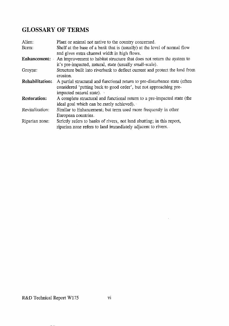
GLOSSARY OF TERMS
Alien: Berm:
Enhancement:
Groyne:
Rehabilitation:
Restoration:
Revitalization:
Riparian zone:
Plant or animal.not native to the country concerned. Shelf at the base of a bank that is (usually) at the level of normal flow and gives extra channel width in high flows. An improvement to habitat structure that does not return the system to it’s pre-impacted, natural, state (usually small-scale).. Structure built into riverbank to deflect current and protect the land from erosion. A partial structural and functional return to pre-disturbance state (often considered ‘putting back to good order’, but not approaching pre- impacted natural state). A complete structural and functional return to a pre-impacted state (the ideal goal which can be. rarely achieved). Similar to Enhancement; but term used more frequently in other European countries. Strictly refers to banks of rivers, not land abutting; in this report, riparian zone refers to land immediately adjacent to rivers.
R&D Technical Report W 175 vi
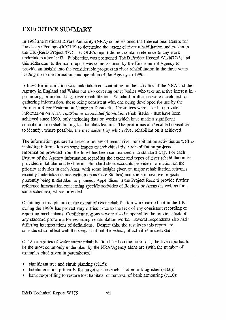
EXECUTIVE SUMMARY
In 1993 the National Rivers Authority-(NRA) commissioned the International Centre for Landscape Ecology (ICOLE) to determine -the extent of river rehabilitation undertaken in the UK (R&D Project 477). ‘ICOLE’s report did not contain reference to any work undertaken after 1993. Publication was postponed (R&D Project Record Wl/i477/5) and this addendum to the main report was commissioned by the Environment Agency to provide an insight into the considerable progress in river rehabilitation in the three years leading up to the formation and operation of the Agency in 1996.
A trawl for information was undertaken concentrating on the activities of the NRA and the Agency in England and Wales but also covering other bodies who take an active interest in promoting, or undertaking, river rehabilitation. Standard proformas were developed for gathering information, these being consistent with one being developed for use by the European River Restoration Centre in Denmark. Consultees were asked to provide information on river, riparian or associatedfloodplain rehabilitations that have been achieved since 1990, only including data on works which have made a significant contribution to rehabilitating lost -habitats/features. The proformas also enabled consultees to identify, .where possible, the mechanisms by which river rehabilitation is achieved.
The information gathered allowed a review of recent river rehabilitation activities as well as including information on some important individual river rehabilitation projects. Information provided from the trawl has been summarized in a standard way. For each Region of the Agency information regarding. the extent and types of river rehabilitation is provided in tabular and text form. Standard short accounts provide information on the priority activities in each Area, with some insight -given on major rehabilitation schemes recently undertaken (some written up as Case Studies) and some innovative projects presently being undertaken or planned; Appendices in the Project Record provide further reference information concerning specific activities of Regions or Areas (as well as for some schemes), where provided.
Obtaining a true picture of the extent of river rehabilitation work carried out in the UK during the 1990s has proved very: difficult due to the lack of any consistent recording or reporting mechanisms. Confident responses were also hampered by the previous lack of any standard proforma for recording. rehabilitation works. Several respondents also had differing interpretations of definitions. Despite this, the results in.this report are considered to reflect well the range, but not the extent, of activities undertaken.
Of 21 categories of watercourse rehabilitation listed on the proforma, the five reported to be the most commonly undertaken by the NRA/Agency alone are (with,the number of examples cited given in parentheses):
l significant tree and -shrub planting (cl 15) ; l habitat creation primarily for target species such as otter or kingfisher (~160); l bank re-profiling to restore lost.habitats, or removal of bank armouring (~110);
R&D Technical Report. W 175 vii
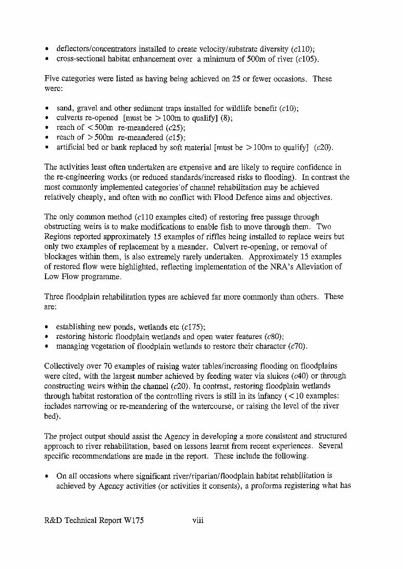
l deflectors/concentrators installed to create velocity/substrate diversity (cl 10); l cross-sectional habitat enhancement over a minimum of 500m of river (~105).
Five categories were listed as having being achieved on 25 or fewer occasions. These were:
l sand, gravel and other sediment traps installed for wildlife benefit (~10); l culverts re-opened [must be > 1OOm to qualify] (8); l reach of < 500m re-meandered (~25); l reach of > 500m re-meandered (~15); l artificial bed or bank replaced by soft material [must be > 1OOm to qualify] (~20).
The activities least often undertaken are expensive and are likely to require confidence in the re-engineering works (or reduced standards/increased risks to flooding). In contrast the most commonly implemented categories-of channel rehabilitation may be achieved relatively cheaply, and often with no conflict with Flood Defence aims and objectives.
The only common method (cl10 examples cited) of restoring free passage through obstructing weirs is to make modifications to enable fish to move through them. Two Regions reported approximately 15 examples of riffles being installed to replace weirs but only two examples of replacement by a meander. Culvert re-opening, or removal of blockages within them, is also extremely rarely undertaken. Approximately 15 examples of restored flow were highlighted, reflecting implementation of the NRA’s Alleviation of Low Flow programme.
Three floodplain rehabilitation types are achieved far more commonly than others. These are:
l establishing new ponds, wetlands etc (~175); l restoring historic floodplain wetlands and open water features (~80); l managing vegetation of floodplain wetlands to restore their character (~70).
Collectively over 70 examples of raising water tables/increasing flooding on floodplains were cited, with the largest number achieved by feeding water via sluices (~40) or througl constructing weirs within the channel (~20). In contrast, restoring floodplain-wetlands through habitat restoration of the controlling rivers is still in its infancy (< 10 examples: includes narrowing or re-meandering of the watercourse, or raising the level of the river bed).
The project output should assist the Agency in developing a more consistent and structured approach to river rehabilitation, based on lessons learnt from recent experiences. Several specific recommendations are made in the report. These include the following.
l On all occasions where significant river/riparian/floodplain habitat rehabilitation is achieved by Agency activities (or activities it consents), a proforma registering what has
R&D Technical Report W175 . . . Vlll
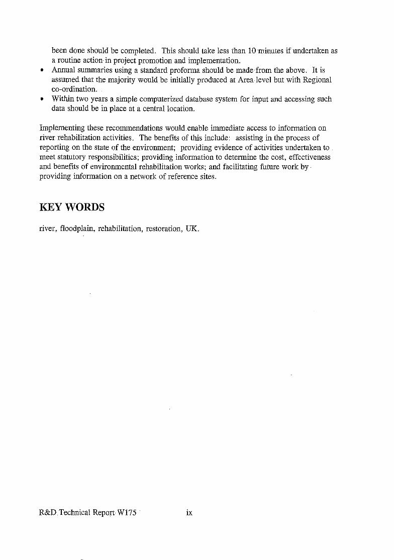
been done should be completed. This should take less than 10 -minutes if undertaken as a routine action- in project promotion and implementation.
l Annual summaries using a standard proforma should be made from the above. It is assumed that the majority would be initially produced at Area.level but with Regional co-ordination.
l Within two years a simple computerized database system for input and accessing such data should be in place at a central location.
Implementing these recommendations would .enable immediate access to information on river. rehabilitation activities. The benefits of this include: assisting in the process of reporting on the state of the environment; providing evidence of activities undertaken to meet statutory responsibilities; providing information to determine the cost, effectiveness and benefits of environmental rehabilitation works; and facilitating future work by. providing information on a network of reference sites.
KEY WORDS
river, floodplain, rehabilitation, restoration, UK.
R&D Technical Report. W 175 ix

(This page lej? intentionally blank)
R&D Technical Report W175 X
1. INTRODUCTION
The Environment Agency was established under the Environment Act 1995. Part of the Act stated “in discharging its functions, the Agency is required so to protect or enhance the environment, taken as a whole, as to make the contribution that Ministers consider appropriate towards achieving sustainable development”. A major contribution towards improving the physical habitat quality of rivers and floodplains has been achieved in recent years by rehabilitation works undertaken as an integral part of planned engineering/management works, and as free-standing environmental enhancement projects.
In early 1993, the NRA commissioned ICOLE (R&D Project 477) to undertake a study to determine the extent of river rehabilitation undertaken in the UK: Due to key personnel leaving, ICOLE’s report was not completed until early 1996, and it did not contain reference to any work undertaken after 1993. Whilst the report contains useful information on schemes up to this point, it does not reflect the extensive recent activity in river rehabilitation. For this reason, publication of ICOLE’s report was postponed (R&D Project Record Wl/i477/5) and an addendum report commissioned by the Agency. This addendum is based on a trawl for information around the Environment Agency and other interested bodies who take an active interest in promoting, or undertaking, river rehabilitation. It ‘refers to work undertaken- up to, and including, 1996.
The trawl for information only :covers projects where ‘significant’ river, ripalian, or associatedfloodplain rehabilitation has been achieved as a deliberate objective. Defining ‘significant’ is difficult, but the consultees were requested only .to include works which : ‘make a significant contribution to rehabilitating lost habitats/features’ and not to include small-scale bank re-profiling or digging small ponds in the floodplain. In-this respect, ‘sensitive management’ or small-scale enhancements during maintenance works are also not included, even though collectively these make very important,contributions and- have recently become a key component of Flood Defence responsibilities-and actions. Such contributions are considered to be too numerous-to cite. The examples of activities listed below, which lead to conservation duties being implemented (and often pave the way for river rehabilitation), are not included within the scope of this trawl:.
. estuary and saltmarsh rehabilitation; l otter holts, bat boxes, bird nesting facilities etc (numerous features in Water Guardian); c small ponds; l fisheries management, ,re-stocking etc; I removal of natural barriers- to fish. (eg ladders up Conway Falls .[Water Guardian Dee
1994/Jan 19951 or removing,debris dams; l wetland restoration unless associated with a water-course or major water-course
management (not included are the many examples of RSPB [Water Guardian Aug/Sept: 95 & Oct/Nov: 951 and Wildfowl and Wetland Trust wetland restorations -and rehabilitation schemes such as those at Redgrave & Lopham and Wicken Fen [both featured in Water. Guardian];
l Water- level and other management plans (eg for-SSSIs);
R&D Technical Report W175 1 ‘.
.
.
.
I
.
riparian or floodplain tree or shrub planting unless major (ie > 500m of river bank or > 0.5ha); archaeological restorations; rehabilitation following pollution (eg catchment acidification or point source as on the Camel [Water Guardian Jan 1990]), or historic water quality problems as in the Mersey [Water Guardian Ott 19911); recreation, amenity, landscape schemes (eg landscaping of Guorn Flood Alleviation scheme [Water Guardian Nov/Dec. 1991-J or hides etc at Slimbridge as part of Severn floodbank scheme [Water Guardian Oct/Nov 19951); support for valley initiatives/projects unless this leads to tangible projects of rehabilitation (Southern and North-West have many, Thames and Midlands few); surveys; educational projects (ponds, leaflets, packs etc); R&D; publications or funding of species research, determination of distribution etc.
Information gathering relating to the extent of river rehabilitation being undertaken by the Agency and others was based on two Inventory Proformas. As part of an EU LIFE project a European River Restoration Centre (ERRC) was established in Denmark in 1996, and one of its first tasks was to undertake a trawl for information in Denmark to determine the extent of different types of river rehabilitation being undertake there. The ERRC developed their proformas for collecting such information in partnership with the author of this Report. Having developed suitable proformas for this study (Forms 1 and 2), these were sent to consultees, the former for summarizing the number of times individual rehabilitation types had been achieved, and the latter enabling more detailed information to be provided on actions undertaken in individual large rehabilitation projects. Both forms divide actions for rehabilitation into just three groups depending on where they are undertaken and the benefits derived:
1. rehabilitation of watercourse habitats (eg re-meandering, re-profiling, flow type and sediment changes etc);
2. restoring free passage for animals through the river system (eg replacing weirs with riffles, opening culverts etc) ;
3. restoration of river floodplains (eg re-creating lost features, restoring water-table, re- establishing river and floodplain connectivity).
In addition, the proforma enabled consultees to identify, where possible, the mechanisms by which river rehabilitation is achieved. Two main categories were identified from the start, with a third ‘catch-all’ provided if projects did not fit the two main types. The first category covers major rehabilitation achieved ‘on the back of’ management affecting rivers for other reasons (eg Flood Defence capital and maintenance, developments), and the second where environmental improvement to the river and/or its floodplain is the key objective. The trawl for information has also provided information on many of the most important river rehabilitation projects, forty of which have been written up as Case Studies. Selecting which projects to include as Case Studies has been somewhat arbitrary, but nothing has been included that is covered in River Restoration Project’s (RRP) Feasibility
R&D Technical Report W175 2
Study or the New Rivers and. Wildlife Handbook since the objective was to draw attention to new projects. In general two out of the,following three criteria had to be met: i) information available and provided by consultees (many more could have been chosen but contacts did not provide suitable (if any) material; ii) innovative and relatively new schemes, even if limited material provided, because they are important in taking forward river rehabilitation knowledge into the next millennium; iii) extensive river reaches affected.
The output of this project should assist the Agency in developing a more consistent and structured approach to river rehabilitation based on lessons learnt from recent experiences.
R&D Technical Report W175 3
2. METHODS AND CONTACTS
The project was initiated in May 1996 by contacting all eight-.Regional representatives of the Agency who have responsibility for conservation.- Contact was made through, correspondence, giving details of what information was required, and why, together with the two proformas onto which .information was requested to be summarized. :A copy of the letter and blank proformas sent are given in Annexe A. The Regional.Conservation contacts were requested to copy correspondence to relevant Area Fishery and Conservation sections, and to either co-ordinate responses or ask Areas to reply direct to the contractor.- At the same time contact was made. with personnel from other statutory and voluntary UK bodies with an active interest in river rehabilitation.
Regional contacts were requested by the Agency’s Head of Conservation Function.to provide information by mid-August. .By this date few responses had been received, so each was contacted again, and direct approaches made to all 26 Area Conservation ; representatives in November 1996. By this time. responses had been received from around a third. For those who had given details previously, information was prepared in the standard format and returned to consultees for checking and/or amendment.
Whilst awaiting responses from consultees, Water Guardian and Glas-y-Dorlan were trawled for-articles relating to river rehabilitation. Andrew Brookes drew attention to two relevant PhD studies currently being undertaken at Nottingham and Southampton Universities. These are looking at a number of rivers where significant rehabilitation measures have been undertaken to determine, among other things, the geomorphological responses that have occurred. Contact was made with the,two students to ensure,the projects would not duplicate effort or require consultees to provide the same information twice. (Alison Briggs at Southampton co-ordinated inputs).
Information provided from the trawl has been summarized in a standard way. Information from Proforma 1 has been tabulated separately for each Region, giving separate information for the’ Areas. These Tables are included within the.main body of the R&D report, next to the summary text for each Region. More than 50% of Agency Area Conservation staff provided completed Proformas 1 - the form which identifies the number of times specific types of river/floodplain rehabilitation have been undertaken since 1990. Two Areas (NW Region - Northern:Area; Environment Agency Wales - South East Area) indicated that none of the activities undertaken by them conformed. with the required standards to be met for inclusion since their priority action was conserving high-. value rivers. Many more did not have precise figures to quote for each category, but gave approximations in three bands - (F)ew = <5; (S)ome = 5-10;. @@any = > 10. When making assessments of total numbers of each type undertaken, and comparisons between Regions, figures of-3, 8 and-13 were.used.
Information on individual projects, where information has been provided, is tabulated separately and given in Annexe B. This has been summarized from data provided by some Areas on Proforma 2.
R&D Technical Report W 175 4
Consultees were requested to provide information on individual projects which might be suitable for inclusion in the report as Case Studies. Few were volunteered, but from the data provided in the trawl, sufficient numbers of people kindly proffered the required material. Draft texts for the Cole and Skeme were prepared by Martin Janes of RRP; the Lamboum by Bob Preston; the Stour and Canley by Liz Galloway; the Tame by Andrew Crawford; Ah Phase A and B by Neil Guthrie; and Padgate A and B, Atherton Lake Brook and Whittle Brook by Pam Nolan. These were edited by the author who prepared other Case Studies from material provided by consultees. Artwork was also prepared by the author from information and photographs provided by others.
Some other information provided by Regional and Area representatives for a number of projects, or combinations of projects, was too detailed to be included within this R&D Report but will be useful for future reference. Appendices in the Project Record contain such information. The Appendices include some summary raw information from consultees on overall achievements in river rehabilitation as well as project-specific information relating to technical specifications, articles in Water Guardian, Environment News, Glas-y-Dorlan and other press coverage.
To increase the accuracy and completeness of the project, a consultation draft of the main text was circulated to all Area contacts in April 1997. This provided them with an opportunity to add/correct information to ensure that the author had fairly interpreted the information they provided. The text and final artwork of individual Case Studies were also circulated to relevant personnel for checking (the Case Studies in this report thus describe the status of projects as at summer 1997).
Supporting information gathered during the project is contained as appendices within Project Record W 1 I0021 1 A Review of River Restoration in the UK, 1990-l 996, Supporting Documentation: Appendix A - forms and correspondence with consultees; Appendix B - non-technical literature; Appendix C - technical literature. A copy of the Project Record is lodged with the R&D section at the Agency’s Head Office, Bristol.
R&D Technical Report W175 5
3. ENVIRONMENT .AGENCY RIVER RESTORATION/ REHABILITATION
This chapter is divided into eight sections; each one dedicated to an Agency Region. They provide information in a-standard format on four pages:
Regional contact name, address and telephone number; Area contacts name, address and telephone number; brief account of extent and priority actions in river rehabilitation; major schemes undertaken in the past six years; Case Studies from the Region; major scheme/projects planned; reference material-in Project Record, with citations of other literature of note; summary tabulation of Proforma -1 information relating to the number of examples of each category of river/floodplain rehabilitation in each Area.
R&D Technical Report W175 6
3.1 North East Region
Regional Contact: Simon Keys [pre May 19961 and Andrea Shaftoe, Rivers House, 21 Park Square South, LEEDS LSl 2QG. Tel: 0113 244 0191.
Three Areas: Colin Blundel/Anna Warburton Northumbria Area Tyneside House, Skinnerburn Road, Newcastle NE4 7AR
Anne Sansom/Olivia Clymer Simon Keys Dales Area Ridings Area Coverdale House Olympia House Aviator Court, Amy Johnson Way Gelderd Lane Clifton Moor LEEDS York Y03 4UZ LS12 6DD
3.1.1 Extent and priority actions in river rehabilitation
The information received from the Areas is not considered to totally reflect the complete extent of river rehabilitation activity within the Region. No information has been received direct from Fisheries.
Northumbria and Ridings Area completed Proforma 1. The former listed a total of 19 types of rehabilitation, spread between the three major categories. Five elements of rehabilitation have been possible due to other works, whilst 17 resulted from promotion in their own right.
Ridings did not provide a breakdown of the number of times different rehabilitation measures have been achieved, but indicated on the proforma which ones have been undertaken. The Dearne is probably the best example in de UK of > 500m of river being effectively re-meandered within an existing over-wide channel. Considerable conservation and fisheries benefits were achieved here as well as on Elmswell Beck (Hull headwaters) due to weir constructions to alleviate low-flow problems. Off-River Supplementary Units (ORSUs) have also been created in Ridings Area and several examples of weir modifications are cited (eg Calder) to enable fish migration.
Apart from the Swale and Skeme projects, Dales Area reported that no other major projects (other than fisheries work to remove obstacles to movement and create ORSUs) qualified for inclusion. Martin Fuller (the former contact for the Dales Area) reported a variety of habitat and fishery enhancements at three sites (The Holmes, Preston Hall Park & Black Bobbies Field) on the lower Tees following completion of the tidal barrage.
There is no clear indication of priorities, but floodplain wetland rehabilitation projects are rare, with no examples cited for Ridings or Dales Areas. The Region acknowledges the impact that land-use can have on rivers. This is reflected in the Swale Case Study project which was implemented through the Farming and Wildlife Advisory Group (FWAG) and addresses river bank erosion and riparian vegetation losses. Anne Sansom was responsible for this project and has since been seconded to the Region as a Rural Land Use Project
R&D Technical Report W175 7
Officer (details provided in the Project Record .withcopies of her informative regular newsletters).
3.1.2 Major Schemes (for details see Annexe Bl and Appendices in the Project Record)
Information for five schemes has been provided, one being the RRl?/EU LIFE partnership project on the Skeme. The others are the Till, Swale and Dearne Case Studies, and the. opening of a culverted reach of Chester Bum. This latter project was a major flood alleviation scheme which resulted in a large, but inadequate,- culvert being opened and a ‘natural’ channel established within parkland in the heart of Chester-le-Street. Major habitat rehabilitation on the Rother has been reported to be very successful, but no details provided. The headwater reaches of the Hull have been the subject of. considerable recent attention due to problems of low flow. River narrowing, and the use of current deflectors/concentrators, has been undertaken at Pondsworth on the Hull; and on Elmswell Beck, a tributary, weirs have been used to hold water in a drying river;
Creation of open water, and rehabilitation of Pulfin bog (on the Hull), was featured in The New Rivers and Wildlife Handbook; so too were numerous fishery enhancement projects involving installation of groynes (eg Wharfe and Hull) and bank protection schemes utilizing willows (eg tidal Ouse). The patchwork mowing of -reeds on the banks of the Winestead Drain (pumped system) was featured as a case study.
3.1.3 Case Studies included in this report
l Till (restoration of floodplain open water-habitats). l Skeme (river structure, habitat, fish movement; visual and public amenity, water
quality). 9 Swale (bank/ riparian vegetation recovery to arrest bank erosion). . Deame (introduction of significant degree of sinuosity, underwater/marginal habitat
diversification etc on a previously deep, over-wide, trapezoidal channel).
3.1.4 Major Schemes/Projects Planned
The possibility of an upland river restoration demonstration project is being explored with- the National.Trust, River Restoration Project and other potential partners. Phase 2 of re- meandering the Deame is on-going.
3.1.5 NE Region - Reference Material in the .Project Record- (Bl)
e Water Guardian articles, press cuttings and journal coverage of the Swale project (together with the Agency’s The-Eaflh Newsletters No l-5 and Circulation No 49 on the effect of sheep on rivers).
l Selection of media coverage and leaflets resulting from the Skeme Project. l Water Guardian coverage of Till project. l Water. Guardian coverage (two articles on both) of Ea Beck (turf transplants) and the
Hull at High Eske (12ha wetland nature reserve on floodplain) . .
R&D Technical Report W175 8

l Leaflet on Chester Burn. l Extracts from contract documents and information leaflets for Dearne project.
3.1.6 Reference material consulted but not appended in the Project Record
l Extensive technical outputs on design, soft revetment, hydraulics, geomorphology, public perception, pre- and post- monitoring etc on the EU LIFE demonstration site on the Skerne .
. Design drawings etc for the Till and Dearne.
R&D Technical Report W175 9
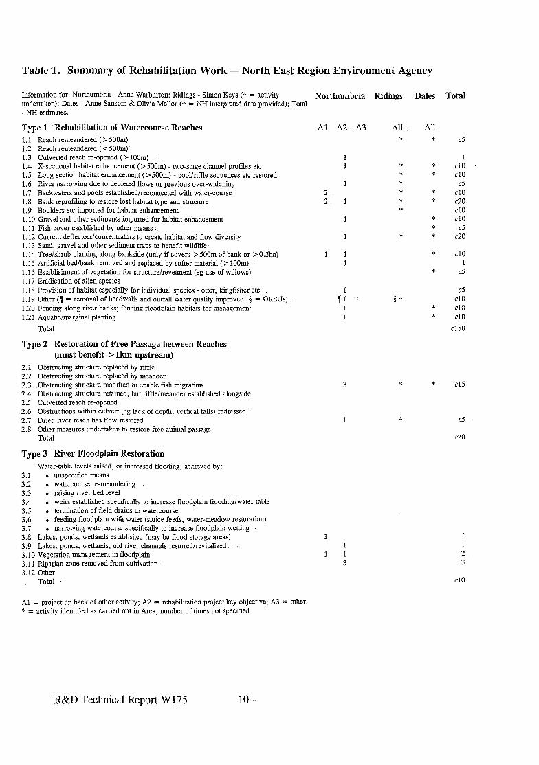
Table 1. Summary of Rehabilitation Work - North East Region Environment Agency
Information for: Northumbria - Anna Warburton; Ridings - Simon Keys (* = activity Northumbria undertaken); Dales - Anne Sansom & Olivia Mellor (* = NH interpreted data provided); Total - NH estimates.
Type 1 Rehabilitation of Watercourse Reaches 1.1 Reach remeandered (> 500m) 1.2 Reach remeandered ( < 500m) 1.3 Culverted reach re-opened ( > loom) 1.4 X-sectional habitat enhancement (> 500m) - two-stage channel profiles etc 1.5 Long section habitat enhancement (> 500m) - pool/riffle sequences etc restored 1.6 River narrowing due to depleted flows or previous over-widening 1.7 Backwaters and pools established/reconnected with water-course 1.8 Bank reprofiling to restore lost habitat type and structure 1.9 Boulders etc imported for habitat enhancement 1.10 Gravel and other sediments imported for habitat enhancement 1.11 Fish cover established by other means 1.12 Current deflectors/concentrators to create habitat and flow diversity 1.13 Sand, gravel and other sediment traps to benefit wildlife. 1.14 Tree/shrub planting along bankside (only if covers > 500m of bank or > OSha) 1. I5 Artificial bed/bank removed and replaced by softer material ( > IOOm) 1.16 Establishment of vegetation for structure/revetment (eg use of willows) 1.17 Eradication of alien species 1.18 Provision of habitat especially for individual species - otter, kingfisher etc 1.19 Other (7 = removal of headwalls and outfall water quality improved; 5 = ORSUs) 1.20 Fencing along river banks; fencing floodplain habitats for management 1.21 Aquatic/marginal planting
Total
Type 2 Restoration of Free Passage between Reaches (must benefit > lkm upstream)
2.1 Obstructing structure replaced by riffle 2.2 Obstructing structure replaced by meander 2.3 Obstructing structure modified to enable fish migration 2.4 Obstructing structure retained, but riffle/meander established alongside 2.5 Culverted reach re-opened 2.6 Obstructions within culvert (eg lack of depth, vertical falls) redressed 2.7 Dried river reach has flow restored 2.8 Other measures undertaken to restore free animal passage
Total
Type 3 River Floodplain Restoration Water-table levels raised, or increased flooding, achieved by:
3.1 l unspecified means 3.2 . watercourse re-meandering 3.3 . raising river bed level 3.4 . weirs established specifically to increase floodplain flooding/water table 3.5 . termination of field drains to watercourse 3.6 . feeding floodplain with water (sluice feeds, water-meadow restoration) 3.7 . narrowing watercourse specifically to increase floodplain wetting 3.8 Lakes, ponds, wetlands estabIished (may be flood storage areas) 3.9 Lakes, ponds, wetlands, old river channels restoredlrevitalized : 3.10 Vegetation management in floodplain 3.11 Riparian zone removed from cultivation 3.12 Other . Total
Al = project on back of other activity; A2 = rehabilitation project key objective; A3 = other. * = activity identified as carried out in Area, number of times not specified
Al A2 A3
1 1
1 2 2 1
1
1
1 1 1
1 :1 ..
1 1
1 1 3
Ridings Dales Total
All *
$ * * 1 * t
*
0”
All *
* *
d *
* * *
*
*
* *
c5
1 cl0 .’ cl0 c5
cl0 C20 cl0 cl0 c5
c20
cl0 1
c5
cj cl0 cl0 cl0
cl50
8 * cl5
t c5
c20
3
cl0
R&D Technical Report W175 10
3.2 North West Region
Regional Contact: Paul Green, Richard Fairclough House, Knutsford Road, Warrington WA4 IHG. Tel: 01925 653999.
Three Areas: Steve Garner North Area Ghyll Mount, Gillan Way Penrith 40 Business Park Pen&h Cumbria CA11 9BP
Pam Nolan South Area Mirwell Carrington Road Sale Cheshire M33 5NL
Neil Guthrie Central Area Lutra House Dodd Way, Walton Summit Bamber Bridge, Preston Lanes PR5 8BX
3.2.1 Extent and Priority Actions in River Rehabilitation
All three Areas responded to the questionnaire, with completed Proformas 1 and 2 provided by both Central and Southern Areas, Northern Area indicated that the priority activity was conserving the best rivers and undertaking mitigation and minor enhancement works that do not qualify for consideration as signijkant rehabilitation works.
Central Area reported a small number of watercourse rehabilitations, including one re- meandering and two de-culverting; however no examples of floodplain rehabilitation or rehabilitation of river channel to restore free passage were given.
The more urban Southern Area cited no fewer than 68 examples of channel rehabilitation, 15 floodplain projects and five examples of obstructions to free passage being removed. No direct responses have been provided by Fisheries, and it is clear that the enquiries did not successfully determine the extent of fishery habitat enhancement achieved within the Region since 1990.
There is clearly a gradient of priorities from north to south; in the north the priority is conservation of the best, in the south much greater attention is focused on rehabilitation of the many de-graded river reaches. A wide variety of ambitious projects have been completed in the past five years, the release of a significant reach of the River Alt from culvert, and extensive re-profiling and re-meandering of Whittle Brook being prime examples. The release of the Alt from over 200m of culvert primarily for environmental benefit is almost certainly the most ambitious scheme of its type in the UK. Greatest attention has focussed on channel rehabilitation, but floodplain restoration has been incorporated in several schemes in Southern Area. Examples of high-profile schemes often involve the local community and council, and the success of original schemes has led to extensions and new projects being planned for the future.
3.2.2 Major Schemes (for details see Annexe B2 and Appendices in the Project Record)
Information for seven schemes has been provided, with the addition made by the author of the Lowther. Two of the cited schemes are on Padgate Brook, where creation of some
R&D Technical Report W175 11
sinuosity in an otherwise trapezoidal channel in 1992 was so successful that more extensive re-meandering and channel rehabilitation has been completed recently. Whittle Brook restoration incorporated the re-instatement of ,meanders as well as a wide variety of different elements of in-stream and floodplain rehabilitations. The major R. Alt scheme is probably the best example of a river being released from culvert - a single statistic on the formresults in the restoration of more than 10 elements of channel rehabilitation. Due to the success of this .project in 1994/5, a further reach of open river upstream has been restored during winter 1996/:7, having meanders-created and major improvements made for in-stream and riparian habitats (Alt Phase II Case study). The floodplain of Atherton Lake Brook has had wetlands restored courtesy of an additional &30k being spent during a capital flood alleviation scheme which utilizes the.area for -flood storage.
The Lowther has been added since information, has come to hand which clearly identifies the river as a target for alleviation of low-flow problems due to abstraction The water company and-the NRA (1993) reached agreement on restoring flow (with some bed modifications) to a reach that previously suffered periodic drying.
The original work on Padgate Brook was featured in The New Rivers and Wildlife Handbook; so too was Savick Brook where a flood storage scheme incorporated extensive wetland habitat re-creations.
3.2.3 Case Studies
l Atherton Lake Brook (flood alleviation scheme incorporating floodplain rehabilitation). l Padgate Brook (two schemes, the second [B] creating extensive in-stream and riparian
habitat restoration and minor sinuosity) . @ Whittle Brook (meandering, channel, riparian and floodplain habitat restoration). l Alt (de-culverting) and more recent re-meandering of nearby stretch.
3.2.4 Major SchemesErojects~Planned
Future schemes are expected to develop from opportunities identified at a more strategic level through Local Environment Agency Plans (LEAPS, formerly catchment management plans - CMPs) and River Valley Initiatives (RVIs), with the Agency .working in partnership with private; public and voluntary groups. The major schemes on the Ah have convinced both the general public and the local authority of their value: Liverpool City Council is currently planning its own &50k river rehabilitation on the river.
3.2.5 NW Region - Reference Material in the Project Record
l Water Guardian article on restored flow to the Lowther. l Selection of material from media coverage and leaflets resulting from the Whittle
project. l Leaflet explaining the aims of the RVIs - Weaver RVI.
R&D Technical Report W175 12
3.2.6 Reference material consulted but not apperided in the Project Record
e Alt and Whittle consultants’ reports and detailed engineering proposaIs * Paper submitted for Aquatic Conservation, and delivered at Silkeborg 1996 conference,
by Nolan and Guthrie on the above projects (River rehabilitation in an urban environment: examples from the Mersey Basin, NW England).
R&D Technical Report W175 13
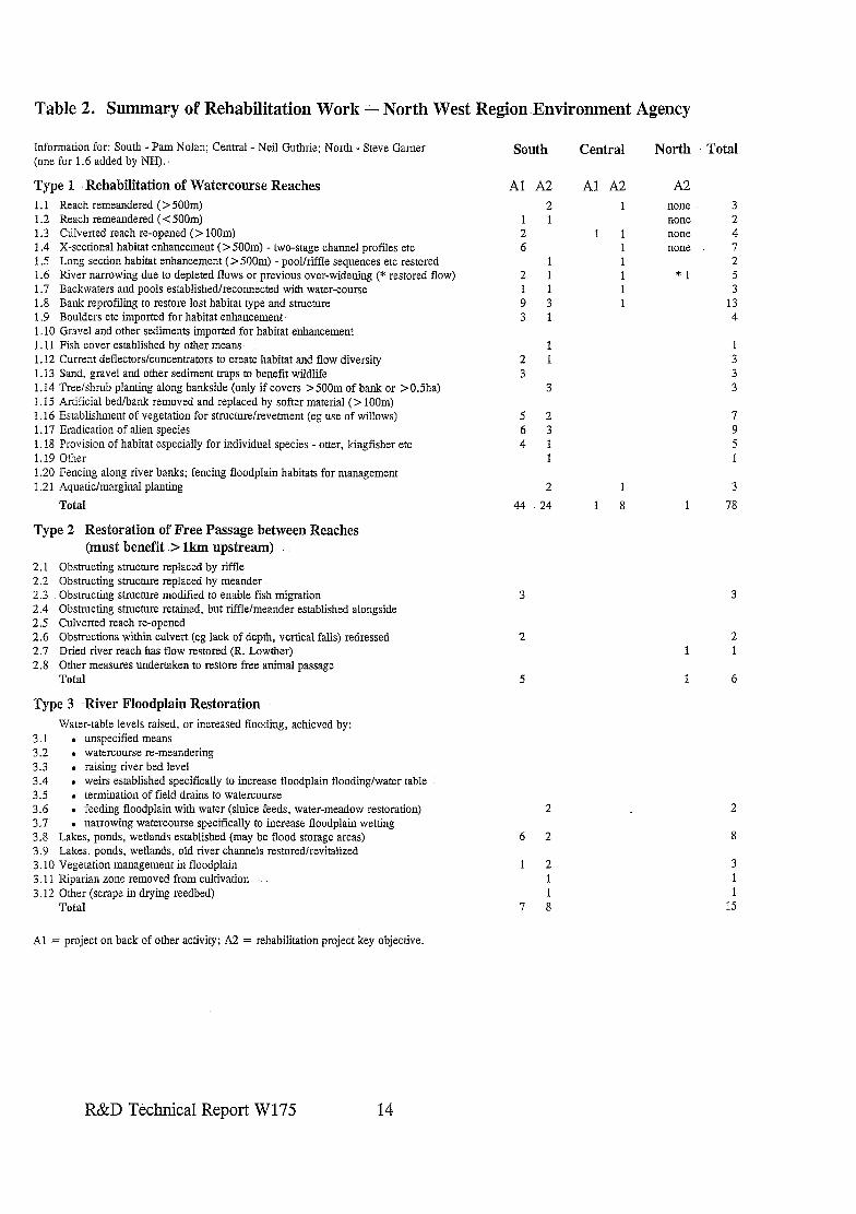
Table 2. Summary of Rehabilitation Work - North West Region Environment Agency
Information for: South - Pam Nolan; Central - Neil Guthrie; North - Steve Gamer (one for 1.6 added by NH).
Type 1 Rehabilitation of Watercourse Reaches 1.1 Reach remeandered (> 500m) 1.2 Reach remeandered (< 500m) 1.3 Culverted reach re-opened (> 100m) 1.4 X-sectional habitat enhancement (> 500m) - two-stage channel profiles etc 1.5 Long section habitat enhancement (> 500m) - pool/riffle sequences etc restored 1.6 River narrowing due to depleted flows or previous over-widening (* restored flow) 1.7 Backwaters and pools established/reconnected with water-course 1.8 Bank reprofiling to restore lost habitat type and structure 1.9 Boulders etc imported for habitat enhancement. 1.10 Gravel and other sediments imported for habitat enhancement 1.11 Fish cover established by other means 1.12 Current deflectors/concentrators to create habitat and flow diversity 1.13 Sand, gravel and other sediment traps to benefit wildlife 1 .I4 Tree/shrub planting along bankside (only if covers > 500m of bank or >0.5ha) 1.15 Artificial bed/bank removed and replaced by softer material (> loom) 1.16 Establishment of vegetation for structurelrevetment (eg use of willows) 1.17 Eradication of alien species 1.18 Provision of habitat especially for individual species - otter, kmgfisher etc 1.19 Other 1.20 Fencing along river banks; fencing floodplain habitats for management 1.21 .4quatic/marginal planting
Total
Type 2 Restoration of Free Passage between Reaches (must benefit .> lkmupstream) :
2.1 2.2 2.3 2.4 2.5 2.6 2.7 2.8
Obstructing structure replaced by riffle Obstructing structure replaced by meander. Obstructing structure modified to enable fish migration Obstructing structure retained, but riffle/meander established alongside Culverted reach re-opened Obstructions within culvert (eg lack of depth, vertical falls) redressed Dried river reach has flow restored (R. Lowther) Other measures undertaken to restore free animal passage Total
Type 3 -River Floodplain Restoration Water-table levels raised, or increased flooding, achieved by:
3.1 . unspecified means 3.2 l watercourse re-meandering 3.3 . raising river bed level 3.4 l weirs established specifically to increase floodplain flooding/water table 3.5 . termination of field drains to watercourse 3.6 . feeding floodplain with water (sluice feeds, water-meadow restoration) 3.7 narrowing watercourse specifically to increase floodplain wetting 3.8 LaLes, ponds, wetlands established (may be flood storage areas) 3.9 Lakes, ponds, wetlands, old river channels restored/revitalized 3.10 Vegetation management in floodplain 3.11 Riparian zone removed from cultivation 3.12 Other (scrape in drying reedbed)
Total
South Central North Total
Al A2 2
1 1 2 6
2 1 1 1 9 3 3 1
2 1 3
3
5 2 7 6 3 9 4 1 5
2 1 3
44 24 1 8 1 78
2
6 2 8
1 2 1 1
7 8
Al A2 A2 1 none 3
none 2 1 1 none 4
1 none 7 1 2
1 *1 1 ; 1 13
4
3
2 1 1
1 6
2
3
1 15
Al = project on back of other activity; A2 = rehabilitation project key objective.
R&D T&hnical Report W175 14
3.3 Midlands Region
Regional Contact: Andrew Heaton, Sapphire East, 550 Streetsbrook Road, Solihull, West Mids. B91 1QT. Tel 0121 711 2324.
Four Areas: Valerie Holt Lower Trent Area Scarrington Road West Bridgford Nottingham Notts NG2 5FA
Andrew Crawford Alan Jones Upper Trent Area Upper Severn Sentinel House Hafren House Fradley Park Welshpool Road Lichfield Shelton Staffs WS13 SRR Salops SY3 8BB
Liz Galloway Lower Severn Riversmeet House Newtown Ind Est Tewkesbury Glos GL20 7JG
3.3.1 Extent and Priority Actions in River Rehabilitation
Three of the four Areas, supported by the Regional co-ordinator, sent a considerable amount of information regarding river restoration activities. Completed proformas (1) summarizing activities within each of the Areas (Table 3), with separate documentation for significant single schemes (Annexe B3) were completed only for the Lower Trent and Lower Severn Areas. For projects in Upper Severn Area, Alan Jones highlighted relevant schemes in Andrew Heaton’s list and also suggested trawling through information in their annual Conservation and Recreation reports. This enabled.an approximate estimate to be made of the extent of projects within the Area since 1990, but routes for project promotion could not be identified. Liz Galloway produced a long list of relevant projects in Lower Severn since 1990, details of which are given in the Project Record. No detailed information has been received from Upper Trent, but some information was given verbally over the telephone by Andrew Crawford. From this it was clear that significant rehabilitation of constrained urban rivers is achieved in this Area, and major collaborative work has been undertaken on the River Cole (with Project Kingfisher - Case Study).
From the information provided, eight rehabilitation types have been reported to have been undertaken at least 20 times during the 1990s. Five of these primarily affect river habitat (cross-sectional habitat enhancement; backwaters and pools; bank re-profiling; boulders imported for habitat enhancement; use of current deflectors/concentrators) and three affect floodplains (lakes and ponds restored; existing wetlands established; vegetation management). These are also often the most commonly reported types of rehabilitation by other Regions too. Upper Trent has several examples of previous obstructions to migration being replaced by riffles, and Lower Trent has one which has been by-passed by a meander.
3.3.2 Major Schemes (for details see Annexe B3 and Appendices in the Project Record)
Summary information for ten separate schemes of major river rehabilitation were provided for the Lower Trent Area (for summary details for some, see Annexe B3 and further details in Appendix B in the Project Record). One of the ten was promoted ‘on the back of’ Flood Defence works; one (River Leen) was collaborative support for Nottingham City Council’s
R&D Technical Report W175 15
Corridors to the Countryside Project; and the other eight were promoted with river rehabilitation-as the primary objective, with an estimated cost of around &140k from 1995- 7. No detailed information was provided for earlier schemes.
The Soar at Narborough is an example of floodplain rehabilitation (Narborough Bog SSSI [Site of Special Scientific Interest] - the largest reedbed in the Area) achieved by raising the water level in the-river:. The NRA/Agency has supported a Montgomery Wildlife Trust proposal to collaborate with .other organisations to protect. and enhance ‘Jewels along the Severn?. Led-by the Countryside Commission, a feasibility study for restoration at the Sevem/Vyrnwy confluence has been completed (1996) by Landuse Consultants;
Few detailsof river rehabilitation activities in Upper .Trent were provided, but Andrew Crawford gave many examples of work on severely degraded and constrained urban rivers. Release of a length of Yardley Brook (with Project Kingfisher) from a concrete channel is featured in the Cole - Project Kingfisher Case Study but numerous other innovative work has been recently completed. The Tame, a polluted and previously trapezoidal.river, with the majority of banks re-inforced too, has been subject to major attention in many. locations. A re-inforced reach was moved by a development- which resulted in the new banks having rock armouring below shallow reedy slopes (case study); and in other locations sheet piling has been replaced by re-profiled earth banks which allow for geomorphological adjustments, At Kingsbury Water Park over 2km of armouring have been removed, only the toe remaining with wide shallow reeds established as the margins. The Per& has been narrowed using poles and reeds, and 2-3km of a trapezoidal reach of the Upper. Sence has been re-created in made-up land following mining. The Trent has also had bankre-inforcements removed to allow some sinuosity to return.
Several schemes in Midlands Region featured, or were case studies, in The New Rivers and Wildlife Handbook.. These included the -extensive rehabilitation works on the Tome associated with floodbank works; Trent and Avon banks (experimental seed mixes, turf transplants, management and monitoring); Hatfield Drains (ditch management); Alne (by- pass channel); Project Kingfisher (on-line ponds); Ford Brook flood alleviation scheme (new channel better than old); and the Avon (variety of catchment enhancements). The Leen (now the key feature of the Nottingham’s Corridors Project) was featured in RRP’s 1993 Feasibility Study report. Several Projects have been reported in Fisher@ News. Many restoration projects of the Severn floodplain have been featured in Water. Guardian. Schemes involving restoration of meanders, bank re-profiling, in-stream habitat diversity. measures etc.are reported for the Derwent, Idle and Erewash in Lower Trent and the Tern in Upper Severn.
3.3.3 Case Studies
l Tame (river re-routed to establish more natural character). l River Cole - Project Kingfisher (brook released from concrete channel, -sheet piling
removed, ,weir replaced by riffle). l Stour (removal of floodbanks to restore over-land flood flows and wetland floodplain:
restoration).
R&D Technical Report W175 16 1
l Canley Brook (in-channel and floodplain restoration featuring terraced wetlands). e Erewash (restoration of cut-off meanders and floodplain wetland rehabilitation). l Idle (geomorphologically-led rehabilitation with deflectors, flow constrictors and bank
re-profiling to assist the river restore habitat).
3.3.4 Major Schemes/Projects Planned
Potentially elements of the Severn/Vymwy proposal in Upper Severn may take place, but greater land-owner co-operation is required if significant work is to be undertaken. Each Area has on-going projects, but support funding is needed if large individual project implementation is to be achieved. In Lower Severn, as part of proposed major Flood Defence works on the Chelt, considerable environmental gain to a severely degraded river is proposed. In Upper Trent, removing armouring to urban water-courses is planned as opportunities and funding arise; and on the Tame it is hoped that braiding will be achieved as part of works associated with a floodplain gravel extraction.
3.3.5 Midlands Region - Reference Material in the Project Record
l Andrew Heaton’s summary of significant Restoration (none), Rehabilitation (nine) and Enhancement Projects (many) produced in 1996; plus extracts from supporting documents.
l Lower Trent: Meden (Pleasley Vale Project) - scheme summary and photos; Scalford Brook - scheme sketch plans and photos; Corridors to the Countryside leaflet; Soar - notes on Narborough Bog Restoration; Fisheries News article on rehabilitation works on Idle, Erewash and Sence.
l Upper Trent: Trent weir modifications for fish migration (Water Guardian). l Upper Severn: Fisheries News article on River Tern cut-off meander restoration;
Chelmarsh Scrape; Dolydd Hafren (one of the ‘Severn Jewels’) floodplain scrapes, meander/oxbow restoration, Severn Valley Wetlands Strategy (NRA, MWT); Articles in Water Guardian on Amy Marsh (Wore.) and Wader scrapes in Montgomery.
l Lower Severn: Water Guardian articles - Slimbridge floodplain habitat creations; notes and leaflet on Canley BrooWTocil Pool project.
3.3.6 Reference material consulted but not appended in the Project Record
l Severn/Vymwy Studies: Tucker J J (1994) River Severn and River Vyrnwy Confluence Environmental Asset Survey. The conjbence; its history, and its waterfowl and waders, past, present and, potentialfuture. Feasibility Report to NRA by LUC (1996). NRA & MWT (1995?) Severn Valley Wetlands Strategy.
l Downs & Thome’s paper (presented at Silkeborg, 1996) on the R. Idle scheme. l PKF (1996) Project Kingfisher - Caring for the Cole Valley; the First Ten Years
1985-95. l Erewash engineering drawings.
R&D Technical Report W17.5 17
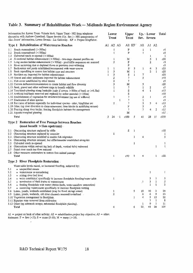
Table 3. Summary of Rehabilitation Work L Midlands Region Environment Agency
Information for: Lower Trent -Valerie Holt; Upper Trent - NH from telephone discussion with Andrew Crawford; Upper Severn (Up. Sev.) - NH interpretation of Alan Jones’ information; Lower Severn - Lii Galloway. KF = Project Kingfisher.
Type 1 Rehabilitation of Watercourse Reaches 1.1 Reach remeandered (> 500m) 1.2 Reach remeandered ( < 5OOm) 1.3 Culverted reach re-opened (> IOOm) 1.4 X-sectional habitat enhancement (> 500m) - two-stage channel profiles etc 1.5 Long section habitat enhancement (>5OOm) - pool/riffle sequences etc restored 1.6 River narrowing due to depleted flows or previous over-widening 1.7 Backwaters and pools established/reconnected with water-course 1.8 Bank reprofiling to restore lost habitat type and structure 1.9 Boulders etc imported for habitat enhancement. 1.10 Gravel and other sediments imported for habitat enhancement 1.11 Fish cover established by other means 1.12 Current deflectors/concentrators to create habitat and flow diversity 1.13 Sand, gravel and other sediment traps to benefit wildlife 1.14 Tree/shrub planting along bankside (only if covers > 500m of bank or > 0.5ha) 1.15 Artificial bed/bank removed and replaced by softer material (> 100m) 1.16 Establishment of vegetation for stmcturelrevennent (eg use of willows) 1.17 Eradication of alien species 1.18 Provision of habitat especially for individual species - otter, kingfisher etc 1.19 Other (eg river diversion to clean minewater; lime blocks in acidifying stream) 1.20 Fencing along river banks; fencing floodplain habitats for management 1.21 Aquatic/marginal planting
Total
Type 2 Restoration of Free Passage between Reaches (must benefit > lkm upstream)
2.1 Obstructing structure replaced by riffle 2.2 Obstmcting structure replaced by meander 2.3 Obstructing structure modified to enable fish migration 2.4 Obstructing structure retained, but riffle/meander established alongside 2.5 Culverted reach re-opened 2.6 Obstructions within culvert (eg lack of depth, vertical falls) redressed 2.7 Dried river reach has flow restored 2.8 Other measures undertaken to restore free animal passage
Total
Type 3 River Floodplain Restoration Water-table levels raised, or increased flooding, achieved by:
3.1 . unspecified means 3.2 . watercourse re-meandering 3.3 . raising river bed level 3.4 . weirs established specifically to increase floodplain flooding/water table 3.5 . termination of field drains to watercourse 3.6 . feeding floodplain with water (sluice feeds;water-meadow restoration) 3.7 l narrowing watercourse specifically to increase floodplain wetting 3.8 Lakes, ponds, wetlands established (may be flood storage areas) 3.9 Lakes, ponds, wetlands, old river channels restoredlrevitalized 3.10 Vegetation management in floodplain 3.11 Riparian zone removed from cultivation 3.12 Other (eg saltmarsh scrape; substantial floodplain planting).
Total
Lower Trent
Upper Trent
Up. .: Lower Total Sev. Severn
Al A2 A3 AU KF F F
AU Al A2 1 1 c5 1 d
1 1 5 1 c20 2 c5
c5 163 ~25
2 1 a0 7 c20 5 cl0
c5 5 c20 1 2 d 4 1 cl5
cl0 2 1 A 1 c5 3 34 cl5 3 c5 7 42 cl5
cl5
41 28 11 ~230
M F F s- 3
M 1 s 1 ?
1 2
1 1 1 3 1 3
2 2 3 1 1
M ? S S
2 F
M
cl00 5 3 24 .1
s 1 cl0 1
4 5
1 1 1
cl0 3 4 1 c20
1 1
3 1 5 .l 3 1 5
1 1 2
5 10 10 2 28 6 6 9 23
1 4 5 12 22 7 1 8
1 9 1 11 6 22. 45 28 105
Al = project on back of other activity; A2 = rehabilitation project key objective; A3 = other. Estimates: F = few (<5); S = some (5-10); M = many (> 10).
R&D Technical Report W175 18
3.4 Environment Agency Wales
Regional Contact: Gill Mackley (previously Richard Howell), Rivers House, St Mellons Business Park, Cardiff CF3 OLT. Tel: 01222 770088.
Three Areas: Teg Jones South East Area St Mellons Bus Park St Mellons CARDIFF CF3 OLT
Liz Roblin South West Area Glen Tawe 154-156 St Helens Road Swansea W. Glam SA14DF
Bryan Jones Northern Area Part Menai Penlan Road Bangor Gwynedd LL57 4BD
3.4.1 Extent and Priority Actions in River Rehabilitation
Northern Area provided a completed Proforma 1 summarizing priority actions associated with six individual schemes of floodplain restoration (Annexe B4). Both Northern and South-west Areas gave precise figures for the number of rehabilitation actions within the defined limits of the proforma (Table 4), with the former considering the figures to be reasonably accurate, and also gave a breakdown of promotion routes for rehabilitation projects. For six significant projects in South-west Area, Liz Roblin provided documentation and some photographs; two of the most relevant being listed in Annexe B4.
Teg Jones reported that the majority of projects are small-scale in South-east Area (some in mitigation for planned work) or biased towards conservation not restoration. Local Environment Action Plans (LEAPS) are expected to help identify priority areas for future action in the Area. Examples of major collaborative projects include improvements to fish passes on the Taff (see Glas-y-Dorlan), habitat enhancements of whole catchments for otters (eg Usk, Mom-row) and habitat re-habilitation on Magor Marsh in collaboration with the Caldicote and Wentloog IDB. Several major water quality improvement schemes involving mine waters or acidification have occurred in Wales (not the subject for this project), and significant Otter rehabilitation projects and tree planting schemes have been carried out.
It is clear from the summary statistics that in Wales the main thrust of activity relating to ‘river restoration’ has centred on floodplain wetlands in Northern Area. Restoration has focused on fens, bogs and reedbeds, and most large projects been undertaken in partnerships with the Countryside Council for Wales (CCW) and/or RSPB. The provision of habitats suitable for otters has been highlighted as the most frequently undertaken river rehabilitation measure for rivers overall, with establishment of vegetation for structure (eg willow spiling) the second most connnonly undertaken project. Both Area submissions indicate that major rehabilitations are achieved ‘on the back of’ Flood Defence works, this being particularly clearly demonstrated for in-channel rehabilitations in Northern Area. Liz Roblin identified that many rehabilitation projects are opportunistic: concern was expressed that all available time is spent developing such projects, with too little attention
R&D Technical Report W175 19
paid to post-implementation work to ensure that objectives are achieved and lessons learned.
3.4.2 Major Schemes. (for details see Annexe B4:and Appendices in the Project Record)-
Summary information for six separate schemes are appended. It is clear from this that in Wales the emphasis of attention in river rehabilitation (c.f. enhancement) is on restoration of.floodplain wetlands: these are mainly fens, bogs and reedbeds. In all the cases cited in North Wales, the NRA/Agency has undertaken such projects in partnership with. either/or/both RSPB and CCW (see Statutory Conservation and NGO Sections). These projects have included a wide variety of techniques for. reedbed and fen restoration. Examples include: river water levels raised by weirs/sluices; pumping water from the river to the fen; bunding to hold water in; blocking drains and ditches; lowering the peat surface level; and control of scrub succession. Other examples of fen restoration not cited in the Table include:. East Llyn, where removal of 50,000 tons of willow has restored wetland; and raising water-tables in raised mire and- wetlands of Cors Fochno and along the River Leri. Work.on the Western Cleddau has centred primarily on river channel re-habilitation for the benefit of fisheries, conservation and flood defence;. local raising of water-levels to benefit the adjacent fen also featuring as an objective.
Several schemes in -Wales featured, or were covered as case studies, in The New Rivers and Wildlife Handbook. These included the Lugg (set-back floodbanks, drop weirs and willow revetment);‘Clwyd system and,Ystrad (several examples of use of willows for revetment) and Monnow (two-stage channel).
Many projects have been cited in Glas-y-Dorlan (copies in Project Record) including Cors Fachno (blocking drains and bund creation), Garreg Lwyd (reedbed/open water restoration and scrub control) and examples cited above and detailed below. Similarly, several of the same, and other, projects have been reported in Water Guardian, and these are listed below.
3.4.3 Case Studies
l Cleddau (variety of in-stream rehabilitation measures and raising water levels to safeguard adjacent wetland).
. Cefni - -Malltraeth Marsh (rehabilitation of ancient river cut-offs and wetland restoration).
3.4.4 Major Schemes/Projects.Planned
There are several on-going .partnership projects with CCW and RSPB in North Wales relating to wetland rehabilitation (fens, bogs, reedbeds). In partnership with the National Trust, opportunities -for a major floodplain restoration on the ‘Afon Ogwen are being considered through a feasibility study.
R&D Technical Report W175 20
3.4.5 Environment Agency Wales - Reference Material in Project Record
Northern Area l Some summary information on wetland restoration projects (in Appendix A - some
information from RSPB and CCW) on: Cedron/Ystumllyn SSSI; Cors Erddreiniog, Cors Geirch; Cors Y Bol; Afon Crigyll; Cefni/Malltraeth.
l Water Guardian / Glas Y Dorlan coverage (in Appendix B): Cors Fochno & Garreg Lwyd restorations; ‘Anglesey Wetlands - Time Travel by JCB - reporting NRA’s &200k contribution to CCW/RSPB/NRA Anglesey Wetland restoration programme; Winning Back Wetlands - summary of key projects; ‘One for the Birds’ - Morfa Madryn restoration; Action on the Dee.
South West Area l W. Cleddau gravel re-instatement, in-stream meandering, boulder implants for fisheries
and river level/water table rising (details in case study). l Solva borrow pit. l Dulas willow weaving for bank stabilization l Water Guardian / Glas Y Dorlan features on Solfach habitat creation from spoil
winning and Cleddau - ‘A river is re-born’.
South East Area l Water Guardian / Glas Y Dorlan coverage of: Magor Marsh rehabilitation; Usk Otter
rehabilitation project; Taff fish pass work - ‘A Weir too Far’ and Case Study; ‘Improving the Wye’ .
3.4.6 Reference material consulted but not included in the Project Record
l Wetland restoration projects, including SSSI maps and citations, undertaken in N. Wales in conjunction with RSPB and/or CCW.
0 Details of Cleddau projects and work on the Solfach, SW Area.
R&D Technical Report W175 21
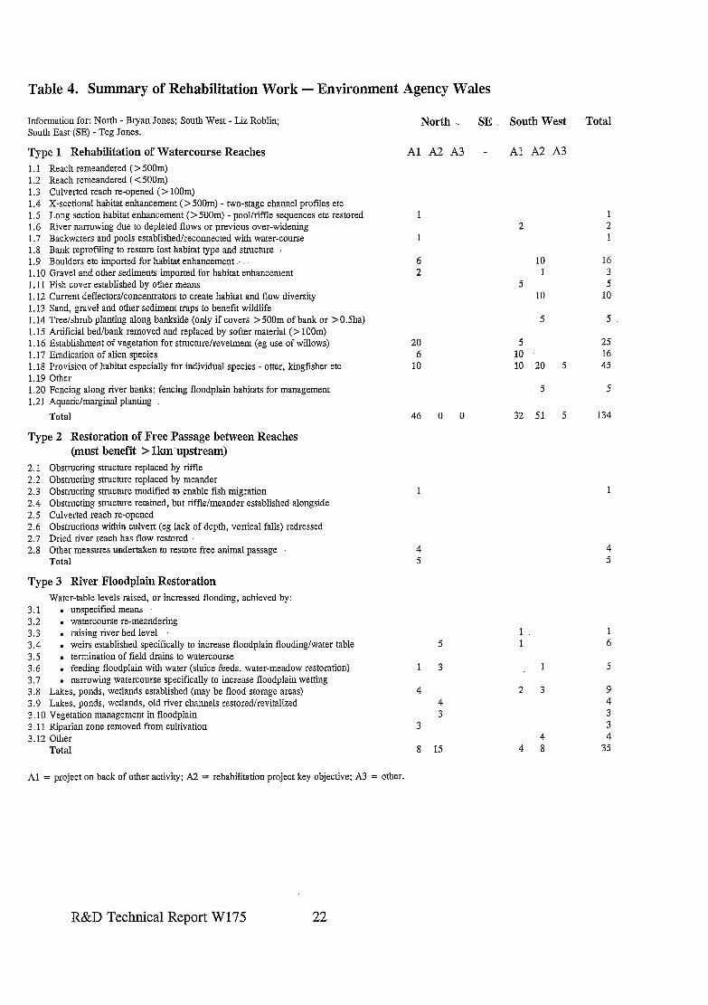
Table 4. Summary of Rehabilitation Work - Environment Agency Wales
Information for: North - Bryan Jones; South West - Liz Roblin; South East (SE) - Teg Jones.
North . SE South West Total
Type 1 Rehabilitation of Watercourse Reaches AlMA - Al A2 A3
1.1 Reach remeandered ( > 500m) 1.2 Reach remeandered ( < 500m) 1.3 Culverted reach re-opened (> 100m) 1.4 X-sectional habitat enhancement (> 500m) - two-stage channel profiles etc 1.5 Long section habitat enhancement (> 500m) - pool/riffle sequences etc restored 1.6 River narrowing due to depleted flows or previous over-widening 1.7 Backwaters and pools established/reconnected with water-course 1.8 Bank reprofiling to restore lost habitat type and structure 1.9 Boulders etc imported for habitat enhancement . . 1.10 Gravel and other sediments imported for habitat enhancement 1.11 Fish cover established by other means 1.12 Current deflectors/concentrators to create habitat and flow diversity 1.13 Sand, gravel and other sediment traps to benefit wildlife 1.14 Tree/shrub planting along bankside (only if covers > 500m of bank or > 0.5ha) 1.15 Artificial bed/bank removed and replaced by softer material ( > loom) 1.16 Establishment of vegetation for structure/revetment (eg use of willows) 1.17 Eradication of alien species 1.18 Provision of habitat especially for individual species - otter, kingfisher etc 1.19 Other 1.20 Fencing along river banks; fencing floodplain habitats for management 1.21 Aquatic/marginal planting
Total
1
1
6 2
20 6
10
2 2
10 16 1 3
5 5 10 10
5 5
5 25 10 16 10 20 5 45
5 5
46 0 0 32 51 5 134
Type 2 Restoration of Free Passage between Reaches (must benefit > lkmupstream)
2.1 2.2 2.3 2.4 2.5 2.6 2.7 2.8
Obstructing structure replaced by riffle Obstructing structure replaced by meander Obstructing stmctnre modified to enable fish migration Obstructing structure retained, but riffle/meander established alongside Culverted reach re-opened Obstructions within culvert (eg lack of depth, vertical falls) redressed Dried river reach has flow restored Other measures undertaken to restore free animal passage Total
Type 3 River Floodplain Restoration
1
4 5
Water-table levels raised, or increased flooding, achieved by: 3.1 . unspecified means 3.2 . watercourse re-meandering 3.3 . raising river bed level 3.4 . weirs established specifically to increase floodplain flooding/water table 3.5 . termination of field drains to watercourse 3.6 . feeding floodplain with water (sluice feeds, water-meadow restoration) 3.7 . narrowing watercourse specifically to increase floodplain wetting 3.8 Lakes, ponds, wetlands established (may be flood storage areas) 3.9 Lakes: ponds, wetlands, old river channels restoredlrevitalized 3.10 Vegetation management in floodplain 3.11 Riparian zone removed from cultivation 3.12 Other
5
1 3
4 4 3
3
Total 8 15
2 3
4 4 8
4 5
6
9 4
3 4
35
Al = project on back of other activity; A2 = rehabilitation project key objective; A3 = other.
R&D Technical Report W175 22
3.5 Anglian Region
Regional Contact: Gerard Stewart, Kingfisher House, Goldhay Way, Orton Goldhay, Peterborough PE2 5ZR. Tel: 01733 37181.
Three Areas: Merle Leeds Eastern Area Cobham Road IPSWICH Suffolk IP3 9JE
Geraldine Daly Irven Forbes & Phil Smith Central Area Northern Area Bromhoh-ne Lane Waterside North Brampton LINCOLN Huntingdon Lines Cambs PE18 8NE LN2 5HA
3.51 Extent and Priority Actions in River Rehabilitation
Table 5 gives a summary of the extent of different river restoration works carried out by the three Areas within Anglian Region. Both Central and Eastern Areas gave precise figures for the number of rehabilitations, and the majority of these were considered to be reasonably accurate. They also gave a breakdown of promotion routes for rehabilitation projects. Northern Area provided a summary of activities divided into the three categories ‘F’ for few (l-5), ‘S’ for some (6-10) and ‘M’ for many (> 10) examples; but gave no breakdown on the proportion of projects promoted through Flood Defence or Conservation/Fisheries. A direct input from Fisheries only came from Central Area, and it is known that several fishery-led rehabilitations have been undertaken in the Region that have not been cited. For example, Northern Area Fisheries have created many gravel/stone riffles and berms, off-stream fish refugia, planted riparian trees and undertaken three innovative replacements of structures with riffles (eg on the Witharn). In Eastern Area several projects of in-stream habitat enhancement are known to have been undertaken but were not reported during the study. These include projects on the Wensum (where several projects have been undertaken in conjunction with Norfolk Anglers Conservation Association [NACA]) and on the Stiffkey were flow deflectors and concentrators have been installed recently in an attempt to increase flow and substrate diversity.
It is clear from the summary statistics that in Anglian Region the main thrust of activity relating to ‘river rehabilitation’ has strongly centred on river habitat/structure restoration and much less emphasis on wetland restoration or removing obstacles to fish movement. All Areas reported greatest participation in projects leading to watercourse rehabilitations: but some of these lead to floodplain rehabilitation too (eg the Little Ouse meander restoration). Priority attention in Northern Area is given to schemes where river and floodplain have connectivity restored to the benefit of the environment and flood defence (eg setback of floodbanks on Long and Great Eau). Statistics from Eastern Area indicates the important role that Flood Defence can play in enabling river rehabilitation to be promoted; this Area also being most actively involved in floodplain wetland rehabilitation projects. All three Areas have rivers with important washlands (eg Nene for Northern; Ouse for Central; Broads for Eastern) where water level management plans have been
R&D Technical Report W175 23
drawn up with English Nature (EN), RSPB, Wildlife Trusts and the Broads Authority. The importance of these areas is reflected in ‘conservation’ being the priority action, and few have had rrestoration’ measures implemented by the NRA or Agency:
3.5.2 Major Schemes (for details see Annexe B5 and Appendices in the Project Record)
Summary information for a few schemes are appended, but completed proformas were only provided for four sites. The most innovative river rehabilitation projects of multi-function interest have been completed in Northern Area. The Case study of the Long and Great Eau ‘- features the setting back of floodbanks to allow the floodplain to again store flood waters, with .wetland; marginal and in-stream habitat structure re-established. .. Similar work has been carried out on a 500m stretch of the Witham where 15ha of floodplain has been restored above Lincoln. A Sha wetland site has also been created on land next to West Fen Catchwater Drain purchased to improve flood protection downstream.- -1nstream habitat enhancement resulting from-riffles installed on 2km of Harpers Brook has been monitored comprehensively by Leicester University. In a canalised, previously meandering; reach of the Brook 26 cobble/pebble/gravel riffles-were installed in 1992. Three years later 20 remain, and these have increased available ‘functional habitats? in the river for invertebrates. Other significant river rehabilitation projects implemented recently by Northern Area include: re-meandering 800m of the Welland. at Maxey; re-meandering a 500m reach on the’R.‘Ise near Desborough; three reedbeds (one lha) on the Nene,. principally to provide otter habitat; numerous riffles established on the Lynn-n and Morcott Brook; and marginal wetland restored along many, previously step-sided, rivers such as the Glen.
In Central Area the most prestigious river rehabilitation project is the re-meandering- of the Little Ouse at Thetford. In .Eastem Area wetlands adjacent to Flatford Mill on the Stour, and Earsham on the Waveney, have benefited from restored sluices which now feed the meadows with water. Weirs, constructed on the Fobbing Creek at Fobbing have also enabled water-tables to be raised on adjacent wetlands while the Brett has received major channel rehabilitation.
Several Projects have been reported in Water Guardian, Environment Action -and local Wildlife Trust magazines. These are listed below, as they are included in the Project Record. The Bain (bank re-profiling), Great Ouse (weirs and floodplains) and Broadland rivers (reed revetments) were featured in the New -Rivers and Wildlife Handbook.
3.5.3 Case Studies,
l Great and Long- Eau (removal of floodbanks with restoration of river and floodplain connectivity and extensive in-stream and bank rehabilitation).
l Little Ouse.at Thetford (restoration of meander. [cut-off recently during gravel extraction] and wetlands associated with floodplain).
l Wensum at Great Ryburgh (restoration of, historic meander cut-off when mill race built centuries ago).
l Stiffkey (a landowner/EN river and floodplain restoration project).
R&D Technical Report W 175 24.
3.5.4 Major Schemes/Projects Planned
More projects which bring floodplain rehabilitation and restored flood storage by setting floodbanks away from the river are promoted in Northern Area. Within Central Area there is the potential for an innovative river and floodplain restoration project being undertaken on Ellington Brook: gravel winning provides an opportunity to put the brook back into its meandering pre-straightened course where it will be flanked by reedbeds and wetlands. Several small-scale rehabilitations are being promoted by Eastern Area, one being in- stream works supported by NACA to restore fishery and ecological interests associated with the Wensum.
3.5.5 Anglian Region - Reference Material in Project Record
Northern Area l Several Projects reported in Water Guardian (December 199YJanuary 1996 - West
Fen Catchment Drain flood storage/floodplain restoration project). l Wildlife Trust magazine - ‘Getting the River Ise back on course’. l Summary papers from Mark Tarttelin, with colour photos, of major rehabilitation
projects recently undertaken within the Area (including specific extracts of a report relating to the Great and Long Eau).
Central Area l Water Guardian January 1990 - Wicken Fen; 1994 - Little Ouse Re-meandering (plus
notes from British Trust for Ornithology Warden and NRA on initial monitoring); April/May 1995 - Hiz flow restoration.
l Wildlife Trust magazine - Ivel Valley project up-date. l Environment Action 1, April/May 1996 - Ely Ouse &60k pioneering habitat
improvement project for Flood Relief Channel. l Hiz flow alleviation leaflet.
Eastern Area l Sayer’s Meadow rehabilitation work (information on NACA scheme on Wensum). l Water Guardian No. 10 - Waveney Valley Project. l Water Guardian feature on Redgrave and Lopham fenland restoration project.
3.5.6 Reference material consulted but not included in the Project Record
l David Harper et. al paper submitted to Aquatic Conservation: River restoration; setting the goals and measuring the successes.
. River Restoration Feasibility Studies (Lee Donaldson) for Mardyke and Nayland Lock on Stour.
l Interim report by ‘Lapwing Consultants’ for the Agency: The Reedbeds of the South Humber Bank - Reedbed Restoration/Operation Bittern (NOT strictly river floodplain).
l Wensum backwater rehabilitation - Consultants ToR (1994).
R&D Technical Report W175 25
Table 5. Summary of Rehabilitation Work - Anglian Region Environment, Agency
Information for: North (N) - Irven Forbes; Central - Sue Loveridge, Geraldine Daly & Hanefford; East - Merle Leeds.
Type 1 Rehabilitation of Watercourse Reaches 1.1 Reach remeandered (> 5OOm) (R. Welland) 1.2 Reach remeandered (< 500m) 1.3 Culverted reach re-opened (> IOOm) 1.4 X-sectional habitat enhancement (> 500m) - two-stage channel profiles etc 1.5 Long section habitat enhancement (> 5OOm) - pool/riffle sequences etc restored 1.6 River narrowing due to depleted flows or previous over-widening 1.7 Backwaters and pools established/reconnected with water-course 1.8 Bank reprofiling to restore lost habitat type and structure 1.9 Boulders etc imported for habitat enhancement 1.10 Gravel and other sediments imported for habitat enhancement 1.11 Fish cover established by other means 1.12 Current deflectors/concentrators to create habitat and flow diversity 1.13 Sand, gravel and other sediment traps to benefit wildlife 1.14 Tree/shrub planting along bankside (only if covers > 500m of bank or > OSha) 1.15 Artificial bed/bank removed and replaced by softer material (> loom) 1.16 Establishment of vegetation for structurelrevehnent (eg use of willows) 1.17 Eradication of alien species 1.18 Provision of habitat especially for individual species - otter, kingfisher etc 1.19 Other 1.20 Fencing along river banks; fencing floodplain habitats for management 1.21 Aquatic/marginal planting
Total
Type 2 Restoration of -Free Passage between Reaches (must benefit > lkm upstream)
2.1 2.2 2.3 2.4 2.5 2.6 2.7 2.8
Obstxucting.structure replaced by riffle Obstmcting structure replaced by meander Obstructing stmcture modified to enable fish migration Obstructing structure retained, but riffle/meander established alongside Culverted reach re-opened Obstructions within culvert (eg lack of depth, vertical falls) redressed Dried river reach has flow restored (Slea at Sealford) Other measures undertaken to restore free animal passage (West Glen) Total
Type 3 River Floodplain Restoration Water-table levels raised, or increased flooding, achieved by:
3.1 . unspecified means 3.2 . watercourse re-meandering ! 3.3 . raising river bed level 3.4 . weirs established specifically to increase floodplain flooding/water table 3.5 . termination of field drains to watercourse 3.6 . feeding floodplain with water (sluice feeds, water-meadow restoration)
(* Nene Washes) 3.7 . narrowing watercourse specifically to increase floodplain wetting 3.8 Lakes, ponds, wetlands established (may be flood storage areas) 3.9 Lakes, ponds. wetlands, old river channels restoredlrevitalized . 3.10 Vegetation management in floodplain 3.11 Riparian zone removed from cultivation 3.12 Other.
Total
Al = project on back of other activity; A2 = rehabilitation project key objective; A3 All = project promotion not identified. : Estimates: F = few (<5); S = some (j-10); M = many (> IO).
Roger N
All
= other.
M M F F
M
M S
M
S
cl20 2 26
3
F
l?
Cl0
*F
S. 2 2 cl0 F 2 6 cl0
F c5 F c5
c20 5 8 2 c35
Central East Total
Al A2 A3 Al A2.A3
1
5
3 2 1
4 3 5
2
2
1 1
2 1
2
3 1
7 8
1 1
15 13
1 1
1 1
1 4
cl5 c20 c5
cl0 cl5
cl5 cl0 c20
c25 c5 c5 c5
cl0
cl0
cl75
3
c5
1 1
cl0
1 1
1 1 c5
R&D Technical Report. W175 26
3.6 Thames Region
Regional Contact: Alastair Driver, Kings Meadow House, Kings Meadow Road, READING, Berks RGl 8DG. Tel: 01734 535563.
Three Areas: Dave Webb South East Area Ladymead Bypass Road Guildford Surrey GUl 1BZ
Chris Catling Graham Scholey North East Area Western Area Gade House Isis House London Road Howberry Park Rickmansworth Wallingford Herts WD3 1RS Oxon OX10 8BD
3.6.1 Extent and Priority Actions in River Rehabilitation
Table 6 summarizes information provided by the Area staff on returns given on proformas by all three Areas and from the Regional Flood Defence Committee (RFDC) paper detailing 1995/6 and 1996/7 projects implemented with their funding. It shows clearly that across the board there is a wide range of works undertaken within the Region. For channel rehabilitation types, only river-bank fencing and sediment traps are not listed as having been undertaken: fencing was not originally on the list of ‘features’ and is undertaken regularly. Many projects involving extensive channel and bank re-profiling just to benefit conservation are listed, as are ORSUs and weir modifications, as projects primarily implemented as part of the Flood Defence programme. River narrowing, backwater creations, sediment imports, current deflectors/concentrators, tree planting and habitat provisions for individual species are typically promoted by Fishery or Conservation sections, but again mainly through funds from Flood Defence. The Table also shows that open-water, wetland, reedbed and floodplain meadow creation and restoration feature prominently on the programme of activities.
Thames Region is unique: since 1991 it has utilized a small proportion of its Flood Defence revenue budget for implementing habitat enhancement schemes associated with on-going or past works. Because the spending of the RFDC is relatively large, the ‘small’ proportion is a significant sum of between &500-800k worth of expenditure on environmental enhancements every year (for six years). The priority works are determined by Area Liaison Teams consisting of representatives from Flood Defence, Fisheries and Conservation. Major rehabilitation works are also promoted as integral parts of capital projects, the River Colne system (N-East Area) benefiting from many examples whilst on Bear Brook, re-meandering and wetland rehabilitation was achieved as part of a flood storage scheme. The listing of almost 100 projects implemented as an integral part of the Flood Defence programme in 1995-6 and 1996-7 illustrates an extremely broad spectrum of project types which range from large tree management projects and bank/channel re- profiling, to ox-bow, pond, lake, water meadow, wetland, reedbed restoration/creation. Fishery projects include ORSUs, weir modifications and fish pass constructions. Collaborative funding supports Local Authorities and work by the Lea Valley Parks Regional Authority, Colne Valley and Pang Valley Projects.
R&D Technical Report W175 27
Table 6 shows that Thames Region has undertaken significantly more floodplain wetland rehabilitations than any .other Region, and eight types of watercourse rehabilitation have each been achieved on at least 20 sites. The table also shows .that the type of rehabilitation undertaken in the three Areas is broadly. similar, with a great number of projects promoted with rehabilitation as the key objkctive (it has to be noted that the-majority of the funds come from Flood Defence). Chris Catling also highlighted the need for river and floodplain restoration projects to be implemented without impact to other interests. For example fishery-led rehabilitations aim to maximise benefits for conservation too and where conservation may wish to raise river water levels by creating weirs to raise water levels on the floodpltiin,- this must be. achieved without detriment to fish movement.or invertebrate communities.
3.6.2 Major Schemes (for details of some see Annexe B6 and Appendix B in the Project Record)
The Cole LIFE project site at Coleshill .is the-largest restoration project in the Region, . being a collaborative scheme promoted by RRP and achieving river meandering, restoration of original river course, enhanced flooding on floodplain etc over almost ,2km of ,river. The Bear Brook project, a flood storage scheme, achieved many. similar features. The Ash is a small urban watercourse which under-went a series of major works to rehabilitate it in the early 199Os, since when post-project appraisal (ppa) has been carried out. 3herborne meadows, on the Windrush, -is the largest floodplain restoration project (collaborative with the National Trust and Countryside Commission) which involved digging/restoring 1Okm of ditches and feeding water to restore an area of historic water meadow. The Ver and Pang are examples where chalk streams have dried due to over-abstraction and a ‘natural flow regime’ has returned following alleviation projects which reduced abstraction and moved the.abstraction points. To capitalize on the restored flow, channel works were also. undertaken at several sites; for example on the Ver a gradient of 1: 10,000, on a ,wide mill. pond was changed to 1:700 by removal of a weir to establish a 2m wide riffle with firm bed..
Several projects in Thames Region featured, or were covered as case studies, in The New Rivers and Wildlife Handbook.. These included projects of major habitat rehabilitation on the Windrush;-Dun, Lyd, Blackwater, Ock and Dyke as well as bank stabilization and -. vegetation establishment on several Thames sites such as on the Loddon and the Thames itself. Many Projects have-been reported-in Water Guardian, including Pinkhill Meadows, Ash and Cole. These are listed below and copies provided in the Project Record.
3.6.3. Case Studies
. Lambourn (channel- narrowing for fisheries and in-stream/riparian habitat restoration). l Bear Brook- (channel and floodplain rehabilitation as part of a flood alleviation scheme). l Ash (urban.river rehabilitation), l Windrush/Sherbourne (Water-meadow restoration). -. l Ver and Pang (restoration of flow following cessation/reduction in groundwater.
abstraction - followed by channel .enhancements).
R&D Technical Report W175 28
l Pinkhill Meadows (floodplain wetland creation, experimentation and monitoring) I l Cole (RRP LIFE partnership demonstration of river and floodplain restoration).
3.6.4 Schemes/Projects Planned
Feasibility and environmental studies on the Misboume are on-going with the hope of leading to implementation of an alleviation of low flows project. As part of their Flood Defence enhancement programme, enhancement works will continue to be undertaken at the same level as in previous years. Major in-channel and floodplain habitat creations will result from the Maidenhead flood alleviation scheme which is now being undertaken. A major rehabilitation project on the Cove Brook in SE Area is planned for 199743 implementation. At Rye Meads SSSI, N-East Area, a joint venture is underway (with RSPB, Thames Water, Herts and Middlesex Wildlife Trust and St Albans Sands) to establish 20ha of reedbed, flood meadows and a mosaic of floodplain habitats to encourage Bittern and other wildlife back (otters already return to take advantage of existing works): the cost is c&500,000. With RSPB, 25ha of reedbed and 80ha of wet grassland is planned for creation on Otmoor to attract Bittern and breeding waders.
3.6.5 Thames Region - Reference Material in the Project Record
Regional l Paper prepared by RGMIRegional Conservation Manager for Flood Defence (FD)
Committee (23’d May 1996) outlining environmental enhancement spending from FD budget since 1991, progress on implementation of the 1995/6 programme and plans for 1996/7.
West Area l NotesJproforma of key schemes prepared by Graham Scholey and Alastair Driver plus
examples of key outputs/papers from Cole LIFE project. l The Sherborne Water Meadows, Windrush Narrowing, Bear Brook, and Pinkhill
Projects (with others) reported in Water Guardian. l Summary leaflet on restoration of flow to the Pang l Bob Preston’s Summary of Fishery Habitat Enhancements carried out since 1990,
indicating degree of monitoring undertaken.
South East Area l Notes on key schemes prepared by Dave Webb plus information on the Ash.
North East l Summary leaflet on restoration of flow to the Ver and Water Guardian article.
3.6.6 References material consulted but not appended in the Project Record
l Detailed reports on schemes cited above (see Case Studies), including plethora of studies for several low-flow rivers dating back to the 1988 original Halcrow Alleviation of Low Flow reports.
R&D Technical Report W175 29
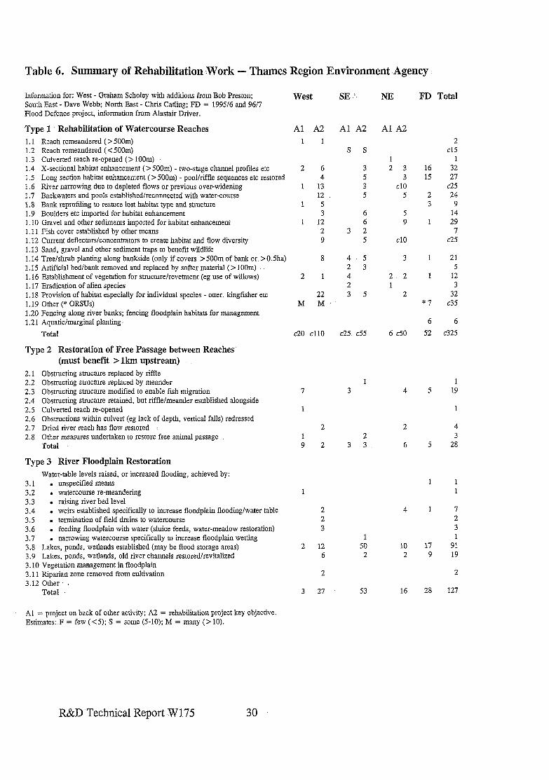
Table 6. Summary of Rehabilitation :Work - Thames Region Environment .Agency
Information for: West - Graham Scholey with additions from Bob Preston; South East - Dave Webb; North East - Chris Cathng; FD = 199% and 96/7 Flood Defence project, information from Alastair Driver.
West SE NE FD Total
Type 1 Rehabilitation of Watercourse Reaches 1.1 Reach remeandered (> 5OOm) 1.2 Reach remeandered ( < 500m) 1.3 Culverted reach re-opened (> 100m) 1 .I X-sectional habitat enhancement (> 500m) --two-stage channel profiles etc 1.5 Long section habitat enhancement (> 5OOm) - pool/riffle sequences etc restored 1.6 River narrowing due to depleted flows or previous over-widening 1.7 Backwaters and pools established/reconnected with water-course 1.8 Bank reprotiling to restore lost habitat type and structure 1.9 Boulders etc imported for habitat enhancement 1.10 Gravel and other sediments imported for habitat enhancement 1.11 Fish cover established by other means 1.12 Current deflectors/concentrators to create habitat and flow diversity 1.13 Sand, gravel and other sediment traps to benefit wildlife 1.14 Tree/shrub planting along bankside (only if covers > 500m of bank or > 0.5ha) 1.15 Artificial bed/bank removed and replaced by softer material (> loom) 1.16 Establishment of vegetation for structure/revetment (eg use of willows) 1.17 Eradication of alien species 1.18 Provision of habitat especially for individual species - otter, kingfisher etc 1.19 Other (* ORSUs) 1.20 Fencing along river banks; fencing floodplain habitats for management 1.21 Aquatic/marginal planting:
Al A2 1 1
Al A2 Al A2
2 6 4
1 13 12
1 5 3
1 12 2 9
8
2 1
22 M M
s s
3 5 3 5
6 6
3 2 5
4 5 2 3 4 2 3 5
1 2 3
3 cl0
5
5 9
cl0
3
2 2 1
2
Total c20 cl10 c25. c55 6 c50
Type 2 Restoration of Free Passage between Reaches’ (must benefit > lkm upstream)
2.1 Obstructing structure replaced by riffle 2.2 Obstructing structure replaced by meander 2.3 Obstructing structure modified to enable fish migration 2.4 Obstructing structure retained, but riffle/meander established alongside 2.5 Culverted reach re-opened 2.6 Obstructions within culvert (eg lack of depth, vertical falls) redressed 2.7 Dried river reach has flow restored 2.8 Other measures undertaken to restore free animal passage
Total
7
1
2 1 9 2
1 3 4
2 2
3 3 6 5 28
Type 3 River Floodplain Restoration Water-table levels raised, or increased flooding, achieved by:
3.1 . unspecified means 3.2 . watercourse re-meandering 3.3 . raising river bed level 3.4 . weirs established specifically to increase floodplain flooding/water table 3.5 . termination of field drains to watercourse 3.6 . feeding floodplain with water (sluice feeds, water-meadow restoration) 3.7 narrowing watercourse specifically to increase floodplain wetting 3.8 LaLes, ponds, wetlands established (may be flood storage areas) 3.9 Lakes, ponds, wetlands, old river channels restored/revitalized 3.10 Vegetation management in floodplain 3.11 Riparian zone removed from cultivation 3.12 Other. :
1
2 2 3
4
2 12 6
1 50 2
10 2
2
Total 3 27 53 16 28 127
Al = project on back of other activity; A2 = rehabilitation project key objective. Estimates:.F = few (<5); S = some (5-10); M = many (> 10).
16 15
2 3
1
2 cl5
1 32 27
~25 24 9
14 29 7
c25
*7
21 5
12 3
32 c35
6 6
52 ~325
5 19
4
1 1
2 3
17 9
91 19
2
R&D Technical Report W175 30
3.7 Southern Region
Regional Contact: Robin Crawshaw, Guildboume House, Chatsworth Road, Worthing, Sussex BNll 1LD. Tel: 01903 820692.
Three Areas: Phil Griffiths Sussex Area 3 Liverpool Gdns WORTHING Sussex BNll 1TF
Robert Pilcher Tim Sykes Kent Area Hants & Isle of Wt Area Sturry Road Sarum Court Canterbury Sarum Road Kent Winchester CT2 OAA Hants SO22 5DP
3.7.1 Extent and Priority Actions in River Rehabilitation
Both Sussex and Hampshire & Isle of Wight Areas provided completed Proforma 1 in which activities within the Areas are summarized (Table 7). No separate documentation for individual schemes has been provided other than the Medway River Project. For Kent Area, Robert Pilcher has provided a brief summary of enhancement projects carried out by the Fisheries Department only. On the basis of this it is not possible to determine the true extent of rehabilitation activities within the Area but a summary of the information has been transferred to Table 7. Some activities of the Medway River Project (MRP) are highlighted in a Case Study and a summary of the rehabilitation actions of this River Project, and the Kentish Stour Countryside Project, is given in Table 7. Hampshire & Isle of Wight Area have focused considerable effort on rehabilitation options for the Herrnitage Stream: detailed feasibility studies have been carried out and funding is being sought for implementation. Several examples of-narrowing over-widened channels, using a variety of soft revetment materials, have been used within the Area.
All three Areas contain chalk streams, these being Bio-diversity Action Plan priorities for conservation. Hampshire is especially well endowed with such streams and rivers, with tabulated data confirming that the Agency focuses on conservation and management practices rather than restoration. Here, as elsewhere with Flood Defence activities, enhancements are commonly sought as part of routine works. In Sussex, the- preparation of Water Level Management Plans for Amberley Wildbrooks and Pevensey Levels has facilitated raising of water levels in some critical ditch systems. The information on the proforma shows a very even balance between ‘watercourse’, ‘free passage’ and ‘floodplain’ rehabilitation types. Promotion of watercourse rehabilitation is commonly through conservation-promotion projects or ‘on the back of’ other management activities; the other two types are generally promoted as free-standing rehabilitation projects. No major schemes have been reported directly for Kent, but the MRP has completed significant projects of rehabilitating degraded banks of navigable river. The Region invests considerably in collaborative approaches to river valley management. To this end the Region supports several river valley projects (Medway, Stour, Arun and Ouse). In addition there is a regional Otter Project officer.
R&D Technical Report W 175 31
3.7.2 Major Schemes (for details see Annexe B7 and Appendices in the Project Record) :
Summary information for some rehabilitation projects in Sussex has been provided. Examples include: illegally culverted stream at Wellhurst Golf Course re-opened (c500m) in 1992; Hogweed eradication trials for three years on Boldings Brook using glyphosate; and raising water levels on.Amberley and at Pevensey . Fisheries also report pool/riffle creations, and removal of woody debris. blockages, as examples of rehabilitation., In Kent the MRP has been responsible for the largest amount of rehabilitation on a single river system whilst the Darent is-now the centre of attention for restoration of flow and habitat re-constructions. The Kentish Stour Project reports more than 50 individual rehabilitation projects, split almost equally between river habitat rehabilitation and floodplain projects.
A few schemes in Southern Region featured, or were covered as case studies, in .The New Rivers and Wildlife Handbook. These included: MRP’s experiences of bay creations and the use of soft engineering/live willows for bank-protection; and bank re-profiling to create wetland, habitat on the Eden and Beult in Kent. T Several Projects have been reported in Water Guardian, the actions of the MRP and rehabilitation work associated with flow restoration of the Darent featuring most prominently.
The RSPB has been active in wetland restoration in this Region, but the majority of schemes involve controlling water levels in grazing marshes etc where the river is embanked and disconnected from -its previous floodplain wetlands.
3.7.3 Case Studies
l Medway River Project (bank protection and habitat enhancement on a navigation channel using soft revetments; bay creations).
3.7.4 Major. Schemes/Projects Planned
The Darent is currently benefiting from implementation of remedial measures following severe degradation caused by over-abstraction. The MRP, and other river-valley based projects,- aim to continue to undertake projects as outlined in the Case Study providing funds are available; In Sussex, continued- ‘trial’ raising of water levels, supported by monitoring,,-is planned for 1997 at Amberley with implementation of improved water level control and scrapes at Pevensey . Restoration of an old meander at ‘Slugs Eye Island’ on the Ouse and re-meandering of the Cockshut at Lewes (part of Ouse Valley Project) are planned. Problems with Japanese Knotweed requires that an eradication programme be considered. The Hermitage Stream,. now. a concrete trapezoidal channel, is ear-marked for rehabilitation; public consultation on options is underway and collaborative funds are being sought.
R&D Technical Report W175 32
3.7.5 Southern Region - Reference Material in the Project Record (B7)
Kent Area l Many articles in Water Guardian on the Darent and Medway River Project (also more
detailed notes of three river restoration projects prepared by Brian Smith [subsequently reduced to single Case Study]).
l Relevant Extracts from Annual Review of The Kent Stour Countryside Project and Project Report March 1994.
Sussex Area l Summary of activities past and future prepared by Phil Griffiths. . Leaflets on The Arun Valley Project. l Two articles in Water Guardian relating to Pevensey Levels.
Hampshire and Isle of Wight l Leaflet summarizing options for the Hermitage Stream.
Regional l LeafIet on the South-East Otters and Rivers Project.
3.7.6 Reference material consulted but not appended in the Project Record
l Amberley Brooks Water Level Management Plan (first plan) 1995. . Detailed feasibility study for the Hermitage Stream. l Plethora of studies for the Darent dating back to the 1988 original Halcrow Alleviation
of low flow reports. m MRP Annual reports, newsletters etc.
R&D Technical Report W175 33
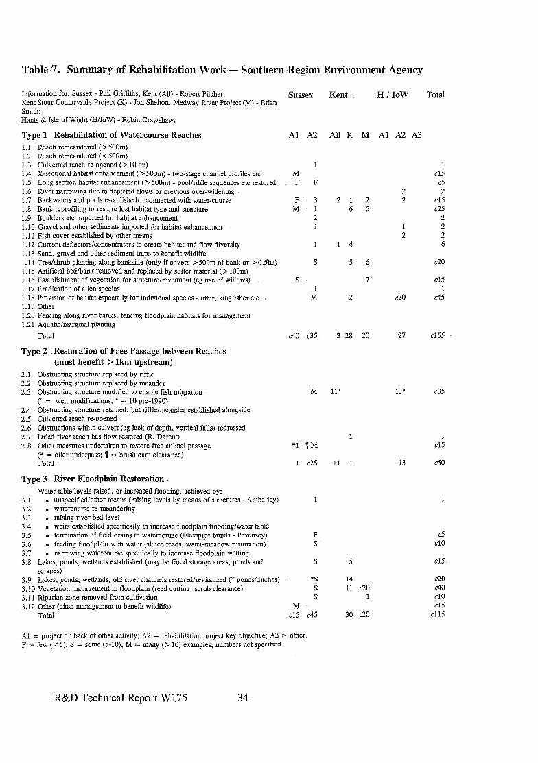
Table -7. Summary of Rehabilitation Work - Southern Region Environment Agency
Information for: Sussex - Phil Griffiths; Kent (All) - Robert Pitcher, Kent Stour Countryside Project (K) - Jon Shelton, Medway River Project (M) - Brian Smith: Hams & Isle of Wight (H/IoW) - Robin Crawshaw.
Type 1 Rehabilitation of Watercourse Reaches 1.1 Reach remeandered ( > 500m) 1.2 Reach remeandered (< 5OOm) 1.3 Culverted reach re-opened (> loom) 1.4 X-sectional habitat enhancement (>5OOm) - two-stage channel profiles etc 1 .S Long section habitat enhancement (> 500m) - pool/riffle sequences etc restored 1.6 River narrowing due to depleted flows or previous over-widening 1.7 Backwaters and pools established/reconnected with water-course 1.8 Bank reprofiing to restore lost habitat type and structure 1.9 Boulders etc imported for habitat enhancement 1.10 Gravel and other sediments imported for habitat enhancement 1.11 Fish cover established by other means 1.12 Current deflectors/concentrators to create habitat and flow diversity 1.13 Sand, gravel and other sediment traps to benefit wildlife 1.14 Tree/shrub planting along bankside (only if covers > 5OOm of bank or > 0.5ha) 1.15 Artificial bed/bank removed and replaced by softer material (> 100m) 1.16 Establishment of.vegemtion for structure/revetment (eg use of willows) 1.17 Eradication of alien species 1.18 Provision of habitat especially for individual species - otter, kingfisher etc 1.19 Other 1.20 Fencing along river banks; fencing floodplain habitats for management 1.21 Aquatic/marginal planting
Total
Type 2 Restoration of Free Passage between Reaches (must benefit > lkm upstream)
2.1 Obstructing structure replaced by riffle 2.2 Obstructing structure replaced by meander 2.3 Obstructing structure modified to enable fish migration
(‘ = weir modifications; ” = 10 pre-1990) 2.4 Obstructing structure retained, but riffle/meander established alongside 2.5 Culverted reach re-opened 2.6 Obstructions within culvert (eg lack of depth, vertical falls) redressed 2.7 Dried river reach has flow restored (R. Darent) 2.8 Other measures undertaken to restore free animal passage
(* = otter underpass; 1 = brush dam clearance) Total-.
Type 3 River Floodplain Restoration . Water-table levels raised, or increased flooding, achieved by:
3.1 . unspecified/other means (raising levels by means of structures - Amberley) 3.2 . watercourse re-meandering 3.3 . raising river bed level 3.4 . weirs established specifically to increase floodplain flooding/water table 3.5 . termination of field drains to watercourse (Flexipipe bunds - Pevensey) 3.6 . feeding floodplain with water (sluice feeds, water-meadow restoration) 3.7 . narrowing watercourse specifically to increase floodplain wetting 3.8 Lakes, ponds, wetlands established (may be flood storage areas; ponds and
scrapes) 3.9 Lakes, ponds, wetlands, old river channels restoredlrevitalized (* ponds/ditches) 3.10 Vegetation management in floodplain (reed cutting, scrub clearance) 3.11 Riparian zone removed from cultivation 3.12 Orher (ditch management to benetit wildlife)
Total
Sussex Kent H/IoW Total
Al A2 AUK M Al A2 A3
1 IM F F
F 3 M 1
2 1
1
S
S 1
M
21 2 6 5
2 2
1 2
1 4
5 6
7
12 c20
1 cl5
d 2
cl5 c25
2 2 2 6
c20
cl5 1
c45
c40 c35 3 28 20 27 cl55
M 11’ c35
1 *l 1M
1 c25 11 1
13”.
13
1 cl5
60
1 1
F S
d cl0
S 5 cl5
3 S S
M cl5 c45
14 11 c-20
1
30 c20
c20 c40 cl0 cl5
cl15
Al = project on back of orher activity; A2 = rehabilitation project key objective; A3 = other. F = few (< 5); S = some (5-10); M = many (> IO) examples, numbers not specified.
R&D Technical Report W175
3.8 South West Region
Regional Contact: Lyn Jenkins, Manley House, Kestrel Way, Exeter, Devon EX2 7LQ. Tel: 01392 444000.
Four Areas:
Sonia Thurley Mike Williams Judith Crompton Ann Skinner Cornwall Area Devon Area South Wessex North Wessex St John Moore Ho Exminster House Sunrise Business Park Rivers House Victoria Square Miller Way Blandford Forum East Quay Bodmin Exminster Dorset Bridgwater Cornwall PL31 1EB Exeter EX6 8AS DTll 8ST Somerset TA6 4YS
3.8.1 Extent and Priority Actions in River Rehabilitation
The information received from the Areas does not reflect the extent of river rehabilitation activity within the Region. Cornwall provided information for a rehabilitation project on the Fal at Goss Moor, but no summary information relating to activities anywhere else. Devon, like Cumbria, made a formal response stating that ‘rehabilitation’ was secondary to ‘conservation’, with few schemes justifying inclusion on the proforma. However considerable attention has been paid to fishery rehabilitations (gravel cleaning, modifying weirs), some of which are reported in Water Guardian. Fencing, eradication of alien plants and use of willows for revetment were also reported to have been occasionally undertaken. South Wessex provided precise numbers for river rehabilitations relating to Fisheries, but no information was received from Conservation due to lack of time to extract it (but an offer made to the contractor to visit the office and extract the information himself). No details of individual projects were given either, yet the Piddle catchment has been the subject of many studies leading to initiation of some flow restoration measures (for example, work by the Game Conservancy Council). Summary statistics were provided from North Wessex together with details of many rehabilitation projects undertaken in the Area.
The information, as provided, is summarized in Table 8. From the Table it is impossible to determine an accurate picture of the extent of river rehabilitation undertaken in the Region, or which ‘types’ predominate. It implies that little or nothing is done in Devon and Cornwall, only fishery enhancements take place in South Wessex, and it is in North Wessex where all the river and floodplain rehabilitation takes place. In reality, the first three have minor rehabilitation programmes compared with North Wessex; however they do undertake some (generally more minor) river rehabilitation works. This reflects the different needs of the Areas - Devon, Cornwall and South Wessex tending to have less degraded rivers.
It is not possible, from the lirnited information given, to identify clear priorities. The importance of game fisheries in South Wessex is probably reflected in the predominance of fishery enhancements, with no conservation examples cited. In this Area, as well as Devon
R&D Technical Report W175 35
and Cornwall, priority attention is given to conserving some very good semi-natural rivers, but taking advantage of opportunities for rehabilitation as part of routine maintenance or ‘on-the back of’ capitalschemes/developments affecting their rivers; The Fal, flowing through Goss Moor, is an unusual example of a free-standing rehabilitation project undertaken in Cornwall.
North Wessex, which has a much higher proportion of degraded rivers, has a balance of rehabilitation types within all three of the-sectors on the proforma. Major river, rehabilitation projects have been undertaken on rivers such as the Bristol Frome and BrinkworthBrook. Floodplain,wetland rehabilitation projects involving raising water- tables, or causing controlled- flooding, are rare nationally; however ,in North Wessex there are many examples associated with the Somerset Levels Environmentally ,Sensitive Area (ESA), SSSIs and nature reserves. By the end of 1996, 13 schemes covering 783ha had established raised water levels (560ha designed, engineered and funded by NRA at a cost of &231k; average, cost/ha of 2412). By summer 1997 another 202ha had been engineered, the Environment Agency funding 141ha of these at a cost of &125K. This raises the average cost per hectare as the later ones were more difficult schemes to promote. This represents -12 % of the total SSSI and 4 % of the ESA.
3.8.2 -Major Schemes (for details see Appendices in the Project Record)
No summaries have been provided on Proforma 2 (except for the Fal which is described in a Case Study) so tabulation of relevant schemes could not be.prepared for Annexe B; however several schemes warrant inclusion. Three NRA/Agency promoted and funded rehabilitation projects within the Region have been written up as Case Studies. Another project, implemented by the Game Conservancy on Devil’s Brook, has also been included. In addition to the activities,reported in the Case Studies and onthe Somerset Levels and Moors wetlands, North Wessex has been preparing for, and undertaking some;: other floodplain and river restoration projects; Plans have been developed for Semington Brook, Dauntsey Brook and sections of the R. Avon (groynes to ameliorate effects of low flow near Malmesbury and work near Sherston to benefit crayfish and water voles) whilst rehabilitation works (restoring pools-and riffle through boulder weir placements and some slight sinuosity development) have been recently completed on the Tone through Taunton, in a collaborative exercise with Taunton Deane BC, and on the Avon at Melksham. In .‘. Cornwall the Deer River has been subject to gravel rehabilitation for fisheries with a ppa. undertaken towards an MSc study.
3.8.3 Case Studies
l Fal at Goss Moor (weirs installed-to raise water levels, generate geomorphic habitat creation and safeguard- drying floodplain SSSI).
l Brinkworth Brook (restoration of abandoned course). l Bristol Frome (series of river and-riparian rehabilitations in an urbanized lowland river
system). l Devil’s Brook (flow concentrators to create flow/substrate diversity and riparian
vegetation regeneration through fencing).
R&D Technical Report W175
3.8.4 Major Schemes/Projects Planned
The Agency is currently undertaking feasibility studies for a major restoration project on a straightened, featureless and embanked river which flows through the Somerset Levels. The aim is to harmonise flood defence and environmental needs/benefits as the present standards are inadequate and necessitate regular and extensive management.
The Avalon Marshes are an area of worked-out peat extractions in the Brue catcbment where there are excellent opportunities for restoration of wetlands. Here the Agency is working with Somerset County Council (and others) who are promoting wetland restoration. The vision is ‘to turn the tide on wetland losses through involving local communities, traditions and industries to bring alive the outstanding history and archaeology of the vale of Avalon’.
The Bristol Avon between Melksham and Kellaways has had plans drawn up for rehabilitation and three miles of the river at Chippenham was proposed for a millennium project that was unsuccessful. This work is being developed as a bid for lottery funding by means of a collaborative project with much public support.
3.8.5 South West Region - Reference Material in the Project Record
North Wessex Area e Water Guardian articles (several) on restoring wetlands in the Somerset Levels and a
willow bank revetment scheme on the Avill. l Extracts from LUCY’s 1994 Brue Valley Wetland Study (Phase II). l Water Guardian and press coverage of Brinkworth Brook project.
South Wessex Area l Water Guardian - flow restoration to the Devils Brook l Environment Action - Piddle flow restoration plans.
Devon & Cornwall Areas l Westcountry Rivers - Newsletter of the Westcountry Rivers Trust. l Water Guardian article on plans for habitat restoration of the Otter, several on the
Torridge, gravel restoration on the Axe and spawning gravel rejuvenation on the Tamar.
3.8.6 Reference material consulted but not appended in the Project Record
l NRA/Landmark (1994) Bristol Frame Action Plan. l Univ. of Plymouth (1997) Restoration and Rehabilitation of Goss Moor. l Vivash (1997) River Brue - Glastonbury. Concepts for River Restoration. l West Country Rivers Trust - information on it’s Tamar 2000 project and other
activities.
R&D Technical Report W175 37
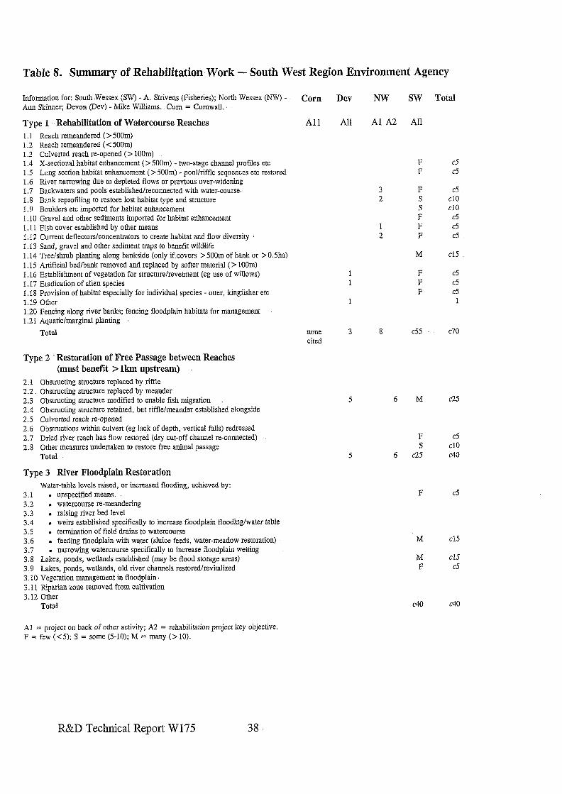
Table 8. Summary of Rehabilitation-Work - South West Region Environment Agency
Information for: South.Wessex (SW) - A. Strivens (Fisheries); North Wessex (AqV) - Ann Skinner; Devon (Dev) - &like Williams. Corn = Cornwall.
Type 1 Rehabilitation of Watercourse Reaches 1.1 Reach remeandered ( > 5OOm) 1.2 Reach remeandered ( < 5OOm) 1.3 Culverted reach re-opened (> loom) 1.4 X-sectional habitat enhancement ( > 5OOm) - two-stage channel profiles etc 1.5 Long section habitat enhancement (> 500m) - pool/riffle sequences etc restored 1.6 River narrowing due to depleted flows or previous over-widening 1.7 Backwaters and pools established/reconnected with water-course., 1.8 Bank reprofiling to restore lost habitat type and structure 1.5 Boulders em imported for habitat enhancement 1.10 Gravel and other sediments imported for habitat enhancement 1.11 Fish cover established by other means 1.12 Current deflectors/concentrators to create habitat and flow diversity I. 13 Sand, gravel and other sediment traps to benefit wildlife 1.14 Tree/shrub planting along bankside (only ifcovers > 5OOm of bank or >0.5ha) 1.15 Artificial bed/bank removed and replaced by softer material (> 100m) 1.16 Establishment of vegetation for structure/revetment (eg use of willows) 1.17 Eradication of alien species 1.18 Provision of habitat especially for individual species - otter, kingfisher etc 1.19 Other 1.20 Fencing along river banks; fencing floodplain habitats for management 1.2 1 Aquatic/marginal planting
Total
Type 2 Restoration of Free Passage between Reaches (must benefit > lkm upstream)
2.1 Obstructing structure replaced by riffle 2.2 Obstructing structure replaced by meander 2.3 Obstructing sttucture modified to enable fish migration 2.4 Obstructing structure retained, but riffle/meander established alongside 2.5 Culverted reach re-opened 2.6 Obstructions within culvert (eg lack of depth, vertical falls) redressed 2.7 Dried river reach has flow restored (dry cut-off channel re-connected) 2.8 Other measures undertaken to restore free animal passage
Total
Type 3 River Floodplain Restoration Water-table levels raised, or increased flooding, achieved by:
3.1 . unspecified means. 3.2 . watercourse re-meandering 3.3 . raising river bed level 3.4 , weirs established specifically to increase floodplain flooding/warer table 3.5 . termination of field drains to watercourse 3.6 . feeding floodplain with water (sluice feeds, water-meadow restoration) 3.7 . narrowing watercourse specifically to increase floodplain wetting 3.8 Lakes, ponds, wetlands established (may be flood storage areas) 3.9 Lakes, ponds, wetlands, old river channels restoredlrevitahzed 3.10 Vegetation management in floodplain, 3.11 Riparian zone removed from cultivation 3.12 Other
Total
Al = project on back of other activity; A2 = rehabilitation project key objective. F = few (<5); S = some (5-10); M = many (> 10).
Corn Dev NW SW
All All Al A2 All
F F
3 F 2 S
s F
1 F 2 F
M
1 F 1 F
F
none 3 8 c55 cited
Total
CS
c5
B cl0 cl0
c5 d c5
cl5
c5 C5
d 1
c70
5 6 M c25
F cj S cl0
5 6 c25 c40
F c5
M Cl5
M cl5 F c5
c40 c40
R&D Technical Report W175 38
4. RIVER RESTORATION/REHABILITATION BY EXTERNAL ORGANISATIONS
4.1 Statutory Conservation Agencies
In England, English Nature (EN) is the statutory conservation body.and is involved in a variety of actions relating to river rehabilitation. .Principal attention is paid to conservation of the best rivers with support for better management and production of Water Level Management,Plans .for all SSSI rivers and floodplain wetlands. Financial support is given to many collaborative projects leading to river rehabilitation: assistance of projects can vary considerably, but support is given to many River Valley Projects as well as specific projects such as the-RRP LIFE demonstration.projects on the Cole and Skerne. Prime attention is paid to help facilitate others to undertake river restoration rather than undertaking the work itself.
EN most frequently leads (often with RSPB) on actions undertaken as part of their Species Action Plans. The restoration of reedbeds (priority focus for birds, especially bittern) and wetlands has contributed to many floodplain wetlands being rehabilitated. Most of these sites are not affected by.river regimes (eg Ham Wall in Somerset which- has become a RSPB reserve with a 120ha reedbed created on old peat workings). EN’s three year-Bittern Recovery Project (1994/5-6/7) spent &95k on improved management and rehabilitation of reedbeds inthe first two years which included creation or rehabilitation of reedbeds in the lower Bure, Kent Stour and Yorkshire-Derwent floodplains. In 1996/7 almost 1Oha of arable’land in the lower Stiffkey floodplain was converted to reedbed (see Case Study). and wetland and reedbeds rehabilitated in the Kennet valley too..
EN has promoted many reedbed and wetland rehabilitation projects in partnership. with. other bodies. It has also supported, or led, successful Millennium bids, which will restore reedbeds and wetlands to river valleys in the future. One example is the purchase of 79ha of wet grasslands adjacent to Stodrnarsh National Nature Reserve (NNR) on the Kent Stour where a mosaic of wetlands will be recreated, including a 50ha new reedbed. A recent EN initiative is it’s Habitat Restoration Project which forms part of its contribution to achieve targets set by the Rio Earth Summit in 1992. It began in April 1996 and the R. Ouse near Milton Keynes has been selected as one of the first two pilot-areas. The aim of the project is to, investigate the extent to which new wildlife habitats can be created using existing agri- environmental incentive schemes. The project will promote ways of restoring and linking existing wildlife habitats in the Ouse .Valley near Milton Keynes. Material in the Project Record includes details of the three years of Action for Reedbeds, and two leaflets and a Progress Report on the Habitat Restoration Project.
The Countryside Commission (CoCo) plays a similar facilitating role, and: also supports many community river projects. The main focus is to bring -improvements to river landscape, recreation and access. Many schemes featuring land-use change and floodplain . restoration cited in.the case studies highlight the importance of the support provided by CoCo, both, in personnel- support and through the grant systems they administer (principally
R&D Technical Report .W 175 39
Stewardship). The grants to land-owners are often the critical difference which allows promotion of large projects involving restoration of the functioning connectivity of river and floodplain. CoCo was a major supporter of the RRP LIFE demonstration restoration projects on the Cole and Skerne and has continued its commitment to RRPs activities. It also co-ordinated a feasibility study (1996) of options for restoring past landscape and wildlife value of the extensive floodplain area of the Severn/Vrynwy confluence.
In Wales Countryside Council for Wales (CCW) combines the roles of EN and CoCo. Activities are similar to the combined roles of these two bodies, but CCW has been very pro-active with RSPB and the NRA/Agency in promoting wetland restoration of several river valley wetlands. The activities on Maltraeth Marsh (Cefni) are featured as a Case Study. In addition raising water levels on several SSSI river valley wetlands has been achieved through promotional activities of CCW. Examples include Magor Marsh on the Gwent Levels and Cedron/Ystumllyn, Cors Erddreiniog, Cors Geirch; Cors Y Bol; Afon Crigyll, Cors Fochno & Garreg Lwyd.
In Scotland Scottish Natural Heritage (SNH) has a similar role to CCW. Few river or floodplain restoration projects have been undertaken in Scotland, and SNH has not been in a position to promote such work. It has supported other UK organisations (eg River Restoration Project) in developing knowledge of river rehabilitation. In 1996 it commissioned surveys of 12 rivers degraded by past agricultural schemes, to determine the impacts as a baseline for any future rehabilitation actions which might take place.
In N. Ireland the Department of the Environment’s (DoENI) Environment and Heritage Service (EHS) has statutory responsibilities for conservation. It has not been directly involved in river restoration projects to date, but has been supportive of the River Agency’s activities (see 4.3).
Case Studies Based Primarily on Projects Promoted by Statutory Conservation Agencies (SCAs): l Cefni/Malltraeth Marsh (Environment Agency Wales - wetland and historic
watercourse restorations). l Stiffkey (Anglian Region - floodplain restoration).
There are many other examples where SCAs have been key partners (eg Cole and Skerne LIFE demonstration projects) and/or where they ,have provided significant Stewardship funds (eg Eau and Sherbourne water-meadow restoration on the Windrush).
4.2 NGOs and Others
The Wildlife Trusts (WTs) generally failed to provide information on their activities relating to river rehabilitation, except for Shropshire WT which provided information of its activities to protect and enhance the ‘Jewel’ river and floodplain habitats of the Severn and its contribution to the feasibility study to restore the Severn-Vrynwy confluence. The Trust movement has been very active in pushing for flow/water-table restoration due to over-
R&D Technical Report W175 40
abstraction but has not been involved in committing its member’s funds directly into river rehabilitation activities.
The .Wildfowl and Wetland Trust (WWT) has been active in giving practical advice on .- wetland restoration on extensive areas of land. They also have a number of large landholdings as reserves where they are actively involved in wetland restoration. .-,Their activities rarely relate to rivers, with principal interest focused on non-fluvial open water and wetland sites. Their book (Merritt A, 1994 Wetlands, Industry and Wildlife - a Manual of Principles and Practices) is a valuable reference document for establishing and managing wetlands not dependent on rivers.
The Royal Society for the ,Protection of Birds ‘(RSPB) has focused a great deal of attention and activity on.wet grassland, reedbed and other wetland restorations. Many of these are in historic floodplains; but the most notable restorations are on sites which are now isolated from the river by floodbanks and other control systems (eg Pevensey, Ham Wall, Malltraeth). RSPB is also a major owner of important .washlands (eg Nene, Ouse) where totally artificial river systems traverse areas where RSPB is active in promoting wetland restoration. RSPB .has not been directly involved in restorations where river and . . floodplainare in close connectivity, but they have produced three major-publications-(in partnership -with, or supported by, others) which make, a significant contribution to helping others undertake river or floodplain wetland restorations. These are: The New Rivers & Wildlife Handbook (1994); Reedbed Management for Commercial and ,Wildlife Interests (Hawke-C J & Jose P V: 1996) and The Wet Grassland Guide (RSPB; in prep 1997).
The National Trust (NT) owns extensive reaches of river and floodplain. It actively promotes river rehabilitation in partnership with others. The latter consideration is important since it-identifies the need to promote such activities within a framework of supporting a sustainable future for rural communities. It was on National-Trust land that the LIFE demonstration river restoration project was completed on the Cole (Case Study) and the River Agency in N. Ireland undertook its first river rehabilitation project on National.Trust land. The Trust (owner) is also working with others on a feasibility study to promote a major river restoration project on the Afon Ogwen in N. Wales, and looking at opportunities to promote an upland river restoration elsewhere (eg Wharfe in NE Region). On riparian land owned by the Trust, establishment of buffer zones is often promoted, with support for research too; parts of the Wandle:restoration works were on NT land.
The River Restoration Project was formed in 1990 and has since been supported by funds from a variety of sources through the whole of the UK to enable it to promote river restoration. The prime activity to date has been the completion of two major river restoration projects, one rural and one urban, in partnership with other organisations with an -interest in improving the’natural function and broad environmental value of rivers. These have established demonstration sites on the Cole and Skeme (Case Studies) as part of an EU LIFE project linked to an even bigger river restoration project.in Denmark. In tandem with promoting and implementing the two demonstration restoration projects, RRP has produced a variety of technical and non-technical literature. The former. have included reports on site selection criteria for river restoration, institutional frameworks for
R&D Technical Report-W175 41
promoting river restoration, public perception studies and detailed pre- during- and post- implementation monitoring. The scale of the two demonstration projects also required legal agreements and Memoranda of Understanding to be prepared for partners: these are considered to be suitable templates for modified use elsewhere.
RRP also has a stated aim of being a catalyst to promote river restoration. It has actively utilized the two demonstration sites for this purpose and in future it plans to be much more actively involved in dissemination of information rather than in promoting projects. To this end it is evolving into the ‘River Restoration Centre’.
Several other organisations have become actively involved in river restoration. No special attempts have been made to determine all those involved, and especially the numerous fishery and angling associations etc that promote good river management and habitat enhancement in tandem with their more specific interests in fish. The work of the Tweed Foundation, Game Conservancy, West Country Rivers Trust and World Wide Fund for Nature have been identified within this report through production of Case Studies. Through the Scottish Environment Protection Agency @EPA) several District Salmon Fishery Boards (DSFBs) indicated they are embarking upon projects to remove obstacles to salmon migration. For example, the Forth DSFB stated it had c40 man-made obstructions which seriously impacted fish movement, all of which it hoped would be made passable within the next five years. The Association of Drainage Authorities (ADA) circulated the proforma to several Internal Drainage Boards (IDBs); two responses were received. The Bedford Group of IDBs reported four cases of rehabilitation (one 9OOm length of river habitat improvement by creation of a two-stage channel; two examples of wetland creation and one 300m new channel). Upper Witham IDB reported wetland restoration as a key part of a flood protection scheme. Although few examples were provided, these are important in setting examples for other Boards.
4.3 Northern Ireland
Contact: Joe Nicholson/Roger Thompson, Department of Agriculture, Rivers Agency, Hydebank, 4 Hospital Road, Belfast BT8 8JP. Tel: 01232 253394. Fax 253455. Also Susannah Allen, DoENI, Environment & Heritage Service (EHS), Commonwealth House, Belfast. Tel: 01232 546550. Fax: 01232 315717.
4.3.1 Extent and Types of River Rehabilitation
In Northern Ireland DoENI has no direct role in river restoration/rehabilitation, this being the responsibility of the Rivers Agency. It is only in the past few years that rehabilitation has become an integral part of the River Agency’s activities. To this end two restoration projects have been completed on the Tall and Ballysally Blagh, both reported here as Case Studies. Major rehabilitation, primarily for fisheries, has been undertaken on the Blackwater following the major capital drainage scheme of the late 1980s. Table 9 gives basic information on the types of river rehabilitation undertaken by the Rivers Agency: the first two columns give a summary of the types of works undertaken throughout Northern
R&D Technical Report W175 42
Ireland and the last three columns indicate the elements of rehabilitation included within the three main rehabilitation projects cited.
To help ,develop the’increasing integration of flood defence activities and river restoration: in the 1990s) the Rivers Agency has produced two information documents (see below).
4.3.2 ‘Rehabilitation Priorities
It is clear from the summary statistics that few projects involve restoration or rehabilitation of wetlands (one example is the Annaghroe meadows on the Blackwater, which are to be the subject of a detailed partnership project with the RSPB, EHS and Caledon Estates). Modifications to structures to remove obstructions to fish movement are relatively common and achieved ‘on the back of’ Flood Defence works and as projects in their own right. The two same routes have also led to a wide range of watercourse rehabilitations, with bank re- profiling,. boulder imports to diversify habitat and flow character, and current deflectors/concentrators to accelerate flows the most common. Instream fishery enhancements, bank re-profiling and tree planting opportunities are often identified through river corridor surveys.
4.3.3 Major Schemes (for details of two, see Table 9)
Summary information for three schemes has been provided. The Blackwater rehabilitations are featured in Tlze River-s & Wildlife Handbook and include an extensive range of channel works focusing on diversification of substrate and flow characteristics to rehabilitate sahnonid fishery habitats. Both the Ballysally Blagh and Tall schemes involve major works to partially restore sinuosity and associated channel; marginal and bank habitats.
Two rehabilitation projects were featured as case studies in The New Rivers afzd Wildlife Handbook: the Blackwater fishery rehabilitation programme and modifications to Loughran’s Weir to restore fish movement to the upper Ballygawley Water.
4.3.4 CawStudies
l Tall River l Ballysally Blagh ’ (both in-stream,, margin and .back-water.rehabilitations).
4.3;5 Major Schemes/Pfojects Planned
Annaghroe wet meadow restoration (extension of previous work),. the Argory and Tall River Stage II.
R&D Technical Report W175 43
4.3.6 Department of Agriculture (DoA) Rivers Agency - Reference Material in Project Record
Selected photographs, plans and text for the Tall and Ballysally Blagh projects.
4.3.7 Reference material not appended as Project Record, held by the Rivers Agency
l DoA (1991) Drainage Works Carefully planned and Executed Minimise Environmental Damage and Encourage Regeneration (Booklet).
l DoA (1995) River Restoration: an Option in Northern Ireland? (leaflet). l Detailed plans and project development reports for the Tall and Ballysally Blagh
projects. l Karen Fisher paper on hydraulic performance of the Ballysally Blagh channel. l University of Ulster also will have, in the future, a number of reports on the Ballysally
Blagh, including an assessment of the sustainability and ecological benefits of stream restoration on the urban fringe.
R&D Technical Report W175 44
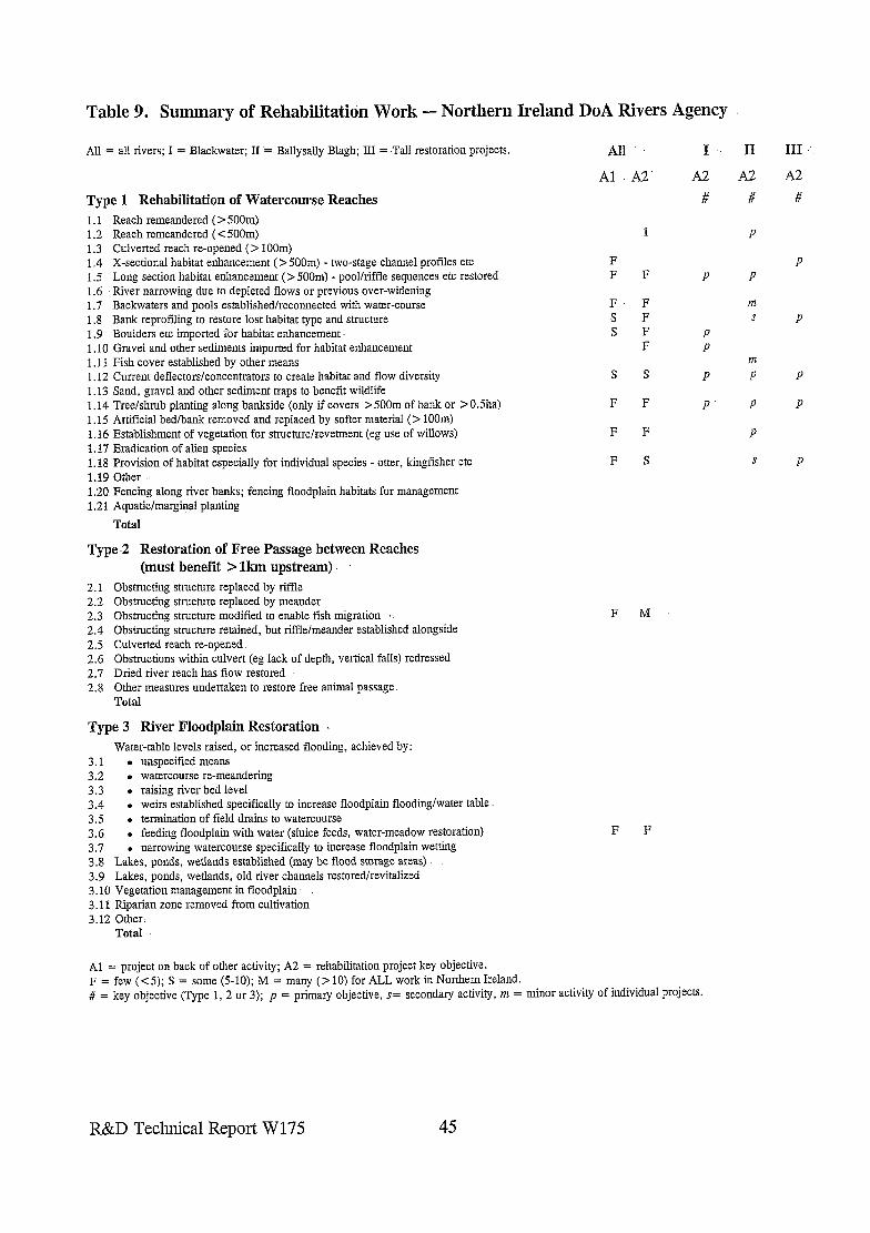
Table 9; Summary of Rehabilitation Work - Northern Ireland DoA Rivers Agency
All = all rivers; I = Blackwater; II = Ballysally Blagh; III = Tall restoration projects. All I
Type 1 Rehabilitation of Watercourse Reaches 1.1 Reach remeandered ( > 5OOm) 1.2 Reach remeandered ( < 500m) 1.3 Culverted reach re-opened (> 100m) 1.4 X-sectional habitat enhancement ( > 5OOm) - two-stage channel profiles etc 1.5 Long section habitat enhancement (> 5OOm) - pool/riffle sequences etc restored 1.6 River narrowing due to depleted flows or previous over-widening 1.7 Backwaters and pools established/reconnected with water-course 1.8 Bank reprofiling to restore lost habitat type and structure 1.9 Boulders etc imported for habitat enhancement. 1.10 Gravel and other sediments imported for habitat enhancement 1.11 Fish cover established by other means 1.12 Current deflectors/concentrators to create habitat and flow diversity 1.13 Sand, gravel and other sediment traps to benefit wildlife 1.14 Tree/shrub planting along bankside (only if covers >500m of bank or >0.5ha) 1.15 Artificial bed/bank removed and replaced by softer material (> loom) 1.16 Establishment of vegetation for stmcturelrevetment (eg use of willows) 1.17 Eradication of alien species 1.18 Provision of habitat especially for individual species - otter, kingfisher etc 1.19 Other. 1.20 Fencing along river banks; fencing floodplain habitats for management 1.21 Aquatic/marginal planting
Total
Type 2 Restoration of Free Passage between Reaches (must benefit > lkm upstream)
2.1 2.2 2.3 2.4 2.5 2.6 2.7 2.8
Obstructing structure replaced by riffle Obstructing structure replaced by meander Obstructing structure modified to enable fish migration Obstructing structure retained, but riffle/meander established alongside Culverted reach re-opened Obstructions within culvert (eg lack of depth, vertical falls) redressed Dried river reach has flow restored Other measures undertaken to restore free animal passage Total
Type 3 River Floodplain Restoration Water-table levels raised, or increased flooding, achieved by:
3.1 . unspecified means 3.2 . watercourse re-meandering 3.3 . raising river bed level 3.4 l weirs established specifically to increase floodplain flooding/water table 3.5 . termination of field drams to watercourse 3.6 . feeding floodplain with water (sluice feeds, water-meadow restoration) 3.7 . narrowing watercourse specifically to increase floodplain wetting 3.8 Lakes, ponds, wetlands established (may be flood storage areas) 3.9 Lakes, ponds, wetlands, old river channels restoredlrevitalized 3.10 Vegetation management in floodplain. 3.11 Riparian zone removed from cultivation 3.12 Other-
Total
Al
F F
F s s
S
F
F
F
AT A2
#
1
F P
F F F P F P
S P
F P
F
S
F M
F F
Al = project on back of other activity; A2 = rehabilitation project key objective. F = few (< 5); S = some (j-10); M = many (> 10) for ALL work in Northern Ireland. d = key objective (Type 1,2 or 3); p = primary objective, r= secondary activity, nz = minor activny or marvidual projects.
II
A2
#
P
P
m s
III
A2
#
P
P
P
P
P
R&D Technical Report W175 45
5. INTERPRETATION & SUMMARY
5.1.. Problems in.Determining Extent of River Rehabilitation
A request for information was sent to Regional contacts in May 1996; who were asked to also circulate the request to Area Fishery and Conservation personnel. A time-scale for responses was set at three months; after six months less than half the 26 Areas had : responded. As a result a second request for information was sentto all 26 Area Conservation staffin November giving respondents opportunities to up-date (and check the author’s interpretation of) their information and providing another chance for those who had been unable to provide information previously. By Mid-January only three Areas had not responded, responses coming almost exclusively through their Conservation Officers; rarely had any .information come from Fisheries.
Whilst determining the extent offishery enhancement programmes was not a priority, many projects led by Fisheries have considerable ecological benefit. In many cases, projects are -- promoted jointly, or with benefits for both considered key objectives in implementation. The’proformas also specifically targeted river works which are often promoted most frequently by Fisheries. These include flow deflectors etc to increase bed and flow-type diversity, as well as projects which restore migration access denied through obstructions such as weirs, sluices and other structures (a key target area inmany-Danish river restoration projects).
To obtain the true extent of river rehabilitation work carried out in the UK during the 1990s has proved very difficult. -,The results in this report are considered to reflect well the range of activities undertaken, but are not considered to be a true reflection of the extent of such activities. Information from virtually every Agency Region and Area had to ‘be dragged out of them’, not because of a reluctance to provide the information, but due to the onerous task involved in retrieving it, ‘A fax from Kent Area seven months after the original request was made for the information epitomised the problem “We hope to send, you details of Agency Schemes to you shortly - I apologise for the delay, however, we do. not hold such information in an easily accessible form”. Similarly the response from South Wessex was “we have no time to dig the information out, but you are welcome to come to the Blandford office and extract it yourself”.
The information discussed in this report is therefore not considered comprehensive, but is likely to give a reasonably clear idea-of the recent priority actions in river rehabilitation. If the exercise was repeated today, with the report information made available to those consulted, it is likely that instances of rehabilitation not originally noted would be-re-called and fewer gaps seen on the summary sheets.
Making confident responses was also hampered by the previous lack of any standard proforma to record-rehabilitation works. Several respondents also had differing interpretations of definitions, even those in regular use, with some appearing to include, some relatively minor ‘enhancements’ whilst others were more rigorous and only counted
R&D Technical Report W175 46
rehabilitation projects which have brought ‘significant’ change (a strict adherence to the definitions given to them at the start).
5.2 Summary of NRA/Environment Agency River Rehabilitation Activities
Table 10 is a summary of the returned proformas, divided into records for the number of times separate rehabilitation measures have been achieved. The data are a summary of information in Tables l-8. Key points are shown graphically in Figure 1.
5.2.1 Type 1 Rehabilitations of Watercourses
On the initial proforma, 18 separate examples of rehabilitation were specified (which closely matched the ERRC check-list) with the option of ‘others’ being highlighted. Four Regions felt that fencing along banks made an important contribution to river rehabilitation, especially in areas of heavy grazing pressure, and three Regions indicated that marginal planting featured strongly in rehabilitation projects. Four Regions used the ‘other’ category for a variety of reasons, with fishery ‘Off River Supplementary Units’ (ORSUs) cited by more than one. It is probable, therefore, that had these categories been on the original proforma, more examples from other Regions would have been given.
Five categories of watercourse rehabilitation are listed as having been implemented in at least 100 locations since 1990. The five most common activities are (with number of examples cited in parentheses):
l tree and shrub planting along banks of > 500m of bank or > 0.5ha (~115); l habitat creation primarily for target species such as otter or kingfisher (~160); l bank re-profiling to restore lost habitats, or removal of bank armouring (~110); l deflectors/concentrators installed to create velocity/substrate diversity (cl 10); l cross-sectional habitat enhancement over > 500m of river (~105).
Five categories of watercourse rehabilitation were listed as having being achieved on 25 or fewer occasions. These were:
s sand, gravel and other sediment traps installed for wildlife benefit (~10); . culverts re-opened [included only if > lOOm] (8); l reach of < 500m re-meandered (~25); l reach of > 500m re-meandered (~15); l artificial bed or bank replaced by soft material [included if > lOOm] (~20).
R&D Technical Report W175 47
Type 1 - Rehabilitation Watercourses Reaches
1.21 Aquatic plantingI-
1.17 Alien eradication:-
1.16 vegetation revetment
1.15 Artiical bed/bank removed :- 1.14Tree planting;
1.13 Sedimenttraps:-
1.12 Current deflectors’
1.11 Fiih CCIV~-
1.10 Sediments imports-
1.7 B;is
1.4 X-s enhancement )
1.3 Culverts opened @
1.2 Remeandered (c500m)JJB
1.1 Remeandered (2500m) ) I
0 20 40 60 80 100 120 140 160 180 200
Number
Type 2 - Free Passage Restoration
2.8 Other measures:-
2.7 Flow restored-w
2.6 Culvert accessedlp
’ 2.5 Culvert removed
2.4 Riffle/meander by-pass
2.3 Obstruction modiiid
2.2 Obstruction to meander
2.1 Obstruction to riffle 4 0 20 40 60 80 100 120 140 160 180 200
Number
Type 3 -Measures to Restore Floodplain Habitats
3.12 Others I-
3.11 Riparian zone formed I-
3.10 Floodplain management :
3.9 Wetlands restoredlrevitalized T
3.8 Wetlands established
3.7 *Narrowing water-course
3.6*Feeding fkmdplain with water 1
3.5 Termination of field drains m
3.4 Weirs B
3.3 *Raising river bed level1
3.2VVater-course re-meandering b
3.1 *Unspecified
0 20 40 60 80 100
Number
Figure 1. Summary of Rehabilitation Work - Environment Agency
R&D Technical Report W175 49
The breakdown of priority activity is broadly as might, have been expected. Four of the five categories least often undertaken are all expensive and are more likely to require great confidence in the re-engineering or be only possible where previous standards/risks are reduced. Installation of sediment traps for environmental rehabilitation was only included on the proforma because it is a common. action undertaken in Denmark, where most of the engineered rivers are cut,through soft sands; but it is one of the two least commonly implemented categories in the UK. The most commonly implemented categories of channel rehabilitation may be achieved relatively cheaply, and often with no conflict with Flood Defence aims. and objectives.
Few consultees reported problems of assigning. specific elements of rehabilitation projects to the categories on the proforma. It is likely that some respondents recorded built otter holts as ‘habitat’ and therefore inflated the score for this category of ‘habitat creation for single species’. In contrast, the relatively~limited inputs from fishery personnel to the proforma means that categories such as gravel imports, boulder placements and installation of deflectors etc is under-recorded. A category of removal of bed/bank armouring covering < 1OOm should be incorporated since this is-an unusual, and expensive, rehabilitation type and more examples need to be brought to the fore to add to the technical knowledge required to implement it. A specific category for removal of floodbanks is also.perceived to be needed..
The results of the trawl indicate some major differences in the extent;.and type, of river rehabilitation undertaken at Regional and Area level. There are many reasons for this, not least the degree to which rivers have been degraded, and the constraints that urbanisation impose upon achieving rehabilitation objectives. This is starkly illustrated by reference to information from-Northern and Southern Areas of NW Region. .The former has rivers of a more pristine nature in Cumbria (where conservation is the-priority) whilst the latter has many degraded rivers in the Mersey basin (here many rehabilitation projects have been undertaken, but. infra-structures and funds limit the extent to which large-scale projects can be completed). Availability. of funds is also important in determining how much, and where, river rehabilitation can take place. The importance of Flood Defence-support cannot be over-stated.. Where this Function has a limited programme of works, their support for river rehabilitation will be limited too: in contrast, where there is a large annual programme of works (as in Thames Region), the potential is much greater. Thames Region has responded tothe opportunities for river rehabilitation in a very positive manner for many years, which is reflected in the large number of projects it has carried out in-each of its three Areas in the past few years.
5.2.2 Type 2 Restoration of Free Passage
The extent of river rehabilitation and removal of obstructions to migration cited in this report are considered to be a relatively small percentage of the total carried out by the. NRA and Environment Agency in England and Wales since 1990. Since such works are primarily. carried out for the benefit of fisheries, a clear picture of the extent of in-stream fishery enhancements, and numbers of migration routes restored, would. only emerge if a
R&D Technical Report W175
separate investigation dedicated to this task was undertaken. Under-recording of activities may not necessarily apply to all Areas or Regions.
The only common method (cl10 examples cited) of restoring free passage through obstructing weirs is to make modifications to enable fish to move through them. The next category, with an estimated 35 examples, was ‘undefined measures’. Midlands and Anglian Region both reported approximately 15 examples of riffles being installed to replace weirs but only two examples of replacement by a meander were cited: both of these are commonly achieved in Denmark, and hence were specifically identified on the proforma. Culvert re-opening, or removal of blockages within them, is also extremely rarely undertaken to enable fish and other biota to move into upstream reaches. Thames Region reports that their involvement in the planning process has brought success at removing blockages to migration when culverted streams are subject to re-development.
Approximately 15 examples of restored flow were highlighted, reflecting the environmental benefit of the Alleviation of Low Flow programme started by the NRA in the early 1990s. Southern Region reported removal of debris dams as restoration of free passage for fish, and therefore a rehabilitation measure. In the New Forest the conservation lobby wish to see debris darns retained and this can be in conflict with the interests of anglers (note: an R&D project on woody debris dams has recently been undertaken for the Agency).
In N. Ireland there has been extensive rehabilitation of the Blackwater and several other examples of restored access to headwaters through removal, or modification, of previous obstructions. In Scotland this has not been a major issue in most rivers until brought into focus recently. Previously priority effort was spent looking after the best salmonid rivers, and obstacles were usually only allowed to be built on natural ‘non-salmonid rivers’ and those salmonid rivers where water quality was very poor and industry took priority. Attention is now turning to promoting removal of obstructions as water quality improves but salmon cannot get to headwater streams to spawn. The Tweed Foundation is also promoting with vigour improved access to the headwater systems of the Tweed: many rivers have over-widened due to intensive grazing pressure, and this has reduced the depth and velocity making fish movement very limited except in large spates.
5.2.3 Type 3 River Floodplain Restoration
Three rehabilitation types are achieved far more cormnonly than any of the other 12 initially on the list. These are:
l establishing NEW ponds, wetlands etc (~175); l restoring HISTORIC floodplain wetlands and open water features (~80); l managing vegetation of floodplain wetlands to restore their character (~70).
Midlands and Thames have been particularly active in these areas, with more than 50% of cited examples of new ponds/wetlands being in Thames Region. Midlands, Thames and Southern are each responsible for undertaking around 25 % of floodplain wetland restoration works cited. Collectively over 70 examples of raising water tables/increasing
R&D Technical Report W175 51
flooding on floodplain were cited, with by, far the largest number achieved through feeding water via sluices (~40) or through constructing weirs within the channel (~20). It is probable that several of the,former examples (~25 cited for Southern and South West) relate to controlled feeding of wetlands behind protecting floodbanks (eg on Somerset Levels and Amberley). In contrast some of the more important floodplain wetland restoration projects may have been missed and placed in other categories. For example. the restoration of floodplain wetlands associated .with re-meandering (Little Ouse Case Study) and the increased flooding of the Eau system (Case Study) were not originally placed in this category by consultees (former listed as ‘old channels restored’ and the latter as ‘bank re- profiling’ and ‘wetland revitalization’).
It is clear that restoring floodplain wetlands through habitat restoration of the controlling rivers -is still in its infancy, with fewer than 10 examples provided. Floodplain wetland ‘re- creation’. is far more prevalent than ‘restoration’ of degraded existing features; although North East and Southern Regions are the exceptions. Management of the floodplain vegetation to restore former interests is a common occurrence only in Southern and. Midlands Regions. Small numbers of examples of establishing riparian zones, removed from cultivation, were cited for most Regions; this probably being a very recent trend, the effects of which on the environment and Flood ,Defence standards will require monitoring. Southern included ditch management specifically for-wildlife; but since these are.in wetlands adjacent to rivers, not in fluvial contact, they probably should be excluded from the records :.’
R&D Technical Report W175 52
6. RECOMMENDATIONS
Knowing the past and present inputs to river rehabilitation; and the achievements of such work, is very important in determining future activities. Those that have funded works will .wish to know where and why resources were allocated as they were, and .what benefits accrued. This applies to Environment Agency Grant-in-Aid (GiA) projects as well ‘as those funded from Flood Defence or from other Function budgets. It is also important for river rehabilitation being sought as compensation, or .planning gain, associated with . . developments affecting river valleys.
For river rehabilitation to advance efficiently in the future, and bring targeted benefits where most required, much tighter auditing of work carried out is recommended. ‘Audit’ should encompass two elements.-. Firstly;,an ‘audit trail’ which enables an immediate retrieval of -information on types of rehabilitation undertaken, ,where and when. Secondly, an ‘audit of implemented work’ or ppa, should be carried out on a proportion of projects to determine kwhether- objectives have been achieved, and where techniques succeed and fail. A notable number of consultees remarked on the lack. of ppa due to limited time and financial resources,
As an absolute minimum each Area Conservation/Fishery officer should keep a systematic record of rehabilitation works. It is recommended that this information should filter down to Regional co-ordinators and to a national database system of storage for subsequent retrieval. The proformas used for data gathering.in this project, which are compatible with the ERRC system; should be up-dated and used for this- purpose. With such a. system in place, the.problems this project had in obtaining relevant information about river restoration would be obviated. Agency staff would have such information at their finger-. tips, and would,not need to state that accessing it was impossible without contractors having to trawl through their Area files.
The following specific recommendations are made:
1. Up-date the Proformas to take account of consultees views so that an agreed form is available that can be also equated to activities of. the ERRC.
Amended proformas, incorporating changes recommended as a result-of the findings of this project, are provided in Annexe C.
2. On all occasions where significant river/riparian/floodplain habitat rehabilitation is achieved by the-Environment Agency (eg during-Maintenance, Capital, Conservation/Fishery Schemes) Profoma 2 should be .filled in.- This should take less than 10 minutes if undertaken as a routine. action in project promotion and. implementation.
R&D Technical Report W175 53
3. Where significant river/riparian/floodplain habitat rehabilitation is achieved by external bodies on works requiring consent from the Environment Agency, a Profoma 2 should be also filled in by relevant Agency staff on all occasions.
4. Annual summaries using Profomza I should be made from the above. It is assumed that the majority would be initially produced at Area level but with Regional co-ordination. Such an activity should take less than a single day.
5. A National Centre for receiving all the Proformas would be desirable.
6. Within two years a simple computerized database system for input and accessing such data should be in place.
The simple recommendations made above would enable immediate access to information on river rehabilitation activities at minimal cost: access does not exist at present and considerable resources are wasted attempting to acquire it. Such important information is imperative for a wide range of reasons, including:
l instant information for reporting on the state of the environment; . evidence of activities undertaken to meet statutory responsibilities; . provision of initial information required to determine cost, effectiveness and
benefit of environmental rehabilitation works; l instant access to information on reference sites to facilitate planned/future
rehabilitation projects.
The proposed ‘national centre’ is not considered to be a ‘centre of excellence’, merely a single location where information could be gathered, checked, entered onto a database and then made available for a whole host of uses. It may also combine the role of encouraging deposition of simple and clear documentation on major projects of rehabilitation, including photographs.
Many of the photographs used in the Case Studies (and some others) have been copied and deposited at the Agency’s office in Bristol. A CD-Rom of photographs of good rehabilitation projects would be very useful, but many consultees have been reluctant to make them available. It is therefore not recommended that existing available photographic material is transferred on to CD at this stage, although this would be a useful exercise as part of the development of the centre. It is recommended, however, that a series of leaflets be published on some of the Case Studies. This will help ensure successful implementation of the research findings by providing an accessible output targeted for widespread dissemination. The leaflets will also serve to promote river rehabilitation in general.
R&D Technical Report W175 54
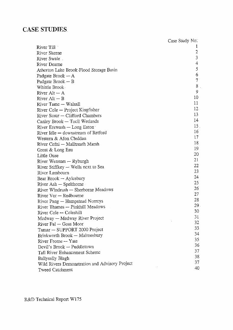
CASE STUDIES
River Till River Skerne River Swale River Dearne Atherton Lake Brook.Flood Storage Basin Padgate Brook - A Padgate Brook.- B Whittle Brook River Ah - A River Ah - B River Tame - Walsall River Cole - Project Kingfisher River Stour - Clifford Chambers Canley Brook - Tocil Wetlands River Erewash - Long Eaton River Idle - downstream of Retford Western & Afon Cleddau- River Cefni - Malltreath Marsh Great & Long Eau Little Ouse River Wensum - Ryburgh River Stiffkey - Wells next to Sea River Lambourn Bear Brook - Aylesbury River Ash - Spelthorne River Windrush - Sherborne Meadows River Ver - Redbourne River Pang - Hampstead Norreys River Thames - Pinkhill Meadows River Cole - Coleshill Medway - iMedway River Project River Fal - Goss Moor Tamar - SUPPORT 2000 Project Brinkworth Brook - Malmesbury River Frome-- Yate Devil’s Brook - Puddletown Tall River Enhancement Scheme Ballysally Blagh Wild Rivers Demonstration and Advisory Project Tweed Catchment
Case Study No; 1 2 3 4 5 6 7’ 8 9
10 11 12 13 14 15 16 17 18 19 20 21 22 23 24 25 26 27 28 29 30 31 32 33 34 35 36 37 38 37 40
R&D Technical Report W175
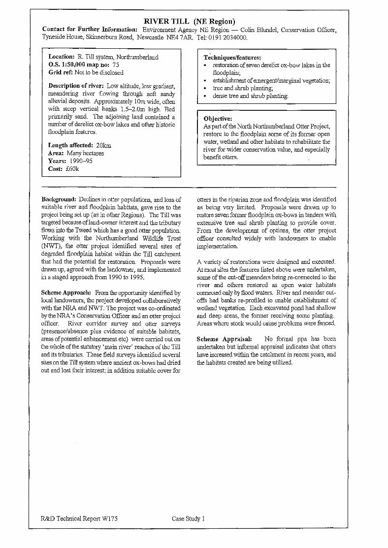
RJYER TILL (NE Region) Contact for Further Information: Environment Agency NE Region - Colin Blundel, Conservation Officer, Tyneside House, Skinnerbum Road, Newcastle NE4 7AR. Tel: 0191 2034000.
Location: R. Till system, Northumberland OS. 1:50,000 map no: 75 Grid ref: Not to be disclosed
Description of river: Low altitude, low gradient, meandering river flowing through soft sandy alluvial deposits. Approximately 1 Om wide, often with steep vertical banks 1.5-2.0m high. Bed primarily sand. The adjoining land contained a number of derelict ox-bow lakes and other historic floodplain features.
Length affected: 2Okm Area: Many hectares Years: 1990-95 Cost: E60k
Techniques/features: l restoration of seven derelict ox-bow lakes in the
floodplain; . establishment of emergent/marginal vegetation; l tree and shrub planting; l dense tree and shrub planting.
Objective: As part of the North Northumberland Otter Project, restore to the floodplain some of its former open water, wetland and other habitats to rehabilitate the river for wider conservation value, and especially benefit otters.
Background: Declines in otter populations, and loss of suitable river and floodplain habitats: gave rise to the project being set up (as in other Regions). The Till was targeted because of land-owner interest and the tributary flows into the Tweed which has a good otter population. Working with the Northumberland Wildlife Trust (NWT): the otter project identified several sites of degraded floodplain habitat within the Till catchment that had the potential for restoration. Proposals were drawn up, agreed with the landowner, and implemented in a staged approach from 1990 to 1995.
Scheme Approach: From the opportunity identified by local landowners, the project developed collaboratively with the NRA and NWT. The project was co-ordinated by the NRA’s Conservation Officer and an otter project officer. River corridor survey and otter surveys (presence/absence plus evidence of suitable habitats, areas of potential enhancement etc) were carried out on the whole of the statutory ‘main river’ reaches of the Till and its tributaries. These field surveys identified several sites on the Till system where ancient ox-bows had dried out and lost their interest; in addition suitable cover for
R&D Technical Report W175 Case Study 1
otters in the riparian zone and floodplain was identified as being very limited. Proposals were drawn up to restore seven former floodplain ox-bows in tandem with extensive tree and shrub planting to provide cover. From the development of options, the otter project officer consulted widely with landowners to enable implementation.
A variety of restorations were designed and executed. At most sites the features listed above were undertaken, some of the cut-off meanders being re-connected to the river and others restored as open water habitats connected only by flood waters. River and meander cut- offs had banks re-profiled to enable establishment of wetland vegetation. Each excavated pond had shallow and deep areas, the former receiving some planting. Areas where stock would cause problems were fenced.
Scheme Appraisal: No formal ppa has been undertaken but informal appraisal indicates that otters have increased within the catchment in recent years, and the habitats created are being utilized.
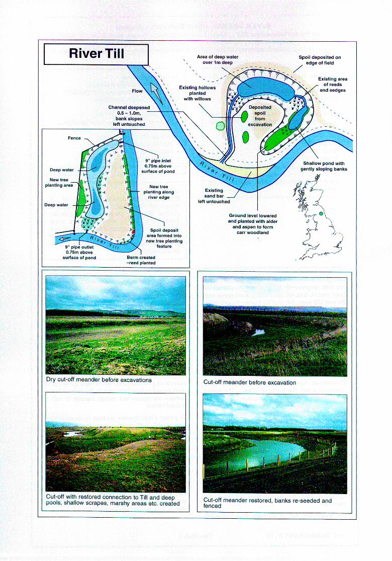
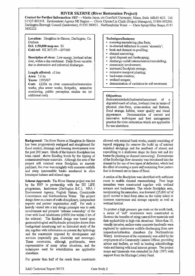
RJYER SKERNE (River Restoration Project) Contact for Further Information: RRP - Martin Janes, c/o Cranfield University, Silsoe, Beds MK45 4DT. Tel: 0 152.5 86334 1. Environment Agency NE Region - Olivia Clymer/Liz Chalk (Project Managers), 0 1904 692296. Darlington Borough Council (landowner), 0155 38065 1 . Northumbrian Water - Chris Spray/Allan Snape, 0 19 1 3832222.
Location: Haughton-le-Skeme, Darlington, Co. Durham O.S. 1:50,000 map no: 93 Grid ref: NZ 307 157-297 160
Description of river: Low energy, lowland urban river, within a clay cat&n-rent. Daily flows variable due to abstraction and industrial discharges.
Length affected: c2 km Area: 7.6 ha Years: 19951617 Cost: f220k on river construction/restoration works; plus sewer works, footpaths, extensive monitoring, public perception studies etc (at additional cost).
Techniques/features: l restoring meandering plan form; l m-channel deflectors to create ‘sinuosity’; l bank and channel re-profiling; l channel narrowing; l spoil disposal and landscaping; l discharge outfall rationalisation/remodelling; l Community involvement; l increased floodplain storage; l extensive marginal planting; l backwater creation; . wetland scrapes; l demonstration of variations in soft revetment.
Objectives: Restoration/rehabilitation/enhancement of a degraded reach of urban, lowland river in terms of physical plan-form, cross-section and features, flood storage, habitat, water quality and visual appearance. Demonstration of current and innovative techniques and best management practice for river restoration which are applicable for use elsewhere.
Background: The River Skeme at Hat&ton-le-Skeme has been progressively realigned and straightened for flood control, drainage and housing development over the past 200 years. Much of the historic floodplain has been raised above flooding levels by the tipping of contaminated/waste materials. Although the area of the project still retained some floodplain as amenity parkland, the river was unsightly with concrete outfalls and steep inaccessible banks smothered in alien himalayan balsam and oilseed rape.
Scheme Approach: The River Skeme project was led by the RRP in partnership with the EU LIFE programme, landowner (Darlington B.C.), NRA / Environment Agency, English Nature, Countryside Commission and Northumbrian Water. The project design drew on a team of multi-disciplinary, independent experts and partner organisation stat??. For such a heavily visited site a key design principle was to seek involvement and promote ‘scheme ownership’ of the river with local inhabitants (~5000 live within 1 km of the scheme). The finished design was based upon geomorphological and hydraulic principles drawn from background monitoring and an historical study of the site, together with information on present day hydrology and the constraints imposed by development and services (especially gas, electricity and sewerage). These constraints, although problematic, were representative of many urban situations, and the techniques used for rehabilitation are applicable elsewhere.
For greater than half of the reach these constraints
allowed only minimal bank works, mainly consisting of topsoil stripping (to remove the build up of nutrient enriched dredgings and the seedbank of aliens) and reprofiling to a shallower slope (to form wet and dry berms for planting or channel narrowing). Downstream of the footbridge flow sinuosity was introduced into the channel by the use of two types of deflectors, which had the effect of creating a more self sustaining flow pattern that is drowned out in times of flood.
A section of the floodplain was identified with sufficient room to enable channel remeandering. Four large meanders were constructed together with wetland scrapes and backwaters. The whole floodplain area, incorporating the meanders, was lowered (25,000 m3 of spoil moved to land-form sites on the valley sides) to increase conveyance and storage capacity as well as wetland habitat.
To protect a high pressure gas main on the north bank, a series of ‘soft’ revetments were constructed to illustrate the benefits of using natural/live materials and their applicability in high risk situations. More than 15, visually intrusive, surface water concrete headwalls were replaced by underwater outfalls discharging from new inspection/collection chambers (by Northumbrian Water). Involvement of the community was aided by the employment of a Community Liaison Officer, providing advice and leaflets, as well as hosting school/college visits and liaising with local interest groups. The project scope and timescale was extended (to July 1997) with support from the Heritage Lottery Fund.
R&D Technical Report W175 Case Study 2
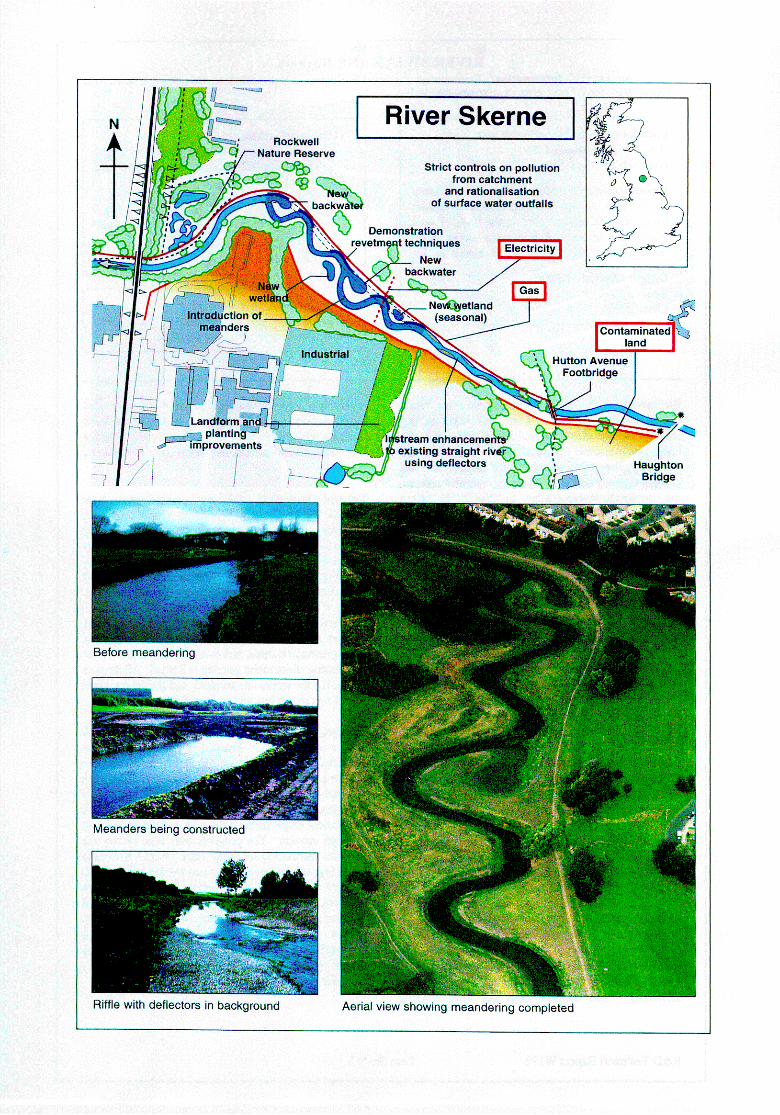
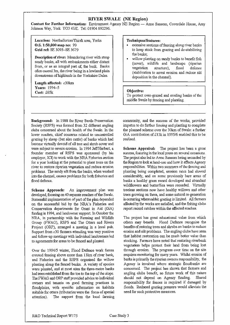
RIVER SWALE (NE Region) Contact for Further Information: Environment Agency NE Region - Anne Sansom, Coverdale House, Amy Johnson Way, York Y03 4U.Z. Tel: 01904 692296.
Location: Northallerton/Thirsk area, Yorks O.S. 1:50,000 map no: 99 Grid refi SE 3093-SE 3679
Description of river: Meandering river with steep sandy banks, all with embankments either distant from, or as an integral part of, the bank. Banks often exceed 3m, the river being in a lowland plain downstream of highlands in the Yorkshire Dales.
Length affected: c3O?sm Years: 1994-5 Cost: E65k
Techniques/features: l extensive sections of fencing along river banks
to keep stock from grazing and de-stabilizing the banks;
l willow planting on sandy banks to benefit fish (cover), wildlife and landscape (riparian vegetation structure), flood defence (stablization to arrest erosion and reduce silt deposition in the channel).
Objective: To protect over-grazed and eroding banks of the middle Swale by fencing and planting.
Background: In 1988 the River Swale Preservation Society (RSPS) was formed Tom 32 different angling clubs concerned about the health of the Swale. In the lower reaches, chief concerns related to uncontrolled grazing by sheep (but also cattle) of banks which had become virtually devoid of all tree and shrub cover and were subject to severe erosion. In 1994 Jeff Herbert, a founder member of RSPS was sponsored (by his employer, ICI) to work with the NRA Fisheries section for a year looking at the potential to plant trees on the river to restore riparian vegetation and reduce erosion problems. The sandy silt from the banks, when washed into the channel, causes problems for both fisheries and flood defence.
Scheme Approach: An improvement plan was developed, focusing on 40 separate reaches of the Swale. Successful implementation of part of the plan depended on the successful bid by the NRA’s Fisheries and Conservation departments for Grant in Aid (GiA) funding in 1994, and landowner support. In October the NRA, in partnership with the Farming and Wildlife Group (FWAG), RSPS and The Otters and Rivers Project (ORP), arranged a meeting in a local pub. Support fi-om ~30 farmers attending was very positive and follow-up meetings with individual landowners led to agreements for areas to be fenced and planted.
Over the 1994/5 winter, Flood Defence work forces erected fencing above more than 13km of river bank, and Fisheries and the RSPS organised the willow planting along the fenced banks. A variety of species were planted, and at most sites the three-metre banks had trees established from the toe to the top of the slope. The FWAG and ORP staiTprovided advice to individual owners and tenants on good farming practices in floodplains, with specific information on habitats suitable for otters (tributaries were the focus of special attention). The support from the local farming
community, and the success of the works, provided impetus to do further fencing and planting to complete the planned scheme over the 30km of Swale: a further GiA contribution of fl5k in 1995/6 enabled this to be realised.
Scheme Appraisal: The project has been a great success, featuring in the local press on several occasions. The project also led to Anne Sansom being seconded by the Region to look at land-use and how it affects Agency responsibilities. Within two summers of the fencing and planting being completed, erosion rates had slowed considerably, and on some previously bare areas of banks a healthy grass sward developed and abundant wildflowers and butterflies were recorded. Virtually treeless sections now have healthy willows and other trees growing on them, and some natural re-generation is occurring where rabbit grazing is limited. All farmers affected by the works are satisfied, and the fishing clubs report record catches within the affected reaches.
The project has great educational value from which others may benefit. Flood Defence recognise the benefits of restoring trees and shrubs on banks to reduce erosion and silt problems. The angling clubs have seen that habitat restoration can be much better value than stocking. Farmers have noted that restoring riverbank vegetation helps protect their land from being lost through erosion. The progress over time on the site requires monitoring for many years. Whilst erosion of banks is primarily the riparian owners responsibility, the Agency is involved where strategic floodbanks are concerned. The project has shown that farmers and angling clubs benefit, so future work of this nature should not depend on Agency funding. Shared responsibility for fences is required if damaged by floods. Reduced grazing pressure would alleviate the need for such protective measures.
R&D Technical Report W 175 Case Study 3
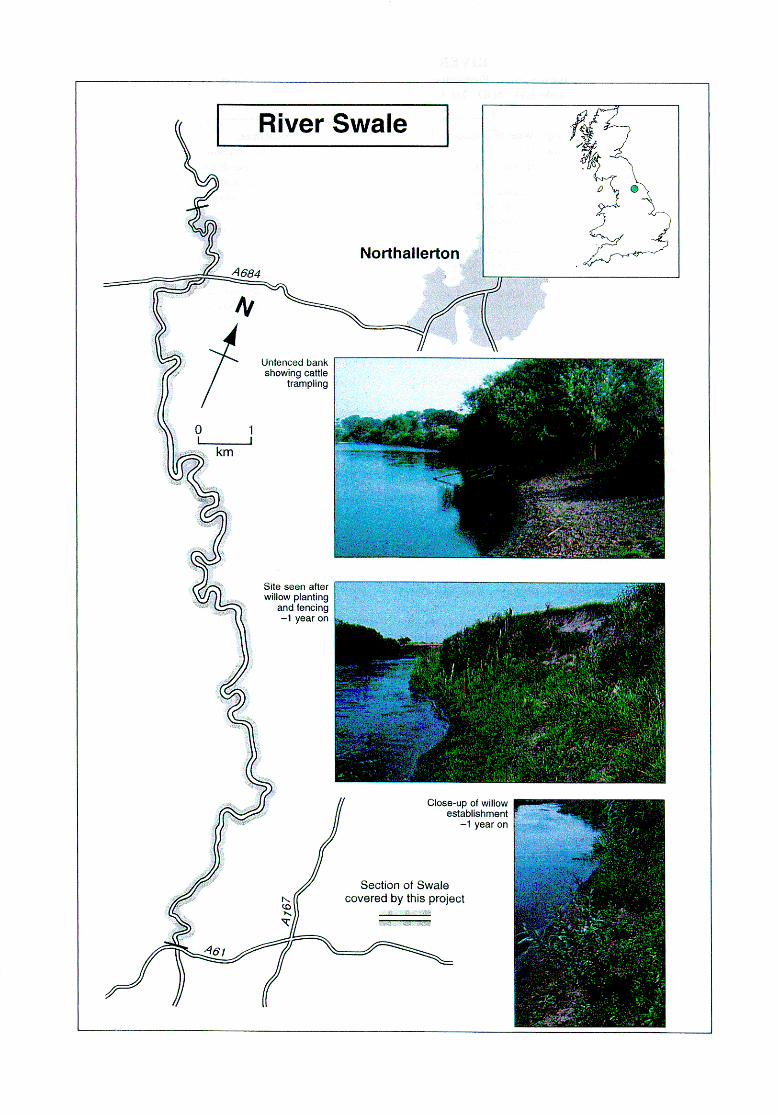
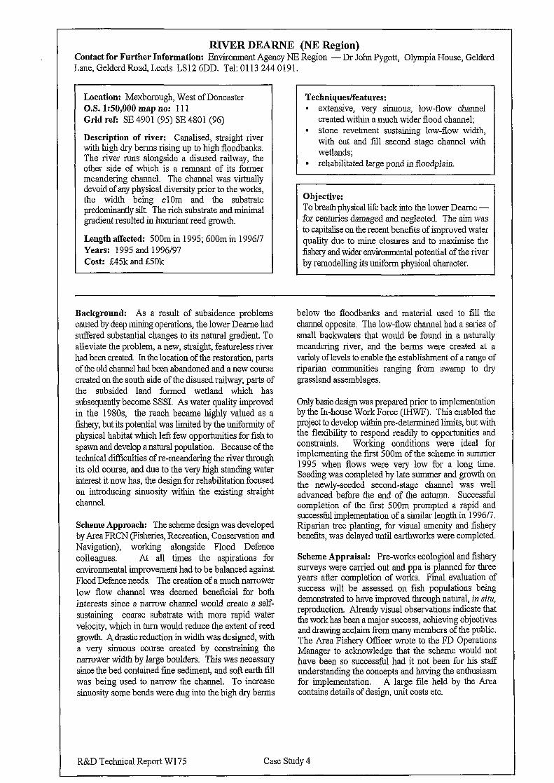
RIVER DEARNE (NE Region) Contact for Further Information: Environment Agency NE Region - Dr John Pygott, Olympia House, Gelderd Lane, Gelderd Road, Leeds LS 12 6DD. Tel: 0 113 244 0 19 1.
Location: Mexborough, West of Doncaster O.S. 1:50,000 map no: 111 Grid ref: SE 4901 (95) SE 4801 (96)
Description of river: Canalised, straight river with high dry berms rising up to high floodbanks. The river runs alongside a disused railway, the other side of which is a remnant of its former meandering channel. The channel was virtually devoid of any physical diversity prior to the works, the width being clOm and the substrate predominantly silt. The rich substrate and minimal gradient resulted in luxuriant reed growth.
Length affected: 500m in 1995; 600m in 1996/7 Years: 1995 and 1996/97 Cost: g45k and g50k
Techniques/features: l extensive, very sinuous, low-flow channel
created within a much wider flood channel; l stone revetment sustaining low-flow width,
with cut and fill second stage channel with wetlands;
l rehabilitated large pond in floodplain.
Objective: To breath physical life back into the lower Dearne - for centuries damaged and neglected. The aim was to capitalise on the recent beneiits of improved water quality due to mine closures and to maximise the fishery and wider environmental potential of the river by remodelling its uniform physical character.
Background: As a result of subsidence problems caused by deep mining operations, the lower Deame had suffered substantial changes to its natural gradient. To alleviate the problem, a new, straight, featureless river had been created In the location of the restoration, parts of the old channel had been abandoned and a new course created on the south side of the disused railway; parts of the subsided land formed wetland which has subsequently become SSSI. As water quality improved in the 1980s the reach became highly valued as a fishery, but its potential was limited by the uniformity of physical habitat which left few opportunities for fish to spawn and develop a natural population, Because of the technical difEiculties of re-meandering the river through its old course, and due to the very high standing water interest it now has, the design for rehabilitation focused on introducing sinuosity within the existing straight channel.
Scheme Approach: The scheme design was developed by Area FRCN (Fisheries, Recreation, Conservation and Navigation), working alongside Flood Defence colleagues. At all times the aspirations for environmental improvement had to be balanced against Flood Defence needs. The creation of a much narrower low flow channel was deemed beneficial for both interests since a narrow channel would create a self- sustaining coarse substrate with more rapid water velocity, which in turn would reduce the extent of reed growth A drastic reduction in width was designed, with a very sinuous course created by constraining the narrower width by large boulders. This was necessary since the bed contained fine sediment, and soft earth fill was being used to narrow the channel. To increase sinuosity some bends were dug into the high dry berms
below the floodbanks and material used to fill the channel opposite. The low-flow channel had a series of small backwaters that would be found in a naturally meandering river, and the berms were created at a variety of levels to enable the establishment of a range of riparian communities ranging from swamp to dry grassland assemblages.
Only basic design was prepared prior to implementation by the In-house Work Force (E-IWF). This enabled the project to develop within pre-determined limits, but with the flexibility to respond readily to opportunities and constraints. Working conditions were ideal for implementing the first 500m of the scheme in summer 1995 when flows were very low for a long time. Seeding was completed by late summer and growth on the newly-seeded second-stage channel was well advanced before the end of the autumn. Successful completion of the fast 500m prompted a rapid and successful implementation of a similar length in 199617. Riparian tree planting, for visual amenity and fishery benefits, was delayed until earthworks were completed.
Scheme Appraisal: Pre-works ecological and fishery surveys were carried out and ppa is planned for three years after completion of works. Final evaluation of success will be assessed on fish populations being demonstrated to have improved through natural, in situ, reproduction. Already visual observations indicate that the work has been a major success, achieving objectives and drawing acclaim from many members of the public. The Area Fishery Officer wrote to the FD Operations Manager to acknowledge that the scheme would not have been so successful had it not been for his stat?? understanding the concepts and having the enthusiasm for implementation. A large file held by the Area contains details of design, unit costs etc.
R&D Technical Report W175 Case Study 4
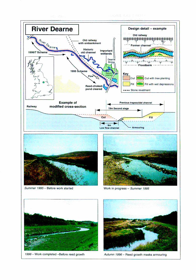
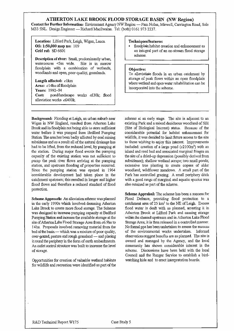
ATECERTON LAKE BROOK FLOOD STORAGE BASIN (NW Region) Contact for Further Information: Environment Agency NW Region -Pam Nolan, Mirwell, Canington Road, Sale M33 5NL. Design Engineer -Richard Macilwaine. Tel: (both) 0161 973 2237.
Location: Lilford Park, Leigh, Wigan, Lanes. OS: 150,000 map no: 109 Grid refi SD 6601
Description of river: Small, predominantly urban, watercourse c5m wide. Site is in narrow floodplain with a combination of wetlands, woodlands and open, poor-quality, grasslands.
Length affected: clkm Area: cl4ha of floodplain Years: 1992-94 cost: pond/landscape works ci30k; flood alleviation works cE400k.
floodplain habitat creation and enhancement as an integral part of an on-stream flood storage
Objective: To alleviatiate floods in an urban cat&rent by storage of peak flows within an open floodplain where wetland and open water rehabilitation can be incorporated into the scheme.
Background: Flooding at Leigh, an urban suburb near Wigan in NW England, resulted f?om Atherton Lake Brook and its floodplain not being able to store sufficient water before it was pumped from Bedford Pumping Station. The area has been badly affected by coal mining subsidence and as a result all of the natural drainage has had to be lifted, from the reduced level, by pumping at the station. During major flood events the pumping capacity of the existing station was not sufficient to pump the peak river flows arriving at the pumping station, and upstream flooding of properties occurred. Since the pumping station was opened in 1964 ‘considerable development had taken place in the catchment upstream; this resulted in longer and higher flood flows and therefore a reduced standard of flood protection.
Scheme Approach: An alleviation scheme was planned in the early 1990s which involved damming Atherton Lake Brook to create more flood storage. The Scheme was designed to increase pumping capacity at Bedford Pumping Station and increase the available storage at the site of Atherton Lake Flood Storage Area from c6.9ha to 14ha. Proposals involved removing material fi-om the bedofthebasin -which was a mixture of poor quality, over-grazed, pasture and rough grassland - and placing it round the periphery in the form of earth embankments. An outlet control structure was built to increase the level of storage.
Opportunities for creation of valuable wetland habitats for wildlife and recreation were identified as part of the
scheme at an early stage. The site is adjacent to an existing Park and a mixed deciduous woodland of SBI (Site of Biological Interest) status. Because of the considerable potential for habitat enhancement for wildlife, it was decided to limit future access to the site to those wishing to enjoy this interest. Improvements included: creation of a large pond (c2lOOm’) with an island and reed bed and associated marginal tYinges on the site of a dried-up depression (possibly derived from subsidence); shallow wetland scrape; two small ponds; extensive tree planting to create copses of alder woodland; wildflower meadows. A small part of the Park has controlled grazing. A small periphery ditch with a good range of marginal and aquatic species was also retained as part of the scheme.
Scheme Appraisal: The scheme has been a success for Flood Defence, providing flood protection to a catchment area of 25 km’ to the NE of Leigh. Excess flood water is dealt with as planned, arresting it in Atherton Brook at Lilford Park and causing storage within the channel upstream and in Atherton Lake Flood Storage Area; it is then released in a controlled manner. No formal ppa has been undertaken to assess the success of the environmental works undertaken. Informal observations suggest benefits are as planned. The site is owned and managed by the Agency, and the local community has shown considerable interest in the scheme. Discussions have been held with the local Council and the Ranger Service to establish a bird- watching hide and to erect interpretation boards.
R&D Technical Report W175 Case Study 5
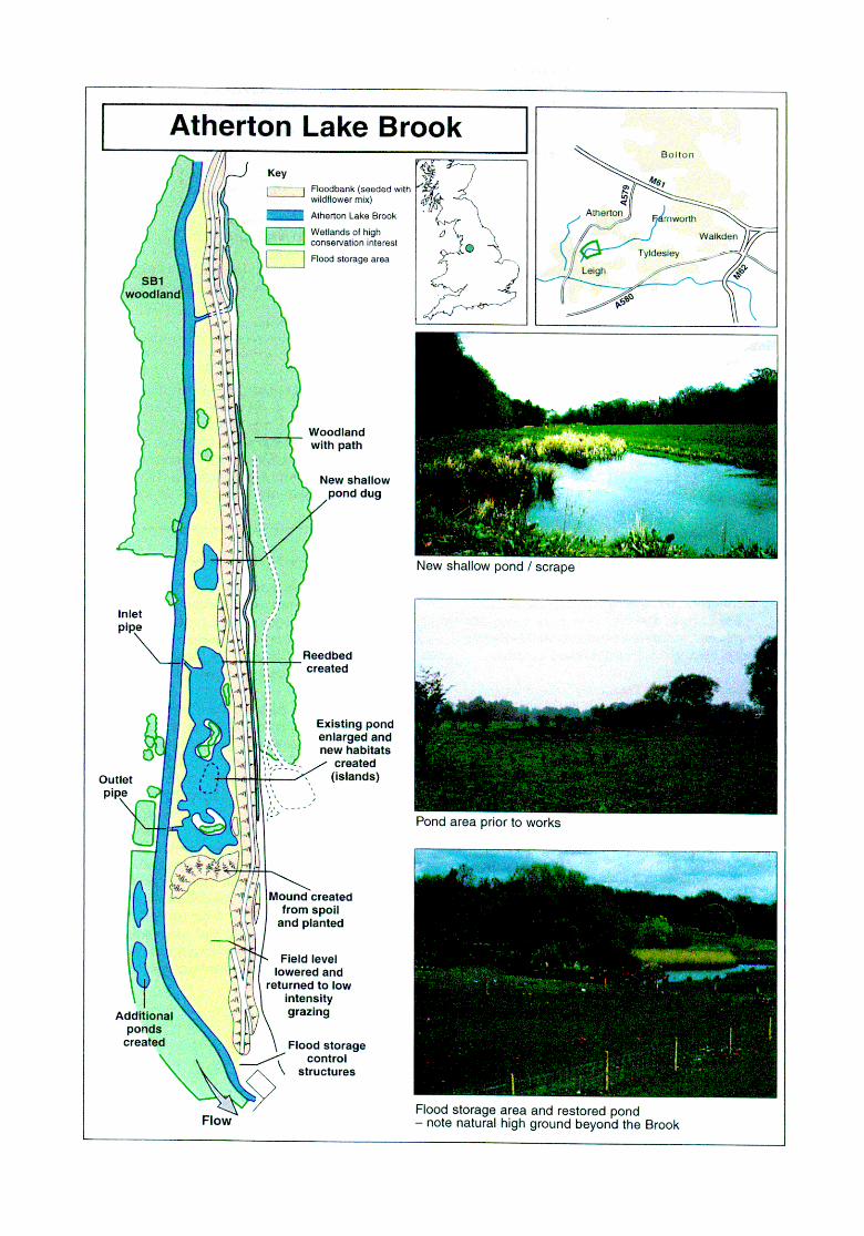
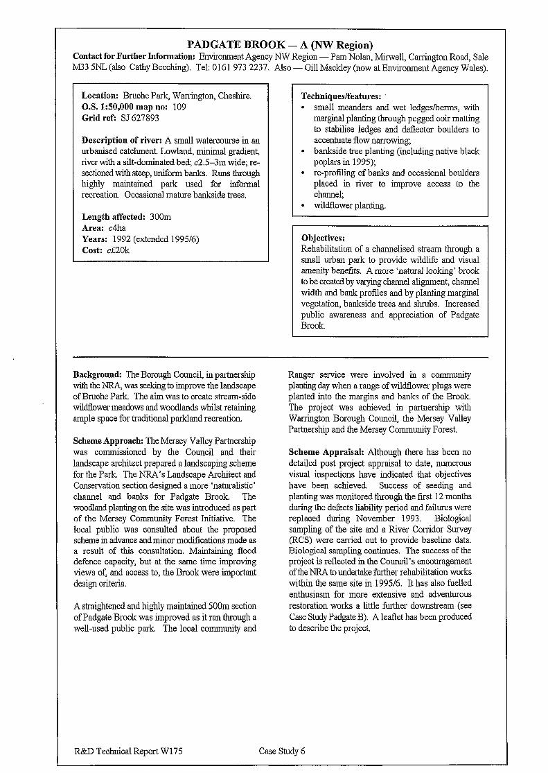
PADGATE BROOK - A (NW Region) Contact for Further Information: Environment Agency NW Region - Pam Nolan, Mu-well, Carrington Road, Sale M33 5NL (also Cathy Beeching). Tel: 0161 973 2237. Also - Gill Mackley (now at Environment Agency Wales).
Location: Bruche Park, Warrington, Cheshire. O.S. 1:50,000 map no: 109 Grid ref: SJ 627893
Description of river: A small watercourse in an urbanised catchment. Lowland, minimal gradient, river with a silt-dominated bed; c2.5-3m wide; re- sectioned with steep, uniform banks. Runs through highly maintained park used for informal recreation. Occasional mature bankside trees.
Length affected: 300m Area: c4ha Years: 1992 (extended 1995/6) Cost: cf20k
Techniques/features: l small meanders and wet ledges/berms, with
marginal planting through pegged coir matting to stabilise ledges and deflector boulders to accentuate flow narrowing;
l bankside tree planting (including native black poplars in 1995);
l re-profiling of banks and occasional boulders placed in river to improve access to the channel;
l wildflower planting.
Objectives: Rehabilitation of a channelised stream through a small urban park to provide wildlife and visual amenity benefits. A more ‘natural looking’ brook to be created by varying channel alignment, channel width and bank profiles and by planting marginal vegetation, bankside trees and shrubs. Increased public awareness and appreciation of Padgate Brook.
Background: The Borough Council, in partnership with the m was seeking to improve the landscape of Bruche Park. The aim was to create stream-side wildflower meadows and woodlands whilst retaining ample space for traditional parkland recreation.
Scheme Approach: The Mersey Valley Partnership was commissioned by the Council and their landscape architect prepared a landscaping scheme for the Park. The NRA’s Landscape Architect and Conservation section designed a more ‘naturalistic’ channel and banks for Padgate Brook. The woodland planting on the site was introduced as part of the Mersey Community Forest Initiative. The local public was consulted about the proposed scheme in advance and minor modifications made as a result of this consultation. Maintaining flood defence capacity, but at the same time improving views of, and access to, the Brook were important design criteria.
A straightened and highly maintained 500m section of Padgate Brook was improved as it ran through a well-used public park. The local community and
Ranger service were involved in a community planting day when a range of wildflower plugs were planted into the margins and banks of the Brook. The project was achieved in partnership with Warrington Borough Council, the Mersey Valley Partnership and the Mersey Community Forest.
Scheme Appraisal: Although there has been no detailed post project appraisal to date, numerous visual inspections have indicated that objectives have been achieved. Success of seeding and planting was monitored through the first 12 months during the defects liability period and failures were replaced during November 1993. Biological sampling of the site and a River Corridor Survey (RCS) were carried out to provide baseline data. Biological sampling continues. The success of the project is reflected in the Council’s encouragement of the NRA to undertake further rehabilitation works within the same site in 1995/6. It has also fuelled enthusiasm for more extensive and adventurous restoration works a little further downstream (see Case Study Padgate B). A leaflet has been produced to describe the project.
R&D Technical Report W175 Case Study 6
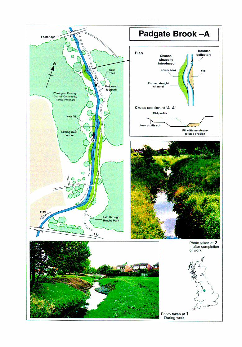
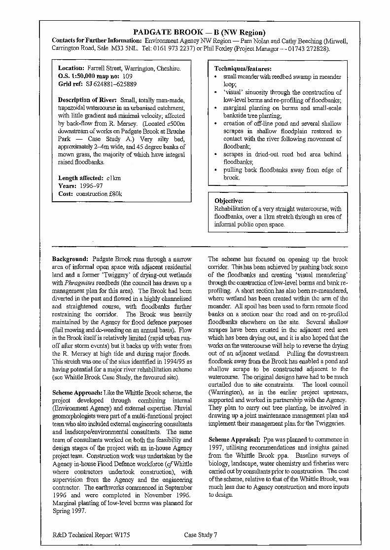
PADGATE BROOK - B (NW Region) Contacts for Further Information: Environment Agency NW Region - Pam Nolan and Cathy Beeching @In-well, Canington Road, Sale M33 SNL. Tel: 0 16 1 973 2237) or Phil Foxley (Project Manager - 01743 272828).
Location: Farrell Street, Warrington, Cheshire. O.S. 1:50,000 map no: 109 Grid ref: SJ 624881625889
Description of River: Small, totally man-made, trapezoidal watercourse in an urbanised catchment, with little gradient and minimal velocity; affected by back-flow from R. Mersey. (Located c500m downstream of works on Padgate Brook at Bruche Park - Case Study A.) Very silty bed, approximately 2-4m wide, and 45 degree banks of mown grass, the majority of which have integral raised floodbanks.
Length affected: clkm Years: 1996-97 Cost: construction i80k
Techniques/features: l small meander with reedbed swamp in meander
loop; . ‘visual’ sinuosity through the construction of
low-level berms and re-profiling of floodbanks; l marginal planting on berms and small-scale
barikside tree planting, l creation of off-line pond and several shallow
scrapes in shallow floodplain restored to contact with the river following movement of floodbank;
l scrapes in dried-out reed bed area behind floodbanks;
. pulling back floodbanks away from edge of brook.
Objective: Rehabilitation of a very straight watercourse, with floodbanks, over a lkm stretch through an area of informal public open space.
Background: Padgate Brook runs through a narrow area of informal open space with adjacent residential land and a former ‘Twiggery’ of drying-out wetlands with Phrugmites reedbeds (the council has drawn up a management plan for this area). The Brook had been diverted in the past and flowed in a highly channelised and straightened course, with floodbanks further restraining the corridor. The Brook was heavily maintained by the Agency for flood defence purposes (flail mowing and de-weeding on an annual basis). Flow in the Brook itself is relatively limited (rapid urban run- off after storm events) but it backs up with water from the R. Mersey at high tide and during major floods. This stretch was one of the sites identified in 1994/95 as having potential for a major river rehabilitation scheme (see Whittle Brook Case Study, the favoured site).
Scheme Approach: Like the Whittle Brook scheme, the project developed through combining internal (Environment Agency) and external expertise. Fluvial geomorphologists were part of a multi-functional project team who also included external engineering consultants and landscape/environmental consultants. The same team of consultants worked on both the feasibility and design stages of the project with an m-house Agency project team Construction work was undertaken by the Agency m-house Flood Defence workforce (cf Whittle where contractors undertook construction), with supervision from the Agency and the engineering contractor. The earthworks commenced in September 1996 and were completed in November 1996. Marginal planting of low-level berms was planned for spring 1997.
The scheme has focused on opening up the brook corridor. This has been achieved by pushing back some of the floodbanks and creating ‘visual meandering’ through the construction of low-level berms and bank re- profiling. A short section has also been re-meandered, where wetland has been created within the arm of the meander. All spoil has been used to form remote flood banks on a section near the road and on re-profiled floodbanks elsewhere on the site. Several shallow scrapes have been created in the adjacent reed area which has been drying out, and it is also hoped that the works on the watercourse will help to reverse the drying out of an adjacent wetland. Pulling the downstream floodbank away from the Brook has enabled a pond and shallow scrape to be constructed adjacent to the watercourse. The original designs have had to be much curtailed due to site constraints. The local council (Warrington), as in the earlier project upstream, supported and worked in partnership with the Agency. They plan to carry out tree planting, be involved in drawing up a joint maintenance management plan and implement their management plan for the Twiggeries.
Scheme Appraisal: Ppa was planned to commence in 1997, utilising recommendations and insights gained from the Whittle Brook ppa. Baseline surveys of biology, landscape, water chemistry and fisheries were carried out by consultants prior to construction. The cost of the scheme, relative to that of the Whittle Brook, was much less due to Agency construction and more inputs to design.
R&D Technical Report W175 Case Study 7
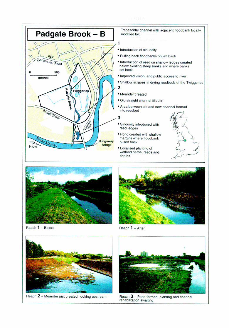
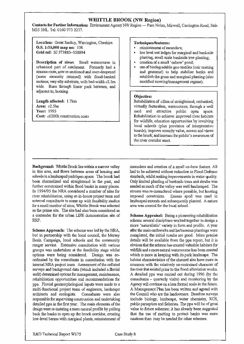
WHITTLE BROOK (NW Region) Contacts for Further Information: Environment Agency NW Region - Pam Nolan, Mu-well, Carrington Road, Sale M33 SNL. Tel: 0160 973 2237
Location: Great Sankey, Warrington, Cheshire. O.S. 1:50,000 map no: 108 Grid refi SJ 573885-558894
Description of river: Small watercourse in urbanised part of catchment. Formerly had a sinuous route, now re-sectioned and over-deepened (some sinuosity retained) with flood-banked sections; very silty substrate, with bed-width c2.5m wide. Runs through linear park between, and adjacent to, housing.
Length affected: 1.7km Area: c2.5ha Year: 1995 Cost: ci200k construction costs
Techniques/features: . reinstatement of meanders; l low level wet ledges for marginal and bankside
planting, small scale bankside tree planting; l creation of a small ‘oxbow’ pond, l use of biodegradable geo-textiles (coir matting
and grassmat) to help stabilise banks and establish the grass and marginal planting (also modified mowing/management regime).
Objective: Rehabilitation of c2km of straightened, embanked, virtually featureless, watercourse, through a well used and attractive public open space. Rehabilitation to achieve: improved river habitats for wildlife, education opportunities by involving local schools (plus provision of interpretative boards); improve amenity value, access and views to the brook; and increase the public’s awareness of the river corridor asset.
Background: Whittle Brook lies within a narrow valley in this area, and flows between areas of housing and schools in a landscaped park/open space. The brook had been channelized and straightened in the past, and further constrained within flood banks in many places. In 1994195 the NRA considered a number of sites for river rehabilitation, using an in-house project team and external consultants to come up with feasibility studies for a small number of sites; Whittle Brook was selected as the prime site. The site had also been considered as a contender for the urban LIFE demonstration site of RRP.
Scheme Approach: The scheme was led by the NRA, but in partnership with the local council, the Mersey Basin Campaign local schools and the community ranger service. Extensive consultation with various groups was undertaken at the feasibility stage whilst options were being considered. Design was co- ordinated by the consultants in consultation with the internal NRA project team. Assessment of the collated surveys and background data (which included a fluvial audit) determined options for management, maintenance, rehabilitation opportunities and recommendations for ppa. Fluvial geomorphological inputs were made to a multi-functional project team of engineers, landscape architects and ecologists. Consultants were also responsible for supervising construction and undertaking detailed ppa in the fast year. The main elements of the design were re-instating a more natural profile by pulling back the banks to open up the brook corridor, creating low-level berms with marginal plants, reinstatement of
meanders and creation of a small ox-bow feature. All had to be achieved without reduction to Flood Defence standards, whilst seeking improvements in water quality. Only limited planting of bankside trees and shrubs was needed as much of the valley was well landscaped. The stream was re-meandered where possible, but housing imposed constraints. Excess spoil was used in landscaped mounds and subsequently planted. A. nature area was created for the local school.
Scheme Appraisal: Being a pioneering rehabilitation scheme several disciplines worked together to design a more ‘naturalistic’ variety in form and profile. A year after the main earthworks and herbaceous plantings were completed, the initial results are good. More precise details will be available from the ppa report, but it is obvious that the scheme has created valuable habitats for wildlife and a more natural watercourse has been created which is more in keeping with its park landscape. The habitat characteristics of the channel also have more in common with the relatively un-restrained character of the river that existed prior to the flood alleviation works. A detailed ppa was carried out during 1996 (hy the consultants - quarterly visits) and monitoring by the Agency will continue on a less formal scale in the future. A Management Plan has been written and agreed with the Council who are the landowners. Baseline surveys include biology, landscape, water chemistry, RCS, public perception and fisheries. The ppa will be of great value to Imure schemes; it has already been suggested that the use of matting to protect banks was more cautious than may be needed for other schemes.
R&D Technical Report W175 Case Study 8
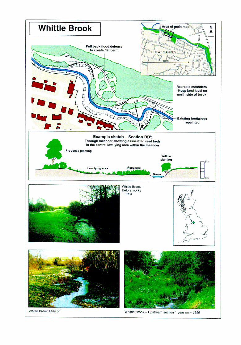
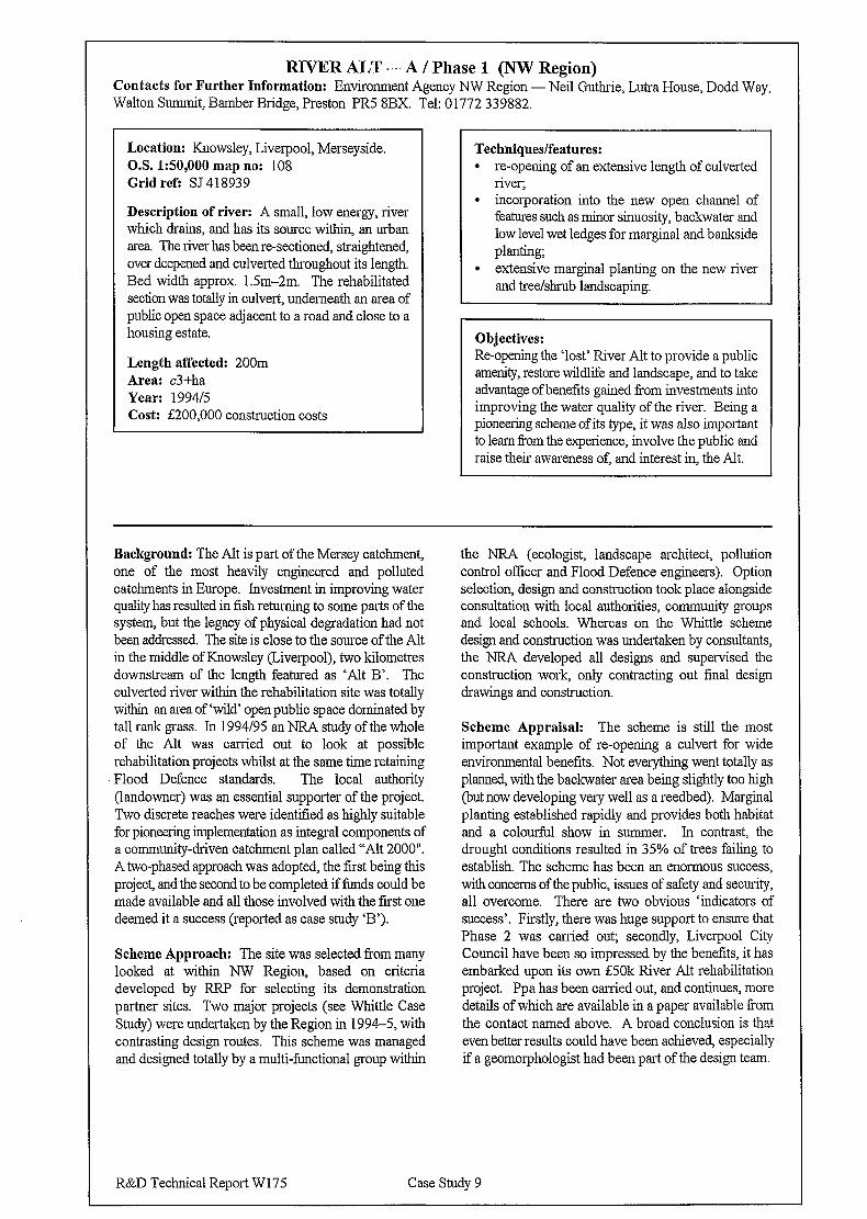
RIVER ALT - A / Phase 1 (NW Region) Contacts for Further Information: Environment Agency NW Region - Neil Guthrie, Lutra House, Dodd Way, Walton Summit, Bamber Bridge, Preston PR5 8BX. Tel: 01772 339882.
Location: Knowsley, Liverpool, Merseyside. OS. 1:50,000 map no: 108 Grid refi SJ 418939
Description of river: A small, low energy, river which drains, and has its source within, an urban area. The river has been re-sectioned, straightened, over deepened and culverted throughout its length. Bed width approx. lSm-2m. The rehabilitated section was totally in culvert, underneath an area of public open space adjacent to a road and close to a housing estate.
Length affected: 200m Area: c3+ha Year: 199415 Cost: f200,OOO construction costs
Techniques/features: l re-opening of an extensive length of culverted
river; l incorporation into the new open channel of
features such as minor sinuosity, backwater and low level wet ledges for marginal and bankside planting;
. extensive marginal planting on the new river and tree&rub landscaping.
Objectives: Re-opening the ‘lost’ River Alt to provide a public amenity, restore wildlife and landscape, and to take advantage of benefits gained from investments into improving the water quality of the river. Being a pioneering scheme of its type, it was also important to learn from the experience, involve the public and raise their awareness of, and interest in, the Ah.
Background: The Alt is part of the Mersey catchment, one of the most heavily engineered and polluted catchments in Europe. Investment in improving water quality has resulted in fish returning to some parts of the system, but the legacy of physical degradation had not been addressed. The site is close to the source of the Ah in the middle of Knowsley (Liverpool), two kilometres downstream of the length featured as ‘Ah B’. The culverted river within the rehabilitation site was totally within an area of ‘wild’ open public space dominated by tall rank grass. In 1994/95 an NRA study of the whole of the Alt was carried out to look at possible rehabilitation projects whilst at the same time retaining Flood Defence standards. The local authority (landowner) was an essential supporter of the project. Two discrete reaches were identified as highly suitable for pioneering implementation as integral components of a community-driven cat&n-rent plan called “Alt 2000”. A two-phased approach was adopted, the first being this project, and the second to be completed if funds could be made available and all those involved with the first one deemed it a success (reported as case study ‘B’).
Scheme Approach: The site was selected from many looked at within NW Region, based on criteria developed by RRP for selecting its demonstration partner sites. Two major projects (see Whittle Case Study) were undertaken by the Region in 1994-5, with contrasting design routes. This scheme was managed and designed totally by a multi-functional group within
the NRA (ecologist, landscape architect, pollution control officer and Flood Defence engineers). Option selection, design and construction took place alongside consultation with local authorities, community groups and local schools. Whereas on the Whittle scheme design and construction was undertaken by consultants, the NRA developed all designs and supervised the construction work, only contracting out final design drawings and construction.
Scheme Appraisal: The scheme is still the most important example of re-opening a culvert for wide environmental benefits. Not everything went totally as planned, with the backwater area being slightly too high (but now developing very well as a reedbed). Marginal planting established rapidly and provides both habitat and a colourful show in summer. In contrast, the drought conditions resulted in 35% of trees failing to establish. The scheme has been an enormous success, with concerns of the public, issues of safety and security, all overcome. There are two obvious ‘indicators of success’. Firstly, there was huge support to ensure that Phase 2 was carried out; secondly, Liverpool City Council have been so impressed by the benefits, it has embarked upon its own E50k River Alt rehabilitation project. Ppa has been carried out, and continues, more details of which are available in a paper available from the contact named above. A broad conclusion is that even better results could have been achieved, especially if a geomorphologist had been part of the design team.
R&D Technical Report W175 Case Study 9
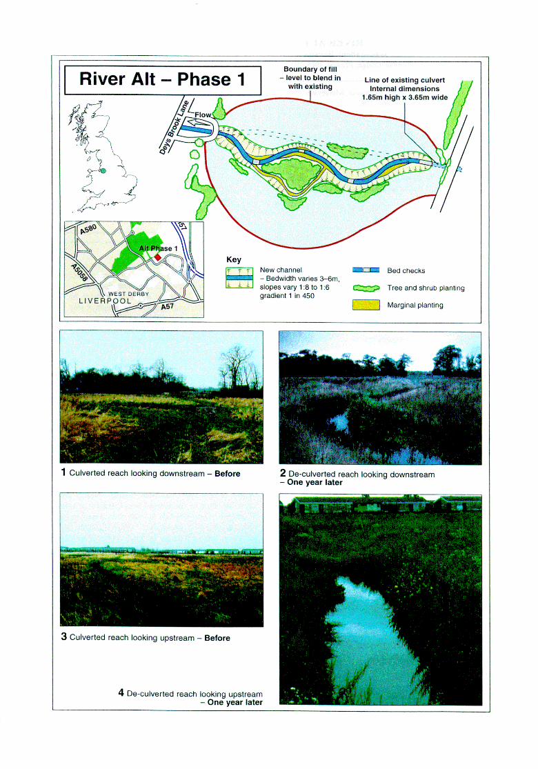
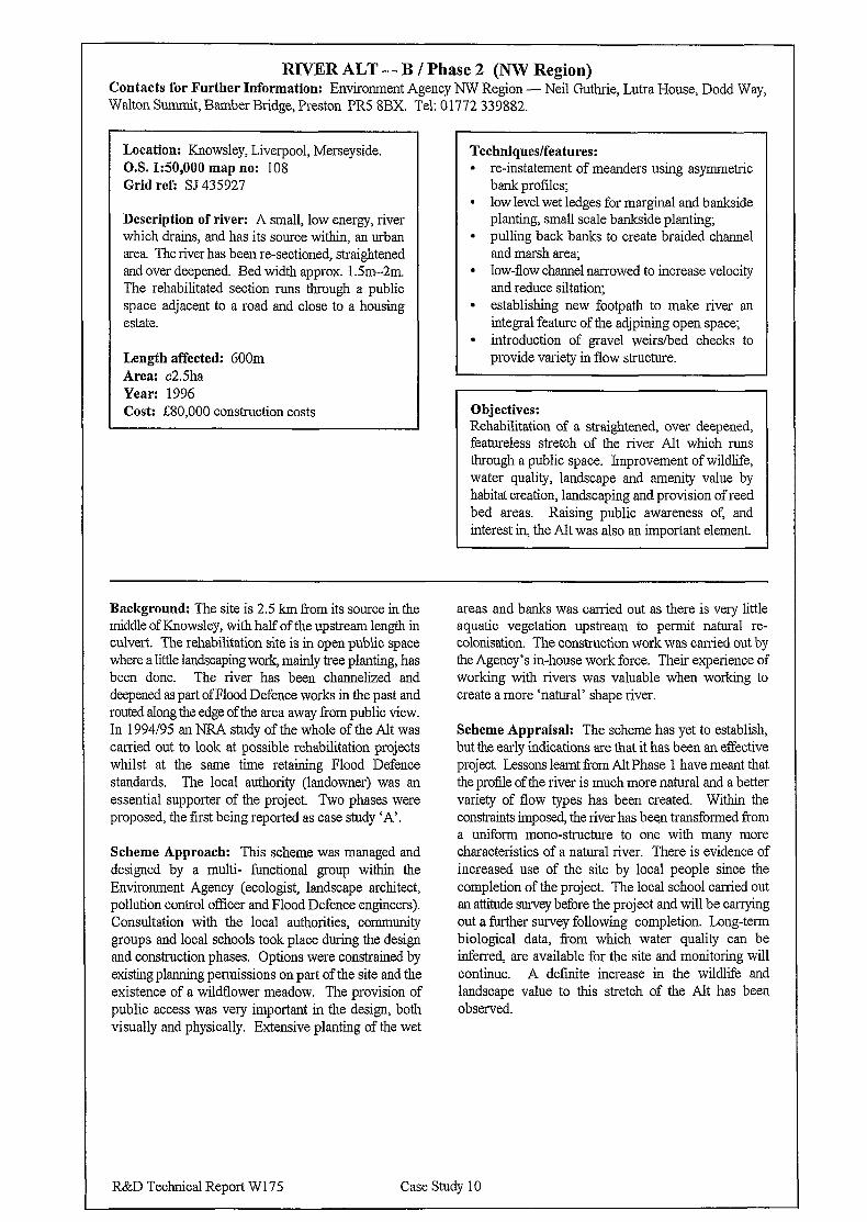
RIVER ALT - B / Phase 2 (NW Region) Contacts for Further Information: Environment Agency NW Region - Neil Guthrie, Lutra House, Dodd Way, Walton Summit, Bamber Bridge, Preston PR5 SBX. Tel: 01772 339882.
Location: Knowsley, Liverpool, Merseyside. O.S. 1:50,000 map no: 108 Grid ref: SJ 435927
Description of river: A small, low energy, river which drains, and has its source within, an urban area. The river has been re-sectioned, straightened and over deepened. Bed width approx. 1.5m-2m. The rehabilitated section runs through a public space adjacent to a road and close to a housing estate.
Length affected: 600m Area: c2.5ha Year: 1996 Cost: f80,OOO construction costs
Techniques/features: 9 re-instatement of meanders using asymmetric
bank profiles; l low level wet ledges for marginal and bankside
planting, small scale bankside planting; l pulling back banks to create braided channel
and marsh area; l low-flow channel narrowed to increase velocity
and reduce siltation; . establishing new footpath to make river an
integral feature of the adjpining open space; l introduction of gravel weirs/bed checks to
provide variety in flow structure.
Objectives: Rehabilitation of a straightened, over deepened, featureless stretch of the river Alt which runs through a public space. Improvement of wildlife, water quality, landscape and amenity value by habitat creation, landscaping and provision of reed bed areas. Raising public awareness of, and interest in, the Ah was also an important element.
Background: The site is 2.5 km from its source in the middle of tiowsley, with half of the upstream length in culvert. The rehabilitation site is in open public space where a little landscaping work, mainly tree planting, has been done. The river has been channelized and deepened as part of Flood Defence works in the past and routed along the edge of the area away from public view. In 1994195 an NRA study of the whole of the Alt was carried out to look at possible rehabilitation projects whilst at the same time retaining Flood Defence standards. The local authority (landowner) was an essential supporter of the project. Two phases were proposed, the first being reported as case study ‘A’.
Scheme Approach: This scheme was managed and designed by a multi- functional group within the Environment Agency (ecologist, landscape architect, pollution control officer and Flood Defence engineers). Consultation with the local authorities, community groups and local schools took place during the design and construction phases. Options were constrained by existing planning permissions on part of the site and the existence of a wildflower meadow. The provision of public access was very important in the design, both visually and physically. Extensive planting of the wet
areas and banks was carried out as there is very little aquatic vegetation upstream to permit natural re- colonisation. The construction work was carried out by the Agency’s in-house work force. Their experience of working with rivers was valuable when working to create a more ‘natural’ shape river.
Scheme Appraisal: The scheme has yet to establish, but the early indications are that it has been an effective project. Lessons learnt from Alt Phase 1 have meant that the profile of the river is much more natural and a better variety of flow types has been created. Within the constraints imposed, the river has been transformed Tom a uniform mono-structure to one with many more characteristics of a natural river. There is evidence of increased use of the site by local people since the completion of the project. The local school carried out an attitude survey before the project and will be canying out a further survey following completion. Long-term biological data, from which water quality can be inferred, are available for the site and monitoring will continue. A definite increase in the wildlife and landscape value to this stretch of the Ah has been observed.
R&D Technical Report W 17 5 Case Study 10
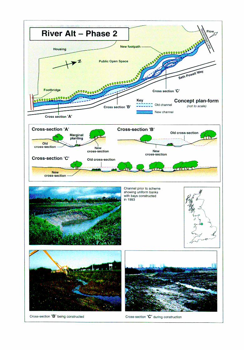
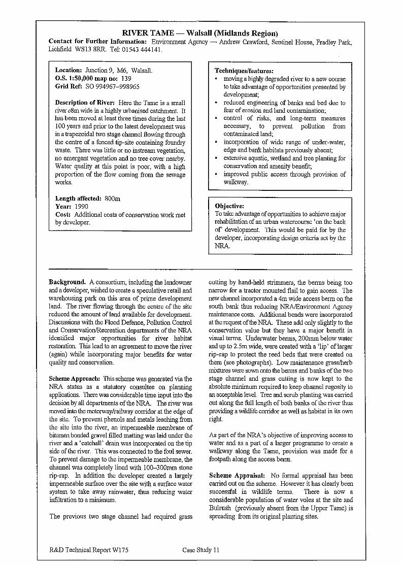
RIVER TAME - Walsall (Midlands Region) Contact for Further Information: Environment Agency - Andrew Crawford, Sentinel House, Fradley Park, Lichtield WS13 8RR. Tel: 01543 444141.
Location: Junction 9, M6, Walsall. O.S. 150,000 map no: 139 Grid Refi SO 994967-998965
Description of River: Here the Tame is a small river c8m wide in a highly urbanised catchment. It has been moved at least three times during the last 100 years and prior to the latest development was in a trapezoidal two stage channel flowing through the centre of a fenced tip-site containing foundry waste. There was little or no instream vegetation, no emergent vegetation and no tree cover nearby. Water quality at this point is poor, with a high proportion of the flow coming from the sewage works.
Length affected: 800m Year: 1990 Cost: Additional costs of conservation work met by developer.
Techniques/features: l moving a highly degraded river to a new course
to take advantage of opportunities presented by development;
l reduced engineering of banks and bed due to fear of erosion and land contamination;
l control of risks, and long-term measures necessary, to prevent pollution from contaminated land,
l incorporation of wide range of under-water, edge and bank habitats previously absent;
l extensive aquatic, wetland and tree planting for conservation and amenity benefit;
l improved public access through provision of walkway.
Objective: To take advantage of opportunities to achieve major rehabilitation of an urban watercourse ‘on the back of development. This would be paid for by the developer, incorporating design criteria set by the NRA.
Background. A consortium, including the landowner and a developer, wished to create a speculative retail and warehousing park on this area of prime development land. The river flowing through the centre of the site reduced the amount of land available for development. Discussions with the Flood Defence, Pollution Control and Conservation/Recreation departments of the NRA identified major opportunities for river habitat restoration This lead to an agreement to move the river (again) while incorporating major benefits for water quality and conservation.
Scheme Approach: This scheme was generated via the NRA status as a statutory consultee on planning applications. There was considerable time input into the decision by all departments of the NRA. The river was moved into the motorway/railway corridor at the edge of the site. To prevent phenols and metals leaching from the site into the river, an impermeable membrane of bitumen bonded gravel filled matting was laid under the river and a ‘catchall’ drain was incorporated on the tip side of the river. This was connected to the foul sewer. To prevent damage to the impermeable membrane, the channel was completely lined with lOO-300mm stone rip-rap. In addition the developer created a largely impermeable surface over the site with a surface water system to take away rainwater, thus reducing water infiltration to a minimum.
The previous two stage channel had required grass
cutting by hand-held strirnmers, the berms being too narrow for a tractor mounted flail to gain access. The new channel incorporated a 4m wide access berm on the south bank thus reducing NRA/Environment Agency maintenance costs. Additional bends were incorporated at the request of the NRA. These add only slightly to the conservation value but they have a major benefit in visual terms. Underwater berms, 200mm below water and up to 2.5m wide, were created with a ‘lip’ of larger rip-rap to protect the reed beds that were created on them (see photographs). Low maintenance grass/herb rnkures were sown onto the berms and banks of the two stage channel and grass cutting is now kept to the absolute minimum required to keep channel rugosity to an acceptable level. Tree and scrub planting was carried out along the full length of both banks of the river thus providing a wildlife corridor as well as habitat in its own light.
As part of the NRA’s objective of improving access to water and as a part of a larger programme to create a walkway along the Tame, provision was made for a footpath along the access berm.
Scheme Appraisal: No formal appraisal has been carried out on the scheme. However it has clearly been successful in wildlife terms. There is now a considerable population of water voles at the site and Bulrush (previously absent from the Upper Tame) is spreading from its original planting sites.
R&D Technical Report W175 Case Study 1 I
RIVER COLE - Project Kingfisher (Midlands Region) Contact for Further Information: Project Kingfisher (PK) - Jon Clarkson, Shard End Community Centre, Packington Avenue, Shard End, Birmingham B34 7RD. Tel: 01021 749 3131. Environment Agency - Andrew Crawford, Sentinel House, Wellington Crescent, Fradley Park, Lichtield WS 13 SRR. Tel: 01543 444 14 1.
Location: South East Birmingham O.S.1:50,000 map no: 139 Grid refi SP 118.5 - SP 1989
Description of River: The Cole within the PK area is a combination of straightened and meandering reaches of cS-1Om width, with shallow steep banks predominantly <lm high, and a gravel/pebble bed. It has been heavily engineered in places to improve flood protection, with some stretches constrained by sheet piling; however a floodplain width of between lOO-1000m has been retained as public open space and is subject to periodic flooding. The catchment is highly urbanised, with over 150,000 people living within 2km of the river, urban run-off thus causes periodic poor water quality and significant litter.
Length affected: cl lkm Years: 1985-97 Cost: Variable, from E3k upwards (Yardley Brook channel naturalization jZ5k)
Three recent examples of river rehabilitation projects are featured opposite:
In early 1994 the NR4 removed a >500m section of sheet piling in the Shard End area (2) and re- profiled the banks - the river is now free to erode and deposit material to form natural habitats. Where sheet piling could not be removed it was screened with rocks and soil which is colonised by riverside vegetation.
Yardley brook (3) arises in urbanised Solihull and emerges from culvert to traverse the floodplain of the Cole in a concrete channel. In 1995 the NRA dug a 120m replacement channel alongside it, stock-piling the spoil between the new and the old channel. The flow was then diverted through the new channel and the concrete of the old channel smashed up before being covered by the arisings from the new channel. This was deemed so successful that a further length was removed from a concrete straight-jacket in 199617.
At Fordbridge (4) a concrete weir, which was a barrier to fish movement except in high flows, was removed by the NRA in 1995 and replaced by a more natural gradient using boulders and other stones.
Background: Project Kingfisher is dedicated to caring for more than 1 lkm of the River Cole and its valley to the east of Birmingham. It was formed as a collaborative venture by West Midlands County Council prior to its abolition in 1985 with a vision to be: “A collaboration between local and statutory authorities and volunteer groups to achieve a substantial upgrading in the wildlife quality of the Cole and adjacent land in Solihull and Binningham”. Since that time it has been a joint project between Birmingham and Solihull Councils with funding and other support from CoCo, EN, NRMEnviromnent Agency, Urban Wildlife Trust and Warwickshire Wildlife Trust. In partnership with the NRA/Environment Agency (and previous to this, with Severn Trent Water Authority) a large number of river rehabilitation projects have been undertaken on the Cole and some of its small tributaries. The creation of floodplain pools and wetlands were featured as a case study in The New Rivers and Wildlife Handbook (sites shown as 1 a-c on plan).
Scheme Approaches: The examples cited above have been generated through partnership with the NRA, and further work with the Environment Agency is in progress and planned. The Agency is responsible for flood
defence, so in-channel works were primarily undertaken by their worlcforce. Critical support has been provided by the Flood Defence function; each proposal for rehabilitation is assessed according to risk to flooding and property damage. Where problems to neither are perceived, Conservation and other staff prepare outline plans for approval and then provide on-site supervision of work so that amendments can take place based on local conditions arising from the excavations. Some works have been undertaken which provide improved access to, and across the river to meet the objective of bringing human benefits.
Scheme Appraisals: The three schemes cited above have all been extremely successful, the first two making spectacular changes in landscape, visual amenity and ecology. After winter floods Yardley Brook has developed very ‘natural’ channel features and where sheet piling was removed on the Cole unacceptable erosion has not occurred. The Agency holds more details of the river works whilst reports/newsletters of PK provide information on management and public involvement in rehabilitating, and use of, the River Cole valley.
R&D Technical Report W 175 Case Study 12

RIVER STOUR - Clifford Chambers (Midlands Region) Contact for Further Information: Environment Agency Lower Severn - Liz Galloway, Riversmeet House, Newtown Industrial Estate, Tewkesbury, Gloucestershire GL20 SJG. Tel: 0 1684 85095 1.
Location: Cifford Chambers, Stratford-upon- Avon O.S. l:SO,OOO map no: 151 Grid refi SP 201519
Description of river: Slow moving lowland river, flowing through a relatively narrow floodplain dominated by permanent pasture, within a clay catchment. The affected reach of the Stour is clOm wide, and was embanked on the inside of the meander to protect a fish farm from flooding.
Length affected: c500m Area: 0.66ha Cost: gl8k
Techniques/features: l landscape and ecological floodplain
rehabilitation as an integral part of improving flood conveyance, flood storage and flood protection;
l removal of embankments to increase floodplain inundation;
l floodplain re-profiling to establish waterside environments by creation of a floodplain meadow, a small stream, associated marsh and pond;
. a high level mill leat being utilized to sustain a flow through floodplain wetlands;
l de-silting and re-shaping of the tailrace to restore historic open water and wetland habitats.
Objectives: To improve flood conveyance and floodplain storage resulting in reduced flood risk to properties. In tandem with this, restore floodplain wetland habitats and improve ecological, landscape and amenity value of an area suffering due to dereliction of a fish farm.
Background: A fish farm was constructed on an area of floodplain at The Old Mill, Clifford Chambers, between the Mill Leat and the River Stour. The fish farm consisted of ~20 steep-sided ponds, connected by a deteriorating network of concrete channels. To prevent farm fish loss during times of flood, the site was totally contained within earth embankments. After a relatively short working life the farm ceased operation and lay derelict for several years. The embankments were no longer protecting a fish farm but they reduced the flood water storage capacity of the valley floor and were an obstruction to flood flows. The site became increasingly unsightly and dangerous due to structural deterioration in what was otherwise an unspoiled rural riverside setting on th.e edge of a village Conservation Area, adjacent to a well used footpath. The Old Mill and adjacent properties are Listed Buildings. Arthur Amos Associates were contracted to work with the Agency on the design and supervision of the project.
Scheme Approach: The project developed because the present owner of the Mill and derelict ponds was keen to see improved flood protection standards combined with restoration of floodplain habitats. Work began with a detailed topographic and structure survey, followed by site investigation into the construction of embankments, tanks, sluices and channels. This enabled calculations of cut and fill options to take place. Site restoration options were appraised to discover the best practical option which would achieve project objectives within the available budget. Particular problems presented by the site included: site access; overhead electricity cables;
steep-sided fish tanks containing soft silt; deep channels. Culverts under the Mill were weak so the large machinery required gained access to the site via an old ford across the Stour. Prior to de-watering, all wet ponds were fished to remove stock (principally eels), which were then released into the adjacent sluice pond. All pipes, concrete structures and pond bases were demolished and buried in the deeper ponds before systematic cut, fill, and compaction took place to achieve the desired profiles. Prior to the site being graded to form pond, stream, and marsh profiles, the floodbanks were pulled down and spread over the site. The existing fish farm water inlet, and outlet structures, were adapted to allow water flow though the site.
Fish farm construction had achieved a thorough mixing of soil on the site, so no attempt was made to conserve topsoil. Initial works were completed in February 1996 and the site was left until the summer months before final grading and cultivation. An initial flush of wildflowers and grasses led to the cancelling of reseeding proposals; re-colonisation of the meadow, pond and marsh area has been left to natural seed spread from within the locality.
Scheme Appraisal: It is too early to assess fully, but early signs are that improved hydraulic performance will be achieved alongside river and floodplain rehabilitation. A vegetation management plan has been drawn up for the site and monitoring to record vegetation development is underway.
R&D Technical Report W175 Case Study 13
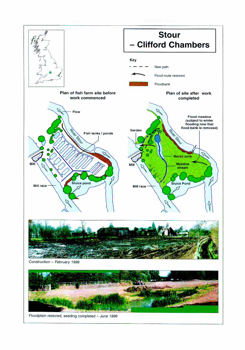
CANLEY BROOK - Tocil Wetlands (Midlands Region) Contact for Further Information: Environment Agency Lower Severn Area-Liz Galloway, Riversmeet House, Northway Lane, Newtown Industrial Estate, Tewkesbmyi Gloucestershire GL20 8JG. Tel: 01684 850951.
Location: University of Warwick (VW), near Coventry O.S. 1:50,000 map no: 140 Grid refi SP 3075
Description of river: Small watercourse, <4m wide, flowing through open countryside and university grounds. The site is less than 1 Okm from the brook’s source, and is the first location for more than 5km where urban developments have not encroached onto the floodplain.
Length affected: 1.5km Area: 1 Sha Years: 1989-91 main works; sub-projects 1992 + 199617 Cost: 63 8k
Techniques/features: l old meander re-excavated and connected to the
main river as a back-channel; l large pool created with variable bed and bank
profiles (and island); . extensive tiered marsh/reed area created on-
stream, allowing wide range of levels for marginal plant habitat;
l small timber weir to maintain upstream levels in times of low flow;
l wilderness area between river and pools; l wetland meadow with swathes of wetland wild
flowers; l appropriate riparian and floodplain planting -
including marsh plants and willows for pollarding alongside the river.
Objectives: To reinstate diverse wetland features, catering for recreational access along the river and educational opportunities for all ages from primary to undergraduate ages. Creating a progression from amenity use around the campus walkway across to the more secluded area of Tocil Woods.
Background: The University of Warwick approached the NRA in 1989 to seek advice and collaboration to carry out a significant wetland enhancement project to celebrate their 25th Anniversary. The site proposed for the project had already been identified, being tipped waste land alongside the ‘improved’ Canley Brook.
Scheme Approach: The first project concentrated on the restoration of an area of floodplain alongside Canley Brook, which had been previously straightened, deepened by 0.5m, and meanders cut off, to carry run-off from industrial developments upstream. This initial project was designed and supervised by Mark Ross Landscape Architects, with environmental, ecological, archaeological, graphics and surveying consultants being used by them as necessary. Following on Tom this Dr Duncan Jefh-ay (Warwickshire Wildlife Trust) provided advice relating to creation of specific habitats and to the individual needs of species to be re-established. It was a collaborative project involving the NRA (primary funders) and UW, with inputs ti-om local interest groups. The scheme designs developed as more was learnt from the site, the desire being to have a progression created across the site corn remote areas of damp woodland and reeds, across the river to more accessible wetlands, open water and amenity areas of grassland within the campus. A walkway links to variable pond dipping areas designed for disabled access and a boardwalk through a Phragmites reedbed. A feature of the site is a tiered
reedbed which is connected to a widened bay of the brook. It was created in 1OOmm steps to provide a diverse range of water-logged conditions so that no less than 14 different reeds, rushes and herbs could be established on it. There has been experimental use of timber piling and geotextiles for ‘soft’ treatment of outfalls. A detailed Management Plan was prepared for the whole site and Educational Packs produced in conjunction with the University Science Education Department.
Scheme Appraisal: The site was opened formally in 1991 with a Water Art Competition run for schools in three counties. Interpretation Panels and leaflets have been produced and pond dipping equipment provided for educational use. Heavy use and ad hoc observations of habitat developments indicates that the project has been a great success, achieving ecological, landscape, and amenity benefits. It has proved to be a valued education resource covering a wide age-range.
The success of the initial project has prompted plans for further work. The historically wetter elements of Tocil Wood are still drying out, which is detrimental to both its ecology and archaeological remains (mainly timber) dating from the 12th century. Raising water levels in Canley Brook upstream of the initial floodplain works; in an attempt to protect the wetland-dependent interests, is currently being investigated for the Agency.
R&D Technical Report W175 Case Study 14
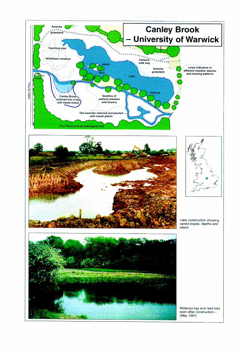
RIVER EREWASH - Long Eaton (Midlands Region) Contact for Further Information: Environment Agency - Valerie Holt, Scarrington Road, West Bridgford, Nottingham NG2 5FA. Tel: 01159 455722. Fax: 817743
Location: Long Eaton, Derbyshire O.S. 150,000 map no: 129 Grid refi SK 483359-489344
Description of river: An urban watercourse sandwiched between Long Eaton and Toton on the western fringe of Nottingham City. The river has been straightened, but not excessively deepened. Bed-width is 6-l 2m, with banks rarely greater than 1.25m high. Substrates include gravels, pebbles, clay and silts (which include urban run-oft).
Length affected: 700m Years: 1994-96 Cost: 535k (Meander I = ;El5k, Meander II g2Ok)
Techniques/features: l reconnection of two cut-off meanders with river; l floodplain lakes created as part of scheme to
widen floodbanks; l various scrapes formed in remnant low spots; l drying ponds formed from redundant channels
enlarged/restored; l small watercourse dug to feed water to ponds
from re-connected meander loop; l bank re-profiling of existing channel and
restored meander loops; l planting of reeds etc in restored/created ponds; . planting on island created by restoration of the
meander.
Objectives: As part of the required Flood Defence works of widening a floodbank, create two lakes within the floodplain to augment the existing remnant channels present. As purely conservation, fishery and recreation enhancements, restore some sinuosity to the river by re-opening two former meander loops and improving the physical diversity of the channel margins and banks. In addition to in- channel restorations, halt the succession of redundant floodplain pools to scrub by dredging them to variable extents, depths and profiles to restore open water and a variety of stages in succession.
Background: The site is on the Erewash just a few kilometres upstream of its confluence with the Trent (in the post-glacial floodplain of the river). Whereas centuries ago the Erewash here was a meandering, low gradient river; now it is straightened, being flanked on the west by the Erewash Canal and the east by a railway line. Despite being straightened, the historic engineering works retained a floodplain of l-200m width and cut-off meanders which were not m-filled. The cut-offs are numerous, and are in a variety of stages of succession - some still retaining open water (but with deep silt), whilst others are completely reeded over or succumbed to scrub encroachment. River corridor surveys in the late 1980s identified enormous opportunities for channel and floodplain restoration and rehabilitation as part of needed Flood Defence works (floodbank widening) and as Conservation, Fisheries and Recreation projects in their own right.
Scheme Approach: The first project included the creation of two floodplain lakes (to the design of Conservation) as part of the Flood Defence works to widen the floodbank. In addition to this some shallow scrapes were also created and drying ancient floodplain pools restored as part of this work in 1994. Conservation, Fisheries and Flood Defence personnel then combined forces to develop an integrated river channel and floodplain restoration project. Designs were
prepared for reconnecting two historic meander loops to the straightened channel. To ensure Flood Defence needs were not compromised, the existing straight channel was retained and flow diverted through the restored channels by means of a sloping riffle weir. Bank re-profiling was also planned to maximise the wider environmental benefit of the restored meander loop and facilitate appropriate planting. One meander was restored in early 1996, the second in the winter 9617. Further restoration of drying, silted or over-grown cut-off water bodies continued in 1996-7 to restore a wide variety of sizes, depths, profiles and vegetation character of these floodplain features. The project was designed by Valerie Holt, Tom Baker and Stephen King in-house. Work was undertaken and supervised by in-house work force. Costs were kept low as no consultants were contracted and hydraulic performance was vouched for by Agency Flood Defence engineers. Full levels surveys were undertaken to ensure correct gradients.
Scheme Appraisal: It is too early to be sure of its success, but early signs are very good. The use of internal personnel has kept costs to a minimum, increased in-house expertise and illustrated multi- functional partnerships working in practice. There is a full set of pre-scheme River Habitat Survey (RHS), RCS, macro-invertebrate and fish survey data. A management plan has also been produced.
R&D Technical Report W175 Case Study 15
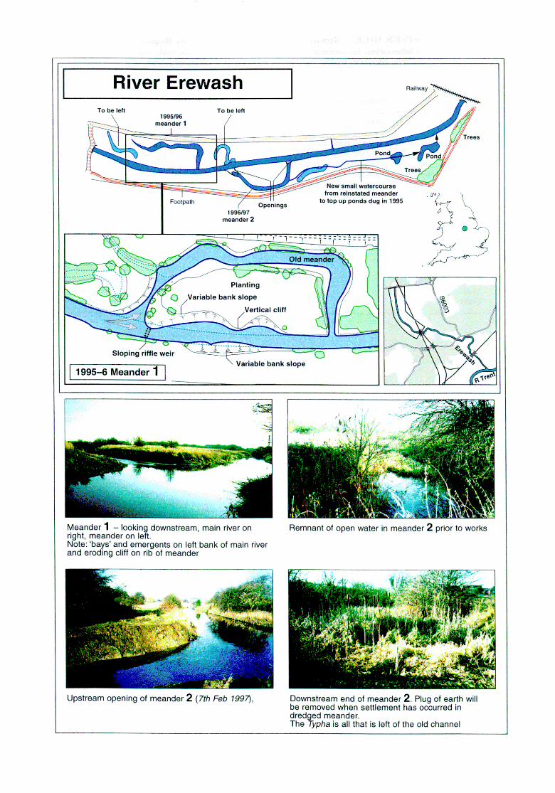
RIVER IDLE - downstream of Retford (Midlands Region) Contact for Further Information: Environment Agency Midlands Region -Martin Stark, Scarrington Road, West Bridgford, Notts NG2 5FA Tel: 01159 455722. Fax: 8 17743. Peter Downs, Geography, Univ. of Nottingham NG7 2RD:
Location: Chainbridge, Retford, Notts. OS. 1:50,000 map no: 120 Grid refi SK 703843-714889
Description of river: A rural river flowing through flat arable land below 10m high. It has a meandering planform but has been extensively dredged and embanked. Within the reach the flow character is almost universally ponded or slack, with short stretches of faster water very rare. The substrate contains gravel, but this is only exposed intermittently in locations where scour is sufficient to remove a blanket of silty-sand which otherwise smothers the bed. Steep trapezoidal banks rise out of the water, there being few sections with low wetland shelves present.
Length affected: c4km Years: 1995-96 Cost: f4Ok
Techniques/features: l geomorphologically-led rehabilitation project
incorporating features to aid the river’s own natural ability to restore structural diversity;
. experimental designs of in-stream deflectors (winged bank types and instream ‘A’ frame) in previously uniform stretches to create local narrowing leading to increased velocities, fine sediment scour and creation of pools, runs and discrete sediment bar formations;
l installation of ‘lobate’ riffles formed from imported gravel to create downstream scour to form pools;
l bank re-profiling - shallowing the inside of bends and steepening the outside;
l planting of reeds on the inside of bends to enhance habitat cover and simulate deflectors;
l fish cover under banks opposite deflectors (imported wooden frames installed underwater).
Objective: Gradual and sustainable habitat improvements to a severely degraded river channel. This objective to have multi-functional benefit without compromising existing Flood Defence standard.
Background: Improved flood conveyance in the Idle has been achitived through several inter-related actions. These include deep dredging (deepening and widening), embanking and pumping. River works have tended to retain the original plan-form, this being reported by Nottingham University as not have changed greatly over the past 200 years. A major flood in 1977 prompted renewed works which led to further dredging and re- sectioning to increase cross-sectional area and improve floodbanks. Details of the Project Development are provided in a paper by Downs and Thome submitted to Aquatic Conservation.
Scheme Approach: In 1994 the NRA commissioned an investigation into the potential for rehabilitation of the East Retford to Bawtry reach of the channel of the River Idle. This was undertaken by Peter Downs and Colin Thome of the Geography Department at the University of Nottingham. The approach was to co-ordinate a variety of surveys on the river and undertake their own geomorphological studies, to determine the objectives of rehabilitation. The process identified a river reach with very poor structural diversity, leading to minimal geomorphological and biotic conservation value and a generally poor fishery based on biomass and species. Public perception studies and amenity use assessments were also undertaken, the former providing evidence that the general public favoured the more ‘natural target’ conditions than those present. In developing the concepts for achieving in-stream rehabilitation, the design worked
with the need to maintain the present Flood Defence standards. The design was by Downs and Thome at Nottingham
After investigating over 1Okn-1 of degraded river, and determining a reference site to mimic, the consultants proposed a 4km reach which was most amenable to rehabilitation. They described it as “monotonous geomorphologically, has sand covering a majority of the channel bed, and is of very limited value ecologically due to its uniform channel banks.....However the reach retains some of its natural sinuosity and its embankments are set back....angling club interests mean that short- term recreational as well as ecological improvements can be attempted.” The key to identifying sustainable rehabilitation solutions was sediment management, recognising that low stream power promotes deposition not erosion. Catchment-wide measures to control sediment inputs were suggested, including river corridor plantings. In-stream measures proposed for the target rehabilitation reach are listed above. Prior to implementation the hydraulic implications were modelled. Work was undertaken by in-house Agency workforce, supervised by Martin Stark (Fisheries).
Scheme Appraisal: It is too early to determine if the objectives will be fi~lly met, but a comprehensive ppa is being undertaken, co-ordinated by Nottingham University.
R&D Technical Report W 175 Case Study 16
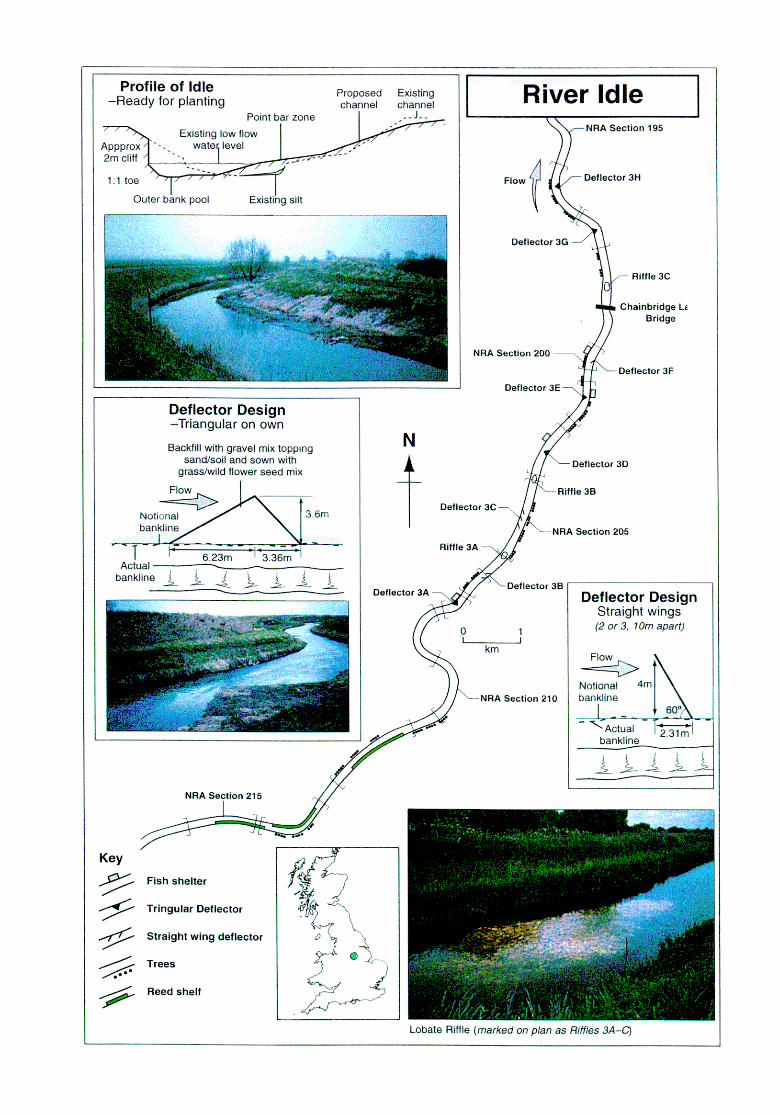
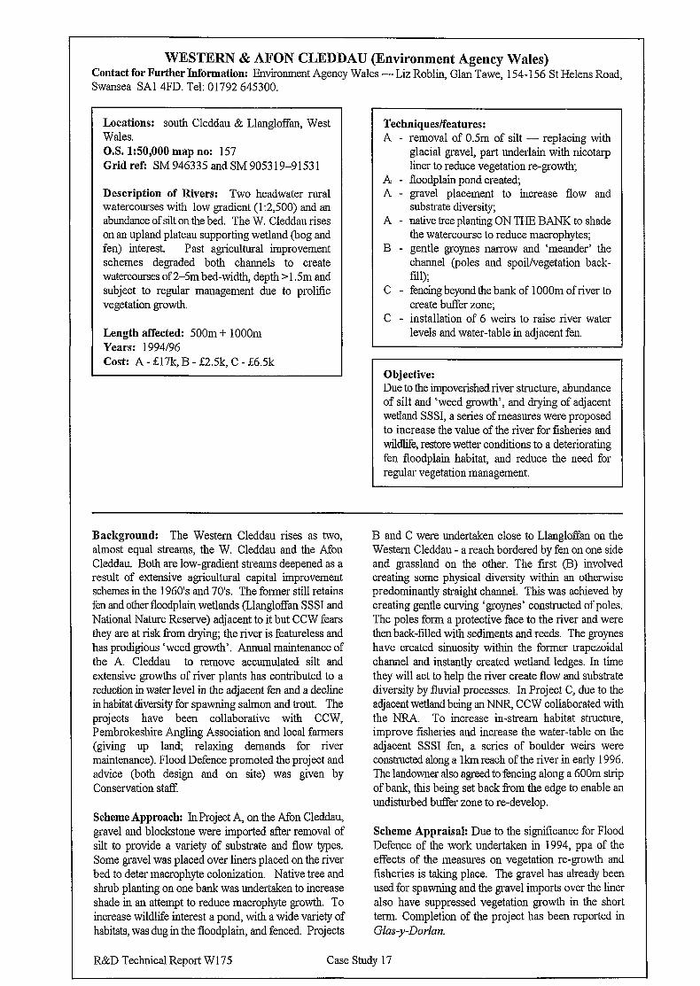
WESTERN & AFON CLEDDAU (Environment Agency Wales) Contact for Further Information: Environment Agency Wales - Liz Roblin, Glan Tawe, 154-l 56 St Helens Road, Swansea SAl 4FD. Tel: 01792 645300.
Locations: south Cleddau & Llangloffan, West Wales. O.S. 1:50,000 map no: 157 Gridrefi SM946335andSM905319-91531
Description of Rivers: Two headwater rural watercourses with low gradient (1:2,500) and an abundance of silt on the bed. The W. Cleddau rises on an upland plateau supporting wetland (bog and fen) interest. Past agricultural improvement schemes degraded both channels to create watercourses of 2-5m bed-width, depth > 1.5m and subject to regular management due to prolific vegetation growth.
Length affected: 500m + 1OOOm Years: 1994/96 Cost: A - &17k, B - &2.5k, C - L6.5k
Techniques/features: A - removal of 0.5m of silt - replacing with
glacial gravel, part underlain with nicotarp liner to reduce vegetation regrowth;
A - floodplain pond created; A - gravel placement to increase flow and
substrate diversity; A - native tree planting ON THE BANK to shade
the watercourse to reduce macrophytes; B - gentle groynes narrow and ‘meander’ the
channel (poles and spoil/vegetation back- till);
C - fencing beyond the bank of 1 OOOm of river to create buffer zone;
C - installation of 6 weirs to raise river water levels and water-table in adjacent fen.
Objective: Due to the impoverished river structure, abundance of silt and ‘weed growth’, and drying of adjacent wetland SSSI, a series of measures were proposed to increase the value of the river for fisheries and wildlife, restore wetter conditions to a deteriorating fen floodplain habitat, and reduce the need for regular vegetation management.
Background: The Western Cleddau rises as two, almost equal streams, the W. Cleddau and the Afon Cleddau. Both are low-gradient streams deepened as a result of extensive agricultural capital improvement schemes in the 1960’s and 70’s. The former still retains fen and other floodplain wetlands (Llangloffan SSSI and National Nature Reserve) adjacent to it but CCW fears they are at risk from drying; the river is featureless and has prodigious ‘weed growth’. Annual maintenance of the A. Cleddau to remove accumulated silt and extensive growths of river plants has contributed to a reduction in water level in the adjacent fen and a decline in habitat diversity for spawning salmon and trout. The projects have been collaborative with CCW, Pembrokeshire Angling Association and local farmers (giving up lank relaxing demands for river maintenance). Flood Defence promoted the project and advice (both design and on site) was given by Conservation staff
Scheme Approach: In Project A, on the Afon Cleddau, gravel and blockstone were imported after removal of silt to provide a variety of substrate and flow types. Some gravel was placed over liners placed on the river bed to deter macrophyte colonization. Native tree and shrub planting on one bank was undertaken to increase shade in an attempt to reduce macrophyte growth. To increase wildlife interest a pond, with a wide variety of habitats, was dug in the floodplain, and fenced. Projects
B and C were undertaken close to Llangloffan on the Western Cleddau - a reach bordered by fen on one side and grassland on the other. The first (B) involved creating some physical diversity within an otherwise predominantly straight channel. This was achieved by creating gentle curving ‘groynes’ constructed of poles. The poles form a protective face to the river and were then back-filled with sediments and reeds. The groynes have created sinuosity within the former trapezoidal channel and instantly created wetland ledges. In time they will act to help the river create flow and substrate diversity by fluvial processes. In Project C, due to the adjacent wetland being anNNR, CCW collaborated with the NRA. To increase in-stream habitat structure, improve fisheries and increase the water-table on the adjacent SSSI fen, a series of boulder weirs were constructed along a lkm reach of the river in early 1996. The landowner also agreed to fencing along a 600m strip of bank, this being set back from the edge to enable an undisturbed buffer zone to re-develop.
Scheme Appraisal: Due to the significance for Flood Defence of the work undertaken in 1994, ppa of the effects of the measures on vegetation regrowth and fisheries is taking place. The gravel has already been used for spawning and the gravel imports over the liner also have suppressed vegetation growth in the short term. Completion of the project has been reported in Glas-y-Dorlan.
R&D Technical Report W175 Case Study 17
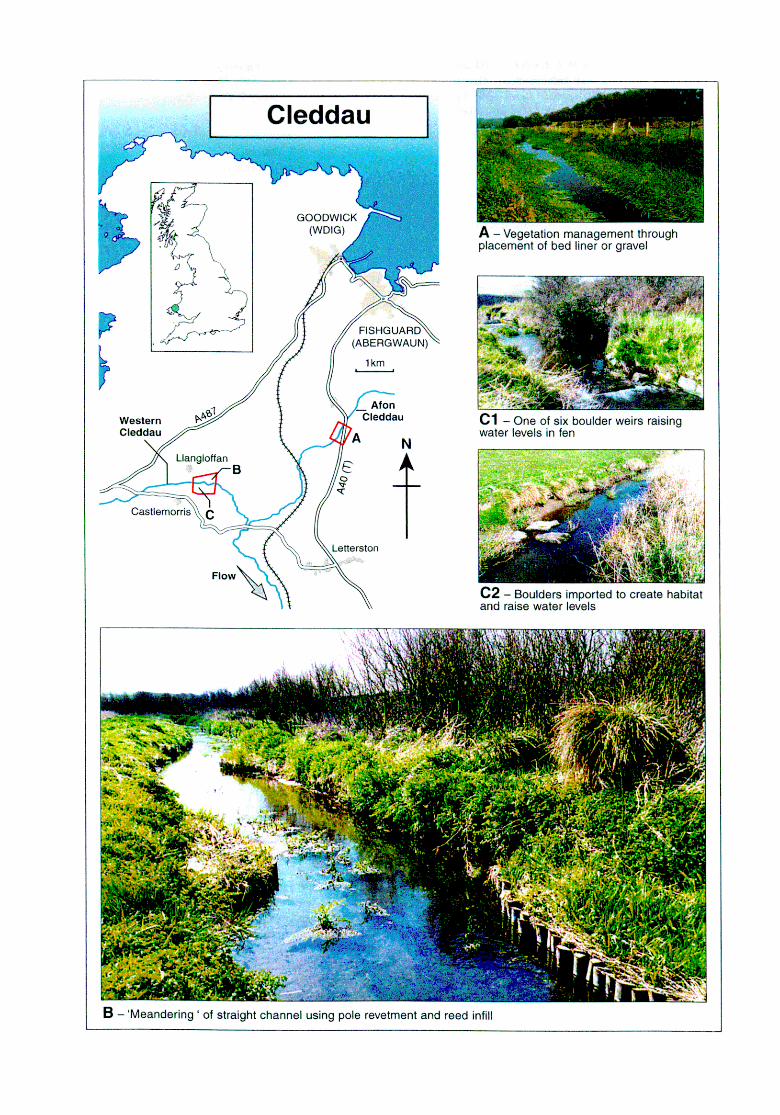
RIVER CEFNI - Malltraeth Marsh (Environment Agency Wales) Contact for Further Information: Countryside Council for- Wales (CCW) - Sally Ellis, Bryn’Menai, Ffordd Caergybi, Bangor, Gwynedd LL57 2JA. Tel: 01248 373 100. Environment Agency Wales -Bryan Jones, Ffordd Penlan, Part Menai, Bangor LL57 4BP. Tel: 01248 670770.
Location: Llangemi, Anglesey O.S. 1:50,000 map no: 114 Grid refi SH 4572-SH 4240
Description of River: The lower Cefhi is a canalised, embanked, virtually featureless, river carrying highland water from upstream across a flat lowland valley almost 8km long and 3km wide. The majority of the marsh either side is grazing land designated as SSSI. The canalization left considerable lengths of the previous course of the Cefni untouched, which are drying, tortuously meandering, linear water bodies left in the floodplain. It is these remnants of the old course which have been rehabilitated in recent years, alongside other actions to raise water levels in parts of the marsh for wetland restoration.
Length affected: c7km Area: >50ha Years: 1993-96 Cost: Not known
Techniques/features: . excavation of drying relic meanders and other
open water areas; . sluices on drains/ditches to raise water levels
in summer; . sluices and/or bunds to raise winter water
levels; . willow/scrub control and other vegetation
management; . improved bank profiles to the many ditches
that traverse the floodplain.
’ Objective: To restore the open water character of remnant cut- off channels of the Cefni that were being lost through drying and reed/rush/sweet-grass invasion. Combined with local restoration of high water tables, these measures ensure that the wildlife interests which gave rise to its notification as an SSSI are maintained and enhanced for the future.
Baclgkound: Malltraeth Marsh has developed from marine alluvium at the mouth of the Cefni. In 18 10 the river was canalised and embanked, with defences bulit to exclude the sea. Agricultural drainage followed, as well as the building’of the railway which resulted in some borrow areas developing open water habitats. The newly constructed ditches, borrow pit pools and relic meanders retained sign&ant botanical and invertebrate interest. This, added to the breeding bird communities of the lowland damp grasslands, resulted in the whole area being designated as SSSI, and part being purchased by the RSPB. Efficient drainage, and reed/rush invasion, threatens much of the interest for which the area has been designated To address the loss of wetland interests that was occurring, CCW has promoted co-operative projects in the past few years.
Scheme Approach: CCW has co-ordinated many of the activities undertaken on the marsh in recent years by interested bodies. Principal partners have been the Environment Agency, the Agricultural Advisory Service (ADAS), RSPB and other landowners. This Case Study refers only to actions (listed above) undertaken on private land by contractors appointed and supervised by CCW, or by the Agency when machinery has been on site for maintenance of the watercourses. Through such means a number of the choked relic meanders and borrow pits have had open water restored to enable the return of macrophytes and invertebrates for which the site is noted In undertaking such clearances, operatives take care not to dig too deeply and risk draining the pools. Raising water levels in ditches, and thereby raising water tables on adjacent land, requires land-
owner support. A number have given approval, but realising objectives is difficult due to the diverse nature of the clay, silt and sand soils. Sluices have normally been installed in locations where leakage through the bed will not occur. On RSPB land extensive bunds and sluices have been created to raise water levels to 2.0m OD; the objective is to provide ideal conditions to extend existing reedbeds and damp grassland to make the site suitable for bittern. On one area of private land the owner allowed a ditch to be sluiced at both ends, and water was allowed to flow over the bank and across gently sloping land adjacent. In other areas contractors have been supervised to control scrub invasion; the most effective method has been pulling willows out by the root.
Scheme Appraisal: The work on Malltraeth has had some monitoring, and this has indicated that many objectives are being realised. The technical details of much of the bund and sluice constructions on the RSPB reserve is described in the RSPB’s 1997 Wet Grassland Guide. CCW report that the plant communities of the meanders and borrow areas which have been de-silted have benefited greatly. Monitoring of invertebrates would be necessary to assess their responses to the works. Locally raised water levels and water tables have resulted in more wildfowl and waders being reported in some locations. However in some areas where water levels have been raised to target levels, the increase in bird numbers hoped for has not always been observed, possibly due to the areas being small and surrounded by fields still in intensive use.
R&D Technical Report W175 Case Study 18
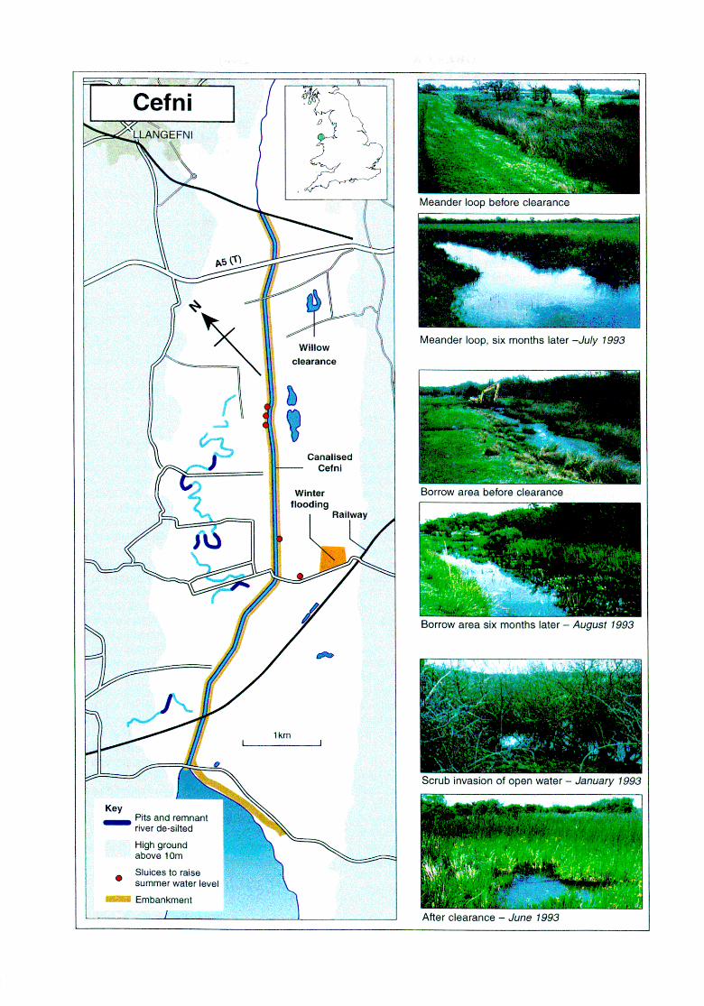
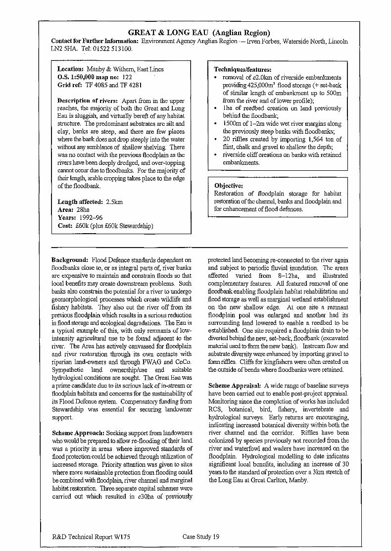
GREAT & LONG EAU (Anglian Region) Contact for Further Information: Environment Agency Anglian Region - Irven Forbes, Waterside North, Lincoln LN2 5HA. Tel: 01522 513100.
Location: Manby & Withem, East Lines O.S. 150,000 map no: 122 Grid ref: TF 4085 and TF 4281
Description of rivers: Apart Tom in the upper reaches, the majority of both the Great and Long Eau is sluggish, and virtually bereft of any habitat structure. The predominant substrates are silt and clay, banks are steep, and there are few places where the bank does not drop steeply into the water without any semblance of shallow shelving. There was no contact with the previous floodplain as the rivers have been deeply dredged, and over-topping cannot occur due to floodbanks. For the majority of their length, arable cropping takes place to the edge of the floodbank.
Length affected: 2.5km Area: 28ha Years: 1992-96 Cost: i60k (plus &60k Stewardship)
Techniques/features: l removal of c2.Okm of riverside embankments
providing 425,OOOm’ flood storage (+ set-back of similar length of embankment up to 500m from the river and of lower profile);
l lha of reedbed creation on land previously behind the floodbank;
l 1500m of l-2m wide wet river margins along the previously steep banks with floodbanks;
l 20 ties created by importing 1,564 ton of flint, chalk and gravel to shallow the depth;
l riverside cliff creations on banks with retained embankments.
for enhancement of flood defences.
Background: Flood Defence standards dependent on floodbanks close to, or as integral parts of, river banks are expensive to maintain and constrain floods so that local benefits may create downstream problems. Such banks also constrain the potential for a river to undergo geomorphological processes which create wildlife and fishery habitats. They also cut the river off from its previous floodplain which results in a serious reduction in flood storage and ecological degradations. The Eau is a typical example of this, with only remnants of low- intensity agricultural use to be found adjacent to the river. The Area has actively canvassed for floodplain and river restoration through its own contacts with riparian land-owners and through FWAG and CoCo. Sympathetic land ownership/use and suitable hydrological conditions are sought. The Great Eau was a prime candidate due to its serious lack of in-stream or floodplain habitats and concerns for the sustainability of its Flood Defence system. Compensatory funding from Stewardship was essential for securing landowner support.
Scheme Approach: Seeking support from landowners who would be prepared to allow re-flooding of their land was a priority in areas where improved standards of flood protection could be achieved through utilization of increased storage. Priority attention was given to sites where more sustainable protection from flooding could be combined with floodplain, river channel and marginal habitat restoration Three separate capital schemes were carried out which resulted in c30ha of previously
protected land becoming re-connected to the river again and subject to periodic fluvial inundation. The areas affected varied from 8-12ha, and illustrated complementary features. All featured removal of one floodbank enabling floodplain habitat rehabilitation and flood storage as well as marginal wetland establishment on the new shallow edge. At one site a remnant floodplain pool was enlarged and another had its surrounding land lowered to enable a reedbed to be established. One site required a floodplain drain to be diverted behind the new, set-back, floodbank (excavated material used to form the new bank). Instream flow and substrate diversity were enhanced by importing gravel to form riffles. Cliffs for kingfishers were often created on the outside of bends where floodbanks were retained.
Scheme Appraisal: A wide range of baseline surveys have been carried out to enable post-project appraisal. Monitoring since the completion of works has included RCS, botanical, bird, fishery, invertebrate and hydrological surveys. Early returns are encouraging, indicating increased botanical diversity within both the river channel and the corridor. Riffles have been colonized by species previously not recorded from the river and waterfowl and waders have increased on the floodplain. Hydrological modelling to date indicates significant local benefits, including an increase of 30 years to the standard of protection over a 3km stretch of the Long Eau at Great Carlton, Manby.
R&D Technical Report W175 Case Study 19
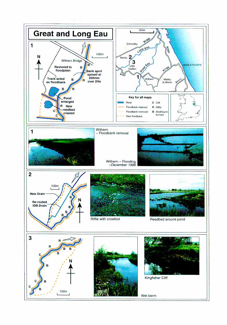
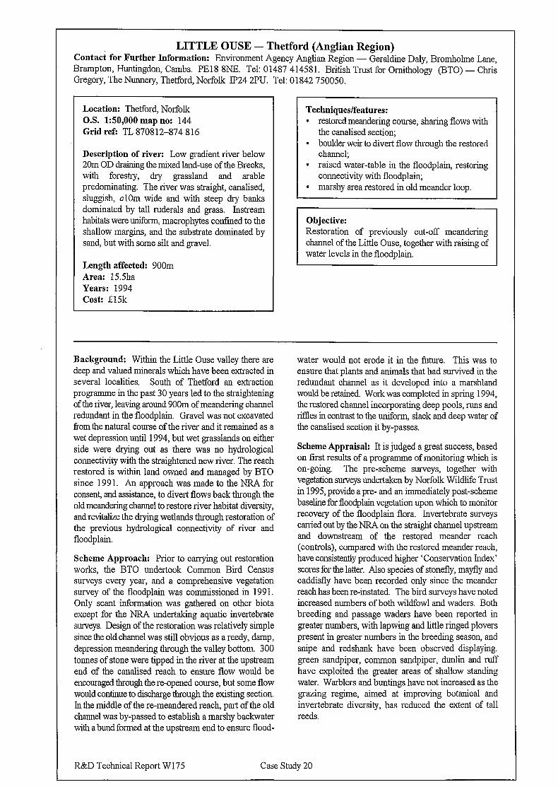
LITTLE OUSE - Thetford (Anglian Region) Contact for Further Information: Environment Agency Anglian Region - Geraldine Daly, Bromhohne Lane, Brampton, Huntingdon, Cambs. PE18 8NE. Tel: 01487 414581. British Trust for Ornithology (BTO) - Chris Gregory, The Nunnery, Thetford, Norfolk It’24 2PU. Tel: 01842 750050.
Location: Thetford, Norfolk O.S. 150,000 map no: 144 Grid refi TL 870812-874 816
Description of river: Low gradient river below 20m OD draining the mixed land-use of the Brecks, with forestry, dry grassland and arable predominating. The river was straight, canalised, sluggish, clOm wide and with steep dry banks dominated by tall ruderals and grass. Instream habitats were uniform, macrophytes confined to the shallow margins, and the substrate dominated by sand, but with some silt and gravel.
Length affected: 900m Area: 15Sha Years: 1994 Cost: E15k
Techniques/features: l restored meandering course, sharing flows with
the canalised section; l boulder weir to divert flow through the restored
channel; l raised water-table in the floodplain, restoring
connectivity with floodplain, l marshy area restored in old meander loop.
Objective: Restoration of previously cut-off meandering channel of the Little Ouse, together with raising of water levels in the floodplain.
Background: Within the Little Ouse valley there are deep and valued minerals which have been extracted in several localities. South of Thetford an extraction programme in the past 30 years led to the straightening of the river, leaving around 900m of meandering channel redundant in the floodplain. Gravel was not excavated from the natural course of the river and it remained as a wet depression until 1994, but wet grasslands on either side were drying out as there was no hydrological connectivity with the straightened new river. The reach restored is within land owned and managed by BT0 since 199 1. An approach was made to the NRA for consent, and assistance, to divert flows back through the old meandering channel to restore river habitat diversity, and revitalize the drying wetlands through restoration of the previous hydrological connectivity of river and floodplain.
Scheme Approach: Prior to carrying out restoration works, the BT0 undertook Common Bird Census surveys every year, and a comprehensive vegetation survey of the floodplain was commissioned in 199 1. Only scant information was gathered on other biota except for the NRA undertaking aquatic invertebrate surveys. Design of the restoration was relatively simple since the old channel was still obvious as a reedy, damp, depression meandering through the valley bottom. 300 tonnes of stone were tipped in the river at the upstream end of the canalised reach to ensure flow would be encouraged through the re-opened course, but some flow would continue to discharge tbrough the existing section. In the middle of the re-meandered reach, part of the old channel was by-passed to establish a marshy backwater with a bund formed at the upstream end to ensure flood-
water would not erode it in the future. This was to ensure that plants and animals that had survived in the redundant channel as it developed into a marshland would be retained. Work was completed in spring 1994, the restored channel incorporating deep pools, runs and ritlles in contrast to the uniform, slack and deep water of the canalised section it by-passes.
Scheme Appraisal: It is judged a great success, based on first results of a programme of monitoring which is on-going. The pre-scheme surveys, together with vegetation surveys undertaken by Norfolk Wildlife Trust in 1995, provide a pre- and an immediately post-scheme baseline for floodplain vegetation upon which to monitor recovery of the floodplain flora. Invertebrate surveys carried out by the NRA on the straight channel upstream and downstream of the restored meander reach (controls), compared with the restored meander reach, have consistently produced higher ‘Conservation Index’ scores for the latter. Also species of stonefly, mayfly and caddisfly have been recorded only since the meander reach has been re-instated. The bird surveys have noted increased numbers of both wildfowl and waders. Both breeding and passage waders have been reported in greater numbers, with lapwing and little ringed plovers present in greater numbers in the breeding season, and snipe and redshank have been observed displaying. green sandpiper, common sandpiper, dunlin and n.rJT have exploited the greater areas of shallow standing water. Warblers and buntings have not increased as the grazing regime, aimed at improving botanical and invertebrate diversity, has reduced the extent of tall reeds.
R&D Technical Report W 175 Case Study 20
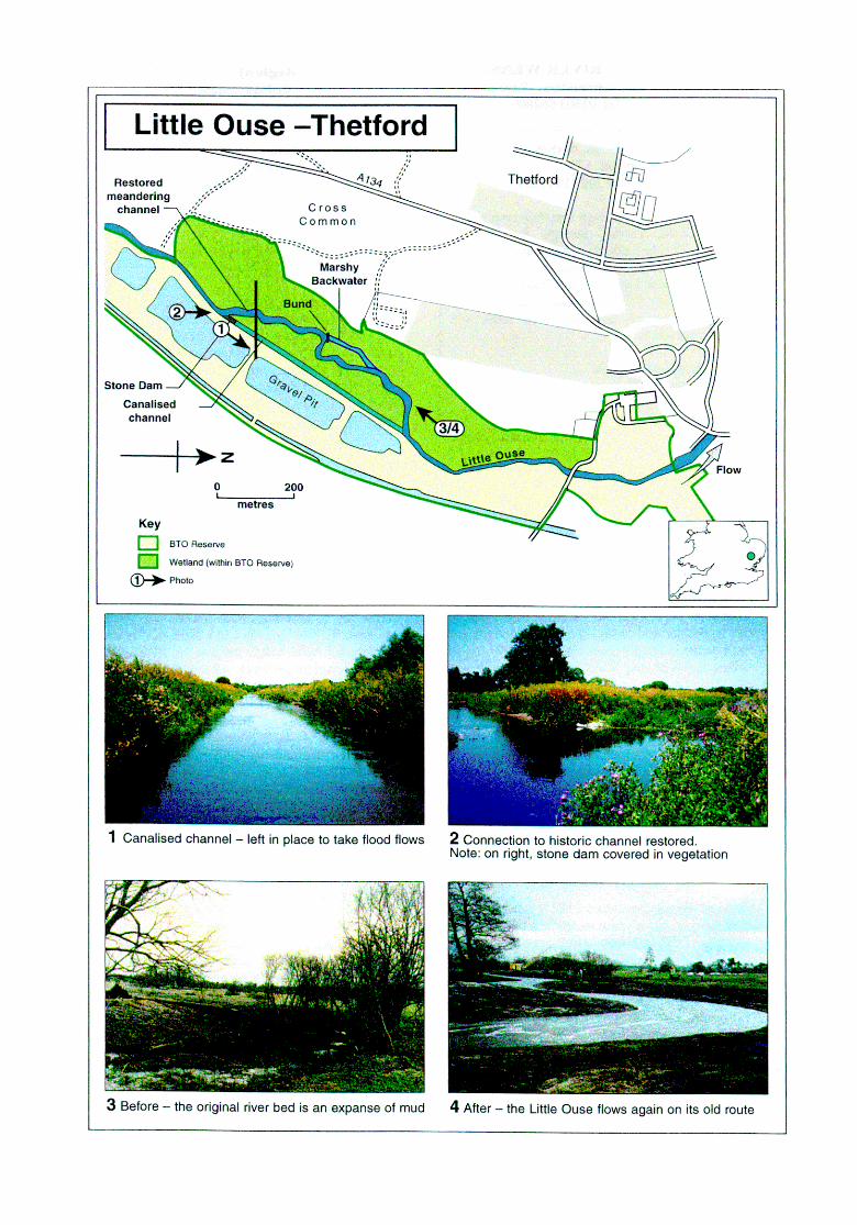
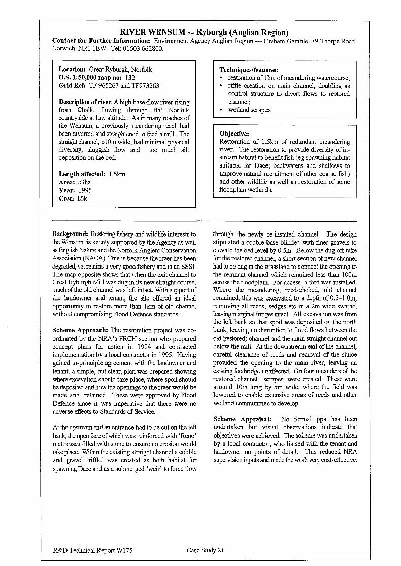
-
RIVER WENSUM - Ryburgb (Anglian Region) Contact for Further Information: Environment Agency Anglian Region - Graham Gamble, 79 Thorpe Road, Norwich NRl 1EW. Tel: 01603 662800.
Location: Great Ryburgh, Norfolk Techniques/features: O.S. 150,000 map no: 132 l restoration of lkm of meandering watercourse; Grid Refi TF 965267 and TF973263 l riffle creation on main channel, doubling as
control structure to divert flows to restored channel;
l wetland scrapes. Description of river: A high base-flow river rising from Chalk, flowing through flat Norfolk countryside at low altitude. As in many reaches of the Wensum, a previously meandering reach had been diverted and straightened to feed a mill. The straight channel, cl Om wide, had minimal physical diversity, sluggish flow and too much silt deposition on the bed.
Objective:
Length affected: 1.5kn-1 Area: c3ha Year: 1995 Cost: L5k
Restoration of 1.5km of redundant meandering river. The restoration to provide diversity of in- stream habitat to benefit fish (eg spawning habitat suitable for Date; backwaters and shallows to improve natural recruitment of other coarse fish) and other wildlife as well as restoration of some floodplain wetlands.
Background: Restoring fishery and wildlife interests to the Wensum is keenly supported by the Agency as well as English Nature and the Norfolk Anglers Conservation Association (NACA). This is because the river has been degraded, yet retains a very good fishery and is an SSSI. The map opposite shows that when the exit channel to Great Ryburgh Mill was dug in its new straight course, much of the old channel was left intact. With support of the landowner and tenant, the site offered an ideal opportunity to restore more than lkm of old channel without compromising Flood Defence standards.
Scheme Approach: The restoration project was co- ordinated by the NRA’s FRCN section who prepared concept plans for action in 1994 and contracted implementation by a local contractor in 1995. Having gained in-principle agreement with the landowner and tenant, a simple, but clear, plan was prepared showing where excavation should take place, where spoil should be deposited and how the openings to the river would be made and retained. These were approved by Flood Defence since it was imperative that there were no adverse effects to Standards of Service.
At the upstream end an entrance had to be cut on the left bank, the open face of which was reinforced with ‘Reno’ mattresses tilled with stone to ensure no erosion would take place. Within the existing straight channel a cobble and gravel ‘riffle’ was created as both habitat for spawning Date and as a submerged ‘weir’ to force flow
through the newly re-instated channel. The design stipulated a cobble base blinded with fmer gravels to elevate the bed level by 0.5m. Below the dug off-take for the restored channel, a short section of new channel had to be dug in the grassland to connect the opening to the remnant channel which remained less than 1OOm across the floodplain. For access, a ford was installed. Where the meandering, reed-choked, old channel remained, this was excavated to a depth of 0.5-l .Om, removing all reeds, sedges etc in a 2m wide swathe, leaving marginal fringes intact. All excavation was from the left bank so that spoil was deposited on the north bank, leaving no disruption to flood flows between the old (restored) channel and the main straight channel cut below the mill. At the downstream exit of the channel, careful clearance of reeds and removal of the sluice provided the opening to the main river, leaving an existing footbridge unaffected. On four meanders of the restored channel, ‘scrapes’ were created. These were around 10m long by 5m wide, where the field was lowered to enable extensive areas of reeds and other wetland communities to develop.
Scheme Appraisal: No formal ppa has been undertaken but visual observations indicate that objectives were achieved. The scheme was undertaken by a local contractor, who liaised with the tenant and landowner on points of detail. This reduced NRA supervision inputs and made the work very cost-effective.
R&D Technical Report W 175 Case Study 2 1
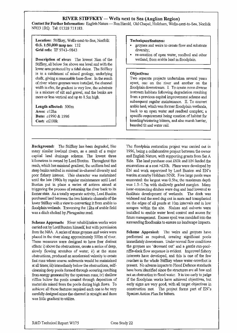
RIVER STIFFKEY - Wells next to Sea (Anglian Region) Contact for Further Information: English Nature-Ron Harold, Old Chapel, Holkham, Wells-next-to-Sea, Norfolk
v NES23 IRQ. Tel: 01328 711183.
Location: Stiffkey, Wells-next-to-Sea, Norfolk Techniques/features: O.S. 150,000 map no: 132 l groynes and weirs to create flow and substrate Grid refs: TF 9743-9843 diversity;
Description of river: The lowest 3km of the Stifkey, all below Sm above sea level and with the lower area protected by a tidal sluice. The Stiffkey is in a catchment of mixed geology, underlying chalk, giving a reasonable base-flow. In the reach of river where groynes were installed, the channel width is c5m, the gradient is very low, the substrate is a mixture of silt and gravel, and the banks are more or less vertical and up to 1 .Sm high.
l re-creation of open water, reedbed and other wetland, from arable land in floodplain.
Objectives:
Length affected: 500m Area: cl2ha Date: cl 990 & 1996 Cost: cElOOk
Two separate projects undertaken several years apart, one on the river and another on the floodplain downstream. I. To create more diverse instream habitats following degradation resulting from a previous capital improvement scheme and subsequent regular maintenance. II. To convert arable land, which was former floodplain wetlands, back to an open water and reedbed complex; a specific requirement being creation of habitat for breeding/wintering bittern, and also marsh harrier, bearded tit and water rail.
Background: The Stiffkey has been degraded, like many similar lowland rivers, as a result of a major capital land drainage scheme. The lowest three kilometres is owned by Lord Buxton. Throughout this reach, which has minimal gradient, the uniform bed and steep banks resulted in minimal in-channel diversity and poor fishery interest. This character was maintained until the late 1980s by regular maintenance until Lord Buxton put in place a series of actions aimed at triggering the process of returning the river back to its former state. As a totally separate activity, Lord Buxton purchased land between the two historic channels of the lower Stiftkey with a view to converting it ti-om arable to floodplain wetlands. Traversing the 12ha of arable field was a ditch choked by Phragmites reed,
Scheme Approach: River rehabilitation works were carried out by Lord Buxton himself, but with permission from the NRA. A series of stone groynes and weirs were placed in the river along approximately 500m of river. These measures were designed to have four distinct effects: i) above the obstructions, create a series of deep, slowly flowing stretches of water; ii) at the stone obstructions, produced an accelerated velocity to create fast runs where coarse sediments would be maintained at all times; iii) immediately below the obstructions, self- cleansing deep pools formed through scouring resulting from energy generated by the upstream runs; iv) shallow riffles below the pools created through deposition of materials mined from the pools during high flows. To achieve all these features required each one to be very carefully designed since the channel is straight and there was little gradient to utilize.
The floodplain restoration project was carried out in 1996, being a collaborative project between the owner and English Nature, with supporting grants from Set A Side. The land purchase cost f60k and EN funded the excavations at a cost >f 30k. Plans were developed by EN and work supervised by Lord Buxton and EN’s warden at nearby Holkham NNR. Five large pools were excavated: the largest was 0.5ha; the maximum depth was 1.5-l .7m with shallowly graded margins. Many inter-connecting ditches were dug and land lowered to facilitate development of wetlands. The ditch was widened and the reed dug out in mats and transplanted on the edges of all ponds at 1Om intervals and in low scrapes within the site. Sluices and culverts were installed to enable water level control and access for future management. Excess spoil was moulded into the surrounding floodbanks to ensure no landscape impacts.
Scheme Appraisal: The weirs and groynes have performed as required, creating significant pools immediately downstream. Under normal flow conditions the groynes are ‘drowned out’ and a gentle run-pool- riffle-slack flow sequence is evident. Improved fishery interests have developed, and this is one of the few reaches in the whole Stiffkey where water-crowfoot is present No adverse impacts to Flood Defence standards have been identified since the structures are all low and not an obstruction to flood water. It is too early to judge if the floodplain works have achieved objectives, but early signs are very good, with all target objectives in construction met. The project forms part of EN’s Species Action Plan for bittern.
R&D Technical Report W 175 Case Study 22

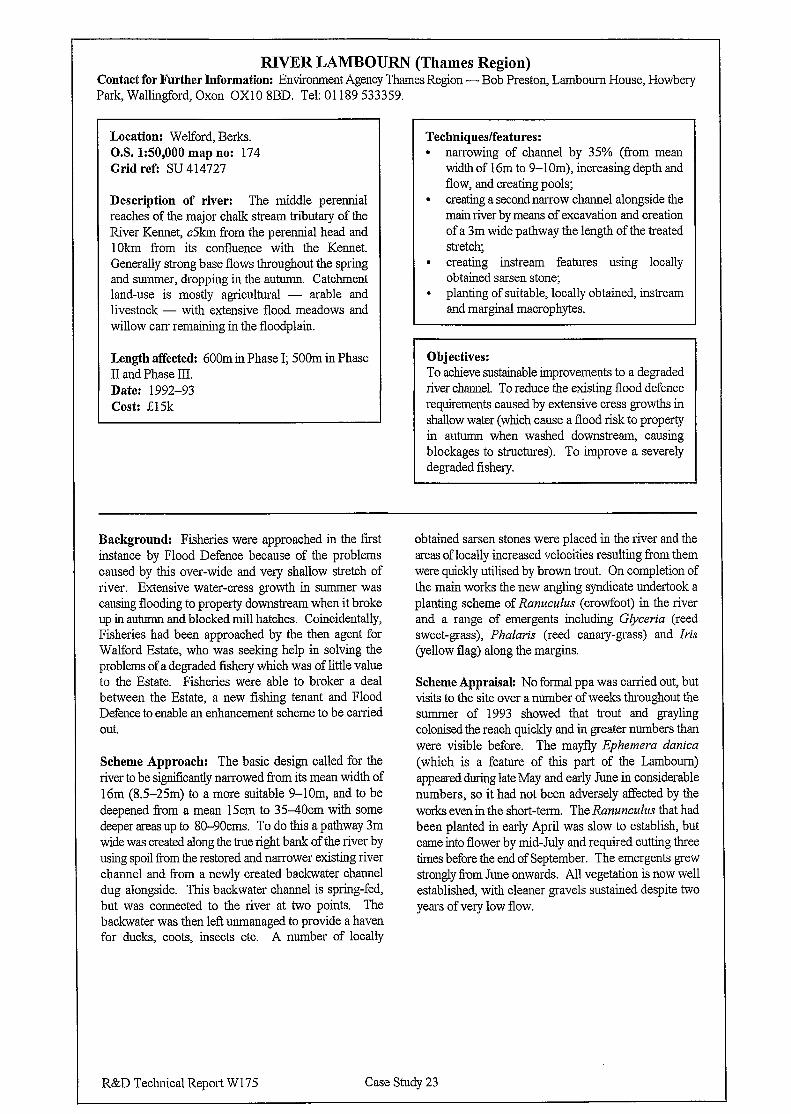
RIVER LAMBOURN (Thames Region) Contact for Further Information: Environment Agency Thames Region - Bob Preston, Lambourn House, Howbery Park, Wallingford, Oxon OX10 8BD. Tel: 01189 533359.
Location: Welford, Berks. OS 1:50,000 map no: 174 Grid refi SU 414727
Description of river: The middle perennial reaches of the major chalk stream tributary of the River Kennet, c5km from the perennial head and 1Okm from its confluence with the Kennet. Generally strong base flows throughout the spring and summer, dropping in the autumn. Catchment land-use is mostly agricultural - arable and livestock - with extensive flood meadows and willow carr remaining in the floodplain.
Length affected: 600m in Phase I; 500m in Phase II and Phase III. Date: 1992-93 Cost: ;E15k
Techniques/features: . narrowing of channel by 35% (from mean
width of 16m to 9-1 Om), increasing depth and flow, and creating pools;
. creating a second narrow channel alongside the main river by means of excavation and creation of a 3m wide pathway the length of the treated stretch,
l creating instream features using locally obtained sarsen stone;
l planting of suitable, locally obtained, instream and marginal macrophytes.
Objectives: To achieve sustainable improvements to a degraded river channel. To reduce the existing flood defence requirements caused by extensive cress growths in shallow water (which cause a flood risk to property in autumn when washed downstream, causing blockages to structures). To improve a severely degraded fishery.
Background: Fisheries were approached in the first instance by Flood Defence because of the problems caused by this over-wide and very shallow stretch of river. Extensive water-cress growth in summer was causing flooding to property downstream when it broke up in autumn and blocked mill hatches. Coincidentally, Fisheries had been approached by the then agent for Walford Estate, who was seeking help in solving the problems of a degraded fishery which was of little value to the Estate. Fisheries were able to broker a deal between the Estate, a new fishing tenant and Flood Defence to enable an enhancement scheme to be carried out.
Scheme Approach: The basic design called for the river to be significantly narrowed from its mean width of 16m (8.5-25m) to a more suitable 9-lOm, and to be deepened from a mean 15cm to 35-4Ocm with some deeper areas up to 80-9Ocms. To do this a pathway 3m wide was created along the true right bank of the river by using spoil from the restored and narrower existing river channel and Tom a newly created backwater channel dug alongside. This backwater channel is spring-fed, but was connected to the river at two points. The backwater was then lefi unmanaged to provide a haven for ducks, coots, insects etc. A number of locally
obtained sarsen stones were placed in the river and the areas of locally increased velocities resulting from them were quickly utilised by brown trout. On completion of the main works the new angling syndicate undertook a planting scheme of Ranuculus (crowfoot) in the river and a range of emergents including Glyceria (reed sweet-grass), Phalaris (reed canary-grass) and Iris (yellow flag) along the margins.
Scheme Appraisal: No formal ppa was carried out, but visits to the site over a number of weeks throughout the summer of 1993 showed that trout and grayling colonised the reach quickly and in greater numbers than were visible before. The mayfly Ephemera danica (which is a feature of this part of the Lambourn) appeared during late May and early June in considerable numbers, so it had not been adversely affected by the works even in the short-term. The Ranunculus that had been planted in early April was slow to establish, but came into flower by mid-July and required cutting three times before the end of September. The emergents grew strongly from June onwards. All vegetation is now well established, with cleaner gravels sustained despite two years of very low flow.
R&D Technical Report W175 Case Study 23
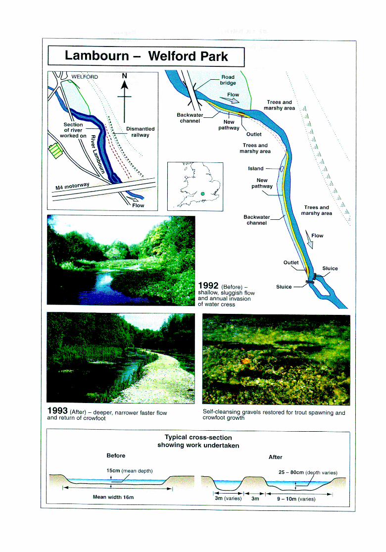
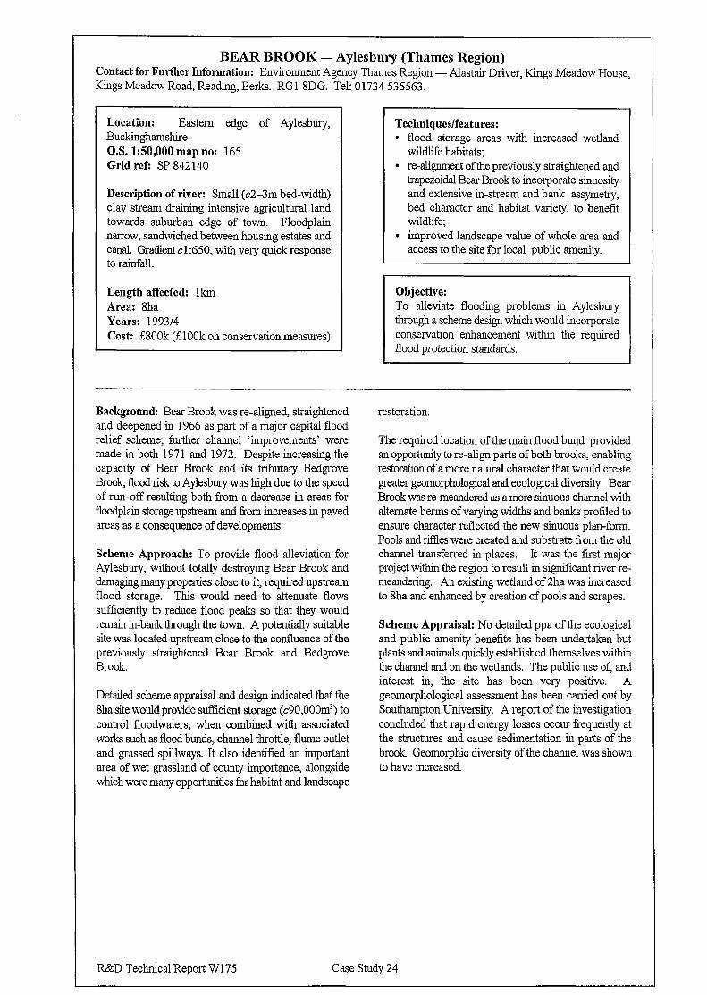
BEAR BROOK - Aylesbury (Thames Region) Contact for Further Information: Environment Agency Thames Region - Alastair Driver, Kings Meadow House, Kings Meadow Road, Reading, Berks. RGl 8DG. Tel: 01734 535.563.
Location: Eastern edge of Aylesbury, Buckinghamshire O.S. 1:50,000 map no: 165 Grid refi SP 842 140
Description of river: Small (c2-3m bed-width) clay stream draining intensive agricultural land towards suburban edge of town. Floodplain narrow, sandwiched between housing estates and canal. Gradient cl :650, with very quick response to rainfall.
Length affected: lkm Area: 8ha Years: 199314 Cost: i800k (LlOOk on conservation measures)
Techniques/features: l flood storage areas with increased wetland
wildlife habitats; l realignment of the previously straightened and
trapezoidal Bear Brook to incorporate sinuosity and extensive in-stream and bank assymetry, bed character and habitat variety, to benefit wildlife;
l improved landscape value of whole area and access to the site for local public amenity.
Objective: To alleviate flooding problems in Aylesbury through a scheme design which would incorporate conservation enhancement within the required flood protection standards.
Background: Bear Brook was re-aligned, straightened and deepened in 1966 as part of a major capital flood relief scheme; further channel ‘improvements’ were made in both 1971 and 1972. Despite increasing the capacity of Bear Brook and its tributary Bedgrove Brook, flood risk to Aylesbury was high due to the speed of run-off resulting both fi-om a decrease in areas for floodplain storage upstream and Tom increases in paved areas as a consequence of developments.
Scheme Approach: To provide flood alleviation for Aylesbury, without totally destroying Bear Brook and damaging many properties close to it, required upstream flood storage. This would need to attenuate flows sufficiently to reduce flood peaks so that they would remain in-bank through the town. A potentially suitable site was located upstream close to the confluence of the previously straightened Bear Brook and Bedgrove Brook.
Detailed scheme appraisal and design indicated that the 8ha site would provide sufficient storage (c90,000m3) to control floodwaters, when combined with associated works such as flood bunds, channel throttle, flume outlet and grassed spillways. It also identified an important area of wet grassland of county importance, alongside which were many opportunities for habitat and landscape
restoration.
The required location of the main flood bund provided an opporhmi!y to re-align parts of both brooks, enabling restoration of a more natural character that would create greater geomorphological and ecological diversity. Bear Brook was re-meandered as a more sinuous channel with alternate berms of varying widths and banks profiled to ensure character reflected the new sinuous plan-form. Pools and riffles were created and substrate from the old channel transferred in places. It was the fast major project within the region to result in significant river re- meandering. An existing wetland of 2ha was increased to 8ha and enhanced by creation of pools and scrapes.
Scheme Appraisal: No detailed ppa of the ecological and public amenity benefits has been undertaken but plants and animals quickly established themselves within the channel and on the wetlands. The public use of, and interest in, the site has been very positive. A geomorphological assessment has been carried out by Southampton University. A report of the investigation concluded that rapid energy losses occur frequently at the structures and cause sedimentation in parts of the brook Geomorphic diversity of the channel was shown to have increased.
R&D Technical Report WI75 Case Study 24
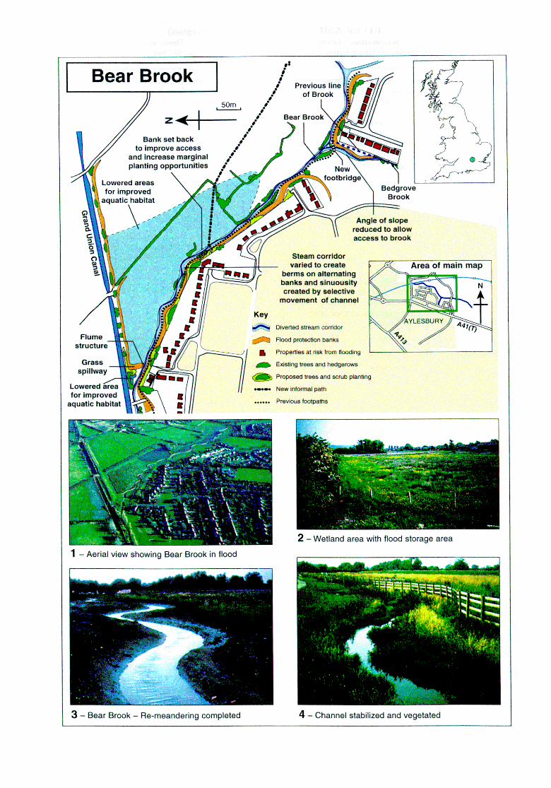
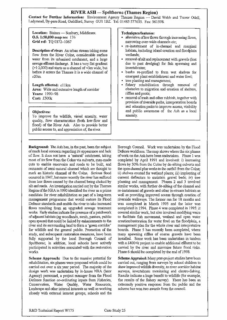
RIVER ASH - Spelthorne (Thames Region) Contact for Further Information: Environment Agency Thames Region - David Webb and Trevor Odell, Ladymead, By-pass Road, Guildford, Surrey GUl 1BZ. Tel: 01483 577655. Fax: 561598.
Location: Staines - Sunbury, Middlesex. O.S. 150,000 map no: 176 Grid refi TQ 0372-1067
Techniques/features: l alleviation of low flows through increasing flows,
narrowing over-wide channels etc; l re-instatement of m-channel and marginal
Description of river: An urban stream taking some flow from the River Colne, considerable surface water from its urbanised catchment, and a large sewage effluent discharge. It has a very flat gradient (>1:2,000) and starts as a channel of c3m wide, but before it enters the Thames it is a wide channel of c20m.
Length affected: cl Ikm Area: Wide and extensive length of corridor Years: 1990-98 Cost: E500k
Objectives: To improve the wildlife, visual amenity, water quality, flow characteristics (both low-flow and flood) of the River Ash. Also to provide better public access to, and appreciation of, the river.
habitats, including island creation and floodplain wetlands;
l removal of silt and replacement with gravels (lost due to past dredging) for fish spawning and invertebrates;
l banks m-profiled to form wet shelves for emergent plant establishment and water fowl;
l tree planting and management; l fishery rehabilitation through removal of
obstacles to migration and creation of shelters, rifFles and pools;
l removal of trash and other rubbish, together with provision of riverside paths, interpretation boards and education packs to improve access, visibility and public awareness of the Ash as a local amenity.
Background: The Ash-has, in the past, been the subject of much local concern regarding its appearance and lack of flow. It does not have a ‘natural’ catchment, taking most of its flow from the Calne via culverts, man-made cuts to enable reservoirs and roads to be built, and remnants of semi-natural channel which are thought to mark an historic channel of the Calne. Serious flood occurred in 1947, but more recently the river has suffered from low flows caused by the channel being choked by silt and reeds. An investigation carried out by the Thames Region of the NRA in 1990 identified the river as a prime candidate for river rehabilitation as part of a long-term management programme that would restore its Flood Defence standards and enable the river to take increased flows resulting from an upgraded sewage treatment works. Early studies indicate the presence of a patchwork of adjacent habitats (eg woodlands, scrub, pasture, public open spaces) that could be linked by enhancements to the river and its surrounding land to form a ‘green corridor’ for wildlife and the general public. Promotion of the study, and subsequent restoration measures, have been fully supported by the local Borough Council of Spelthome; in addition, local schools have actively participated in activities associated with the restoration works.
Scheme Approach: Due to the massive potential for rehabilitation, six phases were proposed which could be carried out over a six year period. The majority of the design work was undertaken by in-house NRA (later Agency) personnel, a project manager from the Flood Defence function co-ordinating inputs from Fisheries, Conservation, Water Quality, Water Resources, Landscape and other internal interests as well as working closely with external interest groups, schools and the
Borough Council. Work was undertaken by the Flood Defence workforce. The map shows where the six phases of work on the Ash have been undertaken. Phase 1 was completed by April 1991 and involved: i) increasing flows by 50% from the Come by de-silting culverts and the open channel plus works to the outfall f?om the Colne; ii) shelves created for wetland plants; iii) implanting of current deflectors to maintain gravel beds; iv) tree planting and management. Phases 2 and 3 involved similar works, with further de-silting of the channel and re-instatement of gravels and other in-stream habitats as well as providing improved access through creation of riverside walkways. The former ran for 18 months and was completed in March 1993 and the latter was completed in 1994. Phase 4 was completed in 1995: it covered similar work, but also involved modifying weirs to facilitate fish movement, wetland and open water creation/restoration for water fowl on the floodplain, a management plan for the whole river and interpretative boards. Phase 5 has recently been completed, where many spawning riffles of coarse gravels have been installed. Some work has been undertaken in tandem with a f400+k project to enable additional effluent to be carried by the river and minimise future flood risks. Phase 6 should be completed by the end of 1998.
Scheme Appraisal: Many post-project studies have been carried out, ranging from surveys by school children to show improved wildlife diversity, to river corridor habitat surveys, invertebrate monitoring and electro-fishing. Results indicate a huge benefit to wildlife (for example, the results of the fishery survey). There has been an extremely positive response from the public and the scheme has won two awards from the council.
R&D Technical Report W175 Case Study 2.5
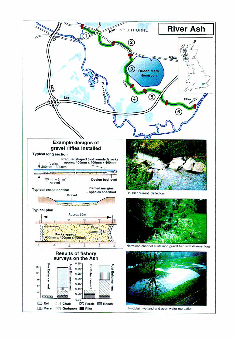
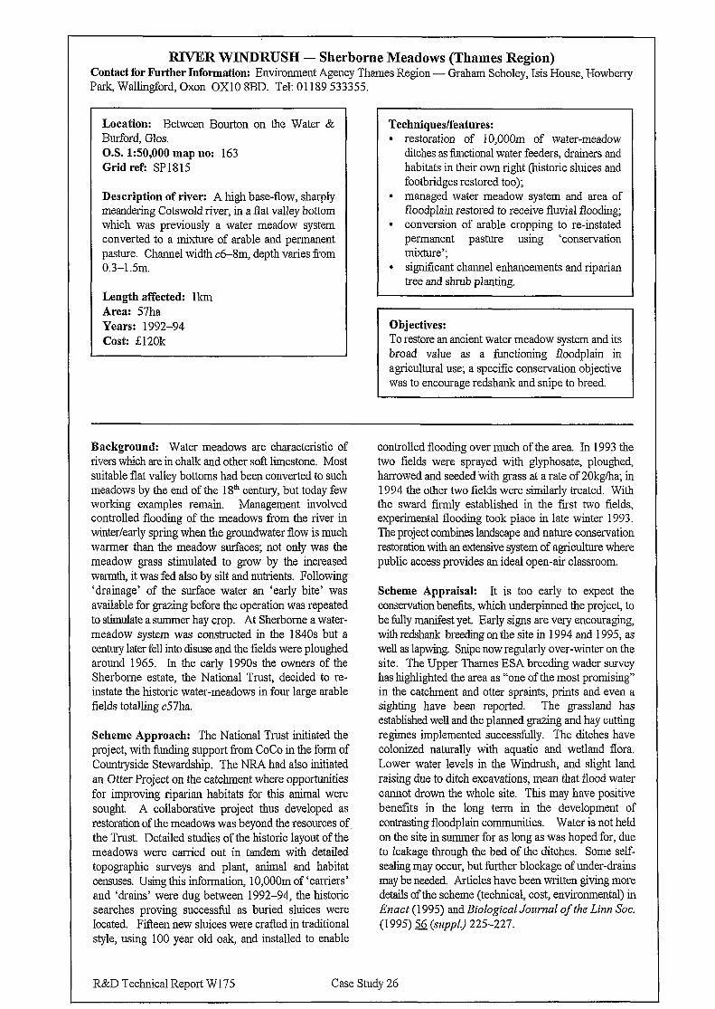
RIVER WINDRUSH - Sherborne Meadows (Thames Region) Contact for Further Information: Environment Agency Thames Region - Graham Scholey, Isis House, Howberry Park, Wallingford, Oxon OX10 8BD. Tel: 01189 533355.
Location: Between Bourton on the Water & Burford, Glos. O.S. 150,000 map no: 163 Grid ref: SPl815
Description of river: A high base-flow, sharply meandering Cotswold river, in a flat valley bottom which was previously a water meadow system converted to a mixture of arable and permanent pasture. Channel width c6-8m, depth varies from 0.3-l 5m.
Length affected: lkm Area: 57ha Years: 1992-94 Cost: 020k
Techniques/features: . restoration of 10,OOOm of water-meadow
ditches as functional water feeders, drainers and habitats in their own right (historic sluices and footbridges restored too);
l managed water meadow system and area of floodplain restored to receive fluvial flooding;
l conversion of arable cropping to re-instated permanent pasture using ‘conservation mixture’;
l significant channel enhancements and riparian tree and shrub planting.
Objectives: I
To restore an ancient water meadow system and its broad value as a functioning floodplain in agricultural use; a specific conservation objective was to encourage redshank and snipe to breed.
Background: Water meadows are characteristic of rivers which are in chalk and other soft limestone. Most suitable flat valley bottoms had been converted to such meadows by the end of the 18”’ century, but today few working examples remain. Management involved controlled flooding of the meadows from the river in winter/early spring when the groundwater flow is much warmer than the meadow surfaces; not only was the meadow grass stimulated to grow by the increased warm& it was fed also by silt and nutrients. Following ‘drainage’ of the surface water an ‘early bite’ was available for grazing before the operation was repeated to stimulate a summer hay crop. At Sherborne a water- meadow system was constructed in the 1840s but a century later fell into disuse and the fields were ploughed around 1965. In the early 1990s the owners of the Sherborne estate, the National Trust, decided to re- instate the historic water-meadows in four large arable fields totalling c57ha.
Scheme Approach: The National Trust initiated the project, with funding support from CoCo in the form of Countryside Stewardship. The NRA had also initiated an Otter Project on the cat&rent where opportunities for improving riparian habitats for this animal were sought. A collaborative project thus developed as restoration of the meadows was beyond the resources of the Trust. Detailed studies of the historic layout of the meadows were carried out in tandem with detailed topographic surveys and plant, animal and habitat censuses. Using this information, 10,OOOm of ‘carriers’ and ‘drains’ were dug between 1992-94, the historic searches proving successful as buried sluices were Iocated. Fifteen new sluices were crafted in traditional style, using 100 year old oak, and installed to enable
controlled flooding over much of the area. In 1993 the two fields were sprayed with glyphosate, ploughed, harrowed and seeded-with grass at a rate of 20kg/ha; in 1994 the other two fields were similarly treated. With the sward firmly established in the first two fields, experimental flooding took place in late winter 1993. The project combines landscape and nature conservation restoration with an extensive system of agriculture where public access provides an ideal open-air classroom.
Scheme Appraisal: It is too early to expect the conservation benefits, which underpinned the project, to be fully manifest yet. Early signs are very encouraging, with redshank breeding on the site in 1994 and 1995, as well as lapwing. Snipe now regularly over-winter on the site. The Upper Thames ESA breeding wader survey has highlighted the area as “one of the most promising” in the catchment and otter sprain& prints and even a sighting have been reported. The grassland has established well and the planned grazing and hay cutting regimes implemented successfully. The ditches have colonized naturally with aquatic and wetland flora. Lower water levels in the Windrush, and slight land raising due to ditch excavations, mean that flood water cannot drown the whole site. This may have positive benefits in the long term in the development of contrasting floodplain communities. Water is not held on the site in summer for as long as was hoped for, due to leakage through the bed of the ditches. Some self- sealing may occur, but further blockage of under-drains may be needed. Articles have been written giving more details of the scheme (technical, cost, environmental) in Enact (1995) and Biological Journal of the Linn Sot. (1995) s (szrpp[) 225-227.
R&D Technical Report W 175 Case Study 26
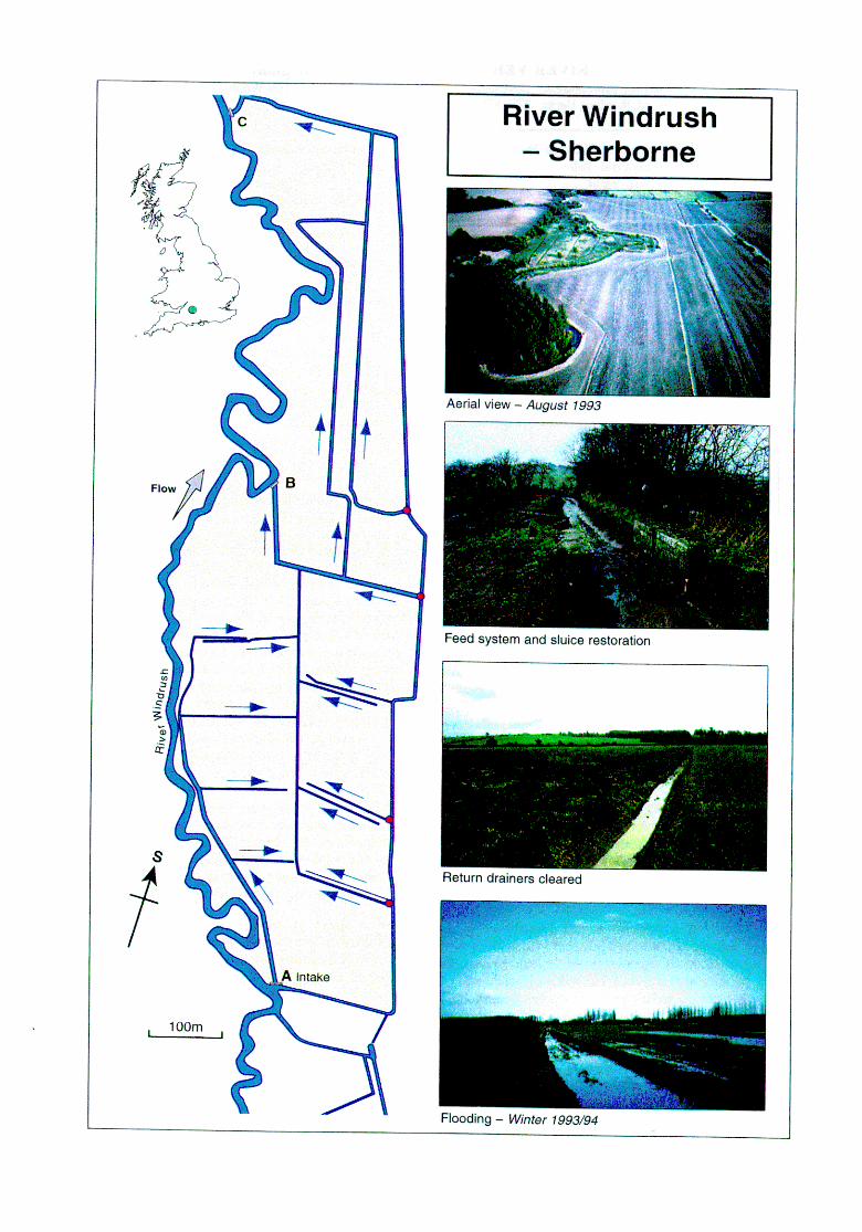
RIVER VER - Redbourne (Thames Region) Contact for Further Information: Environment Agency Thames Region - Tim Webb, Kings Meadow House, Kingsmeadow Road, Reading, Berks. RGI 8DG. Tel: 01734 535000.
Location: Redboume, St Albans, Herts. O.S.1:50,000 map no: 166 Grid refi TL 0616-1208
Description of river: A chalk stream with a steep gradient rising on the Chilterns. Natural winterboume section above Redboum, but perennial below. Above St Albans some sections meander through meadows; width 3-5m, with very gently sloping banks which grade imperceptibly into meadows.
Length affected: Whole river, 25km Area: All wetlands in upper catchment Year: 1993 Cost: 52.5m+
Techniques/features: l groundwater pumping station at head of
catchment switched off to restore river flow; l major channel works to maximise
environmental benefit of restored flows and maintain acceptable Flood Defence standards;
l extensive pre- and post- implementation monitoring covering full range of habitat and community types.
Objectives: Restore flows to the upper River Ver, improve flows in the lower reaches, and undertake monitoring to determine the effects on the landscape, ecology and fisheries that had been severely degraded.
Background: In the 1980s despite the decade being a relatively wet one, concern grew that several chalk streams had been severely impacted by groundwater abstractions. The Ver Society was formed to put pressure on Thames Water Authority in 198718 to investigate the reasons and determine options for remediation. The Ver was one of six rivers chosen for study, and it was confirmed that since the 1950s abstraction from the aquifer had risen sharply to intercept nearly 70% of the rainfall of the catchment before it could reach the river. The effect was a perennially dry river above Redboum, which previously had a typical winterboume flow, and sluggish flows throughout the rest of the river which also periodically failed in years of poor re-charge.
Scheme Approach: A re-assessment of the previous studies was undertaken soon after the NRA was formed in 1989, following the Board’s direction to investigate urgently 40 of the worst cases of degradation caused by abstraction. It used its duties to secure proper use of water resources whilst at the same time conserving and enhancing the environment. Working with the Ver Society, Three Valleys Water (TVW) responded to the NRA’s firm commitment to improve flows in the Ver, by submitting a proposal to the Department of the Environment (DOE) in September 1991 to close down (but retain its operational use for emergencies) the borehole at Friars Wash that was the primary cause of the problems, and to pipe in new supplies from G&ham. This required g2.5m of engineering works to pump and pipe water from the reservoir, and was paid for by the NRA. The substantially increased cost of using water from Gratham instead of Friars Wash is shared by the Environment Agency and TVW. With engineering
works completed in early 1993, pumps were switched off on May 26” 1993.
Scheme Appraisal: The effects of ceasing abstraction were dramatic. Even before the extremely good autumn re-charge of 1993, springs started to break out in the middle and upper river. A rise in groundwater levels became apparent very quickly and at Markyate the river retained a flow all through 1994 - some 8km further upstream than for more than 10 years. In the middle reaches between Redbourn and St Albans flows were so great they spilled over the banks into the meadows which had been dry for decades. Sensitive river engineering works were undertaken on extensive lengths of the river to provide adequate Flood Defence standards whilst at the same time maximising the value of the restored flow to create self-sustaining riffles and runs with coarse sediments. Within 18 months of restored flows, many typical winterboume macrophytes (eg water-cress, blue water-speedwell, starwort) returned to the previously dry channel above Redboum and the terrestrial grasses that had colonized the bed of the river below Redboum were replaced by the same species but with water crowfoot also returning in abundance.
An extensive monitoring programme has been undertaken which included physical habitat structure, macrophytes, invertebrates, fish and birds; these being assessed alongside hydrologic changes and hydraulic performance of the channel. A report was due in 1997. A colour leaflet has been produced describing the scheme and an extremely detailed and extensive library of reports and other documents is held by the Agency at Reading.
R&D Technical Report W175 Case Study 27
RIVER PANG - Hampstead Norreys (Thames Region) Contact for Further Information: Environment Agency Thames Region - Tim Webb, Kings Meadow House, Kingsmeadow Road, Reading, Berks. RGl 8DG. Tel: 01734 535000.
Location: Compton - Frilsham, Berkshire OS. 1:50,000 map no: 174 Grid refi SU 5280-577 1
Description of river: A chalk stream rising on the eastern limit of the Berkshire Downs. Naturally a winterbourne above Hampstead Norreys, but perennial at the village and downstream. Below the village some sections meander through meadows where width varies from 4-l Om, with gentle banks grading into meadows. Other sections are impounded at mills or constrained within deepened and straightened engineered channels.
Length affected: Principally upper 2Olun Area: Upper catchment wetlands Date: 1993 Cost: Not known
Techniques/features: l abstraction from groundwater pumping station
at head of catchment reduced to restore river flow;
l minor works to maximise environmental benefit of restored flows, including installing current- concentrating groynes to narrowing the channel, removal of silt and bank re-profiling;
l extensive pre- and post- implementation monitoring covering full range of habitat and community types.
Objectives: Restore flows to the previously dry upper River Pang, improve flows in the lower reaches, and undertake monitoring to determine the recovery of the severely degraded fishery, landscape and ecological interests.
Background: Compton pumping station abstracts groundwater from the head of the Pang Valley. In the early 1960s cl.5 Megalitres a day was abstracted, but this had risen to almost 10 times that volume by the end of the 1970s. Despite the 1980s being a relatively wet decade, concern grew that the river was severely impacted by the groundwater abstractions. Residents of Hamstead Norreys put pressure on Thames Water Authority in 198718 to investigate the reasons and determine options for remediation. The Pang was one of six rivers chosen for study, and it was confiied that the abstraction from the aquifer intercepted much of the rainfall of the upper catchment before it could reach the river. As a result of the pumping at Compton, the upper reaches of the Pang dried up more frequently and for longer periods than otherwise would be expected; frequently there was no flow in the river through the village; and the middle and lower reaches often became shallow and sluggish, or flows even failed. Environmental damage was thus evident throughout the river.
Scheme Approach: A re-assessment of the previous studies was undertaken soon after the NRA was formed in 1989, following the Board’s direction to investigate urgently 40 of the worst cases of degradation caused by abstraction. It used its responsibilities to manage water resources to achieve a balance between the needs of the environment and those of abstracters. The NRA assessed various options with the abstractor, Thames Water. It was agreed that Thames Water would reduce their abstraction limit from 13.5 to no more than 5.0
Megalitres per day, with a new groundwater source near Goring at Gatehampton, supplying the deficit. The reduced abstraction commenced in April 1992.
Scheme Appraisal: Following the reduction. in abstraction a rise in groundwater levels in the upper Pang catchment soon became apparent. With good re- charge in winters 1992/3 and 1993f4 the source of the river remained at Hampstead Norreys throughout the summers of 1993 and 1994, this being 6km further upstream than for most of the time in the previous ten years. To aid recovery, Conservation, Biology and Fishery staff worked with Flood Defence colleagues to implement sensitive river engineering works to maximise the ecological value of the restored flows. Extensive de-silting to expose gravels for spawning, low-flow channel narrowing and placement of current- concentrating groynes was undertaken. Many typical winterboume macrophytes (eg blue water-speedwell, water-cress, brooklime) returned to the previously dry channel above Hampstead Norreys and water crowfoot returned in local abundance downstream.
An extensive monitoring programme has been undertaken which includes physical habitat structure, macrophytes, invertebrates, fish and birds; these are assessed alongside water-table and river water level changes in the channel. A report was due in 1997. A colour leaflet has been produced describing the scheme and an extremely detailed and extensive library of reports and other documents is held by the Agency at Reading.
R&D Technical Report W175 Case Study 28
RIVER TEUMIB - Pinkhill Meadows (Thames Region) Contact for Further Information: Environment Agency Thames Region - Alastair Driver, Kings Meadow House, Kings Meadow Road, Reading, Berks. RGI 8DG. Tel: 01734 535563.
Localion: Near Oxford, Oxon O.S. 150,000 map no: 164 Grid ref: SP 439067
Description of river: Very low gradient, navigable, meandering reach of the River Thames. Pastoral character with extensive, ill-defined, floodplain mainly of pastures and a large bunded reservoir located on the right bank. River width 15-20m, 2-3m deep.
Length affected: 500m Area: 2ha Years: 1990-92 Cost: f 180k
Techniques/features: . creation of a variety of ponds (size, shape,
surface-water fed and ground-water-fed) - seven in all-to enable monitoring to determine the differences in vegetation establishment and. subsequent use by invertebrates and birds;
l wader scrapes, gravel islands, reedbeds, meadow, willow scrub establishment;
. appropriate management of remnant habitats of ecological value.
Objectives: Restore an area of Thames floodplain to wetland using a variety of habitat restoration techniques within a small area. Specific targets included creation of wader habitats suitable for breeding redshank, lapwing and little ringed plover. Undertake a comprehensive pre- and post- monitoring programme to advance the understanding of techniques used for, and benefits derived f?orn, floodplain restoration. Establishment of a new floodplain nature reserve.
Background: The project of floodplain restoration at Pinkhill developed as a result of planned experimentation and monitoring of floodplain habitat creation, the findings of which could be of great benefit to other similar projects. This was developed as an Operational Investigation and later become a national R&D project. The site is a meander loop owned by Thames Water, sandwiched between the Thames and their Farmoor Reservoir. The development of the habitat creations, and their funding, was a joint initiative of Thames Water and the NRA (advice by Pond Action), with monitoring funded by the NR4.
Scheme Approach: NRA and Thames Water Conservation and Landscape personnel worked with Pond Action to develop a design which would enable the full range of wetland habitats to be re-instated on the sites (all those which were formerly widespread in the upper Thames), especially concentrating on habitats attractive to waders (especially redshank). Pre- construction surveys were carried out in 1989/90, this identifying that a third of the site should be left untouched as it contained plant communities of high conservation value. For the remaining two-thirds a mosaic of diverse habitats was planned, including shallow pools, wet meadows, wader scrapes, pond with gravel island and willow scrub. Phase 1 excavations were carried out in summer 1990 followed by monitoring to ascertain the speed of colonization by plants and how rapidly invertebrates and birds moved onto the site. In winter 1991/2 phase 2 completed the works and publicity material was produced to provide information for visitors to the site and for others
planning similar projects. In December 1992 there were over-bank flows from the Thames and the planned flooding of the site occurred. With work completed, monitoring continued, and a management plan for the site developed with Thames Water and local conservation groups. Management activities include meadow mowing, weeding of the gravel island etc.
Scheme Appraisal: Winter flooding in 1992 resulted in large numbers of gadwell, shoveller and snipe frequenting the site. As flood water subsided in spring 1993 the bare mud attracted large numbers of waders. In the long-term the site has not attracted migrant waders or significant waterfowl. Common tern feed on the Thames, bath in the ponds and breed on the gravel islands. Little ringed plover and redshank have both bred, making a significant contribution to the Oxfordshire populations. Monitoring of experimental planting in ponds suggested that plant density was more important than species-richness for invertebrate diversity. The project has spawned technical reports on construction methods for floodplain habitat restoration and the response of wildlife to the creation of such habitats. In addition the spectacular visual improvements have been depicted in more popular articles such as the one in Water Guardian July/August 1993; it reported “As Pinkhill Meadow continues to develop and the reedbeds attain their full stature, an unrivalled concen- tration of the Thames Valley’s most exciting birds and wetland wildlife will be on view within this ten acre site”. Reports are held by the Agency at Reading; R&D Technical Report W24 and Project Record 383/1/T are dedicated to the ecological monitoring programme.
R&D Technical Report W175 Case Study 29
RIVER COLE - Coleshill (River Restoration Project) Contact for Further Information: RRP - Martin Janes, c/o CranIield University, Silsoe, Beds MK45 4DT. Tel: 01525 863341. Environment Agency Thames Region- ColinPlatt (Project Manager), 01734 533334. National Trust - Richard Morris (Estate Manager), Buscot & Coleshill Estate, 01793 762209.
Location: Coleshill, Swindon, Oxen/Wilts border OS. 1:50,000 map no: 174 Grid refi SU 234925-226936
Description of river: Lowland rural river, prone to spates due to urbanised headwater and clay catchment. The rehabilitated reach forms two distinct sections separated by a mill. Upstream: high water levels, impounded, straightened and deepened artificial mill leat. Downstream: oversized, realigned, deepened and widened.
Length affected: c2km Area: ~16.3 ha Years: 199516 Cost: fl50k construction works
Techniques/features: l significant bed raising; l channel narrowing; l charme reprofihng; l restoring meandering plan form;
l increasing floodplain storage and flooding; l reintroduction of historical landscape elements; l wet meadow grassland creation; l continued sustainable farming, l riffle ‘seeding’ with gravel placed in pools; l recreating sustainable natural processes; l flow splitting.
Objectives: Restoration/rehabilitation of 2km of a previously degraded rural river and floodplain system in terms of physical channel plan form and cross-section, flood regime and bio-diversity. Demonstration of current and innovative restoration and rehabilitation techniques and best management practice.
Background: The River Cole at Coleshill has been extensively modified for a variety of reasons over the past 900+ years. The downstream section has been realigned, straightened, deepened and widened, initially as a function of milling, but more recently to safeguard agricultural production and for flood capacity. Above the mill the channel was realigned and impounded 200-300 years ago to form a mill leat with remnants left as over-spil1 channels.
Scheme Approach: The Cole Project was led by the River Restoration Project @RP) in partnership with the EU LIFE programme, the landowner (National Trust), NRA/Environment Agency, English Nature, and the Countryside Commission. The project design was environmentally led drawing on a team of up to 30 multi- disciplinary, independent experts and partner organisation staff Community and user involvement was sought before, during and after design, promoting ‘ownership’ of the project. The design was based on the principles drawn from year one of the comprehensive monitoring programme and catchment audit. All design decisions were approved by a Project Board representing all partner organisations.
Using the information produced by the geomorphological audit and catchment hydrology/ hydraulics a typical channel dimension was arrived at for a sustainable River Cole. Upstream of the mil1 it was decided to reinstate the river on its original course (as shown on old maps and topographical evidence). Flows were to be split via a bifurcation structure retaining a sweetening flow in the retained mill leat. This new cut was to join the remnant ‘mill by-pass’ channel to by- pass the mill weir. The increase in slope would provide
energy to enable a more natural, self sustaining flow regime to develop and flooding onto the floodplain with resultant improved storage, to be realised. Due to the historical and landscape interest of the National Trust, an in-filled meander loop in the now ponded mill leat was also reinstated.
Downstream of the mill and roadbridge, the channel form and sinuosity previously identified was used in conjunction with the principle of retaining mature riverside trees on the new riverbank. These mature trees were evident as they were perched 1 m above the bed of the old channel due to a recent (20 years) capital scheme to remove 1 m of clay from the river bed. This general bed lowering also served to reduce the water table in the adjacent floodplain, thus adding to the process of drying out of a SSSI hitillary flood meadow - now denotihed.
As an achievable target, the restoration of bed level, water level and flood regime to that of 20 years ago was incorporated into the remeandering across the old channel. This entailed excavating the new cut up to 1.2m above the bed of the old channel. All spoil was placed in the old channel but deep backwaters and wide shallow berms left to increase habitat diversity.
Scheme Appraisal: Initial results show that restoration has had no detrimental effects on the more sensitive plant and invertebrate communities and that natural erosion and deposition processes are operating as expected. Plant re-colonisation in-stream and on the banks has been slow, but invasion of a rich marginal wetland community on the new channels was noted, and crowfoot gradually spread into new riffles.
R&D Technical Report W175 Case Study 30
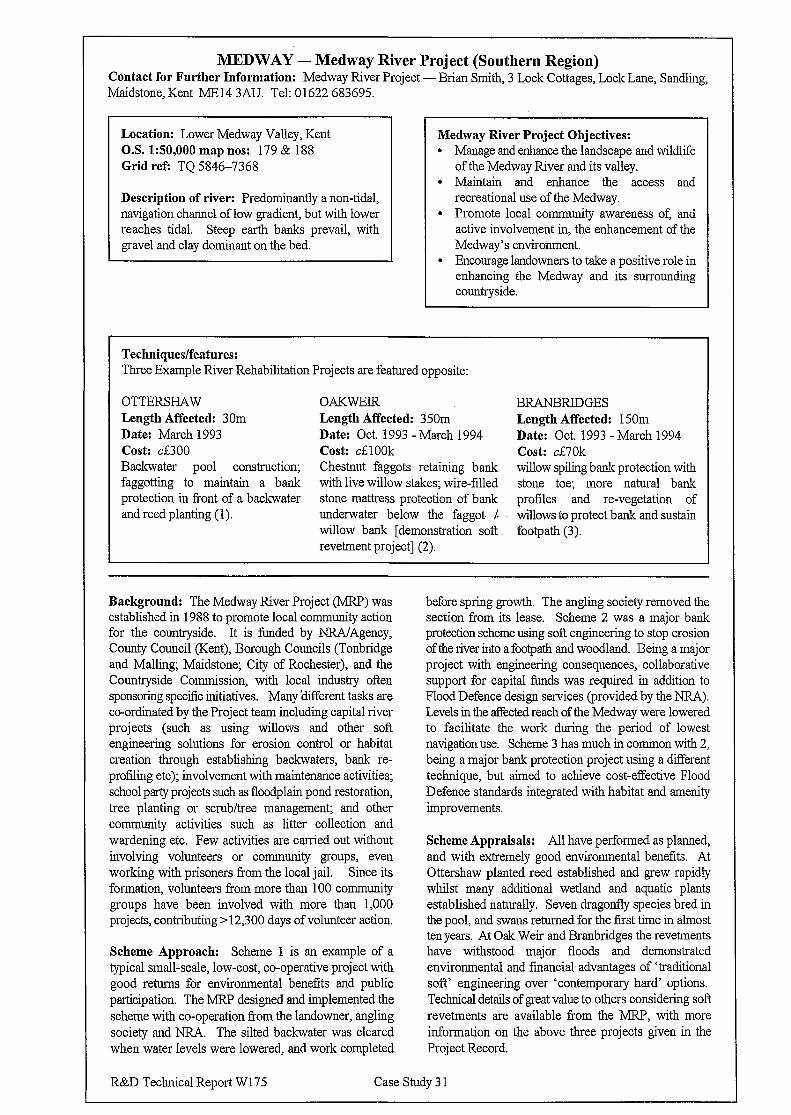
MEDWAY - Medway River Project (Southern Region) Contact for Further Information: Medway River Project-Brian Smith, 3 Lock Cottages, Lock Lane, Sandling, Maidstone, Kent ME14 3AU. Tel: 01622 683695.
Location: Lower Medway Valley, Kent 02. 1:50,000 map nos: 179 & 188 Grid ref: TQ 5846-7368
Description of river: Predominantly a non-tidal, navigation channel of low gradient, but with lower reaches tidal. Steep earth banks prevail, with gravel and clay dominant on the bed.
Medway River Project Objectives: l Manage and enhance the landscape and wildlife
of the Medway River and its valley. l Maintain and enhance the access and
recreational use of the Medway. l Promote local community awareness of, and
active involvement in, the enhancement of the Medway’s environment.
l Encourage landowners to take a positive role in enhancing the Medway and its surrounding countryside.
Techniques/features: Three Example River Rehabilitation Projects are featured opposite:
OTTERSHAW Length Affected: 30m Date: March 1993 cost: d300 Backwater pool construction; faggotting to maintain a bank protection in front of a backwater and reed planting (1).
OAKWElR Length Affected: 350m. Date: Oct. 1993 - March 1994 Cost: d100k Chestnut faggots retaining bank with live willow stakes; wire-filled stone mattress protection of bank underwater below the faggot. 1 willow bank [demonstration soft revetment project] (2).
BRANBRIDGES Length Affected: 150m Date: Oct. 1993 - March 1994 Cost: ci70k willow spiling bank protection with stone toe; more natural bank profiles and re-vegetation of willows to protect bank and sustain footpath (3).
Background: The Medway River Project (MRP) was established in 1988 to promote local community action for the countryside. It is funded by NRA/Agency, County Council (Kent), Borough Councils (Tonbridge and Malling; Maidstone; City of Rochester), and the Countryside Commission, with local industry often sponsoring specific initiatives. Many different tasks are coordinated by the Project team including capital river projects (such as using willows and other soft engineering solutions for erosion control or habitat creation through establishing backwaters, bank re- profiling etc); involvement with maintenance activities; school party projects such as floodplain pond restoration, tree planting or scrub/tree management; and other community activities such as litter collection and wardening etc. Few activities are carried out without involving volunteers or community groups, even working with prisoners from the local jail. Since its formation, volunteers from more than 100 community groups have been involved with more than 1,000 projects, contributing >12,300 days of volunteer action.
Scheme Approach: Scheme 1 is an example of a typical small-scale, low-cost, co-operative project with good returns for environmental benefits and public participation. The MRP designed and implemented the scheme with co-operation from the landowner, angling society and NRA The silted backwater was cleared when water levels were lowered, and work completed
before spring growth. The angling society removed the section from its lease. Scheme 2 was a major bank protection scheme using soft engineering to stop erosion of the river into a footpath and woodland. Being a major project with engineering consequences, collaborative support for capital funds was required in addition to Flood Defence design services (provided by the NRA). Levels in the affected reach of the Medway were lowered to facilitate the work during the period of lowest navigation use. Scheme 3 has much in common with 2, being a major bank protection project using a different technique, but aimed to achieve cost-effective Flood Defence standards integrated with habitat and amenity improvements.
Scheme Appraisals: All have performed as planned, and with extremely good environmental benefits. At Ottershaw planted reed established and grew rapidly whilst many additional wetland and aquatic plants established naturally. Seven dragonfly species bred in the pool, and swans returned for the first time in almost ten years. At Oak Weir and Branbridges the revetments have withstood major floods and demonstrated environmental and financial advantages of ‘traditional soft’ engineering over ‘contemporary hard’ options. Technical details of great value to others considering sol? revetments are available from the MRP, with more information on the above three projects given in the Project Record.
R&D Technical Report W 175 Case Study 3 1
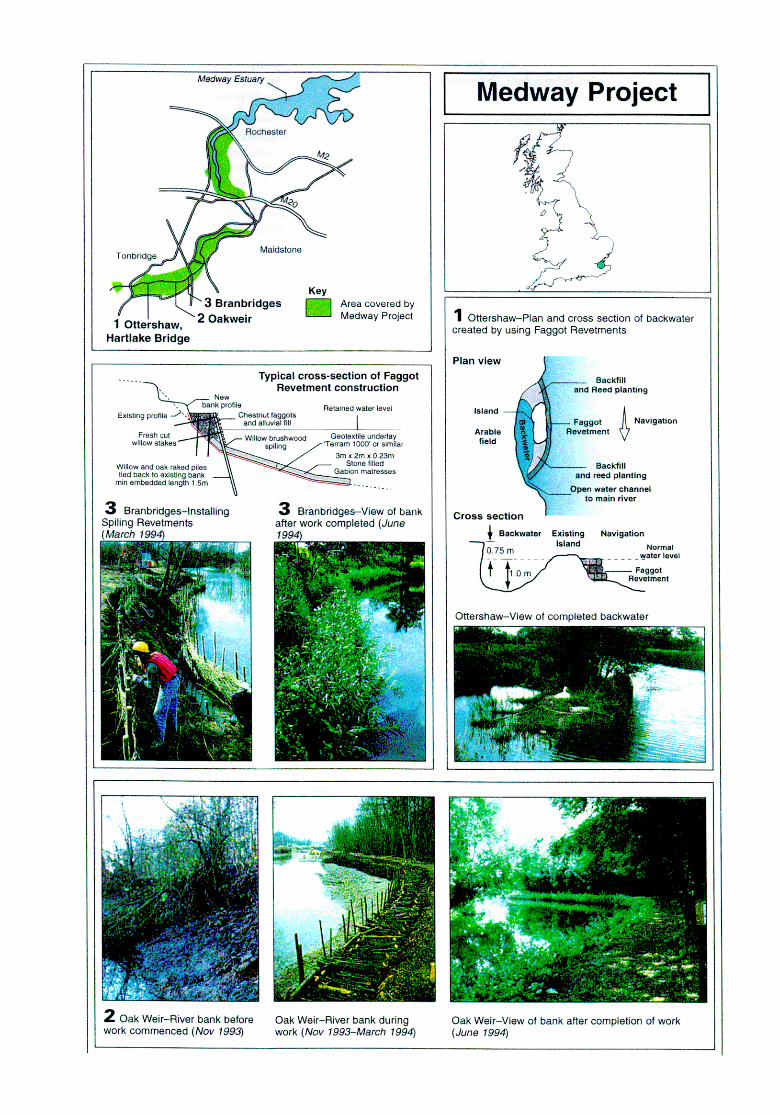
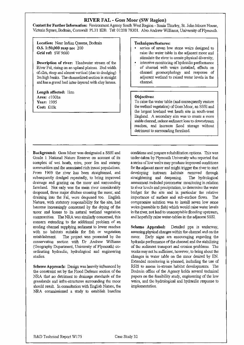
RIVER FAL - Goss Moor (SW Region) Contact for Further Information: Environment Agency South West Region - Sonia Thurley, St. John Moore House, Victoria Square, Bodmin, Cornwall PL3 1 1EB. Tel: 0 1208 7830 1. Also Andrew Williams, University of Plymouth.
Location: Near Indian Queens, Bodmin O.S. 150,000 map no: 200 Grid ref: SW 9660
Description of river: Headwater stream of the River Fal, rising on an upland plateau. Bed width of c2m, steep and almost vertical (due to dredging) 2m high. banks. The channelized section is straight and has a gravel bed inter-layered with clay lenses.
Length affected: lkm Area: cl OOha Year: 1995 Cost: ;ElOk
Techniques/features: l series of seven low stone weirs designed to
raise the water table in the adjacent moor and stimulate the river to create physical diversity;
l intensive monitoring of hydraulic performance of channel with weirs installed, effects on channel geomorphology and response of adjacent wetland to raised water levels in the channel.
Objectives: To raise the water table (and consequently restore the wetland vegetation) of Goss Moor, an SSSI and the largest lowland wet heath site in south-west England. A secondary aim was to create a more stable channel, reduce sediment loss to downstream reaches, and increase flood storage without detriment to surrounding farmland.
Background: Goss Moor was designated a SSSI and Grade 1 National Nature Reserve on account of its complex of wet heath, mire, poor fen and swamp communities and the associated rich insect populations. From 1969 the river has been straightened, and subsequently dredged repeatedly, to bring improved drainage and grazing on the moor and surrounding farmland. Not only was the main river considerably deepened, three major ditches crossing the moor, and draining into the Fal, were deepened too. English Nature, with statutory responsibility for the site, had become increasingly concerned by the drying of the moor and losses to its natural wetland vegetation communities. The NRA was similarly concerned, this concern extending to the additional problem of an eroding channel supplying sediment to lower reaches with no habitats suitable for fish or vegetation establishment. The project was promoted by the conservation section with Dr Andrew Williams (Geography Department, University of Plymouth) co- ordinating hydraulic, hydrological and engineering studies.
Scheme Approach: Design was heavily influenced by the constraint set by the Flood Defence section of the NRA that no detriment to drainage standards of the grasslands and &a-structures surrounding the moor should result. In consultation with English Nature, the NRA commissioned a study to establish baseline
conditions and prepare rehabilitation options. This was under-taken by Plymouth University who reported that a series of low weirs may produce improved conditions for the adjacent moor and might trigger the river to start developing instream habitats removed through straightening and deepening. The hydrological assessment included piezometer monitoring in relation to river levels and precipitation, to determine the water budget for the site and in particular the relative importance of surface and sub-surface flows. The compromise solution was to install seven low stone weirs (passable to fish) which would raise water levels in the river, not lead to unacceptable flooding upstream, and hopefully raise water-tables in the adjacent SSSI.
Scheme Appraisal: Detailed ppa is underway, assessing physical changes within the channel and on the moor. Early signs are encouraging regarding the hydraulic performance of the channel and the stabilizing of the sediment transport and erosion problems. The works may not be sufficient, however, to bring about the changes in water table on the moor desired by EN. Extended monitoring is planned, including the use of RI-IS to assess in-stream habitat developments. The Bodmin office of the Agency holds several technical papers on the feasibility study, engineering of the low weirs, and the hydrological and hydraulic response to implementation.
R&D Technical Report WI75 Case Study 32
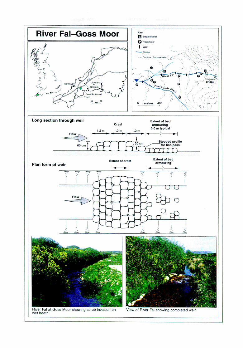
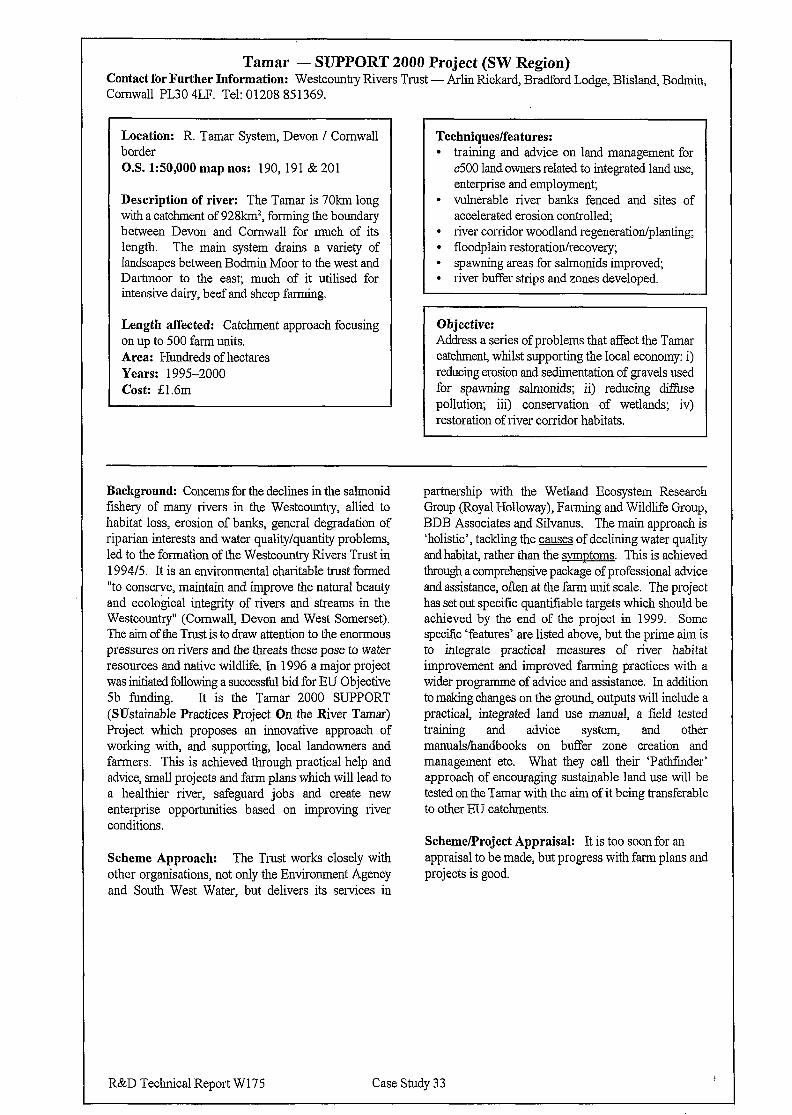
Tamar - SUPPORT 2000 Project (SW Region) Contact for Further Information: Westcountry Rivers Trust - Arlin Rickard, Bradford Lodge, Blisland, Bodmin, Cornwall PL30 4LF. Tel: 01208 851369.
Location: R. Tamar System, Devon / Cornwall border O.S. 1:50,000 map nos: 190, 191 & 201
Description of river: The Tamar is 70km long with a catchment of 928km2, forming the boundary between Devon and Cornwall for much of its length. The main system drains a variety of landscapes between Bodmin Moor to the west and Dartmoor to the east; much of it utilised for intensive dairy, beef and sheep farming.
Length affected: Catchment approach focusing on up to 500 farm units. Area: Hundreds of hectares Years: 1995-2000 Cost: f; 1.6m
Techniques/features: l training and advice on land management for
~500 land owners related to integrated land use, enterprise and employment;
l vulnerable river banks fenced and sites of accelerated erosion controlled;
l river corridor woodland regeneration/planting; l floodplain restoration/recovery; l spawning areas for salmonids improved, 9 river buffer strips and zones developed.
Objective: Address a series of problems that affect the Tamar cat&merit, whilst supporting the local economy: i) reducing erosion and sedimentation of gravels used for spawning salmonids; ii) reducing d&se pollution; iii) conservation of wetlands; iv) restoration of river corridor habitats.
Background: Concerns for the declines in the salmonid fishery of many rivers in the Westcountry, allied to habitat loss, erosion of banks, genera1 degradation of riparian interests and water quality/quantity problems, led to the formation of the Westcountiy Rivers Trust in 1994/5. It is an environmental charitable trust formed “to conserve, maintain and improve the natural beauty and ecological integrity of rivers and streams in the Westcountry” (Cornwall, Devon and West Somerset). The aim of the Trust is to draw attention to the enormous pressures on rivers and the threats these pose to water resources and native wildlife. In 1996 a major project was initiated following a successll bid for EU Objective 5b funding. It is the Tamar 2000 SUPPORT (SUstainable Practices Project On the River Tamar) Project which proposes an innovative approach of working with, and supporting, local landowners and farmers. This is achieved through practical help and advice, small projects and farm plans which will lead to a healthier river, safeguard jobs and create new enterprise opportunities based on improving river conditions.
Scheme Approach: The Trust works closely with other organisations, not only the Environment Agency and South West Water, but delivers its services in
partnership with the Wetland Ecosystem Research Croup (Royal Holloway), Farming and Wildlife Croup, BDB Associates and Silvanus. The main approach is ‘holistic’, tackling the causes of declining water quality and habitat, rather than the svmntoms. This is achieved through a comprehensive package of professional advice and assistance, often at the farm unit scale. The project has set out specific quantifiable targets which should be achieved by the end of the project in 1999. Some specific ‘features’ are listed above, but the prime aim is to integrate practical measures of river habitat improvement and improved farming practices with a wider programme of advice and assistance. In addition to making changes on the ground, outputs will include a practical, integrated land use manual, a field tested training and advice system, and other manuals/handbooks on buffer zone creation and management etc. What they call their ‘Pathfinder’ approach of encouraging sustainable land use will be tested on the Tamar with the aim of it being transferable to other EU catchments.
Scheme/Project Appraisal: It is too soon for an appraisal to be made, but progress with farm plans and projects is good.
R&D Technical Report W 175 Case Study 33
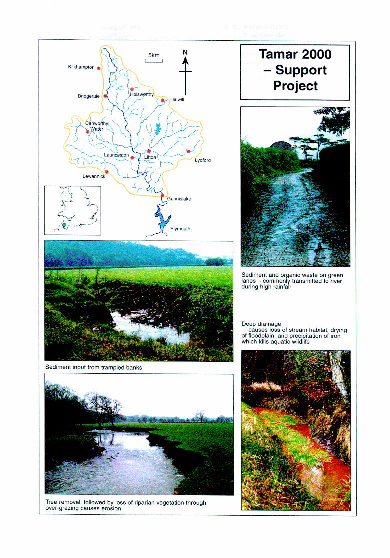
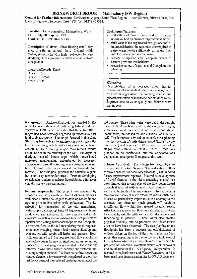
BRINKWORTH BROOK - Malmesbury (SW Region) Contact for Further Information: Environment Agency South West Region - Ann Skinner, Rivers House, East Quay, Bridgwater, Somerset TA6 4YS. Tel: 01278 457333.
Location: Little Somerford, Malmesbury, Wilts O.S. 1:50,000 map no: 173 Grid ref: ST 989838-977838
Description of river: Slow-flowing small clay river in a flat agricultural plain. Channel width 2-4m, steep banks >2m high. Subjected to deep dredging, with a previous sinuous channel cut-off alongside it.
Length affected: 3km+ Area: cl Oha Years: 1992-3 Cost: DOk
Techniques/features: l restoration of flow to an abandoned channel
(>2km) cut-off by channel improvement works; l riflle weirs in the engineered straight channel to
improve fisheries, the upstream one required to raise water levels sufficiently to restore flow into the historic old watercourse;
l variety of riparian and floodplain works to restore previous lost habitats;
l extensive variety of riparian and floodplain tree planting.
Objectives: Rehabilitation of a degraded river through restoration of a redundant river loop, management of floodplain grassland for breeding curlew, and general restoration of landscape and wildlife value. Improvements to water quality and fisheries were key targets.
Background: Brinkworth Brook was targeted by the Area for restoration work following habitat and fish surveys in 199 1 which indicated that the entire 1 Okm length had been severely degraded by successive past land drainage works. The length featured in this Case Study has been subject to engineering works since the turn of the century, with the old meandering course being cut-off in 1975 during major re-alignment works associated with the building of the M4. The depth of dredging caused banks slips which necessitated increased maintenance, exacerbated by increased emergent reed growth resulting from eutrophication and lack of shade (the latter caused by bankside tree removal). The biological, physical and chemical signals indicated a system under stress. Prior to developing rehabilitation options to address the problems, a full river corridor survey was carried out.
Scheme Approach: The project was managed by Conservation, with assistance from Fisheries, working with Flood Defence colleagues to develop rehabilitation options prior to discussions with landowners. The site selected for restoration of the old meandering watercourse had support from all landowners, with one landowner also interested to have scrapes and pools excavated as well as accommodating localised pockets of riparian tree planting in meander loops on the floodplain. To restore flow to the old meandering reach required some spot dredging, since it had become silted up and over-grown with scrub, tall herbs and grasses. Bed- width was limited to 2-3m because flood flows would be able to flow down the new straight course, and retaining fringes of reed and sedges was essential. Due to fishery interests, flows were shared between the restored and existing straight channel. To force some flow down the restored channel, a low stone weir was placed in the river just downstream of the restored upstream opening of the
old course. Three other weirs were put in the straight course to hold levels up, and thereby simulate pool/run sequences. Work was carried out by the NRA’s direct labour force, supervised by Conservation and Fisheries staf? The former also advised on extensive tree planting plus the creation of cattle drinks, pond (funded by the landowner) and scrapes. Work was carried out in stages over autumn and winter 199213: work was planned to be continuous, but the workforce was deployed on emergency flood prevention work.
Scheme Appraisal: The scheme has been subject to a detailed audit by Ann Skinner. The restoration of flow to the old channel has been very successful, with marked fishery improvements reported. Natural re-development of fluvial features in the old meandering channel has been limited due to only part of the flow being forced through it (shared with retained flood channel). The audit also highlighted the importance of tree growth on the banks to naturally shade excessive reed-growth: this is seen as particularly important, at the opening to the meander loop since too much growth will result in insuftlcient flow within the restored meander reach. After four years, however, flow was still shared between the channels, with the riffle weirs in the straight channel functioning as planned. These weirs also created physical diversity, and no problems with downstream erosion have been observed. The tree planting on the floodplain has been a success but establishment of willow stakes on the top of the river banks has been poor, this appearing to be due to the very high level of the clay banks which dry to concrete most summers. The project is considered an excellent example of landowner and multi-functional NRA (Agency) co-operation. It featured in the local press and Water Guardian, and has been used as a demonstration site for FWAG visits etc.
R&D Technical Report W17.5 Case Study 34
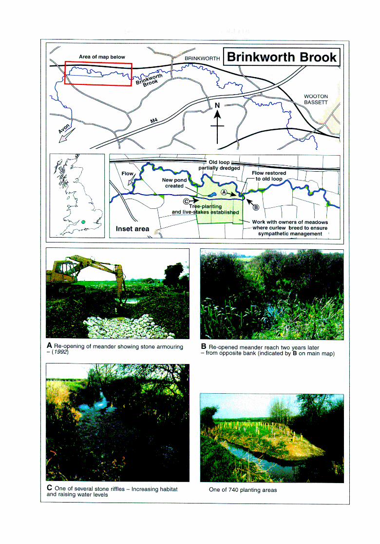
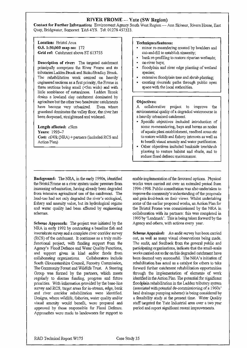
RIVER FROME - Yate (SW Region) Contact for Further Information: Environment Agency South West Region - Ann Skinner, Rivers House, East Quay, Bridgwater, Somerset TA6 4YS. Tel: 01278 457333.
Location: Bristol Area O.S. 150,000 map no: 172 Grid refi Catchment above ST 613755
Description of river: The targeted catchment principally comprises the River Frome and its tributaries Ladden Brook and Stoke/Bradley Brook. The rehabilitation work centred on heavily engineered sections as a first priority, the Frome in these sections being small (<5m wide) and with little semblance of naturalness. Ladden Brook drams a lowland clay catchment dominated by agriculture but the other two headwater catchments have become very urbanized. Even where grassland dominates the valley floor, the river has been deepened, straightened and widened.
Length affected: c5km Years: 1993-7 Cost: czE4Ok (NR4) + partners (included RCS and Action Plan)
Techniques/features: l minor re-meandering created by boulders and
cut-and-fill to establish sinuosity; l bank re-profiling to restore riparian wetlands; l on-river bays; l floodplain and river edge planting of wetland
species; l extensive floodplain tree and shrub planting; l creating riverside paths through public open
space,with the local authorities.
Objectives: A collaborative project to improve the environmental quality of a degraded watercourse in a heavily urbanised catchment. l Specific objectives included introduction of
some re-meandering, bays and berms as nodes of aquatic plant establishment, reedbed areas etc to restore wild&e and fishery interests as well as to benefit visual amenity and water purification.
l Other objectives included bankside tree/shrub planting to restore habitat and shade, and to reduce flood defence maintenance.
Background: The NRA, in the early 1990s identified the Bristol Frome as a river system under pressure from increasing urbanisation, having already been degraded from intensive agricultural use of the catchment. The land-use had not only degraded the river’s ecological, fishery and amenity value, but its hydrological regime and water quality had been affected by engineering schemes.
Scheme Approach: The project was initiated by the NRA in early 1992 by contracting a baseline fish and invertebrate survey and a complete river corridor survey (RCS) of the catchment. It continues as a truly multi- functional project, with funding support from the Agency’s Flood Defence and Water Quality Functions, and support given in kind and/or funds from collaborating organisations. Collaborators include South Gloucestershire Council, Forestry Commission, The Community Forest and Wildlife Trust. A Steering Group was formed by the partners, which meets regularly to discuss funding, progress and future priorities. With information provided by the base-line survey and RCS, target areas for in-stream, edge, bank and river corridor rehabilitation were identified. Designs, where wildlife, fisheries, water quality and/or visual amenity would benefit, were prepared and approved by those responsible for Flood Defence. Approaches were made to landowners for support to
enable implementation of the favoured options. Physical works were carried out over an extended period from 1994-l 998. Public consultation was also undertaken to improve the community’s understanding of the proposals and gain feed-back on their views. Whilst undertaking some of the earlier proposed works, an Action Plan for the Bristol Frome was commissioned by the NRA in collaboration with its partners: this was completed in 1995 by ‘Landmark’. This is being taken forward by the Agency and others, with actions every year.
Scheme Appraisal: An audit survey has been carried out, as well as many visual observations being made. The audit, and feedback from the general public and participating organisations, indicate that the small-scale works carried out so far on this degraded catchment have been deemed very successful. The NRA’s initiation of rehabilitation has acted as a catalyst for others to take forward further catchment rehabilitation opportunities through the implementation of elements of work identified in the Action Plan. The potential for significant floodplain rehabilitation in the Ladden tributary system (associated with potential de-commissioning of a 1960s’ land drainage pumping scheme) is being considered by a feasibility study at the present time. Water Quality staff targeted the Yate Industrial area over a two year period and report significant recent improvements.
R&D Technical Report W 175 Case Study 35
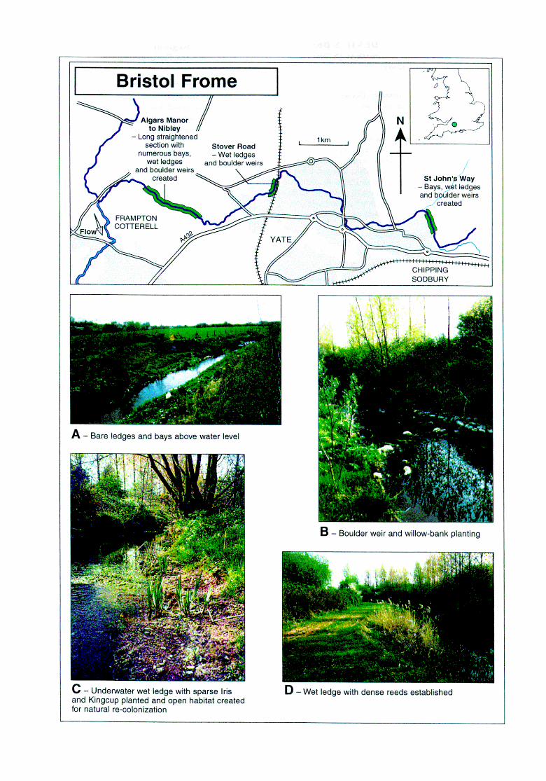
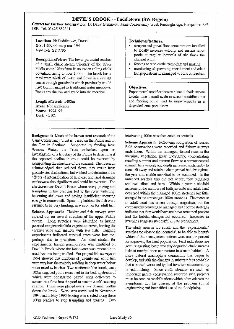
DEVIL’S BROOK - Puddletown (SW Region) :ontact for Further Information: Dr David Summers, Game Conservancy Trust, Fordingbridge, Hampshire SP6 EF. Tel: 01425 652381.
Location: Nr Puddletown, Dorset O.S. 150,000 map no: 194 Grid refi SY 7795
Description of river: The lower perennial reaches of a small chalk stream tributary of the River Piddle, some 1 Okm from its source in rolling chalk downland rising to over 200m. The brook has a maximum width of 3-4m and flows in a straight course through grasslands which previously would have been managed as traditional water meadows. Banks are shallow and grade into the meadow.
Length affected: c400m Area: Not applicable Years: 1994-95 Cost: 41Ok
Techniques/features: l sleepers and gravel flow concentrators installed
to locally increase velocity and sustain scour pools at regular intervals of six times the channel width;
l fencing to stop cattle trampling and grazing; l monitoring of spawning, recruitment and adult
fish populations in managed v. control reaches.
Objectives: Experimental modifications on a small chalk stream to determine if small-scale in-stream modifications and fencing could lead to improvements in a degraded trout population.
lackground: Much of the brown trout research of the iame Conservancy Trust is based on the Piddle and on le Don in Scotland. Supported by funding from iressex Water, the Trust embarked upon an rvestigation of a tributary of the Piddle to determine if le reported decline in trout could be reversed by manipulating the structure of the channel. The research cknowledged that reduced flows may result from roundwater abstractions, but wished to determine ifthe ffects of intensification of land-use and land drainage rorks were also sign&ant and could be reversed. The .te chosen was Devil’s Brook where heavy grazing and .ampling in the past has led to the river widening, ecoming shallower and having insufficient scouring nergy to remove silt. Spawning habitats for fish were ssumed to be very limiting, as was cover for adult fish.
theme Approach: Habitat and fish surveys were arried out on several stretches of the upper Piddle ystem. Long stretches were identified as having oached margins with little vegetation cover, leaving the hannel wide and shallow with few fish. Tagging xperiments indicated survival rates were low too, erhaps due to predation. An ideal stretch for xperimental habitat manipulation was identified on Ievil’s Brook where the landowner was amenable to rod&cations being trialled. Pre-project fish surveys in 994 showed that numbers of juvenile and adult fish irere very low, the majority residing in deep water below irater meadow hatches. Two sections of the brook, each OOm long, had pools excavated in the bed, upstream of which were constructed paired wing deflectors to oncentrate flow into tb.e pool to sustain a self-scouring egime. These were placed every 6-7 channel widths .own the brook. Work was completed in November 994, and in May 1995 fencing was erected along these OOm reaches to stop trampling and grazing. Two
intervening 1 OOm stretches acted as controls.
Scheme Appraisal: Following completion of works, field observations were recorded and fishery surveys undertaken. Within the managed, fenced reaches the marginal vegetation grew luxuriantly, concentrating receding summer and autumn flows to a narrow central channel; here velocity and depth increased sufficiently to scour silt away and retain a clean gravel bed throughout the year and enable crowfoot to be sustained. In the unfenced reaches this did not occur; they remained shallow, silted and bare. Within a year a six-fold increase in the numbers of both juvenile and adult trout occurred within the managed IOOm stretches but little changed in the unmanaged 1 OOm stretches. The increase in adult trout has arisen through migration, but the comparisons between the managed and control stretches indicates that they would have not have remained present had the habitat changes not occurred. Increases in juveniles suggests successful in situ recruitment.
The study area is too small, and the ‘experimental’ stretches too close to the ‘controls’, to be able to identity which of the management actions were most important for improving the trout population. First indications are good, suggesting that in severely degraded chalk streams habitat manipulation can restore in-stream habitats. A more natural macrophyte community has begun to develop, and with the changes in substrate it is probable that a more diverse and typical invertebrate community is establishing. Since chalk streams are such an important nature conservation resource such projects must be seen as rehabilitations which often address the symptoms, not the causes, of the problem (initial engineering and intensified use of the floodplain).
L&D Technical Report W 175 Case Study 36
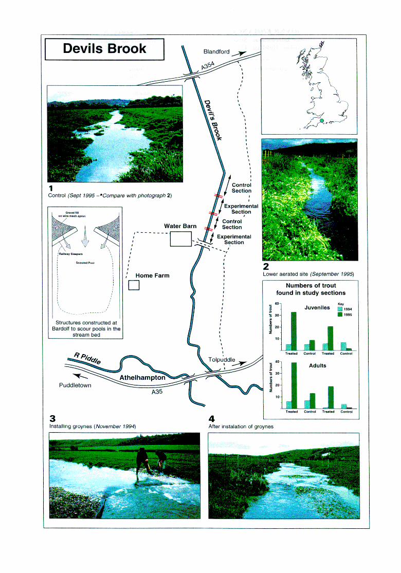
TALL RIVER ENHANCEMENT SCECEME (Rivers Agency, N. Ireland) Contact for Further Information: Rivers Agency, Department of Agriculture for Northern Ireland - Roger Thompson /Joe Nicholson, Hydebank, 4 Hospital Road, Belfast BT8 8JR. Tel: 01232 253406. Fax: 253455.
Location: Blackwater tributary in Co. Armagh, N. Ireland Map No: 19 Grid refi H 916555
Description of river: Slow-flowing, low gradient/energy river in an agricultural catchment. Approximately 6m wide, with banks 1.5-2.5m high. Bed primarily silt, banks of cohesive clays. The adjoining land is part-owned by the National Trust.
Length affected: 1,200m Years: 1995-6 Approx. construction cost: &50k
Techniques/features: l bank re-profiling, low-level berms for
establishing wetland marginal species; . island creation; l creation of shallow bays and installation of
horseshoe groyne; l establishment of emergent vegetation; l tree and shrub planting; l otter holt and Kingfisher nest cliff; l re-seeding re-profiled banks with wildflower
seed mix; l pathway for public access.
Objective: Rehabilitation of the degraded watercourse was undertaken to improve its value for nature conservation, landscape and visual amenity, recreational use, water quality and fisheries. The partial restoration and enhancement of the degraded river was one of three key objectives. The second was to provide a riverside walk which would connect to the existing path network at Ardress House, a popular National Trust property. The third objective was to attract the public to what is a demonstration site where enviromnental gains could be seen at first hand, thereby raising the profile and understanding of river enhancement and restoration.
Background: A previous arterial drainage scheme of the 1960s created a deepened and widened river with a trapezoidal cross-section. Such conditions resulted to poor channel habitat diversity, leading to low fish interest, low tree cover, poor visual amenity, and much reduced conservation value. Water quality, due to agricultural enrichment, improved little due to poor structure within the channel. The project is a pioneering scheme in N. Ireland, being the first river restoration project promoted by the Rivers Agency where the key objective is broad environmental rehabilitation (ie not undertaken ‘on the back of a proposed Flood Defence scheme).
Scheme Approach: The Rivers Agency sought to promote a river restoration project and the National Trust, who own the land adjacent to the Tall, wished to
see their section of river improved and were pleased to provide the extra land required to make it effective. The design and implementation was undertaken in-house, in consultation with the National Trust.
Scheme Appraisal: A pre- and post- project appraisal programme has been implemented. Baseline surveys included river corridor, common bird, water quality, fish populations and aerial photography. Monitoring of these is on-going to determine the benefits of the scheme’s implementation. Improvements to the landscape and habitat structure are clear to see and this is reflected in the number of visitors to the site increasing significantly in 1996, largely due to the usage of the path network when Ardress house is closed. Display boards have been erected at critical locations along the walk to illustrate specific aims and features.
R&D Technical Report W175 Case Study 37

BALLYSALLY BLAGH FLOOD ALLEVIATION SCHEME (Rivers Agency, N. Ireland)
Contact for Further Information: Rivers Agency, Department of Agriculture for Northern Ireland - Roger Thompson / Joe Nicholson, Hydebank, 4 Hospital Road, Belfast BT8 8JP. Tel: 01232 253406. Fax: 253455.
Location: University of Ulster, Coleraine, N. Ireland O.S. map no: 4 Grid refi C 848340
Description of river: A small river flowing partly through the landscaped grounds of the University of Ulster in Coleraine where it is between 2-3.5m wide; upstream the river is more degraded, flowing through developed land downstream of Coleraine by-pass.
Length affected: 1480m Date: 1994-5 Construction cost: d280k, g4k on environmental works.
Techniques/features: l bank re-profiling - low-level berms for
establishing wetland marginal species; l channel re-alignments and bed material re-
instatement; l creation of bays and bird nesting tunnels; l deflector groynes to create substrate and flow
diversity; l soft bank protection using rock armouring
incorporating stakes, gabions with willow logs and geo-textile bags;
l establishment of vegetation through transplants and spoil spreading;
l tree and shrub planting.
Objective: The aim was to integrate within a required flood alleviation scheme the rehabilitation of a degraded watercourse to improve its value as a wildlife corridor, and provide benefits for landscape and visual amenity, recreational use and fisheries.
Background: The scheme is the first flood protection scheme in N. Ireland where the design concepts were developed with river restoration as a key, and integral, part of the project. Several flood events in the 1980s caused property damage. After the potential cost-benefit of a scheme was recognised in 1993 design work began on options for alleviation.
Scheme Approach: To achieve the required hydraulic benefits, channel regrading and/or widening would be required. Upstream of the University grounds this would be achieved through bed lowering of between 500-75Omm and widening by l-1.5m. Plans were prepared which integrated sensitive bank protection measures and in-stream structures to increase habitat diversity. The works were contracted out due to the low environmental sensitivity of this reach. Flood risk was minimal through the sensitive reaches of the University, however, so the design team promoted a series of channel enhancements to be incorporated as part of the completed flood alleviation project. To ensure work was completed sensitively, and in the correct season, it was carried out by the Rivers Agency’s Direct Labour Organisation. The whole project was co-ordinated in- house by the Rivers Agency who ensured the integration of the engineering, hydraulic, cost benefit and
environmental inputs. Designs were subject to consultations with the Agency’s Environment Section and both the main riparian owners (the University of Ulster and the N. Ireland Housing Executive).
Scheme Appraisal: A pre- and post- project appraisal programme has been implemented. A key aspect of on- going work is monitoring the experimental planting and spoil transfer techniques used in reach within the University grounds. The ppa covers the different techniques used and the density of planting, as well as monitoring natural establishment on habitats created. The structural integrity and ecological benefits of the three forms of bank protection are also being monitored. The Rivers Agency has contributed to the funding of a University of Ulster research project at Ballysally Blagh, examining the ‘cost’ and ‘ecological’ benefits of stream restoration on the rural liinge.
Early indications are that the project has achieved the required hydraulic performance whilst also realising environmental gains. It is a flagship project in N. Ireland since it marks the start of developing river rehabilitation as a key component of flood alleviation schemes wherever possible.
R&D Technical Report W175 Case Study 3 8
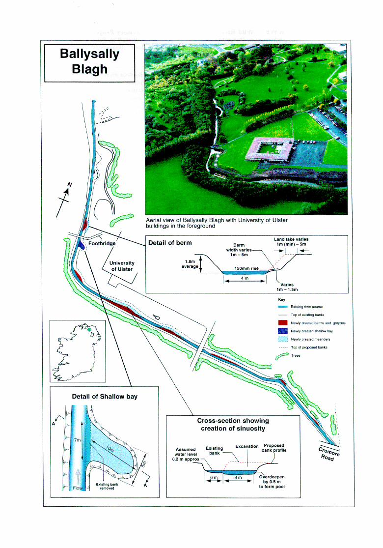
WWF - Wild Rivers Demonstration and Advisory Project Contact for further information: Project Manager - Steven Bell, through World Wide Fund for Nature, Scotland (WWF Scotland), 8 The Square, Aberfeldy PH15 2DD. Tel 01887 820449. Alternatively, contact the Project Supervisor - Elizabeth Leighton - at the same address.
Project area: Rural Stirling and Upland Tayside area designated under Objective 5b of the EU Structural fund
Rivers and their tributaries in the project area: Endrick, Forth, Tay, South Esk and part of the North Esk
03. 1:50,000 map 110s: parts of 42,43,44,50, 51,52,53,54, 56,57
Project life: 1997-2000 Budget: f250,OOO
Features of the Wild Rivers Demonstration and Advisory Project: l Demonstration sites, all being developed and
implemented through partnership with the landowner / occupier and other bodies with an interest The sites will demonstrate at selected sites the lasting ecological, economic and social benefits of natural management of rivers.
l Advisory service, free to anyone with an interest in rivers in the project area. This service will be used to encourage a natural approach to river management by a significant number of other river managers in the area.
Background: WWF Scotland has taken an active role in promoting river rehabilitation in Scotland by launching the wild Rivers Initiative. Its prime objective is to raise awareness of the degradation of river systems in Scotland that have hitherto been considered wild and natural, and generate an educated debate on the scale of the problems and how they could be rectified. The Initiative, launched in 1995, highlighted that many of Scotland’s rivers have been greatly modified; those that flow through intensively farmed or urban areas being considered as artificial as any in Europe, and many of the upland rivers have lost previous riparian interest. Historic land use and controls imposed on rivers have removed much of the interest and natural value of catchments, and their floodplains. The Initiative promotes a more natural approach.
Three publications have so far emerged from the initiative: i) the Technical report; ii) a Brochure, which summarises the main findings of the technical report; and iii) a Review of policies concerning freshwater fish in Scotland. All three publications are available from WWF Scotland.
In 1996 WWF Scotland secured funding from the EU, which they matched, to fund the wild Rivers Demonstration and Advisory Project which would further the Initiative’s goals in practice. This project began in Spring 1997.
Project Approach: The Project involves working with all river interests in the project area to promote the benefits to all parties of a more integrated approach to land and river management The project aims to address concerns about flooding, fish stocks, degraded wildlife environments and landscapes and at the same time show through monitoring, how more natural rivers can produce real benefits.
Project Appraisal: The project should provide valuable information for wider catchment restoration involving both land use change and better targeting of fiscal incentives for less intensive agricultural production Since the project only began in March 1997, there is little to report on this to date (as at July 1997). The project’s advisory component has some similarities with the TAMAR 2000 project.
R&D Technical Report W 175 Case Study 39
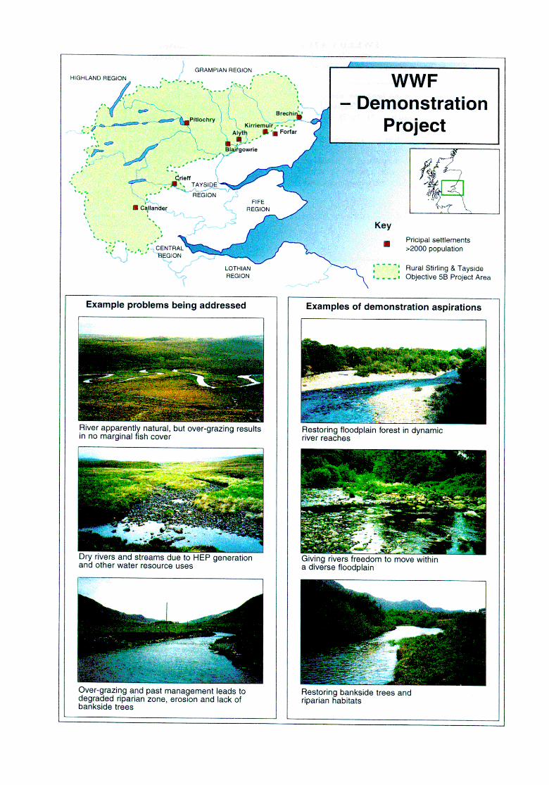
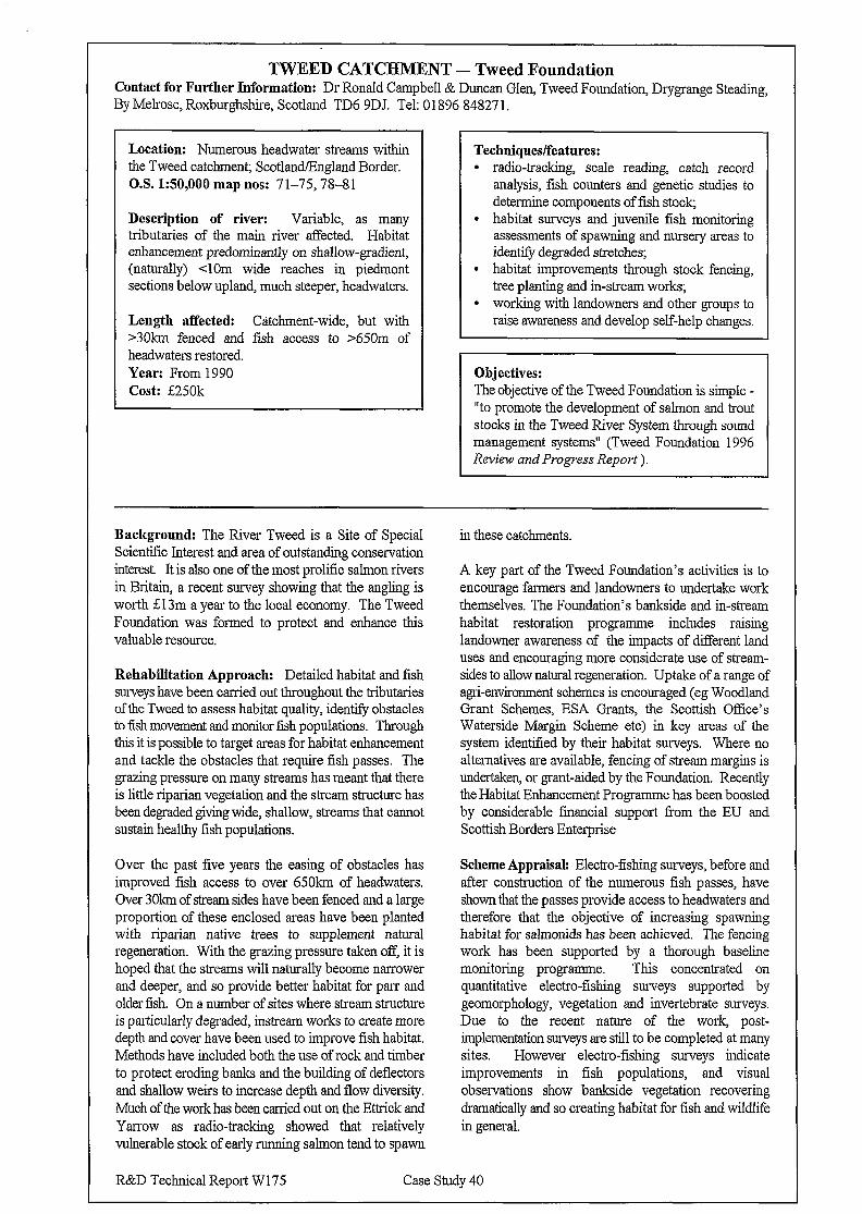
TWEED CATCHMENT - Tweed Foundation Contact for Further Information: Dr Ronald Campbell & Duncan Glen, Tweed Foundation, Drygrange Steading, By Mehose, Roxburghshire, Scotland TD6 9DJ. Tel: 01896 84827 1.
Location: Numerous headwater streams within the Tweed catchment; Scotland.!England Border. O.S. 150,000 map nos: 71-75,78-81
Description of river: Variable, as many tributaries of the main river affected. Habitat enhancement predominantly on shallow-gradient, (naturally) <lOm wide reaches in Piedmont sections below upland, much steeper, headwaters.
Length affected: Catchment-wide, but with >3Okm fenced and fish access to >650m of headwaters restored. Year: From 1990 Cost: E250k
Techniques/features: l radio-tracking, scale reading, catch record
analysis, fish counters and genetic studies to determine components of fish stock,
l habitat surveys and juvenile fish monitoring assessments of spawning and nursery areas to identify degraded stretches;
l habitat improvements through stock fencing, tree planting and in-stream works;
l working with landowners and other groups to raise awareness and develop self-help changes.
I I Objectives: The objective of the Tweed Foundation is simple - “to promote the development of salmon and trout stocks in the Tweed River System through sound management systems” (Tweed Foundation 1996 Review and Progress Report ).
Background: The River Tweed is a Site of Special Scientific Interest and area of outstanding conservation interest It is also one of the most prolific salmon rivers in Britain, a recent survey showing that the angling is worth &13m a year to the local economy. The Tweed Foundation was formed to protect and enhance this valuable resource.
Rehabilitation Approach: Detailed habitat and fish surveys have been carried out throughout the tributaries of the Tweed to assess habitat quality, identify obstacles to fish movement and monitor fish populations. Through this it is possible to target areas for habitat enhancement and tackle the obstacles that require fish passes. The grazing pressure on many streams has meant that there is little riparian vegetation and the stream structure has been degraded giving wide, shallow, streams that cannot sustain healthy fish populations.
Over the past five years the easing of obstacles has improved fish access to over 650km of headwaters. Over 30km of stream sides have been fenced and a large proportion of these enclosed areas have been planted with riparian native trees to supplement natural regeneration. With the grazing pressure taken off, it is hoped that the streams will naturally become narrower and deeper, and so provide better habitat for parr and older fish. On a number of sites where stream structure is particularly degraded, instream works to create more depth and cover have been used to improve fish habitat. Methods have included both the use of rock and timber to protect eroding banks and the building of deflectors and shallow weirs to increase depth and flow diversity. Much of the work has been carried out on the Ettrick and Yarrow as radio-tracking showed that relatively vulnerable stock of early running salmon tend to spawn
in these catchments.
A key part of the Tweed Foundation’s activities is to encourage farmers and landowners to undertake work themselves. The Foundation’s bankside and in-stream habitat restoration programme includes raising landowner awareness of the impacts of different land uses and encouraging more considerate use of stream- sides to allow natural regeneration. Uptake of a range of agri-environment schemes is encouraged (eg Woodland Grant Schemes, ESA Grants, the Scottish Office’s Waterside Margin Scheme etc) in key areas of the system identified by their habitat surveys. Where no alternatives are available, fencing of stream margins is undertaken, or grant-aided by the Foundation. Recently the Habitat Enhancement Programme has been boosted by considerable fmancial support Tom the EU and Scottish Borders Enterprise
Scheme Appraisal: Electra-fishing surveys, before and after construction of the numerous fish passes, have shown that the passes provide access to headwaters and therefore that the objective of increasing spawning habitat for salmonids has been achieved. The fencing work has been supported by a thorough baseline monitoring programme. This concentrated on quantitative electro-fishing surveys supported by geomorphology, vegetation and invertebrate surveys. Due to the recent nature of the work, post- implementation surveys are still to be completed at many sites. However electro-fishing surveys indicate improvements in fish populations, and visual observations show bankside vegetation recovering dramatically and so creating habitat for fish and wildlife in general.
R&D Technical Report W175 Case Study 40


Annexe A Proformas 1 and-2 as sent to consultees., Example letter to consultees.
R&D- Technical Report-W 175
Circulation list. .
Principal: Dr Nigel ‘I’ II IIolrnes
The Ain~onds, 57 J~amcy Road, Wnrboys, IJ~mtingdon PE17 2KW Tel: 01487 822020; Fax: 01487 823036; Mobile 0860 821643
May 20th ‘1996
Environment Agency Regional Conservation Officers/Managers (for distribution to Area staff AND appropriate fishery officers), SEPA (Ian Fozzard - central contact), DoENI (Joe Nicholson & Suzzana Allen), EN (David Withrington), CCW (Cathrine Duigan), SNH (Phil Boon), COCO~( . RSPB (Paul Jose), WWF (Wild Rivers, Scotland), WFWT (Kevin Peherdy), .- MAFF/ADAS for details of ESA affecting floodplain rehab/revitalization ( Game Conservancy (David Summers), ,. Tweed Foundation (Ronald Campbell), Broads Authority/Lea Valley Parks, -. River Medway Project (Brian Smith), Project Kingfisher, British Cole Opencast, others - please suggest useful contacts
Dear
Trawl .For Information: Addendum to,NRA (Environment Agency) R & D Project 477
River Rehabilitation/Rest.oration.- The UK &cctute in September 1996 in Denmark)“
I am trying.. to- kill tit least three birds with one &one (apologies to RSPB and
WFWT!!). There are several .immediate needs which k hope can be’.met.
I. The NRA commissioned R & D from ICOLE in 1993 relating to River Rehabilitation. Their report only covers schemes and ideas up to.the beginning of 1994 when the A@w%~Ys and ufl&% ~&Inf.ihook was published. There is a desperate need to. provide an up-to-date Addendum to this for the Environment Agency. which reflects, and builds upon, what has been done over the past two and half years.
2. I am giving a paper at the-River Restoration 96 Conference in Silkeborg, Denmark in September. I have been invited to outline ‘The UK experiences in River Restoration’. A similar paper covering Denmark is also to be given, and I assisted the Danes in producing a pro-forma for identifying and classifying .their examples of rehabilitation; I therefore hope to follow more or less the same system they have now adopted.
3. A true appreciation of what has been done by other organisations, and by other Areas of the same organisations at times, islacking. I would like to obtain photographs (ideally in slide form which: include before and after shots Ibut others not shunned! J) of as many.of the rehabilitation works as possible so that;ALL meaningful ones can be put on to CD ROM and
-I-
this will be made available to ALL those who provide me (and the Agency) with relevant material.
For the purposes of this trawl, I think it wise to concentrate just on this decade, SO
stick to 1990-1996 rehabilitation.works unless there are very special ones with good supporting information.
The prime focus must be PHYSICAL WORKS leading to rehabilitation of river, margin, bank, riparian zone of floodplains but there are opportunities for adding other schemes too if.you want to draw these to my attention. Please note: this is about rehabilitation so DO NOT include examples of ‘sympathetic management’ that minimise damage - the works must make a significant contribution to rehabilitating lost habitats/features,
To understand more fully the mechanisms/situations which give rise to rehabilitation, projects should be categorised into three distinct areas:
’
Al. Clear IMPROVEMENTS to ‘environnnm%I mif!e’ to rivers and floodplains (not mitigations) which result from (and are paid for by) PROJECTS/ ACTlVlTIES with other Objectives. Examples in&&Capital Flood Defence Schemes (e.g. are many - River Tome, R. Cole), Maintenance of Flood Defence Standards of Service (even more), replacement of hard defences with willows etc, Road Schemes, Reservoirs/other water resource projects, Urban/Industrial Developments, Gravel/other mineral extractions.
A2. IMPROVEMENTS to rivers and floodplains where the KEY OBJECTIVE has been to restoreirehahilitate features degraded jn the past. Examples include Capital habitat restoration projects of rivers (e.g. Ah, Whittle Brook, Brinkworth Brook), of rivers and fktiidplains (e.g.few at present, include the Cole, Skeme, Little Ouse, Project Kingfisher), of specific riverine features for fish (many local and strategic habitat enhancements and removal of barriers to migration), corridor enhancements for biota (otter projects), floodplain enhancements (often for birds,.with RSPB [ + CCW) involved with some of the best).
A3. OTIlERS - most enhancements/rehabilitations should fall into category I or 2. If it doesn’t, put it in here. Most pmiects will be in here by default, but what I am really looking for is a project that has been approached multi-functionally and multi-objectively with rehabilitation/restoration s&n as the key to achieving other o&ctives (this is what is happening in Denmark where floodplains are being restored to negate need. to undertake more extensive/expensive flood alleviation further downstream or to improve water quality).
4
Information on completed projectshurh is the most important. However I know there are some exciting projects phned - so if you consider these important, please provide information.
Please provide detailed information for individual major schemes/projects AND a numerical inventory of scheme types of a more minor nature to enable the SCALE and MECHANISM of improvements to be assessed.
Proformas for identifying key elements of major schemes, and an inventory of schemes, are attached. .,
For details of individual projects it is important to follow the protocol described below.
2
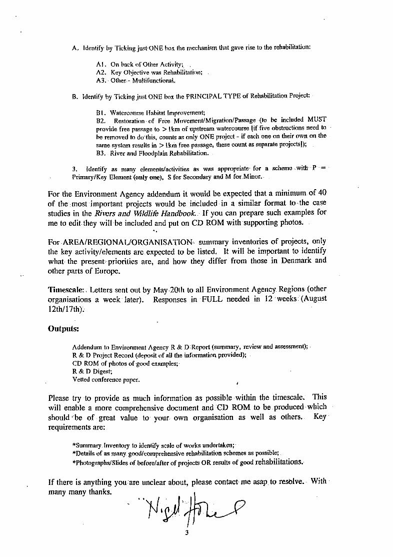
A. Identify. hy Ticking just ONE hox the mechanism that gave rise to the rehabilitation:
AI . On hack of Other Activity: A2. Key Objective was Rehabilitation; A3. Other.- Multifunctional.
B. Identify by Ticking just ONE box the PRINCIPAL TYPE of Rehabilitation Project:
BI . Watercourse Ilahitat Improvement; 02. Restoration. of Free Mr)vement/Migration/Passage .(to be inchdd MUST provide free passage to > Ikm of upstream watercourse \if.five obstructions need to he removed to do’this, counts as only ONE project - if each one on their own on the same system results in > lkm free passage, these count as separate projects]); B3. River and Floodplain Rehabilitation.
3. Identify as many elements/activities as was appropriate- for a scheme -.with -P = Primary/Key Element (only one), S for Secondary and M for Minor..
For the Environment Agency addendum it would be expected that a minimum.of 40 of the-,most -important projects would be iricluded in a similar ,format- to.,the .case studies in the Rivers and $Wdli~ Handbook. If you can prepare such examples for me to edit-they will.be included and put on CD ROM with supporting photos.
For .AREAIREGIONALIORGANISATION:~ summary inventories of projects, only the key activity/elements are expected to be listed. It will be important to identify what. the present:.priorities are, and how they differ from those in Denmark and
*. other parts of Europe.
Tirtlescale:L Letters sent out by May.20111 to all Environment Agency. Regions (other organistitions a week later). Responses in -FULL needed in 12 ‘weeks:.(August 12th117th);
outputs:
Addendum to Environment Agency R & D.Report (summary, review and assessment); R & D Project Record (deposit of all the information provided); . CD ROM of photos of.gocd examples;- R & D Digest; Vetted conference paper. I
Please try -to provide as much information as possible within the timescale: This will- enable a more comprehensive document and CD ROM to be. produced. which should :‘be of great value to your.. own organisation as well as others. Key requirements are:
*Summary. Inventory to identify scale of works undertaken; *Details of as many. god/comprehensive rehabilitation schemes as possible;
*Photograph#lides of before/after of projects OR results of good rehabilitations.,
If there is anything you’are unclear about, please contact- me asap. to res6lve:. With many many thanks.
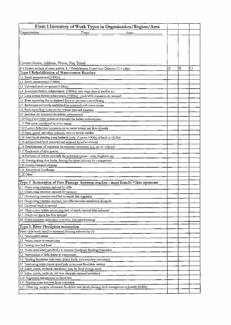
Form 1 Inventory of Work Types in Organisation/Region/Area 1
Oqanisation . . . . . . . . . . . . . . . . . . . . . . . . . . . . . . . . . . Dept.. . . . . . . . . . . . . . . . . . . . . . . . . . . Area.. . . . . . . . . . . . . . . . . I
Contact Name, Address, Phone, Fax, Email.. . . . . . . . . . . . . . . . . . . . , . . . . . . . . . . . . . . . . . . . . . . . . . . . . . . . . . ! I I B = Project on back of other activity, R = Rehabiitation Project Key Objective: 0 = other. B R 0 Type 1 Rehabilitation of Watercourse Reaches
1.1 Reach remeandered (XOOm)
1.2 Reach remeandered (~5OOm)
1.3 Culverted reach re-owned G=lOOrrJ
Water-table levels raised or increased flooding achieved by (*): I 3.1 *unspecified means I
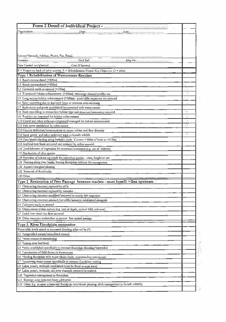
I Form 2 Detail of Individual Proiect - . . . . . . . . . . . . . . . . . . . . . . . . . . . . . . . . . . . . . . . . . . I I Or,4lllsation.. . . . . . .,.. . . . . . . . ..Dept.. _. . . . ,... .,.,................. .Alea. . . . . . . . . . - ..-
Contact Name(s), Address, Phone, Fax, Email. . . . . . . . . . . . . . . . . . . . . . . . . .
Location.. . . . . . t... . . . . . . . . . . . . . . . . . . . . . . . . . . . . Grid Ref . . . . . . . . . . . . . . . . . . . . . . . . . . . . . . . . . . . . ..1Map No..................................
Date Carded out/planned.. . . . . . ..Cost (if known). . . . .
B = Project on back of other activity, R = Rehabiitation Project Key Objective, 0 = other.
Type 1 Rehabilitation of Watercourse Reaches 1.1 Reach.remeandered (>5OOm)
1.2 Reach remeandered (<5OOm)
1.3 Culverted reach re-omened f>lOOm) :
I
1.4 X-sectional habitat enhancement. (>5OOm) -two-stage channel profiles etc.
1.5 Long section habitat enhancement (>5OOm) - pool/riffle sequences etc restored
1.6 ‘River nar:owing due to depleted flows or previous over-widening
1.7 Backwaters and pools established/reconnected with water-course.
1.8 Bank reprofiling to restore lost habitat type and structure/an-nouring removed
1.9 Boulders erc imuorted for habitat enhancement
: .:
2.1 Obstructing stmcture replaced by riff!e
2.2 Obstructing structure replaced by meander
2.3 Obstmcting stmcture modified/removed to enable fish migration
2.4 Obstructing stmchue retained, but riffle/meander established alongside
2.5 Culverted reach re-ooened
2.6 Obstructions within culvert (e.g. !a& of depth, vertical falls) redressed
2.7 Dried river reach has flow restored
2.8 Other measures undertaken to restore free animal passage
3.11 Riparian zone removed from cultivation
3.12 Other 6.8. scrapes; substantial floodplain tree/shrub planting, ditch management to benefit wildlife)
Annexe B. Summary tabulations of information,provided by Environment Agency consultees for individual schemes -within seven (excludes South West) Regions
R&D Technical Report. W 175.

(This page left intentionally blank)
R&D Technical Report W175
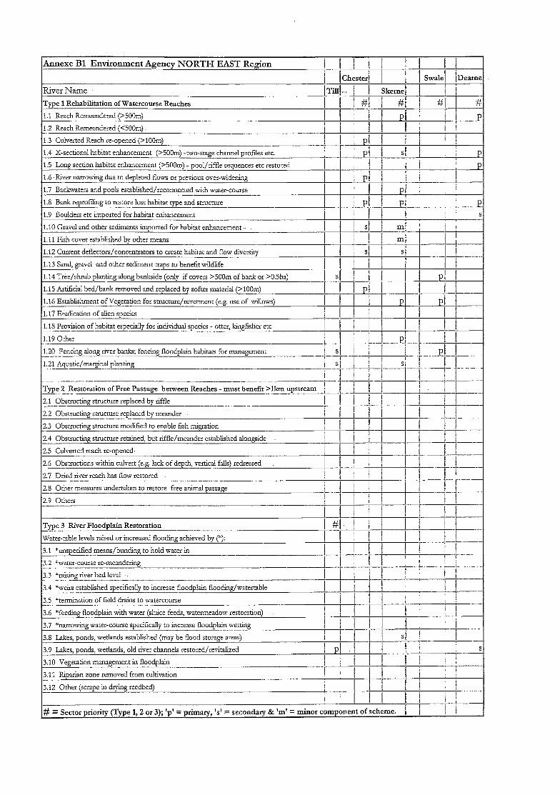
;$nnexe Bl Environment Agency NORTH EAST Region
River Name
TyTe 1 Rehabilitation of Watercourse Reaches
1.1 Reach Remeandered (>SOOm)
1.2 Reach Remeandered (<50&n) -.
1.3 Culverted Reach re-opened (>lOOn-)
IIIII II II
I I Chester I 1 &vale, 1 IDeame
Skerne !I Ii I w I 77 1 if/ 1 4 I
#
P
‘1.4 X-sectional habitat enhancement (>SOOm) -two-stage channel profiles etc.
1.5 Long section habitat enhancement (>5OOm) - pool/riffle sequences etc restored
I.6 .I&-er narrowing due to depleted flows or previous over-widening
1.7 Backxvaters and pools established/reconnected with water-course
1.8 Bank reprofiling to restore lost habitat type and structllle __~- 1.9 Boulders etc imoorted for habitat enhancement
1.10 Gravel and other sediments imported for habitat enhancement -.
1.11 Fish cover established by other means
1.12 Current deflectors/concentrators to create habitat and flow diversity
1.13 Sand, gravel and other sediment traps to benefit v&Uife
1.14 Tree/shrub planting along bankside (only if covers >500m of bank or >0.5ha)
1.15 Artificial bed/bank removed and replaced by softer material (>lOOm)
1.16 Establishr;ienr of Vegetation for stmcture/revetment (e.g. use of willows) - 1.17 Eradication of alien species
1.18 Provision of habitat especially for individual species - otter, kingfisher etc _. - 1.19 Other -- 1.20 Fencing along river banks; fencing floodplain habitats for management - 1.21 Aquatic/marginal planting _-.~-.-
-----~
Type 2 Restoration of Free Passage between Reaches - must benefit >lkm upstream 1 _.-- 2.1 Obstructing struchxe replaced by riffle _--- _ .- .-.
2.2 Obstructing s’zuctore replaced by meander - 2.3 Obstructing structure modified to enable fish migration
24 Obstructing structure retained, but riffle/meander established alongside
25 Culverted reach re-opened,
2.6 Obstructions within culvert (e.g. lack of depth, vertical falls) redressed
2.i Dried river reach has flow restored
2.8 Oher measures undertten to restore free animal passage
2.9 Others
Type 3 River Floodplain Restoration
Water-table levels raised or increased flood&g achieved by (*):
3.1 *unspecified means/bonding to hold water in - 3.2 %vater-course re-meandering _ _ _--.
3.3 *raising river bed level - -_..__-
3.4 %wirs established specifically to increase floodplain f?ooding/matertable
3.3 *termination of field drains to watercourse _..
3.6 *feeding floodplain with water (sluice feeds, watermeadow restoration)
3.i *narrowing water-course specifically to increase floodplain wetting
3.8 Lakes, ponds, wetlands established (may be flood storage areas)
,3.9 Lakes, ponds, wetlands, old river channels restored/revitalized
~3.10 Vegetation management in floodplain
3.11 Riparian zone removed from cultivation
3.12 Other (scrape in drying reedbed)
l#=s ector priority (Type 1,2 or 3); ‘p’ = primary, ‘s’ = secondary & ‘m’ = minor component of scheme.
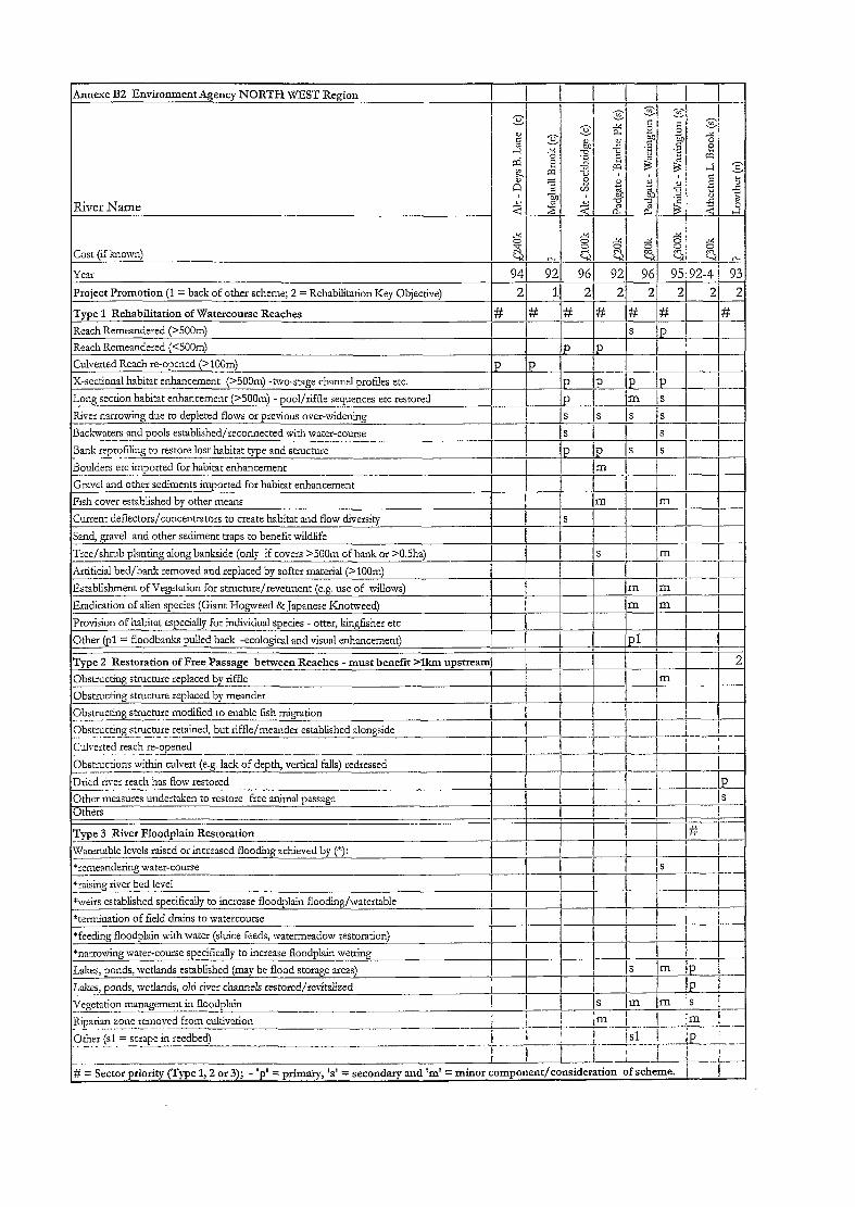
structlng stmchlr __..__ -~-..- -.- vetted reach e-opened
ther ($1 = scrape in reedbed) ._... -_ --..-~--

Annexe B3 Environment Agency - MIDLANDS Region; Lower Trent Area - _--
-_ -..
Rive; Name
Cost (if bow-n)
Year !* = year completed)
Area (LT = Lower Trent) (LT ILT (LT LT /LT !LT IL?? ILT !LT ,LT Project Promotion (1 = back of other scheme; 2 = Rehabilitation Key Objective; 3 = Other)
Type 1 Rehabilitation of Watercourse Reaches
Reach Remeandered (XOOm) (pl - one meander, staged work 95-97)
Reach Remeandered (<5OOm) @l = channel diversion)
Culverred Reach reopened (>lOOm) .__. _._ --. X-sectional habitat enhancement (>SOOm) -hvo-stage channel profiles etc. .- . -..---_- Long section habitat enhancement (>SOOm) - pool/riffle sequences etc restored
--
- River narrowing due to depleted flows or previous over-widening -- . .._ -- Backwaters and pools established/reconnected with water-course
Bank reprofiling to restore lost habitat type and stmcture
Boulders etc imported for habitat enhancement (pl = new weir)
Gravel and other sediments imported for habitat enhancement
Fish cover established by other means -..- Current deflectors/concentrators to create habitat and flow diversity
Sand, gravel and other sediment traps to benefit wildlife
Tree/shrub planting along bankside (only if covers >500m of bank or >0.5ha)
Artificial bed/bank removed and replaced by softer material (>lOOm)
Establishment of Vegetation for stmcture/revetment (e.g. use of willows)
Eradication of alien species (pl = Japanese Knotweed)
Provision of habitat especially for individual species - otter, kingfisher etc
S)ther @I = Diversion; p2 = part-funded project officer of Nottingham C.Cj
Type 2 Restoration of Free Passage between Reaches - must benefit >llun upstream -. .-. __ Obstructing structure replaced by riffle
Obstructing structure replaced by meander
Obstructing structure modified to enable fish migration
Obstructing struchxe retained, but riffle/meander established alongside
Culverted reach x-opened
ObsAactions within cuivert (e.g. lac!; of depth, vertical fa!!s) redressed --.--- Dried river reach has flow restored -. - .--.__- Other measures undertaken to restore free animal passage -...- Others --ZZ
Type 3 River Floodplain Restoration
Watertable levels raised or increased flooding achieved by (“):
*remeandering mater-course I ) 1 / j ! 1 i j
*raising river bed level I ’ I I i I / 1 I I__. *weirs established specifically to increase floodplain flooding/watertable
xtermination of field drains to watercourse
“feeding floodplain with water (sluice feeds, watermeadow restoration)
*narrowing marer-course specifically to increase floodplain metting-
Lakes, ponds, wetlands established (may be flood storage areasj -.-___ Lakes, ponds, wetlands, old river channels restored/revitalized
Vegetation management in floodplain -. _-.____- - Riparian zone removed from cultivation __ .._--- - Other _ .__ __-._ . _-._-___ -- # = Sector priority (Type 1,2 or 3); ‘p’ = primary, ‘s’ = secondary and ‘m’ = minor
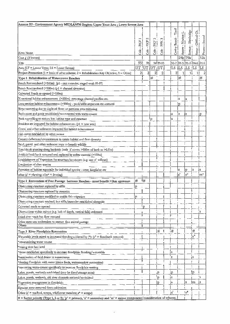
Annexe B3 - Environment Agency- MIDLANDS Region; Upper Trent Area ; Lower Severn Area
River Name
Cost L (if known)
Y.2
Area (LT = Lower Trent; LS = Lower Severn)
Project Promotion (1 = back of other scheme; 2 = Rehabilitation Key Objective; 3 = Other)
Type 1 Rehabilitation of Watercourse Reaches
Reach Remeandered (XOCm) @l - one meander, staged work 95-97)
Reach Remeandered (GCiJm) (pl = channel diversion)
Culverted Reach re-opened (>lOOm)
X-sectional habitat enhancement (25OOm) -two-stage channel profiles etc.
Long section habitat enhancement (S5OOm) - pool/riffle sequences etc restored
River narrowing due to depleted flows or previous ove:-w&r&g
Backwaters and pools established/reconnected with water-course _- BnJ11; reprofiling co restore lost habitat type and structure
Bouiders etc imported for habitat enhancement @I = new w&)
Gravel and other sediments imported for habitat enhancenxne --- Fish cover established by other means
Current deflectors/concentrators co create habitat and flow diversity
Sand, gravel and other sediment traps to benefit wildlife
Artificial bed/bank removed and replaced by softer material (>lOOm) ~____ Establishment of Vegetaation for stnxture/revetment (e.g. use of wilIows) _ .--_- ---. - Eradication of alien species --. Provision of habitat especially for individual species - otter, kingfisher etc
other (s’ = planting, s/m* = fencing)
Type 2 Restoration of Free Passage between Reaches - must benefit >lkm upstream
Obstructing structure replaced by riffle
Obstructing strocture replaced by meander --- Obstructing structure modified to enable fish migration
Obstructing swuchxe retained, but riffle/meander established alongside --- Culverted reach re-opened __-... Obstructions within culvert (e.g. lack of depth, vertical falls) redressed -.-- Dried river reach has flow restored
Other measures undertaken to restore free animal passage 6ihers
Type 3 River Floodplain Restoration
*remeandering water-course -- *raising river bed level
*\ireirs established specifically to increase floodplain flooding/watertable
*termination of field drains to watercourse
*feeding floodplain with water (sluice feeds, watermeadow restoration)
*narrowing water-course specifically to increase floodplain wetting
Lakes, ponds, wetlands established (may be flood storage areas)
Lakes, ponds, wetlands, old river channels restored/reviklized
Vegetation management in floodplain -.____ Riparian zone removed from cultivation --- Other (s’ = reedbed, scrape, wildflower meadow; s* = scrape) ____. -. --_- # = Sector priority
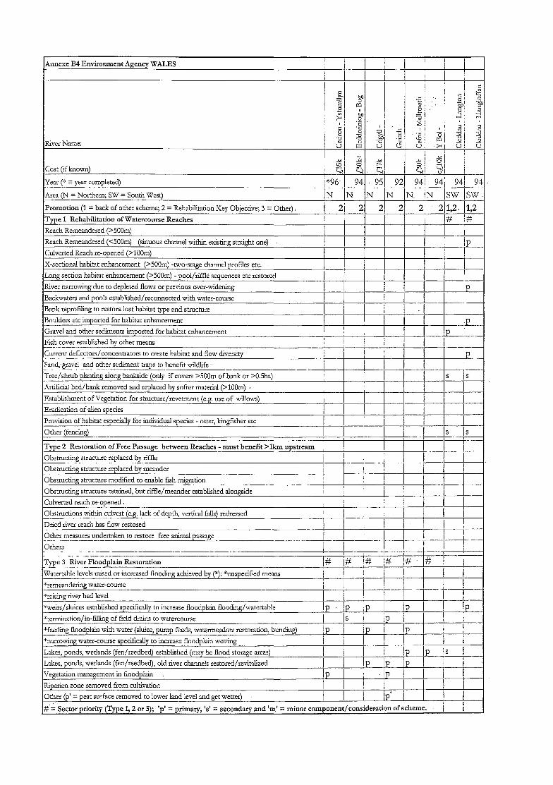
Annexe B4 Environment Agency WALES
River Name:
Cost (if known)
Year C = year completed) _-- I*96 1 94 951 92) 94: 941 941 94
Area (34 = Northern; SW = South West) IN IN IN IN N /N Isw /SW.
Promotion (1 = back of other scheme; 2 = Rehabilitation Key Objective; 3 = Other). 1 2j 21 2) 2 2 211,2: 11,2 Type 1 Rehabilitation of Watercourse Reaches I
I I I$ !#
Reach Remeandered (XOOm)
Reach Remeandered (6OOm) (sinuous channel within esisting straight one)
Culverted Reach re-opened (>lOCm)
Y-sectional habitat enhancement (x~JCHI~) -two-stage channel profdes etc.
Long section habitat enhancement (X00$ - pool/riffle sequences etc restored
River narrowing due to depleted flows or previous over-widening
Backvaters and pools established/reconnected with water-course
Bank reprofiling to restore lost habitat type and structure
Boulders etc imported for habitat enhancement
Gravel and other sediments imuorted for habitat enhancement
IF’ 1 IS I cover established bv other means I
I 1 I I , I
ICurrent deflectors/concentrators to create habitat and Bow diversity _ - Sand;gravel and other sediment traps to benefit wildlife ._- Tree/shrub planting along bankside (only if covers >500m ofbank or >0.5ha) - ..~ Artificial bed/bank removed and replaced by softer material (21OOm) :
Establishment of Vegetation for structure/revetment (e.g. use of willows)
Eradication of alien species
Provision of habitat especially for
Other (fencing) -̂- - True 2 Restoration of Free Passage between Reaches - must benefit >llun uustream
Obstructing structure replaced by riffle
Obstructing structure replaced by meander
Obstructing structure modified to enable fish migration
Obstructing structure retained, but riffle/meander established alongside
Culverted reach re-opened .
I i i I I I
Obstructions within culvert (e.g. lack of depth, vertical falls) redressed
Dried river reach has flow restored
Other measures undertaken to restore free animal passage _ _.__ .____. ----.~ Others _. -
Tvpe 3 River Floodplain Restoration _ L- .._ -. .--._-- Watertable levels raised or increased flooding achieved by (*): *;unspcdfied means - *:emeandering water-course
*raising river bed level - %.eirs/sluices established specifically to increase floodplain flooding/watertable
:Ltermination/in-fdling of field drains to watercourse
*feeding floodplain with water (sluice, pump feeds, watermeadow restoration, bunding)
‘narrowing water-course specifically to increase floodplain wetting
Lakes, ponds, wetlands (fen/reedbed) established (may be flood storage areas)
Lakes, ponds, wetlands (fen/reedbed), old river channels restored/revitalized
T’egetation management in floodplain
Riparian zone removed from cultivation
Other @’ = peat surface removed to lower land level and get wetter)
#.= Sector priority (Type 1,2 or 3); ‘p’ = primary, ‘s’ = secondary and ‘m’ = minor component/consideration of scheme.
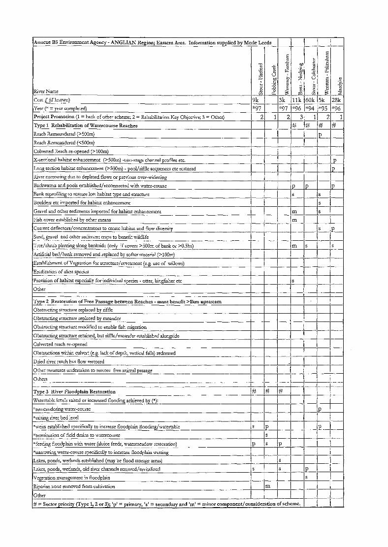
Annexe B5 Environment Agency - ANGLIAN Region; Eastern Area. Information supplied by
River Name
Cost L (if known) -- .- Year (* = year completed) __ _ ..- Project Promotion (1 = back of other scheme; 2 = Rehabilitation Key Objective; 3 = Other)
Type 1 Rehabilitation of Watercourse Reaches
Reach Remeandered (S5OOm)
Reach Remeandered (~5004
Culverted Reach re-opened (>lOOm)
X-sectional habitat enhancement (>5OOm) -two-stage channel profdes etc.
Long section habitat enhancement (~5OOm) - pool/riffle sequences etc restored
River narrowing due to depleted flows or previous over-widening
Backzqaters and pools established/reconnected with water-course
Bank reprofling to restore lost habitat type and structure
Boulders etc imported for habitat enhancement
Gravel and other sediments imported for habitat enhancement
Fish cover established by other means
Current deflectors/concentrators to create habitat and flow diversity -.-____ Sand, gravel and other sediment traps to benefit wildlife
‘Tree/shrub planting along bankside (only if covers >5OOm of bank or >0.5ha) _ .--. - ---- Artificial bed/bank removed and replaced by softer material (>lOOm) __- iEstablishment of Vegeration for stmcture/revetment (e.g. use of willows)
‘Eradication of alien soecies
*97 *97 ,*9G *94 I*93 I*96
I
Provision of habitat especially for individual species - otter, kingfisher etc ! I I Is ! 1 ( Other
Type 2 Restoration of Free Passage between Reaches - must benefit >lkm upstream ____. Obstructing st-mcture replaced by riffle - - Obstructing stn&re replaced by meander
Obstructing structure modified to enable fish migration
Obstructing stmcture retained, but riffle/meander established alongside
Culverted reach re-opened
Obstructions within cuIvert (e.g. Iack of depth, vertical falls) redressed
Dried river reach has flow restored --~ Other measures undertaken to restore free animal passage I .-
I i I.1 I
/
I i
Othels I 1 I _. ,... _.---.- ---- - _-__. - -.-- +-.7 ! 1 1 ..&-
Type 3 River Floodplain Restoration _-_. Etertable levels raised or increased flooding achieved by (*):
*remeandering water-course
*raising rivet bed level
*weirs established specifically to increase floodplain flooding/watertable - *termination of field drains to watercourse -- *fee&g floodplain wirh water (sluice feeds, watermeadow restoration)
*narrowing water-course specifically to increase floodplain wetting
IL&es, ponds, wetlands established (may be flood storage areas)
Lakes, ponds, wetlands, old river channels restored/revitalized
IVegetation management in floodplain
Riparian zone removed from cultivation
iOdKr
# = Sector priority (Type 1,2 or 3); ‘p’ = primary, I.4 = secondary and ‘m’ = minor
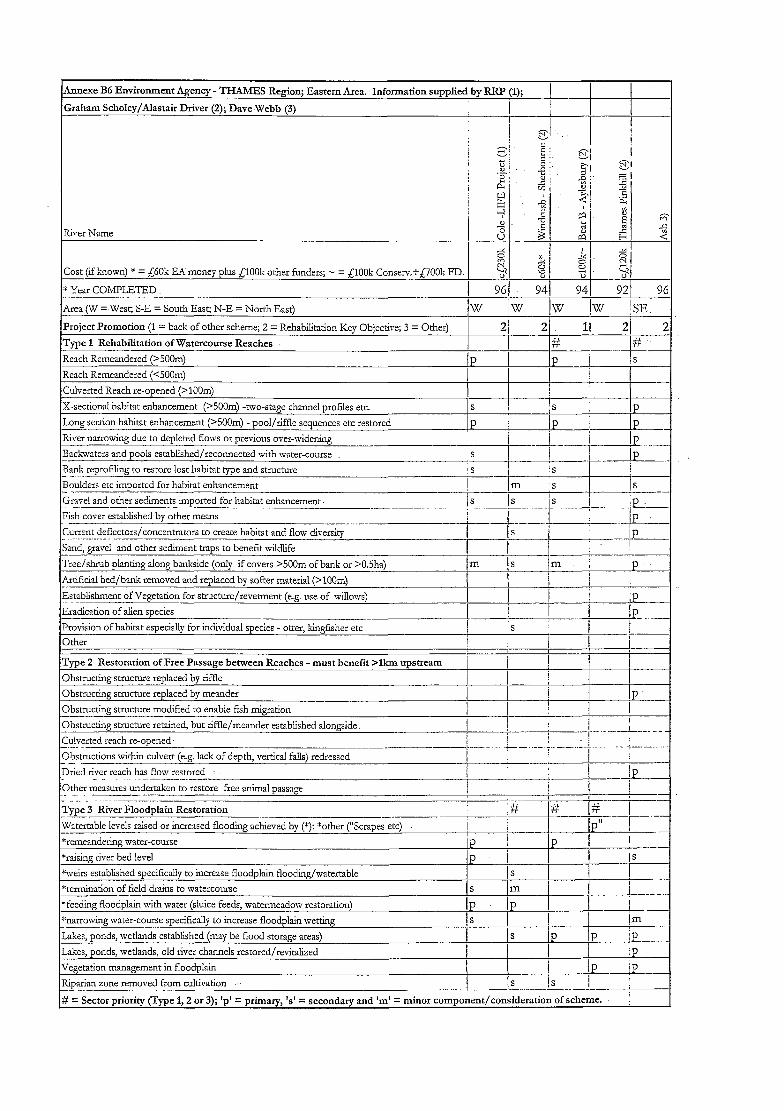
Annexe BG Environment Agency - THAMES Region; Eastern Area. Information supplied by RRP (1); (
Graham Scholey/AIastair Driver (2); Dave Webb (3) I I I
I ! I
g .,.
L 2 I I I x 2. Cost (if known) * = EGOk E-4 money plus QOOli other funders; - = ElOOk Conserc+,C;7001; FD. 4 z
* Year COMPLETED I - 961 941 941 921 96
Area (W =-Wesest; S-E = South East; N-E = North East) w Iw w Iw jSE.
Project Promotion (1 = back of other scheme; 2 = Rehabilitation Key Objective; 3 = Other)
Type 1 Rehabilitation of Watercourse Reaches
Reach Remcandered (>5OOm) Reach Remcandered (>5OOm)
Reach Remeandered (<5OOm) Reach Remeandered (<5OOm)
Culverted Reach re-opened (>lOOm) Culverted Reach re-opened (>lOOm)
X-secrional habitat enhancement (>5OOm) -two-stage channel profdes etc. X-secrional habitat enhancement (>5OOm) -two-stage channel profdes etc.
Long section habitat enhancement (>5OOmj -pool/riffle sequences etc restored Long section habitat enhancement (>5OOmj -pool/riffle sequences etc restored
River narrowing due to depleted flows or previous over-widening River narrowing due to depleted flows or previous over-widening
Backwaters and pools established/reconnected with water-course Backwaters and pools established/reconnected with water-course
Bank reprofang to restore lost habitat type and structure Bank reprofang to restore lost habitat type and structure - _.̂ - _.̂
P P P P 1 ! Is 1 ! Is I I , I I I , I
/ 1 I j / 1 I j S S jS jS P P P P P P P P
j--+- j j--+- j !P ._ !P ._ -Il -Il S S c c P P
IS IS ! !
-1 -1 !S !S
Boulders etc imported for habitat enhancement ---- Gravel and other sediments imported for habitat enhancement. - .-.~ - Fish cover established by other means
I__.- Current deflectors/concentrators to create habitat and flow diversity _ ..-.--_-. ..--- Sand, gravel and other sediment traps to benefit wildlife
Tree/A& planting along bankside (only if covers >500m of bank or >O.jha)
I /m s IS
!s 1s is i :p.- I
----...-.--- IP
_Artificial bed/bank removed atld replaced by softer material (Bloom)
Establishment of Vegetation for stmcture/revetment (e.g. use of willows)
Eradication of alien species - Provision of habitat especially for individual species - otter, kingfisher etc
Other
Type 2 Restoration of Free Passage between Reaches - must benefit >lkm upstream I
Obstructing stmcmre replaced by riffle
Obstructing structure replaced by meander P Obstructing smxtwe modified to enable fih migration
Obstm&g stmcmre retained, but riffle/meander established alongside -.- Culverted reach re-opened-
Obstructions within culvert (e.g. lack of depth, vertical f&j redressed -- - Dried river reach has flow restored - - ----I_- Other measures undertaken to restore free animal passage ._ .---.._I -_... Tvpe 3 River Floodplain Restoration -L Waterxble levels raised or increased flooding achieved by (*): *other (“Scrapes etc)
*remeandertig water-course
*raising river bed level
*weirs established specifically to increase floodplain flooding/watertable
*termination of field drains to watercourse -_~--
Lakes, ponds, wetlands established (may be flood storage areas)
Lakes, ponds, wetlands, old river channels restored/revitalized
Vegetation management in floodplain
Riparian zone removed from cultivation
$ = Sector priority (Type 1,2 or 3); ‘p’ = primary, ‘s’ = secondary and ‘m’ = minor component/consideration of scheme. I
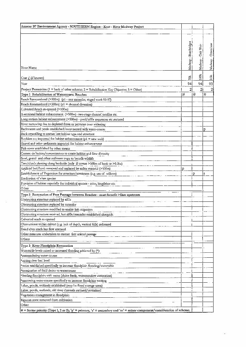
Amexe B7 Environment Agency - SOUTHERN Region - Kent - River Medway Project
River Name
Project Promotion (1 = back of other scheme; 2 = Rehabilitation Key -..-. -- -- Type 1 Rehabilitation of Watercourse Reaches ----~ Reach Remeandered (>5OOm) (pl - one meander, staged work 95-97)
Reach Remeandered (<5OOm) (~1 = channel diversions
Objective; 3 = Other) --
94/ -7
21 -+-
‘; Culverted Reach re-opened (>lOOm)
X-sectional habitat enhancement (>SOOm) -two-stage channel prohles etc.
Long section habitat enhancement (>SOOm) - pool/riffle sequences etc restored
Rker narrowing due to depleted flows or previous over-widening
Backwaters and pools established/reconnected with water-course
Bank reprofiling to restore lost habitat type and structure
i I
i 1 1
P I
- Boulders etc imported for habitat enhancement (pl = new weir)
Gravel and other sediments imuorted for habitat enhancement
IFish cover established bv other means I 1 I I
Current deflectors/concentrators to create habitat and flow diversiq
Sand, gravel and other sediment traps to benefit wikIlife
Tree/shrub planting along bankside (only if covers SOOm of bank or >O.jha) ---_--.- Xr~ficial bed/bank removed and replaced by softer material (>lOOm) -.- Establishment of Vegetation for stmcture/revetment (e.g. use of willows) - ..- _._-~-- Eradication of alien soecies
’ j
I ----
-____- iP I..---- _...._. ~-.-.
Drox-ision of habitat especially for individual species - otter, kingfsher etc -._- - Other
Type 2 Restoration of Free Passage between Reaches - must benefit >lkm upstream I
Obstructing stmchxe replaced by riffle ~_-_.-. _ -- Obstrucdng structure replaced by meander
--+- j
I -__- Obstructing structure modified to enable fish migration I I
f---- Obstmctine structure retained. but riffle/meander established alongside i I
ICulverted reach re-owned ! I I 1 I I
Obstructions within culvert (e.g. lack of depth, vertical falls) redressed
Dried river reach has flow restored
Other measures undertaken to restore free animal passage
Others
Twe 3 River Flood&in Restoration
I I j
I 1
Watertable levels raised or increased flooding achieved by (*): I I
*remeandering water-course I ‘raising river bed level ! i
*weirs established specifically to increase floodplain flooding/watertable
*termination of field drains to watercourse I / j_._--_
I ! “feeding floodplain with water (sluice feeds, watermeadow restoration) 1
I 1 -- & --
*narrowing water-course specifically to increase floodplain wetting !
Lakes, ponds, wetlands established (may be flood storage areas) I _- / -
Lakes, ponds, wetlands, old river chznnels restored/revitalized
Vegetation management in floodplain / 1 ’ I Riparian zone removed from cultivation 1 ! 1
Other i i # = Sector priority (Type 1,2 or 3); ‘p’ = primary, ‘s’ = secondary and ‘m’ = minor component/consideration of scheme. 1
9

Annexe C New proformas 1 ,and 2, incorporating changes recommended as a result .: of the findings of this project
R&D Technical Report W175

(This page left intentionally blank)
R&D Technical Report W175