enabling big geoscience data analytics with a cloud-based, mapreduce-enabled and service-oriented...
TRANSCRIPT
RESEARCH ARTICLE
Enabling Big Geoscience Data Analytics witha Cloud-Based, MapReduce-Enabled andService-Oriented Workflow FrameworkZhenlong Li1, Chaowei Yang1*, Baoxuan Jin1,2, Manzhu Yu1, Kai Liu1, Min Sun1,Matthew Zhan1,3
1 NSF Spatiotemporal Innovation Center, George Mason University, Fairfax, VA, United States of America,2 Yunnan Provincial Geomatics Center, Yunnan Bureau of Surveying, Mapping, and GeoInformation,Kunming,Yunnan, China, 3 Department of Computer Science, University of Texas—Austin, Austin, Texas,United States of America
AbstractGeoscience observations and model simulations are generating vast amounts of multi-
dimensional data. Effectively analyzing these data are essential for geoscience studies.
However, the tasks are challenging for geoscientists because processing the massive
amount of data is both computing and data intensive in that data analytics requires complex
procedures and multiple tools. To tackle these challenges, a scientific workflow framework
is proposed for big geoscience data analytics. In this framework techniques are proposed
by leveraging cloud computing, MapReduce, and Service Oriented Architecture (SOA).
Specifically, HBase is adopted for storing and managing big geoscience data across distrib-
uted computers. MapReduce-based algorithm framework is developed to support parallel
processing of geoscience data. And service-oriented workflow architecture is built for sup-
porting on-demand complex data analytics in the cloud environment. A proof-of-concept
prototype tests the performance of the framework. Results show that this innovative frame-
work significantly improves the efficiency of big geoscience data analytics by reducing the
data processing time as well as simplifying data analytical procedures for geoscientists.
IntroductionGeoscience data are a core component driving geoscience advancement [1]. Understanding theEarth as a system requires a combination of observational data recorded by sensors and simula-tion data produced by numerical models [2]. Over the past half century human’s capability toexplore the Earth system has been enhanced with the emergence of new computing, sensor andinformation technologies [3]. While the technological advancements accelerate collecting, sim-ulating and sharing geoscience data, they also produce Big Data for geosciences from at leasttwo aspects. First, massive amounts of multi-dimensional data recording various physical phe-nomena are taken by the sensors across the globe, and these data are accumulated rapidly with
PLOSONE | DOI:10.1371/journal.pone.0116781 March 5, 2015 1 / 23
OPEN ACCESS
Citation: Li Z, Yang C, Jin B, Yu M, Liu K, Sun M, etal. (2015) Enabling Big Geoscience Data Analyticswith a Cloud-Based, MapReduce-Enabled andService-Oriented Workflow Framework. PLoS ONE10(3): e0116781. doi:10.1371/journal.pone.0116781
Academic Editor: Moncho Gomez-Gesteira,University of Vigo, SPAIN
Received: September 20, 2014
Accepted: December 14, 2014
Published: March 5, 2015
Copyright: © 2015 Li et al. This is an open accessarticle distributed under the terms of the CreativeCommons Attribution License, which permitsunrestricted use, distribution, and reproduction in anymedium, provided the original author and source arecredited.
Data Availability Statement: All relevant data arewithin the paper.
Funding: This research is supported by NSF (PLR-1349259, IIP-1338925, CNS-1117300) and NASA(NNG12PP37I). The funders had no role in studydesign, data collection and analysis, decision topublish, or preparation of the manuscript.
Competing Interests: The authors have declaredthat no competing interests exist.

a daily increase rate of terabytes to petabytes [4]. For example the meteorological satelliteHimawari-9 collects*3 terabytes data from space every day [5]. Second, supercomputers en-able geoscientists to simulate Earth phenomena with finer spatiotemporal resolution and great-er space and time coverage, producing large amounts of simulated geoscience data.
Effectively processing and analyzing big geoscience data are becoming critical to challengessuch as climate change, natural disasters, diseases and other emergencies. However, the evergrowing big geoscience data exceed the capacity of computing and data management technolo-gies [6]. This is particularly true in climate science, which normally produces hundreds of tera-bytes of data in model simulations [2,7].
In this paper, we first take big climate data analytics as a case study to exemplify three chal-lenges in big geoscience data processing and analyzing and then demonstrate how our pro-posed solution could address these challenges.
1.1. A Study Case: Climate Model SensitivityClimate change is one of the biggest contemporary concerns for humankind due to its broadimpacts on society and ecosystems worldwide [8]. Information about future climate is criticalfor decision makers, such as agriculture planning, emergency preparedness, political negotia-tions and intelligence [9]. However, a major problem the decision makers face is that differentclimate models produce different projected climate scenarios due to unknown model uncer-tainties. Testing the sensitivity of input parameters of a climate model is a standard modelingpractice for determining the model uncertainties [10]. To do this, perturbed physics ensembles(PPEs) run a model hundreds or thousands of times with different model input parameters,followed by analyses of the model output and input to identify which parameter is more sensi-tive to simulated climate changes (diagnostic).
Climate@Home (http://climateathome.com/climate@home) is a project initiated by NASAto advance climate modeling studies [11]. In this project to study the sensitivity of ModelE(http://www.giss.nasa.gov/tools/modelE/, global climate model developed by NASA), 300 en-semble model-runs (PPE-300) are required for each experiment, sweeping seven atmosphericparameters in each model-run input (Table 1). The simulation period is from December 1949to January 1961 with a 4° x 5° spatial resolution and a monthly time resolution. Each modelrun generates*10 gigabytes data in four dimensions (3D space and 1D time) with 336 climat-ic variables and totally three terabytes of data for the PPE-300 experiment.
To identify which of the 336 output variables are sensitive to the seven input parameters,the three terabytes model output is analyzed. Specifically, the following steps are taken:
S1. Simulation: Run ModelE 300 times sweeping seven input parameters;
Table 1. Seven tested atmospheric parameters in the PPE-300 experiment.
Parameter Definition Range Default
funio_denom Affects fraction of time that clouds in a mixed-phase regime over ocean are ice or water 5–25 22
autoconv_mult Multiplies rate of auto conversion of cloud condensate 0.5–2 1
radius_mult Multiples effective radius of cloud droplets 0.5–2 1
ent_conf1 Entrainment coefficient for convective plume 0.1–0.9 0.3
ent_conf2 Entrainment coefficient for secondary convective plume 0.1—0.9 0.6
U00a Relative humidity threshold for stratus cloud formation 0.4–0.8 0.6
U00b Relative humidity multiplier for low clouds 0.9–2.5 2.3
doi:10.1371/journal.pone.0116781.t001
Developing a New Framework to Enable Big Geoscience Data Analytics
PLOS ONE | DOI:10.1371/journal.pone.0116781 March 5, 2015 2 / 23

S2. Preprocess: Convert model output (monthly .acc files) into NetCDF files, and combinemonthly data to reduce the file numbers;
S3. Management: Store and manage the NetCDF files in a file system or database;
S4. Process: For each of the 336 variables in each of the 300 runs, calculate the annual globaland 10-year mean.
S5. Analysis: Conduct linear regression analysis for each Parameter-Variable (P, V) pair(totally 336�7 pairs) using the 300 runs; and
S6. Visualization: Identify and plot the variables most affected by the parameters.
1.2. Challenges Posed by Geoscience Data AnalyticsGeoscience data analytics poses three computing challenges as exemplified in the climatemodel sensitivity study case.
C1. Big data or data intensity: Storing, managing, and processing massive datasets aregrand challenge in geosciences [12,13,51]. For example, one PPE-300 experiment produces3 terabytes of climate data. A scalable data management framework is critical for managingthese datasets. Furthermore, geoscience data analytics need to deal with heterogeneous dataformats (e.g., array-based data, text files, and images), access distributed data sources, andshare the result. Different data access protocols (e.g., FTP, HTTP) and data service standards(e.g., WCS, WFS, and OpenDAP) are normally involved in each step’s input/output. Hence, amechanism to encapsulate these heterogeneities is essential.
C2. Computing intensity:Multi-dimensions and heterogeneous data structures are intrin-sic characteristics of geoscience data [14]. Processing and analyzing these complex big data arecomputing intensive, requiring massive amounts of computing resources. In the case study, S4is computing intensive given the terabytes of 4-D data. A parallelization-enabled algorithm isone key to accelerate these processes. Another computing intensive aspect is climate simulation(S1), where each model-run requires*5 days to simulate a single 10-year scenario. Traditionalcomputing cannot finish the 300 model-runs with reasonable effort and time [15]. In addition,parallelization requires more resources since processing threads are running at the same time.Therefore, supplying adequate computing resources is another key to tackle the computingintensity challenge.
C3. Procedure complexity: Geoscience data analytics normally require complex steps witha specific sequence [16]. For example, the study case needs six steps (S1 to S6) from data gener-ation (simulation) to visualization. A workflow platform tailored for handling these proceduresis critical for managing, conducting and reusing the processes. In addition, conducting eachstep requires different tools, libraries and external processing services. To accomplish an ana-lytics task, geoscientists normally need to discover appropriate tools/libraries, write their ownprograms/scripts and deal with Linux command lines. For example, S2 requires data formatconversion tools, and S4 requires specific tools using libraries (e.g., NetCDF-Java, http://www.unidata.ucar.edu/software/thredds/current/netcdf-java/). And, for S5 and S6, scientists need toprogram using R script or other languages. A mechanism to integrate these heterogeneoustools and libraries is essential.
Cloud computing is a new computing paradigm characterized by its on-demand self-service,broad network access, resource pooling, rapid elasticity and measured service [17]. Cloud com-puting provides potential computing solutions to the management, discovery, access, and ana-lytics of the big geoscience data for intuitive decision support [4].
Developing a New Framework to Enable Big Geoscience Data Analytics
PLOS ONE | DOI:10.1371/journal.pone.0116781 March 5, 2015 3 / 23

In this paper, we explore the idea of building a scientific workflow framework using cloudcomputing as the fundamental infrastructure to tackle the aforementioned challenges. In thisframework, methodologies are proposed for leveraging cloud computing, parallel computingand Service Oriented Architecture (SOA) as follows: HBase stores and manages big geosciencedata across distributed computers; a MapReduce-based algorithm framework supports parallelprocessing of geoscience data; service-oriented workflow architecture supports on-demandcomplex data analytics; and the whole framework is implemented in the cloud environment.The remainder of this paper details the framework in the following sequence: Section 2 reviewsrelevant research; Section 3 details the methodologies; Section 4 introduces a proof-of-conceptprototype and experimental results; and Section 5 draws conclusions and discusses futureresearch.
RelatedWorkIn this section, some related work, fundamental technologies and background for the researchare discussed.
2.1. Database Technologies for Managing Big Geoscience DataOver the past decades, relational databases management systems (RDBMS) (e.g., Oracle) havebeen used to manage a variety of scientific data including that of the geosciences [18]. WithRDBMS metadata are normally managed in a relational database while the actual data arestored in file systems. The data can be accessed by querying the database to find the reference(file location). While this approach takes advantage of the matured relational database technol-ogy, it is limited in terms of scalability and reliability since the data are normally archived inraw files. In fact the evolution of geoscience data has exceeded the capability of existing infra-structure for data access, archiving, analysis and mining [19,20].
To overcome the drawbacks of the traditional RDBMS, an emerging group of projects areaddressing the multi-dimensional geoscience data utilizing distributed data management (e.g.,Integrated Rule-Oriented Data Systems: http://irods.org/, Climate-G testbed [21], the EarthSystem Grid Federation [52]). These projects provide a grid-based framework to manage biggeoscience data in a distributed environment. However, they do not draw support from cloudcomputing [22], so the resources and services can neither be initiated on demand nor meet therequirements of high scalability, availability and elastic of computing processes. In addition,these systems are normally complicated and bulky, making them hard to be adopted for otherscientific research and applications.
NoSQL databases [23] provide a potential solution to the traditional RDBMS problemswhile offering flexibility to be tailored for various requirements. Over the past several yearsNoSQL databases have been used to store and manage big data in a distributed environment.Compared to traditional RDBMS, NoSQL database has the characteristics of schema-free, de-fault replication support and simple API [24]. The most prevalent NoSQL databases such asHBase [25] and Cassandra [26] are based on a BigTable [27] schema. HBase, an open sourcedistributed database running on top of Hadoop Distributed File System (HDFS), provides highscalability and reliability by storing data across a cluster of commodity hardware with automat-ic failover support. Studies to harness the power of HBase to manage big geoscience data in-clude that of Liu et al. [24], who proposed a method to store massive imagery data in HBase byintroducing two specific tables (“HRasterTable” and “HRasterDataTable”), and Chen et al.[28], who proposed a mechanism to effectively search and manage remote sensing imagesstored in HBase. Unfortunately, less research attention has been focused on leveraging HBaseto handle big array-based multi-dimensional data (e.g., NetCDF or HDF).
Developing a New Framework to Enable Big Geoscience Data Analytics
PLOS ONE | DOI:10.1371/journal.pone.0116781 March 5, 2015 4 / 23

To address this shortcoming, a data decomposition mechanism is proposed to manage mul-tidimensional geoscience data with HBase in a scalable cloud computing environment.
2.2. Parallelization Technologies to Process Big Geoscience DataComputation and data intensive geoscience analytics are becoming prevalent. To improve scal-ability and performance, parallelization technologies are essential [29]. Traditionally, most par-allel applications achieve fine grained parallelism using message passing infrastructures such asPVM [30] and MPI [31] executed on computer clusters, super computers, or grid infrastruc-tures [32]. While these infrastructures are efficient in performing computing intensive parallelapplications, when the volumes of data increase, the overall performance decreases due to theinevitable data movement. This hampers the usage of MPI-based infrastructure in processingbig geoscience data. In addition, these infrastructures normally have poor scalability and allo-cating resources is constrained by computational infrastructure.
MapReduce [33], a parallelization model initiated by Google, is a potential solution to ad-dress the big data challenges as it adopts a more data-centered approach to parallelize runtimes,moving computation to the data instead of the converse. This avoids the movement of largevolume data across the network which impacts performance. Hadoop (http://hadoop.apache.org/) is an open source implementation of MapReduce and has been adopted in the geoscienceresearch community [15,28,34].
Since Hadoop is designed to process unstructured data (e.g., texts, documents, and webpages), the array-based, multi-dimensional geoscience data cannot be digested by Hadoop.Studies have explored processing geoscience data in Hadoop. One approach converts binary-based dataset into text-based dataset. For example, Zhao et al. [35] converted NetCDF datainto text-based CDL (http://www.unidata.ucar.edu/software/netcdf/docs/netcdf/CDL-Syntax.html) files to allow parallel access of massive NetCDF data using MapReduce. Althoughstraightforward, this approach poses two issues: the transformation sacrifices the integrity andportability of the NetCDF data as well as increases the data management complexity; and thetransformed data volume may increase by several times from its original volume. The other ap-proach reorganizes and stores the original NetCDF dataset in Hadoop supported files (e.g., Se-quence Files, http://wiki.apache.org/hadoop/SequenceFile). Duffy et al. [36] leveraged HadoopMapReduce to process climate data by converting the dataset into Hadoop Sequence Files,eliminating the issues that occurred in the first approach. However, all records must be fullytraversed to match records since no index or query is supported by Sequence File, reducing theperformance as the number of records increases.
To address this problem, this paper explores a mechanism to store big geoscience data inHBase (see Section 2.1). Based on the proposed data decomposition mechanism, a MapRe-duce-enabled framework is introduced to support on-demand accessing and processing in par-allel of big geoscience data.
2.3. Scientific Workflow for GeosciencesScientific workflow serves as a problem-solving environment simplifying tasks by creatingmeaningful sub-tasks and combining to form executable data analysis pipelines [37]. Scientificworkflow provides mechanisms to discover, share, analyze, and evaluate research tools [38,39]and is a significant element of geospatial cyberinfrastructure [37,40–42]. Provenance trackingprovided by workflow systems enables geoscientists to determine the reliability of the dataand service products and validate and reproduce scientific results in cyberinfrastructure [43].
There are several scientific workflow systems including Kepler [37], Taverna [44], Triana[45], Trident [46], and VisTrails [47]. These systems compose and schedule complex workflows
Developing a New Framework to Enable Big Geoscience Data Analytics
PLOS ONE | DOI:10.1371/journal.pone.0116781 March 5, 2015 5 / 23

on a distributed environment, such as clusters and Grids [32]. As a new computing infrastruc-ture, cloud computing is a new approach for deploying and executing scientific workflows [16].Preliminary studies to evaluate feasibility and performance of migrating scientific workflowsinto the cloud [48–50] have found that cloud computing provides comparable performance withbetter scalability and flexibility to traditional computing infrastructure given similar resources.However, these studies mainly focused on deploying current scientific workflow platforms to thecloud environment by replacing traditional physical machines with virtual machines in existingworkflow deployment. A more comprehensive study is desired to fully leverage the advantagesof cloud computing to enable scientific workflow for supporting geoscience.
We propose a cloud-based workflow framework by incorporating cloud computing to pro-vision on-demand the whole workflow execution environment, adding dynamically computingresources to the workflow during runtime and integrating heterogeneous tools seamlessly.
Methodologies
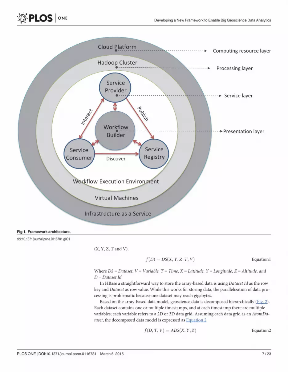
3.1. FrameworkThe framework (Fig. 1) is layer-based and includes four layers: computing resource (CloudPlatform); processing (Hadoop Cluster); service; and presentation (Workflow Builder). Cloudplatform provides the on-demand computing resources including computing, storage, and net-work as services. The cloud platform includes a processing layer where the workflow enginerunning on the virtualized Hadoop cluster (virtual machines as cluster nodes). The servicelayer is built on top of the cluster for registering, managing, and chaining the services. The ser-vices are chained as executable workflows in an on-demand and scalable computing environ-ment. Processing layer and service layer form the workflow execution environment. On top isthe presentation layer which enables users to publish, discover and use services to build work-flows in a drag-and-drop style, and runs and monitors workflows in a web-based interface.Oozie (Oozie http://yahoo.github.com/oozie/) is adapted as the workflow engine due to its in-trinsic integration with Hadoop MapReduce.
In this framework, data intensity is handled through storing and managing data usingHBase in a distributed environment. Computing intensity is tackled by allocating the intensivecomputation tasks to many computing nodes using the MapReduce model. By integratingcloud computing, computing resources associated with the workflow are provisioned or termi-nated on-demand to ensure performance while minimizing resource consumption.
Service Oriented Architecture (SOA) is adopted to publish different processes as individualservices, and these not only include processing and data services but also offer infrastructureand tool services. Different from the traditional web services orchestration [55–56], the “ser-vice” herein does not refer to the “web service” but rather to a self-described functional unitplugged into the workflow. This section details the framework from big geoscience data pro-cess, service-oriented approach, and cloud-based workflow execution environment.
3.2. Big Geoscience Data Processing with MapReduce3.2.1. Multi-Dimensional Geoscience Data Decomposition Mechanism. This section de-
tails the mechanism to decompose the array-based data files and store them in HBase.Normally, geoscience data are five dimensional: space (latitude, longitude, and altitude),
time and variable. For the array-based data models, data are stored in individual files, regardedas a dataset. The dataset is located by the dataset id (e.g., file URI). The array-based data modelis expressed as Equation 1, and each dataset id refers to a dataset containing five dimensions
Developing a New Framework to Enable Big Geoscience Data Analytics
PLOS ONE | DOI:10.1371/journal.pone.0116781 March 5, 2015 6 / 23
(X, Y, Z, T and V).
f ðDÞ ¼ DSðX;Y ;Z;T;VÞ Equation1
Where DS = Dataset, V = Variable, T = Time, X = Latitude, Y = Longitude, Z = Altitude, andD = Dataset Id
In HBase a straightforward way to store the array-based data is using Dataset Id as the rowkey and Dataset as row value. While this works for storing data, the parallelization of data pro-cessing is problematic because one dataset may reach gigabytes.
Based on the array-based data model, geoscience data is decomposed hierarchically (Fig. 2).Each dataset contains one or multiple timestamps, and at each timestamp there are multiplevariables; each variable refers to a 2D or 3D data grid. Assuming each data grid as an AtomDa-taset, the decomposed data model is expressed as Equation 2
f ðD;T;VÞ ¼ ADSðX;Y ;ZÞ Equation2
Fig 1. Framework architecture.
doi:10.1371/journal.pone.0116781.g001
Developing a New Framework to Enable Big Geoscience Data Analytics
PLOS ONE | DOI:10.1371/journal.pone.0116781 March 5, 2015 7 / 23

Where ADS = AtomDataset, V = Variable, T = Time, X = Latitude, Y = Longitude, Z = Altitude,and D = Dataset Id.
Compared with Equation 1, the decomposed data model moves two dimensions T and Vfrom the right to the left side. This triggers two changes: 5D dataset (X, Y, Z, T, V) is degradedto 3D AtomDataset (X, Y, Z) and single dataset id (D) becomes composite id(D, T, V). Withthis decomposition, large volumes of geoscience data are managed in a Bigtable style [27],where the (D, T, V) are stored as the composite row key and the AtomDataset as the row valuein HBase.
Besides the scalability and reliability of HBase, this decomposition has three advantages.First, the D, T, and V are stored in HBase as columns in series enabling flexible search againstthe time, variable and dataset. Once data are loaded into HBase, the AtomDataset queries andaccesses data through various filters. Second, new data can be seamlessly appended and inte-grated to the database without breaking current data structure. And third, parallelization withMapReduce algorithm is achieved in a finer granularity by decomposing the data from 5 to3 dimensions.
3.2.2. MapReduce-enabled Framework for Processing Big Geoscience Data. Based onthe above data decomposition mechanism, we introduce a MapReduce-enabled framework toprocess big geoscience data. The back end of the framework is a Hadoop cluster deployed inthe cloud environment that provides distributed storage and computing power. The frameworkcontains the following components: Geo-HBase, Controller, and Pluggable MR Operator(Fig. 3).
• Geo-HBase stores the decomposed big geoscience data (Section 3.2.1). Geo-HBase supportsflexible queries to the data repository based on dataset id, time, and variable, so a subset of in-terested data is effectively extracted and processed.
• Pluggable MR Operator is a MapReduce program conducting a processing task against thedata stored in HBase (e.g., calculating an annual mean for selected variables, sub-setting thedata based on user specified regions).
• Controller is the user interface allowing users to interact with the framework, such as startinga processing job with specified parameters.
A typical workflow for processing data with this framework is the following sequence: Con-troller sends processing request with the query parameters (dataset ids, time period, and vari-ables) and spatial region; Geo-HBase extracts the required data based on the dataset id (D),time (T), and variable (V); the extracted data are loaded toMR Operator as a list of key-valuepairs; theMap first conducts spatial (X, Y, Z) sub-setting based on the specified spatial region.
Fig 2. Hierarchical structure of the multi-dimensional geoscience data.
doi:10.1371/journal.pone.0116781.g002
Developing a New Framework to Enable Big Geoscience Data Analytics
PLOS ONE | DOI:10.1371/journal.pone.0116781 March 5, 2015 8 / 23
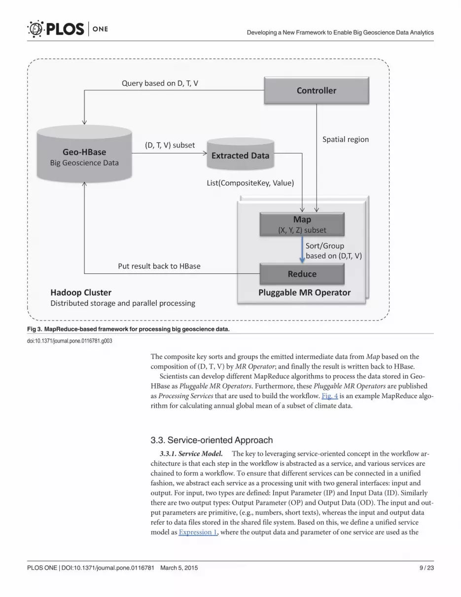
The composite key sorts and groups the emitted intermediate data fromMap based on thecomposition of (D, T, V) byMR Operator; and finally the result is written back to HBase.
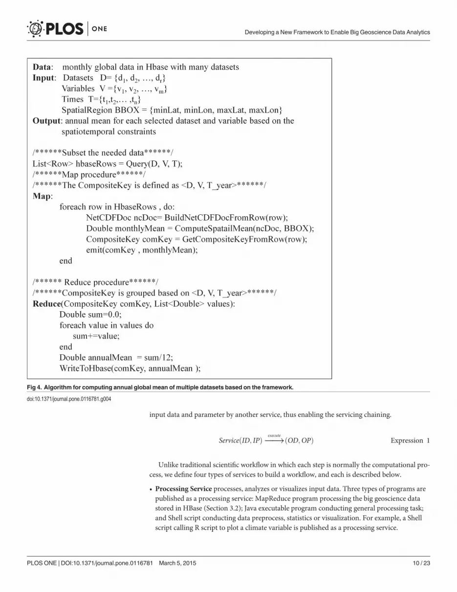
Scientists can develop different MapReduce algorithms to process the data stored in Geo-HBase as Pluggable MR Operators. Furthermore, these Pluggable MR Operators are publishedas Processing Services that are used to build the workflow. Fig. 4 is an example MapReduce algo-rithm for calculating annual global mean of a subset of climate data.
3.3. Service-oriented Approach3.3.1. Service Model. The key to leveraging service-oriented concept in the workflow ar-
chitecture is that each step in the workflow is abstracted as a service, and various services arechained to form a workflow. To ensure that different services can be connected in a unifiedfashion, we abstract each service as a processing unit with two general interfaces: input andoutput. For input, two types are defined: Input Parameter (IP) and Input Data (ID). Similarlythere are two output types: Output Parameter (OP) and Output Data (OD). The input and out-put parameters are primitive, (e.g., numbers, short texts), whereas the input and output datarefer to data files stored in the shared file system. Based on this, we define a unified servicemodel as Expression 1, where the output data and parameter of one service are used as the
Fig 3. MapReduce-based framework for processing big geoscience data.
doi:10.1371/journal.pone.0116781.g003
Developing a New Framework to Enable Big Geoscience Data Analytics
PLOS ONE | DOI:10.1371/journal.pone.0116781 March 5, 2015 9 / 23
input data and parameter by another service, thus enabling the servicing chaining.
ServiceðID; IPÞ�!execute ðOD;OPÞ Expression 1
Unlike traditional scientific workflow in which each step is normally the computational pro-cess, we define four types of services to build a workflow, and each is described below.
• Processing Service processes, analyzes or visualizes input data. Three types of programs arepublished as a processing service: MapReduce program processing the big geoscience datastored in HBase (Section 3.2); Java executable program conducting general processing task;and Shell script conducting data preprocess, statistics or visualization. For example, a Shellscript calling R script to plot a climate variable is published as a processing service.
Fig 4. Algorithm for computing annual global mean of multiple datasets based on the framework.
doi:10.1371/journal.pone.0116781.g004
Developing a New Framework to Enable Big Geoscience Data Analytics
PLOS ONE | DOI:10.1371/journal.pone.0116781 March 5, 2015 10 / 23
• Data Service focuses on fetching data from outside of the workflow as service input and pub-lishing output as various services to share (Section 3.3.2).
• Model Service runs geoscience models (e.g., climate model) with user specified model input;the modeling environment of software configuration and computing resources running themodel are automatically provisioned in the cloud [53].
• Infrastructure Service provisions the virtual machine-based services by leveraging the IaaS.Three types are included: provisioning pure computing resources (e.g., bare-metal virtualmachine); provisioning computing platforms (e.g. Hadoop or MPI-based cluster); and provi-sioning virtual machines with pre-installed software packages or applications (e.g., virtualmachine with R environment).
Following the service model, each service is composed of service executable program and servicedefinition metadata. Service definition metadata is an XML describing the services (Fig. 5) and iscomprised of three sections: service description of the general service information; service entrypoint indicating the location of the service executable program; and service interface detailing theservice input and output along with semantic description. To register a service into the workflowframework, the service definition metadata is first interpreted to add the service in the service cata-logue, and the service executable program is uploaded to the workflow execution environment.
3.3.2. Loosely-coupled Service I/O Mechanism. The workflow engine is deployed onHadoop, and the workflow tasks (services) are executed on different machines. Hence, it is im-portant that all services read input and write output data in a shared file system to avoid extradata transfer loads. The HDFS is used as such a file system in the framework, providing a uni-fied service execution environment. However, geoscience analytics often requires small to mid-sized data from remote data services (e.g., WFS, WCS, and OPenDAP) as part of the input, andpublish the output as web services (e.g., WMS, WFS). One solution is that the service includesthe function to fetch and publish data from remote services. However, at least two problemsarise. The first is that data handling is tightly coupled with the processing logic, which makes itdifficult for the service to incorporate other types of data services. The second is that each ser-vice implements its own data handling function which cannot be reused. We propose a loose-ly-coupled, service Input/output (I/O) mechanism as illustrated in Fig. 6 to addressthese shortcomings.
This mechanism extracts the data handling components and publishes them as individualworkflowData Services, including two categories: Fetch Data Services and Publish Data Services.Fetch Data Service fetches data from remote data servers and loads them into HDFS. Other ser-vices, such as Processing Service andModel Service, can access the data directly fromHDFS. Forexample, Fetch WAF (Web Access Folder) service downloads data from aWAF and loads themto HDFS; Fetch OpenDAP service subsets data from an OpenDAP server. Publish Data Service re-quires a server to host the data. For example, to publish a Processing Service’s output asWMS, aWMS server (e.g., GeoServer) is required to host the service, and, an Infrastructure Service can beintegrated into the workflow to provision a virtual machine with pre-installed GeoServer.
Fig. 7 shows a typical workflow consisting of four different services:
1. A Fetch Data Service fetches vector data (U.S. state boundary) from aWFS server as theinput of the Processing Service;
2. The Processing Service is a MapReduce program which calculates the monthly mean landsurface temperature from the climate data stored in Geo-HBase using the boundary data asthe statistics unit;
Developing a New Framework to Enable Big Geoscience Data Analytics
PLOS ONE | DOI:10.1371/journal.pone.0116781 March 5, 2015 11 / 23

3. Meanwhile, an Infrastructure Service provisions a virtual machine with pre-installed Geo-Server from the cloud platform; and
4. Publish Data Service publishes output data from process service to GeoServer as WMS.
This service I/O mechanism is flexible and extendable in that external services are supportedby developing corresponding data services in the workflow platform. Once a data service is reg-istered, it can be used by any other services to fetch/publish input/output. This service I/Omechanism addresses the challenge of heterogeneous and distributed data associated with eachstep’s input and output in the workflow.
3.4. Cloud-based Workflow Execution EnvironmentScientific workflows normally require a collection of software components such as tools, libraries,programs, models, and applications, and these components are developed at different times bydifferent people [16]. In this case study the workflow needs to setup and run a climate model,first with NetCDFOperator (NCO) library to preprocess the model output, followed by HadoopMapReduce to parallel process model output, and then fed to a Java program (or R script) toconduct linear regression analysis and visualization. These heterogeneous software componentsmust be seamlessly integrated into a coherent workflow. To achieve this, a traditional workflowsystem needs to pre-install the required software components on the physical machine (s), andthis poses two problems. First, if the execution environment is backed by a cluster, the samesoftware components must be configured on each machine, and any update to the executionenvironment is time consuming. Second, some software components are complex requiring spe-cific execution environments that cannot be installed on the common environment. To addressthese shortcomings, we propose the workflow in the cloud environment with two mechanisms.
Fig 5. Service definition metadata example (Infrastructure Service: ProvisionVM). Please refer to theSupporting Information file (service definition XML schema.xsd) for the service metadata XML schema.
doi:10.1371/journal.pone.0116781.g005
Developing a New Framework to Enable Big Geoscience Data Analytics
PLOS ONE | DOI:10.1371/journal.pone.0116781 March 5, 2015 12 / 23

The first mechanism deploys the whole Workflow Execution Environment (WEE, Hadoopcluster) in the cloud. The entireWEE is “burned” to image, including Hadoop software, work-flow engine, and library environment for executing the workflow tasks (e.g., R, NCO, JRE) and
Fig 6. Loosely-coupled Service I/O mechanism.
doi:10.1371/journal.pone.0116781.g006
Fig 7. A typical workflow with four types of services.
doi:10.1371/journal.pone.0116781.g007
Developing a New Framework to Enable Big Geoscience Data Analytics
PLOS ONE | DOI:10.1371/journal.pone.0116781 March 5, 2015 13 / 23

can be provisioned within minutes. The VMs are provisioned as cluster nodes based on the VMimage (a snapshot of pre-configured operating system used to launch a VM). When an update isrequired, the VM image is re-built by installing new or removing old software components, andtheWEE is re-provisioned quickly based on the new VM image. Another advantage is that newcomputing resources can be easily added to the WEE by provisioning more cluster nodes.
The second mechanism integrates specified software into VM images and publishes theseimages as Infrastructure Services. This is more flexible in that the software environment is self-contained and exposed as a standard infrastructure service in the workflow platform. Theseservices are added and removed without affecting current WEE. In addition, the complex soft-ware components (e.g., climate model, GeoServer) are difficult to integrate into WEE due tothe specified system requirement and high resource occupation, and publishing them as Infra-structure Services improves the system performance and flexibility. Furthermore, this mecha-nism provides an alternative to integrating legacy software that requires a specific executionenvironment into the workflow. Finally, the image-based Infrastructure Service offers a repro-ducible environment for certain tasks in the workflow.
Prototype and Experiment ResultTo verify the performance of the proposed framework, a proof-of-concept is offered, and an ex-periment is conducted for the aforementioned case study using the prototype.
4.1. Prototype Based on the Framework4.1.1. Cloud Environment Setup. The proposed framework is based on both private and
public clouds. A private cloud platform on Eucalyptus (http://www.eucalyptus.com) 4.0 is es-tablished in our data center, serving as the cloud environment, and this selection is based onour previous study [54]. In addition, Eucalyptus has compatible Application Programming In-terfaces (APIs) with Amazon’s Elastic Compute Cloud (Amazon EC2, http://aws.amazon.com/ec2/), a widely used public cloud service. The underlying hardware consists of 16 physical ma-chines connected with 1 Gigabit Ethernet (Gbps), and each has an 8-core CPU running at 2.35GHz with 16 GB of RAM and 60 GB of on-board storage. Totally, 120 m1.small VMs (1 coreCPU running at 1 GHz and 2G of RAM) is provisioned in the cloud.
4.1.2. Prototype Implementation. The prototype implementation architecture (Fig. 8)contains four major components: Eucalyptus Cloud, Workflow Execution Environment(WEE), Web-based Workflow Builder, and Service/Workflow Registry.
Eucalyptus Cloud provides virtualized computing resources. The WEE, built on top of thecloud platform, consists of computing, storage and processing libraries. The computing is pro-vided by a virtualized Hadoop cluster and coordinated by the workflow engine (powered byOozie). Storage is provided by HBase and HDFS, where HBase stores the decomposed big cli-mate data and key/value-based workflow output, whereas HDFS stores the service executableprograms and other workflow output.
Service/Workflow Registry is the service layer providing a database for managing the regis-tered services and saved workflows. Service definition metadata (XML) and workflow defini-tion files (XML) are stored in the database. During service registration, the service executableprogram is uploaded to WEE.
Web-based Workflow Builder is the graphic interface (Fig. 9) through which users buildworkflow by visually connecting various services, run workflow by submitting the request toWEE with one-click, and monitor the workflow execution status in real time. Services andworkflows are loaded to the builder from the registry. The workflow is saved to the server for
Developing a New Framework to Enable Big Geoscience Data Analytics
PLOS ONE | DOI:10.1371/journal.pone.0116781 March 5, 2015 14 / 23

re-running or downloaded as XML for sharing. The builder is based on the open source work-flow-generator tool (https://github.com/jabirahmed/oozie/tree/master/workflowgenerator).
4.2. Experiment Result4.2.1. Executable Workflow for the Study Case. To demonstrate how the proposed work-
flow framework addresses the challenges posed by the study case (Section 1.2), over ten servicesare developed following the proposed service model. These are registered to the prototype sys-tem to facilitate the six steps of the study case.
For the S1, aModel Service (RunModelE) is based on our previous study [53] to setup andrun ModelE automatically. This is also an Infrastructure Service since it provisions a virtualcluster with configured modeling environment to run the model. For S2, two Processing Ser-vices are developed with AccToNetCDF being a script-based service converting model out .accfiles to NetCDF format, and NetCDFtoHBase using NCO library to decompose (split) theNetCDF and subsequently uploading into database using HBase APIs. For S4, a MapReduce-enabled Processing Service computes the global monthly mean for all model output. Finally, for
Fig 8. Prototype implementation architecture.
doi:10.1371/journal.pone.0116781.g008
Developing a New Framework to Enable Big Geoscience Data Analytics
PLOS ONE | DOI:10.1371/journal.pone.0116781 March 5, 2015 15 / 23

S5 and S6 a Java-based Processing Service conducts linear regression analysis and plots the rela-tionships for the most affected variables. To support input and output for the above services,FetchDataHttp downloads data from a web accessible folder or simply a URL to the WEE. Pub-lishDataWaf publishes the data in the WEE to a web accessible folder.
Once these services are registered, an executable workflow is built by visually dragging andconnecting services in theWeb-based Workflow Builder to conduct the experiment (Fig. 10). Inthis workflow, RunModelE provisions virtual machines to run the climate model. When modelruns are finished, output are preprocessed and loaded to HBase with ArcToNetCDF andNetCDFtoHBase. Then global monthly mean for each output climate variable is calculated inparallel in the WEE with ComputeGlobalMonthlyMean service. Next, two services GetGloba-lEesembleMean and FetchModelParamters, are executed in parallel. Once finished, Correlatio-nAnalysis service calculates linear regression statistics for each Parameter-Variable pair basedon the variable ensemble mean values and the model input parameters. Finally, the workflowoutput (intermediate and final) is published on a web accessible folder (Fig. 11).
This workflow transforms a complex geoscience experiment into an intuitive diagram-based workflow. In contrast to a traditional workflow, this workflow addresses the three prob-lems of data intensity, computing intensity, and procedure complexity as presented below:
• For the computing intensity, RunModelE service on-demand provisions a cluster of virtualmachines with pre-configured model environment and on-demand parameter configurationto conduct ensemble model runs in parallel. In addition, a Hadoop cluster is provisioned on-demand in the workflow (Fig. 12);
• For data intensity, the MapReduce-enabled ComputeGlobalMonthlyMean service conductsparallel processing of large volumes of model output in the cloud-based WEE; and
Fig 9. GUI of the web-based workflow builder.
doi:10.1371/journal.pone.0116781.g009
Developing a New Framework to Enable Big Geoscience Data Analytics
PLOS ONE | DOI:10.1371/journal.pone.0116781 March 5, 2015 16 / 23

• For the procedure complexity, the service model enables the complex problem to be decou-pled into reusable services. Furthermore, the heterogeneous software components (e.g.,Hadoop, R, NCO, JRE) are seamlessly integrated in the cloud-based WEE.
4.2.2. Performance Evaluation for Big Climate Data Processing. To evaluate the per-formance of the big geoscience data processing strategy (Section 3.2), we calculated the globalmonthly mean for 100 model outputs using a 6-node Hadoop cluster (1 master node and 5slave nodes). Each node is a virtual machine with 8-core CPU/2.35 GHz with 16 GB RAM, andthe 100 model outputs are preprocessed and loaded to HBase deployed on the Hadoop cluster.Another virtual machine with the same configuration processes the same data with the tradi-tional serial method. Two sets of tests are conducted. The first keeps the number of clusternodes the same and processes different numbers of model outputs from 1 to 100 (Fig. 13A).The second keeps the 100 model output unchanged but changes the number of cluster nodesfrom 1 to 5 (Fig. 13B).
For the first set of tests and as model output number increases, the time consumed for theserial method increases dramatically for 5 model outputs, whereas the time for MapReduce ap-proach only increases marginally (give a percentage) (Fig. 13A). With 100 outputs, the serialprocess takes> 20 minutes, while the MapReduce approach takes*3.5 minutes. It should benoted that if the number of model output is< 5, the time for the MapReduce approach is morethan that of the serial approach due to the overhead of the Hadoop framework. For the secondset of tests and with increasing node number, the consumed time decreases significantly(Fig. 13B), which indicates efficient scalability of the proposed big geoscience data processingstrategy. Scalability is important in cloud environment because new nodes are quickly provi-sioned and added to the cluster as needed to improve performance.
Discussion and ConclusionThis paper proposes a cloud-based, MapReduce-enabled, and service-oriented workflowframework to address the challenges posed by big geoscience data analytics. These challengesare tested by a case study of climate model sensitivity diagnostics. Methodologies for designingand implementing the framework are presented. To test the feasibility of the framework, aproof-of-concept workflow platform prototype is offered. A set of services are developed andregistered to the prototype system, and an executable workflow is built based on these servicesfor the study case. Two sets of tests are conducted to evaluate the performance of the proposedbig geoscience data processing strategy.
Fig 10. Executable workflow for the study case built in the prototype.
doi:10.1371/journal.pone.0116781.g010
Developing a New Framework to Enable Big Geoscience Data Analytics
PLOS ONE | DOI:10.1371/journal.pone.0116781 March 5, 2015 17 / 23

The workflow and test results show that the proposed framework provides a robust and effi-cient approach to accelerate geoscience studies. Each proposed methodology addresses one orseveral aspects of the challenges facing the geosciences community. Specifically, Table 2 sum-marizes the proposed methodologies (Section 3) for addressing the corresponding challenges(Section 1).
By leveraging cloud computing, MapReduce, and SOA, this framework seamlessly integratesthe proposed methodologies as a whole to form a scalable, reliable and interoperable workflowenvironment. Such a workflow environment enables scientists to achieve four goals: transformcomplex geoscience experiment into intuitive diagram-based workflows by decoupling the ex-periment into reusable services; manage big geoscience data in a scalable and reliable distribut-ed environment; process big geoscience data in parallel by adapting MapReduce and provideon-demand; and provision computing resources during the workflow execution to meet theperformance requirement.
Fig 11. Workflow output: Workflow output published in a web accessible folder (A), presented as correlation statistics in CSV format (B), andplotted output climate variables highly affected by the sevenmodel input parameters (R2> 0.6, 9 of 57 pairs).
doi:10.1371/journal.pone.0116781.g011
Developing a New Framework to Enable Big Geoscience Data Analytics
PLOS ONE | DOI:10.1371/journal.pone.0116781 March 5, 2015 18 / 23

Fig 12. An executable workflow for provisioning a Hadoop cluster on-demand in the cloud. Three Infrastructure Services support this provision:ProvisionMaster, ProvisonSlave, and ConfigureHadoop.
doi:10.1371/journal.pone.0116781.g012
Fig 13. Performance evaluation result for the MapReduce-enabled big climate data processing.
doi:10.1371/journal.pone.0116781.g013
Developing a New Framework to Enable Big Geoscience Data Analytics
PLOS ONE | DOI:10.1371/journal.pone.0116781 March 5, 2015 19 / 23

5.1. Key Features of the Workflow FrameworkThis framework provides three features compared to traditional scientific workflow platformas presented below:
• Cloud-based for computing intensity: Adequate computing resources are critical since sci-entific workflow normally contains computing intensive tasks and require hundreds of stepsexecuted in parallel. This workflow framework provides the mechanism to supply adequatecomputing resources to the WEE by provisioning more VMs into the WEE and shifting thecomputing load to resources independent of WEE using Infrastructure Services (e.g., runninga computing intensive model on a virtual machine). In addition, the entire WEE is provi-sioned based on customized VM images, and virtualization enables each node of the WEE tohave exactly the same computational environment. Therefore, this framework provides prov-enance for the WEE in a bitwise level. This cloud-based feature helps address computingintensity challenges.
• MapReduce-enabled for data intensity: By incorporating the big geoscience data processingstrategy (Section 3.2), the proposed framework manages and processes big geoscience data.The data decomposition and storage mechanism enables the multi-dimensional geosciencedata to be effectively stored in a distributed environment (HBase), while the MapReduce-enabled processing framework enables data to be processed in parallel on the cluster of WEEchained with other tasks in the workflow. The MapReduce-enabled feature helps address thedata intensity challenge.
• Service-oriented for procedure complexity: Different steps involved in scientific workflowsare published as four types of services: process, data, model and infrastructure (Section 3.3).In contrast to traditional scientific workflow considering only computational tasks, infra-structure services enable scientists to provision on-demand more computing resources dur-ing the workflow execution. Model services enable scientists to integrate an entire modelingenvironment to the workflow. By introducing a unified service model, these services are reg-istered to the framework and connected in a unified manner. In addition, the service-orient-ed mechanism opens the framework, allowing scientists to collaborate by publishing theirown services and workflows. Thus, the service-oriented feature helps address the challenge ofprocedure complexity.
5.2. Future ResearchAs a preliminary study, this framework has limitations. There are at least two major challengesthat need to be addressed in the future:
Table 2. Methodologies addressing the challenges.
Challenges 3.1 3.2.1 3.2.2 3.3.1 3.3.2 3.4
C1. Data intensity Data management x x
Distributed data x x
C2. Computing intensity Model simulation x x x
Big data processing x x x x
C3. Complex procedure Complex steps x x
Heterogeneous tools x x x
doi:10.1371/journal.pone.0116781.t002
Developing a New Framework to Enable Big Geoscience Data Analytics
PLOS ONE | DOI:10.1371/journal.pone.0116781 March 5, 2015 20 / 23

• The framework for data storage currently uses virtual storage attached to the VMs to formthe HDFS. The storage attached to each VM is of two types. The first is virtualized directlyfrom the physical machine on which the VM is hosted, and the stored data are accessible di-rectly by the VM without going through any network. However, such storage is not perma-nent, and the data are lost with the termination of the VM. The second storage type isvirtualized from a storage cluster connected to the cloud platform and persists even when theVM is terminated. However, since the storage is from a storage cluster instead of the VM’shost machine, the VM needs to access the data remotely. Therefore, neither storage type isoptimized for the framework. Further study is desired to explore a new storage mechanismto support both local access and persistence.
• We only consider the private cloud in the prototype system. While a private cloud may beenough for a research center, spike workload normally cannot be handled due to the limitedresources. To address this problem, a hybrid cloud mechanism is a candidate for the frame-work, using full-controlled private cloud as the primary cloud while bursting to the publiccloud (e.g., Amazon EC2) for extra computing resources when needed.
Data intensity, computing intensity and procedure complexity are grand challenges in thegeosciences even with 21st century computing technologies. The proposed framework offers apotential solution to solve these challenges. This framework serves as a path to a common geos-patial cyberinfrastructure platform shared by the geoscience community to relieve scientistfrom computing issues and facilitate scientific discoveries.
AcknowledgmentsDr. George Taylor helped proof an earlier version of the manuscript.
Author ContributionsConceived and designed the experiments: CY ZL BJ. Performed the experiments: ZL KL MYMZ. Analyzed the data: ZL CY BJ KL MY. Contributed reagents/materials/analysis tools: ZLCY BJ MS KL. Wrote the paper: ZL CYMY BJ.
References1. Groot R, McLaughlin JD (2000) Geospatial data infrastructure: concepts, cases, and good practice:
Oxford: Oxford university press. PMID: 25506959
2. Schnase JL, Duffy DQ, Tamkin GS, Nadeau D, Thompson JH, et al. (2014) MERRA analytic services:Meeting the big data challenges of climate science through cloud-enabled climate analytics-as-a-ser-vice. Computers, Environment and Urban Systems doi: 10.1016/j.compenvurbsys.2013.12.003.
3. Yang C, Li W, Xie J, Zhou B (2008) Distributed geospatial information processing: sharing distributedgeospatial resources to support Digital Earth. International Journal of Digital Earth 1: 259–278.
4. Yang C, Goodchild M, Huang Q, Nebert D, Raskin R, et al. (2011) Spatial cloud computing: how canthe geospatial sciences use and help shape cloud computing? International Journal of Digital Earth 4:305–329.
5. Minchin S (2014) Big Data: Dealing with the Deluge. Available: http://www.atnf.csiro.au/research/workshops/2013/astroinformatics/talks/StuartMinchin_Astroinformatics.pdf. Accessed 2014 December27.
6. Cugler DC, Oliver D, Evans MR, Shekhar S, Medeiros CB (2013) Spatial Big Data: Platforms, Analytics,and Science. GeoJournal. (in press)
7. Edwards PN (2010) A vast machine: Computer models, climate data, and the politics of global warming:MIT Press. PMID: 25506974
8. Grassl H (2011) Climate change challenges. Surveys in Geophysics 32: 319–328.
9. Hodgson JA, Thomas CD, Wintle BA, Moilanen A (2009) Climate change, connectivity and conserva-tion decision making: back to basics. Journal of Applied Ecology 46: 964–969.
Developing a New Framework to Enable Big Geoscience Data Analytics
PLOS ONE | DOI:10.1371/journal.pone.0116781 March 5, 2015 21 / 23
10. Murphy JM, Sexton DM, Barnett DN, Jones GS, Webb MJ, et al. (2004) Quantification of modelling un-certainties in a large ensemble of climate change simulations. Nature 430: 768–772. PMID: 15306806
11. Li Z, Yang C, Sun M, Li J, Xu C, et al. (2013) A high performance web-based system for analyzing andvisualizing spatiotemporal data for climate studies. Web andWireless Geographical Information Sys-tems: Springer Berlin Heidelberg 190–198.
12. Cui D, Wu Y, Zhang Q (2010) Massive spatial data processing model based on cloud computingmodel. IEEE. pp. 347–350. doi: 10.1002/pst.472 PMID: 22328327
13. Liu Y, GuoW, JiangW, Gong J (2009) Research of remote sensing service based on cloud computingmode. Application Research of Computers 26: 3428–3431.
14. Yang C, Wu H, Huang Q, Li Z, Li J (2011) Using spatial principles to optimize distributed computing forenabling the physical science discoveries. Proceedings of the National Academy of Sciences 108:5498–5503. doi: 10.1073/pnas.0909315108 PMID: 21444779
15. Li J, Wang FZ, Meng L, ZhangW, Cai Y (2014) A map-reduce-enabled SOLAP cube for large-scale re-motely sensed data aggregation. Computers & Geosciences 70: 110–119. doi: 10.4103/2231-0770.148499 PMID: 25625082
16. Juve G, Deelman E (2011) Scientific workflows in the cloud. In: Grids. Clouds and Virtualization:Springer71–91.
17. Mell P, Grance T (2011) The NIST definition of cloud computing. Available: http://faculty.winthrop.edu/domanm/csci411/Handouts/NIST.pdf. Accessed 2014 December 27.
18. Porter JH (2000) Scientific databases. In: Michener W. K., & Brunt J. W. editors. Ecological data: De-sign, management and processing: 48–69.
19. Wright DJ, Wang S (2011) The emergence of spatial cyberinfrastructure. Proceedings of the NationalAcademy of Sciences, 108(14), 5488–5491. doi: 10.1073/pnas.1103051108 PMID: 21467227
20. Dongarra J (2011) The international exascale software project roadmap. International Journal of HighPerformance Computing Applications: 1094342010391989.
21. Fiore S, Negro A, Aloisio G (2012) The Climate-G Portal: The context, key features and a multi-dimen-sional analysis. Future Generation Computer Systems 28: 1–8.
22. Cinquini L, Crichton D, Mattmann C, Bell GM, Drach B, et al. (2012) The Earth SystemGrid Federation:An open infrastructure for access to distributed geospatial data IEEE. pp. 1–10.
23. Stonebraker M (2010) SQL databases v. NoSQL databases. Communications of the ACM 53: 10–11.
24. Liu Y, Chen B, HeW, Fang Y (2013) Massive image data management using HBase and MapReduce.IEEE. pp. 1–5. doi: 10.1097/ACC.0b013e31829c6877 PMID: 25611599
25. Khetrapal A, Ganesh V (2006) HBase and Hypertable for large scale distributed storage systems. Deptof Computer Science, Purdue University. Available: http://cloud.pubs.dbs.uni-leipzig.de/sites/cloud.pubs.dbs.uni-leipzig.de/files/Khetrapal2008HBaseandHypertableforlargescaledistributedstorage.pdf.Accessed 2014 December 27. PMID: 25590126
26. Lakshman A, Malik P (2010) Cassandra: a decentralized structured storage system. ACM SIGOPS Op-erating Systems Review 44: 35–40.
27. Chang F, Dean J, Ghemawat S, HsiehWC, Wallach DA, et al. (2008) Bigtable: A distributed storagesystem for structured data. ACM Transactions on Computer Systems (TOCS) 26: 4.
28. Chen J, Zheng G, Chen H(2013) ELM-MapReduce: MapReduce accelerated extreme learning ma-chine for big spatial data analysis. IEEE. pp. 400–405. doi: 10.1007/s13191-013-0341-z PMID:25489164
29. Zhang H, Liu M, Shi Y, Yuen DA, Yan Z, et al. (2007) Toward an automated parallel computing environ-ment for geosciences. Physics of the Earth and Planetary Interiors 163: 2–22.
30. Geist A (1994) PVM: Parallel virtual machine: a users' guide and tutorial for networked parallel comput-ing: MIT press. PMID: 25144107
31. GroppW, Lusk E, Skjellum A (1999) Using MPI: portable parallel programming with the message-passing interface: MIT press. PMID: 25506965
32. Foster I, Kesselman C, Tuecke S (2001) The anatomy of the grid: Enabling scalable virtual organiza-tions. International journal of high performance computing applications 15: 200–222.
33. Dean J, Ghemawat S (2008) MapReduce: simplified data processing on large clusters. Communica-tions of the ACM 51: 107–113.
34. Rizvandi NB, Boloori AJ, Kamyabpour N, Zomaya AY(2011) MapReduce implementation of prestackKirchhoff time migration (PKTM) on seismic data. IEEE. pp. 86–91. doi: 10.1007/s12262-011-0358-7PMID: 24426523
Developing a New Framework to Enable Big Geoscience Data Analytics
PLOS ONE | DOI:10.1371/journal.pone.0116781 March 5, 2015 22 / 23

35. Zhao H, Ai S, Lv Z, Li B (2010) Parallel accessing massive NetCDF data based on mapreduce. Web In-formation Systems and Mining: Springer. pp. 425–431. doi: 10.3390/s110100425 PMID: 22346584
36. Duffy DQ, Schnase JL, Thompson JH, Freeman SM, Clune TL (2012) Preliminary Evaluation ofMapReduce for High-Performance Climate Data Analysis. NASA new technology report white paper.
37. Ludäscher B, Altintas I, Berkley C, Higgins D, Jaeger E, et al. (2006) Scientific workflow managementand the Kepler system. Concurrency and Computation: Practice and Experience 18: 1039–1065.
38. Wang S (2010) A CyberGIS framework for the synthesis of cyberinfrastructure, GIS, and spatial analy-sis. Annals of the Association of American Geographers 100: 535–557.
39. Yang C, Raskin R, Goodchild M, GaheganM (2010) Geospatial cyberinfrastructure: past, present andfuture. Computers, Environment and Urban Systems 34: 264–277.
40. Deelman E, Gil Y, Zemankova M (2006) NSF workshop on the challenges of scientific workflows 1–2.
41. Gil Y (2008) From data to knowledge to discoveries: Scientific workflows and artificial intelligence. Sci-entific Programming 16: 4
42. Taylor IJ, Deelman E, Gannon D, Shields M (2007) Workflows for e-Science: Springer-Verlag LondonLimited. doi: 10.1093/jxb/erm028 PMID: 25506957
43. Yue P, He L (2009) Geospatial data provenance in cyberinfrastructure. IEEE. pp. 1–4. doi: 10.1016/j.fas.2009.11.003 PMID: 21278824
44. Oinn T, Addis M, Ferris J, Marvin D, Senger M, et al. (2004) Taverna: a tool for the composition and en-actment of bioinformatics workflows. Bioinformatics 20: 3045–3054. PMID: 15201187
45. Majithia S, Shields M, Taylor I, Wang I (2004) Triana: A graphical web service composition and execu-tion toolkit IEEE. pp. 514–521.
46. Barga R, Jackson J, Araujo N, Guo D, Gautam N, et al.(2008) The trident scientific workflow work-bench. IEEE. pp. 317–318. doi: 10.1007/s12265-008-9065-6 PMID: 19956787
47. Bavoil L, Callahan SP, Crossno PJ, Freire J, Scheidegger CE, et al. (2005) Vistrails: Enabling interac-tive multiple-view visualizations IEEE. pp. 135–142.
48. Hoffa C, Mehta G, Freeman T, Deelman E, Keahey K, et al. (2008) On the use of cloud computing forscientific workflows IEEE. pp. 640–645.
49. Juve G, Deelman E, Vahi K, Mehta G, Berriman B, et al. (2009) Scientific workflow applications on Am-azon EC2 IEEE. pp. 59–66.
50. Simmhan Y, Barga R, van Ingen C, Lazowska E, Szalay A (2009) Building the trident scientific workflowworkbench for data management in the cloud IEEE. pp. 41–50.
51. Mattmann CA, Crichton DJ, Hart AF, Goodale C, Hughes JS, et al. (2011) Architecting Data-IntensiveSoftware Systems. Handbook of Data Intensive Computing: Springer. pp. 25–57.
52. Williams DN, Drach R, Ananthakrishnan R, Foster I, Fraser D, et al. (2009) The Earth SystemGrid: En-abling access to multimodel climate simulation data. Bulletin of the American Meteorological Society90: 195–205.
53. Li Z, Yang C, Huang Q, Liu K, Sun M, et al. (2014) Building Model as a Service to support geosciences.Computers, Environment and Urban Systems. doi: 10.1016/j.compenvurbsys.2014.06.004
54. Huang Q, Yang C, Liu K, Xia J, Xu C, et al. (2013) Evaluating open-source cloud computing solutionsfor geosciences. Computers & Geosciences 59: 41–52. doi: 10.4103/2231-0770.148499 PMID:25625082
55. Yue P, Di L, YangW, Yu G, Zhao P (2007) Semantics-based automatic composition of geospatial Webservice chains. Computers & Geosciences, 33(5), 649–665. doi: 10.4103/2231-0770.148499 PMID:25625082
56. Li Z. Yang C, Wu H, Li W, Miao L (2011) An optimized framework for seamlessly integrating OGCWebServices to support geospatial sciences. International Journal of Geographical Information Science,25(4), 595–613.
Developing a New Framework to Enable Big Geoscience Data Analytics
PLOS ONE | DOI:10.1371/journal.pone.0116781 March 5, 2015 23 / 23