earth science priya singh abstract r.k. mall o. p. mishra
TRANSCRIPT
Earth ScienceKEYWORDS: Tsunami, Tsunami Early Warning System, Tsunami preparedness, Future Strategy, Coastal
risk management, Coastal Risk Resilient safer cities
Priya Singh Research Scholar and Formerly student of Amity College, New Delhi-110003
1. INTRODUCTIONe great Sumatra-Andaman earthquake and Indian Ocean tsunami of 2004 came as a surprise to most of the earth science community as well as the people of the affected region. e damage survey reported that Andaman and Nicobar Islands were worst affected by this megathrust earthquake (MW 9.3), which is referred to as Mainshock Earthquake (MSE 9.3) followed up by huge waves (tsunami) [Mishra et al., 2007a,b]. e location of tsunami is shown in Figure 1. Tsunamis in Indian Ocean are not as common as in Pacific. As compared, on an average of eight tsunamis per year in Pacific, there is not more than one in three years in Indian Ocean (Satake, 2014). On 26 December 2004, the countries around the Indian Ocean suffered from the devastating tsunami. is tsunami, generated by the Sumatra-Andaman earthquake (magnitude M 9.3), was the worst tsunami disaster in the annals of tsunamigenic earthquakes of the world, and the casualties were not only confined to countries surrounding the Indian Ocean but also extended to European countries because many tourists were spending their Christmas vacations in Asian countries (Satake, 2014).
It was not known to the common people that the tsunami was triggered by the sub-oceanic earthquake that ruptured the boundary between the Indo-Australian plate and the Eurasian plate. e 2004 earthquake (Mw 9.3) occurred beneath the seafloor of the Indian Ocean, which resulted deformation in the seafloor that displaced significant amount of sea water. Seismic wave with hydrostatic pressure disturbance propagated in the ocean as tsunami with long wavelengths in different directions towards the coastal belts that caused catastrophic losses to flora and faunas in the region (Kanamori, 2006).
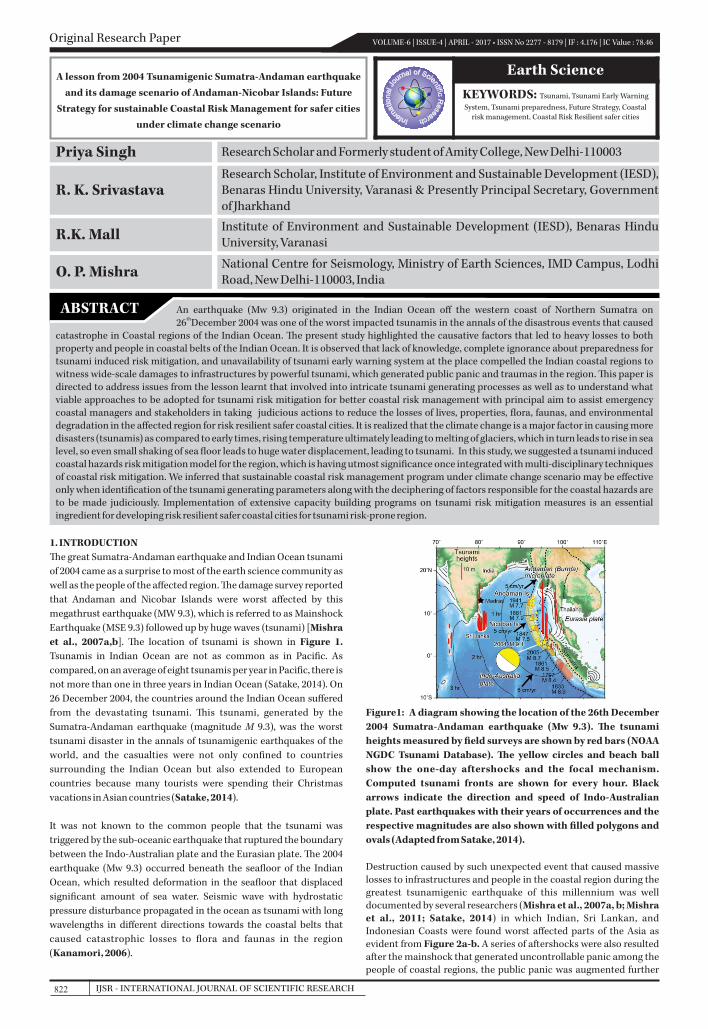
Figure1: A diagram showing the location of the 26th December 2004 Sumatra-Andaman earthquake (Mw 9.3). e tsunami heights measured by field surveys are shown by red bars (NOAA NGDC Tsunami Database). e yellow circles and beach ball show the one-day aftershocks and the focal mechanism. Computed tsunami fronts are shown for every hour. Black arrows indicate the direction and speed of Indo-Australian plate. Past earthquakes with their years of occurrences and the respective magnitudes are also shown with filled polygons and ovals (Adapted from Satake, 2014).
Destruction caused by such unexpected event that caused massive losses to infrastructures and people in the coastal region during the greatest tsunamigenic earthquake of this millennium was well documented by several researchers (Mishra et al., 2007a, b; Mishra et al., 2011; Satake, 2014) in which Indian, Sri Lankan, and Indonesian Coasts were found worst affected parts of the Asia as evident from Figure 2a-b. A series of aftershocks were also resulted after the mainshock that generated uncontrollable panic among the people of coastal regions, the public panic was augmented further
Original Research Paper VOLUME-6 | ISSUE-4 | APRIL - 2017 • ISSN No 2277 - 8179 | IF : 4.176 | IC Value : 78.46
A lesson from 2004 Tsunamigenic Sumatra-Andaman earthquake and its damage scenario of Andaman-Nicobar Islands: Future
Strategy for sustainable Coastal Risk Management for safer cities under climate change scenario
An earthquake (Mw 9.3) originated in the Indian Ocean off the western coast of Northern Sumatra on th26 December 2004 was one of the worst impacted tsunamis in the annals of the disastrous events that caused
catastrophe in Coastal regions of the Indian Ocean. e present study highlighted the causative factors that led to heavy losses to both property and people in coastal belts of the Indian Ocean. It is observed that lack of knowledge, complete ignorance about preparedness for tsunami induced risk mitigation, and unavailability of tsunami early warning system at the place compelled the Indian coastal regions to witness wide-scale damages to infrastructures by powerful tsunami, which generated public panic and traumas in the region. is paper is directed to address issues from the lesson learnt that involved into intricate tsunami generating processes as well as to understand what viable approaches to be adopted for tsunami risk mitigation for better coastal risk management with principal aim to assist emergency coastal managers and stakeholders in taking judicious actions to reduce the losses of lives, properties, flora, faunas, and environmental degradation in the affected region for risk resilient safer coastal cities. It is realized that the climate change is a major factor in causing more disasters (tsunamis) as compared to early times, rising temperature ultimately leading to melting of glaciers, which in turn leads to rise in sea level, so even small shaking of sea floor leads to huge water displacement, leading to tsunami. In this study, we suggested a tsunami induced coastal hazards risk mitigation model for the region, which is having utmost significance once integrated with multi-disciplinary techniques of coastal risk mitigation. We inferred that sustainable coastal risk management program under climate change scenario may be effective only when identification of the tsunami generating parameters along with the deciphering of factors responsible for the coastal hazards are to be made judiciously. Implementation of extensive capacity building programs on tsunami risk mitigation measures is an essential ingredient for developing risk resilient safer coastal cities for tsunami risk-prone region.
ABSTRACT
R.K. Mall Institute of Environment and Sustainable Development (IESD), Benaras Hindu University, Varanasi
O. P. Mishra National Centre for Seismology, Ministry of Earth Sciences, IMD Campus, Lodhi Road, New Delhi-110003, India
IJSR - INTERNATIONAL JOURNAL OF SCIENTIFIC RESEARCH822
R. K. SrivastavaResearch Scholar, Institute of Environment and Sustainable Development (IESD), Benaras Hindu University, Varanasi & Presently Principal Secretary, Government of Jharkhand
because of baseless propaganda of occurrences of subsequent another tsunamigenic earthquakes due beneath Indian Ocean. It is worth to mention that there were complete unawareness and ignorance among the people about tsunami and its generating processes since there were neither lessons learnt previously by the people of the region nor the tsunami early warning system was
thavailable with Indian agencies till the occurrence of the 26 December 2004 tsunamigenic earthquake. Because of absence of these two vital requirements the gigantic losses of lives and properties were reported as there was no alert for their safe escape from the zone of influence of the 2004 killer Sumatra-Andaman tsunami (GSI, 2004; Mishra et al., 2011; Singh et al., 2012). Such observations make us understand that the mechanism for prediction of tsunami was not well authenticated for Indo-Indonesia-Sri Lankan coastal belts of Asia otherwise huge losses that happened to lives and properties could have been significantly mitigated.
thConsequent up on the 26 December 2004 tsunami, a total death toll of 230,000 people and an economic loss of more than 10 billion US dollars were reported (Featherstone, A. 2014)
ere were a series of studies carried out by several researchers of different disciplines to understand what caused and how the damage scenario of the Sumatra-Andaman-Nicobar expanded that brought the developmental schemes of the regions stand still. However, these studies highlighted different factors that caused disasters and they suggested different steps for its future mitigation without common consensus. ere were no unison in approaches suggested by earlier researchers using different tools and methodologies to safeguard people and infrastructural resources from geo-hydrological disaster event like tsunami in the coastal belt. It is, therefore, in this study we attempted to address the intricate issues involved in tsunami genesis, tsunami-induced damage pattern, and preparedness and prevention plans to be adopted in future by the coastal countries of analogous geotectonic settings from the lessons learnt and a series of research studies conducted so far.
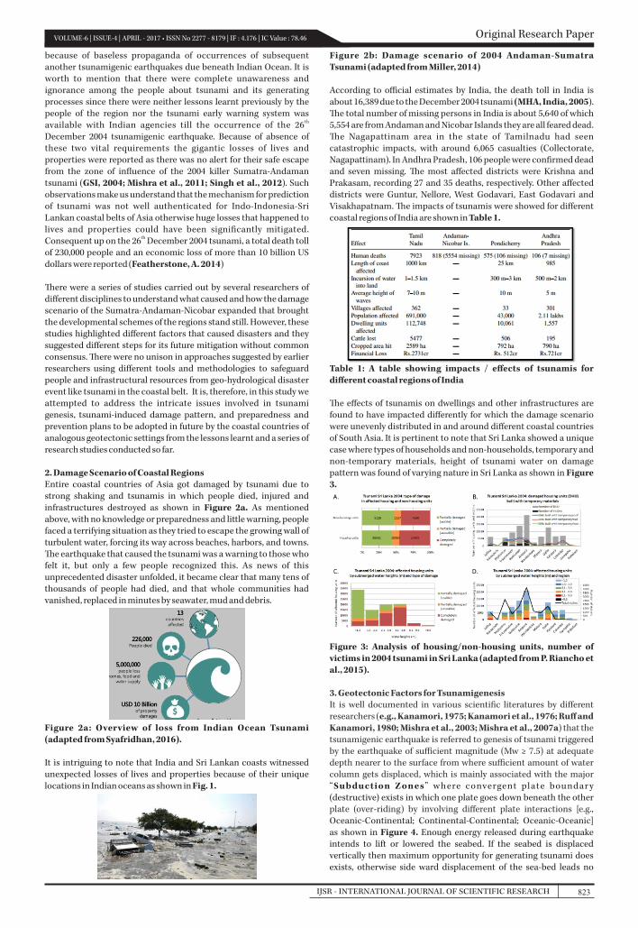
2. Damage Scenario of Coastal RegionsEntire coastal countries of Asia got damaged by tsunami due to strong shaking and tsunamis in which people died, injured and infrastructures destroyed as shown in Figure 2a. As mentioned above, with no knowledge or preparedness and little warning, people faced a terrifying situation as they tried to escape the growing wall of turbulent water, forcing its way across beaches, harbors, and towns. e earthquake that caused the tsunami was a warning to those who felt it, but only a few people recognized this. As news of this unprecedented disaster unfolded, it became clear that many tens of thousands of people had died, and that whole communities had vanished, replaced in minutes by seawater, mud and debris.
Figure 2a: Overview of loss from Indian Ocean Tsunami (adapted from Syafridhan, 2016).
It is intriguing to note that India and Sri Lankan coasts witnessed unexpected losses of lives and properties because of their unique locations in Indian oceans as shown in Fig. 1.
Figure 2b: Damage scenario of 2004 Andaman-Sumatra Tsunami (adapted from Miller, 2014)
According to official estimates by India, the death toll in India is about 16,389 due to the December 2004 tsunami (MHA, India, 2005). e total number of missing persons in India is about 5,640 of which 5,554 are from Andaman and Nicobar Islands they are all feared dead. e Nagapattinam area in the state of Tamilnadu had seen catastrophic impacts, with around 6,065 casualties (Collectorate, Nagapattinam). In Andhra Pradesh, 106 people were confirmed dead and seven missing. e most affected districts were Krishna and Prakasam, recording 27 and 35 deaths, respectively. Other affected districts were Guntur, Nellore, West Godavari, East Godavari and Visakhapatnam. e impacts of tsunamis were showed for different coastal regions of India are shown in Table 1.
Table 1: A table showing impacts / effects of tsunamis for different coastal regions of India
e effects of tsunamis on dwellings and other infrastructures are found to have impacted differently for which the damage scenario were unevenly distributed in and around different coastal countries of South Asia. It is pertinent to note that Sri Lanka showed a unique case where types of households and non-households, temporary and non-temporary materials, height of tsunami water on damage pattern was found of varying nature in Sri Lanka as shown in Figure 3.
Figure 3: Analysis of housing/non-housing units, number of victims in 2004 tsunami in Sri Lanka (adapted from P. Riancho et al., 2015).
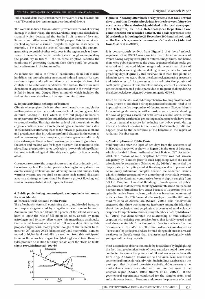
3. Geotectonic Factors for Tsunamigenesis It is well documented in various scientific literatures by different researchers (e.g., Kanamori, 1975; Kanamori et al., 1976; Ruff and Kanamori, 1980; Mishra et al., 2003; Mishra et al., 2007a) that the tsunamigenic earthquake is referred to genesis of tsunami triggered by the earthquake of sufficient magnitude (Mw ≥ 7.5) at adequate depth nearer to the surface from where sufficient amount of water column gets displaced, which is mainly associated with the major “Subduction Zones” where convergent plate boundar y (destructive) exists in which one plate goes down beneath the other plate (over-riding) by involving different plate interactions [e.g., Oceanic-Continental; Continental-Continental; Oceanic-Oceanic] as shown in Figure 4. Enough energy released during earthquake intends to lift or lowered the seabed. If the seabed is displaced vertically then maximum opportunity for generating tsunami does exists, otherwise side ward displacement of the sea-bed leads no
Original Research PaperVOLUME-6 | ISSUE-4 | APRIL - 2017 • ISSN No 2277 - 8179 | IF : 4.176 | IC Value : 78.46
823IJSR - INTERNATIONAL JOURNAL OF SCIENTIFIC RESEARCH
tsunami wave in the subduction zone.
Oceanic-Continental
Continental-Continental
Oceanic-Oceanic
Figure4: Showing the different interactions between the two plates [adapted from https://en.wikipedia.org/wiki/Plate_ tectonics]
e rate of subduction is typically measured in centimeters per year, which varies from about 2cm to 8 cm per year in the world where the largest and destructive earthquakes generally occur. Due to their shallow nature and large amount of energy release and areas ruptured, these constitute hazards not only from strong ground shaking but also from high rise tsunami wave that follows the
thearthquake shaking. e 26 December 2004 tsunamigenic earthquake (Mw 9.3) occurred beneath the Indian Ocean where Indian plate subducts beneath the Eurasian plate. Most important sources that creates earthquake-generated tsunamis in the Indian Ocean lies along the northern margin of the Arabian Sea – adjoining the Makran coasts of Iran and Pakistan – and from the northern tip of the Bay of Bengal, through the western margin of the Andaman Sea, and skirting the southern coasts of Sumatra, Java, and the islands of Lesser Sunda. It is, therefore these oceanic tracts are subduction zones, characterized by large earthquakes and, along the Indonesian coasts, by active volcanism as well.
In common understanding the subduction zones are very complex and it behave differently during the processes of tsunami genesis as shown in Figure 5.
Figure 5: Diagrams (a-c) demonstrates different stages of plate interactions and genesis of destructive tsunamis (adapted from http://www.tsunami-alarm-system.com/en/phenomenon-tsunami/phenomenon-tsunami-formation.html)
It has been observed that tsunami is a secondary effect that can be caused by any of primary factors, such as earthquake, sub-marine landslides, volcanic eruptions, meteoritic impact, which can occur either in isolation or simultaneously altogether. Majority of the tsunamis, however are caused by Earthquakes in which three quarters of tsunamis are associated with mega-thrust earthquakes that generally lead to changes in displacement, rupture of sea bed, changes of geometry of bathymetry, and undulation in sub-surface topography. But other causative factors as mentioned above are well known to us that can generate tsunami. e 1883 eruption of Krakatau (Indonesia) is the only known major volcanic eruption that has caused a tsunami and severely affected the Indian Ocean. As mentioned above the submarine landslides are one of the other reasons that induce the tsunami to occur as landslides can get triggered due to seismic waves caused by any earthquake, indicating the fact that such tsunami may be regarded as the phenomenon of tertiary effect.
4. Indicators of Hazardous TsunamisIn annals of tsunami generating history it has been seen that each and every tsunami is not disastrous or hazardous because of involvement of several factors that control the degree of hazards and pattern of disaster of the affected areas due to tsunamis. Different tsunami causative factors have different indicators for estimating the nature and extent of tsunami-induced hazards. e degree of tsunami-induced hazards depends up on several factors that include geomorphological characteristic of the Sea / Ocean; locked and unlocked type of Ocean; amount and type of sedimentation beneath the Sea / Ocean; strength and source location of earthquake; speed of tsunami wave; duration of longer and shorter seismic wave; and severity of volcanism and meteoritic impacts. It is evident that the extent of hazards is dictated by the amount of energy released during the process. Energy of tsunami wave gets distributed throughout the water column during the spread of tsunamis regardless of ocean depth. It is indicated that the period of constituent waves in a tsunami event may range from 5 to 90 minutes in which the wave crests can range from a few kilometers to more than 100 km apart whilst the wave height of a tsunami in the deep ocean may range from just a few centimeters to more than one meter, depending on its generating sources. In the deep ocean, tsunami waves can travel at high speeds, covering thousands of kilometers and losing little energy in the process; the deeper the water, the greater the rate of propagation. In the deepest waters, the speed of propagation may be more than 900 km/hour. Where the tsunami enters shallow coastal waters, wave heights may become many times greater than those in the open ocean because propagating tsunami wave when reaches coastal waters it gets diffracted around obstacles such as headlands and islands resulting in marked changes relative to the undisturbed wave field regime. Similarly the wave may be refracted by variations in water depth. e extent of coastal hazards has also a strong bearing to the tsunami wave that may get reflected from a coastline in a way similar to that of wind-forced waves being reflected off a seawall. Significantly, the wave height is greatly increased where the tsunami enters shallow coastal waters in the process of shoaling, resulting in wave heights many times greater at the coast than in the open ocean (IOC - UNESCO, 2009). Andaman-Nicobar Islands,
Original Research Paper VOLUME-6 | ISSUE-4 | APRIL - 2017 • ISSN No 2277 - 8179 | IF : 4.176 | IC Value : 78.46
IJSR - INTERNATIONAL JOURNAL OF SCIENTIFIC RESEARCH824
India provided most apt environment for severe coastal hazards due thto 26 December 2004 tsunamigenic earthquake (Mw 9.3).
e volcanic induced tsunamis have proven track record of causing damage in Indian Ocean. e 1883 Karakatau eruption caused a local tsunami which devastated the Sunda Strait coasts of Java and Sumatra and killed more than 35,000 people. is tsunami also reached appreciable run-up heights at regional distances, for example, 1–2 m along the coast of Western Australia. e tsunami-generating potential of other volcanoes in the region, such as Barren Island in the Andaman Sea, is uncertain, even though we cannot deny the possibility in future if the volcanic eruption satisfies the conditions of generating tsunamis then there could be volcanic-induced tsunami in the Andaman Sea.
As mentioned above the role of sedimentation in sub-marine landslides has strong bearing on tsunami-induced hazards. As steep seafloor slopes and sedimentation are the major factors that contribute to submarine landslides. e Indian Ocean includes deposition of large sedimentation accumulation in the world which is fed by Indus and Ganges River ultimately which includes the sedimentation received from Himalayan mountain range.
5. Impacts of Climate change on TsunamiClimate change gives birth to other new hazards, such as, glacier melting, extreme weather conditions, sea level rise, and glacial lake outburst flooding (GLOF), which in turn put people millions of people at verge of vulnerability and risk that they were never exposed to so much earlier. is high rise in sea level put more strain on the edges of continents and ultimately leading to submarine landslides. ese landslides ultimately leads to the release of gases like methane and greenhouse, that introduces profound changes in the ocean as well as warms up the atmosphere, as, these gases are ultimately released in open. ese factors makes a chain, connecting one link to the other and making way for bigger disasters like tsunami to take place. High precipitation rates too leads to the over flooding of lakes, that results in flooding and ultimately causing destruction in nearby areas.
One needs to control the usage of sources that alter or interfere with the natural cycle of Earth's temperature, leading to many disastrous events, causing destruction and affecting flaura and faunas. Early warning systems are required to mitigate such natural disasters, adequate drainage system should be there to protect flooding and similar measures to be taken for specific hazard.
6. Public panic during tsunamigenic earthquake in Andaman-Nicobar Islandsa) Intense aftershocks and Public Panice aftershocks were still continuing due to multiscaled fractures and ruptures generated by megathrust earthquake beneath Andaman and Nicobar Island. e people of the island were very keen to know the role of full moon on tides, as told by many astrologers and fortune-tellers (since, this megathrust earthquake that created tsunami occurred on full moon day). Due to this proposed hypothesis, many people thought of the tsunami to re-
thoccur on 26 January 2005 ( full moon day), and many of the islanders moved to higher land and hills to save them from this anticipated tsunami. But no such strong motion (shaking) was noticed there, as, tides produce no motion but they can do alter the stress on faults (Stein 1999, Mishra et al., 2007b).
Figure 6: Showing aftershock decay process that took several days to stabilize e aftershock data for the first week (since the occurrence of the mainshock) published in the local newspaper (e Telegram) by India Meteorological Department are combined with our recorded data set. e x axis represents time (t) as the days following the 26 December 2004 mainshock, and, on the Y-axis, N represents the number of aftershocks. (Adapted from Mishra et al., 2007a) It is conspicuously evident from Figure 6 that the aftershock sequence of the MSE9.3 was associated with its subsequences of events having varying strengths of different magnitudes, and hence there were public panic once the decay sequence of aftershocks got reversed and depicted higher magnitude events than those of preceding days causing intense shaking in comparison to those of preceding days (Figure 6). is observation showed that public or islanders were not aware about the aftershock generating processes and intricacies of the processes involved into the physics of earthquake genesis. It was therefore subsequences of aftershocks generated unexpected public panic due to frequent shaking during the aftershock decay triggered by tsunamigenic MSE9.3.
Based on this fact it is realized comprehensive training on aftershock decay processes and their bearing to genesis of tsunamis need to be imparted to the first responders of the Andaman – Nicobar Islands for remaining calm and quiet with utmost patience by understanding the law of physics associated with stress accumulation, strain release, and the earthquake generating mechanism could have been a better remedial measure for reducing the public panic during intense aftershock shaking in the Islands. Unfortunately it did not happen prior to the occurrence of the tsunami in the region of Andaman-Nicobar region.
a) Mud Eruption and Public PanicMud eruptions after the lapse of two days from the occurrence of MSE 9.3 also happened as shown in Figure 7 in the areas of Baratang,
thwhich is located 100km northeast of Port Blair on 28 December 2004. e reason of mud eruption however was not known adequately by islanders prior to such happening. Later the use of aftershocks by researchers (Mishra et al., 2007a,b) unraveled the deep mystery of erupting mud at Baratang was due to presence of accretionary subduction complex beneath the Andaman Islands which is further associated with a number of thrust fault systems, indicating the dominant compressive forces at depths ranging from 0-30km. Eruption of mud at Baratang , though generated public panic in sense that they were thinking whether this mud crater could have got transformed into lava crater because of its proximity to the episodic active Barren volcano, which was based on documented evidence from the 1997 Aso mud volaco of Japan , and the 2001 Azeri Mud volcano of Azerbaijan, (Seach, 2005). is observation suggested that there was complete ignorance among the islanders about the geological and geophysical processes of mud volcanic eruption. Comprehensive studies using aftershock data by Mishra et al. (2010) that demonstrated the relationship of mud volcanic eruption with existing compressive forces that forcibly oozed mud and slurry materials from the sub-surface to surface after the occurrence of the MSE 9.3. e mud volcanoes mentioned as “capricious” by geologists and are formed along fault lines in areas of weakness in Earth's crust that are associated geologically with younger sedimentary deposits. Most astonishing observation made by researchers by highlighting the fact that geochemical tests of these samples should have been conducted to assess the presence of oil and gas reserves beneath Baratang, Andaman Island since the area was remained geochemically unexplored and virgin. Such findings was based on the past report that discussed the existence of oil and Gas reserves in the mud volcanic zones associated with land and Sea areas of the Caspian region (Seach, 2005; Mishra et al., 2007b). If the geochemical experiments conducted for the samples from mud volcanic zones beneath Baratang and proves the presence of oil and
Original Research PaperVOLUME-6 | ISSUE-4 | APRIL - 2017 • ISSN No 2277 - 8179 | IF : 4.176 | IC Value : 78.46
825IJSR - INTERNATIONAL JOURNAL OF SCIENTIFIC RESEARCH
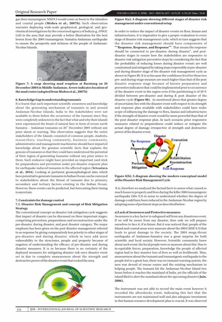
gas then tsunamigenic MSE9.3 would come as boon to the islanders and coastal people (Mishra et al., 2007b). Such observation warrants deploying wide-scale geophysical, geological, and geo-chemical investigations by the concerned agency of India (e.g., ONGC Ltd) in the area that may provide a better illustration for the best lesson from the 2004 tsunamigenic Sumatra-Andaman earthquake to ensure the prosperity and richness of the people of Andaman-Nicobar Islands.
Figure 7: A snap showing mud eruption at Baratang on 28 December 2004 in Middle Andaman. Arrow indicates location of the mud crater (adapted from Mishra et al., 2007b)
6. Knowledge Gap in understanding tsunamisIt is learnt that such important scientific awareness and knowledge about the generating mechanism of tsunamis in and around Andaman-Nicobar Islands, India to the stakeholders were not available to them before the occurrence of the tsunami since they were completely unknown to the fact that what and why their islands were experienced the brunt of natural fury in form of severe north
thSumatra – Andaman tsunamis on 26 December 2004 without any prior alarm or warning. is observation suggests that the entire stakeholders of the Islands consisted of common people, students, researchers, teaching community, business community, administrative and management machineries should have imparted knowledge about the genuine scientific facts that explains the genesis of tsunamis so that they could have understood the potential of their region of generating tsunamis without any prior notice to them. Such endeavor might have provided an important yard stick for preparedness and prevention under pre-disaster response plan for earthquake-induced tsunamis in the affected region (Srivastava et al., 2016). Looking at pertinent geomorphological data which have potential to generate tsunamis in Indian Ocean can be conveyed to stakeholders about the threat of tsunami due to primary, secondary and tertiary factors existing in the Indian Ocean. However, these events can be predicted, but forecasting their timing is uncertain.
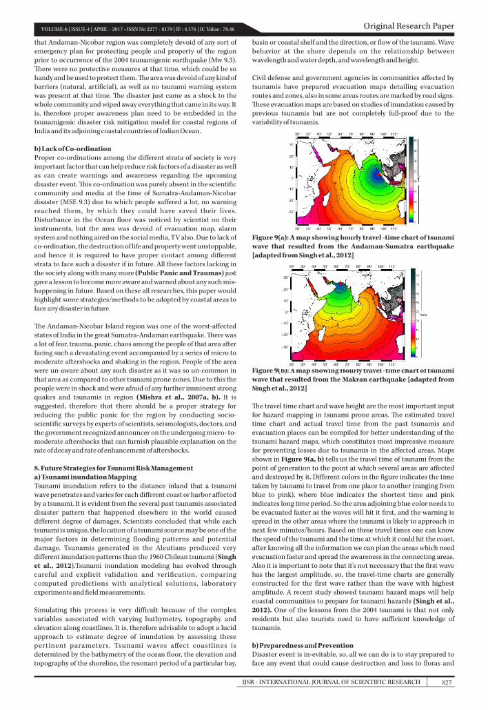
7. Constraints for damage control7.1. Disaster Risk Management and concept of Risk Mitigation Strategye conventional concept on disaster risk mitigation cycle suggests that impact of disaster can be discussed on three important stages, comprising prevention, preparedness and reconstruction under the pre-disaster, during disaster, and post disaster category. e major emphasis has been given on the post disaster management referred to as response by giving comparatively less priority to other stages of pre-disaster and during disaster, which in turn add more vulnerability to the structures, people and property because of negation of understanding the efficacy of pre-disaster and during disaster measures. It is so because there is no certainty of the deployed measures for mitigating disaster risk once disaster event set in due to complete unawareness about the strength and destructive power of the disaster event that rocked the area.
Figure 8(a): A diagram showing different stages of disaster risk management under conventional setup
In order to reduce the impact of disaster events on flora, faunas and infrastructures, it is imperative to give a proper evaluation to every stage of disaster risk management cycle, which in turn suggests that the disaster risk management should have components of “”Response, Response, and Response””. at means the response should be connected to pre-disaster, during disaster”, and post-disaster stages to ensure how the stakeholders are responsive to disaster risk mitigation preventive steps by considering the fact that the probability of reducing losses during disaster events are well constrained and mitigated by taking steps responsibly at pre-disaster and during disaster stage of the disaster risk management cycle as shown in Figure 8b. It is so because the confidence level for these two pre- and during-stage measure are much higher than that of the post disaster response stage because of known preparatory and preventive indicators that could be implemented prior to occurrence of the disaster event in the region even if the partitioning is of 50 % divided between pre-disaster and during & post disaster of the disaster cycle (Figure 8b). As mentioned above that greater degree of uncertainty lies with the disaster event with respect to its strength and response plan available with stakeholders could have wider scope of influencing the damage to flora, faunas and infrastructures if the strength of disaster event would be more powerful than that of the post disaster response plan. In such scenario prior responsive measures related to preparedness could reduce or mitigate the actual degree of damage irrespective of strength and destructive power of the disaster event.
Figure 8(b): A diagram showing the modern conceptual model of the Disaster Risk Management Cycle It is, therefore we analyzed the factual facts to assess what caused so much losses to property and lives during the killer 2004 tsunamigenic earthquake (Mw 9.3) in sense to understand whether the degree of damage could have been reduced in the Andaman-Nicobar region by adopting some of pertinent steps as described below:
a) Lack of Awareness and Protective measuresAwareness is a key factor to safeguard self from any disastrous event. If we will be aware from any disaster, then only we will prepare ourselves to face it, if in future. But it was noticed that, people of the Island and coastal areas were unaware about the 2004 (MSE 9.3) that leads to great damage to the society. e 2004 mega-thrust earthquake of Andaman-Sumatra was a great surprise for both scientific and local society. However, Scientific community knew about such event, the local people were so unaware about this. Due to in-equitable forces, preparation, knowledge the people of affected region had to face massive loss of lives as well as livelihoods. us, unawareness about the tsunami and tsunamigenic earthquake to the people led to a great loss, there was no tsunami warning system, the area was devoid of rescue routes and the existing mechanism to helping people. e tsunami hit the Andaman-Nicobar Island two hours before it reaches the mainland of India, yet the officials of the island filed to alert the mainland about the upcoming disaster (Jain, 2006). e instrument was not able to record the main event however it recorded the aftershocks event, indicating this fact that the instruments are not maintained well and also adequate investment in this human resource development plan is crucial. It was observed
Original Research Paper VOLUME-6 | ISSUE-4 | APRIL - 2017 • ISSN No 2277 - 8179 | IF : 4.176 | IC Value : 78.46
IJSR - INTERNATIONAL JOURNAL OF SCIENTIFIC RESEARCH826
that Andaman-Nicobar region was completely devoid of any sort of emergency plan for protecting people and property of the region prior to occurrence of the 2004 tsunamigenic earthquake (Mw 9.3). ere were no protective measures at that time, which could be so handy and be used to protect them. e area was devoid of any kind of barriers (natural, artificial), as well as no tsunami warning system was present at that time. e disaster just came as a shock to the whole community and wiped away everything that came in its way. It is, therefore proper awareness plan need to be embedded in the tsunamigenic disaster risk mitigation model for coastal regions of India and its adjoining coastal countries of Indian Ocean. b) Lack of Co-ordinationProper co-ordinations among the different strata of society is very important factor that can help reduce risk factors of a disaster as well as can create warnings and awareness regarding the upcoming disaster event. is co-ordination was purely absent in the scientific community and media at the time of Sumatra-Andaman-Nicobar disaster (MSE 9.3) due to which people suffered a lot, no warning reached them, by which they could have saved their lives. Disturbance in the Ocean floor was noticed by scientist on their instruments, but the area was devoid of evacuation map, alarm system and nothing aired on the social media, TV also. Due to lack of co-ordination, the destruction of life and property went unstoppable, and hence it is required to have proper contact among different strata to face such a disaster if in future. All these factors lacking in the society along with many more (Public Panic and Traumas) just gave a lesson to become more aware and warned about any such mis-happening in future. Based on these all researches, this paper would highlight some strategies/methods to be adopted by coastal areas to face any disaster in future. e Andaman-Nicobar Island region was one of the worst-affected states of India in the great Sumatra-Andaman earthquake. ere was a lot of fear, trauma, panic, chaos among the people of that area after facing such a devastating event accompanied by a series of micro to moderate aftershocks and shaking in the region. People of the area were un-aware about any such disaster as it was so un-common in that area as compared to other tsunami prone zones. Due to this the people were in shock and were afraid of any further imminent strong quakes and tsunamis in region (Mishra et al., 2007a, b). It is suggested, therefore that there should be a proper strategy for reducing the public panic for the region by conducting socio-scientific surveys by experts of scientists, seismologists, doctors, and the government recognized announcer on the undergoing micro- to- moderate aftershocks that can furnish plausible explanation on the rate of decay and rate of enhancement of aftershocks.
8. Future Strategies for Tsunami Risk Managementa) Tsunami inundation MappingTsunami inundation refers to the distance inland that a tsunami wave penetrates and varies for each different coast or harbor affected by a tsunami. It is evident from the several past tsunamis associated disaster pattern that happened elsewhere in the world caused different degree of damages. Scientists concluded that while each tsunami is unique, the location of a tsunami source may be one of the major factors in determining flooding patterns and potential damage. Tsunamis generated in the Aleutians produced very different inundation patterns than the 1960 Chilean tsunami (Singh et al., 2012).Tsunami inundation modeling has evolved through careful and explicit validation and verification, comparing computed predictions with analytical solutions, laboratory experiments and field measurements.
Simulating this process is very difficult because of the complex variables associated with varying bathymetry, topography and elevation along coastlines. It is, therefore advisable to adopt a lucid approach to estimate degree of inundation by assessing these pertinent parameters. Tsunami waves affect coastlines is determined by the bathymetry of the ocean floor, the elevation and topography of the shoreline, the resonant period of a particular bay,
basin or coastal shelf and the direction, or flow of the tsunami. Wave behavior at the shore depends on the relationship between wavelength and water depth, and wavelength and height.
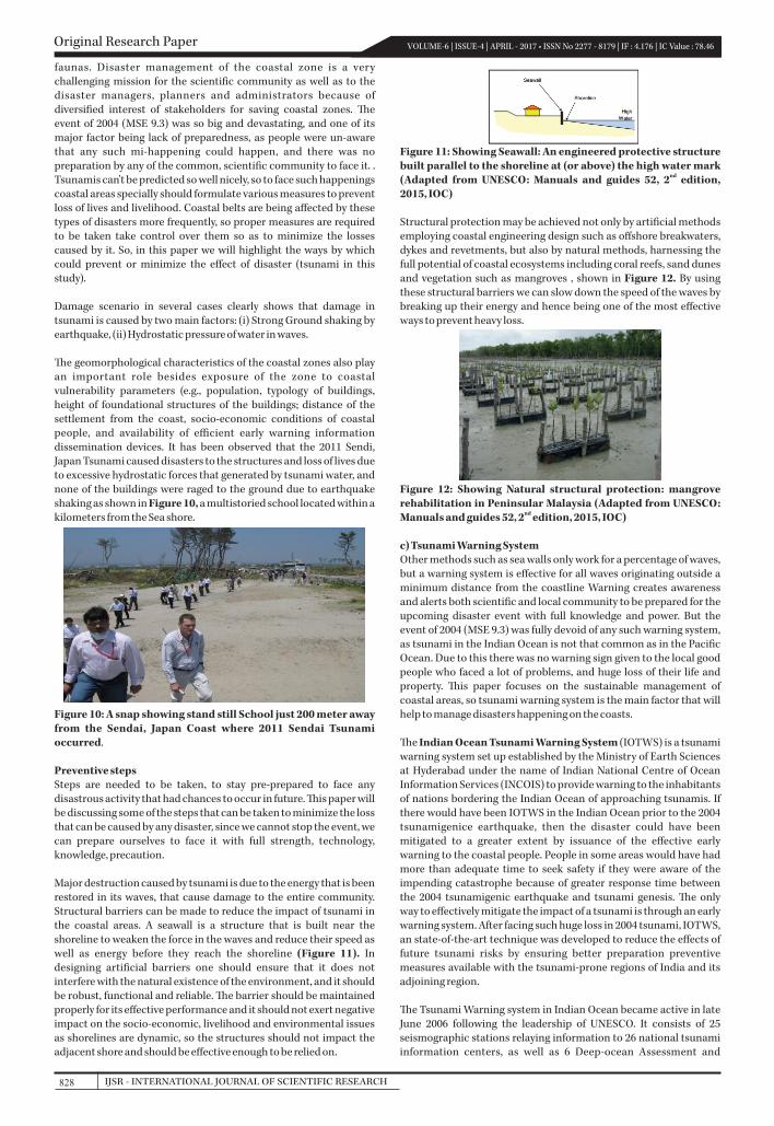
Civil defense and government agencies in communities affected by tsunamis have prepared evacuation maps detailing evacuation routes and zones, also in some areas routes are marked by road signs. ese evacuation maps are based on studies of inundation caused by previous tsunamis but are not completely full-proof due to the variability of tsunamis.
Figure 9(a): A map showing hourly travel -time chart of tsunami wave that resulted from the Andaman-Sumatra earthquake [adapted from Singh et al., 2012]
Figure 9(b): A map showing Hourly travel -time chart of tsunami wave that resulted from the Makran earthquake [adapted from Singh et al., 2012]
e travel time chart and wave height are the most important input for hazard mapping in tsunami prone areas. e estimated travel time chart and actual travel time from the past tsunamis and evacuation places can be compiled for better understanding of the tsunami hazard maps, which constitutes most impressive measure for preventing losses due to tsunamis in the affected areas. Maps shown in Figure 9(a, b) tells us the travel time of tsunami from the point of generation to the point at which several areas are affected and destroyed by it. Different colors in the figure indicates the time taken by tsunami to travel from one place to another (ranging from blue to pink), where blue indicates the shortest time and pink indicates long time period. So the area adjoining blue color needs to be evacuated faster as the waves will hit it first, and the warning is spread in the other areas where the tsunami is likely to approach in next few minutes/hours. Based on these travel times one can know the speed of the tsunami and the time at which it could hit the coast, after knowing all the information we can plan the areas which need evacuation faster and spread the awareness in the connecting areas. Also it is important to note that it's not necessary that the first wave has the largest amplitude, so, the travel-time charts are generally constructed for the first wave rather than the wave with highest amplitude. A recent study showed tsunami hazard maps will help coastal communities to prepare for tsunami hazards (Singh et al., 2012). One of the lessons from the 2004 tsunami is that not only residents but also tourists need to have sufficient knowledge of tsunamis.
b) Preparedness and PreventionDisaster event is in-evitable, so, all we can do is to stay prepared to face any event that could cause destruction and loss to floras and
Original Research PaperVOLUME-6 | ISSUE-4 | APRIL - 2017 • ISSN No 2277 - 8179 | IF : 4.176 | IC Value : 78.46
827IJSR - INTERNATIONAL JOURNAL OF SCIENTIFIC RESEARCH
faunas. Disaster management of the coastal zone is a very challenging mission for the scientific community as well as to the disaster managers, planners and administrators because of diversified interest of stakeholders for saving coastal zones. e event of 2004 (MSE 9.3) was so big and devastating, and one of its major factor being lack of preparedness, as people were un-aware that any such mi-happening could happen, and there was no preparation by any of the common, scientific community to face it. . Tsunamis can't be predicted so well nicely, so to face such happenings coastal areas specially should formulate various measures to prevent loss of lives and livelihood. Coastal belts are being affected by these types of disasters more frequently, so proper measures are required to be taken take control over them so as to minimize the losses caused by it. So, in this paper we will highlight the ways by which could prevent or minimize the effect of disaster (tsunami in this study).
Damage scenario in several cases clearly shows that damage in tsunami is caused by two main factors: (i) Strong Ground shaking by earthquake, (ii) Hydrostatic pressure of water in waves. e geomorphological characteristics of the coastal zones also play an important role besides exposure of the zone to coastal vulnerability parameters (e.g., population, typology of buildings, height of foundational structures of the buildings; distance of the settlement from the coast, socio-economic conditions of coastal people, and availability of efficient early warning information dissemination devices. It has been observed that the 2011 Sendi, Japan Tsunami caused disasters to the structures and loss of lives due to excessive hydrostatic forces that generated by tsunami water, and none of the buildings were raged to the ground due to earthquake shaking as shown in Figure 10, a multistoried school located within a kilometers from the Sea shore.
Figure 10: A snap showing stand still School just 200 meter away from the Sendai, Japan Coast where 2011 Sendai Tsunami occurred.
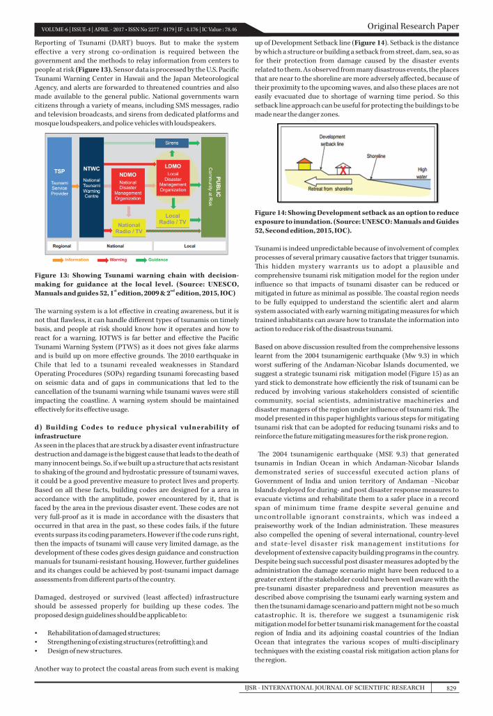
Preventive stepsSteps are needed to be taken, to stay pre-prepared to face any disastrous activity that had chances to occur in future. is paper will be discussing some of the steps that can be taken to minimize the loss that can be caused by any disaster, since we cannot stop the event, we can prepare ourselves to face it with full strength, technology, knowledge, precaution. Major destruction caused by tsunami is due to the energy that is been restored in its waves, that cause damage to the entire community. Structural barriers can be made to reduce the impact of tsunami in the coastal areas. A seawall is a structure that is built near the shoreline to weaken the force in the waves and reduce their speed as well as energy before they reach the shoreline (Figure 11). In designing artificial barriers one should ensure that it does not interfere with the natural existence of the environment, and it should be robust, functional and reliable. e barrier should be maintained properly for its effective performance and it should not exert negative impact on the socio-economic, livelihood and environmental issues as shorelines are dynamic, so the structures should not impact the adjacent shore and should be effective enough to be relied on.
Figure 11: Showing Seawall: An engineered protective structure built parallel to the shoreline at (or above) the high water mark
nd(Adapted from UNESCO: Manuals and guides 52, 2 edition, 2015, IOC)
Structural protection may be achieved not only by artificial methods employing coastal engineering design such as offshore breakwaters, dykes and revetments, but also by natural methods, harnessing the full potential of coastal ecosystems including coral reefs, sand dunes and vegetation such as mangroves , shown in Figure 12. By using these structural barriers we can slow down the speed of the waves by breaking up their energy and hence being one of the most effective ways to prevent heavy loss.
Figure 12: Showing Natural structural protection: mangrove rehabilitation in Peninsular Malaysia (Adapted from UNESCO:
ndManuals and guides 52, 2 edition, 2015, IOC)
c) Tsunami Warning SystemOther methods such as sea walls only work for a percentage of waves, but a warning system is effective for all waves originating outside a minimum distance from the coastline Warning creates awareness and alerts both scientific and local community to be prepared for the upcoming disaster event with full knowledge and power. But the event of 2004 (MSE 9.3) was fully devoid of any such warning system, as tsunami in the Indian Ocean is not that common as in the Pacific Ocean. Due to this there was no warning sign given to the local good people who faced a lot of problems, and huge loss of their life and property. is paper focuses on the sustainable management of coastal areas, so tsunami warning system is the main factor that will help to manage disasters happening on the coasts. e Indian Ocean Tsunami Warning System (IOTWS) is a tsunami warning system set up established by the Ministry of Earth Sciences at Hyderabad under the name of Indian National Centre of Ocean Information Services (INCOIS) to provide warning to the inhabitants of nations bordering the of approaching . If Indian Ocean tsunamisthere would have been IOTWS in the Indian Ocean prior to the 2004 tsunamigenice earthquake, then the disaster could have been mitigated to a greater extent by issuance of the effective early warning to the coastal people. People in some areas would have had more than adequate time to seek safety if they were aware of the impending catastrophe because of greater response time between the 2004 tsunamigenic earthquake and tsunami genesis. e only way to effectively mitigate the impact of a tsunami is through an early warning system. After facing such huge loss in 2004 tsunami, IOTWS, an state-of-the-art technique was developed to reduce the effects of future tsunami risks by ensuring better preparation preventive measures available with the tsunami-prone regions of India and its adjoining region. e Tsunami Warning system in Indian Ocean became active in late June 2006 following the leadership of UNESCO. It consists of 25 seismographic stations relaying information to 26 national tsunami information centers, as well as 6 Deep-ocean Assessment and
Original Research Paper VOLUME-6 | ISSUE-4 | APRIL - 2017 • ISSN No 2277 - 8179 | IF : 4.176 | IC Value : 78.46
IJSR - INTERNATIONAL JOURNAL OF SCIENTIFIC RESEARCH828
Reporting of Tsunami (DART) buoys. But to make the system effective a very strong co-ordination is required between the government and the methods to relay information from centers to people at risk (Figure 13). Sensor data is processed by the U.S. Pacific Tsunami Warning Center in Hawaii and the Japan Meteorological Agency, and alerts are forwarded to threatened countries and also made available to the general public. National governments warn citizens through a variety of means, including SMS messages, radio and television broadcasts, and sirens from dedicated platforms and mosque loudspeakers, and police vehicles with loudspeakers.
Figure 13: Showing Tsunami warning chain with decision-making for guidance at the local level. (Source: UNESCO,
st ndManuals and guides 52, 1 edition, 2009 & 2 edition, 2015, IOC)
e warning system is a lot effective in creating awareness, but it is not that flawless, it can handle different types of tsunamis on timely basis, and people at risk should know how it operates and how to react for a warning. IOTWS is far better and effective the Pacific Tsunami Warning System (PTWS) as it does not gives fake alarms and is build up on more effective grounds. e 2010 earthquake in Chile that led to a tsunami revealed weaknesses in Standard Operating Procedures (SOPs) regarding tsunami forecasting based on seismic data and of gaps in communications that led to the cancellation of the tsunami warning while tsunami waves were still impacting the coastline. A warning system should be maintained effectively for its effective usage.
d) Building Codes to reduce physical vulnerability of infrastructureAs seen in the places that are struck by a disaster event infrastructure destruction and damage is the biggest cause that leads to the death of many innocent beings. So, if we built up a structure that acts resistant to shaking of the ground and hydrostatic pressure of tsunami waves, it could be a good preventive measure to protect lives and property. Based on all these facts, building codes are designed for a area in accordance with the amplitude, power encountered by it, that is faced by the area in the previous disaster event. ese codes are not very full-proof as it is made in accordance with the disasters that occurred in that area in the past, so these codes fails, if the future events surpass its coding parameters. However if the code runs right, then the impacts of tsunami will cause very limited damage, as the development of these codes gives design guidance and construction manuals for tsunami-resistant housing. However, further guidelines and its changes could be achieved by post-tsunami impact damage assessments from different parts of the country.
Damaged, destroyed or survived (least affected) infrastructure should be assessed properly for building up these codes. e proposed design guidelines should be applicable to:
Ÿ Rehabilitation of damaged structures;Ÿ Strengthening of existing structures (retrofitting); andŸ Design of new structures.
Another way to protect the coastal areas from such event is making
up of Development Setback line (Figure 14). Setback is the distance by which a structure or building a setback from street, dam, sea, so as for their protection from damage caused by the disaster events related to them. As observed from many disastrous events, the places that are near to the shoreline are more adversely affected, because of their proximity to the upcoming waves, and also these places are not easily evacuated due to shortage of warning time period. So this setback line approach can be useful for protecting the buildings to be made near the danger zones.
Figure 14: Showing Development setback as an option to reduce exposure to inundation. (Source: UNESCO: Manuals and Guides 52, Second edition, 2015, IOC).
Tsunami is indeed unpredictable because of involvement of complex processes of several primary causative factors that trigger tsunamis. is hidden mystery warrants us to adopt a plausible and comprehensive tsunami risk mitigation model for the region under influence so that impacts of tsunami disaster can be reduced or mitigated in future as minimal as possible. e coastal region needs to be fully equipped to understand the scientific alert and alarm system associated with early warning mitigating measures for which trained inhabitants can aware how to translate the information into action to reduce risk of the disastrous tsunami.
Based on above discussion resulted from the comprehensive lessons learnt from the 2004 tsunamigenic earthquake (Mw 9.3) in which worst suffering of the Andaman-Nicobar Islands documented, we suggest a strategic tsunami risk mitigation model (Figure 15) as an yard stick to demonstrate how efficiently the risk of tsunami can be reduced by involving various stakeholders consisted of scientific community, social scientists, administrative machineries and disaster managers of the region under influence of tsunami risk. e model presented in this paper highlights various steps for mitigating tsunami risk that can be adopted for reducing tsunami risks and to reinforce the future mitigating measures for the risk prone region.
e 2004 tsunamigenic earthquake (MSE 9.3) that generated tsunamis in Indian Ocean in which Andaman-Nicobar Islands demonstrated series of successful executed action plans of Government of India and union territory of Andaman –Nicobar Islands deployed for during- and post disaster response measures to evacuate victims and rehabilitate them to a safer place in a record span of minimum time frame despite several genuine and uncontrollable ignorant constraints, which was indeed a praiseworthy work of the Indian administration. ese measures also compelled the opening of several international, country-level and state-level disaster risk management institutions for development of extensive capacity building programs in the country. Despite being such successful post disaster measures adopted by the administration the damage scenario might have been reduced to a greater extent if the stakeholder could have been well aware with the pre-tsunami disaster preparedness and prevention measures as described above comprising the tsunami early warning system and then the tsunami damage scenario and pattern might not be so much catastrophic. It is, therefore we suggest a tsunamigenic risk mitigation model for better tsunami risk management for the coastal region of India and its adjoining coastal countries of the Indian Ocean that integrates the various scopes of multi-disciplinary techniques with the existing coastal risk mitigation action plans for the region.
Original Research PaperVOLUME-6 | ISSUE-4 | APRIL - 2017 • ISSN No 2277 - 8179 | IF : 4.176 | IC Value : 78.46
829IJSR - INTERNATIONAL JOURNAL OF SCIENTIFIC RESEARCH
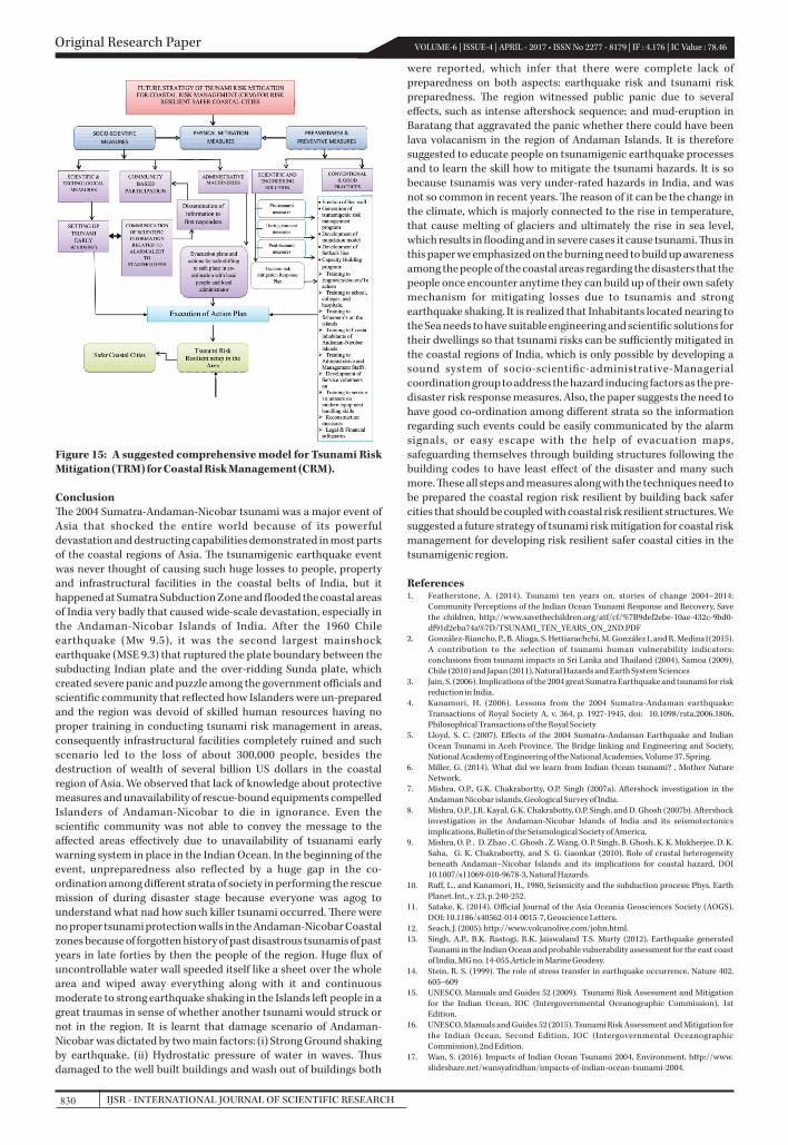
Figure 15: A suggested comprehensive model for Tsunami Risk Mitigation (TRM) for Coastal Risk Management (CRM).
Conclusione 2004 Sumatra-Andaman-Nicobar tsunami was a major event of Asia that shocked the entire world because of its powerful devastation and destructing capabilities demonstrated in most parts of the coastal regions of Asia. e tsunamigenic earthquake event was never thought of causing such huge losses to people, property and infrastructural facilities in the coastal belts of India, but it happened at Sumatra Subduction Zone and flooded the coastal areas of India very badly that caused wide-scale devastation, especially in the Andaman-Nicobar Islands of India. After the 1960 Chile earthquake (Mw 9.5), it was the second largest mainshock earthquake (MSE 9.3) that ruptured the plate boundary between the subducting Indian plate and the over-ridding Sunda plate, which created severe panic and puzzle among the government officials and scientific community that reflected how Islanders were un-prepared and the region was devoid of skilled human resources having no proper training in conducting tsunami risk management in areas, consequently infrastructural facilities completely ruined and such scenario led to the loss of about 300,000 people, besides the destruction of wealth of several billion US dollars in the coastal region of Asia. We observed that lack of knowledge about protective measures and unavailability of rescue-bound equipments compelled Islanders of Andaman-Nicobar to die in ignorance. Even the scientific community was not able to convey the message to the affected areas effectively due to unavailability of tsuanami early warning system in place in the Indian Ocean. In the beginning of the event, unpreparedness also reflected by a huge gap in the co-ordination among different strata of society in performing the rescue mission of during disaster stage because everyone was agog to understand what nad how such killer tsunami occurred. ere were no proper tsunami protection walls in the Andaman-Nicobar Coastal zones because of forgotten history of past disastrous tsunamis of past years in late forties by then the people of the region. Huge flux of uncontrollable water wall speeded itself like a sheet over the whole area and wiped away everything along with it and continuous moderate to strong earthquake shaking in the Islands left people in a great traumas in sense of whether another tsunami would struck or not in the region. It is learnt that damage scenario of Andaman-Nicobar was dictated by two main factors: (i) Strong Ground shaking by earthquake, (ii) Hydrostatic pressure of water in waves. us damaged to the well built buildings and wash out of buildings both
were reported, which infer that there were complete lack of preparedness on both aspects: earthquake risk and tsunami risk preparedness. e region witnessed public panic due to several effects, such as intense aftershock sequence; and mud-eruption in Baratang that aggravated the panic whether there could have been lava volacanism in the region of Andaman Islands. It is therefore suggested to educate people on tsunamigenic earthquake processes and to learn the skill how to mitigate the tsunami hazards. It is so because tsunamis was very under-rated hazards in India, and was not so common in recent years. e reason of it can be the change in the climate, which is majorly connected to the rise in temperature, that cause melting of glaciers and ultimately the rise in sea level, which results in flooding and in severe cases it cause tsunami. us in this paper we emphasized on the burning need to build up awareness among the people of the coastal areas regarding the disasters that the people once encounter anytime they can build up of their own safety mechanism for mitigating losses due to tsunamis and strong earthquake shaking. It is realized that Inhabitants located nearing to the Sea needs to have suitable engineering and scientific solutions for their dwellings so that tsunami risks can be sufficiently mitigated in the coastal regions of India, which is only possible by developing a sound system of socio-scientific-administrative-Managerial coordination group to address the hazard inducing factors as the pre-disaster risk response measures. Also, the paper suggests the need to have good co-ordination among different strata so the information regarding such events could be easily communicated by the alarm signals, or easy escape with the help of evacuation maps, safeguarding themselves through building structures following the building codes to have least effect of the disaster and many such more. ese all steps and measures along with the techniques need to be prepared the coastal region risk resilient by building back safer cities that should be coupled with coastal risk resilient structures. We suggested a future strategy of tsunami risk mitigation for coastal risk management for developing risk resilient safer coastal cities in the tsunamigenic region.
References1. Featherstone, A. (2014). Tsunami ten years on, stories of change 2004–2014:
Community Perceptions of the Indian Ocean Tsunami Response and Recovery, Save the children, http://www.savethechildren.org/atf/cf/%7B9def2ebe-10ae-432c-9bd0-df91d2eba74a%7D/TSUNAMI_TEN_YEARS_ON_2ND.PDF
2. González-Riancho, P., B. Aliaga, S. Hettiarachchi, M. González1, and R. Medina1(2015). A contribution to the selection of tsunami human vulnerability indicators: conclusions from tsunami impacts in Sri Lanka and ailand (2004), Samoa (2009), Chile (2010) and Japan (2011), Natural Hazards and Earth System Sciences
3. Jain, S. (2006). Implications of the 2004 great Sumatra Earthquake and tsunami for risk reduction in India.
4. Kanamori, H. (2006). Lessons from the 2004 Sumatra-Andaman earthquake: Transactions of Royal Society A, v. 364, p. 1927-1945, doi: 10.1098/rsta.2006.1806, Philosophical Transactions of the Royal Society
5. Lloyd, S. C. (2007). Effects of the 2004 Sumatra-Andaman Earthquake and Indian Ocean Tsunami in Aceh Province, e Bridge linking and Engineering and Society, National Academy of Engineering of the National Academies, Volume 37, Spring.
6. Miller, G. (2014). What did we learn from Indian Ocean tsunami? , Mother Nature Network.
7. Mishra, O.P., G.K. Chakrabortty, O.P. Singh (2007a). Aftershock investigation in the Andaman Nicobar islands, Geological Survey of India.
8. Mishra, O.P., J.R. Kayal, G.K. Chakrabotty, O.P. Singh, and D. Ghosh (2007b). Aftershock investigation in the Andaman-Nicobar Islands of India and its seismotectonics implications, Bulletin of the Seismological Society of America.
9. Mishra, O. P. , D. Zhao , C. Ghosh , Z. Wang, O. P. Singh, B. Ghosh, K. K. Mukherjee, D. K. Saha, G. K. Chakrabortty, and S. G. Gaonkar (2010). Role of crustal heterogeneity beneath Andaman–Nicobar Islands and its implications for coastal hazard, DOI 10.1007/s11069-010-9678-3, Natural Hazards.
10. Ruff, L., and Kanamori, H., 1980, Seismicity and the subduction process: Phys. Earth Planet. Int., v. 23, p. 240-252.
11. Satake, K. (2014). Official Journal of the Asia Oceania Geosciences Society (AOGS), DOI: 10.1186/s40562-014-0015-7, Geoscience Letters.
12. Seach, J. (2005). http://www.volcanolive.com/john.html.13. Singh, A.P., B.K. Rastogi, R.K. Jaiswaland T.S. Murty (2012). Earthquake generated
Tsunami in the Indian Ocean and probable vulnerability assessment for the east coast of India, MG no. 14-055.Article in Marine Geodesy.
14. Stein, R. S. (1999). e role of stress transfer in earthquake occurrence, Nature 402, 605–609
15. UNESCO, Manuals and Guides 52 (2009). Tsunami Risk Assessment and Mitigation for the Indian Ocean, IOC (Intergovernmental Oceanographic Commission), 1st Edition.
16. UNESCO, Manuals and Guides 52 (2015). Tsunami Risk Assessment and Mitigation for the Indian Ocean, Second Edition, IOC (Intergovernmental Oceanographic Commission), 2nd Edition.
17. Wan, S. (2016). Impacts of Indian Ocean Tsunami 2004, Environment, http://www. slideshare.net/wansyafridhan/impacts-of-indian-ocean-tsunami-2004.
Original Research Paper VOLUME-6 | ISSUE-4 | APRIL - 2017 • ISSN No 2277 - 8179 | IF : 4.176 | IC Value : 78.46
IJSR - INTERNATIONAL JOURNAL OF SCIENTIFIC RESEARCH830