draft consolidated toxic hot spots cleanup plan
TRANSCRIPT

State of California
STATE WATER RESOURCES CONTROL BOARD
DRAFT CONSOLIDATED TOXIC HOT SPOTS CLEANUP PLAN
VOLUME II: REGIONAL CLEANUP PLANS
FINAL FUNCTIONAL EQUIVALENT DOCUMENTAPPENDIX B
August 29, 2003June 1999

4
PREFACEThe Consolidated Toxic Hot Spot Cleanup Plan has two parts:(1) Volume I which contains the consolidated lists, policystatements and findings; and (2) Volume II which contains each ofthe Regional Toxic Hot Spot Cleanup Plans.
This is Volume II of the Consolidated Toxic Hot Spot Cleanup Planthat contains each of the Regional Toxic Hot Spot Cleanup Plans.Regional Cleanup Plans are included for the following RegionalWater Quality Control Boards:
• North Coast (Region 1)• San Francisco Bay (Region 2)• Central Coast (Region 3)• Los Angeles (Region 4)• Central Valley (Region 5)• Santa Ana (Region 8)• San Diego (Region 9) Each Regional Cleanup Plan in this volume is divided into thefollowing sections:
• Toxic Hot Spot List• Ranking Matrix• Characterization and planning for remediation of high priority
toxic hot spots• Future needs

5
TABLE OF CONTENTS
PREFACE ............................................................................................................................................................ 4
TABLE OF CONTENTS..................................................................................................................................... 5
REGIONAL WATER QUALITY CONTROL BOARD, NORTH COAST REGION .................................. 1-1
REGION DESCRIPTION .......................................................................................................................................... 1-2CANDIDATE TOXIC HOT SPOT LIST ....................................................................................................................... 1-4RANKING MATRIX................................................................................................................................................ 1-4HIGH PRIORITY CANDIDATE TOXIC HOT SPOT, G&R METALS FOOT OF H STREET BETWEEN FIRST STREET AND
HUMBOLDT BAY EUREKA, CALIFORNIA (SCRAP YARD)........................................................................................... 1-5FUTURE NEEDS .................................................................................................................................................... 1-7SITES OF CONCERN (SITES THAT DO NOT QUALIFY AS CANDIDATE TOXIC HOT SPOTS) ............................................. 1-8
Reference list ................................................................................................................................................. 1-8
REGIONAL WATER QUALITY CONTROL BOARD, SAN FRANCISCO BAY REGION ...................... 2-1
REGION DESCRIPTION .......................................................................................................................................... 2-2CANDIDATE TOXIC HOT SPOTS (EXCEPT FOR SAN FRANCISCO BAY, SITES ARE LISTED FROM NORTH TO SOUTH) ........ 2-6
Reference list ................................................................................................................................................. 2-7RANKING MATRIX (EXCEPT FOR SAN FRANCISCO BAY SITES WITHIN AN OVERALL RANK ARE LISTED FROM NORTH TO
SOUTH).............................................................................................................................................................. 2-11HIGH PRIORITY CANDIDATE TOXIC HOT SPOT CHARACTERIZATION ..................................................................... 2-12SITE A -- SAN FRANCISCO BAY........................................................................................................................... 2-12
Description of site/ Background ................................................................................................................... 2-12Reason for listing ......................................................................................................................................... 2-13Mercury ....................................................................................................................................................... 2-13PCBs............................................................................................................................................................ 2-15Chlorinated Pesticides ................................................................................................................................. 2-16Dioxins.................................................................................................................................................. 2-162-17Mercury ....................................................................................................................................................... 2-17PCBs............................................................................................................................................................ 2-20Chlorinated Pesticides ................................................................................................................................. 2-21Dioxins......................................................................................................................................................... 2-21Summary of actions by government agencies in response to health advisory................................................. 2-22References.................................................................................................................................................... 2-26
SITE B -- PEYTON SLOUGH ................................................................................................................................. 2-28Description of site ........................................................................................................................................ 2-28Reason for listing ......................................................................................................................................... 2-31CH2MHILL (1986) ....................................................................................................................................... 2-31The MARK Group (1988a, 1988b, 1989a, 1989b)........................................................................... 2-312-312-32Bay Protection and Toxic Cleanup Program ................................................................................................ 2-32
Pilot Regional Monitoring Program (Flegal et al., 1994)............................................................................................ 2-32Screening and Confirmation Studies (Hunt et al., 1998) ............................................................................................ 2-32
Harding Lawson Associates (1998)................................................................................................. 2-332-332-34References.................................................................................................................................................... 2-42
SITE C - CASTRO COVE ...................................................................................................................................... 2-44Description of site ........................................................................................................................................ 2-44Reason for listing ......................................................................................................................................... 2-44
E.V.S. investigations (1987)...................................................................................................................................... 2-45Entrix Investigations (1990a, 1990b) ......................................................................................................................... 2-47E.V.S. study (1991)................................................................................................................................................... 2-47

6
Mussel Watch Program (1988, 1990) ........................................................................................................................ 2-48Bay Protection and Toxic Cleanup Program............................................................................................................... 2-48
Pilot Regional Monitoring Program (Flegal et al., 1994)....................................................................................... 2-49Reference site study (Hunt et al., 1998a) .............................................................................................................. 2-50Screening/confirmation studies (Hunt et al., 1998b) ............................................................................................. 2-50
References............................................................................................................................................. 2-542-55SITE D - STEGE MARSH...................................................................................................................................... 2-57
Description of site ........................................................................................................................................ 2-57Reason for listing ......................................................................................................................................... 2-59
ICI Americas Investigations (1987)............................................................................................................................ 2-60The Mark Group Investigations (1990, 1991) ............................................................................................................ 2-60URS Corporation Investigation (1991)....................................................................................................................... 2-61Woodward-Clyde Consultants Investigation (1993).................................................................................................... 2-61ICF Kaiser Investigation (1997)................................................................................................................................. 2-61Zeneca and RWQCB sediment sample (1997) ........................................................................................................... 2-62Bay Protection and Toxic Cleanup Program (1998).................................................................................................... 2-62Pacific Eco-Risk Laboratories.................................................................................................................................... 2-63
References.................................................................................................................................................... 2-75SITE E -- POINT POTRERO/RICHMOND HARBOR................................................................................................... 2-77
Description of Site........................................................................................................................................ 2-77Reason for Listing ........................................................................................................................................ 2-77References.................................................................................................................................................... 2-84
SITE F -- MISSION CREEK ................................................................................................................................... 2-86Description of site ........................................................................................................................................ 2-86Reason for listing ......................................................................................................................................... 2-86References............................................................................................................................................. 2-952-96
SITE G -- ISLAIS CREEK...................................................................................................................................... 2-97Description of site ........................................................................................................................................ 2-97Reason for listing ......................................................................................................................................... 2-98Recurrent Toxicity...................................................................................................................................... 2-101Elevated Chemicals.................................................................................................................................... 2-102Impacted Benthic Community..................................................................................................................... 2-103CSOs.........................................................................................................................................2-1062-1052-106Quint Street Outfall .................................................................................................................................... 2-106Other Potential Sources ............................................................................................................................. 2-107References.................................................................................................................................................. 2-111
FUTURE NEEDS ................................................................................................................................................ 2-113Sites of Concern ......................................................................................................................................... 2-114
SITES OF CONCERN (THESE SITES DO NOT QUALIFY AS CANDIDATE TOXIC HOT SPOTS)........................................ 2-116SITES OF CONCERN (THESE SITES DO NOT QUALIFY AS CANDIDATE TOXIC HOT SPOTS)........................................ 2-117
Reference list ............................................................................................................................2-1182-1172-118
REGIONAL WATER QUALITY CONTROL BOARD, CENTRAL COAST REGION.............................. 3-1
REGION DESCRIPTION .......................................................................................................................................... 3-2CANDIDATE TOXIC HOT SPOT LIST ....................................................................................................................... 3-3
References...................................................................................................................................................... 3-7RANKING MATRIX................................................................................................................................................ 3-9HIGH PRIORITY CANDIDATE TOXIC HOT SPOT CHARACTERIZATION ..................................................................... 3-10MOSS LANDING AND TRIBUTARIES...................................................................................................................... 3-10
River and Stream Maintenance Activities ..................................................................................................... 3-19Urban Activities ........................................................................................................................................... 3-19Harbor Activities.......................................................................................................................................... 3-20Issuance of Discharge Permits and CWA 401 Certifications......................................................................... 3-20Harbor Dredging Activities .......................................................................................................................... 3-20

7
303(d) Listings of Water Quality Limited Water Bodies ................................................................................ 3-21Watershed Management Initiative ................................................................................................................ 3-22Salinas River Watershed Strategy................................................................................................................. 3-22Nonpoint Source Program............................................................................................................................ 3-23Urban Runoff Management .......................................................................................................................... 3-24Clean Water Act Section 319(h) and 205(j) Grants ....................................................................................... 3-25Coordination with Existing Resource Protection Efforts ............................................................................... 3-26Dredging...................................................................................................................................................... 3-30Control of Harbor Pollutants........................................................................................................................ 3-30Control of Urban Runoff .............................................................................................................................. 3-31Implementation of Management Practices to Reduce Nonpoint Source Pollution from Agriculture............... 3-32
SUMMARY ........................................................................................................................................... 3-353-353-36Environmental Benefits ................................................................................................................................ 3-361. Regional Board Program costs ................................................................................................................. 3-372. Harbor implementation costs.................................................................................................................... 3-383. Urban implementation costs ..................................................................................................................... 3-394. Agricultural implementation costs ............................................................................................................ 3-39Overall Agricultural Implementation Cost Estimate ..................................................................................... 3-41Harbor ......................................................................................................................................................... 3-41Urban........................................................................................................................................................... 3-42Agricultural.................................................................................................................................................. 3-42
CANADA DE LA HUERTA – SHELL/HERCULES SITE ............................................................................................... 3-43Environmental Benefits ................................................................................................................................ 3-52
Commercial and Sport Fishing .................................................................................................................................. 3-52Aquaculture .............................................................................................................................................................. 3-52Wildlife Habitat ........................................................................................................................................................ 3-52Cold/Warm Freshwater Habitat ................................................................................................................................. 3-52Rare, Threatened, and Endangered Species ............................................................................................................... 3-52
References.................................................................................................................................................... 3-55SITES OF CONCERN (SITES THAT DO NOT CURRENTLY QUALIFY AS CANDIDATE TOXIC HOT SPOTS) .................... 3-60
Additional Comments on Sites of Concern.................................................................................................... 3-62Santa Maria River Estuary ........................................................................................................................................ 3-62Santa Cruz Harbor..................................................................................................................................................... 3-62Pajaro River Estuary ................................................................................................................................................. 3-62Monterey Harbor....................................................................................................................................................... 3-63Other Sites................................................................................................................................................................ 3-64
REGIONAL WATER QUALITY CONTROL BOARD, LOS ANGELES REGION.................................... 4-1
REGION DESCRIPTION .......................................................................................................................................... 4-2CANDIDATE TOXIC HOT SPOT LIST ..................................................................................................................... 4-13
Reference list ............................................................................................................................................... 4-14HIGH PRIORITY CANDIDATE TOXIC HOT SPOT CHARACTERIZATION ..................................................................... 4-16SANTA MONICA BAY/PALOS VERDES SHELF........................................................................................................ 4-16MUGU LAGOON/CALLEGUAS CREEK TIDAL PRISM ............................................................................................... 4-27LOS ANGELES/LONG BEACH HARBORS................................................................................................................ 4-37LOS ANGELES OUTER HARBOR/CABRILLO PIER ................................................................................................... 4-39LOS ANGELES INNER HARBOR/DOMINGUEZ CHANNEL, CONSOLIDATED SLIP ........................................................ 4-45MCGRATH LAKE................................................................................................................................................ 4-52FUTURE NEEDS .................................................................................................................................................. 4-61SITES OF CONCERN (SITES THAT DO NOT QUALIFY AS CANDIDATE TOXIC HOT SPOTS) ........................................... 4-62
Reference list ............................................................................................................................................... 4-63
REGIONAL WATER QUALITY CONTROL BOARD, CENTRAL VALLEY REGION ........................... 5-1
REGION DESCRIPTION .......................................................................................................................................... 5-2

8
CANDIDATE TOXIC HOT SPOT LIST ....................................................................................................................... 5-3References...................................................................................................................................................... 5-4
RANKING MATRIX................................................................................................................................................ 5-9HIGH PRIORITY CANDIDATE TOXIC HOT SPOT CHARACTERIZATION ..................................................................... 5-10MERCURY CLEAN UP PLAN ................................................................................................................................. 5-10
Background.................................................................................................................................................. 5-10TABLE 1. ESTIMATE OF COST TO COLLECT INFORMATION TO DEVELOP A MERCURY CONTROL STRATEGY. .............. 5-28SAN JOAQUIN RIVER DISSOLVED OXYGEN CLEANUP PLAN ................................................................................... 5-29
Background.................................................................................................................................................. 5-29TABLE 2. COST ESTIMATES FOR DEVELOPING A DISSOLVED OXYGEN TMDL IN THE LOWER SAN JOAQUIN RIVER AND AN
ESTIMATE OF THE TIME REQUIRED TO COMPLETE EACH TASK................................................................................. 5-39References.................................................................................................................................................... 5-40
PESTICIDE VARIANCE FROM REGIONAL TOXIC HOT SPOT CLEANUP PLAN DIAZINON ORCHARD DORMANT SPRAY
CLEANUP PLAN .................................................................................................................................................. 5-42High Priority Candidate Toxic Hot Spot Characterization Variance for Diazinon Orchard Dormant SprayCleanup Plan ............................................................................................................................................... 5-42
Background............................................................................................................................................................... 5-42URBAN STORMWATER PESTICIDE CLEANUP PLAN ................................................................................................ 5-50
Background.................................................................................................................................................. 5-50IRRIGATION RETURN FLOW PESTICIDE CLEANUP PLAN .......................................................................... 5-585-585-58
Background.................................................................................................................................... 5-585-585-58References.................................................................................................................................. 5-1145-1145-64
FUTURE NEEDS ................................................................................................................................ 5-1245-1245-68SITES OF CONCERN (SITES THAT DO NOT QUALIFY AS CANDIDATE TOXIC HOT SPOTS) ......................... 5-1265-1265-70
REGIONAL WATER QUALITY CONTROL BOARD, SANTA ANA REGION......................................... 8-1
REGION DESCRIPTION .......................................................................................................................................... 8-2CANDIDATE TOXIC HOT SPOT LIST ....................................................................................................................... 8-3
References...................................................................................................................................................... 8-4RANKING MATRIX................................................................................................................................................ 8-5
Human Health Impacts................................................................................................................................... 8-6Water Quality Objectives ............................................................................................................................... 8-6
Natural Remediation Potential..................................................................................................................................... 8-7HIGH PRIORITY CANDIDATE TOXIC HOT SPOT CHARACTERIZATION ....................................................................... 8-7LOWER NEWPORT BAY - RHINE CHANNEL............................................................................................................. 8-7
Year 1....................................................................................................................................................................... 8-13Year 2....................................................................................................................................................................... 8-13
References.................................................................................................................................................... 8-13FUTURE NEEDS .................................................................................................................................................. 8-14SITES OF CONCERN (SITES THAT DO NOT QUALIFY AS CANDIDATE TOXIC HOT SPOTS) ........................................... 8-15
REGIONAL WATER QUALITY CONTROL BOARD, SAN DIEGO REGION ......................................... 9-1
REGION DESCRIPTION .......................................................................................................................................... 9-2CANDIDATE TOXIC HOT SPOT LIST ....................................................................................................................... 9-3
Reference list ................................................................................................................................................. 9-4RANKING MATRIX................................................................................................................................................ 9-5HIGH PRIORITY CANDIDATE TOXIC HOT SPOT ....................................................................................................... 9-6SEVENTH STREET CHANNEL, NATIONAL CITY ....................................................................................................... 9-6
Year 1: ......................................................................................................................................................... 9-13Year 2: ......................................................................................................................................................... 9-13
FUTURE NEEDS .................................................................................................................................................. 9-13SITES OF CONCERN ............................................................................................................................................ 9-15SITES OF CONCERN (SITES THAT DO NOT QUALIFY AS CANDIDATE TOXIC HOT SPOTS) ........................................... 9-16

9
References.................................................................................................................................................... 9-20

1-1
REGIONAL WATER QUALITY CONTROL BOARD, NORTH COAST REGION(REGION 1.)
REGIONAL TOXIC HOT SPOTCLEANUP PLAN

1-2
Region DescriptionThe North Coast Region is defined in Section 13200(a) of thePorter-Cologne Water Quality Control Act as follows:
“North Coast Region, which comprises all basins including theLower Klamath Lake and Lost River Basins draining into thePacific Ocean from the California-Oregon state line southerly to thesoutherly boundary of the watershed of the Estero de San Antonioand Stemple Creek in Marin and Sonoma Counties.”
The Region is divided into two natural drainage basins, the KlamathRiver Basin and the North Coastal Basin. The North Coast Regioncovers all of Del Norte, Humboldt, Trinity, and MendocinoCounties, major portions of Siskiyou and Sonoma Counties, andsmall portions of Glenn, Lake and Marin Counties.
The Region encompasses a total area of approximately 19,390square miles, including 340 miles of scenic coastline and remotewilderness areas, as well as urbanized and agricultural areas.
The Region is characterized by distinct temperature zones. Alongthe coast, the climate is moderate and foggy and the temperaturevariation is not great. For example, at Eureka, the seasonalvariation in temperature has not exceeded 63°F for the period ofrecord. Inland however, seasonal temperature ranges in excess of100°F have been recorded.
Precipitation over the North Coast Region is greater than any otherpart of California, and damaging floods are a fairly frequent hazard.Particularly devastating floods occurred in the North Coast area inDecember of 1955, December of 1964, and in February of 1986.
Ample precipitation in combination with the mild climate foundover most of the North Coast Region has provided a wealth of fish,wildlife, and scenic resources. The mountainous nature of theRegion, with its dense coniferous forests interspersed with grassyor chaparral covered slopes, provides shelter and food for deer, elk,bear, mountain lion, fur-bearers and many upland bird and mammalspecies. The numerous streams and rivers of the Region containanadromous fish, and the reservoirs, although few in number,support both cold-water and warm-water fish.

1-3
Tidelands, and marshes too, are extremely important to manyspecies of waterfowl and shore birds, both for feeding and nesting.Cultivated land and pasture lands also provide supplemental foodfor many birds, including small pheasant populations. Tidelandareas along the north coast provide important habitat for marineinvertebrates and nursery areas for forage fish, game fish andcrustaceans. Offshore coastal rocks are used by many species ofseabirds as nesting areas. Major components of the economy aretourism and recreation, logging and timber milling, aggregatemining, commercial and sport fisheries, sheep, beef and dairyproduction, and vineyards and wineries.
In all, the North Coast Region offers a beautiful naturalenvironment with opportunities for scientific study and research,recreation, sport and commerce. To ensure their perpetuation, theresources must be used wisely.

1-4
Candidate Toxic Hot Spot List
Water bodyname
Segment Name Site Identification Reason for Listing Pollutantspresent at thesite
Reportreference
Humboldt Bay 14001, Eureka Waterfront “H” Street(G&R Metals)
Bioassay toxicity EE Pb, Ag, Sb, Zn,Methoxychlor,PAH
BPTCP data
Bodega Bay 10006, Mason’s Marina Bioassay toxicityRA; EE
Cd, Cu, TBT,PAH
BPTCP data
Bodega Bay 10028, Porto Bodega Marina Bioassay toxicity EE Cu, Pb, Hg, Zn,TBT, DDT,PCB, PAH
BPTCP data
Reference list:State Water Resources Control Board, Bay Protection and Toxic Cleanup Program Database and Data ReportsSite File, G&R Metals
Ranking Matrix
Water bodyName
SiteIdentification
Human HealthImpacts
Aquatic LifeImpacts
Water QualityObjectives
Areal Extent RemediationPotential
OverallRanking
Humboldt Bay 14001 Low High Low 1 to 10 acres High High
Bodega Bay 10006 Low High Low Unknown High ModerateBodega Bay 10028 Low High Low Unknown High Moderate

1-5
High Priority Candidate Toxic Hot Spot, G&R Metals Foot of H Street Between FirstStreet and Humboldt Bay Eureka, California (scrap yard)
A. Areal extent of the Toxic Hot Spot:
The areal extent of the toxic hot spot has been estimated to be 3.5 acres with an average depth of contamination of 2 feet. The total contaminated soil quantity is about 10,000 cubic yards. The constituents of concern are lead, arsenic, chromium, cadmium, cobalt, copper, mercury, zinc, and PCBs.
B. Most likely Sources of Pollutants:
The site is located on the shore of Humboldt Bay and has been used for industrial activities since the early part of the century. It has been operated as a scrap metal facility since the early 1950s. Operations at the site included disassembly, incineration, and crushing of automobiles, storage of metals, batteries, radiators, metals reclamation from electrical transformers, and miscellaneous refuse. These operations occurred across the site. All industrial activities have ceased at the site but the historic uses have resulted in an area contaminated with PCBs, PAHs, metals and Methoxychlor. Cleanup and abatement activities remain to be performed at this site. These activities include: a.) performing an ecological and human health risk assessment, b.) conducting a feasibility study assessing remedial alternatives, and c.) performing appropriate cleanup and abatement activities.
C. Summary of actions that have been initiated by theRegional Water Board to reduce the accumulation ofpollutant at existing Toxic Hot Spots and to prevent thecreation of new Toxic Hot Spots:
The site has not been used since 1980. On-going activity is limited to site assessment work to determine the extent of the contamination and the appropriate remediation needed to clean up the site. The Regional Water Board issued a draft Cleanup and Abatement Order on June 4, 1998 requiring cleanup of the site.

1-6
The final order will be issued sometime in fiscal year 1998/99.
D. Preliminary Assessment of Actions required to remedyor restore a THS to an unpolluted condition includingrecommendations for remedial actions.
The cleanup alternatives are limited to the removal of highly contaminated soils and capping of the site to prevent migration of metals to ground and surface waters. Dredging of the offshore area may be necessary for a complete cleanup.
E. An estimate of the total cost to implement the CleanupPlan.
It is estimated that the cost to implement the chosen cleanup plan will be between $500,000 and $5 million dollars. These costs are based on a $500.00 per ton cost for hauling and tipping fees at a hazardous waste disposal site. The exact amount of material that will be removed from the site will be determined at a later date when the assessment work is completed.
F. An estimate of recoverable costs from potentialDischargers.
The responsible parties will be required to pay for the cleanup. It appears that the responsible parties have the ability to pay for the entire cleanup effort.
G. A two-year expenditure schedule identifying funds toimplement the plans that are not recoverable frompotential dischargers.
Not applicable.
H. Benefits.
The cleanup plan, when implemented, will restore the beneficial uses that have been impacted on and around the site. The beneficial uses of Humboldt Bay are: Navigation; Commercial and Sport Fishing; Wildlife Habitat; Rare, Threatened or Endangered Species;

1-7
Marine Habitat; Migration of Aquatic Organisms; Spawning, Reproduction, and Development; Shellfish Harvesting; Estuarine Habitat; and Aquaculture. The benefits will include the general improvement of the ecosystem which will result in more abundant benthic life and lower concentrations of pollutants in fish and shellfish.
Future Needs
A number of sites have shown toxicity, sediment chemistryproblems or other indications of pollutants, but insufficientevidence is currently available to consider them “candidatetoxic hot spots”. Additional data and information is needed toconfirm them as Toxic Hot Spots or remove them from furtherconsideration. Sites of Concern are listed in a later Section inthis report.
Four sites are listed as Candidate Toxic Hot Spots. Three donot include a cleanup plan. Additional information is necessaryto determine the areal extent of the contamination and the needfor cleanup or mitigation at those sites.

1-8
Sites of Concern (Sites that do not qualify as Candidate Toxic Hot Spots)
Water bodyname
Segment Name Site Identification Reason for Listing Pollutantspresent at thesite
Reportreference
Humboldt Bay 14002, Eureka, “J” Street Bioassay toxicity EE Methoxychlor,PAH
BPTCP data
Humboldt Bay 10017, Eureka Slough Bioassay toxicity RA Cr, Cu, Hg BPTCP dataHumboldt Bay 10020, Del Norte St., Old Pacific
Lumber SiteBioassay toxicity RA PAH BPTCP data
Humboldt Bay 10038, Fuel Dock, “C” Street Chemistry, Pb, hg,PAH, PCB
Sb, Cd, Cu, Pb,Hg, PAH, PCB
BPTCP data
Humboldt Bay 10023, Small Boat Basin, WaterfrontDrive
Chemistry, PAH Dieldrin, PAH BPTCP data
Arcata Bay 10004, McDaniel Slough Bioassay toxicity RA BPTCP dataArcata Bay 10026, Jolly Giant Slough Chemistry, Pb, Zn,
PCBPb, Zn,Chlordane, DDT,Dieldrin,Methoxychlor,PCB, PAH
BPTCP data
Reference list
State Water Resources Control Board, Bay Protection and Toxic Cleanup Program Database and DataReports

2-1
(REGION 2.)
REGIONAL WATER QUALITY CONTROL BOARD, SAN FRANCISCO BAY REGION
REGIONAL TOXIC HOT SPOTCLEANUP PLAN

2-2
Region DescriptionThe San Francisco Bay Region is comprised of most of theSan Francisco estuary up to the mouth of the Sacramento-San JoaquinDelta (Figure 1). The San Francisco estuary conveys the waters of theSacramento and San Joaquin rivers into the Pacific Ocean. Located onthe central coast of California, the Bay system functions as the onlydrainage outlet for waters of the Central Valley. It also marks anatural topographic separation between the northern and southerncoastal mountain ranges. The region’s waterways, wetlands and baysform the centerpiece of the fourth largest metropolitan area in theUnited States, including all or major portions of Alameda,Contra Costa, Marin, Napa, San Francisco, San Mateo, Santa Clara,Solano and Sonoma counties.
The San Francisco Bay Regional Water Quality Control Board(RWQCB) has jurisdiction over the part of the San Francisco estuarywhich includes all of the San Francisco Bay segments extending east tothe Delta (Winter Island near Pittsburg). Coastal embaymentsincluding Tomales Bay and Bolinas Lagoon are also located in thisRegion. The Central Valley RWQCB has jurisdiction over the Deltaand rivers extending further eastward.
The Sacramento and San Joaquin rivers, which enter the Bay systemthrough the Delta at the eastern end of Suisun Bay, contribute almostall of the freshwater inflow to the Bay. Many smaller rivers andstreams also convey fresh water to the Bay system. The rate andtiming of these freshwater flows are among the most important factorsinfluencing physical, chemical and biological conditions in the estuary.Flows in the region are highly seasonal, with more than90 percent of the annual runoff occurring during the winter rainyseason between November and April.
The San Francisco estuary is made up of many different types ofaquatic habitats that support a great diversity of organisms. SuisunMarsh in Suisun Bay is the largest brackish-water marsh in the UnitedStates. San Pablo Bay is a shallow embayment strongly influenced byrunoff from the Sacramento and San Joaquin Rivers. The Central Bayis the portion of the Bay most influenced by oceanic conditions. The

2-3
South Bay, with less freshwater inflow than the other portions of theBay, acts more like a tidal lagoon. Together these areas sustain richcommunities of aquatic life and serve as important wintering sites formigrating waterfowl and spawning areas for anadromous fish.

2-4
Please Refer to Figure 1 San Francisco Bay Region

2-5
Please Refer to Figure 2 Candidate Toxic Hot Spots

2-6
Candidate Toxic Hot Spots (except for San Francisco Bay, sites are listed from north to south)
Water bodyName
SegmentName
Site Identification Reason forListing
Pollutants present at the site Reportreference
S.F. Bay S.F. Bay S.F. Bay Human Health Hg, PCBs, dieldrin, chlordane, DDT, dioxin, 12, 24, 26, 27,28, 30, 31, 32,35, 54
Suisun Bay Suisun Bay Peyton Slough Aquatic Life Ag, Cd, Cu, Se, Zn, PCBs, chlordane, ppDDE,pyrene
3, 12, 35, 39,40, 41, 42, 43,44
S.F. Bay San PabloBay
Castro Cove Aquatic Life Hg, Se, PAHs, dieldrin 7, 8, 9, 11, 12,27, 33, 34, 35,55
S.F. Bay Central Bay Stege Marsh Aquatic Life As, Cu, Hg, Se, Zn, chlordane, dieldrin,ppDDE, dacthal, endosulfan I, endosulfansulfate, dichlorobenzophenone, heptachlorepoxide, hexachlorobenzene, mirex, oxadiazon,toxaphene, PCBs
19, 29, 35, 37,45, 46, 47, 48,49, 50, 51, 52
S.F. Bay Central Bay Point Potrero/Richmond Harbor
Human Health Hg, PCBs, Cu, Pb, Zn 2, 4, 14, 15, 16,17, 18, 24, 35,36
S.F. Bay OaklandEstuary
Pacific Dry Dock#1 (area in frontof stormdrain)
Aquatic Life Cu, Pb, Hg, Zn, TBT, ppDDE, PCBs, PAHs,chlorpyrifos, chlordane, dieldrin, mirex
25, 35, 38
S.F. Bay South Bay Mission Creek Aquatic Life Ag, Cr, Cu, Hg, Pb, Zn, chlordane, chlorpyrifos,dieldrin, mirex, PCBs, PAHs, anthropogenicallyenriched H2S & NH3
20, 35, 56

2-7
Water bodyName
SegmentName
Site Identification Reason forListing
Pollutants present at the site Reportreference
S.F. Bay OaklandEstuary
Fruitvale (area infront ofstormdrain)
Aquatic Life chlordane, PCBs 35
S.F. Bay South Bay Central Basin,S.F.
Aquatic Life Hg, PAHs 35
S.F. Bay South Bay Islais Creek Aquatic Life PCBs, chlordane, dieldrin, endosulfan sulfate,PAHs, anthropogenically enriched H2S & NH3
1, 5, 6, 20, 21,22, 23, 35, 53,55
S.F. Bay South Bay San Leandro Bay Aquatic Life Hg, Pb, Se, Zn, PCBs, PAHs, DDT, chlordane,dieldrin, ppDDE, hexachlorobenzene,heptachlor, chlorpyrifos
10, 13, 35
Reference list
1. Anderson, S. L., J. P. Knezovich, J. Jelinski, and D. J. Steichen. 1995. The Utility of Using Pore-Water Toxicity Testing todevelop Site-Specific Marine Sediment Quality Objectives for Metals. Report LBL-37615 UC-000, Lawrence Berkeley NationalLaboratory, University of California, Berkeley, CA.
2. California Department of Fish and Game (CDFG). 1997. California Sport Fishing Regulations, Public Health Advisory on FishConsumption, Richmond Harbor Channel, California.
3. CH2MHILL. 1986. Equivalent Protection Study for Stauffer Chemical Company, Martinez Sulfuric Acid Plant. Prepared forStauffer Chemicals. December 1986. 78 p. and Appendices.
4. California Office of Environmental Health Hazard Assessment (OEHHA). 1994. Public Health Advisory on Fish Consumption,Richmond Harbor Channel, California.
5. Chapman, P.M., R.N. Dexter, and E.R. Long. 1987. Synoptic Measures of Sediment Contamination, Toxicity and InfaunalCommunity Composition. The Sediment Quality Triad in San Francisco Bay. Marine Ecology Progress Series 37:75-96.
6. City and County of San Francisco, Department of Public Works, Bureau of Water Pollution Control, 1990-1993. Southeast andIslais Creek Sediment Data.

2-8
7. Entrix. 1990a. Surface Sediment Monitoring Program for Castro Cove and Areas Adjacent to the Deep Water Outfall. FinalReport Prepared for Chevron U.S.A., Richmond Refinery. 96 pp. and Appendices.
8. Entrix. 1990b. Benthic Community Monitoring Program for Castro Cove and Areas Adjacent to the Deep Water Outfall. FinalReport Prepared for Chevron U.S.A., Richmond Refinery. 100 pp. and Appendices.
9. E.V.S. Consultants, Inc. 1987. A Chemical And Toxicological Evaluation of Sediments from San Pablo Bay. Prepared forChevron Environmental Health Center, Inc. Project No. 2/320-01. Seattle, WA.
10. E.V.S. Consultants, Inc. 1990. Bioassay and Chemical Characterization of Sediments from San Leandro Bay. Prepared forAlameda County Flood Control and Water District. Hayward, CA. 22 pp.
11. E.V.S. Consultants, Inc. 1991. Chemical and Toxicological Analyses of Sediments From Castro Cove, San Francisco Bay.Prepared for Chevron USA, Richmond
12. Flegal, A. Russel, R W. Risebrough, B. Anderson, J. Hunt, S. Anderson, J. Oliver, M. Stephenson and R. Packard. 1994. SanFrancisco Estuary Pilot Regional Monitoring Program: Sediment Studies, Final Report for San Francisco Bay Regional WaterQuality Control Board. July 1994.
13. General Electric. 1980. Sediment Survey for PCBs in Drainage Courses Below the Oakland Facility on November 20, 1980.SFBRWQCB.
14. Hart Crowser, Inc. 1993. Final Remedial Investigation Report, Volume I, Port of Richmond, Shipyard No. 3 Scrap Area Site.Richmond, CA.
15. Hart Crowser, Inc. 1994. Final Feasibility Study Operable Unit 1: Soil and Groundwater, Port of Richmond, Shipyard No. 3Scrap Area Site. Richmond, CA.
16. Hart Crowser, Inc. 1995. Final Remedial Action Plan, Port of Richmond, Shipyard No. 3 Scrap Area Site. Richmond, CA.17. Hart Crowser, Inc. 1997. Final Work Plan for Supplemental Sediment Characterization, Port of Richmond, Shipyard No. 3
Scrap Area Site, Operable Unit 2 and Operable Unit 3. Richmond, CA.18. Herzog, Donald and Associates, Inc. 1989. Final Report, Remedial Investigation/Feasibility Study, Seacliff Marina, Richmond
Shipyard No. 3, Richmond, California.19. ICF Kaiser. 1997. Wetlands Area Sampling Program Zeneca Ag. Products Richmond Facility20. CH2MHILL. 1979. Bayside Overflows. Report for City and County of San Francisco.21. Advanced Biological Testing Inc. 1998. Results of Chemical, Physical, and Bioassay Testing of Sediments for Maintenance
Dredging at Pier 80A, San Francisco, California, Prepared for the Port of San Francisco.22. Long, E.R. and R. Markel. 1992. An Evaluation of the Extent and Magnitude of Biological Effects Associated with Chemical
Contaminants in San Francisco Bay, California. NOAA Tech Memo NOS ORCA 64. National Oceanic and AtmosphericAdministration. 86 pp. + appendices.

2-9
23. MEC Analytical Systems, Inc. 1997. Sampling and Analysis of Sediment at Islais Creek, San Francisco, CA. Prepared for theCity and County of San Francisco, San Francisco, CA.
24. Office of Environmental Health Hazard Assessment (OEHHA). 1994. Health Advisory on Catching and Eating Fish-InterimSport Fish Advisory for San Francisco Bay. Sacramento, CA.
25. PTI Environmental Services. 1994. Supplemental Inshore Sediment Impairment Study. Crowley Marine Services, Inc. PacificDry-dock Yards I & II, June 1994. Volume I.
26. Risebrough, R.W. 1994. Contaminants in San Francisco Bay Sediments-Relationships with Toxicity Studies. SFBRWQCB,SWRCB and U.S.EPA.
27. San Francisco Estuary Institute (SFEI). 1995. 1996 Annual Report. San Francisco Estuary Regional Monitoring Program forTrace Substances, Richmond, Ca.
28. SFBRWQCB, SWRCB, CDFG. 1994. Contaminant Levels in Fish Tissue from San Francisco Bay29. SFBRWQCB. 1997. Chemical Analytical Results for a Zeneca Sediment.30. San Francisco Estuary Institute (SFEI). 1994. 1993 Annual Report, San Francisco Estuary Regional Monitoring Program for
Trace Substances, Richmond, CA.31. SFEI. 1995. 1994 Annual Report, San Francisco Estuary Regional Monitoring Program for Trace Substances, Richmond, CA.32. SFEI. 1996. 1995 Annual Report, San Francisco Estuary Regional Monitoring Program for Trace Substances, Richmond, CA.33. Spies, R.B., A.J. Gunther, J. Stegeman, B. Woodin, R. Smolowitz, B. Saunders, and L. Hain. 1993. Induction of Biochemical,
Genetic and Morphological Markers of Contamination in Speckled Sanddabs Citharichthys stigmaeus Experimentally Exposed toSediments from San Francisco Bay. Prepared for the SFBRWQCB.
34. State Water Resources Control Board (SWRCB). 1995. State Mussel Watch Program, 1987-1993 Data Report, 94-1WQ. StateWater Resources Control Board, California Environmental Protection Agency.
35. Hunt, J., B. Anderson, B. Phillips, J. Newman, R. Tjeerdema, K. Taberski, C. Wilson, M. Stephenson, H. Puckett, R. Fairey, J.Oakden. 1998. Sediment Quality and Biological Effects in San Francisco Bay. For Ca. State Water Resources Control Board. pp.188 + appendices A-E.
36. U.S. Army Corps of Engineers and Port of Richmond. 1996. Final Supplemental Environmental ImpactStatement/Environmental Impact Report, Richmond Harbor Navigation Improvements.
37. URS Consultants, Inc. 1994. CERCLA Site Inspection, Stauffer Chemical Company, Richmond CA. Prepared for U.S. EPARegion IX, San Francisco, CA.
38. Versar. 1992. Revised Inshore Sediment Impairment Study, Pacific Dry Dock and Repair Yard I, Oakland , California. Preparedfor Crowley Maritime Corporation.
39. Harding Lawson Assoc. (HLA). 1998. Results - Peyton Slough Sediment Investigation. For Rhodia Inc. Martinez. Ca.

2-10
40. The MARK Group. 1987. Interim Report of Subsurface Conditions. Stauffer Chemical Company, Martinez, California.41. The MARK Group. 1988. Work Plan - Site Investigations Report. Sulphur Products Facility. Stauffer Chemical Company,
Martinez, California.42. The MARK Group. 1988. Two Solar Evaporation Surface Impoundments. Amended Closure Plan. Stauffer Chemical Company,
Martinez, California.43. The MARK Group. 1989. Site Investigation Report. Sulfur Products Facility. Stauffer Chemical Company, Martinez, California.44. The MARK Group. 1989. Addendum to Site Investigation Report. Sulfur Products Facility. Stauffer Chemical Company,
Martinez, California.45. ICI Americas Inc. 1987. Assessment of Surface Impoundments at ICI Americas, Richmond, CA for TPCA.46. ICI Americas Inc. 1990. Solid Waste Assessment Test Proposal. July 23, 1990.47. The Mark Group. 1988. Report of Field Investigations Stege Plant. Prepared for ICI Americas. January 22, 1988.48. The Mark Group. 1991. Water Quality Solid Waste Assessment Report, Cinder Fill Area, ICI Americas Inc., Richmond,
California. Prepared for ICI Americas. July 1, 1991.49. May, M. 1995. Tidal Marsh Evolution and Breakwater Construction, Richmond, California. Unpublished.50. Pacific Eco-Risk Laboratories. 1998. Initial Data Report for the Phase I: Stage 2 Evaluation of Stege Marsh Sediments, Draft.
September 30, 1998.51. Stauffer Chemical Company. 1987. Proposed Sample and Analysis Plan for NPDES Impoundments per the Toxic Pits Clean-up
Act (TPCA). July 16, 1987.52. Woodward-Clyde Consultants. 1993. Supplemental Site Subsurface Investigation at Zeneca’s Agricultural Facility, Richmond,
California. Prepared for Zeneca Agricultural Products. June 23, 1993.53. Advanced Biological Testing Inc. 1998. Results of Chemical, Physical, and Bioassay Testing of Sediments for Maintenance
Dredging at Pier 80A, San Francisco, California. Prepared for the Port of San Francisco.54. Hornberger, M.I., S.N. Luoma, A. van Geen, C. Fuller, R. Anima. 1999. Historical Trends of Metals in the Sediments of San
Francisco Bay, California. Mar. Chem. 64: 39-55.55. Hunt, J.W., B. Anderson, B. Phillips, J. Newman, R. Tjeerdema, M. Stephenson, M, Puckett, R. Fairey, R. Smith, K. Taberski.
1998. Evaluation and Use of Sediment Reference Sites and Toxicity Tests in San Francisco Bay. For Ca. State Water ResourcesControl Board. pp. 132. Appendix A-D.
56. S.R. Hansen & Assoc. 1996. Development and Application of Estuarine Sediment Toxicity Identification Evaluations. Prepared forSan Jose State Foundation. pp. 79. Appendix A&B.

2-11
Ranking Matrix (except for San Francisco Bay sites within an overall rank are listed from north to south)
Water bodyName
Site Identification Human HealthImpacts 1
AquaticLifeImpacts
WaterQualityObjectives
ArealExtent
RemediationPotential
OverallRank
S.F. Bay S.F. Bay High NA NA > 10 acres Moderate HighSuisun Bay Peyton Slough High High NA 1-10 acres High HighS.F. Bay Castro Cove High High NA > 10 acres High HighS.F. Bay Stege Marsh High High NA > 10 acres High HighS.F. Bay Point Potrero/
Richmond HarborHigh Low NA 1-10 acres High High 2
S.F. Bay Mission Creek High High NA 1-10 acres High HighS.F. Bay Islais Creek High High NA 1-10 acres Moderate HighS.F. Bay Pacific Drydock High Moderate NA <1 acre High ModerateS.F. Bay Fruitvale High Moderate NA <1 acre High ModerateS.F. Bay San Leandro Bay High Moderate NA unknown 3 Moderate ModerateS.F. Bay Central Basin High Moderate NA <1 acre High Moderate
1. All sites within San Francisco Bay were ranked high in this category because a health advisory on fish consumption applies to theentire Bay and elevated levels of mercury and PCBs are found throughout the Bay.
2. This site was ranked high because it is in the area where the health advisory on fish consumption applies, the health advisory is basedon PCBs and mercury and this site had the highest PCB and mercury concentrations in over 600 samples collected statewide in theBPTCP. In addition, this site ranked high in other ranking criteria.
3. A study is currently being conducted through the San Francisco Estuary Institute to define the areal extent of contamination at thissite.

2-12
High Priority Candidate Toxic Hot Spot Characterization
Site A -- San Francisco Bay
Description of site/ BackgroundSan Francisco Bay is part of an estuarine system which conveys thewaters of the Sacramento and San Joaquin rivers to the PacificOcean. This is a highly complex system that includes large brackishmarshes, tidal lagoons and freshwater rivers and creeks. Thediversity of these ecosystems support a wide variety of organisms.While the upper part of the estuary has been widely used for miningand agricultural activities the San Francisco Bay region has beenheavily urbanized and is the site of many industrial activities andports.
The San Francisco estuary has high concentrations of metals due tocontributions from numerous sources, both natural andanthropogenic. Natural sources include drainage of water fromformations that are naturally enriched in some metals, such as theFranciscan Formation that is exposed throughout the Bay area, andthe rocks that make up the Sierra Nevada Mountains. This drainageflows into the streams that empty into the Bay. Localizedconcentrations of these metals were exploited in a great wave ofmining activity from the 1820’s continuing, in some cases, into the1970s.
Mercury was mined at numerous locations in the Coastal Range andthen transported to the Sierra Nevada foothills to be used in theamalgamation of gold in placer and hydraulic mining. Drainagefrom natural mercury deposits, mine tailings, and directly frommining activities have had a major impact on the San Francisco Bayand estuary.
San Francisco Bay is an extremely dynamic depositionalenvironment. Sediments flow from the major river systems and aredeposited in the Bay. Strong winds and tidal currents resuspendand redeposit these sediments resulting in a system where sedimentsare well mixed. Bioaccumulative contaminants attach to sedimentsand are distributed and mixed by the same physical processes.Therefore, the sediment acts as a sink for contaminants. Thesediment, however, is also a source of contaminants to organisms inthe aquatic food chain and ultimately to humans.

2-13
Although the San Francisco estuary extends from the ocean upthrough the river systems, the jurisdiction of the San Francisco BayRWQCB only extends to the area just west of Antioch. TheCentral Valley RWQCB includes the Delta and extends through theriver systems. Since the health advisory on fish consumption effectsboth Regions, it is important that a coordinated strategy isdeveloped, especially in regard to mercury contamination.
Reason for listingIn 1994, the BPTCP conducted a study to measure the levels ofcontaminants in fish in San Francisco Bay (SFBRWQCB, 1995).Results from the study indicated that six chemicals exceeded thescreening levels based on U.S. EPA guidance (U.S. EPA, 1993,1995) that were established prior to the study. These chemicalswere PCBs, mercury, DDT, chlordane, dieldrin and dioxins. Inresponse to the results of the study, the Office of EnvironmentalHealth Hazard Assessment (OEHHA) issued a health advisory onconsuming fish caught in San Francisco Bay and the Delta. Thehealth advisory was primarily based on elevated levels of PCBs andmercury in fish tissue and the human health risk related specificallyto these chemicals. While, DDT, dieldrin, chlordane and dioxinswere also listed as chemicals of concern as a result of exceedance ofscreening values, OEHHA determined that the health concernsassociated with these chemicals were less than for PCBs andmercury. Therefore, while the general discussion in Part B willinclude DDT, dieldrin, chlordane and dioxins, the remediation plan(Part D) for San Francisco Bay will focus on mercury and PCBs.
A. Assessment of the areal extent of the THS
The San Francisco Bay and Delta cover approximately 1631 squaremiles.
B. Assessment of the most likely sources of pollutants
MercuryMercury was mined in the Coast Range from the early 1800sthrough the mid-1900s. Initially most of the mercury was used inthe amalgamation of gold in placer and hydraulic mining operations.Mining activity introduced mercury into the San Francisco Estuarysystem in a number of ways. Runoff from mercury mines within theregion transported sediment rich in mercury to the Bay and estuary.In the Sierra, mercury was added to sediment to aid in theseparation of gold from waste in placer and hydraulic miningoperations. Most of this mercury ended up in the aquatic system,

2-14
becoming attached to sediment particles flushing downstream. Themining of gold and silver ores may also expose surrounding rockthat was enriched in mercury by the same geologic processes thatcreated the gold and silver deposits, again introducing sedimentenriched in mercury to the stream systems that drain into SanFrancisco Bay. Ongoing drainage from these mines has introducedmercury and other metals into the streams that drain into theestuary.
Core samples of Bay sediment indicate background concentrationsof mercury of 0.06 +/- 0.02 ppm dw (Hornberger et al., 1999).Superimposed upon these background levels are concentrations thatreflect historic and ongoing loadings. Core samples of Baysediment indicate that an historic gradient of contaminated sediment(up to 0.9 ppm Hg) entered the Bay from the Sacramento- SanJoaquin Delta during the Gold Rush, then diffused into cleanersediment as it moved seaward towards the Golden Gate. Thesecore samples indicate a contaminated (0.5-0.9 ppm Hg) layer buriedin the sediment, the depth of which varies from location to location,with the most concentrated levels of mercury in the upper estuary.Surficial sediments throughout the Bay system generally contain 0.3to 0.4 ppm mercury, except in areas of the lower South Bayaffected by drainage from the New Almaden mining area. Mixingbetween these two sediment layers is a key factor in determining theconcentration of mercury in surficial sediments, the mass balance ofmercury in the Bay and the rate at which concentrations canchange.
The estuary, therefore, has become a sink for sediments rich inmercury and an ongoing source for the bioaccumulation of mercuryup the food chain. Monitoring data from the BPTCP shows thatmercury concentrations in the estuary are elevated and highlydispersed. There are a number of individual sites around themargins of the Bay where mercury concentrations higher than thesegenerally elevated levels are found. These are usually due to pastindustrial practices such as the smelting of ore.
Although there is very little active mining in the San Francisco Baydrainage system, runoff from abandoned mines and mine tailingscontinue to be an ongoing source of mercury to the estuary. Datafrom the Sacramento River indicate that the Cache Creek drainageand the Sacramento drainage above the Feather River are major,ongoing sources to the lower watershed. In the southern part ofSan Francisco Bay, the major ongoing source is the drainage fromNew Almaden mining region. Other less significant sources include

2-15
urban runoff, POTWs, industrial discharges and aerial deposition.Recent pollution prevention audits indicate that human waste, watersupplies, laundry waste, household products, and waste fromhospitals and dental facilities are the most significant sources toPOTWs. Known industrial discharges of mercury are from rawmaterials used in the facilities. About half the aerial depositionappears to come from global fuel combustion and the other halffrom local fuel combustion.
The key environmental concern about mercury in the San FranciscoBay system is the extent to which it bioaccumulates in the foodchain. Bioaccumulation, in turn, is governed by the level of methylmercury in the aquatic environment. Methyl mercury is formedprimarily by microbial activity, and only under certain physical andchemical conditions. A complex set of factors influence the rateand net production of methyl mercury by bacteria. These includechemical factors that change the oxidation state of mercury in theaquatic system; “habitat” characteristics that promote the growth ofmethylating bacteria such as the availability of sulfur compoundsused as food and the presence of anoxic zones conducive to thesebacteria; and much larger scale processes such as wind, tide, andrunoff patterns that serve to mix and transport particle boundmercury throughout the estuary. Significant changes in any of thesefactors may potentially change the rate of mercury methylation.These processes must be better understood in order toappropriately manage environmental risks associated with theexisting reservoir of mercury, as well as to regulate ongoingsources. A particular concern is to prevent the creation ofenvironments, that is some subset of these physical and chemicalfactors, that may increase the rate of mercury methylation.
PCBsPCBs have also accumulated in the sediments of the estuary due tohistoric use. This class of chemicals is comprised of 209compounds called congeners. Mixtures of congeners have beenmanufactured in the U.S. since 1929 and sold under the trade nameAroclor. These mixtures were used extensively in the U.S. prior to1979 when their manufacture, processing, use and application wasbanned, except in totally enclosed applications such astransformers. PCBs were used for industrial applications requiringfluids with thermal stability, fire and oxidation resistance, andsolubility in organic compounds. PCBs have proven to beextremely persistent in the environment. RMP monitoring dataindicate that in the water column PCBs exceed non-promulgatedU.S.EPA water quality criteria throughout the estuary. This is

2-16
most probably due to resuspension from the sediments, althoughongoing sources may still contribute a significant amount of PCBs.BPTCP monitoring has shown that, except for a few areas (seeSites of Concern and Candidate Toxic Hot Spots), PCBs are fairlywell mixed in the sediments of the estuary where they provide anongoing source to organisms in the food chain.
Although the use of PCBs has been banned there are historicdeposits in the sediment and on land. Point Potrero, at the Port ofRichmond, had ten times the PCB concentration (19.9 ppm) of anyother sample collected under this region’s BPTCP and the highestconcentration of any BPTCP sample in the state. Stormwaterevents can mobilize PCBs deposited on land and transport theminto the estuary. Recent monitoring by the RMP has shown thatthere seems to be current sources contributing to PCB loads in theSouth Bay from Coyote Creek. In addition, a recent RMPworkgroup evaluating PCBs has come to the preliminaryconclusion that there are probably significant ongoing sources ofPCBs to the Bay. Increased monitoring is necessary to identify andcleanup any ongoing sources.
Chlorinated PesticidesThree chlorinated pesticides exceeded screening levels in theBPTCP fish study: DDTs, chlordanes and dieldrin. All three havesimilar properties in that they are extremely persistent in theenvironment and highly lipid soluble. Since these lipid solublecompounds are not easily metabolized or excreted, they are storedin fatty tissue and can readily bioaccumulate in fish tissue with highlipid content.
Although all three of these chemicals have been banned for use inthe U.S. for approximately 20 years they are still commonlydetected in sediments and in tissue. These compounds aredispersed in the sediments throughout the estuary. One largehistoric source of DDT, Lauritzen Canal in Richmond Harbor, hasbeen recently cleaned up. Other sources may be detected throughincreased monitoring of stormwater.
DioxinsDioxins are released into the environment as by-products of thermaland chemical processes. These chemicals are not intentionallymanufactured. Stationary sources include the incineration of

2-17
municipal, hospital and chemical wastes, paper pulp chlorinebleaching, oil refining and the manufacturing of pesticides andPCBs. Mobile sources include combustion engines in cars, busesand trucks, particularly those that use diesel fuel. Since the greatmajority of dioxins are emitted directly to the air, their primarysource to the aquatic environment is through aerial deposition andrunoff. The Bay Area Air Quality Management District hasestimated that 69% of the current dioxin emissions in the Bay areais from on and off road mobile sources and 15% from residentialwood burning. The San Francisco Bay RWQCB staff has estimatedthat greater than 90% of dioxins entering the Bay are transportedby stormwater runoff or result from direct deposition from the airto the Bay.
C. Summary of actions that have been initiated by the RegionalBoard to reduce the accumulation of pollutants at existing THSand to prevent the creation of new THSs
MercuryThe Regional Board has developed a draft regulatory policy andprogram for mercury in the Region. The proposed strategy would,in the long term, reduce mercury concentrations in the estuary. It isnot feasible to clean up the diffuse, historic sink of mercury in Baysediments. Natural processes such as outflow through the GoldenGate and capping by the natural deposition of cleaner sedimentsmay effectively isolate this mercury. Therefore, the proposedmercury strategy emphasizes the need to control all controllablesources. The two goals of the strategy are to: (1) reduce theinflow of controllable sources so that natural cleanup rates will bemaximized and (2) identify human activities that may increase therate of mercury methylation in the system and to prevent thecreation of environments that may increase that rate.
To ensure that controllable sources are controlled, the strategy setsup a process to focus on the most cost-effective measures first. Apreliminary evaluation indicates that the most cost-effectivemeasures are to: (1) remediate abandoned mine sites on thewestern side of the Central Valley and the New Almaden district inthe South Bay, (2) step up recycling programs for mercury userssuch as miners on the east side of the Central Valley, dentists andhospitals, (3) improve household product substitution such asproducts produced by the mercury caustic cell process and (4)verify the status of the use of scrubber systems on sludgeincinerators. Many permitted entities in the San Francisco andSacramento Regions have already implemented these measures. In

2-18
addition, as part of the mercury strategy, dischargers areimplementing clean sampling and analytical techniques. This willresult in improved loading estimates and improve the evaluation ofthe most cost-effective remedial alternatives.
The RWQCB has worked with dischargers to set up programs forpollution prevention and source control of mercury and otherchemicals of concern. The Palo Alto Regional Water QualityControl Plant and the City and County of San Francisco havedevoted significant resources in their service areas into identifyingsources of these contaminants and determining methods ofdecreasing loads to their facilities.
In addition to these control measures, the draft strategy includes aprovision for a pilot offset program for point source dischargers. Ifsuccessful, the pilot offset program would create an administrativetool that can help direct regulatory efforts toward cost-effectivemeasures first.
The initial step has been taken to begin implementation of thisstrategy with the formation of watershed council for mercury. Thiscouncil includes broad representation from dischargers and publicinterest groups. The first phase has been the establishment of threeworkgroups. One work group is focused on pollution preventionand the identification of opportunities to remove or replaceproducts or practices that may contain or generate mercury. Asecond group is reviewing a separate workplan developed byRegional Board staff for the completion of a total maximum dailyload for mercury for San Francisco Bay. The third group isinvestigating the possibility of including pollution credit trading aspart of the overall control strategy.
The second goal of the proposed mercury strategy, to minimize theenvironmental risk associated with existing levels of mercury in theBay system, requires a better understanding of the processes thatcontrol mercury methylation and the subsequent bioavailability ofmercury to the food chain. This understanding is necessary in orderto determine whether methylation can be managed. The proposedregional pollutant policy includes provisions for defining waterquality based effluent limits for point source discharges, and a seriesof actions to be taken by nonpoint source control agencies andentities. These provisions may serve as a TMDL for all segments ofSan Francisco Bay except possibly the extreme South Bay where aseparate TMDL may be developed. Adequate funding to completeboth the TMDL Basin Planning process and the methylation

2-19
research and management efforts has not been identified. However,a grant from CALFED that has been awarded with the Departmentof Fish and Game as the principal investigator will providesignificant information to assist in resolving these questions.
In order to identify and cleanup mercury sources under thejurisdiction of the Central Valley RWQCB, interregionalcoordination is necessary. Because these sources contribute such ahigh proportion of the load to the estuary, control of these sourcesas part of the San Francisco Bay Region’s mercury strategy isessential. However, due to liability issues the State and interestedprivate parties are limited in their ability to clean up mines in whichthere are no responsible parties. An amendment to the FederalClean Water Act is needed in order to resolve this issue.In April 1998, the RWQCB completed a survey of all of theregion’s abandoned mines. In total, 41 mines were surveyed andmines that had actual or potential impacts to water quality wereidentified. The survey documented conditions at the mines throughfield inspections, photographs and chemical analyses. Five mercurymines with drainages to the San Francisco estuary were identifiedas having actual or potential impacts to water quality. The NewAlmedan mine was one of these mines and was by far the largestwith the highest water quality impact. Recommendations weremade for monitoring or controlling waste in these mines. TheRWQCB is currently monitoring all of the North Bay tributaries tothe Bay to identify areas with elevated mercury concentrations.
The New Almaden mercury mine was the second largest mercurymine in the world during its operation. The mine consists of severalmines: those located within Santa Clara Almaden Quicksilver Parkand those located outside the Park. Those mines located withinSanta Clara County Almaden Quicksilver Park are currently beingremediated under CERCLA. The Department of Toxic SubstancesControl is the lead agency, while the RWQCB provides input onwater quality issues on this project.
Remediation of the mines within Santa Clara Almaden QuicksilverPark was divided into two phases: Phase 1: remediation ofHacienda Furnace Yard, and Phase 2: remediation of the rest of thePark. The Hacienda Furnace Yard was identified as the highestpriority area, from a water quality perspective, of six areas in needof cleanup. In this location mine tailings were eroding directly intoLos Alamitos Creek, a tributary to San Francisco Bay. Cleanup ofthis area began in the spring of 1996 and was completed in

2-20
December 1997. Phase 2 of the project, which includesremediation of Mine Hill, San Francisco Open Cut, Enriquita Mine,San Mateo Mine, and Senator Mine was started in August 1998and is scheduled to be completed January 1999. Mine Hill, SanFrancisco Open Cut and Enriquita Mine were identified as potentialsources of mercury laden sediment that flow directly to Guadalupeand Almaden Reservoirs with surface runoff. Because mercurystrongly binds to particulates, these reservoirs may be serving as asink for mercury, therefore minimizing fluxes to the Bay. However,these reservoirs are currently posted with a health advisory onconsuming fish because of mercury contamination.
With the completion of Phase 2 of the project, all known minewaste piles located within Santa Clara County Almaden QuicksilverPark will be either capped in place or moved to somewhere else inthe Park and capped. However, other remaining sources ofpotential mercury contamination, i.e. those mines located outsidethe Park and mercury laden sediment from the overburden naturalformations within the greater watershed areas of Guadalupe andAlmaden Reservoirs, are yet to be addressed.
PCBsPCBs are ubiquitous and diffuse in the sediments throughout SanFrancisco Bay. Although several areas have been identified thathave elevated sediment concentrations (see Sites of Concern andCandidate Toxic Hot Spots), these levels do not approach sedimentconcentrations that have been measured in the Great Lakes or manyEast Coast harbors. Yet, the mass of PCBs in the estuary’ssediment and possible ongoing sources have contributed to levels infish that are a potential threat to human health. Sites withhistorically elevated levels of PCBs should be evaluated for cleanup(see Cleanup Plan for Point Potrero/Richmond Harbor), however,identification and cleanup of ongoing sources is extremelyimportant.
The RWQCB has been working with dischargers, both point andnonpoint, and the RMP to identify sources of PCBs to the estuary.An article in the 1996 RMP annual report (SFEI, 1997) indicatesthat ongoing sources of PCBs are discharging to the Bay. Tofurther this evaluation a RMP workgroup has been set up toevaluate PCB data from the Bay, perform a preliminary model ofloadings and come up with conclusions and recommendations forfuture monitoring and studies. Preliminary results indicate thatthere may be significant ongoing sources. Results of a 1997 RMPfish pilot study indicate that fish from Oakland Harbor have

2-21
distinctly higher levels of contaminants than at other areasmonitored in the Bay. This was particularly true for mercury,PCBs, DDTs and dieldrin. Additional monitoring needs to beconducted in Oakland Harbor, particularly of stormwater runoff, toidentify sources of these contaminants. A study was recentlyconducted by SFEI, with funds from an ACL from the Port ofOakland, in San Leandro Bay, a toxic hot spot just south ofOakland Harbor. Contaminants from San Leandro Bay mayaccumulate in the fish from Oakland Harbor that were sampled.The purpose of the study was to identify the extent and generalsources of contamination. The results of this study are not yetavailable.
Chlorinated PesticidesLauritzen Canal is an area in Richmond Harbor that had extremelyelevated levels of DDT. This site was recently cleaned up underCERCLA. Although U.S.EPA was the lead agency, the RWQCBcoordinated with U.S.EPA and other agencies to implement thecleanup.
As with the other chemicals previously discussed, it is important tomonitor discharges (both point and nonpoint) to the estuary for theidentification and cleanup of sources of chlorinated pesticides. TheRegional Board is working with dischargers and the RMP toidentify sources of these contaminants. However, as was discussedunder Future Needs, increased resources for watershed monitoringand assessment are needed to address this issue in a significantmanner.
DioxinsThe Regional Board has requested the assistance of the CaliforniaEnvironmental Protection Agency in addressing the problem ofdioxin contamination, due to the cross-media issues that areinvolved in identifying and controlling any ongoing dioxin sources.Coordination with the Bay Area Air Quality Management Districtand the State Air Resources Board is essential in addressing thisissue since the predominant source of this contaminant is throughaerial deposition. A meeting was held in 1997 for scientists topresent information on dioxin to the Regional Water QualityControl Board. Since the majority of dioxins in the Bay Area islikely generated by fixed and mobile combustion of diesel fuel andemission into the air, regulation of point source discharges into theBay is unlikely to have an impact on the concentration of dioxin insediment or organisms. Since even areas removed from sourcescontain background levels of dioxins that are potentially harmful to

2-22
humans and other organisms, and since this group of contaminantsare very persistent and can be spread great distances through aerialdeposition, a global strategy is truly needed. This will probablyrequire that the U.S. EPA take the lead in cooperation with theCalifornia Environmental Protection Agency in addressing thisproblem including instituting any additional control measures.
Summary of actions by government agencies in response to health advisoryDue to the large reservoir of mercury and PCBs in the estuary itmay take decades for contaminant levels in fish to reach acceptablelevels, even with full implementation of the cleanup plan.Therefore, interim measures should be taken to: (1) determine therate of change in chemical concentrations in fish to determine ifnatural processes and required cleanup measures are having aneffect, and over what time scale, (2) determine the risk ofconsuming fish from the Bay and identify high risk populations and(3) conduct public outreach and education programs, especially tohigh risk populations, in order to minimize their risk.
The RWQCB has been leading an effort through the RMP toconduct studies to address the first two issues. Several committeeshave been put together with representatives from State and Federalagencies, environmental groups and dischargers (who fund theprogram). A five year plan has been developed to: 1) measurecontaminant levels in fish throughout the Bay every three years, 2)conduct special studies on specific species, organs or chemicals ofconcern and 3) conduct a consumption study to quantify theparameters that would go into a risk assessment for San FranciscoBay and to identify high risk populations for public outreach andeducation.
The second monitoring study of contaminant levels in fish tissue inthe Bay, after the BPTCP study, was carried out through the RMPin the summer of 1997 by the Department of Fish and Game.Results will be published in the RMP’s 1997 Annual Report. Aspecial study was conducted in the spring of 1998 to measurecontaminant levels in resident clams that are collected by clammers.A special study will be conducted in the spring of 1999 to measurecontaminant levels in crabs. The State Department of HealthServices has been hired to conduct the consumption study and thisstudy is currently underway.
The Department of Health Services has been chairing a committeefor Public Outreach and Education on Fish Contamination. As aresult, County Health Departments and the East Bay Regional

2-23
Parks District have posted signs at public fishing areas in sixdifferent languages describing the advisory. Currently, thecommittee is developing a strategy to more effectively educate thepublic on this issue. This strategy, however, is limited due to thelack of funding for this effort and the fact that there is no legalmandate that requires any agency to address this issue.Environmental groups have been using various forums to educatepeople who eat Bay fish on how to decrease their risk, but theirfunding is also very limited.
D. Preliminary assessment of actions required to remedy or restorea THS to an unpolluted condition including recommendationsfor remedial actions
1. Finish the cleanup of the New Almaden Mine.
2. Clean up sediment at Point Potrero that is high in PCBs (seeCleanup Plan Site B).
3. Finalize the Basin Plan amendment process to add the proposedTMDL, pilot permit offset program, and regional requirementsfor ongoing mercury sources. Once adopted, implement thetwo main components of the Region-wide Mercury Strategy.The first component is controlling ongoing, controllablesources, thereby enhancing the natural cleanup process andaccelerating mine remediation work. The second componentinvolves developing new technical information about mercurymethylation and sediment fate and transport within differentzones of the estuary. This information is needed to enable theRegional Board to manage methylation and bioaccumulation tothe greatest extent possible.
4. Increase investigations into ongoing sources of mercury andPCBs and develop remediation plans for those sources. Thisaction would require an increase in watershed monitoring andassessment (see Future Needs) and in the case of mercurywould require coordination with the Central Valley RWQCB.PCBs should be fingerprinted to distinguish the differencebetween historic and ongoing sources. Biomarker methodscould be used to more inexpensively screen for PCBs. Thehighest priority for monitoring should be in areas where fishcontain higher levels of contaminants (Oakland Harbor), areaswhere sources of PCBs or mercury have been identified, andareas where these chemicals are or were used or produced.

2-24
5. Continue RMP studies on fish contamination issues.
6. Increase public education to:
a. Inform people who consume San Francisco Bay fish, especially high risk populations, about the health advisory and ways to decrease their risk and,
b. Inform the public on product use and replacement in order to decrease concentrations of chemicals of concern. This could include the use of dioxin free paper, the substitution or conservation of diesel fuel, limiting the use of fireplaces and wood stoves and the substitution of mercury containing products.
Endangered species consultations will take place for any part of this plan for which it is required.
E. Estimate of the total cost to implement the cleanup plan
1. Cleanup of New Almaden Mine - $10 million (includes theamount already spent for cleanup, $5 million, and the additionalamount expected to be needed to complete the cleanup).
2. Point Potrero cleanup - $ 800,000 - $3,000,000
3. Implement Mercury Strategy - $10-20 million
a. Finalize and implement Basin Plan amendmentb. Technical studies including:
Fate and transport of particle-bound mercury in Bay systemMercury methylation studies
4. Ongoing sources
a. Watershed investigations to identify ongoing sources of thechemicals of concern in the San Francisco Bay and Central Valley Regions - $4 million over 5 years
b. Costs of cleanup once sources are identified - Unknown
5. RMP studies (including monitoring of contaminant levels in fishevery three years and special studies) - Average $75,000/year(1998-99 special studies and consumption study are alreadyfunded)

2-25
6. Public Education
a. Outreach and education to people consuming fish from the Bay to reduce their health risk (including DHS staff, translations, training and educational materials) - $150,000 for first two years then $50,000/year
b. Educational efforts on source control and product substitution - $50,000
Total to Implement Plan - Approximately $25 to $45 million (notincluding cleanup of ongoing sources that have not yet beenidentified)
Although there are costs to implementing this plan there are alsobenefits. Currently, beneficial uses are being impacted by highconcentrations of mercury and PCBs in San Francisco Bay that areaccumulating in fish. These concentrations have lead to a humanhealth advisory on consuming fish but probably also impact otherhigher trophic organisms, such as marine mammals and birds thathave a much higher consumption rate than humans, as well aspossibly the fish themselves. The beneficial uses that are impactedare OCEAN, COMMERCIAL AND SPORTFISHING (COMM),MARINE HABITAT (MAR), ESTUARINE HABITAT (EST),WATER CONTACT RECREATION (REC1), NONCONTACTWATER RECREATION (REC2) and probably WILDLIFE(WILD) and SHELLFISH HARVESTING (SHELL).Implementation of this plan is intended to lower concentrations ofthese chemicals in fish and minimize or eliminate the impacts onbeneficial uses. For a more thorough description of the benefits torestoring beneficial uses see Table 1 in Volume I.
F. Estimate of recoverable costs from potential dischargers
Ongoing RMP studies are currently funded by dischargers atapproximately $75,000/year. Cleanup of the New AlmadenMine in Santa Clara Almaden Quicksilver Park ($5 million) andPoint Potrero ($0.8 - $3.0 million) will be paid for in full by theresponsible parties. The total equals approximately $5.8 millionto $8 million plus $75,000/year for RMP studies.
G. Two-year expenditure schedule identifying funds to implementthe plans that are not recoverable from potential dischargers

2-26
Although funding is available for continuation of the RMPstudies and the cleanup of Point Potrero and the part of NewAlmaden Mine in Santa Clara Almaden Quicksilver Park there islittle or no funding for the other parts of the cleanup plan.
References
Flegal, A.R., R.W. Riseborough, B. Anderson, J. Hunt, S.Anderson, J. Oliver, M. Stephenson and R. Packard. 1994. SanFrancisco Estuary Pilot Regional Monitoring Program: SedimentStudies. Final Report for San Francisco Bay Regional WaterQuality Control Board. July, 1994.
Hornberger, M.I., S.N. Luoma, A. van Geen, C. Fuller, R. Anima.1999. Historical Trends of Metals in the Sediments of SanFrancisco Bay, California. Mar. Chem. 64: 39-55.
Hunt, J., B. Anderson, B. Phillips, J. Newman, R. Tjeerdema, K.Taberski, C. Wilson, M. Stephenson, H. Puckett, R. Fairey and J.Oakden. 1998. Sediment Quality and Biological Effects in SanFrancisco Bay. pp.188 + Appendices A-E.
Office of Environmental Health Hazard Assessment (OEHHA).1994. Health Advisory on Catching and Eating Fish-Interim SportFish Advisory for San Francisco Bay. Sacramento, CA.
San Francisco Bay Regional Water Quality Control Board(SFBRWQCB), SWRCB, CDFG. 1995. Contaminant Levels inFish Tissue from San Francisco Bay.
SFBRWQCB. 1998. Mines Report. pp.75.
San Francisco Estuary Institute (SFEI). 1994. 1993 AnnualReport, San Francisco Estuary Regional Monitoring Program forTrace Substances. Richmond, CA.
SFEI. 1995. 1994 Annual Report, San Francisco Estuary RegionalMonitoring Program for Trace Substances. Richmond, CA.
SFEI. 1996. 1995 Annual Report, San Francisco Estuary RegionalMonitoring Program for Trace Substances. Richmond, CA
SFEI. 1997. 1996 Annual Report, San Francisco Estuary RegionalMonitoring Program for Trace Substances. Richmond, CA

2-27
U.S. EPA. 1993. Guidance for Assessing Chemical ContaminantData for Use in Fish Advisories. Volume 1. Fish Sampling andAnalysis. EPA 823-R-93-002. Office of Water. Washington, D.C.
U.S. EPA. 1995. Guidance for Assessing Chemical ContaminantData for Use in Fish Advisories. Volume 1. Fish Sampling andAnalysis. Second Edition. EPA 823-R-95-007. Office of Water.Washington, D.C.

2-28
Site B -- Peyton Slough
Description of sitePeyton Slough is located in Martinez, northern Contra CostaCounty, California. The slough discharges into the San Franciscoestuary at the confluence of Suisun Bay and the Carquinez strait,near Bull Head Point, just east of the Benicia Bridge (Figure B-1).
Sediments in Peyton Slough are comprised of firm clays that do notappear to erode easily (CH2MHILL, 1986). Sediments fromPeyton Slough appear to have been dredged in the past with thedredge spoils deposited on the east and west shore forming levees.There are openings in the east levee downstream of the tidal gatethat provide exchange between Peyton Slough and a large brackishwetland to the east of the slough.
During the winter, Peyton Slough receives fresh water dischargefrom the Contra Costa Canal and storm water runoff from thesurrounding area. During the dry weather months, Peyton Sloughreceives fresh water treated discharge primarily from a waste watertreatment plant (Mountain View Sanitary District) through a tidalgate. Some minor flow from the Contra Costa Canal may alsooccur during the dry months. A tidal gate had been configured suchthat fresh water from upstream can be released when the waterlevel is greater on the upstream side of the gate. In 1998, this tidalgate was replaced with a newer gate which will allow water to flowfrom the bay into a wetland area situated upstream from PeytonSlough.
Two major historical industrial activities have taken place in thevicinity of Peyton Slough on a site currently owned and operated byRhodia: sulfuric acid production and the smelting of copper.Historically, the first recorded industrial use near Peyton Sloughwas by the Mountain Copper Company (MOCOCO). Thiscompany used the site for a copper smelting operation from theearly 1900s until 1966 at which time it was purchased by StaufferChemical Company. During the smelting of copper, a fused

2-29
Refer to Figure B-1: Peyton Slough

2-30
silicate slag was generated which was discharged over the north andsouth sides of the hillside housing the smelter. MOCOCO alsoroasted pyrite ore to recover its sulfur. Resulting cinders remain onsite.
Cinder and slag, classified as Class B Mining Waste, from thesmelting operations were stored in large piles on the site. The northcinder/slag area covers 8.3 acres, while the south cinder/slag covers7.1 acres. Due to their weights, the cinder and slag piles subsided30 to 35 feet into the softer bay mud below the existing groundsurface. Stauffer Chemical Company bought the site fromMOCOCO and removed the cinder/slag piles to the depth of thewater table, but it is estimated that over 500,000 tons of wastematerial remains below the surface. The remaining north and southcinder/slag piles have been capped with a minimum of two feet oflow permeability soil in 1978 and 1980 respectively.
In 1972, a leachate removal and containment system (LRCS) wasinstalled in response to a cease and desist order No. 71-21 issued bythe RWQCB (The MARK Group, 1988b). The LRCS preventedleachate from moving to Carquinez Strait and Peyton Slough by acut-off wall consisting of compacted bay mud along the bayshoreline. Prior to 1988, the leachate from the north cinder/slagarea was pumped to a north solar evaporation pond. Leachate fromthe south cinder/slag piles was pumped from two deep sumps to thesouth solar evaporation pond. Starting in 1988, the ProcessEffluent Purification (PEP) system was installed and began treatingthis leachate prior to discharge to a deep water outfall. Cutoffwalls were not constructed along Peyton Slough. However, to datethere is no evidence that leachate is being discharged into theslough.
Currently, the Contra Costa Mosquito Vector Control District(CCMVCD) is planning a restoration project in Shell marsh. Thisproject intends to restore the marsh south of Peyton Slough backto a brackish marsh with regular inputs of salt water from SanFrancisco Bay. As part of this project, the CCMVCD has replacedthe tidal gate in Peyton Slough and is proposing to dredge PeytonSlough to allow for higher flows of saline water up the slough intoShell marsh. This project is partially funded by Caltrans to mitigatefor discharge from Route 680 and to prevent flooding of thehighway. Rhodia is also working with CCMVCD to coordinate thedredging of Peyton Slough. Regional Board staff has been helping

2-31
to coordinate completion of the marsh restoration project in orderto remediate the toxic hot spot, restore Shell marsh and alleviateflooding on Route 680.
Reason for listingMultiple investigations have shown that sediments from PeytonSlough have elevated concentrations of metals, especially copperand zinc. Copper and zinc concentrations (Table B-1) in PeytonSlough were the highest from over 600 samples analyzed statewideby the BPTCP. The metal contamination can be traced to pastactivities at a nearby industrial site, and perhaps also to thecontinued presence of slag and cinder below the water table. Thecontaminated sediment was shown to exhibit recurrent toxicity overtime to two different aquatic organisms (Table B-2), and theToxicity Identification Evaluation (TIE) points to metals as thesource of toxicity (Table B-3). In addition, although benthiccommunity indices categorized this site as transitional, the upperand end stations rated only slightly higher than the cutoff of 0.3(Table B-4).
CH2MHILL (1986)This study was conducted to determine the chemical constituents ofthe effluent discharged from Stauffer Chemical Company (SCC).Since 1988, this discharge has been released to the deepwateroutfall in Carquinez Strait. The potential impacts of the effluentdischarge on the aquatic habitat in Peyton Slough was alsoanalyzed. As part of this study, the following components wereexamined: water quality, benthic organisms, plankton and fishlarvae, fish, and mussel bioaccumulation.
The mean metal concentrations in effluent were greater than thechronic marine Ambient Water Quality Criteria (AWQC) for leadand zinc and the acute AWQC for copper and zinc. Sedimentmetals also had elevated concentrations of copper and zinc.Although the abundance and diversity of benthic infauna variedmore in Peyton Slough than in Carquinez strait, this reportconcluded that benthic infauna do not seem to be impacted by SCCdischarge. No significant bioaccumulation of copper and zinc inmussel tissue was detected in Peyton Slough.
The MARK Group (1988a, 1988b, 1989a, 1989b)The MARK Group conducted several investigations at the formerStauffer Chemical Co. site. The studies on the cinder/slag area and

2-32
the solar evaporation ponds relate to potential sources of metalsreleased to Peyton Slough. The results of these investigations aredescribed below.
The sludge in both solar evaporation ponds had elevated zincconcentrations. Cadmium, chromium, copper, lead and mercurywere released by the WET procedure from both pond sludges atconcentrations greater than the, Title 22, STLC (The MARKGroup, 1988b).
The concentrations of metals were measured in both north andsouth cinder piles. Cinders in the north area had elevated copperand zinc concentrations of 3150 mg/kg and 6600 mg/kgrespectively. Cinders from the south area had elevated copper, leadand zinc concentrations of 1580, 1030 and 1190 mg/kgrespectively.
Bay Protection and Toxic Cleanup Program
Pilot Regional Monitoring Program (Flegal et al., 1994)
As part of the Pilot Regional Monitoring Program (PRMP), twomarsh sediment samples were collected in Peyton Slough on July24, 1991: one from the mouth and the other at the south end. Bothsamples were analyzed for chemical constituents (Table B-1). Thesample from the south end of Peyton Slough had the greatestconcentrations of cadmium (19.5 mg/kg), copper (2960 mg/kg),and zinc (4390 mg/kg) detected in San Francisco estuary marshsediments as part of the PRMP. In toxicity tests, mortality ofEohaustorius estuarius for the sediment sample collected from thesouth end of Peyton slough was significantly higher than a homesediment from Monterey Bay (Table B-2).
Screening and Confirmation Studies (Hunt et al., 1998)
Under the Bay Protection and Toxic Cleanup Program, theRWQCB collected two screening and three confirmation samplesfrom Peyton Slough (Figure B-1). Sampling location 21006 (1995and 1997) is located in the upper portion of Peyton Slough.Sample location 21305 (1997) is located mid-gradient in the slough.Sample locations 21306 (1997) and 21005 (1995) are located end-gradient and at the mouth of the slough respectively.

2-33
One 1995 sample (21006) and all three 1997 samples were analyzedfor chemical constituents. Table B-1 compares analytical results toambient concentrations in San Francisco Bay and to NOAA’sEffects Range Median (ERMs) values. Elevated concentrations ofcadmium, copper, lead, silver and zinc were detected in thesesediments. Copper and zinc concentrations of 7800 mg/kg and6000 mg/kg were the highest detected in over 600 samplescollected statewide in the BPTCP. Mean ERM quotients of 3.58and 2.35 were measured in the 1995 and 1997 upper site samples(21006). Mean ERM quotients greater than 0.5 are believed torepresent elevated concentrations of mixtures of chemicals.
The sediments collected at the upper portion of the site, location21006, exhibited recurrent toxicity in the 10-day solid phaseamphipod test in 1995 and 1997 (Table B-2). Toxicity toEohaustorius estuarius was also found in the mid and end-gradientsediments (21305 and 21306) collected in 1997. Sea urchins,Strongylocentrotus purpuratus, also exhibited recurrent toxicity inporewater and sediment-water interface exposures.
Toxicity Identification Evaluations (TIEs) were performed onporewater from the upper Peyton Slough site. Reduction oftoxicity was shown for the treatments that remove metals fromsolution, such as EDTA and STS. The evidence from the TIEresults indicate that toxicity to aquatic organisms could be linked tometals such as copper and zinc, which are present at elevatedconcentrations in these sediments (Table B-3).
Benthic community analyses of the three confirmation samplesshowed transitional aquatic communities. However, at the upperand end stations, the Relative Benthic Index (RBI) was just greaterthan the BPTCP cutoff of 0.3 for significantly impacted benthiccommunities. The RBI is a calculated value considering the totalfauna, total mollusk species, crustacean species and indicatorspecies at a site. A RBI of less than or equal to 0.3 is an indicatorthat pollutants or other factors are negatively impacting the benthiccommunity (Table B-4). The RBI ranges from 0 - 1.0.
Harding Lawson Associates (1998)Under direction from the RWQCB, Rhodia asked Harding LawsonAssociates (HLA) to conduct a site investigation in Peyton Slough.HLA collected sediment cores of varying depths at eight samplinglocations in Peyton Slough. Multiple depth intervals from each

2-34
core were analyzed for selected metals. Elevated concentrations ofcadmium, copper, lead and zinc were detected throughout PeytonSlough (Table B-5). In specific locations, vertical extent ofcontamination could not be determined as the deepest sample, 8feet below the sediment surface, still showed elevatedconcentrations of one or more metals.

2-35
Table B-1. Selected Concentrations of Analytes in Peyton Slough SedimentsA. BPTCP Studies (Pilot RMP and Screening/Confirmation Studies)
ANALYTE AmbientValuesa
ERMb Sampling Location
MF22(7/24/91)
MF23(7/24/91)
21006(5/1/95)
21006(4/2/97)
21305(4/2/97)
21306(4/2/97)
METALS (mg/kg)Arsenic 15.3 70 NA NA 53.5 32.1 36.3 20.5Cadmium 0.33 9.6 19.5 0.32 27.9 19.6 2.14 0.82Chromium 112 370 124 78.5 277 127 141 76.8Copper 68.1 270 2,960 92.2 7,800 3,780 386 132Lead 43.2 218 62.6 14.2 214 1,140 63.1 23.8Mercury 0.43 0.71 NA NA 0.568 0.268 0.31 0.258Nickel 112 51.6 101 79.4 145 NA NA NASelenium 0.64 NA NA NA 2.27 0.623 1.16 0.536Silver 0.58 3.7 1.76 0.53 3.81 5.85 2.02 0.23Tin NA NA NA NA 45.2 72.7 3.84 2.95Zinc 158 410 4,390 234 6,000 4,680 741 718CHLORINATED ORGANICS (ug/kg)Chlordanes, total 1.1 NA 7.17 0.985 20.9 5.8 1.3 1.8PCBs, total 14.8 180 80.3 14.5 217 41.9 59.8 54.0DDTs, total of 6 isomers 7 46.1 22.1 3.5 95.7 23.4 16.4 19.5POLYNUCLEAR AROMATIC HYDROCARBONS (ug/kg)PAHs, total 3,390 44,792 1727 469 9,251 1,027 691 2,744High molecular weight PAHs, total 434 9,600 1,537 429 8,115 887 578 1,192Low molecular weight PAHs, total 3,060 3,160 40.9 40 1,137 140 113 1,552
a) San Francisco Bay Ambient Concentrations (SFB-RWQCB, 1998)b) NOAA Effects Range-Medium (Long et al., 1995)NA Not Available

2-36
Table B-2. BPTCP Bioassay Results for Sediments from Peyton Slough
Species End Point Medium Duration a) Sampling Location
MF22(7/24/91)
MF23(7/24/91)
21005(5/1/95)
21006(5/1/95)
21006(4/2/97)
21305(4/2/97)
21306(4/2/97)
Strongylocentrotusp.
Percent normaldevelopment
100% PoreWater
96 hours NA NA 63 0* 0* NA NA
Strongylocentrotusp.
Percent normaldevelopment
50% Pore Water 96 hours NA NA 84 0* 0* NA NA
Strongylocentrotusp.
Percent normaldevelopment
25% Pore Water 96 hours NA NA 89 1* 0* NA NA
Strongylocentrotusp.
Percent normaldevelopment
Sediment-waterinterface
96 hours NA NA NA NA 1* 0* 81
Eohaustorius e. Percent survival Bulk sediment 10 days 60* 80 87 1* 69* 59* 14*
NA - Not Applicable - Test not performed* Samples toxic

2-37
Table B-3 Toxicity Identification Evaluation (TIE) for Upper Site Sediment PeytonSlough
Percent Normal Development EffectiveTreatment
TIE Treatment Porewater Concentration (%)0 3 5 15
Baseline 87 98 69 0EDTA 96 97 97 97 YesSTS 76 98 96 79 Yes
Aeration 98 85 79 0Filtration 95 72 96 94 Yes
C18 Column 95 95 100 94 YesMethanol
Eluate99 98 96 99 Yes
pH 7.9 97 45 52 0pH 8.1 97 94 84 0pH 8.4 95 96 51 0PBO 97 95 79 0
Table B-4. Community Analysis Results for Sediments from Peyton Slough BPTCP Study
SamplingLocation
Station TotalIndividuals
Number ofSpecies
Benthic Index
Upper (#1) 21006 250 4.3 0.36Mid (#2) 21305 1,296 7.7 0.51End (#3) 21306 29 3.0 0.34

2-38
Table B-5. Concentration of Selected metals in Peyton Slough Sediments HLAStudy (1998)
SamplingLocation
SampleDepth
Analyte
Cadmium Copper Lead Zinc1 0' to 1' 7 817 55 1,700
1' to 2' 8 1,610 72 2,1202' to 3' 15 3,200 54 2,5304' to 5' NA 455 NA 852
2 0' to 1' 3 278 62 1,6401' to 2' 2 501 65 1,1802' to 3' ND (1) 97 43 5813' to 5' NA 29 NA 112
3 0' to 2' 19 3,980 72 2,8302' to 3' 32 6,540 73 3,9203' to 4' 6 1,250 70 1,8605' to 6' NA 341 NA 1,330
4 0' to 3' 47 10,300 77 7,2603' to 4' 40 7,630 75 5,3004' to 5' 17 3,660 59 3,7005' to 6' NA 1,800 NA 2,760
5 0' to 4' 133 61,100 400 21,7004' to 5' 118 28,400 115 15,4005' to 6' 63 18,600 93 11,0007' to 8' NA 12,200 NA 7,130
6 0' to 2' 6 2,980 67 1,2202' to 3' 6 3,700 61 1,3003' to 4' 3 2,530 32 6675' to 6' NA 70 NA 97
7 0' to 4' 25 49,900 201 6,3600' to 2' NA 121,000 NA 7,6802' to 4' NA 6,280 NA 5,4804' to 5' ND (1) 131 ND (20) 1015' to 6' ND (1) 64 ND (20) 88
8 0' to 1' ND (1) 51 ND (20) 711' to 2' ND (1) 35 ND (20) 812' to 3' ND (1) 33 ND (20) 79
Culvert Site NA 2 245 ND (20) 52240 Pole Site NA 3 73 ND (20) 427

2-39
A. Assessment of areal extent of the THS
Elevated metal concentrations were detected from the mouth ofPeyton Slough all the way to the tidal gate. Toxicity to aquaticorganisms was found at all BPTCP locations, but recurrenttoxicity was only measured at the upper sampling location. Theareal extent of the channel is approximately 1.25 acres.
B. Assessment of the most likely sources of pollutants
The most likely source of contaminants in Peyton Slough is thehistorical industrial activity associated with the creation of thecinder/slag piles. Potential current subsurface transport ofmetals in groundwater from the buried cinder piles to PeytonSlough is not known.
C. Summary of actions that have been initiated by the RegionalBoard to reduce the accumulation of pollutants at existing THSand to prevent the creation of new THSs
In 1972, a leachate removal and containment system (LRCS)was installed in response to a cease and desist order No. 71-21issued by the RWQCB (The MARK Group, 1988b). TheLRCS prevented leachate from moving to Carquinez Strait andPeyton Slough by a cut-off wall consisting of compacted baymud along the bay shoreline. Prior to 1988, the leachate fromthe north cinder/slag area was pumped to a north solarevaporation pond. Leachate from the south cinder/slag pileswas pumped from two deep sumps to the south solarevaporation pond. Starting in 1988, the Process EffluentPurification (PEP) system was installed and began treating thisleachate prior to discharge to a deep water outfall. Cut-offwalls were not constructed along Peyton Slough, however, todate there is no evidence that leachate is being discharged in tothe slough.
Waste Discharge Requirements for Rhodia have been regulatedunder the National Pollution Discharge Elimination System(NPDES) Permit No. CA 0006165 and Order 93-060 in June1993, which was amended by order 96-033 in March 1996.Recently, the SFB-RWQCB reissued Waste DischargeRequirements, under Order No. 97-121, which rescindedprevious Orders. Leachate from the onsite cinder and slag pilesare mixed with the treated process waste water. Until recently,this discharge was located in the tidal section of Peyton Slough

2-40
about 800 yards upstream of its confluence with CarquinezStrait and 200 feet downstream of the tidal gate. Currently, thisdischarge goes to a deepwater outfall located in the CarquinezStrait. Another source of discharge from the Rhodia siteoriginates from storm water runoff from the Caltrans I-680 andBenecia bridge, and from the western highlands drain collectionsystem located on this property. This runoff flows via a pipelineinto a usually submerged discharge point in Peyton Slough.
As part of the reissuance of Waste Discharge Requirements inOrder No. 97-121, Rhone Poulenc, now Rhodia, was asked tosubmit a workplan, including a detailed schedule, forinvestigation of metal contamination in Peyton Sloughsediments. The workplan has been submitted, and a siteinvestigation is being completed. Results of this siteinvestigation are provided in a previous section (Reason forListing). The RWQCB has asked Rhodia to provide a remedialworkplan based on these results.
Mountain View Sanitary District (MVSD) discharges anaverage of 1.47 million gallons per day MGD to 21 acres ofintensively managed marsh ponds at a location 1,000 yardsupstream of the tidal gate under NPDES Permit No. CA0037770, Order 93-001. Wet weather flows have beenapproximately 3.5 MGD, with wet weather peaks of 11.1 MGDallowed. Effluent in Peyton Slough backs up onto 68 acres ofwetland also managed by the discharger.
D. Preliminary assessment of actions required to remedy or restoreTHS to an unpolluted condition including recommendations forremedial actions
The CCMVCD Shell marsh restoration project needs to deepenPeyton Slough in order to enhance salt water flow into Shellmarsh. Rhodia is currently coordinating their remediation planfor Peyton Slough with this project, and is studying thefeasibility of various other activities. Dredging of contaminatedsediments to three feet below needed depth and back filling withclean materials has been proposed for Peyton Slough sincecontamination has been shown to extend to at least 8 feet belowthe sediment surface. Dredging and capping with cleancompatible fill seem to be the most feasible alternative sincecontamination is so deep and the slough is so narrow removalof all contaminated sediment would cause instability of thesidewalls. Follow-up monitoring would be required to make

2-41
sure that the cap stays in place and is effective. Contaminatedsediments to be dredged are estimated at 12,000 cubic yardsand will be disposed at a regulated off site landfill. Anendangered species consultation with all appropriate agencies iscurrently in progress.
E. Estimate of the total cost to implement the cleanup plan
Based on the proposed remediation, the estimated cost is for12,000 cubic yards of sediments to be dredged and disposed,and for a three-foot cap to be put in place in the entire slough.The range of costs are approximately $400,000 to $1,200,000depending on the methodology followed for the cleanup, andother potential activities such as building a subsurface cut-offwall or a cap on the sidewall along the slough to controlgroundwater discharge. Follow-up monitoring would costapproximately $5,000 -$10,000/year. RWQCB staff costs areestimated at $10,000 to $50,000 over the entire course of theproject.
Although there are costs to implementing this plan there arealso benefits. Currently, beneficial uses are being impacted byhigh concentrations of chemicals at this site. The beneficial usethat is impacted is ESTUARINE HABITAT (EST). Sedimentsfrom this site cause toxicity to test organisms and may have animpact on the benthos. Since Peyton Slough will be the mainconduit of water from Carquinez Straits to the restored Shellmarsh, cleanup of this site will prevent other marsh organismsfrom being exposed to chemicals from the slough.Implementation of this plan will minimize or eliminate thisimpact on the beneficial use. For a more thorough descriptionof the benefits to restoring beneficial uses see Table 1 inVolume I.
F. Estimate of recoverable costs from potential dischargers
The responsible party or parties are accountable for all costsincurred as a result of site cleanup at Peyton Slough as well asthe cost for RWQCB and other regulatory staff oversight.However, Caltrans has budgeted $300,000 toward theCCMVCD restoration project which can be partially used todefray the cost of dredging.
G. Two-year expenditure schedule identifying funds to implementthe plans that are not recoverable from potential dischargers

2-42
The responsible party or parties are accountable for all costsincurred as a result of site investigations and cleanup at PeytonSlough as well as the cost of RWQCB and other regulatorystaff oversight.
References
CH2MHILL. 1986. Equivalent Protection Study for StaufferChemical Company, Martinez Sulfuric Acid Plant. Prepared forStauffer Chemicals. December 1986. 78 p. and Appendices.
Flegal, A. R., R. W. Risebrough, B. Anderson, J. Hunt, S.Anderson, J. Oliver, M. Stephenson and R. Packard. 1994.San Francisco Estuary Pilot Regional Monitoring Program,Sediment Studies, Final Report, July, 1994.
Harding Lawson Associates (HLA). 1998. Results-Peyton SloughSediment Investigation-Rhodia Inc. Martinez, CA.
Hunt J.W., B.S. Anderson, J. Newman, R.S. Tjeerdema, K.Taberski, C.J. Wilson, M. Stephenson, H.M. Puckett, R. Fairey andJ. Oakden. 1998. Sediment Quality and Biological Effects in SanFrancisco Bay. Final Technical Report. Pp. 118. Appendices A-E.
The MARK Group. 1987. Interim Report of SubsurfaceConditions. Stauffer Chemical Company, Martinez, California.August 1987.
The MARK Group. 1988a. Work Plan-Site Investigations Report.Sulphur Products Facility. Stauffer Chemical Company, Martinez,California. May 1988.
The MARK Group. 1988b. Two Solar Evaporation SurfaceImpoundments. Amended Closure Plan.
The MARK Group. 1989a. Site Investigation Report. SulfurProducts Facility. Stauffer Chemical Company, Martinez,California. March 1989.
The MARK Group. 1989b. Addendum to Site InvestigationReport. Sulfur Products Facility. Stauffer Chemical Company,Martinez, California. May 1989.

2-43
San Francisco Bay Regional Water Quality Control Board(SFBRWQCB). Ambient Concentrations of Toxic Chemicals in SanFrancisco Bay Sediments. May 1998.
2-44
Site C - Castro Cove
Description of siteCastro Cove is a protected embayment located in the southernportion of San Pablo Bay in Richmond, CA (Figure C-1). CastroCove is defined as the cove enclosed by a line drawn from the PointSan Pablo Yacht Club breakwater to the northwest corner of theWest Contra Costa Sanitary Landfill. The embayment is protectedby diked margins on the west, south and most of its eastern margin.The southeastern portion, where Castro Creek enters the cove, is asalt marsh. Castro Cove is shallow with extensive mudflats andmarshlands that are subject to tidal action. Castro Creek emptiesinto a channel that is about 30 to 75 feet wide and about three tosix feet deep at mean lower low water.
Reason for listingSince studies started in 1987 for Chevron’s deep water outfall,petroleum hydrocarbons have been detected in Castro Cove.Several studies showed high levels of PAHs in the southwestportion of Castro Cove, the area where an historic outfall waslocated. The last surface sample collected in Castro Cove by theBPTCP, in 1995, had the highest concentration of PAHs measuredin over 600 samples analyzed for PAHs statewide. Theconcentration of PAHs in this sample (227,800 ppb) was over fourtimes the ERM and was collected in the top five centimeters ofsediment. This was the highest concentration of PAHs evercollected at this site. Individual PAHs also exceeded ERMs.Several studies, including the BPTCP, also showed levels ofmercury exceeding the ERM. In the last BPTCP sampling,chlordane was measured at levels exceeding the ERM and seleniumand dieldrin were measured at elevated concentrations.
Toxicity tests have been conducted on sediments from Castro Coveon five separate occasions. Significant toxicity has been observedin several species of amphipods and in urchin and bivalvedevelopment tests during the five sampling events. The southwestportion of the cove always showed toxicity when sampled. The lastsamples collected by the BPTCP, in 1995, had 0% amphipodsurvival and 0% normal urchin development.
For three years, from 1988 to 1990, the State Mussel WatchProgram deployed mussels in Castro Cove. Their results showedincreasing concentrations of PAHs over these three years. Inaddition, the last sample collected had the second highest PAH

2-45
concentration (40,210 ppb dry weight) of any sample measuredstatewide in the 20 year history of the program.
The benthic community at Castro Cove has been sampled threetimes, in 1989, 1990 and 1991. All three sampling events identifiedspecies in Castro Cove that were indicative of stressed or frequentlydisturbed environments. An evaluation of the 1991 data in the1996 RMP Annual Report categorized this site as a moderatelycontaminated sub-assemblage due to the presence of speciesindicative of stressed environments.
As part of the PRMP gradient study conducted in Castro Cove in1991, speckled sanddabs were exposed to Castro Cove sediment inthe laboratory. Results showed increasing effects with increasingPAH concentrations. The most significant effects were seen in fishexposed to sediment from the area of the old outfall. Fish exposedto sediments collected at stations in Castro Cove showedstatistically significant gill histopathology. Gill histopathology wassignificantly correlated with PAH concentration of the sediment, aswell as with P4501A content in the gills and hepatic EROD activity,both indicators of exposure to PAHs. These studies are describedin more detail below.
E.V.S. investigations (1987)
This study was performed in order to comply with State Order 86-4and an NPDES permit requiring an investigation of sediment qualityalong a deep-water outfall. The 1987 E.V.S. study was undertakento determine the quality of deep sediments at sites along thelocation of the deepwater outfall. As part of this investigation,three replicate cores from five stations in San Pablo Bay, includinga reference site, were collected. Two of these stations were inCastro Cove. The three replicate cores from each station werecomposited and homogenized.
All five samples were analyzed for grain size, percent moisture,total organic carbon, total petroleum hydrocarbons, biochemicaloxygen demand, and total and dissolved sulfides. Additionally, twosediment toxicity tests, a ten-day amphipod survival bioassay and a48-hour suspended phase bivalve larvae development test, wereperformed for all five composite samples.

2-46
Figure C-1. Castro Cove

2-47
Oil and grease and petroleum hydrocarbons were detected at onelocation just outside Castro Cove. The results of the amphipodsurvival test showed lower survival rates with sediments fromstations in Castro Cove. For the bivalve larvae bioassay, all fivetest samples had significantly lower rates of normal developmentthan the sediment control.
Entrix Investigations (1990a, 1990b)
Entrix conducted a three-year monitoring program at Castro Coveand the adjacent portions of San Pablo Bay to monitor potentialchanges in sediment chemistry, benthic organisms, and eelgrasschemistry after relocation of the effluent discharge. The monitoringactivity results are presented in two reports (Entrix, 1990a, 1990b).Ten surface sediment locations within Castro Cove were sampledsix times over a three-year period. Sediment and tissue sampleswere also collected at offshore and shoal locations. Sedimentsamples were analyzed for chemical and physical parameters, aswell as for benthic organisms. Tissue samples were analyzed formetals only.
Castro Cove sediments were finer than those from Castro Creekand from San Pablo Bay. Oil and grease was detected both inCastro Cove and in offshore sediments. The greatestconcentrations of oil and grease within Castro Cove were usuallydetected where Castro Creek enters Castro Cove. Mercury wasdetected at concentrations greater than the ERM in Castro Cove.
The Benthic Community Monitoring Program Report (Entrix,1990b) presented the results of the October 1989 and May 1990sediment sampling and analysis. In both sampling events, thenumber of benthic taxa was greatest in Castro Cove followed by thearea around the deep water outfall diffuser. The Castro Creeksampling locations had lower numbers of benthic taxa then theCastro Cove stations. The top four species detected in Castro Covein both surveys were the same and are considered indicators ofstressed or frequently disturbed environments.
E.V.S. study (1991)
This study was undertaken to complement the previous EVS study(EVS, 1987) to complete the requirements of State Order 86-4. AnNPDES permit also required Chevron to monitor sediments formetals, organic compounds and benthic organisms in Castro Coveand offshore areas. Core and grab samples were collected at 11stations within Castro Cove and at two reference locations in SanPablo Bay. The sediment analyses included physical and chemical

2-48
parameters, and two toxicity tests. Physical parameters consisted ofgrain size and percent solids. Chemical parameters consisted of oiland grease, total organic carbon, total sulfide, eight metals, SVOCs,phenols and organochlorine pesticides. A 10-day amphipodsurvival test and a 48-hour bivalve larvae development test wereperformed on the top 0.5-foot section of each core sample.
Most sediment samples had detected concentrations of oil andgrease. Elevated concentrations of oil and grease were detected inthe southwest portion, the area of the historic discharge, and at theentrance of Castro Cove. SVOCs were detected in surfacesediments in the southwest of Castro Cove.
The surface sediments showed significantly decreased amphipodsurvival at both stations in Castro Creek and at five of nine stationsin Castro Cove compared to that for reference and controlsediments. Sediments from the southwest and northeast portions ofCastro Cove exhibited the highest amphipod mortality. Sedimentsfrom the northeast and southern portion of Castro Cove exhibitedsignificantly higher abnormal development in bivalves whencompared to a control.
Mussel Watch Program (1988, 1990)
As part of the State Mussel Watch Program, bioaccumulation ofcontaminants was measured in Castro Cove (SWRCB, 1995).Mussels were deployed on three separate sampling events. Theywere collected on January 18, 1988, December 29, 1988, and onMarch 21, 1990. PAHs were detected in mussel tissues atconcentrations of 12,530, 24,960 and 40,210 ppb dry weight, forthose respective dates. The concentration of PAHs from musselscollected on March 21, 1990 was the second highest concentrationmeasured statewide in the 20 year history of the State MusselWatch Program.
Bay Protection and Toxic Cleanup Program
Castro Cove was sampled three different times under the BPTCP todetermine if sediments were being naturally capped. Chemicalanalyses and toxicity tests were performed to determine ifconcentrations of contaminants or the levels of toxicity weredecreasing. Samples were collected in Castro Cove under the PilotRegional Monitoring Program, the Reference Site Study and theScreening/ Confirmation Studies.

2-49
Pilot Regional Monitoring Program (Flegal et al., 1994)
As part of the PRMP, sediment quality was assessed along acontamination gradient in Castro Cove in May 1991. The gradientstudy objectives were to evaluate sediment sampling, chemistry andtoxicity test methods for the BPTCP and the RMP. Severaldifferent sediment toxicity tests were evaluated for a series ofsampling stations for which previous studies had shown a gradientof chemical contamination. Three stations located in thesouthwest, middle and northeast of Castro Cove were sampledalong with a reference site. The southwest station was located nearthe historic outfall. Shallow and subsurface sediments werecollected. Subsurface sediments had a noticeable smell ofpetroleum hydrocarbons. The sediments were analyzed for selectedtrace metals, PCBs, chlorinated pesticides, and PAHs. Toxicitytests performed were a 10-day amphipod survival test and elutriateand porewater bivalve larval development tests. Some experimentaltests were also performed.
All sediment samples had mean metal concentrations less than theirrespective ERM. In this study selenium, arsenic and mercury werenot measured. The southwest sediment station, which was closestto the old outfall, had a PAH concentration greater than the ERMat depth and greater than the ERL on the surface.
In the amphipod test, all stations from Castro Cove, in both shallowand deep samples, showed toxicity when compared to control andreference sediment. However, amphipod mortality was greatest inthe samples from the southwest and northeast stations. In adilution series experiment, sediment from the southwest station hadto be mixed with over 80% reference sediment in order to increaseamphipod survival to acceptable levels. Porewater and elutriatetests on bivalve larvae showed no discernible trends for the shallowlayers. Porewater development tests for the deep core layersindicated significant toxicity at three of the four Castro Cove sites,including the southwest station, relative to the reference site. Onlythe southwest station exhibited toxicity in the deep core elutriateurchin larvae development test.
The benthic infauna displayed similar number of taxa at all stationswithin Castro Cove with the highest diversity at the northeastlocation and the lowest at the southwest location. Faunalassemblages were similar for all stations, with one or two speciesdominant in each of the three major taxonomic groups (amphipod,crustacean and polychaete). A reevaluation of the benthicassemblages concluded that the benthic community at Castro Cove

2-50
was representative of a moderately contaminated sub-assemblagedue to the presence of species indicative of stressed environments(SFEI, 1996).
As part of this same study, the effects of exposure to sediments onspeckled sanddabs was investigated (Spies et al., 1993). This studycompared sediments from three stations in Castro Cove withreference and control samples. The results showed increasedbiological effects with increasing PAH concentrations in thesediments. The most significant biological effects were seen at thestation closest to the historic outfall. This station also had thehighest concentration of PAHs. All sediments collected at stationsin Castro Cove caused slight but statistically significant alteration ofgills of speckled sanddabs. Gill histopathology was significantlycorrelated with PAH concentration of the sediment, as well as withP4501A content in the gills and hepatic EROD activity, bothindicators of exposure to PAHs.
Reference site study (Hunt et al., 1998a)
Under the BPTCP’s reference site study, samples were collected inthe southwest corner of Castro Cove in 1994. Ten-day amphipodsurvival tests were performed with two species, Ampelisca abditaand Eohaustorius estuarius. Echinoderm larvae development testswere performed on the sediment with two different exposures,porewater and sediment-water interface. In both amphipod speciesthere was a statistically significant increase in mortality in theCastro Cove sediment as compared to reference and controlsediments.
Screening/confirmation studies (Hunt et al., 1998b)
Under the BPTCP’s screening/ confirmation studies, samples werecollected from the top 5 cm. of sediment in southwest Castro Covein 1995. The sediment was analyzed for chemical parametersincluding metals, PAHs, PCBs and pesticides. Both the 10-dayamphipod survival test and the urchin development test inporewater were performed on the sediment. Grain size and totalorganic carbon were measured in the sample. Ammonia andhydrogen sulfide were measured at the beginning and end of thetoxicity tests.
This 1995 sample had the highest total PAH concentration(227,800 ppb) of the more than 600 sediment samples analyzed forPAHs statewide in the BPTCP. This was the highest level of PAHsever collected in sediments at this site. Mercury and chlordaneswere detected at concentrations greater than the ERM. Selenium

2-51
and dieldrin also had elevated concentrations. Toxicity test resultsshowed 100% amphipod mortality and 100% abnormaldevelopment in the urchin development test.
A. Assessment of areal extent of the THS
Based on the distribution of oil and grease and PAHs, two mainareas of contamination can be delineated: the south/southwest andthe north/northeastern portions of Castro Cove. Similar patterns inthe surface distribution of mercury are also evident. Thedistribution of biological effects is slightly more extensive than thechemical distribution, but overlays the spatial area delineated bydetection of oil and grease and PAHs. Although horizontal extenthas not been bounded, the contaminated area is estimated to rangebetween 10 and 100 acres based on past studies and the establishedboundaries of Castro Cove. The depth of contamination has notbeen determined, but in one set of core samples the depth of visiblepetroleum hydrocarbons seemed to extend from the surface toapproximately three feet below the sediment surface, the maximumdepth of the cores.
B. Assessment of the most likely sources of pollutants
The Chevron refinery and the San Pablo Sanitary Districtdischarged effluent directly into Castro Cove until the 1980s.Currently, the refinery and San Pablo Sanitary District dischargetheir waste effluent into San Pablo Bay via two separate deep-wateroutfalls. Contaminants may have also entered Castro Cove viaCastro Creek due to urban runoff.
From the turn of the century, Chevron discharged wastewaterwhich was only treated by an oil water separator into Castro Creekup to a rate of 50 MGD. The Chevron U.S.A. refinery dischargedtreated effluent into Castro Cove from 1972 until 1987. San PabloSanitary District discharged untreated sewage into Castro Creeknear the confluence with Wildcat Creek until 1955 whenconstruction of a municipal treatment plant was completed. From1955 to 1981, the district discharged treated effluent directly intothe cove through a channel running along the southern end of theWest Contra Costa Landfill. In 1981, the district relocated itsoutfall to a deep-water site offshore of Point Richmond. Thesedischarges were not associated with the Chevron Refinery effluentdischarges.

2-52
Based on the historical discharge of untreated waste by theChevron refinery and the presence of petroleum relatedcontaminants (oil and grease and PAHs), Chevron is the most likelysource of the contamination in Castro Cove.
C. Summary of actions that have been initiated by the RegionalBoard to reduce the accumulation of pollutants at existing THSand to prevent the creation of new THSs
RWQCB actions regarding Castro Cove have been to control thesources of contamination through NPDES permitting and ACLs.All municipal and industrial point source discharges to Castro Covewere eliminated by 1987. Process effluent discharge from theChevron refinery into Castro Cove was prohibited after July 1,1987 under NPDES permit CA0005134, thereby eliminating thesource of contaminated effluent into Castro Cove. This NPDESpermit regulates discharges from the deep-water outfall.Discharges regulated by this NPDES permit include: thermal waste,cooling tower blowdown, gas scrubber blowdown from anincinerator, treated process wastewater, cooling water, and stormwater. As stated previously, the San Pablo Sanitary Districtdischarge was relocated to an offshore deep-water site which is alsounder permit. The City of Richmond is required by its municipalstormwater permit to implement and document the effectiveness ofbest management practices to reduce or prevent pollutant dischargethrough the city’s stormwater runoff collection system.
The RWQCB has also conducted sampling and analysis ofsediments in Castro Cove as discussed in the previous section.State Order 86-4 required Chevron to evaluate the quality of thesediments in Castro Cove resulting in the Entrix and EVS studies.In June 1998, RWQCB staff requested, under section 13267 of theCalifornia Water Code, that Chevron submit a workplan andschedule for characterization of sediment contamination in CastroCove due to sources from the refinery. Specific items thatRWQCB staff requested the workplan to address included: (1) adelineation of sediment contamination gradients originating fromrefinery-related source areas, (2) an evaluation of the effects of thebioavailable layer of sediment on aquatic organisms by means ofconcurrent toxicity and chemistry testing, (3) a characterization ofthe vertical extent of sediment contamination in conjunction with anestimation of sediment deposition and erosion rates, and (4) anevaluation of the bioaccumulation/biomagnification potential forcontaminants in the sediment.

2-53
Chevron submitted a workplan in August 1998 that proposed atiered ecological risk assessment consisting of a new round ofsurficial sediment sampling and chemical analysis with subsequentcomparison of the resulting chemical concentrations to establishedecological benchmarks. If chemicals likely associated with refineryreleases exceed the proposed benchmarks and complete exposurepathways exist, Chevron proposed conducting a second tier riskassessment to address specific ecological concerns. This secondtier may contain bioassays and a bioaccumulation/biomagnificationevaluation in addition to a refined predictive risk assessment. Theworkplan also proposed conducting a bathymetric survey andcomparing the results to a previous survey made in 1989 toevaluate sediment accretion or erosion rates in Castro Cove.RWQCB staff conditionally approved the workplan in September1998 with the provision that additions would be made to the plan.RWQCB staff collected five core samples in Castro Cove inNovember 1998 to begin characterization of the verticalcontaminant profile. In December 1998 Chevron took deep coresamples in Castro Cove.
D. Preliminary assessment of actions required to remedy or restoreTHS to an unpolluted condition including recommendations forremedial actions
Corrective actions for Castro Cove sediments will require thefollowing phases:
1. Preparation of a Sampling and Analysis Plan (SAP) in order to delineate vertical and horizontal extent of contamination,2. Completion of a Site Investigation to complete goals of SAP,3. Preparation of a Feasibility Study (FS) based on the findings of
the Site Investigation (at a minimum the following cleanupoptions will be considered: natural recovery, in-placecontainment, dredging with various disposal options anddredging and capping),
4. Sediment clean up following option(s) selected from the FSand,
5. Follow-up monitoring to make sure that the site has beencleaned up.
An endangered species consultation with all appropriate agencieswill be conducted before remediation plans are finalized.
E. Estimate of the total cost to implement the cleanup plan

2-54
The uncertainty regarding the horizontal and vertical extent ofsediment contamination results in a range of potential cleanupcosts. All options including natural recovery, dredging, dredgingwith upland disposal and capping will be considered forremediation. The cost is estimated based on a contaminated arearanging from a minimum of 10 acres to a maximum of 100 acres.Sediments will be assumed to be contaminated to a depth of at leastthree feet below the sediment surface. The cost of performing a fullsite investigation and feasibility study is estimated at $2,000,000.The cost of remediating Castro Cove, depending on the chosenremedial alternative, and follow-up monitoring is estimated at$1,000,000 to $20,000,000. Follow-up monitoring will be requiredregardless of the chosen remedial alternative. RWQCB staff costsare estimated at $200,000 over the entire course of the project.
Although there are costs to implementing this plan there are alsobenefits. Currently, beneficial uses are being impacted by highconcentrations of chemicals at this site. The beneficial use that isimpacted is ESTUARINE HABITAT (EST). Implementation ofthis plan will minimize or eliminate this impact on the beneficial use.For a more thorough description of the benefits to restoringbeneficial uses see Table 1 in Volume I.
F. Estimate of recoverable costs from potential dischargers
The responsible party or parties are accountable for all costsincurred as a result of site investigation and cleanup at Castro Coveas well as the cost for RWQCB and other regulatory staffoversight.
G. Two-year expenditure schedule identifying funds to implementthe plans that are nor recoverable from potential dischargers
The responsible party or parties are accountable for all costsincurred as a result of site investigation and cleanup at Castro Coveas well as the cost for RWQCB and other regulatory staffoversight.
ReferencesCalifornia Department of Fish and Game (CDFG). 1995. StateMussel Watch Program, 1987-1993 Data Report, 94-1WQ. StateWater Resources Control Board.

2-55
Entrix. 1990a. Surface Sediment Monitoring Program for CastroCove and Areas Adjacent to the Deep Water Outfall. Final ReportPrepared for Chevron U.S.A., Richmond Refinery. 96 pp. andAppendices.
Entrix. 1990b. Benthic Community Monitoring Program forCastro Cove and Areas Adjacent to the Deep Water Outfall. FinalReport Prepared for Chevron U.S.A., Richmond Refinery. 100 pp.and Appendices.
E.V.S. Consultants, Inc. 1987. A Chemical And ToxicologicalEvaluation of Sediments From San Pablo Bay. Prepared forChevron Environmental Health Center, Inc. Project No. 2/320-01.Seattle, WA.
E.V.S. Consultants, Inc. 1991. Chemical and ToxicologicalAnalyses of Sediments From Castro Cove, San Francisco Bay. Vol.1. For Chevron USA, Richmond
Flegal, A. R., R. W. Risebrough, B. Anderson, J. Hunt, S.Anderson, J. Oliver, M. Stephenson and R. Packard. 1994. SanFrancisco Estuary Pilot Regional Monitoring Program,: SedimentStudies, Final Report, July, 1994.
Hunt, J., B. Anderson, B. Phillips, J. Newman, R. Tjeerdema, M.Stephenson, M. Puckett, R. Fairey, R. Smith, K. Taberski. 1998a.Evaluation and Use of Sediment Reference Sites and Toxicity Testsin San Francisco Bay. For Ca. State Water Resources ControlBoard. pp. 133 + Appendices A-D.
Hunt, J., B. Anderson, B. Phillips, J. Newman, R. Tjeerdema, K.Taberski, C. Wilson, M. Stephenson, H. Puckett, R. Fairey and J.Oakden. 1998b. Sediment Quality and Biological Effects in SanFrancisco Bay. pp.188 + Appendices A-E.
SFEI. 1996. Annual Report: San Francisco Estuary RegionalMonitoring Program for Trace Substances. Prepared by the SanFrancisco Estuary Institute, Richmond, CA. 324 p.
Spies, R.B., A.J. Gunther, J. Stegeman, B. Woodin, R. Smolowitz,B. Saunders and L. Hain. 1993. Induction of Biochemical, Geneticand Morphological Markers of Contamination in SpeckledSanddabs Citharichthys stigmaeus Experimentally Exposed to

2-56
Sediments from San Francisco Bay. Prepared for theSFBRWQCB.

2-57
Site D - Stege Marsh
Description of siteStege marsh occupies approximately 23 acres on the westernmargin of San Francisco Bay in the City of Richmond, California(Figure D-1). Eastern Stege marsh is located on property currentlyowned by Zeneca Agricultural Products. Western Stege marsh iscurrently owned by the University of California Richmond FieldStation. The cinder landfill separates east and west Stege marsh(Figure D-1). The East Bay Parks District currently owns the landsouth of the historic railroad track which is now a hiking trail.
Eastern Stege marsh rests directly on the alluvial fan-deltaicdeposits of Carlson Creek interspersed with Bay mud. Bedrock atthe site is likely to be Franciscan Formation rocks, cretaceous andyounger in age, consisting of an assemblage of marine sedimentaryand volcanic, and some metamorphic rocks (The Mark Group,1988). Western Stege Marsh is fed by Meeker Creek. Between1947 and 1969, a railroad track was constructed just south of Stegemarsh resulting in siltation and thus the extension of the tidal marshinto a previously subtidal area (May, 1995).
Stauffer Chemical Company is the prior owner of the Zenecaindustrial facility and associated marsh. Stauffer ChemicalCompany utilized the site to roast pyrite ores for the production ofsulfuric acid from about 1919 until 1963. This industrial processresulted in the production of cinders, which were placed on the sitesurface. Elevation at the bottom of the cinders is at mean sea levelthroughout the facility, which indicates past placement of cinders atground level. The presence of a layer of peaty silt under the base ofthe cinders also supports that cinders were disposed of on the sitesurface. The cinder pile extends along the north and east sides ofeastern Stege marsh (Figure D-1). The cinders were covered with aone-foot clay layer, with a permeability of 10-7 cm/sec or less, thatwas itself covered by a one-foot layer of topsoil to comply withRWQCB Order No. 73-12 and its 1974 amendment.
Besides pyrite cinders, other products that have been generated orutilized on the site include fuels, sulfuric acid, ferric sulfate,proprietary pesticides, solvents and alum. Until recently, Zenecaproduced proprietary agricultural chemicals on the

2-58
Figure D-1. Stege Marsh

2-59
industrial portion of the site. Currently, Zeneca uses the site solelyas a research laboratory. The discharges resulting from pastindustrial activities were treated through a series of settling,neutralization and alum mud ponds ending in two evaporationponds situated just north of the marsh. Effluent from theevaporation ponds was discharged into the marsh southeast of theevaporation ponds (discharge 001). Another discharge (002)consists of untreated storm water from building roofs, parking lotsand streets. Most of the ponds were closed in the early 1970s andreplaced with new lined ponds. The discharge of stream waste tothe marsh ended in the 1980s. Since then, treated effluent has beendischarged from the evaporation ponds into the Richmond sanitarysewer system. Under wet weather conditions, when the city ofRichmond cannot handle inflow and the holding capacity of theZeneca Facility are exhausted, discharges to the marsh arepermitted. Contaminated groundwater from the industrial portionof the site is being removed by an intercept trench, treated anddischarged with the treated industrial effluent.
In western Stege marsh several explosives manufacturingcompanies had been in production since the 1840s. During thistime various areas were used for the production of mercuryfulminate, manufacturing of ammunition shells and blasting caps,and storage and testing of explosives (Jonas and Associates 1990).
Reason for listingIn 1991, URS Corporation performed a site investigation forU.S.EPA and found elevated concentrations of metals andmetalloids (arsenic, copper, lead, mercury, selenium, and zinc) andorganic contaminants (DDTs and PCBs) (Table D-2). A follow upsediment investigation by ICF Kaiser also found elevatedconcentrations of metals and metalloids (arsenic, copper, lead, andzinc) (Table D-4). Organic contaminants were not detected by ICFKaiser, but were reported with elevated detection limits due toanalytical interferences. Zeneca and the RWQCB independentlyanalyzed a split sediment sample from the north-western section ofthe eastern marsh and found elevated concentrations of metals,metalloid and organic contaminants (Table D-5).
The BPTCP collected screening sediment samples at threelocations: 21401 in the Richmond field station, 21402 in the north-west section of eastern Stege marsh and 21403 near outfall 002, aswell as a reference sample in Carlson Creek (21404). All threemarsh samples had elevated concentrations of metals, metalloids

2-60
and organic compounds (Table D-6), and resulted in 100%mortality of Eohaustorius estuarius. Locations 21401 and 21402were resampled as part of the BPTCP confirmation sampling. Bothsediment samples were toxic to Eohaustorius estuarius with 99 and100 % mortality respectively. The Relative Benthic Indices of 0were measured at these two sampling locations, indicating the lackof living organisms present at the time of the sampling. Stegemarsh falls in the high priority toxic hot spot category due toelevated chemistry (including the highest concentrations of arsenic,selenium and several pesticides measured by the BPTCP statewide),recurrent sediment toxicity, and impairment to in-situ benthicorganisms.
A summary of investigations conducted at Stege marsh is presentedin the following sections.
ICI Americas Investigations (1987)
In 1987, ICI Americas sampled 10 foot cores of sludge and theunderlying soil in the neutralization pond, surge pond, carboncolumn pond, agriculture yard pond and both evaporation ponds.The sludge samples were analyzed for total and WET extractablemetals. Elevated concentrations of arsenic, copper and zinc werefound in samples from the two evaporation ponds. Solublethreshold limit concentrations (STLC) were also exceeded forarsenic and lead in samples from the evaporation ponds. Effluentfrom these two evaporation ponds was regularly discharged to themarsh in the past. Samples from other ponds had elevatedconcentrations of copper, lead, selenium and zinc. These samplesalso had detected concentrations greater than STLCs for copperand zinc. Metal contaminated soil below the sludge in the pondsmay contribute to these concentrations since both soil and sludgewere sampled and homogenized. Relevant analytical results arelisted in Table D-1. This study indicates that the evaporation pondsmay have been a source of contaminants to Stege marsh.
The Mark Group Investigations (1990, 1991)
These two reports present the results of an underground siteinvestigation of the cinder area next to Stege marsh. Hydrologicdata are also reported but are not discussed in this report.
These investigations resulted in the production of cross-sectionsdepicting the horizontal and vertical extent of the cinders in uplandsoils. Potential presence of cinders in the marsh was notinvestigated, although the presence of subsurface cinders wasmapped in upland soils up to the edges of Stege marsh. Also, the

2-61
chemical constituents of the cinders were not reported as part ofthis site investigation. Cinders may have been and/or remain apotential source of contamination in or near Stege marsh.
URS Corporation Investigation (1991)
URS Corporation performed an investigation of the chemistry ofthe marsh sediments in 1992 for the U.S. EPA. The relevant dataobtained in this investigation are listed in Table D-2. Elevatedconcentrations of arsenic, copper, lead, mercury, selenium, zinc,DDTs and PCBs were detected in samples throughout Stege marshduring this investigation. Results are presented in Table D-2. Thisinvestigation indicated that Stege marsh is contaminated withmultiple chemicals.
Woodward-Clyde Consultants Investigation (1993)
Woodward-Clyde Consultants performed a subsurface investigationnext to Stege marsh of the extent of cinders and groundwaterhydrology and chemistry. Cinders were found next to the marsh,but the marsh was not investigated for the presence of cinders.Groundwater chemistry results showed low pH and elevatedsolution concentrations of metals and metalloids in somemonitoring wells next to Stege marsh (Table D-3). Thisinvestigation suggests that subsurface transport of chemicals wasand/or remains a pathway for contamination in Stege marsh.
ICF Kaiser Investigation (1997)
In 1997, ICF Kaiser undertook a follow-up investigation to that byURS Corporation. Arsenic, copper, lead and zinc were againdetected with elevated concentrations (Table D-4). Mercury andselenium concentrations were detected but at lower concentrationsthan in the URS Corp. investigation. Since chemical concentrationswere reported on a wet weight basis in this study, comparisons toother analytical results and to screening guidelines are not possible.DDTs, DDEs and DDDs were not detected in sediment samples inthis investigation likely due to the elevated detection limits reportedfor these compounds. Mercury concentrations were not as elevatedas in the URS investigation, but the areas with elevated mercuryconcentrations were not sampled by ICF Kaiser. As with the URSCorporation investigation, contamination of Stege marsh by metalsand metalloids was evident in these data.

2-62
Zeneca and RWQCB sediment sample (1997)
In 1997, Zeneca and SFB-RWQCB jointly collected a sedimentsample in the northwest corner of Stege marsh based on acomplaint received by the SFB-RWQCB of a barren area in thislocation. Split samples were sent to two independent laboratoriesfor chemical analyses. Metal results show elevated concentrationsof arsenic, cadmium, copper, lead, selenium and zinc. Organiccompounds detected at concentrations above San Francisco Bayambient sediment concentration include chlordanes, dieldrin,hexachlorohexanes, DDTs and PCBs. Analytical results arepresented in Table D-5. Again note that the results from theZeneca split sample are reported on a wet weight basis.Contamination of Stege marsh is evident by the elevatedconcentration of chemicals reported.
Bay Protection and Toxic Cleanup Program (1998)
Under the Bay Protection and Toxic Clean-up Program, theRWQCB collected three screening and two confirmation samplesfrom Stege marsh, as well as a reference sample from CarlsonCreek. Sampling location 21401 is located in the Richmond fieldstation in the vicinity of the cinder pile. Sampling location 21402 issituated in the barren portion of the Stege marsh on Zenecaproperty. This is in the vicinity of the SFB-RWQCB samplediscussed in the previous section. Sample location 21403 issituated in Stege marsh south of evaporation pond 1 near outfall002. Reference samples (location 21404) were also collected fromCarlson Creek during both screening and confirmation samplingevents.
The three screening samples were analyzed for chemicalconstituents. As with the URS Corp. study, elevatedconcentrations of arsenic, copper, mercury, selenium, zinc andDDTs were detected at concentrations much greater than bothERM and ambient concentrations (Table D-6). Arsenic andselenium concentrations were the highest measured in 544 samplescollected statewide in the BPTCP. In these samples, PCBs werealso detected at concentrations much greater than both ERM andambient concentrations. Also, multiple chlorinated pesticides weredetected at elevated concentrations. Dieldrin, endosulfan sulfate,mirex, oxadiazon and toxaphene were detected in Stege marsh atthe highest concentrations from over 600 samples collectedstatewide by the BPTCP. The mean ERM quotients were 2.7(21401), 0.61 (21402) and 2.59 (21403). Mean ERM quotientsgreater than 0.5 are believed to represent elevated concentrations ofmixtures of chemical compounds. These chemicals are detected at

2-63
concentrations in Stege marsh that are believed to pose a threat towaters of the state.
Exposure to all three sediment samples from Stege marsh resultedin 100 percent mortality to Eohaustorius estuarius in the 10-daysolid phase bioassay (Table D-7). The two confirmation samplesalso exhibited high mortality (99 and 100 percent) for the samebioassay. Urchin development bioassays using a sediment-waterinterface exposure resulted in 100 percent abnormal developmentfor the two sediment screening samples. These results denote asignificant impact of the sediments to these test species.
Benthic community analysis of the two confirmation samples fromZeneca marsh found no living individuals (Table D-8). Themeasured Relative Benthic Index was zero denoting the totalabsence of benthic organisms in these sediments. This represents asignificant impact to the marsh biota.
Pacific Eco-Risk Laboratories
In 1998, Zeneca Agricultural performed a site investigation insloughs and the northwest corner of eastern Stege marsh. Theresults showed elevated concentrations of arsenic, copper, lead,mercury, selenium and zinc in the sediments (Table D-9). Toxicityto the bivalve embryo Mytilus edulis was found at multiplelocations in the sloughs and in the northwest corner of easternStege marsh (Table D-10). Toxicity to Eohaustorius estuarius wasfound at all locations sampled in Stege marsh (Table D-10). ThepH of sediment and porewater samples at this site was, in general,unusually low. The pH of several highly acidic sediment andporewater samples was adjusted to a normal pH and toxicity testswere repeated. Although pH adjustment lowered the toxicity ofmost samples, high levels of toxicity remained in all undilutedporewater samples and in 1 out of the 2 sediment samples in whichpH was successfully adjusted. In addition, there was toxicity atstations with normal pH. Low pH seems to contribute to toxicity atsome stations at this site, however, it is clear that other factors playa significant role. Benthic community analyses showed decreasedpopulations in the northwest corner of eastern Stege marsh.

2-64
Table D-1. Selected Maximum and Total Soluble Metal Concentration in Sludges from Various Stauffer Chemical Company FieldInvestigations
Pond Total SolubleArsenic Copper Lead Selenium Zinc Arsenic Copper Lead Selenium Zincmg/kg dry weight mg/L
Neutralization 60 429 522 67 448 1.6 0.06 18.2 0.5 NASurge 15 456 134 24 832 NA 11.4 0.9 0.7 23Carbon Column 7.4 999 193 20 7,275 NA ND (0.04) 0.04 0.6 106Agricultural Yard 8.8 10,631 72 44 10,099 NA 600 0.2 1.1 279Evaporation 1 208 649 143 36 1,235 7.8 11 3.4 0.4 NAEvaporation 2 159 570 130 28 654 9 0.14 55 0.5 NA

2-65
Table D-2. Selected Concentration of Analytes in Stege Marsh Sediments URS Corporation Field Investigation
SamplingLocation
Analyte
Metals (mg/kg dry weight) Organics (µµg/kg dry weight)Arsenic Copper Lead Mercury Selenium Zinc DDTs
(total)HCHalpha
HCHbeta
HCHdelta
HCHgamma
PCBstotal
E-1 496 315 310 10.9 60.7 957 212 57 16 ND 11 160
E-2 749 239 563 5.8 124 863 521 300 66 ND 14 ND
E-3 96.3 169 145 5.3 ND 215 31 ND ND ND ND 140
E-4 20.3 88.7 74.8 0.89 ND 231 28 ND ND ND ND 120
E-5 104 649 69.2 1.9 ND 431 294 ND ND ND ND ND
E-6 20.6 ND 10 ND ND 31.6 58 200 46 70 12 ND
E-7 146 34.4 54.7 0.88 ND 150 321 5 2 2 1 ND
E-8 294 600 192 4.5 7.3 1,250 374 ND ND ND ND ND
E-9 27.3 149 116 1.2 ND 354 147 ND ND ND ND ND
E-10 1,660 189 78.4 1.6 5.7 348 311 3 9 ND ND ND
E-11 177 170 55.6 0.8 ND 457 98 ND 7 ND ND ND
E-12 32.1 111 75.1 0.83 ND 286 72 ND ND ND ND ND
E-13 12.6 942 64.7 1.7 7.2 490 181 38 20 ND ND ND
E-15 12.3 116 75.1 3 ND 296 140 ND ND ND ND ND
E-16 60.1 816 84.1 1.6 4.5 440 273 ND ND ND ND ND
E-17 65 87.2 157 0.88 ND 270 13 ND ND ND 0.8 ND
E-20 810 1,930 210 9.3 5,490 269 ND ND 4 ND ND
E-21 651 104 202 2.3 16.3 4,820 332 ND ND 39 ND ND

2-66
Table D-3. Selected Concentrations in Groundwater near Stege MarshWoodward-Clyde Consultants
WellCluster
SamplingLocation
Analyte
pH Sulfate Aluminum Arsenic Cadmium Copper Iron Lead Zincmg/L
A H-38 3.7 4430 109 3.91 0.127 11.6 1370 0.138 84.6
H-39 6.2 2610 0.568 ND(0.006) 0.012 ND(0.033) 0.468 ND(0.001) 0.043
H-59 7.3 244 7.68 ND(0.006) ND(0.011) ND(0.033) 5.26 0.001 0.023B H-40 5.8 3190 2.33 0.085 ND(0.011) 0.039 630 ND(0.001) 0.093
H-41 7.1 3080 0.849 ND(0.002) ND(0.011) ND(0.033) 0.864 ND(0.001) ND(0.022)
H-42 7 2960 3.12 0.006 ND(0.011) ND(0.033) 2.23 ND(0.001) ND(0.022)C H-46 3.6 3310 162 0.053 0.017 0.812 587 0.013 14.7
H-47 4.5 2240 17.9 0.031 ND(0.011) 0.139 403 0.004 12.3
H-48 6.8 3580 0.917 ND(0.006) ND(0.011) ND(0.033) 0.769 ND(0.001) 0.052D H-49 6.2 421 3.39 0.029 ND(0.011) 0.039 21 0.006 0.142
H-60 6.7 2670 0.687 ND(0.006) ND(0.011) ND(0.033) 0.409 ND(0.001) 0.401

2-67
Table D-4 Selected Concentrations of Metals in Stege Marsh SedimentsICF-Kaiser Field Investigation
Sampling Location AnalyteArsenic Copper Lead Mercury Zinc
mg/kg wet weightMSM-1 26 97 72 0.69 230
MSM-6 570 300 84 ND (0.44) 550
MSM-8 71 300 63 ND (0.6) 1,400
MSM-9 10 23 8.6 ND (0.25) 21
MSM-10 400 5.7 35 0.65 50
MSM-11 16 ND (1.3) 12 ND (0.24) ND (2.6)
MSM-12 240 350 120 ND (0.53) 720

2-68
Table D-5. Selected Concentrations in Stege Marsh SedimentRWQCB and Zeneca Split Sample
RWQCB (dryweight)
ZENECA(wet weight)
Metals (mg/kg)
Arsenic 570 210
Copper 11,000 11,000
Lead 340 110
Mercury 9.1 1.5
Selenium 20.0 14.0
Zinc 2,100 1,300
Organics (µµg/kg)
Chlordane, total 165 ND (80)
Dieldrin 17 ND (10)
HCH, alpha 50 30
HCH, beta 40 ND (20)
HCH, gamma (Lindane) 14.0 ND (10)
HCH, delta 24 ND (10)
DDT, total 287 110
PCBs, total 335 400
* total HCH
NA-Not Available

2-69
Table D-6. Selected Concentrations of Analytes in Stege marsh SedimentsBPTCP Field Investigation
Analyte Sampling Locations ERM AmbientConcentrations
21401 21402 2140306-Oct-97 06-Oct-97 06-Oct-97
Metals (mg/kg dry weight)
Arsenic 1,140 61.8 343 70 15.3
Copper 373 624 450 270 68.1
Lead 180 72.2 102 218 43.2
Mercury 5.5 1.1 2.2 0.71 0.43
Selenium 35.7 7.9 3.8 NA 0.64
Zinc 2,500 434 1,020 410 158
Organics (µµg/kg dry weight)
Chlordane, total 14.6 7.1 32.3 NA 1.1
Dieldrin 10.6 5.93 62.6 NA 0.44
Endosulfan Sulfate 7.0 0.9 163 NA NA
Hexachlorobenzene 19.9 7.5 6.0 NA 0.48
HCH, alpha 292 26.1 ND (0.1) NA 0.78*
HCH, beta 56.8 9.8 ND (0.5) NA
HCH, gamma (Lindane) 8.4 6.3 ND (0.1) NA
HCH, delta 99.4 14.4 0.25 NA
Mirex ND (0.25) ND (0.25) 103 NA
trans-Nonachlor 1.8 1.2 1.6 NA NA
Oxadiazon ND (1) ND (1) 114 NA NA
Toxaphene ND (5) ND (5) 15,700 NA NA
DDT, total 472 304 542 46.1 7
PCBs, total 758 122 2,546 180 21.6
PAH, low molecular weight 1,468 598 583 3,160 434
PAH, high molecular weight 6,734 2,508 2,123 9,600 3,060
PAH, total 8,203 3,106 2,706 44,792 3,390
* total HCH
NA-Not Available

2-70
Table D-7. Bioassay Results for Sediments from Stege MarshBPTCP Field Investigation
SCREENING
Sampling Location Sampling Date 96 hr.-Sediment-WaterInterface Test
10 day-Bulk sediment
Strongylocentrotus p. Eohaustorius e.
Percent normal-development Percent survival
21401 06-Oct-97 0 0
21402 06-Oct-97 0 0
21403 06-Oct-97 19 0
21404 06-Oct-97 24 54
CONFIRMATION
Sampling Location Sampling Date 10 day-Bulk sediment
Eohaustorius e.
Percent survival
21401 03-Dec-97 1
21402 03-Dec-97 0
21404 03-Dec-97 85

2-71
Table D-8. Benthic Community Analysis Results for Sedimentsfrom Stege Marsh BPTCP Field Investigation
SamplingLocation
TotalIndividuals
Number ofSpecies
Benthic Index
21401 0 0 0
21402 0 0 0
21404 557 18 0.51
Table D-9 Selected Concentrations of Analytes in Stege MarshPacific Eco-Risk Laboratories Field Investigation
SamplingLocation
Metals (mg/kg dry weight)
Arsenic Copper Lead Mercury Selenium Zinc
SM1 33 166 93.4 1.5 ND(1) 549
SM2 77 187 71.3 1.2 ND(1) 582
SM3 60 254 102 1.9 2 721
SM4 91 292 106 2.4 4 1,030
SM5 124 309 111 2 3 1,170
SM6 260 483 232 10.9 25 1,240
SM7 62.1 131 45.4 0.6 3 681
SM8 47 75 15.7 0.3 4 864
SM9 38 109 64.7 1 ND(1) 432
SM10 170 536 152 2.4 6 1,260
SX1 45 723 35.5 0.8 8 2,510
SX2 24 20 3.4 ND(0.2) ND(1) 201
SX3 214 24 6.1 ND(0.2) ND(1) 1,330
SX4 56 50 9.4 ND(0.2) 3 1,340
SX5 31 84 8.3 ND(0.2) 4 2,070

2-72
Table D-10 Selected Toxicity Results for Sediments from Stege Marsh Pacific Eco-RiskLaboratories Field Investigation
SamplingLocation
Sediment PorewaterTest (100%)
Bulk Sediment Test Sediment Water InterfaceTest
Mytilus e. Eohaustorius e. Atherinops a.Percent Normal
DevelopmentPercent Survival Percent Hatchability
SM1 90 0 100
SM2 NR 0 NR
SM3 96.8 0 22
SM4 NR 0 NR
SM5 19.2 0 18
SM6 90.9 0 84
SM7 1 0 76
SM8 0 0 0
SM9 66.8 1.2 98
SM10 0 15 90
SX1 0 0 0
SX2 NR NR NR
SX3 NR NR NR
SX4 0 0 0
SX5 NR NR NR
A. Assessment of areal extent of the THS
Based on the distribution of elevated concentrations of metals,metalloids and organic compounds, three areas of contaminationcan be seen. The first is near evaporation pond 1 and outfall 2.This area has elevated concentrations of arsenic, mercury, zinc andDDTs. The second area is in the north-west corner of easternStege marsh and is characterized by low pH measurements,elevated concentrations of arsenic, copper, zinc and DDTs, aquatictoxicity, and is devoid of benthic organisms. The third area islocated in the U.C. Richmond Field Station. This location ischaracterized by elevated concentrations of arsenic, mercury,selenium, zinc, DDTs and aquatic toxicity, and is devoid of benthicorganisms. Further study may show that these areas are continuousrather than discrete. Regardless, the areal extent of the THS is

2-73
greater than 10 acres. The entire marsh encompasses an area of 23acres.
B. Assessment of the most likely sources of pollutants
Oxidation of pyrite cinders in the presence of sulfides is the mostlikely source of the low pH at the site. Leaching of metal at thislow pH is a probable source of toxicity. Subsurface transport ofmetals from upland cinders may also be a source of contaminants toStege marsh. Effluent discharge from the two evaporation ponds isalso a likely source of contaminants to Stege marsh. Contaminantsmay have also entered Stege marsh via Carlson or Meeker Creeksin urban runoff or from upland industrial facilities. In westernStege marsh munitions manufacturing is a possible source.
C. Summary of actions that have been initiated by the RegionalBoard to reduce the accumulation of pollutants at existing THSand to prevent the creation of new THSs
RWQCB actions regarding Stege marsh have been to control thesources of contamination through NPDES permitting. NPDESpermit No. CA0006157 (Order No. 95-008) requires thatwastewater from the evaporation ponds be discharged into the Cityof Richmond sanitary sewer. Discharge to Stege marsh is onlyallowed during storm events when the sanitary sewer capacity andon-site storage capacity have been exhausted. A prior NPDESpermit requested that the cinders be capped and that an interceptortrench be built to limit discharges from the pyrite cinders.
Other actions by the RWQCB have included a request to ZenecaAgricultural products for sampling and analyses of sediments. InDecember 1996, the RWQCB requested, under section 13267 ofthe California Water Code, that Zeneca Agricultural Productsperform sediment studies in order to propose a conceptual sitemodel to evaluate potential impacts of contaminants includingecological and human health impacts. The studies by ICF Kaiserand Pacific Eco-Risk Laboratories were in response to this request.However, these studies are just the beginning of studies that will berequired to develop a full conceptual site model.
D. Preliminary assessment of actions required to remedy or restoreTHS to an unpolluted condition including recommendations forremedial actions

2-74
1. Completion of a Sampling and Analysis Plan (SAP) in order tofinish delineating vertical and horizontal extent of contamination(in progress);
2. Completion of a Site Investigation to complete goals of SAPincluding development of a conceptual site model andecological and human health risk assessments (in progress);
3. Preparation of a Feasibility Study (FS) based on the findings ofthe Site Investigation (at a minimum the following cleanupoptions will be considered: natural recovery, in-placecontainment, dredging with various disposal options, anddredging and capping);
4. Sediment clean up following option(s) selected from the FSand,
5. Follow-up monitoring to ensure that the site has been cleanedup to agreed levels.
An endangered species consultation with all appropriate agencieswill be conducted before remediation plans are finalized.
E. Estimate of the total cost to implement the cleanup plan
The uncertainty regarding the horizontal and vertical extent ofsediment contamination, the potentially varied nature of the sourcesof contamination and the cleanup options results in a range ofpotential clean-up costs. The cost is estimated based on a minimumof 10 acres and a maximum of 23 acres being remediated. Theestimated range of costs are $1,500,000 to $10,000,000 dependingon the range of clean-up options selected and the areal extentremediated. RWQCB staff costs are estimated at $100,000 to$200,000 over the entire course of the project.
Although there are costs to implementing this plan there are alsobenefits. Currently, beneficial uses are being impacted by highconcentrations of chemicals at this site. The beneficial use that isimpacted is ESTUARINE HABITAT (EST) at a minimum. Due tohigh concentrations of bioaccumulative compounds, such asselenium, WILDLIFE HABITAT (WILD) and PRESERVATIONOF RARE AND ENDANGERED SPECIES (RARE) may also beimpacted. Implementation of this plan will minimize or eliminatethese impacts on beneficial uses. For a more thorough descriptionof the benefits to restoring beneficial uses see Table 1, Volume I.
F. Estimate of recoverable costs from potential dischargers

2-75
The responsible party or parties are accountable for all costsincurred as a result of site investigation and cleanup at Stege marshas well as the cost for RWQCB and other regulatory staffoversight.
G. Two-year expenditure schedule identifying funds to implementthe plans that are not recoverable from potential dischargers
The responsible party or parties are accountable for all costsincurred as a result of site investigation and cleanup at Stege marshas well as the cost for RWQCB and other regulatory staffoversight.
ReferencesHunt J.W., B.S. Anderson, J. Newman, R.S. Tjeerdema, K.Taberski, C.J. Wilson, M. Stephenson, H.M. Puckett, R. Fairey andJ. Oakden. 1998. Sediment Quality and Biological Effects in SanFrancisco Bay. Final Technical Report. Pp. 118. Appendix A-E.
ICF Kaiser. 1997. Wetlands Area Sampling Program, Zeneca AgProducts, Richmond Facility. November 1997.ICI Americas Inc. 1987. Assessment of Surface Impoundments atICI Americas, Richmond, CA for TPCA. November 2, 1987.
ICI Americas Inc. 1990. Solid Waste Assessment Test Proposal.July 23, 1990.
Jonas and Associates. 1990. Sampling and Analysis Report.Richmond Field Station. Report submitted to University ofCalifornia, Richmond Field Station.
The Mark Group. 1988. Report of Field Investigations StegePlant. Prepared for ICI Americas. January 22, 1988.

2-76
The Mark Group. 1991. Water Quality Solid Waste AssessmentTest Report, Cinder Fill Area, ICI Americas Inc., Richmond,California. Prepared for ICI Americas. July 1, 1991.
May, M. 1995. Tidal Marsh Evolution and BreakwaterConstruction, Richmond, California. Unpublished.
Pacific Eco-Risk Laboratories. 1998. Initial Data Report for thePhase I: Stage 2 Evaluation of Stege Marsh Sediments, Draft.September 30, 1998.
SFBRWQCB. 1997. Chemical Analytical Results for a Stegemarsh Sediment.
San Francisco Bay Regional Water Quality Control Board(SFBRWQCB). Ambient Concentrations of Toxic Chemicals in SanFrancisco Bay Sediments. May 1998.
Stauffer Chemical Company. 1987. Proposed Sample and AnalysisPlan for NPDES Impoundments per the Toxic Pits Clean-up Act(TPCA). July 16, 1987.
URS Consultants. 1994. CERCLA Site Inspection, StaufferChemical Company.
Woodward-Clyde Consultants. 1993. Supplemental SiteSubsurface Investigation at Zeneca’s Agricultural Facility,Richmond, California. Prepared for Zeneca Agricultural Products.June 23, 1993.

2-77
Site E -- Point Potrero/Richmond Harbor
Description of SiteThe site designated Point Potrero/Richmond Harbor is a 400 footlong intertidal embayment, the Graving Inlet, on the western side ofthe Shipyard #3 Scrap Area at the Port of Richmond(Figure E-1). Shipyard #3 is currently used as a parking lot, but inthe past the site has been used for shipbuilding, ship scrapping, sandblasting and metal recycling. The geographic feature identified withthe site is Point Potrero, although the original configuration of thepoint has been modified by quarrying of a bedrock hillside andfilling of intertidal mudflats.
The embayment known as the Graving Inlet (Inlet) was excavatedin 1969 to allow ships to be beached in shallow water for finalscrapping operations. Site investigations have shown that thesediments in the Inlet have the same levels and types ofcontaminants found on the adjacent Shipyard #3, including heavymetals, PCBs and PAHs. While the most heavily contaminatedsediments are in the intertidal zone and shallow subtidal zone withinthe inlet, elevated levels of PCBs and metals are also found in thesubtidal zone outside of the inlet.
Reason for ListingPoint Potrero has been listed as a candidate toxic hot spot due tothe extremely high levels of bioaccumulative contaminants,including the highest levels of PCBs (19.9 mg/kg) and mercury (9.1mg/kg) found by the BPTCP in over 600 samples collectedstatewide. These two contaminants are listed in the San FranciscoBay/Delta Fish Advisory as primary chemicals of concern to humanhealth due to fish consumption (OEHHA, 1994; RWQCB, 1995).In addition, there is a site-specific health advisory for the RichmondHarbor Channel area based on PCBs and DDTs that was issued bythe Office of Environmental Health Hazard Assessment (OEHHA,1994) and published by California Department of Fish and Game(1997). Lauritzen Canal, the source of the DDT was cleaned up,under CERCLA, by the summer of 1997.
The levels of contaminants found in the Inlet are shown inTable E-1. Also included are Effects Range Median (ERM)guidelines; NOAA derived values which are the 50th percentilevalue associated with adverse biological effects for any particularchemical. Levels of PCBs have been measured up to 19.9 ppm and

2-78
Please Refer to Figure E-1. Point Potrero

2-79
levels of mercury have been measured up to 7.5 ppm. The tableshows that PCBs exceed ERMs by up to 110 times and mercury byover 10 times. Metals such as copper, lead and zinc have beenmeasured at levels exceeding ERMs by 6, 10 and 5 times,respectively. Attempts have been made to associate sedimentconcentrations with unacceptable concentrations of particularcontaminants in fish tissue. The Washington State Dept. ofEcology has proposed a human health based sediment qualitycriteria for PCBs of 0.012 ppm based on 1% TOC (WA. StateDept. of Ecology, 1997). Concentrations of PCBs at PointPotrero are more than 3 orders of magnitude over this value.Ambient levels of PCBs and mercury in S.F. Bay are, in general,below 0.015 ppm and 0.5 ppm respectively (SFEI, 1993, 1994,1995, 1996; SFBRWQCB, 1998).
A. Assessment of the areal extent of the THS
Estimated area: At least 1 acre.
The area that has the highest levels of contaminants (GravingInlet) has a well-characterized boundary and comprises aboutone acre. This area is surrounded on three sides by land and theopen end of the inlet has been defined by five cores withsubsamples at 0 to 0.5 feet, 0.5 to 2.5 feet and 2.5 to 4.5 feet.Other areas along the waterfront have elevated levels of metals(including mercury), PCBs and PAHs, but there is conflictingdata on the concentrations and extent of contamination. It ispossible that contaminants may extend over one or twoadditional acres.
B. Assessment of the most likely sources of pollutants
The contaminants found in the sediments near Point Potrero arethe same as those found on the adjacent upland: metals, PCBsand PAHs. These areas were the site of shipbuilding operationsduring World War II and later ship scrapping activities. Thesediments with the highest chemical concentrations are found inthe Graving Inlet.
Industrial activities that have taken place at the site in the pastinclude: shipbuilding, ship scrapping, and metal scrap recycling.Prior to 1920 the site consisted of unimproved marshland andtidal flats at the foot of the Point Potrero hills. During WorldWar II, the U.S. government appropriated much of thewaterfront for wartime ship construction. The two finger piers

2-80
on the west side of the site were constructed between 1942 and1949. From the end of World War II until 1964 the site wasleased to Willamette Iron and Steel for use as a ship repair,construction, scrapping and steel fabrication facility. After1964 the shipbuilding and steel fabrication ended when LevinMetals took over the site, but scrapping and recycling continueduntil 1987. In 1969, the Graving Inlet was excavated into thenorthwest shoreline of the property to allow final dismantling ofthe keels of scrapped ships. These activities are the mostprobable source of sediment contamination at the Graving Inletand around Point Potrero.
Regulatory agencies became involved with the onshore portionof the site in 1984, starting with investigations of leaking and/orunlabeled drums. PCBs, metals and oil and grease wereidentified in the soils and sandblast waste at the site. Between1987 and 1988, preliminary remedial actions occurred onshore(removal of drums, sand blast waste and underground storagetanks), the site was graded, storm drains were installed and upto two feet of road base aggregate was added to the site.
C. Summary of actions that have been initiated by the RegionalBoards to reduce the accumulation of pollutants at existingTHSs and to prevent the creation of new THSs
Regional Board staff, in cooperation with staff of theDepartment of Toxic Substances Control, have overseen thedesign and implementation of a Remedial Investigation (HartCrowser, 1993) and a Feasibility Study (Hart Crowser, 1994)for the onshore area that recommended capping of the uplandsource of the contaminated sediments. Placement of dredgedmaterial on the site was completed in December 1997 and thedredged material will be capped with asphalt when it hascompleted drying (projected for the summer of 1999).
Regional Board staff have written Waste DischargeRequirements (WDRs) for the onshore portion of the site. TheWDRs serve to regulate the placement of dredged material ontop of the upland source material to isolate it from humancontact and provide a base for an asphalt surface.
Staff approved Supplemental Sediment Characterization inJanuary 1997 and the preliminary results were made available inDecember 1997. The results provided better documentation ofthe horizontal and vertical extent of contamination at the mouth

2-81
of the Graving Inlet. The data indicates that the areas ofgreatest contamination are limited to the Inlet and a smaller areaat the southern extent of the property. Regional Board staffhave provided comments on a draft Remedial Action Workplan(Terra Verde, 1998) that described five remedial actionalternatives and participated in meetings with the Port ofRichmond, Bay Conservation and Development Commission,and Department of Toxic Substances Control.
D. Preliminary assessment of actions required to remedy or restorea THS to an unpolluted condition including recommendationsfor remedial actions
Actions at this site to date have defined the horizontal andvertical extent of contaminants and shown that beneficial usesof waters of the state are impaired by the levels of contaminantsin the Graving Inlet. A draft Remedial Action Workplan (RAP)has been submitted and is being finalized by the Port. Remedialaction alternatives described in the RAP include: (1) No action,(2) Sheetpile Bulkhead, Capping and Institutional Controls, (3)Rock Dike Bulkhead, Capping and Institutional Controls, (4)Excavation and Off-Site Disposal, and (5) Excavation andReuse or Disposal Onsite. Excavation or capping wouldrequire restoration of the site or restoration of an offsitelocation to mitigate for the loss of intertidal habitat.
Alternative 2: Sheetpile Bulkhead, Capping and InstitutionalControls, is the alternative preferred by the Port, since it has arelatively low cost and would provide additional flat propertythat can be used by the Port. While this would provide afinancial benefit to the landowner, it would require mitigationfor loss of habitat and for filling of the Bay. This mitigationwould probably require more than one acre of habitatrestoration and/or public access improvements to be acceptableto the San Francisco Bay Regional Water Quality ControlBoard and the San Francisco Bay Conservation andDevelopment Commission. Any requirement for endangeredspecies consultation will be completed before finalization of theremediation plan.
E. Estimate of the total cost to implement the cleanup plan
Preliminary cost estimates for the remedial action alternativesdescribed in the RAP include: (1) No action ($0), (2) SheetpileBulkhead, Capping and Institutional Controls ($792,000),

2-82
(3) Rock Dike Bulkhead, Capping and Institutional Controls($1,344,000), (4) Excavation and Off-Site Disposal($3,010,000), and (5) Excavation and Reuse or Disposal Onsite($881,000). Regional Board staff costs are estimated at$30,000 ($10,000/yr for 3 years). There may be additional costsfor mitigation of wetlands.
Although there are costs to implementing this plan there arealso benefits. Currently, beneficial uses are being impacted byhigh concentrations of mercury and PCBs in San Francisco Baythat are accumulating in fish. These concentrations have lead toa human health advisory on consuming fish but probably alsoimpact other higher trophic organisms, that have a much higherconsumption rate than humans, as well as possibly the fishthemselves. The beneficial uses that are impacted are OCEANCOMMERCIAL AND SPORTFISHING (COMM), MARINEHABITAT (MAR), ESTUARINE HABITAT (EST),NONCONTACT WATER RECREATION (REC 1), WATERCONTACT RECREATION and possibly WILDLIFEHABITAT (WILD). Point Potrero has the highestconcentrations of mercury and PCBs in over 600 samplescollected statewide in the BPTCP. Implementation of this planwould contribute to lowering concentrations of these chemicalsin fish and minimize the impacts on beneficial uses. For a morethorough description of the benefits to restoring beneficial usessee Table 1 in Volume I.
F. Estimate of recoverable costs from potential dischargers
The responsible party or parties are accountable for all costsincurred as a result of site investigation and cleanup at PointPotrero, as well as cost for RWQCB staff oversight.
G. Two-year expenditure schedule identifying funds to implementthe plans that are not recoverable from potential dischargers
The responsible party or parties are accountable for all costsincurred as a result of site investigation and cleanup at PointPotrero, as well as cost for RWQCB staff oversight.

2-83
Table E-1. Contaminant Levels in Point Potrero Graving Inlet (all units are mg/kg)
Data Source SampleLocation
Depth Cadmium Chromium Copper Lead Mercury Nickel Zinc PCBsAr-1254
PAHs
ERM 9.6 370 270 218 0.71 51.6 410 0.180 44.8
Herzog(1986)
D1/2 NR 20 340 1600 2300 10 U 270 400 1.8 NA
HartCrowser(1992)
SD-1 0-10 cm 4.4 190 870 840 7.5 84 2100 7.2 24
HartCrowser(1992)
SD-1 11-18 cm 3.4 220 1000 560 6.3 110 1500 4.1 43
HartCrowser(1997)
SD-1-s 0-15 cm 0.92 45 160 200 2.9 28 450 2.1 >1.0
BPTCP(1997)
21013.0 0-5 cm NA NA NA NA 4.6 NA NA 19.9* NA
ERM = NOAA’s Effects Range Median; NA = Not Analyzed; NR = Not Reported; U = Below Detection Limit< = Less than, data below detection limits counted as one half of the detection limit; * PCBs measured as total congeners

2-84
ReferencesCalifornia Department of Fish and Game (CDFG). 1997.California Sport Fishing Regulations, Public Health Advisoryon Fish Consumption, Richmond Harbor Channel, California
California Office of Environmental Health Hazard Assessment(OEHHA). 1994. Health Advisory on Catching and EatingFish-Interim Sport Fish Advisory for San Francisco Bay.Sacramento, CA.
California Office of Environmental Health Hazard Assessment(OEHHA). 1994. Public Health Advisory on FishConsumption , Richmond Harbor Channel, California.
Hart Crowser, Inc. 1993. Final Remedial InvestigationReport, Volume I, Port of Richmond, Shipyard No. 3 ScrapArea Site. Richmond, CA.
Hart Crowser, Inc. 1994. Final Feasibility Study OperableUnit 1: Soil and Groundwater, Port of Richmond, ShipyardNo. 3 Scrap Area Site. Richmond, CA.
Hart Crowser, Inc. 1995. Final Remedial Action Plan, Port ofRichmond, Shipyard No. 3 Scrap Area Site. Richmond, CA.
Hart Crowser, Inc. 1997. Final Work Plan for SupplementalSediment Characterization, Port of Richmond, Shipyard No. 3Scrap Area Site, Operable Unit 2 and Operable Unit 3.Richmond, CA.
Herzog, Donald and Associates, Inc. 1989. Final Report,Remedial Investigation/Feasibility Study, Seacliff Marina,Richmond Shipyard No. 3, Richmond.
Hunt J.W., B.S. Anderson, J. Newman, R.S. Tjeerdema, K.Taberski, C.J. Wilson, M. Stephenson, H.M. Puckett, R. Faireyand J. Oakden. 1998. Sediment Quality and Biological Effectsin San Francisco Bay. Final Technical Report. Pp. 118.Appendix A-E.San Francisco Bay Regional Water Quality Control Board,SWRCB, CDFG. 1995. Contaminant Levels in Fish Tissuefrom San Francisco Bay.

2-85
San Francisco Bay Regional Water Quality Control Board(SFBRWQCB). Ambient Concentrations of Toxic Chemicals inSan Francisco Bay Sediments. May 1998.
San Francisco Estuary Institute (SFEI). 1994. 1993 AnnualReport, San Francisco Estuary Regional Monitoring Programfor Trace Substances. Richmond, CA.
SFEI. 1995. 1994 Annual Report, San Francisco EstuaryRegional Monitoring Program for Trace Substances.Richmond, CA.
SFEI. 1996. 1995 Annual Report, San Francisco EstuaryRegional Monitoring Program for Trace Substances.Richmond, CA.
SFEI. 1997. 1996 Annual Report, San Francisco EstuaryRegional Monitoring Program for Trace Substances.Richmond, CA.
Terra Verde. 1998. Draft Remedial Action workplan, OperableUnits 2 and 3, Port of Richmond, Shipyard No. 3 Scrap AreaSite, Richmond, California. April 9, 1998.
Washington State Department of Ecology. 1997. DevelopingHealth Based Sediment Quality Criteria for Cleanup Sites: ACase Study Report. Ecology Publication 97-114.
U.S. Army Corps of Engineers and Port of Richmond. 1996.Final Supplemental Environmental Impact Statement/Environmental Impact Report, Richmond Harbor NavigationImprovements.

2-86
Site F -- Mission Creek
Description of siteMission Creek is a 0.75 mile long arm of the Bay in the easternside of the San Francisco waterfront (Figure F-1 and F-2). Formerly, the estuary of Mission Creek reached back acouple of miles. It was filled to roughly its present dimensionbefore the turn of the century. Currently, the creek is 100 to200 feet wide in most sections and narrower at the two bridgesat 3rd and 4th Streets. Concrete rip rap and isolated bands ofvegetation line Mission Creek’s banks.
Ten to fifteen houseboats are docked at the Mission CreekHarbor located between 5th and 6th Streets along the southshore of the creek. Many of the houseboats have year roundon-board residents.
The City and County of San Francisco operates sevencombined sewer overflow structures in Mission Creek from 3rdStreet to the upper end at 7th Street. Light industrial andurban development line the shores of Mission Creek. A newbaseball stadium will soon open on the north shore at themouth of Mission Creek near 2nd Street in China Basin.Currently, demolition debris cover the remainder of the northshore. According to City plans, new retail development willoccupy this area in the near future. Along the south shore,there is a golf driving range near 6th Street, warehousefacilities, and a sand and gravel operation near the mouth of theCreek. Finally, Interstate Freeway 280 crosses over MissionCreek between 6th and 7th Streets.
Reason for listingThe upper end of Mission Creek in the vicinity of 6th Streetmeets the definition of a toxic hot spot due to impacts onaquatic life resulting from contaminated sediment. This isdefinition number 2 in the SWRCB’s Guidance onDevelopment of Toxic Hot Spot Cleanup Plans. Definitionnumber 2 defines a toxic hot spot as exhibiting recurrenttoxicity associated with pollutants that is significantly differentcompared to reference site conditions (see Definition of aToxic Hot Spot, Volume I). The primary basis

2-87
Please Refer to Figure F-1 . Mission Creek

2-88
Please Refer to Figure F-2. Mission Creek

2-89
for the determination is the BPTCP data. Also, data from a1979 study the City and County of San Franciscocommissioned support the determination. Below is a summaryof these data and the specific reason for listing.
According to the State Board Guidance Document, a site isranked high in aquatic life impact if 1) recurrent toxicitytesting, 2) chemical analysis, and 3) benthic community analysiscombine to provide a weight-of-evidence determination in thecommonly used “sediment quality triad” described by Chapmanet al. (1987).
The BPTCP data show that the upper end of Mission Creekhas recurrent sediment toxicity, elevated concentrations ofchemicals, and an impacted benthic community. The report,Sediment Quality and Biological Effects in San Francisco Bay(Hunt et al., 1998a), contain details of these data. Also, the1979 study the City and County of San Franciscocommissioned to assess the impacts of their wastewateroverflows (CH2M Hill, 1979) provides support that there areelevated metals and an impaired benthic community at this site.Below are summaries of each of the three factors.
The BPTCP results show recurrent toxicity to both theamphipod and sea urchin tests at a station located in the upperend of Mission Creek. The BPTCP collected sediment samplesfrom this station (number 21030) during a screening phase in1995, and two years later during a confirmation phase. Theamphipod survival was 5 and 19 percent, in the screening andconfirmation phases, respectively. Sea urchin larvaedevelopment was zero percent normal in the pore water and 11percent normal in the sediment-water interface exposure. Allof these results were lower than the respective referenceenvelope limits for that test, less than 90% the appropriateminimum significant difference (MSD), and significantlydifferent than controls.
This toxicity is associated with mean ERM quotients of 0.51for the screening phase and 3.93 for the confirmation phase.The value of 3.93 is the highest of all the BPTCP stations inthe Bay. The chemicals consistently found above the ERMvalues are chromium, lead, and chlordane. Mercury, copper,silver, zinc, dieldrin, PCBs, phenanthrene, and PAHs were also

2-90
found above the ERM values during confirmation sampling. Inaddition, chlorpyrifos and mirex levels were in the top 10% ofsamples in the statewide BPTCP database.
The 1979 study supports the conclusion that there are elevatedmetals in the sediments at this site. Data from a station20 yards upstream of 6th Street show metals in the sedimentabove the ERM levels for copper, lead, mercury, nickel, silver,and zinc.
The BPTCP benthic community analysis for station 21030shows a Relative Benthic Index (RBI) of zero. A RBI of lessthan or equal to 0.3 is an indicator that pollutants or otherfactors are negatively impacting the benthic community.
The 1979 study found no benthic organisms with the exceptionof one invertebrate, an oligochaeta, in one out of five samplingevents between February and April.
During the reference site study a large composite sedimentsample was collected from Mission Creek for a Phase IToxicity Identification Evaluation (TIE). This sample wastoxic to the amphipod Eohaustorius. There were high levels ofunionized ammonia and hydrogen sulfide in the sample. Afterthe ammonia and hydrogen sulfide were removed toxicityremained. This residual toxicity had to be due to toxicantsother than ammonia and sulfide, since those two compoundswere reduced to non-toxic levels. However, the residual causeof the toxicity could not be determined(S.R. Hansen & Assoc., 1996).
A. Assessment of areal extent of the toxic hot spot
Our best estimate of the areal extent of the toxic hot spot atthis time is approximately 9 acres. This includes the entirewidth of Mission Creek from its upper end at 7th Streetdown to the 4th Street bridge. This is a rough estimatebased on data from the BPTCP, as discussed below. Theprecise areal extent is unknown at this time because thereare insufficient sampling locations. Additional sampling isnecessary to define the actual areal extent, however, it isestimated that it may range from 5 to 12 acres.

2-91
The BPTCP collected samples at three stations alongMission Creek: one at the upper end near 6th Street,another near the mouth and a third (added during theconfirmation phase) located midway between the two near4th street. It is data from the upper end station that formsthe primary basis for determining that this area is a toxichot spot.
For the western boundary of the toxic hot spot, weassumed that the upper end station is representative of thesediments upstream to the end at 7th Street. This is aconservative assumption and accurate if the primary sourceof pollutants is from the combined sewage overflowdischarge points located at 6th and 7th Streets. Data froma 1979 study also supports this assumption. The data showelevated metals and impaired benthic community insediment collected upstream of 6th Street (CH2M Hill,1979).
We believe the eastern boundary of the toxic hot spot mayextend to the 4th Street bridge based on data from theBPTCP midway station (number 21301). The data showthat the sediments here are somewhat impacted though notas impacted as at the upper end station. There was toxicityto amphipods with 58% survival, and elevated metals witha mean ERM quotient of 1.0 and three chemicals above theERM (chlordane, PCBs, and PAH).
B. Assessment of the most likely sources of pollutants
The most likely source of pollutants is either historic orlegacy sources or storm water either by way of directdischarge to the channel or as discharged during theinfrequent combined sewer overflows (CSO) operated bythe City and County of San Francisco. Other sources mayinclude deposition from air emissions from vehiclestraveling the Interstate 280 overpass and surroundingstreets. PAHs are associated with fossil fuel combustionand mercury along with other metals are a contaminant indiesel exhaust. The magnitude of these various sources isstill to be determined, however it is probable that allsources have an effect on toxicity at this location.

2-92
The City and County of San Francisco operates seven CSOdischarge points into Mission Creek. The largest one islocated at the upper end near 7th Street (often referred toas the Division Street overflow structure). The Cityreports that this CSO structure receives approximately95% of the overflows. Other CSO structures are locatedalong Mission Creek at 6th, 5th, 4th and 3rd Streets.CSO discharges consist of sanitary sewage, industrialwastewaters, and storm water runoff from the City’scombined sewer system. Currently, CSO discharges occurwhen storm water and wastewater flows exceed thetreatment capacity of the City’s treatment plants. The Cityis currently permitted to overflow an average of ten timesper year to the structures in Mission Creek. Before about1988, the overflows were untreated and occurred anytimerainfall exceeded 0.02 inches per hour. After 1988, newlyconstructed storage and consolidation facilities providedtreatment of the overflows equivalent to primary treatmentstandards. Primary treatment involves removal of asignificant portion of settleable and floatable solids fromthe wastewaters.
Although there is sparse data on the quality of the historicoverflows to Mission Creek, data from recent dischargesand other similar sources support the conclusion that theCSOs are one of the sources of the pollutants. These datashow that most if not all the pollutants exceeding ERMs inthe sediment at this site are also present in urban runoffand/or sewage. Additionally, a 1979 study commissionedby San Francisco concluded that the accumulative impactof the CSOs on the sediments was evident (CH2M Hill,1979). The impact of CSO events on sediment distributionand the relationship of historic versus current discharges isuncertain.
C. Summary of actions that have been initiated by theRegional Board to reduce the accumulation of pollutants atexisting THS and to prevent the creation of new THSs
Since 1967, the Regional Board has issued resolutions andorders prescribing requirements on the discharges from theCSO structures. One of the more significant ones is Ceaseand Desist Order No. 79-119 in 1979 requiring

2-93
San Francisco to construct overflow consolidationstructures to reduce wet weather overflow frequencies toallowable levels. San Francisco completed theconsolidation structures for the CSOs into Mission Creekaround 1988. These consolidation structures also providedsettleable and floatable solids removal treatment for theoverflows.
More recently in June 1998, the Regional Board issued adraft Water Code Section 13267 letter requiring SanFrancisco to define the extent of the sedimentcontamination, and determine if the CSOs are continuing tocause the contamination or acting to resuspendcontaminated sediments already there. Section 13267 is alegal administrative tool with enforcement powers for theRegional Board to require collection of technicalinformation. The Regional Board followed up with threemore letters in August and September 1998 and March1999 to further define and formalize the requirements ofthe investigation. San Francisco submitted a Sampling andAnalysis Plan, and in October 1998 started theinvestigation. Results of the October sampling have beensubmitted to Regional Board staff and are being reviewed.
D. Preliminary assessment of actions required to remedy orrestore THS to an unpolluted condition includingrecommendations for remedial actions
Corrective actions for Mission Creek sediments will requirethe following phases:
1. Completion of a site investigation that delineates the vertical and horizontal extent of contamination
2. Complete a source investigation to determine thesources and relative magnitude of contribution ofpossible sources
3. Preparation of a Feasibility Study based on the findings of the Site Investigation. At a minimum the following cleanup options will be considered, if the CSOs are not contributing pollutants:

2-94
a. natural recovery,b. dredging with disposal and capping, andc. dredging with disposal of sediments.
If the CSOs are a significant ongoing source of theidentified pollutants the cleanup options will includethose listed above plus, at a minimum, the following:d. evaluation of reduction or elimination of thenumber of overflows by changing the operation or thestorage and treatment capacity of the current system,and/ore. implement upstream measures that reduce thevolume or intensity of runoff. An example of thiswould be a program to encourage increasing permeablecover.
4. Implement the remediation option(s) selected from theFeasibility Study.
5. Follow-up monitoring to make sure that the site has beencleaned up and remains clean.
An endangered species consultation with all appropriateagencies will be conducted before remediation plans arefinalized.
E. Estimate of the total cost to implement the cleanup plan
We estimate that the cost of performing a full siteinvestigation and feasibility study will be $1 million; thecost of remediation and follow-up monitoring will be$800,000 to $1,800,000 with dredging options; if option(d) is added and significant structural changes are neededthe cost would increase to approximately $75 million.Regional Board staff costs will be $100,000 to $200,000over the entire course of the project.
In estimating the remediation cost, we used an areal extentof 5 acres as a minimum and 12 acres as a maximum, andcontamination to a depth of at least 3 feet below thesediment surface. Furthermore, we used dredging as thepreferred option for cleanup, with sediment disposal in anupland facility, either a Class I landfill or a reuse site based

2-95
on the degree of contamination. Following dredging, wealso assume that the area would be backfilled with cleansediment.
Although there are costs to implementing this plan thereare also benefits. Currently, beneficial uses are beingimpacted by high concentrations of chemicals at this site.The beneficial uses that are impacted are ESTUARINEHABITAT (EST), WATER CONTACT RECREATION(REC 1) AND NONCONTACT WATER RECREATION(REC 2). Implementation of this plan will minimize oreliminate these impacts on beneficial uses. For a morethorough description of the benefits to restoring beneficialuses see Table 1 in Volume I.
F. Estimate of recoverable costs from potential dischargers
The responsible party or parties are accountable for allcosts for the site cleanup. Costs for Regional Board andother regulatory staff oversight are recoverable from theresponsible party after the Regional Board issues a Cleanupand Abatement Order to that party.
G. Two-year expenditure schedule identifying funds toimplement the plans that are not recoverable from potentialdischargers
In the next two years, we estimate the expenditure will be$1,100,000. This includes the completion of the siteinvestigation and feasibility study with Regional Board staffoversight.
Currently, the City and County of San Francisco is fundingthe site investigation. The plan is for the Regional Boardto issue a Cleanup and Abatement Order to the responsibleparty or parties subsequent to completion of the siteinvestigation, at which point, staff oversight costs and thefeasibility study will be recoverable from that party.
ReferencesChapman, P.M., Dexter, R.N., and Long, E.R. 1987.Synoptic Measures of Sediment Contamination, Toxicity andInfaunal Community Composition. The Sediment Quality

2-96
Triad in San Francisco Bay. Marine Ecology Progress Series37:75-96.
CH2M Hill. 1979. Bayside Overflows. Report for City andCounty of San Francisco.
Hunt, J.W., Anderson, B.S., Phillips, B.M., Newman, J.,Tjeerdema, R.S., Taberski, K.M., Wilson, C.J., Stephenson,M., Puckett, H.M., Fairey, R., and Oakden, J. 1998a.Sediment Quality and Biological Effects in San Francisco Bay.Prepared for Ca. State Water Resources Control Board. pp.188 + appendices A-E.
SFBRWQCB. 1996. Fact Sheet. Prepared by staff of theCalifornia Regional Water Quality Control Board, SanFrancisco Bay Region for Amendment of Waste DischargeRequirements for Order No. 94-149 for City and County ofSan Francisco, Southeast Water Pollution Control Plant.
S.R. Hansen & Assoc. 1996. Development and Application ofEstuarine Sediment Toxicity Identification Evaluations.Prepared for San Jose State Foundation. pp. 79 AppendixA&B.

2-97
Site G -- Islais Creek
Description of siteIslais Creek is a one mile long channel of the Bay running east-west on the San Francisco waterfront near the foot of PotreroHill and Caesar Chavez Street (Figure G-1 and G-2).Formerly, the estuary of Islais Creek reached back a couple ofmiles as far as Bayshore Boulevard, and was fed by a creekthat ran down what is now Alamany Boulevard. Before theturn of the century, the area was filled to roughly its presentsize.
A bridge at Third Street forms a narrow 100-foot wideconstriction that physically divides the channel into twosegments. The eastern segment is approximately 400 to 500feet wide; the western, 250 to 300 feet wide.
The City and County of San Francisco operates four wetweather overflow structures that discharge into the westernsegment. San Francisco also operates a sewage treatmentplant effluent outfall that discharges into the western segmentat Quint Street.
The banks of Islais Creek are covered with concrete rip-rapwith narrow bands of vegetation in small isolated areas. Longstretches of creek bank in the eastern segment are under pierstructures. Old pier pilings dot the southern shore of thewestern segment.
Light industrial and urban development surround Islais Creek.On the shores of the eastern segment are a sand and gravelfacility, grain terminal, oil and grease rendering facility,warehouse, and container cargo terminal. Auto dismantlersand auto parts dealers, scrap metal recyclers, and warehousesmake up the bulk of the current activities surrounding thewestern segment. Interstate 280 passes over the western endof Islais Creek.

2-98
Reason for listingThe western segment of Islais Creek meets the definition of atoxic hot spot due to impacts on aquatic life resulting fromcontaminated sediment. This is definition number 2 in the

2-99
Refer to Figure G-1. Isais Creek

2-100
Refer to Figure G-2. Isais Creek, Location Detail

2-101
SWRCB’s Guidance on Development of Toxic Hot SpotCleanup Plans. Definition number 2 defines a toxic hot spot asexhibiting recurrent toxicity associated with pollutants that issignificantly different compared to reference site conditions(see Part I Specific Definition of a Toxic Hot Spot). Theprimary basis for our determination is the BPTCP data. Datafrom various other studies also support our determination.Below is a summary of these data and the specific reasons forlisting.
According to the State Board Guidance Document, a site has ahigh ranking in aquatic life impact if (1) recurrent toxicitytesting, (2) chemical analysis, and (3) benthic communityanalysis combine to provide a weight-of-evidencedetermination in the commonly used “sediment quality triad”described by Chapman et al. (1987). The BPTCP data showthat the western segment of Islais Creek has sediment toxicity,elevated concentrations of chemicals, and an impacted benthiccommunity. The report Sediment Quality and BiologicalEffects in San Francisco Bay (Hunt et al., 1998a) contain thesedata. The BPTCP report Evaluation and Use of SedimentReference Sites and Toxicity Tests in San Francisco Bay (Huntet al., 1998b) contain additional details. Also, a research studyin 1987 and a study MEC conducted for San Francisco providesupporting data for our determination that this site is a toxichot spot. Below are summaries of the data related to each ofthe three factors.
Recurrent ToxicityThe BPTCP results show recurrent toxicity to both theamphipod and sea urchin tests at a station located in thewestern segment of Islais Creek. The BPTCP collectedsediment samples from this station (number 20011) during thereference site study in 1995 (which served as the screening forthis site), and two years later during a confirmation phase.
The amphipod survival was 57% and 0%, in the screening andconfirmation phase, respectively. The sea urchin larvaedevelopment was 0% normal in the pore water and sediment-water interface during the screening phase. In the confirmationphase, there was only 8% normal development. All of theseresults were lower than the respective reference envelope limitsfor that test, less than 90% of the appropriate minimum

2-102
significant difference (MSD), and significantly different thancontrols.
During the reference site study, a large composite sedimentsample was collected for a Phase I Toxicity IdentificationEvaluation (TIE). The results of the Phase I Characterizationprocedures indicated that the sediments from Islais Creek weretoxic to the urchin Strongylocentrotus p. and contained 20TUs (toxic units). Sediments were high in unionized ammoniaand hydrogen sulfide. When the ammonia and hydrogensulfide were removed there were still 10 TUs remaining. Theresidual toxicity had to be due to toxicants other than ammoniaand hydrogen sulfide since those two compounds were reducedto non-toxic levels. The cause of the remaining toxicity wasnot identified but may have been due to polar organics (S.R.Hansen & Assoc., 1996).
Data from a research study in 1987 supports the finding oftoxicity in sediments in the western segment of Islais Creek.This study found toxicity to amphipods and mussel larvae(Chapman et al., 1987).
A study MEC conducted for the City and County of SanFrancisco in 1996 shows toxicity to amphipods compared tocontrols in four out of fifteen samples in the western segment(MEC, 1996). Although this study did not find toxicity at alllocations in the western segment, the results still supportrecurrent toxicity and may suggest sediment quality is dynamicin this segment.
Elevated ChemicalsThe toxicity described above is associated with a mean ERMquotient of 1.18 for the confirmation phase. This quotient iscalculated from the concentrations of a list of metals andorganic compounds divided by an average of sediment qualityguideline values (ERMs) for those compounds. Sedimentswith a quotient of greater than 0.5 are considered to haveelevated chemical concentrations. The chemicals found abovethe ERM values are chlordane, dieldrin, PCBs, and lowmolecular weight PAHs. In addition, endosulfan sulfate was inthe top 10% of samples in the statewide BPTCP database.

2-103
Data from a 1979 study by CH2M Hill and another researchstudy in 1987 support the conclusion that there are elevatedPCBs in the sediments in the western segment. The 1979study found a mean of 500 ug/kg total Aroclor (CH2M Hill,1979); the 1987 study found total PCBs at 255 ug/kg(Chapman et al., 1987). Furthermore, the 1987 study foundsediments with elevated low and high molecular weight PAHs(Chapman et al., 1987).
These studies also found metals in the western segmentsediments above ERM values (Chapman et al., 1987;CH2MHill, 1979). The metals include lead, mercury, andsilver. Sediment monitoring in the western segment of IslaisCreek by the City and County of San Francisco from 1990 to1993 show levels of mercury exceeding the ERM in every yearexcept 1990. The ERM value for lead was also exceeded in1991 (CCSF, 1990-1993).
Impacted Benthic CommunityThe BPTCP benthic community analysis of the westernsegment of Islais Creek shows a Relative Benthic Index (RBI)of 0.22. A RBI of less than or equal to 0.3 is an indicator thatpollutants or other factors are negatively impacting the benthiccommunity.
The 1979 study found few to no benthic organisms in fivesampling events between February and April in the westernsegment of Islais Creek. There were a total of only elevenspecies, six of which the report’s authors noted as beingunusual because they were freshwater organisms or fly larvaecommon at sewage treatment plants.
A 1987 research study concluded that this area of Islais Creekwas the most depauperate compared to other sites in the study,in terms of taxa richness and total abundance (Chapman et al.,1987).
A. Assessment of areal extent of the toxic hot spot
At this time, our best estimate of the areal extent of the hotspot is approximately 11 acres, comprising the entire widthof Islais Creek from its upper end at Selby Street down toThird Street. This is a rough estimate based on data from

2-104
the BPTCP, as discussed below. The precise areal extent isunknown at this time because there are insufficientsampling locations. Additional investigation is necessary todetermine the actual areal extent which may range from 5to 35 acres.
The BPTCP collected samples at three stations along IslaisCreek: one at the upper end near Selby Street, and theother two down stream about 200 feet west (mid-gradient)and 400 feet east (lower end) of the Third Street Bridge.The last two were added during the confirmation phase. Itis data from the upper end station that forms the primarybasis for determining that that area is a toxic hot spot.Therefore, the western boundary for the toxic hot spot isthe upper end of Islais Creek at Selby Street.
The eastern boundary of the toxic hot spot extends out tothe Third Street Bridge and probably farther east towardsthe Bay. The BPTCP data show that the sediments at themid-gradient station are impacted though not as highlyimpacted as at the upper end station. The sediment at thisstation was toxic to sea urchin larvae with 47% normaldevelopment, had elevated chemicals with an ERMquotient of 0.6, and had a Relative Benthic Index (RBI) of0.25.
Support for the statement that the toxic hot spot extendsfarther east of the Third Street Bridge comes from the lastBPTCP station and other studies. These other studiesshow that the quality of sediments in the eastern segment ofIslais Creek has high variability either spatially ortemporally. These studies include one by the NationalOceanic and Atmospheric Administration in 1992 (Long etal., 1992), another by the Lawrence Berkeley NationalLaboratory in 1995 (Anderson et al., 1995), and two othersby Advanced Biological Testing in 1998 (ABT, 1998a and1998b).
In 1997, the sediments at the BPTCP lower end stationappear impacted. The sediment was toxic to amphipods
2-105
with 49% survival, and had elevated chemicals with anERM quotient of 0.62. However, the benthos was lessimpacted than the other two BPTCP stations with a RBI of0.43.
A 1992 study collected sediments from Islais Creek atstations further east of the BPTCP stations. These datashow mercury, PAHs, and PCBs at concentrations aboveERM levels (Long et al., 1992). There was also observedcytogenetic effects on mussel and sea urchin larvaeexposed to sediments at these stations compared tocontrols (Long et al. 1992). The 1995 study also foundsediment in this vicinity to be toxic to sea urchins andmussels compared to a reference site (Anderson et al.,1995).
Studies conducted in 1998 for the Port of San Franciscosampled sediments midway along the north shore of theeastern segment of Islais Creek (ABT 1998a and 1998b).The purpose of the studies was to characterize thesediments for maintenance dredging. The data did notshow elevated concentrations of chemicals although severalsamples were toxic to mussel larvae and one sample wastoxic to amphipods.
B. Assessment of the most likely sources of pollutants
The most likely source of pollutants is some combination ofstorm water and urban runoff either entering the channeldirectly or through the combined sewer overflows (CSO)operated by the City and County of San Francisco.Another possible source is San Francisco’s treatment plantdischarge outfall at Quint Street. Because of recentimprovements in treatment of the discharges from theCSOs and the Quint Street outfall in the past two years,historic discharges from these sources are probably more ofa factor than current discharges. Other sources may alsocontribute and the actual magnitude of contribution ofsources is still to be determined. Additional description ofall these sources and potential sources are below.

2-106
CSOsThe City and County of San Francisco operates four CSOdischarge points into Islais Creek. Two are at the upper endnear Selby Street (referred to as the Selby Street andMarin Street overflow structures). The other two CSOstructures are at Third Street.
CSO discharges consist of sanitary sewage, industrialwastewaters, and storm water runoff from the City’s combinedsewer system. CSO discharges occur when storm water andwastewater flows exceed the treatment capacity of the City’streatment plants. The City is currently permitted to overflowan average of four times per year to the structures in IslaisCreek. Newly constructed storage and consolidation facilitiesprovide treatment of the overflows equivalent to primarytreatment standards. Primary treatment involves removal of asignificant portion of settleable and floatable solids from thewastewaters. However, prior to the completion of theseconsolidation facilities in 1996, the overflows were untreatedand occurred anytime rainfall exceeded 0.02 inches per hour.
Although there is sparse data on the quality of the historicoverflows to Islais Creek, data from recent discharges andother similar discharges support the conclusion that the CSOsare one of the sources of the pollutants. Most if not all thepollutants exceeding ERMs in the sediment at this site are orwere pollutants in urban runoff and/or sewage. Additionally, a1979 study commissioned by San Francisco concluded that theaccumulative impact of the CSOs on the sediments was evident(CH2M Hill, 1979).
Quint Street OutfallThis outfall is at the south shore of Islais Creek at Quint Streetjust west of the Third Street Bridge. San Francisco uses thisoutfall when wastewater flows from the Southeast WastewaterTreatment Plant exceed the capacity of the main deep waterdischarge outfall to the Bay. The capacity of the deep wateroutfall is 100 million gallons per day.
After completing a re-piping project and increasing thesecondary treatment capacity of the plant in 1997,San Francisco discharges only secondary treated wastewater tothe outfall. Prior to 1997, the Quint Street outfall received a

2-107
blend of primary and secondary treated wastewaters from thetreatment plant.
Secondary treatment is a higher level of treatment thanprimary. Primary treatment relies on physical separation andremoval of settleable and floatable solids. Secondary involvesusing biological treatment technologies which can removedissolved pollutants. Secondary treatment standards requireremoval of at least 80% of the suspended solids and oxygenconsuming matter from the sewage.
As is the case for the CSO, most if not all the pollutantsexceeding the ERMs in the sediment at this site are or werepollutants in treated sewage. Therefore, the discharges fromthe Quint Street Outfall are or were a likely source ofpollutants.
Other Potential SourcesOther sources of pollutants to Islais Creek may include sheetrunoff or any past discharges from auto dismantlers and metalrecycling facilities bordering Islais Creek. Deposition from airemissions from vehicles traveling the Interstate 280 overpassand surrounding streets may also contribute. PAHs areassociated with fossil fuel combustion. Mercury and othermetals are contaminants in diesel exhaust.
C. Summary of actions that have been initiated by theRegional Board to reduce the accumulation of pollutants atexisting THS and to prevent the creation of new THSs
Since 1967, the Regional Board has issued numerousresolutions and orders prescribing requirements on thedischarges from the CSO structures. One of the moresignificant ones is Cease and Desist Order No. 79-119 in1979 requiring San Francisco to construct overflowconsolidation structures to reduce wet weather overflowfrequencies to allowable levels throughout the city. ForIslais Creek, San Francisco completed the consolidationstructures in 1996. These consolidation structures alsoprovided settleable and floatable solids removal treatmentfor the overflows.

2-108
Order No. 79-119 also required the City to developalternatives to address the discharge from the Quint Streetoutfall. The outcome of this order was improvement in thequality of the discharge to the outfall. Starting in 1997, theQuint Street outfall received only secondary treatedwastewater. San Francisco accomplished this by a majorre-piping project and increasing the secondary treatmentcapacity of their Southeast Treatment Plant.
More recently in June 1998, the Regional Board issued adraft Water Code Section 13267 letter requiring SanFrancisco to define the extent of the sedimentcontamination, and determine if the CSOs and Quint Streetoutfall are continuing to cause the contamination or mayact to resuspend contaminated sediments already there.Section 13267 is a legal administrative tool withenforcement powers for the Regional Board to requirecollection of technical information. The Regional Boardfollowed up with three more letters in August andSeptember 1998 and March 1999 to further define andformalize the requirements of the investigation.San Francisco submitted a Sampling and Analysis Plan, andin October 1998 started the investigation. The results of theOctober 1998 investigation have been submitted and arebeing reviewed by RWQCB staff.
D. Preliminary assessment of actions required to remedy orrestore THS to an unpolluted condition includingrecommendations for remedial actions
Corrective actions for Islais Creek sediments will requirethe following phases:
1. Completion of a Site Investigation that delineates the vertical and horizontal extent of contamination.
2. Complete a source investigation to determine thesources and relative magnitude of contribution ofpossible sources
3. Preparation of a Feasibility Study based on the findings ofthe Site Investigation. At a minimum the following

2-109
cleanup options will be considered, if the CSOs and QuintStreet outfall are not contributing pollutants:
a. natural recovery,b. partial dredging with disposal and capping, andc. dredging with disposal of sediments.
If the CSOs and Quint Street outfall are identified as asignificant ongoing source of the chemicals of concern,the cleanup options will include those listed above plusat a minimum the following:
d. evaluation of reduction or elimination of the numberof overflows by changing the operation or increasingthe storage and treatment capacity of the currentsystem, and/ore. implement upstream measures that reduce the volume or intensity of runoff. An example of this would be a program to encourage increasing permeablecover.
4. Implement the remediation option(s) selected from theFeasibility Study.
5. Follow-up monitoring to make sure that the site has beencleaned up and remains clean.
An endangered species consultation with all appropriateagencies will be conducted before remediation plans arefinalized.
E. Estimate of the total cost to implement the cleanup plan
We estimate that the cost of performing a full siteinvestigation and feasibility study will be $1 million; thecost of remediation and follow-up monitoring will be$800,000 to $5,200,000 with dredging options; if option(d) is added and significant structural changes are neededthe costs would increase to approximately $75 million.Regional Board staff costs will be $100,000 to $200,000over the entire course of the project.
In estimating the remediation cost, we used an areal extentof 5 acres as a minimum and 35 acres as a maximum, and

2-110
contamination to a depth of at least 3 feet below thesediment surface. Furthermore, we used dredging as thepreferred option for cleanup, with sediment disposal in anupland facility, either a Class I landfill or a reuse site basedon the degree of contamination. Following dredging, wealso assume that the area would be backfilled with cleansediment.
Although there are costs to implementing this plan thereare also benefits. Currently, beneficial uses are beingimpacted by high concentrations of chemicals at this site.The beneficial use that is impacted is ESTUARINEHABITAT(EST) and NONCONTACT WATERRECREATION (REC 2). Implementation of this plan willminimize or eliminate these impacts on beneficial uses. Fora more thorough description of the benefits to restoringbeneficial uses in Table 1 in Volume I.
F. Estimate of recoverable costs from potential dischargers
The responsible party or parties are accountable for allcosts for the site cleanup. Costs for Regional Board andother regulatory staff oversight are recoverable from theresponsible party after the Regional Board issues a Cleanupand Abatement Order to that party.
G. Two-year expenditure schedule identifying funds toimplement the plans that are not recoverable from potentialdischargers
In the next two years, we estimate the expenditure will be$1,100,000. This includes the completion of the siteinvestigation and feasibility study with Regional Board staffoversight.
Currently, the City and County of San Francisco is fundingthe site investigation. The plan is for the Regional Boardto issue a Cleanup and Abatement Order to the responsibleparty or parties subsequent to completion of the siteinvestigation, at which point staff oversight costs and thefeasibility study will be recoverable from that party.

2-111
ReferencesAdvanced Biological Testing Inc. 1998a. Results of Chemical,Physical, and Bioassay Testing of Sediments for MaintenanceDredging at Pier 80A, San Francisco, California. Prepared forthe Port of San Francisco.Advanced Biological Testing Inc.1998b. Results of Chemical, Physical, and Bioassay Testing ofSediments for Maintenance Dredging at Pier 80B, SanFrancisco, California. Prepared for the Port of San Francisco.
Anderson, S.L., Knezovich, J.P., Jelinski, J., and Steichen, D.J.1995. The Utility of Using Pore-Water Toxicity Testing todevelop Site-Specific Marine Sediment Quality Objectives forMetals. Final Report. LBL-37615 UC-000. LawrenceBerkeley National Laboratory, University of California,Berkeley, California.
Chapman, P.M., Dexter, R.N., and Long, E.R. 1987.Synoptic Measures of Sediment Contamination, Toxicity andInfaunal Community Composition. The Sediment QualityTriad in San Francisco Bay. Marine Ecology Progress Series37:75-96.
City and County of San Francisco, Department of PublicWorks, Bureau of Water Pollution Control. 1990-1993.Tabulated data on Southeast and Islais Creek Sedimentsubmitted by Jim Salerno to the California Regional WaterQuality Control Board, San Francisco Bay Region.
CH2M Hill. 1979. Bayside Overflows. Report for City andCounty of San Francisco.
Hunt, J.W., Anderson, B.S., Phillips, B.M., Newman, J.,Tjeerdema, R.S., Taberski, K.M., Wilson, C.J., Stephenson,M., Puckett, H.M., Fairey, R., and Oakden, J. 1998a.Sediment Quality and Biological Effects in San Francisco Bay.pp. 118 + Appendices A-E.
Hunt, J., B. Anderson, B. Phillips, J. Newman, R. Tjeerdema,M. Stephenson, M. Puckett, R. Fairey, R. Smith, K. Taberski.1998b. Evaluation and Use of Sediment Reference Sites andToxicity Tests in San Francisco Bay. For Ca. State WaterResources Control Board. pp. 133 + Appendices A-D.

2-112
Long, E.R. and Markel. 1992. An Evaluation of the Extentand Magnitude of Biological Effects Associated with ChemicalContaminants in San Francisco Bay, California. NOAATechnical Memorandum NOS ORCA 64. National Oceanicand Atmospheric Administration.
MEC Analytical Systems Inc. 1996. Sampling and Analysis ofSediment at Islais Creek, San Francisco, CA. Report preparedfor the City and County of San Francisco, Department ofPublic Works, Water Quality Planning.
San Francisco Bay Regional Water Quality Control Board(SFBRWQCB). 1996. Fact Sheet. Prepared by staff of theCalifornia Regional Water Quality Control Board,San Francisco Bay Region for Amendment of Waste DischargeRequirements for Order No. 94-149 for City and County ofSan Francisco, Southeast Water Pollution Control Plant.
SFBRWQCB. Ambient Concentrations of Toxic Chemicals inSan Francisco Bay Sediments. May 1998.
S.R. Hansen & Assoc. 1996. Development and Application ofEstuarine Sediment Toxicity Identification Evaluations.Prepared for San Jose State Foundation. pp. 79 + AppendicesA&B.

2-113
Future NeedsThis document is primarily oriented to the cleanup of specificsites that have contaminated sediments. However, the goals ofthe Bay Protection and Toxic Cleanup Program are not only toclean up toxic hot spots but also to prevent them fromoccurring. U.S. EPA and the State Board are stronglyencouraging the development of watershed management plansto protect watersheds. However, to develop watershedmanagement plans there must be watershed monitoring andassessment in order to identify and prioritize current orpotential problems. Watershed monitoring is also importantfor the calculation of Total Maximum Daily Loads (TMDLs)and the development of implementation plans, which arerequired when water bodies are listed as impaired under section303(d) of the Clean Water Act. Currently, approximately 500water bodies in the state are 303(d) listed yet the resourcesneeded to calculate TMDLs and develop meaningfulimplementation plans are almost totally lacking.
Stormwater runoff is currently the major source of massloading of contaminants that accumulate in the food chain andpesticides that cause acute toxicity to aquatic organisms. Inthe past several years, the RMP and the Bay Area StormwaterManagement Agencies Association (BASMAA) have beenconducting some monitoring of runoff from urban creeks.Through this monitoring Coyote Creek has been identified as asource of PCBs and chlorinated pesticides to the estuary. Inother urban creeks, high levels of toxicity have been identifiedduring runoff events. Toxicity Identification Evaluations(TIEs) have shown that in most of the samples tested toxicitywas due to the pesticides diazinon and/or chlorpyrifos. Arecent RMP workgroup on PCBs that is using a model toconduct a preliminary calculation of loadings has determinedthat there are probably significant ongoing sources of PCBs tothe estuary. Identification of the sources and an evaluation ofthe loadings of these contaminants are necessary to developTMDLs and implementation plans, as well as watershedmanagement plans to protect the beneficial uses of the estuary.Remediation might take the form of cleanup, theimplementation of best management practices or pollutionprevention. Yet, to solve watershed problems and plan fortheir prevention, a solid program of watershed monitoring and

2-114
assessment is needed. At this time, the funding for themonitoring and assessment of watersheds is extremelyinadequate and needs to be substantially increased if TMDLsand watershed management plans are to be meaningful.
Sites of ConcernThere are additional sites of concern in the San Francisco BayRegion that don’t technically qualify as candidate toxic hotspots under the definition used in this program. Most of thesesites are military bases slated for closure or redevelopmentproperties. Many of these sites are undergoing large scaleinvestigations, including environmental risk assessments.Lauritzen Canal, which was previously listed as a potentialtoxic hot spot in 1993, went through a $2 million investigationunder CERCLA and was cleaned up by the summer of 1997.
At military bases sediment pollution is evaluated in the largercontext of determining the risk to human and ecologicalreceptors. Ecological risk assessments are generally rigorousand are required under CERCLA, the primary regulatoryauthority driving environmental investigations at military bases.Jurisdictions other than the Regional Board, including the U.S.EPA, the U.S. Fish and Wildlife Service, the National Oceanicand Atmospheric Administration, the Ca. Department of Fishand Game and the Ca. Department of Toxic SubstancesControl also participate in designing and determining the scopeof the characterization. Although efforts were made at thesesites to follow methods and protocols being used by theBPTCP, and in the beginning of the program were visited bythe BPTCP, the study designs and the scale of theinvestigations were distinctly different.
Some military facilities were identified for investigation due tosuspected use or disposal practices, or elevated levels ofcontaminants identified upland. Therefore, full characterizationof these sites was conducted. Study designs at these sites weredriven by various programmatic requirements.Characterization included defining the nature and extent ofchemical contaminants, conducting synoptic toxicity tests anddetermining the risk to vertebrate species in proximity to thesites by conducting ecological risk assessments. The fact thatsamples were taken at deeper depths toxicity tests were notrecurrent and benthic community analyses were not conducted
2-115
made data collected at these sites difficult to compare toBPTCP criteria. In addition, the limited number of surficialsediment samples that the BPTCP took at these sites exhibitedno toxicity and relatively low levels of chemicals of concern.Subsequent studies at some military bases have identifiedtoxicity in areas not sampled by the BPTCP and elevated levelsof chemical contaminants at deeper depths that may potentiallybe a risk to human and/or environmental health. However,since the cost of investigating one of these sites dwarfed theentire BPTCP budget, the BPTCP decided to concentrate onsites that were not already undergoing extensive investigations.
Limited funding and the desire to avoid regulatory overlap atsites already in the process of remedial investigations focusedthe BPTCP on performing sediment screening at 127 locationsin the Bay. For the aquatic life definition, candidate toxic hotspots are those with recurrent toxicity and associated highchemistry. To be a “high priority” site they must have anotherbiological measurement such as impacted benthic communities,high bioaccumulation or TIEs that associate the contaminantsat the site with toxicity. For the human health definition, “highpriority” candidate toxic hot spots are sites which have ahuman health advisory on consuming aquatic non-migratoryspecies and which have high levels of the chemicals of concernestablished in the advisory. High priority sites will be requiredto conduct a site investigation, develop a feasibility study andremediate, as appropriate. Environmental risk assessments mayalso be conducted.
Several of the sites that were sampled by the BPTCP containedhigh levels of compounds, such as PAHs, that are known tocause chronic effects but do not cause acute effects, unless atvery high concentrations, in the toxicity tests being used forscreening. These sites should be resampled in the future whentests are developed that are more sensitive to the chroniceffects of these compounds. These sites are also listed in thefollowing table.

2-116
Sites of Concern (These sites do not qualify as Candidate Toxic Hot Spots)
Water bodyName
SegmentName
Site Identification Pollutants Present Status/Comments Report reference
San FranciscoBay
South Bay Hunters Point Shipyard/Yosemite Creek & SouthBasin
PCBs, PAHs,DDT, chlordane,dieldrin, endrin,TBT, metals
Offshore Feasibility Studysubmitted in April 1998;studies in Yosemite Creekongoing
6, 8, 15, 16, 23,28, 30
San FranciscoBay
South Bay Alameda Naval Air Station Cr, Hg, PAHs,DDT, PCBs, TBT
Field work and analysisongoing
11, 16, 19, 22, 35
San FranciscoBay
Central Bay Treasure Island Naval Station fuels, Ag, As, Cu,Hg, Pb, Zn
Offshore RemedialInvestigation reportsubmitted in June 1998
1, 3, 10, 16, 17,18, 30, 36
Napa River Mare IslandStraits
Mare Island Naval Shipyard As, Ag, Cr, Cu,Hg, Zn, TBT,PAHs, PCBs,dieldrin, endrintoxaphene
Risk characterization inprogress
12, 16, 30, 37
Suisun Bay Suisun Bay Concord Naval WeaponsStation
As, Cd, Cu, Pb, Zn Most contaminated areacleaned up, restundergoing investigation
14, 16, 21, 24, 25,38, 39, 40
San FranciscoBay
South Bay Moffett Naval Air Station Hg, Pb, Zn, PCBs,DDT, chlordane,PAHs
Finalizing FeasibilityStudy for cleanup atEastern Diked Marsh andchannels. Developingecological monitoringprogram.
9, 13, 16, 20, 26,27

2-117
Sites of Concern (These sites do not qualify as Candidate Toxic Hot Spots)
Water bodyName
Segment Name Site Identification Pollutants present Status/Comments Report reference
San FranciscoBay
San Pablo Bay Hamilton Army Airfield Cr, Hg, Pb, PAHs,PCBs, DDT,petroleum
Currently validatingecological riskassessment
7, 16, 33, 34, 41
San FranciscoBay
South Bay Shearwater/ U.S. Steel Pb, PCBs Regional Boardapproved remediationplan , Bay AreaConservation andDevelopmentCommission (BCDC)denied approval
16, 29, 30, 31, 32
San Francisco Bay
South Bay Warmwater Cove PAHs No toxicity in screeningdespite high levels ofPAHs
4, 16, 30
San FranciscoBay
Central Bay Gashouse Cove PAHs Finished report onstudy to characterizeaerial extent ofcontamination
2, 16, 30
San FranciscoBay
Richardson Bay Waldo Point PCBs, PAHs EIR released 5, 16, 30

2-118
Reference list
1. Anderson, S. L., J. P. Knezovich, J. Jelinski, and D. J. Steichen. 1995. The Utility of Using Pore-Water Toxicity Testing todevelop Site-Specific Marine Sediment Quality Objectives for Metals. Report LBL-37615 UC-000, Lawrence Berkeley NationalLaboratory, University of California, Berkeley, CA.
2. Advanced Biological Testing (ABT). 1997. Results of Investigation of Sediments from Gashouse Cove in San Francisco Marina,San Francisco, CA.
3. Aqua Terra Technologies (ATT). 1991. Environmental Sampling and Analysis Plan for Naval Station, Treasure Island, HuntersPoint, San Francisco, CA.
4. Dames & Moore. 1992. Data Report, Offshore Sediment Sampling, Army Street Site, San Francisco, California for UnionPacific Realty Co., Job No. 16515-015-043 GN-O-111.006 , Project #96231.
5. EDAW. 1997. Draft Environmental Impact Report for Waldo Point Harbor, Marin County.6. EMCON Associates. 1987. Confirmation Study Verification Step, Hunters Point Naval Shipyard. Volumes 1-IV. San
Francisco, CA.7. Engineering-Science, Inc. (ESI). 1993. Final Environmental Investigation Report, Hamilton Army Airfield, California. Prepared
for the U.S. Army.8. Environmental Science Associates (ESA). 1987. Final Environmental Impact Statement: Homeporting Battleship Battle
Group/Cruiser Destroyer Group, Volumes 1,2 and 3. San Francisco, CA.9. ESA. 1988. Dredge Sediment Evaluation, Naval Air Station, Moffett Field, Sunnyvale, CA.10. Hunt, J.W., B. Anderson, B. Phillips, J. Newman, R. Tjeerdema, M. Stephenson, M, Puckett, R. Fairey, R. Smith, K. Taberski.
1998. Evaluation and Use of Sediment Reference Sites and Toxicity Tests in San Francisco Bay. For Ca. State Water ResourcesControl Board. pp. 132. Appendix A-D.
11. Harding Lawson Associates (HLA). 1988. Sediment Evaluation Alameda Naval Air Station, Piers 2 and 3, Alameda, CA.Concord, CA. Santina and Thompson, Inc.
12. IT Corp. 1992. Distribution and Environmental Fate of Metals and Organotin in Mare Island Strait near Building 900. Preparedfor the Department of the Navy, San Bruno, CA.
13. Larry Walker and Associates & Kinnetic Laboratories. 1991. Summary Data Report: Toxicity Testing of Sediment Collected inthe Vicinity of the Sunnyvale Water Pollution Control Plant (1989-1990). Prepared for the City of Sunnyvale.

2-119
14. Lee, C.R., L.J. O’Neil, D.L. Brandon, R.G. Rhett, J.G. Skogerboe, A.S. Portzer, and R.A. Price. 1988. Remedial Investigationof Contaminant Mobility at Naval Weapons Station, Concord, California. Subtitle Appendix 2.5 - 1986/87 Data, MiscellaneousPaper EL-86-3 (Draft Final Report), US Army Engineer Waterways Experiment Station, Vicksburg, MS.
15. O'Connor T. P. and B. Beliaeff. 1994. Recent Trends in Coastal Environmental Quality: Results from the Mussel Watch Project.National Status and Trends Program. Marine Environmental Quality. NOAA, NOS, ORCA, Coastal Monitoring and BioeffectsDivision, Silver Spring, MD.
16. Office of Environmental Health Hazard Assessment (OEHHA). 1994. Health Advisory on Catching and Eating Fish-InterimSport Fish Advisory for San Francisco Bay. Sacramento, CA.
17. PRC EMI Inc. 1993. Draft Phase I Remedial Investigation Report for Naval Station Treasure Island, California. Prepared forthe Department of the Navy, San Bruno, CA.
18. PRC EMI Inc. 1993. Naval Station Treasure Island, California, Draft Ecological Risk Assessment Report. Prepared for theDepartment of the Navy, San Bruno, CA.
19. PRC EMI Inc. 1994. Draft Naval Air Station Alameda Draft Ecological Assessment. Prepared for the Department of the Navy,San Bruno, CA.
20. PRC EMI Inc. 1996. Final Station-Wide Remedial Investigation Report, Moffett Federal Airfield, California. Prepared for theDepartment of the Navy, San Bruno, CA.
21. PRC EMI Inc. 1996. After Remediation (Year 1) Monitoring Remedial Action Report, Litigation Area, Naval Weapons StationConcord, California. Prepared for the Department of the Navy, San Bruno, CA.
22. PRC EMI, Inc. 1996. Naval Air Station Alameda, California. Operable Unit 4 Ecological Risk Assessment Revision 2 Draft.Prepared for the Department of the Navy, San Bruno, CA.
23. PRC EMI, Inc. 1996. Phase 1B Ecological Risk Assessment Draft Report Hunters Point Shipyard, San Francisco, CA.24. PRC EMI Inc. 1997a. After Remediation (Year 2) Monitoring Remedial Action Report, Litigation Area, Naval Weapons Station
Concord, California. Prepared for the Department of the Navy, San Bruno, CA.25. PRC EMI Inc. 1997b. Qualitative Ecological Assessment Report, Litigation Area, Naval Weapons Station Concord, California.
Prepared for the Department of the Navy, San Bruno, CA.26. PRC EMI Inc. and Montgomery Watson. 1995. Final Phase I Site-Wide Ecological Assessment Report, Moffett Federal Airfield,
California. Prepared for the Department of the Navy, San Bruno, CA.27. PRC EMI Inc. and Montgomery Watson. 1997. Final Phase II Site-Wide Ecological Assessment Report, Moffett Federal
Airfield, California. Prepared for the Department of the Navy, San Bruno, CA.28. Parcel F Feasibility Study Draft Report, Hunters Point Shipyard, San Francisco, CA. 1998. Prepared by Tetra Tech EM Inc., and
Levine-Fricke-Recon Inc.

2-120
29. San Francisco Bay Regional Water Quality Control Board (SFBRWQCB). 1996. Order No. 96-102. Adoption of Site CleanupRequirements for USX Corporation and Bay West Cove LLC for the Property :Located at Shearwater Site, Oyster Point Blvd.,South San Francisco, CA.
30. Hunt, J., B. Anderson, B. Phillips, J. Newman, R. Tjeerdema, K. Taberski, C. Wilson, M. Stephenson, H. Puckett, R. Fairey, J.Oakden. 1998. Sediment quality and biological effects in San Francisco Bay. For Ca. State Water Resources Control Board. pp.188 + appendices A-E.
31. Treadwell and Rollo. 1995. Draft Workplan for Onshore Investigative, Bay West Cove, South San Francisco, California.Prepared for Bay West Cove LLC, San Francisco, CA.
32. Treadwell and Rollo. 1997. Workplan for Offshore Remediation and Wetland Mitigation, Bay West Cove, South San Francisco,California. Prepared for Bay West Cove LLC, San Francisco, CA.
33. United States Army Corps of Engineers (USACE). Supplement to the Final Environmental Investigation Report, Hamilton ArmyAirfield, California. Prepared for the U.S. Army.
34. Woodward-Clyde, Inc. 1996. Draft Additional Environmental Investigation Report, BRAC Property, Hamilton Army Airfield,California.
35. Chemical Data Summary Report for Offshore Sediment and Wetland Areas at Alameda Point, Alameda, CA. 1998. Prepared by Tetra Tech Em Inc. for EFA West, San Bruno, CA.
36. Remedial Investigation, Offshore Sediments Operable Unit, Naval Station Treasure Island, San Francisco, CA. 1998. Prepared by Tetra Tech EM Inc.
37. Draft Offshore Areas Ecological Risk Assessment, Mare Island, Vallejo, CA. 1998. Prepared by Tetra Tech EM Inc.38. After Remediation (Year 1) Monitoring Report, Litigation Area Sites, Concord Naval Weapons Station. 1996. Prepared by Tetra
Tech EM Inc.39. After Remediation (Year 2) Monitoring Report, Litigation Area Sites, Concord Naval Weapons Station. 1997. Prepared by Tetra
Tech EM Inc.40. After Remediation (Year 3) Monitoring Report, Litigation Area Sites, Concord Naval Weapons Station. 1998. Prepared by Tetra
Tech EM Inc.41. Draft Comprehensive Remedial Investigation Report, BRAC property, Hamilton Army Airfield, Novato, CA. 1998. Prepared by
IT Corporation for the Department of the Army, United States Army Corps of Engineers.

3-1
(REGION 3.)
REGIONAL WATER QUALITY CONTROL BOARD, CENTRAL COAST REGION
REGIONALTOXIC HOT SPOT CLEANUP PLAN

3-2
Region DescriptionThe Central Coast Regional Board has jurisdiction over a 300-mile long by 40-mile wide section of the State’s central coast.Its geographic area encompasses all of Santa Cruz, San Benito,Monterey, San Luis Obispo, and Santa Barbara Counties aswell as the southern one-third of Santa Clara County, andsmall portions of San Mateo, Kern, and Ventura Counties.Included in the region are urban areas such as the MontereyPeninsula and the Santa Barbara coastal plain; primeagricultural lands as the Salinas, Santa Maria, and LompocValleys; National Forest lands, extremely wet areas like theSanta Cruz mountains; and arid areas like the Carrizo Plain.
Historically, the economic and cultural activities in the basinhave been agrarian. Livestock grazing persists, but it has beencombined with hay cultivation in the valleys. Irrigation, withpumped local ground water, is very significant in intermountainvalleys throughout the basin. Mild winters result in longgrowing seasons and continuous cultivation of many vegetablecrops in parts of the basin.

3-3
Candidate Toxic Hot Spot List
These waterbodies warrant consideration as Toxic Hot Spots because they meet criteria for Candidate status described earlier in thisreport. Specific site information provides supporting documentation for the designation of the water body. “Pollutants present at eachsite” includes information from the Bay Protection and Toxic Cleanup Program, State Mussel Watch Program, Toxic SubstancesMonitoring Program, RWQCB sampling activities, and others. Chemicals which exceeded ERMs or PEL for sediment; EPA ScreeningLevels, NAS or FDA Action levels for tissue; or Basin Plan or Ocean Plan water quality violations are indicated in bold print.
Water bodyname
SegmentName
Reason for Listing Pollutants present at the site Reportreference
MossLandingHarbor &Tributaries
MossLandingHarbor
Sandholdt Bridge -Station #30007.0
Aquatic Life Concerns -Sediment Chemistry,Sediment Toxicity (multiplevisits), bioaccumulation
Dieldrin, Chlordane, Total DDT,Toxaphene, PCBs, Endosulfan,Chlorpyrifos, Dacthal, Aldrin, HCH,Nonachlor, Diazinon, Endosulfan,Endrin, Ethion, Ethylparathion,gamma-chlordene, heptachlor epoxide,hexachlorobenzene, methoxychlor,chlorbenside
1, 3, 5, 6
MossLandingHarbor
Moss LandingYacht Harbor -Station #30004.0,Moss LandingSouth Harbor -Station #30005.0
Aquatic Life Concerns -Sediment Toxicity (singlevisit), Sediment Chemistry,bioaccumulation
Tributyltin, Dieldrin, PCBs, TotalDDT, Toxaphene, Nickel, Dacthal,Endosulfan, Endrin, Heptachlorepoxide
1, 3, 5

3-4
Water bodyname
SegmentName
Reason for Listing Pollutants present at the site Reportreference
MossLandingHarbor &TributariesMossLandingHarbor &Tributaries
ElkhornSlough
Andrews Pond -Station #31003.0,Egret’s Landing -Station # 31001.0,Potrero Rd -Station #30028.0
Aquatic Life Concerns -Sediment Toxicity (multiplevisits except Potrero Rd.),Sediment Chemistry,bioaccumulation (multipleexceedances of NAS and/orFDA guidelines)
Dieldrin, Nickel, Endosulfan,Endosulfan sulfate, Chemical GroupA, Chromium, Dacthal, Heptachlorepoxide, PCBs, Toxaphene, Endrin,Hexachlorocyclohexane (HCH)
1, 2, 5, 6
BennettSlough
Bennett Slough -Station #30023.0
Aquatic Life Concerns -Sediment Toxicity (multiplevisits), Sediment Chemistry
Dieldrin, Nickel, Chromium 1
TembladeroSlough
Upper Tembladero(Alisal) –downstream ofSalinas City -Station #36004.0,Tembladero -Station #36002.0
Aquatic Life Concerns,Human Health Concerns -Sediment Toxicityassociated with SedimentChemistry (single visit),bioaccumulation (multipleexceedances of NAS and/orFDA guidelines)
Chlordane, Dieldrin, Total DDT,Toxaphene, PCBs, Lindane, PAH,Endosulfan, Endosulfan sulfate,Chemical Group A, Aldrin,Chlorpyrifos, Dacthal, Endrin,Heptachlor epoxide,Hexachlorobenzene,Oxadiazon
1, 2, 6
Old SalinasRiver
Old Salinas RiverChannel - Station#36007.0
Aquatic Life Concerns -Sediment Toxicityassociated with SedimentChemistry (single visit),bioaccumulation
Dieldrin, Total DDT, Toxaphene,PCBs, gamma HCH, Aldrin,Chlorpyrifos, Dacthal, Endrin,Heptachlor epoxide,Hexachlorobenzene, Methoxychlor,oxydiazinon, Endosulfan
1, 5, 6

3-5
Water bodyname
SegmentName
Reason for Listing Pollutants present at the site Reportreference
EspinosaSlough
Espinosa Slough -Station #36005.0
Aquatic Life Concerns,Human Health Concerns -Sediment Toxicityassociated with SedimentChemistry (single visit),bioaccumulation (multipleexceedances of NAS and/orFDA guidelines)
Dieldrin, DDT, Toxaphene, PCBs,Chlordane, Endosulfan, Endosulfansulfate, Endrin, HeptachlorEpoxide, Chemical Group A
1, 2
Moro CojoSlough
Moro CohoSlough - Station#30019.0
Aquatic Life Concerns -Sediment Toxicityassociated with SedimentChemistry (single visit),bioaccumulation
Nickel, Dieldrin, Total DDT,Toxaphene, PCBs, Dacthal,Endosulfan, Heptachlor epoxide
1, 5
SalinasReclamationCanal
SalinasReclamation Canal– State MusselWatch Sites#408.8, 408.9,409.0
Human Health and AquaticLife Concerns -bioaccumulation (multipleexceedances of NAS and/orFDA guidelines)
Chlordane, Total DDT, PCBs,Dieldrin, Chemical Group A,Endrin, Toxaphene, Endosulfan,Endosulfan sulfate, HeptachlorEpoxide, Diazinon, Aldrin, Dacthal,Hexachlorobenzene, Methoxychlor,Chlorpyrifos, alpha-Chlordene, gammaHCH, gamma-Chlordene, nonachlor
2, 5, 6
Blanco Drain State MusselWatch Sites#407.4, 407.5,407.8
Human Health and AquaticLife Concerns -Bioaccumulation (multipleexceedances of NAS andFDA guidelines)
Chlordane, Total DDT, Dieldrin,PCBs, Toxaphene, Chemical GroupA, Endrin, nonachlor, Aldrin,Hexachlorobenzene, Chlorpyrifos,Dacthal, Alpha-chlordene, gamma-chlordene
3, 4, 5, 6

3-6
Water bodyname
SegmentName
Reason for Listing Pollutants present at the site Reportreference
MossLandingHarbor &Tributaries
Salinas RiverLagoon
State MusselWatch Sites#405.6, 405.7,405.8
Human Health and AquaticLife Concerns -Bioaccumulation (multipleexceedances of NAS andFDA guidelines)
Total DDT, Dieldrin, PCBs,Toxaphene, Chlorpyrifos,Hexachlorobenzene, Aldrin, Dacthal,methoxychlor, Endrin, Endosulfansulfate, Alpha-chlordene,Chlorbenzide, gamma HCH,Heptachlor epoxide
1, 5
Canada dela Huerta
ShellHercules GasPlant, SantaBarbaraCounty
Multiple Sites Aquatic Life Concerns -Sediment and water toxicity,sediment chemistry,bioaccumulationWater Quality Concerns –violation of Basin Plan andOcean Plan standards
PCBs 8, 9, 10,11, 12

3-7
References
1. State Water Resources Control Board, Central CoastRegional Water Quality Control Board CaliforniaDepartment of Fish and Game, Moss Landing MarineLaboratories, University of California Santa Cruz. 1998.Chemical and Biological Measures of Sediment Quality inthe Central Coast Region.
2. Rasmussen, D. and H. Blethrow. 1991. Toxic SubstancesMonitoring Program 1988-89 Data Report. State WaterResources Control Board, California EnvironmentalProtection Agency. 91-1WQ
3. Rasmussen, D. 1992. Toxic Substances MonitoringProgram 1990 Data Report. State Water ResourcesControl Board, California Environmental ProtectionAgency. 92-1WQ.
4. Rasmussen, D. 1993. Toxic Substances MonitoringProgram 1991 Data Report. State Water ResourcesControl Board, California Environmental ProtectionAgency. 93-1WQ.
5. Rasmussen, D. 1995a. State Mussel Watch Program1987-1993 Data Report (94-1WQ). State Water ResourcesControl Board, California Environmental ProtectionAgency.
6. Rasmussen, D. 1996. State Mussel Watch Program 1993-1995 Data Report (96-2WQ). November. State WaterResources Control Board, California EnvironmentalProtection Agency.
7. Hunt, J. W., B.A. Anderson, B. M. Phillips, R.S.Tjeerdema, H. M. Puckett, and V. deVlaming. In press.Patterns of aquatic toxicity in an agriculturally dominatedcoastal watershed in California. Agriculture, Ecosystemsand Environment.
8. Regional Water Quality Control Board Central CoastRegion. October 1997. Post-Remediation MonitoringReport, Canada de la Huerta, Gaviota, Santa BarbaraCounty.
3-8
9. Dames & Moore Consultants. January 15, 1998“September 1997 Quarterly Sampling, Hercules Gas PlantSite, Area Energy LLC. Prepared for Area Energy LLC.
10. Dames & Moore Consultants. March 12, 1998. December1997 Quarterly Sampling, Hercules Gas Plant Site, AreaEnergy LLC. Prepared for Area Energy LLC.
11. Dames & Moore Consultants. July 1, 1998. March 1998Quarterly Sampling, Hercules Gas Plant Site, Area EnergyLLC. Prepared for Area Energy LLC.
12. Dames & Moore Consultants. October 5, 1998. June 1998Quarterly Sampling, Hercules Gas Plant Site, Area EnergyLLC. Prepared for Area Energy LLC.

3-9
Ranking Matrix
A water body was ranked as a high priority candidate toxic hot spot if data collected to evaluate any of the first three categories(Human Health Impacts, Aquatic Life Impacts, or Water Quality Objectives) suggested that a "high" was merited. Information onaerial extent, and natural remediation potential are also included in the ranking matrix, when available, to help describe the problem."No Action" indicates that no data is available for consideration (see Section IV).
Water bodyName
Human HealthImpacts
Aquatic LifeImpacts
WaterQualityObjectives
Areal Extent RemediationPotential
OverallRanking
Moss LandingHarbor &Tributaries
Moderate High No Action >10 acres Moderate High
Canada de laHuerta
Moderate High High >10 acres High High

3-10
High Priority Candidate Toxic Hot Spot Characterization
Moss Landing and Tributaries
Moss Landing Harbor and associated drainages appear tomeet the Bay Protection and Toxic Cleanup Program’scriteria for a “high priority toxic hot spot”. Moss Landingand the surrounding vicinity has special importance for boththe State and Nation. Because of the unique nature of themarine environment within the area, the NationalOceanographic and Atmospheric Administration (NOAA)established the Monterey Bay National Marine Sanctuary in1992. Elkhorn Slough is a NOAA National EstuarineResearch Reserve. These designations reflect the highresource values found within the area. Figure 1 shows thelocation of the Moss Landing area and associatedsubwatersheds of interest within Region 3.
Because of a “high” ranking for impacts to aquatic life dueto sediment toxicity with confirming chemistry and tissuebioaccumulation, the areal extent of the problem, and thesensitive nature of the area, "high priority toxic hot spot"status is warranted for the Moss Landing area. The areawas given a moderate ranking for Human Health because ofpesticide levels in tissue repeatedly exceeding federalstandards. It was not give a "high" ranking for HumanHealth because health advisories have not been issuedrecently.
Sediments from Moss Landing Harbor have been shown fora number of years to contain high levels of pesticides, insome cases at levels which cause concern for human andaquatic life. Concentrations of a number of pesticides in fishand shellfish tissue have exceeded National Academy ofSciences (NAS) Guidelines, USEPA Screening Values, andFood and Drug Administration (FDA) Action Levels.
In addition to pesticides, PCBs have also been identified as a concern in the Harborand its watershed; they have been detected in shellfish tissue by the State MusselWatch Program at elevated concentrations for many years.

3-11
Please Refer to Figure 1. Moss Landing Harbor Watershed and SubwatershedAreas of Interest

3-12
High levels of tributyltin exceeding EPA Screening Valueshave been detected in mussel tissue at several locations inthe Harbor. The Harbor’s watershed supports substantialagricultural and urban activities, which are sources ofpesticides and other chemicals. Several chemicals detectedby the program have been banned for many years (Figure 2).Although chemical types and usages have changed, bannedchemicals, particularly chlorinated hydrocarbons, are stillmobilized through eroding sediments. Actions to alleviatethis problem consist of proper disposal of dredged materials,source control management measures for the chemicals ofconcern, and management of erosion of associatedsediment.
AldrinChlordaneDDT (Total DDT)DieldrinEndrinHeptachlorToxaphenePCBsTributlytinChlorpyrifosDacthalDiazinonEndosulfan
No longer in useNo longer in useNo longer in useNo longer in useNo longer in useNo longer in useNo longer in useNo longer in useNo longer in useCurrently in useCurrently in useCurrently in useRestricted
Figure 2. Use Status of Some of the Chemicals Found in Moss Landing Harbor and itsWatershed.
Moss Landing was given a moderate "remediation potential"ranking according to BPTCP guidelines, sinceimprovements may or may not occur over time withoutintervention. Although concentrations of persistentchemicals which have been banned will eventually decreasewithout action in aquatic systems, the time involved insignificant reductions in the Harbor would have to bemeasured in decades. Reducing land erosion andimplementing Best Management Practices in urban,agricultural and harbor areas will remediate the problem

3-13
more rapidly and provide other benefits for both the landand Harbor. Both chemical concentrations and the volumesof sediment which must be dredged from the Harbor will bereduced, improving aquatic habitat and reducing problemswith dredge spoil disposal. Implementation of appropriateerosion control practices will serve to restore and protectthe status of beneficial uses including navigation, aquaticlife, and human health.
A. Assessment of areal extent. (Greater than 10 acres)
Moss Landing Harbor receives drainage water from ElkhornSlough watershed, Moro Cojo Slough watershed,Tembladero Slough watershed, the Old Salinas River, andthe Salinas River. Figure 3 shows the location of thesewater bodies. Elevated levels of chemicals were foundassociated with all of these water bodies.
The watershed areas include only the lower portions of theSalinas watershed. Some Salinas River water drains to theOld Salinas River and then to Moss Landing Harbor. Aslide gate near the mouth of the Salinas River permitsapproximately 250 cubic feet per second to pass to the OldSalinas River (Gilchrist, et al., 1997). Other watercoursessuch as the Blanco Drain and the Salinas Reclamation Canalalso drain either directly or indirectly to Moss LandingHarbor. The size of water bodies of immediate concern andtheir associated watershed subareas are indicated in Figure4.

3-14
Refer to Figure 3; Location of Various Water Bodies of Interest and Figure 4; Sizeof Various Water Bodies of Concern, and Acreage of Associated Watersheds

3-15
B. Assessment of most likely sources of pollutants.
The majority of chemicals found at excessiveconcentrations in the Harbor and its tributaries arepesticides, and most have already been banned.Figure 5 shows a summary of chemical exceedances ofvarious guideline values for State Mussel Watch andToxic Substances Monitoring Program data collectedwithin the Moss Landing watershed in the past ten yearsin fish and shellfish data (Rasmussen, 1991, 1992, 1993,1995a, 1995b, 1995c, 1996, 1997).
Tissue data (Rasmussen, 1995, 1996, 1997) shows thattotal DDT values in the southern Harbor increaseddramatically after the end of the drought of the mid andlate 1980’s. Other pesticides follow a similar trend(Figure 6). Nesting failure of the Caspian Tern (a birdspecies of special interest) in Elkhorn Slough in theheavy rain year of 1995 was attributed to high tissuelevels of DDT resulting from storm-driven sediments(Parkin, 1998). High flow events carry large amounts ofchemical-laden sediments into sensitive aquatic habitatsand the Moss Landing Harbor. Soil erosion fromnumerous sources is a major transport mechanism for avariety of chemicals impacting the Harbor (Kleinfelder,1993).

3-16
Figure 5. Number of exceedances of EPA Screening Levels, FDA Action Levels, and/or NAS levels for protection of Human Healthand Wildlife for various chemicals in the Moss Landing Watershed (compiled from the State Mussel Watch and Toxic SubstancesMonitoring Program (1988 – 1996), and Bay Protection and Toxic Cleanup Program (1998).

3-17
DDT
0
200
400
600
800
1000
02/8
2
11/8
3
02/8
5
11/8
5
03/8
6
11/8
7
12/8
8
02/9
1
03/9
4
Toxaphene
0
100
200
300
400
500
600
02/8
2
11/8
3
02/8
5
11/8
5
03/8
6
11/8
7
12/8
8
02/9
1
03/9
4
Dieldrin
0
10
20
30
40
50
02/8
2
01/8
5
02/8
5
09/8
5
01/8
6
03/8
6
02/8
7
02/8
8
12/8
8
02/9
0
01/9
2
03/9
4
Endrin
0
5
10
15
20
02/8
2
01/8
5
02/8
5
09/8
5
01/8
6
03/8
6
02/8
7
02/8
8
12/8
8
02/9
0
01/9
2
03/9
4
Chlorpyrifos
0
2
4
6
8
02/8
2
11/8
3
02/8
5
11/8
5
03/8
6
11/8
7
12/8
8
02/9
1
03/9
4
Dacthal
0
50
100
150
200
02/8
2
11/8
3
02/8
5
11/8
5
03/8
6
11/8
7
12/8
8
02/9
1
03/9
4
Figure 6. Tissue levels of six pesticides in mussels at Sandholdt Bridge, 1982 - 1995.Measured in parts per billion, wet weight (of these, only Chlorpyrifos and Dacthal are stillin use).

3-18
Agricultural Activities - Past and present storage and use ofagricultural biocides is a primary source of chemicals found in MossLanding Harbor. Fine sediment in runoff from agricultural land isthe primary transport mechanism for many chemicals (Kleinfelder,1993; NRCS, 1994; AMBAG, 1997). Erosion from farm land is aconcern for private landowners and the public alike. Though mostof the chemicals of concern are no longer applied to agriculturalland, they are still present in soils. Banned chemicals found in soilstested on agricultural land in the Elkhorn Slough watershed includeDDT and its breakdown products, Dieldrin, Endrin, Chlordane andHeptachlor Epoxide ( Kleinfelder, 1993, RWQCB, raw data 1998).Though PCBs were used extensively in industrial applications, priorto 1974 they were also components of pesticide products and mayoriginate from agricultural as well as industrial sources (U.S. EPAEnvirofacts, 1998). Several currently applied chemicals have beendetected at various sites in the watershed, including Chlorpyrifos,Diazinon, Dimethoate and Endosulfan (Ganapathy, et al., draft).Amounts of a few of the pesticides applied during 1994-95 in theSalinas watershed are shown in Figure 7.
MethomylDiazinonChlorpyrifosMalathionDimethoateCarbofuranEndosulfan
63,149 lbs. (Aug 94-July 95)62,000 lbs. (Aug 94–July 95)52,095 lbs. (Aug 94-July 95)42,519 lbs. (Aug 94-July 95)33,024 lbs. (Aug 94–July 95)19,982 lbs. (Aug 94-July 95)2,953 lbs. (Aug 94-July 95)
Figure 7. Examples of annual application rates of some pesticides in the SalinasWatershed (from Ganapathy, et al., draft).

3-19
River and Stream Maintenance ActivitiesLocal agency personnel indicate DDT was used for mosquitocontrol in the sloughs draining to Moss Landing in past years(Stillwell, pers. comm., 1997). This must have introduced largeamounts of DDT and its breakdown products directly into the riverand estuarine systems.
River systems in the area have been treated for riparian plantcontrol for a number of years in order to increase water supply andchannel capacity (Anderson-Nichols & Co., 1985). Vegetationremoval, which increases flow velocities and consequent sedimenttransport, may exacerbate erosion and transport of chemicals ofconcern.
Urban ActivitiesLarge amounts of certain pesticides are used in the urbanenvironment. These have included chlordane and dieldrin fortreatment of termites and other wood boring insects, and diazinonand other chemicals for household and garden use.
PCBs were widely used in industrial applications prior to 1974,when their use was confined to transformers and capacitors. Theyhave not been used in any application since 1979. Because of theirdiverse past use and extreme persistence, they are still present atmany sites throughout the watershed.
Polyaromatic Hydrocarbons (PAHs) are petroleum relatedchemicals. These are common pollutants in urban runoff, fromimproperly handled waste oil, street and parking lot runoff, andother sources.
Sampling conducted in Tembladero Slough for BPTCP foundhighest levels of dieldrin below the City of Salinas, exceedingEffects Range Median (ERM) values by six-fold. Concentrations ofthis chemical generally decreased with distance below the City.Other concentrations for nearly all measured pesticides and PAHswere higher here than anywhere else measured in the drainage.Both sediment and water toxicity were found at this site. (SWRCBet al., 1998). Because agricultural activity occurs above the City ofSalinas and no sampling site was placed upstream of the City, it isnot possible to discriminate between agricultural and urban sourcesat this time. However, the decrease in concentrations indownstream agricultural areas indicate that urban sources may besignificant contributors and should be the subject of further study.

3-20
Harbor ActivitiesTributyltin has been documented over the years at several sites inMoss Landing Harbor. This chemical was the active ingredient inantifouling paint for boat bottoms. Its use has been banned formany years, but it is persistent in the environment. Other chemicalsassociated with Harbor activities include PAHs, copper, zinc, andother metals.
C. A summary of actions that have been initiated by the RegionalBoard to reduce the accumulation of pollutants at MossLanding Harbor and to prevent the creation of new THSs.
The Regional Board has long been involved in activities toaddress water quality issues in the Moss Landing area. Thefollowing are some of the Regional Board activities whicheither directly or indirectly address pollution at Moss LandingHarbor and its tributaries:
Issuance and enforcement of Discharge Permits and CWA 401Certifications 303(d) listings of water quality limited waterbodies Watershed Management Initiative activities
Issuance of Discharge Permits and CWA 401 CertificationsExisting RWQCB Waste Discharge Requirements for the MossLanding Harbor District, U.S. Army of Corps of Engineers,National Refractories, and Pacific Gas and Electric Co. (now DukeEnergy), contain prohibitions and limitations on the quality ofeffluent discharges to the ocean. These limitations are for theprotection of beneficial uses. RWQCB staff also review ArmyCorps permitted activity, pursuant to the Clean Water Act Section401 Water Quality Certification Program.
Harbor Dredging ActivitiesThe Moss Landing Harbor has suffered from severe sedimentationfor a number of years; this has been exacerbated by high flowsduring the winter of 1997/98 which have made the Harbor nearlyunusable for many vessels and landlocked some at their moorings.The Harbor District requested an increase of up to 150,000 cubicyards for 1998 and 1999 to address the current sedimentationproblems.
Recent results of sediment sampling and analysis (Harding, Lawson,& Assoc., July 7, 1998 Draft) indicate that sediment quality inMoss Landing Harbor varies with depth and location,

3-21
with some sediments showing significant toxicity and high chemicalconcentrations, and others suitable for unconfined aquatic disposal.
Suitable dredge material has been used for beach replenishment, oris disposed offshore at one of two areas. The disposal areas arelocated within the Monterey Bay National Marine Sanctuary andauthorization to dispose of material at these sites is allowed under agrandfather clause. Dredging activities have occurred since theearly 1950’s, but there have been no focused studies of unconfinedaquatic disposal of inner harbor material, and ultimate impacts areunknown.
Because of the long history of monitoring data indicating elevatedlevels of pesticides in inner harbor sediments, several regulatoryagencies, including the U.S. Environmental Protection Agency andthe Monterey Bay National Marine Sanctuary, expressed concernsin recent years regarding the suitability of the material forunconfined aquatic disposal. Dredging of inner harbor fine grainsediments has been limited during the past five years as a result ofthese concerns. Dredged materials which do not meet certainquality standards must be disposed of using sites located on land.The cost of upland disposal is considerably more expensive thanunconfined aquatic disposal (Jim Stillwell, pers. comm., 1997).
The Regional Board has worked with other regulatory agencies inan effort to develop a sediment sampling and disposal suitabilityplan for the Monterey area. The basis of Board approval is adetermination of beneficial use protection. The Board is currentlyinvolved in a dialog with the U.S. EPA, U.S. Army Corps ofEngineers, California Dept. of Fish and Game, the CaliforniaCoastal Commission, and Monterey Bay National MarineSanctuary, regarding sampling and disposal of dredge spoils in theMoss Landing area. Moss Landing Harbor District has recentlyobtained several million dollars in Federal Emergency ManagementAct funding for dredging the Harbor, securing an upland disposalsite, and possibly conducting a ecological risk assessment oncontaminated sediments in the Harbor.
303(d) Listings of Water Quality Limited Water BodiesCurrently, the Regional Board has listed Moss Landing Harbor,Elkhorn Slough, Espinosa Slough, Moro Cojo Slough, Old SalinasRiver Estuary, Salinas River Lagoon, Salinas River ReclamationCanal, and Tembladero Slough on the 303(d) list of water qualitylimited water bodies. All of these water bodies are listed forpesticides and other problems. A Total Maximum Daily Loadanalysis for pesticides, which assesses sources and allocatesloadings appropriately, must be developed for all of these waters.

3-22
Once developed, management activities will be prioritized to bestaddress various sources. The Regional Board will coordinatedevelopment of Total Maximum Daily Loads for pesticides withinterested and responsible landowners, organizations and agencies.Coordination will occur through meetings, workshops, preparationand review of written documentation and implementation ofexisting memorandums of understanding or management agencyagreements. For example, in the case of currently registeredpesticides, the Regional Board will coordinate with DPR throughthe State Water Resources Control Board’s Management AgencyAgreement.
Watershed Management InitiativeIn order to more effectively utilize limited resources, the RegionalBoard is implementing the Watershed Management Initiative(WMI), the purpose of which is to direct State and federal funds tothe highest priority activities needed to protect water quality. TheWMI is attempting to achieve water quality goals in all ofCalifornia's watersheds by supporting development of localsolutions to problems with full participation of all affected parties(this constitutes a “watershed management approach”).
One objective of the Regional Board’s WMI effort is to integrateand coordinate permitting, enforcement, implementation of theCoastal Zone Act Reauthorization Amendments, basin planning,monitoring and assessment, total maximum daily load (TMDL)analysis, groundwater protection and nonpoint source (NPS)pollution control activities within watersheds.
As part of the WMI effort, the Regional Board has identifiedseveral target watersheds in the region, based on severity of waterquality impacts. The Salinas River Watershed is currently theRegion’s top priority watershed.
Salinas River Watershed StrategyIn 1996, the Central Coast Regional Board established the SalinasRiver Watershed Team to develop a pilot watershed managementapproach to address water resource issues in the Salinas Riverwatershed. The Team has outlined a two-year Salinas RiverWatershed Team Strategy (1996) to develop a WatershedManagement Action Plan, which is scheduled to be completed byDecember 1998. The Team's goal is to promoteintegrated/coordinated water resource protection, enhancement,

3-23
and restoration in the Salinas River Watershed. The general stepsto accomplish this goal include the following:
1. Implement Existing Regulatory Responsibilities within theWatershed
2. Implement Watershed Activities3. Characterize the Watershed4. Identify and Evaluate Water Resource Issues/Areas5. Develop a Watershed Management Action Plan6. Implement the Plan7. Evaluate Progress
Staff is currently implementing watershed activities by facilitatinggrant funding, supporting and participating in activities of the WaterQuality Protection Program of the Monterey Bay National MarineSanctuary, coordinating with the Central Coast RegionalMonitoring Program, participating and supporting education andoutreach efforts, and coordinating with other agencies on permitstreamlining and resource protection activities. The Regional Boardhas committed staff time and resources towards watershedmanagement in the Salinas River watershed. The Regional Boardhas also given the Salinas River Watershed priority for receipt ofgrant funding under Sections 205(j) and 319(h) of the Clean WaterAct.
Nonpoint Source ProgramThe Regional Water Quality Control Board has been implementingits nonpoint source program in the tributaries to Moss Landing fora number of years and is continuing to do so as part of its WMIeffort. The Regional Board’s nonpoint source programincorporates a tiered strategy for obtaining control of nonpointsource pollution. Consistent with the 1988 State Board NonpointSource Management Plan, Region 3 advocates three approaches foraddressing nonpoint source management in the tributaries to MossLanding Harbor (from the Central Coast Basin Plan, 1996).
1. Voluntary implementation of Best Management Practices
Property owners or managers may volunteer to implement Best Management Practices.
2. Regulatory Encouragement of Best Management Practices
Although the California Porter-Cologne Water Quality Control Act constrains Regional Boards from specifying the manner of compliance with water quality standards, there are two ways in which Regional Boards can use their
3-24
regulatory authorities to encourage implementation of Best Management Practices.
First, the Regional Board may encourage Best Management Practices by waiving adoption of waste discharge requirements on condition that dischargers utilize Best Management Practices. Alternatively, the Regional Board may encourage the use of Best Management Practices indirectly by entering into management agreements with other agencies which have the authority to enforce the use of Best Management Practices.
3. Adoption of Effluent Limitations
The Regional Board can adopt and enforce requirements on the nature of any proposed or existing waste discharge, including discharges from nonpoint sources. Although the Regional Board is constrained from specifying the manner of compliance with waste discharge limitations, in appropriate cases, limitations may be set at a level which, in practice, requires the implementation of Best Management Practices.
In general, the Regional Board’s approach to addressing sediment and its associated pollutants follows this three tiered approach. The voluntary approach is predominantly utilized, with resources committed to planning, educational outreach, technical assistance, cost-sharing and BMP implementation.
Urban Runoff ManagementRegional Board has been reviewing phases of the application for anNPDES Municipal Storm Water Permit from the City of Salinas.The city of Salinas is developing and implementing managementpractices and will be conducting monitoring of urban discharges aspart of that permit.
Regional Board staff participated in development of The ModelUrban Runoff Guide with the Cities of Monterey and Santa Cruzand the Monterey Bay National Marine Sanctuary. This projectwas funded under a 319(h) grant.
Implementation of strategies contained in the MBNMS Action Planfor Implementing Solutions to Urban Runoff (1996) are currently inprogress. Seven strategies are identified in this plan:
Public Education and Outreach

3-25
Technical TrainingRegional Urban Runoff ManagementStructural and Nonstructural ControlsSedimentation and ErosionStorm Drain InspectionCEQA Additions
Clean Water Act Section 319(h) and 205(j) GrantsA number of projects have been undertaken in the affected areausing Clean Water Act (CWA) funding, provided by the UnitedStates Environmental Protection Agency and administered by theState and Regional Boards. Some of these projects are described inmore detail below.
The Elkhorn Slough Agricultural Watershed DemonstrationProgram was developed by the State Coastal Conservancy and theElkhorn Slough Foundation. This project included implementationof a series of BMP's on agricultural lands in Elkhorn Sloughwatershed, including filter strips, sediment basins, farm roadrevegetation and realignment, and riparian corridor restoration.The project also included developing a characterization ofagricultural activities in the watershed in cooperation with U.C.Santa Cruz, the Elkhorn Slough Foundation and the NatureConservancy, developing a demonstration project and associatedagricultural/environmental education outreach program, andcoordinating with activities of various agencies.
A 205(j) grant was obtained by the Association of Monterey BayArea Governments (AMBAG) to develop the "Northern SalinasValley Watershed Restoration Plan”. The Watershed RestorationPlan discusses pesticide pollution entering Moss Landing Harborthrough its southern tributaries, including the Salinas River,Tembladero Slough, and Moro Cojo Slough, and recommends BestManagement Practices to help alleviate this problem. The programemphasizes the use of "wet corridors" as a means of reducingsediment delivery to waterways. A number of Best ManagementPractices have been implemented associated with this plan. Severalwet corridors have been installed by the Watershed Institute(California State University at Monterey Bay). Several otherproject sites for wet corridors have been identified in need offunding.
The Moro Cojo Slough Management and Enhancement Plan,prepared for the State Coastal Conservancy and Monterey County,was funded by a number of agencies, including the State Board.This document examines several alternative plans for managementof the lower slough and recommends Best Management Practices

3-26
for implementation in the entire watershed. As part of planimplementation, two hundred acres in the lower slough haverecently been acquired through Coastal Conservancy funds forrestoration as wetland and floodplain.
The Elkhorn Slough Uplands Water Quality Management Plan,developed for AMBAG, examined the effectiveness of BestManagement Practices at reducing pesticide runoff from strawberryfields on study sites in the Elkhorn Slough watershed, and makesrecommendations for Land Use Policies and implementation of BestManagement Practices.
The Model Urban Runoff Program, developed under a 319(h)contract, is a pilot project by the cities of Monterey and Santa Cruzwhich has produced a user’s guide for small municipalities to helpthem develop effective storm water management programs.
There are currently five new 319(h) contracts awarded in theSalinas River Watershed. These projects will demonstrate the use ofrestored wetlands as filters for pollutants and as ground waterrecharge areas; reduce nitrate loading to ground water throughdemonstrating and promoting agricultural best managementpractices; promote citizen monitoring in the watersheds of theMonterey Bay National Marine Sanctuary; reduce erosion andsedimentation on the east side of the Salinas Valley; and develop anexpedited permitting process to encourage implementation ofagricultural best management practices for reduction of erosion andsedimentation.
Coordination with Existing Resource Protection EffortsA number of other programs have been initiated in the past decadeto address erosion and pesticide problems impacting Moss LandingHarbor and its watershed. The Regional Board has been involvedin funding or providing technical support for many of theseprograms. Numerous land management plans have been developedfor the various watersheds and tributaries within the Moss Landingwatershed, and extensive effort has been dedicated to education,outreach, and technical assistance to agricultural landowners andoperators.
The Water Quality Protection Program for the Monterey BayNational Marine Sanctuary (WQPP) is a cooperative effort of manyagencies and entities working in the watersheds of the Sanctuary toprotect the water quality of the Sanctuary. The Regional Board is asignatory of a Memorandum of Agreement between agencies whichdeals with water quality activities within the Sanctuary and itswatersheds. The Regional Board participates in a number of

3-27
programs related to Sanctuary efforts, including the WQPP.Regional Board staff are members of the WQPP Water QualityCouncil. Staff attend meetings and have worked with other Councilmembers in developing and reviewing strategies to addressproblems facing the Sanctuary.
The WQPP has developed Action Plans to address water qualityneeds related to Urban Runoff and Boating and Marinas within theSanctuary. These documents contain information pertinent toproblems identified at Moss Landing Harbor. Full implementationof these plans will help address problems related to tributyltin,PCBs, PAHs, and other pollutants found in the Harbor anddownstream of the City of Salinas.
The WQPP is currently involved in work with the agriculturalcommunity to develop an Agricultural Action Plan to better protectwater quality. A number of meetings have been held with theagricultural community to acquire its input during the plandevelopment process. The Regional Board has been an activeparticipant in these meetings. The Action Plan focuses on a varietyof ways to encourage the adoption of management measures toreduce sedimentation, pesticide and nitrate runoff throughimprovements in technical training, education, demonstrationprojects, economic incentives, regulatory coordination, etc.
The plan will be linked with the State Farm Bureau Federation’snew Nonpoint Source Initiative which proposes that Farm Bureaustake a leadership role in establishing landowner committees andactive projects to address nonpoint pollution. Six county FarmBureaus on the Central Coast have developed an intercountyagreement to work together as an agricultural implementation armof the WQPP, and to establish Farm Bureau-led pilot projectswhich will evaluate and implement management measures and tracksuccess over time. The local and state Farm Bureaus will workwith the various WQPP members, particularly with the RegionalBoard as a key player, to ensure that their nonpoint efforts can helpmeet the water quality goals of a variety of agencies and sustain theagricultural economy.
The Natural Resources Conservation Service (NRCS) andMonterey County Resource Conservation District have beeninvolved in technical assistance and bilingual educational outreachto the growers in the Elkhorn and Moro Cojo Slough watersheds,through the Elkhorn Slough Watershed Project (1994). Thisproject focuses particularly on outreach to ethnic minority farmersand strawberry growers. Its goal is to produce a fifty percentreduction in erosion, sediment, and sediment-borne pesticides. It

3-28
strives to reconcile some of the socio-economic factors hinderingadoption of BMPs, including high land rental and production costs,leasing arrangements and unfamiliarity with technical services andopportunities. Funding has been provided to this program throughthe SWRCB Cleanup and Abatement Fund.
The U.S. Army Corps of Engineers has issued a regional, watershedpermit to the NRCS and the Resource Conservation District foractivities in and around streams associated with restoration effortsin the Elkhorn Slough area. This is a pilot permit streamliningeffort to encourage landowners to implement management practiceswhich protect water quality. Landowners working with the NRCSon approved management practices and meeting specific designconditions can be included in a regional watershed permit held byNRCS and the Resource Conservation District rather than applyingfor individual permits or agency approvals.
The Farm Services Agency and the Natural ResourcesConservation Service of the U.S. Department of Agriculture havedesignated Elkhorn Slough and the Old Stage Road area on theEast Side of the Salinas Valley as priority areas for cost sharingunder the Environmental Quality Incentive Program (EQIP).Decisions on priority areas and other aspects of the EQIP programare made by local work groups, whose members includelandowners, and staff from NRCS, resource conservation districts,Regional Boards, county planning departments and UCCooperative Extension.
The State Coastal Conservancy and the County of Monterey fundedthe Elkhorn Slough Wetlands Management Plan (1989). Thisdocument describes problems in Elkhorn Slough resulting fromerosion, pesticides, bacteria and sea water intrusion, describesenhancement plans for five major wetlands in the Slough, plans forpublic access, and proposed implementation for managementproblem areas. It includes a lengthy discussion of pesticide use inElkhorn Slough and the Salinas River area.
Monterey County Water Resources Agency and the Salinas RiverLagoon Task Force, with funding provided by a number ofagencies, developed the Salinas River Lagoon Management andEnhancement Plan (MCWRA, 1997). This document describesnatural resources of the area, as well as some land managementissues of concern associated with this lagoon. The documentencourages the participation of Task Force members in the WQPPplanning process, and recommends that an Interagency/PropertyOwners Management Committee be formed to ensureimplementation of the Management Plan. Funds have recently been

3-29
obtained to begin implementation of portions of this plan related tobank revegetation.
Monterey County Water Resources Agency has also developed aNitrate Management Program as part of the Salinas Valley WaterProject (formerly the Basin Management Plan). This long-termprogram will address reduction of the transport of toxic pollutants,specifically nitrate, through implementation of “on-farmmanagement” outreach and education programs, as recommendedby the Salinas Valley Nitrate Technical Advisory Committee inOctober 1997. Additionally, the Water Conservation Section of theAgency has promoted and fostered water conservation and fertilizermanagement programs since the early 1990s. These efforts havebeen focused on reducing the transport of toxic pollutants,specifically nitrate to ground water. Simultaneously, they haveresulted in reducing the transport of toxic pollutants to surfacewaters as well.
D. Preliminary Assessment of Actions required to remedy orrestore Moss Landing Harbor to an unpolluted condition
Actions necessary to restore Moss Landing Harbor to anunpolluted condition include both removal of contaminatedsediments through dredging and control of the sources ofpollutants in the watersheds tributary to the harbor.
As discussed previously, the pollutants of concern in MossLanding Harbor and its tributaries include sediment, pesticides,tributyltin and several metals. Sources include urban runoff,runoff from agricultural fields and activities associated withboating and marinas.
Listed below are recommended actions, followed by a moredetailed description of each item:
Dredging and appropriate disposal of sedimentsControl of Harbor Pollutants: Implementation of the Marinasand Boating Action Plan developed by WQPPControl of Urban Runoff:Implementation of the Urban Runoff Action Plan developed byWQPP
Implementation of an approved storm water management planfor the City of Salinas
Use of the Model Urban Runoff Guide by small municipalitiesImplementation of management practices to reduce nonpointsource pollution from agriculture

3-30
DredgingIt is not the intent of this cleanup plan to originate newrequirements or actions associated with the dredging of theHarbor. The problems associated with dredging projects arewell known and are the topic of continuing interagencydiscourse. The gravity of the problems facing the MossLanding Harbor caused the United State Congress to seekfunding specifically for this purpose. In addition, several milliondollars in Federal Emergency Management Act money havebeen acquired by the Harbor District to address dredging issues.
Sediment originating in upland watershed areas will continue tobe deposited in the harbor and disrupt navigation. This materialwill continue to present a dredging and disposal problem, aslong as it contains pesticides and other pollutants. An uplandsite for drying and processing dredge spoils has been establishedin the North Harbor area, but upland disposal is significantlymore expensive and labor intensive than offshore disposal. Thesedimentation itself, and the financial burden of dredge spoildisposal, create adverse impacts to the Harbor District, marineresearch community, fishing industry and other harbor interests.The best long term solution is source control of sediment withinthe watershed.
The current dredging activities are expected to deal with muchof the excess sediment in the Harbor area itself. However,dredging will provide only a partial solution to an ongoingproblem of sediment and pollutants entering the harbor from thewatershed. This plan focuses cleanup efforts at the sources ofsediment and associated pollutants.
Control of Harbor PollutantsA number of activities are generated at harbors as a result ofboat maintenance and other activities. Tributyltin, one of thechemicals of major concern, has long since been banned.However, other problem chemicals, including PAHs, copper,zinc, and other metals, can still create pollution problems inpoorly flushed Harbor areas.
Implementation of the Boating and Marinas Action PlanDeveloped by the WQPP will contribute to reduction ofpollutants resulting from harbor activities. Seven strategies areidentified in this plan:
Public Education and OutreachTechnical TrainingBilge Waste Disposal and Waste Oil Recovery

3-31
Hazardous and Toxic Materials ManagementTopside and Haul-out Vessel MaintenanceUnderwater Hull MaintenanceHarbor Pollution Reduction Progress Review
A position has recently been created to address the variouswater quality issues in the Harbors and Marinas of theSanctuary.
Control of Urban RunoffUrban runoff from the city of Salinas is a probable source ofsome of the contamination in the Moss Landing Harborwatershed. The city of Salinas is in the process of obtaining anNPDES Municipal Storm Water Permit through the RWQCB,and will implement management practices and conductmonitoring of urban discharges as part of that permit.
Other smaller cities will soon be required to develop municipalstorm water programs as well. The Model Urban Runoff Guidedeveloped by the Cities of Monterey and Santa Cruz and theMonterey Bay National Marine Sanctuary under a 319(h) grantwill be promoted for use by small municipalities throughout thearea.
Continued and increased implementation of strategies containedin the MBNMS Action Plan for Implementing Solutions toUrban Runoff (1996) will also reduce urban pollutiondischarges. Seven strategies are identified in this plan:
Public Education and OutreachTechnical TrainingRegional Urban Runoff ManagementStructural and Nonstructural ControlsSedimentation and ErosionStorm Drain InspectionCEQA Additions
The State Water Resources Control Board’s managementagency agreement with the Department of Pesticide Regulation(DPR) provides another mechanism for developing strategiesfor reducing problems associated with runoff of pesticides intourban waters. The Regional Board will coordinate with DPR indeveloping and implementing such strategies.

3-32
Implementation of Management Practices to Reduce Nonpoint SourcePollution from Agriculture
There are currently many activities taking place within uplandareas which can potentially reduce the movement of sedimentscontaining pesticides from agricultural lands. In order to ensureincreased implementation of management practices, thefollowing actions are recommended:
Implement the Regional Board’s Watershed ManagementInitiative. To further the restoration process in the tributaries toMoss Landing Harbor the Regional Board will continue withimplementation of the Salinas River Watershed Team Strategyand development of a watershed management action plan forthe Salinas River Watershed. The scope of this effort should beexpanded to include all tributaries to Moss Landing Harbor.This expansion will not be feasible without the addition ofanother staff person. Funding for this person is included in theestimates of cleanup costs in Section E of this Cleanup Plan.
Increase support for education and outreach. Many activitiesand planning efforts are already underway by other agencies inthe tributaries to Moss Landing Harbor, and have beendescribed in this report. The Regional Board supports many ofthese activities through funding, technical support, or othermeans. It is important that implementation activities becontinued and whenever possible, accelerated. The importanceof education and outreach can not be overemphasized.Providing and facilitating funding for these efforts is a priorityaction of this cleanup plan.
Develop and promote a variety of tools to control agriculturalnonpoint source pollution. Agricultural nonpoint sourcepollution is diffuse by nature and is generated from a variety ofcrop types and land use configurations. Landowner attitudestowards government involvement in private propertymanagement vary considerably. It is important that a number oftools be available for implementing solutions and that a widevariety of approaches be applied by various agencies. Thesemay include development of land management plans, costsharing programs, educational programs, technical supportprograms, demonstration projects, land easement acquisitionprograms, purchase of critical areas for floodplain restorationand wetland buffer development, and so on. The RegionalBoard will work with state and local Farm Bureaus and theWQPP to develop effective strategies.

3-33
Coordinate implementation of existing land management plans.A number of agencies and landowners have developed landmanagement plans and are already actively involved in erosioncontrol activities in the tributaries to Moss Landing. Many ofthese documents list Best Management Practices and makerecommendations for site specific implementation projects. Toensure that the numerous management plans developed for thisarea are implemented in a coordinated and effective fashion, it isrecommended that an agency and landowner task force or othercoordinating body be designated to assume a lead role inprioritizing and implementing actions.
Build on existing plans and programs. Work with the NaturalResources Conservation Service and other agriculturalextension agencies to develop resource management planswhich address both economic and environmental concerns.
Increase effective use of land use policies and local ordinances.Local agencies can utilize land use policies and ordinances toprovide incentives for retirement of marginal or highly erodibleagricultural lands which are sources of sediment and pollutants,such as those on steep slopes. Local agencies should utilizeerosion control policies and ordinances to discourage activitieswhich create excessive soil erosion. Local agencies, however,are often underfunded. Investigation of means of increasing theability of local agencies to effectively enforce ordinances wouldbe of benefit.
Increase technical assistance and outreach to landowners. Mostprivate landowners are concerned with soil loss and pesticideuse, for both environmental and economic reasons. Excessive orinappropriate use of pesticides can increase operating costs.Excessive soil erosion can increase land maintenance costs andresult in irreversible impacts to land productivity. It has beenestimated that strawberry farmers in the Elkhorn Sloughwatershed lose $1.7 million per year as a result of soil erosion(NRCS, 1994). Many landowners are familiar with IntegratedPest Management and basic erosion control practices and haveworked with the Natural Resources Conservation Service andother technical agencies on land management issues. However,many farmers are uncomfortable or unfamiliar with the use ofgovernment assistance, and are unsure how to obtain suchassistance (NRCS, 1994). This effort could be facilitatedthrough development of short courses for row crops andvineyards, similar to the Ranch Water Quality Planning coursesbeing offered statewide the University of California CooperativeExtension.

3-34
Support joint efforts of the California Farm Bureau Federation’sNonpoint Source Initiative and the Water Quality ProtectionProgram. The California Farm Bureau Federation hasdeveloped a statewide nonpoint source initiative to addresswater quality concerns. The initiative is based on a voluntarywatershed planning process to be developed by landowners andcoordinated through local farm bureaus. Farm bureaus in threewatersheds tributary to Monterey Bay National MarineSanctuary, including the Salinas River Watershed, will beworking with the Water Quality Protection Program of theSanctuary to develop pilot projects. Work with the WQPP andthe Farm Bureau to ensure that the action plans developed forprotection of water quality in the Sanctuary reflect agriculturalneeds and issues as well as regulatory requirements.
Encourage broad implementation of management practices tosolve multiple problems. Many practices exist which can reducethe delivery of pesticides to waterways. It is not the intent ofthis document to present a comprehensive list of practices thatshould be implemented. Many sources of guidance are availablewhich address this issue. Also, these practices must be selectedand tailored to the specific conditions at each site, combiningthe expertise of the grower/rancher and technical outreach byagencies as necessary. Some of the major approaches which canbe utilized by the agricultural community are summarizedbelow:
• Maintain a vegetative buffer area between creek drainages andagricultural activities. Wider buffer areas should be utilized
• Revegetate drainageways with grass or suitable wetlandvegetation.
• If levees are utilized, set them back from creek channels toprovide a flood plain within the area of channelized flow.
• Restore channelized areas wherever possible to a more naturalflood plain condition.
• Seek funding for riparian enhancement and easementdevelopment to offset financial losses from land conversionimmediately adjacent to creek areas.

3-35
Utilize cover crops and grassed field roads during winter
events.
Utilize low till and no till farming practices wherever feasible.
• measures as needed.
Use sediment basins and other detention or retention devices to
• Reduce overall use of pesticides; utilize integrated pestmanagement practices.
•
• Avoid overspraying and spraying when wind can transportchemicals.
• assistance to address erosion control problems and pesticideapplication issues.
• other, less erosive uses.
Utilize irrigation/runoff management such as underground
Coordinate with the Department of Pesticide Regulation.
The State Water Resources Control Board’s management
cooperative program to protect water quality related to the
Board and DPR have produced the California Pesticide Management Plan which provides for outreach programs,
surface water protection programs, self-regulatory and regulatory compliance, and interagency communication.
implementation efforts of the California Pesticide Management Plan.
Summary

3-36
A large number of planning and implementation activities have beenundertaken in the tributaries to the Moss Landing Harbor to
issues. Some of these have been done at a "demonstration" scaleon public lands, but other projects have been on private lands
plans identify erosion and pesticide movement as a major problem,and all recommend various land treatments to help ameliorate the
watershed restoration. The implementation of these plans shouldbe continued, in order to achieve the long-term improvements
aimed at coordinating and implementing recommendations ofexisting plans, including those of the Regional Board’s Watershed
the Water Quality Protection Program of the Monterey BayNational Marine Sanctuary.
Environmental Benefits sediment and smaller percentages of polluted sediment. Theseenvironmental benefits will impact a wide variety of beneficial uses
Beneficial Uses designated in the Region 3 Basin Plan for MossLanding Harbor, adjacent waters, and tributaries, include the
• Navigation• Reduction of impairments to navigation resulting from siltation
in the Harbor area. Reduction of complications and cost of dredging the harbor.
Shellfish Harvesting Reduction of elevated levels of pollutants found in shellfish.
Commercial and Sport Fishing• Reduction of elevated levels of pollutants found in finfish and
the benthic invertebrates which serve as food for a number of
• • Wildlife Habitat Reduction of elevated levels of pollutants found in the food
•
chain and evidenced by bioaccumulation in fish and shellfish. Cold Freshwater Habitat

3-37
• Reduction of elevated levels of pollutants found in the foodchain and evidenced by bioaccumulation in fish and shellfish.
Estuarine Habitat• Reduction of elevated levels of pollutants found in the food
chain and evidenced by bioaccumulation in fish and shellfish.• Preservation of Biological Habitats of Special Significance• Reduction of elevated levels of pollutants found in the food
chain in special habitats:• Elkhorn Slough National Estuarine Research Reserve• Monterey Bay National Marine Sanctuary• Salinas River Wildlife Refuge Rare, Threatened, and Endangered Species• Reduction of elevated levels of pollutants found in the food
chain and evidenced by bioaccumulation in birds, fish andshellfish.
Industrial Service Supply• Reduction of sediment and turbidity in power plant cooling
water intake, resulting in increased plant efficiency.
E. An estimate of the total costs to implement the cleanup planCost estimates for implementation of this Cleanup Plan arepartitioned into four general categories:
1) Regional Board Program Coordination costs2) Harbor implementation costs3) Urban implementation costs4) Agricultural implementation costs
1. Regional Board Program costsThe Watershed Management Initiative Chapter (1997) for Region 3states “Although the state has had a Nonpoint Source (NPS)Program for many years, funding has been extremely limited andinadequate to address NPS problems in the Region, and in theSalinas River watershed in particular, which has relatively few pointsource discharges.” In the WMI, for FY 99/00, a staffing deficit of1.6 Personnel Years (PYs) has been identified related toimplementation of the Watershed Management Action Plan,Nonpoint Source activities, and this Cleanup Plan in the Salinas andElkhorn watersheds. Because only a portion of the SalinasWatershed is considered in this cleanup plan, 1.0 PY isrecommended for funding to implement this cleanup effort.
In addition to an allocation for this PY, an allocation has been madeto cover other expenses expected to be incurred by the RegionalBoard in connection with its administration of the plan and inconnection with water and habitat monitoring in support of theimplementation of this plan. First year expenses include provisions

3-38
for a monitoring program and equipment to aid in selection ofimplementation sites and for collecting baseline data to be usedduring subsequent years in the performance evaluation phase ofmonitoring the BMP installations.
2. Harbor implementation costsCost estimates for this aspect of the Cleanup Plan were developedusing Action Plan III, Marinas and Boating, Water QualityProtection Program for Monterey Bay National Marine Sanctuary,May 1996. This plan dealt with the entire Sanctuary area andinvolved a broad range of agency and private sector stakeholderinvolvement in its development. Cost estimates included in thedocument were prorated to provide estimates for use in thisCleanup Plan in Moss Landing Harbor only.
Strategy First Year Second YearLow
EstimateHigh
EstimateLow
EstimateHigh
EstimatePublic Education and Outreach 5,000 6,667 10,000 15,000Technical Training 4,000 5,000 6,667 11,667Bilge Waste Disposal and Waste OilRecovery
5,000 8,333 18,333 21,667
Hazardous and Toxic MaterialsManagement
1,667 3,000 11,667 16,667
Topside and Haulout Maintenance 1,667 1,667 13,333 16,333Underwater Hull Maintenance 1,667 3,000 4,000 6,333Harbor Pollution Reduction Review 1,667 1,667 3,333 6,667
Overall Harbor Costs 20,667 29,334 67,333 94,333

3-39
3. Urban implementation costsCost estimates for this aspect of the Cleanup Plan were developedusing Action Plan I, Implementing Solutions to Urban Runoff,Water Quality Protection Program for Monterey Bay NationalMarine Sanctuary, May 1996. This plan dealt primarily with thecoastal urban areas of the Sanctuary and involved a broad range ofagency and private sector stakeholder involvement in itsdevelopment. Cost estimates included in the document were usedas guidelines to provide estimates for use in this Cleanup Plan.
Strategy First Year Second YearLowEstimate
HighEstimate
LowEstimate
HighEstimate
Education and Outreach 22,500 22,500 10,000 10,000Technical Training 10,500 10,500 6,500 6,500Regional Urban Runoff MgmtProgram
134,000 134,000 75,500 85,500
Structural/Non-StructuralControls
30,000 40,000 30,500 67,500
Sedimentation / Erosion 7,500 12,500 15,000 32,500Stormdrain Inspection 17,500 20,000 27,500 35,000CEQA additions 3,500 4,500 3,500 3,500
Overall Urban Costs 225,500 244,000 168,500 240,500
4. Agricultural implementation costsThe overall area of the Moss Landing watershed used for this costestimate is approximately 210,000 acres. The cost estimates werederived by evaluating several local land improvement plans andprorating costs contained in those plans to the area underconsideration in this plan. Some elements of these plans are alreadybeing implemented, and recalculations based on these activities willreduce overall clean up cost estimates.

3-40
estimates contained in this document are:
1.(Kleinfelder, 1993)
This plan estimates that implementation of Best
and $1,500 per acre of land treated.
Elkhorn Slough Watershed Project (SCS, 1994)
This plan includes the Elkhorn Slough and Moro Cojo
about $650 per acre. It proposes to reduce erosion and the resultpesticides by 50%. The plan encompasses a 44,900 acre portion of the Moss Landing watershed, of which
acres are proposed for treatment. The plan emphasizes
attention to strawberry growing operations in the area.
In addition to providing remediation for some of the
implementation would reduce the cost of erosion damage
public road cleanup costs by $64,000 per year and traffic delay costs by $9,000 per year.
Guidance Specifying Management Measures For Sources of Nonpoint Jan 1993).
While this guidance document is general in nature, it
measures and offers a framework for comparison of the cost benefit ratios for various m
For the purposes of this Cleanup Plan, the acreage ofirrigated agricultural land being considered for treatment
of Monterey Bay Area Governments(AMBAG) Geographic Informaimagery as a basis for land cover classification. Only a portion of this total acreage is targeted for implementation

3-41
Documented cost estimates for the types of treatment deemed suitable and feasible range from $650/acre (NRCS 1994) to $1,500/acre (Kleinfelder 1993). Though Kleinfelder cites a higher treatment cost per acre than NRCS, the variability appears to be based on the topography and actual cropping practices in their respective study areas. Further inquiry into cost estimates indicates that because of the flatter overall topography of the Tembladero and lower Salinas area the costs will actually be lower. NRCS indicates that estimates of $500/acre are reasonable (D. Mountjoy, pers. comm. 1997). The use of a focused, results-oriented implementation management approach, which gives high priority to projects at sites which produce maximum benefits, will have a significant impact on overall costs.
The cost estimates below are based on implementation of Best Management Practices on 10 to 15% of the estimated 100,000 acres of agricultural land addressed by this Cleanup Plan.
Overall Agricultural Implementation Cost Estimate
Strategy First Year Second YearLowEstimate
HighEstimate
LowEstimate
HighEstimate
Education and Outreach 75,000 100,000 40,000 50,000Technical Training 50,000 75,000 40,000 40,000Sedimentation / Erosion ControlProjects
100,000 500,000 1,300,000 1,400,000
Land Use Practice BMPAssistance
100,000 300,000 100,000 100,000
Overall Agricultural Costs 325,000 975,000 1,480,000 1,590,000
F. An estimate of recoverable costs from potential dischargers
Harbor
Moss Landing Harbor District currently bears the financialburden of dredging sediment from the Harbor. Providingfunding for regular maintenance dredging of the harbor willcontinue to be the responsibility of the harbor department.Federal funding for the large dredging project required by

3-42
recent extreme sedimentation has been appropriated through theFederal Emergency Management Act (FEMA).
Urban
Urban stormwater control activities by municipalities in the areaare currently underway and the cost of administering andimplementing these activities is being borne by municipalities,the State, and Federal government. The majority of funding forthe urban stormwater component of this plan will be borne bythe cities as part of their implementation of stormwatermanagement plans.
Agricultural
Implementation of management measures to control erosion ismost frequently carried out by a combination of public andprivate sector funds. A variety of cost sharing programs existwhich will be employed as a part of the overall funding strategy.These cost sharing programs generally require a projectproponent share of 25% to 50% of the overall project cost.Many of the needed management measures produce continuingeconomic benefits to landowners and land users in general.Accordingly, a portion of the land treatment cost is expected tobe absorbed by individuals and organizations which receivedirect benefit from the land treatment measures.
The cleanup plan implementation program will incorporateinducements for private and public sector investment, and willinclude a spectrum of grants, fees, tax incentives, and public-private partnerships. In the case of management measureswhich produce a predictable return on investment, StateRevolving Funds may be considered as temporary financing toencourage private and public sector investment by amortizingimplementation costs. Other mechanisms, such as conservationbanking and mitigation banking, can combine many smallsources of funding into an asset pool capable of supportinglarger scale projects.
Currently, there is no plan to issue waste dischargerequirements or otherwise regulate agricultural land uses in thetributaries to Moss Landing Harbor. Consequently, no directlyrecoverable costs are anticipated from agricultural land owners.However, if voluntary compliance continues to be inadequate toaddress pollution problem in the Harbor, regulatory action maybe considered at some point, particularly for individual

3-43
landowners whose actions are shown to cause significantimpact. The RWQCB has existing authority to initiate suchaction, under the Porter Cologne Act Water Quality ControlAct.
G. A five-year expenditure schedule identifying funds to implementthe plans that are not recoverable from potential dischargers
Expenditures in the first year of the program will be largelycommitted to identifying and prioritizing specificimplementation measures and target sites. First year expenseswould include the addition of one full time position for Region3 staff, and staff time expenditures by several other agencies.The Region 3 staff position would be dedicated to “landtreatment implementation management”. The individual wouldinitially be charged with the creation of a prioritized candidateproject list for focused remediation of the Moss Landingsedimentation and pesticide problems. This list would includefinancing and performance monitoring options for each project.This effort will require and result in an increase in coordinationand assistance with existing projects and programs.
Second year funding, as well as funding for following years willemphasize implementation activities and monitoring for success.
YEAR 1 YEAR 2 YEAR 3 YEAR 4 YEAR 5 5 YEAR TOTALS
Harbor 25,001 80,833 80,833 80,833 80,833 348,334
Urban 234,750 204,500 204,500 204,500 204,500 1,052,750
Agricultural 650,000 1,535,000 1,535,000 1,535,000 1,535,000 6,790,000
Program Management 185,000 185,000 185,000 185,000 185,000 925,000
Monitoring 198,000 110,000 110,000 110,000 150,000 678,000
Total Program 1,292,751 2,115,333 2,115,333 2,115,333 2,155,333 9,794,084
Canada de la Huerta – Shell/Hercules SiteThe Shell Western/Hercules Gas Plant site (now owned by AeraEnergy LLC (Aera)) is located adjacent to Canada de la Huerta,approximately 18 miles west of Goleta in Santa Barbara County. In1986 soils at the site were discovered to contain PCBs and otherchemicals, as a result of operation and maintenance of the plant,and storage of a heat transfer fluid onsite.
In 1988, a remedial investigation was initiated, as a result of aConsent Agreement between Shell Western and the Department ofToxic Substances Control. As a result of that investigation, soilcontaining PCBs in concentrations exceeding 50 parts per million

3-44
(ppm) was excavated from the site and removed to a landfill fordisposal. A Human Risk Assessment comprised a large part of theanalysis associated with the Remedial Action Plan. The analysisonly considered individuals in direct contact with the site. Cleanupat 50 ppm was deemed appropriate to protect Human Health givena “Reasonable Maximum Exposed “ individual. This corresponds tothe Toxic Substances Control Act Protection Level for PCBs, but isconsiderably less protective than other suggested protection levelsas published in the National Sediment Quality Survey(U.S. EPA, 1997).
Data collected as part of the post-remediation monitoring programin 1997- 98 indicate that PCB levels at the site still violate EPA,Ocean Plan, and Basin Plan standards in both surface and groundwater by orders of magnitude (Figures 8 and 9). Toxicity has beendocumented in both water and sediment. Sediment PCB levelsfrom post-remediation sampling have ranged at some sites between3,000 and 20,000 ppb (wet weight). These values are orders ofmagnitude higher than numerous protective levels referenced in the1997 U.S. EPA document which are intended to provide protectionfor various beneficial uses. A number of different species still showelevated tissue levels of PCBs, with many exceedances of EPAScreening levels (10 ppb), FDA Action Levels (2,000 ppb), and/orNAS Guidelines for protection of wildlife (500 ppb). Worm tissuecollected at the site is particularly high in PCBs. Tissue frommarine species, including mussels and shore crabs, are also elevatedabove EPA Screening levels and Maximum Tissue Residual Levels.Average values of mussels collected at the marine sites in 1997 and1998 are compared to averages from Regions 1 and 3 State MusselWatch data in Figure 10. Data are averaged over both regions andin the nonurbanized areas only, for comparison purposes. Asummary of data collected, a map of sampling locations during thefirst year of monitoring, and a timeline of important events areshown in Appendix A.

3-45
Figure 8. Shell Hercules Post Remediation, PCBs in Groundwater

3-46
Please Refer to Figure 9. Shell Hercules Post Remediation, PCBs in Surface Water

3-47
Figure 10. Average concentrations of total PCB (ppb, wet weight) from State Mussel Watch data (1988 – 1996) for the North Coastand Central Coast Regions. Data from non-urbanized areas has excluded major harbors, urban areas, and areas with known pollutionproblems. This data is representative of relatively undeveloped open coast in California.
Total PCBs In Mussel Tissue
0.00
5.00
10.00
15.00
20.00
25.00
30.00
35.00
40.00
Region 1 and Region 3Average
Region 3 Non Urban Average Canada De la Huerta M1/B Canada De la Huerta M3 Canada De la Huerta M4

3-48
It was assumed at the onset of post-remediation monitoringthat the site could take a year or more to stabilize followingtreatment. The first year of monitoring data indicates bothwater quality violations and tissue bioaccumulationconcerns. In spite of prior remediation efforts, the siteappears to qualify at this time as a high priority toxic hotspot based on Bay Protection and Toxic Cleanup Programguidelines; we recommend that it be included as a “knowntoxic hot spot”.
A. Assessment of areal extent (Greater than 10 acres)
The Shell Hercules Gas Plant site is approximately 25 mileswest of the City of Santa Barbara. The plant wasconstructed in 1963 and operated until 1988. It processednatural gas from offshore wells for pipeline transport. Thesite is located in a canyon (known as Canada de la Huerta)that is approximately 3600 feet in length (from theheadwaters of the canyon to the ocean) and approximately1200 feet wide (from ridge to ridge). This canyon can bedivided into four zones described as follows:
Sea Cliff - This zone is approximately 400 feet in lengthand includes the canyon’s point of discharge from a three-foot diameter culvert to the sea wall and into the ocean.The culvert inlet is located on the north side of Highway101 and runs beneath the highway and the Union-PacificRailroad right-of-way.Lower Canyon – This zone is approximately 700 feet inlength and includes a riparian area with a perennial surfacewater flow fed by groundwater seepage.Fill Pad – This zone is approximately 600 feet in length andwas the former location of Shell Western E&P Inc.’s gasplant. Shell constructed a terraced fill pad, involving threelevels, through this zone. The Fill Pad was constructedfrom soils excavated at the head of this canyon. A four-footdiameter culvert is located beneath and along the full lengthof this zone. The culvert’s inlet is located in a sedimentretention basin, described below, and terminates at the headof the Lower Canyon.Upper Canyon – This zone is approximately 1500 feet inlength and includes riparian areas along an ephemeralstream. There is a sediment retention basin at the south end

3-49
of this zone. As indicated, the head of the Upper Canyonwas the borrow site for constructing the Fill Pad.
Aera (formerly Shell) owns 56 acres of this canyon (aportion of the Lower Canyon, the Fill Pad and UpperCanyon). Four acres of Aera’s property was used as thegas plant site area (essentially the Fill Pad zone).Kennedy/Jenks (1994) described the pollution prior to the1997 remediation efforts as follows:
“PCB-impacted soils have been detected in localized areasthroughout the Site. The plant site area was determined tobe the most impacted by small leaks and spills over time.Impacted soils in the upper canyon area (immediately northof the Plant Site) resulted from discarding of drumscontaining residual oils with PCBs and subsequent erosionand deposition of impacted soils down the canyon duringstorm events. Impacted soils in the lower canyon area(immediately south of the Plant Site) resulted from erosionof impacted soils in the upper canyon and the plant site area.In addition, PCBs were detected in the Seacliff area, wherethe canyon meets the coastline. It is likely that PCBs weretransported to the Seacliff area in stormwater runoff fromthe Site.”
The Kennedy/Jenks report indicated that approximately 13acres of the 51-acre site had detectable levels of PCBs instudies from the late 1980’s. Though the site wasexcavated and capped as a result of the remediation effort inWinter 1997, data still indicates toxicity, contamination ofsurface and ground water, and bioaccumulation in a numberof resident organisms.
It is unclear to what extent the remediation effort hasreduced the areal extent of contamination at the site, but itis likely that the areas remediated are still a source ofcontamination (e.g., soils were taken from a sedimentretention basin onsite to fill the excavated area in the lowercanyon). At least ten acres may still require additionalremediation in order to fully protect beneficial uses. We areproposing amending the Post-Remediation MonitoringProgram to address this issue.

3-50
B. Assessment of most likely sources of pollutants
The Shell Western E & P Inc. Hercules Gas Plant used aheat transfer fluid, Therminol oil, as part of the treatmentprocess while in operation from 1963 to 1989. This fluidcontained Polychlorinated biphenyls (PCB). PCBs werereleased to site soils, ground waters and surface waters fromShell’s various practices at this site. In addition to PCBs,activities at the plant caused releases to the environment ofbenzene, toluene, xylenes, ethylbenzene, total petroleumhydrocarbons and polynuclear aromatic hydrocarbons, alongwith many other chemicals and some metals.
Some contamination, though probably minimal, maypossibly also originate from Highway 101 and railroad right-of-way stormwater runoff, which discharges to the seawallculvert onsite.
C. A summary of actions that have been initiated by theRegional Board to reduce the accumulation of pollutantsat the Shell Hercules site and to prevent the creation ofnew THSs
During the Fall of 1996 and Winter of 1997, the site wasexcavated and capped, per a remedial action plan (RAP)approved by the Department of Toxic Substances Control(DTSC). The excavation was based on removing PCBcontaminated soils to 50 ppm, to a depth of five feet and asite average concentration of 10-ppm. This Regional Boardand other local and state agencies, prior to RAP approval,advised DTSC that water quality and the environment werenot adequately assessed by the plan. Further, RegionalBoard staff indicated that the 50-ppm standard would notsufficiently protect water quality or the environment. DTSCdisagreed with the other agencies and the Regional Boardand approved the RAP on June 15, 1994. The time periodbetween June of 1994 and the summer of 1997 was spentnegotiating with DTSC and Aera over the inclusion anddetails of a post-remediation monitoring program.
It was agreed that the post-remediation monitoring planwould continue for a minimum of five years. Data collectedfrom the first year of monitoring are shown in Appendix A.Also in this appendix is a time-line of events, along with a

3-51
rainfall record. A few post-remediation monitoring resultsare described as follows:
Mean PCB-Arochlors and Benzene concentrations havebeen found at 100 times and 1300 times drinking water andground water standards, respectively.PCB-Arochlors concentrations in surface waters are 300times higher than USEPA’s guidelines for protecting freshwater aquatic organisms.Total PCB-congeners, at 23 parts per million (ppm), in theLower Canyon sediments, exceed the 10-ppm remediationcleanup criteria described above.Some invertebrate marine organisms are bioaccumulatingPCBs at 11,000 times the USEPA’s guideline for protectionof saltwater organisms and 30 times the USEPA’srecommended toxicity limit.Laboratory bioaccumulation studies using worm tissueshow toxic levels of total PCBs at 43 ppm.Laboratory toxicity tests show PCBs are at toxic levels forwater and sediment dwelling organisms located in the lowerriparian area.
D. Preliminary Assessment of Actions required to remedyor restore Canada de la Huerta to an unpollutedcondition
The following actions are planned for this site. The successof implementing these actions depends on the cooperationof Aera, the Department of Toxic Substances Control,Department of Fish and Game, Santa Barbara CountyPlanning and Protection Services, and this Regional Board.
Continue the post-remediation monitoring program forminimum of five years after remediation (one year hasalready past). Aera has taken the position time is needed toallow the site to stabilize, and that once stable, there will bea significant reduction in releases of constituents of concernto the environment. The above agencies have generallyagreed with this position provided there is a substantialreduction in concentrations for constituents of concernwithin a very short period of one or two years.Within this five-year monitoring period, particularly duringthe period of site stabilization, the implemented remedialaction plan’s effectiveness at protecting water quality andthe environment will be evaluated.

3-52
If it is determined that water quality or the environment arenot being protected, the monitoring program will bemodified to assess the source of the contamination and theRAP will be amended to eliminate the source ofcontamination.
An ecological risk assessment may be appropriate todetermine to what extent this site is impacting theenvironment.
Deed restriction on groundwater use should remain in placeon the property until monitoring data demonstrate beneficialuses are being protected.
Environmental BenefitsA number of environmental benefits will result from actiontaken to fully remediate the Shell Hercules site. Benefits ofcleanup, in terms of existing and foreseeable Beneficial Usesdesignated in the Region 3 Basin Plan, include thefollowing:
Commercial and Sport Fishing
Reduction of elevated levels of pollutants found in finfishand the benthic invertebrates which serve as food for anumber of species.
Aquaculture
Reduction of elevated levels of pollutants found in shellfish.
Wildlife Habitat
Reduction of elevated levels of pollutants found in the foodchain evidenced by bioaccumulation in various species.
Cold/Warm Freshwater Habitat
Reduction of elevated levels of pollutants found in the foodchain evidenced by bioaccumulation in various species.
Rare, Threatened, and Endangered Species
Reduction of elevated levels of pollutants found in the foodchain and evidenced by bioaccumulation in various specieswhich may serve as prey for rare, threatened or endangeredspecies.
E. An estimate of the total costs to implement the cleanupplan

3-53
At this time the amount of excavation and/orgroundwater extraction needed to fully protectbeneficial uses is unknown. Assuming additionalexcavation is required to remedy the contaminationproblem once the site has stabilized, estimates of costcan be estimated from past remediation efforts.
The Remedial Action Plan for the first cleanup effortestimated that 6,600 cubic yards of material would needto be excavated and disposed of properly. The plandetermined that offsite disposal would be the most costeffective alternative. The total preliminary estimate foroffsite disposal was $2,945,200. This estimate includedclearing and grubbing, excavating, transportation,disposal, filling, grading and revegetating the site.Assuming that as much material must be removed anddisposed of as was in the initial project, the total costwould probably be similar to the cost of the initialremediation effort. Obviously, this estimate will behighly dependent on the outcome of monitoring effortsdirected at determining the areal extent and specificnature of the remaining problems.
Costs may be approximated as follows:
Monitoring ($30,000/yr for 10 years)$300,000
Additional Site Assessment$250,000
Amended Remedial Action Plan $50,000Implement Remediation Alternative
$2,000,000
Total$2,600,000
An estimate of recoverable costs from potentialdischargers
The Remediation Action Plan provides a non-bindingpreliminary allocation of financial responsibility. Thedocument states that Shell Western E & P, Inc. (Aera) isallocated 100 percent financial responsibility for cleanupof this site.

3-54
G. A two-year expenditure schedule identifying funds toimplement the plans that are not recoverable frompotential dischargers
This schedule assumes that continued monitoring showsinsufficient improvement in water, sediment andbiological measures.
Year 1 – Continued Monitoring and Assessment$30,000
Regional Board staff time(160 hrs @ $70/hr) $11,200
Year 2 – Continued Monitoring and Assessment$30,000
Detailed assessment and RAP revision to address$250,000 cleanup needs Regional Board staff time(160 hrs @ $70/hr) $11,200
Estimated costs for first two years $332,400
All funds to be recovered from discharger.

3-55
ReferencesABA Consultants, 1989. Elkhorn Slough WetlandManagement Plan. Prepared for the California StateCoastal Conservancy and the Monterey County PlanningDepartment.
Action Plan 1: Implementing Solutions to Urban Runoff.1996. Water Quality Protection Program for the MontereyBay National Marine Sanctuary.
Action Plan III: Marinas and Boating. 1996. WaterQuality Protection Program for the Monterey Bay NationalMarine Sanctuary.
AMBAG, 1997. Northern Salinas Valley WatershedRestoration Plan: Final Report of AMBAG’s Water QualityPlanning Project entitled Nonpoint Source Pollution inCoastal Harbors & Sloughs of the Monterey Bay Region:Problem Assessment and Best Management Practices.
Anderson-Nichols & Co., 1985. Salinas River Study Phase3 Report: Phreatophyte Water Use.
Boggs, Melissa. California Department of Fish and Game.Telephone conversation on July 31, 1998.
Central Coast Basin Plan, 1996. Central Coast RegionalWater Quality Control Board.
Central Coast Regional Water Quality Control Board,Region 3. Watershed Management Initiative Chapter.May, 1998. Prepared for the U.S Environmental ProtectionAgency.
Coastlinks: News from the Water Quality ProtectionProgram for the Monterey Bay National Marine Sanctuary.Winter, 1997.
Cotter, P. and L. Strnad. 1997. Compilation of MonitoringData for the Elkhorn Slough Watershed and the LowerSalinas River Drainage Area. California CoastalCommission.

3-56
Dames & Moore Consultants. January 15, 1998“September 1997 Quarterly Sampling, Hercules Gas PlantSite, Area Energy LLC. Prepared for Area Energy LLC.
Dames & Moore Consultants. March 12, 1998. December1997 Quarterly Sampling, Hercules Gas Plant Site, AreaEnergy LLC. Prepared for Area Energy LLC.
Dames & Moore Consultants. July 1, 1998. March 1998Quarterly Sampling, Hercules Gas Plant Site, Area EnergyLLC. Prepared for Area Energy LLC.
Dames & Moore Consultants. October 5, 1998. June 1998Quarterly Sampling, Hercules Gas Plant Site, Area EnergyLLC. Prepared for Area Energy LLC.
EDAW, Inc. 1998. Draft Environmental Impact Report:Salinas River Vegetation Management Program. StateClearinghouse No. 98021039.
Ganapathy, C., C. Nordmark, K. Bennett, A. Bradley, H.Feng, J. Hernandez, J. White, in draft. TemporalDistribution of Insecticide Residues in Four CaliforniaRivers. Environmental Hazards Assessment Program,Environmental Monitoring and Pest Management Branch,California Dept. of Pesticide Regulation, Sacramento.
Habitat Restoration Group, 1996. Moro Cojo SloughManagement and Enhancement Plan. Prepared for theMonterey County Planning and Building InspectionDepartment and the State Coastal Conservancy.
Harding Lawson & Associates (1997). Amphipod toxicityand sediment chemistry testing for the Moss LandingHarbor District.
Hunt, J. W., B.A. Anderson, B. M. Phillips, R.S.Tjeerdema, H. M. Puckett, and V. deVlaming. In press.Patterns of aquatic toxicity in an agriculturally dominatedcoastal watershed in California. Agriculture, Ecosystemsand Environment.
Kennedy/Jenks Consultants. April 1994. Final RemedialAction Plan, Hercules Gas Plant Site, Santa Barbara

3-57
County, California. Prepared for Shell Western E&P Inc.K/J 920042.00.
Kleinfelder, 1993. Uplands Water Quality ManagementPlan for Elkhorn Slough. Prepared for the Association ofMonterey Bay Area Governments.
Model Urban Runoff Program – A How-To Guide ForDeveloping Urban Runoff Programs for SmallMunicipalities. April, 1998 Draft. MBNMS, Calif. CoastalCommission, RWQCB, City of Monterey, City of SantaCruz, AMBAG.
National Academy of Sciences. 1973. Water QualityCriteria, 1972.
Oakden, J.M. and J.S. Oliver (1988). Pesticide Persistencein Fields and Drainages of the Central Monterey Bay Area.Prepared for the Regional Water Quality Control Board.
Parkin, J. L. 1998. Ecology of Breeding Caspian Terns(Sterna caspia) in Elkhorn Slough, California. Thesispresented to the Faculty of Moss Landing MarineLaboratories, San Jose State University.
Rasmussen, D. and H. Blethrow. 1991. Toxic SubstancesMonitoring Program 1988-89 Data Report. State WaterResources Control Board, California EnvironmentalProtection Agency. 91-1WQ
Rasmussen, D. 1992. Toxic Substances MonitoringProgram 1990 Data Report. State Water ResourcesControl Board, California Environmental ProtectionAgency. 92-1WQ.
Rasmussen, D. 1993. Toxic Substances MonitoringProgram 1991 Data Report. State Water ResourcesControl Board, California Environmental ProtectionAgency. 93-1WQ.
Rasmussen, D. 1995a. State Mussel Watch Program1987-1993 Data Report (94-1WQ). State Water ResourcesControl Board, California Environmental ProtectionAgency.

3-58
Rasmussen, D. 1995b. Toxic Substances MonitoringProgram 1993-94 Data Report. State Water ResourcesControl Board, California Environmental ProtectionAgency. 95-1WQ.
Rasmussen, D. 1996. State Mussel Watch Program 1993-1995 Data Report (96-2WQ). November. State WaterResources Control Board, California EnvironmentalProtection Agency.
Rasmussen, D. 1997. Toxic Substances MonitoringProgram 1994-95 Data Report. State Water ResourcesControl Board, California Environmental ProtectionAgency.
Regional Water Quality Control Board, Central CoastRegion. January 1997. Pre-Remediation MonitoringReport, Canada de la Huerta, Gaviota, Santa BarbaraCounty.
Regional Water Quality Control Board Central CoastRegion. October 1997. Post-Remediation MonitoringReport, Canada de la Huerta, Gaviota, Santa BarbaraCounty.
Regional Water Quality Control Board, Central CoastRegion. November 6, 1998. Position Paper, Shell HerculesGas Plant, Canada de la Huerta, Santa Barbara County.
Salinas River Watershed Team Strategy, 1996. CentralCoast Regional Water Quality Control Board.
Salinas River Lagoon Management and Enhancement Plan(March, 1997). Prepared by John Gilchrist & Assoc., theHabitat Restoration Group, Philip Williams and Associates,Wetlands Research Associates, and the staff of theMonterey County Water Resources Agency for the SalinasRiver Lagoon Task Force.
State Water Resources Control Board. 1998. FinalFunctional Equivalent Document – Water Quality ControlPolicy for Guidance on the Development of Regional ToxicHot Spot Cleanup Plans. Division of Water Quality.

3-59
State Water Resources Control Board, Central CoastRegional Water Quality Control Board CaliforniaDepartment of Fish and Game, Moss Landing MarineLaboratories, University of California Santa Cruz. 1998.Chemical and Biological Measures of Sediment Quality inthe Central Coast Region.
Stillwell, Jim. Moss Landing Harbor District. Telephoneconversation in November, 1997.
Sustainable Conservation. 1996. Partners in Restoration:Creating Model Incentives and Access for WatershedRestoration. Grant No. 95-8694. Final Report to the Davidand Lucille Packard Foundation.
U.S. Environmental Protection Agency, 1990. GuidanceSpecifying Management Measures for Sources of NonpointPollution in Coastal Waters. USEPA Office of Water. 840-B-92-002.
U.S. EPA Envirofacts, 1998. U.S. EPA World Wide WebSite.
U.S. EPA. 1993. Guidance Specifying ManagementMeasures For Sources of Nonpoint Pollution in CoastalWaters (6217(g)). Issued under the Authority of theCoastal Zone Act Reauthorization Amendments of 1990.
U.S. EPA. 1993b. Guidance for assessing chemicalcontaminant data for use in fish advisories. Volume 1.EPA 823-R-93-002. Office of Water. Washington, D.C.
U. S. EPA, 1997. The incidence and severity of sedimentcontamination in surface waters of the United States.Volume 1, National Sediment Quality Survey. DocumentNo. EPA 823-R-97-006.
U.S. Food and Drug Administration. 1984. ShellfishSanitation Interpretation: Action Levels for Chemical andPoisonous Substances.

3-60
Sites Of Concern (Sites That Do Not Currently Qualify As Candidate Toxic Hot Spots)
The sites described below showed indications of toxicity or other related problems, but insufficient evidence wasavailable to rank them as candidate hot spots. They are listed here for consideration as targets of future monitoringor analysis efforts. Chemicals which exceeded ERMs or PEL for sediment; EPA Screening Levels, NAS or FDAAction levels for tissue are indicated in bold print. (* See references listed under Candidate Sites)
Water bodyname
Segment Name Site Identification Reason for Listing Pollutants present atthe site
Reportreference *
Santa MariaRiver
Santa MariaEstuary
Santa Maria Estuary –Station #30020
Aquatic Life Concerns,Human Health Concerns- Only one sample takenby BPTCP, but highvalues of some chemicals,sediment toxicity,bioaccumulation
DDT, Dieldrin,Nickel, Toxaphene,Endrin
1, 3
Santa CruzHarbor
Santa CruzYacht Harbor
Santa Cruz Yacht Basin –Station #30001.0, #35001.0,#35002.0
Aquatic Life Concerns –Sediment Chemistry,bioaccumulation; limitedtoxicity data
PAHs, PCBs,Copper, Mercury,Chlordane,Tributyltin
1, 5
MontereyHarbor
Monterey YachtHarbor Marina
Monterey Yacht Club -#30002.0
Aquatic Life Concerns –Sediment Toxicity,Sediment Chemistry,bioaccumulation (multiplevisits)
PAHs, Copper,Zinc, Toxaphene,PCBs, Tributyltin
1, 5

3-61
Water bodyname
Segment Name Site Identification Reason for Listing Pollutants present atthe site
Reportreference *
MontereyBoatyard
Monterey Boatyard - Station#35003.0, #30012.0
Aquatic Life Concerns -Sediment Toxicity withassociated SedimentChemistry (single visit)
PAHs 1
MontereyHarbor - MidHarbor
Monterey Stormdrain #3 -Station #30014.0
Aquatic Life Concerns -Sediment toxicity withassociated SedimentChemistry (single visit)
PAHs 1
Pajaro River Pajaro RiverEstuary
Pajaro River Estuary –Station #30006.0
Aquatic Life Concerns -Limited sediment toxicitydata with associatedsediment chemistry,bioaccumulation
Nickel, Chromium,Dieldrin, PCB,Toxaphene, DDT(upstream sites alsoshow endosulfan,chlordane, endrin,heptachlor epoxide)
1, 6, 7

3-62
Additional Comments on Sites of Concern
Santa Maria River Estuary
Though insufficient data was collected to designate theSanta Maria Estuary as a candidate Toxic Hot Spot, thesingle visit to this site showed high levels of somechemicals, as well as high toxicity. DDT values were thehighest in the Region, exceeding guideline values even afterorganic carbon normalization.
The Department of Fish and Game has collected toxicitydata on the lower Santa Maria River, as part of theGuadalupe Natural Resources Damage Assessment for thecleanup effort at Unocal’s Guadalupe Oil Field site. TheSanta Maria River site was selected as a reference site inone study for the Damage Assessment, but showed hightoxicity (Melissa Boggs, pers. comm.). The final results ofthese studies have not yet been released for public use, butonce available should provide additional insight into theproblems at the Santa Maria site. Additional monitoring ofthis site is warranted.
Santa Cruz Harbor
Santa Cruz Harbor had a wide variety of chemicalexceedances, including mercury, copper, PCBs, PAHs, andchlordane, resulting in the highest ERM and PEL quotientvalues in the Region 3 BPTCP dataset. Quotient values areused to characterize overall pollution content, when morethan one pollutant is present at a site. Toxicity was onlydetected from one of multiple visits at the Yacht Harbor,but was not conducted at other sites in the Harbor.Additional monitoring of this site is warranted.
Pajaro River Estuary
BPTCP identified elevated levels of nickel and chromium inthe single sample analyzed for this site. These two metalsare widespread throughout the Region and are thought tobe geological in origin. In addition, low confidence isplaced in the ERM and PEL values for these metals (Longet al., 1998 in SWRCB et al., 1998). Tissue data from theState Mussel Watch Program indicates elevated levels of awide variety of chemicals in the lagoon, particularly bannedorganochlorine pesticides. A focused study of this area bythe University of Santa Cruz revealed toxicity in 78% of

3-63
agricultural drainage ditch samples, 14% of tributary sloughsamples, and 19% of river and estuary samples. Temporalpatterns indicated that agricultural ditches and the upperriver may be more important sources of toxic runoff to theestuary than were the freshwater sloughs (Hunt et al, inpress). Additional monitoring of this site is underway aspart of a joint AMBAG/RWQCB effort and should furthercharacterize the problem. Initial results from this effort didnot detect sediment toxicity at the four sites monitored inthe watershed.
Monterey Harbor
Recent data submitted by the City of Monterey to theRWQCB indicate that levels of PAHs in sediments in theHarbor taken as a result of dredge spoil testing and otheractivities show minimal impact from the chemicals ofconcern identified by BPTCP in previous years.
Benthic assemblages showed no significant impacts atMonterey Boatyard where a lead slag heap had been cleanedup in the late 1980s, nor did associated lead values exceedERM or PEL guideline values. The patterns of speciesabundance and distribution showed no clear pattern asdistance increased from the cleanup site, and in fact wasmost complex near the site, but this may be attributable todifferences in habitat (SWRCB et al., 1998). The MontereyYacht Harbor had pollutants present typical of marinas,including copper, zinc, PAHs and tributyltin. Multipletoxicity was shown from two visits, with associatedchemistry. However, toxicity was also seen at “reference”sites outside the Harbor mouth. This confoundsinterpretation of toxicity data within the Harbor.
Mussel Watch data showed bioaccumulation values at theMarina exceeding EPA Screening Levels for Toxaphene,PCBs, and Tributyltin in 1991, 1992, and 1993 (SMW,1995). However, no FDA or NAS standards wereexceeded. The Harbor is relatively well flushed.
Because the pollutants of concern in Monterey Harbor aretypical of those found in harbor and urban areas, it isrecommended that existing efforts by the Monterey BayNational Marine Sanctuary and local agencies to addressnonpoint pollution in the Sanctuary continue to besupported by State and federal funding mechanisms. The

3-64
Sanctuary has developed Action Plans to address urban andharbor nonpoint source pollution. The City of Monterey isone of the collaborators in recent development of a ModelUrban Runoff Program for the Sanctuary.
The aggressive and continuing implementation of BestManagement Practices in the Harbor by the City, newstormwater programs being developed in the area, and therecent announcement of a new contract position for HarborWater Quality Project Manager in the Monterey BayNational Marine Sanctuary ensure that Monterey Harborwill continue to benefit from water quality improvements inthe future.
Other Sites
Samples from Morro Bay either were toxic but had noassociated chemistry analysis, or had exceedances ofchromium and nickel but did not prove to be toxic. Othersites in the Region which showed toxicity from a singlevisit, but for which associated sediment chemistry testingwas not conducted include Santa Barbara Harbor, GoletaSlough, Scott Creek, Soquel Lagoon, and San Luis Harbor.All of these sites warrant further investigation for sedimentchemistry and toxicity, and will be assessed as part of theCentral Coast Ambient Monitoring Program coastalconfluences assessment.

3-65
APPENDIX A – Compilation of Data Collected by the California Department of Fish and Game (pre-treatment, 1996)and Dames and Moore (post-treatment, 1997-98) at the Canada de la Huerta Site
Shell Hercules Gas Plant, Canada de la Huerta, Santa Barbara County
Sampling Site Standards
Date MW-2 MW-3 MW-3S MW-4 LC3 R1/LC2 R2/LC1 M1/B COP CTR BP ERL
PCB, ug/l (ppb) in Groundwater
Jan-89 12.0 66.0 0.000019 0.00017 0.3
Sep-89 79.0 0.000019 0.00017 0.3
Oct-90 45.0 NA 0.000019 0.00017 0.3
Aug-96 11.8 ND Dry 0.000019 0.00017 0.3
Mar-97 22.0 ND Dry 0.000019 0.00017 0.3
Jun-97 6.2 ND Dry 0.000019 0.00017 0.3
Sep-97 19.0 ND Dry 0.000019 0.00017 0.3
Dec-97 210.0 ND Dry 0.000019 0.00017 0.3
Mar-98 14.0 ND ND 0.000019 0.00017 0.3
Benzene, ug/l (ppb) in Groundwater
Jan-89 30000.0
0.9 5900 1.2 1
Sep-89 8900.0 5900 1.2 1
Oct-90 1600.0 ND 5900 1.2 1
Aug-96 4400.0 ND Dry 5900 1.2 1
Mar-97 2300.0 ND Dry 5900 1.2 1
Jun-97 1700.0 ND Dry 5900 1.2 1
Sep-97 850.0 ND Dry 5900 1.2 1
Dec-97 160.0 ND Dry 5900 1.2 1
Mar-98 1500.0 ND ND 5900 1.2 1
Toluene, ug/l (ppb) in Groundwater
Jan-89 1900.0 ND 85000 6800
Sep-89 380.0 85000 6800

3-66
Oct-90 47.0 ND 85000 6800
Aug-96 52.0 ND Dry 85000 6800
Mar-97 240.0 ND Dry 85000 6800
Jun-97 ND ND Dry 85000 6800
Sep-97 ND ND Dry 85000 6800
Dec-97 5.0 ND Dry 85000 6800
Mar-98 11.0 ND ND 85000 6800
Ethylbenzene, ug/l (ppb) in Groundwater
Jan-89 390.0 3.0 4100 680
Sep-89 60.0 4100 680
Oct-90 ND ND 4100 680
Aug-96 ND ND Dry 4100 680
Mar-97 ND ND Dry 4100 680
Jun-97 25.0 ND Dry 4100 680
Sep-97 ND ND Dry 4100 680
Dec-97 9.0 ND Dry 4100 680
Mar-98 ND ND ND 4100 680
Total Xylenes, ug/l (ppb) in Groundwater
Jan-89 100.0 ND 1750
Sep-89 60.0 1750
Oct-90 2.0 ND 1750
Aug-96 200.0 ND Dry 1750
Mar-97 ND ND Dry 1750
Jun-97 ND ND Dry 1750
Sep-97 19.0 ND Dry 1750
Dec-97 6.0 ND Dry 1750
Dec-97 34.0 ND ND 1750
TPH, ug/l (ppb) in Groundwater
Aug-96 2300.0 ND Dry
Mar-97 2600.0 ND Dry
PCB, ug/l (ppb) in Surface Water

3-67
Jan-89 3.6 0.000019 0.00017 0.3
Sep-89 12.0 0.000019 0.00017 0.3
Oct-90 120.0
0.000019 0.00017 0.3
Apr-93 0.5 0.000019 0.00017 0.3
Jun-96 2.7 4.3 1.4 0.000019 0.00017 0.3
Aug-96 2.6 1.2 1.2 0.000019 0.00017 0.3
Mar-97 14.0 2.9 0.000019 0.00017 0.3
Mar-97 6.5 3.3 3.1 0.000019 0.00017 0.3
Jun-97 2.3 2.3 1.2 0.000019 0.00017 0.3
Sep-97 4.7 1.0 1.0 9.5 0.000019 0.00017 0.3
Dec-97 4.7 6.2 4.5 5.3 0.000019 0.00017 0.3
Mar-98 1.2 1.2 1.2 0.5 0.000019 0.00017 0.3
TPH, ug/l (ppb) in Surface Water
Jun-96 1900.0 1000.0
Aug-96 410.0
370.0 280.0
Mar-97 ND 230.0
Mar-98 240.0
240.0 180.0
PCB, ug/kg (ppb) in Sediment
Pre-90 6600000.0
38000.0 180.
Jun-96 6700.0 24000.0
2800.0 180.
Mar-97 180.0 280.0 180.
Mar-98 320 960 230 4100 180.
TPH, ug/kg (ppb) in Sediment
Pre-90 3500000
Jun-96 81000.0 92000 110000
Mar-97 28000 51000.0

3-68
COP = California Ocean Plan – Objectives for Protection of Human Health (30-day average)CTR = USEPA California Toxics Rule – For Protection of Human Health in water or organisms – 40 CFR, vol. 62, no. 150. August 5,1997BP = Central Coast Regional Water Quality Control Board Basin Plan – General Objectives for PCBs, Protection of Domestic orMunicipal Supply for Benzene, Ethylbenzene, and XyleneERM = NOAA Effects Range Median
Shell Hercules Gas Plant, Canada de la Huerta, Santa Barbara County
Sampling Site Standards
Date LC3 R1/LC2 R2/LC1 M1/B M2 M3 M4 MTRL EPA NAS FDA ERL
PCB - Congeners, ng/g (ppb) In Sediment
Dry Weight
Aug-96 20111 16484 35253
Mar-97
26204 37252 5395
Wet Weight
Aug-96 13118 10731 20440 180.
Mar-97
13927 21453 3364 180.
PCB - Congeners, ng/g (ppb)(Bioaccumulation)Tadpoles
Dry Weight
Jun-96 97450 56485
Wet Weight
Jun-96 8283 5310 0.6 10 500 2000
Shore Crabs
Dry Weight
Jun-96 497.3
Wet Weight
Jun-96 140.7 0.6 10 500 2000

3-69
Mussels
Dry Weight
Jun-96 37.7
Mar-97
347.6 61.0 230.7
Wet Weight
Jun-96 4.5 0.6 10 500 2000
Mar-97
36.8 7.7 29.1 0.6 10 500 2000
Sand Crabs
Dry Weight
Jun-96 20.7 10.5
Mar-97
328.8 261.3
256.4
Wet Weight
Jun-96 3.2 1.7 0.6 10 500 2000
Mar-97
61.2 49.1 48.6 0.6 10 500 2000
Fish Tissue, RubberlipSurfperch
Dry Weight
Mar-97
16.6
Wet Weight
Mar-97
1.8 0.6 10 500 2000
Fish Tissue, Barred Surfperch
Dry Weight
Mar-97
35.2
Wet Weight
Mar-97
3.9 0.6 10 500 2000
Liver Tissue, RubberlipSurfperch

3-70
Dry Weight
Mar-97
197.6
Wet Weight
Mar-97
64.0 0.6 10 500 2000
Liver Tissue, Barred Surfperch
Dry Weight
Mar-97
232.1
Wet Weight
Mar-97
100.2
0.6 10 500 2000
WormTissue
Dry Weight
Aug-96 428823
1135240 428823
Mar-97
91646 17285 19729
Wet Weight
Aug-96 279721
739041 248632 0.6 10 500 2000
Mar-97
11217 2116 2415 0.6 10 500 2000
Sediment Toxicity (% Survival)
Jun-96 TOXIC TOXIC TOXIC
Aug-96 TOXIC
TOXIC NON-TOXIC
Mar-97
NA NON-TOXIC
NON-TOXIC
Mar-97
TOXIC
TOXIC NON-TOXIC
Mar-98
NON-TOXIC
NON-TOXIC
Sediment Toxicity (Growth)

3-71
Jun-96 NON-TOXIC
NON-TOXIC
TOXIC
Aug-96 Toxic NON-TOXIC
NON-TOXIC
Mar-97
NA TOXIC TOXIC
Mar-98
NON-TOXIC
TOXIC
Water Toxicity (Growth)
Jun-96 NA NA NA
Aug-96 Toxic TOXIC TOXIC
Mar-97
NA TOXIC TOXIC
Mar-97
TOXIC TOXIC
Mar-98
Water Toxicity (Survival)
Mar-98
TOXIC TOXIC
MTRL = California Ocean Plan Maximum Tissue Residual LevelEPA = USEPA Screening LevelNAS = US National Academy of Sciences Screening LevelFDA = US Food and Drug Administration Action LevelERL = NOAA Effects Range Median Level

3-72

4-1
(REGION 4.)
REGIONAL WATER QUALITY CONTROL BOARD, LOS ANGELES REGION
REGIONALTOXIC HOT SPOT CLEANUP PLAN

4-2
Region DescriptionThe Los Angeles Region encompasses all coastal drainagesflowing to the Pacific Ocean between Rincon Point (on thecoast of western Ventura County) and the eastern LosAngeles County line, as well as the drainages of five coastalislands (Anacapa, San Nicolas, Santa Barbara, SantaCatalina and San Clemente). In addition, the regionincludes all coastal waters within three miles of thecontinental and island coastlines.
The enclosed bays, estuaries and coastal waters of theLos Angeles Region subject to the provisions of the BayProtection and Toxic Cleanup Program are listed inTable 1). The region contains two large deepwater harbors(Los Angeles and Long Beach Harbors) and one smallerdeepwater harbor (Port Hueneme). There are small craftmarinas within the harbors, as well as tank farms, navalfacilities, fish processing plants, boatyards, and containerterminals. Several small-craft marinas also occur along thecoast (e.g., Marina del Rey, King Harbor, Ventura Harbor);these contain boatyards, other small businesses and denseresidential development.
Several large, primarily concrete-lined rivers (e.g.,Los Angeles River, San Gabriel River) lead to unlined tidalprisms which are influenced by marine waters. Salinity maybe greatly reduced following rains since these rivers drainlarge urban areas composed of mostly impermeablesurfaces. Some of these tidal prisms receive a considerableamount of freshwater throughout the year from publicly-owned treatment plants discharging tertiary-treated effluent.Lagoons are located at the mouths of other rivers drainingrelatively undeveloped areas (e.g., Mugu Lagoon, MalibuLagoon, Ventura River Estuary, Santa Clara River estuary).There are also a few isolated coastal brackish water bodiesreceiving runoff from agricultural or residential areas.
Santa Monica Bay, which includes the Palos Verdes Shelffor the purposes of the Bay Protection and Toxic Cleanup
TABLE 1. LOS ANGELES REGION - WATERBODIES COVERED UNDER BAYPROTECTION AND TOXIC CLEANUP PROGRAM

4-3
WATER BODY OR SEGMENT NAME HYDROLOGIC UNIT TOTAL AREAL EXTENTESTUARIESOrmond Beach Wetlands 400.00 20 acresVentura River Estuary 402.10 10 acresSanta Clara River Estuary 403.00 60 acresCalleguas Creek Tidal Prism 403.11 10 acresMcGrath Lake Estuary 403.11 40 acresMugu Lagoon-East & West Arms 403.11 1500 acresMalibu Lagoon 404.31 29 acresColorado Lagoon 405.12 13 acresDominguez Channel Tidal Prism 405.12 8 milesLos Angeles River Tidal Prism/Queensway Bay 405.12 3 milesLos Cerritos Channel Tidal Prism/Wetland 405.12 5 acresSim’s Pond 405.12 1 acreBallona Wetlands 405.13 150 acresVenice Canals 405.13 20 acresSan Gabriel River Tidal Prism 405.15 3 miles
ENCLOSED BAYSChannel Islands Harbor 403.11 220 acresPort Hueneme 403.11 121 acresVentura Harbor 403.11 423 acresAlamitos Bay 405.12 285 acresKing Harbor 405.12 90 acresLong Beach Harbor (Inner) 405.12 840 acresLong Beach Marina 405.12 100 acresLos Angeles Harbor (Inner) 405.12 1,260 acresSan Pedro Bay 405.12 10,700 acresShoreline Marina 405.12 25 acresMarina Del Rey Harbor 405.13 354 acres
OPEN BAYS/OCEANNearshore - Point Mugu to Latigo Point 400.00 11,710 acresSanta Monica Bay (L.A. County Line to Pt. Fermin) 405.13 256,000 acresAnacapa Island ASBS 406.10 21,280 acresSan Nicolas Island/Begg Rock ASBS 406.20 102,528 acresSanta Barbara Island ASBS 406.30 14,000 acresSanta Catalina Island ASBS 406.40 17,936 acresSan Clemente Island ASBS 406.50 80,512 acres

4-4
Figure 1: Sampling Stations in Outer Los Angeles and Long Beach Harbor,Port Hueneme, and Palos Verdes.

4-5
Figure 2: Sampling Stations in Inner Los Angeles and Long Beach Harbor andConsolidated Slip.

4-6
Figure 3: Sampling Stations in Shoreline Marina and Los Alamitos Bay.

4-7
Figure 4: Sampling Stations in King Harbor and Marina del Ray.

4-8
Figure 5: Sampling Stations in Ventura Marina and Channel Islands Harbor.

4-9
Figure 6: Sampling Stations in Mugu Lagoon.

4-10
Figure 7: Sampling Stations in McGrath Lake, Ballona Creek and Colorado Lagoon/Sims Pond.

4-11
Figure 8: Sampling Stations in Ventura River Estuary, Santa Clara River Estuary andMalibu Lagoon.

4-12
Program, dominates a large portion of the open coastalwaters in the region. The region's coastal waters alsoinclude the areas along the shoreline of Ventura County andthe waters surrounding the five offshore islands in theregion Sites of Concern

4-13
Candidate Toxic Hot Spot List
{PRIVATE}Water bodyname
SegmentName
Site Identification Reason for Listing Pollutants present atthe site
Reportreference
{PRIVATE}Santa MonicaBay
Palos VerdesShelf
BPTCP 40031.1, 40031.2,40031.3
Human health advisory; NAS levelexceeded for DDT; sedimentconcentrations + sediment toxicity;degraded benthic community
DDT, PCB [1], [2],[3], [4]
McGrath Lake 44024.0, 44027.0 sediment concentrations; sedimenttoxicity
DDT, Chlordane,Dieldrin, Toxaphene,Endosulfan
[5]
Mugu Lagoon/CalleguasCreek TidalPrism
Eastern Arm,Main Lagoon,Western Arm/Tidal Prism
BPTCP 44050.0, 44052.0,44053.0, 44054.0; 44016.0,48013.0, 48014.0, 48015.0,48016.0, 48017.0, 48018.0,SMW 507.8; TSM403.11.04, 403.12.06
Reproductive impairment; OEHHAEPA level exceeded for Hg; NASlevel exceeded for DDT; sedimentconcentrations + sediment toxicity;degraded benthic community
DDT, PCB, metals,Chlordane,Chlorpyrifos
[4], [5],[6], [7]
Los AngelesInner Harbor
DominguezChannel/ConsolidatedSlip
BPTCP 40006.1, 40006.2 Human health advisory; NAS levelexceeded for DDT; sedimentconcentrations + sediment toxicity;degraded benthic community
DDT, PCB, PAH,metals (Cd, Cu, Pb,Hg, Zn), dieldrin,chlordane
[2],[4],[8], [9],[10]
Los AngelesOuter Harbor
Cabrillo Pier BPTCP 40010.1, 40010.2,40010.3
Human health advisory; NAS levelexceeded for DDT; sedimentconcentrations + sediment toxicity
DDT, PCB, Cu [2], [4],[10]
Los AngelesRiver
Estuary BPTCP 40013.1 Sediment concentrations + sedimenttoxicity
DDT, PAH,Chlordane
[4]
Ballona Creek EntranceChannel
BPTCP 44024.0, COE Sediment concentrations + sedimenttoxicity
DDT, metals (Zn, Pb),Chlordane, Dieldrin,Chlorpyrifos
[4]

4-14
{PRIVATE}Water bodyname
SegmentName
Site Identification Reason for Listing Pollutants present atthe site
Reportreference
Marina del Rey BPTCP 44014.0, 48001.0,48002.0, 48003.0, 48004.0,48005.0
Sediment concentrations + sedimenttoxicity
DDT, PCB, Metals(Cu, Hg, Ni, Pb, Zn),Chlordane
[4]
Reference list
[1] Los Angeles Regional Water Quality Control Board. Santa Monica Bay: State of the Watershed. June, 1997.[2] California Department of Fish and Game. 1996 California Sport Fishing Regulations.[3] Santa Monica Bay Restoration Project, Comprehensive Conservation and Management Plan, 1996 1994.[4] Anderson, B. et al. 1998. Sediment chemistry, toxicity and benthic community conditions in selected water bodies of the Los
Angeles Region. Final Report to State Water Resources Control Board, Bay Protection and Toxic Cleanup ProgramMonitoring.
[5] Ledig, D. Preliminary report on the ecology of the light-footed clapper rail at Mugu Lagoon, Ventura Co., California. LosAngeles Regional Water Quality Control Board. Chemical and biological measures of sediment quality in McGrath Lake.February 1999.
[6] Final report to California Department of Fish and Game FG 8555, 1990.[7] Los Angeles Regional Water Quality Control Board. Calleguas Creek Watershed. June, 1996.[8] Malins, D.C. et al. Toxic chemicals, including aromatic and chlorinated hydrocarbons and their derivatives, and liver lesions in
white croaker (Genyonemus lineatus) from the vicinity of Los Angeles. Environ. Sci. and Tech., August 1987, pp. 765-770.[9] MEC Analytical Systems, Inc. Biological baseline and ecological evaluation of existing habitats in Los Angeles Harbor and
adjacent waters, Vol. II, Final Report. Page 4-74. Sept. 1988. Prepared for Port of Los Angeles, Environmental ManagementDivision.
[10] Cross, J.N. et al. Contaminant concentrations and toxicity of sea-surface microlayer near Los Angeles, California. Mar.Environ. Research: 23 (1987) 307-323.

4-15
Ranking Matrix
{PRIVATE}Water bodyName
SiteIdentification
Human HealthImpacts
Aquatic LifeImpacts
Water QualityObjectives
Areal Extent RemediationPotential
OverallRanking
Santa MonicaBay
Palos VerdesShelf
High High Low > 10 acres High High
McGrath Lake High High Moderate 1 – 10 acres High HighMugu Lagoon Eastern Arm,
Main Lagoon,Western Arm/Tidal Prism
Moderate High Low > 10 acres High High
Los AngelesInner Harbor
DominguezChannel/ConsolidatedSlip
High High Low 1 - 10 acres High High
Los AngelesOuter Harbor
Cabrillo Pier High Moderate Low 1 - 10 acres High High
Los AngelesRiver
Estuary Moderate Moderate Low 1-10 acres High Moderate
Marina DelRey
EntranceChannel
Low Moderate Low < 1 acre High Moderate
Marina delRey
Moderate Moderate Low 1-10 acres High Moderate

4-16
High Priority Candidate Toxic Hot Spot Characterization
This section of the cleanup plan contains a characterization of the fourhigh priority candidate toxic hot spots identified (Santa MonicaBay/Palos Verdes Shelf, Mugu Lagoon/Calleguas Creek Tidal Prism,McGrath Lake, Los Angeles Outer Harbor/Cabrillo Pier, Los AngelesInner Harbor/Dominguez Channel, Consolidated Slip). This section alsocontains a preliminary assessment of actions to address the problemsidentified at these sites.
Candidate Toxic Hot Spot Areal Extent Estimated Remediation Cost
Palos Verdes Shelf 9 million cubic meters $13 - 67 millionMugu LagoonCalleguas Creek Tidal Prism
725,000 cubic yards50,000 - 100,000 cubic yards
$72.5 million$1-5 million
McGrath Lake 150,000 - 300,000 cubicyards
$3 – $30 million (up to $300million for treatment)
Cabrillo Pier 25,000 - 50,000 cubic yards $0.5 - 50 millionConsolidated Slip 50,000 cubic yards $1 - 50 million
Three areas were designated as moderate priority candidate toxic hotspots (Los Angeles River Estuary, Marina del Rey Entrance Channel,Marina del Rey), based on lower ratings for human health impacts andaquatic life impacts (refer to ranking matrix). The Cleanup Plan is notrequired to contain a detailed characterization report and preliminaryassessment of remediation actions for “moderate” candidate toxic hotspots. However, these needs would be addressed in the future afterremediation plans have been initiated at the high priority sites.
Santa Monica Bay/Palos Verdes ShelfThe contaminated sediments on the Palos Verdes Shelf appear tosignificantly impact the marine community and may pose a serious riskto individuals who regularly consume fish from the area. Currently,elevated levels of DDT and PCBs are found in the organisms that live inthe area of the contaminated sediments, including bottom feeding fishsuch as white croaker, and water column feeders such as kelp bass.Marine mammals and birds could be affected through the consumptionof contaminated fish [Draft Ecological Risk Evaluation Report for thePalos Verdes Shelf, U.S. Environmental Protection Agency, September1998].

4-17
The ongoing release of these hazardous substances from the sedimentinto the environment and the resulting accumulation of DDT and PCB infood chain organisms may persist if no action is taken. Commercialfishing and recreational fishing have been affected by the contamination.The State of California has issued a health advisory warning against theconsumption of white croaker and kelp bass and closed commercialfishing for white croaker on the Palos Verdes Shelf.
A. Areal Extent of Toxic Hot Spot
In July 1996, the United States Environmental Protection Agencyinitiated a response action under Superfund site and began anevaluation to address the large deposit of DDT and PCBcontaminated sediments on the Palos Verdes Shelf. Thecontaminated sediment footprint identified as the study area for thisevaluation was defined as the boundary for one part-per-million(mg/kg) sediment DDT concentration described by the United StatesGeological Survey (USGS), covering portions of the continentalshelf and continental slope between Point Vicente in the northwestand Point Fermin to the southeast (Figure 9). This entire area isproposed as a candidate know toxic hot spot.
Studies by the USGS in 1992 and 1993 indicated that this layer ofcontaminated sediments is about two inches to two feet thick andcovers an area of more than 15 square miles, with the highestconcentrations located in a 3-square mile band near the outfall pipes.The total volume of contaminated sediments on the Palos VerdesShelf is approximately 9 million cubic meters and covers a surfacearea of approximately 40 square kilometers, with approximately70% of this volume present on the continental slope in water depthsless than 100 meters. The total mass of p,p’-DDE in thecontaminated sediments is estimated to be greater than67 metric tons.

4-18
Figure 9: Areal extent of toxic hot spot on the Palos Verdes Shelf.
In addition to the large volume of monitoring data evaluated as partof the Superfund evaluation, limited sampling was conducted as part

4-19
of the Bay Protection and Toxic Cleanup Program. BPTCPmonitoring data showed that on September 10, 1992, sedimentconcentrations at stations 40031.1, 40031.2 and 40031.3 exceededthe ERM thresholds for Total DDT and Total PCB. Samplescollected on August 17-19, 1993, and February 3. 1994, at station40031.2 (Replicates 1, 2 and 3) also exceeded the ERM thresholdsfor Total DDT and Total PCB. Amphipod toxicity was recordedwith whole sediments at station 40031.2 on February 3, 1994.Porewater toxicity to abalone was recorded at station 40031.2 onSeptember 10, 1992. A degraded benthic community was observedat station 40031.2 on August 17-19, 1993.
Palos Verdes Shelf BPTCP Stations With Sediment Chemistry ConcentrationsExceeding ERM Threshold
BPTCP Station Sampling Date Total DDT (ppb) Total PCB (ppb)40031.1 9/10/92 2729.3 268.740031.2 9/10/92 3337.5 271.340031.3 9/10/92 2520.7 204.1
40031.2 Rep 1 8/17-19/93 2525.8 259.540031.2 Rep 2 8/17-19/93 3569.3 301.440031.2 Rep 3 8/17-19/93 2604.6 302.540031.2 Rep 1 2/3/94 3344.2 271.340031.2 Rep 2 2/3/94 3331.5 312.840031.2 Rep 3 2/3/94 2063.9 221.8
B. Sources of Pollutants
From 1947 to 1983, the Montrose Chemical Corporation ofCalifornia, Inc., manufactured the pesticide dichloro-diphenyl-trichloroethane (DDT) at its plant at 20201 Normandie Avenue inLos Angeles. Wastewater containing significant concentrations ofDDT was discharged from the Montrose plant into the sewers,flowed through the Los Angeles County Sanitation Districts'wastewater treatment plant and was discharged to the Pacific Oceanwaters on the Palos Verdes Shelf through subsurface outfallsoffshore of Whites Point. Montrose's discharge of DDT stoppedaround 1972, and the plant was shut down and dismantled in 1983.
Polychlorinated biphenyls (PCBs) also were present in thewastewater discharged from the LACSD wastewater treatment plant

4-20
and are found along with DDT in the effluent-affected deposits onthe ocean floor along the Palos Verdes Shelf. Historically, PCBcontamination entered the sewer system as the result of dischargesfrom several industrial sources.
Although DDT and PCBs were banned in the early 1970s, release ofcontaminants from historically deposited sediments continues to be asource of these toxic chemicals. Concentrations of total DDT andp,p'-DDE (the predominant metabolite of DDT) in the surfacesediments have remained relatively high since the late 1980s. Thissuggests that historical deposits are brought to the sea floor surfaceby a combination of natural physical, chemical or biologicalprocesses.
Besides DDT and PCB, there has been little evidence that theconcentrations of other toxic organic compounds, such as PAHsand heavy metals (including copper, cadmium, chromium, nickel,silver, zinc and lead), discharged from the LACSD wastewatertreatment plant have caused impacts to marine organisms. However,the concentrations of heavy metals in the sediments on the PalosVerdes Shelf are significantly higher than the background levelsfound in most parts of Santa Monica Bay and other parts of theSouthern California Bight.
C. Actions by Regional Board
The Los Angeles Regional Board's Water Quality Assessmentidentifies the Palos Verdes Shelf as an impaired water body. Theaquatic life beneficial use was listed as impaired due to sedimenttoxicity, tissue bioaccumulation of pollutants (DDT, PCBs, silver,chromium, lead), sediment contamination (DDT, PCBs, cadmium,copper, lead, mercury, nickel, zinc, PAHs, chlordane), and a healthadvisory warning against consumption of fish (white croaker). TheRegional Board believes that the impairment is due to the effects ofhistorical discharges of these pollutants, since the concentrationspresently discharged are very low.
The Santa Monica Bay Restoration Project (SMBRP) was formed in1988 under the National Estuary Program in response to the criticalproblems facing Santa Monica Bay. The Los Angeles RegionalBoard has been an active participant in this program. The SMBRPwas charged with the responsibility for assessing the Bay's problems,developing solutions and putting them into action. The scientific

4-21
characterization of the Bay is described in the SMBRP's "State ofthe Bay, 1993" report and other technical investigations. Thisreport, along with the Project's recommendations for action,comprises the Bay Restoration Plan which was approved in 1995.With over 200 recommended actions (74 identified as priorities), theplan addresses the need for pollution prevention, public healthprotection, habitat restoration and comprehensive resourcemanagement throughout Santa Monica Bay, including the PalosVerdes Shelf area. The Los Angeles Regional Board is the leadagency responsible for implementation of several recommendedactions.
The Los Angeles Regional Board has adopted a watershedmanagement approach, which is expected to regulate pollutant loadsfrom point sources through permits that better focus on issuesrelevant to each watershed. The Regional Board also expects thatpollutant loads from nonpoint sources can be better controlledthrough the participation of the public in the management of theirwatersheds. During the 1996-97 Fiscal Year, the watershedmanagement approach was used to renew selected NPDES permitswithin the Santa Monica Bay Watershed. The NPDES permit forthe Los Angeles County Sanitation Districts’ Joint Water PollutionControl Plant, which discharges a mixture of advanced primary andsecondary effluent through an ocean outfall onto the Palos VerdesShelf, was renewed with appropriate limits, performance goals andmass emission caps to limit the discharge of pollutants of concern.

4-22
D. Preliminary Assessment of Remediation Actions
In July 1996, the U.S. Environmental Protection Agency decided toundertake a Superfund response (under the ComprehensiveEnvironmental Response, Compensation and Liability Act) called aremoval action to address the contaminated sediment problem on thePalos Verdes Shelf. EPA initiated the preparation of an EngineeringEvaluation/Cost Analysis (EE/CA) of possible response actions.The EE/CA will evaluate the need for Superfund action and will usethe three broad criteria of effectiveness, implementability and cost toevaluate the alternatives for addressing hazardous substances beingreleased into the environment.
As an initial step in the EE/CA process, EPA has prepared the"Screening Evaluation of Response Actions for ContaminatedSediments on the Palos Verdes Shelf". The Screening Evaluationdescribes the range of potential cleanup and disposal technologiesfor contaminated sediments and makes an initial determination aboutwhich technologies will be incorporated into the alternativesevaluated in detail in the EE/CA. General response actions whichwere evaluated included:
-removal (i.e., dredging) and treatment or disposal;-institutional controls; and-in situ (or in-place) capping;-no action.
While sediment removal (i.e., dredging) is technically feasible, itcould possibly result in the dispersal of contaminated sediment,thereby increasing short-term risks. Once dredged, the sedimentwould require disposal, possibly preceded by treatment, which couldbe both expensive and very difficult to implement. Upland disposalfacilities are very limited, and disposal options along the coastline orin the open ocean would likely violate Federal and Stateenvironmental laws. For these reasons, EPA has decided not toconsider dredging and treatment or disposal options further in theEE/CA.
Institutional control measures, such as warning notices or fishingrestrictions, intended to protect human health already have beenestablished for certain coastal areas including the Palos Verdes Shelfby the State of California, although their effectiveness is uncertain.

4-23
Additional institutional controls could include measures to (1)expand the scope of existing State controls by increasing the areaaffected; (2) increase the awareness of and effectiveness of existingcontrols through additional public outreach efforts; and (3) enhanceState enforcement of the commercial fishing closure.
In situ, or in-place, capping can be used to prevent or reduce directhuman or ecological exposure to contaminants and to preventmigration of contaminants into the water. The cap could reduce oreliminate adverse impacts through (1) physical isolation of thecontaminated sediment from the benthic environment, reducing theexposure of organisms to contaminants and limiting the potential forbioaccumulation and movement of contaminants into the food chain;(2) physical stabilization of the contaminated layer to retardresuspension and transport of contaminated sediment; and (3)reducing the flux of dissolved contaminants from the sediments intothe water column (e.g., due to waves and currents). Large caps forareas like the Palos Verdes Shelf typically would consist of cleandredged material (i.e., sand or silt) that is placed over thecontaminated area using dredge or platform barges. Caps can beconstructed to various sizes or thicknesses and may be augmentedafter initial construction to increase effectiveness. For a large sitelike the Palos Verdes Shelf, a phased approach to capping wouldlikely be desirable in order to maximize cost-effectiveness. Any capdesign would need to consider the engineering characteristics of thecap material and the effluent-affected sediment in order to addresspotential erosion by currents and waves, mixing of the cap materialand underlying sediment by bottom-dwelling organisms or otherdisturbances.
In situ capping has the potential to isolate the contaminated marinesediments, thereby providing long-term protection for the majorityof the mass of contaminants on the Palos Verdes Shelf.Approximately 25% of the mass of contaminants is on the PalosVerdes slope, which is likely to be too steep for capping. Over theshort term, capping would have some adverse impact on the existingbenthic communities in the capped area, although it is expected thatthey would rapidly recolonize. If the cap were composed of suitabledredged material generated by local navigation projects (e.g.,maintenance dredging), there would be no additional excavationbeyond that already required for those projects, and reuse of thematerial for capping would reduce short-term impacts at traditional

4-24
disposal sites. Carefully controlled placement of the cap materialwould minimize the resuspension of contaminated sediment.
In situ caps have been used successfully at numerous sites, althoughnot as deep as the deeper parts of the Palos Verdes Shelf. Ingeneral, existing caps have stabilized after initial reworking andconsolidation of the contaminated sediment. Capping could beaccomplished reasonably quickly, depending on the availability ofcapping material.
A draft report (September 1998) prepared by the United StatesArmy Corps of Engineers for EPA evaluates “Options for In-SituCapping of Palos Verdes Shelf Contaminated Sediment”. Thereport considers two options: (1) capping an area of approximately4.9 square kilometers centered over the area with the highest DDTcontamination; (2) capping a secondary area of contaminationcomprising approximately 2.7 square kilometers located northwestof the first area. Bioturbation, consolidation and cap effectivenessevaluations indicated that a thickness of 15 centimeters would beappropriate for a thin capping approach, designed to isolatecontaminated material from shallow burrowing benthic organisms,while a 45 centimeter cap would be adequate for a thick cap design,effectively isolating the contaminated material from benthicorganisms. Capping both areas with a thick cap (45 cm) wouldresult in a reduction of potential exposures to contaminants over thetotal shelf area on the order of 60-70%, while a thin cap (15 cm)over both area reduces the potential exposures on the order of 60%.Capping only the most contaminated area (4.9 square kilometers)with a thin cap would reduce potential exposures on the orderof 40%.

4-25
E. Cost Estimate to Implement Cleanup Plan
Cost estimates have been developed by the United StatesEnvironmental Protection Agency for three capping options (othersmay be developed):
Option 1 - capping of both areas (4.9 + 2.7 square kilometers) witha thick (45 cm) isolation cap = approximate cost would be $44million to $67 million.
Option 2 - capping of both areas (4.9 + 2.7 square kilometers) witha thin (15 cm) cap = approximate cost would be $18 million to $30million.
Option 3 - capping of only the most contaminated area (4.9 squarekilometers) with a thin (15 cm) cap approximate cost would be $13million to $19 million.
Option 1 would require on the order of 7 million cubic meters ofcapping material for implementation, while options 2 and 3 wouldrequire proportionally less material.
F. Estimate of Recoverable Costs from Dischargers
The United States National Oceanographic and AtmosphericAdministration (NOAA), via its Natural Resource DamageAssessment, and the United States Environmental ProtectionAgency (EPA), via Superfund, are attempting to recover financialdamages from parties responsible for DDT-related damages to theenvironment on the Palos Verdes Shelf. EPA estimates thatapproximately $20-25 million may be recovered from municipalitiesthrough settlement agreements. NOAA and EPA are seeking torecover approximately $100 million from Montrose ChemicalCorporation, Westinghouse Electric Corporation and other industrialdischargers. All of the recovery estimates are approximations, andthe actual amount recovered may change.

4-26
G. Two-year Expenditure Schedule
EPA should complete its evaluation of alternatives (including the"no-action" alternative) and issue the EE/CA report during 1999. Atthe end of the EE/CA process, EPA will solicit public comment onthe EE/CA report, including the recommended removal alternative.If EPA decides to move ahead, EPA would issue an ActionMemorandum formally selecting the response action.
Option 1 would require approximately 5 years to construct with asingle hopper dredge. However, to take advantage of the availabilityof clean dredged material from the Queensway Bay dredging projectfor use in the cap, it may be necessary to use three hopper dredges,reducing the time for completion of the project to less than 2 years.Options 2 and 3 would require proportionally less material and lesstime for completion.
If $20-25 million becomes available from settlement agreements orother means, Options 2 and 3 potentially could be implementedwithin two years. Although Option 1 could be completed with 2years with the use of multiple hopper dredges, $20-25 million wouldonly allow completion of approximately one-third to one-half of thecapping project, unless additional funds are available.
H. Benefits of Remediation
Capping of the DDT and PCB contamination on the Palos VerdesShelf would isolate this material from the benthic environment andreduce bioaccumulation and movement of contaminants into thefood chain. This would improve the ecological health of the marineenvironment and could lead to elimination of the health advisorywarning against human consumption of fish caught in this area.
I. Environmental Impacts of Remediation
Placement of a cap could release contaminants into the marineenvironment, but design studies indicate that this should not occurwith proper deployment of the capping material. Depending on thenature of the cap material, placement of the cap could destroy ormodify the existing benthic community. Placement of the cap couldcause damage to the ocean outfall and interfere with its operation.

4-27
Monitoring will be required to verify the integrity of the final capand assess environmental impacts from cap placement.
Mugu Lagoon/Calleguas Creek Tidal PrismMonitoring of Mugu Lagoon and the lower Calleguas Creek watershedhas identified the following problems: (1) impaired reproduction in thelight-footed clapper rail, a resident endangered species inhabiting thelagoon, due to elevated levels of DDT and PCBs; (2) fish and shellfishtissue levels exceeded National Academy of Sciences guidelines forseveral pesticides; (3) possible exceedances of U.S. EnvironmentalProtection Agency water quality criteria for the protection of saltwaterbiota for nickel, copper and zinc at some locations; (4) possible impactsto sediment and water quality, as well as aquatic community health,from operations at the Naval Air Base over many years. Severalpesticides whose use has been discontinued still are found at highconcentrations in the sediment and biota; (5) excessive sedimentloading.
The Point Mugu Naval Air Base is located in the immediate vicinity ofMugu Lagoon. The surrounding Oxnard Plain supports a large varietyof agricultural crops. These fields drain into ditches which either enterthe lagoon directly or through Calleguas Creek and its tributaries. Thelagoon borders on an Area of Special Biological Significance andsupports a great diversity of wildlife, including several endangered birdsand one endangered plant species. Except for the military base, theOxnard Plain portion of the watershed is relatively undeveloped.
Calleguas Creek and its major tributaries (Revolon Slough, ConejoCreek, Arroyo Conejo, Arroyo Santa Rosa and Arroyo Simi) drain anarea of 343 square miles in southern Ventura County and a small portionof western Los Angeles County. This watershed is about 30 miles longand 14 miles wide.
The Calleguas Creek watershed exhibits some of the most active andsevere erosion rates in the country. Although erosion rates are naturallyhigh in this tectonically active area, land use also is a factor in erosionand sedimentation problems. Channelization of Calleguas Creek wasinitiated by local farmers in Somis and downstream areas beginningabout 1884, and around Revolon Slough in 1924. Following completechannelization, eroded sediment generated in the higher reaches of theCalleguas Creek watershed has begun to reach Mugu Lagoon evenduring minor flood events. At current rates of erosion, it is estimatedthat the lagoon habitat could be filled with sediment within 50 years.

4-28
Urban developments generally are restricted to the city limits of SimiValley, Moorpark, Thousand Oaks and Camarillo. Although someresidential development has occurred along the slopes of the watershed,most upland areas still are open space. Agricultural activities (primarilycultivation of orchard and row crops) are spread out along valleys andon the Oxnard Plain. The U.S. Navy maintains a Naval Air Base onmuch of the area around Mugu Lagoon.
The main surface water system drains from the mountains and towardthe southwest, where it flows through the flat, expansive Oxnard Plainbefore emptying into the Pacific Ocean through Mugu Lagoon. MuguLagoon, situated at the mouth of the Calleguas Creek system, is one ofthe few remaining salt marshes in southern California along the PacificFlyway. Threatened and endangered species that are supported byvaluable habitats in Mugu Lagoon include the peregrine falcon, leasttern, light-footed clapper rail and brown pelican. In addition toproviding one of the last remaining habitats on the mainland for harborseals to pup, Mugu Lagoon is a nursery ground for many marine fishand mammals.
The Eastern Arm of Mugu Lagoon is somewhat removed from the restof the lagoon and tends to receive water from and drain directly into thelagoon mouth. The arm empties and fills rather quickly, leaving aconsiderable amount of sand near its western end, but moving towardsfiner sediments further east. The water tends to be marine in characterthe majority of the time.
The Main Lagoon and Western Arm are the areas most heavily used bybirds (including endangered species). The Western Arm, with its slightgradient and slow water flow, has the most widespread freshwaterinfluence during dry weather, receiving water from several drains. TheMain Lagoon is affected primarily by Calleguas Creek, which may carrya considerable amount of fresh water during storms, although this flowgenerally is funneled into a channel which leads to the lagoon mouth.
A. Areal Extent of Toxic Hot Spot
Sediment contamination clearly exists throughout Mugu Lagoon andwithin the Calleguas Creek Tidal Prism. Problems appear to beworst in the Western Arm of Mugu Lagoon, particularly near theRio de Santa Clara, which drains neighboring agricultural lands, andparts of the Eastern Arm. Although sediment contamination

4-29
problems occur in the Main Lagoon, it appears that the large volumeof this water body and good flushing is helping to keepcontamination and associated effects at a lower level than mightotherwise be expected. It is estimated that approximately 20% ofthe Western Arm and approximately 10% of the Eastern Arm ofMugu Lagoon contain contaminated sediments. The total volume ofcontaminated sediments is estimated to be approximately 725,000cubic yards (based on approximately 150 acres with 3-foot depth ofcontamination).
Twenty-two miles of Calleguas Creek are listed as impaired due tohigh sediment concentrations of pesticides and accumulation in fishand shellfish. However, the area with the greatest contaminationproblem is estimated to cover approximately 3 miles. The totalvolume of contaminated sediments is estimated to be approximately50,000 to 100,000 cubic yards.
In samples collected for the Bay Protection and Toxic CleanupProgram on February 6, 1997, sediment concentrations at stations48013.0, 48014.0, 48015.0, 48016.0, 48017.0 and 48018.0exceeded the ERM Thresholds for p,p’-DDE and Total DDT.Station 44054.0 also exceeded the p,p’-DDE threshold on June 19,1996. No sediment chemistry data were collected during sedimenttoxicity screening surveys conducted on January 12, 1993 andApril 14, 1994.
Amphipod toxicity with whole sediment was observed at stations44016.0, 44050.0, 44051.0, 44052.0, 44053.0 and 44054.0 onJanuary 15, 1993. Amphipod toxicity was observed at stations44053.0 and 44054.0 on April 18, 1994, and station 48015.0 on

4-30
Figure 10: Areal extent of toxic hot spot within Mugu Lagoon/Calleguas Creek Tidal Prism.
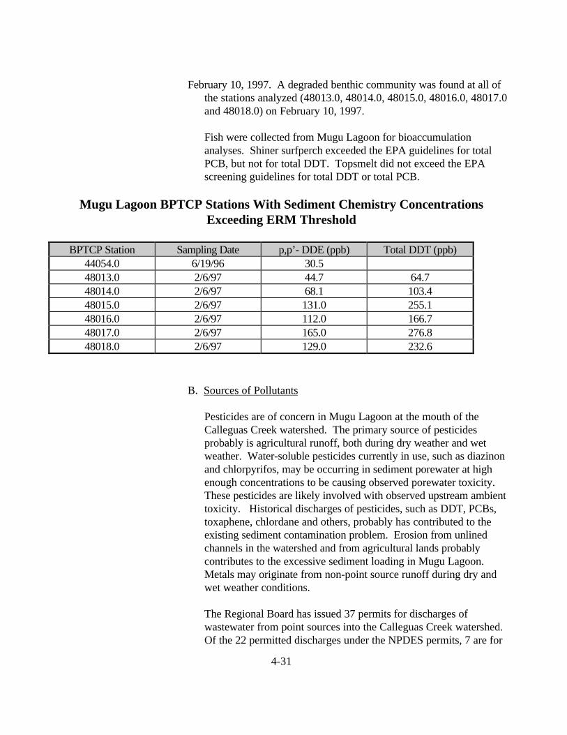
4-31
February 10, 1997. A degraded benthic community was found at all ofthe stations analyzed (48013.0, 48014.0, 48015.0, 48016.0, 48017.0and 48018.0) on February 10, 1997.
Fish were collected from Mugu Lagoon for bioaccumulationanalyses. Shiner surfperch exceeded the EPA guidelines for totalPCB, but not for total DDT. Topsmelt did not exceed the EPAscreening guidelines for total DDT or total PCB.
Mugu Lagoon BPTCP Stations With Sediment Chemistry ConcentrationsExceeding ERM Threshold
BPTCP Station Sampling Date p,p’- DDE (ppb) Total DDT (ppb)44054.0 6/19/96 30.548013.0 2/6/97 44.7 64.748014.0 2/6/97 68.1 103.448015.0 2/6/97 131.0 255.148016.0 2/6/97 112.0 166.748017.0 2/6/97 165.0 276.848018.0 2/6/97 129.0 232.6
B. Sources of Pollutants
Pesticides are of concern in Mugu Lagoon at the mouth of theCalleguas Creek watershed. The primary source of pesticidesprobably is agricultural runoff, both during dry weather and wetweather. Water-soluble pesticides currently in use, such as diazinonand chlorpyrifos, may be occurring in sediment porewater at highenough concentrations to be causing observed porewater toxicity.These pesticides are likely involved with observed upstream ambienttoxicity. Historical discharges of pesticides, such as DDT, PCBs,toxaphene, chlordane and others, probably has contributed to theexisting sediment contamination problem. Erosion from unlinedchannels in the watershed and from agricultural lands probablycontributes to the excessive sediment loading in Mugu Lagoon.Metals may originate from non-point source runoff during dry andwet weather conditions.
The Regional Board has issued 37 permits for discharges ofwastewater from point sources into the Calleguas Creek watershed.Of the 22 permitted discharges under the NPDES permits, 7 are for

4-32
municipal wastewaters from publicly-owned treatment works,accounting for a combined permitted discharge of 36.7 milliongallons per day (98% of the total permitted discharges). Of theremaining NPDES permits, 11 are for discharges of treatedgroundwater from hydrocarbon or other contamination, and 5 aregeneral permits for discharges of either well development water orground water from dewatered aquifers at construction sites. Inaddition, 88 releases of stormwater from major municipalities,certain industrial activities and construction projects are nowpermitted under the Regional Board's NPDES program for stormwater.
Only one landfill, the Simi Valley Landfill, is active in the watershed.Simi Valley Landfill began operating in 1970. Hazardous wasteswere accepted until 1983; since that time, only Class III wastes(municipal solid waste) have been discharged at this landfill. Sinceoperations at the landfill predate current regulations for siting wastemanagement units, only a portion of the Simi Valley Landfill is linedin accordance with current regulations. Leaks from unlined portionsof the landfill have contaminated ground water in an underlyingsandstone aquifer; corrective actions are underway by the operatorunder the direction of the Regional Board.
C. Actions by Regional Board
The Los Angeles Regional Board’s Water Quality Assessmentidentifies the following problems in Mugu Lagoon: aquatic lifebeneficial use is impaired based on water column exceedances ofcriteria for copper, mercury, nickel, and zinc, bird reproductivityaffected (DDT), tissue accumulation (arsenic, cadmium, silver;chlordane, DDT, endosulfan, dacthal, toxaphene, PCBs); sedimentconcentrations (DDT, toxaphene), sediment toxicity and excessivesediment. Fish consumption beneficial use is impaired based ontissue accumulation of DDT, PCBs and toxaphene. For CalleguasCreek (Estuary to Arroyo Los Posas), the Water Quality Assessmentlists the following problems: aquatic life beneficial use is impairedbased on water column toxicity, sediment contamination (DDT,toxaphene), tissue bioaccumulation (chlordane, toxaphene, PCBs,DDT, dacthal, endosulfan) and sediment toxicity. Fish consumptionbeneficial use is impaired based on tissue bioaccumulation (DDT,toxaphene, chlordane).

4-33
The first large-scale stakeholder effort in the watershed was MuguLagoon Task Force, formed in September 1990. The purpose of theTask Force is to improve communication between agencies withvarious interests and specific projects in Ventura County that mayimpact water quality in Mugu Lagoon. All of the members share acommon goal - to preserve and enhance Mugu Lagoon. The TaskForce currently meets infrequently, since many of its membersbelong to the Calleguas Creek Watershed Management Committee.Active members of the Mugu Lagoon Task Force include the U.S.Army Corps of Engineers, University of California CooperativeExtension Service Farm Advisor, Ventura County Public WorksAgency, Ventura County Planning Department, CaliforniaDepartment of Fish and Game, California Coastal Conservancy, U.S.Navy Point Mugu Naval Air Station, Ventura County ResourceConservation District, U.S. Natural Resources Conservation Serviceand Los Angeles Regional Water Quality Control Board.
The Los Angeles Regional Board's Watershed ManagementInitiative began in late 1994 with the Calleguas Creek (and VenturaRiver) watersheds. Through watershed management, the RegionalBoard expects to regulate pollutant loads from point sourcesthrough permits that better focus on issues relevant to eachwatershed. The Regional Board also expects that pollutant loadsfrom nonpoint sources can be better controlled through theparticipation of the public in the management of their watersheds.
The Los Angeles Regional Board renewed NPDES permits fordischarges within the Calleguas Creek Watershed in June 1996.However, the Regional Board was unable to fully assess cumulativeimpacts to beneficial uses from all pollutant sources, particularlyfrom nonpoint sources, during the first eighteen months ofapplication of the Watershed Management Initiative. The RegionalBoard was able to develop a regional monitoring program for theinland waters of the watershed which is currently being implementedand should provide additional information needed to assesscumulative impacts.
Thanks to the formation of the Calleguas Creek WatershedManagement Committee in 1996, stakeholders will have theopportunity to structure and implement measures that will addresspollutants from nonpoint sources through the development of aWatershed Management Plan. The Committee intends to hire afacilitator to help prepare a plan to develop a strategy for the

4-34
preservation, enhancement and management of the watershed’sresources, including identification and control of sources ofpollution. The Committee has outlined a three-phased plan toaccomplish this goal over a 2.5 year period, beginning in January1998. The Regional Board plans to reassess cumulative impacts tothe beneficial uses of waters in the watershed by fiscal year 2002-2003. Using this information, the Regional Board is scheduled torevise NPDES permits by June 2003.
The Regional Board is working with the Naval Air Weapons Stationat Point Mugu to develop a cleanup plan for contamination at thisDepartment of Defense site. This effort still is at the stage ofcharacterizing historical sources of pollution and the extent ofexisting contamination levels. In the near future, decisions will bemade concerning possible remediation and restoration activities inand around Mugu Lagoon.
D. Preliminary Assessment of Remediation Actions
Effects-based data has established that Mugu Lagoon sediment ismore toxic than sediment from other lagoons in the region. Currentagricultural and erosion control practices are likely moving soilsheavily polluted with residuals of banned pesticides to drainages andsubsequently into Mugu Lagoon.
Under the direction of the California Coastal Conservancy, VenturaCounty Resource Conservation District and other members of theMugu Lagoon Task Force, the U.S. Natural ResourcesConservation Service completed a report entitled: "Calleguas CreekWatershed Erosion and Sediment Control Plan for Mugu Lagoon(May 1995)". The primary focus of this study was to addresserosion and sedimentation impacts and solutions for the watershed.The U.S. Environmental Protection Agency, State Water ResourcesControl Board and the Los Angeles Regional Water Quality ControlBoard recently have granted additional 319(h) funds to implementspecific erosion control measures for Grimes Canyon, a critical areatargeted for remediation in the plan.
Existing contaminated sediments within Mugu Lagoon and theCalleguas Creek Tidal Prism are unlikely to remediate naturallywithin a reasonable time frame. Removal of the contaminatedsediments (i.e., dredging) or treatment appear to be the mostappropriate remediation alternatives, although in situ capping might

4-35
be the best solution for historical deposits, particularly within thelagoon.
E. Cost Estimate to Implement Cleanup Plan
Given the sensitive nature of Mugu Lagoon as a habitat forendangered species, the most likely remediation alternatives wouldbe no action or in situ treatment. The no action alternative wouldnot have a financial cost, but the contaminated sediment couldremain in the environment and continue to cause problems forseveral more decades. In situ treatment would be very expensiveand may pose technical problems for remediation in an estuarineenvironment. No reliable cost estimate exists at this time for thistreatment method, but it would probably exceed $100 per cubicyard. The total cost for remediation of Mugu Lagoon would be atleast $72.5 million.
Dredging could be used to remove the contaminated sediments fromthe Calleguas Creek Tidal Prism. However, identifying a suitableand legal disposal site for contaminated sediments may be difficult.Application of this technique would cost an estimated $1 million to$5 million, based on a cost estimate of $20-100 per cubic yard(disposal costs are likely to be high, so the cost estimate probablywould approach or even exceed the upper limit of the cost estimaterange).
F. Estimate of Recoverable Costs From Dischargers
Contamination of the Mugu Lagoon sediments probably associatedwith historical use of the now-banned pesticide DDT. Although theUnited States Navy could be liable for any remediation activitiesrequired as a result of historical discharges of pollutants due tooperations at the Naval Air Weapons Station at Point Mugu, there isno evidence that the Navy is responsible for the elevatedconcentrations of DDT in the sediments. It is unlikely that costs canbe recovered from any other dischargers in this watershed.
G. Two-Year Expenditure Schedule
The Regional Board plans to work with the Calleguas CreekWatershed Management Committee, which already has begundevelopment of a watershed management plan, to select theappropriate remediation alternative for Mugu Lagoon and the

4-36
Calleguas Creek Tidal Prism. In addition, watershed managementmeasures may be required to control sources of contaminants andprevent recontamination of these areas.
During Year One, the focus would be on selection of the appropriateremediation alternative for Mugu Lagoon and Calleguas Creek TidalPrism. Additional sediment sampling may be required, particularlyfor Calleguas Creek Tidal Prism, to fully characterize the arealextent of the sediment contamination and prepare a plan for capping,dredging or treatment of the contaminated sediments. This samplingprogram probably will require approximately $100,000 - $250,000for implementation. A source for this funding has not beendetermined.
During Year Two, the focus would be on implementation of theremediation alternative(s) selected for Mugu Lagoon and CalleguasCreek Tidal Prism, as well as watershed management measures tocontrol sources of contamination and prevent recontamination of theexisting hot spots. Remediation of the Calleguas Creek Tidal Prismprobably could be completed within Year Two, if funding isavailable. However, remediation of Mugu Lagoon could requireadditional time, depending upon the alternative selected. Amonitoring program will be required to measure the success of theremediation plans that are implemented; although a monitoringprogram has not yet been designed, the estimated cost would be$50,000 - $100,000 per year, and may be required for at least threeto five years following completion of the remediation activities.
H. Benefits of Remediation
Successful remediation of the contamination in Mugu Lagoon andthe Calleguas Creek Tidal Prism could eliminate the source ofimpairment of the beneficial uses of these waters. However,watershed management efforts to control erosion probably would berequired to prevent recontamination of the these areas.
I. Environmental Impacts of Remediation
If in-situ treatment is implemented, it could result in short-termimpacts to the benthic infaunal community. However, thiscommunity would be expected to fully recover within 2-3 years.Any remediation activity within this sensitive watershed, particularlyin Mugu Lagoon, potentially could affect endangered species, such

4-37
as the peregrine falcon, least tern, light-footed clapper rail andbrown pelican. Prior to initiating any remediation plan, the RegionalBoard will consult with the California Department of Fish and Gameand the United States Fish and Wildlife Service concerning potentialadverse impacts to endangered species.
With proper management of dredging and disposal of dredgedmaterial, this activity would not be expected to result in adverseenvironmental impacts.
Los Angeles/Long Beach HarborsThe Los Angeles and Long Beach Harbors are located in thesoutheastern portion of the Los Angeles Basin. Along the northernportion of San Pedro Bay, there is a natural embayment formed by awesterly extension of the coastline which contains both harbors, with thePalos Verdes Hills as the dominant onshore feature. Offshore, agenerally low topographic ridge is associated with the eastern flank ofthe Palos Verdes uplift and adjacent Palos Verdes fault zone, andextends northwest across the San Pedro shelf nearly to the breakwaterof the Los Angeles Harbor.
The port and harbor areas have been modified over the course of morethan one hundred years to include construction of breakwaters, landfills,slips and wharves, along with channelization of drainages, dredging ofnavigation channels and reclamation of marshland. The inner harborincludes the Main Channel, the East and West Basins, and the EastChannel Basin. The outer harbor is the basin area located betweenTerminal Island and the San Pedro and Middle Breakwaters.Los Angeles and Long Beach Harbor are considered to be a singleoceanographic unit, and share a common breakwater across the mouthof San Pedro Bay. The outer harbor areas reflect the conditions of thecoastal marine waters of the Southern California Bight, while the innerharbor areas typically have lower salinities.
In the presence of the strong currents and rocky habitat of the outerharbor, aquatic life communities are similar to those of the nearby coast,while the inner harbor supports biota generally found in bays andestuaries. The inner harbor has a mostly soft bottom character.
The major surface drainages in the area include the Los Angeles River,which flows in a channel and drains parts of the San Fernando Valley, aswell as downtown and south Los Angeles, into eastern San Pedro Bay atLong Beach. The Dominguez Channel drains the intensely urbanized

4-38
area west of the Los Angeles River into the Consolidated Slip of the LosAngeles Inner Harbor, carrying with it mostly urban runoff and non-process industrial waste discharges. A major source of both freshwaterand waste in the outer harbor is secondary effluent from the TerminalIsland Treatment Plant. Waste discharges to the inner harbor area ofLos Angeles Harbor consist of both contact and non-contact industrialcooling wastewater and stormwater runoff. Fuel spills and oil spillsfrom marine vessel traffic or docking facilities also contribute pollutantsto the inner harbor.

4-39
Los Angeles Outer Harbor/Cabrillo PierA. Areal Extent of Toxic Hot Spot
The site's toxic hot spot status is based on several factors, includinga fish advisory warning against human consumption of whitecroaker, which resulted from an OEHHA study released in 1991which cited elevated DDT and PCB levels in a number of fishspecies caught in the area. Sediment DDT levels in some BPTCPsamples collected from the site were elevated above that foundelsewhere in the harbor, while sediment PCB levels were comparableto other sites. Sediment toxicity fluctuated widely. This is a heavilyused sustenance and sportfishing pier (Figure 11). It is unclearwhether fish caught there are contaminated from DDT found locallyor from sources outside of but close to the harbor. It is estimatedthat 25,000 to 50,000 cubic yards of contaminated sediments existwithin the Cabrillo Pier area (based on 1 to 2 foot depth ofcontaminants).
Based on samples collected for the BPTCP, sediment concentrations exceededthe ERM Threshold for Total DDT at every station (40010.1, 40010.2, 40010.3,49001.0, 49002.0, 49003.0) on each occasion that sediment chemistry analyses wereconducted (August 18, 1992; September 16, 1992; August 19, 1993; May 19, 1994;February 15, 1994; May 13, 1997). Sediment concentrations also exceeded the ERMfor copper at station 40010.1 (Replicates 1, 2 and 3) on February 14, 1994. Amphipodtoxicity with whole sediments was observed at station 40010.1 on May 28, 1993, andagain at stations 40010.1, 40010.2 and 40010.3 on February 14, 1994. A degradedbenthic community was observed at station 40010.2 (Replicate 2) on August 17-19,1993.

4-40
Please Refer to Figure 11. Areal Extent of Topxic Hot Spots Within Los Angels OuterHarbor/Cabrillo Pier

4-41
Cabrillo Pier Area BPTCP Stations With Sediment Chemistry ConcentrationsExceeding ERM Threshold
BPTCP Station Sampling Date Copper (ppm) Total DDT (ppb)40010.1 8/18/92 267.540010.2 8/18/92 207.340010.3 8/18/92 203.740010.1 9/16/92 195.640010.1 8/19/93 304.840010.2 8/19/93 204.640010.3 8/19/93 215.0
40010.1 Rep 1 2/15/94 247.0 175.040010.1 Rep 2 2/15/94 274.0 186.640010.1 Rep 3 2/15/94 273.0 174.440010.2 Rep 1 2/15/94 207.240010.2 Rep 2 2/15/94 168.840010.2 Rep 3 2/15/94 180.440010.3 Rep 1 2/15/94 171.640010.3 Rep 2 2/15/94 212.040010.3 Rep 3 2/15/94 163.2
49001.0 5/13/97 192.949002.0 5/13/97 100.049003.0 5/13/97 53.5
Fish were collected on May 12, 1997, to assess bioaccumulation ofDDT and PCB. Total DDT and total PCB in white croaker muscletissue samples exceeded EPA screening values at stations 49001.0,49002.0 and 49003.0. Total PCB in white surfperch muscle tissuealso exceeded the EPA screening value at all three stations, althoughtotal DDT concentrations fell below the EPA screening value.Clams (Macoma) collected at station 49002.0 also exceeded theEPA screening value for total PCB.

4-42
B. Sources of Pollutants
Historical discharges of DDT, PCBs and metals are the probablecause of sediment contamination in the Cabrillo Pier area. Dischargeof wastewater effluent from the Terminal Island Treatment Plant is apotential source of pollutants, especially metals. Nonpoint sourcesof pollutants include spills from ships and industrial facilities, as wellas stormwater runoff. Many areas of the port have experienced soiland/or groundwater contamination, which may result in possibletransport of pollutants to the harbor’s surface waters.
C. Actions by Regional Board
The Los Angeles Regional Board’s Water Quality Assessment liststhe following problems in the Cabrillo area of Los Angeles OuterHarbor: aquatic life beneficial use is impaired due to tissueaccumulation (DDT), sediment toxicity, sediment contamination(PAHs, DDT, zinc, copper, chromium).
The Los Angeles Regional Board has adopted a watershedmanagement approach, which is expected to regulate pollutant loadsfrom point sources through permits that better focus on issuesrelevant to each watershed. The Regional Board also expects thatpollutant loads from nonpoint sources can be better controlledthrough the participation of the public in the management of theirwatersheds. During the 2001-02 Fiscal Year, the watershedmanagement approach will be used to renew NPDES permits withinthe Los Angeles/Long Beach Harbors Watershed. The Los AngelesRegional Board’s Site Cleanup Unit has developed cleanup andremediation plans for many contaminated soil and groundwater sites,including refineries and old oil fields. The Regional Board hasissued waste discharge requirements for some of the boatyards andstormwater runoff sources within the port.
The Los Angeles Regional Board and the California CoastalCommission began work during fiscal year 1997-98 to prepare along-term management plan for the dredging and disposal ofcontaminated sediments in the coastal waters adjacent to LosAngeles County. The goals of this plan will be to develop unifiedmulti-agency policies for the management of contaminated dredgedmaterial, promote multi-user disposal facilities and reuse, to the

4-43
extent practicable, and support efforts to control contaminants attheir source using a watershed management approach.
D. Preliminary Assessment of Remediation Actions
Given the protected nature of the Cabrillo Pier area within theLos Angeles Outer Harbor, in situ capping might be a feasiblemethod for containment of contaminated sediments. Dredgingwould be a proven method to remove the contaminated sediments,but identification of a suitable and legal disposal site is often aproblem. Treatment of contaminated sediments may be feasible, butis likely to be expensive and difficult to accomplish with marinesediments.
E. Cost Estimate to Implement Cleanup Plan
In situ capping would probably be the least expensive remediationoption. However, a stable cap must be designed to preventreexposure of the contaminated sediments. Application of thistechnique to contain contaminated sediments from the Cabrillo Pierarea would cost an estimated $0.5 million to $1 million, based on acost estimate of up to $20 per cubic yard (this is a rough estimate,since the unit cost could be higher).
Dredging could be used to remove the contaminated sediments fromthe Cabrillo Pier area. However, identifying a suitable and legaldisposal site for a large volume of contaminated sediments can bedifficult. Application of this technique would cost an estimated $0.5million to $5 million, based on a cost estimate of $20-100 per cubicyard (if a disposal site, such as a confined aquatic disposal or landdisposal site, is available within or close to the Los Angeles/LongBeach Harbors complex, the cost estimate probably would approachthe lower limit of the cost estimate range).
Treatment of the contaminated sediments is likely to be expensive.Application of this technique would cost an estimated $2.5 million to$50 million, based on a cost estimate of $100-$1,000 per cubic yard(due to limited experience in treating marine sediments, costs arelikely to be in the upper part of the cost estimate range).
F. Estimate of Recoverable Costs from Dischargers

4-44
In July 1996, the U.S. Environmental Protection Agency decided toundertake a Superfund response (under the ComprehensiveEnvironmental Response, Compensation and Liability Act) toaddress the contaminated sediment problem on the Palos VerdesShelf. However, the Los Angeles Harbor area was not includedwithin the scope of the Superfund action. Since it will be difficult orimpossible to prove that the contamination of the harbor is due tostormwater runoff from the Montrose Chemical Corporation’shistorical manufacturing site in Torrance, which appears to be alikely source for this contamination, we do not anticipate recoveringany remediation costs from dischargers.
G. Two-year Expenditure Schedule
The Regional Board plans to work with the Los Angeles BasinContaminated Sediments Task Force to select a remediationalternative and implement the cleanup plan for the Cabrillo Pier hotspot. Additional sediment sampling will be required to better definethe areal extent of the sediment contamination, prior to selection ofan appropriate remediation alternative. This sampling programcould be conducted during Year One, if funding becomes available(estimated cost approximately $250,000 - $500,000). However, theRegional Board would recommend implementing the cleanup of theConsolidated Slip/Dominguez Channel hot spot prior to initiatingany remediation activities at the Cabrillo Pier site, since theConsolidated Slip/Dominguez Channel area may represent a sourceof contamination to the Cabrillo Pier area. A monitoring programwould be required upon completion of any remediation activities; itis estimated that monitoring would cost $50,000 to $100,000 peryear, and may be required for three to five years.
H. Benefits of Remediation
Remediation of the contamination would eliminate the immediatesource of impairment of beneficial uses of the receiving waters.However, recontamination from other areas of the harbor couldoccur.
I. Environmental Impacts of Remediation
If capping or dredging is implemented, it could result in short-termimpacts to the benthic infaunal community. However, thiscommunity would be expected to fully recover within 2-3 years.

4-45
There is potential for release of contaminants into the marineenvironment during dredging, but proper management of thisoperation should minimize this risk. Special management practiceswould be required for disposal of contaminated sediments to containthe material and prevent releases of contaminants to theenvironment.
Los Angeles Inner Harbor/Dominguez Channel, Consolidated Slip
A. Areal Extent of Toxic Hot Spot
A reservoir of polluted sediment in Consolidated Slip (moving downfrom Dominguez Channel) probably is continuing to contaminate alarge part of Los Angeles Inner Harbor (Figure 12). It is estimatedthat approximately 30,000 cubic yards of contaminated sedimentsexist in Consolidated Slip and approximately 20,000 cubic yards inDominguez Channel (based on 6 miles of channel contaminated toan average depth of 1 foot).
In limited sampling conducted on July 30, 1992, sediment samplesfrom stations 40006.1 and 40006.2 exceeded ERM thresholds forzinc, total chlordane and total PCB; in addition, station 40006.1also exceeded the ERM for mercury. Amphipod toxicity with wholesediments, as well as porewater toxicity with the abalone test, wereobserved at both stations. A degraded benthic community wasobserved at station 40006.1.
In limited sampling conducted on February 3, 1994, sediment samples from station 40006.1(Replicates 1, 2 and 3) exceeded ERM thresholds for zinc, total chlordane, total PCB and highmolecular weight PAH; in addition, Replicate 3 from this station also exceeded the ERM formercury. Amphipod toxicity was observed in

4-46
Please Refer to Figure 12. Areal Extent of Toxic Hot Spots within Los Angeles InnerHarbor/Dominguez Channel, Consolidated Slip

4-47
Replicates 1 and 2 from station 40006.1. Benthic samples were not analyzed on this occasion.
A more extensive survey was conducted at several stations on July22, 1996, including the collection of surface samples and subsurfacesamples. Sediment samples from stations 47001.0, 47002.0,47003.0, 47004.0, 47005.0, 47010.0, 47007.0, 47008.0 and 47009.0all exceeded at least one ERM threshold, and sometimes exceededseveral, including those for cadmium, copper, lead, mercury, zinc,dieldrin, total PCB, low molecular weight PAH, high molecularweight PAH and total PAH. Amphipod toxicity with wholesediment was observed at stations 47001.0 (surface and depth 2),47002.0 (surface), 47003.0 (surface and depth 2), 47004.0 (surfaceand depth 2), 40005.0 (surface and depth 2), 47007.0 (surface),47008.0, 47009.0 (surface) and 47010.0 (surface). A degradedbenthic community was found at stations 47002.0, 47003.0, 47009.0and 47010.0.
When average ERM Quotient exceeds 1.00, the probability ofamphipod toxicity was found to be 71% (Long et al., 1995). Whenaverage PEL Quotient exceeds 1.00, probability of significantamphipod toxicity was found to be 56% (McDonald, 1996).Consolidated Slip exceeded both of these effect thresholds at severalstations (47004.0, 4006.1, 47002.0, 47009.0, 47003.0, 47008.0,47001.0, 40006.2, 40007.0). When sediment concentrations werefound to exceed 11 or more of the ERM thresholds, 85% of thesamples have been found to be significantly toxic to amphipods.When sediment concentrations exceeded 21 or more of the PELthresholds, 100% of the samples have been found to be significantlytoxic to amphipods. One of the Consolidated Slip stations exceededthe ERM threshold (47004.0), but not the PEL threshold.
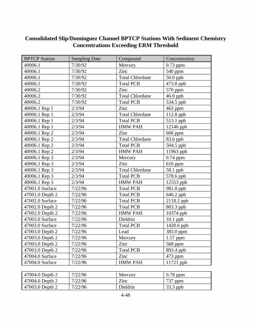
4-48
Consolidated Slip/Dominguez Channel BPTCP Stations With Sediment ChemistryConcentrations Exceeding ERM Threshold
BPTCP Station Sampling Date Compound Concentration40006.1 7/30/92 Mercury 0.73 ppm40006.1 7/30/92 Zinc 540 ppm40006.1 7/30/92 Total Chlordane 50.0 ppb40006.1 7/30/92 Total PCB 473.8 ppb40006.2 7/30/92 Zinc 570 ppm40006.2 7/30/92 Total Chlordane 46.0 ppb40006.2 7/30/92 Total PCB 534.5 ppb40006.1 Rep 1 2/3/94 Zinc 463 ppm40006.1 Rep 1 2/3/94 Total Chlordane 112.8 ppb40006.1 Rep 1 2/3/94 Total PCB 513.1 ppb40006.1 Rep 1 2/3/94 HMW PAH 12146 ppb40006.1 Rep 2 2/3/94 Zinc 606 ppm40006.1 Rep 2 2/3/94 Total Chlordane 83.6 ppb40006.1 Rep 2 2/3/94 Total PCB 504.5 ppb40006.1 Rep 2 2/3/94 HMW PAH 11963 ppb40006.1 Rep 3 2/3/94 Mercury 0.74 ppm40006.1 Rep 3 2/3/94 Zinc 616 ppm40006.1 Rep 3 2/3/94 Total Chlordane 58.1 ppb40006.1 Rep 3 2/3/94 Total PCB 578.6 ppb40006.1 Rep 3 2/3/94 HMW PAH 12553 ppb47001.0 Surface 7/22/96 Total PCB 981.8 ppb47001.0 Depth 2 7/22/96 Total PCB 646.2 ppb47002.0 Surface 7/22/96 Total PCB 2118.2 ppb47002.0 Depth 2 7/22/96 Total PCB 803.3 ppb47002.0 Depth 2 7/22/96 HMW PAH 10374 ppb47003.0 Surface 7/22/96 Dieldrin 10.1 ppb47003.0 Surface 7/22/96 Total PCB 1420.6 ppb47003.0 Depth 2 7/22/96 Lead 385.0 ppm47003.0 Depth 2 7/22/96 Mercury 1.57 ppm47003.0 Depth 2 7/22/96 Zinc 568 ppm47003.0 Depth 2 7/22/96 Total PCB 893.4 ppb47004.0 Surface 7/22/96 Zinc 473 ppm47004.0 Surface 7/22/96 HMW PAH 11721 ppb
47004.0 Depth 2 7/22/96 Mercury 0.78 ppm47004.0 Depth 2 7/22/96 Zinc 737 ppm47003.0 Depth 2 7/22/96 Dieldrin 33.3 ppb

4-49
47004.0 Depth 2 7/22/96 Total PCB 1341.6 ppb47004.0 Depth 2 7/22/96 LMW PAH 9679 ppb47004.0 Depth 2 7/22/96 HMW PAH 16467 ppb47005.0 Surface 7/22/96 Copper 478 ppm47005.0 Surface 7/22/96 Lead 460 ppm47005.0 Surface 7/22/96 Mercury 3.28 ppm47005.0 Surface 7/22/96 Zinc 447 ppm47005.0 Surface 7/22/96 Total PCB 1599.9 ppb47005.0 Depth 2 7/22/96 Copper 1740 ppm47005.0 Depth 2 7/22/96 Lead 542 ppm47005.0 Depth 2 7/22/96 Mercury 2.94 ppm47005.0 Depth 2 7/22/96 Zinc 700 ppm47005.0 Depth 2 7/22/96 Total PCB 525.8 ppb47005.0 Depth 3 7/22/96 Lead 1590 ppm47005.0 Depth 3 7/22/96 Mercury 1.49 ppm47005.0 Depth 3 7/22/96 Zinc 1010 ppm47010.0 Surface 7/22/96 Total PCB 361.5 ppb47007.0 Surface 7/22/96 Total PCB 246.2 ppb47008.0 7/22/96 Cadmium 14.5 ppm47008.0 7/22/96 Total PCB 942.4
B. Sources of Pollutants
Historical discharges of DDT, PCBs and metals probably causedmuch of the existing contamination. Current point source dischargesof process water and other waste streams from refineries locatedalong Dominguez Channel may be contributing to the contaminationproblem. Numerous nonpoint sources, such as spills, vesseldischarges, leaching of pollutants from boat anti-fouling paints, andstorm drains, also are present in the area.

4-50
C. Actions by Regional Board
The Los Angeles Regional Board’s Water Quality Assessment liststhe following problems in Dominguez Channel: aquatic life beneficialuse is impaired due to sediment contamination (chromium, zinc,DDT, PAHs) and benthic community impairment. The WaterQuality Assessment identifies the following problems inConsolidated Slip: aquatic life beneficial use is impaired due totissue accumulation (DDT, chlordane, PCBs, tributyltin, zinc),sediment toxicity, benthic community effects, sedimentcontamination (PAHs, zinc, chromium, lead, DDT, chlordane,PCBs); fish consumption advisory.
The Los Angeles Regional Board’s Site Cleanup Unit has developedcleanup and remediation plans for many contaminated soil andgroundwater sites, including refineries and old oil fields. TheRegional Board has issued waste discharge requirements for some ofthe boatyards and stormwater runoff sources within the port.
The Los Angeles Regional Board has adopted a watershedmanagement approach, which is expected to regulate pollutant loadsfrom point sources through permits that better focus on issuesrelevant to each watershed. The Regional Board also expects thatpollutant loads from nonpoint sources can be better controlledthrough the participation of the public in the management of theirwatersheds. During the 2001-02 Fiscal Year, the watershedmanagement approach will be used to renew NPDES permits withinthe Los Angeles/Long Beach Harbors Watershed and theDominguez Channel Watershed.
The Los Angeles Regional Board and the California CoastalCommission began work during fiscal year 1997-98 to prepare along-term management plan for the dredging and disposal ofcontaminated sediments in the coastal waters adjacent to LosAngeles County. The goals of this plan will be to develop unifiedmulti-agency policies for the management of contaminated dredgedmaterial, promote multi-user disposal facilities and reuse, to theextent practicable, and support efforts to control contaminants attheir source using a watershed management approach.
D. Preliminary Assessment of Remediation Actions

4-51
Dredging would be a proven method to remove the contaminatedsediments, but identification of a suitable and legal disposal site oftencan be a problem. Treatment of contaminated sediments may befeasible, but is likely to be expensive and difficult to accomplish withmarine sediments. In situ capping is not likely to be chosen as analternative, due to the high flows that can occur in this area and thepotential for reexposure and transport of contaminated material.
E. Cost Estimate to Implement Cleanup Plan
Dredging could be used to remove the contaminated sediments fromthe Dominguez Channel/Consolidated Slip area. However,identifying a suitable and legal disposal site for a large volume ofcontaminated sediments can be difficult. Application of thistechnique would cost an estimated $1 million to $5 million, based ona cost estimate of $20-100 per cubic yard (if a disposal site, such asa confined aquatic disposal or land disposal site, is available withinor close to the Los Angeles/Long Beach Harbors complex, the costestimate probably would approach the lower limit of the costestimate range).
Treatment of the contaminated sediments is likely to be expensive.Application of this technique would cost an estimated $5 million to$50 million, based on a cost estimate of $100-$1,000 per cubic yard(due to limited experience in treating marine sediments, costs arelikely to be in the upper part of the cost estimate range).
F. Estimate of Recoverable Costs from Dischargers
No responsible parties have been identified from which costs couldbe recovered.

4-52
G. Two-year Expenditure Schedule
The Regional Board plans to work with the Los Angeles BasinContaminated Sediments Task Force to select a remediationalternative and implement the cleanup plan for the ConsolidatedSlip/Dominguez Channel hot spot. Additional sediment samplingwill be required to precisely define the areal extent of the sedimentcontamination, prior to selection of an appropriate remediationalternative. This sampling program could be conducted during YearOne, if funding becomes available (estimated cost approximately$250,000 - $500,000). If dredging is selected as the desiredremediation method, the Regional Board will work with the TaskForce to identify a suitable disposal alternative (e.g., constructed fillsite, confined aquatic disposal site). A monitoring program would berequired upon completion of any remediation activities; it isestimated that monitoring would cost $50,000 to $100,000 per year,and may be required for three to five years.
H. Benefits of Remediation
Remediation of the contamination would eliminate the immediatesource of impairment of beneficial uses of the receiving waters.However, recontamination of the site from other areas is possible.
I. Environmental Impacts of Remediation
If capping or dredging is implemented, it could result in short-termimpacts to the benthic infaunal community. However, this communitywould be expected to fully recover within 2-3 years. There is potentialfor release of contaminants into the marine environment duringdredging, but proper management of this operation should minimize thisrisk. Special management practices would be required for disposal ofcontaminated sediments to contain the material and prevent releases ofcontaminants to the environment.
McGrath LakeMcGrath Lake is a 40-acre lake within McGrath State Beach Park and isunder the stewardship of the California Department of Parks andRecreation. The area is managed for low intensity uses, such as hikingand nature observation. Adjacent uses include oil-related facilities to thenorth and a power generating station to the south. Park land and

4-53
agricultural fields lie to the east. A public beach is located immediatelyto the west end of the lake.
The lake surface currently measures approximately 3000 feet in lengthand is approximately 450 feet at its widest point. It is a shallow lake,with an average depth of approximately 2 feet. The southern portion ofthe lake generally is deeper than the northern portion, with a maximumdepth of approximately 5 feet. The lake contains brackish water, withsalinities varying from 2.5 to 5 parts per thousand throughout much ofthe lake, with higher salinities (up to 24 parts per thousand) in some ofthe deeper areas.
The lake does not have an ocean connection, but waves occasionallyovertop the beach berm. Water is pumped from the lake to the oceanthroughout most of the year to maintain a lowered lake level and avoidflooding of upstream agricultural fields. In addition, the lake is breachedintermittently at the southern edge during the wet season to preventflooding of nearby agricultural fields.
Water sources to the lake include seawater intrusion from the oceanthrough the coastal dunes, groundwater seepage, and irrigation andstormwater runoff. McGrath Lake was included on the Los AngelesRegional Water Quality Control Board’s 1996 list of 303(d) impairedwater bodies due to sediment pollution (elevated pesticides and othercontaminants) and sediment toxicity. The lake was impacted in 1993when a ruptured pipeline released nearly 80,000 gallons of crude oil intoan agricultural ditch draining into the lake. However, PAH levels in thesediments are relatively low, suggesting little long-term effect onsediment contamination due to the oil spill.
The lake historically was part of the Santa Clara River Estuary. Thebackdune coastal lake is unique in Southern California and plays a keyrole in the avian migratory flyway. It is fronted by a coastal dune whichis rare because of the undisturbed natural processes, which allow thedunes to continue to grow and build.
McGrath Lake is an important coastal resource that has been impaired byhigh levels of trace metals, pesticides, and other organic contaminants.Elevated levels of several chemical contaminants in the lake sediments andthe demonstrated toxicity of these sediments appear to have limitedproductivity within the lake and threatens the health of wildlife, such asbirds, associated with the habitats provided by the lake.

4-54
A. Areal Extent of Toxic Hot Spot
Sediment contamination appears to exist throughout most of McGrathLake (Figure 13). To estimate the volume of contaminated sedimentspresent in the lake, we have assumed that the layer of contaminationextends down approximately 3 feet (based on core samples collected in1998); however, the contaminated layer could extend deeper, since thesampling device employed for this study could not penetrate beyond thislevel. In addition, some of the shallowest areas of the lake were notsampled and could contain contaminated sediments. The total volumeof contaminated sediments is estimated to be approximately 150,000 to300,000 cubic yards.
In samples collected for the Bay Protection and Toxic Cleanup Programon January 13, 1993 and June 19, 1996, sediment concentrations atstation 44027.0 exceeded the ERM Thresholds for chlordane, p,p’-DDE, Total DDT, Dieldrin and Total PCB. No sediment chemistrydata were collected during the sediment toxicity screening surveyconducted on April 13, 1994. Amphipod toxicity with whole sedimentswas observed at the single station tested on January 13, 1993, but inonly one of the three replicate samples collected on April 14, 1994(testing with Rhepoxynius abronius). No sediment toxicity wasobserved at the single station tested during the June 19, 1996 samplingperiod (testing with Eohaustorius estuarius). No benthic infaunalcommunity analyses were performed.
During a sediment characterization investigation of McGrath Lakeconducted in October 1998, sediment concentrations at several stationsexceeded the ERM Thresholds for chlordane, Total DDT, dieldrinand Total PCB. During this 1998 survey, two stations (S1 and N1)exceeded the ERM Threshold for mercury. Sediment toxicity wasobserved at nine of the ten stations samples (all but S10) during thisstudy (testing with Eohaustorius estuarius). Benthic infaunalanalyses indicated that McGrath Lake supports an extremely limitedbenthic community, in terms of number of species present andabundance. Insect larvae (family Chironomidae) were found at moststations, indicating a degraded benthic community.
B. Sources of Pollutants
Historical discharges of DDT and other pesticides, as well as PCBs,probably were responsible for some of the existing contamination.However, although sediment contamination has been found in the

4-55
deeper layers of core samples collected from the lake, contaminantlevels also were extremely high in the surficial sediments (top 2centimeters), suggesting continuing present-day sources ofcontamination. Runoff from approximately 1000 acres ofagricultural fields enters McGrath Lake and may be the primarysource of both historical and current contamination problems.Although PCBs and the pesticides contaminating the lake’ssediments have been banned from use for many years, residues mayexist in the soil on the agricultural fields, acting as a continuingsource of contamination as erosion and stormwater runoff carriesmaterial from the fields into the lake.
C. Actions by Regional Board
The Los Angeles Regional Board’s Water Quality Assessment liststhe following problems in McGrath Lake: aquatic life beneficial useis impaired due to sediment contamination (DDT, chlordane,dieldrin) and sediment toxicity. The Regional Board has adopted awatershed management approach, which is expected to regulatepollutant loads from point and non-point sources through permitsthat better focus on issues relevant to each watershed. During the2003-2004 Fiscal Year, the watershed management approach will beused to renew NPDES permits within the Ventura CoastalWatershed.

4-56
Figure 13. Areal extent of toxic hot spot within McGrath Lake.

4-57
McGrath LakeStations With Sediment Chemistry Concentrations Exceeding ERM Threshold
Station # Sampling Date Compound Concentration44027.0 1/13/93 Total Chlordane 150.8 ppb44027.0 1/13/93 P,p’-DDE 1540 ppb44027.0 1/13/93 Total DDT 3187 ppb44027.0 1/13/93 Dieldrin 23.6 ppb44027.0 6/19/96 Total Chlordane 233.1 ppb44027.0 6/19/96 P,p’-DDE 1090 ppb44027.0 6/19/96 Total DDT 1983.1 ppb44027.0 6/19/96 Dieldrin 16.8 ppbN1 10/98 Total Chlordane 37-450 ppbN1 10/98 Total DDT 1464-2943 ppbN1 10/98 Dieldrin 14.3-17.3 ppbN1 10/98 Total PCB 298 ppbN1 10/98 Mercury 1.5 ppmN2 10/98 Total Chlordane 67-251 ppbN2 10/98 Total DDT 2312-2758 ppbN2 10/98 Dieldrin 14.3-26.2 ppbN2 10/98 Total PCB 200 ppbN3 10/98 Total Chlordane 67-541 ppbN3 10/98 Total DDT 1713-2678 ppbN3 10/98 Dieldrin 8.8-28.0 ppbN3 10/98 Total PCB 200 ppbM4 10/98 Total Chlordane 734 ppbM4 10/98 Total DDT 2414 ppbM4 10/98 Dieldrin 31.1 ppbM4 10/98 Total PCB 448 ppbM5 10/98 Total Chlordane 28-699 ppbM5 10/98 Total DDT 543-3488 ppbM5 10/98 Dieldrin 11.7-37.3 ppbM5 10/98 Total PCB 260 ppbM6 10/98 Total Chlordane 647 ppbM6 10/98 Total DDT 2576 ppbM6 10/98 Dieldrin 35.6 ppbM6 10/98 Total PCB 243 ppb

4-58
M7 10/98 Total Chlordane 61-816 ppbM7 10/98 Total DDT 994-3412 ppbM7 10/98 Dieldrin 19.8-26.0 ppbM7 10/98 Total PCB 185-310 ppbS8 10/98 Total Chlordane 550 ppbS8 10/98 Total DDT 2629 ppbS8 10/98 Dieldrin 26.0 ppbS8 10/98 Total PCB 227 ppbS9 10/98 Total Chlordane 10-697 ppbS9 10/98 Total DDT 150-2808 ppbS9 10/98 Dieldrin 16.9 ppbS10 10/98 Total Chlordane 30-486 ppbS10 10/98 Total DDT 180-1369 ppbS10 10/98 Dieldrin 14.5 ppbS10 10/98 Mercury 2.6 ppm
D. Preliminary Assessment of Remediation Actions
Dredging would be a proven method to remove the contaminatedsediments, but identification of a suitable and legal disposal site oftencan be a problem. Treatment of contaminated sediments may befeasible, but is likely to be expensive. In situ capping is not likely tobe chosen as an alternative, due to the shallow nature of the lake andthe high flows that can occur in this area, which could lead toreexposure and transport of contaminated material.
Source control measures appear necessary to preventrecontamination of the lake sediments. Flows from adjacentagricultural fields, which apparently continue to introduce pesticidesand other contaminants into the lake, could be redirected away fromthe lake or treated to remove the contamination (e.g., settling basinscould be used to remove particulates, which may remove much ofthe contaminant load).
E. Cost Estimate to Implement Cleanup Plan
Dredging could be used to remove the contaminated sediments fromMcGrath Lake. However, identifying a suitable and legal disposalsite for a large volume of contaminated sediments can be difficult.Application of this technique would cost an estimated $3 million to$30 million, based on a cost estimate of $20-100 per cubic yard toremove 150,000 to 300,000 cubic yards of contaminated sediments.

4-59
Treatment of the contaminated sediments is likely to be expensive.Application of this technique would cost an estimated $15 million to$300 million, based on a cost estimate of $100-1000 per cubic yard(due to limited experience in treating dredged material, costs arelikely to be in the upper part of the cost estimate range).
F. Estimate of Recoverable Costs from Dischargers
No responsible parties have been identified from which costs couldbe recovered.
G. Two-year Expenditure Schedule
The Regional Board plans to work with the McGrath State BeachArea Trustee Council, which is composed of representatives fromthe California Department of Fish and Game, California Departmentof Parks and Recreation and United States Fish and Wildlife Service.The Trustee Council was formed as a condition of settlement withBerry Petroleum following the 1993 oil spill. The Council isworking with local stakeholders to develop a plan to remediate andrestore the habitat values and maximize beneficial uses of McGrathLake. The Council plans to address any residual problems related tothe oil spill, as well as those caused by other sources (e.g.,agricultural runoff).
Additional sediment sampling will be required to precisely define theareal extent and total volume of the sediment contaminationproblem, prior to selection of an appropriate remediation alternative.This sampling program could be conducted during Year One, iffunding becomes available (estimated cost approximately $250,000 -$500,000). Source control measures to eliminate or reducerecontamination of the lake’s sediments should be undertaken duringYear Two prior to initiation of remediation of the existing sedimentcontamination. Although no specific funds have been secured forthis source control effort, several potential sources are available,such as United States Environmental Protection Agency grants,Wetlands Restoration Program grants, Mitigation Project funds andenforcement action settlements.
H. Benefits of Remediation

4-60
Remediation of the sediment contamination and source controlmeasures would eliminate the source of impairment of beneficialuses of the receiving waters of McGrath Lake and adjacent areas.
I. Environmental Impacts of Remediation
If dredging or treatment is implemented as the sediment remediationalternative, it could result in short-term impacts to the benthicinfaunal community. However, this community would be expectedto fully recover within 2-3 years. Dredging or treatment alternativescould result in short-term disturbances to wildlife in the area (e.g.,birds), but proper management of this operation should minimizethis risk. Special management practices would be required fordisposal of contaminated sediments to contain the dredged materialand prevent releases of contaminants to the environment. Long-term benefits associated with habitat improvement should result in ahealthier and more productive benthic infaunal community, whichwould benefit migratory waterfowl and other organisms that utilizethe lake for foraging and other activities.

4-61
Future NeedsAdditional monitoring should be conducted at sites of concern todetermine whether such sites meet the criteria for designation ascandidate toxic hot spots in the future. Monitoring of candidate toxichot spots also will be required to determine whether remediation effortsare successful in eliminating the hot spots or whether conditionsimprove without any directed remediation efforts.

4-62
Sites of Concern (Sites that do not qualify as Candidate Toxic Hot Spots)
{PRIVATE}Water bodyname
Segment Name Site Identification Reason for Listing Pollutants present at the site Reportreference
{PRIVATE}Los AngelesInner Harbor
Inner FishHarbor
44019.0, 40019.2, 40019.3 sediment concentrations;sediment toxicity
DDT, PCB, metals (Cu, Hg, Zn) [1]
Los AngelesInner Harbor
KaiserInternational
49004.0 sediment concentrations DDT, PCB, PAH, Cu,Endosulfan
[1]
Los AngelesInner Harbor
Hugo NeuProler
46001.0, 46002.0 sediment concentrations PCB [1]
Los AngelesInner Harbor
Southwest Slip 40001.2, 40001.3 sediment concentrations;sediment toxicity
DDT, PCB, PAH, metals (Hg,Cr), Benz[a]anthracene,Benzo[a]pyrene, Dibenz[a,h]anthracene
[1]
Long BeachInner Harbor
CerritosChannel
44011.0 sediment concentrations;sediment toxicity;accumulation in musseltissue
DDT, PCB, metals, Chlordane,TBT
[1], [2]
ColoradoLagoon
44017.0 sediment concentrations;sediment toxicity;accumulation in musseland fish tissue
DDT, PCB, metals (Pb, Zn),Chlordane, Dieldrin
[1], [2],[3] DFG
ShorelineMarina
44020.0, 48006.0, 48008.0 sediment concentrations;sediment toxicity
Zn, DDT, PCB, Chlordane,Phenanthrene
[1], [3]
DDT, Chlordane, Dieldrin,Toxaphene, Endosulfan
[1]

4-63
Sites of Concern (Sites that do not qualify as Candidate Toxic Hot Spots){PRIVATE}Water bodyname
SegmentName
Site Identification Reason for Listing Pollutants present at the site Reportreference
Port Hueneme 44012.0, 44013.0 sediment concentrations;sediment toxicity;accumulation in musseltissue;
DDT, PCB, PAH, metals (Zn,Cr), Benz[a]anthracene;Benzo[a]pyrene; Dibenz[a,h]anthracene
[1], [2]
Long BeachOuter Harbor
44018.1, 44018.2, 44018.3,44020.1, 44020.2, 44020.3
sediment concentrations;sediment toxicity
DDT, Chlordane [1]
Long BeachInner Harbor
West Basin 40009.0, 40009.1, 40009.2,40009.3
sediment concentrations;sediment toxicity;accumulation in clam tissue
DDT, PCB [1]
Alamitos Bay 40021.1, 40021.2, 40021.3,40022.1, 40022.2, 40022.3,40023.1, 40023.2, 40023.3
sediment concentrations DDT, Chlordane [1]
King Harbor 48011.0 sediment concentrations;sediment toxicity
DDT, PCB [1]
Channel IslandsHarbor
44023.0 sediment concentrations;sediment toxicity
DDT, Ag [1]
Reference list
[1] Anderson, B. et al. 1998. Sediment chemistry, toxicity and benthic community conditions in selected water bodies of the Los Angeles Region. FinalReport to State Water Resources Control Board, Bay Protection and Toxic Cleanup Program Monitoring.
[2] State Mussel Watch Program, Los Angeles Region[3] Water Quality Assessment [303(d) List], Los Angeles Region, August 1996

4-64
Several sites have been listed in the table above as “Sites of Concern”.These are sites that displayed signs of sediment contamination problems,primarily based upon data collected as part of the Bay Protection andToxic Cleanup Program, but did not meet the criteria for designation as“Candidate Toxic Hot Spots”. Although designation as a “Site ofConcern” does not trigger any specific action under the Bay Protectionand Toxic Hot Spot Program, these sites have been identified by theRegional Board so that they can be targeted for additional monitoring asfunding becomes available.
Several of the Sites of Concern could not be designated as “CandidateToxic Hot Spots” due to the lack of recurrent toxicity; in some cases,the sites were only sampled on one occasion, while in other cases,toxicity was observed on only one of the sampling events. Inner FishHarbor, Southwest Slip, Cerritos Channel, Colorado Lagoon, ShorelineMarina, Port Hueneme, Long Beach Outer Harbor, West Basin, KingHarbor and Channel Islands Harbor all fall into this category.
Hugo Neu Proler, Kaiser International, Alamitos Bay are listed as sitesof concern due to sediment contamination, but sediment toxicity was notobserved on any occasion.

5-1
(REGION 5.)
REGIONAL WATER QUALITY CONTROL BOARD, CENTRAL VALLEY REGION
REGIONAL TOXIC HOT SPOT CLEANUP PLAN

5-2
Region DescriptionThe Central Valley Region covers the entire area included in theSacramento and San Joaquin River drainage basins. The two basinscover about one fourth of the total area of the State and include over30% of the State's irrigable land. The Sacramento and San JoaquinRivers furnish roughly 50% of the States water supply. Surface waterfrom the two drainages meet and form the Delta which ultimately drainsto San Francisco Bay.
The Delta, the area of primary focus for the BPTCP, is a maze of riverchannels and diked islands covering roughly 1,150 square miles,including 78 square miles of water area. Two major water projectslocated in the South Delta, the Federal Central Valley Project and theState Water Project, deliver water from the Delta to SouthernCalifornia, the San Joaquin Valley, Tulare Lake Basin, the San FranciscoBay area, as well as within the Delta boundaries. The legal boundary ofthe Delta is described in Section 12220 of the Water Code.

5-3
Candidate Toxic Hot Spot List
Water bodyName
SegmentName
Site Identification Reason forListing
Pollutants present at the site Reportreference
Delta Estuary All Delta Aquatic Life Diazinon 7, 8, 10,12,13, 17 8, 9,11, 13, 14, 20
Delta Estuary Various Morrison Ck, Mosher, 5-Mile, Mormon Sls, &Calaveras R.
Aquatic Life Diazinon & Chlorpyrifos 2, 3, 4 1, 3, 4,5, 17, 18
Delta Estuary Various Ulatis Ck, Paradise Cut,French Camp & Duck Sls
Aquatic Life Chlorpyrifos 5, 6, 7
Delta Estuary All Delta Human Health Mercury 9, 14, 18 10,15, 21
Delta Estuary South Delta San Joaquin River at Cityof Stockton
Water QualityObjective
Low Dissolved Oxygen 1, 11, 19 2,12, 22
Delta Estuary Various Smith Canal, Mosher &5-Mile Sloughs andCalaveras R.
Water QualityObjective
Low Dissolved Oxygen 15 16
Delta Estuary All Delta Human Health Chlordane, Dieldrin, Total DDT,PCBs, Endosulfan & Toxaphene
16 19
Delta Estuary All Delta Aquatic Life Chlordane, Dieldrin, Lindane,Heptachlor, Total PCBs, PAHs, DDT
16 19

5-4
ReferencesChen, C. and W. Tsai, 1997. Evaluation of alternatives to meet thedissolved oxygen objectives of the lower San Joaquin River. Preparedfor SWRCB by Systech Engineering Inc. San Ramon, Ca.
Connor, V. 1994. Toxicity and diazinon levels associated with urbanstorm runoff. Staff memorandum, Central Valley Regional WaterQuality Control Board, Sacramento, CA
Connor, V. 1995a. Status of urban storm runoff project. Staffmemorandum, Central Valley Regional Water Quality Control Board,Sacramento, CA
Connor, v. 1996. Chlorpyrifos in urban storm runoff. Staffmemorandum, Central Valley Regional Water Quality Control Board,Sacramento, CA
Deanovic, L. H. Bailey, T.W. Shed and D. Hinton. 1996. Sacramento-San Joaquin Delta Bioassay monitoring report. 1993-94. First annualreport to the Central Valley Regional Water Quality Control Board.
Deanovic, L. H. Bailey, T.W. Shed and D. Hinton. 1998. Sacramento-San Joaquin Delta Bioassay monitoring report. 1994-95. Secondannual report to the Central Valley Regional Water Quality ControlBoard.
Foe, C. and R. Sheipline 1993. Pesticides in surface water fromapplication on orchards and alfalfa during the winter and spring of 1991-92. Staff report, Central Valley Regional Water Quality Control Board,Sacramento, CA
Foe, C. 1995. Insecticide concentrations and invertebrate bioassaymortality in Agricultural return water from the San Joaquin Basin. Staffreport, Central Valley Regional Water Quality Control Board,Sacramento, CA
Foe, C. and W. Croyle. 1998. Mercury concentrations and loads fromthe Sacramento River and Cache Creek to the Sacramento-San JoaquinDelta Estuary. Central Valley Regional Water Quality Control Boardstaff report. Sacramento Office.

5-5
Foe, C., L. Deanovic and D. Hinton 1998. Toxicity IdentificationEvaluations of Orchard Dormant Spray Storm Runoff. Central ValleyRegional Water Quality Control Board Staff Report, Sacramento Office.
Jones and Stokes Associates. 1998. Potential Solutions for Achievingthe San Joaquin River Dissolved Oxygen Objective. Report preparedfor De Cuir and Somach and the City of Stockton. Jones and StokesAssociates, 2600 V Street, Suite 100, Sacramento, CA 95818.
Kratzer, C. 1977. Transport of diazinon in the San Joaquin River Basin,California. U.S. Geological Survey open file report 97-411.Sacramento 22p.
Kuivila, K and C. Foe. 1995. Concentration, transport and biologicalimpact of dormant spray insecticides in the San Francisco Estuary,California. Env. Toxicol. and Chem. 14:1141-1150
Larry Walker and Associates, 1997. Sacramento River mercury controlplanning project. Prepared for the Sacramento Regional CountySanitation District.
Larson, K.K. Cortright, V. Connor, P. Young, L. Deanovic and D.Hinton. 1998. Stockton fish kills associated with urban storm runoff:the role of low dissolved oxygen. University of California Reportprepared for the Central Valley Regional Water Quality Control Board.
Montoya, B. 1991. An analysis of the toxic water quality impairmentsin the Sacramento-San Joaquin Delta Estuary. Staff report, CentralValley Regional Water Quality Control Board, Sacramento, CA
Novartis Crop Protection, 1997. An ecological risk assessment ofdiazinon in the Sacramento and San Joaquin River Basins. Technicalreport 11/07 Environmental and Public affairs department Greensboro,NC
San Francisco Bay Regional Water Quality Control Board, 1995.Contaminant levels in fish tissue from San Francisco Bay. Staff reportprepared jointly by the San Francisco Regional Board, the State WaterResources Control Board, and the Department of Fish and Game.

5-6
Schantz, R. and C. Chen, 1993. City of Stockton water quality model:Volume I. Model development and calibration. Prepared by PhillipWilliams and Associates, San Francisco, CA.
1. Bailey, H., L. Deanovic, K. Luhman, T. Shed, and D. Hinton. 1996.Pesticides in Urban stormwater from the Sacramento Valley and theSan Francisco Bay Area. Poster presentation In Third annual Stateof the Estuary Conference. October 10-12 San Francisco, CA. p51.
2. Chen, C. and W. Tsai, 1997. Evaluation of alternatives to meet thedissolved oxygen objectives of the lower San Joaquin River.Prepared for SWRCB by Systech Engineering Inc. San Ramon, Ca.
3. Connor, V. 1994. Toxicity and diazinon levels associated withurban storm runoff. Staff memorandum, Central Valley RegionalWater Quality Control Board, Sacramento, CA
4. Connor, V. 1995a. Status of urban storm runoff project. Staffmemorandum, Central Valley Regional Water Quality ControlBoard, Sacramento, CA
5. Connor, v. 1996. Chlorpyrifos in urban storm runoff. Staffmemorandum, Central Valley Regional Water Quality ControlBoard, Sacramento, CA
6. Deanovic, L. H. Bailey, T.W. Shed and D. Hinton. 1996.Sacramento-San Joaquin Delta Bioassay monitoring report. 1993-94. First annual report to the Central Valley Regional Water QualityControl Board.
7. Deanovic, L. H. Bailey, T.W. Shed and D. Hinton. 1998.Sacramento-San Joaquin Delta Bioassay monitoring report. 1994-95. Second annual report to the Central Valley Regional WaterQuality Control Board.
8. Foe, C. and R. Sheipline 1993. Pesticides in surface water fromapplication on orchards and alfalfa during the winter and spring of1991-92. Staff report, Central Valley Regional Water QualityControl Board, Sacramento, CA
9. Foe, C. 1995. Insecticide concentrations and invertebrate bioassaymortality in Agricultural return water from the San Joaquin Basin.

5-7
Staff report, Central Valley Regional Water Quality Control Board,Sacramento, CA
10. Foe, C. and W. Croyle. 1998. Mercury concentrations and loadsfrom the Sacramento River and Cache Creek to the Sacramento-SanJoaquin Delta Estuary. Central Valley Regional Water QualityControl Board staff report. Sacramento Office.
11. Foe, C., L. Deanovic and D. Hinton 1998. Toxicity IdentificationEvaluations of Orchard Dormant Spray Storm Runoff. CentralValley Regional Water Quality Control Board Staff Report,Sacramento Office.
12. Jones and Stokes Associates. 1998. Potential Solutions forAchieving the San Joaquin River Dissolved Oxygen Objective.Report prepared for De Cuir and Somach and the City of Stockton.Jones and Stokes Associates, 2600 V Street, Suite 100, Sacramento,CA 95818.
13. Kratzer, C. 1977. Transport of diazinon in the San Joaquin RiverBasin, California. U.S. Geological Survey open file report 97-411.Sacramento 22p.
14. Kuivila, K and C. Foe. 1995. Concentration, transport andbiological impact of dormant spray insecticides in the San FranciscoEstuary, California. Env. Toxicol. and Chem. 14:1141-1150
15. Larry Walker and Associates, 1997. Sacramento River mercurycontrol planning project. Prepared for the Sacramento RegionalCounty Sanitation District.
16. Larson, K,K. Cortright, V. Connor, P. Young, L.Deanovic and D.Hinton. 1998. Stockton fish kills associated with urban stormrunoff: the role of low dissolved oxygen. University of CaliforniaReport prepared for the Central Valley Regional Water QualityControl Board.
17. Larson, K.K.,V.Connor, L.Deanovic, and D. Hinton. 1998.Sacramento River Watershed project. Toxicity monitoring results:1997-98. Report prepared for the Sacramento Regional CountySanitation District by the U.C. Davis Aquatic ToxicologyLaboratory. Davis, CA.

5-8
18. Larson, K.K.,V.Connor, L.Deanovic, and D. Hinton. 1998.Sacramento River Watershed project. Toxicity monitoring results:1997-98. Report prepared for the Sacramento Regional CountySanitation District by the U.C. Davis Aquatic ToxicologyLaboratory. Davis, CA.
19. Montoya, B. 1991. An analysis of the toxic water qualityimpairments in the Sacramento-San Joaquin Delta Estuary. Staffreport, Central Valley Regional Water Quality Control Board,Sacramento, CA
20. Novartis Crop Protection, 1997. An ecological risk assessment ofdiazinon in the Sacramento and San Joaquin River Basins. Technicalreport 11/07 Environmental and Public affairs departmentGreensboro, NC
21. San Francisco Bay Regional Water Quality Control Board, 1995.Contaminant levels in fish tissue from San Francisco Bay. Staffreport prepared jointly by the San Francisco Regional Board, theState Water Resources Control Board, and the Department of Fishand Game.
22. Schantz, R. and C. Chen, 1993. City of Stockton water qualitymodel: Volume I. Model development and calibration. Prepared byPhillip Williams and Associates, San Francisco, CA.

5-9
Ranking Matrix
Water bodyName
Site Identification HumanHealth
Impacts
AquaticLife
Impacts
WaterQuality
Objectives
ArealExtent
RemediationPotential
OverallRank
Delta Estuary Delta High >10 acres High High 1
Delta Estuary Morrison Ck, Mosher, 5-Mile,Mormon Sls & Calaveras R.
High >10 acres HighHigh 1
Delta Estuary Ulatis Ck, Paradise Cut, FrenchCamp & Duck Sls
High >10 acres HighHigh1
Delta Estuary Delta, Cache Creek High >10 acres High High
Delta Estuary San Joaquin River @ City ofStockton
High >10 acres HighHigh
Delta Estuary Smith Canal, Mosher & 5-MileSloughs and Calaveras R.
High Moderate >10 acres HighModerate 2
Delta Estuary Delta Moderate >10 acres Moderate Moderate
Delta Estuary Delta Moderate >10 acres Moderate Moderate
1/ No cleanup plan provided as the Regional Board directed staff to seek site specific variance for pesticides.2/ Sites ranked as moderate because of the lower importance of the water bodies involved.

5-10
High Priority Candidate Toxic Hot Spot Characterization
Mercury Clean up Plan
BackgroundMercury has been identified in part II of the cleanup plan asresponsible for creating a candidate BPTCP hot spot in theSacramento-San Joaquin Delta Estuary. In January 1998 theCentral Valley Regional Water Quality Control Board adopted arevised 303(d) list, ranked mercury impairments in the lowerSacramento River, Cache Creek, Sulfur Creek , Lake Berryessa,Clear Lake and the Sacramento-San Joaquin Delta Estuary as highpriority because of elevated concentrations in fish tissue andcommitted to the development of a load reduction program by theyear 20051. The widespread distribution of mercury contaminationemphasizes the regional nature of the problem and the need forregional solutions.
Mercury is a potent human neurotoxin with developing fetuses andsmall children being most at risk. The principal route of humanexposure is through consumption of mercury contaminated fish. In1970 a human health advisory was issued for the Sacramento-SanJoaquin Delta Estuary advising pregnant women not to consumestriped bass. In 1994 an interim health advisory was issued by theOffice of Environmental Health Hazard Assessment (OEHHA) forSan Francisco Bay and the Delta recommending no consumption oflarge striped bass and shark because of elevated mercury and PCBconcentrations.
Factors which promote excess mercury in fish tissue are not wellunderstood. To a large extent this is because until very recentlythere was no methodology to measure mercury at environmentalconcentrations (part per trillion) in surface water. However, it isgenerally agreed that mercury biomagnifies in the aquatic foodchain with fish in California often having a million times moremercury, on a weight basis, than ambient water. Methyl mercury is
1The lower American River, lower Feather River, Harley Gulch, Sacramento Slough, March Creek and Reservoir,San Carlos Creek, James Creek, and Panoche Creeks were also placed on the 303(d) list as impaired because ofexcess mercury but were given a lower priority for cleanup.

5-11
the most toxic form of mercury and the primary form accumulatingin the aquatic food chain. Over ninety percent of the mercury infish tissue is usually in the form of neurotoxic methyl mercury.Conversion of inorganic to organic mercury appears to becontrolled primarily by microorganisms, mostly sulfate reducingbacteria in sediment. Important factors in other systems whichappear to control the conversion rate of inorganic to organicmercury include temperature, percent organic matter, redoxpotential, salinity, pH and mercury concentration (Gilmour, 1994).Neither the primary locations of methyl mercury production nor theprincipal factors controlling methylation are yet known for anylocation in the Central Valley.
In California mercury was historically mined in the Coast Rangeboth north and south of San Francisco Bay and transported acrossthe Valley for use in placer gold mining in the Sierra Nevadas.Both operations caused widespread mercury sedimentcontamination in water courses in the Coast Range, Sierra NevadaMountains, Valley floor, and Sacramento-San Joaquin DeltaEstuary.
The limited mercury work undertaken so far in the Central Valleyhas concentrated on estimating mercury loads to the Estuary and ondetermining in situ mercury bioavailability in valley waterways. Aloading study conducted by Larry Walker and Associates (1997)estimated that 640 kg of mercury were exported by the Sacramentowatershed to the Estuary between October 1994 and September1995. Most of the material was contributed during winter highflow periods. Surprisingly, the Feather and American Riverwatersheds, sites of intensive historical placer gold mining activity,only accounted for about 25 percent of the total load. The majorityof mercury appeared to originate from the Sacramento watershedabove the confluence of the Feather River. The SacramentoRegional Wastewater Treatment Plant, the largest NPDESdischarger in the Region, accounted for less than 2 percent of thetotal load.
In a companion study mercury concentration in aquaticinvertebrates and fish in the historic gold mining region of theSierra Nevada Mountains was evaluated (Slotton et al., 1997a).Concentrations of mercury in aquatic indicator organisms increasedin a predictable fashion with increasing trophic feeding level. Aclear signature of mine derived mercury was found associated withthe most intensively worked river stretches. Mercury

5-12
concentrations were lower in non-hydrologically mined reaches ofthe Feather and American Rivers.
Foothill reservoirs were found to operate as traps for bothbioavailable and sediment associated inorganic mercury (Slotton etal., 1997a; Larry Walker and Associates, 1997). Significantlylower levels of mercury were found in aquatic organisms belowreservoirs as compared to concentrations both in and above them.Similarly, bulk loads of mercury entering foothill reservoirs weregreater than the amount exported. This suggests that foothillreservoirs in placer gold mining districts may act as interceptors ofmercury, trapping and preventing downstream transport to theEstuary. This may explain the lower than expected loads measuredby Larry Walker and Associates (1997) in the Feather andAmerican Rivers.
Between 1993 and 1995 the Central Valley Regional Board alsoconducted a bulk mercury loading study to the Estuary from theSacramento watershed. The study differed from that of LarryWalker and Associates (1997) in that the Regional Board study alsoincluded an assessment of loads from the Yolo Bypass during highflows. During flood conditions the Bypass receives overflow fromthe Sacramento River and significant input from several coastalwatersheds.
The Regional Board estimated that the Sacramento Watershed(Sacramento River at Greene’s Landing plus Yolo Bypass atProspect Slough) exported 800 kg of mercury to the Estuarybetween May 1994 and April 1995 (Foe and Croyle, 1998). Stafffound, like Larry Walker and Associates, that most of the mercurywas transported into the Estuary during high flow periods. Highmercury concentrations in the Yolo Bypass suggested possible localinputs. Follow up studies demonstrated that Cache Creek wasexporting about 1,000 kg of mercury during the year. Half of themercury appeared to be trapped by the Cache Creek Settling Basinat the confluence with the Bypass while the remainder was exportedto the Estuary.
In the spring of 1996 a one time benthic invertebrate survey wasconducted in the upper Cache Creek basin to determine localmercury bioavailability (Slotton et al., 1997b). All invertebratetissue samples with mercury concentrations greater thanbackground were associated with known mercury mines orgeothermal hot springs. These included Sulfur and Davis Creeks,

5-13
Harley Gulch, and the discharge from Clear Lake. The highlylocalized nature of these sites was demonstrated by the lower biotictissue concentrations in adjacent streams without historic mercurymining activity. Invertebrates collected in the upper mainstem ofCache Creek away from all historic mining activity had tissueconcentrations comparable to similar indicator organisms obtainedfrom mainstem Sierra Nevada River gold mining activity that Coastrange mercury is at least as bioavailable as that in the Sierras.However, tissue concentrations in Cache Creek decreaseddownstream suggesting that much of the large bulk loads ofmercury observed by the Regional Board might not be verybiologically available in the lower watershed.
Limited fish tissue sampling has occurred in Cache Creek. Mostsampling has been conducted in the lower watershed betweenWoodland and the Settling Basin. Mean mercury concentrations infish of a size eaten by people ranged between 0.2 and 0.4 ppm forbenthic predators (channel and white catfish) and between 0.4 and0.9 ppm composite fillet wet weight for water column predators(squawfish, crappie, small and large mouth bass, Davis, 1998;Slotton et al., 1997b). Concentrations in small fish (2-4 inches)suitable for consumption by wildlife ranged between 0.1 and 0.3ppm whole body wet weight. Sufficient data have not yet beencollected to warrant evaluating the Cache Creek watershed for apossible human health fish consumption advisory.
Estuarine bioavailability of Cache Creek mercury is not known.However, the Creek serves as the major water source for therecently created Yolo Wildlife Refuge. In addition, the CALFEDBay Delta Program is proposing to purchase large areasdownstream in the Yolo Bypass and further out in the Estuary forconversion to shallow water wildlife habitat. Follow up studies areneeded to ascertain the methylation potential of mercury at suchsites and also to compare the methylation potential of mercury fromsources in the Coast Range to that from the Sierra NevadaMountains.
A. Areal Extent
There is a human health advisory in effect in the Delta and inSan Francisco Bay because of elevated mercury levels in stripedbass and other long lived fish. The entire area of the Delta istherefore considered a hot spot. The Delta is a maze of river

5-14
channels and diked islands covering roughly 78 square miles ofopen water and about 1,000 linear miles of channel.
Cache Creek is a 1100 square mile watershed in the CoastRange with about 150 linear miles of mercury impactedwaterways. The watershed also contains Clear Lake, the largestnatural lake in California at 43,000 acres. A human healthadvisory has been posted in Clear Lake because of elevatedmercury concentrations in fish tissue. The source of themercury is Sulphur Bank Mine, a U.S. EPA Superfund site.
B. Sources
Four major bulk sources of mercury have been identified for theSacramento-San Joaquin Delta Estuary. They are: (1) exportsfrom the placer gold mining regions of the Sierra NevadaMountains, (2) mercury mining in the Coast Range, (3)resuspension of estuarine sediment, and (4) effluent frommunicipal and industrial discharges to surface water. Notknown, but critically important, is the relative methylationpotential of mercury from each source once in the estuary. Thefour sources are briefly reviewed below.
1. Sierra Nevada Mountains It has been estimated that over 3million kg of mercury were lost in the Sierra Nevada Mountainsduring the gold rush (Montoya, 1987). All this mercury wasinitially in an elemental form (quicksilver) and most of it isprobably still highly oxidized. Foothill reservoirs appear to trapmost of the bioavailable and total mercury entering them.Therefore, only the mercury presently located in water coursesbelow the foothill reservoirs appear available for transport intothe estuary, unless major flooding events move large volumes ofsediment downstream from behind reservoirs. This needsevaluation.
2. Coast Range Some of the largest historic mercury mines inthe world were located in the Coast Range both north and southof San Francisco Bay. Most of the mercury in the Coast Rangeis as mercuric sulfide (cinnabar) and is probably emanating fromabandoned mine portals and deposits around retorts and slagpiles, geothermal springs and seeps, and erosion of mercury richlandforms. The Coast Range is drier than the Sierra NevadaMountains and therefore has fewer reservoirs and permanentlyflowing waterways. Off site movement of mercury from the

5-15
Coast Range appears to occur mostly in the winter after largerainstorms although evidence from Clear Lake indicates it maybe occurring year-round. Cache Creek has been identified as amajor source of mercury to the Estuary. Sites in the CacheCreek watershed with highly bioavailable loads include runofffrom Sulfur Creek, Harley Gulch, Schneider Creek and ClearLake.
3. Sediment Potentially the largest source of mercury isalready present in the Estuary buried in sediment. Mercuryfrom sediment is potentially available through natural fluxing,bioturbation, scour and erosion from wave action, dewateringand beneficial reuse of dredge spoils on levees, and creation ofintertidal shallow water habitats by breaking levees andreflooding Delta agricultural land. Potential bioavailability ofmercury from each action depends on, among other things, thechemical form of the metal in sediment and environmentalconditions in the Estuary which influence biological processes atthe time of release to the food chain.
Municipal and Industrial Discharges Undoubtedly, the smallestsource of mercury to the Estuary is from permitted municipaland industrial discharges to surface water. Load estimates areonly available for the Sacramento Regional WastewaterTreatment Plant, the largest discharger in the Central Valley.The facility was estimated to have discharged 9.9 kg of mercuryduring water year 1995 (Larry Walker and Associates, 1997).This represents less than 2 percent of the total annual load fromthe Sacramento Basin. More recent mercury effluent dataindicates that the annual mass discharge from the Regional Plantmay be as low as 2 kg/yr. This contribution represents less thanone percent of the total mercury load from the Sacramentowatershed at Rio Vista (personal communication, Grovhoug).
C. Summary of Actions
Three actions have been taken in the Central Valley to beginaddressing the human health problems posed by mercury. Eachis summarized below.
Loading studies Bulk mercury loading studies conducted by theCentral Valley Board (Foe and Croyle, 1998) and by LarryWalker and Associates (1997) on the Sacramento River havedetermined that new loads of metal enter the estuary each year

5-16
during high flows. Coast Range inputs appear more importantthan Sierra Nevada ones as a significant fraction of the inputsfrom the latter are intercepted and trapped by foothillreservoirs. Cache Creek has been identified as an importantCoast Range mercury source. Other sources on the SacramentoRiver upstream of the confluence of the Feather River may alsobe important but remain unidentified.
Bioavailability Studies by Slotton et al. have determined thatfish tissue concentrations can be predicted from changes inmercury concentration in invertebrate trophic levels. Thisrelationship has been used to standardize mercury food chainbioaccumulation in the Central Valley and identify local areaswhere fish may or may not be present but elevatedconcentrations of bioavailable mercury are accumulating in thefood chain. The studies have identified areas with apparent highmethylation potential in the Sierra Nevadas and Coast Range.All are associated with past intensive gold, silver and mercurymining. The process has also suggested that some sites withlarge bulk mercury loads, such as the Cache Creek drainage,might not be as vulnerable to methyl mercury production astheir loads would suggest. Similar food chain studies need tobe completed for all mercury rich areas in the Central Valley.
CALFED The CALFED Water Quality Common Program hasidentified mercury as a contaminant of concern. The program isdeveloping actions to attempt to reduce mercury tissueconcentrations in edible fish from the Central Valley and Deltato concentrations below health advisory levels. A draft of theWater Quality Common Program is presently being circulatedamong the public for comment.
The CALFED Category III Ecosystem Restoration Programhas proposed to purchase large tracts of farmland in theEstuary, break levees, and convert the fields to shallow waterintertidal habitat. Newly flooded wetlands are known to haveelevated rates of methyl mercury production and concern hasbeen expressed that CALFED restoration activities mightincrease methyl mercury concentrations in estuarine fish. TheCALFED Category III program announced in December 1997that they would fund a grant entitled "The effects of wetlandrestoration on the production of methyl mercury in the SanFrancisco Bay Delta System" by Drs. Suchanek and Slotton.Purpose of the three year project is to quantify changes in

5-17
methyl mercury production caused by restoration practices andevaluate the bioavailability and impact of the mercury on theBay Delta Ecosystem. The ultimate intent of the Authors is toprovide recommendations to managers for potentially modifyingrestoration approaches to minimize methyl mercury production.
D. Assessment of Actions Required
In January 1998 the Central Valley Regional Board adopted arevised 303(d) list, ranked mercury in fish tissue as a highpriority impairment in several Central Valley water bodies andcommitted to adopting a TMDL to control mercurybioaccumulation by the year 2005. The purpose of the BayProtection mercury clean up plan is to lay out a strategy forcollecting the information needed to develop a phased TMDLwith the initial emphasis in Cache Creek.
According to the U.S. EPA (1998), “the goal of a TMDL is theattainment of water quality standards. A TMDL is a writtenquantitative assessment of water quality problems and thecontributing pollutant sources. It specifies the amount ofreduction needed to meet water quality standards, allocatesload reductions among sources... and provides the basis fortaking actions to restore a water body”.
It will be challenging to successfully implement a TMDL formercury in the Central Valley as there are fundamentalunresolved scientific questions about mercury bioaccumulationin aquatic food chains. Principal among these is a lack ofknowledge about the primary chemical forms of mercury mostefficiently methylated and the locations and processes whichmost stimulate the conversion. Therefore, Regional Board staffpropose a phased mercury TMDL. Staff propose to commencepilot mercury control work in Cache Creek, a major source ofmercury to the Estuary. As the necessary scientific informationis obtained and success demonstrated in the control ofbioavailable mercury in this watershed, then similar controlefforts will be undertaken in other mercury enriched watercourses and in the estuary itself. The working hypothesis for theestuary is that as all bioavailable sources of mercury to theestuary are identified and their discharge reduced to themaximum extent possible, then material already present in thesystem will gradually become buried and less bioavailable. Theresult will be a slow reduction in mercury fish tissue levels.

5-18
The U.S EPA (1998) suggests that the successful developmentof a TMDL requires information in six general areas:identification of a target, location of sources, quantification ofthe amount of reduction needed, allocation of loads amongsources, an implementation plan, and monitoring and evaluationto track results and demonstrate compliance. Regional Boardstaff also believe that a seventh element, formation of a regionalmercury taskforce, is needed to help guide the control effort.Each element, including the associated scientific uncertaintiesand resources needed to resolve these, is briefly describedbelow.
1. Task force. A regional mercury control strategy task forceshould be formed. The Task Force should be composed ofscientists, watershed stakeholder groups, and resourcemanagers from both the Central Valley and San Francisco Bayarea. The nucleus of the Task Force could be the Cache CreekMercury Group. Purpose of the Task Force would be to adviseRegional Board staff on the definition of an appropriate target,on the identification of sources and the allocation of loads, ondeveloping the regional mercury control strategy, and as aclearing house for mercury information. Regional Board staffwill take the Task Force’s recommendations and develop themercury TMDL Basin Plan amendment. If the Task Force isunable to make recommendations in a timely fashion, the staffwill develop the TMDL considering all information and adviceavailable. Finally, the Task Force should makerecommendations to the Regional Board, CALFED, and otherentities on funding priorities.
2. Target. Purpose of the Cache Creek mercury TMDL is toreduce fish tissue mercury concentrations to levels that are safefor ingestion by humans and wildlife. Several possible fishtissue mercury targets should be evaluated and one selected forincorporation into the TMDL. Possible options are theidentification of a fish tissue concentration that would fullyprotect both wildlife and human health. An alternate target isthe identification of a background Cache Creek fish tissueconcentration in areas of the watershed uninfluenced by miningor other anthropogenic activities which enhance mercurybioavailability.

5-19
Wildlife The U.S. Fish and Wildlife Service has identifiedMergus merganser, the common merganser, as the wildlifespecies most likely at risk from elevated fish tissue mercuryconcentrations in Cache Creek (personal communication,Schwarzbach). The bird is known to breed in the Cache Creekbasin and elevated mercury levels in its diet may causereproductive impairment. Principal merganser prey items aresmall (3-7 inch) fish. The U.S. Fish and Wildlife Serviceestimate that the provisional “no and low effect dietaryconcentrations” for the common merganser range between 0.1and 0.3 ppm mercury fish wet weight (personal communication,Schwarzbach). Limited data exist in the basin for mercuryconcentrations in small fish. Values collected in the lower basinrange between 0.1 and 0.3 ppm (Davis, 1998) and in BearCreek in late summer between 0.3 and 1.75 ppm whole bodywet weight (personal communication, Schwarzbach). Thesevalues suggest that mergansers may presently experiencereproductive impairment at some locations in the basin. Thesafe concentration estimate of 0.1 ppm wet weight is basedupon a three generation mallard feeding study (Heinz, 1979).The safe value was calculated by dividing the lowest effectconcentration by a factor of three. The U.S. EPA (1997) intheir Report to Congress used a similar safety factor to estimateno effect concentrations. The Cache Creek wildlife target couldbe improved by completion of a mercury dietary study for a fisheating bird, such as a merganser, to verify the proposed no andlow effect levels. The study should also evaluate seasonalchanges in mercury concentrations in feathers. The risk posedby mercury to wildlife could be further strengthened byconducting an egg-feather survey in Cache Creek and elsewherearound the Estuary to ascertain how mercury concentrations ineggs and feathers of fish eating birds compare to thosedocumented to be toxic in the merganser feeding study. Suchstudies are proposed in Table 1 as part of the basic scientificneeds for completion of the TMDL implementation plan.
Human Health The U.S. EPA (1995) presently recommends amercury screening value of 0.6 ppm wet weight in fish fillet toprotect human health. International studies of the human healtheffects of mercury exposure via fish consumption are underwayin the Seychelles and Faroes Islands. The reference levelprotective of human health may change as a result of thesestudies which are expected to be completed and analyzed withinthe next several years. A better estimate of a safe mercury

5-20
concentration to protect human health should be available uponcompletion of this work.
Limited mercury fish tissue data is available for Cache Creek.Most of the data has been collected in the lower basin betweenthe City of Woodland and the Settling Basin. As notedpreviously, average mercury concentrations in predacious fishof a size consumed by people range between 0.2 and 0.9 ppmwet weight. Staff of the California Office of EnvironmentalHealth Hazard Assessment (OEHHA) have evaluated this dataand concluded that, while more information is needed, some ofthe concentrations appear elevated for human consumption(personal communication, Brodberg).
A follow-up fish tissue study is needed. The purpose of thestudy is two fold. The first objective is to determine mercuryconcentrations in fish caught throughout the basin to bettercharacterize the threat posed to human health and wildlife bythe consumption of fish from Cache Creek. The secondobjective is to establish statistically reliable baseline data toevaluate the effect of mercury remediation activity in the Basin.The study should emphasize the seasonal collection of a varietyof fish species at locations most likely used by people andwildlife. The study should be coordinated with OEHHA, localoffices of County Public Health, Fish and Game and U.S. Fishand Wildlife Service. Resources are requested in Table 1 tocollect the fish tissue data. Funds are also requested forOEHHA to help organize the study and evaluate the data.
Baseline No baseline fish tissue data is available for CacheCreek. Efforts should be undertaken to establish such data atlocations in the watershed unaffected by mining activity.Possible locations for evaluation include Rayhouse, Fiske, Cole,Kelsey, Adobe, Scott and Middle Creeks. One or more of theselocations should be included in the fish tissue studies describedabove. The data would be evaluated to ascertain whether thebaseline concentrations are lower than the concentrationsnecessary to protect human health and wildlife. If so, the valuemight be considered an “anti-degradation” type of target.
3. Sources. Two mercury source studies were conducted in theCache Creek Basin. The first was a loading study to determinethe amount of total recoverable mercury exported from thewatershed and the principal seasonal sources within the basin

5-21
(Foe and Croyle, 1998). The second was an invertebratebioavailability study to determine the major locations in thebasin where mercury was bioaccumulating in the aquatic foodchain (Slotton et al., 1997b). Both are briefly reviewed belowto help identify the major mercury sources needing remediation.
Loading Studies Studies conducted between 1996-98determined that Cache Creek was a major source of estuarinemercury (Foe and Croyle, 1998). Most of the mercuryappeared to be transported on sediment particles. A correlationwas noted between total mercury concentration at Road 102and flow immediately upstream at the Town of Yolo. Therelationship was employed to estimate bulk mercury loads. Thebasin was estimated to have exported 980 kg of mercury duringthe wet 1995 water year. Half of the metal appears to havebeen trapped by the Cache Creek Settling Basin while theremainder was exported to the Estuary. In contrast, little to nomercury was predicted to be transported out of the Basin duringdry years emphasizing the importance of winter runoff in the offsite transport of mercury.
Seasonal studies demonstrate three general loading patterns:summer irrigation season, winter non-storm runoff periods, andwinter storm runoff events. The irrigation season occurs duringthe six month period between April and October. Mercurytransport rates in the upper basin were on the order of 10-50g/day with most of the metal coming from Clear Lake.Probable source of the Clear Lake mercury is from the SulfurBank Mine, an EPA Superfund site. The winter non-stormperiod is the next most common event and occurs betweenNovember and March. The only observations to date have beenmake during wet winters. Mercury export rates were on theorder of 100-1,000 g/day. Much of the mercury appears tohave originated from Benmore and Grizzly Creeks which aretributaries to the North Fork of Cache Creek. Finally, stormrunoff events were least common and occurred about 4-10times per wet year. All subbasins of Cache Creek exportedsignificant amounts of mercury but the majority of the metalappeared to come from the Cache Creek canyon between theconfluence of the North and South Forks but above Bear Creek.The precise source(s) of the metal in the inaccessible canyonwas not identified. Sulfur Creek and Harley Gulch, sites withextensive abandoned mining activity, also exported largeamounts of mercury. Storm export rates were on the order of

5-22
5,000-100,000 g/day. Resuspension of mercury contaminatedsediment appears to be a major source of mercury during allthree time periods. Little dissolved and no methyl mercury datawas collected. These two forms of mercury may provide abetter correlation with in situ bioavailability than the bulkmercury mineral loads measured in this study.
Additional loading information is needed. Emphasis should beon collecting seasonal information on dissolved and methylmercury loads at key locations throughout the basin includingseveral background sites and all major mercury mining sources.Funding is requested for Cache Creek loading studies inTable 1.
Bioavailability studies In the spring of 1996 a one time benthicinvertebrate survey was conducted in the upper Cache Creekbasin to determine local mercury bioavailability (Slotton et al.,1997). Representative benthic invertebrates were collected witha kick screen, sorted to taxa, grouped according to trophiclevel, and analyzed for total mercury body burden. All elevatedinvertebrate tissue burden samples were associated withdrainage from known mercury mines or geothermal hot springs.These include Sulfur and Davis Creeks, Harley Gulch, and ClearLake. No elevated mercury signal was observed in the NorthFork of Cache Creek downstream of Benmore and GrizzlyCreeks suggesting that these two non-mine impacted mercuryenriched drainages might not be major sources of locallybioavailable mercury. The conclusions of the bioavailabilitystudy also differ from the loading one in that Clear Lake isidentified as a major source of bioavailable mercury in the upperwatershed. The loading study suggested that Clear Lake wasonly a major source of mercury during summer and on anannual basis did not account for much of the mercurytransported in the basin. The bioavailability data collecteddownstream of Clear Lake emphasize the need to betterunderstand the forms and processes which mediate methylmercury production and cycling in the Cache Creek aquaticfood chain.
Additional information is needed on the correlation of mercuryconcentrations in water, sediment and invertebrate body burdenlevels. Invertebrates are emphasized as they are moreubiquitous than fish and, being closer to the bottom of the foodchain, should respond more rapidly to changes in bioavailable

5-23
mercury than any other life form. Also, in the Coast Rangeinvertebrates often exhibit mercury concentrations very similarto small fish (personal communication, Slotton). More data isneeded to establish the relationship between invertebrate bodyburden levels and mercury concentration in larger fish.Intensive seasonal monitoring of water and sediment coupledwith changes in invertebrate body burden levels should beconducted at key locations in the watershed. The sedimentsampling should determine flux rates of dissolved inorganic andmethyl mercury from the sediment. The water, sediment andinvertebrate studies should be closely coordinated with the fishtissue sampling effort. The purpose is twofold. First, establishbaseline seasonal invertebrate bioavailability data for thewatershed so that changes in mercury cycling may be morereadily determined once remediation is undertaken. Second, byintensively sampling water/sediment and invertebrates, betteridentify the times, locations and mercury forms most importantin the formation and movement of methyl mercury up theaquatic food chain. This information will be essential toquantify the amount of load reduction needed at differentsources. Funding is requested for water, sediment andinvertebrate sampling in Table 1.
Site Remediation studies As noted above, Sulfur Creek, HarleyGulch, and Clear Lake have been identified as major sources oftotal and bioavailable mercury. All three watersheds haveabandoned mercury mines. In addition, Sulfur Creek has activegeothermal activity which may also contribute mercury. Siteremediation feasibility studies should be undertaken in SulfurCreek and Harley Gulch to identify the major sources of thebioavailable mercury and the most practical, cost effectivecontrol methods which will insure that the TMDL goals for thesite are met. Control efforts for evaluation may include runoffand waste material isolation studies, natural revegetation, wasterock removal and infiltration evaluations.
Sulphur Bank Mine is the likely source of the mercury in ClearLake. The mine is an active U.S. EPA Superfund site.Downstream load reduction requirements should be coordinatedwith the Superfund cleanup activities to ensure that thebeneficial uses of both Clear Lake and the downstreamwatershed are protected. Funding for Cache Creek siteremediation feasibility studies are requested in Table 1. Nofunding is suggested for Sulphur Bank Mine as the site has been

5-24
selected as a U.S. EPA Superfund site and the cost ofremediation will be paid for by the Federal Government.
4. Quantification of the Amount of Load Reduction Needed.The key weakness in the development of this TMDL is ourpresent lack of understanding about the relationship betweeninorganic mercury concentrations in water/sediment and methylmercury concentrations in invertebrate and fish tissue.However, it is anticipated that detailed information aboutmercury concentrations in the water column from upstreamtransport and from in situ sediment fluxing coupled withchanges in invertebrate and fish tissue concentration will helpestablish such a relationship. This information will be used todetermine how much reduction in the various forms of mercuryare needed downstream of each source. No implementationplan should be incorporated into the Regional Board’s BasinPlan until these relationships are established.
5. Implementation. The Regional Board committed to adoptionof a mercury TMDL implementation plan by the year 2005.While discussion of the contents of the implementation plan arepremature, several factors are worth noting. First, as notedthroughout the discussion, the development of the plan willrequire significant directed research. All research results shouldbe reviewed by the Mercury Task Force and recommendationsmade to Regional Board staff prior to commencingimplementation. The recommendations should include anevaluation of the scientific defensibility of the researchconclusions and the likelihood of success should theimplementation plan be incorporated into the Basin Plan andremediation control activity undertaken. Second, the plan willinclude a time schedule and recommendations on how to fundimplementation. This may include a discussion of developing“Pollution Trading” opportunities whereby Central Valley andBay Area Dischargers are allowed to fund more cost effectivenon point source cleanup projects in Cache Creek andelsewhere in lieu of less effective abatement actions at theirown facilities. Third, while the mine remediation feasibilitystudies have not yet been undertaken, it is likely that one of theconclusions will be that some of the principal sources ofbioavailable mercury are from sites where the owners haveinsufficient resources to carry out the cleanup. So, in theinterim, the State of California should pursue federal “GoodSamaritan” legislation or identify some other legally defensible
5-25
mechanism to minimize State liability and insure that publicfunds can be used for mercury control efforts wherever they aremost cost effective. Finally, it is estimated that all the studiesoutlined above can be completed within 2.5 years of their beinginitiated. The mercury Task Force should be allowed anadditional six months to evaluate the study results and makerecommendations to Regional Board staff on lead allocationsand an implementation plan. It should take an additional half ayear for Regional Board staff to evaluate the data, allrecommendations and develop a TMDL for insertion into theBasin Plan.
6. Monitoring and Evaluation. Significant monitoring will berequired once the TMDL is implemented and site remediation isundertaken. It is predicted that methyl mercury concentrationsin invertebrates close to the sources should decrease mostrapidly (within a year or so of the completion of remediation).Concentrations in large fish and higher trophic levelinvertebrates more distant from the source will changes moreslowly. If significant reduction in invertebrate body burdenlevels are not measured in a timely fashion close to the sourcesthen further remediation or other adaptive managementmeasures should be considered. The TMDL will be consideredsuccessful and will be terminated only when mean small andlarge fish tissue concentrations in the Basin reach the adoptedtarget level.
7. Other Studies Needed. As previously mentioned, there areother major sources of mercury to the Sacramento-San JoaquinDelta Estuary besides Cache Creek. These include runoff fromthe historic placer gold fields in the Sierra Nevadas and runofffrom other mercury producing areas in the Coast Range. Offsite movement of this material has contributed to elevatedmercury levels in sediment and biota in the Estuary and to theposting of health advisories warning the public to limitconsumption of large striped bass and shark. The strategic plandescribed above is a pilot TMDL with the initial emphasis beingon determining mercury bioavailability and mine remediationfeasibility studies in Cache Creek. The anticipation is that theinformation gained by intensively studying one watershed willresult in the identification of cost effective solutions which canbe employed elsewhere. However, in the interim, some directedstudies will be needed outside of Cache Creek. Each area isbriefly described below.

5-26
(A) Source identification. Mercury mass load studies (totalrecoverable, dissolved and methyl mercury) should continue inthe Central Valley with an emphasis on watersheds where nodata are available. These should include the San Joaquin,Mokelumne, and Consumnes Rivers. Detailed follow up studiesshould be undertaken in watersheds where the initial studiesdemonstrate that major sources of mercury come from. Followup studies should include an assessment of inter-annualvariability and the precise locations of all the major mercurysources within each watershed. The studies should also includeassessments of the load contributions from major NPDES,storm water discharges and atmospheric input. The mass loadwork should be accompanied by biological surveys to identifylocations with enhanced food chain mercury bioavailability.Funding for such loading studies are requested in Table 1.
(B) Public Health Mercury fish tissue studies should continue in theDelta. Studies should be designed and carried out incoordination with the Office of Environmental Health HazardAssessment, Department of Health Services, and Fish andGame. The primary purpose is to establish the range of mercuryin fish tissue in the Estuary to assess the public risk posed bytheir consumption. A secondary objective is to establishbaseline conditions to evaluate the future success of upstreamremediation activities.
(C) Bioavailability Studies Directed research should be undertakento better understand mercury cycling in the Central Valley andEstuary. Research emphasis should be on evaluating therelative bioavailability of the different sources of mercuricmaterial moving into the Estuary in comparison withconcentrations already present and available in sedimentporewater. At a minimum these should include an evaluation ofinputs from the Cache Creek drainage in the Coast Range,Sierra Nevada Mountains and municipal, industrial, and stormwater discharges. The studies should also include an evaluationof the importance of the remobilization of mercury fromsediment by natural fluxing and release during dredging,disposal of dredge material on island levees, and creation ofshallow water habitat. The ultimate objective of this directedresearch is to provide resource managers with recommendationson how to minimize mercury bioaccumulation in the CentralValley, Delta and San Francisco Bay.

5-27
E. An estimate of the total cost to implement the cleanup plan
An estimate of the costs to develop the information necessary toimplement the TMDL are provided in Table 1 below. It isimpossible until this information is obtained to estimate theactual cost of implementing the mercury TMDL. It should alsobe noted that while there are costs to implementing this planthere are also benefits. Currently, beneficial uses are beingimpacted by high concentrations of mercury in Bay and Deltafish. These concentrations have lead to a human healthadvisory on consuming fish but probably also impact otherhigher trophic level organisms, such as mammals and birds thathave a much higher fish consumption rate than humans, as wellas possibly the fish themselves. The beneficial uses that areimpacted are SPORTFISHING (COMM), and probablyWILDLIFE (WILD). Implementation of this plan would lowermercury concentrations in fish and minimize or eliminate theimpacts on beneficial uses. For a more thorough description ofthe benefits to restoring beneficial uses see Appendix A.

5-28
Table 1. Estimate of cost to collect information to develop a mercury control strategy.
Task Cost
TARGETFish eating bird (merganser) study 200,000Egg study 60,000Coordination with OEHHA 75,000
Total 335,000
MERCURY MONITORING IN CACHE CK (per yr)Methyl mercury sediment flux studies 200,000Water, invertebrate and fish tissue work 200,000Mercury Mass Loading Studies 160,000
Multi-year Total 1,120,000
MINE REMEDIATION FEASIBILITY STUDIES 150,000
ESTUARINE MERCURY MONITORING STUDIES (per yr)Source Identification 100,000Fish Tissue studies (wildlife and human health) 150,000Bioavailability 500,000
Multi-year Total 1,500,000
Grand Total 3,105,000

5-29
F. An estimate of recoverable costs from potential dischargers
No cost recovery possible.
G. A two year expenditure schedule identifying funds to implementthe plans that are not recoverable from potential dischargers.
Several potential sources of funding may be available. First,Clean Water Act 104(b)(3), 106 (g), and 319(h) grants havebeen used in the past by Regional Board’s to address suchissues. Second, the Sacramento River Toxic Pollutant ControlProgram may have fiscal year 1998 and 1999 appropriationmoney available for mercury work. Finally, CALFED hasindicated an interest in funding mercury work and asked theRegional Board in cooperation with Fish and Game to developa mercury proposal. CALFED has not yet decided whether tofund the work. CALFED has made mercury remediation adesignated action and requested that the Regional Board, incooperation with the California Department of Fish and Game,submit a proposal. CALFED recently informed the RegionalBoard that it has funded the proposal for $3.8 million. Workshould begin in the fall of 1999. The CALFED grant includesfunding for all the work outlined in the Regional Toxic HotSpots Cleanup Plan.
San Joaquin River Dissolved Oxygen Cleanup Plan
BackgroundLow dissolved oxygen concentrations in the San Joaquin River inthe vicinity of the City of Stockton has been identified in Part II ofthe cleanup plan as constituting a candidate BPTCP hot spot. InJanuary 1998 the Central Valley Regional Water Quality ControlBoard (Regional Board) adopted a revised 303(d) list whichidentified low dissolved oxygen levels in Delta waterways in thelower San Joaquin River as a high priority problem and committedto developing a waste load allocation (TMDL) by the year 2011.The purpose of the Bay Protection Plan is to develop a strategy tocollect the information necessary to implement the TMDL.
The San Joaquin River near the City of Stockton annuallyexperiences violations of the 5.0 and 6.0 mg/l dissolved oxygen

5-30
standard2. Violations are variable in time but usually occur over aten mile River reach between June and November. Dissolvedoxygen concentrations in the mainstem River can be chronicallybelow the water quality objective and can reach below 2.5 mg/l.
In 1978 the Board adopted more stringent biochemical oxygendemand (BOD) and total suspended solid (TSS) effluent limits forthe Stockton Regional Wastewater Control Facility (RWCF) withthe intent of reducing or eliminating the low dissolved oxygenconditions in the San Joaquin River. The plant has constructed thenecessary additional treatment facilities and has complied with themore stringent effluent limitations. Despite the Cities best efforts,the low dissolved oxygen conditions persist.
The City completed a river model (Schanz and Chen, 1993)assessing the impact of the Stockton RWCF on receiving waterquality. Water quality parameters considered included TSS, BOD,ammonia, nitrate and dissolved oxygen. The model suggested that:(1) low dissolved oxygen conditions occur in the fall and spring dueto a high mass loading of BOD and ammonia, (2) the currentStockton RWCF contributions are a significant portion of theoxygen demand of the River during critical low dissolved oxygenperiods, (3) addition of activated sludge/nitrification units toprovide a carbonaceous biochemical oxygen demand (CBOD) of 5mg/l and ammonia of 0.5 mg/l would increase dissolved oxygenlevels in the River at the station most proximate to the RWCF from2.5 to 3.0 mg/l during critical periods, and (4) (3) the San JoaquinRiver would not meet the receiving water dissolved oxygenstandards even if the entire discharge from the Stockton RWCFwere eliminated from the River.
Taking these facts into consideration, the Board adopted a stricterpermit in 1994 requiring the Stockton RWCF to further reduceCBOD and ammonia concentrations. Stockton appealed the permitto the State Board on a variety of grounds including that hydraulicconditions had changed in the River since the Board had consideredthe permit. The State Board remanded the permit back to theRegional Board for consideration of new Delta flow standards.
In the interim the Stockton RWCF refined the dissolved oxygenmodel for the River (Chen and Tsai, 1997). The model suggests
2The 5.0 mg/l standard applies between 1 December and 30 August while the 6.0 mg/l standard is for the periodof 1 September through 30 November.
5-31
that the principal factors controlling in-stream oxygen concentrationare temperature, flow, upstream algal production, sediment oxygendemand (SOD), and discharge from the Stockton RWCF.Obviously, only one of these factors is within the ability of theStockton RWCF to control. Solutions to the dissolved oxygenproblem will require a more holistic watershed approach. Eachfactor is described briefly below.
Dissolved oxygen problems are most acute at high temperature inthe San Joaquin River in late summer and early fall. Temperature isimportant because the oxygen carrying capacity of water decreaseswith increasing temperature while biotic respiration rates increase.Water temperature is controlled by air temperature and reservoirreleases.
Flow of the San Joaquin River at Stockton is regulated by upstreamreservoir releases and pumping at the state and federal pumpingfacilities at Tracy. Net flows at the City of Stockton are often zeroor negative in late summer. The lowest dissolved oxygen levels inthe River occur during prolonged periods of no net flow.
Algal blooms occasionally develop in the faster moving shallowupper River and are carried down past the City to the deeper slowermoving deep water ship channel. Respiration exceedsphotosynthesis here resulting in net oxygen deficits. Upstream algalblooms are controlled by turbidity and nutrient inputs from otherNPDES dischargers, the dairy industry, erosion, stormwater runoff,and agricultural inputs.
Finally, the model identified discharge from the Stockton RWCF ascontributing to the dissolved oxygen problem. The model indicatesthat improvements in effluent quality would increase dissolvedoxygen levels in the River during critical periods. However, themodel confirmed that exceedance of the dissolved oxygen waterquality objective would persist if the entire discharge of theStockton RWCF were removed from the River. The City ofStockton has expressed the concern that the estimated costs for theadditional treatment are disproportionate to the benefits and thatmore cost-effective improvements in dissolved oxygen levels arepossible.
Adult San Joaquin fall run chinook salmon migrate up riverbetween September and December to spawn in the Merced,Tuolumne, and Stanislaus Rivers (Mills and Fisher, 1994). The

5-32
Basin Plan dissolved oxygen water quality objective was increasedfrom 5.0 to 6.0 mg/l between 1 September and 30 November to aidin upstream migration. The San Joaquin population hasexperienced severe declines and is considered a ‘species of concern’by the U.S. Fish and Wildlife Service. Low dissolved oxygen mayact as a barrier preventing upstream spawning migration. Also, lowdissolved oxygen can kill or stress other aquatic organisms presentin this portion of the Delta.
In conclusion, the San Joaquin River near the City of Stocktonannually experiences dissolved oxygen concentrations below theBasin Plan water quality objective in late summer and fall. A modelhas been developed which identifies river flow and temperature,upstream algal blooms, SOD, and discharge from the StocktonRWCF as controlling variables. Only the latter variable is withinthe ability of the plant to influence. Fall run chinook salmonmigrate upstream during this critical time period.
A. Areal Extent
The areal extent of the water quality exceedance is variable butmay in some years be as much as 10 miles of mainstem River.The temporal extent is also variable but can be for as long as 4months. Dissolved oxygen concentrations are often less than2.5 mg/l in the mainstem River.
B. Sources
A computer model developed for the Stockton RWCFidentified ammonia and BOD as the primary cause of the lowdissolved oxygen concentration. The sources are dischargesfrom the Stockton RWCF and surrounding point and non pointsource discharges. River flow and water temperature wereidentified as two other variables strongly influencing oxygenconcentrations.
C. Summary of Actions
Low dissolved oxygen levels near the City of Stockton in latesummer and fall are a well known problem. In 1978 theRegional Board adopted more stringent effluent limits which theRWCF met but these did not correct the in-stream problem. Amodel developed for the Stockton RWCF suggested thatfurther decreases in effluent BOD and ammonia would improve

5-33
in-stream dissolved oxygen concentrations during criticalperiods but would not completely correct the problem. In 1994the Regional Board further tightened BOD and ammonia permitlimits to protect water quality. The permit was appealed toState Board because River hydrology had changed since thepermit was adopted. State Board remanded the permit back tothe Regional Board to reevaluate the modeling based upon newDelta flow conditions. In the interim, the Stockton RWCFinstalled a gauge at their discharge point to measure River flowand refined their computer model. The model concluded thatthe primary factors controlling dissolved oxygen concentrationin the critical late summer and fall period were River flow andtemperature, upstream algal blooms, SOD, and discharge fromthe Stockton RWCF. The model also made a preliminaryevaluation of placing aerators in the River during criticalperiods. The results appeared promising. Finally, simulationscoupling the dissolved oxygen and the San Joaquin River dailyinput-output model should be run. It may be possible bycoupling the two models to predict exceedances of the BasinPlan dissolved oxygen standard about two weeks in advance.This could be valuable in that it raises the possibility of beingable to conduct “real time management” to aid in correcting theproblem.
D. Assessment of Actions Required
In January 1998 the Central Valley Regional Board adopted arevised 303(d) list which identified low dissolved oxygen levelsin Delta Waterways near Stockton as a high priorityimpairment. The goal of the TMDL is to ensure that theSan Joaquin River achieves full compliance with the Basin PlanWater Quality Objective for dissolved oxygen. To meet thisobjective, the Central Valley Regional Board intends to developa strategy for collecting the information necessary to develop aTMDL.
According to the U.S. EPA (1998), “the goal of the TMDL isthe attainment of water quality standards. A TMDL is awritten quantitative assessment of water quality problems andthe contributing pollutant sources. It specifies the amount ofreduction needed to meet water quality standards, allocatesload reductions among sources... and provides the basis fortaking actions to restore a water body”.

5-34
The U.S. EPA (1998) suggests that the successful developmentof a TMDL requires information in six general areas:identification of a target, location of sources, quantification ofthe amount of reduction needed, allocation of loads amongsources, an implementation plan and monitoring and evaluationto track results and compliance. Regional Board staff alsobelieve that a seventh element, the formation of a SteeringCommittee, is needed to help guide the control effort. Each ofthe elements are described briefly below.
Steering Committee. The Steering Committee shall becomposed of representatives from the Stockton RWCF,upstream and adjacent NPDES dischargers, the dairy industry,irrigated agriculture, the environmental community, and stateand federal resource agencies. A facilitator/coordinator will beneeded to conduct the Steering Committee meetings. A costestimate for this function is shown in Table 2. The primary roleof the Steering Committee will be to establish a TechnicalAdvisory Committee, determine other stakeholders who shouldbe participants on the Steering Committee, reviewrecommendations of the Technical Advisory Committee onwhat special studies should be performed, how the loadreductions should be allocated, and the time schedule andstrategy for implementing the TMDL. The Steering Committeewill also be responsible for developing a financial plan to securethe funding for collecting the information needed to implementthe TMDL.
The responsibilities of the Technical Advisory Committee willbe to identify information needs, determine and prioritize specialfunding needs, recommend load allocations, direct and assist inthe review of the Stockton RWCF model, collate and analyzeexisting data, conduct special studies, critique special study anddata analysis results, establish a common data bank, developcost estimates, draft implementation and monitoring plans,review monitoring data and advise on effectiveness of theimplementation plan. Regional Board staff will make finalrecommendations to the Board about load allocations and theTMDL implementation. If it appears likely that the Steeringand Technical Advisory Committees will be unable to makerecommendations in a timely fashion, then staff will develop theload allocation and TMDL implementation plan in the absenceof this information.

5-35
Target. The target of the TMDL is attainment of the BasinPlan dissolved oxygen water quality objective in the lower SanJoaquin River. The dissolved oxygen objective for the timeperiod of 1 September through 30 November is 6.0 mg/l and atall other times is 5.0 mg/l.
Sources and Causes. The Stockton RWCF dissolved oxygenmodel identified the following factors as the cause of the lowdissolved oxygen levels: upstream and adjacent algal blooms,SOD, river flow, discharge from the Stockton RWCF andtemperature. It is felt that there is a need for independentvalidation of the Stockton RWCF dissolved oxygen model.U.S. EPA has committed resources through Tetra Tech to doso. Model evaluation should occur after input has beenobtained from both the Steering and Technical AdvisoryCommittees. If validation shows that the model is reliable andthat its initial findings are accurate, then the actions listed beloware recommended.
Summarize and Compile Data. Collate all pertinent backgrounddata on the principle factors which contribute to the dissolvedoxygen problem. These include information on all upstream andadjacent point and non-point source BOD and nutrient loads aswell as all information on historical dissolved oxygen patterns inthe San Joaquin River and changes in fisheries resources thatmay have been caused by the problem. All information gapsshould be identified. Funds necessary for this task are shown inTable 2.
Determine BOD and Nutrient Sources. Collect all additionalnutrient and BOD data needed to fill information gaps identifiedabove. This will probably include additional studies on loadingsfrom both local and upstream point and non-point sourcedischarges. In addition, feasibility studies should be undertakento evaluate the cost and efficacy of load reductions at the mostimportant sources. Funding for this task is identified in Table 2.
Determine Sources and Causes of SOD. The Steering andTechnical Advisory Committees will conduct investigations todetermine the sources and causes of SOD. Also, feasibilitystudies will be undertaken to identify the most effectivesolutions for controlling SOD. Funds necessary for this task areshown in Table 2.

5-36
Evaluate Engineered Solutions. The TMDL strategy shouldinclude evaluations of creative engineered solutions. At aminimum, the Steering and Technical Advisory Committeesshould evaluate the feasibility of river aeration and changes inSan Joaquin River hydrology. Evaluations of river hydrologymay include several options. One is real time management offlows at the head of Old River during critical periods. A secondoption might be pumping water south through the DeltaMendota Canal for release down Newman Wasteway toaugment base flows in the lower San Joaquin River duringcritical periods. Either option might be significantly enhancedby linking the continuous monitoring data (flow, salinity,temperature, dissolved oxygen and pH) presently collected inthe San Joaquin River with measurements of nutrients, andchlorophyll to determine sources and timing of high organicloads so that the head of Old River barrier can be operated in anadaptive management framework (Jones and Stokes Associates,1998). A cost estimate for evaluating these options is shown inTable 2.
Amount of Load Reduction Needed. The load reductionneeded is the difference between the load that would fulfill theBasin Plan Water Quality Objective for dissolved oxygen andthe load that causes the dissolved oxygen concentrationspresently measured in the main channel of the River.
Allocation of Loads Among Sources. The Steering andTechnical Advisory Committees will make recommendations onload allocations to Regional Board staff after considering thefollowing: importance of source, cost of correction per unit ofdissolved oxygen increase obtained and probability of success ofthe action. The Steering and Technical Advisory Committeesmay also consider creative solutions such as funding aeration orhydrologic changes or the development of non-point sourcemanagement practices. These are suggested as methods forassuring a contribution from other responsible parties who canmake no load reductions. Finally, the load allocation processwill include a safety factor to account for population growth inthe Basin during the next 30 years.
Implementation Plan. While a full discussion of theimplementation plan is premature, several facts are worthnoting. First, the Steering and Technical Advisory Committeeswill make recommendations on load reduction allocations and

5-37
the schedule and funding for implementing the TMDL. RegionalBoard staff will review these recommendations and propose adissolved oxygen TMDL to the Board. It is anticipated thatRegional Board staff will need about 6 months to review therecommendations and prepare the paperwork for the Basin Planamendment. Second, the Basin Plan amendment will includeload reduction allocations and a time schedule for meetingthem. The reductions may necessitate revisions of NPDESpermits and development and enforcement of managementpractices in the agriculture community.
It is anticipated that the TMDL will take three years to developonce funding has been secured. In the interim, the RegionalBoard will be revising NPDES permits for discharge to both thelower San Joaquin River and South Delta. Staff proposerecommending to the Board when revising these NPDESpermits, that no additional ammonia load reductions forcorrection of the dissolved oxygen problem will be sought whilesatisfactory progress is being made on the development of theTMDL and the discharge is not responsible for a significantportion of the dissolved oxygen problem. It will be assumedthat satisfactory TMDL progress is being made if the majorityof studies to determine load allocations are underway byDecember 1999 and it appears likely that the SteeringCommittee will recommend a TMDL implementation plan,including load allocations, to Regional Board staff by the year2002.
It is anticipated that the TMDL will take three years to developonce funding has been secured. In the interim, the RegionalBoard will be draft new and revising existing NPDES permitsfor discharge to the lower San Joaquin River and South Delta.The Clean Water Act requires that NPDES permits containeffluent limits fully protective of receiving water quality, so anypermits for discharges to impaired water bodies must containstringent effluent limits. Where dischargers are a significantcontributor to the River’s dissolved oxygen problem,improvements in effluent quality may be required prior tocompletion of the TMDL. For new and expanded discharges,staff will recommend on a case-by-case basis stringent effluentlimits to ensure no increase in oxygen demand to the SouthDelta. The time schedules for implementation of any strictereffluent limits may take into account the TMDL process.However, load reductions from existing dischargers will not be

5-38
required if satisfactory progress is being made on TMDLdevelopment unless it is clear before the process has beencompleted that the specific load reduction would be requiredeven under the TMDL. It will be assumed that satisfactoryprogress is being made if the majority of studies to determineload allocations are underway by December 1999 and, itappears likely, that the Steering Committee will recommend aTMDL implementation plan, including load allocations toRegional Board staff by the year 2002.
Monitoring and Reevaluation. The implementation plan willinclude monitoring. The purpose of monitoring is to verifycompliance with the Basin Plan Dissolved Oxygen Objective. Ifmonitoring demonstrates that the Water Quality Objective is notbeing met, then additional load reductions will be required.These new load reductions will be implemented afterconsultation with the Steering and Technical AdvisoryCommittees. An estimate of funds necessary for monitoring isshown in Table 2.
E. An Estimate of the Total Cost to Develop the TMDL
A cost estimate for developing the TMDL is provided in Table2. Although there are costs to implement this plan there arealso benefits. Currently, beneficial uses are being impacted bythe low dissolved oxygen levels in the South Delta. Thebeneficial uses that are being impacted are ESTUARINEHABITAT (EST) and SPORT FISHING (RECI).Implementation of the plan would increase dissolved oxygenconcentrations and minimize or eliminate the impact onbeneficial uses. For a more thorough description of the benefitsto restoring beneficial uses see Appendix .

5-39
Table 2. Cost estimates for developing a dissolved oxygen TMDL in the lower San JoaquinRiver and an estimate of the time required to complete each task.
Task Cost Years from datefunds available
Steering Committee Facilitator/Coordinator $ 12,0001
as long asrequired
Problem Statement Summarize and compile data $ 50,000 0.5Source Analysis Validate D.O. Model Determine BOD and nutrient sources Evaluate feasibility of control options Determine sediment contribution Evaluate feasibility of control options Evaluate engineered solutions
$ 30,000$ 200,000$ 50,000$ 200,000$ 50,000$ 80,000
0.52.0
2.0
2.0Implementation Plan TMDL for Regional Board consideration -- 2.5Monitoring/Reevaluation Monitoring to evaluate load reductions $ 20,0001
annually afterTMDL adopted
1 per year
F. An Estimate of Recoverable Costs from Potential Dischargers
No immediate funds are available from the dischargecommunity to develop the TMDL. However, once the loadreductions are allocated, then the responsible parties will berequired to assume the costs of implementation.
G. Two Year Expenditure Schedule Identifying Funds toImplement the Plan that are Not Recoverable from PotentialDischargers.
Clean Water Act 104(b)(3), 106(g), and 319(h) grants arepotential sources of funding and have been used in the past byRegional Boards to address such issues. CALFED may also bea source of funding.

5-40
ReferencesChen, C. and W. Tsai, 1997. Evaluation of alternatives to meet thedissolved oxygen objectives of the lower San Joaquin River.Prepared for SWRCB by Systech Engineering Inc. San Ramon,CA.
Foe, C. and W. Croyle 1998. Mercury concentrations and loadsfrom the Sacramento River and from Cache Creek to theSacramento-San Joaquin Delta Estuary. Central Valley RegionalWater Quality Control Board Staff Report. Sacramento Office.
Gilmour, C. 1994. Mercury methylation in fresh water. In NationalForum on mercury in fish, proceedings. EPA 823-R-95-002.
Jones and Stokes Associates. 1998. Potential Solutions forAchieving the San Joaquin River Dissolved Oxygen Objective.Report prepared for De Cuir and Somach and the City of Stockton.Jones and Stokes Associates, 2600 V Street, Suite 100,Sacramento, CA. 95818.
Larry Walker and Associates, 1997. Sacramento River mercurycontrol planning project. Prepared for the Sacramento RegionalCounty Sanitation District.
Mills, T. and F. Fisher, 1994. Central Valley anadromous sport fishannual run-size, harvest and population estimates, 1967 through1991. Cal Dept. Fish and Game. Inland fisheries Div. TechReport.
Montoya, B. 1991. An analysis of the toxic water qualityimpairments in the Sacramento-San Joaquin Delta Estuary. Staffreport, Central Valley Regional Water Quality Control Board,Sacramento, CA.
San Francisco Bay Regional Water Quality Control Board, 1995.Contaminant levels in fish tissue from San Francisco Bay. Staffreport prepared jointly by the San Francisco Regional Board, theState Water Resources Control Board, and the Department of Fishand Game.

5-41
Schantz, R. and C. Chen, 1993. City of Stockton water qualitymodel: Volume I. Model development and calibration. Preparedby Phillip Williams and Associates, San Francisco, CA.
Slotton D., S. Ayers, J. Reuter, and C. Goldman. 1997a. Goldmining impacts on foodchain mercury in Northwestern SierraNevada Streams. Final Report. Div. of Env. Studies U.C. Davis,CA
Slotton D., S. Ayers, J. Reuter, and C. Goldman. 1997b. CacheCreek watershed preliminary mercury assessment, using benthicmacroinvertebrates. Final Report. Div. of Env. Studies U.C.Davis, CA
U.S. EPA 1995. Guidance for assessing chemical contaminant datafor use in fish advisories, Volume 1, Fish Sampling and analysis,2nd edition, Office of Water. EPA 823-R-95-007, September 1995.
U.S. EPA 1997. Mercury Report to Congress Volume VI: AnEcological Assessment of anthropogenic mercury emissions in theUnited States. Office of Air Quality Planning and Standards andOffice of Research and Development.

5-42
High Priority Candidate Toxic Hot Spot Characterization Variance forDiazinon Orchard Dormant Spray Cleanup Plan
Background
“Diazinon in orchard dormant spray runoff” was identified inPart of the draft Central Valley Bay Protection Clean-up plan asconstituting a candidate hot spot in the Sacramento-San JoaquinDelta Estuary (Ranking Matrix Table). Staff briefed the CentralValley Regional Board on 23 October 1998 on pesticide detectionpatterns in the Central Valley and requested guidance on whetherthese should be considered “frequent” as required by the BayProtection Program in order to be considered as a candidate highpriority toxic hot spot. In addition, guidance was sought onwhether to prepare cleanup plans under Bay Protection or seek avariance and prepare a control program under section 303(d) of theClean Water Act as the same pesticide excursions were also listedas a high priority 303(d) impairment. The Board unanimouslydetermined that the pattern of pesticide detections observed in theSacramento and San Joaquin Rivers and in the Bay-Delta werefrequent and merited consideration as a high priority candidate BayProtection Hot Spot. The Board also directed staff to seek avariance and regulate pesticides under the Clean Water Act.Outlined below are all required elements of the Bay ProtectionClean Up Plan except sections D through G which address theassessment of the necessary control actions and their associatedcost. The activities covered by these latter sections will beaddressed by the Regional Board as it develops a waste loadallocation program under section 303(d) of the Clean Water Act.
About a million pounds of insecticide active ingredient are appliedeach January and February in the Central Valley on about half amillion acres of stonefruit and almond orchards to control boringinsects (Foe and Sheipline, 1993). The organophosphate insecticidediazinon accounts for about half the application. Numerousbioassay and chemical studies have measured diazinon in surfacewater samples in the Central Valley during winter months at toxicconcentration to sensitive invertebrates (Foe and Connor, 1991;Foe and Sheipline, 1993; Ross 1992;1993; Foe, 1995; Domagalski,1995; Kratzer, 1997). The typical pattern is that the highestconcentrations and longest exposures are in small water coursesadjacent to high densities of orchards. However, after large stormsin 1990 and 1992 diazinon was measured in the San Joaquin River

5-43
at the entrance to the Delta at toxic concentrations to thecladoceran invertebrate Ceriodaphia dubia in U.S. EPA threespecies bioassays (Foe and Connor, 1991; Foe and Sheipline,1993). Following up on these findings, the U.S. Geological Surveyand Regional Board traced pulses of diazinon from both theSacramento and San Joaquin Rivers across the Estuary in 1993(Kuivila and Foe, 1995). Toxic concentrations to Ceriodaphniawere observed as far west in the Estuary as Chipps Island, some 60miles downstream of the City of Sacramento and the entrance tothe Delta.
Concern has been expressed that other contaminants might also bepresent in winter storm runoff from the Central Valley andcontribute to invertebrate bioassay mortality. Therefore, in 1996toxicity identification evaluations (TIEs) were conducted on threesamples testing toxic in Ceriodaphnia bioassays from the SanJoaquin River at Vernalis (Foe et al., 1998). The results confirmthat diazinon was the primary contaminant although otherunidentified chemicals may also have contributed a minor amount oftoxicity. The study was repeated in 1997 with the exception thatsamples were taken further upstream in the Sacramento and SanJoaquin watersheds in the hope of collecting water with greaterconcentrations of unknown toxicants thereby facilitating theiridentification. TIEs were conducted on samples from OrestimbaCreek in the San Joaquin Basin on 23 and 25 January and from theSutter Bypass on 23, 25, and 26 January. Again, diazinon wasconfirmed as the primary toxicant (Foe et al., 1998). No evidencewas obtained suggesting a second contaminant.
No biological surveys have been undertaken to determine theecological significance of toxic pulses of diazinon. However,Novartis, the Registrant for diazinon, has completed a diazinonprobabilistic risk assessment for the Central Valley (Novartis CropProtection, 1997). Little data were available for the Delta. Therisk assessment, like chemical and bioassay studies, suggest that thegreatest impacts are likely to occur in water courses adjacent toorchards. Lower concentrations are predicted in mainstem Rivers.The report predicts that the Sacramento and San Joaquin Riverswill experience acutely toxic conditions to the 10% of mostsensitive species 0.4 and 11.6% of the time in January andFebruary, the period of most intensive diazinon off site movement3.
3 Unfortunately, many agricultural pesticides are applied in the Central Valley and measured in the Rivers. Whenthe risk assessment is repeated with multiple chemicals (Appendix C), the mainstem San Joaquin River is

5-44
Novartis concludes that the risk of diazinon alone in theSacramento-San Joaquin River basin is limited to the most sensitiveinvertebrates, primarily cladocerans. Furthermore, the report notesthat cladocerans reproduce rapidly and their populations aretherefore predicted to recover rapidly. Also, the report predictsthat indirect effects on fish through reductions in their invertebrateprey are unlikely as the preferred food species are unaffected by thediazinon concentrations observed in the rivers. The studyrecommends though, that the population dynamics of susceptibleinvertebrate species in the basin be evaluated along with the feedinghabits and nutritional requirements of common fish species.
In conclusion, the only major use of diazinon in the Central Valleyin January and February is on stonefruit and almond orchards. In1990, 1992, 1993, and 1996 diazinon was observed entering theEstuary from either the Sacramento or San Joaquin Rivers at toxicconcentration in Ceriodaphnia bioassays. In 1993 the chemical wasfollowed at toxic concentrations across the Estuary. On eachoccasions diazinon was confirmed as being present in toxic watersamples by GC/MS analysis. In 1996 and 1997 TIEs implicateddiazinon as the primary contaminant responsible for the toxicity.Finally, sensitive organisms like Ceriodaphnia are predicted toexperience acutely toxic conditions in the Sacramento and SanJoaquin Rivers about 0.5 and 12 percent of the time in January andFebruary of each year. These frequencies translate to about 1 dayevery four years in the Sacramento River and 7-8 days per year inthe San Joaquin River.
Bay Protection Toxic Cleanup Program guidance recommends thata site or situation be considered a candidate toxic hot spot forpesticides if toxicity in bioassays can be demonstrated, bioassayresults are collaborated by both chemical analysis and TIEs, and thepesticide residues reoccur in a pattern of frequent pulses. On 23October 1998 the Central Valley Regional Board reviewed thedormant spray data and unanimously concluded that theSacramento and San Joaquin Rivers and Delta-Estuary fit therecommend criteria for listing as a high priority candidate toxic hotspot.A. Areal Extent
predicted to experience acutely toxic conditions about 20 percent of the year to the 10 percent of most sensitivespecies. Diazinon is only one of the chemicals present in the River at toxic concentrations.

5-45
Studies demonstrate that the potential areal extent of diazinonwater column contamination from orchard runoff is variable byyear but may include in some years the entire Sacramento SanJoaquin Delta Estuary. The Delta Estuary is a maze of riverchannels and diked islands covering some 78 square miles ofwater area and 1,000 linear miles of waterway.
B. Sources
The only major use of diazinon in agricultural areas in theCentral Valley in winter is as a dormant orchard spray.Virtually every study investigating off site movement into theRivers and Estuary have concluded that the primary source ofthe chemical is from agriculture (Foe and Connor, 1991; Foeand Sheipline, 1993; Ross, 1992;1993; Domagalski, 1995;Kratzer, 1997).
Farmers must obtain a permit to apply diazinon as a dormantspray and their names and addresses are available through theCounty Agricultural Commissioner's Office. However, notknown at this time is the relative contribution of eachapplication to total offsite movement. More information isneeded on the primary factors influencing off site movementand the relative contribution of different portions of the CentralValley watershed. Such information is essential not only forassessing responsibility but also for successful development andimplementation of agricultural Best Management Practices(BMPs).
C. Summary of Actions
The Department of Pesticide Regulation (DPR) and the StateWater Resources Control Board (SWRCB) both have statutoryresponsibilities for protecting water quality from adverse effectsof pesticides. In 1997, DPR and the SWRCB signed amanagement agency agreement (MAA), clarifying theseresponsibilities. In a companion document, the PesticideManagement Plan for Water Quality (Pesticide ManagementPlan), a process was outlined for protecting beneficial uses ofsurface water from the potential adverse effects of pesticides.The process relies on a four-stage approach: Stage 1 relies oneducation and outreach efforts to communicative pollutionprevention strategies. Stage 2 efforts involve self-regulating orcooperative efforts to identify and implement the most

5-46
appropriate site-specific reduced-risk practices. In stage 3,mandatory compliance is achieved through restricted usepesticide permit requirements, implementation of regulations, orother DPR regulatory authority. In stage 4, compliance isachieved through the SWRCB and RWQCB water qualitycontrol plans or other appropriate regulatory measuresconsistent with applicable authorities. Stages 1 through 4 arelisted in a sequence that should generally apply. However,these stages need not be implemented in sequential order, butrather as necessary to assure protection of beneficial uses.
Currently, DPR is coordinating a stage 2 effort to addresseffects of dormant sprays on surface water. DPR’s stated goalis to eliminate toxicity associated with dormant sprayinsecticides (i.e., chlorpyrifos, diazinon, and methidathion) inthe Sacramento and San Joaquin River Basins and Delta. Aslong as progress continues toward compliance with appropriatewater quality objectives, stage 3 activities will be unnecessary.
The U.S. EPA requires Regional Boards under the Clean WaterAct to maintain 303(d) lists of impaired water bodies. InJanuary 1998 the Central Valley Regional Board approved arevised 303(d) list of impaired water bodies and provided aschedule for the development of Total Maximum Daily Loads.The Sacramento and San Joaquin Rivers and Delta-Estuarywere listed, in part, because of diazinon impairments fromorchards to water quality. The Regional Board ranked theimpairment in all three locations as a high priority andcommitted to the development of a TMDL by the year 2005.Components of a TMDL include problem description, numerictargets, monitoring and source analysis, implementation plan,load allocations, performance measures and feedback, margin ofsafety and seasonal variation and public participation. Ifcompliance monitoring demonstrates that the problem has notbeen corrected by 2005, then a TMDL waste load allocation,including an implementation schedule, must be adopted as aBasin Plan amendment by the Regional Board.
Several activities are underway in the Basin to developagricultural BMPs to control orchard dormant spray runoff.These are summarized below by the Agency conducting thestudy.

5-47
Department of Pesticide Regulation. In addition to theactivities already discussed, DPR is investigating orchard floormanagement as a means to reduce discharges of dormant spraysinto surface waterways (Ross et al., 1997). At an experimentalplot at UCD, DPR staff measured discharges of chlorpyrifos,diazinon, and methidathion from a peach orchard with threeorchard floor treatments. Investigations are continuing in acommercial orchard. At California State University at Fresno,DPR is investigating the effects of microbial augmentation andpostapplication tillage on runoff of dormant sprays. Results willbe highlighted in DPR’s own outreach activities and will bemade available to other groups interested in the identificationand promotion of reduced-risk management practices.
DPR is also monitoring water quality at four sites--two eachwithin the Sacramento and San Joaquin river watersheds.During the dormant spray use season, approximately Januarythrough mid-March, water samples will be collected five timeseach week from each site. Chemical analyses are performed oneach sample; one chronic and two acute toxicity tests, usingCeriodaphnia dubia, are performed each week.
Novartis. The Registrant of diazinon distributed over tenthousand brochures last winter through U.C. Extension, CountyAgricultural Commissioner's Offices, and Pesticide distributors.The brochure described the water quality problems associatedwith dormant spray insecticides and recommended a voluntaryset of BMPs to help protect surface waters. Novartis intends torepeat the education and outreach program this winter.
DowElanco and Novartis. The Registrants of chlorpyrifos anddiazinon have undertaken a multiyear study in Orestimba Creekin the San Joaquin Basin with the primary objective ofidentifying specific agricultural use patterns and practices whichcontribute the bulk of the off-site chemical movement intosurface water. The study involves an evaluation of pesticidemovement in both winter storms and in summer irrigation returnflows. Objectives in subsequent years are to use the data todevelop and field test BMPs to reduce off site chemicalmovement. The first year of work is complete and a report maybe released soon.
Biologically Integrated Prune Systems (BIPS). The BIPSprogram is a community-based project that supports

5-48
implementation of reduced-risk pest management strategies inprune orchards. The reduction or elimination oforganophosphate dormant sprays is a goal. The project has astrong outreach component that includes demonstration sitesand “hands-on” training for growers and pest control advisors(PCAs). BIPS is a recipient of one of DPR’s pest managementgrants.
Biologically Integrated Orchard Systems (BIOS). The BIOSprogram pioneered community-based efforts to implementeconomically viable, nonconventional, pest managementpractices. It emphasizes management of almond orchards inMerced and Stanislaus counties in ways that minimize oreliminate the use of dormant spray insecticides. BIOS was arecipient of a DPR pest management grant and a federal CleanWater Act (CWA) section 319(h) nonpoint sourceimplementation grant.
Biorational Cling Peach Orchard Systems (BCPOS). Thisproject has the same goals as the BIPS program, except that itfocuses on primary pests in cling peach orchards. TheUniversity of California Cooperative Extension is acting asproject leader, with Sacramento and San Joaquin valleycoordinators. BCPOS is another recipient of a DPR pestmanagement grant.
Colusa County Resource Conservation District. The ColusaCounty Resource Conservation District (RCD) is leading arunoff management project within the watershed of HahnCreek. Project participants are trying to identify managementpractices that reduce runoff from almond orchards within thewatershed, thereby reducing pesticide loads in the creek.Outreach and demonstration sites are part of this project. Thisproject was the recipient of a CWA section 319(h) grant.
Glenn County Department of Agriculture. The Glenn CountyDepartment of Agriculture is organizing local growers andPCAs to address the use of dormant spray insecticides in thecounty. The local RCD is also involved; they are applying forgrants to facilitate the implementation of reduced-risk pestmanagement practices.
Natural Resources Conservation Service-Colusa Office. TheColusa County office of the Natural Resources ConservationService (NRCS) was recently awarded over $100,000 from the

5-49
Environmental Quality Incentives Program (EQIP), one of theconservation programs administered by the U.S. Department ofAgriculture. EQIP offers contracts that provide incentivepayments and cost sharing for conservation practices needed ateach site. Most of these funds should be available to helpimplement reduced-risk pest management practices in almondorchards in the area.
Natural Resources Conservation Service--Stanislaus Office.The Stanislaus County office of NRCS was recently awarded$700,000 from EQIP. Half of the funds are allocated to addresslivestock production practices, but most of the remaining fundsshould be available to address dormant sprays and theimplementation of reduced-risk pest management practices.Local work groups, comprised of Reds, NRCS, the FarmServices Agency, county agricultural commissioners, FarmBureau, and others will determine how EQIP funds will bedistributed. Applicants for EQIP funds will be evaluated ontheir ability to provide the most environmental benefits.
Nature Conservancy. The Nature Conservancy is enrollingmore prune growers in the BIPS project as it proceeds with itsFelon Island restoration project in the Sacramento Valley. Thisproject is supported by a CWA section 319(h) grant.
U.C. Statewide Integrated Pest Management Project. In late1997 the U.C. Statewide Integrated Pest Management Projectwas awarded a two year grant by the State Water ResourceControl Board to: (1) identify alternate orchard managementpractices to prevent or reduce off site movement of dormantsprays, (2) provide outreach and education on these newpractices to the agricultural community, and (3) design andinitiate a monitoring program to assess the success of the newpractices. A Steering Committee composed of representativesfrom Commodity groups, State Agencies including RegionalBoard staff, and U.C. Academics was formed to serve as a peerreview body for the study.
5-50
D. Assessment of Actions Required.
In January 1998 the Central Valley Regional Water QualityControl Board adopted a revised 303(d) list, ranked diazinonimpairments in the Sacramento and San Joaquin Rivers and inthe Delta Estuary as high priority and committed to thedevelopment of a load reduction program by the year 2005. InOctober 1998 staff briefed the Regional Board on pesticidedetection patterns in the Central Valley and requested guidanceon whether these should be considered “frequent” as requiredby the Bay Protection Program in order to be considered as acandidate high priority hot spot. In addition, guidance wassought on whether to prepare cleanup plans under BayProtection or seek a variance and prepare a control programunder section 303(d) of the Clean Water Act. The Boardunanimously decided that the pattern of pesticide detectionsobserved in the Sacramento and San Joaquin Rivers and in theBay-Delta from dormant spray applications was frequent andmerited consideration as a high priority candidate BayProtection Hot Spot. The Board also directed staff to seek avariance and begin pesticide regulation under section 303(d) ofthe Clean Water Act.
E. An estimate of the total costs to develop the plan.
Not Applicable.
F. An estimate of recoverable costs from potential discharges.
Not Applicable.
G. Two year expenditure schedule identifying funds to implementthe plan that are not recoverable from potential dischargers.
Not Applicable.
Urban Stormwater Pesticide Cleanup Plan
Background“Diazinon and chlorpyrifos in urban stormwater runoff” wasidentified in the draft Bay Protection Cleanup Plan as constituting acandidate toxic hot spot in several Delta backsloughs (RankingMatrix Table). Staff briefed the Central Valley Regional Board on23 October 1998 on pesticide detection patterns in the Central

5-51
Valley and requested guidance on whether these should beconsidered “frequent” as required by the Bay Protection Programto be considered as a candidate high priority toxic hot spot. Inaddition, guidance was sought on whether to prepare cleanup plansunder Bay Protection or seek a variance and prepare a controlprogram under section 303(d) of the Clean Water Act as the samepesticides excursions were also listed as a medium priority 303(d)impairment. The Board unanimously determined that the pattern ofpesticide detections observed in urban runoff around the Deltawere frequent and merited consideration as high priority candidateBay Protection Hot Spots. The Board also directed staff to seek avariance and regulate pesticides under the Clean Water Act.Outlined below are all required elements of the Bay ProtectionClean Up Plan except sections D through G which address theassessment of the necessary control actions and their associatedcost. The activities covered by the latter sections will be addressedby the Regional Board as it develops a waste load allocationprogram under section 303(d) of the Clean Water Act.
Three hundred and forty thousand pounds of diazinon and 775thousand pounds of chlorpyrifos active ingredients were used inreported landscape and structural pest control in California in 1994for control of ants, fleas and spiders (Scanlin and Cooper, 1997;Department of Pesticide Regulation, 1996). The figure likelyunderestimates by about half the total use as it does not includeunreported homeowner purchases. In February and again inOctober 1994 Ceriodaphnia bioassay mortality was reported inMorrison Creek in the City of Sacramento and in Mosher Slough, 5Mile Slough, Calaveras River, and Mormon Slough in the City ofStockton (Connor, 1994;1995). All these waterbodies are withinthe legal boundary of the Delta. A modified phase I TIE wasconducted on samples from each site which implicated ametabolically activated pesticide(s) (such as diazinon andchlorpyrifos). Chemical analyses demonstrated that diazinon andoccasionally chlorpyrifos was present at toxic concentrations. Aphase III TIE was conducted on water collected from MosherSlough on 1 May 1995 which confirmed that the primary cause ofacute toxicity was a combination of diazinon and chlorpyrifos.
It was not known at the time that the Bay Protection samples werebeing collected that an assessment of the frequency of pesticideexcursions would be needed to determine whether a location shouldbe considered as a candidate toxic hot spot. Therefore, no intensivesampling was conducted at Mosher, Five Mile, and Mormon

5-52
Sloughs, or the Calaveras River or Morrison Creek. However, inother testing 230 samples were collected from urban dominatedwaterways in the Sacramento and Stockton areas (Bailey et al.1996). These sites are thought to exhibit water quality similar tothose locations being considered here as candidate hot spots. All230 samples were analyzed for diazinon. Eighty-five percent of themeasured values (195 samples) exceeded Fish and Gamerecommended acute hazard criteria. Ninety samples were analyzedfor chlorpyrifos. Eighty percent of the values (72 samples) alsoexceeded the recommended chlorpyrifos acute hazard criteria.Finally, Ceriodaphnia bioassays were run on 47 samples. Seventy-seven percent of these (36 samples) produced total mortality within72 hours. Modified Phase I TIEs suggested that the toxicity wasdue to metabolically activated pesticides, such as diazinon andchlorpyrifos. Chemical analysis was consistent with theseconclusions suggesting that the two organophosphate insecticideswere the major contaminants.
In second set of data, the Sacramento River Watershed Programhas monitored Arcade Creek in Sacramento monthly since 1996 fortoxicity. Arcade Creek was selected to represent a typical urbancreek. In the 1996-97 sampling period, Arcade Creek wasmonitored 13 times during 12 months. Seventy-seven percent ofthose samples exhibited significant Ceriodaphnia mortality.Diazinon and chlorpyrifos concentrations were measured in theseven samples causing 100% mortality. TIEs and pesticidedetections in the seven samples confirm that both pesticidescontributed to the observed toxicity. Toxicity was detected duringboth wet and dry weather (Larson et al., 1998a). The 1997-98sampling period data has been summarized for only five dates. Infour of the five samples (eighty percent), 100% Ceriodaphniamortality was detected and linked through TIEs to the presence ofdiazinon and chlorpyrifos. Again, toxicity was detected during wetand dry periods (Larson et al., 1998b).
Background concentrations of diazinon in urban storm runoff in theCentral Valley increase after application on orchards in January andFebruary suggesting that urban use might not be the sole source ofthe chemical at this time (Connor, 1996). Volatilization followingapplication is known to be a major diazinon dissipation pathwayfrom orchards (Glotfelty et al., 1990 ) and a number of dormantspray insecticides have previously been reported in rain and fog inthe Central Valley (Glotfelty et al., 1987). Therefore, compositerainfall samples were collected in South Stockton in 1995 which
5-53
demonstrated that diazinon concentrations in rain varied frombelow detection to about 4,000 ng/l (ten times the acuteCeriodaphnia concentration). The rainfall study was continuedthrough March and April of 1995 to coincide with application ofchlorpyrifos on alfalfa for weevil control. Chlorpyrifosconcentrations in composite rainfall samples increased, rangingfrom below detection to 650 ng/l (again 10 times the acuteCeriodaphnia concentration). However, unlike with diazinon, nostudy was conducted to ascertain whether chlorpyrifosconcentrations in street runoff increased suggesting that agriculturalinputs might be a significant urban source.
Similar invertebrate bioassay results coupled with TIEs andchemical analysis from the San Francisco Bay Area suggest thatdiazinon and chlorpyrifos may be a regional urban runoff problem(Katznelson and Mumley, 1997) This finding prompted theformation of an Urban Pesticide Committee (UPC). The UPC is anad hoc committee formed to address the issue of toxicity in urbanrunoff and wastewater treatment plant effluent due toorganophosphate insecticides, in particular diazinon andchlorpyrifos. The UPC is composed of staff from the U.S. EPA,the San Francisco Bay and Central Valley Regional Water QualityControl Boards, the Department of Pesticide Regulation, Novartisand Dow Elanco, municipal storm water programs, the Bay AreaStormwater Management Agencies Association, CountyAgricultural commissions, Wastewater treatment plants, theUniversity of California, and Consultants. The members of theUPC are committed to working in partnership with the variousstakeholders to develop effective measures to reduce theconcentrations of organophosphate insecticides in urban runoff andwastewater treatment plant effluent.
In conclusion, a combination of bioassay, chemical, and TIE workdemonstrate that diazinon and chlorpyrifos are present in urbanstormwater runoff discharged to urban creeks and back sloughsaround the Cities of Sacramento and Stockton at concentrationstoxic to sensitive invertebrates. The source of the diazinon appearsto be primarily from urban sources although agricultural orcharduse may also be important. Chlorpyrifos appears to bepredominately of urban origin but the impacts from agricultural useneed to be evaluated. Finally, bioassay and chemical analysissuggest that about 75 percent of the samples collected from urbanrunoff dominated waterbodies will test toxic in Ceriodaphniabioassays while eighty to eighty-five percent of the samples will

5-54
contain diazinon and chlorpyrifos at concentrations exceeding theacute California Department of Fish and Game Hazard Assessmentcriteria.
Bay Protection Toxic Cleanup Program guidance recommends thata site or situation be considered a candidate toxic hot spot forpesticides if toxicity in bioassays can be demonstrated, bioassayresults are collaborated by both chemical analysis and TIEs, and thepesticide residues reoccur in a pattern of frequent pulses. On 23October 1998 the Central Valley Regional Board reviewed the dataand unanimously concluded that pesticides in urban runoffdominated backsloughs around the Delta fit the recommendedcriteria for listing as a high priority candidate toxic hot spot.
A. Areal Extent
The potential threat posed by diazinon and chlorpyrifos in urbanstorm runoff is localized to Morrison Creek in the City ofSacramento and Mosher Slough, 5 Mile Slough, the CalaverasRiver, and Mormon Slough in the City of Stockton. Togetherthe areal extent of impairment may be up to 5 linear miles ofback sloughs within the legal boundary of the Delta.
B. Sources
Detailed information on urban sources are not available for theCentral Valley. However, source information has been obtainedfor the Bay Area and the conclusions are thought to also applyin the Valley with the caveat that the Bay area does not receivesignificant amounts of diazinon in rainfall as appears to occur inthe Central Valley (personal communication, Connor).Confirmatory studies are needed to verify that the Bay Areaconclusions also apply in the Valley.
The primary source of diazinon and chlorpyrifos in Bay Areacreeks is from urban runoff. Sampling in urbanized areas inAlameda County indicated that residential areas were asignificant source but runoff from commercial areas may also beimportant (Scanlin and Feng, 1997). It is not known whatportion of the diazinon and chlorpyrifos found in creeks isattributable to use in accordance with label directions versusimproper disposal or over application. However, a preliminarystudy of runoff from residential properties suggest that

5-55
concentrations in creeks may be attributable to proper use(Scanlin and Feng, 1997).
C. Summary of Actions
The discovery of diazinon in urban storm runoff in both theCentral Valley and San Francisco Bay Region at toxicconcentrations to Ceriodaphnia led to the formation of theUrban Pesticide Committee (UPC). The objective of the UPC isto provide a forum for information exchange, coordination andcollaboration on the development and implementation of aurban pesticide control strategy. An additional advantage of theCommittee is that it facilitates a more efficient use of limitedresources. The initial characterization of the pesticide problemthrough extensive bioassay, chemical and TIE work occurred inthe Central Valley with confirmation in the Bay Area while thefollow-up studies identifying sources and loads has primarilyoccurred in the Bay Area.
The UPC has prepared three reports describing various aspectsof the urban pesticide problem in the Bay Area and a fourthvolume describing a strategy for reducing diazinon levels inurban runoff. The first report provides a compilation andreview of water quality and aquatic toxicity data in urban creeksand storm water discharges in the San Francisco Bay Areafocusing on diazinon (Katznelson and Mumley, 1997). Thereview also includes a discussion of the potential adverse impactof diazinon on aquatic ecosystems receiving urban runoff. Thesecond report characterizes the temporal and spatial patterns ofoccurrence of diazinon in the Castro Valley Creek watershed(Scanlin and Feng, 1997). Runoff at an integrator point for theentire watershed was sampled during multiple storms to recordboth seasonal and within-event variations in diazinonconcentration. The purpose of the third report was to compileinformation on the outdoor use of diazinon in urban areas inAlameda County including estimates of quantity applied, targetpests, and seasonal and long term trends (Scanlin and Cooper,1997). This information will be used in the development of astrategy to reduce the levels of diazinon in Bay Area creeks.Finally, the UPC has produced a strategy for reducing diazinonlevels in Bay Area creeks (Scanlin and Gosselin, 1997). Sincepesticides are regulated on the state and national level, much ofthe strategy focuses on coordinating with enforcement agencies.

5-56
The strategy presents a framework of roles and responsibilitiesthat can be taken by various agencies to achieve the overallgoal. The strategy focuses on diazinon as it is the mostcommon insecticide detected at toxic levels. In the CentralValley both diazinon and chlorpyrifos are regularly observedand must be simultaneously addressed in any cleanup plan.
As was explained in the diazinon orchard dormant spray cleanup plan, DPR and the SWRCB both have statutoryresponsibilities for protecting water quality from adverse effectsof pesticides. In 1997 DPR and the SWRCB signed amanagement agency agreement (MAA), clarifying theseresponsibilities. In a companion document, the PesticideManagement Plan for Water Quality (Pesticide ManagementPlan), a process was outlined for protecting beneficial uses ofsurface water from the potential adverse effects of pesticides.The process relies on a four-stage approach: Stage 1 relies oneducation and outreach efforts to communicative pollutionprevention strategies. Stage 2 efforts involve self-regulating orcooperative efforts to identify and implement the mostappropriate site-specific reduced-risk practices. In stage 3,mandatory compliance is achieved through restricted usepesticide permit requirements, implementation of regulations, orother DPR regulatory authority. In stage 4, compliance isachieved through the SWRCB and RWQCB water qualitycontrol plans or other appropriate regulatory measuresconsistent with applicable authorities. Stages 1 through 4 arelisted in a sequence that should generally apply. However,these stages need not be implemented in sequential order, butrather as necessary to assure protection of beneficial uses. Atpresent pesticides in urban storm water are managed throughstage 1 of the MAA.
The U.S. EPA requires Regional Boards under the Clean WaterAct to maintain 303(d) lists of impaired water bodies. InJanuary 1998 the Central Valley Regional Board approved arevised 303(d) list of impaired water bodies and provided aschedule for the development of Total Maximum Daily Loads.Morrison Creek, Mosher Slough, and Five Mile Slough werelisted because of diazinon and chlorpyrifos impairments towater quality. The Regional Board ranked the impairment in allthree locations as a medium priority and committed to thedevelopment of a TMDL by the year 2011. Components of aTMDL include problem description, numeric targets,

5-57
monitoring and source analysis, implementation plan, loadallocations, performance measures and feedback, margin ofsafety and seasonal variation and public participation. Ifcompliance monitoring demonstrates that the problem has notbeen corrected by 2011, then the TMDL waste load allocation,including an implementation schedule, must be adopted as aBasin Plan amendment by the Regional Board.
D. Assessment of Actions Required.
In January 1998 the Central Valley Regional Water QualityControl Board adopted a revised 303(d) list, ranked diazinonand chlorpyrifos impairments in urban runoff dominated backsloughs around the Delta as a medium priority and committedto the development of a load reduction program by the year2011. In October 1998 staff briefed the Regional Board onpesticide detection patterns in the Central Valley and requestedguidance on whether these should be considered “frequent” asrequired by the Bay Protection Program in order to beconsidered as a candidate high priority hot spot. In addition,guidance was sought on whether to prepare cleanup plans underBay Protection or seek a variance and prepare a controlprogram under section 303(d) of the Clean Water Act. TheBoard unanimously decided that the pattern of pesticidedetections observed in urban runoff were frequent and meritedconsideration as high priority candidate Bay Protection HotSpot. The Board also directed staff to seek a variance andbegin pesticide regulation under section 303(d) of the CleanWater Act.
E. An estimate of the total costs to develop the plan.
Not Applicable.
F. An estimate of recoverable costs from potential dischargers.
Not Applicable.
G. Two year expenditure schedule identifying funds to implementthe plan that are not recoverable from potential dischargers.
Not Applicable.

5-58
Irrigation Return Flow Pesticide Cleanup Plan
Background“Chlorpyrifos in irrigation tailwater” has been identified in the draftBay Protection Clean-Up Plan as constituting a candidate hot spotin various agriculturally dominated backsloughs within the Delta(Ranking Matrix Table). Staff briefed the Central Valley RegionalBoard on 23 October 1998 on pesticide detection patterns in theCentral Valley and requested guidance on whether these should beconsidered “frequent” as required by the Bay Protection Programto be considered as a candidate high priority toxic hot spot. Inaddition, guidance was sought on whether to prepare cleanup plansunder Bay Protection or seek a variance and prepare a controlprogram under section 303(d) of the Clean Water Act as pesticideexcursions in the San Joaquin River and Delta-Estuary were alsolisted as a high priority 303(d) impairment. The Board unanimouslydetermined that the pattern of pesticide detections observed invarious Delta backsloughs from irrigated agriculture was frequentand merited consideration as a high priority candidate BayProtection Hot Spot. The Board also directed staff to seek avariance and regulate pesticides under the Clean Water Act.Outlined below are all required elements of the Bay ProtectionClean Up Plan except sections D through G which address theassessment of the necessary control actions and their associatedcost.
One and a half million pounds of chlorpyrifos active ingredient wereused in the Central Valley on agriculture in 1990 (Sheipline, 1993).Major uses in March are on alfalfa and sugarbeets for weevil andworm control and between April and September on walnuts andalmonds for codling moth and twig borer control. Two minor usesare on apples and corn. A bioassay study was conducted inagriculturally dominated waterways in the San Joaquin Basin in1991 and 92. Chlorpyrifos was detected on 190 occasions betweenMarch and June of both years, 43 times at toxic concentrations toCeriodaphnia (Foe, 1995). Many of the crops grown in the SanJoaquin Basin are also cultivated on Delta Tracts and Islands. Notknown was whether these same agricultural practices might alsocontribute to instream toxicity in the Delta. BPTCP resources wereused between 1993 and 1995 to conduct a bioassay monitoringprogram in the Delta. Chlorpyrifos toxicity was detected on nineoccasions in surface water from four agriculturally dominatedbacksloughs (French Camp Slough, Duck Slough, Paradise Cut,and Ulatis Creek; Deanovic et al., 1996;1997). In each instance the

5-59
Ceriodaphnia bioassay results were accompanied by modifiedphase I and II TIEs and chemical analysis which implicatedchlorpyrifos. On four additional occasions phase III TIEs wereconducted (Ulatis Creek 21 March 1995, Paradise Cut 15 March1995, Duck Slough 21 March 1995, and French Camp Slough 23March 1995). These confirmed that chlorpyrifos was the primarychemical agent responsible for the toxicity. Analysis of the spatialpatterns of toxicity suggest that the impairment was confined tobacksloughs and was diluted away upon tidal dispersal into mainchannels. The precise agricultural crops from which the chemicalsoriginated are not known because chlorpyrifos is a commonlyapplied agricultural insecticide during the irrigation season.However, the widespread nature of chlorpyrifos toxicity in Marchof 1995 coincided with applications on alfalfa and subsequent largerainstorms. Follow up studies are needed to conclusively identify allresponsible agriculture practices.
It was not known at the time that the Bay Protection samples werebeing collected that an assessment of the frequency of pesticideexcursions would be needed to determine whether a location shouldbe considered as a candidate toxic hot spot. Therefore, no intensivesampling was conducted in French Camp and Duck Sloughs or inParadise Cut or Ulatis Creeks to determine the precise frequency ofirrigation induced pesticide toxicity. However, as has beenpreviously mentioned, the same agricultural crops and pesticideapplication patterns occur in the Delta as in the San Joaquin Basin.Novartis (1997) conducted an ecological risk assessment using allthe available pesticide data and concluded that the mainstem SanJoaquin River should experience acutely toxic conditions about 20percent of the time (approximately 70 days/year) from a mixture ofinsecticides but predominately diazinon and chlorpyrifos. Diazinonwas most commonly observed during the dormant spray season(January and February) while chlorpyrifos explained most of thetoxicity during the irrigation season (March through September). Ithas previously been calculated that the mainstem San Joaquin Riveris expected to experience acutely toxic conditions for about 7 daysin January and February from off site movement of diazinon.Therefore, it is estimated that acute toxicity will occur for about 63days during the remaining year (70-7=63). Most of this toxicity ispredicted to be from chlorpyrifos excursions.
In a more recent study, Dow AgroSciences, the primary registrantfor chlorpyrifos, monitored diazinon and chlorpyrifosconcentrations daily in Orestimba Creek for one year (1 May 1996-

5-60
30 April 1997). Orestimba Creek is about 25 miles south of theDelta in the San Joaquin Basin. The water body was selected forstudy as it’s water quality is thought to be typical of a localagriculturally dominated watershed. Diazinon and chlorpyrifoswere measured at acutely toxic conditions to sensitive organismslike Ceriodaphnia for 50 days during the irrigation season (15March-30 September; Dow AgroSciences, 1998). Forty-four of thefifty events (88%) were from elevated chlorpyrifos concentrations.
In conclusion, the frequency of toxicity from pesticides was notmeasured in agriculturally dominated back sloughs in the Delta.However, estimates of the frequency of toxicity from chlorpyrifosexcursions in similar nearby watersheds range between 44 and 63days per irrigation season. Similar frequency rates are expected inDelta backsloughs.
Bay Protection Toxic Cleanup Program guidance recommends thata site or situation be considered a candidate toxic hot spot forpesticides if toxicity in bioassays can be demonstrated, bioassayresults are collaborated by both chemical analysis and TIEs, and thepesticide residues reoccur in a pattern of frequent pulses. On 23October 1998 the Central Valley Regional Board reviewed theabove data and unanimously concluded that Ulatis Creek, ParadiseCut, French Camp and Duck Sloughs fit the recommended criteriafor listing as a high priority candidate toxic hot spot because ofelevated concentrations of chlorpyrifos.
A. Areal Extent
The potential aquatic threat posed by chlorpyrifos inagricultural return flow is confined to the four previously namedCreeks and Sloughs. The areal extent of the impairment may beup to 15 linear miles of waterway within the legal boundary ofthe Delta.
B. Sources
The only major use of chlorpyrifos in these four drainage basinsis on agriculture. Detailed follow up studies are needed todetermine the crop and precise agricultural practice which led tothe off site movement.
C. Summary of Actions

5-61
As described previously, DPR and SWRCB both have statutoryresponsibilities for protecting water quality from adverse effectsof pesticides. In 1997, DPR and the SWRCB signed amanagement agency agreement (MAA), clarifying theseresponsibilities. In a companion document, the PesticideManagement Plan for Water Quality (Pesticide ManagementPlan), a process was outlined for protecting beneficial uses ofsurface water from the potential adverse effects of pesticides.The process relies on a four-stage approach: Stage 1 relies oneducation and outreach efforts to communicative pollutionprevention strategies. Stage 2 efforts involve self-regulating orcooperative efforts to identify and implement the mostappropriate site-specific reduced-risk practices. In stage 3,mandatory compliance is achieved through restricted usepesticide permit requirements, implementation of regulations, orother DPR regulatory authority. In stage 4, compliance isachieved through the SWRCB and RWQCB water qualitycontrol plans or other appropriate regulatory measuresconsistent with applicable authorities. Stages 1 through 4 arelisted in a sequence that should generally apply. However,these stages need not be implemented in sequential order, butrather as necessary to assure protection of beneficial uses.
The U.S. EPA requires Regional Boards under the Clean WaterAct to maintain 303(d) lists of impaired water bodies. InJanuary 1998 the Central Valley Regional Board approved arevised 303(d) list of impaired water bodies and provided aschedule for the development of Total Maximum Daily Loads.The San Joaquin River and Delta-Estuary were listed, in part,because of chlorpyrifos impairments to water quality. TheRegional Board ranked the impairment in both locations as ahigh priority and committed to the development of a TMDL bythe year 2005. Components of a TMDL include problemdescription, numeric targets, monitoring and source analysis,implementation plan, load allocations, performance measuresand feedback, margin of safety and seasonal variation and publicparticipation. The TMDL waste load allocation, including animplementation schedule, must be adopted as a Basin Planamendment by the Regional Board should compliancemonitoring demonstrate that the problem has not beencorrected.

5-62
BMPs to reduce pesticide movement into surface water inirrigated
U.C. Statewide Integrated Pest Management ProjectDecember 1997 the U.C. Statewide Integrated PestManagement Project was awarded a three year one milliondollar grant by the CALFED Bay Delta program. Objectives ofthe grant are to (1) Identify alternate urban and rural BMPpractices to prevent and reduce off site movement of diazinonand chlorpyrifos into surface water. Study is to consider bothsummer and winter uses of the two insecticides. (2) Provideoutreach and education on these new practices to the urban andagricultural community, and (3) design and initiate a monitoringprogram to assess the success of the new practices. StanislausCounty will be the focus of the study effort.
DowElanco The Registrant of chlorpyrifos has undertaken amulti year study in the San Joaquin Basin at Orestimba Creek toidentify the specific agricultural use patterns and practiceswhich contribute the majority of the off-site movement of theirproduct into surface water. The study involves an evaluation ofpesticide movement in both winter storms and in summerirrigation return flows. Objectives in subsequent years are touse the data to develop and field test BMPs to reduce off sitechemical movement. The initial study is now complete. Areport is expected soon.
Much similarity exits between agricultural practices in the San Joaquin Basin and the Delta. The results of the DowElanco
work may be important in helping to identify the agriculturalpractices responsible for causing instream toxicity in the Estuaryand also for developing successful BMPs to solve the problem.All promising solutions need to be field tested in Deltafarmland.
D. Assessment of Actions Required
In January 1998 the Central Valley Regional Water QualityControl Board adopted a revised 303(d) list, rankedchlorpyrifos impairments in the San Joaquin River and in theDelta as high priority and committed to the development of aload reduction program by the year 2005. In October 1998staff briefed the Regional Board on pesticide detection patterns

5-63
should be considered “frequent” as required by the BayProtection Program in order to be considered as a candidate
ot spot. In addition, guidance was sought onwhether to prepare cleanup plans under Bay Protection or seek
of the Clean Water Act. The Board unanimously decided thatthe pattern of pesticide dbacksloughs were frequent and merited consideration as a highpriority candidate Bay Protection Hot Spot. The Board also
under section 303(d) of the Clean Water Act. Therefore, nofurther assessment of the actions required under the Bay
E. An estimate of the total costs to develop the plan
Not Applicable.
An estimate of recoverable costs from potential dischargers
Not Applicable
Two year expenditure schedule identifying funds to implementthe plan that are not recoverable from potential dischargers
Not Applicable.

5-64
Diazinon Orchard Dormant Spray Cleanup Plan
Background4
The Regional Board determined that diazinon in orchard dormantspray runoff caused toxic conditions in the Sacramento-San JoaquinDelta that warranted identifying the entire Delta as a candidate highpriority toxic hot spot in 1999. The Consolidated Hot SpotCleanup Plan adopted by the State Water Resources Control Board(State Board) in Resolution No. 99-065 identified this candidatehot spot as a known toxic hot spot that required a cleanup plan.
Diazinon in Delta waterways, as well as many other Central Valleywaterbodies (see table below), have been identified in the StateBoard’s 303(d) list as a high priority problem and committed todeveloping a waste load allocation (TMDL) by the year 2004. Thisplan addresses the cleanup plan requirements of the Bay ProtectionProgram and is consistent with the proposed actions and schedulesof the 303(d) listing.
303(d) List for DiazinonWaterbody Affected size Priority TMDL End DateArcade Creek 10 miles High 2003Chicken Ranch Slough 5 miles High 2003Delta Waterways 48,000 acres High 2004Elder Creek 10 miles Medium 2003Elk Creek Grove 5 miles Medium 2003Feather River, lower 60 miles High 2003Five Mile Slough 1 mile Medium 2012Harding Drain 7 miles Low After 2015Merced River Lower 60 miles High 2006Morrison Creek 20 miles Medium 2003Mosher Slough 2 miles Medium 2012Natomas East Main Drain 5 miles Medium 2015Orestimba Creek 10 miles Medium 2010Sacramento River (RedBluff to Delta
30 miles High 2003
4 The Bay Protection Program (California Water Code § 13394(a), (b) and (d)) requires that the regional boardsdevelop cleanup plans that include a priority ranking of all hot spots (§ 13394(a)), a description of the hot spots (§13394(b)), and an assessment of the most likely source(s) of the pollutants present at the hot spot site (§ 13394(d)).The information presented in this section was previously developed and included in the Statewide ConsolidatedToxic Hot Spot Cleanup Plan adopted by the State Board. It is substantively unchanged (with the exception of theupdated 303(d) listing information) but is presented for essential background information purposes.

5-65
Salt Slough Low After 2005San Joaquin River 130 miles High 2003Stanislaus River, lower 48 miles High 2004
In the early 1990s, up to one million pounds of insecticide activeingredient was documented as being applied in the months Januaryand February in the Central Valley on about half a million acres ofdormant stonefruit and almond orchards to control boring insects(Foe and Sheipline, 1993). Diazinon accounted for about half theapplication. Numerous chemical studies and toxicity tests havemeasured diazinon in surface water samples in the Central Valleyduring winter months at concentrations toxic to sensitiveinvertebrates and exceeding the California Department of Fish andGame’s criteria (See figure below; Foe and Connor, 1991; Foe andSheipline, 1993; Ross, 1992 and 1993; Foe, 1995; Domagalski,1995; Kratzer, 1997). Highest concentrations and longestexposures are typically found in small water courses adjacent tohigh densities of orchards. However, toxic concentrations ofdiazinon have been recorded after large storm events in the CentralValley’s major waterbodies (Foe and Connor, 1991; Foe andSheipline, 1993). The US Geological Survey and Regional Boardtraced pulses of diazinon from both the Sacramento and SanJoaquin Rivers across the Delta in 1993 (Kuivilla and Foe, 1995).Toxic concentrations to the cladoceran invertebrate Ceriodaphniawere observed as far west in the Delta as Chipps Island, some 60miles downstream of the City of Sacramento and the entrance tothe Delta.
Concern was expressed that other contaminants might also bepresent in winter storm runoff from the Central Valley andcontribute to invertebrate mortality. Therefore, in 1996, toxicityidentification evaluations (TIEs) were conducted on three samplestesting toxic in Ceriodaphnia toxicity tests from the San JoaquinRiver at Vernalis (Foe et al., 1998). The results confirmed thatdiazinon was the primary contaminant although other unidentifiedchemicals may also have contributed a minor amount of toxicity.The study was repeated in 1997 with samples taken furtherupstream in the Sacramento and San Joaquin watersheds in thehope of collecting water with greater concentrations of unknowntoxicants thereby facilitating their identification. TIEs conductedon samples from Orestimba Creek in the San Joaquin Basin andfrom the Sutter Bypass confirmed diazinon as the primary toxicant(Foe at al., 1998). No evidence was obtained suggesting a secondcontaminant.

5-66
Diazinon Concentrations in the Sacramento River @ City of Sacramento
0
20
40
60
80
100
120
140
160
180
200
220
240
260
280
300
320
340
360
Oct
-91
Dec
-91
Feb
-92
Apr
-92
Jun-
92
Aug
-92
Oct
-92
Dec
-92
Feb
-93
Apr
-93
Jun-
93
Aug
-93
Oct
-93
Dec
-93
Feb
-94
Apr
-94
Date/Year
Dia
zion
Con
c. (
ng/l)
Dept of Fish and Game Acute Criteria
The criteria specified in the State Board Bay Protection ToxicCleanup Program Guidance for determining what constitutes a highpriority toxic hot spot requiring a cleanup plan includesconsideration of aquatic life impacts, frequent exceedances of waterquality objectives, the areal extent of the impairment, identificationof sources and potential for natural remediation. Aquatic toxicityhas been demonstrated to occur repeatedly through toxicity tests,TIEs and chemical confirmation. The Regional Board previouslydetermined that high concentrations of diazinon, frequentlydetected in the Sacramento River, San Joaquin River and in theDelta were toxic and these waterbodies merited consideration as ahigh priority toxic hot spot. The Consolidated Hot Spot CleanupPlan adopted by the State Board in Resolution No. 99-065identified this Regional Board high priority toxic hot spot as aknown toxic hot spot. More information supporting the staffrecommendation to list diazinon from dormant orchard spray runoffas a high priority toxic hot sport may be found in the StatewideConsolidated Hot Spot Cleanup Plan tables (see pages 5-3 through

5-67
5-7).
Although the extent of impairments is widespread, the sources arelimited to the single activity of dormant spray applications. Thisimpairment will not be corrected by natural processes, and cannotbe remediated like some sediment contamination problems throughsite cleanup. Whereas sediment contamination can be removed andtreated, diazinon from dormant orchard spray results in a watercolumn problem which requires an effective upstream sourcecontrol program in order to remediated the hot spot.
A. Areal Extent
Studies demonstrated that the potential areal extent of diazinonwater column contamination from orchard runoff is variable yearby year but can include most of the Sacramento-San JoaquinDelta in some years. The Delta is a maze of river channels anddiked islands covering some 78 square miles of water area and1,000 linear miles of waterway. See attached map.
B. Sources
Virtually every study investigating off-site movement into theRivers and Delta have concluded that the primary source ofdiazinon in the winter is from agriculture (Foe and Connor, 1991;Foe and Sheipline, 1993; Ross, 1992 and 1993;Domagalski,1995; and Kratzer 1997). The only major use ofdiazinon in agricultural areas in the Central Valley during thewinter is as a dormant orchard spray.
Due to the many variables affecting the offsite movement ofdormant applications of diazinon, it is not known at this time therelationship between pesticides applied to orchards and the loadsin the waterways. Determining the factors influencing the offsitemovement of diazinon to waterways and identifying the areascontributing to the hot spot is essential not only for assessingresponsibility and source but also for successful development andimplementation of agricultural management practices. However,farmers are required to report all applications of diazinon to theCounty Agricultural Commissioner’s Office and the total quantityof pesticide applied by individual counties is available from theDepartment of Pesticide Regulation.

5-68

5-69
C. Summary of Actions that have been Initiated by the RegionalBoard to Reduce Diazinon at Existing Hot Spot Sites and toPrevent the Creation of New Hot Spots (Cal. Water Code §13394(h))
The Regional Board has been involved in activities to addresswater quality problems associated with diazinon in the Delta andtributaries to the Delta for more than 15 years. The RegionalBoard’s involvement has included implementation ofcomprehensive monitoring programs, revision of CWA 303(d)listings of impaired waterbodies, revisions to NPDES permitspecifications, and coordination with DPR, watershed groups andstakeholders.
Regional Board Monitoring
§ Comprehensive monitoring program identified diazinon as abasin wide water quality problem, 1986-1994.§ Since 1994, the Regional Board has participated in cooperativemonitoring efforts with DPR and others.
303(d) Listings of Impaired Water Bodies§ The Delta, Sacramento River, Feather River and San JoaquinRiver and several tributaries have been placed on the 303(d) listof impaired waterbodies for elevated concentrations of diazinon.§ Total Maximum Daily Loads (TMDLs) are required for alllisted waterbodies§ The Regional Board has established time schedules to developTMDLs for the rivers and Delta and has initiated meeting withstakeholders and interested parties.
NPDES Permit Revisions
§ A letter was sent in 2002 to all significant NPDES Permitteesrequiring monitoring of effluent discharges and receiving watersfor diazinon and chlorpyrifos.§ Waste discharge requirements for municipal wastewaterdischarges have been re-evaluated as the permits reach the five-year expiration date. Where monitoring data indicate that there isreasonable potential for diazinon or chlorpyrifos to causereceiving water toxicity, effluent limitation are included in theNPDES Permit. (For example, the April 2002 NPDES Permitrenewal for the City of Stockton wastewater treatment plantincluded an effluent limitation for diazinon.)

5-70
§ Stormwater permits for Sacramento and Stockton urban areashave been re-evaluated and strengthened to require monitoringand diazinon control programs to insure that urban sources do notcontribute to the hot spot.
Watershed Management Initiative
§ The Watershed Management Initiative (WMI) directs stateand federal funds to the highest priority activities and to assurecoordination with other agencies and parties.§ The Regional Board has identified diazinon as high prioritywater quality problem in the WMI.
CALFED and other Grant Programs
§ The Regional Board has successfully obtained state andfederal grant funding for management practice developmentprojects.§ The Regional Board has also worked with CALFED to ensurethat the Record of Decision included diazinon as a high priorityproblem that needs to be addressed.
Department of Pesticide Regulation CoordinationIn 1997, the Department of Pesticide Regulation (DPR) and theState Board signed a management agency agreement (MAA) anda companion document, the Pesticide Management Plan forWater Quality (Pesticide Management Plan), These documentswere developed, in part, to provide the framework for using eachagency’s authorities to effectively address water quality problemsassociated with pesticides. The Regional Board has worked withDPR to implement monitoring programs and to support programsthat evaluate management practice effectiveness.
In February 2003 DPR placed dormant agricultural use pesticidescontaining diazinon in to formal reevaluation. In this reevaluation,registrants are required to identify (1) the processes by whichdormant spray diazinon products are contributing to detections ofdiazinon in surface water that exceed water quality criteriarecommended by the Department of Fish and Game, and (2)mitigation strategies that will reduce or eliminate diazinon insurface water. As it administers this reevaluation, DPR willcoordinate with the Regional Board.

5-71
Watershed and Stakeholder GroupsThe Regional Board has been working with DPR, interest groupsand stakeholders to collect the information needed fordevelopment of the components of the TMDLs. The State’sNonpoint Source Program also funds active participation in manywatershed groups working on pesticide issues, and state andfederal grant projects that staff manage also allows staff to keepabreast with watershed/stakeholder activities. Staff has alsopartnered with other agencies and programs to maximize availableresources for monitoring programs, computer models,workshops, and education and outreach efforts. The RegionalBoard has participated in the following stakeholder activities (byattending meetings or providing grant or technical assistance) thatare related to the dormant spray problem.
• DPR has investigated several management practicealternatives. A study on orchard floor management as a means toreduce discharges of dormant sprays into surface waterways hasbeen completed (Ross et al., 1997) and investigations arecontinuing in a commercial orchard. For example, the Universityof California Statewide Integrated Pest Management Program isinvestigating orchard management practices and their effects ondiazinon runoff in the dormant season.
• DPR partnered with the USGS and the Regional Board in1999 to perform two years of intensive dormant spray seasonmonitoring in the Sacramento River Watershed as part of theirdormant spray program.
• Novartis (now Syngenta), the registrant of diazinon,distributed over ten thousand brochures over the past severalyears describing the water quality problems associated withdormant spray insecticides and recommending a voluntary set ofbest management practices (BMPs) to help protect surfacewaters.
• Novartis (now Syngenta) and Makhteshim-Agan of NorthAmerica, Inc. ("MANA"), diazinon registrants, distributed overten thousand brochures over the past several years describing thewater quality problems associated with dormant spray insecticidesand recommending a voluntary set of best management practices(BMPs) to help protect surface waters.

5-72
• Dow AgroSciences and MANA are conducting a study tocharacterize the benthic communities and physical habitat inArcade Creek and Orestimba Creek. In addition to monitoring,Dow AgroSciences and MANA are developing a pesticidetransport model integrating pesticide inputs with stream transportand fate.
• DowAgro Sciences LLC and Novartis, the registrants ofchlorpyrifos and diazinon, have undertaken a study in OrestimbaCreek to identify specific agricultural use patterns and practiceswhich contribute the majority of off-site chemical movement intosurface water.
• DowAgroSciences is also conducting a study to characterizethe benthic communities and physical habitat in Arcade Creek andOrestimba Creek. In addition to monitoring, Dow Agro Sciencesis developing a pesticide transport model integrating pesticideinputs with stream transport and fate.
• In 1997 the U.C. Statewide Integrated Pest ManagementProject (IPM) was awarded a two year grant by the State WaterResource Control Board to identify alternate orchardmanagement practices, provide outreach and education on thesepractices to the agricultural community, and design and initiate amonitoring program to assess the success of the new practices.CALFED has funded a multi-year follow-up study with the samegeneral objectives and the formation of a Steering Committee.
• The California Dried Plum Board (CDPB) has severalprograms that will lead to reduced pesticide use including theBiologically Integrated Prune Systems (BIPS) program, whichhopes to achieve the reduction or elimination of organophosphatedormant sprays deriving from a strong outreach component thatincludes demonstration sites and “hand-on” training for growersand pest control advisors (PCAs). Funds were also acquired fromthe NRCS Environmental Quality Incentives Program (EQIP) tostudy management practices reducing the offsite movement ofpesticides from orchards.
• The Biorational Cling Peach Orchard Systems (BCPOS)project has the same goals as the BIPS program, except that itfocuses on primarily on pests in cling peach orchards.
• The Almond Board of California has conducted research on

5-73
BMPs to minimize the movement of pesticides off-site, softerinsecticides, and almond varieties with greater pest resistance. Inaddition, the Almond Board has participated in a survey to set abaseline measurement of IPM practices in use and assess pestcontrol practices among almond growers and Pest ControlAdvisors. The Almond Board has also produced a PestManagement Strategic Plan developed with almond growers, pestcontrol advisors and UC Extension representatives to plan for thetransition away from at-risk pesticides, particularly OPs.
• Biologically Integrated Orchard Systems (BIOS) programpioneered community-based efforts to implement economicallyviable, non-conventional pest management practices. Itemphasizes management of almond orchards in Colusa, Merced,Madera, and San Joaquin and Stanislaus counties in ways thatminimize or eliminate the use of dormant spray insecticides.
• The Colusa County Resource Conservation District (RCD) isleading a runoff management project in the Hahn Creekwatershed targeting management practices that reduce runofffrom almond orchards, thereby reducing pesticide loads in thecreek. Outreach and demonstration sites are part of this project.
• The Glenn County Resource Conservation District (RCD) hasan EQIP funded program that educate producers in Glenn Countyabout existing water quality regulations, wetland determinations,and ground water quality monitoring.
• The Glenn County Resource and Planning Department leadsthe Glenn County Surface Water Stewardship Project which is avoluntary program promoting management measures to addressthe off-site movement of pesticides, nutrients and sediment fromagricultural sources.
• The Natural Resources Conservation Service-Colusa Officewas recently awarded over $100,000 of EQIP funds for costsharing and incentive payments for conservation practices.
• The Natural Resources Conservation Service, StanislausOffice, has obtained $700,000 of EQIP funds to address livestockproduction practices and implementation of reduced-risk pestmanagement practices.
• The Coalition for Urban/Rural Environmental Stewardship(CURES) has provided grower and agricultural consultant

5-74
education and outreach on pesticide runoff problems in surfacewater and BMPs to mitigate these problems.
• The Nature Conservancy initiated a voluntary program ofreducing OP pesticides and is enrolling more prune growers in theBIPS project as it proceeds with its Phelan Island restorationproject in the Sacramento Valley.
• Ducks Unlimited has conservation easements for agriculturalland and provides information to local communities on how keyhabitat areas such as wetlands and riparian systems can assistthem in dealing with water management issues, both water qualityand flood protection.
• The University of California at Berkeley has receivedCALFED funds to assess the effect of pesticides on fish and theirfood sources in the Sacramento/San Joaquin Delta.
• The OP Focus Group, a subgroup of the Sacramento RiverWatershed Program, has developed the “Water QualityManagement Strategy for Diazinon.” The OP Focus Group hassuccessfully applied for and been awarded four grants totalingover $1 million to implement the strategy. Demonstration farmsand a grower outreach campaign are key elements of the projectstargeting almond, dried plum and peach growers who farm in theSacramento and Feather River watersheds.
D. Preliminary Assessment of Actions Required (Cal. WaterCode § 13394(f))
The entire Delta was determined to be a hot spot from inputs ofdiazinon resulting from dormant orchard spray runoff. Theimpairment is seasonal water column toxicity that occurs duringperiods of winter stormwater runoff. Diazinon is applied in thewinter, usually December through February, as a dormant sprayto orchards to control various insect pests. The pesticide reachessurface waters when subsequent storms wash pesticides off thefields into the rivers. Another potential source is direct depositsto surface waters during the pesticide application. Also, some ofthe pesticides that are applied to fields volatilizes and aredeposited in surface water in subsequent rainfall events.
This cleanup plan is designed to address the seasonal watercolumn toxicity problem that occurs as a result of applications of

5-75
diazinon as a dormant spray. This cleanup plan, and the twocleanup plans that follow, are different than cleanup plansdeveloped in other parts of the state to remediate toxic sediment,a problem that can be addressed by traditional cleanup activitiessuch as burying, dredging and hauling to remedy the problems.This seasonal water column hot spot cannot be addressed byhauling away the water or the underlying sediment. The cleanupplan must rely on controlling the amounts of the chemicals thatreach surface waters entering the Delta. Therefore, this cleanupplan and the two cleanup plans that follow, focuses on sourcecontrol, either by reduction of the use of the chemicals or byimplementation management practices that reduce or eliminatethe discharge of diazinon into surface waters.
This cleanup plan identifies actions the Regional Board may taketo establish a regulatory framework that will requireimplementation of a suite of management practices or measures toassure dormant orchard spray discharges do not continue to causeor contribute significantly to the hot spot. The regulatoryframeworks and associated costs outlined in this cleanup plan areincluded here for informational purposes. These are examples ofpotential actions the Board may take when implementing TMDLsand Basin Plan Amendments and should not be construed asinitiating or dictating action at this time. This cleanup plan doesset a time schedule for the Regional Board to make importantregulatory revisions to the Basin Plan5.
This cleanup plan establishes a time schedule for the RegionalBoard to adopt TMDLs, and to adopt Basin Plan amendments toimplement the TMDLs. This cleanup plan requires that theRegional Board approve the TMDLs and consider amendments tothe Basin Plan by September 2003 for the Sacramento River andSan Joaquin River and by September 2004 for the Delta andadopt amendments to the Basin Plan no later than December2003 and December 2004 respectively.
5 The time schedules set forth herein express the Board’s intent and may need to be revised depending on futurefunding levels and developments that occur in the separate public proceedings for considering adoption of TMDLsand Basin Plan amendments.

5-76
Basin Plan Amendment ScheduleWaterway Schedule DateSacramento/San Joaquin Rivers
Technical reports circulated for peer review,includes preliminary staff analysis on waterquality objectives and implementationalternatives
March 2003
Sacramento/San Joaquin Rivers
Proposed basin plan amendments given to theRegional Board for consideration.Amendments will include:
− water quality objectives for diazinon;− an implementation program and
framework;− a compliance time schedule;− a monitoring program; and− other required TMDL elements.
September 2003
Sacramento/San Joaquin Rivers
Adopt Basin Plan Amendments December 2003
Delta Technical reports prepared that includespreliminary staff analysis on water qualityobjectives and implementation alternatives
September 2003
Delta Proposed Basin Plan amendments given to theRegional Board for consideration.Amendments will include:
− water quality objectives for diazinon;− an implementation program and
framework;− a compliance time schedule;− a monitoring program; and− other required TMDL elements.
September 2004
Delta Adopt Basin Plan Amendments December 2004Delta and Upstream Monitor diazinon concentrations in surface
waters in the Delta and upstream inputs.Annually
TMDLs will be developed for the diazinon in the SacramentoRiver, San Joaquin River and Delta. The TMDLs will include aTMDL staff report that describes the impairment, identifies anappropriate water quality target, determines the loading capacityand allocates loads (including a margin of safety). The TMDLload allocations are implemented by amending the basin plan toinclude the regulatory provisions of the TMDL (water qualityobjective, load allocations and margin of safety) and animplementation program and time schedule. The TMDLs areadopted when the Regional Board adopts the basin plan

5-77
amendments that implement the load allocations. The cleanupplan requires that these amendments contain:
• numeric water quality objectives for diazinon for theSacramento River, the San Joaquin River and the Delta• load allocations including a margin of safety• a time schedule for compliance with the objectives andallocations• a program of implementation that is based on the regulatoryoptions contained in Porter-Cologne (i.e., individual WDRs,areawide or group WDRs, conditional prohibitions, conditionalwaivers)• monitoring requirements to evaluate program effectiveness
Basin Plan amendments and TMDLs typically take two to threeyears to develop. The reason that the proposed time schedule canbe met is that development of the TMDL and Basin Planamendments are already underway (they started two years ago).However, the time schedule set forth above cannot be shortenedfurther, because of requirements for public review and responseto comments and CEQA.
The Basin Plan amendments that are required by the cleanupplans will implement actions previously missing (BMPs and othersource control options) in order to correct the hot spots. TheRegional Board cannot specify what specific practices should beimplemented. The Regional Board can specify through a BasinPlan amendment what water quality conditions need to be met, bywhen they must be met, and what type of information must besubmitted to determine compliance.
The implementation framework that will be included in the BasinPlan will be based on Regional Board regulatory authorities thatare included in Porter-Cologne. Porter-Cologne describes threeprimary mechanisms to regulate the discharge of waste:
1. prohibiting the discharge of waste (a “prohibition” under §13243 of Porter-Cologne)
2. issuance of requirements for the discharge of waste (wastedischarge requirements (WDRs) under § 13263 of Porter-Cologne)
3. waiver of waste discharge requirements (a “waiver” under §13269 of Porter-Cologne)

5-78
Prohibitions and waivers of waste discharge requirements can bedeveloped that specify conditions under which discharges may beallowed. The conditions can include a wide array of provisionsgeared toward assuring that waste discharges do not cause waterquality problems.
E. Estimated Costs of Implementing Control Program (Cal.Water Code § 13394(c))
The primary costs of implementing this program are 1) costs tothe Regional Board to develop and process the Basin Planamendments, including monitoring and preparation of staffreports, 2) costs to the Regional Board to implement theregulatory program that is developed through the Basin Planningprocess, 3) costs to other entities (DPR, agriculturalcommissioners, watershed groups, irrigation districts, etc.) thatwould be part of the regulatory framework, 4) cost to growers toimplement practices to reduce pesticide runoff and to submitinformation required as part of the regulatory program, 5) costsassociated with the continuing need to develop and evaluatemanagement practices, and 6) monitoring costs to evaluateprogram effectiveness. In the following table, costs are estimatedfor these 6 elements. More detailed information on the costs ispresented following the table for each of the elements.
Task Cost
Regional Board staff costs to develop Basin Plan proposal $400,000 FY 2002-2003*
$200,000 FY 2003-2004*Regional Board costs to oversee (Depends on regulatory framework) $180,000-$600,000 annually
Costs to other entities to oversee $0-$300,000 annually
Costs to GrowersImplementation of practices $3-$164 per acre additional cost (Depends on alternatives selected) Regulatory Compliance $1,000-$4,060 per grower annually Continued practices development $100,000 to $1,000,000 per year
Monitoring for program effectiveness $100,000/yr in Delta only

5-79
*Costs included in present budget
Regional Board Staff Costs to Develop Basin Plan AmendmentAlthough the Regional Board has worked on this pesticideproblem for many years, it was not until 1998 that resources werespecifically designated for this program. The cost estimatespresented here are for FY 2002-2003 and FY 2003-2004. BasinPlan amendments are scheduled for consideration in September2003 for the Sacramento River and San Joaquin River andSeptember 2004 for the Delta. It is estimated that the costs forFY 2002-2003 would be about $400,000 and the costs for FY2003-2004 would be about $200,000. The information isexcerpted from program workplans. The cost estimates includestaff time to develop the amendment package, includingevaluating alternative water quality objectives and implementationframeworks and costs associated with monitoring and analysis ofmonitoring information. The Regional Board has resourcesbudgeted to conduct the monitoring and the planning needed tosupport development of the Basin Plan amendments.
Regional Board Costs of Regulatory OversightAs has been previously indicated, the Regional Board has threeprimary mechanisms that could be used to regulate the dischargeof waste from agricultural sources: 1) prohibiting the discharge ofwaste (a “prohibition” under § 13243 of Porter-Cologne); 2)issuing requirements for the discharge of waste (waste dischargerequirements (WDRs) under § 13263 of Porter-Cologne); and 3)waiving waste discharge requirements (a “waiver” under § 13269of Porter-Cologne. Therefore, we have presented a range of costestimates that account for the relative level of Regional Boardoversight that would be required under the different options. Theestimates are based on costs associated with previous RegionalBoard regulatory efforts for rice pesticide in the SacramentoRiver watershed and selenium in the San Joaquin River watershedand information presented in the Regional Board staff report onagricultural waivers that was presented to the Regional Board inDecember 2002. However, these costs are based on thedevelopment of regulatory oversight for one parameter (diazinon)for one time of the year (dormant season). The oversight will beless time consuming and costly than a more comprehensiveregulatory program for multiple parameters such as those outlinedin the agricultural waivers. The estimated annual cost to theRegional Board to implement this program would range from

5-80
about $180,000 to $600,000, depending on which regulatoryframework is used. Following is more detailed information abouteach alternative.
For purposes of these cost estimates, we assume that there areabout 600 growers that apply diazinon in the Delta andwatersheds tributary to the Delta. If individual waste dischargerequirements were used, we assume that it would take one staffto handle 100 permits. Typical annual staff costs average about$100,000. This would include activities associated with adoptingwaste discharge requirements over a 5 year period for the 600growers that apply diazinon as a dormant orchard spray, reviewof information and monitoring reports submitted by dischargersand doing a baseline amount of inspections, monitoring andenforcement. The annual cost would be about $600,000 (3 staff x$100,000 to adopt WDRs and 3 staff x $100,000 to reviewinformation, monitor, inspect and enforce).
The costs for the Regional Board to use general WDRs (assumesone set of WDRs covers entire Bay-Delta watershed) would beless expensive than using individual WDRs because we assumethat it would take less staff effort to develop and adopt onegeneral WDR rather than 600 separate WDRs. We assume that asimilar level of activity would be needed to review informationand monitoring reports submitted by dischargers and to perform abaseline number of inspections, monitoring and enforcement(compared to individual WDRs), because there still are the same600 dischargers to work with. Therefore, the annual costs areestimated to be about $300,000 annually (3 staff x $100,000).
The costs to the Regional Board to use areawide WDRs (separateWDRs that covers smaller sub-watersheds within the larger Bay-Delta watershed) would be slightly less than using general WDRsbecause we assume that some watershed groups, irrigationdistricts or other entities would be formed to take responsibilityfor managing and digesting information developed by individualgrowers. The Regional Board would therefore need to work witha relatively small number of entities, instead of 600 individualgrowers. This would reduce Regional Board oversight costs, butthere would be additional costs to entities accepting responsibilityfor the areawide waste discharge requirements. The annual costsare estimated to be about $180,000. There would be additionalcosts to entities participating in the program.

5-81
Costs to the Regional Board to use a conditional waiver orprohibition would be similar to a general WDRs if the RegionalBoard works with all 600 growers or would be similar to theareawide WDRs if the growers formed watershed groups.
Cost to Other Entities for Regulatory OversightWe estimate that the costs to other entities (DPR, agriculturalcommissioners, watershed groups, irrigation districts, etc.) wouldrange from almost nothing to about $300,000 annually dependingon the alternative selected.
Cost to GrowersThere are three types of costs to the grower: 1) the cost toimplement practices to reduce pesticide runoff, 2) the costassociated with gathering and submitting information to fulfillwaste discharge requirement or other conditions and 3) any WDRpermit fee that might be required.
Cost of Practice ImplementationThe choice of alternative practices to be implemented willbe up to individual growers. Valley-wide implementationcosts will be dependent on the mix of practices selected.Several practices which reduce the quantity of pesticideapplied result in a cost savings over time, however thisdiscussion will focus on the costs known to incur fromaltering pest management practices. The following costestimates are presented to demonstrate the range ofdifferent potential alternative practices that could beimplemented.
Costs are estimated for four pest management scenarios andcompared to the current practice. The pest managementand agronomic practices presented here are all considered“viable”, that is, they offer favorable levels of pest controlefficacy when compared the status quo. Most of these pestmanagement and agronomic practices have beenrecommended or at least studied by the University ofCalifornia Integrated Pest Management Program (UCIPM),and are considered to be effective both for controlling pestdamage and for reducing diazinon runoff from orchards.(Zalom et al, 1999)
The individual pest management practices and their costsare from a study conducted by the Statewide UCIPM

5-82
Project, the Water Resources Center, and theEcotoxicology Program at UC Davis (Zalom, et al. 1999),funded by the State Board.
The most common current pest management practice istreating orchards with dormant oil (DO) and diazinon in thewinter to control PTB, SJS, aphids, and mites, and reducethe need for in-season applications of other pesticides tocontrol these pests. The following four alternative scenarioswere evaluated, using the cost information presented in thedocuments previously mentioned: 1) dormant oil combinedwith an in-season application of some pesticide, 2) dormantoil with Bt and/or spinosad, 3) biological controls combinedwith cover crops and buffer strips with no pesticideapplications, and 4) dormant oils, in-season use ofpyrethroids, and in-season pesticides as needed.
It was estimated that applications of dormant oil combinedwith some in-season applications of pesticides of low risk,such as neem oil, would cost about $3 per acre more thanthe current practice of applying DO and diazinon. It wasestimated that applications of dormant oil, and Bt atbloomtime/or in-season spinosad dormant oil applicationswould cost about $164 per acre more than current preferredpractices. It was estimated that use of biological controls,combined with cover crops and vegetative buffer strips (anno pesticides) would cost $132 per acre more than thecurrent preferred practices. It was estimated that use ofdormant oils with dormant applications of pyrethroids, in-season use of pesticides and use of cover crops, buffers, andother measures to reduce or eliminate field runoff, wouldcost $92 per acre more than current preferred practices.
Cost of Regulatory ComplianceIf use of individual WDRs is the regulatory frameworkselected, each grower could be required to submit a filingfee. Considering the existing filing fee schedule andcategory descriptions, staff estimates that annual filing feeswould be about $2,025. We assume that monitoring,reports and other information would need to be submittedby all growers. We estimate that the cost for each growerto submit information required to satisfy the WDRs wouldbe about $2,035 annually, for a total of $4,060 a year. Weassume that other options that would rely on formation of

5-83
subwatershed groups to coordinate activities would costless because the level of detail submitted from each growerwould not be as great and there would be savings onimplementing areawide monitoring programs rather thanhaving monitoring at each orchard. In the event that wastedischarge requirements are waived, all or part of the feescollected will be returned to the discharger, in accordancewith Water Code section 13260(e) and 23 California Codeof Regulations (CCR) 2200.4. However, the filing fees maynot be required and could be subtracted as a cost. Weestimate that using a watershed approach could cost as littleas about $1,000 per grower annually.
Although there are costs of implementing this cleanup plan, thebenefits of remediation include the protection of beneficial uses inthe Delta. Currently the high concentrations of diazinon in theDelta are impacting the estuarine habitat (EST), migration ofaquatic organisms (MIGR), spawning, reproduction and/or earlydevelopment (SPWN), warm freshwater habitat (WARM), coldwater habitat (COLD), water contact recreation (REC-1), non-contact recreation (Rec-2), and commercial and sport fishing(COMM) beneficial uses. Implementation of this plan willminimize or eliminate negative impacts on these uses. For moreinformation on the benefits of restoring beneficial uses, see Table1 in Volume 1 of the State Board’s Toxic Hot Spots CleanupPlan.
F. Estimate of Recoverable Costs from Potential Dischargers(Cal. Water Code § 13394(e))
The Regional Board, DPR and other agencies and parties havespent considerable resources developing the information tosupport this cleanup plan. These costs are not recoverable. Ashas been mentioned in the previous section, the cost ofimplementing the cleanup plan will be largely borne by thefarmers using alternative practices and the regulatory agenciesthat must oversee control program implementation.
Regulatory oversight costs could be recovered if waste dischargerequirements are part of the regulatory framework that isdeveloped. If individual requirements are issued approximately$1.2 million could be recovered annually. Costs recovered byareawide or general permits would be dependent on thepopulation covered by the permit. In the event that waste

5-84
discharge requirements are waived, the Regional Board couldelect to withhold sufficient funds collected with a filing of wastedischarge to cover the actual staff time spent reviewing the reportof waste discharge (as set forth in the California Code ofRegulations). These costs were estimated by assuming that thereare about 1000 orchards in the Sacramento and San JoaquinRiver watersheds that apply diazinon or some other alternative asa dormant orchard spray, assuming that the Regional Boardwould have to deal with all of them, and using the existing feeschedule to estimate the appropriate fee that would be applicable(in this case $2,025).
G. Two Year Expenditure Schedule Identifying Funds toImplement the Plan That Are Not Recoverable fromPotential Dischargers (Cal. Water Code § 13394(g))
The Regional Board has a TMDL budget and a workplan thatincludes resources to monitor and develop the Basin Planamendment proposals for the Sacramento River and the SanJoaquin River in FY 2002 and 2003. Resources are alsoearmarked for FY 2003-2004 for completion of the Basin Planamendments for the Delta.
Resources to support the Regional Board regulatory frameworkhave not been identified and are dependent on what regulatoryframework is chosen. If WDRs are used, then the program canbe supported by WDR fees. If other options are used, fundingsources will need to be identified. One option may be to requestbudget augmentations. Most of the costs to the Regional Boardand other regulatory entities would occur beyond the two yearbudget outlook included under this section, since the Basin Planamendments will not be completed until 2004.
Costs of implementation practices will primarily be borne bygrowers. However, there are many cost sharing (NRCSEnvironmental Quality Incentives Program (EQIP)) fundsavailable to defray the costs associated with implementing newmanagement practices. Additionally, several of the possiblealternatives would result in cost savings. There are also severalstate and federal grant programs available to conduct researchand monitoring to analyze management practice implementation,water quality improvement and management practicedevelopment, as well as education and outreach projects. Thesefunding sources include the Clean Water Act Sections 319(h) and

5-85
205(j), Proposition 13 (including the Pesticide Research andInvestigation of Source, and Mitigation (PRISM) Program), 40and 50 funds, and the CALFED Bay-Delta Program.

5-86
Urban Stormwater Pesticide Cleanup Plan
Background6
The Regional Board determined that diazinon and chlorpyrifos inurban stormwater runoff caused toxic conditions in theSacramento-San Joaquin Delta that warranted identifying severalDelta back sloughs and creeks collectively as a candidate highpriority toxic hot spot. The Consolidated Hot Spot Cleanup Planadopted by the State Board in Resolution No. 99-065 identified thiscandidate hot spot as a known toxic hot spot. Diazinon andchlorpyrifos from urban runoff have also been noted in the CentralValley Region’s 303(d) list as water quality impairments in Deltaback sloughs and creeks. This cleanup plan addresses the cleanuprequirements of the BPTCP and is consistent with the proposedactions and schedules of the 303(d) listing.
Three hundred and forty thousand pounds of diazinon and sevenhundred and seventy five thousand pounds of chlorpyrifos activeingredients were used in landscape and structural pest control inCalifornia in 1994 for control of ants, fleas and spiders (Scanlin andCooper, 1997; Department of Pesticide Regulation, 1996).However, these figures do not include homeowner purchases andlikely underestimates total use by about one half. In February andagain in October 1994 Ceriodaphnia toxicity test mortality wasreported in Morrison Creek in the City of Sacramento and inMosher Slough, 5 Mile Slough, Calaveras River, and MormonSlough in the City of Stockton (Connor, 1994; 1995). All thesewater bodies are within the legal boundary of the Delta. Amodified phase I TIE, conducted on samples from each site,implicated metabolically activated pesticide(s) (such as diazinon andchlorpyrifos) as responsible for the toxicity. Chemical analysesdemonstrated that diazinon and occasionally chlorpyrifos werepresent at toxic concentrations. A phase III TIE was conducted onwater collected from Mosher Slough on 1 May 1995 that confirmed
6 The Bay Protection Program (California Water Code § 13394(a), (b) and (d)) requires that the regional boardsdevelop cleanup plans that include a priority ranking of all hot spots (§ 13394(a)), a description of the hot spots (§13394(b)), and an assessment of the most likely source(s) of the pollutants present at the hot spot site (§ 13394(d)).The information presented in this background section was previously developed and included in the StatewideConsolidated Toxic Hot Spot Cleanup Plan adopted by the State Board. It is substantively unchanged but ispresented for essential background information purposes.

5-87
that the primary cause of acute toxicity was a combination ofdiazinon and chlorpyrifos.
Similar invertebrate toxicity test results coupled with TIEs andchemical analysis from the San Francisco Bay Area suggest thatdiazinon and chlorpyrifos may be a regional urban runoff problem(Katznelson and Mumley, 1997). This finding prompted theformation of an Urban Pesticide Committee (UPC). The UPC is anad hoc committee formed to address the issue of toxicity in urbanrunoff and wastewater treatment plant effluent due toorganophosphate insecticides, in particular diazinon andchlorpyrifos. The UPC is composed of staff from the U.S. EPA,the San Francisco and Central Valley Regional Water QualityControl Boards, DPR, Novartis and Dow Elanco, municipal stormwater programs, the Bay Area Stormwater Management AgenciesAssociation, County Agricultural Commissions, wastewatertreatment plants, the University of California and consultants. Themembers of the UPC are committed to working in partnership withthe various stakeholders to develop effective measures to reducethe concentrations of organophosphate insecticides in urban runoffand wastewater treatment plant effluent.
In conclusion, a combination of toxicity test, chemical and TIEwork demonstrate that diazinon and chlorpyrifos are present inurban stormwater runoff discharged to urban creeks and backsloughs around the cities of Sacramento and Stockton atconcentrations toxic to sensitive invertebrates. The diazinonappears to be primarily from urban sources, although agriculturalorchard use may also be an important source. Chlorpyrifos appearsto be predominately of urban origin but the impacts fromagricultural use need to be evaluated. Similar results from urbansites in the Bay area indicate that pesticide storm runoff is awidespread problem.
The Regional Board monitoring focused on Ceriodaphnia toxicitytests, TIEs and water column chemistry because these measures ofaquatic toxicity were specifically identified in the BPTCP as toolsthat could be used to define toxic hot spots. The use ofCeriodaphnia in the BPTCP as an indicator of aquatic toxicity wasan innovative and sound approach. An analysis of 49 independentstudies (U.S. EPA, 1999) concluded that the Ceriodaphnia test hasbeen a particularly reliable predictor of instream biological impacts.In 1995, the Society for Environmental Toxicology and Chemistryassembled a panel of experts to analyze the question of how reliably

5-88
the results of laboratory single species tests (such as the U.S. EPACeriodaphnia toxicity test) predict aquatic population responses.The panel concluded that, “it is unmistakable and clear that whenthe U.S. EPA toxicity test procedures are used properly, they arereliable predictors of environmental impact provided that theduration and magnitude of exposure are sufficient to effect residentbiota” and that “a strong predictive relationship exists betweenambient toxicity and ecological impact.”
Bay Protection Toxic Cleanup Program Guidance prepared by theState Board specifies how to determine what sites or situationsshould be designated as high priority toxic hot spots (cleanup plansare required for high priority hot spots). The criteria for makingthis determination for water column toxicity includes considerationof aquatic life impacts, exceedances of water quality objectives, theareal extent of the impairment, identification of sources andpotential for natural remediation. Aquatic toxicity has beendemonstrated to occur repeatedly through toxicity tests, TIEs andchemical confirmation. The extent of impairments from urbanpesticide discharges is relatively widespread. This impairment willnot be corrected by natural processes, however many of the urbanuses are being phased out as a result of a December 2000agreement between U.S. EPA and manufacturers of diazinon andchlorpyrifos.
In 1999, the Regional Board determined that diazinon andchlorpyrifos in urban runoff caused toxic conditions in numerousback sloughs in the vicinity of Sacramento and Stockton thatwarranted identifying these sloughs as a candidate high prioritytoxic hot spot. In making this determination, the Regional Boardspecifically concluded that the pattern of pesticide detectionsobserved in the sloughs was frequent and clearly fit the definition ofa toxic hot spot. The Consolidated Hot Spot Cleanup Plan adoptedby the State Board in 1999 in Resolution No. 99-065 identified thiscandidate hot spot as a known toxic hot spot. The tables in theStatewide Consolidated Cleanup Plan (see 5-3 through 5-7)summarize the determinations that support the staffrecommendation that the back sloughs and creeks named above belisted as a high priority toxic hot spot for chlorpyrifos and diazinon.

5-89
A. Areal Extent
The potential threat posed by diazinon and chlorpyrifos in urbanstorm runoff is localized to Morrison Creek in the City ofSacramento and Mosher Slough, 5 Mile Slough, the CalaverasRiver, and Mormon Slough in the City of Stockton. Together theareal extent of impairment may be up to 5 linear miles of backsloughs within the legal boundary of the Delta. In addition,runoff from urban areas in tributaries to the Delta contributes tothe overall loads entering the Delta during storm events.
B. Sources
Detailed information on urban sources is not available for theCentral Valley. However, in a Sacramento StormwaterManagement Report (Busath, 2001), three sources of pesticidesin Sacramento urban creeks were identified: 1) unreportedresidential and commercial applications, 2) reported applicationsby licensed pesticide applicators, and 3) pesticides transportedfrom agricultural applications. This report and others (personalcommunication, Val Connor) suggest that diazinon in rainfall is asignificant source in the Central Valley. Monitoring and pesticideuse surveys in the Sacramento area confirm Bay area findings(Scanlin and Feng, 1997) that residential areas were a significantsource but runoff from commercial areas may also be important.
It is not known what portion of the diazinon and chlorpyrifosfound in creeks is attributable to use in accordance with labeldirections versus improper disposal or over application.However, a preliminary study of runoff from residential propertiessuggests that concentrations in creeks may be attributable toproper use (Scanlin and Feng, 1997).
C. Summary of Actions that have been Initiated by the RegionalBoard to Reduce Diazinon at Existing Hot Spot Sites and toPrevent the Creation of New Hot Spots (Cal. Water Code §13394(h))
The initial characterization of the pesticide problem throughextensive toxicity test, chemical and TIE work occurred in theCentral Valley, with confirmation in the Bay Area. The follow-upstudies identifying sources and loads has primarily occurred in theBay Area and in the Sacramento urban area. The discovery of

5-90
diazinon in urban storm runoff in both the Central Valley and SanFrancisco Bay Region at toxic concentrations to Ceriodaphnialed to the formation of the Urban Pesticide Committee (UPC).The objective of the UPC is to provide a forum for informationexchange, coordination and collaboration on the development andimplementation of an urban pesticide control strategy. Anadditional advantage of the Committee is that it facilitates a moreefficient use of limited resources.
The UPC has prepared three reports describing various aspects ofthe urban pesticide problem in the Bay Area and a fourth volumedescribing a strategy for reducing diazinon levels in urban runoff.The first report provides a compilation and review of waterquality and aquatic toxicity data in urban creeks and storm waterdischarges in the San Francisco Bay Area focusing on diazinon(Katznelson and Mumley, 1997). The review also includes adiscussion of the potential adverse impact of diazinon on aquaticecosystems receiving urban runoff. The second reportcharacterizes the temporal and spatial patterns of occurrence ofdiazinon in the Castro Valley Creek watershed (Scanlin and Feng,1997). Runoff at an integrator point for the entire watershed wassampled during multiple storms to record both seasonal andwithin-event variations in diazinon concentration. The purpose ofthe third report was to compile information on the outdoor use ofdiazinon in urban areas in Alameda County including estimates ofquantity applied, target pests, and seasonal and long term trends(Scanlin and Cooper, 1997). This information will be used in thedevelopment of a strategy to reduce the levels of diazinon in BayArea creeks. Finally, the UPC has produced a strategy forreducing diazinon levels in Bay Area creeks (Scanlin andGosselin, 1997). Since pesticides are regulated on the state andnational level, much of the strategy focuses on coordinating withenforcement agencies. The strategy presents a framework ofroles and responsibilities that can be taken by various agencies toachieve the overall goal. The strategy focuses on diazinon as it isthe most common insecticide detected at toxic levels. In theCentral Valley both diazinon and chlorpyrifos are regularlyobserved and must be simultaneously addressed in any viablecleanup plan.
The Regional Board has been working with DPR, the cities ofSacramento and Stockton, interest groups and stakeholders tocollect the information needed for development of thecomponents of the TMDLs (required for 303(d) listings) for the

5-91
discharges of pesticides from Sacramento and Stockton.Monitoring programs have been implemented and data is beingevaluated to determine trends and sources of diazinon andchlorpyrifos entering the Delta. Staff has discussed with andreceived input from stakeholders on potential numeric waterquality targets that would be appropriate for diazinon andchlorpyrifos in the Delta and main tributaries. Alternativeimplementation frameworks are being evaluated. Staff hasworked with stakeholders and CALFED to see that projects arefunded for development of alternative management practices thatcan be implemented to reduce urban discharges of pesticides tosurface waters.
Following are additional specific actions taken by the RegionalBoard to address this hot spot.
US EPA Agreement with Manufacturers to Phase Out UrbanUsesRegional Board data and information was submitted to US EPAto support their efforts to reduce the urban uses.
Reevaluation of Stormwater PermitsIn October and December 2002 respectively, the stormwaterpermits for the Stockton and Sacramento urban areas wererevised and new requirements were imposed to assure that urbandischarges do not continue to contribute to the hot spots. Thenew permits require monitoring to document the effectiveness ofthe phase-out and require additional actions, as needed, to assurethat the hot spots are not continued.
303(d) Listings of Impaired Water BodiesThe Regional Board has included several water bodies in theStockton and Sacramento urban areas on the Clean Water Act303(d) list of impaired water bodies and has established timeschedules for addressing them.
Many other groups and entities are developing and implementingprograms to reduce pesticide concentrations in urban stormwaterrunoff. Some of these activities are summarized below.
• The Sacramento Stormwater Program conducted aCALFED OP Pesticide Control Project grant study to evaluateOP pesticides in Sacramento area waterways from 1998 –2001, including urban runoff, creeks, and rain concentrations.

5-92
• The Water Wise Pest Control Program is a cooperativeeffort promoting IPM to Sacramento residents through MasterGardener workshops, presentations, and plant clinics.
• During the 2001-02 program year, the Coalition forUrban/Rural Environmental Stewardship (CURES) gavepesticide control operator (PCO) outreach presentations. Thepresentations informed PCOs about the problems from pesticidescontaminating urban runoff and waterways and methods toprevent this contamination from occurring.
D. Preliminary Assessment of Actions Required (Cal. WaterCode § 13394(f))
As a result of agreements made in 2000 between US EPA andmanufacturers of diazinon and chlorpyrifos, almost all non-agricultural uses are being phased out over the next several years.Therefore, this cleanup plan focuses on monitoring 1) to evaluatethe trends in levels of diazinon and chlorpyrifos and anyreplacement products, 2) to determine the significance of rainfallcontributions to the urban pesticide loads and 3) to determine thesignificance of the permitted urban uses that have not been phasedout. Monitoring would be the joint responsibility of the cities andDPR and the Regional Board. Periodically, Regional Board staffwill review monitoring results and make a recommendation to theRegional Board regarding the need for additional control actions.
This cleanup plan will be implemented through two primaryactions: 1) developing Basin Plan amendments for controllingorchard dormant spray runoff (see Orchard Dormant SprayCleanup Plan) in the Delta, Sacramento River and San JoaquinRiver and 2) amending the stormwater permits for theSacramento and Stockton urban areas.
Impact of Orchard Dormant Spray Cleanup Plan on Urban Stormwater RunoffIt is expected that Basin Plan amendments addressing dormantorchard spray applications will help reduce levels of diazinon andchlorpyrifos in rainfall either directly or because the implementedcontrol program results in a decrease in use of the pesticides.These amendments, combined with the urban phase-out ofdiazinon and chlorpyrifos use is expected to eliminate or greatly

5-93
reduce impairments from diazinon and chlorpyrifos in the urbancreeks.
Strengthened Municipal Stormwater Permits Requirements forAffected AreasNew stormwater permits covering the Stockton and Sacramentourban areas were adopted in October and December 2002,respectively, that include findings, provisions and requirementsthat are needed to ensure compliance with Basin Plan provisionsand to prevent maintenance or further pollution of existing hotspots. Specifically the permits do the following:
§ require monitoring to evaluate the effectiveness of thephase-out of urban uses; require development of a managementprogram for pesticides;§ require evaluation and determination by the Regional Boardon program effectiveness; and§ establish numerical pesticide performance standards.
It is also anticipated that TMDLs that are consistent with Federaland State requirements will be established for the urban creeks.Additionally, if the diazinon and chlorpyrifos TMDLs andstrengthened stormwater permits are not found to be effective inresolving the urban stormwater pesticide toxic hot spot, the BasinPlan will be revised to address urban stormwater.
Following is the time schedule for the above actions:
• Stormwater permits have been reevaluated and revised(October and December 2002)• Basin Plan amendments for agriculture sources in theSacramento River and San Joaquin River, including water qualityobjectives, implementation plan and time schedule, monitoringand load allocations (September 2003)7
• Basin Plan amendments for agriculture sources in the Delta,including water quality objectives, implementation plan and timeschedule, monitoring and load allocations (September 2004)8
7 See diazinon dormant orchard spray cleanup plan for more details on the Sacramento River and San JoaquinRiver Basin Plan amendments.8 See diazinon dormant orchard spray cleanup plans for more details on the Delta Basin Plan amendments.

5-94
E. Estimated Costs of Implementing Control Program (Cal.Water Code § 13394(c))
The stormwater permits have already been adopted. Staff willneed to conduct routine monitoring and inspections. These costsare already included in the Regional Board budget. Costs formonitoring to determine the effectiveness of the phase-outprogram will be borne largely by the stormwater dischargers inSacramento and Stockton. DPR and Regional Board resourcesmay be used to supplement monitoring and to evaluate the rainfallcomponent. Continued monitoring in the urban area will be theresponsibility of the dischargers. Costs associated withimplementation of alternative management practices (aside fromgrants awarded for demonstration or pilot projects) in urban areaswill be borne by entities regulated by the urban area permitprograms. Educational programs and other programs to reducepesticide use or promote use of alternative practices will be borneby stakeholders included in the implementation plans.
Following is an estimate of costs to implement the diazinon andchlorpyrifos urban stormwater runoff cleanup plan:
Task Cost
DPR/Regional Board/urban entities costs $50,000 per year for three yearsto evaluate rainfall
Monitoring costs for urban dischargers $50,000/yr in urban creeksto define trends and evaluate urban sources
Continued practices evaluation $50,000 to $100,000 for cities annually
Implementation of practices No additional cost anticipated
Regulatory agency costs to oversee $20,000 annually
RB staff costs to develop TMDL $50,000 annually until 2005
RB staff costs to develop Basin Plan $50,000/yr for two yearsamendment (if needed)

5-95
Although there are costs of implementing this cleanup plan, thebenefits of remediation include the protection of beneficial uses inthe Delta. Currently the high concentrations of diazinon andchlorpyrifos in the Delta are impacting the estuarine habitat(EST), migration of aquatic organisms (MIGR), spawning,reproduction and/or early development (SPWN), warmfreshwater habitat (WARM), cold water habitat (COLD), watercontact recreation (REC-1), non-contact recreation (REC-2), andcommercial and sport fishing (COMM) beneficial uses.Implementation of this plan will minimize or eliminate negativeimpacts on these uses. For more information on the benefits ofrestoring beneficial uses, see Table 1 in Volume 1 of the StateBoard’s Toxic Hot Spots Cleanup Plan.
F. Estimate of Recoverable Costs from Potential Dischargers(Cal. Water Code § 13394(e))
The Regional Board, DPR and urban dischargers have spentconsiderable resources developing the information to support thisclean-up plan. Continued costs will be incurred as all the aboveentities oversee development and implementation of programs.These costs are not recoverable. The cost of conducting themonitoring and implementing the clean-up plan will be largelyborne by the urban dischargers in Sacramento and Stockton, DPRand entities that implement alternative pesticide managementstrategies. Fees are collected from the Sacramento and Stocktonurban permittees (approximately $12,500 for the Stockton urbanarea and $25,000 for the Sacramento urban area) and theseresources are used to oversee implementation of the permits.
The urban stormwater permits for the Sacramento and Stocktonurban areas have already been adopted. The Regional Board hasresources budgeted to implement cooperative monitoringprograms with the urban stormwater entities. Resources are alsoavailable to develop TMDLs for the urban creeks.
G. Two Year Expenditure Schedule Identifying Funds toImplement the Plan that Are Not Recoverable From PotentialDischargers (Cal. Water Code § 13394(g))
The urban stormwater permits for the Sacramento and Stocktonurban areas have already been adopted. The Regional Board hasresources budgeted to implement cooperative monitoring

5-96
programs with the urban stormwater entities. Resources are alsoavailable to develop TMDLs for the urban creeks, however costsincurred from TMDLs and Basin Plan amendments will be beyondthe two year expenditure schedule.

5-97
Irrigation Return Flow Pesticide Cleanup Plan
Background9
The Regional Board determined that chlorpyrifos in irrigationreturn flow caused toxic conditions in various agriculturallydominated back sloughs within the Delta that warranted identifyingDelta back sloughs as a candidate high priority toxic hot spot in1999. The Consolidated Hot Spot Cleanup Plan adopted by theSWRCB in Resolution No. 99-065 identified this candidate hot spotas a known toxic hot spot.
Chlorpyrifos has also been noted in the Central Valley 303(d) list asa water quality impairment in the San Joaquin River, Sacramento-San Joaquin Delta and several other tributaries (see table below).This plan primarily addresses the cleanup requirements of theBPTCP but has also been written to be consistent with theproposed schedule for the 303(d) list.
303(d) List for ChlorpyrifosWaterbody Affected size Priority TMDL End DateArcade Creek 10 miles High 2003Chicken RanchSlough
5 miles High 2003
Delta Waterways 48,000 acres High 2004Elder Creek 10 miles Medium 2003Five Mile Slough 1 mile Medium 2012Harding Drain 7 miles Low After 2015Merced River Lower 60 miles High 2006Mosher Slough 2 miles Medium 2012Orestimba Creek 10 miles Medium 2010Salt Slough 15 miles Low After 2005San Joaquin River 130 miles High 2003Strong Ranch Slough 5 miles High 2003
9 The Bay Protection Program (California Water Code § 13394(a), (b) and (d)) require that the regional boardsdevelop cleanup plans that include a priority ranking of all hot spots (§ 13394(a)), a description of the hot spots (§13394(b)), and an assessment of the most likely source(s) of the pollutants present at the hot spot site (§ 13394(d)).The information presented in this section was previously developed and included in the Statewide ConsolidatedToxic Hot Spot Cleanup Plan adopted by the State Board. It is substantively unchanged (with the exception of the
updated 303(d) listing information) but is presented for essential background information purposes.

5-98
One and a half million pounds of chlorpyrifos active ingredientwere used in the Central Valley on agriculture in 1990 (Sheipline,1993). Major uses are in March on alfalfa and sugarbeets forweevil and worm control and between April and September onwalnuts and almonds for codling moth and twig borer control.Two minor uses are on apples and corn. A toxicity test study wasconducted in agriculturally dominated waterways in the SanJoaquin Basin in 1991 and 1992. Chlorpyrifos was detected on190 occasions between March and June of both years, at 43 timesthe toxic concentrations to Ceriodaphnia (Foe, 1995). Many ofthe crops grown in the San Joaquin Basin are also cultivated onDelta Tracts and Islands. Not known was whether these sameagricultural practices might also contribute to instream toxicity inthe Delta. BPTCP resources were used between 1993 and 1995to conduct a toxicity monitoring program in the Delta.Chlorpyrifos toxicity was detected on nine occasions in surfacewater from four agriculturally dominated backsloughs (FrenchCamp Slough, Duck Slough, Paradise Cut, and Ulatis Creek;Deanovic et al., 1996; Larson et al., 1994). In each instance theCeriodaphnia toxicity test results were accompanied by modifiedPhase I and II TIEs and chemical analysis which implicatedchlorpyrifos. On four additional occasions phase III TIEs wereconducted (Ulatis Creek 21 March 1995, Paradise Cut 15 March1995, Duck Slough 21 March 1995, and French Camp Slough 23March 1995). These confirmed that chlorpyrifos was the primarychemical agent responsible for the toxicity. Analysis of the spatialpatterns of toxicity suggests that the impairment was confined toback sloughs and was diluted away upon tidal dispersal into mainchannels. The precise agricultural crops from which thechemicals originated are not known because chlorpyrifos is acommonly applied agricultural insecticide during the irrigationseason. However, the widespread nature of chlorpyrifos toxicityin March of 1995 coincided with applications on alfalfa andsubsequent large rainstorms. Follow-up studies are needed toconclusively identify all responsible agriculture practices.
The Regional Board monitoring focused on Ceriodaphniatoxicity tests, TIEs and water column chemistry because thesemeasures of aquatic toxicity were specifically identified in theBPTCP as tools that could be used to define toxic hot spots. Theuse of Ceriodaphnia in the BPTCP as an indicator of aquatictoxicity was an innovative and sound approach. An analysis of 49independent studies (U.S. EPA, 1999) concluded that theCeriodaphnia test has been a particularly reliable predictor of

5-99
instream biological impacts. In 1995, the Society forEnvironmental Toxicology and Chemistry assembled a panel ofexperts to analyze the question of how reliably the results oflaboratory single species tests (such as the U.S. EPACeriodaphnia toxicity test) predict aquatic population responses.The panel concluded that, “it is unmistakable and clear that whenthe U.S. EPA toxicity test procedures are used properly, they arereliable predictors of environmental impact provided that theduration and magnitude of exposure are sufficient to effectresident biota” and that “a strong predictive relationship existsbetween ambient toxicity and ecological impact.”
A combination of toxicity test, chemical and TIE workdemonstrate that chlorpyrifos was present periodically in at leastfour agriculturally dominated backsloughs at concentrations toxicto sensitive invertebrates. The source of the chlorpyrifos appearsto be from agricultural use. These results led Regional Boardstaff to conclude that French Camp Slough, Duck Slough,Paradise Cut, and Ulatis Creek fit the BPTCP criteria for listingas candidate water column toxic hot spots because of elevatedconcentrations of chlorpyrifos.
Bay Protection Toxic Cleanup Program Guidance prepared by theState Board specifies how to determine what sites or situationsshould be designated as high priority toxic hot spots (cleanupplans are required for high priority hot spots). The criteria formaking this determination for water column hot spots includeconsideration of aquatic life impacts, exceedances of waterquality objectives, the areal extent of the impairment,identification of sources and potential for natural remediation.Aquatic toxicity has been demonstrated to occur repeatedlythrough toxicity tests, TIEs and chemical confirmation. Theextent of impairments from irrigation return flow is relativelywidespread. This impairment will not be corrected by naturalprocesses.
In 1999 the Regional Board determined that chlorpyrifos inagricultural return flow caused toxic conditions in numerous backsloughs in the Delta that warranted identifying these sloughs as acandidate high priority toxic hot spot. In making thisdetermination, the Regional Board concluded that the pattern ofpesticide detections observed in the sloughs was frequent andclearly fit the definition of a toxic hot spot. The 1999 StateBoard resolution adopting the Consolidated Hot Spot Cleanup

5-100
Plan (Resolution No. 99-065) identified this candidate hot spot asa known toxic hot spot. The tables in the Statewide ConsolidatedCleanup Plan (see pages 5-3 through 5-7) summarize thedeterminations that support the staff recommendation that theback sloughs in the Delta named above be listed as a high prioritytoxic hot spot for chlorpyrifos.
A. Areal Extent
For the Bay Protection Program, the potential aquatic threatposed by chlorpyrifos in agricultural return flow is confined to thefour previously named Creeks and Sloughs: French Camp Slough,Duck Slough, Paradise Cut and Ulatis Creek. The areal extent ofthe impairment may be up to 15 linear miles of waterway withinthe legal boundary of the Delta. See attached map.
B. Sources
The only major use of chlorpyrifos in these four drainage basins ison agriculture. Detailed follow-up studies are needed todetermine the crop and precise agricultural practice which led tothe off-site movement. While it is not known at this time whatthe relative contribution of each application is, illegal use ofpesticides has not been implicated as a significant component ofthe loads entering surface waters. It would appear that legal useof the pesticide is resulting in the observed water quality

5-101

5-102
C. Summary of Actions that have been Initiated by the RegionalBoard to Reduce Chlorpyrifos at Existing Hot Spot Sites andto Prevent the Creation of New Hot Spots (Cal. Water Code§ 13394(h))
The Regional Board has been involved in activities to addresswater quality problems associated with chlorpyrifos in the Deltaand tributaries to the Delta for more than 15 years, including,implementing comprehensive monitoring programs, revisingCWA 303(d) listings of impaired water bodies, revising NPDESpermit specifications, and working with DPR and watershedgroups and stakeholders.
Regional Board Monitoring
• Comprehensive monitoring identified chlorpyrifos as a basinwide water quality problem, 1986-1994.
• Since 1994, the Regional Board has participated incooperative monitoring efforts with DPR and others.
303(d) Listings of Impaired Water Bodies
• The Delta, San Joaquin River, and several tributaries havebeen placed on the 303(d) list of impaired waterbodies forelevated concentrations of chlorpyrifos.
• Total Maximum Daily Loads (TMDLs) are required for alllisted waterbodies.
• The Regional Board has established time schedules todevelop TMDLs for the rivers and Delta and has initiatedmeeting with stakeholders and interested parties.
NPDES Permit Revisions
• A letter was sent in 2002 to all significant NPDESPermittees requiring monitoring of effluent discharges andreceiving waters for diazinon and chlorpyrifos.
• Waste discharge requirements for municipal wastewaterdischarges have been re-evaluated as the permits reach thefive-year expiration date. Where monitoring data indicatethat there is reasonable potential for diazinon orchlorpyrifos to cause receiving water toxicity, effluentlimitation are included in the NPDES Permit. (Forexample, the April 2002 NPDES Permit renewal for the

5-103
City of Stockton wastewater treatment plant included aneffluent limitation for diazinon.)
• Stormwater permits for Sacramento and Stockton urbanareas have been re-evaluated and strengthened to requiremonitoring and chlorpyrifos control programs to insurethat urban sources do not contribute to the hot spot.
Watershed Management Initiative
• The Watershed Management Initiative (WMI) directsstate and federal funds to the highest priority activities andto assure coordination with other agencies and parties.
• The Regional Board has identified chlorpyrifos as a highpriority water quality problem in the WMI.
CALFED and other Grant Programs
• The Regional Board has successfully obtained state andfederal grant funding for management practicedevelopment projects.
• The Regional Board has also worked with CALFED toensure that the Record of Decision included chlorpyrifosas a high priority problem that needs to be addressed.
Department of Pesticide Regulation CoordinationIn 1997, the Department of Pesticide Regulation (DPR) and theState Board signed a management agency agreement (MAA) anda companion document, the Pesticide Management Plan forWater Quality (Pesticide Management Plan), These documentswere developed, in part, to provide the framework for using eachagencies authorities to effectively address water quality problemsassociated with pesticides. The Regional Board has worked withDPR to implement monitoring programs and to support programsthat evaluate management practice effectiveness.
DPR will consider regulatory options to improve water qualityimpaired by pesticides in irrigation return flows. These optionsmay include reevaluation as a means to obtain information frompesticide registrants on practices for reducing pesticides fromreturn flows. They may also include requiring growers to obtainpesticide use permits from county agricultural commissioners. Ifpermits were to be issued, they may be conditioned to reduce thelikelihood that pesticides leave the application site via irrigationreturn flows.

5-104
Watershed and Stakeholder GroupsThe Regional Board has been working with DPR, interest groupsand stakeholders to collect the information needed fordevelopment of the components of the TMDLs. The State’sNonpoint Source Program also funds active participation in manywatershed groups working on pesticide issues, and state andfederal grant projects that staff manage also allows staff to keepabreast with watershed/stakeholder activities. Staff has alsopartnered with other agencies and programs to maximize availableresources for monitoring programs, computer models,workshops, and education and outreach efforts.Two activities by other entities are underway in the CentralValley to develop BMPs to reduce pesticide movement intosurface water. Each is summarized below.
• The U.C. Statewide Integrated Pest Management Project wasawarded a CALFED grant in order to identify alternate urban andrural BMP practices, provide outreach and education on thesenew practices, and design and initiate a monitoring program toassess the success of the new practices.
• DowElanco (now DowAgro Sciences), the registrant ofchlorpyrifos, has undertaken a multi year study in OrestimbaCreek to identify the specific agricultural use patterns andpractices which contribute the majority of the off-site movementof their product into surface water.
D. Preliminary Assessment of Actions Required (Cal. WaterCode § 13394(f))
Controlling the loads of chlorpyrifos entering the Delta from theSan Joaquin River is expected to prevent impairments in the mainwater masses in the Delta that in the past have been associatedwith in-season applications. Additional work will be needed toevaluate other in-Delta sources and other tributaries (such as theMokelumne River and the Yolo Bypass) and develop controlprograms for these sources, if warranted. The Basin Planamendment for the Delta will describe how monitoring results willbe evaluated and how impairments in the back sloughs will beaddressed. In evaluating implementation program options,Regional Board staff will consider all alternatives that are

5-105
appropriate under state and federal laws and regulations,including use of waste discharge requirements.
This cleanup plan is designed to address the seasonal watercolumn toxicity problem that occurs as a result of applications ofchlorpyrifos. This cleanup plan is different than cleanup plansdeveloped in other parts of the state to remediate toxic sediment,a problem that can be addressed by traditional cleanup activitiessuch as burying, dredging and hauling to remedy the problems.This seasonal water column hot spot cannot be addressed byhauling away the water or the underlying sediment. . Instead, likethe preceding cleanup plans, this cleanup plan must rely oncontrolling the amounts of the chemicals that reach surface watersentering the Delta. Therefore, the cleanup plans focuses onsource control, either by reduction of the use of the chemicals orby implementation of use and management practices that reduceor eliminate the discharge of chlorpyrifos into surface waters.
This cleanup plan identifies actions the Regional Board may taketo establish a regulatory framework that will requireimplementation of a suite of management practices or measures toassure that irrigation return flow discharges do not continue tocause or contribute significantly to the hot spot. The regulatoryframeworks and associated costs outlined in this cleanup plan areincluded here for informational purposes. These are examples ofpotential actions the Board may take when implementing TMDLsand Basin Plan Amendments and should not be construed asinitiating or dictating action at this time. This cleanup plan doesset a time schedule for the Regional Board to make importantregulatory revisions to the Basin Plan.
This cleanup plan establishes a time schedule for the RegionalBoard to adopt TMDLs, and to adopt Basin Plan amendments toimplement the TMDLs. This cleanup plan requires that theRegional Board approve the TMDLs and consider amendments tothe Basin Plan by September 2003 for the San Joaquin River andby September 2004 for the Delta and adopt amendments to theBasin Plan no later than December 2003 and December 2004respectively10.
10 The time schedules set forth herein express the Board’s intent and may need to be revised depending on futurefunding levels and developments that occur in the separate public proceedings for considering adoption of TMDLsand Basin Plan amendments.

5-106
Basin Plan Amendment ScheduleWaterway Schedule DateSan Joaquin Rivers Technical reports circulated for peer review;
includes preliminary staff analysis on waterquality objectives and implementation alternatives
March 2003
San Joaquin Rivers Proposed basin plan amendments given to theRegional Board for consideration. Amendmentswill include:
− water quality objectives for chlorpyrifos;− an implementation program and
framework;− a compliance time schedule;− a monitoring program; and− other required TMDL elements.
September 2003
San Joaquin Rivers Adopt Basin Plan Amendments December 2003Delta Technical reports prepared that includes
preliminary staff analysis on water qualityobjectives and implementation alternatives
September 2003
Delta Proposed Basin Plan amendments given to theRegional Board for consideration. Amendmentswill include:
− water quality objectives for chlorpyrifos;− an implementation program and
framework;− a compliance time schedule;− a monitoring program; and− other required TMDL elements.
September 2004
Delta Adopt Basin Plan Amendments December 2004Delta and Upstream Monitor chlorpyrifos concentrations in surface
waters in the Delta and upstream inputs.Annually
TMDLs will be developed for chlorpyrifos in the San JoaquinRiver and Delta. The TMDLs will include a TMDL staff reportthat describes the impairment, identifies an appropriate waterquality target, determines the loading capacity and allocates loads(including a margin of safety). The TMDL load allocations areimplemented by amending the Basin Plan to include theregulatory provisions of the TMDL (water quality objective, loadallocations and margin of safety) together with an implementationprogram and time schedule. The TMDLs are adopted when theRegional Board adopts the Basin Plan amendments thatimplement the load allocations. The cleanup plan requires thatthese amendments contain:

5-107
• numeric water quality objectives for chlorpyrifos for theSan Joaquin River and the Delta
• load allocations including a margin of safety• a time schedule for compliance with the objectives and
allocations• a program of implementation that is based on the
regulatory options contained in Porter-Cologne (i.e.,individual WDRs, areawide or group WDRs, conditionalprohibitions, conditional waivers)
• monitoring requirements to evaluate programeffectiveness
This cleanup plan also reaffirms the Board’s commitment andtime schedule for adopting TMDLs for the San Joaquin River andthe Delta. It also reaffirms the Board’s commitment to continueto work with watershed groups, DPR, the agriculturalcommissioners, and other stakeholders.
Basin Plan amendments and TMDLs typically take two to threeyears to develop. The reason that the proposed time schedule setforth above can be met is that development of the TMDL andBasin Plan amendments are already underway (they started twoyears ago). However, this time schedule cannot be shortenedfurther because of requirements for public review and response tocomments and CEQA.
The Basin Plan amendments that are required by the cleanupplans will implement actions previously missing (BMPs and othersource control options) in order to correct the hot spots. TheRegional Board cannot specify what specific practices should beimplemented. The Regional Board can specify through a BasinPlan amendment what water quality conditions need to be met, bywhen they must be met, and what type of information must besubmitted to determine compliance.
The implementation framework that will be included in the BasinPlan will be based on Regional Board regulatory authorities thatare included in Porter-Cologne. Porter-Cologne describes threeprimary mechanisms to regulate the discharge of waste:
1. prohibiting discharge of waste (a “prohibition” under § 13243of Porter-Cologne)

5-108
2. issuance of requirements for the discharge of waste (wastedischarge requirements (WDRs) under § 13263 of Porter-Cologne)
3. waiver of waste discharge requirements (a “waiver” under §13269 of Porter-Cologne)
Prohibitions and waivers of waste discharge requirements can bedeveloped that specify conditions under which discharges may beallowed. The conditions can include a wide array of provisionsgeared toward assuring that waste discharges do not cause waterquality problems.
E. Estimated Costs of Implementing Control Program Cal.Water Code § 13394(c))
The primary costs of implementing this program are 1) costs tothe Regional Board to develop and process the Basin Planamendments, including monitoring and preparation of staffreports, 2) costs to the Regional Board to implement theregulatory program that is developed through the Basin Planningprocess, 3) costs to other entities (DPR, agriculturalcommissioners, watershed groups, irrigation districts, etc.) thatwould be part of the regulatory framework, 4) cost to growers toimplement practices to reduce pesticide runoff and to submitinformation required as part of the regulatory program, 5) costsassociated with the continuing need to develop and evaluatemanagement practices, and 6) monitoring costs to evaluateprogram effectiveness. In the following table, costs are estimatedfor these 6 elements. More detailed information on the costs ispresented following the table for each of the elements.

5-109
Task Cost
Regional Board staff costs to develop Basin Plan proposal $100,000 FY 2002-2003*
$100,000 FY 2003-2004*Regional Board costs to oversee (Depends on regulatory framework) $540,000 -$1.8 million annually
Costs to other entities to oversee $0-$300,000 annuallyCosts to Growers
Implementation of practices See Below (Depends on alternatives selected) Regulatory Compliance $555 to $8,200 per grower annually Continued practices development $100,000 to $1,000,000 per year
Monitoring for program effectiveness $100,000/yr in Delta only
Regional Board Staff Costs to Develop Basin Plan AmendmentAlthough the Regional Board has worked on this pesticideproblem for many years, it was not until 1998 that resources werespecifically designated for this program. The cost estimatespresented here are for FY 2002-2003 and FY 2003-2004. BasinPlan amendments are scheduled for consideration in September2003 for the San Joaquin River and September 2004 for theDelta. It is estimated that the costs for FY 2002-2003 would beabout $100,000 and the costs for FY 2003-2004 would be about$100,000. The information is excerpted from programworkplans. The cost estimates include staff time to develop theamendment package, including evaluating alternative waterquality objectives and implementation frameworks and costsassociated with monitoring and analysis of monitoringinformation. The Regional Board has resources budgeted toconduct the monitoring and the planning needed to supportdevelopment of the Basin Plan amendments.
Regional Board Costs of Regulatory OversightAs has been previously indicated, the Regional Board has threeprimary mechanisms that could be used to regulate the dischargeof waste from agricultural sources. The mechanisms are 1)prohibiting the discharge of waste (a “prohibition” under § 13243

5-110
of Porter-Cologne); 2) issuing requirements for the discharge ofwaste (waste discharge requirements or WDRs under § 13263 ofPorter-Cologne); and 3) waiving waste discharge requirements (a“waiver” under § 13269 of Porter-Cologne). Therefore, we havepresented a range of cost estimates that account for the relativelevel of Regional Board oversight that would be required underthe different options. The estimates are based on costs associatedwith previous Regional Board regulatory efforts for rice pesticidein the Sacramento River watershed and selenium in the SanJoaquin River watershed and information presented in theRegional Board staff report on agricultural waivers that waspresented to the Regional Board in December 2002. However,these costs are based on the development of regulatory oversightfor one parameter (chlorpyrifos) in smaller backsloughs. Theoversight will be less time consuming and costly than a morecomprehensive regulatory program for multiple parameters suchas those outlined in the agricultural waivers. The estimated annualcost to the Regional Board to implement this program wouldrange from about $540,000 to $1.8 million depending on whichregulatory framework is used. Following is more detailedinformation about each alternative.
For purposes of these cost estimates, we assume that there areabout 1800 growers that apply chlorpyrifos in the Delta andwatersheds tributary to the Delta. If individual waste dischargerequirements were used, we assume that it would take one staffto handle 100 permits. Typical annual staff costs average about$100,000. This would include activities associated with adoptingwaste discharge requirements over a 5 year period for the 1800growers that apply chlorpyrifos during the irrigation season,review of information and monitoring reports submitted bydischargers and doing a baseline amount of inspections,monitoring and enforcement. The annual cost would be about$1.8 million (9staff x $100,000 to adopt WDRs and 9 staff x$100,000 to review information, monitor, inspect and enforce).
The costs for the Regional Board to use general WDRs (assumesone set of WDRs covers entire Bay-Delta watershed) would beless expensive than using individual WDRs because we assumethat it would take less staff effort to develop and adopt onegeneral WDR rather than 1800 separate WDRs. We assume thata similar level of activity would be needed to review informationand monitoring reports submitted by dischargers and performing abaseline number of inspections, monitoring and enforcement

5-111
(compared to individual WDRs), because there still are the same1800 dischargers to work with. Therefore, the annual costs areestimated to be about $900,000 annually (9 staff x $100,000).
The costs to the Regional Board to use areawide WDRs (separateWDRs that covers smaller subwatersheds within the larger Bay-Delta watershed) would be slightly less than using general WDRsbecause we assume that some watershed groups, irrigationdistricts or other entities would be formed to take responsibilityfor managing and digesting information developed by individualgrowers. The Regional Board would therefore need to work witha relatively small number of entities, instead of 1800 individualgrowers. This would reduce Regional Board oversight costs, butthere would be additional costs to entities accepting responsibilityfor the areawide waste discharge requirements. The annual costsare estimated to be about $540,000. There would be additionalcosts to entities participating in the program.
Costs to the Regional Board to use a conditional waiver orprohibition would be similar to a general WDRs if the RegionalBoard works with all 1800growers or would be similar to theareawide WDRs if the growers formed watershed groups.
Cost to Other Entities for Regulatory OversightWe estimate that the costs to other entities (DPR, agriculturalcommissioners, watershed groups, irrigation districts, etc.) wouldrange from almost nothing to about $300,000 annually dependingon the alternative selected.
Cost to GrowersThere are three types of costs to the grower: 1) the cost toimplement practices to reduce pesticide runoff, 2) the costassociated with gathering and submitting information to fulfillwaste discharge requirement or other conditions and 3) any WDRpermit fee that might be required.
Cost of Practice ImplementationThe choice of alternative practices to be implemented willbe up to individual growers. Valley-wide implementationcosts will be dependent on the mix of practices selected.Alternative management practices for irrigation return flowincludes vegetating irrigation canal banks with native plantswhich reduces erosion and off site movement of pesticides

5-112
and nutrients, while enhancing biological diversity andaesthetics (Yolo County RCD, 1999). The cost ofvegetating one mile of irrigation canal on both sides isestimated to be about $2,695-$7,747. Another effectivemanagement practice is to install tailwater ponds. Tailwaterponds catch and store runoff water while preventing non-point source pollution from reaching surface waters andallows for pesticides to degrade naturally. Approximately, 1acre per 100 acre field is needed for the pond(s) and theestimated costs for installing a tailwater pond is $3,3730 -$11,525 plus the cost of taking land out of production toconstruct the ponds. The most effective tailwater ponds forirrigation water management include return flow systemswhich captures the tailwater and re-circulates it for furtherirrigation while preventing offsite runoff. Minimum costs fortailwater ponds with return flow systems are estimated to bebetween $13,580 and $27,555 (Yolo County RCD, 1999).Depending on the individual grower’s choice of practices tobe implemented, valley-wide implementation costs will vary.
Cost of Regulatory ComplianceIf use of individual WDRs is the regulatory frameworkselected, each grower could be required to submit a filingfee. Considering the existing filing fee schedule andcategory descriptions, staff estimates that annual filing feeswould be approximately $2,025. We assume thatmonitoring, reports and other information would need to besubmitted by all growers. We estimate that the cost foreach grower to submit information required to satisfy theWDRs would be about $6,175 annually, for a total of$8,200 a year. We assume that other options that would relyon formation of subwatershed groups to coordinateactivities would cost less because the level of detailsubmitted from each grower would not be as great and therewould be savings on implementing areawide monitoringprograms rather than having monitoring at each orchard. Inthe event that waste discharge requirements are waived, allor part of the fees collected will be returned to thedischarger, in accordance with Water Code section13260(e) and 23 California Code of Regulations (CCR)2200.4. However, the filing fees may not be required andcould be subtracted as a cost. We estimate that using awatershed approach could cost as little as about $555 pergrower annually.

5-113
Although there are costs of implementing this cleanup plan, thebenefits of remediation include the protection of beneficial uses inthe Delta. Currently the high concentrations of diazinon andchlorpyrifos in the Delta are impacting the estuarine habitat(EST), migration of aquatic organisms (MIGR), spawning,reproduction and/or early development (SPWN), warmfreshwater habitat (WARM), cold water habitat (COLD), watercontact recreation (REC-1), non-contact recreation (Rec-2), andcommercial and sport fishing (COMM) beneficial uses.Implementation of this plan will minimize or eliminate negativeimpacts on these uses. For more information on the benefits ofrestoring beneficial uses, see Table 1 in Volume 1 of the StateBoard’s Toxic Hot Spots Cleanup Plan.
F. Estimate of Recoverable Costs from Potential Dischargers(Cal. Water Code § 13394(e))
The Regional Board, DPR and other agencies and parties havespent considerable resources developing the information tosupport this cleanup plan. These costs are not recoverable. Ashas been mentioned in the previous section, the cost ofimplementing the cleanup plan will be largely borne by thefarmers using alternative practices and the regulatory agenciesthat must oversee control program implementation.
Regulatory oversight costs could be recovered if waste dischargerequirements are part of the regulatory framework that isdeveloped. If individual requirements are issued, based on thecost estimates provided in the previous section, approximately$3.6 million could be recovered annually. Costs recovered byareawide or general waste discharge requirements woulddependent on the population covered by the requirements. In theevent that waste discharge requirements are waived, the RegionalBoard could elect to withhold sufficient funds collected with afiling of waste discharge to cover the actual staff time spentreviewing the report of waste discharge (as set forth in theCalifornia Code of Regulations). These costs were estimated byassuming that there are about 1800 growers in the Sacramentoand San Joaquin River watersheds that apply chlorpyrifos duringthe irrigation season, assuming that the Regional Board wouldhave to deal with all of them, and using the existing fee scheduleto estimate the appropriate fee that would be applicable (in thiscase $2,025).

5-114
G. Two Year Expenditure Schedule Identifying Funds toImplement Plan That Are Not Recoverable From PotentialDischargers (Cal. Water Code § 13394(g))
The Regional Board has a TMDL budget and a workplan thatincludes resources to monitor and develop the Basin Planamendment proposals for the San Joaquin River in FY 2002 and2003. Resources are also earmarked for FY 2003-2004 forcompletion of the Basin Plan amendments for the Delta.
Resources to support the Regional Board regulatory frameworkhave not been identified and are dependent on what regulatoryframework is chosen. If WDRs are used, then the program canbe supported by WDR fees. If other options are used, fundingsources will need to be identified. One option may be to requestbudget augmentations. Most of the costs to the Regional Boardand other regulatory entities would occur beyond the two yearbudget outlooks included under this section, since the Basin Planamendments will not be completed until 2004.
Costs of implementation practices will primarily be borne bygrowers. However, there are many cost sharing (NRCSEnvironmental Quality Incentives Program (EQIP)) fundsavailable to defray the costs associated with implementing newmanagement practices. Additionally several of the possiblealternatives would result in cost savings. There are also severalstate and federal grant programs available to conduct researchand monitoring to analyze management practice implementation,water quality improvement and management practicedevelopment, as well as education and outreach projects. Thesefunding sources include the Clean Water Act Sections 319(h) and205(j), Proposition 13 (including the Pesticide Research andInvestigation of Source, and Mitigation (PRISM)), Program, 40and 50 funds, and the CALFED Bay-Delta Program.
ReferencesBailey, H., J. Miller, M. Miller, L. Wiborg. 1997. Joint toxicity ofdiazinon and chlorpyrifos under the conditions of acute exposure toCeriodaphnia. J. Env. Cont. Toxicol. 16(11):2304-2309

5-115
Bailey, H. L. Deanovic, K. Luhman, T. Shed, D. Hinton, and V.Connor. 1996. Pesticides in urban stormwater from theSacramento Valley and San Francisco Bay Area. Posterpresentation at State of the Estuary Conference. October 10-121996, San Francisco CA. p 51.
BIOS, 1995. BIOS for almonds. A practical guide to biologicallyintegrated orchard system management. Community Alliance withfamily farmers foundation, Davis, CA.
Connor, V., C. Foe and L. Deanovic 1993. Sacramento RiverBasin biotoxicity Survey Results, 1988-90. Staff report, CentralValley Regional Water Quality Control Board, Sacramento, CA
Connor, V. 1994. Toxicity and diazinon levels associated withurban storm runoff. Staff memorandum, Central Valley RegionalWater Quality Control Board, Sacramento, CA
Connor, V. 1995a. Status of urban storm runoff project. Staffmemorandum, Central Valley Regional Water Quality ControlBoard, Sacramento, CA
Connor, V. 1995b. Algal toxicity and herbicide levels associatedwith urban storm runoff. Staff memorandum, Central ValleyRegional Water Quality Control Board, Sacramento, CA
Connor, V. 1996. Chlorpyrifos in urban storm runoff. Staffmemorandum, Central Valley Regional Water Quality ControlBoard, Sacramento, CA
Deanovic, L. H. Bailey, T.W. Shed and D. Hinton. 1996.Sacramento-San Joaquin Delta Bioassay monitoring report. 1993-94. First annual report to the Central Valley Regional WaterQuality Control Board. Aquatic Toxicology Laboratory. Universityof California, Davis.

5-116
Deanovic, L. K. Cortright, K. Larson, E. Reyes, H. Bailey, D.Hinton 1997. Sacramento-San Joaquin Delta Bioassay monitoringreport. 1994-95. Second Annual Report to the Central ValleyRegional Water Quality Control Board. Aquatic ToxicologyLaboratory. University of California, Davis.
Department of Pesticide Regulation, 1996. Pesticide use report,annual 1994. Information systems Branch, Department of PesticideRegulation, Sacramento CA.
Domagalski, J. 1995. Nonpoint source pesticides in the SanJoaquin River and California, inputs from winter storms: 1992-93.U.S. Geological Survey Open file report 95-165. 15p
Dow AgroSciences LLC, 1998. A monitoring study to characterizechlorpyrifos concentration patterns and ecological risk in anagriculturally dominated tributary of the San Joaquin River. StudyENV 96055 for Dow AgroSciences, 9330 Zionsville Road,Indianapolis, Indiana 46268.
Foe, C and V. Connor 1991a. San Joaquin bioassay results: 1988-90. Staff report, Central Valley Regional Water Quality ControlBoard, Sacramento, CA
Foe, C. and V. Connor 1991b. 1989 Rice season toxicitymonitoring results. Staff report, Central Valley Regional WaterQuality Control Board, Sacramento, CA
Foe, C. and R. Sheipline 1993. Pesticides in surface water fromapplication on orchards and alfalfa during the winter and spring of1991-92. Staff report, Central Valley Regional Water QualityControl Board, Sacramento, CA
Foe, C. 1995. Insecticide concentrations and invertebrate bioassaymortality in Agricultural return water from the San Joaquin Basin.Staff report, Central Valley Regional Water Quality ControlBoard, Sacramento, CA
Foe, C., L. Deanovic, D. Hinton. 1998. Toxicity identificationevaluations of orchard dormant spray runoff. Central ValleyRegional Water Quality Control Board staff report. SacramentoOffice.

5-117
Fox, P and E. Archibald, 1997. Aquatic toxicity and pesticides insurface waters of the Central Valley. Final report. Prepared for theCalifornia Urban Water Agencies , Sacramento, CA.
Glotfelty, D., J. Seiber, L. Liljedahl 1987. Nature 325(6105):602-605
Glotfelty, D., C. Schomburg, M.M. McChesney, J. Sugebiel and J.Seiber. 1990. Chemosphere, 21:1303-1314.
Katznelson, R. and T. Mumley. 1997. Diazinon in surface water inthe San Francisco Bay area: occurrence and potential impact.Report prepared for the Alameda Countywide Clean WaterProgram, Hayward, CA.
Kratzer, C. 1997. Transport of diazinon in the San Joaquin RiverBasin, California. U.S. Geological Survey open file report 97-411.Sacramento 22p.
Kuivila, K. and C. Foe. 1995. Concentration, transport andbiological impact of dormant spray insecticides in the San FranciscoEstuary, California. Env. Toxicol. and Chem. 14:1141-1150
Larsen, K., V. Connor, L. Deanovic and D. Hinton. 1998a.Sacramento River Watershed Program Toxicity MonitoringResults: 1996-1997. Prepared for the Sacramento RegionalCounty Sanitation District by the U.C. Davis Aquatic ToxicologyLaboratory.
Larsen, K., V. Connor, L. Deanovic and D. Hinton. 1998b.Sacramento River Watershed Program Toxicity MonitoringResults: 1997-1998. Prepared for the Sacramento RegionalCounty Sanitation District by the U.C. Davis Aquatic ToxicologyLaboratory.
Menconi M. and C. Cox 1994a. Hazard Assessment to theinsecticide diazinon to aquatic organisms in the Sacramento SanJoaquin River System. California Department of Fish and GameEnv. Serv. Div. Administrative Report 94-2. Sacramento CA.
Menconi M. and A. Paul 1994b. Hazard Assessment to theinsecticide chlorpyrifos to aquatic organisms in the Sacramento SanJoaquin River System. California Department of Fish and GameEnv. Serv. Div. Administrative Report 94-1. Sacramento CA.

5-118
Novartis Crop Protection, 1997. An ecological risk assessment ofdiazinon in the Sacramento and San Joaquin River Basins.Technical report 11/07 Environmental and Public affairs departmentGreensboro, NC
Ross, L. 1992. Preliminary results of the San Joaquin River study:winter 91-92. Staff memorandum to Kean Goh. EnvironmentalHazard Assessment Branch, Department of Pesticide Regulation.Sacramento CA.
Ross, L. 1993. Preliminary results of the San Joaquin River study:winter 92-93. Staff memorandum to Kean Goh. EnvironmentalHazard Assessment Branch, Department of Pesticide Regulation.Sacramento CA.
Ross, L. K. Bennett, K. Kim, K. Hefner and J. Hernandez 1997.Reducing dormant spray runoff for orchards. Staff reportEnvironmental Monitoring and Pest Management Department ofPesticide Regulation Sacramento, CA.
Scanlin, J. and A. Cooper 1997. Outdoor use of diazinon and otherinsecticides in Alameda County. Report prepared for the AlamedaCounty Flood Control and Water Conservation District, HaywardCA.
Scanlin, J. and A. Feng. 1997. Characterization of the presenceand sources of diazinon in the Castro Valley Creek Watershed.Prepared for Alameda County Clean Water Program and AlamedaCounty Flood Control and Water Conservation District.
Scanlin, J. and S. Gosselin 1997. Strategy to reduce diazinon levelsin Creeks in the San Francisco Bay Area. Prepared for AlamedaCounty Clean Water Program and Alameda County Flood Controland Water Conservation District.
U.S. EPA 1994. Short-term methods for estimating the chronictoxicity of effluents and receiving water to freshwater organisms.(3rd edition). Research and Development. EPA-600-4-91-002.
U.S. EPA 1998. TMDL Program Update. Presented at the U.S.EPA Water Quality Standards meeting in Philadelphia, PA. 24-27August, 1998.References

5-119
Bailey, H., J. Miller, M. Miller, L. Wiborg. 1997. Jointtoxicity of diazinon and chlorpyrifos under theconditions of acute exposure to Ceriodaphnia. J. Env.Cont. Toxicol. 16(11):2304-2309
Bailey, H., L. Deanovic, K. Luhman, T. Shed, D.Hinton, and V. Connor. 1996. Pesticides in urbanstormwater from the Sacramento Valley and SanFrancisco Bay Area. Poster presentation at State of theEstuary Conference. October 10-12 1996, SanFrancisco CA. p 51.
BIOS, 1995. BIOS for almonds. A practical guide tobiologically integrated orchard system management.Community Alliance with family farmers foundation,Davis, CA.
Busath, Bill. 2000. Characterization of OP Pesticidesin Sacramento Urban Runoff and Receiving Waters.Sacramento Stormwater Management Program.Sacramento, CA
Connor, V., C. Foe and L. Deanovic 1993.Sacramento River Basin biotoxicity Survey Results,1988-90. Staff report, Central Valley Regional WaterQuality Control Board, Sacramento, CA
Connor, V. 1994. Toxicity and diazinon levelsassociated with urban storm runoff. Staffmemorandum, Central Valley Regional Water QualityControl Board, Sacramento, CA
Connor, V. 1995a. Status of urban storm runoffproject. Staff memorandum, Central Valley RegionalWater Quality Control Board, Sacramento, CA
Connor, V. 1995b. Algal toxicity and herbicide levelsassociated with urban storm runoff. Staffmemorandum, Central Valley Regional Water QualityControl Board, Sacramento, CA

5-120
Connor, V. 1996. Chlorpyrifos in urban storm runoff.Staff memorandum, Central Valley Regional WaterQuality Control Board, Sacramento, CA
Deanovic, L., H. Bailey, T.W. Shed and D. Hinton.1996. Sacramento-San Joaquin Delta Bioassaymonitoring report. 1993-94. First annual report to theCentral Valley Regional Water Quality Control Board.Aquatic Toxicology Laboratory. University ofCalifornia, Davis.
Deanovic, L., K. Cortright, K. Larson, E. Reyes, H.Bailey, D. Hinton. 1997. Sacramento-San JoaquinDelta Bioassay monitoring report. 1994-95. SecondAnnual Report to the Central Valley Regional WaterQuality Control Board. Aquatic ToxicologyLaboratory. University of California, Davis.
Department of Pesticide Regulation. 1996. Pesticideuse report, annual 1994. Information systems Branch,Department of Pesticide Regulation, Sacramento CA.
Domagalski, J. 1995. Nonpoint source pesticides in theSan Joaquin River and California, inputs from winterstorms: 1992-93. U.S. Geological Survey Open filereport 95-165. 15p
Dow AgroSciences LLC. 1998. A monitoring study tocharacterize chlorpyrifos concentration patterns andecological risk in an agriculturally dominated tributaryof the San Joaquin River. Study ENV 96055 for DowAgroSciences, 9330 Zionsville Road, Indianapolis,Indiana 46268.
Foe, C and V. Connor. 1991a. San Joaquin bioassayresults: 1988-90. Staff report, Central ValleyRegional Water Quality Control Board, Sacramento,CA
Foe, C. and V. Connor. 1991b. 1989 Rice seasontoxicity monitoring results. Staff report, Central ValleyRegional Water Quality Control Board, Sacramento,CA

5-121
Foe, C. and R. Sheipline. 1993. Pesticides in surfacewater from application on orchards and alfalfa duringthe winter and spring of 1991-92. Staff report, CentralValley Regional Water Quality Control Board,Sacramento, CA
Foe, C. 1995. Insecticide concentrations andinvertebrate bioassay mortality in Agricultural returnwater from the San Joaquin Basin. Staff report,Central Valley Regional Water Quality Control Board,Sacramento, CA
Foe, C., L. Deanovic, D. Hinton. 1998. Toxicityidentification evaluations of orchard dormant sprayrunoff. Central Valley Regional Water Quality ControlBoard staff report. Sacramento Office.
Fox, P and E. Archibald. 1997. Aquatic toxicity andpesticides in surface waters of the Central Valley. Finalreport. Prepared for the California Urban WaterAgencies , Sacramento, CA.
Glotfelty, D., J. Seiber, L. Liljedahl. 1987. Nature325(6105):602-605
Glotfelty, D., C. Schomburg, M.M. McChesney, J.Sugebiel and J. Seiber. 1990. Chemosphere, 21:1303-1314.
Katznelson, R. and T. Mumley. 1997. Diazinon insurface water in the San Francisco Bay area:occurrence and potential impact. Report prepared forthe Alameda Countywide Clean Water Program,Hayward, CA.
Kratzer, C. 1997. Transport of diazinon in the SanJoaquin River Basin, California. U.S. GeologicalSurvey open file report 97-411. Sacramento 22p.
Kuivila, K. and C. Foe. 1995. Concentration, transportand biological impact of dormant spray insecticides inthe San Francisco Estuary, California. Env. Toxicol.and Chem. 14:1141-1150

5-122
Larsen, K., V. Connor, L. Deanovic and D. Hinton.1998a. Sacramento River Watershed Program ToxicityMonitoring Results: 1996-1997. Prepared for theSacramento Regional County Sanitation District by theU.C. Davis Aquatic Toxicology Laboratory.
Larsen, K., V. Connor, L. Deanovic and D. Hinton.1998b. Sacramento River Watershed Program ToxicityMonitoring Results: 1997-1998. Prepared for theSacramento Regional County Sanitation District by theU.C. Davis Aquatic Toxicology Laboratory.
Menconi, M. and C. Cox. 1994a. Hazard Assessmentto the insecticide diazinon to aquatic organisms in theSacramento San Joaquin River System. CaliforniaDepartment of Fish and Game Env. Serv. Div.Administrative Report 94-2. Sacramento CA.
Menconi, M. and A. Paul. 1994b. Hazard Assessmentto the insecticide chlorpyrifos to aquatic organisms inthe Sacramento San Joaquin River System. CaliforniaDepartment of Fish and Game Env. Serv. Div.Administrative Report 94-1. Sacramento CA.
Novartis Crop Protection. 1997. An ecological riskassessment of diazinon in the Sacramento and SanJoaquin River Basins. Technical report 11/07Environmental and Public affairs departmentGreensboro, NC
Ross, L. 1992. Preliminary results of the San JoaquinRiver study: winter 91-92. Staff memorandum toKean Goh. Environmental Hazard Assessment Branch,Department of Pesticide Regulation. Sacramento CA.
Ross, L. 1993. Preliminary results of the San JoaquinRiver study: winter 92-93. Staff memorandum toKean Goh. Environmental Hazard Assessment Branch,Department of Pesticide Regulation. Sacramento CA.
Ross, L,. K. Bennett, K. Kim, K. Hefner and J.Hernandez 1997. Reducing dormant spray runoff fororchards. Staff report Environmental Monitoring and

5-123
Pest Management Department of Pesticide RegulationSacramento, CA.
Sacramento River Watershed Program. 2001. WaterQuality Management Strategy for Diazinon in theSacramento and feather Rivers: Identification andEvaluation of OP Pesticide Management Practices forOrchard Dormant Sprays. OP Pesticide Focus Group.Woodland, CA.
Scanlin, J. and A. Cooper. 1997. Outdoor use ofdiazinon and other insecticides in Alameda County.Report prepared for the Alameda County FloodControl and Water Conservation District, HaywardCA.
Scanlin, J. and A. Feng. 1997. Characterization of thepresence and sources of diazinon in the Castro ValleyCreek Watershed. Prepared for Alameda County CleanWater Program and Alameda County Flood Controland Water Conservation District.
Scanlin, J. and S. Gosselin. 1997. Strategy to reducediazinon levels in Creeks in the San Francisco BayArea. Prepared for Alameda County Clean WaterProgram and Alameda County Flood Control andWater Conservation District.
U.S. EPA. 1994. Short-term methods for estimatingthe chronic toxicity of effluents and receiving water tofreshwater organisms. (3rd edition). Research andDevelopment. EPA-600-4-91-002.
U.S. EPA. 1998. TMDL Program Update. Presentedat the U.S. EPA Water Quality Standards meeting inPhiladelphia, PA. 24-27
U.S. EPA. 1999. A Review of Single Species ToxicityTests: Are the Tests Reliable Predictors of AquaticEcosystem Community Responses. Research andDevelopment. EPA-600-R97-114.
Yolo County RCD. 1999. Bring Farm Edges Back toLife! Fourth Edition. Woodland, CA.

5-124
Zalom, F., M. Oliver, and D. Hinton. 1999.Alternatives to Chlorpyrifos and Diazinon DormantSprays. Statewide IPM Project, Water ResourcesCenter, and Ecotoxicology Program University of CCalifornia, Davis.
Future Needs1. Sediment More sediment bioassay and pore water chemicalanalysis needs to be conducted in the Delta and Estuary. Thisinformation would serve as baseline data for evaluating futureBPTCP hot spots, in situ dredge operations, beneficial reuse ofdredge spoils on delta island levees and creation of CALFEDshallow water habitat.
2. Fish Tissue studies Several organochlorine compounds andmercury have been identified in multiple fish species inhabiting theDelta at concentrations in excess of FDA and the new U.S. EPAfish tissue screening values (Montoya, 1991). A fish tissue studyneeds to be undertaken in the Delta in conjunction with theCalifornia Office of Environmental Health Hazard Assessment toascertain whether additional fish advisories are warranted to protecthuman health. A similar study was recently completed in the Bayarea using BPTCP funding (San Francisco Regional Water QualityControl Board, 1995).
The CALFED water quality program has identified mercury andseveral of these organochlorine compounds as contaminants ofconcern and is proposing actions to reduce their loading to theEstuary. Collection of fish tissue data would serve as baselineinformation to assess the future success of the CALFED program.
3. Water column fish toxicity tests The Sacramento River is about80% of the freshwater flow into the Estuary. About half of allwater samples collected since 1991 at Freeport on the lowerSacramento River at the entrance to the Delta have tested toxic in 7day U.S. EPA (1994) fathead minnow bioassays (summarized inFox and Archibald, 1997). The typical toxicological pattern is a30-50% mortality rate within 7 days. Other characteristics that areimportant are: (1) similar toxicity has been observed throughoutthe watershed, (2) follow-up toxicity work performed under theRWP has indicated that pathogens are a potential causative agent

5-125
for observed toxicity, (3) questions exist whether the pathogenbased toxicity is representative of field conditions or is a testingartifact, and (4) the Regional Board has been given $400,000 byCALFED for follow-up studies to confirm that pathogens are theprimary cause of the impairment.
4. Algal TIEs About 2000 metric tons of herbicide are usedannually in the Central Valley and Delta and some compounds areregularly detected in chemical analysis of estuarine surface water(Edmunds et al., 1996). These include simazine, atriazine anddiuron. The impact of herbicides on Delta primary production ratesare not known. Furthermore, no algal TIE procedures have beendeveloped to ascertain this.
On occasion water samples collected as part of the BPTCP whichexhibited low algal primary production in the three species algalbioassay were eluted through a C8 resin column and retested.Often primary production rates in eluted samples were statisticallyenhanced, sometimes by as much as an order of magnitude, overunmanipulated ones (Deanovic et al., 1996; 1997). This suggeststhat a non-polar organic compound was the potential cause of theobserved toxicity. Chemical analysis was performed on splits ofthese water samples and diuron was observed in several urbanrunoff samples at toxic concentrations (Connor, 1995b). However,no chemical was usually identified. Algal TIE procedures need to beperfected for local diatom species (Delta algal communitydominants) and estuarine surface water monitored to assesswhether phytotoxins are present at concentrations impactingestuarine production.

5-126
Sites of Concern (Sites that do not qualify as Candidate Toxic Hot Spots)
Water body Name Segment Name Site Identification Reason for Listing Pollutantspresent at thesite
Reportreference
Delta-Estuary Various Paradise Cut, Old River,Mcleod Lake
Aquatic lifeimpairment
Diuron 1
Delta-Estuary Various Paradise Cut, Bishop Cut Aquatic lifeimpairment
Carbofuran 1, 2
References
1. Deanovic, L. H. Bailey, T.W. Shed and D. Hinton. 1996. Sacramento-San Joaquin Delta Bioassay Report. 1993-94. Firstannual report to the Central Valley Regional Water Quality Control Board. U.C. Davis Aquatic Toxicology Laboratory. U.C.Davis, Davis, CA.
2. Foe, C. and R. Sheipline. 1993. Pesticides in surface water from applications on orchards and alfalfa during the winter andspring of 1991-92. Staff report. Central Valley Regional Water Quality Control Board, Sacramento, CA.

7-127
(REGION 6.) (REGION 7.)

8-1
(REGION 8.)
REGIONAL WATER QUALITY CONTROL BOARD, SANTA ANA REGION
REGIONAL TOXIC HOT SPOT CLEANUP PLAN

8-2
Region Description
The Santa Ana Region is the smallest of the nine regions in thestate (2800 square miles) and is located in southern California,roughly between Los Angeles and San Diego. Although smallgeographically, the region’s four-plus million residents (1993estimate) make it one of the most densely populated regions.
The climate of the Santa Ana Region is classified asMediterranean: generally dry in the summer with mild, wetwinters. The average annual rainfall in the region is aboutfifteen inches, most of it occurring between November andMarch.

8-3
Candidate Toxic Hot Spot List
Water body name Segment Name Site Identification Reason for Listing Pollutants presentat the site
Report reference
Anaheim Bay Naval Reserve BPTCP Site # 82030, Latitude -33,44,12N, Longitude - 118,05,31W
Sediment toxicity Chlordane, DDE 3, 4
Seal Beach NWR Navy Marsh 82001, 33,43,88N, 118,04,72W Sediment toxicity DDE 3, 4, 6Seal Beach NWR Bolsa Ave. 82023, 33,44,65N, 118,04,66W Sediment toxicity Arsenic 3, 4Seal Beach NWR Middle Reach 82002, 33,44,44N, 118,04,40W Sediment toxicity Arsenic 3, 4Seal Beach NWR Left Reach 82040, 33,44,26N, 118,05,18W Sediment toxicity DDE 3, 4Huntington Harbour Upper Reach 80028, 33,42,80N, 118,03,67W Sediment toxicity Chlordane, DDE,
Chlorpyrifos3, 4, 5, 6
Bolsa ChicaEcological Reserve
82039, 33,41,75N, 118,02,76W Sediment toxicity DDE 3, 4
Upper Newport Bay Narrows 85001, 33,38,083N, 117,53,454W Sediment toxicityExceeds objectives
Chlordane, zinc,DDE
1, 3, 4
Lower Newport Bay Rhine Channel 85013, 33,36,721N, 117,55,670W Sediment toxicityExceeds objectives
Arsenic, copper,lead, mercury,zinc, DDE, PCB,TBT
1, 2, 3, 4, 6
Lower Newport Bay Newport Island 85014, 33,37,251N, 117,56,174W Exceeds objectives Copper, lead,mercury, zinc,chlordane, DDE,PCB, TBT
1, 4

8-4
References1. Anderson, B., Hunt, J., Tudor, S., Newman, J., Tjeerdema, R.,
Fairey, R., Oakden, J., Bretz, C., Wilson, C., La Caro, F.,Stephenson, M., Puckett, M., Long, E., Fleming, T., Summers, K.1996. Chemistry, Toxicity and Benthic Community Conditions inSediments of the Southern California Bays and Estuaries. Reportto the California State Water Resources Control Board,Environmental Protection Agency, National Oceanic andAtmospheric Administration, California Department of Fish andGame, University of California, Santa Cruz, and the Moss LandingMarine Laboratories. 140 pp + appendices.
2. California Regional Water Quality Control Board - Santa AnaRegion. 1990. Evaluation of Boat Yard Waste TreatmentTechnologies Within the Santa Ana Region. 117 pp.
3. Moore, B., Klein, E., Hines, D., Au, M., Boon, R., Ashby, K.,Nguyen, D. 1997. Orange County NPDES Stormwater ProgramAnnual Progress Report 1997 (NPDES Permit CAS618030).Report to the Santa Ana Regional Water Quality Control Board.60 pp. + appendices.
4. Phillips, B., Anderson, B., Hunt, J., Newman, J., Tjeerdema, R.,Wilson, C., Sapudar, R., Long, E., Stephenson, M., Puckett, M.,Fairey, R., Oakden, J., Dawson, S., and Smythe, H. 1998.Sediment Chemistry, Toxicity, and Benthic Community Conditionsin Selected Water Bodies of the Santa Ana Region. Sacramento,CA. 104p + appendices.
5. Sapudar, R., Wilson, C., Reid, M., Long, E., Stephenson, M.,Puckett, M., Fairey, R., Hunt, J., Anderson, B., Holstad, D.,Newman, J., Birosik, S., Smythe, H. 1994. Sediment Chemistryand Toxicity in the Vicinity of the Los Angeles and Long BeachHarbors. Final Report to the California State Water ResourcesControl Board and the National Oceanic and AtmosphericAdministration. 81 pp + appendices.
6. State Water Resources Control Board. 1998. State Mussel WatchProgram Monitoring Database. Computer file.

8-5
Ranking Matrix
Water body Name Site Identification HumanHealthImpacts
AquaticLifeImpacts
WaterQualityObjectives
Areal Extent RemediationPotential
OverallRanking
Anaheim Bay -Naval Reserve
BPTCP Site # 82030, Latitude -33,44,12N, Longitude - 118,05,31W
No Action Moderate No Action 1 to 10 acres Moderate Moderate
Seal Beach NWR -Navy Marsh
82001, 33,43,88N, 118,04,72W Low Low Low 1 to 10 acres Moderate Low
Seal Beach NWR -Bolsa Ave.
82023, 33,44,65N, 118,04,66W No Action Low No Action 1 to 10 acres Moderate Low
Seal Beach NWR -Middle Reach
82002, 33,44,44N, 118,04,40W No Action Low No Action 1 to 10 acres Moderate Low
Seal Beach NWR 82040, 33,44,26N, 118,05,18W No Action Low No Action 1 to 10 acres Moderate LowHuntington Harbour -Upper Reach
80028, 33,42,80N, 118,03,67W Low Low Low 1 to 10 acres Moderate Low
Bolsa Chica EcologicalReserve
82039, 33,41,75N, 118,02,76W No Action Low Low 1 to 10 acres Moderate Low
UNB - Narrows 85001, 33,38,083N, 117,53,454W No Action Moderate Low 1 to 10 acres Moderate ModerateLNB - Rhine Channel 85013, 33,36,721N, 117,55,670W Low High Moderate 1 to 10 acres High HighLNB - Newport Island 85014, 33,37,251N, 117,56,174W No Action High Low 1 to 10 acres High Moderate

8-6
Best professional judgment was used to assign ranks to severalsites for some of the ranking criteria.
Human Health ImpactsIf tissue residues from aquatic organisms contained elevatedlevels, such as exceeding Elevated Data Levels (EDLs) basedon State Toxic Substances Monitoring Program or MusselWatch data, but did not exceed FDA/DHS action levels orU.S. EPA screening levels, the site was ranked “Low”. Themedium and high ranks are defined in the Water QualityControl policy for Guidance on the Development of RegionalToxic Hot Spot Cleanup Plans (SWRCB, 1998).
Water Quality ObjectivesDue to the absence of numeric objectives for toxic substancesfor Enclosed Bays and Estuaries contained in the WaterQuality Control Plan for the Santa Ana River Basin (BasinPlan) (CRWQCB-SAR, 1995), best professional judgment wasused to interpret the following narrative standards:
Toxic substances shall not be discharged at levels that willbioaccumulate in aquatic resources to levels which are harmfulto human health.The concentrations of toxic substances in the water column,sediments or biota shall not adversely affect beneficial uses.
Water column and sediment chemistry data and tissue residuedata from aquatic organisms were used to assign the rankbased on the frequency of exceedance of the objective. Thewater column chemistry data were compared to objectivesformerly established by the Enclosed Bays and Estuaries Planand sediment chemistry data were compared to sedimentscreening levels developed by NOAA (Long and Morgan,1990, Long et al, 1995) and the State of Florida (MacDonald,1994. The tissue residue data from aquatic organisms werecompared against FDA/DHS action levels or U.S. EPAscreening levels. The ranks were: Exceeded regularly (High),occasionally exceeded (Moderate), infrequently exceeded(Low).
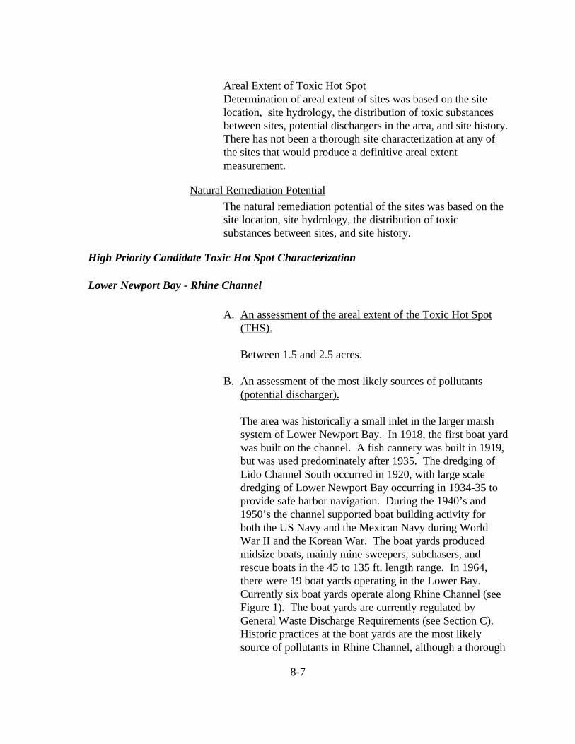
8-7
Areal Extent of Toxic Hot SpotDetermination of areal extent of sites was based on the sitelocation, site hydrology, the distribution of toxic substancesbetween sites, potential dischargers in the area, and site history.There has not been a thorough site characterization at any ofthe sites that would produce a definitive areal extentmeasurement.
Natural Remediation Potential
The natural remediation potential of the sites was based on thesite location, site hydrology, the distribution of toxicsubstances between sites, and site history.
High Priority Candidate Toxic Hot Spot Characterization
Lower Newport Bay - Rhine Channel
A. An assessment of the areal extent of the Toxic Hot Spot(THS).
Between 1.5 and 2.5 acres.
B. An assessment of the most likely sources of pollutants(potential discharger).
The area was historically a small inlet in the larger marshsystem of Lower Newport Bay. In 1918, the first boat yardwas built on the channel. A fish cannery was built in 1919,but was used predominately after 1935. The dredging ofLido Channel South occurred in 1920, with large scaledredging of Lower Newport Bay occurring in 1934-35 toprovide safe harbor navigation. During the 1940’s and1950’s the channel supported boat building activity forboth the US Navy and the Mexican Navy during WorldWar II and the Korean War. The boat yards producedmidsize boats, mainly mine sweepers, subchasers, andrescue boats in the 45 to 135 ft. length range. In 1964,there were 19 boat yards operating in the Lower Bay.Currently six boat yards operate along Rhine Channel (seeFigure 1). The boat yards are currently regulated byGeneral Waste Discharge Requirements (see Section C).Historic practices at the boat yards are the most likelysource of pollutants in Rhine Channel, although a thorough

8-8
characterization of the depth of pollution has never beenundertaken. An investigation of the extent of pollutiondepth and area would help to either eliminate or includelikely historic sources.
C. A summary of actions that have been initiated by theRegional Boards to reduce the accumulation of pollutantsat existing THSs and to prevent the creation of new THSs.
The Regional Board currently regulates the discharge ofprocess wastewater and stormwater from all boat yardfacilities in Lower Newport Bay and Huntington Harbourthrough General Waste Discharge Requirements (OrderNo. 94-26, as amended by Order No. 95-60 and 96-52).The boat yards were initially issued individual NPDESpermits beginning in 1975. The main feature of Order No.94-26, as amended, is the elimination of the discharge ofprocess wastewater in accordance with the requirement ofthe Water Quality Control Policy for the Enclosed Baysand Estuaries of California. Process wastewater is definedby the Order to include the first one tenth of an inch of rainthat is proceeded by seven days of dry weather. Thispermit requirement was to be implemented by April, 1996.Presently, five of the six boat yards in Rhine Channel havecomplied with this requirement.
The Newport Bay watershed is one of two watershedswithin the Santa Ana Region that are the focus of intensivewatershed management activities. The expected outcomesof this planning and management effort includes a furtherrefinement of water quality problems, both in the Bay andwatershed, the development and implementation of awatershed management plan that addresses these problems,and mechanisms for measuring the success of the plan andimprovements in water quality.
Additionally, Lower Newport Bay is currently listed as water quality limited formetals and pesticides pursuant to Section 303(d) of the Clean Water Act. A Total MaximumDaily Load (TMDL) for metals and pesticides will be developed by the Regional Board toaddress this impairment. The control of pollutant sources occurring in Rhine Channel will bea component of the TMDLs.

8-9
Please Refer to Figure 1 Rhine Channel

8-10
D. Preliminary Assessment of Actions required to remedy orrestore a THS, including recommendations for remedialactions.
There are four options for cleanup of the Rhine ChannelTHS. These include ex-situ treatment, chemical separation,immobilization, and dredging. The ex-situ treatment ofpollution at Rhine Channel could include either chemicalseparation or immobilization. Chemical separation wouldseparate the weakly bound metals from the sediment, andthe clean sediment would then be disposed. The problemwith this treatment is the limited application of the method,the need for further treatment systems integration for acomplete separation, and the need for a treatment site.This last factor is significant due to the urban setting of thesite. Significant transportation costs would be incurred byhauling the sediment to a non-local treatment area.
Immobilization of trace metals by chemical fixation isanother possible treatment. This treatment has been usedextensively for solid wastes. A limitation with thistreatment is the high moisture content of the sediment inRhine Channel and the need for a treatment site.
The capping or containment of the site is not an option dueto the shallow depth of Rhine Channel. Capping wouldeffectively eliminate any navigation in the channel andadversely affect the economic activities of business that usethe channel (i.e., the boatyards).
The only other viable treatment is dredging and off-sitedisposal. Dredging of the site would allow for a confinedremediation area with a low potential for the off-sitemigration of toxic substances through the use of siltationcurtains. It would also allow for the continued use of thechannel without a significant disruption of access orbusiness activity.

8-11
E. An estimate of the total cost and benefits of implementingthe cleanup plan.
The dredging of Rhine Channel would involve the removalof approximately 23,000 cubic yards of sediment (2 acres x7 feet deep). This is a rough estimate because there has notbeen a thorough characterization of the areal extent ofpollution. These amounts should be consideredconservative and preliminary. Additional costs could beincurred if alternative disposal transportation is required.

8-12
Sediment RemovalHydraulic dredge (23,000 cy @ $10 cy) $230,000Silt screen (material,labor)
(600 ft @ $3 ft) $1,800
Sediment TransportTruck (23,000 cy @ $200 cy) $4,600,000
Sediment DisposalClass I disposal facility (23,000 cy @ $250 cy) $5,750,000(Hazardous waste)
Total $10,581,800
The benefits of implementing the cleanup plan are relatedto the beneficial uses of Lower Newport Bay. Thebeneficial uses of Lower Newport Bay are: Navigation(NAV); Water Contact Recreation (REC1); Non-contactWater Recreation (REC2); Commercial and Sportfishing(COMM); Wildlife Habitat (WILD); Rare, Threatened orEndangered Species (RARE); Spawning, Reproduction,and Development (SPWN); Marine Habitat (MAR); andShellfish Harvesting (SHEL). The benefits would beimproved ecosystem conditions, more abundant wildlife,lower concentrations of pollutants in water and sediment,lower concentrations of pollutants in fish and shellfishtissue, and an undegraded benthic community.
F. An estimate of recoverable costs from potentialdischargers.
The recoverable costs from dischargers would beinsufficient to perform cleanup activities. The boatyardoperations are small businesses, with a few having financialdifficulty implementing control measures currently requiredby the Regional Board. If the Regional Board were toissue Cleanup and Abatement Orders to the boatyards in anattempt to recover costs for the proposed cleanupactivities, it is envisioned that several of the boatyardswould claim bankruptcy rather than participate. It isestimated that recoverable cleanup costs from dischargers

8-13
would be from 1 to 10 %.
G. A two-year expenditure schedule identifying funds toimplement the plans that are not recoverable from potentialdischargers.
Year 1.
The activities conducted during the first year would befurther site pollution characterization. These activitieswould include extensive sampling to determine the arealextent, depth, and severity of pollution in Rhine Channel.The cost would be approximately $900,000.
Year 2.
The activities conducted during the second year would bethe development of an engineering report and operatingplan for the cleanup site, obtaining the appropriate permits(e.g., 401/404), and producing appropriate environmentaldocumentation (e.g., NEPA/CEQA). These services wouldbe provided by a consulting firm. This would costapproximately $500,000.
ReferencesCalifornia Regional Water Quality Control Board - Santa AnaRegion (CRWQCB - SAR), 1995. Water Quality Control Planfor the Santa Ana River Basin. 7 sections + appendices.
Long, E. R., and L. Morgan, 1990. The potential effects ofsediment-sorbed contaminants tested in the National Status andTrends Program. NOAA Technical Memorandum NOS OMA52.
Long, E. R., D.D. MacDonald, S. L. Smith, and F. D. Calder,1995. Incidence of adverse biological effects within ranges ofchemical concentrations in marine and estuarine sediments.Environmental Management 19:81-97.

8-14
MacDonald, D.D., 1994. Approach to assessment of sedimentquality in Florida coastal waters. Volumes I and II. Preparedfor the Office of Water Policy, Florida Department ofEnvironmental Regulation. MacDonald EnvironmentalServices, Ltd., Ladysmith, British Columbia.
State Water Resources Control Board (SWRCB), 1998.Water Quality Control Policy for Guidance on theDevelopment of Regional Toxic Hot Spot Cleanup Plans. 43pp.
Future Needs
Several sites in the Region need additional characterizationwork to either include or exclude them from Candidate ToxicHot Spot designation. These sites are listed in the followingtable.

8-15
Sites of Concern (Sites that do not qualify as Candidate Toxic Hot Spots)
Water body name Segment Name Site Identification Reason for Listing Pollutantspresent at thesite
Reportreference
Huntington Harbour Middle Reach BPTCP Site # 80027, Latitude -33,42,80N, Longitude - 118,03,67W
Sediment toxicity(Not recurrent)
Chlordane, DDE 3, 4, 5
Huntington Harbour Launch ramp 82005, 33,43,61N, 118,03,91W Sediment toxicity(Not recurrent)
Lead, zinc, DDE 3, 4
Bolsa Bay Mouth OfEGGW
82024, 33,42,40N, 118,03,35W Sediment toxicity(Not recurrent)
Unknown 3, 4
Lower Newport Bay Arches Drain 85015, 33,37,199N, 117,55,697W Sediment toxicity(Not recurrent)
Chlordane, DDE,TBT
1, 4

9-1
(REGION 9.)
REGIONAL WATER QUALITY CONTROL BOARD, SAN DIEGO REGION
REGIONAL TOXIC HOT SPOTCLEANUP PLAN

9-2
Region DescriptionThe San Diego Region is located along the coast of the PacificOcean from the Mexican border to north of Laguna Beach inOrange County. The Region is rectangular in shape andextends approximately 80 miles along the coastline and 40miles east to the crest of the mountains. The Region includesportions of San Diego, Orange, and Riverside Counties.Weather patterns are Mediterranean in nature with an averagerainfall of approximately ten inches per year occurring alongthe coast. Almost all of the rainfall occurs during wet coolwinters. The Pacific Ocean generally has cool watertemperatures due to upwelling.
The population of the Region is heavily concentrated along thecoastal strip. There are coastal lagoons at river mouths to theocean, and two dredged small craft harbors, Dana Point andOceanside Harbor in the north part of the Region. In thesouthern part two harbors, Mission Bay and San Diego Bay,support major recreational vessel and ship traffic. San DiegoBay is long and narrow, 15 miles in length averagingapproximately one mile across. A deep-water harbor, the Bayhas experienced waste discharge from former sewage outfalls,industries, and urban runoff. Up to 9,000 vessels may bemoored in the Bay. San Diego Bay also hosts four major U.S.Navy bases with approximately 50 surface ships andsubmarines home-ported in the Bay.

9-3
Candidate Toxic Hot Spot List
Water BodyName
SegmentName
Site Identification Reason for Listing1
PollutantsPresent at theSite
ReportReference
San Diego Bay North Bay Between “B” Street and Broadwaypiers, San Diego(Stations 93205, 93206)
5 PAHs, totalchemistry
1
San Diego Bay Central Bay Switzer Creek, San Diego(Station 90039)
2 Chlordane,Lindane, DDT,total chemistry
1, 3
San Diego Bay Central Bay Foot of Evans and Sampson Streets,San Diego(Stations 90020, 93211)
5 PCBs, antimony,copper, totalchemistry
1
San Diego Bay Central Bay Chollas Creek, San Diego 2
(Stations 90006, 93212, 93213)5 Chlordane, total
chemistry1
San Diego Bay Central Bay Seventh Street Channel/Paleta Creek,Naval Station(Stations 90009, 93227, 93228)
2, 5 Chlordane, DDT,total chemistry
1
1 See candidate toxic hot spot definitions on page No. 2 is repeat amphipod sediment toxicity; No. 5 is multiple degraded benthic communities.
2 The Chollas Creek watershed is one of two high-priority San Diego Region Total Maximum Daily Load (TMDL) projects proposed to be completed in the year 2000.

9-4
Reference listState Water Resources Control Board. 1996 Chemistry,Toxicity and Benthic Community Conditions in Sediments ofthe San Diego Bay Region. Final Report.
State Water Resources Control Board. 1997 Chemistry,Toxicity and Benthic Community Conditions in Sediments ofSelected Southern California Bays and Estuaries. Final Report.
State Water Resources Control Board. 1998 Chemistry,Toxicity and Benthic Community Conditions in Sediments ofthe San Diego Bay Region. Addendum Report.

9-5
Ranking Matrix
Water bodyName
SiteIdentifica-tion
HumanHealthImpacts
Aquatic LifeImpacts
WaterQualityObjectives
Areal Extent Remedia-tionPotential
OverallRanking
San DiegoBay
Seventh StreetChannel/Paleta Creek,National City
No action High No action 1 to 10 acres High High
San DiegoBay
Between “B”St. andBroadwaypiers, SanDiego
No action Moderate No action 1 to 10 acres High Moderate
San DiegoBay
Switzer Creek,San Diego
No action Moderate No action 1 to 10 acres High Moderate
San DiegoBay
Foot of Evansand SampsonStreets, SanDiego
No action Moderate No action 1 to 10 acres High Moderate
San DiegoBay
Chollas Creek,San Diego
No action Moderate No action 1 to 10 acres High Moderate

9-6
High Priority Candidate Toxic Hot Spot
Seventh Street Channel, National City
A. Assessment of the Areal Extent of the THS
Approximately three acres appear affected (Stations90009, 93227, 93228); however, the area affectedcould be substantially larger or smaller. Dredgingactivities could have occurred in this area since SanDiego Bay was sampled during the period 1992 to1994. If so, this area or parts of this area may nolonger be considered for designation as a candidatetoxic hot spot.
B. Assessment of the Most Likely Sources of Pollutants(Potential Discharger)
Because benthic community analysis does not directlymeasure cause and effect relationships betweenchemicals and fauna living in the sediment, it is possiblethat some of the degraded benthic communities couldhave been caused by physical disturbance of the bottomfrom tug and ship propellers, or from disturbancecaused by recent dredging.
Persistent chemicals, such as PAHs and Chlordane,could also have caused benthic community degradationand sediment toxicity at the Seventh Street Channel.Possible sources include industrial activities,atmospheric fallout, pesticides from lawns, streets, andbuildings, and runoff from pest control operations.
C. Summary of Actions That Have Been Initiated by theRWQCB to Reduce the Accumulation of Pollutants at Existing THSs and to Prevent the Creation of New THSs
The following programs address water quality near theSeventh Street Channel. It is unknown whether any ofthe organizations or facilities named below havedischarged chemical wastes at levels which could have
9-7
caused the accumulation of pollutants at existing toxichot spots.
NPDES Permits for the Naval Station. The NavalStation Graving Dock, which lies midway betweenChollas Creek and the Seventh Street Channel and ahalf mile north of the Seventh Street Channel, currentlyis covered by its own National Pollutant DischargeElimination System (NPDES) permit. Discharges fromNavy industrial facilities are currently covered underthe State Water Resources Control Board GeneralIndustrial Storm Water Permit. The Regional Boardmay issue NPDES permits for discharges from otherNavy activities adjacent to San Diego Bay.
NPDES Municipal Storm Water Permit. In 1990, theRegional Board issued NPDES storm water permits tomunicipalities responsible for civilian areas, includingthose tributary to San Diego Bay. Activities underwayin the Paleta Creek watershed by the City of NationalCity include public education, public serviceannouncements on television, and street sweeping. Thestorm water permit is now being revised.
Pacific Steel site. During the 1980s, the Regional Boardtook enforcement action against Pacific Steel, anautomobile recycler. The company, which was locatedinland of the Seventh Street Channel, maintained a large“fluff” pile of non-ferrous waste. Runoff from the fluffpile was prohibited by the Regional Board from drainingto San Diego Bay. The fluff pile was subsequentlyremoved and the site cleaned up.
Military cleanups. The Regional Board has participatedin Department of Defense Environmental ResponseProgram (DERP) and Navy Installation Restoration (IR)activities to close former military hazardous waste siteson land adjacent to the Bay. Several disposal sites arelocated around the Seventh Street Channel.
D. Preliminary Assessment of Actions Required toRemedy or Restore a THS to an Unpolluted ConditionIncluding Recommendations for Remedial Actions

9-8
The following discussion applies only to the limitedarea of three acres estimated to be contaminated. It ispossible that a larger or smaller area could have beencontaminated by industrial wastes.
Section 13360 of the Porter-Cologne Water QualityControl Act prohibits regional boards, the State Board,and the courts from designating the means ofcompliance with the California Water Code. For thisreason, the options presented below are not meant toinfluence the ultimate solution, but are presented tocomply with Bay Protection and Toxic CleanupProgram legislative requirements and to provide astarting point for discussion. The Regional Boardcould require potential responsible parties to submitCWC Section 13267 technical reports documenting theamounts and types of wastes discharged.
Regional Board procedures. A first step could be toconvene a meeting between potential responsibleparties to discuss the data and to receive comments andinformation about the site. After review by staff ofavailable information, the Regional Board ExecutiveOfficer could ask potential dischargers to submittechnical reports. Subsequently, the Board couldrequire potential responsible parties to sample the siteand surrounding area to document in detail the arealextent of the site and to identify specific pollutants atthe site. Only after extensive review of all availableinformation would the Regional Board requireremediation actions.
Persistence of wastes at this site. The chemical wastesfound in the Seventh Street Channel and at the mouthof Paleta Creek, the pesticides Chlordane and DDT,and the class of polynuclear aromatic hydrocarbon(PAH) “ring” compounds derived from fossil fuels, areknown to persist in nature. These organic chemicalsmay be resistant to treatment or natural remediationprocesses such as oxidation, microbial degradation, andphotolysis. For this reason, natural recovery or in situtreatment may not be feasible. In-place capping ispresumed to be infeasible because of frequent vessel

9-9
traffic in this area of the Bay. Two options which maybe feasible are dredging followed by placement in anupland confined disposal facility, and dredging followedby contained aquatic disposal. There is precedent forboth options in San Diego Bay. Dredging ofcontaminated bottom material has occurred at boatyards in north San Diego Bay and at the 24th MarineTerminal in the south Bay. A submerged aquaticdisposal site has been completed in the north Bay offseveral storm drains known to have contributed PCBsto the Bay.
Dredging and upland disposal. Stations 90009, 93227,and 93228 are located in a heavily-used dredgedchannel frequented by barges, boats, and tugs.Navigation charts show depths of between 18 to 21 feetat mean lower low water, although the depths may beshallower or deeper due to sedimentation or recentdredging. There may be suitable sites on land nearby tobuild settling ponds to receive hydraulic dredge spoils.Sediment removal activities could include clamshelldredging or hydraulic dredging, and transportation to asuitable disposal site by barge, rail, or truck, or tosettling ponds next to the Channel.
Dredging and contained aquatic disposal. Anothermethod could involve dredging a disposal site atanother location in San Diego Bay, depositing thecontaminated dredge spoil from the candidate toxic hotspot site, and capping the site with suitable material.The following conditions would have to be met if thisoption were to be implemented:
Clean Water Act Section 404 dredging permits wouldbe obtained from the U.S. Army Corps of Engineers forthe contaminated site and for the aquatic disposal siteState waste discharge requirements would be obtainedfrom the Regional Board for the disposal site. The capwould provide adequate coverage to prevent the spreadof contaminated material. Burrowing organisms wouldbe prevented from mixing polluted sediments (i.e.,bioturbation must not occur). The contaminatedmaterial covered would be able to support the cap. The

9-10
bottom slope would be able to support the cap duringseismic events. The cap would be well marked andprotected against erosion or destruction from anchors,propellers, and strikes by vessels. The site would belocated away from major navigation lanes. The exactlocation of the site would be noted on maps, charts, anddeeds.
E. Estimate of the Total Cost to Implement the CleanupPlan
This preliminary cost list is based on the schedule foundin the 1997 guidance document. High and low costsare provided. It is assumed that if ocean disposal at the100 fathom site is chosen, the U.S. Army Corps ofEngineers would require extensive testing of thematerial removed from the Seventh Street Channel tobe transported to the LA-5 site 6 miles from Pt. Loma.Costs were not able to be estimated for CaliforniaEnvironmental Quality Act (CEQA) compliance,Section 404 dredging permit and state waste dischargerequirements acquisition, or sampling to determine theareal extent of the candidate toxic hot spot.
Costs for dredging and upland disposal. High costs:Assume that 14,520 square yards (three acres) needremediation and that sediment to a depth of one yardwould be removed. The 14,520 cubic yards of dredgespoil would then be placed on a barge, offloaded ontotrucks, and transported to a suitable upland landfill.Low costs: Assume that the wastes are transported to aClass III site.

9-11
Comparison of High and Low Costsfor Dredging and Upland Disposal
High Cost per Cubic Yard Low Cost per Cubic Yard
Clamshell dredging $10 Clamshell dredging $10Unloading from barge TBD Unloading from barge TBDTransport by truck 200 Transport by truck 200Disposal at Class I site 300 Disposal at Class III site 30
Sub total per cubic yard $510 Sub total per cubic yard $240
14,520 cubic yards X $510 =$7,405,200 (not includingpermits)
14,520 cubic yards X $240 =$3,384,800 (not including permits)
Costs for dredging and contained aquatic disposal. High costs:Assume that 14,520 square yards (three acres) needremediation and that sediment to a depth of one yard would beremoved. An aquatic disposal site would be dredged andsuitable material obtained for use as a cap. Another suitablecap to prevent burrowing animals from penetrating into theunderlying contaminated sediment would be provided as well.The 14,520 cubic yards of dredge spoil would be placed on abarge and transported to the aquatic disposal site. The capswould then be constructed. Low costs: Assume thatconfinement at the disposal site is not necessary.

9-12
Comparison of High and Low Costs forDredging and Contained Aquatic Disposal
High Cost per Cubic Yard Low Cost per Cubic Yard
Excavation of disposal site TBD Clamshell dredging and disposal(assuming confined disposal is notneeded)
$10
Clamshell dredging $10
Barge transport of waste (assumehigh truck costs)
TBD
Disposal at aquatic site 9
Cap at disposal site TBD
Monitoring at disposal site TBD
Sub total per cubic yard $19 Sub total per cubic yard $10
14,520 cubic yards X $19 =$275,880 total (not includingcreating and maintaining disposalsite or acquiring permits)
14,520 cubic yards X $10 =$145,520 total (assuming a confinedsite is not needed)
F. Estimate of Recoverable Costs From PotentialDischargers
No attempt has been made to ask potential responsibleparties to participate in any remediation activities, soprojected participation by responsible parties is basedon conjecture. If fifty percent of the costs wererecovered and the cleanup were to cost $7.4 million,the following schedule may be possible. Assume that$3.7 million is not recoverable.

9-13
G. Two-Year Expenditure Schedule Identifying Funds toImplement the Plans That Are Not Recoverable From Potential Dischargers
Assume that a total of more than $3.7 million would beneeded, and that more than two years would be neededto remediate the Seventh Street Channel site.
Activity Deficit
Year 1:
- Meeting with responsible parties- Request for technical information- Discharger response- Staff review of response- Cleanup and abatement order- Sampling plan to characterize aerial extent- Request for bids for chemistry sampling and analysis- Lab contract
estimate $800,000
Year 2:
- Site characterization- Engineering report- Section 404 dredging permit application- State waste discharge requirements application- NEPA and CEQA environmental documentation
estimate $900,000
Future NeedsSampling information is needed to confirm whether toxicchemicals are present at sites that did not undergo repeatsampling. Follow-up information is also needed to adequatelycharacterize toxic hot spots and sites of concern for toxicchemicals, both in the geographic area covered and by depth.Because of San Diego Regional Board experience and basedon requests from industrial and government interests, it is felt

9-14
new sampling trend data for the San Diego Region would behelpful to determine changes in the occurrence of toxic hotspots and sites of concern over time.
If the Regional Board cannot identify parties responsible fordischarging historical chemicals such as Chlordane, DDT,PAHs, and PCBs there is a possibility the sites would not becleaned up. There is a need, therefore, to obtain funding toclean up these “orphan” sites.

9-15
Sites of Concern
The stations on the Sites of Concern list shown belowdemonstrated biological degradation associated with elevatedchemistry. Although the Bay Protection and Toxic CleanupProgram legislation only requires toxic hot spots to beidentified and ranked, it was the consensus of the BayProtection Program’s Monitoring and Surveillance Task Forceto present lists of sites which may be impaired, based onexisting information. “Sites of concern” are not defined in theState Board’s September 1998 Water Quality Control Policyfor Guidance on Development of Regional Toxic Hot SpotCleanup Plans. Criteria for identifying the sites in the SanDiego Region are presented in the Regional Board’s decisionmatrix tables used to identify toxic hot spots.
The Sites of Concern presented in the San Diego RegionCleanup Plan fall into two categories:
“High-priority” stations recommended by the Department ofFish and Game in technical reports for the San Diego Region,and
Stations with at least one “triad” biological hit underdefinitions 2 and 5 of the State Board’s Policy with elevatedchemistry sampled on the same date as the biological hits.

9-16
Sites of Concern (Sites that do not qualify as Candidate Toxic Hot Spots)
Water BodyName
SegmentName
Site Identification Reason for Listing PollutantsPresent at theSite
ReportReference
Stations withsingle biologictriad hits andassociatedchemistry:Mission Bay Northeast Bay Rose Creek, San Diego
(Station 93107)Degraded benthiccommunity
Chlordane, totalchemistry
1
San DiegoRiver
Flood controlchannel
Sunset Cliffs Bridge, San Diego(Station 93116)
Degraded benthiccommunity
Chlordane 1
San Diego Bay North Bay Submarine Base, Ballast Point,San Diego(Station 90028)
Degraded benthiccommunity
PAH 1
North Bay Laurel Street, San Diego(Station 900021)
Sediment toxicity,degraded benthiccommunity
Chlordane, totalchemistry
1
San Diego Bay Central Bay Area near Coronado Bridge, SanDiego(Station 931791)
Sediment toxicity PCB, PAH, totalchemistry
1, 3
San Diego Bay Central Bay Indian Point, south of CoronadoBridge, San Diego(Station 90030)
Sediment toxicity PAH, totalchemistry
1

9-17
Sites of Concern, continued
Water BodyName
SegmentName
Site Identification Reason for Listing PollutantsPresent at theSite
ReportReference
continued

9-18
Sites of Concern, continued
Water BodyName
SegmentName
Site Identification Reason for Listing PollutantsPresent at theSite
ReportReference
San Diego Bay Central Bay 26th Street, San Diego(Station 93181)
Sediment chemistry Total chemistry 1
San Diego Bay Central Bay Between Piers 3 and 4, Naval Station(Station 93223)
Degraded benthiccommunity
Total chemistry 1
San Diego Bay Central Bay Between Piers 3 and 4, Naval Station(Station 90007)
Sediment toxicity Mercury 1
San Diego Bay Central Bay Between Piers 3 and 4, Naval Station(Station 93224)
Degraded benthiccommunity
Zinc 1
San Diego Bay Central Bay Between Piers 5 and 6, Naval Station(Station 90022)
Sediment toxicity,degraded benthiccommunity
PAH, totalchemistry
1
San Diego Bay Central Bay South of Pier 14 Naval Station(Station 93229)
Degraded benthiccommunity
PAH 1
Tijuana Estuary North slough El Centro Street, National WildlifeRefuge, Imperial Beach (Station93118)
Sediment toxicity DDE 1
continued

9-19
Sites of Concern, continued
Water BodyName
SegmentName
Site Identification Reason for Listing PollutantsPresent at theSite
ReportReference
Tijuana Estuary North slough Boundary Road islands, NationalWildlife Refuge, Imperial Beach(Station 93119)
Sediment toxicity DDE, DDT 1
Tijuana Estuary South slough South of Tijuana River mouth,National Wildlife Refuge, ImperialBeach (Station 93175)
Sediment toxicity DDE, DDT 1
Tijuana Estuary South slough North boundary of Border Field StatePark, Imperial Beach (Station 93174)
Sediment toxicity DDE, DDT 1
Stations withsingle biologictriad hits butwithout“threshold”levels ofelevatedchemistry:Dana PointHarbor
East basin Central harbor south, Dana Point(Station 960161)
Degraded benthiccommunity (andurchin fertilizationeffects)
(Copper TBT,Chlordane)2
2
continued

9-20
Sites of Concern, continued
Water BodyName
SegmentName
Site Identification Reason for Listing PollutantsPresent at theSite
ReportReference
San DieguitoLagoon
Southeasternslough
Fish hook slough, Del Mar(Station 950241)
Sediment toxicity,degraded benthiccommunity (andurchin fertilizationeffects)
(Dieldrin)2 2
1 Department of Fish and Game high-priority stations2 Chemicals present at the station but below threshold levels triggering an “elevated chemistry” designation
References
State Water Resources Control Board. 1996 Chemistry, Toxicity and Benthic Community Conditions inSediments of the San Diego Bay Region. Final Report.
State Water Resources Control Board. 1997 Chemistry, Toxicity and Benthic Community Conditions inSediments of Selected Southern California Bays and Estuaries. Final Report.
State Water Resources Control Board. 1998 Chemistry, Toxicity and Benthic Community Conditions inSediments of the San Diego Bay Region. Addendum Report.