aberdeen south waterfront integrated cleanup and
TRANSCRIPT
aberdeen south waterfront integrated cleanup and redevelopment plan
December 1, 2016
table of contents
executive summary................................................. 3
1 introduction......................................................... 5
1.1 Vision1.2 Goals & Objectives1.3 Community Involvement
2 conceptual plans................................................... 13
2.1 Conceptual Approaches & Plans
2.2 Conceptual Comparative Evaluation
2.3 Community Involvement
3 existing conditions................................................ 21
3.1 Regional Context
3.2 Property Profile & Physical Assets
3.3 Building Assessment3.4 Infrastructure3.5 State-Owned Aquatic Lands3.6 Land Use Regulatory Framework3.7 Considerations for Development
4 market assessment................................................ 43
4.1 Real Estate Market Trends4.2 Commercial Boatyard Assessment
5 environmental conditions..................................... 60
5.1 Environmental Risk Management
5.2 Pakonen Boatyard Environmental Strategies
5.3 Seaport Landing Environmental Strategies
6 implementation strategies.................................... 75
6.1 Organizing for Success
6.2 Action Steps - Seaport Landing
6.3 Action Steps - Pakonen Property
appendices
A. Commercial Boatyard Pre-Feasibility Study
B. Pakonen Boatyard Focused Site Assessment
C. Sediment Sampling Report: Seaport Landing
D. Site Investigation and Alternatives Analysis
E. Interpretive Center Case Studies
ACKNOWLEDGMENTS
Grays Harbor Historical Seaport Authority
BOARD OF DIRECTORS
Brandi Bednarik, Executive Director
Dave Douglass, ChairAl CarterDavid CottrellTawni AndrewsTim Howden
Washington State Department of Ecology
Jim Pendowski, Toxics Cleanup Program ManagerAlan Bogner, Brownfields Program ManagerJoyce Mercuri, Site Manager
Alex KluhRoberta MeyersBill SimpsonLaura Pilgrim-RustScott Reynvaan
City of Aberdeen
Mayor Erik Larson
CITY COUNCIL
Peter Schave, PresidentAlan RichrodAlice PhelpsDenny J. LawrenceKathi PrietoKathi HoderMargo Shortt
Consultant Team
Harbor ArchitectsSRG ArchitectsMaul Foster & Alongi, Inc.Berger PartnershipHeartland, LLCBST Associates
Lisa Scott, Planning Director
Dee Anne ShawJames CookJeff CookDenny LawrenceTawni AndrewsTim Alstrom
1
PREFACE
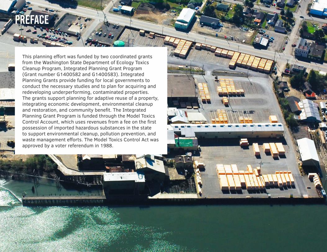
This planning effort was funded by two coordinated grants from the Washington State Department of Ecology Toxics Cleanup Program, Integrated Planning Grant Program (Grant number G1400582 and G1400583). Integrated Planning Grants provide funding for local governments to conduct the necessary studies and to plan for acquiring and redeveloping underperforming, contaminated properties. The grants support planning for adaptive reuse of a property, integrating economic development, environmental cleanup and restoration, and community benefit. The Integrated Planning Grant Program is funded through the Model Toxics Control Account, which uses revenues from a fee on the first possession of imported hazardous substances in the state to support environmental cleanup, pollution prevention, and waste management efforts. The Model Toxics Control Act was approved by a voter referendum in 1988.
SOUTH WATERFRONT INTEGRATED PLAN
2
about the grays harbor historical seaport authority
The Grays Harbor Historical Seaport Authority (GHHSA) is a 501(c)(3) municipal Public Development Authority chartered by the City of Aberdeen in October 1986. The GHHSA’s mission is to provide educational, vocational, recreational, and ambassadorial activities and experiences that promote and preserve the maritime history of Grays Harbor and the Pacific Northwest while serving the needs of its community.
The GHHSA is governed by a Board of Directors, who are appointed by the Mayor of the City of Aberdeen to serve three-year terms.
3
executive summary
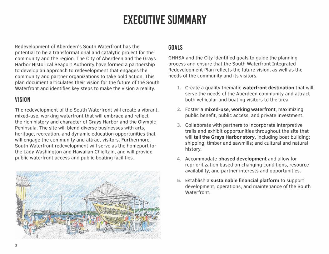
Redevelopment of Aberdeen’s South Waterfront has the potential to be a transformational and catalytic project for the community and the region. The City of Aberdeen and the Grays Harbor Historical Seaport Authority have formed a partnership to develop an approach to redevelopment that engages the community and partner organizations to take bold action. This plan document articulates their vision for the future of the South Waterfront and identifies key steps to make the vision a reality.
vision
The redevelopment of the South Waterfront will create a vibrant, mixed-use, working waterfront that will embrace and reflect the rich history and character of Grays Harbor and the Olympic Peninsula. The site will blend diverse businesses with arts, heritage, recreation, and dynamic education opportunities that will engage the community and attract visitors. Furthermore, South Waterfront redevelopment will serve as the homeport for the Lady Washington and Hawaiian Chieftain, and will provide public waterfront access and public boating facilities.
goals
GHHSA and the City identified goals to guide the planning process and ensure that the South Waterfront Integrated Redevelopment Plan reflects the future vision, as well as the needs of the community and its visitors.
1. Create a quality thematic waterfront destination that will serve the needs of the Aberdeen community and attract both vehicular and boating visitors to the area.
2. Foster a mixed-use, working waterfront, maximizing public benefit, public access, and private investment.
3. Collaborate with partners to incorporate interpretive trails and exhibit opportunities throughout the site that will tell the Grays Harbor story, including boat building; shipping; timber and sawmills; and cultural and natural history.
4. Accommodate phased development and allow for reprioritization based on changing conditions, resource availability, and partner interests and opportunities.
5. Establish a sustainable financial platform to support development, operations, and maintenance of the South Waterfront.
4
SOUTH WATERFRONT INTEGRATED PLAN
action steps
Critical actions have been identified to catalyze redevelopment of the Seaport Landing property and the Pakonen Boatyard property.
Seaport Landing
PLACE MAKING INITIATIVES TO CREATE A DESTINATION
1. Activate the property with events and programs.
2. Establish facilities to support GHHSA operations.
3. Open space and trails design and construction.
4. Moorage improvements.
INITIATIVES TO CREATE INTERPRETIVE AND EDUCATIONAL OPPORTUNITIES
5. Education/interpretive center.
6. Education and workforce training facility.
INITIATIVES TO ESTABLISH WORKING WATERFRONT AND FINANCIAL PLATFORM
7. Asset management strategy.
8. Recruit commercial and industrial users.
INITIATIVES TO PREPARE PROPERTY FOR REDEVELOPMENT
9. Conduct in-water environmental remediation.
10. Enter into Agreed Order for upland investigation and interim cleanup actions
11. Amend upland restrictive covenant.
12. Obtain land use entitlements.
13. Inter-local agreement.
14. Adjust inner and outer harbor lines.
Pakonen Property
A range of future use options for the former Pakonen Boatyard property has been identified that would complement the Seaport Landing development.
• Open space and parking to support improvements to the existing Boone Street boat ramp
• Adaptive re-use of the workshop building as an interpretive center
The following action steps have been defined to support the potential for a new owner to acquire and redevelop the property.
ACTION STEPS
1. Environmental due diligence.
2. Negotiate property transaction
3. Negotiate pathway for tidelands cleanup
4. Design and implement cleanup
5. Plan and design redevelopment
INTRODUCTION1.1 south aberdeen1.2 vision1.3 goals AND OBJECTIVES1.4 COMMUNITY INVOLVEMENT
6
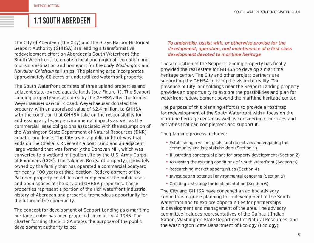
1.1 south Aberdeen
INTRODUCTION
SOUTH WATERFRONT INTEGRATED PLAN
The City of Aberdeen (the City) and the Grays Harbor Historical Seaport Authority (GHHSA) are leading a transformative redevelopment effort on Aberdeen’s South Waterfront (the South Waterfront) to create a local and regional recreation and tourism destination and homeport for the Lady Washington and Hawaiian Chieftain tall ships. The planning area incorporates approximately 60 acres of underutilized waterfront property.
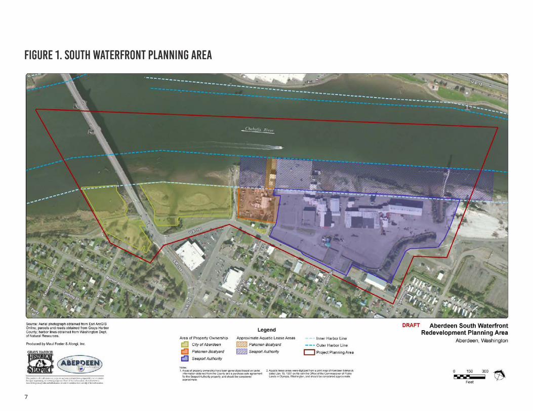
The South Waterfront consists of three upland properties and adjacent state-owned aquatic lands (see Figure 1). The Seaport Landing property was acquired by the GHHSA after the former Weyerhaeuser sawmill closed. Weyerhaeuser donated the property, with an appraised value of $2.4 million, to GHHSA with the condition that GHHSA take on the responsibility for addressing any legacy environmental impacts as well as the commercial lease obligations associated with the assumption of the Washington State Department of Natural Resources (DNR) aquatic land lease. The City owns a public right-of-way that ends on the Chehalis River with a boat ramp and an adjacent large wetland that was formerly the Donovan Mill, which was converted to a wetland mitigation site by the U.S. Army Corps of Engineers (COE). The Pakonen Boatyard property is privately owned by the family that has operated a commercial boatyard for nearly 100 years at that location. Redevelopment of the Pakonen property could link and complement the public uses and open spaces at the City and GHHSA properties. These properties represent a portion of the rich waterfront industrial history of Aberdeen and present a tremendous opportunity for the future of the community.
The concept for development of Seaport Landing as a maritime heritage center has been proposed since at least 1986. The charter forming the GHHSA states the purpose of the public development authority to be:
To undertake, assist with, or otherwise provide for the development, operation, and maintenance of a first class development devoted to maritime heritage
The acquisition of the Seaport Landing property has finally provided the real estate for GHHSA to develop a maritime heritage center. The City and other project partners are supporting the GHHSA to bring the vision to reality. The presence of City landholdings near the Seaport Landing property provides an opportunity to explore the possibilities and plan for waterfront redevelopment beyond the maritime heritage center.
The purpose of this planning effort is to provide a roadmap for redevelopment of the South Waterfront with a focus on the maritime heritage center, as well as considering other uses and activities that can complement and support it.
The planning process included:
• Establishing a vision, goals, and objectives and engaging the community and key stakeholders (Section 1)
• Illustrating conceptual plans for property development (Section 2)• Assessing the existing conditions of South Waterfront (Section 3)• Researching market opportunities (Section 4)• Investigating potential environmental concerns (Section 5)
• Creating a strategy for implementation (Section 6)
The City and GHHSA have convened an ad hoc advisory committee to guide planning for redevelopment of the South Waterfront and to explore opportunities for partnerships in development and management of the area. The advisory committee includes representatives of the Quinault Indian Nation, Washington State Department of Natural Resources, and the Washington State Department of Ecology (Ecology).
7
Figure 1. south waterfront planning area
8
INTRODUCTION
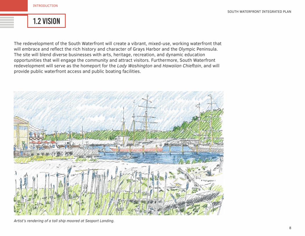
1.2 visionSOUTH WATERFRONT INTEGRATED PLAN
The redevelopment of the South Waterfront will create a vibrant, mixed-use, working waterfront that will embrace and reflect the rich history and character of Grays Harbor and the Olympic Peninsula. The site will blend diverse businesses with arts, heritage, recreation, and dynamic education opportunities that will engage the community and attract visitors. Furthermore, South Waterfront redevelopment will serve as the homeport for the Lady Washington and Hawaiian Chieftain, and will provide public waterfront access and public boating facilities.
Artist’s rendering of a tall ship moored at Seaport Landing.
9
INTRODUCTION
1.3 goals & objectives
GHHSA and the City identified several goals and objectives for the South Waterfront redevelopment. These goals and objectives serve to guide the design process and ensure that the South Waterfront Integrated Redevelopment Plan reflects the future vision, as well as the needs of the community and its visitors. The following goals were identified for the South Waterfront:
1. Create a quality thematic waterfront destination that will serve the needs of the Aberdeen community and attract both vehicular and boating visitors to the area.
2. Foster a mixed use, working waterfront, maximizing public benefit, public access, and private investment.
3. Collaborate with partners to incorporate interpretive trails and exhibit opportunities throughout the site that will tell the Grays Harbor story, including boat building, shipping, timber and sawmills, and cultural and natural history.
4. Accommodate phased development and allow for reprioritization based on changing conditions, resource availability, and partner interests and opportunities.
5. Establish a sustainable financial platform to support development, operations, and maintenance of the South Waterfront.
The objectives for the future South Waterfront are as follows:
1. Create a highly visible and accessible destination that will attract both residents and visitors to the Seaport Landing and surrounding area.
a. Provide ample access and designated parking for vehicles, including RVs, cars, boat trailers, motor coaches, and school buses.
b. Provide on-site transit connections.c. Establish an on-site recreational trail system that
connects to community recreational trail systems.
2. Embrace and incorporate best practices and innovative designs to create a facility that invites exploration.
3. Create a system of thematic interpretive trails connecting on-site education stations.
4. Design and construct multi-user boating facilities and public fishing areas.
5. Design, develop, and utilize the site in collaboration with public, private, and nonprofit partners.
6. Create a plan that will allow for phased/incremental development as funding and appropriate opportunities arise.

10
INTRODUCTION
1.4 community involvement
Figure 2. future use ideas word cloud
SOUTH WATERFRONT INTEGRATED PLAN
Over the past several years, there have been a number of community meetings to discuss the potential for a maritime heritage center. The Integrated Planning Grant (IPG) process continued this public involvement initiative. There were personal meetings with stakeholder throughout the planning process. Three open-house community meetings were also held in March 2015 (as part of the Grays Harbor Expo), in April 2015, and in August 2015.
Issues important to the community to be integrated into the South Waterfront redevelopment were discussed at the
community meetings. The key themes of the community input can be organized into two components: project elements and project goals.
Potential project elements were presented during the community meetings, and attendees were given the opportunity to vote on the elements they would like to see integrated into the South Waterfront Redevelopment. The relative rating of the various project elements is depicted in the word cloud—the more votes received by a project element, the larger it is written (see Figure 2 below)
11
INTRODUCTION
1.4 community involvement
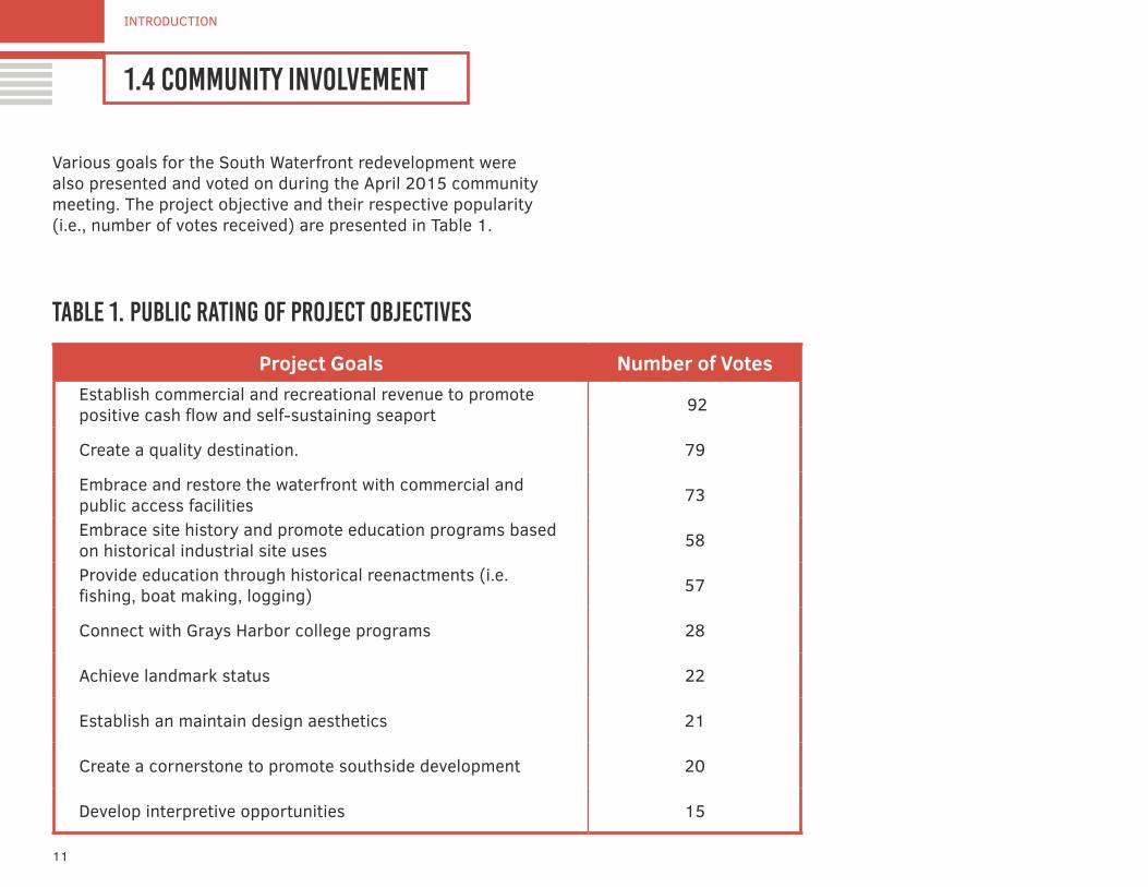
table 1. public rating of project objectives
Various goals for the South Waterfront redevelopment were also presented and voted on during the April 2015 community meeting. The project objective and their respective popularity (i.e., number of votes received) are presented in Table 1.
Project Goals Number of VotesEstablish commercial and recreational revenue to promote positive cash flow and self-sustaining seaport 92
Create a quality destination. 79
Embrace and restore the waterfront with commercial and public access facilities 73
Embrace site history and promote education programs based on historical industrial site uses 58
Provide education through historical reenactments (i.e. fishing, boat making, logging) 57
Connect with Grays Harbor college programs 28
Achieve landmark status 22
Establish an maintain design aesthetics 21
Create a cornerstone to promote southside development 20
Develop interpretive opportunities 15
conceptual plans2.1 conceptual approaches and plans2.2 conceptual comparative evaluation
14
CONCEPTUAL PLANS
2.1 conceptual approaches & plansSOUTH WATERFRONT INTEGRATED PLAN
Acquisition and redevelopment of the South Waterfront represent the first step in establishing the mixed-use working waterfront. Development of the South Waterfront should be conducted in the context of establishing the Seaport and supporting areas with a buffer to the commercial and residential uses in adjacent neighborhoods. Conceptual plans are based on a planning principle of designating districts within the study area to organize uses to enhance synergy and minimize conflicts.
• Education and Public-Access District. The center of the study area, including the fixed pier, is dedicated to the core mission of the GHHSA education and public access that will serve the local community and attract tourists.
• Marine Industrial. The eastern portion of the study area is designated for marine and industrial uses to capitalize on the asset of the existing Pee Wee mill and allow for separation of traffic and operations.
• Boat Launch and Public Park. The western portion of the study area includes the existing boat ramp at the end of the Boone Street right-of-way. The plan envisions improvements to the boat ramp and use of the adjacent upland for boat trailer parking and park space.
Conceptual site planning was performed to illustrate how the elements of a mixed-use waterfront can be laid out on the property in a way that enhances synergies and minimizes conflicts. A cornerstone of the two concepts is to have a maritime village—with an interpretive center at its heart—for
education about maritime cultural history and ecology of Grays Harbor. The plans provide a flexible framework for development that can be phased and adapted to changing conditions. The conceptual site plans incorporated the following principles:
• Reconnect Aberdeen and the surrounding community to its waterfront by creating a quality thematic waterfront destination that will serve the needs of the community and region.
• Promote the educational mission of the GHHSA to tell the long maritime and lumber history of the region and celebrate the region’s unique culture and heritage.
• Create a working waterfront by providing opportunities for revenue-generating activities that will support the mission of the GHHSA and move the economy of the region forward.
• Enhance and restore the site’s natural environment; provide opportunities for interpretation and increased public awareness and access to the shoreline for multiple activities.
In studying the constraints and opportunities presented by the South Waterfront site, two alternative approaches to a site concept evolved. Both alternatives include a mix of uses, but vary in the location and orientation of those uses.
The initial plans for Seaport Landing included extensive in-water construction, including a marina and commercial boatyard. Those elements have been removed from the updated site plans based on feasibility analysis and considerations of potential impacts to tribal fishing rights.
15
CONCEPTUAL PLANS
2.1 conceptual approaches & plans
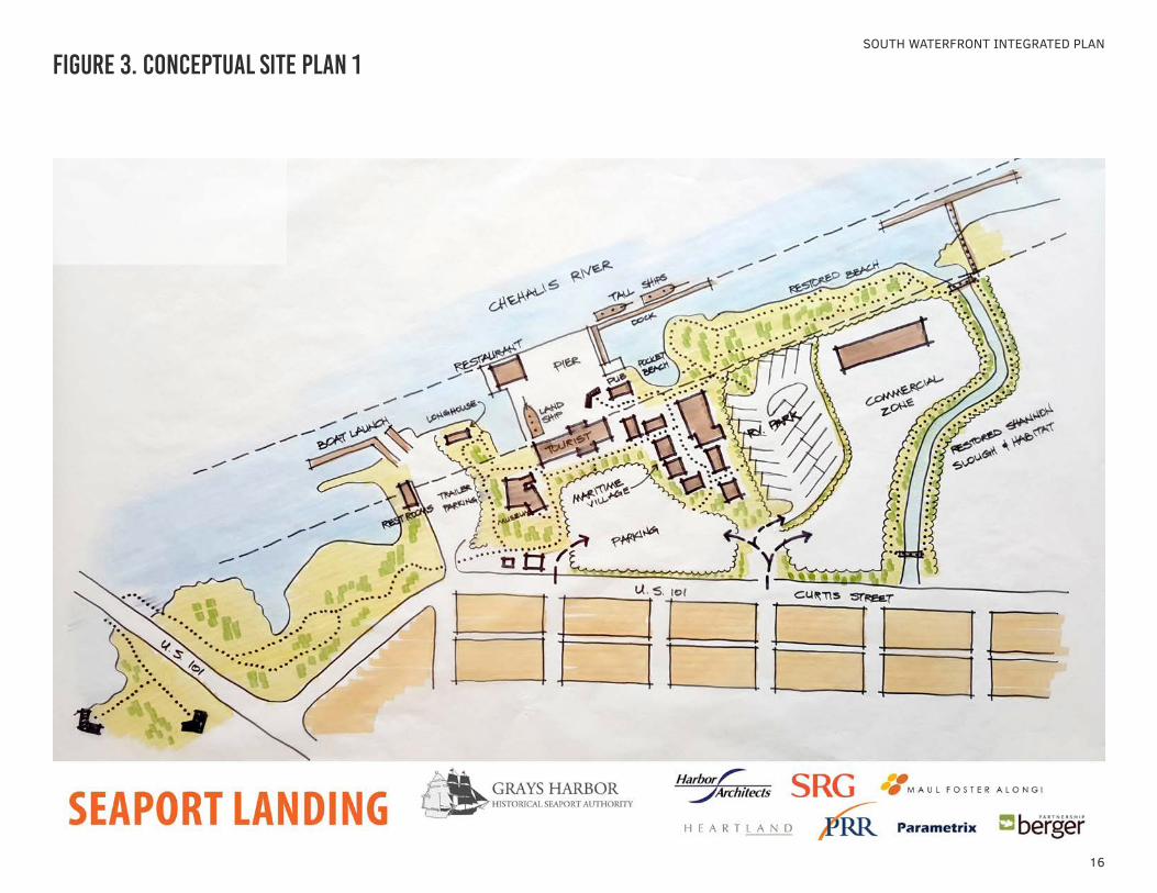
concept 1: discovery center and tourism focus
The centerpiece for Concept 1 development is a Maritime Village: an integration of cultural, historical, and environmental education; interpretive displays; and interactive programs complemented by hospitality, conferencing facilities, food service, gift sales, and planned on-water activities. Existing buildings will form the core of the village, with aesthetic and historical photos of former buildings guiding restoration and new construction.
Interactive demonstrations of actual ship construction and boat building would be featured, such as an iconic “land ship” that could be on display. It would be a place where the public could view and interact with working maritime activity.
A public access pier and floating dock would allow the moorage of the GHHSA’s tall ships, the Lady Washington and Hawaiian Chieftain, as well as occasional visiting vessels. Public fishing, celebratory events, displays, and demonstrations would be staged on the pier.
A recreational vehicle (RV) park could be established on the east side of the Maritime Village to capitalize on river views and create a place for tourists to stay on site. Further to the east, the existing Pee Wee Mill could be re-purposed to support commercial and light industrial uses. This could include operation of the GHHSA’s spar lathe, a unique operation that can mill masts for tall ships.
The Concept 1 plan includes improvements to the existing public boat ramp at the end of Boone Street. Improvements are expected to include a new concrete ramp to facilitate launching boats and a floating pier for transient moorage. The
former Pakonen Boatyard property would be redeveloped to include truck and trailer parking and open space to support and complement the improved boat ramp. The existing boat workshop could be renovated as an interpretive center. The design and character of the building is representative of the historic maritime industry; remaining equipment in the facility could potentially be put on display. With the importance of this area for tribal fishing and the potential for this area to attract tourists, the site could also support an interpretive center or longhouse celebrating coastal tribes.
The ecological functions of the Chehalis River shoreline along the South Waterfront and Shannon Slough would be enhanced through removal of derelict pilings and debris and by planting with native vegetation. A linear trail along the shoreline would also be established to provide public access to the water and opportunities for interpretation and education. These trails would connect to the Chehalis River Trailway system. The existing culvert over Shannon Slough could be replaced with a clear-span bridge to provide more natural flow patterns to the slough.
Opportunities for industrial development would be provided, continuing the site’s traditional activity, as well as providing revenue to help support the educational mission of the South Waterfront (see Figure 3).
16
SOUTH WATERFRONT INTEGRATED PLAN
Figure 3. conceptual site plan 1
17
CONCEPTUAL PLANS
2.1 conceptual approaches & plans
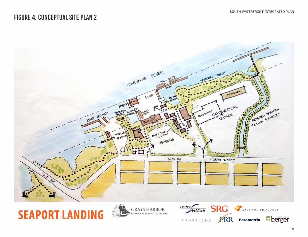
concept 2: discovery center and commercial focus
Concept 2 includes most of the same elements as Option 1, but dedicates more space for commercial and light industrial uses. The western portion of the Seaport Landing property would be developed as a maritime village. The eastern portion of the Seaport Landing property includes industrial buildings that could be reused for light industrial and water-related businesses. The large size of the Seaport Landing property allows for a clear separation of public access/education uses and light industrial uses, including separating vehicle circulation to avoid truck conflicts with pedestrians.
18
SOUTH WATERFRONT INTEGRATED PLAN
Figure 4. conceptual site plan 2
19
CONCEPTUAL PLANS
2.2 conceptual comparative evaluation
concept comparative evaluation
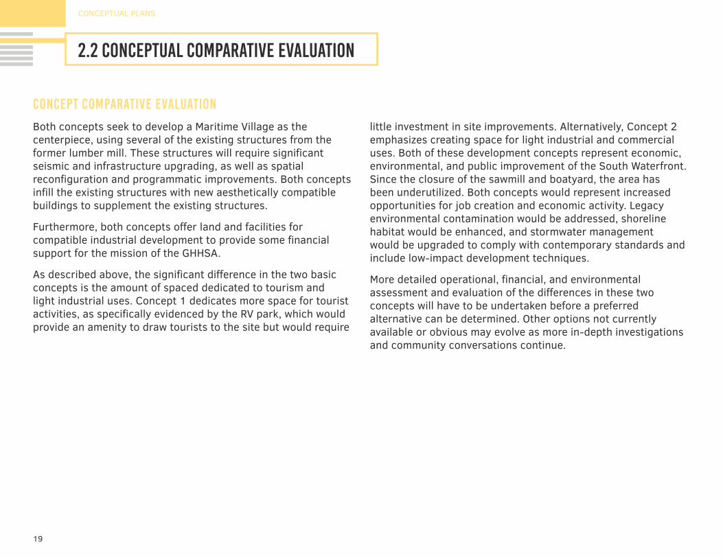
Both concepts seek to develop a Maritime Village as the centerpiece, using several of the existing structures from the former lumber mill. These structures will require significant seismic and infrastructure upgrading, as well as spatial reconfiguration and programmatic improvements. Both concepts infill the existing structures with new aesthetically compatible buildings to supplement the existing structures.
Furthermore, both concepts offer land and facilities for compatible industrial development to provide some financial support for the mission of the GHHSA.
As described above, the significant difference in the two basic concepts is the amount of spaced dedicated to tourism and light industrial uses. Concept 1 dedicates more space for tourist activities, as specifically evidenced by the RV park, which would provide an amenity to draw tourists to the site but would require
little investment in site improvements. Alternatively, Concept 2 emphasizes creating space for light industrial and commercial uses. Both of these development concepts represent economic, environmental, and public improvement of the South Waterfront. Since the closure of the sawmill and boatyard, the area has been underutilized. Both concepts would represent increased opportunities for job creation and economic activity. Legacy environmental contamination would be addressed, shoreline habitat would be enhanced, and stormwater management would be upgraded to comply with contemporary standards and include low-impact development techniques.
More detailed operational, financial, and environmental assessment and evaluation of the differences in these two concepts will have to be undertaken before a preferred alternative can be determined. Other options not currently available or obvious may evolve as more in-depth investigations and community conversations continue.
20
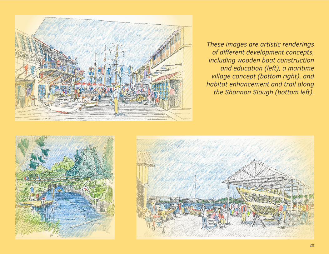
These images are artistic renderings of different development concepts,
including wooden boat construction and education (left), a maritime
village concept (bottom right), and habitat enhancement and trail along
the Shannon Slough (bottom left).
existing conditions3.1 regional context3.2 property profile & physical assets3.3 building assessment3.4 Infrastructure3.5 state-owned aquatic lands3.6 land use regulatory framework3.7 considerations for development
22
EXISTING CONDITIONS
3.1 regional contextSOUTH WATERFRONT INTEGRATED PLAN
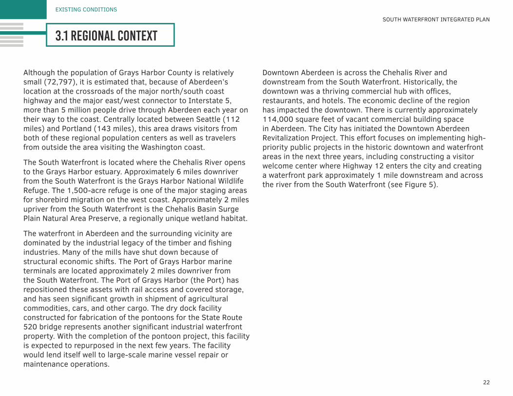
Although the population of Grays Harbor County is relatively small (72,797), it is estimated that, because of Aberdeen’s location at the crossroads of the major north/south coast highway and the major east/west connector to Interstate 5, more than 5 million people drive through Aberdeen each year on their way to the coast. Centrally located between Seattle (112 miles) and Portland (143 miles), this area draws visitors from both of these regional population centers as well as travelers from outside the area visiting the Washington coast.
The South Waterfront is located where the Chehalis River opens to the Grays Harbor estuary. Approximately 6 miles downriver from the South Waterfront is the Grays Harbor National Wildlife Refuge. The 1,500-acre refuge is one of the major staging areas for shorebird migration on the west coast. Approximately 2 miles upriver from the South Waterfront is the Chehalis Basin Surge Plain Natural Area Preserve, a regionally unique wetland habitat.
The waterfront in Aberdeen and the surrounding vicinity are dominated by the industrial legacy of the timber and fishing industries. Many of the mills have shut down because of structural economic shifts. The Port of Grays Harbor marine terminals are located approximately 2 miles downriver from the South Waterfront. The Port of Grays Harbor (the Port) has repositioned these assets with rail access and covered storage, and has seen significant growth in shipment of agricultural commodities, cars, and other cargo. The dry dock facility constructed for fabrication of the pontoons for the State Route 520 bridge represents another significant industrial waterfront property. With the completion of the pontoon project, this facility is expected to repurposed in the next few years. The facility would lend itself well to large-scale marine vessel repair or maintenance operations.
Downtown Aberdeen is across the Chehalis River and downstream from the South Waterfront. Historically, the downtown was a thriving commercial hub with offices, restaurants, and hotels. The economic decline of the region has impacted the downtown. There is currently approximately 114,000 square feet of vacant commercial building space in Aberdeen. The City has initiated the Downtown Aberdeen Revitalization Project. This effort focuses on implementing high-priority public projects in the historic downtown and waterfront areas in the next three years, including constructing a visitor welcome center where Highway 12 enters the city and creating a waterfront park approximately 1 mile downstream and across the river from the South Waterfront (see Figure 5).
23
Figure 5. aberdeen context map
24
EXISTING CONDITIONS
3.2 property profile & physical assetsSOUTH WATERFRONT INTEGRATED PLAN
property profile physical assets
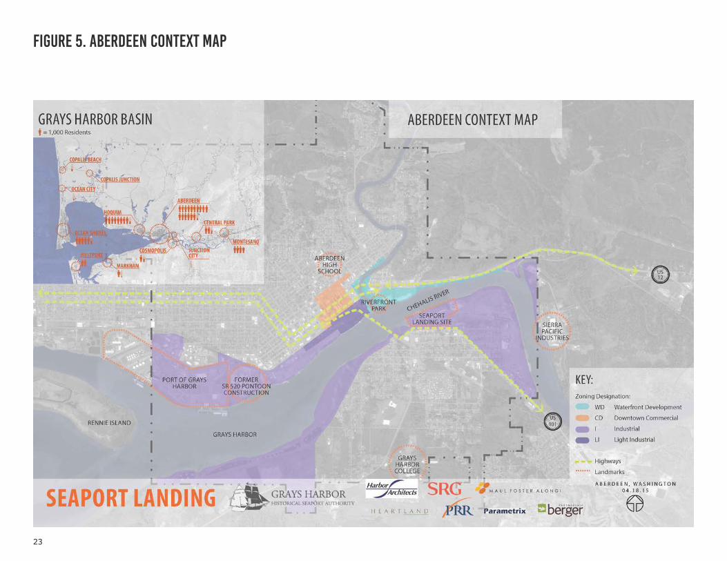
The South Waterfront properties together represent a nearly half-mile stretch of shoreline along the Chehalis River. The properties include wetland areas at the western, downstream side near the Chehalis River Bridge and at Shannon Slough, on the eastern, upstream side. Existing marine infrastructure includes an approximately 55,000 square-foot fixed pier and the public boat ramp at the end of Boone Street.
Most of the upland property consists of historical fill material and is relatively flat. Nearly all of the Seaport Landing upland property is paved, and most of the Pakonen Boatyard upland property is covered with gravel. The shoreline is characterized by large rocks and gravel near the top of bank and fine sediments on the lower slope. Native trees have been planted along Shannon Slough as part of habitat restoration efforts conducted in the 1990s. Both properties are on the river side of a flood control structure, within the mapped 100-year floodplain.
Properties Seaport Landing
Pakonen Boatyard City Wetlands
Ownership GHHSA Private City of Aberdeen
Tax Parcel Numbers
029901100501,029901100100,027401900000
0299001100600,0299001100502, 027401800000
Size (approx.) 23.64 acres 2.26 acres 4.5 acres
Zoning Industrial Industrial Industrial
Tidelands Lease
Lease to GHHSA Approx. 14.5 acres
1. Lease to GHHSA approx. 1.4 acres2. Lease in Default approx. 0.6 acres
N/A
Shoreline of Seaport Landing, looking to the southwest
25
EXISTING CONDITIONS
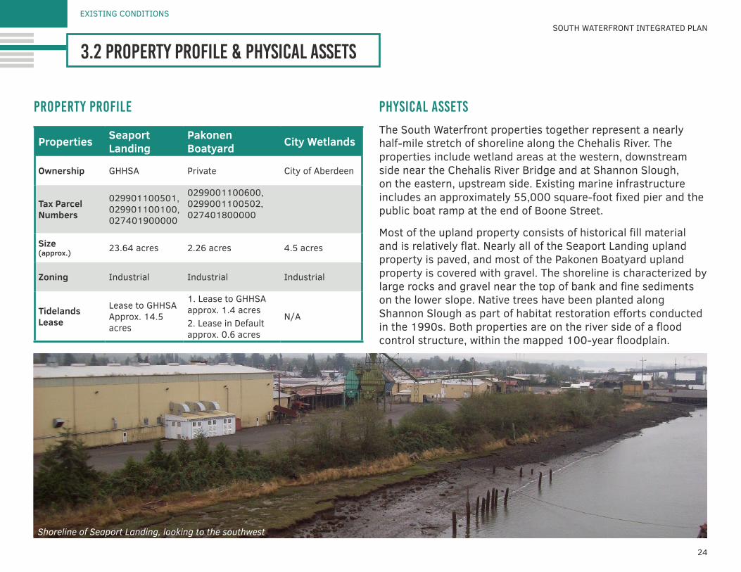
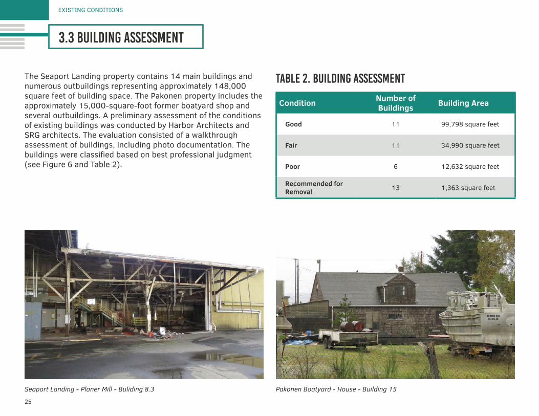
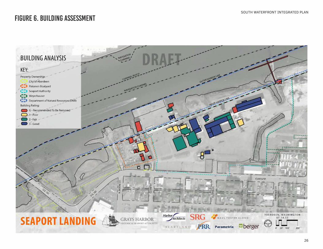
3.3 building assessment
The Seaport Landing property contains 14 main buildings and numerous outbuildings representing approximately 148,000 square feet of building space. The Pakonen property includes the approximately 15,000-square-foot former boatyard shop and several outbuildings. A preliminary assessment of the conditions of existing buildings was conducted by Harbor Architects and SRG architects. The evaluation consisted of a walkthrough assessment of buildings, including photo documentation. The buildings were classified based on best professional judgment (see Figure 6 and Table 2).
table 2. building assessment
Condition Number of Buildings Building Area
Good 11 99,798 square feet
Fair 11 34,990 square feet
Poor 6 12,632 square feet
Recommended for Removal 13 1,363 square feet
Pakonen Boatyard - House - Building 15Seaport Landing - Planer Mill - Buliding 8.3
26
SOUTH WATERFRONT INTEGRATED PLAN
Figure 6. building assessment
27
EXISTING CONDITIONS
3.4 infrastructure
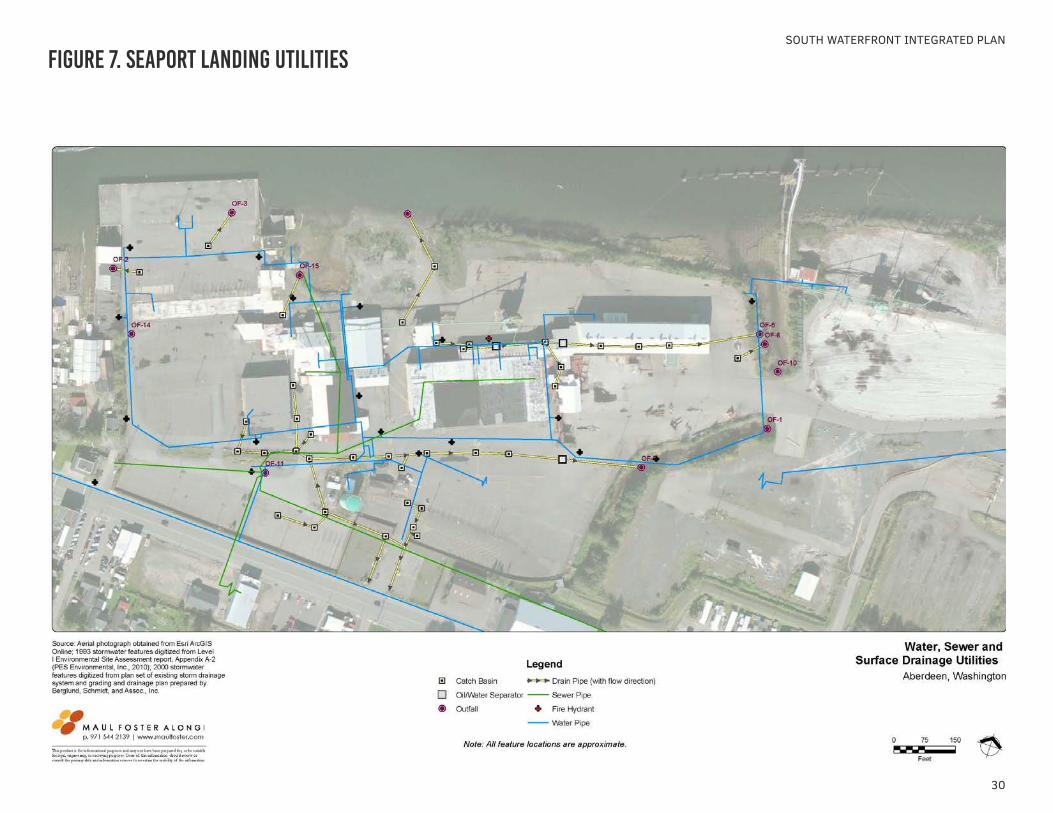
The Seaport Landing property is served by municipal water, sanitary sewer, and stormwater systems. Redevelopment of the South Waterfront properties provides the benefits of maximizing use of existing infrastructure systems, avoiding the costs and impacts of expanding infrastructure into undeveloped areas. The characteristics of these infrastructure systems are described briefly in this section. A more detailed analysis of the condition and capacity of these systems will be needed when a specific development project is proposed to understand whether improvements would be needed.
This infrastructure evaluation is based on review of existing records and the City’s Comprehensive Land Use Plan, which evaluated the condition and needs for public facilities and services, including roads, sanitary sewer, storm sewers, water supply, power, and other public facilities and services. The comprehensive plan addresses facilities and services that are closely related to land use and evaluates them to ensure that they remain suitable as the community grows; in addition, the plan can reduce public costs by encouraging maximum possible use of existing facilities and cost-effective service extensions (see Figure 7).
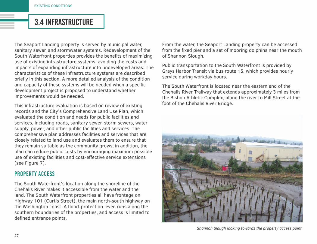
property access
The South Waterfront’s location along the shoreline of the Chehalis River makes it accessible from the water and the land. The South Waterfront properties all have frontage on Highway 101 (Curtis Street), the main north-south highway on the Washington coast. A flood-protection levee runs along the southern boundaries of the properties, and access is limited to defined entrance points.
From the water, the Seaport Landing property can be accessed from the fixed pier and a set of mooring dolphins near the mouth of Shannon Slough.
Public transportation to the South Waterfront is provided by Grays Harbor Transit via bus route 15, which provides hourly service during workday hours.
The South Waterfront is located near the eastern end of the Chehalis River Trailway that extends approximately 3 miles from the Bishop Athletic Complex, along the river to Mill Street at the foot of the Chehalis River Bridge.
Shannon Slough looking towards the property access point.
28
water
The City provides domestic water service for all residential and commercial customers within both the Aberdeen and Cosmopolis city limits, as well in areas of unincorporated Grays Harbor County in the Wishkah River valley. The City has a goal in providing safe and adequate water supply to support existing development and expected growth. Federal and state laws govern water quality standards, and the City is responsible for engineering, building, and operating a public water supply that complies with these regulations.
The source of potable water for the South Waterfront is the Wishkah River, following treatment at the City’s water treatment plant located approximately 14 miles up the Wishkah Valley on Squirrel Road. The filtration plant began operation in May 2000.
Based on existing and proposed development conditions, current water sources are sufficient to provide adequate supply and pressure year-round. Hydraulic modeling of future systems during fire flows will be required for permitting of new development to determine if required fire protection can be supplied, or if pipe upgrades will be needed.
• Water lines and fire hydrants are located in rights-of-way of Front Street and Curtis Street. They are also present throughout the South Waterfront property. Details on system layout and sizing are provided in Figure 7. Pipe sizes vary between 6- and 10-inch-diameter lines inside the Seaport Landing property.
• Curtis Street has 8- to 12-inch-diameter cast iron pipes. Service to the Seaport Landing property connects to the line along Curtis Street. Two lines connecting to the main
along Curtis Street provide service to the property through an 8-inch-diameter line to the west of the pump house and a 350,000-gallon tank, and a 6- to 12-inch-diameter line along N Custer Street.
• Custer Street has 8- and 6-inch-diameter cast iron pipes.
• Front Street has 8- and 6-inch-diameter cast iron pipes. Seaport Landing is currently served by an 8-inch-diameter cast iron line that tees into a 6-inch-diameter cast iron pipe.
sewer
Aberdeen’s wastewater is treated by a public sewer system, which conveys wastewater to a central plant for treatment and subsequent discharge into the Chehalis River.
The wastewater treatment plant for the City of Aberdeen is located at 1205 West State Street. The activated sludge wastewater treatment plant is designed to handle an average/maximum daily flow of 9.9 million gallons per day (MGD). The peak flow recorded at the treatment plant occurred in October 2003 (reached 20 to 21 MGD for two days), while the dry weather average flow is typically 2 to 3 MGD.
Sanitary sewer lines serve the South Waterfront area. Sewer lines run north-south along N Lawrence Street, and east-west in parallel with Curtis Street (between Curtis and King Streets and to the northeast of Curtis Street). The Seaport Landing connects to the sanitary sewer to the east of the pump house. See Figure 7 for system layout.
SOUTH WATERFRONT INTEGRATED PLAN
29
stormwater
Stormwater is managed in the planning area through a combination of public and private systems. The City maintains stormwater facilities along Curtis Street south of the property. Stormwater facilities on the properties are owned and managed privately.
Stormwater collected on site is discharged to either the Chehalis River or Shannon Slough (which drains to the Chehalis River). The Chehalis River is tidally influenced and some areas of the South Waterfront are subject to ponding and can be periodically submerged at high tide.
Stormwater from the Seaport Landing property is collected in stormwater catch basins, then conveyed through underground stormwater pipes or aboveground through surface/roadside drainage ditches. The catch basins near the northeastern portion of the property discharge directly into Shannon Slough. The catch basins and stormwater lines along the northern half of the property discharge into the Chehalis River. The catch basins and stormwater lines along the south-central portion of the property discharge into the stormwater lines along Curtis Street, which then discharge through a culvert into Shannon Slough and then into the Chehalis River.
The facility has oil/water separators (OWSs) at selected discharge outfalls and at the Shannon Slough outfall. Stormwater runoff at the facility is currently managed under a National Pollutant Discharge Elimination System industrial stormwater permit, issued by the Ecology, and an associated Stormwater Pollution Prevention Plan (SWPPP).
An updated Stormwater Management Plan for the Seaport
EXISTING CONDITIONS
3.4 infrastructure
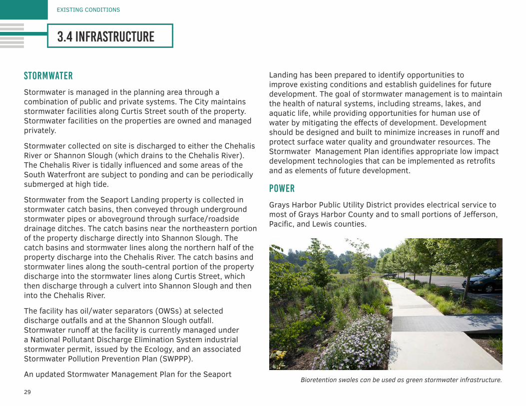
Landing has been prepared to identify opportunities to improve existing conditions and establish guidelines for future development. The goal of stormwater management is to maintain the health of natural systems, including streams, lakes, and aquatic life, while providing opportunities for human use of water by mitigating the effects of development. Development should be designed and built to minimize increases in runoff and protect surface water quality and groundwater resources. The Stormwater Management Plan identifies appropriate low impact development technologies that can be implemented as retrofits and as elements of future development.
power
Grays Harbor Public Utility District provides electrical service to most of Grays Harbor County and to small portions of Jefferson, Pacific, and Lewis counties.
Bioretention swales can be used as green stormwater infrastructure.
30
SOUTH WATERFRONT INTEGRATED PLAN
Figure 7. seaport landing utilities
31
EXISTING CONDITIONS
3.5 state-owned aquatic lands
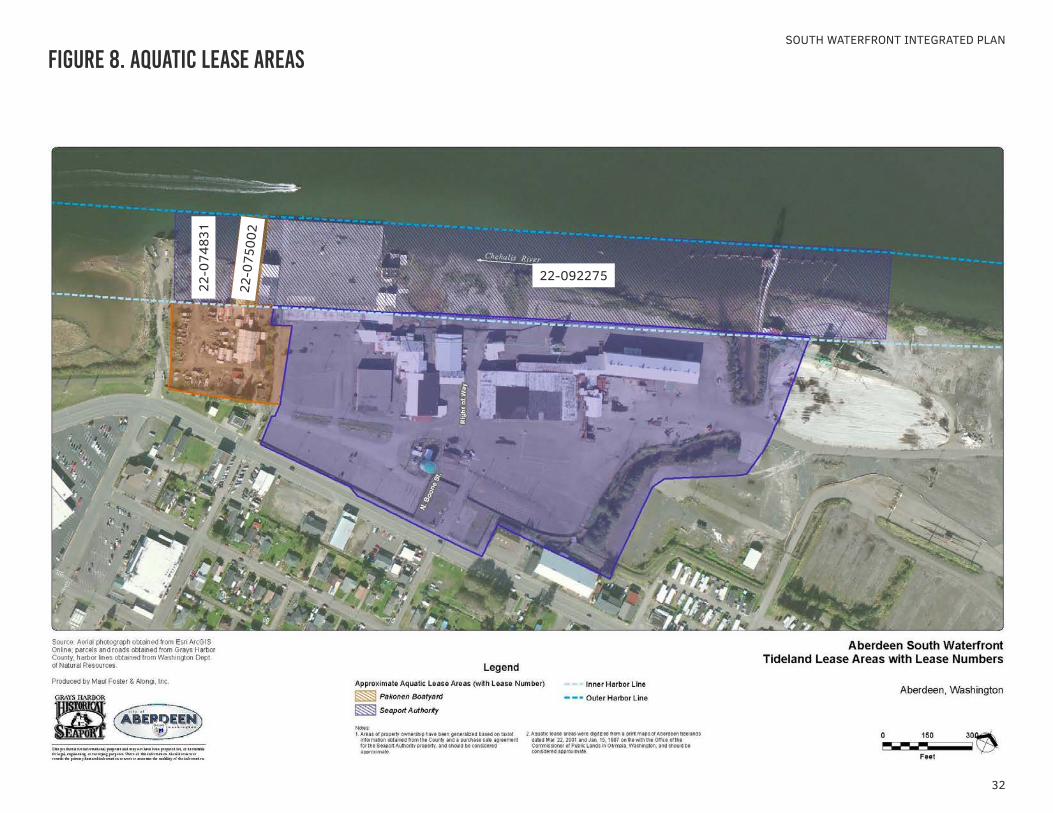
Across most of the state, aquatic land below the ordinary high water mark is owned and managed by the DNR in trust for the public. State-owned aquatic lands can be leased from the DNR under a commercial contract. As with any lease, the DNR places conditions in the tideland leases regarding uses, maintenance requirements, payment, and other obligations. There are three tideland leases along the South Waterfront, as depicted in Figure 8.
• Lease No. 22-074831 (lease term expires 1/31/2034) This lease is adjacent to the Pakonen property and is held by GHHSA. Permitted uses are restricted to docks, public parking, public access, transient moorage, and vessel moorage (intended for the GHHSA’s tall ships).
• Lease No. 22-075002 (lease term expires 1/31/2024) This lease is approximately 90 feet wide and is adjacent to the former boat haul-out rails on the Pakonen property.
• Lease No. 22-092275 (lease currently under negotiation) This lease is adjacent to the Seaport Landing property and is held by GHHSA. Permitted uses are restricted to the moorage of vessels and accessory uses related thereto, public access, exhibit and display space open to the public, and education activities.
dnr policy on uses in tidelands
There is no list of DNR “permitted uses.” However, the Aquatic Land Management guidelines are specified in state law (Revised Code of Washington [RCW] 79.105.030):
The management of state-owned aquatic lands shall be in conformance with constitutional and statutory requirements. The manager of state-owned aquatic lands shall strive to provide a balance of public benefits for all citizens of the state. The public benefits provided by state-owned aquatic lands are varied and include:
• Encouraging direct public use and access;• Fostering water-dependent uses;• Ensuring environmental protection;• Utilizing renewable resources
Generating revenue in a manner consistent with subsections (1) through (4) of this section is a public benefit.
1. Commerce and navigation;2. Public uses and public access;3. Use of renewable resources;4. Those uses which protect the environment (aquatic land
health); and5. Generate an economic return to citizens (as appropriate)
32
SOUTH WATERFRONT INTEGRATED PLAN
Figure 8. aquatic lease areas
22-092275
22-0
7500
2
22-0
7483
1
33
EXISTING CONDITIONS
3.6 land use regulatory framework
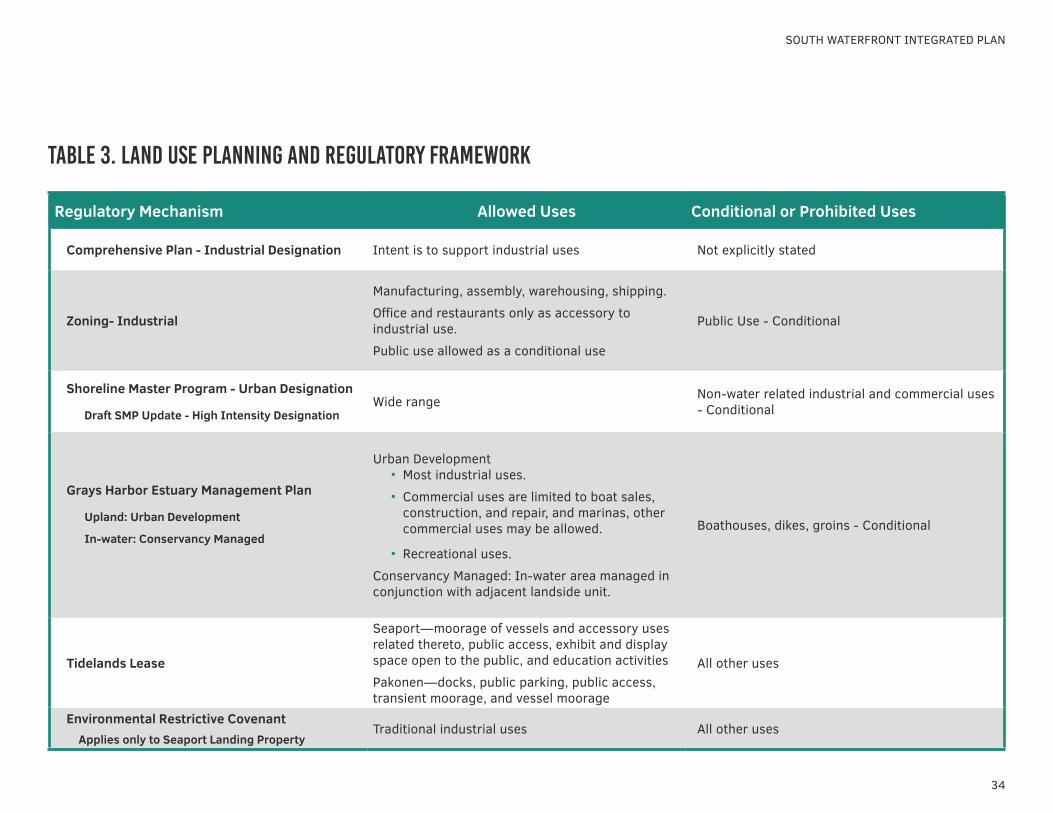
In addition to the contractual limitations on the use of state-owned aquatic lands, land use at the Southern Waterfront is regulated by a set of interrelated mechanisms based on federal and state law, local land use plans and ordinances, and an environmental restrictive covenant on the property. The City regulates land use through the Comprehensive Plan, Zoning Ordinance, and Shoreline Master Program (SMP). The Washington State Growth Management Act requires that zoning designations and requirements be consistent with the Comprehensive Plan Land Use Designations.
Table 3 summarizes the land use planning regulatory mechanisms that affect redevelopment planning at the Seaport Landing and Pakonen Boatyard properties. The regulatory mechanisms will be further described in this section.
comprehensive plan
The Comprehensive Plan Land Use designation for the Seaport Landing and Pakonen Boatyard properties is Industrial.
zoning
Both properties are currently zoned Industrial. The purpose of the Industrial district is to provide the opportunity for intensive industrial uses in appropriate locations (Aberdeen Municipal Code [AMC] Chapter 17.48).
The following uses are permitted in Industrial districts:
• Manufacturing, light manufacturing, processing, light processing, light assembly, fabricating, and light fabrication and industrial activities all within a building
• Equipment; heavy equipment sales, repair and rentals; auto and truck rental, repair, and servicing within a building; exterior storage of goods and equipment
• Shipping terminals, truck terminals, materials movement facilities, and docks, wharfs, marine terminals, and contractors’ yards
• Warehousing, indoor and outdoor storage, wholesale sales, industrial sales, building and industrial material retail sales, and retail sales accessory to a related permitted or conditional use
• Offices accessory to a permitted or conditional use• A caretaker’s residence accessory to a permitted or
conditional use• Kennels and animal hospitals• Service stations
tribal treaty rights
Related to the land use regulatory framework, it is important to recognize the Quinault Indian Nation rights under their 1856 treaty. The treaty provided the tribe with rights to fishing and hunting in their usual and accustomed areas which includes Grays Harbor and its tributaries. Appropriate government to government relations with the Quinault Indian Nation will be required for proposed projects that may impact fisheries of the Chehalis River.
Consultation with Native American tribes will also be an important component of the state and federal permitting process.
34
SOUTH WATERFRONT INTEGRATED PLAN
Regulatory Mechanism Allowed Uses Conditional or Prohibited Uses
Comprehensive Plan - Industrial Designation Intent is to support industrial uses Not explicitly stated
Zoning- Industrial
Manufacturing, assembly, warehousing, shipping.
Office and restaurants only as accessory to industrial use.
Public use allowed as a conditional use
Public Use - Conditional
Shoreline Master Program - Urban Designation
Draft SMP Update - High Intensity DesignationWide range Non-water related industrial and commercial uses
- Conditional
Grays Harbor Estuary Management Plan
Upland: Urban Development
In-water: Conservancy Managed
Urban Development • Most industrial uses.
• Commercial uses are limited to boat sales, construction, and repair, and marinas, other commercial uses may be allowed.
• Recreational uses.
Conservancy Managed: In-water area managed in conjunction with adjacent landside unit.
Boathouses, dikes, groins - Conditional
Tidelands Lease
Seaport—moorage of vessels and accessory uses related thereto, public access, exhibit and display space open to the public, and education activities
Pakonen—docks, public parking, public access, transient moorage, and vessel moorage
All other uses
Environmental Restrictive Covenant Applies only to Seaport Landing Property
Traditional industrial uses All other uses
table 3. land use planning and regulatory framework
35
EXISTING CONDITIONS
3.6 land use regulatory framework
• Laboratories and industrial research facilities• Restaurants accessory to a permitted use• Outside assembly accessory to a permitted or conditional
use. (Prior code § 11.014.020)
A conditional use permit would be required to allow public and semi-public uses.
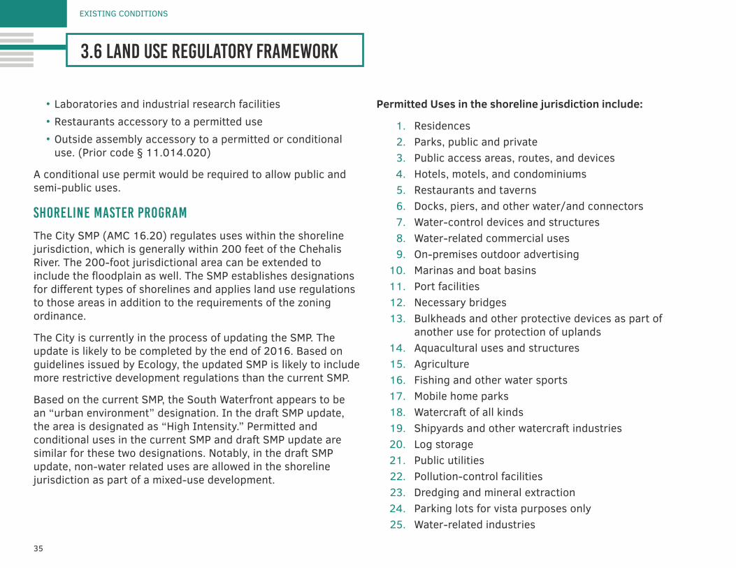
shoreline master program
The City SMP (AMC 16.20) regulates uses within the shoreline jurisdiction, which is generally within 200 feet of the Chehalis River. The 200-foot jurisdictional area can be extended to include the floodplain as well. The SMP establishes designations for different types of shorelines and applies land use regulations to those areas in addition to the requirements of the zoning ordinance.
The City is currently in the process of updating the SMP. The update is likely to be completed by the end of 2016. Based on guidelines issued by Ecology, the updated SMP is likely to include more restrictive development regulations than the current SMP.
Based on the current SMP, the South Waterfront appears to be an “urban environment” designation. In the draft SMP update, the area is designated as “High Intensity.” Permitted and conditional uses in the current SMP and draft SMP update are similar for these two designations. Notably, in the draft SMP update, non-water related uses are allowed in the shoreline jurisdiction as part of a mixed-use development.
Permitted Uses in the shoreline jurisdiction include:
1. Residences2. Parks, public and private3. Public access areas, routes, and devices4. Hotels, motels, and condominiums5. Restaurants and taverns6. Docks, piers, and other water/and connectors7. Water-control devices and structures8. Water-related commercial uses9. On-premises outdoor advertising
10. Marinas and boat basins11. Port facilities12. Necessary bridges13. Bulkheads and other protective devices as part of
another use for protection of uplands14. Aquacultural uses and structures15. Agriculture16. Fishing and other water sports17. Mobile home parks18. Watercraft of all kinds19. Shipyards and other watercraft industries20. Log storage21. Public utilities22. Pollution-control facilities23. Dredging and mineral extraction24. Parking lots for vista purposes only25. Water-related industries
36
SOUTH WATERFRONT INTEGRATED PLAN
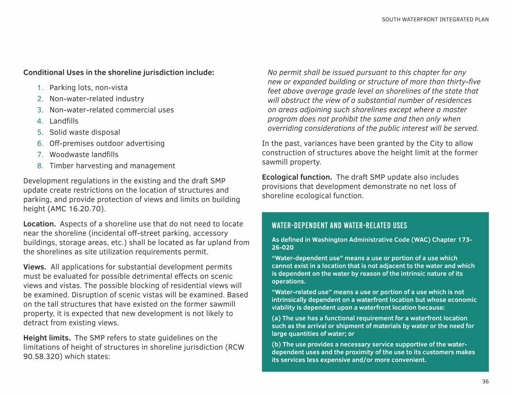
Conditional Uses in the shoreline jurisdiction include:
1. Parking lots, non-vista2. Non-water-related industry3. Non-water-related commercial uses4. Landfills5. Solid waste disposal6. Off-premises outdoor advertising7. Woodwaste landfills8. Timber harvesting and management
Development regulations in the existing and the draft SMP update create restrictions on the location of structures and parking, and provide protection of views and limits on building height (AMC 16.20.70).
Location. Aspects of a shoreline use that do not need to locate near the shoreline (incidental off-street parking, accessory buildings, storage areas, etc.) shall be located as far upland from the shorelines as site utilization requirements permit.
Views. All applications for substantial development permits must be evaluated for possible detrimental effects on scenic views and vistas. The possible blocking of residential views will be examined. Disruption of scenic vistas will be examined. Based on the tall structures that have existed on the former sawmill property, it is expected that new development is not likely to detract from existing views.
Height limits. The SMP refers to state guidelines on the limitations of height of structures in shoreline jurisdiction (RCW 90.58.320) which states:
No permit shall be issued pursuant to this chapter for any new or expanded building or structure of more than thirty-five feet above average grade level on shorelines of the state that will obstruct the view of a substantial number of residences on areas adjoining such shorelines except where a master program does not prohibit the same and then only when overriding considerations of the public interest will be served.
In the past, variances have been granted by the City to allow construction of structures above the height limit at the former sawmill property.
Ecological function. The draft SMP update also includes provisions that development demonstrate no net loss of shoreline ecological function.
water-dependent and water-related uses
As defined in Washington Administrative Code (WAC) Chapter 173-26-020“Water-dependent use” means a use or portion of a use which cannot exist in a location that is not adjacent to the water and which is dependent on the water by reason of the intrinsic nature of its operations.“Water-related use” means a use or portion of a use which is not intrinsically dependent on a waterfront location but whose economic viability is dependent upon a waterfront location because:(a) The use has a functional requirement for a waterfront location such as the arrival or shipment of materials by water or the need for large quantities of water; or(b) The use provides a necessary service supportive of the water-dependent uses and the proximity of the use to its customers makes its services less expensive and/or more convenient.
37
EXISTING CONDITIONS
3.6 land use regulatory framework
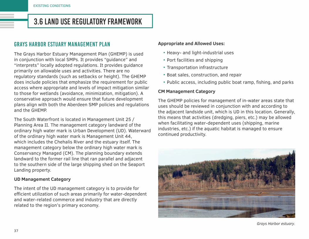
grays harbor estuary management plan
The Grays Harbor Estuary Management Plan (GHEMP) is used in conjunction with local SMPs. It provides “guidance” and “interprets” locally adopted regulations. It provides guidance primarily on allowable uses and activities. There are no regulatory standards (such as setbacks or height). The GHEMP does include policies that emphasize the requirement for public access where appropriate and levels of impact mitigation similar to those for wetlands (avoidance, minimization, mitigation). A conservative approach would ensure that future development plans align with both the Aberdeen SMP policies and regulations and the GHEMP.
The South Waterfront is located in Management Unit 25 / Planning Area II. The management category landward of the ordinary high water mark is Urban Development (UD). Waterward of the ordinary high water mark is Management Unit 44, which includes the Chehalis River and the estuary itself. The management category below the ordinary high water mark is Conservancy Managed (CM). The planning boundary extends landward to the former rail line that ran parallel and adjacent to the southern side of the large shipping shed on the Seaport Landing property.
UD Management Category
The intent of the UD management category is to provide for efficient utilization of such areas primarily for water-dependent and water-related commerce and industry that are directly related to the region’s primary economy.
Appropriate and Allowed Uses:
• Heavy- and light-industrial uses • Port facilities and shipping• Transportation infrastructure• Boat sales, construction, and repair• Public access, including public boat ramp, fishing, and parks
CM Management Category
The GHEMP policies for management of in-water areas state that uses should be reviewed in conjunction with and according to the adjacent landside unit, which is UD in this location. Generally, this means that activities (dredging, piers, etc.) may be allowed when facilitating water-dependent uses (shipping, marine industries, etc.) if the aquatic habitat is managed to ensure continued productivity.
Grays Harbor estuary.
38
SOUTH WATERFRONT INTEGRATED PLAN
environmental restrictive covenants
In response to a release of pentachlorophenol (PCP) under the Planer Building on the Seaport Landing property, Weyerhaeuser conducted a remedial action and received a No Further Action (NFA) letter from Ecology in 1999.
Extent of Applicability of NFA Letter
The NFA letter does not address the entire property, but it limited to the extent of the cleanup of the PCP release. Ecology NFA letter states:
Ecology’s no further action determination is made only with respect to the release identified in the independent remedial action report dated January 17, 1997. This no further action determination applies only to the area of the property affected by the release identified in the report at the Weyerhaeuser Aberdeen Sawmill. It does not apply to any other release or potential release at the property, any other areas on the property, nor any other properties owned or operated by Weyerhaeuser company.
Use Restrictions
The Restrictive Covenant states:
The Property shall be used only for traditional industrial uses, as described in RCW 70.105D.020(23) and defined in and allowed under the City of Aberdeen’s zoning regulations codified in the Aberdeen City Code, Chapter 17.48, as of the date of this Restrictive Covenant.
The Restrictive Covenant also prohibits the use of groundwater taken from the property.
Amendment of Restrictive Covenant
Ecology has authority to approve amendment of the Restrictive Covenant. The GHHSA has begun the process of negotiating an amendment of the restrictive covenant by preparing a Disproportionate Cost Analysis. The analysis compares the costs of removing residual contamination related to the PCP release with capping the impacts on site.
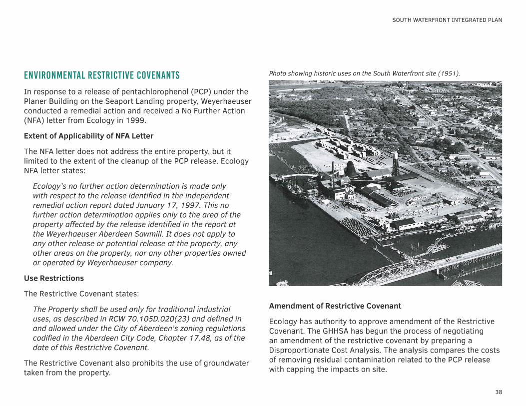
Photo showing historic uses on the South Waterfront site (1951).
39
EXISTING CONDITIONS
3.6 land use regulatory framework
state and federal in-water permits
Permits are required from the state and federal governments for any projects that involve construction below the ordinary high water mark of a navigable water. The multiple permits are coordinated through a single Joint Aquatic Resources Permit Application. Consultation with Native American tribes, including the Quinault Indian Nation will be an important component of review for in-water permits.
Clean Water Act Section 404
Section 404 of the Clean Water Act establishes a program to regulate the discharge of dredged or fill material into waters of the United States, including wetlands. Activities in waters of the United States regulated under this program include fill for development, water resource projects, and infrastructure development. Section 404 requires a permit before dredged or fill material may be discharged into waters of the United States, unless the activity is exempt from Section 404 regulation (e.g., certain farming and forestry activities).
Section 10 Rivers and Harbors Act Permit
Section 10 of the Rivers and Harbors Act of 1899 prohibits obstruction of the navigable capacity of any of the waters of the United States.
Hydraulic Project Approval
Washington State’s Department of Fish and Wildlife administers the Hydraulic Project Approval with the purpose of minimizing impacts from projects on fish and shellfish populations and their habitat.
Required Review and Consultations
The federal permit process also requires additional review and consultation, including the following:
• Section 401 Water Quality Certificate and Coastal Zone Management Act Consistency Certification (issued by Ecology)
• National Environmental Policy Act (lead agency is the COE, based on the Section 404 and Section 10 permitting authorities)
• National Historic Preservation Act—Section 106 Consultation (lead agency is the COE, with consultation by Native American tribes and the state Historic Preservation Office)
• Endangered Species Action—Section 7 Consultation (review by the National Marine Fisheries Service)
40
EXISTING CONDITIONS
3.7 considerations for development
SOUTH WATERFRONT INTEGRATED PLAN
Context. Uses on the South Waterfront will have to be carefully selected to complement, more than compete with, other properties in the region. These uses include industrial areas in and around the Port of Grays Harbor, the pending adaptive reuse of the pontoon dry dock facility, and downtown commercial activities.
Physical Assets. The potential for public waterfront access provided by the Seaport Landing and Pakonen Boatyard is rare in the Aberdeen area and, along with the existing marine infrastructure, represents one of the greatest assets of the properties. Future use of the properties should highlight and capitalize on these assets.
While nearly all of the upland property in the South Waterfront consists of historical fill, the shoreline, the wetlands, and Shannon Slough represent functional habitat that can be enhanced for educational and natural resource purposes. The potential for flooding at the South Waterfront will have to be carefully considered in design and operations of new construction and renovated buildings.
Existing Buildings. The existing buildings on the Seaport Landing property are generally of sound construction, with flexible floor plans. They likely can be renovated at a reasonable cost for continued industrial uses, but transition to educational, office, retail, and restaurant uses will require more substantial resources. The boat workshop building on the Pakonen property presents a great opportunity to renovate an authentic and rare historic maritime building, aligning very well with the mission of GHHSA and the goals of Seaport Landing. However, the building is located on privately owned property and will require significant renovation to meet current building code for use as a public interpretive facility.
Infrastructure. The South Waterfront is served by urban infrastructure with capacity to support future development. The existing centralized infrastructure system built to support the former sawmill will require modifications to service other types of uses.
State-Owned Aquatic Leased Lands. Leases obtained by GHHSA support the goals of the South Waterfront redevelopment. GHHSA or the City should consider leasing the narrow strip of state-owned aquatic land along the marine railway at the Pakonen property. GHHSA and the City should also pursue adjustment of the inner and outer harbor lines waterward to remove some upland area from the lease and to create space between the face of the wharf and the outer harbor line for vessel moorage.

41
EXISTING CONDITIONS
3.7 considerations for development
Land Use Regulations. Currently, the allowed uses in the South Waterfront are limited to industrial, based on zoning and the Restrictive Covenant on the Seaport Landing property. Obtaining clear land use approval of a broader range of uses will require the following:
• City Comprehensive Plan Amendment, to change the land use designation from Industrial to mixed use or another more flexible designation
• Rezoning from Industrial to Waterfront Mixed Use or a similar zone that allows commercial, retail, recreation, and other uses. Note that the Comprehensive Plan amendment is required before the rezoning to ensure that the zoning designation complies with the Comprehensive Plan.
• Removal or amendment of the Restrictive Covenant on the Seaport Landing property.
• Change of GHEMP designation to Urban Mixed to allow a broader range of commercial uses.
The SMP, GHEMP, and Tideland Leases will require that uses on the waterfront be water-dependent or water-related.
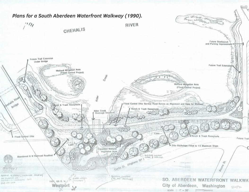
Plans for a South Aberdeen Waterfront Walkway (1990).
market assessment4.1 real estate market trends4.2 commercial boatyard assessment
44
MARKET ASSESSMENT
4.1 real estate market trends
SOUTH WATERFRONT INTEGRATED PLAN
The purpose of this market assessment is to provide a current baseline understanding of market dynamics influencing investment and business activity in the Aberdeen market area as related to the Seaport Landing property and Pakonen Boatyard. The focus of the market assessment is the upland property. An assessment of commercial boatyard uses of the aquatic lease areas is presented in Section 5.2. The market information will inform strategic decisions towards utilizing property assets to create a sustainable financial platform that supports the vision for the South Waterfront.
This assessment will be separated into three sections:
• Economic Assets of the Property which provides a baseline level assessment is for evaluating potential future uses.
• Market Trends will include population and demographic trends as well as a summary of the basic real estate fundamentals in the Grays Harbor area.
• Opportunity Assessment will present recommendations for potential users and partners that may be targeted by the GHHSA and City to activate the uplands portion of the South Waterfront.
economic assets of the property
As described in Section 4.4, the Seaport Landing and Pakonen properties include a standing stock of over 150,000 square feet of building space. These buildings have the potential for continued industrial uses, or re-purposing for commercial, office, and educational uses.
The South Waterfront enjoys excellent visibility from across the Chehalis River when traveling into Aberdeen via SR-12. This
exposure is important as it enhances the profile of the planning area for all visitors coming to or through Aberdeen.
In order to access the South Waterfront, all travelers going to Aberdeen or other points west such as Westport, Ocean Shores, North Beach (where Seabrook is located), and Lake Quinault must travel on State Route 12. Based on estimates from Grays Harbor Tourism, there are roughly 425,000 total visitors staying in lodging offerings in these destinations each year.
Further expounding on the opportunity for travelers and locals to access the site it is useful to note the traffic counts. The State Route-105 Bridge carries an average of 30,000 vehicles per day and this bridge is only 0.3 miles from the South Waterfront. For comparison, these counts are similar to big box retail driven traffic on Black Lake Boulevard Southwest in Olympia, and Martin Way East and Marvin Road Southeast in Lacey. These traffic counts within a short distance from the South Waterfront, coupled with the strong visibility from across the river suggest that a destination use may be viable.
Finally, the South Waterfront is roughly 2 miles from the Port of Grays Harbor where economic activity on and around the Port is expanding. This close proximity may be leveraged to serve as a location for light industrial uses that support port/maritime related activities or as an educational center for a skills training center.
Based on the types of buildings and land on the Seaport Landing and Pakonen properties, its location along the river with excellent visibility and close proximity to the Port potential upland uses may include light industrial users, education/vocational users, and possibly destination retail. Each of these user groups will be explored in the following sections.

45
MARKET ASSESSMENT
4.1 real estate market trends
market trends
The future use of the South Waterfront may be driven by a number of local and regional factors such as demographic and employment trends as well as real estate market fundamentals. The following information is useful context when considering strategies for attracting uses that are compatible with the South Waterfront vision. In general, the market area influencing the South Waterfront is defined as Grays Harbor County when discussing the labor pool and employment, and the combined cities of Aberdeen and Hoquiam when discussing demographic and market fundamental trends.
Employment
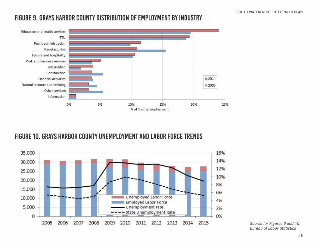
Since employment levels peaked in 2006, Grays Harbor County has lost approximately 3,000 jobs. Historically, the County has been supported by the manufacturing, trade, and education and health care sectors. Combined, these industries totaled 54% of the County-wide employment in 2014, while government and hospitality related jobs accounted for another 22% of the jobs. Professional services industries comprised roughly 10% of the jobs in the County. While the distribution of employment by these industry groups has been relatively consistent compared to the 2006 peak and year end 2014 counts, there has been a significant drop in manufacturing jobs and an increase in health care and social service jobs. The County’s largest employer is the Grays Harbor Community Hospital followed by the Stafford Creek Correctional Center, Aberdeen School District, and the Quinault Nation. The largest manufacturer is Westport Shipyard, a maker of high-end yachts. The distribution of Grays Harbor County jobs, compared with the distribution of employment by industry at the County’s economic peak in 2006 with 2014 estimates is illustrated in Figure 9.
Shifting from the types of jobs that comprise the County’s employment to the historical County-wide employment trends, data show signs of an improving employment situation. Grays Harbor County currently has the second highest unemployment rate in the State of Washington. There are two key observations in this the historical trend illustrated in Figure 10. First, unemployment is trending down as of the May 2015 release. The 8.9% unemployment rate is the lowest it has been since 2008. While this is excellent news, the labor pool, or the combined count of the employed workers and unemployed workers has shrunk since 2010, and is currently at 27,636. Prior to the Great Recession, this figure was over 30,000; so it appears that the economic downturn forced more people out of the labor pool. The observed labor loss is a function of households seeking employment outside of the County or simply remaining in the County, but no longer seeking employment. The year over year change from 2014 to 2015 in these May figures saw the first increase in the labor pool since the start of the recession, with 269 people added.
46
SOUTH WATERFRONT INTEGRATED PLAN
figure 9. grays harbor county distribution of employment by industry
figure 10. grays harbor county unemployment and labor force trends
Source for Figures 9 and 10: Bureau of Labor Statistics
47
MARKET ASSESSMENT
4.1 real estate market trends
Demographics
While the employment situation in Grays Harbor County appears to be stabilizing other key demographics that may drive future use at the Site also need to be assessed. The statistics that will be reviewed below are household growth, educational attainment and consumer expenditures.
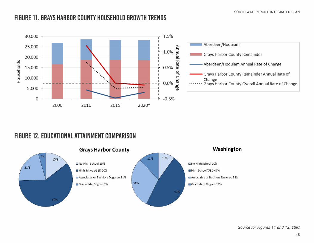
HOUSEHOLD GROWTHSince 2010, the number of households County-wide has decreased. From 2000 to 2010, the County grew slightly by 0.7% annually compared to the statewide rate of 1.5% annually. A closer look at the County’s growth reveals that while the number of households in the County increased during this time, the Aberdeen/Hoquiam area population was decreasing. This decrease in households is a likely a function of the Great Recession and its impact on employment. More recently, between 2010 and 2015, statewide growth slowed to 0.9% annually; however, the effects of the recession began to impact the entire County with the household growth rate declining by 0.2% per year. Household growth projections over the next five years through 2020 are increasing statewide with an expected annual growth rate of 1.1%. Grays Harbor County is not expected to share in this improving growth rate with its average annual rate of change that is still declining slightly. To put this decline into perspective, the County and the Aberdeen/Hoquiam area are not expected to lose a significant number of households, 52 households and 143 households, respectively. Figure 11 illustrates these observed household growth trends.
EDUCATIONAL ATTAINMENTThe educational attainment statistics illustrate that the Grays Harbor population is generally less educated that the rest of the
state. Figure 12 depicts a county where 25% of its population has achieved an associate’s degree or higher compared to 43% statewide. This observation, coupled with the employment statistics underscores the need for more educational opportunities in the County.
CONSUMER EXPENDITURESIn 2015 the County-wide median income was just under $40,000 while the statewide median was nearly $60,000. This statistic is important should retail or food service be considered for the Site. The average household, both across the state and in the County, spends roughly 4.5% of its budget on dining out. This translates to $2,250 per household in the County compared to the statewide average of $3,530 per household. Retail goods account for 37% of the average household budget in Grays Harbor County compared to 35% statewide, but again the amount spent is considerably less per household in the County just under $19,000 per year budged for retail expenditures compared to $27,000 per average household statewide. This information suggests that relying on the local households to support retail or a restaurant is not likely sustainable.
Based on the review of employment and demographic indicators, it appears that future uses on the South Waterfront that meet the GHHSA’s mission to provide educational, vocational, recreational and ambassadorial activities related to the region’s maritime history are relevant. The next section will summarize the market fundamentals for industrial space, similar to that found on the Site.
48
SOUTH WATERFRONT INTEGRATED PLAN
figure 11. grays harbor county household growth trends
figure 12. educational attainment comparison
Source for Figures 11 and 12: ESRI
49
MARKET ASSESSMENT
4.1 real estate market trends
Market Fundamentals
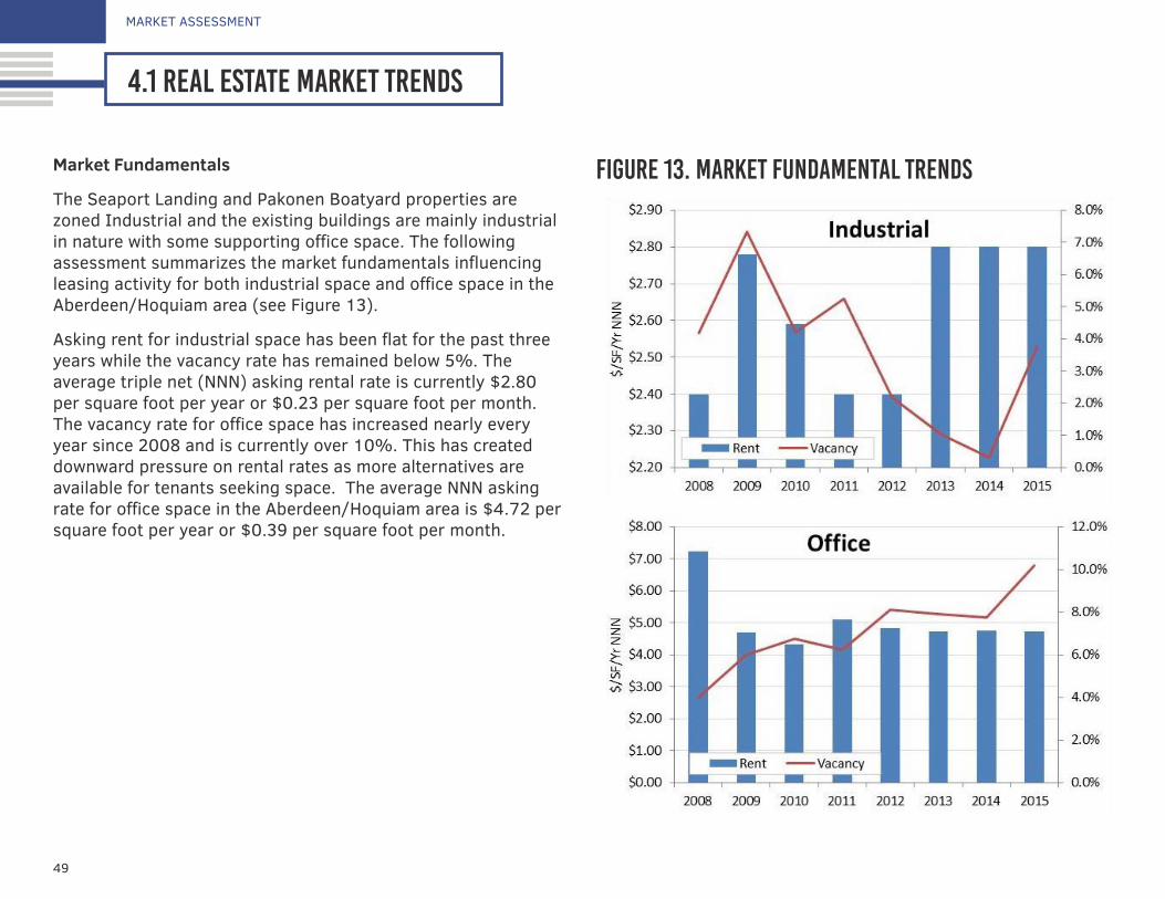
The Seaport Landing and Pakonen Boatyard properties are zoned Industrial and the existing buildings are mainly industrial in nature with some supporting office space. The following assessment summarizes the market fundamentals influencing leasing activity for both industrial space and office space in the Aberdeen/Hoquiam area (see Figure 13).
Asking rent for industrial space has been flat for the past three years while the vacancy rate has remained below 5%. The average triple net (NNN) asking rental rate is currently $2.80 per square foot per year or $0.23 per square foot per month. The vacancy rate for office space has increased nearly every year since 2008 and is currently over 10%. This has created downward pressure on rental rates as more alternatives are available for tenants seeking space. The average NNN asking rate for office space in the Aberdeen/Hoquiam area is $4.72 per square foot per year or $0.39 per square foot per month.
figure 13. market fundamental trends
50
SOUTH WATERFRONT INTEGRATED PLAN
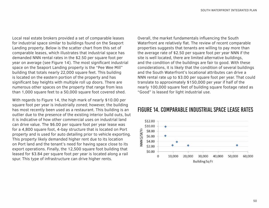
Local real estate brokers provided a set of comparable leases for industrial space similar to buildings found on the Seaport Landing property. Below is the scatter chart from this set of comparable leases, which illustrates that industrial space has demanded NNN rental rates in the $2.50 per square foot per year on average (see Figure 14). The most significant industrial space on the Seaport Landing property is the “Pee Wee Mill” building that totals nearly 22,000 square feet. This building is located on the eastern portion of the property and has significant bay heights with multiple roll up doors. There are numerous other spaces on the property that range from less than 1,000 square feet to a 50,000 square foot covered shed.
With regards to Figure 14, the high mark of nearly $10.00 per square foot per year is industrially zoned; however, the building has most recently been used as a restaurant. This building is an outlier due to the presence of the existing interior build outs, but it is indicative of how other commercial uses on industrial land can drive value. The $6.00 per square foot per year lease was for a 4,800 square foot, 4-bay structure that is located on Port property and is used for auto detailing prior to vehicle exporting. This property likely demanded higher rent due to its location on Port land and the tenant’s need for having space close to its export operations. Finally, the 12,500 square foot building that leased for $3.84 per square foot per year is located along a rail spur. This type of infrastructure can drive higher rents.
Overall, the market fundamentals influencing the South Waterfront are relatively flat. The review of recent comparable properties suggests that tenants are willing to pay more than the average rate of $2.50 per square foot per year NNN if the site is well located, there are limited alternative buildings, and the condition of the buildings are fair to good. With these considerations, it is likely that the condition of several buildings and the South Waterfront’s locational attributes can drive a NNN rental rate up to $3.00 per square foot per year. That could translate to approximately $150,000 per year if half of the nearly 100,000 square feet of building square footage rated as “Good” is leased for light industrial use.
figure 14. comparable industrial space lease rates
51
MARKET ASSESSMENT
4.1 real estate market trends
opportunity assessment
The process of evaluating how specific opportunities may fit into a broader master plan for the South Waterfront is ongoing. The intent of this assessment is to help with the master plan evaluation and to provide useful information to identifying potential users and/or partners. The set of potential uses that could either be revenue generating or create activity on the South Waterfront that aligns with the future use vision and may support other tenants on the Site include the following:
• Light Industrial• Educational/Vocational• Tourism/ Museum
Light Industrial
The South Waterfront has historically been used for industrial purposes and the existing buildings lend themselves to the production of goods or the maintenance and repair of marine vessels. There are three potential user groups for the light industrial space for industrial purposes:
• Users that cater to the maritime business related to a boatyard
• Users that produce goods or provide repair services (typical light industrial users), or
• Users that may operate in the cold shell industrial buildings with minimal improvement at market average rents.
MARITIME BUSINESS RELATED TO BOATYARDThe maritime related users of the buildings could be associated with boat yard activities that can be conducted at the South
Waterfront or may be associated with activity centered on the Port of Grays Harbor. BST Associates conducted a Boatyard Pre-feasibility Study in June 2015 to assess the types of vessels that need boatyards for service, repairs, and storage as well as the competition on the West Coast for the range of vessels (See Section 5.2).
The boatyard concept offers an interesting opportunity. If successful, a majority of the industrial space that is not used for GHHSA operations could be absorbed to support boatyard activities. Uses of the buildings could include boat and parts storage, maintenance and repair, and possibly a small retail element that may include some food and beverage services. Fulfilling this vision will require patience to go through the design, permitting and construction process for the in-water infrastructure and a creative funding strategy. In a best case scenario, the development of the boatyard infrastructure may be subsidized with State or Federal grant and loan programs; however, the GHHSA or City may need to contribute funds for improvements as well.
TYPICAL LIGHT INDUSTRIAL USERSGiven the probability that a boatyard may develop slowly over time – or potentially not at all – an alternative option to generate revenue may be to lease out a portion of the existing buildings to light industrial users. These could be light manufacturers or companies looking for warehousing or storage space. A targeted leasing engagement with a qualified broker with expertise in the area could result in a lease that generates revenue from the property. For example, a $0.25 per square foot per month lease on the 21,888 square foot “Pee Wee Mill” building could generate $63,000 of gross revenue per year. The cost benefit assessment of this approach would be comparing the net lease

52
SOUTH WATERFRONT INTEGRATED PLAN
revenues against any upfront capital investments that would be required to make the structure leasable.
The GHHSA also has a unique piece of machinery that it plans to operate at Seaport Landing. The 85-year old spar lathe is used to spin timber to make cylindrical wood products such as boat masts and booms. This, coupled with a metal works fabrication shop, could be leveraged for wooden boat ship repair on boats other than the Lady Washington. There may be other untapped uses for the spar lathe in addition to nautical purposes. For example, the GHHSA has been contracted to fabricate large tent poles with the lathe in the past. Another opportunity may be to produce utility poles. Based on previous work, the consulting team has learned that there is a long lead time in ordering this part for local utility companies and the spar lathe in Aberdeen may be able to speed up certain projects.
OTHER POTENTIAL INDUSTRIAL SPACE USERSAn emerging sector of goods production locally and regionally is brewing and distilling. For example, the Wishkah River Distillery leases space from the Port of Grays Harbor and produces whiskey, gin, and vodka. This industry is expanding throughout the State; however there are few operations based on the Olympic Peninsula. These users do not need overly finished space and, if successful with their craft and distribution, may drive traffic to the South Waterfront with the development of a tasting room. The rents would be similar to that of the typical industrial user. The water and infrastructure requirements to support these uses would need to be evaluated.
Education
Education is an important aspect of the GHHSA’s mission. Given Grays Harbor’s position as a globally relevant port area with historical significance there is a need for an employment base trained in a range of maritime skills. The South Waterfront is well positioned to provide that venue.
There are only three postsecondary schools in the county: Grays Harbor College main campus, Grays Harbor College Whiteside Education Center in Aberdeen (which is closing and its remaining functions being moved to the Manspeaker Building on the main campus), and a NAC Training Center for nursing assistants. Grays Harbor College does not have a program dedicated to the maritime industry; however, it does have some coursework dedicated to welding and fabrication. There could be an opportunity to partner with the College to establish a maritime trades training program. This would require a feasibility study and funding plan.
There are 16 schools in the state that offer postsecondary education specific to the maritime industry. These programs offer safety and captain’s license training, vocational skills related to maintenance and repair of boats, and boat building. The majority of these schools are located proximate to the I-5 corridor and none are in Grays Harbor or near the Pacific Coast. Understanding the range of offerings among these schools combined with a workforce skills needs assessment can inform a curriculum. The table below lists the schools focused on maritime training and education.
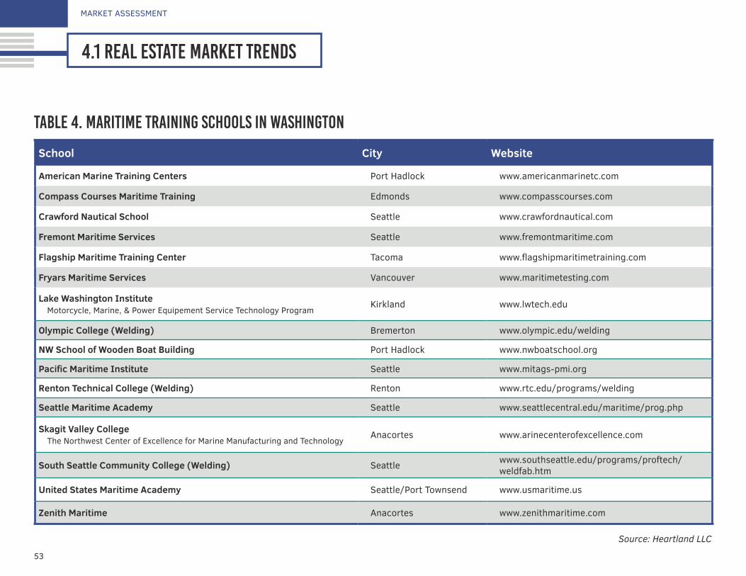
53
MARKET ASSESSMENT
4.1 real estate market trends
School City Website
American Marine Training Centers Port Hadlock www.americanmarinetc.com
Compass Courses Maritime Training Edmonds www.compasscourses.com
Crawford Nautical School Seattle www.crawfordnautical.com
Fremont Maritime Services Seattle www.fremontmaritime.com
Flagship Maritime Training Center Tacoma www.flagshipmaritimetraining.com
Fryars Maritime Services Vancouver www.maritimetesting.com
Lake Washington InstituteMotorcycle, Marine, & Power Equipement Service Technology Program
Kirkland www.lwtech.edu
Olympic College (Welding) Bremerton www.olympic.edu/welding
NW School of Wooden Boat Building Port Hadlock www.nwboatschool.org
Pacific Maritime Institute Seattle www.mitags-pmi.org
Renton Technical College (Welding) Renton www.rtc.edu/programs/welding
Seattle Maritime Academy Seattle www.seattlecentral.edu/maritime/prog.php
Skagit Valley CollegeThe Northwest Center of Excellence for Marine Manufacturing and Technology
Anacortes www.arinecenterofexcellence.com
South Seattle Community College (Welding) Seattle www.southseattle.edu/programs/proftech/weldfab.htm
United States Maritime Academy Seattle/Port Townsend www.usmaritime.us
Zenith Maritime Anacortes www.zenithmaritime.com
table 4. maritime training schools in washington
Source: Heartland LLC
54
SOUTH WATERFRONT INTEGRATED PLAN
GHHSA provides youth education programs that could be enhanced and expanded at Seaport Landing. The GHHSA is already aligned with the Youth Maritime Training Association. The mission of this organization aligns with the GHHSA, but there appears to be little activity with this program in the Grays Harbor area. A model similar to the Ballard Maritime Academy may be anchored at Seaport Landing and coordinated with leadership from the various high schools in the area.
With some investment, the facilities at the South Waterfront may provide for an excellent location for a maritime educational center. With a defined curriculum the GHHSA may coordinate with an entity such as the Grays Harbor College or investigate whether there may be a fit with one of the private schools. With any such group, access to funds will be an important aspect to unlocking this opportunity. Funds would be needed not only for building investment but also for program operations. Grays Harbor College may have access to State or Federal funds while a private school may be swayed by the opportunity to expand into Grays Harbor if course demand can be demonstrated. The pursuit of an educational anchor user on the Site will likely take many months to develop relationships, identify the organization that is the best fit, and to secure funding to support the development and operations of the program.
Tourism/Museum
Tourism to Grays Harbor County is an important part of the regional economy. There is approximately $50,000,000 spent on overnight stays in the County representing roughly 500,000 travelers. This does not include people making day trips or staying in rental vacation homes. With the high volumes of tourism traffic in Aberdeen and high visibility to the South Waterfront from State Route-12 there is opportunity to develop a destination location.
Tourism on its own will not likely support retail or dining endeavors on the South Waterfront, but some potential uses noted above such as breweries or boat builders may attract tourist traffic. A boatyard and ramp may be used to support the fishing tourism industry. Over time, these commercial uses may be supported on a portion of the property depending on the success and mix of users and if the opportunity is properly advertised to locals and tourists alike.
Another non-commercial use that may benefit the site that is worth exploring is a museum. A museum could attract visitors to the South Waterfront and support the GHHSA’s education mission. This museum would likely be related to the area’s maritime history and supplement the other regional museums such as:
• Westport Maritime Museum• Aberdeen Museum of History• Polson Museum• Museum of the North Beach• Chehalis Valley Historical Museum
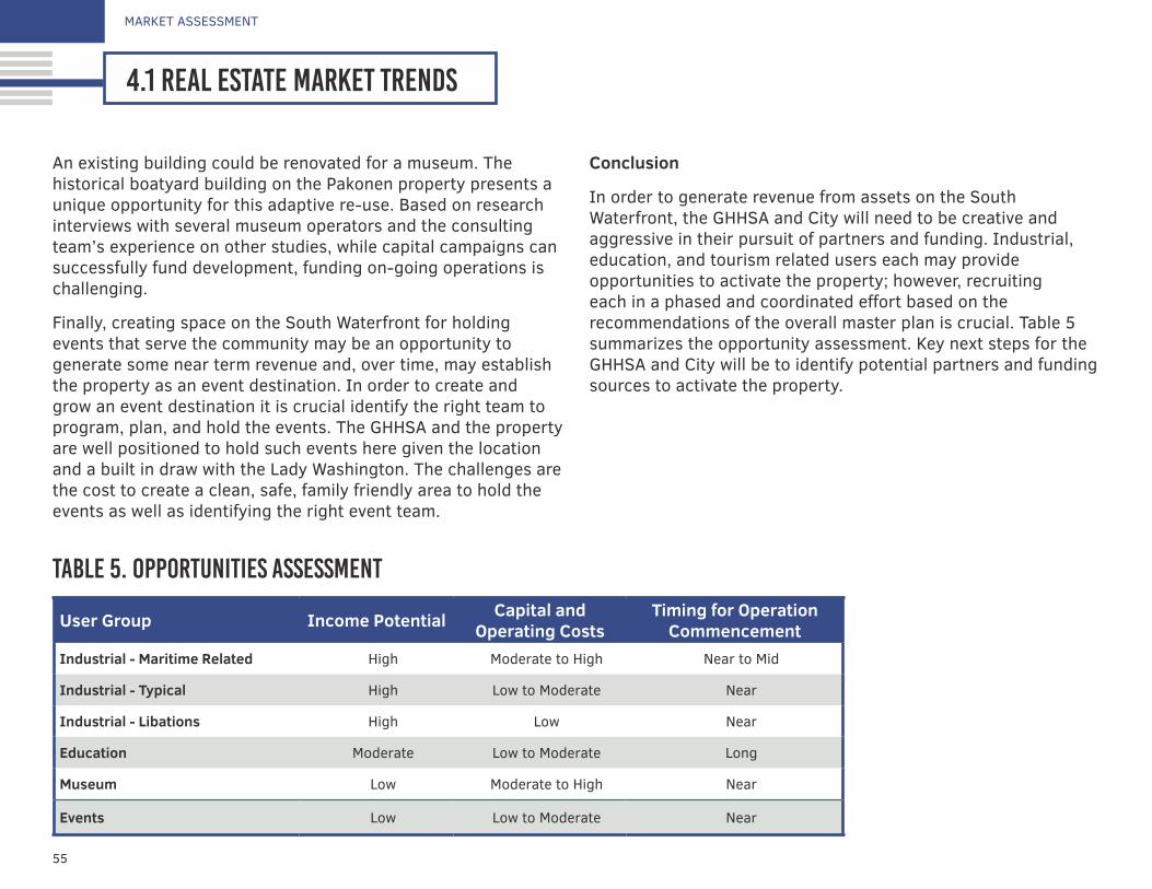
55
MARKET ASSESSMENT
4.1 real estate market trends
An existing building could be renovated for a museum. The historical boatyard building on the Pakonen property presents a unique opportunity for this adaptive re-use. Based on research interviews with several museum operators and the consulting team’s experience on other studies, while capital campaigns can successfully fund development, funding on-going operations is challenging.
Finally, creating space on the South Waterfront for holding events that serve the community may be an opportunity to generate some near term revenue and, over time, may establish the property as an event destination. In order to create and grow an event destination it is crucial identify the right team to program, plan, and hold the events. The GHHSA and the property are well positioned to hold such events here given the location and a built in draw with the Lady Washington. The challenges are the cost to create a clean, safe, family friendly area to hold the events as well as identifying the right event team.
Conclusion
In order to generate revenue from assets on the South Waterfront, the GHHSA and City will need to be creative and aggressive in their pursuit of partners and funding. Industrial, education, and tourism related users each may provide opportunities to activate the property; however, recruiting each in a phased and coordinated effort based on the recommendations of the overall master plan is crucial. Table 5 summarizes the opportunity assessment. Key next steps for the GHHSA and City will be to identify potential partners and funding sources to activate the property.
table 5. Opportunities assessment
User Group Income Potential Capital and Operating Costs
Timing for Operation Commencement
Industrial - Maritime Related High Moderate to High Near to Mid
Industrial - Typical High Low to Moderate Near
Industrial - Libations High Low Near
Education Moderate Low to Moderate Long
Museum Low Moderate to High Near
Events Low Low to Moderate Near
56
MARKET ASSESSMENT
4.2 commercial boatyard assessmentSOUTH WATERFRONT INTEGRATED PLAN
In addition to the evaluation of market opportunities for the upland property, a preliminary study was conducted to evaluate the potential feasibility of the development of a boatyard at the South Waterfront. The key issues identified are summarized below. For the full report, please refer to Appendix A.
boatyard demand
The market for a boatyard at Grays Harbor consists of four components: Grays Harbor Seaport vessels, commercial fishing vessels, charter fishing vessels, and recreational vessels.
The ability for the potential Grays Harbor boatyard to successfully accommodate the four market components listed above depends on the length and physical compositions of the vessels themselves. Commercial, charter, and recreational vessels operating on the West Coast are largely under 40 feet in length, while they can range up to 60+ feet in length.
The lifting capacity required for these vessels depends on their hull type (fiberglass, wood, aluminum and steel) as well as the length, beam, and draft of the vessel. Typically, boats with a beam of up to 18 feet and length up to 60 feet can be accommodated with a 100-ton lift. However, other factors (such as steel hulls) cause vessel weight to vary widely, potentially requiring greater lift. GHHSA vessels, including Hawaiian Chieftain and Lady Washington, are longer and heavier than typical vessels. The Lady Washington is has a length of 112 feet, beam of 22 feet, and displacement weight of 210 tons. The boatyard would be designed with a larger lift to handle these vessels.
The market study determined that commercial fishing likely would constitute the largest share of the potential market demand for a boatyard in Grays Harbor. Although the commercial fishing fleet declined in the Pacific Northwest during the 1980s and 1990s, the number of vessels with commercial landings has remained relatively stable. Based on PacFIN5 data for fish landings, in Grays Harbor County the number of individual vessels with commercial landings fell from a high of 1,528 in 1981 to only 272 in 1998. In Pacific County the number of vessels with commercial landings fell from 1,220 in 1981 to 303 in 1999, and in Clallam County the number fell from 2,466 in 1981 to 425 in 1999. The Pacific Ocean side of Jefferson County has essentially no commercial fish landings. It should be noted that there is overlap in these figures, with individual vessel potentially delivering fish in any of these counties.
The decline in the commercial fleet slowed after 2000, and since that time the number of vessels with commercial landings has remained relatively stable. In Grays Harbor County there were 375 vessels with commercial landings in 2000, essentially identical to the 378 vessels with landings in 2014.
Similarly, the number of charter vessels is smaller than it was in its peak but has remained constant in recent years. The recreational boating fleet on the West Coast has increased slightly since 2000.
As shown in Figure 15, 71 percent of the documented commercial fishing boats operating on the West Coast are less than 40 feet in length; followed by 14 percent in the 40-50 foot range; 8 percent in the 51-60 foot range and 8 percent longer than 60 feet.
5Pacific Fisheries Information Network (PacFIN) retrieval dated 4-22-2-15, Pacific States Marine Fisheries Commission, Portland, Oregon (www.psmfc.org)PacFIN data
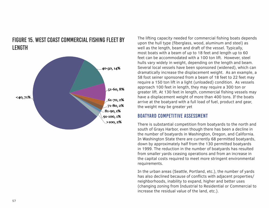
57
figure 15. west coast commercial fishing fleet by length
The lifting capacity needed for commercial fishing boats depends upon the hull type (fiberglass, wood, aluminum and steel) as well as the length, beam and draft of the vessel. Typically, most boats with a beam of up to 18 feet and length up to 60 feet can be accommodated with a 100 ton lift. However, steel hulls vary widely in weight, depending on the length and beam. Several local vessels have been sponsoned (widened), which can dramatically increase the displacement weight. As an example, a 58 foot seiner sponsoned from a beam of 18 feet to 22 feet may require a 150 ton lift in a light (unloaded) condition. As vessels approach 100 feet in length, they may require a 300 ton or greater lift. At 130 feet in length, commercial fishing vessels may have a displacement weight of more than 400 tons. If the boats arrive at the boatyard with a full load of fuel, product and gear, the weight may be greater yet
boatyard competitive assessment
There is substantial competition from boatyards to the north and south of Grays Harbor, even though there has been a decline in the number of boatyards in Washington, Oregon, and California. In Washington State there are currently 68 permitted boatyards, down by approximately half from the 130 permitted boatyards in 1999. The reduction in the number of boatyards has resulted from smaller yards ceasing operations and from an increase in the capital costs required to meet more stringent environmental requirements.
In the urban areas (Seattle, Portland, etc.), the number of yards has also declined because of conflicts with adjacent properties/neighborhoods, inability to expand, higher and better uses (changing zoning from Industrial to Residential or Commercial to increase the residual value of the land, etc.).
58
MARKET ASSESSMENT
4.2 commercial boatyard assessmentSOUTH WATERFRONT INTEGRATED PLAN
boatyard options
Given the demand and competitive assessment components identified, the GHHSA has two primary potential options for a boatyard. The ultimate success of the boatyard will depend on meeting the needs of local/regional and more distant fleets. Further analysis should be undertaken to assess vessel needs, including a more detailed evaluation of market conditions impacting the fleets and competitive yards (existing and proposed) and an assessment of other strategic issues related to the project.
Option 1
Provide a trailer/ramp operation at an improved ramp on the South Waterfront property. This option likely would meet the needs of a limited number of users, which and would also be useful for trailered boats (recreational and commercial up to 26 feet long) as well as vessels up to 50 feet, depending on hull type. One vendor’s (Sealift) largest trailer will accommodate vessels up to 90 feet with a displacement weight of up to 75 short tons. This option would utilize a reconstructed boat ramp, which would provide access for trailered boats (recreational and commercial up to 26 feet long) and possibly for manually launched boats. Development of a ramp/trailer system would take less time than a Travelift system, and would cost less. However, it would not address the needs of larger boats. This option could be considered phase 1.
Option 2
Construct a Travelift pier that would accommodate larger vessels. The Travelift could range from an 80-ton lift (which could accommodate most vessels up to a length of 50 feet)
up to a 600-ton lift (which could accommodate most vessels up to a length of 175 feet). This option could service not only local/regional vessels but also the larger U.S. West Coast fleet from California to Alaska to Hawaii. Only a few boatyards from Humboldt Bay to Port Townsend provide this service. The success of the Port Townsend boatyard serves as a model for this type of large vessel yard in the types of services provided as well as the positive economic impact on the local economy. This option could be considered phase 2.
considerations for boatyard development
The GHHSA has applied for a grant from the U.S. Economic Development Administration to support a more robust feasibility assessment for a commercial boatyard. The feasibility study will consider the following items, which were identified during the market analysis.
Finance. The ability to finance construction and the ability to have a financially sustainable boatyard are of critical importance. A pro forma of boatyard operations is an integral component of the finance plan.
Construction Cost. The cost of constructing a boatyard can be substantial. The Port of Toledo, Oregon, is expecting construction of the Travelift pier, acquisition of the lift, and upland improvements to cost approximately $5 million. The Port of Toledo has been successful at obtaining state funding for the project.
The cost of constructing a boatyard at Seaport Landing would also include upland improvements. It may require a piling supported path from the Travelift pier to the work areas. It will also require collection systems. The full cost is unknown.

59
Operating Cost. The cost of operating a boatyard can be substantial. The Port of Astoria estimates that the Astoria boatyard may be costing the port $50,000 per year.
There are several requirements to consider in the operation of a financially sustainable boatyard. The number of boats lifted must be high enough to generate sufficient revenues. Many publicly owned boatyards are considered an amenity and are subsidized by other funding sources (other lines of business, taxes, etc.). However, private operators must cover capital and operating expenses.
The ability to cover costs often rests on the operations provided by the boatyard owner. As an example, charges for the lift into the yard are generally insufficient to cover operating costs. This dilemma is compounded if the yard is a do-it-yourself (DIY) yard. In private yards, the lift charges may be reduced to capture the charges associated with the repair operations. Boatyards seek to provide additional services to increase revenues (wash-downs, building leases, and other services).
Environmental. Environmental regulations are tightening for boatyards, and this in turn affects the financial performance of the yard. Additional staffing may be required to provide reporting documents and to monitor best management practices undertaken by service providers and DIY repair operations.
Economic Impact. The creation of family-wage jobs is a key determinant in gaining community support and state/federal funding for construction of the proposed boatyard. This evaluation should include an estimate of jobs directly associated with the boatyard as well as the spin-off jobs (indirect and induced) that result from boatyard operations
Boatyard in Port Townsend, WA.
Boatyard lift and assembly docks at the Port of Toledo, OR.
environmental conditions5.1 environmental risk management5.2 pakonen boatyard environmental strategies5.3 seaport landing environmental strategies
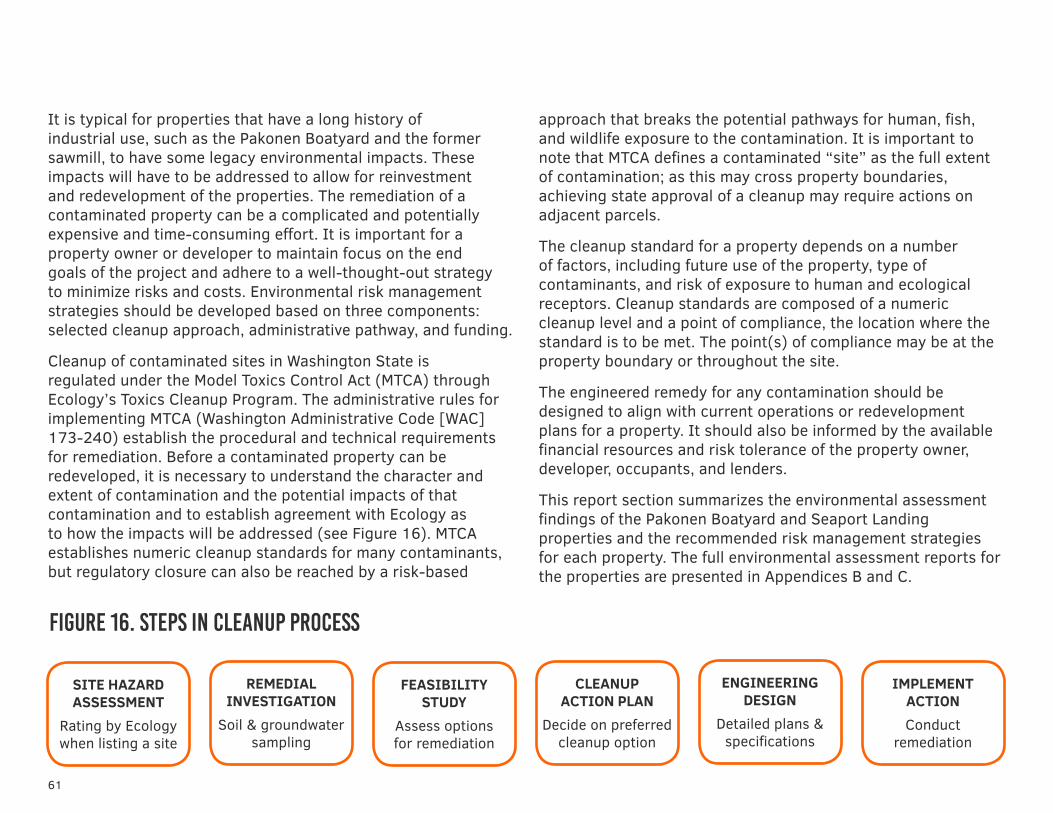
61
It is typical for properties that have a long history of industrial use, such as the Pakonen Boatyard and the former sawmill, to have some legacy environmental impacts. These impacts will have to be addressed to allow for reinvestment and redevelopment of the properties. The remediation of a contaminated property can be a complicated and potentially expensive and time-consuming effort. It is important for a property owner or developer to maintain focus on the end goals of the project and adhere to a well-thought-out strategy to minimize risks and costs. Environmental risk management strategies should be developed based on three components: selected cleanup approach, administrative pathway, and funding.
Cleanup of contaminated sites in Washington State is regulated under the Model Toxics Control Act (MTCA) through Ecology’s Toxics Cleanup Program. The administrative rules for implementing MTCA (Washington Administrative Code [WAC] 173-240) establish the procedural and technical requirements for remediation. Before a contaminated property can be redeveloped, it is necessary to understand the character and extent of contamination and the potential impacts of that contamination and to establish agreement with Ecology as to how the impacts will be addressed (see Figure 16). MTCA establishes numeric cleanup standards for many contaminants, but regulatory closure can also be reached by a risk-based
approach that breaks the potential pathways for human, fish, and wildlife exposure to the contamination. It is important to note that MTCA defines a contaminated “site” as the full extent of contamination; as this may cross property boundaries, achieving state approval of a cleanup may require actions on adjacent parcels.
The cleanup standard for a property depends on a number of factors, including future use of the property, type of contaminants, and risk of exposure to human and ecological receptors. Cleanup standards are composed of a numeric cleanup level and a point of compliance, the location where the standard is to be met. The point(s) of compliance may be at the property boundary or throughout the site.
The engineered remedy for any contamination should be designed to align with current operations or redevelopment plans for a property. It should also be informed by the available financial resources and risk tolerance of the property owner, developer, occupants, and lenders.
This report section summarizes the environmental assessment findings of the Pakonen Boatyard and Seaport Landing properties and the recommended risk management strategies for each property. The full environmental assessment reports for the properties are presented in Appendices B and C.
figure 16. steps in cleanup process
SITE HAZARD ASSESSMENT
Rating by Ecology when listing a site
REMEDIAL INVESTIGATION
Soil & groundwater sampling
FEASIBILITY STUDY
Assess options for remediation
CLEANUP ACTION PLAN
Decide on preferred cleanup option
ENGINEERING DESIGN
Detailed plans & specifications
IMPLEMENT ACTIONConduct
remediation
62
ENVIRONMENTAL CONDITIONS
5.1 environmental risk managementSOUTH WATERFRONT INTEGRATED PLAN
As with all investments, parties must consider the risk and rewards of brownfield redevelopment. Liability for environmental contamination is a common concern for these projects. The federal Superfund Law and the Washington State MTCA both create “strict, joint, and several liability” for contaminated sites. Potentially liable parties under both statues include current property owners or operators; past owners or operators from the time when hazardous substances were released; parties that arranged for the disposal of hazardous substances; and the transporters of the materials. The “strict liability,” means that responsibility is imposed without fault and parties cannot argue lack of due diligence or ignorance. “Joint and several liability” means that all potentially responsible parties are responsible for all costs of the cleanup, regardless of the existence of other potentially liable parties. This rigorous framework has increased the sensitivity to liabilities and required that potential parties proceed diligently in assessing real and perceived risk.
administrative pathways
MTCA establishes administrative pathways that establish a framework for how cleanup projects are processed through Ecology’s Toxics Cleanup Program and what liability protections are available. The pathways provide different degrees of Ecology involvement in cleanup and levels of liability protection. The pathway options are:
Voluntary Cleanup Program (VCP)—Provides limited Ecology review at the work party’s request and potential for a No Further Action (NFA) letter from the state upon completion of a satisfactory cleanup. The VCP is the most commonly used pathway for brownfield properties with relatively low levels of contamination. The NFA letter is typically acceptable assurance
for financing institutions to lend money for development. However, Ecology opinions issued under the VCP are not binding and there is no formal settlement of liability.
Agreed Order—Negotiated agreement between the lead work party and Ecology on the scope and schedule of the cleanup. As long as the work is being done in compliance with the order, Ecology cannot pursue additional enforcement actions against the work party. Agreed Orders are not settlements of liability and do not provide the party with either a “covenant not to sue” (meaning that Ecology will not pursue further legal action) or contribution protection (meaning that other potentially liable parties are prevented from seeking compensation from the liable party). An Agreed Order does provide some formal assurance that the cleanup actions meet state standards, and it can be the basis for a Consent Decree.
Consent Decree—Legal settlement of liability with the state. Judicial approval of the consent decree provides the work party with both a covenant not to sue from the state and contribution protection, which precludes claims by other parties. Consent decrees do include reopener clauses that allow Ecology to require additional or different remedial action if the party does not complete the cleanup, if the remedial action did not achieve cleanup standards, or if new information reveals a previously unknown threat to human health or the environment at the site. To date, Ecology has not reopened any consent decrees.
The greatest liability protection is provided through the Consent Decree, but this also requires the greatest level of state oversight and highest transaction costs. The VCP is the most commonly utilized administrative pathway because of its relative expediency. The choice of administrative pathway also has implications for funding.
63
ENVIRONMENTAL CONDITIONS
5.1 environmental risk management
funding environmental cleanup
There are three primary sources for funding environmental cleanup projects: grants, historic insurance recovery, and contribution from liable parties.
Grants—MTCA establishes a fee on imported hazardous materials, including petroleum, that funds a grant program to support local governments in cleanup of contaminated properties. This fund for local government grants has been budgeted around $65 million in recent biennia. These Remedial Action Grants typically cover 50 percent of cleanup costs and require local matching funds. There are two types of Remedial Action Grants: Oversight Grants and Independent Grants. Oversight Grants are provided to local governments conducting cleanup under an Agreed Order or Consent Decree. The match ratio for these grants can be adjusted to as high as 90 percent funding on a case-by-case basis. Independent Grants are available to local governments that conduct cleanups under the VCP. Independent Grants are limited to $600,000 in total eligible project costs. Like the Oversight grants, they typically require 50 percent match, but that can be adjusted to 90 percent.
The US Environmental Protection Agency (US EPA) also provides grants for assessment and cleanup of brownfield properties. These grants typically provide up to $200,000 for individual cleanup sites, but that amount can be increased. These grants are awarded through a nation-wide competition. Applications are usually accepted each fall with awards grants the following spring.
Historical Insurance Recovery—Property owners have the opportunity to pursue funds to support environmental investigation and cleanup through claims on liability insurance
carriers that provided coverage to either the current property owner or previous property owners and site operators. Before the mid-1980s, commercial general liability policies did not contain exclusions for liabilities caused by environmental damage. Therefore, cost recovery may be pursued from historical insurance policies that were in place when pollution occurred and that covered the property owner, operators, or other potentially liable parties. Historical insurance recovery requires a commitment of time and resources, but is becoming a standard industry practice. It should be noted that actions seeking liability insurance claims for environmental damage to a property are not actions against the site owner or operator, nor do they impact current or future insurance premiums. These are claims for damages in the past and are covered by liability policies for which coverage premiums were paid.
Contribution from Potentially Liable Parties—MTCA is based on the principle that liable parties should pay for environmental cleanup. One source of funds to assist in the cleanup is a contribution by historical liable parties that either owned or operated the site. This venue is available to any party acquiring a property with an outstanding environmental liability.

64
ENVIRONMENTAL CONDITIONS
5.2 pakonen boatyard environmental strategiesSOUTH WATERFRONT INTEGRATED PLAN
A focused environmental investigation of soil, groundwater, and sediment conditions at the Pakonen Boatyard was conducted under the IPG. Further investigation was conducted using USEPA Brownfield Assessment Funds through Ecology’s State Tribal Response Program. The full report of the environmental assessment is included in Appendix B and summarized below.
site background and areas of concern
The Pakonen Boatyard opened in the 1910s, originally as Endressen Spar & Timber Company; however, anecdotal information suggests that the boatyard began operations in the late 1890s. In 1940, the Pakonen family purchased the property and operated it until 2005 under multiple listings, including Pakonen & Son Boat Builders, Pakonen & Son Boatyard, and Pakonen & Sons Boat Repair. Since 2005, the Pakonen Boatyard has been nonoperational and used as a storage yard for
equipment associated with the former boatyard activities (see Figure 17).
In 1997, a limited environmental investigation was performed at the Pakonen Boatyard. Surface and subsurface sediment sampling found elevated concentrations of copper, lead, and zinc above MTCA A cleanup levels in most of the sediment samples. Limited sediment excavation was conducted following the investigation. This was the only historical environmental investigation conducted at the boatyard.
Four areas of concern were identified for the Pakonen Boatyard, based on former facility operations and data obtained from the previous environmental investigation as described above. These four areas were identified as most likely to have resulted in contaminant releases to the surface, surface water, subsurface soil, groundwater, and sediments at the Pakonen Boatyard. With the exception of the marine railways, the former features identified below that are potential contaminant sources had not been investigated previously.
1. Marine railways. Elevated concentrations of metals in the surface and subsurface were identified in sediments surrounding the marine railways in the 1997 investigation. Some limited excavation was subsequently conducted to remove these impacts, but the extent of the removal action was not clearly documented. The marine railways were used to haul boats in and out of the river for repairs. If boats were scrubbed and washed on the railway before they were brought into the buildings for maintenance and repair, heavy metals and/or other chemicals present in marine paint could have been released.
Historical boat repair shop.
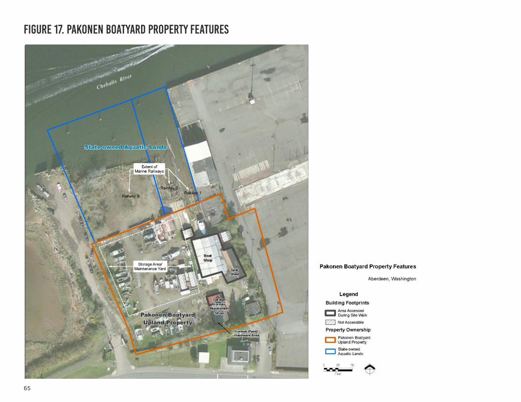
65
figure 17. pakonen boatyard property features
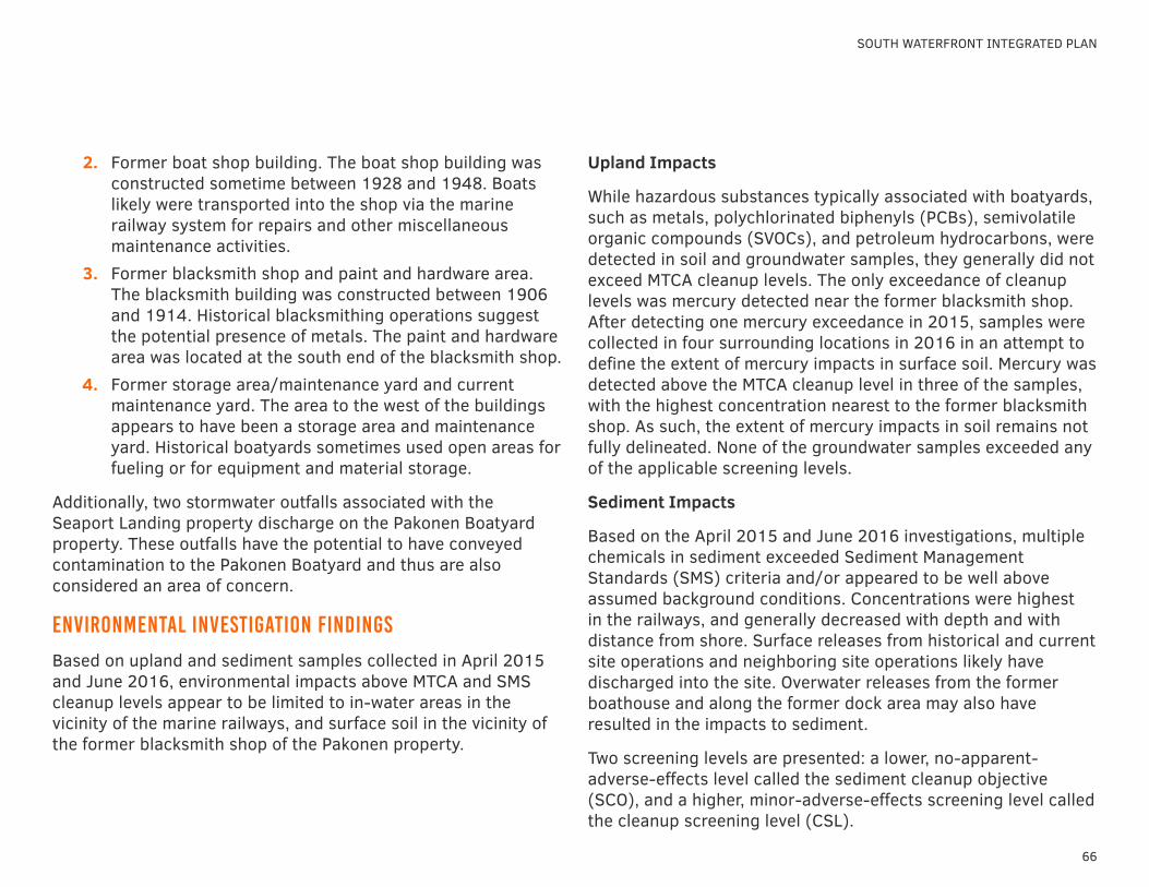
66
SOUTH WATERFRONT INTEGRATED PLAN
Upland Impacts
While hazardous substances typically associated with boatyards, such as metals, polychlorinated biphenyls (PCBs), semivolatile organic compounds (SVOCs), and petroleum hydrocarbons, were detected in soil and groundwater samples, they generally did not exceed MTCA cleanup levels. The only exceedance of cleanup levels was mercury detected near the former blacksmith shop. After detecting one mercury exceedance in 2015, samples were collected in four surrounding locations in 2016 in an attempt to define the extent of mercury impacts in surface soil. Mercury was detected above the MTCA cleanup level in three of the samples, with the highest concentration nearest to the former blacksmith shop. As such, the extent of mercury impacts in soil remains not fully delineated. None of the groundwater samples exceeded any of the applicable screening levels.
Sediment Impacts
Based on the April 2015 and June 2016 investigations, multiple chemicals in sediment exceeded Sediment Management Standards (SMS) criteria and/or appeared to be well above assumed background conditions. Concentrations were highest in the railways, and generally decreased with depth and with distance from shore. Surface releases from historical and current site operations and neighboring site operations likely have discharged into the site. Overwater releases from the former boathouse and along the former dock area may also have resulted in the impacts to sediment.
Two screening levels are presented: a lower, no-apparent-adverse-effects level called the sediment cleanup objective (SCO), and a higher, minor-adverse-effects screening level called the cleanup screening level (CSL).
2. Former boat shop building. The boat shop building was constructed sometime between 1928 and 1948. Boats likely were transported into the shop via the marine railway system for repairs and other miscellaneous maintenance activities.
3. Former blacksmith shop and paint and hardware area. The blacksmith building was constructed between 1906 and 1914. Historical blacksmithing operations suggest the potential presence of metals. The paint and hardware area was located at the south end of the blacksmith shop.
4. Former storage area/maintenance yard and current maintenance yard. The area to the west of the buildings appears to have been a storage area and maintenance yard. Historical boatyards sometimes used open areas for fueling or for equipment and material storage.
Additionally, two stormwater outfalls associated with the Seaport Landing property discharge on the Pakonen Boatyard property. These outfalls have the potential to have conveyed contamination to the Pakonen Boatyard and thus are also considered an area of concern.
environmental investigation findings
Based on upland and sediment samples collected in April 2015 and June 2016, environmental impacts above MTCA and SMS cleanup levels appear to be limited to in-water areas in the vicinity of the marine railways, and surface soil in the vicinity of the former blacksmith shop of the Pakonen property.
67
ENVIRONMENTAL CONDITIONS
5.2 pakonen boatyard environmental strategies
• Copper, mercury, and nickel exceeded the SMS marine SCO criteria. Copper exceeded the SCO and CSL criteria in only one surface sample, collected nearest the easternmost marine railways and boat shop areas of the Property. Nickel exceeded the SMS marine SCO criterion in nearly all samples, and concentrations were generally consistent throughout the sample area regardless of depth (i.e., surface or 1 foot below mudline); however, all concentrations were below the CSL. Mercury concentration exceeded the SMS marine SCO criteria in eleven samples. All of the samples with mercury in exceedance of the SMS criteria were bounded horizontally and laterally by sediment with mercury concentrations below both the applicable SCO and CSL, thereby confirming that mercury concentration decreases with depth and distance from the marine railways.
• Total PCB concentrations exceeded the SCO one location sampled in 2015, which was collected in the immediate vicinity of Marine Railway 3; however, concentrations were below the CSL. The total-PCB concentrations at this location decreased with depth. Deeper sediment samples from this location were collected during the 2016 investigation. The total PCB results from the deeper 2016 samples did not exceed the SCO or CSL. Furthermore, total PCBs were not detected above the SCO or CSL in any other samples collected during 2016.
• Selected SVOCs, PCP, and phenol, were detected at concentrations above the SMS marine SCO and CSL criteria in at least one sample. Concentrations of 4-methylphenol and benzoic acid exceeded the respective SMS marine SCO criteria for every sample analyzed. The concentrations were generally highest in the railways. Concentrations of the
constituents generally decreased with depth.
• Polycyclic aromatic hydrocarbons (PAHs) were detected in every sample analyzed. Only acenapthalene and fluorene exceeded the SCO and CSLs. However, high-molecular-weight PAHs and low-molecular-weight PAHs did not exceed the criteria in any samples.
• Dioxins and furans were analyzed in one sample in 2015, and in two samples in the 2016 investigation. As SMS criteria are not available for dioxins and furans, sample concentrations are compared to the calculated average dioxin sediment concentrations for existing Chehalis River sediment samples. In all three samples, the average dioxin toxic equivalent quotients (TEQs) were somewhat consistent with the average Chehalis River concentration of 2.88 pg/g at 4.03 pg/g, 5.00 pg/g, and 3.47 pg/g.
• Several samples collected in 2015 exceeded the SMS freshwater criteria for organotins (note SMS marine criteria are not available for organotins, therefore the SMS freshwater screening criteria are used for these constituents). The 2016 data adequately defined the lateral extent of organotins in the near-shore marine railways. However, the vertical extent was not fully delineated.
• Diesel- and motor-oil-range petroleum hydrocarbons were detected in all of the sediment samples collected during both investigations. SMS marine criteria are not available for petroleum hydrocarbons; therefore, the SMS freshwater screening criteria were used for comparison. Diesel- and motor-oil-range petroleum hydrocarbon concentrations only exceeded the criteria at one of the sample locations.
68
SOUTH WATERFRONT INTEGRATED PLAN
• Several detected PAHs, PCBs, and dioxins have been identified by the State of Washington as having a high potential to bioaccumulate. The SMS criteria are not necessarily protective of bioaccumulative effects; no default criteria are available to evaluate this pathway. The SMS indicates that an evaluation of bioaccumulative chemicals should be conducted on a site-specific basis. Site-specific bioaccumulation screening levels have not been generated for this property. However, concentrations of the chemicals in sediment do appear generally to be above Chehalis River conditions, but follow the same trend of extent: concetrations are highest closer in to shore, and decrease with depth and distance from shore.
environmental investigation findings
Additional investigation will be needed to refine the understanding of the extent of impacts in sediments and to design a remedial action. To support future use planning, four remedial alternatives were reviewed. These alternatives include combinations of either excavation and off-site disposal of impacted soil and sediment or capping the impacted areas with clean soil or pavement.
• Alternative 1 - Capping the upland mercury impact with clean soil or pavement and placing a thin layer of clean sediment over in-water impacted areas. Monitoring and institutional controls.
• Alternative 2 - Excavating the upland mercury impact. Off-site disposal. Placing a thin-layer cap over impacted sediments. Monitoring and institutional controls.
• Alternative 3 - Excavating the upland mercury impact. Limited in-water excavation with dewatering and off-site
disposal. Monitoring and institutional controls. • Alternative 4 - Excavating the upland mercury impact
and excavating the full extent of impacted sediments, with dewatering and off-site disposal. No monitoring or institutional controls would be needed.
While all four alternatives comply with the MTCA threshold requirements for consideration as a cleanup action and provide for a reasonable restoration time frame, Alternative 4 most closely satisfied the threshold criteria and other MTCA requirements and therefore is recommended as the preferred remediation alternative. While each of the alternatives is protected of human health and the environment, Alternative 4 is the most protective, permanent, effective over the long term, and either equally or more technically implementable than the other alternatives analyzed. Furthermore, Alternative 4 is more administratively implementable than the other alternatives. The preliminary cost forecast for design, permitting, and construction of Alternative 4 is estimated to be approximately $930,000 (-35 to +50 percent).
69
ENVIRONMENTAL CONDITIONS
5.2 pakonen boatyard environmental strategies
implications for redevelopment
Based on the desired future public use of the property, the recommended environmental strategy to position the former boatyard for redevelopment is based on:
• Due Diligence and Property Transaction—Ensure that a Phase I Environmental Site Assessment (ESA) is completed prior to acquisition of the property to obtain innocent purchaser liability protections and ensure eligibility for US EPA brownfield grant funds. Negotiate a transaction of the property that recognizes the costs of remediation in the sale price.
• Cleanup Approach—considering the relatively limited extent of impacts and the desired public use of the property, it is recommended to fully remove all contaminated sediments and soil. This approach has a higher initial cost, but avoids long-term maintenance and monitoring expenses, and minimizes risk of potential exposure of public visitors to residual contamination.
• Administrative Pathway—Because of the complexity inherent in sediment remediation, the Agreed Order or Consent Decree pathways are recommended. An innocent purchaser, could also pursue a Prospective Purchaser Consent Decree to define the cleanup action plan ahead of actually taking title to the property. Entering into either an Agreed Order or Consent Decree also would make the City eligible for the maximum amount of Remedial Action Grant funding.
• Funding—This project has the opportunity to pursue state and federal grants as well as historic insurance recovery. Leveraging all three of these sources would minimize financial impact of the cleanup on the local community.
CLEANUP APPROACH
Full Removal
ADMINISTRATIVE PATHWAY
Agreed Order or Consent Decree
FUNDING
State & Federal Grants and Historic Insurance
Recovery
70
ENVIRONMENTAL CONDITIONS
5.3 seaport landing environmental strategiesSOUTH WATERFRONT INTEGRATED PLAN
Environmental investigation at Seaport Landing under the IPG focused on sediment issues and relied on previous studies of operations and remedial actions at the former sawmill. Two environmental reports focused on Seaport Landing were produced, the Sediment Sampling Report and the Site Investigation and Alternatives Analysis work plan. These are presented in Appendices C and D, respectively.
site background and areas of concern
Waterfront has been developed for commercial and industrial use since the early 1890s. The piling (commonly referred to as a pile field) at the mouth of Shannon Slough marks the location of an early Aberdeen salmon cannery (see Figure 18). In the late 1890s, the Aberdeen Lumber sawmill was constructed on the upland property, with logs rafted along the shoreline to feed the mill. Aberdeen Lumber was later sold, becoming Schafer Brothers Lumber and Door Co. Mill #4. The business expanded, and so did its footprint. Schafer Brothers later sold the property to Simpson Timber Company. Weyerhaeuser acquired the Property in 1955 and operated several sawmills and associated support facilities through January 2009, when the mill known as the small log sawmill was permanently closed.
environmental investigation findings and areas of concern
Environmental investigations have been conducted at the Seaport Landing property since the 1980s. Recent environmental investigation data serve as a general basis for determining if soil, sediment, or groundwater contamination resulting from historical uses of Seaport Landing is present. Additional site characterization and analysis will be required
to more fully characterize the extent of impacts and evaluate cleanup alternatives.
Below is a summary of the investigations to date; Appendix D provides more detail. Upland and in-water investigations have been performed at the facility (uplands, aquatic lands, and leased area) since the 1980s and have focused on former mill operational areas of concern:
• Former Mill Area and Pocket Beach: Mill facilities and equipment were installed over plank flooring on pilings over the Chehalis River and the pocket beach area. Sediment sampling conducted under the IPG found elevated levels of mercury, PCBs, phenol, benzoic acid, and SVOCs as well as significant accumulations of woodwaste and nonaqueous-phase liquids.
• Associated sawmill structures: Several structures existed on the upland property that supported sawmill activities and included a small sawmill, lumber storage and sorting, wood refuse “teepee” type burner, planer building, maintenance shop, fuel and chemical storage building, underground fuel storage tanks, paint spray room, an aboveground fuel storage tank, and a paint waste underground storage tank. Environmental impacts from these structures have been confirmed at some locations.
• Pentachlorophenol (PCP) release: In the early 1990s, Weyerhaeuser conducted a voluntary cleanup to remediate soils and groundwater contaminated with PCP. Approximately 522 tons of soil contaminated with PCP was removed in the vicinity of the grader and planer buildings. Groundwater monitoring showed that groundwater contamination was localized and not moving toward the

71
Figure 18. seaport landing property features
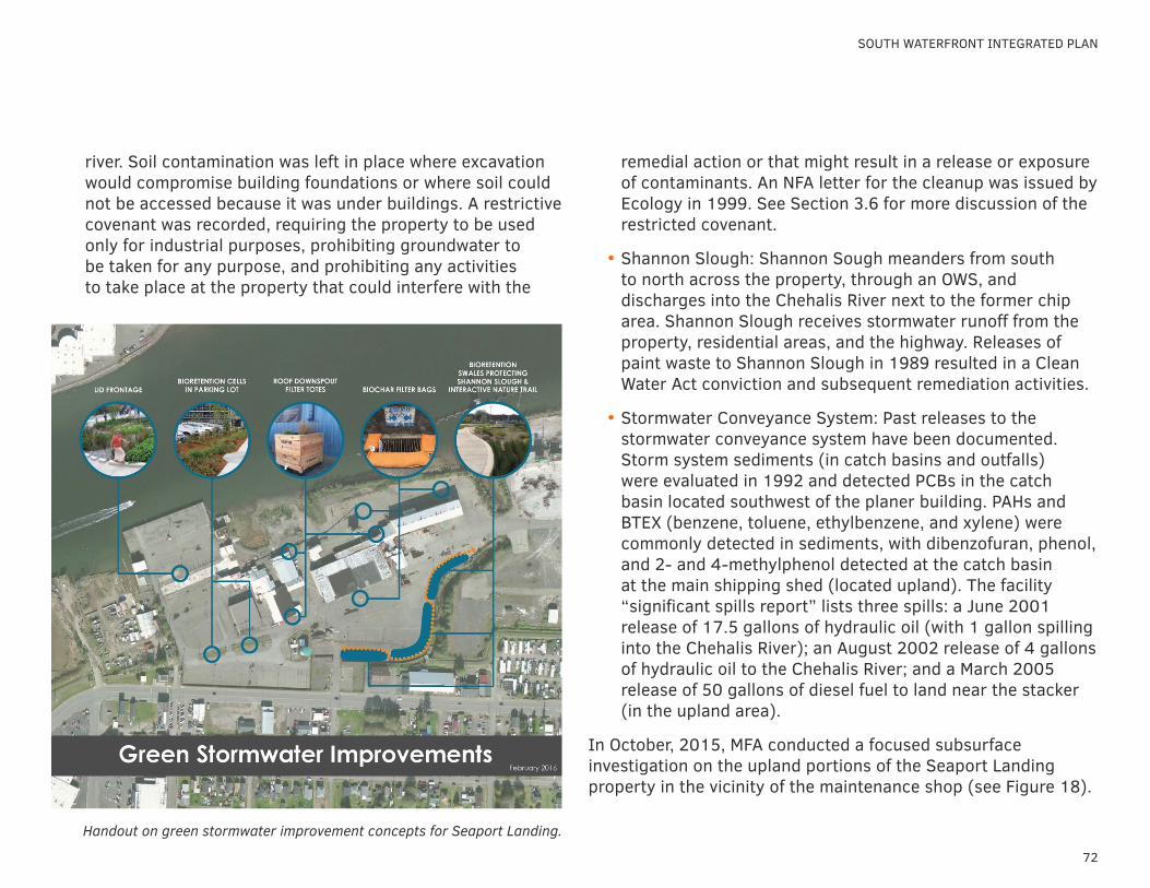
72
SOUTH WATERFRONT INTEGRATED PLAN
river. Soil contamination was left in place where excavation would compromise building foundations or where soil could not be accessed because it was under buildings. A restrictive covenant was recorded, requiring the property to be used only for industrial purposes, prohibiting groundwater to be taken for any purpose, and prohibiting any activities to take place at the property that could interfere with the
remedial action or that might result in a release or exposure of contaminants. An NFA letter for the cleanup was issued by Ecology in 1999. See Section 3.6 for more discussion of the restricted covenant.
• Shannon Slough: Shannon Sough meanders from south to north across the property, through an OWS, and discharges into the Chehalis River next to the former chip area. Shannon Slough receives stormwater runoff from the property, residential areas, and the highway. Releases of paint waste to Shannon Slough in 1989 resulted in a Clean Water Act conviction and subsequent remediation activities.
• Stormwater Conveyance System: Past releases to the stormwater conveyance system have been documented. Storm system sediments (in catch basins and outfalls) were evaluated in 1992 and detected PCBs in the catch basin located southwest of the planer building. PAHs and BTEX (benzene, toluene, ethylbenzene, and xylene) were commonly detected in sediments, with dibenzofuran, phenol, and 2- and 4-methylphenol detected at the catch basin at the main shipping shed (located upland). The facility “significant spills report” lists three spills: a June 2001 release of 17.5 gallons of hydraulic oil (with 1 gallon spilling into the Chehalis River); an August 2002 release of 4 gallons of hydraulic oil to the Chehalis River; and a March 2005 release of 50 gallons of diesel fuel to land near the stacker (in the upland area).
In October, 2015, MFA conducted a focused subsurface investigation on the upland portions of the Seaport Landing property in the vicinity of the maintenance shop (see Figure 18).
Handout on green stormwater improvement concepts for Seaport Landing.
73
ENVIRONMENTAL CONDITIONS
5.3 seaport landing environmental strategies
The focused investigation was designed to evaluate any impacts associated with underground storage tanks (USTs) suspected to be located in that area.
The investigation found elevated TPH concentrations in both soil and groundwater to the northeast of the maintenance shop, as well as chromium, lead, and cPAHs concentrations above the applicable cleanup levels in the groundwater from this area. Lube oil was detected above the applicable cleanup level in groundwater collected from the west side of the maintenance shop. The results of the investigation did not definitively identify the source(s) of groundwater and soil impacts in the vicinity of the maintenance shop, however it is likely that the impacts observed are related to the former sawmill operations and/or the presence of USTs in that area.
Additional investigation will be required to fully define the extent of contamination in the sediment, and to evaluate potential soil and groundwater contamination in the upland and aquatic lands areas of Seaport Landing.
implications for redevelopment
The large size of the former sawmill property and the expected long timeframe for redevelopment leads to a phased approach to resolving legacy environmental issues in discrete areas as new projects are implemented. Redevelopment of the Property can be integrated into development of the remedial alternatives and selection of the most effective cleanup actions. The surface of the upland property is currently almost entirely covered with buildings or pavement, so there is limited risk of exposure of people to contaminants. GHHSA currently controls access to the property, and as visitors are brought in, a clear access control plan will be an important institutional control.
Applying the three pillars approach to environmental risk management (cleanup approach, administrative pathway, and funding) leads to the following key strategies.
Cleanup Approach
• Sediments—Based on the findings of the remedial investigation, the focus of sediment concerns is in the pocket beach area. A feasibility study of cleanup options is currently underway. The current status of this area as an emergent wetland and the depth of woodwaste, raises concerns about the environmental benefit and feasibility of fully removing all impacted sediments. Enhanced natural recovery or a thin layer cap may be more effective remediation options.
• o Uplands—Impacts in soil and groundwater have been identified around the former Maintenance and Planer Buildings. There has been very limited upland sampling outside of that vicinity so significant uncertainty remains
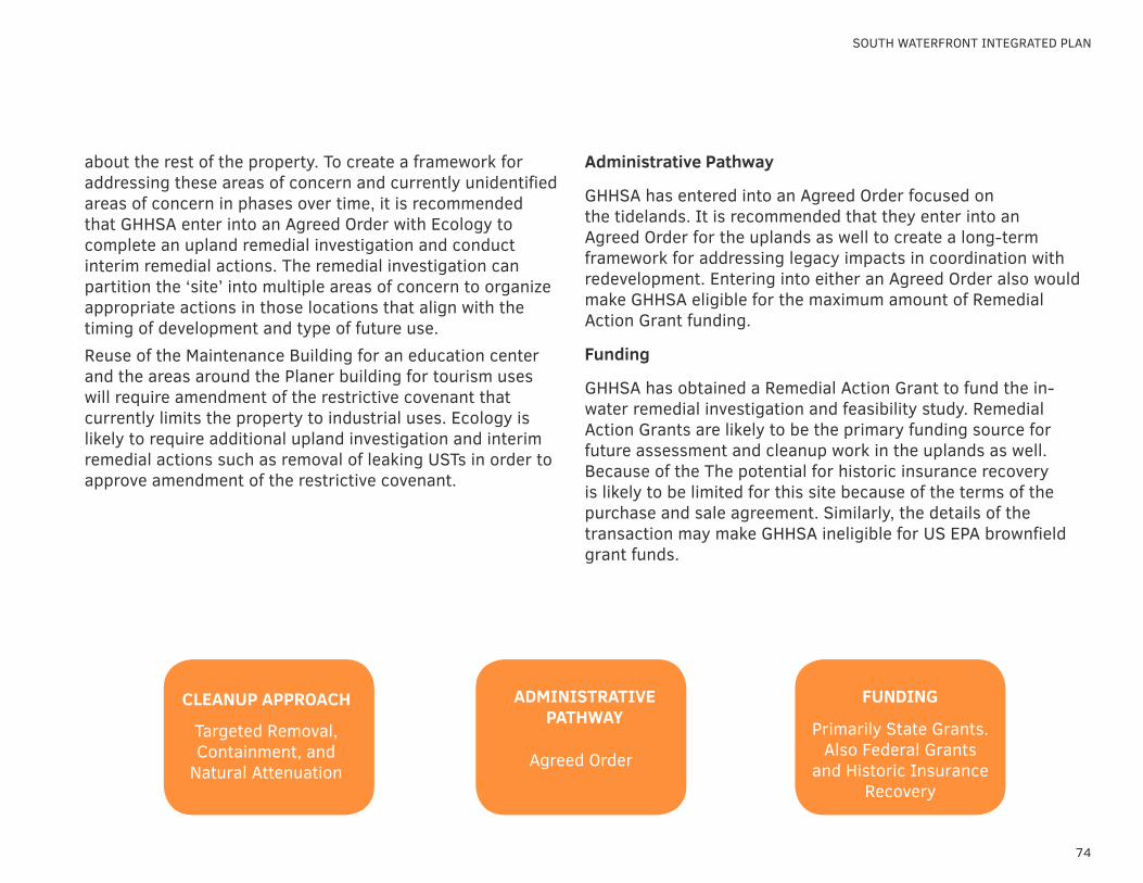
74
SOUTH WATERFRONT INTEGRATED PLAN
about the rest of the property. To create a framework for addressing these areas of concern and currently unidentified areas of concern in phases over time, it is recommended that GHHSA enter into an Agreed Order with Ecology to complete an upland remedial investigation and conduct interim remedial actions. The remedial investigation can partition the ‘site’ into multiple areas of concern to organize appropriate actions in those locations that align with the timing of development and type of future use. Reuse of the Maintenance Building for an education center and the areas around the Planer building for tourism uses will require amendment of the restrictive covenant that currently limits the property to industrial uses. Ecology is likely to require additional upland investigation and interim remedial actions such as removal of leaking USTs in order to approve amendment of the restrictive covenant.
Administrative Pathway
GHHSA has entered into an Agreed Order focused on the tidelands. It is recommended that they enter into an Agreed Order for the uplands as well to create a long-term framework for addressing legacy impacts in coordination with redevelopment. Entering into either an Agreed Order also would make GHHSA eligible for the maximum amount of Remedial Action Grant funding.
Funding
GHHSA has obtained a Remedial Action Grant to fund the in-water remedial investigation and feasibility study. Remedial Action Grants are likely to be the primary funding source for future assessment and cleanup work in the uplands as well. Because of the The potential for historic insurance recovery is likely to be limited for this site because of the terms of the purchase and sale agreement. Similarly, the details of the transaction may make GHHSA ineligible for US EPA brownfield grant funds.
CLEANUP APPROACH
Targeted Removal, Containment, and
Natural Attenuation
ADMINISTRATIVE PATHWAY
Agreed Order
FUNDING
Primarily State Grants. Also Federal Grants
and Historic Insurance Recovery
implementation strategy6.1 organizing for success6.2 action steps - seaport landing6.3 action steps - pakonen property
implementation strategy
76
Redevelopment of the South Waterfront will require proactive, creative, and coordinated efforts between the City and GHHSA and their partners. Market economics are not strong enough for the private sector to lead this effort on their own. It will require significant leadership and investment from the public sector. There is substantial community benefit and potential to achieve multiple public policy goals at this property to support a significant public role, including public waterfront access, education and work training, job creation, tourism, historic preservation, habitat enhancement, and environmental remediation.
There is broad consensus on the key elements of redevelopment of the South Waterfront. The key elements of the South Waterfront redevelopment include the following:
• Public access to the Chehalis River• Maritime heritage education and interpretation• Commercial and industrial activities to support employment
and provide revenues to support the public elements of the development
• Habitat enhancement Plans for future development at the South Waterfront should be flexible to respond to opportunities, but defined with sufficient parameters to provide predictability for the community and potential investors. Rather than providing one detailed site plan for future development, this report recommends an approach of defining a range of potential uses and site plan scenarios to inform future development. This approach positions the GHHSA and the City to respond to opportunities as they arise with the forethought to plan for public infrastructure improvements to support future development.
SOUTH WATERFRONT INTEGRATED PLAN
77
IMPLEMENTATION STRATEGY
6.1 organizing for success
For a development project of this scale, the questions of HOW to organize around the effort are perhaps more critical to success than the questions of WHAT will be constructed.
There are two fundamental questions for the City and GHHSA to consider in redevelopment of the South Waterfront:
• How should they organize and augment existing internal resources, primarily staff, to more effectively manage the South Waterfront project while not losing ground on other very significant efforts the organizations have under way?
• What institutional approach should they take to pursue the development, possibly including the creation of a new entity that would undertake the work?
internal organization
There are two fundamental ways in which the GHHSA and the City could organize around the long-term management of the redevelopment of the South Waterfront:
• Create a dedicated staff position.• Contract for management services with an outside party or
agency with close staff oversight.
Create Dedicated Staff Position
The GHHSA and/or the City could consider creating a dedicated position to manage the development effort. The new position could be filled either through a new hire, or by reassigning an existing employee who has the right credentials to the new position and then backfilling behind him or her.
In considering the qualifications for such a position, it will be
important to assign an individual with a set of development skills that are most often found in the private sector or, in limited cases, in the public sector in which the individual has had previous market-based development experience.
One of the challenges in retaining new staff that has considerable experience in the private sector and with market-based development is compensation. Typically, those individuals are highly compensated; creating a position that is funded at a market competitive wage may be disruptive to the GHHSA and/or the City’s current salary structure and benefit package.
Pros:
• Direct control over a dedicated staff member responsible for the project.
• Minimizes distractions and disruptions to other projects, which will require internal discipline.
• Provides long-term project continuity and control.
• Helps ensure that GHHSA and City goals and expectations are met.
• Creates a real perception for the development community that the organization is making a serious investment in the effort.
Cons:
• The compensation package may be a challenge in attracting the right person with the appropriate experience and skills.
• There may be some perception that the GHHSA and/or the City is unbalanced in its focus on the South Waterfront

78
project in contrast to other efforts currently under way.• The development experience held by an individual is often
at cultural odds with a public agency’s culture and the local political environment.
• It is likely to create a negative cash flow over the short term.Contract the Management Services with an Outside Party
Real estate development and management services may be obtained from other organizations. A range of terms and structures for a contract could be developed to meet the needs of GHHSA and the City as well as the contractor. The contract would be for a multi-year focus and can be selected with special skills in mind that may include a firm rather than an individual. In addition to contracting with private firms, there may be an opportunity to contract for real estate services with another public agency, such as the Port of Grays Harbor. The Port has a unique position of both having staff with expertise in real estate management and having a public agency mission and culture.
Pros:
• Can specify a very high level of skills with experience needed according to the development phase.
• May be provided by several individuals, to provide a robust suite of skills that are difficult to find in one individual.
Cons:
• May be costly to provide; however, the results may be more predictable.
• Perception of loss of control by bringing in an outside party.
institutional approach
There are several legal and organizational structures that the GHHSA and the City could employ to undertake the redevelopment. These structures can be customized to suit the GHHSA and City’s needs. They include:
• Traditional role in which the public agency manages property development.
• Contractual partnership with a master developer.
Traditional Role
The GHHSA and the City could serve as the lead party in undertaking the many facets of the development of their respective properties, from permitting through construction, marketing, and property leasing. This role is typical for local governments in development of public facilities and parks. The concept of leasing buildings or ground along the South Waterfront to private parties deviates from the typical model for public facilities.
Pros:
• Maintains the highest level of control over the project.
• Likely to receive highest level of revenue stream from the project or, alternatively, could adjust land costs and rates of return to facilitate development.
• Approach may work best in those development activities traditionally associated with GHHSA and the City, such as design and construction of public amenities and educational elements.
SOUTH WATERFRONT INTEGRATED PLAN
79
IMPLEMENTATION STRATEGY
6.1 organizing for success
Cons:
• Strains organizations’ staff capacity and stretches beyond typical practice when dealing with private-sector leases.
• Retain ongoing management and maintenance costs.
• Less flexibility in controlling construction costs because of prevailing wage requirements.
Contractual Partnership with a Master Developer
Under this approach, the GHHSA and/or the City would solicit, select, and contract with a master developer for redevelopment of the Seaport Landing and/or the South Waterfront. The organizations could contract with a master developer for development phases or for the entire site and adjust contractual arrangements as the situation and marketplace require. Properties could be either leased or sold.
Pros:
• Master developer would most likely have (or hire) appropriate level of expertise needed.
• Would likely reduce upfront “soft” costs for GHHSA and the City, resulting in more positive cash flow in the short term.
• If the master developer is from outside the area, it may help increase project exposure and resulting tenancies.
Cons:
• May not be a project with sufficient regional exposure to merit a large number of responses. Less competition may require that the GHHSA and the City compromise on some goals.
• Unless clearly defined and articulated in the contract, there would be a potential loss of project control.
• Potential loss of full capture of future project revenue.• Master developer could go bankrupt or otherwise fail,
complicating project and timelines. (There has been some ‘in-state’ experience with this situation.)

80
property sale or land swap
An overarching consideration related to internal resources and institutional approach is the allocation of property. The South Waterfront represents a large portfolio of property. The City, GHHSA, and their partners have different legal authorities, missions, and areas of expertise. To implement the vision of creating a working waterfront with a mix of uses, it may be beneficial to align land ownership with the organization best suited to manage the different uses. For example:
GHHSA Operations. Administrative offices, spar shop, and facilities related to maintenance of the GHHSA vessels and maritime heritage educational activities most appropriately should be owned and managed by GHHSA.
Public Park and Open Space. The City has dedicated staff and resources for maintenance and operation of park facilities and may be able to own and manage these resources in the most cost-effective way. It should be acknowledged that cities across the country, including Aberdeen, struggle with the costs of maintaining public parks and open space.
Commercial and Industrial Uses. Neither the City nor GHHSA have staff whose job focus is leasing and managing property for private-sector users. While the commercial and industrial uses are important to generating revenue to support the public and educational uses at the South Waterfront, this is likely to be the most challenging land use to develop and maintain. The GHHSA and the City could consider sale of the property intended to support these uses rather than leasing to generate a cash infusion and minimize long-term management and maintenance costs. The property could be sold to a private party or to the Port, which would allow the area to remain in
public ownership but transition it to an organization established to manage real estate for economic development. It likely will be difficult to attract a viable buyer and close a transaction until the environmental issues associated with the Seaport Landing property are resolved or at least on a clear pathway to resolution.
Pakonen Boatyard Building. The Pakonen Boatyard building presents a unique and challenging opportunity. As a building designed for construction and repair of ships that has been in operation for over 100 years, it has a strong potential connection to the maritime heritage education mission of the GHHSA. The building and equipment inside it could lend themselves to adaptive reuse as an interpretive center. However, the building is located on property that is currently in private ownership. The Seaport Landing property provides a large amount of usable space for the development, so GHHSA should be very careful about acquiring additional real estate. A land swap scenario could be negotiated that would reduce the size of GHHSA holdings of the current Seaport Landing Property and bring some portion of the Pakonen property, including the boatyard building, into their ownership.
SOUTH WATERFRONT INTEGRATED PLAN
81
IMPLEMENTATION STRATEGY
6.2 action steps - seaport landing
The following work program describes the key steps the GHHSA can take to move forward with the redevelopment of the Seaport Landing property, integrating both redevelopment and cleanup. The action steps are organized into “Initiatives” that support the goals stated in Section 1.2. While the actions support multiple goals, they are organized into the initiatives that they can primarily support or provide with the greatest impact. These tasks are summarized in the “Action Steps” table for easy review and reference.
placemaking initiatives to create a destination
1. Activate the Property with Events and ProgramsGHHSA has organized several events at Seaport Landing, most notably for the Fourth of July. GHHSA should continue to host community events on a regular basis at Seaport Landing. These events foster the public access element of the future use vision. They also activate the property and generate excitement and enthusiasm for the project that have incalculable value.
In addition to deck tours and sailing trips on the Lady Washington and Hawaiian Chieftain when they are in homeport, community events could include:
• Boat tours on the Chehalis River—in smaller vessels that would remain in Aberdeen
• Concerts, movies, and food festivals on the pier• Temporary art installations
2. Establish Facilities to Support GHHSA OperationsGHHSA has moved their administrative operations to Seaport Landing. The property also has the potential to provide space for maintenance and woodworking operations that would support the tall ships and potentially generate additional revenue from direct service for other organizations. GHHSA should conduct a programming assessment, outlining their current and future activities, staffing levels, and operational activities to estimate the amount of space needed to accommodate these services. An assessment of the condition of existing buildings should be conducted in tandem to determine potential costs of renovating these buildings to house these operations.
A critical decision in this effort will be where to set up the spar shop. GHHSA staff are preparing a business plan and programming assessment for moving the spar shop and a woodworking shop into the Pee Wee Mill building (Building #13). The spar shop serves a core function of producing wooden masts and spars for replacing damaged parts of the tall ships. The shop also contracts with other organizations for custom milling of masts, columns, poles gaffs, booms, timbers, beams, and cants. Through fee-for-service contracting, the spar shop provides a potential source of revenue for GHHSA.
3. Open Space and Trails Design and Construction The City and GHHSA should immediately begin to apply for state and federal grants to support design and construction for public open spaces and trails on the South Waterfront. The GHHSA application was among the highest rated in the state for a Boating Infrastructure Grant from the Washington State Recreation and Conservation Office. The grant would have provided funding for design and permitting of a boat ramp and floating docks for transient moorage; however, at that
82
point the aquatic lands lease had still been in transition, so the grant agreement was not executed. It is expected that future applications to the Recreation and Conservation Office for the Washington Wildlife and Recreation Program and Aquatic Lands Enhancement Account would be received favorably. Applications for these grants are accepted in even-numbered years. To be competitive for these grants, GHHSA should: finalize the lease agreement for the state-owned aquatic lands, prepare 30 percent design drawings for the trail (which may be eligible for reimbursement if the grant is awarded), and ensure that the project is identified in the City of Aberdeen’s Parks Recreation and Open Space Plan (a requirement for funding programs). An important design decision will be treatment of the riverbank. If the greenway involves grading or slope stabilization below the ordinary high water mark, federal and state permits will be required, which will increase the timeframe and costs of the project.
While the time cycle for grant funding and construction is likely to extend over several years, GHHSA could establish a basic trail in the uplands, along Chehalis River, using gravel or woodchips to outline a path for visitors. This effort could be conducted with volunteers and in-kind labor and be implemented in a matter of weeks or months.
4. Moorage ImprovementsThe existing fixed pier and Seaport Landing are critical assets of the property. To maximize their utility as the homeport for the tall ships, improvements are needed, including construction of a floating dock, which will allow easier access during the range of tides. A preliminary step for making these improvements is conducting a structural assessment of the dock. Construction of a floating dock will require engineering plans and specifications;
federal, state, and local permits; and potentially an adjustment of the Outer Harbor Line (see Action Step 13).
initiatives to create interpretive and educational opportunities
It is intended that education and interpretation opportunities are incorporated throughout Seaport Landing—in the trails and public access features, in the GHHSA operations and industrial activities, and even in the environmental remediation actions. Two key actions focused on education are highlighted below.
5. Educational/Interpretive CenterThe concept of a maritime heritage museum or interpretive center has been prominent in the current and previous community discussions of Seaport Landing. In terms of capital and human resources, establishing and operating an interpretive center is a significant undertaking. A careful analysis, including defining the concept in more detail, building programming, a conceptual architectural plan, and a financial plan should be conducted. A compelling site for the interpretive center would be in a restored Pakonen Boatyard building. An interim location for the interpretive center could be in the existing maintenance building (Building #9). GHHSA staff are in the process of developing a programming plan for use of the maintenance building for this purpose.
Case study examples of the programs and financing to support interpretive centers are presented in Appendix E.
6. Education and Workforce Training FacilityEstablishing a facility at Seaport Landing for education and workforce training would strongly support GHHSA’s mission and
SOUTH WATERFRONT INTEGRATED PLAN
83
IMPLEMENTATION STRATEGY
6.2 action steps - seaport landing
provide an anchor use that would enable long-term activity and attract supporting uses. The GHHSA has strong connections with Aberdeen public schools and the Grays Harbor Community College. Initial conversations have identified an interest in the potential for developing an education and workforce training facility at Seaport Landing. It is recommended that a task force be convened to define needs and opportunities and formulate a strategy for making this concept a reality.
initiatives to establish working waterfront & financial platform
7. Asset Management StrategyGHHSA should confirm the strategy to guide their efforts to lease facilities for private-sector uses. The strategy should answer the fundamental questions of internal resources and institutional approach discussed in Section 7.1. This may be most effectively determined through a series of board workshops. The strategy should address:
• Criteria for evaluating whether GHHSA should enter into a lease, such as:
– Alignment with GHHSA mission, goals, and objectives – Alignment with Seaport Landing vision, goals, and objectives
• Willingness to lease buildings, land, or both• Approach to establishing lease rates and comparison with
private market rates• Return on investment expectations
8. Recruit Commercial and Industrial UsersGHHSA has already been approached by several businesses interested in using the dock and existing buildings at Seaport Landing for shipping and storage. Once it has established an asset management strategy, GHHSA should increase its efforts to attract commercial uses, such as a restaurant, brew pub, or boat rental, and industrial uses such as marine trades, maker’s space, or light industry.
initiatives to prepare property for redevelopment
9. Conduct In-water Environmental RemediationRemediation actions on the former mill property can be conducted concurrently with redevelopment for efficiency and cost savings. The next step in the remediation process is to complete the remedial investigation and feasibility study of the sediments. The findings of this analysis will inform future plans for development of in-water infrastructure, such as a floating dock. GHHSA has taken on the role of the lead work party for the remediation and has entered into an Agreed Order with Ecology to guide the site to regulatory closure. As a municipal corporation, GHHSA is eligible for state and federal grants to offset the costs of cleanup. Other funding sources for the cleanup include contributions from other parties, historical insurance policies, and investment capital.
10. Enter into Agreed Order for Upland Investigation and Interim Remediation Actions
Assessment and remediation of legacy upland impacts can be addressed in phases over time in coordination with redevelopment projects. GHHSA can enter into an Agreed Order with Ecology that creates a legal framework for that approach by
84
establishing ‘remediation areas’ on the property and allowing for interim remediation actions that may address one specific area at a time rather than the entire property all at once. The highest priority interim actions will be related to the highest priority redevelopment projects: reuse of the maintenance building for an education center and demolition of the planer building to create space for a hotel and restaurant.
11. Amend Upland Restrictive CovenantThe environmental restrictive covenant presents a barrier to achieving the mixed-use vision for Seaport Landing. The covenant could be amended to allow for a wider range of uses or removed altogether. This would require negotiation and agreement with Ecology. A disproportionate cost analysis has been prepared to provide supporting technical analysis of the risks associated with the residual contamination on the property and the options for environmental remediation. Additional investigation of potential upland impacts may be required in order to inform the negotiations. Additionally, removal of USTs and impacted soil near the maintenance shop may be required to support redevelopment and control potential sources of contamination to the pocket beach area.
12. Obtain Land Use Entitlements To allow the mix of uses described in the vision and conceptual plans for Seaport Landing, the property Comprehensive Plan land use designation and zoning district should be changed. The City has an existing Waterfront Development zone that would allow the range of uses desired at Seaport Landing. It is recommended that GHHSA apply to change the Comprehensive Plan land use designation to Waterfront Development and the zoning to Waterfront Development. As required by the Washington State Growth Management Act, land use designation
changes must be approved by City Council.
13. Inter-local Agreement GHHSA should consider entering into an inter-local agreement (or a series of inter-local agreements) with the City to formalize their respective roles in redevelopment of the South Waterfront. These agreements could include:
• Responsibilities and commitments of each party toward the South Waterfront
• Process for entitling the property• Finance and development of public spaces and open space• Treatment of permit and impact fees• Marketing and branding the area
The inter-local agreement could be structured to apply to the different phases of the development rather than be universal for the life of the development.
14. Adjust Inner and Outer Harbor LinesThe face of the existing pier is built out to the Outer Harbor line, which is the boundary line for state leases of aquatic lands. Permitting of a floating dock on the water-ward side of the pier would require adjustment of the Outer Harbor line. Since much of the area between the Inner and Outer Harbor line has been filled and is now effectively uplands rather than tidelands, there is a strong case to make to the Department of Natural Resources to also move the Inner Harbor line water-ward. This would remove aquatic land-lease restrictions on that property and increase potential reuse options. Harbor Lines can be relocated by the Harbor Line Commission, which is supported by the Department of Natural Resources, through a request process outlined in RCW 79.115.020 and WAC 332-30-116.
SOUTH WATERFRONT INTEGRATED PLAN

85
ACTION TIMEFRAME FUNDING SOURCE
Place-making Initiatives to Create a Destination
1. Activate Property with Events and Programs
Establish a calendar of regular public events at Seaport Landing that attract people to the site and get them on the water.
Ongoing •Donations, Sponsorships
2. Establish Facilities to Support GHHSA Operations
Conduct assessment of space needs for organization. 2017•GHHSA Budget•Private Donations•Foundation Grants
Prepare plans for expansion of office and workshop space into existing buildings (i.e. maintenance building).
2018•GHHSA Budget•Private Donations•Foundation Grants
Design, permitting, and renovation of building space to support GHHSA operations.
2017-2018•Heritage Capital Fund Grant•Private Foundation Grants•Donations
3. Open Space and Trails Design and Construction
Interim trail along Chehalis River uplands 2016-2017•Donations and In-Kind
Services
Apply for state and federal grants related to public waterfront access, trail development, parks, and habitat enhancement.
Spring 2016Spring 2018
•Recreation and Conservation Office Grants
•GHHSA Budget
4. Moorage Improvements
Structural assessment of existing dock. 2016 •GHHSA Budget
Engineering design, permitting, and construction of floating dock. 2017-2019•Private Donations•Foundation Grants
IMPLEMENTATION STRATEGY
6.2 action steps - seaport landing
table 6. seaport landing redevelopment work program
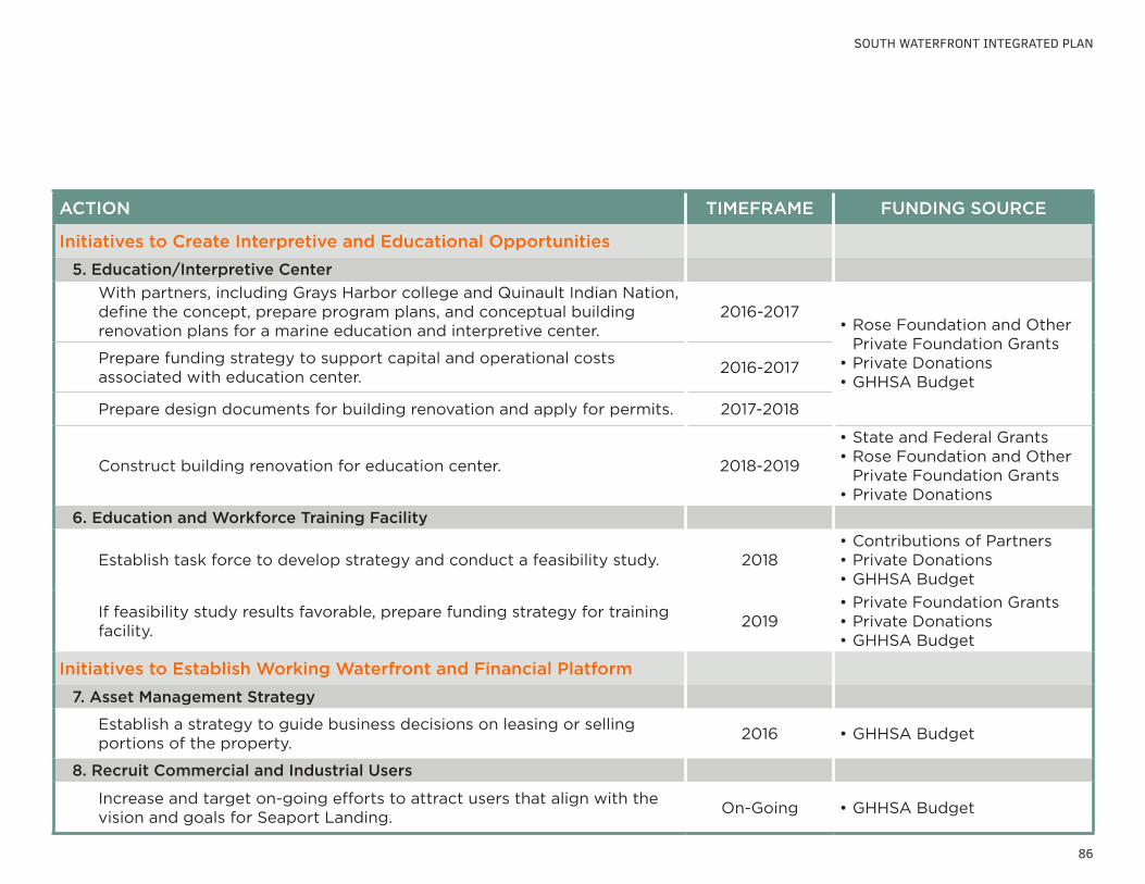
86
ACTION TIMEFRAME FUNDING SOURCE
Initiatives to Create Interpretive and Educational Opportunities
5. Education/Interpretive Center
With partners, including Grays Harbor college and Quinault Indian Nation, define the concept, prepare program plans, and conceptual building renovation plans for a marine education and interpretive center.
2016-2017•Rose Foundation and Other
Private Foundation Grants•Private Donations•GHHSA Budget
Prepare funding strategy to support capital and operational costs associated with education center.
2016-2017
Prepare design documents for building renovation and apply for permits. 2017-2018
Construct building renovation for education center. 2018-2019
•State and Federal Grants•Rose Foundation and Other
Private Foundation Grants•Private Donations
6. Education and Workforce Training Facility
Establish task force to develop strategy and conduct a feasibility study. 2018•Contributions of Partners•Private Donations•GHHSA Budget
If feasibility study results favorable, prepare funding strategy for training facility.
2019•Private Foundation Grants•Private Donations•GHHSA Budget
Initiatives to Establish Working Waterfront and Financial Platform
7. Asset Management Strategy
Establish a strategy to guide business decisions on leasing or selling portions of the property.
2016 •GHHSA Budget
8. Recruit Commercial and Industrial Users
Increase and target on-going efforts to attract users that align with the vision and goals for Seaport Landing.
On-Going •GHHSA Budget
SOUTH WATERFRONT INTEGRATED PLAN
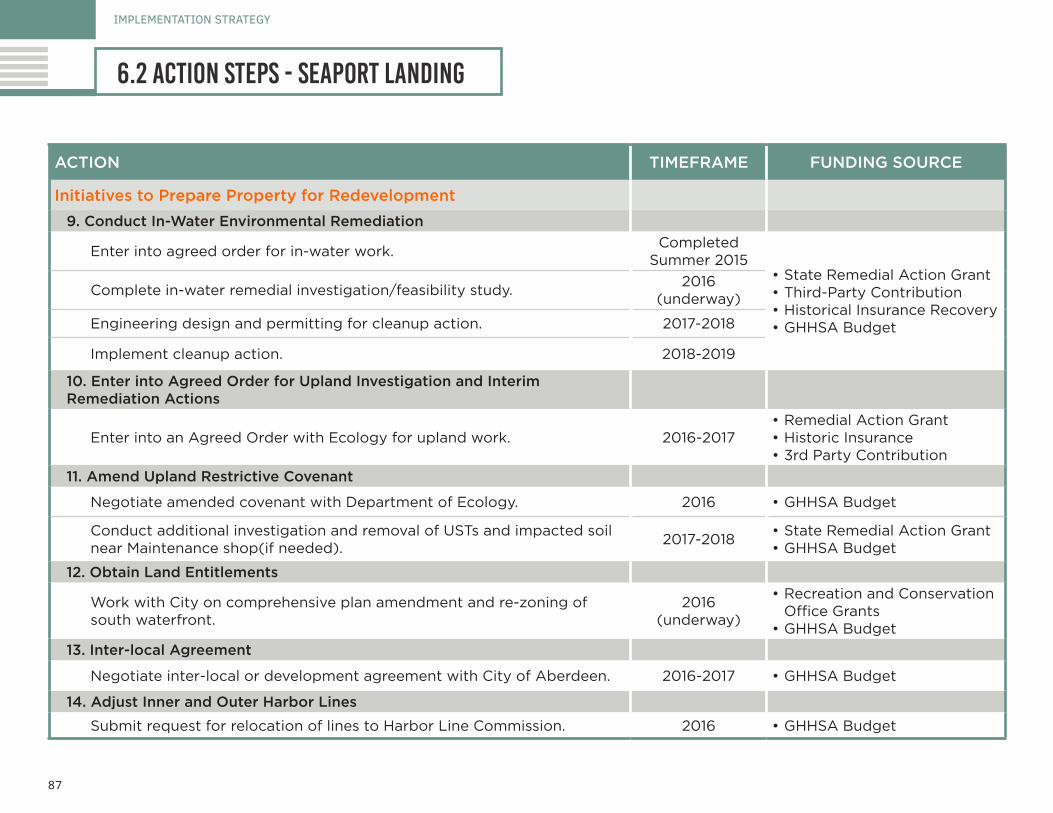
87
ACTION TIMEFRAME FUNDING SOURCE
Initiatives to Prepare Property for Redevelopment
9. Conduct In-Water Environmental Remediation
Enter into agreed order for in-water work.Completed
Summer 2015•State Remedial Action Grant•Third-Party Contribution•Historical Insurance Recovery•GHHSA Budget
Complete in-water remedial investigation/feasibility study.2016
(underway)
Engineering design and permitting for cleanup action. 2017-2018
Implement cleanup action. 2018-2019
10. Enter into Agreed Order for Upland Investigation and Interim Remediation Actions
Enter into an Agreed Order with Ecology for upland work. 2016-2017•Remedial Action Grant•Historic Insurance•3rd Party Contribution
11. Amend Upland Restrictive Covenant
Negotiate amended covenant with Department of Ecology. 2016 •GHHSA Budget
Conduct additional investigation and removal of USTs and impacted soil near Maintenance shop(if needed).
2017-2018•State Remedial Action Grant•GHHSA Budget
12. Obtain Land Entitlements
Work with City on comprehensive plan amendment and re-zoning of south waterfront.
2016 (underway)
•Recreation and Conservation Office Grants
•GHHSA Budget
13. Inter-local Agreement
Negotiate inter-local or development agreement with City of Aberdeen. 2016-2017 •GHHSA Budget
14. Adjust Inner and Outer Harbor Lines
Submit request for relocation of lines to Harbor Line Commission. 2016 •GHHSA Budget
IMPLEMENTATION STRATEGY
6.2 action steps - seaport landing
88
IMPLEMENTATION STRATEGY
6.3 action steps - pakonen property
The following work program describes the key steps the City or GHHSA can take to redevelop the Pakonen property. These tasks are summarized in Table 7 for easy review and reference. For the purposes of this analysis, it is assumed that the City, GHHSA, or another party will acquire the Pakonen property.
1. Environmental Due DiligenceAn environmental assessment of the Pakonen Boatyard property has been conducted as part of this planning effort (see Section 6.1). Based on these findings, there are limited impacts to soil and no impacts to groundwater on the upland property. There are also impacts to sediments in the state-owned aquatic lands lease area. In addition to the Focused Site Assessment, a Phase I environmental site assessment (ESA) has been completed.
The Phase I ESA is an important administrative tool for limiting liability for a prospective purchaser related to acquisition of a contaminated property. Under the Comprehensive Environmental Response, Compensation and Liability Act “innocent landowner defense,” a landowner can be eligible for liability relief if it made “all appropriate inquiry” (AAI) into the property’s previous ownership and history at the time of purchase, and has not contributed to contamination of the site. It is important to note that the AAI standard requires that a Phase I ESA be conducted no more than six months prior to the property transaction.
Another reason why these site characterizations are important is that financial institutions typically require Phase I ESAs for securitized loans. A bank may require a loan applicant to provide a Phase I ESA and may commission a study on its own to quantify the potential risk and liability the property poses. It is important to note that federal law provides a liability exemption for lenders if they are not the owners or operators of a facility. Phase I ESAs are also required in order to be eligible for cleanup
grants from the U.S. Environmental Protection Agency, which are available to public entities.
A Phase I ESA involves a review of all the records and knowledge associated with the property’s history to determine past ownership and activities that may have involved hazardous substances or reported spills. It also involves a visual survey of the property to look for signs of potential contamination, and interviews with owners and operators to gain insight into activities on the site. To evaluate the potential of off-site impacts to the property, a review of public records of adjoining properties is also conducted.
2. Negotiate Property TransactionThe deal structure for purchase of a property with contamination concerns should be carefully crafted to protect the interests of the buyer and seller. It is recommended that an attorney specializing in environmental contamination issues be involved in the preparation of the purchase and sale agreement. There are a number of contractual tools that can be incorporated in the purchase and sale agreement, such as indemnification and release clauses; escrow accounts for cleanup costs; and deal terms such as reduced purchase price. The potential for accessing historical insurance policies should also be explored.
3. Negotiate Pathway with DNR and Ecology on Environmental Remediation
It is recommended that an environmental attorney be engaged to support negotiations with the DNR and Ecology on regarding resolution of the environmental impacts on the state-owned aquatic land. Since there are no exceedances of state cleanup levels in soil or groundwater, it may be possible to transact the upland property without resolving this issue. However,
SOUTH WATERFRONT INTEGRATED PLAN

89
ACTION TIMEFRAME FUNDING SOURCE
1. Environmental Due Diligence
Conduct Phase I ESA (valid for six months).No more than six months
or prior to transaction•Property Purchaser
2. Negotiate Property Transaction
Structure transaction to protect interests of buyer and seller. Fall-Winter 2016 •Property Purchaser
3. Negotiate Pathway for Tidelands Cleanup
Establish a strategy to guide business decisions on leasing or selling portions of the property.
Fall-Winter 2016•Property Purchaser •GHHSA
4. Design and Implement Cleanup
Conducted prior to redevelopment, or in coordination. 2017-2018•Historic Insurance•Remedial Action Grant•USEPA Brownfield Cleanup Grant
5. Plan and Design Redevelopment
Design and permitting for future use. 2016-2017•Initially internal budgets•Additional funding dependent on
type of future use
IMPLEMENTATION STRATEGY
6.3 action steps - pakonen property
table 7. pakonen property work program
liability for sediment impacts may be connected to the historical operations on the property. The tideland impacts will limit ability to improve the shoreline of the property until they are resolved.
4. Design and Implement Cleanup Action The cleanup actions can be completed before or in coordination with redevelopment efforts. Because of the relatively limited extent of impacts, and the likely public use of the property in the future, the recommended cleanup is removal of all impacted upland soil and sediments. The funding approach to cleanup is to combine historic insurance with state and federal grants.
5. Plan and Design Improvements At this point in the planning process, two options are proposed for redevelopment of the Pakonen property, including:
• Public boat ramp and upland park amenities• Adaptive reuse of boatyard building for interpretive center or
museum
Further discussion among the City, GHHSA, and potential development partners is needed to select a preferred plan for redevelopment. A funding strategy can be developed along with the preferred plan.