deterministic seismic hazard assessment for north morocco
TRANSCRIPT
Deterministic Seismic Hazard Assessment for North Morocco
JSEE: Summer 2001, Vol. 3, No. 1 / 1
Deterministic Seismic Hazard Assessment for North Morocco
F. Vaccari1, 2, B. Tadili3 , A. El Qadi4, M. Ramdani 3,L. Ait Brahim4, and M. Limouri 4
1. Universita di Trieste, Dip. di Scienze della Terra, Via Weiss, 4, 1-34127 Trieste, Italy,email: [email protected]
2. INGV-GNDT, Istituto Naz. di Geofisica e Vulcanologia, Via di Vigna Murata, 605,1-00143 Rome, Italy
3. Institut Scientifique, Department de Physique du Globe, Av. Ibn Batouta B.P. 703,Agdal Rabat Maroc
4. Universite Mohammed V-Agdal, Faculte des Sciences, Avenue Ibn Batouta B.P. 1014,Agdal Rabat Maroc
ABSTRACT: The purpose of this work is to evaluate the regional seismichazard for Morocco, following the deterministic approach proposedby Costa et al [1], based on the computation of complete P-SV and SHsynthetic seismograms. The input for the computations is represented bysource and structural models. Seismic sources are parameterized using theknowledge about past seismicity and the tectonic regime. The regionalstructural model we adopted is the one proposed by Cherkaoui [2],modified in its shallower part to account for the effects of the uppermostsedimentary layers. Maps of peak acceleration, velocity, and displace-ments are used for the general representation of the hazard. Accelerationsare in good agreement with the values determined by Jimenez et al [3]with the standard probabilistic approach.
Keywords: Deterministic hazard modeling; Morocco; Seismic hazard maps;Synthetic seismograms
1. Introduction
Morocco, part of the North Africa plate, is at the boundarybetween the African and European plates. The seismichistory mentions several important earthquakesdistributed in the territory of the country. In particular,northern Morocco has been most affected by earthquakesin past. The last relevant one is the earthquake of 26 May1994 of magnitude 5.9 which caused great damage in AlHoceima city and the surrounding area [4, 5].
Various studies have been performed in the past toevaluate the seismic hazard in Morocco. Recently,Cherkaoui [2], Tadili [6] and Jimenez et al [3] havecalculated the seismic hazard of Morocco using probabi-listic approaches [7].
In this study, we compute the seismic hazard in thecountry using the deterministic approach developed byCosta et al [1], based on the computation of completesynthetic seismograms.
2. Deterministic Seismic Hazard Assessment
The deterministic procedure, developed by Costa et al [1]and subsequently widely applied [8, 9, 10, 11, 12, 13, 14,15, 16] allows for a first-order seismic hazard mapping.
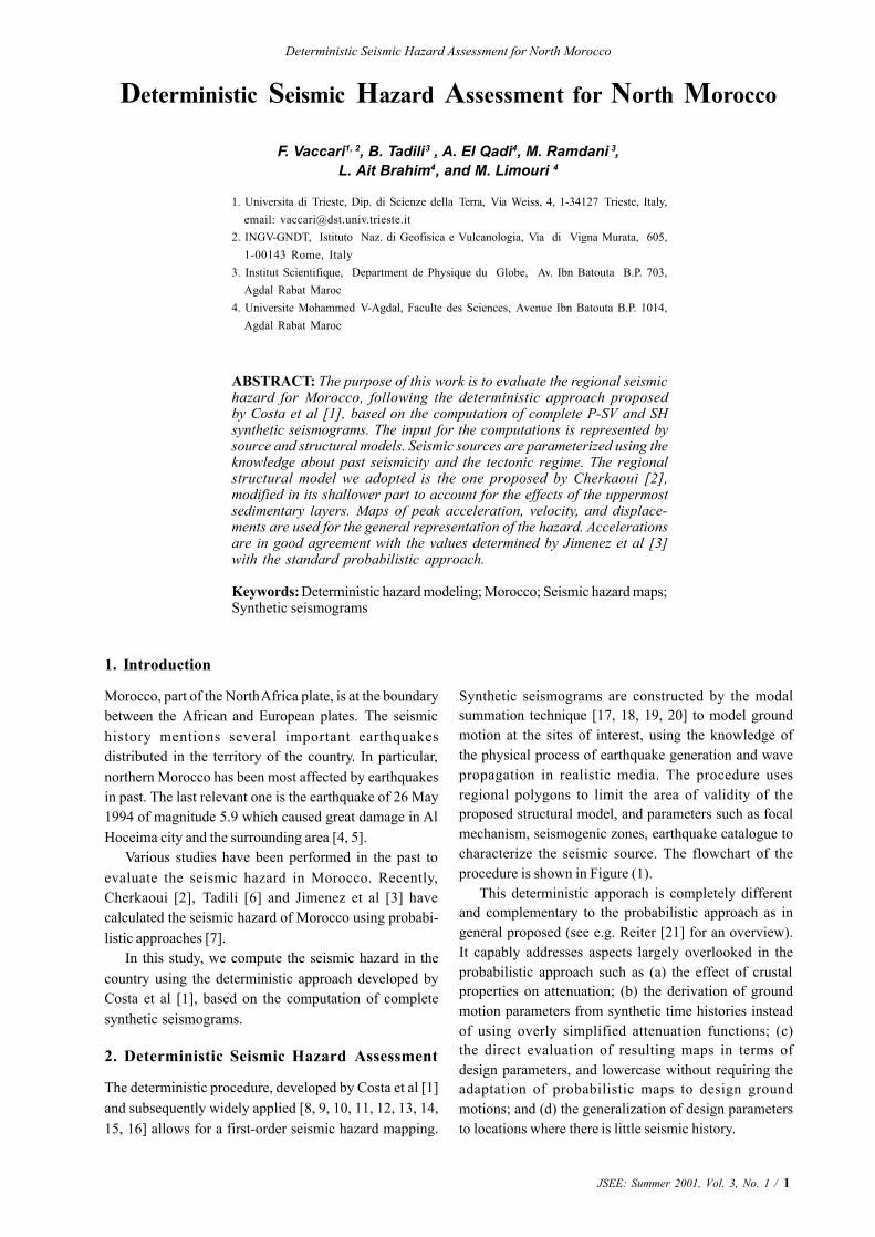
Synthetic seismograms are constructed by the modalsummation technique [17, 18, 19, 20] to model groundmotion at the sites of interest, using the knowledge ofthe physical process of earthquake generation and wavepropagation in realistic media. The procedure usesregional polygons to limit the area of validity of theproposed structural model, and parameters such as focalmechanism, seismogenic zones, earthquake catalogue tocharacterize the seismic source. The flowchart of theprocedure is shown in Figure (1).
This deterministic apporach is completely differentand complementary to the probabilistic approach as ingeneral proposed (see e.g. Reiter [21] for an overview).It capably addresses aspects largely overlooked in theprobabilistic approach such as (a) the effect of crustalproperties on attenuation; (b) the derivation of groundmotion parameters from synthetic time histories insteadof using overly simplified attenuation functions; (c)the direct evaluation of resulting maps in terms ofdesign parameters, and lowercase without requiring theadaptation of probabilistic maps to design groundmotions; and (d) the generalization of design parametersto locations where there is little seismic history.
2 / JSEE: Summer 2001, Vol. 3, No.1
F. Vaccari, et al
The deterministic approach is also preferable in viewof the limited seismological data availability and of themultiscale seismicity model formulated by Molchan et al[22]. According to this model only the ensemble of eventsthat are geometrically small, compared with the elementsof the seismotectonic regionalization, can be described bya log-linear frequency-magnitude (FM) relation. Thiscondition, largely fulfilled by the early global investiga-tion by Gutenberg and Richter (e.g. see Figure (49) ofBath [23]), has been subsequently violated in manyinvestigations. This violation has given rise to theCharacteristic Earthquake (CE) concept [24] in oppositionto the Self-Organized criticality (SOC) paradigm [25].The multiscale model implies that, in order to apply theprobabilistic approach the seismic zonation must be madeat several scales, depending upon the self-similarityconditions of the seismic events and the linearity of thelog FM relation, in the magnitude range of interest.
3. Input Data
Indeed to compute synthetic seismograms, it is necessaryto define the characteristics of the seismic sources and ofthe structural model representative of the studied area.The input data consist of an earthquake catalogue, ofseismogenic zones with associated representative focalmechanisms, and of a structural model.
Figure 1. Flow chart scheme of the deterministic procedure(modified from Costa et al [1]). The vertical compo-nent is routinely not used.
3.1. Earthquake Catalogue
One of the main advantages of the deterministic approachis that an earthquake catalogue complete for magnitude 5and above is sufficient. Therefore it is much easier tocollect the required information, compared to the probabi-listic approach. The catalogue we used (catalogue MORO)is produced by Ramdani [26] for the period from 1900 to1989, completed up to 1995 with the data collected by theseismic network of Morocco. For the region between0O-20OW and 20O-37ON we have compared it with othercatalogues: NEIC in the time period between 1910 and 1998,ISC for earthquakes between 1964 and 1994, and thecatalogue by Benouar (BEN) up to 1990 [27, 28]. Theregion [20O-27ON] is not considered in this study since nosignificant event was ever recorded there.
Indeed the available catalogues show different loca-tions for the same reported event. For the earthquakeswith magnitude 5 and greater, listed in Table (1), thediscrepancies reported by different sources show thatthe choice of the catalogue does not influence much thehazard results. In any case this choice is not critical sincethe smoothing procedure of the magnitude distribution,implemented in the deterministic approach [1], reduces theeffects due to mislocation errors. We finally decided to usethe MORO catalogue since it was earlier adopted by Tadili[6] and Jimenez et al [3] for seismic hazard assessmentstudies in Morocco. In such a way, we can better compareour deterministic results with the probabilistic ones alreadyavailable.
The MORO catalogue contains different estimates ofthe magnitude (magnitude computed from body waves,surface waves, and local magnitude). In order to beconservative in the computation of the synthetic seismo-grams we use the maximum among them. Given all theuncertainties in magnitude determination, we think thatthe best choice is to stay on the “safe” side.
Date Catalogue Lat. Long. Mmax H(km)
1960/02/29MORONEICBEN
30.4530.0030.45
-9.61-9.00-9.62
6.06.36.2
---
1992/10/23MORONEICISC
31.5131.3531.29
-4.23-4.32-4.33
5.25.35.2
22285
1992/10/30MORONEICISC
31.531.2831.25
-4.61-4.37-4.38
5.05.25.1
-258
1994/05/26 MORONEIC
35.2335.31
-4.07-4.10
5.96.0
109
Table 1. Comparison of the earthquake epicenters in the fourcatalogues.
Deterministic Seismic Hazard Assessment for North Morocco
JSEE: Summer 2001, Vol. 3, No. 1 / 3
3.2. Seismogenic Zones and Focal Mechanisms
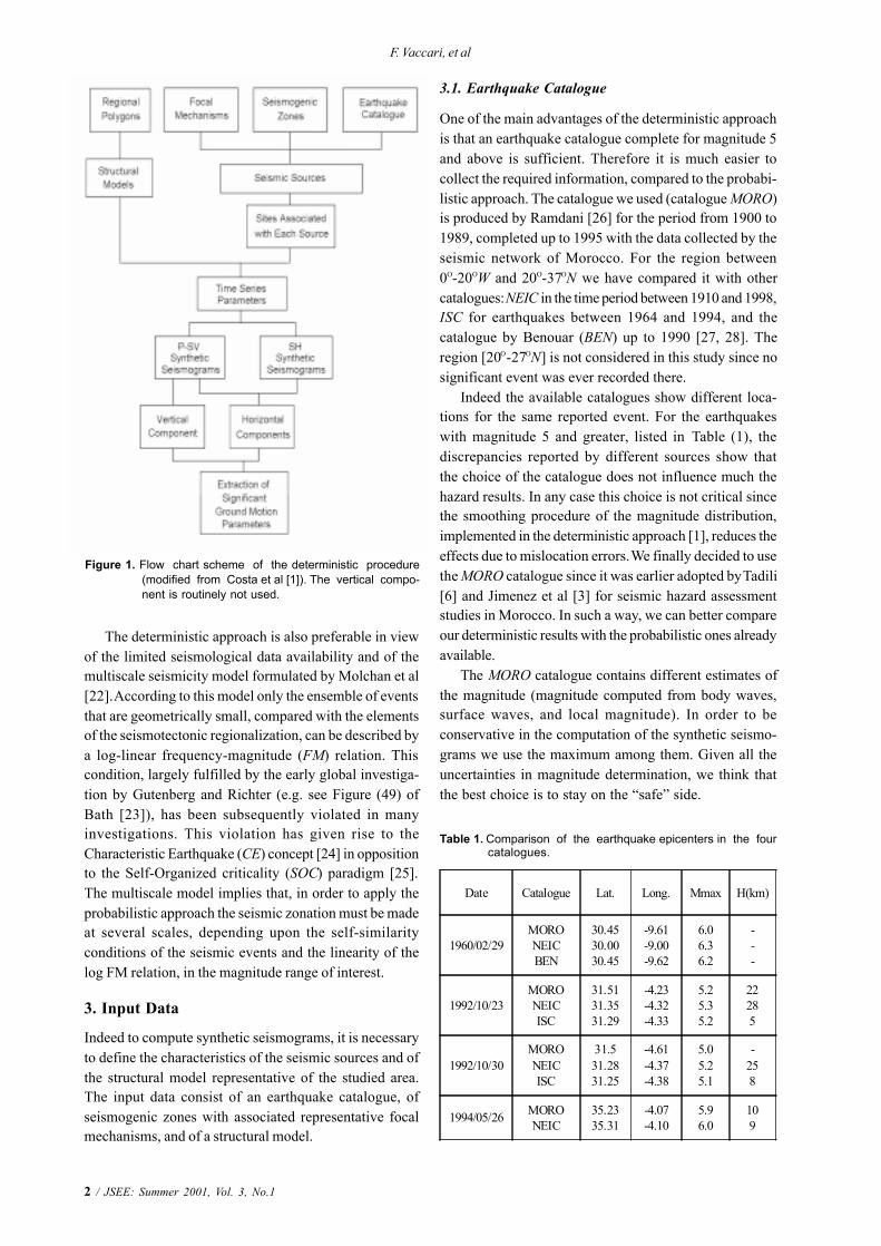
On the basis of the geologic, tectonic and seismicityevidences, Tadili [6] proposed a set of seismic zones forMorocco, shown in Figure (2). This zoning does notseem to satisfy the criteria defined in the deterministic
Figure 2. Seismogenic zones defined by Tadili [6] (modified), used in variant 1, and associated fault plane solutions.
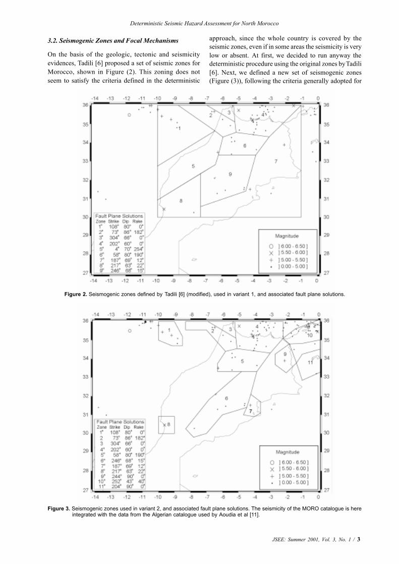
approach, since the whole country is covered by theseismic zones, even if in some areas the seismicity is verylow or absent. At first, we decided to run anyway thedeterministic procedure using the original zones by Tadili[6]. Next, we defined a new set of seismogenic zones(Figure (3)), following the criteria generally adopted for
Figure 3. Seismogenic zones used in variant 2, and associated fault plane solutions. The seismicity of the MORO catalogue is hereintegrated with the data from the Algerian catalogue used by Aoudia et al [11].
4 / JSEE: Summer 2001, Vol. 3, No.1
F. Vaccari, et al
the deterministic approach. Therefore we reduced thespatial extension of the zones taking into account theseismicity of Morocco, and we carefully arranged the zonesat the border with Algeria, considering the work by Aoudiaet al [11].
For the definition of the focal mechanism associatedwith each seismogenic zone, we have collected thepublished fault plane solutions for the territory ofMorocco. The fault plane solutions used are derivedfrom Tadili and Ramdani [29], Medina and Cherkaoui[30], Bufom et al [31], El Alami et al [5], Geo-Ter [32], andCMT (Centroid Moment Tensor) determinations for theregion. In the zones where no focal-plane solution isavailable, the solution available in the nearest zone isconsidered, provided that it is compatible with theseismotectonic regime. The values of strike, dip and rakefor the representative focal mechanism of each seismogeniczone are given in Figures (2) and (3).
3.3. Structural Model
A flat layered anelastic structural model must be defined inorder to run the procedure. Layers are described by theirthickness, density, P- and S-wave velocity, and attenua-tion. The velocity model we used is derived from the onecomputed by Cherkaoui [2]. We modified the uppermost2.5km of the model, considering a layer with Vs = 1.9km/sto account for the sedimentary cover. The model does notdiffer notably from the one adopted by Aoudia et al [11]for Algeria. The parameters of the layers (thickness,density, P- and S- wave velocity and attenuation) aregiven in Table (2).
4. Computations
We compute seismic hazard for two variants: in variant 1we adopt the original seismogenic zones defined byTadili [6] and the earthquake catalogue MORO, while invariant 2 we use the new seismogenic zones defined inSection 3.2, and integrate the MORO catalogue to the Eastwith the Algerian data used by Aoudia et al [11].
In order to account for mislocations and uncertaintiespresent in the earthquake catalogue, and to consider faultdimensions, the distribution of the maximum observedmagnitude over Morocco is discretized and smoothed.
First, the studied region is divided into cells of 0.2ox0.2o
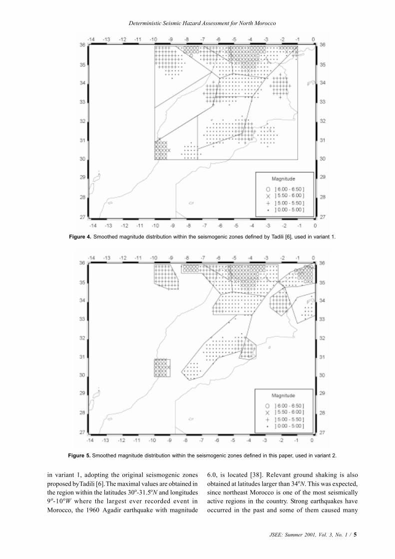
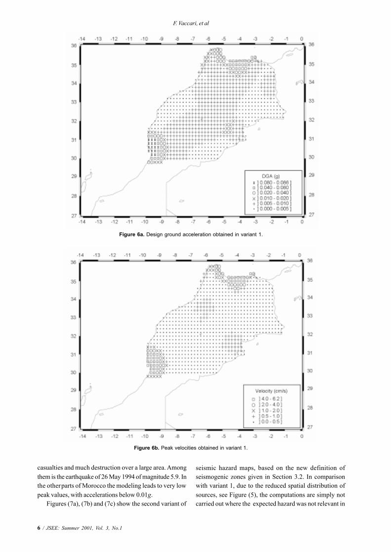
and the maximum observed magnitudes of the earthquakeswhich occurred within each cell is determined. A smooth-ing window is then applied (with radius of three cells), sothat earthquake magnitudes are reported not only in thecentral cell, but also in the neighboring ones, if they fallwithin a seismogenic zone [1]. The maps shown in Figures(4) and (5) are the results of the application of this methodto the two set of seismogenic zones, used in variant 1 andvariant 2 respectively. Each seismic source is representedby a double-couple point source located in the center ofeach cell. The orientation of the double-couple pointsource is fixed accordingly to the fault-plane solutionsrepresentative of the seismogenic zone containing thesource.
Once the structural models and the source characteris-tics are defined, sites are considered on a grid 0.2o x 0.2o
covering the whole territory, and synthetic seismogramsare computed by the modal summation technique [17, 18,19, 20]. To reduce the number of computed seismograms,the source receiver distance is kept below an upper thresh-old, which is considered to be a function of the magnitudeassociated with the source. The maximum source-receiverdistance is set to 25, 50, and 90km for M<6, 6<M<7 andM 7, respectively. At each receiver the P-SV (radialcomponent) and SH (transverse component) are computedfor a seismic moment of 1x10⁻⁷Nm. The amplitudes are thenproperly scaled according to the smoothed magnitudeassociated with the cell of the source using the moment-magnitude relation by Kanamori [33] and the spectralscaling law proposed by Gusev [34] as reported inAki [35]. The horizontal components are first rotated toa common reference system (NS- and EW-directions)and then their vector sum is calculated. From theseseismograms, at each point of the 0.2 grid we select themaximum values of acceleration (AMAX), velocity (VMAX)and displacement (DMAX). The synthetic signals arecomputed for an upper frequency content of 1Hz, andthe scaled point-source approximation [34] is stillacceptable. It has been shown by Panza et al [36] thatfor displacements and for velocities 1Hz cutoff does notlead to significant losses in the peak amplitudes. Foraccelerations, the deterministic results may be extended tofrequencies higher than 1Hz by using design responsespectra to obtain the Design Ground Acceleration (DGA).For this purpose we have adopted the Eurocode 8 (EC8[37]), which defines the normalized elastic accelerationresponse spectrum of the ground motion, for 5% criticaldamping. This choice is not obliged, and other designspectra can be used if more appropriate for the studiedarea.
5. Discussion of Results and Conclusion
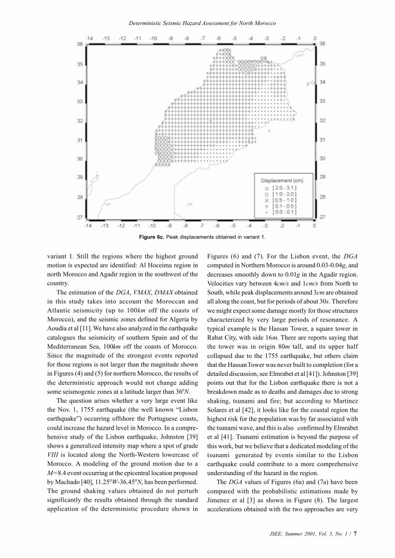
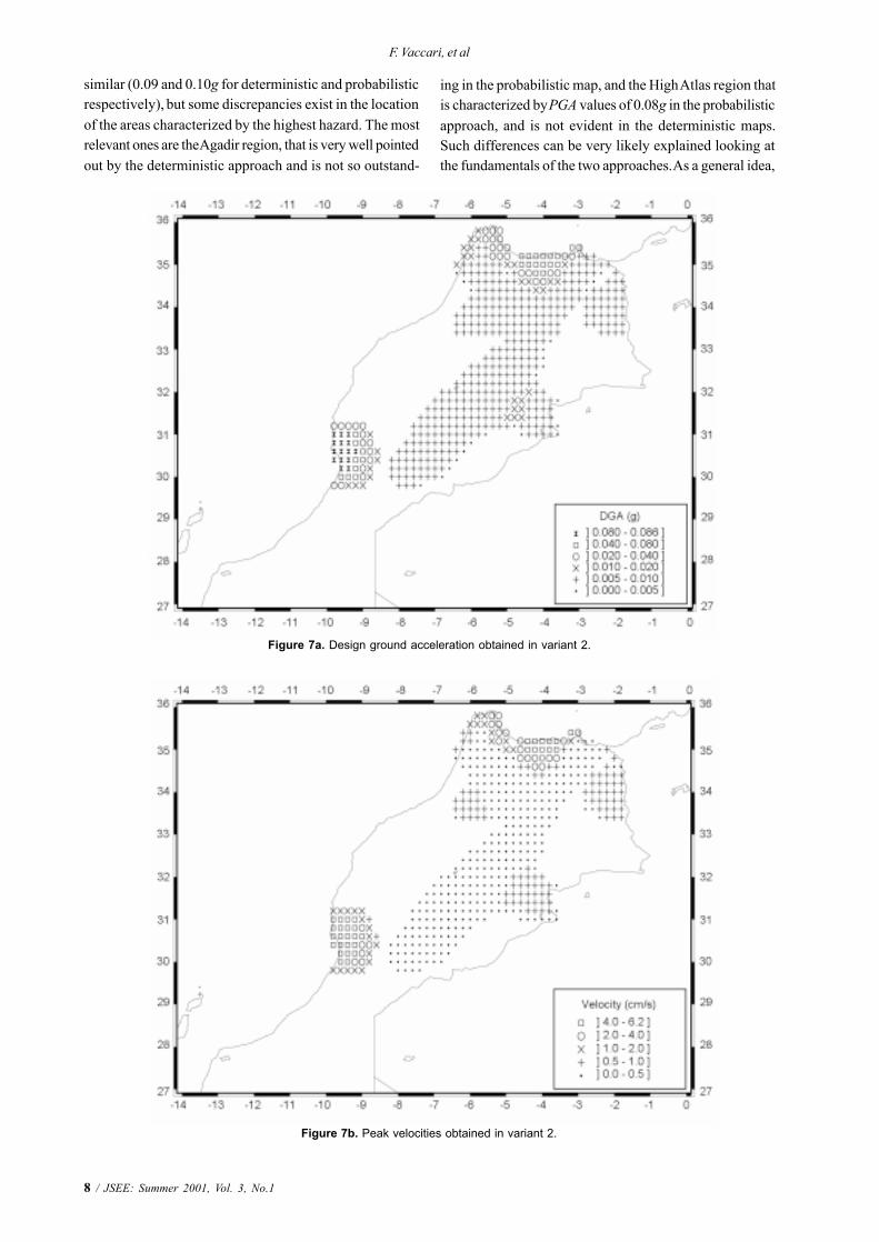
Figure (6) shows the maximum ground motion computed
Table 2. Velocity model used for the computation of syntheticseismograms.
3
Deterministic Seismic Hazard Assessment for North Morocco
JSEE: Summer 2001, Vol. 3, No. 1 / 5
Figure 4. Smoothed magnitude distribution within the seismogenic zones defined by Tadili [6], used in variant 1.
Figure 5. Smoothed magnitude distribution within the seismogenic zones defined in this paper, used in variant 2.
in variant 1, adopting the original seismogenic zonesproposed by Tadili [6]. The maximal values are obtained inthe region within the latitudes 30o-31.5oN and longitudes9o-10oW where the largest ever recorded event inMorocco, the 1960 Agadir earthquake with magnitude
6.0, is located [38]. Relevant ground shaking is alsoobtained at latitudes larger than 34oN. This was expected,since northeast Morocco is one of the most seismicallyactive regions in the country. Strong earthquakes haveoccurred in the past and some of them caused many
6 / JSEE: Summer 2001, Vol. 3, No.1
F. Vaccari, et al
Figure 6a. Design ground acceleration obtained in variant 1.
casualties and much destruction over a large area. Amongthem is the earthquake of 26 May 1994 of magnitude 5.9. Inthe other parts of Morocco the modeling leads to very lowpeak values, with accelerations below 0.01g.
Figures (7a), (7b) and (7c) show the second variant of
Figure 6b. Peak velocities obtained in variant 1.
seismic hazard maps, based on the new definition ofseismogenic zones given in Section 3.2. In comparisonwith variant 1, due to the reduced spatial distribution ofsources, see Figure (5), the computations are simply notcarried out where the expected hazard was not relevant in
Deterministic Seismic Hazard Assessment for North Morocco
JSEE: Summer 2001, Vol. 3, No. 1 / 7
Figure 6c. Peak displacements obtained in variant 1.
variant 1. Still the regions where the highest groundmotion is expected are identified: Al Hoceima region innorth Morocco and Agadir region in the southwest of thecountry.
The estimation of the DGA, VMAX, DMAX obtainedin this study takes into account the Moroccan andAtlantic seismicity (up to 100km off the coasts ofMorocco), and the seismic zones defined for Algeria byAoudia et al [11]. We have also analyzed in the earthquakecatalogues the seismicity of southern Spain and of theMediterranean Sea, 100km off the coasts of Morocco.Since the magnitude of the strongest events reportedfor those regions is not larger than the magnitude shownin Figures (4) and (5) for northern Morocco, the results ofthe deterministic approach would not change addingsome seismogenic zones at a latitude larger than 36oN.
The question arises whether a very large event likethe Nov. 1, 1755 earthquake (the well known “Lisbonearthquake”) occurring offshore the Portuguese coasts,could increase the hazard level in Morocco. In a compre-hensive study of the Lisbon earthquake, Johnston [39]shows a generalized intensity map where a spot of gradeVIII is located along the North-Western lowercase ofMorocco. A modeling of the ground motion due to aM = 8.4 event occurring at the epicentral location proposedby Machado [40], 11.25oW-36.45oN, has been performed.The ground shaking values obtained do not perturbsignificantly the results obtained through the standardapplication of the deterministic procedure shown in
Figures (6) and (7). For the Lisbon event, the DGAcomputed in Northern Morocco is around 0.03-0.04g, anddecreases smoothly down to 0.01g in the Agadir region.Velocities vary between 4cm/s and 1cm/s from North toSouth, while peak displacements around 3cm are obtainedall along the coast, but for periods of about 30s. Thereforewe might expect some damage mostly for those structurescharacterized by very large periods of resonance. Atypical example is the Hassan Tower, a square tower inRabat City, with side 16m. There are reports saying thatthe tower was in origin 80m tall, and its upper halfcollapsed due to the 1755 earthquake, but others claimthat the Hassan Tower was never built to completion (for adetailed discussion, see Elmrabet et al [41]). Johnston [39]points out that for the Lisbon earthquake there is not abreakdown made as to deaths and damages due to strongshaking, tsunami and fire; but according to MartinezSolares et al [42], it looks like for the coastal region thehighest risk for the population was by far associated withthe tsunami wave, and this is also confirmed by Elmrabetet al [41]. Tsunami estimation is beyond the purpose ofthis work, but we believe that a dedicated modeling of thetsunami generated by events similar to the Lisbonearthquake could contribute to a more comprehensiveunderstanding of the hazard in the region.
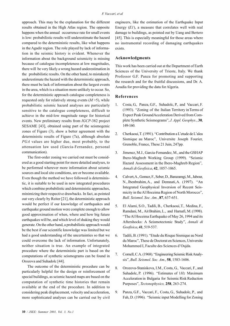
The DGA values of Figures (6a) and (7a) have beencompared with the probabilistic estimations made byJimenez et al [3] as shown in Figure (8). The largestaccelerations obtained with the two approaches are very
8 / JSEE: Summer 2001, Vol. 3, No.1
F. Vaccari, et al
Figure 7a. Design ground acceleration obtained in variant 2.
Figure 7b. Peak velocities obtained in variant 2.
similar (0.09 and 0.10g for deterministic and probabilisticrespectively), but some discrepancies exist in the locationof the areas characterized by the highest hazard. The mostrelevant ones are the Agadir region, that is very well pointedout by the deterministic approach and is not so outstand-
ing in the probabilistic map, and the High Atlas region thatis characterized by PGA values of 0.08g in the probabilisticapproach, and is not evident in the deterministic maps.Such differences can be very likely explained looking atthe fundamentals of the two approaches. As a general idea,
Deterministic Seismic Hazard Assessment for North Morocco
JSEE: Summer 2001, Vol. 3, No. 1 / 9
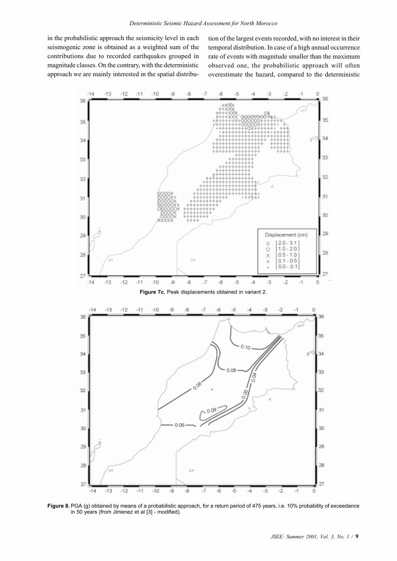
Figure 7c. Peak displacements obtained in variant 2.
Figure 8. PGA (g) obtained by means of a probabilistic approach, for a return period of 475 years, i.e. 10% probability of exceedance in 50 years (from Jimenez et al [3] - modified).
in the probabilistic approach the seismicity level in eachseismogenic zone is obtained as a weighted sum of thecontributions due to recorded earthquakes grouped inmagnitude classes. On the contrary, with the deterministicapproach we are mainly interested in the spatial distribu-
tion of the largest events recorded, with no interest in theirtemporal distribution. In case of a high annual occurrencerate of events with magnitude smaller than the maximumobserved one, the probabilistic approach will oftenoverestimate the hazard, compared to the deterministic
10 / JSEE: Summer 2001, Vol. 3, No.1
F. Vaccari, et al
approach. This may be the explanation for the differentresults obtained in the High Atlas region. The oppositehappens when the annual occurrence rate for small eventsis low: probabilistic results will underestimate the hazardcompared to the deterministic results, like what happensin the Agadir region. The role played by lack of informa-tion in the seismic history is evident. Whenever theinformation about the background seismicity is missingbecause of catalogue incompleteness at low magnitudes,there will be very likely a wrong hazard underestimation inthe probabilistic results. On the other hand, to mistakenlyunderestimate the hazard with the deterministic approach,there must be lack of information about the largest eventsin the area, which is a situation more unlikely to occur. So,for the deterministic approach catalogue completeness isrequested only for relatively strong events (M >5), whileprobabilistic seismic hazard analyses are particularlysensitive to the catalogue completeness, difficult toachieve in the mid-low magnitude range for historicalevents. New preliminary results from IGCP-382 projectSESAME [43], obtained using part of the seismogeniczones of Figure (3), show a better agreement with thedeterministic results of Figure (7a), although absolutePGA values are higher due, most probably, to theattenuation law used (Garcia-Fernandez, personalcommunication).
The first-order zoning we carried out must be consid-ered as a good starting point for more detailed analyses, tobe performed wherever more information about seismicsources and local site conditions, are or become available.Even though the method we have followed is determinis-tic, it is suitable to be used in new integrated procedureswhich combine probabilistic and deterministic approaches,minimizing their respective drawbacks. In fact, as pointedout very clearly by Reiter [21], the deterministic approachwould be perfect if our knowledge of earthquakes andearthquake ground motion were complete enough to allowgood approximation of when, where and how big futureearthquakes will be, and which level of shaking they wouldgenerate. On the other hand, a probabilistic approach wouldbe the best if our scientific knowledge was limited but wehad a good understanding of the uncertainties so that wecould overcome the lack of information. Unfortunately,neither situation is true. An example of integratedprocedure where the deterministic part is based on thecomputations of synthetic seismograms can be found inOrozova and Suhadolc [44].
The outcome of the deterministic procedure can beparticularly helpful for the design or reinforcement ofspecial buildings, as seismic hazard maps are based on thecomputation of synthetic time histories that remainavailable at the end of the procedure. In addition toconsidering peak displacement, velocity and acceleration,more sophisticated analyses can be carried out by civil
engineers, like the estimation of the Earthquake InputEnergy (E1), a measure that correlates well with realdamage to buildings, as pointed out by Uang and Bertero[45]. This is especially meaningful for those areas whereno instrumental recording of damaging earthquakesexists.
Acknowledgments
This work has been carried out at the Department of EarthSciences of the University of Trieste, Italy. We thankProfessor G.F. Panza for promoting and supportingthe research and for the fruitful discussions, and Dr. A.Aoudia for providing the data for Algeria.
References
1. Costa, G., Panza, G.F., Suhadolc, P., and Vaccari, F.(1993). “Zoning of the Italian Territory in Terms ofExpect Peak Ground Acceleration Derived from Com-plete Synthetic Seismograms”, J. Appl. Geophys., 30,149-160.
2. Cherkaoui, T. (1991). “Contribution a L’etude de L’aleaSismique au Maroc”, Universite Joseph Fourier,Grenoble, France, These 21 Juin, 247pp.
3. Jimenez, M.J., Garcia-Femandez, M., and the GSHAPIbero-Maghreb Working Group (1999). “SeismicHazard Assessment in the Ibero-Maghreb Region”,Annali di Geofisica, 42, 1057-1065.
4. Calvert, A., Gomez, F., Seber, D., Barazamgi, M., Jabour,N., Ibenbrahim, A., and Demnati, A. (1997). “AnIntegrated Geophysical Inversion of Recent Seis-micity in the Al Hoceima Region of North Morocco”,Bull. Seismol. Soc. Am., 87, 637-651.
5. El Alami, S.O., Tadili, B., Cherkaoui, T., Medina, F.,Ramdani, M., Ait Brahim, L., and Harnafi, M. (1998).“The Al Hoceima Earthquake of May 26, 1994 and itsAftershocks: A Seismotectonic Study”, Annali diGeofisica, 41, 519-537.
6. Tadili, B. (1991). “Etude du Risque Sismique au Norddu Maroc”, These de Doctorat en Sciences, UniversiteMohammed I, Faculte des Sciences d’Oujda.
7. Cornell, C.A. (1968). “Engineering Seismic Risk Analy-sis”, Bull. Seismol. Soc. Am., 58, 1583-1606.
8. Orozova-Staniskova, I.M., Costa, G., Vaccari, F., andSuhadolc, P. (1996). “Estimates of 1Hz MaximumAcceleration in Bulgaria for Seismic Risk ReductionPurposes”, Tectonophysics, 258, 263-274.
9. Panza, G.F., Vaccari, F., Costa, G., Suhadolc, P., andFah, D. (1996). “Seismic input Modelling for Zoning
Deterministic Seismic Hazard Assessment for North Morocco
JSEE: Summer 2001, Vol. 3, No. 1 / 11
and Microzoning”, Earthquake Spectra, 12, 529-566.
10. Alvarez, L., Vaccari, F., and Panza, G.F. (1999). “Deter-ministic Seismic Zoning of Eastern Cuba”, Pure Appl.Geophys., 156, 469-486.
11. Aoudia, A., Vaccari, F., Suhadolc, P., and Meghraoui,M. (2000). “Seismogenic Potential and EarthquakeHazard Assessment in Tell Atlas of Algeria”, J. ofSeismology, 4, 79-98.
12. Bus, Z., Szeidovitz, G., and Vaccari, F. (2000). “Syn-thetic Seismogram Based Deterministic SeismicZoning for the Hungarian Part of the PannonianBasin”, Pure Appl. Geophys., 157, 205-220.
13. Markusic, S., Suhadolc, P., Herak, M., and Vaccari, F.(2000). “A Contribution to Seismic Hazard Assess-ment in Croatia from Deterministic Modelling”, PureAppl. Geophys., 157, 185-204.
14. Radulian, M., Vaccari, F., Mandrescu, N., Panza, G.F.,and Moldoveanu, C.L. (2000). “Seismic Hazard ofRomania: Deterministic Approach”, Pure Appl.Geophys., 157, 221-248.
15. Zivcic, M., Suhadolc, P., and Vaccari, F. (2000).“Seismic Zoning of Slovenia Based on DeterministicHazard Computations”, Pure Appl. Geophys., 157,171-184.
16. El-Sayed, A., Vaccari, F., and Panza, G.F. (2001).“Deterministic Seismic Hazard in Egypt”, Geophys. J.Int., 144, 1-20.
17. Panza, G.F. (1985). “Synthetic Seismograms: TheRayleigh Waves Modal Summation”, J. Geophys., 58,125-145.
18. Panza, G.F. and Suhadolc, P. (1987). “Complete StrongMotion Synthetics”, In: Computational Techniques,Vol. 4, Seismic Strong Motion Synthetics, ed. by: B.A.Bolt, 153-204, Academic Press.
19. Florsch, N., Fah, D., Suhadolc, P., and Panza, G.F.(1991). “Complete Synthetic Seismograms for High-Frequency Multimode SH-Waves”, Pure Appl.Geophys., 136, 529-560.
20. Panza, G.F., Romanelli, F. and Vaccari, F. (2000).“Seismic Wave Propagation in Laterally Heteroge-neous Anelastic Media: Theory and Applications tothe Seismic Zonation”, Advances in Geophysics, 43,1-95.
21. Reiter, L. (1990). “Earthquake Hazard Analysis”,Columbia University Press, New York.
22. Molchan, G., Kronrod, T., and Panza, G.F. (1997).
“Multi-Scale Seismicity Model for Seismic Risk”, Bull.Seismol. Soc. Am., 87, 1220-1229.
23. Bath, M. (1973). “Introduction to Seismology”,Birkhauser, Basel.
24. Schwartz, D.P. and Coppersmith, K.J. (1984). “FaultBehaviour and Characteristic Earthquakes: Examplesfrom the Wasatch and San Andres Fault Zones”, J.Geophys. Res., 89, 5681-5698.
25. Bak, P. and Tang, C. (1989). “Earthquakes as a Self-Organized Critical Phenomenon”, J. Geophys. Res.,94, 15635-15637.
26. Ramdani, M. (1991). “Etude Simotectonique du Norddu Maroc”, Ph.D. Thesis, Universite Mohammed I,Faculte Des Sciences D’Oujda.
27. Benouar, D. (1994). “An Earthquake Catalogue forthe Maghreb Region 20o-38oN, 10oW-12oE for thePeriod 1900-1990”, Annali di Geofisica, 37, 511-528.
28. Benouar, D. (1994). “Earthquake Catalogue for theMaghreb Region 20o-38oN, 10oW-12oE for the Period1900-1990 for Ms≥ 3.0”, Annali di Geofisica, 37,561-605.
29. Tadili, B. and Ramdani, M. (1986). “La Sismicite duMoyen Atlas”, Gerlands Beitz. Geophysics, Leipzig95, 6, S. 469-479.
30. Medina, F. and Cherkaoui, T. (1992). “Mecanismes auFoyer Des Seismes du Maroc et Des Regions Voisines(1959-1986): Consequences Tectoniques”, EclogaeGeologicae Elvetiae, 85, 433-457.
31. Bufom, E., Sanz de Galdeano, C., and Udias, A. (1995).“Seismotectonics of the Ibero-Maghrebian Region”,Tectonophysics, 248, 247-261.
32. Geo-Ter (1999). “Cen de Maamora, Evaluation DesMouvements Sismiques Sur le Site”, Rapport Inedit.
33. Kanamori, H. (1977). “The Energy Release in GreatEarthquakes”, J. Geophys. Res., 82, 2981-2987.
34. Gusev, A.A. (1983). “Descriptive Statistical Model ofEarthquake Source Radiation and its Application toan Estimation of Short Period Strong Motion”,Geophys. J. R. Astron. Soc., 74, 787-800.
35. Aki, K. (1987). “Strong Motion Seismology”, In: Erdik,M. and Tokoz, M. (eds), Strong Ground MotionSeismology, NATO ASI Series, Series C: Mathemati-cal and Physical Sciences, D. Reidel PublishingCompany, Dordrecht, 204, 3-39.
36. Panza, G.F., Cazzaro, R., and Vaccari, F. (1997).
12 / JSEE: Summer 2001, Vol. 3, No.1
F. Vaccari, et al
“Correlation between Macroseismic Intensities andSeismic Ground Motion Parameters”, Annali diGeofisica, 40, 1371-1382.
37. EC8 (1993). Eurocode 8 Structures in Seismic Regions-Design-Part 1 General and Building, Doc TC250/SC8/N57A.
38. Benouar, D. (1994). “The Agadir Earthquake of 29February, 1960”, Annali di Geofisica, 37, 775-792.
39. Johnston, A.C. (1996). “Seismic Moment Assessmentof Earthquakes in Stable Continental Regions- III, New Madrid 1811-1812, Charleston 1886 and Lisbon1755”, Geophys. J. Int., 126, 314-344.
40. Machado, F. (1966). “Contribucao Para o Estudio doTerremoto de 1 de Nov. de 1775”, Rev. Fac Cien. DeLisbon, Ser. C., 14, 19-31.
41. Elmrabet, T., Levret, A., Ramani, M., and Tadili, B.(1991). “Historical Seismicity in Morocco: Method-ological Aspects and Cases of MultidisciplinaryEvaluation”, In: Seismicity and Seismic Risk of the
Ibero-Maghrebian Region, Monograph 8, InstitutoGeografico Nacional (IGN), Madrid, 115-129.
42. Martinez Solares, J.M., Lopez Arroyo, A., andMezcua, J. (1979). “Isoseismal Map of the 1755 LisbonEarthquake Obtained from Spanish Data”, Tectono-physics, 53, 301-313.
43. Jimenez, M.J., Giardini, D., Grunthal, G., and theSESAME Working Group (2000). “Unified SeismicHazard Modelling throughout the MediterraneanRegion”, XXVII General assembly of t he EuropeanSeismological Commission, Lisbon, Portugal, Bookof Abstracts and Papers, Lisbon University, Lisbon,Portugal, SSF-1-50-O, 93.
44. Orozova, I.M. and Suhadolc, P. (1999). “A Determinis-tic-Probabilistic Approach for Seismic HazardAssessment”, Tectonophysics, 312, 191-202.
45. Uang, C.M. and Bertero, V.V. (1990). “Evaluation ofSeismic Energy in Structures”, Earthquake Engineer-ing and Structural Dynamics, 19, 77-90.