data acquisition in oceanographic research vessels
TRANSCRIPT
Data Acquisition in Oceanographic Research Vessels
Oscar García, Joan Olivé, Dulce Afonso,
Eduardo Arilla, Alberto Hernández, Juan Luis Ruiz,
Xoan Romero, Antonio Sandoval,
José Alberto Serrano, Jordi Sorribas
Telematic and Communications Dept.
Unidad de Tecnología Marina. CSIC. Barcelona, Spain
e-mail: [email protected]
Enric Trullols, Joaquin del Río Applied Mathematics and Electronics Dept,
Universitat Politècnica de Catalunya. BarcelonaTech
Vilanova i la Geltrú, Spain
e-mail: [email protected]
e-mail: [email protected]
Abstract – This paper describes the design and the development
of a new real time data acquisition system which focuses on
oceanographic research. The system has been implemented in
several Spanish oceanographic platforms (vessels and land-sites)
using very reliable MESH network that can still operate when
one node breaks down or a connection goes bad. Service Oriented
Architecture allows expandable access to real time and historical
data. This system is applicable to any network of instrumentation
where an integrated management of data and a wide range of
access procedures are needed. We can frame these data
acquisition system in a satellite communications environment
both VSAT (C band) and TNX75 (X band). The target domain off
these projects is to provide long-range data and optimize satellite
communications resources. The challenging issue is to achieve
cross-platform data-generating infrastructure, which in an
optimized use of system resources and provide real time
information to the user without depending on the location in
which to generate or produce them. The project is focused mainly
in relation to the acquisition of data, such as an integrated system
of generation of data with a multilayer structure for accessing
data consulting services, all using communications via satellite.
To this day, we fully integrated platform and running, and we are
expanding the services and optimizing the end-user interfaces
with these new services. The eyelet of this document is to provide
global technical community the current status in Spain, in regard
to oceanographic data generation and exploitation of the same by
the scientific community, from both the oceanographic vessels
located anywhere of the world from locations ashore.
Keywords-data acquisition; web data services; OGC standards;
service oriented architecture
I. INTRODUCTION
The Marine Technology Unit (UTM) from the Spanish
Research Council (CSIC) manages three different oceanic
research vessels: “Hesperides”, “Sarmiento de Gamboa” and
“García del Cid”, and the Spanish Antarctic base “Juan
Carlos-I”. These scientific platforms are devoted to acquiring
different kinds of scientific data, depending on the project
(survey) in course. A new oceanographic data acquisition and
exploitation system has been integrated on vessels managed
by UTM. Several Data layers are implemented to allow data
access from the more common tools and formats used in
marine sciences. MESH networking was used in order to find
a good solution for continuous connections and
reconfiguration around broken or blocked paths. It also allows
easy connection of new instruments and sensors.
Broadband communications systems via satellite installed
on research platforms (ships and bases) provides a link from
remote networks to the local area network of the UTM in
Barcelona (Spain). A network of instrumentation on each
platform works as a generator node of data, being all of them
managed from the headquarters of UTM.
The objective is to ensure uniform treatment of
information from these systems and their access (in real time
or by consulting the historical records) by the maximum
possible number of protocols and procedures.
It is designed following a Service Oriented Architecture
(SOA) with a multilayer service schema in order to be easily
expandable to new required data services [7]. It is fully
operational and it has been implemented on top of the Java
library and data model build in two previous technological
research projects: The Virtual Distributed Lab for
Oceanographic Data Processing and Monitoring (LabVir) and
the Interoperability in Environmental and Marine Sensor
Networks (INTIMAS), both funded by the Spanish
government [6].
To achieve the centralization of data in a fast and stable
environment, one of the problems that we face is to the
dependencies of communications via satellite, and the
optimized use of them, then detailing the steps we have taken
for achieve good results.
The oceanographic data acquisition can be seen as a
technological challenge in regard to getting the system
becomes a real system for generating real-time data, and a
resource server system for searching them all that using
current technologies in terms of infrastructure and
communication protocols.
To this day, our communications infrastructure is
implemented in oceanographic vessel BIO Hesperides and
BIO Sarmiento de Gamboa. Regarding the vessel's
communications Garcia del Cid, we are looking for
alternatives of communication via satellite but with a limited
geographical range to the Mediterranean Sea. On the other
hand, the Spanish Antarctic Base Juan Carlos I, is
implementing a VSAT (C Band) from this year and became
fully operational during the next year (2011).
Regarding the data acquisition system, the system actually
is fully operational, and its performance is like we expected,
providing to our software architecture high values-added.
The implementation of the proposed data acquisition
system, is conceived as a MESH network at the application
layer, where all devices and instruments have the ability to
talk, through web services, with the rest of equals with out any
hierarchy.
In the next section we display the state of the art pointing
the differences with previous works and showing the
advantage of the MESH approach instead of the existing ones.
Sections 3, 4, 5 and 6 are devoted to the communications
infrastructure, the data acquisition core, the services offered
by our architecture, and the data representation, respectively.
Section 7 shows a case study working in one of our
oceanographic research vessels. The paper ends with a
conclusions and future work section.
II. STATE OF THE ART
There are relatively few references to bibliographic data
acquisition systems on oceanographic vessels and none with a
level of integration similar to the proposal, detailing the
services to low-level communications and acquisition
(relations between instruments) to the upper layer interface
user, where the scientific view and get the data produced. The
integration of network management system with data
management system is also new, although simple in concept,
and there are no references to similar systems.
The MESH approach is advantageous in this area down as
no predetermined relationships between systems that limit the
expandability of the system (adding new instruments or
sensors to the network) or to interfere with the restoration of
the system against a potential failure of one of its elements.
The latter concept is especially important in isolated
environments such as neglected or acquisition systems that are
installed on board ships or ocean observatories.
III. COMMUNICATIONS
Broadband Satellite Communication Systems were
installed in two vessels during 2008. In “Sarmiento de
Gamboa” oceanographic vessel a VSAT Communication
System in C band was installed with a data transfer rate of 192
kbps (CIR, Committed Information Rate) and a burst capacity
of 256 kbps (MIR, Maximum Information Rate) which can be
increased to 5 Mbps. In “Hesperides” oceanographic vessel,
following Navy specifications (the ship-owner) a TNX75
Communication System in X band was installed with a data
transfer rate of 128 kbps (CIR) which can be also increased to
5 Mbps.
Apart from the advantages that an Internet access has had
for the researchers, one of the most important characteristics
of this Broadband System is the possibility of configuring a
Virtual Private Network (VPN) between the vessels and the
UTM main offices on shore (Land-Site). This network enables
real-time data transmission and remote systems control and
operation. Furthermore, web browsing is possible and an IP
telephone system has been installed.
The broadband satellite service of UTM allows IP
networking in permanent connection using VSAT technology.
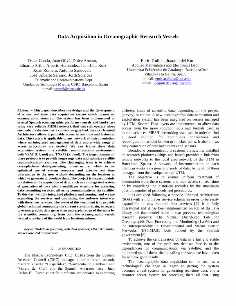
Figure 1. General schema of system communication on board “Sarmiento de Gamboa” and “Hesperides”
The satellite service providers are SEAMOBILE and
HISDESAT. Both providers use geostationary satellites
(orbiting at 35,786 km) and a large set of ground stations to
provide coverage around the globe except the polar areas
(their effective coverage is between 70 º N and 70 º S).
The terminals used onboard work with the C and X bands.
The dimension of the antennas (2.4 m diameter) enables data
transmission rates close to 5 Mbps in a global coverage
scenario. With the current contract the providers guarantee a
link with a minimum symmetrical bandwidth of 128Kbps.
Since the key element of both systems is the VPN connection
between the vessels and the UTM on shore (Land Site), the
system architecture is virtually identical in both cases,
although the receivers work in different bands. The diagram
for that architecture is detailed in Figure 1, referring to the
three locations involved: vessel, land backbone or teleport site,
and UTM Land Site:
Vessel Site: On board there is a gyro-stabilized antenna and
position control unit, a modem, and the network equipment
(that enables IP routing, VPN establishment, access control
lists, management of service quality, and links to the vessel
network). In both vessels the IP equipment is the same brand
and model (Cisco 2800 Series routers), while the electronic
equipment for satellite link is specific to each case.
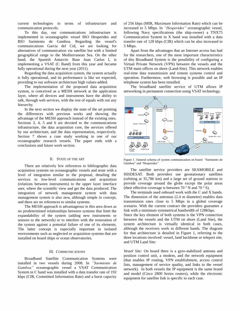
Figure 2. Data Service Layers, communication protocols used and data clients
used in the Multilayer Service Data Acquisition and Operation System for Oceanographic ships and Instrumentation Networks. Real time and archive
data domains are located at the background.
The configuration of these routers allows VPN establishment
and Access Control Lists (ACLs) which allow specific
computers to access Internet or Land Site Local Area
Network.
Teleport Site: In order to link the satellites and the data
backbone network (or public switched telephone network
(PSTN)) providers need specific equipment. In this site a
modem for the satellite link, an IP router for Internet
connection and a firewall can be found. This last security
element has been placed in this site in order to prevent the
waste of bandwidth due to spam traffic.
Land Site: This equipment corresponds to the end of VPN and
is located in the UTM Land Site (Barcelona, Spain). The VPN
links are managed by a router. This is the central node in the
Private Network which is extended between the UTM site and
the oceanographic vessels. Only some computers have
permission to access the ships’ networks from the UTM LAN,
these are specific in the ACL configuration.
IV. A MULTILAYER SERVICE DATA ACQUISITION AND
OPERATION SYSTEM (SADO)
The basic mechanisms of transport and exchange of data
between acquisition applications and interfaces, users or other
external systems have been built using a model of overlapping
layers (Figure 2). Basic interfaces, and instrumentation have
been placed at the core of the system, and several layers of
service of increasing complexity are superimposed until the
mechanisms of communication with user applications. Layers
of service cover data access in real time as well as access to
stored or archived data sets.
A. Basic Data Transport Service Layer
The basic mechanism for information exchange from
acquisition applications to the different layers of service is
made using datagrams ASCII following the NMEA-183
standard using the User Datagram Protocol protocol (UDP) in
broadcast mode. The inner ring of the service layer model for
communication with instruments is formed upon this basic
mechanism that has been used and tested successfully from
several previous works [2].
For instruments that use UDP as the native method of data
transmission, this layer of service provides the proper
normalization of telegrams that identifies the type of
instrument and the platform (ship or base) that is issued. For
those that use other input/output interfaces, an additional
network interface is provided within this service.
The UDP protocol is not as reliable as TCP in the delivery
of messages, but is faster, it also introduces low overhead of
headers in the network and allows a design between client
applications and servers without needing to establish
permanent links or specific boot order when is used in
broadcast mode.
B. Access to Historical Records Service Layers
In order to provide access to the historical records of the
acquired data a three-layer service have been designed and
developed.
In each platform and in the central node of the whole
system the historic records are feed by real time acquisition
applications while an additional copy is stored, every minute,
in the central node by database synchronization procedures.
This databases redundancy allows the detection of sporadic
cuts in satellite links.
1) RAW and Processed Files Service Layer (FILE). This
layer provides data storage in ASCII files with the
raw information, contained in the telegrams NMEA
and ASCII files in CSV format [9], with a subset of
data encoded within the telegrams specifying the
name and units of the measured variables. The ASCII
files are generated daily. The name of each file is a
code with information about the day, month and year
of its creation..The extension of the name identifies
the instrument that originates the data.
2) Relational Database Service (SQL) This layer
provides data storage in tables in a relational database
with geographic extensions, as POSTGRES with
PostGIS. The acquisition date adjusted to the
millisecond is formed as primary key databases. The
relationships between tables are not formally
expressed as table relations, but are implemented
inside the logic of the service at the application level.
3) Geographic Data Service (WFS and WMS) It is built
on the previous layer. This service offers
georeferenced data in map and features using the
standard WMS and WFS from Open Geospatial
Consortium [8]. The requests to these two services
are initiated by GIS clients using the HTTP protocol
as a channel of communication with the servers
WMS / WFS. This is a service typically oriented to
recover historical data but its design allows its
operation in real time by defining an specific
"service" for taking the last data arrived in the
system.
4) Data Export Service (EXP) An exportation interface
to different formats commonly used in marine and
environmental sciences as SensorML [13], NetCDF
[9] or openDAP [10] is built from the two previous
layers.
C. Real Time Data Access Service Layers
These layers are formed by all the service layers that
provides access to data in the same moment of its acquisition,
in different formats and network protocols, asynchronously or
by request.
1) UDP Data Service This service multiplex UDP
messages received on an specific port to multiple
ports in broadcast mode or directed to a particular IP
address. This service is oriented to processes or
applications such as real time data graphic displays or
event handlers.
2) TCP Data Service.This service replicates the
messages received on a specific UDP port to three
TCP ports in three different formats: ASCII raw from
the received NMEA, self describing XML with
information of structure of corresponding data and
Java object as a serialized object of data from the
used LabVir library. It is a service oriented to other
processes or applications that need to overcome the
inherent limitations in the use of UDP, such as the
multi attendance to a determined port number in the
same server, the reliability of the data reception, and
the overcoming security mechanisms on broadcast
traffic related to Java applications. This layer
provides an interface to universal queries of on-line
data, using a valid TCP client that is a tool from all
the operating systems that support TCP/IP as "telnet".
TCP data service implements a mechanism to match
the UDP telegram reception rate to its asynchronous
service to TCP clients.
3) WSS Data Service. This service offers real-time data
provided by UDP telegrams and the stored data from
databases in Service Oriented Access Protocol
(SOAP) using a Web Service called Web SADO
Server (WSS) that are published on a application
server using WSDL [6,11] for its description. The
data access using WSS enables communication from
the data acquisition system to any application,
regardless of the programming language or platform
used. Part of WSS service is built on the SQL service
layer becoming a layer from access to historic data
layer, and part is built over the Basic Data Transport
Service Layer in order to provide data access in Real
Time.
4) KMZ Data Service. This service provides the values
of the last acquired data in compressed KML files
[14] whose content and structure is updated in real
time and are served through HTTP protocol. In those
files a time value is included in order to allow the
automatically refreshment of data. This is a service
oriented to Google Earth clients, although some map
servers and Geographical Information System clients
can define contents layers from those files.
5) Data Management Agent Service (NMA). This layer
allows the asynchronous transmission of data using a
TCP channel to a Zabbix network management [12]
server. Through this service, the functionality of the
management system used to monitor the physical
network devices is extended by introducing the
quality of data management.
V. UTM GIS ARCHITECTURE
The geographic information system developed by the
UTM have as a principal goal to give facilities to access and
work with the data that collects the research oceanographic
vessels “Hespérides”, “Sarmiento de Gamboa”, “García del
Cid” and the Spanish Antarctic base “Juan Carlos I” in
Livingston island. This system is easily scalable to accept
more platforms and data sources like automatic sub-aquatic
stations, buoys and new vessels. All this information has an
important spacial and temporal component.
The UTM GIS solution set it's all developed over Open
Source projects and take into account the OGC (Open
Geospatial Consortium) standards. That grants the
interoperability of the data and the services over the data. We
have identified and developed four principal components:
Georepository: store the information of the system and
guarantees the persistence of the data. It stores all the spatial
and thematic information or a reference to the thematic
information. It uses PostgresSQL as a relational data base with
the spatial extension POSTGIS.
Geographic information server: it uses Geoserver and offers
publication map services: WMS, WFS and WCS over the
OGC standards. The geographic information server has been
deployed over the application server GlassFish. Geoserver is
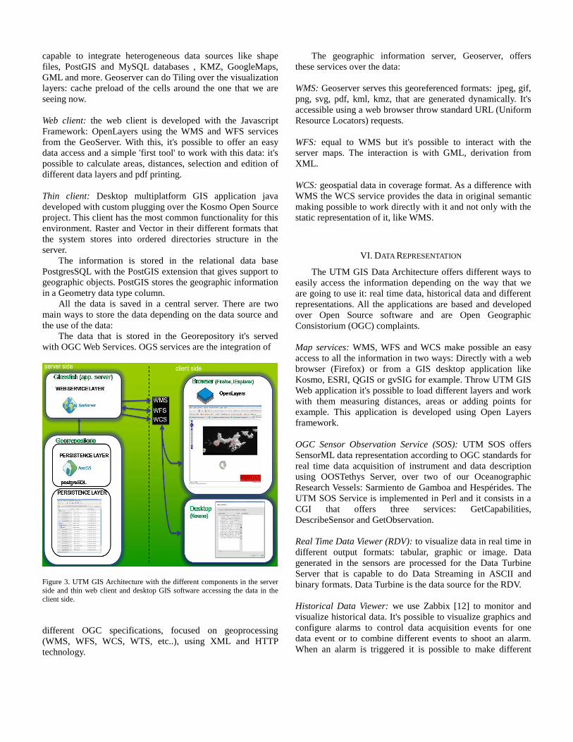
capable to integrate heterogeneous data sources like shape
files, PostGIS and MySQL databases , KMZ, GoogleMaps,
GML and more. Geoserver can do Tiling over the visualization
layers: cache preload of the cells around the one that we are
seeing now.
Web client: the web client is developed with the Javascript
Framework: OpenLayers using the WMS and WFS services
from the GeoServer. With this, it's possible to offer an easy
data access and a simple 'first tool' to work with this data: it's
possible to calculate areas, distances, selection and edition of
different data layers and pdf printing.
Thin client: Desktop multiplatform GIS application java
developed with custom plugging over the Kosmo Open Source
project. This client has the most common functionality for this
environment. Raster and Vector in their different formats that
the system stores into ordered directories structure in the
server.
The information is stored in the relational data base
PostgresSQL with the PostGIS extension that gives support to
geographic objects. PostGIS stores the geographic information
in a Geometry data type column.
All the data is saved in a central server. There are two
main ways to store the data depending on the data source and
the use of the data:
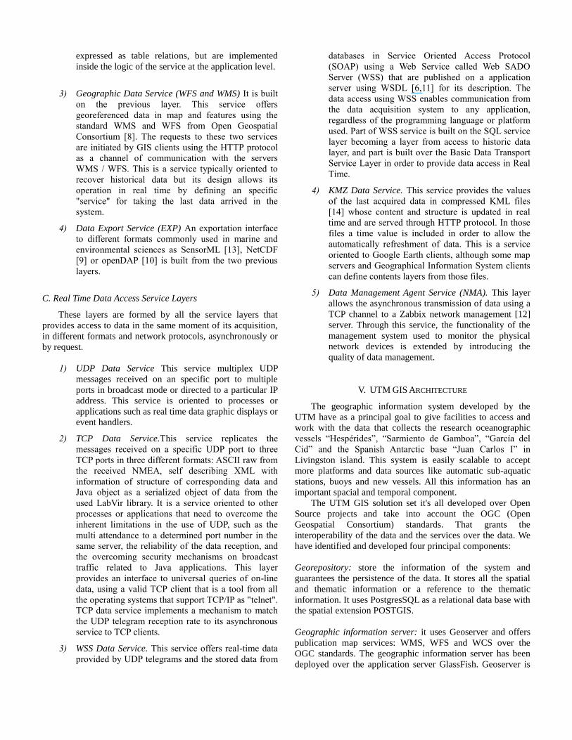
The data that is stored in the Georepository it's served
with OGC Web Services. OGS services are the integration of
Figure 3. UTM GIS Architecture with the different components in the server
side and thin web client and desktop GIS software accessing the data in the
client side.
different OGC specifications, focused on geoprocessing
(WMS, WFS, WCS, WTS, etc..), using XML and HTTP
technology.
The geographic information server, Geoserver, offers
these services over the data:
WMS: Geoserver serves this georeferenced formats: jpeg, gif,
png, svg, pdf, kml, kmz, that are generated dynamically. It's
accessible using a web browser throw standard URL (Uniform
Resource Locators) requests.
WFS: equal to WMS but it's possible to interact with the
server maps. The interaction is with GML, derivation from
XML.
WCS: geospatial data in coverage format. As a difference with
WMS the WCS service provides the data in original semantic
making possible to work directly with it and not only with the
static representation of it, like WMS.
VI. DATA REPRESENTATION
The UTM GIS Data Architecture offers different ways to
easily access the information depending on the way that we
are going to use it: real time data, historical data and different
representations. All the applications are based and developed
over Open Source software and are Open Geographic
Consistorium (OGC) complaints.
Map services: WMS, WFS and WCS make possible an easy
access to all the information in two ways: Directly with a web
browser (Firefox) or from a GIS desktop application like
Kosmo, ESRI, QGIS or gvSIG for example. Throw UTM GIS
Web application it's possible to load different layers and work
with them measuring distances, areas or adding points for
example. This application is developed using Open Layers
framework.
OGC Sensor Observation Service (SOS): UTM SOS offers
SensorML data representation according to OGC standards for
real time data acquisition of instrument and data description
using OOSTethys Server, over two of our Oceanographic
Research Vessels: Sarmiento de Gamboa and Hespérides. The
UTM SOS Service is implemented in Perl and it consists in a
CGI that offers three services: GetCapabilities,
DescribeSensor and GetObservation.
Real Time Data Viewer (RDV): to visualize data in real time in
different output formats: tabular, graphic or image. Data
generated in the sensors are processed for the Data Turbine
Server that is capable to do Data Streaming in ASCII and
binary formats. Data Turbine is the data source for the RDV.
Historical Data Viewer: we use Zabbix [12] to monitor and
visualize historical data. It's possible to visualize graphics and
configure alarms to control data acquisition events for one
data event or to combine different events to shoot an alarm.
When an alarm is triggered it is possible to make different
actions like insert a new register to control it in a data base or
to send an email for example.
VII. CASE STUDY
As a particular case of the implementation, we describe
the system that is working right now in our oceanographic
research vessel “Sarmiento de Gamboa”.
The communications system implements a broadband
Very Small Aperture Terminal working in C-band, a router on
board the ship, and another router in the land site data center
in Barcelona. Apart from the advantages that an internet acces
has had for the researchers, one of the most important
characteristics of the system is the possibility of configuring a
Virtual Private Network and the possibility of exchange real
time data between the ship and land site in Barcelona.
As data source we have a server, which is responsible for
collecting the data traveling over the network (UDP frames,
NMEA datagrams), store this data in our databases (MySQL
and Postgres in real time), and also integrate them into data
files in both raw and processed form.
A geographic service layer georeferences our data using
WMS WFS standards.
To access data in real time, we have established multilayer
services, which we offer the following features, UDP frame
generation, replication of data with TCP frames, web services
access to data in databases, file generation KML,
asynchronous transmission of data with the Zabbix server.
With these data, and by other agents, we provide
information to Zabbix and DataTurbine systems, which offer
us the service of access to data in real time, as historical trends
querying.
VIII. CONCLUSIONS AND FUTURE WORK
A new data acquisition system has been described. The
system has been implemented in several Spanish
oceanographic platforms. The system is applicable to any
network of instrumentation where an integrated management
of data and a wide range of access procedures are needed.
Service Oriented Architecture allows expandable access to
real time and historical data. In the future, new instruments
will be added to the current integrated data network, especially
those which have complex data formats or those which have a
high data streaming behavior. Data access will be improved by
the creation of a new metadata service layer.
In the future the system will be implemented in new
platforms as cabled seafloor observatories or remote weather
stations located in Antarctica.
ACKNOWLEDGMENT
This work has been supported by the Spanish “Ministerio de
Ciencia e Innovación” under contract CTM2009-08867.
REFERENCES
[1] T.R. Henderson and R.H. Katz, "Transport Protocols for Internet-
Compatible Satellite Networks," IEEE Journal on Selected Areas in Communications, vol. 17, No. 2, pp. 345-359, February 1999.
[2] M. Allman, D. Glover, and L. Sanchez, “Enhancing TCP Over
Satellite Channels using Standard”, 1998. [3] A. Tirumala, M. Gates, F. Qin, J. Dugan, and J. Ferguson, “The
TCP/UDP bandwidth measurement tool”. http://www.nlanr.net/ .
Last visit 19/05/2010. [4] H. Newton, “Newtons Telecom Dictionary”, CMP Books 2001.
[5] W. Stallings, “Data and computer communications” Fifth Edition,
Prentice Hall International, 1997. [6] E. Trullols, J. Sorribas, J. del Río, C. Samitier, A. Manuel, and R.
Palomera, “LabVir: A Virtual Distributed Measurement System,”
IEEE Instrumentation and Measurement Technology Conference, Colorado, USA, May 2003.
[7] J. Sorribas, A. Tudela, A. Castellón, O. Chic, Z. García, J. Prades,
and D. Montero, “An oceanographic data acquisition system for Ethernet LAN for Spanish Research vessels”, IEEE Oceans’98
Conference Proceedings, vol. 1, San Diego. USA, pp. 93–97, 1998.
[8] Open Geospatial Consortium Standards. [9] http://www.opengeospatial.org/standards/common. Last visit
19/05/2010 [10] Network Common Data Format.
http://www.unidata.ucar.edu/netcdf . Last visit 19/05/2010. [11] Open-source Project for a Network Data Access Protocol. [12] http://opendap.org/. Last visit 19/05/2010. [13] Web Service Definition Language. http://www.w3.org/TR/wsdl .
Last visit 19/05/2010. [14] “An enterprise-class open source distributed monitoring solution”.
http://www.zabbix.com/. Last visit 19/05/2010. [15] SensorML. http://marinemetadata.org/references/sensorml. Last
visit 19/05/2010. [16] Google Earth, KML.
http://earth.google.es/userguide/v4/ug_kml.html. Last visit
19/05/2010.