danakhil potash; ethiopia - modern hydrothermal kcl, part 3 of 4
TRANSCRIPT
Page 1
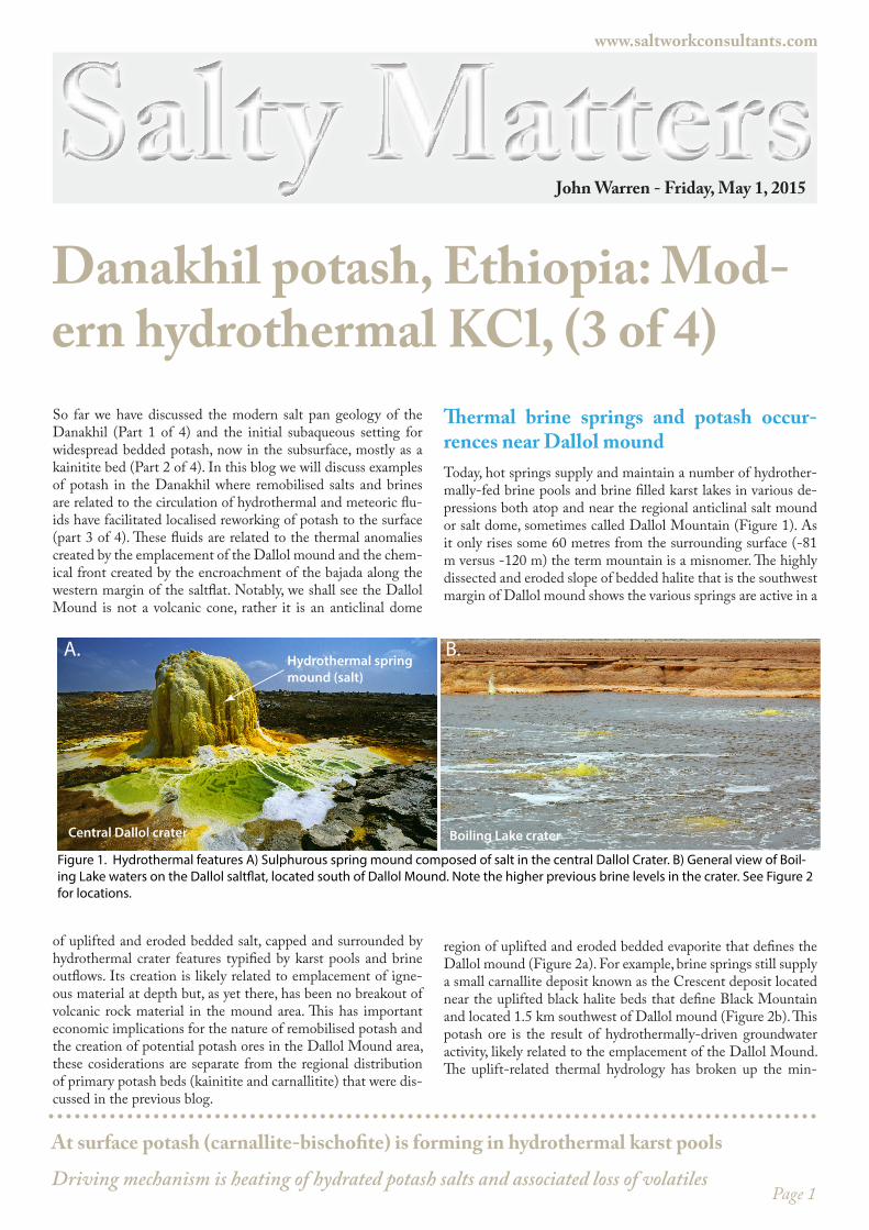
Thermal brine springs and potash occur-rences near Dallol moundToday, hot springs supply and maintain a number of hydrother-mally-fed brine pools and brine filled karst lakes in various de-pressions both atop and near the regional anticlinal salt mound or salt dome, sometimes called Dallol Mountain (Figure 1). As it only rises some 60 metres from the surrounding surface (-81 m versus -120 m) the term mountain is a misnomer. The highly dissected and eroded slope of bedded halite that is the southwest margin of Dallol mound shows the various springs are active in a
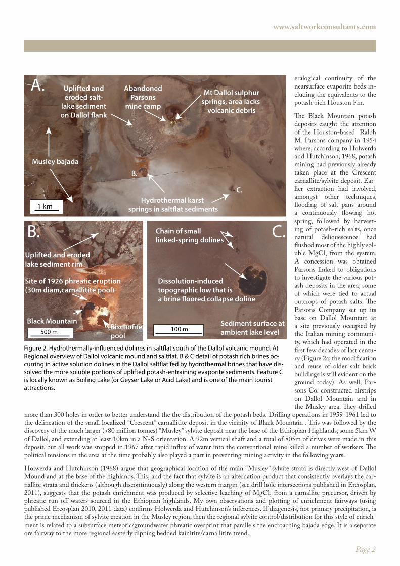
region of uplifted and eroded bedded evaporite that defines the Dallol mound (Figure 2a). For example, brine springs still supply a small carnallite deposit known as the Crescent deposit located near the uplifted black halite beds that define Black Mountain and located 1.5 km southwest of Dallol mound (Figure 2b). This potash ore is the result of hydrothermally-driven groundwater activity, likely related to the emplacement of the Dallol Mound. The uplift-related thermal hydrology has broken up the min-
So far we have discussed the modern salt pan geology of the Danakhil (Part 1 of 4) and the initial subaqueous setting for widespread bedded potash, now in the subsurface, mostly as a kainitite bed (Part 2 of 4). In this blog we will discuss examples of potash in the Danakhil where remobilised salts and brines are related to the circulation of hydrothermal and meteoric flu-ids have facilitated localised reworking of potash to the surface (part 3 of 4). These fluids are related to the thermal anomalies created by the emplacement of the Dallol mound and the chem-ical front created by the encroachment of the bajada along the western margin of the saltflat. Notably, we shall see the Dallol Mound is not a volcanic cone, rather it is an anticlinal dome
of uplifted and eroded bedded salt, capped and surrounded by hydrothermal crater features typified by karst pools and brine outflows. Its creation is likely related to emplacement of igne-ous material at depth but, as yet there, has been no breakout of volcanic rock material in the mound area. This has important economic implications for the nature of remobilised potash and the creation of potential potash ores in the Dallol Mound area, these cosiderations are separate from the regional distribution of primary potash beds (kainitite and carnallitite) that were dis-cussed in the previous blog.
Salty MattersDanakhil potash, Ethiopia: Mod-ern hydrothermal KCl, (3 of 4)
www.saltworkconsultants.com
Central Dallol crater Boiling Lake crater
Hydrothermal spring mound (salt)
A. B.
Figure 1. Hydrothermal features A) Sulphurous spring mound composed of salt in the central Dallol Crater. B) General view of Boil-ing Lake waters on the Dallol salt�at, located south of Dallol Mound. Note the higher previous brine levels in the crater. See Figure 2 for locations.
At surface potash (carnallite-bischofite) is forming in hydrothermal karst pools
Driving mechanism is heating of hydrated potash salts and associated loss of volatiles
John Warren - Friday, May 1, 2015
Page 2
eralogical continuity of the nearsurface evaporite beds in-cluding the equivalents to the potash-rich Houston Fm.
The Black Mountain potash deposits caught the attention of the Houston-based Ralph M. Parsons company in 1954 where, according to Holwerda and Hutchinson, 1968, potash mining had previously already taken place at the Crescent carnallite/sylvite deposit. Ear-lier extraction had involved, amongst other techniques, flooding of salt pans around a continuously flowing hot spring, followed by harvest-ing of potash-rich salts, once natural deliquescence had flushed most of the highly sol-uble MgCl2 from the system. A concession was obtained Parsons linked to obligations to investigate the various pot-ash deposits in the area, some of which were tied to actual outcrops of potash salts. The Parsons Company set up its base on Dallol Mountain at a site previously occupied by the Italian mining communi-ty, which had operated in the first few decades of last centu-ry (Figure 2a; the modification and reuse of older salt brick buildings is still evident on the ground today). As well, Par-sons Co. constructed airstrips on Dallol Mountain and in the Musley area. They drilled
more than 300 holes in order to better understand the the distribution of the potash beds. Drilling operations in 1959-1961 led to the delineation of the small localized “Crescent” carnallitite deposit in the vicinity of Black Mountain . This was followed by the discovery of the much larger (>80 million tonnes) “Musley” sylvite deposit near the base of the Ethiopian Highlands, some 5km W of Dallol, and extending at least 10km in a N-S orientation. A 92m vertical shaft and a total of 805m of drives were made in this deposit, but all work was stopped in 1967 after rapid influx of water into the conventional mine killed a number of workers. The political tensions in the area at the time probably also played a part in preventing mining activity in the following years.
Holwerda and Hutchinson (1968) argue that geographical location of the main “Musley” sylvite strata is directly west of Dallol Mound and at the base of the highlands. This, and the fact that sylvite is an alternation product that consistently overlays the car-nallite strata and thickens (although discontinuously) along the western margin (see drill hole intersections published in Ercosplan, 2011), suggests that the potash enrichment was produced by selective leaching of MgCl2 from a carnallite precursor, driven by phreatic run-off waters sourced in the Ethiopian highlands. My own observations and plotting of enrichment fairways (using published Ercosplan 2010, 2011 data) confirms Holwerda and Hutchinson’s inferences. If diagenesis, not primary precipitation, is the prime mechanism of sylvite creation in the Musley region, then the regional sylvite control/distribution for this style of enrich-ment is related to a subsurface meteoric/groundwater phreatic overprint that parallels the encroaching bajada edge. It is a separate ore fairway to the more regional easterly dipping bedded kainitite/carnallitite trend.
500 m
Uplifted and erodedlake sediment rim
Black MountainBischo�tepool
Site of 1926 phreatic eruption(30m diam,carnallitite pool)
100 m
Dissolution-induced topographic low that isa brine �oored collapse doline
Chain of small linked-spring dolines
Sediment surface at ambient lake level
Hydrothermal karst springs in salt�at sediments
Mt Dallol sulphursprings, area lacks
volcanic debris
Musley bajada
B.
C.
Uplifted anderoded salt-
lake sedimenton Dallol �ank
AbandonedParsons
mine camp
1 km
A.
C.B.
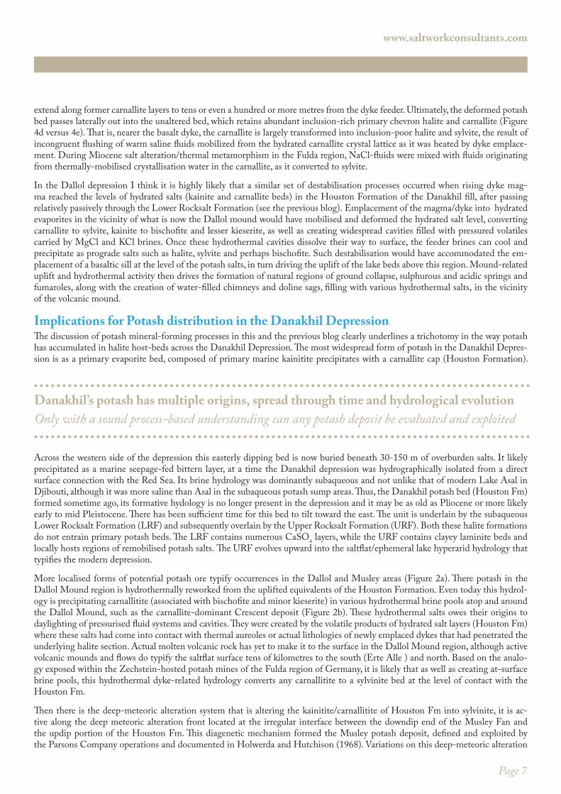
Figure 2. Hydrothermally-in�uenced dolines in salt�at south of the Dallol volcanic mound. A) Regional overview of Dallol volcanic mound and salt�at. B & C detail of potash rich brines oc-curring in active solution dolines in the Dallol salt�at fed by hydrothermal brines that have dis-solved the more soluble portions of uplifted potash-entraining evaporite sediments. Feature C is locally known as Boiling Lake (or Geyser Lake or Acid Lake) and is one of the main tourist attractions.
www.saltworkconsultants.com
Page 3
Waters in some of the active brine-filled hydrothermal craters and dolines can locally have temperatures of more than 100°C and when waters cool they precipitate varying combinations of halite, carnallite and bischofite. The brines are so saturated with salts that if a stick is thrust into a boiling brine pool and removed it is immediately covered by layer of carnallite or bischofite and halite (Figure 2b, c). The same pools are also rich in FeCl2, sulphur and manganese, which explains the spectacular bright green, red-orange and yellow colours of many of the saline mineral assemblages precipitating in and about these active spring-formed pools. Occasional intense storm-driven sheetfloods can drive renewed activity in the various springs in vicinity of the mound, as happened in the recent floods of February 2011, when the intensity of water circulation and the areal extent of the pools greatly increased. After the same storm flood, a natural collapse doline tens of metres across formed on the western depression margin. Clearly, the local hydrother-mal/karstic enhancement style of bittern enrichment is a separate process set for potash enrichment compared to the widespread earlier deposition of marine-fed subaqueous kainite. Hence, it contrasts with the much more widespread set of depositional/early diagenetic processes that laid down the bulk of the bedded potash association that is the Houston Fm. in the Danakhil Depression (as discussed in the previous Danakhil blog).
What is the Dallol Mound and what drives its uplift hydrology?Despite the widespread misconception that the Dallol mound is a lava cone, Mount Dallol is not a volcanic-centered feature on the Danakhil landscape. A visit to the area reveals no observable volcanic products (lava, ashfall or scoria) on the surface on or near the Dallol mound. This is so even in the region of the most recent phreatic activity in 1926 where a 30 m-diameter phreatic (explosion? or daylighting hydrothermal karst) crater formed, hosted in salt beds (Figure 2b). All the rocks associated with this cavity and its for-mative event are not volcanic. This means the mechanism that created the Dallol Mound is unlike the magmatic events that created the world famous Erte Ale volcanic cone, with its distinctive longterm active magma lake and located some 80 km to the south of Dallol and still in the Danakhil depression. Instead, the Dallol mound crest is made up of uplifted and eroded halite and potash beds soaked in a thermal hydrology that breaks out on the lake surface as a number of hot bubbling sulphurous brine pools. This is also true of the off-mound crater that formed in 1926 near Black Mountain and still retains bubbling brines with present temperatures ~65-70°C. Nearby “Black Mountain” is a small area of dark coloured bedded and recrystallised halite, it is not a primary volcanic feature.
As a sedimentologist visiting the area, I wondered at why the Dallol mound features had ever been called volcanic cones, hornitos, or maars (as they are widely described in the literature). To use such genetic terms in a geologically correct fashion I would like to put my hand on a piece of volcanic debris (lava, pumice, scoria or ash) in any of the craters before I call the Dallol mound a volcanic cone. And yet, many workers in the published literature dealing with the Dallol area are happy to do this. I am not saying there is no influence of magmatic heating in forming Dallol Mound, only that molten volcanic rock has yet to surface in the immediate Dallol region. Hence it is unlike the many actual volcanic cones, maars and hornitos to the south and north and this is an significant obser-vation as it deals with mechanism of local potash enrichment. I will argue in the next section that this is because Dallol Mound is a salt uplift feature or dome capped by phreatic cone/ hydrothermal karst structures and all related to the migration of molten magma into more deeply buried salt beds, which contain hydrated salts at the level of the Houston Fm and perhaps even deeper buried hydrated salt layers (see blog 2).
Darrah et al (2013) and Detay (2011) argue that the 30m diameter 1926 crater and other nearby pools on the Dallol saltflat in the vicinity of the Dallol mound are the result of a phreatic explosions, tied to the increasing gas pressure in superficial hydrothermal reservoirs atop a deeper mass of molten rock. The mound is a landscape feature indicative of deep dyke/sill intrusion that did not surface. According to Holwerda and Hutchinson (1968) this yet-to-daylight dyke complex explains the linear orientation of the mound, its pools and other karst/erosion features on the salt flat surface in vicinity of the Dallol mound. That is, the various Dallol hot springs typically consist of 30-40m diameter circular to sub-circular ponds, initially formed by explosive vapor eruptions, to form at-surface circular features, which are widely termed maars, although I would prefer to call them “maar-like.” A “maar” is defined in the AGI Glossary of Geology as “a low relief, broad volcanic crater formed by multiple shallow explosive eruptions. It is surrounded by a crater ring, and may be filled by water. Type occurrence is in the Eifel area of Germany.” Given the lack of a volcanic crater rim the Dallol Mound and adjacent brine-filled cavities are not really maars, nor are they hornitos. They will likely evolve into such fea-tures, but in their current state better considered brine-filled fumaroles or solfateras or even better, hydrothermal karst cavities that have daylighted. Once the cavities have broken out onto the salt flat surface, these circular (possibly-explosive) features can continue
www.saltworkconsultants.com
Deep meteoric water mixing forms diagenetic sylvite at depth along downdip bajada rim
This style of potash ore forms via incongruent dissolution of the updip edge of Houston Formation
Page 4
enlarge due to ongoing rise of undersaturated waters and so evolve into expanding hydrothermal karst pools or they can be partially to completely filled with saline precipitates (with no volcanic products derived from molten igneous rock materials).
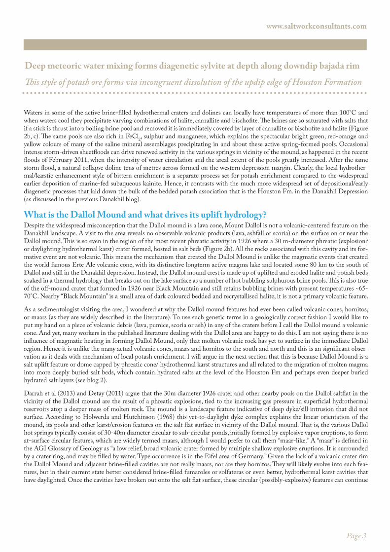
So, instead of at-surface volcanic products such as lava and ashfall, most of the superficial precipitates/sediments observed in and around the various on- and off-structure Dallol brine pools are evaporite salts, along with some remnants of older clay-sediments. Brine fluids in various hot spring pools in the Dallol area (in the Dallol “hill” crest and the “Crescent” region near Black mountain, and in the “Boiling Lake” region south of the mound) are typically multi-coloured warm/hot ponds (Figures 1, 3; Gebresilassie et al., 2011). The various pools are extremely salty (>500g/L), can be highly acidic (sometimes with a pH approaching 0.5), and gas-rich (as evidenced by steady, vigorous bubbling of gases). According to Darrah et al. (2013) the Dallol “salt dome” fluids and associated hot springs are hypothe-sized to result from the interaction between hot man-tle fluids or basalt dyke injections with evaporite de-posits at unknown depths. However, direct observations of the volumes of pool waters and the vigour of the out-flow are known to increase after the occasional heavy rain event, as hap-pened in February, 2011. Hence, it is unclear if sul-fur-rich gases and the low pH brine fluids provide evi-dence of the inter-action of hot man-tle fluids with the evaporites (as inferred by Darrah et al., 2013) or the pool waters are, at least in part, related shallower ongoing hydrothermal/karst interactions with more deeply circulated meteoric waters sourced in the 1000-m high adjacent rift highlands.
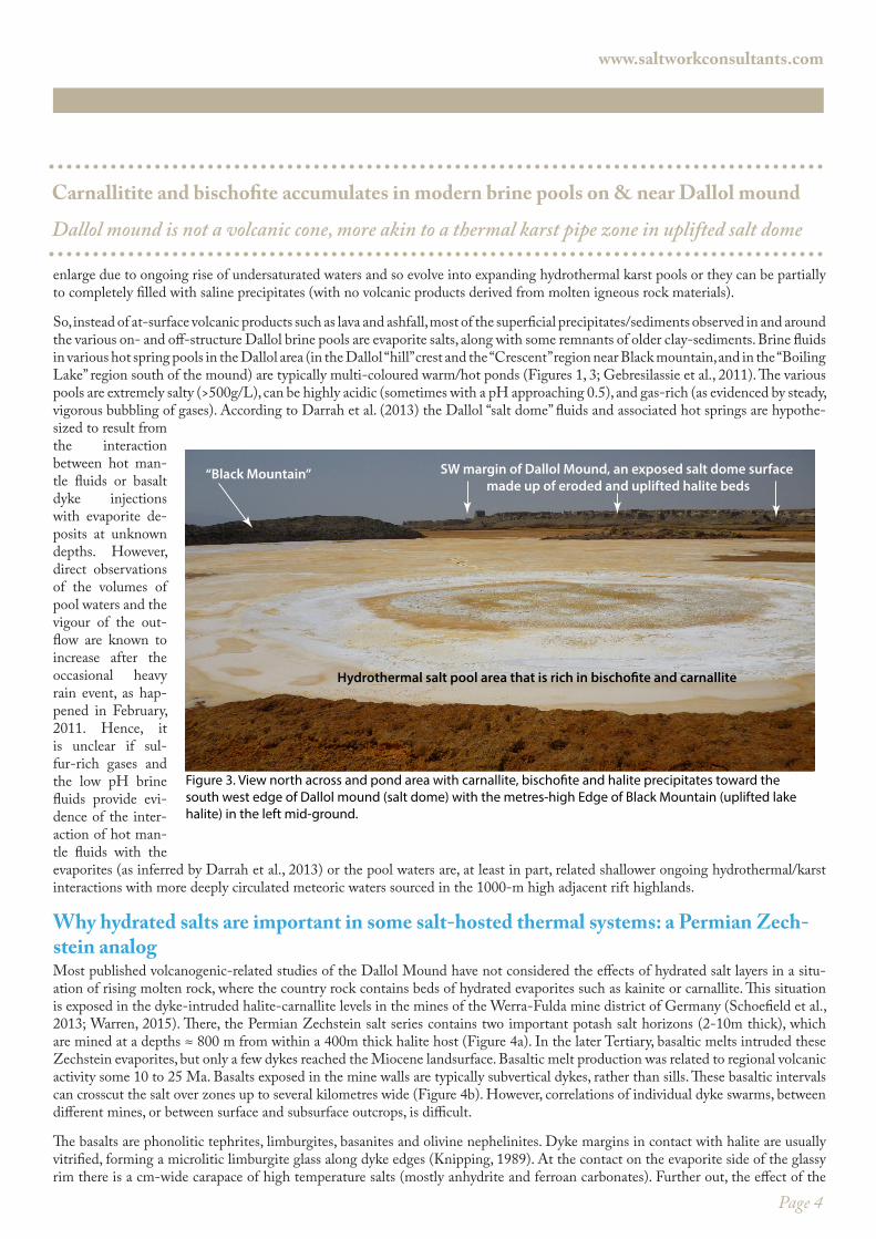
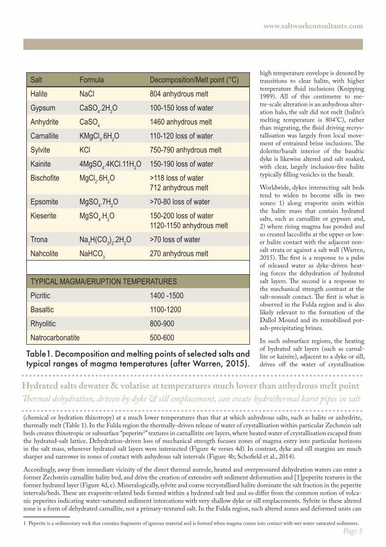
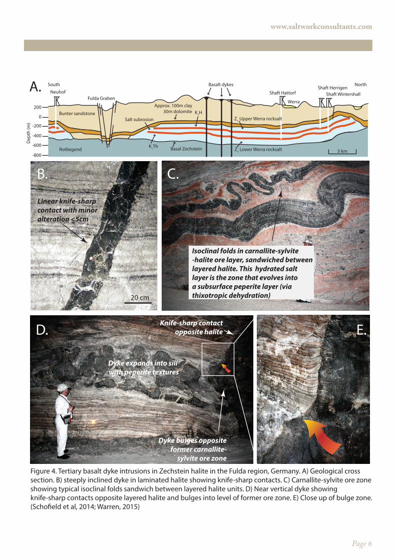
Why hydrated salts are important in some salt-hosted thermal systems: a Permian Zech-stein analogMost published volcanogenic-related studies of the Dallol Mound have not considered the effects of hydrated salt layers in a situ-ation of rising molten rock, where the country rock contains beds of hydrated evaporites such as kainite or carnallite. This situation is exposed in the dyke-intruded halite-carnallite levels in the mines of the Werra-Fulda mine district of Germany (Schoefield et al., 2013; Warren, 2015). There, the Permian Zechstein salt series contains two important potash salt horizons (2-10m thick), which are mined at a depths ≈ 800 m from within a 400m thick halite host (Figure 4a). In the later Tertiary, basaltic melts intruded these Zechstein evaporites, but only a few dykes reached the Miocene landsurface. Basaltic melt production was related to regional volcanic activity some 10 to 25 Ma. Basalts exposed in the mine walls are typically subvertical dykes, rather than sills. These basaltic intervals can crosscut the salt over zones up to several kilometres wide (Figure 4b). However, correlations of individual dyke swarms, between different mines, or between surface and subsurface outcrops, is difficult.
The basalts are phonolitic tephrites, limburgites, basanites and olivine nephelinites. Dyke margins in contact with halite are usually vitrified, forming a microlitic limburgite glass along dyke edges (Knipping, 1989). At the contact on the evaporite side of the glassy rim there is a cm-wide carapace of high temperature salts (mostly anhydrite and ferroan carbonates). Further out, the effect of the
Carnallitite and bischofite accumulates in modern brine pools on & near Dallol mound
Dallol mound is not a volcanic cone, more akin to a thermal karst pipe zone in uplifted salt dome
www.saltworkconsultants.com
“Black Mountain” SW margin of Dallol Mound, an exposed salt dome surface made up of eroded and uplifted halite beds
Hydrothermal salt pool area that is rich in bischo�te and carnallite
Figure 3. View north across and pond area with carnallite, bischo�te and halite precipitates toward the south west edge of Dallol mound (salt dome) with the metres-high Edge of Black Mountain (uplifted lake halite) in the left mid-ground.
Page 5
high temperature envelope is denoted by transitions to clear halite, with higher temperature fluid inclusions (Knipping 1989). All of this centimetre to me-tre-scale alteration is an anhydrous alter-ation halo, the salt did not melt (halite’s melting temperature is 804°C), rather than migrating, the fluid driving recrys-tallisation was largely from local move-ment of entrained brine inclusions. The dolerite/basalt interior of the basaltic dyke is likewise altered and salt soaked, with clear, largely inclusion-free halite typically filling vesicles in the basalt.
Worldwide, dykes intersecting salt beds tend to widen to become sills in two zones: 1) along evaporite units within the halite mass that contain hydrated salts, such as carnallite or gypsum and, 2) where rising magma has ponded and so created laccoliths at the upper or low-er halite contact with the adjacent non-salt strata or against a salt wall (Warren, 2015). The first is a response to a pulse of released water as dyke-driven heat-ing forces the dehydration of hydrated salt layers. The second is a response to the mechanical strength contrast at the salt-nonsalt contact. The first is what is observed in the Fulda region and is also likely relevant to the formation of the Dallol Mound and its remobilised pot-ash-precipitating brines.
In such subsurface regions, the heating of hydrated salt layers (such as carnal-lite or kainite), adjacent to a dyke or sill, drives off the water of crystallisation
(chemical or hydration thixotropy) at a much lower temperatures than that at which anhydrous salts, such as halite or anhydrite, thermally melt (Table 1). In the Fulda region the thermally-driven release of water of crystallisation within particular Zechstein salt beds creates thixotropic or subsurface “peperite1” textures in carnallitite ore layers, where heated water of crystallisation escaped from the hydrated-salt lattice. Dehydration-driven loss of mechanical strength focuses zones of magma entry into particular horizons in the salt mass, wherever hydrated salt layers were intersected (Figure 4c verses 4d). In contrast, dyke and sill margins are much sharper and narrower in zones of contact with anhydrous salt intervals (Figure 4b; Schofield et al., 2014).
Accordingly, away from immediate vicinity of the direct thermal aureole, heated and overpressured dehydration waters can enter a former Zechstein carnallite halite bed, and drive the creation of extensive soft sediment deformation and [1]peperite textures in the former hydrated layer (Figure 4d, e). Mineralogically, sylvite and coarse recrystallised halite dominate the salt fraction in the peperite intervals/beds. These are evaporite-related beds formed within a hydrated salt bed and so differ from the common notion of volca-nic peperites indicating water-saturated sediment intercations with very shallow dyke or sill emplacements. Sylvite in these altered zone is a form of dehydrated carnallite, not a primary-textured salt. In the Fulda region, such altered zones and deformed units can
1 Peperite is a sedimentary rock that contains fragments of igneous material and is formed when magma comes into contact with wet water-saturated sediments.
Hydrated salts dewater & volatise at temperatures much lower than anhydrous melt pointThermal dehydration, driven by dyke & sill emplacement, can create hydrothermal karst pipes in salt
www.saltworkconsultants.com
Salt Formula Decomposition/Melt point (°C)Halite NaCl 804 anhydrous meltGypsum CaSO4.2H2O 100-150 loss of waterAnhydrite CaSO4 1460 anhydrous meltCarnallite KMgCl3.6H2O 110-120 loss of waterSylvite KCl 750-790 anhydrous meltKainite 4MgSO4.4KCl.11H2O 150-190 loss of water
MgCl2.6H2O >118 loss of water712 anhydrous melt
Epsomite MgSO4.7H2O >70-80 loss of waterKieserite MgSO4.H2O 150-200 loss of water
1120-1150 anhydrous meltTrona Na3H(CO3)2.2H2O >70 loss of waterNahcolite NaHCO3 270 anhydrous melt
TYPICAL MAGMA/ERUPTION TEMPERATURESPicritic 1400 -1500Basaltic 1100-1200Rhyolitic 800-900Natrocarbonatite 500-600
Table1. Decomposition and melting points of selected salts and typical ranges of magma temperatures (after Warren, 2015).
www.saltworkconsultants.com
Page 6
Basalt dykes
Shaft Hattorf Shaft WintershallShaft Herrigen
Fulda GrabenNeuhof
0
200
-200
-400
-600
-800
Dep
th (m
)
Werra
Rotliegend
Bunter sandstoneSalt subrosion
Z1 Lower Werra rocksalt
Z1 Upper Werra rocksaltK1H
K1Th Basal Zechstein
Approx. 100m clay30m dolomite
5 km
South North
20 cm
Linear knife-sharpcontact with minoralteration <5cm
Knife-sharp contactopposite halite
Dyke bulges oppositeformer carnallite-
sylvite ore zone
Dyke expands into sill with peperite textures
Isoclinal folds in carnallite-sylvite-halite ore layer, sandwiched betweenlayered halite. This hydrated salt layer is the zone that evolves into a subsurface peperite layer (viathixotropic dehydration)
A.
B. C.
D. E.
Figure 4. Tertiary basalt dyke intrusions in Zechstein halite in the Fulda region, Germany. A) Geological cross section. B) steeply inclined dyke in laminated halite showing knife-sharp contacts. C) Carnallite-sylvite ore zone showing typical isoclinal folds sandwich between layered halite units. D) Near vertical dyke showing knife-sharp contacts opposite layered halite and bulges into level of former ore zone. E) Close up of bulge zone. (Scho�eld et al, 2014; Warren, 2015)
Page 7
extend along former carnallite layers to tens or even a hundred or more metres from the dyke feeder. Ultimately, the deformed potash bed passes laterally out into the unaltered bed, which retains abundant inclusion-rich primary chevron halite and carnallite (Figure 4d versus 4e). That is, nearer the basalt dyke, the carnallite is largely transformed into inclusion-poor halite and sylvite, the result of incongruent flushing of warm saline fluids mobilized from the hydrated carnallite crystal lattice as it was heated by dyke emplace-ment. During Miocene salt alteration/thermal metamorphism in the Fulda region, NaCl-fluids were mixed with fluids originating from thermally-mobilised crystallisation water in the carnallite, as it converted to sylvite.
In the Dallol depression I think it is highly likely that a similar set of destabilisation processes occurred when rising dyke mag-ma reached the levels of hydrated salts (kainite and carnallite beds) in the Houston Formation of the Danakhil fill, after passing relatively passively through the Lower Rocksalt Formation (see the previous blog). Emplacement of the magma/dyke into hydrated evaporites in the vicinity of what is now the Dallol mound would have mobilised and deformed the hydrated salt level, converting carnallite to sylvite, kainite to bischofite and lesser kieserite, as well as creating widespread cavities filled with pressured volatiles carried by MgCl and KCl brines. Once these hydrothermal cavities dissolve their way to surface, the feeder brines can cool and precipitate as prograde salts such as halite, sylvite and perhaps bischofite. Such destabilisation would have accommodated the em-placement of a basaltic sill at the level of the potash salts, in turn driving the uplift of the lake beds above this region. Mound-related uplift and hydrothermal activity then drives the formation of natural regions of ground collapse, sulphurous and acidic springs and fumaroles, along with the creation of water-filled chimneys and doline sags, filling with various hydrothermal salts, in the vicinity of the volcanic mound.
Implications for Potash distribution in the Danakhil DepressionThe discussion of potash mineral-forming processes in this and the previous blog clearly underlines a trichotomy in the way potash has accumulated in halite host-beds across the Danakhil Depression. The most widespread form of potash in the Danakhil Depres-sion is as a primary evaporite bed, composed of primary marine kainitite precipitates with a carnallite cap (Houston Formation).
www.saltworkconsultants.com
Danakhil’s potash has multiple origins, spread through time and hydrological evolution Only with a sound process-based understanding can any potash deposit be evaluated and exploited
Across the western side of the depression this easterly dipping bed is now buried beneath 30-150 m of overburden salts. It likely precipitated as a marine seepage-fed bittern layer, at a time the Danakhil depression was hydrographically isolated from a direct surface connection with the Red Sea. Its brine hydrology was dominantly subaqueous and not unlike that of modern Lake Asal in Djibouti, although it was more saline than Asal in the subaqueous potash sump areas. Thus, the Danakhil potash bed (Houston Fm) formed sometime ago, its formative hydology is no longer present in the depression and it may be as old as Pliocene or more likely early to mid Pleistocene. There has been sufficient time for this bed to tilt toward the east. The unit is underlain by the subaqueous Lower Rocksalt Formation (LRF) and subsequently overlain by the Upper Rocksalt Formation (URF). Both these halite formations do not entrain primary potash beds. The LRF contains numerous CaSO4 layers, while the URF contains clayey laminite beds and locally hosts regions of remobilised potash salts. The URF evolves upward into the saltflat/ephemeral lake hyperarid hydrology that typifies the modern depression.
More localised forms of potential potash ore typify occurrences in the Dallol and Musley areas (Figure 2a). There potash in the Dallol Mound region is hydrothermally reworked from the uplifted equivalents of the Houston Formation. Even today this hydrol-ogy is precipitating carnallitite (associated with bischofite and minor kieserite) in various hydrothermal brine pools atop and around the Dallol Mound, such as the carnallite-dominant Crescent deposit (Figure 2b). These hydrothermal salts owes their origins to daylighting of pressurised fluid systems and cavities. They were created by the volatile products of hydrated salt layers (Houston Fm) where these salts had come into contact with thermal aureoles or actual lithologies of newly emplaced dykes that had penetrated the underlying halite section. Actual molten volcanic rock has yet to make it to the surface in the Dallol Mound region, although active volcanic mounds and flows do typify the saltflat surface tens of kilometres to the south (Erte Alle ) and north. Based on the analo-gy exposed within the Zechstein-hosted potash mines of the Fulda region of Germany, it is likely that as well as creating at-surface brine pools, this hydrothermal dyke-related hydrology converts any carnallitite to a sylvinite bed at the level of contact with the Houston Fm.
Then there is the deep-meteoric alteration system that is altering the kainitite/carnallitite of Houston Fm into sylvinite, it is ac-tive along the deep meteoric alteration front located at the irregular interface between the downdip end of the Musley Fan and the updip portion of the Houston Fm. This diagenetic mechanism formed the Musley potash deposit, defined and exploited by the Parsons Company operations and documented in Holwerda and Hutchison (1968). Variations on this deep-meteoric alteration
Page 8
www.saltworkconsultants.com
theme likely extend south and north of the Musley fan, wherever the active phreatic hydrology of the bajada located at the foot of the Ethiopian Highlands interacts and interfingers with the updip edge of the easterly dipping Houston Formation.
Once again there is no “one-size-fits-all) model for economic potash understanding (Warren, 2010, 2015). Even in what is probably the youngest known marine-fed potash system in the world, the original potash mineralogy and distribution has been altered and locally upgraded via diagenetic interactions with hydrothermal or deep-meteoric fluids. Predicting ore distributions in this, and all potash systems worldwide, requires an understanding of formative process evolution through deep time, and not just the simple ap-plication of a layer-cake primary stratigraphic model.
Is the present the key?
Significant time separates bedded potash from today’s pan hydrology and its hydrothemal overprint
Page 9
John Warren, Chief Technical DirectorSaltWork Consultants Pte Ltd (ACN 068 889 127)Kingston Park, Adelaide, South Australia 5049
www.saltworkconsultants.com
www.saltworkconsultants.com
ReferencesCarniel, R., E. M. Jolis, and J. Jones, 2010, A geophysical multi-parametric analysis of hydrothermal activity at Dallol, Ethiopia: Journal of African Earth Sciences, v. 58, p. 812-819.
Darrah, T. H., D. Tedesco, F. Tassi, O. Vaselli, E. Cuoco, and R. J. Poreda, 2013, Gas chemistry of the Dallol region of the Danakil Depression in the Afar region of the northern-most East African Rift: Chemical Geology, v. 339, p. 16-29.
Detay, M., 2011, Le DALLOL revisité: entre explosion phréatomagmatique, rifting intra-continental, manifestations hydrother-males et halocinèse: LAVE. Liaison des amateurs de volcanologie européenne, v. 151, p. 7-19.
ERCOSPLAN, 2010, Techical report and current resource estimate: Danakhil Potash Deposit, Afar State, Ethiopia: Project Refer-ence: EGB 08-024.
ERCOSPLAN, 2011, Preliminary Resource Assessment Study, Danakhil Potash Deposit, Afar State, Ethiopia: G & B Property: Project Reference: EGB 10-030.
Gebresilassie, S., H. Tsegab, and K. Kabeto, 2011, Preliminary study on geology, mineral potential, and characteristics of hot springs from Dallol area, Afar rift, northeastern Ethiopia: implications for natural resource exploration: Momona Ethiopian Journal of Science, v. 3, p. 17-30.
Holwerda, J. G., and R. W. Hutchinson, 1968, Potash-bearing evaporites in the Danakil area, Ethiopia: Economic Geology, v. 63, p. 124-150.
Knipping, B., 1989, Basalt intrusions in evaporites: Lecture Notes in Earth Sciences (Springer-Verlag), v. 24, p. 132 pp.
Schofield, N., I. Alsop, J. Warren, J. R. Underhill, R. Lehné, W. Beer, and V. Lukas, 2014, Mobilizing salt: Magma-salt interactions: Geology.
Warren, J. K., 2010, Evaporites through time: Tectonic, climatic and eustatic controls in marine and nonmarine deposits: Earth-Sci-ence Reviews, v. 98, p. 217-268.
Warren, J. K., 2015, Evaporites: A compendium (ISBN 978-3-319-13511-3) Released August 2015: Berlin, Springer, 1600 p.