corte madera - attachment 17
TRANSCRIPT

Attachment 17
Site Photographs

J
i'' 'u,'1i il.ril
,tr- -
Lot 6 Lot 4 i':' ''i .i
I
r'"
ffi Lot5 :. Lot4 Lot3
', .-.,,.. ", .'::t&1!9r:r.,.,to:,,,;;;.!J#,
*, ***,o*g@i
View north (downhill)along Robin Drive with proposed lots 3,4, and 5 in view
I
Figure 1
Lot 3watercourse

Figure 2
, :i -'!
Lot 2
Lot 3
Lot 1
View west along proposed entry into the subdivision at the private road, with lots 7,2,3, and 15 in view
2
Lot 15

l
I
!
I
!, .-_
Figure 3
Lot 9 Lot 10Lot 11
Lot 4
Lot 8
View north (downhill) along the proposed private road at the proposed bridge with proposed lots 8through 11 in view to the right and lot 4 visible to the left.
3
!
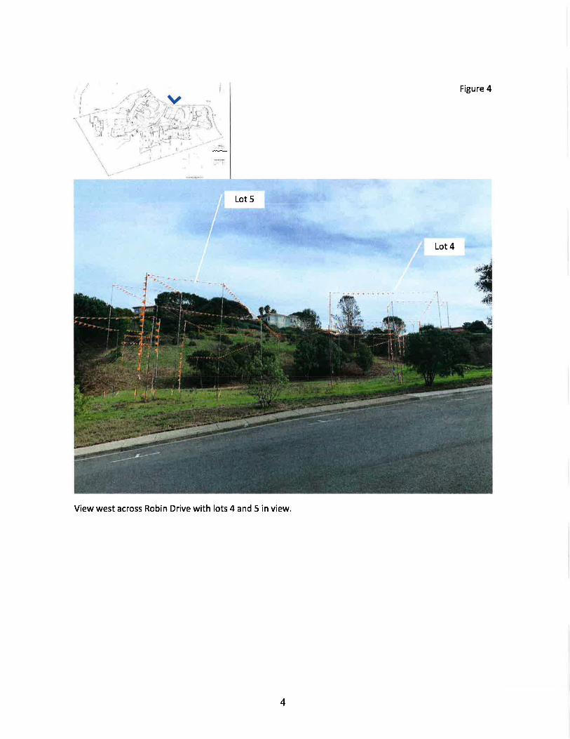
Figure 4
Lot 5
Lot 4
_isffis
View west across Robin Drive with lots 4 and 5 in view.
4

vjI
i
1.. -::l!
l" l
j,l
, :i-
Figure 5
View west across Robin Drive at the private road exit with lots 5 and 5 in view, as well as Paradise Drivedownhillat left.
5

v Figure 5
Lot 5 ,,Lot 7
Paradise Drive
View west from base of Robin Drive along Paradise Drive with the rear of lots 6 and 7 in view at right
6
I
Robin Drive

Figure 7
li'
Lot 13
View south toward lot 15 at the proposed bridge with lots 13 and 14 in view
Lot 14
7

Roof oflot 6Roof of
lot 7
Figure 8
View through window above entry door at neighboring property at 5156 Paradise Drive with the rear of
lots 6 and 7 in view behind foliage.
8

Figure 9
1l
I
View south along proposed private road with lots 5 and 9 in foreground, lot 1 in the background
9
Lot 5
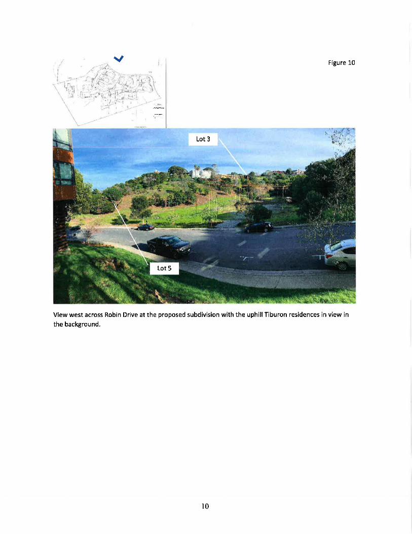
v Figure 10
Lot 3
View west across Robin Drive at the proposed subdivision with the uphillTiburon residences in view inthe background.
l.+
10

Attachment 18
Planned Development Policy Statement: DevelopmentStandards
CR#IM4E
3
tU
3
"<
RatN
t-I
l
I
I
I
)
r\I
I
I
I
I
L \-_--
t
I
-/
t
?
)
1
UIuz=ieEUJUTin"='o->k6Ul lrlld rne=fit-*6 z.-z
aeEo.-3IIL
lrl o
-F=FOP
!Ei.3:
iEttE!
H
;
I
PRELIMINARY - NOT

R-|4
RESIDENCES AT PRESERVEPLANNED DEVELOPMENT OVERLAY
\=.-=---_ __ u
(L
u'
.a
t_._
r.-
I
reft€l-=ERAPHIA %ALE
o /50NOTE9
PARCEL MflDARIffi 9IaMI PER ftE ALTAatRvEf DA|EDflHET42OE
(INEET)I Inch = ltu FT
2. ZOt'ilN9 tuLl DAHre gDr{'l PER TtE TOl4l tr@RTE I,IADERA ZOMI'I€ I4AP PA|ED AUAbT |qq4.
2
RS^c.I5I5 FOURTH STREET
NAPA, CALIF, 94559oFFlcEl?071252.33or+ www.RsAcivll.com +
RSA CONSULTING CIVIL ENGINEERS+ SURVEYORS +
/50 3@
APRIL 4 2ol4 4/bo2l-o Eyh-ZaliEdg

Existing R-l Zoning Dwelopment Standards and Modifications Proposed in the Planned Developrm.ent for the Residences at Preserve Project
;"T'"^l""o"loSite Aree (fli) 7,500 7,514 7,532 7,514 g,77g 7,610 9,655 9,388 18,249 13,427 10,618 10,170
Lotwidth(ft)
31 41.1 48.6 86.6
82.2
11
I 1,E33
t2t2Atl
13
tl,622
14
10,689
15
8,5&
t629,s3g
At Street
At Setback
Setbecks (ft)
Front Yard
Side Yard
Rear Yard
Coverage
Height
F.A-R
20
6
15
23
40o/o
30
See Note 2
29.5
30.6%
30
0.40
51.6
29.6%
30
0.40
12.8
23
36.5
28.6%
30
0.40
79.3
75.8
9.7
N/A
29.2
24.7%
30
0.lm
85.9
1l1.1
12.6
l5
29.5%
30
0.40
@
76.2
79.O
13.7
20
32.4
23.2o/o
30
0.40
78.5
19.4%
30
0.,S0
92.7
20.2Yo
30
0.40
85.7
219%
30
0.40
81.5
20.9%
30
0.40
44.5
17.4
24.5o/o
30
0.40
@ 53.9
24.3Yo
30
0.40
77.5
84.1
24.0%
30
o.N
30
70
19s.2
192.5
27.4
19.4
73.5
tt.9%
30
0.40
20.1
77
32.4
9,8
69.9
15.1%
30
0.40
1l
54.7
15.3o/o
30
0.40
10 l0 11.9 tt.2 10 16
Side (Corner)
7
l5 N/A N/A
30.60/o
30
0.rm
NOTE 1: Cells highlighted in [fi! do not conform with existing development standards in the R-l Zoning District
NOTE 2: Floor Area Ratio (F.A.R) is determiae6 61 6 5liding soale according to lot size as outlined in Municipal Code g 18.08.220:
I\IET LOT AREA MAXIMT]M F.A.R PERMITTED IN R-l COMMENTS
4,5fi) fP orless 0.60 No lots areproposedatthis netlot size
Greater then 4,61X) ff (IOVo x Net Lot Area) + 2,3OO) The largest maximum allowable F.A.R using this formrda forand less then 7r7lx) fl3 N
"t L"t Ar"" proposed lots between 4,600
^nd,7 ,700 ff is 0.40 for Lot 4.
7,71X) F or more 0.40 All proposed lots of this size achieve a F.A.R. of 0.40.
3

Attachment 19
Alternative Site Design to Minimize Tree Loss, 0210712079

Zl1 ()50 PBESEflVE AT MABIME DRAWNG$6.40 CAD\1 -S|TA1 90204 SIIE PI,AN ADJIJSTMINI0WG - Tue, Feb 5 2019 @ 12l9pm ' TNGUYEN
$lp
I,.. I
t;lllt{-l
-,t
L.
I
i..-
@ 6rchltecb

Attachment 20
Arborist Report, O8/3O|ZOLB

LSACARLSBAD
FRESNO
IRVINE
LOS ANGELES
PAIM SPRINGS
POINT RICHMOND
RIVERSIDE
ROSEVILLE
SAN LUIS OBISPOAugust 30, 2018
Sarah Klaustermeier (via email: [email protected])AIMCO26 Executive Park, Suite 125lrvine, C492674
Subject: Updated Tree Data for the Preserve ll Project in Corte Madera, California
Dear Ms. Klaustermeier:
You asked LSA to resurvey 11 trees within the Preserve ll project area. These include trees that wereidentified by the landscape architect (Carducci Associates) as near protected tree permit size of 50inches in circumference (15.91 inches in diameter) at 4.5 feet above grade (circumference at breastheight = CBH, diameter a! breast height = DBH).t The Town of Corte Madera's tree ordinance usescircumference to define permit size trees. Both Carducci and LSA used diameter when describingproject trees. This memo provides the results of the survey and a summary of updates to the 2015arborist report (prepared by LSA).
METHODS
Document ReviewLSA reviewed the following project documents
Sheet LA2 of the Tree Plan: for the Lower Porcel of the Residences at Preserve. Dated:03.07.2018. Prepared by Carducci Associates.
a Arborist Report - The Preserve ot Morin l/. Prepared by LSA for Aimco Properties. Dated:11.16.201s.
Chapter 15-50, of the Town of Corte Madera Municipal Code, Definitions ($15-50.020 [12a]and Exemptions to permit requirements ($15-50.050 t25l).
Tree SurveyOn July 2L,20t8, LSA's certified arborist Tim Milliken visited the project to update the existing treedata. A total of 11 trees were measured (#s L4, L8,27,59,104, 105, 109, 115, tl6, t26, and 148).
1 Chapter 15-5Q of the Town of Corte Madera Municipal Code.
a
a
157 Park Place, Pt. Richmond, California 94801 510.236.6810 www.lsa.net
LSA
RESUTTS
Document review
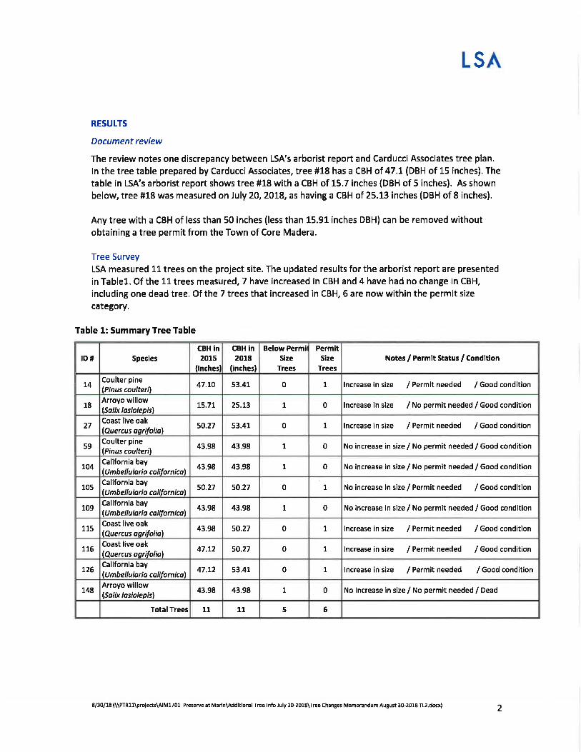
The review notes one discrepancy between LSA's arborist report and Carducci Associates tree plan.
ln the tree table prepared by Carducci Associates, tree #18 has a CBH of 47 .1(DBH of 15 inches). The
table in LSA's arborist report shows tree #18 with a CBH of 15.7 inches (DBH of 5 inches). As shownbelow, tree #18 was measured on July 20,20L8, as having a CBH of 25.13 inches (DBH of 8 inches).
Any tree with a CBH of less than 50 inches (less than 15.91 inches DBH) can be removed withoutobtaining a tree permit from the Town of Core Madera.
Tree SurveyLSA measured 11 trees on the project site. The updated results for the arborist report are presented
in Tablel. Of the 11 trees measured, 7 have increased in CBH and 4 have had no change in CBH,
including one dead tree. Of the 7 trees that increased in CBH, 6 are now within the permit size
category.
Table 1: SummaryTree Table
2
IDfl Species
CBH in2015
flnchesl
CBH ln2018
(inchesl
Below PermilSize
Trees
PermltSize
TreesNotes / Permit Status / Condition
14Coulter pine
lPinus coulteril47.LO 53.41 0 7 lncrease in size / Permit needed / Good condition
18Arroyo willow(Solix lasiolepisl
L5.77 25.13 1 0 lncrease in size / No permit needed / Good condition
27Coast live oak(Quercus aorifolial
50.27 53.41 0 t lncrease in size / Permit needed / Good condition
59Coulter pine(Pinus coulteril
43,98 43.98 7 0 No increase in size / No permit needed / Good condition
104California bayUmbellulorio colifornical
43,98 43.98 1 0 No increase in size / No permit needed / Good condition
105California bay
lU mbel lulo rio colifornicol50.27 50.27 0 ! No increase in size / Permit needed / Good condition
109California bay
lU m b e I I u lo ri a ca I if o r n i col43.98 43.98 1 0 No increase in size / No permit needed / Good condition
115Coast live oaklQuercus oorifoliol
43.98 50.2t 0 1 lncrease in size / Permit needed / Good condition
7L6Coast live oak
lQuercus o,srifoliol47.12 50.27 0 7 lncrease in size / Permit needed / Good condition
726California bayU mbellulorio colifornicol
47.72 53.41 0 1 lncrease in size / Permit needed / Good condition
148Arroyo willow(Salix lasiolepisl
43.98 43,98 1 0 No lncrease in size / No permit needed / Dead
Total Trees 11 11 5 6
8/30/18(\\PTR1l\projects\A|M1701 PreserveatMarin\AddltionalTreelnfoJuly2G20lS\TreeChangesMemorandumAugust30-2018TL2.dex)
LSA
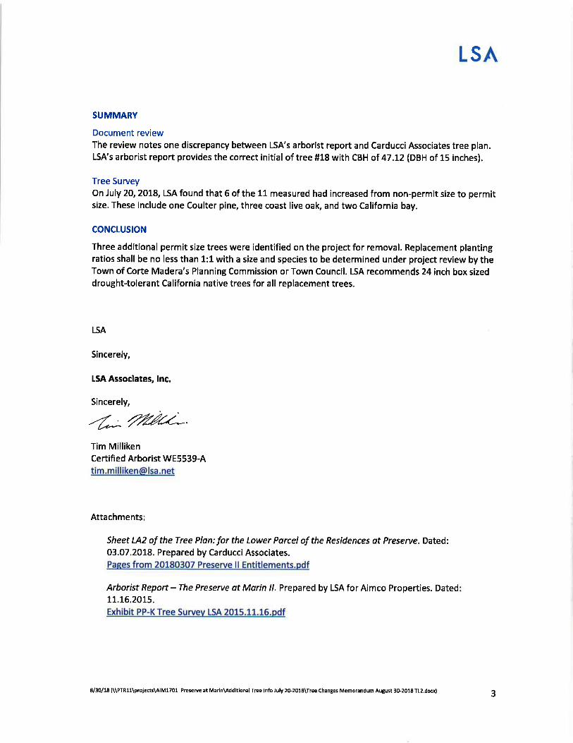
SUMMARY
Document reviewThe review notes one discrepancy between LSA's arborist report and Carducci Associates tree plan.LSA's arborist report provides the correct initial of tree #18 with CBH of 47.12 (DBH of 15 inches).
Tree SurveyOn July 20,20t8, LSA found that 6 of the 11 measured had increased from non-permit size to permitsize. These include one Coulter pine, three coast live oak, and two California bay.
CONCLUSION
Three additional permit size trees were identified on the project for removal. Replacement plantingratios shall be no less than 1:1 with a size and species to be determined under project review by theTown of Corte Madera's Planning Commission or Town Council. LSA recommends 24 inch box sizeddrought-tolerant California native trees for all replacement trees.
LSA
Sincerely,
LSA Associates, lnc.
Sincerely,
-'E;ruC*Tim MillikenCertified Arborist [email protected]
Attachments:
Sheet LA2 of the Tree Plon: for the Lower Porcel of the Residences ot Preserve. Dated:03.07.2018. Prepared by Carducci Associates.Paees from 20180307 Preserve ll Entitlements.pdf
Arborist Report - The Preserve at Morin //. Prepared by LSA for Aimco Properties. Dated11.16.2015.
Exhibit PP-K Tree Survev LSA 2015,11.15.pdf
38/30/18 (\\PTRlqprcjects\A|M1701 Preserue at Marln\Addltlonal Tree lnfo luly 2o-2018\Tree Changes Memorandum August 3G2018 TL2.dcx)

i..,,...i Near pemit size
oo
TREES TO BE
NEW TREES
EXISTING TREESTOTAL
oo
.*l
"t....'
REFEPAGE
':, .. ToTAL TREES ADDED:107
aFto2
TREE PLAN: LOWER PARCEL SCALE: 1"=3O'

Exhibit PP-KResidences at Preserve, APN 038-01 1-2't
Aimco Robin Drive L.P.
LSAI LSA ASSOCIATES, INC.I 57 PARK PLAC EPT. RICHMOND. CALIFORNIA 9480I
510.236.5t10 TEL510.236.3!E0 rAX
BERKELEYCARLSBAD
FRBSNOIRVINEPALM SPRINCS
RIVERSIDEROCKLINSAN LUIS OBISPO
November 16,2015
Jared HazardAimco Properties1350 Old Bayshore Highway, Suite 500Burlingame, CA 94010
Subjecl Arborist Report - The Preserve at Marin II, Corte Madera,Marin County, California
Dear Jared:
This report provides the results ofa tree survey for the proposed development ofThe Preserve atMarin II (project). This report builds upon the information contained within LSA's prior arboristreport for the project (LSA 2014). The project site is located on Robin Drive in the Town of CorteMadera on the Tiburon Peninsula along the eastern city boundary of the town of Corte Madera(Town) in Marin County, California (Figure 1). This arborist report was prepaxed with knowledge ofthe policies of the Town of Corte Madera's Tree Ordinancet (tree ordinance) including tree removalpermit requirements.
The tree survey identified, mapped, and assessed the condition of trees within a portion of the projectsite that was identified by AIMCO as having potential for development (study area). Sudden oakdeath (SOD), a plant disease that is devastating to oak woodlands, is suspected to be present in theproject area.
METHODS
LSA certified arborist, Timothy Milliken (International Society of Arboriculture Certification#WE5539A), conducted the tree survey on April 2,2014 for 24 trees and on August 17, 18, and19,2015 for the rest of the tees. Trees were mapped and assessed in the freld. The tree ordinanceprovided the parameters upon which to categorize hees of different sizes and species. Research onSOD provided information on the biology of the tree pathogen and measures used to restrict itsspread. A summary of tree data is presented in Table A. Detailed fee data recorded in the field arecompiled in Attachment A at the back of this letter.
I Chapter 15-50, of the Town of Corte Madera Municipal Code, defines 'Tleritage tree" as any tree, excluding an
undesirable species, (A) no less than fifty years old with a single trunk circumference equal to or more than one hundredinches (31.8 inches in diameter [or multi-stemmed trees having an aggregate circumference of equal to or more than onehundred inchesl) measured 4.5 feet above grade; or (B) which is no less than one hundred years old ($15-50.020 [2a]).Chapter 15-50 also defines "Tree" as any woodyplant ($15-50.020 [25]).
PLANNINC 1 ENVIRONMENTAL SCIENCES I DESIGN
Exhibit PP-K Page 1 ot 21

Residences at Preserve, APN 038-01 1-21Aimco Robin Drive L.P,Exhibit PP-K
LSA ASSOCIATES, INC
a
a
a
Mapping
The field surveyed trees were mapped (location data from LSA's GPS, BAR Architects, and Kier andWright's topographic survey [Kier and Wright 2015]) and marked with numbered tags (Tree Map,Figure 2aand 2b). Trees were mapped precisely where access was not impeded by brush and thecanopy was open. Tree locations were estimated where access was prevented by brush and where thecanopy was dense. Nevertheless, these trees are tagged in the field.
Tree Assessment
Trees were assessed in the field. Recorded tree information includes the species, trunk diameter atbreast height (DBH; in inches as measured 4.5 feet above natural grade), and condition of all the treeswithin the study area. If an individual tree had multiple trunks, the diameters of all the trunks weretotaled. The health and structural condition of each tree was classified as follows:
Good - Trees observed to be in good health and structure, with no outward sign of rot or disease,and may have potential for longevity on site;
Fair - Trees observed to be in moderate health and/or have structural defects that can be correctedwith proper free care; or
Poor - Trees observed to be in declining health or with significant sfiuctural defects that cannotbe mitigated. Trees in this category are expected to continue to decline.
Tree Ordinance
The arborist also determined which trees in the study area qualiff as "heritage," 'trndesirablespecies," and/or "permit size" trees as defined by the Town's tree ordinance. This is determined as
follows:
a
a
a
Heritage tree - A tree, excluding an undesirable species, (A) no less than fifty years old with asingle trunk circumference equal to or more than one hundred inches (31.8 inches in diameter [ormulti-stemmed trees having an aggregate circumference of equal to or more than one hundredinches]) measured 4.5 feet above grade; or (B) which is no less than one hundred years old.
Undesirable species - Some undesirable trees such as a few species of eucalyptus and acacia areconsidered invasive and a permit is not required to remove them as long as their identity isconfirmed by the Town. These species are Tasmanian blue gtm(Eucalyptus globulus), sugargum eucalypits (Eucalyptus cladocalyx), manna gum eucallptus (Eucalyptus viminalis), blackacacia(Acacia melanorylon), green wattle acacia(Acacia decurrens), Monterey pine (Pinusradiata), all species ofjuniper (Juniperus spp.), and Lombardy poplar (Populus nigra"Italica"\.
Permit size - The Town of Corte Madera requires a permit for the removal of trees larger than 50inches in circumference (16.6 inches in diameter) at 4.5 feet above grade.2
' Cort" Mud"ru Code of Ordinances: Title 15 - Buildings and Construction, Chapter 15.50 - Trees (15.50.050)Although unclear in the ordinance, permits are usually not required for projects that will be reviewed according to theCalifomia Environmental Quality Act because significant impacts to trees are usually adequately mitigated by the project.
Exhibit PP-K Page 2 oI 21

Residences at Preserve, APN 038-01 1-21Aimco Robin Drive L.PExhibit PP-K
LSA ASSOCIJ,TES, INC
Sudden OakDeath
Sudden Oak Death (SOD) is a tee disease caused by the plant pathogen Phytophthora rarnorum.Theproject area is within the l5-county SOD quarantine zone (as regulated by the California Departmentof Food and Agriculture [CDFA] and the U.S. Department of Agriculture [USDA], Animal and PlantHealth Inspection Service [APHIS]). The disease is suspected to be present in the woodlands on theproject site. The disease kills some oak species and has had devastating effects on forests inCalifornia and Oregon. In Marin County, the closest confirmed SOD infected oak tree isapproximately 1.5 miles southeast of the project along Paradise Drive in Tiburon (SODmap 2015).California bay laurel (Umbellularia califtrnica), a host species to SOD, can transmit the disease tooaks but still remain alive. SOD symptoms on California bay laurel can be recognized as a distinctivebrown leaf tip. Although a definitive diagnosis of SOD can only be confrmed through laboratorytesting, there are some signs on oaks that may indicate infection. These signs can include bleedingbark cankers, fungal charcoal-black globs growing on the bark(Hyporylon spp.), and branch and twigdieback with leaves still attached. Samples for laboratory assessment were not collected.
RESULTS
During LSA's prior swvey of the site in20l4, data on 24 trees was recorded from within a designatedsurvey area (LSA 2014). Eight (8) of these frees were removed. The trees assessed by the surveyincluded non-native ornamental trees, native California trees not indigenous to the project site, andnative California trees indigenous to the project site. The non-native ornamental tree species includesacacia (Acacia sp.), red flowering eucalyptus (CorynbiaJicifolia) and Tasmanian blue gum(Eucalyptus globosus\. The native California trees not indigenous to the project site (not naturallyoccurring on the Tiburon Peninsula) include coast redwood (Sequoia sempervirens) and Coulter pine(Pinus coulteri). The California native frees assessed by the survey include coast live oak(Quercusagrifolia), arroyo willow (Salix lasiolepls), Californiabay (Unbellularia califurnica), and toyon(Heteromeles arbutifulia). Toyon is generally considered a shrub; however, this species cansometimes reach tree-like proportions such as on the project site.
A total of 152 surveyed trees representing nine species occur within the study area. This data issummarized in Table A and depicted on Figure 2a and 2b. Attachment A contains the survey data onall trees observed within the project study area including: tree ID number, species name (common andscientific), diameter at breast height (DBH), number of stems, condition, and potential SOD infection.
Tree Ordinance
A total of 54 of the surveyed trees are greater than 50 inches in circumference (16.6 inches indiameter), thus they need a tree removal permit from the Town3. None of the trees included in thissurvey are heritage trees. The Tasmanian blue gum is considered an undesirable species by the Town.Although not specifically listed as an undesirable species the red-flowering gum and acacia could beconsidered undesirable species because oftheir close relationship to the undesirable species ofeucallptus and acacia. Furthermore, since coast redwood and Coulter pine are not native to theTiburon Peninsula, an argument could be made that they are also undesirable species for this project.
3 See footnote on prior page.
Exhibit PP-K Page3 ol21
Residences at Preserve, APN 038-01 1-21Aimco Robin Drive L.PExhibit PP-K
LSA ASSOCIATES, INC
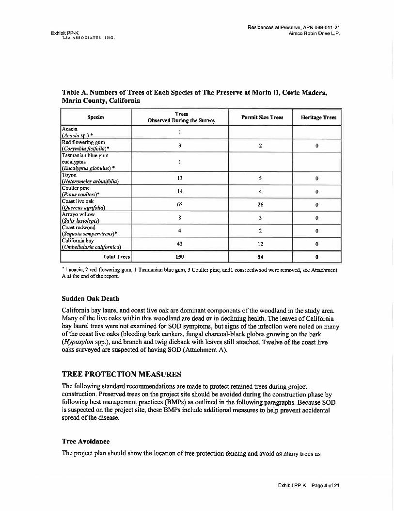
Table A. Numbers of Trees of Each Species at The Preserve at Marin II, Corte Madera,Marin County, California
' I acacia, 2 red-flowering gum, I Tasmanian blue gum, 3 Coulter pine, andl coast redwood were removed, see AttachmentA at the end ofthe report.
Sudden Oak Death
California bay laurel and coast live oak are dominant components of the woodland in the study area.Many of the live oaks within this woodland are dead or in declining health. The leaves of Californiabay laurel trees were not examined for SOD symptoms, but sigus of the infection were noted on manyof the coast live oaks (bleeding bark cankers, fungal charcoal-black globes gowing on the bark(Hyporylon spp.), and branch and trvig dieback with leaves still attached. Twelve of the coast liveoaks surveyed are suspected of having SOD (Attachment A).
TREE PROTECTION MEASURES
The following standard recommendations are made to protect retained trees during projectconstruction. Preserved trees on the project site should be avoided during the consffuction phase byfollowing best management practices (BMPs) as outlined in the following paragraphs. Because SODis suspected on the project site, these BMPs include additional measures to help prevent accidentalspread ofthe disease.
Tree Avoidance
The project plan should show the location oftree protection fencing and avoid as many trees as
SpeciesTrees
Observed During the SurveyPermit Size Trees Ileritage Trees
Acacia(Acacia w.) *
I
Red flowering gum(Corvmbia ficifolia)*
3 2 0
Tasmanian blue gumeucallptus( Eucalvntus plobulus\ *
I
Toyon(Heteromeles arbutifolia\
l3 5 0
Coulterpine(Pinus coulturt)*
t4 4 0
Coast live oak(Ouercus asrifolia\ 65 26 0
Arroyo willow(Salix lasiolepis'l
8 3 0
Coast redwood( S eauoia s emn entirens\*
4 2 0
Califomia bay( Umbellularia califomic a\ 43 t2 0
Total Trees 150 54 0
Exhibit PP-K Page 4 ol21

Exhibit PP-KLSA ASSOCIATES. INC
Residences at Preserve, APN 038-01 1-21Aimco Robin Drive L.P.
feasible.Tree Root Msintenance During Construction
Tree roots often extend far beyond the canopy dripline. Excavation work within the dripline ofavoided trees shall not be allowed.
Tree Protection Fencing
Prior to the start of consfuction, Tree Protection Fencing (TPF) should be installed. The TPF shouldbe maintained during the entire development process to prevent direct damage to trees and theirgrowing environment. The TPF should consist ofblaze orange barrier fencing supported by metal "Trail" fence posts. The TPF should be placed at a distance that is at or outside of the drip lines ofavoided trees. The TPF should be installed as part ofthe site preparation before construction or treeremoval/trimming begins and should be installed under the supervision of a qualified arborist. TheTPF should not be altered in any way that would increase the encroachment on the avoided treesduring construction activities.
Use of Heavy Equipment
Heavy machinery should not be allowed to operate (excavation, grading, drainage and leveling) orpark within the drip line of avoided fees unless approved by a qualified arborist.
Storage of Construction Materials and Debris
Fill materials should not be placed against the trunks or within the dripline of avoided trees. Disposalor depositing of oil, gasoline, chemicals or other harmful materials within the drip line is prohibited.
Incidental Damage to Protected Trees
The attachment of wires, sigrrs, and ropes to any protected tree is strictly prohibited. Workers may beallowed to rest under fees, but they must not injure trees by any means.
Tree Trimming and Tree Removal in SOD Suspected Areas
SOD is suspected to be present in the project area. All pruning of protected hees shall be performedby a certified arborist or certified tree worker (tree crew). The tree crew shall be familiar withInternational Society of Arboriculture pruning guidelines and shall comply with the guidelinespublished in Best Management Practices; Tree Pruning (Gilman and Lily 2002) when pruningretained trees. Additionally, the tree crew should also familiarize themselveswith SanitationMeasures to Minimize Pathogen Spread as outlined under the following heading. These specialsanitation measures include thorough cleaning of tools and equipment between jobs.
Being within the SOD quarantine zone, certain precautions are necessary to avoid the spread of thedisease to trees through movement and disposal of all plant materials. Disposal of plant material
Exhibit PP-K Page 5 of 21

Exhibit PP-KL8A ASIOCIATEg, INC
Residences at Preserve, APN 038-01 1 -21Aimco Robin Drive L.P,
within the quarantine zone is not regulated, but if susceptible plant material is to be moved out of thequarantine zone apermit from the county agricultural commissioner is neededa. Restrictions andexceptions are provided at the CDFA and APHIS websites.s The best way to dispose of SOD infestedwood is to chip and spread on-site such that it dries out (Matteo Garbelotto, pers. comm.).
Sanitation measures to minimize pathogen spread
As a precaution against spreading the pathogen, clean and disinfect pruning tools after use onconfirmed or suspected infested trees or in known infested areas. Sanitize pruning tools beforepruning healthy trees or working in a pathogen-free area. Clean chippers and vehicles of mud, dirt,leaves, and woody debris before leaving a SOD-infested site and before entering a site withsusceptible hosts.
l. Before Working. Inform tree crews about the arboricultural implications of SOD and sanitationpractices when they are working in infested areas.
. Provide crews with sanitation kits. (Sanitation kits should contain the following: chlorinebleach [10/90 mixture bleach to water], or Clorox Clean-up@, scrub-brush, metal scraper,boot brush and plastic gloves).
. Sanitize shoes, pruning gear and other equipment before working in an area with susceptiblespecies.
2. While Working. Implement the measures below to reduce the likelihood of the transmission ofSOD.
. When possible, work on SOD-infected and susceptible species during the dry season (June -October), or ask customers to allow flexible scheduling so work may be done during dryspells. When working in wet conditions, keep equipment on paved or dry surfaces and avoidmud.
. Work in disease-free axeas before proceeding to infested areas.
. Do not collect soil or plant material (wood, brush, leaves and litter) from host trees in theregulated area without first contacting your local agricultural commissioner (see footnote 3).Host material (e.g. wood, bark, brush, chips, leaves, or firewood) from tree removals orpruning of symptomatic or non-symptomatic plants should remain on site to minimizepathogen spread.
3. After Working. Implement the following measures after trees have been cut on the project site.
. Use all reasonable methods to sanitize personal gear and crew equipment before leaving aSOD-infested site. Scrape, brush, and/or hose offaccumulated soil and mud from clothing,gloves, boots and shoes. Remove mud and plant debris by blowing it out or power washingchipper trucks, chippers, buckets trucks, fertilization and soil aeration equipment, cranes, andother vehicles.
a Stacy K. Carlsen, Agriculture, Weights and Measures - Marin County (415)-7 43-6700
5 htp://wwwcdfa.ca.gov, and http://www.aphis.usda.gov
Exhibit PP-K Page 6 of 21

Residences at Preserve, APN 038-01 1 -21
Aimco Robin Drive L.P.Exhibit PP-KL8A ASSOCIATES, INC
a
a
Restrict the movement of soil and leaf litter under and around infected trees as spores may befound there. Contaminated soil, particularly mud, on items such as vehicle tires, workersboots, shovels, stump grinders, frenchers, may result in pathogen spread if moved to a new,uninfested site. Remove or wash off soil and mud from these items before use at another site.If complete on-site sanitation is not possible, complete the work at a local power wash facilityor an isolation area in your equipment yard. Clean, orderly vehicles and equipment are goodbusiness, and prevent pathogen and insect spread.
Tools used in tree removaVpruning may become contaminated and should be disinfected withLysol@ spray, a 70Yo or greater solution ofalcohol, or a Clorox@ solution (1 part Chlorox@to 9 parts water or Clorox Clean-up@). Remember that these products are corrosive to metaland fabric. Rinse your gear after sanitation.
SUMMARYTrees were mapped for the project in order to assist in siting buildings and roads. Although projectplans are not developed yet, a total of 152 trees were mapped in the likely vicinity of the buildingsand roads of the project. The project will avoid as many of these trees as possible but some fees mayrequire trimming or removal, once project plans are frnalized, accurate tree impacts can be quantified.
LSA appreciates the opportunity to provide this arborist report to you, and our arborist is available toanswer questions regarding it ifneeded. Please feel free to contact us ifyou have questions orcomments.
Sincerely,
LSA ASSOCTATES, rNC.
Ctk' Y/{."*ClintonKellner, Ph.D. Timothy Milliken
Certifred Arborist
Attachments: Attachment A: Detailed Tree Table, The Preserve at Marin II, Corte Madera,Marin County, California
Exhibit PP-K PageT oI21
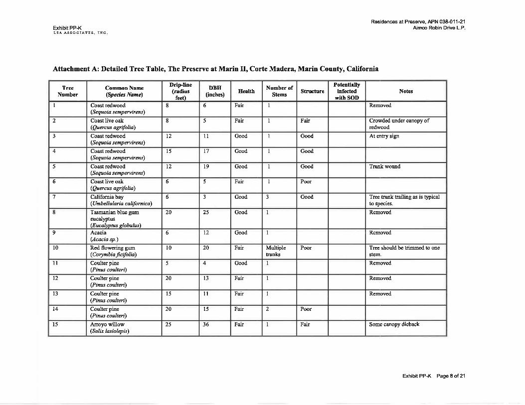
Exhibit PP-KLSA ASSOCIATES, INC
Attachment A: Detailed Tree Table, The Preserve at Marin II, Corte Madera, Marin County, California
Residences at Preserve, APN 038-01 1-21Aimco Robin Drive L.P
Notes
Removed
Crowded under canopy ofredwood
At entry sip'
Trunkwound
Tree trunk trailing as is tlpicalto species.
Removed
Removed
Tree should be trimmed to onestem.
Removed
Removed
Removed
Some canopy dieback
Potentiallyinfected
with SOI)Stnrture
Fair
Gooil
Good
Good
Poor
Good
Poor
Poor
Fair
Number ofStems
I
I
I
I
I
I
3
I
I
Multipletrunks
I
I
I
2
I
Health
Fair
Fair
Good
Good
Good
Fair
Good
Good
Good
Fair
Good
Fair
Fair
Fair
Fair
DBII(inches)
6
5
u
l7
l9
5
3
25
t2
20
4
l3
ll
l5
36
Dripline(radius
feet)
l2
l5
t2
6
6
20
6
t0
5
20
l5
20
25
Cotnmon Name(Species Nane)
Coast redwood(Sequoia sempemirens)
Coast live oak(Quercus agrifolia)
Coast redwood(Sequoia sempenirens)
Coast redwood(S equo i a s emp erv iren s)
Coast redwood(Sequoia s empervirens)
Coast live oak(Quercas agrifolia)
Califomiabay(Umb e llularia c a lifu rnic a)
Tasmanian blue gumeucalyptus(Eucalwtus slabulus'lAcacia(Acacia sp.)
Red flowering gum(Corynbiaficifulia)
Coulter pine(Pinus coulteri)
Coulter pine(Pinus coulteri)
Coulter pine(Pinus coulteri)
Coulter pine(Pinus coulteri)
Arroyo willow(Salix lasiolqis)
TreeNumber
I
2
J
4
5
6
7
9
l0
ll
t2
l3
l4
t5
Exhibit PP-K Page I of 21

Exhibit PP-KLSA ASSOCIATBS, INC
Residences at Preserve, APN 038-011-21Aimco Robin Drive L.P.
Notes
In decline, canopy dieback
In decline, canopy dieback
Has been trimmed
Has been trimmed
Removed
Multiple stems
Lopsided crown
Removed
Some poor bark attachment.Live crown no outward sip ofrot or sudden oak death (SOD).
5 live stems 2 dead stems.Origrnating from commonpoint. May look like two trees.Dead branches and canopyprobably died offdue toshading. Live crown nooutward sigr of rot or SOD.
Some rotten branches of smalldiameter.
Rot in trunk lools substantial.SOD symptoms Qlyporylon)on trunk. Scaffold of largediameter has crossed limbs.
Potentiallyinfected
with SOI)
x
x
Structure
Poor
Poor
Good
Good
Good
Good
Fair
Good
Good
Good
Fair
Number ofStems
I
I
ll
I
I
t
I
I
I
3
5
I
I
Health
Poor
Poor
Good
Good
Good
Poor
Good
Good
Good
Good
Good
Good
Poor
DBH(inches)
8
l0
5
6
I
l9
6
8
22
27
62
l6
52
Dripline(radius
feet)8
12
l5
8
8
6
l0
20
20
20
25
20
Common Name(Species Name)
Arroyo willow(Salix lasiolqis)
Arroyo willow(Salix lasiolepis)
Arroyo willow(Salix lasiolepis)
Toyon(H et eromel es arbutifoli a)
Coast live oak(Queras agrifolia)
Red flowering gum(Co4nnbiaficifolia)
Califomia bay(Umb ellu laria califu mica)
Coast live oak(fuercus agrifolia)
Red flowering gum(Corynbiaficifolia)
Coast live oak(Quercus agrifolin)
Coast live oak(fuercus agrifolia)
Coast live oak(Qaercus agrifolia)
Coast live oak(Quercas agrifolia)
TreeNumber
l6
17
18
19
20
2t
22
23
24
25
26
27
28
Exhibit PP-K Page 9 of 2'l

Exhibit PP-KLSA ASSOCIATES. INC
Residences at Preserve, APN 038-01 1-21Aimco Robin Drive L.P.
Notes
Vigorous young tree. All theseare multi-stemmed from groundlevel. Must have been browsedby deer when very young. Livecrown, no outward sign ofrotor SOD.Tree trunk trailing as is typicalto species.
Some rot in main trunk.Dieback of smaller branches.
Rot in tnmk. Northem half oftree dead and failed. Canopylopsided. Scaffold fuir, but a lotof small leaves.
Except for large conk on base.The conk may be benip as
there is one rotten trunkalready. Still the overallaDDearftmce is sood.Robust tree on edge oflargegully.
On edge of gully
Three live stems of smalldiameter. Two dead stems oflarge diameter. These largestems recently fallen over fromrotten tnrnk at grormd level.There could be SOD. Brownleaves still on dead tree.
No outward sign of rot.
Some rotted branches butotherwise lools healthy. Onother side of zully.Robust tree on edge oflargegully.
Potentiallyinfected
with SOI)
x
x
x
x
Structure
Good
Good
Fair
Fair
Fair
Good
Good
Fair
Good
Good
Good
Number ofStems
3
3
I
I
I
2
I
J
5
I
I
Ileelth
Good
Good
Fair
Fair
Fair
Good
Good
Fair
Good
Good
Good
DBH(inches)
27
28
l2
20
20
t2
10
l8
36
t2
6
Dripline(radius
feet)l5
25
20
l0
30
10
l5
l5
l5
l5
l5
Common Nane(Specia Nane)
Coast live oak(fuercas agrifolia)
California bay(Umb ellu laria c a lifu rnic a)
Califomiabay(Umb e I lularia c alifu rni c a)
Coast live oak(Quercus agrifolia)
Coast live oak(Qaercts agrifolia)
Coast live oak(fuercus agrifolia)
Coast live oak(Quercus agifolia)
Coast live oak(Quercus agifolia)
Coast live oak(fuercus agrifolia)
Coast live oak(Quercus agrifolia)
Coast live oak(Qrercas agrifolia)
TreeNumber
29
30
3l
32
33
34
35
36
37
38
39
Exhibit PP-K Page 10 of 21

Exhibit PP-KLSA ASSOCIATES, INC
Residences at Preserve, APN 038-01 1 -21
Aimco Robin Drive L.P,
Notes
Some rotted branches andbleeding bark. Canopy sparseand recently exposed fiomadiacent larse tree fall.Some rotted branches andbleeding bark. Canopy sparseand recently exposed fromadiacent laree tree fall.
Tree no more than 12 feet tall.Canopy ofbroken limbs androtted branches.
Some rotted branches butotherwise looks healthy.
Tree trunk trailing as is tlpicalto species.
Some rotted branches butotherwise looks healthy.
Some rotted branches butotherwise looks healthy.
Some rotted branches butotherwise looks healthy.
Some rotted branches butotherwise looks healthy.
Potentiallyinfected
with SOD
x
x
x
Structure
Good
Good
Fair
Good
Good
Poor
Good
Good
Good
Good
Good
Good
Good
Good
Good
Number ofStems
I
I
I
I
2
1
2
I
3
I
2
I
I
2
I
Hedth
Good
Fair
Fair
Good
Good
Fair
Good
Good
Good
Good
Good
Good
Good
Good
Good
DBE(inches)
8
l0
8
8
t4
6
l8
6
l0
t2
l8
6
l4
l3
6
Dripline(radius
feet)20
20
5
l5
20
5
20
l0
l5
20
20
5
25
l5
l5
Common Name(Species Name)
Califomiabay(Umb ellu laria c a lifo rni c a)
Coast live oak(Quercus agrifolia)
Coast live oak(fuercus agrifolia)
Coast live oak(Quercus agrifolia)
Coast live oak(Quercus agrifolia)
Coast live oak(Quercus agrifolia)
Coast live oak(Qtercas agrifolia)
Coast live oak(Quercus agrifolia)
Califomiabay(Umb ellularia ca lifo rnic a)
Coast live oak(Quercas agrifoliQ
Coast live oak(Querats agrifolia)
Coast live oak(Quercus agrifolia)
Coast live oak(Quercus agrifolia)
Coast live oak(Qaercus agrifolia)
Coast live oak(Qaercus agrifolia)
TreeNumber
40
4t
42
43
44
45
46
47
48
49
50
5l
52
53
54
Exhibit PP-K Page 11 oI21

Exhibit PP-KLSA ASSOCIATES, INC
Residences at Preserve, APN 038-011-21Aimco Robin Drive L.P.
Notes
Tree leaning from dead woodofother tree fall.
Suppressed rmder larger trees.
Nice old tree some poor barkattachment.
Sup'pressed under larger trees.
Forked scaffold old tree tag154.
Tree next to existing building.
Old shrub. In cluster with tree73, 7 4, 7 5, 7 6,77, 78, & 79.
Tree in poison oak. Diameterestimated.
Potentiallyinfected
with SODStrrrcture
Fair
Good
Goocl
Good
Fair
Good
Gooil
Good
Good
Good
Goocl
Good
Good
Good
Goocl
Gootl
Good
Number ofStems
2
2
4
2
I
2
6
I
2
1
3
3
I
I
J
I
I
Health
Good
Good
Good
Good
Good
Good
Good
Crood
Good
Good
Good
Good
Good
Good
Good
Good
Good
DBH(inches)
12
l0
57
t2
l4
23
36
9
l5
8
2t
24
8
E
24
6
8
Dripline(radius
feet)l0
l0
25
15
20
20
l5
t5
t0
5
l0
10
10
l5
20
5
5
CommonName(Species Name'|
Coast live oak(Quercus agrifolia)
Coast live oak(Qaercus agrifolia)
Coast live oak(Quercus agrifolia)
Coast live oak(Quercas agrifolia)
Coulterpine(Pinus coultei)
Coast live oak(Querats asrifolia)
Toyon(Heteromeles arbutifolia)
Coulter pine(Pinus coulteri)
Toyon(Heter o m e I es arbutifoli a)
Califomia bay(Umb ellu I aria c a lifo rni c a)
Coast live oak(Qrercus agrifolia)
Coast live oak(Quercus agrifolia)
Califomiabay(Umb e I lularia c alfo rnic a)
Coulter pine(Pinus coultei)
Califomia bay(Umb ellu I ar ia c a lifu rnic a)
Coulter pine(Pinus coulter)
Coast live oak(Quercus agrifolia)
TreeNunber
55
56
57
58
s9
60
6l
62
63
64
55
66
67
68
69
70
7l
ExhibitPP-K Page12o121

Exhibit PP-KLSA ASSOCIATES. INC
Residences at Preserve, APN 038-01 1-21Aimco Robin Drive L.P.
Notcs
Because tree 76 is in poisonoalq its tag is on tree 75.
Because tree 76 is in poisonoalg its tag is on tree 75.
Old shrub. In cluster with tree#s 73, 7 4, 75, 7 6,'17, 78, & 79.
Old shrub.
Multiple stems but only onegreater than 6".
Multiple stems but onlytwogreater than 6".
Multiple stems but only onegreater than 6".
Tree trunk trailing as is tlpicalto species. Inoks very healthycompared to oak next to it.Broken oak on too.Bleeding bark. Looks likeSOD. Many dead oaks in area.
Potentiallyinfected
with SODStructure
Good
Good
Good
Good
Good
Good
Good
Good
Good
Good
Good
Good
Good
Good
Good
Good
Number ofStems
2
I
I
I
I
I
l2
9
3
2
4
4
3
I
I
I
Health
Good
Good
Good
Good
Good
Good
Good
Good
Good
Good
Good
Good
Good
Good
Poor
Good
DBH(inches)
12
t4
6
7
l2
6
l2
l8
30
22
7
t2
6
l8
24
6
Dripline(radius
feet)5
10
10
l0
l5
15
l5
5
15
l5
l0
l0
10
30
25
l5
CommonName(Specia Nane)
Toyon(Heteromeles arbutifolia)
Califomia bay(Umb e llularia ca lifu rnic a)
Califomiabay(Umb ellularia c alift rnic a)
Califomiabay(Umb ellularia ca lift rni ca)
Coast live oak(Quercus agrifolia)
Califomiabay(Umbellularia cafunica)Toyon(Heteromeles arbutifolia)
Toyon(H et er om el e s arbutifo li a)
Toyon(H eter omeles arbutifoli a)
Toyon
Qfeteromeles arbutifolia)
Toyon(Heteromeles arbutifolia)
Toyon(Heteromeles arbutifolia)
Toyon(Heteromeles arbutifolia)
Califomiabay(Umb e llularia califu rnic a)
Coast live oak(Qaercas asrifolia)
Califomia bay(Umb ellularia c a lifo rni c a)
TreeNumber
72
73
74
75
76
77
78
79
80
8l
82
83
84
85
86
87
Exhibit PP-K Page 13 of 21

Exhibit PP-KLSA ASSOCIATES, INC
Residences at Preserve, APN 038-01 1-21Aimco Robin Drive L.P.
Notes
Conk on trunk.
Multiple stems but only onegreater than 6".
Bleeding bark. Lools likeSOD. Many dead oaks in area.
Bleeding bark. Looks likeSOD. Many dead oaks in area.
Dying tree.
Tag says 300.
Potentiallyinfected
with SOI)
x
x
Structure
Good
Good
Good
Good
Good
Good
Good
Good
Good
Good
Good
Fair
Good
Good
Good
Good
Good
Number ofStems
2
3
I
2
J
3
2
4
2
2
I
I
t
2
4
I
I
Health
Good
Crood
Good
Fair
Good
Good
Good
Good
Fair
Fair
Crood
Poor
Good
Good
Good
Good
Good
DBII(inches)
5
6
6
t8
l2
46
20
30
8
24
l0
6
52
48
48
t4
l4
Dripline(radius
feet)
l0
5
25
l5
40
25
20
l5
20
l5
t5
40
35
35
15
25
CommonName(Species Name)
Califomiabay(Umb ellu I art a c a lifu rni c a)
Califomia bay(Umb e I lu I ai a c alifu rni c a)
Califomia bay(Umb e I lularia c alifu rnic a)
Califomia bay(Umb elluhria c alifo rnic a)
Califomia bay(Umb e llul aria c a lift rnic a)
Califomiabay(Umb ellu I aria c a lifu rn i c a)
Coast live oak(Quercus agrifolia)
Coast live oak(Quercus agrifolia)
Coast live oak(Quercts agrifolia)
Coast live oak(Quercrs agrifolia)
Coast live oak(fuercus agrifolia)
Califomiabay(Umb ellu I ai a c affi rni c a)
Califomia bay(Umb e I lu I ai a c a lifu rni c a)
Coast live oak(Qaercus agrifolia)
Califomia bay(Umb e llularia c alift rnic a)
Coast live oak(Quercus agrifolia)
Califomiabay(Umb el lu I aria c a lifo rn ic a)
TreeNumber
88
89
90
91
92
93
94
9s
96
97
98
99
100
t0l
t02
103
104
Exhibit PP-K Page 14 ol21

Exhibit PP-KLSA ASSOCIATES. INC
Residences at Preserve, APN 038411-21Aimco Robin Drive L.P.
Notes
Stunted.
Tree lools pretty good for itssize..
Two stsms above dbh.
Multiple suckers from base.
Potentiallyinfected
with SOI)Shucture
Good
Good
Good
Good
Good
Good
Good
Good
Good
Good
Good
Good
Good
Good
Fair
Poor
Good
Number ofStems
2
I
I
I
2
I
3
2
I
2
I
I
2
I
2
1
I
Hedth
Good
Good
Good
Good
Good
Good
Good
Good
Good
Good
Good
Good
Good
Good
Good
Good
Good
DBE(inches)
l6
7
6
24
t4
6
52
30
8
18
t4
l5
38
8
24
36
6
Dripline(radius
feet)l5
l5
15
35
20
l5
35
30
20
20
10
l5
20
5
25
25
5
Common Name(Specia Name)
Califomiabay(Umb el lularia c alifornic a)
Califomiabay(Umb ellularia c alift rni cQ
Califomiabay(Umb ellulari a c aliforni c a)
Coast live oak(Quercas agrifolia)
Califomiabay(Umb ellularia c alifu mic a)
Califomiabay(Umb ellularia c alifu rnic a)
Califomiabay(Umb e llulari a c alift rnic a)
Coast live oak(Qaercus agrifolia)
Califomiabay(Umb ellularia c alifornic a)
Califomiabay(Umb ellu laria c a lifu rnic a)
Coast live oak(Quercus agrifolia)
Coast live oak(Quercus agrifoliQ
Coast live oak(Quercus agrifolia)
Toyon(Heteromel e s arbutifoli a)
Coulter pine(Pinus coulteri)
Coulterpine(Pinus coulteri)
Coast live oak(Querctts agrifolia)
TreeNumber
105
106
107
108
t09
ll0
lll
tt2
ll3
tt4
ll5
ll6
lt7
ll8
ll9
120
t2t
Exhibit PP-K Page 15 ot 21

Exhibit PP-KLSA ASSOCIATES, INC
Residences at Preserve, APN 038-01 1-21Aimco Robin Drive L.P.
Notes
Multiple stems but only onegreater than 6".
Multiple stems but only onegreater than 6".
Multiple stems but only onegreater than 6".
Multiple stems but only onegreater than 6".
Bleeding bark and poor branchattachment.
Multistem.
Some poor branch attachment.
Potentiallyinfected
with SOI)
x
Structure
Good
Good
Good
Good
Good
Good
Good
Good
Good
Good
Good
Good
Good
Good
Good
Good
Good
Nunber ofStems
I
5
5
I
2
2
2
I
2
4
I
I
I
3
5
5
5
Health
Good
Good
Good
Good
Good
Good
Good
Fair
Good
Good
Good
Good
Good
Good
Good
Good
Good
DBH(inches)
6
6
6
8
15
6
6
8
12
27
6
24
12
42
35
50
42
Drip-line(radius
feet)l0
15
t0
l0
l5
l5
5
l0
l0
l0
5
25
l0
20
l5
30
25
Common Name(Species Name)
Califomia bay(Umb e I lularia c alifu rnica)
Califomia bay(Umb e llularia c affi rnic a)
Califomiabay(Umb ellul ari a c alfo rnic a)
Coast live oak(fuercus agrifolia)
Califomia bay(Umb ellu lari a c alift rnic a)
Califomiabay(Umb ellul aria ca lifu rni c a)
Califomia bay(Umb e I lularia c a lifo rnic a)
Coast live oak(Quercus agifolia)
Coast live oak(btercts agrifolia)
Toyon(Heterome I e s arbutifo lia)
Coast live oak(Quercus agrifolia)
Coulter pine(Pinus coulteri)
Coast live oak(Quercus agrifolia)
Coast live oak(Qaercus agrifolia)
Califomiabay(Umb ellularia c a lifo rni c a)
Califomiabay(Umb e llu I aia c alifu rnic a)
Coast live oak(Qu*cus agrifolia)
TreeNunber
122
123
124
125
t26
127
128
129
130
13l
132
133
134
135
136
137
138
Exhibit PP-K Page 16 ot 21

Exhibit PP-KLSA ASSOCIATES, INC
Residences at Preserve, APN 038-01 1-21Aimco Robin Drive L.P.
Notes
Some rotted branches butotherwise looks healthy. Deadtrees with f/porylon nearby.
Extensive canopy dieback.
Borers and drought weakentree. Iots ofbroken tops andbranches.
The condition ofthese willowsis ok giveir the natural thicketform.Trunk rot and canopy dieback,poor branch attachment.
Potentiallyinfected
with SOI)Structure
Good
Good
Good
Good
Good
Good
Good
Good
Good
Poor
Fair
Good
Fair
Good
Number ofStcms
I
I
I
I
I
I
1
3
2
I
3
2
2
4
Eedth
Good
Good
Good
Good
Good
Good
Good
Good
Good
Poor
Fair
Good
Fair
Good
DBE(inches)
6
7
ll
7
l2
22
24
l4
52
t6
l8
32
Dripline(radius
feet)
5
5
t0
l0
l0
l0
l5
30
25
25
20
l5
20
l5
CommonName(Specia Name)
Califomiabay(Umb ellularia c alifu rnic a)
Coulter pine(Pinus coulteri)
Coast live oak(Querars asrifol@Coast live oak(Quercus agrifolia)
Coast live oak(Quercas aCrifoln)
Coulterpine(Pinus coulteri)
Coulter pine(Pinus coultei\
Coast live oak(Qaercas agrifolia)
Coast live oak(Quercas asrtfoln)Arroyo willow(Sal* lasiolqis)
Aroyo willow(Salix lasiolqis)
Aroyowillow(Salix lasiolqis)
Aroyo willow(Salix lasiolepis)
Califomiabay(Umb e I lulai a c alifu rnic a)
TreeNumber
139
140
t4t
t42
143
144
145
146
147
148
149
150
l5l
152
Exhibit PP-K Page 17 o121

Residences at Preserve, APN 038-01 1-21Exhibit PP-K
LSA AgSOOIATES, INCAimco Robin Drive L.P
REFERENCES
California Oak Mortality Task Force http://www.suddenoakdeath.org
Garbelotto, Matteo. 2015. Plant pathologist and foremost expert on sudden oak death. University ofCalifornia, Berkeley.
Gilman, Edward F. and Sharon J. Lilly. 2002. Best Management Practices, Tree Pruning. Companionpublication to the ANSI A300 Part I: Tre, Shrub, and Other Woody Plant Maintenance -Standard Practices, Pruning. Published by the International Society of Arboriculture,Champagne,IL.
Kier and Wright. 2015. Topographic survey of 300 Robin Drive for AIMCO. Dated 8-19-2015. Kierand Wright Civil Engineers and Surveyors, 2850 Collier Canyon Road, Livermore, CA94551
LSA Associates Inc. 2014. Results of a Tree Survey of the Robin Drive Project Site, Town of CorteMadera, Marin County, Califurnia. December 1,1992. Letter to JohnBezzant, AimcoProperties, LP. 4582 South Ulster Street, Suite 900, Denver, Colorado, 80237 . LSA PointRichmond Offi ce, California.
SODmap. 2015. UC Berkeley Forest Pathology and Mycology Lab. SoDmap.org
ExhibitPP-K Page 18of2'l

o
,'' Rich
GorteCONTRcosr'
II
ttA LFra
M
0 3.?5 7.5FE-MILBS TEO
AN
Project Site
nRid
r RingMountain
ord st., r l-lillary'$
Goldon GateNatronal Recreation Area
!'.l\
Ang6ll$land
State Park
:
Tiburon
Residences at Preserve, APN 038-01 1-21
FIGURE 1
Robin Drive ProjectCorte Madera, Marin County, Califurnia
Regional Location
LSA
600.5 I
---MILES
SOURCE: Esri StreetMap North America (2012).
I:\AIMl301\GISWaps\Figrc1_Regional Location.ild (9/ l0l2gl3) Exhibit PP-K Page 19 of 21

Resid€nFs at Preserye, APN 038-011-21
--,t114!J
J4
@4@El7a .Jl43lJP
@g tlo't6ia -b4!ry-:=^t J j3al .1r3slu!4J'Jq!]"
t;;lq
ftaJ"5r3n
ttle$:r@t@
liilt/ir6l ltlJ- JP
lr21L l1?9 fiAr-^rT4J
na
Pfiffi]P fta
lt1cJ
r!1.eJ
fiia
EA
fia
qr'Ea
/-relt:')201
ii
%na'-l2o('---f j ,5n
ECr
6A
I5€\'
Ii Eol.._Paradise Drive
EA'---b
'i
Robrn 9il"'e
i:ii'l
'i l
LSA LECEND
I eroject site
FIGURE 2a
Robin Drive Prcject6
Tr@
Nolc: Tr*s not mappcd are outside lhesudy are6 boundary prcr'lded by AlvlLU.
0 17.5 15
-
Corle Maderc, Msrin County, Califomiq
Tree SwevSOWCF,USOS Odoil:UrMl l0l\ClswgF$dodilRqontriFr. 2 r.. S*y*a 1r m;ZOr1

R€sidonc€s at Prosorve, APN 038-01 1-21
flnr
.l6tl)prr Jsd fia
lE].
aFA.FH*
lzgJ
lsllr
fin
E,L
'Jw
Jit
'@A!)
Joel
Ji
lat-_J83t
fiolr
P
!l'.
!.!.i.
LSA LEGEND
I rroject Site
FIGURE 2b
Robin Drive Prcject6
a Tr@
Nolo: Tr@s notmapFd are outside thesNdy areabound!ry provided byAIMCO.
o t1.5 15
-
Corte Madera, Mailn County, CaliforniaIEET
sowcEruscs odoimq.ry (04n0I). Tree Sweyl:WM I lOl\GlsrvspsudonsdSonUiryc 2 r."

Attachment 21
Project Marketing Strategy, 08 / 30 12078
Preserve at Marin ll - Marketing Strategy
Preserve at Marin's custom marketing plan for eight ADU apartment homes will target area workforceemployees, such police officers, fire fighters, teachers, nurses, and more. This plan will include digital,out-of-home, and community-based channels that appeal to this audience.
Customized digital ads will reach local employees and employers through Linkedln, other social mediachannels, and local publications such as the Marin lndependent Journal online edition. Preserve at Marinll will also have prominent placements on popular apartment listing sites ApartmentGuide.com.Apartments.com, Zillow.com, and more.
Out-of-Home tactics will include metro station and interior train ads along the Sonoma-Marin Area Rail
Transit line, including the new Larkspur Station, which offers area residents convenient access to 70 milesacross the North Bay.
Meeting and attracting the target demographic will be fostered through community-based partnershipsand in-person neighborhood outreach by Preserve at Marin community leaders. This includes:
r Sponsoring and attending College of Marin Workforce Career Education events to forgeawareness with students, faculty, and mentors of the availability of apartments
r Visiting local fire/police stations and hospitals to meet with housing administrators andemployees
o Participating in the "Share a Book" program at the Marin Humane Society which interacts heavilywith local teachers, reading specialists, and librarians to promote childhood literacy
o Staffing an Open Mic Night booth at Sweetwater Music Hall to engage with customers at thispopular entertainment location
o HostinB Book Passage Literary Luncheons popular for author events and writing classes
o Providing housing collateral about the ADUs for these organizations to have on hand throughoutthe year
These ADU apartment homes range in size from 665 to 749 square feet. The smaller size of these one-bedroom apartments help maintain the market rate of these apartments at a moderate level for thecustomers. Other moderate level deed restricted apartments at Aimco communities have proven to be
difficult to rent due to strict levels of Area Median lncome requirements by the applicant. Thecumbersome application and paperwork process for these apartments has deterred or declined manypotential workforce customers who would otherwise be qualified from renting the apartments. The verynature of the smaller size of these ADUs along with our targeted marketing plan will help Aimco attractworkforce and moderate income area professionals as customers in the Preserve community.

Attachment 22
Project Conditions of Approval

PLANNING
CONDITIONS OF APPROVALUNIQUE TO
The Residences at Preserve (APN 038-011-21), File #PL-2017-055 through PL-2OI7-OO6t
PLANS
1
3.
4.
2
PTANNING DIVISION
Consistencv with Approved Plans. Except as otherwise noted in these conditions of approval, plans
submitted to the Building Department for plan check shall include identical information as the plans andthe color and materials board titled Residences at Preserve, stamped "Official Exhibit" with a receivedstamp of March 79, zOLg approved by the Corte Madera Town Council on lf anychanges are made to the approved plans, the applicant is responsible for clearly identifying all such
changes and reviewing them with the Planning Department prior to submitting for a Grading or BuildingPermit. All changes made between the drawings and specifications approved by the Town Council andthe Building Permit submittal must be clearly highlighted with a "bubble" or "cloud" on plans andmarked with a "Delta 'P"'at the time of initial Building Permit submittal. A written list describing in detailall such changes shall be submitted and attached to these plans.
Plan Chanses. No changes shall be made to the approved plans without written approval from the CorteMadera Planning Department. lf the applicant proposes changes that require Planning Departmentreview to determine conformance with the approved plans, the Planning Director may require a SSOO
deposit for a Permit Amendment. The Planning Director may also refer proposed changes of theapproved plans to the Planning Commission and/or Town Council for review. Any changes that have notbeen clouded and noted and explicitly approved in writing by the Planning Director are not approved.Construction or demolition that does not conform to the Design Review approval is not valid and shallbe subject to stop work orders and may require removal. Per Municipal Code 518.18.050, if an
amendment to the approved Precise Plan is requested by the applicant, the Planning Commission andTown Council may review and amend all previous Conditions of Approval.
Conditions of Approval. Prior to the issuance of any construction permits, these conditions of approval,the conditions of approvalof the ProjectTentative Map, and the MMRP of the lnitialStudy/MitigatedNegative Declaration shall be included with the plan set. A copy of the approved plans shall bemaintained on-site when construction activities are occurring.
Conditions and MMRP. All applicable Conditions of Approval of the Residences at Preserve and themitigation measures of Resolution No. 19-007 N.C.S. adopting the Residences at Preserve MitigatedNegative Declaration and Mitigation Monitoring and Reporting Program (MMRP) are incorporated byreference and made Conditions of Approval.
1

Owner and Contractor Statement. The applicant shall provide with the Building Permit application a
signed "Owner and Contractor Statement" (attached). This signed document acknowledges that theowner and contractor have read, understand and accept the responsibility to implement the conditionsof approval.
Electronic Plans. At Building Permit issuance, the applicant shall provide the Town with an electroniccopy of final/approved construction documents in portable document (PDF) format.
Solar-Readiness. Prior to the issuance of a Building Permit, the applicant shall verify on the building plans
that all residential units shall be solar-ready, to support General Plan Policy RCS-2.4 and RCS-2.5.
Solar Panel lnstallation. Any installed solar photovoltaic panels in the Project shall be non-reflective tothe maximum extent feasible and practicalto minimize glare on uphill properties.
Precise Plan Expiration Prior to Construction Commencement. Per Municipal Code 5 18.18.050, approvalor conditional approval of the Residences at Preserve Precise Plan shall lapse and become null and voidtwo years following the date the approval or conditional approval was given unless, prior to theexpiration date, construction of improvements has commenced. The approval or conditional approvalmay be extended by the Planning Director for an additional period of one year upon application filedprior to the expiration date and provided that no change in conditions or requirements has occurred;but an application involving any change shall be treated as a new application.
10. Design Review Permit Expiration. Per Municipal Code 518.30.090, and per the request of the applicant,the approved or conditionally approved Residences at Preserve Design Review permit shall lapse andbecome null and void three years following the date on which the approval became effective unless,prior to the expiration of one year, a Building Permit is issued and is active per Building Departmentrequirements. Per Municipal Code 518.30.080, the Design Review Permit shall become effective uponthe expiration of ten days following the Town Council's action.
CONSTRUCTION
7L. Resulatorv Compliance. The project shall comply with all performance standards of the Town of CorteMadera Municipal Code, including Title 5 (Health and Sanitation) and Title 18 (Zoning).
72. Preconstruction Meetins. Prior to submission of a Building Permit, a preconstruction meeting shall takeplace with all appropriate representatives of the project construction team, Town representatives andany other agencies, in preparation for developing the Construction Management Plan. The meeting shalladdress items such as the construction management and parking plan, required permits, traffic andparking management, work schedule, delivery schedule, contact person(s), neighborhood notification,insurance, damage deposits, etc. A second preconstruction meeting may be required by the Director ofthe Planning and Building Department prior to the initiation of actual construction.
13. Construction Management Plan. A Construction Management Plan and Parking Plan shall be preparedby the applicant and submitted at or before the time of Building Permit application submittal to thesatisfaction of the Planning, Building, and Public Works Departments to minimize impacts on theneighborhood during the construction period. The plan shall show in detail how the work will progress.This shall include, but not be limited to a detailed schedule of the work, the designation of stockpileareas for grading and construction materials, the size and type of trucks and equipment to be used forthe work, and an indication of how construction deliveries and workers will park and access the site. ThePlan should include a Construction Parking Plan to propose a system to minimize the effect of
2
5
6
7
8
9
construction worker parking in the neighborhood. An estimate of the number of workers and vehiclesthat will be present on the site during various phases of construction shall be provided, and the Planshall indicate where sufficient off-street parking will be provided. The construction Management Planshall include provisions for eliminating deliveries and truck activity during peak pick-up and drop-offhours at the Marin Montessori and Marin Country Day schools adjacent to the project site. The morningpeak period covers the arrival of staff and students at the start of the school day, between 7:30 a.m. and8:30 a.m., while the afternoon school peak period covers the departure of school traffic between 2:30p.m. and 4:00 p.m.
74. Hours of Construction. The Applicant shall implement the following to reduce construction noise levelsfrom the site, limit construction hours, and minimize disruption and annoyance:a. All construction activities shall be limited to the hours between 7:00 a.m. and 5:00 p.m. Monday
through Friday, 10:00 a.m. and 4:00 p.m. on Saturdays, and no construction shall be permitted onSundays and holidays defined as
i. New Years Day (January 1)
ii. Martin Luther King Day
iii. Presidents Dayiv. Memorial Day
v. lndependence Day (July a)vi. Labor Day
vii. Veterans Day
viii. Thanksgiving Day and Thanksgiving Fridayix. Christmas Day (December 25)
Work outside of these times may only be permitted at the sole discretion of the Planning Directorif it is determined in writing that such work is either: 1) emergency work necessary to resolve publichealth and safety issues, or 2) work that is of such a nature (such as interior painting) that it will notexceed permitted noise levels.
b. All internal combustion engines used in conjunction with construction shall be muffled accordingto the equipment manufacturer's requirements.
c. Unnecessary idling of internal combustion engines should be strictly prohibited.d. Locate stationary noise-generating equipment such as air compressors or portable power
generators as far as possible from sensitive receptors.e. lf stationary noise equipment is located within 100 feet from sensitive receptors, temporary noise
barriers should be constructed to screen stationary noise-generating equipment. Temporary noisebarriers could reduce construction noise levels by 5 dBA.
t. Utilize "quiet" air compressors and other stationary noise sources where technology exists.g. Control noise from construction workers' radios to a point where they are not audible at existing
residences bordering the project site.h. Notify all adjacent business, residences, and other noise-sensitive land uses of the construction
schedule, in writing, and provide a written schedule of "noisy" construction activities to theadjacent land uses and nearby residences.
i. Construction Noise Complaints. lf any work-related complaints are received by the Town aboutconstruction on a weekend, Town reserves the right to determine that no further work shall beconducted on a Saturday; and provided further, if any complaints are received by the Town aboutconstruction during any weekday, the Planning Director is vested with the authority to imposereasonable conditions to address the issues that gave rise to the complaint. To mitigate the adverseimpacts the applicant's construction activities have on neighboring property owners and renters,the Planning Director shall be vested with the authority to impose reasonable conditions on the
3

applicant's hours of construction and/or the applicant's construction activities. No workers shall be
on the site except during these hours. Without limiting the generality of the foregoing, nopreparatory work or staging shall be allowed to occur on the site or on adjacent properties exceptduring the hours specified above. No work shall be performed on a legal holiday.
15. Disturbance Monitor and Coordinator. The Town shall contract for a "Disturbance Monitor andCoordinator" at the applicant's expense, for an amount agreed to by Town and applicant in advance,who will be responsible for responding to any complaints about construction noise, ensuring thatconstruction-related nuisances are properly managed on a daily basis in accordance with all applicableproject conditions and the MMRP. The Disturbance Monitor and Coordinator will determine the cause
of any nuisances (e.9., noisy mufflers, operations outside of approved construction hours, improperimplementation of dust control measures, etc.) and will report to the Town regarding compliance andreasonable measures to correct the problem. A report shall be provided on a not-less-than weekly basis.
lf violations are identified, they shall be documented. At the Planning Director's discretion, measuresshall be imposed to ensure compliance, including but not limited to a stop-work order as well as anynecessary corrective actions that are needed to address impacts caused by the nuisance. Stop workorders shall be issued on an escalating basis: the first infraction shall result in a stop work order of notless than 1 day, the second infraction shall result in a stop work order of not less than 3 days, and thethird or subsequent stop work orders shall extend up to one week. A telephone number for theDisturbance Monitor and Coordinator shall be conspicuously posted at the construction site andincluded in the notice sent to neighbors regarding the construction schedule.
16. Construction Notice. Prior to commencing construction activities, a sign shall be posted on the siteregarding the allowable hours of construction and contact information for complaints. Proof of signinstallation shall be provided to the Planning Manager prior to construction commencing.
T7 Debris. The site shall be kept clear at all times of garbage and debris. No outdoor storage shall bepermitted other than typical bulk materials, i.e., lumber, appliances, window systems, etc., temporarilystored through the normal course of construction.
Construction Phasing. This approval is granted for and contingent upon construction of the project, in a
single phase, with the construction and/or installation of all features approved and required herein.Modifications to the project, including but not limited to a change in construction phasing, shall requirereview by the Planning Department.
19 Staeing. All construction staging shall occur on-site, unless expressly permitted by the ConstructionManagement Plan.
20. Emissions durins Construction. Greenhouse Gas (GHG) reduction best management practices as definedby the Bay Area Air Quality Management District (BAAQMD), shall be followed during construction.
2L Dust Control. Demolition and construction activities may result in the generation of fugitive dust, whichmust be controlled in accordance with the Municipal Code 515.20.190 and the Bay Area Air QualityManagement District's (BAAQMDI Best Management Practices (BMP). To ensure that fugitive dustgenerated during construction is minimized, the responsible party shall implement basic and additionalair quality construction measures set forth by the Town and the BMQMD, including the following:a. Water all active construction areas (staging, parking, soil piles, graded areas, unpaved driveways,
etc.) at least twice daily with the first watering occurring before 10 a.m. and the second wateringoccurring after 4 p.m.
b. Cover all haul trucks transporting soil, sand, or other loose materials offsite.
4
18

c. Sweep daily (with water sweepers) all paved access roads, parking areas, and staging areas. Sweepstreets daily (with water sweepers) if visible soil material is deposited onto adjacent roads.
d. Limit traffic speeds on any unpaved roads to 15 mph.e. Suspend construction activities that cause visible dust plumes beyond the construction site.f. A certified mechanic shall verify that equipment is properly tuned and maintained in accordance
with manufacturer specifications.g. ldling times shall be limited to 5 minutes or less pursuant to the "no idling" rule for in-use off-road
diesel-fueled vehicles. Signage shall be posted at the construction site indicating the idle timelimitation.
h. All diesel-powered off-road equipment larger than 50 horsepower and operating at the site formore than two days continuously shall meet U.S. EPA particulate matter emissions standards forTier 2 engineer or the equivalent.
i. Diesel-powered generators or air compressors shall not be used on-site for more than two dayscontinuously, unless under emergency conditions.
j. Post a publicly visible sign with the telephone number of designated person and person to contactat the Lead Agency regarding dust complaints. This person shall respond and take corrective actionwithin 48 hours. The Air District's phone number shall also be visible to ensure compliance withapplicable regulations.
LANDSCAPE PLANS
22. Unpermitted Tree Removal. No trees requiring a permit for their removal shall be removed duringproject construction unless the removal has been identified in the Landscape Plan, dated March 7,2O!8,and available at the Planning Department, or amendments thereto required as a condition of approvalfor the project that me be determined by Town Council. All tree removal shall be subject to MunicipalCode S15.050.080.
23. MWELO. Per California Code of Regulations Title 23 Waters Division 2 Department of Water ResourcesChapter 2.7 Model Water Efficient Landscape Ordinance (MWELO) 8492.3, the applicant shall submit a
landscape package compliant with 5490 through $495 and submit a including a soil management report,irrigation design plan, and applicant signature and date, with the statement, "l agree to comply with therequirements of the water efficiency landscape ordinance and submit a complete Landscape DocumentPackage" on the Landscape Plan.
24. lnstallation. Prior to the issuance of an Occupancy Permit, the project Landscape Architect shall certifyin writing in a manner acceptable to the Town of Corte Madera, that the landscaping plan has beeninstalled in accordance with all aspects of the approved, final Landscape and lrrigation Plans preparedby BAR Architects, dated March 7,20t8, as well as the approved Vegetation Management Plan and allapplicable conditions, including but not limited to the removal of invasive species. lf all the requiredlandscaping is not completed prior to the Certificate of Occupancy, the applicant shall post a cash depositor letter of credit for L25 percent of the total cost of the landscaping based on a written estimate ofsuch cost. All landscaping shall be completed within six months of the Certificate of Occupancy.
25. Herbicides and Pesticides. Herbicides and pesticides shall not be used until all plant material has beenplanted a minimum of 20 days. All planting areas shall be kept weed-free by non-herbicide methodsprior to the expiration of the 20-day period. Herbicide shall not be applied to any areas which have beenseeded. The project contractor shall be licensed by the State and Marin County for fertilizer applicationand must have current registration filed with the County.
5
26 Maintenance. Any landscaped area shall be compliant with Corte Madera Zoning Ordinance 518.24.110.All landscaped areas shall feature water-conserving landscape designs and shall be permanently
maintained by the property owner, including automatic watering, weeding, pruning, fertilizing, spraying,
or other form of insect control, replacement of plant materials as needed, and any other operationsneeded to ensure proper maintenance. Failure to meet these requirements shall be cause for theissuance of a citation, an order of compliance, nuisance abatement action, and/or the revocation of anyland use approval for which the landscape requirements were made a condition of approval. lf therespondent refuses to comply with the provisions of the citation and order, legal proceedings may be
initiated by the town attorney to obtain compliance when such proceedings are authorized by the towncouncil.
27 Gravwater Requirements. Prior to applying for a Building Permit with the Town of Corte Madera, theapplicant shall provide written documentation that the project complies with the graywater provisions
of Title 13 of the Marin MunicipalWater District (MMWD) Code (Ordinance 429) to the extent that gray-
water provision is suitable on the site due to topography and proximity to the Bay. MMWD Graywateri nformation is availa ble at ma rinwat er.orgl L55 / Graywater or 415-945-1530.
28. Erosion Control. Prior to the issuance of a building permit, the landscaping plans shall be revised to notethat to protect the stream from any erosion while vegetation is being removed, and prior to the planting
and establishment of new, native vegetation as proposed and amended pursuant to the project
conditions of approval, erosion control measures shall be installed to protect the bare soil and prevent
further fill or soil material from entering into the stream system.
29. Hvdroseeding. Prior to the issuance of a building permit, the landscaping plans shall note that plantings
shall by hydroseeded.
30. Native Plantinss. Prior to the issuance of a building permit, the Landscaping and VegetationManagement Plans shall be revised such that any proposed grasses and forbs shall be native varietals as
shown on Landscape Plan sheet LA17 - Biome lmagery: rain garden and remediation. Landscaping plan
sheet LA17 shall be revised to remove the proposed Cape Rush (Chondrapetalum tectorum) plant species
from the plantings menu as this is not a native species.
LIGHTING
31 Exterior Lightins Dark Skv Compliant. All exterior lighting fixtures shall be submitted to the Town forreview and approval. All exterior lighting must be dark sky compliant and not create a glare or hazard
on adjoining streets, properties or residential areas. Lighting must be designed with full cutoff and/orfully shielded fixtures, and installed so that the filaments, light sources or lenses are shielded withopaque material so they will not be visible at property lines. Exterior lights shall have a color temperatureof 3000-3500 Kelvin or lower (warm not cool). Any changes to approved lighting must be approved by
the Planning Department.
IMPACT AND OTHER FEES
Fee Pavment. Prior to the Certificate of Occupancy being issued for any residence, the property ownershall remit all development impact fees to the Town of Corte Madera, unless otherwise indicated inthese Conditions of Approval.
6
32
33 lnclusionarv Housing ln-Lieu Fee. Prior to the issuance of a Building Permit the applicant shall pay an in-lieu fee, paid to the Affordable Housing Fund, for housing to be provided elsewhere in the Town. Theamount of the in-lieu fee shall be based on the formula found in CMMC 5L8.24.I20 (a) for a developmentconsisting of 8 dwelling units.
34. School District Mitieation Fees. Applicant is responsible for ascertaining whether School Districtmitigation fees will be required by the Larkspur-Corte Madera School District for this project. lf fees arerequired, the District will require that these fees be paid prior to the applicant receiving a Building.
35. Park Dedication or ln Lieu Fee. The applicant shall provide an in-lieu payment, or dedicate suitable land,for park and recreational purposes pursuant to Municipal Code Chapter 17.30 prior to the issuance of aCertificate of Occu pa ncy.
36. Street lmpact Fee. Per Town Resolution No. 3314, a project with a valuation over 510,000.00 or more issubject to the Street lmpact Fee equal to L% of the project valuation. Applicability of this fee will bedetermined by the Public Works/Engineering Department prior to the issuance of a Building Permit.
37. Sewer Fees. Prior to Building Permit approval all sewer connection charges and fees will be paid to theDistrict. These charges and fees are based on the number of units approved for the project and thenumber of bathrooms. A fee schedule can be obtained from the Public Works office.
38 Traffic Mitieation Fee. The applicant shall remit the required traffic impact mitigation fee consistentwith CMMC S 3.32.040.
CALIFORNIA ENVI RONM ENTAL QUALITY ACT
39. Mitigation Measures. All mitigations measures listed in the Residences at Preserve MitigationMonitoring and Reporting Plan (MMRP) shall be implemented along with these conditions of approval.The MMRP is attached hereto as Attachment 22 and made a part of these conditions as if fully set forth.
40. Work Offsite. Approval from adjacent property owners shall be secured prior to completing any activitiesor improvements on adjacent properties, including any landscaping and vegetation management, as
well as improvements to the adjacent Preserve at Marin property at APNs 038-011-23 and 038-011-38.
INSPECTIONS AND VERIFICATIONS
Height Verification. No structure shall exceed the maximum heights identified on the plans. Heightcertification is required prior to the issuance of an Occupancy Permit. After installation of the first rooftruss or following initial roof framing on each structure, confirmation in writing shall be submitted tothe Town from a licensed surveyor or engineer that the height of the structure(s) is consistent with theapproved Building Permit plans.
42. Propertv Line and Setback Verification. Upon issuance of a Building Permit, the property line and setbacklocation(s) at areas of construction must be identified on site by a licensed land surveyor or registeredcivil engineer. The licensed land surveyor or registered civil engineer shall submit a written confirmationto the Building Department that the staking of the property lines has been properly completed.
43. Final Planning lnspection. Prior to a final Building Division inspection of this project, the applicants shallcontact the Planning Department to schedule an inspection of the finished project to ensure compliancewith all the required Conditions of Approval per the Resolution approving the project.
7
4t

44. Access for lnspections. The applicant shall permit the Planning Department or its representative(s) ordesignee(s) to make inspections at any reasonable time deemed necessary to assure that theconstruction being performed under the authority of this approval is in accordance with the terms and
conditions described herein.
INDEM N I FICATION AGREEMENT
45. lndemnitv. The applicant shall defend, indemnify, and hold harmless the Town of Corte Madera and itsagents, officers, attorneys, or employees from any claim, action or proceeding (collectively referred toas "proceeding") brought against the Town or its agents, officers, attorneys, or employees to attack, setaside, void, or annul this approval, which proceeding is brought within the applicable statute oflimitations. The indemnification shall include, but not be limited to, damages, fees and/or costs awardedagainst the Town, if any, and the cost of suit, attorney's fees, and other costs, liabilities and expenses
incurred in connection with such proceeding whether incurred by the applicant, the Town, and/or theparties initiating or bringing such proceeding.
45. Costs lncurred. The applicant shall defend, indemnify, and hold harmless the Town, its agents, officers,attorneys, or employees for all costs incurred in additional investigation or study of, or forsupplementing, redrafting, revising, or amending any document, if made necessary by said proceeding
and if applicant desires to pursue securing such approvals, after initiation of such proceeding, which are
conditioned on the approval of such documents.
47. Lesal Proceedines. lf a proceeding is brought, the Town shall promptly notify the applicant of theexistence of the proceeding and the Town will cooperate fully in the defense of such proceeding. ln theevent that the applicant is required to defend the Town in connection with any said proceeding, theTown shall retain the right to (1) approve the counsel to defend the Town, (2) approve all significantdecisions concerning the matter in which the defense is conducted, and (3) approve any and all
settlements, which approval shall not be unreasonably withheld. The Town shall also have the right notto participate in said defense, except that the Town agrees to cooperate with the applicant in thedefense of said proceeding. lf the Town chooses to have counsel of its own defend any proceeding wherethe applicant has already retained counsel to defend the Town in such matters, the fees and expenses
of the counsel selected by the Town shall be paid by the Town. Notwithstanding the immediatelypreceding sentence, if the Town attorney's office participates in the defense, all Town attorney fees andcosts shall be paid by the applicant.
APPEAL PERIOD
48. Appeal Period. No Building Permit shall be issued until the expiration of the appeal period. The appealperiod extends ten calendar days from the date of decision. Unless a shorter statute of limitations periodapplies, the time within which judicial review must be sought is governed by California Code of Civil
Procedure S1094.6.
SPECIAL REQUIREMENTS
Permits from Other Agencies. As part of the application for a Building Permit, the applicant shall providein writing approved permits from appropriate agencies, or written agencies' statements that a permit isnot required, from the local, state or federal agencies with jurisdiction over the project site, unless a
separate parallel processing agreement is entered into with the Town. lt shall be the responsibility ofthe applicant to determine whether approvals and/or permits are required. lt is anticipated that these
8
49
permits shall include but are not limited to San Francisco Bay Regional Water Quality Control Board(NCRWQCB)- 401Water Quality Certification, and California Department of Fish and Wildlife (CDFW) -Strea mbed Alteration Agreement.
50. Affirmative Marketine Strateev. An Affirmative Marketing Strategy shall be developed and approved bythe Planning Director prior to the issuance of Building Permit to raise awareness and encourage ADUrental applications from moderate-income households or lower-income households for the Project'sADUs. The Strategy shall: require marketing materials to include prominent use of Equal HousingOpportunity logos; include materials written in English and Spanish; include a marketing distributionplan that-in addition to the locations and events identified in the Marketing Strategy submitted for theProject in the entitlement application package-identifies specific destinations for advertising availableADU units with the intention of attracting applicants who work in local retail centers, schools,government, and the like for the purposes of reaching moderate and lower-income households. Thestrategy will ensure that moderate-income households, or other lower-income households (as definedby HUD for Marin County), shall be notified of the opportunity to lease the project's ADUs, and thatmoderate or lower-income households will be prioritized in the selection process for leasing accessorydwelling units to the maximum extent feasible. The strategy shall be implemented during the pre-leasingperiod, the initial leasing period, and on an ongoing basis if units are vacated and new leases areavailable. The strategy shall include maintaining a referral list of interested moderate-income and lower-income households to notify these households of unit availability on an ongoing basis. The AffirmativeMarketing Strategy shall be submitted to the Planning Director for review and approval prior toimplementation. The approved marketing strategy for the dwelling units shall be implemented anddocumentation shall be provided to the Planning Department for recordation in the property file.
51. Prohibition on Sinsle Users for Primarv Units and ADUs. On each lot, there shall be a distinct user orgroup of users for the primary residential unit and the accessory dwelling unit so that both units areoccupied by different households in the structure (i.e. a single tenant may not reside in both the primaryunit and the ADU). The purpose of the condition is to ensure that accessory units are made available toseparate households and are not utilized as an extension of space for use by the users of the primarysingle-family unit.
52. Owner Occupancv Waiver. Prior to the issuance of an Occupancy Permit for any residence within thePreserve - Phase ll, the property owner shall record a deed restriction such that if any of the subject lotsare individually transferred or sold, or transferred or sold as a group of lots, the Town of Corte Maderaowner-occupancy requirement for any Accessory Dwelling Units associated with the transferred or soldproperties shall comply with owner occupancy requirements established in Municipal Code$18.31.050(2) (owner occupancy for primary unit or ADU) for those properties, unless the new propertyowner is able to provide equivalent or improved property management on-site in the same rentalstructure and in the same manner that upholds the conditions and mitigations associated with theproject.
53 Accessorv Unit Rent Reporting. The property owner shall submit an annual report to the PlanningDirector identifying the rent levels for each accessory dwelling unit and that shows compliance withCondition 5L, Prohibition on Single Users for Primary Units ond ADUs.
54. Anti-Discrimination. The applicant shall not discriminate against prospective tenants' sources of incomepursuant to Housing Element Policy H-1.2 and the Town of Corte Madera Anti-Discrimination Ordinance.
55. Short-Term Vacation Rental. A covenant shall be recorded with the County stating that the ADUs shallnot be rented for less than 30 days.
9
56. Garase Articulation. Consistent with General Plan Policy CD-3.1 and Housing Element Policy H-3.2,greater articulation is needed for the proposed front facades of the residences in the Residences atPreserve subdivision to reinforce an active block frontage. The project plans shall be revised to includeadditional articulation on the garage doors for lots 1-3 and 8 through 12, including consideration ofadditional fenestration and detailing, for review and approval by the Planning Director.
57 Garages for Parking. Garage space in the any unit in the project shall be maintained in a condition toaccommodate a vehicle for parking. Garages shall not be used exclusively for storage or other purposes,
including but not limited to hobby space or home work spaces, such that the storage or other activitiesprevent a vehicle from utilizing the garage parking space. The applicant shall record a dead restrictionfor each unit that requires each resident in the subdivision to maintain their assigned garage in a mannerwhich permits the parking of the number of cars for which the garage was designed. ln addition, thedeed restriction shall provide that, from 10:00 p.m. to 6:00 a.m. the following morning, each resident in
the subdivision must park their vehicle in the garage built for their rental unit. For units that are served
by assigned, uncovered parking spaces, residents of those units must park their vehicles in assigned
spaces over the same overnight period.
58. Lot 5 and 7 Site Desisn. Prior to the issuance of a Building Permit, the structures on lot 6 and 7 shall be
relocated to be placed closer to the private roadway with greater setback from Paradise Drive and
additional landscaped screening shall be planted along Paradise Drive to the extent feasible consideringwildfire risks at the site. The revised site and landscaping plan for these lots shall be submitted to thePlanning Director for review and approval.
59. Utilitv Services. All utility services for the Project shall be connected and operational prior to the issuance
of an Occupancy Permit.
50. Contribution to Paradise Drive Multi-Use Pathwav. Prior to the issuance of a Certificate of Occupancy
for any units in the Project, the applicant shall remit a fair-share monetary contribution to the Town tobe used for the completion of the Paradise Drive Multi-Use Pathway along the south side of Paradise
Drive from Upland Way to Robin Drive connecting to the Robin Drive intersection improvementsidentified in the Project MMRP. The fair share contribution shall be determined by the Town based on
construction estimates and be in an amount not to exceed 5250,000.
51 Propertv Management. Property management shall be provided by an on-site property manager and
facility that may include the existing property management office and operations at the adjacentPreserve at Marin apartment complex.
10

PUBLIC WORKS
62. Maintenance Agreement. At the time of Building Permit submittal, the applicant shall enter into a
maintenance agreement with the Town of Corte Madera Public Works Department regarding all workdone between the property line and the edge of the pavement of the subject property.
TENTATIVE MAP, EASEMENTS, AND DEDICATIONS
63. Tentative Map. The tentative map shall comply with the requirements under Title 17 of the CorteMadera Municipal Code and all applicable Town policies, standards, codes, resolutions and ordinances.Final Parcel Map fees and technical review deposits shall be required at the time of the applicationsubmittal.
64. Easements Delineated. All easements shall be clearly defined on the Final Map, including thoseassociated with private open space areas, public trails, rights-of-way, utilities, and other services. Thenecessary crossover access, parking, utility and drainage easements shall be identified for dedication onthe Final Parcel Map.
55. Open Space. All property identified as "private open space" shall be clearly designated on the TentativeMap and Final Map as such. Prior to issuance of any Building Permit, a restriction shall be recorded withthe County of Marin for all identified private open spaces to ensure that the property is exclusively usedas private open space, is restricted from any non-open space use, and said restriction shall run with theland and be binding on successor property owners in perpetuity.
66. Trail Easement. Prior to the issuance of an Occupancy Permit, and if accepted by the County of Marinfollowing its review of recreational, open space, and trails assets for Region 6-the Ring MountainPreserve area-the property owner shall record a 10-foot wide public access trail easement on the upperportion of the lot to Ring Mountain Preserve on the location of the existing informal trail. The easementshall include an expanded landing area in which interpretive and educational materials for RingMountain Preserve may be established in partnership with the County of Marin in the future.
67. Dedications. The applicant shall satisfy the applicable requirements for any dedications of property orprovisions of easements for street, storm drain, sanitary sewer, drainage, or access purposes as definedand approved by the Town or other agencies.
68. CC&Rs. ln the event the applicant desires to convert any of the units in the project from rental units tofor sale units, the applicant shall provide 90 days advance notice to the Town prior to the sale of anyunit, and within said time period the applicant shall submit Conditions, Covenants, and Restrictions(CC&Rsl. The CC&Rs shall include:a. Requirements to ensure the appropriate management of parking, including guest parking.b. Easements for all private open space areas identified in the Tentative Map and Final Map.c. Defined rights of access rights to all common areas and shared facilities identified in the Tentative
and Final Map.d. Waste management standards, including the location of and access to waste receptacles, on lots
with two units.e. Maintenance declarations for all shared facilities (access, parking, water lines, storm drains, sewer
lines, etc.).f. An owner occupancy requirement consistent with Municipal Code S18.31.050(2), unless the
waiver may continue to be applied to the property consistent with Condition 52.
7t

69. Final Map. A Final Map shall be prepared, approved byTown for compliance with the approved TentativeMap and all conditions contained herein, and recorded.
70. Final Map Format. A copy of the recorded Final Parcel Map shall be submitted in a format compatiblewith the Town of Corte Madera Graphic lnformation System.
GRADING AND DRAINAGE
7L, Grading and Drainase Permit. ln accordance with 515.20.030 of the Municipal Code, the applicant shall
obtain a Grading and Drainage Permit from the Public Works Department prior to issuance of a BuildingPermit. The application for this permit shall include, but not be limited to, a site grading plan/drainageplan showing topographic information prepared by a licensed civil engineer or landscape architect. lf ageotechnical report is required, the project geotechnical/soils engineer shall review and approve thegrading/drainage plan for conformance to the report prepared for the project.
72. Supervised Gradins. Grading within this area will be subject to the requirements of 515.20.220"Supervised Grading" of the Municipal Code if the construction schedule and scope requires a full time,or near-full time inspector for a period of a week or longer. A determination will be made by the Public
Works Department at the time of the Grading and Drainage Permit.
73. Rainv Season Earthwork. No earthwork shall take place during the rainy season between October 15th
and April 15th without special written authorization from the Director of Public Works.
74. Erosion and Sediment Control Permit. Earthwork operations will require an Erosion and SedimentControl Permit from the Public Works Department per Municipal Code 515.20,285. The permit willrequire the installation and maintenance of appropriate erosion and sedimentation control measures
for the proposed work. The applicant will be required to obtain the permit prior to the issuance ofBuilding Permit.
75. Erosion Control lnstallation. Per Municipal Code 515.20.285, the applicant shall be required to post a
security (cash deposit) to guarantee the timely installation of erosion control measures whenever thecontractor fails to perform the required erosion control work or to perform it in a timely manner.Applicability of the securitg which is based on the square footage of earthwork, will be determined atthe time of Erosion and Sediment Control Permit.
76 Watercourse Alteration/Relocation Permit. Prior to issuance of a Building Permit, the permitee shallobtain a watercourse alteration/relocation permit from the Public Works/Engineering Department. The
construction of any improvement within a watercourse will require a WatercourseAlteration/Relocation Permit from the Public Works Department per Municipal Code 59.32.060. Allrequirements for the watercourse permit shall be met, including notably Requirement 7: The Permitteeshall submit written certification by an engineer duly licensed by the state that the proposed work willfunction properly, has not and will not impact any other properties, increase surface or subsurfacedrainage entering any other properties, deprive adjacent land of lateral support, cause slippage orexcessive washing of earth or rock onto adjacent land and further that the design minimizes dischargeof drainage from the property to the street/right-of-way to the minimum necessary. Further, atcompletion of the work and prior to acceptance, the applicant shall submit written certification by thesame engineer that the completed work satisfies these and all other requirements of the permit.
77. Drainage Facilities. Where possible, drainage facilities shall be installed to collect roof drainage andsurface water runoff from driveways, walkways, and other paved surfaces. Drainage shall be conveyed
t2

and disposed in a manner that avoids concentrated flows and minimizes impacts to adjoining properties.Drainage collection systems shall be designed to Town standards and the flow shall be conveyed to apublicly maintained storm drain system, natural drainageway, or approved on-site dispersal structure.Runoff shall not be diverted from one drainage area to another. The subsurface drainage system(foundation, retaining wall, etc.) shall remain separate from the surface drainage system.
78. Storm Drainage Plans. Prior to issuance of a building permit, the applicant shall submit storm drainageplans, profiles and drainage calculations that follow all Town standards. The plans shall comply withstorm water mitigation requirements under the current NPDES Phase ll Permit for post-constructionstorm water discharge.
79 General Permit for Discharees. Construction activity resulting in a land disturbance of one acre or more,or less than one acre but part of a larger common plan of development, must obtain coverage under theGeneral Permit for Discharges of Storm Water Associated with Construction Activity (ConstructionGeneral Permit) from the California State Water Resources Control Board. This permit will require thedevelopment and implementation of a Storm Water Pollution Prevention Plan (SWPPP) for the project.
80 NPDES. Prior to issuance of a Building Permit the applicant shall provide a copy of the Notice of lntentto obtain coverage under and to comply with the State Water Resources Control Board NationalPollutant Discharge Elimination System (NPDESI Phase ll for Post-Construction Storm Water Discharges.
TRAFFIC
81. Traffic Detour Plans. Prior to issuance of any permit, the applicant shall submit any applicable pedestrianor traffic detour plans to the satisfaction of the Town Engineer for any lane or sidewalk closures. Thedetour plan shall comply with the State of California Manual of Traffic Controls for Construction andMaintenance Work Zones, and with standard construction practices.
WORK IN PUBLIC RIGHT-OF-WAY
Encroachment Permit. The applicant shall obtain an Encroachment Permit from Department of PublicWorks for all activities within, or use of, the public right-of-way per Municipal Code S12.04.040.Encroachments include but are not limited to all work in the right-of-way, placement of debris boxes,staging of equipment in the street, traffic control activities, or street closures. Work in the public right-of-way shall be in conformance with the Marin County Uniform Construction Standards andSpecifications and the latest Town of Corte Madera Encroachment Permit Provisions. The permit shallbe obtained prior to any work being performed within the Town right-of-way.
83. License Agreement. The private use of public property, public easements, or right-of-ways, and/or theconstruction of private improvements thereon, may be subject to review by the Town Council, and a
License Agreement. To permit permanent encroachments on Town Property a License agreement willbe required by the applicant and recorded with the County.
84. Compliance Verification. At the time of Building Permit, the Public Works/Engineering Department willinspect encroachments, vegetation, and drainage at the property for compliance with the TownMunicipal Code. The applicant shall bring the property into compliance with the Municipal Code inaccordance with Town standards and to the satisfaction of the Department of Public Works Directorprior to final acceptance ofthe project.
82
13

85 The Robin Drive roadway between Paradise Drive and the terminus of Robin Drive, is in like-newcondition, therefore, any damage or cuts to the roadway resulting from construction activities relatedto the project, shall be restored to similar like-new condition. Where excavations occur in the roadway,the pavement restoration patching will be reviewed by the Department of Public Works and will be
required to extend either the full width of the road or centerline depending on the extents of the damageor severity.
SANITARY SEWER
85. Sanitarv Sewer Plan. Prior to issuance of a building permit, the applicant shall submit a sanitary sewerdrawing showing a plan and profile of the existing and proposed sewer mains and laterals. All work shallcomply with Sanitary District No. 2 Standard Specifications and Drawings, latest edition, and any otherspecial requirements, including additional sewer main replacement. The entire sanitary sewer systemlying on private property, including but not limited to; private sewer laterals, mains, and manholes shallbe the ownership and maintenance of the permittee
87 Sewer Design Calculations. Provide design calculations based on project build out for the existingsanitary sewer system. Show any pipe sizing changes and structure modifications required toaccommodate the calculated increase in effluent flow.
88. Sewer Capacitv. Provide capacity calculations on Paradise Drive Sanitary Sewer Pump Station. Show anymodifications to the sewer pumps and /or changes to the structure required to accommodate thecalculated increase in effluent.
89. Sanitarv Sewer Permit. Prior to the issuance of a Building Permit, the applicant shall obtain a SanitarySewer Permit to be issued by Sanitary District No. 2 for all work associated with the sanitary sewer mainsor laterals serving this property, including the installation of a backflow preventer device.
CONSTRUCTION OPERATIONS
90. Video lnspection. Prior to the issuance of Building Permit, a video or photographic inspection of theexisting conditions of the roadways and other public improvements adjoining the project may be
required of the applicant. The inspection results shall be submitted to the Public Works Department.
91 Damage Repair. Any damage to the street caused by heavy equipment or because of projectconstruction activities shall be repaired, at the applicant's expense, prior to issuance of the Certificateof Occupancy. All hazardous damage shall be repaired immediately. Any heavy equipment brought tothe construction site shall be transported by truck.
92. Bondine. Prior to the issuance of a Building Permit, a cash deposit of 510,000 shall be posted for bondingpurposes to ensure repair of any damage to roadways, landscaping, and other public improvements inthe Town right-of-way caused by the applicant's construction-related activities. The amount of the cash
deposit shall be determined at the time of the Building Permit. Said cash deposit shall not be releaseduntil the project, including all landscaping, is completed and all required repairs have been made.
t4

93 Stormwater Best Management Practices. Per Municipal Code 59.33.100, the applicant shall employ bestmanagement practices (BMPs) as appropriate from the California Stormwater Best ManagementPractice Handbook for Construction Activity, latest edition, or from the Erosion and SedimentationControl Field Manual published by the California Regional Water Quality Control Board, to control andprevent the discharge of sediment, debris and other construction related wastes to the storm drainagesystem or waterways, including, but not limited to, general construction, concrete and mortarapplication, heavy equipment operation, road work and paving, and earth-moving activities.
94. Utilitv Services Connected. All utility services for the dwelling units shall be connected prior to theissuance of any Occupancy Permits.
BUITDING DIVISION
95 Buildins Code Compliance. The project shall be designed to comply with the 2015 California BuildingStandards Codes. Note: The 2015 Buildings Standards Code Cycle will end on 72-L3-2019 and the 2019Building Standards Code Cycle will begin. The date of submittal for Building Permit will dictate the codecycle this project will fall under.
95 Green Buildins Code. Project plans submitted after December 3I, 2OtB shall be subject to the 2019Building Code and all submittal requirements contained therein.
97. Alarm Svstems. Smoke Detectors and Carbon Monoxide alarms shall be installed in the structure, asrequired by the 2016 California Residential Code.
FIRE DEPARTMENT
98. Address. Address numbers at least four (4) inches tall must be in place adjacent to the front door. lf notclearly visible from the street, additional numbers are required. Residential numbers must be internallyilluminated (backlit), placed to a light or be reflective numbers. Address numbers may only be internallyilluminated or illuminated by an adjacent light controlled by a photocell and switched on by a breaker,so it will remain illuminated all night.
99 Fire Service Access. The fire apparatus road shall be in service prior to the delivery of combustiblebuilding material to the site.
100. Access and Roadwav Requirements. Fire apparatus access roads shall have an unobstructed width of notless than 20 feet, exclusive of shoulders, and shall have an unobstructed vertical clearance of not lessthan 13 feet 5 inches.
101. Bridge Construction. Where a bridge or elevated service is part of the fire apparatus access road, thebridge shall be constructed and maintained in accordance with AASHTO HB-17. Bridges and elevatedsurfaces shall be designed for a live load sufficient to carry the live loads of fire apparatus. Vehicle loadlimits shall be posted at both entrances to the bridge.
15
LOZ. Fire Hvdrant Requirement. A fire hydrant or fire hydrants capable of flowing a minimum of 1,000 gallons
per minute at a minimum pressure of 20 psi for the duration of at least 1-hour shall be installed and
made serviceable prior to the delivery of combustible building material to the site. The fire hydrant orhydrants shall be able to reach every proposed residence within 350 feet.
103. Fire Sprinkler Requirement. A fire sprinkler system shall be installed throughout all the buildings, whichcomplies with the requirements of the National Fire Protection Association (NFPA) 13-D and local
standards. A separate deferred permit shall be required for this system. Plans and specifications for thesystem shall be submitted by an individual or firm licensed to design and /or design-build sprinklersystems.
LO4. Smoke Alarms. All smoke detectors in the residence shall be provided with AC power and be
interconnected for simultaneous alarm. Detectors shall be in each sleeping room, outside of sleepingrooms centrally located in the corridor and over the center of all stairways with a minimum of onedetector per story of the occupied portion of the residence.
105. Carbon Monoxide Alarms. Carbon monoxide alarms shall be provided in existing dwellings when a
permit is required for alterations, repairs, or addition exceeds one thousand dollars. CO alarms shall be
located outside of each dwelling unit sleeping are in the immediate vicinity of the bedroom(s) and on
every level of a dwelling unit including basements.
106. Compliance with WUI Requirements. The project is in the Wildland Urban lnterface Zone and shall
comply with the fire-resistant provisions set forth in the California Residential Code (CRC) 5R337.
I07. Vesetation Management Plan Requirement. Projects located within a designated Wildland Urbanlnterface Zone "WUl" shall have a Vegetation Management Plan submitted to the Central Marin Fire
Department for approval prior to the installation/planting of any landscaping. This shall be noted on theplans as a deferred submittal. The Vegetation Management Plan shall be approved and in place prior toFinal lnspection.
108. Defensible Space Requirement. Prior to the commencement of construction, all dead and fire pronevegetation shall be removed from the site.
109. Undesirable Plants. Prior to the issuance of a Building Permit, all plant species that are listed on theTown's "Do Not Use Plant List" are to be removed from the proposed Landscape and VegetationManagement Plans (VMP), including the Manzanita species identified in the VMP. Manzanita species areon the "Do Not Use Plant List" within any designated Wildland Urban lnterface Zones. This plant species
is not permitted and shall not be shown on the Landscaping Plans.
15

Attachment 23
Mitigation Monitoring and Reporting Plan (MMRP)

Robin Drive - The Preserve Phase II – MMP Page 1 of 11
0BMITIGATION AND MONITORING PLAN Robin Drive – The Preserve Phase II
Environmental Protection Actions and Mitigation Measures Monitoring
Responsibility Monitoring/ Reporting
Action & Schedule Monitoring Compliance
Record (Name/Date)
EPA-1 Implement Geotechnical Design Recommendations
The Project shall be designed to comply with the site-specific recommendations made in the Project's geotechnical report. This would include design in accordance with the seismic and foundation design criteria, site preparation and grading recommendations, and practices for addressing expansive soils included in the report. The geotechnical recommendations shall be incorporated into the final plans and specifications for the project and shall be implemented during construction.
Town of Corte Madera
Verify geotechnical study design requirements are incorporated into construction documents prior to issuing grading permit.
EPA – 2 Implement Air Quality Control Measures during Construction Consistent with General Plan Implementation Program RCS-10.3.c, the following Bay Area Air Quality Management District (BAAQMD) recommended Basic Construction Measures shall be included in construction contract specifications and required during implementation of the Project: All exposed surfaces (e.g., parking areas, staging areas, soil piles, graded
areas and unpaved access roads) shall be watered two times per day; All haul trucks transporting soil, sand, or other loose material off-site shall be
covered or shall have at least two feet of freeboard; All visible mud or dirt tracked-out onto adjacent public roads shall be
removed using wet power vacuum street sweepers at least once per day. The use of dry power sweeping shall be prohibited;
All vehicle speeds on unpaved areas shall be limited to 15 miles per hour; All paving shall be completed as soon as possible after trenching work is
finished; Idling times shall be minimized either by shutting equipment off when not in
use or reducing the maximum idling time to five minutes (as required by the California airborne toxics control measure Title 13, Section 2485 of California Code of Regulations). Clear signage shall be provided for construction workers at all access points;
All construction equipment shall be maintained and properly tuned in accordance with manufacturer’s specifications. All equipment shall be checked by a certified mechanic and determined to be running in proper condition prior to operation;
A publicly visible sign shall be posted with the telephone number and person to contact at the Town regarding dust complaints. This person shall respond and take corrective action within 48 hours. The Air District’s phone number shall also be visible to ensure compliance with applicable regulations.
Town of Corte Madera
Verify control measures are incorporated into construction specifications prior to issuing grading permit. Check daily jobsite compliance as necessary.

Robin Drive - The Preserve Phase II – MMP Page 2 of 11
0BMITIGATION AND MONITORING PLAN Robin Drive – The Preserve Phase II
Environmental Protection Actions and Mitigation Measures Monitoring
Responsibility Monitoring/ Reporting
Action & Schedule Monitoring Compliance
Record (Name/Date)
EPA 3- Comply with “Dark Sky” Requirements In compliance with General Plan Policy CD-1.5a, the Project’s exterior lighting shall be designed to comply with “Dark Sky” requirements including the use of energy-efficient lighting and shielded fixtures. Only fixtures with International Dark-Sky Association Fixture Seal of Approval shall be used. Direct light would not be allowed to trespass onto neighboring properties.
Town of Corte Madera
Verify requirements are in construction documents prior to issuing building permit
EPA-4 – Implement Best Management Practices and Measures to Minimize Pathogen Spread for Trees Infected with Sudden Oak Death Best management practices, as outlined in the Arborist Report – The Preserve at Marin II prepared by LSA (November 2015) under the heading Tree Protection Measures, shall be implemented to handle trees infected with Sudden Oak Death and to protect those trees remaining. All foliar host trees, such as California bay, that are confirmed to be infected with Sudden Oak Death shall be reviewed by a Certified Arborist and considered for removal, taking into account proximity to coast live oak trees and the potential to infect the oaks. If determined a threat, the trees shall be chipped and dried onsite or removed. All pruning of trees shall be performed by a certified arborist or certified tree worker (tree crew) and conform to the best management practices and Measures to Minimize Pathogen Spread. Additionally, disposal of plant material within the Sudden Oak Death quarantine zone is not regulated, but if susceptible plant material is to be moved out of the quarantine zone a permit from the agricultural commissioner is required. The applicant shall acquire such a permit if removal of susceptible plant material is required.
Town of Corte Madera
Verify BMPs are in construction documents prior to issuing building permit. Monitor during construction, as needed. Verify permit is obtained, if needed.
EPA-5 – Implement Vegetation Management Plan In compliance with the Corte Madera Wildland Urban Interface Code, the Applicant has prepared a Vegetation Management Plan (Carducci Associates 2018). The plan contains Maintenance Requirements for Defensible Space Zones, including maintenance of vegetation and use of fire resistive landscape materials. The maintenance requirements shall be implemented during operation of the Project, on a permanent and on-going basis. Mowing within Defensible Space Zones would occur between June 1 and July 1.
Town of Corte Madera
Monitor implementation of the Plan in accordance with the Wildland Urban Interface Code.

Robin Drive - The Preserve Phase II – MMP Page 3 of 11
0BMITIGATION AND MONITORING PLAN Robin Drive – The Preserve Phase II
Environmental Protection Actions and Mitigation Measures Monitoring
Responsibility Monitoring/ Reporting
Action & Schedule Monitoring Compliance
Record (Name/Date)
EPA-6 – Stormwater Pollution Prevention Plan (SWPPP)
The Project will seek coverage under State Water Resources Control Board (Water Board) Order No. 2009-0009-DWQ, Waste Discharge Requirements for Discharges of Storm Water Runoff Associated with Construction and Land Disturbance Activities. The Applicant will submit permit registration documents (notice of intent, risk assessment, site maps, SWPPP, annual fee, and certifications) to the Water Board. The SWPPP will address pollutant sources, best management practices, and other requirements specified in the Order. The SWPPP will include erosion and sediment control measures, and dust control practices to prevent wind erosion, sediment tracking, and dust generation by construction equipment. A Qualified SWPPP Practitioner will oversee implementation of the Project SWPPP, including visual inspections, sampling and analysis, and ensuring overall compliance.
Town of Corte Madera
Verify SWPPP requirement are incorporated into construction documents prior to issuing grading permit. Confirm NOI has been submitted, prior to issuance of grading permit. Verify compliance, as needed.
BIO-1: Protect Oakland Star-tulip during Construction
Prior to construction, the Applicant shall retain a qualified biologist to conduct a seasonally appropriate survey for Oakland star-tulip within the lower portion of the Project site. The biologist shall be pre-approved by the Town’s Planning Director prior to surveys being conducted. The survey shall comply with the most recent CDFW Protocols for Surveying and Evaluation Impacts to Special-Status Native Plant Populations and Sensitive Natural Communities. A report summarizing the results of the plant survey shall be provided to the Town. If Oakland star-tulip is found, the report shall also recommend location-specific avoidance measures to implement during construction including appropriate set-backs and installation of protective temporary construction fencing. If a plant is found beyond 50 feet of the Project area of disturbance, and avoidance is feasible, the Applicant shall ensure that temporary fencing is installed to protect the plants during construction activities. The protected plants shall be monitored twice annually for two years following the completion of construction activities at the site. If deemed appropriate by the qualified biologist, the temporary construction fencing shall remain in place for the two years of monitoring. A memo documenting the results of each monitoring event shall be provided to the Town within 30 days after the completion of the monitoring. If the plants continue to be in good health after two years, no further action is required. If the monitoring reveals that the health of the plants has been compromised, as determined by the qualified biologist, due to Project construction, or if avoidance is not feasible, and plants are found in, or within 50 feet of, the project disturbance area, the bulbs of the plants shall be moved to grassy areas in the upper portion of the parcel that will not be affected. The two-year monitoring shall reset from the time the bulbs are moved. Transplantation
Town of Corte Madera
Prior to issuance of grading permit, conduct surveys for Oakland star-tulip. Submit report of findings to Town. If plant is found on lower parcel: - If in, or within 50 feet
of, are to be disturbed, relocate plant to upper portions of parcel.
- If beyond 50 feet, install temporary protection fencing around plant until construction is complete.
If needed, monitor for 2 years and report results to Town.

Robin Drive - The Preserve Phase II – MMP Page 4 of 11
0BMITIGATION AND MONITORING PLAN Robin Drive – The Preserve Phase II
Environmental Protection Actions and Mitigation Measures Monitoring
Responsibility Monitoring/ Reporting
Action & Schedule Monitoring Compliance
Record (Name/Date) methods shall be completed with as little physical disturbance as possible to the individual, and at a time when the individual is photosynthetically inactive or dormant; the transplantation site shall be of the same quality habitat, free of weeds, and having similar physical characteristics and soil type. Success criteria shall be measured by greater than 75% of the relocated propagules established reproducing population. Monitoring and adaptive management techniques shall be employed until the standard is achieved.
BIO-2: Prevent Disturbance to Nesting Birds The Applicant shall implement the following measures to prevent impacts to nesting birds during construction of the Project and implementation of the Vegetation Management Plan: • Grading and tree removal shall be conducted outside the nesting season,
which occurs between February 15 and August 15, as feasible. No survey is required for work conducted outside the nesting period.
• If grading or tree removal between August 15 and February 15 is infeasible and work must occur within the breeding season, a pre-construction nesting bird survey of the landscaped areas and trees shall be performed by a qualified biologist, who is approved by the Town, within 7 days of ground breaking or tree removal. If no nesting birds are observed, no further action is required and work shall occur within one week of the survey to prevent "take" of individual birds that could begin nesting after the survey.
• If bird nests are observed during the pre-construction survey, a disturbance-free buffer zone shall be established around the nest tree(s) until the young have fledged, as determined by a qualified biologist.
• The radius of the required buffer zone can vary depending on the species, (i.e., 75 to 100 feet for passerines and 200 to 300 feet for raptors), with the dimensions of any required buffer zones to be determined by a qualified biologist in consultation with California Department of Fish and Wildlife.
• To delineate the buffer zone around a nest or nesting tree, orange construction fencing shall be placed at the specified radius from the base of the tree within which no machinery or workers shall intrude.
• After the fencing is in place there will be no restrictions on grading or construction activities outside the prescribed buffer zones.
Town of Corte Madera
Verify in construction documents prior to issuing building permit. Conduct pre-construction surveys within one week prior to start of construction, if necessary. Install construction fencing, if necessary. Verify installation of fencing prior to start of construction, monitor as necessary during construction.

Robin Drive - The Preserve Phase II – MMP Page 5 of 11
0BMITIGATION AND MONITORING PLAN Robin Drive – The Preserve Phase II
Environmental Protection Actions and Mitigation Measures Monitoring
Responsibility Monitoring/ Reporting
Action & Schedule Monitoring Compliance
Record (Name/Date)
BIO-3: Prevent Disturbance to Roosting Bats The Applicant shall implement the following measures to prevent impacts to roosting bats during construction and implementation of the Vegetation Management Plan: Removal of trees that potentially support a bat maternity roost should only occur between September 1 and October 15, after the young have learned to be self-sufficient but before hibernation. Trees supporting bats should not be removed while bats are hibernating between October 15 and March 15 or otherwise while bats are present. Prior to construction, the Applicant shall have a Bat Habitat Assessment conducted, and submitted to the Town, for the trees to be removed. The Habitat Assessment shall be completed by a qualified biologist (e.g., a biologist holding a California Department of Fish and Wildlife collection permit and a Memorandum of Understanding with the California Department of Fish and Wildlife allowing the biologist to handle and collect bats) who is approved by the Town. The Habitat Assessment shall evaluate the trees for suitable entry points and roost features, and shall provide focused daytime surveys for day-roosting bats. If a special-status bat species is found, or if suspected day roosts for special-status bats are identified, then the Habitat Assessment shall identify suitable performance measures for avoiding impacts to roosts, which may include, but would not be limited to: • Consultation with the California Department of Fish and Wildlife to
determine appropriate measures for protecting bats with young if present, and for implementing measures to exclude non-breeding bat colonies during construction process.
• Phased removal of trees where selected limbs and branches not containing cavities are removed using chainsaws on the first day, with the remainder of the tree removed using chainsaws or other equipment on the second day.
Based on the daytime habitat assessment, and if site conditions warrant further surveys, additional surveys may be required, e.g. a night emergence survey, or radio-controlled remote vehicle with infrared camera system to determine presence or absence of bats. If no bats are present during the day construction shall proceed. If bats are present during the day, additional exclusion and eviction efforts would be required based on specific recommendations of a qualified bat biologist in consultation with the California Department of Fish and Wildlife.
Town of Corte Madera
Verify in construction documents prior to issuing building permit. Conduct habitat assessment prior to start of construction. Conduct additional surveys, if necessary. Verify exclusion or eviction efforts implemented prior to start of construction, if necessary.
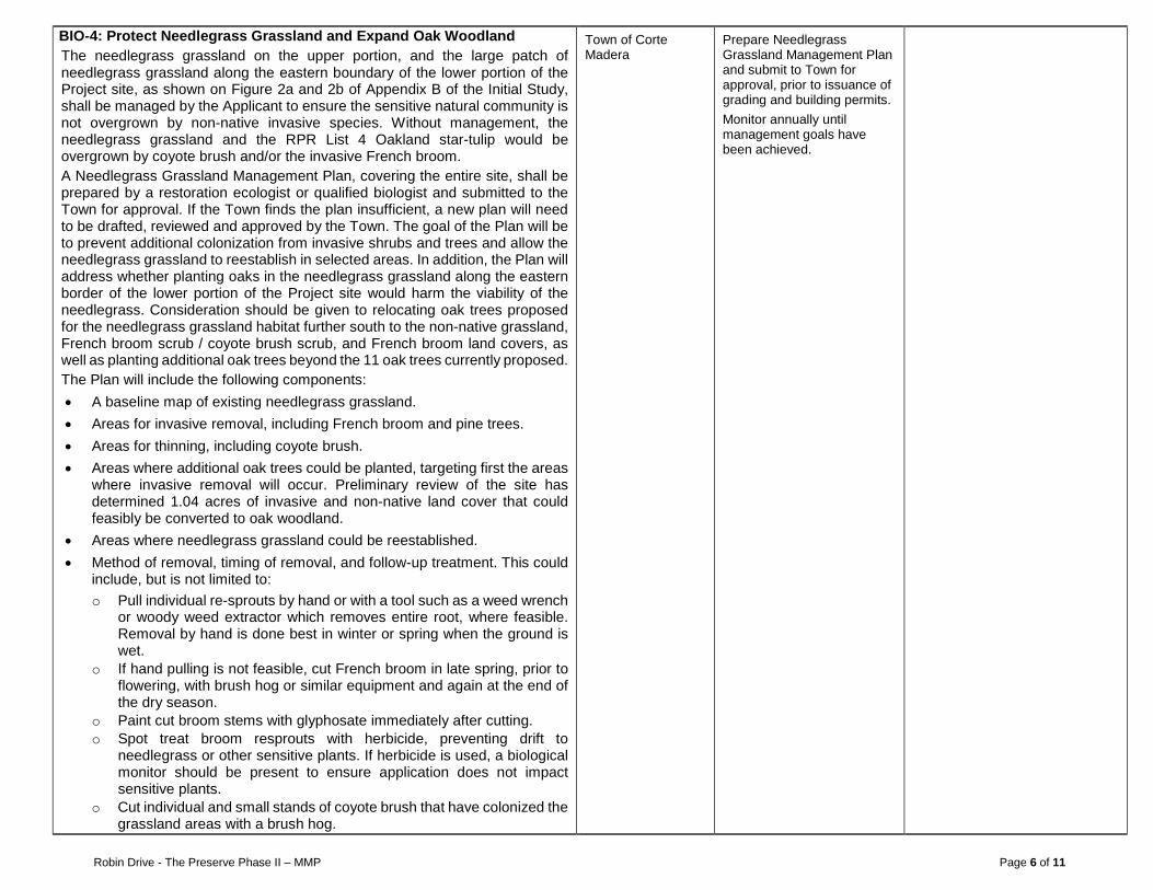
Robin Drive - The Preserve Phase II – MMP Page 6 of 11
BIO-4: Protect Needlegrass Grassland and Expand Oak Woodland The needlegrass grassland on the upper portion, and the large patch of needlegrass grassland along the eastern boundary of the lower portion of the Project site, as shown on Figure 2a and 2b of Appendix B of the Initial Study, shall be managed by the Applicant to ensure the sensitive natural community is not overgrown by non-native invasive species. Without management, the needlegrass grassland and the RPR List 4 Oakland star-tulip would be overgrown by coyote brush and/or the invasive French broom. A Needlegrass Grassland Management Plan, covering the entire site, shall be prepared by a restoration ecologist or qualified biologist and submitted to the Town for approval. If the Town finds the plan insufficient, a new plan will need to be drafted, reviewed and approved by the Town. The goal of the Plan will be to prevent additional colonization from invasive shrubs and trees and allow the needlegrass grassland to reestablish in selected areas. In addition, the Plan will address whether planting oaks in the needlegrass grassland along the eastern border of the lower portion of the Project site would harm the viability of the needlegrass. Consideration should be given to relocating oak trees proposed for the needlegrass grassland habitat further south to the non-native grassland, French broom scrub / coyote brush scrub, and French broom land covers, as well as planting additional oak trees beyond the 11 oak trees currently proposed. The Plan will include the following components: • A baseline map of existing needlegrass grassland. • Areas for invasive removal, including French broom and pine trees. • Areas for thinning, including coyote brush. • Areas where additional oak trees could be planted, targeting first the areas
where invasive removal will occur. Preliminary review of the site has determined 1.04 acres of invasive and non-native land cover that could feasibly be converted to oak woodland.
• Areas where needlegrass grassland could be reestablished. • Method of removal, timing of removal, and follow-up treatment. This could
include, but is not limited to: o Pull individual re-sprouts by hand or with a tool such as a weed wrench
or woody weed extractor which removes entire root, where feasible. Removal by hand is done best in winter or spring when the ground is wet.
o If hand pulling is not feasible, cut French broom in late spring, prior to flowering, with brush hog or similar equipment and again at the end of the dry season.
o Paint cut broom stems with glyphosate immediately after cutting. o Spot treat broom resprouts with herbicide, preventing drift to
needlegrass or other sensitive plants. If herbicide is used, a biological monitor should be present to ensure application does not impact sensitive plants.
o Cut individual and small stands of coyote brush that have colonized the grassland areas with a brush hog.
Town of Corte Madera
Prepare Needlegrass Grassland Management Plan and submit to Town for approval, prior to issuance of grading and building permits. Monitor annually until management goals have been achieved.
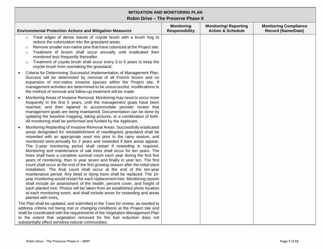
Robin Drive - The Preserve Phase II – MMP Page 7 of 11
0BMITIGATION AND MONITORING PLAN Robin Drive – The Preserve Phase II
Environmental Protection Actions and Mitigation Measures Monitoring
Responsibility Monitoring/ Reporting
Action & Schedule Monitoring Compliance
Record (Name/Date) o Treat edges of dense stands of coyote brush with a brush hog to
reduce the colonization into the grassland areas. o Remove smaller non-native pine that have colonized at the Project site. o Treatment of broom shall occur annually until eradicated then
monitored less frequently thereafter. o Treatment of coyote brush shall occur every 3 to 5 years to keep the
coyote brush from overtaking the grassland. • Criteria for Determining Successful Implementation of Management Plan.
Success will be determined by removal of all French broom and no expansion of non-native invasive species within the Project site. If management activities are determined to be unsuccessful, modifications to the method of removal and follow-up treatment will be made.
• Monitoring Areas of Invasive Removal. Monitoring may need to occur more frequently in the first 5 years, until the management goals have been reached, and then tapered to accommodate periodic review that management goals are being maintained. Documentation can be done by updating the baseline mapping, taking pictures, or a combination of both. All monitoring shall be performed and funded by the Applicant.
• Monitoring Replanting of Invasive Removal Areas. Successfully eradicated areas designated for reestablishment of needlegrass grassland shall be reseeded with an appropriate seed mix prior to the rainy season, and monitored semi-annually for 2 years and reseeded if bare areas appear. The 2-year monitoring period shall restart if reseeding is required. Monitoring and maintenance of oak trees shall occur for ten years. The trees shall have a complete survival count each year during the first five years of monitoring, then in year seven and finally in year ten. The first count shall occur at the end of the first growing season after the initial plant installation. The final count shall occur at the end of the ten-year maintenance period. Any dead or dying trees shall be replaced. The 10-year monitoring would restart for each replacement tree. Monitoring reports shall include an assessment of the health, percent cover, and height of each planted tree. Photos will be taken from an established photo location at each monitoring event, and shall include areas for reseeding and areas planted with trees.
The Plan shall be updated, and submitted to the Town for review, as needed to address criteria not being met or changing conditions at the Project site and shall be coordinated with the requirements of the Vegetation Management Plan to the extent that vegetation removed for fire fuel reduction does not substantially effect sensitive natural communities.

Robin Drive - The Preserve Phase II – MMP Page 8 of 11
0BMITIGATION AND MONITORING PLAN Robin Drive – The Preserve Phase II
Environmental Protection Actions and Mitigation Measures Monitoring
Responsibility Monitoring/ Reporting
Action & Schedule Monitoring Compliance
Record (Name/Date)
BIO-5: Remove Non-native Species from Landscape Plan The Town shall ensure that the landscape plans comply with General Plan Policy RCS-7.5. A qualified botanist or biologist shall review the landscape plans for any non-native invasive species and provide recommendations for appropriate replacement species, if needed. Consideration shall be given to the context of the placement of the species particularly in or adjacent to sensitive natural communities such as oak woodland, willow scrub, and needlegrass grassland. Exceptions can be made in isolated cases such as including non-native, but disease resistant oaks, mixed with native oaks to combat sudden oak death syndrome. These exceptions are to be recommended by the qualified biologist and must be approved by the Planning Director.
Town of Corte Madera
Verify landscape plan complies with Town policy prior to issuance of grading and building permit.
CR-1: Protect Unknown Archaeological Resources If potential archaeological resources are uncovered, the Town shall halt work and workers shall avoid altering the materials and their context. Project personnel shall not collect cultural materials. Prehistoric materials might include obsidian and/or chert flaked-stone tools such as projectile points, knives, or scraping implements; the debris from making, sharpening, and using them (“debitage”); culturally darkened soil containing shell, dietary bone, heat-altered rock, and carbonized plant material (“midden”); or stone milling equipment such as mortars, pestles, handstones, or milling slabs. A qualified professional archaeologist shall evaluate the find and provide appropriate recommendations. If the archaeologist determines that the find potentially qualifies as a historic resource or unique archaeological resource for purposes of CEQA (per CEQA Guidelines Section 15064.5), all work must remain stopped in the immediate vicinity to allow the archaeologist to evaluate any materials and recommend appropriate treatment. A Native American monitor shall be present for the investigation, if the local Native American tribe requests. Avoidance of impacts to the resource are preferable. In considering any suggested measures proposed by the consulting archaeologist in order to mitigate impacts to historical resources or unique archaeological resources, the Town shall determine whether avoidance is feasible in light of factors such as the nature of the find, project design, costs, and other considerations. If avoidance is infeasible, other appropriate measures as recommended by the archaeologist (e.g., data recovery) shall be instituted. Work may proceed on other parts of the Project while mitigation for historic resources or unique archaeological resources is being carried out.
Town of Corte Madera
Verify requirement is in construction documents prior to issuing grading permit. Halt work and follow evaluation procedures, if necessary.
Robin Drive - The Preserve Phase II – MMP Page 9 of 11
0BMITIGATION AND MONITORING PLAN Robin Drive – The Preserve Phase II
Environmental Protection Actions and Mitigation Measures Monitoring
Responsibility Monitoring/ Reporting
Action & Schedule Monitoring Compliance
Record (Name/Date)
CR-2: Protect Paleontological Resources during Construction Activities In the event that fossils are encountered during construction (i.e., bones, teeth, or unusually abundant and well-preserved invertebrates or plants), the Town shall divert construction activities away from the discovery within 50 feet of the find, and notify a professional paleontologist to document the discovery as needed, to evaluate the potential resource, and to assess the nature and importance of the find. Based on the scientific value or uniqueness of the find, the paleontologist may record the find and allow work to continue, or recommend salvage and recovery of the material, if it is determined that the find cannot be avoided. The paleontologist shall make recommendations for any necessary treatment that is consistent with currently accepted scientific practices. Any fossils collected from the area shall then be deposited in an accredited and permanent scientific institution where they will be properly curated and preserved.
Town of Corte Madera
Verify requirement is in construction documents prior to issuing grading permit. Halt work and follow evaluation procedures, if necessary.
CR-3: Protect Human Remains If Encountered during Construction If human remains, associated grave goods, or items of cultural patrimony are encountered during construction, the Town shall halt work in the vicinity of the find and notify the County Coroner immediately. The Town shall follow the procedures in Public Resources Code § 5097.9 and Health and Safety Code § 7050.5. If the human remains are determined to be of Native American origin, the Coroner shall notify the Native American Heritage Commission within 24 hours of the determination. The Native American Heritage Commission shall then notify the Most Likely Descendant (MLD), who has 48 hours to make recommendations to the landowner for the disposition of the remains. A qualified archaeologist, the Town and the MLD shall make all reasonable efforts to develop an agreement for the treatment, with appropriate dignity, of any human remains and associated or unassociated funerary objects. The agreement would take into consideration the appropriate excavation, removal, recordation, analysis, custodianship, and final disposition of the human remains and associated or unassociated funerary objects.
Town of Corte Madera
Verify requirement is in construction documents prior to issuing grading permit. Halt work and follow procedures, if necessary.

Robin Drive - The Preserve Phase II – MMP Page 10 of 11
0BMITIGATION AND MONITORING PLAN Robin Drive – The Preserve Phase II
Environmental Protection Actions and Mitigation Measures Monitoring
Responsibility Monitoring/ Reporting
Action & Schedule Monitoring Compliance
Record (Name/Date)
NOI-1: Limit Noise during Construction The Applicant shall implement the following to reduce construction noise levels from the site, limit construction hours, and minimize disruption and annoyance: • All construction activities shall be limited to the hours between 7:00 a.m. and
5:00 p.m. Monday through Friday, 10:00 a.m. and 4:00 p.m. on Saturdays, and no construction shall be permitted on Sundays and holidays.
• All internal combustion engines used in conjunction with construction shall be muffled according to the equipment manufacturer’s requirements.
• Unnecessary idling of internal combustion engines should be strictly prohibited.
• Locate stationary noise-generating equipment such as air compressors or portable power generators as far as possible from sensitive receptors.
• If stationary noise equipment is located within 100 feet from sensitive receptors, temporary noise barriers should be constructed to screen stationary noise-generating equipment. Temporary noise barriers could reduce construction noise levels by 5 dBA.
• Utilize "quiet" air compressors and other stationary noise sources where technology exists.
• Control noise from construction workers’ radios to a point where they are not audible at existing residences bordering the project site.
• Notify all adjacent business, residences, and other noise-sensitive land uses of the construction schedule, in writing, and provide a written schedule of “noisy” construction activities to the adjacent land uses and nearby residences.
• Designate a "disturbance coordinator" who would be responsible for responding to any complaints about construction noise. The disturbance coordinator will determine the cause of the noise complaint (e.g., bad muffler, etc.) and will require that reasonable measures be implemented to correct the problem. Conspicuously post a telephone number for the disturbance coordinator at the construction site and include in it the notice sent to neighbors regarding the construction schedule.
Town of Corte Madera
Verify requirement is in construction documents prior to issuing building permit. Monitor during construction, as needed.

Robin Drive - The Preserve Phase II – MMP Page 11 of 11
0BMITIGATION AND MONITORING PLAN Robin Drive – The Preserve Phase II
Environmental Protection Actions and Mitigation Measures Monitoring
Responsibility Monitoring/ Reporting
Action & Schedule Monitoring Compliance
Record (Name/Date)
TR-1: Improve Line-of-Site at Paradise Drive/Robin Drive The Applicant shall improve the intersection of Paradise Drive/Robin Drive. The improvement will modify the Paradise Drive/Robin Drive intersection to provide enhanced sight distance by reconfiguring the intersection’s curbs, moving Robin Drive’s stop bar northerly, pruning trees within the public right-of-way, and enhanced pedestrian safety by installation of a new crosswalk across Robin Drive, with associated ADA improvements and sidewalk extensions. The Applicant shall prepare construction plans and submit to the Public Works Director for review and approval as part of building permit submittal. Improvements shall be constructed prior to receiving the first Certificate of Occupancy of the Residence at the Preserve.
Town of Corte Madera
Verify in construction documents prior to issuing building permit. Verify completion of improvements prior to issuance of first certificate of Occupancy of the Residence at the Preserve.
TCR-1: Protect Unknown Tribal Cultural Resources If previously unknown tribal cultural resources are uncovered, the Applicant shall halt work, and workers shall avoid altering the materials and their context. Project personnel shall not collect cultural materials. The Applicant shall notify the Town and the California Native American tribes culturally affiliated with the project area. The Applicant, in coordination with Native American tribes, shall determine if the resource qualifies as a tribal cultural resource under CEQA. If it does, then all work must remain stopped in the immediate vicinity to allow evaluation of any materials. The Applicant shall ensure that qualified resources are avoided, protected in place, or moved to an appropriate location in accordance with the requests of Native American tribes, to the extent feasible. Work may proceed on other parts of the project while mitigation for tribal cultural resources is being carried out.
Town of Corte Madera
Verify requirement is in construction documents prior to issuing grading permit. Halt work and follow evaluation procedures, if necessary.

Attachment 24
CEQA response to comments

Response to Gomments Received onlnitial Study /
Proposed Mitigated Negative Declaration
Robin Drive - The Preserwe Phase II
Town of Gorte Madera
ffi'l'u n 'l'owN or:Conrs lvllnrnailAf,tx (:ouvly riit ltrlRtla
February 2019

Table of GontentsResponse to Comments
Marin County Parks and Open Space District, Michelle Julen, Regulatory Open Space Planner, December 14,2018 'l
Marin Audubon Society, Barbara Salzman, Co-Chair of Conservation Committee, December 13, 2018..............3
California Department of Fish and Wildlife, Deborah Waller, Environmental Scientist, December 14,2018...... '12
California Native Plant Society, Eva Buxton, Conservation Chair, December 13, 2018 14
Figures/Attachments
Figure 1: Proposed Site Plan & Existing Land Cover
Figure 9: GonceptualWetland Mitigation Map
Sheet LA17 Rain Garden and Remediation
Robin Drive - The Preserve Phase ll- Response to Comments Received for IS/MND I Page i

Response to Gomments
Marin Gounty Parks and Open Space Districtn Michelle Julen, RegulatoryOpen Space Planner, December 14r 2018
Gomment l"t Bullet: The IS/MND should include a graphic to show the location of Ring Mountain relativeto the Project and the location of the public access easemenUtrailto Ring Mountain on the lower (nofthern)parcel, including how this access would enter Ring Mountain.
Resoonse: The project would not implement a public access trail on the lower (northern) portion of theProject site. The Project would place a 1O-foot public access easement along the existing informal trail,located on the upper (southern) portion of the parcel, which enters the Ring Mountain Preserve along theProject site's southern boundary. Please refer to Figure VMP3-VMP, Defensible Space Zone Map, inAppendix C, Vegetation Management Plan Narrative, of the lnitial Study, which illustrates the location ofthe existing informal trail on the upper portion of the parcel and where it enters the Ring Mountain Preserve.Access to the Ring Mountain Preserve would not change from existing conditions and no improvements tothe existing trail are proposed as part of the Project. The easement is being provided at the request of theMarin County Parks Department. ln addition, the public and Town Planning Commission expressed interestin having a trail easement during early review of the proposed Project. The trail would provide the Districtwith the option of formalizing the access and adding the trail to the formal trail network in the future. As itcurrently stands, trail users are crossing private property to access Ring Mountain Preserve. See theresponse to comment # 7 of the Marin Audubon Society lefter for a discussion of how the public assesseasement came to be part of the Project.
Comment 2nd Bullet: The IS/MND should describe the physical characteristics and management of theaccess easement/trail in the project description and should include the public access easement/trail in theimpact analysis.
Resoonse: The existing trail is a dirt path, worn by foot traffic. The easement would be recorded with theMarin County Assessor's Office. Sections 1 .4 and 1 .4.5 of the IS/MND describe the public access easementthat is proposed along the existing trailon the upper parcel. Use of the existing trail is anticipated to remainthe same as existing conditions. lmplementation of the Project does not include any improvements to theexisting trail, and therefore no discussion of construction- or maintenance-related impacts related to thetrail is provided. No improvements to the existing trail would be implemented as part of the Project thatcould theoretically increase trail users. lf at some point in the future the Marin County Parks Departmentdecides to add the trail to the formal trail network, the Department would presumably evaluate the impactsat that time. As the Project would not improve or add the trail to the formal network, no further impactanalysis is warranted.
To clarify that no improvements would be made to the trail, Section 1.4.5, Private Open Space, of the lnitialStudy is revised as follows:
1.4.5 Private Open Space
The 9.49-acre upper portion of the parcelwould remain as private open space, with a public accesseasement placed alonq the lenoth of the existinq informal trail +er-puUtie-+rait-aeeess to Ring
Mountain. No imorovements to the existinq informal trail are prooosed as part of this Proiect. ln
addition, two areas within the lower portion of the parcel would be reserved as private open spacefor the development (see Figure 2). Open Space Area A is located adjacent to the more southern
entrance to the site and is 0.139 acre. Open Space Area B is located in the eastern corner of the
Robin Drive - The Preserve Phase ll- Response to Comments Received for IS/MND I Page 1
site and is 1.108 acres. An existing drainage within the eastern cornerflows northwesttowardsRobin Drive, crossing what would be the back yards of three of the residential lots. This wetlandaround the drainage feature (referred to later as Stream 1) would be enlarged by 0.028 acre. lnaddition, two V-boulder weirs with step pools and riparian vegetation would be planted in this area,enhancing the drainage and creating a riparian feature. ln total, approximately 10.74 acres of theparcelwould be required to remain undeveloped.
Comment 3d Bullet: The IS/MND should clarify if access fo Rrhg Mountain is adequate or if new facilities,such as trail improvement or development, would be required on the Project site and/or on Ring Mountain.
Resoonse: The informal access to Ring Mountain would remain the same as existing conditions. No newfacilities or improvements would be implemented on-site or at Ring Mountain. The Project is providing thepublic access easement to give the Marin County Parks Department the option of maintaining the trail aspart of the formal trail network in the future. lmplementation of the Project would not add it to the County'strail network. No impact has been identified that would require the applicant to implement trail improvementson-site or at Ring Mountain Preserve.
Comment #4 Bullet: The IS/MND should identtfy who would be responsible for management of the publicaccess e ase me nt/trai l -
Response: The easement would be recorded with the Marin County Assessor's Office for public access.The Project would not change the existing conditions of the existing informal trail. The Marin County ParksDepartment requested the easement to give the District the option of formalizing the trail in the future aspart of its Region 6 parks and open space management strategy, if it is determined by the District to be anappropriate access point to Ring Mountain Preserve. No trail improvements would be provided as a part ofthe Project and the Project would not add the trail to the formal trail network. Therefore, there would benothing to manage. Should the County Department incorporate the trail into its Region 6 trail network, theCounty would be responsible for management of the trail.
Gomment #5 Bullet: The IVMND should include the public access easement/trail and the entire lower(nofthern) parcel in the impact analysis and in Mitigation Measure BIO-4: Protect Need/egrass Grassland./f is posstb/e that foot traffic, on and off public access easemeniltrail, could affect needlegrass grass/andand populations of Marin dwart flax (Hesperolinon congestum) on the lower (nofthern) parcel.
Response: lt is agreed that the undeveloped area of the lower portion of the Project site should be includedin Mitigation Measure BIO-4 Protect Needlegrass Grassland. As can be seen in the response to comment#6 of the Marin Audubon Society letter, modifications to Mitigation Measure BIO-4 have been made toinclude eradication of the French broom on the undeveloped portions of the lower portion of the Projectsite. Note that the landscape plan indicates oak trees would be planted in the needlegrass grassland onthe lower portion of the Project site. Although planting oak trees would be beneficial in the context ofreplacing oak trees that would be removed as part of the Project, it may not be appropriate to place themin the needlegrass grassland. Therefore, Mitigation Measure BIO-4 requires that a qualified biologist reviewand determine the appropriateness of planting oak trees within this sensitive natural community. lt may bemore appropriate to relocate these trees (of which there are approximately eight) to other areas of theproperty, such as to the portions of the site where French broom would be eradicated.
There are no known occurrences of Marin dwarf flax on the lower portion of the Project site. Marin dwarfflax occurs in the upper portion of the Project site in one location, near the south property boundaryapproximately 100 feet from the existing informal trail. The Project would provide Marin County Parks theoption of maintaining a public access easement on the existing informal trail, in which case, the trail wouldcontinue to receive foot traffic. No new improvements to the trail or access to Ring Mountain Preserve are
Robin Drive - The Preserve Phase ll- Response to Comments Received for IS/MND I page 2

proposed. The number of users is anticipated to remain approximately the same as under the existingcondition, with up to 1 or 2 additional users per day resulting from the proposed residences. Therefore, it isnot anticipated that the Project would result in risk to the sensitive natural communities, includingneedlegrass grassland, on the upper portion of the parcel where the public access easement would occur.
Gomment #6 Bullet: The IS/MND should likewise consider potential impacts to Oakland star tulip(Calochortus umbellatus) and Tiburon mariposa lily (Calochortus tiburensis) from public use of the publicaccess easement/trail and the entire lower (nofthern parcel, as fhese species are known to grow at thislocation.
Response: The lnitial Study addresses potential impacts to the Oakland star tulip (Calochortus umbellatusland Tiburon mariposa lily (Calochortustiburensis) in Section 3.4, Biological Resources, lmpact a). Althoughthe Biological Survey (LSA 2014) found that Tiburon mariposa lily is unlikely to occur on the Project site,the lnitial Study conservatively concluded that there is the potential for it to exist in the serpentine area,located on the upper portion of the Project site. However, as noted in the lnitial Study, the Project proposes
to leave the upper portion of the Projectsite undeveloped. Because the Projectwould not modifythe existingtrail nor add it to the formal trail network, it is not anticipated that implementation of the Project wouldincrease the number of trail users over existing conditions. Therefore, no further analysis regarding potential
impacts to either the Oakland mariposa lily or the Tiburon mariposa lily is required.
Comment #7 Bullet: The IVMND misidentifies Marin dwart flax on Table 2 in Appendix A as Marin westernflax.
Response: Table 2 of Appendix A (Biological Survey) does misidentify Marin dwarf flax (Hesperolinoncongestum) as Marin western flax. However, all other references to Marin dwarf flax are correct in the textof the Biological Survey and the lnitial Study.
Marin Audubon Society, Barbara Salzman, Go-Ghair of GonservationGommitteen December 13, 2018
Marin Audubon Society, Barbara Salzman, Co-Chair of Conservation Committee, December 13, 2018
Gomment #1: Proposed mitigation for /oss of trees, 1.6 trees planted per trae cut down, is inadequate andthe proposed location adjacent to the streef r.s a/so unacceptable. To plant mitigation trees adjacent toParadise Drive ignores the fact that the trees that will be lost are currently part of an oak woodland-grassland ecosystem together with the Ring Mountain Preserve land. Mitigation should replace not justthequantity of trees, but the habitat value and functions of the mixed oak woodland/grassland which thehousing development would destroy. A more suitable location to restore native woodland so that it retainsits habitat values, not just as landscaping for the project, is adjacent to the open space areas. A moreacceptable ratio would be 3:1.
Response: As a point of clarification, there is no mitigation in the lnitial Study that requires 1.6 trees beplanted per tree removed at the Project site. The trees discussed as being planted are included in theProject's proposed landscape plan and therefore are part of the Project lnformation section of the lnitialStudy. lt is agreed that landscape and street trees do not always provide the same habitat value as treesremoved as part of a larger ecosystem such as oak woodland. lt also is noted that there are severalsensitive natural communities at the Project site (oak woodland, needlegrass grassland, and willow scrub)each with different habitat values, as described in Section 3.4, Biological Resources, of the lnitial Study.Therefore, it is important that these habitats are considered holistically and opportunities to eradicateinvasive species, stop the decline of needlegrass grassland, and restore and/or enlarge the sensitivenatural communities where feasible, be balanced. For example, the landscape plan proposes planting oaks
Robin Drive - The Preserve Phase ll- Response to Comments Received for IS/MND I Page 3

along the eastern side of the lower portion of the Project site within needlegrass grassland. Although thereis a desire to plant as many replacement oaks on site as feasible to compensate for the lost oak woodland,the other sensitive natural communities need to be considered, leaving little room to plant additional oaktrees. For this reason, Mitigation Measure BIO-4, Protect Needlegrass Grassland, requires that theapplicant hire a qualified biologist to assess whether planting oaks in needlegrass grassland areas isappropriate or whether some or all of the new trees should instead be planted in a different location on theparcel. ln addition, as noted in the response to comment #8, below, Mitigation Measure BIO-4 has beenmodified to include eradication of French broom on the lower portion of the Project site and requiresidentifying areas within invasive land covers that would be appropriate for planting additionaloak trees. Forexample, there is a patch of French broom in the southeast corner of the lower parcel that is bordered byoak woodland on three sides. lf the French broom were removed from this area, it could be planted withoak trees, thereby increasing the oak woodland and connecting the three fragmented oak woodland areasinto one larger area. Although the exact number of additional trees that could be planted in areas currentlydominated by invasive plant species is not precisely known, a review of the site has identified approximately1.04 acres where oak trees could feasibly be planted in areas of French broom, French broom/coyote brush,Himalayan blackberry, and pine. Mitigation Measure BIO-4 has been modified to ensure that some of theareas targeted for invasive removal are reserved for planting oak trees where it is appropriate. ln addition,as part of the Project, approximately 1.86 acres of oak woodland would be preserved within the privateopen space areas. Overall, there is currently 3.41 acres of oak woodland at the site, of which 0.77 acrewould be impacted by the Project. With implementation of the Project, oak woodland would increase to 3.68acres. This information is summarized in the table below. ln consideration of the oak woodland that wouldbe preserved on site and areas to be planted with oaks, the impact to the oak woodland sensitive communitywould be less than significant.
AcresPercent ofExisting
Total Existing Oak Woodland 3.41
lmpacted by Project: 0.77 23o/o
Undisturbed: 2.64 77o/o
Preserved in Open Space Areas: 1.86 55o/o
Potential Area to Convert to Oak Woodland 1.04 NA
TOTAL Oak Woodland withlmplementation of Project 3.68
Gomment #2: lnclude a figure showing the proposed houses superimposed on the biologicalresourcesidentified in the lS - sfreams 1 and 2, wetlands, native trees and native gnsslands. We canT evaluateoptions for eliminating or reducing /osses withoutthis information.
Response: Please refer to Figure 1, attached to this document, which shows the proposed housing unitssuperimposed on the existing land covers. Additionally, Figure 3 of the lnitial Study shows the location ofStream 1 and Stream 2 in relation to the footprint of the Project. Stream 1 and Stream 2, in context of theProject, also can be seen in the figure in Appendix 82 Areas Subject to Agency Jurisdiction, of the lnitialStudy. Figure LA of Appendix C, Vegetation Management Plan Narrative, shows the location of existingtrees in relation to the Project footprint. Note that the Town has already worked with the Applicant to relocateUnit 16 which resulted in avoiding impacts to needlegrass grassland and Oakland star tulip. Refer to theresponse to comment #4, below, for additional information regarding the relocated unit.
Robin Drive - The Preserve Phase ll- Response to Comments Received for IS/MND I Page 4

Gomment #3: Drscuss provisions that should be in the Vegetation Management Plan related to habitat,such as.' length of time and frequency of plant maintenance and tasks that would be required, includingweeding, watering, and plant replacement.
Response: The Vegetation Management Plan was prepared to satisfythe Town of Corte Madera's WildhndUrban lnterface Code requirements and establishes the fire safety and protection measures that would beincorporated into the Project, including the maintenance of defensible space around structures. Managingvegetation within the defensible space for fire fuel reduction would occur into perpetuity. The VegetationManagement Plan only addresses the defensible space around the proposed structures.
Please refer to Appendix C, Vegetation Management Plan Narrative, of the lnitial Study for additional detailregarding plant maintenance and watering which is included underthe heading "Landscape lmprovements."
Comment #4: Drlscuss alternatives to removing oak trees. Drbcuss whether the size, design, number orlocation of the units could be modified to save oaks.
Resoonse: As a point of clarification, an alternatives analysis is not a required component of an lnitial Study(CEOA Guidelines 15063). However, it is noted that the Project has already been modified to protect asensitive natural community. Consistent with the Housing Element, the original submittal by the Applicant,datedT-12-2016, included a unit (Unit 16) on the upper portion of the Project site. The footprint of Unit 16was within an area of needlegrass grassland and Oakland star tulip. To avoid impacts to this sensitivenatural community and special-status plant, and to address concerns raised by nearby residents and thePlanning Commission about the potential effect of the unit on views from surrounding open spaces andresidential neighborhoods, the unit was moved to the lower portion of the Project site. The relocated unitresulted in an increase in trees that would be removed including one pine, one California bay, and ninecoast live oaks (five of which have symptoms of sudden oak death). Although original submittal would haveminimized the number of oak trees required to be removed, it was determined that the upper portion of theparcel should remain completely undeveloped and preserved as private open space. The revised projectpreserves other sensitive natural communities including needlegrass grassland and serpentine areas,which provide suitable habitat for special-status plant species including the Oakland star tulip and Marindwarf flax, respectively.
ln addition, the units have been clustered, thereby maximizing the use of the three existing graded pads toachieve the housing units envisioned in the Town's Housing Element while minimizing impacts. While theHousing Element notes that a 16th unit may not be feasible on the lower portion due to tree loss, that wasbased on the assumption that structures would be less clustered, with potentially more tree loss.
Gomment #5: Dhcuss the potentialfor invasive species to colonize the disturbed areas and how this wouldbe addressed. We would expect broom, Harding Grass, and thistle to be problems because they areproblems on Marin Audubon's propefty, a short distance away, and on Ring Mountain Preserue.
Response: The lnitial Study analyzed the potentialfor invasive species to spread within the Project site inSection 3.14 Biological Resources:
"The spread of these invasive species threaten the sensitive natural communities at the Project
site, particularly the needlegrass grassland which is home to a majority of the Oakland star tulip inthe upper portion of the Project site. Given the already threatened and diminishing needlegrass
grassland community, the Project's impact from construction would be significant."
lnvasive species would be managed in accordance with Mitigation Measure BIO-4, Protect Needlegrass
Grassland, which is described in Section 3.4, Biological Resources, of the lnitial Study. As noted under the
response to comment #8, Mitigation Measure BIO-4 has been revised to include the lower portion of the
Robin Drive - The Preserve Phase ll- Response to Comments Received for IS/MND I Page 5
Project site. Additionally, implementation of Mitigation Measure BIO-5, Remove Non-native Species fromLandscape Plan, requires a review of the landscape plan to insure that no invasive species are introduced
to the Project site. As noted in Section 3.4, Biological Resources, one invasive plant has already been notedas being on the landscape plan and would need to be removed or replaced with something more appropriateto the Project site.
Gomment #6: Would a conseruation easement be placed on the public and private open space? Only anaccess easement is mentioned.
Response: A 1O-foot public access easement would be recorded along the existing trail that traverses theupper portion of the Project site. Other than the trail, there is no public open space. Private open spaceeasements would be recorded with the County Assessor's Office for proposed Open Space A and OpenSpace B, as shown in Figure 2 of the lnitial Study, as well as the upper parcel. No conservation easementis proposed as part of the Project.
Comment #7: Has Marin County Open Space District been consufted about providing an access to theRing Mountain Preserue? A major problem in this Preserue is the spider-web of unauthorized access frailsmade hy users. Ihe District has been working to reduce/eliminate these trails. Having another entrancefrom an adjacent development would not appear to comply with the Distict's efforts to protect the RingMountain resources.
Resoonse: ln April 2018 discussions were had with James Raives, Senior Open Space Planner with MarinCounty Parks. Marin County is currently working on an effort to better define the trail and roadway networkin the various regions in their jurisdiction. Ring Mountain Preserve is included in Region 6 and is thereforeincluded in the overall review of this region. Because the investigative effort is on-going, the County hasnot yet determined whether the informal trail, which leads to an existing Fire Road, will be maintained aspart of the Marin County Parks trail network for Region 6. At the time of the discussions, it was decided torequire the public access easement as part of the Project in the event that, following the County's reviewof Region 6 open space and parks trail networks, the Marin County Parks Department decides to add theinformal trail to the District Region 6 trail network.
Gomment #8: Native needlegrass would be impacted by the project. How would fhe loss of needlegrassbe mitigated? Discuss avoiding the needlegrass. Dr.scuss the impact of planting mitigation oaks inneedlegrass patches.
Response: As noted above, underthe response to comment#4 in this letter, Unit 16 has been relocatedto address concerns raised by nearby residents and the Planning Commission about the potential effect ofthe unit on views from surrounding open spaces and residential neighborhoods. This relocation alsoavoided impacts to needlegrass grassland and Oakland star tulip on the upper portion of the Project site.
As to the lower portion of the Project site, the majority of the needlegrass grassland along the eastern sideof the site would be left undeveloped, except that oak trees are proposed to be planted in this area. Referto the response to comment #5 of the Marin County Parks and Open Space District letter, above, regardingthe potential impact of planting oaks in this area. As noted in that response, there is a concern regardingthe appropriateness of planting oaks in the needlegrass grassland, and therefore Mitigation Measure BIO-4 requires a qualified biologist to assess the entire site and determine how landscaping can be reconfiguredto balance the needs of these two sensitive natural communities. Finally, Unit 8, Unit 4, and thestream/riparian improvements would disturb isolated patches of needlegrass grassland. The loss ofneedlegrass grassland would be mitigated via implementation of Mitigation Measure BIO-4, ProtectNeedlegrass Grassland.
Robin Drive - The Preserve Phase ll- Response to Comments Received for IS/MND I Page 6

ln summary, the revised and mitigated Project avoids needlegrass grassland to the extent possible, withno impacts to the upper portion of the parcel, where the greatest extent of needlegrass grassland occurs,and minimal impacts to the patchwork of needlegrass grassland on the lower portion of the parcel. Withimplementation of Mitigation Measure BIO-4, invasive species at the site would be removed or thinnedallowing for the reestablishment of needlegrass grassland in certain areas (and planting oak trees in otherareas). As an example, the needlegrass grassland in the upper portion of the parcel, where the Oaklandstar-tulip also exists, is bordered on some sides by French broom, pine, and coyote brush. The threepatches of French broom and pine equates to 0.41 acre where the needlegrass grassland could reestablish.Areas of French broom on the lower portion of the site may be targeted for planting oak trees, so are notaccounted for in the acreage. ln accordance with Mitigation Measure BIO-4 a Needlegrass GrasslandManagement Plan would be prepared that covers the entire site and would be reviewed by a qualifiedbiologist to determine the actions that would be most successful within the site's conditions.
ln light of these comments and in review of Mitigation Measure BIO-4, it has been determined thatclarifications should be made to the mitigation language.
Mitigation Measure BIO-4: Protect Needlegrass Grassland is revised as follows
Mitigation Measure BlO.4: Protect Needlegrass Grassland and Expand Oak Woodland
The needlegrass grassland on the upper portion, and the large patch of needlegrass qrassland
alonq the eastern boundarv of the lower oortion of the Project site, as shown on Figure 2a and 2b
of Appendix B of the lnitial Study, shall be managed bythe Applicant to ensure the sensitive natural
community is not overgrown by non-native invasive species. Without management, theneedlegrass grassland and the RPR List 4 Oakland startulip would be overgrown by coyote brush
and/or the invasive French broom.
A Needlegrass Grassland Management Plan, coverinq the entire site. shall be prepared by arestoration ecolooist or qualified biologist and submitted to the Town for approval. lf the Town findsthe plan insufficient, a new plan will need to be drafted, reviewed and approved by the Town. Thegoal of the Plan will be to prevent additional colonization from invasive shrubs and trees and allowthe needlegrass grassland to reestablish in selected areas. ln addition, the Plan sheulC wlll_address
whether planting oaks in the needlegrass grassland along the eastern border of the lower portion
of the Project site would harm the viability of the needlegrass. Consideration should be given topla€ing relocatinq oak trees proposed for the needlegrass qrassland habitat further south to the
non-native grassland, French broom scrub / coyote brush scrub, and French broom land covers.as well as plantino additional oak trees bevond the 'll oak trees currentlv oroposed.
The Plan will include the following components:
o A baseline map of existing needlegrass grassland.
. Areas for invasive removal, including French broom and pine trees.
r Areas for thinning, including coyote brush.
. Areas where additional oak trees could be olanted. taroetino first the areas where invasiveremoval will occur. Preliminarv review of the site has determined 1.04 acres of invasive andnon-native land cover that could feasiblv be converted to oak woodland.
r Areas where needleorass qrassland could be reestablished.
r Method of removal, timing of removal, and follow-up treatment. This could include, but is notlimited to:
Robin Drive - The Preserve Phase ll- Response to Comments Received for IS/MND I Page 7

o Pull individual re-sprouts by hand or with a tool such as a weed wrench or woody weedextractor which removes entire root, where feasible. Removal by hand is done best inwinter or spring when the ground is wet.
o lf hand pulling is not feasible, cut French broom in late spring, prior to flowering, with brushhog or similar equipment and again at the end of the dry season.
o Paint cut broom stems with glyphosate immediately after cutting.
o Spot treat broom resprouts with herbicide, preventing drift to needlegrass or other sensitiveplants. lf herbicide is used, a biological monitor should be present to ensure applicationdoes not impact sensitive plants.
o Cut individual and small stands of coyote brush that have colonized the grassland areaswith a brush hog.
o Treat edges of dense stands of coyote brush with a brush hog to reduce the colonizationinto the grassland areas.
o Remove smaller non-native pine that have colonized at the Project site.
o Treatment of broom shall occur annually until eradicated then monitored less frequentlythereafter.
o Treatment of coyote brush shall occur every 3 to 5 years to keep the coyote brush fromovertaking the grassland.
. Criteria for Determining Successfgl lmplementation of Management Plan. Success will bedetermined by removal of all French broom and no expansion of non-native invasive specieswithin the Project site. lf management activities are determined to be unsuccessful,modifications to the method of removal and follow-up treatment will be made.
e Monitoring Areas of lnvasive Removal. Monitoring may need to occur more frequently in thefirst 5 years, until the management goals have been reached, and then tapered toaccommodate periodic review that management goals are being maintained. Documentationcan be done by updating the baseline mapping, taking pictures, or a combination of both. Allmonitoring shall be performed and funded by the Applicant.
o Monitorinq Reolantinq of lnvasive Removal Areas. Successfullv eradicated areas desiqnatedfor reestablishment of needleqrass grassland shall be reseeded with an appropriate seed mixorior to the rainv season. and monitored semi-annuallv for 2 vears and reseeded if bare areasapoear. The 2-year monitorinq oeriod shall restart if reseedino is required. Monitorinq andmaintenance of oak trees shall occur for ten vears. The trees shall have a comolete survivalcount each vear durino the first five years of monitorino. then in vear seven and finallv in vearten. The first count shall occur at the end of the first orowino season after the initial plantinstallation. The final count shall occur at the end of the ten-vear maintenance period. Anv deador dvinq trees shall be reolaced. The 1O-vear monitorinq would restart for each replacementtree. Monitorinq reports shall include an assessment of the health, oercent cover. and heiohtof each planted tree. Photos will be taken from an established ohoto location at each monitorinqevent. and shall include areas for reseeding and areas planted with trees.
The Plan shall be updated, and submitted to the Town for review, as needed to address criteria notbeing met or changing conditions at the Project site and shall be coordinated with the requirementsof the Vegetation Management Plan to the extent that vegetation removed for fire fuel reduction
does not substantially effect sensitive natural communities.
Gomment #9: Nesfing bird impact evaluation should a/so address ground dwelling birds that depend onunderstory for nesting and foraging.
Response: The Town agrees that the potential exists for ground dwelling birds to be nesting at the site. Asnoted on page 3-13 of the Initial Study, there is suitable nesting habitat in the grasslands at the Project site.Mitigation Measure BIO-2: Prevent Disturbance to Nesting Birds is revised as follows:
Robin Drive - The Preserve Phase ll- Response to Comments Received for IS/MND I Page 8
Mitigation Measure BIO-2: Prevent Disturbance to Nesting Birds
The Applicant shall implement the following measures to prevent impacts to nesting birds duringconstruction of the Proiect and implementation of the Vegetation Management Plan:
. Grading within 300 feet ef a tree and tree removal shall be conducted outside the nesting
season, which occurs between appreximatety February 15 and August 15, as feasible. No
survey is required for work conducted outside the nesting period.
. lf grading ortree removal between August 15 and February 15 is infeasible and work must
occur within the breeding season, a pre-construction nesting bird survey of the landscaped
areas and trees shall be performed by a qualified biologist, who is approved by the Town, within
7 days of ground breaking or tree removal. lf no nesting birds are observed, no further action
is required and work shall occur within one week of the survey to prevent "take" of individual
birds that could begin nesting after the survey.
e lf bird nests are observed during the pre-construction survey, a disturbance-free buffer zone
shall be established around the nest tree(s) until the young have fledged, as determined by aqualified biologist.
o The radius of the required buffer zone can vary depending on the species, (i.e., 75 to 100 feetfor passerines and 200 to 300 feet for raptors), with the dimensions of any required buffer zones
to be determined by a qualified biologist in consultation with California Department of Fish and
Wildlife.
To delineate the buffer zone around a nest or nesting tree, orange construction fencing shall
be placed at the specified radius from the base of the tree within which no machinery or workersshall intrude.
After the fencing is in place there will be no restrictions on grading or construction activitiesoutside the prescribed buffer zones.
Comment #10: Contrary to the lS, street and roads are nof necessa rily impedimenfs fo wildlife movement.ln fact, in some locations roads are used by wildlife for moving hetween habitats. However, structures andfences are impedimenfs. Revlsif fhis dr'scussrbn with this information.
Response: The lnitial Study did not discount the potential for the project site to be utilized as a wildlifecorridor. Rather, it indicated that, due to existing development and structures to the west, north, and eastof the proposed development area, connectivity from one area to the next is already limited and thereforethe impact of the Project, with the additional structures, would be less than significant. The comment alsomentions fences, however no fences are proposed as part of the Project. Wildlife would still be expected tomove around the lower portion of the parcel, particularly the oak woodland along the southern boundary,the grassland along the eastern boundary, and the enhanced Stream 1. Please refer to Section 3.4Biological Resources, lmpact d) for the full discussion of wildlife corridors.
Gomment #11: Show the wetlands on a figure, including the area that would be enlarged, and drscuss fheRegional Water Board's requirements for avoidance and mitigation. How would the wetlands and streamsbe protected during construction and post-construction? What width of buffer will be required to protectthewetlands and provide an essential habitat component?
Response: The existing wetlands are shown on Figure 3 of Appendix 82, Areas Subject to AgencyJurisdiction, of the lnitial Study. Streams 1and2 are shown on Figure 2, Site Plan, and Figure 3, UtilityPlan, in the Project lnformation section of the lnitial Study.
a
a
Robin Drive - The Preserve Phase ll- Response to Comments Received for IS/MND I Page 9

With respect to the wetland that would be enlarged, attached to this response to comments document is"Figure 9 Conceptual Wetland Mitigation Map," which has been submitted to, and is subject to review by,California Department of Fish and Wildlife (CDFW) and RegionalWater Quality Control Board (RWQCB).A Section 401 Water Quality Certification Permit Application was submitted to the RWQCB and aStreambed Alteration Agreement application was submitted to CDFW, on October 18, 2018. Theapplications are under review, and therefore no permit has been issued that states the mitigation and/oravoidance measures that may be required by these agencies. ln general, the resource agencies typicallylook for a project to first minimize and avoid impacts to the extent feasible, and then mitigate for any impactsthat cannot be avoided.
To protect the wetlands and streams from construction-related impacts to water quality, Stream 1 and thewetland area would be protected through implementation of standard BMPs described in Section 1.7.6,Environmental Protection, Action 6 - Stormwater Pollution Prevention Plan (SWPPP) in the Projectlnformation section of the lnitial Study, which states:
Environmental Protection Action 6 - Stormwater Pollution Prevention Plan (SWPPP)
The Project will seek coverage under State Water Resources Control Board (Water Board) OrderNo. 2009-0009-DWQ, Waste Discharge Requirements for Discharges of Storm Water RunoffAssociated with Construction and Land Disturbance Activities. The City Aoolicant will submit permitregistration documents (notice of intent, risk assessment, site maps, SWPPP, annual fee, andcertifications) to the Water Board. The SWPPP will address pollutant sources, best managementpractices, and other requirements specified in the Order. The SWPPP will include erosion andsediment control measures, and dust control practices to prevent wind erosion, sediment tracking,and dust generation by construction equipment. A Qualified SWPPP Practitioner will overseeimplementation of the Project SWPPP, including visual inspections, sampling and analysis, andensuring overall com pliance.
Temporary impacts to Stream 1 were addressed in Section 3.4, Biological Resources, of the lnitial Study.The analysis determined that impacts to the jurisdictional features would be less than significant asimprovements are being made to enlarge and enhance Stream 1 and the associated riparian vegetation.Based on the proposed project plans the closest buildings (Units 1, 2,3, and 4) are set back a minimum 50feet from the edge of the stream. There are no applicable existing Town regulations requiring buffers fromthe on-site stream, but the applicant and Town has informally consulted with RWQCB and CDFW regardingthe applicant's site plan and adequate set back distances. The Town is not aware of any concerns fromthese agencies related to buffers.
Gomment #12: What size buffer would be provided along the stream that would be sunounded bydevelopment and how would it be vegetated? Uplands adjacent fo sfreams are needed to provide streamside habitat and buffer the impacts of the project.
Response: According to the proposed project plans, the proposed structures would have a minimumsetback of 50 feet from the edge of the stream. Please refer to Section 3.4 Biological Resources, lmpactc), for a discussion of the anticipated impacts and restoration activities regarding Stream 1. Figure 5 in theProject lnformation section of the lnitial Study shows overall conceptual landscape plan. Sheet LA17 of theApplicant's Landscape Plan, aftached to this document, lists the plants currently proposed specific to thestream area. Note that as part of Mitigation Measure BIO-5, Remove Non-Native Species from LandscapePlan, the plant list would be reviewed by a qualified biologist for compliance with the Town's requirementsfor the inclusion of native plants and not allowing invasive species.
Robin Drive - The Preserve Phase ll - Response to Comments Received for IS/MND I Page 10

Gomment #13: Discuss whether any oaks or bays are infected with Phytophthora? lf yes, what /neasureshave been taken to address the infections? Surueys should be done now if they haven't been already.
Response: As described in Appendix C, Vegetation Management Plan Narrative, tree surveys wereperformed on April2,2014, August 17,2015,August 18,2015, August 19,20'15, and July 21,2018. Thesesurveys identified the number, species, and diameter breast height of trees within the Project footprint, andidentified which trees would be removed as a result of Project implementation. During these surveys thearborist identified which trees showed signs of being infected with Phytophthora or Sudden Oak Death.Twelve trees were determined to potentially be infected with Sudden Oak Death: one California bay and 11
coast live oak. Of those, six coast live oaks are proposed to be removed. Although not currently proposed
for removal, because the California bay is a foliar host, the Town has refined Environmental ProtectionAction 4 to include a review of all foliar host trees infected with Sudden Oak Death and their potential toinfect additional coast live oak trees.
The following revisions are made to Environmental Protection Action 4 - lmplement Best ManagementPractices and Measures to Minimize Pathogen Spread for Trees lnfected with Sudden Oak Death:
Environmental Protection Action 4 - lmplement Best Management Practices and Measuresto Minimize Pathogen Spread for Trees lnfected with Sudden Oak Death
Best management practices, as outlined in the Arborist Repoft- The Preserve at Marin l/ prepared
by LSA (November 2015) under the headinq Tree Protection Measures, shall be implemented tohandle trees infected with Sudden Oak Death and to orotect those trees remaininq. Allfoliar hosttrees. such as California bav. that are confirmed to be infected with Sudden Oak Death shall bereviewed bv a Certified Arborist and considered for removal. takinq into account proximitv to coastlive oak trees and the potential to infect the oaks. lf determined a threat. the trees shall be chipoedand dried onsite or removed. All pruning of trees shall be performed by a certified arborist orcertified tree worker (tree crew) and conform to the best management practices and Measures toMinimize Pathogen Spread. Additionally, disposal of plant material within the Sudden Oak Deathquarantine zone is not regulated, but if susceptible plant material is to be moved out of thequarantine zone a permit from the agricultural commissioner is required. The applicant shall acquiresuch a permit if removal of susceptible plant material is required.
Gomment #14: An environmentally superior alternative, that eliminates or significantly reduces fhe /oss ofnative oaks and impacfs on other sensitive habitats, should be provided. We realize an alternatives analysrbis not required in an IS, however, in fhr.s case it is warranted. Otherwise, we recommend that a FocusedEIR be prepared.
Response: Please refer to the response to commenl #4 of this letter, regarding the requirement for analternatives analysis, and project modifications that have already been implemented to reduce impacts tosensitive natural communities, including relocating Unit 16 and clustering of buildings. The mitigationmeasures in the lnitial Study further minimize and mitigate impacts to sensitive biological resources (seethe responses to comments #1 thru #13 of this letter). The analysis in the lnitial Study determined that allpotentially significant impacts can be mitigated to a less than significant level. Therefore, preparation of anEIR is not required.
Robin Drive - The Preserve Phase ll- Response to Comments Received for IS/MND I Page 11
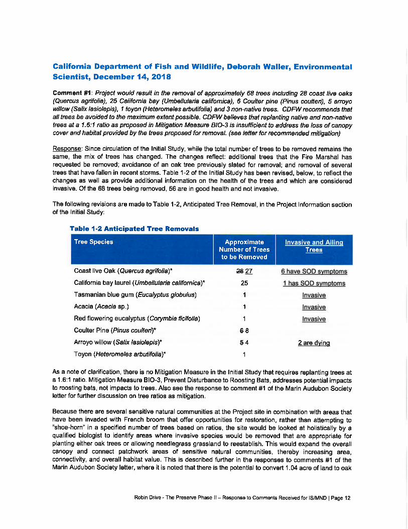
Galifornia Department of Fish and Wildlife, Deborah Waller, EnvironmentalScientist, December 14, 2018
Comment #1: Project would result in the removal of approximately 68 trees including 28 coast live oaks(Quercus agrifolia), 25 California bay (Umbellularia califomica), 6 Coufter pine (Pinus coulteri), 5 arroyowillow (Salix lasiolepis), 1 toyon (Heteromeles arbutifolia) and 3 non-native trees. CDFW recommendsthatalltrees be avoided to the maximum extent possible. CDFW believes that replanting native and non-nativetrees at a 1.6:1 ratio as proposed in Mitigation Measure B/O-3 is insufficient to address fhe loss of canopycover and habitat provided by the trees proposed for removal. (see letter for recommended mitigation)
Response: Since circulation of the lnitial Study, while the total number of trees to be removed remains thesame, the mix of trees has changed. The changes reflect: additional trees that the Fire Marshal hasrequested be removed; avoidance of an oak tree previously slated for removal; and removal of severaltrees that have fallen in recent storms. Table 1-2 of the lnitial Study has been revised, below, to reflect thechanges as well as provide additional information on the health of the trees and which are consideredinvasive. Of the 68 trees being removed, 56 are in good health and not invasive.
The following revisions are made to Table 1-2, Anticipated Tree Removal, in the Project lnformation sectionof the lnitial Study:
Table {-2 Anticipated Tree Removals
Coast live Oak (Quercus agrifolia)*
California bay laurel (U mbellularia calffomica)*
Tasmanian blue gum (Eucalyptus globulusl
Acacia (Acacra sp.)
Red flowering eucalyptus (Corymbia ficifolia)
Coulter Pine (Prnus coulten)*
Arroyo willow (Sa/ix /asrb/epis)*
Toyon (H ete ro m e le s arb utifo li al*
ztt27
25
,l
1
1
68
54
1
6 have SOD symotoms
t has SOD svmotoms
lnvasive
lnvasive
lnvasive
2 are dvinq
As a note of clarification, there is no Mitigation Measure in the lnitial Study that requires replanting trees ata 1.6:1 ratio. Mitigation Measure BIO-3, Prevent Disturbance to Roosting Bats, addresses potential impactsto roosting bats, not impacts to trees. Also see the response to comment #1 of the Marin Audubon Societyletter for further discussion on tree ratios as mitigation.
Because there are several sensitive natural communities at the Project site in combination with areas thathave been invaded with French broom that offer opportunities for restoration, rather than attempting to"shoe-horn" in a specified number of trees based on ratios, the site would be looked at holistically by aqualified biologist to identify areas where invasive species would be removed that are appropriate forplanting either oak trees or allowing needlegrass grassland to reestablish. This would expand the overallcanopy and connect patchwork areas of sensitive natural communities, thereby increasing area,connectivity, and overall habitat value. This is described further in the responses to comments #1 of theMarin Audubon Society letter, where it is noted that there is the potential to convert 1.04 acre of land to oak
ApproximateNumber of Treesto be Removed
lnvasive and AilinqTrees
Tree Species
Robin Drive - The Preserve Phase ll- Response to Comments Received for IS/MND lPage 12
woodland. ln addition, as described further in the response to comment lf4 of the Marin Audubon Societyletter, the buildings have been clustered and utilize the three existing graded pads to avoid trees to theextent feasible.
Gomment#2: Resu/fs from 2014 Rare Plant Surueys identifiedtwo special-status plant specr'es on theProject site including the Marin dwart flax, state listed as threatened and a CNPS List 18 specieg and theOakland star-tulip, a CNPS List 4 species. Mitigation Measure BIO-1 indicates that pior to construction,the applicant shall retain a qualified biologist to conduct seasonally appropriate surueys for Oakland star-tulip within the construction footprint on the lower parcel, recommend location-specific avoidance measurasand monitor protected plants for two years after construction. lf plants cannot be avoided, bulbs of the plantswould be moved and monitored for two years. The MND states that the expert opinion of a qualified biologistwill suffice in-lieu of performing plant surueys. CDFW helieves these measures are insufficient to protectspecra/-sfafus plants at the Projecf sde. (see lefter for recommended mitigation)
Resoonse: ln review of Mitigation Measure BIO-1, Protect Oakland Startulip during Construction, it hasbeen determined the mitigation could be enhanced with some of the suggested edits provided by CDFW.As construction would occur in excess of 800 feet from the Marin dwarf flax, suggested revisions regardingthis species are not being included as there would be no impact to this species.
The following revisions are made to Mitigation Measure BIO-1, Protect Oakland Star-tulip duringConstruction, of the lnitial Study.
Mitigation Measure BIO-I: Protect Oakland Star-tulip during Gonstruction
Prior to construction, the Applicant shall retain a qualified biologist to conduct a seasonallyappropriate survey for Oakland star-tulip within the lower portion of the Project site-Prejeetbeenstruetien+eetp+i*. The biologist shall be pre-approved by the Town's Planning Director prior to
surveys being conducted. The survey shall comply with the most recent CDFW Protocols forSurueying and Evaluation Impacts fo Specra/-Status Native Plant Populafibns and Sensitive Natural
Communities. A report summarizing the results of the plant survey shall be provided to the Town.
lf Oakland star-tulip is found, the report shall also recommend location-specific avoidancemeasures to implement during construction including appropriate set-backs and installation ofprotective temporary construction fencing.
lf a plant is found bevond 50 feet of the Proiect area of disturbance. and avoidance is feasible, theApplicant shall ensure that temporary fencing is installed to protect the plants during constructionactivities. The protected plants shall be monitored twice annually for two years following the
completion of construction activities at the site. lf deemed appropriate by the qualified biologist, the
temporary construction fencing shall remain in place for the two years of monitoring. A memo
documenting the results of each monitoring event shall be provided to the Town within 30 days
after the completion of the monitoring. lf the plants continue to be in good health after two years,
no further action is required. lf the monitoring reveals that the health of the plants has been
compromised, as determined by the qualified biologist, due to Project construction, or if avoidanceis not feasible, and olants are found in. or within 50 feet of. the oroject disturbance area. the bulbs
of the plants shall be moved to grassy areas in the uooer oortion of the oarcel that will not be
affected. The two-year monitoring shall reset from the time the bulbs are moved. Transplantation
methods shall be completed with as liftle ohvsical disturbance as possible to the individual. and at
a time when the individual is photosvntheticallv inactive or dormant: the transplantation site shall
be of the same qualitv habitat. free of weeds. and havinq similar phvsical characteristics and soil
tvpe. Success criteria shall be measured bv qreater than 75% of the relocated prooaoules
Robin Drive - The Preserve Phase ll- Response to Comments Received for IS/MND I Page 13
established reproducinq population. Monitorinq and adaptive manaqement techniques shall beemploved until the standard is achieved.
lf a qualified bielegist has reeent (within 12 mentheef start ef eenetruetien)t deeumented knewledge
l-reieet eite einee the 2015 plant surveye' this expert epinien will euffie€ in lieu ef perferming plantsutleys,
Gomment #3: Be advised that a CESA permit must be obtained ff the project has the potential to result in"take" of plants or animals listed under CESA, either during construction or over the life of the project./ssuance of a CESA Permit is subjectto CEQA documentation; the CEQA document must specify impacts,mitigation measures, and a mitigation monitoring and repofting program. lf the Project will impact CESALsfed species, early consultation is encouraged, as significant modiftcation to the Project and mitigation/neasures may be required in order to obtain a CESA Permit. ln order to address impacts fo speaal-sfafusplant species, CDFW reguesfs that Mitigation Measure BIO-1 be expanded to include the following: (seelefter)
Response: The reminder of the trigger for obtaining a CESA permit is appreciated. The Applicant hassubmitted a Streambed Alteration Agreement Application to CDFW, and we assume as part of that reviewthat if CDFW believes "take" would occur, they would advise the Applicant. At this time there is no evidenceof special-status plant species occurring on the lower portion of the parcel where construction disturbancewould occur. Special-status plant species have only been found on the upper parcel. As noted in Section3.4, Biological Resources, of the lnitial Study, Mitigation Measure BIO-1, Protect Oakland Star-tulip duringConstruction, would require plant surveys to occur on the lower parcel prior to the start of construction inthe event that Oakland star-tulip may have migrated to the lower parcel. See the response to comment #2,above, for revisions that have been made to enhance Mitigation Measure BIO-1.
Galifornia Native Plant Societyn Eva Buxton, Conservation Ghairn December13,2018
Gomment #1: Vegetation including specra/-sfafus species may vary from year to year depending onenvironmental conditions and the potential establishment of new populations, additional surueys to agencyprotocol should be conducted on the southern parcel. Parcel abuts the Ring Mountain preseve suppoftingfederal- and State-listed endangered and threatened species -Tiburon mariposa and Marin dwarf flax. Foottraffic (including pets) will likely increase from the development when completed into the Ring Mountainpreserue via the Robin Drive fire road and a narrower trail. The trailtraverses serpentine habitat whereMarin dwart flax was documented by LSA in 2014. Therefore, surueys in this area should be updated and,if found, the distribution of Marin dwart flax, and any other specia/-stafus species should be mapped toindicate where and how avoidance measures need to be implemented in the future.
Response: lt is agreed that vegetation can vary from year to year. That is why Mitigation Measure BIO-1,Protect Oakland Star-tulip during Construction, requires a seasonally appropriate survey be conducted onthe lower portion of the Project site, prior to construction. The mitigation further outlines the procedures tofollow if the plant is found. No construction would occur on the upper portion of the Project site, therefore itis not necessary to survey this area. As analyzed in Section 3.4, Biological Resources, of the lnitial Study,the Marin dwarf flax and Tiburon mariposa can be found in areas of serpentine outcrop. A small patch ofserpentine exists near the southern border of the upper parcel in excess of 800 feet from the proposedconstruction. During the biological surveys, Marin dwarf flax was found in the area. As noted in the responseto comment #6 of the Marin County Parks lefter, while the Biological Survey found that Tiburon mariposalily is unlikely to occur on the Project site, because of the presence of the serpentine, the lnitial Studyconservatively concluded the potential exists for it to occur. However, there are no Project improvements
Robin Drive - The Preserve Phase ll - Response to Comments Received for IS/MND I Page 14
proposed to the upper portion of the Project site and the serpentine area is in excess of 800 feet from theproposed construction on the lower portion. With regard to foot traffic increasing as a result of the Project,refer to the response to comment #1 of the Marin County Parks letter.
Gomment #2: Habitat for Oakland star-tulip is present on the lower parcel, the plant could potentially occurwithin the development envelope. The documenf sfafes that a qualified hiologist will suruey this parcel within12 months of the start of construction. CNPS recommends that a botanist familiar with all developmentalsfages conduct the surueys in order to positively establish its presence/absence. Mitigation Measurc Bio-loutlines the protection of Oakland star-tulip during construction of the project and within its foot-print. Asmentioned above, this action proposes to conduct seasonally appropriate suveys for Oakland star-tulipand if found, and avoidance is feasible, temporary fencing will be installed to protect the plants duringconstruction activities and remain in place for two years with appropriately-timed monitoring events. lt isnot clear what conditions would be present if "avoidance is feasible." CNPS contends that rare plants thatgrow within, or in the immediate vicinity of a development do not suruive over time, as a resu/f of impactsfrom trampling by people and pets, the use of feftilizer and inigation in private gardens/yards that spreadthroughout the substrate, the introduction of non-native, invasive species that results from disturbance ofthe soil, efc. CNPS recommends that if Oakland star-tulip is found during surueys within the developmentenvelope, the bulbs be dug up and moved to appropriate grassland habitat on the southern podion of thesite at the time they are obserued, i.e., not as a contingency measure if the plants do not do well afrerattempts to protect them where found, as suggesfed in the VPN.
Resoonse: lt is agreed that there is potential habitat for Oakland star-tulip on the lower portion of the Projectsite. That is why Mitigation Measure BIO-1, Protect Oakland Star-tulip during Construction, requiresseasonally appropriate preconstruction surveys prior to construction and procedures to follow if the plant isfound. See the response to comments #2, of the California Department of Fish & wiHlife letter, for edits thathave been made to Mitigation Measure BIO-1, incorporating some of the suggestions made in thiscomment. The revised mitigation measure includes relocating Oakland star-tulip, if found within 50 feet ofthe proposed improvements, to the upper portion of the parcel. Additionally, implementation of MitigationMeasure BIO-5, Remove Non-native Species from Landscape Plan, requires a review of the landscapeplan to insure that no invasive species are introduced to the Project site.
Gomment #3: /f is to be expected that non-native plants will invade areas around the periphery of theconstruction sites and plans to remove such specrbs are in place. Grass/ands on the eastern side of RingMountain are being invaded by coyote brush (Baccharis pilularis), a native shrub. Without wildfire, coyotebrush scrub is eliminating grass/ands, as can be seen when looking uphillfrom the Paradise Drive entranceto the Ring Mountain preserue. Associated with the removal of non-native species on the southern parcel,and as a general mitigation measure to preserue the habitat for Marin dwart flax and Oakland star-tulip,CNPS recommends maintaining open grassland habitat, some of which is bunchgrass grassland - asensffiVe community - by removing coyote brush, an invasive native species.
Resoonse: The comment is correct, Mitigation Measure BIO-4, Protect Needlegrass Grassland, requiresthe preparation and implementation of a plan to remove or limit invasive species. Mitigation Measure BIO-4 can be seen in the response to comment #8, from the Marin Audubon Society letter, above. Thismanagement plan includes removal of French broom and strategic thinning and removal of coyote brushto preserve the native grassland sensitive communities and the special-status plant species that inhabitthem. lmplementation of Mitigation Measure BIO-4 adequately addresses the threat to needlegrassgrasslands. ln addition, it allows for the reestablishment of needlegrass grassland in specified areas.
Robin Drive - The Preserve Phase ll - Response to Comments Received for IS/MND I Page 15
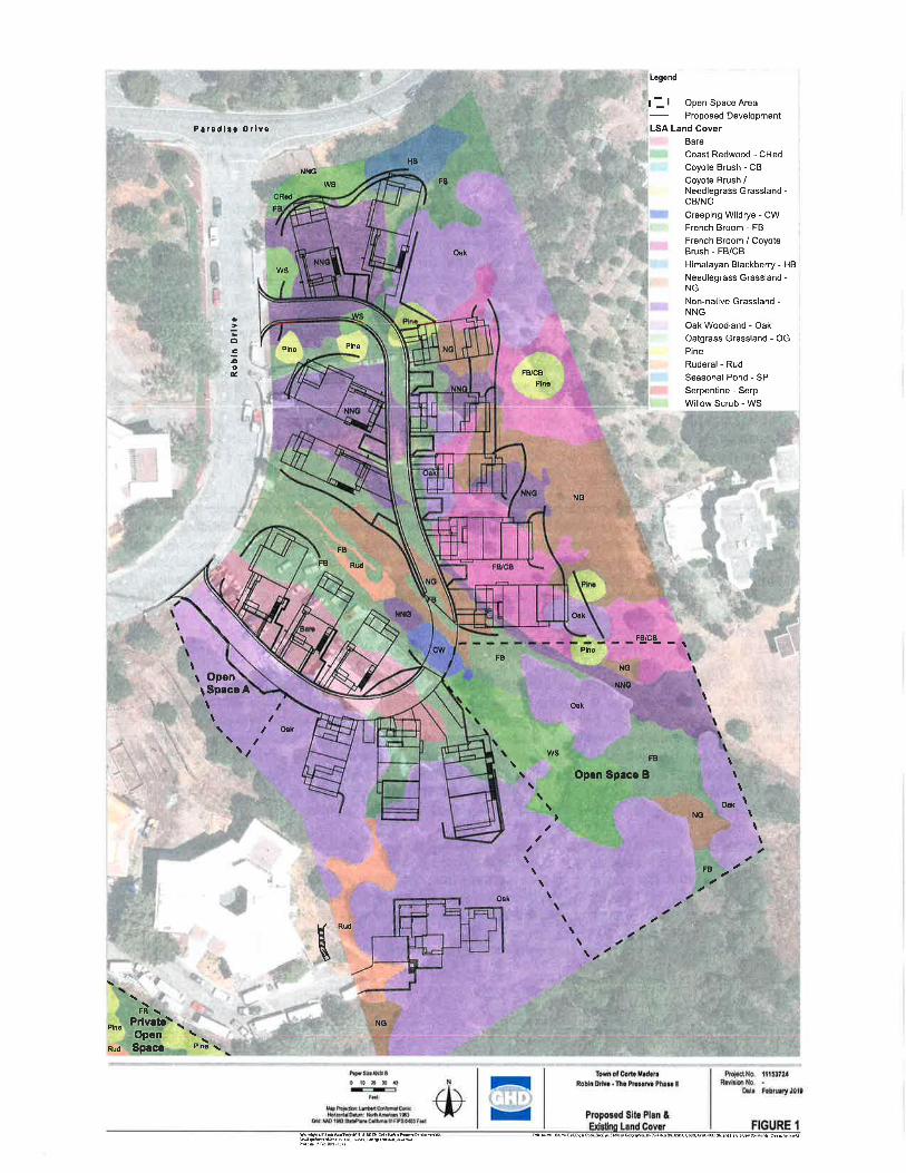
\
FB\Privete\ rOpenSpace
Parsdlso OrlYo
t OpentSp.coAtt
FB Rud
Rud
HB
FB/CB
NG
Ork
Plno
NNO
Ook
ws
Open Spaco B
Logend
l: I open SpaceAreaProposed Development
LSA Land CoverBare
Coast Redwood - CRedCoyote Brush - CBCoyote Brush /Needlegrass Grassland -CB/NG
Creeping Wildrye - CwFrench Broom - FB
French Broom / CoyoteBrush - FB/CB
Himalayan Blackberry - HB
Needl€grass Grassland -NG
Non-native Grassland -NNG
Oak Woodiaild - Oak
Oatgrass Grassland - OG
Pine
Ruderal - Rud
Seasonal Pond - SPSerpentine - Serp
Willow Scrub - WS
FB/CB
\
FB
NO
NNG
ws FB
Oek
ws
oc5oc
Plno
I O6k
Plno
Pln€
FB
NNG'
\ FB
Oak
NC
\
t\:\
FB
\\\
O"t \\\\
t
\
w
NGPlno
Rud
hpsdossallTomofcodeMrdsrelProiectNo.ttt53Tu,lrlErRobrngrve'ftopro3odephaleilr^ovrsu'NU.'
-.**n',il**"*t,.-S lJ I **,,,r*,,*, | -,.,*l'
tnlws\sturftsrrlnr$r eb&kdo,cra turs,le usstulcRqrcr.rd6lc6ui,hldr c6rdhA{

r.
VI'
ftaq
4
*4:Nlt"1,;F.-8"7fr{,N.;
ffi
lt
k
.lF,i
.(! :. .,44t
at.o
<.
IFlz'Ef8s
,o5
6D,ll
q-
.ttz
9-
8,,'FFPtTrFig',W"9.7
It_
t.
ai
OC
't'
p!+
i.JN9
I
u2ffE
in
@xPt!
'sA
\B
#2 r+2
H
',*
t_
lI
7A&p
12irpri4.ktrz'744
:f9
7rJ {<
/'aaugq FEtrrs )t -r.e rcts f{t2 <'F1Rl4'-;Eir:vr" {-tourwresi4@iiiP nal/#tai:
J'L11
{
snea='da':u-n;o!D99Ydclc.? 9
^Al;x o ov] = o3a0,
3od_0)
=
nnc=€arJoxoc):,iTD TD
=EE99dioogfcio* P A6Bdo^<o)o<(oA:ao(ooLTP@-a(ooO!^oo6=?f+."-i --l >
c).('lor-z-n-l
UCO o)cDo()--n +90€€>6:loo:€>Q9ii-Jwwu19HFFoE"g$;soo-oo-a3oo=O!=io)
=oO6=oo.)ooobb>-g 3-o--c) .;>-- 5 rico) - 'TtO) Z --toT-(t -lD'Tl-t
o
='il
a!L!c
in
JOO
o
N)O]
(Jl
T'loo
*-,/it:'if:l+
trtr:{K
(oC!
!t!d'l Eoal)..o oG3 <.r_ fooo=>vFssrou)BO
d
-T'l
(oc-Iopoofoo
15
cor_
€oo,fo_
(o'o)
=-of
CD
E
-lo€fo-)ool9rsdXaOY-tPb<93.<ao)
-1(J -
c-f!<.i- !:l-(1 (Dtq
n6'6'
o!q
o
o

IRSMUG|ru
ts-
NEuPUEHil sMoBnaffiotMULEGIAFffi
CHONDWET&UM EfrOruM
tRls@GslM
s@ffial@
CHIOMGIUM EMERIDNUM
ruqLFmtq
EPIPMISGIWB
JUNdS PATENS
UWONIA PEFOUATA
NER dILilSIS 4YNH6@IDilTNS 4W6nm@OES
FLMIdUM ilUNIruMFEWqWFOilTq NUWLUS4TFOilTCUS WPHORrcMOUIS
CLMN CONDEN$TUS'CANYON PRINCE ffidhREru
iMUHENBThRGENS streruFmrq WIFRIMffiBIGINNLRNON Q
an@Mftffi3@
n*rr?n.ffi.+,fisF"
BIOME IMAGERY:RAIN GARDEN AND REMEDIATION
-*fqnq lffil ^tmco1'^
b
TH€
RE.sIDENCES
n. ,,.,
'(_
ir-{..
ffi ril pttE$€rli/e
DANTHONA WIFONM ELWUS UUCUS

Attachment 25
Public Comments Received
Public Comments on the Residences at Preserve Project at APN 038-011-21:
i NAME ii. :-.- t-- .. I
I SgottAnderson -p8.2 I
; Hilde Simon -p9.4 i
i Deborah Waller - pg. 5 I
1 EvaBuxton-pg.8
:
, Barbara Salzman - pg. I llMichelle Julene - pg. 13
i R. & B. Guelden - pg. 15 i
AX'F'ILIATIONCommunity Development Director, Town of TiburonProperty oiq4er at 5156 Paradise DriveCA department of Fish & WildlifeMarin Chapter of the California Native Plants SocietyMarin Audubon SocietyMarin County ParksProperff omers at 101 Taylor Road
DATE07/21/20t7rt/25/2018L2/t4/2018tzlr3l20t8tzl13/2018tzlt4/201802/t9120r9
I

Towrof'filrumn"|505Tibumn[loulcv-rnl .'l'ibumn,C:94920.l'.415.435.737tli415.435.2438.*rv*'.tovrooftiburon,org
Community Dev elopment Department July 21,2017
Milan Nevajda, Associate PlannerM-Group499 Humboldt StreetSanta Rosa, CA 95404
Rtr: Robin Drive Subdivision Preliminary RcviewRobin Drivc, Corte Maders
Dear Ms. Nevadj4
Thank you for providing the Town of Tiburon the opportunity to review and comment
on the Robin Drive Subdivision project in Core Madera. The Town of Tiburon's main
comments at this point in time are as follows:
The parking provided for the project appea$ to be inadequate. The twogarage spdces for each dwelling unit and one space for each second unitwould be the absolute minimum parking for these units. Only seven (7)
additional off-street parking spaces appear to be provided, with no
available on-sheet parking on the proposed one-way street. Furthermore,
the new street would eliminate 6 or more existing on-street parking
spaces on Robin Drive. Spillover of parking onto Robin Drive and/or
Paradise Drive is very likely.
The affordability component of the proposed accessory dwelling units isquestionable. Although Aimco appears well qualified to identiff future
tenants for this project, there does not appear at this tirne to be a
mechanism to insure that the accessory dwelling units would actuallyconstitute affordable units. In addition, the individual lots might be
available to be sold separately in the future to other property owners,
which could negate any assurances given by the current propertyowners. If the Town of Corte Madera intends that the accessory dwellingunits are affordable, consideration should be given to rental andloraflordability requirements for those units that would be recorded against
the relevant lots.
The project narrative should more clearly reflect the actual nature of the
project. Individual structures containing one larger dwelling unit and an
attached one-bedroom unit, intended for rental purposes only, are not
Jirn Frrrcr
...,.Yr'.....Emmett OfDcnncll
ViceMapr
Franlc X. Doylc{'louncilmambcr
Alicc Fredcritks{oundlncrnbcr
rirl[ lournrflouncilmcmbcr
,ChenisQ*c'lirqm Mrrugcr
I
)
3
2
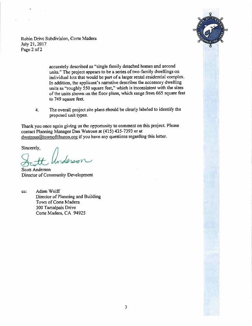
Robin Drive Subdivision, Corte MaderaJuly 21,2017Page2 of 2
accurately described as "single family detached homes and second
units." The project appears to be a series of two-family dwellings on
individual lots that would be part of a larger rental residential complex.In addition, the applicantns narative describes the accessory dwellingunits as "roughly 550 square feet," which is inconsistent with the sizes
of the units shown on the floor plans, which range from 665 square feet
la 749 square feet.
4. The overall project site plans should be clearly labeled to identifu theproposed unit types.
Thank you once again giving us the opportunity to comment on this project. Please
contact Planning Manager Dan Watrous at (415) 435-7393 or at
[email protected] if you have any questions regarding this letter.
Sincerely,
Scott AndersonDirestor of Community Development
cc: Adam WolffDirector of Planning and BuildingTown of Corte Madera300 Tamalpais DriveCorte Madera, CA 94925
J

Subject: FW: residences at the Preserve
From : hilde simon [mai lto : hi ldesimon @comcast. net]Sent: Sunday, November 25,20L8 9:03 AMTo: Adam WolffCc: Jimmy Simon; sue duryeeSubject residences at the Preserue
HiAdam,
While we regard the proposed construction directly across the street from us as inevitable, we would like topoint out a few items for your consideration as you move forward.
1 . The study states that there could be as many as 40 round trips a day by our house by constructionvehicles. Have you thought at all about the fact that the RUSD buses stop at the corner of Robin Drive for pickup and drop off? Have you factored in the flashing red lights and how all traffic in both directions must stop onParadise Drive, often for 5-10 minutes to wait for a tardy child? I think you should reach out to the schooldistrict to coordinate their schedule with the Preserve's construction vehicle traffic. At this point in time we arealready trapped in our driveway by idling cars behind the stopped buses. I anticipate that if not betterregulated, the backed up traffic and the inevitable fumes in front of our house will add the the diminishedquality of life we are already experiencing due to the 2 other construction projects on either side of our home. I
hope you give the kids and the school priority and not the contractor's bottom line.
2. As you are well aware, we have endured at least 4 years of construction directly next door. We aretolerating the MMS project on the OTHER side of our house which is being better run but honestly we are fedup with back up beeps, dust, diesel exhaust and workers'food wrappers that seem to all wind up on ourproperty-just to name a few of the many items that are detracting from our enjoyment of our home. Can youhelp us out here? A few pointers: Please do anything you can to mitigate all the dust which the afternoon 'fogwind' will blow right onto our house and both our front and back yards. Construction at 5148 has prevented usfrom using our back yard in the past 4 summers due to fumes, dust and lack of privacy landscaping andfencing; we have little grandchildren that want to visit and run outside; often they can't come over because it'stoo noisy with construction. lt's kind of pathetic, what has been allowed to happen. We live here. I look toYOU to do anything you can to return our property back to its usability by these ideas: All grading on this newPreserve project should be showered with water to keep the dust down. Barriers should be erected to keepdust, wrappers and loose construction items from blowing onto our property. No engines should be leftidling. The port-a-potty clean out trucks need to come during actual construction hours, not at Sam as they didat 5148 and we want the stinky potties put far away from our house. lt has not been pleasant to have one 5feet from our fence as at 5148. Please let the workers be aware that our inviting and welcoming driveway isnot for them to turn around in or use in any fashion.
Adam, somehow the'rules' have permitted us to feel like our quality of life is the least important item on thetown's agenda. Any effort you can make to change our attitude would be welcome.
I4
Thank you, Hilde and Jim Simon

Milan Nevaida
From:Sent:To:
Adam Wolff < [email protected] >
Friday, December 14,201810:20 AMMilan Nevajda; Kristine Gaspar ([email protected]) ([email protected])([email protected]); Haley Cahill ([email protected])
Judith Propp ([email protected])FW: Robin Drive - The Preserve Phase ll Project SCH 2018112032
Cc:
Subject:
See below
Adam
From : Waller, Deborah @Wildlife Imailto : [email protected]. gov]Sent: Friday, December L4,2018 10:15 AMTo: Adam WolffCc: Weiss, Karen@WldlifeSubject: Robin Drive - The Preserve Phase II Project SCH 2018112032
Dear Mr. Wolf,
Thank you for giving California Department of Fish and Wildlife (CDFW) the opportunity to review and providecomments on the Mitigated Negative Declaration (MND)forthe Robin Drive-The Preserve Phase ll project (Project).
CDFW has done a quick, limited review and is submitting informal comments to be incorporated into the MND as
provided below.
Section 1.4.4 Landscaping and Tree Removal
Comment 1 The Project would result in the removal of approximately 68 trees including 28 coast live oaks lQuercusagrifolial,25 California bay (Umbellularia californical,6 Coulter pine (Prnus coulteril,5 arroyo willow (Salix lasiolepisl,ltoyon (Heteromeles arbutifolra) and 3 non-native trees.
CDFW recommends that all trees be avoided to the maximum extent possible. CDFW believes that replanting native andnon-native trees at a 1.5:1 ratio as proposed in Mitigation Measure BIO-3 is insufficient to address the loss of canopycover and habitat provided by the trees proposed for removal.
Recommended Mitigation: To reduce impacts to less-than-significant, CDFW recommends avoiding tree removal to thegreatest extent feasible and replacement of trees that cannot be avoided at a minimum 3:1 ratio for natives and a 1:1
ratio for non-natives greater than 12 inches diameter at breast height (dbh). Due to the high-quality habitat provided byoaks, individual oak trees that cannot be avoided should be replanted at a minimum 10:1 ratio; oak trees greater than15-inches in dbh should be mitigated at a ratio of 15:1. Preference should be given to on-site restoration and mitigation.Off-site mitigation ratios may be higher.
Replacement plantings should consist of locally-collected seeds, stakes, or other suitable nursery stock, and should be
native species to the area adapted to the lighting, soil, and hydrological conditions at the replanting site. Replacementoaks should come from nursery stock grown from locally-sourced acorns, or from acorns gathered locally, preferablyfrom the same watershed in which they are planted.
1
5

Section 3.4 Biological Resources
Mitisation Measure BIO-1: Protect Oakland Star-tulip durins Construction
Comment 2: Results from2O14 Rare Plant Surveys identified two special-status plant species on the Project site includingthe Marin dwarf flax (Hesperolinon congestum), state listed as threatened and a California Native Plant Society (CNPS)List 1B species, and the Oakland star-tulip (Calochortus umbellatus), a CNPS List 4 species.
Mitigation Measure BIO-1 indicates that prior to construction, the applicant shall retain a qualified biologist to conductseasonally appropriate surveys for Oakland star-tulip within the construction footprint on the lower parcel, recommendlocation-specific avoidance measures and monitor protected plants for two years after construction. lf plants cannot beavoided, bulbs of the plants would be moved and monitored for two years. The MND states that the expert opinion of aqualified biologist will suffice in-lieu of performing plant surveys. CDFW believes these measures are insufficient toprotect special-status plants at the Project site.
Recommended Mitigation: CDFW recommends that plant surveys be conducted prior to construction following CDFW
Protocols for Surveying and Evaluating lmpacts to Special-Stotus Native Plont Populations and Sensitive NaturolCommunities (CDFW, 2018) located here: CDFW Special Status Plant Survev Protocols. Surveys should be floristic in
nature and include the entire Project site, including the upper parcel which includes a proposed public access easementthrough private open space.
Botanical surveys should be conducted during the blooming period for all sensitive plant species potentially occurringwithin the Project area using reference populations, as feasible. "Focused surveys" that are limited to habitats known tosupport special-status plants orthat are restricted to lists of likely potentialspecial-status plants are not consideredfloristic in nature and are not adequate to identify all plants in a project area.
ln order to adequately avoid impacts to this species, CDFW requests the Mitigation Measure BIO-1 measures be updatedto include:
1. Establishment of a construction buffer distance for Marin dwarf flax of a minimum of 500 feet. The U.S. Fish
and Wildlife Service (USFWS) recovery strategy for Marin dwarf flax (USFWS, 1998) suggests at least a 500-footbuffer to reduce human impacts and allow for population expansion (refer to the Recoverv Plan for SerpentineSoil Species of the San Francisco Bav Area (USFWS, 1998) and the Marin dwarf flax S-vear Review: Summarv andEvaluation (USFWS, 2011).
2. ln instances where a 500-foot buffer cannot be accomplished, the Project botanist should consult with CDFW
on appropriate buffer distances and any potential additional protective measures such as additional speciesmonitoring or installation of fences and signage to dissuade users from going off trail. Direct impacts to Marinwestern (dwarf) flax, including seed collection, require a CESA take permit (pursuant to Fish and Game Code 52080 et seq.).
Please be advised that a California Endangered Species Act (CESA) permit must be obtained if the project has thepotential to result in "take" of plants or animals listed under CESA, either during construction or over the life of theproject. lssuance of a CESA Permit is subject to CEQA documentation; the CEQA 6o.urent must specify impacts,mitigation measures, and a mitigation monitoring and reporting program. lf the Project will impact CESA listed species,early consultation is encouraged, as significant modification to the Project and mitigation measures may be required inorder to obtain a CESA Permit.
ln order to address impacts to special-status plant species, CDFW requests that Mitigation Measure BIO-1 be expandedto include the following:
2
6
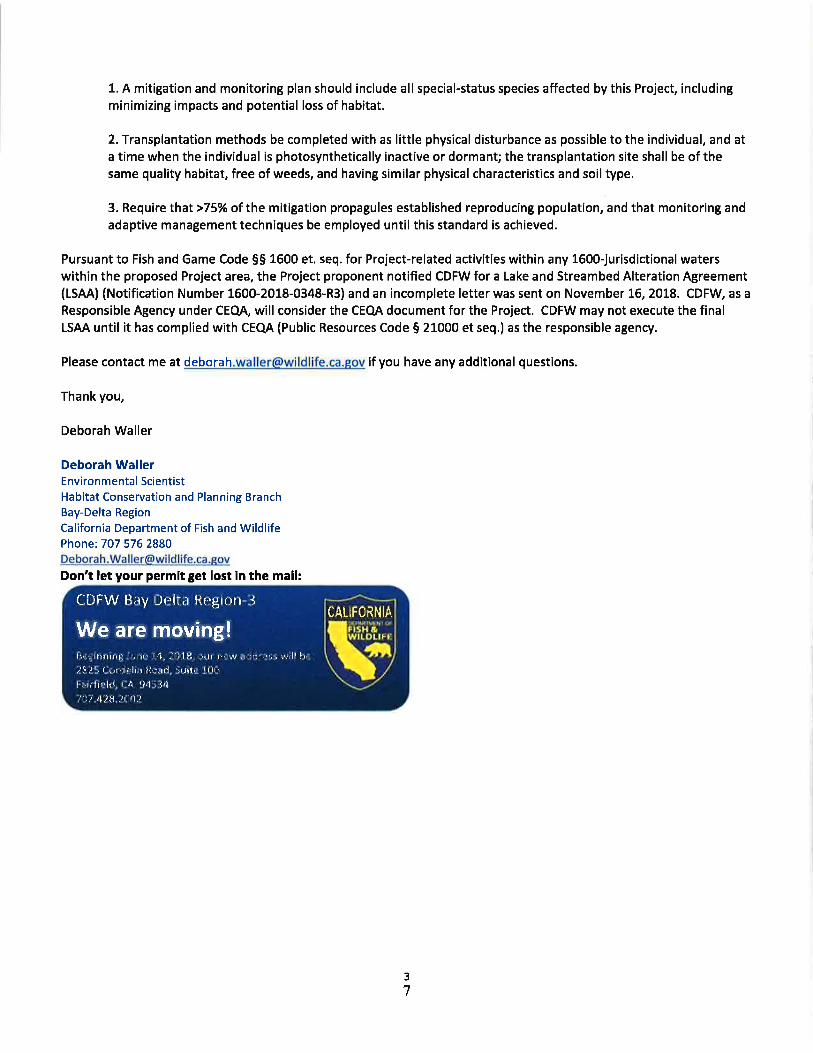
1. A mitigation and monitoring plan should include all special-status species affected by this Project, includingminimizing impacts and potential loss of habitat.
2. Transplantation methods be completed with as little physical disturbance as possible to the individual, and ata time when the individual is photosynthetically inactive or dormant; the transplantation site shall be of thesame quality habitat, free of weeds, and having similar physical characteristics and soil type.
3. Require that>75% of the mitigation propagules established reproducing population, and that monitoring andadaptive management techniques be employed until this standard is achieved.
Pursuant to Fish and Game Code 55 1600 et. seq. for Project-related activities within any 1600-jurisdictional waterswithin the proposed Project area, the Project proponent notified CDFW for a Lake and Streambed Alteration Agreement(LSAA) (Notification Number 1500-2018-0348-R3) and an incomplete letter was sent on November L6,2OL8. CDFW, as a
Responsible Agency under CEQA, will consider the CEQA document for the Project. CDFW may not execute the finalLSAA until it has complied with CEQA (Public Resources Code 5 21000 et seq.) as the responsible agency.
Please contact me at [email protected] if you have any additional questions.
Thank you,
Deborah Waller
Deborah WallerEnvironmental ScientistHabitat Conservation and Planning BranchBay-Delta Region
California Department of Fish and WildlifePhone: 7O7 576 2880Deborah.Wa ller@wildlife,ca.eov
Don't let your permit get lost in the mail:
CDFW Bay lJrlta Region i
ttrilllriilir!'. \ilrr' i4, Jlllli rirtr rrrr,'* ,rrir]lr,',', ilrll frs,:
.ti{,i', f nrr:ir':lt;r j{r'.rrJ i'r:r{r' I li{f{tt,rrlrlhi. r: l1 ::141' j,]
/l].i 'llil Jll{.1.)
CALIFORHIA
We are moving! F}
3
7
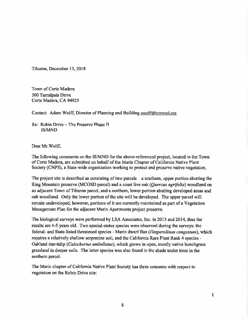
Tiburon, December 13, 2018
Town of Corte Madera
300 Tamalpais DriveCorte Madera, CA 94925
Contact: Adam Wolff, Director of Planning and Building [email protected]
Re: Robin Drive - The Preserve Phase IIISA{ND
Dear Mr.Wolff,
The following comments on the ISA4ND for the above-referenced project, located in the Townof Corte Madera, are submitted on behalf of the Marin Chapter of California Native PlantSociety (CNPS), a State-wide organization working to protect and preserve native vegetation.
The project site is described as consisting of trvo parcels - a southern, upper portion abutting the
Ring Mountain preserve (MCOSD parcel) and a coast live oak (Quercus agriftlia) woodland onan adjacent Town of Tiburon parcel, and a northern, lower portion abutting developed areas and
oak woodland. Only the lower portion of the site will be developed. The upper parcel willremain undeveloped; however, portions of it are currently maintained as part of a VegetationManagement Plan for the adjacent Marin Apartments project preserve.
The biological surveys were performed by LSA Associates, Inc. in 2013 and 2014, thus the
results are 4-5 years old. Two special-status species were obseryed during the surveys: thefederal- and Statelisted threatened species - Marin dwarf flax (Hesperolinon congestun), whichrequires a relatively shallow serpentine soil, and the California Rare Plant Rank 4 species -Oakland star-tulip (Calochortus umbellatus), which grows in open, mostly native bunchgrassgrassland in deeper soils. The latter species was also found in the shade under trees in thenorthern parcel.
The Marin chapter of Califomia Native Plant Society has three concerns with respect tovegetation on the Robin Drive site:
L
8
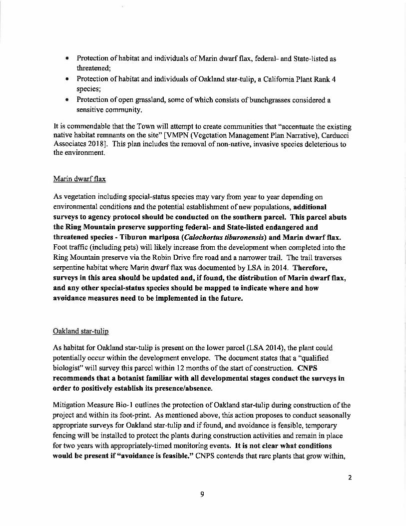
Protection of habitat and individuals of Marin dwarf flax, federal- and State-listed as
threatened;
Protection of habitat and individuals of Oakland star-tulip, a California Plant Rank 4species;
Protection of open grassland, some of which consists of bunchgrasses considered asensitive community.
It is commendable that the Town will attempt to create communities that "accenfuate the existingnative habitat remnants on the site" [VMPN (Vegetation Management Plan Na:rative), CarducciAssociates 2018]. This plan includes the removal of non-native, invasive species deleterious tothe environment.
Marin dwarf flax
As vegetation including special-status species may vary from year to year depending onenvironmental conditions and the potential establishment of new populations, additionalsurveys to agency protocol should be conducted on the southern parcel. This parcel abutsthe Ring Mountain preserve supporting federal- and StateJisted endangered andthreatened species - Tiburon mariposa (Calochortus tiburonenslS) and Marin dwarf flax.Foot traffic (including pets) will likely increase from the development when completed into the
Ring Mountain preserve via the Robin Drive fire road and a narrower trail. The trail traverses
serpentine habitat where Marin dwarf flax was documented by LSA in 2014. Therefore,surveys in this area should be updated and, if found, the distribution of Marin dwarf flax,and any other special-status species should be mapped to indicate where and howavoidance measures need to be implemented in the future.
Oakland star-tulip
As habitat for Oakland star-tulip is present on the lower parcel (LSA 2014), the plant couldpotentially occur within the development envelope. The document states that a "qualifiedbiologist" will survey this parcel within 12 months of the start of conskuction. CNPSrecommends that a botanist familiar with all developmental stages conduct the surveys inorder to positively establish its presence/absence.
Mitigation Measure Bio- I outlines the protection of Oakland star-tulip during construction of theproject and within its foot-print. As mentioned above, this action proposes to conduct seasonally
appropriate surveys for Oakland star-tulip and if found, and avoidance is feasible, temporaryfencing will be installed to protect the plants during construction activities and remain in place
for two years with appropriately-timed monitoring events. It is not clear what conditionswould be present if 6savoidance is feasible." CNPS contends that rare plants that grow within,
a
a
2
9
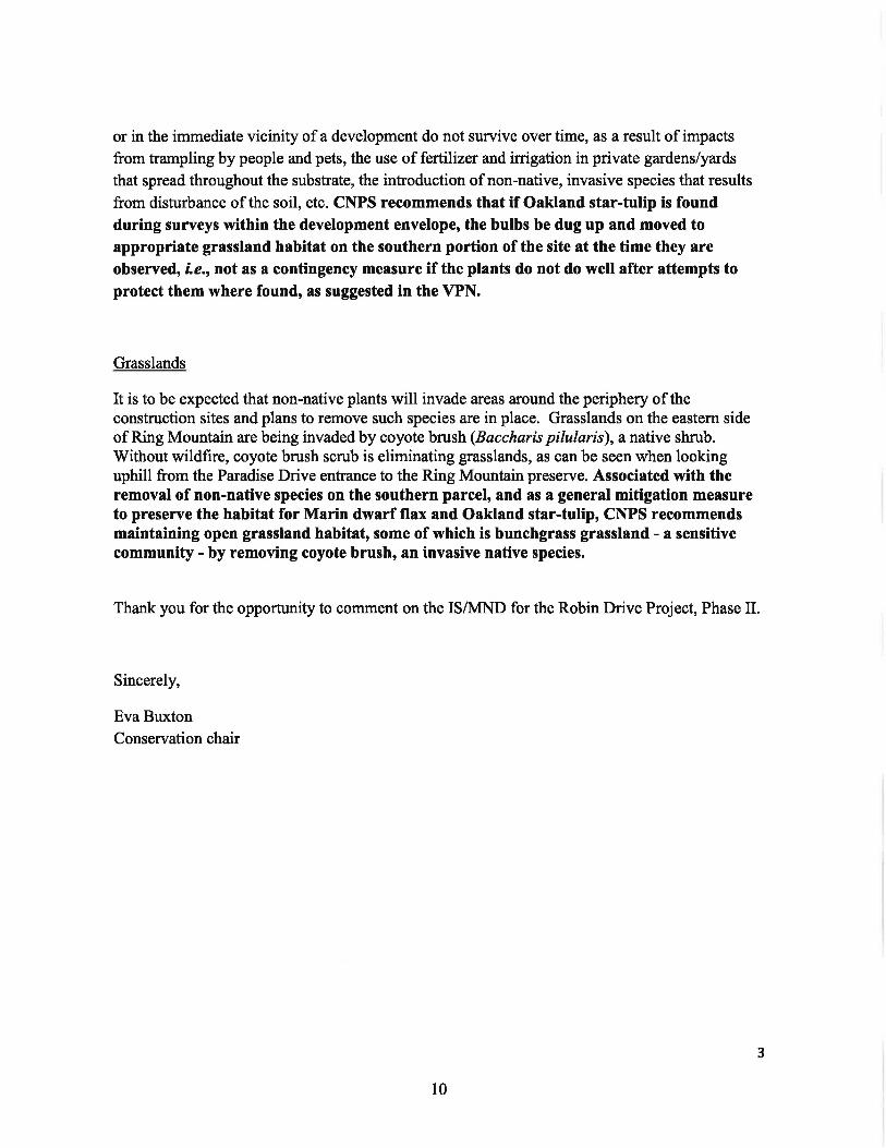
or in the immediate vicinity of a development do not survive over time, as a result of impacts
from trampling by people and pets, the use of fertilizer and irrigation in private gardens/yards
that spread throughout the substrate, the introduction of non-native, invasive species that results
from disturbance of the soil, etc. CNPS recommends that if Oakland star-tulip is foundduring surveys within the development envelope, the bulbs be dug up and moved toappropriate grassland habitat on the southern portion of the site at the time they are
observed, Le.rnot as a contingency measure if the plants do not do well after attempts toprotect them where found, as suggested in the VPN.
Grasslands
It is to be expected that non-native plants will invade areas around the periphery of theconstruction sites and plans to remove such species are in place. Grasslands on the eastern sideof Ring Mountain are being invaded by coyote brush (Baccharis pilularis), a native shrub.Without wildfire, coyote brush scrub is eliminating grasslands, as can be seen when lookinguphill from the Paradise Drive entrance to the Ring Mountain preserve. Associated with theremoval of non-native species on the southern parcel, and as a general mitigation measureto preserve the habitat for Marin dwarf flax and Oakland star-tulip, CNPS recommendsmaintaining open grassland habitat, some of which is bunchgrass grassland - a sensitivecommunity - by removing coyote brush, an invasive native species.
Thank you for the opportunity to comment on the ISll\4ND for the Robin Drive Project, Phase II.
Sincerely,
Eva BuxtonConservation chair
3
10

Marin Audubon Society1).O. tsox 599 | Mrr-l Verr.pv, CA 94r142-o599 |
MAIiINAUDUBON. ORG
December 13,20L8
Adam Wolff, Planning Director
Town of Corte Madera
Tamalpais Avenue
Corte Madera, CA94925
RE: COMMENTS ON lNlTlAL STUDY FOR ROBIN DRIVE PROJECT
Dear Mr, Wolff,
Thank you for considering Marin Audubon's comments on the lnitial Study (lS) for the Robin Drive
residential project. This project is of interest to Marin Audubon because the property supports multiplesensitive habitats: needlegrass grass (sp?), wetlands and native oak woodlands along with a special
status plants, The site is adjacent to the Ring Mountain Open Space Preserve which increases its value as
habitat. The lS does not provide adequate information for the public or decision-makers to take
informed positions.
We recognize that the project would protect oak woodland habitat, but our most significant concern isthe number of native trees that are proposed for removal, sixty-eight. Sixty trees slated for removal are
natives, 28 of which are oaks - a large number in this day and age when the benefits of trees are broadlyknown, While removal of any native trees is a concern, the loss of mature native oaks is of particular
concern. Not only are 800 species known to be supported by oaks, but the value of each mature nativeoak is increased because of the ongoing and extensive loss of Marin's oak population to Phytophtora(SOD). Such significant losses, make the protection of remaining healthy trees even more important.And oaks sequester carbon thereby combating climate change, and moderating climate. Oaks are also
beautiful and increase the economic value of property.
We request that the following information be provided;
t. The proposed mitigation for loss of trees, 1.6 trees planted per tree cut down, is inadequate and
the proposed location adjacent to the street is also unacceptable. To plant mitigation treesadjacent to Paradise Drive ignores the fact that the trees that will be lost are currently part of an
oak woodland-grassland ecosystem together with the Ring Mountain Preserve land. Mitigationshould replace not just the quantity of trees, but the habitat value and functions of the mixed
oak woodland/grassland which the housing development would destroy. A more suitablelocation to restore native woodland so that it retains its habitat values, not just as landscaping
for the project, is adjacent to the open space areas. A more acceptable ratio would be 3:L.
2. lnclude a figure showing the proposed houses superimposed on the biological resources
identified in the lS - streams L and 2, wetlands, native trees and native grasslands. We can'tevaluate options for eliminating or reducing losses without this information.
A Oltapttr o/'tlte Nttittnd Aurluhon Sacirtyll
3, Discuss provisions that should be in the Vegetation Management Plan related to habitat, such
as: length of time and frequency of plant maintenance and tasks that would be required,
including weeding, watering, and plant replacement.
4. Discuss alternatives to removing oak trees. Discuss whether the size, design, number or location
of the units could be modified to save oaks.
5. Discuss the potential for invasive species to colonize the disturbed areas and how this would be
addressed. We would expect broom, Harding Grass, and thistle to be problems because they areproblems on Marin Audubon's property, a short distance away, and on Ring Mountain Preserve.
6. Would a conservation easement be placed on the public and private open space? Only an
access easernent is mentioned.
7, Has the Marin County Open Space District been consulted about providing an access to the Ring
Mountain Preserve? A major problem in this Preserve is the spider-web of unauthorized access
trails made by users. The District has been working to reduce/eliminate these trails, Having
another entrance from an adjacent development would not appear to comply with the District's
efforts to protect the Ring Mountain resources.
8. Native needlegrass would be impacted by the project. How would the loss of needlegrass be
mitigated? Discuss avoiding the needlegrass, Discuss the impact of planting mitigation oaks in
needlegrass patches,
9. The nesting bird impact evaluation should also address ground dwelling birds that depend on
understory for nesting and foraging,
L0. Contrary to the lS, street and roads are not necessarily impediments to wildlife movement. ln
fact, in sorne locations roads are used by wildlife for moving between habitats. However,
structures and fences are impediments. Revisit this discussion with this information.11. Show the wetlands on a figure, including the area that would be enlarged, and discuss the
Regional Water Board's requirements for avoidance and mitigation. How would the wetlandsand streams be protected during construction and post-construction? What width of buffer willbe required to protect the wetlands and provide an essential habitat cornponent?
1.2. What size buffer would be provided along the stream that would be surrounded by
development and how would it be vegetated? Uplands adjacent to streams are needed toprovide streamside habitat and buffer the impacts of the protect.
13. Discuss whether any oaks or bays are infected with Phytophthora? lf yes, what measures have
been taken to address the infections? Surveys should be done nov.r if they haven't been already.14. An environmentally superior alternative, that eliminates or significantly reduces the loss of
native oaks and impacts on other sensitive habitats, should be provided, We realize an
alternatives analysis is not required in an lS, however, in this case it is warranted. Otherwlse, werecommend that a Focused EIR be prepared,
Thank you for addressing our concerns.
Sincgrely,
!
l, "' Br/bbrj #lzman, corchai?
, Conservation Comnilttde
CC: MCOSD
12

COUNTY OF MARIN
t'lARlN COUNTY
MARIN COUNIY PARKSPreservolion . Recreotion
Adam Wolff, Director of Planning and BuildingTown of Corte Madera300 Tamalpais DriveCorte Madera, CA 94925
December 14,2418 pia email)
RE: RESIDENCES AT PRESERVE MITIGATED NEGATIVE DECLARATION
Mr. Wolff,
The Marin County Parks and Open Space District (District) appreciates the opportunityto review and comment on the lnitial Study and Mitigated Negative Declaration(IS/MND) for the "Residences at Preserve" project (Project). The District's commentspertain to the "public access easement placed for public trail access to Ring Mountain."Ring Mountain Open Space Preserve includes native grassland and serpentine soils,
and is home to rare and endangered plant species.
r The IS/MND should include a graphic to show the location of Ring Mountainrelative to the Project and the location of the public access easemenUtrail to
Ring Mountain on the lower (northern) parcel, including how this access would
enter Ring Mountain.
r The ISIMND should describe the physical characteristics and management ofthe public access easemenVtrail in the project description and should include
the public access easemenVtrail in the impact analysis.
. The IS/MND should clarify if the access to Ring Mountain is adequate or if new
facilities, such as trail improvement or development, would be required on the
Project site andlor on Ring Mountain.
. The IS/MND should identify who would be responsible for management of thepublic access easementltrail.
o The IS/MND should include public access easemenUtrail and the entire lower(northern) parcel in the impact analysis and in Mitigation Measure BIO-4:
Protect Needlegrass Grassland. lt is possible that foot traffic, on and off thepublic access easemenVtrail, could affect needlegrass grassland and
populations of Marin dwarf flax (Hesperolinon congestum) on the lower(northern) parcel.
FN I? K !tRt 5ItvAIr()N tt( RtAITOX
o
oPrfl sPAct Dlsr&tcTRIGIONAI IIARKS & IAII]WAY:;CQINMUNITY IARXS
tANDSCAPf SillVlCtS
Mox Korten
DIRECIOT AND
GENIRAI MANAGER
Morin Counly Civic Conlor
3501 Civic Cenler Drive
Suite 260
Son Rofool, CA 94903
415 473 6387 T
41 5 A73 3795 r415 473 2495 TTY
www. morincounlyporks,org
13

PG.2 OF 2 . The ]S/MND should likewise consider potential impacts to Oakland mariposa
lily (Catochortus umbellatus) and Tiburon mariposa lily (Calochortus
tiburonensis) from public use of the public access easemenVtrail and the entire
lower (northern) parcel, as these species are known to grow at this location.
r The ]S/MND misidentifies Marin dwarf flax on Table 2 in Appendix A as Marin
western flax.
Please contact Michelle Julene, Regulatory Open Space Planner at
[email protected] or (415)473-5283 if you would like to discuss thesecomments or would like additional information about Ring Mountain Open SpacePreserve.
Sincerely,
UJ
Michelle Julene, Regulatory Open Space Planner
Cc: Amanda Magallanes, Ring Mountain Stewardship Coordinator
wu
COUNW OT MARIN MAlld COUNTY PARKS 3501 Civic Ccnter Drivo' Suite 260 Son Rofoel. CA 94903

Milan Nevajda
Sent:lo:Cc:
From: Adam Wolff <[email protected] >
Tuesday, February 19,2019 4:38 PM
R Guel
Belle Guelden ([email protected]); Milan NevajdaRE: "The Residences at Preserves" Planning Commission Meeting February 26,2019, pedestrianaccess
Hi Ron,
The below email minus the italics is good. We will include in our Staff Report to the Planning Commission and we willprovide a summary at the public hearing on Feb. 26. You may also want come to the meeting to discuss this comment.
Best,
Adam
From: R Guel [mailto:rguel@outlook,com]Sent: Tuesday, February 19,20t9 12:47 PMTo: Adam WolffCc R Guel; Belle Guelden ([email protected])Subject: "The Residences at Preserves" Planning Commission Meeting February 26,2019, pedestrian access
Mr. Wolff:I spoke with you last week regarding the '"The Residences at Preserves" on Robin Drive and the possibility of having the"Open Space B" areo occessible to pedestrions from Cibrian Drive to Paradise Drive through the new development. t hovesent Mr. Ullian comments on this request and would like to also hove these comments presented to the PlanningCommission in the staff report.
Below are the comments thot we would like to present to the Board for the upcoming meeting on this project. Thesecomments ore nearly the same os we sent to Mr. Ullian; only a few clarifications hove been odded. Pleuse let us knowhow we can proceed with presenting these comments (via e-mail, letter, etc. and addressed to who).
February 78,2079
Mr. Adam Wolff, Director of Planning and BuildingTown of Corte Madera300 Tamalpais DriveCorte Madera, CA
Mr. WolffWe are writing to you regarding the development 'The Residences at Preserves" on Robin Drive. First off, let us say thatwe take no exceptions to the housing being proposed in either design or density.
What we would like to have incorporated in the project is that the area designated as "Open Space B" include theprovision allowing pedestrian foot traffic from Cibrian Drive (via parcel 038-011-45 "Lands of Tiburon") through Robin
Subject:
1
15

Drive to Paradise Drive. This 'shortcut', while not extensively used, is a significant safety option for people walking on
Paradise between Corte Madera and Tiburon by avoiding Paradise Drive from Robin Drive to about the Tiburon townlimit. This portion of Paradise Drive is particularly hazardous due to the road's steep inclines, blind corners, and no
sidewalks or road shoulders. To have an available walkable by-pass would be a significant safety benefit to the Preserve
at Robin Drive and local Paradise Drive-area residents.
There exists a recognizable footpath from Cibrian Drive through the new development area and all we are asking is theability for pedestrians to continue its use. We are making no request for this path to be improved, maintained, orsigned. Natural use will preserve its course.
Regards,
Ron & Belle Guelden101Taylor Road
Tiburon, CA94920
2
t6

Attachment 26
Applicant request for Design Review permit extension
IFRagghianti Fre itas LLP
Attorneys at Law
1101 Fifth Ave, Suite 100San Rafael, CA 94901
telephone 415.453.9433facsimile 475.453.8269
www,rflawllp.com
March 9,20L8Via E-Mail Only
Adam WolffDirector of Planning and BuildingTown of Corte Madera300 Tamalpais DriveCorte Madera CA94925
Re: Preserve Phase II - 301 Robin Drive; APN 038-0ll-21(PL-20\7 4055 to 2017 -00671 -
DESIGN REVIEW EXPIRATION EXTENSION REQUEST
Dear Mr. Wolff:
Our office continues to represent the property owner in connection with the above-referenced application. In light of the scope of this project, we hereby request that anydesign review approval granted as part of the Town's entitlement process be valid for 3years pursuant to Municipal Code Section L8.30.090.
Thank you.
Very Truly Yours,
Riley F. Hurd [email protected]
CC: Aimco
@3kiLRiley F. Hurd III