contrail radiative forcing over the northern hemisphere from 2006 aqua modis data
TRANSCRIPT

Contrail radiative forcing over the Northern Hemisphere from 2006Aqua MODIS data
Douglas A. Spangenberg,1 Patrick Minnis,2 Sarah T. Bedka,1 Rabindra Palikonda,1
David P. Duda,1 and Fred G. Rose1
Received 31 October 2012; revised 7 January 2013; accepted 13 January 2013.
[1] Radiative forcing due to linear-shaped jet contrails iscalculated over the Northern Hemisphere for four seasonalmonths using 2006 Aqua Moderate-resolution ImagingSpectroradiometer cloud and contrail property retrieval datain a radiative transfer model. The 4month mean shortwave,longwave, and net radiative forcings normalized to 100%contrail cover are �5.7, 14.2, and 8.5Wm�2. Mean total netforcing over the northern half of the globe varies from9.1mWm�2 during October to 12.1mWm�2 in January andis only representative at 01:30 and 13:30 LT in nonpolarregions. In some dense flight traffic corridors, the mean netforcing approaches 80mWm�2. Scaling the 4month averageof 10.6mWm�2 to the Southern Hemisphere air trafficyields global mean net forcing of 5.7mWm�2, which issmaller than most model estimates. Nighttime net forcingis 3.6 times greater than during daytime, when net forcing isgreatest over low clouds. Effects from contrail cirrus cloudsthat evolve from linear contrails are not considered in theseresults. Citation: Spangenberg, D. A., P. Minnis, S. T. Bedka,R. Palikonda, D. P. Duda and F. G. Rose (2013), Contrail radiativeforcing over the Northern Hemisphere from 2006 Aqua MODISdata, Geophys. Res. Lett., 40, doi:10.1002/grl.50168.
1. Introduction
[2] Contrail impacts on global climate are estimated mostsimply in terms of the parameter contrail radiative forcing(CRF), which is the change in the radiation balance at thetop of the atmosphere (TOA) caused by the presence of con-trails. The CRF over any given location depends on manyfactors [Meerkötter et al. 1999], including the backgroundradiation field and contrail properties such as coverage CC,visible optical depth t, ice crystal effective diameter D, icecrystal habit [Yang et al., 2010], and temperature T or pres-sure P. Because of the difficulty in distinguishing contrailsfrom natural cirrus clouds and the tenuous nature of con-trails, direct measurement of CRF is extremely challenging.Thus, it has been estimated in several ways using puremodeling approaches or various combinations of data withmodel calculations. Some pure modeling approaches specifyany number of the above contrail parameters, while othersallow the model to compute them [e.g., Ponater et al. 2002].The mixed data-model techniques [e.g., Minnis et al., 1999;
DeLeon et al., 2012] compute monthly mean CRF by usingclimatological cloud, surface, and atmospheric data to com-pute the background radiation field using a radiative transfermodel (RTM) and then add specified values of CC, T, D,and t on top of the clear and cloudy atmospheres for each gridbox. The results are differenced with the contrail-free radiationfield to obtain CRF. Because the actual contrail properties andtheir background radiation fields are poorly known and themodels produce a wide range of values, the most recent assess-ment of aircraft climate effects [Lee et al., 2009] has an uncer-tainty of more than 100% in the net CRF (NCRF) of linearcontrails in terms of the global mean. Thus, more accuratemeasurements of contrail properties and CRF are needed toimprove our understanding of contrails’ influence on climate.[3] To date, objective measurements of contrail properties
and CRF have been confined to regional analyses of satellitedata. Meyer et al. [2002] analyzed NOAA-14 AdvancedVery High Resolution Radiometer (AVHRR) data overEurope and found average values of 0.11 for t. They alsoestimated the normalized (CRF for CC= 100%) NCRFto be ~7.9Wm�2 based on RTM calculations using theobserved optical depths over a cloud-free background.Palikonda et al. [2005] used the same approach and founda mean t of 0.27 from NOAA-15 and 16 AVHRR data overthe United States. They used a direct method that accountsfor the variable background to estimate the normalized long-wave CRF (LCRF) at ~15.5Wm�2 but were unable to deter-mine the normalized shortwave CRF (SCRF) and, hence,NCRF with the same type of approach. The differences int between the two analyses are striking and are indicativeof the uncertainty in the global NCRF. They may be dueto different sensitivities in the AVHRRs used in the twostudies or to actual regional variations in t. To obtain a betterestimate of the regional variation in t and NCRF, it is desir-able to use a consistent dataset and analysis procedure overthe globe and to estimate both longwave and shortwaveCRF using the actual background radiation fields belowthe contrails. To address this need, this study uses a RTMto compute the CRF by employing as input the contrail cov-erage and properties and related cloud parameters derivedfrom 2006 Aqua Moderate-resolution Imaging Spectroradi-ometer (MODIS) data by Duda et al. [2013] and Bedkaet al. [2013]. The global estimates of CRF are then obtainedby averaging the results over the Northern Hemisphere (NH)and scaling by air traffic to the remainder of the Earth.
2. Data and Methodology
[4] The 2006 Aqua MODIS pixels over the NH identifiedas contrails by Duda et al. [2013] are used to define the con-trails in this study. Only the pixels from the flight-track
1Science Systems & Applications, Inc., Hampton, VA, USA.2NASA Langley Research Center, Hampton, VA, USA.
Corresponding author: PatrickMinnis, MS 420, NASALangley ResearchCenter, Hampton, VA 23681, USA. ([email protected])
©2013. American Geophysical Union. All Rights Reserved.0094-8276/13/10.1002/grl.50168
1
GEOPHYSICAL RESEARCH LETTERS, VOL. 40, 1–6, doi:10.1002/GRL.50168, 2013
screened, sensitive mask, Mask B, as defined by Duda et al.[2013], are used here for the four seasonal months: January,April, July, and October, denoted as JAJO hereafter. Thismask captures mostly linear features and not diffuse, spread-ing contrails that are difficult to distinguish from natural cir-rus clouds. The results of the contrail mask were screenedusing advected air traffic waypoint data for the same periodaccording to the likelihood of having been located closeenough to a passing aircraft [Duda et al., 2013]. That screen-ing reduces the number of false detections and is especiallyuseful at eliminating tropical cirrus streamers that are oftenmisidentified as contrails. To further screen out noncontrailpixels here, contrail pixels having t> 3.0 are eliminated onthe assumption that such large values are likely to occur onlyfor natural ice clouds given the lack of reliable observationsof contrails with t> 2.0. Nearly a third of the contrail pixelshad t< 0.1, while only 8% had t> 1.0 [Bedka et al., 2013].This secondary filter eliminated ~0.5% of the contrail pixelsoriginally detected with Mask B and remaining after theflight-track screening.[5] For each contrail pixel assumed to be completely
covered by a contrail, the radiative forcing is defined to be
CRF ¼ Fconf � Fcon; (1)
where Fconf and Fcon are the upward TOA shortwave orlongwave fluxes for contrail-free and contrail-covered con-ditions, respectively. The Fu-Liou (FL) RTM [Fu and Liou,1993; Fu et al., 1998] is used here to compute these fluxes.Fcon is derived assuming an atmosphere with contrail-covered conditions where a contrail layer and backgroundcloud, if applicable, are inserted at the relevant altitudes.Fconf is computed for the contrail-free situation for the samebackground conditions but without the contrail layer.Finally, SCRF and LCRF are computed using equation (1)as well as NCRF, which is the sum of SCRF and LCRF.The contrail properties, t, D, and P, retrieved by Bedkaet al. [2013] are used to define the contrail layer for eachpixel calculation. The contrail ice crystals and backgroundice clouds are assumed to have a smooth surface and an as-pect ratio, AR� 1.1, parameters that must be specified in theFL RTM [Fu, 2007]. The liquid cloud model, used in somebackground scenes, is described by Hu and Stamnes [1993].[6] To specify the background conditions, all of the Aqua
MODIS 1 km data used in the contrail analyses of Dudaet al. [2013] were processed with the algorithms of Minniset al. [2008] to classify every pixel as either clear or cloudy.The cloud properties, including thermodynamic phase, opti-cal depth, pressure, and effective particle size, were deter-mined for each cloudy pixel using the methods of Minniset al. [2011]. To define the background conditions, the dom-inant scene for the surrounding pixels is first determined asclear or cloudy, as in Bedka et al. [2013]. When the domi-nant background type is determined to be clear, no cloudlayer is inserted below the contrail. Otherwise, the dominantcloud phase is used, and the mean particle size, opticaldepth, and pressure of the dominant cloud type are used tospecify the cloud layer used in the calculations of both Fconf
and Fcon.[7] The atmospheric temperature and humidity profiles
were taken from the 0.5� � 0.67� Modern Era RetrospectiveAnalysis for Research and Applications analyses [Rieneckeret al., 2011]. A continental aerosol type was specified withan optical depth of 0.2. Surface albedo was specified for land
as in Rutan et al. [2009] and for ocean as in Jin et al. [2004].Surface longwave emissivities were taken from Wilber et al.[1999]. Snow and ice cover was assigned using maps fromthe Interactive Multisensor Snow and Ice Mapping System[Ramsay 1998].[8] For each image, a partially filled 1� � 1� NH map of
CRF and CC was produced. This follows from obtainingthe pixel means in each grid box, CRFg =ΣCRFi/Nc andCCg =Nc/N , where N is the total number of pixels, Nc isthe number of contrail pixels, subscript i is the contrail pixelindex, and g indicates a gridded quantity. The JAJO meannormalized CRF and CC for each grid box were computedfrom ΣCRFgj/Ng and ΣCCgj/Ng, respectively, where Ng isthe number of JAJO samples, and subscript j is an imageindex. Total mean CRF (TCRF) for each grid box is derivedfrom Σ[CRFgj�CCgj]/Ng. The overall mean NH TCRF wascomputed by integrating over the hemisphere using a cosine-of-latitude weighting. The TCRF takes into account thecontrail-free pixels, which have CRF=0. The averaging wasperformed for night and day scenes separately and accordingto dominant background type. This process should yield arealistic estimate of contrail radiative forcing at the times ofthe Aqua overpasses at ~01:30 and 13:30 local time (LT).
3. Results and Discussion
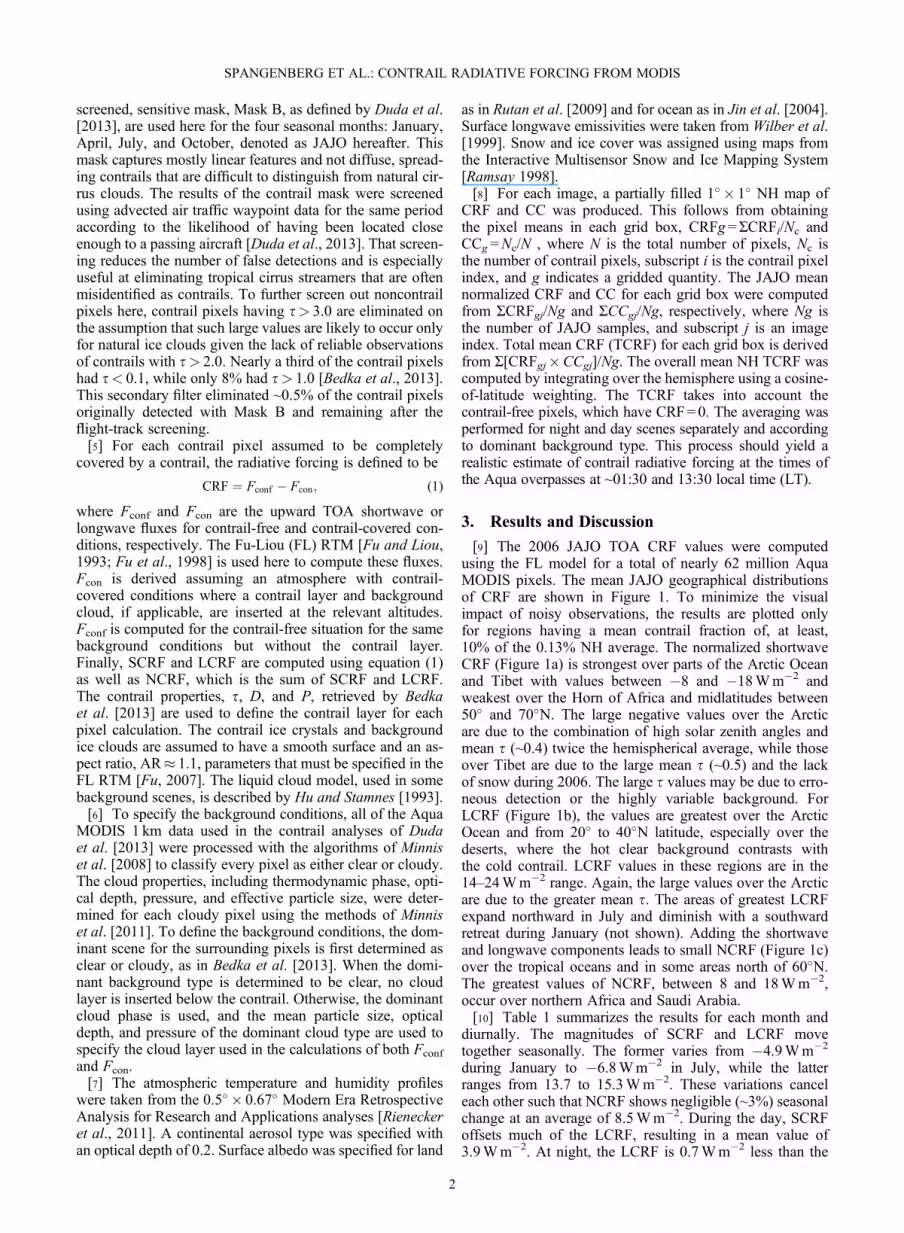
[9] The 2006 JAJO TOA CRF values were computedusing the FL model for a total of nearly 62 million AquaMODIS pixels. The mean JAJO geographical distributionsof CRF are shown in Figure 1. To minimize the visualimpact of noisy observations, the results are plotted onlyfor regions having a mean contrail fraction of, at least,10% of the 0.13% NH average. The normalized shortwaveCRF (Figure 1a) is strongest over parts of the Arctic Oceanand Tibet with values between �8 and �18Wm�2 andweakest over the Horn of Africa and midlatitudes between50� and 70�N. The large negative values over the Arcticare due to the combination of high solar zenith angles andmean t (~0.4) twice the hemispherical average, while thoseover Tibet are due to the large mean t (~0.5) and the lackof snow during 2006. The large t values may be due to erro-neous detection or the highly variable background. ForLCRF (Figure 1b), the values are greatest over the ArcticOcean and from 20� to 40�N latitude, especially over thedeserts, where the hot clear background contrasts withthe cold contrail. LCRF values in these regions are in the14–24Wm�2 range. Again, the large values over the Arcticare due to the greater mean t. The areas of greatest LCRFexpand northward in July and diminish with a southwardretreat during January (not shown). Adding the shortwaveand longwave components leads to small NCRF (Figure 1c)over the tropical oceans and in some areas north of 60�N.The greatest values of NCRF, between 8 and 18Wm�2,occur over northern Africa and Saudi Arabia.[10] Table 1 summarizes the results for each month and
diurnally. The magnitudes of SCRF and LCRF movetogether seasonally. The former varies from �4.9Wm�2
during January to �6.8Wm�2 in July, while the latterranges from 13.7 to 15.3Wm�2. These variations canceleach other such that NCRF shows negligible (~3%) seasonalchange at an average of 8.5Wm�2. During the day, SCRFoffsets much of the LCRF, resulting in a mean value of3.9Wm�2. At night, the LCRF is 0.7Wm�2 less than the
SPANGENBERG ET AL.: CONTRAIL RADIATIVE FORCING FROM MODIS
2

daytime mean, presumably due to a cooler surface. Also, atnight, the NCRF is equal to the LCRF and, therefore, is~3.6 times larger than its daytime counterpart.[11] The normalized results provide a measure of sensitiv-
ity to the presence of contrails but do not provide an estimateof the overall contrail forcing. This is characterized by totalnet CRF (TNCRF), which is plotted in Figure 2 for JAJO2006. During the day (Figure 2a), the flight corridors overthe north Atlantic, north Pacific, southwest Asia, and easternEurope and Russia stand out remarkably well with TNCRFvalues of 20–60mWm�2, as well as some extreme valuesup to 70mWm�2. Most areas have positive daytimeTNCRF, but a significant number of areas in the Tropicshave negative or zero TNCRF. Without the reflected sun-light, TNCRF is dramatically enhanced at night (Figure 2b)with many areas over the North Atlantic, southern Asia, andcentral North America having values exceeding 80mWm�2
up to 160mWm�2. The corridors between both Europe andSouth America and Europe and southern Asia become quite
Figure 1. Normalized contrail radiative forcing for JAJO2006 Aqua MODIS data. a) Shortwave; b) longwave; c) net.
Table 1. Pixel Mean Normalized Contrail Radiative Forcing andNumber of Contrail Pixels for Each Seasonal Month of 2006
Time Period
SCRF LCRF NCRF
N (�107)(Wm�2)
January �4.9 13.7 8.7 1.7April �5.8 14.2 8.4 1.6July �6.8 15.3 8.4 1.5October �5.3 13.9 8.5 1.4JAJOAll times �5.7 14.2 8.5 6.2Day �10.7 14.6 3.9 3.3Night 0.0 13.9 13.9 2.9
Figure 2. Mean total net contrail radiative forcing duringJAJO 2006 from Aqua MODIS data.
SPANGENBERG ET AL.: CONTRAIL RADIATIVE FORCING FROM MODIS
3

visible at night. Combining the day and night results yieldsa pattern in total TNCRF (Figure 2c) that is most similar tothat at night. The greatest values of TNCRF are evidentover the North Atlantic, the Persian Gulf, and Malaysia.The few areas having zero or negative TNCRF are overthe central Pacific where air traffic is sparse and the impactis negligible.[12] The NH total CRF means are listed in Table 2. The
total shortwave CRF (TSCRF) varies from �6.0mWm�2
in October to �8.1mWm�2 in April, while total longwaveCRF (TLCRF) ranges from 15.0 to 19.6mWm�2 for therespective months. The maximum TNCRF during Januarydrops 3mWm�2 to a minimum during October, yielding aNH JAJO mean of 10.6mWm�2. This 28% seasonal changeis driven by the CC, which shows a 25% decrease relative tothe JAJO mean between the same 2months. During thedaytime, TNCRF averages only 4.6mWm�2 but increasesto 16.7mWm�2 at night. The nocturnal contrail coverageaccounts for 47.5% of the total coverage, so it is clear thatflights occurring in the dark are responsible for much ofthe net climate impact of contrails.[13] Assuming that the NH forcing computed here is rep-
resentative of the globe, then the global radiative forcingcan be estimated by scaling the TCRF by relative amountsof air traffic in the two hemispheres. Based on the waypointdata used by Duda et al. [2013], 93% of the high altitude airtraffic takes place in the Northern Hemisphere. Thus, theglobal TSCRF, TLCRF, and TNCRF are estimated to be�3.9, 9.6, and 5.7mWm�2, respectively, for the linear con-trails detected by mask B assuming the average air trafficdensity is the same for both hemispheres. A sensitivity anal-ysis using other assumptions suggests that the globalTNCRF is certain to within �0.1 and +0.3mWm�2. TheJAJO 2006 mean global contrail coverage is estimated tobe 0.070%.[14] The frequency distributions of CRF provide another
measure of contrail effects that should be valuable for modelevaluation. Figure 3 shows the normalized JAJO CRF fre-quency distributions for all scenes. This histogram is similarto those for specific background types (not shown). Themost common SCRF value is between 0 and 5Wm�2,which is primarily due to night pixels. SCRF frequencydecreases almost exponentially with decreasing SCRF.Values of SCRF<�10Wm�2 are nearly twice as commonover clear backgrounds as over cloudy scenes because of thegenerally low surface albedos (not shown). The LCRF fre-quency peaks at ~7.5Wm�2 for all scene types and dropsexponentially to a minimum near 40Wm�2. Essentially,LCRF is always positive. Maximum NCRF frequency is
evident between 0 and 5Wm�2 and decreases exponen-tially to 40Wm�2, but ~12% of the pixels have slightlynegative values.[15] Although the histograms for the various scene types
are similar to those in Figure 3, subtle differences combineto produce variations in the average values for each back-ground type. Table 3 lists the mean CRF values for the threebackground conditions. During daytime, the magnitude ofSCRF is greatest for clear scenes and least for water cloudbackgrounds, reflecting the difference in relative mean albe-dos of the scene types. LCRF is also greatest for clear scenesbut is larger over water cloud than over ice clouds. As aresult, the magnitude of NCRF is greatest over water clouds,which are highly reflective and warm, and is least over iceclouds, which are often similar to the contrails overlyingthem. Water cloud backgrounds occur most often or 45%of the time, while clear backgrounds are only seen for 24%of the pixels. At night, the greatest NCRF occurs over clearbackgrounds, where the mean value is 5.9Wm�2 larger thanthe average over ice clouds. These results suggest that flyingover or within extant ice clouds would minimize CRF.[16] The results presented here only represent the CRF at
the Aqua overpass times, twice per day in most areas,although ~4–6 overpasses occur per day in the Arctic, wherecontrail cover is sparse. The time of day for computing CRFis important for several reasons. Air traffic undergoes a largediurnal cycle with more than 60% occurring during daylight[Stuber and Forster, 2007]. Additionally, the SCRF dependson the time of day because of the solar zenith angle depen-dence of contrail albedo [Myhre and Stordal, 2001]. Thecontrail coverage at night is not entirely proportional to thenocturnal air traffic relative to the daytime, probably becausethe heavier air traffic during the day and more variable
Table 2. Monthly and Estimated 2006 Mean Total Contrail Radi-ative Forcings and Contrail Coverage
Time Period
TSCRF TLCRF TNCRF
CC %(mWm�2)
January �7.3 19.4 12.1 0.144April �8.1 19.6 11.5 0.142July �7.9 17.7 9.8 0.125October �6.0 15.0 9.1 0.111JAJOAll times �7.3 17.9 10.6 0.131Day �14.6 19.2 4.6 0.137Night 0.0 16.7 16.7 0.124
Figure 3. Normalized frequency of occurrence of contrailpixel radiative forcing values for JAJO 2006 Aqua MODISretrievals.
Table 3. Mean Pixel Normalized Contrail Radiative Forcing overDifferent Background Types from NH Aqua MODIS Data for FourSeasonal Months of 2006
Water Cloud Ice Cloud Clear
DaySCRF (Wm�2) �8.8 �10.4 �14.6LCRF (Wm�2) 14.5 11.7 18.5NCRF (Wm�2) 5.7 1.3 3.9N (�106) 14.9 10.2 7.9NightLCRF/NCRF (Wm�2) 14.8 11.0 16.9N (�106) 15.1 9.4 4.3
SPANGENBERG ET AL.: CONTRAIL RADIATIVE FORCING FROM MODIS
4

background make detection of individual contrails moredifficult than shortly after local midnight when flights areless likely to overlap [Duda et al., 2013]. Many of the unde-tected contrails during the day fall into the contrail cirruscategory and are likely to increase the overall CRF. Thequestion of whether the averaged day and night overpassesrepresent the true 24 h average CRF of linear contrails willrequire further study.[17] Assuming that the global average, 5.7mWm�2,
presented here is representative of a 24 h mean, it can becompared to previous model estimates. It is less than the8.4mWm�2 estimate of Marquart et al. [2003] for 2015;the difference can be partially explained by differences incontrail coverage. Rap et al. [2010] employed the Ponateret al. [2002] contrail scheme and found a global averageTNCRF of 7.7mWm�2 for 2002 air traffic for contrail cov-erage of 0.11% and t = 0.2. Yi et al. [2012] used the sameapproach as Rap et al. [2010] in a different climate modeland obtained a value of TNCRF that is double the resultfound here but comparable to that reported by Lee et al.[2009]. The best estimate from Minnis et al. [1999] fort= 0.3 and CC=0.09% produced TNCRF= 17mWm�2.All but 3mWm�2 of the discrepancy with the current resultscan be explained by the larger t and slightly greater CC usedin the earlier report. The remainder is likely due to the differ-ences in the treatment of the contrail pressure and back-ground. In general, it appears that the current estimate issomewhat lower than many of the model results of the pastdecade. Since linear contrail coverage is defined only bythe satellite mask, it is possible that the models’ definitionsinclude more spreading contrails than detected by the con-trail mask used here.
4. Concluding Remarks
[18] This study has estimated, for the first time, the hemi-spherical radiative forcing of linear contrails based on simul-taneous observations of contrails and their environment. TheTOA CRFs normalized to 100% contrail cover show awarming effect of ~8.5Wm�2. Taking the contrail coverageinto account, this translates to a NH TNCRF mean of10.6mWm�2 with a seasonal range of 9.1–12.1mWm�2.The greatest warming effect occurs during winter when con-trail coverage peaks. Some areas, such as the North Atlanticair corridor, experience TNCRF values ranging up to 80mWm�2. The nocturnal contribution to the average TNCRF is~3.6 times the daytime value. Assuming that the NorthernHemisphere results are representative of other parts of theglobe, it is estimated that the net contrail radiative forcingis 5.7mWm�2, which is generally smaller than most climatemodel results.[19] The CRF results presented here are based on the sen-
sitive contrail mask (mask B) of Duda et al. [2013] and con-sidered to be a best estimate of the net warming effects onthe Earth-atmosphere system due to linear contrails. Contrailcirrus was not considered here. Including it would signifi-cantly increase the contrail fractions, and a more pronouncedwarming effect would be seen for most areas in the NorthernHemisphere, especially along the main flight corridors. Forexample, using the most sensitive contrail mask (mask C)of Duda et al. [2013] would lead to a factor of 3 increasein the total mean net CRF. But it is not clear if the numberof false contrails detected in that mask balances the missed
contrail cirrus (e.g., Minnis et al., Linear contrail and con-trail cirrus properties derived from satellite data, submittedto Geophysical Research Letters, 2013). Additional researchis needed to assess the contrail cirrus effects. The mostconservative estimate of contrail effects based on the conser-vative mask (mask A) would halve the CRF values reportedin this study. To determine if the results presented here for4months of Aqua data are representative for linear contrails,it will be necessary to apply the methods used here to addi-tional months of Aqua data and to data from Terra MODISto better cover the diurnal cycle of air traffic and clouds.The current results, however, are useful for model validationand should reduce the uncertainty in our knowledge of linearcontrail effects.
[20] Acknowledgments. This work was supported by the AviationClimate Change Research Initiative (ACCRI) under contract DTRT57-10-X-70020 with the DOT. Any opinions, findings and conclusions or recom-mendations expressed in this material are those of the authors and do notnecessarily reflect the views of the US DOT Volpe Center, the US FAA,or EUROCONTROL.
ReferencesBedka, S. T., P. Minnis, D. P. Duda, R. Boeke, and R. Palikonda (2013),Contrail properties over the Northern Hemisphere from 2006 AquaMODIS data, Geophys. Res. Lett., 40, doi:10.1029/2012GL054363.
DeLeon, R. R., M. Krämer, D. S. Lee, and J. C. Thelen (2012), Sensitivityof radiative properties of persistent contrails to the ice water path, Atmos.Chem. Phys., 12, 7893–7901.
Duda, D. P., P. Minnis, K. Khlopenkov, R. Boeke, and R. Palikonda (2013),Estimation of 2006 Northern Hemisphere contrail coverage usingMODIS data, Geophys. Res. Lett., 40, doi:10.1029/2012GL054392.
Fu, Q., and K.-N. Liou (1993), Parameterization of the radiative propertiesof cirrus clouds, J. Atmos. Sci., 50, 2008–2025.
Fu, Q., P. Yang, and W. B. Sun (1998), An accurate parameterization of theinfrared radiative properties of cirrus clouds for climate models, J. Clim.,11, 2223–2237.
Fu, Q. (2007), A new parameterization of an asymmetry factor of cirrusclouds for climate models, J. Atmos. Sci., 64, 4140–4150, doi:10.1175/2007JAS2289.1.
Hu, Y. X., and K. Stamnes (1993), An accurate parameterization of theradiative properties of water clouds suitable for use in climate models,J. Clim., 6, 728–742.
Jin, Z., T. P. Charlock, W. L. Smith, and K. Rutledge (2004), A parameter-ization of ocean surface albedo, Geophys. Res. Lett., 31, L.22301.
Lee, D. S., D. W. Fahey, P. M. Forster, P. J. Newton, and R. C. N. Wit, et al.(2009), Aviation and global climate change in the 21st century, Atmos.Environ., 43, 3520–3537.
Marquart, S., M. Ponater, F. Mager, and R. Sausen (2003), Future develop-ment of contrail cover, optical depth, and radiative forcing: Impacts ofincreasing air traffic and climate change, J. Clim., 26, 2890–2904.
Meerkötter, R., U. Schumann, D. R. Doelling, P. Minnis, T. Nakajima, andY. Tsushima (1999), Radiative forcing by contrails, Ann. Geophys., 17,1070–1084.
Meyer, R., H. Mannstein, R. Meerkotter, U. Shumann, and P. Wendling(2002), Regional radiative forcing by line-shaped contrails derivedfrom satellite data, J. Geophys. Res., 107(D10), 4104, doi:10.1029/2001JD000426.
Minnis, P., U. Schumann, D. R. Doelling, K. M. Gierens, and D. W. Fahey(1999), Global distribution of contrail radiative forcing, Geophys. Res.Lett., 26, 1853–1856.
Minnis, P., et al. (2011), CERES Edition-2 cloud property retrievals usingTRMMVIRS and Terra and Aqua MODIS data-Part 1: Algorithms, IEEETrans. Geosci. Remote Sens., 49, 4374–4400.
Minnis, P., et al. (2008), Cloud detection in non-polar regions for CERESusing TRMM VIRS and Terra and Aqua MODIS data, IEEE TransGeosci. Remote Sens., 46, 3857–3884.
Myhre, G., and F. Stordal (2001), On the tradeoff of the solar and infraredradiative impact of contrails, Geophys. Res. Lett., 28, 311903122.
Palikonda, R., P. Minnis, D. P. Duda, and H. Mannstein (2005), Contrailcoverage derived from 2001 AVHRR data over the continental UnitedStates of America and surrounding areas, Meteor. Z., 14, 515–523.
Ponater, M., S. Marquart, and R. Sausen (2002), Contrails in a comprehen-sive climate model: Parameterization and radiative forcing, J. Geophys.Res., 107(D13), 4164, doi:10.1029/2001JD000429.
SPANGENBERG ET AL.: CONTRAIL RADIATIVE FORCING FROM MODIS
5

Ramsay, B. H. (1998), The interactive multisensor snow and ice mappingsystem, Hydrol. Process, 12, 1537–1546.
Rap, A., P. M. Forster, A. Jones, O. Boucher, J. M. Haywood, N. Bellouin, andR. R. De Leon (2010), Parameterization of contrails in the UK Met Officeclimate model, J. Geophys. Res., 115, D10205, doi:10.1029/2009JD012443.
Rienecker, M. M., et al. (2011), MERRA: NASA’s modern-era retrospec-tive analysis for research and applications, J. Clim., 24, 3624–3648,doi:10.1175/JCLI-D-11-00015.1.
Rutan, D., F. Rose, M. Roman, N. Manalo-Smith, C. Schaaf, andT. Charlock (2009), Development and assessment of broadband surfacealbedo from Clouds and the Earth’s Radiant Energy System Clouds andRadiation Swath data product, J. Geophys. Res., 114, D08125,doi:10.1029/2008JD010669.
Stuber, N., and P. Forster (2007), The impact of diurnal variationsof air traffic on contrail radiative forcing, Atmos. Chem. Phys., 7,3153–3162.
Wilber, A. C., D. P. Kratz, and S. K. Gupta (1999), Surface emissivity mapsfor use in satellite retrievals of longwave radiation, NASA Tech. Memo.,TP-1999-209362, 30 pp.
Yang, P., G. Hong, A. E. Dessler, S. C. Ou, K.-N Liou, P. Minnis, andHarshvardan (2010), Contrails and induced cirrus: Optics and radiation,Bull. Am. Meteorol. Soc., 91, 473–478.
Yi, B., P. Yang, K.-N. Liou, P. Minnis, and J. Penner (2012), Simulation ofthe global contrail radiative forcing and test of its sensitivity, Geophys.Res. Lett., 39, doi:10.1029/2012GL054042
SPANGENBERG ET AL.: CONTRAIL RADIATIVE FORCING FROM MODIS
6