constraints on global fire activity vary across a resource gradient
TRANSCRIPT

Ecology, 92(1), 2011, pp. 121–132� 2011 by the Ecological Society of America
Constraints on global fire activity vary across a resource gradient
MEG A. KRAWCHUK1
AND MAX A. MORITZ
Department of Environmental Science, Policy and Management, 137 Mulford Hall, MC#3114, University of California,Berkeley, California 94720 USA
Abstract. We provide an empirical, global test of the varying constraints hypothesis,which predicts systematic heterogeneity in the relative importance of biomass resources toburn and atmospheric conditions suitable to burning (weather/climate) across a spatialgradient of long-term resource availability. Analyses were based on relationships betweenmonthly global wildfire activity, soil moisture, and mid-tropospheric circulation data from2001 to 2007, synthesized across a gradient of long-term averages in resources (net primaryproductivity), annual temperature, and terrestrial biome.
We demonstrate support for the varying constraints hypothesis, showing that, while keybiophysical factors must coincide for wildfires to occur, the relative influence of resources toburn and moisture/weather conditions on fire activity shows predictable spatial patterns. Inareas where resources are always available for burning during the fire season, such assubtropical/tropical biomes with mid-high annual long-term net primary productivity, fuelmoisture conditions exert their strongest constraint on fire activity. In areas where resourcesare more limiting or variable, such as deserts, xeric shrublands, or grasslands/savannas, fuelmoisture has a diminished constraint on wildfire, and metrics indicating availability ofburnable fuels produced during the antecedent wet growing seasons reflect a more pronouncedconstraint on wildfire. This macro-scaled evidence for spatially varying constraints provides asynthesis with studies performed at local and regional scales, enhances our understanding offire as a global process, and indicates how sensitivity to future changes in temperature andprecipitation may differ across the world.
Key words: circulation anomalies; climate; constraints on wildfire; energy and moisture gradients;global pyrogeography; resources and conditions; soil moisture; Spearman rank correlation; zero-inflatednegative binomial regression.
INTRODUCTION
Pyrogeography considers biophysical factors control-
ling the distribution and abundance of wildfire activity
(Krawchuk et al. 2009), including biomass resources to
burn, atmospheric conditions suitable for combustion
and propagation of fire, and ignition agents (Fig. 1a).
Although fire always needs these resources, conditions,
and an ignition, landscape-scale studies have highlighted
vast spatial and temporal heterogeneity in how each of
the factors contributes to variability in wildfire (e.g.,
Turner and Romme 1994, Bessie and Johnson 1995,
Cumming 2001, Moritz 2003, Mermoz et al. 2005,
Krawchuk et al. 2006). Earlier global pyrogeographies
have developed our understanding of macro-scaled
controls over fire (Dwyer et al. 2000, Scholze et al.
2006, Le Page et al. 2007, Chuvieco et al. 2008, Marlon
et al. 2008, Krawchuk et al. 2009), but none have
formally examined the relative contribution of fuels
(resources) and weather (conditions). Quantifying how
the relative roles of these factors fluctuate to generate
variability in global fire activity begins a synthesis of
global studies with landscape studies, developing our
understanding of the codependence of ecosystems and
fire through vegetation–disturbance–climate interactions
(Stephenson 1990, Bond et al. 2005) and how climate
change may alter these patterns (Scholze et al. 2006,
Bowman et al. 2009, Krawchuk et al. 2009).
A conceptual synthesis of local and regional wildfire
studies by Meyn et al. (2007) outlined environmental
gradients across which relative control over large,
infrequent fires might vary. Though Meyn et al. (2007)
illustrated the idea with respect to large, infrequent
events, the rationale holds for variation in fire activity,
too. Drier weather conditions during the fire season tend
to increase fire activity in biomass-rich areas such as wet
forests, where the dominant limiting factor is arguably
fuel moisture rather than fuel amount (see Plate 1). At
the other end of the spectrum, dry weather conditions
are common, and the dominant limiting factor for fire is
the ephemeral amount and/or connectivity of resources
to burn, such as in grasslands and some shrublands;
here, temperature and precipitation in the years or
growing period preceding the fire season tend to drive
fire activity through accumulation of fine fuels or by
modulating live fuel moisture. This conceptual model,
which we refer to here as the varying constraints
hypothesis, provides a framework that explicitly con-
Manuscript received 7 October 2009; revised 6 May 2010;accepted 2 June 2011. Corresponding Editor: J. B. Yavitt.
1 E-mail: [email protected]
121

FIG. 1. (a) Fire activity requires the coincidence of resources, conditions, and ignition; these are dynamic in space and time.(b) We hypothesized that the relative influence of resources and conditions for fire would vary such that SOILMC, SOILMN,SOILMA, and ANOM would have characteristically positive or negative relationships (arrows) with fire activity (y-axis) accordingto a global gradient in resource availability (x-axis). (SOILMC, SOILMN, SOILMA represent current soil moisture conditions,near-term conditions, and antecedent conditions, respectively; ANOM represents the 500 hPa height [midtropospheric] circulationanomaly.) The thick line depicts an abstracted baseline relationship between long-term fire probability and global resources toburn, depicted by net primary productivity (NPP), as estimated by Krawchuk et al. (2009). The locations of arrows areapproximate, but they indicate the general region along the global resource gradient where we expected to see these varyingconstraints. Dashed arrows indicate examples of additional strong controls over wildfire activity that were not tested explicitly inthe study but are mentioned in the Discussion.
MEG A. KRAWCHUK AND MAX A. MORITZ122 Ecology, Vol. 92, No. 1

siders spatial gradients in the relative importance of
controls over wildfire, rather than a binary view of
weather/fuel moisture vs. fuel amount. Specifically, we
propose that the relative influence changes systemati-
cally according to scarcity or variability: where resources
to burn are available all the time, then fuel moisture
conditions are likely to be relatively more important; in
contrast, if resources are ephemeral, then their avail-
ability should regulate wildfire.
Supporting evidence for the varying constraints
hypothesis comes from geographically diverse studies
ranging from western North America (Swetnam and
Betancourt 1990, Westerling et al. 2003, Gedalof et al.
2005, Sherriff and Veblen 2008, Littell et al. 2009) to the
tropics/subtropics (van der Werf et al. 2008), but this
conceptual model has not been quantitatively tested for
global consistency. Furthermore, many of the constitu-
ent studies provide local evidence for varying con-
straints, yet do not address a resource gradient
explicitly. The goal of our study was thus to determine
whether the importance of resources and conditions for
wildfire changed predictably over a global gradient in
biomass resource availability, using globally extensive
empirical data. Our analyses examined the relationship
between remotely sensed monthly global fire activity
(2001–2007) vs. monthly moisture metrics during the fire
season and those leading up to it. In addition to soil
moisture, we proposed a further metric of fire weather
conditions, anomaly in mean monthly 500 hPa geo-
potential height, that has been shown to characterize
prime conditions for fire (Johnson and Wowchuk 1993)
in mid and high latitudes.
MATERIALS AND METHODS
We sampled all study variables at a spatial resolution
of 50 km (i.e., 2500 km2) using a Behrmann equal area
projection. The sample included only terrestrial areas of
the globe and excluded Greenland and Antarctica,
resulting in a total of 52 298 sample points.
Fire
We acquired monthly summaries of MODIS (Mod-
erate Resolution Imaging Spectroradiometer) Collection
5 corrected active fire data (Giglio et al. 2006a) detected
by the Terra satellite from January 2001 to December
2007, resulting in 84 months of data. The MODIS sensor
provides data at a spatial resolution of 1 km from twice-
daily passes of the Terra satellite over the globe, and
detects actively burning fires using infrared bands.
MODIS can detect flaming and smoldering fires of
;1000 m2, and under good conditions fires of 100 m2
can be detected. Raw data corrections include adjust-
ment for multiple satellite overpasses, cloud cover, and
persistent static fire sources indicative of nonvegetation
fire. The resulting data are provided as 0.58 monthly
climate model grids (CMG) for the globe (Giglio et al.
2006a). We selected the Terra Collection over the Aqua
satellite since the former had a longer period of record.
As with all remotely sensed fire data, there are omission
(e.g., undetectable understory fires or short-duration
fires occurring between twice daily satellite passes) and
commission errors; however, extensive diagnostics on
the MODIS active fire data show them as a robust index
of global fire activity (Giglio et al. 2006a, b).
After registering fire data to our 50-km resolution
sampling grid, we determined the dominant fire season
for each location based on observed temporal patterns
of fires. We identified the peak of the fire season as the
month of the year with the highest number of events
over the seven-year record. Patterns observed in van der
Werf et al. (2003) and Giglio et al. (2006a) showed peak
fire activity to be very similar to our calculations. We
then described the potential fire season as the three
months preceding and following this peak, based
liberally on length of fire season presented in Giglio et
al. (2006a). This is a simplification of fire seasonality,
but one that allowed us to confine analyses to the most
relevant time periods. We also used the fire season’s
peak to inform calculations of fire constraints (see Fire
constraints: SOILMA).
Fire constraints
We used four metrics to test hypotheses examining
whether seasonal constraints on wildfire activity vary
PLATE 1. Fire burning in a mixed conifer forest inCalifornia (USA), an environment with intermediate amountsof biomass availability within the global rersource gradient.Photo credit: M. A. Krawchuk.
January 2011 123VARYING CONSTRAINTS ON GLOBAL FIRE

across a global long-term resource gradient (Fig. 1b).
Three metrics were derived from soil moisture data and
one from 500-hPa tropospheric heights. We confined
our assessment to these four metrics, since the goal was
to test particular hypotheses associated with their
variability, rather than to build a global predictive
model of fire activity or seasonality. Current soil
moisture (SOILMC) was calculated for each month for
each location to characterize the moisture (dryness) of
live and dead fuels and their propensity to burn; for
example, SOILMC would then be analyzed with respect
to the amount of fire activity in that month and location.
Near-term soil moisture (SOILMN) was calculated from
mean monthly soil moisture in the first and second
months prior to the month of fire activity, representing
slightly longer-term drought conditions. Antecedent soil
moisture conditions (SOILMA) were calculated as mean
monthly soil moisture of the fourth to eighth months
prior to the peak of the fire season. For warmer and
drier climates where burning conditions are common
and fuels may be limiting, SOILMA indicated moisture
availability in the growing period prior to the fire season
as a proxy for resources to burn. For example, high
SOILMA would lead to more productivity, and these
fuels would then cure during the dry season, resulting in
a greater fire activity (Spessa et al. 2005). Phenology
differs among types of fine fuels (e.g., herbaceous plants)
and fuel accumulation may occur over numerous years,
but the SOILMA metric provides a relatively simple
index of potential variability in amount of fine fuel
available to burn. In colder climates, higher soil
moisture in months preceding the fire season’s peak
characterizes accumulation of precipitation (hypotheti-
cally, snow), which would contribute to soil recharge
and generate higher moisture conditions and thus less
fire during the fire season. Fig. 1b illustrates our
hypothesized relationships between fire activity and
SOILM variables, as well as how they might vary across
a gradient in resource availability.
All three SOILM indices were generated from the
Climate Prediction Center’s Soil Moisture data, provid-
ed by the NOAA/OAR/ESRL PSD, Boulder, Colorado,
USA, available at a 0.5-degree spatial resolution
(available online).2 These soil moisture data are modeled,
based on monthly averaged soil moisture water height
equivalents. High values indicate more soil moisture.
Units are in millimeters, and values represent soil
moisture in a single column of 1.6 m, taking on a
maximum value of 760 mm (ranges in Appendix A).
These data have been validated in the United States (van
den Dool et al. 2003), and are described in Fan and van
den Dool (2004). Soil properties are assumed constant in
the model. There is no equation for snow and ice, so
precipitation is added as a liquid at all times. The effect
of measuring snow in liquid form is an overestimation of
water supply during winter in colder climates, followed
by underestimation when snow melts. This would have
most influence on calculations of SOILMA in temperate,
boreal, and high-elevation parts of the world where
snow occurs during the months preceding the fire
season. However, moisture accumulation as snow would
have an equivalent effect from year to year, with the
relative amount of soil moisture recharge from snow
melt varying according to precipitation. Our primary
analyses were performed for time series data at each grid
location rather than among locations, so correlations
between SOILMA and fire activity would not be
invalidated by differences in water phase.
In addition to the three soil moisture metrics, we
generated the 500 hPa height (midtropospheric) circula-
tion anomaly (ANOM) for each month and location to
quantify potential fire weather conditions. Studies in the
boreal forest (Skinner et al. 2002, Macias Fauria and
Johnson 2008), northwestern United States (Gedalof et
al. 2005), and Portugal (Pereira et al. 2005) have shown
the regional utility of these anomalies as synoptic fire
weather indices (Johnson and Wowchuk 1993), where
positive values represent upper air blocking high-
pressure systems that obstruct atmospheric circulation
and lead to a lack of precipitation and rapid drying of
fuels. Blocking ridges are features of the mid and high
latitudes where westerly upper flow prevails. The
breakdown of these ridges can generate strong surface
winds and enhanced lightning, which in association with
dried fuels, result in prime conditions for fire. The
ANOM index was calculated using monthly values of
500 hPa height from NCEP Reanalysis 1 data (Kalnay
et al. 1996), provided by the NOAA/OAR/ESRL PDS
in Boulder, Colorado, USA on their web site at a spatial
resolution of 2.5 degrees (see footnote 2). We used the
monthly data to create a long-term monthly mean for
each location, and anomalies were then calculated as the
difference between the month’s 500 hPa height and the
long-term mean for that month (ranges in Appendix A),
following Skinner et al. (2002).
Global gradients
We calculated three resource-related variables that are
long-term measures, or ‘‘normals,’’ quantifying gradi-
ents in radiant energy and water across the globe. These
variables were used to describe long-term variation in
resources for wildfire across which we hypothesized that
constraints would differ (Fig. 1b). Global gradients were
represented by mean annual temperature, net primary
productivity, and terrestrial biome (ranges in Appendix
A). Mean annual temperature (TEMP) was assigned
based on the WorldClim database (Hijmans et al. 2005),
generated from observed weather data from 1950 to
2000 and provided at a spatial resolution of 10 arc-
minutes. Net primary productivity (NPP), the amount
of carbon produced by an ecosystem per year, was
assigned for each location based on simulated NPP
values provided by Imhoff and Bounoua (2006) at a2 hhttp://www.cdc.noaa.gov/i
MEG A. KRAWCHUK AND MAX A. MORITZ124 Ecology, Vol. 92, No. 1

resolution of 0.25 degrees from the CASA model (Potter
et al. 1993). The CASA model uses satellite and climate
data to estimate the fixation and release of carbon.
Terrestrial biome (BIOME) was adopted from Olson et
al.’s (2001) classification (Fig. 2). We divided biomes
into three broad groupings according to temperature
conditions during the fire season: (1) warm, including
tropical/subtropical, temperate, and mediterranean bi-
omes; (2) hot/dry, including deserts and xeric shrublands
that provide rare and extremely ephemeral vegetation
for burning; and (3) cold, including montane, boreal,
and tundra biomes that have low amounts of resources
to burn and occur in relatively cold environments. We
excluded the mangrove biome from analyses outright
since these areas are not fire prone and would not
respond to SOILM variability.
Analyses
We used two analytical frameworks to test the
hypothesis of spatially varying constraints. Local
correlation analysis was the principal tool, which used
the series of data at each location to examine how fire
activity was correlated with explanatory variables over
the study period. The benefit of this technique was the
ability to focus on fire–climate relationships at each
location independently; the disadvantage was its poten-
tial sensitivity to the number of zeroes in the data.
Generalized multivariate global regression analysis was
the supporting tool we used, which aggregated data
from all locations and times together. The benefit of this
method was its explicit handling of zero-inflated
response data; however, the disadvantage for our
purposes was that information from different locations
would be pooled together, thus obscuring particular
relationships occurring at a given location through time.
The global regression analysis was used as supporting
evidence for forms and patterns found in the main
correlation analysis.
For correlation analyses, we quantified fire–SOILM
and fire–ANOM relationships in each month of the fire
season at each sampling location, and then determined
whether these relationships varied predictably according
to long-term resource availability gradients character-
ized by NPP, TEMP, and BIOME. At each location, we
used a Spearman rank correlation test to quantify the
approximately linear fire–SOILM and fire–ANOM
relationships. We performed analyses on all locations
where fire was detected in three or more months and
then further restricted analyses to locations with fire
detected in .10 months. The latter cut-off was used to
test the robustness of the correlation analyses. By
focusing on areas where three or more fire events
occurred over the study period, we were unable to
examine varying constraints in environments where fire
is extremely rare or infrequent. Further, we limited our
analyses to the fire season to focus on variation, rather
than general seasonality or overall prediction of fire
activity.
We used the nonparametric Spearman rank correla-
tion because data were not bivariate-normally distrib-
uted; in some locations there were a high number of
zeroes in monthly fire activity. We found strong support
for a monotonic form in the fire–SOILM relationships
and moderate support for fire–ANOM using loess
FIG. 2. The 13 terrestrial BIOMEs used in the study, based on Olson et al.’s (2001) classification.
January 2011 125VARYING CONSTRAINTS ON GLOBAL FIRE

smoothers of scatter plot data across randomly sampled
locations; for the latter, fire increased with ANOM,
followed by a slight decrease at high, positive values.
Given these exploratory analyses, we judged a mono-
tonic correlation test for the time series of data at each
location to be appropriate for our data.
To examine spatial patterns in the resulting fire–
SOILM and fire–ANOM relationships, we mapped the
correlation coefficients. We then examined the polarity
and magnitude of correlation coefficients against gradi-
ents in NPP, TEMP, and BIOME using covariate plots
and box-and-whisker plots to determine if there were
systematic global patterns that supported or refuted the
varying constraints hypothesis.
For the supporting regression analysis, we pooled
data from the full spatial and temporal extent of the
study area together and quantified the relationship
between monthly fire activity and each of the three
SOILM variables using regression analysis. So that
results would be comparable with correlation analyses,
we built separate models to test each of the fire–SOILM
relationships, using locations where three or more
months of fire were detected. We used zero-inflated
negative binomial (ZINB) multivariate regression, which
considered fire data to be a mixture of two distributions,
a negative binomial and a binomial. Explanatory
variables in the negative binomial (count) component
of the model included SOILMC (or SOILMN or
SOILMA), BIOME, and their interaction. The
SOILM–BIOME interaction allowed rough comparison
with correlation analyses. Variables included in the zero-
inflated (binomial) component included NPP, lightning
activity, and the human footprint. These non-SOILM
variables were used to account for some of the
additional underlying factors underlying fire activity in
the pooled data. Human activity and lightning are
strongly connected with fire activity through ignition,
and we used two available products, the human
footprint (Sanderson et al. 2002) and NASA’s lightning
climatology (Christian et al. 2003) as long-term esti-
mates of their distribution across the globe. Though the
fire relationship with these two variables is extremely
complex, we included them here as simple linear
relationships.
Since we were using the ZINB analysis as corrobora-
tion for the local correlation analyses, we did not focus
on strongly spatial or temporal structure inherent in the
pooled fire data (e.g., autocorrelation); instead, we
simply used a random 20% subset of data for the ZINB
analysis, and repeated the subset and model procedure
10 times to check for consistent results in the polarity of
parameter estimates.
RESULTS
Our fire activity cutoff of three or more months
resulted in sampling 28 728 locations, and a cut-off of 10
or more months resulted in 18 869 locations, represent-
ing 55% and 36% of the terrestrial sampling area,
respectively (Fig. 3). Locations excluded from this cutoff
occurred in biomes where fire is known to be relatively
uncommon, but .25% of locations from all biomes were
maintained in analyses (Appendix B), with the exception
of the tundra, where cold temperatures generally
diminish primary productivity and fire. Spearman rank
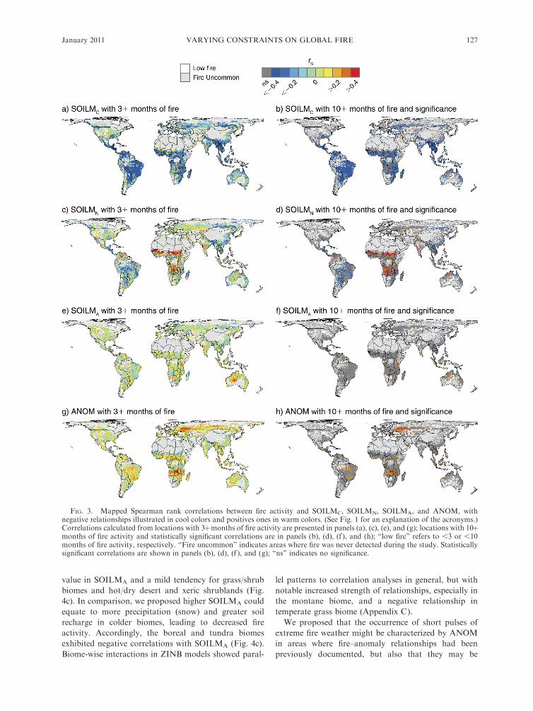
correlations between fire activity and SOILM(C,N,A)
varied in magnitude and polarity across the globe (Fig.
3). Soil moisture at the time of fire activity (SOILMC)
was the most pervasive constraint (Fig. 3a), and
statistically significant increases in activity occurred
with decreasing SOILMC in many locations (Fig. 3b).
The fire–SOILMC relationships varied systematically
across energy–moisture metrics characterized by NPP,
TEMP, and BIOME (Fig. 4a). Fire–SOILMC con-
straints were increasingly negative at higher levels of
NPP within each of the biome groupings in warmer
climates, and increasingly negative overall in cold
climates (Fig. 4a). Trends observed in the biome-wise
calculations were supported by ZINB models, and with
even stronger negative relationships for cold biome types
than observed in correlation analyses (Appendix C).
We proposed a negative fire–SOILMN relationship in
parallel with fire–SOILMC, suggesting SOILMN would
characterize prolonged drought conditions leading up to
the fire season. Low SOILMN should generate prime
conditions for burning, especially in more mesic and
cold climates that would presumably be more con-
strained by weather/climate conditions. Some of these
areas did exhibit strong, negative fire–SOILMN rela-
tionships (Fig. 3c, d), yet we also detected spatially
contiguous positive fire–SOILMN correlations across
the African Sahel, south-central Africa, Australia,
western India, and parts of South America. These
unexpected positive relationships largely occurred in
tropical/subtropical grassland biomes (Fig. 4b). Similar
trends were observed for biome-wise interactions in
ZINB models (Appendix C), although the montane
biome exhibited a positive relationship inconsistent with
local correlation analyses. Such slight differences be-
tween the ZINB and correlation models are not
unexpected given the pooling of all data and inclusion
of additional variables within the ZINB.
We hypothesized that in regions of the globe with
lower and more variable resource availability, such as
grasslands, woodlands, shrublands, and xeric shrub-
lands, the stimulation of vegetative productivity by
higher soil moisture conditions in antecedent growing
period (SOILMA), i.e., before the fire season, could
generate increased fine fuels and thus precondition the
area to more fire. Positive correlations with SOILMA
were detected over warmer resource-poor parts of the
world, and statistically significant correlations dominat-
ed in dry/hot desert areas, as well as central Argentinean
grasslands, and were patchily distributed through
eastern and southern African grasslands (Tanzania
and Botswana; Fig. 3e, f ). Box-and-whisker plots
showed a tendency for deserts to have a positive median
MEG A. KRAWCHUK AND MAX A. MORITZ126 Ecology, Vol. 92, No. 1
value in SOILMA and a mild tendency for grass/shrub
biomes and hot/dry desert and xeric shrublands (Fig.
4c). In comparison, we proposed higher SOILMA could
equate to more precipitation (snow) and greater soil
recharge in colder biomes, leading to decreased fire
activity. Accordingly, the boreal and tundra biomes
exhibited negative correlations with SOILMA (Fig. 4c).
Biome-wise interactions in ZINB models showed paral-
lel patterns to correlation analyses in general, but with
notable increased strength of relationships, especially in
the montane biome, and a negative relationship in
temperate grass biome (Appendix C).
We proposed that the occurrence of short pulses of
extreme fire weather might be characterized by ANOM
in areas where fire–anomaly relationships had been
previously documented, but also that they may be
FIG. 3. Mapped Spearman rank correlations between fire activity and SOILMC, SOILMN, SOILMA, and ANOM, withnegative relationships illustrated in cool colors and positives ones in warm colors. (See Fig. 1 for an explanation of the acronyms.)Correlations calculated from locations with 3þmonths of fire activity are presented in panels (a), (c), (e), and (g); locations with 10þmonths of fire activity and statistically significant correlations are in panels (b), (d), (f ), and (h); ‘‘low fire’’ refers to ,3 or ,10months of fire activity, respectively. ‘‘Fire uncommon’’ indicates areas where fire was never detected during the study. Statisticallysignificant correlations are shown in panels (b), (d), (f ), and (g); ‘‘ns’’ indicates no significance.
January 2011 127VARYING CONSTRAINTS ON GLOBAL FIRE

important in new, as yet unstudied regions of the globe.
Though our correlation analysis showed evidence for a
strong positive relationship with fire activity in some
locations (Fig. 3g, h), none of the patterns aligned
consistently with BIOME or gradients in NPP or
TEMP.
DISCUSSION
Our global test of the varying constraints hypothesis
demonstrates that while key biophysical factors must
coincide for wildfires to occur, the influence of moisture/
weather conditions and resources available to burn
varies spatially and shows predictable patterns based on
global gradients in primary productivity, temperature,
and biome. Patterns in fire activity illustrated here
include signals from both seasonality and interannual
variability, e.g., within and between years, but the key
message is the clear spatial variability in the strength and
polarity of fire–environment relationships. These vary-
ing constraints on wildfire are akin to spatially varying
trade-offs in limiting conditions of temperature (or
radiant energy) and moisture purported to underlie
biotic assemblages (Stephenson 1990, Hawkins et al.
2003, Brown et al. 2004, Kreft and Jetz 2007). Such
trade-offs, described in Hawkins et al. (2003) as the
water–energy dynamics hypothesis, suggest that species
richness at higher (i.e., colder) latitudes is controlled by
the availability of heat, whereas in the warmer, lower
latitudes, water- and humidity-related variables are the
main driving factors. For wildfire, we see that as
resources to burn are increasingly available, energy
limitation through drying of fuels via fuel/soil moisture
FIG. 4. Box-and-whisker plot distributions of the Spearman rank correlation coefficients between fire activity and (a) SOILMC,(b) SOILMN, and (c) SOILMA according to BIOMEs using data from Fig. 3b, d, and f. In the box-and-whisker plots, the boxindicates the 25th and 75th percentile (inter-quartile range) of the data, the mid band indicates the median, and whiskers indicatepoints within 1.5 times the inter-quartile range. In panel (a) the normalized distribution of net primary productivity (NPP) for eachBIOME is presented in gray to illustrate a gradient in resource availability; normalized values are NPP (g/C/year/0.58 divided by1.2 3 1012). Biomes are bracketed into groups according to general climate types.
MEG A. KRAWCHUK AND MAX A. MORITZ128 Ecology, Vol. 92, No. 1

conditions are a stronger constraint on wildfire activity,
especially in more mesic and/or colder areas. In warmer,
more arid climates where resources are more variable or
scarce, evidence that water availability prompting
production of vegetation during the growing season,
which would then cure for burning, was an increasingly
important constraint on fire. Though our use of
relatively coarse spatial resolution may obscure within-
pixel heterogeneity in resources and conditions, uncov-
ering these systematic patterns in climate-based con-
straints on fire suggests a macroscopic framework is
effective at synthesizing our understanding of global fire,
and its potential sensitivities to changing climate.
In more mesic areas where biomass is relatively
abundant, i.e., measured by mid-high levels of net
primary productivity (Kindermann et al. 2008), the
drying of live and dead/downed fuels indexed by
increasingly low measures of soil moisture resulted in
more fire activity detected during the burning season.
Our analyses showed increasingly negative fire–soil
moisture correlations (SOILMC) as net primary pro-
ductivity moved from low to mid-high levels in the warm
and hot/dry biomes, and this pattern was clear in both
the local correlation and global regression analyses.
Highly productive areas include moist tropical and
subtropical forests, where complex forest structure tends
to inhibit water loss from the understory and maintain a
moist microclimate that historically made them relative-
ly fire free (Cochrane 2003). However, dry spells in
conjunction with anthropogenic ignitions and manipu-
lation of forest structure to aid in burning for land
clearing (Nepstad et al. 2001, Cochrane 2003) has led to
increasing fire activity in these, and other high-produc-
tivity areas (‘‘human activity’’ in Fig. 1b). In the colder
biomes, fire–soil moisture correlations were strongly
negative, despite relatively low primary productivity,
suggesting a strong moisture constraint resulting from
low temperatures leading to low rates of evaporation.
In addition to examining effects of soil moisture
during the month of fire activity we also looked at the
effect of conditions in the two months preceding
(SOILMN), as an indicator of more chronic drought.
Though the expected negative correlations with
SOILMN in many parts of the world suggested that
prolonged dry spells did indeed lead to increased fire
activity, we also detected positive correlations suggesting
more fire when soil moisture was higher in deserts/xeric
shrublands and savanna regions. The global regression
models suggested positive relationships might also occur
in the montane savanna/grassland biome; similarly,
Archibald et al. (2009) suggest that in Southern Africa,
growth of grasses with late rains, and therefore high
SOILMN, followed by rapid drying of these fine fuels,
could lead to increased fire activity. This scenario is an
accelerated form of the relationship we proposed for soil
moisture during the growing season (SOILMA) in warm/
hot, resource-poor climates. Further, human-caused
fires early in the dry season are common in West Africa,
due to land-burning practices enacted to protect areas
from later dry-season fires (Nielsen and Rasmussen
2001, Laris and Wardell 2006), so that fire activity may
in fact follow wetter months that generate conditions
allowing for more controllable early burning.
In warm, dry grass/shrub type biomes or hot/dry desert
biomes where annual mean productivity is mid-low and
resource availability more variable, we proposed that
temporal variation in resources to burn would be a strong
constraint on fire activity. Whereas Spessa et al. (2005)
show relationships between monthly rainfall, vegetation,
and fire frequency in grassland and woodland commu-
nities in the northern Australian wet–dry tropics, we did
not test explicitly for variation in vegetation green-up
resulting from a wetter growing season. We instead
used higher soil moisture during the growing period
(SOILMA) prior to the fire season as a proxy for
productivity of fuels that would subsequently cure during
the dry season, and then contribute to fire activity. In
support of our hypothesis, we detected spatially contig-
uous patterns of positive correlations between fire activity
and soil moisture in the growing period for hot/dry and
warm areas of central-northern Australia, Tanzania, and
Botswana, representing desert and xeric shrubland,
tropical/subtropical grassland, and temperate grassland
biomes; there was also a smattering of positive correla-
tions through dry areas of the United States, Argentina,
and India. In contrast, for colder areas such as tundra
and boreal forest biomes, we detected some negative fire–
SOILMA relationships, supporting our hypothesis that
higher precipitation in the cold winter months (as a data-
constrained proxy of snow) could result in more soil
recharge and less fire activity. In reality, spring run-off in
mountainous terrain would likely also affect nearby areas
as well, but we did not include this mechanism in our
analyses. Recent increases in fire activity over the western
United States have been attributed to earlier snowmelt
and decreased winter (snow) precipitation (Westerling et
al. 2006), so our results suggest additional locations
where changes projected for winter precipitation by
climate models could have a relatively strong influence
on fire activity in the future.
Our evidence for lagged relationships between soil
moisture and fire activity aligns with some existing
regional studies, yet not with others, and the overall
extent of the signal was relatively small. Where our
results overlap with the spatial extent of regional work
by van der Werf et al. (2008) in the tropics, the patterns
are encouraging, especially in central-northern Austral-
ia. Using different metrics than ours, van der Werf et al.
(2008) showed that dryness during the fire season was a
strong driver of fire activity in biomass-rich areas, while
cumulative precipitation during the growing season in
advance of fire activity was a stronger driver in biomass-
poor regions. However, we were surprised to find only
limited time-lagged fire–SOILMA correlations in the
western United States, given that previous work has
demonstrated relationships with fire and indices of
January 2011 129VARYING CONSTRAINTS ON GLOBAL FIRE

antecedent productivity in the region (Swetnam and
Betancourt 1998, Westerling et al. 2003, Littell et al.
2009), largely characterized here as desert and xeric
shrubland biome. Our short sample period and relatively
fine spatiotemporal study resolution may have contrib-
uted to the poor showing, given that previous works
have been based on regional area-burned statistics and
included multiple years in lag times in soil moisture. The
aggregation of diverse fire regime and ecosystem types
within each study pixel may also obscure relationships
somewhat, but the justification of such a coarse scale
comes from the need to simplify, or stand back, to
uncover more general macroscopic trends. In doing so,
our data show patterns that support our predications,
which were largely generated from observations of local-
and regional-scaled dynamics.
We found limited support to suggest that circulation
anomalies (ANOM) provide stand-alone synoptic char-
acterization of fire weather over mid-high latitudes or
over a global extent. Gedalof et al. (2005) demonstrated
that high fire activity in wetter forests of the northwest-
ern United States required both severe drought and
prolonged blocking highs, suggesting that fire seasons
with chronic lower soil moisture could set the stage for
fire activity and that coincidence of a positive circulation
anomaly could provide conditions necessary for en-
hanced fire activity; we did not explore these interactions
in our study. Previous studies have also demonstrated
correlations that are spatially offset. Since the anomaly
data we used were generated at a coarser scale than fire
activity (2.5 vs. 0.5 degrees), they inadvertently included
upstream, or contextual, positive anomalies from the
spatial neighborhood. We had hoped that circulation
anomalies, and/or their resulting breakdown, might
provide a macro-scaled index of fire weather conditions
that integrated dry weather conditions as well as winds,
since winds are the bellows of high fire activity in many
locations, including the famous Santa Ana winds of
California (Moritz et al. 2010) and the Bergwinds of
South Africa (Geldenhuys 1994), and they are a
common factor used to calculate many fire weather
indices (Fosberg 1978, van Wagner 1987). As wind data
become increasingly available for many parts of the
world through reanalysis data (Kalnay et al. 1996) and
developments in weather modeling (Hughes and Hall
2009), it will be helpful to include them in future global
pyrogeographies.
Overall, increased soil moisture during the growing
season (warm-climate SOILMA) led to more fire activity
in grassland, savanna, shrubs, or woodlands, where
resource availability might vary among years due to
seasonality of herbaceous materials. There was little
overlap with the locations where we detected significant
relationships suggesting more fire in months with
decreased soil moisture (i.e., SOILMC and SOILMN).
Local fire–soil moisture correlations provided very
similar results to those estimated by the supporting
global regression analyses, giving credibility to the
hypothesis that constraints on fire activity vary spatially
across locations and biomes, and predictably along
resource availability gradients (Fig. 1b).
Fire–climate relationships were detected broadly
across the fire-prone areas of the globe, indicating that
climate is still a strong engine defining fire’s domain,
despite the important contribution of human activity to
wildfire through ignition and suppression of fires, as well
as alteration of fuel structure. However, there were
places where fire activity was not strongly related to the
soil moisture metrics or circulation anomalies. These
may be areas where anthropogenic activities such as
land management, industrial farming, and fire suppres-
sion may interact with climate regulation over fire
particularly strongly, or asynchronously (Le Page et al.
2010). For example, if small fires are detected quickly,
they can often be suppressed by initial attack before they
grow to be large (Arienti et al. 2006). Also, while the
study’s relatively coarse spatial resolution was chosen, in
part, to aggregate sufficient data for robust analyses,
some areas may not have experienced sufficient fire to
expose significant relationships in either the correlation
or regression analyses.
Together, the family of meso-meteorological indices
show evidence in support of spatially varying constraints
on fire that are systematic across the globe as a function
of a gradient in resource availability. While climate is a
superordinate driver over both conditions and resources
for wildfire, we show that the direct effect of climate on
fuel moisture and fire weather conditions is a relatively
stronger constraint over wildfire in some parts of the
planet, while other parts are constrained more strongly
by the indirect effect of climate on fuel accumulation
and structure. It will be an ongoing challenge to
understand how climate changes may shift fire’s range
and activity as a function of these varying constraints,
alongside and interacting with future changes in
biodiversity, productivity, and human behavior.
ACKNOWLEDGMENTS
Funding for this project was provided by a Natural Sciencesand Engineering Research Council of Canada PostdoctoralFellowship to M. A. Krawchuk. Our thanks to Marc-AndreParisien, Eric Waller, Walter Skinner, and reviewers TonyWesterling and Ze’ev Gedalof for comments and discussionsthat contributed greatly to the manuscript.
LITERATURE CITED
Archibald, S., D. P. Roy, B. W. van Wilgen, and R. J. Scholes.2009. What limits fire? An examination of drivers of burntarea in Southern Africa. Global Change Biology 15:613–630.
Arienti, M., S. Cumming, and S. Boutin. 2006. Empiricalmodels of forest fire initial attack success probabilities: theeffects of fuels, anthropogenic linear features, fire weather,and management. Canadian Journal of Forest Research 36:3155–3166.
Bessie, W. C., and E. A. Johnson. 1995. The relative importanceof fuels and weather on fire behavior in sub-alpine forests.Ecology 76:747–762.
Bond, W. J., F. I. Woodward, and G. F. Midgley. 2005. Theglobal distribution of ecosystems in a world without fire. NewPhytologist 165:525–537.
MEG A. KRAWCHUK AND MAX A. MORITZ130 Ecology, Vol. 92, No. 1

Bowman, D. M. J. S., et al. 2009. Fire in the earth system.Science 324:481–484.
Brown, J. H., J. F. Gillooly, A. P. Allen, V. M. Savage, andG. B. West. 2004. Toward a metabolic theory of ecology.Ecology 85:1771–1789.
Christian, H., R. Blakeslee, D. Boccippio, W. Boeck, D.Buechler, K. Driscoll, S. Goodman, J. Hall, W. Koshak, andD. Mach. 2003. Global frequency and distribution oflightning as observed from space by the Optical TransientDetector. Journal of Geophysical Research 108:4005.
Chuvieco, E., L. Giglio, and C. Justice. 2008. Global charac-terization of fire activity: toward defining fire regimes fromEarth observation data. Global Change Biology 14:1–15.
Cochrane, M. A. 2003. Fire science for rainforests. Nature 421:913–919.
Cumming, S. G. 2001. Forest type and wildfire in the Albertaboreal mixedwood: What do fires burn? Ecological Applica-tions 11:97–110.
Dwyer, E., J. M. Gregoire, and J. M. C. Pereira. 2000. Climateand vegetation as driving factors in global fire activity. Pages171–191 in M. Beniston, editor. Biomass burning and itsinter-relationship with the climate system. Kluwer Academic,London, UK.
Fan, Y., and H. van den Dool. 2004. Climate Prediction Centerglobal monthly soil moisture data set at 0.5 degrees resolutionfor 1948 to present. Journal of Geophysical Research–Atmospheres 109.:D10102. [doi: 10.1029/2003JD004345]
Fosberg, M. A. 1978. Weather in wildland fire management—Fire Weather Index. Bulletin of the American MeteorologicalSociety 59:341.
Gedalof, Z., D. L. Peterson, and N. J. Mantua. 2005.Atmospheric, climatic, and ecological controls on extremewildfire years in the northwestern United States. EcologicalApplications 15:154–174.
Geldenhuys, C. J. 1994. Bergwind fires and the location patternof forest patches in the southern Cape landscape, South-Africa. Journal of Biogeography 21:49–62.
Giglio, L., I. Csiszar, and C. O. Justice. 2006a. Globaldistribution and seasonality of active fires as observed withthe Terra and Aqua Moderate Resolution Imaging Spectror-adiometer (MODIS) sensors. Journal of Geophysical Re-search–Biogeosciences 111:G02016.
Giglio, L., G. R. van der Werf, J. T. Randerson, G. J. Collatz,and P. Kasibhatla. 2006b. Global estimation of burned areausing MODIS active fire observations. Atmospheric Chem-istry and Physics 6:957–974.
Hawkins, B. A., R. Field, H. V. Cornell, D. J. Currie, J. F.Guegan, D. M. Kaufman, J. T. Kerr, G. G. Mittelbach, T.Oberdorff, E. M. O’Brien, E. E. Porter, and J. R. G. Turner.2003. Energy, water, and broad-scale geographic patterns ofspecies richness. Ecology 84:3105–3117.
Hijmans, R. J., S. E. Cameron, J. L. Parra, P. G. Jones, and A.Jarvis. 2005. Very high resolution interpolated climatesurfaces for global land areas. International Journal ofClimatology 25:1965–1978.
Hughes, M., and A. Hall. 2009. Dynamics of the Santa Anawinds. Climate Dynamics. [doi: 10.1007/s00382-009-0650-4]
Imhoff, M. L., and L. Bounoua. 2006. Exploring globalpatterns of net primary production carbon supply anddemand using satellite observations and statistical data.Journal of Geophysical Research—Atmospheres 111:D22S12.
Johnson, E. A., and D. R. Wowchuk. 1993. Wildfires in thesouthern Canadian Rocky Mountains and their relationshipto mid-tropospheric anomalies. Canadian Journal of ForestResearch 23:1213–1222.
Kalnay, E., et al. 1996. The NCEP/NCAR 40-Year ReanalysisProject. Bulletin of the American Meteorological Society 77:437–471.
Kindermann, G. E., I. McAllum, S. Fritz, and M. Obersteiner.2008. A global forest growing stock, biomass and carbonmap based on FAO statistics. Silva Fennica 42:387–396.
Krawchuk, M. A., S. G. Cumming, M. D. Flannigan, andR. W. Wein. 2006. Biotic and abiotic regulation of lightningfire initiation in the mixedwood boreal forest. Ecology 87:458–468.
Krawchuk, M. A., M. A. Moritz, M.-A. Parisien, J. Van Dorn,and K. Hayhoe. 2009. Global pyrogeography: the currentand future distribution of wildfire. PLoS ONE 4:e5102.
Kreft, H., and W. Jetz. 2007. Global patterns and determinantsof vascular plant diversity. Proceedings of the NationalAcademy of Sciences USA 104:5925–5930.
Laris, P., and D. Wardell. 2006. Good, bad or ‘necessary evil’?Reinterpreting the colonial burning experiments in thesavanna landscapes of West Africa. The GeographicalJournal 172:271–290.
Le Page, Y., D. Oom, J. M. N. Silva, P. Jonsson, and J. M. C.Pereira. 2010. Seasonality of vegetation fires as modified byhuman action: observing the deviation from eco-climatic fireregimes. Global Ecology and Biogeography Early View, inpress.
Le Page, Y., J. M. C. Pereira, R. Trigo, C. da Camara, D. Oom,and B. W. Mota. 2007. Global fire activity patterns (1996–2006) and climatic influence: an analysis using the World FireAtlas. Atmospheric Chemistry and Physics Discussions 7:17299–17338.
Littell, J., D. McKenzie, D. Peterson, and A. Westerling. 2009.Climate and wildfire area burned in western U.S. ecopro-vinces, 1916–2003. Ecological Applications 19:1003–1021.
Macias Fauria, M., and E. A. Johnson. 2008. Climate andwildfires in the North American boreal forest. PhilosophicalTransactions of the Royal Society B 363:2317–2329.
Marlon, J. R., P. J. Bartlein, C. Carcaillet, D. G. Gavin, S. P.Harrison, P. E. Higuera, F. Joos, M. J. Power, and I. C.Prentice. 2008. Climate and human influences on globalbiomass burning over the past two millennia. NatureGeosciences 1:697–702.
Mermoz, M., T. Kitzberger, and T. T. Veblen. 2005. Landscapeinfluences on occurrence and spread of wildfires in Patago-nian forests and shrublands. Ecology 86:2705–2715.
Meyn, A., P. S. White, C. Buhk, and A. Jentsch. 2007.Environmental drivers of large, infrequent wildfires: theemerging conceptual model. Progress in Physical Geography31:287–312.
Moritz, M. A. 2003. Spatiotemporal analysis of controls onshrubland fire regimes: age dependency and fire hazard.Ecology 84:351–361.
Moritz, M. A., T. J. Moody, M. A. Krawchuk, M. Hughes, andA. Hall. 2010. Spatial variation in extreme winds predictslarge wildfire locations in chaparral ecosystems. GeophysicalResearch Letters 37:L04801.
Nepstad, D., G. Carvalho, A. Barros, A. Alencar, J.Capobianco, J. Bishop, P. Moutinho, P. Lefebvre, U. Silva,and E. Prins. 2001. Road paving, fire regime feedbacks, andthe future of Amazon forests. Forest Ecology and Manage-ment 154:395–407.
Nielsen, T. T., and K. Rasmussen. 2001. Utilization of NOAAAVHRR for assessing the determinants of savanna firedistribution in Burkina Faso. International Journal ofWildland Fire 10:129–135.
Olson, D. M., E. Dinerstein, E. D. Wikramanayake, N. D.Burgess, G. V. N. Powell, E. C. Underwood, J. A. D’Amico,I. Itoua, H. E. Strand, and J. C. Morrison. 2001. Terrestrialecoregions of the world: a new map of life on Earth.BioScience 51:933–938.
Pereira, M. G., R. M. Trigo, C. C. da Camara, J. M. C. Pereira,and S. M. Leite. 2005. Synoptic patterns associated with largesummer forest fires in Portugal. Agricultural and ForestMeteorology 129:11–25.
Potter, C. S., J. T. Randerson, C. B. Field, P. A. Matson, P. M.Vitousek, H. A. Mooney, and S. A. Klooster. 1993.Terrestrial Ecosystem Production—a process model basedon global satellite and surface data. Global BiogeochemicalCycles 7:811–841.
January 2011 131VARYING CONSTRAINTS ON GLOBAL FIRE

Sanderson, E. W., M. Jaiteh, M. A. Levy, K. H. Redford, A. V.Wannebo, and G. Woolmer. 2002. The human footprint andthe last of the wild. BioScience 52:891–904.
Scholze, M., W. Knorr, N. W. Arnell, and I. C. Prentice. 2006.A climate-change risk analysis for world ecosystems.Proceedings of the National Academy of Sciences USA103:13116–13120.
Sherriff, R. L., and T. T. Veblen. 2008. Variability in fire-climate relationships in ponderosa pine forests in theColorado Front Range. International Journal of WildlandFire 17:50–59.
Skinner, W. R., M. D. Flannigan, B. J. Stocks, D. L. Martell,B. M. Wotton, J. B. Todd, J. A. Mason, K. A. Logan, andE. M. Bosch. 2002. A 500 hPa synoptic wildland fireclimatology for large Canadian forest fires, 1959–1996.Theoretical and Applied Climatology 71:157–169.
Spessa, A., B. McBeth, and C. Prentice. 2005. Relationshipsamong fire frequency, rainfall and vegetation patterns in thewet-dry tropics of northern Australia: an analysis based onNOAA-AVHRR data. Global Ecology and Biogeography14:439–454.
Stephenson, N. L. 1990. Climatic control of vegetationdistribution—the role of the water-balance. AmericanNaturalist 135:649–670.
Swetnam, T. W., and J. L. Betancourt. 1990. Fire–SouthernOscillation relations in the southwestern United States.Science 249:1017–1020.
Swetnam, T. W., and J. L. Betancourt. 1998. Mesoscaledisturbance and ecological response to decadal climaticvariability in the American Southwest. Journal of Climate11:3128–3147.
Turner, M. G., and W. H. Romme. 1994. Landscape dynamicsin crown fire ecosystems. Landscape Ecology 9:59–77.
van den Dool, H., J. Huang, and Y. Fan. 2003. Performanceand analysis of the constructed analogue method applied toUS soil moisture over 1981–2001. Journal of GeophysicalResearch—Atmospheres 108.Issue D16, pp. GCP 12-1,CiteID 8617. [doi: 10.1029/2002JD003114]
van der Werf, G. R., J. T. Randerson, G. J. Collatz, and L.Giglio. 2003. Carbon emissions from fires in tropical andsubtropical ecosystems. Global Change Biology 9:547–562.
van der Werf, G. R., J. T. Randerson, L. Giglio, N. Gobron,and A. J. Dolman. 2008. Climate controls on the variabilityof fires in the tropics and subtropics. Global BiogeochemicalCycles 22:GB3028.
van Wagner, C. 1987. Development and structure of theCanadian Forest Fire Weather Index System. CanadianForestry Service, Ottawa, Ontario, Canada.
Westerling, A. L., A. Gershunov, T. J. Brown, D. R. Cayan,and M. D. Dettinger. 2003. Climate and wildfire in thewestern United States. Bulletin of the American Meteoro-logical Society 84:595–604.
Westerling, A. L., H. G. Hidalgo, D. R. Cayan, and T. W.Swetnam. 2006. Warming and earlier spring increase westernU.S. forest wildfire activity. Science 313:940–943.
APPENDIX A
Summary of variables used for each 50-km2 grid location in the study (Ecological Archives E092-010-A1).
APPENDIX B
The proportion of terrestrial biomes (Biome) where fire was detected over the study period (Fire) and where fire was detected inthree or more months (3þ months), and the proportion of the global study area covered by each biome (Global). Note thatmangroves were removed for this analysis (Ecological Archives E092-010-A2).
APPENDIX C
Boxplots of regression coefficients for SOILM:BIOME interactions (Ecological Archives E092-010-A3).
MEG A. KRAWCHUK AND MAX A. MORITZ132 Ecology, Vol. 92, No. 1