considerations on the seismotectonics of the northern apennines
TRANSCRIPT
Tmmph.wic.~, 117 (1985) 7-38
Elsevier Science Publishers B.V.. Amsterdam - Printed in The Netherlands
CONSIDERATIONS ON THE SEISMOTECTONICS OF THE NORTHERN
APENNINES
M. BOCCALETTI ‘, M. COLI ‘, C. EVA 2, G. FERRARI 3, G. GIGLIA 4, A. LAZZAROTTO ‘,
F. MERLANTI 2, R. NICOLICH 6, G. PAPANI ’ and D. POSTPISCHL 3
’ Istituto Geologin, Universith di Firenre, Florence (Italy)
’ Jstituto Geofisrco e Geodetico, Universitb di Genova, Genoa (Ita[v)
’ fstituto di Topografia e Geofisica, Universitb de Bologna, Bologna (Italy)
4 Jstituto di Geologia, Unwersitb di Geneva, Genoa (Italy)
’ Departimento di Scienze della Terra, Universitir di Siena, Siena (Italy)
’ Jsirtuto di Miniere e Geofisica Applicata, Universltd di Trieste, Trieste (Italy)
7 Jstituto di Geologia, Universitb di Parma, Parma (Italy)
(Received June 20, 1983; revised version accepted June 4, 1984)
ABSTRACT
Boccaletti, M., Coli, M., Eva, C., Ferrari, G., Giglia, G., Lazzarotto, A., Merlanti, F., Nicolich, R., Papani,
G. and Postpischl, D., 1985. Considerations on the seismotectonics of the Northern Apennines. In: C.
Eva and N. Pavoni (Editors), Seismotectonics. Tectonophysics, 117: 7-38.
The Northern Apennines have been subdivided into homogeneous zones, on the basis of recent
structural evolution and crustal structure, in which the earthquake distribution can find a coherent
framework. These zones, whose physiography is in strict connection with their structure, are: the Internal
Peri-Tyrrhenian Belt: the External or Main Belt; the Buried Belt; and the Pede-Alpine Homocline.
Earthquake activity has a tendency to cluster along well-defined bands, particularly in the easternmost
border of the Peri-Tyrrhenian Belt, as well as along the zone between the External Belt and the Buried
Belt, i.e. along the Padanian margin of the Northern Apennines.
A minimum of seismic activity seems to be correlated with some zones of the External Belt, as well as
with the Late Tertiary and Quatemary magmatic province of Tyrrhenian Southern Tuscany.
The fault-plane solutions are coherent with the structural picture.
A tentative seismotectonic model of the Northern Apennines is discussed.
INTRODUCTION: THE GENERAL FRAMEWORK
The Northern Apennines are an example of a seismically active belt where
stresses, connected in a complex way to the Neogene or earlier deformation history,
are still active.
Over a consistent length, the Northern Apennines run parallel to the Alpine belt
the units which are present in northeastern Corsica and the Gorgona Island; as a
0040-1951/85/$03.30 0 1985 Elsevier Science Publishers B.V.
8
consequence, at least one part of the structural evolution of the whole belt must be
considered in the light of its relationships with the Western Alps.
The unraveling of the tectonic units of both belts invariably leads to a quite
simple paleogeographic organization at the end of the Jurassic or the beginning of
the Cretaceous: two passive continental margins-the European and the Insubro-
Apenninic-separated by a presumably deep-sea basin with an oceanic floor: the
Piedmontese-Ligurian paleo-ocean.
The structural history of these two paired belts can be subdivided into two main
stages (Boccaletti, 1977):
(1) A long late Cretaceous-Eocene stage, with the destruction of the Liguro-
Piedmontese oceanic trough, and the continental collision of the two crustal ele-
ments mentioned above. This episode led to imposing nappe formation, mainly with
European asymmetry; a quite linear eo-Alpine belt was formed. Flysch deposition
took place along the suture, on the residual non-consumed oceanic crust and
presumably even, to some extent, on the approached continental margins. These
thick flysch wedges had to be later involved in the successive structural events of the
internal zones of both the belts.
(2) With the closure of the Liguro-Piedmontese paleo-ocean, deformation was
displaced in the collided continental crusts. Ne deformational (and metamorphic)
phases overprinted the early Alpine building, and even more external zones of the
European crust. Deformation began in the Apenninic crust.
In the latter belt two particular groups of deformational events can be further
separated:
(a) In the Oligo-Miocene, when the emplacement of the main tectonic units, with
an Adriatic asymmetry, took place. Compressive deformation began to migrate
towards the Adriatic, presumably by ensialic shears, with the formation of successive
flysch troughs. Shortening of the basement was accompanied by decoupling of the
sedimentary cover, leading to the formation of folds and thrust nappes (e.g. the
Tuscan Nappe, in turn resting on the Tuscan metamorphics in the Apuane Alps;
Juratype folding in the Umbro-Marchean area, etc.). The more internal nappes (e.g.
the Ligurian nappes, in turn resting over the Tuscan Nappe) were translated towards
the external (Adriatic) side of the belt.
(b) Starting in the late Miocene, while translation and compressional movements
(at least on the cover) were confined to the external side of the belt, brittle
deformation began in its internal side, cross-cutting the whole nappe edifice. The
area underwent mainly tensile vertical movements, crustal attenuation and high heat
flow, possibly as a consequence of the opening of the Tyrrhenian Sea Basin. The
latter seems to have the same crustal and geological characteristics as the Tyrrhenian
slope of the emerged Apenninic belt (Giglia, 1974). Prevailingly elongated sedimen-
tary basins were formed in the areas depressed by vertical movements and block
faulting, filled by Messinian evaporites and Pliocene marine and Plio-Pleistocene
lacustrine deposits.
Fig
5.
1.
Srl
smot
ccto
nic
sk
etch
map
of
th
e N
orth
ern
A
pen
nin
es.
I =
Ext
ern
al
Bel
t.
wrt
h
rece
nt
com
prea
sion
al
mov
rmrn
tb
(bu
ried
u
nder
th
e Q
uat
ern
ary
sedim
ents
):
2 =
Mai
n
Bel
t.
prev
ailin
g re
cen
t u
plift
m
ovem
ents
: 3
= In
tern
al
Bel
t,
wit
h
exte
nsi
onal
m
ovem
ents
: 4
= La
te
Mio
cen
e an
d Pl
io-Q
uat
ern
ary
inte
rmon
tan
e bas
ins
of
the
Infe
rnal
bel
t:
3 =
Ter
tiar
y an
d Q
uat
ern
ary
plu
ton
ic
and
volc
anic
: ro
cks:
6
= n
orm
al
fau
lts
(squ
ares
to
war
ds
the
dow
n-t
hro
wn
bl
ock)
of
maj
or
impo
rtan
ce
in
rccc
nt
stru
ctu
ral
evol
uti
on;
7 =
cwer
th
rust
s (t
rian
gles
to
war
ds
the
over
ndin
g bl
ock)
: X
=
fau
lts
of
nor
mal
an
d tr
anse
urr
ent
type.
of
th
e
inte
rnal
bel
t;
V =
de
form
atio
n
or
dlsc
ontl
nu
ity
ban
ds;
10
=
drpt
h
of
the
Moh
o (fu
ll lin
rs).
Das
hed
lin
es
repre
sen
t th
e lim
its
of
the
low
er
cru
st
char
acte
nre
d by
a ve
loci
ty
of
7.4
km/x
c;
II
= fa
ult
-pla
ne
solu
tion
an
d fo
cal
dep
th;
I 2
= tr
aces
of
g
eolo
gic
al
cros
s-se
ctio
ns
of
Fig
. 2.
pp
. 11
-12
Fig.
2.
Sc
hem
atic
ge
olog
ical
se
ctio
ns
acro
ss
the
Nor
ther
n A
penn
ines
. Se
ctio
n tr
aces
ar
e in
dica
ted
in
Fig.
1.
I
= Q
uate
rnar
y se
dim
ents
of
th
e PO
Pl
ain:
2 =
Mio
-Plio
cene
an
d Q
uate
rnar
y se
dim
ents
of
th
e in
tern
al
basi
ns;
3 =
Plio
cene
se
dim
ents
of
th
e PO
Pla
in;
4 =
Tert
iary
ex
tern
al
tlysc
h (C
erva
rola
, U
mbr
ian.
flys
ch,
etc.
); 5
= Te
rtia
ry
flys
chs
of
the
Tus
can
unit
s;
6 =
Mes
ozoi
c co
vers
of
th
e T
usca
n an
d U
mbr
ian
unit
s;
7=
Ligu
rian
al
loch
thon
ous
unit
s;
8 =
subs
trat
um
(Pal
eozo
ic
to
llppe
r T
rias
sic)
: 9
= ea
rthq
uake
hy
poce
ntre
s (d
iam
eter
s pr
opor
tion
al
to
foca
l vo
lum
e).

13
The Tyrrhenian-Adriatic main divide itself prograded eastwards, annexing successive and more external parts of the belt to the Tyrrhenian slope (Mazzanti and
Trevisan, 1978).
GEOLOGICAL ORGANIZATION AND STRUCTURAL EVOLUTION OF THE NORTHERN
AI’ENNINES
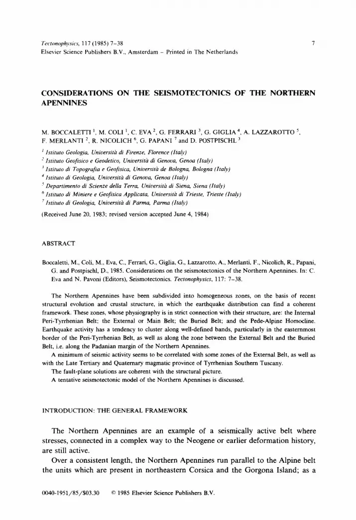
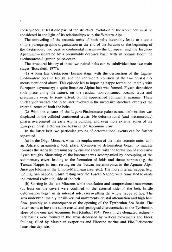
The general structural organization of the belt is shown in the map of Fig. 1 and the cross-sections of Fig. 2, where the depth of the Moho has also been recorded. Considerations on the crustal structure will be made later; a short summary on the different te~tono-sedimental units appearing in the cross-sections, as well as on their deformation phases, is given herein.
The different Ligurian units (once deposited in the Ligurian-Piedmontese paleo- ocean) occupy the top of the nappe pile and in turn rest over different tectono-sedi- mentary units deposited on continental crust. From the internal (Tyrrhenian) towards the external (Adriatic) side of the belt, these are:
(1) The Tuscan Domain, subdivided in two Tectonic units: the Tuscan Nappe and the Tuscan metamorphic core of the Apuane Alps. The Tuscan Nappe (mainly represented by the Triassic to Oligocene sedimentary cover) was emplaced on the Apuane metamo~~cs in the upper Oligocene or perhaps lower Miocene, in corre- spondence with an ensialic shear belt with polyphase deformation (Carmignani et al., 1978, 1981). In the lower unit even the Paleozoic basement is involved. since the earlier deformation phases are present, at the core of isoclinal, recumbent syn-meta- morphic shear folds where formations up to Oligocene are represented. The early- phase axial-plane schistosities have been later refolded in a complex mega-antiform, presumably connected with crustal diapirism (Carmignani and Giglia, 1983).
(2) The ModinooCervarola Domain, outcropping with a thick flysch sequence and Upper Oligocene to Middle Miocene in age. This unit was deposited on top of the Tuscan Nappe flysch (presumably already emplaced on the Apuane Metamor- phics), from which it is separated by more or less thick advanced tongues of the Ligurian Allochthon.
(3) The Umbro-Marchid Domain, outcropping with a thick sedimentary sequence of late Triassic to Miocene age. The overall concentric geometry of the
Umbro-Marchid compressive structures renders probable the existence of a decolle- ment tectonics at depth, under the Burano evaporites, at the contact with the siliciclastic Paleozoic and Triassic basement. The basement is possibly underthrusted to the westernmost alignment of structural highs (A. Apuane, M. Pisani, etc.). The age of the top of the sequence involved in fold deformation becomes younger from west to east: Middle Miocene to Late Miocene in the outcropping belt; still younger for that part of the Domain buried under the PO Plain, as will be described in detail in the following paragraphs.
14
Homogeneous zone in the recent structural evolution of the Northern Apennines
From the point of view of morphology and recent structural evolution, the
Northern Apennines and immediately surrounding areas can be subdivided into
homogeneous longitudinal bands (Bartolini et al., 1983). These are (Figs. 1 and 2):
the Internal Belt, corresponding to the Tyrrhenian slope of the Northern Apennines;
the External Belt or Main Belt, corresponding to the Adriatic slope; the folded and
thrusted area under the PO Plain alluvial deposits (Buried Belt), and the Pede-Alpine
Homocline (Pieri and Groppi, 1981).
Transverse1 lineaments, evidenced by both physiographic and structural features,
are also present in the Northern Apennines. Their importance has been stressed
since long (Signorini, 1935; Boni, 1962; Zanzucchi, 1963; Ghelardoni, 1965; Borto-
lotti, 1966). Their structural expression is marked by both brittle and ductile
deformation at the surface (see in Boccaletti et al., 1982) mainly corresponding to
transcurrent movements at depth, active since the Miocene (Ricci Lucchi, 1975;
Boccaletti et al., 1980; Chiocchini et al., 1982). Some of these lineaments may
correspond to old rejuvenated features, since they have influenced the Mesozoic and
early Tertiary sedimentation (prior to compressive deformation), but they also mark
an interruption and fragmentation of the Neogenic and Quaternary intermontane
basins of the internal belt, or the deflection of recent fold axes in the Buried Belt.
Quaternary activity, even in the last 700.000 years, has been demonstrated in the
structural evolution of some transverse1 lineaments.
In the seismotectonic map (Fig. 1) we have marked the transverse1 lineaments that
have seismotectonic relevance, since they define compartments with a somewhat
different evolution in geologic time and presumably reflect deep tectonic dis-
turbances in the crust.
The Peri-Tyrrhenian Internal Belt In the complex structural setting of this area, the most striking character is the
presence of ridges and basins, mainly elongated parallel to the belt (NNW-SSE). In
the basins, unfolded (or only locally warped) marine and continental formations
outcrop.
The age of the base of the sedimentary infilling varies between late Tortonian and
Quaternary; the more recent ages are clearly confined to the eastern limits of the
area, close to the main divide of the belt. The substratum, represented by strongly
folded and thrusted Paleozoic to Tertiary formations, outcrops in the ridges separat-
ing the basins. These are limited by sets of normal faults superimposed on all the
pre-existing folds, thrusts and nappes. Vertical movements connected to normal
faulting have controlled the deposition inside the basins; local compressive episodes,
whose importance in the general framework is still a matter of debate, have been
described within these basins (Cerrina Feroni and Plesi, 1980). Subsidence velocities
of up to 50 cm/1000 yr. have been ascertained in the lower Pliocene sediments,
15
whose thickness can reach 1000 m (Volterra basin, see in Costantini et al., 1980).
The elevation and, more generally, the physiography of the basins can be strongly
disturbed by the emplacement of intrusive stocks, in connection with crustal
magmatism of late Miocene to Quaternary age, as in Radicofani and Monte Amiata,
where marine Pliocene is elevated to 800-1000 m a.s.1.. Detailed geological and
sedimentation-rate studies in some of these areas (Costantini et al., 1980, 1982) have
shown that these structures are strongly asymmetric; they are in fact, frequently
characterized by a master fault dipping WSW (with a throw of some thousand
metres) on their eastern margin, and with antithetic faults with minor throw, dipping
ENE, on their western margin. Tilting of the basins towards the east, with a
migration of the axis of maximum depth from west to east has been ascertained in a
time interval between the lower and middle Pliocene in the Siena basin (Costantini
et al., 1979) as well as in the Val di Chiana (Ambrosetti et al., 1980) and in the mid
and upper Tiber Valley (Baldi et al., 1974).
The same situation can be invoked in the northernmost sector of the belt (see
cross-section A in Fig. 2) where much evidence points to the Apuane Alps being a
NNW tilted block (Eva et al., 1978).
As a conclusion, the whole peri-Tyrrhenian area appears, rather than being a
series of horsts and grabens, as a succession of eastwards-tilted step blocks grading
down towards the Tyrrhenian depression, limited to the east by master faults of
presumably crustal importance, with antithetic faults dipping eastwards, on the
western side.
The External or Main Belt
In a longitudinal sense, the External Belt can be subdivided into three segments,
separated by major transverse1 lineaments having relevance to the recent structural
evolution:
(1) North of the transverse1 Passo della Cisa-Val D’Enza lineament, the Ligurids
outcrop extensively, with the more external units appearing only in minor tectonic
windows (ex: Umbro-Marchid Domain in the Salsomaggiore window).
(2) The Tuscan Nappe and the Modino-Cervarola Unit outcrop in the inter-
mediate longitudinal segment of the external belt. South of the transverse1 Passo
della Cisa-Val D’Enza lineament, they have been uplifted by many hundreds of
metres since the middle Pleistocene. This compartment is limited to the south by the
transverse1 Prato-Sillaro lineament.
(3) The Umbro-Marchid Domain outcrops extensively in the southernmost
segment of the external belt of the Northern Apenmnes, South of the Prato-Sillaro
line, where it has been uplifted by many thousands of metres compared to the
north-western sector.
Since at least the Upper Pleistocene, the whole easternmost part of the Main Belt
has been uplifted by many hundreds of metres compared to the Padanian margin.
The structures separating the External or Main Belt from the PO Plain are flexures
16
and strongly dipping reverse faults, representing the surface expression of the
Pede-Apenninic Thrust Front (PTF). The bundle of reverse faults representing the
Pede-Apenninic Thrust Front have been active at least since the Late Miocene
(Iaccarino and Papani, 1981). In correspondence with the PTF, the internal part of
the Pliocene foredeep of the Northern Apennines has been uplifted, compressively
deformed and annexed to the belt in the Quaternary. The throw at the base of the
Pliocene deposits can reach many thousands of metres.
Compressive stresses in correspondence with the PTF have been active during the
whole Quaternary time interval, up to the present. The direction of maximum
compression, deduced from meso-structures in the middle Pleistocene formations
near Parma is in accordane with the fault-plane solution of the 1971 earthquake
(Bernini and Clerici, 1983).
The Buried Belt
This longitudinal band of the Northern Apennines represented in the Pliocene the
foredeep of the belt. Its depocentre has migrated towards the northeast, contempora-
neously with compressive deformation, in Plio-Quaternary times.
The structure at depth has been retraced by AGIP work (Pieri and Groppi, 1981)
and can be schematically defined as a blind thrust system (with northeastern
asymmetry), represented by many leading imbricate fans (in the sense of Boyer and
Elliot, 1982).
Different arched groups of folded structures can be distinguished in the Buried
Belt: the Emilia folds in the northwest; the Ferrara, Adriatic and Romagna folds in
the southeast (see Fig. 1).
The Emilia folded arch has a width of 25-35 km and is represented by a
succession of blind imbricate thrusts, presumably detached from the basement at the
level of the Mesozoic successions. Folding dates back to the Pliocene and has been
active in the Quaternary.
The southeastern arch (Ferrara, Adriatic and Romagna folds) is formed by two
distinct blind imbricate leading fans: the internal Romagna and the external Ferrara
and Adriatic folds, separated by a major thrust with northeastern asymmetry. In
correspondence with this thrust, the Pliocene base dips down to about - 8000 m
b.s.1.. The age of the folds in Plio-Quaternary.
The external margin of the Buried Belt is again marked by a group of blind thrust
faults (External Thrust Front: ETF). On the Adriatic side of the structure, the base
of Pliocene Formations is again strongly depressed, reaching - 7000 m b.s.1.
Northeast of the ETF a discontinuous band, a few kilometres wide, of gentle
compressional deformation separates the buried belt from the Pede-Alpine Homo-
cline.
The Pede-Alpine Homocline
This buried area can be considered as the present-day foredeep of the Apenninic
17
Orogeny. It can be subdivided into two main sectors, on the basis of its deforma-
tional history.
In the eastern sector (East Lombardy and Venetian Plain) the Mesozoic and
Tertiary buried successions dip more or less regularly SSW, with dipping values of
less than 10”. Pliocene and Quaternary deposits are locally reduced or discontinuous
in some active areas, but the sector as a whole is generally characterized by moderate
subsidence and a more regular and thicker stratigraphic succession.
In the northwestern sector (central and western Lombardy Plain) the area is, on
the contrary, gently deformed, showing a blind thrust system with SSW asymmetry,
formed in the late Miocene (Pieri and Groppi, 1981). Plio-Quaternary compressional
stresses, in correspondence with the External Thrust Front, are mainly concentrated
around the V-shaped sector of the Pede-Alpine Homocline, defined by the conver-
gence of the two main arches of the Buried Belt.
CRUSTAL ORGANIZATION
Gravity data
The Bouguer gravity pattern (Ballarin et al., 1972; Morelli, 1973) gives a rough
indication of the crustal structures. First of all, a gravity high ( + 200 mGa1) occurs
in the Ligurian Sea, whereas values of - 150 mGa1 are found in correspondence with
the buried Pede-Apennine. The zero-line approximately follows the coastline be-
tween Genoa and La Spezia, but extends far inland in Tuscany (at the limit between
the internal and external belts), being accompanied by the maximum gradient
towards the negative values in the External Belt. This feature indicates an abrupt
change in the crustal thicknesses.
Free-air anomalies are positive in the Tyrrhenian Sea as well as in the Peri-Tyr-
rhenian Internal Belt, and negative in correspondence with the western margin of the
Buried Belt (Morelli, 1973). This distribution of free-air anomalies is indicative of
the existence of isostatic desequilibria. In the Tyrrhenian slope, these may be
correlated with distensive tectonics, with consequent magmatic intrusions and the
presence of high-density materials towards the base of the crust. In the Padanian
margin, the apparent contradiction of subsidence coupled to negative free-air
anomalies can be attributed to the upthrusting of the Apennine emerged belt over
the PO Plain (Elter et al., 1975) as is indicated by the presence of very recent
compressive structures in the surface geology (Bartolini et al., 1983).
Crustal structures from deep seismic soundings (DSS)
The isobaths of the Moho discontinuity derived from DSS data collected in the
area (Fahlquist and Hersey, 1969; Morelli et al., 1977; Giese et al., 1981; Ferrucci et
al., 1982) have been contoured on the seismotectonic map (Fig. 1).
18
They refer to the computed depths in correspondence with velocity values close to
8.0 km/s, commonly assumed for the identification of the crust-mantle boundary.
For most of the profiles the interpretation is based on the indication of a precise
velocity gradient at the base of the crust. In places the Moho remains only
tentatively defined, but critical analysis of peculiar seismic features of the lower
crust and of crust-mantle transition zone allow us to delimit different sectors and
make correlations with the geological evidence
An example is given by the Tuscany-Latium geothermal region, where a thinned
crust of 22-25 km has been computed. The upper crust is characterised by velocities
of 6.0-6.3 km/s and thicknesses of 14-18 km. Velocities of 6.8-7.5 km/s identify
the top of the lower crust or of a peculiar interval that could represent a thick and
upward-extended crust-mantle transition zone. No hypocentral depth has been
computed inside this interval. Moreover, the downwards extension of the heat-flow
data, according to different models, accepts temperatures higher than 700°C in this
interval. Thus the interaction between acid and basic rocks results in a pronounced
vertical and lateral heterogeneity with materials of variable viscosities, perhaps in
places partially melted, that give origin to multiple reflections caused by alternating
high and low velocity layers.
At the bottom of this 5-10 km thick interval the velocity reaches values of nearly
7.9 km/s. However, the Moho is not clearly defined and also the upper mantle does
appear homogeneous. Thus, it is possible to imagine that the lower crust is, affected
by “absorption phenomena” from the upper mantle, and (or) that a soft mantle may
be present at depth.
These features characterise the Tuscany-Latium geothermal area and the north-
ern Tyrrhenian Sea as well. Eastwards, in the region of the “Ancona-Anzio” line,
crustal structures are of normal continental type with well-marked Moho and
thicknesses of nearly 30 km. Along the Peri-Tyrrhenian Internal Belt, high velocity
values (nearly 6.5 km/s) have been observed at shallow depths (5-6 km) which can
support the hypothesis of intra-crustal thrusting connected to post-collisional
orogenetic processes. In correspondence with the limit of the External Belt, a
lowering of the Moho from about 25 to at least 35 km is observed. On the lowered
side, the Moho reflections are poor or uncertain. However towards the buried
Pede-Apennine an increased crustal thickness of 35 km or less is found on the
northern side of the PO Plain.
Again in the Northern Apennines some of the anti-Apenninic or Apenninic
structural elements also affect the Moho. Nearby La Spezia one of the anti-Apen-
ninic lineaments bounds the Tyrrhenian structures towards the North, and its
seaward extension separates the Corsica Block from the mantle uplift in the Ligurian
Sea, where a velocity of 7.9 km/s has been found at depths greater than 15 km.
Between La Spezia and Livorno the base of the crust in Fig. 1 corresponds to
velocities of only 7.4 km/s; velocities of 8.0 km/s have been observed here at depths
greater than 50 km.
19
The continental structures of Corsica are well defined as far as the N-S trending
boundary with the Tyrrhenian where the features of the lower crust and upper
mantle appear more complicated. Only the upper structures of the crust exhibit very
similar velocities and thicknesses (20 km) on both sides of the two sectors.
Aeromagnetic data
The aeromagnetic surveys carried out by AGIP in the period 1970-1980 (Bolis et
al., 1982) have made it possible to obtain a picture of the structural features of the
basement and to insert them into a regional context.
Also in aeromagnetic data, a clear subdivision appears in NNW-trending bands
roughly coinciding with the partitions adopted on the base of surface geology,
fragmented by transverse1 lineaments.
(1) The Peri-Tyrrhenian Internal Belt corresponds to the Northern Tuscany and
Tuscany-Latium-Campania magnetic Provinces. In the region between the Apuane
Alps and Pisa, the magnetic substratum is characterized by medium-low intensities,
referred to the basement of the Apuane Alps. The susceptibility contrasts (100-300
x 10e6 C.G.S.U.) are compatible with crystalline metamorphic rocks (mainly acidic).
AGIP interpretation places this magnetic substratum at a depth of 3-4 km, with a
progressive deepening towards the north and south of the Apuane Alps.
In Southern Tuscany, medium-high frequency anomalies are found, referable to
recent magmatic activity.
(2) The low-to medium-high magnetic province of the Internal Belt strongly
contrasts with the adjacent Apenninic magnetic province. The peculiar characteristic
of this area, corresponding to the previously described External or Main Belt, is a
general lack of magnetic response. The data seem to be consistent with the presence
of a very deep, westwards-dipping basement.
(3) In the PO Valley magnetic province (corresponding to our Buried Belt and
Pede-Alpine Homocline together) magnetic anomalies present a low intensity (20-30)
and wide wavelength, witnessing a deep acidic crystalline basement, deepening
irregularly towards the southwest. Calculated depths are in fact, less in the PO Plain
(8-10 km at Alessandria: 8 km between Milan and Brescia, about 6 km in the
Venetian offshore with a local high along 4752 m in a narrow strip facing the lagoon
of Venice) than along the edge of the Emilia Apennines, where they reach depths
greater than 12 km.
Mafic intrusions and volcanites, both Permian or Triassic and Middle Miocene,
recorded at depth in oil drillings, can further complicate the local magnetic anomaly
pattern.
SEISMICITY
Historical seismicity
The Italian finalized project “Geodinamics” has started since 1979 a national
20
program of revision and completion of the Italian Seismic Catalogue from the years
1000 up to 1975, drawn up by ENEL (ENEL 1977).
In particular, the program started with the revision of the strongest historical
earthquakes (about 200 shocks with I,,, = IX MCS) carried out on the basis of
published and unpublished contemporaneous documents concerning historical events,
which in some cases also allowed of completing the catalogue with the smallest
shocks.
From the historical and statistical point of view, the maximum magnitudes that
occurred in the last 1000 years have been observed in the regions of
Garfagnana-Lunigiana (inner belt), Mugello (inner belt), Forll and some other
zones of the External Belt.
Analyzing the historical main events (C.N.R./P.F.G., 1983) in each area, it is
possible to summarize these principal behaviours.
The GarfagnanaaLunigiana was affected in different periods (1481-174661837-
1820) by events with intensities greater than VIII MCS. The orientation of the main
axis of the isoseismal lines is mainly in agreement with the general trend of the
Apenninic structures. The reconstruction of the macroseismic field of Sept. 7th, 1920
earthquake, the strongest recorded in the area, shows most efficient propagation
towards the PO (Ferrari et al., 1983).
The Mugello zone was affected by severe earthquakes in 1542, 1611, 1762. and
1919, with epicentres ranging between Firenzuola, Barberino Mugello, Scarperia,
and Vicchio. Also is this area, the main trend of the isoseismal lines is of Apennines
strike. In the Forli area the most part of the heaviest shocks (1279,1661,1768, 1918).
was localized in an area included between S. Sofia, Galeata, and Civitella di
Romagna. Another seismicity cluster is connected with the Brisighella-Faenza
territory (1509, 1781, 1882).
The isoseismal lines of maximum degree are normally aligned with the Apenninic
trend (Ferrara et al., 1983).
The PO Valley includes the following areas affected by destructive earthquakes:
Rimini, Lugo di Romagna and Ferrara. Rimini and other coastal sites felt the
seismic activity generated in the Adriatic Sea (1308, 1672, 1786, 1875, 1916). This is
to show that all macroseismic maps of these events are very similar and they show a
good propagation towards Ferrara and Venice.
In the region of Lugo some earthquakes were felt with high values of intensity
and characterized by very low values of focal depth.
In the Ferrara area, where buried folded structures of the PO Plain are very
shallow, the occurrence of shocks with intensity of VIII MCS was observed (1467,
1570, 1624, 1787).
The earthquake that occurred in the 1570 showed the main isoseismal axis
oriented with the direction of the Ferrara faulted belt at the limit between the buried
Apenninic belt and the Pede-Apenninic Homocline.
All earthquakes that occurred in the PO Valley are characterized by their
pp. 21-32
0,
.
l I
I 1 -
.
_-.-- . . . .
d_ __-.-.._._..
I i
.
1
/)
--
fz
_ -
-- ___ . . ..L__ -.. - $0.0
33
shallowness of foci and by the raising of long seismic periods in connection with low
values of realized energy. The Ferrara earthquake of 1570 was followed by a long
sequence (4 years) with, on the basis of historical information, more than 2000
shocks with intensities ranging between III and VIII MCS.
Instrumental seismicity
The catalogue has been completed up to 1980, with data derived from the
national seismic network (Cassinis, 1981; CNR/PFG, 1982).
As far as the northwestern part of the Apennines is concerned, the seismic activity
occurring in the last 10 years has been revised with a relocation of foci (Eva et al.,
1978).
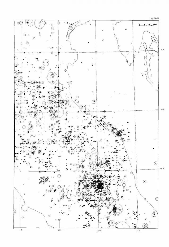
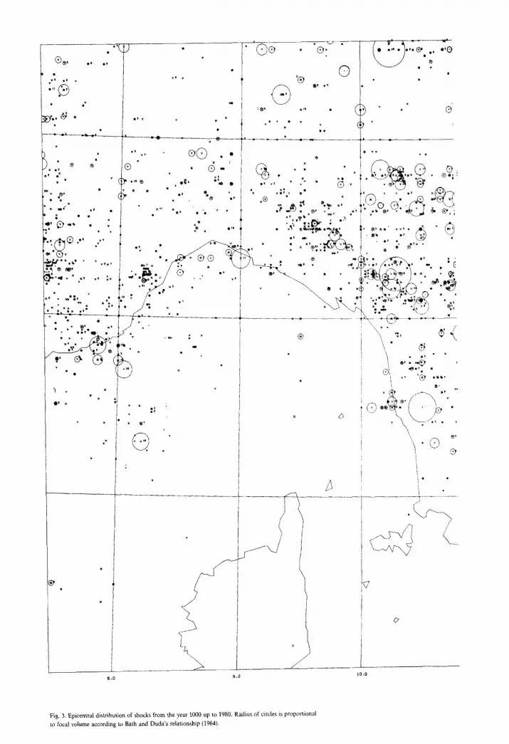
The epicentral distribution of shocks occurring in the area from the years 1000 up
to 1980 is shown in Fig. 3, where the epicentres are represented by circles whose
radius is proportional to the radius of the equivalent sphere of focal volume
determined according the Bath relationship (1964) (Gasparini and Postpischl, 1980).
From the figure, the Northern Apennines appear to be affected by a diffuse
seismicity, even if in terms of occurrence frequency and released energy, a tendency
to concentration in bands of activity is shown (Cattaneo et al., 1981). This happens
particularly along the eastern border of the Tyrrhenian margin, corresponding with
the maximum horizontal gradient of the Moho and the zero-line of the Bouguer
anomaly, and along the PO-Plain and Adriatic borders in connection with the
minima of this anomaly.
On the contrary, the seismic activity is moderate or nearly absent in the eastern
Ligurian Sea and Southern Tuscany, in connection with the Tuscany-Latium
geothermal region, characterized by a rise of the Moho and by positive values of
gravimetric anomaly.
At the present state of knowledge, more detailed interpretations do not seem
significant because the accuracy in the definition of epicentres, as reported in the
catalogue, is on average 25 km.
As regards the focal depths, it is necessary to outline that this parameter has been
determined only for 27% of shocks occurring in the studied area and in many cases it
has been derived from the macro-seismic field.
A different behaviour is shown by foci, instrumentally determined, with a
systematic deepening of the hypocentres. This systematicity may depend on the fact
that the catalogue is prevailingly a macroseismic one and the macroseismic depth
evaluation, when it is restricted to the highest isoseismal lines (as happens for the
shocks occurring in the past centuries), gives informations on the shallower part of
the fracture plane (Shebalin, 1972).
Nevertheless, considering the frequency distribution of depths, the data tend to
concentrate at different levels.
The first level of seismic activity, affecting the whole Apenninic structure, is
34
connected with very shallow sources lying in the first 10 km of the crust.
The second level points to a deeper crustal seismic activity and is mainly
connected with the central part of the belt in coincidence with the major deepening
of the Moho.
More evidence of very deep crustal seismic activity, with foci deeper than 50 km,
exists in two narrow areas: Lunigiana and the Northern sector of Marche, respec-
tively in the inner and external Apennines.
These data are related to only 14 shocks that occurred during the last 20 years,
and one of these events (earthquake occurring on 25th Oct. 1972 in Lunigiana),
studied by Bossolasco et al. (1973) shows a focal depth of about 50 km.
The distribution of foci is shown in cross-sections of the Northern Apennines
drawn in Fig. 2.
The focal mechanisms, available for the studied area, are shown in Fig. 1. Some
of them have been collected from the literature (Bossolasco et al., 1974; Eva et al.,
1978; Cagnetti et al., 1976; Scarpa et al., 1982); others have been revised and some
evaluated for this study.
The distribution of focal solutions in so wide and area of complex geological
evolution does not allow the drawing of unambiguous conclusions.
Indeed, the focal mechanisms outline the presence of both transcurrent and
vertical (either normal or overthrust) faults. Particularly the inner belt is affected by
mechanisms prevailingly of distensive type passing to transcurrent type in the
northwestern sector. The directions of fault planes are consistent with either the
Apenninic trend or the transverse1 systems of structural discontinuity.
An anomalous behaviour is shown by the earthquake with a focal depth of 50 km
(25th Oct. 1972 shock) which presents a clear overthrust solution (Bossolasco et al.,
1974; Scarpa et al., 1982).
The External Belt, along the Apenninic margin with the PO Valley and Adriatic
Sea, is mainly characterized by transcurrent mechanisms, which assuming a fault
plane parallel to the Apenninic trend, are of sinistral type. In this area, overthrust
solutions have been determined in the regions near Parma and Ferrara in connection
with the buried folding systems.
A POSSIBLE SEISMOTECTONIC MODEL
A seismotectonic model of the Northern Apennines arises from previously
described data on its recent geological evolution and deep structural setting, com-
bined with the location of seismic events and the study of fault-plane solutions.
Leaving apart the early Alpine phases, a good starting point can be represented
by the continental collision which took place after the complete consumption of the
oceanic crust once separating (in the late Mesozoic) the European and Insubro-
Apenninic crustal elements. Since oceanic crust is consumed more easily, the
formation of ensialic shear belts in both the above-mentioned crustal elements can

35
be considered as indicative of the beginning of continental collision. Post-Middle
Eocene syncinematic metamorphism in the Alpine Brianconnais, Upper Oligocene
and Miocene metamorphism and deformation in the Apuane Massif for the Apen-
nines seem sufficient evidence that, at least in the upper Oligocene, the two
above-mentioned crustal elements were already appressed and collided.
The ensialic shear model appears as one of the possible mechanisms in the
compressive post-Eocene deformational history of the Northern Apennines. The
existence of an Upper Oligocene ensialic shear belt in the Apuane Alps is demon-
strated by rotation of fold axes into parallelism with extension lineation in the
course of tangential ductile deformation (Carmignani et al., 1981).
A present-day ensialic shear belt could be represented by the external margin of
the Northern Apennines, where crustal thickening and compressive events at the
surface, indicative of shortening, have been evidenced in the Quaternary evolution.
These geological data are not in conflict with the few fault-plane solutions available
for the area, showing compressive and or transcurrent character.
Following some of us (Boccaletti, 1977; Boccaletti et al., 1980) as well as other
authors (Panza et al., 1980), the post-collisional intercontinental deformation, re-
sponsible of the formation of the belt and still active, would have implied detach-
ment of the upper crust in relation to the underlying lower crust and lid. These
episodes would be controlled by important systems (Boccaletti et al., 1982).
The ensialic shear model for collisional belts has been extensively applied to the
Himalayan orogeny by Mattauer (1975). In Mattauer’s reconstruction the migration
of compressive deformation, from the internal Main Central Thrust towards the
more external (and presently seismically active) Main Boundary Thrust, is strictly
connected to ensialic shears. The buoyancy of continental crust makes in fact the
ensialic shear a rapidly self-sealing process; successive shortening is consequently
displaced towards the external side of the belt, where further thickning of the crust is
already possible.
In the Northern Apennines, such a model would be in perfect accordance with the
migration of flysch throughs, described by Italian authors since the fifties (see in
Merla, 1951) for which it would provide an adequate mechanism.
Compressive stresses at the external margin of the Northern Apennines make the
present-day structural evolution of this side of the belt the continuation of its
post-collisional history.
Mainly tensile deformation in the internal Peri-Tyrrhenian Belt, overprinted on
compressive deformation appears, on the contrary, as having an origin outside the
geodynamic framework which led (and is presently leading on the external side) to
the formation of the folded and thrusted belt.
From the surface structure (see, for references, in Giglia, 1974), crustal and
lithospheric thinning at depth (Calcagnile and Panza, 1981) high heat flow (Loddo
and Mongelli, 1979) and emplacement of magmatic events, the internal belt appears
as an emerged equivalent of the Northern Tyrrhenian Sea. The whole Western
36
Mediterranean appears as a superimposed structural (and physiographic) feature,
since its emplacement is without connection with the previously established Alpine
lineaments. The Western Provencal-Ligurian Sea basin cuts obliquely across all the
Western Alps tectonic units; and the Tyrrhenian Sea occupies the internal root zones
of both the Apenninic units and Alpine units of Corsica which in earlier times
certainly had represented convergent plate margins. Rifting and “oceanization”,
acting in the Western Mediterranean Sea and in the internal zone of the Northern
Apennines, coexist with crustal thickening, separated in space and time.
The two stress fields at the origin of the present-day crustal organization of the
belt can be connected in many ways, but further expansion of the model, as part of
the general picture of the whole Mediterranean Sea basin, merely on the basis of the
Northern Apennines data, seems hardly practical to the authors.
REFERENCES
Ambrosetti, P., Carboni, M.G., Conti, M.A., Costantini, A., Esu, D., Gandin, A., Girotti, O., Lazzarotto,
A., Mazzanti, R., Nicosia, U., Parisi, G. and Sandrelli, F., 1979. Evoluzione paleogeografica e tettonica
dei bacini tosco-umbro-laziali nel Pliocene e nel Pleistocene inferiore. Mem. Sot. Geol. Ital.. 19:
573-580.
Baldi, P., Decandia, F.A., Lazzarotto, A. and Calamai, A., 1974. Studio Geologico de1 substrato della
copertura vulcanica laziale nella zona dei laghi di Bolsena, Vito e Bracciano. Mem. Sot. Geol. Ital.,
13: 575-606.
Ballarin, S., Palla, B. and Trombetti, C., 1972. La gravita in Italia. Carta delle anomalie topografiche e
topografico-isostatiche. Boll. Geod. Sci. Aff., 31: 4: 461-489.
Bartohni, C., Bemini, M., Carloni, G.C., Castaldini, P., Costantini, A., Federici, P.R., Francavilla. F.,
Gasperi, G., Lazzarotto, G., Mazzanti, A., Papani, G., Pranzini, G., Rau, A., Sandrelli, F. and Vercesi.
P.L., 1983. Carta neotettonica dell’Appennino Settentrionale. Note illustrative, Boll. Sot. Geol. Ital..
in press.
Bath, M. and Duda, S.J., 1963. Strain release in relation to focal depth. Geofis. Pura Appl., 56: 93-100.
Bernini, M., Boccaletti. M. and Clerici, A., 1977. The role of the foreland in the late geotectonic evolution
of the Mediterranean arcs at the continental stage. Rend. Accad. Naz. Lincei, Sci. Fis. Mat. Nat., 6
Ser., 63: 561-570.
Boccaletti, M., Coli, M. and Napoleone, G., 1980. Landsat lineation pattern in the Apennines and its
geodynamic significance. Modem Geol., 7: 95-103.
Boccaletti, M., Coli, M., Decandia, F.A., Giannini, E. and Lazzarotto, A., 1981. Evoluzione dell’Appen-
nino Settentrionale second0 un nuovo modello strutturale. Mem. Sot. Ital., 21: 359-373.
Boccaletti, M., Conedera, C., Dainelli, P. and Gocev, P., 1982. The recent (Miocene-Quaternary)
regmatic system of the Western Mediterranean Region. J. Petrol. Geol., 5(l): 31-49.
Bolis, G., Cappelli, V., Marinelli, M., 1981. Aeromagnetic data of the Italian area: instrumental to a better
comprehension of the basement main characteristics in Italy. 43rd E.A.E.G. Meet.. Venice, presented
paper.
Boni, A., 1962. Lignes et problemes tectoniques du secteur Nord-Quest de 1’Apennin Septentrional. Bull.
Sot. Geol. Fr., Ser. 7, 4: 644656.
Bortolotti, V., 1966. La tettonica trasversale dell’Appennino. I-La linea Livomo-Sillaro. Boll. Sot.
Geol. Ital., 85: 529-540.
Bossolasco, M., Eva, C. and Pasquale, V., 1973. 11 terremoto de1 25 Ottobre in Lunigiana. Riv. Ital.
Geofis.. 22: 314-322.
31
Bossolasco, M., Eva, C. and Pasquale, V., 1974. On seismotectonics of the Alps and Northern Apennines.
Riv. Ital. Geofis., 23(1/2): 57-63.
Boyer, SE. and Elliott, D., 1982. Thrust Systems. Am. Assoc. Pot. Geol. Bull., 66(9): 1196-1230.
Cagnetti, V., Pasquale, V. and Pollinari, S., 1976. Focal mechanisms of earthquakes in Italy and adjacent
regions. Comitato Naz. Energia Nucleare, RT/AMB, 76, 4.
Calcagnile, G. and Panza, G.F., 1980. The main characteristics of the lithosphere-astenosphere system in
Italy and surrounding regions. Pure Appl. Geophys. 119: 865-879.
Carmignani, L. and Giglia, G., 1983. “Autoctono Apuano” e Falda Toscana: sintesi dei dati e
interpretazioni pih recenti. Mem. Sot. Geol. Ital., in press.
Carmignani, L., Giglia, G. and Khgfield, R., 1978. Structural evolution of the Apuane Alps: an example
of continental margin deformation. J. Geol., 86: 487-504.
Carmignani, L., Giglia, G., and Kligfield, R., 1981. Nuovi dati sulla zona di taglio ensialica delle Alpi
Apuane. Mem. Sot. Geol. Ital., 21: 93-100.
Cassinis, R., 1981. Prime correlazioni tra struttura crostale e sismicita della regione italiana. In: CNR,
Gruppo Naz. Geofis. Terra Solida. Atti de1 lo Convegno, 2: 507-532.
Cattaneo. M., Eva, C. and Merlanti, F., 1981. Seismicity of Northern Italy: a statistical approach. Boll.
Geofis. Teor. Appl., 89: 31-42.
Chiocchini, V., Cipriani, N. and Giardini, G., 1981. Pretrologia delle arenarie dei bacini minori torbiditici
di Camerino e di S. Donato Cantia (Marche). Boll. Geol. Ital., 100 (2): 213-231.
Costantini. A., Gandin, A., Guasparri, G., Mazzanti, R.. Lazzarotto, A. and Sandrelli, S.. 1980.
Neotettonica dei Fogli: 111 Livorno-112 Volterra-113 Castelfiorentino-119 Mass marittina-120
Siena-121 Monte pulciano-126 Isola d’Elba-127 Piombino-128 Grossetto 129 S. Fiora. In: Contrib-
uti Preliminari alla Realizzazione della Carta Neotettonica d’Italia. CNR P.F. Geodin., Pubbl. 356:
1075-1186.
Costantini. A., Lazzarotto, A. and Sandrelli, S.. 1982. II graben di Siena. Conoscenze geologico-strutturali.
CNR, P.F. Geodin.. R.S. 9: 11-33.
C.N.R., P.F. Geodinamica, 1982. Italian Seismic Catalogue from the year 1000 up to 1980. In press.
Elter, P., Giglia, G., Tongiorgi. M. and Trevisan, L.. 1975. Tensional and compressional areas in the
recent (Tortonian to present) evolution of the Northern Apennines. Boll. Geofis. Teor. Appl.. 77:
3318.
ENEL. 1977. File of Italian earthquakes from the year 1000 up to 1975. Unpubl.
Eva. C.. Giglia, G., Graziano, F. and Merlanti. F.. 1978. Seismicity and its relation with surface structures
in the North-Western Apennines. Boll. Geofis. Teor. Appl., 20: 2633277.
Fahlquist. D.A. and Hersey, J.B.. 1969. Seismic refraction measurements in the Western Mediterranean
Sea. Bull. Inst. Ocean. Monaco, 67 (1386).
Ferreari, G., Guidoboni. E. and Manenti, E., 1981. Criteri per la ricerca dei dati sismici storici. Atti
Convegno Sismicita dell’ltalia, Udine, 12-14 Maggio 1981. In press.
Ferrucci, F., Makris, J., Nicolich, R., Snoek, M., Steinmetz, L. and Weigel, W.. 1982. Deep seismic
soundings by observation in the Tyrrhenian Sea. Proc.-Verb. Congr.-Assem. C.I.E.S.M.. 28e, Cannes.
2-11 Dec. 1982.
Gasparini, P. and Postpischl, D., 1980. Criteri per la rappresentazione automatica dei dati ipocentrali
CNR/PFG, N. 322: 1-31.
Gasparini, C.. Iannaccone, G. and Scarpa, R., 1983. Fault-plane solutions and seismicity of the Italian
peninsula. Tectonophysics. 117: 59-78.
Ghelardoni, R., 1965. Osservazioni sulla tettonica trasversale dell’Appennino settentrionale. Boll. Sot.
Geoi. Ital., 84: 277-290.
Giese, P., Wigger. P., Morelli, C. and Nicolich, R., 1981. Seismische Studien zur Bestimmung der
Krustenstruktur-Anomalien der Toskana, Comm. Europ. Communities, EUR, 75-78.
Giglia, G., 1974. L’insieme Corsica-Sardegna e i suoi rapporti con 1’Appennino Settentrionale: rassegna
di dati cronologici e strutturali. In: Paleogeografia de1 Terziario Sardo nell’ambito de1 Mediterraneo
Occidentale. Rend. Sem. Fat. Sci. Univ. Cagliari, pp. 245-275.
38
Iaccarino, S. and Papani, G,, 1980. II Messiniano dell’Appennino Settentrionale della Val d’Arda alla Val
See&a: stratigrafia e rapporti con ii substrato ed il Pliocene. In: Volume deddicato a S. Venzo. Parma,
pp. 15-46.
Loddo, M. and Mongelli, F., 1979. Heat flow in Italy. In: V. Cermak and L. Rybach (Editors), Terrestrial
Heat Flow in Europe. Springer, Berlin, pp. 221-231.
Mattauer, M., 1975. Sur Ie mecanisme de formation de la schistosite dans 1’Himalaya. Earth Planet. Sci.
Lett., 28: 144-154.
Mazzanti, R. and Trevisan, L., 1978. Evoluzione d&a rete idrografica nel~Appennino Centro-Settentrio-
nale. Geogr. Fis. Din. Quat., 1: 55-62.
Merla, G., 1951. Geologia dell’Appennino Settentrionale. Boll. Sot. Geol., 70: 95-382.
Morelli, C., 1973. La gravimetria dell’area italiana. In: Modeme vedute sulla Geologia dell’Appennino.
Accad. Naz. Lincei, quad. N. 183.
More% C.. Giese, P.. Carrozzo, M.T., Colombi, B., Guerra, I., Hirn, A., Letz, H., Nicolich, R., Prodehl,
C., Reichert, C., Rower, P., Sapin, M., Scarascia, S. and Wigger, P., 1977. Crustal and upper mantle
structure of the Northern Apennines, the Ligurian Sea and Corsica, derived from seismic and
gravimetric data. Boll. Geofis. Teor. Appl., 19 (75-76): 1999260.
Panza, G.F.. Calcagnile, G., Scandone, P. and Mueller, S.T.. 1980. La struttura profonda dell’area
Mediterranea. Le Scienze, 24: 60-69.
Pieri. M. and Groppi, G., 1981. Subsurface geological structure of the PO Plain, Italy. C.N.R., P.F.
Geodin., Sottoprogetto Modello Strutturafe, PubI. 914: 23.
Plesi. G. and Cerrina Feroni, A., 1980. Contributo alla conoscenza delle deformazioni de1 neosutoctono
della Toscana: segnalazione di due fasi di raccorciamento attraverso lo studio degli stilotiti impressi su
ciottoli. Boll. Sot. Geol. Ital., 98: 15-25.
Postpischl, D., 1979. The process of catdoging historical seismic data. IUGG 17th Gen. Assem.,
Canberra.
Postpischl, D. (Editor), 1983. Atlas of Isoseismal Maps of Italian EarthquakesCNR. P.F.G., in press.
Ricci Lucchi, F., 1975. Miocene Paleogeography and Basin Analysis in the periadriatic Apennines. In: C.
Squyres (Editor), Geology of Italy, Pet. Explor. Sot. Lybia, Tripoli, pp. 129-236.
Shebalin, N.V., 1972. Macroseismic data as information on source parameters of large earthquakes. Phys.
Earth. Planet. Inter., 6(4): 315-323.
Signorini, R., 1935. Linee tettoniche trasversali neB’Appennini Settentrionale. Rend. Accad. Lincei, Cl.
Sci. Fis. Mat. Nat., Ser. 6, 21: 42-45.
Zanzucchi, G.. 1963. Sulla vergenza di alcune strutture trasversali nel flysch dell’Appennino Emiliano.
Ateneo Parmense, 34 (suppl. 2): 23.