‘colonial spatial planning versus local traditions in the morphology of dhaka’ in rahman, m....
TRANSCRIPT
Urban Reader for Dhaka
Colonial Spatial Planning versus Local Tradition in the Morphology of Urban Dhaka Qazi Azizul Mowla1 1.0 Introduction The colonisation of the region by the English acted as a catalyst to disrupt or divert the natural flow of morphological evolution to a direction, which could not adjust with the local context. New typology, though coined by many with modernisation, raised many questions regarding its validity to solve the prevailing problems. There is a common misconception that western methods and materials promoted a desirable restructuring of traditional building trades to respond to modern institutional commissions. The study, therefore, attempts to clarify these issues and evaluate the colonial impact on the form and morphology of Dhaka. In order to do that, the context is first studied, then it is analysed to see how colonial interruption has shaped the morphology of urban Dhaka.
The process of growth and development in Dhaka has witnessed and embedded imprints of different socio-cultural, geo-climatic, technological and economic influences. Dhaka is an old city that bears all traces of history in its physical layout (Johnston & Herbert, 1976). The art and architecture of Bangladesh is essentially an expression of an agricultural society who eked out their living from the soil, which profoundly influenced their creation (Nazimuddin, 1985; Mowla, 1985). The requirement of openness and ventilation encouraged the extension of household and social activities to outdoors. Socialisation spaces like uthan, gali, morh, chouk and bazaar2 were a natural outcome of this extension which were affected by the colonisation (Mowla, 1997a, 2001).
There is a tendency to characterise colonial cities as in the state of industrialising, articulating the transition between pre-industrial and industrial cities. This is both inadequate and distorted, largely because it ignores the forces and impact of colonisation and imperialism. There was never a homogeneous colonial style, but there were of course similarity of attitudes among colonisers that gave rise to certain patterns of development.3 The concept, such as stability and change in terms of architectural expression are quite 1 Professor, Dept. of Architecture, Bangladesh University of Engineering and Technology, Dhaka
1000. [email protected], [email protected]. 2 The terms approximately correspond to court yard, lane, corner, square and market respectively
but do not exactly convey the meaning. 3 Colonial influence has been explained by different authors in different ways, to some it was a transition between the Traditional and the Modern, to some colonial city is a product of Cultural contact while others believe it to be a function of dependent peripheral capitalism. In fact there is no need of such segmental explanations because all the interpretations hold true in different degrees for all colonial cities. 3 Colonial influence has been explained by different authors in different ways, to some it was a transition between the Traditional and the Modern, to some colonial city is a product of Cultural contact while others believe it to be a function of dependent peripheral capitalism. In fact there is no need of such segmental explanations because all the interpretations hold true in different degrees for all colonial cities.
Colonial Spatial Planning versus Local Tradition
12
complex, especially when applied to cultures already rich and strong in building tradition that were suddenly brought into contact with imported ideas and tastes. The fallacy of the above can also be judged in the light of contemporary trend of New Urbanism (Katz, 1994; Mowla, 2002a), showing that indigenous pattern could have evolved to meet the needs of the time. The colonial intervention was in fact destruction, through negligence, of a traditional know-how and methods of organisation.
In order to review the evolving morphology of Dhaka and for the sake of the convenience of study, Dhaka’s recorded history of about 500 years can be discussed in three distinct phases i.e. pre-colonial, colonial and post-colonial.
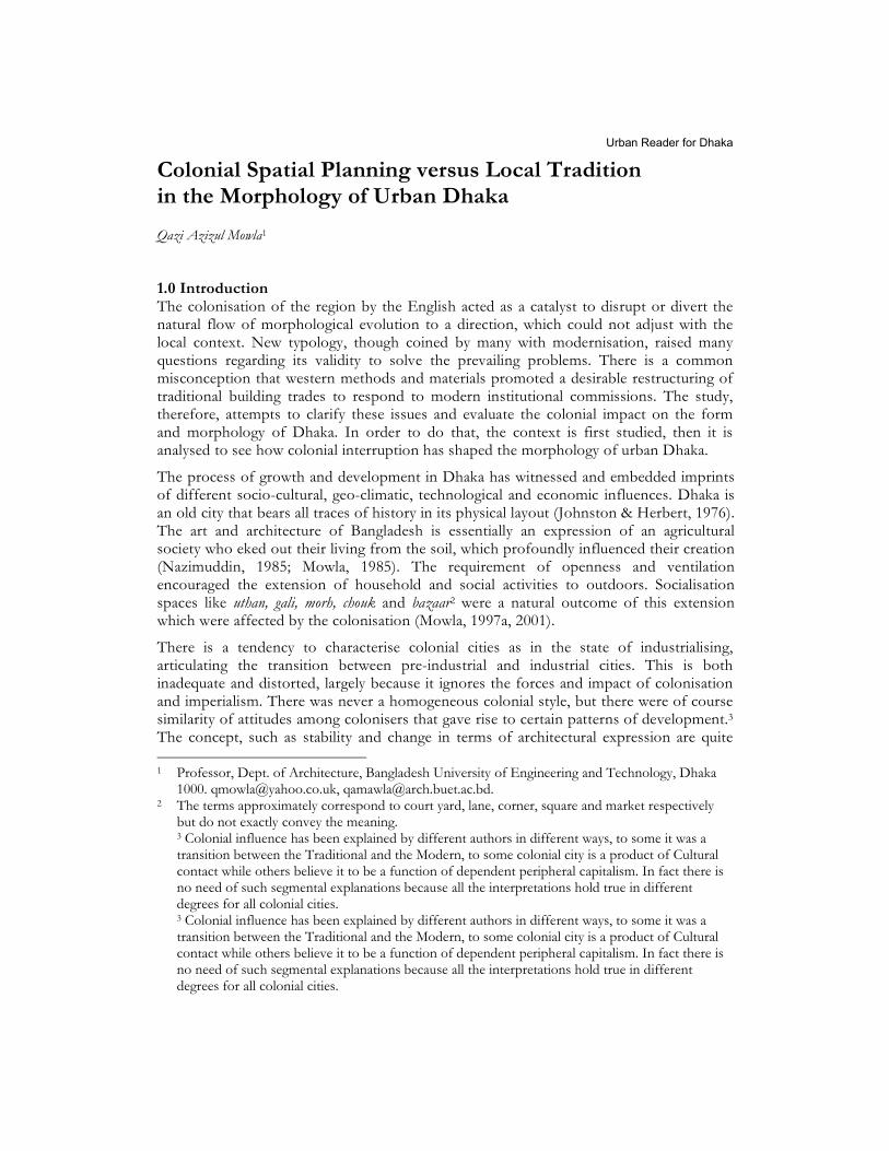
2.0 Pre-colonial Period Urban Dhaka owes its origin to a defence outpost and commercial satellite of pre-colonial era.4 Basically these were constellation of villages, where for different reasons at different times one village or another became the dominant political centre to acquire the status of a City (Ganj or hat - market place, is synonymous to indigenous city) (Fig. 1). Bradley-Birt (1914) and Rudduck (1961) are of the opinion that the Bangla Bazaar of the pre-Mughal Dhaka is perhaps the Bangalla of the legend. Bangla Bazaar which was the centre and main commercial area (hat) before the Mughals, yielded its supremacy to Chouk Bazaar in the Mughal period. A formal gate on the north marked the limits of the city core. Beyond the gate were the royal pleasure gardens (Bagh-e-Badshahi) and suburb settlements. The Mughals preferred the western part of the city, possibly as a precaution from probable attacks coming from the east. The first line of defence was conceived as the older indigenous settlements in the east at Bangla Bazaar (Fig. 1 & 8).
Figure 1: Relative Growth of Dhaka in Four Centuries
Dhaka was a large manufacturing centre where artisans, craftsmen and manufacturers came to settle, buying raw materials and selling finished goods for internal consumption
4 Unless otherwise mentioned, most of the historical information in this study is derived or
interpreted from Dani (1962), Karim (1964), Ahmed (1986) and Mowla (1997a, 2003b).
Qazi Azizul Mowla
13
and overseas exports. Its prominence as the chief centre of trade and commerce in the area attracted non indigenous merchants, traders and bankers. The European settlers, mostly the English, came in large numbers in seventeenth century and organised European companies. The French and the Dutch were the other Europeans who also established their factories in the city.
2.1 Indigenous Settlement: Oldest settlements within Dholai Khal confines5 may have developed same way as other indigenous settlements (Fig. 1); these were clusters of workhouses, each cluster representing a specific professional or caste group. Each cluster or Bari had an access by waterway, which served simultaneously as a natural system of sanitation, transportation etc. Land communication was generally by unpaved winding pedestrian paths that led to a central open space meant for periodic open air market (hat), near the main communication route which was generally a river or other water channels (khals). There would be some community structures around hat and ghat (landing pier) such as a community meeting place of elders and a shelter for travellers, generally maintained by each caste group.
2.2 Socio-Spatial Structure: A very distinct regional identity was formed as a result of political, religious and Cultural Revolution in the Sultanate (pre-Mughal) period, when the rulers endeavoured to identify themselves with the way of life and culture of the local people (Ahmed, 1986, Mowla, 1999a). This revolution in the transcendence of culture over religion helped creation of the architecture and settlement pattern from the same basic principles by both the Hindu and Muslim community of that period. Each mahalla or indigenous neighbourhood centred on a chouk (square) consisting basically of a school and market and occasionally place of worship (Breese, 1966; Mitchell, 1978). The mahalla loyalties although centred on the service/coverage of religious institutions or schools, ponds/ghats/wells etc., defence was also an important spur to organisation.
There was a spatial order in the indigenous city with a formal focus. Local social and services requirements gave rise to an apparently chaotic physical structure, which on detailed study was observed to be a quite ordered paradigm. At the second level was the relatively informal organisation of the rest of the city into mahallas on the basis of quite well defined socially cohesive communities— translating the social need of individual (family) privacy spatially. Thus hierarchic distribution of community buildings and spaces can be seen as one of the principles underlying the structure of the indigenous Dhaka.
Apart from east-west and north-south road with their centre at the Chouk, the remaining city streets tended to be quite irregular in direction, length and width. Melange of convoluted streets, cul-de-sacs, alleys byways gave access to residences and other uses. Gates or doorways open to private holdings and courtyards (uthan) making the high density more tolerable. This was an organic growth following the topography— the basic urban unit was a mahalla, a condensed counter part of the indigenous village (Khan, 1985; Mowla, 1997a). The Chouk was the city centre with main administrative and commercial developments located around it. The roads connecting the Chouk with specialised mahallas formed the specialised shopping streets. Commercial activity occupies a very important place in the indigenous city.
5 A canal originating from the River Buriganga on the south and joining it few kilometers later; the
land in between the canal and the river was the pre-Mughal settlement.
Colonial Spatial Planning versus Local Tradition
14
The principal street which radiates axially from the major buildings was in fact the main bazaars of the city. They were also the economic basis for the homogeneity of particular mahallas. This was the type of an order that underpinned the indigenous settlement pattern (Fig. 2).
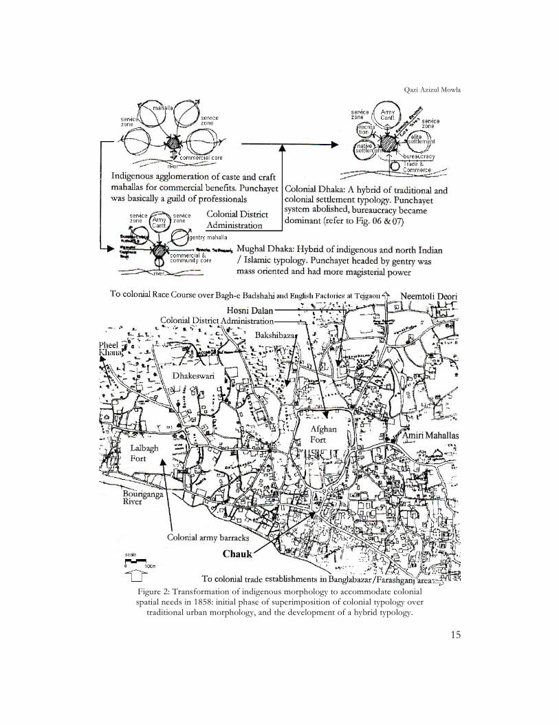
3.0 Characteristics of Pre-colonial Settlement Morphology: 3.1 Mahallas: Fundamentally there were two types of mahallas, the Amiri Mahallas and the Service Mahallas. Service mahallas were single-caste/lineage/profession residential areas (Dayal, 1975) and the Amiri mahalla were a community evolved around a gentry house (Katra/Haveli/Deory). Nucleus of such mahallas were occupied by a single extended family and their descendent and these were grouped together into single security areas, which provided their own defence and police on the basis of a general levy decided upon by the local civic bodies. The rich tended to occupy preferred locations such as along major streets, higher flood free grounds, near the fort or power base, along the river or adjacent to large open spaces/gardens (Mowla, 1985).
The services zone were located at the fringe of the than urban core. This is evident from the location of services mahalla's, falling between two cores i.e. the Chouk and the Bangla Bazaar, of two different phases of pre-colonial period. The upper crust of Mughal society comprised of high civil and military officials, landlords and other nobles. The rich but non-official Mughal citizens Mahallas (Amiri Mahalla) were located between Old Fort and indigenous caste and craft settlements. Vast majority of population clustered around these spacious mansions of important persons. At some distance from the urban core towards north, were the gardens and houses maintained by the nobles and gentry (Fig. 2).
3.2 The Civic Body: The city was managed and administered by a system of civic body called Punchayet (Committee of five) at mahalla level and Kazi (Judicial head) and Kotewal (Administrative head) at the city level (Haider, 1967; Mowla, 2001). The Mahallas or indigenous neighbourhoods headed by Sardars (leaders) were semi-autonomous socio-spatial units, with very little control from higher level in the hierarchy of administration and judiciary, in their internal matters (Ahmed, 1986). Each mahalla had a punchayet office, to be more appropriate, a community centre called Bangla situated in a conspicuous part of the mahalla. Sometimes during the day the Bangla would be used as a Maktab or elementary school and at night as a social club for adults of the locality. Every mahalla in Dhaka had one or two wrestling fields for the physical training of the inhabitants (Haider, 1967). The expenses of punchayet were born out of fines, fees and donations. Before the creation of Municipality, the municipal duties such as maintenance of roads, paths, tanks, bathing places, maintenance of civic places and appointment of security guards (chaukidar) were performed by the punchayet (Mowla,1997a). The functions of the punchayet were in the main threefold: arbitration of disputes, punishment for moral or social offences and a host of social obligations.
Qazi Azizul Mowla
15
Figure 2: Transformation of indigenous morphology to accommodate colonial spatial needs in 1858: initial phase of superimposition of colonial typology over
traditional urban morphology, and the development of a hybrid typology.
Colonial Spatial Planning versus Local Tradition
16
3.3 The settlement Pattern: Settlement and urban form in the pre-colonial phase seems to centre around a complex of buildings of public importance as the formal focus of urban development, and relatively informal organisation of the rest of the area into neighbourhoods, or mahallas, on the basis of quite well defined socially cohesive communities. The courtyard or Uthan was the basic module for the organisation of living space. The Uthan concept resulted in the formation of community/civic spaces at different hierarchy. The streets wind through the mahallas and occasionally branch out into short cul-de-sacs. In short stretches these streets get converted into Bazaar and artisan streets. Yet another feature of old trading areas were Katra6 specialising in the sale of separate single commodities. A katra is a market usually around a uthan with residential quarters and storage facilities enclosed by a high wall and entered by a gate. Subsequently some of these katras have become totally residential in use, though their spatial character remains the same. Similarly, several streets were associated with the manufacture and sale of items of particular handicraft. Within the mahallas, residential quarters were mixed with retail and whole sale outlets, workshops and warehouses.7 Other morphological elements that can be specially attributed to the Mughal phase of Dhaka are its morh and chauk usually located at the junction of two or more streets or the end of a lane. They served as the common meeting grounds of the local community.
4.0 Colonial Period 4.1 Colonial Policy and Urban Morphologies: This phase in Bengal witnessed a conscious effort by the rulers to keep themselves at a distance from the native (King, 1976).8 When the dominant section is a minority ... the dependence on regulation by force is greatest (Smith, 1965). ‘Communally divide and politically rule’ and the ‘indirect rule’ were the general principle of colonisation making use of the local opportunist elite. Wright (1991) declare that the ultimate goal naturally did never revolve around cultural benevolence. The colonisers were searching for a policy that would make their economic and political power work more effective, reducing the need for force. A middle class, an outcome of the colonial policy of ‘indirect rule’ in the early 20th century, was destined to play a fundamental role, even in the post-colonial years. This middle class was described by Macaulay as "a class of persons Indian in blood and colour but English in taste, in opinions, in morals and in intellects" (Sharp, 1920). Even the emphasis on "no interference" by the colonisers had its advantages; it implied no urge to provide modern amenities to the native quarters. Taxes collected for urban development went to pay for municipal improvements and services that primarily benefited the coloniser’s districts of cities. In general the colonial policy got manifested in the compartmentalisation (including the division on ethnic lines)9 of the city and assertive architecture (Mowla, 2000).
6 Katra were generally market place and hostel for traveling merchants. Hodges described Katra as a
grand seminary of Muslim learning (Hodges, 1793, p.18). 7 Indigenous Mahallas were typical, in their dense development, of a pedestrian character with
business, their clerks and their porters all within walking distance of their place of work. Living near the business centre saved people both time and money.
8 The official elite lived like an aristocracy. Social distance seemed essential to their authority (Ballhatchet, 1980, p.164).
9 British ‘divide and rule’ policy successfully injected the idea among the indigenous population that for them British rule is just a matter of change of masters, not a question of local and foreign rule, so they should cooperate with them (Dani ,1962).
Qazi Azizul Mowla
17
The term modernisation as implied in the colonies was a shift from a local market to international capitalism, from production based on self-sufficiency and exchange to a system that responds only to distant consumer market (Chomsky, 1993). This way of thinking was catalytic to the process of disintegration of indigenous self contained communities and settlements. Together with these systemic changes came an array of highways and rail roads, factories and plantations, banking and insurance firms, all geared to large scale production and trade linking the interior with the shipping routes (Zahiruddin & Mowla,1985). The public works benefited the colonisers and local elite almost exclusively at the time, but these were financed largely by increasing taxes on the peasantry (Jacobs, 1984).
4.2 Socio-Cultural Attitude of the Colonisers: The English had evolved a system of control for towns, with English Magistrate under Bengal regulation 39 of 1793, accumulating most of the judicial and administrative powers. Indigenous social structure of mahallas-punchayet also experienced a change during the colonial period. Office of shahar (town) Kotwal and Kazi was abolished and most of their responsibilities taken over by the Magistrate. From 1890 onward, the office of mahalla Sardars (leader of the neighbourhood punchayet) appointed with some external influence lost most of its vitality. However, due to insufficient administrative or judicial setup, the punchayet was allowed to function as before for some time. In spite of all these efforts, dynamism of earlier civic administrative system could not be restored, which was based on active participation of city population (Mowla, 2006a). Though punchayets/local civic bodies of individual mahallas initially retained much of their internal vitality and independence from political intervention, the effect of disruption of the system began to surface in various socio-spatial mismanagements.10 The bodies of merchants, traders and powerful urban land holders who had aided the British in its rise to power saw their influence grow as the pressure of superior authority was removed from them in commercial matters. In fact, actual power lay with the colonialists; therefore, in effect this situation gave rise to a dual rule. Extortion by the native collaborators and taxes/levies by the formal administration exploited the general population; but in neither case was the welfare of local population their concern.
4.3 Impact of Colonisation: The colonialist effectively isolated the South Asian region from its geographical neighbours with whom it had socio-cultural interaction for centuries. Nehru (1956) termed this development as the most remarkable and unfortunate consequence of colonial rule as it disrupted the earlier trend of evolution. The colonial impact also resulted in the partial break down of a traditional, territorial based social structure associated with religious, ethnic, caste and socio-occupational criteria. Instead it built up a new, territorial-based system of class linked to occupational, socio-economic and racial groupings. The newly founded cities, after destruction, transformation and distortion of indigenous civilisation, reflected the new power structures and exercised functions relevant to the interests of colonisers. Older cities that survived had to change to cater for the needs of the colonisers (Fig. 2).
4.3.1 Development of a Pattern during the Colonial phase: Colonialists often created a dual urban regional system favouring the development of the major coastal cities tied to their home economy and the extraction of wealth from the inland regions (Breese, 1966; Jacobs, 1984). Thus Dhaka became the internal extraction centre and Calcutta became the main coastal urban centre.
10 Loosened social bondage, reduced effectiveness of local arbitration and more court cases, and less
community participation in the development process and increased dependence on public body.
Colonial Spatial Planning versus Local Tradition
18
However, the following generalisations can be made for this period (a) Geo-climate continued to play a dominant role over technology in the urban morphology, and regional patterns of settlements did not change significantly. (b) Although, at a later phase, the total urban population was growing in geometric progression, its proportion to the total population remained almost unchanged11 and (c) only a small number of towns were created during this period in the whole of south Asia. In most of the towns of colonial period, only small sections were thoughtfully laid, and subsequent growth was by accretion, in an ad hoc manner, by encroaching into adjacent villages, i.e. they were open ended and their demographic and spatial extension uncontrolled.
The Third World Cities (TWC) experiencing colonisation, resulted in hybrid structures, part tending to behave as a capitalistic system and part perpetuating the features of the previously existing system. In most of these cities, the indigenous main market place is supplemented by younger western style central business district. Some distance usually separates these two centres. Industrial activity may and does appear almost any where in these cities. European sectors present relative openness, green, order and quiet, making them sharply out of character with the indigenous sectors to which they were attached. This duality in character is termed by Brush (1962) and Bose (1973) as dual city, while King (1976) labelled them as the old and new town, but McGee (1971) preferred to call them cultural and administrative cities. In the colonial towns, the formal lay-out separated and segregated senior officers from the juniors, English from the natives. Although, Dhaka was not laid-out under European influence, it still bears testimony to a once pervasive colonial influence. In 1757, the British East India Company (EIC) gained military control of Bengal and in 1765 took over the civil administration of the country. In 1872, EIC gained the Dewani (power to collect and administer revenues) of Bengal from the Mughal court.
4.3.2 Transitional period of Colonial Phase: One of the immediate consequences of the English take-over of Bengal, as observed by Dasgupta (1987), was the rapid de-urbanisation and de-industrialisation of the territory. At its peak at about 1660 to 1690, Dhaka city with its suburbs had a population of about 900,000 (Ahmed, 1976). D'Oyly (1808) observed that the city proper stretched seven to ten miles along the river Buriganga and up to two and half miles inland. The suburbs extended from Buriganga to Tongi Bridge, fifteen miles to the north and from Mirpur-Jafarabad on the west to some ten miles to the east to Postogola. Rennell (1792, pp. 201-229) also reported that in 1765 the city core had an estimated population of 450,000 and stretched nearly four miles along the river and two and half miles deep, signifying a decline of the city. With the collapse of the economic base, the population of the urban centres of Dhaka (which used to be compared favourably with London) registered massive drops (DMMR, 1893 & Chomsky, 1993).
As people deserted the town, many houses were left unoccupied and decaying, becoming health hazards. In about forty years the city's housing stock had fallen from 44,000 houses in 1801 to 16,279 in 1830 and 10,830 in 1838.12 Paradoxically, as the overall population declined, and with no mechanism to check on wealthy people leaving and poor people migrating in, parts of the city grew overcrowded. Many older locations of settlements were in fact occupied to accommodate 11 Observations are based on census data/reports of BBS, 1993, UNCHS,1996 and authors field
studies in Dec-Feb’ 1995-96. 12 Taylor, 1840, pp. 363-371, ‘Notes by the (Commercial) Resident,’ (HMS 456), footnotes to p 289;
and Karim, 1964, pp. 37-38.
Qazi Azizul Mowla
19
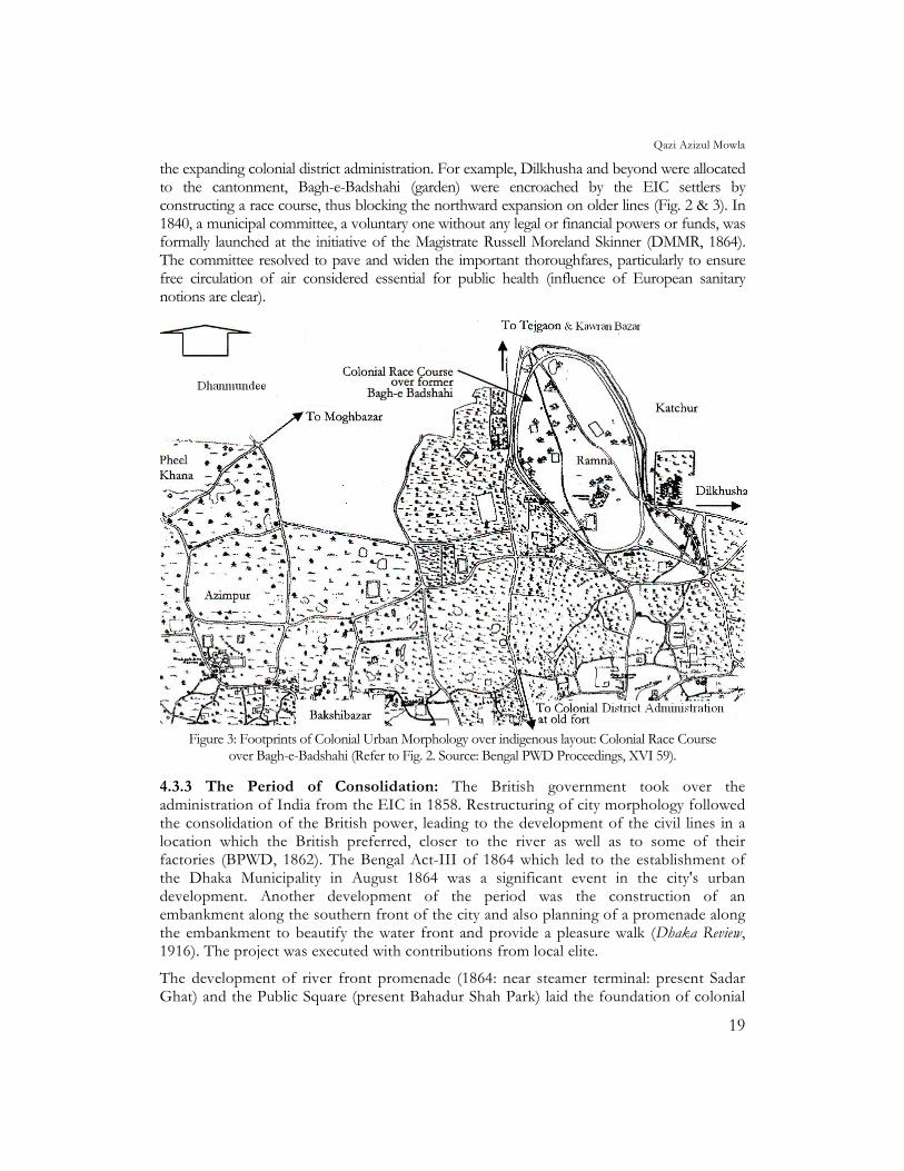
the expanding colonial district administration. For example, Dilkhusha and beyond were allocated to the cantonment, Bagh-e-Badshahi (garden) were encroached by the EIC settlers by constructing a race course, thus blocking the northward expansion on older lines (Fig. 2 & 3). In 1840, a municipal committee, a voluntary one without any legal or financial powers or funds, was formally launched at the initiative of the Magistrate Russell Moreland Skinner (DMMR, 1864). The committee resolved to pave and widen the important thoroughfares, particularly to ensure free circulation of air considered essential for public health (influence of European sanitary notions are clear).
Figure 3: Footprints of Colonial Urban Morphology over indigenous layout: Colonial Race Course
over Bagh-e-Badshahi (Refer to Fig. 2. Source: Bengal PWD Proceedings, XVI 59).
4.3.3 The Period of Consolidation: The British government took over the administration of India from the EIC in 1858. Restructuring of city morphology followed the consolidation of the British power, leading to the development of the civil lines in a location which the British preferred, closer to the river as well as to some of their factories (BPWD, 1862). The Bengal Act-III of 1864 which led to the establishment of the Dhaka Municipality in August 1864 was a significant event in the city's urban development. Another development of the period was the construction of an embankment along the southern front of the city and also planning of a promenade along the embankment to beautify the water front and provide a pleasure walk (Dhaka Review, 1916). The project was executed with contributions from local elite.
The development of river front promenade (1864: near steamer terminal: present Sadar Ghat) and the Public Square (present Bahadur Shah Park) laid the foundation of colonial
Colonial Spatial Planning versus Local Tradition
20
urban morphology in Dhaka (Fig. 3). This location prompted many new typology of building to come up to cater to the needs of that period such as for the Dhaka District Board (1841), Bengal Bank (1890), Baptist, Catholic and Protestant Church (1815-1819), Dhaka College (1835), Collectorate (1866) and Municipal Committee. The embankment, named after C.T. Buckland, the Commissioner of Dhaka, was faced with stone, and the top laid with bricks. Near the main steamer terminal (sadar ghat), part of the strand was left green; this was later turned into a miniature park with a raised dais to receive local dignitaries on landing. The strand proved an ornament to the town and provided a spacious promenade overlooking the river with its busy traffic, where people could stroll in the afternoon. In late 1880's the Buckland Bund was about a mile in length and was handed over to the municipality for maintenance (Dacca Review, 1916).
4.3.4 Spatial Imprints of Colonial Influence: Colonial imprints began to surface in the late Mughal era with European settlers building their trading houses and settlements. The Portuguese, the Dutch and the French had separate settlements. The English took control over all of them at a later period (Mamoon, 1993). This had more lasting influence on Dhaka's physical environment. Two important patterns that were observed during the British rule were the Civil Lines and the Civil Station. However, the railway colony and the cantonment may also be uniquely attributed to this period. Together they brought about significant change in the lay out of Dhaka.
Colonial notions encouraged functional zoning. The high class residential buildings built along/near the river during the Mughal and the British period, was fundamentally due to the need of comfort and easy access to the water ways (then the main source of communication and transport). In due course, situation was utilised aesthetically, with the houses facing the water front. Buckland Bund, the river front promenade, is reminiscent of Danish Serampore or French Chandernagore near Calcutta and the water front at British Madras, all created by the Europeans (Nilsson,1968). The recreational areas around or selection of water front helped the Europeans to adjust themselves to the sub-tropical climate. Some of the reasons that lay behind most radical breaches in the pattern of earlier conventional type towns, in both the indigenous and the colonial periods, were climate and defence.13 Conception of town as a clearly defined compact unit was abandoned in favour of scattered houses and settlements connected with some form of available communication line - generally water ways (Nilsson, 1968). The introduction of the railway, piped water and electricity (for indoor comfort) reduced the importance of river front, and Dhaka began to expand and densify towards the north (Fig. 4). The developments under the English were sharply in contrast with the older quarters. The European sector of the town was spaciously laid with all the civic amenities.
13 Dhaka’s topography provided necessary defense and security but at the same time forced the
settlement to be built loosely.
Qazi Azizul Mowla
21
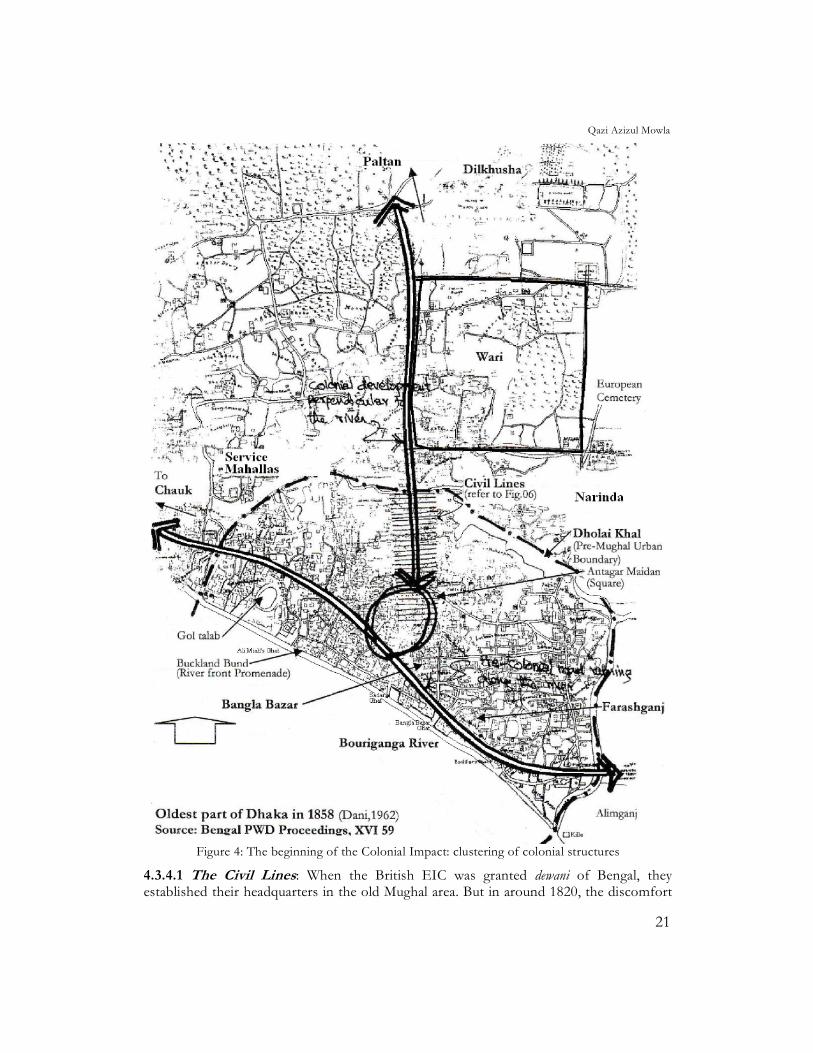
Figure 4: The beginning of the Colonial Impact: clustering of colonial structures
4.3.4.1 The Civil Lines: When the British EIC was granted dewani of Bengal, they established their headquarters in the old Mughal area. But in around 1820, the discomfort
Colonial Spatial Planning versus Local Tradition
22
of living in the previous ruler’s quarters prompted them to move to the indigenous core of Bangla Bazaar/Farashganj area or French quarters (Fig. 4). It was also close to their old factories and new cantonment in the Mill Barrack area (Ahmed, 1986). In 1862, Divisional Commissioner Buckland selected a strip of land about 100 meters in width on the west side of the public road leading north from the public square up to Dholai Khal for the new Civil lines, across which was the Rai Saheb’s Bazaar, the newly laid residential area of Wari (completed 1880) and the Christian Cemetery (Fig. 4 & 6).14 By 1866, the courts for the District Judge, Magistrate and Collector and other subordinate offices were built and shifted to new location.
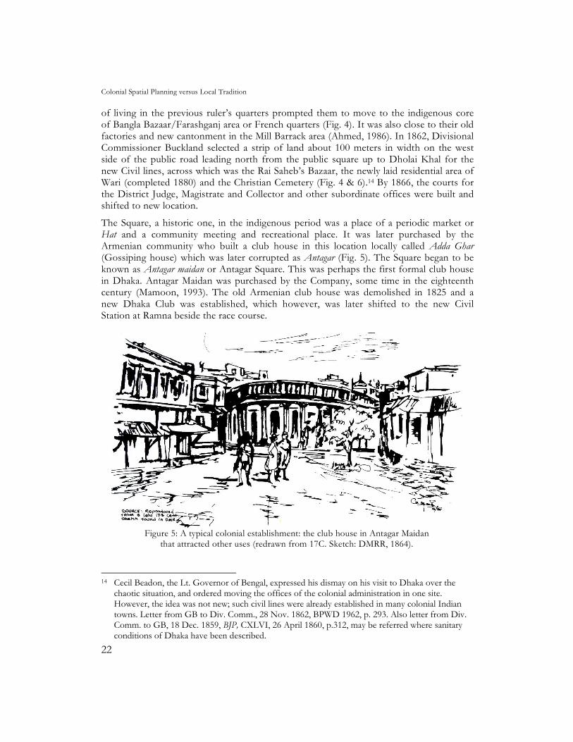
The Square, a historic one, in the indigenous period was a place of a periodic market or Hat and a community meeting and recreational place. It was later purchased by the Armenian community who built a club house in this location locally called Adda Ghar (Gossiping house) which was later corrupted as Antagar (Fig. 5). The Square began to be known as Antagar maidan or Antagar Square. This was perhaps the first formal club house in Dhaka. Antagar Maidan was purchased by the Company, some time in the eighteenth century (Mamoon, 1993). The old Armenian club house was demolished in 1825 and a new Dhaka Club was established, which however, was later shifted to the new Civil Station at Ramna beside the race course.
Figure 5: A typical colonial establishment: the club house in Antagar Maidan
that attracted other uses (redrawn from 17C. Sketch: DMRR, 1864).
14 Cecil Beadon, the Lt. Governor of Bengal, expressed his dismay on his visit to Dhaka over the
chaotic situation, and ordered moving the offices of the colonial administration in one site. However, the idea was not new; such civil lines were already established in many colonial Indian towns. Letter from GB to Div. Comm., 28 Nov. 1862, BPWD 1962, p. 293. Also letter from Div. Comm. to GB, 18 Dec. 1859, BJP, CXLVI, 26 April 1860, p.312, may be referred where sanitary conditions of Dhaka have been described.

Qazi Azizul Mowla
23
Figure 6a: Development around a square (Antagar Maidan): the birth of the colonial
Civil Lines in 1858 (Refer to Fig. 4) (Source: Bengal PWD Proceedings, XVI 59)
Colonial Spatial Planning versus Local Tradition
24
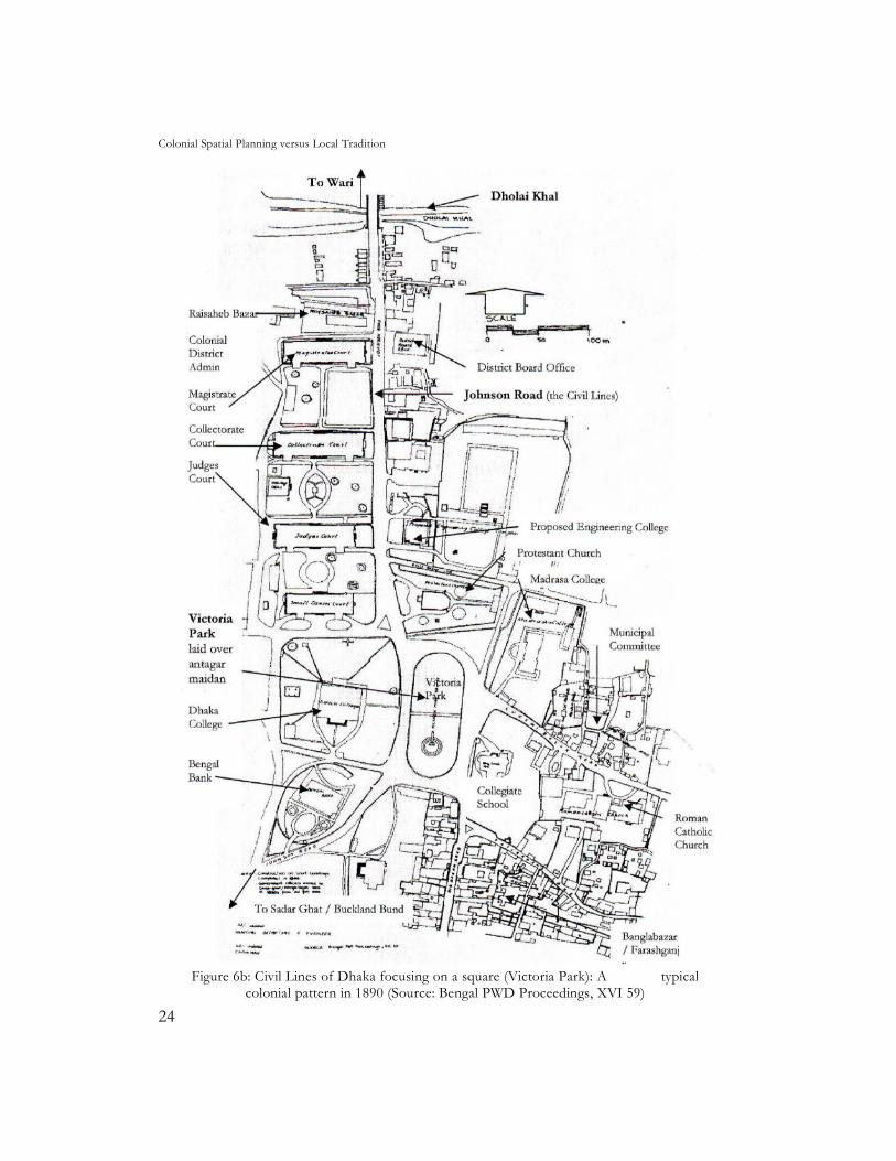
Figure 6b: Civil Lines of Dhaka focusing on a square (Victoria Park): A typical
colonial pattern in 1890 (Source: Bengal PWD Proceedings, XVI 59)
Qazi Azizul Mowla
25
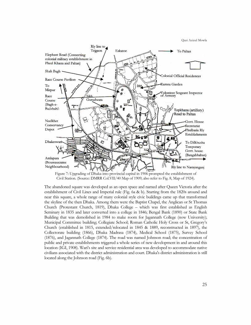
Figure 7: Upgrading of Dhaka into provincial capital in 1906 prompted the establishment of Civil Station. (Source: DMRR Col.VII/40 Map of 1909; also refer to Fig. 8, Map of 1924).
The abandoned square was developed as an open space and named after Queen Victoria after the establishment of Civil Lines and Imperial rule (Fig. 6a & b). Starting from the 1820s around and near this square, a whole range of many colonial style civic buildings came up that transformed the skyline of the then Dhaka. Among them were the Baptist Chapel, the Anglican or St Thomas Church (Protestant Church, 1819), Dhaka College – which was first established as English Seminary in 1835 and later converted into a college in 1846; Bengal Bank (1890) or State Bank Building that was demolished in 1984 to make room for Jagannath College (now University); Municipal Committee building; Collegiate School; Roman Catholic Holy Cross or St, Gregory’s Church (established in 1815, extended/relocated in 1845 & 1889, reconstructed in 1897), the Collectorate building (1866), Dhaka Madrasa (1874), Medical School (1875), Survey School (1876), and Jagannath College (1874). The road was named Johnson road; the concentration of public and private establishments triggered a whole series of new development in and around this location (IGI, 1908). Wari’s site and service residential area was developed to accommodate native civilians associated with the district administration and court. Dhaka's district administration is still located along the Johnson road (Fig. 6b).
Colonial Spatial Planning versus Local Tradition
26
4.3.4.2 The Civil Station: An important development in the morphological evolution of Dhaka in 1905 had been the establishment of a new Civil Station (Fig. 7 & 8),15 north of the railway line and around the Ramna race course, laid over the former Bagh-e-Badshahi (Royal garden) of the Mughals. In the period of Dhaka’s urban decline the Mughal pleasure gardens on the north, which were encroached by deep vegetation, were taken up for clearing by the Magistrate Charles Dawes in 1825. He laid out a spacious green. A large oval in Bagh-e-Badshahi or present Shah Bagh was cleared and enclosed with a wooden railing, and round the perimeter a race-course was laid out (Ahmed, 1986,).16 At the extreme north-west, half a mile from the winning post, a small hillock within the present Children’s Park was created, thickly vegetated and crowned with a pavilion in the gothic style. The race course was again reclaimed from overgrown vegetation in 1840 by Magistrate Skinner; a ticket house was then built (inside present Shah Bagh police station).
The garden city-pattern civil station developed in the area contained Governor’s or Government House (Old High Court building), Secretariat (present Dhaka Medical College Hospital), Curzon Hall or Town Hall, Survey School, Engineering Hostel (present Fazlul Haq Hall), Press and Printing (in present Bangladesh University of Engineering and Technology campus), Senior officials Bungalows in the northern and western side of the Ramna Race Course. At some distance from Ramna, towards west, in Azimpur the staff quarters was conceived for the provincial administration. The massive development work, with imperial overtones, that began in civil station with the partition failed to set a trend, as partition of Bengal was annulled after just 6 years in 1911. Most of the Civil Station buildings were acquired by the newly established Dhaka University. Dhaka University campus has a lasting impression on Dhaka’s morphology.
It may be noted here that Ramna is historically a high-class area. Gardens were important elements for Mughal settlements, as the race course was for English settlements, and these were mostly exclusive for the ruling elite. Many new buildings have infiltrated into this area since then, but basic morphology of the area from the Mughal period till this day has remained largely intact. The area was and still is a major recreational area of the city with large open spaces containing parks, playing areas and clubs.
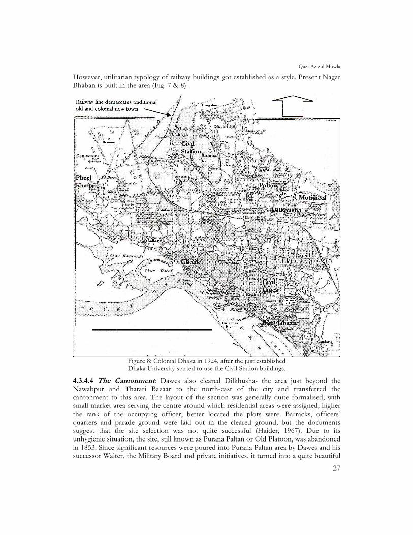
4.3.4.3 Railway Establishment: The railway establishments at Tejgaon and Phulbaria (two colonial settlements) are typical of a colonial district. The selection of the site for Dhaka's first railway station at Phulbaria in 1885 left a lasting impression on Dhaka's urban morphology. About fifty acres of land were acquired and developed for the station, workshop, staff quarters and the railway colony. The station and the rail line practically demarcated the old (traditional) from the new (European) developments (Dani, 1962).
15 Bengal was partitioned in 1905 and Dhaka was made capital of newly formed East Bengal-Assam
province. 16 Though the city was still declining and Ramna race course, away from urban core, became a
popular recreational site for Europeans. It was R. M. Skinner (1840-42), who arranged regular maintenance of Ramna area using prisoners of the Dhaka Jail and persuading ‘the most respectable natives’ to get involved in the development of Dhaka (Ahmed, 1986, pp. 149-51).
Qazi Azizul Mowla
27
However, utilitarian typology of railway buildings got established as a style. Present Nagar Bhaban is built in the area (Fig. 7 & 8).
Figure 8: Colonial Dhaka in 1924, after the just established Dhaka University started to use the Civil Station buildings.
4.3.4.4 The Cantonment: Dawes also cleared Dilkhusha- the area just beyond the Nawabpur and Thatari Bazaar to the north-east of the city and transferred the cantonment to this area. The layout of the section was generally quite formalised, with small market area serving the centre around which residential areas were assigned; higher the rank of the occupying officer, better located the plots were. Barracks, officers’ quarters and parade ground were laid out in the cleared ground; but the documents suggest that the site selection was not quite successful (Haider, 1967). Due to its unhygienic situation, the site, still known as Purana Paltan or Old Platoon, was abandoned in 1853. Since significant resources were poured into Purana Paltan area by Dawes and his successor Walter, the Military Board and private initiatives, it turned into a quite beautiful
Colonial Spatial Planning versus Local Tradition
28
place in the town and the ground was transferred to Municipal Committee after it was vacated to be maintained as an open space. Part of it was turned into a garden and a part was left vacant, where various athletic and wrestling competitions were annually held. However, it continued to be used by the military as a parade ground and shooting range. After partition in 1947, Pheel Khana remained as a cantonment of border guards, part of Purana Paltan area was assigned to the Police line and the rest of the area was developed as the centre of sporting activities in Dhaka, with Dhaka's first stadium built here.
5.0 Contemporary Period 5.1 Adaptation phase of contemporary development: During the last two centuries, concepts and life styles in Dhaka have undergone considerable changes. Initially, it was internal strife, and then foreign rule, then destruction of indigenous home based crafts which affected the nature of the social pattern. Subsequent emphasis on industrialisation, the advent of new building materials, and a desire to "modernise" gave rise to different patterns of building and community - city planning (Mowla, 1997b & 2003c). The models for such development were neither conceived on the basis of local climate, social needs, life style, nor by incorporating the attributes of the process discussed earlier. The consequence is a contradiction between what was there before and what is there now. What was there is appreciated, but it is not known how to improve the present and ensure a better future. As a result superficial attempts are made in urban design, building and space design to redress the problems (Mowla, 1999b). They do not appeal to the hearts, as they are not symbolically or emotionally related to the soil. However, it is clear that all the older forms, pre-colonial or colonial, had an impact on the subsequent development.
Older indigenous cities were once seats of great tradition, but in most cases, the nature of these older cities has been transformed to such an extent that past has been overwhelmed. The Asian cities are now a hybrid of indigenous and western influences especially in terms of their contemporary functions, physical characteristics and morphology (Mowla, 2003b). Third World Cities are also not beyond the influence of contemporary trends; in fact many of them are testing ground, for international masters in architecture and urban design, Dhaka is no different. Avant-garde or pioneer movement in European Architecture or Urban Design may not have directly influenced the development pattern during colonial period, but seeds were definitely sown at that time. The result was the commissioning of master architects by newly independent TWCs.17 Both the trends tend to obscure the importance of traditional morphology.
One of the fundamental changes that these cities experienced after independence was to substitute colonial administrators with local bureaucrats following the colonial footsteps. In all of these formal colonial cities under national governments, the privileged areas of the former colonial rulers are generally taken over by the local ruling class or elite associated with them. This poses a question of whether the urban environment itself can perpetuate relationship of domination. It is perhaps the same psychology which prompted the colonial rulers (Nilsson, 1968) to surpass or at least show similar extravagance or symbolic positions of power as previous mighty rulers.
17 For example: Le Corbusier in Chandigarh (India), Doxiadis in Islamabad (Pakistan) and Louis I.
Kahn in Sher-e-Bangla Nagar-Dhaka (Bangladesh).
Qazi Azizul Mowla
29
5.2 Post-colonial Phase: In the post-colonial period, Bangladesh entered into another era of political subjugation. Socio-culturally, East and West Pakistan were as much apart as they were physically.18 The only common bond being of religion, the obvious political intention was to use religion as a means of internal colonisation. Expression of this attitude is manifest in the beginning of pseudo-Islamic architecture in Bangladesh, which was as weak as the political concept of the unification of two separate nations with different cultural identities. At the beginning of this phase, European or Anglo-Indian typology were often combined in attempts to create a so called Islamic style.19 However, during this time, in order to fulfil the needs of the provincial capital, this region entered into a feverish era of building activities (Nazimuddin, 1985).
In the contemporary Bangladesh, names of the residential areas indicate the position of the residents in terms of their financial and social status. This Euro-centric mentality, along with the image of the buildings and spaces of European typology, formed the standard definition of an acceptable architecture and urban growth. This attitude still prevails. The projects of western architects in the TWC, although well intentioned, carried their perception of local situation and were western-biased but nevertheless remained a source of inspiration and awareness in the search for deeper meaning and purpose of architecture and urban design.20
6.0 Discussion on Spatial Characteristics Associated with Societal Values The external rulers except the English turned and then identified themselves with the local people and culture (Mowla, 1999a). It is because all of them belonged to oriental cultures having similar values and also that they settled in the region. For the first time during the British rule the ruling class remained alien usurpers and failed to identify themselves with the local people. However, indigenous values could not be eradicated. In the backdrop discussed in the preceding sections, some of the spatial characteristics associated with societal values are compared here in the following sections.
6.1 Family Structure: In the pre-colonial setup, the nucleus of social structure was household (ghar) and homestead (bari). Neighbourhood or mahalla (also called para) were mainly composed of family lineage (paribar). The social structure was similar to contemporary rural structure in Bangladesh. Physical manifestation of family level outdoor activities gave rise to uthan or courtyard house and galies or lane/by lanes.
18 Post 1947 rule was a synthesis of the autocratic element in the tradition of the British rule with the
aristocratic traditions of the north Indian Muslim ascendancy. The special character and aspirations of the Bengali could not find little room to express themselves within such political order. [Jackson, 1975, pp. 18-19]. The Bengalis were most progressive among the South Asian people and possessed a deep loyalty to their Bengali Culture - a synthesis of pre-Islamic and Islamic traditions, besides their commitment to Islam [Jackson, 1975, p. 14]
19 Socio- cultural norms are often reflected in the physical environment. If a man’s religious belief affects societal values than it may in turn effect his physical surrounding. It is seen, however, that pre-Islamic spatial principles and concepts emerging in Arab civilizations or in South-Asia had continued after the advent of Islam. As such there is nothing like Islamic Architecture or Urban Design rather it is regional. May also refer to Alnowaiser, A.M. (1996, pp. 91-106. [p.94])
20 In spite of their presumable honesty, it was not possible for them to feel the pulse of the society from abroad. They could see the outer expression but not the internal dynamics of the form as did the colonialists while evolving ‘Bungalow’ typology.
Colonial Spatial Planning versus Local Tradition
30
The house of the wealthy was likely to have two uthan, one for bhitor bari or inner house and another for bahir bari (Bangla ghar) or outer house, each flanked by rooms of female and male domains respectively. In the house of not so wealthy, rooms would be arranged around a single uthan with front room facing the street functioning as the entertaining area for males. In the pre-colonial city, uthan was the basic module for the organisation of living spaces (Mowla, 2002a). Earlier in a more compact urban context, social structure in Dhaka had consolidated more. Prevailing mahalla typology was derived from social interaction of families.
During the colonial period the built-form provided for western culture at Dhaka was the Bungalow-compound complex (King, 1976). The typology derived from the indigenous ‘bangla ghar’ typically consisted of a large, single storied dwelling located generally at the centre of large enclosed plot. The servants quarters and services areas were located at the backyard detached from the main building (Mowla, 1997a). Front lawns were carefully arranged and cultivated to expose their status and to suit "garden parties", the backyard was assigned to services e.g. Bungalow typology.
6.2 Religious Belief: The pre-colonial period was largely influenced by polytheism which does not proselytise and it being an ethnic attitude rather than universalising concept, gave rise to variety of worship places. Indigenous attitude, unlike Muslim’s masjid (mosque) or Christian’s girja (church), was god oriented rather than community oriented. Typically, spaces were occupied, inhabited and modified according to caste criteria of indigenous settlement. Generally religious observance was at individual and family level expressing that in the domestic shrines in each house and the many small temples that were scattered throughout the city.21
The cyclical world view of Hinduism was associated with the practice of cremation or floating away at the sacred water gave rise to the need for cremation ground or shoshan ghat by the river. Typical settlement layout was concentric with higher caste living near the centre and lower caste away from core.
21 Islam is strictly a monotheistic religion and careful study shows that it does not approve of shrines, tombs
etc. but a significant portion of so-called Islamic Architecture comprises of these buildings. However, Vedic religion (Hinduism) was opposed to all forms of idol and image worship. The idea came to India from Greece (Nehru, 1956, p.1 46) in a similar way it had partly influenced Christianity.
Observance of Puja’s (worship) on more community scale evolved during the Mughals. These used to be patronized by the ruling elites, both Muslim and Hindu, as an act of social duty towards their subjects. McDermott (1995) observes that Pujas have always been means of demonstrating wealth and prestige, and the worship of Durga has long been associated with sovereignty, useful in the context of eighteenth century Bengal for bolstering the rajas’ claims to identity and power. The Barowari Puja, or Puja sponsored by twelve (friends), was first introduced in 1790. Instead of the expanses for the festival being defrayed by one zamindar family alone, the Puja was democratized; its cost spread out and shared among people not necessarily of the hereditary aristocracy. The Sarbajanin (or public) Puja of today is heir to this intermediate, Barowari type, now Pujas are sponsored by neighbourhood groups and civic associations, which vie with each other to produce the best, most opulent and beautiful displays. Muslims also could not escape this social trend, among Muslims this evolved in the shape of mass observance of Muharram and Eid-e-Milad un Nabi. The most amazing act of worship, as cited in McDermott (1995), was performed by the East India Company itself: in 1765 it offered a thanksgiving puja (perhaps to appease its Hindu subjects) on obtaining the Dewani (right to collect revenues) of Bengal
Qazi Azizul Mowla
31
Muslims monotheistic belief had a community based on the principle that faith not kinship acts as a social bond. The traditions begins from a Muslim notion of centre, although, not metaphysical but symbolic of the idea of earth and the heavens and of the manifested centre - which becomes a geometric or physical centre. Dickie (1978) has observed four levels of prayers and accordingly a hierarchy in mosque or prayer was identified i.e. at individual level, the congregation, the total population of the community and the entire world. For the last three of these, there were distinct liturgical structures - the first is the Masjid for daily prayer generally located at each mahalla, the second is the much larger Jami-Masjid (congregation or Friday mosque) located at a convenient place for a group of mahallas, and the third level is the Eidgah or place of annual Eid prayer, a great open space often on the outskirts of the city for the assembly of the whole population of the city. Jami Masjid was one of the prominent features of central urban space or chouk. Kaba (Mecca) is the fourth level or global level of congregation of Muslims. Perhaps, no other religious practice has been so instrumental in establishing the basic frame of Dhaka than of the need of facing towards the Kaba for prayer. The hidden axis, inevitably determines the orientation of the Mosque and also the alignment of the principal streets at whose intersection the rectangular space of the mosque has to be nudged in nicely. Numerous tombs of Muslim saints, though discouraged in the Islamic faith, are a definite expression of hybrid indigenous and Persian cultural beliefs.
The colonisers had a monotheistic system of belief. In contrast with the previous practices, there was marked distinction between sacred and secular activities. Formal worship and ritual in the European community, as King (1976, p.50) observed, were therefore more specialised, both spatially and temporally, with worship generally taking place only once a week and only in church. The legitimisation which European doctrine gives for sanctification to both persons and places associated with upholding the faith in the face of attack from opposing ideologies, took symbolic meaning, and are commemorated in the urban landscape. Victoria Memorial commemorating the suppression of mutiny against the rulers is such an example. Belief relating to the resurrection of the flesh and immortality of the soul called for the custom of burial, the place of which is visually commemorated, and was part of a larger, community burial place, whose ground sanctified. The idea of central community grave yard was borrowed by the native Muslims from the colonialists, earlier it was family burial ground.
6.3 Economic Institutions: The predominant economic activity in urban area was marketing of surplus agricultural products and centre of craft production. Indigenous setup had a system of money lenders who acted as indigenous bank. Marketing was done in the hat/bazaar of more periodic nature and also on shopping streets in the artisan's mahallas (Mowla, 2006b). Because of particular style of marketing behaviour, the hat and bazaar, with its line of open stall or shops organised on big open grounds or directly into the thoroughfare and with constant movement along it, had a totally different spatial structure than European market.
"The Mughal rulers encouraged these people (the artisans and craftsmen) by granting them rent free lands for habitation"(Ahmed, 1986). Travel accompanies trade, therefore, the propensity for travel found physical expression in the provision of amenities such as caravansaries and Katras. Providing amenities for travellers and the community was considered a pious act. Therefore encouraging the wealthy people to take these responsibilities and thus relieve
Colonial Spatial Planning versus Local Tradition
32
the state from this function. These groups of public buildings acted as nuclei of a mahalla and also of the city. Exclusive economic institutions were unknown and had a broader function including social, thus generating a series of civic spaces particularly morh, bazaar and chouk (Mowla, 2006b).
In the European cultures of the colonisers, economic functions like saving or credit facilities were provided by the bank and marketing by specialised shopping centre. Property was represented generally in the form of house or `share' in industry - usually at home. Thus, according to King (1976), in European urban settlement, saving, marketing, property, and employment are embodied in bank, the offices of insurance agents, shops specialising in European goods, housing of different types and sizes allotted according to occupational rank, and status which is partly ascribed and partly achieved. Hotel, an important functional unit in European urban settlement, belonged primarily to the economic institutions of the culture. Contemporary shopping streets are a fusion of bazaar and market typology.
6.4 Recreational Pattern: In the pre-colonial era work and recreation was a part of day to day life in the indigenous society, therefore, recreation was family and community centred and frequently related to religious festivals (Nehru,1956 & Mamoon,1990) accompanied by Mela or open air fairs, Jatra or drama and Kavi Gan or recital programmes. Daily recreation was comparatively unstructured. Courtyards, squares, Garden, park, play ground etc. as a representation of paradise got projected as major places for recreation (Ramna, Shah Bagh, Dilkhusha etc)
Among the colonisers, the recreational patterns were those generally associated with an urban industrial society. In which a society, King (1976) observes, time divisions were more formal and specialised, demanding specialised buildings and spatial areas in which activities could take place. Recreational pursuits of the community, such as amateur theatricals, social dancing and the children's party took place in the club. At Dhaka, development of river front promenade, the race course and different clubs were the spatial representation of colonial culture (Mowla & Reza, 2000).
7.0 Evolving Form and Space in Dhaka Dhaka was at its peak during Mughal rule but the Mughal city core was settled over a former Afghan settlement laid during the reign of Sher Shah in the 16th century. Present Central Jail was an Afghan fort. In Mughal Dhaka, as before, water bodies served as the communication lines. There were two principal roads in the city. One of them ran from eastern defence outpost of Beg Murad Forts 1 and 2 via the Bangla Bazaar (pre-Mughal urban core) and Chouk (Mughal urban core) to the western fringe, extending up to Satmasjid area, the part of the city running parallel to the river. The other road ran north up to the Tongi defence out post via Badshahi gardens and Tejgaon from chauk. This road was developed and diverted near the Mughal gate besides the race course during English rule towards the newly established colonial Civil Lines and Civil Station. The internal road network was secondary to a cluster of Mahallas and was paved with brick.
The Chouk during the Mughals was well located to serve both the gentry (Amiri Mahalla) and service Mahallas. During the Mughals, the Chouk was more dominant than the previously important Bangla Bazaar area because of housing ruling base and gentry
Qazi Azizul Mowla
33
mahallas. When the English establishments moved to the Bangla Bazaar area, the core also shifted there. Before moving out of Old fort it housed the English Civil Secretariat. In the post-partition and post-liberation periods as the administration moved northwards the core also moved to the new location.22 However all the previous cores continued to survive, but transformed to some what specialty core. This study shows that, though the specialty of different localities might have changed over time, the basic native morphology has remained largely unchanged. After partition of Bengal in 1947, in line with the prevailing western notion, Motijheel-Dilkhusha central Business District (CBD) was established, away from Civil Lines-Bangla Bazaar area (Fig. 8). It may be mentioned here that Central Business District (CBD), being a western concept, may not be clearly traceable or defined in Dhaka’s urban morphology. In the indigenous system, the domestic life was extended to the commercial public squares/chouk or morh.
Pre-colonial urban settlements had two economic classes with an expression of two types of houses. The rich class basically had one to two storied courtyard type dwellings set in a very large plot with rooms opening inwards. The poor had mixed-use type of structure, with shop/workshop in the front and living quarters behind. The structures had narrow frontage opening on-to the street and a deep living area at the rear. The more common indigenous pattern reflects uncontrolled growth, with mixed land use and smaller but more numerous foci of activity. On the other hand colonial typology features a formal street pattern, segregation of functional areas and similar features. These two typologies are the result of two different types of evolutionary process and stages. "The models of indigenous cities have their own problems too. Congestion, pollution and traffic chaos may have been synonymous with old neighbourhoods but it would be wrong to blame the physical form or the built environment of the place. The culprit is the unhealthy densification and an over taxed infrastructure, and not the spatial configuration" (Doshi, 1995, p.6). Dhaka’s first formal development plan was conceived by Sir Patrick Geddes (1917) which was in line with the then English Garden city movement but suggested ‘conservative surgery’ in the older areas requiring redevelopment.
The native middle class that rose during the colonial period tried to imitate all that was British but at the same time could not shake off their indigenous characteristics. A native class of bureaucrats also came up after the world wars. On retirement, mostly during early post-colonial days, these people could not go back to their indigenous roots from their `civil lines' habits and therefore, housing areas were developed for them (e.g. Dhanmondi R/A). The new development was designed after western suburb model were geometric sub-divisions of big tracts of land into roads and plots, where, the inhabitants built their houses in the bungalow pattern. The pattern of houses and settlements do not have any resemblance to indigenous typology.
8.0 Contemporary Urban Morphology: A legacy of Past Historically ownership of land was the symbol of aristocracy in Bangladesh (Islam, 1991). During the colonial rule, neo-rich people bought Zamindari or land lordship in spite of the fact that land control was much less profitable than other trade and commerce. Instead of developing capitalistic outlook like their English counterparts, the local rich people adopted the old aristocratic value system, and thus tradition persisted in spite of radical changes in the social structure under the impact of colonial rule. Bureaucrats enjoy great privileges and power in colonial set-up, accepted by the people (nourished by illiteracy and
22 Bangla Bazaar to Chouk to Bangla Bazaar to Motijheel/Dilkhusha to Kauran Bazaar to Banani.
Colonial Spatial Planning versus Local Tradition
34
colonial legacies) as their benefactors and protectors. The people have yet to learn that the bureaucrats are but public servants. Only then an approach of spatial planning can really be developed which would reflect people’s aspirations.
In the contemporary architectural and urban design scene, the external forces are still the major determinants. The deep and sensitive response of some legacies of past have helped to form the contemporary paradigm for a contextual physical-spatial development with respect to Bangladesh. It is believed that, even under different contradictory and controversial forces these will act as eternal sources of inspiration for the future generation.
The essential image of a traditional city would probably be that of a self contained cohesive community with relatively undifferentiated society and mixed land uses; compactly built low rise buildings along narrow streets. Urban economy based on trade and commerce was reflected in hierarchical arrangement of cluster of public buildings, spaces and spontaneous infilling. Irrespective of religious affiliation of the settlers, the segregation of private uthan from public chouk/morh (square) within the city and female from male area within the house are probably the key concepts in the organisation of indigenous urban entities in the region.
8.1 Transcended Characteristics in the contemporary urban Morphology: Some of the architectural artefacts that transcended their cultural boundaries and well adapted in the contemporary morphology can be summarised as follows:
Uthan was the basic module for the organisation of living spaces in the indigenous culture. The pre-colonial elements such as hanging eaves, brackets, loggias, verandas, lattices, kiosks or cupolas transcended in the European typology. Adaptation of uthan in the form of family space, veranda, and loggia and elements like brackets and lattices mostly in the form of grill work, are concepts that infiltrated the contemporary typology of form (including high-rise buildings) and space having their structural framework derived from the western models.
General characteristics of physical form in the indigenous cultures were mixed use of spaces and well integrated indoor and outdoor living, where as in western cultures household spaces were assigned for specific uses (Mowla, 2002b). This tendency has got its way in different levels of community spaces starting from family space (uthan) to city (shahar) level urban spaces (bazaar). Some of the older residential areas planned, during post-colonial time, in the western concept of functional zoning had to give way to the traditional requirements of the community complex (a masjid, shops, tea-house/a British legacy, meeting and gossiping place) within a legible neighbourhood echoing the traditional mahalla-morh setup (Mowla, 2003a). Indigenous concept of hat and katra and western concept of shopping precinct have got a popular transformation or fusion in the contemporary New Market typology. Though not properly planned, the indigenous "artisan Patti" or bazaar has got its way into the contemporary specialised shopping streets. Similarly, concept of larger zonal burial grounds or kabaristan is well adapted from European practices. Garden and parks got transcended from traditional cultures. It may be mentioned here that the race course created during the colonial rule was converted into a garden/park after independence.
Qazi Azizul Mowla
35
8.2 Hybrid Characteristics: English doctrine sanctifying both persons and places associated with upholding the faith and having resonance with the indigenous mentality got its expression in the contemporary developments in the form of monuments for the martyrs of the language movement and later for liberation movement. Both of these at national level and many more at local level testify to this psychology and are carefully preserved and developed as a place of pilgrimage in a hybrid fashion similar to colonial and indigenous culture.23 Central Asian and Persian cultures which have profound influence on the indigenous typology also had the tradition of erecting "minarets" or towers to commemorate some events, therefore, contemporary expression had its sources in some form in all the layers of preceding cultures.
Indigenous recreational institutions of religious festivals got its way down in the form of more secular "boi mela" or book fair, "Vijoy Utsav" or victory celebration to mark victory in the war of liberation and Amor Ekoishe to mark sacrifices during language movement respectively, and also Batmul and "Baishakhi mela" or Bengali New Year festival. All these occasions are associated with art and craft fairs, jatra, kavita utsav etc. Ananda Michil (pleasure procession) during Eid-e-Miladun Nabi and Bengali New Year, Tazia procession during Muharam, etc. probably has their roots in indigenous religious processions. Spatial and ceremonial expression of the first two social institutions is found in the above mentioned monuments. Some open spaces were allocated for fairs and festivals associated with these occasions; for example the Ramna Green, Bangla Academy campus and Nazrul Islam Avenue, National Parade Square at Tejgaon etc. Most of them are located in the old civil station areas adapted to the present day need. These are indeed a popular evolution in the synthesis of past typologies.
As a legacy of colonial culture in Bengal, a popular contemporary social trend for annual picnic parties and outings have got its expression in picnic spots, reserve forests, Botanical and Zoological gardens, park and children park etc. Formal and organised recreational needs gave rise to the spatial expression in the form of auditorium, stadium, sports centres, theatres, art galleries, museums, designed picnic spots, etc. These are also instances of physical language and idioms being gradually transformed to accommodate social changes brought about by stimuli external to the community.
9.0 Conclusion While evaluating the urban morphology of Dhaka, it is seen that the three dominantly acting phases discussed here represent, three different socio-economic phases in the social evolution. Naturally their requirements and physical manifestations were different and some times opposing in character. Since all these social changes did not take place under a single cultural background or timeframe, the evolution was not always continuous.
23 Park surrounding the Victoria Memorial was named as Bahadur Shah Park, in the name of last
Mughal Emperor of India, to commemorate the mutiny as the first expression of movement for Independence. Shaheed Minar (Martyrs tower) was erected as a memorial for the martyrs of the language movement (of 1952), Budhijibi Smirity Soudha is a memorial for the intellectuals killed on the eve of final victory in 1971, Savar Smirity Saudha is a memorial for the war of liberation in 1971, Shikha Anirban (Eternal Flame) is a memorial for the martyrs of Liberation war and more recently a memorial to be known as Vijoy Stambha (Victory Tower) is under construction to commemorate the surrender of occupation army after the war of liberation
Colonial Spatial Planning versus Local Tradition
36
Another aspect that deserves notice is that in some cases metamorphosis is such that it becomes difficult to trace back the original form. The interactions are so intricate and unpredictable that sometimes it becomes essential to interpret certain phenomenon through intelligent speculations and to support them by analogies. However, in spite of all pervasive colonial influence for about 200 years pre-colonial or indigenous form seems to have prevailed under contradictory situations.
Therefore, from the discussion it may be concluded that ‘community’ is the basis of urban morphology. Also privacy at individual household level and emphasis on community interaction within age and gender groups were the driving forces in the evolving pattern of urban morphology in Dhaka. The spatial characteristics associated with societal values provided a distinct identity to the contemporary urban Dhaka. Its spatial unit i.e. the mahalla and the social institution including the punchayet, may, therefore be considered as the fundamental to any fruitful study on Dhaka’s urban morphology.
It may be noted here that, one of the most important recent lessons learnt by the western planners and city authorities has been that the ‘local communities’ are the source of all successful planning strategies. Third World Cities are in a planning dilemma as their formal planning is framed on western parameters, while local socio spatial forces are at odds with that framework (Mowla, 2003a). The central idea underpinning this study is the notion that interventions, if it is to succeed needs to frame its tactics within the local tradition. To do so, of course, demands a clear understanding of the local tradition and foreign implants, and the paper sought to identify these different strands in the morphology of one of Asia’s more complex urban areas - Dhaka.
Bibliography Ahmed, Nazimuddin (1985): Architectural Development in Bangladesh- a background,
paper presented at the Regional Seminar on Architecture and the Role of Architects in Southern Asia, 19-22 December, 1985, Dhaka.
Ahmed, S.U. (1986): Dacca- A study in Urban History and Development, London Studies on South Asia No. 4, Curzon Press Riverdale Co., London.
Alnowaiser, A.M. (1996): Towards A Residential Zoning Regulation Approach for Saudi Arabia, in the Journal of Architectural and Planning Research, Vol. 13, No. 2, 1996.
BBS (1993): Population Census 1991 - Dhaka, Bangladesh Bureau of Statistics, Dhaka. Ballhatchet, K. (1980): Race, Sex and Class under the Raj - Imperial Attitude and Policies and their
Critics, 1795-1905. Weidenfield & Nicolson, London. Bose, A. (1973): Studies in India's Urbanization, 1901- 1971, Tata McGraw-Hill, Delhi. BPWD (1862): Proceeding (General), XVI, 59, Nov. 1862, p 293. Bradley-Birt, F. (1914): Romance of an Eastern Capital, Smith, Elder & Co., London. Breese, G. (1966): Urbanization in newly developing countries, Prentice-Hall, Inc., Eaglewood
Cliffs., NJ. Brush, J.E (1962): The Morphology of Indian Cities, in Turner (Ed.) India's Urban Future,
University of California Press, Berkeley. Chomsky, N (1993): Year 501- The Conquest Continues, Verso, New York. Dasgupta, Biplab (1987): Urbanization and Rural Change in West Bengal, Economic & Political
Weekly, Vol. 22, No 8, pp.10-12.
Qazi Azizul Mowla
37
Dani, A.H. (1962): Dhaka-A Record of its Changing Fortunes, Asiatic Society Press, Dhaka. Dayal, M. (1975): Rediscovering Delhi- the story of Shahjahanabad, S. Chand & Co., New Delhi. Dacca Review (1916): The Dacca Review VI, No. 2, May, pp. 67-68. Dickie, J. (1978): Allah and Eternity: Mosques, Madrasas and Tombs, in Mitchell, G. (Ed)
Architecture of Islamic World- its History and Social Meaning, Themes & Hudson, London. p 18. D'Oyly, C. (1808): Antiquities of Dacca, John Lanseer, London. Doshi, V.B (1995): Architecture and Society, in EARTH, Vol. 02, No. 01, Winter. p6. DMRR (1864): Dhaka Municipal Corporation Record Room, Coll. XXXI/64; Coll.
XXV/11, and Coll. VII/40. DMRR (1893): Magistrate’s Report, 1893 (file). Haider, A. (1967): Dhaka: History and Romance in Place Names, Dhaka Municipality, Dacca. HMS (nd): Home Miscellaneous Series, Vol. 456 (f), footnotes to p 289. Hodges, W. (1793): Travels in India, 1780-83, London. IGI (1908): Imperial Gazetteer of India, Vol. XI, Clavendon Press, Oxford. Islam, S. (1991): Social Life in Dhaka, 1763-1800, Ahmed, S. (Ed) Dhaka: Past Present,
Future, Asiatic Society of Bangladesh, Dhaka. Jacobs, J. (1984): Cities and the Wealth of Nations, Penguin Books, NY. Jackson, R. (1975): South Asian Crises- India, Pakistan, Bangladesh, Chotto & Windus Ltd.,
London. Johnston, R.J & Herbert, D.T (1976): Spatial Process and Form, in Herbert & Johnston (Ed.)
Social Areas in Cities: Vol. I - Spatial Processes and Form, John Wiley & Sons, NJ. Karim, A. (1964): Dacca- The Mughal Capital, Asiatic society of Pakistan Publication no. 15,
Dacca. Katz, P. (1994): The New Urbanism- toward an architecture of community, McGraw-Hill,
London. King (1976): Colonial Urban Development- culture, social power and environment, Routledge &
Kegan Paul, London Khan, I.M. (1985): Liveability in Old Dhaka: Evolving Residential Pattern in Mahallas, in
the Regional Seminar on Architecture and the Role of Architects in South Asia, 19-22 December, 1985, Dhaka, pp. 7.1-7.13.
Mamoon, M. (1993): Dhaka-Smrity Bismritir Nagari (in Bengali), Bangla Academy, Dhaka Mamoon, M. (1990): Purono Dhaka - Utsav O Ghar Bari (in Bengali), Bangla Academy, Dhaka. McDermott, P. (1995): Unanswered Questions on the Relationship between Politics, Economics and
Religion: The case of Durga Puja in the Late Eighteenth-Century Bengal, at Bengal Studies Conference, University of Chicago, April 28-30, Chicago.
McGee, T.G. (1971): The Urbanization Process in the Third World, McGraw-Hill, London, Mitchell, G. (1978): Architecture of the Islamic World, Thames and Hudson, London. Mitchell, G. (Ed.) (1983): Brick Temples of Bengal- from the archives of David McCutchion,
Princeton Univ. Press, Princeton. Mowla, Q. A. (1985): An Appraisal of Architecture in Dhaka, in Powell, R. (Ed.)
Regionalism in Architecture, Concept Media, Singapore, pp.156-161. Mowla, Q.A. (1997a): Settlement Texture- Study of a Mahalla in Dhaka, Journal of Urban
Design, Vol. 2 (3), pp. 247-263.
Colonial Spatial Planning versus Local Tradition
38
Mowla, Q.A. (1997b): Ancestral Urban Pattern: Study of an Indigenous Neighbourhood at Dhaka, in the seminar on Settlements- Traditional Physical and Cultural Settings, Februrary 12-13, University of Liverpool, UK
Mowla, Q.A. (1999a): Spatial Manifestation of Societal Norms: A Case of Urban Design in Bangladesh, Khulna University Studies, Vol. 1, No. 2, pp. 177-186.
Mowla, Q.A. (1999b): Contemporary Urban Morphology of Dhaka– Lessons from the Context, Oriental Geographer, Vol. 43(1), pp. 52-65.
Mowla, QA. (2000): Colonial Urban Morphologies- an inquiry into typology and evolution pattern, Khulna University Studies, Vol. 2(1), pp. 45-62
Mowla, QA (2001): Governance for Urban Development– the Case of Dhaka City, Asian Studies, Vol. 20, pp. 66-77.
Mowla, Q.A. (2002): New Urbanism Concept and Housing– an Agenda for Third Millennium, Jahangirnagar Review II, XXV-XXVI, pp. 186-206.
Mowla, Q.A. (2002): Bangladesh– Government, Politics and Urban Structure, Asian Studies, Vol. 22, pp. 23-30.
Mowla, Q.A. (2002): Emergence of Civic Space in Dhaka, Plan Plus, Vol.1 (1), pp. 98-116 Mowla, Q.A. (2003a): Contemporary Planning Dilemma, Jahangirnagar Planning Review, Vol.
01, pp. 13-30. Mowla, Q.A. (2003b): Urbanization and the Morphology of Dhaka– a Historical
Perspective, Journal of the Asiatic Society of Bangladesh, Vol. 48, no. 1, pp. 145-170. Mowla, QA. (2003c): Towards a paradigm of Liveable City– the Case of Dhaka,
Jahangirnagar Review, Vols. XXVII, June, pp. 15-25. Mowla, Q.A. (2006a): Traditional Wisdom in Managing the Dhaka Metropolis, in seminar
on Metamorphosis of the South Asian Cities and Villages, organized by IIAS/EASAS, the Netherlands.
Mowla, Q.A. (2006b): Ideological Imprints in the Traditional Urban Environment, Asian Studies, Vol.25, pp. 87-98.
Mowla, Q.A. & Reza, A.T.M. (2000): Stylistic Evolution of Architecture in Bangladesh, Journal of the Asiatic Society of Bangladesh, Vol. 45(1), Dhaka, pp. 31-58.
Nehru, J. (1956): The Discovery of India, Meridian Books Ltd., London. Nilsson, S. (1968): European Architecture in India 1770-1850, Faber & Faber, London. Rennel, J. (1792): Memoir of a Map of Hindostan, 2nd Ed., Royal Society, London. Rudduck, G. (1961): Towns and Villages of Pakistan, Government of Pakistan, Planning
Commission, Karachi. Sharp, H. (1920): Selection from Educational Records- part I (Macaulay’s Minutes on
Edn. Feb 2, 1835), Government Printing, Calcutta. Smith, M.G. (1965): The plural Society in the British West Indies, University of California
Press, Berkeley. Taylor, J. (1840): A Sketch of the Topography and Statistics of Dhaka, G.H. Huttmann,
Calcutta. Todaro, M.P. (1989): Economic Development in the Third World, Longman, London. UNCHS (1996): An Urbanizing World- Global Report on Human Settlement, Oxford
University Press, Oxford

Qazi Azizul Mowla
39
Wright, G. (1991): The Politics of Design in French Colonial Urbanism, The university of Chicago Press, Chicago.
Zahiruddin, S.A., Mowla Q.A. & Helaluzzaman, A.K. (1985): Role of Government in Architecture, in Powell, R (Ed.) Regionalism in Architecture, Concept Media, Singapore. pp. 126-135.