chapter 6 - environmental water resources.pdf
TRANSCRIPT
YOLO COUNTY INTEGRATED REGIONAL WATER
MANAGEMENT PLAN
Background Data and Information Appendix
CHAPTER 1 OVERVIEW OF IRWMP EFFORT CHAPTER 2 GEOLOGY, HYDROGEOLOGY, AND GROUNDWATER
IN YOLO COUNTY AND VICINITY CHAPTER 3 SOILS OF YOLO COUNTY CHAPTER 4 HYDROLOGY OF YOLO COUNTY CHAPTER 5 LAND USE, WATER USE, AND WATER SUPPLIES OF
YOLO COUNTY CHAPTER 6 ENVIRONMENTAL WATER RESOURCES OF YOLO
COUNTY APPENDIX A CALIFORNIA WATER RIGHTS PERTAINING TO
WATER RESOURCE MANAGEMENT IN YOLO COUNTY
May 2005
Chapter 6 Environmental Resources of Yolo County
Yolo County IRWMP 6-i May 2005Background Data and Information Appendix
TABLE OF CONTENTS
CHAPTER 6. ENVIRONMENTAL WATER RESOURCES IN YOLO COUNTY ...... 6-1 6.1 Introduction ................................................................................................................... 6-1 6.2 Environmental Benefits from Agricultural and Municipal Water Use ......................... 6-3 6.3 Organization .................................................................................................................. 6-5 6.4 Cache Creek................................................................................................................... 6-5
6.4.1 Cache Creek: Physical Setting ........................................................................................ 6-5 6.4.2 Cache Creek: History ..................................................................................................... 6-7 6.4.3 Cache Creek: Plant, Fish, and Wildlife Species ........................................................... 6-10 6.4.4 Cache Creek: Aquatic Ecosystems................................................................................ 6-13
6.5 Putah Creek ................................................................................................................. 6-15 6.5.1 Putah Creek: Physical Setting ....................................................................................... 6-15 6.5.2 Putah Creek: History ..................................................................................................... 6-17 6.5.3 Putah Creek: Plant, Fish, and Wildlife Species ............................................................. 6-19 6.5.4 Putah Creek: Aquatic Ecosystems................................................................................. 6-23
6.6 Colusa basin Drain ...................................................................................................... 6-24 6.6.1 Colusa Basin Drain: Physical Setting............................................................................ 6-24 6.6.2 Colusa Basin Drain: History.......................................................................................... 6-25 6.6.3 Colusa Basin Drain: Aquatic Ecosystems ..................................................................... 6-26
6.7 Yolo Bypass................................................................................................................. 6-27 6.7.1 Yolo Bypass: Physical Setting ...................................................................................... 6-27 6.7.2 Yolo Bypass: History ................................................................................................... 6-29 6.7.3 Yolo Bypass: Plant, Fish, and Wildlife Species ............................................................ 6-30 6.7.4 Yolo Bypass: Aquatic Ecosystems................................................................................ 6-31
6.8 Willow Slough............................................................................................................. 6-32 6.8.1 Willow Slough: Physical Setting................................................................................... 6-32 6.8.2 Willow Slough: History................................................................................................. 6-34 6.8.3 Willow Slough: Plant, Fish, and Wildlife Species ........................................................ 6-35 6.8.4 Willow Slough: Aquatic Ecosystems ........................................................................... 6-35
6.9 Sacramento River ........................................................................................................ 6-37 6.9.1 Sacramento River: Physical Setting .............................................................................. 6-37 6.9.2 Sacramento River: History ........................................................................................... 6-38 6.9.3 Sacramento River: Plant, Fish, and Wildlife Species................................................... 6-40 6.9.4 Sacramento River: Aquatic Ecosystems....................................................................... 6-40
6.10 REFERENCES............................................................................................................ 6-42
Chapter 6 Environmental Resources of Yolo County
Yolo County IRWMP 6-ii May 2005Background Data and Information Appendix
LIST OF MAPS
Map 6-1 Yolo County Principal Watersheds Map 6-2 Yolo Bypass Map 6-3 Willow Slough
Chapter 6 Environmental Resources of Yolo County
Yolo County IRWMP 6-1 May 2005Background Data and Information Appendix
CHAPTER 6. ENVIRONMENTAL WATER RESOURCES IN YOLO COUNTY
6.1 INTRODUCTION
This Chapter provides background information from scientific reports and local experts
about environmental water resources in Yolo County for use during future discussions
about ways to improve water resource management to benefit the aquatic and riparian
environment.1 Yolo County’s water resources benefit a variety of plant, fish, and wildlife
species, from cottonwoods clustering along creeks to Chinook salmon migrating from the
Delta in search of spawning habitat. This Chapter describes these “environmental water
resources,” while recognizing that these water resources are also used for agricultural,
municipal, and recreational purposes.2 It also identifies some key areas where additional
information is needed to better understand Yolo County’s environmental water resources.
Yolo County’s most well-known environmental water resources include Cache Creek,
Putah Creek, Willow Slough, the Colusa Basin Drain, the Yolo Bypass, and the
Sacramento River. Smaller waterways include Buckeye Creek, Bird Creek, Oat Creek,
Cottonwood Creek, Chickahominy Slough, Union School Slough, Dry Slough, and Dry
Creek. Within and around these waterways, Yolo County’s ground water and surface
water support a network of aquatic ecosystems, including vernal pools, wetlands, and
1 The term “aquatic and riparian environment” does not encompass all the ways in which water is used to benefit the environment in Yolo County, such as irrigation water applied to rice fields, seasonal wetlands, or tailwater ponds. The IRWMP will consider ways to improve water resources management for these water-related habitats as well. 2 Information for this chapter is from published and unpublished reports listed in the bibliography at the end of the chapter, and from personal communications with local experts. While this list is not exhaustive, the information referenced in this chapter represents an overview of baseline information available about environmental water resources in Yolo County.
Chapter 6 Environmental Resources of Yolo County
Yolo County IRWMP 6-2 May 2005Background Data and Information Appendix
riparian habitat. Despite the importance of other water sources, the aquatic and riparian
ecosystems of Yolo County’s major waterways are the focus of this Chapter.
Development, flood control efforts, agriculture and other human endeavors have
significantly altered Yolo County’s aquatic ecosystems over the past 150 years. Dams,
reservoirs and diversions – among other human activities - have contributed to changes in
the flow regimes in the Sacramento River, Cache Creek and Putah Creek, as well as
other, smaller waterways. Infrastructure necessary for navigation and public safety, such
as bridges and levees, narrow the natural channels of these waterways as well, often
forcing more water to flow through small spaces and resulting in channel incision and
erosion. Flood control efforts transformed the Yolo Basin, a historical tule marsh and
sometime inland sea, into a managed drainage system for floodwaters that sustains
significant agricultural production and habitat for migrating waterfowl and anadromous
fish.
Even after significant alteration, Yolo County’s aquatic ecosystems are some of the most
important in the Central Valley. The native fish assemblage upstream of Capay Dam on
Cache Creek, for example, is one of the most diverse and healthy of any native fish
assemblages in California (Peter Moyle, personal communication). Putah Creek provides
habitat for six species of riparian nesting birds that are important to the Central Valley
Riparian Habitat Joint Venture, as well as recovering populations of salmon and
steelhead. The Yolo Bypass, a 59,000 acre leveed floodplain, provides diverse habitat for
native fish and over 200 species of birds, as well as a wintering area along the Pacific
Flyway for shorebirds and waterfowl. The Yolo Bypass Wildlife Area within the Bypass
Chapter 6 Environmental Resources of Yolo County
Yolo County IRWMP 6-3 May 2005Background Data and Information Appendix
(16,000 acres total, with 3,700 acres of restored wetlands) is one of the largest wetlands
restoration projects in the western United States.
The systems described above show that it is possible for plants, fish and wildlife to thrive
in highly altered habitats. It is impossible to restore the County’s aquatic environment to
its original condition, but improving water management in a manner that also benefits
fish, plants, and wildlife is a reasonable goal.
6.2 ENVIRONMENTAL BENEFITS FROM AGRICULTURAL AND MUNICIPAL WATER USE
As previously discussed in Chapter 5, approximately 960,000 acre-feet of water are used
annually in Yolo County for agricultural, municipal, and environmental purposes. Of
these three categories, 90% of the water is used for agriculture. While diversions for
agricultural and municipal uses have changed the historical flows of Yolo County’s
waterways, there are many ways in which agricultural and municipal water use benefits
the environment. Many examples in Yolo County illustrate these benefits.
Yolo County Flood Control and Water Conservation District’s (YCFCWCD) storage at
both Clear Lake and Indian Valley Reservoir allows Cache Creek flows to continue
longer through the summer than they would under natural conditions. In addition, during
the YCFCWCD’s irrigation season water in the slough system is almost wholly a
function of agricultural deliveries and farm runoff. Scheduled releases of water stored in
Lake Berryessa by the Solano County Water Agency have changed Putah Creek from an
intermittent stream to a perpetual stream. This water provides wildlife habitat benefits
that otherwise would not exist under a natural flow regime.
Chapter 6 Environmental Resources of Yolo County
Yolo County IRWMP 6-4 May 2005Background Data and Information Appendix
The water for the 400-acre Davis Wetlands, constructed by the City of Davis and
adjacent to the city’s wastewater treatment facility, is from wastewater (treated at the
secondary level) and stormwater the city conveys directly to the wetlands. The wetlands
environment is monitored continuously to ensure its quality, and provides permanent
open water, seasonal wetland, native grassland, riparian woodland, and mudflats that
benefit numerous wildlife species. In addition, treated wastewater effluent from UC
Davis and tailwater from YCFCWCD’s Willow Canal increases flows in Putah Creek,
benefiting fish and wildlife.
The Cache Creek Nature Preserve utilizes agricultural drainage water for its 130-acre
managed wetlands. Water is diverted from the YCFCWCD’s East Adams Canal to the
wetlands and eventually drains into Cache Creek. The Cache Creek Conservancy
manages the Preserve for the benefit of plants, fish, and wildlife and depends on the
agricultural drainage water to maintain its viability.
In the Yolo Bypass, the U.S. Army Corps of Engineers improved the existing agricultural
irrigation system for the Yolo Bypass Wildlife Area. The California Department of Fish
and Game partnered in these irrigation improvements, as well as maintain and operate the
system. The system reuses agricultural water on the restored wetlands. In addition,
municipal storm water enters the Yolo Bypass from the South Davis drain for use in the
Yolo Bypass Wildlife Area. The Davis wastewater treatment plant may contribute water
in the future.
Chapter 6 Environmental Resources of Yolo County
Yolo County IRWMP 6-5 May 2005Background Data and Information Appendix
6.3 ORGANIZATION
The Chapter describes each major Yolo County waterway separately, although they are
all inextricably connected (See Map 6-1). Cache Creek, Willow Slough, the Colusa
Basin Drain, and Putah Creek flow into the Yolo Bypass, which in turn is flooded by the
upper Sacramento River during winter storms (and drains back into the lower Sacramento
River as floods recede). The Chapter provides a description of each major waterway’s
physical setting, history, and the plant, fish, and wildlife species the waterway supports,
one of the first efforts in the County to provide such a compilation. The descriptions of
major waterways are followed by a more detailed report of what is known (and not
known) about the waterway’s contribution to the County’s aquatic ecosystems.
For the purposes of this chapter, “aquatic ecosystems” includes riparian habitat. The
structure and composition of aquatic stream habitat is affected by and affects the structure
and composition of the riparian ecosystem. The riparian ecosystem affects the amount of
light reaching the stream (thereby affecting stream temperature and productivity),
provides organic litter and a food source for the aquatic community (i.e. invertebrates),
provides streambank stability, and adds to aquatic habitat complexity in the form of large,
woody debris (Northwest 2005).
6.4 CACHE CREEK
6.4.1 Cache Creek: Physical Setting The Cache Creek watershed can be separated into the Upper Cache Creek watershed
(above Capay Dam) and the Lower Cache Creek watershed (below Capay Dam to the
Chapter 6 Environmental Resources of Yolo County
Yolo County IRWMP 6-6 May 2005Background Data and Information Appendix
Cache Creek Settling Basin). The Upper Cache Creek watershed drains approximately
1,044 square miles of the Coast Range Mountains, much of it captured in Clear Lake and
Indian Valley Reservoir in Lake County, and enters the Sacramento Valley floor near the
town of Capay. The lower Cache Creek watershed drains approximately 1,139 square
miles and enters the Yolo Bypass through the Cache Creek Settling Basin. For more
information about gauging stations, streamflow estimation, flooding/flood control, and
erosion/sedimentation, please see Chapter 4.
Cache Creek’s water directly benefits the environment, agriculture, and recreation. No
water is currently diverted from the creek for municipal purposes, although expanding
urbanization in the rural areas of Yolo County may encourage such deliveries in the
future. Water is diverted from Clear Lake for municipal purposes, and the municipalities
of Woodland, Davis and Winters receive an indirect groundwater recharge benefit
through creek percolation and the District's unlined canal system. As described in
Chapter 4, the YCFCWCD possesses the rights to a maximum of 150,000 acre-feet of
Clear Lake’s water, which flows to Yolo County down Cache Creek. The District
regulates the river’s flow for agricultural water supply through the Clear Lake Dam, the
Capay Dam, and associated irrigation canals. In addition, the District built the Indian
Valley Reservoir on the north fork of Cache Creek to increase water storage (it collects
water from the North Fork’s watershed). It diverts water for agricultural uses into the
West Adams Canal and the Winters Canal at the Capay Dam.
Cache Creek drains the Clear Lake, North Fork, and Bear Creek basins on the east side of
the Coast Range mountains. The North Fork drains into Cache Creek approximately 8
Chapter 6 Environmental Resources of Yolo County
Yolo County IRWMP 6-7 May 2005Background Data and Information Appendix
miles downstream of the Clear Lake Dam in the 30-mile long Cache Creek canyon,
known for its relatively undeveloped surroundings (CALFED 2000). When the creek
passes out of the canyon into the Capay Valley, agriculture enters the riparian zone along
the west bank and the slope of the creek’s east bank becomes increasingly steep and
erodible (Yates 2003a).
Below the Capay Dam for approximately seven miles, a wide, braided channel
characterizes the creek. In-channel gravel mining occurred along the upper braided reach
below Capay Dam until 1996. For the next five miles, the channel is very narrow and
more densely vegetated. The final five miles of the creek are extremely narrow (near the
town of Yolo) and is confined by levees (Linda Fiack, personal communication). The
leveed reach terminates at a 6-square-mile basin at the lower end of the creek, called the
Cache Creek Settling Basin (U.S. Army Corps 1996). The Settling Basin acts as a trap for
Cache Creek’s sediment, designed specifically to preserve the flood capacity of the Yolo
Bypass. Cache Creek connects to the Sacramento River through the Yolo Bypass during
unusually high-flow events. It also connects to the Sacramento River sometimes during
low flows as a result of diversion into the Tule Canal/Toe Drain by Reclamation District
2035. Water that is not used by Reclamation 2035 for farming continues in the Tule
Canal/Toe Drain through the Yolo Bypass and eventually enters the Sacramento River
near Rio Vista.
6.4.2 Cache Creek: History While many human endeavors contributed to the loss of riparian habitat and the changes
to the creek basin’s aquatic ecosystems over the last 150 years, the gravel mining
industry’s contribution to the decline was perhaps the most obvious. As a result of
Chapter 6 Environmental Resources of Yolo County
Yolo County IRWMP 6-8 May 2005Background Data and Information Appendix
increasing recognition of the continued impacts of gravel mining on Cache Creek’s
aquatic ecosystems (documented in three reports from 1975 to 1994), Yolo County
adopted the Cache Creek Resource Management Plan (CCRMP) and its companion
document, the Off-Channel Mining Plan (OCMP), in 1996. The OCMP governs the
operations and reclamation of mining activities outside of the creek channel, and the
CCRMP provides a framework for integrated management of the creek’s resources.
Together the CCRMP and the OCMP comprise the Cache Creek Improvement Program,
covering the reach from the Capay Dam to Interstate 5.
With the adoption of the CCRMP, gravel companies discontinued commercial mining
within the active creek channel and Yolo County established the following goals and
objectives: 1) improve the stability of the channel; 2) minimize flood damage; 3) restore
wildlife; 4) prescribe standards and regulations for initial channel smoothing and shaping;
5) recommend ongoing maintenance activities and creek restoration efforts; 6) provide
year-round flows in many portions of the creek; 7) identify restoration project areas; and
8) provide buffers for existing and future agriculture from restoration and recreation
areas. The CCRMP also resulted in the creation of the Cache Creek Technical Advisory
Committee (TAC), whose main responsibilities include recommending stream
management efforts, defining procedures and methodologies for stream monitoring and
maintenance activities, and prioritizing projects for stream stabilization. The CCRMP
requires the members of the TAC to be comprised of a geomorphologist, a hydrologist,
and a riparian biologist (Aspen 2002).
Chapter 6 Environmental Resources of Yolo County
Yolo County IRWMP 6-9 May 2005Background Data and Information Appendix
Since the adoption of the CCRMP, riparian vegetation has naturally regenerated in areas
that otherwise would have been exposed to in-channel mining. Some of this regeneration
is the result of an aggressive program to remove invasive plant species implemented by
the Cache Creek Conservancy, in partnership with the County of Yolo. The County of
Yolo also annually conducts an aerial survey to monitor revegetation progress and trends
with the assistance of the Cache Creek Conservancy. In addition, a number of
reclamation projects have been implemented that have benefited the aquatic environment
(Aspen 2002).
Mercury occurs naturally in the Cache Creek basin, and was once extracted for use in
goldmining operations in the Sierra Nevada. These mines are now inactive, but continue
to be a source of mercury into the creek. Researchers have found higher levels of mercury
in Cache Creek fish than in almost any other waterway in the nation, causing concern for
humans and wildlife that eat the fish. Some of the mercury in the creek accumulates with
the sediment in the Settling Basin.
Inorganic mercury (commonly found in Cache Creek) does not pose a risk to human
health. When inorganic mercury converts through natural processes to methylmercury,
however, it easily crosses from water and sediments to algae, plants, fish, and humans –
magnifying in concentration at every step of the way. At high enough levels in fish tissue
and assuming significant levels of fish consumption, methylmercury can be toxic to birds,
wildlife, and humans. The conditions under which inorganic mercury converts to
methylmercury are not well understood, making it difficult to identify ways to reduce
methylmercury production. The County of Yolo, in partnership with the Cache Creek
Chapter 6 Environmental Resources of Yolo County
Yolo County IRWMP 6-10 May 2005Background Data and Information Appendix
Conservancy, consistently monitors total mercury and methylmercury levels in fish tissue
in the Cache Creek Nature Preserve and in the creek above and below the Preserve to
determine the impacts of this wetlands environment on methylmercury concentrations in
the creek. (Wetlands environments generally increase the conversion of total mercury to
methylmercury.)
In February 2004, the Central Valley Regional Water Quality Control Board released a
staff report in preparation for establishing a Total Maximum Daily Load (TMDL) for
mercury in Cache Creek, Bear Creek, and Harley Gulch. The Board expects to submit
language to amend the Basin Plan in June 2005, which will require some entities to take
action to reduce the mercury loading (RWQCB 2004).
6.4.3 Cache Creek: Plant, Fish, and Wildlife Species Although efforts to increase knowledge about Cache Creek’s ecological resources have
increased since the adoption of the CCRMP in 1996, the ecological resources of Cache
Creek historically been studied far less than those of Putah Creek, the Sacramento River,
the Yolo Bypass, or even Willow Slough (especially with respect to fisheries). Basic
information on water temperatures, turbidity, and flows has not been consistently
collected for Cache Creek and adequate surveys of fish species in the creek are lacking.
The Cache Creek Resource Management Plan and associated technical studies, as well as
a study by the U.S. Army Corps of Engineers in the mid-1990s, are the best summaries of
available information.
The native fish assemblage upstream of Capay Dam on Cache Creek, for example, is one
of the most diverse and healthy of any native fish assemblages in California (Peter
Chapter 6 Environmental Resources of Yolo County
Yolo County IRWMP 6-11 May 2005Background Data and Information Appendix
Moyle, personal communication). This assemblage includes the following: California
roach, Sacramento pikeminnow, hardhead, speckled dace, hitch, Sacramento sucker, and
rainbow trout (Moyle 2003). These native fish generally like cool water temperatures
(with the exception of the California roach, which can survive in quite warm water) and a
moderate to high dissolved oxygen content. Additional information is needed to
determine whether conditions in Cache Creek are suitable for these species, although the
presence of such a diverse assemblage of native fish suggests that conditions for these
fish are favorable. Historically, anadromous fish – fall-run Chinook salmon, steelhead,
Pacific lamprey, and river lamprey – were also found in Cache Creek. Cache Creek was
historically an intermittent stream, however, so it probably never supported a large
salmon run.
Barriers to fish passage at the Capay Dam and between the Tule Canal and the Cache
Creek Settling Basin, as well as potentially inadequate habitat conditions and flows in the
lower creek, prevent successful migration and spawning of anadromous fish today. As
recently as 2000, however, three fall-run Chinook salmon were spotted in Cache Creek
(Moyle, personal communication). There is unfortunately no evidence that these fish
successfully spawned. Futhermore, additional information is needed to determine
whether conditions for juvenile salmon in Cache Creek would permit them to grow and
return to the Sacramento River and eventually to the Pacific Ocean.
Non-native fish species, such as carp, catfish, red shiner, small mouth bass, large mouth
bass, bluegill, threadfin shad, white crappie, inland silversides, mosquitofish, green
sunfish, and the bigscale logperch, are also present in Cache Creek. These fish species are
Chapter 6 Environmental Resources of Yolo County
Yolo County IRWMP 6-12 May 2005Background Data and Information Appendix
generally not affected by high turbidity, can withstand low dissolved oxygen values, and
can thrive in waters with high organic content. Non-native fish species are less common
above the Capay Dam, as Capay Dam provides a complete barrier to fish passage. Some
non-native fish found in Clear Lake occur throughout the Cache Creek reach below the
Clear Lake Dam, however. More complete studies are needed to better characterize
native fish assemblages and learn more about habitat restoration opportunities or flow
regime changes that could benefit them.
The following are special status species3 that are found in and around Cache Creek, or
have the potential to be found: Swainson’s hawk, bank swallow, tricolored blackbird,
elderberry longhorn beetle, ancient ant, Valley oak ant, Sacramento anthicid beetle, giant
garter snake, Northwestern pond turtle, golden eagle, northern harrier, prairie falcon,
Cooper’s hawk, white-tailed hawk, burrowing owl, loggerhead shrike, yellow warbler,
double-crested cormorant, white-faced ibis, ringtail, and American badger. In addition,
the following special status plant species are located – or have the potential to be located
– in or around Cache Creek: deep-scarred cryptantha, palmate bird’s beak, adobe-lily,
wooly-headed lessingia, Heller’s bush mallow, alkali milk vetch, and brittlescale (Aspen
2002). The Yolo County Habitat Conservation Plan/Natural Community Conservation
Plan Joint Powers Authority is in the process of developing a regional program (called a
“Natural Community Conservation Plan”) that mitigates for the loss of habitat for 26
endangered and threatened species caused by urban development in Yolo County,
including many of the species listed above.
3 Special-status species include those that are listed or proposed for listing as rare, threatened, or endangered by either the California Department of Fish and Game or the U.S. Fish and Wildlife Service.
Chapter 6 Environmental Resources of Yolo County
Yolo County IRWMP 6-13 May 2005Background Data and Information Appendix
Riparian areas along Cache Creek are infested with the invasive weeds tamarisk and
arundo, once planted by landowners to control erosion. Now known to actually increase
erosion and make it more difficult for native plant species to survive, Yolo County and
the Cache Creek Conservancy are removing these weeds through intensive efforts now
underway. The proliferation of these invasive weeds is greatest in areas of intermittent
flow and areas (such as Bear Creek) where the presence of boron and salinity stunt the
growth of native species. In addition, tamarisk consumes a significant amount of water
that could otherwise remain in the system.
The Cache Creek Conservancy and the County of Yolo are making significant strides
towards eradicating tamarisk and arundo. More studies are needed to better understand
the aquatic and riparian ecosystems of Cache Creek. Some of this information could be
collected through the Cache Creek Resource Management Plan process, but additional
studies are needed to address areas not covered by the Plan.
6.4.4 Cache Creek: Aquatic Ecosystems Early researchers estimated that over 162,000 hectares of riparian vegetation once grew
along Cache Creek, creating a riparian corridor approximately 5 kilometers wide. Today,
Cache Creek retains a narrow fringe of approximately 650 hectares of riparian vegetation,
most of which is either within or immediately adjacent to the creek. While the riparian
habitat has been greatly reduced from historical levels, small pockets of relatively intact
habitat remain in some areas. These areas continue to support important species that were
once associated with relatively pristine riparian habitats (Truan 2004).
Chapter 6 Environmental Resources of Yolo County
Yolo County IRWMP 6-14 May 2005Background Data and Information Appendix
Some portions of Lower Cache Creek support well-developed riparian trees and shrubs
that provide excellent wildlife habitat, while other portions support little established
vegetation and are predominantly open gravel bars with little habitat value. Valley oaks
form remnant stands of woodland or savanna, sometimes gradually merging with valley
oak riparian forest along the fringe of the creek. The Cache Creek Settling Basin includes
a 6 square-mile area of agricultural land, riparian vegetation (including cottonwoods and
willows), and floodplain habitat. Most of the original native riparian forest, oak savanna,
and perennial grassland have been replaced by agricultural crops, with remnants of native
communities limited to small segments along the creek corridor (Aspen 2002). Cache
Creek’s biodiversity, however, appears highest at the site of the Cache Creek Nature
Preserve (Truan 2004). The Nature Preserve was once the site of a gravel mining
operation, but was restored to wetlands habitat.
While additional studies are needed, the natural vegetation along the creek appears to
support a diverse array of resident and migratory wildlife, and the creek itself supports
amphibians, reptiles, and resident and migratory fish. Wetlands along the creek attract
waterfowl and colonial-nesting birds. The scattered oaks and remnant woodland/savanna
also provide important nest sites, roosting habitat, and cover for raptors and other birds,
as well as a food source for deer, squirrels, woodpeckers, and jays. The abundant
agricultural habitat also provides important foraging habitat for mammalian and avian
predators (Aspen 2002).
Riparian vegetation along Cache Creek includes, but is not limited to, habitats dominated
by woody plant species. While one of the most prominent characteristics of the riparian
Chapter 6 Environmental Resources of Yolo County
Yolo County IRWMP 6-15 May 2005Background Data and Information Appendix
habitat along Cache Creek is its tendency towards rapid change, recognition of certain
subtypes of riparian vegetation is useful for characterizing existing conditions and
evaluating restoration opportunities. These subtypes include herbaceous riparian habitat
(such as tules, cattails, rushes), mixed woody/herbaceous riparian habitat (areas in which
woody species, such as western buttonbush, occur within herbaceous vegetation), willow
thickets, and riparian forest (characterized by the presence of scattered emergent trees or
of a continuous closed canopy of willows, Fremont cottonwood, and willows). Other
elements of riparian habitat that are valuable to a variety of common and special-status
species are eroding vertical banks, sand and gravel bars, snags, and downed woody debris
(Northwest 1995).
Deforestation, water development, flood control measures, and mining activities have
contributed to lower streamflows, increased water temperatures, increased turbidity,
streambed siltation, and alteration of aquatic microhabitat in the creek. As a result, the
aquatic environment in some reaches of Cache Creek is better suited for non-native fish
species that can survive better in warm water with high turbidity (Northwest 1995). A
diverse and healthy native fish assemblage exists above Capay Dam, however.
6.5 PUTAH CREEK
6.5.1 Putah Creek: Physical Setting The Putah Creek watershed encompasses 710 square miles and drains the Macayamas
Mountains (including Cobb Mountain) in Napa and Lake Counties. The creek flows 30
miles through Solano County and Yolo County (it forms the border between these two
counties along much of its length) into the Yolo Bypass. Water from the creek then
Chapter 6 Environmental Resources of Yolo County
Yolo County IRWMP 6-16 May 2005Background Data and Information Appendix
flows south through the Toe Drain and enters the Sacramento River at Rio Vista. Most
water in the creek is from rainfall in the winter, but natural levees created by the creek as
it flowed across its alluvial fan prevent much of the surface water from adjacent land in
the lower watershed from draining directly into the creek. For more information about
gauging stations, streamflow estimation, flooding/flood control, and
erosion/sedimentation, please see Chapter 4.
The Bureau of Reclamation built the Solano Project on Putah Creek in the 1950s,
completing it in 1957 (Smith 1991). The centerpiece of the Solano Project is Monticello
Dam, which impounds Berryessa Reservoir. Approximately 600 square miles of the
watershed are upstream of Monticello Dam. The reservoir has a capacity of 1.6 million
acre-feet and covers almost 14 miles of the original Putah Creek channel plus many
tributaries. Water released from Berryessa Reservoir (on average at about 350 cfs) flows
eastward in the creek channel for close to eight miles before it reaches Lake Solano and
the Putah Diversion Dam, where most of the water is diverted south through the Putah
South Canal to agricultural and municipal users in Solano County (Moyle et al 1998).
Dry Creek is the only major tributary that enters Putah Creek below the Putah Diversion
Dam near the town of Winters. Putah Creek then meanders down the gentle western slope
of the Sacramento Valley, finally ending 20 miles further east in the Putah Sinks area of
the Yolo Bypass.
Prior to construction of the Solano Project and changes resulting from other human
activities, lower Putah Creek flooded frequently during the winter as rainfall ran off
quickly into the creek. In the 1870s, farmers constructed of a new channel, the South
Chapter 6 Environmental Resources of Yolo County
Yolo County IRWMP 6-17 May 2005Background Data and Information Appendix
Fork of Putah Creek to reduce flooding in Davis. Since the mountains are too low to
accumulate snow, summer flows were usually quite low (less than 20 cfs). High seepage
rates along the reach between the present-day site of the Putah Diversion Dam and
Winters often caused flow to cease in downstream reaches. This natural flow pattern was
altered by the construction of Berryessa Reservoir. Average daily flows from Monticello
Dam are high in the summer and low in the winter in all but the wettest years.
Even along intermittent reaches, there was always enough water in deep pools under pre-
project conditions, however, to support a diverse fish assemblage. In the reach now
flooded by Berryessa Reservoir, the stream was perennial. Other perennial reaches were
found downstream of the site of Monticello Dam and a short segment near Stevenson
Bridge (Moyle et al 1998).
6.5.2 Putah Creek: History In 1987, a citizen’s environmental group –Putah Creek Council - formed to protect the
educational, recreational, aesthetic, and research values of the creek. After a major
drought from 1987 to 1992 that dried up reaches of the creek in 1989 and contributed to
major die-offs of fish, Putah Creek Council, UC Davis, and the City of Davis sued the
Solano County Water Agency and other Solano Project member units for additional
water.
The trial spanned five weeks in March and April 1996. The plaintiffs argued that Section
5937 of the California Fish and Game Code applied to Putah Creek. Section 5937 states
that “the owner of any dam shall allow sufficient water at all times to pass through a
fishway, or in the absence of a fishway, allow sufficient water to pass over, around, or
Chapter 6 Environmental Resources of Yolo County
Yolo County IRWMP 6-18 May 2005Background Data and Information Appendix
through the dam, to keep in good condition any fish that may be planted or exist below
the dam.”4
At the conclusion of the trial, the judge ordered a 50% increase in the minimum release
schedule from the diversion dam (approximately 10,000 additional acre-feet per year) to
keep the creek flowing all the way to its mouth in the Yolo Bypass and to provide
additional water for spawning and rearing of native fishes. After an appeal and a cross-
appeal, a final settlement agreement (the Putah Creek Accord) provided additional water
for anadromous fish. The agreement also formed the Lower Putah Creek Coordinating
Committee, created a permanent streamkeeper and provided an annual budget for fish
and wildlife monitoring and vegetation management in perpetuity.
Putah Creek Council spawned another environmental group, the Yolo Basin Foundation.
The Foundation focused attention on the Putah Sinks area of the Yolo Bypass in the hope
of restoring wetlands in the Bypass. Their efforts resulted in the construction of the Yolo
Bypass Wildlife Area by the U.S. Army Corps of Engineers and Ducks Unlimited,
described more in the section on the Yolo Bypass.
Gravel mining took place in Putah Creek in scattered locations, most intensively along a
2-mile reach below the Putah Diversion Dam, but was discontinued in the early1970s.
Soil and groundwater conditions in the mined reach of Putah Creek facilitated the
regeneration of riparian vegetation – a phenomenon also observed on the mined reaches
of Cache Creek – although Putah Creek has a 25-year head start on natural regeneration
of vegetation (Yates 2003a).
4 The plaintiffs also relied on the Public Trust Doctrine and Section 2 of the California Constitution.
Chapter 6 Environmental Resources of Yolo County
Yolo County IRWMP 6-19 May 2005Background Data and Information Appendix
Prior to the construction of Monticello Dam, 5-year frequency flood events exceeded
50,000 cfs, enough to scour away most vegetation in the channel. Unregulated flows
now occur only when the dam is full and excess water spills via the Glory Hole, an event
that has occurs on average only once every 7 years. The change in frequency of flood
flows has allowed riparian vegetation to flourish and encroach upon the low flow
channel, cutting off flood plain access and otherwise interfering with natural stream
processes.
The reduced frequency of high flow events also has created steeper hydraulic gradients of
the tributaries to mainstem Putah Creek in most years when the Glory Hole is not
spilling. The steeper gradient has resulted in higher flow velocities and accelerated
downcutting and bank erosion on tributaries such as Dry Creek. Protection and
enhancement of riparian vegetation depends on measures to stabilize stream banks and
reduce flow velocities with in-stream structures such as rock weirs and rock vanes. The
narrow canyons of Putah Creek and Cache Creek provide occasional surpluses of natural
rock in the form of rock slides that could be used for bank stabilization and habitat
enhancement projects.
6.5.3 Putah Creek: Plant, Fish, and Wildlife Species Putah Creek once supported populations of all native resident fishes of the Sacramento
Valley in a series of assemblages that changed with elevation (Moyle 1976). Populations
of native fish have declined in the creek, but are still an important component of the
aquatic ecosystem and are a primary focus for restoration efforts (CALFED 2000).
Anadromous fish also were present historically in low numbers, mainly steelhead, fall-
run Chinook salmon, and Pacific Lamprey (Shapolov 1947). The Solano Project virtually
Chapter 6 Environmental Resources of Yolo County
Yolo County IRWMP 6-20 May 2005Background Data and Information Appendix
eliminated these anadromous fish runs, but occasionally small numbers of salmon
(presumably hatchery-raised salmon or confused wild salmon that got lost in theYolo
Bypass as a result of false attraction flows from floodwaters) were spotted in Putah Creek
(Moyle, personal communication). Since the settlement agreement, salmon attraction
flows have succeeded in bringing salmon and steelhead back to Putah Creek.
Prior to the settlement agreement, Putah Creek was an intermittent stream that partially
dried up in most years. Despite only minimal releases of water from the Putah Diversion
Dam, native fish managed to persist along lower Putah Creek in a few isolated pools
downstream of the Putah Diversion Dam during the post-Solano Project era. These pools
were sustained by subsurface flow, groundwater, irrigation tailwater (some imported
from the neighboring Cache Creek watershed by the YCFCWCD), and effluent from a
sewage treatment plant and agriculture operations on the UC Davis campus. The
settlement agreement provided perennial flows in Putah Creek in part to offset reduced
groundwater recharge associated with agricultural and urban development.
Each year from 1996 to 2003, researchers identified juvenile salmon in the spring from
the lower creek, usually in small numbers (sometimes just one or two). In 2003, however,
about 60-70 spawning salmon ascended the creek in late November, using every
available patch of gravel. They came up the creek in response to the release of a pulse
flow from the Putah Diversion Dam that was coordinated with the lowering of another
small dam in the Yolo Bypass Wildlife Area that historically may have blocked salmon
from entering Putah Creek. The pulse flow release is a result of coordinating between the
Department of Fish and Game, Putah Creek Council, and the Solano Water Agency as
Chapter 6 Environmental Resources of Yolo County
Yolo County IRWMP 6-21 May 2005Background Data and Information Appendix
agreed to under the Putah Creek Accord. Juvenile salmon were numerous in the creek the
following spring. Salmon also spawned in 2004, except that 35-40 spawning salmon
trickled upstream for about a month, rather than coming up all at once (Moyle, personal
communication).
Putah Creek also contains a significant number of non-native fish species, such as
largemouth bass, smallmouth bass, carp, bluegill, and red shiner. In addition, the New
Zealand mud snail has recently been found in the creek in rapidly expanding numbers.
The snail is a non-native species that may reduce the food supply for fish, including
juvenile salmon. A non-native Asian clam and three species of non-native crayfish also
reside in Putah Creek. The clams are abundant below Dry Creek, but their impact on the
aquatic ecosystem has not yet been documented.
Beavers are very much at home in and along Putah Creek. Beavers constructed over 20
dams along lower Putah Creek during the 1987-1992 drought, resulting in ponded flow
conditions and warmer water temperatures. High flows in the mid-1990s washed out
almost all of the dams, and lowered the water level in the creek by about three feet in
many places (Yates 2003a). A beaver dam in 2004 blocked spawning salmon from
ascending the creek, and was punctured by a couple of dedicated volunteers to allow
passage. Timely breaching of beaver dams may extend salmon attraction flows by
releasing impounded water (Rich Marovich, personal communication). Otters, muskrats,
deer, and even mountain lions and black bear have been sighted on the creek.
Non-native mice and rats dominate most habitats along Putah Creek, including the dusky-
footed woodrat, the common house mouse, the western harvest mouse, and the deer
Chapter 6 Environmental Resources of Yolo County
Yolo County IRWMP 6-22 May 2005Background Data and Information Appendix
mouse. These rats and mice can have negative effects on plant and wildlife populations
through herbivory, competition, and predation (Truan 2004).
Birds are also common along Putah Creek. In 2003, researchers documented 161 species
of birds along Putah Creek (Engilis 2004). According to the Yolo Audubon Society, over
325 species of birds are found in Yolo County, so approximately half can be found along
lower Putah Creek (Engilis 2004). Birds that used nest boxes along Putah Creek included
the tree swallow, the ash-throated flycatcher, the house wren, the western bluebird, the
oak titmouse, and the house sparrow. The 2003 survey also documented the following
sensitive species in lower Putah Creek: Swainson’s hawk, yellow warbler, common
yellowthroat, song sparrow, black-headed grosbeak, and blue grosbeak.5 This survey is
part of an ongoing effort to monitor birds, mammals, and vegetation in Putah Creek, and
these initial results are deemed “incomplete” by the study’s authors.
Riparian vegetation is dense along most of lower Putah Creek, although native vegetation
often loses out to non-native species, such as arundo, tamarisk, eucalyptus, tree of
heaven, Himalayan blackberry, yellow star thistle, and others. Regeneration of native
willows and cottonwoods is limited by the lack of high flows and fresh, bare gravel bars
(Yates 2003a).
Early researchers estimated that between 9,000 and 26,000 hectares of riparian vegetation
once grew along Putah Creek, which terminated in multiple riparian cloaked channels
emptying into the tidally influenced tule marshes of the Yolo Basin. This would have
5 According to the study, sensitive species are “special status species and obligate or facultative riparian birds.” Obligate species are those that are only found in riparian habitats. Facultative species prefer riparian habitats, but are less specialized and can survive elsewhere.
Chapter 6 Environmental Resources of Yolo County
Yolo County IRWMP 6-23 May 2005Background Data and Information Appendix
resulted in an average riparian corridor width of about 2.5 kilometers. Today, only about
500-800 hectares of riparian vegetation remain along the creek, comprising a narrow
corridor of approximately 70 to 300 meters in width. While the riparian habitat has been
greatly reduced from historical levels, small pockets of relatively intact habitat remain in
some areas. These areas continue to support important species that were once associated
with relatively pristine riparian habitats (Truan 2004).
6.5.4 Putah Creek: Aquatic Ecosystems In the channel, the streamflow improvements as a result of the Putah Creek Accord have
greatly improved the aquatic ecosystems by providing a more permanent connection
between the mouth of the creek and the Delta, although an agricultural diversion dam
remains a barrier from April to November. In addition, the releases from Berryessa
Reservoir are cold and conducive to native fish survival.
Inadequate spawning gravel continues to limit salmon and steelhead spawning in the
creek, especially in the upper reach below Putah Diversion Dam. Monticello Dam and
Putah Diversion Dam block gravel and sediment that the creek used to deposit in this
reach. Invasive weeds – especially Himalayan blackberry, arundo and tamarisk – stabilize
gravel bars impeding natural replenishment of sediment. Currently the only sources of
gravel are deposits in the previously mined reach, in-channel bars and terraces, and Dry
Creek. A survey during 2002 found that gravels are a common substrate along lower
Putah Creek, but in most places the gravels only occur as a relatively thin veneer over a
clay-silt substrate (Yates 2003b). Also, most of these gravels are too small to support
viable salmon egg nests.
Chapter 6 Environmental Resources of Yolo County
Yolo County IRWMP 6-24 May 2005Background Data and Information Appendix
6.6 COLUSA BASIN DRAIN
6.6.1 Colusa Basin Drain: Physical Setting The Colusa Basin watershed covers approximately 1 million acres in Glenn, Colusa, and
Yolo counties. The Colusa Basin Drain is designed to convey drainage flows from
agricultural lands and 32 ephemeral streams during the irrigation season to the Knights
Landing outfall gates and stormwater flows during the winter. The Drain has two major
canals, the Colusa Basin Drain and the Knights Landing Ridge Cut. For more information
about gauging stations, streamflow estimation, flooding/flood control, and
erosion/sedimentation, please see Chapter 4.
The Colusa Bain Drain drains approximately 1,620 square miles in the Sacramento
Valley, and includes portions of Glenn, Colusa, and Yolo counties. The Canal starts in
Glenn County northeast of the city of Willows and runs in a southerly direction for 70
miles to Knights Landing in Yolo County. Farmers built the canal in the 1920s as rice
production in the Valley expanded. Without a drain, leftover irrigation water would spill
into fields of neighboring farmers, resulting in a raft of lawsuits (Leavenworth 2004).
Between the Colusa Basin and the Yolo Basin to the south, a ridge exists that was formed
by sediments washing down Cache Creek (the same sediments that are caught by the
Cache Creek Settling Basin to preserve the integrity of the Yolo Bypass). The Army
Corps of Engineers, partnering with the State of California, cut a 7-mile canal through the
ridge to transport water into the Bypass in 1930, called the Knights Landing Ridge Cut.
When the Sacramento River is low, water from the Colusa Basin Drain discharges into
the Sacramento River through a set of gates at Knights Landing that are operated to
Chapter 6 Environmental Resources of Yolo County
Yolo County IRWMP 6-25 May 2005Background Data and Information Appendix
maintain for irrigation a relatively constant water level elevation of 25 feet above the U.S.
Army Corps of Engineers datum on the upstream (drain) side (Yolo Bypass Working
Group 2001). When the Sacramento River stage exceeds 25 feet, however, the gates close
and all Colusa Basin Drain water is shunted through the Knights Landing Ridge Cut into
the Bypass. A berm is constructed every spring at the Bypass end of the Knights Landing
Ridge Cut to regulate flow into the Bypass for irrigation, but overflows occur in summer
sometimes.
Land in the Colusa Basin watershed is devoted primarily to agriculture, including
irrigated row crops, orchards and vineyards in the valley and sheep and cattle grazing in
the foothills (Navigant Consulting 2004).
6.6.2 Colusa Basin Drain: History In the 1980s, Sacramento residents started complaining about odd tastes and odors in
their drinking water. Later, those problems were traced to rice herbicides flowing from
the Colusa Drain and others in the rice belt. Rice growers responded by switching
herbicides and holding their water longer in their fields. Those practices reduced
herbicide levels in the river but have not eliminated them, according to tests by the
Central Valley Regional Water Quality Control Board and the U.S. Geological Survey
(Leavenworth 2004).
In 1987, the State Legislature formed the Colusa Basin Drainage District after
landowners recognized the need to address flooding, drainage, and subsidence problems
in the Basin. The District’s territory encompasses 600,000 acres of the Colusa Basin
watershed, and its primary mission is to reduce future flood-related damage. In the floods
Chapter 6 Environmental Resources of Yolo County
Yolo County IRWMP 6-26 May 2005Background Data and Information Appendix
of 1995 and 1998, for example, the three counties straddled by the District suffered
approximately $100 million in damages.
In 2004, the Northern California Water Association and a number of urban and
agricultural water agencies undertook a study of water quality in the Colusa Basin Drain
and the Knights Landing Ridge Cut. Urban water agencies that draw water from the river
below the Knights Landing outfall gates hypothesize that the water from the Drain
entering the Sacramento River is high in total organic carbon (TOC), but low in
pesticides. The presence of TOC in water increases drinking water treatment costs, but is
not harmful to agricultural crops or wetland habitat. Depending on the quality of the
water, these agencies believe that a “win-win” re-operation proposal is possible. If more
water from the Drain is diverted into the Knights Landing Ridge Cut to farmers and for
use in the wetlands or floodplain habitat of the Yolo Bypass, their water treatment costs
will decline. The results of the study are pending.
6.6.3 Colusa Basin Drain: Aquatic Ecosystems The Colusa Basin is a resting stop for millions of migrating waterfowl along the Pacific
Flyway (Navigant 2000). In addition, the Knights Landing Ridge Cut supports some
marsh habitat (Jones & Stokes 1992). Additional information about the aquatic
ecosystems supported by water in the Colusa Basin Drain or the Knights Landing Ridge
Cut was not available, and it appears additional studies are needed to determine the value
of habitats along the Drain.
Chapter 6 Environmental Resources of Yolo County
Yolo County IRWMP 6-27 May 2005Background Data and Information Appendix
6.7 YOLO BYPASS
6.7.1 Yolo Bypass: Physical Setting The Yolo Bypass is a leveed 59,000-acre floodplain engineered to convey flood flows
from the Sacramento, American, and Feather rivers (and their tributary watersheds) to the
Delta. The width of the 41-mile long Bypass varies; it is 1.6 miles wide at the north end
and reaches as much as 3 miles wide. It extends from the junction of the Sacramento and
Feather rivers to just north of the city of Rio Vista, where it rejoins the Sacramento River
(Yolo Bypass Working Group 2001). Tributaries to the Yolo Bypass include the Knights
Landing Ridge Cut, Cache Creek (via the Settling Basin), Willow Slough, the Conaway
Canal (a private diversion canal for agricultural uses on the Conaway Ranch), and Putah
Creek. For more information about gauging stations, streamflow estimation,
flooding/flood control, and erosion/sedimentation, please see Chapter 4.
The Fremont Weir, located at the upstream end of the Yolo Bypass, is a fixed concrete
wall three miles long that parallels the south bank of the Sacramento River near Knights
Landing. High flows in the Sacramento River spill over the weir and enter the Bypass,
then flow south. These spills are from high flows in the Sacramento River, the Sutter
Bypass, or the Feather River, all of which converge at the north end of the Bypass (Jones
and Stokes 1994).
The Sacramento Weir is a 2-mile long channel that conveys floodwaters in a westerly
direction from the Sacramento River into the east side of the Yolo Bypass. The
floodgates of the weir are operated manually, and are only opened in extremely high flow
situations.
Chapter 6 Environmental Resources of Yolo County
Yolo County IRWMP 6-28 May 2005Background Data and Information Appendix
The Sacramento Deep Water Ship Channel is a 22-mile-long channel, approximately
200-300 feet wide, that parallels the east side of the Bypass from near Rio Vista to West
Sacramenot. Its purpose is to allow ships to travel to the Port of Sacramento in West
Sacramento. Construction of the channel reduced the flood conveyance capacity of the
Yolo Bypass by eliminating the easterly, downstream portions of the Bypass (Jones and
Stokes 1994).
The Tule Canal and the Toe Drain are the two major internal drains of the Yolo Bypass.
These drains convey low flows south to the outlet of the Yolo Bypass at Cache Slough
near the Little Holland Tract.
The Yolo Bypass is unusual in that it does not wholly isolate the floodplain from the
river. While the aquatic ecosystems of the Bypass can be improved, many of the original
ecosystem functions and processes were preserved. The success of the Yolo Bypass as a
floodway and as an ecologically favorable conveyance system makes it a valuable model
for other flood control projects.
Many activities are severely impacted by even moderate flooding within the Yolo
Bypass. Agricultural activities may be curtailed depending on the timing and duration of
flooding, resulting in significant economic impacts. Any flood event also severely
impacts the Yolo Bypass Wildlife Area. The Wildlife Area is closed during periods of
flooding as a result of an operating agreement with the U.S. Army Corps of Engineers,
preventing visitors (including school children) from accessing the wetlands.
Chapter 6 Environmental Resources of Yolo County
Yolo County IRWMP 6-29 May 2005Background Data and Information Appendix
6.7.2 Yolo Bypass: History As a result of severe flooding of agricultural land and urban areas in the late 1800s, the
U.S. Army Corps of Engineers built the Sacramento River Flood Control Project, of
which the Yolo Bypass and the 18,000-acre Sutter Bypass are key components. These
two bypasses convey floodwaters around the developed areas of the lower Sacramento
Valley. Construction of the levees and weirs that bound the Yolo Bypass began in 1917,
and much of the Sacramento River Flood Control Project was completed by the early
1930s.
Floodflows in 1986 and 1997 corresponded to a 70-year flood event, and approximately
equaled the capacity of the Bypass. In spite of these large flood events, none of the
Bypass levees have ever failed.
The State of California holds permanent flood easements on all lands inside the levees of
the Bypass and its tributaries. These easements vary in their conditions, but generally
allow the State to use lands in the Bypass to store and convey floodwaters 365 days a
year (Dave Ceppos, personal communication). The levees and floodway are maintained
by the Department of Water Resources according to standards set by the U.S. Army
Corps of Engineers.
The Yolo Basin Foundation has successfully consolidated communication among
landowners and stakeholders in the Yolo Bypass through regular meetings of the Yolo
Bypass Working Group. The Yolo Bypass Working Group offers the opportunity for
landowners and stakeholders to discuss important issues in the Yolo Bypass with the
assistance of a professional facilitator. Any proposed projects affecting the livelihood of
Chapter 6 Environmental Resources of Yolo County
Yolo County IRWMP 6-30 May 2005Background Data and Information Appendix
the landowners or the primary flood protection mission of the Bypass are discussed in
this forum.
6.7.3 Yolo Bypass: Plant, Fish, and Wildlife Species The Bypass provides valuable aquatic habitat to at least 42 resident and seasonal fish
species, 15 of which are native. It supports state and federally listed species (delta smelt,
steelhead trout, spring-run and winter-run Chinook salmon) as well as game fish (white
sturgeon and striped bass).
The Bypass also provides migratory and nesting habitat for shorebirds along the Pacific
Flyway. They are abundant in the Yolo Bypass for much of the year, with migrants
arriving in July and departing for northern nesting areas in March. Many of the wetlands
in the Yolo Bypass Wildlife Area are managed specifically for shorebirds.
Waterfowl are the most visible component of the avifauna in the Yolo Bypass. Massive
numbers of ducks, geese and swans provide dramatic viewing opportunities for thousands
of travelers along Interstate 80 during the winter months. This spectacle is the result of
year-round management of seasonal wetlands and careful preparation of agricultural
fields following the harvesting of crops such as rice and corn. Water depth is a critical
ingredient of this management practice and it is imperative that the shallow depths of less
than six inches be maintained for dabbling ducks and shorebirds.
The Bypass is an important wintering area for numerous species of raptors including
Red-tailed Hawks, Peregrine Falcon, Prairie Falcon and northern species such as the
Ferruginous Hawk and Rough-legged Hawk. Resident birds of prey include Northern
Harrier, Red-tails, and American Kestrel. The Swainson’s Hawk nests regularly in the
Chapter 6 Environmental Resources of Yolo County
Yolo County IRWMP 6-31 May 2005Background Data and Information Appendix
Bypass and forages in great numbers in summer irrigated seasonal wetlands. Over 200
species of birds are found in the Yolo Bypass and the area is becoming increasingly
important for Neotropical migrant birds who use the area when traveling between their
northern breeding areas and the wintering grounds of tropical America. Otters, Beaver,
muskrat and mink abound in the wetlands of the Yolo Bypass. Land mammals include
deer, Gray Fox , skunk, opossum, and many species of rodents.
6.7.4 Yolo Bypass: Aquatic Ecosystems Urbanization, flood control efforts, and other human endeavors have significantly
degraded or diminished the Central Valley’s aquatic ecosystems, so the aquatic and
riparian habitat of the Yolo Bypass has exceptional biological value for many native
aquatic and wildlife species.
The Bypass provides a myriad of habitats for fish and wildlife, including riparian habitat,
valley oak woodland, uplands, open water, and natural and managed wetland habitats
(Yolo Bypass Working Group 2001). The Yolo Bypass provides significantly better
habitat for juvenile salmon than the Sacramento River (Sommer et al 2001). Mean
salmon size increased significantly faster in the seasonally inundated Yolo Bypass
floodplain than in the Sacramento River. This could be in part because of higher water
temperatures in the Bypass as a result of the shallower depth and because food resources
are better. It also provides foraging habitat from agricultural land. Corn, tomatoes,
safflower, alfalfa, hay, and rice are the primary crops grown in the Bypass (Jones &
Stokes 1994).

Chapter 6 Environmental Resources of Yolo County
Yolo County IRWMP 6-32 May 2005Background Data and Information Appendix
In more than half of all water years (October 1st to September 30th), excess floodwaters
enter the Yolo Bypass from the main river channel. This inflow of water from the
Sacramento River redistributes shallow water habitat for shorebirds and dabbling ducks
to the western edge of the bypass while flooding east side wetlands with deep water. As
the water level rises, this shallow water on the west disappears and wildlife species using
the Bypass shifts to diving duck species such as Canvasback and Scaup. It is at this time
that anadramous native fish such as White Sturgeon and Spllittail utilize the newly
inundated floodplain.
Flood events create up to 59,000 acres of vital shallow water habitat for native fish. In
other (below-normal to critically dry) years, there is little or no floodplain inundation and
poor connectivity between the Yolo Bypass and the Sacramento River. During these
years, salmon and splittail populations decline due to an inability to reach spawning and
rearing habitat. Shorebird abundance also decreases in correspondence with low
availability of shallow water foraging habitat. In the absence of flooding, however,
shorebird habitat is managed within the constructed wetlands and agricultural fields of
the Yolo Bypass.
6.8 WILLOW SLOUGH
6.8.1 Willow Slough: Physical Setting Willow Slough drains the 164 square mile watershed between Cache Creek and Putah
Creek. It includes the eastern slope and low-lying foothills of the Inner Coast Range and
the relatively flat alluvial plain of the southern Sacramento Valley in Yolo County. The
watershed is divided into five major landform units: the upper watershed draining the
Chapter 6 Environmental Resources of Yolo County
Yolo County IRWMP 6-33 May 2005Background Data and Information Appendix
eastern slope of the Inner Coast Range, the low hills at the foot of the range, the alluvial
plains of the Sacramento Valley, a band of undulating hills known as the Plainfield
Ridge, and the low-lying basin west of the ridge (Jones and Stokes 1996). For more
information about gauging stations, streamflow estimation, flooding/flood control, and
erosion/sedimentation, please see Chapter 4.
Waterways in the Willow Slough watershed that extend up to the crest of the Rocky
Ridge include, from north to south, Lamb Valley Slough, Cottonwood Creek
(Cottonwood Slough in its lower reaches), Union School Slough, and Dry Slough. Salt
Creek and Pine Creek become Chickahominy Slough just below their confluence, and
Chickahominy Slough becomes the main tributary to Dry Slough.
The U.S. Army Corps of Engineers constructed the Willow Slough Bypass in the 1960s,
approximately ¼ mile east of Highway 113 to the north of the city of Davis, to divert all
flood flows in downstream Willow Slough to a lower elevation of the Yolo Bypass. The
Bypass improved gravity flow, therefore more rapidly draining the flood flows. The
average annual flow and annual peak discharge entering the Bypass is unknown (Jones &
Stokes 1996), but peak flows have been estimated through rainfall-runoff modeling. The
remnant Willow Slough channel continues northeast and enters the Yolo Bypass at the
Conaway Ranch.
In the upper watershed and foothills area, the locations and shapes of the stream channels
are approximately the same as they were before development. On the valley floor,
however, most of the channels have been realigned. In addition, artificial waterways to
supply irrigation water interconnect with the natural channels in many places. Water can
Chapter 6 Environmental Resources of Yolo County
Yolo County IRWMP 6-34 May 2005Background Data and Information Appendix
move back and forth among natural, artificial, and altered channels, especially during
floods.
The Willow Slough watershed is sparsely populated, as agriculture dominates the land
use. The principal towns include Winters and the unincorporated communities of Esparto,
Madison, and West Plainfield. The City of Davis wastewater treatment plant discharges
treated effluent into the lower end of the Willow Slough Bypass.
6.8.2 Willow Slough: History Willow Slough and its major tributary Dry Slough are ephemeral streams, named when
the U.S. Army Corps of Engineers built the Sacramento River Flood Control Project in
the first quarter of the twentieth century. Called the “Laguna de Santos Calle” and “Deep
Arroyo” in the 19th century respectively, Willow Slough and Dry Slough ran completely
dry in the summers after winter and spring rains, as well as runoff from the foothills,
subsided (Robins 1995).
Historically, Willow Slough has always been a discrete waterway, although it merged
with other sloughs during floods. Parts of Willow Slough were as much as 50 yards
across and 75 feet deep. Willow Slough also was fed in several places by underground
springs that ran year round. It ended among the tules of the marshes created west of the
Sacramento River when it overflowed during winter storms. Dry Slough was not
historically described as connected to Willow Slough, although it may have been at one
time (Robins 1995).
Extensive alterations took place over time to Willow Slough, Dry Slough, and its
tributaries. In addition to clearing the sloughs of vegetation in many places, local
Chapter 6 Environmental Resources of Yolo County
Yolo County IRWMP 6-35 May 2005Background Data and Information Appendix
landowners also modified the path of the slough. For example, one local landowner
rerouted the slough around his fields and created highline ditches to bring water
westward to other fields on his ranch (Robins 1995).
6.8.3 Willow Slough: Plant, Fish, and Wildlife Species Trees found along the slough include valley oaks, willows, cottonwoods, and black
walnut. Understory species include wild rose, poison oak, blackberry, mugwort and
sandbar willow. Some landowners are restoring the riparian habitat along their property
by planting more of these native species (Robins 1995).
Trees and other riparian vegetation along the slough provide roosting and nesting
opportunities for birds that forage the surrounding agricultural habitat, including the
Swainson’s Hawk. Other species that may benefit from Willow Slough include the valley
elderberry longhorn beetle, white-faced ibis, giant garter snake, and western pond turtle.
The yellow-billed cuckoo, California yellow warbler, and bank swallow generally require
more extensive riparian vegetation (Yates 2003a), although Willow Slough may provide
such habitat if extensive habitat restoration occurs.
Willow Slough does not support anadromous fish or large populations of resident native
fish, although non-native fish adjusted to warm water temperatures are sometimes found
in the slough.
6.8.4 Willow Slough: Aquatic Ecosystems Much of the riparian habitat that existed in the Willow Slough watershed in the pre-
settlement era has been lost to agricultural and urban development. All that remains are
narrow strips – often only one tree canopy wide – of riparian vegetation along some
Chapter 6 Environmental Resources of Yolo County
Yolo County IRWMP 6-36 May 2005Background Data and Information Appendix
slough reaches (Jones and Stokes 1996). The channel east of Road 99 to the Yolo Bypass
is nearly pristine, however, supporting a healthy population of old and young valley oaks,
willows, cottonwood, black walnut, and other riparian tree species (Robins 1995).
The upper Willow Slough watershed (above an elevation of 300 feet) contains a mixture
of blue oak woodland, grassland, and chaparral. The Willow Slough watershed also
provides grasslands habitat, woodlands habitat, wetlands habitat and riparian habitat
along sloughs and canals. While the habitats of the Willow Slough watershed have been
significantly altered over the last 150 years, opportunities exist to restore or enhance
some habitat (Jones and Stokes 1996).
Agricultural habitat dominates the valley floor, consisting of seasonally flooded,
irrigated, and dry-farmed cropland. Except for some use of cover crops in orchards and
crop rotation, the agricultural fields are managed as a monoculture with narrow strips of
uncultivated vegetation along roads and between fields. Pasture and alfalfa are the most
common crops in the watershed, providing good foraging habitat for the endangered
Swainson’s Hawk. Vegetable and grain crops, rice fields, and orchards also provide
habitat for wildlife.
Streamflow in Willow Slough under pre-settlement conditions probably was not high and
sustained enough to support anadromous fish or large populations of resident or native
fish (Yates 2003a). Summer flow in many of the segments on the valley floor is
currently boosted by the use of those channels to deliver irrigation water diverted by
Cache Creek. In addition, carriage water and return flows maintain flows in Willow
Chapter 6 Environmental Resources of Yolo County
Yolo County IRWMP 6-37 May 2005Background Data and Information Appendix
Slough throughout the summer. Because of warm temperatures during the summer, most
of the fish species present in the slough are probably non-native species.
The perennial presence of water provides a distinct benefit to riparian vegetation and
wildlife, however. Most of the benefits are derived from the presence of water and might
not increase substantially with increased flows (Yates 2003a). The amount of riparian and
wetland habitat in the watershed is much less than under predevelopment conditions, and
wildlife populations dependent on those habitats are declining. Many opportunities for
improving habitat conditions are described in the Willow Slough Watershed Management
Plan (Jones and Stokes 1996), however, and will be further discussed in the completed
Integrated Regional Water Management Plan.
6.9 SACRAMENTO RIVER
6.9.1 Sacramento River: Physical Setting The Sacramento River forms the eastern border of Yolo County. The meandering,
single-channel river is 327 miles long and drains a watershed of 24,000 square miles
(Mount 1995). Levees and channels have significantly altered the original pattern of the
Sacramento River, but major portions in the lower reaches still retains their meandering
characteristics.
The Sacramento River is the largest river in California, and provides most of the water to
the Sacramento-San Joaquin Delta, as the majority of the San Joaquin River’s water is
diverted before it reaches the Delta. Much of this water is pumped through the Delta to
supply irrigation water to San Joaquin Valley farmers and drinking water to residents of
Southern California.
Chapter 6 Environmental Resources of Yolo County
Yolo County IRWMP 6-38 May 2005Background Data and Information Appendix
6.9.2 Sacramento River: History During the pre-settlement era, the Sacramento River was free-flowing without restrictions
from dams or diversions. Flows varied dramatically. Late summer flows were low in
contrast to today’s summer flows, probably averaging about 3,000 cubic feet/second.
Flows fluctuated widely during the winter in response to winter rains. The high winter
and spring flows resulted in over-bank flooding, often over extensive reaches of the
valley floor. Open expanses of emergent marsh and dense areas of riparian vegetation
covered these floodplains. Some accounts place the riparian band as extending up to 4 to
5 miles along each side of the river and encompassing at least a half million acres
(USFWS 2001).
The forces of bank erosion and river meander continued unimpeded during the pre-
settlement era. As one bank eroded, the opposite bank experienced sediment accretion
and riparian vegetation colonization. Some of the meanders became cut off from the
river, forming oxbow lakes and other broad, highly diverse channel overflow areas.
Erosion also resulted in the input of large volumes of woody debris. The fish, wildlife,
and riparian vegetation of the river were in a dynamic equilibrium, dependent on the
cycle of erosion, deposition, and changing channel patterns (USFWS 2001).
The natural levees of the Sacramento River supported riparian forest, including valley
oak woodland. Beyond the forest lay vast seasonal marshlands in the basin areas. Rapid
development of the Sacramento Valley began in the 1850s, and settlers cleared the trees
along the river for lumber and fuel, particularly cordwood for steamboats. Since then,
water development projects, dam and levee construction, bank protection, streamflow
Chapter 6 Environmental Resources of Yolo County
Yolo County IRWMP 6-39 May 2005Background Data and Information Appendix
regulation, agricultural conversion, and housing construction have significantly altered
the riparian corridor (SRCAF 2003).
In addition, hydraulic mining in the foothills contributed to significant damage to the
river from an influx of mining debris and sediment. At one point, so much sediment
accumulated in the river that steamboats could no longer pass in the river. While much of
this debris was washed down the river and through the Delta, much like a flood wave,
over the course of many years, significant amounts of debris remain behind dams and
stored in terraces and floodplains. This material is being slowly reworked and added to
the sediment load of the mountain rivers, which eventually drain in the Sacramento River
(Mount 1995).
The response of residents in the Central Valley to the increase in hydraulic mining debris
was to build higher and stronger levees, which had significant impacts on riparian habitat.
In addition, the construction of levees increased the velocity and erosive power of the
water in the river, leading to the scouring of the Sacramento River channel. To prevent
additional erosion, engineers used rip-rapping techniques that further degraded fish and
wildlife habitat, as described in a later section.
To provide flood protection and to capture water for drinking water supply, Shasta Dam
was built on the Sacramento River as part of the federal Central Valley Project in the
1930s. Dozens of other dams also control flow on the main steam and many tributaries.
These changes worked in concert with the impacts of hydraulic mining and other
anthropogenic impacts to reduce overbank flooding events which provide essential
Chapter 6 Environmental Resources of Yolo County
Yolo County IRWMP 6-40 May 2005Background Data and Information Appendix
floodplain habitat for native fish species. They also reduced riparian vegetation that
provided essential habitat for wildlife.
6.9.3 Sacramento River: Plant, Fish, and Wildlife Species Fish species listed for protection under the California and/or Federal Endangered Species
Act found in the Sacramento River in the vicinity of Yolo County include winter-run
Chinook salmon, spring-run Chinook salmon, steelhead, and Sacramento splittail.
Biologists are concerned about sturgeon populations, but the sturgeon is not listed right
now. While this reach of the Sacramento River serves as a migratory corridor for juvenile
and adult salmonids, and also as potential rearing habitat for salmon fry, better rearing
habitat is available in the nearby Yolo Bypass (Sommer et al. 2001). Spawning of adult
Chinook salmon and steelhead is not common in this reach of the Sacramento River
because of the absence of spawning gravel.
According to a 2001 Biological Opinion, the U.S. Fish and Wildlife Service feels that the
Sacramento splittail is not recovering, primarily because of habitat loss and changed
hydraulics/hydrology in the Sacramento River. The Service also determined that
environmental contaminants and the presence of introduced species impact the ability of
splittail to survive and reproduce (USFWS 2001).
6.9.4 Sacramento River: Aquatic Ecosystems The reach of the Sacramento River that passes through Yolo County has been studied far
less from an ecosystem perspective than other portions of the river, in part because the
quality of the habitat for fish and wildlife is not as high as in other areas. Decades of
Chapter 6 Environmental Resources of Yolo County
Yolo County IRWMP 6-41 May 2005Background Data and Information Appendix
efforts to provide flood protection to Sacramento has resulted in a highly channelized,
heavily rip-rapped reach.
Rip-rapping, or the placement of a covering of large stone along a river bottom,
embankment, or levee, was often used in the past to control erosion without concern for
its impact on fish and wildlife habitat. As a result, the leveed sections of the river that
border Yolo County provide less fish and wildlife habitat. In addition, as described
above, channel scouring and the construction of levees have negatively impacted the
riparian habitat.
Chapter 6 Environmental Resources of Yolo County
Yolo County IRWMP 6-42 May 2005Background Data and Information Appendix
6.10 REFERENCES
Aspen Environmental Group. Draft Supplemental Program Environmental Impact Report
for Cache Creek Resources Management Plan. 2002.
CAL-FED Bay Delta Program. 2000. Yolo Basin Ecological Management Zone Vision. Volume II: Ecosystem Restoration Program Plan. CALFED Record of Decision.
Central Valley Regional Water Quality Control Board. 2004. Cache Creek, Bear Creek,
and Harley Gulch TMDL: Staff Report. [Finish cite] Ceppos, Dave. March 2005. Personal communication. Colusa Basin Drainage District Integrated Watershed Management Plan Project
Summary. Engilis, Andrew and Irene Torres. 2004. ”Lower Putah Creek Terrestrial Wildlife
Monitoring Report 2003.” Department of Wildlife, Fisheries, and Conservation Biology, UC Davis.
Fiack, Linda. January 14, 2005. Personal Communication. Jones & Stokes Associates, Inc. 1996. Willow Slough Watershed Integrated Resources
Management Plan. Developed for the Yolo County Resource Conservation District.
Jones & Stokes Associates, Inc. 1994. “Suitability Analysis for Enhancing Wildlife
Habitat in the Yolo Basin.” Prepared for Central Valley Habitat Joint Venture and California Wetlands Foundation.
Leavenworth, Stuart. 2004. “Pollution Worries May Alter Course of Colusa Drain.” The
Sacramento Bee. Mount, Jeffrey. 1995. “California’s Rivers and Streams.” University of California Press,
Berkeley. Moyle, Peter. 1976. “Inland Fishes of California.” University of California Press,
Berkeley. Moyle, Peter, Michael Marchetti, Jean Baldridge, and Thomas Taylor. 1998. “Fish Health
and Diversity: Justifying Flows for a California Stream.” Fisheries Management 23(7): 6-15
Chapter 6 Environmental Resources of Yolo County
Yolo County IRWMP 6-43 May 2005Background Data and Information Appendix
Moyle, Peter. “The Native Fishes of Cache Creek.” 2003. Putah Creek/Cache Creek Bioregion web site.
Moyle, Peter. January 2, 2005. Personal Communication. The Natural Heritage Institute. 2003. “Enhancing Natural Values in Cache Creek Within
a Water Supply Augmentation Program.” The Natural Heritage Institute. 2002. Habitat Improvement for Native Fish in the Yolo
Bypass. Navigant Consulting, Inc. 2000. Draft Colusa Basin Drainage District Integrated
Resource Management Program: Programmatic Environmental Impact Statement/Report, Volume 1 – Main Document. Prepared for Colusa Basin Drainage District and U.S. Bureau of Reclamation.
Northwest Hydraulic Consultants. Technical Studies and Recommendations for the
Lower Cache Creek Resource Management Plan. 1995. Robins, Paul. 1995. “Private Land – Common Ground: A Case Study of Farmers,
Landowners, and Wildlife Habitat on Willow and Dry Sloughs in Yolo County, California.”
Sacramento River Conservation Area Forum. 2003. “Sacramento River Conservation
Area Forum Handbook.” Shapovalov, L. 1947. “Report on Fisheries Resources in Connection with the Proposed
Yolo-Solano Development of the United States Bureau of Reclamation. Calif. Fish, Game: 33:61-88
Smith, M.J. 1991. “Protecting Putah Creek.” Environs 14: 4-14. Sommer, Ted, Bill Harrell, Matt Nobriga, Randall Brown, Peter Moyle, Wim Kimmerer,
and Larry Schemel. 2001. California’s Yolo Bypass: Evidence that Flood Control Can Be Compatible with Fisheries, Wetlands, Wildlife, and Agriculture. Fisheries 26(8): 6-16
Sommer, T. , M.L. Nobriga, W.C. Harrell, W. Batham, and W.J. Kimmerer. 2001.
“Floodplain Rearing of Juvenile Chinook Salmon: Evidence of Enhanced Growth and Survival.” Canadian Journal of Fisheries and Aquatic Sciences: 58: 1-9.
Truan, Melanie. 2004. “Summary of Habitat Conditions and Plant, Small Mammal, and
Avian Distribution and Abundance for Putah and Cache Creeks.” Compiled for Ph.D dissertation.
Chapter 6 Environmental Resources of Yolo County
Yolo County IRWMP 6-44 May 2005Background Data and Information Appendix
U.S. Army Corps of Engineers. 1995. “Northern California Streams: Reconnaissance Report, Cache Creek Environmental Restoration, California.
U.S. Fish and Wildlife Service. 2001. “Biological Opinion for U.S. Army Corps of
Engineers Proposed Contract 42E Increment of the Sacramento River Bank Protection Project.”
Yates, Gus. 2003a. Yolo County Integrated Water Management Plan: Environmental
Water Needs. Unpublished draft. Yates, Gus. 2003b. Gravel and Temperature Surveys of Lower Putah Creek. Berkeley,
CA. Prepared for Lower Putah Creek Coordinating Committee, Vacaville, CA. Yolo Bypass Working Group, Yolo Basin Foundation, and Jones & Stokes. 2001. A
Framework for the Future: Yolo Bypass Management Strategy.

Chapter 6
Maps
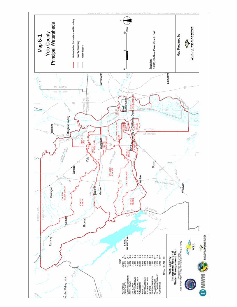
LAKE
BERRYESSA
DRYSLOUGH
CREEK
PUTAH
CREEK
CACHE
WILLOWSLOUGH
YOLO
EAST
DAVIS
EAST
SOUTH
NORTH
DAVIS
EAST
DRAIN
COVELL
UCDAVIS
BYPASS
WEST
SACRAMENTO
CUT
RIDGE
NORTH
WOODLAND
SOUTH
WOODLAND
SLOUGH
WILLOW
BASINDRAIN
COLUSA
6-1
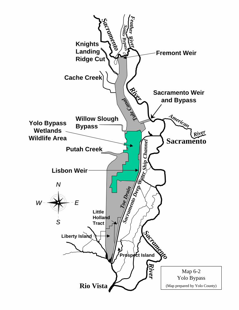
Knights Landing Ridge Cut
Willow Slough Bypass
Cache Creek
Putah Creek
American
SacramentoRiver
Feather
River
Rio Vista
Fremont Weir
Sacramento Weir and Bypass
Yolo Bypass Wetlands
Wildlife Area
NN
WW EE
SS
RiverSacramento
Sacramento
River
SutterBypass
Lisbon Weir
Toe
Dra
inTu
le Ca
nal
Sacr
amen
to D
eep
Wat
er S
hip
Cha
nnel
Liberty Island
Prospect Island
Little Holland Tract
Map 6-2Yolo Bypass
(Map prepared by Yolo County)
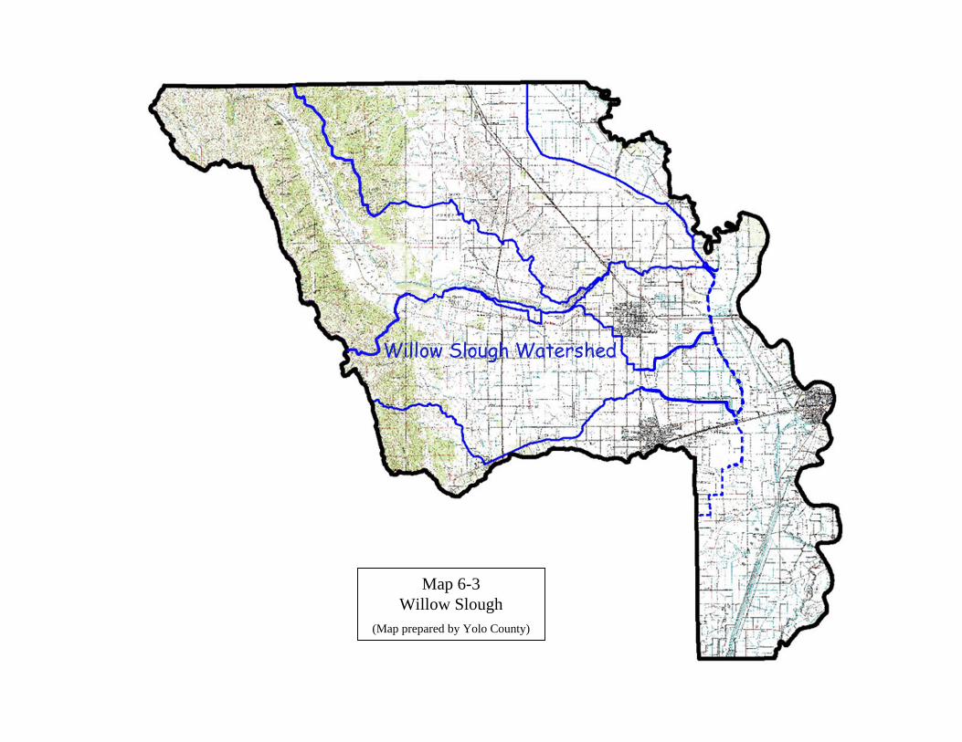
Map 6-3Willow Slough
(Map prepared by Yolo County)