cba full proposal template and guidelines
TRANSCRIPT
1
CBA Full Proposal Template and Guidelines See guidelines at end of document for instructions for completing this proposal
PROPOSAL SUMMARY
1. Project Title: Community Based Adaptation for Lelepa Village
2. Project Site: Lelepa Village, Gagaemauga 3 District, Savaii, Samoa
3. Proponent: Alii & Faipule of Lelepa Village
4. Project Objective: The main objective of the project is to reduce the vulnerability of
Lelepa Village community and the ecosystems on which they rely to climate change, including increases in climate variability – reducing the impacts of climate change-driven flooding and coastal erosion through improved natural resource management. Climate change risks include increasingly intense cyclones, increasing intensity of rainfall events, coral bleaching and increasing coastal erosion stemming from stronger storms and sea level rise.
5. Authorized Representative:
Faamoetauloa Selau (Village Mayor) Lealaiauloto Galuega (Village Orator) Taito Ulaitino Dr Faale Tumaalii (Project Consultant)
6. Cooperating Organizations:
Alii and Faipule of Lelepa village, Gaga’emauga III, c/- Taito Ulaitino Dr Faale Tumaalii, email: [email protected] Tel: 20664.
7. Start-Up Date:
1st July 2009
8. Project Period: 2 years
9. Total Project Cost: Approximately USD $103,250
10. Amount Requested From CBA: USD $25,000.00

2
11. Brief Project Description
The project is aimed at reducing the vulnerability of Lelepa village community and the ecosystems on which they rely to climate change. Several objectives inclusive in the project were drawn out by major factors of concern faced by the Lelepa village community. The village is expanding inland and the work road that runs from the main sealed road inland to village plantations provides the only access to higher grounds during coastal flooding from the north and flooding from the wetland behind the village. This work road is in a very poor state and is often flooded due to the absent of a drainage system that will allow free flow of water of wetland areas that flank both sides of the road, this means that when water rises the community won’t be able to cross to elevated grounds. In addition to flooding impacting on the work road and its important role as a safe crossing route to higher grounds, the wetland itself is also adversely affected by flooding as salinization in the wetland ecosystem will increase changing the natural environment of this important resource. Other concerns faced by the community of Lelepa include weak defenses to coastal hazard risks and accessibility to water particularly since the district water supply network is often disrupted during cyclones and major flooding events. To achieve the project objectives, the inland work road is to be upgraded including the raising of the road section at the wetland crossing with proper installation of drains and culverts at the wetland crossing to allow free flow of water. Additionally a replanting strategy (only along the low-lying borders of the community’s farm and residential lands) must be implemented with suitable plant species to reduce vulnerabilities to projected future exacerbated flooding. The barrier provided by plants will protect people’s land uses (such as farmlands) and also serves to protect wetland biodiversity from salinization. Restoration of coast defenses via vegetation planting will also be included as well as implementing a structural protective wall to protect the village local spring (Sogi Well) that the community often relies on when the main water network supply is disrupted.
1.0 RATIONALE 1.1 Community/Ecosystem Context
Lelepa village is located North of the Island of Savaii and is one of the seven villages within the Gagaemauga 3 District with a population count of 217 (CIM Plan, 2007). The village is located on low-lying coral sand beach, and backyard to a disturbed herbaceous marshland and going uphill to non-native ecosystems or cultivated lands and is connected to vital services such as water, telecommunication, electricity and the rest of the island via the main coast road which is entirely within the coastal and flood hazard zone areas. Away from the coast, a work road exists which is now being settled by many villagers who relocated from the coastal hazard zone. Current land uses adjacent to the work road include residential and agricultural uses. Agriculture aspects of the community are still vulnerable to flooding from marshes behind residents. Aside from flooding lands, the danger poses by the work road also being flooded makes it impassable and this takes away the work road’s other

3
main purpose which is an emergency escape route for people to reach higher or elevated grounds during flooding. With the majority of residents rely on subsistence farming and fishing for their livelihood, the frequent disruptions of their current land uses by climate impacts prompts the significance of implementing the best available solutions to reduce the vulnerability of the community and its ecosystem to climate change risks.
1.2 Climate Context
Climate Situation Lelepa, as one of the villages in Samoa, is subjected to the same climate as the rest of the country. Samoa’s climate is tropical with no major seasonal differences, such as summer and winter, that predominate in temperate regions. Its climate is marked by two distinct seasons; wet and warm in the months November – April and dry and cool from May – October. Concurrently, typical to tropical islands the temperature does not vary much and relatively remains within the range of 24oC – 32oC throughout the year. In regards to rainfall, it is usually high with an average annual rainfall of about 3,000mm with approximately 66% of the precipitation occurring during the wet season (NAPA, 2005). On most occasions, natural hazards occurrences in Samoa affect all villages in the country as Samoa is a small island nation of only about 2934 sq. km land area.
Hurricanes The village is susceptible to high risks of hurricane occurrences in between the wet season (particularly between December – February). Data recorded [UN, 2006] identified over 15 major cyclones since 1981. Three of the most severe cyclones occurred recently; Ofa in 1990, Val in 1991 and Heta in 2004 which in addition to wind damage, tidal surges were of high magnitude, wreaking havoc along the coastal areas of Samoa. In 2005, despite the fact that no cyclone directly struck Samoa, it must be taken into account that there were 5 tropical cyclones that developed around Samoa with 2 of them (Olaf and Percy) classified as Class 5, (Major Hurricanes) [NAPA, 2005]. Flooding Flooding is usually a counterpart of cyclones but recently flooding due to heavy rainfall is now a common hazard risk (particularly during the wet season) that occurs with increased frequency, possibly due to long-term changes in weather patterns. A recent severe flooding event in Samoa occurred in the month of Feb 2006 (Fig1 and Fig 2) causing major upsets for all sectors of the country. A series of flooding events that followed thereafter in 2007 and 2008 were of similar magnitude but were identified to have caused less damages presumably due to implemented adaptation measures (improved drainage infrastructure and regular cleaning of drains within the central urban Apia area).

4
Fig1. Flooding within LDS compound at Pesega Fig2. Photo taken in front of the Magic Cinemas, Apia Dated 5th February 2006 Dated 5th February 2006
Drought Exposure to drought is high during the dry season resulting in major fire risks mostly in the Savaii Island. The recent regular occurrence of long dry spells is presumed to be a reflection of the impact of the El Nino Southern Oscillation phenomenon intensified by climate change.
Baseline Climate Risks (non-climate change) Apart from climate change risks, Lelepa is also threatened by cyclical climate hazards that recur every few years such as floods and drought related to ENSO. Additionally considering the location of Samoa in the Pacific surrounded by the Ring of Fire, tsunami, earthquakes and volcanic eruptions are events that occurred in the past and are likely to recur every few years. Human induced activities also contribute to impacts on ecosystems. It releases a variety of substances into the biosphere negatively impacting on ecosystems. Some of these activities include CO and CO2 emissions from industrial processes and from automobile emissions, elevated littering, increase use of fungicides and pesticides which can degrade soil and aquatic ecosystems. Projected Climate Change The National Adaptation Programme of Action (NAPA) 2005, projected climate change for Samoa via observations of past trends and variabilities from collected climate data produced locally and from around the region. Samoa is projected to experience hikes in temperature as well as drought periods with precipitation levels projected to decrease by 49.28mm over the same period but with higher occurrences of high intensity rainfall. Moreover there will be increased tropical cyclone frequency and intensity. A 47-year event cyclone (like cyclone Ofa) is estimated to have a 65% probability to occur within a 10 year period and a 35% probability of a wind greater than 47 knots in that same period. In regards to tidal surges it is estimated that a 6.9 meter wave height is expected to occur 24 years, 7.7 meter wave at 30 years and a 9.1 meter wave at 75 years.

5
1.3 Impacts Context
Lelepa village, its ecosystem and infrastructure consists of several vulnerable areas affected by climate risks. However, the main 3 vulnerable areas that have been identified by the village as priority for resilience improvement, included also in the Project Concept Paper and were similarly identified within the Coastal Infrastructure Management Plan (CIM Plan- Gagaemauga III District), are as follows;
1. INLAND FLOODING The current work road which apart from its normal function of providing access to the villagers to their homes and farmlands was also constructed as an emergency crossing for the community to safer areas further inland during flooding, is frequently inundated making it unsafe for the community. The road flooding arises from it being low leveled and from the lack of proper drainage system or culverts to allow for water passage.
Fig 3. Work Road significantly affected by wetland flooding. Photo dated 02 May 2009
The same hazards posed by inland flooding to the work road also incapacitate other vital services along the road such as telecommunication and electricity poles and water supply system.
2. COASTAL EROSION AND COASTAL FLOODING IMPACTS
Apart from inland hazards, the coast is also highly vulnerable to climate change risks which have resulted in the coastline moving inland over time. The coral sand and beach ridge coastal area of Lelepa have a High Coastal Sensitivity Index rank (CIM Plan 2007) which indicates climate change risks have high impacts on Lelepa’s community and coastal ecosystem.
6
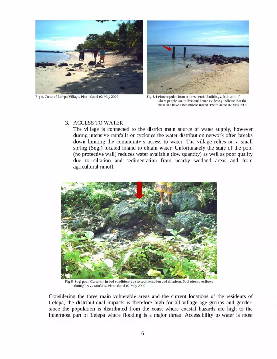
Fig 4. Coast of Lelepa Village. Photo dated 02 May 2009 Fig 5. Leftover poles from old residential buildings. Indicator of where people use to live and hence evidently indicate that the coast line have since moved inland. Photo dated 02 May 2009
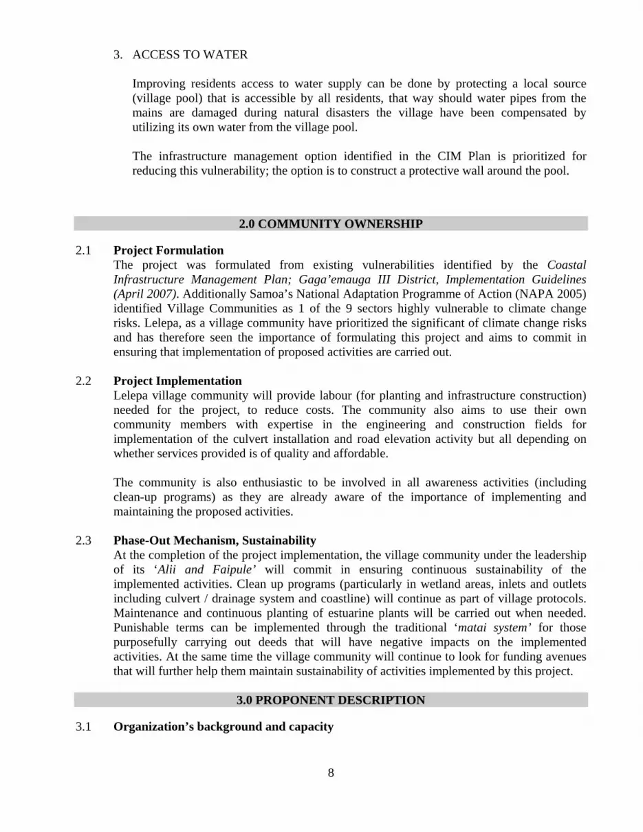
3. ACCESS TO WATER The village is connected to the district main source of water supply, however during intensive rainfalls or cyclones the water distribution network often breaks down limiting the community’s access to water. The village relies on a small spring (Sogi) located inland to obtain water. Unfortunately the state of the pool (no protective wall) reduces water available (low quantity) as well as poor quality due to siltation and sedimentation from nearby wetland areas and from agricultural runoff.
Fig 6. Sogi pool. Currently in bad condition (due to sedimentation and siltation). Pool often overflows during heavy rainfalls. Photo dated 02 May 2009
Considering the three main vulnerable areas and the current locations of the residents of Lelepa, the distributional impacts is therefore high for all village age groups and gender, since the population is distributed from the coast where coastal hazards are high to the innermost part of Lelepa where flooding is a major threat. Accessibility to water is most

7
likely to affect all villagers if the main water supply is disrupted during intensified flooding, coastal hazards or other non-climate related factors.
1.4 Project Approach
Existing vulnerabilities identified in the Community / Ecosystem context (1.1), also in the Climate context (1.2) and again in the Impacts context (1.3) calls for identification of the best solutions to minimize the climate change impacts and at the same time improve the community’s resilience to climate change. The three main vulnerable areas identified in (1.3) will be the main focus targets of the project with the following best solutions as identified in the Project Concept and the CIM Plan to be implemented ;
1. RESILIENT SOLUTIONS FOR INLAND FLOODING
This impact can be addressed by replanting of wetland vegetation along edges to reduce flooding into residential houses and other land uses. The wetland restoration program will not only serve as flood control mechanism but will also improve riparian habitat that is critically important for fish and wildlife. Additionally providing these buffers will reduce impacts of wetland flooding to the other important village ecosystem – the natural spring / pool which is often affected by salinization and siltation during flooding arising from storm surges.
Also raising awareness in the village to ensure frequent village clean-up programs are carried out to remove waste from the wetlands and ensuring that outlets and inlets are clear at all times. Along with the soft restoration program, finance from the co-financing groups is much needed to implement the infrastructure resilient solutions such as the upgrade in the existing work road which crosses the wetland. This is of utmost importance as it is the main escape route for most of the people currently living on coastal and flood hazard zones, when the need arises to move to elevated grounds during intensive occurrences of such natural hazards. This infrastructure management option was identified in the CIM Plan to be implemented to improve the village’s resilience to natural hazards. The works will include raising the road at the wetland crossing and install proper drainage system / culverts to allow for water flow and general road work upgrades like tar sealing and widening.
2. RESILIENT SOLUTIONS FOR COASTAL EROSION AND COASTAL FLOODING IMPACTS Soft options such as ecosystem restoration via vegetation replanting are proposed along the coast to strengthen coastal defenses and to provide natural buffers for residents’ settlements. Not only will this solution provide adaptation through increasing resilience to climate changes but also the delivery of ecosystem services to the landscape / seascape. Additionally a village clean-up program is significant to ensure the coastal environment is regularly free of litter and waste materials.
8
3. ACCESS TO WATER Improving residents access to water supply can be done by protecting a local source (village pool) that is accessible by all residents, that way should water pipes from the mains are damaged during natural disasters the village have been compensated by utilizing its own water from the village pool. The infrastructure management option identified in the CIM Plan is prioritized for reducing this vulnerability; the option is to construct a protective wall around the pool.
2.0 COMMUNITY OWNERSHIP 2.1 Project Formulation
The project was formulated from existing vulnerabilities identified by the Coastal Infrastructure Management Plan; Gaga’emauga III District, Implementation Guidelines (April 2007). Additionally Samoa’s National Adaptation Programme of Action (NAPA 2005) identified Village Communities as 1 of the 9 sectors highly vulnerable to climate change risks. Lelepa, as a village community have prioritized the significant of climate change risks and has therefore seen the importance of formulating this project and aims to commit in ensuring that implementation of proposed activities are carried out.
2.2 Project Implementation
Lelepa village community will provide labour (for planting and infrastructure construction) needed for the project, to reduce costs. The community also aims to use their own community members with expertise in the engineering and construction fields for implementation of the culvert installation and road elevation activity but all depending on whether services provided is of quality and affordable. The community is also enthusiastic to be involved in all awareness activities (including clean-up programs) as they are already aware of the importance of implementing and maintaining the proposed activities.
2.3 Phase-Out Mechanism, Sustainability
At the completion of the project implementation, the village community under the leadership of its ‘Alii and Faipule’ will commit in ensuring continuous sustainability of the implemented activities. Clean up programs (particularly in wetland areas, inlets and outlets including culvert / drainage system and coastline) will continue as part of village protocols. Maintenance and continuous planting of estuarine plants will be carried out when needed. Punishable terms can be implemented through the traditional ‘matai system’ for those purposefully carrying out deeds that will have negative impacts on the implemented activities. At the same time the village community will continue to look for funding avenues that will further help them maintain sustainability of activities implemented by this project.
3.0 PROPONENT DESCRIPTION
3.1 Organization’s background and capacity

9
The proponent ‘Alii and Faipule of Lelepa’ are the high chiefs and members of parliament of the villages which are the leaders of the Village and are those that maintain order and ensure smooth running of the village daily operations and activities as well as providing security for the village community of Lelepa. I, Taito Ulaitino Dr Faale Tumaalii, as one of the matai of the Lelepa village community have been trusted with writing the proposal. My selection by my village was due to my extensive knowledge on management, organizational structure and experience with initiating and carrying out project proposals, (refer to attached CV). My current employment status as the Chief Executive Officer (CEO) of the Scientific Research Organization of Samoa (SROS) reflects the nature of my work experiences which often include working with the Ministry of Natural Resources and Environment in executing projects that will benefit the environment of Samoa. On top of my academic and work experiences it was decided by our Village that I (being a member of the village) will also be the best candidate for preparing the proposal as I also have sufficient local knowledge on the occurrences and the impacts of climate change on our village community. On the finance side the village does not have the financial resources like other institutions that require annual budget preparation and audit financial statement.
4.0 PROJECT DESCRIPTION
4.1 Objective, Outcomes, Planned Outputs:
The following table incorporates the projective objective (same objective stated in the concept paper), outcomes and planned outputs drawn out from section 1.4 of this project proposal. Table 1: Project Description
PROJECT OBJECTIVE
To reduce the vulnerability of Lelepa Village community and the ecosystems on which they rely to climate change, including increases in climate variability – reducing the impacts of climate change-driven flooding and coastal erosion through improved natural resource management. Climate change risks include increasingly intense cyclones, increasing intensity of rainfall events, coral bleaching and increasing coastal erosion stemming from stronger storms and sea level rise.
Outcome 1.0: Enhance resilience of inland ecosystems to Climate Change induced flooding. Improving resilience to flooding enables inland ecosystems to reduce vulnerability to climate change and at the same time resolve the following flooding associated hazard risks
- danger posed to residents and their livelihoods (farming, retail businesses, etc.,) - damages to nearby infrastructure - siltation risks for water supplies - extensive losses of wetland fauna and flora -
10
CBA funded
Output 1.1: planting of wetland vegetation along wetland banks/edges (of the wetland bordering community’s assets / important land uses) will reduce flooding and hence also minimizes other flooding hazard risks as identified in Outcome 1.0 Appropriate wetland plant species will be planted.
CBA and AusAID
Output 1.2: Village clean-up programs to clean out waste materials dumped in the wetlands and clear outlets and inlets to allow natural flow of wetland water. Strict prohibition of waste disposal with punishable terms can be imposed on by the village of Lelepa to culprits as part of a Natural Resources Management Plan.
CBA and AusAid
Output 1.3: Implement one of the best solutions provided for Lelepa in the CIM Plan: which is to upgrade and raise work road to safe and passable level to ensure that crossing is safe during significant flooding events. Road elevating activities will include proper installation of drains and culverts at the wetland crossing to allow free flow of water
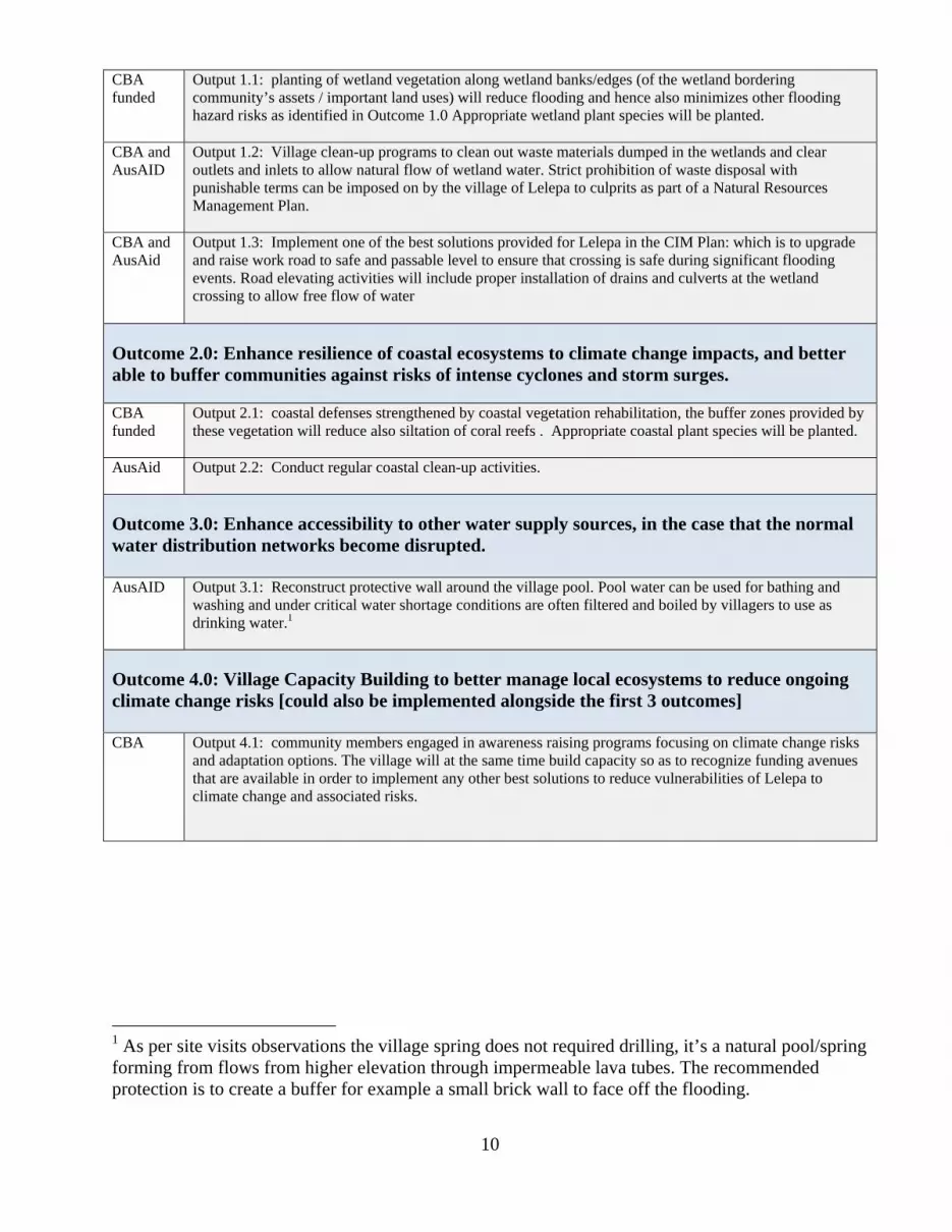
Outcome 2.0: Enhance resilience of coastal ecosystems to climate change impacts, and better able to buffer communities against risks of intense cyclones and storm surges. CBA funded
Output 2.1: coastal defenses strengthened by coastal vegetation rehabilitation, the buffer zones provided by these vegetation will reduce also siltation of coral reefs . Appropriate coastal plant species will be planted.
AusAid Output 2.2: Conduct regular coastal clean-up activities.
Outcome 3.0: Enhance accessibility to other water supply sources, in the case that the normal water distribution networks become disrupted. AusAID
Output 3.1: Reconstruct protective wall around the village pool. Pool water can be used for bathing and washing and under critical water shortage conditions are often filtered and boiled by villagers to use as drinking water.1
Outcome 4.0: Village Capacity Building to better manage local ecosystems to reduce ongoing climate change risks [could also be implemented alongside the first 3 outcomes] CBA Output 4.1: community members engaged in awareness raising programs focusing on climate change risks
and adaptation options. The village will at the same time build capacity so as to recognize funding avenues that are available in order to implement any other best solutions to reduce vulnerabilities of Lelepa to climate change and associated risks.
1 As per site visits observations the village spring does not required drilling, it’s a natural pool/spring forming from flows from higher elevation through impermeable lava tubes. The recommended protection is to create a buffer for example a small brick wall to face off the flooding.

11
4.2 Timetable
Table 2: Project Timetable Duration Period: 2 Years
The proposed payment process for the CBA portion of the project is as follows (The AusAID will co-finance this payment schedule 1:1 at the same intervals):
UNOPS shall provide funds to the Local CBO in an amount of USD$25,000, twenty-five thousand US dollars according to the schedule set out below, subject to the Local CBO’s submission of timely and accurate expense reports:
USD$7,500, seven thousand five hundred US dollars (30%), upon signature of this Agreement by both parties if the following points are met:
• Submission of the CVs for all personnel that will be engaged in this project including but not limited to the Project Advisor and Engineers.
• Submission of letters from MWTI regarding their estimates of the work for this project
USD$7,500, seven thousand five hundred US dollars (30%), October 2009 if the following are met
• Submission of 1st Progress Report, including IAS baseline indicators recorded • Provision of an initial engineering assessment report including detail design and
layout plan for the proposed road works.
J 09
A 09
S 09
O 09
N 09
D 09
J 10
F 10
M 10
A 10
M 10
J 10
J 10
A 10
S 10
O 10
N 10
D 10
J 11
F 11
M 11
A1
OUTCOME 1
Output 1.1
Output 1.2
Output 1.3
OUTCOME 2
Output 2.1
Output 2.2
OUTCOME 3
Output 3.1
OUTCOME 4
Output 4.1
Disbursements of Funds for the Lelepa Project
12
• Development Consent approved from PUMA MNRE • Awareness raising programme plan complete and submitted;
USD$7,500, seven thousand five hundred US dollars (30%), January 2010 if the following are met
• Submission of 2nd Progress Report, including IAS and VRA indicators recorded USD$2,500, two thousand five hundred US dollars (10%), January 2011 if the following are met
Submission of 3rd Progress Report, including IAS and VRA indicators recorded
4.3 Risks and Barriers External Barriers
District level issues and conflicts often result in exacerbating impacts. For example the water supply network for the district is controlled within 1 village (out of seven villages in the district), water disruptions could occur any time due to negligence or if there are problems or confrontations between other villages and the main village whose lands hold the control to water supply network. Other barriers include National laws, policies and regulations like obtainment of all permits and development consents in relation to the development activities may impact on the project timeframe and budget. This barrier may be mitigated since most of the outcomes (including infrastructural options) were proposed as best solutions to improve resilience and reduced vulnerabilities of Lelepa village to Coastal and Flood Hazard Risks by the CIM Plan in which most of the Government Ministries involved are the responsible government bodies in monitoring and administering of the related policies and regulations. Internal Barriers Limited human resources and money to carry out the planned activities is seen as an internal barrier for the project. However, Lelepa identified that some of the soft options proposed in the project can be coordinated by the villagers and will need commitment from a district committee to commit in providing labour and some resources (like earth materials for harder options) and maintain any infrastructure and ensure village participation in the activities. The project will also undertake a strong public awareness programs on some of the activities undertaken by villagers that increase the vulnerabilities or reduce the resilience of the ecosystems and people to climate change occurrences.
Risks Unforeseen risks are crucial factors that must be considered to reduce panic and delays to the implementation of the project. Some of the unforeseen risks include;
1. Currency fluctuations (especially triggered by economic crises) 2. Occurrence of natural disaster(s) during the implementation of the project
activities 3. Political in-country coups; and 4. Long term maintenance of proposed activities

13
4.4 Monitoring and Evaluation Plan For the VRA all 4 indicators (assessed in the Initial VRA analysis) will be monitored and measured again in second VRA meeting planned to be conducted during the implementation phase (halfway) and again upon completion of the project implementation. Depending on funds availability, a fourth consultation may be conducted a year after the completion of the project implementation.
4.4.1 Initial VRA Analysis
The initial VRA Analysis was conducted on May 2nd 2009 during the second consultation meeting with the village of Lelepa. All four indicators were measured for three of the climate hazard risks that were identified (CIM Plan and initial consultations) to pose higher risks to Lelepa. The three prioritized climate risks were (1) flooding (2) coastal erosion; and (3) cyclones and strong winds. Gender equality was taken into consideration as well as inclusion of young untitled men (aumaga) in the VRA discussions. The VRA consultation process (including questions) was conducted in the Samoan language.
Fig 7. Women and aumaga discussing VRA questions. Fig 8 H-Form on newsprints used to present VRA questions.
Photo dated 02 May 2009 Photo dated 02 May 2009
The four indicator questions along with the common themes in the answers to the questions, the score and all information gather from the initial VRA consultation phase are presented in the following table.

14
Indicator Question Flooding Indicator
Score
Comments Coastal Erosion
Indicator Score
Comments Cyclones and
Strong Winds
Indicator Score
Comments
(1) Assessing
current vulnerability
What happens when there is flooding, coastal erosion or cyclones and strong winds ? How does this affect you and your community?
1 Impacts - destroy farms, residential homes, other assets, - people’s lives threatened (homes on low-lying areas flooded and concurrently people can’t cross to elevated (safer) areas Mitigation Measures - option 1 (preferable and now included in proposal) make existing inland work road safer by raising lower area of existing work road and place culverts underneath to allow free flow of water. Inlets and outlets regularly clean up. - option 2 (time consuming and not eco-friendly only consider if option1 cannot be implemented). Reclaim wetland areas with any means including using it as a rubbish disposal site in order to elevate area
1 Impacts - damages homes and properties - cause relocation of homes (move out of the Coastal hazard Zone (CHZ) - village lose lands - affect other vital services located near the coast like telecommunication, electricity and road infrastructure. Mitigation Measures - infrastructural seawall (something to consider in future proposal formulations taking into consideration things like EIA, EMP etc.,) - natural seawall (coastal replanting) - regular clean-up of coastline (and sea) -
1 Impacts - cause coastal and inland flooding - affect services and infrastructure (homes, roads, water supply network (poor water quality) - affect livelihood (plantations, loss of some species of fish e.g. Agaaga) - impact on ecosystem (exacerbate coastal erosion (low sand budget), plants, natural spring / pools) - further affecting coastline (lose lands) Mitigation Measures - implement priority options provided in flooding and coastal erosion mitigation - construct solid household buildings - protect and maintain village pool to obtain water when mains water supply is disrupted.
15
Indicator Question Flooding Indicator
Score
Comments Coastal Erosion
Indicator Score
Comments Cyclones and
Strong Winds
Indicator Score
Comments
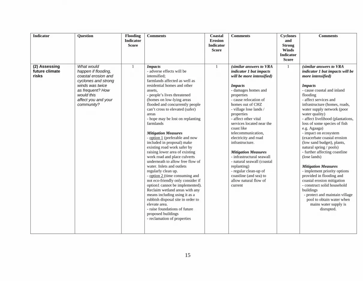
(2) Assessing future climate risks
What would happen if flooding, coastal erosion and cyclones and strong winds was twice as frequent? How would this affect you and your community?
1 Impacts - adverse effects will be intensified; farmlands affected as well as residential homes and other assets, - people’s lives threatened (homes on low-lying areas flooded and concurrently people can’t cross to elevated (safer) areas - hope may be lost on replanting farmlands Mitigation Measures - option 1 (preferable and now included in proposal) make existing road work safer by raising lower area of existing work road and place culverts underneath to allow free flow of water. Inlets and outlets regularly clean up. - option 2 (time consuming and not eco-friendly only consider if option1 cannot be implemented). Reclaim wetland areas with any means including using it as a rubbish disposal site in order to elevate area. - raise foundations of future proposed buildings - reclamation of properties
1 (similar answers to VRA indicator 1 but impacts will be more intensified) Impacts - damages homes and properties - cause relocation of homes out of CHZ - village lose lands / properties - affect other vital services located near the coast like telecommunication, electricity and road infrastructure. Mitigation Measures - infrastructural seawall - natural seawall (coastal replanting) - regular clean-up of coastline (and sea) to allow natural flow of current
1 (similar answers to VRA indicator 1 but impacts will be more intensified) Impacts - cause coastal and inland flooding - affect services and infrastructure (homes, roads, water supply network (poor water quality) - affect livelihood (plantations, loss of some species of fish e.g. Agaaga) - impact on ecosystem (exacerbate coastal erosion (low sand budget), plants, natural spring / pools) - further affecting coastline (lose lands) Mitigation Measures - implement priority options provided in flooding and coastal erosion mitigation - construct solid household buildings - protect and maintain village
pool to obtain water when mains water supply is
disrupted.
16
Indicator Question Flooding Indicator
Score
Comments Coastal Erosion
Indicator Score
Comments Cyclones and
Strong Winds
Indicator Score
Comments
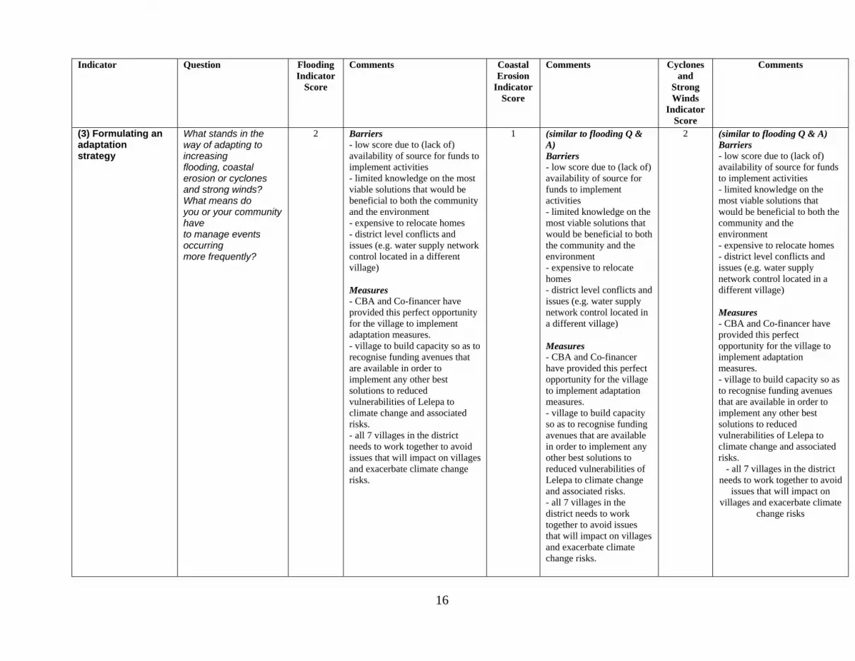
(3) Formulating an adaptation strategy
What stands in the way of adapting to increasing flooding, coastal erosion or cyclones and strong winds? What means do you or your community have to manage events occurring more frequently?
2 Barriers - low score due to (lack of) availability of source for funds to implement activities - limited knowledge on the most viable solutions that would be beneficial to both the community and the environment - expensive to relocate homes - district level conflicts and issues (e.g. water supply network control located in a different village) Measures - CBA and Co-financer have provided this perfect opportunity for the village to implement adaptation measures. - village to build capacity so as to recognise funding avenues that are available in order to implement any other best solutions to reduced vulnerabilities of Lelepa to climate change and associated risks. - all 7 villages in the district needs to work together to avoid issues that will impact on villages and exacerbate climate change risks.
1 (similar to flooding Q & A) Barriers - low score due to (lack of) availability of source for funds to implement activities - limited knowledge on the most viable solutions that would be beneficial to both the community and the environment - expensive to relocate homes - district level conflicts and issues (e.g. water supply network control located in a different village) Measures - CBA and Co-financer have provided this perfect opportunity for the village to implement adaptation measures. - village to build capacity so as to recognise funding avenues that are available in order to implement any other best solutions to reduced vulnerabilities of Lelepa to climate change and associated risks. - all 7 villages in the district needs to work together to avoid issues that will impact on villages and exacerbate climate change risks.
2 (similar to flooding Q & A) Barriers - low score due to (lack of) availability of source for funds to implement activities - limited knowledge on the most viable solutions that would be beneficial to both the community and the environment - expensive to relocate homes - district level conflicts and issues (e.g. water supply network control located in a different village) Measures - CBA and Co-financer have provided this perfect opportunity for the village to implement adaptation measures. - village to build capacity so as to recognise funding avenues that are available in order to implement any other best solutions to reduced vulnerabilities of Lelepa to climate change and associated risks.
- all 7 villages in the district needs to work together to avoid
issues that will impact on villages and exacerbate climate
change risks

17
Indicator Question Flooding Indicator
Score
Comments Coastal Erosion
Indicator Score
Comments Cyclones and
Strong Winds
Indicator Score
Comments
(4) Continuing the adaptation process
Rate your confidence that the (project activity) will continue after the project period.
5 Confidence - high VRA score because Lelepa having suffered so long from flooding know the importance of maintaining any project that is in place to improve their resilience to flood risks. - as a village, cultural and traditional methods are strongly upheld; any misdeeds that may result in affecting the proposed project will result in application of punishable terms by village laws. - village programs for clean-up and maintenance will be regularly conducted
4 Confidence - VRA score is rated Good(4) because Lelepa having suffered so long from coastal erosion know the importance of maintaining any project that is in place to improve their resilience to coastal erosion - as a village, cultural and traditional methods are strongly upheld; any misdeeds that may result in affecting the proposed project will result in application of punishable terms by village laws. - village programs for clean-up will be regularly conducted - Confidence level lower than flooding because the main option needed to improve resilience to coastal erosion (infrastructural seawall) cannot be implemented in this projected due to limited funds.
5 Confidence - high VRA score because Lelepa having suffered so long from impacts of cyclones and strong winds know the importance of maintaining any project that is in place to improve their resilience - as a village, cultural and traditional methods are strongly upheld; any misdeeds that may result in affecting the proposed project will result in application of punishable terms by village laws. - village programs for clean-up and maintenance will be regularly conducted
18
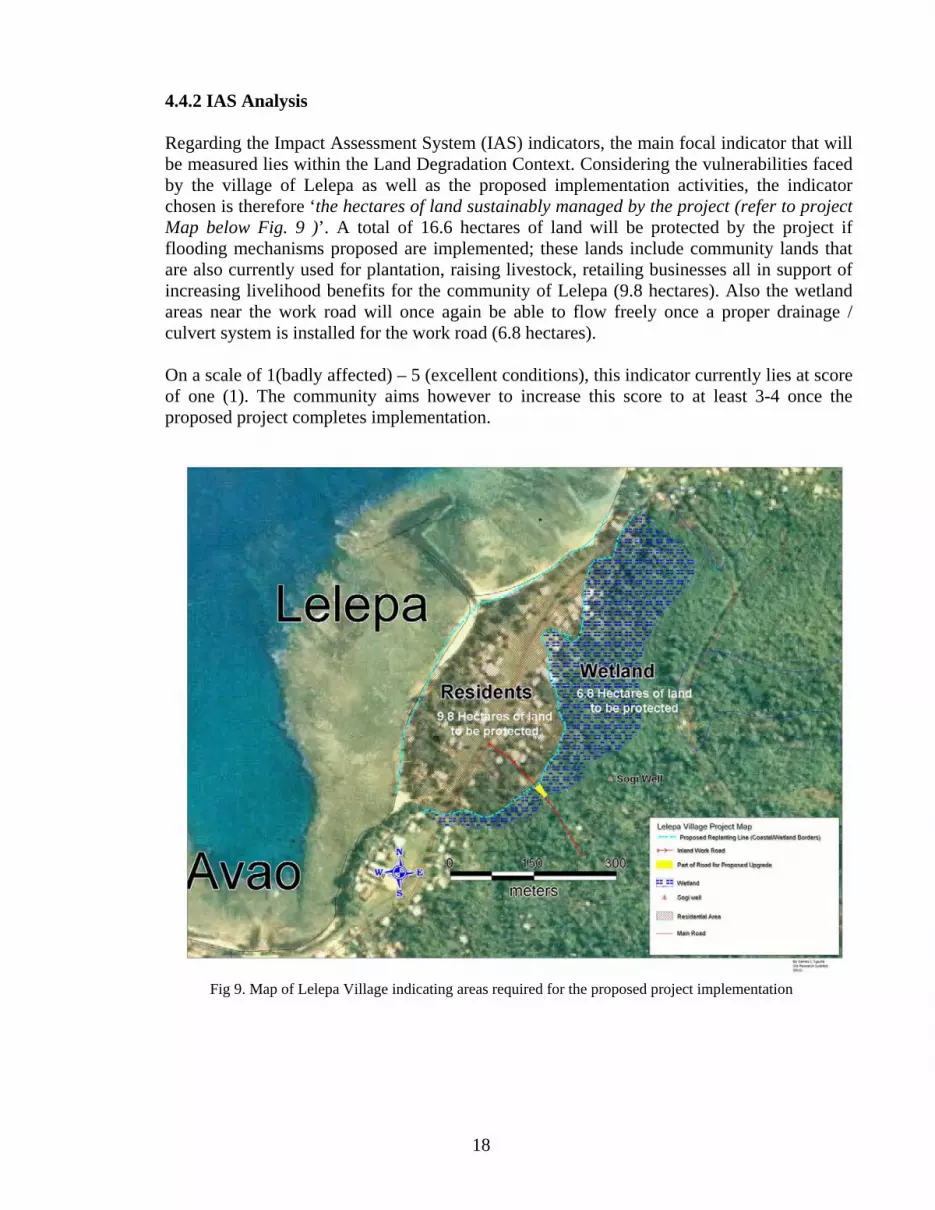
4.4.2 IAS Analysis
Regarding the Impact Assessment System (IAS) indicators, the main focal indicator that will be measured lies within the Land Degradation Context. Considering the vulnerabilities faced by the village of Lelepa as well as the proposed implementation activities, the indicator chosen is therefore ‘the hectares of land sustainably managed by the project (refer to project Map below Fig. 9 )’. A total of 16.6 hectares of land will be protected by the project if flooding mechanisms proposed are implemented; these lands include community lands that are also currently used for plantation, raising livestock, retailing businesses all in support of increasing livelihood benefits for the community of Lelepa (9.8 hectares). Also the wetland areas near the work road will once again be able to flow freely once a proper drainage / culvert system is installed for the work road (6.8 hectares). On a scale of 1(badly affected) – 5 (excellent conditions), this indicator currently lies at score of one (1). The community aims however to increase this score to at least 3-4 once the proposed project completes implementation.
Fig 9. Map of Lelepa Village indicating areas required for the proposed project implementation
19
The indicator can be measured at the last IAS and VRA consultation meeting upon the completion of the project. Further monitoring can be conducted comparing aerial maps and photos (taken during IAS and VRA meetings) with those (aerial maps and photos) to be taken after any future flooding, cyclones or tidal surges. The VRA score can be at the same time used to indicate how the proposed implemented activities have helped sustain, and, in a wider context, restored lands that are vulnerable at this time to climate change hazards. 4.4.3 Progress Reports
Progress reports will be submitted in accordance with times marked in project timetable (refer to table 2). Indicators will be measured and included in progress reports prepared for the first half of the implementation phase of the project. The indicators will then again measures at the completion of the project implementation.
4.5 Project Management 4.5.1 Management Structures
4.5.1 The project committee (selected by the village) and the project consultant will oversee the project from its planning phase and implementation to a successful completion. It will also continue overseeing all village community activities which will include maintenance and sustainability of all activities implemented in this project. The soft solutions provided in the project will be carried out by the village community with advice from an environmentalist / biodiversity specialist.
Infrastructural solutions will be managed by the engineer who will be working together with the proponent and the village community. The village also has qualified structural builders that would be employed in the project. The overall project manager will be the project consultant who is the matai of the village.
4.5.2 Relationship and Responsibilities of Proponent and Project Partners
The implementation of the project will be entirely on Lelepa village community with technical assistance in the form of expert advice and hire of heavy work equipment from village qualified sons/daughters and the village business people respectively. The village needs technical advice on replanting the wetland boundaries with the right plants to absorb flooding during heavy rains and the coastal areas to stop sea water from overflowing to the wetland killing the wetland vegetation. The hire of heavy work equipment from business families of the village is for upgrading the inland work road to the village plantations.
5.0 PROJECT COSTS AND OTHER SOURCES OF FUNDING
5.1 Total Project Cost and Amount Requested

20
2 The funds for awareness will cater for the materials used (stationery; newsprints, markers, vehicle petrol ., ) and refreshments during village consultation. It is also noted that VRA & IAS indicator monitoring will be included in this meeting. Funds can also go to the compilation of the results (responsibility of Project Manager and authorized Village representatives).
Budget Item (Description)
Unit Cost USD
Amount from CBA USD
Amount from Proponent USD
Amount from AusAid
USD
Total Cash USD
In Cash In Cash
In kind
In Cash In Kind
(should equal sum of lines to
the right) Outcome
1 Output
1.1 (1)Personnel -environmentalist (2) Equipment & Material Costs (mainly plants)
-100.00 x 5days -2,000.00
2,500.00
Planters (Community) 3.00 per hr per
laborer Approx:work 4hrs per day = 12.00 x 50people = 600 per day Approx 15 days =
9,000
2,500.00
Output 1.2
(1) Personnel -Prepare a Natural Resource (Wetland ) Management Plan (2) Equipment & Material Costs -excavator - other work tools
-1,000 -100.00 x 1hr x 8hrs x 3days -100.00
1,000.00 Laborers (Community) 3.00 per hr per
laborer Approx:work 4hrs per day = 12.00 x 10people = 120 per day Approx 5 days =600
2,500 3,500.00
Output 1.3
(1)Personnel -Construction consultant / Engineer (2)Equipments -culverts -excavator -trucks -cement (plus other materials required by Engineer for raising required section of the road)
- - 6,250 (duration of project) 17,500 (AusAID) + 6,250 (CBA) = 23,750
12,500 Laborers (Community) 3.00 per hr per
laborer Most prob work at least 6 hrs a
day; 10 -15 persons)
+ Most raw materials (rocks)
=30,000
17,500 30,000.00
Outcome 2
Output 2.1
(1)Personnel -environmentalist (2) Equipment & Material Costs (mainly plants)
-100.00x5days
-6,500.00
7,000.00 Laborers (Community)
3.00 per hr per laborer Approx:work 4hrs per day = 12.00 x 50people = 600 per day Approx 15 days =
9,000
7,000.00
Output 2.2
1)Personnel (2) Equipment & Material Costs
-2,500.00
Community workers
3.00 per hr per laborer
Approx:work 4hrs per day = 12.00 x 10people = 120 per day Approx 5 days =600
2,500.00 2,500.00
Outcome 3
Output 3.1
(1)Equipment & Material Costs
-2,500.00
Laborers (Community) 3.00 per hr per
laborer Most prob work at least 6 hrs a
day; say 15 persons)
= 18 x 15persons x 15 days = 4,050
2,500.00 2,500.00
Outcome 4
Output 4.1
Awareness Workshops (Include VRA and IAS meetings)
-2,000.00
2,000 2,000.002
Total 25,000.00 In kind in monetary value
25,000.00 50,000.00 +

21
6.0 EXHIBITS/ATTACHMENTS
6.1 Mandatory
a.) Location map (Project Site). This may be a very rough sketch over a country map (may be the same map used in the project concept).
- Refer to Fig 9.
b.) Latest audited financial statements if any OR explanation of why no audited statement is available.
- Refer to attached copy of receipt : Cash received for preparation of full project proposal
c.) Brief curriculum vitae or résumé of project manager/coordinator and person in charge of
accounting for the funds. Letter from a partnering organization if one will assist in accounting for funds - attached CV of project manager
d.) Document/letter showing proof of approved co-financing… - Kevin Petrini (UNDP) has confirmed co-financing by AusAID
e.) Photographs of community project development meeting and of the project area - Refer to Fig 3 – Fig 8
6.2 Optional a) Topical outline of training modules or other capacity building activities b) Organizational Chart of NGO/CBO c) Other information you think would improve your proposal - TOR for Engineer / Constructor - TOR for Environmentalist (Biodiversity expert) - TOR for Project Manager (Voluntary Worker) References

22
Government of Samoa. 2007. Coastal Infrastructure Management Plan, Gagaemauga 3 District. Ministry of Natural Resources, Environment and Meteorology. 2005. National Adaptation Programme of Action, Samoa. United Nations (UN) Conference on Trade and Development. 2006. Vulnerability profile of Samoa.
23
TERMS OF REFERENCE CONTRACT FOR THE ENGINEER/CONSTRUCTOR
Primary Objectives: The engineer is expected to provide technical advice, design and carry out construction of the proposed road works for the Lelepa Village community project. Relationship:
1. Engineer/constructor will report to Lelepa village community overall project manager and authorized representatives.
2. Engineer/constructor will work closely and consult with authorized representatives and village matai’s.
Key responsibilities will include, but not limited to: 1. Provision of an initial assessment report including design and layout plan for the proposed road
works. 2. Provide progress reports when required (to project manager, SGP, authorized village
representatives). 3. Obtain all relevant permits / consent in regards to the road project (e.g. obtainment of
Development Consent from PUMA) 4. Consult with the project manager and village representatives and community on sourcing and
purchasing materials needed for the work road upgrade project. Additionally must work together in ensuing that all materials required and project implementation falls in line with the allocated budget required for this output.
5. Construct work road to meet project objectives
Duration of assignment: 24 months from start of project. Language: English and Samoan. Duty Station: Lelepa village at Savaii. Remuneration of USD $6,250.00

24
TERMS OF REFERENCE CONSULTANT FOR THE PROJECT MANAGER
TAITO ULAITINO DR FA’ALE TUMAALII
Primary Objective: The consultant is expected to provide assistance, advice and work with the village to ensure successful completion of the project. Responsible to: The consultant reports to the Alii and Faipule of Lelepa village in executing his responsibilities. Key responsibilities will include, but not limited to: 6. Lead the whole team (village work force) in planning and executing the whole project. 7. Work with the environmentalist and village community in implementing the replanting program
to achieve project outcomes. 8. Work with the constructor/engineer (a matai of Lelepa village) in planning and upgrading of the
work road as well as raising the section that cross the wetland. 9. Administer the purchase of building materials and hiring of machineries. 10. Administer the construction of culverts, road drains and pool protective wall. 11. Work with constructor/engineer and environmentalist in planning the whole project to ensure
flooding stays in the wetland. 12. Work with village community to regularize clean-up schedules. 13. Assist the village with an awareness program regarding the up-keeping of their environment. Qualification: The consultant must have extensive experience in project management and good understanding of Samoan customs and tradition. He/She should have a good knowledge of local conditions and should be available for consultation when requires. Reports: Reporting on this project will comprise summary notes on meetings and initial recommendations, and submission of an agreed final report draft for the two year project.
Duration of assignment: 24 months from start of project. Language: English and Samoan. Duty Station: Lelepa village at Savaii.
25
Terms of references (TOR)
ENVIRONMENTALIST CONTRACT AS TECHNICAL ADVISER TO THE LELEPA VILLAGE COMMUNITY PROJECT: BIODIVERSITY AND ENVIRONMENTAL PROTECTION
1. Background The United Nations Development Programme (UNDP) under its Community Based Adaptation (CBA) programme to Climate Change, is providing assistance to the Community of Lelepa Village for implementing identified solutions for adaptation to climate change in selected priority sites at the village. The proposed works is structured into the following two outcomes. 2. Outcomes:
Outcome 1 Replant edges of the existing wetland area with suitable plant species of high tolerance levels to flooding.
Outcome 2 Strengthen coastal ecosystems via planting suitable plant species with adaptative features to adapt to harsh environmental conditions.
3. Scope of Work The consultant will be responsible in providing expert advice (planting activities) to the community (including on site demonstrations) in regards to the outcomes stated in this TOR. He / She will also advise on selecting and purchasing of flora species for replanting implementation. He/She will also work closely and consult with authorized representatives of the village community to ensure successful implementation of the village replanting works. A final report must be prepared and submitted to authorized representatives of the community at the completion of the replanting implementation. 4. Qualifications The consultant should have the following qualifications:
• University education in biodiversity with regards to climate change and environmental protection; • At least 5 years of experience in biodiversity and environmental protection, natural resources management, community beneficial programs or related scientific research, • Work experience on projects financed by UNDP, GEF, SPREP or other international environmental organizations will be an asset; • Fluent in both Samoan and English
5. Time frame and Deliverables: The Consultant will be hired as follows:
Outcome 1: Hire for 5 days – Visit 1: Site Visit to provide expert advice on planting activities and materials required (2 days)
Visit 2: Supervise planting on Day 1 (including on site demonstrations). Visit 3: Mid- project monitoring inspection Visit 4: At the completion of planting, evaluate and submit a report.
Outcome 2: Hire for 5 days – Visit 1: Site Visit to provide expert advice on planting activities and materials required (2 days)
Visit 2: Supervise planting on Day 1 (including on site demonstrations). Visit 3: Mid- project monitoring inspection Visit 4: At the completion of planting, evaluate and submit a report. 6. Remuneration of USD $1,000.00 for the 10 days required