catastrophic ice lake collapse in aram chaos, mars
TRANSCRIPT
Catastrophic ice lake collapse in Aram Chaos, Mars
Manuel Roda1,∗, Maarten G. Kleinhans1, Tanja E. Zegers1, Jelmer H.P. Oosthoek2
Abstract
Hesperian chaotic terrains have been recognized as the source of outflow channels formed by catastrophic outflows. Four mainscenarios have been proposed for the formation of chaotic terrains that involve different amounts of water and single or multipleoutflow events. Here, we test these scenarios with morphological and structural analyses of imagery and elevation data for AramChaos in conjunction with numerical modeling of the morphological evolution of the catastrophic carving of the outflow valley.The morphological and geological analyses of Aram Chaos suggest large-scale collapse and subsidence (1500 m) of the entire area,which is consistent with a massive expulsion of liquid water from the subsurface in one single event. The combined observationssuggest a complex process starting with the outflow of water from two small channels, followed by continuous groundwater sappingand headward erosion and ending with a catastrophic lake rim collapse and carving of the Aram Valley, which is synchronous withthe 2.5 Ga stage of the Ares Vallis formation. The water volume and formative time scale required to carve the Aram channelsindicate that a single, rapid (maximum tens of days) and catastrophic (flood volume of 9.3·104 km3) event carved the outflowchannel. We conclude that a sub-ice lake collapse model can best explain the features of the Aram Chaos Valley system as well asthe time scale required for its formation.
Keywords: Mars, surface, Geological Processes, Ices
1. Introduction
Martian chaotic terrains are deeply collapsed areas (> 1 kmdeep) that stretch for up to hundreds of kilometers and showa bumpy floor characterized by an irregular pattern of frac-tures and tilted blocks of different sizes (from meter to kilome-ter scale). Chaotic terrains predominantly occur along the di-chotomy boundary between the southern highlands and north-ern lowlands (Sharp, 1973; Chapman and Tanaka, 2002; Ro-driguez et al., 2005; Glotch and Christensen, 2005; Meresseet al., 2008; Warner et al., 2011).
Outflow channels represent the largest systems carved by liq-uid water on Mars. They are thousands of kilometers long,more than a kilometer deep (Baker, 2001)and show attributessuch as grooves, terraces, teardrop islands, streamlined terracesand high width-to-depth ratios that are consistent with the ero-sive origin of the channels (e.g., Nelson and Greeley, 1999;Baker, 2001; Coleman, 2005; Pacifici et al., 2009; Warner et al.,2010b).
In many cases, chaotic terrains represent the source area ofHesperian (approximately 3.7–3.3 Ga) outflow channels (Nel-son and Greeley, 1999; Tanaka et al., 2003) and several authors(e.g., Carr, 1979, 1996; Baker, 2001) argue that those chaotic
IUniversiteit Utrecht, Faculty of Geosciences, Budapestlaan 4, 3584 CDUtrecht, The Netherlands
IIJacobs University Bremen, Campus Ring 1, 28759 Bremen, Germany∗Corresponding authorEmail addresses: [email protected] (Manuel Roda),
[email protected] (Maarten G. Kleinhans), [email protected](Tanja E. Zegers), [email protected] (Jelmer H.P.Oosthoek)
terrains were formed by a rapid discharge of water from thesubsurface, resulting in collapsed and fractured areas and mas-sive flows carving the large outflow channels. However, theactual evolutionary process leading to chaotic terrain formationand collection and the discharge of catastrophic volumes of wa-ter (≥105 km3) has remained controversial.
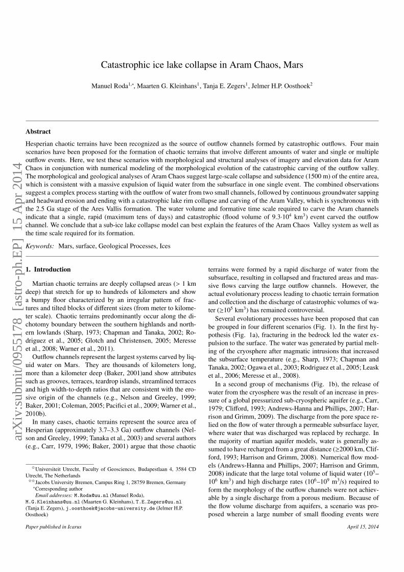
Several evolutionary processes have been proposed that canbe grouped in four different scenarios (Fig. 1). In the first hy-pothesis (Fig. 1a), fracturing in the bedrock led the water ex-pulsion to the surface. The water was generated by partial melt-ing of the cryosphere after magmatic intrusions that increasedthe subsurface temperature (e.g., Sharp, 1973; Chapman andTanaka, 2002; Ogawa et al., 2003; Rodriguez et al., 2005; Leasket al., 2006; Meresse et al., 2008).
In a second group of mechanisms (Fig. 1b), the release ofwater from the cryosphere was the result of an increase in pres-sure of a global pressurized sub-cryospheric aquifer (e.g., Carr,1979; Clifford, 1993; Andrews-Hanna and Phillips, 2007; Har-rison and Grimm, 2009). The discharge from the pore space re-lied on the flow of water through a permeable subsurface layer,where water that was discharged was replaced by recharge. Inthe majority of martian aquifer models, water is generally as-sumed to have recharged from a great distance (≥2000 km, Clif-ford, 1993; Harrison and Grimm, 2008). Numerical flow mod-els (Andrews-Hanna and Phillips, 2007; Harrison and Grimm,2008) indicate that the large total volume of liquid water (105–106 km3) and high discharge rates (106–109 m3/s) required toform the morphology of the outflow channels were not achiev-able by a single discharge from a porous medium. Because ofthe flow volume discharge from aquifers, a scenario was pro-posed wherein a large number of small flooding events were
Paper published in Icarus April 15, 2014
arX
iv:s
ubm
it/09
5517
8 [
astr
o-ph
.EP]
15
Apr
201
4
ice cap
recharge
water table
cryosphere
headrecharge
cryospheredisruption
ponding andchannel formation
i
ii
iii
b
sediments cap
buried ice
sediments cap
buried ice
sub-ice lake
fracturing
water ponding
collapsed area
outflow
i
ii
iii
d
cryospheremelts
buriedclathratelenses
cryospheremelts
buriedclathratelenses
wateroutflow
buriedclathratelenses
i
ii
iii
c
magmatic intrusion
fracturing
wateroutflow
ai
ii
iii
collapse
cryospheremelting
head
Magma-cryosphere model Aquifer model
Gas-hydrate model Sub-ice lake model
Figure 1: Four different scenarios for the origin of chaotic terrains. a) Magma-cryosphere model (redrawn after Meresse et al., 2008); b) Aquifer model (redrawnafter Harrison and Grimm, 2009); c) Gas-hydrate model (redrawn after Kargel et al., 2007); d) sub-ice lake model (redrawn after Zegers et al., 2010).
followed by a sudden release of previously ponded water (≥600,Harrison and Grimm, 2008).
Another hypothesis (Fig. 1c) suggests that dewatering of flu-ids from gas and/or salt hydrate buried deposits (Max and Clif-ford, 2001; Montgomery and Gillespie, 2005) or the hydrologicprocesses triggered by clathrates (Kargel et al., 2007) could be
responsible for the water outflow.
Finally, Zegers et al. (2010) propose that chaotic terrains de-veloped by the catastrophic collapse of sediments induced as aconsequence of the melting of buried ice sheets (Fig. 1d). Ther-mal modeling results show that even under very low crustal heatflux conditions, ice sheets will melt if buried under thick sed-
2
iments (up to 2 km) because of the difference in thermal con-ductivity between the basin fill and surrounding crust. Whenthe buried sub-ice lake reaches a critical thickness, the overbur-den collapses and subsides, resulting in a massive expulsion ofwater to the surface.
To distinguish between those four scenarios and test the va-lidity of the evolution models for chaotic terrains and their out-flow channels, the amount and timing of the water release, theamount of subsidence, and the fracture distributions are fun-damental variables. To constrain those variables for a singlechaotic terrain and its outflow channel, we analyzed the mor-phological and geological features characterizing Aram Chaosand its valley. Furthermore we estimated the flow volume andformative time scale required to carve the Aram channel. Fi-nally we discuss the four scenarios proposed for chaotic terrainformation in view of these results, propose the most likely sce-nario for the evolution of Aram Chaos and Aram channel anddiscuss the significance of our findings for other chaotic ter-rains.
2. Aram Chaos morphology and fracturing
In this section, we present the geological and morphologi-cal observations related to Aram Chaos in conjunction with astructural analysis performed on the fractures to determine thesequence of depositional and fracturing events during its for-mation.
2.1. Geology and pre-faulting morphology
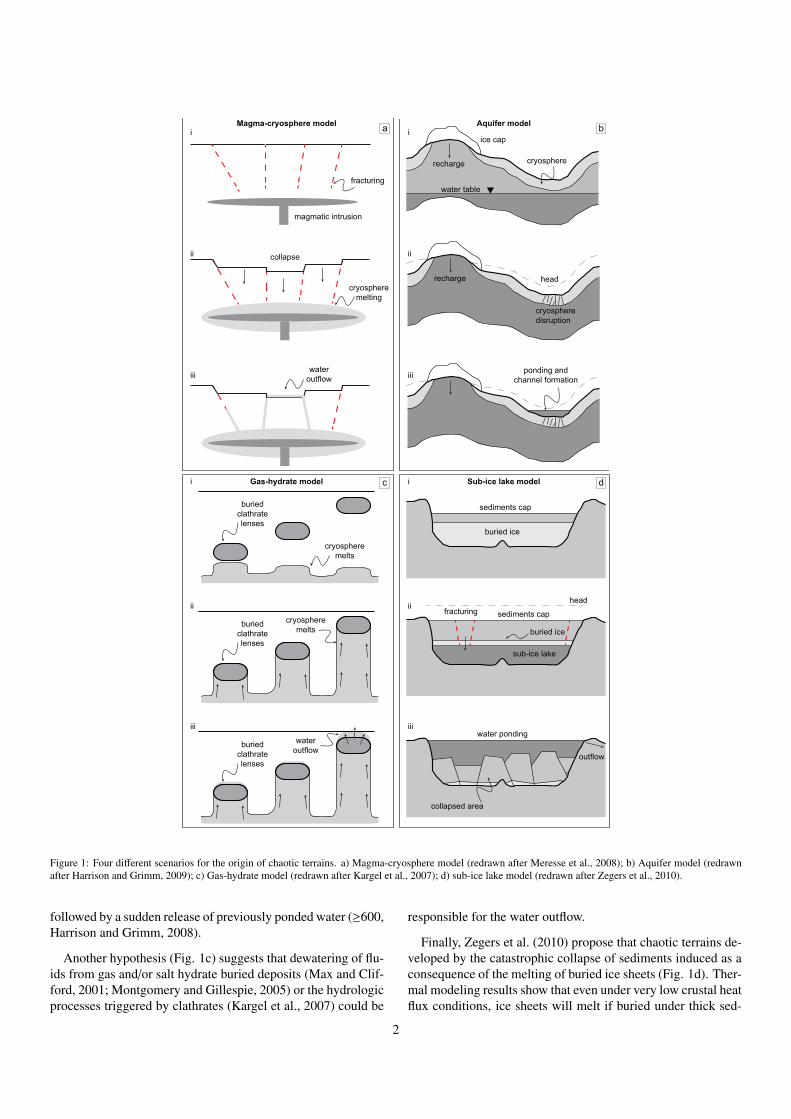
Aram Chaos is situated in a circular basin with a diameterof 280 km centered at 2.5◦N and 338.5◦E (Fig. 2) suggestingthat it is developed in a large impact crater (Schultz et al., 1982;Glotch and Christensen, 2005). It is connected to Ares Vallis byAram Valley, a 15 km wide and 2.5 km deep outflow channel(Glotch and Christensen, 2005; Masse et al., 2008; Oosthoeket al., 2007). The formation time of the original impact crateris not constrained; however, given the size of the crater, theimpact likely occurred in the Noachian (≥ 3.7 Ga, Zegers et al.,2010).It has been suggested that the outflow event of Aram Val-ley was synchronous with the final erosive event of Ares Vallis(approximately 2.5 Ga, Warner et al., 2009).
Glotch and Christensen (2005) divide the Aram chaotic ter-rain into three possibly lateral main units. The Fractured Plainsunit is the largest and almost completely surrounds the craterrim. It consists of up to tens of kilometer-sized slumped blocksforming a curvilinear fracture pattern. The Knobby Terrain unitis the second unit and occurs in the central part of Aram Chaosand at certain locations surrounding the crater rim. It consistsof km-scale irregular blocks (knobs). The High Thermal InertiaChaotic Terrain unit occurs in the central part of Aram Chaosand underlies outcrops of layered material. Those two (Masseet al., 2008) or three (Lichtenberg et al., 2010) layered subunits(500-m thick) are composed by mono- and polyhydrated min-erals such as sulfates and ferric-oxides.
Observations in 3D, particularly from HRSC stereo data (12m/pixel), provide evidence that the current Aram Chaos terrain
-18° W-19° W-20° W-21° W-22° W-23° W
5° N
4° N
3° N
2° N
1° N
0 30 60 90 120 150
km
Fig.3
Fig.8
Fig.4
Fig.9
Fig.12Fig.16
a
b
Figure 2: a) View of Aram Chaos showing the typical fractured and tilted chaosblocks, and associated outflow channel (Aram Valley). The black squares arereferred to the locations of detailed figures (HRSC mosaic). b) Geological mapof Aram Chaos after Glotch and Christensen (2005). This material is repro-duced with permission of John Wiley & Sons, Inc.
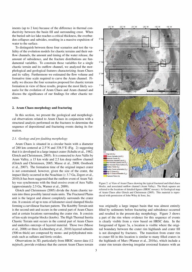
was originally a large impact basin that was almost entirelyfilled by sediments before fracturing and subsidence occurredand resulted in the present-day morphology. Figure 3 showsa part of the rim where evidence for this sequence of eventsis clearly visible from a view based on HRSC data. In theforeground of figure 3a, a location is visible where the origi-nal boundary between the crater rim highlands and crater fillis not disrupted by fractures. The transition from crater rimto crater fill in this location is similar to many filled craters inthe highlands of Mars (Warner et al., 2010a), which include acrater rim terrain showing irregular erosional features with an
3
onlap transition to smooth crater fill material. There is a grad-ual slope from the crater rim into the crater fill of almost 500m (Fig. 3b, white arrow), which suggests that the crater waslikely filled to a level of 500 m below the rim in this part. In thebackground of figure 3b, the transition from unfractured high-land to chaotic terrain is visible, and the transition is marked byan abrupt escarpment of 1500 m.
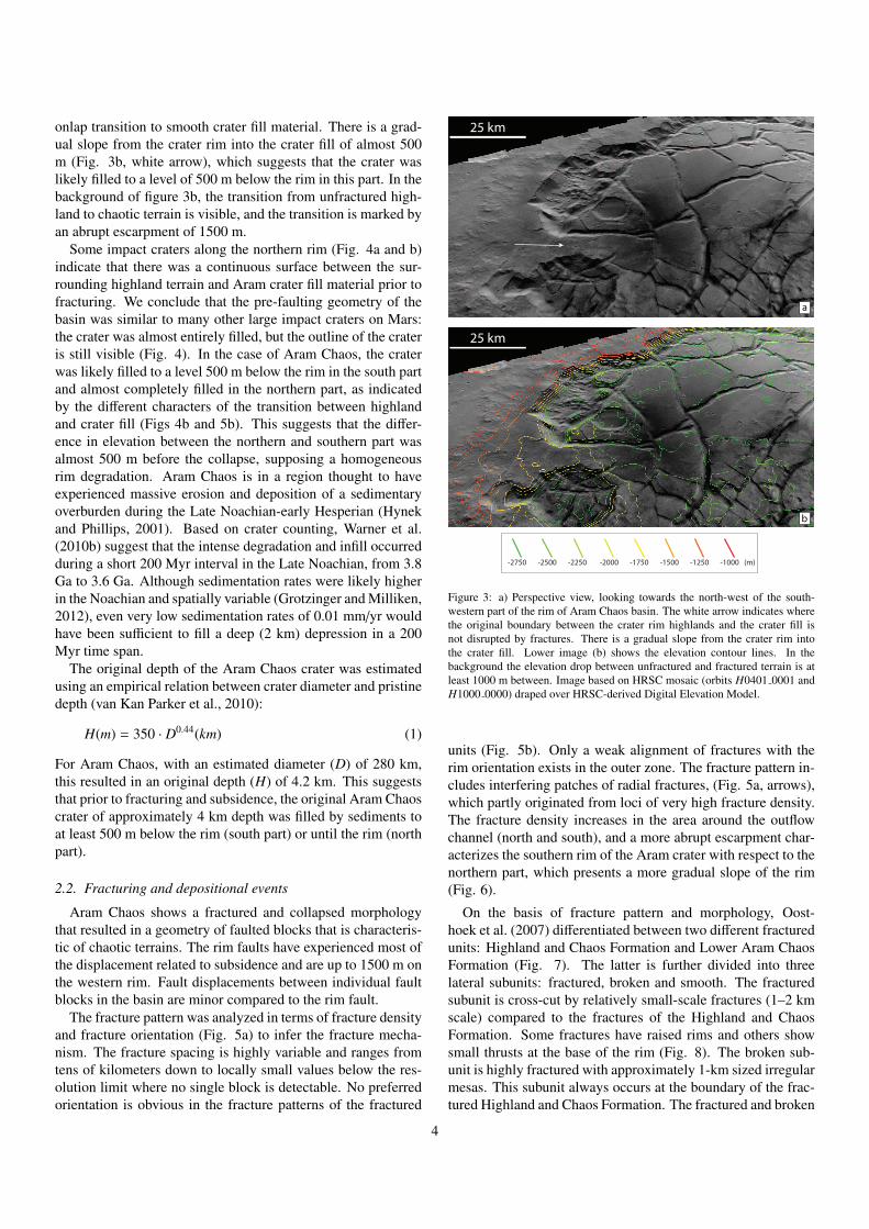
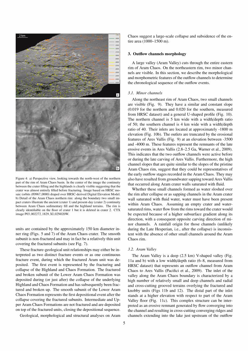
Some impact craters along the northern rim (Fig. 4a and b)indicate that there was a continuous surface between the sur-rounding highland terrain and Aram crater fill material prior tofracturing. We conclude that the pre-faulting geometry of thebasin was similar to many other large impact craters on Mars:the crater was almost entirely filled, but the outline of the crateris still visible (Fig. 4). In the case of Aram Chaos, the craterwas likely filled to a level 500 m below the rim in the south partand almost completely filled in the northern part, as indicatedby the different characters of the transition between highlandand crater fill (Figs 4b and 5b). This suggests that the differ-ence in elevation between the northern and southern part wasalmost 500 m before the collapse, supposing a homogeneousrim degradation. Aram Chaos is in a region thought to haveexperienced massive erosion and deposition of a sedimentaryoverburden during the Late Noachian-early Hesperian (Hynekand Phillips, 2001). Based on crater counting, Warner et al.(2010b) suggest that the intense degradation and infill occurredduring a short 200 Myr interval in the Late Noachian, from 3.8Ga to 3.6 Ga. Although sedimentation rates were likely higherin the Noachian and spatially variable (Grotzinger and Milliken,2012), even very low sedimentation rates of 0.01 mm/yr wouldhave been sufficient to fill a deep (2 km) depression in a 200Myr time span.
The original depth of the Aram Chaos crater was estimatedusing an empirical relation between crater diameter and pristinedepth (van Kan Parker et al., 2010):
H(m) = 350 · D0.44(km) (1)
For Aram Chaos, with an estimated diameter (D) of 280 km,this resulted in an original depth (H) of 4.2 km. This suggeststhat prior to fracturing and subsidence, the original Aram Chaoscrater of approximately 4 km depth was filled by sediments toat least 500 m below the rim (south part) or until the rim (northpart).
2.2. Fracturing and depositional events
Aram Chaos shows a fractured and collapsed morphologythat resulted in a geometry of faulted blocks that is characteris-tic of chaotic terrains. The rim faults have experienced most ofthe displacement related to subsidence and are up to 1500 m onthe western rim. Fault displacements between individual faultblocks in the basin are minor compared to the rim fault.
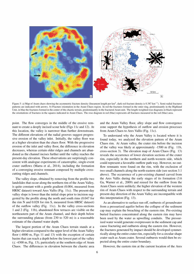
The fracture pattern was analyzed in terms of fracture densityand fracture orientation (Fig. 5a) to infer the fracture mecha-nism. The fracture spacing is highly variable and ranges fromtens of kilometers down to locally small values below the res-olution limit where no single block is detectable. No preferredorientation is obvious in the fracture patterns of the fractured
-2750 -2500 -2250 -2000 -1750 -1500 -1250 -1000 (m)
25 km
a
b
25 km
Figure 3: a) Perspective view, looking towards the north-west of the south-western part of the rim of Aram Chaos basin. The white arrow indicates wherethe original boundary between the crater rim highlands and the crater fill isnot disrupted by fractures. There is a gradual slope from the crater rim intothe crater fill. Lower image (b) shows the elevation contour lines. In thebackground the elevation drop between unfractured and fractured terrain is atleast 1000 m between. Image based on HRSC mosaic (orbits H0401 0001 andH1000 0000) draped over HRSC-derived Digital Elevation Model.
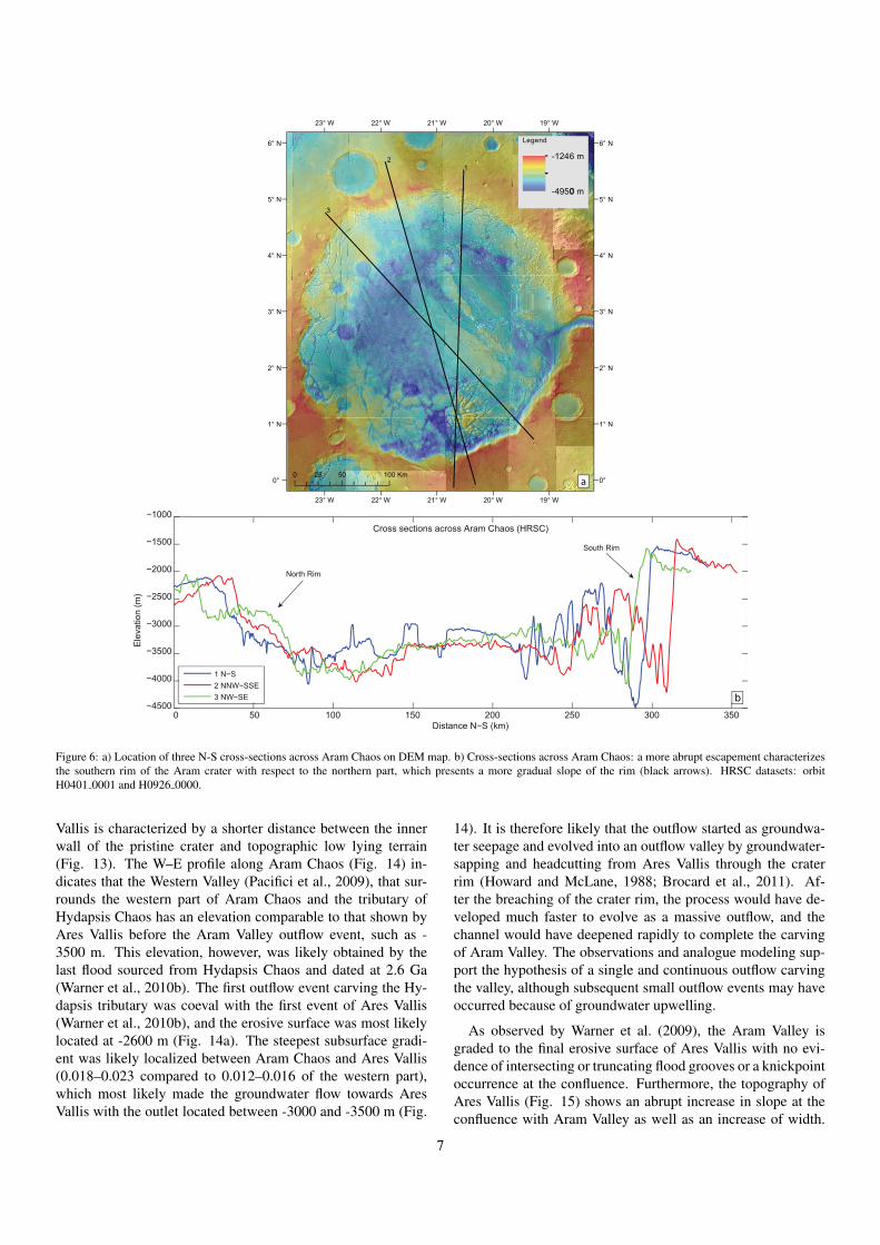
units (Fig. 5b). Only a weak alignment of fractures with therim orientation exists in the outer zone. The fracture pattern in-cludes interfering patches of radial fractures, (Fig. 5a, arrows),which partly originated from loci of very high fracture density.The fracture density increases in the area around the outflowchannel (north and south), and a more abrupt escarpment char-acterizes the southern rim of the Aram crater with respect to thenorthern part, which presents a more gradual slope of the rim(Fig. 6).
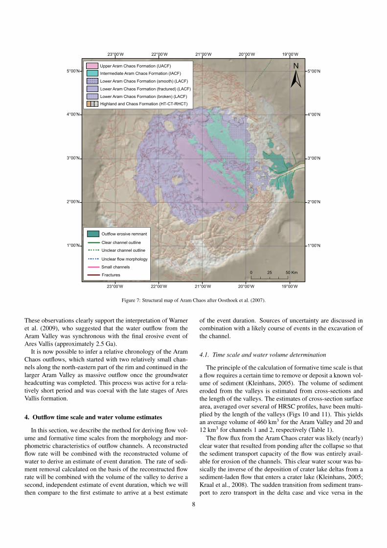
On the basis of fracture pattern and morphology, Oost-hoek et al. (2007) differentiated between two different fracturedunits: Highland and Chaos Formation and Lower Aram ChaosFormation (Fig. 7). The latter is further divided into threelateral subunits: fractured, broken and smooth. The fracturedsubunit is cross-cut by relatively small-scale fractures (1–2 kmscale) compared to the fractures of the Highland and ChaosFormation. Some fractures have raised rims and others showsmall thrusts at the base of the rim (Fig. 8). The broken sub-unit is highly fractured with approximately 1-km sized irregularmesas. This subunit always occurs at the boundary of the frac-tured Highland and Chaos Formation. The fractured and broken
4
1
2
b
Fig. 4b
a
( m)
-3500
-3400
-3300
-3200
-3100
-3000
-2900
-2800
-2700
-2600
-2500
-2400
-2300
-2200
2 km
Fig. 4b
Figure 4: a) Perspective view, looking towards the north-west of the northernpart of the rim of Aram Chaos basin. In the center of the image the continuitybetween the crater filling and the highlands is clearly visible suggesting that thecrater was almost entirely filled before fracturing. Image based on HRSC mo-saic (orbits H0967 0000) draped over HRSC-derived Digital Elevation Model.b) Detail of the Aram Chaos northern rim: along the boundary two small im-pact craters illustrate the ancient (crater 1) and present-day (crater 2) continuitybetween Aram Chaos sedimentary fill and the highland terrains. The rim isclearly identifiable on the floor of crater 1 but it is deleted in crater 2. CTXimage P03 002272 1829 XI 02N020W.
units are contained by the approximately 150 km diameter in-ner ring (Figs. 5 and 7) of the Aram Chaos crater. The smoothsubunit is non-fractured and may in fact be a relatively thin unitcovering the fractured subunits (see Fig. 7).
These fracture-geological unit relationships may either be in-terpreted as two distinct fracture events or as one continuousfracture event, during which the fractured Aram unit was de-posited. The first event is represented by the fracturing andcollapse of the Highland and Chaos Formation. The fracturedand broken subunit of the Lower Aram Chaos Formation wasdeposited during (or just after) the collapse of the underlyingHighland and Chaos Formation and has subsequently been frac-tured and broken up. The smooth subunit of the Lower AramChaos Formation represents the first depositional event after thecollapse covering the fractured subunits. Intermediate and Up-per Aram Chaos Formations are not fractured and are depositedon top of the fractured units, closing the depositional sequence.
Geological, morphological and structural analyses on Aram
Chaos suggest a large-scale collapse and subsidence of the en-tire area (1000–1500 m).
3. Outflow channels morphology
A large valley (Aram Valley) cuts through the entire easternrim of Aram Chaos. On the northeastern rim, two minor chan-nels are visible. In this section, we describe the morphologicaland morphometric features of the outflow channels to determinethe chronological sequence of the outflow events.
3.1. Minor channels
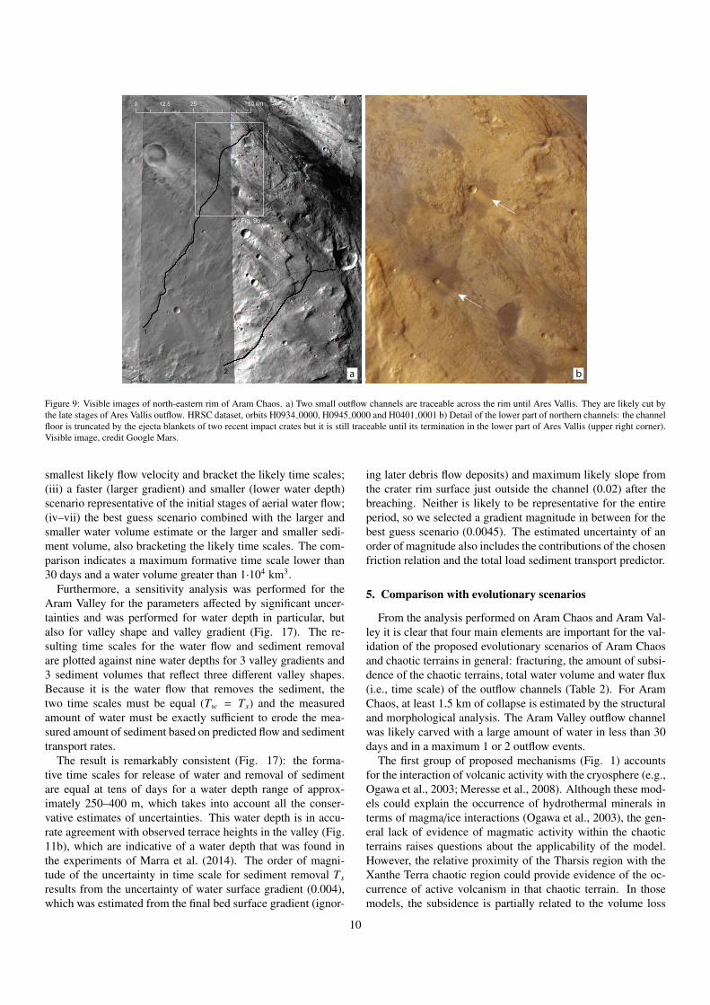
Along the northeast rim of Aram Chaos, two small channelsare visible (Fig. 9). They have a similar and constant slope(0.019 for the northern and 0.020 for the southern, measuredfrom HRSC dataset) and a general U-shaped profile (Fig. 10).The northern channel is 5 km wide with a width/depth ratioof 50; the southern channel is 4 km wide with a width/depthratio of 40. Their inlets are located at approximately -1800 melevation (Fig. 10b). The outlets are truncated by the erosionalfeatures of Ares Vallis (Fig. 9) at an elevation between -3500and -4000 m. These features represent the remnants of the lateerosive events in Ares Vallis (2.8–2.5 Ga, Warner et al., 2009).This indicates that the two outflow channels were active beforeor during the late carving of Ares Vallis. Furthermore, the highchannel slopes that are quite similar to the slopes of the pristineAram Chaos rim, suggest that they could be representatives ofthe early outflow stages recorded in the Aram Chaos. They mayalso have resulted from groundwater sapping toward Ares Vallisthat occurred along Aram crater walls saturated with fluid.
Whether these small channels formed as water sloshed overthe rim after collapse or as sapping channels in the Aram craterwall saturated with fluid water, water must have been presentwithin Aram Chaos. Assuming an empty crater and water-saturated rims, water flow from the rims toward the crater wouldbe expected because of a higher subsurface gradient along itsdirection, with a consequent opposite carving direction of mi-nor channels. A rainfall origin for those channels (unlikelyduring the Late Hesperian, i.e., after the collapse) is inconsis-tent with the absence of other small channels around the AramChaos rim.
3.2. Aram Valley
The Aram Valley is a deep (2.5 km) V-shaped valley (Fig.11a and b) with a low width/depth ratio (6–8, measured fromHRSC dataset) that represents an outflow channel from AramChaos to Ares Vallis (Pacifici et al., 2009). The inlet of thevalley along the Aram Chaos boundary is characterized by ahigh number of relatively small and deep channels and radialand cross-cutting grooved terrains overlying the fractured andknobby units (Figs 11b and 12). The distal part of the inletstands at a higher elevation with respect to part of the AramValley floor (Fig. 11c). This complex structure can be inter-preted as an erosive remnant generated by flow converging intothe channel and resulting in cross-cutting converging ridges andchannels extending into the lake just upstream of the outflow
5
N = 521
N = 138
N = 169
N = 244
N = 521
N = 138
N = 169N 16969
============================================== 242422242424424444222222222 4N N NNNNNNNNNNNNNNNNNNNNNNNNNNNNNNNN
N = 1469
Circle 1
Circle 2
50 km
N = 2957
a b
Figure 5: a) Map of Aram chaos showing the asymmetric fracture density (lineament length per km2, dark red fracture density is 0.387 km−1). Semi-radial fracturespatterns are indicated with arrows. b) Fracture orientation in the Aram Chaos region. In red the fractures formed in the outer ring, predominantly in the HighlandUnit, in blue the fractures formed in the center of the chaotic terrain, predominantly in the fractured Aram unit. The length-weighted rose diagrams in black representthe orientations of fractures in the squares indicated in Aram Chaos. The rose diagram in red (blue) represents all fractures measured in the red (blue) area.
point. The flow converges in the middle of the erosive rem-nant to create a deeply incised scour hole (Figs 11c and 12). Atthis location, the valley is narrower than further downstream.The different elevations of the radial grooves suggest progres-sive erosion of the valley inlet. Initially, the valley floor wasat a higher elevation than the chaos floor. With the progressiveerosion of the inlet and valley floor, the difference in elevationdecreases, whereas certain older ridges and channels are aban-doned as the channel incises further until the valley reaches thepresent-day elevation. These observations are surprisingly con-sistent with analogue experiments of catastrophic, single-eventcrater outflows (Marra et al., 2014), including the formationof a converging erosive remnant composed by multiple cross-cutting ridges and channels.
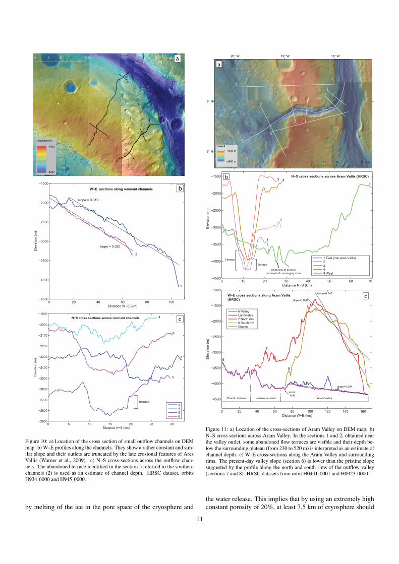
The valley slope, obtained by removing from the profile twolandslides that occur along the northern rim of the Aram Valley,is quite constant with a gentle gradient (0.004, measured fromHRSC dataset) toward Ares Vallis (Fig. 11c). The present-dayvalley slope is lower than the initial slope prior to incision sug-gested by the profile along the north and south rims (0.047 forthe rim N and 0.028 for rim S, measured from HRSC dataset)of the outflow valley (Fig. 11c). In the valley cross-sections1 and 2 (Fig. 11b), abandoned flow terraces are visible on thenortheastern part of the Aram channel, and their depth belowthe surrounding plateau (from 230 to 520 m) is a reasonableestimate of the channel water depth.
The largest portion of the Aram Chaos terrain stands at ahigher elevation compared to the upper level of the Aram Valleyfloor (-4000 m, Figs 11 and 13) with the exception of certainbasins that can reach a depth below the lowest part of the valley(≤ -4300 m, Fig. 13), particularly at the southern edge of AramChaos. The differences in elevation between the chaotic area
and the Aram Valley floor, alley slope and flow convergencezone support the hypothesis of outflow and erosion processesfrom Aram Chaos to Ares Vallis (Fig. 11c).
To understand why the Aram Valley is located where it isfound today, we analyzed the elevation pattern of the AramChaos rim. At Aram valley, the crater rim before the incisionof the valley was likely at approximately -1500 m (Fig. 11b,cross-section 3). The elevation map of Aram Chaos (Fig. 13)reveals the occurrence of lower elevation sections of the craterrim, especially in the northern and north-western side, whichcould represent a favorable outflow path way. However, no out-flow remnants were found on the rim, with the exclusion oftwo small channels along the north-eastern side (see section 3.1above). The occurrence of a pre-existing channel carved fromthe Ares Vallis during the early stages of its formation (3.6Ga, Warner et al., 2009) and reused for the outflow from theAram Chaos seem unlikely; the higher elevation of the westernrim of Aram Chaos with respect to the surrounding terrain andpresent-day direction of the Aram Valley are incompatible withthis interpretation (Fig. 13).
As an alternative to surface run-off, outbursts of groundwaterfrom a pressurized aquifer before the collapse of the sedimentcap may explain the breaching of the eastern rim. Pre-existingburied fractures concentrated along the eastern rim may havebeen used by the water as upwelling conduits. The pressur-ized water would generate overpressure in the sediment cap andcause fracturing and outbursts along the eastern rim. However,the fractures generated by impact should be developed symmet-rically along the entire crater rim, especially for a circular-shapecrater such as Aram crater. Several outbursts would then be ex-pected along the entire crater boundary.
However, the eastern rim at the current location of the Ares
6
b0 50 100 150 200 250 300 350
−4500
−4000
−3500
−3000
−2500
−2000
−1500
−1000
Distance N−S (km)
Ele
vatio
n (m
)
Cross sections across Aram Chaos (HRSC)
1 N−S2 NNW−SSE3 NW−SE
North Rim
South Rim
19° W
19° W
20° W
20° W
21° W
21° W
22° W
22° W
23° W
23° W
6° N 6° N
5° N 5° N
4° N 4° N
3° N 3° N
2° N 2° N
1° N 1° N
0° 0° 0 50 100 mK52
Legend
-1246 m
-4950 m
12
3
a
0
Figure 6: a) Location of three N-S cross-sections across Aram Chaos on DEM map. b) Cross-sections across Aram Chaos: a more abrupt escapement characterizesthe southern rim of the Aram crater with respect to the northern part, which presents a more gradual slope of the rim (black arrows). HRSC datasets: orbitH0401 0001 and H0926 0000.
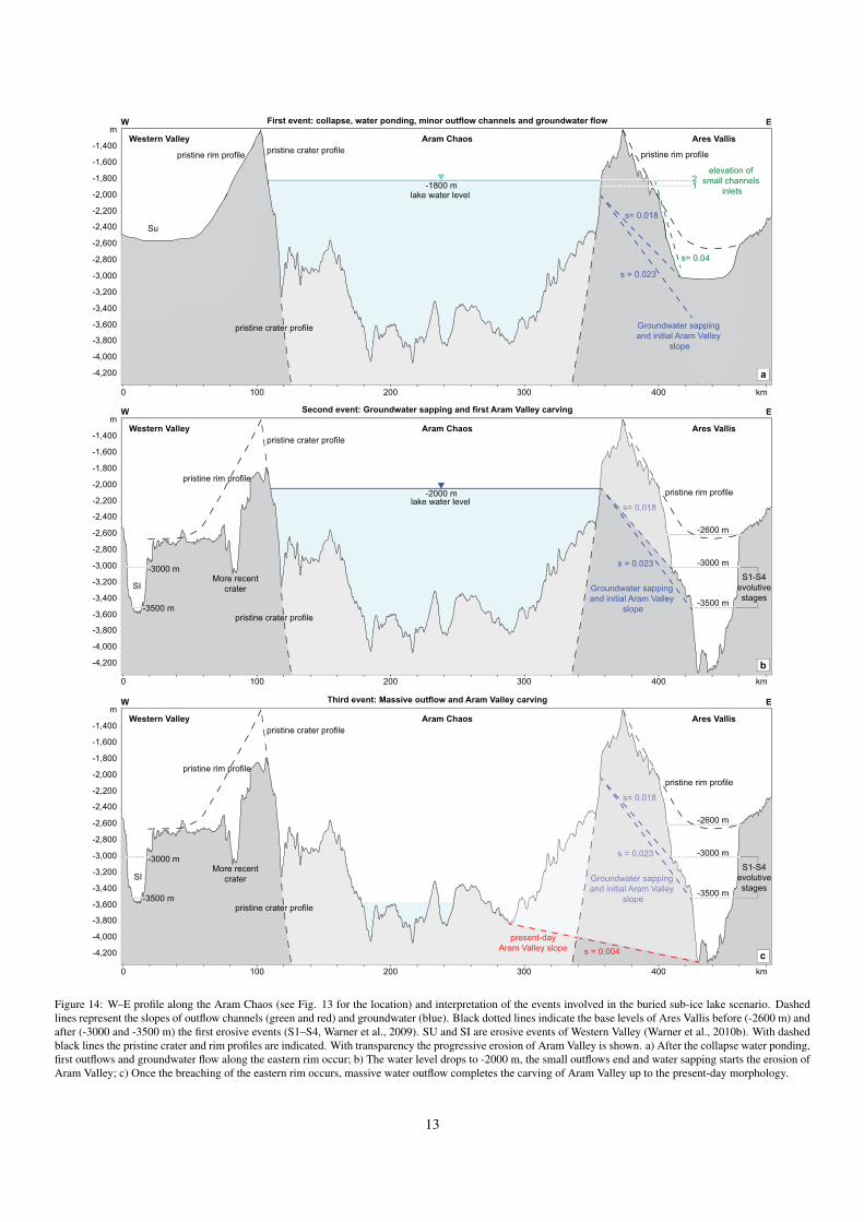
Vallis is characterized by a shorter distance between the innerwall of the pristine crater and topographic low lying terrain(Fig. 13). The W–E profile along Aram Chaos (Fig. 14) in-dicates that the Western Valley (Pacifici et al., 2009), that sur-rounds the western part of Aram Chaos and the tributary ofHydapsis Chaos has an elevation comparable to that shown byAres Vallis before the Aram Valley outflow event, such as -3500 m. This elevation, however, was likely obtained by thelast flood sourced from Hydapsis Chaos and dated at 2.6 Ga(Warner et al., 2010b). The first outflow event carving the Hy-dapsis tributary was coeval with the first event of Ares Vallis(Warner et al., 2010b), and the erosive surface was most likelylocated at -2600 m (Fig. 14a). The steepest subsurface gradi-ent was likely localized between Aram Chaos and Ares Vallis(0.018–0.023 compared to 0.012–0.016 of the western part),which most likely made the groundwater flow towards AresVallis with the outlet located between -3000 and -3500 m (Fig.
14). It is therefore likely that the outflow started as groundwa-ter seepage and evolved into an outflow valley by groundwater-sapping and headcutting from Ares Vallis through the craterrim (Howard and McLane, 1988; Brocard et al., 2011). Af-ter the breaching of the crater rim, the process would have de-veloped much faster to evolve as a massive outflow, and thechannel would have deepened rapidly to complete the carvingof Aram Valley. The observations and analogue modeling sup-port the hypothesis of a single and continuous outflow carvingthe valley, although subsequent small outflow events may haveoccurred because of groundwater upwelling.
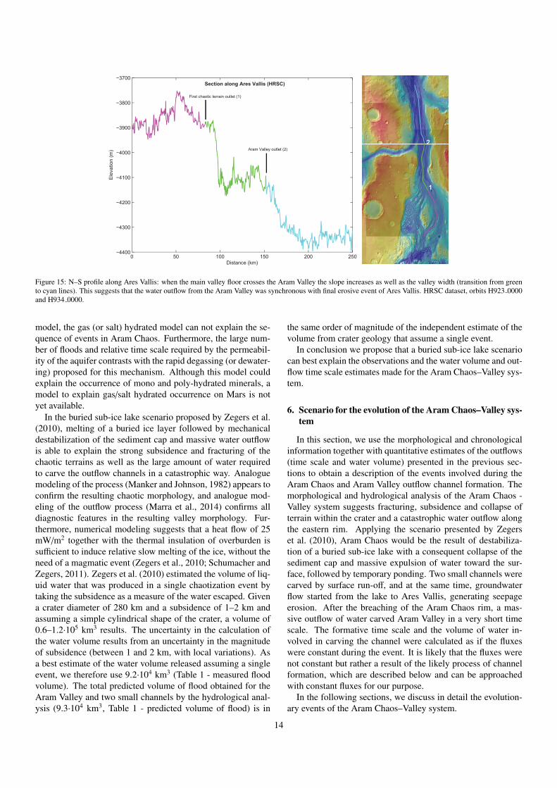
As observed by Warner et al. (2009), the Aram Valley isgraded to the final erosive surface of Ares Vallis with no evi-dence of intersecting or truncating flood grooves or a knickpointoccurrence at the confluence. Furthermore, the topography ofAres Vallis (Fig. 15) shows an abrupt increase in slope at theconfluence with Aram Valley as well as an increase of width.
7
0 5025 KmFractures
Small channels
Clear channel outline
Outflow erosive remnant
Unclear channel outline
Unclear flow morphology
5°00’N
4°00’N
3°00’N
2°00’N
1°00’N
5°00’N
4°00’N
3°00’N
2°00’N
1°00’N
23°00’W 22°00’W 21°00’W 20°00’W 19°00’W
23°00’W 22°00’W 21°00’W 20°00’W 19°00’W
Lower Aram Chaos Formation (smooth) (LACF)
Lower Aram Chaos Formation (fractured) (LACF)
Lower Aram Chaos Formation (broken) (LACF)
Intermediate Aram Chaos Formation (IACF)
Upper Aram Chaos Formation (UACF)
Highland and Chaos Formation (HT-CT-RHCT)
Figure 7: Structural map of Aram Chaos after Oosthoek et al. (2007).
These observations clearly support the interpretation of Warneret al. (2009), who suggested that the water outflow from theAram Valley was synchronous with the final erosive event ofAres Vallis (approximately 2.5 Ga).
It is now possible to infer a relative chronology of the AramChaos outflows, which started with two relatively small chan-nels along the north-eastern part of the rim and continued in thelarger Aram Valley as massive outflow once the groundwaterheadcutting was completed. This process was active for a rela-tively short period and was coeval with the late stages of AresVallis formation.
4. Outflow time scale and water volume estimates
In this section, we describe the method for deriving flow vol-ume and formative time scales from the morphology and mor-phometric characteristics of outflow channels. A reconstructedflow rate will be combined with the reconstructed volume ofwater to derive an estimate of event duration. The rate of sedi-ment removal calculated on the basis of the reconstructed flowrate will be combined with the volume of the valley to derive asecond, independent estimate of event duration, which we willthen compare to the first estimate to arrive at a best estimate
of the event duration. Sources of uncertainty are discussed incombination with a likely course of events in the excavation ofthe channel.
4.1. Time scale and water volume determination
The principle of the calculation of formative time scale is thata flow requires a certain time to remove or deposit a known vol-ume of sediment (Kleinhans, 2005). The volume of sedimenteroded from the valleys is estimated from cross-sections andthe length of the valleys. The estimates of cross-section surfacearea, averaged over several of HRSC profiles, have been multi-plied by the length of the valleys (Figs 10 and 11). This yieldsan average volume of 460 km3 for the Aram Valley and 20 and12 km3 for channels 1 and 2, respectively (Table 1).
The flow flux from the Aram Chaos crater was likely (nearly)clear water that resulted from ponding after the collapse so thatthe sediment transport capacity of the flow was entirely avail-able for erosion of the channels. This clear water scour was ba-sically the inverse of the deposition of crater lake deltas from asediment-laden flow that enters a crater lake (Kleinhans, 2005;Kraal et al., 2008). The sudden transition from sediment trans-port to zero transport in the delta case and vice versa in the
8
5 km
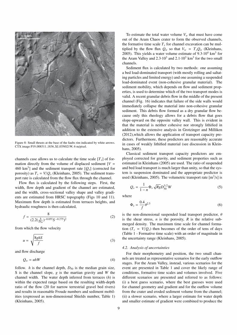
Figure 8: Small thrusts at the base of the faults rim indicated by white arrows.CTX image P19 008311 1836 XI 03N021W, 6 m/pixel.
channels case allows us to calculate the time scale [Ts] of for-mation directly from the volume of displaced sediment [V =
460 km3] and the sediment transport rate [Qs] (corrected forporosity) as Ts = V/Qs (Kleinhans, 2005). The sediment trans-port rate is calculated from the flow flux through the channel.
Flow flux is calculated by the following steps. First, thewidth, flow depth and gradient of the channel are estimated,and the width, cross-sectional valley shape and valley gradi-ents are estimated from HRSC topography (Figs 10 and 11).Maximum flow depth is estimated from terraces heights, andhydraulic roughness is then calculated,
f =8
(2.2( hD50
)−0.055S −0.275)2(2)
from which the flow velocity
u =
√8ghS
f(3)
and flow discharge
Qw = uhW (4)
follow. h is the channel depth, D50 is the median grain size,S is the channel slope, g is the martian gravity and W thechannel width. The water depth inferred from terraces (h) iswithin the expected range based on the resulting width-depthratio of the flow (20 for narrow terrestrial gravel bed rivers)and results in reasonable Froude numbers and sediment mobil-ities (expressed as non-dimensional Shields number, Table 1)(Kleinhans, 2005).
To estimate the total water volume Vw that must have comeout of the Aram Chaos crater to form the observed channels,the formative time scale Ts for channel excavation can be mul-tiplied by the flow flux Qw so that Vw = TsQw (Kleinhans,2005). This yields a water volume estimate of 9.3·104 km3 forthe Aram Valley and 2.3·103 and 2.1·103 km3 for the two smallchannels.
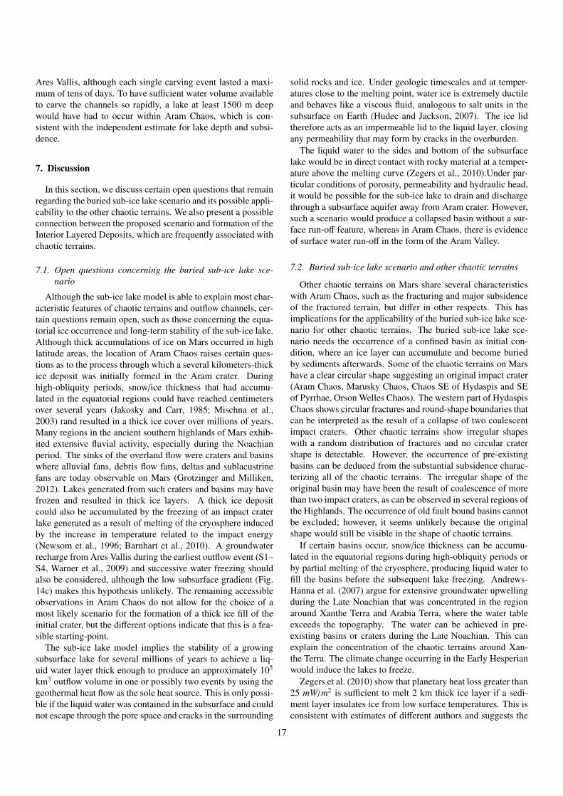
Sediment flux is calculated by two methods: one assuminga bed load-dominated transport (with mostly rolling and saltat-ing particles and limited energy) and one assuming a suspendedload-dominated event (non-cohesive granular material). Thesediment mobility, which depends on flow and sediment prop-erties, is used to determine which of the two transport modes isvalid. A recent granular debris flow in the middle of the presentchannel (Fig. 16) indicates that failure of the side walls wouldimmediately collapse the material into non-cohesive granularsediment. This debris flow formed as a dry granular flow be-cause only this rheology allows for a debris flow that goesslope-upward on the opposite valley wall. This is evident inthat the material is neither cohesive nor strongly lithified inaddition to the extensive analysis in Grotzinger and Milliken(2012),which allows the application of transport capacity pre-dictors. Furthermore, these predictors are reasonably accuratein cases of weakly lithified material (see discussion in Klein-hans, 2005).
Classical sediment transport capacity predictors are em-ployed corrected for gravity, and sediment properties such asestimated in Kleinhans (2005) are used. The ratio of suspendedand bed load transport is much larger than unity, so that the sys-tem is suspension dominated and the appropriate predictor isused (Kleinhans, 2005). The volumetric transport rate [m3/s] is
Qs =1
1 − nΦs√
RgD3/250 W (5)
where
Φs =0.4fθ2.5 (6)
is the non-dimensional suspended load transport predictor, θis the shear stress, n is the porosity, R is the relative sub-merged density. The maximum time scale for channel forma-tion (Ts = V/Qs) then becomes of the order of tens of days(Table 1 - Formative time scale) with an order of magnitude inthe uncertainty range (Kleinhans, 2005).
4.2. Analysis of uncertaintiesFor their morphometry and position, the two small chan-
nels are treated as representative scenarios for the early outflowstages. For the Aram Valley, instead, various scenarios for theevent are presented in Table 1 and cover the likely range ofconditions, formative time scales and volumes involved. Fivedifferent scenarios are presented and referred to as follows:(i) a best guess scenario, where the best guesses were usedfor channel geometry and gradient and for the outflow volumefrom the crater and eroded sediment volume from the channel;(ii) a slower scenario, where a larger estimate for water depthand smaller estimate of gradient were combined to produce the
9
0 25 50 km12.5
1
2
Fig. 9b
a b
Figure 9: Visible images of north-eastern rim of Aram Chaos. a) Two small outflow channels are traceable across the rim until Ares Vallis. They are likely cut bythe late stages of Ares Vallis outflow. HRSC dataset, orbits H0934 0000, H0945 0000 and H0401 0001 b) Detail of the lower part of northern channels: the channelfloor is truncated by the ejecta blankets of two recent impact crates but it is still traceable until its termination in the lower part of Ares Vallis (upper right corner).Visible image, credit Google Mars.
smallest likely flow velocity and bracket the likely time scales;(iii) a faster (larger gradient) and smaller (lower water depth)scenario representative of the initial stages of aerial water flow;(iv–vii) the best guess scenario combined with the larger andsmaller water volume estimate or the larger and smaller sedi-ment volume, also bracketing the likely time scales. The com-parison indicates a maximum formative time scale lower than30 days and a water volume greater than 1·104 km3.
Furthermore, a sensitivity analysis was performed for theAram Valley for the parameters affected by significant uncer-tainties and was performed for water depth in particular, butalso for valley shape and valley gradient (Fig. 17). The re-sulting time scales for the water flow and sediment removalare plotted against nine water depths for 3 valley gradients and3 sediment volumes that reflect three different valley shapes.Because it is the water flow that removes the sediment, thetwo time scales must be equal (Tw = Ts) and the measuredamount of water must be exactly sufficient to erode the mea-sured amount of sediment based on predicted flow and sedimenttransport rates.
The result is remarkably consistent (Fig. 17): the forma-tive time scales for release of water and removal of sedimentare equal at tens of days for a water depth range of approx-imately 250–400 m, which takes into account all the conser-vative estimates of uncertainties. This water depth is in accu-rate agreement with observed terrace heights in the valley (Fig.11b), which are indicative of a water depth that was found inthe experiments of Marra et al. (2014). The order of magni-tude of the uncertainty in time scale for sediment removal Ts
results from the uncertainty of water surface gradient (0.004),which was estimated from the final bed surface gradient (ignor-
ing later debris flow deposits) and maximum likely slope fromthe crater rim surface just outside the channel (0.02) after thebreaching. Neither is likely to be representative for the entireperiod, so we selected a gradient magnitude in between for thebest guess scenario (0.0045). The estimated uncertainty of anorder of magnitude also includes the contributions of the chosenfriction relation and the total load sediment transport predictor.
5. Comparison with evolutionary scenarios
From the analysis performed on Aram Chaos and Aram Val-ley it is clear that four main elements are important for the val-idation of the proposed evolutionary scenarios of Aram Chaosand chaotic terrains in general: fracturing, the amount of subsi-dence of the chaotic terrains, total water volume and water flux(i.e., time scale) of the outflow channels (Table 2). For AramChaos, at least 1.5 km of collapse is estimated by the structuraland morphological analysis. The Aram Valley outflow channelwas likely carved with a large amount of water in less than 30days and in a maximum 1 or 2 outflow events.
The first group of proposed mechanisms (Fig. 1) accountsfor the interaction of volcanic activity with the cryosphere (e.g.,Ogawa et al., 2003; Meresse et al., 2008). Although these mod-els could explain the occurrence of hydrothermal minerals interms of magma/ice interactions (Ogawa et al., 2003), the gen-eral lack of evidence of magmatic activity within the chaoticterrains raises questions about the applicability of the model.However, the relative proximity of the Tharsis region with theXanthe Terra chaotic region could provide evidence of the oc-currence of active volcanism in that chaotic terrain. In thosemodels, the subsidence is partially related to the volume loss
10
0 5 10 15 20 25 30−2900
−2800
−2700
−2600
−2500
−2400
−2300
−2200
−2100
−2000
−1900
Distance N−S (km)
Ele
vatio
n (m
)
N−S cross sections across remnant channels
3456
3
4
5
6
0 20 40 60 80 100−4500
−4000
−3500
−3000
−2500
−2000
−1500
Distance W−E (km)
Ele
vatio
n (m
)
W−E sections along remnant channels
1
2
slope = 0.020
slope = 0.019
b
c
terrace
0 30 60 mK51
1
2
3
45
6
a
-1160
-5280
elevation (m)
Figure 10: a) Location of the cross section of small outflow channels on DEMmap. b) W–E profiles along the channels. They show a rather constant and sim-ilar slope and their outlets are truncated by the late erosional features of AresVallis (Warner et al., 2009). c) N–S cross-sections across the outflow chan-nels. The abandoned terrace identified in the section 5 referred to the southernchannels (2) is used as an estimate of channel depth. HRSC dataset, orbitsH934 0000 and H945 0000.
by melting of the ice in the pore space of the cryosphere and
18° W19° W20° W
3° N
2° N
6030 mk0 15
Legend
-1246 m
-4950 m
1
234
5
6
7
8
0 20 40 60 80 100 120 140 160
−4500
−4000
−3500
−3000
−2500
−2000
−1500
−1000
Distance W−E (km)
Ele
vatio
n (m
)
W−E cross sections along Aram Vallis (HRSC)
6 ValleyLandslides7 North rim8 South rimSlopes
Aram Valleyerosive remnantChaotic terrains
6
7
8
slope=0.028
slope=0.047
slope=0.004
1
2
3 45
Terrace
Terrace
Channels of erosiveremnant of converging zone
0 10 20 30 40 50 60 70−4500
−4000
−3500
−3000
−2500
−2000
−1500
Distance N−S (km)
Ele
vatio
n (m
)
N−S cross sections across Aram Vallis (HRSC)
5 West
1 East (into Ares Vallis)234
b
a
c
scour hole
Figure 11: a) Location of the cross-sections of Aram Valley on DEM map. b)N–S cross sections across Aram Valley. In the sections 1 and 2, obtained nearthe valley outlet, some abandoned flow terraces are visible and their depth be-low the surrounding plateau (from 230 to 520 m) is interpreted as an estimate ofchannel depth. c) W–E cross-sections along the Aram Valley and surroundingrims. The present-day valley slope (section 6) is lower than the pristine slopesuggested by the profile along the north and south rims of the outflow valley(sections 7 and 8). HRSC datasets from orbit H0401 0001 and H0923 0000.
the water release. This implies that by using an extremely highconstant porosity of 20%, at least 7.5 km of cryosphere should
11
0 10 20 mK5
scourhole
crater rim
crater rim
inlet coverging
zone
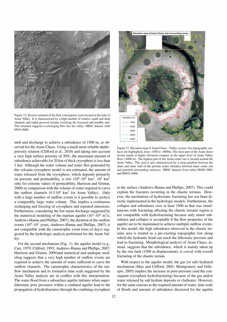
Figure 12: Erosive remnant of the flow convergence zone located at the inlet ofAram Valley. It is characterized by a high number of relative small and deepchannels and radial grooved terrains overlying the fractured and knobby unit.This structure suggests a converging flow into the valley. HRSC dataset, orbitH945 0000.
melt and discharge to achieve a subsidence of 1500 m, as ob-served for the Aram Chaos. Using a much more reliable depth–porosity relation (Clifford et al., 2010) and taking into accounta very high surface porosity of 30%, the maximum amount ofsubsidence achievable for 20 km of thick cryosphere is less than1 km. Although the water volume and water flux generated bythe volcanic-cryosphere model is not estimated, the amount ofwater released from the cryosphere, which depends primarilyon porosity and permeability, is low (100–102 km3, 103 km3
only for extreme values of permeability, Harrison and Grimm,2008) in comparison with the volume of water required to carvethe outflow channels (9.3·104 km3 for Aram Valley). Onlywith a large number of outflow events is it possible to archivea comparably large water volume. This implies a continuousrecharging and freezing of cryosphere and repeated intrusions.Furthermore, considering the low mean discharge suggested bythe numerical modeling of the martian aquifer (103–104 m3/s,Andrews-Hanna and Phillips, 2007), the duration of the outflowevents (100–102 years, Andrews-Hanna and Phillips, 2007) isnot compatible with the catastrophic event (tens of days) sug-gested by the hydrologic analysis performed for the Aram Val-ley.
For the second mechanism (Fig. 1), the aquifer model (e.g.,Carr, 1979; Clifford, 1993; Andrews-Hanna and Phillips, 2007;Harrison and Grimm, 2009)and numerical and analogue mod-eling suggests that a very high number of outflow events arerequired to achieve the amount of water sufficient to carve theoutflow channels. The catastrophic characteristics of the out-flow mechanism and its formative time scale suggested by theAram Valley analysis are in conflict with this interpretation.The water flood from a subsurface aquifer initiates when super-lithostatic pore pressures within a confined aquifer lead to thepropagation of hydrofractures through the confining cryosphere
-1500
-2000
-3000
-3500
-4000
elevation (m)
Elevation map of Aram Chaos and surrounding areas
Figure 13: Elevation map of Aram Chaos - Valley system: five topographic sur-faces are highlighted, from -1500 to -4000m. The most part of the Aram chaosterrain stands at higher elevation compare to the upper level of Aram Valleyfloor (-4000 m). The highest part of the Aram crater rim is located around theAram Valley. This area is also characterized by a steep gradient between theinner and outer wall of the pristine crater (distance between inner crater rimand greenish surrounding surfaces). HRSC datasets from orbits H0401 0001and H0923 0000.
to the surface (Andrews-Hanna and Phillips, 2007). This couldexplain the fractures occurring in the chaotic terrains. How-ever, the mechanism of hydrostatic fracturing has not been di-rectly implemented in the hydrologic models. Furthermore, thecollapse and subsidence over at least 1500 m that was simul-taneous with fracturing affecting the chaotic terrains region isnot compatible with hydrofracturing because only minor sub-sidence and collapse is acceptable if the flow properties of theaquifer are to be maintained to achieve multiple outflow events.In this model, the high subsidence observed in the chaotic ter-rains area is treated as a pre-existing topographic low alongwhich the hydraulic head can reach the lithostatic pressure andlead to fracturing. Morphological analysis of Aram Chaos, in-stead, suggests that the subsidence, which is mainly taken upby the rim fault (1500 m displacement), is coeval with overallfracturing of the chaotic terrain.
With respect to the aquifer model, the gas (or salt) hydratedmechanism (Max and Clifford, 2001; Montgomery and Gille-spie, 2005) implies the increase in pore-pressure (and the con-sequent cryosphere hydrofracturing) because of the gas and/orwater released by salt hydrate deposits or clathrates. However,for the same reasons as the required amount of water, time scaleof floods and amount of subsidence discussed for the aquifer
12
Third event: Massive outflow and Aram Valley carving
-2,600
-2,800
-3,000
-3,200
-3,400
-3,600
-3,800
-4,000
-4,200
100 200 300 400 km0
m
-1,400
-1,600
-1,800
-2,000
-2,200
-2,400-2600 m
-3000 m
-3500 m
s = 0.004
Ares VallisAram ChaosWestern Valley
present-dayAram Valley slope
W E
More recentcrater
-3000 m
-3500 m
pristine rim profilepristine rim profile
pristine crater profile
S1-S4evolutivestages
pristine crater profile
s = 0.023
s= 0.018
Groundwater sapping and initial Aram Valley
slope
Second event: Groundwater sapping and first Aram Valley carving
-2,600
-2,800
-3,000
-3,200
-3,400
-3,600
-3,800
-4,000
-4,200
100 200 300 400 km0
m
-1,400
-1,600
-1,800
-2,000
-2,200
-2,400-2600 m
-3000 m
-3500 m
Ares VallisAram ChaosWestern Valley
W E
More recentcrater
-3000 m
-3500 m
pristine rim profilepristine rim profile
pristine crater profile
S1-S4evolutivestages
pristine crater profile
s = 0.023
s= 0.018-2000 m
lake water level
Groundwater sapping and initial Aram Valley
slope
First event: collapse, water ponding, minor outflow channels and groundwater flow
-2,600
-2,800
-3,000
-3,200
-3,400
-3,600
-3,800
-4,000
-4,200
m
-1,400
-1,600
-1,800
-2,000
-2,200
-2,400
-1800 m
Ares VallisAram ChaosWestern Valley
W E
pristine rim profile pristine rim profile
pristine crater profile
pristine crater profile
lake water level
elevation ofsmall channels
inlets12
s= 0.04
s= 0.018
Groundwater sapping and initial Aram Valley
slope
s = 0.023
100 200 300 400 km0
Su
SI
SI
s= 0.018
s = 0.023
s= 0.018
Groundwater sapping and initial Aram Valley
slope
a
b
c
Figure 14: W–E profile along the Aram Chaos (see Fig. 13 for the location) and interpretation of the events involved in the buried sub-ice lake scenario. Dashedlines represent the slopes of outflow channels (green and red) and groundwater (blue). Black dotted lines indicate the base levels of Ares Vallis before (-2600 m) andafter (-3000 and -3500 m) the first erosive events (S1–S4, Warner et al., 2009). SU and SI are erosive events of Western Valley (Warner et al., 2010b). With dashedblack lines the pristine crater and rim profiles are indicated. With transparency the progressive erosion of Aram Valley is shown. a) After the collapse water ponding,first outflows and groundwater flow along the eastern rim occur; b) The water level drops to -2000 m, the small outflows end and water sapping starts the erosion ofAram Valley; c) Once the breaching of the eastern rim occurs, massive water outflow completes the carving of Aram Valley up to the present-day morphology.
13
0 50 100 150 200 250−4400
−4300
−4200
−4100
−4000
−3900
−3800
−3700
Distance (km)
Ele
vatio
n (m
)
Section along Ares Vallis (HRSC)
Aram Valley outlet (2)
First chaotic terrain outlet (1)
2
1
Figure 15: N–S profile along Ares Vallis: when the main valley floor crosses the Aram Valley the slope increases as well as the valley width (transition from greento cyan lines). This suggests that the water outflow from the Aram Valley was synchronous with final erosive event of Ares Vallis. HRSC dataset, orbits H923 0000and H934 0000.
model, the gas (or salt) hydrated model can not explain the se-quence of events in Aram Chaos. Furthermore, the large num-ber of floods and relative time scale required by the permeabil-ity of the aquifer contrasts with the rapid degassing (or dewater-ing) proposed for this mechanism. Although this model couldexplain the occurrence of mono and poly-hydrated minerals, amodel to explain gas/salt hydrated occurrence on Mars is notyet available.
In the buried sub-ice lake scenario proposed by Zegers et al.(2010), melting of a buried ice layer followed by mechanicaldestabilization of the sediment cap and massive water outflowis able to explain the strong subsidence and fracturing of thechaotic terrains as well as the large amount of water requiredto carve the outflow channels in a catastrophic way. Analoguemodeling of the process (Manker and Johnson, 1982) appears toconfirm the resulting chaotic morphology, and analogue mod-eling of the outflow process (Marra et al., 2014) confirms alldiagnostic features in the resulting valley morphology. Fur-thermore, numerical modeling suggests that a heat flow of 25mW/m2 together with the thermal insulation of overburden issufficient to induce relative slow melting of the ice, without theneed of a magmatic event (Zegers et al., 2010; Schumacher andZegers, 2011). Zegers et al. (2010) estimated the volume of liq-uid water that was produced in a single chaotization event bytaking the subsidence as a measure of the water escaped. Givena crater diameter of 280 km and a subsidence of 1–2 km andassuming a simple cylindrical shape of the crater, a volume of0.6–1.2·105 km3 results. The uncertainty in the calculation ofthe water volume results from an uncertainty in the magnitudeof subsidence (between 1 and 2 km, with local variations). Asa best estimate of the water volume released assuming a singleevent, we therefore use 9.2·104 km3 (Table 1 - measured floodvolume). The total predicted volume of flood obtained for theAram Valley and two small channels by the hydrological anal-ysis (9.3·104 km3, Table 1 - predicted volume of flood) is in
the same order of magnitude of the independent estimate of thevolume from crater geology that assume a single event.
In conclusion we propose that a buried sub-ice lake scenariocan best explain the observations and the water volume and out-flow time scale estimates made for the Aram Chaos–Valley sys-tem.
6. Scenario for the evolution of the Aram Chaos–Valley sys-tem
In this section, we use the morphological and chronologicalinformation together with quantitative estimates of the outflows(time scale and water volume) presented in the previous sec-tions to obtain a description of the events involved during theAram Chaos and Aram Valley outflow channel formation. Themorphological and hydrological analysis of the Aram Chaos -Valley system suggests fracturing, subsidence and collapse ofterrain within the crater and a catastrophic water outflow alongthe eastern rim. Applying the scenario presented by Zegerset al. (2010), Aram Chaos would be the result of destabiliza-tion of a buried sub-ice lake with a consequent collapse of thesediment cap and massive expulsion of water toward the sur-face, followed by temporary ponding. Two small channels werecarved by surface run-off, and at the same time, groundwaterflow started from the lake to Ares Vallis, generating seepageerosion. After the breaching of the Aram Chaos rim, a mas-sive outflow of water carved Aram Valley in a very short timescale. The formative time scale and the volume of water in-volved in carving the channel were calculated as if the fluxeswere constant during the event. It is likely that the fluxes werenot constant but rather a result of the likely process of channelformation, which are described below and can be approachedwith constant fluxes for our purpose.
In the following sections, we discuss in detail the evolution-ary events of the Aram Chaos–Valley system.
14
Table 1: Calculation of formative time scale for channel excavation and the necessary water volume involved (to be compared to the geologically estimated watervolume) for different scenarios. Slower = deeper and small gradient; Faster = shallower and large gradient. See the italic values for the variables changed withineach scenario. The friction factor is obtained using the equation 13 of Kleinhans (2005).
Calculation Parameters Units ScenarioBest guess Slower Faster Less water More water Less sed. More sed.
Input Channel width m 8000 8000 8000 8000 8000 8000 8000Channel depth m 375 520 230 375 375 375 375Slope m/m 0.0045 0.004 0.02 0.0045 0.0045 0.0045 0.0045
Discharge calculation friction factor - 0.21 0.20 0.45 0.21 0.21 0.21 0.21Velocity m/s 14.8 16.5 17.0 14.8 14.8 14.8 14.8Froude number - 0.40 0.37 0.58 0.40 0.40 0.40 0.40Discharge m3/s 4.5·107 6.8·107 3.1·107 4.5·107 4.5·107 4.5·107 4.5·107
Bedload transport Shields parameter - 0.48 0.56 0.71 0.48 0.48 0.48 0.48Nondim. transport rate - 2.45 3.07 4.44 2.45 2.45 2.45 2.45Volum. transport rate km3/day 0.20 0.26 0.37 0.20 0.20 0.20 0.20water/sediment ratio - 1.9·103 2.3·103 7.3·103 1.9·103 1.9·103 1.9·103 1.9·103
Total load transport Shields parameter - 6.7 8.3 18.4 6.7 6.7 6.7 6.7suspension dominated Nondim. transport rate - 2.3·102 3.9·102 1.3·103 2.3·102 2.3·102 2.3·102 2.3·102
Volum. transport rate km3/day 19 33 108 19 19 19 19water/sediment ratio - 2.0·102 1.8·102 2.5·101 2.0·102 2.0·102 2.0·102 2.0·102
Erosion sediment valley volume km3 4.5·102 4.5·102 4.5·102 4.5·102 4.5·102 3.7·102 5.4·102
Measured flood outflow volume km3 9.2·104 9.2·104 9.2·104 6.2·104 1.2·105 9.2·104 9.2·104
Formative time scale time scale days 24 14 4 24 24 20 29Predicted volume of flood flood volume km3 9.3·104 8.2·104 1.1·104 9.3·104 9.3·104 7.5·104 1.1·105
2 km
Figure 16: Details of the eastern debris flow located in the Aram Valley(white arrow). This debris flow goes slope-upward on the opposite val-ley wall (south wall) indicating a dry granular rheology flow. CTX imageP05 003129 1842 XI 04N018W.
6.1. Aram Chaos collapse
Geological, morphological and structural analyses of AramChaos suggest a large scale collapse and subsidence of the en-tire area of 1000–1500 m, which is compatible with a massiveexpulsion of liquid water from the subsurface in one (or possi-bly two) event(s). It is not possible to determine the timing offracturing and subsequent collapse; however, the processes tookplace between the crater formation (≥ 3.7 Ga) and late erosive
events in Ares Vallis (2.5 Ga). The order of magnitude of thetotal time span is therefore hundreds of million years withinwhich sedimentation, melting of buried ice, fracturing and col-lapse occurred. The amount of subsidence in Aram Chaos is di-rectly related to the thickness of the buried sub-ice lake beforemechanical destabilization. The fracturing was a result of fastcollapse of the sediment cap that occurred during the release ofwater toward the surface (Fig. 13a).
The formative time scale and water volume determinationindicates the occurrence of very rapid (tens of days) and catas-trophic (volume of flood of 9.3·104 km3) events capable of carv-ing the Aram Valley and two other small channels. This meansthat a large amount of water would have to have been availableat the source of the outflows. In a context such as that observedin Aram Chaos, a temporary lake generated by a massive ex-pulsion of liquid water from the subsurface of the chaos andconfined within the crater rims could be a valid solution to ex-plain the morphology of the area (subsidence and fracturing),the time scale and amount of water required to carve Aram Val-ley.
In the present-day atmospheric pressure conditions of Mars,the ponding of water for a long time is not feasible. Further-more, the thermo-chronology of martian meteorites suggeststhat for most of the past 4 Ga, ambient near-surface tempera-tures on Mars were unlikely to have been much higher than thepresent cold state (Shuster and Weiss, 2005). For these reasons,a rapid outflow of water followed directly by rapid valley for-mation is more consistent with the Hesperian condition. Slowand multi-stage outflow over millions of years require higher at-mospheric pressure (and possible higher surface temperatures)for which no direct evidence exists. Under present-day condi-tions, lakes on Mars can remain largely liquid for thousands ofyears if an ice cap hinders the evaporation of water (Newsomet al., 1996; Kreslavsky and Head, 2002), which would make
15

the storage of large amounts of water possible for a relativeshort period and allow for the initial process of seepage erosionthrough the crater rim. In fact, given a typical groundwater flowvelocity, seepage from the lake to Ares Vallis would have takenthousands of years.
6.2. Early outflow event: two small channels
After the collapse and rise of water, the first flow over therim between Aram Chaos and Ares Vallis would have occurredlocally and briefly at the topographically lowest point along therim, which was localized in the NE sector at an elevation be-tween -1800 and -2000 m (Figs 10 and 14a). Figure 13 showsthat the -2000 m surface, excluding successive erosion, waslikely mostly continuous around the crater, whereas the -1500surface was localized in certain isolated areas. For this reason,an elevation between -1800 and -2000 m is a good approxi-mation of the initial outflow channel inlet. Most initial ero-sion would have taken place at the downstream end where theflow descended steeply into Ares Vallis. The backward stepsmight have had certain antidunes in the initial stages, such as inthe experiments of Kraal et al. (2008) and Marra et al. (2014)where the flow initially debouched onto a dry floor. The channelwould have been narrower where it cut deeper into the plateau.On the upstream rim there would not have been much erosionbecause the flow essentially went uphill initially. With little orno sediment supply at the upstream, the channels slope quicklydecreased from the initial values (0.028 – 0.047, Figs 11c andgreen line of Fig. 14a) to the present-day slope (0.020, Fig.10b). The lake water level decreased down to -2000 m and theoutflow channels were abandoned (Fig. 14b).
6.3. Groundwater sapping as a precursor of the Aram Valley
Temporary ponding of water would likely result in ground-water seepage and sapping along the eastern rim, where the sub-surface gradient was steeper (Fig. 14a - blue lines). Therefore,together with the first outflow event, groundwater flow wouldhave been present through the crater rim because of the rela-tively high porosity of the ejecta blanket. Where the ground-water emerged on the surface, certain erosional mechanismsbecame active because of the seepage (Howard and McLane,1988). Three main processes of sediment mobilization, re-lated to the seepage erosion, are described by Schorghofer et al.(2004) and Marra et al. (2014): channelization, slumping, andfluidization. Seepage erosion starts with a quick incision of aninitial channel at the groundwater emergence point. This pro-cess is quite efficient because the critical mobilization slope ofsediment is significantly smaller than the maximum angle ofstability (Lobkovsky et al., 2004; Marra et al., 2014). The chan-nel grows initially downwards and then upwards (headward).The channel profile is typically concave with an increase ofslope toward the headcut. As a consequence, destabilizationof the sediments surrounding the headcut area occurs and theslumping process starts. Continued headward erosion on theextending channel results in a migration of the groundwater fluxtoward the emergence point and activation of fluidification pro-cess. Therefore, the headward erosion rate increases rapidly
10310−2
10−1
100
101
102
103
Water depth (m)
Form
ativ
e tim
e sc
ale
(day
s)
Sensitivity of formative time scale and water volume to water depth
best guessmore sedimentless sedimentslope 0.004slope 0.020best guessmore sedimentless sedimentslope 0.004slope 0.020
sedi
men
tw
ater
200 500
measured terrace height (m) as indication for minimum water depth
Figure 17: Sensitivity of formative time scale and water volume to water depthin the channel. The formative time scale for sediment (Ts, red lines) plottedversus the most uncertain parameter: water depth. Five lines are plotted for dif-ferent combinations of gradient (slope) and larger or smaller sediment volume(Table 1). The formative time scale derived from the calculated flow dischargeand measured volume of water (Tw, blue lines) in Aram Chaos is drawn for thesame calculations. The range of depths for which Tw=Ts matches the range ofobserved terrace depths (dashed square) and gives the likely time scale of tensof days (gray area).
through the crater rim. Finally, the breaching of rim occurs andthe overland flow starts (Fig. 14b).
6.4. Late outflow event: Aram Valley final carving
The initial overland flow conditions were characterized by ahigher slope gradient (perhaps 0.02, as a remnant of the ground-water sapping, Fig 14b) and lower water depth (Table 1 - fasterscenario). During the outflow event, the channel would havedeepened, whereas the lake water level incrementally droppedas it emptied through the channel. The width of that channelwas not necessarily equal to the width of the present valley, be-cause the valley would have widened through slab failure andmass wasting while the channel undercut the valley sidewalls.The valley slope rapidly decreased from 0.02 to the present-dayvalue of 0.004 (Fig. 14c, Table 1 - slower scenario).
In a waning flow, the sediment transport capacity would havereduced considerably so that the channel floor excavation nolonger kept pace with the lake water level lowering. This wouldhave ended the outflow event (Fig. 14c) and may have beenabrupt or more gradual depending on the hypsometry of thecrater basin immediately after the chaotic terrain collapse event.The formative time scale calculation (Table 1) and its sensitivityto water depth (Fig. 17) suggest that a rapid surface outflowevent occurred and was active for tens of days.
The entire outflow process from Aram Chaos started shortlybefore and ended simultaneously with the late outflow event of
16
Ares Vallis, although each single carving event lasted a maxi-mum of tens of days. To have sufficient water volume availableto carve the channels so rapidly, a lake at least 1500 m deepwould have had to occur within Aram Chaos, which is con-sistent with the independent estimate for lake depth and subsi-dence.
7. Discussion
In this section, we discuss certain open questions that remainregarding the buried sub-ice lake scenario and its possible appli-cability to the other chaotic terrains. We also present a possibleconnection between the proposed scenario and formation of theInterior Layered Deposits, which are frequently associated withchaotic terrains.
7.1. Open questions concerning the buried sub-ice lake sce-nario
Although the sub-ice lake model is able to explain most char-acteristic features of chaotic terrains and outflow channels, cer-tain questions remain open, such as those concerning the equa-torial ice occurrence and long-term stability of the sub-ice lake.Although thick accumulations of ice on Mars occurred in highlatitude areas, the location of Aram Chaos raises certain ques-tions as to the process through which a several kilometers-thickice deposit was initially formed in the Aram crater. Duringhigh-obliquity periods, snow/ice thickness that had accumu-lated in the equatorial regions could have reached centimetersover several years (Jakosky and Carr, 1985; Mischna et al.,2003) rand resulted in a thick ice cover over millions of years.Many regions in the ancient southern highlands of Mars exhib-ited extensive fluvial activity, especially during the Noachianperiod. The sinks of the overland flow were craters and basinswhere alluvial fans, debris flow fans, deltas and sublacustrinefans are today observable on Mars (Grotzinger and Milliken,2012). Lakes generated from such craters and basins may havefrozen and resulted in thick ice layers. A thick ice depositcould also be accumulated by the freezing of an impact craterlake generated as a result of melting of the cryosphere inducedby the increase in temperature related to the impact energy(Newsom et al., 1996; Barnhart et al., 2010). A groundwaterrecharge from Ares Vallis during the earliest outflow event (S1–S4, Warner et al., 2009) and successive water freezing shouldalso be considered, although the low subsurface gradient (Fig.14c) makes this hypothesis unlikely. The remaining accessibleobservations in Aram Chaos do not allow for the choice of amost likely scenario for the formation of a thick ice fill of theinitial crater, but the different options indicate that this is a fea-sible starting-point.
The sub-ice lake model implies the stability of a growingsubsurface lake for several millions of years to achieve a liq-uid water layer thick enough to produce an approximately 105
km3 outflow volume in one or possibly two events by using thegeothermal heat flow as the sole heat source. This is only possi-ble if the liquid water was contained in the subsurface and couldnot escape through the pore space and cracks in the surrounding
solid rocks and ice. Under geologic timescales and at temper-atures close to the melting point, water ice is extremely ductileand behaves like a viscous fluid, analogous to salt units in thesubsurface on Earth (Hudec and Jackson, 2007). The ice lidtherefore acts as an impermeable lid to the liquid layer, closingany permeability that may form by cracks in the overburden.
The liquid water to the sides and bottom of the subsurfacelake would be in direct contact with rocky material at a temper-ature above the melting curve (Zegers et al., 2010).Under par-ticular conditions of porosity, permeability and hydraulic head,it would be possible for the sub-ice lake to drain and dischargethrough a subsurface aquifer away from Aram crater. However,such a scenario would produce a collapsed basin without a sur-face run-off feature, whereas in Aram Chaos, there is evidenceof surface water run-off in the form of the Aram Valley.
7.2. Buried sub-ice lake scenario and other chaotic terrains
Other chaotic terrains on Mars share several characteristicswith Aram Chaos, such as the fracturing and major subsidenceof the fractured terrain, but differ in other respects. This hasimplications for the applicability of the buried sub-ice lake sce-nario for other chaotic terrains. The buried sub-ice lake sce-nario needs the occurrence of a confined basin as initial con-dition, where an ice layer can accumulate and become buriedby sediments afterwards. Some of the chaotic terrains on Marshave a clear circular shape suggesting an original impact crater(Aram Chaos, Marusky Chaos, Chaos SE of Hydaspis and SEof Pyrrhae, Orson Welles Chaos). The western part of HydaspisChaos shows circular fractures and round-shape boundaries thatcan be interpreted as the result of a collapse of two coalescentimpact craters. Other chaotic terrains show irregular shapeswith a random distribution of fractures and no circular cratershape is detectable. However, the occurrence of pre-existingbasins can be deduced from the substantial subsidence charac-terizing all of the chaotic terrains. The irregular shape of theoriginal basin may have been the result of coalescence of morethan two impact craters, as can be observed in several regions ofthe Highlands. The occurrence of old fault bound basins cannotbe excluded; however, it seems unlikely because the originalshape would still be visible in the shape of chaotic terrains.
If certain basins occur, snow/ice thickness can be accumu-lated in the equatorial regions during high-obliquity periods orby partial melting of the cryosphere, producing liquid water tofill the basins before the subsequent lake freezing. Andrews-Hanna et al. (2007) argue for extensive groundwater upwellingduring the Late Noachian that was concentrated in the regionaround Xanthe Terra and Arabia Terra, where the water tableexceeds the topography. The water can be achieved in pre-existing basins or craters during the Late Noachian. This canexplain the concentration of the chaotic terrains around Xan-the Terra. The climate change occurring in the Early Hesperianwould induce the lakes to freeze.
Zegers et al. (2010) show that planetary heat loss greater than25 mW/m2 is sufficient to melt 2 km thick ice layer if a sedi-ment layer insulates ice from low surface temperatures. This isconsistent with estimates of different authors and suggests the
17
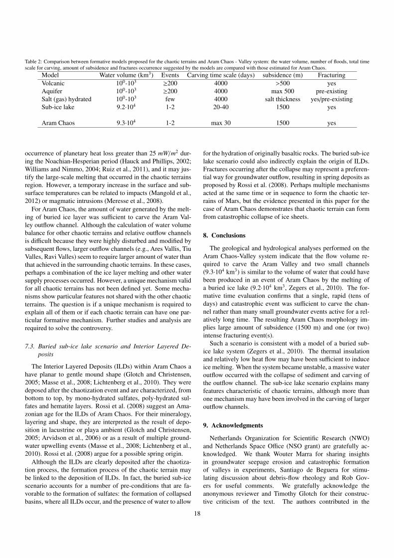
Table 2: Comparison between formative models proposed for the chaotic terrains and Aram Chaos - Valley system: the water volume, number of floods, total timescale for carving, amount of subsidence and fractures occurrence suggested by the models are compared with those estimated for Aram Chaos.
Model Water volume (km3) Events Carving time scale (days) subsidence (m) FracturingVolcanic 100-103 ≥200 4000 >500 yesAquifer 100-103 ≥200 4000 max 500 pre-existingSalt (gas) hydrated 100-103 few 4000 salt thickness yes/pre-existingSub-ice lake 9.2·104 1-2 20-40 1500 yes
Aram Chaos 9.3·104 1-2 max 30 1500 yes
occurrence of planetary heat loss greater than 25 mW/m2 dur-ing the Noachian-Hesperian period (Hauck and Phillips, 2002;Williams and Nimmo, 2004; Ruiz et al., 2011), and it may jus-tify the large-scale melting that occurred in the chaotic terrainsregion. However, a temporary increase in the surface and sub-surface temperatures can be related to impacts (Mangold et al.,2012) or magmatic intrusions (Meresse et al., 2008).
For Aram Chaos, the amount of water generated by the melt-ing of buried ice layer was sufficient to carve the Aram Val-ley outflow channel. Although the calculation of water volumebalance for other chaotic terrains and relative outflow channelsis difficult because they were highly disturbed and modified bysubsequent flows, larger outflow channels (e.g., Ares Vallis, TiuValles, Ravi Valles) seem to require larger amount of water thanthat achieved in the surrounding chaotic terrains. In these cases,perhaps a combination of the ice layer melting and other watersupply processes occurred. However, a unique mechanism validfor all chaotic terrains has not been defined yet. Some mecha-nisms show particular features not shared with the other chaoticterrains. The question is if a unique mechanism is required toexplain all of them or if each chaotic terrain can have one par-ticular formative mechanism. Further studies and analysis arerequired to solve the controversy.
7.3. Buried sub-ice lake scenario and Interior Layered De-posits
The Interior Layered Deposits (ILDs) within Aram Chaos ahave planar to gentle mound shape (Glotch and Christensen,2005; Masse et al., 2008; Lichtenberg et al., 2010). They weredeposed after the chaotization event and are characterized, frombottom to top, by mono-hydrated sulfates, poly-hydrated sul-fates and hematite layers. Rossi et al. (2008) suggest an Ama-zonian age for the ILDs of Aram Chaos. For their mineralogy,layering and shape, they are interpreted as the result of depo-sition in lacustrine or playa ambient (Glotch and Christensen,2005; Arvidson et al., 2006) or as a result of multiple ground-water upwelling events (Masse et al., 2008; Lichtenberg et al.,2010). Rossi et al. (2008) argue for a possible spring origin.
Although the ILDs are clearly deposited after the chaotiza-tion process, the formation process of the chaotic terrain maybe linked to the deposition of ILDs. In fact, the buried sub-icescenario accounts for a number of pre-conditions that are fa-vorable to the formation of sulfates: the formation of collapsedbasins, where all ILDs occur, and the presence of water to allow
for the hydration of originally basaltic rocks. The buried sub-icelake scenario could also indirectly explain the origin of ILDs.Fractures occurring after the collapse may represent a preferen-tial way for groundwater outflow, resulting in spring deposits asproposed by Rossi et al. (2008). Perhaps multiple mechanismsacted at the same time or in sequence to form the chaotic ter-rains of Mars, but the evidence presented in this paper for thecase of Aram Chaos demonstrates that chaotic terrain can formfrom catastrophic collapse of ice sheets.
8. Conclusions
The geological and hydrological analyses performed on theAram Chaos-Valley system indicate that the flow volume re-quired to carve the Aram Valley and two small channels(9.3·104 km3) is similar to the volume of water that could havebeen produced in an event of Aram Chaos by the melting ofa buried ice lake (9.2·104 km3, Zegers et al., 2010). The for-mative time evaluation confirms that a single, rapid (tens ofdays) and catastrophic event was sufficient to carve the chan-nel rather than many small groundwater events active for a rel-atively long time. The resulting Aram Chaos morphology im-plies large amount of subsidence (1500 m) and one (or two)intense fracturing event(s).
Such a scenario is consistent with a model of a buried sub-ice lake system (Zegers et al., 2010). The thermal insulationand relatively low heat flow may have been sufficient to induceice melting. When the system became unstable, a massive wateroutflow occurred with the collapse of sediment and carving ofthe outflow channel. The sub-ice lake scenario explains manyfeatures characteristic of chaotic terrains, although more thanone mechanism may have been involved in the carving of largeroutflow channels.
9. Acknowledgments
Netherlands Organization for Scientific Research (NWO)and Netherlands Space Office (NSO grant) are gratefully ac-knowledged. We thank Wouter Marra for sharing insightsin groundwater seepage erosion and catastrophic formationof valleys in experiments, Santiago de Beguera for stimu-lating discussion about debris-flow rheology and Rob Gov-ers for useful comments. We gratefully acknowledge theanonymous reviewer and Timothy Glotch for their construc-tive criticism of the text. The authors contributed in the
18
following proportions to conception and design, data col-lection, modeling, analysis and conclusions, and manuscriptpreparation (%): MR(30,60,10,30,80); MGK(30,0,90,30,10);TEZ(30,0,0,30,10); JHPO(10,40,0,10,0).
References
Andrews-Hanna, J.C., Phillips, R.J., 2007. Hydrological modeling of outflowchannels and chaos regions on Mars. Journal of Geophysical Research 112,E08001.
Andrews-Hanna, J.C., Phillips, R.J., Zuber, M.T., 2007. Meridiani Planum andthe global hydrology of Mars. Nature 446, 163–166.
Arvidson, R.E., Poulet, F., Morris, R.V., Bibring, J.P., Bell, J. F., I., Squyres,S.W., Christensen, P.R., Bellucci, G., Gondet, B., Ehlmann, B.L., Farrand,W.H., Fergason, R.L., Golombek, M., Griffes, J.L., Grotzinger, J., Guin-ness, E.A., Herkenhoff, K.E., Johnson, J.R., Klingelhfer, G., Langevin, Y.,Ming, D., Seelos, K., Sullivan, R.J., Ward, J.G., Wiseman, S.M., Wolff, M.,2006. Nature and origin of the hematite-bearing plains of Terra Meridianibased on analyses of orbital and Mars Exploration rover data sets. Journalof Geophysical Research 111, E1211.
Baker, V., 2001. Water and the martian landscape. Nature 412, 228–236.Barnhart, C.J., Nimmo, F., Travis, B.J., 2010. Martian post-impact hydrother-
mal systems incorporating freezing. Icarus 208, 101 – 117.Brocard, G., Teyssier, C., Dunlap, W.J., Authemayou, C., Simon-Labric, T.,
Cacao-Chiquın, E.N., Gutierrez-Orrego, A., Moran-Ical, S., 2011. Reorga-nization of a deeply incised drainage: role of deformation, sedimentationand groundwater flow. Basin Research 23, 631–651.
Carr, M.H., 1979. Formation of martian flood features by release of water fromconfined aquifers. Journal of Geophysical Research 84, 2995–3007.
Carr, M.H., 1996. Water on Mars. Oxford University Press.Chapman, M., Tanaka, K., 2002. Related magma-ice interactions: Possible
origins of chasmata, chaos, and surface materials in Xanthe, Margaritifer,and Meridiani Terrae, Mars. Icarus 155, 324–339.
Clifford, S.M., 1993. A model for the hydrologic and climatic behavior of wateron Mars. Journal of Geophysical Research 98, 10973–11016.
Clifford, S.M., Lasue, J., Heggy, E., Boisson, J., McGovern, P., Max, M.D.,2010. Depth of the Martian cryosphere: Revised estimates and implicationsfor the existence and detection of subpermafrost groundwater. Journal ofGeophysical Research 115, E07001.
Coleman, N.M., 2005. Martian megaflood-triggered chaos formation, revealinggroundwater depth, cryosphere thickness, and crustal heat flux. Journal ofGeophysical Research 110, E12S20.
Glotch, T., Christensen, P., 2005. Geologic and mineralogic mapping of AramChaos: evidence for a water-rich history. Journal of Geophysical Research110, E09006.
Grotzinger, J.P., Milliken, R.E., 2012. The Sedimentary Rock Record of Mars:Distribution, Origins, and Global Stratigraphy, in: Sedimentary Geology ofMars. SEPM (Society for Sedimentary Geology). volume 102, pp. 1–48.
Harrison, K.P., Grimm, R.E., 2008. Multiple flooding events in Martian outflowchannels. Journal of Geophysical Research 113, E02002.
Harrison, K.P., Grimm, R.E., 2009. Regionally compartmented groundwaterflow on Mars. Journal of Geophysical Research 114, E04004.
Hauck, Steven A., I., Phillips, R.J., 2002. Thermal and crustal evolution ofMars. J. Geophys. Res. 107, 5052.
Howard, A.D., McLane, Charles F., I., 1988. Erosion of cohesionless sedimentby groundwater seepage. Water Resour. Res. 24, 1659–1674.
Hudec, M.R., Jackson, M.P., 2007. Terra infirma: Understanding salt tectonics.Earth-Science Reviews 82, 1 – 28.
Hynek, B., Phillips, R., 2001. Evidence for extensive denudation of the Martianhighlands. Geology 29, 407–410.
Jakosky, B.M., Carr, M.H., 1985. Possible precipitation of ice at low latitudesof Mars during periods of high obliquity. Nature 315, 559–561.
van Kan Parker, M., Zegers, T., Kneissl, T., Ivanov, B., Foing, B., Neukum, G.,2010. 3D structure of the Gusev Crater region. Earth and Planetary ScienceLetters 294, 411 – 423.
Kargel, J.S., Furfaro, R., Prieto-Ballesteros, O., Rodriguez, J.A.P., Mont-gomery, D.R., Gillespie, A.R., Marion, G.M., Wood, S.E., 2007. Martianhydrogeology sustained by thermally insulating gas and salt hydrates. Ge-ology 35, 975–978.
Kleinhans, M.G., 2005. Flow discharge and sediment transport models forestimating a minimum timescale of hydrological activity and channel anddelta formation on Mars. Journal of Geophysical Research 110, E12003.
Kraal, E.R., van Dijk, M., Postma, G., Kleinhans, M.G., 2008. Martian stepped-delta formation by rapid water release. Nature 451, 973–976.
Kreslavsky, M.A., Head, J.W., 2002. Fate of outflow channel effluents in thenorthern lowlands of Mars: The Vastitas Borealis Formation as a sublima-tion residue from frozen ponded bodies of water. J. Geophys. Res. 107,5121.
Leask, H.J., Wilson, L., Mitchell, K.L., 2006. Formation of Aromatum Chaos,Mars: Morphological development as a result of volcano-ice interactions. J.Geophys. Res. 111, E08071.
Lichtenberg, K.A., Arvidson, R.E., Morris, R.V., Murchie, S.L., Bishop, J.L.,Fernandez Remolar, D., Glotch, T.D., Dobrea, E.N., Mustard, J.F., Andrews-Hanna, J., Roach, L.H., 2010. Stratigraphy of hydrated sulfates in the sed-imentary deposits of Aram Chaos, Mars. Journal of Geophysical Research115, E00D17.
Lobkovsky, A.E., Jensen, B., Kudrolli, A., Rothman, D.H., 2004. Thresholdphenomena in erosion driven by subsurface flow. J. Geophys. Res. 109,F04010.
Mangold, N., Kite, E., Kleinhans, M., Newsom, H., Ansan, V., Hauber, E.,Kraal, E., Quantin, C., Tanaka, K., 2012. The origin and timing of fluvialactivity at Eberswalde crater, Mars. Icarus 220, 530 – 551.
Manker, J.P., Johnson, A.P., 1982. Simulation of martian chaotic terrain andoutflow channels. Icarus 51, 121–132.
Marra, W.A., Braat, L., Baar, A.W., Kleinhans, M.G., 2014. Valley formationby groundwater seepage, pressurized groundwater outbursts and crater-lakeoverflow in flume experiments with implications for Mars. Icarus 232, 97–117.
Masse, M., Le Mouelic, S., Bourgeois, O., Combe, J.P., Le Deit, L., Sotin, C.,Bibring, J.P., Gondet, B., Langevin, Y., 2008. Mineralogical composition,structure, morphology, and geological history of Aram Chaos crater fill onMars derived from OMEGA Mars Express data. Journal of GeophysicalResearch 113, E12006.
Max, M., Clifford, S., 2001. Initiation of Martian outflow channels: Relatedto the dissociation of gas hydrate? Geophysical Research Letters 28, 1787–1790.
Meresse, S., Costard, F., Mangold, N., Masson, P., Neukum, G., 2008. For-mation and evolution of the chaotic terrains by subsidence and magmatism:Hydraotes Chaos, Mars. Icarus 194, 487–500.
Mischna, M., Richardson, M., Wilson, R., McCleese, D., 2003. On the or-bital forcing of Martian water and CO2 cycles: A general circulation modelstudy with simplified volatile schemes. Journal of Geophysical Research108, 5062.
Montgomery, D., Gillespie, A., 2005. Formation of Martian outflow channelsby catastrophic dewatering of evaporite deposits. Geology 33, 625–628.
Nelson, D., Greeley, R., 1999. Geology of Xanthe Terra outflow channels andthe Mars Pathfinder landing site. Journal of Geophysical Research-Planets104, 8653–8669.
Newsom, H., Brittelle, G., Hibbitts, C., Crossey, L., Kudo, A., 1996. Impactcrater lakes on Mars. Journal of Geophysical Research 101, 14951–14955.
Ogawa, Y., Yamagishi, Y., Kurita, K., 2003. Evaluation of melting processof the permafrost on Mars: Its implication for surface features. Journal ofGeophysical Research 108, 8046.
Oosthoek, J., Zegers, T., Rossi, A., Foing, B., Neukum, G., the HRSC Co-Investigator Team, 2007. 3D mapping of Aram Chaos: a record of fracturingand fluid activity, in: Lunar and Planetary Science XXXVIII, pp. 1–2.
Pacifici, A., Komatsu, G., Pondrelli, M., 2009. Geological evolution of AresVallis on Mars: Formation by multiple events of catastrophic flooding,glacial and periglacial processes. Icarus 202, 60 – 77.
Rodriguez, J., Sasaki, S., Kuzmin, R., Dohm, J., Tanaka, K., Miyamoto, H., Ku-rita, K., Komatsu, G., Fairen, A., Ferris, J., 2005. Outflow channel sources,reactivation, and chaos formation, Xanthe Terra, Mars. Icarus 175, 36–57.
Rossi, A.P., Neukum, G., Pondrelli, M., van Gasselt, S., Zegers, T., Hauber, E.,Chicarro, A., Foing, B., 2008. Large-scale spring deposits on Mars? Journalof Geophysical Research 113, E08016.
Ruiz, J., McGovern, P.J., Jimenez-Dıaz, A., Lopez, V., Williams, J.P., Hahn,B.C., Tejero, R., 2011. The thermal evolution of Mars as constrained bypaleo-heat flows. Icarus 215, 508 – 517.
Schorghofer, N., Jensen, B., Kudrolli, A., Rothman, D.H., 2004. Spontaneouschannelization in permeable ground: theory, experiment, and observation.
19
Journal of Fluid Mechanics 503, 357–374.Schultz, P.H., Schultz, R.A., Rogers, J., 1982. The Structure and Evolution
of Ancient Impact Basins on Mars. Journal of Geophysical Research 87,9803–9820.
Schumacher, S., Zegers, T.E., 2011. Aram Chaos and its constraints on thesurface heat flux of Mars. Icarus 211, 305 – 315.
Sharp, R.P., 1973. Mars - Fretted and chaotic terrains. Journal of GeophysicalResearch 78, 4073–4083.
Shuster, D., Weiss, B., 2005. Martian surface paleotemperatures from ther-mochronology of meterorites. Science 309, 594–597.
Tanaka, K., Skinner, J., Hare, T., Joyal, T., Wenker, A., 2003. Resurfacinghistory of the northern plains of Mars based on geologic mapping of MarsGlobal Surveyor data. Journal of Geophysical Research-Planets 108, 8043.
Warner, N., Gupta, S., Lin, S.Y., Kim, J.R., Muller, J.P., Morley, J., 2010a.Late Noachian to Hesperian climate change on Mars: Evidence of episodicwarming from transient crater lakes near Ares Vallis. Journal of GeophysicalResearch 115, E06013.
Warner, N., Gupta, S., Muller, J.P., Kim, J.R., Lin, S.Y., 2009. A refinedchronology of catastrophic outflow events in Ares Vallis, Mars. Earth andPlanetary Science Letters 288, 58–69.
Warner, N.H., Gupta, S., Kim, J.R., Lin, S.Y., Muller, J.P., 2010b. Retreat of agiant cataract in a long-lived (3.7–2.6 Ga) martian outflow channel. Geology38, 791–794.
Warner, N.H., Gupta, S., Kim, J.R., Muller, J.P., Le Corre, L., Morley, J., Lin,S.Y., McGonigle, C., 2011. Constraints on the origin and evolution of IaniChaos, Mars. Journal of Geophysical Research 116, E06003.
Williams, J.P., Nimmo, F., 2004. Thermal evolution of the Martian core: Im-plications for an early dynamo. Geology 32, 97–100.
Zegers, T.E., Oosthoek, J.H., Rossi, A.P., Blom, J.K., Schumacher, S., 2010.Melt and collapse of buried water ice: An alternative hypothesis for theformation of chaotic terrains on Mars. Earth and Planetary Science Letters297, 496 – 504.
20