bombay - ahmedabad - professur schett
TRANSCRIPT

BOMBAY - AHMEDABAD
Professur Wolfgang SchettETH Eidgenössische Technische Hochschule Zürich
Seminarreise Herbstsemester 200818. Oktober - 27. Oktober 2008
ImpressumSeminarreise Herbstsemester 2008Professur Wolfgang SchettDepartement ArchitekturETH Eidgenössische Technische Hochschule Zürich
Organisation, ProgrammFranziska ManetschLukas Meyer
BroschüreDeborah Wyss
DruckReprozentrale ETH Hönggerberg
© bei den jeweiligen Autoren
Zürich, Oktober 2008
3Organisation
Organisation:Lehrstuhl Prof. W. SchettDepartement ArchitekturHIL E 62.1Wolfgang-Paulistr. 15CH - 8093 Zürich HönggerbergT: +41 44 633 29 40F: +41 44 633 10 25www.arch.ethz.ch/schett
Assistenten: Franziska ManetschE: [email protected] Lukas MeyerE: [email protected]
Treffpunkt:08.45 Uhr, Samstag, 18. Oktober 2008Flughafen Zürich, Check-In 1, Meeting Point
Flugreise:Samstag, 18. Oktober 2008LX 154 09.55 Zürich 21.40 Mumbai
Sonntag / Montag, 26./27. Oktober 2008G8 104 18.10 Ahmedabad 19.25 MumbaiLX 155 01.20 Mumbai 06.15 Zürich
Hotels:18. - 22. Oktober 2008Hotel GulfKamal Mansion, Arthur Bunder Rd, Colaba Mumbai 400 005T: +91 022 2285 6672
22. Oktober - 26. Oktober 2008Hotel RiverfrontOpp. Museum, near NID, PaldiAhmedabad 380 007T: + 91 079 2657 7406
5TeilnehmerInnen
Ballabio Fabrizio Brägger JoshuaGisler Luis Haab Oliver Hänni LauraInauen Rebecca Lässer KatjaLehmann Claudia Lörincz AgnesMamane KerenMoshfegh Benjamin Mosimann AndreaRitter SeverinSalvioni Anna Werder Vanessa
Buffoni AldoEgli Andrzej Ringli Kornel
Manetsch FranziskaMeyer Lukas
6 Übersicht
EINFÜHRUNG The Architecture of Kanvinde, Doshi, and Correa in Political and Social Context 9 Charles Correa 17Balkrishna V. Doshi 18Bimal P atel 19Louis I. Kahn 20Le Corbusier 21
BOMBAY 23Entstehung von Bombay 25Imperiale Architektur 33 Victoria Terminus F. W. Stevens 34 Taj Mahal Hotel Chambers and Finchley 35 Gateway of India G. Wittet 36 Prince of Wales Museum G. Wittet Crawford Market W. Emerson 37Banganga Tank 38Haji Ali Dargah 39Kanchanjunga Apartments Charles Correa 41Salvacao Church Charles Correa 43Nehru Planetarium and Centre J. M. Kadri 45Hochhausbau in Bombay 47 Wohnhochhaus ‚Belvedere‘ Khareghat and Associates 48 Residence ‚Antilia‘ Perkins + Wills 49Dharavi Slum 51Stadtplanung Navi-Mumbai Charles Correa and Associates 55CIDCO Lowcost Housing Raj Rewal 57
AHMEDABADEntstehung von Ahmedabad 61Pols 67Havelis 68 Bsp 1: Moti Rangila Pol 72 Bsp 2: Sankdi Sheri 74 Bsp. 3: Surdas Shet‘s Pol 76
7Übersicht
The Old City 79 Jami‘ Masjid Ahmed Shah 80 Sidi Sayyed‘s Mosque Sidi Sayyed 81 Chabutra - bird feeding places 82 Hathee Singh temple Seth Hathee Singh 83nstitute of Indology Balkrishna V. Doshi 85C.E.P.T. - School of Architecture Balkrishna V. Doshi 87Premabhai Hall Balkrishna V. Doshi 91Sangath Balkrishna V. Doshi 93Amdavad ni Gufa Balkrishna V. Doshi, M. F. Hussain 97Gandhi Sabarmati Ashram Charles Correa 101Cricket Stadium and Sports Complex Charles Correa 103Mill Owner‘s Association Building Le Corbusier 105Villa Sarabhai Le Corbusier 109Villa Shodan Le Corbusier 113Sanskar Kendra Museum Le Corbusier 117I.I.M. - Institute of Indian Management Louis I. Kahn, Bimal Patel 121Ahmedabad Management Association Bimal Patel 125Sabarmati Riverfront Project HCP Design and Project Management 127The House of the Architect Bimal Patel 129Prathama Blood Centre Matharoo Associates 131
UMGEBUNG AHMEDABADStep-wells 133Ruda Baoli step-well 135Complex of Sarkhej-Roza 139
JAIN Der Jaintempel 143Satrunjaya temple city 145
ANHANGGeschichte Indiens 149Architektonisches Glossar 152Kulinarisches Glossar 155
9
James Belluardo
The enormous changes that have transformed the world in the last fi fty years are especially evident in the situation of India. In the period following its independence from British rule in 1947, the nation was dominated by a strong belief in the ability of technology to advance the cause of democracy. By the 1960s, however, a disenchantment with scientifi c solutions had taken hold in some segments of Indian society, and by the 1970s and 1980s a renewed interest in values rooted in the past came to the fore. In recent years India has regained a new confi dence in science, this time without the idealistic underpinnings of the earlier period. Throughout the postcolonial era, the work of three architects in particular - Achyut Kanvinde, Balkrishna Doshi, and Charles Correa - has both refl ected and helped defi ne and highlight the social, cultural and economic issues the country has faced.
Politically, India‘s major priority at the time of its independence was the consolidation and transformation of the Indian states into a modern nation. Once the British had left and the subcontinent had been partitioned into India and East and West Pakistan, the government was confronted with the need to create a sense of national identity. In contrast to Pakistan, India did not have a common religion as a basis for unity. Moreover, the distinct characters of the many regions of the country tended to militate against evolution of a common identity.
In the years following World War II, India occupied a prominent place in the international community. The National Movement‘s successful use of a policy of non-violence to achieve independence gave the country a moral authority, and independent India‘s policy of nonalignment, while seen as a provocation by the great powers that had emerged from the war, served to underscore the country‘s autonomy and made it a model for other former colonies gaining their independence from the West. India benefi ted from policies of the newly established United Nations, along with various other agencies created at the time, that supported economic, social, and political development to achieve universal parity.
The vision of India‘s fi rst prime minister, Jawaharlal Nehru, guided the nation into the modern era. With wa population of 350 million
The Architecture of Kanvinde, Doshi, and Correa in Political and Social Context
10
in 1947, India was the second largest country in the world after China. Nehru wanted international recognition for his country commensurate with its history and its potential for development, and he sought to harness India‘s great resources to position it alongside the United States, the Soviet Union, Europe, and China in shaping the future. The new government made self-reliance a major goal, to prove to the world and to the country itself that India‘s poverty and economic backwardness had resulted from colonial rule. This was an important nationalist cause and it now had to be acted upon. Nehru created a centralized state to launch India on a massive nationalized project of large-scale industrial development that included the construction of dams, mines, factories, and institutes of technology. Nehru believed that communal unrest grew out of economic injustice, and that the secular and socialist state, investing in technology, would be able to erase both of these curses together. In post-colonial India, scientifi c knowledge was given priority over traditional learning, centers for scientifi c study and research were given a privileged position in society, and engineers were accorded a high status. After centuries of colonization, in 1947 India was off to a fresh start.
Although Mahatma Gandhi gave Nehru his support, their views on India‘s future differed sharply. Gandhi advocated a return to the traditional values of the village. The goal of his emotional appeal to tradition-tempered with social reforms on matters such as attitudes towards the untouchables and sanitary habits-was to promote self-suffi ciency at the local level. He believed that industrial technology, and not just those who controlled it, was the root cause of India‘s poverty. Despite the powerful impact of Gandhi‘s message, however, Nehru‘s vision ultimately prevailed. To prosper, the nation was convinced, India would have to break with the past.
Modern Architecture and India
Modern architecture spread rapidly throughout the world in the years immediately following World War II. Because its functionally and structurally-determined forms and spaces made little reference to traditional architecture, it too represented a fresh start. Using modernist forms and new construction technologies,
industrialized nations that had been devastated by the war would be rapidly rebuilt and embark on great economic expansion. The abstracted, universal vocabulary of modern architecture seemed to offer a path to a future of prosperity and international amity.
These qualities of modern architecture offered India the possibility of meeting its own construction needs, as well as participating along with the industrialized nations in the commitment to progress. A great deal had to be built in India within a short period of time; the sense of urgency left little time for young architects to debate architectural issues or evolve a theoretical approach to design. The Modern Movement offered India a vision of the future based on a functionalist language that was free of colonial associations and of reference to specifi c religious or ethnic traditions. The recent memory of the agonizing partition of the subcontinent, and the demands of the secular state, called into question the value of India‘s architectural heritage for use in the present. Modern architecture seemed to promise exciting possibilities for the expression of India‘s newly formed identity, and its clean, effi cient forms were easily understood by the technocrats who made decisions for the state to advance industry, commerce, and science.
Achyut Kanvinde was to playa crucial role in making modern architecture an important part of Indian life. He had studied architecture at the JJ School of Art in Bombay - at independence, the only school of architecture in India - before being sent by the government in 1945 to study at the Harvard University Graduate School of Design, then headed by Walter Gropius. Like Kanvinde, many Indian architects of his generation went to the United States for further education. While England‘s former colonies often maintained close ties with the British, especially in educating their elites, many Indian architects were attracted to the very progressive architectural community in the United States in those years. The attractiveness of the U.S. was enhanced by the fact that it was still perceived as a former colony that had proved its greatness, an achievement India hoped to duplicate. Since President Franklin D. Roosevelt had supported India‘s independence in spite of Winston Churchill‘s opposition, and America was then promoting an anti-colonial foreign policy, studying in the U.S. seemed all the more appropriate.
11
Kanvinde returned to India in September 1947, barely a month after independence, and immediately was assigned such major commissions as the Ahmedabad Textile Industry‘s Research Association and the Physical Research Laboratory. Well equipped with the language of modernism, Kanvinde, along with fellow architects Habib Rahman and Jeet Lal Malhotra, introduced the Modern Movement to India some years before the arrival of Le Corbusier and Louis Kahn. Strongly infl uenced by Gropius, Kanvinde believed that the visual language of modern architecture was based upon a scientifi c understanding that could be grasped by all cultures in the same way. They shared the midtwentieth century belief that science was at the core of all understanding, that its appeal was universal, and that it was able to transcend cultural boundaries. Science, through technology, could respond to the needs of all Indians without privileging one group over another. In the mid-1950s there was, however, some strong opposition to the Modern Movement in India. Among the leaders of the opposition was Claude Batley, a British architect who continued as director of the JJ School. A campaign was mounted for a legislated national style for architecture, based on traditional Indian motifs. While on the one hand the idea of a national style echoed approaches adopted in the Soviet Union and China, in India the notion that decorative and compositional motifs were adequate to creation of a national style was characteristic of the British attitude toward Indian architecture. The British had typically appropriated compositional devices from India‘s past for use on buildings that were designed according to Western spatial concepts.
Some young architects became aware of the proposed mandate for a national style and were very disturbed by its implications. Kanvinde was able to arrange a meeting with Nehru in order to present his strong opposition to such action. Nehru listened.
In March 1959, in an inaugural address delivered to a conference on modern architecture, Nehru aligned himself with the modernist cause. At this important occasion, convened by Kanvinde and held at the Lalit Kala Akademi in New Delhi, Nehru, in his only direct address to architects, stated,“You cannot isolate architecture from the age, from the social conditions, from the thinking, from the objectives and ideals of that particular age.“ To those who favored using historical
references in architecture, Nehru pointed out that „The past was good when it was the present, but you cannot bring it forward when the world has changed into a technological period.“ There would be no national policy to impose an Indian style. Kanvinde‘s decision to set up private practice in New Delhi in 1955, with Shaukat Rai and (later) Morad Chowdhury, was propitious for the continuing role he would playas a strong proponent of modernism. As the newly-formed Indian government in New Delhi, guided by Nehru‘s centralization policies, became the major client for new construction, New Delhi had quickly become the center of architectural activity. Although most building continued under the Public Works Department (PWD), a governmental agency inherited from the British and dominated by engineers, commissions were also given to architects in private practice. The offi ce of Kanvinde Rai and Chowdhury received commissions for projects - many to address India‘s industrial possibilities - of large scale on tight schedules that demanded an organized construction industry. Traditional ways of building could not meet the needs of a nation anxious to participate in a world undergoing rapid industrialization. Kanvinde played a crucial role in the transformation of building from a manual trade to an organized industry based upon a new division of labor. He worked with materials suppliers and major contractors to develop materials and methods for large-scale construction, and he also was a critical fi gure in enhancing the status and defi ning the responsibilities of architects. In 1974, Kanvinde became fi rst member of the newly-established New Delhi Urban Arts Commission, which gave accredited architects sole authority to submit drawings for buildings. Legislation to establish the Commission was passed by Parliament as the result of efforts of Pilu Modi, an architect who entered politics. Until that time, draftsmen and engineers, as well as architects, were able to submit drawings of buildings for approval by appropriate authorities.
Throughout his long practice, which remains active today, Kanvinde has continued to deliver straightforward, well-constructed buildings that meet the needs of his clients. He has remained committed to the noble values of modernism, and his work has
12
consistently avoided reference to historic forms. Although his professional life has been occupied with the building of Nehru‘s vision for a modern India, his home life remains respectful of traditions from his family‘s humble origins. A true self-effacing modesty, stemming from Gandhi‘s values, defi nes the man himself. In addition, it is through his inherent generosity that a number of talented young architects, not necessarily sharing his views, have received their fi rst important commissions.
In 1993, Kanvinde agreed to accept a pro bono commission to build the ISKCON temple complex for the followers of Srila Prabhupada in New Delhi. With a conscious and deliberate use of symbols to express character in religious architecture, and drawing inspiration from eleventh-century temples in Orissa, Kanvinde produced a design that is in marked contrast to all his previous work, but not inconsistent with his design philosophy. At the ISKCON temple complex, a symbolic use of space, structure and elaborate decoration achieves its vital meaning in the present because it has been carried forward directly from the past.
Kanvinde has always been troubled by the use of traditional forms in non-traditional buildings. For him form is not value-free; he believes that architects need to consider the religious aspects of buildings that were created within a particular context. Kanvinde, like Nehru, has sought to keep the secular and religious realms separate. He sees the past as specifi c and as understood differently by various groups. It was this dilemma of specifi c pasts that troubled the fi rst generation of post-colonial Indian architects who experienced fi rst-hand the horrors of Partition. It is also a current problem, with the open exploitation of religion by political groups and the disturbing rise of sectarian violence.
Reassessing the Present and the Past
By the late 1960s, it was clear that Nehru‘s ambitions for India had been overly optimistic. Europe and Japan had recovered from the destruction of the war. India, however, still lagged behind in establishing a prosperous industrial state. Many problems, including a soaring population, illiteracy, territorial vastness, and isolation of communities, plus political corruption, prevented quick advancement. While the West had been seen as a partner of
sorts right after India‘s independence, it now became a measure of India‘s economic backwardness. A vast chasm existed between the industrialized and developing nations, now commonly referred to as the First and Third Worlds, with the Second World, or communist nations, keeping a respectable distance from the Third. In addition, it should be noted that modern architecture in India was not always successful. The process of standardization, integral to the Modern Movement and central to the revitalization of India‘s construction industry, never was fully accomplished in the decades following independence. In fact, the quality of building construction had declined, so much so that by the 1960s modern architecture was seen by many as a formulaic way of building cheaply and quickly. There were numerous examples of modern buildings in urban India that gave validity to this perception. Furthermore, a number of Indians saw the Modern Movement as a continuation of Western dominance, a new form of cultural imperialism. Nevertheless, in those years modernist architecture was offi cially regarded as representative of the nation‘s progress. This image was continually encouraged in order to attract foreign investment and aid, which many political leaders, Nehru among them, actively sought.
By the 1970s, serious questioning of modernism‘s validity and success had spread world-wide, along with doubts about the notion of progress itself, and dependence on advanced technology. As in the nineteenth century, many in the West turned now to India as a repository of values that had been ignored in the rise of industrialization. They looked to India to fulfi ll spiritual needs and to seek inspiration in Gandhi‘s teachings, which were central to Martin Luther King and the civil rights movement in the United States.
Fortunately Nehru‘s policies, while emphasizing growth and technology, had not sought to eradicate traditional culture, as China‘s modernization policies had. While a clean line was drawn between the past and the present, crafts continued to exist and were encouraged by state subsidies. Gandhi‘s India of village culture, although marginalized by Nehru‘s vision, endured. This general atmosphere would lead to the attempt by many architects to use traditional forms and technologies for nontraditional buildings.
13
For many Indian architects, Bauhaus functionalism was made obsolete by the example of Le Corbusier and later of Louis Kahn, both of whom built major projects in South Asia during the 1950s and 1960s. Le Corbusier sought to give India an architecture that referred to its particular spirit, quite unlike the more scientifi c and universal Bauhaus model. His sketchbooks, with their recording of bulls‘ horns, industrial cooling towers, vernacular scenes, and miniature paintings, form a visual record of his wide-ranging observations in India. He showed architects how they could make their own, rooted expression while using modernist language.
Balkrishna Doshi, who worked on Chandigarh in Le Corbusier‘s atelier in Paris and oversaw construction of his buildings in Ahmedabad, adopted the master‘s method of making notations in sketchbooks, writing essays, creating study models, and painting. His early works attempted to extend Le Corbusier‘s formal vocabulary. In a search for an architecture that would have the most resonance for India, Doshi looked to India‘s past. But his focus was on space and how it was experienced, not on the design motifs that had intrigued the British. In the early 1970s, Doshi immersed himself in a deep study of India‘s religious practices and their meaning for the built environment. Doshi lamented the contemporary emphasis on the secular over the sacred, and sought to understand the basic principles that shaped Indian society. Architecture, he believed, should grow from a culture‘s roots; for Doshi the meaning of space could only be discovered through an understanding of the rituals that bring dignity to everyday life. Indeed, he maintained, the strength of India‘s spirit would survive in the rituals of its people. In this way India could be a rich country; poverty is not the absence of material success of the West, but the loss of signifi cant meaning in the present. While he rejected Nehru‘s clear distinction between the past and present, Doshi nevertheless felt that segments of the past that were no longer viable should be discarded. He valued modernist architecture, but believed it should be adapted to an Indian way of life. Modern forms could renew traditions and sustain the vitality of traditional values. Doshi‘s concern was not to create a style, but to support an ethos that acknowledges India‘s complexities. This led him to an
architecture of ambiguous spaces that seeks to activate the psyche, while also providing a sense of security and well-being.
Doshi‘s fi rst project that sought to integrate his studies was Sangath (1979-81), his studio west of Ahmedabad. Sangath‘s organic formal values establish, through a process of abstraction, multiple associations and orderings that build upon an understanding of what informed the past and eschew overt references that would give the work an obvious Indian identity. In this work, Doshi succeeds in transforming the past into something totally new. Sangath also expresses Doshi‘s understanding of the spiritual value of craft, which he used to further develop a modern vocabulary. There is for Doshi, as there was for the traditional Indian architect, a unity of purpose in the thinking and the making of architecture. Sangath‘s vaulted forms, set in a garden, result in an evocative and sensuous architecture. This craft quality is closely tied to scale, and Doshi‘s Gandhi Labour Institute (1980-84), located a kilometer away from Sangath, which makes use of similar forms and materials, reveals the limitation of craft production when adopted for large projects.
Like Le Corbusier, Doshi has produced an oeuvre that covers a wide range of building types and scales. Prominent in his work is his effort to understand and address the need to provide housing for India‘s masses. In rural areas, poor people have traditionally built their own shelters. When they migrate to cities, it is impossible for the government to house all; many end up in squatter settlements. Since the 1970s, non -governmental organizations, including the World Bank, have been involved in development schemes to provide housing for India‘s destitute. In an effort to take care of the most urgent needs of sanitation and public access, programs providing „sites and services“ have been implemented. With an emphasis on quantity, they have mostly resulted in the stringing out of services along the most effi cient route.
Doshi‘s settlement plan for Aranya, carried out with the Vastu-Shilpa Foundation, seeks to expand the concept of „sites and services“ and create a new model for the architect‘s role in housing, as the supporter of people‘s initiative to build for themselves. Through intelligent planning of the site, and through the creation of mechanisms to encourage residents in their own
14
efforts, the architect can structure space to address community issues and strengthen a social framework. Aranya is about creating social structures; for Doshi this is ultimately tied to his growth as an architect through a deepening of social engagement.
In his pivotal role as a founder, teacher and the architect of Ahmedabad‘s Centre for Environmental Planning and Technology (CEPT), Doshi has profoundly affected the way young Indian architects design and think about architecture. His friendships with internationally known architects such as Christopher Alexander, and CEPT‘s exchange programs with schools in Zurich, Philadelphia, and Syracuse, have enabled many Indian students to become acquainted with diverse approaches to modern architecture.
Doshi‘s project for the Bharat Diamond Bourse (1992-ongoing) in Mumbai (Bombay) is the largest private undertaking in post-colonial India. Here he utilizes highly technological materials to realize an architecture that aspires to be considered as an equal to recent work in the industrialized world. It expresses a confi dence in the present that many Indians also share. Still, the need for the past as a steadying infl uence amid the fast moving events and uprooting of values in the present remains strong. While the outward appearance of the Diamond Bourse may appear Western, it has a spatial quality that is not forced for the sake of visual gymnastics, but responds to the differing ways in which Indians and Westerners perceive and use space.
A Different Approach to Past and Present
Another architect of particular importance to India‘s maturation in architecture and planning is Charles Correa. In his earliest projects, Correa, like many architects of his generation, shows a debt to the work of Le Corbusier and Kahn. His brick and concrete clustered pavilions for the Gandhi Smarak Sangrahalaya (1958-63), for example, refer directly to Kahn‘s Bath House for the Jewish Community Center in Trenton, New Jersey (1954-1959). By the late 1960s the use of exposed brick and concrete had become ubiquitous among Indian architects. Correa had by then begun to favor smooth stucco surfaces. This expressed his growing interest in vernacular architecture
and also recalled the Art Deco buildings featured prominently along Bombay‘s Marine Drive. This material provided a spirit to his work that was both modern and traditional, and emphasized his interest in shaping dramatic spaces, rather than expressing structure or the construction process.
Over the last several decades Correa has evolved an approach to design that draws upon traditional Indian forms and ordering devices, which he uses to create buildings that are nonetheless unmistakably modern. Correa‘s interest in the multiple meanings of architectural form was vividly illustrated in the architecture exhibition „Vistara,“ which he directed as part of the Festival of India in 1983. The Festival, which traveled to Europe, Japan, and the United States, was launched by the government of India to communicate the country‘s cultural and spiritual values and to display its rich craft heritage. It brought about a renewed respect for genuine folk art both in India and abroad. Correa‘s architecture section presented a comprehensive survey of India‘s architecture that included great monuments of the past, vernacular buildings, colonial and modern works, including Le Corbusier‘s and Kahn‘s, and a selection of projects from India‘s contemporary architects. Instead of being treated as a succession of styles, Indian architecture was seen as representative of three themes: mandala, where architecture is an analogue to the cosmos, manusha, in which architecture is the measure of man, and manthana, which involves the absorption of new myths into an existing construct. The continuity of myth, and its appearance and reappearance in Indian design, he felt, allowed the development of an architecture using concepts that guided the past.
The culmination of Correa‘s polysemous approach to architecture is the Jawahar Kala Kendra, an arts center in Jaipur (1986-1992). Using a modern structure to carry references to the past, Correa employs a literal iconography that gives a clearly recognizable Indian identity to this work. The entrance, the dome of which mimics a Buddhist stupa (traditionally a form to be circumambulated, not entered), is decorated on the underside with a Jain cosmological diagram. This introduces visitors to a building that juxtaposes the symbols of many different traditions. Correa‘s architecture fosters in the observer continuous changes of perception, produced by the use of forms and references in settings quite different from those in which
15
they were traditionally experienced. This approach acknowledges the constant reinterpretation of the past in the postmodern world; it is also unsettling to some, who are uncomfortable seeing such literal references outside their accustomed contexts. In recent work Correa has tapped into the richness of India by involving artists in his architectural projects. Generally they are brought into the project to enliven stucco surfaces and occasionally to make free-standing elements, such as the oversize fi gures in a courtyard of his Inter- University Centre for Astronomy and Astrophysics in Pune (1988-92). The most compelling example of the collaboration between architect and artist occurs at the British Council building in New Delhi (1987-92), executed with the English painter Howard Hodgkin. Here, Hodgkin‘s black shadows of a Banyan tree are projected in three dimensions to activate Correa‘s symmetrical entrance facade. The application of bold marble inlay refers to its traditional use in Mughal architecture. As in the past, architecture and art are successfully integrated, to a degree that rarely occurs in modern buildings. Correa has also played an important role in helping to shape thinking about India‘s cities. While signifi cant economic progress has taken place in India since independence, gross economic inequality remains. Massive infl uxes of poor people from rural areas into the cities have created tremendous problems of shelter, sanitary services, and transportation. Nowhere is this more evident than in Bombay, India‘s largest city and commercial capital. Correa recognized early on that the primary requirement for any solution to this situation was the development of the political will to confront it, and to change the underlying patterns of land use that reinforced inequitable development. In 1964, Correa, Pravina Mehta, and Shiresh Patel proposed the creation of New Bombay across the harbor from the existing city, as a way to reduce the concentration of job opportunities in the existing central business district that produced high land prices, and, accordingly, made the provision of decent housing to much of the population impossible. From 1971 to 1974, Correa served as chief architect to the government authority established to implement the New Bombay plan, and in that capacity elaborated his ideas for the reallocation of land uses and the creation of a new transportation infrastructure. In direct, non-technical language in his 1985 book The New
Landscape, Correa further developed his analysis. He drew lessons for architects and planners from the inventiveness with which squatters provide shelter for themselves. Correa argued for „disaggregation“ of the physical needs of the city, in order to open the eyes of architects, planners, and politicians to the importance of localized, small-scale solutions. His book addressed the problems of Third World cities in general, with an optimistic and urgent plea for transformation of the standard processes of urban development.
Starting with his participation in a group of twelve international architects invited by the United Nations and the government of Peru to design low-cost housing in Lima in 1969, Correa has helped set up a dialogue among architects of the developing world. This has helped to shift the attention of India‘s architects from a predominantly Western bias. Today Correa continues his active participation in the international architectural community. Frequently abroad, speaking at conferences, delivering lectures, acting on juries and teaching, he has worked to promote an international awareness of India‘s particular situation in the modern world, and of the possibility of an architecture that is both modern and recognizably Indian. Although much attention has recently focused on India‘s traditions, the nation is still involved with its project of modernization, which has built a powerful industrial force. Modernism has taken root in India, even if not as completely as in the West. However, it is no longer the overwhelming and singular commitment that was defi ned by the West and appeared in the early years after independence.
India Now
Over the past decade, structural adjustments in the Indian economy have created vast changes in the way of life of many of its inhabitants. Nehru‘s ambition for self-suffi ciency and the socialist goal of economic equality prevalent at independence have given way to increasing participation in the world marketplace. No longer is India‘s economy seen as internal to the nation. A rising middle class, caught up in the international mood of consumption, is creating a new national image that links India with the most recent technological advances
16
taking place in the West and Asia. Cities such as Bangalore are positioning themselves within the highly competitive global market as new Silicon Valleys, and a very visible segment of urban India is geared to capitalize on the nation‘s gains in education, especially its achievements in science.
While the government remains active as a client for architects, it no longer plays the dominant role that it did in the early years after independence, when it was the major director of India‘s vast building program. Now, private developers have taken over this role in order to meet the needs of the growing market. Both their number and the number of architects have grown substantially. In response to the demand for architects, numerous private schools of architecture, many established by the construction industry, have appeared in urban centers. Today there are more than ninety schools of architecture in India, and most graduating architects enter into private practice rather than the government‘s Public Works Department. The Indian architecture profession has indeed gained its independence from engineering.
As activists, Kanvinde, Doshi, and Correa have played major parts in shaping the architectural profession and society. They have helped to establish the multiplicity of roles that are possible for architects in India today, prime among these being the relationship to the country‘s poor, especially in urban areas. As practicing architects, each has gone beyond the formal boundaries of the Modern Movement to evolve a personal approach that acknowledges Indian traditions. For Achyut Kanvinde, the past remains secure within the domain of the home and religion, separate from the material world of the state and the economy. This separate co-existence represents a modern division of Indian life that was accepted at independence to safeguard the new institution of democracy. Balkrishna Doshi has endeavoured to bridge modern architecture to a lived and unconscious India. He relies not upon images of the past and is in fact confi dent that meaningful rituals can be best supported by modern forms. His architecture is deepened by associations to local customs. In the work of Charles Correa, the past and present stand juxtaposed. Both have entered the imagination of this architect who connects to a literate and self- conscious India. His strong and dramatic modern spaces draw on traditional understanding and supplement the past with a new set of associations.
Modernism is a vital part of India‘s contemporary character. Its energies are not exhausted; its rigor and ability to cross borders continue to be relevant. Today, the global and the local have become inextricably intertwined; infl uences from East and West are intermingled. All contribute to the fl uidity that has always been India, whose identity has never been fi xed.
17
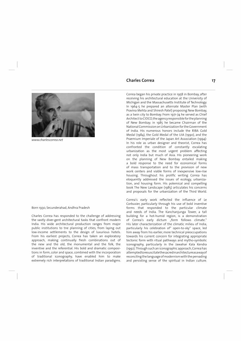
Born 1930, Secunderahad, Andhra Pradesh Charles Correa has responded to the challenge of addressing the vastly diver-gent architectural tasks that confront modern India. His wide architectural production ranges from major public institutions to tne planning of cities, from laying out low-income settlements to the design of luxurious hotels. From his earliest projects, Correa has taken an exploratory approach, making continually fresh combinations out of the new and the old, the monumental and the folk, the inventive and the referential. His bold and dramatic composi- tions in form, color and space, combined with the incorporation of traditional iconography, have enabled him to make extremely rich interpretations of traditional Indian paradigms.
Charles Correa
Correa began his private practice in 1958 in Bombay, after receiving his architectural education at the University of Michigan and the Massachusetts Institute of Technology. In 1964-5 he prepared an alternate Master Plan (with Pravina Mehta and Shiresh Patel) proposing New Bombay, as a twin city to Bombay. From 1971-74 he served as Chief Architect to CIDCO, the agency responsible for the planning of New Bombay; in 1985 he became Chairman of the National Commission on Urbanization for the Government of India. His numerous honors include the RIBA Gold Medal (1984), the Gold Medal of the UIA (1990), and the Praemium Imperiale of the Japan Art Association (1994)· In his role as urban designer and theorist, Correa has confronted the condition of constantly escalating urbanization as the most urgent problem affecting not only India but much of Asia. His pioneering work on the planning of New Bombay entailed making a bold response to the need for economical forms of mass transportation and to the provision of new work centers and viable forms of inexpensive low-rise housing. Throughout his prolifi c writing Correa has eloquently addressed the issues of ecology, urbaniza-tion, and housing form. His polemical and compelling book The New Landscape (1985) articulates his concerns and proposals for the urbanization of the Third World.
Correa‘s early work refl ected the infl uence of Le Corbusier, particularly through his use of bold inventive forms that responded to the particular climate and needs of India. The Kanchanjunga Tower, a tall building for a hot-humid region, is a demonstration of Correa‘s early dictum „form follows climate.“ His later characterization of the climatic milieu of India, particularly his celebration of“ open-to-sky“ space, led him away from his earlier, more technical preoccupations towards his current concern for integrating appropriate tectonic form with ritual pathways and mytho-symbolic iconography, particularly in the Jawahar Kala Kendra (1992). Through such an iconographic approach, Correa has attempted to resuscitate the sacred in architecture as a way of reconciling the language of modernism with the pervading and persisting sense of the spiritual in Indian culture.
www.charlescorrea.net
18
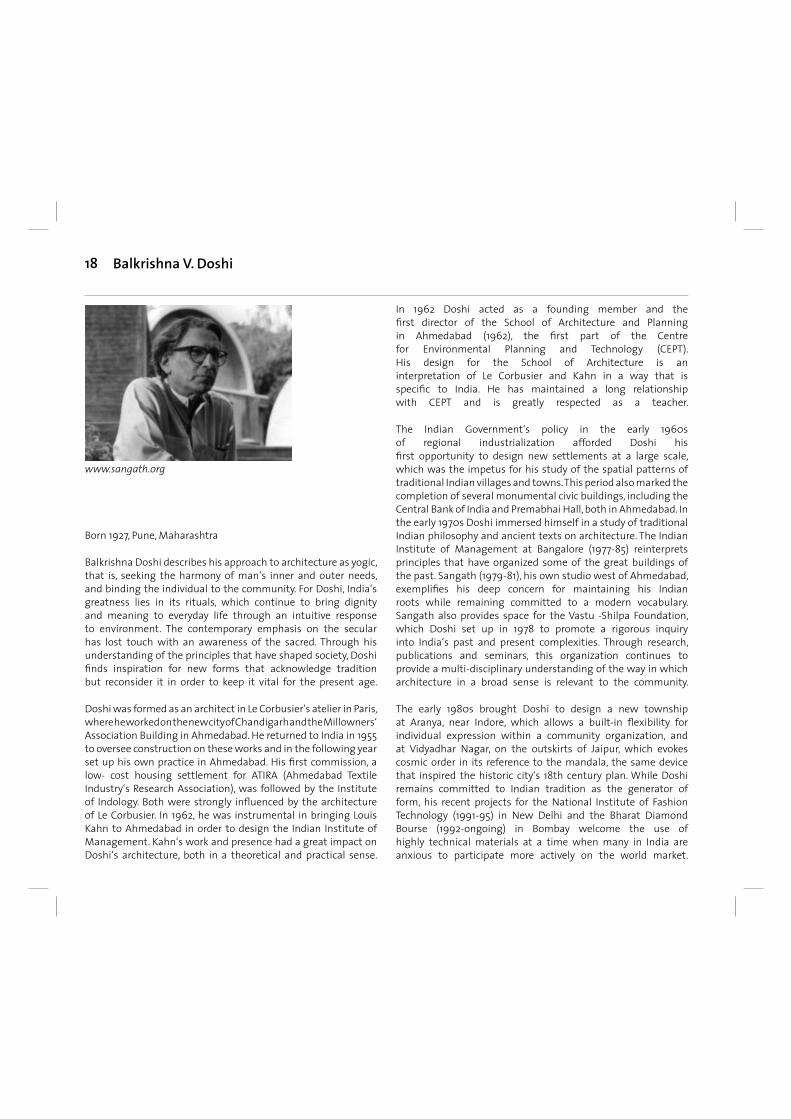
Born 1927, Pune, Maharashtra
Balkrishna Doshi describes his approach to architecture as yogic, that is, seeking the harmony of man‘s inner and outer needs, and binding the individual to the community. For Doshi, India‘s greatness lies in its rituals, which continue to bring dignity and meaning to everyday life through an intuitive response to environment. The contemporary emphasis on the secular has lost touch with an awareness of the sacred. Through his understanding of the principles that have shaped society, Doshi fi nds inspiration for new forms that acknowledge tradition but reconsider it in order to keep it vital for the present age.
Doshi was formed as an architect in Le Corbusier‘s atelier in Paris, where he worked on the new city of Chandigarh and the Millowners‘ Association Building in Ahmedabad. He returned to India in 1955 to oversee construction on these works and in the following year set up his own practice in Ahmedabad. His fi rst commission, a low- cost housing settlement for ATIRA (Ahmedabad Textile Industry‘s Research Association), was followed by the Institute of Indology. Both were strongly infl uenced by the architecture of Le Corbusier. In 1962, he was instrumental in bringing Louis Kahn to Ahmedabad in order to design the Indian Institute of Management. Kahn‘s work and presence had a great impact on Doshi‘s architecture, both in a theoretical and practical sense.
In 1962 Doshi acted as a founding member and the fi rst director of the School of Architecture and Planning in Ahmedabad (1962), the fi rst part of the Centre for Environmental Planning and Technology (CEPT). His design for the School of Architecture is an interpretation of Le Corbusier and Kahn in a way that is specifi c to India. He has maintained a long relationship with CEPT and is greatly respected as a teacher.
The Indian Government‘s policy in the early 1960s of regional industrialization afforded Doshi his fi rst opportunity to design new settlements at a large scale, which was the impetus for his study of the spatial patterns of traditional Indian villages and towns. This period also marked the completion of several monumental civic buildings, including the Central Bank of India and Premabhai Hall, both in Ahmedabad. In the early 1970s Doshi immersed himself in a study of traditional Indian philosophy and ancient texts on architecture. The Indian Institute of Management at Bangalore (1977-85) reinterprets principles that have organized some of the great buildings of the past. Sangath (1979-81), his own studio west of Ahmedabad, exemplifi es his deep concern for maintaining his Indian roots while remaining committed to a modern vocabulary. Sangath also provides space for the Vastu -Shilpa Foundation, which Doshi set up in 1978 to promote a rigorous inquiry into India‘s past and present complexities. Through research, publications and seminars, this organization continues to provide a multi-disciplinary understanding of the way in which architecture in a broad sense is relevant to the community.
The early 1980s brought Doshi to design a new township at Aranya, near Indore, which allows a built-in fl exibility for individual expression within a community organization, and at Vidyadhar Nagar, on the outskirts of Jaipur, which evokes cosmic order in its reference to the mandala, the same device that inspired the historic city‘s 18th century plan. While Doshi remains committed to Indian tradition as the generator of form, his recent projects for the National Institute of Fashion Technology (1991-95) in New Delhi and the Bharat Diamond Bourse (1992-ongoing) in Bombay welcome the use of highly technical materials at a time when many in India are anxious to participate more actively on the world market.
Balkrishna V. Doshi
www.sangath.org
19
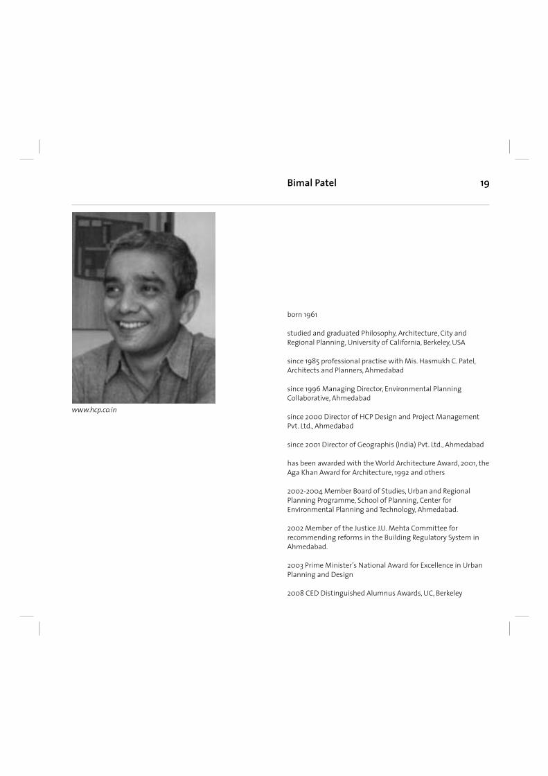
born 1961
studied and graduated Philosophy, Architecture, City and Regional Planning, University of California, Berkeley, USA
since 1985 professional practise with Mis. Hasmukh C. Patel, Architects and Planners, Ahmedabad
since 1996 Managing Director, Environmental Planning Collaborative, Ahmedabad
since 2000 Director of HCP Design and Project Management Pvt. Ltd., Ahmedabad
since 2001 Director of Geographis (India) Pvt. Ltd., Ahmedabad has been awarded with the World Architecture Award, 2001, the Aga Khan Award for Architecture, 1992 and others
2002-2004 Member Board of Studies, Urban and Regional Planning Programme, School of Planning, Center for Environmental Planning and Technology, Ahmedabad.
2002 Member of the Justice J.U. Mehta Committee for recommending reforms in the Building Regulatory System in Ahmedabad.
2003 Prime Minister’s National Award for Excellence in Urban Planning and Design
2008 CED Distinguished Alumnus Awards, UC, Berkeley
Bimal Patel
www.hcp.co.in
20
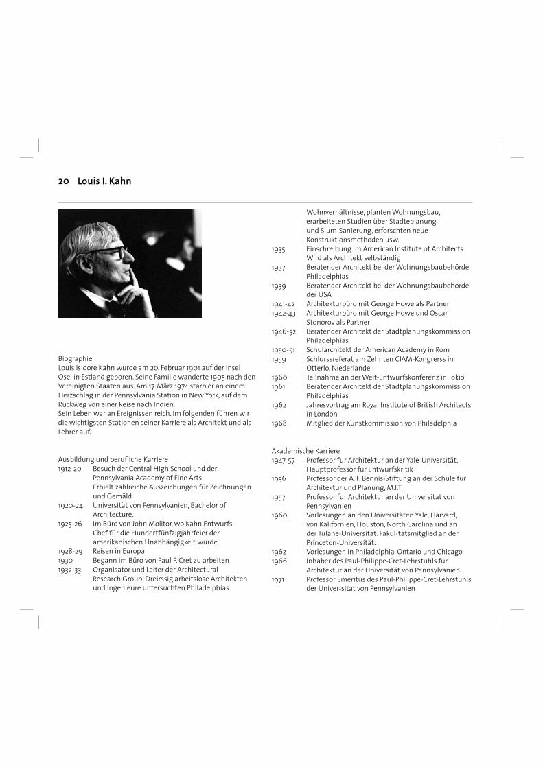
Biographie Louis Isidore Kahn wurde am 20. Februar 1901 auf der Insel Osel in Estland geboren. Seine Familie wanderte 1905 nach den Vereinigten Staaten aus. Am 17. März 1974 starb er an einem Herzschlag in der Pennsylvania Station in New York, auf dem Rückweg von einer Reise nach Indien. Sein Leben war an Ereignissen reich. Im folgenden führen wir die wichtigsten Stationen seiner Karriere als Architekt und als Lehrer auf.
Ausbildung und berufl iche Karriere1912-20 Besuch der Central High School und der
Pennsylvania Academy of Fine Arts. Erhielt zahlreiche Auszeichungen für Zeichnungen
und Gemäld1920-24 Universität von Pennsylvanien, Bachelor of
Architecture.1925-26 Im Büro von John Molitor, wo Kahn Entwurfs-
Chef für die Hundertfünfzigjahrfeier der amerikanischen Unabhängigkeit wurde.
1928-29 Reisen in Europa1930 Begann im Büro von Paul P. Cret zu arbeiten1932-33 Organisator und Leiter der Architectural
Research Group: Dreirssig arbeitslose Architekten und Ingenieure untersuchten Philadelphias
Wohnverhältnisse, planten Wohnungsbau, erarbeiteten Studien über Stadteplanung und Slum-Sanierung, erforschten neue Konstruktionsmethoden usw.
1935 Einschreibung im American Institute of Architects. Wird als Architekt selbständig
1937 Beratender Architekt bei der Wohnungsbaubehörde Philadelphias
1939 Beratender Architekt bei der Wohnungsbaubehörde der USA
1941-42 Architekturbüro mit George Howe als Partner1942-43 Architekturbüro mit George Howe und Oscar
Stonorov als Partner1946-52 Beratender Architekt der Stadtplanungskommission
Philadelphias1950-51 Schularchitekt der American Academy in Rom1959 Schlurssreferat am Zehnten CIAM-Kongrerss in
Otterlo, Niederlande1960 Teilnahme an der Welt-Entwurfskonferenz in Tokio1961 Beratender Architekt der Stadtplanungskommission
Philadelphias1962 Jahresvortrag am Royal Institute of British Architects
in London1968 Mitglied der Kunstkommission von Philadelphia
Akademische Karriere1947-57 Professor fur Architektur an der Yale-Universität.
Hauptprofessor fur Entwurfskritik1956 Professor der A. F. Bennis-Stiftung an der Schule fur
Architektur und Planung, M.I.T.1957 Professor fur Architektur an der Universitat von
Pennsylvanien 1960 Vorlesungen an den Universitäten Yale, Harvard,
von Kalifornien, Houston, North Carolina und an der Tulane-Universität. Fakul-tätsmitglied an der Princeton-Universität.
1962 Vorlesungen in Philadelphia, Ontario und Chicago1966 Inhaber des Paul-Philippe-Cret-Lehrstuhls fur
Architektur an der Universität von Pennsylvanien1971 Professor Emeritus des Paul-Philippe-Cret-Lehrstuhls
der Univer-sitat von Pennsylvanien
Louis I. Kahn
21
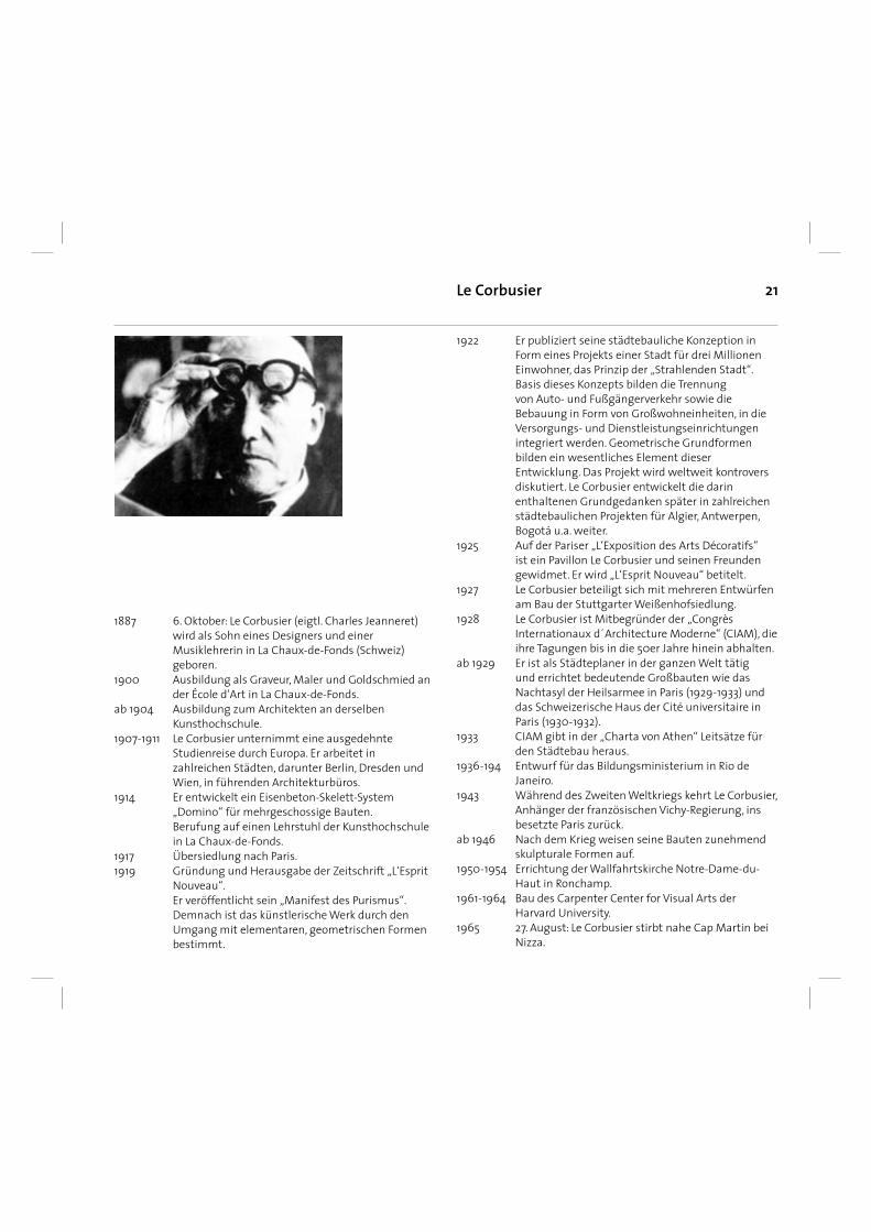
1887 6. Oktober: Le Corbusier (eigtl. Charles Jeanneret) wird als Sohn eines Designers und einer Musiklehrerin in La Chaux-de-Fonds (Schweiz) geboren.
1900 Ausbildung als Graveur, Maler und Goldschmied an der École d‘Art in La Chaux-de-Fonds.
ab 1904 Ausbildung zum Architekten an derselben Kunsthochschule.
1907-1911 Le Corbusier unternimmt eine ausgedehnte Studienreise durch Europa. Er arbeitet in zahlreichen Städten, darunter Berlin, Dresden und Wien, in führenden Architekturbüros.
1914 Er entwickelt ein Eisenbeton-Skelett-System „Domino“ für mehrgeschossige Bauten.
Berufung auf einen Lehrstuhl der Kunsthochschule in La Chaux-de-Fonds.
1917 Übersiedlung nach Paris. 1919 Gründung und Herausgabe der Zeitschrift „L‘Esprit
Nouveau“. Er veröffentlicht sein „Manifest des Purismus“.
Demnach ist das künstlerische Werk durch den Umgang mit elementaren, geometrischen Formen bestimmt.
1922 Er publiziert seine städtebauliche Konzeption in Form eines Projekts einer Stadt für drei Millionen Einwohner, das Prinzip der „Strahlenden Stadt“. Basis dieses Konzepts bilden die Trennung von Auto- und Fußgängerverkehr sowie die Bebauung in Form von Großwohneinheiten, in die Versorgungs- und Dienstleistungseinrichtungen integriert werden. Geometrische Grundformen bilden ein wesentliches Element dieser Entwicklung. Das Projekt wird weltweit kontrovers diskutiert. Le Corbusier entwickelt die darin enthaltenen Grundgedanken später in zahlreichen städtebaulichen Projekten für Algier, Antwerpen, Bogotá u.a. weiter.
1925 Auf der Pariser „L‘Exposition des Arts Décoratifs“ ist ein Pavillon Le Corbusier und seinen Freunden gewidmet. Er wird „L‘Esprit Nouveau“ betitelt.
1927 Le Corbusier beteiligt sich mit mehreren Entwürfen am Bau der Stuttgarter Weißenhofsiedlung.
1928 Le Corbusier ist Mitbegründer der „Congrès Internationaux d´Architecture Moderne“ (CIAM), die ihre Tagungen bis in die 50er Jahre hinein abhalten.
ab 1929 Er ist als Städteplaner in der ganzen Welt tätig und errichtet bedeutende Großbauten wie das Nachtasyl der Heilsarmee in Paris (1929-1933) und das Schweizerische Haus der Cité universitaire in Paris (1930-1932).
1933 CIAM gibt in der „Charta von Athen“ Leitsätze für den Städtebau heraus.
1936-194 Entwurf für das Bildungsministerium in Rio de Janeiro.
1943 Während des Zweiten Weltkriegs kehrt Le Corbusier, Anhänger der französischen Vichy-Regierung, ins besetzte Paris zurück.
ab 1946 Nach dem Krieg weisen seine Bauten zunehmend skulpturale Formen auf.
1950-1954 Errichtung der Wallfahrtskirche Notre-Dame-du-Haut in Ronchamp.
1961-1964 Bau des Carpenter Center for Visual Arts der Harvard University.
1965 27. August: Le Corbusier stirbt nahe Cap Martin bei Nizza.
Le Corbusier
22
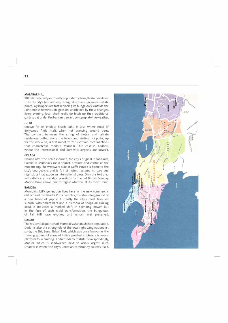
MALABAR HILL Still relatively leafy and mostly populated by Jains, this is considered to be the city‘s best address, though due to a surge in real-estate prices, skyscrapers are fast replacing its bungalows. Outside the Jain temple, however, life goes on, unaffected by these changes. Every evening, local chefs really do hitch up their traditional garb, squat under the banyan tree and contemplate the weather.
JUHU Known for its endless beach, Juhu is also where most of Bollywood fi nds itself, when not prancing around trees. The contrast between the string of hotels and private residences dotted along the beach and visiting hoi polloi, up for the weekend, is testament to the extreme contradictions that characterise modern Mumbai. Due east is Andheri, where the international and domestic airports are located.
COLABA Named after the Koli fi shermen, the city‘s original inhabitants, Colaba is Mumbai‘s main tourist precinct and centre of the modern city. The westward side of Cuffe Parade is home to the city‘s bourgeoisie, and is full of hotels, restaurants, bars and nightclubs that exude an international gloss. Only the Fort area will satisfy any nostalgic yearnings for the old British Bombay. Marine Drive allows one to regard Mumbai at its most ironic.
BANDRA Mumbai‘s MTV generation lives here in the new commercial district and the Bandra Kurla complex, the stomping ground of a new breed of yuppie. Currently the city‘s most favoured suburb, with smart bars and a plethora of shops on Linking Road, it indicates a marked shift in spending power. But in the face of such rabid transformation, the bungalows of Pali Hill have endured and remain well preserved.
DADAR The residential quarters of Mumbai‘s Maharashtrian population, Dadar is also the stronghold of the local right-wing nationalist party, the Shiv Sena. Shivaji Park, which was once famous as the training ground of some of India‘s greatest cricketers, is now a platform for recruiting Hindu fundamentalists. Correspondingly, Mahim, which is sandwiched next to Asia‘s largest slum, Dharavi, is where the city‘s Christian community collects itself.
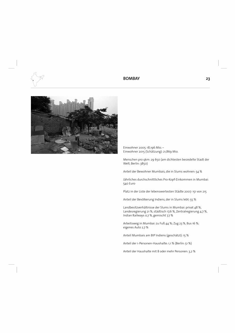
23BOMBAY
Einwohner 2005: 18,196 Mio. – Einwohner 2015 (Schätzung): 21,869 Mio.
Menschen pro qkm: 29 650 (am dichtesten besiedelte Stadt der Welt; Berlin: 3850)
Anteil der Bewohner Mumbais, die in Slums wohnen: 54 %
Jährliches durchschnittliches Pro-Kopf-Einkommen in Mumbai: 540 Euro
Platz in der Liste der lebenswertesten Städte 2007: 151 von 215
Anteil der Bevölkerung Indiens, der in Slums lebt: 55 %
Landbesitzverhältnisse der Slums in Mumbai: privat 48 %, Landesregierung 21 %, städtisch 17,6 %, Zentralregierung 4,7 %, Indian Railways 0,7 %, gemischt 7,7 %
Arbeitsweg in Mumbai: zu Fuß 44 %; Zug 23 %, Bus 16 %; eigenes Auto 2,7 %
Anteil Mumbais am BIP Indiens (geschätzt): 15 %
Anteil der 1-Personen-Haushalte: 1,1 % (Berlin: 51 %)
Anteil der Haushalte mit 8 oder mehr Personen: 3,2 %
25Entstehung von Bombay
Imperial AmbitionsPortuguese explorers had already arrived in Goa in the 16th century, on a mission to wrest control of the near-priceless spice trade from the Arabs and win souls for Christendom. One of the fi rst recorded visits of the Portuguese to Bombay was in 1508, when a ship halted briefl y at Mahim Island while travelling to an outpost at Diu in Gujarat. For the next two decades the Portuguese kept making short visits to the islands and in 1532 they fi nally seized Bassein (now Vasai, just north of Mumbai‘s municipal limits) from Sultan Bahadur Shah of Gujarat. From here the Portuguese took the entire region, including the seven islands. At that time, the Arabian coast was a bustling region of trading ships and seaside outposts. The Portuguese already possessed Goa, Daman and Diu, and Vasai became an important part of their maritime trade network. To protect their shipping routes, the Portuguese fortifi ed the islanded region, establishing cannon-equipped outposts at Mahim, Sion, Bandra and of course in Bassein. It was around this time that the region got a new name - ‚Ilha da Boa Vida‘, meaning ‚the island of good life‘ in Portuguese. When the Portuguese fi rst came to the place they called ‚Bandora‘, now Bandra, they found an ideal spot: a strategically important point overlooking the sea, amply supplied with drinking water from nearby freshwater springs. In 1640, they stationed a permanent garrison of troops here and built a small fort, which they called the Castella de Aguada (‚The Water Point‘). Armed with a pair of cannons, the garrison kept watch over sea lanes crucial to Portuguese trading interests. Anxious about the spiritual wellbeing of their troops, they also built the Chapel of Nossa Senora de Monte (‚Our Lady of the Mount‘) nearby and cut a road linking it to the fort. Over the next 100 years the region‘s social history was shaped by Portuguese religious, economic and political impulses and resembled other Portuguese outposts - including Goa and Daman in India and Malacca in Malaysia. Many village communities from Mahim to Vasai converted to Christianity and the landscape became punctuated with churches and chapels. The Portuguese destroyed the Walkeshwar Temple, which was eventually rebuilt in 1715 by a wealthy Hindu trader. Over 350 years later, the Nossa Senora de Monte church - now known as Mount Mary‘:“ is still a place of worship. At the fort, only ruins remain (now restored and home to a gorgeous amphitheatre).
Thane, to the north east of the islands, became an attractive township of villages, temples and churches nestled between lakes and coconut groves. For all the development, the Portuguese still didn‘t see much trade potential in the area and it remained a backwater. Instead it was their rivals, the British East India Company, who cast a covetous eye over the area from their headquarters in Gujarat. They considered it a perfect natural harbour for the Company‘s fi rst Indian seaport. The main attraction of course was the deep bay on the eastern waterfront overlooking the mainland. The Surat outpost began pressing its London headquarters to purchase the islands from the Portuguese. They fi nally got their hands on them in 1661, when they were given to King Charles II as part of the dowry for his marriage to Portuguese princess Catherine de Braganza. Apparently, Charles was not exactly sure where his wedding present was; he initially thought that the islands were somewhere in Brazil. In 1668, he leased the islands to the British East India Company for the sum of 10 pounds a year and the Company quickly established a colony in and around an existing Portuguese fort, which grew rapidly from 10,000 people in 1661 to 60,000 by 1675. In 1687 the East India Company transferred its headquarters from Surat to what the British now called Bombay.
Birth of a trade hubBombay‘s early population mostly comprised Koli fi sherfolk, East India Company offi cials and migrants from Gujarat who set up shop to service the outpost. Among the migrants were an emigre community of Iranian Zoroastrians known as Parsis, who were to become a decisive commercial and political force in Bombay‘s development. That was foreshadowed earlier in the colony‘s history by the actions of a Parsi trader, Rustomji Dorabji: just two years after the Company moved to Bombay, the outpost was beset by a plague outbreak. At the same time, a nearby Africa-descended tribe called the Sidis launched an attack on the colony from their base down the coast in Janjira (near present--day Alibag). Despite the chaos caused by the plague, Dorabji managed to raise an impromptu army from the local Kolis and repelled the Sidis in a counterattack - saving the colony and killing the Sidi chief in the process. That the size and infl uence of the Parsi presence was strong very early in Bombay‘s history is proved by the fact that a Tower of
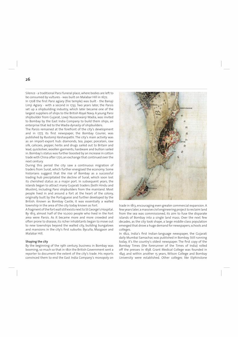
26
Silence - a traditional Parsi funeral place, where bodies are left to be consumed by vultures - was built on Malabar Hill in 1672. In 1708 the fi rst Parsi agiary (fi re temple) was built - the Banaji Limji Agiary - with a second in 1733. Two years later, the Parsis set up a shipbuilding industry, which later became one of the largest suppliers of ships to the British Royal Navy. A young Parsi shipbuilder from Gujarat, Lowji Nusserwanji Wadia, was invited to Bombay by the East India Company to build them ships, an enterprise that led to the Wadia dynasty of shipbuilders. The Parsis remained at the forefront of the city‘s development and in 1777, its fi rst newspaper, the Bombay Courier, was published by Rustomji Keshaspathi. The city‘s main activity was as an import-export hub: diamonds, tea, paper, porcelain, raw silk, calicoes, pepper, herbs and drugs sailed out to Britain and lead, quicksilver, woollen garments, hardware and bullion sailed in. Bombay‘s status was further boosted by an increase in cotton trade with China after 1770, an exchange that continued over the next century. During this period the city saw a continuous migration of traders from Surat, which further energised the economy. Some historians suggest that the rise of Bombay as a successful trading hub precipitated the decline of Surat, which soon lost its cherished status as a major port. In subsequent years, the islands began to attract many Gujarati traders (both Hindu and Muslim), including Parsi shipbuilders from the mainland. Most people lived in and around a fort at the heart of the colony, originally built by the Portuguese and further developed by the British. Known as Bombay Castle, it was essentially a walled township in the area of the city today known as Fort. A fragment of the fort wall still exists next to St George‘s Hospital. By 1813, almost half of the 10,000 people who lived in the Fort area were Parsis. As it became more and more crowded and often prone to disease, its richer inhabitants began to move out to new townships beyond the walled city, building bungalows and mansions in the city‘s fi rst suburbs: Byculla, Mazgaon and Malabar Hill.
Shaping the cityBy the beginning of the 19th century, business in Bombay was booming, so much so that in 1801 the British Government sent a reporter to document the extent of the city‘s trade. His reports convinced them to end the East India Company‘s monopoly on
trade in 1813, encouraging even greater commercial expansion. A few years later, a massive civil engineering project to reclaim land from the sea was commissioned, its aim to fuse the disparate islands of Bombay into a single land mass. Over the next few decades, as the city took shape, a large middle-class population emerged that drove a huge demand for newspapers, schools and colleges. In 1822, India‘s fi rst Indian-language newspaper, the Gujarati daily Mumbai Samachar, was published in Bombay. Still running today, it‘s the country‘s oldest newspaper. The fi rst copy of the Bombay Times (the forerunner of the Times of India) rolled off the presses in 1838. Grant Medical College was founded in 1845 and within another 15 years, Wilson College and Bombay University were established. Other colleges like Elphinstone
27
College and St Xavier‘s went up within a decade. Both the new media and colleges were largely patronised by children of Gujarati merchants and traders, the indigenous Christian populations and Maharashtrians. Middle-class suburbs sprung up in the new neighbourhoods of Kalbadevi, Girgaum, Gowalia Tank, Mohammed Ali Road, Thakurdwar and Walkeshwar. By the middle of the 19th century, the knitting together of Bombay‘s islands through land reclamation was nearly complete. Causeways linked Bombay, Sion, Salsette and Colaba; Mahalaxmi and Worli were joined; and in 1845, Mahim and Bandra were connected by the Mahim causeway thanks to a rich Parsi - Lady Avabai Jamsetjee Jeejeebhoy - who paid Rs 157,000 for it. Legend has it that she prayed at several religious sites for the survival of a sick child. When the child recovered after she prayed at Mount Mary Church, Lady Avabai built the causeway to allow more devotees access to the Virgin Mother without having to take a ferry. As the physical landmass came together, Bombay‘s political and commercial links with the Empire were tightened. A regular steamship service between the city and London was established in 1843; fi fteen years later, direct British Government control of the Indian colony was established after the First War of Indian Independence (the ‚Sepoy Mutiny‘) in 1857, which led to all of the East India Company‘s formal political powers being handed to the Crown.
Urbs prima in IndisBy 1845, the basis of a modern city had been created with land covering 170 square miles - a complex landscape of fi elds, coconut groves and outsize colonial structures, of cosmopolitan enclaves and sleepy villages. Bombay was the starting point of India‘s fi rst passenger railway line in 1853, connecting the city to Thane in Maharashtra. In the 1860s the British began a construction programme, erecting architecture that was designed to signal to the natives that they were here to stay - a direct response to the Indian uprising of 1857. Victoria Terminus, the Prince of Wales Museum, Bombay University, the General Post Offi ce, the Old Customs House, Elphinstone College, the Public Works Department Building - all were begun in the 1860s. With typical imperial hyperbole, they began to refer to Bombay as ‚urbs prima in Indis‘ - the fi rst city of India. In 1864, The Bombay, Baroda and Central India Railway (later merged with other railways to form what is now the Western Railway) were extended to Bombay, boosting the fl ow of cotton from the hinterlands. Cotton now dominated trade through Bombay. Raw cotton from Gujarat was shipped to Lancashire in England, processed into cloth and then shipped back via Bombay to be resold in the Indian market. Although cotton trading was the city‘s main activity, businessmen began to recognise that spinning the cotton themselves could make bigger profi ts. In 1854 a Parsi, Cowasji Nanabhai Davar, opened the fi rst cotton mill, The Bombay Spinning Mill. It was met by vociferous opposition from Lancashire mill owners anxious to avoid the ‚outsourcing‘ of the cotton spinning business, and was only pushed through thanks to the infl uence of the British manufacturers of the cotton looms. In 1870, around 13 mills were in operation in Bombay. The shipping of raw cotton was still the main engine of the city‘s economy, however, and it received a massive boost when the American Civil War broke out in 1861. The war forced global markets to look for alternative sources of cotton for the booming textile industries of Britain and other countries in Europe. Bombay consequently became the world‘s foremost cotton supplier, with money pouring into the city until the war ended in 1865. Within a year of the war‘s end, however, most of the companies were liquidated and many speculators went bankrupt. In spite of this, the city continued to grow, using the wealth generated
28
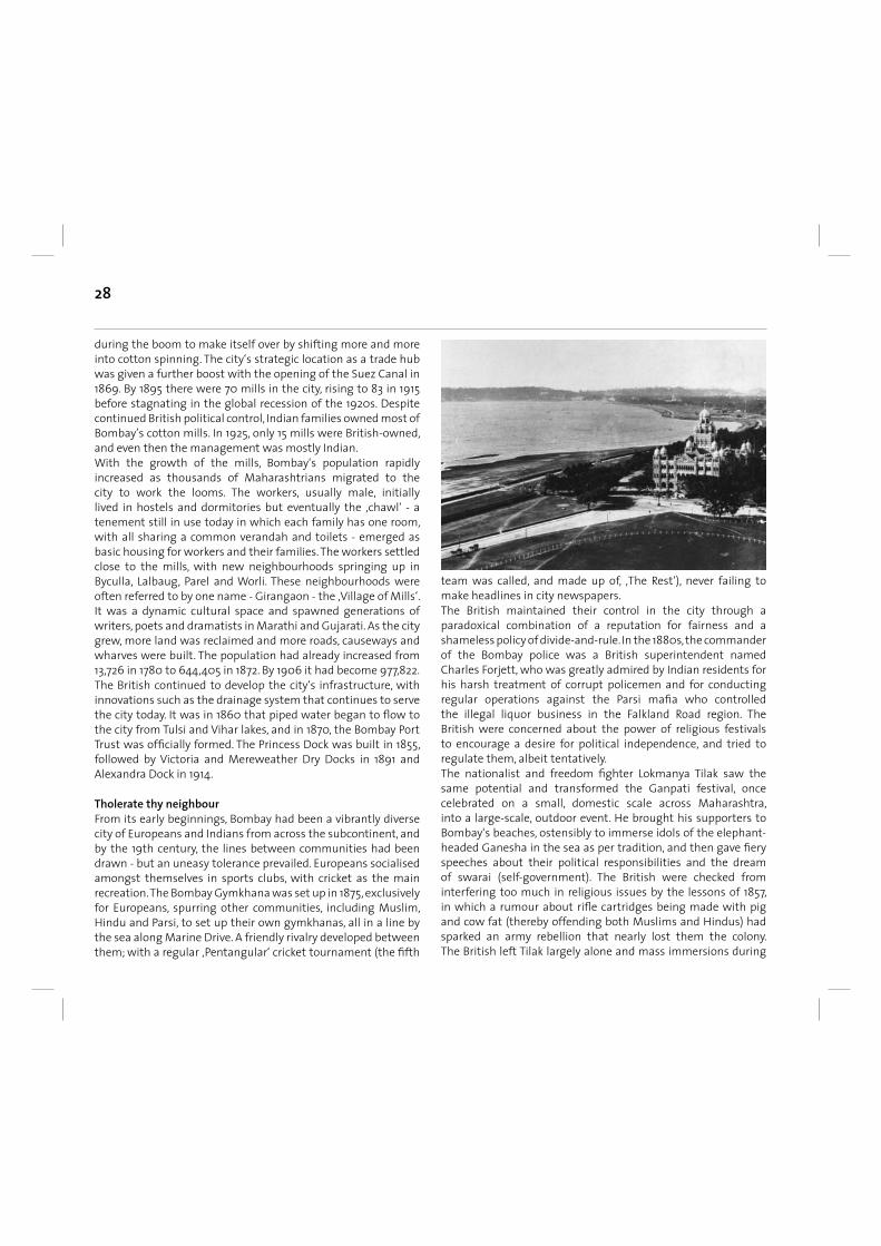
during the boom to make itself over by shifting more and more into cotton spinning. The city‘s strategic location as a trade hub was given a further boost with the opening of the Suez Canal in 1869. By 1895 there were 70 mills in the city, rising to 83 in 1915 before stagnating in the global recession of the 1920s. Despite continued British political control, Indian families owned most of Bombay’s cotton mills. In 1925, only 15 mills were British-owned, and even then the management was mostly Indian. With the growth of the mills, Bombay‘s population rapidly increased as thousands of Maharashtrians migrated to the city to work the looms. The workers, usually male, initially lived in hostels and dormitories but eventually the ‚chawl‘ - a tenement still in use today in which each family has one room, with all sharing a common verandah and toilets - emerged as basic housing for workers and their families. The workers settled close to the mills, with new neighbourhoods springing up in Byculla, Lalbaug, Parel and Worli. These neighbourhoods were often referred to by one name - Girangaon - the ‚Village of Mills‘. It was a dynamic cultural space and spawned generations of writers, poets and dramatists in Marathi and Gujarati. As the city grew, more land was reclaimed and more roads, causeways and wharves were built. The population had already increased from 13,726 in 1780 to 644,405 in 1872. By 1906 it had become 977,822. The British continued to develop the city‘s infrastructure, with innovations such as the drainage system that continues to serve the city today. It was in 1860 that piped water began to fl ow to the city from Tulsi and Vihar lakes, and in 1870, the Bombay Port Trust was offi cially formed. The Princess Dock was built in 1855, followed by Victoria and Mereweather Dry Docks in 1891 and Alexandra Dock in 1914.
Tholerate thy neighbourFrom its early beginnings, Bombay had been a vibrantly diverse city of Europeans and Indians from across the subcontinent, and by the 19th century, the lines between communities had been drawn - but an uneasy tolerance prevailed. Europeans socialised amongst themselves in sports clubs, with cricket as the main recreation. The Bombay Gymkhana was set up in 1875, exclusively for Europeans, spurring other communities, including Muslim, Hindu and Parsi, to set up their own gymkhanas, all in a line by the sea along Marine Drive. A friendly rivalry developed between them; with a regular ‚Pentangular‘ cricket tournament (the fi fth
team was called, and made up of, ‚The Rest‘), never failing to make headlines in city newspapers. The British maintained their control in the city through a paradoxical combination of a reputation for fairness and a shameless policy of divide-and-rule. In the 1880s, the commander of the Bombay police was a British superintendent named Charles Forjett, who was greatly admired by Indian residents for his harsh treatment of corrupt policemen and for conducting regular operations against the Parsi mafi a who controlled the illegal liquor business in the Falkland Road region. The British were concerned about the power of religious festivals to encourage a desire for political independence, and tried to regulate them, albeit tentatively. The nationalist and freedom fi ghter Lokmanya Tilak saw the same potential and transformed the Ganpati festival, once celebrated on a small, domestic scale across Maharashtra, into a large-scale, outdoor event. He brought his supporters to Bombay‘s beaches, ostensibly to immerse idols of the elephant-headed Ganesha in the sea as per tradition, and then gave fi ery speeches about their political responsibilities and the dream of swarai (self-government). The British were checked from interfering too much in religious issues by the lessons of 1857, in which a rumour about rifl e cartridges being made with pig and cow fat (thereby offending both Muslims and Hindus) had sparked an army rebellion that nearly lost them the colony. The British left Tilak largely alone and mass immersions during
29
the Ganpati festival continue to this day, with its freedom--movement origins largely forgotten. Instead of direct action, the British responded to such challenges to their authority with the same divide-and rule-policy they had used all over the country - by playing Hindus and Muslims off against each other. It was hardly diffi cult for the British in Bombay, a city where communities were already naturally divided into different enclaves. With so little offi cial thought put into planning residential neighbourhoods for the poorer or even middle-class populations, the only support network for those looking for homes or the means to build them came from within their own ethnic groups. As the city became increasingly politicised, communal riots began to plague Bombay for the fi rst time.
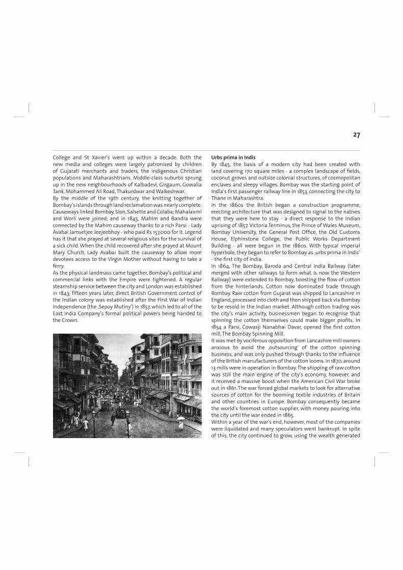
A new centuryBombay was still a city among other Indian cities. But in 1875, the basis for its current status as India‘s economic capital was established with the Bombay Stock Exchange - then referred to as the Native Share and Stockbrokers Association. As the cream of India‘s professional talent fl ooded into the city, political movements began to fl ourish. Political ferment saw the establishment of the Indian National Congress - the fi rst Indian political party - in 1885 at the Gokuldas Tejpal College in South Bombay. By this time a lack of adequate urban planning was causing large parts of the city to choke from over-congestion, a problem that became disastrous just a few years before the end of the
19th century, when bubonic plague broke out, possibly carried by rats on grain ships from Hong Kong. Thousands fl ed the city and Indian and foreign ports quarantined all goods arriving from Bombay, with ruinous consequences for the city‘s economy. The tragedy was compounded by the failure of the monsoon in 1899, leading to one of India‘s worst-ever famines. The British authorities responded to the catastrophe by setting up a City Improvement Trust to encourage the development of the suburbs and relieve pressure on the southern part of the city. By the beginning of the 20th century, the fi rst outlines of the character of modern Bombay had begun to emerge. By 1906, the city‘s population had topped one million. It quickly became a hot-bed of the new politics that would lead to Indian Independence, fi red up by Mahatma Gandhi‘s return from South Africa in 1915. Gandhi took a house called Mani Bhavan in Gamdevi, from where he began to rally citizens to the cause. Prominent Bombay businessmen, traders, workers and professionals became his votaries. Technological innovations that had slowly emerged in the West were implanted in Bombay in rapid order, with the fi rst transmission lines of the Tata Power Company criss-crossing the city‘s skyline in 1915. In 1926 the fi rst motorised bus service started between Afghan Church and Crawford Market. The fi rst electric train started in 1927, an intercity service from Bombay to Pune and Igatpuri. A few years later the fi rst electric commuter train (still known in Mumbai as ‚EMUs‘ - Electric Multiple Units) rolled out. In 1932, the Parsi industrialist JRD Tata fl ew the fi rst scheduled airmail fl ight from Karachi to Bombay via Ahmedabad, landing his single--engined de Haviland Puss Moth on a grass strip at Juhu Aerodrome. The Lumiere Brothers‘ Cinematographe showed four silent short fi lms at the Watson‘s Hotel in Bombay in 1896, charging an entry fee of one rupee. It was a phenomenon that the Times 0f India described at the time as ‚the marvel of the century‘, and quickly fi red the imaginations of a generation of Indians. The Indian fi lm industry was born in Bombay a few years later. A man named HS Bhatavdekar fi lmed the city‘s fi rst documentary in 1899, of a wrestling match, which he showed across the city to general acclaim. The fi rst full-length feature fi lm, Raja Harishchandra, was made in 1913 by Dadasaheb Phalke and shown at Bombay‘s Coronation Cinematograph. By 1920, the Indian fi lm industry was fully formed, with Bombay at its heart. By 1931 about 207 fi lms were being made every year.
30
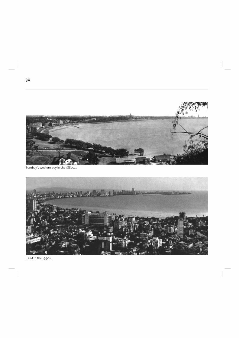
Bombay‘s western bay in the 1880s....
...and in the 1990s.
31
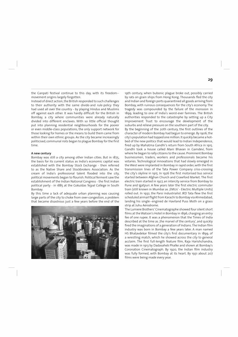
Growing the painsAfter ‚freedom at midnight‘ gave birth to independent India on 15 August 1947, Bombay continued to expand beyond the suburbs of Mahim and Bandra - erstwhile Portuguese areas - swallowing up everything as far north as Mankhurd, Mulund and Dahisar. The city became the capital of Bombay State, a political creation that included the whole of what are now the two separate states of Gujarat and Maharashtra. In the following years Bombay became a battlefi eld for political movements based on language groups, mainly its Gujarati- -and Marathi-speaking populations. The Samyukta Maharashtra Andolan was a major political force of socialists, trade unions and artists that fought fi ercely for the formation of an independent state for Marathi-speaking people, with Bombay as its capital. They fi nally achieved their wish and Bombay State was split into two in 1960, but only after 105 of the movement‘s supporters had been shot dead by police during tumultuous political protests around Flora Fountain earlier the same year. A memorial at what is now called Hutatma Chowk commemorates the dead with an eternal fl ame. Bombay‘s politics in the 1960s and 1970s remained dynamic and dominated by the Left, with the working class mill areas of central Bombay as a Communist heartland. But a splinter of the Samyukta Maharashtra Andolan morphed into a nativist movement - the Shiv Sena (‚Army of Shivaji‘), which won continued infl uence with its Right-wing anti--outsider politics in the face of growing slum encroachment by immigrants from outside the city. During the 1970s the city overtook Calcutta as the most populous city in India. A lack of political will, cushioned by a healthy economy benefi ting from cheap labour, allowed slums to proliferate on a scale that had never been seen before. In the process, the Shiv Sena fi red the imagination of the working class, displacing the old dominance of the Left. Its founder, a former cartoonist named Bal Thackeray, came to dominate the city‘s political landscape using a combination of brutal mafi a-like force and a string of local election victories. The decline of the textile industry contributed to this political shift and, after a catastrophic mill workers‘ strike in 1982-83, the century-old cotton-spinning industry effectively died in Bombay. With its passing, the mill workers lost their key position in the city‘s economy and politics. The 1970s and early ‚80s were an exciting decade in the city‘s cinematic history, with the emergence of fi lmmakers determined
to set themselves apart from the mainstream Hindi fi lm industry. They began to make realist and neo-expressionist fi lms with strong elements of social commentary. City authorities made few infrastructure improvements in the 1970s and ‚80s, despite the alarmingly rapid growth in the city‘s population. The largest was a plan to create New Bombay (now known as Navi Mumbai) - a parallel city across the harbour on the mainland, built to decongest the island city. It began slowly, faltered, and even today has yet to live up to its original aims. The Shiv Sena continued to rise throughout the 1980s, thanks to the decline of the Left and increasingly visible corruption in the Congress. It was a political combination that proved to be lethal, culminating in the horrendous Bombay riots of 1992-93 - incidents that were in fact state-sanctioned and party-sponsored pogroms against Muslims. The violence erupted after the Babri Mosque was razed by Hindu militants in the city of Ayodhya, in the North Indian state of Uttar Pradesh. Hundreds of Muslims were killed by Hindu fundamentalists during the riots. On 12 March 1993 came ‚Black Friday‘, when 13 bombs exploded in one day at locations across the city, including the Bombay Stock Exchange and the Air India Building. Two hundred and fi fty-seven people were killed in what were revenge attacks by a Muslim group for the slaughter two months previously. The riots and bombings were a shattering blow to Bombay‘s self-image as a cosmopolitan, secular city s had avoided the communal violence that affl icts other Indian cities. It paved the way for the Shiv Sena‘s rise to power at both city and state levels and, in 1995, they changed the offi cial name of the city to Mumbai. Since then, Mumbai has been the victim of sporadic terrorist attacks, most recently in July 2006, when bombs tore through the fi rst class compartments of seven commuter trains on the Western Line, killing more than 200 people.
(Text: Time Out Mumbai, 2008)
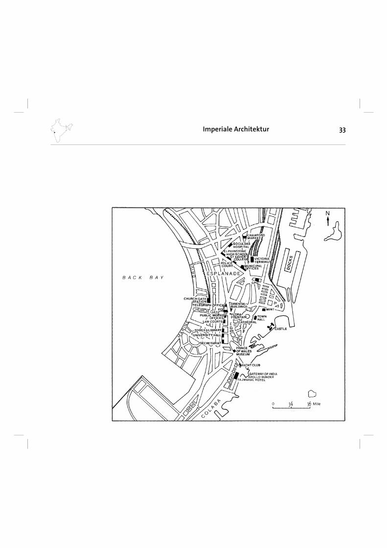
33Imperiale Architektur
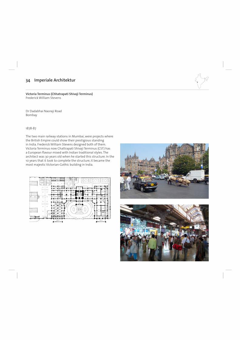
34 Imperiale Architektur
1878-87
Victoria Terminus (Chhatrapati Shivaji Terminus)Frederick William Stevens
Dr Dadabhai Naoraji RoadBombay
The two main railway stations in Mumbai, were projects where the British Empire could show their prestigious standing in India. Frederick William Stevens designed both of them. Victoria Terminus now Chattrapati Shivaji Terminus (CST) has a European fl avour mixed with Indian traditional styles. The architect was 30 years old when he started this structure. In the 10 years that it took to complete the structure, it became the most majestic Victorian-Gothic building in India.
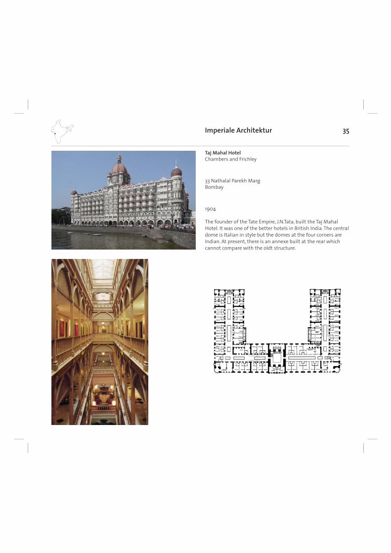
35
1904
Taj Mahal HotelChambers and Frichley
33 Nathalal Parekh MargBombay
Imperiale Architektur
The founder of the Tate Empire, J.N.Tata, built the Taj Mahal Hotel. It was one of the better hotels in British India. The central dome is Italian in style but the domes at the four corners are Indian. At present, there is an annexe built at the rear which cannot compare with the oldt structure.
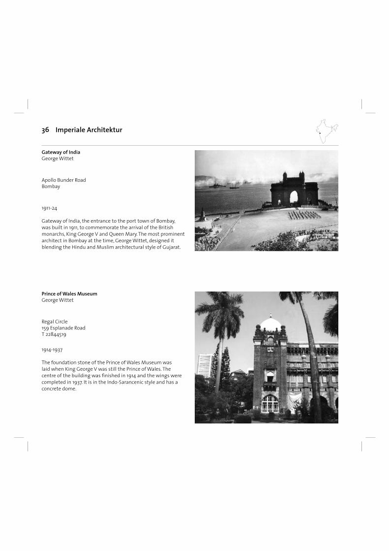
36 Imperiale Architektur
1914-1937
Prince of Wales Museum George Wittet
Regal Circle159 Esplanade Road T 22844519
The foundation stone of the Prince of Wales Museum was laid when King George V was still the Prince of Wales. The centre of the building was fi nished in 1914 and the wings were completed in 1937. It is in the Indo-Sarancenic style and has a concrete dome.
1911-24
Gateway of India George Wittet
Apollo Bunder RoadBombay
Gateway of India, the entrance to the port town of Bombay, was built in 1911, to commemorate the arrival of the British monarchs, King George V and Queen Mary. The most prominent architect in Bombay at the time, George Wittet, designed it blending the Hindu and Muslim architectural style of Gujarat.
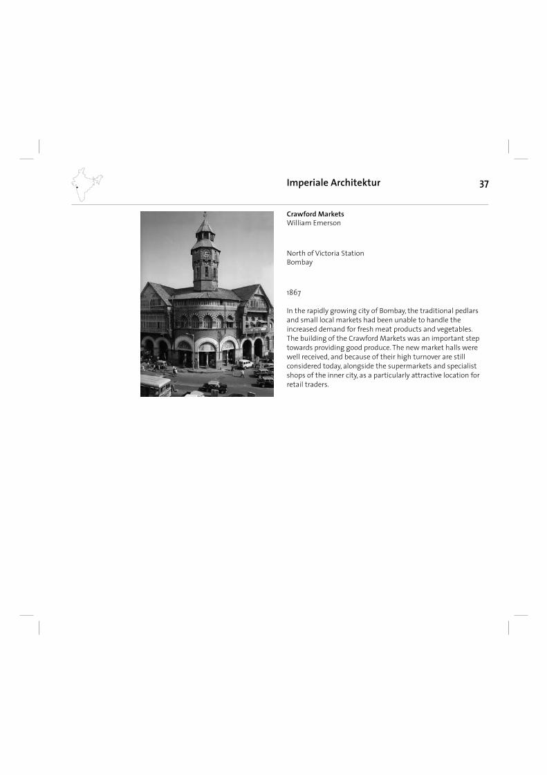
37Imperiale Architektur
1867
Crawford Markets William Emerson
North of Victoria StationBombay
In the rapidly growing city of Bombay, the traditional pedlars and small local markets had been unable to handle the increased demand for fresh meat products and vegetables. The building of the Crawford Markets was an important step towards providing good produce. The new market halls were well received, and because of their high turnover are still considered today, alongside the supermarkets and specialist shops of the inner city, as a particularly attractive location for retail traders.
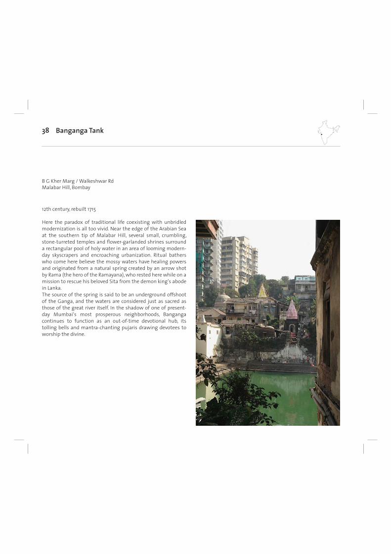
38
Here the paradox of traditional life coexisting with unbridled modernization is all too vivid. Near the edge of the Arabian Sea at the southern tip of Malabar Hill, several small, crumbling, stone-turreted temples and fl ower-garlanded shrines surround a rectangular pool of holy water in an area of looming modern-day skyscrapers and encroaching urbanization. Ritual bathers who come here believe the mossy waters have healing powers and originated from a natural spring created by an arrow shot by Rama (the hero of the Ramayana), who rested here while on a mission to rescue his beloved Sita from the demon king‘s abode in Lanka. The source of the spring is said to be an underground offshoot of the Ganga, and the waters are considered just as sacred as those of the great river itself. In the shadow of one of present-day Mumbai‘s most prosperous neighborhoods, Banganga continues to function as an out-of-time devotional hub, its tolling bells and mantra-chanting pujaris drawing devotees to worship the divine.
Banganga Tank
12th century, rebuilt 1715
B G Kher Marg / Walkeshwar RdMalabar Hill, Bombay
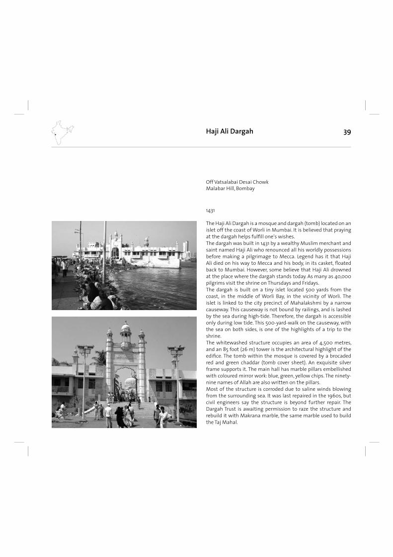
39
The Haji Ali Dargah is a mosque and dargah (tomb) located on an islet off the coast of Worli in Mumbai. It is believed that praying at the dargah helps fulfi ll one‘s wishes.The dargah was built in 1431 by a wealthy Muslim merchant and saint named Haji Ali who renounced all his worldly possessions before making a pilgrimage to Mecca. Legend has it that Haji Ali died on his way to Mecca and his body, in its casket, fl oated back to Mumbai. However, some believe that Haji Ali drowned at the place where the dargah stands today. As many as 40,000 pilgrims visit the shrine on Thursdays and Fridays.The dargah is built on a tiny islet located 500 yards from the coast, in the middle of Worli Bay, in the vicinity of Worli. The islet is linked to the city precinct of Mahalakshmi by a narrow causeway. This causeway is not bound by railings, and is lashed by the sea during high-tide. Therefore, the dargah is accessible only during low tide. This 500-yard-walk on the causeway, with the sea on both sides, is one of the highlights of a trip to the shrine.The whitewashed structure occupies an area of 4,500 metres, and an 85 foot (26 m) tower is the architectural highlight of the edifi ce. The tomb within the mosque is covered by a brocaded red and green chaddar (tomb cover sheet). An exquisite silver frame supports it. The main hall has marble pillars embellished with coloured mirror work: blue, green, yellow chips. The ninety-nine names of Allah are also written on the pillars.Most of the structure is corroded due to saline winds blowing from the surrounding sea. It was last repaired in the 1960s, but civil engineers say the structure is beyond further repair. The Dargah Trust is awaiting permission to raze the structure and rebuild it with Makrana marble, the same marble used to build the Taj Mahal.
Haji Ali Dargah
1431
Off Vatsalabai Desai ChowkMalabar Hill, Bombay
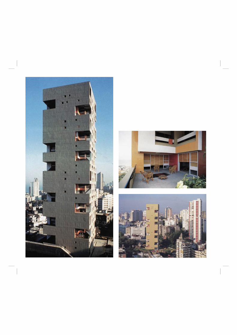
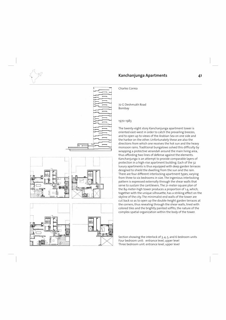
41
The twenty-eight story Kanchanjunga apartment tower is oriented east-west in order to catch the prevailing breezes, and to open up to views of the Arabian Sea on one side and the harbor on the other. Unfortunately these are also the directions from which one receives the hot sun and the heavy monsoon rains. Traditional bungalows solved this diffi culty by wrapping a protective verandah around the main living area, thus affording two lines of defense against the elements. Kanchanjunga is an attempt to provide comparable layers of protection in a high-rise apartment building. Each of the 32 luxury apartments is thus equipped with deep garden terraces designed to shield the dwelling from the sun and the rain. There are four different interlocking apartment types, varying from three to six bedrooms in size. The ingenious interlocking pattern is expressed externally through the shear walls that serve to sustain the cantilevers. The 21-meter-square plan of the 84-meter-high tower produces a proportion of 1:4, which, together with the unique silhouette, has a striking effect on the skyline of the city. The minimalist end walls of the tower are cut back so as to open up the double-height garden terraces at the corners, thus revealing through the shear walls, lined with colored tiles and the brightly painted soffi ts, the nature of the complex spatial organization within the body of the tower.
Kanchanjunga Apartments
1970-1983
Charles Correa
Section showing the interlock of 3, 4, 5, and 6 bedroom unitsFour bedroom unit: entrance level, upper levelThree bedroom unit: entrance level, upper level
72 G Deshmukh RoadBombay
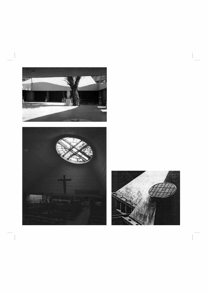
43
Charles Correa’s Salvacao Church in Bombay, according to him is a ‘return to original principles’. The architect felt that originally the design of churches was based on the concept that there were three crucial periods in the life of Christ : a) The Baptism, b) The Public Life’ and c) The Crucifi xion. Liturgically these found expression in ; a) The Baptismal Font and Confessionals, b) The Pulpit and the Altar, and c) The Tabernacle. In early Christian churches the plan clearly refl ected these concepts. Later on, churches became one generalised space in which all the various elements were congregated together. Therefore this church is the modern Indian derivative of the original Christian church. Here the essence is the ritual and then the constants and the local infl uences are used to determine the form.The underlying infl uence in Correa’s architecture is the belief that in warm climates, people have a very different relationship to built form. He says, „The monumental temples of south India are experienced not just as gopurams and shrines, but as a movement through the great open - to - sky spaces that lie between them“ . This led him to deviate from the traditional (Gothic) church plan, which resulted in a series of interlocking courtyards and covered spaces. This pattern allows any activity either to take place in the open, or under cover - depending on the weather. The covered spaces are the liturgical elements and
Salvacao Church
1974-1977
Charles Correa
West Gokhale RoadBombay
are all square, as are the open spaces - the square being the most secular divine shape. All the various areas, both covered and open, interconnect horizontally, so that the space - and the breeze fl ow unobstructed across the site.The covered spaces are protected by concrete shells, in the shape of truncated pyramids. These give the church the appearance of a temple complex with gopurams and shikharas rising heavenwards. Western churches have tended to use spires and towers to achieve the desired verticality, whereas the Indian religious spaces have tended to use more monolithic structures. The shells act as giant fl ues where the hot air rises and exits through a vent at the top, thus drawing in fresh air from the courtyards around.
Charles Correa in this church therefore deliberately moves away from the cruciform plan, the spires, the cross and the closed box and other traditional identity markers, but still makes sure that the church ethos is not lost in the building. Although, it seems that in his effort to rationalise it is visible that a statement is made with this building and the forms that are generated. The building is extremely emotive and moving and in secular vein but the effort of the architect to stamp the building is also visible.
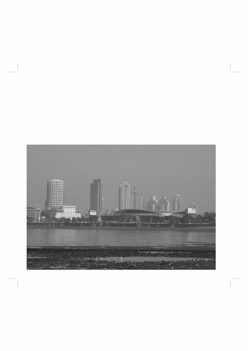
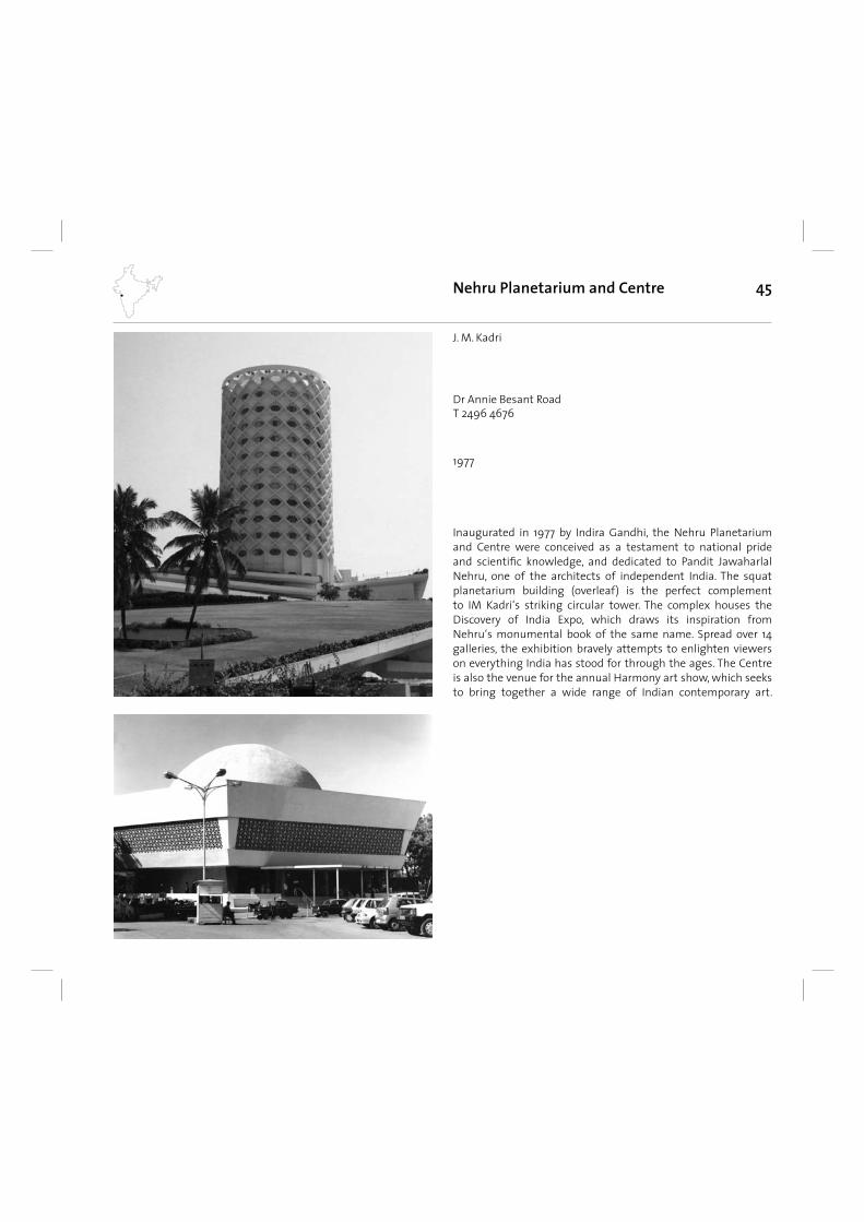
45Nehru Planetarium and Centre
1977
Dr Annie Besant RoadT 2496 4676
Inaugurated in 1977 by Indira Gandhi, the Nehru Planetarium and Centre were conceived as a testament to national pride and scientifi c knowledge, and dedicated to Pandit Jawaharlal Nehru, one of the architects of independent India. The squat planetarium building (overleaf) is the perfect complement to IM Kadri‘s striking circular tower. The complex houses the Discovery of India Expo, which draws its inspiration from Nehru‘s monumental book of the same name. Spread over 14 galleries, the exhibition bravely attempts to enlighten viewers on everything India has stood for through the ages. The Centre is also the venue for the annual Harmony art show, which seeks to bring together a wide range of Indian contemporary art.
J. M. Kadri
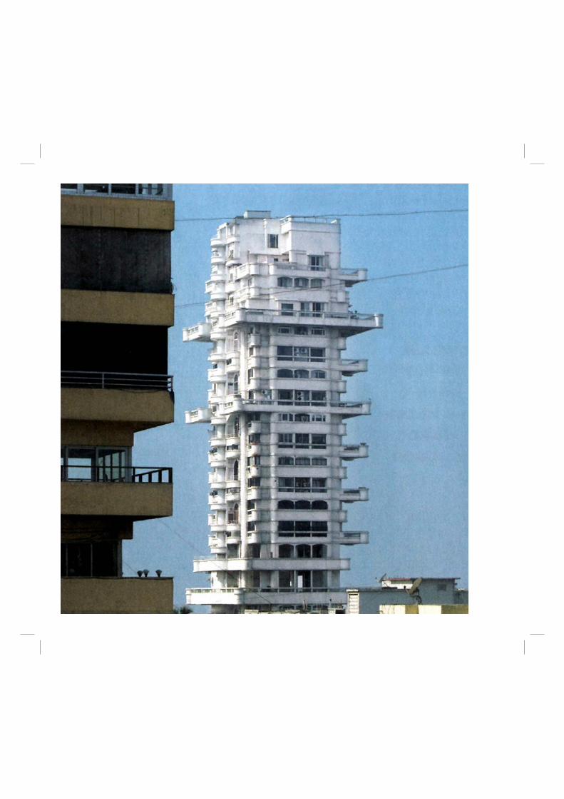
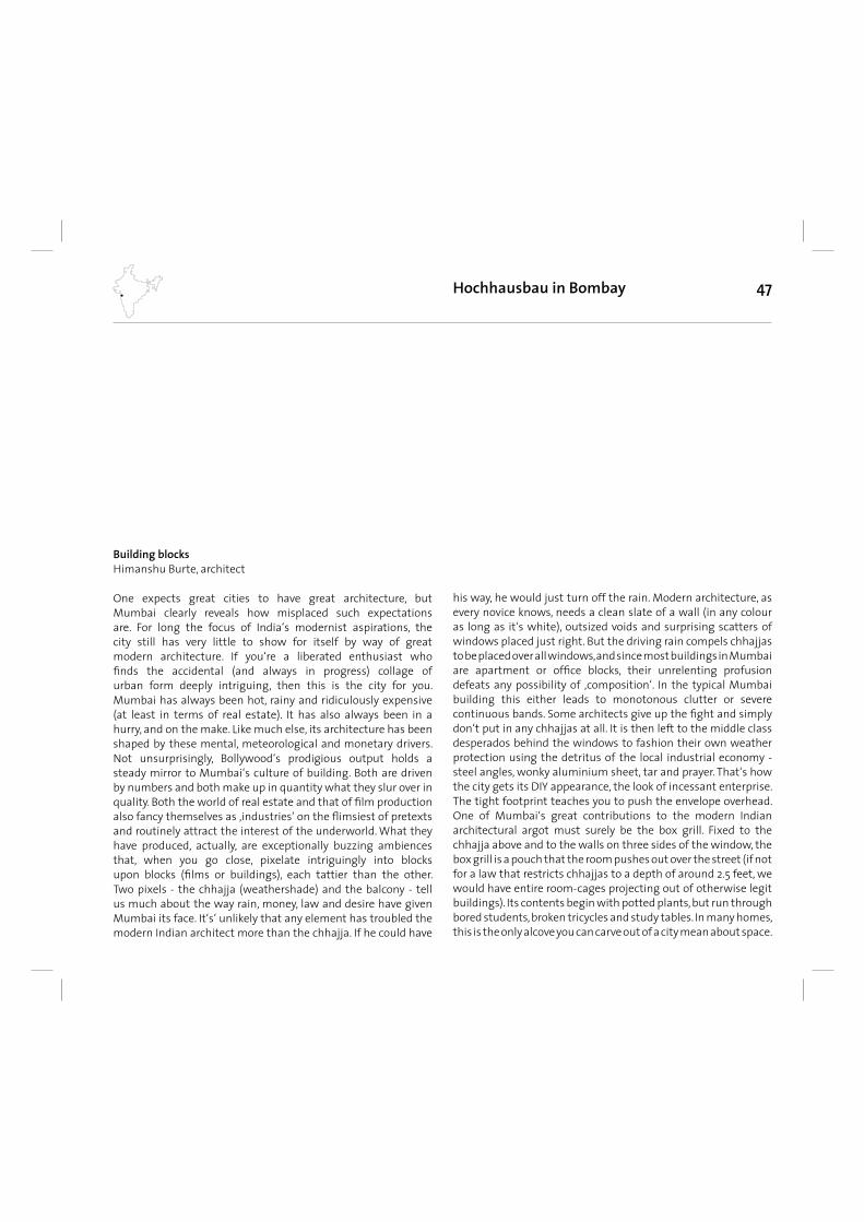
47
Building blocksHimanshu Burte, architect
One expects great cities to have great architecture, but Mumbai clearly reveals how misplaced such expectations are. For long the focus of India‘s modernist aspirations, the city still has very little to show for itself by way of great modern architecture. If you‘re a liberated enthusiast who fi nds the accidental (and always in progress) collage of urban form deeply intriguing, then this is the city for you.Mumbai has always been hot, rainy and ridiculously expensive (at least in terms of real estate). It has also always been in a hurry, and on the make. Like much else, its architecture has been shaped by these mental, meteorological and monetary drivers.Not unsurprisingly, Bollywood‘s prodigious output holds a steady mirror to Mumbai‘s culture of building. Both are driven by numbers and both make up in quantity what they slur over in quality. Both the world of real estate and that of fi lm production also fancy themselves as ‚industries‘ on the fl imsiest of pretexts and routinely attract the interest of the underworld. What they have produced, actually, are exceptionally buzzing ambiences that, when you go close, pixelate intriguingly into blocks upon blocks (fi lms or buildings), each tattier than the other.Two pixels - the chhajja (weathershade) and the balcony - tell us much about the way rain, money, law and desire have given Mumbai its face. It‘s‘ unlikely that any element has troubled the modern Indian architect more than the chhajja. If he could have
Hochhausbau in Bombay
his way, he would just turn off the rain. Modern architecture, as every novice knows, needs a clean slate of a wall (in any colour as long as it‘s white), outsized voids and surprising scatters of windows placed just right. But the driving rain compels chhajjas to be placed over all windows, and since most buildings in Mumbai are apartment or offi ce blocks, their unrelenting profusion defeats any possibility of ‚composition‘. In the typical Mumbai building this either leads to monotonous clutter or severe continuous bands. Some architects give up the fi ght and simply don‘t put in any chhajjas at all. It is then left to the middle class desperados behind the windows to fashion their own weather protection using the detritus of the local industrial economy - steel angles, wonky aluminium sheet, tar and prayer. That‘s how the city gets its DIY appearance, the look of incessant enterprise.The tight footprint teaches you to push the envelope overhead. One of Mumbai‘s great contributions to the modern Indian architectural argot must surely be the box grill. Fixed to the chhajja above and to the walls on three sides of the window, the box grill is a pouch that the room pushes out over the street (if not for a law that restricts chhajjas to a depth of around 2.5 feet, we would have entire room-cages projecting out of otherwise legit buildings). Its contents begin with potted plants, but run through bored students, broken tricycles and study tables. In many homes, this is the only alcove you can carve out of a city mean about space.
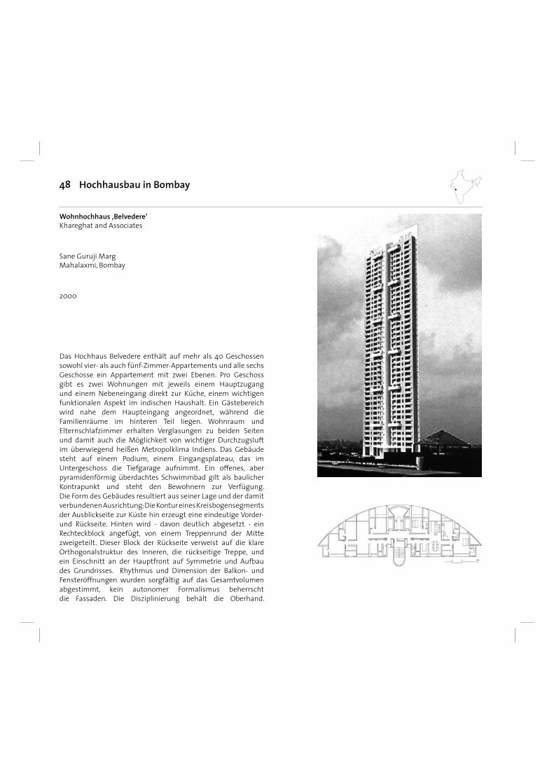
48
Das Hochhaus Belvedere enthält auf mehr als 40 Geschossen sowohl vier- als auch fünf-Zimmer-Appartements und alle sechs Geschosse ein Appartement mit zwei Ebenen. Pro Geschoss gibt es zwei Wohnungen mit jeweils einem Hauptzugang und einem Nebeneingang direkt zur Küche, einem wichtigen funktionalen Aspekt im indischen Haushalt. Ein Gästebereich wird nahe dem Haupteingang angeordnet, während die Familienräume im hinteren Teil liegen. Wohnraum und Elternschlafzimmer erhalten Verglasungen zu beiden Seiten und damit auch die Möglichkeit von wichtiger Durchzugsluft im überwiegend heißen Metropolklima Indiens. Das Gebäude steht auf einem Podium, einem Eingangsplateau, das im Untergeschoss die Tiefgarage aufnimmt. Ein offenes, aber pyramidenförmig überdachtes Schwimmbad gilt als baulicher Kontrapunkt und steht den Bewohnern zur Verfügung. Die Form des Gebäudes resultiert aus seiner Lage und der damit verbundenen Ausrichtung: Die Kontur eines Kreisbogensegments der Ausblickseite zur Küste hin erzeugt eine eindeutige Vorder- und Rückseite. Hinten wird - davon deutlich abgesetzt - ein Rechteckblock angefügt, von einem Treppenrund der Mitte zweigeteilt. Dieser Block der Rückseite verweist auf die klare Orthogonalstruktur des Inneren, die rückseitige Treppe, und ein Einschnitt an der Hauptfront auf Symmetrie und Aufbau des Grundrisses. Rhythmus und Dimension der Balkon- und Fensteröffnungen wurden sorgfältig auf das Gesamtvolumen abgestimmt, kein autonomer Formalismus beherrscht die Fassaden. Die Disziplinierung behält die Oberhand.
Hochhausbau in Bombay
2000
Wohnhochhaus ‚Belvedere‘Khareghat and Associates
Sane Guruji MargMahalaxmi, Bombay
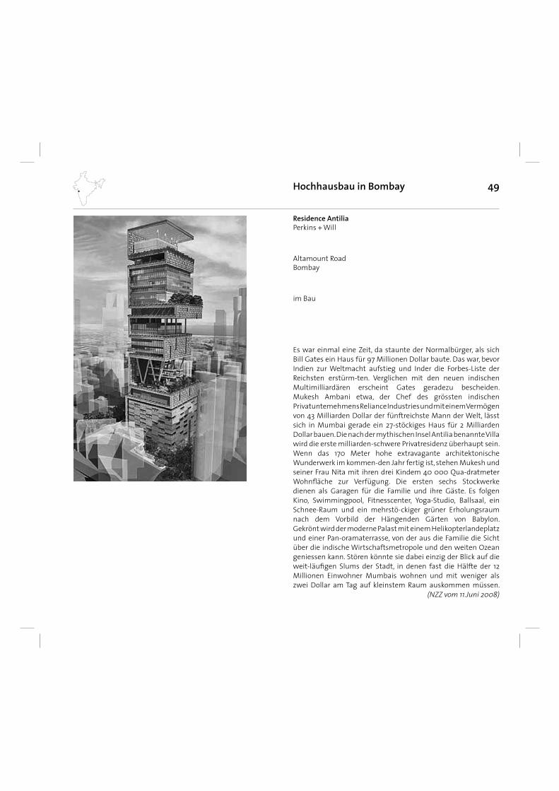
49Hochhausbau in Bombay
Es war einmal eine Zeit, da staunte der Normalbürger, als sich Bill Gates ein Haus für 97 Millionen Dollar baute. Das war, bevor Indien zur Weltmacht aufstieg und Inder die Forbes-Liste der Reichsten erstürm-ten. Verglichen mit den neuen indischen Multimilliardären erscheint Gates geradezu bescheiden. Mukesh Ambani etwa, der Chef des grössten indischen Privatuntemehmens Reliance Industries und mit einem Vermögen von 43 Milliarden Dollar der fünftreichste Mann der Welt, lässt sich in Mumbai gerade ein 27-stöckiges Haus für 2 Milliarden Dollar bauen. Die nach der mythischen Insel Antilia benannte Villa wird die erste milliarden-schwere Privatresidenz überhaupt sein. Wenn das 170 Meter hohe extravagante architektonische Wunderwerk im kommen-den Jahr fertig ist, stehen Mukesh und seiner Frau Nita mit ihren drei Kindem 40 000 Qua-dratmeter Wohnfl äche zur Verfügung. Die ersten sechs Stockwerke dienen als Garagen für die Familie und ihre Gäste. Es folgen Kino, Swimmingpool, Fitnesscenter, Yoga-Studio, Ballsaal, ein Schnee-Raum und ein mehrstö-ckiger grüner Erholungsraum nach dem Vorbild der Hängenden Gärten von Babylon. Gekrönt wird der moderne Palast mit einem Helikopterlandeplatz und einer Pan-oramaterrasse, von der aus die Familie die Sicht über die indische Wirtschaftsmetropole und den weiten Ozean geniessen kann. Stören könnte sie dabei einzig der Blick auf die weit-läufi gen Slums der Stadt, in denen fast die Hälfte der 12 Millionen Einwohner Mumbais wohnen und mit weniger als zwei Dollar am Tag auf kleinstem Raum auskommen müssen.
(NZZ vom 11.Juni 2008)
im Bau
Residence AntiliaPerkins + Will
Altamount RoadBombay
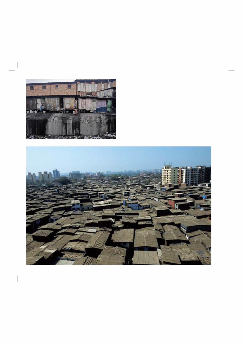
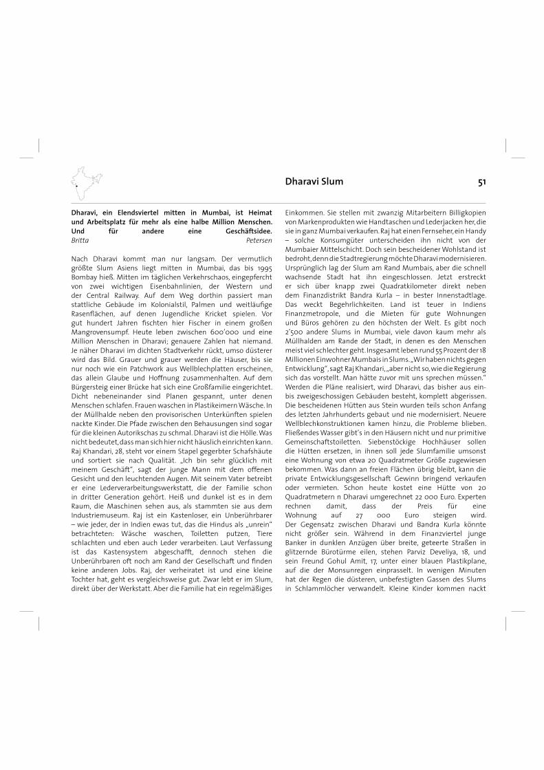
51Dharavi Slum
Dharavi, ein Elendsviertel mitten in Mumbai, ist Heimatund Arbeitsplatz für mehr als eine halbe Million Menschen.Und für andere eine Geschäftsidee.Britta Petersen
Nach Dharavi kommt man nur langsam. Der vermutlich größte Slum Asiens liegt mitten in Mumbai, das bis 1995 Bombay hieß. Mitten im täglichen Verkehrschaos, eingepfercht von zwei wichtigen Eisenbahnlinien, der Western und der Central Railway. Auf dem Weg dorthin passiert man stattliche Gebäude im Kolonialstil, Palmen und weitläufi ge Rasenfl ächen, auf denen Jugendliche Kricket spielen. Vor gut hundert Jahren fi schten hier Fischer in einem großen Mangrovensumpf. Heute leben zwischen 600’000 und eine Million Menschen in Dharavi; genauere Zahlen hat niemand.Je näher Dharavi im dichten Stadtverkehr rückt, umso düsterer wird das Bild. Grauer und grauer werden die Häuser, bis sie nur noch wie ein Patchwork aus Wellblechplatten erscheinen, das allein Glaube und Hoffnung zusammenhalten. Auf dem Bürgersteig einer Brücke hat sich eine Großfamilie eingerichtet. Dicht nebeneinander sind Planen gespannt, unter denen Menschen schlafen. Frauen waschen in Plastikeimern Wäsche. In der Müllhalde neben den provisorischen Unterkünften spielen nackte Kinder. Die Pfade zwischen den Behausungen sind sogar für die kleinen Autorikschas zu schmal. Dharavi ist die Hölle. Was nicht bedeutet, dass man sich hier nicht häuslich einrichten kann.Raj Khandari, 28, steht vor einem Stapel gegerbter Schafshäute und sortiert sie nach Qualität. „Ich bin sehr glücklich mit meinem Geschäft“, sagt der junge Mann mit dem offenen Gesicht und den leuchtenden Augen. Mit seinem Vater betreibt er eine Lederverarbeitungswerkstatt, die der Familie schon in dritter Generation gehört. Heiß und dunkel ist es in dem Raum, die Maschinen sehen aus, als stammten sie aus dem Industriemuseum. Raj ist ein Kastenloser, ein Unberührbarer – wie jeder, der in Indien ewas tut, das die Hindus als „unrein“ betrachteten: Wäsche waschen, Toiletten putzen, Tiere schlachten und eben auch Leder verarbeiten. Laut Verfassung ist das Kastensystem abgeschafft, dennoch stehen die Unberührbaren oft noch am Rand der Gesellschaft und fi nden keine anderen Jobs. Raj, der verheiratet ist und eine kleine Tochter hat, geht es vergleichsweise gut. Zwar lebt er im Slum, direkt über der Werkstatt. Aber die Familie hat ein regelmäßiges
Einkommen. Sie stellen mit zwanzig Mitarbeitern Billigkopien von Markenprodukten wie Handtaschen und Lederjacken her, die sie in ganz Mumbai verkaufen. Raj hat einen Fernseher, ein Handy– solche Konsumgüter unterscheiden ihn nicht von der Mumbaier Mittelschicht. Doch sein bescheidener Wohlstand ist bedroht, denn die Stadtregierung möchte Dharavi modernisieren.Ursprünglich lag der Slum am Rand Mumbais, aber die schnell wachsende Stadt hat ihn eingeschlossen. Jetzt erstreckt er sich über knapp zwei Quadratkilometer direkt neben dem Finanzdistrikt Bandra Kurla – in bester Innenstadtlage. Das weckt Begehrlichkeiten. Land ist teuer in Indiens Finanzmetropole, und die Mieten für gute Wohnungen und Büros gehören zu den höchsten der Welt. Es gibt noch 2’500 andere Slums in Mumbai, viele davon kaum mehr als Müllhalden am Rande der Stadt, in denen es den Menschenmeist viel schlechter geht. Insgesamt leben rund 55 Prozent der 18 Millionen Einwohner Mumbais in Slums. „Wir haben nichts gegen Entwicklung“, sagt Raj Khandari, „aber nicht so, wie die Regierung sich das vorstellt. Man hätte zuvor mit uns sprechen müssen.“Werden die Pläne realisiert, wird Dharavi, das bisher aus ein- bis zweigeschossigen Gebäuden besteht, komplett abgerissen. Die bescheidenen Hütten aus Stein wurden teils schon Anfang des letzten Jahrhunderts gebaut und nie modernisiert. Neuere Wellblechkonstruktionen kamen hinzu, die Probleme blieben. Fließendes Wasser gibt’s in den Häusern nicht und nur primitive Gemeinschaftstoiletten. Siebenstöckige Hochhäuser sollen die Hütten ersetzen, in ihnen soll jede Slumfamilie umsonst eine Wohnung von etwa 20 Quadratmeter Größe zugewiesen bekommen. Was dann an freien Flächen übrig bleibt, kann die private Entwicklungsgesellschaft Gewinn bringend verkaufen oder vermieten. Schon heute kostet eine Hütte von 20 Quadratmetern n Dharavi umgerechnet 22 000 Euro. Expertenrechnen damit, dass der Preis für eine Wohnung auf 27 000 Euro steigen wird. Der Gegensatz zwischen Dharavi und Bandra Kurla könnte nicht größer sein. Während in dem Finanzviertel junge Banker in dunklen Anzügen über breite, geteerte Straßen in glitzernde Bürotürme eilen, stehen Parviz Develiya, 18, und sein Freund Gohul Amit, 17, unter einer blauen Plastikplane, auf die der Monsunregen einprasselt. In wenigen Minuten hat der Regen die düsteren, unbefestigten Gassen des Slums in Schlammlöcher verwandelt. Kleine Kinder kommen nackt
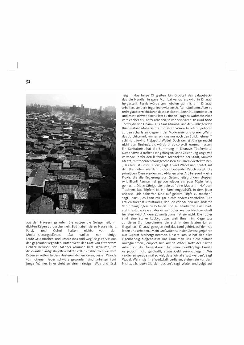
52
aus den Häusern gelaufen. Sie nutzen die Gelegenheit, im dichten Regen zu duschen, ein Bad haben sie zu Hause nicht.Parviz und Gohul halten nichts von den Modernisierungsplänen. „Da wollen nur einigeLeute Geld machen, und unsere Jobs sind weg“, sagt Parviz. Aus der gegenüberliegenden Hütte weht der Duft von frittiertem Gebäck herüber. Zwei Männer kommen herausgelaufen, um die draußen aufgestapelten Pakete voller Knabbereien vor dem Regen zu retten. In dem düsteren kleinen Raum, dessen Wändevom offenen Feuer schwarz geworden sind, arbeiten fünf junge Männer. Einer steht an einem riesigen Wok und lässt
Teig in das heiße Öl gleiten. Ein Großteil des Salzgebäcks, das die Händler in ganz Mumbai verkaufen, wird in Dharavi hergestellt. Parviz würde am liebsten gar nicht in Dharaviarbeiten, sondern Ingenieurswissenschaften studieren. Aber so recht glaubt er nicht daran, dass das klappt. „So ein Studium ist teuer und es ist schwer, einen Platz zu fi nden“, sagt er. Wahrscheinlich wird er eher als Töpfer arbeiten, so wie sein Vater. Die rund 2000 Töpfer, die von Dharavi aus ganz Mumbai und den umliegenden Bundesstaat Maharashtra mit ihren Waren beliefern, gehören zu den schärfsten Gegnern der Modernisierungspläne. „Wenn das durchkommt, können wir uns nur noch den Strick nehmen“, schimpft Arvind Prajapatti Wadel. Doch der 38-Jährige macht nicht den Eindruck, als würde er es so weit kommen lassen.Ein Karikaturist hat die Stimmung in Dharavis Töpferviertel Kumbharwala treffend eingefangen: Seine Zeichnung zeigt, wie wütende Töpfer den leitenden Architekten der Stadt, Mukesh Mehta, mit tönernen Wurfgeschossen aus ihrem Viertel treiben. „Das hier ist unser Leben“, sagt Arvind Wadel und deutet auf den Brennofen, aus dem dichter, beißender Rauch steigt. Die primitiven Öfen werden mit Abfällen aller Art befeuert – eine Praxis, die die Regierung aus Gesundheitsgründen stoppen will. Bharti Parmar hat gerade wieder ein paar Töpfe fertig gemacht. Die 21-Jährige stellt sie auf eine Mauer im Hof zum Trocknen. Das Töpfern ist ein Familiengeschäft, in dem jeder anpackt. „Ich habe von Kind auf gelernt, Töpfe zu machen“, sagt Bharti. „Ich kann mir gar nichts anderes vorstellen.“ Die Frauen sind dafür zuständig, den Ton von Steinen und anderen Verunreinigungen zu befreien und zu bearbeiten. Für Bharti steht fest, dass sie später einen Töpfer aus der Nachbarschaft heiraten wird. Andere Zukunftspläne hat sie nicht. Die Töpfer sind eine starke Lobbygruppe, weil ihnen im Gegensatz zu vielen Slumbewohnern, die erst in den letzten Jahrenillegal nach Dharavi gezogen sind, das Land gehört, auf dem sie leben und arbeiten. „Mein Großvater ist in den Zwanzigerjahren aus Gujarat hierhergekommen. Unsere Familie hat sich alles eigenhändig aufgebaut.m Das kann man uns nicht einfach mwegnehmen“, empört sich Arvind Wadel. Trotz der harten Arbeit von drei Generationen hat seine zwölfköpfi ge Familie es jedoch nicht geschafft, etwas Geld zurückzulegen. „Wir verdienen gerade mal so viel, dass wir alle satt werden“, sagt Wadel. Wenn sie ihre Werkstatt verlieren, stehen sie vor dem Nichts. „Schauen Sie sich das an“, sagt Wadel und zeigt auf
53
den stinkenden offenen Abwasserkanal direkt vor dem Haus. „Die Regierung schafft es nicht einmal, so etwas zu beheben. Unsere Kinder haben ständig Durchfall und andere Krankheiten. Jetzt behaupten sie, es werde uns allen besser gehen, wenn die Häuser abgerissen werden. Ich glaube kein Wort.“Der Mann, der so viele verärgert, sitzt in einem Büro mit Blick aufs Meer in Mumbais Nobelviertel Bandra. Mukesh Mehta, Architekt und offi zieller Regierungsberater, ist genervt, wenn er auf den Widerstand gegen seine Pläne angesprochen wird. „Es gibt einige Nicht-Regierungsorganisationen, die viel Geld im Ausland damit machen, dass sie die Armut vermarkten und diese Leute aufhetzen“, schimpft er. „Doch 80 Prozent der Bewohner von Dharavi befürworten meinen Plan.“ In einer Animation zeigt er, wie Dharavi nach der Sanierung aussehen soll: breite Straßen, Hochhäuser, Schulen, Krankenhäuser, Parkanlagen.In der Tat unterstützen viele Bewohner Dharavis die Modernisierungspläne – vor allem die, deren Hütte kleiner als 20 Quadratmeter ist, sie erwarten sich eine Verbesserung ihrer Lebensverhältnisse. Vaishali Ashok, 32, etwa wohnt seit zwei Monaten in einem der bereits fertigen Hochhäuser. „Ich bin glücklich hier, die Wohnung ist wirklich besser als vorher“, sagt die Hausfrau. Sie hat nun ein gekacheltes Bad und eine gekachelte Küche. Im Wohnzimmer stehen ein Fernseher und sogar ein Computer. Allerdings ist Vaishali tagsüber allein. Erst abends, wenn alle Familienmitglieder von der Arbeit zurückkommen, stellt sich heraus, dass Dharavi auch nach der Sanierung kein „Weltklasse-Vorort“ sein wird – wie Mukesh Mehta es gern formuliert. Denn wenn zwölf Menschen auf 20 Quadratmetern schlafen müssen, ist die Wohnung voll. „Die Familie meines Schwagers schläft auf dem Boden in der Küche“, erklärt Vaishali. Dort stehen aber schon zehn volle Wassereimer, die die Familie braucht, um sich morgens zu waschen. Fließendes Wasser oder gar eine Dusche gibt es auch in der neuen Wohnung nicht. „Wir unterstützen den Entwicklungsplan, weil er besser ist als alles, was die Regierung vorher vorgelegt hatte“, meint Prashad Anthony von der christlichen NGO „Proud“, die seit 1979 in dem Slum arbeitet. Allerdings fordert auch er, dass Gewerbetreibende wie die Töpfer und Lederverarbeiter separat behandelt werden. „Die wirtschaftlichen Aktivitäten dürfen auf keinen Fall gestoppt werden“, sagt Anthony. Laut Mukesh Mehta ist das auch gar nicht vorgesehen. Er zeigt seine Pläne, in denen Industriegebiete ausgewiesen sind, in die die Gewerbetreibenden umziehen
sollen. Sogar eine Fortbildungsakademie für die Handwerker ist eingeplant. Nach Mehtas Schätzungen wird Dharavis lokale Wirtschaft nach der Modernisierung 2,14 Milliarden Euro im Jahr umsetzen gegenüber bisher 300 bis 400 Millionen. Dennoch sitzt das Misstrauen der Slumbewohner gegen die Regierung tief. „Ich habe mit Mukesh Mehta gesprochen“, sagt Raj Khandari. „Er hat vorgeschlagen, dass wir unser Land verkaufen und wegziehen. Aber das ist doch absurd, wo sollen wir denn sonst unsere Lederwerkstatt aufbauen? Wir können uns doch ein anderes Grundstück in Mumbai gar nicht leisten.“ Auch sein Vater sagt: „Warum können wir unser Land nicht selbst modernisieren?“Die Antwort ist offensichtlich. Es geht um zu viel Geld in Dharavi. Mehr als hundert private Entwicklungsgesellschaften haben sich laut Mukesh Mehta auf die Ausschreibung zur Sanierung des Slums beworben. „Wir brauchen enorme Summen, das können wir nicht aus der Stadtkasse bezahlen“, sagt Iqbal Chahal, Geschäftsführer der Slum Rehabilitation Authority. Insgesamt zwei Milliarden Euro soll das Projekt kosten. Er sieht in dem Entwicklungsplan eine „Win-win- Situation für alle“. Die Entwickler verdienen Geld, die Stadt muss nicht zahlen, die Slumbewohner erhalten bessere Wohnungen. Sozialaktivisten wie Simpreet Singh von der National Alliance of People’s Movements halten dennoch das Misstrauen der Slumbewohner für berechtigt. „Die indische Regierung hat in den vergangenen Jahren permanent die Armen enteignet, um die Reichen profi tieren zu lassen“, sagt er. Er weist darauf hin, dass nach offi ziellen Regierungsangaben 57’000 Familien in die Sanierungsmaßnahmen einbezogen werden sollen. Dabei geht man davon aus, dass eine durchschnittliche Familie fünf Mitglieder hat. Bei 600 000 Einwohnern würde damit gerade mal die Hälfte der Bewohner von Dharavi eine neue Wohnung erhalten. „Der Rest wird obdachlos“, sagt Singh. Oder wohnt mit zehn und mehr Personen in den kleinen Wohnungen wie Vaishali Ashok und ihre Familie. Welche Auswirkungen dies auf die geplante moderne Infrastruktur wie Strom- und Wasserversorgung sowie Plätze in Schule und Krankenhäusern hat, vermag derzeit niemand zu sagen.Und klar ist auch: Eine Lederwerkstatt mit zwanzig Mitarbeitern und Maschinen wie die Raj Khandaris und seines Vaters kann man in einem der neuen Hochhäuser auf keinen Fall betreiben. „Ich weiß einfach nicht, wie es weitergehen soll“, sagt Khandari. „Wenn ich an die Zukunft denke, blicke ich in ein schwarzes Loch.“
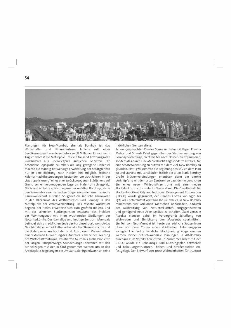
54
Planungen für Neu-Mumbai, ehemals Bombay, ist das Wirtschafts- und Finanzzentrum Indiens mit einer Bevölkerungszahl von derzeit etwa zwölf Millionen Einwohnern. Täglich wächst die Metropole um viele tausend hoffnungsvolle Zuwanderer aus überwiegend ländlichen Gebieten. Die besondere Topografi e Mumbais als lang gezogene Halbinsel machte die ständig notwendige Erweiterung der Stadtgrenzen nur in eine Richtung, nach Norden hin, möglich. Britische Kolonialmachtbestrebungen bestanden vor 200 Jahren in der „Metropolisierung“ eines eher zurückgezogenen Städtchens auf Grund seiner hervorragenden Lage als Hafen-Umschlagplatz. Doch erst 50 Jahre später begann der Aufstieg Bombays, als in den Wirren des amerikanischen Bürgerkriegs der amerikanische Baumwollexport ausblieb. So geriet die indische Baumwolle in den Blickpunkt des Weltinteresses und Bombay in den Mittelpunkt der Warenverschiffung. Das rasante Wachstum begann, der Hafen erweiterte sich zum größten Indiens, und mit der schnellen Stadtexpansion entstand das Problem der Wohnungsnot mit ihren wuchernden Siedlungen der Notunterkünfte. Das damalige und heutige Zentrum Mumbais befi ndet sich am südlichen Ende der Halbinsel, dort, wo sich das Geschäftsleben entwickelte und wo die Bevölkerungsdichte und die Bodenpreise am höchsten sind. Aus diesem Missverhältnis einer extremen Ausweitung des Stadtareals, aber einer Fixierung des Wirtschaftzentrums, resultierten Mumbais große Probleme der langen Transportwege. Stundenlange Fahrzeiten mit den Schnellzügen mussten in Kauf genommen werden, um an den Arbeitsplatz zu gelangen, ein Umstand, der irgendwann an seine
natürlichen Grenzen stiess.Schon 1964 machten Charles Correa mit seinen Kollegen Pravina Mehta und Shiresh Patel gegenüber der Stadtverwaltung von Bombay Vorschläge, nicht weiter nach Norden zu expandieren, sondern das durch eine Meeresbucht abgesonderte Ostareal für eine Stadterweiterung zu nutzen mit dem Ziel, New Bombay zu gründen. Erst 1970 stimmte die Regierung schließlich dem Plan zu und startete mit Landkäufen östlich der alten Stadt Bombay. Große Brückenverbindungen erlaubten dann die direkte Verknüpfung mit dem alten Zentrum, so dass dem eigentlichen Ziel eines neuen Wirtschaftszentrums mit einer neuen Stadtstruktur nichts mehr im Wege stand. Die Gesellschaft für Stadtentwicklung City and Industrial Development Corporation (CIDCO) wurde gegründet, der CharIes Correa von 1970 bis 1974 als Chefarchitekt vorstand. Ihr Ziel war es, in New Bombay mindestens vier Millionen Menschen anzusiedeln, dadurch der Ausbreitung von Notunterkünften entgegenzutreten und genügend neue Arbeitsplätze zu schaffen. Zwei zentrale Aspekte standen dabei im Vordergrund: Schaffung von Wohnraum und Einrichtung von Massentransportmitteln. Ein Teil von Neu-Mumbai ist heute das südliche Subzentrum Ulwe, von dem Correa einen städtischen Bebauungsplan vorlegte. Hier sollte wirkliche Stadtplanung vorgenommen werden, wobei britisch-koloniale Planungen in Alt-Bombay durchaus zum Vorbild gereichten: In Zusammenarbeit mit der CIDCO wurde ein Bebauungs- und Nutzungsplan entwickelt und Bebauungsstrukturen, -höhen und Straßenbreiten etc. festgelegt. Der Entwurf von 1000 Wohneinheiten für 350.000
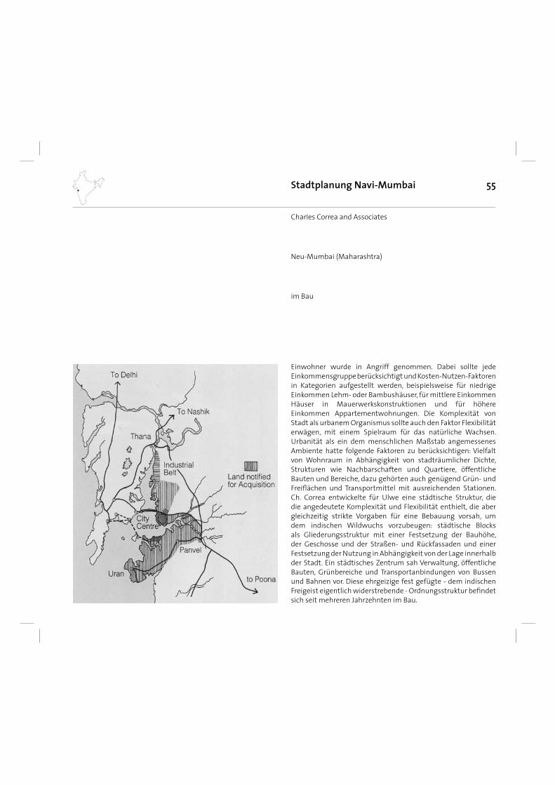
55Stadtplanung Navi-Mumbai
im Bau
CharIes Correa and Associates
Neu-Mumbai (Maharashtra)
Einwohner wurde in Angriff genommen. Dabei sollte jede Einkommensgruppe berücksichtigt und Kosten-Nutzen-Faktoren in Kategorien aufgestellt werden, beispielsweise für niedrige Einkommen Lehm- oder Bambushäuser, für mittlere Einkommen Häuser in Mauerwerkskonstruktionen und für höhere Einkommen Appartementwohnungen. Die Komplexität von Stadt als urbanem Organismus sollte auch den Faktor Flexibilität erwägen, mit einem Spielraum für das natürliche Wachsen. Urbanität als ein dem menschlichen Maßstab angemessenes Ambiente hatte folgende Faktoren zu berücksichtigen: Vielfalt von Wohnraum in Abhängigkeit von stadträumlicher Dichte, Strukturen wie Nachbarschaften und Quartiere, öffentliche Bauten und Bereiche, dazu gehörten auch genügend Grün- und Freifl ächen und Transportmittel mit ausreichenden Stationen. Ch. Correa entwickelte für Ulwe eine städtische Struktur, die die angedeutete Komplexität und Flexibilität enthielt, die aber gleichzeitig strikte Vorgaben für eine Bebauung vorsah, um dem indischen Wildwuchs vorzubeugen: städtische Blocks als Gliederungsstruktur mit einer Festsetzung der Bauhöhe, der Geschosse und der Straßen- und Rückfassaden und einer Festsetzung der Nutzung in Abhängigkeit von der Lage innerhalb der Stadt. Ein städtisches Zentrum sah Verwaltung, öffentliche Bauten, Grünbereiche und Transportanbindungen von Bussen und Bahnen vor. Diese ehrgeizige fest gefügte - dem indischen Freigeist eigentlich widerstrebende - Ordnungsstruktur befi ndet sich seit mehreren Jahrzehnten im Bau.
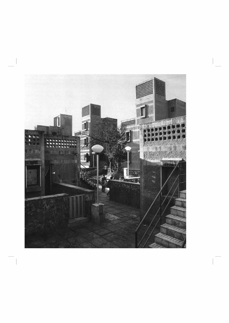
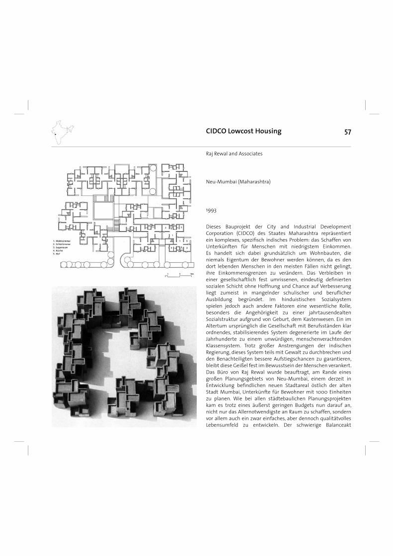
57
Dieses Bauprojekt der City and Industrial Development Corporation (CIDCO) des Staates Maharashtra repräsentiert ein komplexes, spezifi sch indisches Problem: das Schaffen von Unterkünften für Menschen mit niedrigstem Einkommen. Es handelt sich dabei grundsätzlich um Wohnbauten, die niemals Eigentum der Bewohner werden können, da es den dort lebenden Menschen in den meisten Fällen nicht gelingt, ihre Einkommensgrenzen zu verändern. Das Verbleiben in einer gesellschaftlich fest umrissenen, eindeutig defi nierten sozialen Schicht ohne Hoffnung und Chance auf Verbesserung liegt zumeist in mangelnder schulischer und berufl icher Ausbildung begründet. Im hinduistischen Sozialsystem spielen jedoch auch andere Faktoren eine wesentliche Rolle, besonders die Angehörigkeit zu einer jahrtausendealten Sozialstruktur aufgrund von Geburt, dem Kastenwesen. Ein im Altertum ursprünglich die Gesellschaft mit Berufsständen klar ordnendes, stabilisierendes System degenerierte im Laufe der Jahrhunderte zu einem unwürdigen, menschenverachtenden Klassensystem. Trotz großer Anstrengungen der indischen Regierung, dieses System teils mit Gewalt zu durchbrechen und den Benachteiligten bessere Aufstiegschancen zu garantieren, bleibt diese Geißel fest im Bewusstsein der Menschen verankert. Das Büro von Raj Rewal wurde beauftragt, am Rande eines großen Planungsgebiets von Neu-Mumbai, einem derzeit in Entwicklung befi ndlichen neuen Stadtareal östlich der alten Stadt Mumbai, Unterkünfte für Bewohner mit 1000 Einheiten zu planen. Wie bei allen städtebaulichen Planungsprojekten kam es trotz eines äußerst geringen Budgets nun darauf an, nicht nur das Allernotwendigste an Raum zu schaffen, sondern vor allem auch ein zwar einfaches, aber dennoch qualitätvolles Lebensumfeld zu entwickeln. Der schwierige Balanceakt
CIDCO Lowcost Housing
1993
Raj Rewal and Associates
Neu-Mumbai (Maharashtra)
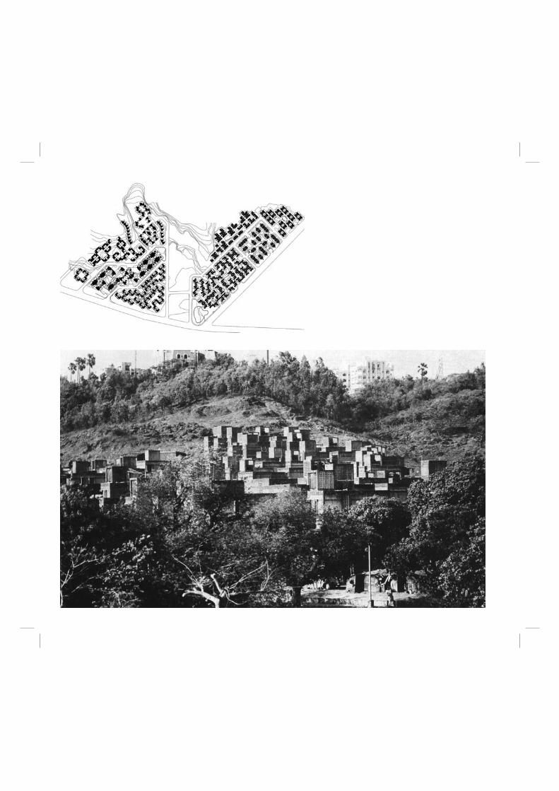
59
zwischen Ökonomie und Ambiente konnte nur gelingen, wenn sorgfältig kostengünstige, aber nachhaltig wirksame Baumaterialien verwendet wurden, sich der Planungsvorgang nicht zu aufwändig gestaltete und ein einfach zu realisierendes Prinzip die Umsetzung erleichterte. Das Büro Rewal entwarf diese Bauaufgabe als hoch verdichtete Struktur. Zum einen entstand sie aus Gründen eines eng begrenzten Planungsbereichs, zum anderen aber, um eine städtebaulich wirksame Außenraumqualität zu erreichen, die an eine gewachsene dörfl iche Bebauung erinnerte. Diese Wohnzellen als Module oder „Moleküle“ (Rewal) bestehen aus ein bis drei Raum-Einheiten in einer Größe von 18, 25, 40 und 70 qm. Sie verfügen über notwendigste Sanitäreinrichtungen und besitzen Wassertanks auf den Dächern für eine stete Wasserversorgung, immer noch keine Selbstverständlichkeit im eher ländlichen Indien. Die wichtige Frage stand im Raum, welche preiswerten und dauerhaften Materialien innerhalb eines sehr eingeschränkten fi nanziellen Rahmens nachhaltig wirksam sein könnten. Es wurde die Materialkombination aus Hohlbetonsteinen, Rauputz, handgeformten Terrakottafl iesen und örtlich vorhandenen groben Granitsteinen für die Sockel gewählt. Sie kann dem harten Monsunklima standhalten und erzeugt eine akzeptable Patina. Auch die Elektrifi zierung der Gesamtanlage wurde gewährleistet, nicht nur in den Wohnungen selbst, sondern ebenfalls im öffentlichen Raum. Um eine sichere, aber auch preiswerte Fußwegeverbindung im Inneren der Bebauung zu ermöglichen, wurden Straßen an die Peripherie verbannt. Von dort ist allseitig die Erschließung gegeben, leicht kann ein Durchfi ltern durch das System der Baugruppen erfolgen. Mit dem Konzept eines stark verdichteten Wohnquartiers kommt Rewal der Tatsache der enorm hohen sozialen Interaktion im indischen Alltag entgegen. Die Menschen leben nicht nur in den Häusern, sondern pfl egen intensive Kontakte zu Nachbarn, Freunden und Mitbewohnern beinahe rund um die Uhr. Die Öffnung der Häuser in den Außenraum ist daher wichtiger Bestandteil der Überlegungen zur städtischen Verdichtung. Dichte ist zumeist kein aus der Not geborener Umstand, sondern ein wichtiges Lebenskonzept. Und daher heißt stadträumliches Bauen, Innen- und Außenraumqualität müssen Hand in Hand gehen, da sich Wohnen zum großen Teil auf der Straße abspielt. Bei der Planung der Verkettung der“ Moleküle“ wurde deswegen größter Wert auf Verbindungen gelegt, die
gemeinsam zu nutzende Flächen beinhalten. Ein „Dorf“ besteht in Indien aus einer Ansammlung von Plätzen, Höfen, Loggien, Terrassen und Balkonen, über die kommuniziert wird und der lebensnotwendige Austausch erfolgt. Rewal berücksichtigt diese Faktoren in großem Umfang und integriert diese Zonen in seine Architektur. Er entwickelt eine Art Baukastensystem mit kubischen Grundelementen, die als Gestaltprinzip ein Spektrum größtmöglicher Variation zulassen und damit beinahe universell einsetzbar werden: Einzelblöcke werden über Höfe verkettet, Module mit engen Zwischenräumen dicht aneinander gestellt, Gruppenblöcke mit Höfen als Quartiere ausgebildet. Hier wird ein Thema konsequent eingehalten und virtuos umgesetzt, wobei nicht allein Effi zienz im Vor-dergrund steht, sondern die Schaffung von räumlichem Reichtum eines Lebensumfeldes. Es entsteht eine nicht nur baukörperlich, sondern auch materialmäßig vollkommen homogene Struktur, ein Entwurf aus einem Guss, und dennoch eine höchst differenzierte Wohnanlage mit komplexer räumlicher Vielfalt. Dazu trägt sowohl die unterschiedliche Geschossigkeit der Häuser bei, denn die Staffelung reicht von einer bis zu vier Ebenen, als auch die Neigung des Geländes. Eine Hanglage dynamisiert die räumliche und baukörperliche Ausdehnung und steigert das Bild eines lebendigen Organismus, der jederzeit erweiterbar scheint. In der Homogenität drückt sich die Gesamtheit der Planung aus, denn damit wird klar, dass es sich um einen ganzheitlichen Entwurf handelt. Kein künstliches Vervielfältigen der Einzelhäuser wird vorgenommen, kein Wachstum vorgetäuscht, und so gewinnt dieser architektonische Ansatz seine volle Glaubwürdigkeit. Rewal führt ein Konzept in großer Konsequenz vor, dessen Gesamterscheinung nichts Nostalgisches besitzt: Aus der Notwendigkeit zur Reduzierung wurde eine abstrakte und damit eindeutig moderne, ihrer Zeit verpfl ichtete Gestalt geboren.
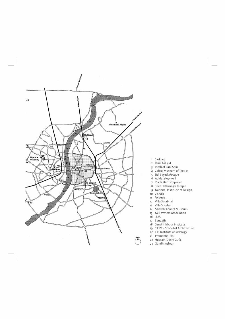
1 Sarkhej 2 Jami‘ Masjid 3 Tomb of Rani Spiri 4 Calico-Museum of Textile 5 Sidi Sayed Mosque 6 Adalaj step-well 7 Dada Harir step-well 8 Shet Hathisingh temple 9 National Institiute of Design10 Vishala11 Pol Area12 Villa Sarabhai13 Villa Shodan14 Sanskar Kendra Museum 15 Mill owners Association16 I.I.M.17 Sangath18 Gandhi labour Institute19 C.E.P.T. - School of Architecture20 L.D. Institute of Indology 21 Premabhai Hall22 Hussain-Doshi Gufa23 Gandhi Ashram

61AHMEDABAD
Ahmedabad has had the good fortune to remain the capital of Gujarat from the fi fteenth century to almost the present day with only occasional gaps, The growth of the city is examined here from the perspective of historical archaeology which considers the results of excavations from salvage archaeology in the light of epigraphy, literary references and toponyms.
Prehistory Archaeological explorations in the Ahmedabad region have revealed the presence of Late Stone Age tools at various sites, including Vatva to the southeast. Though the expanding city has destroyed a good part of the prehistoric landscape, including numerous archaeological sites, the study of bones and tools found at similar sites indicates that cattle breeding were practised in the Ahmedabad area by people of the Stone Age as they moved in search of good pastures. The shallow lakes at the base of the sand dunes at Thaltej on the west bank of the Sabarmati suggest that this was one suitable prehistoric pastoral campsite. Similarly situated campsites elsewhere indicate that these Stone Age cattle breeders preferred higher areas; shepherds tending goats and sheep still tend to avoid low and humid places for their animals. Elevated sites overlooking the landscape may have been additional vantage points for these fi rst occupants of the region. According to our chronological studies, these Stone Age settlements date back to before the second millennium B.C. The problems of the disappearance of this culture are not yet fully understood.
AshavalThe next stage in the habitation of the Ahmedabad region is indicated by fi nds on the eastern bank of the Sabarmati. Relics are scattered in several spots, including Sarangpur, Raipur, Raikhad, Bhadra and Saptarshi Ara. According to the available evidence, it appears that the earliest habitation was known as Ashaval. This town was about two days journey from Cambay (Khambhat) according to the eleventh-century Persian historian Al-Biruni. ln the eighteenth--century history of the city, the Mir‘at-i Ahmadi, the temple of Ramnath is supposed to have existed before the establishment of Ahmedabad. Our examination of the Ramnath shrine in Devnisheri in Mandvi-ni Pol near Manek Chowk indicates that this shrine was already in worship from about the tenth century. This temple is related to two other Natha temples,
Maneknath and Kamnath, which mark points north and south of the Ramnath shrine (in Manek Chowk area, and south of Raipur Darwaza, respectively). The present Kamnath temple dates only from the Maratha period; however, archaeological relics in the compound are much older. They include eleventh-twelfth century sculptures of a two-armed Surya fi gure and a fragmentary Navagraha panel. When these sculptures are correlated with similar relics at Dhalh-ni Pol in Raipur, Sarangpur and other sites, it is clear that the area delimited by Sarangpur on the east, Ramnath on the west, Kamnath on the south, and Maneknath on the north may defi ne the ancient extent of Ashaval. We assume that it is within this area that the main population of the city was concentrated. Our inference about the location and size of Ashaval is supported by a reference to Pinchumandarka Tirtha (now near the Panchanath Mahadeva temple southeast of Ellis Bridge) noted in the Padma Purana. In the area of present-day Bhadra, several stone images of Surya have been recovered from the northeastern bastion of Gaekwad‘s Haveli, and the Panchanath Mahadeva temple. These images testify to the historical validity of the references in the Padma Purana. They also suggest that Surya was worshipped at Ashaval from the eighth century onwards. Further sculptures ranging up to the thirteenth century have also been discovered in other parts of the city.AI-Biruni and several twelfth-century Jain writers refer to the activities of Ashaval, which was evidently a well-known and prosperous city during the fourteenth-century Tughluq period. It was at Ashaval that Tatar Khan proclaimed the independence of the Gujarat Sultanate in 1403.
Karnavati According to Merutungacharya, a fourteenth-century Jain writer, Karnadeva, the Solanki ruler of Anahilvada-Patan, conquered Ashaval and built another capital nearby which was named after him, Karnavati. While this particular reference seems to be a later insertion into Merutungacharya‘s text, it does preserve the local historical tradition about the growth of Ahmedabad. According to this tradition, Karnadeva established another settlement near Ashaval in the later part of the eleventh century. This reference does not indicate the precise location of the new town, but several possibilities may be postulated: Karnavati may have coincided with Ashaval; the two cities may have been adjacent;
62
or, Karnavati may have been located at another site which we identify with the area south of Calico Mills in Behrampur. (In the seventeenth century, during the Mughal period, a new suburb was laid out in the south of the city, also named Ashaval; there is, however, no connection between the two Ashavals other than the coincidence of their names, possibly intended to continue the tradition). An interesting stone inscription mentioning Karnavati and Stambhatirtha was obtained from Saptarshi Ara, an elevated site on the south side of the city overlooking the Sabarmati. Our archaeological investigation of this area has revealed relics dating back to the twelfth-century Solanki period. Here there is a small Shiva temple with a broken linga of black stone similar to that on which the epigraph mentioned above is inscribed. This suggests that the inscription may indeed refer to the Saptarshi Ara site. Other architectural fragments going back to the Solanki period are strewn all around. We note that Stambhatirtha, a name by which this area is generally known, is a toponym found at other elevated sites elsewhere in the region. The thirteenth--century Sanskrit drama Hamirmadmardana suggests that Karnavati was situated on the Sabarmati, thus confi rming our archaeological fi ndings. The extent of the ancient settlement eastwards can be traced to Behrampur, where a fi ne eleventh-century Hanuman image has been discovered. Other old carvings were also found in the Ganganath Mahadeva complex in Behrampur, and also at Chandola. Karnavati was short-lived, since its existence as a military outpost against the rulers of southern Gujarat, at whose hands Karnadeva eventually suffered defeat, became unnecessary in the succeeding period. While these changed circumstances meant the decline of Karnavati, Ashaval continued to fl ourish.
Establishment of Ahmadabad After Ahmad Shah‘s succession to the throne of the new Sultanate he abandoned the old capital of Anahilvada-Patan, where he evidently felt increasingly unsafe. Since he had supporters at Ashaval, Ahmad shifted his new capital there, and rapidly developed a new royal residential settlement. As it was the practice at this time to call capitals after their royal founders, Ahmedabad was adopted as the city‘s name. The site chosen for the new palace was the elevated plain of Bhadra on the east bank of the Sabarmati. Originally this had nalas (streamlets) running
down to the river on the north and south sides, and uneven land to the east. Original portions of the stone fort erected by Ahmad Shah are still to be seen as a north-south wall between Manek Burj on the south and Nehru Bridge on the north; the Tin Darwaza was probably the easternmost extent. The delimited area is about fi ve hundred metres by eight hundred metres, almost the same size as the earlier royal centre at Anahilvada.Bhadra was a rectangular zone, with open ground on the east, and a palace complex with a royal mosque on the west. The mosque and parts of the fort wall along the Sabarmati seem to be original foundations; the Tin Darwaza‘s stonework, for example, is typical of fi fteenth-century construction. Most of the other parts of Bhadra have undergone considerable change; the other original monuments are either destroyed or buried to a depth of about two and a half metres. Around the Bhadra enclosure were scattered other settlements, such as that with Haibat Khan‘s mosque as its focus, a short distance to the south. Other than the older settlement of Ashaval, suburbs such as Bhanderipur were already in existence. Outside Tin Darwaza the most important area was that of Manek Chowk which included the Jami‘ Masjid. This became the nucleus of the new market that developed towards the north and east, eventually engulfi ng older Ashaval. The royal cemetery of Ahmad Shah and his successors was immediately to the east of the Jami‘ Masjid.
Growth of the City As fi rst laid out, Ahmedabad extended up to the Jami‘ Masjid and present-day Ratan Pol to the northeast. Hathi Khana, the royal elephant stables, located in the busy area of Ratan Pol, was an important landmark in this zone, which was on the outskirts of the city. The Golwad, or workers‘ quarters, was also located here. To the east was Dhikva; the word „dhik“ comes from „dhenk“, which signifi es a system of drawing water for the small gardens cultivated by the Vagharis. The planning ‚of the royal enclosures, the Jami‘ Masjid and the markets between Manek, Chowk and Tin Darwaza was a signifi cant achievement of the fi rst Sultanate rulers. Since the city was essentially developed as a royal capital, its nucleus was the palace. Around this settled varous merchants, especially dealers in arms and manufacturers of luxury goods. Beyond this inner commercial ring was another zone of markets around
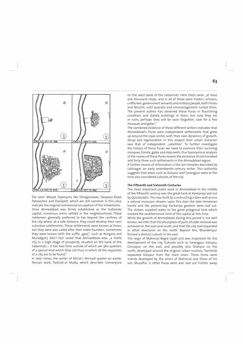
63
the Jami‘ Masjid. Toponyms like Dhalgarwada, Salapasa Road, Patwasheri and Danapith, which are still common in this area, indicate the original commercial occupation of the inhabitants.Once Ahmedabad was fi rmly established as the Sultanate capital, numerous amirs settled in the neighbourhood. These noblemen generally preferred to live beyond the confi nes of the city where, at a safe distance, they could develop their own suburban settlements. These settlements were known as Puras; but they were also called after their noble founders. Sometimes they were known with the suffi x „ganj“, such as Nurganj and Muradganj. Abu‘l Fazl noted that Ahmadabad was: „a noble city in a high stage of prosperity situated on the bank of the Sabarmati..., It has two forts outside of which are 360 quarters of a special kind which they call Pura, in which all the requisites of a city are to be found.“ In later times, the writer of Mir‘at-i Ahmadi quotes an earlier Persian work, Tazkirat-ul Mulka, which describes Usmanpura
on the west bank of the Sabarmati. Here there were „at least one thousand shops, and in all of these were traders, artisans, craftsmen, government servants and military people, both Hindu and Muslim, until quarrels and mismanagement ruined them. The present author has observed these Puras in fl ourishing condition, and stately buildings in them, but now they are in ruins, perhaps they will be soon forgotten, save for a few mosques and gates.“ The combined evidence of these different writers indicates that Ahmedabad‘s Puras were independent settlements that grew up around the royal centre, with their own dynamics of growth, decay and regeneration. In this respect their urban character was that of independent „satellites“. To further investigate the history of these Puras we need to examine their surviving mosques, tombs, gates and step-wells. Our toponymical analysis of the names of these Puras reveals the existence of one hundred and forty-three such settlements in the Ahmadabad region.A further source of information is the Jain temples described by Lalitsagar, an early seventeenth-century writer. This authority suggests that areas such as Kalupur and Sarangpur were at the time also considered suburbs of the city.
The Fifteenth and Sixteenth Centuries The most important public work in Ahmedabad in the middle of the fi fteenth century was the great tank at Kankariya laid out by Qutubuddin. This was built by constructing a dam wall across a natural monsoon stream; upon this dam the later Armenian tombs and the present-day Kankariya gardens were laid out. The stream supplied water to the great polygonal tank which marked the southernmost limit of the capital at this time. While the growth of Ahmedabad during this period is not well known, we infer that the absorption of parts of older Ashaval was achieved on the east and south, and that the city had expanded in other directions on the north. Beyond this, Bhanderipur formed a distinct suburb in the east. The reign of Mahmud Begra (1458-1511) was important for the development of the city. Suburbs such as Sarangpur, Kalupur, Dariyapur on the east, and possibly also Shahpur on the north, developed around the original urban nucleus; Tranlimdi separated Kalupur from the main town. These Puras were mainly developed by the amirs of Mahmud and those of his son, Muzaffur II; other Puras were also laid out further away.
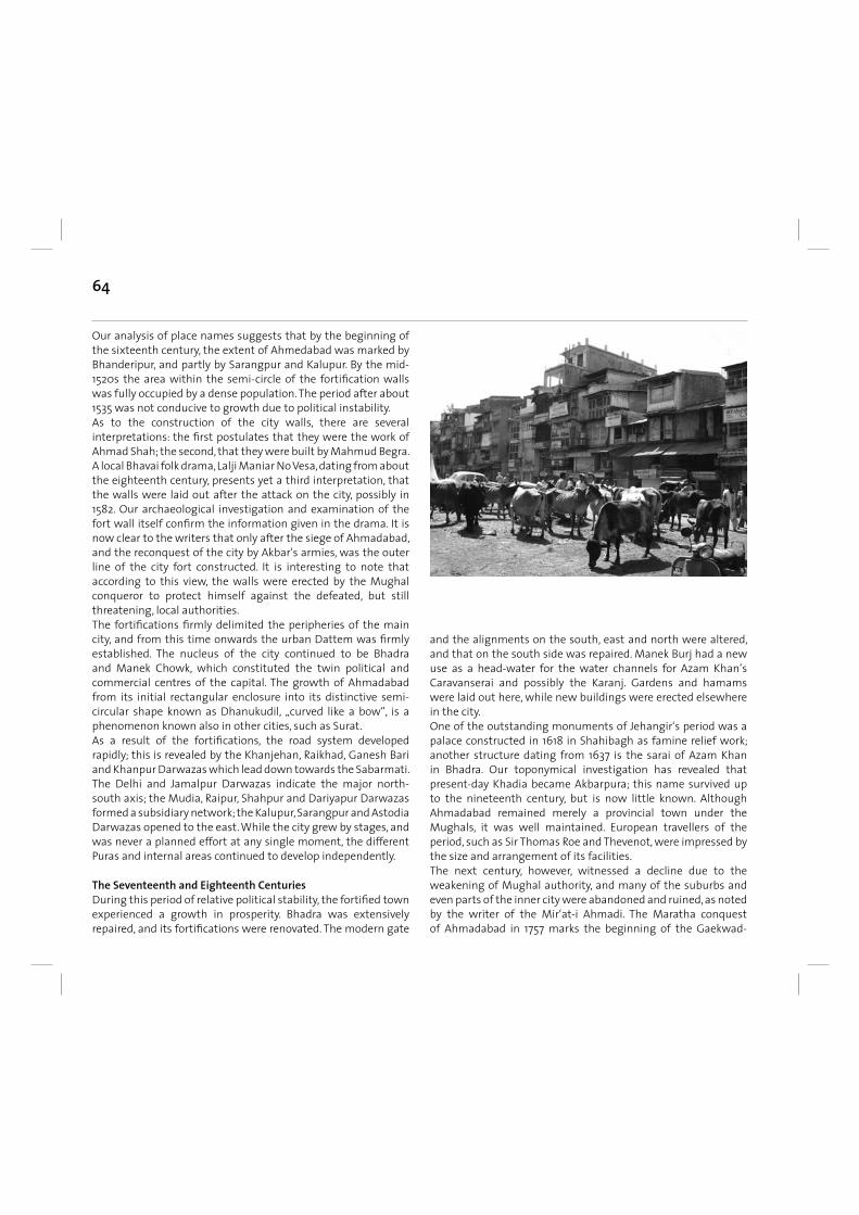
64
Our analysis of place names suggests that by the beginning of the sixteenth century, the extent of Ahmedabad was marked by Bhanderipur, and partly by Sarangpur and Kalupur. By the mid-1520s the area within the semi-circle of the fortifi cation walls was fully occupied by a dense population. The period after about 1535 was not conducive to growth due to political instability. As to the construction of the city walls, there are several interpretations: the fi rst postulates that they were the work of Ahmad Shah; the second, that they were built by Mahmud Begra. A local Bhavai folk drama, Lalji Maniar No Vesa, dating from about the eighteenth century, presents yet a third interpretation, that the walls were laid out after the attack on the city, possibly in 1582. Our archaeological investigation and examination of the fort wall itself confi rm the information given in the drama. It is now clear to the writers that only after the siege of Ahmadabad, and the reconquest of the city by Akbar‘s armies, was the outer line of the city fort constructed. It is interesting to note that according to this view, the walls were erected by the Mughal conqueror to protect himself against the defeated, but still threatening, local authorities. The fortifi cations fi rmly delimited the peripheries of the main city, and from this time onwards the urban Dattem was fi rmly established. The nucleus of the city continued to be Bhadra and Manek Chowk, which constituted the twin political and commercial centres of the capital. The growth of Ahmadabad from its initial rectangular enclosure into its distinctive semi-circular shape known as Dhanukudil, „curved like a bow“, is a phenomenon known also in other cities, such as Surat. As a result of the fortifi cations, the road system developed rapidly; this is revealed by the Khanjehan, Raikhad, Ganesh Bari and Khanpur Darwazas which lead down towards the Sabarmati. The Delhi and Jamalpur Darwazas indicate the major north-south axis; the Mudia, Raipur, Shahpur and Dariyapur Darwazas formed a subsidiary network; the Kalupur, Sarangpur and Astodia Darwazas opened to the east. While the city grew by stages, and was never a planned effort at any single moment, the different Puras and internal areas continued to develop independently.
The Seventeenth and Eighteenth Centuries During this period of relative political stability, the fortifi ed town experienced a growth in prosperity. Bhadra was extensively repaired, and its fortifi cations were renovated. The modern gate
and the alignments on the south, east and north were altered, and that on the south side was repaired. Manek Burj had a new use as a head-water for the water channels for Azam Khan‘s Caravanserai and possibly the Karanj. Gardens and hamams were laid out here, while new buildings were erected elsewhere in the city. One of the outstanding monuments of Jehangir‘s period was a palace constructed in 1618 in Shahibagh as famine relief work; another structure dating from 1637 is the sarai of Azam Khan in Bhadra. Our toponymical investigation has revealed that present-day Khadia became Akbarpura; this name survived up to the nineteenth century, but is now little known. Although Ahmadabad remained merely a provincial town under the Mughals, it was well maintained. European travellers of the period, such as Sir Thomas Roe and Thevenot, were impressed by the size and arrangement of its facilities. The next century, however, witnessed a decline due to the weakening of Mughal authority, and many of the suburbs and even parts of the inner city were abandoned and ruined, as noted by the writer of the Mir‘at-i Ahmadi. The Maratha conquest of Ahmadabad in 1757 marks the beginning of the Gaekwad-
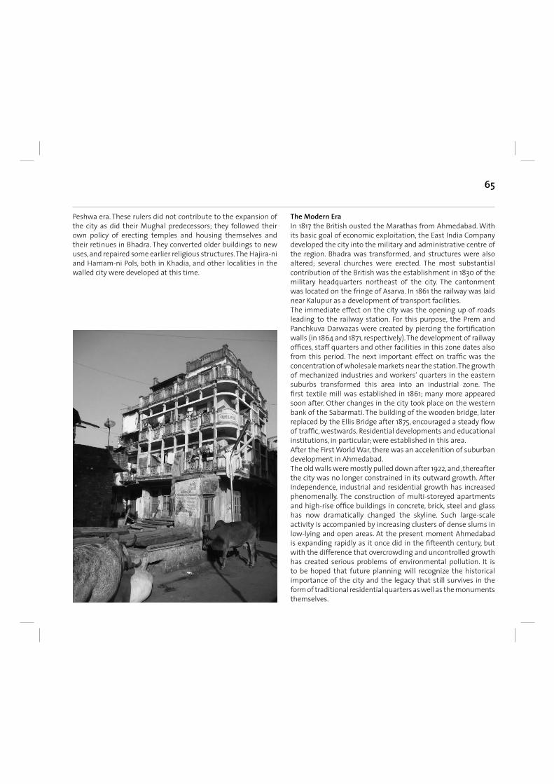
65
Peshwa era. These rulers did not contribute to the expansion of the city as did their Mughal predecessors; they followed their own policy of erecting temples and housing themselves and their retinues in Bhadra. They converted older buildings to new uses, and repaired some earlier religious structures. The Hajira-ni and Hamam-ni Pols, both in Khadia, and other localities in the walled city were developed at this time.
The Modern Era In 1817 the British ousted the Marathas from Ahmedabad. With its basic goal of economic exploitation, the East India Company developed the city into the military and administrative centre of the region. Bhadra was transformed, and structures were also altered; several churches were erected. The most substantial contribution of the British was the establishment in 1830 of the military headquarters northeast of the city. The cantonment was located on the fringe of Asarva. In 1861 the railway was laid near Kalupur as a development of transport facilities. The immediate effect on the city was the opening up of roads leading to the railway station. For this purpose, the Prem and Panchkuva Darwazas were created by piercing the fortifi cation walls (in 1864 and 1871, respectively). The development of railway offi ces, staff quarters and other facilities in this zone dates also from this period. The next important effect on traffi c was the concentration of wholesale markets near the station. The growth of mechanized industries and workers‘ quarters in the eastern suburbs transformed this area into an industrial zone. The fi rst textile mill was established in 1861; many more appeared soon after. Other changes in the city took place on the western bank of the Sabarmati. The building of the wooden bridge, later replaced by the Ellis Bridge after 1875, encouraged a steady fl ow of traffi c, westwards. Residential developments and educational institutions, in particular; were established in this area. After the First World War, there was an accelenition of suburban development in Ahmedabad. The old walls were mostly pulled down after 1922, and ‚thereafter the city was no longer constrained in its outward growth. After Independence, industrial and residential growth has increased phenomenally. The construction of multi-storeyed apartments and high-rise offi ce buildings in concrete, brick, steel and glass has now dramatically changed the skyline. Such large-scale activity is accompanied by increasing clusters of dense slums in low-lying and open areas. At the present moment Ahmedabad is expanding rapidly as it once did in the fi fteenth century, but with the difference that overcrowding and uncontrolled growth has created serious problems of environmental pollution. It is to be hoped that future planning will recognize the historical importance of the city and the legacy that still survives in the form of traditional residential quarters as well as the monuments themselves.
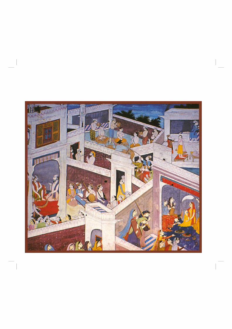
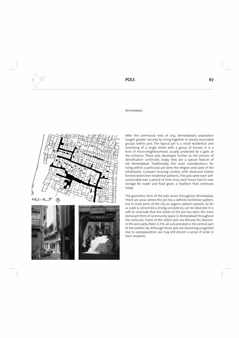
67
After the communal riots of 1714, Ahmedabad‘s population sought greater security by living together in closely associated groups within pols. The typical pol is a small residential unit consisting of a single street with a group of houses. It is a kind of micro-neighbourhood, usually protected by a gate at the entrance. These pols developed further as the process of densifi cation continued; today they are a special feature of old Ahmedabad. Traditionally, the main considerations for living within a particular pol were the religion and caste of the inhabitants. Compact housing clusters with dead-end streets formed distinctive residential patterns. The pols were even self-sustainable over a period of time since each house had its own storage for water and food grain, a tradition that continues today.
The geometric form of the pols varies throughout Ahmedabad. There are areas where the pol has a defi nite rectilinear pattern, but in most parts of the city an organic pattern prevails. As far as scale is concerned a strong consistency can be observed. It is safe to conclude that the street of the pol has been the most dominant form of community space in Ahmedabad throughout the centuries. Some of the oldest pols are Mhurat Pol, Mandvi-ni-Pol and Lakha Patel-ni-Pol, all concentrated in the central part of the walled city. Although these pols are becoming congested due to overpopulation, we may still discern a sense of pride in their residents.
POLS
Ahmedabad
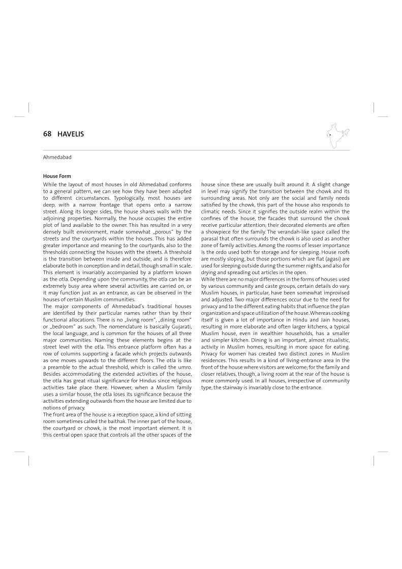
68
While the layout of most houses in old Ahmedabad conforms to a general pattern, we can see how they have been adapted to different circumstances. Typologically, most houses are deep, with a narrow frontage that opens onto a narrow street. Along its longer sides, the house shares walls with the adjoining properties. Normally, the house occupies the entire plot of land available to the owner. This has resulted in a very densely built environment, made somewhat „porous“ by the streets and the courtyards within the houses. This has added greater importance and meaning to the courtyards, also to the thresholds connecting the houses with the streets. A threshold is the transition between inside and outside, and is therefore elaborate both in conception and in detail, though small in scale. This element is invariably accompanied by a platform known as the otla. Depending upon the community, the otla can be an extremely busy area where several activities are carried on, or it may function just as an entrance, as can be observed in the houses of certain Muslim communities.The major components of Ahmedabad’s traditional houses are identifi ed by their particular names rather than by their functional allocations. There is no „living room“, „dining room“ or „bedroom“ as such. The nomenclature is basically Gujarati, the local language, and is common for the houses of all three major communities. Naming these elements begins at the street level with the otla. This entrance platform often has a row of columns supporting a facade which projects outwards as one moves upwards to the different fl oors. The otla is like a preamble to the actual threshold, which is called the umro. Besides accommodating the extended activities of the house, the otla has great ritual signifi cance for Hindus since religious activities take place there. However, when a Muslim family uses a similar house, the otla loses its signifi cance because the activities extending outwards from the house are limited due to notions of privacy.The front area of the house is a reception space, a kind of sitting room sometimes called the baithak. The inner part of the house, the courtyard or chowk, is the most important element. It is this central open space that controls all the other spaces of the
house since these are usually built around it. A slight change in level may signify the transition between the chowk and its surrounding areas. Not only are the social and family needs satisfi ed by the chowk, this part of the house also responds to climatic needs. Since it signifi es the outside realm within the confi nes of the house, the facades that surround the chowk receive particular attention; their decorated elements are often a showpiece for the family. The verandah-like space called the parasal that often surrounds the chowk is also used as another zone of family activities. Among the rooms of lesser importance is the ordo used both for storage and for sleeping. House roofs are mostly sloping, but those portions which are fl at (agasi) are used for sleeping outside during the summer nights, and also for drying and spreading out articles in the open.While there are no major differences in the forms of houses used by various community and caste groups, certain details do vary. Muslim houses, in particular, have been somewhat improvised and adjusted. Two major differences occur due to the need for privacy and to the different eating habits that infl uence the plan organization and space utilization of the house. Whereas cooking itself is given a lot of importance in Hindu and Jain houses, resulting in more elaborate and often larger kitchens, a typical Muslim house, even in wealthier households, has a smaller and simpler kitchen. Dining is an important, almost ritualistic, activity in Muslim homes, resulting in more space for eating. Privacy for women has created two distinct zones in Muslim residences. This results in a kind of living-entrance area in the front of the house where visitors are welcome; for the family and closer relatives, though, a living room at the rear of the house is more commonly used. In all houses, irrespective of community type, the stairway is invariably close to the entrance.
House Form
HAVELIS
Ahmedabad
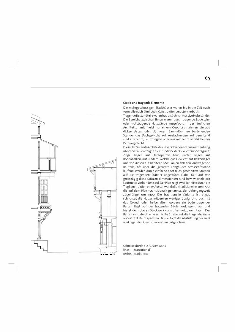
69
Die mehrgeschossigen Stadthäuser waren bis in die Zeit nach 1900 alle nach ähnlichen Konstruktionsmustern erbaut: Tragende Bestandteile waren hauptsächlich massive Holzständer. Die Bereiche zwischen ihnen waren durch tragende Backstein- oder nichttragende Holzwände ausgefacht. In der ländlichen Architektur mit meist nur einem Geschoss nahmen die aus dicken Ästen oder dünneren Baumstämmen bestehenden Ständer das Dachgewicht auf. Ausfachungen auf dem Land sind aus Lehm, Lehmziegeln oder aus mit Lehm verstrichenem Rautengefl echt. Die in der Gujarati-Architektur in verschiedenem Zusammenhang üblichen Säulen zeigen die Grundidee der Gewichtsübertragung: Ziegel liegen auf Dachsparren bzw. Platten liegen auf Bodenbalken, auf Bindern, welche das Gewicht auf Balkenlager und von diesen auf Kapitelle bzw. Säulen ableiten. Auskragende Bauteile, oft über die gesamte Länge der Strassenfassade laufend, werden durch einfache oder reich geschnitzte Streben auf die tragenden Ständer abgestützt. Dabei fällt auf, wie grosszügig diese Stützen dimensioniert sind bzw. wieviele pro Laufmeter vorhanden sind. Der Plan zeigt zwei Schnitte durch die Tragkonstruktion einer Aussenwand: die «traditionelle» um 1700, die auf dem Plan «transitional» genannte, der Üebergangszeit zugehörige, um 1900. Die traditionelle Variante ist etwas schlichter, die Holzschnitzereien weniger üppig. Und doch ist das Grundmodell beibehalten worden: ein bodentragender Balken liegt auf der tragenden Säule auskragend auf und bietet dem oberen Stockwerk damit frei nutzbaren Raum. Der Balken wird durch eine schlichte Strebe auf die tragende Säule abgestützt. Beim späteren Haus erfolgt die Abstützung der zwei auskragenden Geschosse erst im Erdgeschoss.
Statik und tragende Elemente
Schnitte durch die Aussenwandlinks: ‚transitional‘rechts: ‚traditional‘
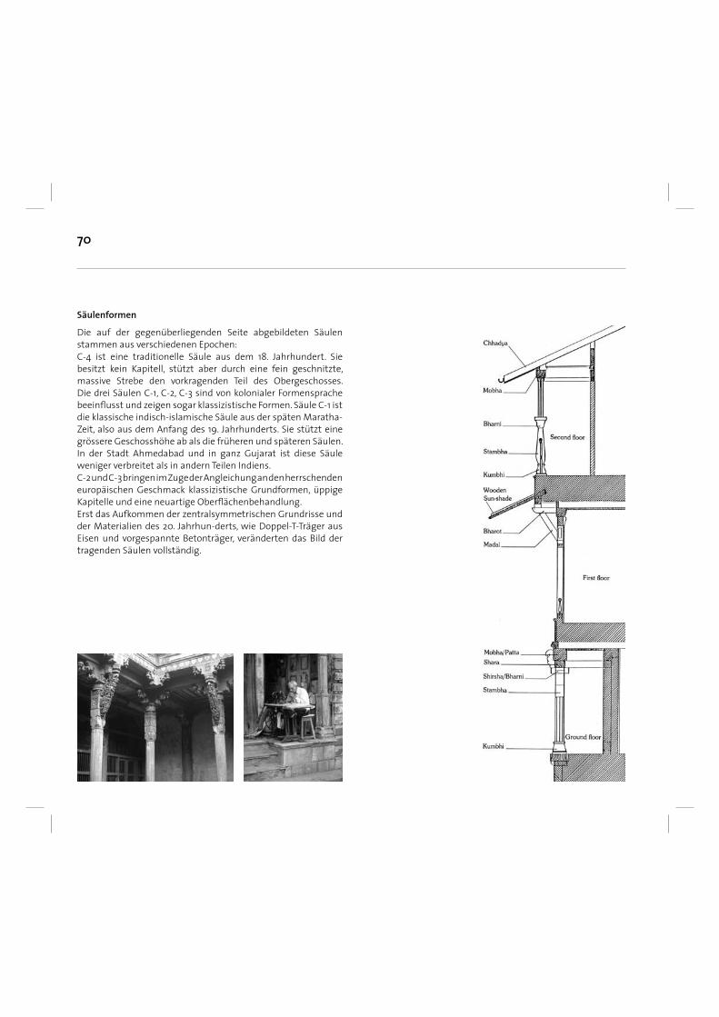
70
Die auf der gegenüberliegenden Seite abgebildeten Säulen stammen aus verschiedenen Epochen:C-4 ist eine traditionelle Säule aus dem 18. Jahrhundert. Sie besitzt kein Kapitell, stützt aber durch eine fein geschnitzte, massive Strebe den vorkragenden Teil des Obergeschosses. Die drei Säulen C-1, C-2, C-3 sind von kolonialer Formensprache beeinfl usst und zeigen sogar klassizistische Formen. Säule C-1 ist die klassische indisch-islamische Säule aus der späten Maratha-Zeit, also aus dem Anfang des 19. Jahrhunderts. Sie stützt eine grössere Geschosshöhe ab als die früheren und späteren Säulen. In der Stadt Ahmedabad und in ganz Gujarat ist diese Säule weniger verbreitet als in andern Teilen Indiens. C-2 und C-3 bringen im Zuge der Angleichung an den herrschenden europäischen Geschmack klassizistische Grundformen, üppige Kapitelle und eine neuartige Oberfl ächenbehandlung. Erst das Aufkommen der zentralsymmetrischen Grundrisse und der Materialien des 20. Jahrhun-derts, wie Doppel-T-Träger aus Eisen und vorgespannte Betonträger, veränderten das Bild der tragenden Säulen vollständig.
Säulenformen
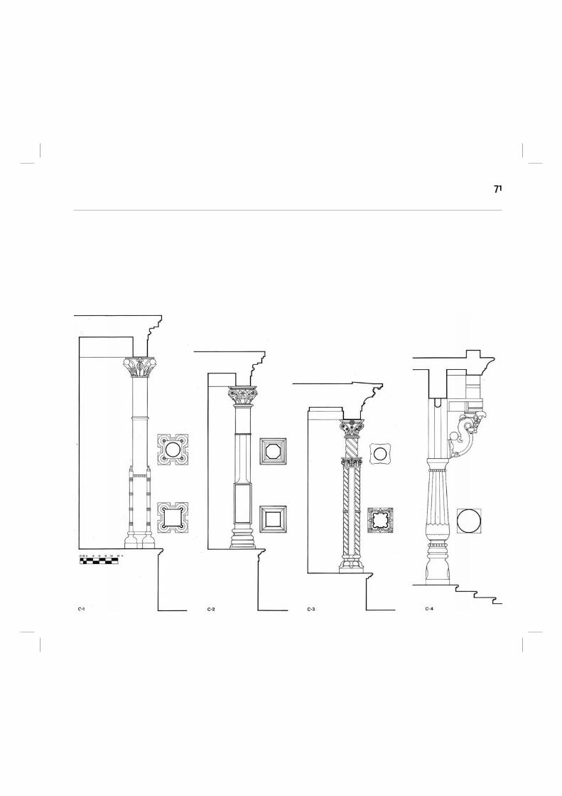
71
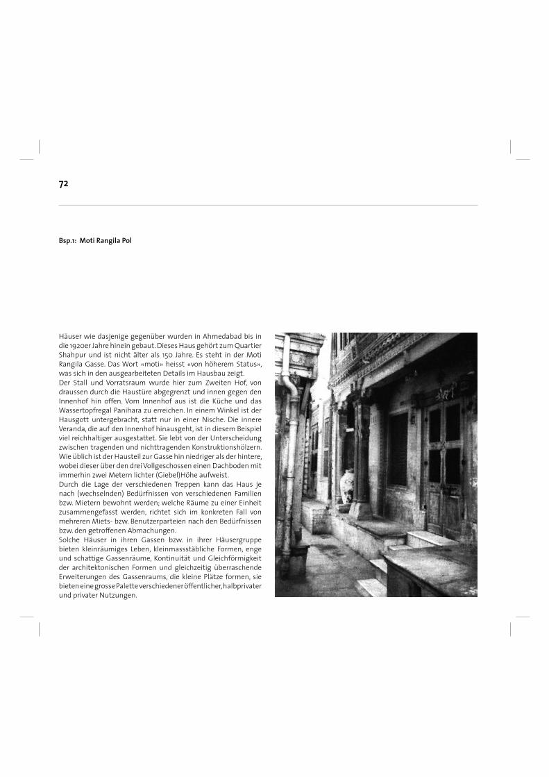
72
Bsp.1: Moti Rangila Pol
Häuser wie dasjenige gegenüber wurden in Ahmedabad bis in die 1920er Jahre hinein gebaut. Dieses Haus gehört zum Quartier Shahpur und ist nicht älter als 150 Jahre. Es steht in der Moti Rangila Gasse. Das Wort «moti» heisst «von höherem Status», was sich in den ausgearbeiteten Details im Hausbau zeigt. Der Stall und Vorratsraum wurde hier zum Zweiten Hof, von draussen durch die Haustüre abgegrenzt und innen gegen den Innenhof hin offen. Vom Innenhof aus ist die Küche und das Wassertopfregal Panihara zu erreichen. In einem Winkel ist der Hausgott untergebracht, statt nur in einer Nische. Die innere Veranda, die auf den Innenhof hinausgeht, ist in diesem Beispiel viel reichhaltiger ausgestattet. Sie lebt von der Unterscheidung zwischen tragenden und nichttragenden Konstruktionshölzern. Wie üblich ist der Hausteil zur Gasse hin niedriger als der hintere, wobei dieser über den drei Vollgeschossen einen Dachboden mit immerhin zwei Metern lichter (Giebel)Höhe aufweist. Durch die Lage der verschiedenen Treppen kann das Haus je nach (wechselnden) Bedürfnissen von verschiedenen Familien bzw. Mietern bewohnt werden; welche Räume zu einer Einheit zusammengefasst werden, richtet sich im konkreten Fall von mehreren Miets- bzw. Benutzerparteien nach den Bedürfnissen bzw. den getroffenen Abmachungen. Solche Häuser in ihren Gassen bzw. in ihrer Häusergruppe bieten kleinräumiges Leben, kleinmassstäbliche Formen, enge und schattige Gassenräume, Kontinuität und Gleichförmigkeit der architektonischen Formen und gleichzeitig überraschende Erweiterungen des Gassenraums, die kleine Plätze formen, sie bieten eine grosse Palette verschiedener öffentlicher, halbprivater und privater Nutzungen.
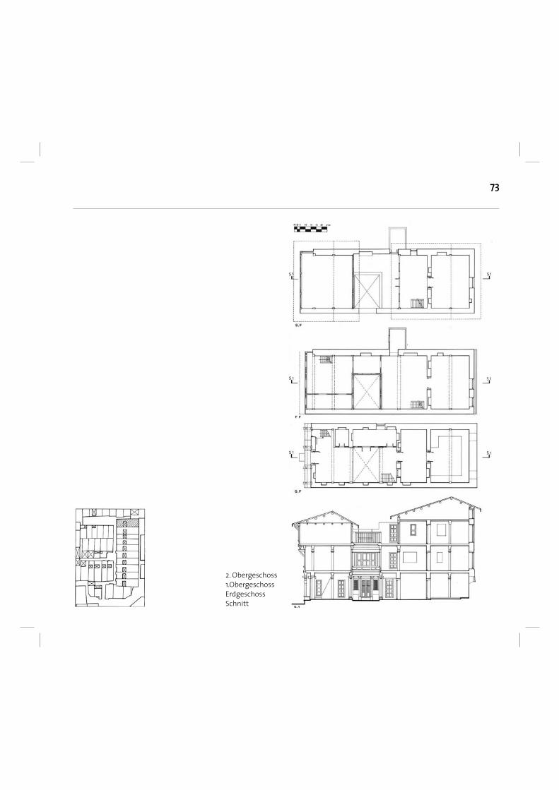
73
2. Obergeschoss1.ObergeschossErdgeschossSchnitt
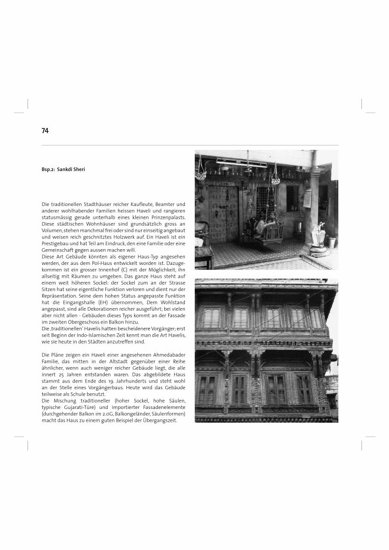
74
Bsp.2: Sankdi Sheri
Die traditionellen Stadthäuser reicher Kaufl eute, Beamter und anderer wohlhabender Familien heissen Haveli und rangieren statusmässig gerade unterhalb eines kleinen Prinzenpalasts. Diese städtischen Wohnhäuser sind grundsätzlich gross an Volumen, stehen manchmal frei oder sind nur einseitig angebaut und weisen reich geschnitztes Holzwerk auf. Ein Haveli ist ein Prestigebau und hat Teil am Eindruck, den eine Familie oder eine Gemeinschaft gegen aussen machen will. Diese Art Gebäude könnten als eigener Haus-Typ angesehen werden, der aus dem Pol-Haus entwickelt worden ist. Dazuge-kommen ist ein grosser Innenhof (C) mit der Möglichkeit, ihn allseitig mit Räumen zu umgeben. Das ganze Haus steht auf einem weit höheren Sockel: der Sockel zum an der Strasse Sitzen hat seine eigentliche Funktion verloren und dient nur der Repräsentation. Seine dem hohen Status angepasste Funktion hat die Eingangshalle (EH) übernommen, Dem Wohlstand angepasst, sind alle Dekorationen reicher ausgeführt; bei vielen aber nicht allen - Gebäuden dieses Typs kommt an der Fassade im zweiten Obergeschoss ein Balkon hinzu.Die ‚traditionellen‘ Havelis hatten bescheidenere Vorgänger; erst seit Beginn der Indo-Islamischen Zeit kennt man die Art Havelis, wie sie heute in den Städten anzutreffen sind.
Die Pläne zeigen ein Haveli einer angesehenen Ahmedabader Familie, das mitten in der Altstadt gegenüber einer Reihe ähnlicher, wenn auch weniger reicher Gebäude liegt, die alle innert 25 Jahren entstanden waren. Das abgebildete Haus stammt aus dem Ende des 19. Jahrhunderts und steht wohl an der Stelle eines Vorgängerbaus. Heute wird das Gebäude teilweise als Schule benutzt. Die Mischung traditioneller (hoher Sockel, hohe Säulen, typische Gujarati-Türe) und importierter Fassadenelemente (durchgehender Balkon im 2.0G, Balkongeländer, Säulenformen) macht das Haus zu einem guten Beispiel der Übergangszeit.
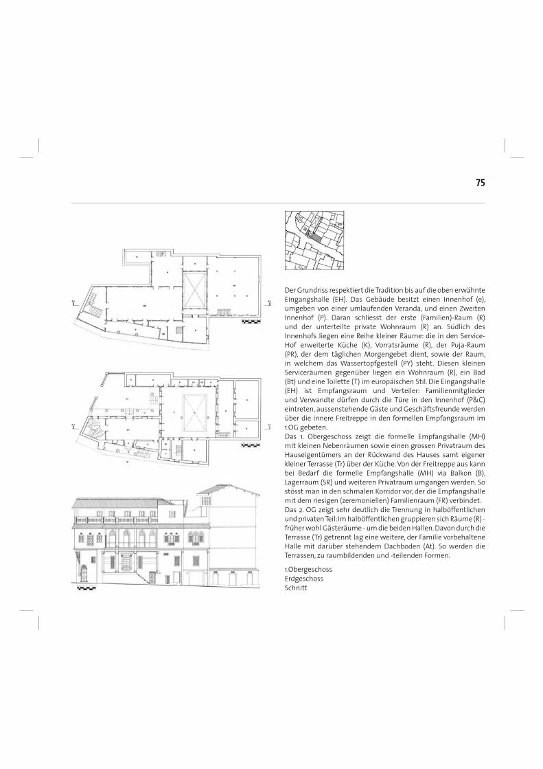
75
Der Grundriss respektiert die Tradition bis auf die oben erwähnte Eingangshalle (EH). Das Gebäude besitzt einen Innenhof (e), umgeben von einer umlaufenden Veranda, und einen Zweiten Innenhof (P). Daran schliesst der erste (Familien)-Raum (R) und der unterteilte private Wohnraum (R) an. Südlich des Innenhofs liegen eine Reihe kleiner Räume: die in den Service-Hof erweiterte Küche (K), Vorratsräume (R), der Puja-Raum (PR), der dem täglichen Morgengebet dient, sowie der Raum, in welchem das Wassertopfgestell (PY) steht. Diesen kleinen Serviceräumen gegenüber liegen ein Wohnraum (R), ein Bad (Bt) und eine Toilette (T) im europäischen Stil. Die Eingangshalle (EH) ist Empfangsraum und Verteiler: Familienmitglieder und Verwandte dürfen durch die Türe in den Innenhof (P&C) eintreten, aussenstehende Gäste und Geschäftsfreunde werden über die innere Freitreppe in den formellen Empfangsraum im 1.OG gebeten. Das 1. Obergeschoss zeigt die formelle Empfangshalle (MH) mit kleinen Nebenräumen sowie einen grossen Privatraum des Hauseigentümers an der Rückwand des Hauses samt eigener kleiner Terrasse (Tr) über der Küche. Von der Freitreppe aus kann bei Bedarf die formelle Empfangshalle (MH) via Balkon (B), Lagerraum (SR) und weiteren Privatraum umgangen werden. So stösst man in den schmalen Korridor vor, der die Empfangshalle mit dem riesigen (zeremoniellen) Familienraum (FR) verbindet. Das 2. OG zeigt sehr deutlich die Trennung in halböffentlichen und privaten Teil: Im halböffentlichen gruppieren sich Räume (R) - früher wohl Gästeräume - um die beiden Hallen. Davon durch die Terrasse (Tr) getrennt lag eine weitere, der Familie vorbehaltene Halle mit darüber stehendem Dachboden (At). So werden die Terrassen, zu raumbildenden und -teilenden Formen.
1.ObergeschossErdgeschossSchnitt
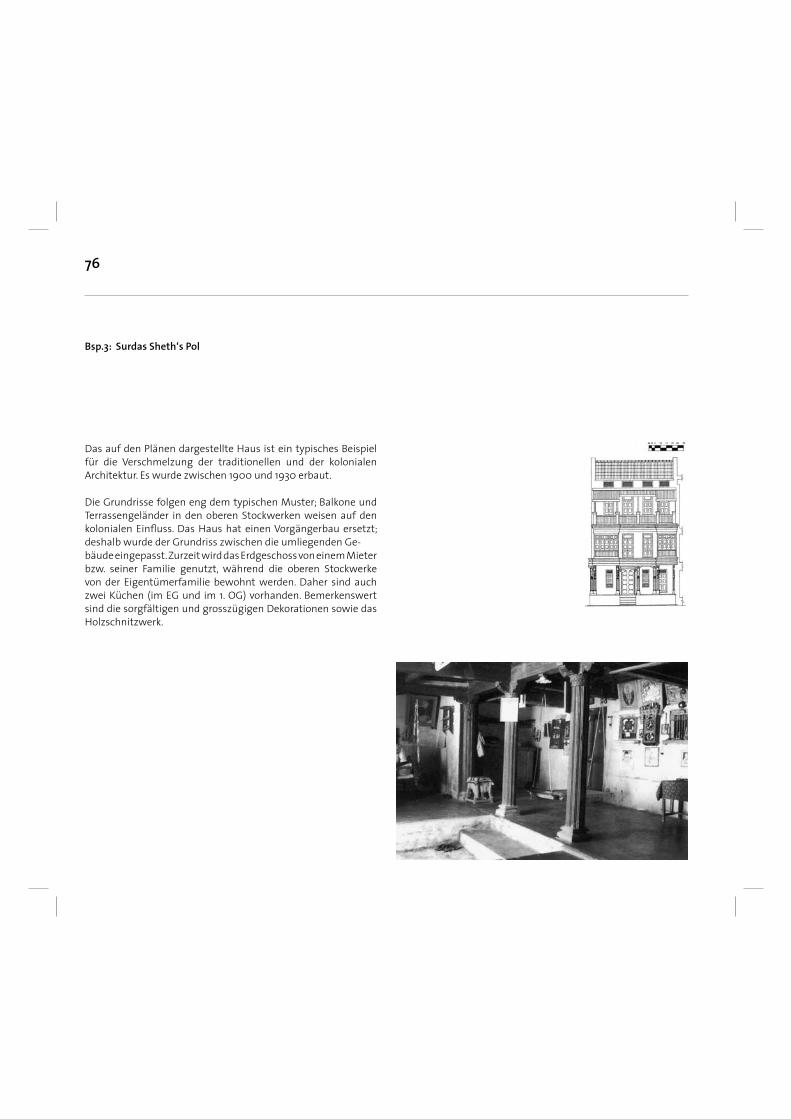
76
Bsp.3: Surdas Sheth‘s Pol
Das auf den Plänen dargestellte Haus ist ein typisches Beispiel für die Verschmelzung der traditionellen und der kolonialen Architektur. Es wurde zwischen 1900 und 1930 erbaut.
Die Grundrisse folgen eng dem typischen Muster; Balkone und Terrassengeländer in den oberen Stockwerken weisen auf den kolonialen Einfl uss. Das Haus hat einen Vorgängerbau ersetzt; deshalb wurde der Grundriss zwischen die umliegenden Ge- bäude eingepasst. Zurzeit wird das Erdgeschoss von einem Mieter bzw. seiner Familie genutzt, während die oberen Stockwerke von der Eigentümerfamilie bewohnt werden. Daher sind auch zwei Küchen (im EG und im 1. OG) vorhanden. Bemerkenswert sind die sorgfältigen und grosszügigen Dekorationen sowie das Holzschnitzwerk.
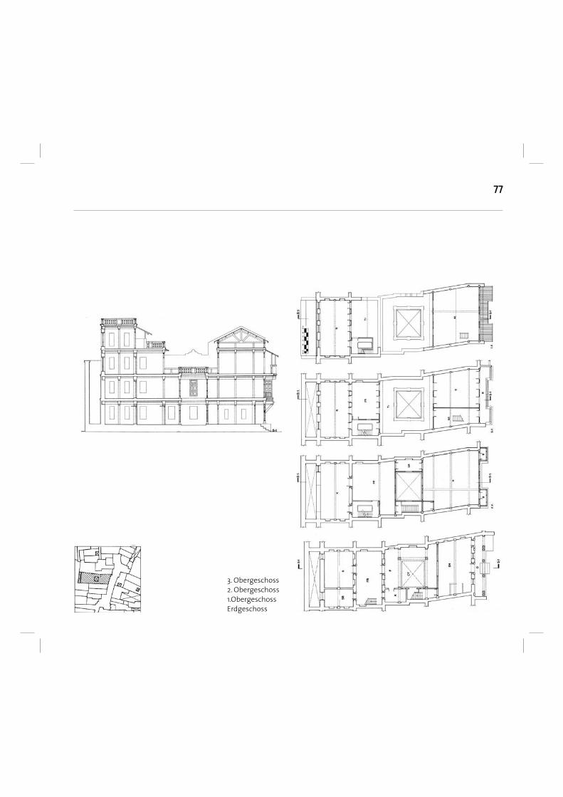
77
3. Obergeschoss2. Obergeschoss1.ObergeschossErdgeschoss
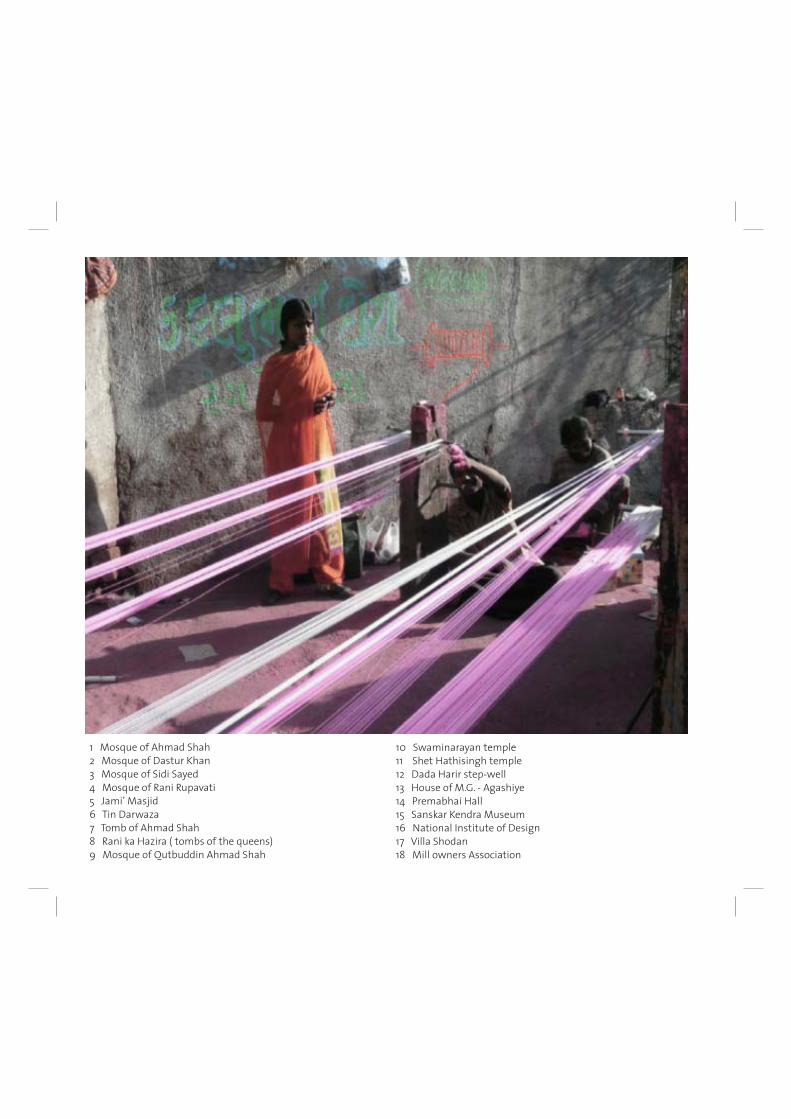
78
1 Mosque of Ahmad Shah 2 Mosque of Dastur Khan 3 Mosque of Sidi Sayed 4 Mosque of Rani Rupavati 5 Jami’ Masjid 6 Tin Darwaza 7 Tomb of Ahmad Shah 8 Rani ka Hazira ( tombs of the queens) 9 Mosque of Qutbuddin Ahmad Shah
10 Swaminarayan temple11 Shet Hathisingh temple12 Dada Harir step-well13 House of M.G. - Agashiye 14 Premabhai Hall15 Sanskar Kendra Museum16 National Institute of Design17 Villa Shodan18 Mill owners Association
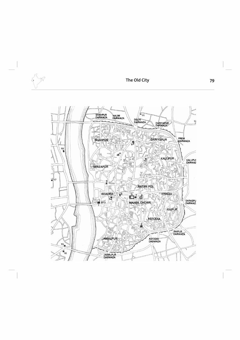
79The Old City
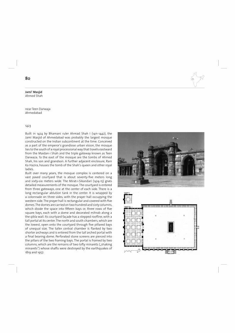
80
near Teen DarwajaAhmedabad
1423
Jami‘ MasjidAhmed Shah
Built in 1424 by Bhamani ruler Ahmad Shah I (1411-1442), the Jami Masjid of Ahmedabad was probably the largest mosque constructed on the Indian subcontinent at the time. Conceived as a part of the emperor‘s grandiose urban vision, the mosque lies to the south of a royal processional way that travels eastward from the Maidan-i Shah and the triple gateway known as Teen Darwaza. To the east of the mosque are the tombs of Ahmed Shah, his son and grandson. A further adjacent enclosure, Rani Ka Hazira, houses the tomb of the Shah‘s queen and other royal ladies. Built over many years, the mosque complex is centered on a vast paved courtyard that is about seventy-fi ve meters long and sixty-six meters wide. The Mirat-i-Sikandari (1414-15) gives detailed measurements of the mosque. The courtyard is entered from three gateways, one at the center of each side. There is a long rectangular ablution tank in the center. It is wrapped by a colonnade on three sides, with the prayer hall occupying the western side. The prayer hall is rectangular and covered with fi ve domes. The domes are carried on two hundred and sixty columns, which divide the space into fi fteen bays or, three rows of fi ve square bays, each with a dome and decorated mihrab along a the qibla wall. Its courtyard façade has a stepped roofl ine, with a tall portal at its center. The north and south chambers, which are the lowest, open onto the courtyard through fi ve pillared bays of unequal size. The taller central chamber is fl anked by two shorter archways and is entered from the tall arched portal with a fi nal bearing dome. Perforated stone screens are pierced into the pillars of the two framing bays. The portal is framed by two columns, which are the remains of two lofty minarets („shaking minarets“) whose shafts were destroyed by the earthquakes of 1819 and 1957.
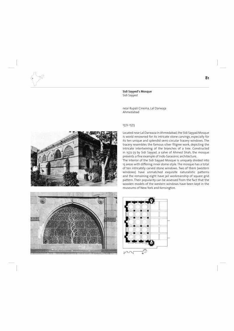
81
near Rupali Cinema, Lal DarwajaAhmedabad
1572-1573
Sidi Sayyed‘s MosqueSidi Sayyed
Located near Lal Darwaza in Ahmedabad, the Sidi Sayyad Mosque is world renowned for its intricate stone carvings, especially for its ten unique and splendid semi-circular tracery windows. The tracery resembles the famous silver fi ligree work, depicting the intricate intertwining of the branches of a tree. Constructed in 1572-73 by Sidi Sayyad, a salve of Ahmed Shah, the mosque presents a fi ne example of Indo-Saracenic architecture.The interior of the Sidi Sayyad Mosque is uniquely divided into 15 areas with differing inner dome-style. The mosque has a total of ten intricately carved stone windows. Two of them (western windows) have unmatched exquisite naturalistic patterns and the remaining eight have jail workmanship of square grid pattern. Their popularity can be assessed from the fact that the wooden models of the western windows have been kept in the museums of New York and Kensington.
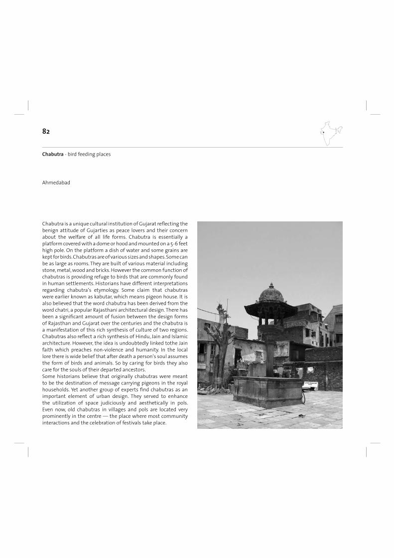
82
Ahmedabad
Chabutra - bird feeding places
Chabutra is a unique cultural institution of Gujarat refl ecting the benign attitude of Gujarties as peace lovers and their concern about the welfare of all life forms. Chabutra is essentially a platform covered with a dome or hood and mounted on a 5-6 feet high pole. On the platform a dish of water and some grains are kept for birds. Chabutras are of various sizes and shapes. Some can be as large as rooms. They are built of various material including stone, metal, wood and bricks. However the common function of chabutras is providing refuge to birds that are commonly found in human settlements. Historians have different interpretations regarding chabutra‘s etymology. Some claim that chabutras were earlier known as kabutar, which means pigeon house. It is also believed that the word chabutra has been derived from the word chatri, a popular Rajasthani architectural design. There has been a signifi cant amount of fusion between the design forms of Rajasthan and Gujarat over the centuries and the chabutra is a manifestation of this rich synthesis of culture of two regions. Chabutras also refl ect a rich synthesis of Hindu, Jain and Islamic architecture. However, the idea is undoubtedly linked tothe Jain faith which preaches non-violence and humanity. In the local lore there is wide belief that after death a person‘s soul assumes the form of birds and animals. So by caring for birds they also care for the souls of their departed ancestors.Some historians believe that originally chabutras were meant to be the destination of message carrying pigeons in the royal households. Yet another group of experts fi nd chabutras as an important element of urban design. They served to enhance the utilization of space judiciously and aesthetically in pols. Even now, old chabutras in villages and pols are located very prominently in the centre — the place where most community interactions and the celebration of festivals take place.
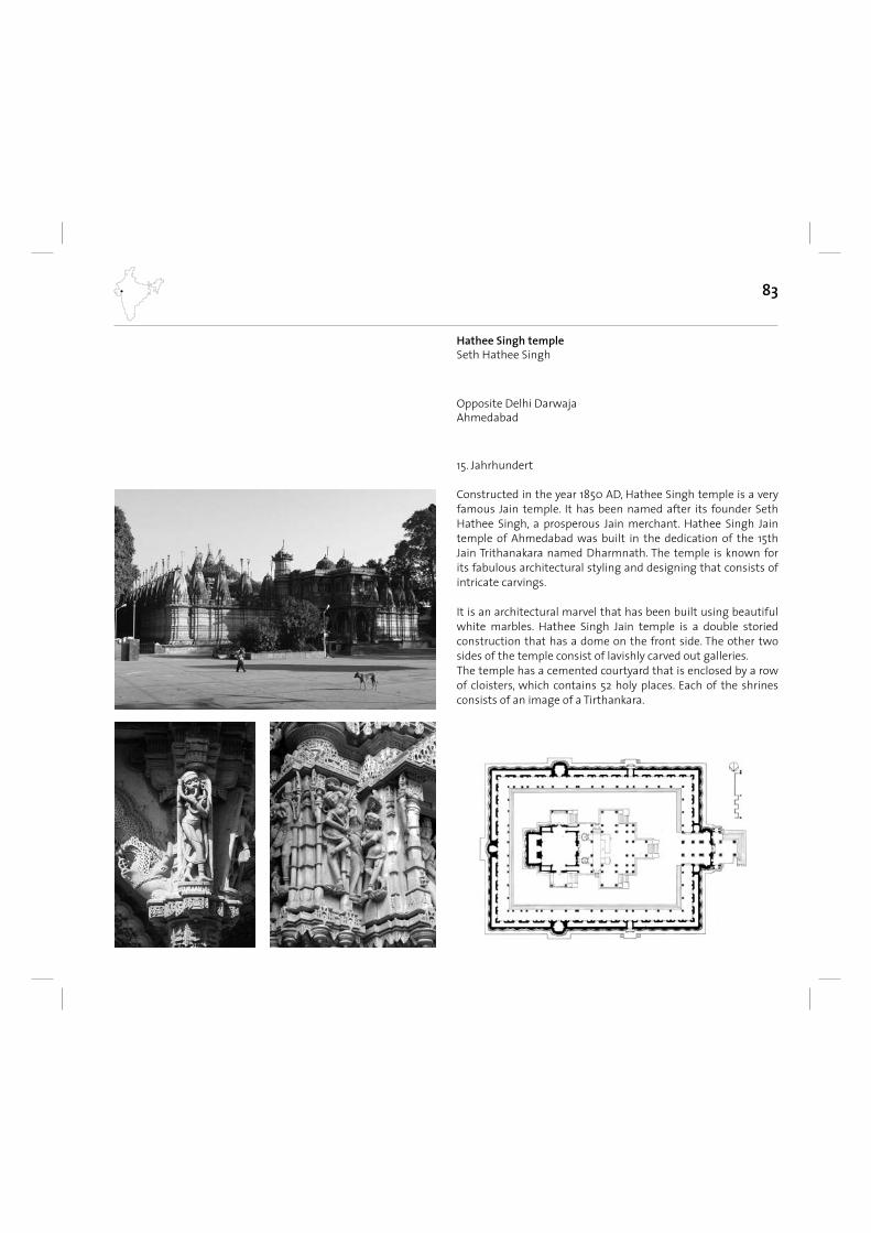
83
Opposite Delhi DarwajaAhmedabad
15. Jahrhundert
Hathee Singh templeSeth Hathee Singh
Constructed in the year 1850 AD, Hathee Singh temple is a very famous Jain temple. It has been named after its founder Seth Hathee Singh, a prosperous Jain merchant. Hathee Singh Jain temple of Ahmedabad was built in the dedication of the 15th Jain Trithanakara named Dharmnath. The temple is known for its fabulous architectural styling and designing that consists of intricate carvings.
It is an architectural marvel that has been built using beautiful white marbles. Hathee Singh Jain temple is a double storied construction that has a dome on the front side. The other two sides of the temple consist of lavishly carved out galleries. The temple has a cemented courtyard that is enclosed by a row of cloisters, which contains 52 holy places. Each of the shrines consists of an image of a Tirthankara.
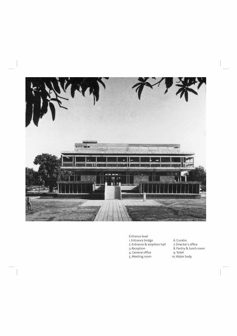
Entrance level1. Entrance bridge 6. Curator2. Entrance & exipition hall 7. Director‘s offi ce3. Reception 8. Pantry & lunch room4. General offi ce 9. Toilet5. Meeting room 10. Water body
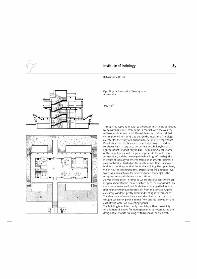
85
Through his association with Le Corbusier, and via introductions by Achyut Kanvinde, Doshi came in contact with the wealthy mill owners in Ahmedabad. One of them, Kasturbhai Lalbhai, commissioned him in 1957 to design the Institute of Indology, a center for the study of ancient manuscripts. This represents Doshi‘s fi rst step in his search for an Indian way of building. He shows his mastery of Le Corbusier‘s vocabulary, but with a lightness that is specifi cally Indian. The building recalls some of the large houses and temple complexes in the old city of Ahmedabad, and the nearby palace buildings of Sarkhej. The Institute of Indology is entered from a monumental staircase, asymmetrically situated on the north facade, that rises to a bridge across the pool that fronts the building. The upper level, which houses teaching rooms, projects over the entrance level to act as a parasol over the wide verandah that adjoins the reception area and administration offi ces. As was the tradition in temples, where precious texts were kept in spaces beneath the main structure, here the manuscripts are stored on a lower level that Doshi has submerged below the ground plane to provide protection from the climate. Angled clerestory windows gently admit indirect light to this space. The slanting roofs over the clerestories channel rain into two troughs which run parallel to the front and rear elevations and cast off the water via projecting spouts. The building is architecturally complete, with no possibility for addition. The need for more space in 1984 necessitated the design of a separate building, with Doshi as the architect.
Institute of Indology
1957 - 1962
Balkrishna V. Doshi
Opp. Gujarat University, NavrangpuraAhmedabad
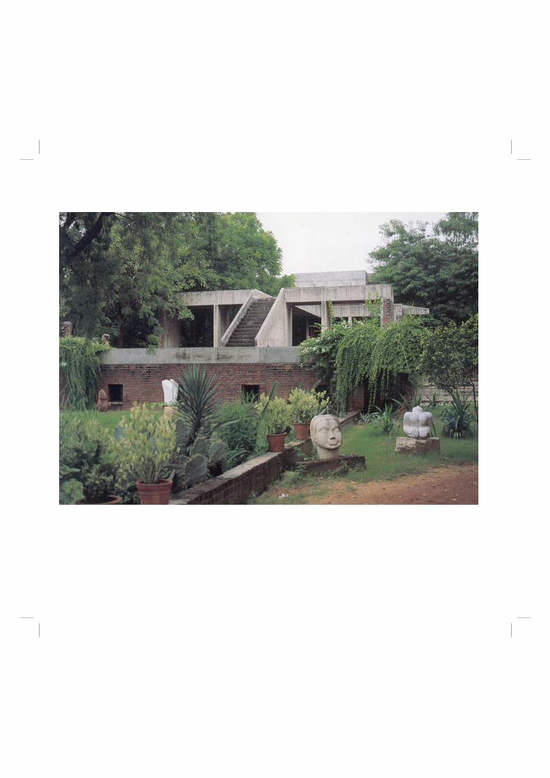
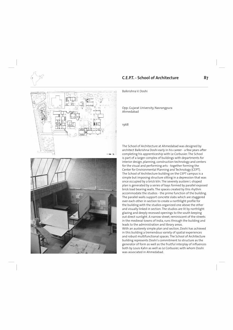
87
The School of Architecture at Ahmedabad was designed by architect Balkrishna Doshi early in his career - a few years after completing his apprenticeship with Le Corbusier. The School is part of a larger complex of buildings with departments for interior design, planning, construction technology and centers for the visual and performing arts - together forming the Center for Environmental Planning and Technology (CEPT). The School of Architecture building on the CEPT campus is a simple but imposing structure sitting in a depression that was once occupied by a brick kiln. The severely austere L-shaped plan is generated by a series of bays formed by parallel exposed brick load bearing walls. The spaces created by this rhythm accommodate the studios - the prime function of the building. The parallel walls support concrete slabs which are staggered over each other in section to create a northlight profi le for the building with the studios organized one above the other and visually linked in section. The studios are lit by northlight glazing and deeply recessed openings to the south keeping out direct sunlight. A narrow street, reminiscent of the streets in the medieval towns of India, runs through the building and leads to the administration and library areas. With an austerely simple plan and section, Doshi has achieved in this building a tremendous variety of spatial experiences and robust multifunctional spaces. The School of Architecture building represents Doshi‘s commitment to structure as the generator of form as well as the fruitful interplay of infl uences both by Louis Kahn as well as Le Corbusier, with whom Doshi was associated in Ahmedabad.
C.E.P.T. - School of Architecture
1968
Balkrishna V. Doshi
Opp. Gujarat University, NavrangpuraAhmedabad
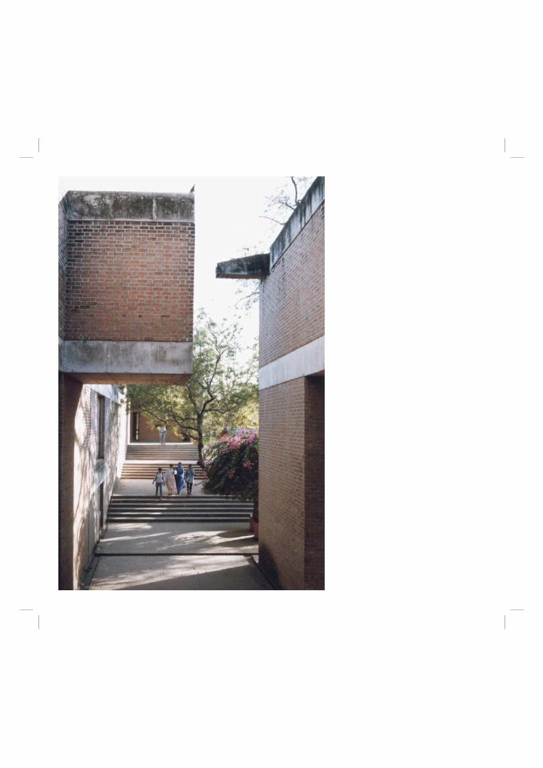
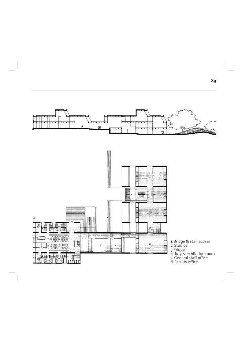
89
1. Bridge & stair access2. Studios3.Bridge4. Jury & exhibition room5. General staff offi ce6. Faculty offi ce
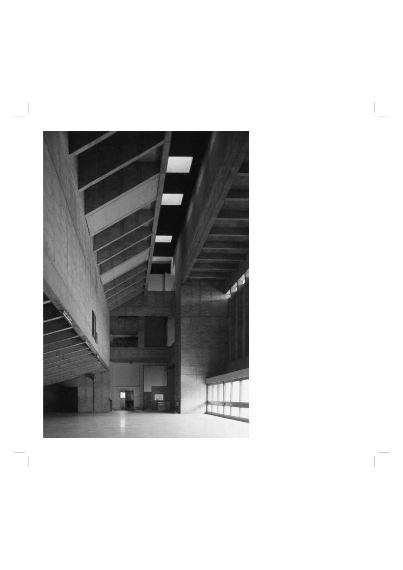
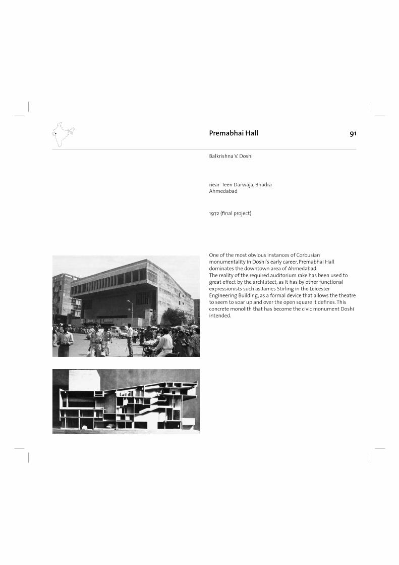
91
One of the most obvious instances of Corbusian monumentality in Doshi’s early career, Premabhai Hall dominates the downtown area of Ahmedabad. The reality of the required auditorium rake has been used to great effect by the archiutect, as it has by other functional expressionists such as James Stirling in the Leicester Engineering Building, as a formal device that allows the theatre to seem to soar up and over the open square it defi nes. This concrete monolith that has become the civic monument Doshi intended.
Premabhai Hall
1972 (fi nal project)
Balkrishna V. Doshi
near Teen Darwaja, BhadraAhmedabad
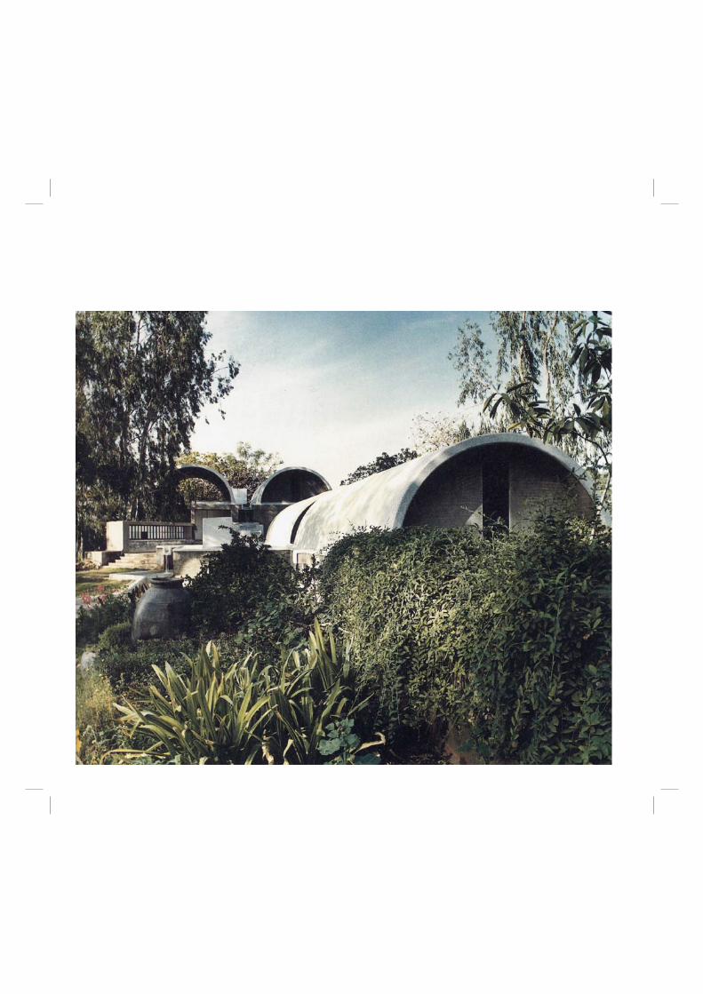
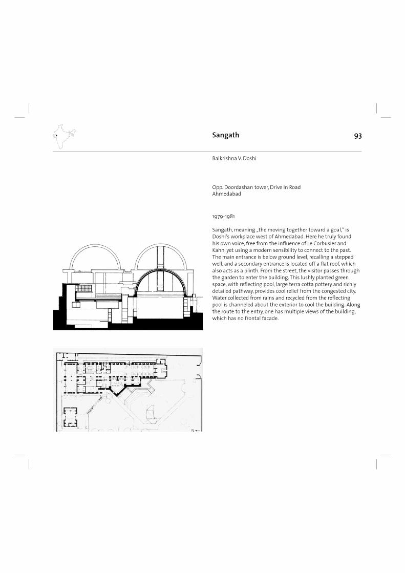
93
Sangath, meaning „the moving together toward a goal,“ is Doshi‘s workplace west of Ahmedabad. Here he truly found his own voice, free from the infl uence of Le Corbusier and Kahn, yet using a modern sensibility to connect to the past. The main entrance is below ground level, recalling a stepped well, and a secondary entrance is located off a fl at roof, which also acts as a plinth. From the street, the visitor passes through the garden to enter the building. This lushly planted green space, with refl ecting pool, large terra cotta pottery and richly detailed pathway, provides cool relief from the congested city. Water collected from rains and recycled from the refl ecting pool is channeled about the exterior to cool the building. Along the route to the entry, one has multipIe views of the building, which has no frontal facade.
Sangath
1979-1981
Balkrishna V. Doshi
Opp. Doordashan tower, Drive In RoadAhmedabad
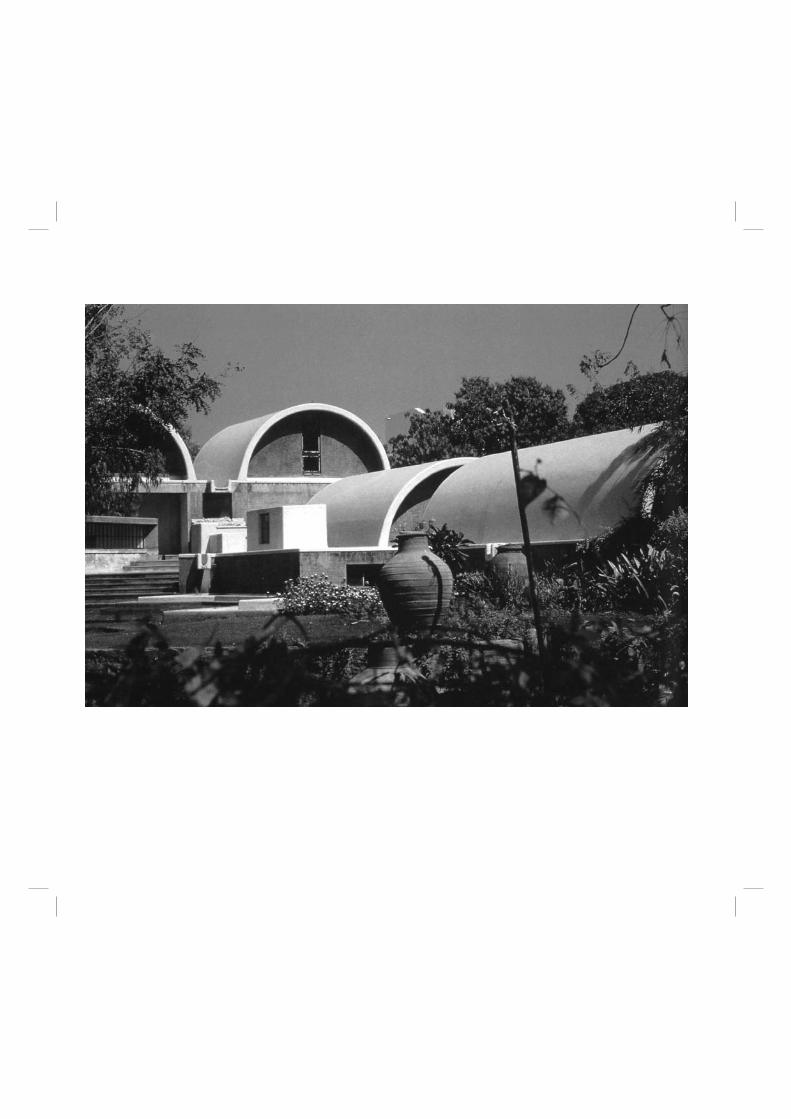
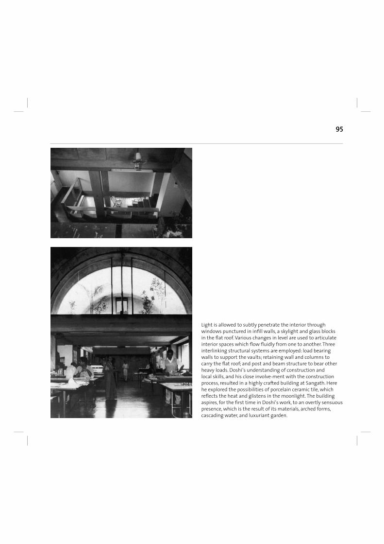
95
Light is allowed to subtly penetrate the interior through windows punctured in infi ll walls, a skylight and glass blocks in the fl at roof. Various changes in level are used to articulate interior spaces which fl ow fl uidly from one to another. Three interlinking structural systems are employed: load bearing walls to support the vaults; retaining wall and columns to carry the fl at roof; and post and beam structure to bear other heavy loads. Doshi‘s understanding of construction and local skills, and his close involve-ment with the construction process, resulted in a highly crafted building at Sangath. Here he explored the possibilities of porcelain ceramic tile, which refl ects the heat and glistens in the moonlight. The building aspires, for the fi rst time in Doshi‘s work, to an overtly sensuous presence, which is the result of its materials, arched forms, cascading water, and luxuriant garden.
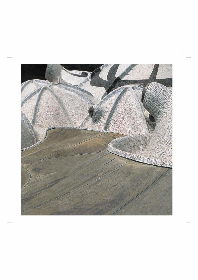
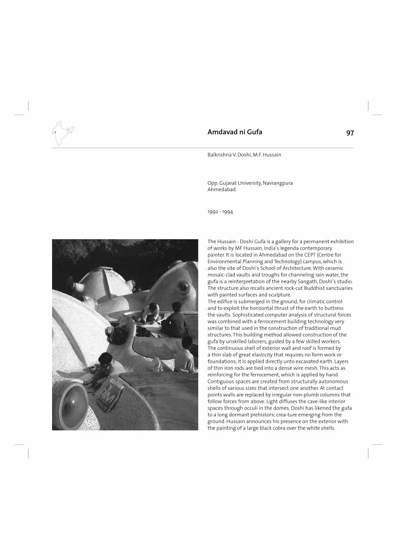
97
The Hussain - Doshi Gufa is a gallery for a permanent exhibition of works by MF Hussain, India‘s legenda contemporary painter. It is located in Ahmedabad on the CEPT (Centre for Environmental Planning and Technology) campus, which is also the site of Doshi‘s School of Architecture. With ceramic mosaic-clad vaults and troughs for channeling rain water, the gufa is a reinterpretation of the nearby Sangath, Doshi‘s studio. The structure also recalls ancient rock-cut Buddhist sanctuaries with painted surfaces and sculpture. The edifi ce is submerged in the ground, for climatic control and to exploit the horizontal thrust of the earth to buttress the vaults. Sophisticated computer analysis of structural forces was combined with a ferrocement building technology very similar to that used in the construction of traditional mud structures. This building method allowed construction of the gufa by unskilled laborers, guided by a few skilled workers. The continuous shell of exterior wall and roof is formed by a thin slab of great elasticity that requires no form work or foundations; it is applied directly unto excavated earth. Layers of thin iron rods are tied into a dense wire mesh. This acts as reinforcing for the ferrocement, which is applied by hand. Contiguous spaces are created from structurally autonomous shells of various sizes that intersect one another. At contact points walls are replaced by irregular non-plumb columns that follow forces from above. Light diffuses the cave-like interior spaces through occuli in the domes. Doshi has likened the gufa to a long dormant prehistoric crea-ture emerging from the ground. Hussain announces his presence on the exterior with the painting of a large black cobra over the white shells.
Amdavad ni Gufa
1992 - 1994
Balkrishna V. Doshi, M.F. Hussain
Opp. Gujarat University, NavrangpuraAhmedabad
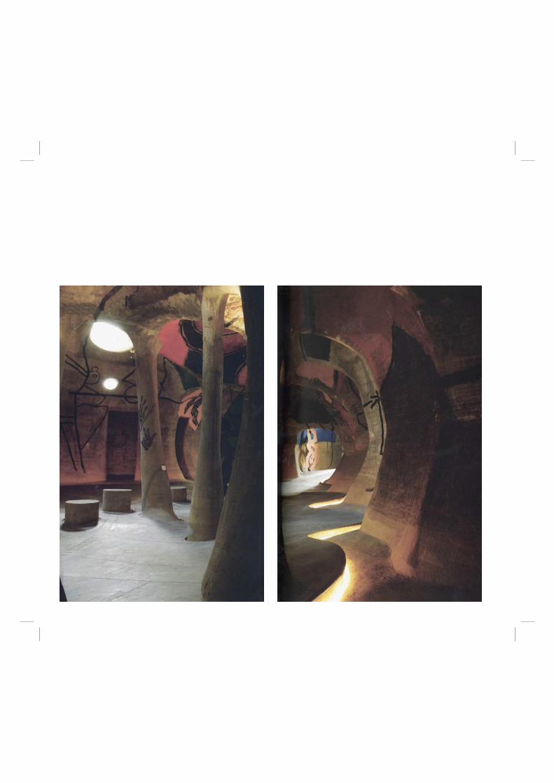
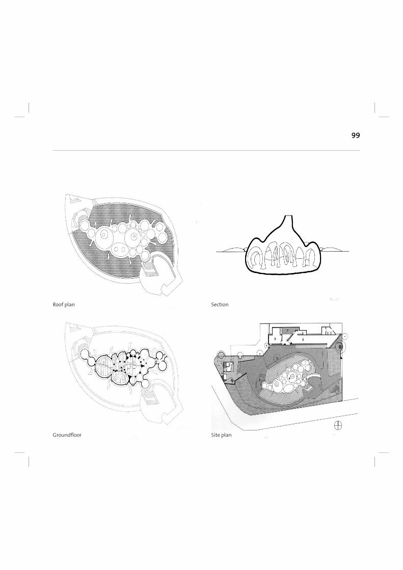
99
Roof plan
Groundfl oor
Section
Site plan
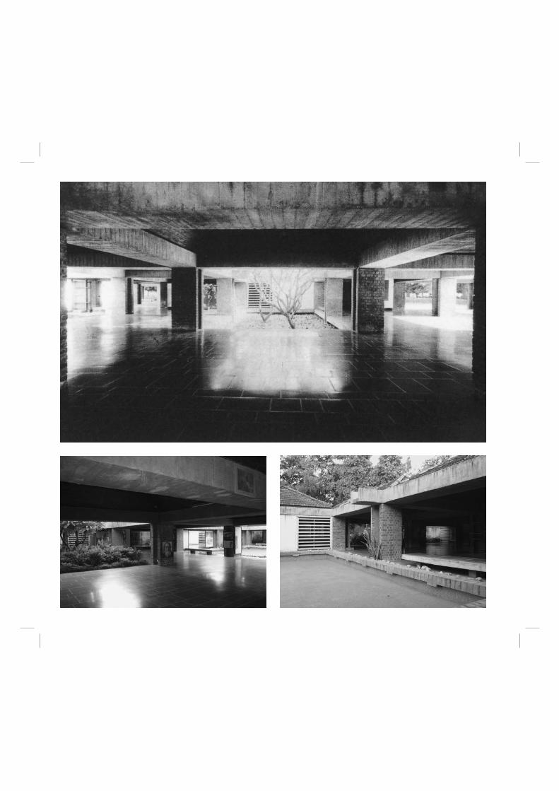
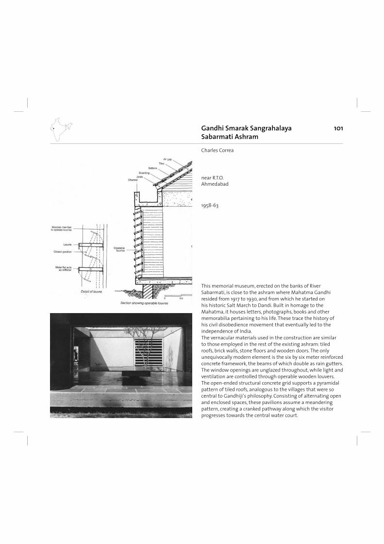
101
This memorial museum, erected on the banks of River Sabarmati, is close to the ashram where Mahatma Gandhi resided from 1917 to 1930, and from which he started on his historic Salt March to Dandi. Built in homage to the Mahatma, it houses letters, photographs, books and other memorabilia pertaining to his life. These trace the history of his civil disobedience movement that eventually led to the independence of India. The vernacular materials used in the construction are similar to those employed in the rest of the existing ashram: tiled roofs, brick walls, stone fl oors and wooden doors. The only unequivocally modern element is the six by six meter reinforced concrete framework, the beams of which double as rain gutters. The window openings are unglazed throughout, while light and ventilation are controlled through operable wooden louvers. The open-ended structural concrete grid supports a pyramidal pattern of tiled roofs, analogous to the villages that were so central to Gandhiji‘s philosophy. Consisting of alternating open and enclosed spaces, these pavilions assume a meandering pattern, creating a cranked pathway along which the visitor progresses towards the central water court.
Gandhi Smarak SangrahalayaSabarmati Ashram
1958-63
Charles Correa
near R.T.O.Ahmedabad
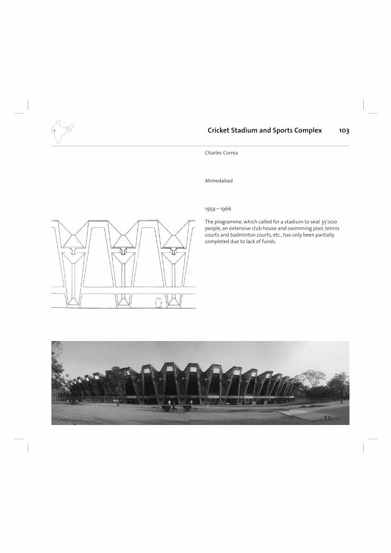
103
The programme, which called for a stadium to seat 35‘000 people, an extensive club house and swimming pool, tennis courts and badminton courts, etc., has only been partially completed due to lack of funds.
Cricket Stadium and Sports Complex
1959 – 1966
Charles Correa
Ahmedabad
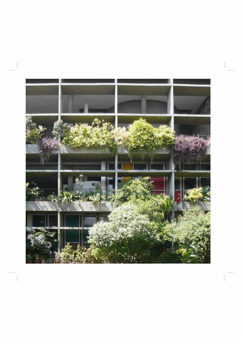
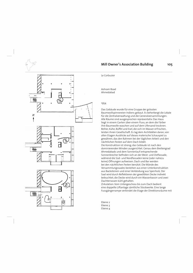
105
Das Gebäude wurde für eine Gruppe der grössten Baumwollspinnereien Indiens gebaut. Es beherbergt die Lokale für die Zentralverwaltung und die Generalversammlungen. Alle Räume sind ausgesprochen repräsentativ. Das Haus liegt in einem Garten über einem Fluss, an dem die Färber ihre Baumwolle waschen und auf dem Ufersand trocknen. Reiher, Kühe, Büffel und Esel, die sich im Wasser erfrischen, leisten ihnen Gesellschaft. Es lag dem Architekten daran, von allen Etagen Ausblicke auf dieses malerische Schauspiel zu gewähren, das den Rahmen bei der täglichen Arbeit und den nächtlichen Festen auf dem Dach bildet. Die Konstruktion ist streng; das Gebäude ist nach den dominierenden Winden ausgerichtet. Genau dem Breitengrad Ahmedabads und dem Sonnenlauf entsprechende Sonnenbrecher befi nden sich an der West- und Ostfassade, während die Süd- und Nordfassaden keine (oder nahezu keine) Öffnungen aufweisen. Dach und Bar werden bei den nächtlichen Festen benützt. Die Wände des Versammlungssaales bestehen aus einer Unterkonstruktion aus Backsteinen und einer Verkleidung aus Sperrholz. Der Saal wird durch Refl ektieren der gewölbten Decke indirekt beleuchtet; die Decke wird durch ein Wasserbassin und zwei Dachterrassen kühl gehalten. Zirkulation: Vom Untergeschoss bis zum Dach bedient eine doppelte Liftanlage sämtliche Stockwerke. Eine lange Fussgängerrampe verbindet die Etage der Direktionsräume mit
Mill Owner’s Association Building
1954
Le Corbusier
Ebene 2Ebene 3Ebene 4
Ashram RoadAhmedabad

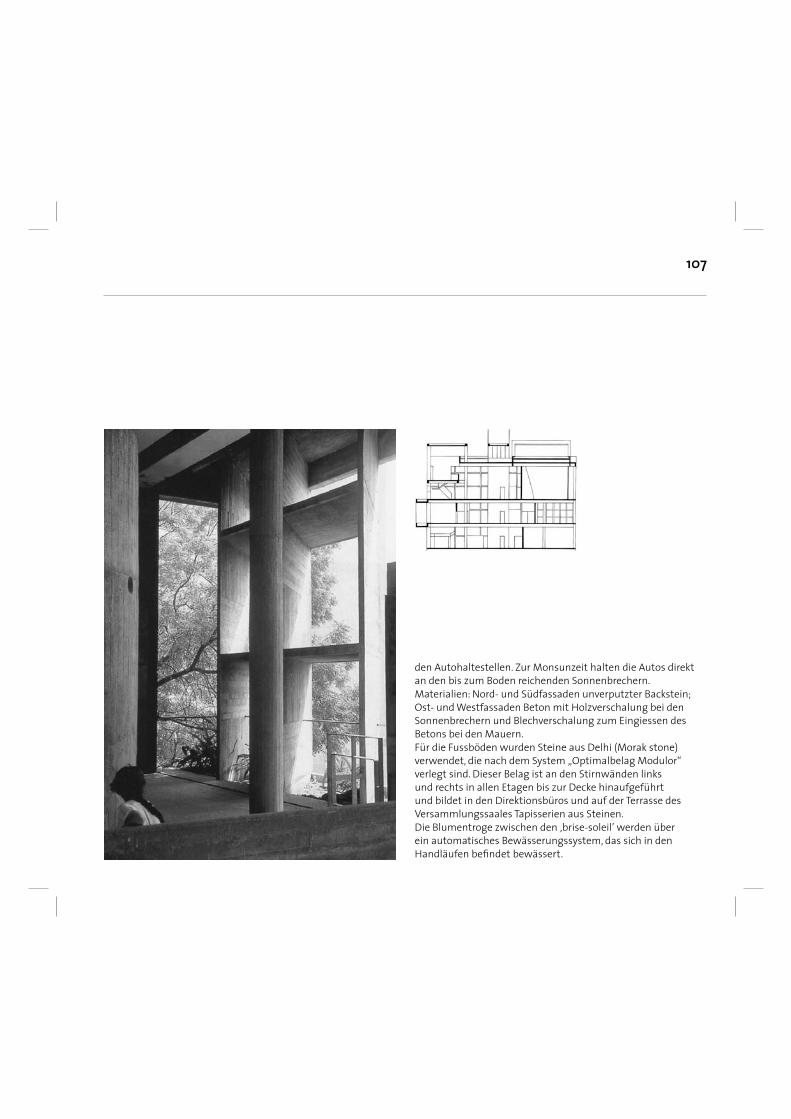
107
den Autohaltestellen. Zur Monsunzeit halten die Autos direkt an den bis zum Boden reichenden Sonnenbrechern.Materialien: Nord- und Südfassaden unverputzter Backstein; Ost- und Westfassaden Beton mit Holzverschalung bei den Sonnenbrechern und Blechverschalung zum Eingiessen des Betons bei den Mauern. Für die Fussböden wurden Steine aus Delhi (Morak stone) verwendet, die nach dem System „Optimalbelag Modulor“ verlegt sind. Dieser Belag ist an den Stirnwänden links und rechts in allen Etagen bis zur Decke hinaufgeführt und bildet in den Direktionsbüros und auf der Terrasse des Versammlungssaales Tapisserien aus Steinen.Die Blumentroge zwischen den ‚brise-soleil’ werden über ein automatisches Bewässerungssystem, das sich in den Handläufen befi ndet bewässert.
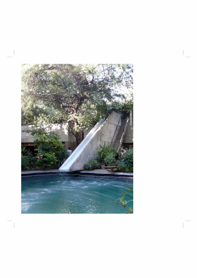
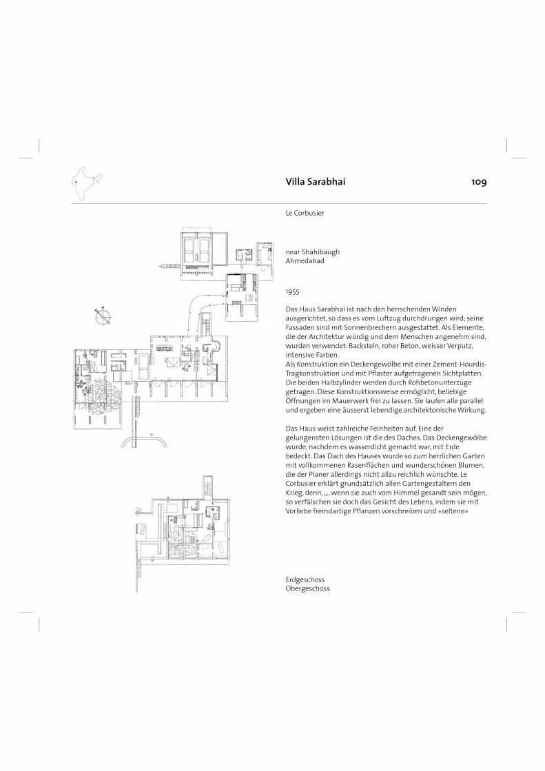
109
Das Haus Sarabhai ist nach den herrschenden Winden ausgerichtet, so dass es vom Luftzug durchdrungen wird; seine Fassaden sind mit Sonnenbrechern ausgestattet. Als Elemente, die der Architektur würdig und dem Menschen angenehm sind, wurden verwendet: Backstein, roher Beton, weisser Verputz, intensive Farben. Als Konstruktion ein Deckengewölbe mit einer Zement-Hourdis-Tragkonstruktion und mit Pfl aster aufgetragenen Sichtplatten. Die beiden Halbzylinder werden durch Rohbetonunterzüge getragen. Diese Konstruktionsweise ermöglicht, beliebige Öffnungen im Mauerwerk frei zu lassen. Sie laufen alle parallel und ergeben eine äusserst lebendige architektonische Wirkung.
Das Haus weist zahlreiche Feinheiten auf. Eine der gelungensten Lösungen ist die des Daches. Das Deckengewölbe wurde, nachdem es wasserdicht gemacht war, mit Erde bedeckt. Das Dach des Hauses wurde so zum herrlichen Garten mit vollkommenen Rasenfl ächen und wunderschönen Blumen, die der Planer allerdings nicht allzu reichlich wünschte. Le Corbusier erklärt grundsätzlich allen Gartengestaltern den Krieg, denn, „...wenn sie auch vom Himmel gesandt sein mögen, so verfälschen sie doch das Gesicht des Lebens, indem sie mit Vorliebe fremdartige Pfl anzen vorschreiben und «seltene»
Villa Sarabhai
1955
Le Corbusier
ErdgeschossObergeschoss
near ShahibaughAhmedabad
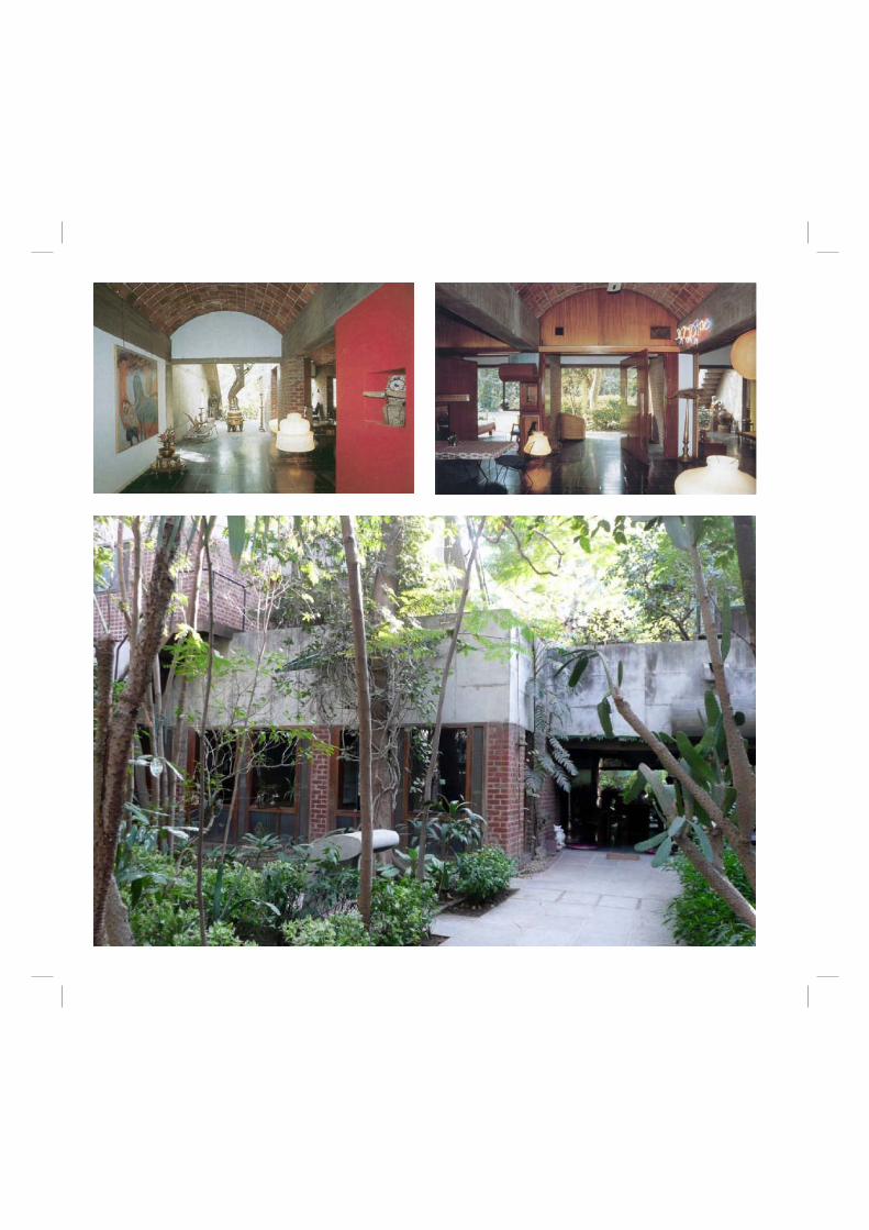
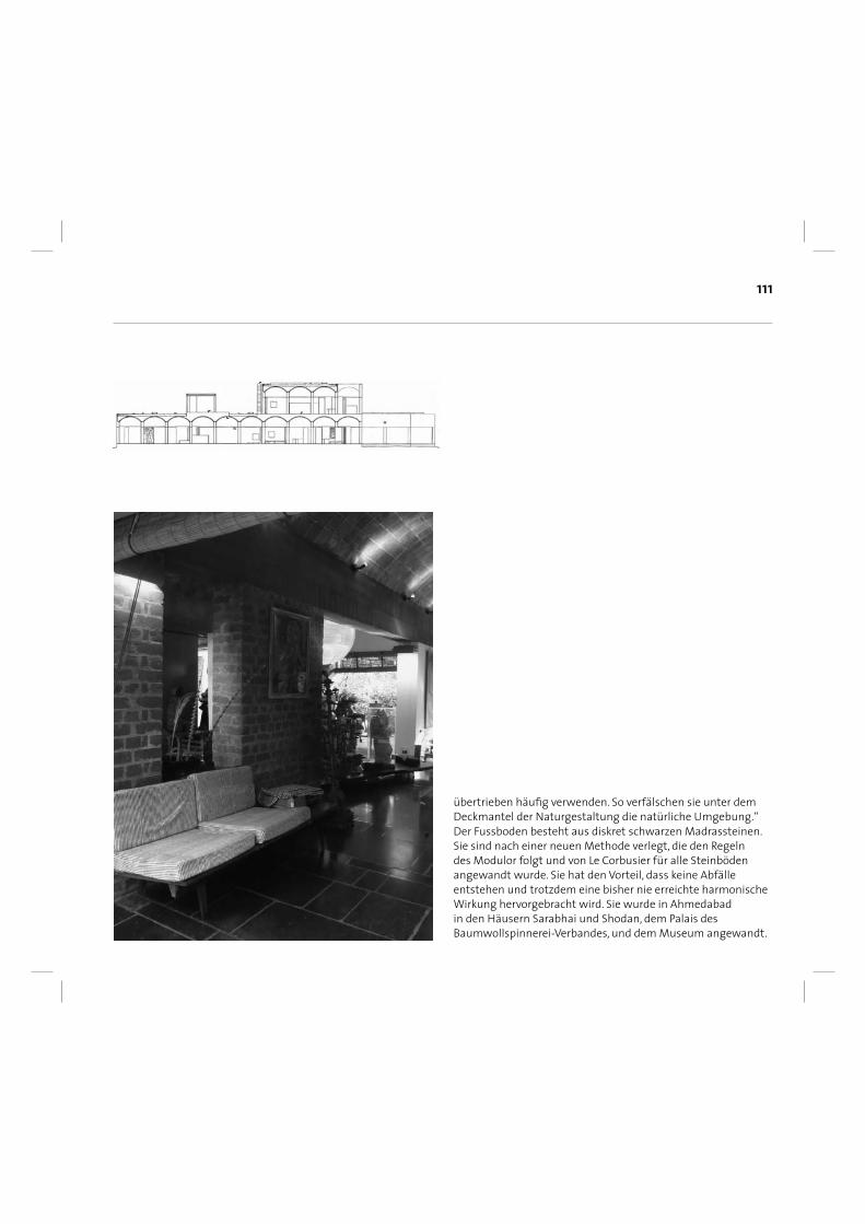
111
übertrieben häufi g verwenden. So verfälschen sie unter dem Deckmantel der Naturgestaltung die natürliche Umgebung.“ Der Fussboden besteht aus diskret schwarzen Madrassteinen. Sie sind nach einer neuen Methode verlegt, die den Regeln des Modulor folgt und von Le Corbusier für alle Steinböden angewandt wurde. Sie hat den Vorteil, dass keine Abfälle entstehen und trotzdem eine bisher nie erreichte harmonische Wirkung hervorgebracht wird. Sie wurde in Ahmedabad in den Häusern Sarabhai und Shodan, dem Palais des Baumwollspinnerei-Verbandes, und dem Museum angewandt.
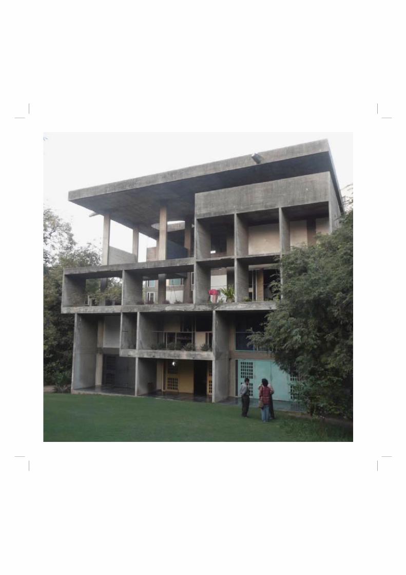
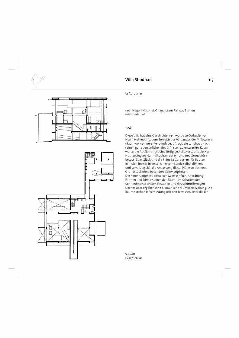
113
Diese Villa hat eine Geschichte: 1951 wurde Le Corbusier von Herrn Hutheesing, dem Sekretär des Verbandes der Millowners (Baumwollspinnerei-Verband) beauftragt, ein Landhaus nach seinen ganz persönlichen Bedürfnissen zu entwerfen. Kaum waren die Ausführungspläne fertig gestellt, verkaufte sie Herr Hutheesing an Herrn Shodhan, der ein anderes Grundstück besass. Zum Glück sind die Pläne Le Corbusiers für Bauten in Indien immer in erster Linie vom Lande selbst diktiert, und so vollzog sich die Anpassung dieser Pläne an das neue Grundstück ohne besondere Schwierigkeiten. Die Konstruktion ist bemerkenswert einfach. Anordnung, Formen und Dimensionen der Räume im Schatten der Sonnenbrecher an den Fassaden und des schirmförmigen Daches aber ergeben eine erstaunliche räumliche Wirkung. Die Räume stehen in Verbindung mit den Terrassen, über die die
Villa Shodhan
1956
Le Corbusier
SchnittErdgeschoss
near Nagari Hospital, Ghandigram Railway StationwAhmedabad
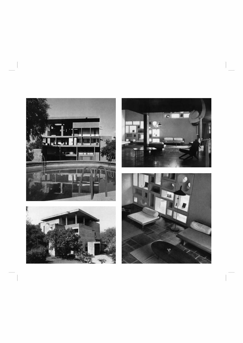
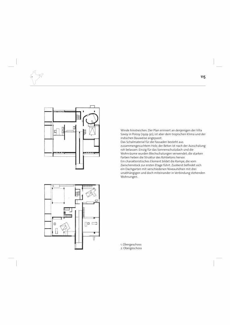
115
1. Obergeschoss2. Obergeschoss
Winde hinstreichen. Der Plan erinnert an denjenigen der Villa Savoy in Poissy (1929-30), ist aber dem tropischen Klima und der indischen Bauweise angepasst. Das Schalmaterial für die Fassaden besteht aus zusammengesuchtem Holz; der Beton ist nach der Ausschalung roh belassen. Einzig für das Sonnenschutzdach und die Wohnräume wurden Blechschalungen verwendet; die starken Farben heben die Struktur des Rohbetons hervor. Ein charakteristisches Element bildet die Rampe, die vom Zwischenstock zur ersten Etage führt. Zuoberst befi ndet sich ein Dachgarten mit verschiedenen Niveauhöhen mit drei unabhängigen und doch miteinander in Verbindung stehenden Wohnungen.
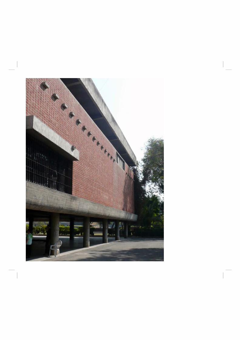
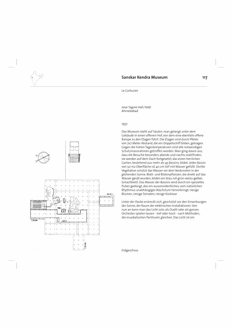
117
Das Museum steht auf Säulen: man gelangt unter dem Gebäude in einen offenen Hof, von dem eine ebenfalls offene Rampe zu den Etagen führt. Die Etagen sind durch Pfeiler von 7x7 Meter Abstand, die ein Doppelschiff bilden, getragen. Gegen die hohen Tagestemperaturen sind alle notwendigen Schutzmassnahmen getroffen worden. Man ging davon aus, dass die Besuche besonders abends und nachts stattfi nden; sie werden auf dem Dach fortgesetzt, das einen herrlichen Garten, bestehend aus mehr als 45 Bassins, bildet. Jedes Bassin von 50 m2 Oberfl äche ist 40 cm tief mit Wasser gefüllt. Dichte Vegetation schützt das Wasser vor dem Verdunsten in der glühenden Sonne. Blatt- und Blütenpfl anzen, die direkt auf das Wasser gesät wurden, bilden ein blau-rot-grün-weiss-gelbes Schachbrett. Das Wasser der Bassins wird durch ein spezielles Pulver gedüngt, das ein ausserordentliches, vom natürlichen Rhythmus unabhängiges Wachstum hervorbringt: riesige Blumen, riesige Tomaten, riesige Kürbisse
Unter der Decke erstreckt sich, geschützt vor den Einwirkungen der Sonne, der Raum der elektrischen Installationen. Von nun an kann man das Licht solo, als Duett oder als ganzes Orchester spielen lassen - tief oder hoch - nach Methoden, die musikalischen Partituren gleichen. Das Licht ist ein
Sanskar Kendra Museum
1957
Le Corbusier
Erdgeschoss
near Tagore Hall, PaldiAhmedabad
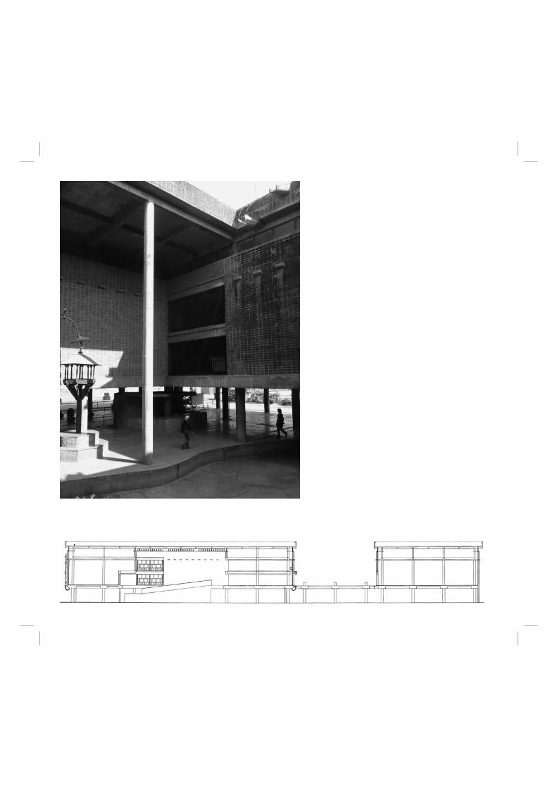
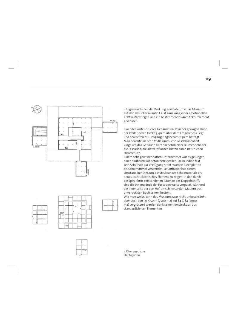
119
integrierender Teil der Wirkung geworden, die das Museum auf den Besucher ausübt. Es ist zum Rang einer emotionellen Kraft aufgestiegen und ein bestimmendes Architekturelement geworden.
Einer der Vorteile dieses Gebäudes liegt in der geringen Höhe der Pfeiler, deren Decke 3,40 m über dem Erdgeschoss liegt und deren freier Durchgang ringsherum 2,50 m beträgt. Man beachte im Schnitt die räumliche Geschlossenheit. Rings um das Gebäude ziert ein betonierter Blumenbehälter die Fassaden; die Kletterpfl anzen bieten einen natürlichen Hitzeschutz. Einem sehr gewissenhaften Unternehmer war es gelungen, einen sauberen Rohbeton herzustellen. Da in Indien fast kein Schalholz zur Verfügung steht, wurden Blechplatten als Schalmaterial verwendet. Le Corbusier hat diesen Umstand benützt, um die Struktur des Schalmaterials als neues architektonisches Element zu zeigen. In den durch die Spiralform entstandenen Räumen des Doppelschiffs sind die Innenwände der Fassaden weiss verputzt, während die Innenseite der den Hof umschliessenden Mauern aus unverputzten Backsteinen besteht. Wie man weiss, kann das Museum zwar nicht unbeschränkt, aber doch von 50 X 50 m (2500 m2) auf 84 X 84 (7000 m2) vergrössert werden dank seiner Konstruktion aus standardisierten Elementen.
1. ObergeschossDachgarten
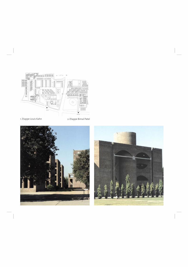
1. Etappe Louis Kahn 2. Etappe Bimal Patel
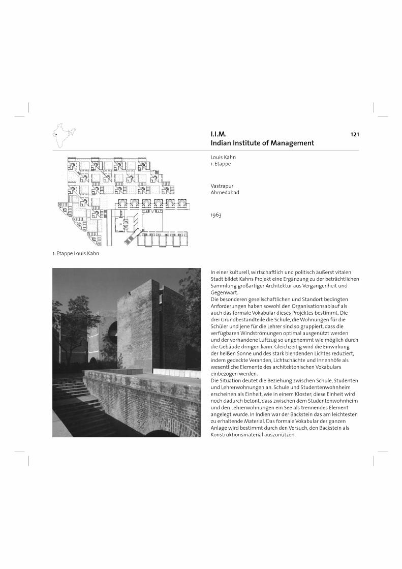
121
In einer kulturell, wirtschaftlich und politisch äußerst vitalen Stadt bildet Kahns Projekt eine Ergänzung zu der beträchtlichen Sammlung großartiger Architektur aus Vergangenheit und Gegenwart. Die besonderen gesellschaftlichen und Standort bedingten Anforderungen haben sowohl den Organisationsablauf als auch das formale Vokabular dieses Projektes bestimmt. Die drei Grundbestandteile die Schule, die Wohnungen für die Schüler und jene für die Lehrer sind so gruppiert, dass die verfügbaren Windströmungen optimal ausgenützt werden und der vorhandene Luftzug so ungehemmt wie möglich durch die Gebäude dringen kann. Gleichzeitig wird die Einwirkung der heißen Sonne und des stark blendenden Lichtes reduziert, indem gedeckte Veranden, Lichtschächte und Innenhöfe als wesentliche Elemente des architektonischen Vokabulars einbezogen werden. Die Situation deutet die Beziehung zwischen Schule, Studenten und Lehrerwohnungen an. Schule und Studentenwohnheim erscheinen als Einheit, wie in einem Kloster; diese Einheit wird noch dadurch betont, dass zwischen dem Studentenwohnheim und den Lehrerwohnungen ein See als trennendes Element angelegt wurde. In Indien war der Backstein das am leichtesten zu erhaltende Material. Das formale Vokabular der ganzen Anlage wird bestimmt durch den Versuch, den Backstein als Konstruktionsmaterial auszunützen.
I.I.M.Indian Institute of Management
1963
Louis Kahn1. Etappe
1. Etappe Louis Kahn
VastrapurAhmedabad
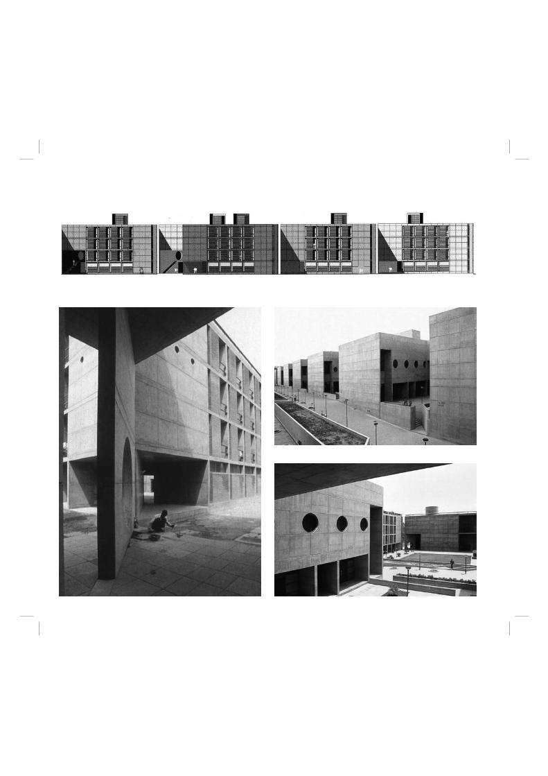
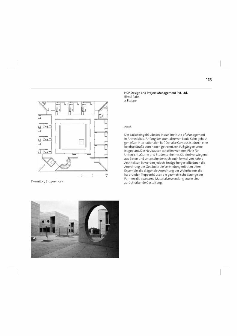
123
Die Backsteingebäude des Indian Institute of Management in Ahmedabad, Anfang der 70er Jahre von Louis Kahn gebaut, genießen internationalen Ruf. Der alte Campus ist durch eine belebte Straße vom neuen getrennt, ein Fußgängertunnel ist geplant. Die Neubauten schaffen weiteren Platz für Unterrichtsräume und Studentenheime. Sie sind vorwiegend aus Beton und unterscheiden sich auch formal von Kahns Architektur. Es werden jedoch Bezüge hergestellt; durch die Anordnung der Gebäude; die Verbindung mit dem alten Ensemble; die diagonale Anordnung der Wohnheime; die halbrunden Treppenhäuser: die geometrische Strenge der Formen; die sparsame Materialverwendung sowie eine zurückhaltende Gestaltung.
2006
Dormitory Erdgeschoss
HCP Design and Project Management Pvt. Ltd.Bimal Patel2. Etappe
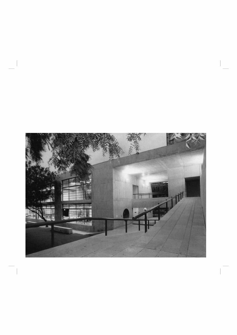
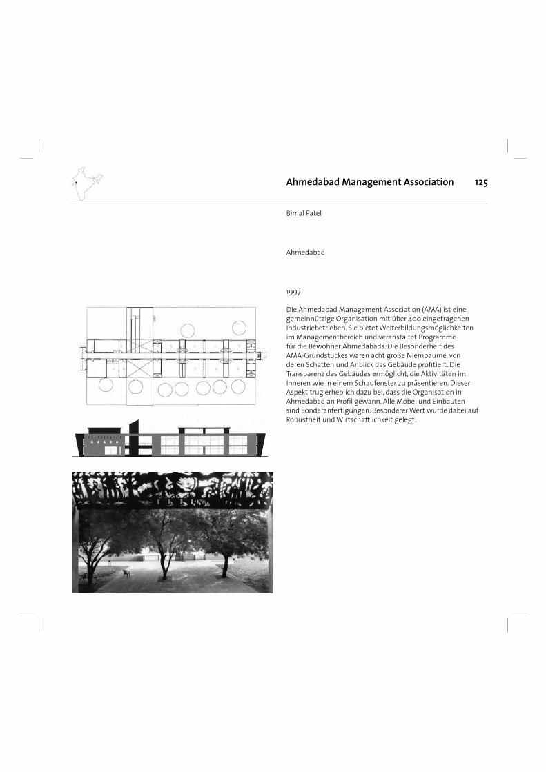
125
Die Ahmedabad Management Association (AMA) ist eine gemeinnützige Organisation mit über 400 eingetragenen Industriebetrieben. Sie bietet Weiterbildungsmöglichkeiten im Managementbereich und veranstaltet Programme für die Bewohner Ahmedabads. Die Besonderheit des AMA-Grundstückes waren acht große Niembäume, von deren Schatten und Anblick das Gebäude profi tiert. Die Transparenz des Gebäudes ermöglicht, die Aktivitäten im Inneren wie in einem Schaufenster zu präsentieren. Dieser Aspekt trug erheblich dazu bei, dass die Organisation in Ahmedabad an Profi l gewann. Alle Möbel und Einbauten sind Sonderanfertigungen. Besonderer Wert wurde dabei auf Robustheit und Wirtschaftlichkeit gelegt.
Ahmedabad Management Association
1997
Bimal Patel
Ahmedabad
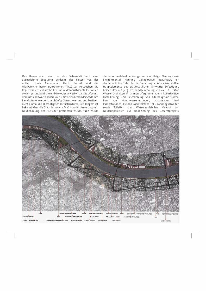
Das Bauvorhaben am Ufer des Sabarmati sieht eine ausgedehnte Bebauung beidseits des Flusses vor, dermitten durch Ahmedabad fl ießt. Zurzeit sind die Uferbereiche heruntergekommen. Abwässer verseuchen die Regenwasserrückhaltebecken und wilde Industrieabfalldeponien stellen gesundheitliche und ökologische Risiken dar. Die Ufer und der Fluss sind zwar Lebensraum für die vielen Armen der Stadt, ihre Elendsviertel werden aber häufi g überschwemmt und besitzen nicht einmal die allernötigsten Infrastrukturen. Seit langem ist bekannt, dass die Stadt in hohem Maß von der Sanierung und Neubebauung der Flussufer profi tieren würde. 1997 wurde
die in Ahmedabad ansässige gemeinnützige Planungsfi rma Environmental Planning Collaborative beauftragt, ein städtebauliches Gutachten zur Sanierung der Areale zu erstellen. Hauptelemente des städtebaulichen Entwurfs: Befestigung beider Ufer auf je 9 km; Landgewinnung von ca. 162 Hektar; Wasserrückhaltemaßnahmen; Uferpromenaden inkl. Parkplätze; Parzellierung und Erschließung von Uferbaugrundstücken; Bau von Hauptwasserleitungen, Kanalisation inkl. Pumpstationen, kleinen Marktplätzen inkl. Parkmöglichkeiten sowie Toiletten und Wasserzapfstellen; Verkauf von Neulandparzellen zur Finanzierung des Gesamtprojekts.
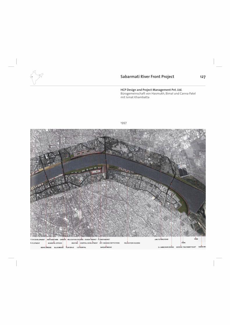
127Sabarmati River Front Project
1997
HCP Design and Project Management Pvt. Ltd.Bürogemeinschaft von Hasmukh, Bimal und Canna Patelmit Ismat Khambatta
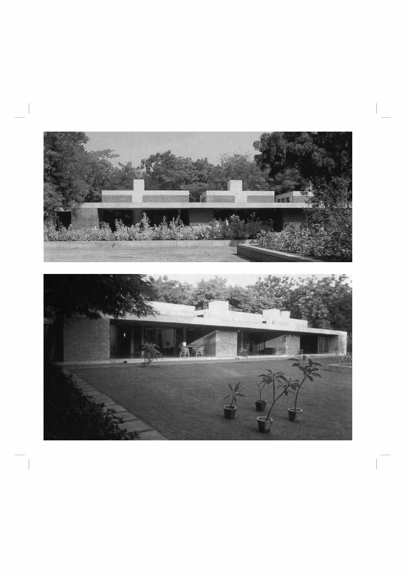
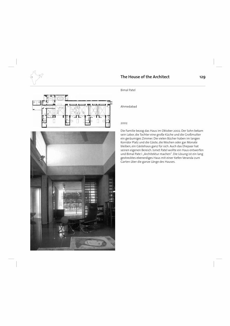
129
Die Familie bezog das Haus im Oktober 2002. Der Sohn bekam sein Labor, die Tochter eine große Küche und die Großmutter ein geräumiges Zimmer. Die vielen Bücher haben im langen Korridor Platz und die Gäste, die Wochen oder gar Monate bleiben, ein Gästehaus ganz für sich. Auch das Ehepaar hat seinen eigenen Bereich. Ismet Patel wollte ein Haus entwerfen und Bimal Pate I „Architektur machen“. Die Lösung ist ein lang gestrecktes ebenerdiges Haus mit einer tiefen Veranda zum Garten über die ganze Länge des Hauses.
The House of the Architect
2002
Bimal Patel
Ahmedabad
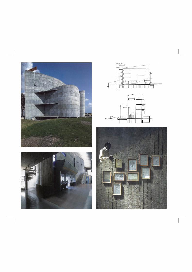
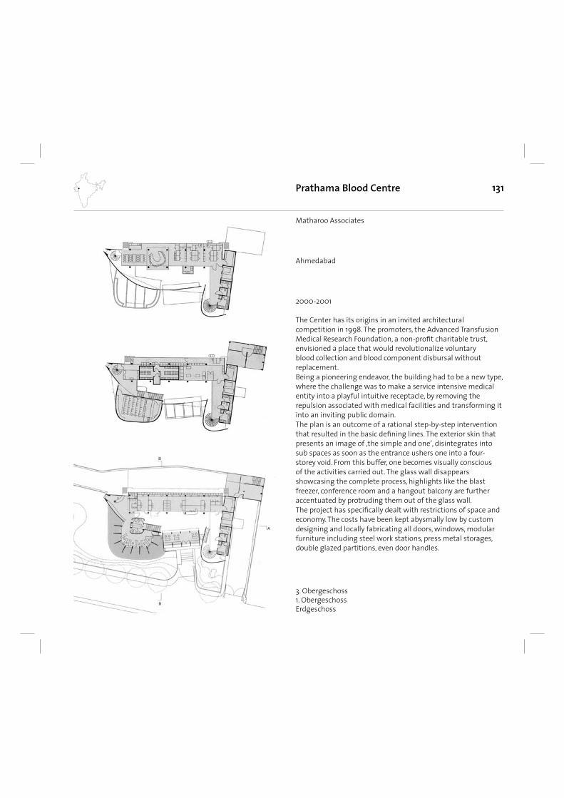
131
The Center has its origins in an invited architectural competition in 1998. The promoters, the Advanced Transfusion Medical Research Foundation, a non-profi t charitable trust, envisioned a place that would revolutionalize voluntary blood collection and blood component disbursal without replacement. Being a pioneering endeavor, the building had to be a new type, where the challenge was to make a service intensive medical entity into a playful intuitive receptacle, by removing the repulsion associated with medical facilities and transforming it into an inviting public domain. The plan is an outcome of a rational step-by-step intervention that resulted in the basic defi ning lines. The exterior skin that presents an image of ‚the simple and one‘, disintegrates into sub spaces as soon as the entrance ushers one into a four-storey void. From this buffer, one becomes visually conscious of the activities carried out. The glass wall disappears showcasing the complete process, highlights like the blast freezer, conference room and a hangout baIcony are further accentuated by protruding them out of the glass wall. The project has specifi cally dealt with restrictions of space and economy. The costs have been kept abysmally low by custom designing and locally fabricating all doors, windows, modular furniture including steel work stations, press metal storages, double glazed partitions, even door handles.
Prathama Blood Centre
2000-2001
Matharoo Associates
3. Obergeschoss1. ObergeschossErdgeschoss
Ahmedabad
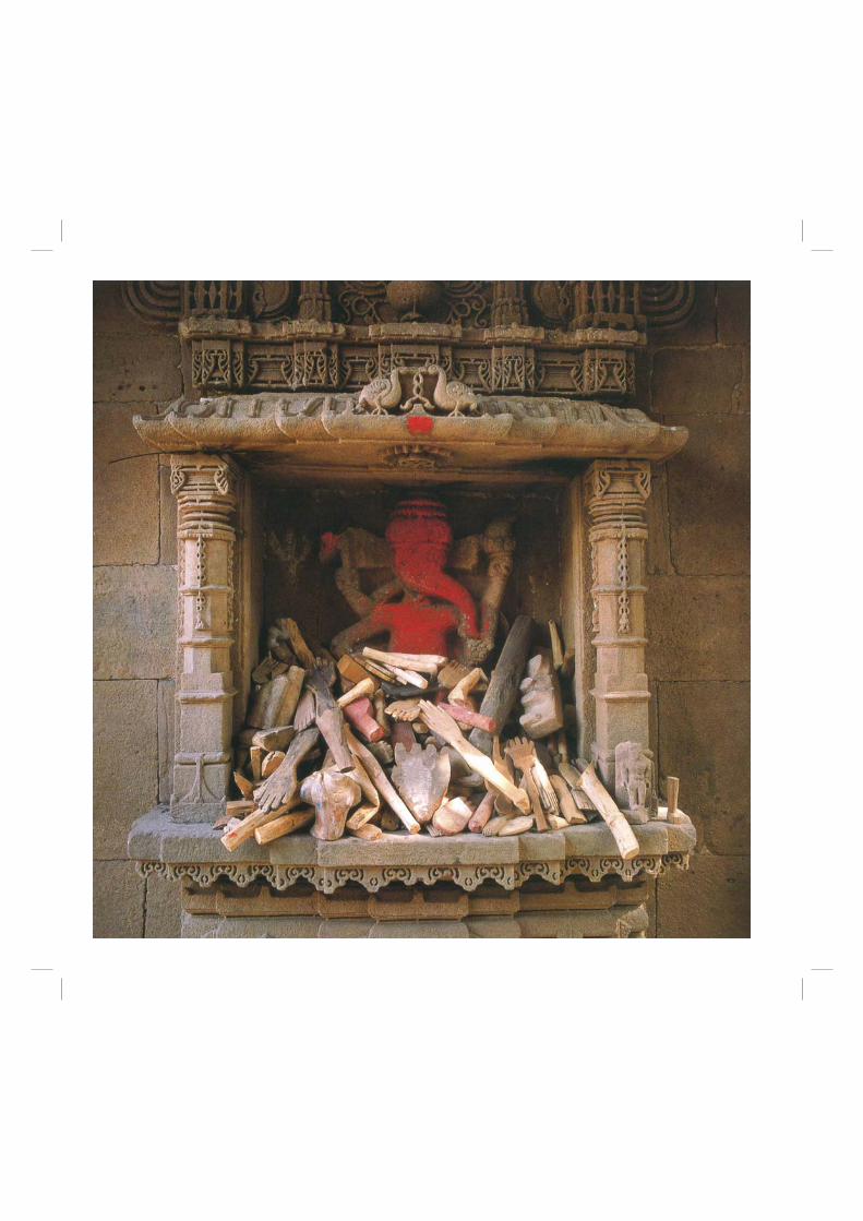
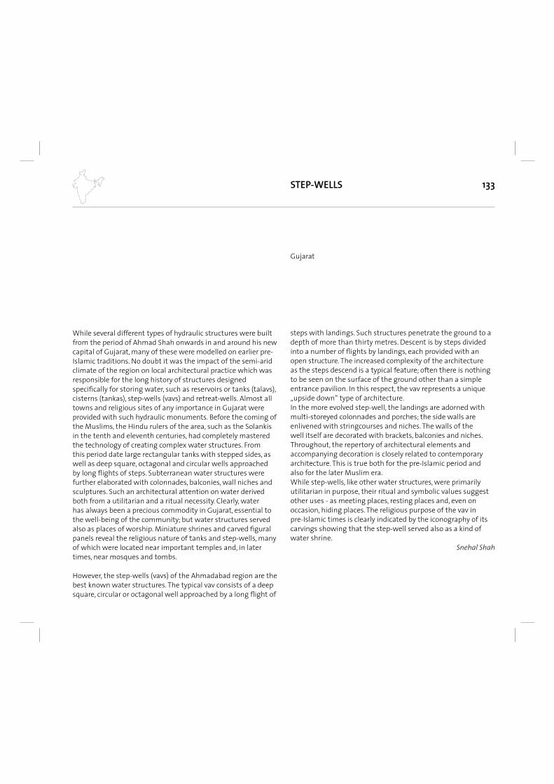
133STEP-WELLS
While several different types of hydraulic structures were built from the period of Ahmad Shah onwards in and around his new capital of Gujarat, many of these were modelled on earlier pre-Islamic traditions. No doubt it was the impact of the semi-arid climate of the region on local architectural practice which was responsible for the long history of structures designed specifi cally for storing water, such as reservoirs or tanks (talavs), cisterns (tankas), step-wells (vavs) and retreat-wells. Almost all towns and religious sites of any importance in Gujarat were provided with such hydraulic monuments. Before the coming of the Muslims, the Hindu rulers of the area, such as the Solankis in the tenth and eleventh centuries, had completely mastered the technology of creating complex water structures. From this period date large rectangular tanks with stepped sides, as well as deep square, octagonal and circular wells approached by long fl ights of steps. Subterranean water structures were further elaborated with colonnades, balconies, wall niches and sculptures. Such an architectural attention on water derived both from a utilitarian and a ritual necessity. Clearly, water has always been a precious commodity in Gujarat, essential to the well-being of the community; but water structures served also as places of worship. Miniature shrines and carved fi gural panels reveal the religious nature of tanks and step-wells, many of which were located near important temples and, in later times, near mosques and tombs.
However, the step-wells (vavs) of the Ahmadabad region are the best known water structures. The typical vav consists of a deep square, circular or octagonal well approached by a long fl ight of
steps with landings. Such structures penetrate the ground to a depth of more than thirty metres. Descent is by steps divided into a number of fl ights by landings, each provided with an open structure. The increased complexity of the architecture as the steps descend is a typical feature; often there is nothing to be seen on the surface of the ground other than a simple entrance pavilion. In this respect, the vav represents a unique „upside down“ type of architecture. In the more evolved step-well, the landings are adorned with multi-storeyed colonnades and porches; the side walls are enlivened with stringcourses and niches. The walls of the well itself are decorated with brackets, balconies and niches. Throughout, the repertory of architectural elements and accompanying decoration is closely related to contemporary architecture. This is true both for the pre-Islamic period and also for the later Muslim era. While step-wells, like other water structures, were primarily utilitarian in purpose, their ritual and symbolic values suggest other uses - as meeting places, resting places and, even on occasion, hiding places. The religious purpose of the vav in pre-Islamic times is clearly indicated by the iconography of its carvings showing that the step-well served also as a kind of water shrine.
Snehal Shah
Gujarat
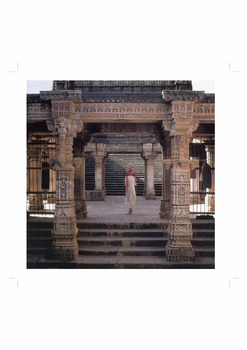
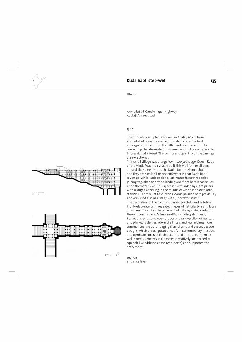
135Ruda Baoli step-well
The intricately sculpted step-well in Adalaj, 20 km from Ahmedabad, is well preserved. It is also one of the best underground structures. The pillar and beam structure for controlling the atmospheric pressure as you descend, gives the impression of a forest. The quality and quantity of the carvings are exceptional. This small village was a large town 500 years ago. Queen Ruda of the Hindu Waghra dynasty built this well for her citizens, around the same time as the Dada Baoli in Ahmedabad and they are similar. The one difference is that Dada Baoli is vertical while Ruda Baoli has staircases from three sides joining together on a wide landing and from here it continues up to the water level. This space is surrounded by eight pillars with a large fl at ceiling in the middle of which is an octagonal stairwell. There must have been a dome pavilion here previously and was used also as a stage with „spectator seats“.The decoration of the columns, curved brackets and lintels is highly elaborate, with repeated friezes of fl at pilasters and lotus ornament. Tiers of richly ornamented balcony slabs overlook the octagonal space. Animal motifs, including elephants, horses and birds, and even the occasional depiction of hunters and planetary deities, adorn the lintels and wall niches; more common are the pots hanging from chains and the arabesque designs which are ubiquitous motifs in contemporary mosques and tombs. In contrast to this sculptural profusion, the main well, some six metres in diameter, is relatively unadorned. A squinch-like addition at the rear (north) end supported the draw ropes.
1502
Hindu
Ahmedabad-Gandhinagar HighwayAdalaj (Ahmedabad)
sectionentrance level
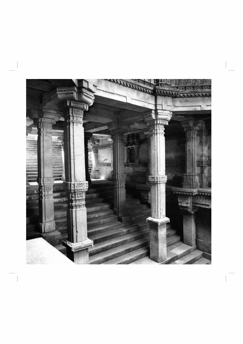
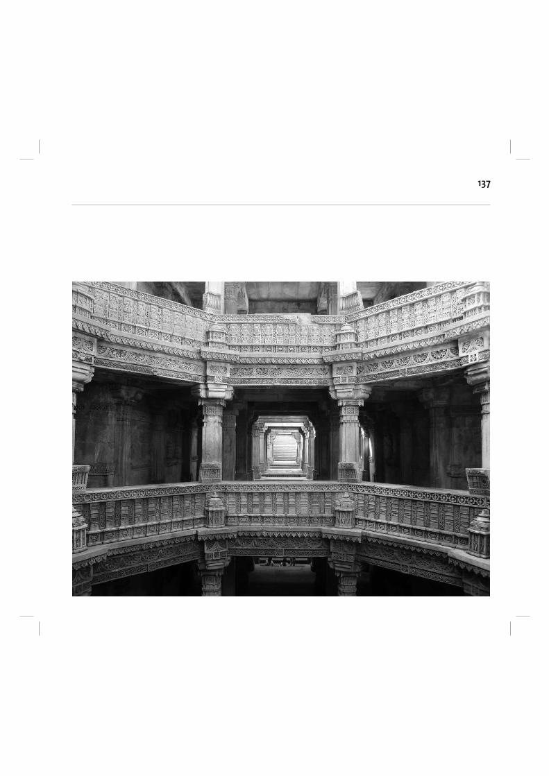
137
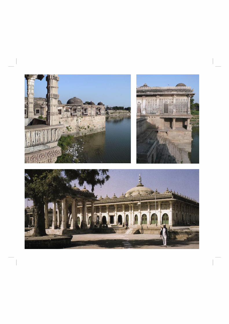
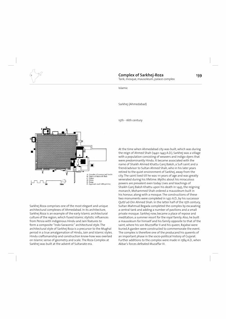
139Complex of Sarkhej-RozaTank, mosque, mausoleum, palace complex
Sarkhej Roza comprises one of the most elegant and unique architectural complexes of Ahmedabad. In its architecture, Sarkhej Roza is an example of the early Islamic architectural culture of the region, which fused Islamic stylistic infl uences from Persia with indigenous Hindu and Jain features to form a composite “Indo-Saracenic” architectural style. The architectural style of Sarkhej Roza is a precursor to the Mughal period in a true amalgamation of Hindu, Jain and Islamic styles. Hindu craftsmanship and construction know-how was overlaid on Islamic sense of geometry and scale. The Roza Complex at Sarkhej was built at the advent of Sultanate era.
15th - 16th century
Islamic
Sarkhej (Ahmedabad)
At the time when Ahmedabad city was built, which was during the reign of Ahmed Shah (1440-1443 A.D.), Sarkhej was a village with a population consisting of weavers and indigo-dyers that were predominantly Hindu. It became associated with the name of Shaikh Ahmed Khattu Ganj Baksh, a Sufi saint and a friend/advisor to Sultan Ahmed Shah, who in his later years retired to the quiet environment of Sarkhej, away from the city. The saint lived till he was 111 years of age and was greatly venerated during his lifetime. Myths about his miraculous powers are prevalent even today. Lives and teachings of Shaikh Ganj Baksh Khattu upon his death in 1445, the reigning monarch, Mohammed Shah ordered a mausoleum built in his honour, along with a mosque. The constructions of these two monuments were completed in 1451 A.D., by his successor Qutb‘ud-Din Ahmed Shah. In the latter half of the 15th century, Sultan Mahmud Begada completed the complex by excavating a central tank and adding a number of pavilions and a small private mosque. Sarkhej now, became a place of repose and meditation; a summer resort for the royal family. Also, he built a mausoleum for himself and his family opposite to that of the saint, where his son Muzzaffar II and his queen, Rajabai were buried.A garden were constructed to commemorate the event. The complex is therefore one of the producand his queents of an important phase in the socio-political history of Gujarat. Further additions to the complex were made in 1584 A.D., when Akbar‘s forces defeated Muzaffar III.
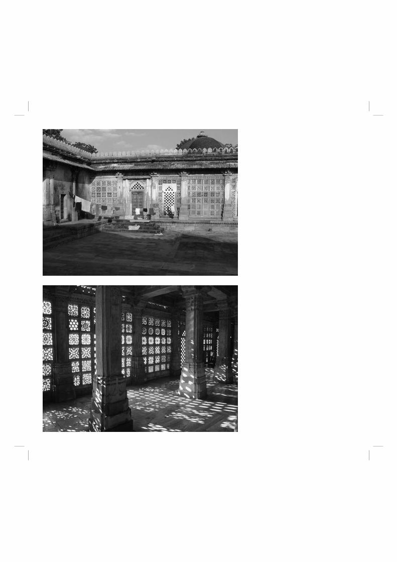
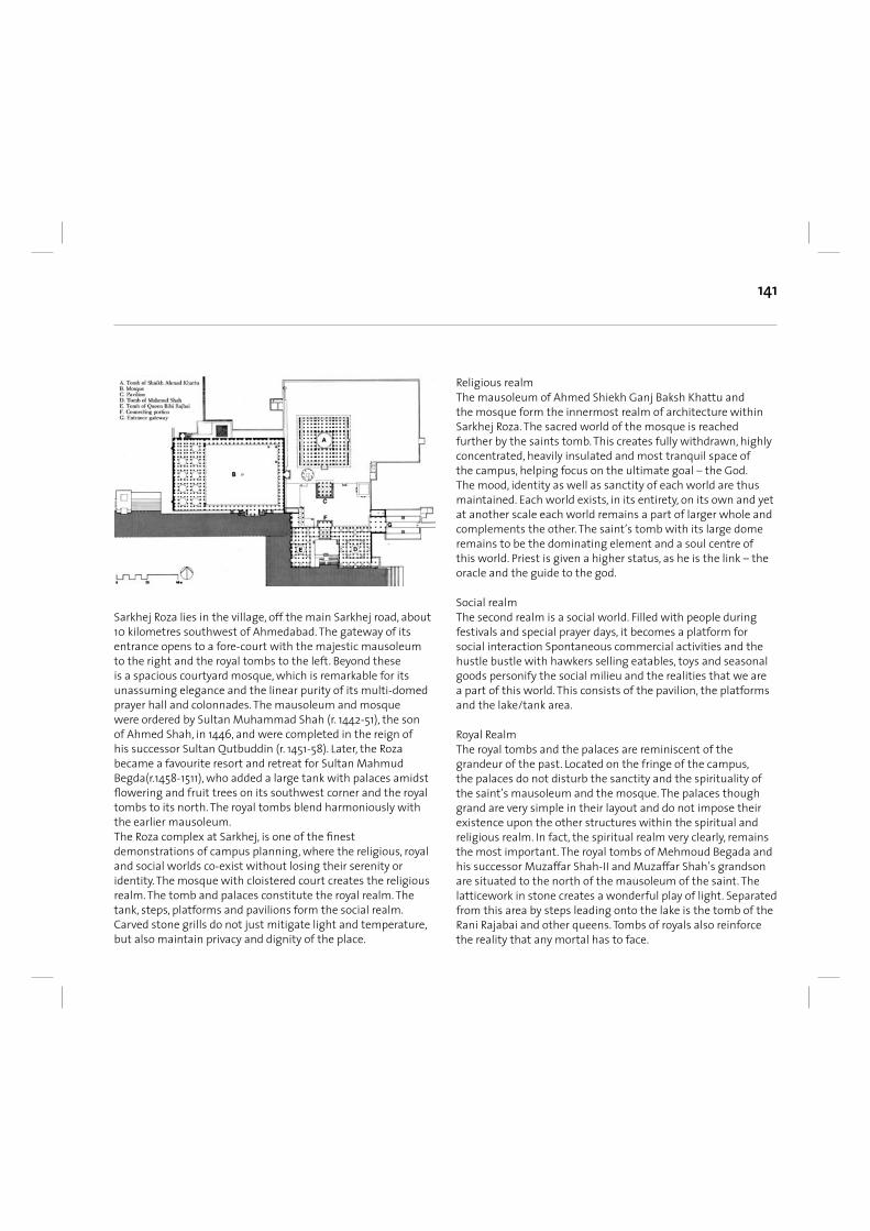
141
Sarkhej Roza lies in the village, off the main Sarkhej road, about 10 kilometres southwest of Ahmedabad. The gateway of its entrance opens to a fore-court with the majestic mausoleum to the right and the royal tombs to the left. Beyond these is a spacious courtyard mosque, which is remarkable for its unassuming elegance and the linear purity of its multi-domed prayer hall and colonnades. The mausoleum and mosque were ordered by Sultan Muhammad Shah (r. 1442-51), the son of Ahmed Shah, in 1446, and were completed in the reign of his successor Sultan Qutbuddin (r. 1451-58). Later, the Roza became a favourite resort and retreat for Sultan Mahmud Begda(r.1458-1511), who added a large tank with palaces amidst fl owering and fruit trees on its southwest corner and the royal tombs to its north. The royal tombs blend harmoniously with the earlier mausoleum.The Roza complex at Sarkhej, is one of the fi nest demonstrations of campus planning, where the religious, royal and social worlds co-exist without losing their serenity or identity. The mosque with cloistered court creates the religious realm. The tomb and palaces constitute the royal realm. The tank, steps, platforms and pavilions form the social realm. Carved stone grills do not just mitigate light and temperature, but also maintain privacy and dignity of the place.
Religious realm The mausoleum of Ahmed Shiekh Ganj Baksh Khattu and the mosque form the innermost realm of architecture within Sarkhej Roza. The sacred world of the mosque is reached further by the saints tomb. This creates fully withdrawn, highly concentrated, heavily insulated and most tranquil space of the campus, helping focus on the ultimate goal – the God. The mood, identity as well as sanctity of each world are thus maintained. Each world exists, in its entirety, on its own and yet at another scale each world remains a part of larger whole and complements the other. The saint’s tomb with its large dome remains to be the dominating element and a soul centre of this world. Priest is given a higher status, as he is the link – the oracle and the guide to the god.
Social realm The second realm is a social world. Filled with people during festivals and special prayer days, it becomes a platform for social interaction Spontaneous commercial activities and the hustle bustle with hawkers selling eatables, toys and seasonal goods personify the social milieu and the realities that we are a part of this world. This consists of the pavilion, the platforms and the lake/tank area.
Royal RealmThe royal tombs and the palaces are reminiscent of the grandeur of the past. Located on the fringe of the campus, the palaces do not disturb the sanctity and the spirituality of the saint’s mausoleum and the mosque. The palaces though grand are very simple in their layout and do not impose their existence upon the other structures within the spiritual and religious realm. In fact, the spiritual realm very clearly, remains the most important. The royal tombs of Mehmoud Begada and his successor Muzaffar Shah-II and Muzaffar Shah’s grandson are situated to the north of the mausoleum of the saint. The latticework in stone creates a wonderful play of light. Separated from this area by steps leading onto the lake is the tomb of the Rani Rajabai and other queens. Tombs of royals also reinforce the reality that any mortal has to face.
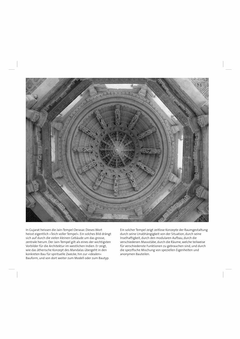
In Gujarat heissen die Jain-Tempel Oerasar. Dieses Wort heisst eigentlich «Teich voller Tempel». Ein solches Bild drängt sich auf durch die vielen kleinen Gebäude um das grosse, zentrale herum. Der Jain-Tempel gilt als eines der wichtigsten Vorbilder für die Architektur im westlichen Indien. Er zeigt, wie das ätherische Konzept des Mandalas übergeht in den konkreten Bau für spirituelle Zwecke, hin zur «idealen» Bauform, und von dort weiter zum Modell oder zum Bautyp.
Ein solcher Tempel zeigt zeitlose Konzepte der Raumgestaltung durch seine Unabhängigkeit von der Situation, durch seine lnselhaftigkeit, durch den modularen Aufbau, durch die verschiedenen Massstäbe, durch die Räume, welche teilweise für verschiedenste Funktionen zu gebrauchen sind, und durch die spezifi sche Mischung von speziellen Eigenheiten und anonymen Bauteilen.
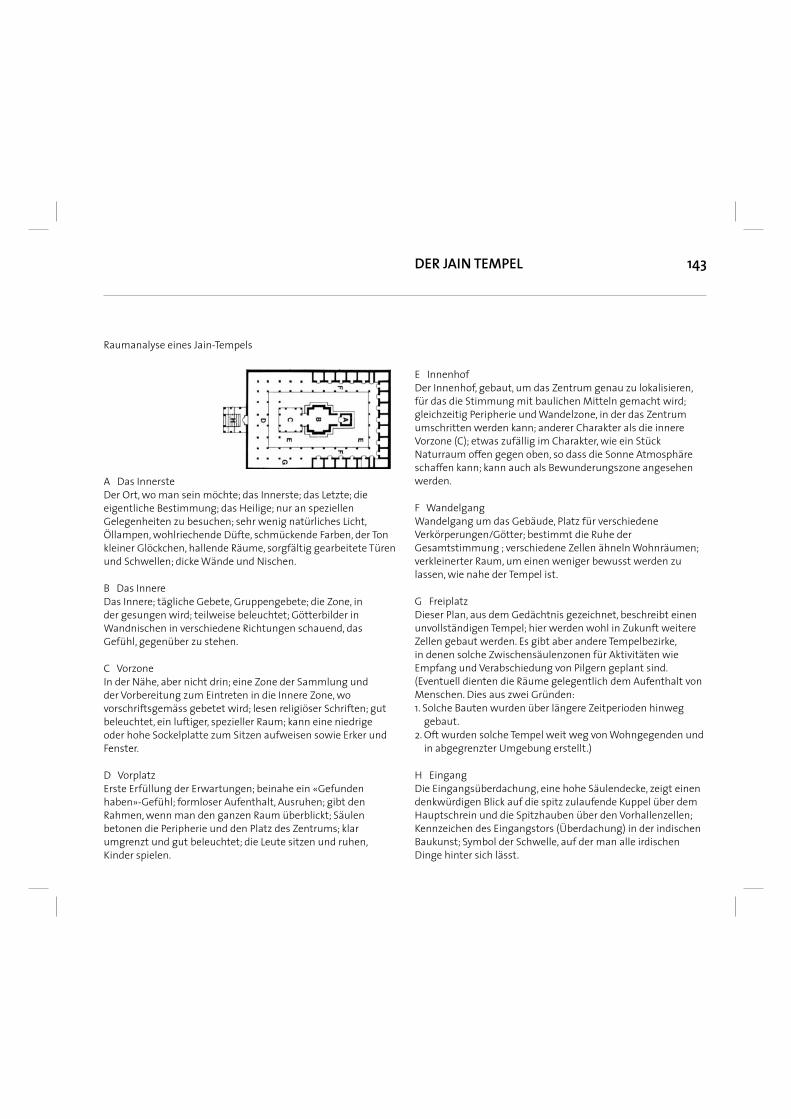
143
Raumanalyse eines Jain-Tempels
A Das Innerste Der Ort, wo man sein möchte; das Innerste; das Letzte; die eigentliche Bestimmung; das Heilige; nur an speziellen Gelegenheiten zu besuchen; sehr wenig natürliches Licht, Öllampen, wohlriechende Düfte, schmückende Farben, der Ton kleiner Glöckchen, hallende Räume, sorgfältig gearbeitete Türen und Schwellen; dicke Wände und Nischen.
B Das Innere Das Innere; tägliche Gebete, Gruppengebete; die Zone, in der gesungen wird; teilweise beleuchtet; Götterbilder in Wandnischen in verschiedene Richtungen schauend, das Gefühl, gegenüber zu stehen.
C VorzoneIn der Nähe, aber nicht drin; eine Zone der Sammlung und der Vorbereitung zum Eintreten in die Innere Zone, wo vorschriftsgemäss gebetet wird; lesen religiöser Schriften; gut beleuchtet, ein luftiger, spezieller Raum; kann eine niedrige oder hohe Sockelplatte zum Sitzen aufweisen sowie Erker und Fenster.
D Vorplatz Erste Erfüllung der Erwartungen; beinahe ein «Gefunden haben»-Gefühl; formloser Aufenthalt, Ausruhen; gibt den Rahmen, wenn man den ganzen Raum überblickt; Säulen betonen die Peripherie und den Platz des Zentrums; klar umgrenzt und gut beleuchtet; die Leute sitzen und ruhen, Kinder spielen.
E Innenhof Der Innenhof, gebaut, um das Zentrum genau zu lokalisieren, für das die Stimmung mit baulichen Mitteln gemacht wird; gleichzeitig Peripherie und Wandelzone, in der das Zentrum umschritten werden kann; anderer Charakter als die innere Vorzone (C); etwas zufällig im Charakter, wie ein Stück Naturraum offen gegen oben, so dass die Sonne Atmosphäre schaffen kann; kann auch als Bewunderungszone angesehen werden.
F Wandelgang Wandelgang um das Gebäude, Platz für verschiedene Verkörperungen/Götter; bestimmt die Ruhe der Gesamtstimmung ; verschiedene Zellen ähneln Wohnräumen; verkleinerter Raum, um einen weniger bewusst werden zu lassen, wie nahe der Tempel ist.
G Freiplatz Dieser Plan, aus dem Gedächtnis gezeichnet, beschreibt einen unvollständigen Tempel; hier werden wohl in Zukunft weitere Zellen gebaut werden. Es gibt aber andere Tempelbezirke, in denen solche Zwischensäulenzonen für Aktivitäten wie Empfang und Verabschiedung von Pilgern geplant sind. (Eventuell dienten die Räume gelegentlich dem Aufenthalt von Menschen. Dies aus zwei Gründen: 1. Solche Bauten wurden über längere Zeitperioden hinweg gebaut. 2. Oft wurden solche Tempel weit weg von Wohngegenden und in abgegrenzter Umgebung erstellt.)
H Eingang Die Eingangsüberdachung, eine hohe Säulendecke, zeigt einen denkwürdigen Blick auf die spitz zulaufende Kuppel über dem Hauptschrein und die Spitzhauben über den Vorhallenzellen; Kennzeichen des Eingangstors (Überdachung) in der indischen Baukunst; Symbol der Schwelle, auf der man alle irdischen Dinge hinter sich lässt.
DER JAIN TEMPEL
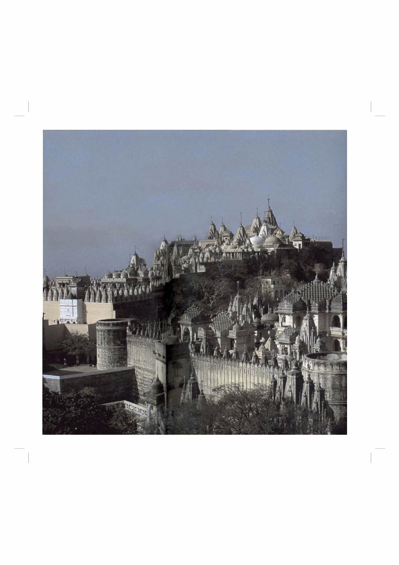
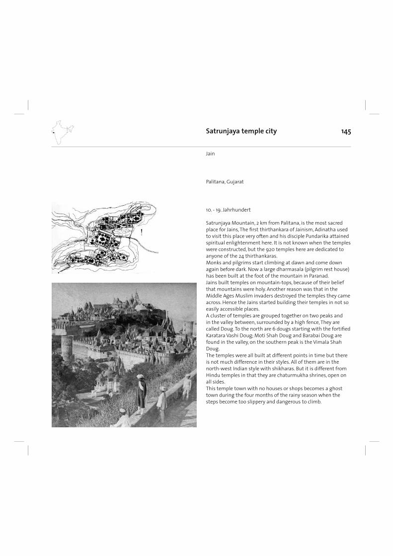
145Satrunjaya temple city
Satrunjaya Mountain, 2 km from Palitana, is the most sacred place for Jains, The fi rst thirthankara of Jainism, Adinatha used to visit this place very often and his disciple Pundarika attained spiritual enlightenment here. It is not known when the temples were constructed, but the 920 temples here are dedicated to anyone of the 24 thirthankaras.Monks and pilgrims start climbing at dawn and come down again before dark. Now a large dharmasala (pilgrim rest house) has been built at the foot of the mountain in Paranad.Jains built temples on mountain-tops, because of their belief that mountains were holy. Another reason was that in the Middle Ages Muslim invaders destroyed the temples they came across. Hence the Jains started building their temples in not so easily accessible places.A cluster of temples are grouped together on two peaks and in the valley between, surrounded by a high fence, They are called Doug. To the north are 6 dougs starting with the fortifi ed Karatara Vashi Doug; Moti Shah Doug and Barabai Doug are found in the valley, on the southern peak is the Vimala Shah Doug. The temples were all built at different points in time but there is not much difference in their styles. All of them are in the north-west Indian style with shikharas. But it is different from Hindu temples in that they are chaturmukha shrines, open on all sides. This temple town with no houses or shops becomes a ghost town during the four months of the rainy season when the steps become too slippery and dangerous to climb.
10. - 19. Jahrhundert
Jain
Palitana, Gujarat
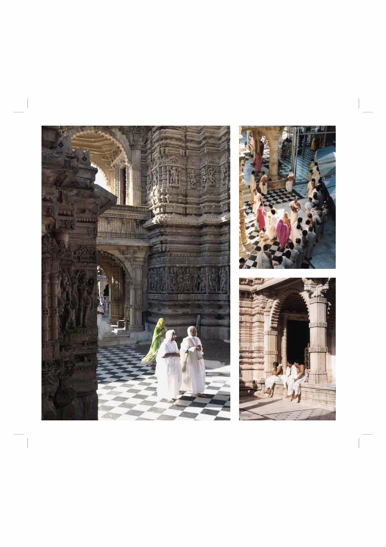
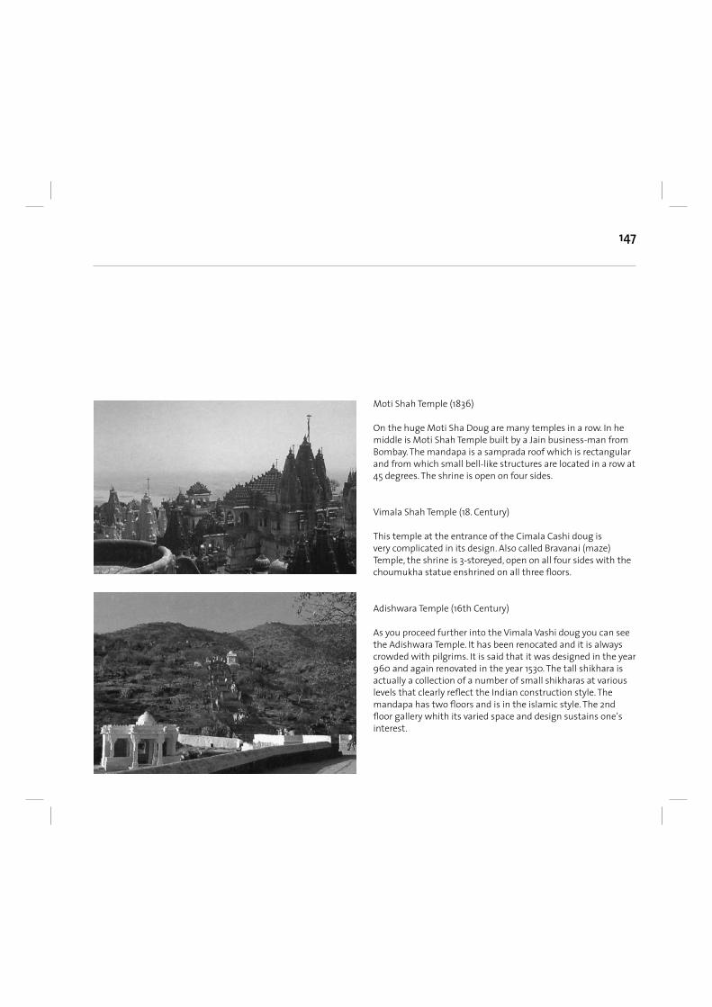
147
Moti Shah Temple (1836)
On the huge Moti Sha Doug are many temples in a row. In he middle is Moti Shah Temple built by a Jain business-man from Bombay. The mandapa is a samprada roof which is rectangular and from which small bell-like structures are located in a row at 45 degrees. The shrine is open on four sides.
Vimala Shah Temple (18. Century)
This temple at the entrance of the Cimala Cashi doug is very complicated in its design. Also called Bravanai (maze) Temple, the shrine is 3-storeyed, open on all four sides with the choumukha statue enshrined on all three fl oors.
Adishwara Temple (16th Century)
As you proceed further into the Vimala Vashi doug you can see the Adishwara Temple. It has been renocated and it is always crowded with pilgrims. It is said that it was designed in the year 960 and again renovated in the year 1530. The tall shikhara is actually a collection of a number of small shikharas at various levels that clearly refl ect the Indian construction style. The mandapa has two fl oors and is in the islamic style. The 2nd fl oor gallery whith its varied space and design sustains one’s interest.
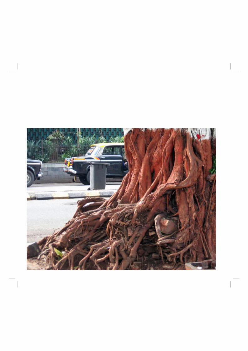
149
Vorgeschichte und klassisches ZeitalterDie Industal-Zivilisation, größtenteils im heutigen Pakistan gelegen, war eine der frühen Hochkulturen der Welt, mit einer eigenen Schrift, der bisher nicht entzifferten Indus-Schrift. Um etwa 2500 v. Chr. existierten dort geplante Städte wie Harappa, mit einer Kanalisation, Seehäfen und Bädern, während angenommen wird, dass in Südindien noch weniger entwickelte Verhältnisse herrschten. Weiter östlich machen sich andere archäologische Komplexe bemerkbar wie die so genannte Copper Hoard Culture. Ab 1700 v. Chr. setzte aus bislang unbekannten Gründen der Zerfall der Indus-Kultur ein.
Eine für die weitere Entwicklung Indiens sehr wichtige Periode war die vedische Zeit (etwa 1500 v. Chr. bis 500 v. Chr.), in der die Grundlagen der heutigen Kultur geschaffen wurden. Über die politische Entwicklung ist weitaus weniger bekannt als über die religiöse und philosophische Entwicklung. Gegen Ende der vedischen Zeit wurden die Upanishaden geschaffen, die in vielerlei Hinsicht die Basis der in Indien entstandenen Religionen Hinduismus, Buddhismus und Jainismus bilden. In diese Zeit fällt die Urbanisierung in der Gangesebene und der Aufstieg regionaler Königreiche wie Magadha.
Ab dem 6. Jahrhundert v. Chr. entfaltete sich der Buddhismus, der rund 500 Jahre lang neben dem Hinduismus die maßgebliche Geistesströmung Indiens darstellte. Im 4. Jahrhundert v. Chr. entstand unter der Dynastie der Maurya erstmals ein indisches Großreich, das unter Ashoka fast den gesamten Subkontinent beherrschte. Ashoka wandte sich nach zahlreichen Eroberungszügen dem Buddhismus zu, den er im eigenen Land und bis nach Sri Lanka und Birma zu verbreiten suchte. Nach seinem Tode zerfi el das Maurya-Reich allmählich erneut in zahllose Kleinstaaten, die erst im 4. Jahrhundert n. Chr. von den Gupta wieder zu einem Großreich in Nordindien geeint werden konnten. Mit dem Buddhismus übte Indien einen wesentlichen kulturellen Einfl uss auf den gesamten Bereich von Zentral- und Ostasien aus. Die Ausbreitung des Hinduismus und Buddhismus über Indochina bis in das heutige Indonesien prägte Geschichte und Kultur dieser Länder. Als letzter großer Förderer des Buddhismus in Indien gilt Harshavardhana, dessen Herrschaft im Nordindien des 7. Jahrhunderts den Übergang zum indischen Mittelalter markiert.
Geschichte Indiens
Indisches Mittelalter und MogulzeitArabische Eroberungszüge im 8. Jahrhundert brachten den Islam nach Nordindien. Zu einer Dominanz muslimischer Staaten im Norden sowie zur Islamisierung größerer Teile der dortigen Bevölkerung kam es jedoch erst mit den Invasionen zentralasiatischer islamischer Mächte ab dem 12. Jahrhundert. Das Sultanat von Delhi weitete seine Macht sogar kurzzeitig auf den Süden aus, dennoch blieb sein kultureller Einfl uss auf den Norden begrenzt. Der Mongoleneinfall des Jahres 1398 schwächte das Sultanat, sodass die hinduistischen Regionalreiche wiedererstarkten. Erholen konnten sich die muslimischen Herrscher erst im 16. Jahrhundert mit der Gründung des Mogulreiches, das für rund 200 Jahre zur bestimmenden Kraft des Nordens wurde und noch bis 1857 Bestand hatte. Herausragende Herrscher wie Akbar, Jahangir, Shah Jahan und Aurangzeb dehnten nicht nur die Grenzen des Reiches bis auf den Dekkan aus, sondern schufen auch ein funktionierendes Verwaltungs- und Staatswesen und förderten die Künste. Hinduistische Königtümer gab es während ihrer Zeit nur noch in Südindien, etwa in Vijayanagar.
EuropäischeKolonialherrschaft und Unabhängigkeits- bewegungEuropäische Mächte, zunächst Portugal, begannen ab 1505 kleinere Küstenstützpunkte zu erobern (vgl. Portugiesisch-Indien). Von 1756 an unterwarf die britische Ostindien-Kompanie (British East India Company) von ihren Hafenstützpunkten Kalkutta, Madras und Bombay aus weite Teile Indiens. Der vorher bestehende Einfl uss der europäischen Kolonialmächte Portugal, Niederlande und Frankreich wurde von ihr weitgehend beseitigt. Loyale Fürsten behielten Staaten mit begrenzter Souveränität wie Hyderabad, Bhopal, Mysore oder Kaschmir. 1857/58 erhoben sich Teile der Bevölkerung Nordindiens im Sepoy-Aufstand gegen die Herrschaft der Ostindien-Kompanie. Nach der Niederwerfung des Aufstandes wurde diese aufgelöst und Indien der direkten Kontrolle durch Großbritannien unterstellt. Die britischen Monarchen trugen ab 1877 (bis 1947) zusätzlich den Titel Empress of India bzw. Emperor of India (Kaiser(in) von Indien).1885 wurde in Bombay der Indian National Congress (Kongresspartei) gegründet. Sie forderte zunächst nicht die Unabhängigkeit Indiens, sondern lediglich mehr politische
150
Mitspracherechte für die einheimische Bevölkerung. Ihre Mitglieder waren vorwiegend Hindus und Parsen. Die muslimische Oberschicht blieb auf Abstand. Deren Wortführer Sayyid Ahmad Khan befürchtete, dass sie durch Einführung des Mehrheitsprinzips aus der Verwaltung gedrängt würden. Stattdessen wurde 1906 die Muslimliga als Interessenvertretung der Muslime gegründet.Im Ersten Weltkrieg verhielt sich die große Mehrheit der Bevölkerung loyal. Aus Verärgerung darüber, dass die Briten an der Aufteilung des Osmanischen Reiches beteiligt waren, schlossen sich nun auch viele Muslime der Unabhängigkeitsbewegung an. Der gewaltfreie Widerstand gegen die britische Kolonialherrschaft, vor allem unter Mahatma Gandhi und Jawaharlal Nehru, führte 1947 zur Unabhängigkeit.Gleichzeitig verfügte die Kolonialmacht die Teilung der fast den gesamten indischen Subkontinent umfassenden Kolonie Britisch-Indien in zwei Staaten, die säkulare Indische Union sowie die kleinere Islamische Republik Pakistan. Die Briten erfüllten damit die seit den 1930er Jahren lauter werdenden Forderungen der Muslimliga und ihres Führers Ali Jinnah nach einem eigenen Nationalstaat mit muslimischer Bevölkerungsmehrheit.
Entwicklungen seit der UnabhängigkeitDie Teilung führte zu einer der größten Vertreibungs- und Fluchtbewegungen der Geschichte. Ungefähr 10 Millionen Hindus und Sikhs wurden aus Pakistan vertrieben, etwa 7 Millionen Muslime aus Indien. 750.000 bis eine Million Menschen kamen ums Leben. Die Vertreibung nahezu aller Hindus und Sikhs aus dem Gebiet des damaligen West- und Ostpakistan (heute Pakistan und Bangladesch) und der Vertreibung vieler Muslime aus Indien gilt als Beispiel für eine sogenannte ethnische Säuberung ohne unmittelbare Verursachung durch einen Krieg.Die durch Schutzverträge an die Briten gebundenen Fürstenstaaten hatten schon vor der Unabhängigkeit ihren Beitritt zur Indischen Union erklärt. Lediglich zwei standen dem Eingliederungsprozess der Fürstentümer ernsthaft im Weg. Der muslimische Herrscher des fast ausschließlich hinduistischen Hyderabad wurde durch einen Einmarsch indischer Truppen zu Fall gebracht. In Kaschmir verzögerte der Maharaja, selbst Hindu bei überwiegend moslemischer Bevölkerung, seine Entscheidung. Nachdem muslimische Kämpfer in sein Land eingedrungen waren, entschied er sich schließlich doch zum Beitritt zu Indien,
welches daraufhin den größten Teil des ehemaligen Fürstentums besetzte. Pakistan betrachtete den Beitritt als unrechtmäßig, was zum Ersten Indisch-Pakistanischen Krieg um Kaschmir (1947 bis 1949) führte. Seitdem schwelt in der Grenzregion der Kaschmir-Konfl ikt, der 1965 auch den Zweiten Indisch-Pakistanischen Krieg und 1999 den Kargil-Krieg zur Folge hatte.Am 26. November 1949 trat Indien dem Commonwealth of Nations bei und am 26. Januar 1950 trat die vor allem von Bhimrao Ambedkar ausgearbeitete Verfassung in Kraft, durch die Indien zur Republik wurde. Grenzstreitigkeiten führten 1962 zu einem kurzen Krieg mit der Volksrepublik China, dem sogenannten Indisch-Chinesischen Grenzkrieg. Die indische Unterstützung einer Unabhängigkeitsbewegung im damaligen Ost-Pakistan führte 1971 zu einem dritten Krieg Indiens gegen Pakistan mit folgender Teilung Pakistans und Gründung des neuen, ebenfalls islamisch geprägten Staates Bangladesch.Innenpolitisch bestimmte unter Jawaharlal Nehru, Premierminister 1947 bis 1964, und danach noch bis Anfang der 1970er Jahre die Kongresspartei überlegen die junge, unabhängige Demokratie. Oppositionsparteien konnten bestenfalls auf Bundesstaaten- oder kommunaler Ebene ihren Einfl uss geltend machen. Erst als Nehrus Tochter Indira Gandhi, die 1966 Premierministerin wurde, die Partei zentralisierte und ihre eigene Machtposition auszubauen versuchte, gelang es der Opposition, sich auf Bundesebene zu formieren. Ein Gericht in Allahabad befand Indira 1975 einiger Unregelmäßigkeiten bei den Wahlen des Jahres 1971 für schuldig. Anstatt den Rücktrittsforderungen
151
ihrer politischen Gegner zu folgen, rief sie den Notstand aus und regierte bis 1977 per Dekret. Demokratische Grundrechte wie Presse- und Versammlungsfreiheit waren stark eingeschränkt. Die zunehmende Unzufriedenheit der Bevölkerung mit dem de facto diktatorischen Regime äußerte sich 1977 in einer deutlichen Wahlniederlage Indira Gandhis. Zwischen 1977 und 1980 stellte daher erstmals nicht die Kongresspartei, sondern eine linksgerichtete Koalition unter Führung der Janata Party die Regierung Indiens.In den Wahlen von 1980 gelang es Indira Gandhi, an die Macht zurückzukehren. In ihre zweite Amtsperiode fällt die Zuspitzung des Konfl ikts im Punjab, wo sikhistische Separatisten einen eigenen Staat forderten. Als sich militante Sikhs im Goldenen Tempel in Amritsar verschanzten, ordnete Indira Gandhi 1984 die Operation Blue Star an. Indische Truppen stürmten den Tempel und beendeten dessen Besetzung. Daraufhin kam es zu blutigen Ausschreitungen, die in der Ermordung Indira Gandhis durch ihre Sikh-Leibwächter gipfelten. Ihr Sohn Rajiv Gandhi übernahm die Regierungsgeschäfte, war aber nicht in der Lage, die von ihm geplanten Reformvorhaben wirkungsvoll umzusetzen. Ein Bestechungsskandal im Zusammenhang mit dem schwedischen Rüstungskonzern Bofors schädigte sein Ansehen schließlich dermaßen, dass die Opposition 1989 einen klaren Sieg über Gandhis Kongresspartei erringen konnte. Nach zweijähriger Unterbrechung gelangte sie von 1991 bis 1996 jedoch erneut an die Macht. Die Regierung von P. V. Narasimha Rao leitete die
wirtschaftliche Öffnung und außenpolitische Neuorientierung des seit Nehru sozialistisch ausgerichteten Landes ein. Zum Reformprogramm gehörten unter anderem die Privatisierung von Staatsbetrieben, die Aufhebung von Handelsbeschränkungen, die Beseitigung bürokratischer Investitionshemmnisse und Steuersenkungen. Die Wirtschaftsreformen wurden von späteren Regierungen fortgeführt.Seit den 1980er Jahren verzeichnet der Hindu-Nationalismus einen deutlichen Aufschwung. Die Auseinandersetzung um eine anstelle eines bedeutenden Hindutempels errichtete Moschee in Ayodhya (Uttar Pradesh) entwickelte sich zu einer der bestimmenden innenpolitischen Streitfragen. 1992 zerstörten hinduistische Extremisten das muslimische Gotteshaus, was zu schweren Ausschreitungen in weiten Teilen des Landes führte. Der politische Arm der Hindu-Nationalisten, die Bharatiya Janata Party (BJP), führte zwischen 1998 und 2004 eine Regierungskoalition an und stellte mit Atal Bihari Vajpayee den Regierungschef. 2004 unterlag sie jedoch überraschend der neu aufgestellten Kongresspartei unter Sonia Gandhi. Die Witwe des 1991 während des Wahlkampfes ermordeten Rajiv Gandhi verzichtete nach Protesten der Opposition wegen ihrer italienischen Abstammung auf das Amt als Premierministerin. Stattdessen übernahm Manmohan Singh diese Stellung, der als Finanzminister unter Rao die wirtschaftliche Liberalisierung Indiens wesentlich mitgestaltet hatte.Heute sind die fundamentalen Probleme Indiens trotz des deutlichen wirtschaftlichen Aufschwungs noch immer die ausgedehnte Armut als auch die starke Überbevölkerung, die zunehmende Umweltverschmutzung sowie ethnische und religiöse Konfl ikte zwischen Hindus und Moslems. Dazu tritt der fortdauernde Streit mit Pakistan um die Region Kaschmir. Besondere Brisanz erhält der indisch-pakistanische Gegensatz durch die Tatsache, dass beide Staaten Atommächte sind. Indien hatte 1974 erstmals einen Atomtest durchgeführt. Auf weitere Kernwaffenversuche im Jahre 1998 reagierte Pakistan mit eigenen Atomtests.
152 Architektonisches Glossar
agasifl at portion of a roofarabesque stylized foliation with stalks and leaves. arcuate arched mode of construction aro bathing ghat baithak reception room baoli step-well blind arch arch-like recess, not an opening burj fort caravanserai structure for travellers chamfered with the corners cut off char-bagh garden design with four squares chhatri small domed pavilion with pillars chowk courtyard of a house; name of a market street chunam lime plaster clearstory upper part of a multi-storeyed space to admit light coffered fl at ceiling divided into square or diamond-shaped patterns corbel an outward projection corbelled dome created by projecting successive rings of horizontal stone courses darwaza gateway four-centred arch with double-curves on each side garbhagriha temple sanctuary ghat bathing place hamam bath-house harem female quarters of a palace haveli large house or mansion hypostyle composed of columns only iwan monumental portal jali pierced screen jamb side portion of a doorway Jami‘ Masjid Friday Mosque, principal place of worship for a Muslim community kakshasan sloping back rest, usually in a porch kalasha pot-like motif kumbhi stone pillar base linga phallic emblem of the god Shiva lintel beam over an opening mandapa columned hall in a temple mihrab niche in the wall of a prayer chamber indicating the direction of Mecca minaret slender tower from which the call to prayer is given oriel window window carried on a projecting balcony otla front verandah of a house parapet wall rising above the roof
153
parasal room opening off a chowk pendentive corner element supporting a dome pishtaq monumental portal pol urban residential unit with a single street pseudo-minaret non-functional minaret Pura city quarter or neighbourhood qaisariya market qanati temporary mosque created with screen walls qibla rear wall of prayer chamber containing one mihrabs rauza enclosure containing a tomb and usually mosque roof cornice bottom roof line rotunda domed chamber sarai enclosed area with facilities for travellers sayyid lineal descendant of the Prophet Muhammad shaikh, shaykh Muslim holy man or saint squinch arch-like corner element supporting a dome stilted dome elevated on straight sides stringcourse horizontal decorative feature on a wall stucco polished plaster tah-khana basement talav reservoir or tank tanka underground cistern tirtha sacred place or shrine torana gateway consisting of two pillars supporting a sinuous arch-likelement trabeate pillar and lintel mode of construction tympanum upper interior of an arch umro, threshold of house zan ana female quarters of a palace Zoroastrianism religion of the Parsis
Architektonisches Glossar
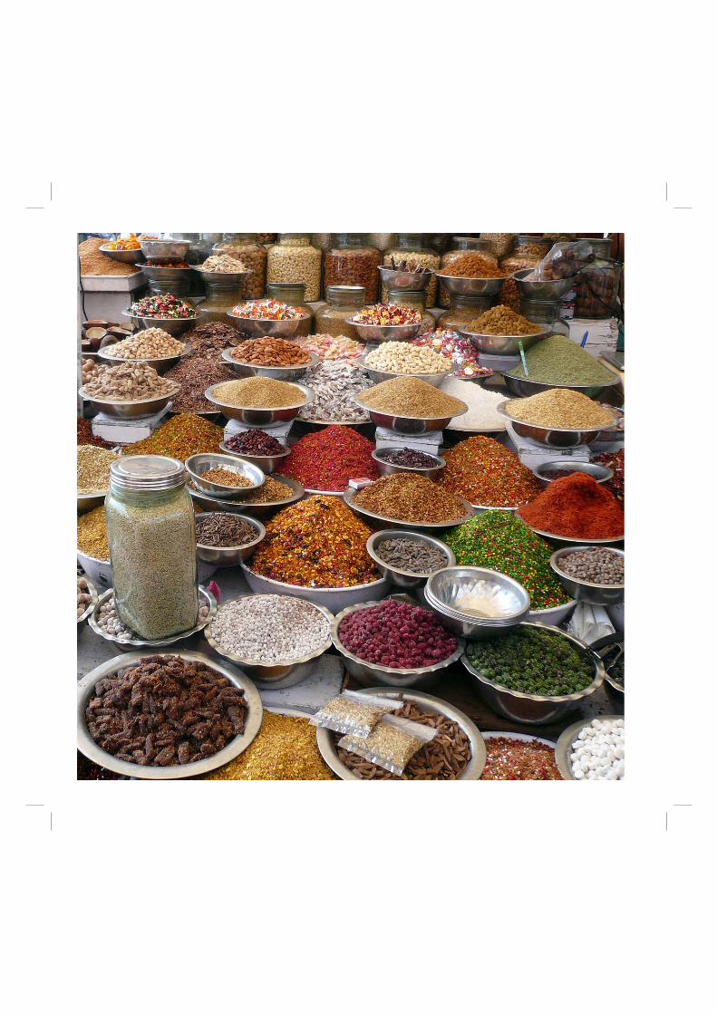
155Kulinarisches Glossar
Allgemeines
cheeni Zucker chai Tee mit Milch und Gewürzen aufgekochtdahi Joghurt dudh Milch garam scharf gosht Fleisch, meist Hammel khaana Essen mirch Pfeffer mirchi scharfe Chilischote murgi Huhn namak Salz paan In Betelnussblatt eingewickelte Paste aus Betelnuss, Limone und Gewürzen. Wird nach dem Essen als Digestif gekaut.pani Wassersabji jedes Gemüse-Curry
Gemüse
alu Kartoffeln bhindi Okraschoten chana Kichererbsen dhal Linsen gobi Blumenkohl mattar Erbsen paneer indischer Käse sabzi wörtlich: „Grünzeug“; wird für jede Art von Gemüse gebrauchttamatar Tomate
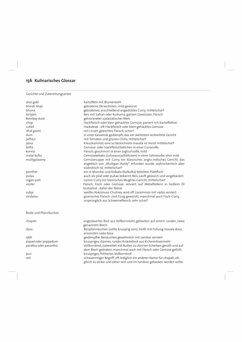
156
Gerichte und Zubereitungsarten
aloo gobi Kartoffeln mit Blumenkohlbhindi bhaji gebratene Okraschoten; mild gewürzt bhuna gebratenes, anschließend angedicktes Curry; mittelscharf biriyani Reis mit Safran oder Kurkuma, ganzen Gewürzen, Fleisch Bombay duck getrockneter südasiatischer Wels chop Hackfl eisch oder klein gehacktes Gemüse, paniert mit Kartoffelbrei cutlet Hacksteak - oft Hackfl eisch oder klein gehacktes Gemüsedhal gosht mit Linsen gekochtes Fleisch; scharf dum in einer Kasserole gedämpft; das am weitesten verbreitete Gericht jalfrezi mit Tomaten und grünen Chilis; mittelscharf jeera Kreuzkümmel; eine so bezeichnete masala ist meist mittelscharf kofta Gemüse- oder Hackfl eischbällchen in einer Currysoße korma Fleisch, geschmort in einer Joghurtsoße, mild malai kofta Gemüsekebabs (Lotuswurzelbällchen) in einer Sahnesoße; eher mild mulligatawny Gemüsesuppe mit Curry, ein klassisches anglo-indisches Gericht, das
angeblich von „Mulligan Aunty“ erfunden wurde, wahrscheinlich aber südindisch ist; mittelscharf
pomfret ein in Mumbai und Kolkata (Kalkutta) beliebter Plattfi sch pulau auch als pilaf oder pullao bekannt, Reis, sanft gewürzt und vorgebacken rogan josh Lamm-Curry, ein klassisches Mughlai-Gericht; mittelscharf sizzler Fleisch, Fisch oder Gemüse, serviert auf Metalltellern in heißem Öl
brutzelnd - daher der Name subje weißes Kokosnuss-Chutney, wird oft zusammen mit vadas serviert vindaloo goanisches Fleisch- (mit Essig gewürzt), manchmal auch Fisch-Curry, ursprünglich aus Schweinefl eisch; sehr scharf
Brote und Pfannkuchen chapati ungesäuertes Brot aus Vollkornmehl, gebacken auf einem runden, tawa
genannten Blech dosa Reispfannkuchen (sollte knusprig sein), heißt mit Füllung masala dosa, ansonsten sada dosa iddli gedämpfter Reiskuchen,gewöhnlich mit sambar serviert papad oder poppadum knuspriges, dünnes, rundes Knäckebrot aus Kichererbsenmehl paratha oder parantha Vollkornbrot, zubereitet mit Butter, zu dünnen Scheiben gerollt und auf dem Blech gebraten; manchmal auch mit Fleisch oder Gemüse gefüllt.puri knuspriges, frittiertes Vollkornbrot roti schwammiger Begriff; oft lediglich ein anderer Name für chapati, ob- gleich es dicker und zäher sein und im tandoor gebacken werden sollte.
Kulinarisches Glossar
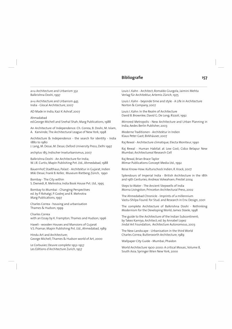
157
a+u Architecture and Urbanism 332Balkrishna Doshi, 1997
a+u Architecture and Urbanism 445India - Glocal Architecture, 2007
AD Made in India, Kazi K Ashraf, 2007
Ahmadabaded.George Michell and Snehal Shah; Marg Publications, 1988
An Architecture of Independence: Ch. Correa, B. Doshi, M. Islam, A. Kanvinde; The Architectural League of New York, 1998
Architecture & Independence - the search for identity - India 1880 to 1980J. Lang, M. Desai, M. Desai; Oxford University Press, Delhi 1997
archplus 185; Indischer Inselurbanismus, 2007
Balkrishna Doshi - An Architecture for India; W. J.R. Curtis; Mapin Publishing Pvt. Ltd., Ahmedabad, 1988
Bauernhof, Stadthaus, Palast - Architektur in Gujarat, Indien Miki Desai; Frank B. Keller, Museum Rietberg Zürich, 1990
Bombay - The City withinS. Dwivedi, R. Mehrotra; India Book House Pvt. Ltd., 1995
Bombay to Mumbai - Changing Perspectivesed. by P. Rohatgi, P. Godrej and R. MehrotraMarg Publications, 1997
Charles Correa - housing and urbanisationThames & Hudson, 1999
Charles Correa with an Essay by K. Frampton; Thames and Hudson, 1996
Haveli - wooden Houses and Mansions of GujaratV.S. Pramar; Mapin Publishing Pvt. Ltd., Ahmedabad, 1989
Hindu Art and Architecture; George Michell; Thames & Hudson world of Art, 2000
Le Corbusier, Oeuvre complete 1952-1957Les Editions d‘Architecture Zurich, 1957
Bibliografi e
Louis I. Kahn - Architect; Romaldo Giurgola, Jaimini MehtaVerlag für Architektur, Artemis Zürich, 1975
Louis I. Kahn - beyonde time and style - A Life in ArchitectureNorton & Company, 2007
Louis I. Kahn: In the Realm of ArchitectureDavid B. Brownlee, David G. De Long; Rizzoli, 1992
Mirrored Metropolis - New Architecture and Urban Planning in India; Aedes Berlin Publisher, 2003
Moderne Traditionen - Architektur in IndienKlaus Peter Gast; Birkhäuser, 2007
Raj Rewal - Architecture climatique; Electa Moniteur, 1990
Raj Rewal - Human Habitat at Low Cost; Cidco Belapur New Mumbai; Architectureal Research Cell
Raj Rewal, Brian Brace TaylorMimar Publications Concept Media Ltd., 1992
Reise Know-How: Kulturschock Indien; R. Krack, 2007
Splendours of Imperial India - British Architecture in the 18th and 19th Centuries; Andreas Volwahsen; Prestel 2004
Steps to Water - The Ancient Stepwells of IndiaMorna Livingston; Princeton Architectural Press, 2002
The Ahmedabad Chronicle - Imprints of a millenniumVastu-Shilpa Found. for Stud. and Research in Env. Design, 2001
The complete Architecture of Balkrishna Doshi - Rethinking Modernism for the Developing World; James Steele, 1998
The guide to the Architecture of the Indian Subcontinent; by Takeo Kamiya, Architect; ed. by Annabel Lopez Jindal Art Foundation, Architecture Autonomous, 2003
The New Landscape - Urbanisation in the third World Charles Correa; Butterworth Architecture, 1989
Wallpaper City Guide - Mumbai; Phaidon
World Architecture 1900-2000: A critical Mosaic, Volume 8,South Asia; Springer Wien New York, 2000

158 Notizen