beaver brook farm - dracut ma |
TRANSCRIPT
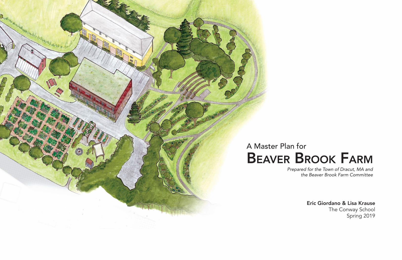
A Master Plan for
BEAVER BROOK FARM
Eric Giordano & Lisa KrauseThe Conway School
Spring 2019
Prepared for the Town of Dracut, MA and the Beaver Brook Farm Committee
BEA
VER
BRO
OK
FARM
MA
STER
PLA
N
761
MA
MM
OTH
RO
AD, D
RAC
UT,
MA
018
26
Not for construction. Part of a student project and not based on a legal survey.
IND
EX
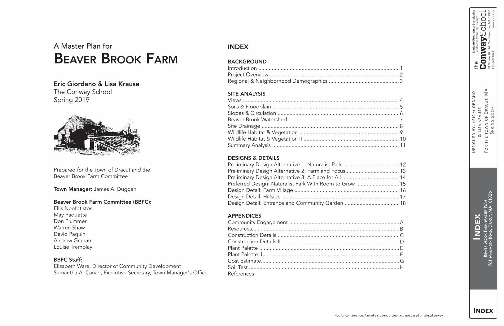
A Master Plan for
BEAVER BROOK FARM
Eric Giordano & Lisa KrauseThe Conway SchoolSpring 2019
Prepared for the Town of Dracut and the Beaver Brook Farm Committee
Town Manager: James A. Duggan
Beaver Brook Farm Committee (BBFC):Ellis NeofotistosMay PaquetteDon PlummerWarren ShawDavid PaquinAndrew GrahamLouise Tremblay
BBFC Staff:Elizabeth Ware, Director of Community Development
INDEX
BACKGROUNDIntroduction ...............................................................................................Project Overview .......................................................................................Regional & Neighborhood Demographics ...............................................
SITE ANALYSISViews ........................................................................................................Soils & Floodplain .....................................................................................Slopes & Circulation .................................................................................Beaver Brook Watershed ..........................................................................Site Drainage ............................................................................................Wildlife Habitat & Vegetation ...................................................................Wildlife Habitat & Vegetation II ................................................................Summary Analysis .....................................................................................
DESIGNS & DETAILSPreliminary Design Alternative 1: Naturalist Park .....................................Preliminary Design Alternative 2: Farmland Focus ...................................Preliminary Design Alternative 3: A Place for All ......................................Preferred Design: Naturalist Park With Room to Grow .............................Design Detail: Farm Village ......................................................................Design Detail: Hillside ...............................................................................Design Detail: Entrance and Community Garden .....................................
APPENDICESCommunity Engagement ..........................................................................Resources....................................................................................................Construction Details ..................................................................................Construction Details II ...............................................................................Plant Palette ..............................................................................................Plant Palette II ...........................................................................................Cost Estimate.............................................................................................Soil Test .....................................................................................................References
123
4567891011
12131415161718
ABCDEFGH
BEA
VER
BRO
OK
FARM
MA
STER
PLA
N
761
MA
MM
OTH
RO
AD, D
RAC
UT,
MA
018
26
1/18
88 V
illag
e H
ill R
d. N
orth
ampt
on, M
A 01
060
413-
369-
4044
ww
w.c
sld.e
du
Not for construction. Part of a student project and not based on a legal survey.
INTR
OD
UC
TIO
N
INTRODUCTION
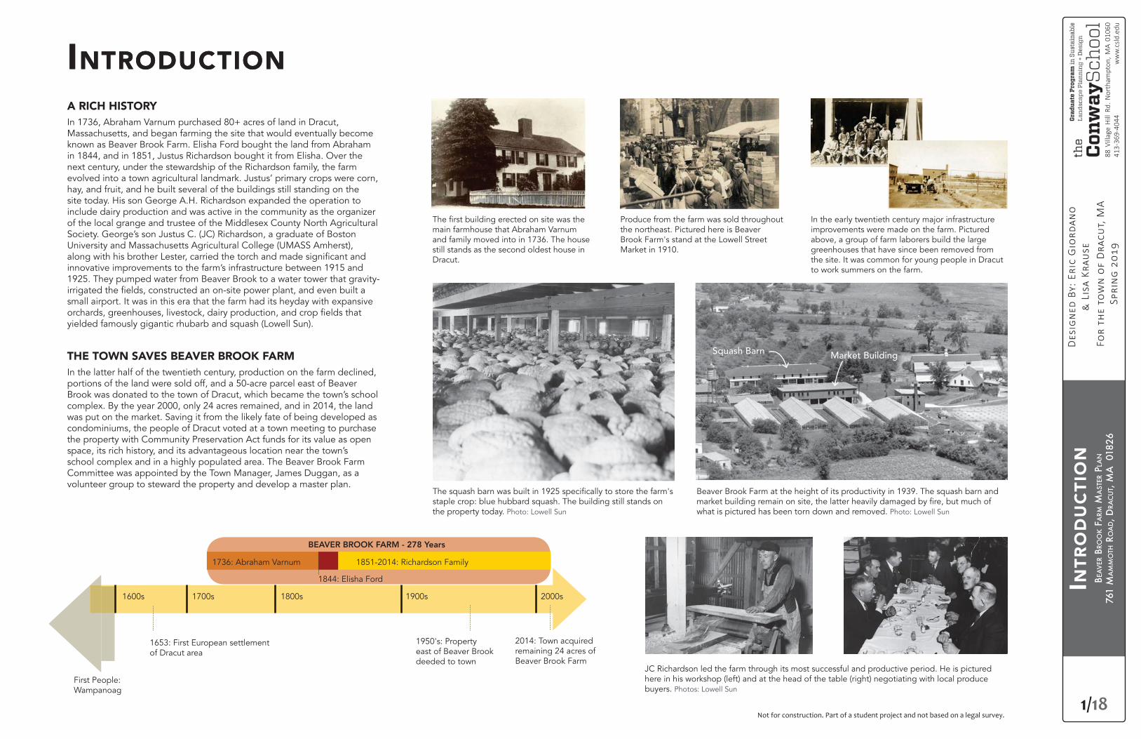
main farmhouse that Abraham Varnum and family moved into in 1736. The house still stands as the second oldest house in Dracut.
Beaver Brook Farm at the height of its productivity in 1939. The squash barn and
what is pictured has been torn down and removed. Photo: Lowell Sunstaple crop: blue hubbard squash. The building still stands on the property today. Photo: Lowell Sun
JC Richardson led the farm through its most successful and productive period. He is pictured here in his workshop (left) and at the head of the table (right) negotiating with local produce buyers. Photos: Lowell Sun
Produce from the farm was sold throughout the northeast. Pictured here is Beaver Brook Farm's stand at the Lowell Street Market in 1910.
In the early twentieth century major infrastructure improvements were made on the farm. Pictured above, a group of farm laborers build the large greenhouses that have since been removed from the site. It was common for young people in Dracut to work summers on the farm.
First People: Wampanoag
1653: First European settlement of Dracut area
1950's: Property east of Beaver Brook deeded to town
2014: Town acquired remaining 24 acres of Beaver Brook Farm
1600s 1700s 1800s 1900s 2000s
BEAVER BROOK FARM - 278 Years
1736: Abraham Varnum
1844: Elisha Ford
1851-2014: Richardson Family
INTRODUCTIONA RICH HISTORYIn 1736, Abraham Varnum purchased 80+ acres of land in Dracut, Massachusetts, and began farming the site that would eventually become known as Beaver Brook Farm. Elisha Ford bought the land from Abraham in 1844, and in 1851, Justus Richardson bought it from Elisha. Over the next century, under the stewardship of the Richardson family, the farm evolved into a town agricultural landmark. Justus’ primary crops were corn, hay, and fruit, and he built several of the buildings still standing on the site today. His son George A.H. Richardson expanded the operation to include dairy production and was active in the community as the organizer of the local grange and trustee of the Middlesex County North Agricultural Society. George’s son Justus C. (JC) Richardson, a graduate of Boston University and Massachusetts Agricultural College (UMASS Amherst),
innovative improvements to the farm’s infrastructure between 1915 and 1925. They pumped water from Beaver Brook to a water tower that gravity-
small airport. It was in this era that the farm had its heyday with expansive
yielded famously gigantic rhubarb and squash (Lowell Sun).
THE TOWN SAVES BEAVER BROOK FARMIn the latter half of the twentieth century, production on the farm declined, portions of the land were sold off, and a 50-acre parcel east of Beaver Brook was donated to the town of Dracut, which became the town’s school complex. By the year 2000, only 24 acres remained, and in 2014, the land was put on the market. Saving it from the likely fate of being developed as condominiums, the people of Dracut voted at a town meeting to purchase the property with Community Preservation Act funds for its value as open space, its rich history, and its advantageous location near the town’s school complex and in a highly populated area. The Beaver Brook Farm Committee was appointed by the Town Manager, James Duggan, as a volunteer group to steward the property and develop a master plan.
Squash Barn Market Building
BEA
VER
BRO
OK
FARM
MA
STER
PLA
N
761
MA
MM
OTH
RO
AD, D
RAC
UT,
MA
018
26
2/18
88 V
illag
e H
ill R
d. N
orth
ampt
on, M
A 01
060
413-
369-
4044
ww
w.c
sld.e
du
Not for construction. Part of a student project and not based on a legal survey.
PRO
JEC
T O
VER
VIE
W
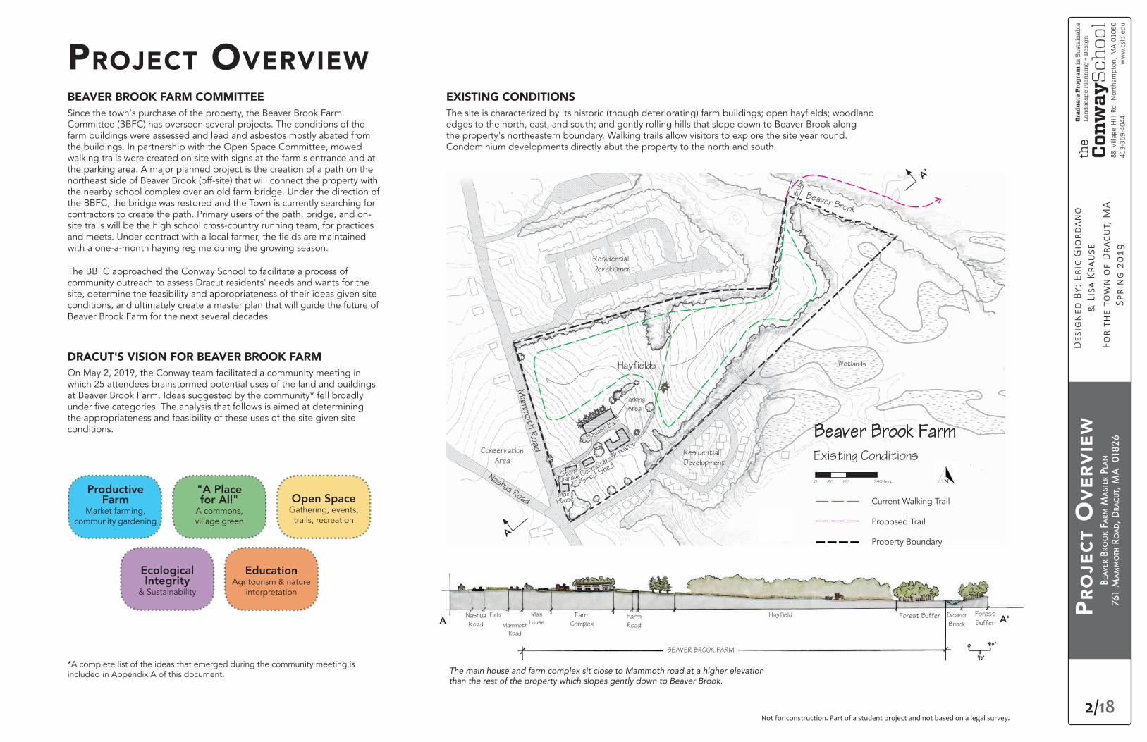
PROJECT OVERVIEWBEAVER BROOK FARM COMMITTEESince the town's purchase of the property, the Beaver Brook Farm Committee (BBFC) has overseen several projects. The conditions of the farm buildings were assessed and lead and asbestos mostly abated from the buildings. In partnership with the Open Space Committee, mowed walking trails were created on site with signs at the farm's entrance and at the parking area. A major planned project is the creation of a path on the northeast side of Beaver Brook (off-site) that will connect the property with the nearby school complex over an old farm bridge. Under the direction of the BBFC, the bridge was restored and the Town is currently searching for contractors to create the path. Primary users of the path, bridge, and on-site trails will be the high school cross-country running team, for practices
with a one-a-month haying regime during the growing season.
The BBFC approached the Conway School to facilitate a process of community outreach to assess Dracut residents' needs and wants for the site, determine the feasibility and appropriateness of their ideas given site conditions, and ultimately create a master plan that will guide the future of Beaver Brook Farm for the next several decades.
DRACUT'S VISION FOR BEAVER BROOK FARMOn May 2, 2019, the Conway team facilitated a community meeting in which 25 attendees brainstormed potential uses of the land and buildings at Beaver Brook Farm. Ideas suggested by the community* fell broadly
the appropriateness and feasibility of these uses of the site given site conditions.
EXISTING CONDITIONS
edges to the north, east, and south; and gently rolling hills that slope down to Beaver Brook along the property's northeastern boundary. Walking trails allow visitors to explore the site year round. Condominium developments directly abut the property to the north and south.
The main house and farm complex sit close to Mammoth road at a higher elevation than the rest of the property which slopes gently down to Beaver Brook.
*A complete list of the ideas that emerged during the community meeting is included in Appendix A of this document.
Mam
moth R
oad
Nashua Road
Squash Barn
Workshop
Corn Crib
Seed Shed
Stone
Garage
Main
House
Beaver Brook
Wetlands
Beaver Brook Farm
Existing Conditions
Bri
dge
0 120 240 feet60
WetlandsndlWWetlandsWettl dW tl dtlands
BBBB
"A Place for All"
A commons, village green
Productive Farm
Market farming, community gardening
Open SpaceGathering, events,
trails, recreation
EducationAgritourism & nature
interpretation
Ecological Integrity
& Sustainability
Hayfields
Parking
Area
Conservation
Area
Current Walking Trail
Proposed Trail
Property Boundary
Residential
Development
Residential
Development
A
Nashua
Road
Field Main
House
Farm
ComplexA'
A'
Farm
Road
HayfieldA
Forest Buffer Beaver
Brook
Forest
Buffer
BEAVER BROOK FARM
Mammoth
Road
BEA
VER
BRO
OK
FARM
MA
STER
PLA
N
761
MA
MM
OTH
RO
AD, D
RAC
UT,
MA
018
26
3/18
88 V
illag
e H
ill R
d. N
orth
ampt
on, M
A 01
060
413-
369-
4044
ww
w.c
sld.e
du
Not for construction. Part of a student project and not based on a legal survey.
REG
ION
AL
& N
EIG
HB
OR
HO
OD D
EMO
GR
APH
ICS
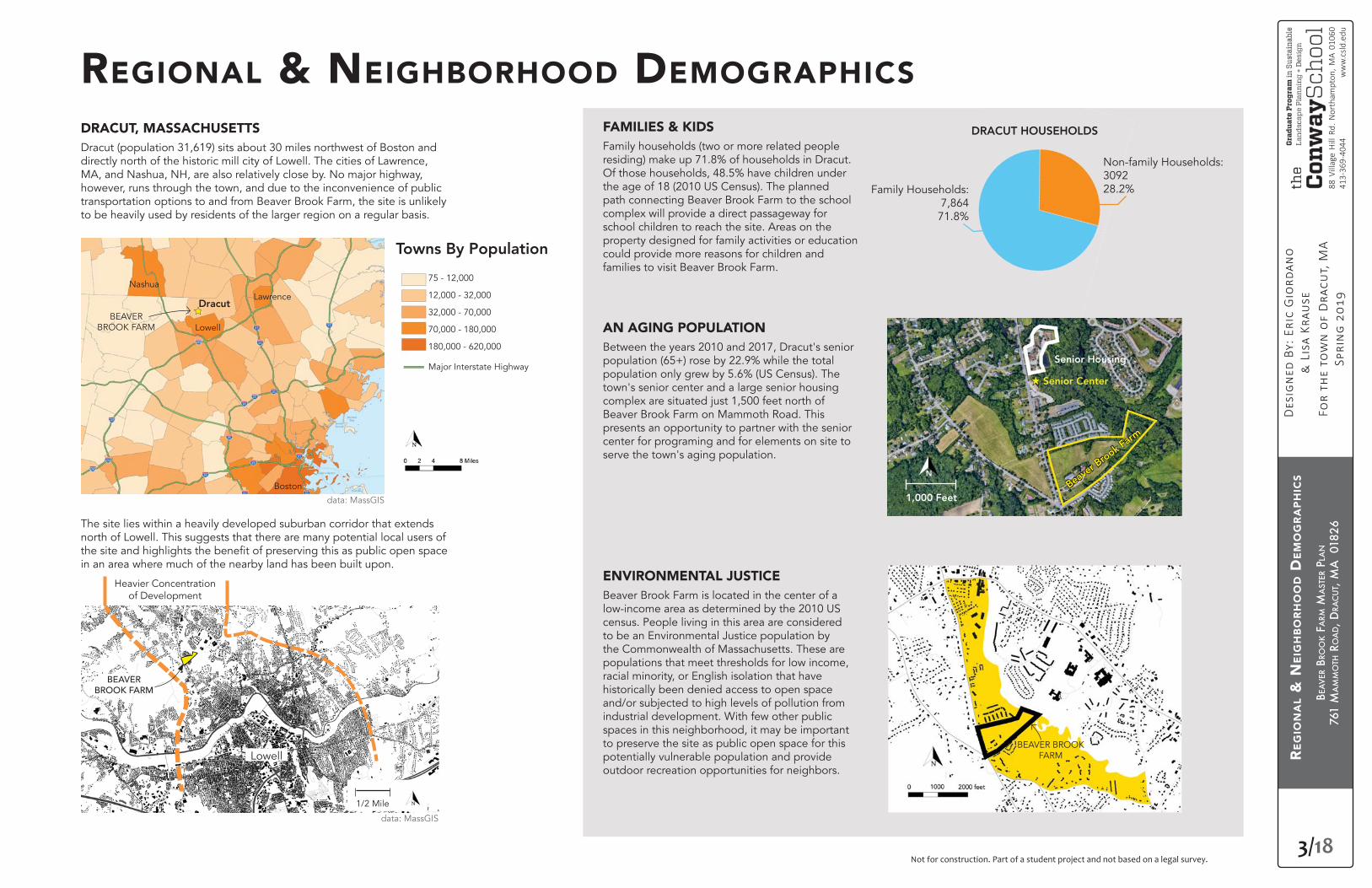
REGIONAL & NEIGHBORHOOD DEMOGRAPHICSDRACUT, MASSACHUSETTSDracut (population 31,619) sits about 30 miles northwest of Boston and directly north of the historic mill city of Lowell. The cities of Lawrence, MA, and Nashua, NH, are also relatively close by. No major highway, however, runs through the town, and due to the inconvenience of public transportation options to and from Beaver Brook Farm, the site is unlikely to be heavily used by residents of the larger region on a regular basis.
FAMILIES & KIDSFamily households (two or more related people residing) make up 71.8% of households in Dracut. Of those households, 48.5% have children under the age of 18 (2010 US Census). The planned path connecting Beaver Brook Farm to the school complex will provide a direct passageway for school children to reach the site. Areas on the property designed for family activities or education could provide more reasons for children and families to visit Beaver Brook Farm.
AN AGING POPULATIONBetween the years 2010 and 2017, Dracut's senior population (65+) rose by 22.9% while the total population only grew by 5.6% (US Census). The town's senior center and a large senior housing complex are situated just 1,500 feet north of Beaver Brook Farm on Mammoth Road. This presents an opportunity to partner with the senior center for programing and for elements on site to serve the town's aging population.
ENVIRONMENTAL JUSTICEBeaver Brook Farm is located in the center of a low-income area as determined by the 2010 US census. People living in this area are considered to be an Environmental Justice population by the Commonwealth of Massachusetts. These are populations that meet thresholds for low income, racial minority, or English isolation that have historically been denied access to open space and/or subjected to high levels of pollution from industrial development. With few other public spaces in this neighborhood, it may be important to preserve the site as public open space for this potentially vulnerable population and provide outdoor recreation opportunities for neighbors.
The site lies within a heavily developed suburban corridor that extends north of Lowell. This suggests that there are many potential local users of
in an area where much of the nearby land has been built upon.
Dracut
Towns By Population
Lowell
Lawrence
75 - 12,000
12,000 - 32,000
32,000 - 70,000
70,000 - 180,000
180,000 - 620,000
Major Interstate Highway
BEAVER BROOK FARM
Nashua
Boston
D
BEAVER BROOK FARM
Heavier Concentration of Development
Lowell
1/2 Mile
DRACUT HOUSEHOLDS
Non-family Households:309228.2%Family Households:
7,86471.8%
Senior Housing
Senior Center
Beaver B
rook F
arm
1,000 Feet
N
BEAVER BROOK FARM
data: MassGIS
data: MassGIS
BEA
VER
BRO
OK
FARM
MA
STER
PLA
N
761
MA
MM
OTH
RO
AD, D
RAC
UT,
MA
018
26
4/18
88 V
illag
e H
ill R
d. N
orth
ampt
on, M
A 01
060
413-
369-
4044
ww
w.c
sld.e
du
Not for construction. Part of a student project and not based on a legal survey.
VIE
WS
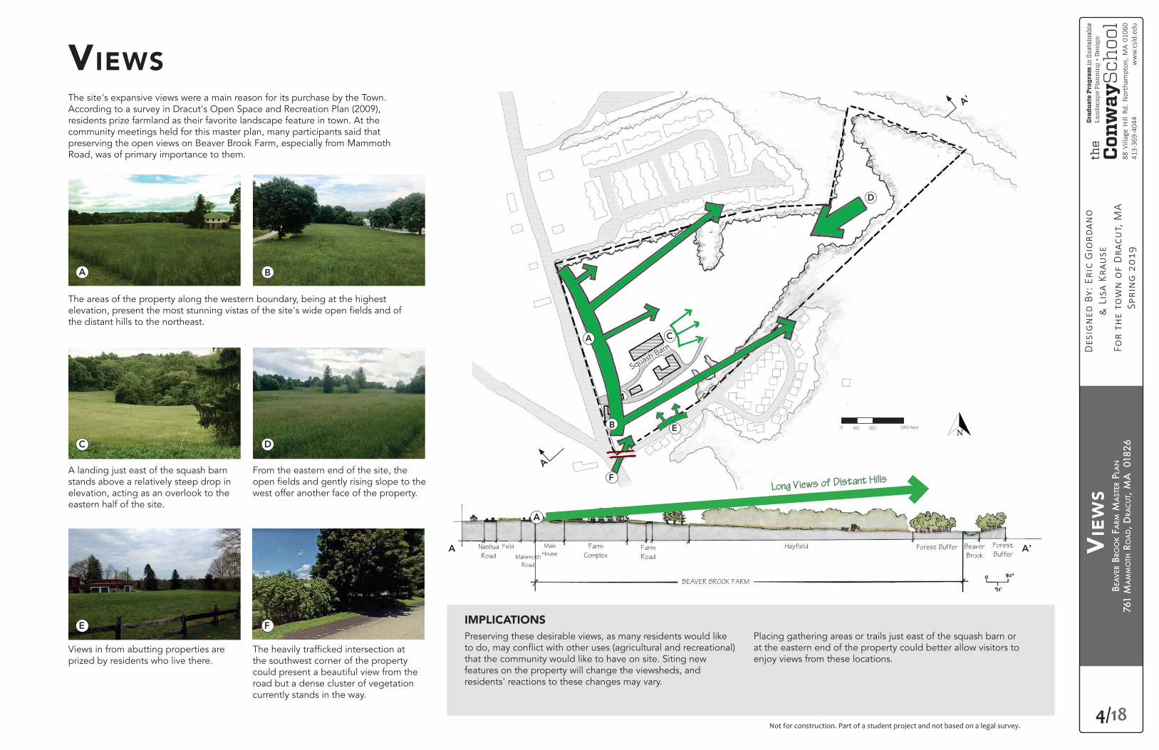
VIEWSThe site's expansive views were a main reason for its purchase by the Town. According to a survey in Dracut's Open Space and Recreation Plan (2009), residents prize farmland as their favorite landscape feature in town. At the community meetings held for this master plan, many participants said that preserving the open views on Beaver Brook Farm, especially from Mammoth Road, was of primary importance to them.
The areas of the property along the western boundary, being at the highest
the distant hills to the northeast.
A landing just east of the squash barn stands above a relatively steep drop in elevation, acting as an overlook to the eastern half of the site.
Views in from abutting properties are prized by residents who live there. the southwest corner of the property
could present a beautiful view from the road but a dense cluster of vegetation currently stands in the way.
From the eastern end of the site, the
west offer another face of the property.
Nashua
Road
Field Main
House
Farm
ComplexFarm
Road
Hayfield Forest Buffer Beaver
Brook
Forest
Buffer
BEAVER BROOK FARM
Mammoth
Road
IMPLICATIONSPreserving these desirable views, as many residents would like
that the community would like to have on site. Siting new features on the property will change the viewsheds, and residents' reactions to these changes may vary.
Placing gathering areas or trails just east of the squash barn or at the eastern end of the property could better allow visitors to enjoy views from these locations.
A
A
A
F
F
E
E
D
D
C
C
B
B
Long Views of Distant Hills
Squash Barn
0 120 240 feet60
A'A
A
A'
BEA
VER
BRO
OK
FARM
MA
STER
PLA
N
761
MA
MM
OTH
RO
AD, D
RAC
UT,
MA
018
26
5/18
88 V
illag
e H
ill R
d. N
orth
ampt
on, M
A 01
060
413-
369-
4044
ww
w.c
sld.e
du
Not for construction. Part of a student project and not based on a legal survey.
SLO
PES
& C
IRC
ULA
TIO
N
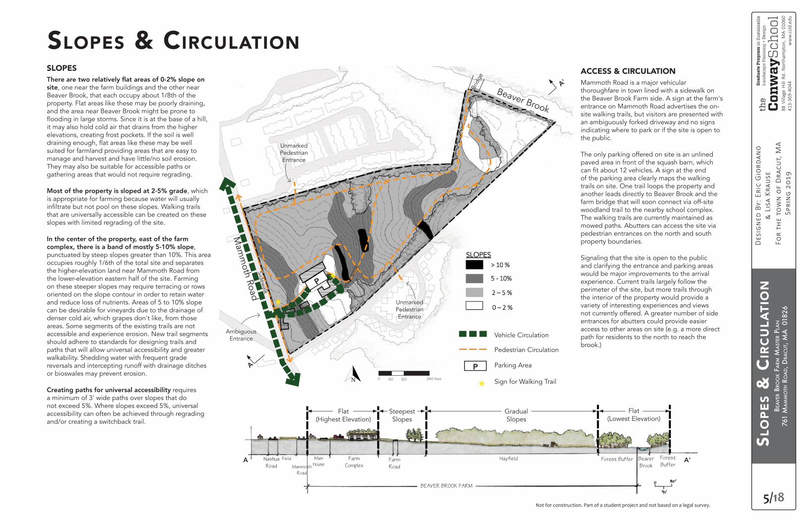
SLOPES & CIRCULATIONSLOPES
site, one near the farm buildings and the other near Beaver Brook, that each occupy about 1/8th of the property. Flat areas like these may be poorly draining, and the area near Beaver Brook might be prone to
it may also hold cold air that drains from the higher elevations, creating frost pockets. If the soil is well
suited for farmland providing areas that are easy to manage and harvest and have little/no soil erosion. They may also be suitable for accessible paths or gathering areas that would not require regrading.
, which is appropriate for farming because water will usually
that are universally accessible can be created on these slopes with limited regrading of the site.
In the center of the property, east of the farm ,
punctuated by steep slopes greater than 10%. This area occupies roughly 1/6th of the total site and separates the higher-elevation land near Mammoth Road from the lower-elevation eastern half of the site. Farming on these steeper slopes may require terracing or rows oriented on the slope contour in order to retain water and reduce loss of nutrients. Areas of 5 to 10% slope can be desirable for vineyards due to the drainage of denser cold air, which grapes don't like, from those areas. Some segments of the existing trails are not accessible and experience erosion. New trail segments should adhere to standards for designing trails and paths that will allow universal accessibility and greater walkability. Shedding water with frequent grade reversals and intercepting runoff with drainage ditches or bioswales may prevent erosion.
Creating paths for universal accessibility requires a minimum of 3' wide paths over slopes that do not exceed 5%. Where slopes exceed 5%, universal accessibility can often be achieved through regrading and/or creating a switchback trail.
ACCESS & CIRCULATIONMammoth Road is a major vehicular thoroughfare in town lined with a sidewalk on the Beaver Brook Farm side. A sign at the farm's entrance on Mammoth Road advertises the on-site walking trails, but visitors are presented with an ambiguously forked driveway and no signs indicating where to park or if the site is open to the public.
The only parking offered on site is an unlined paved area in front of the squash barn, which
of the parking area clearly maps the walking trails on site. One trail loops the property and another leads directly to Beaver Brook and the farm bridge that will soon connect via off-site woodland trail to the nearby school complex. The walking trails are currently maintained as mowed paths. Abutters can access the site via pedestrian entrances on the north and south property boundaries.
Signaling that the site is open to the public and clarifying the entrance and parking areas would be major improvements to the arrival experience. Current trails largely follow the perimeter of the site, but more trails through the interior of the property would provide a variety of interesting experiences and views not currently offered. A greater number of side entrances for abutters could provide easier access to other areas on site (e.g. a more direct path for residents to the north to reach the brook.)
P
P
✴
✴
✴
Vehicle Circulation
Pedestrian Circulation
Parking Area
Sign for Walking Trail
Nashua
Road
Field Main
House
Farm
ComplexFarm
Road
Hayfield Forest Buffer Beaver
Brook
Forest
Buffer
BEAVER BROOK FARM
Mammoth
Road
Flat(Highest Elevation)
Mam
moth Road
Beaver Brook
Sidewalk
Brid
ge
Steepest Slopes
Ambiguous Entrance
Unmarked Pedestrian Entrance
Unmarked Pedestrian Entrance
Gradual Slopes
Flat(Lowest Elevation)
0 120 240 feet60
A'A
A
A'
BEA
VER
BRO
OK
FARM
MA
STER
PLA
N
761
MA
MM
OTH
RO
AD, D
RAC
UT,
MA
018
26
6/18
88 V
illag
e H
ill R
d. N
orth
ampt
on, M
A 01
060
413-
369-
4044
ww
w.c
sld.e
du
Not for construction. Part of a student project and not based on a legal survey.
Pootatuck:
(includes 100-year Floodplain)
Windsor:
Scituate:
Prime Farmland Soil
former orchard area,
potential of lead and
arsenic contamination
SOIL
& F
LOO
DPL
AIN
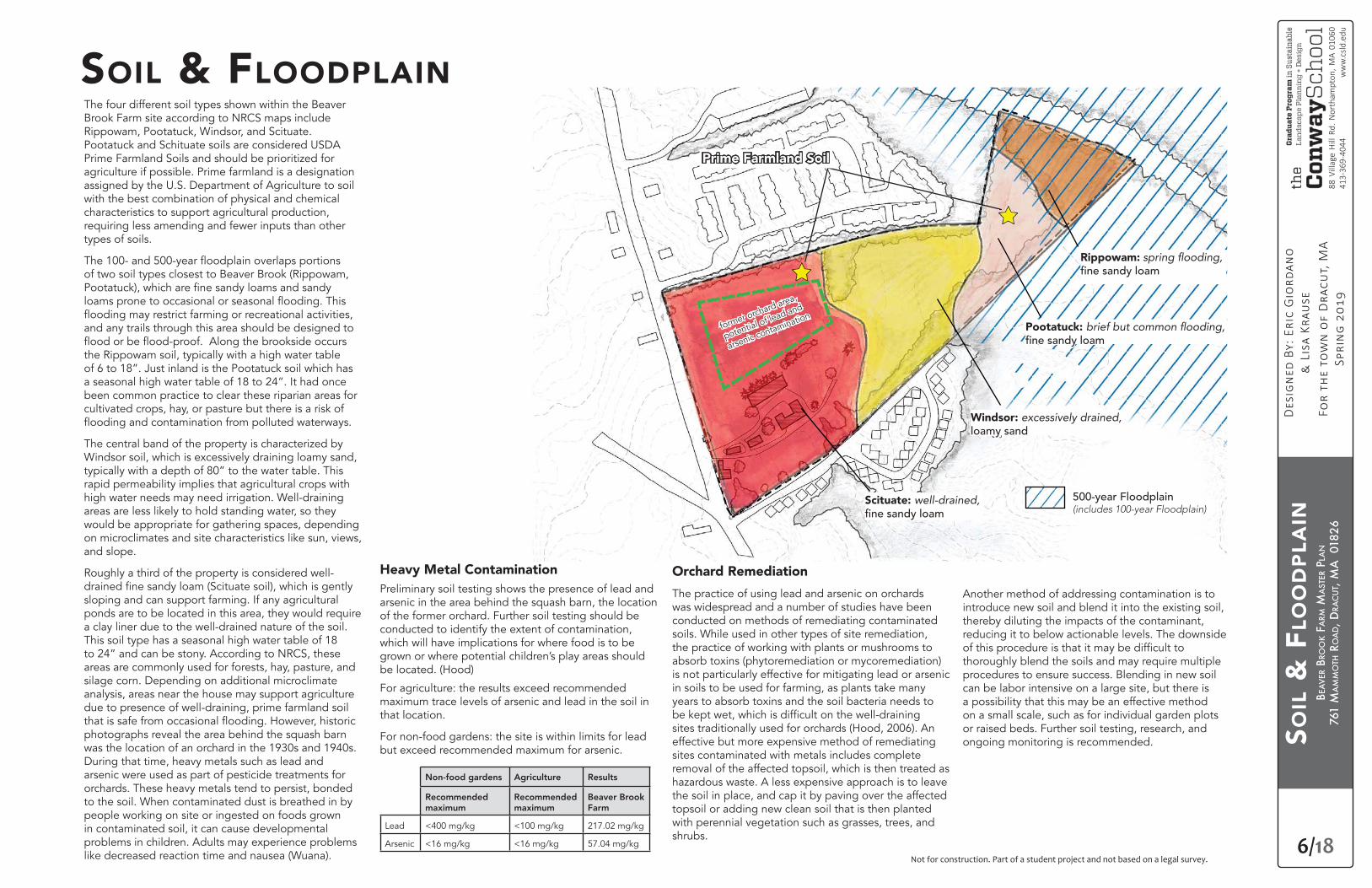
SOIL & FLOODPLAINThe four different soil types shown within the Beaver Brook Farm site according to NRCS maps include Rippowam, Pootatuck, Windsor, and Scituate. Pootatuck and Schituate soils are considered USDA Prime Farmland Soils and should be prioritized for agriculture if possible. Prime farmland is a designation assigned by the U.S. Department of Agriculture to soil with the best combination of physical and chemical characteristics to support agricultural production, requiring less amending and fewer inputs than other types of soils.
of two soil types closest to Beaver Brook (Rippowam,
and any trails through this area should be designed to
the Rippowam soil, typically with a high water table of 6 to 18”. Just inland is the Pootatuck soil which has a seasonal high water table of 18 to 24”. It had once been common practice to clear these riparian areas for cultivated crops, hay, or pasture but there is a risk of
The central band of the property is characterized by Windsor soil, which is excessively draining loamy sand, typically with a depth of 80” to the water table. This rapid permeability implies that agricultural crops with high water needs may need irrigation. Well-draining areas are less likely to hold standing water, so they would be appropriate for gathering spaces, depending on microclimates and site characteristics like sun, views, and slope.
Roughly a third of the property is considered well-
sloping and can support farming. If any agricultural ponds are to be located in this area, they would require a clay liner due to the well-drained nature of the soil. This soil type has a seasonal high water table of 18 to 24” and can be stony. According to NRCS, these areas are commonly used for forests, hay, pasture, and silage corn. Depending on additional microclimate analysis, areas near the house may support agriculture due to presence of well-draining, prime farmland soil
photographs reveal the area behind the squash barn was the location of an orchard in the 1930s and 1940s. During that time, heavy metals such as lead and arsenic were used as part of pesticide treatments for orchards. These heavy metals tend to persist, bonded to the soil. When contaminated dust is breathed in by people working on site or ingested on foods grown in contaminated soil, it can cause developmental problems in children. Adults may experience problems like decreased reaction time and nausea (Wuana).
Heavy Metal ContaminationPreliminary soil testing shows the presence of lead and arsenic in the area behind the squash barn, the location of the former orchard. Further soil testing should be conducted to identify the extent of contamination, which will have implications for where food is to be grown or where potential children’s play areas should be located. (Hood)
For agriculture: the results exceed recommended maximum trace levels of arsenic and lead in the soil in that location.
For non-food gardens: the site is within limits for lead but exceed recommended maximum for arsenic.
Non-food gardens Agriculture Results
Recommended maximum
Recommended maximum
Beaver Brook Farm
Lead <400 mg/kg <100 mg/kg 217.02 mg/kg
Arsenic <16 mg/kg <16 mg/kg 57.04 mg/kg
Another method of addressing contamination is to introduce new soil and blend it into the existing soil, thereby diluting the impacts of the contaminant, reducing it to below actionable levels. The downside
thoroughly blend the soils and may require multiple procedures to ensure success. Blending in new soil can be labor intensive on a large site, but there is a possibility that this may be an effective method on a small scale, such as for individual garden plots or raised beds. Further soil testing, research, and ongoing monitoring is recommended.
Orchard Remediation
The practice of using lead and arsenic on orchards was widespread and a number of studies have been conducted on methods of remediating contaminated soils. While used in other types of site remediation, the practice of working with plants or mushrooms to absorb toxins (phytoremediation or mycoremediation) is not particularly effective for mitigating lead or arsenic in soils to be used for farming, as plants take many years to absorb toxins and the soil bacteria needs to
sites traditionally used for orchards (Hood, 2006). An effective but more expensive method of remediating sites contaminated with metals includes complete removal of the affected topsoil, which is then treated as hazardous waste. A less expensive approach is to leave the soil in place, and cap it by paving over the affected topsoil or adding new clean soil that is then planted with perennial vegetation such as grasses, trees, and shrubs.
Rippowam:
BEA
VER
BRO
OK
FARM
MA
STER
PLA
N
761
MA
MM
OTH
RO
AD, D
RAC
UT,
MA
018
26
7/18
88 V
illag
e H
ill R
d. N
orth
ampt
on, M
A 01
060
413-
369-
4044
ww
w.c
sld.e
du
Not for construction. Part of a student project and not based on a legal survey.
BEA
VER
BR
OO
K W
ATE
RSH
ED
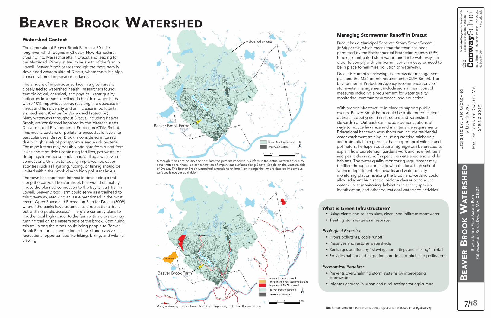
Watershed Context
The namesake of Beaver Brook Farm is a 30-mile-long river, which begins in Chester, New Hampshire, crossing into Massachusetts in Dracut and leading to the Merrimack River just two miles south of the farm in Lowell. Beaver Brook passes through the more heavily developed western side of Dracut, where there is a high concentration of impervious surfaces.
The amount of impervious surface in a given area is closely tied to watershed health. Researchers found that biological, chemical, and physical water quality indicators in streams declined in health in watersheds with >10% impervious cover, resulting in a decrease in
and sediment (Center for Watershed Protection). Many waterways throughout Dracut, including Beaver Brook, are considered impaired by the Massachusetts Department of Environmental Protection (CDM Smith). This means bacteria or pollutants exceed safe levels for particular uses. Beaver Brook is considered impaired due to high levels of phosphorous and e.coli bacteria. These pollutants may possibly originate from runoff from
connections. Until water quality improves, recreation
limited within the brook due to high pollutant levels.
The town has expressed interest in developing a trail along the banks of Beaver Brook that would ultimately link to the planned connection to the Bay Circuit Trail in Lowell. Beaver Brook Farm could serve as a trailhead to this greenway, resolving an issue mentioned in the most recent Open Space and Recreation Plan for Dracut (2009) where “the banks have potential as a recreational trail, but with no public access.” There are currently plans to link the local high school to the farm with a cross-country running trail on the eastern side of the brook. Continuing this trail along the brook could bring people to Beaver Brook Farm for its connection to Lowell and passive recreational opportunities like hiking, biking, and wildlife viewing.
BEAVER BROOK WATERSHEDManaging Stormwater Runoff in Dracut
Dracut has a Municipal Separate Storm Sewer System (MS4) permit, which means that the town has been permitted by the Environmental Protection Agency (EPA) to release untreated stormwater runoff into waterways. In order to comply with this permit, certain measures need to be in place to minimize pollution of waterways.
Dracut is currently reviewing its stormwater management plan and the MS4 permit requirements (CDM Smith). The Environmental Protection Agency recommendations for stormwater management include six minimum control measures including a requirement for water quality monitoring, community outreach, and education.
With proper infrastructure in place to support public events, Beaver Brook Farm could be a site for educational outreach about green infrastructure and watershed stewardship. Outreach can include demonstrations of ways to reduce lawn size and maintenance requirements. Educational hands-on workshops can include residential water catchment training including creating rainbarrels and residential rain gardens that support local wildlife and pollinators. Perhaps educational signage can be erected to explain how bioretention gardens work and how fertilizers and pesticides in runoff impact the watershed and wildlife habitats. The water quality monitoring requirement may
science department. Boardwalks and water quality monitoring platforms along the brook and wetland could allow adjacent high school biology classes to conduct water quality monitoring, habitat monitoring, species
Beaver Brook
Although it was not possible to calculate the percent impervious surface in the entire watershed due to data limitations, there is a concentration of impervious surfaces along Beaver Brook, on the western side of Dracut. The Beaver Brook watershed extends north into New Hampshire, where data on impervious surfaces is not yet available.
Beaver Brook Farm
Many waterways throughout Dracut are impaired, including Beaver Brook.
Beaver Brook
watershed extents
What is Green Infrastructure?•
• Treating stormwater as a resource
• Filters pollutants, cools runoff
• Preserves and restores watersheds
• Recharges aquifers by "slowing, spreading, and sinking" rainfall
• Provides habitat and migration corridors for birds and pollinators
• Prevents overwhelming storm systems by intercepting stormwater
• Irrigates gardens in urban and rural settings for agriculture
Beaver Brook
Beaver Brook Farm
BEA
VER
BRO
OK
FARM
MA
STER
PLA
N
761
MA
MM
OTH
RO
AD, D
RAC
UT,
MA
018
26
8/18
88 V
illag
e H
ill R
d. N
orth
ampt
on, M
A 01
060
413-
369-
4044
ww
w.c
sld.e
du
Not for construction. Part of a student project and not based on a legal survey.
SITE
DR
AIN
AG
E
SITE DRAINAGEThe slopes within Beaver Brook Farm create natural swales that collect and direct water to the east into Beaver Brook. Some areas drain northward, causing potential impact on neighboring properties. Runoff from impervious surfaces on these abutting properties crosses back through Beaver Brook Farm at its lowest point, eventually entering Beaver Brook and the adjacent wetland to the south of the farm.
As stormwater runoff crosses impervious surfaces like roads, parking lots, and rooftops, it picks up contaminants and becomes warmed from stored thermal heat from the sun. This hot, contaminated runoff enters storm sewer systems that empty into waterways, where potential
and other wildlife, stream bank erosion from
and decreasing water quality because of high amounts of pollutants. Measures should be
polluted runoff on site, as close to the source of runoff as possible.
With increasing frequency and severity of storms predicted throughout the northeast of the United States, developing a stormwater management
pollutants in runoff is becoming a critical issue for communities. It is important for each landowner to understand potential runoff volumes in order to design appropriately-sized interventions to
and slowly release runoff after the storm event passes. Potential stormwater runoff volume can be understood through calculating runoff by comparing average rainfall volumes from storm events and multiplying this amount by the area of impervious surfaces like rooftops, driveways, and heavily compacted soil.
Currently at Beaver Brook Farm, hydrocarbon pollutants from parking areas could potentially enter the site in stormwater runoff. If left untreated, this runoff may have introduce pollutants into the farm's soil and downslope waterbodies such as the brook and wetland.
If polluted stormwater runoff entering the site from the road, driveway, and adjacent properties is abated before reaching agricultural areas, the slopes on site present the opportunity to catch water for irrigation. Rainwater harvesting can be achieved through agricultural ponds and swales
runoff.
The building rooftops and driveway at Beaver Brook Farm are impervious surfaces which channel runoff toward a small drainage basin at the base of the driveway. This driveway runoff is creating erosion issues as evident by the photographs of ruts at the top of the farm road. The farm road is used as a walking trail
maintenance, and will likely continue unless runoff is redirected or the trail is redesigned. Instead of becoming runoff, the rainwater from building rooftops could be intercepted with rain barrels and cisterns to be used for irrigation or washing farm tools. In addition to capturing this runoff for agricultural use, designs could include interventions for redesign of this trail to stop
bioswales.
The area behind the farm complex is a site of well draining soil which could suitable for gathering spaces. However, the steep slopes would need regrading to shed water and allow accessible paths. Runoff could be potentially directed into bioswales planted with drought tolerant small
handle periodic inundation, and may help with
Palette for rain garden species suggestions.)
Activities within 200' of streams and 100' of wetlands are regulated by the state. A permitting process will be required if interventions are proposed within these buffers.
Erosion at top of the farm road, just beyond the drain at the base of the parking lot.
Runoff is eroding creating large ruts in the farm road, which is also part of the walking trail.
0 160'
80'
wetland
erosion
swale
drainage
combined buffers for wetland and brook
runoff on adjacent sites
Stormwater Runoff Calculations There is 6,874 cubic feet of total runoff from the rooftop of the squash barn, market building, and driveway at Beaver Brook Farm during a 90-minute 50-year storm (2" of rainfall per hour). In order to intercept this stormwater runoff,
storm runoff (ft ³/sec)
runoff rainfall intensity (inches/hour)
area in acres
a) squash barn 0.228 .95 2 0.12
b) market building 0.171 .95 2 0.09
c) driveway 0.874 .95 2 0.46
Total volume of runoff (a+b+c) = 1.273 ft ³/second
(1.273.ft³/second x 60 seconds/minute) x 90 min. storm duration = 6,842 ft³ of runoff
Total surface area required for 2' deep
6,842 ft ³ ÷ 2 = 3,437 ft ²
BEA
VER
BRO
OK
FARM
MA
STER
PLA
N
761
MA
MM
OTH
RO
AD, D
RAC
UT,
MA
018
26
9/18
88 V
illag
e H
ill R
d. N
orth
ampt
on, M
A 01
060
413-
369-
4044
ww
w.c
sld.e
du
Not for construction. Part of a student project and not based on a legal survey.
WIL
DLI
FE H
AB
ITA
T &
VEG
ETA
TIO
N
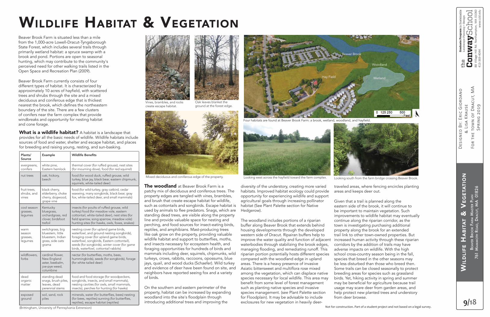
Beaver Brook Farm is situated less than a mile from the 1,000-acre Lowell-Dracut-Tyngsborough State Forest, which includes several trails through primarily wetland habitat: a spruce swamp with a brook and pond. Portions are open to seasonal hunting, which may contribute to the community's perceived need for other walking trails listed in the Open Space and Recreation Plan (2009).
Beaver Brook Farm currently consists of four different types of habitat. It is characterized by
trees and shrubs through the site and a mixed deciduous and coniferous edge that is thickest
boundary of the site. There are a few clusters of conifers near the farm complex that provide windbreaks and opportunity for nesting habitat and cone forage.
WILDLIFE HABITAT & VEGETATION
Hay Field
Beaver Brook
Wetland
Woodland
diversity of the understory, creating more varied habitats. Improved habitat ecology could provide opportunity for experiencing wildlife and support agricultural goals through increasing pollinator habitat (See Plant Palette section for Native Hedgerow).
The woodland includes portions of a riparian buffer along Beaver Brook that extends behind housing developments through the developed western side of Dracut. Ripairan buffers help to improve the water quality and function of adjacent waterbodies through stabilizing the brook edges,
riparian portion potentially hosts different species compared with the woodland edge in upland areas. There is a heavy presence of invasive
among the vegetation, which can displace native species necessary for local wildlife. This area may
such as planting native species and invasive species management. (see Plant Palette section for Floodplain). It may be advisable to include exclosures for new vegetation in heavily deer-
Plants/Source
Example
evergreens, conifers
white pine, Eastern hemlock
thermal cover (for ruffed grouse), nest sites (for mourning dove), food (for red squirrel)
nut trees oak, hickory, beech
food (for wood duck, ruffed grouse, wild turkey, blue jay, black bear, eastern chipmunk, squirrels, white-tailed deer)
fruit trees, shrubs, and vines
black cherry, elderberry, choke cherry, dogwood, grape vine
food (for wild turkey, gray catbird, cedar waxwing, many songbirds, black bear, gray fox, white-tailed deer, and small mammals)
cool season grasses, legumes
Kentucky bluegrass, orchardgrass, red clover, birdsfoot trefoil
insects (for poults of ruffed grouse, wild turkey) food (for meadow vole, eastern cottontail, white-tailed deer), nest sites (for
hunting sites (for hawks, owls, foxes, snakes)
warm season grasses, legumes
switchgrass, big bluestem, little bluestem, Indian grass, side oats grama
nesting cover (for upland game birds, waterfowl, and ground nesting songbirds), foraging cover (for upland game birds, waterfowl, songbirds, Eastern cottontail), seeds (for songbirds), winter cover (for game birds, waterfowl, cottontail rabbits)
forbs New England aster, beebalm, joe-pye weed, columbine
hummingbirds), seeds (for songbirds), forage (for white-tailed deer)
dead organic matter
standing dead snags, brush piles, leaves, dead perennial stems
food and food storage (for woodpeckers, songbirds, insects, and small mammals), nesting cavities (for owls, small mammals, insects), perches for hunting (for hawks)
exposed ground
soil, sand, rock piles
reptiles), escape habitat (reptiles)
What is a wildlife habitat? A habitat is a landscape that provides for all the basic needs of wildlife. Wildlife habitats include sources of food and water, shelter and escape habitat, and places for breeding and raising young, resting, and sun-basking.
The woodland at Beaver Brook Farm is a patchy mix of deciduous and coniferous trees. The property edges are tangled with vines, brambles, and brush that create escape habitat for wildlife, such as cottontails and songbirds. Escape habitat is
standing dead trees, are visible along the property line and provide valuable space for nesting and perching, and food sources for insect-eating birds, reptiles, and amphibians. Mast-producing trees like oak grow on the property, providing valuable
and insects necessary for ecosystem health, and foraging opportunities for hundreds of birds and mammals including deer, squirrels, chipmunks, wild turkeys, crows, rabbits, raccoons, opossums, blue jays, quail, and wood ducks (Schaefer). Wild turkey and evidence of deer have been found on site, and neighbors have reported seeing fox and a variety of birds.
On the southern and eastern perimeter of the property, habitat can be increased by expanding
introducing additional trees and improving the(Brittingham, University of Pennsylvania Extrension)
Vines, brambles, and rocks create escape habitat.
Oak leaves blanket the ground at the forest edge.
Mixed deciduous and coniferous edge of the property. Looking south from the farm bridge crossing Beaver Brook.
traveled areas, where fencing encircles planting areas and keeps deer out.
Given that a trail is planned along the eastern side of the brook, it will continue to be important to maintain vegetation. Such improvements to wildlife habitat may eventually continue along the riparian corridor, as the town is investigating purchasing additional property along the brook for an extended trail link to other town-owned properties. But increased human activity through these riparian corridors by the addition of trails may have adverse impacts on wildlife. With the high school cross-country season being in the fall, species that breed in the other seasons may be less disturbed than those who breed then. Some trails can be closed seasonally to protect breeding areas for species such as grassland birds. Yet, hiking activity in spring and summer
usage may scare deer from garden areas, and help protect new planted trees and understory from deer browse.
BEA
VER
BRO
OK
FARM
MA
STER
PLA
N
761
MA
MM
OTH
RO
AD, D
RAC
UT,
MA
018
26
10/18
88 V
illag
e H
ill R
d. N
orth
ampt
on, M
A 01
060
413-
369-
4044
ww
w.c
sld.e
du
Not for construction. Part of a student project and not based on a legal survey.
WIL
DLI
FE H
AB
ITA
T &
VEG
ETA
TIO
N II
requires planning and public outreach based on bird's nesting cycles which helps to balance of the needs of wildlife, farmers, and the ecological concerns of the community (Fieldman). Farmers can alter mowing patterns to reduce harm to wildlife and can be compensated for wildlife-friendly practices. Funded through private donations to MassAudubon, The Bobolink Project incentivizes farmers to postpone mowing from May through August, allowing for two cuts per season while protecting breeding habitat (Atwood). As part of the Bobolink Project, the University of Vermont Extension Center for Sustainable Agriculture is in the process of identifying focus groups of farmers in Vermont, Connecticut, Massachusetts, and New
to be involved in the study, they will be compensated for managing their land in a way that supports grassland birds on working farms (Alvez).
The need for a wildlife corridor in the more heavily-developed west side of town was established in Dracut’s most recent Open Space and Recreation Plan (2009). Beaver Brook Farm's location on the west side of town positions it to contribute to the formation of a wildlife corridor especially if habitats are improved on site, allowing species to travel safely from one habitat to another. The value of improving habitat on small sites is supported by research from the University of Michigan, which has shown substantial improvements in biodiversity can be made from wildlife corridors as little as 75 feet wide (Conniff).
Currently, forested areas 60 to 80 feet wide can be found along the eastern portion of Beaver Brook Farm. Introducing a more dynamic understory and eliminating invasive species within the forested edges and riparian areas along the stream and wetland can help to create, preserve, and maintain corridor linkages. Increasing biodiversity of the site can also improve the trail experience, providing educational and recreational opportunities for visitors.
provides a pastoral view and is one of the community’s most treasured aspects of the Beaver Brook Farm. Approximately 10 acres of land are on a short 32-day haying rotation, creating a potential ecological trap
for grassland nesting sites, mowing disrupts the breeding cycle, and birds are not able to nest again for the season, creating a population sink where the number of deaths of a species exceed the number of births (Crone, et al.).
habitat. According to MassAudubon, grassland birds throughout Massachusetts are in decline, which include bobolink, Eastern meadowlark, grasshopper sparrow, and savannah sparrow. In Middlesex County, the rare bobolink and vesper sparrow are most likely to be seen in late spring and early fall (eBird). At Beaver Brook Farm mowing the 10-acres on a short haying rotation disrupts potential breeding cycles and habitats for grassland birds that require less acreage like the bobolink and vesper sparrow, but also small mammals, like rabbits, and reptiles and amphibians who may need these habitats. Changing Beaver Brook
become grassland meadows, providing pollinator support and habitat for grassland birds that eat pests, which creates an opportunity for passive recreation including birding and recording sightings with eBird and MassAudubon’s Citizen Scientist Grassland Bird Monitoring Program.
There are programs researching practices that alleviate the tension between providing habitat for wildlife and generating income for farmers. At grassland bird sanctuaries like Arcadia Wildlife Sanctuary in Easthampton,
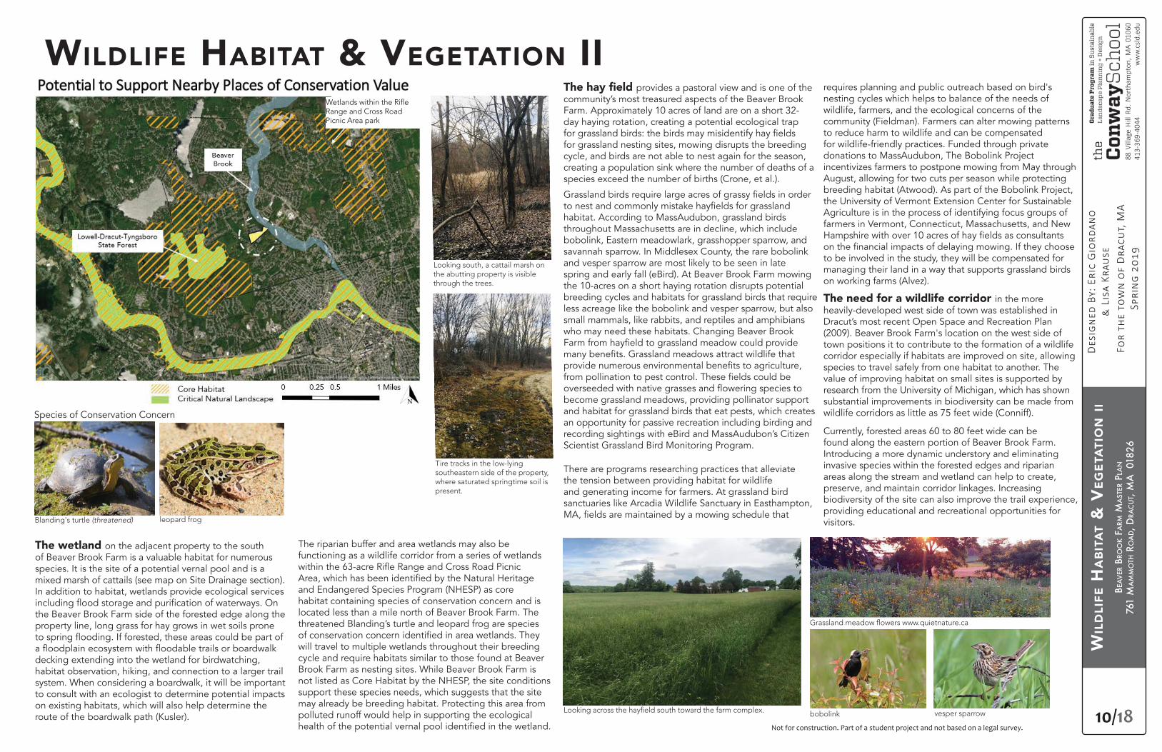
The wetland on the adjacent property to the south of Beaver Brook Farm is a valuable habitat for numerous species. It is the site of a potential vernal pool and is a mixed marsh of cattails (see map on Site Drainage section). In addition to habitat, wetlands provide ecological services
the Beaver Brook Farm side of the forested edge along the property line, long grass for hay grows in wet soils prone
decking extending into the wetland for birdwatching, habitat observation, hiking, and connection to a larger trail system. When considering a boardwalk, it will be important to consult with an ecologist to determine potential impacts on existing habitats, which will also help determine the route of the boardwalk path (Kusler).
WILDLIFE HABITAT & VEGETATION II
Blanding's turtle (threatened) leopard frog
Species of Conservation Concern
Looking south, a cattail marsh on the abutting property is visible through the trees.
Tire tracks in the low-lying southeastern side of the property, where saturated springtime soil is present.
bobolink vesper sparrow
The riparian buffer and area wetlands may also be functioning as a wildlife corridor from a series of wetlands
and Endangered Species Program (NHESP) as core habitat containing species of conservation concern and is located less than a mile north of Beaver Brook Farm. The threatened Blanding’s turtle and leopard frog are species
will travel to multiple wetlands throughout their breeding cycle and require habitats similar to those found at Beaver Brook Farm as nesting sites. While Beaver Brook Farm is not listed as Core Habitat by the NHESP, the site conditions support these species needs, which suggests that the site may already be breeding habitat. Protecting this area from polluted runoff would help in supporting the ecological
Range and Cross Road Picnic Area park
Range and Cross Road Picnic Area park
BEA
VER
BRO
OK
FARM
MA
STER
PLA
N
761
MA
MM
OTH
RO
AD, D
RAC
UT,
MA
018
26
11/18
88 V
illag
e H
ill R
d. N
orth
ampt
on, M
A 01
060
413-
369-
4044
ww
w.c
sld.e
du
Not for construction. Part of a student project and not based on a legal survey.
SUM
MA
RY A
NA
LYSI
S
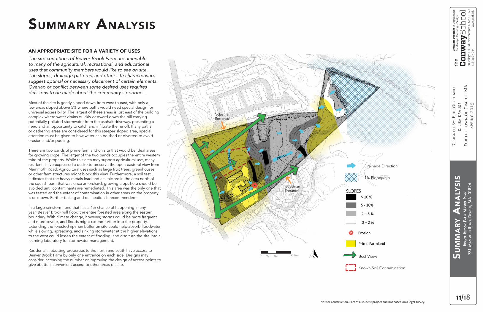
SUMMARY ANALYSIS
AN APPROPRIATE SITE FOR A VARIETY OF USES
The site conditions of Beaver Brook Farm are amenable
uses that community members would like to see on site.
suggest optimal or necessary placement of certain elements.
decisions to be made about the community's priorities.
Most of the site is gently sloped down from west to east, with only a few areas sloped above 5% where paths would need special design for universal accessibility. The largest of these areas is just east of the building complex where water drains quickly eastward down the hill carrying potentially polluted stormwater from the asphalt driveway, presenting a
or gathering areas are considered for this steeper sloped area, special attention must be given to how water can be shed or diverted to avoid erosion and/or pooling.
There are two bands of prime farmland on site that would be ideal areas for growing crops. The larger of the two bands occupies the entire western third of the property. While this area may support agricultural use, many residents have expressed a desire to preserve the open pastoral view from Mammoth Road. Agricultural uses such as large fruit trees, greenhouses, or other farm structures might block this view. Furthermore, a soil test indicates that the heavy metals lead and arsenic are in the area north of the squash barn that was once an orchard; growing crops here should be avoided until contaminants are remediated. This area was the only one that was tested and the extent of contamination in other areas on the property is unknown. Further testing and delineation is recommended.
In a large rainstorm, one that has a 1% chance of happening in any
boundary. With climate change, however, storms could be more frequent
while slowing, spreading, and sinking stormwater at the higher elevations
learning laboratory for stormwater management.
Residents in abutting properties to the north and south have access to Beaver Brook Farm by only one entrance on each side. Designs may consider increasing the number or improving the design of access points to give abutters convenient access to other areas on site.
1% Floodplain
Drainage Direction
Known Soil Contamination
0 120 240 feet60
SWALE
Pedestrian Entrance
Pedestrian Entrance
SWA
LE
Best Views
BEA
VER
BRO
OK
FARM
MA
STER
PLA
N
761
MA
MM
OTH
RO
AD, D
RAC
UT,
MA
018
26
12/18
88 V
illag
e H
ill R
d. N
orth
ampt
on, M
A 01
060
413-
369-
4044
ww
w.c
sld.e
du
Not for construction. Part of a student project and not based on a legal survey.
ALT
ERN
ATI
VE
1: N
ATU
RA
LIST
PA
RK
Mam
moth R
oad
Nashua Road
Non-profit offices above
Montessori School
Farm Museum and
Community Greenhouse
Bed & Breakfast
Cafe
Beaver Brook
Wetlands
Bri
dge
WetlandsndlWWetlandsWettl dW tl dtlands
0 120 240 feet60
Naturalist Park
picnic under oak
grove
10 acres of
Grassland Meadow
trails lead to interpretive signs
throughout
elevated ropes course and
treehouses
boardwalk and platforms for
habitat viewing and
water quality monitoring
Reforested
Floodplain
Field Station and Classroom
with pollinator roof
Community Toolbank
universally accessable community gardens
bioswales
berry
hedge
orchard
hedgerow
pollinator
meadow
trail connection to neighbors
PRELIMINARY DESIGN ALTERNATIVE 1NATURALIST PARK
southwest corner of the property.
All 3 preliminary design alternatives:
• Meet Community Preservation Act criteria by providing open space and recreation and preserving the historic farm buildings.
• Preserve pastoral views from the road.• Provide spaces for agriculture, educational opportunities,
and recreation. • Address stormwater and increase habitat.
PROS• Least expensive of the three concepts to implement, this design
dedicates 10 acres to grassland habitat by overseeding the existing
nesting season or once every 3 years to maintain.
•
a green roof that attracts pollinators on top of the newly renovated market building.
• Nature education opportunities are supported by a nature center
viewing and water quality monitoring platforms, and informational habitat signs.
• Community gardens are located in the southwestern corner of the property. Nearby parking areas are not expanded, keeping the human footprint small on the land.
• meadow and to a ropes course and treehouses for additional outdoor recreation options. The trail system maintains the existing link to the farm bridge that connects to a trail to the school complex and connections to the neighborhoods to the north and south.
CONS• There is little to no space for large gatherings or active recreation.0 120 240 feet60
BEA
VER
BRO
OK
FARM
MA
STER
PLA
N
761
MA
MM
OTH
RO
AD, D
RAC
UT,
MA
018
26
13/18
88 V
illag
e H
ill R
d. N
orth
ampt
on, M
A 01
060
413-
369-
4044
ww
w.c
sld.e
du
Not for construction. Part of a student project and not based on a legal survey.
Mam
moth R
oad
Nashua Road
Food Hub and event
space
Classroom and Workshop with green roof
Seedshed
Tool Storage
Affordable housing for
Farm crew
Beaver Brook
Wetlands
Bri
dge
WetlandsndlWWetlandsWettl dW l dtlands
0 120 240 feet60
Farmland Focus
Pollinator Meadows
Community
Food Forest
trail connection for
neighbors
Incubator Farm Plots
terraced, accessible
Community Garden with bioswales
U-Pick Orchard and Berries
Vinyard
ponds with
picnic area
conveyance
swale
chickens
outdoor classroom
biodigester
Large Fields
permeable parking lot with
bioswales (10 cars)
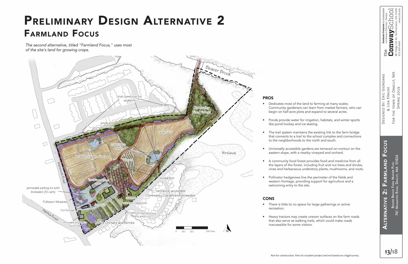
PRELIMINARY DESIGN ALTERNATIVE 2FARMLAND FOCUS
of the site's land for growing crops.
PROS• Dedicates most of the land to farming at many scales.
Community gardeners can learn from market farmers, who can begin on half-acre plots and expand to several acres.
• Ponds provide water for irrigation, habitats, and winter sports like pond hockey and ice skating.
• The trail system maintains the existing link to the farm bridge that connects to a trail to the school complex and connections to the neighborhoods to the north and south.
• Universally accessible gardens are terraced on-contour on the eastern slope, with a nearby vineyard and orchard.
• A community food forest provides food and medicine from all the layers of the forest, including fruit and nut trees and shrubs, vines and herbaceous understory plants, mushrooms, and roots.
• western frontage, providing support for agriculture and a welcoming entry to the site.
CONS• There is little to no space for large gatherings or active
recreation.
• Heavy tractors may create uneven surfaces on the farm roads that also serve as walking trails, which could make roads inaccessible for some visitors.
0 120 240 feet60
ALT
ERN
ATI
VE
2: F
AR
MLA
ND F
OC
US
BEA
VER
BRO
OK
FARM
MA
STER
PLA
N
761
MA
MM
OTH
RO
AD, D
RAC
UT,
MA
018
26
14/18
88 V
illag
e H
ill R
d. N
orth
ampt
on, M
A 01
060
413-
369-
4044
ww
w.c
sld.e
du
Not for construction. Part of a student project and not based on a legal survey.
Mam
moth R
oad
Nashua Road
Beaver Brook
Wetlands
Bri
dge
0 120 240 feet60
A Place for All
Large Event Venue
Affordable Housing with
greenroof patio garden
andsW t ndlWW nW t ndsdsWe sWWettll ddW dst
farm museum
Sugar Maple allee
Farm Fields
picnic
pavillion and lawn
sports field
amphitheaternatural
playground
U-Pick berries and orchard
on-contour swales
tennis and
basketball courts
with bioswales
community garden
pond hockey and ice
skating
wetland boardwalk connec-
tion to
future greenway trail
solar panels over park-
ing lot with bioswales
(20 cars)
pollinator meadow and
conveyance bioswale
trail connection to
neighbors
offices,
meeting space, cafe
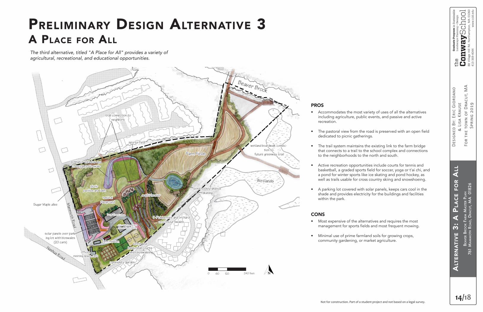
PRELIMINARY DESIGN ALTERNATIVE 3A PLACE FOR ALL
PROS• Accommodates the most variety of uses of all the alternatives
including agriculture, public events, and passive and active recreation.
• dedicated to picnic gatherings.
• The trail system maintains the existing link to the farm bridge that connects to a trail to the school complex and connections to the neighborhoods to the north and south.
• Active recreation opportunities include courts for tennis and
a pond for winter sports like ice skating and pond hockey, as well as trails usable for cross country skiing and snowshoeing.
• A parking lot covered with solar panels, keeps cars cool in the shade and provides electricity for the buildings and facilities within the park.
CONS• Most expensive of the alternatives and requires the most
• Minimal use of prime farmland soils for growing crops, community gardening, or market agriculture.
0 120 240 feet60
ALT
ERN
ATI
VE
3: A
PLA
CE
FOR A
LL
BEA
VER
BRO
OK
FARM
MA
STER
PLA
N
761
MA
MM
OTH
RO
AD, D
RAC
UT,
MA
018
26
15/18
88 V
illag
e H
ill R
d. N
orth
ampt
on, M
A 01
060
413-
369-
4044
ww
w.c
sld.e
du
Not for construction. Part of a student project and not based on a legal survey.
PREF
ERR
ED D
ESIG
N
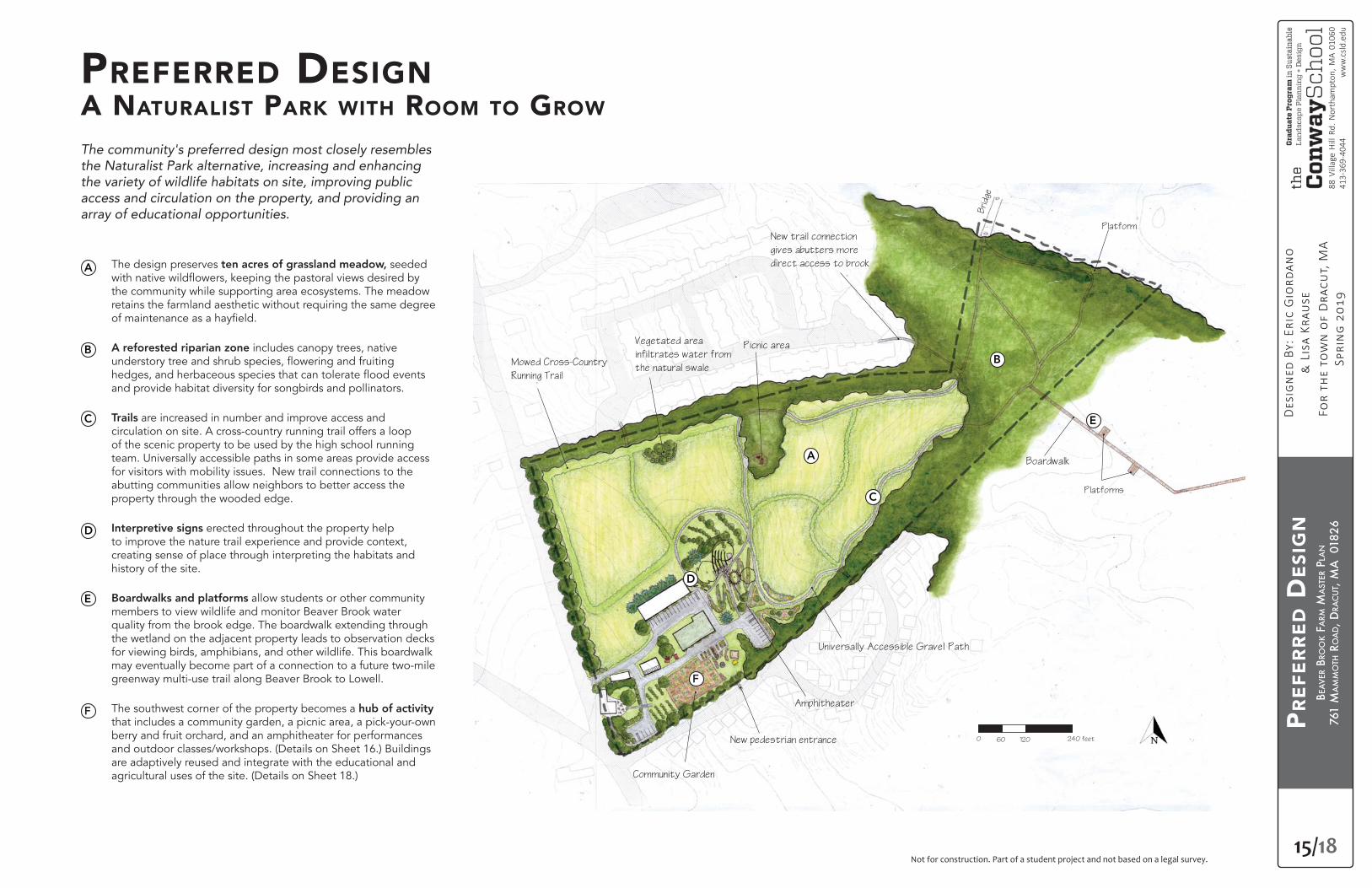
The design preserves ten acres of grassland meadow, seeded
the community while supporting area ecosystems. The meadow retains the farmland aesthetic without requiring the same degree
A reforested riparian zone includes canopy trees, native
and provide habitat diversity for songbirds and pollinators.
Trails are increased in number and improve access and circulation on site. A cross-country running trail offers a loop of the scenic property to be used by the high school running team. Universally accessible paths in some areas provide access for visitors with mobility issues. New trail connections to the abutting communities allow neighbors to better access the property through the wooded edge.
Interpretive signs erected throughout the property help to improve the nature trail experience and provide context, creating sense of place through interpreting the habitats and history of the site.
Boardwalks and platforms allow students or other community members to view wildlife and monitor Beaver Brook water quality from the brook edge. The boardwalk extending through the wetland on the adjacent property leads to observation decks for viewing birds, amphibians, and other wildlife. This boardwalk may eventually become part of a connection to a future two-mile greenway multi-use trail along Beaver Brook to Lowell.
The southwest corner of the property becomes a hub of activity that includes a community garden, a picnic area, a pick-your-own berry and fruit orchard, and an amphitheater for performances and outdoor classes/workshops. (Details on Sheet 16.) Buildings are adaptively reused and integrate with the educational and agricultural uses of the site. (Details on Sheet 18.)
The community's preferred design most closely resembles
array of educational opportunities.
PREFERRED DESIGNA NATURALIST PARK WITH ROOM TO GROW
Universally Accessible Gravel Path
Community Garden
New pedestrian entrance
Amphitheater
Boardwalk
Vegetated area
infiltrates water from
the natural swale
Picnic area
Bri
dge
Platform
Platforms
New trail connection
gives abutters more
direct access to brook
Mowed Cross-Country
Running Trail
A
A
0 120 240 feet60
BB
C
C
D
D
E
E
F
F
BEA
VER
BRO
OK
FARM
MA
STER
PLA
N
761
MA
MM
OTH
RO
AD, D
RAC
UT,
MA
018
26
16/18
88 V
illag
e H
ill R
d. N
orth
ampt
on, M
A 01
060
413-
369-
4044
ww
w.c
sld.e
du
Not for construction. Part of a student project and not based on a legal survey.
DES
IGN
DET
AIL
: FA
RM
VIL
LAG
E
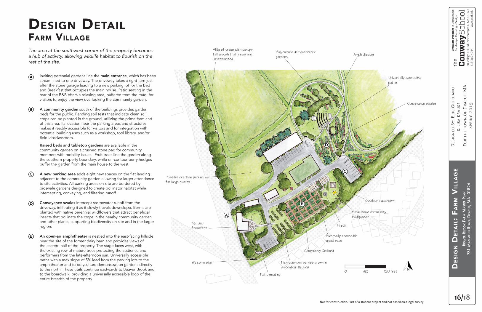
DESIGN DETAILFARM VILLAGE
Inviting perennial gardens line the main entrance, which has been streamlined to one driveway. The driveway takes a right turn just after the stone garage leading to a new parking lot for the Bed and Breakfast that occupies the main house. Patio seating in the rear of the B&B offers a relaxing area, buffered from the road, for visitors to enjoy the view overlooking the community garden.
A community garden south of the buildings provides garden beds for the public. Pending soil tests that indicate clean soil, crops can be planted in the ground, utilizing the prime farmland of this area. Its location near the parking areas and structures makes it readily accessible for visitors and for integration with potential building uses such as a workshop, tool library, and/or
Raised beds and tabletop gardens are available in the community garden on a crushed stone pad for community members with mobility issues. Fruit trees line the garden along the southern property boundary, while on-contour berry hedges buffer the garden from the main house to the west.
A new parking areaadjacent to the community garden allowing for larger attendance to site activities. All parking areas on site are bordered by bioswale gardens designed to create pollinator habitat while
Conveyance swales intercept stormwater runoff from the
insects that pollinate the crops in the nearby community garden and other plants, supporting biodiversity on site and in the larger region.
An open-air amphitheater is nestled into the east-facing hillside near the site of the former dairy barn and provides views of the eastern half of the property. The stage faces west, with the existing row of mature trees protecting the audience and performers from the late-afternoon sun. Universally accessible paths with a max slope of 5% lead from the parking lots to the amphitheater and to polyculture demonstration gardens directly to the north. These trails continue eastwards to Beaver Brook and to the boardwalk, providing a universally accessible loop of the entire breadth of the property
The area at the southwest corner of the property becomes
rest of the site.
Pick-your-own berries grown in
on-contour hedges
Patio seating
Welcome sign
Bed and
Breakfast
Community Orchard
Universally accessible
raised beds
Small scale community
biodigester
Outdoor classroom
Firepit
Conveyance swales
Polyculture demonstration
gardens
Possible overflow parking
for large events
Allee of trees with canopy
tall enough that views are
unobstructed
Amphitheater
Universally accessible
paths
0 60 120 feet
A
A
B
B
CC
D
D
E
E
BEA
VER
BRO
OK
FARM
MA
STER
PLA
N
761
MA
MM
OTH
RO
AD, D
RAC
UT,
MA
018
26
17/18
88 V
illag
e H
ill R
d. N
orth
ampt
on, M
A 01
060
413-
369-
4044
ww
w.c
sld.e
du
Not for construction. Part of a student project and not based on a legal survey.
DES
IGN
DET
AIL
: HIL
LSID
E
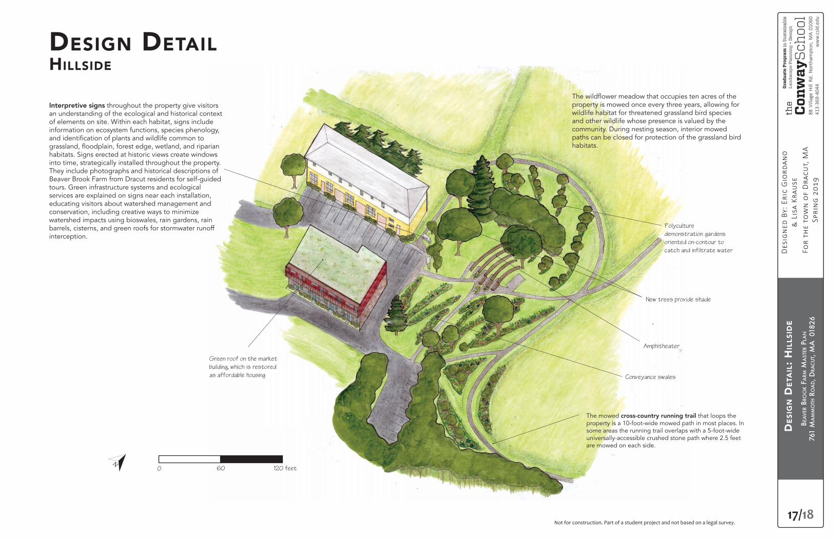
DESIGN DETAILHILLSIDE
The mowed cross-country running trail that loops the property is a 10-foot-wide mowed path in most places. In some areas the running trail overlaps with a 5-foot-wide universally-accessible crushed stone path where 2.5 feet are mowed on each side.
Interpretive signs throughout the property give visitors an understanding of the ecological and historical context of elements on site. Within each habitat, signs include information on ecosystem functions, species phenology,
habitats. Signs erected at historic views create windows into time, strategically installed throughout the property. They include photographs and historical descriptions of Beaver Brook Farm from Dracut residents for self-guided tours. Green infrastructure systems and ecological services are explained on signs near each installation, educating visitors about watershed management and conservation, including creative ways to minimize watershed impacts using bioswales, rain gardens, rain barrels, cisterns, and green roofs for stormwater runoff interception.
property is mowed once every three years, allowing for wildlife habitat for threatened grassland bird species and other wildlife whose presence is valued by the community. During nesting season, interior mowed paths can be closed for protection of the grassland bird habitats.
Polyculture
demonstration gardens
oriented on-contour to
catch and infiltrate water
Amphitheater
New trees provide shade
Conveyance swales
Green roof on the market
building, which is restored
as affordable housing
0 60 120 feet
BEA
VER
BRO
OK
FARM
MA
STER
PLA
N
761
MA
MM
OTH
RO
AD, D
RAC
UT,
MA
018
26
18/18
88 V
illag
e H
ill R
d. N
orth
ampt
on, M
A 01
060
413-
369-
4044
ww
w.c
sld.e
du
Not for construction. Part of a student project and not based on a legal survey.Not for construction. Part of a student project and not base
DESIGN DETAIL:ENTRANCE AND COMMUNITY GARDEN
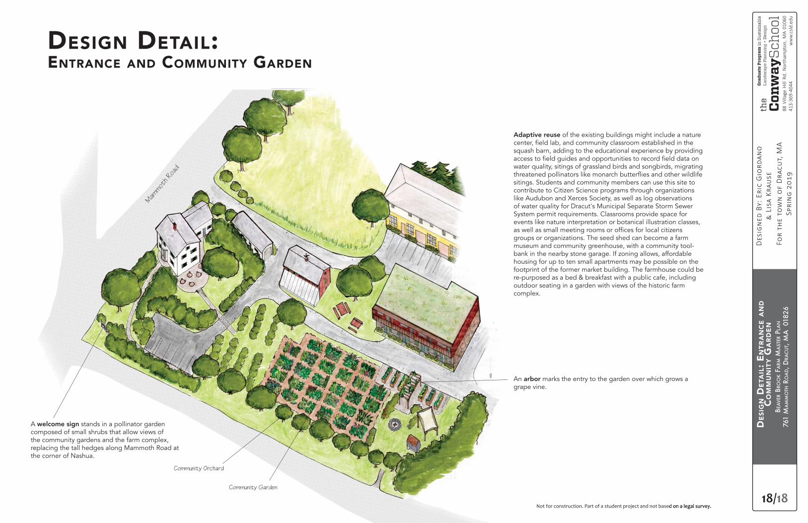
An arbor marks the entry to the garden over which grows a grape vine.
A welcome sign stands in a pollinator garden composed of small shrubs that allow views of the community gardens and the farm complex, replacing the tall hedges along Mammoth Road at the corner of Nashua.
Not for construction. Part of a student project and not based on a legal survey.
Adaptive reuse of the existing buildings might include a nature
squash barn, adding to the educational experience by providing
water quality, sitings of grassland birds and songbirds, migrating
sitings. Students and community members can use this site to contribute to Citizen Science programs through organizations like Audubon and Xerces Society, as well as log observations of water quality for Dracut's Municipal Separate Storm Sewer System permit requirements. Classrooms provide space for events like nature interpretation or botanical illustration classes,
groups or organizations. The seed shed can become a farm museum and community greenhouse, with a community tool-bank in the nearby stone garage. If zoning allows, affordable housing for up to ten small apartments may be possible on the footprint of the former market building. The farmhouse could be re-purposed as a bed & breakfast with a public cafe, including outdoor seating in a garden with views of the historic farm complex.
Community Garden
Community Orchard
Mam
mot
h Roa
d
DES
IGN
DET
AIL
: EN
TRA
NC
E A
ND
CO
MM
UN
ITY G
AR
DEN
BEA
VER
BRO
OK
FARM
MA
STER
PLA
N
761
MA
MM
OTH
RO
AD, D
RAC
UT,
MA
018
26
Not for construction. Part of a student project and not based on a legal survey.A
CO
MM
UN
ITY E
NG
AG
EMEN
T
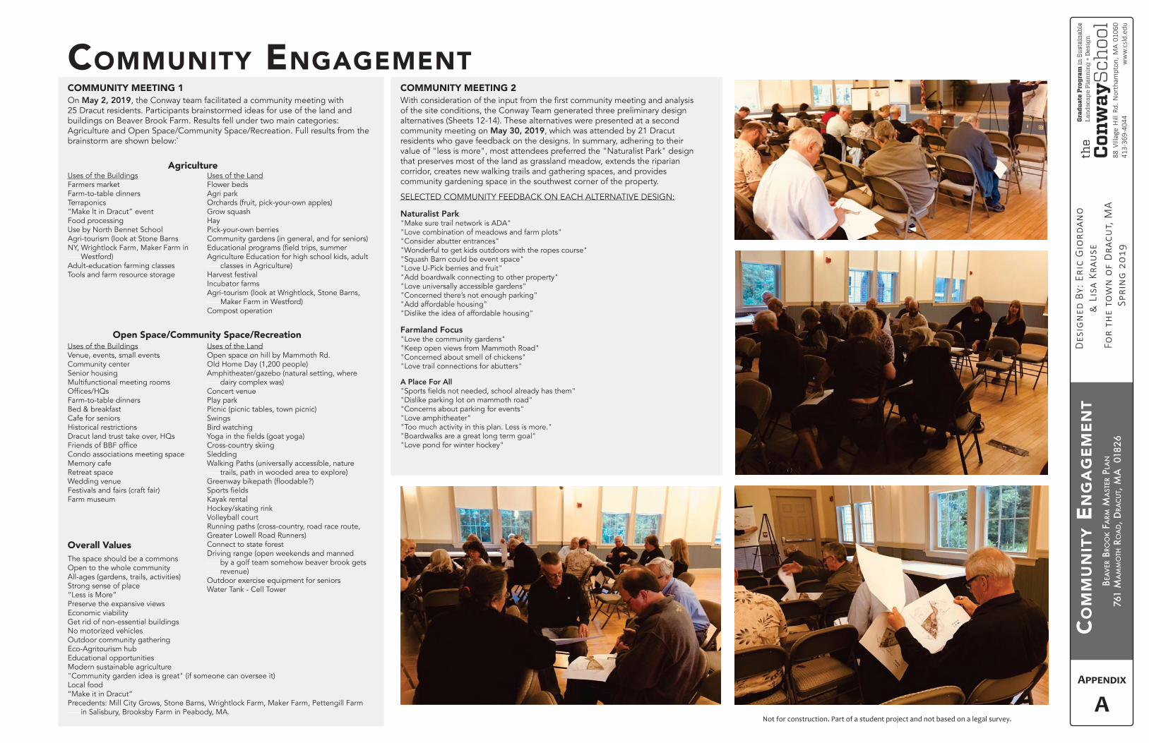
COMMUNITY ENGAGEMENTOn May 2, 2019, the Conway team facilitated a community meeting with 25 Dracut residents. Participants brainstormed ideas for use of the land and buildings on Beaver Brook Farm. Results fell under two main categories: Agriculture and Open Space/Community Space/Recreation. Full results from the brainstorm are shown below:`
of the site conditions, the Conway Team generated three preliminary design alternatives (Sheets 12-14). These alternatives were presented at a second community meeting on May 30, 2019, which was attended by 21 Dracut residents who gave feedback on the designs. In summary, adhering to their value of "less is more", most attendees preferred the "Naturalist Park" design that preserves most of the land as grassland meadow, extends the riparian corridor, creates new walking trails and gathering spaces, and provides community gardening space in the southwest corner of the property.
SELECTED COMMUNITY FEEDBACK ON EACH ALTERNATIVE DESIGN:
Naturalist Park"Make sure trail network is ADA""Love combination of meadows and farm plots""Consider abutter entrances""Wonderful to get kids outdoors with the ropes course""Squash Barn could be event space""Love U-Pick berries and fruit""Add boardwalk connecting to other property""Love universally accessible gardens""Concerned there’s not enough parking""Add affordable housing""Dislike the idea of affordable housing"
Farmland Focus"Love the community gardens""Keep open views from Mammoth Road""Concerned about smell of chickens""Love trail connections for abutters"
A Place For All
"Dislike parking lot on mammoth road""Concerns about parking for events""Love amphitheater""Too much activity in this plan. Less is more.""Boardwalks are a great long term goal""Love pond for winter hockey"
Uses of the BuildingsFarmers marketFarm-to-table dinnersTerraponics“Make It in Dracut” eventFood processingUse by North Bennet SchoolAgri-tourism (look at Stone Barns NY, Wrightlock Farm, Maker Farm in -----Westford)Adult-education farming classesTools and farm resource storage
Uses of the BuildingsVenue, events, small eventsCommunity centerSenior housingMultifunctional meeting rooms
Farm-to-table dinnersBed & breakfastCafe for seniorsHistorical restrictions
Condo associations meeting spaceMemory cafeRetreat spaceWedding venueFestivals and fairs (craft fair)Farm museum
Uses of the LandFlower beds Agri parkOrchards (fruit, pick-your-own apples)Grow squashHayPick-your-own berriesCommunity gardens (in general, and for seniors)
Agriculture Education for high school kids, adult -----classes in Agriculture)Harvest festivalIncubator farmsAgri-tourism (look at Wrightlock, Stone Barns, -----Maker Farm in Westford)Compost operation
Uses of the LandOpen space on hill by Mammoth Rd.Old Home Day (1,200 people)Amphitheater/gazebo (natural setting, where -----dairy complex was)Concert venuePlay parkPicnic (picnic tables, town picnic)SwingsBird watching
Cross-country skiingSledding Walking Paths (universally accessible, nature -----trails, path in wooded area to explore)
Kayak rentalHockey/skating rinkVolleyball courtRunning paths (cross-country, road race route, Greater Lowell Road Runners)Connect to state forestDriving range (open weekends and manned -----by a golf team somehow beaver brook gets -----revenue)Outdoor exercise equipment for seniorsWater Tank - Cell Tower
Agriculture
COMMUNITY MEETING 1 COMMUNITY MEETING 2
Open Space/Community Space/Recreation
Overall ValuesThe space should be a commonsOpen to the whole communityAll-ages (gardens, trails, activities)Strong sense of place“Less is More”Preserve the expansive viewsEconomic viabilityGet rid of non-essential buildingsNo motorized vehiclesOutdoor community gatheringEco-Agritourism hubEducational opportunitiesModern sustainable agriculture"Community garden idea is great" (if someone can oversee it)Local food“Make it in Dracut”Precedents: Mill City Grows, Stone Barns, Wrightlock Farm, Maker Farm, Pettengill Farm -----in Salisbury, Brooksby Farm in Peabody, MA.
BEA
VER
BRO
OK
FARM
MA
STER
PLA
N
761
MA
MM
OTH
RO
AD, D
RAC
UT,
MA
018
26
Not for construction. Part of a student project and not based on a legal survey.
RESO
UR
CES
RESOURCES
Pond Feasibility Requires Further StudyCreating a pond on site may have risks that outweigh its potential agricultural and recreational
an opportunity for winter recreation like ice skating and pond hockey, the risks associated with creating a pond on land potentially contaminated with lead and arsenic requires further study.
Heavy metals from past agricultural practices and roadways bond to soil particles, which travel through runoff as suspended sediments. While the proposed site design includes bioswales and rain gardens intended to help slow runoff and capture sediment, a pond may collect these sediments, which bond strongly to clay, of which ponds generally have higher quantities (Liebens).
Initial soil testing indicates the presence of arsenic and lead in the soil on the site of the former orchard behind the squash barn. It is possible that the contamination is localized to the former orchard area, but it is also possible that contamination is more widespread. Further testing is required in order to determine which areas may be impacted, which has implications for farming, community gardening, children's play areas, and community gathering spaces. This also has potential implications for any areas where soil sediment may collect, like ponds, bioswales, or rain gardens.
If further soil tests indicate that construction of a pond is appropriate and a pond is built, ongoing water quality testing of the pond is recommended, as would a maintenance regime for the pond and any bioswales or green infrastructure capturing polluted sediments.
Funding for Green InfrastructureStrategies to fund green infrastructure programs across the United States have included both incentive programs and stormwater utility fees. These fees are applied in order to fund launching such a program, in conjunction with public education, and outreach campaigns (Staddon,
green infrastructure, consult the Environmental Protection Agency's website (www.epa.gov/green-infrastructure/green-infrastructure-funding-opportunities).
Returning Agriculture to Beaver Brook FarmThere is a strong desire among many in the community to see agriculture return to Beaver Brook Farm. The form of this can vary from small community gardens on public land, to providing access to farmland for small, incubator-style farm business projects. These options could also support each other, as in the case of Just Roots Community Farm, which has a 30-year
Roots began with a desire for community gardens on
engaged in community outreach programming to address food access issues for vulnerable populations in Franklin County. Through a USDA grant, it was able to hire a farmer and grow into a 65-acre farm which has a Community Supported Agriculture program and sub-lease land to a 1-acre herb farm, while still hosting a community garden on the same land.
therapeutic farming alternatives like TALMAR in
owned land that offers training opportunities to people with developmental and physical disabilities. It sells
Clem Clay, the Executive Director of Grow Food
identifying a “Flagship Farmer,” a small-scale farmer in need of land who is willing to enter a long-term lease with the Town, providing stability for both the Town and the farmer and helping to coalesce community support for long-term investments and improvements to the land. Grow Food Northampton contracted with Crimson & Clover Farm to operate on city-owned land, and the town of Amherst's community-owned farm has Simple Gifts Farm in a long-term lease. These leases provide stability to farm operations and motivation for fundraising programs that help improve the sites for public use. Both farm sites also offer community festivals, farm dinners, tours, educational programming, and open space recreation that includes community gardens, walking trails and workshops.
Grassland ManagementShould the Town of Dracut decide to convert the
at Beaver Brook Farm, procedures for grassland management should be instituted to help maintain the long-term ecological health of the grassland and to better support wildlife.
Recommended procedures include:
dynamic ecosystem that meets grassland bird nesting needs and supports pollinators while allowing mowing for a hay crop and improves the trail experience for
activity.
A mix of native grasses hardy to the northeast includes Virginia wildrye (Elymus virginicus), Canada wildrye (Elymus canadensis), little bluestem (Schizachyrium scoparium), Indiangrass (Sorghastrum nutans), and switchgrass . These 2 to 5' tall native perennial grasses can be planted alone or with
primrose, foxglove, gayfeather, Indian blanket, lance-leaved coreopsis, New England aster, perennial lupine,
sweet William pinks.
One option for a regional supplier of bulk seed mixes is NE SEED in East Hartford, CT (www.neseed.com).
Grasslands in Massachusetts are often maintained
every three years. Such a controlled burn mimics a natural disturbance that eliminates built up organic matter, enriches the soil, and spurs renewed growth of perennials. This type of management helps to maintain
and shrubs and preventing invasive plant advancement, but may not be advisable for Beaver Brook Farm, given the close proximity of neighboring residential communities and schools. At Beaver Brook Farm, it may be more appropriate to maintain the grasslands through annual mowing. In order to preserve habitat for grassland birds, mowing the grassland should not occur during the nesting season, between May 15 and August 15 (Atwood).
Finding a Flagship Farmer may be possible through listing Beaver Brook Farm on Massachusetts farm-matching program websites for new farmers. Some of these programs include:
• New England Land Link through the New England Small Farms Institute (NESFI)
• New England Farmland Matching Service through
with Tufts University.
• Massachusetts Agriculture Commissions
• Our Land Here! program through Land for Good, Farm Seekers Program Land For Good (LFG)
• Agriculture Preservation Restriction Program (APR) through Massachusetts Department of Agriculture Resources (MDAR)
• Farms Forever program through Southeastern Massachusetts Agricultural Partnership (SEMAP)
• Massachusetts Land Trust Coalition
• American Farmland Trust – Massachusetts Chapter
B
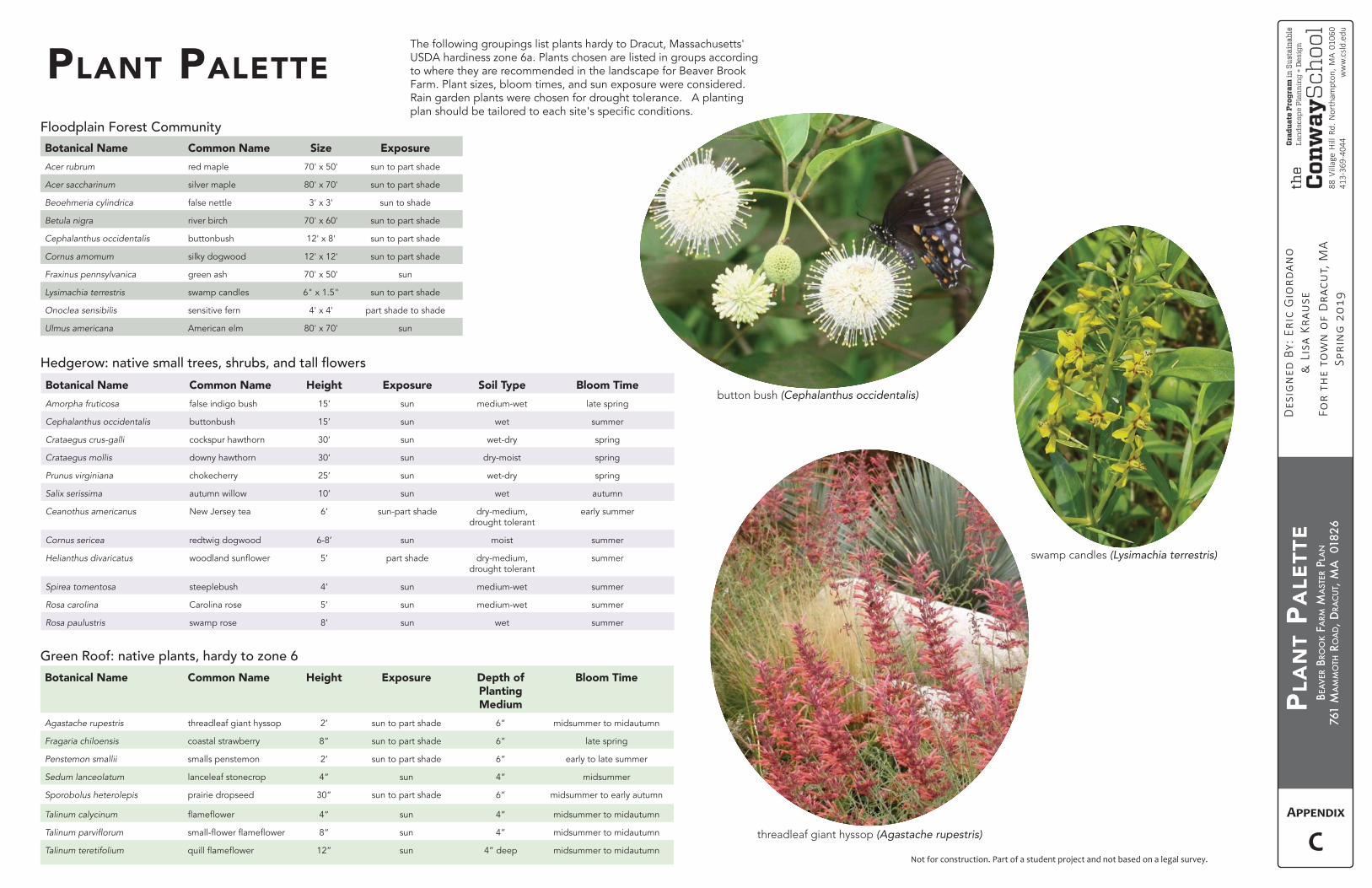
BEA
VER
BRO
OK
FARM
MA
STER
PLA
N
761
MA
MM
OTH
RO
AD, D
RAC
UT,
MA
018
26
Not for construction. Part of a student project and not based on a legal survey.
PLA
NT
PALE
TTE
Botanical Name Common Name Height Exposure Soil Type Bloom Time
Amorpha fruticosa false indigo bush 15’ sun medium-wet late spring
Cephalanthus occidentalis buttonbush 15’ sun wet summer
Crataegus crus-galli cockspur hawthorn 30’ sun wet-dry spring
Crataegus mollis downy hawthorn 30’ sun dry-moist spring
Prunus virginiana chokecherry 25’ sun wet-dry spring
Salix serissima autumn willow 10’ sun wet autumn
Ceanothus americanus New Jersey tea 6’ sun-part shade dry-medium, drought tolerant
early summer
Cornus sericea redtwig dogwood 6-8’ sun moist summer
Helianthus divaricatus 5’ part shade dry-medium, drought tolerant
summer
Spirea tomentosa steeplebush 4’ sun medium-wet summer
Rosa carolina Carolina rose 5’ sun medium-wet summer
Rosa paulustris swamp rose 8’ sun wet summer
PLANT PALETTE
Botanical Name Common Name Size Exposure
Acer rubrum red maple 70' x 50' sun to part shade
Acer saccharinum silver maple 80' x 70' sun to part shade
Beoehmeria cylindrica false nettle 3' x 3' sun to shade
Betula nigra river birch 70' x 60' sun to part shade
Cephalanthus occidentalis buttonbush 12' x 8' sun to part shade
Cornus amomum silky dogwood 12' x 12' sun to part shade
Fraxinus pennsylvanica green ash 70' x 50' sun
Lysimachia terrestris swamp candles 6" x 1.5" sun to part shade
Onoclea sensibilis sensitive fern 4' x 4' part shade to shade
Ulmus americana American elm 80' x 70' sun
Botanical Name Common Name Height Exposure Depth of Planting Medium
Bloom Time
Agastache rupestris threadleaf giant hyssop 2’ sun to part shade 6” midsummer to midautumn
Fragaria chiloensis coastal strawberry 8” sun to part shade 6” late spring
Penstemon smallii smalls penstemon 2’ sun to part shade 6” early to late summer
Sedum lanceolatum lanceleaf stonecrop 4” sun 4” midsummer
Sporobolus heterolepis prairie dropseed 30” sun to part shade 6” midsummer to early autumn
Talinum calycinum 4” sun 4” midsummer to midautumn
8” sun 4” midsummer to midautumn
Talinum teretifolium 12” sun 4” deep midsummer to midautumn
button bush (Cephalanthus occidentalis)
threadleaf giant hyssop
swamp candles (Lysimachia terrestris)
The following groupings list plants hardy to Dracut, Massachusetts' USDA hardiness zone 6a. Plants chosen are listed in groups according to where they are recommended in the landscape for Beaver Brook Farm. Plant sizes, bloom times, and sun exposure were considered. Rain garden plants were chosen for drought tolerance. A planting
C
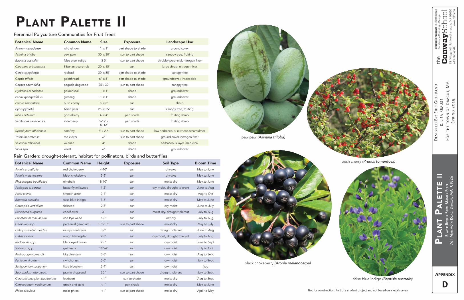
BEA
VER
BRO
OK
FARM
MA
STER
PLA
N
761
MA
MM
OTH
RO
AD, D
RAC
UT,
MA
018
26
Not for construction. Part of a student project and not based on a legal survey.
PLA
NT
PALE
TTE
II
Botanical Name Common Name Height Exposure Soil Type Bloom Time
Aronia arbutifolia red chokeberry 4-10’ sun dry-wet May to June
Aronia melanocarpa black chokeberry 3-5’ sun dry-wet May to June
Physocarpus opulifolius ninebark 8-10’ sun moist-dry May to June
Asclepias tuberosa 1-2’ sun dry-moist, drought tolerant June to Aug
Aster laevis smooth aster 2-4’ sun moist-dry Aug to Oct
Baptesia australis false blue indigo 3-5’ sun moist-dry May to June
Coreopsis verticillata tickseed 2-3’ sun dry-moist June to July
Echinacea purpurea 3’ sun moist-dry, drought tolerant July to Aug
Eupatorium maculatum Joe Pye weed 5-8’ sun wet-dry July to Aug
Geranium spp. perennial geranium 10”-18” sun to part shade moist-dry May to July
Heliopsis helianthoides 3-6’ sun drought tolerant June to Aug
Liatris aspera rough blazingstar 2-3’ sun dry-moist, drought tolerant July to Aug
Rudbeckia spp. black eyed Susan 2-5’ sun dry-moist June to Sept
Solidago spp. goldenrod 18”-4’ sun dry-moist July to Oct
Andropogon gerardii big bluestem 3-5’ sun dry-moist Aug to Sept
Panicum virgatum switchgrass 3-6’ sun dry-moist July to Sept
Schizacyrium scoparium little bluestem 3-4’ sun dry-moist Aug
Sporobolus heterolepis prairie dropseed 30” sun to part shade drought tolerant July to Sept
Ceratostigma plumbaginoides leadwort <1’ sun to shade moist-dry Aug to Sept
Chrysogonum virginianum green and gold <1’ part shade moist-dry May to June
Phlox subulata moss phlox <1’ sun to part shade moist-dry April to May
Botanical Name Common Name Size Exposure Landscape Use
Asarum canadense wild ginger 1' x 1' part shade to shade ground cover
Asimina triloba paw paw 30' x 30' sun to part shade canopy tree, fruiting
Baptisia australis false blue indigo 3-5’ sun to part shade
Caragana arborescens Siberian pea shrub 20' x 15' sun
Cercis canadensis redbud 30' x 35' part shade to shade canopy tree
Coptis trifolia goldthread 6" x 6" part shade to shade groundcover, insecticide
Cornus alternifolia pagoda dogwood 25'x 30' sun to part shade canopy tree
Hydrastis canadensis goldenseal 1' x 1' shade groundcover
Panax quinquefolius ginseng 1' x 1' shade groundcover
Prunus tomentosa bush cherry 8' x 8' sun shrub
Pyrus pyrifolia Asian pear 25' x 25' sun canopy tree, fruiting
Ribes hirtellum gooseberry 4' x 4' part shade fruiting shrub
Sambucus canadensis elderberry 5-12’ x 5'-12'
part shade fruiting shrub
comfrey 3' x 2.5' sun to part shade low herbaceous, nutrient accumulator
Trifolium pratense red clover 6" sun to part shade
valerian 4" shade herbaceous layer, medicinal
Viola spp violet 6" shade groundcover
PLANT PALETTE II
paw paw
false blue indigo (Baptisia australis)
black chokeberry
bush cherry
D
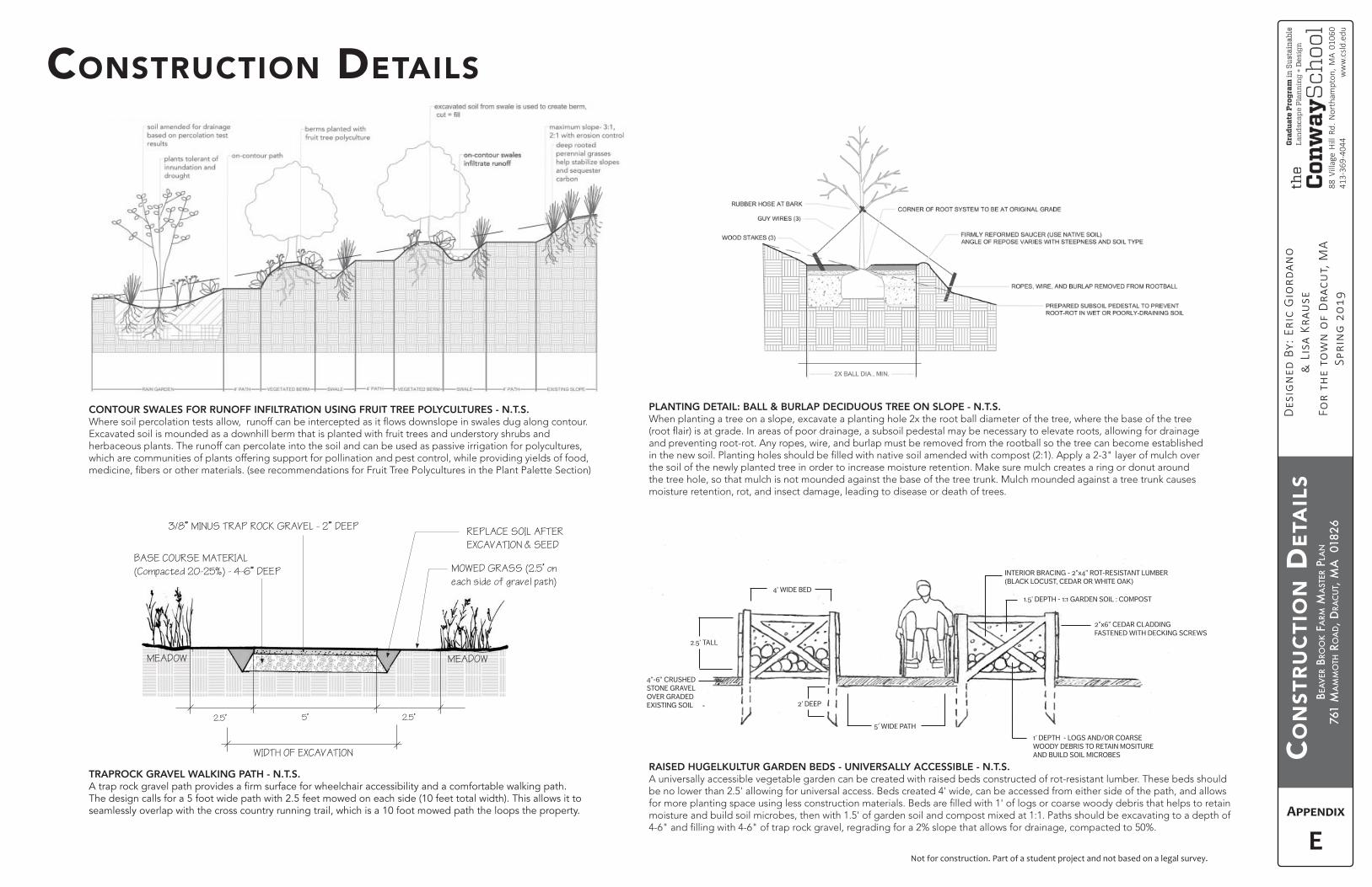
BEA
VER
BRO
OK
FARM
MA
STER
PLA
N
761
MA
MM
OTH
RO
AD, D
RAC
UT,
MA
018
26
Not for construction. Part of a student project and not based on a legal survey.
CO
NST
RU
CTI
ON
DET
AIL
S
INTERIOR BRACING - 2”x4” ROT-RESISTANT LUMBER(BLACK LOCUST, CEDAR OR WHITE OAK)
1.5’ DEPTH - 1:1 GARDEN SOIL : COMPOST
2”x6” CEDAR CLADDING FASTENED WITH DECKING SCREWS
1’ DEPTH - LOGS AND/OR COARSE WOODY DEBRIS TO RETAIN MOSITURE AND BUILD SOIL MICROBES
5’ WIDE PATH
4”-6” CRUSHED STONE GRAVEL OVER GRADED EXISTING SOIL
4’ WIDE BED
2’ DEEP
2.5’ TALL
RAISED HUGELKULTUR GARDEN BEDS - UNIVERSALLY ACCESSIBLE (CROSS-SECTION)
CONTOUR SWALES FOR RUNOFF INFILTRATION USING FRUIT TREE POLYCULTURES - N.T.S.
Excavated soil is mounded as a downhill berm that is planted with fruit trees and understory shrubs and herbaceous plants. The runoff can percolate into the soil and can be used as passive irrigation for polycultures, which are communities of plants offering support for pollination and pest control, while providing yields of food,
TRAPROCK GRAVEL WALKING PATH - N.T.S.
The design calls for a 5 foot wide path with 2.5 feet mowed on each side (10 feet total width). This allows it to seamlessly overlap with the cross country running trail, which is a 10 foot mowed path the loops the property.
RAISED HUGELKULTUR GARDEN BEDS - UNIVERSALLY ACCESSIBLE - N.T.S. A universally accessible vegetable garden can be created with raised beds constructed of rot-resistant lumber. These beds should be no lower than 2.5' allowing for universal access. Beds created 4' wide, can be accessed from either side of the path, and allows
moisture and build soil microbes, then with 1.5' of garden soil and compost mixed at 1:1. Paths should be excavating to a depth of
E
CONSTRUCTION DETAILS
PLANTING DETAIL: BALL & BURLAP DECIDUOUS TREE ON SLOPE - N.T.S. When planting a tree on a slope, excavate a planting hole 2x the root ball diameter of the tree, where the base of the tree
and preventing root-rot. Any ropes, wire, and burlap must be removed from the rootball so the tree can become established
the soil of the newly planted tree in order to increase moisture retention. Make sure mulch creates a ring or donut around the tree hole, so that mulch is not mounded against the base of the tree trunk. Mulch mounded against a tree trunk causes moisture retention, rot, and insect damage, leading to disease or death of trees.
5’2.5’ 2.5’
3/8” MINUS TRAP ROCK GRAVEL - 2” DEEP
WIDTH OF EXCAVATION
BASE COURSE MATERIAL
(Compacted 20-25%) - 4-6” DEEP
REPLACE SOIL AFTER
EXCAVATION & SEED
MEADOWMEADOW
MOWED GRASS (2.5’ on
each side of gravel path)
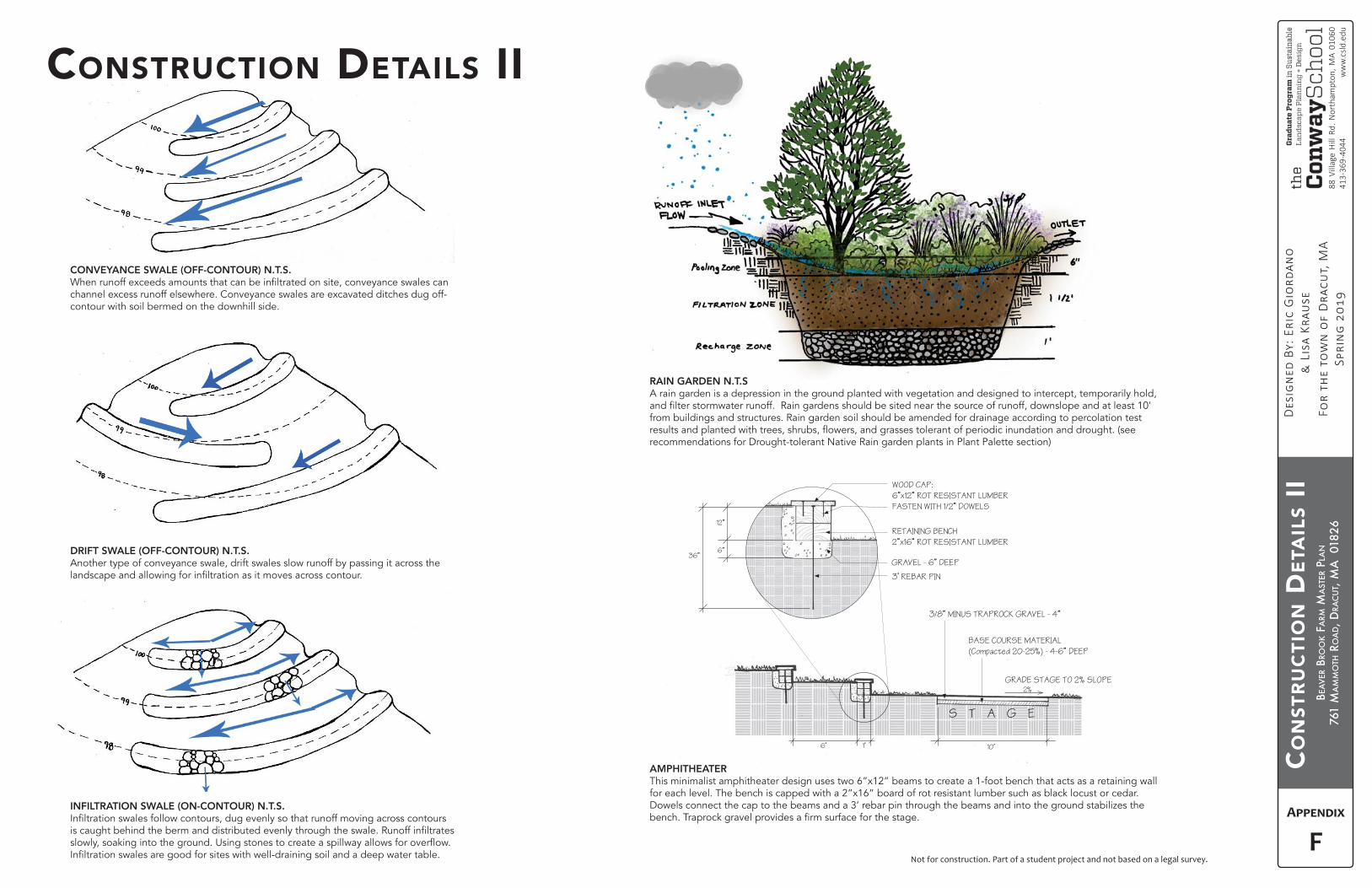
BEA
VER
BRO
OK
FARM
MA
STER
PLA
N
761
MA
MM
OTH
RO
AD, D
RAC
UT,
MA
018
26
Not for construction. Part of a student project and not based on a legal survey.
CO
NST
RU
CTI
ON
DET
AIL
S II
CONVEYANCE SWALE (OFF-CONTOUR) N.T.S.
channel excess runoff elsewhere. Conveyance swales are excavated ditches dug off-contour with soil bermed on the downhill side.
INFILTRATION SWALE (ON-CONTOUR) N.T.S.
DRIFT SWALE (OFF-CONTOUR) N.T.S. Another type of conveyance swale, drift swales slow runoff by passing it across the
RAIN GARDEN N.T.S A rain garden is a depression in the ground planted with vegetation and designed to intercept, temporarily hold,
from buildings and structures. Rain garden soil should be amended for drainage according to percolation test
recommendations for Drought-tolerant Native Rain garden plants in Plant Palette section)
F
CONSTRUCTION DETAILS II
WOOD CAP:
6”x12” ROT RESISTANT LUMBER
FASTEN WITH 1/2” DOWELS
3’ REBAR PIN
GRAVEL - 6” DEEP
6”
12”
36”
10’1’6’
RETAINING BENCH
2”x16” ROT RESISTANT LUMBER
3/8” MINUS TRAPROCK GRAVEL - 4”
S T A G E
BASE COURSE MATERIAL
(Compacted 20-25%) - 4-6” DEEP
GRADE STAGE TO 2% SLOPE2%
AMPHITHEATER This minimalist amphitheater design uses two 6”x12” beams to create a 1-foot bench that acts as a retaining wall for each level. The bench is capped with a 2”x16” board of rot resistant lumber such as black locust or cedar. Dowels connect the cap to the beams and a 3’ rebar pin through the beams and into the ground stabilizes the
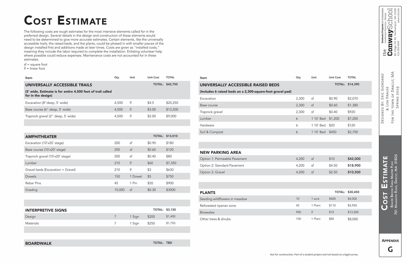
BEA
VER
BRO
OK
FARM
MA
STER
PLA
N
761
MA
MM
OTH
RO
AD, D
RAC
UT,
MA
018
26
Not for construction. Part of a student project and not based on a legal survey.
CO
ST E
STIM
ATE
COST ESTIMATE
Item Qty Unit Unit Cost TOTAL
UNIVERSALLY ACCESSIBLE TRAILS
(5' wide. Estimate is for entire 4,500 feet of trail called for in the design)
TOTAL: $42,750
Excavation (8"deep, 5' wide) 4,500 lf $4.5 $20,250
Base course (6" deep, 5' wide) 4,500 lf $3.00 $13,500
Traprock gravel (2" deep, 5' wide) 4,500 lf $2.00 $9,000
AMPHITHEATER TOTAL: $13,010
Excavation (10'x20' stage) 200 sf $0.90 $180
Base course (10'x20' stage) 200 sf $0.60 $120
Traprock gravel (10'x20' stage) 200 sf $0.40 $80
Lumber 210 lf $60 $7,350
Gravel beds (Excavation + Gravel) 210 lf $3 $630
Dowels 150 1 Dowel $5 $750
Rebar Pins 45 1 Pin $20 $900
Grading 10,000 sf $0.30 $3000
INTERPRETIVE SIGNS TOTAL: $3,150
Design 7 1 Sign $200 $1,400
Materials 7 1 Sign $250 $1,750
BOARDWALK TOTAL: TBD
Item Qty Unit Unit Cost TOTAL
UNIVERSALLY ACCESSIBLE RAISED BEDS
(Includes 6 raised beds on a 2,300-square-foot gravel pad)
TOTAL: $14,390
Excavation 2,300 sf $0.90 $2,070
Base course 2,300 sf $0.60 $1,380
Traprock gravel 2,300 sf $0.40 $920
Lumber 6 1 10' Bed $1,200 $7,200
Hardware 6 1 10' Bed $20 $120
Soil & Compost 6 1 10' Bed $450 $2,700
NEW PARKING AREA
Option 1: Permeable Pavement 4,200 sf $10 $42,000
Option 2: Standard Pavement 4,200 sf $4.50 $18,900
Option 3: Gravel 4,200 sf $2.50 $10,500
PLANTS TOTAL: $30,450
10 1 acre $400 $4,000
Reforested riparian zone 45 1 Plant $110 $4,950
Bioswales 900 lf $15 $13,500
Other trees & shrubs 100 1 Plant $80 $8,000
The following costs are rough estimates for the most intensive elements called for in the preferred design. Several details in the design and construction of these elements would need to be determined to give more accurate estimates. Certain elements, like the universally accessible trails, the raised beds, and the plants, could be phased in with smaller pieces of the
meaning they include the labor required to complete the installation. Enlisting volunteer help where possible could reduce expenses. Maintenance costs are not accounted for in these estimates. sf = square footlf = linear foot
G
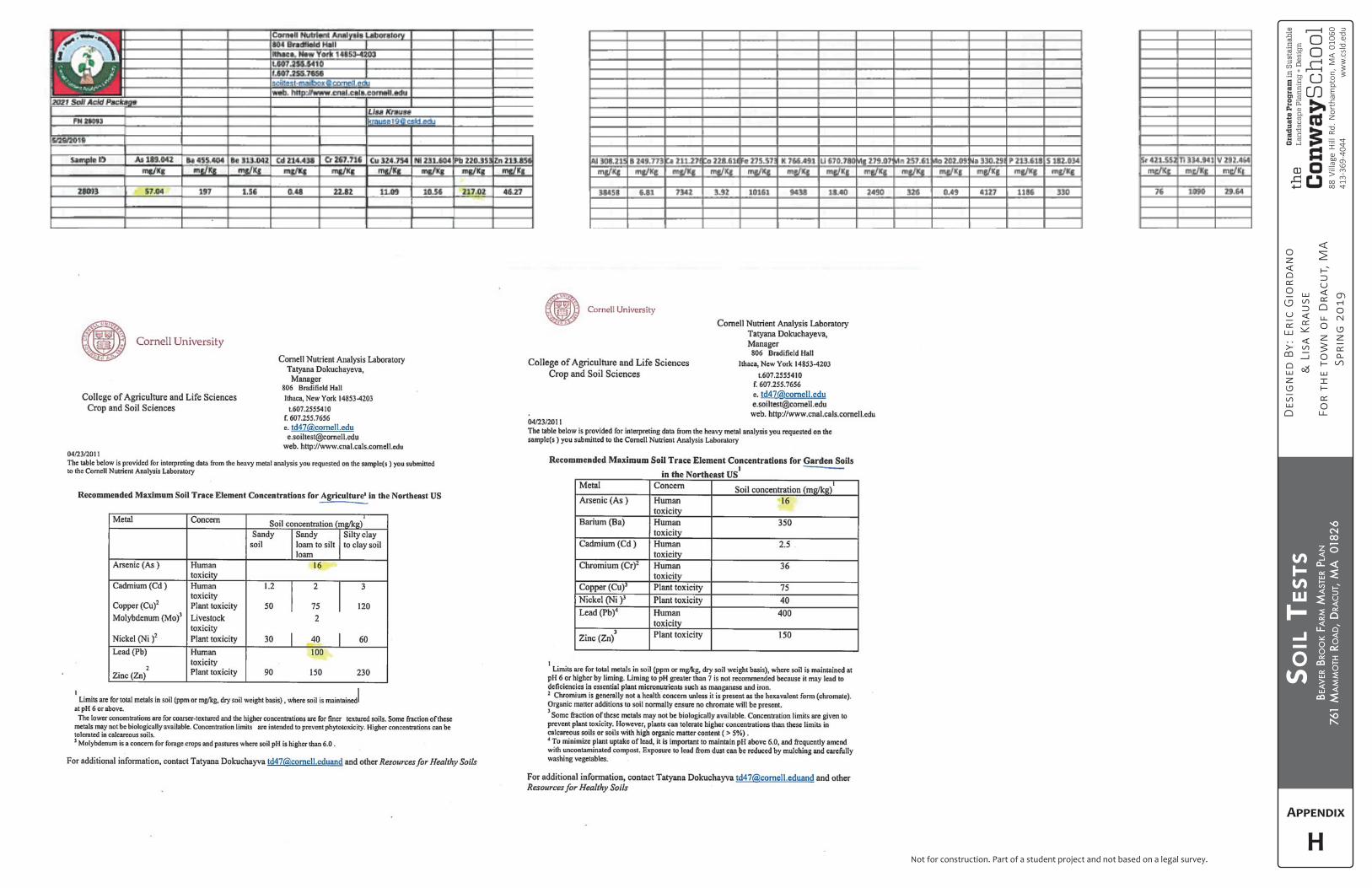
BEA
VER
BRO
OK
FARM
MA
STER
PLA
N
761
MA
MM
OTH
RO
AD, D
RAC
UT,
MA
018
26
Not for construction. Part of a student project and not based on a legal survey.
SOIL
TES
TS
H
BEA
VER
BRO
OK
FARM
MA
STER
PLA
N
761
MA
MM
OTH
RO
AD, D
RAC
UT,
MA
018
26
Not for construction. Part of a student project and not based on a legal survey.
REFE
REN
CES
REFERENCESADA Network "The Universal Garden" www.adata.org/universal-garden
Sustainable Agriculture. March 29th, 2018 blog.uvm.edu/pasture-vtpasture/2018/03/29/managing-
Atwood, J., Collins, J., Kidd, L., Servison, M., and Walsh, J. “Best Management Practices for Nesting
Management-Practices_Grasslands.pdf
Brittingham, M., and DeLong, C. “Management practices for enhancing wildlife habitat.” Penn State Extension. April 15, 2016. https://extension.psu.edu/management-practices-for-enhancing-wildlife-habitat
Bureau, U. S. Census. “American FactFinder - Community Facts.” Accessed June, 2019. census.gov/faces/nav/jsf/pages/index.xhtml
CDM Smith. “Town of Dracut, MA: Stormwater Utility Feasibility Study.” 2017. www.dracutma.gov/sites/
Center for Watershed Protection. "Impacts of Impervious Cover on Aquatic Systems." Monograph no. 1, 2003, pp. 1-7.
Conniff, Richard. “Habitat on the Edges: Making room for wildlife in an urbanized world.” YaleEnvironment360. Yale School of Forestry & Environmental Studies. January 3, 2018 www.e360.yale.edu/features/habitat-on-the-edges-making-room-for-wildlife-in-an-urbanized-world
model system for managing source-sink dynamics on Department of Defense lands.” Institute for Wildlife Studies: Source/Sink Dynamics Project www.iws.org/projects_source_sink.html
guide_10-30-09.pdf
eBird. “Illustrated Checklist of Bird Sightings in Middlesex County.” www.ebird.org/region/US-MA-017/
Environmental Protection Agency. "Green Infrastructure Funding Opportunities." www.epa.gov/green-infrastructure/green-infrastructure-funding-opportunities
Fieldman, Luis. “Meadow cleared on Arcadia property raises eyebrows.” 7/25/2018 www.gazettenet.com/
Hood, E. “The Apple Bites Back: Claiming Old Orchards for Residential Development.” Environmental Health Perspectives. vol.114, no. 8, Aug 2006, pp. A470-476 www.ncbi.nlm.nih.gov/pmc/articles/PMC1551991/
Kafka Granite's Guide to Wheelchair-Accessible Pathway Materials. www.kafkagranite.com/kafka-granites-guide-wheelchair-accessible-pathway-materials
Kusler, J. “Common questions: constructing wetland boardwalks and trails.” 2006 guide. International Institute for Wetland Science and Public Policy. www.aswm.org/pdf_lib/2_boardwalk_6_26_06.pdf
Liebens, J. "Heavy metal contamination of sediments in stormwater management systems: the effect of land use, particle size, and age." Environmental Geology (2001) 41 p.341-351. doi. 10.10007/s002540100392 August 17, 2001.
Lowell Sun. "60 Years of Farming (and lots of blue hubbard squash) at Beaver Brook Farm". 2017. http://blogs.lowellsun.com/history/2017/10/28/60-years-of-farming-and-lots-of-blue-hubbard-squash-at-beaver-brook-farm/
MassGIS (Bureau of Geographic Information), Commonwealth of Massachusetts EOTSS. https://docs.digital.mass.gov/dataset/massgis-data-layers
edgeofthewoodsnursery.com/nine-reasons-plant-oak