baselines-69-ohlos-2015.pdf - sovereign geographic
TRANSCRIPT
1
the oxford handbook of
THE LAW OF THE SEA
Edited by
DONALD R ROTHWELLProfessor of International Law, Australian National University
ALEX G OUDE ELFERINKProfessor of International Law of the Sea, University of Tromsø and Utrecht University
KAREN N SCOTTProfessor of Law, University of Canterbury
TIM STEPHENSProfessor of International Law, University of Sydney
Rothwell171014OUK.indb 3 05-03-2015 21:46:11
1Great Clarendon Street, Oxford, ox2 6dp,
United KingdomOxford University Press is a department of the University of Oxford.
It furthers the University’s objective of excellence in research, scholarship,and education by publishing worldwide. Oxford is a registered trade mark of
Oxford University Press in the UK and in certain other countries© The several contributors 2015
The moral rights of the authors have been assertedFirst Edition published in 2015
Impression: 1All rights reserved. No part of this publication may be reproduced, stored ina retrieval system, or transmitted, in any form or by any means, without the
prior permission in writing of Oxford University Press, or as expressly permittedby law, by licence or under terms agreed with the appropriate reprographics
rights organization. Enquiries concerning reproduction outside the scope of theabove should be sent to the Rights Department, Oxford University Press, at the
address aboveYou must not circulate this work in any other form
and you must impose this same condition on any acquirerCrown copyright material is reproduced under Class Licence
Number C01P0000148 with the permission of OPSIand the Queen’s Printer for Scotland
Published in the United States of America by Oxford University Press198 Madison Avenue, New York, NY 10016, United States of America
British Library Cataloguing in Publication DataData available
Library of Congress Control Number: 2015930576ISBN 978–0–19–871548–1
Printed and bound byCPI Group (UK) Ltd, Croydon, cr0 4yy
Jacket illustration: Roger Coulam/Oxford Scientific/ Getty Images.
Links to third party websites are provided by Oxford in good faith andfor information only. Oxford disclaims any responsibility for the materials
contained in any third party website referenced in this work.
Rothwell171014OUK.indb 4 05-03-2015 21:46:11
4
BASELINES
Coalter G Lathrop*
1 The Function and Significance of Baselines
In the seminal maritime delimitation case of the modern era, the International Court of Justice (ICJ) wrote ‘the land dominates the sea’.1 Two decades later Weil expanded the court’s cryptic assertion writing that ‘the land dominates the sea and it dominates it by the intermediary the coastal front’.2 The ICJ further clarified the intermediate role of the coast: ‘The juridical link between the State’s territorial sovereignty and its rights to certain adjacent maritime expanses is established by means of its coast.’3 As the legal expression of the coast,4 baselines, in their many
* The author would like to thank Ariell Friedman, JD Duke Law, for her research and editorial assistance.
1 North Sea Continental Shelf (Federal Republic of Germany v Denmark; Federal Republic of Germany v Netherlands) (Judgment) [1969] ICJ Rep 3, [96]. In French, ‘le principe que la terre domine la mer’. As the International Court of Justice noted, ‘[t] he land is the legal source of the power which a State may exercise over territorial extensions to seaward.’
2 P Weil, The Law of Maritime Delimitation—Reflections (Grotius Cambridge 1989) 50 (emphasis added).
3 Continental Shelf (Libyan Arab Jamahiriya/Malta) (Judgment) [1985] ICJ Rep 13, [49].4 The term ‘coast’ is broader than the term ‘baseline’, but undoubtedly the low-water line is part of
the coast. ‘Coast’ is defined as ‘the edge or margin of land next to the sea’. GK Walker (ed), Definitions for the Law of the Sea: Terms not Defined by the 1982 Convention (Martinus Nijhoff Leiden 2012) 130. An earlier version of the International Hydrographic Organization glossary defines ‘coast’ as ‘[t] he sea-shore. The narrow strip of land in immediate contact with any body of water, including the area between high- and low-water lines’ (at 131).
Rothwell171014OUK.indb 69 05-03-2015 21:46:24
70 coalter g lathrop
forms, are the features through which coastal States generate derivative title to mar-itime areas, and, as such, baselines are a foundational component of coastal State maritime jurisdiction.
Bederman, writing about the modern system of maritime jurisdictional zones emanating from the coast, notes that ‘[i] t very much matters “where” in the ocean a particular event takes place, because such a location determines the relevant set of rules for legal conduct.’5 The answer to the question ‘where?’ hinges on the loca-tion of baselines. Baselines are the ‘zero mark’ for measuring the breadth of the territorial sea, contiguous zone, exclusive economic zone, and, in most circum-stances, the continental shelf,6 and are the starting point for delimitation between neighboring States claiming overlapping maritime areas. Baselines are ‘a major ingredient’ when used to delineate maritime zone outer limits and to delimit those zones between States.7 Baselines are the only ingredient when used to designate the outer limits of internal waters separating areas in which States enjoy unimpeded sovereignty from the territorial sea beyond.8 Maritime boundary delimitation and the functional and spatial aspects of archipelagic waters, the territorial sea, con-tiguous zone, exclusive economic zone, and continental shelf are addressed sepa-rately in this volume.9 Internal waters, the jurisdictional zone limited by baselines, are addressed in the chapter covering port State jurisdiction but merit additional brief discussion here.10
Internal waters are subject to the legal regime of State sovereignty and are gov-erned by the rules of the coastal State’s municipal legal system. Coastal State sov-ereignty in internal waters is unencumbered by the rights of other States.11 This is in contrast with the territorial sea lying just beyond the baselines, in which ships of all States enjoy the right of innocent passage.12 As a consequence, the coastal State may deny foreign vessels, including warships, entry into its internal waters or may set conditions to that entry.13 Foreign warships are insulated by the principle
5 DJ Bederman, ‘The Sea’ in B Fassbender and A Peters (eds), The Oxford Handbook of the History of International Law (Oxford University Press Oxford 2012) 373.
6 Where the outer edge of the continental margin extends beyond 200 nm the breadth of the con-tinental shelf may be established by criteria other than distance measured from baselines. See 1982 United Nations Convention on the Law of the Sea, Art 76 (hereinafter LOSC).
7 Virginia Commentaries, Vol II, 82.8 LOSC, n 6, Art 8(1) (‘Except as provided in Part IV [Archipelagic States], waters on the landward
side of the baseline of the territorial sea form part of the internal waters of the State.’).9 See Chapter 5 on the territorial sea and contiguous zone, Chapter 7 on archipelagic waters,
Chapter 8 on the exclusive economic zone, Chapter 9 on the continental shelf, and Chapter 12 on maritime delimitation in this volume.
10 See Chapter 13 on coastal and port State jurisdiction in this volume.11 But see LOSC, n 6, Art 8(2), which recites an important exception to this rule for some internal
waters created by Art 7 straight baselines.12 Ibid, Art 17.13 See eg 1987 Nuclear Free Zone, Disarmament, and Arms Control Act (NZ), § 9(2):
Rothwell171014OUK.indb 70 05-03-2015 21:46:24
baselines 71
of sovereign immunity while in internal waters, but non-governmental vessels are not.14 Private vessels entering internal waters may find themselves subjected to the full weight of coastal State jurisdiction with respect to criminal and environmen-tal violations, for example, while just outside the baselines the same foreign ves-sel would enjoy significant protection from coastal State jurisdiction if engaged in innocent passage through the territorial sea. The location of baselines determines where this abrupt and consequential division occurs.
Any discussion of baselines must distinguish the unilateral delineation of zonal outer limits (including of internal waters) from the bilateral process of delimiting maritime boundaries between coastal States. It is important to make this distinction because most of the international decisions of any relevance to the law of baselines have been boundary delimitation cases, and such findings are not always applicable to baselines used for zonal limit delineation. Whether a State may lawfully use a feature, such as an island or jetty, for the purpose of measuring the breadth of the territorial sea and other zones in the unilateral context of establishing outer limits does not necessarily have bearing on whether a court or negotiating partner must or will accept that baseline feature in the bilateral context of boundary delimitation.15 In fact, courts commonly disregard parties’ official baseline claims when deciding a boundary. For example, the ICJ did not take issue with Romania and Ukraine using Sulina Dyke and Serpents’ Island, respectively, to measure the breadth of their territorial seas, but ignored both of these features in the delimitation between the parties.16 Negotiating States also may, and often do, discount otherwise legitimate baseline features in the process of boundary delimitation. Singapore may lawfully measure the breadth of its zones from the low-water line of reclaimed land, but Indonesia need not (and did not) accept that version of Singapore’s baseline for the purpose of delimitation.17
The Prime Minister may only grant approval for the entry into the internal waters of New Zealand by foreign warships if the Prime Minister is satisfied that the warships will not be carrying any nuclear explosive device upon their entry into the internal waters of New Zealand.
14 See eg the ruling by the Supreme Court of Ghana that resolved the pending Annex VII ARA Libertad Arbitration (Argentina v Ghana), Republic v High Court (Commercial Division) Accra, Ex parte Attorney General, NML Capital and the Republic of Argentina, Civil Motion No J5/10/2013 (Supreme Court, Ghana, 2013) [24] (‘There is no doubt that, under customary international law, warships are covered by sovereign immunity in foreign ports.’).
15 The Court observes that the issue of determining the baseline for the purpose of measuring the breadth of the continental shelf and the exclusive economic zone and the issue of identifying base points for drawing an equidistance/median line for the purpose of delimiting continental shelf and exclusive economic zone between adjacent/opposite States are two different issues.
Maritime Delimitation in the Black Sea (Romania v Ukraine) (Judgment) [2009] ICJ Rep 61, [108].16 Ibid, [138] and [149].17 C Schofield, TL McDorman, and IM Andi Arsana, ‘Indonesia—Singapore’ in CG Lathrop (ed),
International Maritime Boundaries, Vol VII (Martinus Nijhoff Publishers, Leiden, forthcoming 2015). International Maritime Boundaries.
Rothwell171014OUK.indb 71 05-03-2015 21:46:24
72 coalter g lathrop
Baselines are a source of tension among States. Like many other aspects of the law of the sea, the historical development of rules and State practice with respect to baselines reveal the underlying tension between the interests of coastal States in expanding the scope of their authority on the one hand, and, on the other, the interests of maritime States in maintaining traditional freedoms of the seas in as much of the oceans as possible. Spatially excessive maritime claims begin with the baseline:18 in all circumstances, the result of moving the legal coastline seaward ‘is to increase the total area of water over which the coastal state possesses the most comprehensive authority and to decrease the total area within which coastal and noncoastal states share authority and use’.19 One can easily observe through the baselines lens the tension between the mare clausum propensities of coastal States and the mare liberum leanings of maritime States. This is not a new phenomenon. Baselines have been contentious at least since they were addressed in the late 1920s by the Hague Codification Conference Preparatory Committee. Baselines contin-ued to present challenging issues throughout subsequent codification efforts from the 1950s through to the adoption of the 1982 United Nations Convention on the Law of the Sea (LOSC). Even now, when the law is as clearly stated as it is ever likely to be, baseline rules carry unsettled questions related to their application by States and their adaptability to the realities of the physical environment.
This chapter sets out the international law of baselines as it stands today and identifies past, present, and possible future problematic issues in this area of the law of the sea. This chapter begins by considering the so-called ‘normal baseline’, con-sisting of the low-water line along the coast, and asks whether this baseline is fixed or ambulatory: a question of some consequence for low-lying, small-island States in an era of sea level rise.20 Specific categories of coastal features that make up the normal baseline, including human-made coastal defences, harbour works, low tide elevations, and reefs, are addressed briefly before turning to the variety of baselines formed by straight line segments, including lines closing mouths of rivers, bay clos-ing lines, port closing lines, straight baselines (stricto sensu), and archipelagic base-lines. For convenience, the group of straight-line baselines is referred to as artificial baselines. Artificial baselines are, or should be, connected to the actual coast at their
18 Spatially excessive claims should be distinguished from functionally excessive claims through which a coastal State might purport to exert more authority in a zone than is lawful. For example, denying innocent passage to foreign warships in the territorial sea without prior authorization.
19 MS McDougal and W Burke, The Public Order of the Oceans (New Haven Press New Haven, CT 1987) 316. The Court captured this tension in this passage from the Anglo-Norwegian Fisheries case:
The delimitation of sea areas has always an international aspect; it cannot be dependent merely upon the will of the coastal State as expressed in its municipal law. Although it is true that the act of delimitation is necessarily a unilateral act, because only the coastal State is competent to undertake it, the validity of the delimitation with regard to other States depends upon international law.
Fisheries (United Kingdom v Norway) (Judgment) [1951] ICJ Rep 116, 132 (hereinafter Anglo-Norwegian Fisheries). But see McNair’s distinction between coastal State competence and coastal State discre-tion: ibid, Dissenting Opinion of Sir A McNair [1951] ICJ Rep 158, 160.
20 See Chapter 34 on climate change in this volume.
Rothwell171014OUK.indb 72 05-03-2015 21:46:24
baselines 73
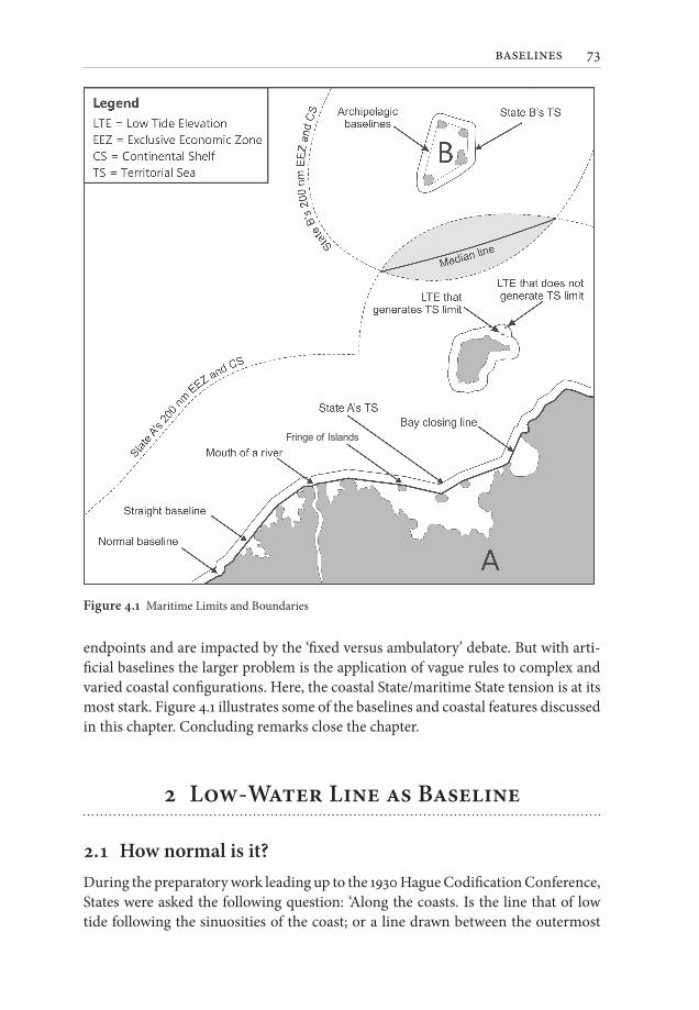
endpoints and are impacted by the ‘fixed versus ambulatory’ debate. But with arti-ficial baselines the larger problem is the application of vague rules to complex and varied coastal configurations. Here, the coastal State/maritime State tension is at its most stark. Figure 4.1 illustrates some of the baselines and coastal features discussed in this chapter. Concluding remarks close the chapter.
2 Low-Water Line as Baseline
2.1 How normal is it?During the preparatory work leading up to the 1930 Hague Codification Conference, States were asked the following question: ‘Along the coasts. Is the line that of low tide following the sinuosities of the coast; or a line drawn between the outermost
Fringe of Islands
Figure 4.1 Maritime Limits and Boundaries
Rothwell171014OUK.indb 73 05-03-2015 21:46:25
74 coalter g lathrop
points of the coast, islands, islets or rocks; or some other line?’21 Of the 21 answers received, 16 States favoured the low-tide/sinuosities formulation, and five expressed a preference for straight lines connecting the outermost points of coastal features.22 Although this codification effort failed, the line of low-tide or the low-water line reappeared in the primary baseline article, Article 3, of the 1958 Convention on the Territorial Sea and the Contiguous Zone (TSC)23 and survives today in the ‘normal baseline’ provision of the LOSC. Article 5 of the LOSC reads: ‘Except where other-wise provided in this Convention, the normal baseline for measuring the breadth of the territorial sea is the low-water line along the coast as marked on large-scale charts officially recognized by the coastal State.’ The disfavoured alternative—‘a line drawn between the outermost points’—also survived the decades and was incorpo-rated into the straight baselines and archipelagic baselines provisions of the LOSC.24
Despite indications that the low-water line along the coast has long been consid-ered the default or normal baseline, State practice indicates a trend toward the use of artificial baselines. Of the approximately 150 coastal States, over two-thirds use straight lines for some or all of their baselines,25 begging the question, how long will the normal baseline be the norm?
2.2 Which features have a normal baseline?Despite a trend towards the use of artificial baselines, the low-water line will con-tinue to play a central role in baselines law as the primary baseline along much of the world’s coastlines and as the anchoring feature for most artificial baselines. The normal baseline rule applies to all coastal territory, including mainland and insular territory. The rule is augmented by several other provisions and norms regarding
21 ‘Second Report Submitted to the Council by the Preparatory Committee for the Codification Conference’, League of Nations Doc No C.73.M.38.1929.V (1929), repr in (1930) 24(1) American Journal of International Law Supplement 3.
22 The five-State minority consisted of Norway, Sweden, Poland, the USSR, and Latvia. WM Reisman and GS Westerman, Straight Baselines in International Maritime Boundary Delimitation (Macmillan Basingstoke 1992) 16.
23 1958 Geneva Convention on the Territorial Sea and Contiguous Zone.24 See primarily LOSC, n 6, Arts 7 and 47.25 States may choose more than one method for determining their baselines. See ibid, Art 14. Roach
and Smith count over 85 States that have delimited straight baselines and several others that have enacted enabling legislation without publishing their straight baseline coordinates. JA Roach and RW Smith, Excessive Maritime Claims (3rd edn Martinus Nijhoff Leiden 2012) 20. Since their count, other States have delimited straight baselines, for example, Nicaragua in 2013. Over 20 States have claimed archipelagic status and are thus entitled to draw archipelagic baselines: Roach and Smith, Excessive Maritime Claims, 206. See also UN Division for Ocean Affairs and the Law of the Sea (DOALOS), Table of Claims to Maritime Jurisdiction (15 July 2011), available at <http://www.un.org/Depts/los/LEGISLATIONANDTREATIES/PDFFILES/table_summary_of_claims.pdf>. But see C Schofield, ‘Departures from the Coast’ (2012) 27 International Journal of Marine and Coastal Law 723, 724 (‘The predominant type of baseline in use by coastal States is the “normal” baseline…’).
Rothwell171014OUK.indb 74 05-03-2015 21:46:26
baselines 75
specific categories of coastal features such as low-tide elevations, reefs, harbour works, and coastal protection works.26
The low-water line of a low-tide elevation—‘a naturally formed area of land which is surrounded by and above water at low tide but submerged at high tide’27—may be included in the normal baseline if at least part of the low-tide elevation is situated within the territorial sea as measured from the low-water line of mainland or island territory. Low-tide elevations located outside the territorial sea do not contribute to the baseline, nor do low-tide elevations located within a part of the territorial sea generated solely by a qualifying low-tide elevation (thereby disallowing an exten-sion of the territorial sea through a chain of low-tide elevations situated progres-sively further from shore).28 The thin line separating islands (above water at high tide) from low-tide elevations (below water at high tide), and the respective treat-ment of these two categories, is of particular consequence in an era of sea level rise.
In certain situations, namely ‘[i] n the case of islands situated on atolls or of islands having fringing reefs’,29 reefs (a subcategory of low-tide elevation) are exempted from the distance limitation that applies to other low-tide elevations. Here, irrespective of distance from the associated island, ‘the baseline for measuring the breadth of the territorial sea is the seaward low-water line of the reef ’.30 Early drafts of this article referred only to the ‘seaward edge’ of the reef, not to the low-water line.31 The refer-ence to the low-water line means that some part of the reef must be above water at low-tide in order for this exception to apply.
In addition to certain low-tide elevations and reefs, Article 11 specifies that ‘the outermost permanent harbour works which form an integral part of the harbour system are regarded as forming part of the coast’.32 As such, the low-water line along these human-made features contributes to the normal baseline. This rule expressly does not apply to offshore installations or artificial islands. Human-made objects situated beyond the harbour system and detached from naturally formed coast have no baseline and generate no maritime zones.33 For clarity, Article 12, which addresses whether roadsteads are included within the territorial sea, is not a base-lines provision although it does impact the outer limit of the territorial sea in cases where the roadstead is ‘situated wholly or partly outside the outer limit of the ter-ritorial sea [as that limit would be drawn in the absence of the roadstead]’.34
26 Note that ‘rocks which cannot sustain human habitation or economic life of their own’ may have a normal baseline for measuring the breadth of the territorial sea only: LOSC, n 6, Art 121.
27 Ibid, Art 13.28 Maritime Delimitation and Territorial Questions between Qatar and Bahrain (Qatar v Bahrain)
(Merits) [2001] ICJ Rep 40, [207] (‘The law of the sea does not in these circumstances allow application of the so-called “leap-frogging” method.’).
29 LOSC, Art 6.30 Ibid. 31 Virginia Commentaries, Vol II, 93. 32 LOSC, n 6 Art 11.33 Ibid, Arts 11 and 60(8), but see eg ibid, Art 60(4) regarding the establishment of safety zones.34 Ibid, Art 12.
Rothwell171014OUK.indb 75 05-03-2015 21:46:26
76 coalter g lathrop
Non-harbour coastal works such as land reclamation projects and coastal pro-tection works are not expressly addressed in the LOSC, but are often included within the appreciation of the ‘coast’ in the context of defining the normal baseline. Protecting existing coast with sea defences or expanding natural coastal territory through land reclamation projects should be differentiated from the creation of entirely human-made artificial islands noted above. State practice appears to con-firm that such augmentations do contribute to the normal baseline, and publicists seem to agree.35
Lastly, permanently ice-covered coasts, like non-harbour coastal works, are not addressed explicitly in the LOSC. The question whether permanent year-round ice should be assimilated to land is complicated by the issue of detecting the non-ice, land/sea interface that, in the absence of ice, would constitute the normal baseline.36
2.3 The normal baseline: the big questionOnce the status of a feature is determined (eg island, low-tide elevation, qualifying reef), the rules related to the normal baseline are relatively immune from subjective interpretation or misuse by self-interested actors.37 Nonetheless, the normal base-line rules do raise one significant question: does the legal baseline move with the actual low-water line or may it be fixed by marking it on a chart? This question arises from the ambiguous text of Article 5 and from the chart-making process. The question is important because of the anticipated plight of low-lying States, espe-cially small-island States, in an era of significant sea level rise.
In order to understand why the language of LOSC Article 5—‘the low-water line along the coast as marked on large-scale charts officially recognized by the coastal State’—is subject to two different interpretations, one must have a basic under-standing of the charting process. A nautical chart is merely a representation of a small portion of the maritime world, created, first and foremost, as a navigational
35 See C Carleton, ‘Problems Relating to Non-Natural and Man-Made Basepoints under UNCLOS’ in CR Symmons (ed), Selected Contemporary Issues in the Law of the Sea (Martinus Nijhoff Leiden 2011) 31, 55 (‘Provided the reclaimed land is an integral part of the mainland or an island, State practice would indicate that it is acceptable to consider it as part of the State’s coast for the generation of mari-time limits.’); McDougal and Burke, n 19, 422–3 (‘There would seem to be no substantial objection to assimilating “coast protective works” to harbor installations even when they are isolated structures…’).
36 See DR Rothwell, ‘Antarctic Baselines’ in AG Oude Elferink and DR Rothwell (eds), The Law of the Sea and Polar Maritime Delimitation and Jurisdiction (Martinus Nijhoff The Hague 2001) 49; SB Kaye, ‘Territorial Sea Baselines along Ice-Covered Coasts’ (2004) 35 Ocean Development and International Law 75.
37 The relative lack of abuse of the low-water line bears out findings from the 1953 Report of the Committee of Experts that governments would not be likely to be tempted ‘unreasonably to extend their low-water lines on their charts’. ILC, ‘Rapport du Comité d’experts sur certaines questions d’ordre technique concernant la mer territorial’, UN Doc A/CN.4/SER.A/1953/Add.1 (1953), English translation repr in Virginia Commentaries, Vol II, 59.
Rothwell171014OUK.indb 76 05-03-2015 21:46:26
baselines 77
aid meant to ensure safety at sea. Therefore, chart makers are mainly concerned with navigational hazards. The coast at low water is among those hazards. Because they depict the low-water line, nautical charts have long been recognized as the most readily available source of information about the shape and location of the low-water line along the coast. However, a chart is only as accurate as the data from which it was assembled. In many parts of the world, the coastal data used to depict the low-water line on nautical charts is several decades, if not more than a century, out of date. This may have little or no impact on navigational safety—ocean-going vessels rarely approach most coasts. However, out-of-date charts create the pos-sibility of significant differences between the charted low-water line and the actual low-water line—differences great enough to impact the legal status of an island or low-tide elevation, for example.
The potential for consequential differences between the charted and actual low-water line has engendered a debate about whether the legal baseline is ambulatory—moving with natural changes in coastal configuration—or fixed by virtue of being depicted on an officially recognized nautical chart, and, if fixed, whether the coastal State is obligated to reassess its fixed baseline periodically to reflect geographic reality.38 This is not an academic debate. The spectre of rapid sea level rise and the resulting wide-spread inundation of coastal areas, including of whole islands, and in the most extreme case the total submersion of a State’s entire territory, raise serious legal questions. For example, does an island continue to have a legal baseline and the associated zones of maritime jurisdiction after the feature has, in fact, submerged below the high-tide line?
There are three approaches to this issue: (1) baselines ambulate automatically with geographic change; (2) baselines may be fixed permanently by the coastal State with no obligation to update baselines even in the event of significant geographic change; and (3) baselines may be fixed temporarily with an obligation to update in the event of significant geographic change. The first and third approaches take the view that the baseline provisions are applicable on a continuing basis: in order to remain law-ful, baselines must remain in compliance with the rules as applied to the current coastal geography. The second approach takes the view that the baseline provisions are only to be applied at the time the baseline is claimed: if the baseline is lawful at the time of the claim, the coastal State has satisfied its obligations and need not ever revise its baselines, notwithstanding significant changes in coastal geography.
The automatic ambulation approach may be sustainable in theory but seems unten-able in practice. Rigid adherence to this view might logically result in a coastal State’s obligation to provide real-time notification of changing baselines and limits through continuous detection, depiction, and dissemination of the physical and legal geogra-phy. This impractical approach would undermine stability and certainty, and would
38 Because artificial baselines ‘anchor’ to the low-water line, this debate has implications for those lines, too.
Rothwell171014OUK.indb 77 05-03-2015 21:46:26
78 coalter g lathrop
de-emphasize the authority of the coastal State to establish the location of its own baselines and limits for the purpose of exercising its rights and jurisdiction at sea.
At the other extreme, the permanently fixed approach divorces the legal baseline from geographic reality, relies heavily on the charted line as the manifestation of a State’s claim to territory, and emphasizes the unfettered prerogative of the coastal State to declare its own physical make-up.39 The permanently fixed baseline thesis has the strength of accounting for equitable considerations related to the developing States most heavily impacted by sea level rise, and carries significant policy advantages of stability, certainty, and public order. However, taken to its extreme, the permanently fixed view would flip the basis of maritime entitlement on its head: the land would no longer dominate the sea if maritime rights and jurisdiction could persist after the permanent disappearance or destruction of the territory from which that title was derived. In this extreme situation, moreover, a coastal State advocating the fixed base-line thesis in the teeth of geographic reality to the contrary would be making claims to the disadvantage of the broader community interest in non-exclusive ocean space.40
The temporarily fixed approach gives coastal States some limited discretion as to the timing of their chart updates, balances the use of the actual and charted low-water line by requiring periodic changes in the latter to reflect the former, but imbues the charted line with an official but not inviolable status for the period dur-ing which it is in effect. Deference to an officially recognized, large-scale, reasonably up-to-date chart acknowledges both clauses in the normal baseline definition while balancing practical concerns of notice, publicity, stability, and certainty with theo-retical concerns about the source of title to maritime areas. Ambulatory purists and advocates of the permanently fixed baselines thesis would both be dissatisfied with this middle position, but aspects of the negotiating history indicate that this was the meaning understood by earlier drafters.41 The few States that update their charts frequently in order to account for coastal change take this approach.42
The answer to the ambulatory-versus-fixed-baselines debate has major implica-tions for the obligations of coastal States, the rights of mariners, and, in some cases, the very survival of coastal State sovereign rights and jurisdiction. Small-island States threatened with total submersion presumably favour the fixed approach. However, the majority of publicists currently believe that the baseline provisions are applicable on a continuing basis, either automatically or at the discretion of the
39 For a proponent of the fixed approach, see K Purcell, ‘Maritime Jurisdiction in a Changing Climate’ in MB Gerrard and K Fischer Kuh (eds), The Law of Adaptation to Climate Change (American Bar Association Chicago 2012) 729.
40 J Lisztwan, ‘Stability of Maritime Boundary Agreements’ (2012) 37 Yale Journal of International Law 153 (discussion regarding common heritage at 170).
41 See eg the concerns raised in the ILC in 1952 about the charted line deviating appreciably from a scientific criterion, including because it was out of date. ILC, ‘Summary Records of the Fourth Session’ (4 June–8 August 1952) 1 Yearbook of the International Law Commission.
42 For example, The Netherlands.
Rothwell171014OUK.indb 78 05-03-2015 21:46:26
baselines 79
coastal State. Several publicists, while adopting the ambulatory perspective on the law as it stands today, recognize its weaknesses and have suggested fixes ranging from physical coastal protection to changing the law.43
Early assessments during the development of the normal baseline provisions pre-dicted little room for abuse, and history has confirmed this assessment. Despite minor disagreements between delimiting neighbours about the status of particular features (eg an island, low tide elevation, or submerged feature)44 or discrete stretches of coast,45 there is no evidence low-water lines have been falsified to enlarge coastal State authority. Whether the normal baseline rules can accommodate the kind of physical coastal change anticipated in the coming decades is, however, of particular concern. Perhaps the next biggest concern is the increasing abandonment of nor-mal baselines by coastal States in the move toward artificial baselines.
3 Artificial Straight Lines as Baselines
Artificial straight-line baselines may be drawn across the mouths of rivers, bays, and ports, along coasts with certain geographic configurations, and to enclose the archipelagic waters of archipelagic States. These different forms of artificial base-line do not share historical origins, but in deciding which waters may be encom-passed by artificial baselines, the three basic considerations the ICJ elucidated in the Anglo-Norwegian Fisheries case generally apply. Acknowledging that ‘[i] t is the land which confers upon the coastal State a right to the waters off its coasts’, the court noted that ‘the drawing of base-lines must not depart to any appreciable extent from the general direction of the coast’.46 A second consideration, also flowing from the legal–geographic relationship between land and sea, was ‘whether certain areas
43 AHA Soons, ‘The Effects of a Rising Sea Level on Maritime Limits and Boundaries’ (1990) 37(2) Netherlands International Law Review 207; DD Caron, ‘When the Law Makes Climate Change Worse: Rethinking the Law of Baselines in Light of a Rising Sea Level’ (1990) 17 Ecology Law Quarterly 621; M Hayashi, ‘Sea Level Rise and the Law of the Sea: Future Options’ in D Vidas and PJ Shei (eds), The World Ocean in Globalisation, (Martinus Nijhoff Leiden 2011) 187; J Grote Stoutenburg, ‘Implementing a New Regime of Stable Maritime Zones to Ensure the (Economic) Survival of Small Island States Threatened by Sea-Level Rise’ (2011) 26 International Journal of Marine and Coastal Law 263.
44 See Qatar v Bahrain (Merits) (disagreement about the status of Qit’at Jaradah).45 See Award of the Tribunal in the Matter of an Arbitration between Guyana and Suriname: Arbitration
between Guyana and Suriname (2007) XXX RIAA 1 (disagreement about the location of the low-water line along the coast of Vissers Bank).
46 Anglo-Norwegian Fisheries, n 19, 133.
Rothwell171014OUK.indb 79 05-03-2015 21:46:26
80 coalter g lathrop
lying within these lines are sufficiently closely linked to the land domain to be sub-ject to the regime of internal waters’.47 The third, non-geographic consideration was ‘that of certain economic interests peculiar to a region, the reality and importance of which are clearly evidenced by a long usage’.48
The vivid phrase inter fauces terrarum, or ‘in the jaws of the land’, has been used to capture the physical characteristics that differentiate internal waters from waters beyond.49 For rivers, bays, and ports, the ‘jaws’ are often readily apparent on charts. With respect to straight baselines and archipelagic baselines, the description often no longer applies. Nonetheless, the relationship between land and the water to be enclosed by baselines remains a fundamental consideration.50
Artificial baselines are just that: artifices for addressing concerns about coastal State authority in nearshore waters while providing a limit on the spatial extent of that authority. As such, they are prone to manipulation by coastal States for the purpose of self-aggrandizement.51 The degree to which the artificial baseline provi-sions have been manipulated appears to be a function of the clarity with which they were drafted.52 In some circumstances, the rules contain objective criteria; in others, the criteria are ill-defined and are subject to widely varying interpretations.
Unlike the normal baseline, for which no express notice is required,53 notice must be provided for most artificial baselines by deposit of a chart or geographic coordinates with the United Nations Secretary-General. Notice serves to make ocean users aware of the existence of these imaginary lines where internal waters begin and from which maritime zones are measured. Article 16 of the LOSC requires due publicity of river and bay closing lines and straight baselines.54 Article 47 sets forth the publicity require-ments for archipelagic baselines.
When considering the suite of artificial baseline rules, one should recall that artifi-cial baselines have long been regarded as the exception to the normal baseline rule.55
47 Ibid. 48 Ibid.49 Ibid, 130; ILC, ‘Articles Concerning the Law of the Sea: Article 13’ (1956) II Yearbook of the
International Law Commission 258.50 See LOSC, n 6, Arts 7, 9, and 10.51 Reisman and Westerman posit that the purpose of straight baselines has always been to push
zonal limits seaward. Reisman and Westerman, n 22, xiv–xv.52 See Schofield, n 25.53 The LOSC, n 6, Art 5 clause ‘as marked on large-scale charts officially recognized by the coastal
State’ could be read as an implicit notice requirement.54 Symmons and Reed note a gap in the requirement that could allow coastal States to fulfill their
publicity requirements without actually providing a mariner with all of the information he would need to understand the States’ full baseline claim. CR Symmons and MW Reed, ‘Baseline Publicity and Charting Requirements: An Overlooked Issue in the UN Convention on the Law of the Sea’ (2010) 41 Ocean Development and International Law 77.
55 Reisman and Westerman, n 22, 92 (‘the normal regime applies automatically, whereas the coastal state seeking to avail itself of the straight baseline regime always has a burden of proof ’); but see DP O’Connell, The International Law of the Sea (Clarendon Press Oxford 1982) Vol 1, 211 (commenting that LOSC, n 6, Art 14 ‘can only be construed as making the straight baseline system optional’).
Rothwell171014OUK.indb 80 05-03-2015 21:46:26
baselines 81
The ICJ noted in Qatar v Bahrain that ‘the method of straight baselines, which is an exception to the normal rules for the delimitation of baselines, may only be applied if a number of conditions are met’. It added ‘[t] his method must be applied restric-tively’,56 indicating that, where artificial baselines are concerned, the rules should be subject to strict interpretation: properly interpreted, the Convention prohibits drawing artificial baselines not expressly allowed.57 Among other reasons for this approach, the international community should not be presumed to have allowed the appropriation of non-exclusive, international areas for exclusive coastal State use.58 This leaves gaps in the conventional law,59 some of which are filled with customary rules, but barring such rules it seems that States may not go beyond what has been prescribed. In practice, the artificial exceptions are beginning to overtake the use of normal baselines, and the application of these exceptions often stretches the legal language to the breaking point. What impact this will have on future development of the law is unclear.60
3.1 Artificial lines and riversArticle 9 of the LOSC (‘Mouths of rivers’) reads: ‘If a river flows directly into the sea, the baseline shall be a straight line across the mouth of the river between two points on the low-water line of its banks’, and is a nearly verbatim adoption of Article 13 of the TSC. This article addresses the interface between rivers—long considered internal waters—and the sea beyond them. Several aspects of this short article deserve comment here. This article does not specify a maximum line length. Whatever the length of the line, it must be a single-segment line (‘a straight line’) connecting points on the low-water line of the river’s banks. Therefore, river closing lines bring with them the interpretive problems of the normal baseline.
In the absence of a specified maximum closing line length, this article could be used to draw lines of considerable length encompassing vast amounts of water as internal waters, especially where a river widens as it approaches the sea. However, the phrase ‘directly into the sea’ limits the rivers to which this article may apply. The French ‘sans former d’estuaire’ (without forming an estuary)61 and the drafting history
56 Qatar v Bahrain (Merits), [212].57 Reisman and Westerman apply ‘the presumption in favor of a strict rather than a permissive
and extensive interpretation’ to their interpretation of the straight baseline regime. Reisman and Westerman, n 22, 75.
58 See ibid, 75–7. 59 See eg multi-State bays.60 RR Churchill and AV Lowe, The Law of the Sea (3rd edn Juris Publishing Manchester 1999) 57 (‘It
may be that the widespread toleration of much of the practice… which clearly contravenes the relevant rules of international law (particularly as regards straight baselines) will in time lead to a modification of those rules themselves.’).
61 This phrase having been left in the French version was, apparently, a drafting error. O’Connell, n 55, Vol 1, 229.
Rothwell171014OUK.indb 81 05-03-2015 21:46:26
82 coalter g lathrop
of the TSC both help interpret this ambiguous phrase. In the 1956 International Law Commission (ILC) Draft Articles, this article included a second paragraph instruct-ing that ‘[i] f the river flows into an estuary the coasts of which belong to a single State, article 7 [bays] shall apply.’ This paragraph was dropped on adoption of the 1958 Convention, but lives on to some degree in the French version. Presumably, Article 9 does not apply to rivers that flow to the sea via an estuary. One possibility is that the estuary assimilates to a bay and would be subject, not to Article 9, but to the more restrictive rules for bays in Article 10.62 In contrast, rivers flowing to the sea via a delta would be subject to the less restrictive rules for straight baselines to be drawn in the presence of a highly unstable deltaic coastline in Article 7(2).
If the dearth of protests is any indication, application of Article 9 has been unproblematic. The 135-mile line across the mouth of the Rio de la Plata, asserted by Argentina and Uruguay on the basis of Article 13 of the TSC, is the only example known to this author of a river mouth closing line subject to diplomatic protest.63
3.2 Bay closing linesThe article addressing bay closing lines has a more complex text and more involved drafting history than the article regarding river mouths. Article 10, which is largely identical to Article 7 of the TSC, contains the conventional rule set for juridical bays: so-called ‘historic’ bays are expressly excluded from these rules.64 In order to draw a baseline enclosing all of the waters of a juridical bay, the bay must satisfy several clear criteria: it must pass the mathematical semi-circle test; ‘the distance between the low-water marks of the natural entrance points’ may not exceed 24 nautical miles (nm); and it must belong to a single State.
The first step in applying Article 10 is to differentiate indentations that qualify as bays from indentations that are ‘a mere curvature of the coast’.65 This concern, iden-tified as early as the North Atlantic Fisheries case,66 was often expressed in terms of an appropriate ratio of the width of the bay mouth to the depth of the indentation, ensuring bay waters were surrounded by coastal State territory on three sides, thus justifying their possible treatment as internal waters.67 The Article 10 semi-circle test usually addresses that concern by requiring the area of the indentation to be ‘as
62 Virginia Commentaries, Vol II, 111.63 See US Department of State, ‘Unclassified Airgram A-46, December 14, 1962’ (1963) 57 American
Journal of International Law 403. The Rio de la Plata closing line was also protested by France, the Netherlands, and the United Kingdom.
64 LOSC, n 6, Art 10(6). 65 Ibid, Art 10(2).66 North Atlantic Coast Fisheries (Great Britain v United States of America) (1910) XI RIAA 167.67 Boggs describes a version of a semi-circle test in his review of the proposal of the US delegation
to the 1930 Hague Conference. See S Whittemore Boggs, ‘Delimitation of the Territorial Sea’ (1930) 24 American Journal of International Law 541, 550–2. See also the position of the United Kingdom in Anglo-Norwegian Fisheries, n 19,120.
Rothwell171014OUK.indb 82 05-03-2015 21:46:26
baselines 83
large as, or larger than, that of the semi-circle whose diameter is a line drawn across the mouth of that indentation’ in order to qualify as a bay.68 Although a bay need not be perfectly semi-circular in shape in order to qualify, a shallow coastal concavity or ‘mere curvature’ would not satisfy this shape test. Article 10(3) provides specific rules for the application of the semi-circle test to indentations with more than one mouth or an indentation containing islands.
The size requirement of Article 10 is triggered only after the threshold shape requirement is satisfied. The maximum bay closing line length is 24 nm. Article 10(4) calls for this line to be drawn between the low-water marks of the natural entrance points of the bay. However, if that distance exceeds 24 nm, Article 10(5) provides for drawing a closing line not to exceed 24 nm ‘within the bay in such a manner as to enclose the maximum area of water that is possible with a line of that length’. The application of this fallback option also is subject to the threshold shape requirement.
Finally, Article 10 only applies to ‘bays the coasts of which belong to a single State’. An early proposal by the United States contained the language ‘in the case of a bay or estuary the coasts of which belong to a single State, or to two or more States which have agreed upon a division of the waters thereof’.69 It seems logical to include such multi-State bays under the same rules, but the record indicates that the ILC did not propose rules to cover multi-State bays because it did not have ‘sufficient data at its disposal concerning the number of cases involved or the regulations at present appli-cable to them’.70 This lacuna remains, yet multi-State bays do exist and the relevant States have drawn closing lines.71 At least one multi-State bay, the Gulf of Fonseca, has been pronounced an historic bay.72 The status of closing lines across other multi-State bays is less clear, but with respect to multi-State bays that would otherwise satisfy the Article 10 criteria, the absence of significant protest may indicate a customary rule is in operation.73
The rules regarding the juridical bay closing line requirements are very clear, con-taining two objective tests, both of which must be satisfied in order to claim as internal
68 LOSC, n 6, Art 10(2). There are circumstances in which the semi-circle test alone is not sufficient to identify landlocked waters or waters inter fauces terrarum. In US practice, the ‘45-degree test’ is applied, in addition to the semi-circle test, to identify appropriate bay headlands and to ensure that the waters of a juridical bay are in fact land-locked pursuant to Article 10(2). See US National Oceanic and Atmospheric Administration glossary for a definition of the 45-degree test, available at <http://www.gc.noaa.gov/gcil_glossary.html>.
69 Boggs, ‘Delimitation of the Territorial Sea’, 551 (emphasis added).70 ILC, ‘Articles Concerning the Law of the Sea: Commentary to Article 7’ (1956) 2 YbILC 269.71 See T Scovazzi, ‘Problems Relating to the Drawing of Baselines to Close Shared Maritime Waters’
in Symmons (ed), Selected Contemporary Issues in the Law of the Sea 15.72 El Salvador v Nicaragua, repr in ( 1917) 11 American Journal of International Law 674.73 But see Westerman’s concern that large water bodies which would otherwise qualify, including
the Mediterranean and Baltic seas, might come under the bay closing line provisions if the single-State criterion were dropped. GS Westerman, The Juridical Bay (Clarendon Press Oxford 1987) 79.
Rothwell171014OUK.indb 83 05-03-2015 21:46:26
84 coalter g lathrop
waters all or some of the waters of a coastal indentation pursuant to Article 10. These clear rules may explain the low instance of disagreement about their application.74 This author is unaware of any protests against States that have relied on Article 10 to close a juridical bay that violates the shape and size requirements of that article. But this apparent lack of controversy should also be attributed to coastal State reliance on the historic bays exception and the use of Article 7 straight baselines to close coastal inden-tations that would not have satisfied Article 10.
Claims to historic bays have created controversy. Historic bay claims are subject to customary rules of acquisitive prescription. In order for the waters of a coastal indenta-tion to be deemed an historic bay, the coastal State must demonstrate its ‘open, effec-tive, long term, and continuous exercise of authority’ over the waters of the bay,75 and ‘affirmative evidence of acquiescence’ by other States.76 There are no shape or size restrictions, and thus any coastal indentation could qualify irrespective of the depth of the bay-like formation if the coastal State can meet the high bar for establishing title. Some bays originally claimed on the basis of historic title now satisfy today’s juridical bay shape and size requirements.77 Not surprisingly, the historic bays which continue to cause concern fail the Article 10 tests.78
In addition to the historic bays exception, Article 10 contains an important refer-ence to the straight baselines provisions of Article 7: ‘The foregoing [bay] provisions do not apply … in any case where the system of straight baselines provided for in article 7 is applied.’ With this exception, States have ignored the restrictive rules of Article 10 and instead applied the less specific language of Article 7 (‘deeply indented and cut into’) to enclose waters in indentations that would not have qualified as juridical bays. This practice has elicited protests and criticism.79 Article 7 straight baselines, including their use to enclose bay-like indentations, are explored below.
74 Schofield makes the connection between compliance and the ‘laudably precise language’ of Art 10. Schofield, ‘Departures from the Coast’, 729.
75 Roach and Smith, n 25, 18.76 I Brownlie, Principles of Public International Law (6th edn Oxford University Press Oxford 2003)
157. Unlike acquisitive prescription of land territory usually involving only one other competitor, his-toric bay claims impact community interests. Therefore, widespread acquiescence by major maritime States may be required. (See ibid.) Roach and Smith note that the United States also take the position that ‘a mere absence of opposition’ is not enough to prove acquiescence. Roach and Smith, n 25, 19.
77 For example, Guatemala’s Gulf of Amatique, several bays of the Dominican Republic and the United States’ Chesapeake Bay, and Delaware Bay. Roach and Smith, n 25, 54–5.
78 For example, Italy’s Gulf of Taranto, Russia’s Peter the Great Bay, and Australia’s Anxious, Encounter, Lacepede, and Rivioli Bays. Ibid, 39–40, 44–5, and 50–2.
79 Ibid. Reisman and Westerman note that ‘[o] ne of the most problematic uses of the straight base-line option has been its use in circumventing other rules of international law’, specifically rules on juridical bays and historic bays. Reisman and Westerman, n 22, 102.
Rothwell171014OUK.indb 84 05-03-2015 21:46:26
baselines 85
3.3 Closing the waters of a portThe article addressing ports and harbour works (Article 11 LOSC) does not expressly allow enclosing the waters of a port with a straight line. However, this option may be inferred from Article 50 which allows archipelagic States to ‘draw closing lines for the delimitation of internal waters, in accordance with articles 9 [mouths of rivers], 10 [bays] and 11 [ports].’ There is no reason this rule would not apply to non-archipelagic coastal States. The closing lines would, in any event, be quite short, and the waters of a port are clearly regarded as having the character of internal waters. The Article 11 prohibition on using off-shore installations and artificial islands for drawing the normal baseline would apply equally to drawing a port closing line.
3.4 Straight baselines stricto sensuThe clear loser in the 1920s vote casting, straight baselines are now a favoured method to aggressively enclose ocean space. Early on, Norway led the straight base-lines charge. Having drawn straight lines across several areas of coastal waters in the late 1800s, Norway answered the 1927 survey advocating for lines connecting the outermost points. By 1935, Norway had established a continuous system of straight lines along the northern portion of its coast. The United Kingdom challenged this system in the Fisheries case. The 1951 decision, endorsing Norway’s straight base-lines, contributed directly to the modern regime of straight baselines. With the exception of paragraph 2, the text of Article 7 is derived from Article 4 of the TSC, which in turn was derived from Article 5 of 1956 ILC Draft Articles, the language of which was borrowed, in many important instances, verbatim, from the closely related, contemporaneous judgment in Fisheries.
The direct lineage between the 1951 judgment and Article 7 of the LOSC combined with ambiguous language in Article 7 makes understanding the Anglo-Norwegian Fisheries case not only helpful, but necessary, in order to understand Article 7. While a full review of this 50-year-old case will not be attempted here, it is sufficient to note the ‘peculiar geography’ of the Norwegian coast with which the court was faced.80 When considering the Article 7 phrase ‘deeply indented’, one should imagine the eastern section of Norway’s coast which was ‘broken by large and deeply indented fjords’;81 these fjords ‘often penetrat[ed] for great distances inland’.82 And the Article 7 phrase ‘fringe of islands along the coast in its immediate vicinity’ should conjure an image of the ‘“skjaergaard” (literally, rock rampart)’, made up of an estimated 120,000 insular features.83 In this geographic context, the court saw Norway’s system as ‘the
80 Anglo-Norwegian Fisheries, n 19, 139. 81 Ibid, 127. 82 Ibid. 83 Ibid.
Rothwell171014OUK.indb 85 05-03-2015 21:46:26
86 coalter g lathrop
application of general international law to a specific case’84 and ‘an adaptation ren-dered necessary by local conditions’,85 and asserted that the idea of a sufficiently close link between the land and the sea areas to be enclosed ‘should be liberally applied in the case of a coast, the geographical configuration of which is as unusual as that of Norway’. Clearly, the court considered this section of the Norwegian coast to be exceptional. The British judge, Sir Arnold McNair, disagreed that the Norwegian coast was exceptional enough to merit application of a different method.86 Presciently, he predicted that the effect of the 1935 Norwegian straight baselines decree ‘will be to injure the principle of the freedom of the seas and to encourage further encroach-ments upon the high seas by coastal States’.87 Today, approximately 90 coastal States apply Article 7 to some or all of their exceptional coasts.88
Article 7 sets out, in six paragraphs, the straight baseline provisions as they stand today.89 This article establishes a two-option, threshold geographic test which must be satisfied before drawing straight baselines pursuant to the criteria, exceptions and limitations of the subsequent paragraphs. Coastal States may only draw straight baselines ‘in localities where the coastline is deeply indented and cut into, or if there is a fringe of islands along the coast in its immediate vicinity’.90 One of these tests must be met before straight baselines joining appropriate coastal points may be drawn, but the lines ‘must not depart to any appreciable extent from the general direction of the coast, and the sea areas lying within the lines must be sufficiently closely linked to the land domain to be subject to the regime of internal waters’.91 Although the text is not explicit, appropriate points are assumed to be points on the low-water line of mainland or island territory, that is, points on the normal baseline. However, appropriate points exclude low-tide elevations except those on which ‘lighthouses or similar installations which are permanently above sea level have been built’ or those for which the drawing of straight baselines has ‘received general international recognition’.92 Only if the threshold geographic test is met, may ‘economic interests peculiar to the region concerned’ be taken into account when drawing particular baselines; but this variance may only be enjoyed if ‘the reality and the importance’ of the economic interests ‘are clearly evidenced by long usage’.93 In any event, States may not draw straight baselines that ‘cut off the territorial sea of another State from the high seas or an exclusive economic zone’.94
84 Ibid, 131. 85 Ibid, 133.86 Anglo-Norwegian Fisheries, Dissenting Opinion McNair, n 19.87 Ibid, 185. McNair further noted that ‘the approbation of [the Norwegian system] would have a
dangerous tendency in that it would encourage States to adopt a subjective appreciation of their rights instead of conforming to a common international standard’. Ibid, 169.
88 Roach and Smith, n 25, 20, 74–82.89 Reisman and Westerman provide a detailed interpretation of the straight baseline regime; see
Reisman and Westerman, n 22, ch 4.90 LOSC, n 6, Art 7(1) (emphasis added). 91 Ibid, Art 7(3). 92 Ibid, Art 7(4).93 Ibid, Art 7(5). 94 Ibid, Art 7(6).
Rothwell171014OUK.indb 86 05-03-2015 21:46:27
baselines 87
This formula repeats in large measure the formula of Article 4 of the TSC which adopted language and concepts from Fisheries. Unfortunately, through-out the decades following Fisheries, the international community was unable to make the straight baseline rules more precise, and coastal States are guided by language that the court itself admitted was ‘devoid of any mathematical preci-sion’.95 Lack of precision does not equate to a lack of rules, but it does make arriving at a standard interpretation of those rules more difficult. The exorbi-tant straight baseline systems resulting from purported application of these rules are evidence of this difficulty.96 The threshold test of ‘deeply indented and cut into’ has been applied to slightly undulating coastlines and to indentations that would not pass the bay shape test. The alternative threshold test of ‘a fringe of islands along the coast in its immediate vicinity’ has been used to justify straight baseline systems connecting a handful of dispersed insular features, often some distance from the mainland. Commentators note that the rules ‘have been bent out of shape’97 and that some applications ‘are so far wide of the mark as to mock [the] language’ of Article 7.98
The straight baseline regime contains two other important aspects. Article 7(2), which had no equivalent provision in the 1958 Convention, reads:
Where because of the presence of a delta and other natural conditions the coastline is highly unstable, the appropriate points may be selected along the furthest seaward extent of the low-water line and, notwithstanding subsequent regression of the low-water line, the straight baselines shall remain effective until changed by the coastal State in accordance with this Convention.
This exception for certain deltaic coastlines was introduced by Bangladesh during the Third United Nations Conference on the Laws of the Sea (UNCLOS III) nego-tiations and probably does not apply to many other coasts in the world. Note that the phrase ‘notwithstanding subsequent regression of the low-water line’—a phrase otherwise absent in the baseline provisions—is used to argue that other baseline provisions, including the normal baseline, are applicable on a continuing basis thereby supporting the ambulatory approach discussed above.
With respect to enclosing internal waters with Article 7 straight baselines, Article 8 limits the effect on preexisting rights of innocent passage. Article 8(2) reads: ‘Where the establishment of straight baselines … has the effect of enclosing as internal waters areas which had not previously been considered as such, a right of innocent passage … shall exist in those waters.’ Practically speaking, the burden
95 Anglo-Norwegian Fisheries, n 19, 142.96 For a list of protests made by the United States against excessive straight baseline claims, see
Roach and Smith, n 25, 74–82.97 V Prescott and C Schofield, The Maritime Political Boundaries of the World (2nd edn Martinus
Nijhoff Leiden 2005) 142.98 Reisman and Westerman, n 22, 190.
Rothwell171014OUK.indb 87 05-03-2015 21:46:27
88 coalter g lathrop
will be on the navigating State to exercise and maintain its residual right of innocent passage through nominally internal waters.
3.5 Archipelagic baselines: the latest artificial baselineBaselines to be drawn around groups of islands were discussed as early as the 1920s, and by the ILC and delegates to the First United Nations Conference on the Law of the Sea (UNCLOS I) in the 1950s, but archipelagic baseline provisions were not adopted until UNCLOS III.99 The articles related to archipelagic States, including archipelagic baselines, are found in Part IV of the LOSC. To date, 22 States have claimed archipelagic status.100
The rules for drawing archipelagic baselines, which separate maritime areas sub-ject to the special regime of archipelagic waters from the territorial sea beyond, are defined in LOSC Article 47.101 Only an archipelagic State—‘a State constituted wholly by one or more archipelagos … ’—may utilize archipelagic baselines.102 Article 47 contains objective criteria for drawing baselines, including minimum and maximum water to land ratios (1:1 and 9:1, respectively) to be encompassed by the baselines103 and maximum line length between turning points.104 The article prohibits the use of low-tide elevations situated wholly outside the territorial sea ‘unless lighthouses or similar installations which are permanently above sea level have been built on them’.105 Archipelagic baselines ‘shall not depart to any appreci-able extent from the general configuration of the archipelago’106 and certain interests of neighboring States must be accounted for when drawing archipelagic baselines.107
With clear rules on the water-to-land ratio and maximum line length, applica-tion of Article 47 has been less problematic than application of Article 7. However, some archipelagic States have claimed archipelagic baselines that violate the ratio restrictions,108 and line length restrictions.109 With such clear rules, protesting States easily point to violations, and, in some cases, the archipelagic State has rectified
99 See Virginia Commentaries, Vol II, 399–404. 100 Roach and Smith, n 25, 206–7.101 Note that archipelagic States may also have areas of internal waters landward of archipelagic
waters, but only on the basis of LOSC, n 6, Arts 9, 10, and 11 (rivers, bays, and ports) and not on the basis of Art 7 (straight baselines).
102 Ibid, Art 46. An archipelago is defined as ‘a group of islands, including parts of islands, intercon-necting waters and other natural features which are so closely interrelated that such islands, waters and other natural features form an intrinsic geographical, economic and political entity, or which histori-cally have been regarded as such’.
103 Ibid, Art 47(1). 104 Ibid, Art 47 (2).105 Ibid, Art 47 (4). 106 Ibid, Art 47 (3). 107 Ibid, Art 47(5) and (6).108 See eg United States Department of State, ‘Seychelles: Archipelagic and Other Maritime Claims
and Boundaries’ (14 February 2014) 132 (hereinafter ‘Limits in the Seas: Seychelles’).109 See eg United States Department of State, ‘Maldives: Maritime Claims and Boundaries’
(8 September 2005) 126.
Rothwell171014OUK.indb 88 05-03-2015 21:46:27

baselines 89
its archipelagic baseline system to bring it into conformity with Article 47.110 States have also chosen outermost turning points that fail the criteria of Article 47(4), using low-tide elevations situated wholly beyond the territorial sea111 or submerged features.112 Questions about the misapplication of these rules are relatively techni-cal in nature. A more interesting question arises with respect to baselines and the dependent archipelagos of non-archipelagic States.113
Dependent archipelagos are groups of islands that are not, by themselves, a State and therefore the provisions of Article 47 do not apply.114 Nonetheless, many conti-nental States have drawn baselines around their dependent archipelagos.115 On what legal basis these baselines have been drawn is a subject of some speculation. Clearly, Article 47 cannot provide the basis, and in any event several of these baselines sys-tems were promulgated before the advent of LOSC Part IV.116 Some coastal archi-pelagos, those near the coast or those formed by a large island fringed by smaller islands, might come under the language of Article 7 straight baselines. The remain-ing examples, however, appear to be ‘motivated by the archipelagic concept’117 in the absence of any conventional rule allowing such claims. In the view of one publicist, ‘this practice is indicative of a considerable trend in international law towards the formation of a rule of customary law’.118
4 Conclusions
Baseline rules under the law of the sea face two major challenges to their legitimacy. First, are they able to accommodate the equitable considerations that arise when low-lying coastal States begin to lose large amounts of their territory to sea level rise, and, if not, is this a problem with the baseline rules or a problem to be addressed
110 Roach and Smith, n 25, 209 (Cape Verde corrected its excessive water to land ratio and baselines length).
111 See eg United States Department of State, ‘Dominican Republic: Archipelagic and Other Maritime Claims and Boundaries’ (31 January 2014) 130.
112 See eg Limits in the Seas: Seychelles.113 See generally S Kopela, Dependent Archipelagos in the Law of the Sea (Martinus Nijhoff
Leiden 2013).114 During UNCLOS III the question of baselines around archipelagos of non-archipelagic States
was debated and ultimately resolved by excluding those archipelagos from LOSC, n 6, Art 47. See Virginia Commentaries, Vol II, 407–15.
115 See Kopela, n 113, 112–40.116 See eg Supreme Decree No 959-A of 28 June 1971 (Ecuador); Decree No 598 of 21 December 1976
(Denmark).117 Kopela, n 113, 147. 118 Ibid, 259.
Rothwell171014OUK.indb 89 05-03-2015 21:46:27
90 coalter g lathrop
elsewhere? This question arises when considering the impact of sea level rise on the normal baseline. Publicists tend to agree that normal baselines are ambulatory, but, when taken to a logical conclusion in conditions of extreme sea level rise, the normal baseline rules lead to an unsatisfactory result. A variety of solutions have therefore been suggested.
Second, do the baseline rules protect sufficiently the interests of all ocean users, or do they allow coastal States to expand their authority beyond what the draft-ers envisioned? The structural characteristic of the law of the sea that pits inclu-sive international community use against exclusive coastal State use of ocean areas incentivizes excessive baseline claims by coastal States. Each individual coastal State experiences a direct benefit from enclosing ocean area near its coast for its exclusive use, while the diffuse community of ocean users experiences only indirect and frac-tional costs from the loss of ocean area at the margins. This lopsided cost-benefit equation explains coastal State expansionism and the development of vague base-line rules. Concern about perverse incentives focuses primarily on artificial base-line provisions, and Article 7 straight baselines are the main offenders. The practice of drawing baselines around dependent archipelagos in the absence of any conven-tional basis demonstrates that new interpretations of existing rules or the develop-ment of entirely new customary rules is a real possibility in this field.
Rothwell171014OUK.indb 90 05-03-2015 21:46:27