appendix a
TRANSCRIPT

OSMRE - Colowyo Coal Mine South Taylor/Lower Wilson Permit Expansion Area Project Mining Plan Modification Environmental Assessment
Appendix A Legal Notice and Outreach Letter

A.1 Legal Notice
OSMRE Colowyo Coal Mine, South Taylor/Lower Wilson Permit Expansion Area Project A-1 Mining Plan Modification Environmental Assessment

OSMRE Colowyo Coal Mine, South Taylor/Lower Wilson Permit Expansion Area Project A-2 Mining Plan Modification Environmental Assessment

A.2 Outreach Letter
OSMRE Colowyo Coal Mine, South Taylor/Lower Wilson Permit Expansion Area Project A-3 Mining Plan Modification Environmental Assessment

OSMRE Colowyo Coal Mine, South Taylor/Lower Wilson Permit Expansion Area Project A-4 Mining Plan Modification Environmental Assessment

OSMRE Colowyo Coal Mine, South Taylor/Lower Wilson Permit Expansion Area Project A-5 Mining Plan Modification Environmental Assessment

OSMRE - Colowyo Coal Mine South Taylor/Lower Wilson Permit Expansion Area Project Mining Plan Modification Environmental Assessment
Appendix B Design Features and Resource Protection Plans

Contents I. Project Design Features .......................................................................................................................... 1
II. Air Pollution Control Plan ................................................................................................................... 26
III. Fish and Wildlife Plan (Taken from Volume 1) ............................................................................... 28
IV. Protection of the Hydrologic Balance .............................................................................................. 35
V. Operations .............................................................................................................................................. 46
VI. SMCRA Permit Stipulations ................................................................................................................ 52

I. PROJECT DESIGN FEATURES
A. Introduction
The resource protection plans and environmental protection measures below were approved by CDRMS in 2007 for PR02 for the South Taylor/Lower Wilson permit expansion area and incorporated in the permit as design features. The permit stipulations were added by CDRMS as PR02 requirements in 2007. The applicable plans, design features and stipulations below are excerpted verbatim, with no editorial or other revisions made to the original text, directly from Colowyo Coal Company’s approved PAP, Volume 15, Rule 2, Permits, and Rule 4, Performance Standards Permit Revision (PR) – 02, approved by CDRMS on June 8, 2007. As a result of excerpting the applicable design features directly, there are numerous references to various sections, Figures, Exhibits, Maps, etc. that are contained in the approved PAP, but are not included in this appendix. The PAP can be accessed on the CDRMS website (http://drmsweblink.state.co.us/drmsweblink/search.aspx?dbid=0). Simply type the permit number c1981019 into the Permit No field, on the left side of the page, and click search; the entire PAP will be available. In the event that the conditions encountered, or other relevant factors are different from those originally anticipated that were the reason for an EPM and/or permit stipulation contained in the PAP, there are regulatory processes in place for CDRMS and OSMRE to consider approval of modifications to the mitigation measures.
B. Design Features Excerpted from the Approved PAP for PR02 2.05.4 (1) Reclamation Plan The reclamation objective for the South Taylor area is to restore the mined area to a land use capability which will, be equal to or better than that which currently exists. The first objectives of all reclamation practices are to stabilize the soils, maintain hydrologic and vegetation resources, and to restore the approximate original contour of the mined area. Ultimately, the areas being mined will be returned to their approximate original use as rangeland with watersheds having their approximate pre-mining character. In general, the long term appearance and usefulness of the mine plan area will be similar to that which would have been encountered prior to any mining. The reclamation plan for the existing mining areas provides information relevant to the reclamation of the South Taylor mining area, which can be found in Volume 1, Section 2.05.4 [see below]. Specific topics requested by the regulations and not incorporated into Volume 1 are included in the following subsections. 2.05.4 Reclamation Plan The reclamation objective of Colowyo is to restore the mined area to a land use capability that will, be equal to or better than that which currently exists or even better than existed pre-mining. Colowyo is the landowner and does not desire to harm the post-mining value of the
OSMRE Colowyo Coal Mine, South Taylor/Lower Wilson Permit Expansion Area Project B-1 Mining Plan Modification Environmental Assessment

property, but to the contrary return a financially superior parcel of land that could command a greater market price if sold. The first objective of all reclamation practices is to stabilize the soil, maintain hydrologic and vegetation resources, and to restore the approximate original contour of the mined area. Ultimately, the areas being mined will be returned to their approximate original use as rangeland with watersheds having their approximate pre-mining character. In general, the long term appearance and usefulness of the mine plan area will be similar to that which would have been encountered prior to any mining. From the beginning planning stages of the Colowyo mine, environmental concerns and reclamation concerns and objectives have been an integral part of the mining and reclamation activities. In 1975, two years prior to the commencement of mining, Colowyo contracted with Colorado State University to conduct reclamation studies to develop methods to reestablish native plant species on disturbed lands, and in particular native shrubs. Also included in these studies were: runoff and sediment plots, mulch plots, fertilizer plots, seeding management practices individual species seedings, and species combination seedings. The initial and last progress reports on these studies are included in Exhibit 10, Vegetation Information. The attainment of reclamation goals will be satisfied by implementation of the reclamation plan described below. Colowyo will combine information from existing baseline conditions with modern practices of reclamation technology to assure achievement of the reclamation objectives. The pre-mining condition of the permit area has been characterized through collection of baseline data. After identification of pre-mining conditions, mining and reclamation commenced in 1976 according to the following sequence: (1) Removal of topsoil and vegetation (2) Removal of overburden; (3) Extraction of the coal resource; (4) Backfilling, grading, and re-contouring of the surface to its approximate original contour; (5) Reestablishment of surface drainage patterns; (6) Topsoil Replacement; and (7) Revegetation and restoration of the affected land to the pre-mining land use. Such practices are expected to result in land use capabilities and productivity levels equal to or greater than those originally found. At the outset, it is imperative to appreciate that the reclamation plan defined in this section is to be implemented in a permit area where there has been disturbance from surface coal mining and reclamation operations (since 1976) and prior (now abandoned) underground operations. There are certain areas which are now undergoing backfilling and regrading. Revegetation techniques have been applied to all previously mined or otherwise disturbed lands. The reclamation timetable for the various aspects of the mining operation are indicated in Section 2.03 on Table 1., Affected Areas For Mining and Reclamation. As indicated in Section 2.05.3, the east half of the coal lease will be mined from north to south. To meet the maximum coal recovery requirements of the U.S. Bureau of Land Management and to avoid disturbing the area twice, a strip of land 500 to 600 feet wide along the Streeter drainage will be left unreclaimed until the west half of the lease is mined (see Spoil Grading Map (Map 29)). The west half of the
OSMRE Colowyo Coal Mine, South Taylor/Lower Wilson Permit Expansion Area Project B-2 Mining Plan Modification Environmental Assessment

coal lease will be mined from north to south. The initial mining in section 15 and 16 will be "X" seam only. Mining will start on the east and west and progress toward the ridge in the middle of Section 16. Later, a portion of the west pit will progress into the northern portion of Section 16. The estimate of the cost of reclamation of the proposed operations required to be covered by the performance bond is found under Rule 3. As discussed in detail in Section 2.05.3, the mining method proposed by Colowyo is referred to as open-pit multiple seam/single seam dragline mining. The overburden material from the initial boxcut area was deposited in the Streeter Fill. As mining progresses to the south, overburden material from each successive cut will be backfilled into the previously mined out area. This cycle will be repeated for the entire mining area. Because an open-pit mining technique is employed, the regrading and backfilling of the spoil material will be as contemporaneous as possible behind the mined-out area to facilitate proper leveling of the overburden material. The mining techniques utilizing dragline and truck/shovel operation are shown in detail on Mining Range Diagram (Map 24), and show the approximate distance between topsoil removal and replacement. The backfilled mining areas will be graded to establish the approximate original contour and to blend in with the undisturbed areas outside the mining limits. Colowyo will grade all final slopes so that overall grades do not exceed 33%. Additional information on the backfilling and regrading plan are discussed further in Section 2.05.3 and Section 4.14. Where necessary, the spoil surface will be roughened by ripping or discing etc., to ensure a bond between the topsoil and spoil to reduce slippage. To date there is no evidence of topsoil slippage on reclaimed areas. A few small tension cracks resulting from settling of fill and topsoil have occurred in a few areas within a year or two after reclamation, but soon stabilize and begin to fill in. The final surface as shown on the Post-mining Topography Map (Map 19) will approximate the overall pre-mining grades. Appropriate cross sections that show the anticipated final surface configuration of the proposed permit area, in conjunction with the existing pre-mining topography, are shown on the Pre-mining and Post-mining Cross Section (Map 20). This final surface configuration also reflects an often neglected concept of providing topographic relief for wildlife habitat. The regrading plan reestablishes escape cover, south facing slopes for wintering big game populations and small drainages suitable as future location of stockponds necessary to achieve the post-mining land use. Colowyo has prepared this reclamation plan with the understanding that some aspects of current reclamation practices are still in the development stages. Therefore, a degree of flexibility has been provided to allow changes and modification as techniques are refined or expanded. Colowyo will continue to evaluate the results of its reclamation plan each year in consultation with the Division and take advantage of each opportunity to try new plant species and materials and new methods for seeding and erosion control.
OSMRE Colowyo Coal Mine, South Taylor/Lower Wilson Permit Expansion Area Project B-3 Mining Plan Modification Environmental Assessment

Supplemental Introduction (Responsive to Stipulation # 8 for PR-02) Given the last statement above and responsive to Stipulation # 8 for PR-02, modified seed mixtures, revegetation metrics, and bond release protocols designed to target specific post-mining land use components are presented within the context of this section (2.05.4) as well as the revegetation requirements, Section 4.15. In effect, reclamation occurring at Colowyo during 2008 and beyond will focus on the replacement of the two primary subcomponents of the pre-mining rangeland land use: 1) grazingland (for domestic livestock), and 2) wildlife habitat (specifically targeting sage grouse brood-rearing habitat). The replacement of these two land use subcomponents will be effected by replacement of two primary revegetation communities: 1) grassland and 2) sagebrush steppe, respectively. Additional “incentive” for this new reclamation approach will be the validation (and modification as necessary) of said techniques necessary to address similar concerns related to greater acreages of potential impact on Colowyo lands located to the West of existing operations. Reclamation beginning in 2008 will be responsive to a new revegetation philosophy utilizing a “prescribed ecological reclamation approach” (PERA) that has been adopted for the Colowyo operation to facilitate creation of a wildlife habitat favorable vegetation community (sagebrush steppe) among the more dominant grasslands necessary for livestock grazing and erosion control. Efforts resulting from this new approach will be subject to a new set of success criteria for bond release as detailed in Section 4.15. Beginning in 2008, revegetation will specifically target livestock grazing and sage grouse brood rearing habitat, both of which are the two primary components of the Post-mining Rangeland Land Use. Areas designed to target livestock grazing (and incidental / unavoidable grazing by elk) will comprise approximately 60% to 80% of the original (2008 and after) and South Taylor reclaimed landscapes. These areas will principally occupy more steeply sloping ground (>10% slope) where the grassland community is necessary to preclude excessive erosion, especially from snowmelt. Based on a detailed evaluation of the post-mining topography, the remaining 20% to 40% (estimated) of the reclaimed landscape will afford flat or gently sloping surfaces (<10% slope) with reduced exposure to erosion. It is on these less exposed more gentle slopes whereby development of wildlife favorable habitats (sagebrush steppe) can be attempted. In this regard, sagebrush communities targeting sage grouse brood-rearing habitat will be attempted in earnest on approximately 20% (or more) of the Post-2008 reclaimed landscape, with the goal of achieving success on at least one-half of this acreage or as otherwise agreed upon between Colowyo and CDRMS. The principal basis of PERA is to rebuild the foundation conditions of target vegetation communities taking into account the appropriate aspects, slopes, and topographic features of the reclaimed landscape. In this manner, targeted communities, as opposed to more simple grasslands will be more strongly encouraged. Potential reclamation techniques to be applied to facilitate the targeting of sagebrush communities include, but are not limited to: 1) taking advantage of site-specific opportunities for development of convex and concave surfaces to encourage snow entrapment; 2) development of small berms along the contour and somewhat perpendicular to prevailing winds, also to encourage snow entrapment; 3) use of native species; 4) severe reduction of grasses in the seed mix; 5) use of only bunch grasses for those taxa OSMRE Colowyo Coal Mine, South Taylor/Lower Wilson Permit Expansion Area Project B-4 Mining Plan Modification Environmental Assessment

planted with sagebrush; 6) sharp increases in the amount of sagebrush seed to be used; 7) extra care to obtain the correct subspecies of sagebrush (vaseyana-pauciflora) with a seed source as close as possible to the Axial Basin; 8) extra care to place seed at the ideal time of year (immediately prior to the first major snowfall event; 9) placement of thin layers of topsoil over overburden; 10) possible placement of zero topsoil; 11) possible placement of thin layers of overburden over topsoil; 12) use of specialized seed placement equipment to obtain correct planting depths; 13) use of seedbed preparation equipment and techniques to encourage sagebrush emergence; and 14) interseeding of additional grasses and/or forbs (only where necessary) following a period of 2 – 3 years of growth by shrubs. All of these possible techniques / metrics are designed to diminish the competitive advantage of grasses, at least in the early stages of establishment and growth. The primary “foundation-building” element for this approach is the ability to replace variable topsoil depths and/or quality of soil materials depending on site-specific needs, the discretion of the field construction supervisor, and the capabilities (or lack thereof) of available materials and equipment. The following practices will not be promoted or practiced at Colowyo with respect to the topsoil resource: 1) Topsoil will not be “buried in place” within the footprints of existing stockpiles in order to reduce the amount of resource to be moved and placed on reclamation areas. 2) At no time will topsoil be placed without adequate metrics in place to accurately estimate volumes placed within each reclamation unit to ensure an accurate accounting of the topsoil balance. 3) Topsoil will not be placed indiscriminately within reclamation units in a manner that does not serve a specific defendable purpose regarding vegetation type establishment or location within the reclamation unit or localized watershed. In summary, application of PERA on “shrub-favorable areas” would be based on the community development contributory factors of: 1) soil quantity, quality, and replacement depth; 2) aspect, slope, and landform; 3) documented and expected performance of various floral species; 4) revegetation metrics; and 5) the target post-mining land use. In this manner, reclamation and resultant developing communities will be encouraged to follow a more natural path to maturation and successional progression as opposed to more historically utilized grassland favorable approaches that should only be applied to the remaining 60% to 80% of reclaimed ground (sloping areas). However, there will likely be instances, if not an overall need, to incorporate managerial practices to encourage or protect positive recruitment to the shrub populations. Such management may include the following steps: • Use of elevated quantities of sagebrush seed within the grassland target areas, and placement of that seed in a manner to encourage sagebrush emergence. • Use of limited livestock (cattle) grazing to select against grasses and for shrubs and forbs. • Use of elk-proof fencing to preclude access into large blocks of maturing shrub populations, especially core areas. • Use of hunting pressure to reduce elk utilization of new reclamation where it can be incorporated in a safe manner given proximity to active mining. Develop special seasons in concert with CDOW for management of “refuge” elk. For obvious reasons, any
OSMRE Colowyo Coal Mine, South Taylor/Lower Wilson Permit Expansion Area Project B-5 Mining Plan Modification Environmental Assessment

activity in this regard would have to be designed and approved for implementation in accordance with applicable statutes. Furthermore, approvals from appropriate agencies (CDOW, MSHA, etc.) will be obtained as necessary. • Use of orchard grass (Dactylis glomerata) in key reclamation locations to encourage elk away from maturing shrub populations. It has been documented that this taxon is heavily utilized by foraging elk. • Implement procedures for micro-habitat development whereby snow catchment is encouraged and shrub heavy mixes can be applied. • Interseeding of shrubs (as necessary as a normal husbandry practice) within areas not exhibiting satisfactory establishment of shrubs, but still presenting opportunities (micro-niches) for shrubs. Such interseeding would be performed in accordance with Rule 4.15.7(5)(g), and documentation of any such efforts would be provided in the Annual Reclamation Report for that year. Application of PERA includes management and revegetation specifications (e.g., shrub species in the seed mix) for use on the “grassland” targeted areas that will facilitate additional shrub establishment when climatic or other conditions are favorable. In this manner, small and/or scattered patches of additional shrubland may be established that will provide improved habitat diversity, especially for sage grouse. However, since this type of reclamation is entirely dependent on the vagaries of nature, dependence upon such techniques cannot be relied upon. Where shrublands evolve on reclaimed lands, they will be segregated into “core” areas and “ecotonal” areas (as is typically evident in nature), each with a separate woody plant density success criterion but both counting as “shrubland”. Ecotonal areas are those areas that exhibit shrub-conducive habitat conditions (e.g., thin grass cover, skeletal soils, etc.), but have not as yet developed the more elevated densities of “core” areas. It has been noted repeatedly in the reclamation industry that the 10-year bond responsibility period is often insufficient for the adequate development of shrub populations unless an excellent “take” is achieved at the time of seeding. In this regard, flexibility has been built into the success evaluation process so that if a positive recruitment rate to the shrub population can be demonstrated on Colowyo revegetation, there would be no need to achieve elevated densities within a modest time-frame such as the 10-year responsibility period. Colowyo makes the commitment to establish sagebrush steppe (comprised of both core and ecotonal areas) on approximately 450 acres (minimum of 225 acres core) of the post-2008 reclamation for the original and South Taylor permit areas, or as otherwise agreed upon between Colowyo and CDRMS. This acreage is based on the following rationale: 1) delineation of all post-2008 post-mining acreage exhibiting slopes 10% or flatter; 2) elimination of all small, isolated, or impractical areas for targeting this community; 3) implementing “banding” (alternating strips of grassland versus shrubland) procedures on large units with long slopes that might otherwise lead to excessive “snowmelt” erosion; and 4) assuming 50% shrub establishment success (i.e. sufficient density) on the acreage that actually receives shrub conducive metrics. Please refer to Map 44 for a visual representation of areas that are < 10% slope at Colowyo Mine according to the current PMT surface.
OSMRE Colowyo Coal Mine, South Taylor/Lower Wilson Permit Expansion Area Project B-6 Mining Plan Modification Environmental Assessment

Critical to the adoption of this approach is the need for Colowyo to be allowed to deviate from the plan in instances where plan maps or specifications do not reflect “on-the-ground” reality, and to the contrary, when opportunities for adding unplanned supplementary areas targeting shrub establishment present themselves. By acceptance of this new approach, Colowyo will be granted the flexibility to take advantage of day-to-day opportunities to promote shrub establishment and be able to option out of planned areas if site conditions prove significantly different than anticipated. Such flexibility will in no way be allowed to circumvent the requirement to maintain a proper life-of-mine topsoil balance and overall plan objective to improve shrub establishment. All significant deviations from plan maps and expectations will be documented and submitted in the Annual Reclamation Report. In this manner, as well as documentation through bond release evaluations, CDRMS will maintain authority over any such deviations. Related to this flexibility and as presented in revisions to Section 4.15, Colowyo commits to revised woody plant density success criteria for Phase III bond release for 2008 and later reclamation, that are somewhat less stringent than the original requirements, and are significantly less stringent for pre-2008 reclamation, but are ecologically defensible and appropriate. This commitment is in the interest of promoting the momentum of the bond release process and the pursuit of a “land-use” based reclamation program. Furthermore, this commitment on the part of Colowyo is based on the fact that the best reclamation science (30+ years ago), and significant financial expenditure went into implementation of the previous reclamation plan (and development of success criteria), and that recent experience and advancements in reclamation science now dictate less stringent requirements for a 10-year bond responsibility period. In other words, the original woody plant density success criterion was developed without sufficient experience, knowledge, or empirical evidence and as such was established at too high a level over too short a time period. In effect, this will amount to the waiving of the previous standards and the adoption of the new proposed standards. Topsoil Redistribution Plan Prior to any mining-related disturbances, all available topsoil will be removed from the site to be disturbed as discussed in Section 2.05.3, and will be redistributed or stockpiled as necessary to satisfy the needs of the reclamation timetable as described herein. Final grading before topsoil placement will be conducted in a manner that minimizes erosion and provides a surface for the topsoil that minimizes slippage. If spoil compaction is a problem, the spoil will be ripped with a dozer to minimize compaction, assure stability and minimize slippage after topsoil replacement. Where possible, development of concave landforms (to encourage snow entrapment) will be developed on a case-by-case basis at the discretion of the field supervisor. Such landforms will still have positive drainage in accordance with overall permitted designs. Topsoil will then be redistributed and graded to a variable replacement depth following the general rule of thin topsoil (<6) inches on ridge tops to gradually thicker topsoil moving down the slopes to the drainage bottoms for the grazingland land use targeted areas (see representation below). Sagebrush Steppe areas will ideally receive an average of approximately 4 inches of topsoil that will likely be a more uniform application to encourage proper seeding depth and overall shrub establishment conditions (see representation below).
OSMRE Colowyo Coal Mine, South Taylor/Lower Wilson Permit Expansion Area Project B-7 Mining Plan Modification Environmental Assessment

Colowyo will track the volume of topsoil applied to each reclamation unit and report it within the Annual Reclamation Report each year. Colowyo utilizes load counts and time card coding to differentiate and accurately assign costs/volumes for all other material movement on the mine site. As such, Colowyo will utilize these tools to ensure the planned and appropriate volume of topsoil is applied to each reclamation unit. A visual representation of Colowyo’s drainage-wide topsoil replacement strategy is provided below:
A Generally defined as a “thin” zone of topsoil (0”-6”) exclusively applicable to Sagebrush Steppe areas which will ideally average 4 inches. Areas seeded using the grassland mix will almost always be >10% slope and have > 6 inches of topsoil replaced. B Generally defined as a “thicker” (>6”) zone of topsoil in the transition zones between Sagebrush Steppe areas and Grazingland areas where topsoil thickness will likely begin around six inches at slope breaks >10% and gradually increase to approximately 10-14 inches to the base of slopes with armored channels in all reclamation areas except South Taylor. South Taylor topsoil replacement depths will begin with approximately 6 inches at the top of slope breaks >10% and gradually increase to approximately 12-18 inches mid-slope up to potentially 3 to 4 feet down-slope to the base of slopes with armored channels, depending on slope length and topsoil balance considerations. C Generally defined as the area within armored channels that will receive minimal to no volume of topsoil due to the likelihood any topsoil placed within the structure would erode into terminal sediment control structures and be lost. On-site experience has demonstrated natural sedimentation processes will support vegetation early post construction, and these areas will be seeded via broadcast method to provide a seed source for beneficial species establishment. NOTE: Specific details regarding topsoil replacement depths on special planting areas will be included in the description provided for approval prior to the creation of those areas. The grazingland targeted reclamation blocks will by necessity have thicker layers of topsoil than recent reclamation areas due to reduced volume of topsoil that will be placed on sagebrush steppe areas. Unless Colowyo provides specific justification, the topsoil resource will be placed in a manner that is thin on the ridge tops and gradually increasing in depth to the base of
B
C
B
A
A
OSMRE Colowyo Coal Mine, South Taylor/Lower Wilson Permit Expansion Area Project B-8 Mining Plan Modification Environmental Assessment

coherent drainages. Large drainage bottom channels that will convey water on a consistent basis will receive little to no topsoil resource as any topsoil placed in these areas will likely be mobilized and washed down the drainage. The full application of seed will still be applied to these areas in order to minimize erosion and allow vegetation to establish in these special locations, adding an additional dimension of potential vegetation community diversity. Colowyo is moving away from applying topsoil in uniform layers and variability in depth will be applied in all practical locations to maximize plant community diversity in areas designated for grazingland. Because the volume of topsoil to be applied to sagebrush steppe targeted areas is much less, and the creation of a seedbed conducive for shrub establishment is of major importance, the variability of topsoil depths within these areas may be limited. However, wherever practical, Colowyo will also make attempts to vary topsoil depths in the Sagebrush Steppe areas as well. Colowyo will ensure proper topsoil resource management through annual analysis of the topsoil balance in stockpiles, the expected areas for the following year’s reclamation focus, the total disturbance area, and the results of topsoil stripping activities each year. Because the topsoil resources from the “original” permit areas (East Pit, West Pit, Section 16, facilities, Gossard Loadout, etc.) are for the most part segregated by location from the topsoil generated from the South Taylor area, it will not be difficult to ensure that these resources are reapplied to the general areas from which they came. The same principles apply to both areas (original & South Taylor) regardless of targeted reclamation focus; < 6 inches on ridge tops with variably deeper application down slopes to the bottom of coherent drainages. The major difference between the two areas will be the thickness of reapplied topsoil from mid-slope to the bottom of drainages. Topsoil redistribution criteria specific to sagebrush steppe areas are defined further on in this section. Prior to 2005, essentially all reclamation units were covered with an average of 18 inches of topsoil. One exception to this was the CSU/DMG Shrub study area, which received various treatments of replaced topsoil at 0”, 6”, and 18” as described in Section 4.15. From 2005 through 2009, reclamation areas received an approximate average of 8 inches of topsoil as a result of modifications related to TR-62. Reclamation areas from 2010 moving forward (including facilities and the Gossard Loadout area) will utilize variable topsoil depths as described in this section through modifications approved via TR-82, unless otherwise specified (sagebrush steppe and special planting areas). Starting in 2005, Section 11 of the Annual Report presented a summary of topsoil stockpile volumes and a table showing the average topsoil replacement depth for each reclamation polygon, and information on overall topsoil balance. Beginning in reporting year 2010, Section 11 of the Annual Report will present topsoil balances for the original permit area and South Taylor area separately. Topsoil will normally be reapplied by hauling, in trucks, from topsoil stockpiles or from areas where topsoil has been removed for mining advance, to the regraded spoil areas and then redistributed with dozers. Alternate methods may also include placing topsoil on slopes with a dragline followed by redistribution with dozer, or using a scraper to redistribute the topsoil. It is anticipated that on slopes of < 10% it will be safe to strategically place rows of topsoil in a designated pattern with haul trucks to ensure the desired four to six inches of topsoil can be dozed into position. If a dozer operator doesn’t do this properly, he won’t have enough
OSMRE Colowyo Coal Mine, South Taylor/Lower Wilson Permit Expansion Area Project B-9 Mining Plan Modification Environmental Assessment

material to cover the entire area and it will be obvious what has occurred. Depth control on the Sagebrush Steppe areas will be verified as the project progresses and any deviations from the plan will be rectified at that time. Depth readings will also be taken after the area has been completely topsoiled, sufficient to ensure that Colowyo can demonstrate compliance with the plan. Even if scrapers are used to initially lay topsoil down, it is anticipated that some dozer work will be needed to do the finish work. The required volume of material will be at/on the location. Verification work will lead to additional dozer/scraper work if necessary to ensure proper final placement. If depth control becomes an issue, staking will be initiated as an additional guide for operators. On areas of > 10% slope it is anticipated that dozers will work together with scrapers to accomplish a gradually thicker application of topsoil on these slopes. As Colowyo has always done, depth stakes at regular intervals will provide guidance to the operators. Depth readings will be taken while the operations are progressing and any issues will be rectified at that time. Depth readings will also be taken after the area has been completely topsoiled, sufficient to ensure that Colowyo can demonstrate compliance with the plan. The allocated volume of topsoil for each area (total volume based on area multiplied by either 8 or 19.5 inches) will be hauled to the location, most likely with haul trucks and scrapers as close as safely possible to the final intended location, then dozed into place or placed via scrapers. Verification work will lead to additional dozer/scraper work if necessary to ensure proper final placement. Beginning with 2010 reclamation activities, Colowyo will institute a topsoil depth verification program to document ecologically significant variations in topsoil where applicable (i.e. grazing land areas) and confirm more uniform topsoil reapplications (i.e. sagebrush steppe areas). It will consist of recording topsoil depths on five acre centers overlaid on each reclamation unit, similar to re-graded overburden suitability monitoring. Specific depth sampling point locations and results will be recorded and reported in the subsequent years Annual Reclamation Report within the Topsoil Volume Inventory section. The topsoil depth verification program is not intended nor should it be used as a topsoil volume verification method as the volume of topsoil will be planned, monitored and verified through load count, time card coding and engineering plan designation of placement of the material on a reclamation unit basis. Overall topsoil balance oversight is performed and reported annually in the Annual Reclamation Report. The overall goal of both the Division and Colowyo is to replace the entire resource in a manner that promotes the likelihood reclaimed areas will meet the success criteria for Phase III Bond Release after the required liability periods and thereby create reclaimed lands that reflect the desired post-mine land use (grazingland and sagebrush steppe). Reapplied topsoil will be left in a rough condition to help control wind and water erosion prior to seeding. In the case of scraper-applied topsoil, dozers usually cross-rip along slope contours at intervals of about 50-75 feet to provide additional surface roughness. Also, contour furrows are almost always put in place when scrapers are utilized to minimize any sheet flow from the topsoil surface. Due to the specific equipment used for the Sagebrush Steppe areas, topsoil will be left in a more smooth condition to ensure proper seeding depth as described in the text. Any topsoil put into final position with a dozer will by practice be in a state of rough condition. Previous roughening efforts at Colowyo have been extreme, leading to difficulties in placing seed at biologically viable depths. The addition of more contour furrows will reduce sheet flow
OSMRE Colowyo Coal Mine, South Taylor/Lower Wilson Permit Expansion Area Project B-10 Mining Plan Modification Environmental Assessment

and moderating the roughness will allow a greater percentage of seed to germinate and provide ground cover that will also alleviate rilling and sediment control issues. As Coloywo transitions into areas of steeper slopes, density of cross ripping will be tightened to increase surface roughness and more contour furrows will be used to break up the slopes and minimize sheet flow conditions and reduce any concentration of flow from rain/snowmelt events. Seedbed preparation, other surface manipulation practices and seeding will be completed primarily during the fall months. Contour furrows, approximately 4-6 inches deep at the deepest point and 20-25 inches wide, which have been used on slope areas very successfully during the past several years, will be used to reduce erosion potential, conserve moisture, and maintain site stability until vegetation is sufficiently established. The size of the furrows may be increased if necessary to control erosion, and the distance between the furrows will vary, but will be approximately 10 to 75 feet along the slope. Small rock check dams may also be used where appropriate to aid in control of erosion both prior to seeding and if necessary, after an area has been seeded. Given recent changes to Federal legislation (30 C.F.R. §816.22(d)(1)(i)) as published in the Federal Register (August 30, 2006, - pages 51683 - 51706), mine operators are now allowed to use “non-uniform redistribution of topsoil in their reclamation plan to encourage plant diversity….” Furthermore, the Colorado Division of Wildlife has requested Colowyo replace topsoil in a non-uniform manner as indicated by their statement: (see complete CDOW letter in Section 4.15.8) “DWM Wangnild discussed the possibility of changing reclamation efforts in the new [South Taylor] permit area. Specific changes would ideally be focused on dramatically varying topsoil depths in an effort to mimic natural depths and thus provide more suitable environments for woody species establishment. One example of this would be to create some sites with extremely shallow topsoil designed at reducing grass stand establishment and their resulting competition with shrubs for water and soil nutrients. Another example would be to create other sites with extremely deep topsoil depths. These sites would ideally benefit woody species like aspen and chokecherry.” In this regard, and depending on site-specific opportunities, Colowyo will utilize the planned post-mine topography (PMT) to help identify candidate (and prime candidate) areas for targeting Sagebrush Steppe post-mining communities. Key to this analysis will be considerations for the risk of erosion and for long-term stability. One such “threshold” value to be used for this analysis will be a slope break at 10% gradient. Slopes greater than 10% will be considered too risky to make attempts at targeting shrub communities, largely due to snowpack runoff scenarios that can often lead to serious erosion and stability failures. For example, snowmelt runoff in the early 1980s caused widespread and severe down-cutting of the natural drainages to the immediate west of Colowyo. Unless proven otherwise by hydraulic and/or erosion modeling, slopes less than 10% will be identified as candidate locations for shrub community establishment. Another “threshold” value to be used in the PMT analysis is the size of units that may exhibit slopes 10% or flatter. Areas small in aerial extent (e.g., less than about 5 acres) will not be identified to receive shrub-conducive metrics. Only those areas that are larger will be identified. The exact size cutoff will be at the discretion of the reclamation coordinator, however, a practical limitation must be defined given the complications realized by the change in revegetation targeting measures.
OSMRE Colowyo Coal Mine, South Taylor/Lower Wilson Permit Expansion Area Project B-11 Mining Plan Modification Environmental Assessment

Where Sagebrush Steppe revegetation will be targeted, Colowyo would apply shallow lifts of topsoil (< 6 inches, ideally 4 inches). Where ideal spoil conditions are encountered, special effort will be made to place very minimal topsoil layers (nearly zero). The size of these areas must be small in order to ensure the potential erosion potential created by this activity does not negatively impact areas down slope. It is imperative for the Division to grant a substantial amount of latitude to Colowyo in the first several years of the implementation of the new reclamation plan as this will be a learning process for all parties involved. The Division will be informed of any instances of “nearly zero” topsoil laydown areas prior to or during topsoil laydown activities to ensure that the Division has the opportunity to verify Colowyo is adequately managing erosive potential. In most cases, due to the general rockiness of Colowyo’s spoil, a layer of topsoil is desirable in order to limit damage to the preferred seeding equipment that will be utilized wherever possible in these areas, as proper seed depth placement is a major factor when establishing shrubs. To help maintain topsoil replacement balances, thicker lifts of topsoil (> 6 inches, occasionally up to 3-4 feet) can be placed along the groin of opposing slopes (drainage-ways). On long slopes steeper than 10%, topsoil distribution using pushdown techniques may be altered to facilitate thin layers near the upper shoulders of the slope, with thicker layers near the bottoms. In this manner, the lower elevation areas that tend to catch more snow will receive and store greater quantities of moisture with the hope that some of the mountain shrub seed within the seed mix will be presented with enhanced opportunities for growth and development, especially taxa such as snowberry. The shoulders of the slope, where soil thickness has been reduced will present greater opportunity for sagebrush to develop given reduced competition from cool-season grasses. In order to facilitate proper accounting of the topsoil resource, topsoil placement on specific areas will be tracked by load counts of the equipment involved. In cases where only Sagebrush Steppe acres are reclaimed in one season, replacement volumes may be less than the currently approved 8-inch average (in the original permit area, approximately 20 inches in the South Taylor area). This does not cause undue harm on the resource as the “left over” material will be utilized in the development of deeper soil areas elsewhere in the reclamation progression. All activities will be accurately and fully described within the confines of the Annual Reclamation Reports that include topsoil balance tracking. Another directive with regard to topsoil distribution (at the discretion of the field supervisor) will be instruction to equipment operators to NOT engineer the final surface, but to the contrary leave it in a very roughened state, where there is the opportunity to diversify the potential plant communities within individual reclamation blocks and further reduce erosion potential. The primary directives in this regard will be to not leave preferential pathways for erosion and to avoid development of surface features that will overly compromise proper seed placement by seeding equipment (e.g., steep and narrow ridges). Sagebrush steppe areas will by necessity be predominately smooth prior to seeding in order to accommodate the special needs of the preferred seeding equipment to be utilized on those sites. Another topsoil distribution technique that may be used in areas targeting Sagebrush Steppe would be the development of low berms using emplaced topsoil with the aid of equipment such as a road grader (see Figure 2.05-7). For ease of discussion, such berms could be termed “soil fences”. These berms would act as natural snowfences trapping wind blown snow to aid sagebrush emergence and development. In this circumstance, a designed amount of topsoil (e.g.
OSMRE Colowyo Coal Mine, South Taylor/Lower Wilson Permit Expansion Area Project B-12 Mining Plan Modification Environmental Assessment

9 inches) would be redistributed over a target area, however, berms would be developed utilizing only the topsoil resource. Where upper layers of topsoil have been pushed aside, a depth of remaining topsoil may be in the 2-4 inch range that should then help to encourage sagebrush emergence while discouraging vigorous grass growth. Where topsoil is bermed, a peak depth up to 30 inches may result. In these thicker topsoil areas, other taxa within the seed mix (or alternate mix) should provide additional competitive advantage. It is critical that berms be constructed on the contour to preclude development of preferential erosion pathways. It is also necessary that berms only be constructed where they will be approximately perpendicular to the prevailing winds, otherwise there is little benefit to be gained. Furthermore, berms would have to exhibit low and rounded shoulders to allow seeding equipment to operate properly. Implementation of techniques such as this must necessarily occur as a result of site-specific opportunity (as opposed to plan) given a variety of factors, not the least of which is availability of equipment and personnel. As indicated on Figure 2.05-7, the dimensions (in cross-section) would need to be based on the width of seeding equipment to facilitate proper seeding operations, although the widths indicated may be changed in the field, especially given aspect differences. In this regard, sagebrush conducive seed mixes would be applied to the shallow soil areas as well as the uphill-facing side of the berm (west-facing slopes). This is the area that will receive maximum benefit from entrapped snow. The downhill-facing side of the berm would ideally receive the grassland conducive mix owing to the steeper slope (4:1). For easterly aspects, the grassland conducive mix would still need to be applied to the downhill 4:1 slope. As this technique is developed and “proven”, modifications to seed mix placement can and should be made as necessary. This additional level of complexity should not be problematic for maintaining an overall topsoil balance. It will simply add an additional layer of “bookkeeping” (Section 12 of the Annual Report) beyond that which has already occurred at Colowyo over the past three decades. Revegetation Plan Following the retopsoiling of an area, any necessary fertilization, surface preparation, berm development, construction of contour furrows, and seeding of the reclamation will take place. The reclamation seed mixture for areas targeting grassland (grazingland land use and erosion control), as shown in Table 2.05-7, Reclamation Seed Mixture, contains sufficient diversity for ecological stability. The seed mixture contains a variety of grasses, forbs and shrub species well adapted to the soil and moisture conditions found at Colowyo. The diverse seed mixture is capable of self-selection for each reclaimed micro-habitat encountered in the reclaimed areas. The diverse seed mixture is required to ensure quick erosion control for the first few years of reclamation as well as obtaining the desired post-mining vegetative community with the same seasonal variety and lifeform of the pre-mined area. The species and seeding rates indicated on this “grassland” mix resulted from in-depth analyses of past mixes and the resulting emergence and dominance within revegetated areas. A total of eleven different measurement events on Colowyo reclamation coupled with a performance evaluation for each taxon in the 2002 mix resulted in development of the mix indicated on Table 2.05-7 as well as Table 2.05-9. Examples of changes resulting from this analysis include: elimination of streambank wheatgrass (less palatable and redundant with thickspike), elimination
OSMRE Colowyo Coal Mine, South Taylor/Lower Wilson Permit Expansion Area Project B-13 Mining Plan Modification Environmental Assessment

of big bluegrass from the grassland mix for lack of performance, elimination of Sainfoin from both mixes for lack of performance, and substantial increases in the amount of sagebrush seed in both grassland and especially sagebrush steppe targeted mixes. These changes, including the planted amounts, have resulted in an increase in the number of seeds per square foot, from 29.2 / ft2 to 75.1 / ft2. Much of the increase is due to the substantial increase of sagebrush seed from 0.02 pounds PLS/acre to 0.5 pounds PLS/acre. Although inclusion of sagebrush seed is contrary to the intended vegetation community that targets the grazingland land use, this change has been adopted to increase the potential for development of shrub patches within the grassland community as well as to add structural diversity to the community and overall reclaimed area. If too much sage results from this mix for the intended land use, the amount of sagebrush seed can be reduced. If excess shrub numbers result from early revegetation efforts, then managerial techniques are readily available to reduce sage populations once the land surface has been transferred back to the landowner if Colowyo does not choose to reclassify the area as sagebrush steppe and apply for bond release under those criteria. Table 2.05-8, List of Contingency Substitutions for Table 2.05-7 and Table 2.05-9, provides the approved list of contingency substitutions for the seed mixes should certain taxa be unavailable or unwarranted in any given year. The reclamation seed mixture for areas targeting sagebrush steppe (wildlife habitat land use – sage grouse brood rearing habitat), as shown in Table 2.05-9, Reclamation Seed Mixture, also contains sufficient diversity for ecological stability. This mixture contains a variety of grasses, forbs and shrub species well adapted to the soil and moisture conditions found at Colowyo and should provide both the structural diversity and life form diversity necessary for habitat requisites of young sage grouse. The seed mixture is capable of self-selection for each reclaimed micro-habitat encountered in the reclaimed areas and contains sufficient sagebrush seed to hopefully encourage at least some emergence each year and substantial emergence occasionally. There is potential, that too much sagebrush seed (115 seeds / ft2) has been incorporated into this mix, and given recent experience with new planting techniques designed for use at Colowyo in and after 2008, the amount of seed may need to be adjusted at some future point*. However, present knowledge within the industry dictates that a significant amount of sagebrush seed is necessary to consistently obtain desired emergence. Present knowledge also dictates that special care must be taken to plant sagebrush seed at precisely the correct depth (~1/16th of an inch) and at precisely the correct time of year (immediately prior to the first major snowfall event of the Fall). The greater the attention given to such details, the greater the potential for successful emergence. As with the reclamation seed mixture for grassland areas, the species and seeding rates indicated on this sagebrush steppe mix resulted from in-depth analyses of past mixes and the resulting emergence and dominance within revegetated areas. Furthermore, it is anticipated that the reduced competition from grasses, especially sod-formers like thickspike wheatgrass, will result in elevated diversity and better performance from certain poor producers such as big
* By example, as of 2007 the CSU shrub test plots exhibited an average sagebrush population of 3,500 plants per acre. This population resulted from an initial 0.25 pounds PLS of seed in the mix, following an excellent recruitment year.
OSMRE Colowyo Coal Mine, South Taylor/Lower Wilson Permit Expansion Area Project B-14 Mining Plan Modification Environmental Assessment

bluegrass, Rocky Mountain Fescue, Louisiana sagewort, bitterbrush, and Wood’s rose. If performance of any of these taxa remains poor after additional attempts, they would be candidates for removal from the mix. Because the amount of grasses (and all sod-formers) has been substantially reduced for this sagebrush steppe mix, it is possible that on occasion, grass emergence may not be satisfactory for erosion control or life form diversity. In such circumstances a supplemental “inter-seeding” with the grassland mix may be necessary to “bolster” the grass and forb component of the community. This activity is allowed under Rule 4.15.7 (5)(g). Such an inter-seeding would only occur if adequate sagebrush or other shrub seedlings have emerged from the initial seeding, otherwise a “reseeding” or “augmented seeding” would be mandated. Furthermore, such an inter-seeding must occur within the first four years from the date of the initial seeding to avoid circumstances that would “reset the bond release clock”. If “inter-seeding” is necessary on any units of land, CDRMS will be apprised in the Annual Reclamation Report. The high rate of seeds per square foot in the sagebrush steppe mix is simply a result of the small seed size for several taxa in the mixture (e.g., sagebrush at 2,500,000 seeds / pound). The individual species have been selected for their habitat forming characteristics for sage grouse during their brooding period. None of the individual seeding rates are excessive given the current state of knowledge, nor is the seeding rate per acre excessive for combination drill / broadcast seeding. However, this mix has not been designed to ensure quick erosion control for immediate stabilization of the topsoil and therefore, should not be used on slopes that exceed 10%. Furthermore, it may need to be planted intermittently (banding) with the grassland mix on long, low-gradient slopes. For additional information regarding this planting technique, see the “Planting and Seeding Methods” section below. The introduced taxon that is included in the seed mixtures above, (Cicer milkvetch), has been retained in the mix to provide forage for both wildlife (elk and sage grouse) and livestock. Furthermore, Cicer milkvetch is an excellent species for providing necessary habitat requisites for a variety of insects that in turn are especially important to sage grouse broods. It is a well-documented observation that insects comprise a very significant portion of young sage grouse diets. Similarly, the introduced species, small burnett, has been retained in the contingency species list (Table 2.05.8) owing to its well documented value to wildlife. Data on reclaimed areas at Colowyo, has indicated that orchard grass is an important grass species for controlling erosion and providing cover the first growing season, while decreasing subsequent growing seasons. Orchard grass comprised 0.13 plants per square foot the first growing season, while decreasing to less than 0.02 plants per square foot the second growing season. This indicates the effectiveness of orchard grass to provide erosion control early on revegetated areas, while not sustaining this vigor in later years due to increased competition and crowding by other species as well as targeted selection by elk (i.e. it has been repeatedly observed in Colowyo reclamation, that orchard grass plants have been selectively consumed by resident elk, and therefore, can be considered highly desirable forage).
OSMRE Colowyo Coal Mine, South Taylor/Lower Wilson Permit Expansion Area Project B-15 Mining Plan Modification Environmental Assessment

Also, data from Exhibit 10 indicates that Kentucky bluegrass is the most important grass species contributing to the pre-mine vegetative diversity. Given the aforementioned, it must be accepted that there is a place for certain introduced species in Colowyo reclamation. In 2008 and thereafter, occasional use of introduced species may occur, but will be limited (as indicated in the seed mixes) to specific circumstances. The only circumstances where limited use of introduced species will not be followed are instances where a unit of land is designed to target a post-mine land use of “pastureland” or a unique area is highly susceptible to erosion. Use of the more aggressive taxa: smooth brome, intermediate wheatgrass, and pubescent wheatgrass will be avoided, with the possible exception of “pastureland” development should such a land use be targeted at some future point of time. Prior to such land use designation or use of aggressive taxa to combat areas that are highly susceptible to erosion, an MR or TR (as appropriate) will be obtained from CDRMS to address such circumstances. For the areas to be disturbed by mining, a timetable for reclamation has been established in order to allow for proper scheduling of reclamation activities. The acres to be reclaimed are shown in Section 2.03 on Table l, Affected Areas for Mining and Reclamation. The revegetation will be conducted during the first normal planting season following the application of topsoil and preparation of the site for seeding. The most favorable times for seeding in this area are in the early spring and late fall. Spring seeding is usually severely limited by high soil moisture conditions, which prohibit the use of seeding and seedbed preparation equipment at a time when conditions are best for germination and seedling establishment. For this reason seeding will be done during late fall months immediately prior to the average occurrence of the first significant snowfall event when the conditions for seeding are optimal. A modest amount of broadcast seeding may occur at other times including early spring, as detailed under Planting and Seeding Methods in this Section, but typically only for small “mop-up” circumstances. With regard to road embankments, several methods have been used to stabilize the various cut and fill slopes. Where possible, road cut slopes were reduced from 1:1 to 3h:lv, retopsoiled, seeded, and mulched. Several other cut and fill slopes were left in a roughened condition during construction, and then topsoiled, mulched and seeded after construction. The seed mixture used for road cuts is the same as the mixture used for exploration sites as described in Section 2.02. Upon the completion of all coal mining and reclamation operations by Colowyo, the office, shop, coal crushing facilities and other related surface facilities will be removed and the sites reclaimed according to the grading, topsoil and revegetation procedures set forth in this plan, providing there are no continuing beneficial uses for these structures. Reclaimed areas will be appropriately fenced, if necessary, to manage grazing or browsing by livestock or wildlife. With regard to shrub establishment areas, the design is to provide sufficient seed for the development of more than adequate populations. If it is determined that marginal populations evolve and warrant protection, or excessive damage (severe hedging) to those populations is noted, those areas of sufficient size (e.g., 10 acres and larger) or sufficiently proximal to each other, may be fenced with elk-proof fencing at the discretion of Colowyo’s
OSMRE Colowyo Coal Mine, South Taylor/Lower Wilson Permit Expansion Area Project B-16 Mining Plan Modification Environmental Assessment

reclamation coordinator. This practice would occur to ensure that reclamation would meet the established success criteria. Planting and Seeding Methods Planting and seeding methods will vary depending on degree of slopes, reapplied topsoil depth, new techniques, targeted community, etc.; however, the same planting sequence will be used in most cases. Seeding will occur during the Fall, immediately prior to the average first permanent snowfall event (typically mid to late October). If seeding cannot be completed prior to seasonally permanent snowfall, “mop-up” broadcast seeding may occur in the Spring as soon as ground conditions allow. Following seedbed preparation, grassland targeted areas will be drill seeded with a heavy duty rangeland drill with depth bands using the perennial mixture as shown on Table 2.05-7, Reclamation Seed Mixture - Grassland. At times, broadcast seeding may be required on steeper areas, wet areas, very rocky areas, or simply on areas that were missed by the drill seeding equipment. Broadcasting will be used in conjunction with the drill seeding equipment to broadcast a portion of this mix as indicated on Table 2.05-7. A very light “tine harrow” or similar equipment may be dragged behind to facilitate a light cover of soil (~1/16 inch) over the broadcast seed. In this manner, the small seed for species such as fescue, yarrow, and sagebrush will be placed in a more optimal manner for emergence. This procedure (where the broadcaster is mounted on the seed drill) will facilitate a “one-pass” seeding procedure. Following seedbed preparation, sagebrush steppe targeted areas will be seeded with one of three scenarios using the perennial mixture as shown on Table 2.05-9, Reclamation Seed Mixture – Sagebrush Steppe. The first scenario would be identical to grassland targeted areas whereby a heavy duty rangeland drill with depth bands would be used for taxa to be drill seeded along with a mounted broadcaster and light tine harrow (for those taxa indicated for broadcast seeding). This process would facilitate a “one-pass” seeding procedure. The second scenario would be separation of the drill seeding and broadcast equipment that would require a “two-pass” seeding procedure. The third scenario (preferred) would involve use of equipment such as a “Trillion” cultipacker type broadcast seeder (or dribbler) to plant the entire mix indicated on Table 2.05-9 in a single pass. The trillion seeder has been developed specifically for “precision seed placement” by “combining the Truax seed box design with Brillion cultipacker rollers”. Use of this equipment means obtaining the seed mix with the seed blended in three separate categories for use in the three separate seed hoppers: 1) small flowable seeds, 2) fluffy seeds, and 3) flowable large seed. (Filler material will also need to be added to these different hopper mixes, as appropriate, to facilitate the correct metering.) The trillion seeder firms the seedbed with the front row of cultipacker wheels, dribbles the seed immediately following, and then “imprints” the seed to the correct depth with the rear set of cultipacker wheels. Where the ground is uneven due to soil clods, rocks, or woody debris, proper seeding will require slower travel speeds. If the seedbed is too uneven or “cloddy”, it will need to be broken and modestly smoothed by discing, harrowing, or chiseling to the point where equipment such as the trillion will work effectively.
OSMRE Colowyo Coal Mine, South Taylor/Lower Wilson Permit Expansion Area Project B-17 Mining Plan Modification Environmental Assessment

Otherwise, most of the seed will not be imprinted to the proper depth and the risk of a seeding failure would be substantially elevated. Research into the use of these techniques, especially with “brillion” style seeders in Wyoming and Idaho has indicated substantially elevated probabilities for success of sagebrush establishment at, or greater than, the desired densities. Other procedural recommendations based on recent successes in Wyoming and Idaho include: 1) proper seedbed preparation [standard agronomic practices]; 2) placement of sagebrush seed at a very shallow depth (≤5mm); 3) planting substantially elevated quantities of seed in comparison to past conventions [at least 80 - 100 seeds/ft2 has been recommended by Agricultural Research Service studies in Wyoming]; 4) planting seeds into a firm seedbed with only a light covering of soil; 5) planting with direct-haul topsoil (as opposed to stockpiled) whenever possible; 6) planting into soils with textures of silty-loam to sandy-loam where possible; 7) use of few-flowered Mountain big sagebrush (Artemisia tridentata var. pauciflora) seed in the Colowyo environs; 8) use of sagebrush seed collected from as close to the Axial Basin circumstances as possible; 9) planting mixes that exhibit significantly reduced quantities of grass seed; 10) supplement with additional grass seed (if necessary) two to three years after sagebrush seedlings have emerged; and 11) placement of grass, forb, and shrub seed in differing rows to reduce interspecific competition when practical. As previously indicated, sagebrush steppe revegetation will only be attempted on slopes exhibiting gradients of 10% or flatter. However, where large expanses of area suitable for this targeted community exist, there also exists potential for elevated erosion because of the length of slopes involved, and the dearth of expected grasses in the short-term. In these circumstances and at the discretion of the reclamation coordinator, the technique of “banding” may be implemented. Banding is defined as alternating “bands” of sagebrush steppe-targeted community with grassland-targeted community. Alternating bands of these two communities would occur along the contour so that erosional pathways that might begin in sagebrush steppe bands would then be intercepted by grassland bands down-gradient. Band width would be dependent on seeder equipment width and a defined number of passes to maintain field practicalities. For example, bands would need to be an even number of passes to facilitate travel in one direction, and then back. In such a manner, seeding equipment could be hooked and unhooked at one end of a reclamation unit without excessive travel. Similarly, field practicalities may dictate that 2, 4, or 6 passes are warranted with given seeding equipment before switching because of complications of attachment or other factors. If seeding equipment exhibits an 8-foot width, then alternating bands would be approximately 16, 32, or 48 feet wide for the example 2, 4, or 6 pass scenario. None of these widths, or even greater widths, would be problematic from an ecological perspective. In addition, such banding would maximize “edge effect” for sage grouse populations. The aforementioned sagebrush steppe limitation to 10% or flatter slopes may be exceeded (up to 15% slope) at the discretion of the reclamation coordinator for given opportunities that may be presented. However, in any such circumstances where the 10% slope limitation is exceeded, the “banding” technique will necessarily become a standard (mandatory) procedure to preclude excessive erosion if no other methods of erosion control are implemented.
OSMRE Colowyo Coal Mine, South Taylor/Lower Wilson Permit Expansion Area Project B-18 Mining Plan Modification Environmental Assessment

Mulching Techniques During the initial permit review process, Colowyo proposed that on slopes flatter than 4h:lv that rather than utilize a hay mulch, a stubble mulch or no mulch be used on reclaimed areas. The use of mulch on these relatively flat slopes was of no value towards reclamation at the Colowyo site. The application of mulch had become a very expensive, time consuming process which, in fact, produced additional problems on the reclaimed areas, rather than solving an assumed erosion problem that can be solved by other methods. The added flexibility of eliminating the use of any mulch greatly enhances the germination of seeds earlier in the spring given the moisture and soil temperature conditions found at the Colowyo site. Mulches tend to shade the soil, thus slowing the rise in soil temperature needed for germination of seeds. At Colowyo, soil moisture is not usually a limiting factor. Soil moisture is usually very high during the spring, due to precipitation during the winter and early spring months. The summer months are generally dry, often with little additional precipitation. By eliminating the use of mulch, the soil temperature is increased earlier in the spring, thus enabling the seeds to germinate earlier when soil moisture conditions are optimum. When the seeds germinate earlier, they are able to utilize soil moisture earlier in the growing season. This results in further root development by the plants, aiding survival through the dry summer months. Only south-facing slopes would benefit from the use of mulch under the moisture conditions at the Colowyo Mine. Without the use of a mulch, erosion control has been maintained with surface manipulation methods such as contour furrows, drainage benches and permanent drainage` channels. The initial reclamation at Colowyo that began in 1978 is indisputable evidence that the methods used at Colowyo have proven highly successful in controlling erosion on slopes as steep as 3h:lv until vegetative cover has established. Where deemed necessary by the reclamation coordinator (e.g., sagebrush steppe targeted areas, south-facing slopes, etc.), techniques such as mulching, chisel plowing, or discing on the contour will be reinstated as necessary. Irrigation No irrigation is planned for areas to be seeded. Pest and Disease Control Noxious plants, as defined in Section 1.04, will be managed in accordance with the following section – “Weed Management Plan”. If insects become a problem to the point where they endanger the successful establishment of the seeded vegetation on the reclaimed area, they will also be controlled using methods suggested by the Colorado State University Extension Service. All herbicides and pesticides utilized will be those that are approved by the appropriate state and federal governmental agencies responsible for the approval and distribution of such agents.
OSMRE Colowyo Coal Mine, South Taylor/Lower Wilson Permit Expansion Area Project B-19 Mining Plan Modification Environmental Assessment

Weed Management Plan A listing of Colorado’s noxious weeds (A, B, and C lists) as well as an indication of Rio Blanco and Moffat Counties’ listed taxa are indicated on Table 2.05-10 along with an indication of those taxa that have been observed on or near the Colowyo mine. As indicated on this table, there are no “A” list taxa known from the area. “A” list taxa must be eradicated. To the contrary, there are seven (7) “B” list (must be managed) taxa known from the environs of the Colowyo mine as well as three (3) “C” list (management may be required by local governments) species. Of these 10 species, common mullein and poison hemlock from the “C” list, and Russian olive from the “B” list are not overly problematic and will normally not require attention. In fact the Russian olive was purposefully planted in the reclamation. If “infestations” of common mullein or poison hemlock evolve, they will be treated in the same manner as the more problematic species. The remaining seven species: hoary cress, musk thistle, Canada thistle, bull thistle, houndstongue, black henbane, and downy brome (cheatgrass) will be the primary focus of the program and will likely receive attention as appropriate at the Colowyo mine. Of these seven species, the first six will be specifically targeted for remediation while the seventh, cheatgrass, will be carefully monitored to determine if it becomes problematic in older reclamation*. If it becomes problematic, it will receive similar attention as the other six species. In addition, continued monitoring of reclamation will focus on identification of any new noxious weeds. For the most part, noxious weeds observed on or near Colowyo reclamation do not achieve “infestation” levels. By infestation, Colowyo means: 1) relative cover contribution of one noxious weed species or a combination of noxious weed species exceeding three percent in a revegetated stand; or 2) a "patch" of any listed species in which the noxious weed component exceeds 25% relative cover and occupies an area larger than 100 square feet on any disturbed area. Rather, noxious weeds tend to occur as scattered individuals or small pockets of individuals. This distribution suggests that spot control will be the only effective procedure that can be utilized. To manage these six noxious weed specie populations, Colowyo will either perform itself, or contract out, annual weed control activities. Weed control will typically involve herbicide application at the appropriate rates and during the appropriate life stages (as possible) to effect control. Spot applications will be preferred over “blanket” applications to prevent loss of desirable reclaimed taxa such as seeded forbs and shrubs, however, blanket application may be necessary if any infestation areas are observed. All Colowyo environmental staff, state inspectors, consultants, or contractors will be requested to remain vigilant for pockets of noxious weeds in the reclamation. If larger concentrations are observed, they will be mapped, recorded with GPS, or other means of identification to facilitate control by weed spraying crews. Both the weed spraying crew and the revegetation monitoring crews will be especially important in this regard.
* Although it cannot be discerned with 100% certainty, it appears that cheatgrass patches and populations in Colowyo reclamation, tend to succumb to successional pressure exhibited by the adapted perennials. In this regard, it appears that cheatgrass populations drop off to low levels in mature reclamation.
OSMRE Colowyo Coal Mine, South Taylor/Lower Wilson Permit Expansion Area Project B-20 Mining Plan Modification Environmental Assessment

In addition to revegetated areas, vigilance will be maintained for other locations conducive to noxious weed populations. Such areas include: riparian areas, topsoil piles, major traffic areas, road cuts and fill slopes, ditches, pond embankments, non-use areas, etc. Weed control measures may include mowing, discing (conventional cultivation), burning, grazing, or applying an approved herbicide. Weedy annual species (such as pennycress) with a single season life cycle provide initial site stabilization and moisture conservation in newly seeded reclamation sites; as such they will not be specifically targeted for control. Historically, seedings on reclaimed sites have greatly out competed annual weed infestations within three or four growing seasons. Specific control measures will be selected by evaluating the location, growth characteristics and vulnerability of each weed. Management efforts will begin after proper planning and evaluation are performed. Proper use of chemicals applied during weed control is ensured by oversight of weed spraying activities by individual(s) certified by the State of Colorado to handle and apply herbicides. Colowyo reserves the right to change and modify the practices and materials it utilizes within the weed management program to achieve compliance with all applicable state and federal rules and regulations. Colowyo will evaluate each infestation on an individual basis in order to ensure proper methods, timing, materials and manpower are utilized for maximum effectiveness. Measures for Determining Success of Revegetation The success of revegetation will be determined as explained in subsection 4.15. Soil Testing Plan From conception to the mid-1990’s, Colowyo tested for topsoil fertility. In order to assure that the reapplied topsoil will support the proposed post-mining land use of rangeland, a soil sampling program will be implemented. Soil samples were taken randomly over each retopsoiled area and were analyzed for nitrate-nitrogen, phosphorus, and potassium. Historical results indicated adequate nutrient value to support post-mining revegetation. Colowyo has demonstrated through numerous years of monitoring that topsoil fertility is not a concern at the mine; this is mainly due to the nutrient rich soil that is commonly present throughout the region. As a result, Colowyo has suspended the soil testing program requirements, until such time as Colowyo determines that the soil fertility adversely affects the reclamation and/or the post-mining land use. As needed other soil amendments will be added to the reclaimed areas to support reclamation efforts.
OSMRE Colowyo Coal Mine, South Taylor/Lower Wilson Permit Expansion Area Project B-21 Mining Plan Modification Environmental Assessment

Acid-Forming and Toxic-Forming Materials No significant acid-forming materials exist within the overburden soil or coal seams to be mined. Therefore, Colowyo will not undertake special handling procedures as described in Section 2:05.3. A detailed description of the chemical characteristics of soils and overburden materials is presented under Sections 2.04.6 and 2.04.9. For a detailed description of the special handling of spoil material and sampling programs, refer to the Production Methods and Equipment Segment of this section. Flammable liquids, such as oil and fuel, will be protected from spilling into other areas by earthen, concrete or HDPE lined structures surrounding each storage facility. A spill containment control plan has been developed to protect against spills. All major equipment on the mine site will be equipped with portable fire extinguishers or automatic fire suppression systems. The water truck used for dust suppression at the mine site could also be used to control most fires. Sealing of Exploration and Mine Holes Exploration and mine holes which remain open for use as a water supply well or for use as a groundwater monitoring well will be completed with casing or piezometers at sufficient height above the land surface to prevent drainage of surface water or entrance of foreign material into the well, and will be fitted with caps to prevent the introduction of objects other than monitoring and sampling equipment. When the groundwater monitoring wells are no longer needed or required for any purpose, each well will be eliminated by plugging with concrete to the surface and removal of the associated surface structure. Plugging procedures utilized for exploration drill holes that will not be mined through during the current Permit term are as follows: 1. Drill holes drilled deeper than the stripping limit (450-500 feet) will be plugged by pumping cement or heavy solids bentonite Plug Gel or chips through the drill stem from the bottom up to within 3 feet of the ground surface. 2. Drill holes shallower than stripping limits (450-500 feet) may be plugged with the ready-mix concrete method instead the method in #1 to within 3 feet of the ground surface. 3. Drill holes with no water or coal zones may be plugged by backfilling with cuttings, and placing a plug ten feet below the ground surface to support a cement plug or bentonite chips to within 3 feet of the ground surface. For safety considerations, exploration drill holes that will eventually be mined through during the present Permit term need only be covered with wood, plastic or other such material or otherwise bermed to prevent access. Those holes completed in aquifers will be sealed entirely with cement or other suitable sealant to within 3 feet of the ground surface.
OSMRE Colowyo Coal Mine, South Taylor/Lower Wilson Permit Expansion Area Project B-22 Mining Plan Modification Environmental Assessment

Where possible, the sealed holes will be marked. At times reclamation operations will cover up the sealed drill holes and marking of holes will not be possible. Within 60 days of the abandonment of a drill hole, approved drilling program or when requested by the Division, the following information will be submitted: a) Location of drill hole as plotted accurately on a topographic map. b) Depth of drill hole. c) Surface elevation of drill hole. d) Intervals where water was encountered during drilling activities. e) Diameter of drill hole f) Type of amount of cement or other sealant used. g) Name of drilling contractor and license number of rig. h) How the hole was worked. Exploration taking place inside and outside of the permit area will be handled through the Notice of Intent (NOI) procedures. See the appropriate NOI for details for each program. With the approval of Technical revision 50, all exploration holes located within the permit boundary are transferred to NOI X-95-109-5 and are managed under Coal Exploration procedures. Wells drilled as an integral part of water monitoring pland identified in the PAP (Permit C-81-019) and water supply wells (for mining purposes) are managed under this Permit C-81-019. Water and Air Quality Control Techniques Steps to be taken to comply with the Clean Water Act and other applicable water quality laws and regulations and health and safety standards include a comprehensive drainage and sediment control plan described in Section 2.05.3 and Sections 4.05.1 through 4.05.18. With respect to compliance with the Clean Water Act, Colowyo has a discharge permit from the Colorado State Department of Health under the National Pollutant and Discharge Elimination System (NPDES). Compliance with this permit will serve to effect compliance with the Clean Water Act and the Colorado Water Quality Control Act. A copy of this submittal is presented in Exhibit 7, Hydrology Information. Colowyo, likewise, operates under several emission permits from the Colorado Department of Health, Air Pollution Control Division. Fugitive dust control measures will be employed as an integral part of the mining and reclamation operations. Colowyo conducts air quality monitoring at the site in accordance with the requirements of emission permits approved by the Colorado Air Pollution Control Division. A copy of all applicable emission permits has been included in Exhibit 8 of the application. 2.05.4 (2)(a) Reclamation Timetable The sequence for reclamation following the mining process is shown on Map 29 A. Final reclamation of the South Taylor pit will be delayed, due to the shape, size and depth of the pit;
OSMRE Colowyo Coal Mine, South Taylor/Lower Wilson Permit Expansion Area Project B-23 Mining Plan Modification Environmental Assessment

which will result in leaving the majority of the spoil backfilling process until final pit closure. The majority of the spoil will be stacked in the initial boxcut area and associated valley fill areas, allowing adequate space to perform mining operations in a geotechnically safe environment. Colowyo is attempting to reduce the amount of mining related disturbance that is associated with the mining of the South Taylor pit; this also contributes to the situation of stacking spoil material and delaying reclamation, which minimizes the areas impacted by temporary spoil pile placement and concentrates the active mining activities to the existing disturbance boundary for South Taylor. Although the final reclamation of the South Taylor will be delayed due to the mining operations in the pit, Colowyo is committed to reclamation in accordance with Rule 4.13 and will perform reclamation activities as contemporaneously as practicable with the South Taylor mining operations. With the limitation of areas available for reclamation prior to final pit backfill, Colowyo is proposing to reclaim the out slopes of both valley fills as shown on Map 29 A, prior to final pit closure. It is anticipated that the South Taylor pit will reach a steady state operation in 2012; where as all spoil material produced in the advancing cut will be back-casted into previously mined areas. In general, it is anticipated that the vast majority of reclamation activities in the South Taylor pit area will begin in the lower elevation areas and progress upslope to the highest elevation areas. This is a matter of practical necessity due to the operational constraints encountered in the area which were also reflected in the hydrological modeling found in Exhibit 7, Item 20. Major departures from this premise will result in the need to revisit the adequacy of the sediment control structures designed and submitted as part of this permit revision. 2.05.4 (2)(b) Reclamation Costs The estimate of the cost of reclamation of the operations required to be covered by the performance bond is found under Rule 3. 2.05.4 (2)(c) Backfilling Plan As the mining progresses to the southeast, overburden material from each successive cut will be backfilled into the previously mined out area and the additional spoil will continue to buildup in previously mined areas, thus creating a large in-pit temporary spoil pile. This cycle will be repeated for the entire mining area. Due to shape, size and depth of the South Taylor pit, results in leaving the majority of the spoil backfilling process until final pit closure. As a result, Colowyo has officially requested a variance for a delay in contemporaneous reclamation based on Rule 4.14.1(1)(d) which states that “Rough backfilling and grading shall be completed within 180 days following coal removal and shall not be more than four spoil ridges behind the pit being worked..”. The mining techniques utilizing dragline and truck/shovel operation are shown in detail on Mining Range Diagram (Map 24A), and show the approximate distance between topsoil removal and replacement. Premining topography is presented on Map 18A and the postmining topography is shown on Map 19B. Map 20B provides cross-sections of the premining and postmining topography. Map 28B presents the topsoil handling movements and the timing of stripping activities. Map 29A shows the spoil grading sequence timing of reclamation activities. The backfilled mining areas will be graded to establish a stable post mine topography that blends into the undisturbed areas outside the mining limits (Map 19B). Colowyo will grade all final
OSMRE Colowyo Coal Mine, South Taylor/Lower Wilson Permit Expansion Area Project B-24 Mining Plan Modification Environmental Assessment

slopes so that overall grades do not exceed 33% (Map 20B). Additional information on the backfilling and regrading plan are discussed further in Volume 1, Section 2.05.4 and Section 4.14. 2.05.4 (2)(d) Topsoil Salvage Prior to any mining-related disturbances, all available topsoil will be removed from the site to be disturbed as discussed in Section 2.05.3, and will be redistributed or stockpiled as necessary to satisfy the needs of the reclamation timetable. Final grading before topsoil placement will be conducted in a manner that minimizes erosion and provides a surface for the topsoil that minimizes slippage. If spoil compaction is a problem, the spoil will be ripped with a dozer to minimize compaction, assure stability and minimize slippage after topsoil replacement. The average uniform topsoil replacement depth will be 19.8 inches as determined by the topsoil salvage calculations shown on Tables 2.04.9-6, 2.04.9-6A, and 2.04.9-7. Topsoil may be applied at depths that are lesser or greater than the specified depth in selected areas where plants, that may require a shallow or deep soil, will be established in conjunction with the proposed post-mining land use. Areas that require a variable topsoil depth replacement plan will be addressed through a Technical Revision to the permit after approval of PR-02. Topsoil will normally be reapplied by hauling, in trucks, from topsoil stockpiles or from areas where topsoil has been removed for mining advance, to the regraded spoil areas and then redistributed with dozers. Alternate methods may also include placing topsoil on slopes with a dragline followed by redistribution with dozer, or using a scraper to redistribute the topsoil. When necessary to ensure replacement to the required depths, replacement depths will be staked on the regraded spoil. Reapplied topsoil will be left in a rough condition to control wind and water erosion prior to seeding. Seedbed preparation, other surface manipulation practices, and seeding will be completed primarily during the fall months. Contour furrows, approximately 4-12 inches deep at the deepest point and 20-36 inches wide, which have been used on slope areas very successfully during the past years, will be used on as needed to reduce erosion potential, conserve moisture, and maintain site stability until vegetation is sufficiently established. The size of the furrows may be increased if necessary to control erosion, and the distance between the furrows will vary, depending on each application. Small rock check dams may also be used where appropriate to aid in control of erosion both prior to seeding and if necessary, after an area has been seeded. 2.05.4 (2) (e) Reclamation Revegetation Revegetation techniques described in Volume 1, Section 2.05.4 will be employed at the South Taylor mining area. 2.05.4(f-h) Disposal, Mine Openings, Water and Air Control These topics are discussed in the original permit starting at page 2.05-57. There will be no substantive changes to the approaches already employed for these topics.
OSMRE Colowyo Coal Mine, South Taylor/Lower Wilson Permit Expansion Area Project B-25 Mining Plan Modification Environmental Assessment

II. AIR POLLUTION CONTROL PLAN Colowyo maintains fugitive dust control measures as an integral part of all mining and reclamation activities. Presently, Colowyo operates under numerous Emission Permits issued from the Colorado Department of Health, Air Pollution Control Division, as more particularly described in Section 2.03.10. Copies of all applicable emission permits issued by the Colorado Department of Health are contained in Exhibit 8, Air Quality Information. Colowyo conducts air quality monitoring at the site in accordance with the requirements of the emission permits. The principal fugitive dust control practices employed by Colowyo are as follows: Roads Colowyo employs a dust suppression program for in pit roads and other unpaved roads which primarily involves periodic watering. Mine water trucks run periodically as needed over the roads wetting down any dusty conditions. During the dryer months of the year, the water trucks will wet down the roads which are being utilized a minimum of two or three times per shift. If determined to be necessary as an addition to periodic watering, a chemical dust suppression agent may be used during the dry months on the primary in pit roads. To this date, however, chemical stabilization of the unpaved in pit roads has not been successful for more than a short period of time due to changing weather conditions and the use of heavy haulage trucks. Colowyo has surfaced “in-pit” roads with gravel or crushed rock; however, no roads in the pit area will be paved with asphalt. Asphalt could not sustain the enormous weights of the haulage equipment currently in use. Likewise, crawler equipment would rip the asphalt surface causing an extremely hazardous condition for all equipment and personnel. All roads in the mining operation will be constantly maintained by a motor grader, scraper, or rubber tired dozer to remove any coal, rock, or any other debris. Smooth and clean road surfaces are essential for not only minimizing dust, but also for allowing efficient, safe and economic use of haulage equipment. The haul roads have been paved with asphalt to provide for emission control. The paved roads include approximately five miles of road from State Highway 13/789 to the main office building, the road from the main office building to the Gossard coal loadout, and the road from the shop facility to the Gossard coal loadout. A strict speed control will be implemented for all roads to control dust and to provide for safe operation of the equipment. Most haul road embankment slopes and adjacent areas have been mechanically stabilized and seeded with a mixture shown in Table 7, Reclamation Seed Mixture. Mechanical stabilization has consisted of furrowing, chiseling, "cat tracking" and mulch, depending on accessibility to the slopes. No travel of unauthorized vehicles will be allowed on anything other than established roads. All overburden haulage equipment will be restricted only to appropriate roads.
OSMRE Colowyo Coal Mine, South Taylor/Lower Wilson Permit Expansion Area Project B-26 Mining Plan Modification Environmental Assessment

Colowyo does not plan to cover any of the haul trucks because the roundtrip between the coal crushing facility and the active mining area will be relatively short, and the loaded trucks will be moving slowly. Also, care will be taken by the front-end loader or shovel operators not to overfill any of the haul trucks so as to cause excessive fugitive dust. Coal Crushing Facility Coal will be hauled from the various mining areas in haulage trucks to the primary crusher facility as shown on the Existing Structures - South Map (Map 22). Following primary crushing, the coal is hauled to the Gossard Loadout facility, as shown on the Existing Structures - North Map (Map 21). The coal crushing and conveying operations at the primary crusher and the Gossard Loadout have been equipped with a water spraying system at all coal transfer points. A four-sided enclosure-bas-been installed on the truck dump at the primary crusher to prevent excessive dust emissions. The secondary crusher at the Gossard Loadout has a bag house to control coal dust emissions. A stacking tube with metal doors is also used to minimize coal dust emissions at the 100,000 ton crushed coal stockpile. The air quality control measures at the coal crushing handling and loadout facilities have been approved by the Colorado Department of Health, Air Pollution Control Division. Colowyo maintains several areas for coal storage near the shop facilities and also near the Gossard Loadout. Inactive storage piles have been sloped and compacted to prevent wind erosion and spontaneous combustion. If coal dust becomes troublesome in the active coal storage piles, a mobile water truck with a high pressure pump and nozzle is available for dust suppression. No thermal dryers are used in the coal crushing and handling facilities. Disturbance Colowyo, in as much as practical, minimizes the area of land disturbed at any one time. Topsoil is removed only to the extent necessary to accommodate the mining operations. Through the mine plan, the rehandling of both topsoil and overburden is kept to a minimum. Reclamation of disturbed areas will commence as contemporaneously as possible. As necessary, mobile water truck will be assigned to work in topsoil or overburden removal operations to keep any dusty conditions under control. Planting of special windbreak vegetation in the permit area is not planned. Blasting Sequential blasting is utilized as a standard practice to reduce the amount of unconfined particulate matter produced.
OSMRE Colowyo Coal Mine, South Taylor/Lower Wilson Permit Expansion Area Project B-27 Mining Plan Modification Environmental Assessment

III. FISH AND WILDLIFE PLAN (TAKEN FROM VOLUME 1) Prior to and during the early years of mining, Colowyo implemented wildlife management and range management programs to offset the potential impacts of mining on wildlife and to improve the rangeland in surrounding areas which had deteriorated after years of overgrazing. Other protection measures were also implemented to minimize any possible effects of the increased mining activity. Also, during the early stages of pre-planning for the mining operation, Colowyo adopted a policy to return the land to a condition capable of supporting the diverse wildlife populations that the area currently supports. The assumption in the late 1970s was that shrub reestablishment would play a key role in wildlife habitat mitigation. These early efforts were unique in that revegetation with shrub species, especially native shrub species, had never been an integral part of pre-mine planning in the West. Virtually no information was available and very little was known about the growth requirements of native species. To reach these early objectives, Colowyo implemented revegetation and wildlife habitat use studies designed to determine the feasibility and techniques of revegetating disturbed areas with native shrub vegetation adapted to northwest Colorado. However, after decades of experience, it has become obvious that reestablishment of shrubs on the reclaimed area is not critical to encourage wildlife use such as by elk. For example, in recent years it has been observed that elk herds of between 200 and 400 animals utilize the reclaimed grasslands of the mine as foraging habitat. These numbers increase to between 2000 and 4000 animals during the hunting season and then slowly drop off as the snow depths increase and the elk herds migrate to lower elevations. The animals return in the Spring for the early green-up. This occurs for at least three reasons: 1) elk are primarily grazers (grass consumers) by nature, 2) there is abundant, high quality grass on the reclaimed areas especially in comparison to surrounding country which exhibits very little if any grassland acreage and relatively low grass production in shrublands, and 3) elk have learned that harassments (such as hunting) are minimized on mining areas (refuge effect) which allows them to forage in relative peace. Likewise, mule deer populations have been observed on reclaimed grasslands at elevated densities (40-60 animals on a daily basis during the Spring, Summer, and Fall periods). Similarly, 15-20 pronghorn utilize the reclamation on a daily basis during the Spring and early Summer periods. Following the winter, it has been observed in early spring that forage utilization on the reclamation often ranges between 70 and 90 percent, especially near water sources. In fact, utilization is often so elevated that both elk and mule deer turn to the few unfenced shrubs that have been established about the reclaimed area and cause extensive hedging damage. Over the years it has been observed that such hedging eventually leads to the death of most of these over-utilized shrubs. Because of the dependence on these areas, and the shrub populations, efforts by Colowyo (as indicated in the previous portions of Section 2.05) have continued to improve reclamation techniques. As discussed in this revision, new and significant strides are being taken to re-establish sagebrush steppe communities as well as grassland areas. Many of these new measures will benefit not only the large game animal segment of the wildlife community, but OSMRE Colowyo Coal Mine, South Taylor/Lower Wilson Permit Expansion Area Project B-28 Mining Plan Modification Environmental Assessment

also other components such as sage grouse and sharp-tailed grouse populations that are dependent on sagebrush and other woody species for forage and cover. Impacts of Mining Operations on Wildlife Resources Within the Mine Plan Area Several short term negative impacts to wildlife are to be expected in the permit area. Removal of vegetation communities and habitats will be the most direct impact, resulting in a reduction of forage and cover. Non-mobile species will be destroyed in localized areas as vegetation and topsoil are removed. Mobile species will be temporarily displaced until mined areas are reclaimed. As the mine progresses, some changes in topography will occur through the removing of vegetation, rock outcroppings, draws, etc. which form natural shelters. Disturbance of soils will affect soil profiles, micro-climate, and other soil properties. The backfilling and grading as required in Section 4.14.2 will assure that topographic features and drainage patterns will be returned to approximate original contour. Wildlife species inhabiting the permit area that have the most potential for being affected include deer, elk, sage grouse, and raptors. However, experience to date has shown that all of these species have adapted to the presence of the Colowyo operation, resulting in minimal direct impact. Most of the mitigation measures, protection measures, and habitat improvement techniques are directed toward this wildlife group. Range and Wildlife Management Programs Data collected during pre-mine studies during 1974 - 1976 indicated overuse by cattle, deer, and elk. A majority of the browse species (serviceberry, oak, snowberry, bitterbrush, sage, chokecherry) showed overutilization to varying degrees. (It has been evident both past and present that many of the shrubs are in a decadent condition.) The results of past poor range management practices and heavy browse use have been a reduction in growth with less available forage. In addition, species such as oak and serviceberry have grown taller, with palatable growth being limited to a height which can be reached only by the largest animals. As oak and serviceberry have grown taller, large windbreaks have been created. In the winter, these areas hold the snow, which becomes deep enough to limit all access by deer and elk. Thirty years of observations on the permit area have shown that winter use of the mountain shrub type by elk and deer is highly dependent on snow depth and severity of winter weather conditions. The use of serviceberry has been limited to shrubs near the edges of the stands where less snow buildup occurs. Depending on snow depth, elk and deer populations tend to concentrate on south facing hill slope areas where snow depth is minimal. Colowyo began fencing the boundaries of the Federal lease during the fall of 1976. The fencing was completed during the summer of 1977. At this time all cattle were removed from the lease area. The fencing was completed as part of an overall grazing management program to
OSMRE Colowyo Coal Mine, South Taylor/Lower Wilson Permit Expansion Area Project B-29 Mining Plan Modification Environmental Assessment

improve the rangeland after several years of over-grazing. In 1991, Colowyo constructed a similar fence to provide a boundary for the areas added to the Permit and to exclude grazing in this area. Disturbed Areas Disturbed acreage has been kept to a minimum in the permit area by proper planning for the location of mine support facilities, haul roads, and pit advance. The mining methods, as discussed in Section 2.05.3, allow for a minimum amount of disturbance on an annual basis (less than 100 acres per pit), when compared to strictly one or two seam mines with similar production levels which disturb several hundred acres annually per pit. Topsoil and vegetation are removed during the summer and fall months to allow for only enough disturbance to facilitate mining advance through June of the following year. Habitat Improvement Program Prior to start-up of mining, Colowyo initiated a big game habitat improvement program in January 1976. The purpose of this on-going program was to increase range carrying capacity by increasing available browse and increased access to herbaceous species. Another objective of the program was to provide increased forage on selected undisturbed areas on and adjacent to the mine site to draw wildlife away from newly reclaimed areas until the vegetation became established. A third benefit was to improve enough habitat prior to and during mining in order to offset the temporary loss of habitat from mining. The technique for habitat improvement involved using a rubber tired or tracked dozer during the winter months, preferably when there was minimal snow cover and the ground was frozen, to shear off the dormant shrubs a few inches above ground level. The shrubs tended to shear or break off easily when the ground was frozen leaving the root systems undisturbed. During the following spring, vigorous new growth from root sprouting occurred, and easy access was provided for deer and elk. This technique has had the additional effect of allowing grasses and forbs to establish stands that will compete with the shrubs, thus prolonging heights useable by wildlife. Approximately 30 acres of overmature decadent shrubs, i.e., serviceberry, oak, and chokecherry was “brushed” on an annual basis through 1986. Although no specific data has been collected on these areas, general observations have shown that the areas are heavily utilized by both deer and elk. On all of the areas, any new shrub sprouting is kept down to a height of only a few inches. The one-acre plot that was cleared of vegetation and fenced in 1977 for testing by the Meeker Environmental Plant Center can be used as a good comparison of the differences between browsed and unbrowsed areas that have had similar treatments. Several of the unbrowsed shrubs that have grown up from root sprouting in the Plant Center plot have attained heights of up to four feet in just a few years. Over a five-year period, we feel the cumulative effects of improving 50-75 acres per year for deer and elk use has been increasingly successful in meeting the objectives of increasing available forage and drawing wildlife away from reclaimed areas.
OSMRE Colowyo Coal Mine, South Taylor/Lower Wilson Permit Expansion Area Project B-30 Mining Plan Modification Environmental Assessment

This wildlife mitigation program is considered a success and was discontinued at permit renewal as reclaimed areas are now attracting a large population of local wildlife populations. Also, suitable areas within the permit for this mitigation had been increasingly difficult to find. Much of the habitat suitable for improvement had already received treatment. Sagegrouse Mitigation In a preliminary findings document dated December 11, 1981, the Division requested additional information on sagegrouse use of the Colowyo permit area and a description of habitat mitigation measures. Colowyo submitted the following response, dated May 25, 1982, which satisfied the remaining concerns of the Division.
Sagegrouse Mitigation
I. Ongoing Mitigation Offsetting Current Loss of Sagegrouse Habitat Due to Mining. Prior to 1976 due to the prior landowners' grazing practices, the rangeland both
within the permit area and surrounding areas was in an overgrazed condition. After 1976 the following changes in the management of the land, then owned by
Colowyo, took place which indirectly increased the sagegrouse nesting and brood rearing capacity of the overall area. This increased carrying capacity of the sagegrouse habitat provides the mitigation for any displaced sagegrouse population during mining.
I. From 1976 until 1979 all livestock grazing was stopped in order to allow the range to
rest and to return to a more productive state. The immediate benefit to sagegrouse was the increased production of herbaceous vegetation which, along with insects, is an important component to the sagegrouse brood population diet. A secondary benefit was the end of any nest trampling and end of disturbance and heavy grazing around watering areas due to livestock grazing.
II. During 1976 a fence was constructed around the Federal coal lease which eliminated all further livestock grazing in this area. Since 1976 to the present, sagegrouse have continued to benefit as described as #1 above.
III. All other areas outside of the lease fence (approximately 6,000 acres) have been grazed since 1979 at 60% of carrying capacity. This rate would allow for an increased sagegrouse brood population over that which the area supported in an overgrazed condition.
4. Since 1976, numerous areas of thick, decadent stands of the mountain shrub vegetation within and adjacent to the lease area have been cleared of brush as part of the big game mitigation program. As a result of the brushing, the production of succulent herbaceous vegetation has increased, offering more forage for the sage grouse brood population.
OSMRE Colowyo Coal Mine, South Taylor/Lower Wilson Permit Expansion Area Project B-31 Mining Plan Modification Environmental Assessment

The above changes in Management practices of the rangeland around the Colowyo mining area contribute to the increased capability of supporting any displaced sage grouse nesting and brooding population. No additional treatments to mitigate for a displaced sage grouse population are in effect, nor would other methods likely be as effective.
II. Post-mining Mitigation for Sagegrouse
As stated in the Permit Application, sage grouse use of the area to be mined is for nesting and brood rearing purposes.
According to information contained within the Bureau of Land Management
Technical Note #330, “Habitat Requirements and Management Recommendations for Sage Grouse,” the most important factor for nesting habitat in the sagebrush vegetation type is sagebrush. Within this vegetative community, the majority of sage grouse nests occur under sagebrush. It is assumed that within the mountain shrub vegetative community, sage grouse nest would be found under the mountain shrub components as well as sagebrush.
The most important factor for brooding habitat is the availability of the appropriate
foods for the chicks. Also, during the later summer months of brood rearing, the availability of water becomes important.
Within the pre-mine vegetative community, the nesting cover component is
assumed to be sagebrush as well as other elements of the mountain shrub community. Within the post-mining vegetative community, seeded shrubs will supply the
necessary requirements for nesting cover. Within the literature no specific location of nests seem to be indicated other than a
preference for less dense and shorter shrubs which seem to indicate a need for quick escape should the hen be flushed unexpectedly. The density and structures of the shrub component within the post-mine community should provide the diversity of cover and density suited to sagegrouse nesting.
Within the pre-mine vegetative community, insects and succulent vegetation provide
the majority of the food for the developing chicks. As these food sources mature and dry, the grouse will move to areas still supporting succulent vegetation. These sites include springs, seeps, drainage bottoms and water impoundments. During the late summer and fall months, the important food plants dry up on the upland slopes and the grouse will tend to remain closer to available watering areas where some succulent vegetation is still available. Many of the grouse are then observed in the alfalfa and irrigated meadowlands on areas around the mining area.
Within the post-mine vegetative community, the food component for brood rearing
will be provided by insects and succulent vegetation on reclaimed areas early in chick development. Later into the summer months, as food sources dry up on the upland
OSMRE Colowyo Coal Mine, South Taylor/Lower Wilson Permit Expansion Area Project B-32 Mining Plan Modification Environmental Assessment

slopes, food will be available near water impoundments and drainage bottoms being returned to the post-mining topography. The literature indicates no optimum distance between nesting sites and food sources. Evidently, the location of nesting sites are independent of food sources, rather, the nesting locations are based on available cover, and the grouse movements are tied to the availability of succulent vegetation.
For the most part, the mitigation measures indicated above had the desired impact
of improving conditions for sage grouse on undisturbed areas under Colowyo control. To the contrary, original reclamation plan measures did not result in a sagebrush component consistent with the original projections in many areas of the mine, especially the old reclaimed units that were revegetated with “introduced” pasture grasses. Beginning in the late 1990s and as evident in revegetated units that have been seeded since then, the sagebrush component of reclamation has improved substantially, but is still not up to original expectations. Therefore, substantial changes to the reclamation plan have been introduced in this submittal to hopefully, make another quantum leap forward in the ability to establish sagebrush steppe communities. Many changes in techniques have been proffered including variable topsoil depths, significantly increased amounts of the appropriate sagebrush seed, proper planting techniques to encourage sagebrush, etc. Given success of these techniques elsewhere in the mining industry, the potential is strong that the original projections for sagebrush establishment at Colowyo will be realized from this point forward.
Additional Mitigation Measures The pre-planning for a minimum amount of annual disturbance, the establishment of herbaceous species, the replacement of native shrub species, and habitat improvement techniques are the most important areas for minimizing impacts to wildlife, several other protection measures are in effect. Electric power lines located in the permit area will be constructed in accordance with the requirements of Section 4.18 to minimize potential electrical hazards to large raptors. Vehicle use within the permit area is limited to the active mining area and the various support facilities. Off-road vehicle use is kept to a minimum and is usually only authorized for surveying, environmental data collection and monitoring, security, etc. Travel by foot, which causes much more disturbance to wildlife than vehicle traffic, is highly unlikely outside active mining areas. Hunting with firearms inside Colowyo’s permit boundary is allowed and is strictly managed by Colowyo. Speed limits in the mine area are limited to reduce the likelihood of collisions between vehicles and wildlife. Colowyo employees are fully aware of the possibility of encountering wildlife on and around the mine site and take special care to avoid these species. In summary after several years of mining at Colowyo, the question is no longer whether coal mining at Colowyo has had an adverse impact on local wildlife populations. The population of deer and elk in the vicinity of Colowyo is reaching record levels. There is little doubt that wildlife populations are drawn to the reclaimed areas because of the availability of quality
OSMRE Colowyo Coal Mine, South Taylor/Lower Wilson Permit Expansion Area Project B-33 Mining Plan Modification Environmental Assessment

herbaceous vegetation. The immediate vicinity around Colowyo has become well known as a wildlife refuge, particularly during big game seasons. The issue now is how can Colowyo assist the CDOW in efforts to control wildlife populations to a level that can be supported by adjacent ranges. To do so, in 1990 we have entered into a cooperative effort with the CDOW to establish a "Ranching For Wildlife" area located south of Hayden. Colowyo has also cooperated with the CDOW in allowing public hunters access to company properties in Axial Basin Ranch to increase harvest of local cow elk populations. The concern for wildlife mitigation has clearly evolved from a concern for the impact of mining on the wildlife population to a concern for involving Colowyo in managing increasing populations especially for big game animals, particularly elk. As one of the large landowners in the region, Colowyo will continue to work with the CDOW to assist where possible to manage local big game populations. With regard to sage grouse populations, Colowyo believes that the new revegetation metrics presented within this submittal will more completely address the concern for negative impacts to area populations and brooding habitat. As this new reclamation technology progresses and adapts into the future, it is anticipated that sage grouse use of reclaimed lands will return to pre-mining levels, or perhaps return to elevated levels as has been experienced at certain Wyoming mining operations. Related to this mitigation and emphasis on wildlife populations, focus must be maintained on the fact that Colowyo is the landowner on the overwhelming majority of disturbed acreage. Were it not for the need for permitting of coal mining operations, and the desire to be a responsible steward of the land, the company could select to manage lands in a manner similar to other Western ranching operations that emphasize red meat production from livestock with little concern for the needs of wildlife. Rule 4 Information 4.18 PROTECTION OF FISH, WILDLIFE, AND RELATED VALUES As described in Section 2.04.11, no threatened or endangered species are known to rarely utilize the habitats present in the permit areas; however, it is unlikely that any impact will occur with respect to those threatened and endangered species which are known to occur in the region. No critical habitat for any species is known to exist in the South Taylor/Lower Wilson permit revision area. Golden Eagle nesting complexes, which are located within the permit area but outside the area to be mined, are described in Section 2.04.11 of the existing permit document. Section 4.18 of the existing permit document discusses electric power line and transmission facility construction guidelines for retrofitting of existing power poles to project raptors. Colowyo has implemented these measures to protect raptors in the mine permit area. As described in Section 2.05.6 and the existing permit document, all disturbed acreage, including roads, has been kept to a minimum by proper planning to reduce impacts to all environmental resources, including impacts on wildlife.
OSMRE Colowyo Coal Mine, South Taylor/Lower Wilson Permit Expansion Area Project B-34 Mining Plan Modification Environmental Assessment

As part of the plan to return the post-mining land use to a rangeland condition capable of supporting the diverse wildlife populations identified in the permit areas, Colowyo initiated efforts to restore wildlife habitats during pre-mine planning and early mining. This was accomplished by conducting an extensive four year study to assist in determination of the best techniques for revegetating disturbed areas with native species to enhance wildlife habitat. In addition, Colowyo implemented a habitat improvement program in 1975 to offset temporary habitat loss during mining. The reestablishment of herbaceous species, topographic relief, impoundments and limited reestablishment of a shrub component form the integral elements of the reclamation plan. To date these efforts have proven successful. Herds of deer and elk are regularly seen grazing on the reclaimed areas. Rodent and small game populations have reestablished on the reclaimed areas providing a readily available food source for local raptor populations and other predators.
IV. PROTECTION OF THE HYDROLOGIC BALANCE Surface Water Surface water will be protected in the mining areas by stormwater management as described in Section 2.05.3(4) of this permit revision application and in the Stormwater Management Plan portion of the Stormwater Discharge Permit and as shown on Map 33B. Protection includes the use of diversion ditches to route surface water around the mining impact areas and stormwater impoundments downstream of the mining impact areas. Similar features will be included in the Lower Wilson mining area, with one or two impoundments likely to be used to catch surface water runoff from that impact area. Current surface water rights will not be impacted by mining operations at Lower Wilson or South Taylor. There is no expected long-term measurable impact to the quantity of surface water in Wilson, Taylor, or Good Spring creeks or any of their tributaries. Surface water amounts that will be used in mining operations will be within the water rights owned by Colowyo. Surface water quality of the three creeks is calculated to only be marginally impacted by mining activities. This marginal impact, described in the Probable Hydrologic Consequences section (Section 2.05.6 (3)(b)(iii) below), will be due to meteoric water being captured in and evaporated from the mine pit during operations, and meteoric water contacting an increased surface area of soil in the vadose zone and thereby theoretically increasing the mass of dissolved solids entering the groundwater. These dissolved solids in groundwater will eventually enter the surface water system, with a theoretical increase in dissolved solids in the surface water. This increase is calculated to be small enough to have no impact on the current or projected surface water uses in Wilson, Taylor, or Good Spring creek drainages. Groundwater Groundwater in the vicinity of the Lower Wilson and South Taylor mining areas is restricted to perched aquifers of limited extent within bedrock of the Williams Fork Formation, the Trout Creek aquifer (a bedrock aquifer of regional extent), and alluvial/colluvial aquifers as described
OSMRE Colowyo Coal Mine, South Taylor/Lower Wilson Permit Expansion Area Project B-35 Mining Plan Modification Environmental Assessment

in Section 2.04.7. The Williams Fork Formation aquifers have no beneficial use owing to their limited extent and minimal production. The Trout Creek Sandstone is a sandstone unit underlying most of the permit area and extending across much of northwestern Colorado. It contains water of useable quantity and quality as demonstrated by beneficial wells near the permit area. The Trout Creek Sandstone is beneath the mining impact areas and is separated from these impacts by clay and claystone layers within the Williams Fork Formation (see Section 2.04.5 and 2.04.6). A borehole intersecting the Trout Creek (84-B-TC - NW¼, NE¼, Sec. 19, T3N, R93W) was installed between the Lower Wilson and South Taylor mining areas. The Trout Creek formation was dry at this location, since the sandstone in this area outcrops to the west and is above any recharge source. With the dip of the strata to the north and east, the Trout Creek Sandstone, and overlying strata, do not become saturated until (1) the strata dips below the valley floor and (2) the elevation of the appropriate strata equals the elevation of surface water in Wilson and Good Spring Creek. Based on this information, mining is anticipated to have no impact on the Trout Creek aquifer. Groundwater in the shallow alluvial-aquifers of Good Spring Creek is calculated to be marginally impacted by surface mining activities at South Taylor as described in the Probable Hydrologic Consequences. There are no registered shallow alluvial aquifers, beneficial-use wells in the Colorado Division of Water Resources well database within several miles, down gradient of the mining impact areas (Map 11A).
2.05.6 (3)(b)(i & ii) Hydrologic Controls Surface water and groundwater drainage from the mining areas will be controlled as described in Section 2.05.3(4) and Section 4.05 of this application and in the Stormwater Management Plan and stormwater discharge permit. Surface water flow will be diverted around the mining operations and into impoundments. Stormwater that enters the mining operations and water that occurs on the mining operations will be allowed to evaporate or infiltrate, or will be routed into these surface impoundments.
RULE 4 INFORMATION 4.05 HYDROLOGIC BALANCE 4.05.1 General Requirements The surface mining activities at Colowyo have been planned and will be conducted to minimize changes in the prevailing hydrologic balance, in both the permit and adjacent areas, and to prevent long term adverse changes in the balance that might result from the activities. As a preliminary step in minimizing adverse changes, hydrologic baseline information has been and is being collected, compiled and analyzed. The baseline monitoring programs are outlined in Section 2.04.7. This data provides detailed information on quality and quantity of surface water, drainage patterns, and geology. The description of the current hydrologic monitoring program is included in the following pages and results of the current monitoring program are included in the Annual Reports for 1983 through 1990. In addition, Section 2.05.4 and 2.05.5 details the specific mining and reclamation techniques which Colowyo will implement to minimize changes to the hydrologic balance.
OSMRE Colowyo Coal Mine, South Taylor/Lower Wilson Permit Expansion Area Project B-36 Mining Plan Modification Environmental Assessment

The post-mining land use as described in Section 2.05.5 will be rangeland. Changes in the hydrologic balance will be minimized so that the post-mining land use will not be adversely affected. Water quality standards and effluent limitations at the existing mining operation are regulated by the U. S. Environmental Protection Agency and the Colorado Department of Public Health and Environment under the terms of an NPDES Permit, (See Exhibit 7, Hydrological Information), and by the Coal Regulations of the Colorado Mined Land Reclamation Board. The applicable effluent limitations will be met by using treatment methods that will include prompt revegetation, minimizing disturbed areas, sediment retention, use of contour furrows, terraces, sediment ponds and, if necessary, strategically placed energy dissipaters, such as riprap, check dams, mulches, filters and dugouts. Water quality control measures are discussed in detail under Section 2.05.4 and 2.05.6. Where practicable, diversion methods will be used to change the flow of water from undisturbed areas so as to bypass the disturbed areas rather than using treatment facilities. The principal technique to be used for this purpose will be diversion ditches. These diversion ditches are located on Maps 11 and 12 and discussed in detail under Section 2.05.6. Their design is specified in Exhibit 7, Hydrological Information. No acid-forming materials are present in the area to be mined which would require selective placement and sealing of overburden (Exhibit 6). The chemical characteristics of the overburden is presented under Section 2.04.6. The overburden sampling program is presented under Section 2.05. Results of the current overburden sampling program are presented in the Annual Reclamation and Hydrology Reports beginning in 1983 to the present. As discussed in Section 2.05.4, Colowyo will use various surface manipulation techniques on the topsoil after its redistribution as one method to prevent excessive wind or water erosion. No special treatment of coal processing waste is necessary since none will be produced. See Section 4.10 and 4.11. Colowyo plans to have all surface runoff from the disturbed areas pass through sedimentation ponds. Sedimentation ponds are discussed in detail under Section 4.05.6, and their locations are shown graphically on the mine plan map (Map 23A). Colowyo employs various methods to manage water which periodically collects internal to the mining operation and does not reach sedimentation ponds. Various sumps, ditches, pumps, hoses and pipes, etc. will be employed to control water within pits and/or route water between pits. The ultimate destination of such water will be for operation's use (i.e. dust control), evaporation, or seepage into the backfilled spoil areas. In addition to the mining, reclamation, and treatment methods described and referenced in this Section, further protection of the hydrologic balance will be established by an on-going plan for monitoring potential changes in surface water quality and quantity and groundwater quality. This monitoring plan is described under Section 4.05.13 and the monitoring locations are graphically shown on Map 10A. Excess spoil valley fill areas are located up-dip from mining and
OSMRE Colowyo Coal Mine, South Taylor/Lower Wilson Permit Expansion Area Project B-37 Mining Plan Modification Environmental Assessment

reclamation areas and periodic monitoring for seeps and springs and periodic monitoring of piezometer wells will detect the formation of spoil springs. 4.05.2 Water Quality Standards and Effluent Limitations The plan for protection and control of drainage and sediment described in 2.05.6 provides that surface drainage from the disturbed area within the permit area will be passed through sedimentation control structures. All ponds will be constructed and maintained to contain or treat the volume design for a 10-year, 24-hour precipitation event. The accumulation of sediment in the ponds will be monitored quarterly. In addition, grab samples of water, as required, will be collected from pond discharges to measure the effectiveness in meeting the applicable Colorado and Federal water quality standards. The proposed sedimentation ponds have been designed and will be constructed and maintained to effectively trap sediment from runoff resulting from precipitation events up to and including the 10-year, 24-hour precipitation event. Drainage from the mining area, after treatment in sedimentation ponds, is not anticipated to exceed the effluent limitations of any federal or Colorado agency requirements. Baseline groundwater quality is discussed in Section 2.04.7. No acid mine drainage of pH equal to or less than 6.0 is expected. For further details relating to the sediment pond discharges, refer to the NPDES reports found in the 1983- through 1990 Annual Reports. Historically, Colowyo has experienced no pH problems with water discharges sampled in the vicinity of the Colowyo operations. As reported in Section 2.04.7, all pH values of water samples taken in the vicinity of the Colowyo operations have ranged between 7.2 and 8.5; therefore, it is anticipated that no acid mine drainage will occur as the operations move to southward to South Taylor and west to Lower Wilson. 4.05.3 Diversions and Conveyance of a Watershed Less than One Square Mile The drainage and sediment control measures described under Section 2.05.6 and presented in Erosion and Sediment Control Structures (Exhibit 7, Item 20) provides for temporary diversion of surface drainages within the permit area. A system of temporary ditches will be used to divert runoff from disturbed areas to sediment ponds. Temporary diversions will be constructed to pass at a minimum the runoff from the precipitation event with a two-year recurrence interval. The temporary diversions drain watersheds less than one square mile in size and serve to reduce the contribution of suspended solids to runoff. The diversions will be constructed with a minimum gradient to pass the design flow and will be stabilized with grasses or riprap. If not removed by mining, upon completion of mining and at an appropriate point mandated in the Coal Regulations of the Colorado Mined Land Reclamation Board, the temporary diversions will be reclaimed as required in Section 4.05.17. The only stream channels that will be impacted by the South Taylor pit are headwaters tributary to Taylor Creek and West Fork Good Spring Creek, which are intermittent and drain watersheds less than one square mile. There will be no upstream diversions of these streams
OSMRE Colowyo Coal Mine, South Taylor/Lower Wilson Permit Expansion Area Project B-38 Mining Plan Modification Environmental Assessment

since mining will extend to the top of the drainages. The headwaters systems will be restored to historic drainage patterns once temporary diversion ditches are removed; therefore, there will be no permanent diversions of these channels. 4.05.4 Stream Channel Diversions (Relocation of Streams) No diversions of perennial streams or streams that drain watersheds that are greater than or equal to one square mile in size are planned or provided for at this time. The stream channels of Good Spring and Wilson Creeks will be maintained in their natural positions. 4.05.5 Sediment Control Measures Sediment control measures to be implemented are shown in Erosion and Sediment Control Structures (Exhibit 7 Item 20). These facilities, consisting primarily of diversion ditches and sedimentation ponds, will be located, constructed and maintained to avoid erosion and increased contribution of sediment load to runoff. Facilities to control sediment are typically installed in areas above and/or below the planned sites of disturbance. “Upstream” facilities, such as temporary diversion ditches and check dams upslope from the mining activities, serve to divert runoff away from the disturbed areas. Because South Taylor mining activities cover the top of the drainages, no upstream facilities are proposed. Temporary diversion ditches below the disturbed area will help collect runoff from disturbed areas and route it into the sedimentation ponds. During active mining, the mining areas will aid in retaining sediment within the disturbed areas by catching water in pits, small depressions and dozer basins, etc. This captured water and sediment will not leave the mining areas. Once reclaimed, the basins will drain as they did prior to mining activities (i.e., historic drainage patterns will be re-established). All temporary diversions will be removed and reclaimed when no longer needed for sediment control in accordance with the Operations and Reclamation Plan described in 2.05.4. Channel lining rock riprap and energy dissipaters will be used when necessary. As stated above, all temporary diversion structures will be seeded and revegetated. Colowyo does not anticipate that there will be any significant excess material resulting from the construction of diversion ditches. None of the proposed diversions will drain into underground mines. 4.05.6 Sedimentation Ponds The location, design parameters, and detailed sedimentation calculations of all planned sedimentation ponds are presented in Erosion and Sediment Control Structures (Exhibit 7, Item 20). The design plans and specifications for the sedimentation ponds are described in this section. All sedimentation ponds will be located as close as practical to the areas to be disturbed. Steep terrain in the upper basins precludes location of the ponds at the disturbance boundaries, necessitating down-valley locations. Other methods of sediment control will be located on the reclaimed areas; these methods include the use of contour furrowing, contour drainage ditches, chisel plowing, and revegetation.
OSMRE Colowyo Coal Mine, South Taylor/Lower Wilson Permit Expansion Area Project B-39 Mining Plan Modification Environmental Assessment

This application contains calculations used to determine runoff volumes and flow rates for the theoretical 10-year, 25-year, and 100-year, 24-hour precipitation events and 50 percent of the probable maximum precipitation (PMP), as well as subsequent sediment volumes. PMP information is required for State Engineer’s Office (SEO) requirements for Class II, small to moderate hazard dams. The precipitation data were obtained from the NOAA Atlas 2, Volume 3 for Colorado; soil types were obtained from the Soil Conservation Service, and are shown on the Soils – South Taylor (Map 5C). The ongoing mining activities within each watershed of the permit area will create constantly changing hydrologic conditions. The design models are generally based on a static, theoretical scenario, utilizing SEDCAD 4, which considers the worst-case scenario wherein mine phasing has caused impacts to the entire disturbance area and reclamation has not yet been attained for any areas. Refer to Map 41A for a delineation of the areas used for these modeling purposes as well as the individual maps associated with each SEDCAD run. The dates indicated on Map 41A are for development of the worst-case scenario for hydrologic modeling and are not a definitive schedule for mining and reclamation activities. It is Colowyo’s contention that the proposed models represent nothing more than our best hydrologic estimates for a described worst-case condition. The intent of the modeling is to aid in the design of sedimentation ponds to predict compliance with applicable effluent standards. A primary limitation of the modeling and subsequent designs is the available existing topography, which is very coarse at a 25-ft interval. Colowyo believes it would be an inappropriate use of the SEDCAD models to use them as an enforcement tool for such operations as topsoil stripping; backfilling, grading, reclamation, etc. Furthermore, more detailed topography must be obtained to verify results prior to implementation. The scenario used for the sedimentation ponds corresponds to an active, disturbed operation. In terms of groundwater, Colowyo’s pits have remained essentially dry. Pumping of pit water (precipitation induced surface runoff) into sedimentation ponds is not anticipated. Discharges from the ponds will remain in compliance with Colowyo’s CDPS Discharge Permit. The use of flocculants in sedimentation ponds may also be used in accordance with the provisions of the CDPS Permit. Sediment will be removed from all sedimentation ponds on an as needed basis or when the sediment level will not allow effective treatment of the runoff resulting from the 10-year, 24-hour precipitation event in accordance with Rule 4.05.2. Quarterly inspections will note the level of sediment in each pond. Ponds will typically be cleaned of sediment when water levels are lowest, and the least amount of precipitation is expected. The removed sediment will be used as topsoil or subsoil if it meets the suitability criteria discussed under Section 2.04.9. The Division will be notified of this determination if the material is selected as overburden material that can be substituted for or as a supplement to topsoil. All sedimentation ponds will be designed so that the minimum elevation at the top of the settled embankment is at least one foot above the elevation of the water surface in the pond with the emergency spillway flowing at design depth.
OSMRE Colowyo Coal Mine, South Taylor/Lower Wilson Permit Expansion Area Project B-40 Mining Plan Modification Environmental Assessment

Colowyo will design, construct, and maintain the sedimentation ponds to prevent short-circuiting to the extent possible. As a general rule, the inflow to the ponds will be at the opposite end from the outflow area. The constructed height of the sedimentation pond embankment will be designed to allow for settling. During construction, a registered professional engineer will ensure that the appropriate embankment height is accomplished. For all sedimentation ponds, the entire embankment, including the surrounding areas disturbed by construction, will be seeded after the embankment is completed, using the Topsoil Stockpile/Pond Embankment seed mix described below. The active upstream side of the embankment where water will be impounded will be riprapped or otherwise stabilized, where necessary. Areas in which revegetation is not successful or, where rills and gullies develop, will be repaired and revegetated. Colowyo will inspect the condition of each sediment pond, sediment trap, orfuture postmining stock reservoir on a quarterly basis. All of these types of structures meet the requirements of an impoundment, and the inspection procedures will meet the requirements under Rule 4.05.9 (17). Previously, Colowyo has received a waiver from quarterly inspections for several existing stock reservoirs within the current permit area as described under Section 4.05.9. This waiver changed the inspection frequency to annual. Following construction of any future postmining stock reservoir proposed in the South Taylor area, Colowyo may request a similar waiver but until that is approved, the quarterly frequency would apply. Results of all impoundment inspections will be submitted annually.
Topsoil Stockpile/Pond Embankment Seed Mix* Western wheatgrass @ 4 Lbs PLS/Acre
Thickspike wheatgrass** @ 4 Lbs PLS/Acre Yarrow*** @ 0.15 Lbs Pls/Acre
*mix will be modified as a result of an updated Reclamation Plan submitted after PR-02 approval. Colowyo existing permit Section 4.06.3 must be modified to reference the updated seed mix in this location at that time. **option to replace Thickspike wheatgrass with Beardless bluebunch wheatgrass
or Sheep fescue ***option to replace Yarrow with Cicer milkvetch
4.05.7 Discharge Structures The sedimentation ponds at Colowyo are designed to treat the theoretical 10year, 24-hour storm event in accordance with Rule 4.05.6(3)(a). As such, the general operation of the ponds will be a passive discharge system where water is allowed to discharge automatically as necessary. Colowyo will sample discharges as appropriate to remain in compliance with applicable CDPS Permit requirements. Pond dewatering through a manual headgate may be performed as necessary to lower the water level depending on operational requirements. Manual dewatering of ponds will meet applicable CDPS Permit standards. Discharge from sedimentation ponds will be controlled by energy dissipaters and flow check devices where necessary. All ponds utilize separate principal and emergency spillways with the emergency spillway located at a minimum of 1 foot above the elevation of the maximum water surface
OSMRE Colowyo Coal Mine, South Taylor/Lower Wilson Permit Expansion Area Project B-41 Mining Plan Modification Environmental Assessment

during the discharge of the 10-year 24-hour storm event through the principal spillway. The principal spillways are designed for the 10-year, 24-hour storm event and the emergency spillways are designed to pass the 25-year, 24-hour storm event in accordance with Rule 4.05.6(5). The design requirements can be found on each of the pond as-built drawings or in Exhibit 7, Item 15 of the existing permit document. All sedimentation ponds will provide a non-clogging dewatering device or conduit spillway to remove water storage from inflow. 4.05.9 Post-Mining Impoundments Colowyo constructs small impoundments on reclaimed areas in accordance with Section 4.05.9 of the CMLRD regulations for Coal Mining, 3/21/01. These small impoundments are essential and basic to the management of the rangeland post-mining land use of livestock grazing and wildlife habitat. The design of post-mining impoundments provides for structures having a vertical height less than five feet from the bottom of the channel to the bottom of the spillway and impound less than two acre-feet of water. As such they are exempt from Division of Water Resources, Office of State Engineer requirements. Water harvesting ditches may also be used to enhance the function of the impoundments, which is consistent with practices employed on adjacent rangelands. The impoundments collect surface runoff from precipitation events and snowmelt from reclaimed areas. The impoundments do not result in the diminution of the quality or quantity of water for downstream water users. Colowyo is the holder of water rights immediately downstream. During periods of low precipitation, the impoundments may be dry, which is consistent with regional practices on similar rangelands. Since the source of water is surface runoff from revegetated areas the quality of the water will meet the requirements of the intended use. The post-mining impoundments have slopes of 4h:1v or less to provide easy access to both livestock and wildlife. These impoundments and any associated ditches, while intended to be permanent, will be classified as temporary until the requirements of Rule 4.05.9 are met. Prior to construction, all designs are submitted to the Division. A copy of the as-built design information will be submitted after construction for inclusion into Exhibit 7, Item 20. In addition, sedimentation ponds that are subsequently approved as part of the post-mining land use, as shown on the hydrology - South Map (Map 12), will remain as permanent impoundments after the requirements of Rule 4.05.9 have been met. All embankments, impoundments, and associated structures will be revegetated if construction materials are conducive to plant growth. If not, rock or gravel will be used on the embankments. The quarterly routine inspections of these structures will be conducted as required by Rule 4.05.9(17). The Division granted Colowyo a waiver to the requirements of 4.05.9(17) for small impoundments. The waiver applies only to impoundments which are not the primary sediment control structure for a particular area; are constructed in reclaimed areas of the mine to enhance the approved postmining land use; are completely incised, or have a storage capacity no greater than two-acre feet and an embankment no greater than five feet in height. The small impoundments will be inspected on a yearly schedule until removal of the structure or release
OSMRE Colowyo Coal Mine, South Taylor/Lower Wilson Permit Expansion Area Project B-42 Mining Plan Modification Environmental Assessment

of the performance bond as directed in rule 4.05.9(14). The inspections will be performed by a qualified registered professional engineer, or other qualified professional specialist under the direction of a professional engineer, or a qualified person other than, and not under the direction of, a professional engineer. Colowyo successfully demonstrated that failure of the small impoundments would not create a threat to public health and safety or threaten significant environmental harm. A written safety demonstration completed by a professional engineer is located in Exhibit 7, Item 11 of the existing permit document in accordance with rule 4.05.9(18)(b). None of the small post-mining impoundments act as primary sediment control structure for a particular area; they are all constructed in reclaimed areas of the mine to enhance the approved postmining land use; they are all under two-acre feet. All impoundments will be maintained according to the specifications set forth in this part. Maintenance for impoundments may include mowing and cutting of excess vegetative growth for the purpose of facilitating inspections and repairs and will include keeping ditches, culverts, spillways, and other outflow structures free of debris. All combustible material, other than mulch or other material needed for erosion control and surface stability will be removed. Plans for any modification of any sedimentation impoundments or dams will be submitted to the Division, and no modification will begin until approval of the plans have been granted unless such modification is necessary on an emergency basis for public health, safety or the environment would be endangered. Colowyo will inspect the condition of each pond annually with the reports submitted annually. None of Colowyo’s post-mining impoundments will meet the size criteria of 30 CFR 77.216(a)(1989). 4.05.13 Surface and Groundwater Monitoring The proposed monitoring program will replace the existing monitoring program in its entirety. This section replaces Section 4.05.13 of Volume 1. Colowyo proposes monitoring the following sites: Sedimentation Ponds - The proposed surface water monitoring plan includes monitoring required under the NPDES Permit Number CO-0045161 issued by the Colorado Department of Public Health and Environment. Colowyo will measure the quantity and quality of any discharges from the permit area in compliance with the NPDES Permit in accordance with permit requirements. Please refer to Colowyo’s discharge permit for a list of monitored parameters. Colowyo will report the discharge in accordance with the Clean Water Act of 1977 under the NPDES Permit on a quarterly basis; therefore, Colowyo will plan to use the NPDES report for filing with the Division. All monitoring data is submitted in an annual report. Annual Hydrologic Reports for the period of January 1st through December 31st will be submitted by April 1st of the following year.
OSMRE Colowyo Coal Mine, South Taylor/Lower Wilson Permit Expansion Area Project B-43 Mining Plan Modification Environmental Assessment

At various times, due to unforeseen circumstances, Colowyo will obtain and discharge water under a CDPS minimal discharge permit. In the event that water is discharged under a minimal discharge permit, Colowyo will report the discharge in the corresponding Annual Hydrologic Report. Surface Water - Six surface water sites will be monitored to some degree. These points include five locations along Good Spring Creek and one location along Taylor Creek. Monitoring
Type Monitoring Location
Monitoring Frequency
Monthly Parameters
Quarterly Parameters
Surface Water Lower Taylor Creek (LTC)1
Monthly/ Quarterly
Flow from Parshall Flume. See List Below
Flow from Parshall Flume. See List Below
Surface Water
Lower West Fork Good
Spring Creek (LWFGSC)2
Monthly/ Quarterly
Flow Only taken from Parshall Flume. Volume
added to EFGSC measurement to apply
to actual flow for NUGSC.
Flow Only taken from Parshall Flume. Volume
added to EFGSC measurement to apply
to actual flow for NUGSC.
Surface Water
East Fork Good Spring
Creek (EFGSC)3
Monthly/ Quarterly
Flow Only taken from Parshall Flume. Volume
added to LWFGSC measurement to apply
to actual flow for NUGSC.
Flow Only taken from Parshall Flume. Volume
added to LWFGSC measurement to apply
to actual flow for NUGSC.
Surface Water
Upper West Fork Good
Spring Creek (UWFGSC)4
Monthly/ Quarterly
Flow from Parshall Flume. See List Below
Flow from Parshall Flume. See List Below
Surface Water
New Upper Good Spring
Creek (NUGSC)5
Monthly/ Quarterly
See List Below. Flow estimated by combining
measurements taken from LWFGSC &
EFGSC.
See List Below. Flow estimated by combining
measurements taken from LWFGSC &
EFGSC.
Surface Water Lower Good Spring Creek
(LGSC)6
Monthly/ Quarterly
Flow from Parshall Flume. See List Below
Flow from Parshall Flume.See List Below
1. Lower Taylor Creek (LTC) represents the water quality conditions of Taylor Creek
directly downstream of the South Taylor mining area and immediately prior to the confluence with Wilson Creek and immediately downstream of the Gossard Loadout.
2. Lower West Fork Good Spring Creek (LWFGSC) represents this tributary after potential impacts caused by South Taylor mining.
3. East Fork Good Spring Creek (EFGSC) represents the upstream, undisturbed background condition of the East Fork Good Spring Creek.
4. Upper West Fork Good Spring Creek (UWFGSC) represents the upstream, undisturbed background condition of the West Fork Good Spring Creek.
OSMRE Colowyo Coal Mine, South Taylor/Lower Wilson Permit Expansion Area Project B-44 Mining Plan Modification Environmental Assessment

5. New Upper Good Spring Creek (NUGSC) represents the water quality of Good Spring Creek downstream of the confluence of the east and west forks of the creek and downstream of the South Taylor mining area.
6. Lower Good Spring Creek (LGSC) represents the water quality downstream of the South Taylor and existing mining areas.
Monthly Surface Water Parameters pH Conductivity Temperature Total Suspended Solids Flow
Quarterly Surface Water Parameters
Flow pH Conductivity Total Dissolved Solids
Total Suspended Solids
Bicarbonate (HCO3
-) Calcium (Ca+2)
Magnesium (Mg+2) Ammonia (NH3)
Nitrate-Nitrite
Phosphate (PO4
-3 as P)
Sodium (Na+) Sulfate (SO4-) Arsenic (As) Iron - Total
Lead (Pb) Mercury (Hg) Manganese (Mn) Selenium (Se) Zinc (Zn) Prior to mining at Lower Wilson, the following three surface water monitoring sites will be added to the sampling schedule: 1. Upper Wilson Creek (UWC) represents water quality upstream of all mining impacts.
2. Upper Middle Wilson Creek (UMWC) represents water quality downstream of the proposed Lower Wilson mining area.
3. Lower Wilson Creek (LWC) represents water quality immediately upstream of the confluence with Taylor Creek.
It is reasonable to expect potential future monitoring activities for the Lower Wilson locations to mirror those for the existing operation as it pertains to frequency and specific parameters. Groundwater – Four alluvial groundwater sites will be monitored.
Monitoring Type Monitoring Location Monitoring Frequency
Quarterly Parameters
Alluvial Ground Water Gossard Well1 Quarterly See Below
Alluvial Ground Water A-6 Well2 Quarterly See Below
Alluvial Ground Water
North Good Spring Well3 Quarterly See Below
Alluvial Ground Water MT-95-024 Quarterly See Below
1. Gossard Well – Located within alluvium beneath the rail loop, this site represents the condition of the alluvial aquifer in the vicinity of the Gossard Coal Loadout Facility.
2. A-6 Well – Located in the Good Spring Creek alluvium, this site represents the condition up-gradient of proposed and current mining activities.
3. North Good Spring Well – Located in the Good Spring Creek alluvium, this site represents the down-dip condition below existing and proposed mining activities.
OSMRE Colowyo Coal Mine, South Taylor/Lower Wilson Permit Expansion Area Project B-45 Mining Plan Modification Environmental Assessment

4. MT-95-02 – Located in the Taylor Creek alluvium, this site represents the down-dip condition below current and proposed mining activities.
Quarterly Alluvial Ground Water Parameters
pH Conductivity at 25oC
Total Dissolved
Solids
Bicarbonate (HCO3
-) Calcium (Ca+2)
Magnesium (Mg+2) Ammonia (NH3)
Nitrate Phosphate (PO4-
3 as P)
Sodium (Na+)
Sulfate (SO4-2) Arsenic (As) Iron (Fe) Lead (Pb) Manganese (Mn)
Mercury (Hg) Selenium (Se) Zinc (Zn) Water Level Prior to mining at Lower Wilson, the following three groundwater monitoring sites will be added to the sampling schedule:
1. MW-95-01 – Located in the Wilson Creek alluvium, this site represents the upstream, undisturbed background conditions of the alluvial aquifer.
2. MW-05-03 – Located in the Wilson Creek and unnamed drainage alluvium, this site represents alluvial groundwater quality immediately downgradient from Lower Wilson.
3. MW-95-02 – Located in the Wilson Creek alluvium, this site represents the downgradient conditions below Lower Wilson and the proposed haul road.
4. It is reasonable to expect potential future monitoring activities for the Lower Wilson locations to mirror those for the existing operation as it pertains to frequency and specific parameters. Groundwater, Fill Piezometers - The Streeter Draw piezometer and the Section 16 Fill piezometer will be monitored annually for water levels. The West Pit Fill piezometer will be monitored quarterly for water levels. After mining, two additional piezometers will be installed into the toes of East Taylor Fill and West Taylor Fill as described in Exhibit 21 Item 1. These piezometers will be added to the monitoring program.
V. OPERATIONS RULE 4 INFORMATION 4.09 DISPOSAL OF EXCESS SPOIL Spoil removed from the South Taylor pit will be stockpiled in valley fill area as shown on Map 23A. Colowyo expects a 20% swell of excavated materials; therefore, part of the material stockpiled in the East and West Taylor Fills and the temporary fill will remain at the conclusion of the project as shown on Map 19B. Placement will occur as described in previous sections of this permit revision application and in the original permit document. Design of the two (East Taylor and West Taylor) fills associated with the South Taylor Mine plan are provided in Exhibit 21, Item 1. The East Taylor Fill will contain approximately 50 million yards of permanent out-of-pit spoil and the West Taylor Fill will contain approximately
OSMRE Colowyo Coal Mine, South Taylor/Lower Wilson Permit Expansion Area Project B-46 Mining Plan Modification Environmental Assessment

10 million yards of out-of-pit spoil. Both fills will be regraded in accordance with the approved Post Mine Topography shown on Map 19B. The final configuration of the fills is designed to minimize erosion. This takes into account a number of the components of the other fill piles at the mine which have proven successful. The final outslope will not exceed 3h:1v. Drainage benches with designed terrace ditches will be constructed at approximately 100 foot vertical increments. Benches will be backsloped to direct runoff against the face to prevent flows from overflowing the edge of the bench. These drainage benches will direct surface runoff perpendicular to the face into a permanent drainage channel designed to pass safely the runoff from a 100 year, 24 hour precipitation event. Terrace ditches are shown on Map 41A and design information is provided in Exhibit 7, Item 20, Part G. Reclamation, specifically topsoil replacement, seeding etc. will be implemented consistent with the Section 2.05 of the permit.
CONSTRUCTION PLAN
All available topsoil will be removed and either stockpiled for later use or direct haul replaced to a reclaimed area.
Due to the fact that the valley fill locations are in close proximity to the initial boxcut area means the entire footprint of these fills must be stripped of topsoil immediately after the approval of PR-2. As described in further detail in this submittal under Section 2.05.3(1); “The entire seam sequence from the top overburden through to the bottom G8 seam, which resides in the area of the initial boxcut, will be placed in the valley fill locations; this will allow Colowyo enough spoil room to reach the desired mining depth.”
It is anticipated the valley fill drains and associated lateral drains will be constructed as one project during the first two years of operation in the South Taylor operation for practical purposes and as a necessary step in preparation of the area for full scale mining.
Channels constructed along the outside of the valley fills (perimeter relief drains) will be built immediately after the logical completion of each terrace ditch across the faces of the fills, which obviously cannot be completed until such a time as the fills themselves develop and are constructed to meet PMT compliance. This activity will be logically sequential in that they will be developed from the bottom up.
Colowyo will follow the Shannon & Wilson recommendation for excavation as described in Exhibit 21, Item 1.
A controlled underdrain in accordance with the Shannon & Wilson recommendations will be placed in the natural drainage bottom from the head to the top of the fill, The harder, available sandstones obtained from the mining operation will be selectively handled and placed in at least a 24 foot wide by 8 foot high configuration to serve as the underdrain before covered by spoil material. The natural spoil sorting which will occur by utilizing the thicker lifts recommended by
OSMRE Colowyo Coal Mine, South Taylor/Lower Wilson Permit Expansion Area Project B-47 Mining Plan Modification Environmental Assessment

Shannon & Wilson will be sufficient to protect the drain from clogging above the geotextile fabric.
Lift thicknesses up to 100 feet thick is acceptable and will be utilized to construct the fill. This method of spoil placement also enhances the construction of a free—draining layer of spoil material at the base of the fill. Experience at Colowyo provides evidence that the natural sorting process which occurs while dumping in higher lifts is sufficient to create this drain. Inspection and documentation of this natural sorting is recommended and will be conducted by Colowyo. See the Inspection Plan section for additional details.
INSPECTION PLAN
During construction of the East Taylor and West Taylor Fills, Colowyo will provide the following information in certified reports as required by Rule 4.09.1(11). 1. Inspections will be conducted at least quarterly during the construction period and
during the following specific construction periods. a. removal of topsoil and organic material b. placement of underdrain system c, installation of surface drain system d. placement of fill material to insure that the largest rocks are reaching the bottom
of the dump face and that the formation of voids that adversely affect mass stability are prevented and
e. revegetation The purpose of the inspections is two fold. First, these inspections will document and certify that the construction plan is being followed. Secondly, during the above phases of the construction, a key emphasis of all inspections will be to implement routine contingencies as situations warrant. For example, perhaps a section of underdrain should be reworked, or the spoil dump raised to provide optimum gravity spoil sorting. Inspections and implementation of contingencies during these critical phases of fill construction will be a routine but very important component of fill inspections. 2. Each certified inspection report will be provided to the Division within two weeks after
each required inspection. Each report will certify that the fill has been constructed as specified in the minimum design approved by the Division. The reports will include a description of any appearances of instability, structural weakness and other hazardous conditions observed during the inspection.
3. Certified reports addressing the underdrain system will include color photographs taken
during and after construction, but before the underdrain is covered with spoil. After construction, the South Taylor fills will be monitored quarterly for the following items and reports will be submitted in the Annual Reclamation Reports. Monitoring will continue until such time that DRMS staff approve a revision to this plan.
OSMRE Colowyo Coal Mine, South Taylor/Lower Wilson Permit Expansion Area Project B-48 Mining Plan Modification Environmental Assessment

1. The groundwater piezometer well will be established in the valley bottom and will be monitored quarterly for water level and the other parameters consistent with the present Colowyo groundwater monitor plan.
2. On a quarterly basis, a certified report by a registered engineer will be completed taking
into consideration any changes and will note any evidence of surficial slope failure or the formation of springs or seeps on the face of the fill.
4.14 BACKFILLING AND GRADING 4.14.1 General Requirements The mining operations of Colowyo will not employ the use of contour mining methods. The original permit demonstrates that Colowyo does not have thin or thick overburden as defined in Subsection 4.14.4 or Subsection 4.14.5. There is always more than enough overburden to reestablish the original elevation. The mining plan, as described in Section 2.05.3, maximizes coal conservation and recovery while minimizing adverse environmental impacts. Because of the multi-seam mining configuration planned by Colowyo, an exemption from the 180 day or four spoil ridge limitations has been formally requested at the date of this submittal. The mining plan has been designed as a continuously-moving open pit operation with the mine advancing approximately parallel to the dip of the numerous coal seams. The mining operation is an extension of the existing Section 16 mine operation, and will progress in a southward direction with shovels/trucks/ proceeding along the entire length of the mining area (Map 23A). With the numerous benches used in an open pit operation, the mine area will be opened for some time until the equipment comes back to initiate another pass on a designated bench. As the mining operations remove coal seams, the mining area must be left open until such time as the lower-most coal seam can be recovered. With the mining configuration, the time differences between mining the upper-most seam versus the lower-most seam will be greater than 180 days. As the operation advances, backfilling will be as contemporaneous as practical but not so as to interfere with removal of the lower-most coal seam. Colowyo will rough backfill and grade as shown on the Map 29A. All disturbed areas will be returned to the appropriate final contour by grading and backfilling with the use of a dragline, trucks, dozers, and scrapers. Additional detail of the backfilling and grading for the mining operation is set forth in the discussion under Sections 2.05.3 and 2.05.4. The area to be mined will be restored to a topography approximating pre-mining grades. The slopes of backfilled areas, as necessary, will utilize terraces and/or contour furrows for erosion control and stability. These terraces and contour furrows will be constructed according to the requirements outlined in Section 2.06.2. Where applicable, Colowyo will retain all overburden and spoil on the solid portion of existing benches. The final graded slopes will not exceed the approximate original pre-mining slope grade as shown on the Map 19B. Post-mining surface drainage channels will be located to minimize erosion and to minimize slippage. 4.14.2 General Grading Requirements
OSMRE Colowyo Coal Mine, South Taylor/Lower Wilson Permit Expansion Area Project B-49 Mining Plan Modification Environmental Assessment
The final graded slopes at the mining operation will not exceed the approximate original pre-mining slope grade as shown on Map 19B. Colowyo will retain all overburden and spoil material on solid portions of existing or new benches. The final highwall at the operation will be eliminated by backfilling overburden into the final pit area. Small depressions of a holding capacity slightly greater than one cubic yard of water may be used to create a moist micro climate to aid in shrub establishment. See Section 2.05.4, Planting and Seeding Methods for further information regarding these small depressions. Also, several stock watering ponds will be constructed to compliment the post-mining land use. Providing a supply of water is an integral part of the grazing post-mining land use. Colowyo will not be mining on any slopes above 20° as shown on Map 18A. Final grading before topsoil placement will be conducted in a manner that minimizes erosion and provides a surface for the topsoil that minimizes slippage. Final grading will be accomplished so that overall grades will not exceed lv:3h. The plan for backfilling and grading is shown graphically on the Map 29A. 4.27 OPERATIONS ON STEEP SLOPES Over 18% of the South Taylor pit area is greater than 20 degree slopes, and over 30% of the pit area is greater than 15 degree slopes (Figure 2.06.4-1). These areas are around most of the perimeter and scattered isolated locations within the pit. Therefore, the application for a variance from approximate original contour for steep slope mining is appropriate for the South Taylor pit. Colowyo has requested this variance in the cover letter to this permit revision. Norwest Corporation prepared the Post Mine Topography (PMT) for the South Taylor mining area based on the Operations on Steep Slopes section of the regulations. The design was based on the mine plan prepared by Marston Mining Engineers & Consultants and the following methodologies were followed: 1. Ridgelines from the original topography will be used to maintain each drainage area. 2. Drainage channels from the original topography will be used to tie into the
undisturbed area surrounding the mine. 3. Waste materials will not be placed back into the pit under Approximate Original
Contour (AOC); alternatively, the pit will be backfilled and the external waste dumps will be re-contoured.
4. The final PMT was designed with SurvCADD Natural Regrade software to create a more stable land form and drainage system.
The configuration of the mining plan will not allow the pit to be backfilled until the end of the mine life. An initial PMT design was based upon conventional methods to generate a PMT surface to maintain the drainage basins using ridgelines from the original topographic map. The final PMT was developed using SurvCADD Natural Regrade. The area was subdivided into eight areas, different drainages, and sub-drainages. The geofluvial design of the channels and drainage basins will control the surface water to minimize the effects of erosion and assist in reestablishing vegetation. Cut and fill volumes were modified to reduce the material by
OSMRE Colowyo Coal Mine, South Taylor/Lower Wilson Permit Expansion Area Project B-50 Mining Plan Modification Environmental Assessment

lowering the fills and raising the cuts. The final material movement for the South Taylor mining area is approximately 114.3 million cubic yards of cut and 115.4 million cubic yards of fill. All requirements set forth in Section 4.27 of the Regulations will be followed during operation and reclamation. Drainage plans are shown in Exhibit 7, Item 20, Erosion and Sediment Control Structures. The post-mining topography is shown on Map 19B. The watersheds tributary to Taylor Creek and Good Spring Creek will be improved by having a lower gradient on reclaimed streams and slopes leading into those streams, thereby reducing erosion and total suspended sediment. The lower slopes will also allow greater infiltration of precipitation, which will tend to attenuate surface water flows. The post-mining watershed drainage areas will be the same as the pre-mining drainage areas. Highwalls will be completely backfilled with spoil material in a manner which results in a static safety factor of at least 1.3. No land above the highwalls will be disturbed except as shown on Map 23A, Mine Plan. The highwall will be blended into the backfilled material to result in a natural and gradual slope change. As discussed in Section 4.14.2, final grading will be accomplished such that overall grades will not exceed 1v:3h. Rule 4.27 requires that a showing be made which demonstrates a minimum static factor of safety of 1.3 for all portions of the reclaimed land. The following analysis is provided for that demonstration: As a general observation, such a demonstration can easily by made when postmining grades do not exceed 1v:3h (approximately equivalent to 18.4 degrees). For example, assuming a cohesionless dumped spoil slope with a 3H:1V slope composed of 125 lbs/sq. ft. in-place density and an internal friction angle (phi) of 35 degrees, the safety factor F for this “infinite slope” problem simplifies to: F = tan (35 degrees) / tan (18.4 degrees) = 2.1 This factor is well above the required safety factor of 1.3. This analysis assumes that no phreatic surface has developed, i.e. no groundwater is present. For the purposes of this analysis, this is a valid assumption. According to the U.S. Army Corp. of Engineers Manual entitled “Engineering Design, Slope Stability, October, 2003” (EM 1110-2-1902), in the case of cohesionless soils, “the critical mechanism is shallow sliding, which can be analyzed as the infinite slope failure mechanism.” In this case, a graphical solution from the manual can be used to verify the equation above. The calculated factor of safety shown above is for a shallow surface failure, and that surface is controlling. A deeper-seated, larger failure surface would have an even higher factor of safety. It is also generally recognized that such a 2-dimensional analysis is conservative. This is because it does not account for additional soil strength that occurs when 3-dimensional effects are considered. In addition, each of the spoil pile designs (Streeter Fill, West Pit Fill, and Section 16 Fill) contain further information regarding other stability analyses that have been performed. These include
OSMRE Colowyo Coal Mine, South Taylor/Lower Wilson Permit Expansion Area Project B-51 Mining Plan Modification Environmental Assessment

additional information regarding material properties, hydrologic assumptions, and laboratory testing results that have been performed as components of the stability analyses. See Section 2.05.3 and Exhibit 19 for more information.
V. SMCRA PERMIT STIPULATIONS The following stipulations were added as part of the previous PR-02 revision process. STIPULATION 2 PRIOR TO DISTURBING ANY LANDS IN THE LOWER WILSON AREA THE COLOWYO COAL COMPANY SHALL PROVIDE THE DIVISION WITH A PERMIT REVISION CONTAINING A MINE PLAN AND A RECLAMATION PLAN AND ANY ADDITIONAL BASELINE MONITORING INFORMATION (SURFACE WATER, GROUND WATER, SOILS, VEGETATION, ETC) REQUESTED BY THE DIVISION. THE APPROVAL OF PERMIT REVISION 02 IS ONLY AN APPROVAL FOR DISTURBANCE IN THE SOUTH TAYLOR PIT (SOUTH TAYLOR PIT, WEST VALLEY FILL, EAST VALLEY FILL, AND ASSOCIATED STRUCTURES). NO DISTURBANCE IS APPROVED FOR THE LOWER WILSON AREA WITH THE APPROVAL OF PERMIT REVISION 02. STIPULATION 3 PRIOR TO DISTURBING THE LOWER WILSON AREA THE COLOW YO COAL COMPANY SHALL PERFORM FURTHER ARCHAEOLOGICAL INVESTIGATIONS ON SEVEN AREAS IDENTIFIED AS REQUIRING MORE DETAILED STUDY IN THE OCTOBER 1984 REPORT TITLED “CULTURAL RESOURCES INVESTIGATIONS IN THE DANFORTH HILLS PROPOSED COAL LEASE AREA; MOFFAT AND RIO BLANCO COUNTIES, COLORADO; CONSOLIDATION COAL COMPANY.” THESE AREAS ARE AS FOLLOWS: 5MF1652, 5MF1935, 5MF1937, 5MF4003, 5MF4010, 5MF4011, AND THE BISON BONE IN THE CUT BANK. THE ADDITIONAL STUDY DATA WLL BE FORWARDED TO THE COLORADO HISTORIC SOCIETY FOR THEIR EVALUATION AND A DETERMINATION OF THE PROPER COURSE OF ACTION REQUIRED. STIPULATION 4 PRIOR TO DISTURBING THE LOWER WILSON AREA THE COLOWYOCOAL COMPANY SHALL PERFORM FURTHER ARCHAEOLOGICAL INVESTIGATIONS ON THE SIX AREAS IDENTIFIED ON MAP 16A AS “UNSURVEYED AREAS.” ADDITIONALLY, COLOWYO WILL BE REQUIRED TO SURVEY ANY OTHER AREAS THAT ARE DETERMINED TO HAVE NO SURVEY OR INADEQUATE SURVEY DATA. THE SIX UNSURVEYED AREAS SHOWN ON MAP 16A ARE ALL WITHIN TOWNSHIP 4 NORTH RANGE 93 EAST AND ARE BASICALLY DESCRIBED AS FOLLOWS:
OSMRE Colowyo Coal Mine, South Taylor/Lower Wilson Permit Expansion Area Project B-52 Mining Plan Modification Environmental Assessment

SW1/4 SW1/4 SECTION 15 SW1/4 SW1/4 SECTION 22 SE1/4 NE1/4 SECTION 28 SW1/4 SE1/4 SECTION 28 E1/2 NW1/4 SECTION 33 W 1/2 SW1/4 SECTION 33 THE ADDITIONAL STUDY DATA WILL BE FORWARDED TO THE COLORADO HISTORIC SOCIETY FOR THEIR EVALUATION AND A DETERMINATION OF THE PROPER COURSE OF ACTION REQUIRED. STIPULATION 5 WITHIN 30 DAYS AFTER THE APPROVAL OF PERMIT REVISION 02 THE COLOWYO COAL COMPANY WILL SUBMIT A MINOR REVISION TO THE PERMIT TO INCLUDE TWO ADDITIONAL GROUND WATER MONITORING SITES. THE SITES TO BE INCLUDED ARE A7 AND A8 BOTH ALONG THE WEST FORK OF GOODSPRING CREEK. STIPULATION 6 WITHIN 30 DAYS AFTER THE APPROVAL OF PERMIT REVISION 02 THE COLOWYO COAL COMPANY WILL SUBMIT A MINOR REVISION TO THE PERMIT TO INCLUDE ONE ADDITIONAL SURFACE WATER MONITORING SITE. THE SITE TO BE INCLUDED IS THE UPPER WEST FORK OF GOODSPRING CREEK STIPULATION 7 THE COLOWYO COAL COMPANY SHALL SUBMIT A TECHNICAL REVISION TO THE DIVISION WHICH PROVIDES AN ANALYSIS OF GROUNDWATER POINTS OF COMPLIANCE AT THE COLOWYO MINE PURSUANT TO RULE 4.05.13(1). THIS ANALYSIS WILL BE DONE IN CONSULTATION WITH THE DIVISION AND WILL INCLUDE A WRITTEN DETERMINATION OF THE NEED FOR GROUNDWATER POINTS OF COMPLIANCE AT THE MINE. IF DEEMED APPROPRIATE, BASED ON THIS ANALYSIS, COLOWYO SHALL ESTABLISH ONE OR MORE POINTS OF COMPLIANCE FOR THE COLOWYO MINE. STIPULATION 8 NO LATER THAN 15 MARCH 2008 THE COLOWYO COAL COMPANY SHALL SUBMIT A TECHNICAL REVISION TO THE DIVISION CONTAINING A COMPREHENSIVE RECLAMATION PLAN FOR THE EAST PIT, WEST PIT, SECTION 16 PIT, SOUTH TAYLOR PIT, FACILITIES AREA, GOSSARD LOADOUT, AND ALL REMAINING DISTURBANCES AT THE COLOWYO MINE. THE REVISION WILL ELIMINATE OUTDATED METHODS OF RECLAMATION THAT ARE CURRENTLY USED AT THE COLOWYO MINE. FURTHER, THE REVISION WILL ADDRESS DIVISION CONCERNS REGARDING REVEGETATION, SOILS HANDLING, AND SPECIES DIVERSITY SUCCESS STANDARDS, ETC. TO MEET THE CURRENT POST-MINE LAND-USE. CONSULTATION WITH THE DIVISION, THE COLORADO DIVISION OF WILDLIFE, THE BUREAU OF LAND MANAGEMENT AND OTHER APPROPRIATE AGENCIES WILL BE NECESSARY.
OSMRE Colowyo Coal Mine, South Taylor/Lower Wilson Permit Expansion Area Project B-53 Mining Plan Modification Environmental Assessment

STIPULATION 9 PRIOR TO CONDUCTING ANY HIGHWALL MINING IN THE SOUTH TAYLOR PIT, THE COLOWYO COAL COMPANY SHALL SUBMIT A TECHNICAL REVISION TO THE DIVISION INCLUDING A MINING PLAN AND SEQUENCE, A STABILITY ANALYSIS AND A ZERO SUBSIDENCE ANALYSIS AND PLAN. HIGHWALL MINING MAY NOT BEGIN IN THE SOUTH TAYLOR PIT UNTIL THE AFOREMENTIONED REVISION HAS BEEN APPROVED BY THE DIVISION. STIPULATION 10 PRIOR TO DISTURBING ANY LANDS ALONG THE WILSON CREEK, THE COLOWYO COAL COMPANY SHALL PROVIDE THE DIVISION WITH A DETAILED ANALYSIS AND DISCUSSION OF THE ALLUVIAL VALLEY FLOOR (AVF) THAT HAS BEEN DOCUMENTED IN THE AREA. COLOWYO MUST ALSO PROVIDE A DETAILED PLAN FOR THE RESTORATION OF THE AVF IF AND WHEN IT IS DISTURBED. THIS ANALYSIS MAY BE IN THE FORM OF A STAND-ALONE REVISION OR IT MAY BE CONTAINED IN THE REVISION REQUIRED IN STIPULATION 3. ANY REVISION SUBMITTED MUST BE APPROVED BY THE DIVISION PRIOR TO ANY DISTURBANCE.
OSMRE Colowyo Coal Mine, South Taylor/Lower Wilson Permit Expansion Area Project B-54 Mining Plan Modification Environmental Assessment

OSMRE - Colowyo Coal Mine South Taylor/Lower Wilson Permit Expansion Area Project Mining Plan Modification Environmental Assessment
Appendix C Air Data Tables


Table 1. Mean Monthly Temperature °F
Monitor Station Name
Elevation (feet) Jan. Feb. Mar. Apr. May June July Aug. Sep. Oct. Nov. Dec.
Craig Airport1 24046 6191 13.9 20.4 32.5 41.8 50.9 60.5 68.6 65.9 56.5 43.8 32.4 17.4 Meeker Airport1 28801 6365 18.9 23.9 30.8 42.4 51.4 61.2 68.7 66.1 57.3 44.6 34.2 20.3 Onsite Gossard2 - - 9.4 19.3 32.1 40.1 49.2 60.0 66.9 64.7 56.3 44.1 32.3 16.5 Onsite North3 - - 20.3 23.1 36.1 41.0 52.0 61.4 69.2 67.6 59.2 46.4 36.1 22.3 1. Data was gathered from the National Climate Data Center from Jan 2005-Dec 2013, www.ncdc.noaa.gov/cdo-wed/datasets
2. Data is onsite from the Gossard Met station from April 2011-April 2013.
3. Data is onsite from the North Met station from July 2008-April 2013.
Table 2. Mean Monthly Precipitation (inches)
Monitor Station Name
Elevation (feet) Jan. Feb. Mar. Apr. May June July Aug. Sep. Oct. Nov. Dec.
Craig Airport1 24046 6191 0.8 0.6 1.0 1.5 1.4 1.1 0.9 1.0 1.9 1.5 0.9 1.2 Meeker Airport1 28801 6365 1.0 0.9 1.1 1.8 1.5 1.1 1.3 1.4 2.2 1.9 1.0 1.0 1. Data was gathered from the National Climate Data Center from Jan 2005-Dec 2013, www.ncdc.noaa.gov/cdo-wed/datasets
OSMRE Colowyo Coal Mine, South Taylor/Lower Wilson Permit Expansion Area Project C-1 Mining Plan Modification Environmental Assessment

Table 3. Mean Monthly Windspeed (m/s) Station Elevation
Monitor Name (feet) Jan. Feb. Mar. Apr. May June July Aug. Sep. Oct. Nov. Dec. Craig Airport1 24046 6191 3.6 3.6 4.0 4.5 4.4 4.3 3.7 4.0 3.8 3.9 3.7 3.5 Meeker Airport1 28801 6365 3.0 4.2 4.6 5.0 4.9 4.9 4.4 4.2 4.2 4.4 4.1 3.7 Onsite Gossard2 - - 1.45 2.34 2.95 3.34 3.56 3.00 2.56 2.52 2.16 2.59 2.78 2.16 Onsite North3 - - 4.2 4.5 4.9 5.3 4.8 4.9 4.1 4.4 4.0 4.7 4.6 4.1 1. Data was gathered from the University of Utah MesoWest site from Jan 2009-Dec 2013, www.mesowest.utah.edu 2. Data is onsite from the Gossard Met station from April 2011-April 2013. 3. Data is onsite from the North Met station from July 2008-April 2013.
Table 4. Mean Monthly Wind Direct (degrees) Station Elevation
Monitor Name (feet) Jan. Feb. Mar. Apr. May June July Aug. Sep. Oct. Nov. Dec. Craig Airport1 24046 6191 212.5 203.7 208.8 223.5 211.1 203.4 171.8 181.9 207.5 221.7 216.6 211.7 Meeker Airport1 28801 6365 163.3 168.4 171.8 191.8 165.7 163.2 146.3 149.1 152.9 172.3 170.1 166.6 Onsite Gossard2 - - 187.6 188.7 188.6 206.3 200.4 202.2 171.9 184.4 201.0 203.3 200.0 197.1 Onsite North3 - - 222.4 228.8 221.6 191.1 220.8 219.4 212.5 218.3 234.2 232.0 219.8 224.1 1. Data was gathered from the University of Utah MesoWest site from Jan 2009-Dec 2013, www.mesowest.utah.edu 2. Data is onsite from the Gossard Met station from April 2011-April 2013. 3. Data is onsite from the North Met station from July 2008-April 2013.
OSMRE Colowyo Coal Mine, South Taylor/Lower Wilson Permit Expansion Area Project C-2 Mining Plan Modification Environmental Assessment

Table 5. 2015 APEN Reporting Sources Within 50 km of the Colowyo Coal Mine
Facility Name PM2.5 (tpy)
PM10 (tpy)
CO (tpy)
NOx (tpy)
SO2 (tpy)
VOC (tpy)
Lead (tpy) Not
Repo Distance from Colowyo (km)
1 3B ENTERPRISES, LLC - DEAKINS PIT 1.353 4.6 42.3 2 4B LAND & LIVESTOCK- BREEZE BASIN S&G PI 4.088 13.9 45.6 3 AXIA ENERGY - BAR NONE (20-12H-892) 0.187 0.187 12.173 4.018 27.696 46.9 4 AXIA ENERGY - MCINTYRE COMPRESSOR STAT. 1.582 1.582 49.998 29.515 35.226 41.4 5 AXIA ENERGY - RIDGELINE PAD (26-34H-894) 6.6 38.975 43.8 6 BARGATH LLC - GREASEWOOD CS 1.96 1.96 28.383 96.276 0.118 35.093 46.1 7 BASIN OPERATING - GOVT TRINITY 1-27 0.089 0.089 6.57 6.57 0.006 0.15 31.4 8 BASIN OPERATING COMPANY 0.117 0.113 0.5 6.57 0.002 1.95 32.6 9 BASIN OPERATING COMPANY 0.113 0.117 6.57 8.06 0.008 0.15 32
10 BKEP CRUDE - ILES GROVE 78.77 17 11 BOPCO - YELLOW CREEK FEDERAL #35-12-1 0.02 0.02 3.606 0.523 16.756 49 12 BOPCO, L.P. - YELLOW CREEK #1-35-1 0.02 0.02 3.606 0.523 6.187 48.4 13 BOPCO LP - YELLOW CREEK FEDERAL #1-41-1 91.136 47.5 14 BOPCO, L.P. - YELLOW CREEK FED #27-32-11 0.02 0.02 3.606 0.523 22.038 49.2 15 BOPCO, L.P. - YELLOW CREEK XOM 2-35-1 0.01 0.01 5.29 3.143 5.369 49.5 16 BOPCO, L.P.- YELLOW CREEK #2-42-1 0.02 0.02 3.606 0.523 11.261 48.7 17 BOPCO, L.P.- YELLOW CREEK FED #35-33-1 0.02 0.02 3.606 0.523 18.165 48.5 18 BOPCO, L.P. -YELLOW CREEK FEDERAL 2-22-1 0.01 0.01 5.29 3.143 38.272 49.4 19 BOPCO, LP - YELLOW CREEK BRIDGE PLT. 0.45 0.45 8.702 26.287 20.562 47.8 20 CHEVRON USA - WILSON CREEK GAS PLT 0.007 0.007 10.32 4.94 1 78.392 6 21 CHEVRON USA - WILSON CREEK UNIT 69 TANK 8.1 9.3 22 COLORADO INTERSTATE GAS CO GREASEWOOD 1.92 1.92 24.427 37.048 0.98 45.6 23 CONNELL RESOURCES - WHITE RIVER CITY PIT 7.235 24.598 1.05 34.7 24 CONNELL RESOURCES- LYSTER PIT 0.226 1.749 41.9 25 CUSTOM ENERGY CONST. - BUCK PEAK PLANT 0.008 0.008 1.924 4.733 0.001 3.475 42.1 26 ELAM CONSTRUCTION - GEHRMAN PIT 0.124 0.958 42.8 27 ELAM CONSTRUCTION INC-CRAIG HMA PLT 1.008 4.3 55.6 5.5 5.8 3.2 42 28 ENCANA - ANT HILL UNIT WYATT 25-43 4.279 33.8
OSMRE Colowyo Coal Mine, South Taylor/Lower Wilson Permit Expansion Area Project C-3 Mining Plan Modification Environmental Assessment

Table 5. 2015 APEN Reporting Sources Within 50 km of the Colowyo Coal Mine
Facility Name PM2.5 (tpy)
PM10 (tpy)
CO (tpy)
NOx (tpy)
SO2 (tpy)
VOC (tpy)
Lead (tpy) Not
Repo Distance from Colowyo (km)
29 ENCANA - WHITE RIVER FED M-17 0.024 0.024 0.72 8.5 0.001 0.03 30.5 30 ENCANA - WRD FEDERAL 19-13 N BOOSTER ST. 3.363 31.3 31 ENCANA - WRD FEDERAL 31-13 1.337 1.783 0.527 32.5 32 ENCANA - WRD FEE A-29 0.018 0.018 1.3 1.7 0.001 0.5 30.1 33 ENCANA - WRD NORTH BOOSTER STATION 8.9 31.3 34 ENTERPRISE CRUDE - ILES GROVE 3.175 16.9 35 ENTERPRISE GAS PROC - MEEKER GAS PLANT 26.4 26.4 254.063 138.728 205.272 317.662 48.9 36 ETC CANYON PIPELINE - GREASEWOOD 0.11 0.11 14.854 7.008 0.1 17.58 45.8 37 EXXON MOBIL CORPORATION 1.092 3.713 46 38 EXXON MOBIL CORP - WELL #33-29 9 42.1 39 EXXONMOBIL - PCU T35X-11G 1 49.5 40 FEY FAMILY INVESTMENTS DBA GOFER FOODS 0.491 21 41 FLEISCHI OIL CO. 10.15 40.7 42 GREAT DIVIDE DISPOSAL, LLC 9.734 4.636 54.23 49.7 43 Gulfport Energy Corp. - State 33-15 0.968 6.736 7.175 36.2 44 HALLIBURTON ENERGY SVCS 1.872 0.85 35.8 45 HRM RESOURCES, LLC - NOLAND #1-15 1.274 1.699 0.661 42.6 46 JETTA OPERATING CO., INC. - CRAIG 1-7 0.021 0.021 1.468 10.818 0.001 54.91 41 47 KINDER MORGAN - BASS YELLOW CREEK GP 12.26 14.59 47.8 48 KN GAS GATHERING PICEANCE - SEE 103/0037 16.7 40.3 49 KOCH - ANT HILL UNIT 13-43 19 33.3 50 KOCH - ANT HILL UNIT 18-23 2.34 31 51 KOCH - ANT HILL UNIT 18-43 2.215 31 52 KOCH - ANT HILL UNIT 19-44 3.693 2.2 0.096 31.3 53 KOCH - ANT HILL UNIT 8-12 0.609 29.3 54 KOCH - ANT HILL UNIT 8-32 3.11 29.3 55 KOCH - ANT HILL UNIT COUNTY 25-22 2.23 33.9 56 KOCH - ANT HILL UNIT FED 16-22 2.455 28.4
OSMRE Colowyo Coal Mine, South Taylor/Lower Wilson Permit Expansion Area Project C-4 Mining Plan Modification Environmental Assessment
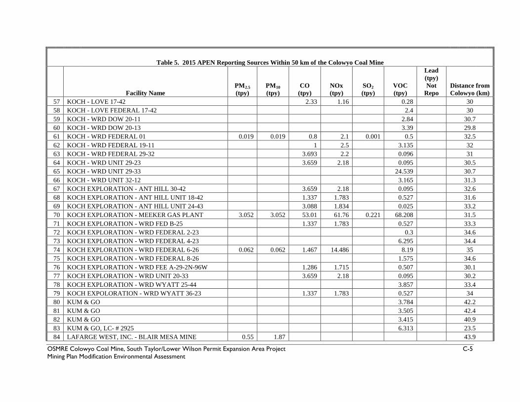
Table 5. 2015 APEN Reporting Sources Within 50 km of the Colowyo Coal Mine
Facility Name PM2.5 (tpy)
PM10 (tpy)
CO (tpy)
NOx (tpy)
SO2 (tpy)
VOC (tpy)
Lead (tpy) Not
Repo Distance from Colowyo (km)
57 KOCH - LOVE 17-42 2.33 1.16 0.28 30 58 KOCH - LOVE FEDERAL 17-42 2.4 30 59 KOCH - WRD DOW 20-11 2.84 30.7 60 KOCH - WRD DOW 20-13 3.39 29.8 61 KOCH - WRD FEDERAL 01 0.019 0.019 0.8 2.1 0.001 0.5 32.5 62 KOCH - WRD FEDERAL 19-11 1 2.5 3.135 32 63 KOCH - WRD FEDERAL 29-32 3.693 2.2 0.096 31 64 KOCH - WRD UNIT 29-23 3.659 2.18 0.095 30.5 65 KOCH - WRD UNIT 29-33 24.539 30.7 66 KOCH - WRD UNIT 32-12 3.165 31.3 67 KOCH EXPLORATION - ANT HILL 30-42 3.659 2.18 0.095 32.6 68 KOCH EXPLORATION - ANT HILL UNIT 18-42 1.337 1.783 0.527 31.6 69 KOCH EXPLORATION - ANT HILL UNIT 24-43 3.088 1.834 0.025 33.2 70 KOCH EXPLORATION - MEEKER GAS PLANT 3.052 3.052 53.01 61.76 0.221 68.208 31.5 71 KOCH EXPLORATION - WRD FED B-25 1.337 1.783 0.527 33.3 72 KOCH EXPLORATION - WRD FEDERAL 2-23 0.3 34.6 73 KOCH EXPLORATION - WRD FEDERAL 4-23 6.295 34.4 74 KOCH EXPLORATION - WRD FEDERAL 6-26 0.062 0.062 1.467 14.486 8.19 35 75 KOCH EXPLORATION - WRD FEDERAL 8-26 1.575 34.6 76 KOCH EXPLORATION - WRD FEE A-29-2N-96W 1.286 1.715 0.507 30.1 77 KOCH EXPLORATION - WRD UNIT 20-33 3.659 2.18 0.095 30.2 78 KOCH EXPLORATION - WRD WYATT 25-44 3.857 33.4 79 KOCH EXPOLORATION - WRD WYATT 36-23 1.337 1.783 0.527 34 80 KUM & GO 3.784 42.2 81 KUM & GO 3.505 42.4 82 KUM & GO 3.415 40.9 83 KUM & GO, LC- # 2925 6.313 23.5 84 LAFARGE WEST, INC. - BLAIR MESA MINE 0.55 1.87 43.9
OSMRE Colowyo Coal Mine, South Taylor/Lower Wilson Permit Expansion Area Project C-5 Mining Plan Modification Environmental Assessment

Table 5. 2015 APEN Reporting Sources Within 50 km of the Colowyo Coal Mine
Facility Name PM2.5 (tpy)
PM10 (tpy)
CO (tpy)
NOx (tpy)
SO2 (tpy)
VOC (tpy)
Lead (tpy) Not
Repo Distance from Colowyo (km)
85 LAFARGE WEST, INC. - BUNN RANCH PIT 6.968 19.848 42.2 86 LOAF N JUG # 869 3.163 40.4 87 MAYBELL ENTERPRISES-JUNIPER MTN LIMESTON 1.114 3.153 2.575 3.919 32.8 88 MEEKER SAND & GRAVEL INC 1.051 8.054 23.1 89 MOFFAT CO LANDFILL 3.15 1.94 36.9 90 MONUMENT OIL CO GO FER FOODS OF CRAIG 2.682 42.4 91 OLDCASTLE SW GROUP - BERRY PIT 1.256 4.27 19.8 92 OVERLAND PASS - DAVIS METER 3.5 45.8 93 OVERLAND PASS - DAVIS/PICEANCE JUNCTION 0.76 46.3 94 OWEN A. GRANT DBA GRANT MORTUARY 0.085 0.1 0.07 0.01 0.002 0.15 41.9 95 PETERSON ENERGY - KNOWLTON BATTERY 32.325 24.3 96 PUBLIC SERVICE CO GREASEWOOD STATION 0.05 0.05 21.5 24.4 0.003 0.17 45.7 97 PUBLIC SERVICE COMPANY INDIAN VALLEY STA 0.664 0.664 11.2 25.04 0.023 10.99 35.7 98 QUESTAR PIPELINE CO - DARK CANYON 0.27 0.13 17.08 45.9 99 QUESTAR PIPELINE CO - GREASEWOOD GULCH 1.413 0.403 1.596 8.943 0.023 3.903 45.6
100 QUICKSILVER - BRET GRANDBOUCHE 24-02H 46.473 9.998 77.137 33.6 101 QUICKSILVER RES. - ANTIETAM 11-12D 3 40.4 102 QUICKSILVER RES. - GAMMA STATE 14-15D 0.784 3.638 3.289 37.2 103 QUICKSILVER RES. - NORTH FORK 43-12 3 39.8 104 QUICKSILVER RESOURCES - ROUNDUP 22-24D 6.406 2.445 11.586 36.7 105 QUICKSILVER RESOURCES - SIMOES 12-30 1.321 1.761 0.52 36.8 106 QUICKSILVER RESOURCES - STODDARD 33-30 0.05 0.08 19.576 5.102 84.728 37.1 107 QUICKSILVER RESOURCES - STODDARD CTB 5.55 1.02 30.302 37.3 108 QUICKSILVER RESOURCES - WEBER 32-04 8.026 2.94 25.559 33.3 109 RIO BLANCO CNTY RD & BRIDGE- BACHMANN PI 0.002 0.019 23.1 110 RIO BLANCO CNTY RD & BRIDGE- SLEEPY CAT 0 0 32.4 111 RIO BLANCO CNTY RD& BRIDGE- PICEANCE PIT 0.003 0.01 36.5 112 RIO BLANCO CNTY ROAD & BRIDGE DEPT 8.2 1.337 34.3
OSMRE Colowyo Coal Mine, South Taylor/Lower Wilson Permit Expansion Area Project C-6 Mining Plan Modification Environmental Assessment

Table 5. 2015 APEN Reporting Sources Within 50 km of the Colowyo Coal Mine
Facility Name PM2.5 (tpy)
PM10 (tpy)
CO (tpy)
NOx (tpy)
SO2 (tpy)
VOC (tpy)
Lead (tpy) Not
Repo Distance from Colowyo (km)
113 RIO BLANCO COUNTY ROAD & BRIDGE 1.063 3.615 30.7 114 RN INDUSTRIES - PICEANCE CREEK, RANGELY 0.372 0.372 6.26 5.921 1.879 12.592 29.6 115 ROBERT L. BAYLESS- MOFFAT FIELD BATTERY 10.115 24.4 116 ROBERT L. BAYLESS- YENOM 1 FIELD BATTERY 2.83 25.5 117 ROCKY MNTN PIPELINE SYS- ILES STATION 31.692 17 118 ROCKY MOUNTAIN NAT GAS - PICEANCE 0.92 0.92 36.014 28.292 0.02 40.431 40.3 119 SAM F. LOVE - P&S GRAVEL PIT 3.949 13.425 33.6 120 SAMSON RESOURCES - ALLEN 44-8 #1 2.889 35.6 121 SAMSON RESOURCES - WEST DANFORTH 5A 0.02 0.02 0.32 6.6 0.652 18.5 122 SIMONS PETROLEUM, INC 60.147 41.1 123 SWEPI - DURHAM 7-32 PRODUCTION FACILITY 0.547 1.974 14 31.5 124 SWEPI - HERRING DRAW PRODUCTION FACILITY 0.202 0.202 9.077 5.306 16.92 31.5 125 SWEPI - WT DURHAM 4 0.396 0.528 0.016 30.1 126 SWEPI LP - DEAL GULCH 30.338 35.3 127 SWEPI LP - HARPER HILL PRODUCTION FACIL. 88.927 31.8 128 SWEPI, LP - BEAVER DURHAM 10.996 30.5 129 SWEPI, LP - DURHAM PRODUCTION FACILITY 87.646 2.361 44.996 29.8 130 TRANSCOLORADO GAS TRANS - GREASEWOOD 0.02 46 131 TRAPPER MINING INC 251 852.4 452.25 114.75 35.3 132 TRI STATE GENERATION CRAIG 132.24 190.701 1978.3 13498.5 3961 59.29 35 133 TRUE OIL - BREEZE UNIT 34-8 0.01 0.01 6.53 5.34 48.4 134 WAGNER ROCK, LLC - WAGNER PIT 0.5 1.7 49.3 135 WEST TEXAS - PICEANCE CREEK GP 1.02 1.02 12.04 9.41 0.006 45.403 45.7 136 WESTERN GRAVEL, LLC - WRC GRAVEL PIT 3.221 10.951 33.1 137 WESTON OIL CO 5 41.3 138 WILLIAMS FORK CO 0.84 6.172 34.5 139 WR AGGREGATES - MEEKER PIT 0.603 2.05 20.2 140 WR AGGREGATES - RUSSELL RANCH PIT 0.323 5.388 23.1
OSMRE Colowyo Coal Mine, South Taylor/Lower Wilson Permit Expansion Area Project C-7 Mining Plan Modification Environmental Assessment

Table 5. 2015 APEN Reporting Sources Within 50 km of the Colowyo Coal Mine
Facility Name PM2.5 (tpy)
PM10 (tpy)
CO (tpy)
NOx (tpy)
SO2 (tpy)
VOC (tpy)
Lead (tpy) Not
Repo Distance from Colowyo (km)
141 WRR SAND & GRAVEL - BLAIR MESA PIT 3.82 3.82 42.8 142 WPX ENERGY - BCU 23-22-198 4.79 49 143 XTO ENERGY - CENTRAL TANK BATTERY 31.826 45.3 144 XTO ENERGY - FEDERAL 1-96-23-12 15.462 37.9 145 XTO ENERGY - FEDERAL 1S-95-20-23 12.692 35.3 146 XTO ENERGY - FEDERAL 1S-96-9-11 11.367 37.5 147 XTO ENERGY - FEDERAL 2S-95-15-22 5.6 17.368 16.631 41.2 148 XTO ENERGY - FEDERAL 2S-95-16-22CP 5.657 2.833 40.731 42.1 149 XTO ENERGY - FEDERAL 2S-95-15-42 28.647 40.9 150 XTO ENERGY - FEDERAL 2S-95-16-33 5.657 2.913 32.322 42.2 151 XTO ENERGY - HATCH GULCH 2.56 48.7 152 XTO ENERGY - NPU 196-19B 11.6 41.6 153 XTO ENERGY - NPU 197-3A (WILD HORSE) 10.796 43.5 154 XTO ENERGY - PICEANCE CREEK UNIT 25X-25G 23.515 45.2 155 XTO ENERGY - PICEANCE CREEK UNIT F23-18G 1.78 48.6 156 XTO ENERGY - PICEANCE CREEK UNIT T22X-8G 1.719 46.2 157 XTO ENERGY - PICEANCE CREEK UNIT T64W-8G 4.537 46.2 158 XTO ENERGY - PINTO GULCH T68-18G 2.315 43.5 159 XTO ENERGY- PICEANCE CREEK UNIT T23X-26G 3.795 47.7 160 XTO ENERGY- PICEANCE CREEK UNIT T33X-29G 17.331 42 161 XTO ENERGY, INC. - PICEANCE CREEK 6.79 7.115 90.02 89.96 7.849 91.711 46.3 162 XTO ENERGY, INC. - PICEANCE CREEK AMINE 0.63 0.63 20.653 9.47 0.05 13.322 46 163 XTO ENERGY, INC. - SHULTS GRAVEL PIT 3.014 9.31 3.29 6.19 1.32 0.65 31.4 TOTALS 475.13 1251.64 3462.78 14434.73 4185.69 2413.19
OSMRE Colowyo Coal Mine, South Taylor/Lower Wilson Permit Expansion Area Project C-8 Mining Plan Modification Environmental Assessment

Table 6. Colowyo Coal Company L.P. Customers
OSMRE Colowyo Coal Mine, South Taylor/Lower Wilson Permit Expansion Area Project C-9 Mining Plan Modification Environmental Assessment

OSMRE Colowyo Coal Mine, South Taylor/Lower Wilson Permit Expansion Area Project C-10 Mining Plan Modification Environmental Assessment

OSMRE Colowyo Coal Mine, South Taylor/Lower Wilson Permit Expansion Area Project C-11 Mining Plan Modification Environmental Assessment

This page intentionally left blank.
OSMRE Colowyo Coal Mine, South Taylor/Lower Wilson Permit Expansion Area Project C-12 Mining Plan Modification Environmental Assessment

OSMRE - Colowyo Coal Mine South Taylor/Lower Wilson Permit Expansion Area Project Mining Plan Modification Environmental Assessment
Appendix D 2006, 2007, and 2015 Biological Opinions

OSMRE Colowyo Coal Mine, South Taylor/Lower Wilson Permit Expansion Area Project D-1 Mining Plan Modification Environmental Assessment

OSMRE Colowyo Coal Mine, South Taylor/Lower Wilson Permit Expansion Area Project D-2 Mining Plan Modification Environmental Assessment

OSMRE Colowyo Coal Mine, South Taylor/Lower Wilson Permit Expansion Area Project D-3 Mining Plan Modification Environmental Assessment

OSMRE Colowyo Coal Mine, South Taylor/Lower Wilson Permit Expansion Area Project D-4 Mining Plan Modification Environmental Assessment

OSMRE Colowyo Coal Mine, South Taylor/Lower Wilson Permit Expansion Area Project D-5 Mining Plan Modification Environmental Assessment

OSMRE Colowyo Coal Mine, South Taylor/Lower Wilson Permit Expansion Area Project D-6 Mining Plan Modification Environmental Assessment

OSMRE Colowyo Coal Mine, South Taylor/Lower Wilson Permit Expansion Area Project D-7 Mining Plan Modification Environmental Assessment

OSMRE Colowyo Coal Mine, South Taylor/Lower Wilson Permit Expansion Area Project D-8 Mining Plan Modification Environmental Assessment

OSMRE Colowyo Coal Mine, South Taylor/Lower Wilson Permit Expansion Area Project D-9 Mining Plan Modification Environmental Assessment

OSMRE Colowyo Coal Mine, South Taylor/Lower Wilson Permit Expansion Area Project D-10 Mining Plan Modification Environmental Assessment

OSMRE Colowyo Coal Mine, South Taylor/Lower Wilson Permit Expansion Area Project D-11 Mining Plan Modification Environmental Assessment

OSMRE Colowyo Coal Mine, South Taylor/Lower Wilson Permit Expansion Area Project D-12 Mining Plan Modification Environmental Assessment

OSMRE Colowyo Coal Mine, South Taylor/Lower Wilson Permit Expansion Area Project D-13 Mining Plan Modification Environmental Assessment

OSMRE Colowyo Coal Mine, South Taylor/Lower Wilson Permit Expansion Area Project D-14 Mining Plan Modification Environmental Assessment

OSMRE Colowyo Coal Mine, South Taylor/Lower Wilson Permit Expansion Area Project D-15 Mining Plan Modification Environmental Assessment

OSMRE Colowyo Coal Mine, South Taylor/Lower Wilson Permit Expansion Area Project D-16 Mining Plan Modification Environmental Assessment

OSMRE Colowyo Coal Mine, South Taylor/Lower Wilson Permit Expansion Area Project D-17 Mining Plan Modification Environmental Assessment

OSMRE Colowyo Coal Mine, South Taylor/Lower Wilson Permit Expansion Area Project D-18 Mining Plan Modification Environmental Assessment

OSMRE Colowyo Coal Mine, South Taylor/Lower Wilson Permit Expansion Area Project D-19 Mining Plan Modification Environmental Assessment

OSMRE Colowyo Coal Mine, South Taylor/Lower Wilson Permit Expansion Area Project D-20 Mining Plan Modification Environmental Assessment

OSMRE Colowyo Coal Mine, South Taylor/Lower Wilson Permit Expansion Area Project D-21 Mining Plan Modification Environmental Assessment

OSMRE Colowyo Coal Mine, South Taylor/Lower Wilson Permit Expansion Area Project D-22 Mining Plan Modification Environmental Assessment

OSMRE Colowyo Coal Mine, South Taylor/Lower Wilson Permit Expansion Area Project D-23 Mining Plan Modification Environmental Assessment

OSMRE Colowyo Coal Mine, South Taylor/Lower Wilson Permit Expansion Area Project D-24 Mining Plan Modification Environmental Assessment

OSMRE Colowyo Coal Mine, South Taylor/Lower Wilson Permit Expansion Area Project D-25 Mining Plan Modification Environmental Assessment

OSMRE Colowyo Coal Mine, South Taylor/Lower Wilson Permit Expansion Area Project D-26 Mining Plan Modification Environmental Assessment

OSMRE Colowyo Coal Mine, South Taylor/Lower Wilson Permit Expansion Area Project D-27 Mining Plan Modification Environmental Assessment

OSMRE Colowyo Coal Mine, South Taylor/Lower Wilson Permit Expansion Area Project D-28 Mining Plan Modification Environmental Assessment

OSMRE Colowyo Coal Mine, South Taylor/Lower Wilson Permit Expansion Area Project D-29 Mining Plan Modification Environmental Assessment

OSMRE Colowyo Coal Mine, South Taylor/Lower Wilson Permit Expansion Area Project D-30 Mining Plan Modification Environmental Assessment

OSMRE Colowyo Coal Mine, South Taylor/Lower Wilson Permit Expansion Area Project D-31 Mining Plan Modification Environmental Assessment

OSMRE Colowyo Coal Mine, South Taylor/Lower Wilson Permit Expansion Area Project D-32 Mining Plan Modification Environmental Assessment

OSMRE Colowyo Coal Mine, South Taylor/Lower Wilson Permit Expansion Area Project D-33 Mining Plan Modification Environmental Assessment

OSMRE Colowyo Coal Mine, South Taylor/Lower Wilson Permit Expansion Area Project D-34 Mining Plan Modification Environmental Assessment

OSMRE Colowyo Coal Mine, South Taylor/Lower Wilson Permit Expansion Area Project D-35 Mining Plan Modification Environmental Assessment

OSMRE Colowyo Coal Mine, South Taylor/Lower Wilson Permit Expansion Area Project D-36 Mining Plan Modification Environmental Assessment

OSMRE Colowyo Coal Mine, South Taylor/Lower Wilson Permit Expansion Area Project D-37 Mining Plan Modification Environmental Assessment

OSMRE Colowyo Coal Mine, South Taylor/Lower Wilson Permit Expansion Area Project D-38 Mining Plan Modification Environmental Assessment

OSMRE Colowyo Coal Mine, South Taylor/Lower Wilson Permit Expansion Area Project D-39 Mining Plan Modification Environmental Assessment

OSMRE Colowyo Coal Mine, South Taylor/Lower Wilson Permit Expansion Area Project D-40 Mining Plan Modification Environmental Assessment
OSMRE Colowyo Coal Mine, South Taylor/Lower Wilson Permit Expansion Area Project D-41 Mining Plan Modification Environmental Assessment

OSMRE Colowyo Coal Mine, South Taylor/Lower Wilson Permit Expansion Area Project D-42 Mining Plan Modification Environmental Assessment

OSMRE Colowyo Coal Mine, South Taylor/Lower Wilson Permit Expansion Area Project D-43 Mining Plan Modification Environmental Assessment

OSMRE Colowyo Coal Mine, South Taylor/Lower Wilson Permit Expansion Area Project D-44 Mining Plan Modification Environmental Assessment

OSMRE Colowyo Coal Mine, South Taylor/Lower Wilson Permit Expansion Area Project D-45 Mining Plan Modification Environmental Assessment

OSMRE Colowyo Coal Mine, South Taylor/Lower Wilson Permit Expansion Area Project D-46 Mining Plan Modification Environmental Assessment

OSMRE Colowyo Coal Mine, South Taylor/Lower Wilson Permit Expansion Area Project D-47 Mining Plan Modification Environmental Assessment

OSMRE Colowyo Coal Mine, South Taylor/Lower Wilson Permit Expansion Area Project D-48 Mining Plan Modification Environmental Assessment

OSMRE Colowyo Coal Mine, South Taylor/Lower Wilson Permit Expansion Area Project D-49 Mining Plan Modification Environmental Assessment

OSMRE Colowyo Coal Mine, South Taylor/Lower Wilson Permit Expansion Area Project D-50 Mining Plan Modification Environmental Assessment

OSMRE Colowyo Coal Mine, South Taylor/Lower Wilson Permit Expansion Area Project D-51 Mining Plan Modification Environmental Assessment

OSMRE Colowyo Coal Mine, South Taylor/Lower Wilson Permit Expansion Area Project D-52 Mining Plan Modification Environmental Assessment

OSMRE Colowyo Coal Mine, South Taylor/Lower Wilson Permit Expansion Area Project D-53 Mining Plan Modification Environmental Assessment

OSMRE Colowyo Coal Mine, South Taylor/Lower Wilson Permit Expansion Area Project D-54 Mining Plan Modification Environmental Assessment

OSMRE Colowyo Coal Mine, South Taylor/Lower Wilson Permit Expansion Area Project D-55 Mining Plan Modification Environmental Assessment

OSMRE Colowyo Coal Mine, South Taylor/Lower Wilson Permit Expansion Area Project D-56 Mining Plan Modification Environmental Assessment

OSMRE Colowyo Coal Mine, South Taylor/Lower Wilson Permit Expansion Area Project D-57 Mining Plan Modification Environmental Assessment

OSMRE Colowyo Coal Mine, South Taylor/Lower Wilson Permit Expansion Area Project D-58 Mining Plan Modification Environmental Assessment

OSMRE Colowyo Coal Mine, South Taylor/Lower Wilson Permit Expansion Area Project D-59 Mining Plan Modification Environmental Assessment

OSMRE Colowyo Coal Mine, South Taylor/Lower Wilson Permit Expansion Area Project D-60 Mining Plan Modification Environmental Assessment

OSMRE Colowyo Coal Mine, South Taylor/Lower Wilson Permit Expansion Area Project D-61 Mining Plan Modification Environmental Assessment

OSMRE Colowyo Coal Mine, South Taylor/Lower Wilson Permit Expansion Area Project D-62 Mining Plan Modification Environmental Assessment

OSMRE Colowyo Coal Mine, South Taylor/Lower Wilson Permit Expansion Area Project D-63 Mining Plan Modification Environmental Assessment

OSMRE Colowyo Coal Mine, South Taylor/Lower Wilson Permit Expansion Area Project D-64 Mining Plan Modification Environmental Assessment

OSMRE Colowyo Coal Mine, South Taylor/Lower Wilson Permit Expansion Area Project D-65 Mining Plan Modification Environmental Assessment

OSMRE Colowyo Coal Mine, South Taylor/Lower Wilson Permit Expansion Area Project D-66 Mining Plan Modification Environmental Assessment

OSMRE Colowyo Coal Mine, South Taylor/Lower Wilson Permit Expansion Area Project D-67 Mining Plan Modification Environmental Assessment

OSMRE Colowyo Coal Mine, South Taylor/Lower Wilson Permit Expansion Area Project D-68 Mining Plan Modification Environmental Assessment

OSMRE Colowyo Coal Mine, South Taylor/Lower Wilson Permit Expansion Area Project D-69 Mining Plan Modification Environmental Assessment

OSMRE Colowyo Coal Mine, South Taylor/Lower Wilson Permit Expansion Area Project D-70 Mining Plan Modification Environmental Assessment

OSMRE Colowyo Coal Mine, South Taylor/Lower Wilson Permit Expansion Area Project D-71 Mining Plan Modification Environmental Assessment

OSMRE Colowyo Coal Mine, South Taylor/Lower Wilson Permit Expansion Area Project D-72 Mining Plan Modification Environmental Assessment

OSMRE Colowyo Coal Mine, South Taylor/Lower Wilson Permit Expansion Area Project D-73 Mining Plan Modification Environmental Assessment

OSMRE Colowyo Coal Mine, South Taylor/Lower Wilson Permit Expansion Area Project D-74 Mining Plan Modification Environmental Assessment

OSMRE Colowyo Coal Mine, South Taylor/Lower Wilson Permit Expansion Area Project D-75 Mining Plan Modification Environmental Assessment

OSMRE Colowyo Coal Mine, South Taylor/Lower Wilson Permit Expansion Area Project D-76 Mining Plan Modification Environmental Assessment

OSMRE Colowyo Coal Mine, South Taylor/Lower Wilson Permit Expansion Area Project D-77 Mining Plan Modification Environmental Assessment

OSMRE Colowyo Coal Mine, South Taylor/Lower Wilson Permit Expansion Area Project D-78 Mining Plan Modification Environmental Assessment

OSMRE Colowyo Coal Mine, South Taylor/Lower Wilson Permit Expansion Area Project D-79 Mining Plan Modification Environmental Assessment

OSMRE Colowyo Coal Mine, South Taylor/Lower Wilson Permit Expansion Area Project D-80 Mining Plan Modification Environmental Assessment

OSMRE Colowyo Coal Mine, South Taylor/Lower Wilson Permit Expansion Area Project D-81 Mining Plan Modification Environmental Assessment

OSMRE Colowyo Coal Mine, South Taylor/Lower Wilson Permit Expansion Area Project D-82 Mining Plan Modification Environmental Assessment

OSMRE Colowyo Coal Mine, South Taylor/Lower Wilson Permit Expansion Area Project D-83 Mining Plan Modification Environmental Assessment

OSMRE Colowyo Coal Mine, South Taylor/Lower Wilson Permit Expansion Area Project D-84 Mining Plan Modification Environmental Assessment

OSMRE Colowyo Coal Mine, South Taylor/Lower Wilson Permit Expansion Area Project D-85 Mining Plan Modification Environmental Assessment

OSMRE Colowyo Coal Mine, South Taylor/Lower Wilson Permit Expansion Area Project D-86 Mining Plan Modification Environmental Assessment

OSMRE Colowyo Coal Mine, South Taylor/Lower Wilson Permit Expansion Area Project D-87 Mining Plan Modification Environmental Assessment

OSMRE Colowyo Coal Mine, South Taylor/Lower Wilson Permit Expansion Area Project D-88 Mining Plan Modification Environmental Assessment
OSMRE Colowyo Coal Mine, South Taylor/Lower Wilson Permit Expansion Area Project D-89 Mining Plan Modification Environmental Assessment

OSMRE Colowyo Coal Mine, South Taylor/Lower Wilson Permit Expansion Area Project D-90 Mining Plan Modification Environmental Assessment

OSMRE Colowyo Coal Mine, South Taylor/Lower Wilson Permit Expansion Area Project D-91 Mining Plan Modification Environmental Assessment

OSMRE Colowyo Coal Mine, South Taylor/Lower Wilson Permit Expansion Area Project D-92 Mining Plan Modification Environmental Assessment

OSMRE Colowyo Coal Mine, South Taylor/Lower Wilson Permit Expansion Area Project D-93 Mining Plan Modification Environmental Assessment

OSMRE Colowyo Coal Mine, South Taylor/Lower Wilson Permit Expansion Area Project D-94 Mining Plan Modification Environmental Assessment

OSMRE Colowyo Coal Mine, South Taylor/Lower Wilson Permit Expansion Area Project D-95 Mining Plan Modification Environmental Assessment

OSMRE - Colowyo Coal Mine South Taylor/Lower Wilson Permit Expansion Area Project Mining Plan Modification Environmental Assessment
Appendix E SHPO Consultation and Tribal Consultation

OSMRE Colowyo Coal Mine, South Taylor/Lower Wilson Permit Expansion Area Project E-1 Mining Plan Modification Environmental Assessment

OSMRE Colowyo Coal Mine, South Taylor/Lower Wilson Permit Expansion Area Project E-2 Mining Plan Modification Environmental Assessment

OSMRE Colowyo Coal Mine, South Taylor/Lower Wilson Permit Expansion Area Project E-3 Mining Plan Modification Environmental Assessment

OSMRE Colowyo Coal Mine, South Taylor/Lower Wilson Permit Expansion Area Project E-4 Mining Plan Modification Environmental Assessment

OSMRE Colowyo Coal Mine, South Taylor/Lower Wilson Permit Expansion Area Project E-5 Mining Plan Modification Environmental Assessment

OSMRE Colowyo Coal Mine, South Taylor/Lower Wilson Permit Expansion Area Project E-6 Mining Plan Modification Environmental Assessment

OSMRE Colowyo Coal Mine, South Taylor/Lower Wilson Permit Expansion Area Project E-7 Mining Plan Modification Environmental Assessment

OSMRE Colowyo Coal Mine, South Taylor/Lower Wilson Permit Expansion Area Project E-8 Mining Plan Modification Environmental Assessment
OSMRE Colowyo Coal Mine, South Taylor/Lower Wilson Permit Expansion Area Project E-9 Mining Plan Modification Environmental Assessment

OSMRE Colowyo Coal Mine, South Taylor/Lower Wilson Permit Expansion Area Project E-10 Mining Plan Modification Environmental Assessment

OSMRE Colowyo Coal Mine, South Taylor/Lower Wilson Permit Expansion Area Project E-11 Mining Plan Modification Environmental Assessment

OSMRE Colowyo Coal Mine, South Taylor/Lower Wilson Permit Expansion Area Project E-12 Mining Plan Modification Environmental Assessment

OSMRE Colowyo Coal Mine, South Taylor/Lower Wilson Permit Expansion Area Project E-13 Mining Plan Modification Environmental Assessment

OSMRE - Colowyo Coal Mine South Taylor/Lower Wilson Permit Expansion Area Project Mining Plan Modification Environmental Assessment
Appendix F Public Comments on the Draft EA and OSMRE Response

Contents I. Public Comment Response Summary .................................................................................................................. 1
Introduction .................................................................................................................................................................... 1
Comment Analysis Process ........................................................................................................................................ 1
Comment Overview .................................................................................................................................................... 1
Summary Comments and Responses ....................................................................................................................... 2
Summary Comment 1 .................................................................................................................................................. 2
Summary Comment 2 .................................................................................................................................................. 3
Summary Comment 3 .................................................................................................................................................. 4
Summary Comment 4 .................................................................................................................................................. 5
Summary Comment 5 .................................................................................................................................................. 8
Summary Comment 6 .................................................................................................................................................. 8
Summary Comment 7 .................................................................................................................................................. 9

I. PUBLIC COMMENT RESPONSE SUMMARY Introduction Consistent with the National Environmental Policy Act (NEPA), 40 C.F.R. 1503.4(b) and 43 C.F.R. 46.305, responses included in this report address the comments received on the South Taylor/Lower Wilson Permit Expansion Area Mining Plan Modification Environmental Assessment (EA) and unsigned Finding of No Significant Impact (FONSI). Each letter and email was read and analyzed to identify substantive comments. Conclusions on whether or not comments were considered substantive were based on the following definitions:
• Substantive comments include those that challenge, with reasonable basis, the information in the EA or the FONSI as being inadequate or inaccurate; develop reasonable alternatives not considered by the agency, or offer new specific information that may have a bearing on the decision.
• Non-substantive comments are those that do not pertain to the Project Area, Proposed Action or alternatives, or express opinions or position statements about the project or agency policy without accompanying factual basis or rationale to support the opinion.
All comments—substantive or not substantive—and agency responses, are part of the administrative record for this EA, and have been considered during the decision-making process. The purpose of this document is to provide responses to substantive comments received on the EA and the FONSI. Comment Analysis Process A standardized content analysis process was conducted to analyze the public comments on the Mining Plan Modification EA and unsigned FONSI. Each comment letter or email received was read by OSMRE to ensure that all substantive comments were identified. The comments were not weighted by organizational affiliation or status of respondents, and the number of duplicate comments did not bias the analysis. The process was not one of counting votes, and no effort was made to tabulate the exact number of people for or against any given aspect of the EA. Rather, emphasis was placed on the content of a comment. Comment Overview Comments were accepted from the release of the EA on July 27, 2015 through August 14, 2015. A total of 9,525 comment letters and emails were received. If substantive comments were identified within a letter, the resource area or concern was noted and summarized in the response to comments presented herein.
OSMRE Colowyo Coal Mine, South Taylor/Lower Wilson Permit Expansion Area Project F-1 Mining Plan Modification Environmental Assessment

Summary Comments and Responses This section paraphrases the substantive comments into Summary Comments and provides both general and specific responses. The comment letters were reviewed, commenter data logged into a spreadsheet, and all information entered into the Administrative Record. Most of the comment letters and emails consisted of one of two basic form letters originating from two websites: www.wildearthguardians.org and SupportColowyo.org. One form letter generally opposed the project while the other supported it. In addition, other individual comments were received generally in support or opposition to the project. The following summary comments were identified after reviewing all of these comments. Summary Comment 1 The Colowyo South Taylor/Lower Wilson Mining Plan Decision requires preparation of an EIS. OSMRE has completed an Environmental Assessment (EA) to determine if there would be significant effects as a result of approving the Colowyo Coal Mine South Taylor/Lower Wilson Mining Plan and an Environmental Impact Statement (EIS) is required. In NEPA documents, significance is determined by context and intensity as defined by CEQ regulations at 40 CFR 1508.27. The significance of the impacts to all resources is analyzed in the EA in chapters 4 and 5, and the rationale for the conclusions reached is provided. For the reasons described in the FONSI, we have determined that there are no significant impacts for the selected alternative (Alternative B). Therefore, an EIS is not required. OSMRE received a number of comments on both sides of the issue as to whether an EIS was required. A number of comments indicated general support for the conclusion there are no significant impacts and that an EIS is not required for this project. In contrast, a number of comments generally indicated that an EIS is required to be prepared for this project. According to these commenters, the primary reason necessitating the preparation of an EIS relates to alleged significant impacts from the project on climate change and GHGs from coal combustion. The commenters that opined that an EIS was required relied on two primary justifications. First, one of the commenters claim that other future activities at the same mine were required to be considered in the same NEPA document, which would have significant impacts in the aggregate. This comment is addressed below as part of Summary Comment 3. Second, another commenter pointed out that the Department of the Interior’s Department Manual at 516 DM 13 identifies specific criteria for when an EIS is required and that this project appears to meet those criteria. Thus, this commenter concludes that an EIS is required. We disagree. To begin, as a point of clarification, 516 DM 13 does not automatically mandate the preparation of an EIS if certain criteria are met. This guidance document only identifies major actions “normally requir[ing] the preparation of an EIS.” 516 DM 13.4(A). It also explicitly recognizes that OSMRE may choose not to prepare an EIS for any of the listed actions. See 516 DM 13.4(A) (“If for any of these actions it is proposed not to prepare an EIS, an EA will be prepared and handled in accordance with Section 1501.4(e)(2)). Thus, there is nothing in the Departmental Manual that diminishes OSMRE’s discretion to follow the NEPA requirements in order to determine whether any particular action is significant.
OSMRE Colowyo Coal Mine, South Taylor/Lower Wilson Permit Expansion Area Project F-2 Mining Plan Modification Environmental Assessment

In addition, we disagree with the commenter that this project would meet the criteria of 516 DM 13.4(A)(4), which states that an EIS must normally be prepared for:
Approval of a proposed mining and reclamation plan for a surface mining operation that meets the following:
(a) The environmental impacts of the proposed mining operation are not adequately analyzed in an earlier environmental document covering the specific leases or mining activity; and
(b) The area to be mined is 1280 acres or more, or the annual full production level is 5 million tons or more; and
(c) Mining and reclamation operations will occur for 15 years or more.
Alternative B, the alternative selected in the FONSI, does not meet the scenario described in the Departmental Manual, which requires all three criteria to be met. While one commenter estimated “1,562 acres will be disturbed as a result of the proposed mining plan,” as described in the EA, Alternative B has a total disturbance of 1,250 acres of which 809 acres is new disturbance and 441 acres is re-disturbance of land disturbed from previously approved mining. The actual area to be mined (South Taylor Pit) is 429 acres. Thus, under either measure (acres disturbed or “area to be mined”), this action is below the 1280 acre threshold. In addition, the maximum production level allowed under Alternative B would be 4 mtpy, which also does not rise to the 5 mtpy threshold of (b). Because criteria (b) is not met, an EIS would not “normally” be required in accordance with the Departmental Manual. Summary Comment 2 The range of alternatives considered in the EA is not adequate. The EA analyzes three alternatives: Alternative A, PR02 as Approved in 2007, the proposed action as directed by the court; Alternative B, PR02 as Revised; and Alternative C, the No Action Alternative. Other alternatives were also considered but eliminated from further analysis as described in Section 2.5. Commenters raised a concern that the range of alternatives considered in the EA was not adequate, that alternatives identified during the public outreach period were ignored, and that additional alternatives should be considered. Alternatives identified in public outreach comments included limiting coal production, underground mining, placing limits on the emission of criteria pollutants, hazardous air pollutants and carbon dioxide from the Craig Power Plant, Colowyo Mine and regional oil and gas operators; and consideration of an alternative that requires mitigation, including off-site mitigation, for air quality impacts from criteria and hazardous air pollutants and greenhouse gases. We considered including each of these alternatives. Section 2.5 of the EA, explains in more detail why some of these alternatives, including underground mining and air quality mitigation, and mining plans with reduced disturbance were in fact considered but not brought forward for analysis in the EA because they were not considered reasonable alternatives in accordance with CEQ regulations at 40 CFR 1502.14. For example, air quality impacts from criteria
OSMRE Colowyo Coal Mine, South Taylor/Lower Wilson Permit Expansion Area Project F-3 Mining Plan Modification Environmental Assessment

pollutants, hazardous air pollutants and greenhouse gases were analyzed for Alternative A (the proposed alternative), Alternative B (the selected alternative) and the No Action Alternative in Section 4.3 of the EA. This analysis concluded there would be no significant impacts. No mitigation beyond Colowyo’s permitted Air Quality Dust Mitigation Plan was required. In response to a comment recommending OSMRE consider an alternative requiring low or no emission mining equipment and require more rigorous maintenance requirements for pollutant emitting machinery, as discussed above, direct air quality impacts from criteria pollutants, hazardous air pollutants and greenhouse gases attributed to mining were analyzed for all alternatives and no significant impacts were identified. In addition to the original proposed action (Alternative A), OSMRE did consider a reasonable alternative that would mine substantially less coal at a lower maximum production rate and disturb less surface acreage—Alternative B. In addition, OSMRE considered an alternative that would have prohibited any additional mining—Alternative C. Thus, OSMRE considered a reasonable range of alternatives, including those submitted by commenters during scoping. The final paragraph of Section 2.5.2 has been broken out into Section 2.5.3 titled Mining Plan with Reduced Disturbance Alternative and revised language has been provided to clarify the intent of the discussion. Summary Comment 3 The determinations of “connected” and “similar” actions (as defined in CEQ regulations) and the related analysis of cumulative impacts are not adequate. Comments identified that the EA does not address the impacts of the pending Collom Mine expansion, the proposed coal lease modification under consideration by the BLM, and the burning of coal in a power plant. The comments indicate these actions should be considered “connected actions” to the South Taylor action in accordance with CEQ regulations at 40 CFR 1508.25(a)(1). OSMRE evaluated these actions under the CEQ regulations and determined that they are separate, discrete actions that are distinct and not interdependent with the South Taylor action. None of these other actions automatically trigger other actions and can proceed independently of the South Taylor action. As such those actions do not meet the criteria for "Connected Actions" as defined by CEQ regulations at 40 CFR 1508.25(a)(1). As required by NEPA, the Collom Mine permit expansion and the BLM lease modification are considered as reasonably foreseeable actions in Chapter 5, Cumulative Impacts. Chapter 5 provides a summary of both proposals in Section 5.3, and describes cumulative effects in Sections 5.4.3, 5.4.4, 5.4.9, 5.4.11, 5.4.12, and 5.4.20. The burning of coal at the power plant is considered at several points in the EA in accordance with NEPA and is addressed in Sections 3.5.2, 4.3.1.4, 4.3.2.3, 4.3.3.2, 4.3.3.3, 4.3.3.4, 4.3.3.5, 4.3.3.6, 4.5.1, 4.9.1, 4.9.2, 5.4.2, and 5.4.8. Commenters further argue that mining operations at the Trapper Mine are “similar” actions, as defined under CEQ regulations at 40 CFR 1508.25(a)(3) because of their timing, geography, and commonality of providing coal to the Craig Generating Station. Those comments pointed out that the EA should, but allegedly fails to, analyze the impacts at the Trapper Mine. Operations at the Trapper Mine are not "Connected Actions" as defined by CEQ regulations at 40 CFR 1508.25(a)(1). Mining at the Trapper Mine is not an interdependent action to the South Taylor mining operation, does not automatically trigger other actions such as the South Taylor action, and can and will proceed regardless of the South Taylor action. As required by NEPA, operations at the Trapper
OSMRE Colowyo Coal Mine, South Taylor/Lower Wilson Permit Expansion Area Project F-4 Mining Plan Modification Environmental Assessment

Mine are, however, considered reasonably foreseeable actions and are considered in Chapter 5 - Cumulative Impacts. Another comment indicated that pending BLM coal leasing decisions in Utah, Montana, and Wyoming should be considered and analyzed in the EA as "similar" actions to the OSMRE/ASLM decision on the South Taylor PR02 mining plan modification. Similar actions, are actions which when viewed with other reasonably foreseeable or proposed agency actions, have similarities, such as common timing or geography, that provide a basis for evaluating their environmental consequences together. BLM coal leasing decisions in Utah, Montana and Wyoming are not considered to exhibit common geography with the Colowyo mining plan approval and consequently are not evaluated within the EA. Commenters also opined that because of these actions, the project would have significant impacts and require an EIS. We disagree. As discussed above, none of the actions the commenters mention as are dependent on the South Taylor Pit expansion. We analyzed the cumulative impacts of these actions and, as described in the EA and the FONSI, we did not determine any significant impacts. Thus, an EIS is not warranted. Summary Comment 4 The impact analyses of climate change and GHG, including the cost of carbon emissions from coal combustion, are inadequate. The potential impacts on climate change and GHG are discussed in Section 4.3 and Section 5.4.2 of the EA. The EA analysis followed the Draft CEQ Guidance regarding GHG and Climate Change in NEPA analysis (CEQ 2014). While many comments identified that the EA presents a comprehensive and more than adequate assessment of the potential environmental impacts, many others raise concerns that the analyses of climate change and GHGs are inadequate. One commenter identified that the EA indicates that no public outreach comments were received by OSMRE that expressed concerns over the potential impacts on climate change from coal. All comments received during the public outreach period (May 21, 2015 to June 15, 2015) were considered. The topics covered in those comments, the total numbers of comments received for each topic, and the overall total number of comments received are summarized in Table 1.6-1 of the EA. The number of comments received on the potential impacts on climate change and GHG are included in the table, in the total number under the category of "Air Quality", which is the section of the EA in which we discuss GHGs and climate change. A description of public outreach comments expressing concern about impacts to climate change and GHG is also included in the EA. For clarity, the category “Air Quality” in Table 1.6-1 will be relabeled to expressly include the topic of "Climate Change". Other comments stated that OSMRE failed to analyze the potential effects of approving the proposed mining plan on climate change. As indicated above, those potential effects are analyzed in the sections of the EA cited in accordance with draft CEQ guidance. The draft guidance notes that quantifying the emissions from a government action or approval is more a statement about the nature of the climate change challenge, and that agencies have substantial discretion in how they tailor their NEPA processes so long as they provide the public and decision-makers with explanations of the basis for the determinations. Specifically, the draft guidance states:
OSMRE Colowyo Coal Mine, South Taylor/Lower Wilson Permit Expansion Area Project F-5 Mining Plan Modification Environmental Assessment

Inherent in NEPA and the CEQ Regulations is a rule of reason which ensures that agencies are afforded the discretion, based on their expertise and experience, to determine whether and to what extent to prepare an analysis based on the availability of information, the usefulness of that information to the decision-making process and the public, and the extent of the anticipated environmental consequences.” In light of the difficulties in attributing specific climate impacts to individual projects, CEQ recommends agencies use the projected GHG emissions and also, when appropriate, potential changes in carbon sequestration and storage, as the proxy for assessing a proposed action's potential climate change impacts. This approach allows an agency to present the environmental impacts of the Proposed Action in clear terms and with sufficient information to make a reasoned choice between the no-action and proposed alternatives and mitigations, and ensure the professional and scientific integrity of the discussion and analysis.” Agencies are encouraged to apply this guidance to all new agency actions moving forward and, to the extent practicable, to build its concepts into currently on-going reviews.
OSMRE prepared the EA in accordance with this draft guidance. The direct and indirect effects from mining operations and coal combustion on GHGs and Climate Change are discussed in Section 4.3 of the EA and cumulative effects are discussed Section 5.4.2. Both analyses included a quantification of projected GHG emissions as CO2 equivalents. Several comments stated that the EA needs to assess the costs of projected carbon emissions associated with the combustion of coal at the Craig Generating Station resulting from the South Taylor Mining Plan Modification. Other comments expressed concern that the EA is misleading because it presumes carbon costs are $0, and one comment points out that the EA only discloses the economic benefits of mining. Additional comments call for the EA to show the calculation of the cost of carbon for the projected coal combustion emissions. The social cost of carbon is addressed in Sections 4.3.1.4, 4.3.2.3 and 4.3.3 of the EA. The EA does not assume that there is no cost ($0) of GHG emissions. As discussed in these section, OSMRE explains that without a complete monetary cost-benefit analysis, which includes the social benefits of energy production, inclusion solely of a social cost of carbon analysis would be misleading and not informative to the decision maker. The social cost of carbon (SCC) protocol was developed by an Interagency Working Group (IWG), including the Environmental Protection Agency (EPA) and others, and is intended for use as part of cost-benefit analyses of proposed regulations that could impact cumulative global emissions (Technical Support Document: Social Cost of Carbon for Regulatory Impact Analysis Under Executive Order 12866, available at: http://www.whitehouse.gov/sites/default/files/omb/inforeg/for-agencies/Social-Cost-of-Carbon-for-
OSMRE Colowyo Coal Mine, South Taylor/Lower Wilson Permit Expansion Area Project F-6 Mining Plan Modification Environmental Assessment

RIA.pdf).1 EO 12866 requires cost-benefit analyses when developing regulations and the IWG encourages the use of the SCC protocol in those cases. The South Taylor Mining Plan Modification EA is not subject to EO 12866 because it was not prepared to support the promulgation of regulations. Instead, the analysis was prepared pursuant to NEPA to inform OSMRE’s decision as to whether or not to recommend approval, disapproval or approval with conditions of the South Taylor Mining Plan Modification. Moreover, neither NEPA nor any other law requires OSMRE to perform a cost-benefit analysis for this action. Thus, a cost-benefit analysis, including the SCC protocol was not performed. NEPA does require agencies to consider socio-economic impacts.2 40 CFR 1508.8. Thus, OSMRE did attempt to quantitatively analyze those impacts. Although this quantitative analysis did determine some of the benefits of mining in dollars, it was not designed as a cost-benefit analysis like those performed under EO 12866. In fact, many costs other than the SCC that would have been considered in a cost-benefit analysis, such as compliance costs, were not considered in this environmental analysis. Thus, simply because some of the NEPA analysis used dollars to describe the impacts, it does not mean that a cost-benefit analysis was performed that would require the use of the SCC protocol.
Despite not using the SCC protocol, OSMRE did not ignore the effects or costs of carbon emissions. The South Taylor Mine Plan Modification EA evaluated the climate change impacts of the proposed action and alternatives using quantitative measures other than dollars. For instance, the South Taylor Mining Plan Modification EA quantified the estimated greenhouse gas emissions that would result from both direct and indirect actions associated with all alternatives. The direct and indirect effects from mining operations and coal combustion on GHGs and Climate Change are discussed in Section 4.3 of the EA and cumulative effects are discussed Section 5.4.2. Both analyses included a quantification of projected GHG emissions as CO2 equivalents. OSMRE also provided context for these numbers by comparing these estimated emissions with state (for direct emissions), national and global emissions levels (for direct and indirect emissions). In addition to the quantitative measures, the EA also qualitatively described the potential GHG/climate change impacts associated with emissions increases and complexities of these linkages in order to inform OSMRE’s decision making. Another commenter noted that the EA indicates that mining at the Colowyo Mine would reasonably foreseeably result in 0.231 percent of all global GHG emissions. The EA quantified the estimated GHG emissions that would result from a variety of proposed development scenarios for both direct and indirect impacts. The total potential GHG emissions percentage reported on Table 4.1-1, page 4-3, are for components of each of the direct and indirect components. For the indirect combustion of GHG emissions referenced in the comment, the global and U.S. percentages have been inadvertently reversed for Alternative A. These values have been corrected, the Alternative A
1 The SCC protocol is used to monetize damages associated with an incremental increase in carbon emissions in a given year. It includes (but is not limited to) changes in net agricultural productivity, human health, property damages from increased flood risk, and the value of ecosystem services due to climate change. 2 Although not mandatory, CEQ NEPA regulations do permit agencies to use cost-benefit in NEPA analyses in certain circumstances. 40 CFR 1502.23. OSMRE Colowyo Coal Mine, South Taylor/Lower Wilson Permit Expansion Area Project F-7 Mining Plan Modification Environmental Assessment

indirect combustion impacts would result in 0.048 percent of global emissions and 0.231 percent of the U.S. total GHG emissions. Alternative B indirect combustion impacts would result in 0.015 percent of global emissions and 0.071 percent of the U.S. total GHG emissions. These percentages were included to provide context to other sources of GHG emissions. Summary Comment 5 The analyses of impacts to rare, imperiled fish, wildlife and plants are inadequate. Many comments identified that the EA presents a comprehensive and more than adequate assessment of the potential environmental impacts of the Project. However, other comments received stated that the EA does not analyze and assess impacts to rare, imperiled fish, wildlife and plants, including T&E species. In particular those comments identify concerns about the impacts of mercury and selenium discharge from water outflows and from the combustion of coal. Some commenters indicated particular concern over the potential impacts to the endangered Colorado pikeminnow and the razorback sucker. The EA provides an adequate analysis of the potential direct effects from mercury and selenium from water discharge and the potential indirect effects of mercury and selenium from coal combustion. The potential for mercury and selenium impacts resulting from water discharge outflows from the mine is analyzed in depth in Section 4.5 of the EA. Similarly, the potential for mercury and selenium deposition from coal combustion is analyzed in detail in Section 4.3 and in Section 5.4.1.4. Potential impacts to threatened, endangered, and candidate species from mercury and selenium deposition resulting from coal combustion at the Craig Generating Station are analyzed in Section 4.9 and in Section 5.4.8 of the EA. For Alternative B, and as described in Section 4.9.2, formal consultation under Section 7 of the ESA has been completed with the USFWS on the effects of coal combustion and associated mercury and selenium deposition in the Yampa River Basin on threatened and endangered fish species. A final determination of effect to these species and their designated critical habitats has been made and mitigation measures volunteered by Colowyo that are now required by USFWS have been incorporated into the EA within the biological opinion included in Appendix D and documented in the signed Finding of No Significant Impact. Summary Comment 6 The socioeconomic impacts of the Project are not adequately analyzed. A number of commenters raised the concern that while the SCC emissions was not calculated for the Project, the economic benefits of mining were disclosed. See response under Summary Comment 4 above. One commenter identified that many secondary and tertiary businesses exist because of the mining industry in Moffat and Rio Blanco Counties. The comment indicates that a 2014 Colorado Mining Association report shows that the Colowyo Mine purchases more than $50 million annually in services and goods. The comment continues to state that in the absence of the mining plan approval many businesses would decline or disappear. Section 3.12 addresses secondary and tertiary businesses and describes annual purchases of goods and services by Colowyo as provided by Tri-State Generation and Transmission. Section 4.12 and Section 5.4.11 incorporate such
OSMRE Colowyo Coal Mine, South Taylor/Lower Wilson Permit Expansion Area Project F-8 Mining Plan Modification Environmental Assessment

expenditures in the analysis of potential impacts. The numbers provided by Tri-State differ from those provided in the comment but the comment does not include the 2014 report identified for documentation. The report referenced is acknowledged but OSMRE has not revised the EA to reflect these numbers because a copy of the report was not provided and OSMRE feels the numbers provided by Tri-State are suitable for the analysis. Summary Comment 7 The effect of the Project design features to reduce environmental impacts and the enforceability of those features is inadequately described. Concerns were raised in one comment that the EA does not provide enough details about the design features incorporated into the Project through the SMCRA permit approval process. Those design features, which would mitigate potential environmental impacts, are enforceable requirements of the approved permit issued by CDRMS. The comment continues by requesting that a description of these design features be included in the discussions of mitigation measures in Chapter 4. In Chapter 2 of the EA, Sections 2.2.3 and 2.3.3, provides a discussion of the mitigating effect of project design features, and Tables 2.2-1 and 2.3-2 provide summary lists of the design features. Appendix B also contains a more comprehensive list of the design features. The design features are incorporated into the Proposed Action and Alternative B and, thus, are an integral part of the proponent proposal. In contrast to design features, mitigation measures are requirements determined by OSMRE to be necessary to further reduce the potential impacts of the proposal, based the impact analysis in Chapter 4 of the EA. Since design features are incorporated into the proponent’s proposed action, they are not considered “mitigation measures” developed through the NEPA analysis. However, because of the extensive nature of the design features, OSMRE has added language to the Introduction for Chapter 4 reminding the reader of the general purpose and effect of the design features and where they can be found in the EA.
OSMRE Colowyo Coal Mine, South Taylor/Lower Wilson Permit Expansion Area Project F-9 Mining Plan Modification Environmental Assessment