anthropogenic change in the landscapes of highland ecuador
TRANSCRIPT
ANTHROPOGENIC CHANGE IN THE LANDSCAPES OF HIGHLAND ECUADOR*
FAUSTO O. SARMIENTO
ABSTRACT. The anthropogenic nature of Andean ecosystems is discussed in the framework of tree-line dynamics in selected sites in Ecuador. Indicators of human impact are evidence of the need for a scientific understanding of neotropical mountains that is better in tune with the special conditions of tropical Andean environments. Tropandean systems are neither
tropical ecosystems nor midlatitude regions, and lessons from ecologically damaging activi- ties in those ecosystems cannot be transferred readily to Tropandean systems. Better research from the ethnobiological and ecological fronts is needed if we are to comprehend the intri- cate functions of neotropical mountains, particularly the cloud-forest belt, which is regarded as the most threatened ecosystem when considering sustainability scenarios. Keywords: Andes
Mountains, Ecuador, geoecology, peiramos, tree-line change, tropical montane cloud forest.
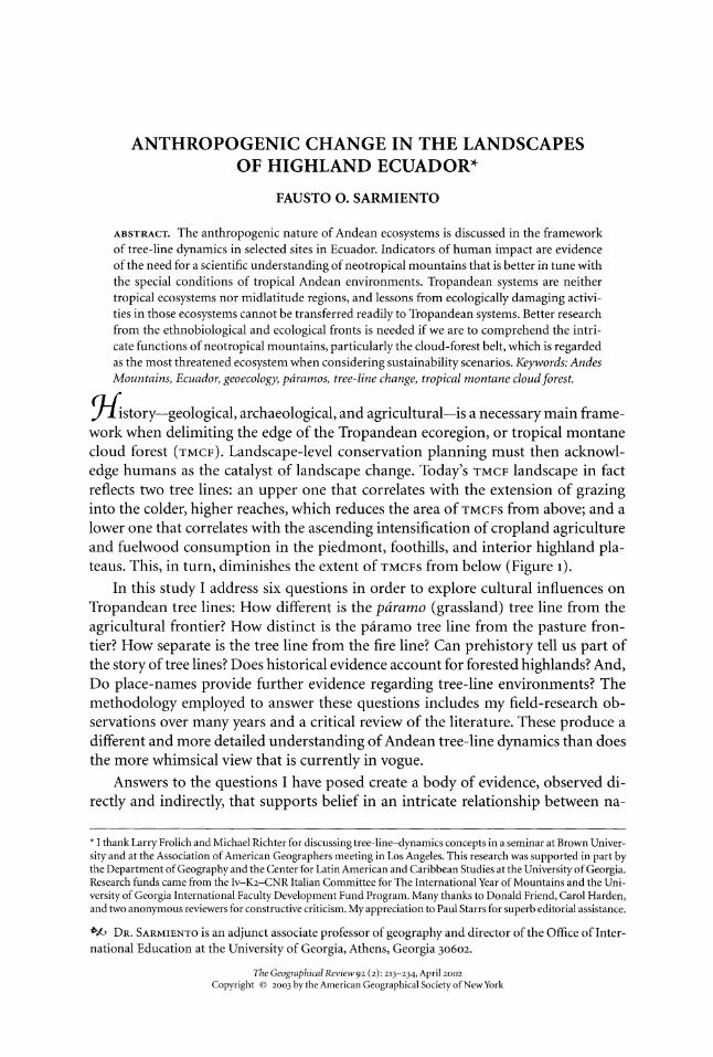
fstory--geological, archaeological, and agricultural-is a necessary main frame- work when delimiting the edge of the Tropandean ecoregion, or tropical montane cloud forest (TMCF). Landscape-level conservation planning must then acknowl- edge humans as the catalyst of landscape change. Today's TMCF landscape in fact reflects two tree lines: an upper one that correlates with the extension of grazing into the colder, higher reaches, which reduces the area of TMCFS from above; and a lower one that correlates with the ascending intensification of cropland agriculture and fuelwood consumption in the piedmont, foothills, and interior highland pla- teaus. This, in turn, diminishes the extent of TMCFS from below (Figure 1).
In this study I address six questions in order to explore cultural influences on Tropandean tree lines: How different is the pdramo (grassland) tree line from the agricultural frontier? How distinct is the piramo tree line from the pasture fron- tier? How separate is the tree line from the fire line? Can prehistory tell us part of the story of tree lines? Does historical evidence account for forested highlands? And, Do place-names provide further evidence regarding tree-line environments? The methodology employed to answer these questions includes my field-research ob- servations over many years and a critical review of the literature. These produce a different and more detailed understanding of Andean tree-line dynamics than does the more whimsical view that is currently in vogue.
Answers to the questions I have posed create a body of evidence, observed di- rectly and indirectly, that supports belief in an intricate relationship between na-
* I thank Larry Frolich and Michael Richter for discussing tree-line-dynamics concepts in a seminar at Brown Univer- sity and at the Association of American Geographers meeting in Los Angeles. This research was supported in part by the Department of Geography and the Center for Latin American and Caribbean Studies at the University of Georgia. Research funds came from the Iv-K2-CNR Italian Committee for The International Year of Mountains and the Uni- versity of Georgia International Faculty Development Fund Program. Many thanks to Donald Friend, Carol Harden, and two anonymous reviewers for constructive criticism. My appreciation to Paul Starrs for superb editorial assistance.
f* DR. SARMIENTO is an adjunct associate professor of geography and director of the Office of Inter- national Education at the University of Georgia, Athens, Georgia 30602.
The Geographical Review 92 (2): 213-234, April 2002
Copyright ? 2003 by the American Geographical Society of NewYork
214 THE GEOGRAPHICAL REVIEW
ture and culture that has created today's landscape mosaic (Gade 1999). The an- swers also speak to the value of ethnoecology as an essential contributor to the current discourse about conservation-with-development. It is both possible and desirable to apply sound environmental-design principles to support sustainable mountain societies amid human-driven change in the Tropandean ecoregion.
CONTEXT
Theory about mountain matters has been summarized in a state-of-the-knowledge compendium (Messerli and Ives 1997). Its final chapter addresses the need for a new science of mountain studies, dubbed with the neologism "montology" which some mountain geographers have echoed (Soffer 1982; Ives, Messerli, and Rhoades 1997; Smethurst 2000). Within this field of study, neotropical montology needs to be redefined in light of new paradigms for tropical mountains (Zimmerer 1999; Sar- miento 2000ooa, 2002). As one of the specifics, to paraphrase Narpat Singh Jodha, deconstruction of the "tree-line theory" helps redefine the new narrative for neo- tropical montology (Jodha 1990; Zimmerer 2002).
Traditional mountain-ecology literature is based primarily on geoecological characteristics that divide mountain systems into four altitudinally defined biogeo- graphical provinces in the mountain biome or orobiome: "colline" areas of rolling hills in low-lying foothills that harbor tall, continuous forest cover; "montane" ar- eas of gentle slopes and flanks of the cordilleras that are covered with stands of robust forest; "alpine" areas of highland plateaus and higher, steeper slopes with grassland vegetation; and "glacial" areas covered by snow or permanent ice and glaciers (Walter and Box 1976; Price 1981; Stadmuiller 1987; Gerrard 199o; Poore 1992; Mountain Agenda 1997). This traditional classification closely reflected the thermally driven approach that divided tropical mountains into hot, warm, cold, and gelid lands, a four-part hierarchy derived from 200-year-old Humboldtian science (Troll 1968).
In the spatial arrangement of the vertical model, scholars perceived the exist- ence of invisible lines separating those layers or physical strata (Landolt 1983). Al- though the snow line can be readily separated as a boundary dividing the alpine and glacial provinces, lower boundaries are far less easily discerned. No set limit separates the colline portions of the foothills from the even lower flatlands of the piedmont, where tall trees emerge from the canopy of the lowland tropical rain forests and no slopes are steeper than to percent. The boundary between the mon- tane and colline provinces is traditionally marked by shorter trees and an abrupt increase in slope, to between 20 and 40 percent (Meybeck, Green, and V6rbsmarty 2001). In humid regions the most common boundary, the tree line, distinguishes forests (montane) from grasslands (alpine). Synonyms often equate grasslands with tundra, prairie, or meadow: The taxonomy is anything but precise. Alpine mead- ows are generically defined as areas that lack forest cover in the high environment. However, high mountains with tall forests, such as those in the Equatorial Andes, fail to fit this model. To clarify this biogeographical gap in neotropical montology, Misael Acosta-Solis called for replacement of "alpine" with "Andean," to indicate
ANTHROPOGENIC CHANGE IN HIGHLAND ECUADOR 215
FIG. 1-Sabanization of Andean forests is visible, as pasture replaces montane forest in the Play6n de San Francisco, 3,200 meters above sea level, in Ecuador's Carchi Province. Note the fragmentation of forests in shreds instead of a checkerboard pattern along brooks and property boundaries. The same process in the higher reaches of the watershed is known as "paramization." (Photograph by the author, May 1991)
that this feature does not exist in the European Alps but does in the American Andes (1984). Michael Richter discusses the need to revise the terminology of altitudinal belts to include the special characteristics of neotropical mountains (Richter 2002).
The concepts dear to alpine tree-line studies belong to physical geography, me- teorology, forestry, and ecology. They emphasize climatic and edaphic factors that influence forest growth, tacitly limiting forestry production in northern latitudes. Modern ecological literature often refers to the altitudinal forest border as the "tree line" and to the latitudinal ecotone as the "timberline" (K6rner 1998). In the Trop- ics, harsh environmental conditions are viewed as the limiting factor for tree growth above a given altitude, mostly correlated with the threshold of the looC mean July isotherm, or the location of the frost line (Stadel 1992; K16tzli 1997; K6rner 1999). This is analogous to tropical-to-polar plant distribution, a traditional argument (Troll 1973; Lauer 1981).
The tree line occurs at a lower altitude in northern latitudes and on north-fac- ing slopes than in tropical mountains (Ives 1978). In addition, throughout the late Quaternary a variety of local factors, such as snowfall, wind velocity, soil condi- tions, aspect, exposure, and slope, affected tree-growth physiology and the altitude at which the alpine zone was encountered (Wright 1983). A subalpine transitional
216 THE GEOGRAPHICAL REVIEW
zone characterized by increasingly stunted and dwarfed trees is the norm in cir- cumpolar and northern Temperate Zone mountains (Halloy 1989; Kullman 1998). Vertical zonation is depicted when altitudinal belts are mentioned as specific com-
TROPANDEAN
Transandean Interandean Cisandean
\ Esmeraldas
Pi inii
SNacpxi ! wwm m
-
P X1
Salf i Cbim ahu
-0 -- - Pastaza e
/
•~~" la
t...
iinbu. '. •
7 South
/
'I, 9I
? lr
? e
Los io f -.ayr -
V
e Ch>5 100 10
cc
I Viu~
. mII >23000m
0 >r 4>000 m
Snow-capped volcanoes
80" '79a 78" 977 76"
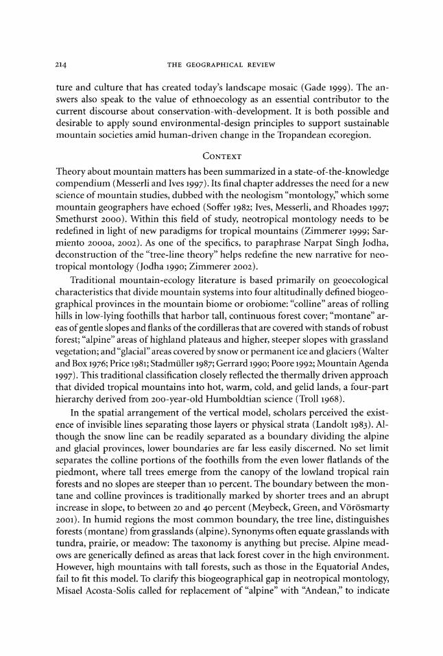
FIG. 2-The Equatorial Andes, showing the Tropandean ecoregion with the differ- ent domains and the study sites in continental Ecuador. Source: Modified from Jorgensen and Ulloa 1994.
ponents of temperate mountains (Whittaker 1952). Therefore, in extratropical moun- tains a combination of elevation, latitude, and local climate defines where the forest -alpine border occurs.
In the Tropical Andes evidence for human imprint on control over the altitudi- nal tree line is substantial. Despite the false notion of the "unspoiled" state of mon- tane forests in the Transandean domain, or the seemingly prevalent "naturalness"
ANTHROPOGENIC CHANGE IN HIGHLAND ECUADOR 217
of the verdant Cisandean domain, or the apparent irreversibility of the degraded Interandean domain, or the suggested restoration practices for returning healthy forested ecosystems to the Andes, the human imprint is barely seen as an important driver of the presence of forest and its limits (Sarmiento 1995a, 1998; Chepstow- Lusty and others 1998; Harden 1999). Moreover, the notion of a human-induced tree line is not prevalent in traditional bibliographical sources, making many schol- ars regard the high Andean piramos as still-natural primary ecosystems and per- petuating stereotypical opinions that some indigenous management techniques, such as fire, are detrimental to the so-called pristine pairamo (Hofstede and others 1998; Wille and others 2002).
The vegetation of highland Ecuador, known as the Interandean domain of the
Tropandean ecoregion (Figure 2), is so highly modified that a major geobotanical classification called it "anthropic" vegetation (Acosta-Solis 1984). People live-and have lived for millennia-in the high mountains of the Neotropics, whereas they do not live-and never have lived (with the exception of the Sami in Fennoscandia)-in high-latitude, northern mountain areas (Budowski 1968; Ellenberg 1979). These are manifestations of the responses of the long-standing human impact on tree bor- derlines in the history of the mountainous landscape of tropical America (Sarmiento and Frolich 2002).
Controversy over the origin of highland grasslands in forested mountains re- mains (Mark 1958; Luteyn 1999). The southern Appalachian Mountains in temper- ate North America harbor grassy areas locally known as "balds" or openings in the otherwise continuous forest canopy. The history of balds can be traced to Pleis- tocene megafauna (Weigl and Knowles 1995). The action of humans, however, came to encroach on balds during the Holocene.
The long-term human presence in the mountainous Neotropics, especially Inter- andean Ecuador, may have created different determining factors for tropical tree- line dynamics (Stern 1983). Human-set fire, agricultural clearing, high-pasture grazing, and trade routes through the mountains may be far more important than climate or megafauna in establishing and maintaining tropical alpine zones, par- ticularly grasslands (Ellenberg 1958). Tree-growth capacity based on the physiology of arboreal species in the TMCF is little known: The presence of tall guandera (Clusia spp.), colca (Miconia spp.), quishuar (Buddleia spp.), palma (Ceroxylum spp.), sene- cio (Gynoxis spp.), and yagual (Polylepis spp.) trees at high elevations in remote coves of isolated ranges in the Equatorial Andes may be evidence of a formerly robust climax forest formation rather than oddities of tropical Andean ecotones (Rundel, Smith, and Meinzer 1994). Conversely, the presence of pajonales (grass balds: Calamagrostis spp., Festuca spp., Cortadeira spp., Stipa spp.) and chaparral (heath balds: Hypericum spp., Rubus spp., Bacharis spp.) in the highland plateaus and areas formerly cultivated or grazed may indicate previous human impact.
The principle that temperate tree lines are based on altitude alone may have little or no validity in the Tropical Andes, where the presence of remnant patches of mature Andean forest above the piramo areas and the contemporary plantation
218 THE GEOGRAPHICAL REVIEW
forestry of Pinus radiata and Eucalyptus globulus demonstrate the potential for vi- able tree growth in the highlands. Remnant fragments can be seen as shreds of the once-continuous matrix of Andean forests. In some Ecuadorian mountains a stunted, dwarfed subalpine zone is indeed encountered, such as on the summit of the Sumaco volcano; perhaps more common is an abrupt tree line characterized by full-grown, tall, primary forest bordering the treeless alpine grasslands with a straight-line divi- sion. In essence, the alpine tree line often differs little from forest borders with agri- cultural lands where recent clear-cutting is a known fact. According to Simon Laegaard, in northern Ecuador "the forest patches border directly on grass p-iramo vegetation and the forest line [that is, tree line] is nearly always sharply cut" (1992, 154). More- over, no vernacular names for "pairamo" or "elfin forest" exist in Ecuador.
STUDY AREA AND METHODOLOGY
Ecuador, in northwestern South America, is often considered part of the ecologi- cally based Northern Andes region; cultural geographers and landscape ecologists include it as part of the ethnobiologically based Central Andes region (Figure 2). Typically, seasonality of rainfall creates dramatic changes in water availability in the lower and middle mountains, but the higher mountains have a permanent high water table, saturated and waterlogged soils, and trees covered with mosses ("mossy forests"), where fog, fog drip, and clouds add significantly to the humidity of the Tropandean landscape. Because influences from trade winds can alter patterns of prevailing clouds and species presence and/or absence, I chose thirteen sites as case studies to test a new paradigm for Andean tree lines, "anthropogenic forcing." The sites were: toward the Amazon Basin, in the Play6n de San Francisco in Carchi Prov- ince, the Cumandi Ethnobotanical Reserve in Napo Province, and the San Francisco Field Research Station in southern Zamora Province; in the Interandean domain, in the Guandera Research Station in Carchi Province, the Guamani piramo in Antisana Reserve, the flats of Limpiopungu in Cotopaxi National Park, the brook of Sacha Wayku on Mount Cariwairazu, the Alao area in Sangay National Park in Chimburazu Province, and the Llaviucu area in Azuay Province; and on the western flank of the Andes, in the Maquipucuna Reserve in the Upper Guayllabamba River Basin, the flats of Chaupi on Mount Chimburazu, the piramos of Salinas in Bolivar Province, and the Paredones archaeological site in the Mullituru region of Azuay Province.
Data collected are my observations of contemporary land uses and vegetation type and cover, as well as historical and prehistoric land uses reported in the scien- tific literature. In most cases, the idea of prime pristine mountain environments has been utilized as a justification for conservation efforts; however, much closer analy- ses reflect an important underlying presence of "man-aged" systems.
How DIFFERENT IS THE PARAMO TREE LINE FROM THE
AGRICULTURAL FRONTIER?
Subsistence crop production is common in highland Ecuador, as are heavily subsi- dized plantations of potato, wheat, barley, and corn. Long-enduring terracing, strip
ANTHROPOGENIC CHANGE IN HIGHLAND ECUADOR 219
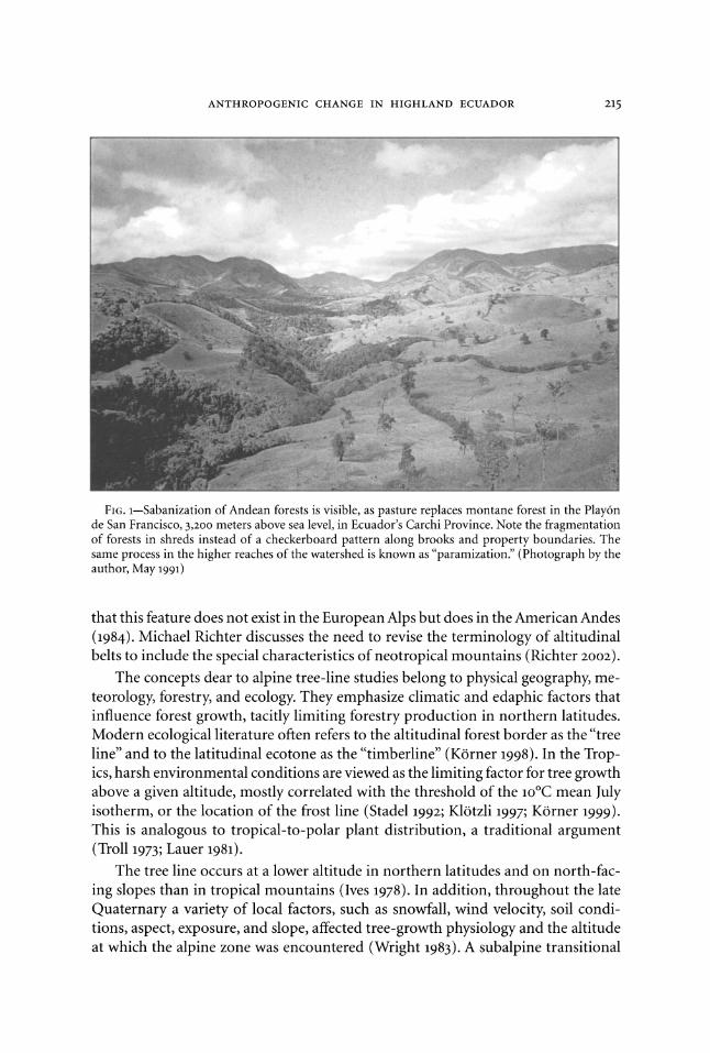
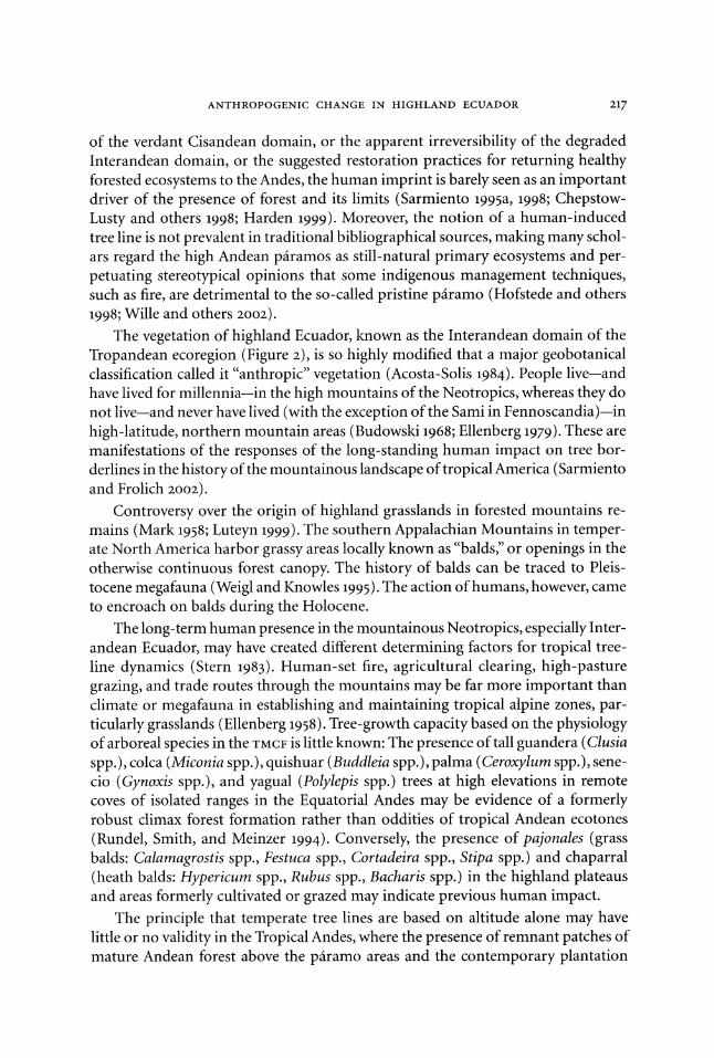
FIG. 3-Signs of landscape change in the Interandean forest of Imbabura Province, Ecuador. Note the tree lines, which isolate the cloud forest as a sandwiched belt between the grasslands from above (grass pairamo) and from below (kikuyu grass), with eucalyptus plantations in the foreground. Also note the evidence of prior fires on the denuded slopes of Cotacachi volcano, 4,939 meters above sea level. (Photograph by Cesar Cotacachi, June 2001)
contour cultivation, alley cropping, and other techniques are also employed in the Interandean region. As Larry Frolich and Esmeralda Guevara point out, the agri- cultural frontier in the northern province of Carchi is always pushing the lower limits of the tree line upward because of the need for fresh, fertile volcanic soils for improved potato yields in an ever-hungry external market (1999). A similar process is described in the pairamos of Cotopaxi, which have been transformed into Pinus plantations and other highland cropping (Sarmiento 1988). It is not uncommon in Carchi to find a great diversity of crops, including cultivation of heirloom potatoes on steep slopes. Worldwide, recent technoagricultural practices may have affected cloud forest-tree-line dynamics more than any other single factor. Although potato monoculture is the cash crop that fuels the economy of the study areas, the high price of fertilizers prevents campesinos from continually using their patches of land and makes it less expensive for them to go farther upslope or farther into the head- waters in search of profitable yields (Figure 3). As higher and steeper hillsides are cleared, erosion can become severe, the water table drops, and degradation of the watershed becomes unavoidable, setting up an unsustainable cycle of farmers clear- ing new land rather than tending depleted acreage and forcing the agricultural fron- tier to ever-higher reaches.
220 THE GEOGRAPHICAL REVIEW
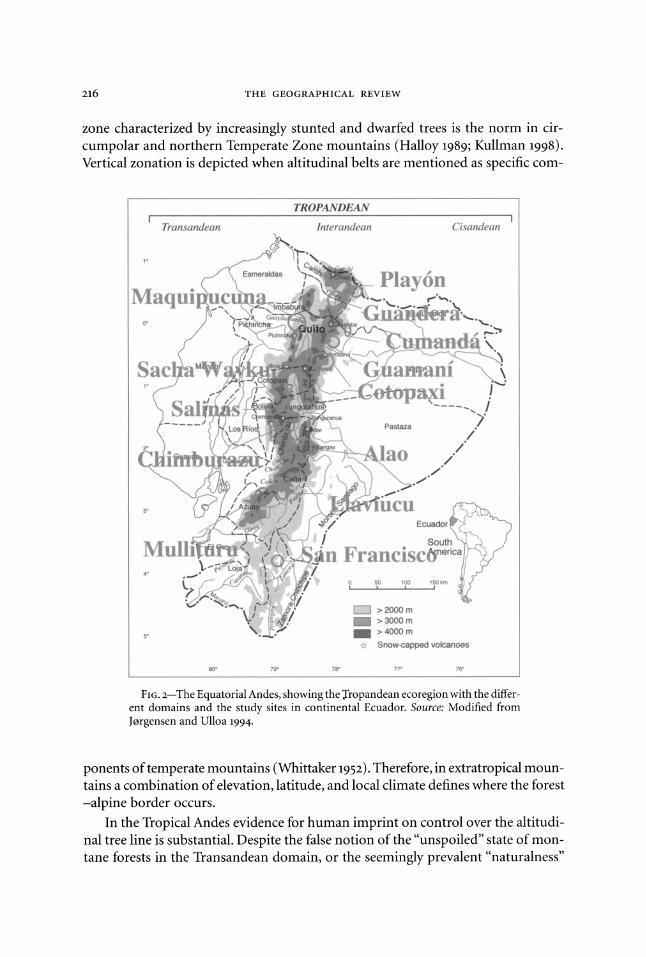
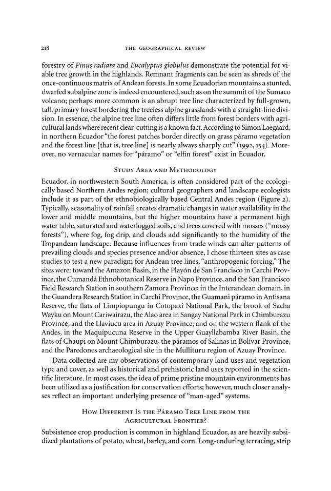
FIG. 4-Pasture grazed by cattle in the Sacha Wayku forests, 4,500 meters above sea level near Mount Cariwairazu, in central Ecuador. Note the definite boundary between the Polilepys stand and the grasses, both above and below the incline. (Photograph by Jennifer Osha, June 2000)
In time, soil nutrients on farm sites become exhausted, and potatoes develop nematode infestations and other pests that push farmers to increase their use of pesticides, herbicides, artificial fertilizers, and manure. Uncertainty of land tenure and unclear colonization rules in the study areas make intensification of agricul- tural production the driving force to claim new lands from the forests (Frolich and others 1999). Little of the production is subsistence oriented; the bulk of the harvest is transported and sold in the cities of Tulcin, Ibarra, Quito, Riobamba, and Cuenca. Over the last forty years, smallholder potato production based on monocropping and chemical-intensive technologies, mechanized tillage, synthetic fertilizers, and pesticides quickly supplanted traditional farming throughout the Ecuadorian Andes. As a result, areas under traditional cultivation and labor-intensive production have grown dramatically. Osvaldo Barsky showed that, between 1954 and 1974, potato production in Ecuador increased by 40 percent and worker productivity by 33 per- cent (1984). Charles Crissman and others argue that this trend has continued in Carchi Province, where yields rose from about 0.5 tons per hectare in 1974 to about 21 tons per hectare in 1997-three times the national average (1998). As a result, the value of Carchi farmland has skyrocketed. Crissman and others also note that the
ANTHROPOGENIC CHANGE IN HIGHLAND ECUADOR 221
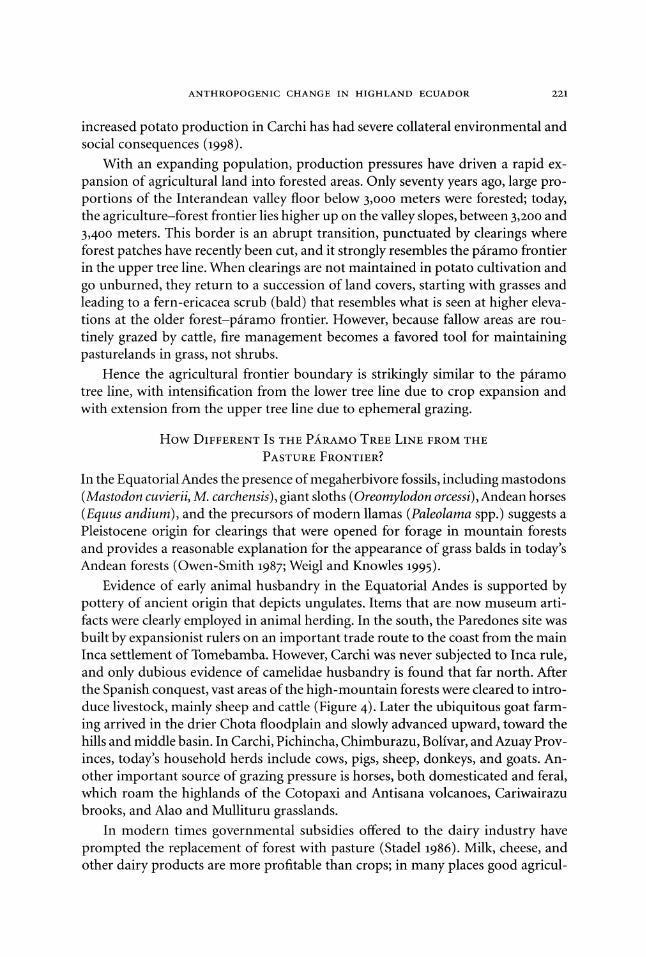
increased potato production in Carchi has had severe collateral environmental and social consequences (1998).
With an expanding population, production pressures have driven a rapid ex- pansion of agricultural land into forested areas. Only seventy years ago, large pro- portions of the Interandean valley floor below 3,000 meters were forested; today, the agriculture-forest frontier lies higher up on the valley slopes, between 3,200 and 3,400 meters. This border is an abrupt transition, punctuated by clearings where forest patches have recently been cut, and it strongly resembles the piramo frontier in the upper tree line. When clearings are not maintained in potato cultivation and go unburned, they return to a succession of land covers, starting with grasses and leading to a fern-ericacea scrub (bald) that resembles what is seen at higher eleva- tions at the older forest-piramo frontier. However, because fallow areas are rou- tinely grazed by cattle, fire management becomes a favored tool for maintaining pasturelands in grass, not shrubs.
Hence the agricultural frontier boundary is strikingly similar to the piramo tree line, with intensification from the lower tree line due to crop expansion and with extension from the upper tree line due to ephemeral grazing.
How DIFFERENT IS THE PARAMO TREE LINE FROM THE
PASTURE FRONTIER?
In the Equatorial Andes the presence of megaherbivore fossils, including mastodons (Mastodon cuvierii, M. carchensis), giant sloths (Oreomylodon orcessi), Andean horses (Equus andium), and the precursors of modern llamas (Paleolama spp.) suggests a Pleistocene origin for clearings that were opened for forage in mountain forests and provides a reasonable explanation for the appearance of grass balds in today's Andean forests (Owen-Smith 1987; Weigl and Knowles 1995).
Evidence of early animal husbandry in the Equatorial Andes is supported by pottery of ancient origin that depicts ungulates. Items that are now museum arti- facts were clearly employed in animal herding. In the south, the Paredones site was built by expansionist rulers on an important trade route to the coast from the main Inca settlement of Tomebamba. However, Carchi was never subjected to Inca rule, and only dubious evidence of camelidae husbandry is found that far north. After the Spanish conquest, vast areas of the high-mountain forests were cleared to intro- duce livestock, mainly sheep and cattle (Figure 4). Later the ubiquitous goat farm- ing arrived in the drier Chota floodplain and slowly advanced upward, toward the hills and middle basin. In Carchi, Pichincha, Chimburazu, Bolivar, and Azuay Prov- inces, today's household herds include cows, pigs, sheep, donkeys, and goats. An- other important source of grazing pressure is horses, both domesticated and feral, which roam the highlands of the Cotopaxi and Antisana volcanoes, Cariwairazu brooks, and Alao and Mullituru grasslands.
In modern times governmental subsidies offered to the dairy industry have prompted the replacement of forest with pasture (Stadel 1986). Milk, cheese, and other dairy products are more profitable than crops; in many places good agricul-

222 THE GEOGRAPHICAL REVIEW
tural soils have been converted to pasture using introduced African kikuyu grass (Panicetum clandestinum). Other "improved" species are also planted for grazing purposes. In the Maquipucuna Reserve the aggressive pasto miel grass (Setaria sphacelata) has taken hold of deforested slopes in the montane landscape (Sarmiento 1997b). Beef-cattle grazing is now the main activity for large landholders on the Interandean valley floor. Most farming families in this area are involved in cattle ranching, either for subsistence milk intake or as a source of revenue to invest in sugarcane production. On many occasions during the dry season, large cattle herds are left to graze on the monte (secondary growth) in cloud-forest patches. Even within the boundaries of national parks (Cotopaxi, Antisana, Las Cajas, Sangay), however, most grazing takes place in the pastures of the higher reaches. Grazing lands may be burned at any time of the year, but set fires are especially common in the dry season. Elsewhere in highland Ecuador, smoke and fire regimes have prompted a species com- position favoring ground bromeliads, grasses, and many serotonous plants that re- semble the pyrophytic species composition of the pairamo. Large herds of cattle were common before the 196o0s in the pairamos of Yuracruz and Mariano Acosta and in Buenos Aires in the north. Some of these cattle escaped and became feral. Feral bulls from the p iramos of Mount Cayambe, for instance, were utilized for bullfighting in nearby towns for Andean festivals. In Carchi Province, highland cattle ranching was prominent along the mountain passes wherever a dirt road facilitated transportation of dairy products to markets.
The pasture frontier is an effective line separating grassland from forest; it is equivalent to the pairamo tree line. Planted kikuyu grass identifies the lower tree- line boundary, and natural tussock grasses identify the higher tree-line boundary.
How DIFFERENT IS THE TREE LINE FROM THE FIRE LINE?
The colonial practice of burning forest margins for charcoal making is still in use by carboneros, who sell their loads to mountain households and also peddle their wares in the markets of nearby towns and cities. On-site production of charcoal in kilns has left a permanent record in the structure and chemical composition of the soil, preventing recolonization of the cleared, usually round, kiln site by forest species. I argue that burning intensively in order to produce charcoal kills all of the mycor- rhizal components of the soil that are needed to jump start succession, creating a crust of burned soil that is unsuitable for the establishment of seeds from forest species. In fact, most tropical seeds are recalcitrant and will not survive for long in this inhospitable environment, remaining viable for only a few days.
It has been argued that ecological succession has not operated at kiln sites and in most of the Interandean domain because of an arrested phase due to the con- tinuing burning regime favoring graminoids and serotonic shrubs (Grubb 1970; Sarmiento 1997a). Burning the grasses promotes an invigorated growth of tussocks, which makes the root mats stronger (Hofstede 200oo1). This supports the notion among campesinos that "after burning, a better pastureland will soon be available for the herds." In their view, burning is the simplest method of pruning and mowing.
ANTHROPOGENIC CHANGE IN HIGHLAND ECUADOR 223
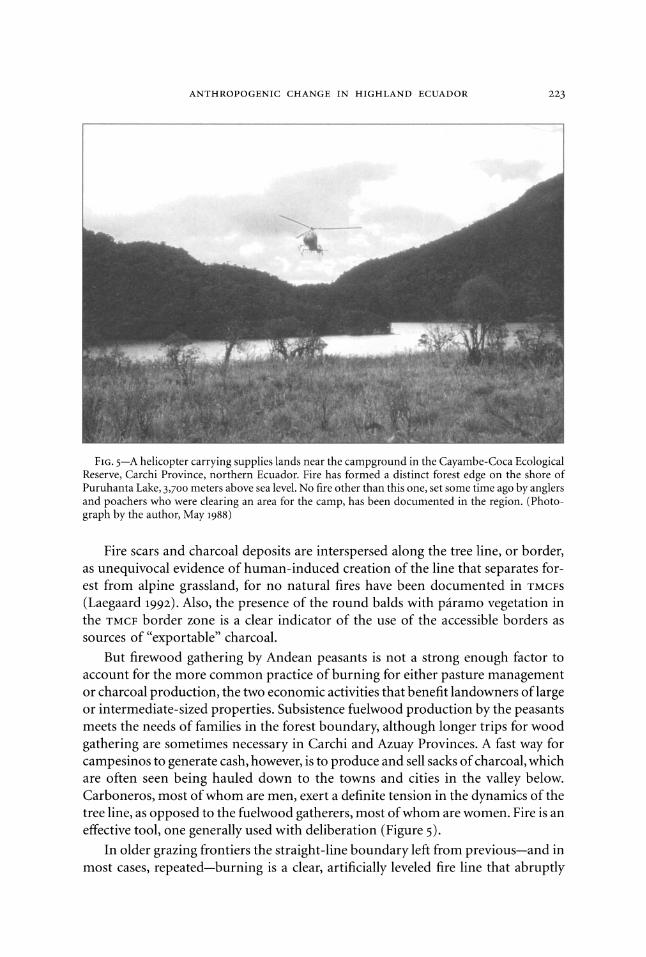
FIG. 5-A helicopter carrying supplies lands near the campground in the Cayambe-Coca Ecological Reserve, Carchi Province, northern Ecuador. Fire has formed a distinct forest edge on the shore of Puruhanta Lake, 3,700 meters above sea level. No fire other than this one, set some time ago by anglers and poachers who were clearing an area for the camp, has been documented in the region. (Photo- graph by the author, May 1988)
Fire scars and charcoal deposits are interspersed along the tree line, or border, as unequivocal evidence of human-induced creation of the line that separates for- est from alpine grassland, for no natural fires have been documented in TMCFS (Laegaard 1992). Also, the presence of the round balds with piramo vegetation in the TMCF border zone is a clear indicator of the use of the accessible borders as sources of "exportable" charcoal.
But firewood gathering by Andean peasants is not a strong enough factor to account for the more common practice of burning for either pasture management or charcoal production, the two economic activities that benefit landowners of large or intermediate-sized properties. Subsistence fuelwood production by the peasants meets the needs of families in the forest boundary, although longer trips for wood gathering are sometimes necessary in Carchi and Azuay Provinces. A fast way for campesinos to generate cash, however, is to produce and sell sacks of charcoal, which are often seen being hauled down to the towns and cities in the valley below. Carboneros, most of whom are men, exert a definite tension in the dynamics of the tree line, as opposed to the fuelwood gatherers, most of whom are women. Fire is an effective tool, one generally used with deliberation (Figure 5).
In older grazing frontiers the straight-line boundary left from previous-and in most cases, repeated--burning is a clear, artificially leveled fire line that abruptly
224 THE GEOGRAPHICAL REVIEW
separates forest and pasture. Karsten Wesche, Georg Miehe, and Meinhard Kaeppeli describe similar scenarios for Afro-alpine vegetation (2000). Laegaard also points out direct evidence of burning-fire scars, burned tissue, charcoal residue, defolia- tion by burning, removal of dry matter from poles and stems of pairamo shrubs and trees-that can easily be recognized along the rectilinear border (1992).
The Ecuadorian study areas offer clear indications that the tree line is a fire line. When fires encroach on the edge from the lower tree line, there is always a risk associated with wind that could cause crown fires; fires that encroach from the up- per tree line are most often surface burning connected with dry tussocks.
PALEOECOLOGICAL DATA AND BIOGEOGRAPHICAL EVIDENCE FOR
TREE-LINE CHANGE
Paleobiogeography in the Tropics is understudied relative to northern countries,
primarily due to scarce resources and the lack of strong scientific and governmental infrastructure for pursuing such studies. Detailed geological maps, based on de-
tailed pollen and soil analyses of the kind frequently available in the United States, are unavailable for most of the Tropics, particularly in the mountains. Limited data are thus interpreted on the basis of corollaries with temperate-climate studies. The
prevalent view of montane-alpine tree-line dynamics is that, along with glacial re- cession, the tree line is progressively advancing to higher altitudes (Van der Hammen and others 1981). However, the detailed tropical analyses that do exist-for example, for El Junco in the Galapagos Islands (Colinvaux 1972), the Sabana de Bogotai (Van der Hammen and others 1981), the lakes of Cajas in Ecuador (Colinvaux and others 1997), a crater floor in Panama (Bush and others 1992), a small lake in Costa Rica
(Clement and Horn 2001), and a bog near Cuzco in Peru (Chepstow-Lusty and others 1998)-reveal a complex situation, thus implicitly arguing that both method-
ologies and paradigms merit revisiting in the light of new narratives.
Although paleoecological studies have not been undertaken in my study areas, locations in Imbabura and Azuay Provinces-Yaguarkucha Lake (Colinvaux and oth- ers 1988) and Llaviucu Lake (Colinvaux and others 1997)-have been analyzed. These show a rearrangement of the cold-tolerant species, instead of a vertical shifting of the tree line with glacial cooling. Furthermore, in comparable neotropical mountains there is evidence that introduced multiuse trees accompanied human population forays into high altitudes. Examples of this are oak (Quercus spp.) in Costa Rica and alder (Alnus acuminata) in Peru and Mesoamerica (Chepstow-Lusty and others 1996; Kappelle 1996). The paleoecology of the now seemingly pristine forests of the Charral Mountains in southern Costa Rica reflects agricultural uses that ceased after the 1500s but began again in the 1950s (Clement and Horn 2001). The same seems to be true for
the mountainous area of the Mixteca Alta in southern Mexico and throughout Belize
(Spores 1969; Campbell 2002). On both sides of the Andean cordillera, findings of abundant pottery pieces and other archaeological artifacts in what seems to be pris- tine montane forest support the intriguing notion of a prior, heavily human-driven
Tropandean landscape in Ecuador. New geographical inquiries in the agricultural
ANTHROPOGENIC CHANGE IN HIGHLAND ECUADOR 225
landscapes of the Andes are helping to reaffirm the framework for the anthropogenic nature of the Andean tree line (Denevan 2001).
Overall, palynology is constrained by the difficulty of finding species-specific pollen markers for some families that may have both shrubs and tree forms. The
presence of alder trees (Alnus spp.) is a clear discriminator, but other trees (Melasto- mataceae, Rubiaceae, Asteraceae) are identifiable only at the family level, which could include both tree and shrub forms, such as the prominent colca tree and the cafetillos shrubs, both of which are melastomes. This makes it difficult to be specific about tree-line dynamics and forces palynologists to generalize comparisons at the gross level of "forest" versus "prairie." Based on cores from the Andes and the Amazon, Paul Colinvaux and others concluded that "Andean vegetation did not respond to
glacial cooling or Holocene warming by movement in belts" (1997, 77). By refuting the postulated steepening of temperature gradients in glacial times driven by high dry-air lapse rates in the Tropics and the postulated compression of Andean veg- etation zones in a shifting tree line (Van der Hammen and others 1981; Haffer 1990), Colinvaux's team proposed a new interpretation: "Vegetation did not move up and down slope as belts. Rather, plant associations were reformed as temperature-sen- sitive species found different centers of distribution with changing temperature" (Colinvaux and others 1997, 69).
The presence of pairamo endemics such as Espeletia pycnophylla is still enig- matic, implying that vicariance plays an important role. The use of the caulirosula life-form as indicative of high pairamo is particularly relevant for the Northern Andes of Colombia and Venezuela, where several species of Espeletia exist (Hedberg and
Hedberg 1979). However, in the Equatorial Andes the presence of only one species in two distinct ranges-El Angel in the north and Llanganatis in central Ecuador- invites further explanation.
PRECOLONIAL HUMAN ACTIVITY IN THE HIGH MOUNTAINS
When the Spaniards came to the region they discovered a place already degraded and deforested by extensive agriculture (Denevan 1992; Mann 2002). Vestiges of
previous human intervention in the landscape discovered by the Europeans included abandoned cangahua (a hard tuffa, or paleosoil) pyramids, terraces, and irrigation channels. The area around Pimampiro, for instance, had been established as an
important commercial center for the exchange of goods from the coastal plain (such as Spondilus conchs) and from the Amazon region (tropical feathers). Evidence of human presence was also found around Cotopaxi, Sangay, and Chimburazu, par- ticularly in areas associated with mountain passes, such as the Quijos River Val-
ley in Napo Province, or Mullituru and Paredones in Azuay Province. The montane belt was an active and populated area, with known human settlements in cloud forests that today seem pristine, and pre-Colombian influence had already changed the original forested landscape (Molestina 1985).
The Mira watershed in Carchi Province was heavily populated in the Formative period and also in the Late Formative period by cultures such as the Capuli, Pastos,
226 THE GEOGRAPHICAL REVIEW
and Quillasingas. Their artifacts are now the only tools that relate to the ancient human occupation of the Mira-Chota watershed (Knapp 1991). Archaeological findings along the Upper Guayllabamba River, in the Quijos River Basin, and in
Cotopaxi, Sangay, and Las Cajas National Parks confirm the notion of ancient hu- man imprint.
Some highland areas are crisscrossed by ancient terracing systems and channels built on sloped terrain, bringing water toward the Interandean plateau. The scale of effort indicated by the archaeology of the Pimampiro Basin suggests that several tens of thousands people probably lived in the area (Mothes 1987). Physical evi- dence of the mountain road network survives in the Maquipucuna site and in Sacha
Wayku. More sophisticated construction of mountain roads can be found in Sangay, Cotopaxi, and Llaviucu. The more refined design of the Inca imperial road network can be found in the ruins of Paredones, in Azuay Province.
The strong effects of the commercial center in Pimampiro and its concomitant
connecting networks with trade routes to the south and north, as well as to the lower tropical plains of the Amazon (via Puruhanta lake) and to the coast (via Mira Canyon), made the Mira-Chota Basin an important cultural center in pre- Colombian times. The same situation may be inferred for Mullituru, which con- nected the western sites of the Huancavilca culture and the eastern sites of the Shwar culture with the Cafiari indigenous territory in the Interandean valley. The Quijos settlement in Cotundo and Baeza is estimated to have had at least 20,000 inhabitants. Satellite imagery has singled out the strategic locations of forts at sev- eral key points in the Interandean valley; however, further studies are needed be- fore we can determine the antiquity of other linear features (possible ditches with extra stonework) or raised fields and terraces in some parts of the watershed. Simi- lar archaeological evidence has been found in highland sites of Peru and Bolivia.
Gregory Knapp described fossil ridges and ditches in northern Ecuador but did not consider the impact of such structures on some sites, now under grass cover as piramo, in areas of the towns ofYuracruz, Sigsipamba, and Nueva America, or on those of the
pristine-looking watershed of Puruhanta Lake, now covered by forests (1991). The concept of megafauna as a driver for tree-line change has its best example
in Ecuador, where a mastodon skull with an encrusted obsidian arrowhead was discovered in Los Chillos Valley. Here, estimates for human intervention go back to 14,000 B.P. (Bonifaz 1972). So, precolonial human activity has definitely played an
important role in setting the boundaries of the forest.
CHANGES IN HIGH-ALTITUDE FORESTS IN COLONIAL TIMES
There is evidence of the extent of TMCFS within the Interandean basin during the colonial era. The construction of large colonial houses and churches in the cities of Ibarra, Tulcin, El Angel, Latacunga, Riobamba, Azogues, and Cuenca was accom-
plished with the use of local old-growth timber. The colonizers of the kingdom of Quito and its chiefdoms to the north (including those of the Mira-Chota water- shed) reportedly contained vast expanses of forest (Salomon 1986). Records kept at
ANTHROPOGENIC CHANGE IN HIGHLAND ECUADOR 227
the bishopric in Ibarra, for instance, attest to the wealth of forest products, in-
cluding caoba (Platymiscium pinnatum), canelo (Nectandra reticulata), nogal (Juglans neotropica), cedro (Cedrela montana), and aliso (Alnus acuminata), be-
ing exported from the Chota Valley and its surrounding hills (Vazquez-Fuller 1988). Today the Chota Valley lacks significant forest cover, and the surrounding hills are denuded.
In some locales, planted tree species survive because of care by the township or the owners of old haciendas. In Machachi, for instance, the Central Plaza offers a
good example of mature, tall native trees, including Podocarpus oleifolia. In sev- eral convents and haciendas the customary ramos palm (Ceroxylum andicola) can still be found, protected within their lands. Furthermore, as evidence of the Inca presence, on the private property tall palm trees (Parajubea cocoides), with no known wild relatives in Ecuadorian montane forests, survive well. In my own lifetime, the history of forest clearing in the Guamani Pass on Mount Antisana reflects the process of creating and maintaining the highland grass- lands, in what I have called "paramization" by an aggressive and effective cut-
ting and burning of the yaguales (Polylepis spp.) on flatter terrain. Sacha Wayku and Las Cajas contain good examples of mature Andean forests of yagual (Polylepis sericea, P. incana), which can serve as a proxy for altitudinal distribution of what was once a continual forest cover. The presence of these trees at record altitudes can be generalized over broader areas to suggest where trees would have been in areas that are now devoid of forest cover.
More recent human impacts can also be traced indirectly in lakes (Puruhanta, Llaviucu) that are surrounded by so-called pristine TMCFS. Over sixty years the fish fauna in these otherwise unspoiled lakes have been modified by attempts to develop rainbow-trout fisheries in highland Ecuador, especially in Imbabura and Azuay Prov- inces, the country's lake districts. Despite the false pristine surroundings, the area of Puruhanta (or Chique) was indeed altered during the 1950s, when the introduc- tion of exotic fishes (Onorhynchus mykiss, Salmo gairdnerii) into the lake resulted in the extinction of local native fauna of prefiadillas (Astroblepus spp.) and bagrecitos (Rhamdia spp.). Paramo tussock grasses appeared in ensuing decades where a camp- ground for fishermen was built and where the forest was cut and burned along the lakeshore (Figure 5). This patch is so localized that it is a clear manifestation of the human impact on a previously forested flat. Around Llaviucu Lake, despite the de-
ceptive primitivism of the surrounding landscape, evidence of fire regime, grazing, and deforestation abounds at both the higher and the lower tree lines. Even though the area is considered part of the old National Recreational Area of Las Cajas, now redefined as Las Cajas National Park, the effect of human presence on the lacustrine environment cannot be denied.
A BIRD SPECIES HINTS OF CULTURE
Field research on the ethology of the Andean lapwing (Charadriidae: Vanelus resplen- dens Tschudi 1840) led me to believe that biological processes in tropical moun-
228 THE GEOGRAPHICAL REVIEW
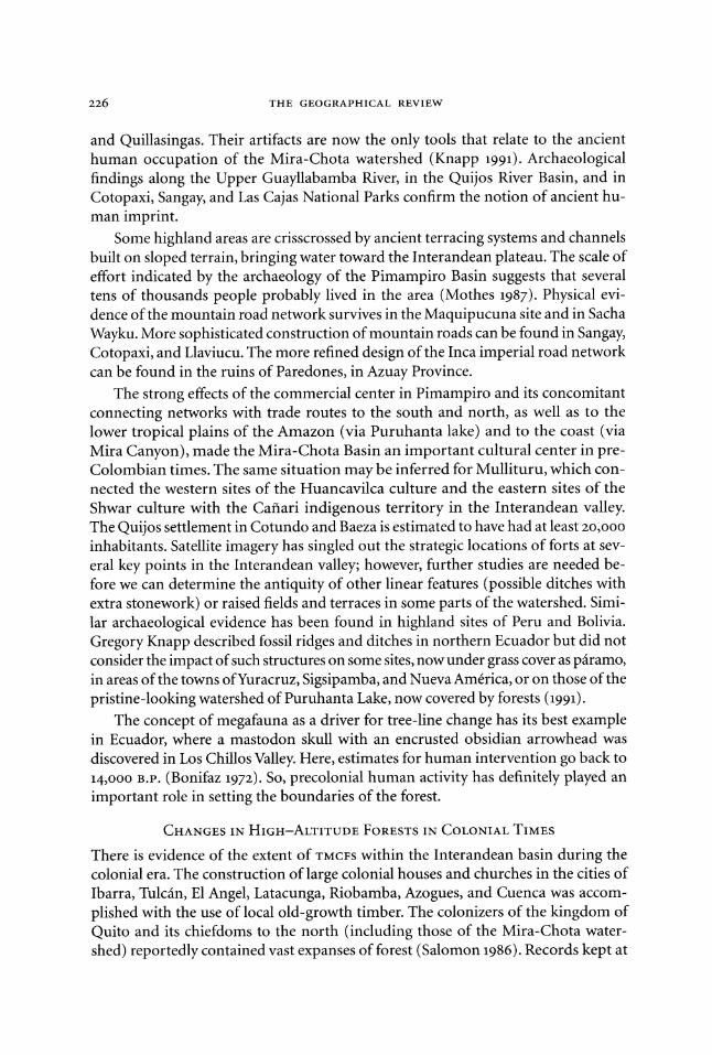
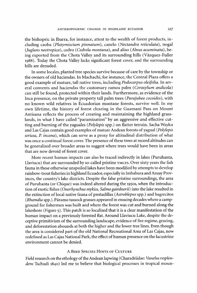
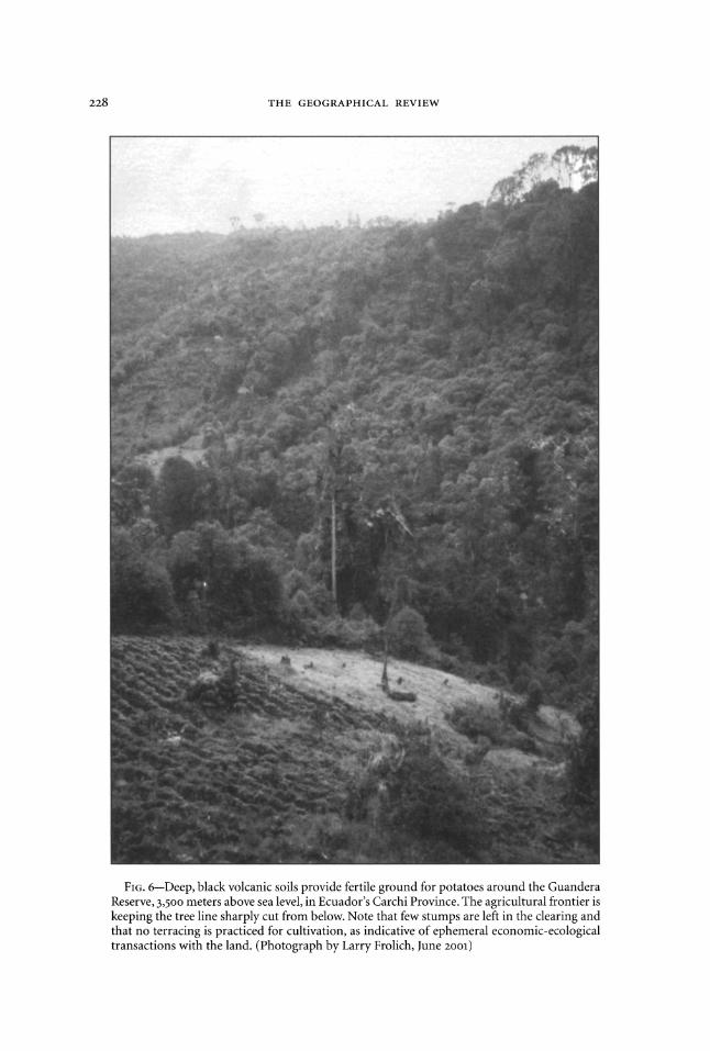
FIG. 6-Deep, black volcanic soils provide fertile ground for potatoes around the Guandera Reserve, 3,500 meters above sea level, in Ecuador's Carchi Province. The agricultural frontier is keeping the tree line sharply cut from below. Note that few stumps are left in the clearing and that no terracing is practiced for cultivation, as indicative of ephemeral economic-ecological transactions with the land. (Photograph by Larry Frolich, June 2001)
ANTHROPOGENIC CHANGE IN HIGHLAND ECUADOR 229
tains, such as habitat selection and reproductive behavior, are mainly a reflection of cultural interference in the so-called pristine or natural piramo. After three years of observation and experimentation, it was clear to me that this bird, considered a signature species associated with the pairamo's lacustrine environments, responded to the vagrant movement of cattle in their roaming about the piramo pastures (Sarmiento 1988). Feral and domesticated free-ranging cattle that have intruded into Cotopaxi National Park have generated a robust community of scarabs and other beetles-the main food source for Andean lapwings-in their scat. Because the flocks followed the dung sites distributed by the vagility of cattle, I later con- cluded that people, rather than nature, appear to have been responsible for the evolv- ing biogeography of the Andean lapwing.
Furthermore, this bird-once believed emblematic of the Andes-was also collected in the lowlands of Limoncocha in the Ecuadorian Amazon and in the piedmont at Chalpi toward the lowland coastal plains, presenting a paradox of biogeography, because neither site is in the mountains. The lapwing's presence in folk ethnobiology and its spiritual significance for the Kichwa and other indigenous groups, especially the Puruha around Cacha, presented a paradox in cultural geography, for neither group depicted this bird in its cosmology. Thus the enigmatic status of the Andean lapwing has questioned old notions of pairamo life and other principles of applied montology in the Neotropics.
A FOREIGN WORD HINTS OF CULTURE
I have argued elsewhere that the very name "Andes" is a proxy for the cultural na- ture of the mountains in South America (Sarmiento 2001b). Local inhabitants did not have a name for the mountain chain, only for individual peaks or specific hills named with the Kichwa suffix urcu. This condition remains rather common among mountain people. For instance, the Nepalese do not have a name for the cordillera of the Himalayas, only for special mountains, such as Sagarmatha; the Sami do not have a name for the Scandinavian Alps, only for certain mountains, such as Kiruna- vara; the Mapuche in southern Patagonia still do not use a name for the entire cordillera, only for special peaks.
So, unlike prevalent but mistaken notions about the etymology of Andes as re- ferring to the Inca territory of Antisuyo or to the copper mines of Anta, the name "Andes" refers to the main cultural attribute of the echelon-like structures, ter- races, or scaffoldings that are known in Spanish as andenerias, systems of andenes. These structures impressed the Spaniards, who wrote in Castellan shorthand (omit- ting the last syllable and changing the n to an s to make the word plural) to docu- ment their discoveries. In summary, "La Cordillera de los Andenes" lacking a proper name, became known in Europe for its main attributes-terraces and walkways on its steep slopes-as "La Cordillera de los Andes." The name "Andes" was shortened by the few people who could read then and became the name for the entire mountain chain. Thus the cultural nature of the neotropical mountains has been recognized since the first colonial contact.
230 THE GEOGRAPHICAL REVIEW
In addition, as I proposed above, the lack of a vernacular descriptor for the highland grasslands can be taken as evidence of the modernity of this landscape feature. The word "pairamo" is taken to refer to the meteorological condition of cloudiness and cold rain, or it may describe the state of being cold and wet, instead of the actual plant formation (Luteyn 1999). One version is that the Spanish word
pdramo has obscure origins in a paleo-Iberian language that described the rather desolated, windswept highlands of the northern massif in Spain. Others suggest that the Latin etymology can be traced to para moor, referring to a site adjacent to a wetland or to a swampy, grassy habitat.
Moreover, a descriptor for "elfin forest" is missing in the vernacular language. The use of the Kichwa word yunga or the Hispanicized yungilla is a reference to the warm, forested slopes of the eastern flank of the Andes. In the Carchi and Imbabura lexicon, however, is the word chaparro, borrowed from the Mexican Spanish for "of small stature" but mostly denoting a place for gathering fuelwood in the nearby forests (Sarmiento 200ooa).
HUMAN MONTOLOGY
The human-induced and human-driven dynamics of the Andean tree line in high- land Ecuador are documented here by both direct and indirect evidence. With cor- roboration to characterize two Andean tree lines instead of only one, which is traditional for mountains in temperate latitudes, the inclusion of human impact as the driver of Tropandean landscape change deserves increased recognition from mountain scholars.
The new discipline of montology merits an in-depth review. Its tenets have so far emphasized only temperate and northern latitudes. The efforts of Alexander von Humboldt and Carl Troll made tropical mountains known to the world of geogra- phers. In fact, Tropandean landscapes should be considered the birthplace of ecol- ogy, although the intricate patterns of Andean tree lines have not been conducive to inclusion of the human dimension (Sarmiento 1995b, 1997c, 1999; Sarmiento, Romero, and Messerli 1999). The anthropogenic nature of highland grasslands is important to the definition of needed potential management practices and conservation priorities for p iramos in Ecuador (Figure 6). The much-needed preservation and strict protec- tion of the remnant shreds of Andean forests should be considered a highest priority in scenarios for sustainable mountain development in the region. Precautionary mea- sures need to be included in the policymaking process that affects water-supply and watershed management for the ever-thirsty, growing Andean cities. The role of TMCFS as "water towers" can no longer be conceived only as an imaginative educational campaign; it must be a priority for national security and strategic long-term envi- ronmental planning. The old approach of protecting "pristine" piramos from hu- man interference, known as the "Yellowstone Model," should give way to the new approach of conserving living landscapes, known as the "Green Mountains Model."
Generalizations of yesteryear, especially about tropical mountains, should be avoided in light of the changing paradigms, modern technologies, and sophisti-
ANTHROPOGENIC CHANGE IN HIGHLAND ECUADOR 231
cated tools that are available to restore degraded mountains into healthy, forested ones (Myster and Sarmiento 1998; Zimmerer and Young 1998). Restoration of TMCFs is a priority if we are to halt the destruction of the mountain system and the con- tinuation of the sandwich-like scenario of the moving Andean tree lines (Sarmiento 1995c, 2000b). If the movement of agricultural and grazing frontiers can be stopped by reworking the degraded grassland sites instead of by opening up new, fresh for- est floors, a better prospect for mountain development is envisaged, securing soil fertility, water catchment, culture maintenance, food security, and biodiversity con- servation (Hamilton 1996). Let there be an organized effort to reforest the high- lands and to re-create the neotropical forests that once existed!
REFERENCES
Acosta-Solis, M. 1984. Los pdramos andinos del Ecuador. Quito: Publicaciones Cientificas, M.A.S. Barsky, 0. 1984. Acumulaci6n campesina en el Ecuador: Los productores de papa en el Carchi. Quito:
Facultad Latinoamericana de Ciencias Sociales, Sede Quito. Bonifaz, E. 1972. Cazadores prehist6ricos del Ilal6. Quito: Casa de la Cultura Ecuatoriana. Budowski, G. 1968. Mountains of Tropical America. In Symposium on the Geo-Ecology of the Moun-
tainous Regions of the Tropical Americas, edited by C. Troll, 157-161. Bonn: Dtimmler in Kommis- sion.
Bush, M. B., D. R. Piperno, P. A. Colinvaux, P. L. Krissek, P. E. De Oliveira, M. Miller, and W. Rowe. 1992. A 14,30oo-Year Paleoecological Profile of a Lowland Tropical Lake in Panama. Ecological Mono- graphs 62 (2): 251-275.
Campbell, D. 2002. Anthropogenic Landscapes in Mesoamerica. Guest lecture, University of Geor- gia, Botany Department. 15 March.
Chepstow-Lusty, A. J., K. D. Bennett, V. R. Switsur, and A. Kendall. 1996. 4000 Years of Human Im- pact and Vegetation Change in the Central Peruvian Andes--With Events Paralleling the Maya Record? Antiquity 70 (270): 824-833.
Chepstow-Lusty, A. J., K. D. Bennett, J. Fjeldsa, A. Kendall, W. Galiano, and A. Tupayachi-Herrera. 1998. Tracing 4000 Years of Environmental History in the Cuzco Area from the Pollen Record. Mountain Research and Development 18 (2): 159-172.
Clement, R. M., and S. P. Horn. 2ool. Pre-Columbian Land-Use History in Costa Rica: A 30ooo0-Year Record of Forest Clearing, Agriculture, and Fires from Laguna Zoncho. Holocene 11 (4): 419-426.
Colinvaux, P. A. 1972. Climate and the Galapagos Islands. Nature 240: 17-20. Colinvaux, P. A., K. Olson, and K.-B. Liu. 1988. Late-Glacial and Holocene Pollen Diagrams from
Two Endorheic Lakes of the Inter-Andean Plateau of Ecuador. Review of Paleobotany and Palynol- ogy 55: 83-99.
Colinvaux, P. A., M. B. Bush, M. Steinitz-Kannan, and M. C. Miller. 1997. Glacial and Postglacial Pollen Records from the Ecuadorian Andes and Amazon. Quaternary Research 48 (1): 69-78.
Crissman, C. C., P. A. Espinosa, C. E. H. Ducrot, D. C. Cole, and F. Carpio. 1998. The Case Study Site: Physical, Health, and Potato Farming Systems in Carchi Province. In Economic, Environmental, and Health Tradeoffs in Agriculture: Pesticides and the Sustainability ofAndean Potato Production, edited by C. C. Crissman, J. M. Antle, and S. M. Capalbo, 89-117. Dordrecht, Netherlands, and Boston: Kluwer Academic Publishers.
Denevan, W. M. 1992. The Pristine Myth: The Landscape of the Americas in 1492. Annals of the Asso- ciation of American Geographers 82 (3): 369-385.
. 2001. Cultivated Landscapes of Native Amazonia and the Andes: Triumph over the Soil. New York: Oxford University Press.
Ellenberg, H. 1958. Wald oder Steppe? Die nattirliche Pflanzendecke der Anden Perus. Umschau in Wissenschaft und Technik 21: 645-681.
-. 1979. Man's Influence on Tropical Mountain Ecosystems in South America. Journal of Ecol- ogy 67: 401-416.
Frolich, L. M., and E. Guevara. 1999. The Role of Family-Based Agricultural Innovation in Conserv- ing Tropical Montane Cloud Forests: The Guandera Project in Northern Ecuador. In Entendiendo
232 THE GEOGRAPHICAL REVIEW
las interfaces ecol6gicas para la gesti6n de paisajes culturales en los Andes, edited by F. O. Sarmiento and J. Hidalgo, 45-50. Quito: Corporaci6n Editora Nacional.
Frolich, L. M., S. Sherwood, A. Hemphill, and E. Guevara. 1999. "Eco-Papas": Through Potato Con- servation toward Agroecology. LEISA (Low External Input Sustainable Agriculture) 15 (3-4): 44-46.
Gade, D. W. 1999. Nature and Culture in the Andes. Madison: University of Wisconsin Press. Gerrard, J. 19go. Mountain Environments: An Examination of the Physical Geography of Mountains.
Cambridge, Mass.: MIT Press. Grubb, P. J. 1970. The Impact of Man on the Paramo of Cerro Antisana, Ecuador. Journal of Applied
Ecology 7 (2): 7-8. Haffer, J. 199o. Avian Species Richness in Tropical South America. Studies on Neotropical Fauna and
Environment 25 (3): 157-183. Halloy, S. 1989. Altitudinal Limits of Life in Subtropical Mountains: What Do We Know? Pacific Sci-
ence 43 (2): 170-184. Hamilton, L. S. 1996. The Role of Protected Areas in Sustainable Mountain Development. Parks 6 (1):
2-13. Harden, C. P. 1999. Conecciones sobre la tierra: Recomendaciones de manejo de un andlisis a scala
cuenca de la erosi6n del suelo en los Andes ecuatorianos. In Entendiendo las interfaces ecol6gicas para la gesti6n de paisajes culturales en los Andes, edited by E O. Sarmiento and J. Hidalgo, 45-50. Quito: Corporaci6n Editora Nacional.
Hedberg, I., and 0. Hedberg. 1979. Tropical-Alpine Life-Forms of Vascular Plants. Oikos 33: 297-307. Hofstede, R. G. M. 2001. El impacto de las actividades humanas sobre el paramo. In Los pdramos del
Ecuador: Particularidades, problemas y perspectivas, edited by P. A. Mena, G. Medina, and R. G. M. Hofstede, 161-185. Quito: Editorial Abya-Yala.
Hofstede, R. G. M., J. Lips, W. Jongsma, and Y. Sevink, eds. 1998. Geografia, ecologia yforestaci6n de la sierra alta del Ecuador: Revisi6n de literatura. Quito: Ediciones Abya-Yala.
Ives, J. D. 1978. Remarks on the Stability of Timberline. In Geoecological Relations between the South- ern Temperate Zone and the Tropical Mountains: Proceedings of the Symposium of the International Geographical Union, Committee on High-Altitude Geoecology, November 21-23, 1974 at Mainz, ed- ited by C. Troll and W. Lauer, 313-318. Wiesbaden, Germany: Steiner Verlag.
Ives, J. D., B. Messerli, and R. Rhoades. 1997. Agenda for Sustainable Mountain Development. In Mountains of the World: A Global Priority, edited by B. Messerli and J. D. Ives, 131-155. New York: Parthenon Publishing Group.
Jodha, N. S. 199o. Mountain Agriculture: The Search for Sustainability. Journal of Farming Systems Research Extension 1 (1): 55-75.
Jorgensen, P. M., and C. Ulloa U. 1994. Seed Plants of the High Andes of Ecuador: A Checklist. AAU Reports, 34. Risskov, Denmark: Aarhus University, Department of Systematic Botany; Quito: Pontificia Universidad Cat61lica del Ecuador, Departamento de Ciencias Biol6gicas.
Kappelle, M. 1996. Los bosques de roble (Quercus) de la cordillera de Talamanca, Costa Rica: Biodiver- sidad, ecologia, conservaci6n y desarrollo. Amsterdam: Universidad de Amsterdam, Laboratorio H. de Vries.
Kl6tzli, F. 1997. Biodiversity and Vegetation Belts in Tropical and Subtropical Mountains. In Moun- tains of the World: A Global Priority, edited by B. Messerli and J. D. Ives, 232-235. London: Parthenon Publishing Group.
Knapp, G. W. 1991. Andean Ecology: Adaptive Dynamics in Ecuador. Boulder, Colo.: Westview Press. Korner, C. 1998. A Re-Assessment of High Elevation Treeline Positions and Their Explanation.
Oecologia 115 (4): 445-459. -- . 1999. Alpine Plant Life: Functional Plant Ecology ofHigh Mountain Ecosystems. Berlin: Springer. Kullman, L. 1998. Tree-Limits and Montane Forests in the Swedish Scandes: Sensitivity Biomonitors
of Climate Change. Ambio 27 (4): 312-321. Laegaard, S. 1992. Influence of Fire in the Grass Pairamo Vegetation of Ecuador. In Pdramo: An Andean
Ecosystem under Human Influence, edited by H. Balslev and J. L. Luteyn, 151-170. London, En- gland, and San Diego, Calif.: Academic Press.
Landolt, E. 1983. Probleme der H6henstufen in den Alpen. Botanica Helvetica 93 (2): 255-268. Lauer, W. 1981. Ecoclimatological Conditions of the Piramo Belt in the Tropical High Mountains.
Mountain Research and Development 1 (2): 209-221. Luteyn, J. L. 1999. Pdramos: A Checklist of Plant Diversity, Geographical Distribution, and Botanical Lit-
erature. Memoirs of the New York Botanical Garden, 84. Bronx: New York Botanical Garden Press.
ANTHROPOGENIC CHANGE IN HIGHLAND ECUADOR 233
Mann, C. C. 2002. 1491. Atlantic Monthly, March, 41-54. Mark, A. F. 1958. The Ecology of the Southern Appalachian Grass Balds. Ecological Monographs 28
(4): 293-336. Messerli, B., and J. D. Ives, eds. 1997. Mountains of the World. A Global Priority. London: Parthenon
Publishing Group. Meybeck, M., P. Green, and C. Vri6smarty. 2001. A New Typology for Mountains and Other Relief
Classes: An Application to Global Continental Water Resources and Population Distribution. Mountain Research and Development 21 (1): 34-45.
Molestina, M. C. 1985. Investigaciones arqueol6gicas en la zona negativa del Carchi o Capuli. Revista Cultura 7 (21a): 31-82.
Mothes, P. 1987. La acequia de Pimampiro: Riego tradicional en el Norte del Ecuador. Ecuador De- bate 14: 69-86.
Mountain Agenda. 1997. Five Years after Rio. In Mountains of the World: Challenges for the Twenty- First Century: A Contribution to Chapter 13, Agenda 21, 30-35. Bern, Switzerland: University of Bern, Institute of Geography.
Myster, R. W., and E O. Sarmiento. 1998. Seed Inputs to Microsite Patch Recovery on Two Tropandean Landslides in Ecuador. Restoration Ecology 6 (1): 35-43.
Owen-Smith, N. 1987. Pleistocene Extinctions: The Pivotal Role of Megaherbivores. Paleobiology 13 (3): 351-362.
Poore, D., ed. 1992. Guidelines for Mountain Protected Areas. Gland, Switzerland: World Conserva- tion Union.
Price, L. W. 1981. Mountains and Man: A Study of Process and Environment. Berkeley: University of California Press.
Richter, M. H. 2002. Tiempo de revisi6n de la nomenclatura de los cinturones altitudinales. In Las montafas del mundo: Una prioridad global con perspectives latinoamericanas, edited by F O. Sarmiento, 431-433. Quito: Editorial Abya-Yala.
Rundel, P. W., A. P. Smith, and E C. Meinzer, eds. 1994. Tropical Alpine Environments: Plant Form and Function. Cambridge, England, and New York: Cambridge University Press.
Salomon, F. 1986. Native Lords of Quito in the Age of the Incas: The Political Economy ofNorth-Andean Chiefdoms. Cambridge, England, and New York: Cambridge University Press.
Sarmiento F. 0. 1988. Selecci6n de habitat del veranero (Vanellus resplendens. Tschudi) en areas seleccionadas del Parque Nacional Cotopaxi, Ecuador. Thesis, Universidad Cat61lica del Ecuador.
. 1995a. The Birthplace of Ecology: Tropandean Landscapes. Bulletin of the Ecological Society ofAmerica 76 (4): 104-105.
. 1995b. Human Impacts on the Cloud Forests of the Upper Guayllabamba River Basin, Ec- uador, and Suggested Management Responses. Ecological Studies 110: 284-295.
. 1995c. Restoration: The Challenge for Conservation of Tropandean Landscapes. In Biodiversity and Conservation of Neotropical Montane Forests, edited by S. P. Churchill, H. Balslev, E. Forero, and J. L. Luteyn, 637-651. Bronx: New York Botanical Garden.
-- . 1997a. Arrested Succession in Pastures Hinders Regeneration of Tropandean Forests and Shreds Mountain Landscapes. Environmental Conservation 24 (1): 14-23.
- . 1997b. Landscape Regeneration by Seeds and Successional Pathways to Restore Fragile Trop- andean Slopes. Mountain Research and Development 17 (3): 239-252.
. 1997c. The Birthplace of Ecology: Tropandean Ecoregion of Ecuador, an Endangered Land-
scape. Environmental Conservation 24 (1): 3-4. . 1998. El valle del Rio Quijos: Un paisaje cultural protegido como la mejor prictica de manejo
para conservaci6n y desarrollo de la ecoregi6n tropandina. Geografia Aplicada y Desarrollo 37: 41- 51.
. 1999. Mount Chimborazo: In the Steps of Alexander von Humboldt. Mountain Research and Development 19 (2): 77-78.
. oo2000a. Breaking Mountain Paradigms: Ecological Effects on Human Impacts in Man-aged Tropandean Landscapes. Ambio 29 (7): 423-431.
. 200ooob. Restoration of Andean Forests for Conservation and Development. In Forests in Sus- tainable Mountain Development: A State of Knowledge Report for 200ooo, edited by M. E Price and N. Butt, 59-70. Wallingford, England, and New York: CABI Publications.
. 2001ooa. Diccionario de ecologia de paisajes, conservaci6n y desarrollo sustentable para Latino- amirica. Quito: Editorial Abya-Yala.
234 THE GEOGRAPHICAL REVIEW
---. 2001b. Les Enjeux de la recherche sur les montagnes en matikre de terminologie et de con- naissances: Application a l'espace andin. Revue de Geographie Alpine 89 (2): 73-77.
, ed. 2002. Las montaias del mundo: Una prioridad global con perspectivas latinoamericanas. Quito: Editorial Abya-Yala.
Sarmiento, E 0., and L. M. Frolich. 2002. Andean Cloud Forest Treelines: Naturalness, Agriculture and the Human Dimension. Mountain Research and Development 22 (3): 278-287.
Sarmiento, F. O., H. Romero, and B. Messerli. 1999. The Andean Mountain Association, the Interna- tional Geographical Union, and Alexander von Humboldt on Mount Chimborazo. International Geographical Union Bulletin 49 (2): 161-164.
Smethurst, D. 2000. Mountain Geography. Geographical Review go (1): 35-56. Soffer, A. 1982. Mountain Geography-A New Approach. Mountain Research and Development 2 (4):
391-398. Spores, R. 1969. Settlement, Farming Technology, and Environment in the Nochixtlan Valley. Science
16 (3905): 557-569., Stadel, C. 1986. Del Valle al Monte: Altitudinal Patterns of Agricultural Activities in the Patate-Pelileo
Area of Ecuador. Mountain Research and Development 6 (1): 53-64. . 1992. Altitudinal Belts in the Tropical Andes: Their Ecology and Human Utilization. Bench-
mark 1990o: Conference of Latin Americanist Geographers Yearbook 17/18: 45-60. Stadmtiller, T. 1987. Cloud Forests in the Humid Tropics: A Bibliographic Review. Tokyo: United Na-
tions University; Turrialba, Costa Rica:, Centro Agron6mico Tropical de Investigaci6n y Ensefianza. Stern, R. 1983. Human Impact on Tree Border Lines. In Man's Impact on Vegetation, edited byW. Holz-
ner,; M. J. A. Werger, and I. Ikusima, 227-236. Hingham, Mass.: Kluwer Boston. Troll, C., ed. 1968. Symposium on the Geo-Ecology of the Mountainous Regions of the Tropical Ameri-
cas. Bonn: Dtimmler in Kommission. Troll, C. 1973. The Upper Timberlines in Different Climatic Zones. Arctic andAlpine Research 5 (3): 3-18. Van der Hammen, T., J. Barelds, H. De Tong, and A. A. deVeer. 1981. Glacial Sequence and Environ-
mental History in the Sierra Nevada del Cocuy (Colombia). Palaeogeography, Palaeoclimatology, Palaeoecology 32 (3-4): 247-340.
Vaizquez-Fuller, C. 198'8. Interview with the author.. Otavalo, Ecuador, 22 February. Walter, H., and E.. Box. 1976. Global Classification of Natural Terrestrial Ecosystems. Vegetatio 32 (2):
75-81. Weigl, P. D., and T W. Knowles. 1995. Megaherbivores and Southern Appalachian Grass Balds. Growth
and Change 26 (3): 365-382z. Wesche, K., G. Miehe, and M.. Kaeppeli. 2000. The Significance of Fire for Afroalpine Ericaceous
Vegetation. Mountain Research and Development 20 (4): 340-347. Whittaker, R. H. 1952. Vegetation of the Great Smoky Mountains. EcologicalMonographs 26 (1): 1-80. Wille, M., R. Hofstede, J. Fehse, H. Hooghiemstra, and I. Sevink. 2002. Upper Forest Line Recon-
struction in a Deforested Area in Northern Ecuador Based on Pollen and Vegetation Analysis. Journal of Tropical Ecology 18 (3): 409-440.
Wright, H. E., Jr.,, ed. 1983. Late Quaternary Environments of the United States. Vol. 1, The Late Pleis- tocene. Minneapolis: University of Minnesota Press.
Zimmerer, K. S. 1999. The Overlapping Patchworks of Mountain Agriculture in Peru and Bolivia: Toward a Regional-Global Landscape Model. Human Ecology 27 (1): 135-165.
. 2002. Agrodiversidad de las comunidades de montafia. In Las montaras del mundo: Una prioridad global con perspectives latinoamericanas, edited by F. O: Sarmiento, 319-330o. Quito: Edi- torial Abya-Yala.
Zimmerer, K. S., and K. R. Young, eds. 1998. Nature's Geography: New Lessons for Conservation in Developing Countries. Madison: University of Wisconsin Press.