annex: geological studies conducted in iran
TRANSCRIPT
Annex: Geological Studies Conductedin Iran
A.1 Introduction
Most of the geological activities in Iran are carried out by governmental organi-zations particularly Geological Survey of Iran, and National Iranian Oil Company(Exploration Directorate), and the papers, M.S., and Ph.D. thesis published byindividual researchers. Atomic Energy Organization deals with the uraniumexploration, and most of water resources including surface and groundwater studiesconducted by Ministry of Energy. Also, the topographical and geographical surveyconducted by the Geographical Survey of Army and National Cartographic Centerof Iran. The topographical produced maps in different scales are the basis forgeological studies. The aerial photographs and satellite images are produced bySatellite Center of Iran.
The activities of these organizations related to the geology of Iran briefly are asfollows.
Geological Studies by Geological Survey of Iran.Geological studies to determine the events of Earth’s crust are the main aims and
objectives of the Geological Survey of Iran. So, the production of geological mapsand related reports on different scales are the main task of this organization asfollows:
Geological maps with a scale 1:250,000.After the foundation of Geological Survey of Iran, in order to obtain compre-
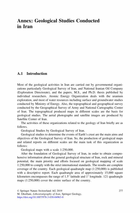
hensive information about the general geological structure of Iran, rock and mineralpotential, the main priority and efforts focused on geological mapping of scale1:250,000 to comply with the strict international standards. The results are completecoverage of the country. Each geological quadrangle map (1:250,000) is publishedwith a descriptive report. Each quadrangle area of approximately 15,000 squarekilometers encompasses the range of 1.5° latitude and 1° longitude. 121 quadranglemaps (1:250,000) cover the entire surface of the country.
© Springer Nature Switzerland AG 2019M. Ghorbani, Lithostratigraphy of Iran, Springer Geology,https://doi.org/10.1007/978-3-030-04963-8
277
The National Iranian Oil Company conducts the geological maps (1:250,000) inoil-rich regions of southwestern Iran, so, the geological projects of the mentionedareas eliminated from the rest of country, and Geological Survey of Iran isresponsible for the rest of areas of the country. Till now, all the field geologicalstudies and maps preparation (1:250,000) of the entire country has been completedand published (Fig. A.1).
Each geological map (1:250,000) has a descriptive report which, is publishedseparately. Regarding the regional and global application, most of these reportshave been written in English. The report of some of these geological maps has notbeen finished yet.
Fig. A.1 The final guideline of Geological Maps of Iran (1:250,000)
278 Annex: Geological Studies Conducted in Iran
A.2 Geological Maps Scale 1:100,000
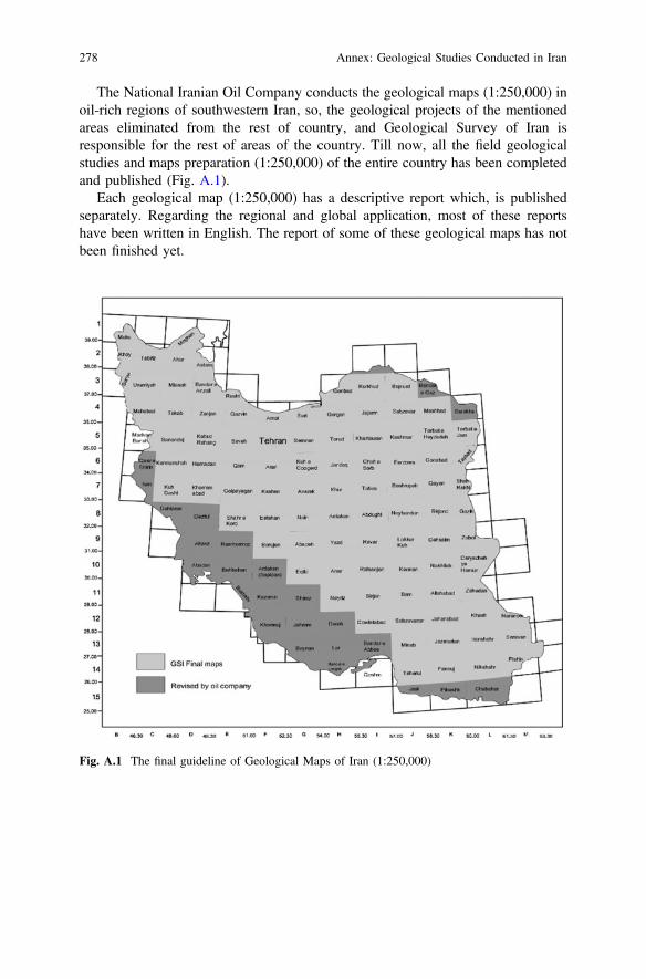
Along with the geological mapping (1:250,000), the other surveys and geologicalstudies (1:100,000) have been conducted in the areas with high potential for theoccurrence of mineral deposits to solve the key geological problems and devel-opment the national projects. The entire country is covered by 659 geologicalquadrangle maps (1:100,000). Each map is about 2500 km2 located between twolatitude and two longitudes encompasses half degree. A brief descriptive geologicalreport printed on the marginal side of each geological map (1:100,000). The pub-lished and under preparation maps is shown in Fig. A.2. As Fig. A.2 shows, almostall 1:100,000 maps are prepared in priority sectors. Those quadrangle maps whichare not in priority, have not been prepared include mostly desert zones.
Fig. A.2 The latest status of maps 1:100,000
Annex: Geological Studies Conducted in Iran 279
A.3 Geological Maps Scale 1:25,000
Geological Survey of Iran plans to cover the entire country by geological maps atscale 1:25000, to provide with information about the geological rock units, theirage, structural elements, environmental information, and seismo-tectonic data in aGIS system. Conducting the program is based on the priority areas, where have thespecific characteristic including mineral potential and environmental matters.
A.4 Airborne Geophysical Maps
In order to obtain more comprehensive information on regional geology and tec-tonics, as well as identifying areas for detailed exploration, especially hiddenmineral deposits, Geological Survey of Iran plans to survey Airborne GeophysicalMaps. To further ease the integration of geophysical and geological data, AirborneGeophysical Maps of 1:250,000 have been published in three colors. In addition tothe above maps, the maps of the Magnetic Total Intensity 1:100,000 and MagneticAnomaly maps 1:250,000; the Base Magnetic Map, and Magnetic Isopach Mapsare prepared and published.
Also, Geological Survey of Iran plans to conduct Magnetic and Radiometricsurvey by intervals of 500 m and Electromagnetic survey by intervals of 250 m forpriority zones of the country.
A.5 Geological Research Studies
In order to solve some of the key issues and developing the exploration geology,some parts of geological research has been allocated in this matter. Although someof these studies are not directly related to the objectives and tasks of GeologicalSurvey of Iran, but could be helpful to provide increasing quantitative and quali-tative studies, especially on Engineering Geology and have an important role forgeological hazards investigation.
In this regard, a significant part of the researches and reports are the result of thegeological exploration, and research studies in the framework of the current pro-grams or in the form of regional and international cooperation.
A.6 Exploratory Studies
The most geological exploration program focuses on prospecting and exploration ofMetallic and non-metallic mineral deposits. At the beginning of the activity,according to the needs of industrial markets and economic importance, most of the
280 Annex: Geological Studies Conducted in Iran
exploration programs were subjective exploration, but later exploration projectsfocused on industrial needs and economic necessities. In other words, it was nec-essary to concern, in addition to the thematic exploration, the systematic explo-ration program which, is of greater importance widely for the long-termdevelopment of the country. Therefore, the current aim of geological explorationtendency towards the regional systematic exploration is intended to conduct thesestudies particularly at 1:100,000 scale.
The geological exploration activities in Geological Survey of Iran are focused onthree main factors:
Mining Exploration: Geological Survey of Iran has been successful to discovera number of valuable resources such as metallic and non-metallic deposits byimplementation topical and systematic exploration projects, particularly, phosphate,bauxite, magnesite, alunite, perlite, nepheline syenite, diatomaceous earth, asbestos,feldspar, sand casting, refractory soil, celestite, and vermiculite as non-metallicdeposits and Copper, Iron, Gold, Lead and Zinc, and other metallic ones that someof them have significant economic value.
It should be noted that since 1998 Geological Survey of Iran has been respon-sible for the exploration of the entire country. So the geological exploration and thesystematic exploration increased widely.
Geochemical Explorations in Iran: Applying the geochemical explorationtechnique, along with the foundation of Heavy Minerals and Atomic AbsorptionLaboratories, goes back to the late 1962.
In early 1970s, in order to explore the mineral resources geochemical explo-ration have been done for copper, lead, zinc and molybdenum, particularly inforested areas in Northern Iran, west of Qazvin, Northeastern Khorasan province,central Iran, Azarbaijan and Zahedan. The final results are presented as prospecting,semi-detailed and detailed characteristics phases. During the same decade, thegeochemical exploration program in central Iran in the range of 42,000 km2 andeastern Iran (270,000 km2) took place by cooperation of several foreign consultingengineers and companies.
In late 1980s, according to the economic policies of the Islamic Republic of Iranin understanding the mineral potential of the country, more emphasis was given tothe Regional (1:100,000) Geochemical Exploration in, Tarom, Zanjan, Manjil,Ghareghosh, Ahar, Kharvana and other areas. In addition, the subjective studies ofcopper deposits in Sungun and Nojamyr were continued.
In 1990s the systematic geochemical studies in the Varcheh, Aran, Nofal-LouChateau, Khoy, shazand, Mahallat, and other areas were carried out, which only theresults of Golpaiegan, Aligoodarz, Jebale-barez, Hana and other areas publishedduring this period. At the present time, the entire geochemical maps of the entirecountry have been done and published.
Geological Survey of Iran plans to revise the previous geochemical maps, andconduct the hydro-geochemical maps at 1:100,000 scale.
The Geochemical Exploration Department of Geological Survey of Iran, withhighly sophisticated facilities, equipment and advanced software, is active in thefollowing areas:
Annex: Geological Studies Conducted in Iran 281
1. Research and identify all valuable heavy minerals such as precious minerals(gold, silver), radioactive minerals (monazite), copper minerals (chalcopyrite,covellite, etc.), base metal minerals, lead and zinc, iron ore group, etc.
2. Qualitative and quantitative content of heavy minerals grades.3. Determine the source of the minerals in relation to depositional environments.4. Geochemical statistical calculations5. Plotting the distribution elements anomalous single or multi-element maps and
relevant reports6. Design and implementation the technical specification of geochemical explo-
ration projects at different scales7. Determination the target area to follow up exploration including drilling and
underground working.
A.7 Geophysical Explorations
Department of Geophysics of Geological Survey of Iran has a very constructive rolein mineral Prospecting. The experts of the Geophysical Department apply the staticmethods (gravity, and magnetic radiometric) and dynamic (seismic, magnetic andelectromagnetic) to investigate the physical properties of rocks for metallic andnon-metallic mineral and ground water exploration and to solve the unknowngeological matters. The Geophysical Department of Geological Survey of Iran hasthe most advanced geophysical equipment and software to provide not only ser-vices to conduct its own projects, but also provide services to the private clients.
In addition to geophysical maps preparation, the Geophysical Department ofGeological Survey of Iran after managing to educate its scientific experts andprovide the most technologically advanced software and hardware, start repro-cessing the National Geophysical Data of the previous projects to provide VerticalGradient, Residual, Horizontal Gradient, as shadowing or Image. Further analyzingand interpreting of rocks and depth of anomalies by applying 2D, 21/2D, and 3Dmethods will be conducted.
All geophysical applications such as gravity, magnetic survey, autogenicpotential, radiation, induced polarization, and resistance VLF survey conducted byfollowing the pre-compiled programs for the entire country, according to request ofother client, governmental and private organizations. The entire above projectscarry out by the geophysical department’s equipment, and Implementation ofinternational standards, practices in all field observations, calculations and map-ping, run by the most sophisticated software programs.
282 Annex: Geological Studies Conducted in Iran
A.8 The Geological, Exploration, and ResearchProjects
Some parts of the objectives and tasks of the Geological Survey are carried out inthe framework of geological and exploration projects are implemented. So far,Geological Survey of Iran has been able to plan the exploration of evaporate saltsdeposits, geological studies Outside Makran Project, clay projects, GeochemicalExploration Projects, Seismic Atlas project, and the Systematic and SubjectiveExploration Projects which achieve some parts of its goal in the field of geologyand exploration.
A.9 Thematic Geological Maps
In addition to the geological maps 1:250,000, 1:100,000, and 1:25,000, GeologicalSurvey attempts to publish some of the Subjective Geological Maps to show thestructural geology, tectonics and exploration characteristic of Iran (Table A.1).
Based on the aims of “Compiling the Geological Book of Iran” project, atremendous numbers of articles and books about the geology and mineral resourcesof Iran and thematic maps were developed and published, Tables A.2 and A.3.
In addition to focused and systematic studies of theGeological Survey, the Industries& Mines Organization carry out great numbers of exploration projects within theirterritories in different states (although it has not achieved satisfactory results).
In the framework of Masters and Ph.D. thesis, at the universities of the countrymany important research and studies on different subjects of geology of Iran areconducted each year.
On the other hand, AEOI (Atomic Energy Organization of Iran) has an explo-ration Department where particularly deals with geological exploration ofradioactive materials.
A.10 National Iranian Oil Company
National Iranian Oil Company Exploration Management is a governmental organi-zation performs particularly the geological studies and the surface and undergroundexploration for oil and gas in the entire country. Since the main exploration activitiesfocused on oil and gas, the Zagros and Kopeh-Dagh zones are the main explorationtarget areas. But the rest of country is also considered for the second priority.
1. The major studies conducted by the National Iranian Oil Company are asfollowing:
2. Geological mapping, in the Zagros region and the Kopeh-Dagh Basin, scale1:250,000, 1:100,000 and in some specific areas 1:50,000.
Annex: Geological Studies Conducted in Iran 283
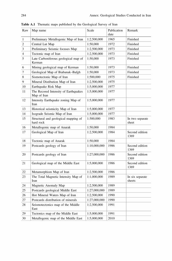
Table A.1 Thematic maps published by the Geological Survey of Iran
Raw Map name Scale Pablicationdate
Remark
1 Preliminary Metallogenic Map of Iran 1:2,500,000 1965 Finished
2 Central Lut Map 1:50,000 1972 Finished
3 Preliminary Seismic focuses Map 1:2,500,000 1973 Finished
4 Tectonic map of Iran 1:2,500,000 1973 Finished
5 Late Carboniferous geological map ofKerman
1:50,000 1973 Finished
6 Mining geological map of Kerman 1:50,000 1973 Finished
7 Geological Map of Biabanak–Bafgh 1:50,000 1973 Finished
8 Sismotectonic Map of Iran 1:500,000 1975 Finished
9 Mineral Distibution Map of Iran 1:2,500,000 1975
10 Earthquake Risk Map 1:5,000,000 1977
11 The Recored Intensity of EarthquakesMap of Iran
1:5,000,000 1977
12 Intensity Earthquake zoning Map ofIran
1:5,000,000 1977
13 Historical seismicity Map of Iran 1:5,000,000 1977
14 Isograde Seismic Map of Iran 1:5,000,000 1977
15 Structural and geological mapping ofhard rock
1:500,000 1983 In two separatesheet
16 Metallogenic map of Anarak 1:50,000 1984
17 Geological Map of Iran 1:2,500,000 1984 Second edition1369
18 Tectonic map of Anarak 1:50,000 1984
19 Postcards geology of Iran 1:10,000,000 1986 Second edition1369
20 Postcards geology of Iran 1:27,000,000 1986 Second edition1369
21 Geological map of the Middle East 1:5,000,000 1986 Second edition1369
22 Metamorphism Map of Iran 1:2,500,000 1986
23 The Total Magnetic Intensity Map ofIran
1:1,000,000 1989 In six separatesheets
24 Magnetic Anomaly Map 1:2,500,000 1989
25 Postcards geological Middle East 1:27,000,000 1989
26 Hot Mineral Waters Map of Iran 1:2,500,000 1990
27 Postcards distribution of minerals 1:27,000,000 1990
28 Seismotectonics map of the MiddleEast
1:2,500,000 1991
29 Tectonics map of the Middle East 1:5,000,000 1991
30 Metallogenic map of the Middle East 1:5,000,000 2010
284 Annex: Geological Studies Conducted in Iran
3. Preparation the first geological thematic map of Iran, scale 1:1,000,000.4. Stratigraphic and Paleontological studies in many areas, especially in the
Zagros, Kopeh-Dagh Basin, and more recently in central Iran, Makran and southof Caspian Sea.
5. The structural geology of the Zagros and the Kopeh-Dagh Basins.
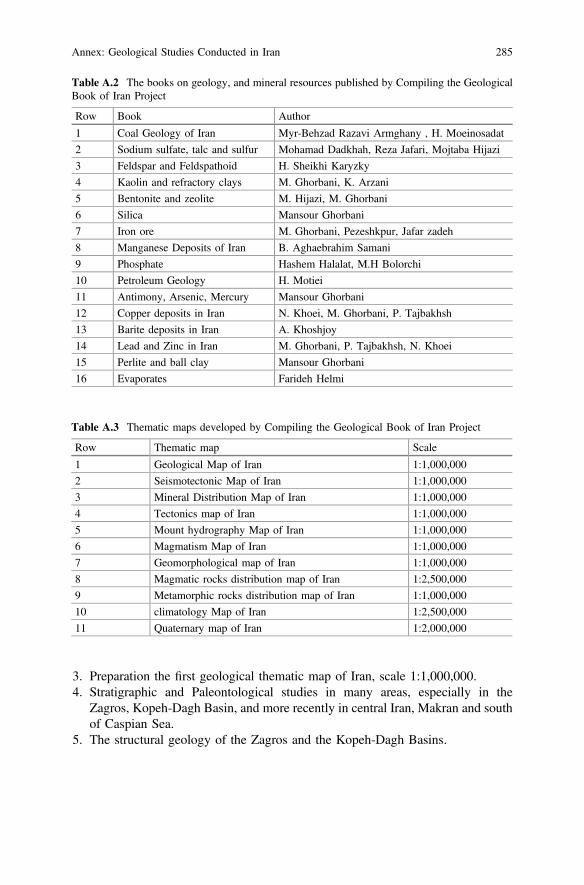
Table A.2 The books on geology, and mineral resources published by Compiling the GeologicalBook of Iran Project
Row Book Author
1 Coal Geology of Iran Myr-Behzad Razavi Armghany , H. Moeinosadat
2 Sodium sulfate, talc and sulfur Mohamad Dadkhah, Reza Jafari, Mojtaba Hijazi
3 Feldspar and Feldspathoid H. Sheikhi Karyzky
4 Kaolin and refractory clays M. Ghorbani, K. Arzani
5 Bentonite and zeolite M. Hijazi, M. Ghorbani
6 Silica Mansour Ghorbani
7 Iron ore M. Ghorbani, Pezeshkpur, Jafar zadeh
8 Manganese Deposits of Iran B. Aghaebrahim Samani
9 Phosphate Hashem Halalat, M.H Bolorchi
10 Petroleum Geology H. Motiei
11 Antimony, Arsenic, Mercury Mansour Ghorbani
12 Copper deposits in Iran N. Khoei, M. Ghorbani, P. Tajbakhsh
13 Barite deposits in Iran A. Khoshjoy
14 Lead and Zinc in Iran M. Ghorbani, P. Tajbakhsh, N. Khoei
15 Perlite and ball clay Mansour Ghorbani
16 Evaporates Farideh Helmi
Table A.3 Thematic maps developed by Compiling the Geological Book of Iran Project
Row Thematic map Scale
1 Geological Map of Iran 1:1,000,000
2 Seismotectonic Map of Iran 1:1,000,000
3 Mineral Distribution Map of Iran 1:1,000,000
4 Tectonics map of Iran 1:1,000,000
5 Mount hydrography Map of Iran 1:1,000,000
6 Magmatism Map of Iran 1:1,000,000
7 Geomorphological map of Iran 1:1,000,000
8 Magmatic rocks distribution map of Iran 1:2,500,000
9 Metamorphic rocks distribution map of Iran 1:1,000,000
10 climatology Map of Iran 1:2,500,000
11 Quaternary map of Iran 1:2,000,000
Annex: Geological Studies Conducted in Iran 285
Uncited References
Abaie, I., Ansari, H. J., Badakhshan, A., & Jaafari, A. (1964). History and development of theAlborz and Sarajeh fields of Central Iran. Bulletin of Iranian Petroleum Institute, 15, 561–574.
Abdi, A. (2008). Geochemistry and depositional environment of the carbonate sediments of theShahbazan Formation in the Shabikhoun Section, northern Khorram-Abad and its correlationwith the Darabi Section, northern Kuh-dasht (Unpublished M.Sc. thesis). Faculty of EarthSciences, Shahid Beheshti University.
Abdi, N. (2003). Isotope and facies studies of the Lower Triassic Kangan Formation. In The 22ndSymposium of Geology. Geological Survey of Iran.
Abradat, M. (2001). Introduction of the wide out crops of Khangiran Formation of the WesternSarakhs Plain. In The 20th Symposium of Geology. Geological Survey of Iran.
Aftabi, A. (2003). An introduction to sequence stratigraphy of Asmari Formation of thesoutheastern Kashan (Unpublished M.Sc. thesis). Kharazmi University.
Ahia, F. (1997). Geology, geochemistry and source of Celestite-bearing horizon of the GachasaranFormation, Likak, Behbahan, Kohgiluyeh and Boyer Ahmad Province.
Ahmadipour, H. (2003). Genetic classification of pyroclastic rocks of the upper Hazar Volcanic(Kerman Province). In 22nd Iranian Symposium of Earth Science.
Ahmadzadeh-Heravi, M. (1971). Study of brachipods and conodonts of Alborz Central, 111.Ain-Alahi, A. (2008). Diagenesis and its effects on the reservoir characterizations of the Asmari
Formation in the Lali Oil Field, northwestern Masjed Soleyman. Journal of ApplicableGeology, 6(2), 118–128.
Akhavan, H. (2011). Evaluation of reservoirs characters of Shurijeh Formation (Member D1) ofthe Gonbadli Gas Field, Sarakhs area, Kopeh-Dagh Basin (Unpublished M.Sc. thesis). Facultyof Sciences, University of Tehran.
Alahbakhsh-Ghiasvand, G. (2003). Biostratigraphy and stratigraphical correlation of theBangestan Group of the Sarkan and Malehkuh areas (Unpublished M.Sc. thesis). Faculty ofSciences, University of Tehran.
Alavi, M., & Salehi-Ras, R. (1975). Geological Map of Damghan (scale of 1/100,000), SheetNo. 6862.
Alavi, M. (1991). Sedimentary and structural characteristics of the Paleo-Tethys remnants in NorthEastern Iran. Bulletin Geological Society of America, 103, 983–992.
Alavi, M. (1996). Tectonostratigraphic synthesis and structural style of the Alborz Mountainsystem in Northern Iran. Journal of Geodynamics, 21(1), 1–33.
Alavi-Naeini, M., & Amidi, M. (1968). Geology of Western Part of Takab Note, J49, 94.Alavi-Naini, M., Hajian, J., Amidi, A., & Bolurchi, H. (1982). Geology of Takab-Saein Qalel:
Explanatory note of 1:250,000 map of Takab quadrangl. Geological Survey of Iran, Report 50.
© Springer Nature Switzerland AG 2019M. Ghorbani, Lithostratigraphy of Iran, Springer Geology,https://doi.org/10.1007/978-3-030-04963-8
287
Ali Nezhad-Kurdi, R. (2007). Sedimentary petrography of the shale and marl beds of the PabdehFormation in the type section, and the borehole No 12, 38 of the Kupal Oil Field (UnpublishedM.Sc. thesis). Faculty of Earth Sciences, Shahid Beheshti University.
Allah Madadi, Sh. (1998). Biostratigraphical and Lithostratigraphical studies of Saran and KandFormation. In The 21st Iranian Symposium of Earth Science.
Amin-Afshari, S. (2004). Depositional environment, diagenesis and geochemistry of the carbonatedeposits of the Sarvak Formation, Giskan and Mond Anticlines, Boushehr Province(Unpublished M.Sc. thesis). Faculty of Earth Sciences, Shahid Beheshti University.
Amir Sardari, D. (1998). Microfacies and depositional environments of the Members 3, 4 and 5 ofMilla Formation, Eastern Alborz (M.Sc. thesis). Faculty of Sciences, Kharazmi University.
Amiri-Bakhtiar, H., Sadeghi, A., Shemirani, A., Vaziri-Moghadam, H., & Safari, A. (1986).Lithostratigraphical and biostratigraphical revision of type section of Tarbur Formation,Gadivan Mountain, Shiraz, In 10th Symposium of Iranian Geological Society.
Amiri-Bakhtiar, H., Sadeghi, A., Shemirani, A., Vaziri-Moghadam, H., & Safari, A. (1987).Introduction of Kuh-e-Chehelcheshmeh Section as the reference section of Tarbur Formation.Journal of Sciences, Shahid Chamran University, 15, 1–19.
Amirkhani, A. (2001). Biostratigraphy of Tarbur Formation, southern Gandoman, based on themacrofossils (Unpublished M.Sc. thesis). Faculty of Sciences, Kharazmi University.
Amirsardari, D. (2005). Microfaceis, depositional environment and diagenesis of Sarvakformation, Mokhtar Section, Borehole 1. In The 21st Symposium of Earth Sciences.
Angaji, M. (2000). Chemical evaluation and hydrocarbonic potential of the Mobarak Formation,Central and Eastern Alborz. In The 4th Symposium of Iranian Geological Society.
Aria-Nasab, M., Spina, A., Cirilli, S., & Daneshian, J. (2016). The palynostratigraphy of theMississippian (middle Tournaisian–upper Viséan) Shishtu Formation from the Howz-e-Dorahsection, southeast Tabas, central Iranian Basin. Palynology, 40(2), 247–263.
Asadi-Eskandar, A. (2006). Permo-Triassic Boundary of South Pars Gas Field using lithologicaland geochemical data, and the study of its relation with reservoir quality of the relatedlithological units (M.Sc. thesis). Faculty of Sciences, University of Tehran.
Asadi-Mehmandousti, E. (2005). Geochemistry and diagensis of the Ilam Formation of theAbtimor and Mansouri Oil Fields, and Tang-e-Rashid section, Izeh area (M.Sc. thesis).Faculty of Earth Sciences, Shahid Beheshti University.
Ashkan, F. (1982). Early Cambrian age determination of the phosphate bearing member“Chapoghlu” of Soltanieh Formation. Geological Survey of Iran.
Ashouri, A. (1990). Devonian and Carboniferous conodont faunas from Iran (Ph.D. thesis).University of Hall.
Ashouri, A. (1994). The stratigraphical position of members 1 and 6 of Khosh yeilagh Formationbased on conodont fauna and introducing of three conodont zones from member 6.Geosciences, Scientific Quarterly Journal, 4, 64–83.
Ashouri, A. (1998). The Devonian-Carboniferous boundary in Ozbak-Kuh area. Geosciences,Scientific Quarterly Journal, 7, 47–53. (in Persian).
Ashouri, A. (2001). Middle Devonian-Mississippian conodont faunas from the KhoshyeilaghFormation, Alborz Mountains, north Iran, In: U. Jansen, P. Königshof, G. Plodowski, & E.Schindler (Eds.), 15th International Senckenberg Conference, Joint Meeting IGCP 421/SDS(Abstracts, p. 6), May 2001.
Ashouri, A. (2004). Late Devonian and Middle– Late Devonian conodonts from eastern andnorthern Iran. Revista Española de Micropaleontología, 3, 355–365.
Ashouri, A., et al. (2010). Echionoids of the Tirgan Formation in the Takht-e-Arkan Section,southeastern Bojnurd and the introduction of new “Toxaster renevieri” for first time in Iran, InThe 12th Symposium of Geology. Geological Survey of Iran.
Askari Pirbloufi, B. (1998). Biostratigraphy of Upper Cretaceous strata, Tarbur Formation, in theDorahan of the Chahar Mahal-e-Bakhtiari (Unpublished M.Sc. thesis). Faculty of Sciences,Ferdowsi Mashhad University.
288 Uncited References
Asl-e-Shirin, F. (2011). Nannostratigraphy of the Gurpi Formation in the Kuh-e-Sefid Section,Eastern Ramhormoz (M.Sc. thesis). Shahid Beheshti University.
Assereto, R., & Ippolito, I. (1964). Observazioni preliminarai sul cretaceo della bassa valle del Lar(Elburz centrale, Iran).
Azimi, R. (2008). The introduction of the calpionellid biozones of the Jurassic-CretaceousBoundary in the Shal section, southeastern Khalkhal county. Earth Science Journal, 17(68),16–25.
Babakhani, A., & Rahimzadeh, F. (1988). Geological map of Ardabil (scale of 1:250,000).Supervised by: Eftekharnezhad, G, Geological Survey of Iran, Sheet No D2.
Badri-Kallou, N. (2007). Nannostratigraphy of Gurpi Formation of the Lar area, Kuh-e-Gach andKuh-e-Kurdeh Anticlines (Unpublished M.Sc. thesis). Faculty of Earth Sciences, ShahidBeheshti University.
Bagheri, T. (1993). Geochemical study of carbonate deposit of Geirud Formation, southwesternDamghan. In 22nd Symposium of Geology. Geological Survey of Iran.
Barzegar, F. (1989). The Razak Fault.Seasonal Letter in Geographical research, Tehran, Iran, 12,72.
Bastami, & Bandpi, L. (2008). Petrography, depositional environment and reservoir character-ization of the Asmari Formation, south Gashvi Gas Field (Unpublished M.Sc. thesis). Facultyof Earth Sciences, Shahid Beheshti University.
Berberian, M. (1973). Two important deformational and metamorphic phases in the belt northeastof the Zagros thrust line (Iran). A brief structural review of the Sanandaj-Sirjan Belt.Geological Survey of Iran, Intial Report 27, 35.
Berberian, M. (1984). Structural evolution and tectonics of the Iranian plateau, a plate tectonicapproach, Bogdanov, N A, Tesizy, 27-Ymezhdunarodnyy geologicheskiy congress, Abstracts,27th International Geological Congress. Geological Survey of Iran, Tehran, 27(3), 140.
Berberian, M. (1984b). Recent tectonics, seismotectonics and earthquake-fault hazard study of thearea West of Damghan (Amirabad), Kubankav Consulting Engineers. Intial Report 45, 421 (inPersian).
Berberian, M., Qorashi, M., Arzhangravesh, B., & Mohajer-Ashtiani, A. (1983). Recent tectonics,seismotectonics and earthquake-fault hazard study in the Greater at Tehran Region. Iran:Geological Survey of Iran (in Persian).
Broumand, Z. (2008). Palynofacies and depositional environment of the Dalichai Formation,northeastern Damghan, Talou Section (Unpublished M.Sc. thesis). Geological Survey of Iran.
Chohen, S., & Finney, P.L. (2012). Gibbard International Commission on Stratigraphy.Dakhili, M.T. (1995). Petrology of magmatic and metamorphic rocks of the northeastern Fariman
(Unpublished M.Sc. thesis). Faculty of Earth Sciences, Shahid Beheshti University.Darvishzadeh, A. (1992). The analysis of the Ural, Iran, Madagascar and Fouron, and Hercynian
Orogenic event. Earth Science Quarterly, Geological Survey of Iran, 6.Dayer, N. (2010). The study of larger benthic foraminifer accumulation as the indicator of the
paleoenvironment of the Asmari Formation in the Mardouk area, Northeastern Kazeroun(Unpublished M.Sc. thesis). Payam-e-Nour University.
Dercourt, J., Zonenshain, L. P., Ricou, L. E., Kazmin, V. G., Le Pichon, X., Knipper, A. L., et al.(1986). Geological evolution of the Tethys belt from the Atlantic to the Pamirs since the Lias.Tectonophysics, 123, 241–315.
Diver, W., & Peat, S. C. J. (1979). On the interpretation and classification of Precambrianorganic-walled microfossils. Geology, 7(8), 401–404.
Eftekharnezhad, J., & Stocklin, J. (1992). Geological map of Iran sheet K8 (Birjand), scale 1:250,000. Tehran: Geological Survey of Iran.
Engalenc, M. (1968). Geologie, geomorphologie, hydrogeologie de la region du Tehran (Iran)(p. 180). Monpellier: These en sciences.
Ezzampanah, Y. (2011). Biostratigraphy and Lithostratigraphy of the Garu Formation in theKuzaran section and Naft borehole No 1 (southern Kermanshah) (Unpublished M.Sc. thesis).Faculty of Earth Sciences, Shahid Beheshti University.
Uncited References 289
Feizi-Kararoudi, M. (2007). Depositional environment and sequence stratigraphy of the Gadvanand Darian Formations of the northern Dezful Embayment (Mamatin borehole No. 10) andIzeh Zone (Ashgar anticline) (Unpublished M.Sc. thesis). Faculty of Sciences, KharazmiUniversity.
Ghaderi, A., Agha, N. S. A., Hamdi, B., & Miller, J. F. (2008). Biostratigraphy of the First andSecond members of type section of the Shirgesht Formation in north of Tabas with specialemphasis on conodonts.
Gharabeigi, Gh., et al. (2008). Structural analysis and priority of the western Kopeh-Dagh,Subsurface Branch, Geological Office, National Iranian Oil Company, No. 2156 GR.
Ghavidel-Syooki, M. (2000). Palynostatigraphy and Palaeobiogeography of Lower Palaeozoicstrata in the Ghelli area, Northeastern Alborz Range of Iran Kopeh-Dagh Region). Journal ofSciences Islamic Republic of Iran, 11(4), 305–318.
Ghavidel-Syooki, M. (2001). Palynostratigraphy and paleogeography of the Late Devonian inNortheastern Esfahan city, Central Iran. In D. K. Goodman, & R. T. Clarke (Eds.), Proceedingof the IX International Palynological Congress, Houston, Texas, USA (pp. 37–51). AmericanAssociation of Stratigraphic Palynologists Foundation.
Ghavidel-Syooki, M. (2008). Palynostratigraphy and Paleogeography of upper Ordovician GorganSchists (Southern Caspian Sea). Eastern Alborz Mountain Ranges, Northern Iran:Comunicocoes Geologicas, 95, 123–155.
Ghavidel-Syooki, M., & Winchester, T. (2001). Biostratigraphy and palaeogeography of LateOrdovician chitinozoans from the Northeastern Alborz Range, Iran. Review of Palaeobotanyand Palynology, 118, 77–99.
Ghavidel-syooki, M., & Vecoli, M. (2006). Latest Ordovician–early Silurian chitinozoans from theeastern Alborz Mountain Range, Kopet–Dagh region, Northeastern Iran: biostratigraphy andpalaeobiogeography PALBO-02829, 20.
Ghazi, M., Hassanipak, A. A., Tucker, P. J., & Mobasher, K. (2001). Geochemistry and 40Ar-39Arages of the Mashhad Ophiolite, NE Iran, abstracts as: A Rare Occurrence of a 300 Ma(Paleo-Tethys) Oceanic Crust. American Geophysical Union, Fall Meeting 2001, abstract#V12C-0993.
Gheli-Netaj, M. (2005). Microfacies and depositional environment of the Elika Formation in theBolbolkhan area, Amol. In The 20th Symposium of Earth Science. Geological Survey of Iran.
Gholamalian, H. (2002). Biostratigraphy of Frasnian/Famennian Boundary in Esfahan & TabasAreas (p. 118) (Unpublished Ph.D. thesis). University of Isfahan.
Gohari, A. (2010). Lithostratigraphy and nannostratigraphy of Gurpi Formation in the Siah KuhSection, Southwestern Ilam (Unpublished M.Sc. thesis). Faculty of Earth Sciences, ShahidBeheshti University.
Gorgij, M. N, & Boomeri, M. (1390). Two Carboniferous coral assemblage of Ozbak-Kuh andKalmard areas, Eastern Central Iran (Zaladou and Gachal sections). Sedimentology andSequence Stratigraphy Journal, Isfahan University.
Hadavand-Khani, N. (2009). Lithostratigraphy and biostratigraphy of Pabdeh formation in theKamestan Anticline, Northeastern Izeh, and its correlation with type section (Unpublished M.Sc. thesis). Faculty of Earth Sciences, Shahid Beheshti University.
Hadavi, F. (2002). Ostracods of Qom Formation in the Do-Chah section. In The 6th Symposium ofGeology. Geological Survey of Iran.
Hadi-Peykani, M. (2005). Petrography and depostional environment of the Fahliyan Formation inthe Izeh area (Unpublished M.Sc. thesis). Faculty of Earth Sciences, Shahid BeheshtiUniversity.
Hajab, R. (1984). Stratigraphy of Member 7 of Gachsaran Formation. In The Third Symposium ofGeology. Geological Survey of Iran.
Hajimohamadi-Shirehjini, N. (2010). Lithostratigraphy of the Qom Formation of the Absard Area,Southern Damavand (Unpublished M.Sc. thesis). Faculty of Earth Sciences, Shahid BeheshtiUniversity.
290 Uncited References
Hamdi, B. (1991). Stratigraphic position and correlation of Hormoz Complex in the Persian GulfPaleontology Division. In Canadaian Paleontology Conference I, Vancouver, Canada.
Hamedi, M. (1988). A revision of Shorm Beds. Geological Survey of Iran.Hazavehei, F. (2002). Reservoir quality evaluation of the Asmari Formation in the Danan Oilfield
(Unpublished M.Sc. thesis). Faculty of Sciences, University of Tehran.Hairapetian, V., Pour, M. G., Popov, L. E., Männik, P., & Miller, C. G. (2017). Silurian
stratigraphy of Central Iran–an update. Acta Geologica Polonica, 67(2), 201–233.Hofmann, H. J., & Jackson, G. D. (1994). Shale-facies microfossils from the Bylot Supergroup,
Baffin Island, Canada. Journal of Paleontology, 68(4), 1–35.Homayun-Zadeh, S. (2002). Lithostratigraphy and biostratigraphy of the Mishan Formation in the
central Dezful Embayment (Unpublished M.Sc. thesis). Faculty of Sciences, KharazmiUniversity.
Hoseini-e Tabatabei, W. (2012). Lithology and depositional environment of the Lalun Formationof the Meskin and Shougolab Sections, Northwestern Urmia. In The 16th Symposium ofGeology. Geological Society of Iran.
Hoseini-Kheyrabadi, A. (2010). The correlation of organic geochemistry data with those ofsequence stratigraphy for hydrocarbon potential evaluation of the Pabdeh Formation ofAhwaz Oil Field (Unpublished M.Sc. thesis). Faculty of Sciences, Shahid Chamran University.
Hoseinzadeh, M. (2003). Lithostratigraphy and biostratigraphy of Shemshak Formation of theEastern Shahmirzad, Southern Alborz, based on the ammonite fauna (Unpublished M.Sc.thesis). Faculty of Earth Sciences, Shahid Beheshti University.
Hurford, A. J., Grunau, H. R., & Stöcklin, J. (1984). Fission track of an apatitecrystal fromHormuz Island, Iran. Journal of Petroleum Geology, 7(4), 365–380.
Jackson, M. P. A., Cornelius, R. R., Craig, C. H., Gansser, A., Stöcklin, J., & Talbot, C. J. (1990).Salt diapirs of the Great Kavir, central Iran. Geological Society of America Memoir, 177-139.
Jafarnezhad, D. (2008). Paleoecology and palynostratigraphy of Gurpi Formation of theTang-e-Bijar Section, Ilam Province (Unpublished M.Sc. thesis). Faculty of Earth Sciences,Shahid Beheshti University.
Kabir, A. (2008). Sedimentology and depositional environment of the coal-bearing sediments ofTabas (Unpublished M.Sc. thesis). Faculty of Sciences, University of Tehran.
Kamel Abbasi, M. (2010). Depositional environments and sequence stratigraphy of the ShurijehFormation, Member D, in the Khangiran and Gonbadli Oil Fields (Unpublished M.Sc. thesis).Islami Azad University, Shahroud Branch.
Kameli Azan, A., Amiri-Bakhtiar, & Vaziri-Moghadam, H. (2003). Biostratigraphy of GurpiFormation, type section, in the northern Lali Oil field, Khuzestan. In The 22nd Symposium ofGeology. Geological Survey of Iran.
Kapeaei, M. (2008). Geological characterizations of the Qom Formation in the eastern andnortheastern Hamedan (Unpublished M.Sc. thesis). Bu-Ali Sina University.
Karimi-Mossadegh, Z. (2009). Biostratgraphy, sequence stratigraphy and depositional environ-ment of the Asmari Formation in the Central Dezful Embayment (Unpublished Ph.D. thesis).Faculty of Earth Sciences, Shahid Beheshti University.
Karimpour, B. (2009). Petrography and depositional environment of Jarhrom Formation in theSarkhon Oil Field (Bandar Abbas) and type section of Jahrom Formation (Southern Jahrom)(Unpublished M.Sc. thesis). Faculty of Earth Sciences, Shahid Beheshti University.
Kazmin, V. G., Sbortshikov, I. M., Ricou, L. E., Zonenshain, L. P., Boulin, J., & Knipper, A. L.(1986). Volcanic belts as markers of the Mesozoic-Cenozoic active margin of Eurasia.Tectonophysics, 123(1–4), 123–152.
Khazaei, A. (1995). Systematic study of the Upper Cretaceous rudist-bearing limestone beds, typesection of Kalat Formation, Tang-e-Neyzar, Kopeh-Dagh (Unpublished M.Sc. thesis). Facultyof Sciences, Ferdowsi Mashhad University.
Kheradmand, A. (2002). Sedimentary facies and environment of the Middle and Upper rocks,equivalents of Bahram Formation, Kerman surroundings. In The 6th Symposium of Geology.Geological Society of Iran.
Uncited References 291
Kholousi, M. (1996). Microbiostratigraphy and depositional environment of the ZiaratFormation, at the type section (southeastern Tehran) and Govije Section (Eastern Tehranand southeastern Tehran) (Unpublished M.Sc. thesis). Faculty of Sciences, University ofTehran.
Kolodka, C., Vennin, E., Vachard, D., Trocme, V., & Goodarzi, M. H. (2012). Timing andprogression of the end-Guadalupian crisis in the Fars province (Dalan Formation, Kuh-eGakhum, Iran) constrained by foraminifers and other carbonate microfossils. Facies, 58(1),131–153.
Kolosov, P. N. (1989). Filamentous microorganism of Proterozoic terminal period. Report atall-Union Meeting, general problems of subdivision of the USSR Precambrian, 1-47.
Kuhgard, H. (1994). Lithostratigraphy and depositional environment of the Dahu ‘Series’ in theNortheastern Zarand (Unpublished M.Sc. thesis). Faculty of Sciences, Kharazmi University.
Lasemi, Y. (1993). Depositional environments of the Geirud Formation in the Central Alborz area,Research project, Kharazmi University.
Lasemi, Y., & Raeesi, A. (2000). Microfacies, depositional environment and sequence stratigraphyof the Asmari Formation in the Southern Dezful embayment. In The 4th Symposium ofGeology. Geological Society of Iran.
Less, G. M. (1929). Salzgletscher in Persia. Mitteilungen Geologische, Wien, 24, 29–34.Lotfpour, M. (2002). Reservoir geology and sequence stratigraphy of the Dalan and Kangan
Formations of the South Pars Oil Field, Persian Gulf. In The 6th Symposium of Geology.Geological Society of Iran.
Mafi, A. (1997). Nannostratigraphy of Chehlkaman Formation in the reference and type sections(Unpublished M.Sc. thesis). Faculty of Sciences, Ferdowsi Mashhad University.
Mafi, A., Ghasemi-Nejad, E., Ashouri, A., & Vahidinia, M. (2014). Dinoflagellate cysts from theUpper Bajocian-Lower Oxfordian of the Dalichai Formation in Binalud Mountains (NE Iran):Their biostratigraphical and biogeographical significance. Arabian Journal of Geosciences, 7(9), 3683–3692.
Maghfouri-Moghaddam, A. (2000). Lithostratigraphy, biostratigraphy and paleoecology of theAghchegil and Apsheron Formations in the Moghan Plain (Unpublished M.Sc. thesis). Facultyof Sciences, Kharazmi University.
Mahbubi-pour, H. (2004). Geological and reservoir characterizations of the Kangan and DalanFormations in the Kaman-Ghatar area, Persian Gulf (Unpublished M.Sc. thesis). Faculty ofSciences, University of Tehran.
Mahdavipour, Z. (2003). Sequence stratigraphy and reservoir quality of the Asmari Formation inthe Shadan Oil Field (Unpublished M.Sc. thesis). Faculty of Sciences, University of Tehran.
Majidi, B. (1981). The ultrabasic lava flows of Mashhad, Northeast Iran. Geological Magazine,118(1), 49–58.
Malaki, M. (2001). Microbiostratigraphy of Ziarat Formation in the Kalmard area (UnpublishedM.Sc. thesis). Faculty of Sciences, Kharazmi University.
Mirab-Shabestary, Gh. (1994). Lithostratigraphy and depositional environment of thePrecambrian-Lower Cambrian rocks, equivalent of Soltanieh Formation in the Sarbandan(eastern Damavand) and Shahmirzad (northern Semnan) (Unpublished M.Sc. thesis). Facultyof Sciences, Kharazmi University.
Mirkiani, H. (1997). Microfacies studies of the Tirgan Formation in the Mozdouran and Kalatsections, Sarakhs area, eastern Kopeh-Dagh (Unpublished M.Sc. thesis). Faculty of EarthSciences, Shahid Beheshti University.
Moallemi, A. (2005). Classification of reservoir lithological groups of the Asmari Formationbased on the petrophysical logs using of fuzzy logic (Unpublished M.Sc. thesis). Faculty ofSciences, University of Tehran.
Moeinpour, M. (1998). Sedimentological studies and recognition of porosity types (UnpublishedM.Sc. thesis). Faculty of Sciences, University of Tehran.
292 Uncited References
Mohamad-Beiknouri, M. (1997). Provenance and thermal maturity of the organic content of theSiahoo and Sarchahan Formations (Ordovician-Silurian) of Zagros (Unpublished M.Sc.thesis). Faculty of Earth Sciences, Shahid Beheshti University.
Mojoudi, M. (2001). Reservoir quality evaluation of the western Ahwaz Oil Field (Unpublished M.Sc. thesis). Faculty of Sciences, Kharazmi University.
Molki-Kheimesari, S. (1999). Lithostratigraphy and depositional environment of the AsmariFormation in the Northern Dezful Embayment. In The 4th Symposium of Geology. GeologicalSurvey of Iran.
Moradi-Lir Gheshasi, N. (2002). Foraminiferal biostratigraphy and paleoecology of the AsmariFormation (Unpublished M.Sc. thesis). Faculty of Sciences, University of Tehran.
Moradpour, P. (2009). Microstratigraphy of the Eocene deposits and Razak Complex in theNorthern Baft, Kerman (Unpublished M.Sc. thesis). Faculty of Earth Sciences, ShahidBeheshti University.
Mousavi, M. (2003). Permeability of Dalan Formation in the South Pars Oil Field, based on theartificial neural network (Unpublished M.Sc. thesis). Faculty of Sciences, University ofTehran.
Mousavi-Abnavi, N. (2009). Biostratigraphy and lithostratigraphy of the Upper Permian depositsof the Banarizeh and Hambast Sections, based on the conodonts (Unpublished M.Sc. thesis).Faculty of Sciences, Esfahan University.
Nabavi, M H (1978) Geological quadrangle map of Nain, 1:250,000, GSI, No. G8.Nabavi, F. (2010). Nannostratigraphy of the Gurpi Formation in the Kharameh (Shiraz) and
Bourekh Mountain (Southern Lar) (Unpublished M.Sc. thesis). Faculty of Earth Sciences,Shahid Beheshti University.
Naderi-Khojin, M. (2006). Palynological studies of Kazhdomi Formation in the South ParsOilfield (Unpublished M.Sc. thesis). Faculty of Sciences, University of Tehran.
Naei, Z. (1995).Microstratigraphy of the Qom Formation in the Kamarkuh and Kuh-e-Dobaradarsections, sedimentary Qom Basin (Unpublished M.Sc. thesis). Faculty of Earth Sciences,Shahid Beheshti University.
Naeiji, M. (1997). Depositional environment and diagenesis of the Qom Formation of theNorthern Iwanaki Section (Unpublished M.Sc. thesis). Faculty of Sciences, University ofTehran.
Najafi, M. (2010). Sequence stratigraphy of Albian-Cenomanian Aitamir Formation in the Sheikhand Bibahreh synclines, Kopeh-Dagh Basin. Scientific Journal of Tehran University, 35(4).
Namd-Malian, A. (1985). Esfordi magmatic reserve and phosphate bearing horizons of Iran.Geological Survey of Iran.
Nawrouzi, M. (2001). Microstratigraphy of the Gurpi Formation in the Soltan Anticline, CentralLorestan, to Gurpi Anticline, type section of Gurpi Formation, Northeastern Khuzestan(Unpublished M.Sc. thesis). Faculty of Sciences, University of Tehran.
Nazari, H, & Salamati, R. (1998). Geological map of Rudbar, Scale 1:100000. Geological Surveyof Iran.
Nouri, N. (1997). Microfaceis and depostional environment of the Qom Formation in theAbdol-Abad area, Semnan, and its correlation with the Kharazn of Ardestan (Unpublished M.Sc. thesis). Faculty of Sciences, Kharazmi University.
Ogg, J. G., Ogg, G., & Gradstein, F. M. (2016). A concise geologic time scale: 2016. Amsterdam:Elsevier.
Okhravi, R. (2011). Ichnology analysis of the Ruteh Formation, Arou Section, Central Alborz. In5th Symposium of Iranian. Geological Society.
Omidpour, A. (2003). Diagenesis history of Asmari Formation, Kupal Field, and its effects on thereservoir quality.
Padiav, P. (1973). Lithostratigraphy of Atamir Formation, based on the well log and seismic data,of the Khangiran, Gonbadli and Sangar Oil Fields (Unpublished M.Sc. thesis). Faculty ofSciences, Kharazmi University.
Uncited References 293
Pilgrim, G. E. (1924). The geology of parts of the Persian Provinces of Fars, Kerman and Luristan.Geological Survey of India, Memoir, 48(2), 1–118.
Piriaei, A. (1996). Petrography, microfacies and depositional environment of Amiran Formationof Zagros (Unpublished M.Sc. thesis). Kharazmi University.
Piroozi, M. (2007). Geology, facies analysis, geochemistry and genesis of the fluorite ores, Pb andBr, of Shotori Formation, Kamar- e Mehdi area.
Rabbani, A. (1993). Depositional environment and diagenesis of the lower Elika Formation of theSarbandan Section (Unpublished M.Sc. thesis). Faculty of Sciences, University of Tehran.
Rabbani, A. (2003). Gochemichal study of the limestone-dolomite facies of the gas reservoir ofDalan and Kangan Formations of the Salman Oil Field. In The 22nd Symposium of Geology.Geological survey of Iran.
Raeisi, W. (1998). Microfacies and depositional environment of the Asmari Formation,Oligo-Miocene of the Dezful Embayment (Unpublished M.Sc. thesis). Faculty of EarthSciences, Shahid Beheshti University.
Rafiei-Oskuhi, N. (1992). Palynostratography and paleobiogeography of the Padeha Formationof the Type section, Ozbak-Kuh (Unpublished M.Sc. thesis). Faculty of Earth Sciences, ShahidBeheshti University.
Rafiei, B. (1983). Sedimentology, depositional environment and geochemistry of Aghche gil andApsheron Formations of the Moghan Plain, Northwestern Iran (Unpublished Ph.D. thesis).Faculty of Sciences, Kharazmi University.
Rahim Zadeh, F. (1994). Oilgocene, Miocene and Pliocene of Iran, Geological Book CodificationProject, Geological Survey of Iran, No. 12.
Rahmani Zadeh, H. (2007). Depositional environment and geochemistry of the Ilam Formation,Surgah Mountain, and its correlation with Siahkuh Section (Unpublished M.Sc. thesis).Faculty of Earth Sciences, Shahid Beheshti University.
Ramazan-Ghorbani, F. (2010). Foraminiferal biostratigraphy and paleoecology of the ZiaratFormation (Paleocene-Eocene) of the Baghdareh Section, Northeastern Abhar, and itscorrelation with Majan Section of the northwestern Shahroud (Unpublished M.Sc. thesis).Faculty of Sciences, Damghan University.
Ramazani, Sh. (2009). Sedimentary facies and history of the Pesteligh Formation in the ChehelKaman and Tang-e-Neyzar areas (Unpublished M.Sc. thesis). Faculty of Sciences, FerdowsiMashhad University.
Rastegar, L. (2000). Microfacies, depositional environment and sequence stragiraphy of the MillaFormation in the Ajabshir Section, Eastern Azarbaijan (Unpublished M.Sc. thesis). Faculty ofSciences, Kharazmi University.
Ruttner, A. (1994). Southern borderland of Triassic Laurasia in north–east Iran. ScientificQuarterly Journal, 12, 28–35.
Ruttner, A. W. (1984). The Pre-Liassic Basement of the Eastern Kopeh-Dagh Range. NeuesJahrbuch fuer Geologie und Palaeontologie Abhandlungen, 168(2–3), 256–268.
Sadeghi, Gh. (2003). Depositional environment model of the Asmari Formation in the BangestanMountain, In The 22nd Symposium of Geology. Geological survey of Iran.
Sahabi, F. (2003). Lithostratigraphy and depositional environment of the Razak Formation of theKavar-Firozabad. In The 22nd Symposium of Geology. Geological Survey of Iran.
Saheb Nouri, A. (2004). Microfaceis study of the Aja-Gheshlaq in the Tolon Section, MoghanPlain (Unpublished M.Sc. thesis). Faculty of Sciences, University of Tehran.
Saheb Nouri, A., Ghasemi-Nejad, E., & Amini, A. (2003). Biostratigraphy of Ajagh GheshlaqFormation of the Tolen section, Moghan Plain. In The 22nd Symposium of Geology. GeologicalSurvey of Iran.
Salehi, F. A. (2007). Geochemistry, diagenesis and depositional environment of the FahlianFormation in the type section, Fahlian Anticline, Northwestern Noorabad-e-Mamseni, and itscorrelation with Gachsaran borehole No 55 of the Gachsaran Oil Field (Unpublished M.Sc.thesis). Faculty of Earth Sciences, Shahid Beheshti University.
294 Uncited References
Samani, B., Xoeie, Ch., Taeo, G., & Kovan, T. (1993). Precambrian geology of Central Iran;implication on the stratigraphy, magmatism and metamorphism. Earth Science Quarterly, 10,40–63.
Scotese, C. R. (2005). Maps of the Phanerozoic.Sepiani, H. (2010). Petrography and interpretation of depositional history of the Ilam Formation if
the Borehole 3 and 4 of the Malekuh Oil Field, Northwestern Andimeshk (Unpublished M.Sc.thesis). Faculty of Sciences, Ferdowsi Mashhad University.
Seyed-Emami, K. (1996). Stratigraphy, Paleobiogeography and paleogeography of the MiddleCretaceous strata of Central Ira. Earth Science Quarterly, 21, 50–69.
Seyed-Emami, K., Brants, A., & Bozorgnia, F. (1971). Stratigraphy of the Cretaceous rockssoutheast of Esfahan. Geological Survey of Iran, Report 20, 5–27.
Seyrafian, A. (2008). Depositional environment of the upper Asmari Formation, Burigialian, basedon the Microfacies and foraminifer paleoecology in the southeastern Kuh-e-Laki Section, southLordegan. Research Journal of Esfahan University, 34(5), 241–260.
Shafi Zadeh, M., & Seyed-Emami, K. (2005). Lithostratigraphy and Biostratigraphy of theDalichai Formation of Western Shahroud, Eastern Alborz. Earth Science Quarterly,Geological Survey of Iran, 44, 98–113.
Shahbazi, H. (1999). Petrography and petrology of Ghareh-Dash ‘Series’ (Unpublished M.Sc.thesis). Faculty of Sciences, Tehran University.
Shahpasnad Zadeh, M. (1992). Structural analysis and depositional environment of themetamorphic complex of Gorgan (Gorgan Schist) (Unpublished M.Sc. thesis). Faculty ofEarth Sciences, Shahid Beheshti University.
Shemirani, A. (2009). The new biostratigraphical findings of the Dorud and Ruteh Formations, InThe 3rd Symposium of Geology. Geological Society of Iran.
Shemirani, A., & Amiri-Bakhtiar, H. (2000). The new lithological and biostratigraphical findingsof the Darian and Kazhdomi Formations of the southeastern Iran, In The 4th Symposium ofGeology. Geological Society of Iran.
Shemirani, A., & Arefifard, S. (1998). The new findings of the Dorud and Ruteh Formation. In:The 3rd Symposium of Geology. Geological Society of Iran.
Shoushtarian, F. (2003). Geochemistry, depositional environment and digenesis of AsmariFormation in the Tang-e-Goltorsh of Asmari Anticline (Unpublished M.Sc. thesis). Faculty ofEarth Sciences, Shahid Beheshti University.
Sohrabi, S. (2009). Microfacies and depositional environment of the Tirgan Formation in theCentral Kopeh-Dagh, Chenaran-Radkan area (Unpublished M.Sc. thesis). Faculty of EarthSciences, Shahid Beheshti University.
Soleymani, B., & Shekhzadeh, H. (2003). Geochemical analysis and paleosalinity of the Pabdeh,Gurpi and Lower Asmari Formations in the Ahwaz Oil Field, In The 22nd Symposium ofGeology. Geological Survey of Iran.
Soleymani, B., & Shekhzadeh, H. (2008). Geochemistry and depositional environment of thePabdeh-Gurpi and Kazhdomi-Gadvan shaly beds, Bangestan Anticline. In The 12th Symposiumof Geology. Geological Survey of Iran.
Soori, S. (2006). Depositional environment and diagenesis of the Fahlian Formation in theMangasht Section and Haftkel Borehole No 61 (Unpublished M.Sc. thesis). Faculty ofSciences, University of Tehran.
Stampfli, G. M. (1996). The Intra-Alpine terrain: A Paleotethyan remanent in the AlpineVariscides. Ecolgae geologicae Helvetiae, 89, 13–42.
Stampfli, G. M. (1978). Etude geologique general de l’Elbourz oriental au sud Gonbade-Qabus.Iran NE, These Geneve, 328.
Stampfli, G. M., & Borel, G. D. (2001). Plate reconstructions of the PeriTethyan Domain. In G.M. Stampfli, G. D. Borel, W. Cavazza, J. Mosar, & P. A. Ziegler (Eds.), The PaleotectonicAtlas of the PeriTethyan Domain. European Geophysical Society.
Stewart-Ajek, H. (1977). The study of Gurpi Formation of Iran, Research Project, University ofShiraz.
Uncited References 295
Stöcklin, J. (1968). Salt deposits of the Middle East. Geological Society of America, 88, 157–181.(Special Issue).
Stöcklin, J. (1968). Structural history and tectonics of Iran: A review. American Association ofPetroleum Geologists Bulletin, 52(7), 1229–1258.
Stöcklin, J. (1977). Structural correlation of the Alpine ranges between Iran and central Asia,Anonymous, Livre a la memoire de Albert F de Lapparent (1905-1975) consacre auxRecherches geologiqes dans les chaines alpines de l`Asie du Sud-Ouest. Soc Geol Fr, MemHors-Ser, 8, 333–353.
Stöcklin, J., Eftekharnezhad, J., & Hushmandzadeh, A. (1972). Central Lut reconnaissance, EastIran. Geological Survey of Iran, Report 22, 62.
Tahmasebi-Sarvestani, A., & Ghavidel-Syooki, M. (2006). Microfaceis, depositional environmentand sequence stratigraphy of the Asmari Formation in the Tang-e-Pabdeh section, southernflank of the Gurpi Anticline, In The 25th Symposium of Geology. Geological Survey of Iran.
Taifeh-Khabbazi, M., & Ghavidel-Syooki, M. (2000). The paleobiology of the Padeha andBahram Formations in the Hootak, Abmorad and Shahzadeh Mohammad of Kerman, In The14th Symposium of Geology. Geological Society of Iran, Shiraz University.
Tavakoli, W. (2005). Electrical analysis of the Asmari Formation of the Mazoun Oil Field(Unpublished M.Sc. thesis). Faculty of Sciences, Kharazmi University.
Tavalaei, M. (2002). The study of the source rocks of Ordovician and Silurian deposits, Sarchahanand Siahoo Formations. In The 6th Symposium of Geology. Geological Society of Iran.
Tavalaei, M. (2008). The study source rocks of Garo Formation of the Kalat Section, Kermanshah,In The 12th Symposium of Geology. Geological Society of Iran.
Teimouri, R. (2009). Biostratography of the Geirud Formation of the Geirud Section,Northeastern Tehran, based on the Conodonts (Unpublished M.Sc. thesis). Faculty of EarthSciences, Shahid Beheshti University.
Thiele, O. (1968). Explanatory text of Golpayegan Quadrangle Map1:250,000 scale. GeologicalSociety of Iran.
Torsvik, T. H., & Cocks, L. R. M. (2005). Norway in space and time: A Centennial cavalcade.Norwegian Journal of Geology, 85, 73–86. ISSN 029-196X.
Vaezjavadi, F. (2003). The introduction of plant macrofossils of the Shemshak Formation in theNarges-Chal area, Alborz. In The 22nd Symposium of Geology. Geological Survey of Iran.
Vahidinia, P. (2000). Echinoid studies of Abderaz Formation in the eastern Kopeh-Dagh. In The4th Symposium of Geology. Geological Survey of Iran.
Walter, M. R. (1977). Interpreting stromatolites. American Scientist, 65, 563–571.Wendt, J., Kaufmann, B., Belka, Z., Farsan, N., & Karimi Bavandpur, A. (2005).
Devonian/Mississippian stratigraphy, facies patterns and palaeogeography of Iran, Part II:Northern and central Iran. Acta Geologica Polonica, 55, 31–97.
Yavari, M. (1987). Stratigraphical and paleontological comparison of the Geirud Formation inthe type and Shahmirzad section (Unpublished M.Sc. thesis). Faculty of Earth Sciences, ShahidBeheshti University.
Zakerabbasi, Z. (2009). Mineralogical and geological studies of the clay mineral of the marlyformation of Razak and Mishan in the some outcrops of the Shiraz surroundings (UnpublishedM.Sc. thesis). Shiraz University.
296 Uncited References