agenda - wiltshire council
TRANSCRIPT
Page 1
AGENDA Meeting: Strategic Planning Committee
Place: Council Chamber - County Hall, Trowbridge BA14 8JN
Date: Wednesday 13 April 2016
Time: 10.30 am
Please direct any enquiries on this Agenda to Roger Bishton, of Democratic Services, County Hall, Bythesea Road, Trowbridge, direct line 01225 713035 or email [email protected]
Press enquiries to Communications on direct lines (01225) 713114/713115.
This Agenda and all the documents referred to within it are available on the Council’s website at www.wiltshire.gov.uk
Briefing Arrangements: Date Time Place
PARTY SPOKESMEN Monday11 April2016
2.00pm Council Chamber,County Hall,Trowbridge
Membership:
Cllr Andrew Davis (Chairman)Cllr Tony Trotman (Vice Chairman)Cllr Glenis AnsellCllr Trevor CarbinCllr Terry ChiversCllr Stewart Dobson
Cllr Charles HowardCllr David JenkinsCllr Bill MossCllr Christopher NewburyCllr Fred Westmoreland
Substitutes:
Cllr Ernie ClarkCllr Brian DaltonCllr Bill DouglasCllr Mary DouglasCllr Dennis DrewettCllr George Jeans
Cllr Paul OatwayCllr James SheppardCllr Ian WestCllr Jerry WickhamCllr Graham WrightCllr Magnus Macdonald
Page 2
RECORDING AND BROADCASTING NOTIFICATION
Wiltshire Council may record this meeting for live and/or subsequent broadcast on the Council’s website at http://www.wiltshire.public-i.tv. At the start of the meeting, the Chairman will confirm if all or part of the meeting is being recorded. The images and sound recordings may also be used for training purposes within the Council.
By entering the meeting room you are consenting to being recorded and to the use of those images and recordings for broadcasting and/or training purposes.
The meeting may also be recorded by the press or members of the public. Any person or organisation choosing to film, record or broadcast any meeting of the Council, its Cabinet or committees is responsible for any claims or other liability resulting from them so doing and by choosing to film, record or broadcast proceedings they accept that they are required to indemnify the Council, its members and officers in relation to any such claims or liabilities.
Details of the Council’s Guidance on the Recording and Webcasting of Meetings is available on the Council’s website along with this agenda and available on request.
If you have any queries please contact Democratic Services using the contact details above.
Page 3
PART I
Items to be considered when the meeting is open to the public
1 Apologies for Absence
To receive any apologies or substitutions for the meeting.
2 Minutes of the Previous Meeting (Pages 5 - 42)
To approve and sign as a correct record the minutes of the meeting held on 10 February 2016.
3 Declarations of Interest
To receive any declarations of disclosable interests or dispensations granted by the Standards Committee.
4 Chairman's Announcements
To receive any announcements through the Chair.
5 Public Participation and Councillors' Questions
The Council welcomes contributions from members of the public.
StatementsMembers of the public who wish to speak either in favour or against an application or any other item on this agenda are asked to register in person no later than 10.20am on the day of the meeting.
The Chairman will allow up to 3 speakers in favour and up to 3 speakers against an application and up to 3 speakers on any other item on this agenda. Each speaker will be given up to 3 minutes and invited to speak immediately prior to the item being considered. The rules on public participation in respect of planning applications are detailed in the Council’s Planning Code of Good Practice.
Questions To receive any questions from members of the public or members of the Council received in accordance with the constitution which excludes, in particular, questions on non-determined planning applications. Those wishing to ask questions are required to give notice of any such questions in writing to the officer named on the front of this agenda (acting on behalf of the Corporate Director) no later than 5pm on Wednesday 6 April 2016. Please contact the officer named on the front of this agenda for further advice. Questions may be
Page 4
asked without notice if the Chairman decides that the matter is urgent.
Details of any questions received will be circulated to Committee members prior to the meeting and made available at the meeting and on the Council’s website.
6 15/04006/FUL - Land south west of Bulford Road extending to Double Hedges, Bulford, Wiltshire - Erection of 227 no. dwellings to provide Service Families Accommodation (SFA), public open space, play areas, landscaping, internal roads and all associated infrastructure works (Pages 43 - 84)
A report by the Case Officer is attached.
7 15/02770/FUL - Land at Tidworth Road, (Corruna Barracks), Tidworth Road, Ludgershall, SP11 9RP - Erection of 246 no. dwellings to provide Service Families Accommodation (SFA), land for a new primary school and community facilities, public open space, play areas, landscaping, internal roads and associated infrastructure (Pages 85 - 122)
A report by the Case Officer is attached.
8 15/05540/FUL - Land north of The Packway and east of Larkhill, Larkhill, Wiltshire, SP4 8PY - Erection of 444 no, dwellings to provide Service Family Accommodation (SFA), land for a new primary school and community facility, public open space, play areas, landscaping, internal roads and all associated infrastructure works (Pages 123 - 166)
A report by the Case Officer is attached.
9 West Warminster Urban Extension Masterplan (Pages 167 - 308)
A report by the Associate Director, Economic Development & Planning is attached.
10 Date of the Next Meeting
To note that the next scheduled meeting of this Committee is due to be held on Wednesday 11 May 2016, at County Hall, Trowbridge, starting at 10.30am.
PART II
Item during whose consideration it is recommended that the public should be excluded because of the likelihood that exempt information would be disclosed
None
STRATEGIC PLANNING COMMITTEE
DRAFT MINUTES OF THE STRATEGIC PLANNING COMMITTEE MEETING HELD ON 10 FEBRUARY 2016 AT COUNCIL CHAMBER - COUNTY HALL, TROWBRIDGE BA14 8JN.
Present:
Cllr Andrew Davis (Chairman), Cllr Tony Trotman (Vice Chairman), Cllr Trevor Carbin, Cllr Terry Chivers, Cllr Stewart Dobson, Cllr Charles Howard, Cllr David Jenkins, Cllr Bill Moss and Cllr Jerry Wickham (Substitute)
Also Present:
Cllr Pip Ridout, Cllr Nick Fogg MBE, Cllr Jon Hubbard, Cllr Toby Sturgis and Cllr Roy While
1 Apologies for Absence
Apologies for absence were received from Cllr Glenis Ansell, Cllr Christopher Newbury and Cllr Fred Westmoreland (who was substituted by Cllr Jerry Wickham).
2 Minutes of the Previous Meeting
Resolved:
To confirm and sign the minutes of the previous meeting held on 9 December 2015 as a true record.
3 Declarations of Interest
Cllr Andrew Davis declared a non-pecuniary interest in Planning Application No. 15/08374/FUL (Minute No. 6 below) as he was a member of Warminster Town Council and, as a member of the Town Council’s Planning Advisory Committee, had taken part in that Committee’s consideration of this application. However, he would take part in the forthcoming debate with an open mind and vote.
Cllr Stewart Dobson declared a non-pecuniary interest in Planning Application No. 15/02026/OUT (Minute No. 8 below) as he was a member of Marlborough Town Council and, as a member of the Town Council’s Planning Committee, had taken part in that Committee’s debate on this application but did not vote. He would take part in the forthcoming debate with an open mind and vote.
Page 5
Agenda Item 2
4 Chairman's Announcements
There were no Chairman’s announcements.
5 Public Participation and Councillors' Questions
There were no questions received from members of the Council.
Members of the public addressed the Committee as set out in Minute Nos. 6 to 9 below.
6 15/08374/FUL - Land adjacent 89, Bath Road, Warminster, BA12 8PA - Change of use of land to 4 Romani gypsy pitches and associated works including 4 mobile homes, 4 dayrooms, 4 touring caravans, hard standing and new access
The following people spoke against the application
Mr Jonathan Carver, a local residentMr Eric Tomes, a local residentMr P Muir, a local residentCllr Rob Fryer, Chairman, Warminster Town Council
The Committee received a presentation from the Case Officer which set out the main issues in respect of the application, with a recommendation that planning permission be granted, subject to conditions. He explained that the Council’s Drainage Engineer considered that the proposed arrangements for foul water drainage and the storm water drain were inadequate and should be linked to the main drainage system. He recommended that the proposed Conditions 4 and 6 should be strengthened to take these views into account.
Members had the opportunity to ask technical questions after which the Committee received statements from members of the public as detailed above, expressing their views regarding the planning application.
Members then heard the views of Cllr Pip Ridout, the local Member, who expressed concern the proposed development would have on the surrounding area, its relationship to adjoining properties, the design, environmental impact and dangers of flooding. She also expressed concern at the lack of footpaths on the highway and the consequent dangers particularly to children walking to and from school.
After discussion, during which Members considered that Conditions 4 and 6 should be strengthened as recommended by the Drainage Engineer,
Resolved:
Page 6
To Grant planning permission subject to the following conditions:
1 The development hereby permitted shall be begun before the expiration of three years from the date of this permission.
REASON: To comply with the provisions of Section 91 of the Town and Country Planning Act 1990 as amended by the Planning and Compulsory Purchase Act 2004.
2 The site shall not be occupied by any persons other than gypsies and travellers as defined in Annex 1 of Planning Policy for Traveller Sites (DCLG, 2015).
REASON: Planning permission has only been granted on the basis of a demonstrated unmet need for accommodation for gypsies and travellers and it is therefore necessary to keep the site available to meet that need.
3 There shall be no more than 4 pitches on the site and on each of the pitches no more than 2 caravans shall be stationed at any time and of these, only 1 caravan on each pitch shall be a static caravan, all as defined in the Caravan Sites and Control of Development Act 1960 and the Caravan Sites Act 1968.
REASON: In order to define the terms of this permission.
4 No development shall commence on site until a scheme for the discharge of foul water from the site to a public foul sewer has been submitted to and approved in writing by the Local Planning Authority.
REASON: To ensure that the development can be adequately drained.
5 The development shall not be first occupied until foul water drainage has been constructed in accordance with the approved scheme.
REASON: To ensure that the development can be adequately drained.
6 No development shall commence on site until a scheme for the discharge of surface water from the site including surface water from the access / driveway, incorporating sustainable drainage details together with permeability test results to BRE365 and
Page 7
which provides for a positive discharge from the site to the downstream watercourse, has been submitted to and approved in writing by the Local Planning Authority.
REASON: To ensure that the development can be adequately drained.
7 The development shall not be first occupied until surface water drainage has been constructed in accordance with the approved scheme.
REASON: To ensure that the development can be adequately drained.
8 The development hereby approved shall be carried out in accordance with the recommendations made in section 4 of the Ecological Appraisal and Bat Survey Report dated 20th August 2015 prepared by TP-Ecology Ltd. as submitted with the planning application.
REASON: To ensure adequate protection and mitigation for protected species / priority species / priority habitats through the implementation of detailed mitigation measures that were prepared and submitted with the application before determination.
9 A Landscape and Ecological Management Plan (LEMP) shall be submitted to, and approved in writing by, the Local Planning Authority prior to any site clearance or preparation or any other work in association with the development hereby approved The content of the LEMP shall include, but not necessarily be limited to, the following information:
a) Full specification of vegetation and habitats to be created, including locally native species of local provenance and locally characteristic species;
b) Description and evaluation of features to be managed; including locations shown on a site map which shall include details of trees and hedgerows to be retained;
c) Aims and objectives of management;
d) Appropriate management options for achieving aims and objectives;
Page 8
e) Preparation of an annual work schedule;
f) Details of the body or organisation responsible for implementation of the plan;
g) Ongoing monitoring and remedial measures;
h) Timeframe for reviewing the plan; and
i) Details of how the aims and objectives of the LEMP will be communicated to the occupiers of the development.
The LEMP shall be implemented in full in accordance with the approved details.
REASON: To ensure the long-term management of protected and priority habitats and other landscape and ecological features, and to maintain and enhance these habitats and features for the lifetime of the development.
10 No part of the development hereby permitted shall be first brought into use until the access, turning area and parking spaces have been completed in accordance with the details shown on the approved plans. The areas shall be maintained for those purposes at all times thereafter.
REASON: In the interests of highway safety.
11 No part of the development shall be first brought into use until the visibility splays shown on the approved plans have been provided, with no obstruction to visibility at or above a height of 900mm above the nearside carriageway level. The visibility splays shall be maintained free of obstruction at all times thereafter.
REASON: In the interests of highway safety.
12 Any gates shall be set back 12.5 metres from the edge of the carriageway, such gates to open inwards only.
REASON: In the interests of highway safety.
13 The development hereby permitted shall not be first brought into use until the first 12.5m of the access, measured from the edge of the carriageway, has been consolidated and surfaced (not loose stone or gravel). The access shall be maintained as
Page 9
such thereafter.
REASON: In the interests of highway safety.
14 No commercial activities shall take place on the land, including the storage of materials and no burning of materials shall take place on open ground.
REASON: In order to define the terms of this permission, protect the rural scene and character of the area, and protect the amenities of the area and neighbour uses.
15 No vehicle over 3.5 tonnes shall be stationed, parked or stored on this site.
REASON: In order to define the terms of this permission and protect the character of the area.
16 Prior to the first occupation of the development hereby approved, details of any external lighting shall be submitted and approved in writing by the Local Planning Authority. Development shall be carried out in accordance with the approved details.
REASON: In the interests of preventing light pollution and nuisance.
17 The development hereby permitted shall be carried out in accordance with the following approved plans:
Site Location Plan registered on 21 August 2015;
1450/02 REV E (Site Layout) registered on 22 December 2015;
1450/03 (Day Room Elevations) registered on 21 August 2015;
JB15-FSW rev. A (Drainage) registered on 13 October 2015;
It being noted for the avoidance of doubt that the landscaping including tree and hedgerow retention/planting shall be in accordance with the details to be submitted in respect of Condition 9 above.
REASON: For the avoidance of doubt and in the interests of proper planning.
18 INFORMATIVES:
Page 10
The applicant should note that under the terms of the Wildlife and Countryside Act 1981 (as amended) and the Conservation of Habitats and Species Regulations 2010 (as amended) it is an offence to disturb or harm any protected species, or to damage or disturb their habitat or resting place. Please note that this consent does not override the statutory protection afforded to any such species. In the event that the proposals could potentially affect a protected species you should seek the advice of a suitably qualified and experienced ecologist and consider the need for a licence from Natural England prior to commencing works. More information is available on Council's website.
Safeguards should be implemented during the construction phase to minimise the risks of pollution from the development. Such safeguards should cover:
- the use of plant and machinery
- oils/chemicals and materials
- the use and routing of heavy plant and vehicles
- the location and form of work and storage areas and compounds
- the control and removal of spoil and wastes
7 N14/10433/OUT - Land north and east of Barrow Farm, Chippenham, SN15 5LX - Residential Development for up to 500 dwellings (C3) , New roundabout access and ancillary emergency access from B4069 Maud Health Causeway/Swindon Road, two form primary school (D1), up to 2500m2 of assembly & leisure (D2), up to 25002retail uses (A1), play areas, open space ,landscaping, drainage & ancillary works
The following people spoke against the application:-
Mr Edward Barham, a local residentCllr David Mannering, representing Langley Burrell Parish Council
The Committee received a presentation by the Case Officer which set out the main issues in respect of the application. He explained that the applicant had submitted an appeal in respect of this application on grounds of non-determination. As a consequence, no formal decision could be made in respect of this application. However, in order to progress with the appeal, Officers were
Page 11
seeking the opinion of the Committee in respect of the application had they been in a position to determine it and on what grounds the Committee wished to contest the scheme at appeal, if at all.
The Case Officer further reported that a late representation had been received from Highways England, taking the form of a formal TR110 response. In it Highways England confirmed that it would recommend that if planning permission were to be granted, the following planning condition should be imposed:-
No development shall commence, except for works referred to in conditions [. . .], until a detailed scheme for the highway junction improvement works at M4 Junction 17 (comprising signalisation of the M4 eastbound and westbound off-slips) has been submitted to and approved in writing by the local planning authority in consultation with Highways England. The occupation of development authorised by this permission shall not commence until such scheme is completed and open to traffic. Members had the opportunity to ask technical questions after which the Committee received statements from members of the public as detailed above, expressing their views regarding the application.
After some discussion,
Resolved:
Had the Committee been able to determine the application, it would have recommended that planning permission be REFUSED and that officers be authorised to contest the appeal for the following reasons (including the delegated authority to negotiate potentially satisfactory outcomes that may address reasons 03 and 06 prior to that appeal taking place):
1. The proposal is unacceptable when having regard to the principles of polices CP1 and CP2 of the Wiltshire Core Strategy (2015), saved Policy H4 of the North Wiltshire Local Plan 2011, as well as the principles set out within the National Planning Policy Framework.
2. The proposal is not sustainable development since it fails to address the phasing and delivery of the North Chippenham Consortium site, especially the link road therein, which is necessary for the development to avoid an unacceptable impact upon surrounding road junctions and traffic movements across Chippenham as a whole. Such impacts would be contrary to policies CP3, CP10, CP61 and CP62 of the Wiltshire Core Strategy (2015).
3. The application fails to set out a scheme that would ensure the delivery, at the appropriate time, of the necessary improvements to J17 of the M4 so as to render the Strategic Road Network safe. As
Page 12
such, the application would not meet the requirements of policies CP10, CP62 and CP66 of the Wiltshire Core Strategy (2015).
4. The proposal fails to provide a suitable bus strategy so as to demonstrate sustainable connections to Chippenham town, thereby failing to meet the requirements of policies CP61 of the Wiltshire Core Strategy (2015).
5. The proposal would have an unacceptable impact upon the tranquil nature of this part of the countryside, the setting of listed buildings at Maud Heath Causeway as well as its relationship to the nearby villages of Langley Burrell and Kington Langley. The proposal is therefore contrary to the provisions of policies CP10, CP51, CP52 and CP58 of the Wiltshire Core Strategy 2015, the NPPF as well as section 16(2) and 72(1) of the Planning (Listed Building and Conservation Area) Act 1990.
6. The proposed development fails to provide and/or secure adequate provision for necessary on-site and, where appropriate, off-site infrastructure. Such infrastructure shall include (but not be limited to) affordable housing, educational facilities, public open space, play equipment and footpath connections to the town, public transport provision and directly related junction improvements, waste collection, additional woodland planting and measures for its future maintenance. The application is therefore contrary to Core Policy 3 of the Wiltshire Core Strategy (2015).
8 15/02026/OUT - Land west of Salisbury Road, Marlborough, Wiltshire - Outline application for up to 175 dwellings (Use Class C3), hotel (C1), new access from Salisbury Road, open space, landscaping, ecological mitigation, drainage works and ancillary works
The following people spoke against the application:
Mr Peter Ridal, a local residentMs Rebecca Davies, Planning Advisor, North Wessex Downs Area of Outstanding Natural BeautyMr Chris Cooper, a local residentCllr Mervyn Hall, Vice-Chair, Planning Committee, Marlborough Town Council
The following people spoke in support of the application:
Mr Ian Mellor, a local residentMr Alexander Kirk Wilson, a local residentMr Neil Hall, representing the applicant
Page 13
The Committee received a presentation from the Case Officer which set out the main issues in respect of the application, with a recommendation that a decision to grant outline planning permission be delegated to the Area Development Manager, subject to the prior completion of a Section 106 legal agreement to secure the required level of affordable housing, financial contributions towards public open space, education facilities, healthcare facilities, waste/recycling facilities, improvements to on and off site highway infrastructure, and a programme for the management and maintenance of the surface water scheme, and subject to the planning conditions.
Members had the opportunity to ask technical questions after which the Committee received statements from members of the public as detailed above, expressing their views regarding the planning application.
Members then heard the views of Cllr Nick Fogg, the local Member, who expressed some misgivings particularly with regard to the traffic issues that were likely to arise on the Salisbury Road following the development. However, he acknowledged the need for additional housing in Marlborough and also the great need for an hotel to cater for the needs of the number of tourists visiting the Marlborough area.
Cllr Stewart Dobson, the other Wiltshire Councillor for Marlborough, acknowledged the need for further affordable housing in the area. However, he did express concerns regarding the traffic problems that were likely to arise particularly on the Salisbury Road following the development, the effect of the development on the air quality in the area and also the impact of the development on the surrounding area should building be permitted up to the 160 foot contour line. On balance, he couldn’t support the application as submitted.
After discussion,
Resolved:
To delegate to the Area Development Manager, the decision to grant planning permission subject to the prior completion of a S106 agreement to cover the following matters:-
Affordable housing Recreation provision Education provision Transportation provision Waste management facilities Healthcare facilities The maintenance and management of the surface water drainage
system
and subject to the imposition of the following conditions:
Page 14
1 The development hereby permitted shall be begun either before the expiration of three years from the date of this permission, or before the expiration of two years from the date of approval of the last of the reserved matters to be approved, whichever is the later.
REASON: To comply with the provisions of Section 92 of the Town and Country Planning Act 1990 as amended by the Planning and Compulsory Purchase Act 2004.
2 No development shall commence on the residential or hotel parts of the site, other than works to complete the approved site access, until details of the following matters for that part of the site (in respect of which approval is expressly reserved) have been submitted to, and approved in writing by, the Local Planning Authority:
(a) The scale of the development;(b) The layout of the development;(c) The external appearance of the development;(d) The landscaping of the site;
The development shall be carried out in accordance with the approved details.
REASON: The application was made for outline planning permission and is granted to comply with the provisions of Section 92 of the Town and Country Planning Act 1990 and Article 5 (1) of the Town and Country Planning (Development Management Procedure) (England) Order 2015. Drawing no.31115-Lea149.dwg identifies the residential and hotel parts of the site.
3 Applications for the approval of all of the reserved matters shall be made to the Local Planning Authority before the expiration of three years from the date of this permission.
REASON: To comply with the provisions of Section 92 of the Town and Country Planning Act 1990.
4 The development hereby permitted shall be carried out in accordance with the following approved plans:
- Drawing reference.31115-Lea120a.dwg, Drawing title: Figure 1 Site Location Plan; - Drawing reference.31115-LEA121a.dwg, Drawing title: Figure 2 Outline Planning Application Site Boundary;
Page 15
- Drawing reference.31115-LEA148revB.dwg, Drawing title: Figure 4 Site Access Proposal;- Drawing reference.31115-LEA135.dwg, Drawing title: Figure 6 Ecological Mitigation and Enhancement Plan;- Drawing reference.31115-LEA150.dwg, Drawing title: Figure 7 Horizontal and Vertical Parameters Plan;- Drawing reference.31115-Lea149.dwg, Drawing title: Figure 8 Land Use and Building Height Parameter Plan.
REASON: For the avoidance of doubt and in the interests of proper planning.
5 Any application for approval of Reserved Matters shall be designed in accordance with the details and parameters set out on the Land Use and Building Height Parameters Plan (drawing reference.31115-LEA150.dwg) and Horizontal and Vertical Parameters Plan (drawing reference 31115-LEA149.dwg).
REASON: In order to ensure that the environmental impact of the development does not exceed that which has been assessed in consideration of the application and the Environmental Statement, and to ensure that a satisfactory form of development is achieved without generating harm to wider landscape and visual interests.
Note: The parameter plans listed above clearly identify:- The different areas of land use and structural open spaces i.e. areas of residential development, the hotel development and open spaces including landscaping, planting and recreational areas;- The position and extent of the new woodland belt on existing contours (thus limiting the southern extent of any cut or fill); and- That no built development should exceed the 160m AOD contour line.
6 Any application for approval of Reserved Matters shall be designed in accordance with the details and parameters set out on the Ecological Mitigation and Enhancement Plan (drawing reference.31115-LEA135.dwg) or any variation thereto which is approved in writing by the local planning authority.
REASON: In order to establish ecological parameters for the site within which no development can take place and to secure mitigation measures to ensure the site is developed in such a way as to avoid adverse impact to protected habitats and species.
Page 16
Note: No trees, shrubs or hedges that are part of the ecological buffers shall be contained within any domestic gardens in order to prevent their removal by householders, thereby preventing the diminution of the area or effectiveness of the ecological buffers.
7 No above ground development shall commence on the residential or hotel parts of the site, other than works to complete the approved site access, until the exact details and samples of the materials to be used for the external walls and roofs for that part of the site have been submitted to and approved in writing by the Local Planning Authority. Development shall be carried out in accordance with the approved details.
REASON: The matter is required to be agreed with the Local Planning Authority before development commences in order that the development is undertaken in an acceptable manner, in the interests of visual amenity and the character and appearance of the area. Drawing no.31115-Lea149.dwg identifies the residential and hotel parts of the site.
8 No railings, fences, gates, walls, bollards and other means of enclosure development shall be erected in connection with the development hereby permitted until details of their design, external appearance and decorative finish have been submitted to and approved in writing by the Local Planning Authority. Development shall be carried out in accordance with the approved details prior to the development being occupied.
REASON: In the interests of visual amenity and the character and appearance of the area.
9 No above ground development shall commence on the residential or hotel parts of the site, other than works to complete the approved site access, until a scheme of hard and soft landscaping for that part of the site has been submitted to and approved in writing by the Local Planning Authority, the details of which shall include:-
- location and current canopy spread of all existing trees and hedgerows on the land;- full details of any to be retained, together with measures for their protection in the course of development;- a detailed planting specification showing all plant species, supply and planting sizes and planting densities;- finished levels and contours;- car park layouts;
Page 17
- other vehicle and pedestrian access and circulation areas;- all hard and soft surfacing materials;- minor artefacts and structures (e.g. furniture, play equipment, refuse and other storage units, signs, lighting etc);- proposed and existing functional services above and below ground (e.g. drainage, power, communications, cables, pipelines etc indicating lines, manholes, supports etc);- a programme of implementation
All soft landscaping comprised in the approved details shall be carried out in accordance with the programme of implementation; All shrubs, trees and hedge planting shall be maintained free from weeds and shall be protected from damage by vermin and stock. Any trees or plants which, within a period of five years, die, are removed, or become seriously damaged or diseased shall be replaced in the next planting season with others of a similar size and species, unless otherwise agreed in writing by the local planning authority. All hard landscaping shall also be carried out in accordance with the approved details prior to the occupation of any part of the development or in accordance with the approved programme of implementation.
REASON: The matter is required to be agreed with the Local Planning Authority before development commences in order that the development is undertaken in an acceptable manner, to ensure a satisfactory landscaped setting for the development and the protection of existing important landscape features. Drawing no.31115-Lea149.dwg identifies the residential and hotel parts of the site.
10 No development shall commence on site until a landscape management plan, including long-term design objectives, management responsibilities and maintenance schedules for all landscape areas (other than small, privately owned, domestic gardens) has been submitted to and approved in writing by the Local Planning Authority. The landscape management plan shall be carried out as approved in accordance with the approved details.
REASON: The matter is required to be agreed with the Local Planning Authority before development commences in order that the development is undertaken in an acceptable manner, to ensure the proper management of the landscaped areas in the interests of visual amenity.
11 No development shall commence on the residential or hotel parts of the site until details of all earthworks for that part of the
Page 18
site have been submitted to and approved in writing by the Local Planning Authority. These details shall include existing and proposed cross-sections and contour plans of the proposed land areas which will accommodate the development, and the nature and source of the material, showing the relationship of proposed mounding to existing vegetation and surrounding landform. The development shall be carried out in accordance with the details approved under this condition.
REASON: The matter is required to be agreed with the Local Planning Authority before development commences in order that the development is undertaken in an acceptable manner, to ensure a satisfactory layout, design and a landscaped setting for the development. Drawing no.31115-Lea149.dwg identifies the residential and hotel parts of the site.
12 No development shall commence on the residential or hotel parts of the site, other than works to complete the approved site access, until details of the proposed ground floor slab levels for that part of the site have been submitted to and approved in writing by the Local Planning Authority. The development shall be carried out in accordance with the approved levels details.
REASON: The matter is required to be agreed with the Local Planning Authority before development commences in order that the development is undertaken in an acceptable manner, in the interests of visual amenity. Drawing no.31115-Lea149.dwg identifies the residential and hotel parts of the site.
13 No development shall commence on the residential or hotel parts of the site until an Ecological Management Plan (EMP) for that part of the site has been submitted to, and approved in writing by, the Local Planning Authority. The content of the EMP shall include, but not necessarily be limited to, the following information:a) Description and evaluation of features to be managed, including those detailed on drawing no.3115-LEA135.dwg;b) Landscape and ecological trends and constraints on site that might influence management;c) Aims and objectives of management;d) Appropriate management options for achieving aims and objectives;e) Prescriptions for management actions;f) Preparation of a work schedule (including an annual work plan capable of being rolled forward over an 5 year period;g) Details of the body or organisation responsible for implementation of the plan;h) Ongoing monitoring and remedial measures;
Page 19
i) Details of how the aims and objectives of the EMP will be communicated to future occupiers of the development.
The EMP shall also include details of the legal and funding mechanism(s) by which the long-term implementation of the plan will be secured by the developer with the management body/ies responsible for its delivery.
The plan shall also set out (where the results from monitoring show that the conservation aims and objectives of the EMP are not being met) how contingencies and/or remedial action will be identified, agreed and implemented. Drawing no.31115-Lea149.dwg identifies the residential and hotel parts of the site.
The EMP shall be implemented in full in accordance with the approved details.
REASON: The matter is required to be agreed with the Local Planning Authority before development commences in order that the development is undertaken in an acceptable manner, to ensure adequate protection, mitigation and compensation for protected species, priority species and priority habitats.
14 No external lighting shall be installed on the residential or hotel parts of the site until plans showing the type of light appliance, the height and position of fitting, illumination levels and light spillage in accordance with the appropriate Environmental Zone standards set out by the Institute of Lighting Engineers in their publication "Guidance Notes for the Reduction of Obtrusive Light" (ILE, 2005)" for that part of the site, have been submitted to and approved in writing by the Local Planning Authority.
The lighting plan shall also establish lighting thresholds to minimise light spill at features on the site used by bats as commuting corridors and foraging habitats (namely the proposed woodland buffer strip and ecological mitigation area both shown on drawing no.31115-LEA135.dwg and existing hedgerows) which are not to be exceeded.
The approved lighting shall be installed and shall be maintained in accordance with the approved details and no additional external lighting shall be installed.
REASON: In order to minimise unnecessary light spillage above and outside the development site in the interests of the amenities of the area, the setting of the AONB and the Grade II* registered park and garden of Tottenham House and Savernake Forest, and to mitigate against the loss of existing biodiversity
Page 20
and nature habitats.
NOTE: The Council's Ecologists advises that the lighting plan should demonstrate that a level of no more than 1 lux is achieved at all hedgerows, tree lines or other features designed to enhance biodiversity.
15 No development shall commence on the residential or hotel parts of the site until:
a) A written programme of archaeological investigation for that part of the site, which should include on-site work and off-site work such as the analysis, publishing and archiving of the results, has been submitted to and approved by the Local Planning Authority; and
b) The approved programme of archaeological work for that part of the site has been carried out in accordance with the approved details.
REASON: The matter is required to be agreed with the Local Planning Authority before development commences in order that the development is undertaken in an acceptable manner, to enable the recording of any matters of archaeological interest. Drawing no.31115-Lea149.dwg identifies the residential and hotel parts of the site.
16 No development shall commence on the residential or hotel parts of the site, until full details of the access to Salisbury Road, as shown on drawing no.31115-LEA148revB.drg, and details of the estate roads, footways, footpaths, verges, junctions, street lighting, sewers, drains, retaining walls, service routes, surface water outfall, vehicle overhang margins, embankments, visibility splays, accesses, carriageway gradients, drive gradients, car parking and street furniture for those parts of the site, including the timetable for provision of such works, have been submitted to and approved by the Local Planning Authority. Each part of the development shall not be first occupied until the estate roads, footways, footpaths, verges, junctions, street lighting, sewers, drains, retaining walls, service routes, surface water outfall, vehicle overhang margins, embankments, visibility splays, accesses, carriageway gradients, drive gradients, car parking and street furniture for that part of the development have all been constructed and laid out in accordance with the approved details.
REASON: The matter is required to be agreed with the Local Planning Authority before development commences in order
Page 21
that the development is undertaken in an acceptable manner, to ensure that the roads are laid out and constructed in a satisfactory manner. Drawing no.31115-Lea149.dwg identifies the residential and hotel parts of the site.
17 No part of the development hereby permitted shall be occupied until the access to Salisbury Road, as shown on drawing no.31115-LEA148revB.drg, has been constructed in accordance with the approved details and made available for use.
REASON: To ensure that the development is served by an adequate means of access.
18 Prior to occupation of the 100th dwelling full details of the emergency access to Salisbury Road, as shown in outline on drawing no. 31115-LEA148revB.dwg, shall be submitted to and approved in writing by the Local Planning Authority. The submitted details shall include the provision of visibility splays at a height not exceeding 600mm above carriageway level from a point 2.4 metres back along the centre line of the emergency access to points on the nearside carriageway edge 120 metres to the south-west and 45 metres to the north, and the lowering of the existing high kerbs at the access position.
The emergency access shall be provided in accordance with the approved details prior to the occupation of the 100th dwelling and shall thereafter be maintained in perpetuity.
REASON: In the interests of safe and convenient access to the development in the event of an emergency.
19 The dwellings hereby approved shall achieve a level of energy performance at or equivalent to Level 4 of the Code for Sustainable Homes. No dwelling shall be occupied until evidence has been issued and submitted to, and approved in writing by, the local planning authority certifying that this level or equivalent has been achieved.
REASON: To ensure that the objectives of sustainable development equal or equivalent to those set out in Policy CP41 of the Wiltshire Core Strategy are achieved.
20 The hotel element of the development hereby approved shall achieve the BREEAM's 'Very Good' Standard, and within 3 months of being first occupied or brought into use, a post construction stage certificate certifying that the 'Very Good' standard has been achieved shall be issued and submitted to
Page 22
the local planning authority for its written approval.
REASON: To ensure that the objectives of sustainable development set out policy CP41 of the Wiltshire Core Strategy are achieved.
21 No development shall commence on site until a Noise Impact Assessment and Mitigation Scheme in order to protect the amenities of the future residents of the development against noise from the A346 Salisbury Road has been submitted to and approved by the Local Planning Authority. The approved scheme shall be implemented in full before the use commences and maintained at all times thereafter.
REASON: To ensure the creation/retention of an environment free from intrusive levels of noise and activity in the interests of the amenity of the future residents of the development.
Note: The Noise Impact Assessment and Mitigation Scheme should be carried out in accordance with BS8233: 2014 and demonstrate that internal and external noise levels will not exceed the guideline noise levels contained in Section 7.7 of BS8233:2014. The report should also demonstrate that internal maximum noise levels in bedrooms will not normally exceed 45dB LAmax between the hours of 23:00 and 07:00.
22 No development shall commence on the residential or hotel parts of the site until a Construction Environmental Management Plan (CEMP) for that part of the site has been submitted to, and approved in writing by, the Local Planning Authority. The CEMP shall include the following:
a) the parking of vehicles of site operatives and visitors;b) loading and unloading of plant and materials;c) storage of plant and materials used in constructing the development;d) the erection and maintenance of security hoarding including decorative displays and facilities for public viewing, where appropriate;e) wheel washing facilities;f) measures to control the emission of dust and dirt during construction;g) a scheme for recycling/disposing of waste resulting from demolition and construction works; andh) measures for the protection of the natural environment;i) measures for the protection of the Source Protection Zone to prevent pollution of groundwater and public water supply;j) hours of construction, including deliveries;k) Noise control measures.
Page 23
The CEMP shall be complied with in full throughout the construction period. The development shall not be carried out otherwise than in accordance with the approved construction method statement.
REASON: The matter is required to be agreed with the Local Planning Authority before development commences in order that the development is undertaken in an acceptable manner, to minimise detrimental effects to the neighbouring amenities, the amenities of the area in general, detriment to the natural environment through the risks of pollution and dangers to highway safety, during the construction phase. Drawing no.31115-Lea149.dwg identifies the residential and hotel parts of the site.
23 No development shall commence on the residential or hotel parts of the site until a scheme for the discharge of surface water from that part of the site, incorporating sustainable drainage details, has been submitted to and approved in writing by the Local Planning Authority. The development shall not be occupied until surface water drainage has been constructed in accordance with the approved scheme.
REASON: The matter is required to be agreed with the Local Planning Authority before development commences in order that the development is undertaken in an acceptable manner, to ensure that the development can be adequately drained. Drawing no.31115-Lea149.dwg identifies the residential and hotel parts of the site.
Note: Infiltration drainage in this area of anything but clean roof water is not recommended given that the site lies within an inner groundwater source protection zone. As such, infiltration of surface water drainage into the ground shall only be permitted for those parts of the site where it has been demonstrated that there is no resultant unacceptable risk to controlled waters.
24 No development shall commence on the residential or hotel parts of the site until details of any on and/or off site drainage works for the disposal of sewerage for that part of the site, including the point of connection to the existing public sewer have been submitted to and approved in writing by the Local Planning Authority. No discharge of foul or surface water from the site shall be accepted into the public system until the drainage works referred to in the strategy have been completed in accordance with the approved plans.
Page 24
REASON: The matter is required to be agreed with the Local Planning Authority before development commences in order that the development is undertaken in an acceptable manner, to ensure that the proposal is provided with a satisfactory means of drainage and does not increase the risk of flooding or pose a risk to public health or the environment.
25 No development shall commence on the residential development until a Residential Waste Minimisation and Waste Management Plan for that part of the site has been submitted to and approved in writing by the Local Planning Authority. The Residential Waste Minimisation and Waste Management Plan shall include details of the volume and type of waste to be generated; re-use of materials and proposals for on and off site recycling; storage of re-cycling and waste collection facilities; proposals for and implementation of waste reduction; and proposals for the review and updating of the Residential Waste Management Plan.
REASON: In the interests of sustainable development.
26 No development shall commence on the residential or hotel parts of the site until a detailed design of building and road foundations for that part of the site has been submitted to and approved by the local planning authority in consultation with Thames Water and the Environment Agency. The development shall be carried out in accordance with the approved details.
REASON: In order to ensure the protection of groundwater and its abstraction for potable water supply as the site lies within an inner source protection zone of a public water supply and has oil supply pipelines running through the site. Drawing no.31115-Lea149.dwg identifies the residential and hotel parts of the site.
Note: Foundation designs using penetrative methods have the potential to cause pollution pathways and will not be permitted unless it has been demonstrated that there is no resultant unacceptable risk to groundwater.
27 No development shall commence on site until a groundwater quality monitoring and maintenance plan including a timetable of monitoring and submission of reports to the Local Planning Authority, has been submitted to and approved in writing by the Local Planning Authority. Reports as specified in the approved plan, including details of any necessary contingency action arising from the monitoring, shall be submitted to and approved
Page 25
in writing by the Local Planning Authority. Any necessary contingency measures shall be carried out in accordance with the details in the approved reports. On completion of the monitoring specified in the plan a final report demonstrating that all long-term remediation works have been carried out and confirming that remedial targets have been achieved shall be submitted to and approved in writing by the Local Planning Authority.
REASON: In order to establish baseline water quality information in case contamination of the public water supply occurs, and if appropriate a suitable remediation strategy, as the site lies within an inner source protection zone of a public water supply.
28 If, during development the residential or hotel parts of the site, contamination not previously identified is found to be present at the site then no further development on that part of the site shall be carried out until the developer has submitted a remediation strategy to the local planning authority detailing how this unsuspected contamination shall be dealt with and obtained written approval from the local planning authority. The remediation strategy shall be implemented as approved.
REASON: In order to ensure the protection of groundwater and its abstraction for potable water supply as the site lies within an inner source protection zone of a public water supply as the disturbance of the ground for development has the potential to cause pollution pathways. Drawing no.31115-Lea149.dwg identifies the residential and hotel parts of the site.
29 No development shall commence on site until details for the provision of a water supply and fire hydrants necessary to meet the fire-fighting needs of the development (including the installation arrangements and the timing of such an installation) have been submitted to and approved in writing by the Local Planning Authority. The approved measures shall be implemented in full accordance with the agreed details. REASON: To ensure that adequate measures for fire-fighting can be incorporated into the development, including the construction phase
30 INFORMATIVE TO APPLICANT: The attention of the applicant is drawn to advice and guidance provided by the Environment Agency within their letter dated 9th April which can be viewed on the Council's website (www.wiltshire.gov.uk).
Page 26
31 INFORMATIVE TO APPLICANT: The attention of the applicant is drawn to the contents of the letters from The Wiltshire Fire & Rescue Service, dated 25 March 2015 & 23 October 2015, which can be viewed on the Council's website (www.wiltshire.gov.uk).
32 INFORMATIVE TO APPLICANT: The attention of the applicant is drawn to the contents of the letter from Fisher German, dated 5 June 2015, which can be viewed on the Council's website (www.wiltshire.gov.uk)
33 INFORMATIVE TO APPLICANT: The attention of the applicant is drawn to the contents of the letter from Wales & West Utilities, dated 17 March 2015, which can be viewed on the Council's website (www.wiltshire.go.uk).
34 INFORMATIVE TO APPLICANT: The attention of the applicant is drawn to the guidance contained within the consultation response from the Council's Urban Design Officer, dated 23 November 2015, which can be viewed on the Council's website (www.wiltshire.go.uk).
35 INFORMATIVE TO APPLICANT: The attention of the applicant is drawn to guidance provided within the consultation response from the Council's Waste and Environment Service department dated the 30th July 2015 which can be viewed on the Council's website at www.wiltshire.gov.uk . It is recommended that any reserved matters application is designed in accordance with the guidance to ensure the layout is acceptable to the waste management services team.
36 INFORMATIVE TO APPLICANT:Thames Water advised:A Groundwater Risk Management Permit from Thames Water will be required for discharging groundwater into a public sewer. Any discharge made without a permit is deemed illegal and may result in prosecution under the provisions of the Water Industry Act 1991. We would expect the developer to demonstrate what measures he will undertake to minimise groundwater discharges into the public sewer. Permit enquiries should be directed to Thames Water's Risk Management Team by telephoning 02035779483 or by emailing [email protected]. Application forms should be completed on line viawww.thameswater.co.uk/wastewaterquality.
37 INFORMATIVE TO APPLICANT:
Page 27
The attention of the applicant is drawn to the requirements of the Highway Authority:- Any application for the approval of reserved matters should include a suitable area in the site convenient to the path to St John's School for parents to pick up and set down children including a vehicle circulatory turning area.- Any application for the approval of reserved matters should include for the making up to a 2 metre wide surfaced route of the MARL 30 footpath through the site.
38 INFORMATIVE TO APPLICANTThe applicant should contact Thames Water to discuss their proposed development in more detail as Thames Water will seek assurances that they will be able to retain 24 hour access to their assets within the site during the construction and operational phases of the development.
The applicant is also advised to contact Thames Water to discuss their plans for the installation of permanent discharge facilities to enable the flushing of its boreholes. This is likely to run from within the 'pumping station' compound to a suitable location within the local environment across the site of the proposed development. It is recommended that any application for approval of reserved matters addresses this issue.
All enquiries from developers in relation to proposed developments should be made to Thames Waters Developer Services team. Their contact details are as follows:Thames Water Developer Services, Reading Mail Room, Rose Kiln Court,Rose Kiln Lane, Reading, RG2 0BY, Tel: 0800 009 3921, Email: [email protected]
39 INFORMATIVE TO APPLICANT: The consent hereby granted shall not be construed as authority to carry out works on the highway. The applicant is advised that a license may be required from Wiltshire's Highway Authority before any works are carried out on any footway, footpath, carriageway, verge or other land forming part of the highway.
40 INFORMATIVE TO APPLICANT: The applicant should note that under the terms of the Wildlife and Countryside Act (1981) and the Habitats Regulations (2010) it is an offence to disturb or harm any protected species, or to damage or disturb their habitat or resting place. Please note that this consent does not override the statutory protection afforded to any such species. In the event that your proposals
Page 28
could potentially affect a protected species you should seek the advice of a suitably qualified and experienced ecologist and consider the need for a licence from Natural England prior to commencing works. Please see Natural England's website for further information on protected species.
41 The applicant is advised that the development hereby approved represents chargeable development under the Community Infrastructure Levy Regulations 2010 (as amended) and Wiltshire Council's CIL Charging Schedule. A separate Community Infrastructure Levy Liability Notice will be issued by the Local Planning Authority. Should you require further information with regards to CIL please refer to the Council's Website www.wiltshire.gov.uk/planninganddevelopment/planningpolicy/communityinfrastructurelevy
42 INFORMATIVE TO APPLICANT: This permission shall be read in conjunction with an Agreement made under Section 106 of the Town and Country Planning Act, 1990 and dated the [INSERT].
9 14/06938/OUT & 14/10461/OUT - Land east of Spa Road, Melksham - Outline application for up to 450 dwellings with associated access and engineering operations, land for extension of medical facilities or community facility, and extension to Eastern Relief Road from Thyme Road to The Spa - Snowberry Lane (amended)
The following people spoke against the applications:
Ms Mareile Feldman, a local residentMr Bryan Clover, a local residentMr Andrew Butterworth, a local resident
The following person spoke in support of the applications:
Mr Andy Birch, representing the applicants
The Committee received a presentation from the Case Officer which set out the main issues in respect of the applications. Members were informed that there were two planning applications with identical proposals for the same site by the same developer because it provided the applicant with an opportunity to appeal one application to the Planning Inspectorate for non-determination of the application, whilst still negotiating on the other application with the Planning Authority. In this case application 14/10461/OUT was still before the Authority
Page 29
for determination by this Council, whilst application 14/06938/OUT had been appealed.
The Council had to advise the Planning Inspectorate by 19 February 2016 of its stance on the appealed application whilst, at the same time, it was considered appropriate to bring application 14/10461/OUT before this Committee for determination. If the decision was made to grant planning permission, then it was unlikely that the appeal, which was scheduled to be heard at a public inquiry in late summer, would be necessary.
Members had the opportunity to ask technical questions after which the Committee received statements from members of the public as detailed above, expressing their views regarding the planning applications.
Members heard the views of Cllr Jon Hubbard, the local Member, whilst generally in support of the development, did express some concerns. He drew attention to the boundary wall of 3 Farmhouse Court which was listed and should be protected. He also referred to the plan to construct an additional roundabout near the junction of Spa Road and Snowberry Lane and considered that traffic lights should be installed instead in the interests of road safety. He felt that the Eastern Relief Road should be built before commencement of building the houses rather than occupation which could then be used by the construction traffic.
Cllr Roy While, an adjoining local Member, spoke in favour of the development.
After discussion,
Resolved:
(1) In relation to application 14/06938/OUT, the Council advise the Planning Inspectorate that provided the matters set out in (2) below are satisfactorily provided through a legal agreement(s), and subject to the conditions also set out in (2) below, the Council supports the grant of planning permission;
(2) In relation to application 14/10461/OUT, that the grant of planning permission be delegated to the Area Development Manager, subject to the prior completion of a legal agreement(s) to cover the following matters:- Affordable housing Education Ecology Open space and play provision Highways Refuse Village Hall
and subject to the conditions set out below:-
Page 30
1 The development hereby permitted shall be begun either before the expiration of three years from the date of this permission, or before the expiration of two years from the date of approval of the last of the reserved matters to be approved, whichever is the later.
REASON: To comply with the provisions of Section 92 of the Town and Country Planning Act 1990 as amended by the Planning and Compulsory Purchase Act 2004.
2 No development shall commence on site until details of the following matters (in respect of which approval is expressly reserved) have been submitted to, and approved in writing by, the Local Planning Authority:
(a) The scale of the development;(b) The layout of the development;(c) The external appearance of the development;(d) The landscaping of the site;(e) The internal access arrangements(f) The mix and type of housingThe development shall be carried out in accordance with the approved details.REASON: The application was made for outline planning permission and is granted to comply with the provisions of Section 92 of the Town and Country Planning Act 1990 and Article 5 (1) of the Town and Country Planning (Development Management Procedure) (England) Order 2015.
3 An application for the approval of all of the reserved matters shall be made to the Local Planning Authority before the expiration of three years from the date of this permission.REASON: To comply with the provisions of Section 92 of the Town and Country Planning Act 1990.
4 No development above ground level shall commence on site until the details of the materials to be used for the external walls and roofs (including samples if necessary) have been submitted to and approved in writing by the Local Planning Authority. Development shall be carried out in accordance with the approved details.REASON: The application contained insufficient information to enable this matter to be considered prior to granting planning permission.
Page 31
5 No development shall commence on site until a scheme of hard and soft landscaping has been submitted to and approved in writing by the Local Planning Authority, the details of which shall include* location and current canopy spread of all existing trees and hedgerows on the land;* full details of any to be retained, together with measures for their protection in the course of development;* a detailed planting specification showing all plant species, supply and planting sizes and planting densities; * proposed seed mix for the neutral grassland areas* finished levels and contours; * means of enclosure; * boundary treatments;* car park layouts; * other vehicle and pedestrian access and circulation areas; * all hard and soft surfacing materials; * minor artefacts and structures (e.g. furniture, play equipment, refuse and other storage units, signs, lighting etc); * proposed and existing functional services above and below ground (e.g. drainage, power, communications, cables, pipelines etc indicating lines, manholes, supports etc); * retained historic landscape features and proposed restoration, where relevant.* arboricultural method statementREASON: The application contained insufficient information to enable this matter to be considered prior to granting planning permission and the matter is required to be agreed with the Local Planning Authority before development commences in order that the development is undertaken in an acceptable manner, to ensure a satisfactory landscaped setting for the development and the protection of existing important landscape features.
6 All soft landscaping comprised in the approved details of landscaping shall be carried out in the first planting and seeding season following the first occupation of the building(s) or the completion of the development whichever is the sooner; All shrubs, trees and hedge planting shall be maintained free from weeds and shall be protected from damage by vermin and stock. Any trees or plants which, within a period of five years, die, are removed, or become seriously damaged or diseased shall be replaced in the next planting season with others of a similar size and species, unless otherwise agreed in writing by the local planning authority. All hard landscaping shall also be carried out in accordance with the approved details prior to the occupation of any part of the development or in accordance
Page 32
with a programme to be agreed in writing with the Local Planning Authority.REASON: To ensure a satisfactory landscaped setting for the development and the protection of existing important landscape features.
7 No development shall commence on site until a landscape environmental management plan, including long-term design objectives, management responsibilities and maintenance schedules for all landscape areas (other than small, privately owned, domestic gardens) has been submitted to and approved in writing by the Local Planning Authority. The landscape management plan shall be carried out in accordance with the approved details.REASON: The application contained insufficient information to enable this matter to be considered prior to granting planning permission and the matter is required to be agreed with the Local Planning Authority before development commences in order that the development is undertaken in an acceptable manner, to ensure the proper management of the landscaped areas in the interests of visual amenity.
8 No development shall commence on site until details of the estate roads, footways, footpaths, cycle tracks, verges, junctions, street lighting, sewers, drains, retaining walls, service routes, surface water outfall, vehicle overhang margins, embankments, visibility splays, accesses, carriageway gradients, drive gradients, car parking and street furniture, and a timetable for implementation and provision of such works has been submitted to and approved in writing by the Local Planning Authority. The development shall then be carried out in accordance with the approved details. REASON: The application contained insufficient information to enable this matter to be considered prior to granting planning permission and the matter is required to be agreed with the Local Planning Authority before development commences in order that the development is undertaken in an acceptable manner and to ensure that the roads are laid out and constructed in a satisfactory manner.
9 No development shall commence on site until a written programme of archaeological investigation, which should include on-site work and off-site work such as the analysis, publishing and archiving of the results, has been submitted to and approved by the Local Planning Authority. The approved programme of archaeological work shall then be carried out in
Page 33
accordance with the approved details. REASON: The application contained insufficient information to enable this matter to be considered prior to granting planning permission and the matter is required to be agreed with the Local Planning Authority before development commences in order that the development is undertaken in an acceptable manner, to enable the recording of any matters of archaeological interest.
10 No development shall commence on site until a Construction Traffic Management Plan (CTMO) which shall include inter alia, proposals for the phasing of the development, and how this might influence construction traffic routeing, and proposals to ensure that the adjacent highway is kept clear of site detritus has been submitted to and approved in writing by the Local Planning Authority. The development shall then be carried out in accordance with the approved details.REASON: The application contained insufficient information to enable this matter to be considered prior to granting planning permission and the matter is required to be agreed with the Local Planning Authority before development commences in order that the development is undertaken in an acceptable manner and to ensure that the amenity of the local highway network is adequately protected.
11 No development shall commence on site until a dust suppression scheme has been submitted to and approved in writing by the Local Planning authority. This shall be designed to minimise windblown dust from affecting adjoining neighbouring properties. This scheme should cover all the phases of the construction site, including earth works, spoil heap storage, vehicle movements and cutting of materials. The development shall be carried out in accordance with the approved scheme.REASON: The application contained insufficient information to enable this matter to be considered prior to granting planning permission and the matter is required to be agreed with the Local Planning Authority before development commences in order that the development is undertaken in an acceptable manner.
12 No development shall commence on site until a noise impact assessment and a scheme for protecting the proposed dwellings and their curtilages from road traffic noise has been submitted and approved by the Local Planning Authority. Any works which form part of the scheme approved by the Local
Page 34
Planning Authority shall be completed before occupation of any approved residential dwelling.REASON: The application contained insufficient information to enable this matter to be considered prior to granting planning permission and the matter is required to be agreed with the Local Planning Authority before development commences in order that the development is undertaken in an acceptable manner, to protect the amenity of future residents.
13 No development shall commence on site until details of a foul drainage disposal scheme has been submitted to and approved in writing by the local planning authority. The scheme shall subsequently be implemented in accordance with the approved details prior to the occupation of any approved building. REASON: The application contained insufficient information to enable this matter to be considered prior to granting planning permission and the matter is required to be agreed with the Local Planning Authority before development commences in order that the development is undertaken in an acceptable manner.
14 No development shall commence on site until details of a storm drainage disposal scheme has been submitted to and approved in writing by the local planning authority. The scheme shall subsequently be implemented in accordance with the approved details prior to the occupation of any approved building. REASON: The application contained insufficient information to enable this matter to be considered prior to granting planning permission and the matter is required to be agreed with the Local Planning Authority before development commences in order that the development is undertaken in an acceptable manner.
15 No development shall commence on site until details of a surface water management scheme for the site, based on sustainable drainage principles and an assessment of the hydrological and hydrogeological context of the development, has been submitted to and approved in writing by the local planning authority. The submitted details shall clarify the intended future ownership and maintenance provision for all drainage works serving the site. The scheme shall subsequently be implemented in accordance with the approved details. REASON: The application contained insufficient information to enable this matter to be considered prior to granting planning permission and the matter is required to be agreed with the
Page 35
Local Planning Authority before development commences in order that the development is undertaken in an acceptable manner, to prevent the increased risk of flooding, and ensure future maintenance of the surface water drainage system.
16 No development shall commence on site until a scheme for water efficiency has been submitted to and approved in writing by the Local Planning Authority. The scheme shall be implemented in accordance with the agreed details. REASON: The application contained insufficient information to enable this matter to be considered prior to granting planning permission and the matter is required to be agreed with the Local Planning Authority before development commences in order that the development is undertaken in an acceptable manner and to prevent the increased risk of flooding, and ensure future maintenance of the surface water drainage system.
17 No development shall commence on site until a Landscape and Ecological Management Plan (LEMP) has beem submitted to, and approved in writing by, the Local Planning Authority. The development hereby approved shall then be carried out in accordance with the approved details. The content of the LEMP shall include, but not necessarily be limited to, the following information:a) Full specification of habitats to be created, including locally native species of local provenance and locally characteristic species;b) Description and evaluation of features to be managed; including location(s) shown on a site map;c) Landscape and ecological trends and constraints on site that might influence management;d) Aims and objectives of management;e) Appropriate management options for achieving aims and objectives;f) Prescriptions for management actions;g) Preparation of a work schedule (including an annual work plan capable of being rolled forward over a 5-10 year period);h) Details of the body or organisation responsible for implementation of the plan;i) Ongoing monitoring and remedial measures;j) Timeframe for reviewing the plan; andk) Details of how the aims and objectives of the LEMP will be communicated to the occupiers of the development.The LEMP shall also include details of the legal and funding mechanism(s) by which the long-term implementation of the
Page 36
plan will be secured by the developer with the management body (ies) responsible for its delivery. The plan shall also set out (where the results from monitoring show that the conservation aims and objectives of the LEMP are not being met) how contingencies and/or remedial action will be identified, agreed and implemented. The LEMP shall be implemented in full in accordance with the approved details.REASON: The application contained insufficient information to enable this matter to be considered prior to granting planning permission and the matter is required to be agreed with the Local Planning Authority before development commences in order to ensure the long-term management of protected and priority habitats and other landscape and ecological features, and to maintain and enhance these habitats and features in perpetuity.
18 No development shall commence on site until a habitat creation plan has been submitted to and approved in writing by the Local Planning Authority. The development shall then be carried out in accordance with the approved details. REASON: The application contained insufficient information to enable this matter to be considered prior to granting planning permission and the matter is required to be agreed with the Local Planning Authority before development commences in order that the development is undertaken in an acceptable manner.
19 No development shall commence on the relief road until details of how the relief road will be designed to avoid impact on amphibians. REASON: The application contained insufficient information to enable this matter to be considered prior to granting planning permission and the matter is required to be agreed with the Local Planning Authority before development commences in order that the development is undertaken in an acceptable manner and in the interest of biodiversity
20 The construction of dwellings hereby permitted shall not commence on site until details of the storage of refuse, including details of location, size, means of enclosure and materials have been submitted to and approved in writing by the Local Planning Authority. A dwelling shall not be first occupied until the approved refuse storage for that dwelling has been completed and made available for use in accordance with the approved details and it shall be retained in accordance with the
Page 37
approved details thereafter.REASON: The application contained insufficient information to enable this matter to be considered prior to granting planning permission and the matter is required to be agreed with the Local Planning Authority before development commences in order that the development is undertaken in an acceptable mannerReason: In the interests of public health and safety
21 No development shall commence on site until a waste audit regarding the construction of the site (part a-g) of Policy WCS6 of the Waste Core Strategy) has been submitted to and approved in writing by the Local Planning Authority. The development shall then be carried out in accordance with the approved details. REASON: The application contained insufficient information to enable this matter to be considered prior to granting planning permission
22 No external lighting shall be installed on the site until plans showing the type of light appliance, the height direction and position of fitting, illumination levels and light spillage spillage in accordance with the appropriate Environmental Zone standards set out by the Institute of Lighting Engineers in their publication "Guidance Notes for the Reduction of Obtrusive Light" (ILE, 2005)" and areas to be maintained as dark corridors (including green corridor along the relief road around the southern and eastern sides of the site) have been submitted to and approved in writing by the Local Planning Authority. The approved lighting shall be installed and shall be maintained in accordance with the approved details and no additional external lighting shall be installed.REASON: In the interests of the amenities of the area and to minimise unnecessary light spillage above and outside the development site including towards designated and non designated heritage assets and to protected ecological species.
23 Prior to the occupation of the first dwelling on the site, details of a local signing scheme, in conformity with the Wiltshire Council Wayfinding Strategy, together with a programme for implementation shall be submitted to and approved by the local planning authority. The development shall then be carried out in accordance with the approved details.REASON: In order to encourage sustainable travel in and around the development.
24 Prior to the occupation of each dwelling, the roads including footpaths and turning spaces shall be constructed with a
Page 38
properly consolidated and surfaced to at least binder course level between the dwelling and the existing adopted highway. REASON: To ensure that the development is served by an adequate means of access
25 No dwelling hereby approved shall be occupied until a public art scheme for the site and a timetable for installation has been submitted to and approved in writing by the Local Planning Authority. The development shall then be carried out in accordance with the approved details. REASON: The application contained insufficient information to enable this matter to be considered prior to granting planning permission and the matter is required to be agreed with the Local Planning Authority before development commences in order that the development is undertaken in an acceptable manner, to ensure the proposal complies with the relevant public art policies.
26 Demolition or construction works on the site hereby approved shall not take place outside 08:00 hours to 18:00 hours Mondays to Fridays and 08:30 hours to 13:00 hours on Saturdays nor at any time on Sundays or Bank Holidays.REASON: In the interest of protecting the amenity of nearby residential properties.
27 The dwellings hereby permitted shall meet the relevant requirements of energy performance equivalent to Level 4 of the Code for Sustainable Homes. The development shall not be occupied until a final Code Certificate has been issued for it certifying that Code Level 4 or its equivalent has been achieved. REASON: To comply with Core Policy 41 of the Wiltshire Core Strategy 2015.
28 The development hereby permitted shall be carried out in accordance with the following approved plans:4769: L-03 C received on 16th January 20154769: L-04 E, L-05 D, L-06E, L-07 E, L-08 C received on 8th December 201510154-HL-07 D received on 15th January 201610154-HL-04 C received on 18th January 2016 10154-HL-03B, 10154-HL-05B received on 26th January 2016REASON: For the avoidance of doubt and in the interests of proper planning.
Page 39
1 INFORMATIVE: This permission shall be read in conjunction with an Agreement made under Section 106 of the Town and Country Planning Act, 1990 and dated the ??
2 INFORMATIVE: In order to discharge the surface water management scheme the Environment Agency would expect to see the inclusion of the following:- A clearly labelled drainage layout plan showing the pipe networks and (where appropriate) any attenuation ponds, soakaways and drainage storage tanks. This plan should show any pipe node numbers referred to in the drainage calculations and the invert and cover levels of manholes; - A manhole schedule; - Model runs to demonstrate that the critical storm duration is being used; - Confirmation of the appropriate discharge rates and volumes, with any flow control devices indicated on the plan with the rate of discharge stated; It is noted that discharge is to be to a single ditch. This ditch must currently receive flows from this site and the post development discharge rate and volume into that ditch must not exceed the existing rate and volume of discharge into the ditch. A 'site-wide' catchment analysis will be required to verify how much of the site curently flows into the ditch and hence to determine the acceptable flows. - Calculations showing the volume of attenuation provided, demonstrating how the system operates during a 1 in 100 critical duration storm event; - Exceedence flow can occur during short but very intense rain storms, or if system lockage occurs etc. The large volume of runoff generated from impermeable surfaces during such events may not all be captured by the drainage system and unless otherwise intercepted a proportion would flow downslope possibly onto land under other ownership. For surcharge / flooding from the system, overland flood flow routes and "collection" areas on site (e.g. car parks, landscaping) must be shown on a drawing. CIRIA good practice guide for designing for exceedance in urban drainage (C635) should be used. The run-off from the site during a 1 in 100 year storm plus an allowance for climate change must be contained within the site and must not reach unsafe depths on site; - A 30% allowance for climate change should be incorporated into the scheme in accordance with PPS25; - Where infiltration forms part of the proposed stormwater system such as infiltration trenches and soakaways, soakage test results and test locations are to be submitted in accordance with BRE digest 365. - Specification of how the scheme will be maintained and
Page 40
managed after completion.
3 INFORMATIVE: The applicant is advised that the development hereby approved represents chargeable development under the Community Infrastructure Levy Regulations 2010 (as amended) and Wiltshire Council's CIL Charging Schedule. A separate Community Infrastructure Levy Liability Notice will be issued by the Local Planning Authority. Should you require further information with regards to CIL please refer to the Council's Website www.wiltshire.gov.uk/planninganddevelopment/planningpolicy/communityinfrastructurelevy
4 INFORMATIVE: The applicant is advised that the reserved matters application should include low-rise development to ensure no harm is raised to the significance of the existing built historic environment.
5 INFORMATIVE: Please note that Council offices do not have the facility to receive material samples. Please deliver material samples to site and inform the Planning Officer where they are to be found.
6
7
8
INFORMATIVE: Safeguards should be implemented during the construction phase to minimise the risks of pollution and detrimental effects to the water interests in and around the site. Such safeguards should cover the use of plant and machinery, oils/chemicals and materials; the use and routing of heavy plant and vehicles; the location and form of work and storage areas and compounds and the control and removal of spoil and wastes. We recommend the applicant refer to our Pollution Prevention Guidelines, which can be found at: https://www.gov.uk/government/collections/pollution-prevention-guidance-ppg
INFORMATIVE: It is important for the applicant to note that the reserved matters application should respect the setting of the listed buildings and listed walls and should include details of how they will be protected.
INFORMATIVE: The Strategic Planning Committee welcomes the fact that the Developer has agreed to form a Neighbourhood Liaison Group
Page 41

10 Date of the Next Meeting
Resolved:
To note that the next scheduled meeting of the Committee is due to be held on Wednesday 9 March 2016, at County Hall, Trowbridge, starting at 10.30am.
11 Urgent Items
There were no items of urgent business.
(Duration of meeting: 10.30 am - 2.35 pm)
The Officer who has produced these minutes is Roger Bishton, of Democratic & Members’ Services, direct line 01225 713035, e-mail [email protected]
Press enquiries to Communications, direct line (01225) 713114/713115
Page 42
STRATEGIC PLANNING COMMITTEE
Date of Meeting 13th April 2016
Application Number 15/04006/FUL
Site Address Land South west of Bulford Road extending to Double Hedges
Bulford
Wiltshire
Proposal Erection of 227 no. dwellings to provide Service Families Accommodation (SFA), public open space, play areas, landscaping, internal roads and all associated infrastructure works
Applicant Defence Infrastructure Organisation
Town/Parish Council BULFORD
Electoral Division BULFORD ALLINGTON AND FIGHELDEAN
Grid Ref 417477 143493
Type of application Full Planning
Case Officer Simon Smith
Reason for the application being considered by Committee
In March 2013, the Secretary of State for Defence announced the Regular Army Basing Plan which is set to deliver the expected restructuring under “Army 2020”. In particular, this set out the future structure of Army units as they move back to the UK from Germany as the British Army’s presence in continental Europe is reduced.
Under the Basing Plan, the necessary optimisation of the UK training estate will result in a greater concentration of the Army on Salisbury Plain Training Area (SPTA), where three high readiness Reaction Force Brigades will be based. Unit moves in Wiltshire commenced in 2014, with the final moves planned for 2019.
This reorganisation of the Army will involve significant new development in the locality to accommodate the additional activity, personnel and their families as well as the infrastructure to support them. Much of this development requires planning permission.
The planning application before the Strategic Planning Committee is one of three large-scale major applications for new Service Family Accommodation (SFA) houses. Since it is part of a wider programme of Army related development across the Salisbury Plain, the application intrinsically possesses wider strategic implications and raise issues of more than local importance.
1. Purpose of Report
1.1 To consider the application and to recommend to Members of the Strategic Planning Committee that the application should be APPROVED, subject to all parties entering into a legal agreement under s106 of The Act and subject to appropriately worded planning conditions.
1.2 The Bulford Town Council Support this application subject to the following conditions included in any planning permission :-
Page 43
Agenda Item 6
The path/cycleway linking to Churchill Avenue, be constructed so as to be impassable to motor vehicles and the ownership/maintenance be established.
A pedestrian crossing be constructed across the Bulford Road, so as to serve as a pedestrian link to the existing Canadian Estate (SFA).
A pedestrian crossing be provided across Churchill Avenue to link to St Leonard's Primary School.
That existing hedgerows and wooded shelter belts on site be retained wherever possible, and thickened and repaired where necessary.
2. Report Summary
Consideration of this planning application reveals the following to be the main issues:
Principle of development
Layout, design, open spaces, landscaping, parking
Impact upon neighbour amenity
Cultural heritage
Highway issues
Pedestrian link to Churchill Avenue
Pedestrian crossing from Canadian Estate
Infrastructure and its delivery via s106 agreement
3. Site Description
3.1 Relating to some 13.60 hectares, the application site consists of a triangular shaped piece of undeveloped arable farmland, located to the east of Bulford village and to the south west of Bulford Camp. To the north, the site is bounded by Bulford Road. To the east by mature woodland, to the south by arable farmland and to the North West by the line of a former railway which now takes the form of a belt of mature trees and planting. The recently constructed Canadian Estate, also Service Family Accommodation, is situated to the east of the site on the other side of Bulford Road.
3.2 The site is situated on an area of rising land to the south of Bulford, which forms part of the wider open and gently landscape of the Salisbury Plain. A localised high point forms the middle part of the site, with a gentle slope East and West of that point.
4. Planning History
S/2011/1112 Variation of condition 2 of S/2010/1774 to allow variations to the approved layout of the scheme.
S/2010/1493 Prior notification of demolition of 125 no. of existing dwelling.
14/12068/SCR EIA Screening opinion for 277 service family homes, new vehicular access, internal access roads and infrastructure, landscaping and ancillary works. Total area of development 9.2 ha
Page 44
5. The Proposal
5.1 The application site is one of three proposed for Service Families Accommodation (SFA). It comprises an area of approximately 13.60 hectares of undeveloped greenfield land. 40 of the houses are intended for officers, the balance for other ranks.
5.2 The application is submitted as a hybrid planning application for 227 dwellings and associated infrastructure. Accordingly, it simultaneously seeks:
Full and detailed planning permission for the first 102 SFA dwellings (on 4.33Ha of the site). Detailed drawings of house types (floor plans and elevations) as well as details of highways, street scenes and public open space.
Outline permission for the remaining 125 SFA dwellings. In this regard, approval is sought for layout, means of access, landscaping and scale, but reserves details of appearance to be approved at a later stage. Such applications are known as Reserved Matters applications.
5.3 The application has previously been ‘Screened’ under the Town and Country Planning (Environmental Impact Assessment) Regulations 2011. The opinion that EIA was not required for this development was adopted on 03/02/15.
6. Local Planning Policy
Wiltshire Core Strategy
6.1 Section 70(2) of the Town and Country Planning Act 1990 and section 38(6) of the Planning and Compulsory Purchase Act 2004 require that the determination of planning applications must be made in accordance with the Development Plan, unless material considerations indicate otherwise.
6.2 The Wiltshire Core Strategy (WCS) was adopted by the Council in January 2015. For the purposes of s38(6) of the Planning and Compulsory Purchase Act 2004 and Annexe1 of the NPPF, the WCS is now the statutory development plan.
6.3 Policy CP4 of the Wiltshire Core Strategy sets out the spatial strategy for the Community Area of Amesbury, with Bulford being considered part of Amesbury as the market town. Paragraph 5.19 of the WCS notes that “The MoD is one of the most significant employers in Wiltshire and makes an important contribution to its economy and to many communities across the county. The development of Britain’s first ‘Super Garrison’ around the Salisbury Plain area is having far reaching implications for local communities and is attracting multi-million pound investment into the county. Although the Super-Garrison project will be supported overall, specific proposal sites will be assessed through a subsequent planning document.
6.4 Policy CP37 of the WCS acknowledges that the provision of new housing on MOD land for military personnel and other operational facilities will be required as a result of the ABP across the SPTA. At a macro level, CP37 envisages that a single master plan should be developed, which, inter alia, would ensure that the infrastructure needs arising from the Army Basing Programme is established and delivered as well as enabling the cumulative impact of development arising from the programme to be addressed. That Masterplan was completed 20th June 2014 and was recognised by the Council’s Strategic Planning Committee 22nd October 2014.
6.5 The site is situated outside of, but immediately adjacent to, the limits of development (of Bulford) as defined by the Salisbury District Local Plan (2011) and the South Wiltshire Core Strategy. Those development limits have been carried forward by the Wiltshire Core Strategy.
Page 45
6.6 Previously saved policies within the Salisbury District Local Plan 2011 relating to design and townscape (particularly G1, G2 and D1 relating to general townscape) have been replaced by CP57 of the WCS. In this regard, whilst Policy CP 37 positively frames proposals for new development at operational military facilities, it requires, inter alia, that such new development should enhance the overall character of the site. CP 57 (design and place shaping) and 61 (transport) of the WCS is applicable to all forms of new development. In particular criterion ix to CP 57 requires new development which has an effect upon the public realm to create places of character.
6.7 Other relevant policies are: CP50 (biodiversity), CP51 (landscape), CP55 (air quality), CP56 (contaminated land), CP58 (conservation and historic environment), CP60 (sustainable transport), CP61 (transport and development), CP66 (strategic transport network), CP67 (flood risk), CP68 (water resources), CP69 (River Avon SAC).
Saved policies with Salisbury District Local Plan (2011)
6.8 Appendix D of the adopted Wiltshire Core Strategy sets out saved policies from the Salisbury District Local Plan (2011), which continue to be relevant to the determination of planning applications.
6.9 Saved Policy R2 and Appendix IV set out the requirements for open space provision in new residential developments. The application proposals incorporate provision of children’s play space, youth play space and amenity green space in accordance with the Wiltshire Open Space Standards 2012 contained within the Open Space Typologies Report.
6.10 Saved Policy R4 deals with Indoor Community and Leisure provision. It advises that where proposed development, either individually or cumulatively with other developments within the settlement, is of a sufficient size to generate an identifiable need for indoor community or leisure facilities, developers will be expected to provide a suitable facility within the site or make a contribution towards improving facilities within the settlement.
Wiltshire Local Transport Plan 2011- 2026 - Car Parking Strategy
6.11 The parking on site will be required to meet the standards embraced in the Council’s LTP3Car Parking Strategy. That being: 1 bedroom = 1 space; 2 to 3 bedrooms = 2 spaces; 4+ bedrooms = 3 spaces; visitor parking 0.2 spaces per dwelling (unallocated).
7. Summary of consultation responses
Bulford Town Council –
“This application has been the subject of detailed briefings (together with substantial discussion and negotiation) and, this being so, Bulford Parish Council's views are already largely known. However, in summary, Council would wish to see the following Conditions included in any Approval:-
(1) That the path/cycleway (described in the Application as a "Private Road"), linking the proposed estate to the existing civilian estate, be constructed so as to be impassable to motor vehicles (including motor cycles).
(2) That the ownership of this "Private Road" be clearly established in proper form, together with the responsibility for ongoing maintenance.
(3) That a pedestrian crossing (appropriate to use by young children and mothers with prams) be constructed across the Bulford Road, so as to serve as a pedestrian link between this proposed estate and the existing Canadian Estate (SFA), so as to accommodate the inevitable increase in footfall that will occur by reason of the build of this new (SFA) estate. In this respect, the attached Highways, Traffic, & Network Management Pedestrian Crossing Assessment dated June 2015 refers; however, the Recommendation of this Assessment (that it be repeated once Planning Permission is granted) is opposed, since it is considered that to repeat the Assessment would be both expensive
Page 46
and time/resource wasting, in the light of the fact that the consequences of the build of this new estate are overwhelmingly clear now and not open to misinterpretation. It is Council's opinion that, whilst this crossing is desirable now, the impact of the new (SFA) estate (largely increasing the footfall between the two SFA estates) will render it essential.
(4) That a similar pedestrian crossing be provided across Churchill Avenue, at a suitable point, to accommodate the footfall that will directly result from the new (SFA) estate to the St Leonard's Primary School.
(5) That existing hedgerows and wooded shelter belts on site be retained wherever possible, and thickened and repaired where necessary; this particularly applies to the wooded tree belt that at present exists along the top (eastern) edge of the existing civilian estate (and which will act as a boundary between the two estates, once the new (SFA) estate is built). This wooded belt is considered to be neglected to a significant degree, at the present time, and a competent, professional tree survey (followed by appropriate remedial work) is considered to be an essential requirement prior to the very large increase in local population (of all ages) that will occur as a direct result of the new SFA estate.”
Council Highway Officer – No objections, subject to imposition of planning conditions and s106 covering junction improvements,
Council Ecologist – No objections, subject to conditions and provisions with s106. Extracts repeated below due to necessary length of HRA undertaken by Ecologist.
Site is arable land, bordered by mixed plantation woodland beyond. The perennial section of the Nine Mile River lies approximately 1 km to the north and flows into the River Avon SAC to the west. Salisbury Plain SSSI/SPA/SAC lies 1 km away to the north and east and the SSSI designation includes the ephemeral stretch of the Nine Mile River.
Habitats Regulations Assessment:
Salisbury Plain SAC – No likely significant effects. Located outside the SAC, will not lead to direct loss of calcareous grassland. Recreational pressure could lead to indirect impacts on grassland within the SAC, but Natural England has not identified this as a risk as grassland is relatively robust due to the scale of the site, free draining nature of the land and low intensity of recreational pressure. Recreational pressure not considered to lead to significant effects in the HRA.
Salisbury Plain SPA – No likely significant effects. Site within 4km zone within which residents may be expected to visit the SPA for recreation potentially leading to an increased risk of disturbing breeding stone curlew. The Masterplan HRA calculates that the increased numbers of visitors from the Army Basing Programme would contributes 20% of expected additional visits to the plain. MoD has worked with Natural England to conserve stone curlews since the SSSI was designated in 1993 and has played an important role in the recovery of this species with the number of pairs doubling between 1993 and 2014. An updated SPTA Stone Curlew Management Plan identifies new measures: (i) Improving existing rights of way and creating new linkages from SFA sites to existing accessible areas off the SPA via the Recreational Access and Action Plan (Feb.16); (ii) information in Welcome Packs to inform new residents of SFA development of the sensitivities of the SPA and the recreational alternatives available; (iii) stone curlew monitoring and discussion at the existing Environmental Steering Group.
River Avon SAC – no likely significant effects. The River Avon has European protection as a Special Area of Conservation (SAC). At present the river is failing its conservation targets, in part due to urban development – (i) greater volume of sewage will increase the amount of phosphate discharged into the river; (ii) reduced river flows due to increased groundwater abstraction for water supply. Since MoD’s boreholes and sewage works currently operate under a Crown exemption from environmental permits/licences (to be withdrawn in 5 years) their impacts have not previously been reviewed under the Habitats Regulations. In the meantime, the Council is therefore responsible for considering the effects of ABP development on the River Avon SAC when determining planning
Page 47
applications. Accordingly, the LPA is applying a condition on all relevant ABP planning applications for MoD to prepare and implement a Water Management Strategy. This document will take a holistic and sustainable approach to managing the MoD’s water resources and will demonstrate compliance with the Habitats Regulations in order to support MoD’s future licence applications. That WMS is currently in preparation.
The overall approach for water supply and sewage treatment of Garrison and SFA developments at Larkhill and Bulford will be as follows: (i) Most of the increased water requirements will be supplied by Wessex Water from their licensed boreholes rather than MoD boreholes. There is already a direct connection from Wessex Water’s supply to Larkhill but a new pipeline will need to be constructed from Allington to feed Bulford, possibly with a back-up supply from Canadian Estate; (ii) Sewage treatment at MoD’s Larkhill sewage works will cease and all existing foul flow from Larkhill Garrison and the proposed Larkhill SFA will go to Wessex Water’s Ratfyn Sewage Works via a new pipeline; (iii) Foul water from Bulford Garrison will continue to be treated at Ratfyn Sewage Works. All additional flows arising from ABP at Bulford will also go to Ratfyn.
In particular, increased sewage from ABP will elevate phosphate levels which are already affecting the SAC. The River Avon SAC currently exceeds its conservation target for phosphorus ,prompting the EA, Natural England and Wiltshire Council to prepare a Nutrient Management Plan (NMP) to address the in-combination effects of phosphate inputs from diffuse and point sources. Ratfyn sewage Works will take all sewage from new and existing SFA and Garrison development at Larkhill and Bulford. While Wessex Water’s permit for Ratfyn has capacity to take these additional flows, modelling has shown this will push the upper Avon into a “high risk” category. Further development in high risk sub-catchments is the most likely to compromise delivery of the NMP. The NMP recommends that “where allocation of permit headroom is considered to compromise delivery of the NMP, phosphorus removal or offsetting will be required.” DIO estimates that ABP will lead to an additional 686g of phosphorous being discharged into the River Avon every day from the latter part of 2017 onwards. Accordingly, it has prepared a Phosphorus Offsetting Plan to offset this as far as reasonably practical. The basic element of the 6 point plan is funding for a Catchment-Sensitive Farming Officer to work with farmers in the River Avon catchment to identify potential improvements to farming practices and assist in obtaining funding to achieve them. The MoD will also contribute funding for capital works. Council’s Ecologist considers the MoD to have done as much as can reasonably be expected to offset phosphate impacts in the short to medium term and the Council can therefore conclude that there will be no significant effect from ABP generated phosphates on the River Avon SAC either alone or in combination with other plans and projects.
Protected Species issues:
Plantation woodlands which lie outside the application site on the west, north and east boundaries where moderate levels of activity by common and soprano pipistrelle were recorded. Proposed landscaping will enhance their biodiversity by creating 3 areas of permanent grasslands and using tree planting to considerably enhance habitat linkage. Amenity land proposed to the west of the new link road will hold great potential for bats as the planting will create an enclosed area ideal for insect populations to shelter in this otherwise exposed landscape. Rough grassland and woodland habitat in the triangle of land to the east of the development holds high potential for reptiles and other species including bats, invertebrates and birds. The woodland to the north of the development holds less potential for amphibians and reptiles due to heavy shade supressing the understory. Public use of this area can be expected to increase significantly as people walk between the new and existing residential areas. Three individual plants of prickly poppy were recorded in the field margins in the northwest corner of the application site (not in an area to be built upon). This species is classified as vulnerable and occurs on chalky, arable soils and waste ground where it requires open ground conditions to persist. Mitigation for breeding birds has also been proposed.
Great crested newts - The Groundwater Modelling Update discussed above demonstrates there will be no impact on the Nine Mile River as a result of ABP development. It can be assumed therefore that the development will also have no effect on water levels in adjacent great crested newt breeding
Page 48
ponds in the Salisbury Plain SSSI. However, the Nine Mile River Habitat Management Plan examines the current condition of great crested newt ponds within and outside the SSSI. Indicative recommendations have been put forward for managing ponds and surrounding habitat as well as for creating new habitat such as new ponds and hibernacula. The management plan needs to be revised to take on board the results of water level monitoring and reconsider the final management and habitat creation proposals in the light of impacts arising from the Bulford rear access track, Bulford SFA and Bulford Garrison developments as well as the constraints of tenancy agreements, archaeology and un-exploded ordnance.
Council Landscape Architect – No objection subject to carrying out of submitted landscaping scheme.
Council Education Officer - No objection subject to land and contributions towards provision of early years, primary and secondary education places being delivered via s106.
Council Environmental Health Officer –
Contaminated land – “The applicant has noted in the Phase 1 Geo-Environmental Desk Study Assessment Report that further site investigation will be undertaken. Therefore, similarly to the EA’s response we would also recommend the need for a condition relating to contaminated land to ensure protection of human health in addition to geo-environmental issues. Please could we be copied in on any documents relating to the potential discharge of the contaminated land condition that the EA have recommended.”
Air Quality - ”In terms of Air Quality the proposed development is not within an Air Quality Management Area and as such we would not require an Air Quality Assessment, however the 227 units of accommodation and associated vehicular traffic is likely to be additive to local air quality. The preferred scenario in terms of air quality and development is one that is neutral or serves to help reduce potential air quality impacts locally.” Also seeking a financial contribution towards “Air Quality work”, but is considered to be adequately dealt with via a planning condition that necessitates the submission and implementation of a low emission strategy.
Construction and noise – “The noise assessment submitted assesses noise from road traffic and provides recommendations and measures to attenuate the noise to levels at or below BS8233 criteria. In relation to the 15 proposed properties that will require enhanced glazing and/or ventilation we would expect further information to be submitted detailing the internal layout, glazing and ventilation to be installed and contaminated land impacts.” No objection subject to the imposition of appropriate planning conditions.
Council Drainage Engineer – No objection subject to conditions.
This application is post 6 April 2015 and for 227 units thus comes under the government’s major development planning/drainage requirements.
Foul drainage discharge is to be to main sewer via existing connection – submitted FRA says discharge arrangements still to be agreed with the sewerage undertaker. FRA indicates intentions to offer new drainage systems for adoption by the sewerage undertaker
Storm drainage disposal is to be via soakaways – FRA confirms most of the site will drain to soakaways but some to existing sewers. Planning condition required so as to confirm existing system can take additional flows. Such planning condition would require following to be taken account of:
Peak flow - Green field sites - discharge calculations for existing and proposed site arrangement for 1 in 1 and 1 in 100 rainfall events
Volume control - Green field sites - Supply proposed runoff volume for development in a 6 hour period for a 1 in 100 year storm event (this must not exceed the green field volume for the same event)
Page 49
Flood risk within development - calculations and drawings submitted for the drainage system design showing designated holding areas and conveying routes based on no flooding on site for a 1 in 30 year rainfall event. Calculations and drawings submitted for the drainage system design showing designated holding areas and conveying routes based on no flooding on site for a 1 in 100 year rainfall event in respect to a building susceptible to water within the development. Submit drawings showing conveyance routes for flows exceeding the 1 in 100 year rainfall event to minimise the risk to people and property.
Structural integrity - supply calculations and drawings to show the integrity of the drainage system components and infrastructure under anticipated loading conditions over the design life of the development taking into account the requirement for reasonable levels of maintenance.
Designing for maintenance considerations - List the different attenuation/disposal units for the site. Confirm proposed ownership details of the individual attenuation/ disposal units. Confirm required maintenance regime for each individual attenuation/ disposal.
Council Conservation Officer – No objections.
The Conservation Officer accepts the findings of the submitted Cultural Heritage chapter from the Over-arching Environmental Appraisal (in relation to the wider Army Basing programme) as well as the Archaeological Evaluation of the site.
The current site appears to have remained largely undeveloped throughout the post-medieval and modern period and, whilst it is expected that there will be below grounds remains associated with C20 military activity, no built heritage assets will be directly affected.
Designated assets within the vicinity include listed buildings within Bulford itself and the Conservation Area which covers the historic core of the village (including a pair of cottages on Bulford Road annotated on maps as “The Pennings”, approximately 350 m from the nearest proposed development). However, the Conservation officer does not considered that there will be any additional impact on these assets due to the separating distance and intervening development and landscape features.
The proposals will have a neutral impact on the built historic environment and it is therefore considered that the scheme is compliant with legislation and policy applicable to the historic environment.
Council Archaeologist – No objection subject to conditions. The site has had two phases of pre-application evaluation. The report for the first phase has been submitted as part of the planning application. The report for the second phase is not yet complete. The two phases of field evaluation clearly demonstrate that there are significant heritage assets with an archaeological interest on the site. These include, but are not limited to, Bronze Age barrows, Neolithic pits, Saxon burials and First and Second World War structures and finds. In this case, it is likely that some elements of the archaeological resource will be preserved in situ and others will require archaeological excavation. Any area preserved in situ will require a management plan to ensure that, in the future, the archaeology is not affected by new uses of the area. See Cultural Heritage section below.
Council Technical Officer (Public Open Space) – No objections subject to conditions and provisions within s106 in respect of youth and adult sports provision. Note: the application proposes that existing sports and community facilities owned and run by the MoD are to be promoted and opened up for use by the local community. Such facilities are to be controlled via a “Sports and Community Access Scheme” embedded and enforced through the s106. The Council’s Technical Officer is satisfied with the proposal since it would deliver facilities far in excess of what would ordinarily be expected from new development of this size, in accordance with saved policies R2 and R4 of the Salisbury District Local Plan 2011.
Council New Housing Officer - No objection subject to appropriate provisions with s106. There is no requirement for an affordable housing contribution while the homes are used as Service Families
Page 50
Accommodation. However the Section 106 Agreement should ensure that, should the units ever be sold on the open market, an affordable housing contribution would be made.
Spatial Planning Officer – No objection. Wiltshire Council has worked in partnership with the DIO in preparing the Army Basing Programme Salisbury Plain Master Plan which has resulted in enhanced public engagement and consultation as well as Joint Officer and Councillor working and steering groups which have informed the Plan. This Master Plan is a material planning consideration in determining planning applications. Provided the case officer is satisfied that he proposal meets the requirements of CP37 and all other relevant policies of the statutory development plan, and takes account of the Salisbury Plain Master Plan, there are no planning policy objection to the Army Basing related planning applications.
Council Sustainable Energy Officer – No objection subject to conditions. CP41 requires a Sustainable Energy Strategy (SES) and a minimum standard of Code for Sustainable Homes (CfSH) Level 4 and BREEAM Very Good. The submitted planning statement commits to this in para 15.24. In addition an SES was submitted, which explored options for compliance with the code requirement and suggested discrete 2kWp solar arrays (followed by micro wind turbines or ASHP). Improved fabric efficiency was rejected as non-compliant. No accredited Code assessor has been named in the SES. The relatively low output of PV per unit is worth 1 CfSH point but is costed at £10,000 pro rata. A further 9% emissions improvement could be sought, attained using improved air tightness and glazing if explored further. Gas boilers have been assumed here but mechanically ventilated heat recovery is an alternative option. The Energy Officer concludes with no objections, subject to the imposition of suitably worded planning condition requiring CfSH4 certification has been provided and approved in writing by the local authority. (Note: following the governments ministerial statement in March 2015 withdrawing CfSH, legal advice confirms that it is now not possible to impose planning conditions requiring CfSH standards to be met).
Council Waste Officer – Confirmation that contributions necessary to provide additional collection capacity and bins.
Environment Agency – No objection subject to conditions.
Groundwater protection - Majority of the site is located in a groundwater Source Protection Zone 1 (SPZ1), the most vulnerable and generally the closest to water supply boreholes which must be protected from contamination. The two boreholes relating to this SPZ1 are located very close to the East of the development site. It is essential that a Construction Environmental Management Plan is produced and implemented for this development. The design and operation of the development, including its drainage system, must incorporate measures to protect groundwater. Support the use of sustainable drainage systems (SuDS) for new discharges. Where infiltration SuDS are to be used for surface run-off from roads, car parking and public or amenity areas, they should have a suitable series of treatment steps to prevent the pollution of groundwater. Where infiltration SuDS are proposed for anything other than clean roof drainage in a SPZ1, will require a risk assessment to demonstrate that pollution of groundwater would not occur. The EA point out that the Proposed Drainage Strategy Drawing No. 1300, Revision B, at the end of the Flood Risk Assessment and Drainage Strategy document may not be acceptable. The drawing shows soakaways close to water supply boreholes and are located in SPZ1. Accordingly, the proposed development will be acceptable only if a planning condition is included requiring the submission and subsequent agreement of further details.
Water supply - DIO has also agreed that they will mitigate any water abstraction impacts of supplying both the existing MoD network and the proposed Army Basing Project developments. However, as the detail of this mitigation has not yet been agreed for individual sites, the EA recommend that suitable worded planning conditions be imposed.
Foul drainage – Foul sewage would be served by a mains foul sewer and connected into an existing drainage system. Foul drainage is discussed in the Flood Risk Assessment and Drainage Strategy document for this development. The EA confirm their support the proposed connection to mains foul sewer, however, it must be ensured that there would be sufficient capacity within the foul drainage
Page 51
system to take the foul water from this development. The EA recommend that a separate planning condition should be included that requires a foul drainage scheme to be submitted and agreed.
Flood risk and surface water - Wiltshire Council is now the lead local flood authority for this site under The Town and Country Planning Development Management Procedure (Development Management Procedure) (England) Order 2015, which came into force on the 15 April 2015. See Council Drainage Engineer commentary.
Contaminated land – The submitted Phase 1 Geo-Environmental Desk Study Assessment Report’ recommends that a further site investigation to characterise the ground conditions beneath the site and to better identify the constraints and geo-environmental issues. The EA support further investigation being undertaken, and we would recommend the imposition of an appropriate planning condition.
Construction (Environmental) Management Plan – Recommend that the submitted Construction Management Plan is secured as a planning condition in any planning permission that may be granted (especially as location within SPZ1).
Green Infrastructure - Areas of green space are to be incorporated into the design of the development. It must be ensured that the green space adequately serves all its requirements, including providing habitat to improve the nature conservation of the area. This should include providing green corridors for biodiversity species.
Highways England – No objections, subject to imposition of conditions. Satisfied that the impact of the proposed development on the safe operation of the trunk road network will not be severe.
Natural England – No objection subject to conditions.
Water supply - This application raises issues on water supply and wastewater disposal that affect the River Avon SAC, especially in combination with other elements to the Army basing programme and other planned development growth. Permission should be compliant with the Habitats Regulations in respect of this SAC. The MoD embarked on a consultation process with NE on the preparation of a Water Management Strategy for the basing programme. There is a timetable for its completion and then approval by Wiltshire Council by mid December 2015. The MoD, as a competent authority, has also engaged NE on their preparation of a Habitats Regulations Assessment for the basing programme related to potential impacts on the River Avon SAC and other European sites. The water strategy, along with the recently completed River Avon SAC Nutrient Management Plan (NMP), will be key documents informing this HRA.
More recently and since completion of assessment work on the River Avon NMP, the MoD has identified its preferred option for development and waste water disposal at Larkhill and Bulford. The option involves a substantially greater volume of waste water discharge to the River Avon SAC than the ‘plan or project’ for development growth considered and assessed by the River Avon NMP. Therefore this proposal, in combination with other MoD Army 2020 applications for development at Bulford and Larkhill which involve waste water disposal, cannot rely on the current NMP alone in a Habitats Regulations Assessment. The preferred option may also affect flow in the River Avon SAC, notably modelling suggests there would be a reduction in flow on the River Till. Further assessment is required on the implications of the waste water increase beyond the NMP plan or project development growth and on river flow to determine whether the MoDs preferred option can be shown not to impact on the integrity of the River Avon SAC. This work is being progressed by MoD in discussion with the Environment Agency, Natural England and the Council.
NE suggest that it would be premature to speculate on the outcome of this work and what measures may be required beyond those in the NMP to enable this proposed development and the wider re-basing programme at Bulford and Larkhill while showing that there would be no impact on the integrity of the River Avon SAC. We expect these measures and their detail to be developed through the Water Management Strategy and their adequacy demonstrated by the HRA.
NE advise that to achieve compliance with the Habitats Regulations any permission should be subject to conditions or other arrangements that will require amendment and/or mitigation of the
Page 52
preferred Army rebasing option at Bulford and Larkhill to demonstrate that an impact on the integrity of the River Avon SAC would be avoided.
The proposal raises the same considerations on water supply and wastewater in relation to the River Avon System SSSI and River Till SSSI. The measures required to avoid an impact on the integrity of the River Avon SAC will also support the conservation and enhancement of these SSSIs. We therefore consider that no additional planning measures are required for the protection of these SSSIs in relation to this application.
Stone curlew - the site’s proximity to the Salisbury Plain SPA results in advice that an appropriate contribution is made to the stone curlew mitigation scheme.
Landscape - NE disagree with some aspects of the LVIA, especially that impact from view point 1 in operational phase is classed as medium-small (para 658). We note that the tree planting to the south of the site appears to provide a weak landscape framework. The landscape impact on the public right of way running through the site does not appear to have been considered, and options for mitigating are fully considered.
Green infrastructure - NE note that the quality of the public right of way that runs through the edge of the site is likely to be degraded through urbanisation. Whilst green infrastructure is being provided in the development, question whether existing residents have equal or better green infrastructure provision than exists now.
Historic England – Refers back to Council’s Conservation team.
Wessex Water – No objection. The applicant has indicated on the planning application form that surface water from the development will drain via soakaway arrangements which will require the approval of the LLFA. It is noted, however, that it is proposed to connect surface water from the north east corner of the site at attenuated rates to existing off site surface water apparatus. Please note that contrary to the advice from the LLFA and according to our records the surface water sewers in Bulford Road are private and not the responsibility of Wessex Water. Connection to the aforementioned sewer will require the agreement of the owner and to the satisfaction of the LLFA and Planning Authority. Sewers and ancillaries connecting to private systems are not usually subject to Section 104 (Water Industry Act) adoption arrangements. The DIO and their partners have been working with Wessex Water to consider foul drainage, treatment and water supply arrangements for army rebasing proposals in the Larkhill and Bulford areas. Strategic solution considers environmental and capacity issues with the rebuilding of the existing terminal foul pumping station and network reinforcement of the existing water supply network. Improvements will be undertaken on a phased basis to match the rate of development.
RSPB – No further comment subject to satisfaction of Council’s Ecologist.
8. Publicity
The application was advertised by site notice, press advert and neighbour consultation.
Five (5) letters in total received in response to publicity. Summary of concerns raised:
All residents from new estate will exit site from new access onto Double Hedges, which is already very busy.
Traffic on Double Hedges and Salisbury Road includes military/tracked vehicles, HGVs and speeding cars/motorbikes. Is gridlocked every day, including noise and fumes.
Bridge over A303 has created rat-run, which new housing will add to. Additional traffic created by development will impact on roads and junctions.
“The need for accommodation resultant from army re-basing is understood. The real cavil is that the site is agricultural land, and the proposal would be better sited at Carter Barracks, the
Page 53
area of land rising to the N behind Bulford Barracks. This area is wanted by the army for training, but still retains old infrastructure from decades ago.”
The hope that the necessary additional school places, doctor and dental facilities have been considered.
Would be preferable to make use of the many redundant military camps which still ca bve seen across the locality.
Wish to see a new fence to stop people getting into woods and allotments. Potential for overlooking into surrounding resident’s houses and gardens. Should use the field next to the existing army housing.
It should be noted that extensive local consultation was undertaken by the applicant during the preparation of the Masterplan and prior to the submission of the respective planning applications.
9. Planning Considerations
Principle of development
9.1 Section 70(2) of the Town and Country Planning Act 1990 and section 38(6) of the Planning and Compulsory Purchase Act 2004 require that the determination of planning applications must be made in accordance with the Development Plan, unless material considerations indicate otherwise.
9.2 The Wiltshire Core Strategy (WCS) was adopted by the Council in January 2015. For the purposes of s38(6) of The Act 2004 and Annexe1 of the NPPF, the WCS is now the statutory development plan.
9.3 Policy CP37 of the WCS acknowledges that the provision of new housing on MOD land for military personnel and other operational facilities will be required as a result of the ABP across the SPTA. At a macro level, CP37 envisages that a single master plan should be prepared in a manner which “frontloads” consultation and partnership working with the local community and other stakeholders. In addition to identifying preferred sites for new military housing, it should also ensure that the infrastructure needs arising from the Army Basing Programme is clearly established and delivered as well as enabling the cumulative impact of development arising from the programme to be addressed. The Masterplan envisaged by CP37 was indeed completed 20th June 2014 and was recognised by the Council’s Strategic Planning Committee 22nd October 2014.
9.4 The finalised Masterplan can be regarded as an important and critical background document informing the assessment of the planning applications submitted in respect of Army Basing Programme. Indeed, the Master Plan has been embedded within each of those planning applications by defining the wider context and assessing the cumulative impacts and thereby demonstrating, in the broadest terms, how and where development can, and cannot, take place. It follows that the Master Plan is a material consideration in the determination of this application, providing contextual understanding, consistency for decision-making and providing confidence that the Army Basing Programme has been planned in a comprehensive manner and will deliver the necessary infrastructure.
9.5 The new housing being brought forward as result of the Army Basing Programme sits outside of the Council’s housing requirements and land supply. Nevertheless, the site itself does site entirely within Ludgershall’s limit of development, as established and carried forward by the Salisbury District Local Plan 2011 and the Wiltshire Core Strategy (policy CP1) respectively.
Layout, design, open spaces, landscaping, parking
9.6 Previously saved policies within the Salisbury District Local Plan 2011 relating to design and townscape (particularly G1 and G2) have been replaced by CP57 of the WCS.
Page 54
9.7 Whilst Policy CP 37 positively frames proposals for new development at operational military facilities, it nevertheless requires, inter alia, that such new development should enhance the overall character of the site. CP 57 (design and place shaping) and 61 (transport) of the WCS is applicable to all forms of new development. In particular criterion ix to CP 57 requires new development which has an effect upon the public realm to create places of character.
9.8 The application identifies a 4.33Ha portion of the site for which full planning permission is sought. Across the entire 13.60Ha site, the application seeks detailed permission for the means of access, layout, landscaping and scale of the development. It does, however, reserve details of appearance of the remaining development to be approved at a later stage (known as Reserved Matters applications).
Means of access
9.9 Vehicular access to the site is proposed via new simple priority junctions onto Bulford Road and the A3028 Double Hedges. A residential access road with a carriageway width of 5.5m with 2m footways on both sides of the carriageway will loop around the north-eastern portion of the site as well as providing a connection through to the A3028 Double Hedges (incorporating ramped access for pedestrians and cyclists to replace the existing steps down the old railway embankment). The concerns raised regarding the access arrangements within the few representations received are understood, since Double Hedges is indeed a busy road. However, the Council’s Highway Engineer has indicated their satisfaction to the principle of such access points and there is considered to be no reason or evidence available which should lead to a different recommendation.
9.10 Appropriately worded planning conditions, as suggested by the Council’s Highway Engineer, would compel the submission and approval of the detailed design of such new vehicular access points (onto Bulford Road and Double Hedges respectively) as well as their creation prior to the commencement of any other part of the development.
9.11 It is understood that the proposal will necessitate very minor re-routing of the public footpath (Bulford 5) which runs along the southern site boundary, connecting Newmans Way to the west with Bulford Road to the east. This public footpath joins a bridleway to the southwest, connecting to Ratftyn. It is to be upgraded 3m wide, hard surfaced, shared cycle/footway/bridleway with associated fencing, lighting, signing etc and appropriate connections to the public highway at either end.
9.12 Mention has been made locally regarding the need for a new road South from Double Hedges so as to link to the A303 and ease reliance upon Salisbury Road (locally known as the Telegraph Hill road), which is anecdotally regarded as being over capacity and difficult to negotiate. However, there is no evidence that this development would necessitate such a new road and in any case would cross third party land not under the control of the applicant. Requiring infrastructure to remedy an existing problem would fail the tests set out within the NPPF. The applicants makes similar points in their submitted “Planning Statement Update”.
9.13 The Council already has plans in place to provide the long hoped for cycle path link between Bulford and Amesbury along the Salisbury Road to Solstice Park. Funding for these works has been obtained from the MoD, Tesco and the Council. This application will not be required to assist with these already planned works, although clearly they will greatly increase the sites accessibility to Amesbury via sustainable modes of transport.
Layout
9.14 The proposal makes use of a hierarchical approach to internal roads which, after entering the site at the Bulford Road entrance, would allow for an early branching and thus framing more private areas of the housing estate (defined by private drives and shared surfaces) as well as three reasonably sized areas of public open space/play (0.164Ha, 0.537Ha and 1.005Ha respectively) within the body of the site. The largest of these three areas of POS is located centrally to the site and correlates to archaeological remains and tumuli. The internal road
Page 55
splits so as to also allow access to the 40no. officer’s housing, located at the Western tip of the site.
9.15 A network of shared surface roads and private drives will provide access to individual dwellings from the access road. It is suggested by the application that the internal road layout and traffic management arrangements within the site will be designed to discourage through traffic movements between Bulford Road and the A3018 Double Hedges. The precise relationship between the carriageway edge and the dwellings (eg. planters, service strip, bollarding etc.) can be resolved through planning conditions.
9.16 The application specifies an overall density to be 17 dwellings to the gross hectare, which in practical terms does not appear to be out of character to the locality. 17dph is certainly a density that is lower than the average contemporary housing scheme sold to market. The initial concerns of the Council’s Urban Design Officer have been largely addressed.
9.17 Within the main body of the site, some 1.706Ha hectares of public open space is to be provided. This is considered to be policy compliant, as are the three equipped play areas (one of which being a LEAP, located on the larger area of POS). A separate, large area of open space is also to be provided immediately adjacent to the site access to Double Hedges, performing mainly as a landscaped visual buffer to the road. Provision and future maintenance of the areas would remain the responsibility of the applicant, secured through provisions within the associated agreement under s106 of The Act. Sports and leisure provision is to be secured off-site within the extensive military facilities across the Ludgershall, Tidworth, Bulford, Larkhill area, reference to which can be found within the s106 section below.
Landscaping
9.18 The proposed landscape strategy for the site is intended to reflect the character of the land in the surrounding area and to create an appropriate edge to the enlarged settlement of Bulford. The extensive existing vegetation at the sites boundaries (especially that boarder between the site and Churchill Avenue, the former route of the rail line) does increase the ability of the site to accommodate development whilst containing the extent of the areas where adverse impact would occur, one of the reasons for the choice of this site for new SFA development. The scheme comprises the following elements:
Additional tree planting is expected across the site, providing height, form and interest to the shrub planting. To include a mixture of Standard, Heavy Standards and Extra Heavy Standard trees.
Ornamental shrubs are to be planted to highlight and soften street features and along the primary roads within the site. In more enclosed spaces, parking courts etc. shrubs are to be planted.
Public footpath 5, which passes along the southern site boundary, is to be incorporated into the development to the benefit of existing and future residents. The existing hedge following the footpath is to be strengthened with native hedgerow planting and supplemented with tree planting to improve the amenity of the path while acting as a screen to soften the impact of the proposed development in the longer term when viewed from the south.
The proposed new foot/cycle link between the site and Churchill Avenue is to be defined at the entrances with planting of small feature trees, amenity grass and bulb
planting.
Three formal and equipped areas of open space are proposed. The largest of which is located in the centre of the site, accommodating a Local Area for Play, with a linear arrangement of specimen trees/shrubs designed to frame views towards the barrows to the south. The smaller area of open space are to also be landscaped.
Page 56
There are several other areas of informal open space shown on the masterplan, including the small areas to the north backing onto the existing woodland; these are to have specimen trees with grassland.
The substantial existing roadside hedge to Double Hedges is to be retained. Where the new access is to be created, replanting with native species is to take place behind the necessary visibility splays or where there are gaps in the existing hedgerow near the access point . Areas of native woodland planting are proposed to frame the road access and provide a visual connection with the existing planting in the southwest corner of the site
9.19 In terms of the development likely impact upon the wider landscape, the submitted Landscape and Visual Impact Appraisal broadly concludes that visual impacts deriving from the development are likely to be extremely limited due to the surrounding topography and well vegetated nature of the area. Where there are visual impacts, these are due to the close proximity of the view and scale of the changes proposed (particularly when passing the site along Double Hedges and from the Canadian estate). It is inevitable that such impacts will occur with development of this scale, but they are considered localised with a diminishing impact over time as new planting matures.
Design of dwellings and boundaries
9.20 A mixture of house types is proposed, including terraced, semi-detached and detached properties. Although the application seeks permission for a total of 227 units, the Army does distinguish between ranks and their housing entitlement, meaning 40 of the total being made available to only Officers, the remaining 187 intended for other ranks. The officer SFA units are clustered in the Western portion of the site (within the outline component of the hybrid application) and are, as would perhaps be expected, likely to be larger properties. However, since design is a reserved matter, no details of those properties have been provided at this time.
9.21 The detailed element of the application suggests only two house types, but a variation in terrace/semi/detached configuration, material finish and roof profile would, when combined with site topography, likely afford a degree of visual interest across the development. Being reasonably reflective of the locality, materials are to be a mix of render, brick and flint with brick quoins; roofs being a suitable alternation of slate and red roman style tiles. As would be expected on a modern housing estate, all doors are specified as timber, with windows white PVCu.
9.22 All properties are of conventional two storey design pitched roof design, without rooms in the roof space. Height to eaves and ridge is in the region of 5.0m and 9.0m respectively. Garages are of mixed detached, semi and terraced form, but do not exceed 5.5m in overall height.
9.23 The most prominent parts of the site will be the presentation of new houses to Bulford Road and across the fields from Double Hedges. The proposal does give special attention to those frontages. The frontage to Bulford Road will interplay directly with the relatively new Canadian estate on the opposite of the road. Those plots directly facing the road (1-5) are to be set-back from the road, thereby providing a setting, and will benefit from flint banding and some hipping of the roof, thus reflecting the particular aesthetic of the Canadian estate. In combination, a clearly defined gateway into the development will be created. The properties that flank the Southern boundary of the site and would be seen from Double Hedges are, of course, part of the outline element of the proposal and therefore can be considered as part of future Reserved Matters submissions.
9.24 The applicant confirms entitlements that military accommodation standards compare favourably with civilian equivalents (Code for Sustainable Homes, Lifetime Homes, for instance). Accordingly, each house features a utility room with separate entrance, allowing users to remove/store kit before progressing through the rest of the dwelling. In common
Page 57
with the Council’s own requirements, new housing for soldiers is required to have a garage that incorporates cycle storage and as additional storage space.
9.25 The submitted masterplan shows boundary walls to be used in a number of locations to help distinguish between public and private space and create a high quality edge to the public realm. Brick has been selected for walls that will be visible from roads and public spaces, with some flint being employed at prominent positions.
Parking
9.26 Parking provision across the detailed component of the application site will be required to meet the standards embraced in the Council’s LTP3 Car Parking Strategy. This results in parking spaces at the following rate:
• House type C - 2 spaces (including one garage)• House type D - 3 spaces (including one garage)• Visitor parking - 1 space per 5 dwellings
9.27 Nevertheless, and in light of the outline nature of large parts of the masterplan, the Council’s Highway Engineer rightly confirms the need to impose a planning condition that would compel a full schedule for car parking to be provided, including plot number, bedroom provision, and car parking spaces provided, together with a sum of visitor parking spaces.
9.28 Not always being the case with conventional market housing, in this particular instance, all households will have access to a garage. The submitted plans demonstrate a combination of single, double, triple and quadruple unit garages. All garages will be constructed of brick with roof finishes to suit the adjacent proposed properties.
9.29 Car and bicycle parking will be provided in accordance with the Wiltshire Local Transport Plan 2011-2016, Car Parking Strategy and the Code for Sustainable Homes (CfSH). The proposed development will incorporate sufficient storage space to enable all residents to store a minimum of one bicycle securely on their own property to meet the minimum requirements of CfSH. In all instances this is to be achieved on plot through the use of cycle racks located in the rear of each garage.
Future Reserved Matters submissions
9.30 Despite its brevity, the NPPF (Section 7) continues to attach great importance to the design of the built environment. The importance is reinforced in the more recently issued NPPG. Good design is a key aspect of sustainable development, is indivisible from good planning, and should contribute positively to making places better for people. The guidance also states that permission should be refused for development of poor quality that fails to take into account the opportunities available for improving the character and quality of an area and the way it functions. All subsequent reserved matters applications submitted in respect of this site will be considered in this context and final agreement of the detail for detailed plot and building layout; design quality including materials and finishes can all be assessed at that stage
Impact upon neighbour amenity
9.31 Existing residents at the Canadian estate and the Churchill Avenue estate will, to varying degrees, experience an abrupt change to their view – from open fields to a housing estate. However, a change to an existing outlook is simply that, and does not necessarily result in an unacceptably oppressive form of development, loss of amenity or, therefore, a reason to refuse planning permission under CP57 of the WCS.
9.32 Despite the change, it is clear that existing mature landscaping forming the Eastern and Northern boundaries of the site (the latter being the line of a former railway) will do much to screen views of the site. In any event, the masterplan provided does demonstrate that it will be possible to avoid adverse overlooking or other similarly un-neighbourly form of
Page 58
development. The amenities of existing and also future residents are certainly able to be protected by reasonable rear gardens and intervening landscaped space, out-buildings and boundary treatments, whilst simultaneously delivering an attractive development. In particular and unlike many modern housing scheme to be sold to the market, the development consists of properties that do not have habitable rooms in the roofspace.
9.33 The potential nuisance and disruption caused to local residents during the construction phase. Although unreasonably nuisance is covered by a separate legislative regime, on a site of this scale it is considered entirely reasonably to compel the submission of a construction management plan (via imposed planning condition), which would ensure good practice is utilised: unreasonable hours of working, delivery times, wheel washing and the like.
Cultural heritage
9.34 Following field evaluation work undertaken by the applicant, a large excavation area has been opened on this site. Part of the excavation area relates to proposed housing and part relates to areas proposed for open space.
9.35 To date, over 150 Saxon burials have been identified on this site. Initial work suggests that this cemetery is a phased one, covering more than one generation. The majority are east-west burials, suggesting an early Christian era, but some are north-south and not all are extended burials. A number of children and babies are included within the groups.
9.36 Two large, circular features were also identified. It was initially thought that these were a pair of round barrows, but when the site was opened it became clear that these were more complex. There will be limited further investigations (as these are in the proposed open space), but the working hypothesis at the moment is that these are a pair of henges. There appear to be a number of internal features, including some cremations, pits and possible post or stone settings.
9.37 In addition to these two more obvious elements of the site, Neolithic pits have also been excavated which included ‘placed’ deposits of flint implements, aurochs horn and deer antler, and large pieces of pottery.
Highway issues
Access
9.38 As described above, two points of vehicular and pedestrian access to the site are proposed, via new simple priority junctions onto Bulford Road and the A3028 Double Hedges. Further pedestrian and cycleway links will be via the route of the existing Bulford 5 footpath as well as a new pedestrian/cycle link through to Churchill Avenue.
Off site junction improvements
9.39 As would be expected of a development of this scale, this application has been submitted complete with a Transport Assessment (TA). This TA follows on from the Outline Transport Assessment (OTA) that was prepared in support of the Salisbury Plain Masterplan. The OTA examined the cumulative transport effects of all the Army rebasing proposals across Salisbury Plain (including all of the SFA and all development to take place “Behind the Wire”) and identified the off-site highway mitigation required to address cumulative traffic impacts.
9.40 The TA assumes that the three proposed SFA developments (444 SFA at Larkhill, 227 SFA at Bulford and 246 SFA at Ludgershall - 917 in total) are delivered simultaneously together with the proposed personnel increases at Larkhill, Bulford, Tidworth and Perham Down Camps. Further, no traffic flow reductions have been applied in the TA to take into account sustainable travel strategies and the assessments can (in many ways) be considered to represent a ‘worst case’.
Page 59
9.41 In addition to other sustainable transport measures, the following off site junction improvements have been identified as needing to be undertaken s a result of the Army Basing Programme taking place. Those works will be secured through an associated agreement between parties under s106 of The Act, which will allow for the appropriate “triggers” to be set for each of the improvements.
Junction 13D - Porton Road/Solstice Park Ave/London Road - localised widening on the Solstice Park Avenue and Porton Rd (south) arms of the roundabout providing wider entries and flare lengths.
Junction 15 - A3028 High Street/Orchard End - Existing T junction to be replaced with mini roundabout. Requires localised carriageway widening to the north of the junction which may require land in third-party ownership to provided a retaining structure to support the existing bank.
Junction 16 - A3028 High Street/Salisbury Road/Double Hedges - Replace existing priority staggered crossroads junction with a double mini-roundabout. Minor kerb realignment required.
Junction 19A - A303 (T) (Slip Rd)/A338 - localised widening of the A303 (T) slip road where it joins the A338 at a priority T junction. Improvement provides two lanes on the approach to the A338 to allow left and right turning traffic to approach the give way in separate lanes.
Junction 20 - A338 Park Road/Station Road - localised widening of A338 to south of the signalised junction to enable a separate right turn lane and an ahead and left turn lane to be provided on the A338 northbound and two ahead lanes (with associated shared turning movements) on the A338 southbound.
Junction 21 - A338 Pennings Road/Meerut Road - replace the existing priority T junction with a signal controlled junction.
Junction 22 - A338 Pennings Road/A3026 Ludgershall Road - localised widening of the A3026 Ludgershall Rd arm to provide longer flare length.
Junctions 36 & 37 - New roundabout to replace the existing mini-roundabouts at the junction of the A338/St Andrew's Road and A338/Ordnance Road - Works comprise removal of the existing mini-roundabouts and replacing with a single enlarged roundabout. Provision of new signal controlled pedestrian crossing.
Junction 28 - A3026 Tidworth Rd/A342 High St/A342 Andover Rd WC Ludgershall. Understood that some S106 money has already been secured towards improvements to this junction. The Army Basing Programme may not be required to contribute towards necessary improvements since they are already scheduled.
Sustainable transport / cycleways
9.42 The DIO has previously confirmed its intention to undertake improvements to the Somme Road (South West of the site, leading to Perham Camp) to enable its use as a cycleway. Currently under construction and expected to be completed July 2016, the cycleway is envisaged as a pilot project, potentially leading to a wider network of cycleways connecting military establishments and town s across the SPTA. As an existing private way that is part of the Ministry of Defence’s operational land, such works to Somme Road would be regarded as permitted development and do not form part of this or any other planning application. Equally, the wider cycle network referenced within the Army Basing Masterplan is not a firm commitment within any of the Army Basing applications. Consequently, none of the modelling works within the associated Traffic Assessment has accounted for it. For this reason, it is not considered reasonable or necessary to compel such a network to be brought forward as part of this planning application.
Page 60
9.43 As part of the submitted Recreational Access Action Plan (Feb 2016), so as to manage the recreational pressure of rebasing on Salisbury Plain Special Protection Area and avoid impacts upon the Stone Curlew, MOD will provide a network of permissive access routes to the south of the SFA site to create new circular walking/ running routes and enhance connectivity to the existing sports ground south of Double Hedges.
9.44 Given the locality of Bulford 5 PRoW, new access points to Churchill Avenue and to the Canadian Estate, the site is considered to be well located and accessible to a range of transport mode. A virtue that will be enhanced with the imminent arrival of the cycleway to Solstice Park along Salisbury Road.
Pedestrian link to Churchill Avenue
9.45 A pedestrian / cycleway link is proposed from the Northern boundary of the site, across the belt of mature landscaping, connecting with Churchill Avenue. The link is welcomed and would allow for enhanced and sustainable access to St Leonard’s Primary School and beyond.
9.46 Residents and the Parish Council have rightly been concerned to see that the pedestrian/cycle link cannot be used for vehicular traffic. It is therefore considered reasonable and necessary to impose planning conditions which would both restrict its use to such and to also necessitate the submission of details as to the precise method of physical restriction (eg. bollarding etc.).
9.47 As part of the public consultation undertaken by the application prior to the submission of this planning application, the precise location of the cycle/pedestrian link was changed so as to respond to the representations from local residents. The route was moved further to the east of the originally proposed location, through the woodland onto adjacent MoD land next to an existing SFA property. The amount of land and potential landscaping given over to the link is considered to adequately buffer and protect against unreasonably noise and disturbance to those existing properties either side of the linking pathway.
Pedestrian crossing to the Canadian estate
9.48 Bulford Road is a link road between the Camp and the town with a speed limit of 30mph. It is regarded as having a reasonable stream of traffic throughout the day. There are currently no formal pedestrian crossing facilities nearby.
9.49 Following Bulford Parish Council having expressed concerns about the difficulty thatpedestrians experience in crossing Bulford Road from the relatively newly constructed dwellings at Canadian Estate (also SFA) a pedestrian count was undertaken by Wiltshire Council on Bulford Road. A report was published in June 2015 which broadly concluded that a signalled pedestrian crossing is warranted at appropriate position on Bulford Road.
9.50 However, the report did also recognise that this planning application was (at that time) being considered by the Council and that, should there development be granted planning permission and implemented, it could have a significant impact on the route that pedestrians take from the Canadian Estate across to St Leonard’s Primary School and the other parts of Bulford in general. Accordingly, the report recommended that the outcome of the planning application be awaited before a new crossing assessment is carried out.
9.51 In light of the intent to allow for pedestrian access and footfall to Bulford be allowed for via the link from the application site to Churchill Avenue, it is reasonable to anticipate that residents of Canadian Estate will also follow a similar route, thereby also crossing the Bulford Road. Demonstrably, the proposed development is considered to justify the creation of a new pedestrian crossing across Bulford Road and should therefore be the subject of a planning condition. Since the optimal location and nature of that crossing has yet to be established,
Page 61
such a condition should be worded so as to, in the first instance, compel the carrying out of a suitable assessment.
10. S106 contributions
10.1 As required by CP3 of the WCS, the Local Planning Authority expect contributions toward infrastructure arising from new development via a combination of planning obligations and the Community Infrastructure Levy (CIL). On 23 June 2014, Wiltshire Council submitted a Community Infrastructure Levy (CIL) Draft Charging Schedule for independent examination (the examination taking place on 27th and 28th January 2015). At that examination, a Statement of Common Ground (SOCG) was prepared and agreed between The Council and the DIO which agrees a zero rate of CIL for SFA development in Wiltshire. It is understood that such a rating reflects the general position elsewhere in the country.
10.2 Effectually, the SOCG also commits to the MOD to delivering the infrastructure required as part of the Army Basing Masterplan. It also confirms that a single Infrastructure Delivery Plan document will be submitted contemporaneously with the three SFA planning applications (Ludgershall, Bulford and Larkhill). That IDP document has indeed been submitted as an integral document to all of the SFA planning applications. It identifies and commits to delivery of the needed infrastructure at the appropriate points within the development process across the entire Army Basing masterplan area. Further, in the event that the houses becoming surplus to MOD requirements in the future (ie. their release onto the open market), the SoCG also commits the DIO to provide affordable housing in line with prevailing policies at the time.
10.3 Along with any future affordable housing provision and where not possible to be secured through the imposition of planning conditions, all infrastructure will instead be secured and delivered via the principle parties entering into a single legal agreement under s106 of The Act. Such an agreement must comply with the tests set out within Regulation 122 of the 2010 CIL Regulations.
10.4 Although the subject of ongoing negotiations, based upon the most up to date demographic/statistical data of returning Army units to the SPTA set out within the submitted “Planning Update Statement”, a schedule of all the substantive infrastructure to be delivered across the entire masterplan area by a Regulation 122 compliant s106 is reproduced as an appendix to this report.
11. Conclusion
11.1 The development is necessary for the purposes of national defence. This is a material consideration.
11.2 In complete accordance with the requirements of Wiltshire Core Strategy Policy CP37, the proposed development is part of the wider Army Basing Programme, itself has been prepared in light of a single masterplan covering the entire Programme, which inter alia, identifies all necessary supporting infrastructure. Such infrastructure can and will be securely delivered via a combination of s106 agreement and planning condition.
11.3 Whilst taking place on greenfield land, the application site is sustainably located in relation to a large proportion of the occupants will be working. Equally, whilst located outside the limits of development, as defined by the Salisbury District Local Plan and the Wiltshire Core Strategy, it is placed immediately adjacent to those limits. It is a site optimally chosen to offer a high level of landscaping and integration into the locality, as has been envisaged by CP37.
11.4 Subject to the imposition of suitably worded planning conditions, the form of development
would achieve high quality buildings and spaces that reinforce a sense of identity as is required by Policy CP57 of the Wiltshire Core Strategy and the PPG. Further, the layout and
Page 62
design of the development would avoid unacceptable impacts upon the amenities of existing residents will be avoided.
11.5 As is required by CP60 and CP61 of the WCS, the submitted plans do demonstrate that suitable pedestrian access can be provided to link the development site to the village. Further, it is regarded as reasonable to impose a suitably worded planning condition that will deliver a pedestrian crossing to Canadian Estate, enhancing accessibility to the Bulford Garrison site.
11.6 It is concluded that the development should be granted planning permission, subject to planning obligations and appropriate worded planning conditions.
RECOMMENDATION
SUBJECT TO ALL PARTIES ENTERING INTO A LEGAL AGREEMENT UNDER S106 OF THE ACT IN RESPECT OF THE FOLLOWING:
Off site road junction improvements Provision of sustainable transport measures Land and contributions for education provision Delivery of community facilities at Ludgershall and Larkhill Access to MoD sports and community facilities Provision and maintenance of on-site public open space and play facilities Contributions towards collection of waste Delivery of the Larkhill medical facility to be made available for NHS GP Ecology provisions – including: terms of reference for the Salisbury Plain
Environmental Steering Group and Hydrology Steering Group, provision of recreation pressure mitigation in respect of breeding Stone Curlew, detail and implementation of the Recreational Access Action Plan. (Note: the resolution requested seeks flexibility so as to make use of planning conditions in addition to, or instead of s106, so as to secure the ecological provisions).
THEN, PLANNING PERMISSION BE GRANTED SUBJECT TO THE FOLLOWING CONDITIONS:
01. The development hereby permitted shall be begun before the expiration of three years from the date of this permission.
REASON: To comply with the provisions of Section 91 of the Town and Country Planning Act 1990 as amended by the Planning and Compulsory Purchase Act 2004.
02. No development of the school and community site shall take place until details of the following matters (in respect of which approval is expressly reserved) in relation to the school and community site have been submitted to, and approved in writing by, the Local Planning Authority:
a) The scale of developmentb) The layout of developmentc) The external appearance of developmentd) The landscaping of development
REASON: This element of the application was made for outline permission and is granted to comply with the provisions of Section 92 of the Town and Country Planning Act 1990 and Article 3(1) of the Town and Country Planning (General Development Procedure) Order 1995.
Page 63
03. Within of three years from the date of this permission, a Reserved Matters application detailing the design of the 125 SFA dwellings not included within the detailed component of the application shall have been submitted to and agreed in writing by the Local Planning Authority. Development of those SFA dwellings shall be carried out in complete accordance with that Reserved Matters application (if approved), as informed by the masterplans listed within condition 46 to this planning permission.
REASON: To comply with the provisions of Section 92 of the Town and Country Planning Act 1990.
04. The development hereby permitted shall be begun before the expiration of three years from the date of this permission.
REASON: To comply with the provisions of Section 91 of the Town and Country Planning Act 1990 as amended by the Planning and Compulsory Purchase Act 2004.
Limits of permission
05. The residential element of the development hereby granted planning permission shall not exceed 227 SFA dwellings.
REASON: To define the limits of the planning permission and to set the maximum number of SFA dwellings to be constructed on the application site.
06. The SFA dwellings hereby granted planning permission shall be occupied solely by military service personnel and their dependents.
REASON: For the avoidance of doubt in order to define the limits of the planning permission and in recognition that planning permission has been granted for development on this site on the basis of the particular requirements of the military..
Landscaping and retained trees
07. All soft landscaping comprised in the approved as part of the detailed component of the planning application shall be carried out in the first planting and seeding season following the completion of the development whichever is the sooner. All shrubs, trees and hedge planting shall be maintained free from weeds and shall be protected from damage by vermin and stock. Any trees or plants which, within a period of five years, die, are removed, or become seriously damaged or diseased shall be replaced in the next planting season with others of a similar size and species, unless otherwise agreed in writing by the local planning authority. All hard landscaping shall also be carried out in accordance with the approved details prior to the occupation of any part of the development or in accordance with a programme to be agreed in writing with the Local Planning Authority.
REASON: To ensure a satisfactory landscaped setting for the development and the protection of existing important landscape features.
08. As part of the first Reserved Matters application, an Arboricultural Impact Assessment, a Tree Retention and Removal Plan as well as an Arboricultural Method Statement shall be provided for the entire site. Such documents shall show all retained trees with Root Protection Areas plotted so as to demonstrate the necessary alignment of utilities and drainage so as to retain and respect trees on the site. Development shall take place in complete accordance with the details so agreed.
REASON: In the interests of securing a form of development that retains and
Page 64
respects existing trees on the site.
09. No operations shall commence on site in connection with the development until a scheme showing the position of protective fencing to enclose all retained trees and hedgerows in accordance with British Standard 5837: ‘2005: Trees in Relation to Construction’ has been submitted to and approved in writing by the Local Planning Authority. Protective fencing must be erected in accordance with the approved plans and shall remain in place for the entire development phase and until all equipment, machinery and surplus materials have been removed from the site. Such fencing shall not be removed or breached during construction operations without prior written approval by the Local Planning Authority. In this condition “retained trees” means an existing tree which is to be retained in accordance with the approved plans and particulars; the paragraphs above shall have effect until the expiration of five years from the completion of the development.
REASON: To prevent trees being retained from being damaged during the construction works, in the interest of visual amenity
Construction phase and protection of amenity
10. No development shall commence on site until a construction and environmental management plan has been submitted to and approved in writing by the Local Planning Authority. The plan shall include details of the measures that will be taken to reduce and manage the emission of noise, vibration, dust and other pollution during the demolition/construction phase of the development. It shall include details of the following:
a) Loading and unloading of equipment and materials b) Storage of plant and materials used in constructing the developmentc) Wheel washing and vehicle wash down facilitiesd) Measures to prevent and control the emission of dust, dirt and other pollution
(including that which may affect the water environment) during demolition and construction
e) A scheme for recycling/disposing of waste resulting from demolition and construction works
f) The movement of construction vehiclesg) The cutting or other processing of building materials on site h) The location and use of generators and temporary site accommodationi) Pile driving (if it is to be within 200m of residential properties)
The construction/demolition phase of the development will be carried out fully in accordance with the construction management plan at all times.
REASON: So as to ensure the construction phase of development is undertaken in a considerate and appropriate manner so as to protect the water environment as well as the amenities of the locality, surrounding residents.
11. No construction or demolition work shall take place on Sundays or Public Holidays or outside the hours of 07.30 to 18.00 Monday to Friday and 08.00 to 13.00 on Saturdays.
REASON: So as to ensure the construction phase of development is undertaken in a considerate and appropriate manner so as to protect the amenities of the locality and surrounding residents.
12. No burning of waste or other materials shall take place on the development site during the demolition/construction phase of the development.
Page 65
REASON: So as to ensure the construction phase of development is undertaken in a considerate and appropriate manner so as to protect the amenities of the locality and surrounding residents.
13. No external lighting other than street lighting shall be installed on site until a scheme of external lighting, including the measures to be taken to minimise sky glow, glare and light trespass, has been submitted to and approved in writing by the Local Planning Authority. The external lighting scheme shall build upon the details already submitted and shall be designed so as to also meet the criteria for Environmental E3 as defined by the Institute of Lighting Professionals ‘Guidance Notes for the Reduction of Obtrusive Light’ 2012.The approved scheme shall be implemented in full before the development is first brought into use and shall be maintained in effective working order at all times thereafter.
REASON: So as to ensure the living conditions of existing and future residents is secured through the appropriate design of any new lighting across the site and so as to also ensure adverse impacts upon the ecology of the locality are minimised.
Contamination
14. No development shall commence on site until an investigation of the history and current condition of the site to determine the likelihood of the existence of contamination arising from previous uses has been carried out and all of the following steps have been complied with to the satisfaction of the Local Planning Authority:
Step (i) A written report has been submitted to and approved by the Local Planning Authority which shall include details of the previous uses of the site for at least the last 100 years and a description of the current condition of the site with regard to any activities that may have caused contamination. The report shall confirm whether or not it is likely that contamination may be present on the site.
Step (ii) If the above report indicates that contamination may be present on or under the site, or if evidence of contamination is found, a more detailed site investigation and risk assessment should be carried out in accordance with DEFRA and Environment Agency’s “Model Procedures for the Management of Land Contamination CLR11” and other authoritative guidance and a report detailing the site investigation and risk assessment shall be submitted to and approved in writing by the Local Planning Authority.
Step (iii) If the report submitted pursuant to step (i) or (ii) indicates that remedial works are required, full details have been submitted to the Local Planning Authority and approved in writing and thereafter implemented prior to the commencement of the development or in accordance with a timetable that has been agreed in writing by the Local Planning Authority as part of the approved remediation scheme. On completion of any required remedial works the applicant shall provide written confirmation to the Local Planning Authority that the works have been completed in accordance with the agreed remediation strategy.
REASON: To ensure that land contamination can be dealt with adequately prior to the use of the site hereby approved by the Local Planning Authority.
Water environment and drainage
15. Prior to the first occupation of any dwellings hereby granted planning permission, a Water Management Strategy that includes the following components shall have been submitted to, and approved in writing by, the local planning authority. The Strategy shall cover all Army Basing Project developments and the existing MoD water network. The Strategy shall be implemented as approved.
Page 66
The Water Management Strategy will outline:
a) Details of water abstraction volumes, specific abstraction sources, where water will be discharged and leakage rates for both existing MoD sites and proposed Army Basing developments. This should include detailing any abstraction conditions and how these conditions will be met, also identifying the link between abstractions and discharge to meet licence and permit conditions.
b) An overall assessment of individual and combined environmental impacts relating to water resources and how any impacts will be mitigated.
c) Details of any required mitigation or infrastructure improvements to the water abstraction/ supply or foul drainage network that have been identified in the overall assessment carried out as part of this Water Management Strategy, or that have been identified by other relevant studies.
d) Any specific water management requirements/ mitigation for the development hereby permitted.
REASON: To ensure the development would be served by an appropriate water supply system and to protect the water environment.
16. No development shall commence on site until a scheme for the discharge of foul water from the site, to include approvals from the sewerage undertaker allowing diversion, abandonment or relocation of public drainage apparatus, has been submitted to and approved in writing by the Local Planning Authority. The development shall not be first occupied until foul water drainage has been constructed in accordance with the approved scheme.
REASON: To ensure the development would be served by an appropriate foul drainage system and to protect the water environment
17. No development shall commence on site until a scheme for the discharge of surface water from the site (including surface water from the access / driveway), incorporating sustainable drainage details together with permeability test results to BRE365, has been submitted to and approved in writing by the Local Planning Authority. The submitted scheme shall be informed by a risk assessment to establish the risk to groundwater and to advise on drainage options appropriate for the development, although infiltration systems should only be used where it can be demonstrated that they will not pose a risk to groundwater quality. The development shall not be first occupied until surface water drainage has been constructed in accordance with the approved scheme.
REASON: To ensure that the development can be adequately drained whilst protecting the quality of groundwater and preventing pollution. The National Planning Policy Framework paragraph 109 states that the planning system should contribute to and enhance the natural and local environment by preventing both new and existing development from contributing to or being put at unacceptable risk from, or being adversely affected by unacceptable levels of water pollution.
Archaeology
18. No development shall commence within the proposed development site until:
A written programme of archaeological investigation, which should include on-site work and off-site work such as the analysis, publishing and archiving of the results, has been submitted to and approved by the Local Planning Authority; and
The approved programme of archaeological work has been carried out in accordance with the approved details.
Page 67
REASON: To enable the recording of any matters of archaeological interest.
19. No development shall commence on site until such a time that a management plan to ensure the preservation in situ of the archaeological features/remains within any open space, to include the provision of archaeological information panels, and a timetable for the implementation of the management plan has been submitted to and agreed in writing by the Local Planning Authority. The management plan shall thereafter be implemented in accordance with the approved plans.
REASON: To safeguard the identification and recording of features of very high archaeological interest with the planned open space.
Construction standards of buildings
20. Prior to the commencement of development, full details relating to the intended method of fire fighting water supply and hydrant facilities in respect of the building shall have been submitted to and agreed in writing by the Local Planning Authority. Such details shall include measures to ensure the water supply is in place during the construction phase and that hydrants are connected at the right locations. The scheme shall also include a scheme for the maintenance of such water supply and hydrant facilities. Development shall be carried out in complete accordance with details agreed.
REASON: So as to secure a satisfactory water supply and hydrant facilities for fire fighting to meet the needs of the development during the construction and operational phase of development.
Refuse and recycling
21. No development shall commence on site until details of the storage of refuse, including details of location, size, means of enclosure and materials, have been submitted to and approved in writing by the Local Planning Authority. The development shall not be occupied until the approved refuse storage has been completed and made available for use and maintained in that condition thereafter in complete accordance with the approved details.
REASON: In the interests of public health and safety as well as effective and efficient refuse collection.
Highways
22. The pedestrian/cycleway link shown on the submitted Masterplan between the new development and Churchill Avenue shall at no time be used for vehicular traffic.
REASON: So as to ensure the pedestrian/cycleway link to Churchill Avenue is only used as such and is not used by cars or other vehicular traffic as a through route.
23. Prior to the first occupation of the dwellings hereby granted planning permission, full details of the design and construction of the bollards to be installed at either end of the pedestrian/cycleway link between the new development and Churchill Avenue (so as to prevent its use for vehicular traffic) shall have been submitted to and approved in writing by the Local Planning Authority. The bollards shall be installed in accordance with the approved details prior to the first occupation of the dwellings hereby granted planning permission.
REASON: So as to ensure the pedestrian/cycleway link to Churchill Avenue is only used as such
Page 68
and is not used by cars or other vehicular traffic as a through route.
24. Unless otherwise agreed in accordance with an alternative timescale beforehand, prior to the commencement of any other part of the development a priority junction on Bulford Road shall be completed in accordance with details which shall first have been approved in writing by the Local Planning Authority.
REASON: In order to secure a safe access to the site.
25. Prior to the commencement of the development a site phasing plan shall be submitted to and approved in writing by the Local Planning Authority. The development shall be constructed in accordance with the approved phasing plan. The phasing plan shall include details of road construction, including the provision of a through route between Bulford Road and High Hedges.
REASON: In order to ensure development proceeds in an acceptable manner.
26. Notwithstanding the details submitted, no development other than works to create the site access onto Bulford Road shall commence on site until details of the site access junctions, estate roads, cycletracks, footways, footpaths, verges, junctions, street lighting, sewers, drains, retaining walls, service routes, surface water outfall, vehicle overhang margins, embankments, visibility splays, accesses, carriageway gradients, drive gradients, car parking and street furniture, including the timetable for provision of such works, have been submitted to and approved by the Local Planning Authority. The development shall not be first occupied until the estate roads, cycletracks, footways, footpaths, verges, junctions, street lighting, sewers, drains, retaining walls, service routes, surface water outfall, vehicle overhang margins, embankments, visibility splays, accesses, carriageway gradients, drive gradients, car parking and street furniture have all been constructed and laid out in accordance with the approved details, unless an alternative timetable is agreed in the approved details.
REASON: To ensure that the roads are laid out and constructed in a satisfactory manner.
27. The roads, including footpaths and turning spaces, shall be constructed so as to ensure that, before it is occupied, each dwelling has been provided with a properly consolidated and surfaced footpath and carriageway to at least binder course level between the dwelling and existing adopted highway.
REASON: To ensure that the development is served by an adequate means of access.
28. Car and cycle parking provision shall be made in accordance with the requirements of Wiltshire Council’s LTP3 Car Parking Strategy and Cycling Strategy respectively. Garage internal floorspace shall be not less than 3m by 6m per car space if the garage is to be counted towards car parking provision. No dwelling shall be occupied until the car and cycle parking provision, together with access thereto, has been provided in accordance with plans which shall previously have been submitted to and approved by the local planning authority.
REASON: In the interests of highway safety and the amenity of future occupants and, through provision of satisfactory facilities for cycle parking, to help encourage travel by means other than the private car.
Page 69
29. Notwithstanding the provisions of the Town and Country Planning (General Permitted Development) Order 2015 (or any Order revoking or re-enacting or amending that Order with or without modification), any garages permitted shall not be converted to habitable accommodation.
REASON: To safeguard the amenities and character of the area and in the interest of highway safety.
30. No development shall commence on site until a scheme for the discharge of surface water from the site (including surface water from the access/driveway), incorporating sustainable drainage details, has been submitted to and approved in writing by the Local Planning Authority. The development shall not be first occupied until surface water drainage has been constructed in accordance with the approved scheme.
REASON: To ensure that the development and its associated roads can be adequately drained.
31. Prior to the commencement of the development a Construction Traffic Management Plan (CTMP) shall be submitted to and approved by the LPA, and the site developed in accordance with the approved CTMP. The CTMP shall include, inter alia, proposals for the phasing of the development, and how this might influence construction traffic routeing, and proposals to ensure that the adjacent highway is kept clear of site detritus.
REASON: In order to ensure that the amenity of the local highway network is adequately protected.
32. Prior to the first occupation of any dwelling on the site, the 3m cycletrack between the site (plots 31 and 32) and Churchill Avenue shall be completed to binder course level.
REASON: In order to encourage sustainable transport, and to provide part of a safe route from the site to the local primary school (St Leonards).
35. Prior to the first occupation of the 151st dwelling on the site, a survey shall be undertaken by the developer to assess the crossing pattern of pedestrians and cyclists on Bulford Road between the Canadian Estate area and the site access. The form of survey to be used shall first have been submitted to and approved in writing by the Local Planning Authority. As informed by the results of the approved survey, the crossing facilities, comprising either a single controlled or up to two uncontrolled crossings on Bulford Road, together with local traffic calming facilities as appropriate to the design of the crossing(s), as well as any requisite modifications to the existing highway facilities and furniture, shall be provided prior to the occupation of the 200th dwelling, at locations agreed in writing by the Local Planning Authority. The design and layout of such crossing facilities shall have been submitted to and agreed in writing by the Local Planning Authority prior to its installation.
REASON: In the interests of highway safety.
36 Prior to the occupation of the 200th dwelling the surface of PROW Bulford 5, including a connecting path to existing footway at the access to The Sidings shall have been surfaced between Bulford Road and High Hedges to a paved width of 3m in accordance with details which shall first have been submitted to and agreed by the Local planning Authority.
REASON: In order to promote sustainable transport.
Page 70
37. No part of the development shall be occupied until a full Travel Plan has been submitted to and approved in writing by the Local Planning Authority and implemented. The Travel Plan shall include details of implementation and monitoring and shall be implemented in accordance with these agreed details. The results of the implementation and monitoring shall be made available to the Local Planning Authority on request, together with any changes to the plan arising from those results.
REASON: In the interests of road safety and reducing vehicular traffic to the development.
Air Quality
38. Prior to the first occupation of any dwelling on the site hereby granted planning permission, a low emission strategy shall have been submitted to and approved by the Local Planning Authority. Development to be carried out in accordance with the approved strategy.
REASON: To build upon the Overarching Travel Plan, in the interests of minimising nitrogen dioxide and fine particulates generated by the development in accordance with CP55 of the Wiltshire Core Strategy.
Ecology
39. A Landscape and Ecological Management Plan (LEMP) shall be submitted to, and approved in writing by, the Local Planning Authority before commencement of the development. The content of the LEMP shall include, but not necessarily be limited to, the following information:
Description and evaluation of landscape and ecological features to be managed; including location shown on a site map
Constraints on site that might influence management
Aims and objectives of management
Appropriate management options for achieving aims and objectives;
Prescriptions for management actions;
Preparation of a work schedule (including an annual work plan capable of being rolled forward over a 5 year period
Details of the body or organisation responsible for implementation of the plan;
Ongoing monitoring and remedial measures;
Details of how the aims and objectives of the LEMP will be communicated to the occupiers of the development.
The LEMP shall also include details of the legal and funding mechanism(s) by which the long-term implementation of the plan will be secured by the developer with the management body responsible for its delivery.
The plan shall also set out (where the results from monitoring show that the conservation aims and objectives of the LEMP are not being met) how contingencies and/or remedial action will be identified, agreed and implemented.
The LEMP shall be implemented in full in accordance with the approved details.
Page 71
REASON: To ensure the long-term management of protected and priority habitats and other landscape and ecological features, and to maintain and enhance these habitats and features in perpetuity.
40. No development approved by this permission shall be commenced until a Construction Environmental Management Plan, incorporating the following:
Pollution prevention measures,
Use of protective fences, exclusion barriers and warning signs, including advanced installation and maintenance to protect habitats of ecological value including woodland, grassland and the location of recorded Rough Poppy plants
has been submitted to and approved by the Local Planning Authority. The plan shall subsequently be implemented in accordance with the approved details and agreed timetable.
Reason: to prevent pollution of the water environment and protect habitats and species of ecological value during the construction period.
41. Prior to the first occupation of any dwelling hereby permitted, details of the provision of 10-15 bat roosting features and 10-15 nesting opportunities for birds to be incorporated into building structures shall have been submitted to the local planning authority for approval, including a plan showing the locations and types of features. The approved details shall be incorporated into the development before occupation of the relevant buildings.
REASON: To provide additional roosting for bats and nesting birds as a biodiversity enhancement.
42. Prior to the commencement of development, a Biodiversity Offsetting Strategy shall have been submitted to and agreed in writing by the Local Planning Authority. Development shall take place in complete accordance with the details so agreed.
REASON: to ensure that loss of calcareous habitat is appropriately mitigated.
43. Prior to the commencement of development, a Recreational Access Action Plan shall have been submitted to and agreed in writing by the Local Planning Authority. Development shall take place in complete accordance with the details so agreed.
REASON: So as to ensure the development incorporates measures to mitigate impacts associated with increased recreational pressure resulting from the development upon the Salisbury Plan SPA.
44. Prior to the commencement of development, a Phosphate Offsetting Plan shall have been submitted to and agreed in writing by the Local Planning Authority. Development shall take place in complete accordance with the details so agreed.
REASON: So as to ensure the development incorporates measures to mitigate impacts upon the River Avon SAC associated with development taking place.
45. Prior to the commencement of development, a Nine Mile River Habitat Management Plan shall have been submitted to and agreed in writing by the Local Planning Authority.
Page 72
Development shall take place in complete accordance with the details so agreed.
REASON: So as to ensure the development incorporates measures to compensate for impacts on great crested newts within the River Avon SSSI and SAC.
Approved plans
46. The development hereby permitted shall be carried out in accordance with the following approved plans:
SPTA Bulford Design &Access Statement 20.04.2015FINAL.pdfBU[3]S01 Site Location Plan.pdfA089116-10 BU[LP] Landscape Proposals LP01-1.pdfA089116-10 BU[LP] Landscape Proposals LP01-2.pdfA089116-10 BU[LP]02 to BU[LP06.pdfBU[LP]07 Hard landscape details.pdfBU[3]S04 Finishes Layout.pdf (received 21/03/16)BU[3]S03 Detailed Site Layout.pdf (received 21/03/16)BU[3]S02 Outline Site Layout.pdf (received 21/03/16)BU[3] POS designations.pdfBU[3]E02 Street scenes.pdfBU[3]E01 Street scenes.pdfBU[3]E05 Proposed site sections.pdfBU[3]E04 Existing site sections.pdfBU[3]E03 Existing site sections.pdfBU[LA]01 Site Location_Bulford.pdfBU[LA]02 Topography_Bulford.pdfBU[LA]03-01 Designations_Bulford.pdfBU[LA]03-2 Landscape Character_Bulford.pdfBU[LA]04 Public Access_Bulford.pdfBU[LA]05 Zone of Theoretical Visibility.pdfBU[LA]06 Assessment Photographs.pdfBU[LA]07 Appraisal Photographs.pdfBU[LA]08 Site Photographs.pdfBU [LA]09 Cumulative Site Locations
All date stamped 22nd April 2015 unless otherwise stated.
REASON: For the avoidance of doubt and in the interests of proper planning.
Page 73
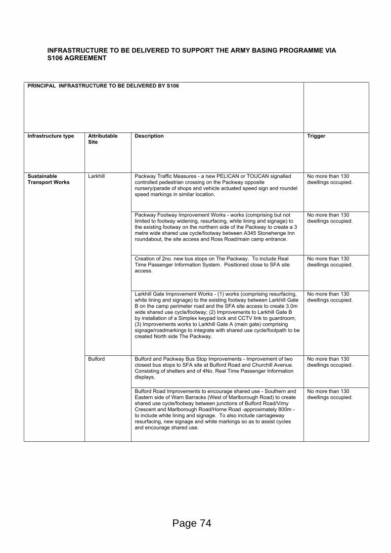
INFRASTRUCTURE TO BE DELIVERED TO SUPPORT THE ARMY BASING PROGRAMME VIA S106 AGREEMENT
PRINCIPAL INFRASTRUCTURE TO BE DELIVERED BY S106
Infrastructure type Attributable Site
Description Trigger
Packway Traffic Measures - a new PELICAN or TOUCAN signalled controlled pedestrian crossing on the Packway opposite nursery/parade of shops and vehicle actuated speed sign and roundel speed markings in similar location.
No more than 130 dwellings occupied.
Packway Footway Improvement Works - works (comprising but not limited to footway widening, resurfacing, white lining and signage) to the existing footway on the northern side of the Packway to create a 3 metre wide shared use cycle/footway between A345 Stonehenge Inn roundabout, the site access and Ross Road/main camp entrance.
No more than 130 dwellings occupied.
Creation of 2no. new bus stops on The Packway. To include Real Time Passenger Information System. Positioned close to SFA site access.
No more than 130 dwellings occupied.
Larkhill
Larkhill Gate Improvement Works - (1) works (comprising resurfacing, white lining and signage) to the existing footway between Larkhill Gate B on the camp perimeter road and the SFA site access to create 3.0m wide shared use cycle/footway; (2) Improvements to Larkhill Gate B by installation of a Simplex keypad lock and CCTV link to guardroom; (3) Improvements works to Larkhill Gate A (main gate) comprising signage/roadmarkings to integrate with shared use cycle/footpath to be created North side The Packway.
No more than 130 dwellings occupied.
Bulford and Packway Bus Stop Improvements - Improvement of two closest bus stops to SFA site at Bulford Road and Churchill Avenue. Consisting of shelters and of 4No. Real Time Passenger Information displays.
No more than 130 dwellings occupied.
Sustainable Transport Works
Bulford
Bulford Road Improvements to encourage shared use - Southern and Eastern side of Warn Barracks (West of Marlborough Road) to create shared use cycle/footway between junctions of Bulford Road/Vimy Crescent and Marlborough Road/Horne Road -approximately 800m - to include white lining and signage. To also include carriageway resurfacing, new signage and white markings so as to assist cycles and encourage shared use.
No more than 130 dwellings occupied.
Page 74

Upgrade to public footpath 5 and 10 - (1) upgrade between Double Hedges and Bulford Road to 3m wide cycleway/footway with associated fencing, lighting signage and required legal orders as well as appropriate connections at either end; (2) works to provide additional safe pedestrian crossing points of footpath number Bulford 10 across Double Hedges Road and for the permissive path.
No more than 130 dwellings occupied.
Bulford Gate Improvement Works - (1) Bulford Gate B (main gate) comprising signage and road markings to assist cyclists accessing the Bulford Site (2) Bulford Gate E comprising signage and road markings to assist cyclists accessing camp; (3) Bulford Gate C comprising the installation of a Simplex keypad lock and CCTV link to guardroom.
No more than 130 dwellings occupied.
Marlborough Road Improvement Works - (1) two new PELICAN or TOUCAN crossings between two sides of camp; (2)2No. Vehicle actuated speed signs and carriageway roundel speed markings in a position adjacent to camp entrance.
No more than 130 dwellings occupied.
Management of vehicle speeds on A3026 outside Wellington Academy No more than 130 dwellings occupied.
Perham Down Camp access gate improvements - (1) Gate A (off Bulford Road) install new CCTV link to guardroom; (2) Gate B and Gate D to include installation of Simplex key pad and CCTV link to guardroom.
No more than 130 dwellings occupied.
Improvements to existing bus stops outside SFA site main access onto A3026 Tidworth Road to include Real Time Passenger Information displays.
No more than 130 dwellings occupied.
Improvements to existing Corunna barracks site (new SFA site access) onto A3026 Tidworth Road (splitter island, pedestrian crossing and modification to geometry) and provision of shared use cycle/footway shared footway - to be provided on the south side of the A3026 (site frontage) between the proposed western site access and the Somme Road junction.
No more than 130 dwellings occupied.
Ludgershall
New pedestrian crossings - (1) New TOUCAN crossing across Tidworth Road outside Wellington Academy - to include 2no. vehicle actuated speed signs, and carriageway roundel speed markings; (2) New PELICAN or TOUCAN crossing immediately outside Perham Down Camp main gates to include 2no. vehicle actuated speed signs, and carriageway roundel speed markings.
No more than 130 dwellings occupied.
Junction Improvements
Bulford Junction 13D Improvement Works - Works to widen the Solstice Park Avenue and Porton Road (south) arms of the roundabout at Junction 13D Porton Road/Solstice Park Avenue/London Road in order to provide wider entries and flare lengths
No more than 150 dwellings occupied.
Page 75
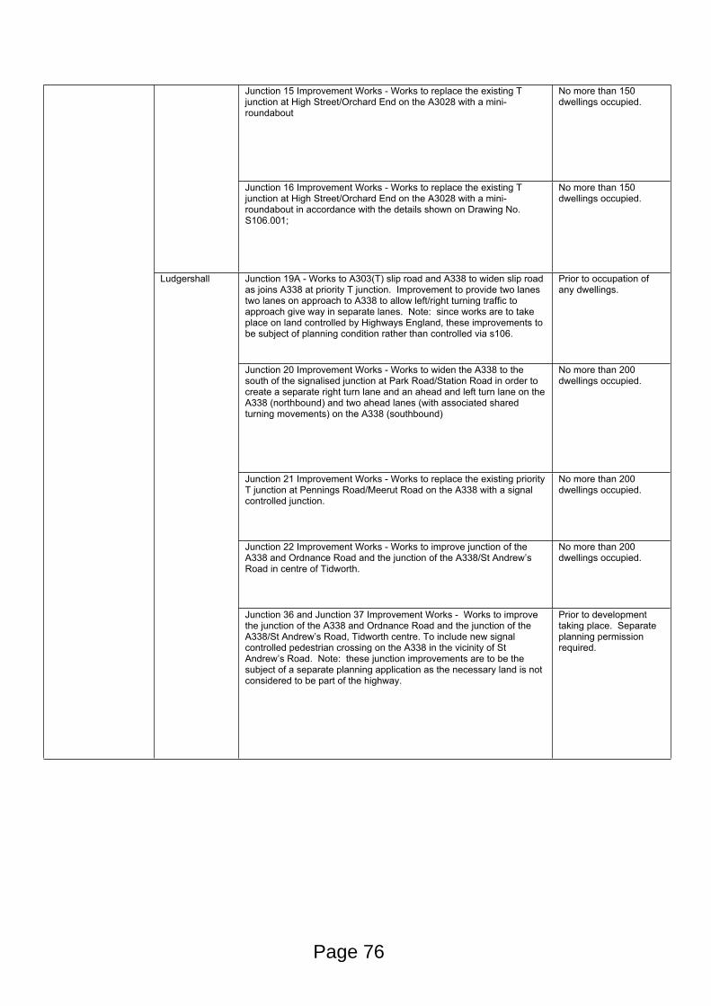
Junction 15 Improvement Works - Works to replace the existing T junction at High Street/Orchard End on the A3028 with a mini-roundabout
No more than 150 dwellings occupied.
Junction 16 Improvement Works - Works to replace the existing T junction at High Street/Orchard End on the A3028 with a mini-roundabout in accordance with the details shown on Drawing No. S106.001;
No more than 150 dwellings occupied.
Junction 19A - Works to A303(T) slip road and A338 to widen slip road as joins A338 at priority T junction. Improvement to provide two lanes two lanes on approach to A338 to allow left/right turning traffic to approach give way in separate lanes. Note: since works are to take place on land controlled by Highways England, these improvements to be subject of planning condition rather than controlled via s106.
Prior to occupation of any dwellings.
Junction 20 Improvement Works - Works to widen the A338 to the south of the signalised junction at Park Road/Station Road in order to create a separate right turn lane and an ahead and left turn lane on the A338 (northbound) and two ahead lanes (with associated shared turning movements) on the A338 (southbound)
No more than 200 dwellings occupied.
Junction 21 Improvement Works - Works to replace the existing priority T junction at Pennings Road/Meerut Road on the A338 with a signal controlled junction.
No more than 200 dwellings occupied.
Junction 22 Improvement Works - Works to improve junction of the A338 and Ordnance Road and the junction of the A338/St Andrew’s Road in centre of Tidworth.
No more than 200 dwellings occupied.
Ludgershall
Junction 36 and Junction 37 Improvement Works - Works to improve the junction of the A338 and Ordnance Road and the junction of the A338/St Andrew’s Road, Tidworth centre. To include new signal controlled pedestrian crossing on the A338 in the vicinity of St Andrew’s Road. Note: these junction improvements are to be the subject of a separate planning application as the necessary land is not considered to be part of the highway.
Prior to development taking place. Separate planning permission required.
Page 76

Junction28 Improvement Works - Measures to improve traffic flow/ease congestion at A3026 Tidworth Road / A342 High Street / A342 Andover Road, centre of Ludgershall (war memorial). No plans submitted, possible contribution towards improvements already scheduled as part of previous planning permissions in Ludgershall - Granby Gardens (14/06522/FUL ),Empress Way (E/2013/0234/OUT), Drummond Park (E/11/0001/OUT).
To be determined.
Early Years - financial contribution to be used to provide facility at new Ludgershall Primary School site.
Upon grant of planning permission for design fee and balance to be paid upon letting of contract of new primary school.
Primary - New Ludgershall Primary School on site. 1.6Ha for 1.5FE with possibility of additional 0.4Ha to create 2FE if required.
Within 20 working days of grant of planning permission, payment of design fee. Balance to be paid upon commencement of development.
Ludgershall
Secondary - contribution to provide additional school places at Wellington Academy.
Within 20 working days of grant of planning permission, payment of design fee. Balance to be paid upon commencement of development or upon the letting of the contract to build the school extensions, whichever is the earlier.
Early Years - places to be created via extensions at Noah's Ark Nursery at The Beeches (Bulford) to provide for a minimum of 100 day nursery places.
The Haig Centre (Bulford) not to be closed until new Tidworth and Bulford EY facility has been opened and available for use. The Haig Centre being inappropriately located within the confines of Ward Barracks, which is to be redeveloped (a "backgate" access to the SPTA to be created immediately adjacent).
Education (equating to land and £18.02M total funding)
Bulford
Primary - Contributions towards the creation of extensions to Kiwi Primary School, Bulford. Separate planning permission has been granted with work on site underway.
Planning permission already granted for extensions to Kiwi Primary (15/06846/FUL) with works underway. Contributions to be paid upon signing of s106. Extensions at St Leonard's Primary (permission 15/06849/FUL) not funded by MoD.
Page 77

Secondary - contribution to provide additional school places at Avon Valley College.
Within 20 working days of grant of planning permission, payment of design fee. Balance to be paid upon commencement of development or letting of contract to build school extensions, whichever is the earlier.
Early years - contributions to be paid towards providing EY spaces at the new primary school to be built at the Larkhill SFA site.
Upon the grant of the Larkhill SFA planning permission pay the design fee. Balanceof contribution to be paid upon the commencement of development or the letting of the contract for the build the new primary school, whichever is the sooner.
Primary - New primary school to be built as part of the Larkhill SFA development. 1.8Ha site to provide for 2 FE school.
Upon the grant of the Larkhill SFA planning permission pay the design fee. Balanceof contribution to be paid upon the commencement of development or the letting of the contract for the build the new primary school, whichever is the sooner.
Larkhill
Secondary - contribution to be paid towards the provision of school places at Avon Valley College.
Within 20 working days of grant of planning permission, payment of design fee. Balance to be paid upon commencement of development or letting of contract to build school extensions, whichever is the earlier.
Healthcare Larkhill 200m2 of floorscape to be created for NHS GP as part of the new MOD medical facility to be constructed on land immediate adjacent to existing health centre (South side The Packway). Seperate planning permission required for new MOD medical facility. Pre-application discussions ongoing.
Within 3 months of the date of commencement of development procure the construction of the additional NHS floorspace. Within 3 months of the commencement of the medical facility, make written offer to relevant NHS Trust or potential operator. Use reasonable endeavours with 6 months of completion of the madical facility to have procured an operator.
Page 78

Sports, Leisure and Community facilities
Applies to all SFA planning applications
Implementation of "Sports and Community Access Scheme". Such a scheme compels the MoD to make sports and leisure facilities available to approved clubs and organisations by prior arrangement. The SCAS is to encourage use of facilities and will allow for parties to meet regularly so as to manage the scheme. Facilities include:
Ludgershall (Perham Down) –
New gym hall (including squash courts)
New Community centre – community room
Somme Road Rugby Pitch
Somme Road Football Pitch
Somme Road Cricket Pitch
Somme Road Polo Area
New 2x Football Pitches (1x grass and 1x 3G pitch)
Bulford –
Swimming Pool (WDO 006)
Beeches Community Centre
Marlborough Road 3G Football Pitch
Marlborough Road Cricket Pitch
Marlborough Road 5-a-side Football Pitch
Marlborough Road Changing Rooms
Double Hedges Football Pitch
Double Hedges Cricket Pitch
New 3G Football Pitch
New Cinder Running Track
Larkhill –
Church of St Albans with St Barbara (LL0368)
St Barbara’s Hall (LA0404)
Larkhill Community Centre (LA0609)
Sharpe Hall (LA0234)
Newcombe Hall (LA0360)
Home Barracks 5-a-side Football Pitch (LA0115)
Cricket Pitch (LA0321)
Cricket Pavillion (LA0012)
Astro-turf Pitch (LSX003)
Shrapnel Park Tennis Courts (LSX013 to 015)
No later than 3 months after commencement of development, submission of Sports and Community Access Scheme to Council for approval (s106 merely sets out principles and lists facilities). Implementation of SCAS within 3 months of Council's written approval.
Page 79
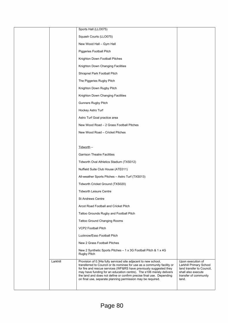
Sports Hall (LLO075)
Squash Courts (LLO075)
New Wood Hall – Gym Hall
Piggeries Football Pitch
Knighton Down Football Pitches
Knighton Down Changing Facilities
Shrapnel Park Football Pitch
The Piggeries Rugby Pitch
Knighton Down Rugby Pitch
Knighton Down Changing Facilities
Gunners Rugby Pitch
Hockey Astro Turf
Astro Turf Goal practice area
New Wood Road – 2 Grass Football Pitches
New Wood Road – Cricket Pitches
Tidworth –
Garrison Theatre Facilities
Tidworth Oval Athletics Stadium (TXS012)
Nuffield Suite Club House (ATE011)
All-weather Sports Pitches – Astro Turf (TXS013)
Tidworth Cricket Ground (TXS020)
Tidworth Leisure Centre
St Andrews Centre
Arcot Road Football and Cricket Pitch
Tattoo Grounds Rugby and Football Pitch
Tattoo Ground Changing Rooms
VCP2 Football Pitch
Lucknow/Esso Football Pitch
New 2 Grass Football Pitches
New 2 Synthetic Sports Pitches – 1 x 3G Football Pitch & 1 x 4G Rugby Pitch
Larkhill Provision of 0.3Ha fully serviced site adjacent to new school, transferred to Council or its nominee for use as a community facility or for fire and rescue services (WF&RS have previously suggested they may have funding for an education centre). The s106 merely delivers the land and does not define or confirm precise final use. Depending on final use, separate planning permission may be required.
Upon execution of Larkhill Primary School land transfer to Council, shall also execute transfer of community land.
Page 80
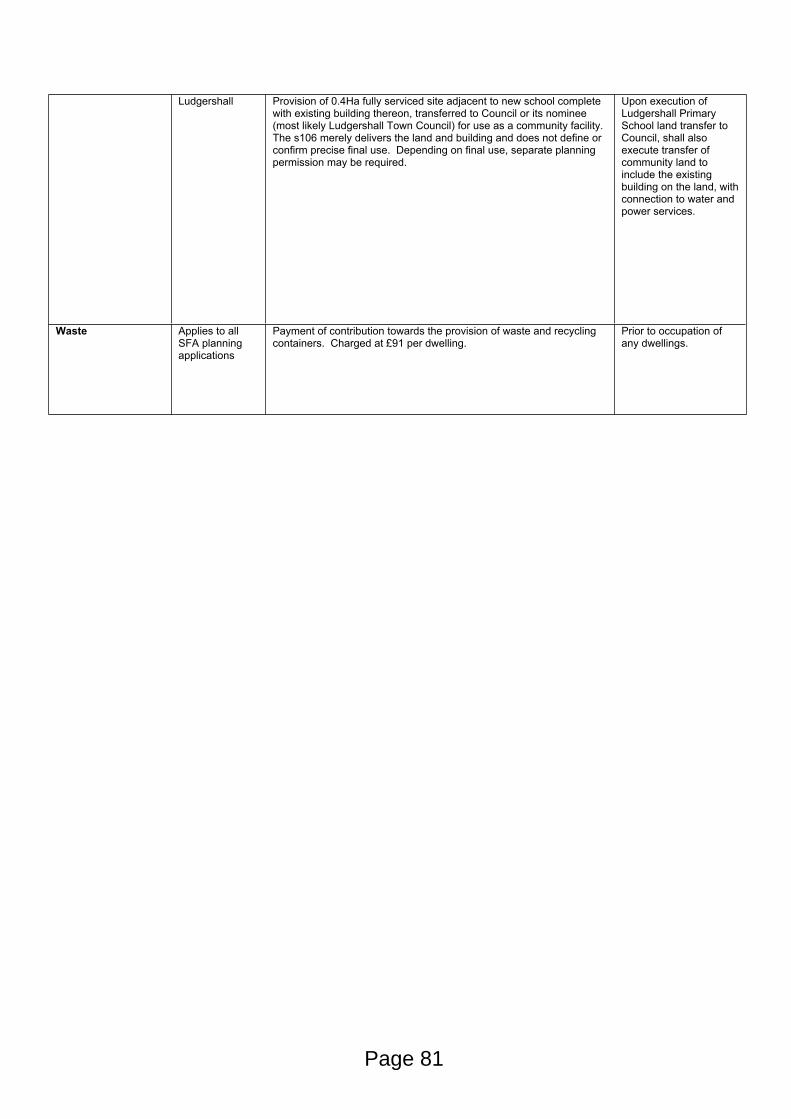
Ludgershall Provision of 0.4Ha fully serviced site adjacent to new school complete with existing building thereon, transferred to Council or its nominee (most likely Ludgershall Town Council) for use as a community facility. The s106 merely delivers the land and building and does not define or confirm precise final use. Depending on final use, separate planning permission may be required.
Upon execution of Ludgershall Primary School land transfer to Council, shall also execute transfer of community land to include the existing building on the land, with connection to water and power services.
Waste Applies to all SFA planning applications
Payment of contribution towards the provision of waste and recycling containers. Charged at £91 per dwelling.
Prior to occupation of any dwellings.
Page 81
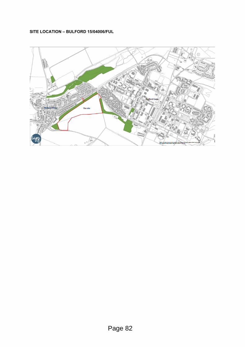
SITE LOCATION – BULFORD 15/04006/FUL
Page 82
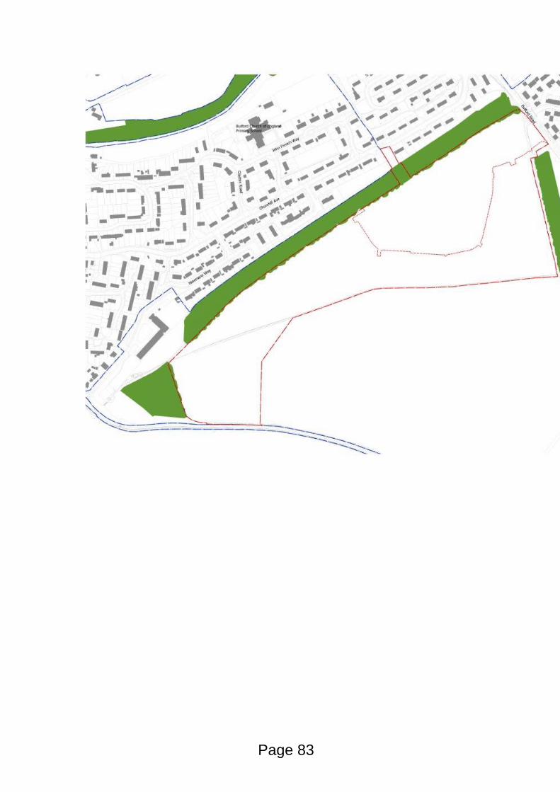
Page 83

This page is intentionally left blank
STRATEGIC PLANNING COMMITTEE
Date of Meeting 13th April 2016
Application Number 15/02770/FUL
Site Address Land at Tidworth Road (Corunna Barracks)Tidworth RoadLudgershallSP11 9RP
Proposal Erection of 246 no. dwellings to provide Service Families Accommodation (SFA), land for a new primary school and community facility, public open space, play areas, landscaping, internal roads and associated infrastructure
Applicant Defence Infrastructure Organisation
Town/Parish Council LUDGERSHALL
Ward LUDGERSHALL AND PERHAM DOWN
Grid Ref 426105 150476
Type of application Full Planning
Case Officer Simon Smith
Reason for the application being considered by Committee
In March 2013, the Secretary of State for Defence announced the Regular Army Basing Plan which is set to deliver the expected restructuring under “Army 2020”. In particular, this set out the future structure of Army units as they move back to the UK from Germany as the British Army’s presence in continental Europe is reduced.
Under the Basing Plan, the necessary optimisation of the UK training estate will result in a greater concentration of the Army on Salisbury Plain Training Area (SPTA), where three high readiness Reaction Force Brigades will be based. Unit moves in Wiltshire commenced in 2014, with the final moves planned for 2019.
This reorganisation of the Army will involve significant new development in the locality to accommodate the additional activity, personnel and their families as well as the infrastructure to support them. Much of this development requires planning permission.
The planning application before the Strategic Planning Committee is one of three large-scale major applications for new Service Family Accommodation (SFA) houses. Since it is part of a wider programme of Army related development across the Salisbury Plain, the application intrinsically possesses wider strategic implications and raise issues of more than local importance.
1. Purpose of Report
1.1 To consider the application and to recommend to Members of the Strategic Planning Committee that the application should be APPROVED, subject to all parties entering into a legal agreement under s106 of The Act and subject to appropriately worded planning conditions.
1.2 The Ludgershall Town Council Support this application subject to the following observations: -
Page 85
Agenda Item 7
The proposed cycleway from site to Somme Road is upgraded to a road to reduce vehicular movements along the A3026 from the traffic light junction past Wellington Academy.
Existing 30mph limit end at Simonds Road is extended past Wellington Academy and a light controlled pedestrian crossing from Wellington Academy to Somme Road.
2. Report Summary
Consideration of this planning application reveals the following to be the main issues:
Principle of development
Layout, design, open spaces, parking
Impact upon neighbour amenity
Highway issues
Pedestrian crossings at Perham Down camp and Wellington Academy
Community building
Infrastructure and its delivery via s106 agreement
3. Site Description
3.1 Extending to 14.58 hectares, the application site comprises a substantial proportion of the Corunna Barracks complex on the Western part of Ludgershall. The A3026 Tidworth Road forms to the North West boundary of the site, with existing residential properties to the East and North East. Military buildings and development surround the site to the West, through which the old military rail line runs. Woodland and the test track form the hinterland beyond, all of which form part of the military training estate. A railway line runs through the southern portion of the site.
3.2 Although recent demolition has resulted in the majority of the buildings on the site being removed, the site is unquestionably Previously Developed Land (PDL). Locally prominent, the buildings were large structures, including barracks, workshops, storage sheds as well as large expanses of hardsurfacing.
4. Relevant Planning History
K/39515 The erection of a temporary 101 person camp within the security fence.
K/40302 The erection of a single storey modular building to provide temporary office accommodation.
K/45550 The erection of two new modular buildings (f1 & f2), two small extensions to existing building (building d) and the re positioning of an existing internal security fence.
K/46972 Formation of layby and re-location of guard cabin
K/78/0815 The extension of security fence and the provision of gates
Page 86
K/51906/F New police post
K/042723/O Headquarters building
K/53835/F New storage unit
14/09997/SCR Request for screening opinion for proposed service family accommodation comprising up to 300 homes, provision of new vehicular access, primary school, public open space, landscaping, internal road and ancillary works
5. The Proposal
5.1 The application site is one of three proposed for Service Families Accommodation (SFA). It comprises an area of approximately 14.58 hectares, which currently forms part of Corunna Barracks in Ludgershall.
5.2 The application is submitted as a hybrid planning application for 246 dwellings and associated infrastructure. Accordingly, it simultaneously seeks:
Full and detailed planning permission for the first 100 SFA dwellings. Detailed drawings of house types (floor plans and elevations) as well as details of highways, street scenes and public open space.
Outline permission for the remaining 146 SFA dwellings. In this regard, approval is sought for layout, means of access, landscaping and scale, but reserves details of appearance to be approved at a later stage. Such applications are known as Reserved Matters applications.
Outline permission for 2.4Ha site for primary school and community uses (including retention of an existing building), disaggregating into 2.0Ha school site and 0.4Ha community site. In this regard, the application merely seeks to establish the principle of development, with all detailed matters being reserved for later consideration.
5.3 The submission is complete with a demolition works plan. It confirms that the buildings within and adjacent to the site are to be demolished and removed from the land with the exception of one building (reference CO 0124), which is to be transferred to the Council or its nominee for community use. In particular, the storage warehouses immediately adjacent to the west and southern boundaries have already been demolished in preparation of the development taking place, so as to prevent potential overshadowing.
5.4 The application has previously been ‘Screened’ under the Town and Country Planning (Environmental Impact Assessment) Regulations 2011. The opinion that EIA was not required for this development was adopted on 14/11/14. An updated opinion was adopted upon the submission of the planning application (dated 30/04/15), again concluding that EIA was not required.
6. Local Planning Policy
Wiltshire Core Strategy
6.1 Section 70(2) of the Town and Country Planning Act 1990 and section 38(6) of the Planning and Compulsory Purchase Act 2004 require that the determination of planning applications must be made in accordance with the Development Plan, unless material considerations indicate otherwise.
6.2 The Wiltshire Core Strategy (WCS) was adopted by the Council in January 2015. For the purposes of s38(6) of the Planning and Compulsory Purchase Act 2004 and Annexe1 of the NPPF, the WCS is now the statutory development plan.
Page 87
6.3 Policy CP37 of the WCS acknowledges that the provision of new housing on MOD land for military personnel and other operational facilities will be required as a result of the ABP across the SPTA. At a macro level, CP37 envisages that a single master plan should be developed, which, inter alia, would ensure that the infrastructure needs arising from the Army Basing Programme is established and delivered as well as enabling the cumulative impact of development arising from the programme to be addressed. That Masterplan was completed 20th June 2014 and was recognised by the Council’s Strategic Planning Committee 22nd October 2014.
6.4 The site is entirely contained within the limits of development defined by the Kennet Local Plan (2004). Those limits have been carried forward by the Wiltshire Core Strategy, defining Ludgershall as a Market Town, which is a settlement that has the ability to support sustainable patterns of living in Wiltshire through their current levels of facilities, services and employment opportunities (Policies CP1 and CP2 refer).
6.5 Previously saved policies within the Kennet District Local Plan 2004 relating to design and townscape (particularly PD1) have been replaced by CP57 of the WCS. In this regard, whilst Policy CP 37 positively frames proposals for new development at operational military facilities, it requires, inter alia, that such new development should enhance the overall character of the site. CP 57 (design and place shaping) and 61 (transport) of the eWCS is applicable to all forms of new development. In particular criterion ix to CP 57 requires new development which has an effect upon the public realm to create places of character.
6.6 Other relevant policies are: CP50 (biodiversity), CP51 (landscape), CP55 (air quality), CP56 (contaminated land), CP58 (conservation and historic environment), CP60 (sustainable transport), CP61 (transport and development), CP66 (strategic transport network), CP67 (flood risk), CP68 (water resources), CP69 (River Avon SAC).
Saved policies with Kennet District Local Plan (2004)
6.7 Appendix D of the adopted Wiltshire Core Strategy sets out saved policies from the former Kennet District Local Plan (2004), which continue to be relevant to the determination of planning applications.
6.8 Saved Policy HC34 contains standards for the recreation provision within new residential developments of 20 or more dwellings. The proposal incorporates provision of children’s play space, youth play space and amenity green space, seeking to meet the requirements of the Wiltshire Open Space Standards 2012 contained within the Open Space Typologies Report. Saved Policy HC36 relates to the retention of this recreation provision in the long term.
6.9 Saved Policy HC37 requires that development involving 25 dwellings or more to satisfy the Local Planning and Education Authorities that the primary and secondary education needs of the population of the new development can be met.
Wiltshire Local Transport Plan 2011- 2026 - Car Parking Strategy
6.10 The parking on site will be required to meet the standards embraced in the Council’s LTP3Car Parking Strategy. That being: 1 bedroom = 1 space; 2 to 3 bedrooms = 2 spaces; 4+ bedrooms = 3 spaces; visitor parking 0.2 spaces per dwelling (unallocated).
7. Summary of consultation responses
Ludgershall Town Council - Support
“The Ludgershall Town Council Support this application subject to the following observations: -
Page 88
The proposed cycleway from site to Somme Road is upgraded to a road to reduce vehicular movements along the A3026 from the traffic light junction past Wellington Academy.
Existing 30mph limit end at Simonds Road is extended past Wellington Academy and a light controlled pedestrian crossing from Wellington Academy to Somme Road.”
Council Highway Officer – No objection subject to conditions and provisions within s106. See separate Highway Issues section below.
Council Ecologist – No objection subject to the imposition of conditions and/or s106 provisions.
Habitats Regulations Assessment
The HRA prepared by DIO for the Army Basing masterplan has been updated (SPTA Masterplan HRA 18/12/15). It concludes no likely significant effects of the Army basing proposals in combination with other plans and projects including the Wiltshire Core Strategy. Natural England has provided comments on the updated HRA (03/02/16) in which it confirmed that a conclusion of no likely significant effects could be reached in relation to Salisbury Plain SAC/SPA.
Salisbury Plain SAC – located outside SAC and no likely significant effects or loss of calcareous grassland.
Salisbury Plain SPA – located within 4km of SPA, therefore may be recreational impact upon Stone Curlew. The updated HRA provides commitments to implementing additional measures (beyond the existing Stone Curlew Management Plan) to offset potential impacts from SFA: (1) Improvements to existing rights of way/new linkages to encourage use of areas off Salisbury Plain for walking dogs etc; (2) Information in “Welcome Packs” to inform new residents of SFA of sensitivities of the SPA and recreational alternatives; (3) Including results of stone curlew monitoring and potential for recreational impacts as standing item on Environmental Steering Group. Likely no significant effects.
River Avon SAC – NE has previously raised concerns with the Masterplan HRA (updated 18/12/15) relating to how the increased demand for water arising from ABP will be met at Bulford and Larkhill and the consequences of directing all existing/proposed foul water at Larkhill to Wessex Water’s Ratfyn STW. Whilst the Council cannot yet rely on the conclusions of the HRA which states there will be no likely significant effects of the Larkhill/Bulford works on the River Avon SAC, no concerns are raised by the EA/NE/Council with regard to water supply/disposal at developments in Tidworth, Ludgershall or Perham Down (ie. within the Tidworth WTZ). The draft WMP which underpins the HRA is therefore acceptable in respect of this application and conclude that no significant effects are likely.
Protected species issues
Reptiles - The Great Crested Newt Survey Report (Mott MacDonald, 26/08/14) confirms that pond 3 is deemed to be unsuitable for breeding and Pond 2 was surveyed but did not contain this species, although a large breeding population of smooth newts is present. Pond 1 is also included in the application site boundary and WYG have latterly confirmed that an assessment in May 2015 found it to have low suitability for great crested newts but will be drained sensitively as a precaution
Breeding Bird Report (WYG, March 2015) - identifies numbers of common passerines and swallows breeding on site including 4 red/amber list species. A hedgerow on the eastern boundary will be retained for breeding birds a close board fence to be erected to protect. Mitigation proposed for the eastern boundary of the school site (Ludgershall Landscape Proposals Drawing number A089116-10 LU[LP]03 Rev A. The EMS identifies a need for mitigation for the impacts of lighting. A 10m buffer has been built into the design between lighting for the development and habitat used by sensitive species and is shown on drawing number LU[3]S10. The lighting itself designed accordingly. Landscape plans have increased the degree of landscape connectivity around the site and all trees with more than negligible potential for bats are being retained. Reptiles are found on the race track outside the development and measures are included in the EMP to ensure any reptiles occurring incidentally within the site are not harmed. New proposals to include a close board fence where the development abuts existing housing will have implications for the movement of wildlife, such as amphibians and mammals and therefore recommends measures are put in place to ensure the fence
Page 89
does not prevent free movement of this and other species across the local area e.g. by requiring fences to include gaps large enough for permeability by eg. Hedgehogs.
Council Landscape Architect – No objection subject to carrying out of submitted landscaping scheme.
Council Education Officer – No objection subject to s106 delivering necessary school places.
Council Environmental Health Officer – No objection subject to conditions.
Contaminated land - The applicants have submitted a Ground Conditions Desktop report as part of the application. I have looked at this and it concludes that more investigation of the site will be required (p24-25). I can confirm that we are happy with these proposals. I suggest we ask for a condition to be placed on any planning permission to be granted
Air Quality - The area does not have an AQMA, and as such we would not require an Air Quality Assessment, however the development is likely to have a negative impact upon local air quality. The councils adopted Air Quality Strategy seeks positive contributions towards the improvement of air quality in Wiltshire; in view of this we would expect to see the developer demonstrate what positive contributions they could make e.g. sustainable travel alternatives and infrastructure, driver training, tree planting, contributing to local air quality action groups. Also seek a financial contribution towards Air Quality work. (Note: this latter matter has been dealt with via planning condition).
Construction - Noise, lighting, demolition and construction impacts on nearby residential properties and future occupants of the proposed properties. The noise assessment submitted assesses noise from road traffic and Ludgershall Business Park and provides recommendations and measures to attenuate the noise to levels at or below BS8233 criteria. In relation to the proposed properties that will require enhanced glazing and/or ventilation and the school, would expect further information to be submitted detailing the internal layout, glazing and ventilation to be installed.
Council Drainage Engineer – No objection subject to conditions.
Foul Drainage - application states foul disposal to mains via existing connection. Development likely to be an increase flow rate – applicant will need to ensure the existing sewer system/pumping station/treatment works can take additional flow without need for off-site works. Retained pumping station and septic tank on site are located in area proposed for the Primary school and community site. If septic tanks have soakaways there is likely to be contaminated ground at that point. Due to the blanket adoption of sewers in 2011 the existing foul system on site is public under the ownership of the sewerage undertaker (the Veolia pumping station). Applicant will need to check with and gain permission to abandon or divert sewers/pumping main to allow the layout as indicated to be achieved.
Storm Drainage - application states storm drainage disposal will be via sustainable system. The application contains no detail as to how the existing site deals with storm water disposal. This information will be required to allow future disposal arrangements to be considered. Ground investigation report (desk study) states site is located on Seaford Chalk (although it also suggests that there is considerable amount of made ground) thus soakaways should be appropriate for storm water disposal, subject to appropriate further testing to BRE365. The report also states “Immediately beyond the north western site boundary is a Source Protection Zone 3 – Total Catchment which becomes a Source Protection Zone 2 – Outer Catchment within 500m of the site boundary.” Any storm disposal system needs to take this into account. Recommends that conditions imposed with regard to proposed foul/storm drainage disposal.
Council Conservation Officer – No objections. Additional information in the form of a heritage assessment to satisfy the requirements of paragraph 128 of the NPPF has now been submitted. The CO agrees with the conclusions contained within the report submitted and notes that the Council’s Archaeologist has requested a condition so as to secure the recording of the buildings to be demolished (as suggested within the conclusion of the Heritage Assessment).
Council Archaeologist – No objection subject to conditions. Following the completion of an updated Heritage Assessment, which assesses the buildings and the potential for below ground archaeological remains, the Archaeologist is now able to support the proposal, subject to the imposition of planning
Page 90
conditions. It is recommended that a programme of archaeological works is carried out as part of any development, likely taking the form of building recording and an archaeological watching brief.
Council Technical Officer (Public Open Space) – No objections subject to conditions and provisions within s106 in respect of youth and adult sports provision. Note: the application proposes that existing sports and community facilities owned and run by the MoD are to be promoted and opened up for use by the local community. Such facilities are to be controlled via a “Sports and Community Access Scheme” embedded and enforced through the s106. The Council’s Technical Officer is satisfied with the proposal since it would deliver facilities far in excess of what would ordinarily be expected from new development of this size, in accordance with saved policy HC34 of the Kennet District Local Plan 2004. Council New Housing Officer – No objection subject to provisions with s106. There is no requirement for an affordable housing contribution while the homes are used as Service Families Accommodation. However the s106 Agreement will ensure that, should the units ever be sold on the open market, an affordable housing contribution would be made.
Spatial Planning Officer – No objections.
“The statutory development plan for the site in question is the Wiltshire Core Strategy (WCS), which also saves some policies from the Kennet District Local Plan. Core Policy 37 of the WCS relates specifically to military establishments. In principle, CP37 is permissive towards the redevelopment of redundant MOD sites, such as Corunna Barracks, provided they are well related to an existing settlement in terms of both location and scale. Whilst the policy is clear that the focus should be on employment led development, it goes on to say that other uses should be determined through a masterplanning approach with the local community. Wiltshire Council has worked in partnership with the DIO in preparing the Army Basing Programme Salisbury Plain Master Plan which has resulted in enhanced public engagement and consultation as well as Joint Officer and Councillor working and steering groups which have informed the Plan. This Master Plan is a material planning consideration in determining planning applications. Provided the case officer is satisfied that he proposal meets the requirements of CP37 and all other relevant policies of the statutory development plan, and takes account of the Salisbury Plain Master Plan, there is no planning policy objection to this proposal.”
Council Sustainable Energy Officer – No objections, subject to the imposition of suitably worded planning condition requiring CfSH4 certification has been provided and approved in writing by the local authority. (Note: following the governments ministerial statement in March 2015 withdrawing CfSH, legal advice confirms that it is now not possible to impose planning conditions requiring CfSH standards to be met).
Council Waste Officer – Confirmation that contributions necessary to provide additional collection capacity and bins.
Environment Agency – No objection subject to conditions.
Water supply - DIO has also agreed that they will mitigate any water abstraction impacts of supplying both the existing MoD network and the proposed Army Basing Project developments. However, as the detail of this mitigation has not yet been agreed for individual sites, the EA recommend that suitable worded planning conditions be imposed.
Foul drainage – The application confirms the development would be connected into an existing drainage system. The EA support the proposed development being connected to a mains foul sewer. However, it must be ensured that there would be sufficient capacity within the foul drainage system to take the foul water from this development. This should be established preferably prior to planning permission being granted, but definitely before any construction commences and therefore recommend that a planning condition be imposed to that effect.
Surface water - Soakaways or porous paving are proposed to manage surface water drainage from the houses and driveways (Page 5 and 16 of FRA and Section 8.6 of Planning Statement). The EA have raised no objection to this option.
Page 91
Contaminated land – The submitted Ground Conditions Desk Study Report states that there is the potential for contamination of the development site. This report included the recommendation to undertake further site investigation to characterise the ground conditions beneath the site, also to better identify the constraints and geo-environmental issues. The EA support further investigation being undertaken, and we would recommend that a condition be included in the planning permission requiring this.
Construction (Environmental) Management Plan – Recommend that the submitted Construction Management Plan is secured as a planning condition in any planning permission that may be granted.
Green Infrastructure - A Green Infrastructure plan is included (Drg No: A089116-10 LU[LP]01-2, dated 12 March 2015). The plan indicates where green space would be located. It must be ensured that the green space provided adequately serves all its requirements, including providing habitat to improve the nature conservation of the area. This should include providing green corridors for biodiversity species.
Highways England – No objections, subject to imposition of conditions. The queue surveys and revised modelling work demonstrate that the base models for Junctions 13a, 13b, 18 and 19a are robust and acceptable. The proposed mitigation for Junction 19A is acceptable and no further mitigation is required for the other junctions for this phase of the proposed development. The proposed improvement works are required to be secured by condition and an early dialogue with Highways England to determine the appropriate legal agreement is recommended.
Natural England – No objection subject to conditions. Confirms that the MoD embarked on a consultation process with NE on the preparation of a Water Management Strategy for the re-basing programme. The MoD, as a competent authority is preparing of a Habitats Regulations Assessment for the re-basing programme related to potential impacts on the River Avon SAC and other European sites. The water strategy, along with the recently completed River Avon SAC Nutrient Management Plan, will be key documents informing this HRA. At the time of writing, NE suggest it to be premature to speculate on the outcome of the HRA and what measures may be required to enable this proposed development and the wider re-basing programme while showing that there would be no impact on the integrity of the River Avon SAC (see Council Ecologist comment). However, appears that there is scope for showing no impact on site integrity provided appropriate water supply/wastewater measures are put in place - detail to be developed through the Water Management Strategy and their adequacy demonstrated by the HRA. The proposal raises the same considerations on water supply and wastewater in relation to the River Avon System SSSI.
Historic England – Refers back to Council’s Conservation team.
Veolia Water – No objection subject to conditions. Corunna development it is on a brown field site and replaces numerous previously occupied barrack blocks and vehicle workshops. Not going to be a significant net increase in water use for the domestic site as opposed to the previous use - borne out by network modelling undertaken on potable water and foul waste. VWPL compiled and published its Water Resources Management Plan [WRMP] last year with EA approval which sets out the management of abstraction rates over as much as 25 years. In preparing the WRMP, VWPL already had visibility of the ABP proposals at Tidworth and Perham Down Garrisons including some married quarters proposals at Area 19. VWPLC took these extra demands into WRMP calculations and projections. Whilst did not have sight of the Corunna Barracks married quarters development when original WRMP was prepared, its subsequent arrival was not viewed with any concern given the perceived net water consumption increase would be minimal. The WRMP and the subsequent EA Abstraction Licence has recognised sufficient headroom to cater for such extra demands going forward.
RSPB – No further comment subject to Council Ecologist’s satisfaction.
8. Publicity
Page 92
The application was advertised by site notice, press advert and neighbour consultation.
Nine (9) letters in total received in response to publicity. Summary of concerns raised:
Future of existing security fence - removed or retained? What is intended boundary treatments – especially with Simonds Road, Johnson Way and
Stable Close. Who would be responsible for upkeep of any new boundary erected? Will development take account of change in levels to Simonds Road, Johnson Way, Stable
Close and secure amenities of existing residents? Does not appear to be any greenbelt buffer zone between the planned houses/gardens and
rear fence of existing residences. Concern over height of new properties. Will the current infrastructure for broadband be upgraded. Concern over noise and levels of dust during demolition and building phase. Wish to see a ring/relief road for Ludgershall. Do not wish to see new development take place behind property as just moved to area. Concern that adequate parking will be provided for new school.
Extensive local consultation was undertaken by the applicant during the preparation of the Masterplan and prior to the submission of the respective planning applications.
9. Planning Considerations
Principle of development
9.1 Section 70(2) of the Town and Country Planning Act 1990 and section 38(6) of the Planning and Compulsory Purchase Act 2004 require that the determination of planning applications must be made in accordance with the Development Plan, unless material considerations indicate otherwise.
9.2 The Wiltshire Core Strategy (WCS) was adopted by the Council in January 2015. For the purposes of s38(6) of The Act 2004 and Annexe1 of the NPPF, the WCS is now the statutory development plan.
9.3 Policy CP37 of the WCS acknowledges that the provision of new housing on MOD land for military personnel and other operational facilities will be required as a result of the ABP across the SPTA. At a macro level, CP37 envisages that a single master plan should be prepared in a manner which “frontloads” consultation and partnership working with the local community and other stakeholders. In addition to identifying preferred sites for new military housing, it should also ensure that the infrastructure needs arising from the Army Basing Programme is clearly established and delivered as well as enabling the cumulative impact of development arising from the programme to be addressed. The Masterplan envisaged by CP37 was indeed completed 20th June 2014 and was recognised by the Council’s Strategic Planning Committee 22nd October 2014.
9.4 The finalised Masterplan can be regarded as an important and critical background document informing the assessment of the planning applications submitted in respect of Army Basing Programme. Indeed, the Master Plan has been embedded within each of those planning applications by defining the wider context and assessing the cumulative impacts and thereby demonstrating, in the broadest terms, how and where development can, and cannot, take place. It follows that the Master Plan is a material consideration in the determination of this application, providing contextual understanding, consistency for decision-making and providing confidence that the Army Basing Programme has been planned in a comprehensive manner and will deliver the necessary infrastructure.
9.5 The new housing being brought forward as result of the Army Basing Programme sits outside of the Council’s housing requirements and land supply. Nevertheless, the application site is positioned entirely within Ludgershall’s limit of development, as established and carried
Page 93
forward by the Kennet Local Plan (2004) and the Wiltshire Core Strategy (policy CP1) respectively.
Layout, design, open spaces, parking
9.6 Previously saved policies within the Kennet District Local Plan 2004 relating to design and townscape (particularly PD1) have been replaced by CP57 of the WCS.
9.7 Policy CP 37 positively frames proposals for new development at operational military facilities. Nevertheless, it also requires, inter alia, that such new development should enhance the overall character of the site. CP 57 (design and place shaping) and 61 (transport) of the WCS is applicable to all forms of new development. In particular criterion ix to CP 57 requires new development which has an effect upon the public realm to create places of character. The submission has taken account of the standards and requires set out within saved policies within the Kennet District Local Plan.
9.8 The application identifies a 4.14Ha part of the site for which full and detailed planning permission is sought. Further, across the entire application site, the application seeks detailed permission for the means of access, layout, landscaping and scale of the development. It does, however, reserve details of appearance of the remaining development to be approved at a later stage (known as Reserved Matters applications).
Means of access
9.9 The new development would be served by two points of vehicular access. The Eastern access would be via the existing signal controlled junction onto Tidworth Road that currently serves Corunna Barracks. Minor modifications are proposed to the existing signal controlled access junction onto Tidworth Road to provide a footway on the eastern side of the site access, signal controlled pedestrian crossings on the western and southern (site) arms of the junction, a pedestrian refuge in the mouth of the site access and revisions to the junction radius on the western side of the site access arm. To the West, a new priority access junction is proposed, also onto Tidworth Road.
9.10 Merely suggested as a possibility by the submitted masterplans, a further pedestrian access to the site from the South (from Johnson Way) is regarded as necessary by the Council’s Highway Engineer and it is considered reasonable to impose a planning condition in that respect, especially as it would allow for access to the new school and community facilities on the site. This access also forms part of the submitted Recreational Access Action Plan proposals for the site, alongside a further recreational pedestrian access route from the southern edge of the SFA to the polo field to the south.
Layout
9.11 The proposal makes use of a hierarchical approach to internal roads which, after entering the site via the existing access onto the Tidworth Road, allow for an early branching and thus framing more private areas of the housing estate (defined by private drives and shared surfaces) as well as three reasonably sized areas of public open space/play (0.79Ha, 0.73Ha and 0.29Ha respectively). The main roads delve deeper into the site and whilst connecting to the estate road leading from the new access onto the Tidworth Road, only affords a pedestrian linkage.
9.12 The application specifies an overall density to be 20 dwellings to the gross hectare (excluding the primary school and community uses), which in practical terms does not appear to be out of character to the locality and is a density that is lower than the average contemporary housing scheme.
9.13 At 2.88 hectares in total, the quantum of public open space on the site is policy compliant as are the three equipped play areas. Provision and future maintenance of the areas would remain the responsibility of the applicant, secured through provisions within the associated
Page 94
agreement under s106 of The Act. The ordinarily expected sports and leisure provision is to be secured off-site within the extensive military facilities across the Ludgershall, Tidworth, Bulford, Larkhill area, reference to which can be found within the s106 section below. In addition, the MOD will provide a network of permissive access routes to the south of the SFA site to connect to the polo field and rugby pitch on Somme road, in order to manage the recreational pressure of rebasing on Salisbury Plain Special Protection Area. Details are provided in the MOD Salisbury Plain Recreational Access Action Plan.
Landscaping
9.14 Following initial concerns raised at the time of the applicant’s pre-consultation events, the application is submitted with substantial green space/planting to the Northern and Western boundaries of the site (15.0m deep for the Western boundary and a variable 10.0m-30.0m for the boundary with Tidworth Road). In combination with the planned demolition of the majority of existing buildings on the Corunna Barracks site, including those not within the application site, these green spaces are likely to greatly improve the feathering and filtering of views (rather than an outright block) of the new development and the built-up edge of Ludgershall in general when approaching via the Tidworth Road. Of course, the proposed new areas of planting also provides opportunity to create habitat and ecological linkages with woodland areas to the south and west.
9.15 Those new dwellings to be positioned adjacent to those existing properties at Simonds Road, Johnson Way, Stable Close are to benefit from planting in their rear gardens so as to soften and filter views.
9.16 In addition to a nuanced scheme of landscaping across the site so as to improve general amenity, there are two formal areas of open space within the development site, one to the north-east and the other to the South-West. These will accommodate local areas for play, feature trees and areas of ornamental shrub planting and bulb planting to add seasonal interest. Amenity grassland will be sown in the remaining open space. There are several other areas of informal open space, including a grouping of existing mature trees in the centre of the site.
9.17 In terms of the development likely impact upon the wider landscape, the submitted Landscape and Visual Impact Appraisal broadly concludes that visual impacts deriving from the development are likely to be extremely limited due to the surrounding topography and well vegetated nature of the area. Indeed, given the currently highly built up nature of the site, it is certainly the case that, once development has taken place, distant views of the site are likely to be less obtrusive than at present. The Council’s Landscape Architect concludes that the development would have a largely neutral impact and there is no reason to diverge from this opinion.
Design of dwellings and boundaries
9.18 A mixture of house types is proposed, including terraced, semi-detached and detached properties. Although the application seeks permission for a total of 246 units, the Army does distinguish between ranks and their housing entitlement, meaning 75 of the total being made available to only Officers, the remaining 171 intended for other ranks. The officer SFA units are clustered in the Western portion of the site (within the outline component of the hybrid application) and are, as would perhaps be expected, likely to be larger properties. However, since design is a reserved matter, no details of those properties have been provided at this time.
9.19 The detailed element of the application suggests only two house types, but a variation in terrace/semi/detached configuration, material finish and roof profile would, when combined with site topography, likely afford a degree of visual interest across the development. Being reasonably reflective of the locality, materials are to be a mix of render, brick and flint with brick quoins; roofs being a suitable alternation of slate and red roman style tiles. As would be
Page 95
expected on a modern housing estate, all doors are specified as timber, with windows white PVCu.
9.20 All properties are of conventional two storey design pitched roof design, without rooms in the roof space. Height to eaves and ridge is in the region of 5.0m and 9.0m respectively. Garages are of mixed detached, semi and terraced form, but do not exceed 5.5m in overall height.
9.21 The applicant confirms entitlements that military accommodation standards compare favourably with civilian equivalents (Code for Sustainable Homes, Lifetime Homes, for instance). Accordingly, each house features a utility room with separate entrance, allowing users to remove/store kit before progressing through the rest of the dwelling. In common with the Council’s own requirements, new housing for soldiers is required to have a garage that incorporates cycle storage and as additional storage space.
9.22 The submitted masterplan shows boundary walls to be used in a number of locations to help distinguish between public and private space and create a high quality edge to the public realm. Brick has been selected for walls that will be visible from roads and public spaces. Flint walls have been used as a feature on prominent properties (especially at the entrances to the site), so as to enhance visual interest.
Primary school and community facility
9.23 Located at the entrance into the site (currently a large car park area) so as to be as close as possible to the existing town and community, the development would provide a site of 2.4 hectares for a two form entry primary school and associated community facility. The area of land for community use includes an existing building (375.5 m² GIA, currently used for offices). The application seeks only to agree the principle of development in this regard, with all detailed matters reserved for later consideration.
9.24 The school site would initially provide for a 1.4Ha 1.5FE primary school so as to meet the needs of the development being proposed, with additional 0.6Ha of land being made available to the Council to create a 2FE school in the event of it being required for expansion in the future.
9.25 The 0.4Ha community site, complete with building, would be transferred to the Council or its nominee (most likely, the Ludgershall Town Council). The building would be delivered with a connection to services.
9.26 The school and community site is not covered by the detailed component of the application and it is therefore necessary for a separate Reserved Matters application to be submitted and considered by the Council before any new buildings and development could be constructed. In this way, the Council as the Education Authority, as well as the local community, will have further opportunity to consider and comment upon the final form of the final form of any new development.
Parking
9.27 Parking provision across the detailed component of the application site will be required to meet the standards embraced in the Council’s LTP3 Car Parking Strategy. This results in parking spaces at the following rate:
• House type C - 2 spaces (including one garage)• House type D - 3 spaces (including one garage)• Visitor parking - 1 space per 5 dwellings
9.28 For the outline component of the application an appropriately worded planning condition would ensure proper parking is provided across the site.
Page 96
9.29 Not always being the case with conventional market housing, in this particular instance, all households will have access to a garage. The submitted plans demonstrate a combination of single, double, triple and quadruple unit garages. All garages will be constructed of brick with roof finishes to suit the adjacent proposed properties.
9.30 Car and bicycle parking will be provided in accordance with the Wiltshire Local Transport Plan 2011-2016, Car Parking Strategy and the Code for Sustainable Homes (CfSH). The proposed development will incorporate sufficient storage space to enable all residents to store a minimum of one bicycle securely on their own property to meet the minimum requirements of CfSH. In all instances this is to be achieved on plot through the use of cycle racks located in the rear of each garage.
Future Reserved Matters submissions
9.31 Despite its brevity, the NPPF (Section 7) continues to attach great importance to the design of the built environment. The importance is reinforced in the more recently issued NPPG. Good design is a key aspect of sustainable development, is indivisible from good planning, and should contribute positively to making places better for people. The guidance also states that permission should be refused for development of poor quality that fails to take into account the opportunities available for improving the character and quality of an area and the way it functions. All subsequent reserved matters applications submitted in respect of this site will be considered in this context and final agreement of the detail for detailed plot and building layout; design quality including materials and finishes can all be assessed at that stage
Impact upon neighbour amenity
9.32 It is undeniable that existing residents with a view from their property across the site (especially those at Simonds Road, Johnson Way, Stable Close across the North Eastern boundary), will experience an abrupt and significant change to their view – from operational military camp to a housing estate. However, a change to an existing outlook is simply that, and does not necessarily result in an unacceptably oppressive form of development, loss of amenity or, therefore, a reason to refuse planning permission under CP57 of the WCS.
9.33 It was requested that specific plans be prepared to demonstrate distances and treatment of the space between existing and new properties along the North Eastern boundary. It is proposed that a boundary fence specified as being 1.7m fence is to form the boundary at this position, with the properties being positioned at distances that would mitigate direct and unacceptable levels of overlooking. Where possible, the orientation of the new buildings, together with the positioning of single storey garaging would further protect amenities. In the case of several of the closest plots (plots 20, 21, 22 and 23), it has been requested that they be moved inboard of the site so as to prove additional relief to existing properties. Amended plans in this respect were received.
9.34 Since the substantive Western part of the development is submitted with design as a reserved matter, it remains the case that the final appearance of the properties will be the subject to a future application. Such an application will provide opportunity for assessment and comment by the local community, Town and County Council. Nevertheless, and despite that part of the site being removed from immediate proximity of existing residential properties (but close to retained military buildings and the old test track), the submitted masterplan does demonstrate that the amenities of existing and also future residents are able to be protected by reasonable rear gardens and intervening landscaped space, out-buildings and boundary treatments, whilst simultaneously delivering an attractive development as required by CP57 of the WCS.
9.35 Concerns have understandably been raised in respect of the potential nuisance and disruption caused to local residents during the construction phase. Although unreasonably nuisance is covered by a separate legislative regime, on a site of this scale it is considered entirely reasonably to compel the submission of a construction management plan (via
Page 97
imposed planning condition), which would ensure good practice is utilised: unreasonable hours of working, delivery times, wheel washing and the like.
Highway issues
Access
9.36 As described above, two points of access are proposed. The existing access to the A3026 Tidworth Road at the Eastern end of the site frontage, which is to be improved as well as a new access at the Western end of the frontage with Tidworth Road. Whilst the Council’s Highway Engineer notes that the traffic signals site access junction requires some modification to its geometry to aid pedestrian and cycle movement as well as the removal of the existing layby to the west of this junction needs to be removed, he has nonetheless indicated his general satisfaction, as assessed against CP61 of the WCS, subject to the imposition of planning conditions.
9.37 Potential pedestrian and cycleway links have been suggested to the South and Eastern hinterland of the site (although not detailed) and it is considered reasonable to impose a planning condition that will compel the provision of a link (pedestrian only) through to Johnson Way.
Off site junction improvements
9.38 As would be expected of a development of this scale, this application has been submitted complete with a Transport Assessment (TA). This TA follows on from the Outline Transport Assessment (OTA) that was prepared in support of the Salisbury Plain Masterplan. The OTA examined the cumulative transport effects of all the Army rebasing proposals across Salisbury Plain (including all of the SFA and all development to take place “Behind the Wire”) and identified the off-site highway mitigation required to address cumulative traffic impacts.
9.39 The TA assumes that the three proposed SFA developments (444 SFA at Larkhill, 227 SFA at Bulford and 246 SFA at Ludgershall - 917 in total) are delivered simultaneously together with the proposed personnel increases at Larkhill, Bulford, Tidworth and Perham Down Camps. Further, no traffic flow reductions have been applied in the TA to take into account sustainable travel strategies and the assessments can therefore be considered to represent a ‘worst case’.
9.40 In addition to other sustainable transport measures, the following off site junction improvements have been identified as needing to be undertaken as a result of the Army Basing Programme taking place. Those works will be secured through an associated agreement between parties under s106 of The Act.
Junction 13D - Porton Road/Solstice Park Ave/London Road - localised widening on the Solstice Park Avenue and Porton Rd (south) arms of the roundabout providing wider entries and flare lengths.
Junction 15 - A3028 High Street/Orchard End - Existing T junction to be replaced with mini roundabout. Requires localised carriageway widening to the north of the junction which may require land in third-party ownership to provided a retaining structure to support the existing bank.
Junction 16 - A3028 High Street/Salisbury Road/Double Hedges - Replace existing priority staggered crossroads junction with a double mini-roundabout. Minor kerb realignment required.
Junction 19A - A303 (T) (Slip Rd)/A338 - localised widening of the A303 (T) slip road where it joins the A338 at a priority T junction. Improvement provides two lanes on the approach to the A338 to allow left and right turning traffic to approach the give way in
Page 98
separate lanes. Highways England have requested a Grampian type condition to be imposed in this respect, which has now been agreed with the applicant.
Junction 20 - A338 Park Road/Station Road - localised widening of A338 to south of the signalised junction to enable a separate right turn lane and an ahead and left turn lane to be provided on the A338 northbound and two ahead lanes (with associated shared turning movements) on the A338 southbound.
Junction 21 - A338 Pennings Road/Meerut Road - replace the existing priority T junction with a signal controlled junction.
Junction 22 - A338 Pennings Road/A3026 Ludgershall Road - localised widening of the A3026 Ludgershall Rd arm to provide longer flare length.
Junctions 36 & 37 - New roundabout to replace the existing mini-roundabouts at the junction of the A338/St Andrew's Road and A338/Ordnance Road - Works comprise removal of the existing mini-roundabouts and replacing with a single enlarged roundabout. Provision of new signal controlled pedestrian crossing. These works constitute development requiring a separate planning permission. The applicant has entered into detailed pre-application discussions over the form of that necessary planning application.
Junction 28 - A3026 Tidworth Rd/A342 High St/A342 Andover Rd WC Ludgershall. Understood that some S106 money has already been secured towards improvements to this junction. The Army Basing Programme may not be required to contribute towards necessary improvements since they are already scheduled.
Sustainable transport / cycleways
9.41 As is required by CP61 of the WCS, potential pedestrian and cycleway links have been suggested to the South and Eastern hinterland of the site, also under the control of the MoD, but none have been confirmed. Of course, across the frontage of the site a substantial shared use path already runs along Tidworth Road to Wellington Academy.
9.42 The DIO has previously confirmed its intention to undertake improvements to the Somme Road (South West of the site, leading to Perham Camp) to enable its use as a cycleway. Such a cycleway is now under construction July 2016 and is intended as a pilot project, potentially leading to a wider network of cycleways connecting military establishments and town s across the SPTA. As an existing private way that is part of the Ministry of Defence’s operational land, such works to Somme Road would be regarded as permitted development and do not form part of this planning application. Equally, the wider cycle network referenced within the Army Basing Masterplan is not a firm commitment within this application and none of the modelling works within the associated Traffic Assessment has accounted for it. For this reason, it is not considered reasonable or necessary to compel such a network to be brought forward as part of this planning application.
9.43 As part of the submitted Recreational Access Action Plan (Feb 2016), so as to manage the recreational pressure of rebasing on Salisbury Plain Special Protection Area and avoid impacts upon the Stone Curlew, MOD will provide a network of permissive access routes to the south of the SFA site to create new circular walking/ running routes.
Pedestrian crossings at Perham Down camp and Wellington Academy
9.44 Following the issue being raised by the local Wiltshire Council Members, it was correctly identified that a “TOUCAN” crossing should be provided on Tidworth Road, immediately outside Wellington Academy. The application now incorporates such a crossing. Since TOUCAN crossings allow for cycles, its existence would link to the potential new cycleway to be created at Somme Road, immediately opposite. Such a crossing would be secured through the associated s106 agreement.
Page 99
9.45 The proposed signal controlled pedestrian crossing between the Officers SLA and the main part of Perham Down Camp continues to be proposed and it has been confirmed by the Council’s Highway Officer that it is a reasonable and necessary installation. Such a crossing would also be secured through s106.
10. S106 contributions
10.1 As required by CP3 of the WCS, the Local Planning Authority expect contributions toward infrastructure arising from new development via a combination of planning obligations and the Community Infrastructure Levy (CIL). On 23 June 2014, Wiltshire Council submitted a Community Infrastructure Levy (CIL) Draft Charging Schedule for independent examination (the examination taking place on 27th and 28th January 2015). At that examination, a Statement of Common Ground (SOCG) was prepared and agreed between The Council and the DIO which agrees a zero rate of CIL for SFA development in Wiltshire. It is understood that such a rating reflects the general position elsewhere in the country.
10.2 Effectually, the SOCG also commits to the MOD to delivering the infrastructure required as part of the Army Rebasing Masterplan. It also confirms that a single Infrastructure Delivery Plan document will be submitted contemporaneously with the three SFA planning applications (Ludgershall, Bulford and Larkhill). That IDP document has indeed been submitted as an integral document to all of the SFA planning applications. It identifies and commits to delivery of the needed infrastructure at the appropriate points within the development process across the entire Army Basing masterplan area. Further, in the event that the houses becoming surplus to MOD requirements in the future (ie. their release onto the open market), the SoCG also commits the DIO to provide affordable housing in line with prevailing policies at the time.
10.3 Along with any future affordable housing provision and where not possible to be secured through the imposition of planning conditions, all infrastructure will instead be secured and delivered via the principle parties entering into a single legal agreement under s106 of The Act. Such an agreement must comply with the tests set out within Regulation 122 of the 2010 CIL Regulations.
10.4 In particular, the Ludgershall SFA development will deliver a serviced community building immediately adjoining the school site. This red-brick building (building reference CO 0124 – some 300m2 in internal floorspace) is currently used as offices within Corruna Barracks and would be transferred to the Council or its nominee (ie. Ludgershall Parish Council) for community use via provisions within the s106 agreement.
10.5 Although the subject of ongoing negotiations, based upon the most up to date demographic/statistical data of returning Army units to the SPTA set out within the submitted “Planning Update Statement”, a schedule of all the substantive infrastructure to be delivered across the entire masterplan area by a Regulation 122 compliant s106 is reproduced as an appendix to this report.
11. Conclusion
11.1 The development is necessary for the purposes of national defence. This is a material consideration.
11.2 In complete accordance with the requirements of Wiltshire Core Strategy Policy CP37, the proposed development is part of the wider Army Basing Programme, itself has been prepared in light of a single masterplan covering the entire Programme, which inter alia, identifies all necessary supporting infrastructure. Such infrastructure can and will be securely delivered via a combination of s106 agreement and planning condition. In particular, the development will deliver a substantial area of land for a new primary school and community uses, including an existing and serviced building.
Page 100
11.3 Sustainably located within the limits of development, as established by the Kennet Local Plan and the Wiltshire Core Strategy, the development would take place on previously developed land, which remains an expressed preference within the NPPF and Planning Practice Guidance (PPG) to new development taking place on greenfield land.
11.4 Subject to the imposition of suitably worded planning conditions, the form of development would achieve high quality buildings and spaces that reinforce a sense of identity as is required by Policy CP57 of the Wiltshire Core Strategy and the PPG. Further, the layout and design of the development would avoid unacceptable impacts upon the amenities of existing residents will be avoided.
11.5 As is required by CP60 and CP61 of the WCS, the submitted plans do demonstrate that suitable pedestrian access can be provided to link the development site to Ludgershall. In particular, the new pedestrian crossing outside across A3026 outside Wellington Academy will provide much needed interlinkage between site, settlement and school.
11.6 It is concluded that the development should be granted planning permission, subject to planning obligations and appropriate worded planning conditions.
RECOMMENDATION:
SUBJECT TO ALL PARTIES ENTERING INTO A LEGAL AGREEMENT UNDER S106 OF THE ACT, TO INCLUDE THE FOLLOWING:
Off site road junction improvements Provision of sustainable transport measures Land and contributions for education provision Delivery of community facilities at Ludgershall and Larkhill Access to MoD sports and community facilities Provision and maintenance of on-site public open space and play facilities Contributions towards collection of waste Delivery of the Larkhill medical facility to be made available for NHS GP Ecology provisions – including: terms of reference for the Salisbury Plain
Environmental Steering Group and Hydrology Steering Group, provision of recreation pressure mitigation in respect of breeding Stone Curlew, detail and implementation of the Recreational Access Action Plan. (Note: the resolution requested seeks flexibility so as to make use of planning conditions in addition to, or instead of s106, so as to secure the ecological provisions).
THEN, PLANNING PERMISSION BE GRANTED, SUBJECT TO THE FOLLOWING CONDITIONS:
01. The development hereby permitted shall be begun before the expiration of three years from the date of this permission.
REASON: To comply with the provisions of Section 91 of the Town and Country Planning Act 1990 as amended by the Planning and Compulsory Purchase Act 2004.
02. No development of the school and community site shall take place until details of the following matters (in respect of which approval is expressly reserved) in relation to the school and community site have been submitted to, and approved in writing by, the Local Planning Authority:
a) The scale of developmentb) The layout of developmentc) The external appearance of development
Page 101
d) The landscaping of development
REASON: This element of the application was made for outline permission and is granted to comply with the provisions of Section 92 of the Town and Country Planning Act 1990 and Article 3(1) of the Town and Country Planning (General Development Procedure) Order 1995.
03. Within of three years from the date of this permission, a Reserved Matters application detailing the design of the 246 SFA dwellings not included within the detailed component of the application shall have been submitted to and agreed in writing by the Local Planning Authority. Development of those SFA dwellings shall be carried out in complete accordance with that Reserved Matters application (if approved), as informed by the masterplans listed within condition 42 to this planning permission.
REASON: To comply with the provisions of Section 92 of the Town and Country Planning Act 1990.
04. The development hereby permitted shall be begun before the expiration of three years from the date of this permission.
REASON: To comply with the provisions of Section 91 of the Town and Country Planning Act 1990 as amended by the Planning and Compulsory Purchase Act 2004.
Limits of permission
05. The residential element of the development hereby granted planning permission shall not exceed 246 SFA dwellings.
REASON: To define the limits of the planning permission and to set the maximum number of SFA dwellings to be constructed on the application site.
06. The SFA dwellings hereby granted planning permission shall be occupied solely by military service personnel and their dependents.
REASON: For the avoidance of doubt in order to define the limits of the planning permission and in recognition that planning permission has been granted for development on this site on the basis of the particular requirements of the military.
Landscaping and retained trees
07. All soft landscaping comprised in the approved as part of the detailed component of the planning application shall be carried out in the first planting and seeding season following the completion of the development whichever is the sooner. All shrubs, trees and hedge planting shall be maintained free from weeds and shall be protected from damage by vermin and stock. Any trees or plants which, within a period of five years, die, are removed, or become seriously damaged or diseased shall be replaced in the next planting season with others of a similar size and species, unless otherwise agreed in writing by the local planning authority. All hard landscaping shall also be carried out in accordance with the approved details prior to the occupation of any part of the development or in accordance with a programme to be agreed in writing with the Local Planning Authority.
REASON: To ensure a satisfactory landscaped setting for the development and the protection of existing important landscape features.
08. As part of the first Reserved Matters application, an Arboricultural Impact Assessment, a Tree Retention and Removal Plan as well as an Arboricultural Method Statement shall be provided
Page 102
for the entire site. Such documents shall show all retained trees with Root Protection Areas plotted so as to demonstrate the necessary alignment of utilities and drainage so as to retain and respect trees on the site. Development shall take place in complete accordance with the details so agreed.
REASON: In the interests of securing a form of development that retains andrespects existing trees on the site.
09. No operations shall commence on site in connection with the development until a scheme showing the position of protective fencing to enclose all retained trees and hedgerows in accordance with British Standard 5837: ‘2005: Trees in Relation to Construction’ has been submitted to and approved in writing by the Local Planning Authority. Protective fencing must be erected in accordance with the approved plans and shall remain in place for the entire development phase and until all equipment, machinery and surplus materials have been removed from the site. Such fencing shall not be removed or breached during construction operations without prior written approval by the Local Planning Authority. In this condition “retained trees” means an existing tree which is to be retained in accordance with the approved plans and particulars; the paragraphs above shall have effect until the expiration of five years from the completion of the development.
REASON: To prevent trees being retained from being damaged during the construction works, in the interest of visual amenity
Construction phase and protection amenity
10. No development shall commence on site until a construction management plan has been submitted to and approved in writing by the Local Planning Authority. The plan shall include details of the measures that will be taken to reduce and manage the emission of noise, vibration and dust during the demolition/construction phase of the development. It shall include details of the following:
a) Loading and unloading of equipment and materials b) Storage of plant and materials used in constructing the developmentc) Wheel washing and vehicle wash down facilitiesd) Measures to control the emission of dust and dirt during demolition and constructione) A scheme for recycling/disposing of waste resulting from demolition and construction
worksf) The movement of construction vehiclesg) The cutting or other processing of building materials on site h) The location and use of generators and temporary site accommodationi) Pile driving (if it is to be within 200m of residential properties)
The construction/demolition phase of the development will be carried out fully in accordance with the construction management plan at all times.
REASON: So as to ensure the construction phase of development is undertaken in a considerate and appropriate manner so as to protect the amenities of the locality and surrounding residents.
11. No construction or demolition work shall take place on Sundays or Public Holidays or outside the hours of 07.30 to 18.00 Monday to Friday and 08.00 to 13.00 on Saturdays.
REASON: So as to ensure the construction phase of development is undertaken in a considerate and appropriate manner so as to protect the amenities of the locality and surrounding residents.
12. No burning of waste or other materials shall take place on the development site during the demolition/construction phase of the development.
Page 103
REASON: So as to ensure the construction phase of development is undertaken in a considerate and appropriate manner so as to protect the amenities of the locality and surrounding residents.
13. No development shall commence on site until a scheme to protect future residents from road traffic noise on the A3026, Tidworth Road and noise from operations and activities at Ludgershall Business Park has been submitted to and approved in writing by the Local Planning Authority. Measures included in the scheme should include site layout, internal dwelling layout, acoustic insulation measures such as acoustic glazing, trickle ventilation, wall and roof construction, and noise mitigation and screening to be provided for external amenity areas. The approved scheme shall be implemented prior to the dwellings being first occupied and maintained at all times thereafter in accordance with the approved details.
REASON: So as to ensure the living conditions of future residents are secured through the appropriate design of new dwellings.
14. No development of the new school shall commence on site until a scheme for protecting the school against noise from road traffic has been submitted to and approved by the Local Planning Authority. The approved scheme shall be implemented in full before the use commences and maintained at all times thereafter.
REASON: So as to ensure the performance and use of the new school buildings are not compromised by unreasonably noise from the adjoining road.
15. No development approved by this permission shall be commenced until a Construction Environmental Management Plan, incorporating pollution prevention measures, has been submitted to and approved by the Local Planning Authority. The plan shall subsequently be implemented in accordance with the approved details and agreed timetable.
REASON: To prevent pollution of the water environment.
Contamination
16. No development shall commence on site until an investigation of the history and current condition of the site to determine the likelihood of the existence of contamination arising from previous uses has been carried out and all of the following steps have been complied with to the satisfaction of the Local Planning Authority:
Step (i) A written report has been submitted to and approved by the Local Planning Authority which shall include details of the previous uses of the site for at least the last 100 years and a description of the current condition of the site with regard to any activities that may have caused contamination. The report shall confirm whether or not it is likely that contamination may be present on the site.
Step (ii) If the above report indicates that contamination may be present on or under the site, or if evidence of contamination is found, a more detailed site investigation and risk assessment should be carried out in accordance with DEFRA and Environment Agency’s “Model Procedures for the Management of Land Contamination CLR11” and other authoritative guidance and a report detailing the site investigation and risk assessment shall be submitted to and approved in writing by the Local Planning Authority.
Step (iii) If the report submitted pursuant to step (i) or (ii) indicates that remedial works are required, full details have been submitted to the Local Planning Authority and approved in writing and thereafter implemented prior to the commencement of the development or in accordance with a timetable that has been agreed in writing by the Local Planning Authority as part of the approved remediation scheme. On completion of any required remedial works the
Page 104
applicant shall provide written confirmation to the Local Planning Authority that the works have been completed in accordance with the agreed remediation strategy.
REASON: To ensure that land contamination can be dealt with adequately prior to the use of the site hereby approved by the Local Planning Authority.
Water environment and drainage
17. Prior to the first occupation of any dwelling hereby granted planning permission, a Water Management Strategy that includes the following components shall have been submitted to, and approved in writing by, the local planning authority. The Strategy shall cover all Army Basing Project developments and the existing MoD water network. The Strategy shall be implemented as approved.
The Water Management Strategy will outline:
a) Details of water abstraction volumes, specific abstraction sources, where water will be discharged and leakage rates for both existing MoD sites and proposed Army Basing developments. This should include detailing any abstraction conditions and how these conditions will be met, also identifying the link between abstractions and discharge to meet licence and permit conditions. b) An overall assessment of individual and combined environmental impacts relating to water resources and how any impacts will be mitigated. c) Details of any required mitigation or infrastructure improvements to the water abstraction/ supply or foul drainage network that have been identified in the overall assessment carried out as part of this Water Management Strategy, or that have been identified by other relevant studies.d) Any specific water management requirements/ mitigation for the development hereby permitted.
REASON: To ensure the development would be served by an appropriate water supply system and to protect the water environment.
18. No development shall commence on site until a scheme for the discharge of foul water from the site, to include approvals from the sewerage undertaker allowing diversion, abandonment or relocation of public drainage apparatus, has been submitted to and approved in writing by the Local Planning Authority. The development shall not be first occupied until foul water drainage has been constructed in accordance with the approved scheme.
REASON: To ensure the development would be served by an appropriate foul drainage system and to protect the water environment
19. No development shall commence on site until a scheme for the discharge of surface water from the site (including surface water from the access / driveway), incorporating sustainable drainage details together with permeability test results to BRE365, has been submitted to and approved in writing by the Local Planning Authority. The development shall not be first occupied until surface water drainage has been constructed in accordance with the approved scheme.
REASON: To ensure that the development can be adequately drained and to protect the water environment.
Archaeology
Page 105
20. No development shall commence within the area indicated (proposed development site) until:
o A written programme of archaeological investigation, which should include on-site work and off-site work such as the analysis, publishing and archiving of the results, has been submitted to and approved by the Local Planning Authority; and
o The approved programme of archaeological work has been carried out in accordance with the approved details.
REASON: To enable the recording of any matters of archaeological interest.
Construction standards of buildings
21. Prior to the commencement of development, full details relating to the intended method of fire fighting water supply and hydrant facilities in respect of the building shall have been submitted to and agreed in writing by the Local Planning Authority. Such details shall include measures to ensure the water supply is in place during the construction phase and that hydrants are connected at the right locations. The scheme shall also include a scheme for the maintenance of such water supply and hydrant facilities. Development shall be carried out in complete accordance with details agreed.
REASON: So as to secure a satisfactory water supply and hydrant facilities for fire fighting to meet the needs of the development during the construction and operational phase of development.
Refuse and recycling
22. No development shall commence on site until details of the storage of refuse, including details of location, size, means of enclosure and materials, have been submitted to and approved in writing by the Local Planning Authority. The development shall not be occupied until the approved refuse storage has been completed and made available for use and maintained in that condition thereafter in complete accordance with the approved details.
REASON: In the interests of public health and safety as well as effective and efficient refuse collection.
Ecology conditions
23. Ecological mitigation will be provided in complete accordance with the following documents: Ecological Mitigation Strategy, Land at Tidworth Road (Corunna Barracks) Lugershall (DIO March 2015); a statement from WYG headed “Applicant’s response to Louisa Kilgallen comments and queries” dated 16 April 2015, received from Chris Meddins, WYG, 11 June 2015), and; Landscape Proposals Drawing number A089116-10 LU[LP]03 Rev A.
REASON: to ensure appropriate and adequate mitigation is provided for ecological impacts.
24. A Landscape and Ecological Management Plan (LEMP) shall be submitted to, and approved in writing by, the Local Planning Authority before commencement of the development. The content of the LEMP shall include, but not necessarily be limited to, the following information:
a) Description and evaluation of landscape and ecological features to be managed; including location shown on a site map
b) Constraints on site that might influence managementc) Aims and objectives of managementd) Appropriate management options for achieving aims and objectives;e) Prescriptions for management actions;
Page 106
f) Preparation of a work schedule (including an annual work plan capable of being rolled forward over a 5 year period
g) Details of the body or organisation responsible for implementation of the plan;h) Ongoing monitoring and remedial measures;i) Details of how the aims and objectives of the LEMP will be communicated to the
occupiers of the development.
The LEMP shall also include details of the legal and funding mechanism(s) by which the long-term implementation of the plan will be secured by the developer with the management body responsible for its delivery. The plan shall also set out (where the results from monitoring show that the conservation aims and objectives of the LEMP are not being met) how contingencies and/or remedial action will be identified, agreed and implemented.
The LEMP shall be implemented in full in accordance with the approved details.
REASON: To ensure the long-term management of protected and priority habitats and other landscape and ecological features, and to maintain and enhance these habitats and features in perpetuity.
25. No external lighting other than street lighting shall be installed on site until a scheme of external lighting, including the measures to be taken to minimise sky glow, glare and light trespass, has been submitted to and approved in writing by the Local Planning Authority. The external lighting scheme shall build upon details set out within DIO drawing LU[3]S10 “Ludgershall Lighting Buffer” dated 2 June 2015 and shall be designed so as to also meet the criteria for Environmental E3 as defined by the Institute of Lighting Professionals ‘Guidance Notes for the Reduction of Obtrusive Light’ 2012.The approved scheme shall be implemented in full before the development is first brought into use and shall be maintained in effective working order at all times thereafter.
REASON: So as to ensure the living conditions of existing and future residents is secured through the appropriate design of any new lighting across the site and so as to also ensure adverse impacts upon the ecology of the locality are minimised.
26. Prior to the commencement of development, a Biodiversity Offsetting Strategy shall have been submitted to and agreed in writing by the Local Planning Authority. Development shall take place in complete accordance with the details so agreed.
REASON: to ensure that loss of calcareous habitat is appropriately mitigated.
27. Prior to the commencement of development, a Recreational Access Action Plan shall have been submitted to and agreed in writing by the Local Planning Authority. Development shall take place in complete accordance with the details so agreed.
REASON: So as to ensure the development incorporates measures to mitigate impacts associated with increased recreational pressure resulting from the development upon the Salisbury Plan SPA.
28. Prior to the commencement of development, a Phosphate Offsetting Plan shall have been submitted to and agreed in writing by the Local Planning Authority. Development shall take place in complete accordance with the details so agreed.
REASON: So as to ensure the development incorporates measures to mitigate impacts upon the River Avon SAC associated with development taking place.
Highway conditions
Page 107
29. None of the SFA houses shall be occupied until the proposed junction improvement at the A303/A338 junction has been completed and opened to traffic as shown on drawing reference Figure 11 (Transport Assessment) Possible Junction Improvement for J19A dated 12 May 2014, unless any variation in the design of the proposals is otherwise agreed in writing by the local Planning Authority in consultation with Highways England.
REASON: To ensure the safety and free flow of traffic on the Strategic Road Network.
30. Prior to the commencement of the development a site phasing plan shall be submitted to and approved in writing by the Local Planning Authority. The development shall be constructed in accordance with the approved phasing plan. The phasing plan shall include details of road construction, including the provision of a through route between the two accesses to Tidworth Road
REASON: In order to ensure development proceeds in an acceptable manner.
31. Notwithstanding the details submitted, with the exception of the site access works, no development shall commence on site until details of the site access junctions, estate roads, cycletracks, footways, footpaths, verges, junctions, street lighting, sewers, drains, retaining walls, service routes, surface water outfall, vehicle overhang margins, embankments, visibility splays, accesses, carriageway gradients, drive gradients, car parking and street furniture, including the timetable for provision of such works, have been submitted to and approved by the Local Planning Authority. The development shall not be first occupied until the estate roads, cycletracks, footways, footpaths, verges, junctions, street lighting, sewers, drains, retaining walls, service routes, surface water outfall, vehicle overhang margins, embankments, visibility splays, accesses, carriageway gradients, drive gradients, car parking and street furniture have all been constructed and laid out in accordance with the approved details, unless an alternative timetable is agreed in the approved details.
REASON: To ensure that the roads are laid out and constructed in a satisfactory manner.
32. The roads, including footpaths and turning spaces, shall be constructed so as to ensure that, before it is occupied, each dwelling has been provided with a properly consolidated and surfaced footpath and carriageway to at least binder course level between the dwelling and existing adopted highway.
REASON: To ensure that the development is served by an adequate means of access.
33. Car and cycle parking provision shall be made in accordance with the requirements of Wiltshire Council’s LTP3 Car Parking Strategy and Cycling Strategy respectively. Garage internal floorspace shall be not less than 3m by 6m per car space if the garage is to be counted towards car parking provision. No dwelling shall be occupied until the car and cycle parking provision, together with access thereto, has been provided in accordance with plans which shall previously have been submitted to and approved by the local planning authority.
REASON: In the interests of highway safety and the amenity of future occupants and, through provision of satisfactory facilities for cycle parking, to help encourage travel by means other than the private car.
34. Notwithstanding the provisions of the Town and Country Planning (General Permitted Development) Order 2015 (or any Order revoking or re-enacting or amending that Order with or
Page 108
without modification), any garages permitted shall not be converted to habitable accommodation.
REASON: To safeguard the amenities and character of the area and in the interest of highway safety.
35. Prior to the commencement of the development a Construction Traffic Management Plan (CTMP) shall be submitted to and approved by the LPA, and the site developed in accordance with the approved CTMP. The CTMP shall include, inter alia, proposals for the phasing of the development, and how this might influence construction traffic routeing, and proposals to ensure that the adjacent highway is kept clear of site detritus.
REASON: In order to ensure that the amenity of the local highway network is adequately protected.
36. Prior to the occupation of the first dwelling on the site, full and complete details of a shared footway and cycletrack on the south side of the A3026 between the Eastern site access and the Somme Road junction together with a formal crossing facility on the A3026 in the vicinity of the eastern access to the Wellington Academy shall have been submitted to agreed in writing by the Local Planning Authority. Development shall be carried out in complete accordance with the approved details prior to the occupation of no more than 130 dwellings on the site.
REASON: In the interests of sustainable transport and highway safety, especially in respect of providing a safe crossing outside Wellington Academy.
37. Prior to the commencement of the development the existing site access traffic signal controlled junction on the A3026 shall be modified in complete accordance with details which shall first have been submitted to and approved by the Local planning Authority. The details shall include for the provision of a footway link between the existing footway to the east of the site access and the proposed western site access.
REASON: In order to secure safe facilities for pedestrian movement associated with the site.
38. Notwithstanding the details shown on Drg No. LU[3]S02, and prior to the occupation of the first dwelling on the site, full and complete details of a footpath/cycletrack link shall be completed between the site and Johnson Way shall have been submitted to and agreed in writing by the Local Planning Authority. Development shall be carried out in complete accordance with those details so agreed.
REASON: In order to promote sustainable transport links between the site and adjacent community.
39. No part of the development shall be occupied until a full Travel Plan has been submitted to and approved in writing by the Local Planning Authority and implemented. The Travel Plan shall include details of implementation and monitoring and shall be implemented in accordance with these agreed details. The results of the implementation and monitoring shall be made available to the Local Planning Authority on request, together with any changes to the plan arising from those results.
REASON: In the interests of road safety and reducing vehicular traffic to the development.
Page 109
Community facilities
40. The community land and building, as identified on the submitted masterplans shall be only used for purposes falling into the B and D use classes of the Town and Country Planning (Use Classes) Order 1987 (as amended) and The Town and Country Planning (General Permitted Development) Order 2015.
REASON: For the avoidance of doubt and so as to protect the amenities of existing and future residents.
Air Quality
41. Prior to the first occupation of any dwellings hereby granted planning permission, a low emission strategy shall have been submitted to and approved by the Local Planning Authority. Development to be carried out in accordance with the approved strategy.
REASON: To build upon the Overarching Travel Plan, in the interests of minimising nitrogen dioxide and fine particulates generated by the development in accordance with CP55 of the Wiltshire Core Strategy.
Approved plans
42. The development hereby permitted shall be carried out in accordance with the following approved plans:
LU[3]S10 Lighting Buffer.pdfSPTA SFA LVIA Ludgershall v4.pdfLU[LA]09 Cumulative Site Locations.pdfLU[LA]08 Site Photographs.pdfLU[LA]07 Appraisal Photographs.pdfLU[LA]06 Assessment Photographs.pdfLU[LA]05 Zone of Theoretical Visibility.pdfLU[LA]04 Public Access.pdfLU[LA]03-2 Landscape Character.pdfLU[LA]03-01 Designations.pdfLU[LA]02 Topography.pdfLU[LA]01 Site Location.pdfLudgershall-LU3S06 Topographical survey.pdfLudgershall-LU[3]S05 Advanced demolition plan.pdfLudgershall-LU[3]HT issue 15.03.13.pdfLudgershall-LU[2]S30 rev C Framework.pdfLudgershall-LU[2]S20 rev C Concept.pdfLudgershall-LU[2]S12 rev C Sketch Layout SK03.pdfLudgershall-LU[2]S07rev A Pedestrian_cycle links.pdfLudgershall-LU[2]S06rev A Wider analysis plan.pdfLudgershall-LU[2]S05rev A Constraints and Opportunites.pdfLudgershall-LU[2]S02 Wider context plan.pdfLudgershall-LU[2]S01 Site Location plan.pdfLU[3]Sch.pdfLU[3]S04 Finishes Layout.pdfLU[3]S03 Detailed Site Layout.pdfLU[3]S02 Outline Site Layout.pdfLU[3]E04 Proposed site sections.pdfLU[3]E03 Existing site sections.pdfLU[3]E02 Proposed street elevations.pdf
Page 110
LU[3]E01 Proposed street elevations.pdfLU[3] POS designations.pdfA089116-10 LU[LP]08 Landscape Details.pdfA089116-10 LU[LP]07 Surfaces and boundary treatments.pdfA089116-10 LU[LP]06 Landscape Proposals.pdfA089116-10 LU[LP]05 Landscape Proposals.pdfA089116-10 LU[LP]04 Landscape Proposals.pdfA089116-10 LU[LP]03 Landscape Proposals.pdfA089116-10 LU[LP]02 Landscape Proposals.pdfA089116-10 LU[LP]01-2 Green Infrastructure.pdfA089116-10 LU[LP]01-1 Landscape Proposals Layout.pdfDrg No: LU[3]Boundary Treatments Rev A (dated July 2015)Drg No: A089116-10 LU[LP]07 Surfaces and Boundary Treatments (dated August 2015)Drg No: A089116-10 LU[LP]01-2 Green Infrastructure (dated 11th August 2015)
All date stamped 20th March 2015.
REASON: For the avoidance of doubt and in the interests of proper planning.
Page 111
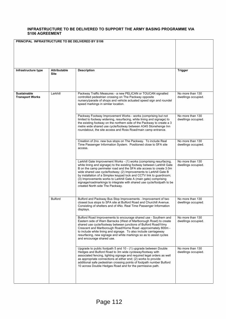
INFRASTRUCTURE TO BE DELIVERED TO SUPPORT THE ARMY BASING PROGRAMME VIA S106 AGREEMENT
PRINCIPAL INFRASTRUCTURE TO BE DELIVERED BY S106
Infrastructure type Attributable Site
Description Trigger
Packway Traffic Measures - a new PELICAN or TOUCAN signalled controlled pedestrian crossing on The Packway opposite nursery/parade of shops and vehicle actuated speed sign and roundel speed markings in similar location.
No more than 130 dwellings occupied.
Packway Footway Improvement Works - works (comprising but not limited to footway widening, resurfacing, white lining and signage) to the existing footway on the northern side of the Packway to create a 3 metre wide shared use cycle/footway between A345 Stonehenge Inn roundabout, the site access and Ross Road/main camp entrance.
No more than 130 dwellings occupied.
Creation of 2no. new bus stops on The Packway. To include Real Time Passenger Information System. Positioned close to SFA site access.
No more than 130 dwellings occupied.
Larkhill
Larkhill Gate Improvement Works - (1) works (comprising resurfacing, white lining and signage) to the existing footway between Larkhill Gate B on the camp perimeter road and the SFA site access to create 3.0m wide shared use cycle/footway; (2) Improvements to Larkhill Gate B by installation of a Simplex keypad lock and CCTV link to guardroom; (3) Improvements works to Larkhill Gate A (main gate) comprising signage/roadmarkings to integrate with shared use cycle/footpath to be created North side The Packway.
No more than 130 dwellings occupied.
Bulford and Packway Bus Stop Improvements - Improvement of two closest bus stops to SFA site at Bulford Road and Churchill Avenue. Consisting of shelters and of 4No. Real Time Passenger Information displays.
No more than 130 dwellings occupied.
Bulford Road Improvements to encourage shared use - Southern and Eastern side of Warn Barracks (West of Marlborough Road) to create shared use cycle/footway between junctions of Bulford Road/Vimy Crescent and Marlborough Road/Horne Road -approximately 800m - to include white lining and signage. To also include carriageway resurfacing, new signage and white markings so as to assist cycles and encourage shared use.
No more than 130 dwellings occupied.
Sustainable Transport Works
Bulford
Upgrade to public footpath 5 and 10 - (1) upgrade between Double Hedges and Bulford Road to 3m wide cycleway/footway with associated fencing, lighting signage and required legal orders as well as appropriate connections at either end; (2) works to provide additional safe pedestrian crossing points of footpath number Bulford 10 across Double Hedges Road and for the permissive path.
No more than 130 dwellings occupied.
Page 112
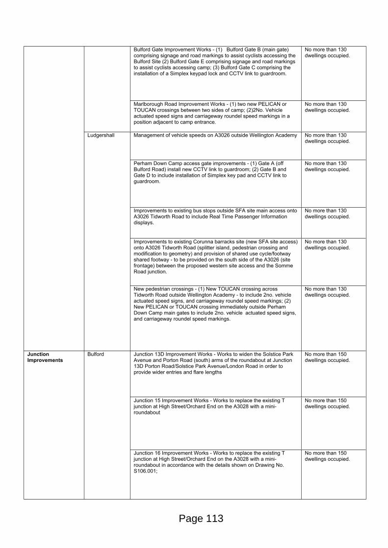
Bulford Gate Improvement Works - (1) Bulford Gate B (main gate) comprising signage and road markings to assist cyclists accessing the Bulford Site (2) Bulford Gate E comprising signage and road markings to assist cyclists accessing camp; (3) Bulford Gate C comprising the installation of a Simplex keypad lock and CCTV link to guardroom.
No more than 130 dwellings occupied.
Marlborough Road Improvement Works - (1) two new PELICAN or TOUCAN crossings between two sides of camp; (2)2No. Vehicle actuated speed signs and carriageway roundel speed markings in a position adjacent to camp entrance.
No more than 130 dwellings occupied.
Management of vehicle speeds on A3026 outside Wellington Academy No more than 130 dwellings occupied.
Perham Down Camp access gate improvements - (1) Gate A (off Bulford Road) install new CCTV link to guardroom; (2) Gate B and Gate D to include installation of Simplex key pad and CCTV link to guardroom.
No more than 130 dwellings occupied.
Improvements to existing bus stops outside SFA site main access onto A3026 Tidworth Road to include Real Time Passenger Information displays.
No more than 130 dwellings occupied.
Improvements to existing Corunna barracks site (new SFA site access) onto A3026 Tidworth Road (splitter island, pedestrian crossing and modification to geometry) and provision of shared use cycle/footway shared footway - to be provided on the south side of the A3026 (site frontage) between the proposed western site access and the Somme Road junction.
No more than 130 dwellings occupied.
Ludgershall
New pedestrian crossings - (1) New TOUCAN crossing across Tidworth Road outside Wellington Academy - to include 2no. vehicle actuated speed signs, and carriageway roundel speed markings; (2) New PELICAN or TOUCAN crossing immediately outside Perham Down Camp main gates to include 2no. vehicle actuated speed signs, and carriageway roundel speed markings.
No more than 130 dwellings occupied.
Junction 13D Improvement Works - Works to widen the Solstice Park Avenue and Porton Road (south) arms of the roundabout at Junction 13D Porton Road/Solstice Park Avenue/London Road in order to provide wider entries and flare lengths
No more than 150 dwellings occupied.
Junction 15 Improvement Works - Works to replace the existing T junction at High Street/Orchard End on the A3028 with a mini-roundabout
No more than 150 dwellings occupied.
Junction Improvements
Bulford
Junction 16 Improvement Works - Works to replace the existing T junction at High Street/Orchard End on the A3028 with a mini-roundabout in accordance with the details shown on Drawing No. S106.001;
No more than 150 dwellings occupied.
Page 113
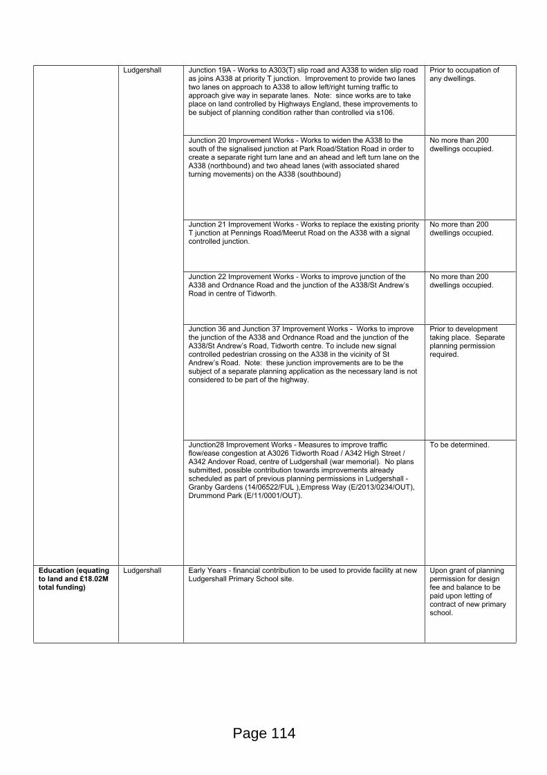
Junction 19A - Works to A303(T) slip road and A338 to widen slip road as joins A338 at priority T junction. Improvement to provide two lanes two lanes on approach to A338 to allow left/right turning traffic to approach give way in separate lanes. Note: since works are to take place on land controlled by Highways England, these improvements to be subject of planning condition rather than controlled via s106.
Prior to occupation of any dwellings.
Junction 20 Improvement Works - Works to widen the A338 to the south of the signalised junction at Park Road/Station Road in order to create a separate right turn lane and an ahead and left turn lane on the A338 (northbound) and two ahead lanes (with associated shared turning movements) on the A338 (southbound)
No more than 200 dwellings occupied.
Junction 21 Improvement Works - Works to replace the existing priority T junction at Pennings Road/Meerut Road on the A338 with a signal controlled junction.
No more than 200 dwellings occupied.
Junction 22 Improvement Works - Works to improve junction of the A338 and Ordnance Road and the junction of the A338/St Andrew’s Road in centre of Tidworth.
No more than 200 dwellings occupied.
Junction 36 and Junction 37 Improvement Works - Works to improve the junction of the A338 and Ordnance Road and the junction of the A338/St Andrew’s Road, Tidworth centre. To include new signal controlled pedestrian crossing on the A338 in the vicinity of St Andrew’s Road. Note: these junction improvements are to be the subject of a separate planning application as the necessary land is not considered to be part of the highway.
Prior to development taking place. Separate planning permission required.
Ludgershall
Junction28 Improvement Works - Measures to improve traffic flow/ease congestion at A3026 Tidworth Road / A342 High Street / A342 Andover Road, centre of Ludgershall (war memorial). No plans submitted, possible contribution towards improvements already scheduled as part of previous planning permissions in Ludgershall - Granby Gardens (14/06522/FUL ),Empress Way (E/2013/0234/OUT), Drummond Park (E/11/0001/OUT).
To be determined.
Education (equating to land and £18.02M total funding)
Ludgershall Early Years - financial contribution to be used to provide facility at new Ludgershall Primary School site.
Upon grant of planning permission for design fee and balance to be paid upon letting of contract of new primary school.
Page 114
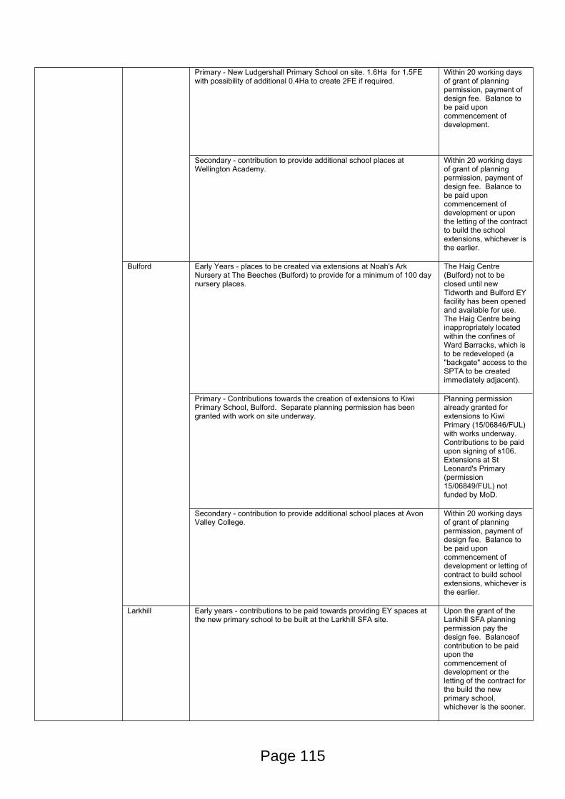
Primary - New Ludgershall Primary School on site. 1.6Ha for 1.5FE with possibility of additional 0.4Ha to create 2FE if required.
Within 20 working days of grant of planning permission, payment of design fee. Balance to be paid upon commencement of development.
Secondary - contribution to provide additional school places at Wellington Academy.
Within 20 working days of grant of planning permission, payment of design fee. Balance to be paid upon commencement of development or upon the letting of the contract to build the school extensions, whichever is the earlier.
Early Years - places to be created via extensions at Noah's Ark Nursery at The Beeches (Bulford) to provide for a minimum of 100 day nursery places.
The Haig Centre (Bulford) not to be closed until new Tidworth and Bulford EY facility has been opened and available for use. The Haig Centre being inappropriately located within the confines of Ward Barracks, which is to be redeveloped (a "backgate" access to the SPTA to be created immediately adjacent).
Primary - Contributions towards the creation of extensions to Kiwi Primary School, Bulford. Separate planning permission has been granted with work on site underway.
Planning permission already granted for extensions to Kiwi Primary (15/06846/FUL) with works underway. Contributions to be paid upon signing of s106. Extensions at St Leonard's Primary (permission 15/06849/FUL) not funded by MoD.
Bulford
Secondary - contribution to provide additional school places at Avon Valley College.
Within 20 working days of grant of planning permission, payment of design fee. Balance to be paid upon commencement of development or letting of contract to build school extensions, whichever is the earlier.
Larkhill Early years - contributions to be paid towards providing EY spaces at the new primary school to be built at the Larkhill SFA site.
Upon the grant of the Larkhill SFA planning permission pay the design fee. Balanceof contribution to be paid upon the commencement of development or the letting of the contract for the build the new primary school, whichever is the sooner.
Page 115
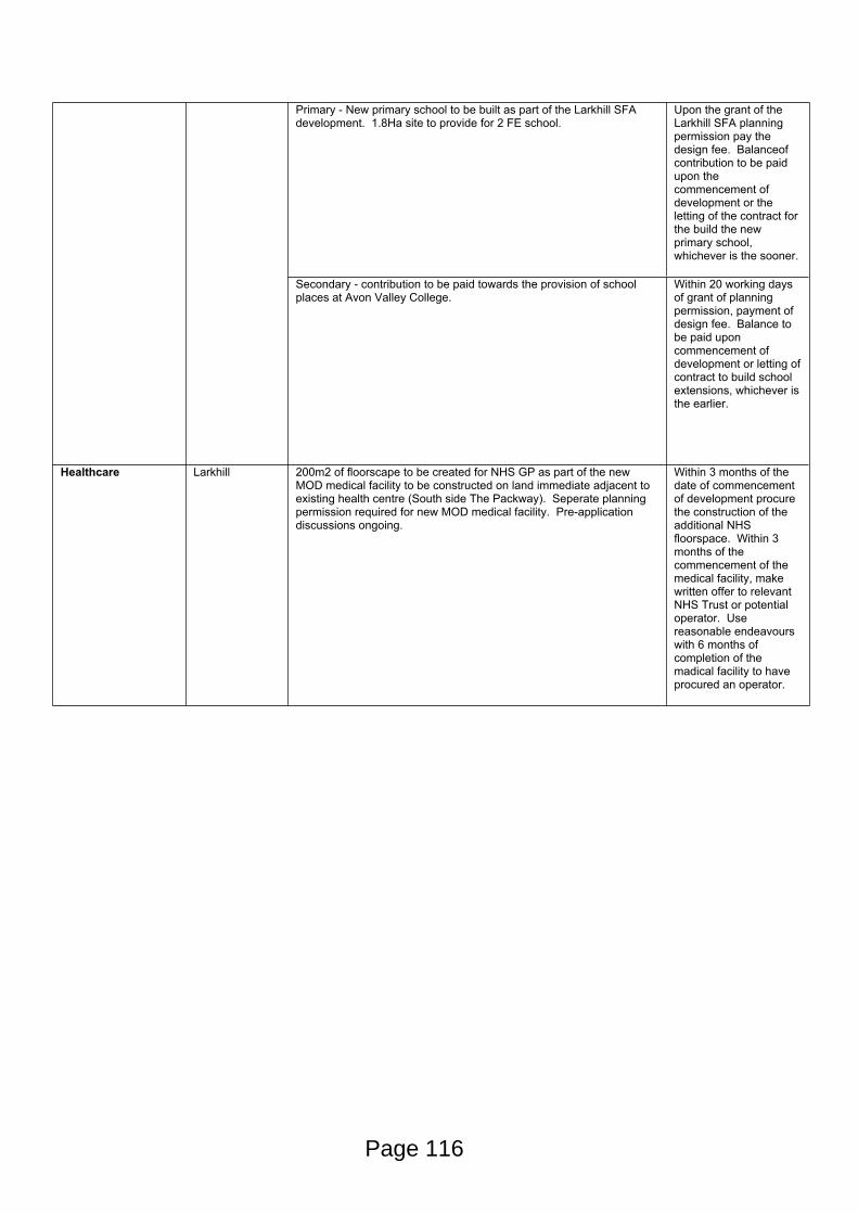
Primary - New primary school to be built as part of the Larkhill SFA development. 1.8Ha site to provide for 2 FE school.
Upon the grant of the Larkhill SFA planning permission pay the design fee. Balanceof contribution to be paid upon the commencement of development or the letting of the contract for the build the new primary school, whichever is the sooner.
Secondary - contribution to be paid towards the provision of school places at Avon Valley College.
Within 20 working days of grant of planning permission, payment of design fee. Balance to be paid upon commencement of development or letting of contract to build school extensions, whichever is the earlier.
Healthcare Larkhill 200m2 of floorscape to be created for NHS GP as part of the new MOD medical facility to be constructed on land immediate adjacent to existing health centre (South side The Packway). Seperate planning permission required for new MOD medical facility. Pre-application discussions ongoing.
Within 3 months of the date of commencement of development procure the construction of the additional NHS floorspace. Within 3 months of the commencement of the medical facility, make written offer to relevant NHS Trust or potential operator. Use reasonable endeavours with 6 months of completion of the madical facility to have procured an operator.
Page 116
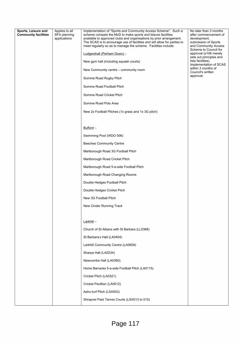
Sports, Leisure and Community facilities
Applies to all SFA planning applications
Implementation of "Sports and Community Access Scheme". Such a scheme compels the MoD to make sports and leisure facilities available to approved clubs and organisations by prior arrangement. The SCAS is to encourage use of facilities and will allow for parties to meet regularly so as to manage the scheme. Facilities include:
Ludgershall (Perham Down) –
New gym hall (including squash courts)
New Community centre – community room
Somme Road Rugby Pitch
Somme Road Football Pitch
Somme Road Cricket Pitch
Somme Road Polo Area
New 2x Football Pitches (1x grass and 1x 3G pitch)
Bulford –
Swimming Pool (WDO 006)
Beeches Community Centre
Marlborough Road 3G Football Pitch
Marlborough Road Cricket Pitch
Marlborough Road 5-a-side Football Pitch
Marlborough Road Changing Rooms
Double Hedges Football Pitch
Double Hedges Cricket Pitch
New 3G Football Pitch
New Cinder Running Track
Larkhill –
Church of St Albans with St Barbara (LL0368)
St Barbara’s Hall (LA0404)
Larkhill Community Centre (LA0609)
Sharpe Hall (LA0234)
Newcombe Hall (LA0360)
Home Barracks 5-a-side Football Pitch (LA0115)
Cricket Pitch (LA0321)
Cricket Pavillion (LA0012)
Astro-turf Pitch (LSX003)
Shrapnel Park Tennis Courts (LSX013 to 015)
No later than 3 months after commencement of development, submission of Sports and Community Access Scheme to Council for approval (s106 merely sets out principles and lists facilities). Implementation of SCAS within 3 months of Council's written approval.
Page 117

Sports Hall (LLO075)
Squash Courts (LLO075)
New Wood Hall – Gym Hall
Piggeries Football Pitch
Knighton Down Football Pitches
Knighton Down Changing Facilities
Shrapnel Park Football Pitch
The Piggeries Rugby Pitch
Knighton Down Rugby Pitch
Knighton Down Changing Facilities
Gunners Rugby Pitch
Hockey Astro Turf
Astro Turf Goal practice area
New Wood Road – 2 Grass Football Pitches
New Wood Road – Cricket Pitches
Tidworth –
Garrison Theatre Facilities
Tidworth Oval Athletics Stadium (TXS012)
Nuffield Suite Club House (ATE011)
All-weather Sports Pitches – Astro Turf (TXS013)
Tidworth Cricket Ground (TXS020)
Tidworth Leisure Centre
St Andrews Centre
Arcot Road Football and Cricket Pitch
Tattoo Grounds Rugby and Football Pitch
Tattoo Ground Changing Rooms
VCP2 Football Pitch
Lucknow/Esso Football Pitch
New 2 Grass Football Pitches
New 2 Synthetic Sports Pitches – 1 x 3G Football Pitch & 1 x 4G Rugby Pitch
Larkhill Provision of 0.3Ha fully serviced site adjacent to new school, transferred to Council or its nominee for use as a community facility or for fire and rescue services (WF&RS have previously suggested they may have funding for an education centre). The s106 merely delivers the land and does not define or confirm precise final use. Depending on final use, separate planning permission may be required.
Upon execution of Larkhill Primary School land transfer to Council, shall also execute transfer of community land.
Page 118
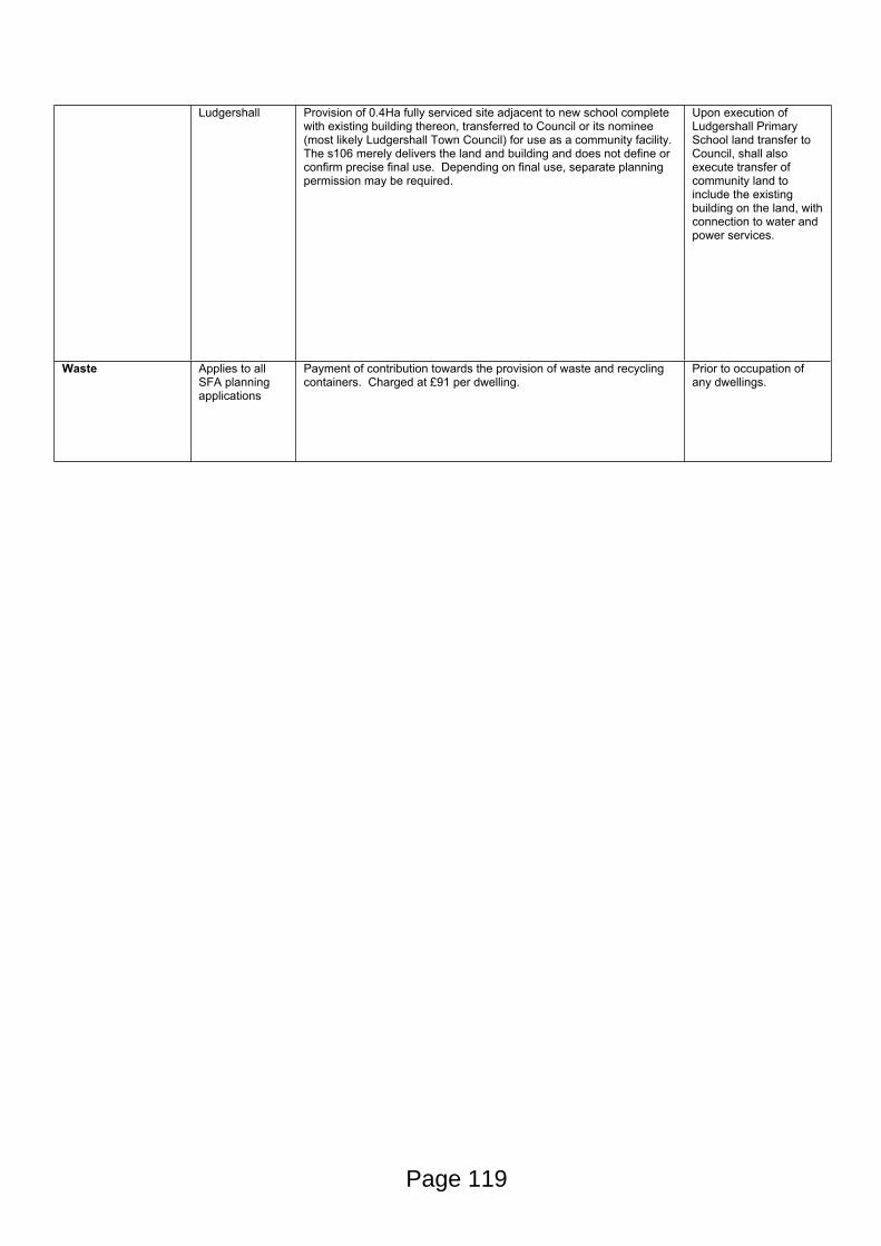
Ludgershall Provision of 0.4Ha fully serviced site adjacent to new school complete with existing building thereon, transferred to Council or its nominee (most likely Ludgershall Town Council) for use as a community facility. The s106 merely delivers the land and building and does not define or confirm precise final use. Depending on final use, separate planning permission may be required.
Upon execution of Ludgershall Primary School land transfer to Council, shall also execute transfer of community land to include the existing building on the land, with connection to water and power services.
Waste Applies to all SFA planning applications
Payment of contribution towards the provision of waste and recycling containers. Charged at £91 per dwelling.
Prior to occupation of any dwellings.
Page 119
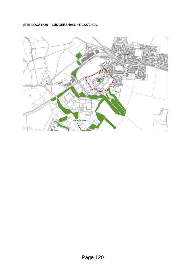
SITE LOCATION – LUDGERSHALL 15/02270/FUL
Page 120
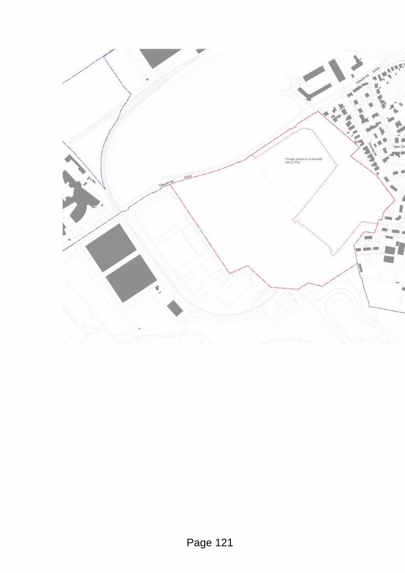
Page 121

This page is intentionally left blank
STRATEGIC PLANNING COMMITTEE
Date of Meeting 13th April 2016
Application Number 15/05540/FUL
Site Address Land North of The Packway and East of Larkhill
Larkhill
SP4 8PY
Proposal Erection of 444 no. dwellings to provide Service Families Accommodation (SFA), land for a new primary school and community facility, public open space, play areas, landscaping, internal roads and all associated infrastructure works
Applicant Defence Infrastructure Organisation
Town/Parish Council LARKHILL
Electoral Division DURRINGTON AND LARKHILL
Grid Ref 413023 144296
Type of application Full Planning
Case Officer Simon Smith
Reason for the application being considered by Committee
In March 2013, the Secretary of State for Defence announced the Regular Army Basing Plan which is set to deliver the expected restructuring under “Army 2020”. In particular, this set out the future structure of Army units as they move back to the UK from Germany as the British Army’s presence in continental Europe is reduced.
Under the Basing Plan, the necessary optimisation of the UK training estate will result in a greater concentration of the Army on Salisbury Plain Training Area (SPTA), where three high readiness Reaction Force Brigades will be based. Unit moves in Wiltshire commenced in 2014, with the final moves planned for 2019.
This reorganisation of the Army will involve significant new development in the locality to accommodate the additional activity, personnel and their families as well as the infrastructure to support them. Much of this development requires planning permission.
The planning application before the Strategic Planning Committee is one of three large-scale major applications for new Service Family Accommodation (SFA) houses. Since it is part of a wider programme of Army related development across the Salisbury Plain, the application intrinsically possesses wider strategic implications and raise issues of more than local importance.
1. Purpose of Report
1.1 To consider the application and to recommend to Members of the Strategic Planning Committee that the application should be APPROVED, subject to all parties entering into a legal agreement under s106 of The Act and subject to appropriately worded planning conditions.
1.2 Durrington Town Council Support this application subject to the following conditions included in any planning permission :-
Page 123
Agenda Item 8
As no retail outlets are planned on site could an agreement be made with the MOD that if its considered necessary in the future the MOD would allow the purchase or rent of a plot on site to allow a private retail shop to be constructed.
Durrington Town Council strongly object to the proposed closure of Tombs Road, and Wood Road.
With the access road from the development site meeting The Packway at a sharp incline visibility is restricted for drivers as they reach the proposed roundabout. Therefore the design and construction of the roundabout needs to take this into consideration.
Durrington Town Council support the other items of concern raised by the chair at the public meeting.
2. Report Summary
Consideration of this planning application reveals the following to be the main issues:
Principle of development
Means of access, layout, design, open spaces, landscaping, parking
Impact upon neighbour amenity
Cultural heritage
Highway issues
Roundabout accessSpeed limits on The PackwayCycleway/pedestrian path between site, Larkhill and Stonehenge Inn roundaboutMartin Bushes Lane
Infrastructure and its delivery via s106 agreement
3. Site Description
3.1 Relating to some 23.84 hectares, the application site consists of an irregularly shaped piece of undeveloped arable farmland, located to the East of Larkhill village’ immediately adjoining a golf driving range/course and existing Service Family Accommodation (SFA) housing. The Packway forms the Southern boundary of the site and would provide for the main access. Public Rights of Way run through the centre of the site, including the Larkhill Camp perimeter track running Westward. To immediate North is the Army’s Salisbury Plain Training Estate.
3.2 From a high point where the site meets The Packway, the site slopes gently Northwards and Eastwards. The site it part of a gently rolling landscape, part of the Larkhill Chalk Downland Character Area.
4. Planning History
14/10626/SCR Request for screening opinion for proposed service family accommodation comprising up to 444 homes, provision of new vehicular access, primary school, public open space, landscaping, internal road and ancillary works.
5. The Proposal
Page 124
5.1 The application site is one of three proposed for Service Families Accommodation (SFA) across Salisbury Plain. On the substantive part of the site, the application seeks permission for 444 SFA houses, 94 of which are intended for officers, the balance for other ranks. The application also seeks permission for a 2FE primary school on a 1.8Ha portion of the site, together with 0.30Ha piece of land for community use.
5.2 The application is submitted in a hybrid format, meaning that detailed permission is sought for part of the development, and outline permission for the balance. Accordingly, it simultaneously seeks:
Full and detailed planning permission for the first 89 SFA houses. Detailed drawings of house types (floor plans and elevations) as well as details of highways, street scenes and public open space have been provided.
Outline permission for the remaining 355 SFA houses as well as the primary school and community use. In this regard, approval is sought for layout, means of access, landscaping and scale, but reserves details of appearance to be approved at a later stage. Such applications are known as Reserved Matters applications.
5.3 The application has previously been ‘Screened’ under the Town and Country Planning (Environmental Impact Assessment) Regulations 2011. The opinion that EIA was not required for this development was adopted on 04/02/15.
6. Local Planning Policy
Wiltshire Core Strategy
6.1 Section 70(2) of the Town and Country Planning Act 1990 and section 38(6) of the Planning and Compulsory Purchase Act 2004 require that the determination of planning applications must be made in accordance with the Development Plan, unless material considerations indicate otherwise.
6.2 The Wiltshire Core Strategy (WCS) was adopted by the Council in January 2015. For the purposes of s38(6) of the Planning and Compulsory Purchase Act 2004 and Annexe1 of the NPPF, the WCS is now the statutory development plan.
6.3 Policy CP4 of the Wiltshire Core Strategy sets out the spatial strategy for the Community Area of Amesbury, with Larkhill and Durrington being considered part of Amesbury as the market town. Paragraph 5.19 of the WCS notes that “The MoD is one of the most significant employers in Wiltshire and makes an important contribution to its economy and to many communities across the county. The development of Britain’s first ‘Super Garrison’ around the Salisbury Plain area is having far reaching implications for local communities and is attracting multi-million pound investment into the county. Although the Super-Garrison project will be supported overall, specific proposal sites will be assessed through a subsequent planning document.
6.4 Policy CP37 of the WCS acknowledges that the provision of new housing on MOD land for military personnel and other operational facilities will be required as a result of the ABP across the SPTA. At a macro level, CP37 envisages that a single master plan should be developed, which, inter alia, would ensure that the infrastructure needs arising from the Army Basing Programme is established and delivered as well as enabling the cumulative impact of development arising from the programme to be addressed. That Masterplan was completed 20th June 2014 and was recognised by the Council’s Strategic Planning Committee 22nd October 2014.
6.5 Larkhill does not benefit from a Housing Policy Boundary (as defined by the Salisbury District Local Plan (2011) and the South Wiltshire Core Strategy), although the site is positioned immediately adjacent to the Eastern edge of the village, predominantly defined by an existing military SFA housing estate.
Page 125
6.6 Previously saved policies within the Salisbury District Local Plan 2011 relating to design and townscape (particularly G1, G2 and D1 relating to general townscape) have been replaced by CP57 of the WCS. In this regard, whilst Policy CP 37 positively frames proposals for new development at operational military facilities, it requires, inter alia, that such new development should enhance the overall character of the site. CP 57 (design and place shaping) and 61 (transport) of the WCS is applicable to all forms of new development. In particular criterion ix to CP 57 requires new development which has an effect upon the public realm to create places of character.
6.7 Other relevant policies are: CP50 (biodiversity), CP51 (landscape), CP55 (air quality), CP56 (contaminated land), CP58 (conservation and historic environment), CP59 (Stonehenge WHS), CP60 (sustainable transport), CP61 (transport and development), CP66 (strategic transport network), CP67 (flood risk), CP68 (water resources), CP69 (River Avon SAC).
Saved policies with Salisbury District Local Plan (2011)
6.8 Appendix D of the adopted Wiltshire Core Strategy sets out saved policies from the Salisbury District Local Plan (2011), which continue to be relevant to the determination of planning applications.
6.9 Saved Policy R2 and Appendix IV set out the requirements for open space provision in new residential developments. The application proposals incorporate provision of children’s play space, youth play space and amenity green space in accordance with the Wiltshire Open Space Standards 2012 contained within the Open Space Typologies Report.
6.10 Saved Policy R4 deals with Indoor Community and Leisure provision. It advises that where proposed development, either individually or cumulatively with other developments within the settlement, is of a sufficient size to generate an identifiable need for indoor community or leisure facilities, developers will be expected to provide a suitable facility within the site or make a contribution towards improving facilities within the settlement.
Wiltshire Local Transport Plan 2011- 2026 - Car Parking Strategy
6.11 The parking on site will be required to meet the standards embraced in the Council’s LTP3Car Parking Strategy. That being: 1 bedroom = 1 space; 2 to 3 bedrooms = 2 spaces; 4+ bedrooms = 3 spaces; visitor parking 0.2 spaces per dwelling (unallocated).
7. Summary of consultation responses
Durrington Town Council – Support the application subject to conditions.
As no retail outlets are planned on site could an agreement be made with the MOD that if its considered necessary in the future the MOD would allow the purchase or rent of a plot on site to allow a private retail shop to be constructed.
Durrington Town Council strongly object to the proposed closure of Tombs Road, and Wood Road.
With the access road from the development site meeting The Packway at a sharp incline visibility is restricted for drivers as they reach the proposed roundabout. Therefore the design and construction of the roundabout needs to take this into consideration.
Durrington Town Council support the other items of concern raised by the chair at the public meeting.
Council Highway Officer – No objections, subject to imposition of planning conditions (see “Highway Issues” within considerations section).
Council Ecologist – No objections, subject to conditions.
Page 126
The site is a former artillery range, supporting calcareous and poor semi-improved grassland which is being re-colonised by scrub. The River Avon SAC lies 1 km to the South East. Salisbury Plain SSSI/SPA/SAC lies 17 km to the North West.
Habitats Regulations Assessment:
Salisbury Plain SAC – no likely significant effects. Located outside the SAC. While recreational pressure could conceivably lead to indirect impacts on grassland within the SAC, impacts have not been identified from current levels of use and Natural England has not identified a risk. The grassland is relatively robust to walkers due to the scale of the site, free draining nature of the land and low intensity of recreational pressure. Recreational pressure was not considered as being likely to lead to significant effects in the HRA for the Wiltshire Core Strategy
Salisbury Plain SPA – No likely significant effects. Site is within the 4km zone within which residents may be expected to visit the SPA for recreation potentially leading to an increased risk of disturbance to breeding stone curlew. The Masterplan HRA calculates that the increased numbers of visitors from the Army Basing Programme would contributes 20% of expected additional visits to the plain. MoD has worked with Natural England to conserve stone curlews since the SSSI was designated in 1993 and has played an important role in the recovery of this species with the number of pairs doubling between 1993 and 2014. An updated SPTA Stone Curlew Management Plan identifies new measures: (i) Improving existing rights of way and creating new linkages from SFA sites to existing accessible areas off the SPA via the Recreational Access and Action Plan (Feb.16); (ii) information in Welcome Packs to inform new residents of SFA development of the sensitivities of the SPA and the recreational alternatives available; (iii) stone curlew monitoring and discussion at the existing Environmental Steering Group.
River Avon SAC – No likely significant effects. The River Avon has European protection as a Special Area of Conservation (SAC). At present the river is failing its conservation targets, in part due to urban development – (i) greater volume of sewage will increase the amount of phosphate discharged into the river; (ii) reduced river flows due to increased groundwater abstraction for water supply. Since MoD’s boreholes and sewage works currently operate under a Crown exemption from environmental permits/licences (to be withdrawn in 5 years) their impacts have not previously been reviewed under the Habitats Regulations. In the meantime, the Council is therefore responsible for considering the effects of ABP development on the River Avon SAC when determining planning applications. Accordingly, the LPA is applying a condition on all relevant ABP planning applications for MoD to prepare and implement a Water Management Strategy. This document will take a holistic and sustainable approach to managing the MoD’s water resources and will demonstrate compliance with the Habitats Regulations in order to support MoD’s future licence applications. That WMS is currently in preparation.
The overall approach for water supply and sewage treatment of Garrison and SFA developments at Larkhill and Bulford will be as follows: (i) Most of the increased water requirements will be supplied by Wessex Water from their licensed boreholes rather than MoD boreholes. There is already a direct connection from Wessex Water’s supply to Larkhill but a new pipeline will need to be constructed from Allington to feed Bulford, possibly with a back-up supply from Canadian Estate; (ii) Sewage treatment at MoD’s Larkhill sewage works will cease and all existing foul flow from Larkhill Garrison and the proposed Larkhill SFA will go to Wessex Water’s Ratfyn Sewage Works via a new pipeline; (iii) Foul water from Bulford Garrison will continue to be treated at Ratfyn Sewage Works. All additional flows arising from ABP at Bulford will also go to Ratfyn.
In particular, increased sewage from ABP will elevate phosphate levels which are already affecting the SAC. The River Avon SAC currently exceeds its conservation target for phosphorus, prompting the EA, Natural England and Wiltshire Council to prepare a Nutrient Management Plan (NMP) to address the in-combination effects of phosphate inputs from diffuse and point sources. Ratfyn sewage Works will take all sewage from new and existing SFA and Garrison development at Larkhill and Bulford. While Wessex Water’s permit for Ratfyn has capacity to take these additional flows, modelling has shown this will push the upper Avon into a “high risk” category. Further development in
Page 127
high risk sub-catchments is the most likely to compromise delivery of the NMP. The NMP recommends that “where allocation of permit headroom is considered to compromise delivery of the NMP, phosphorus removal or offsetting will be required.” DIO estimates that ABP will lead to an additional 686g of phosphorous being discharged into the River Avon every day from the latter part of 2017 onwards. Accordingly, it has prepared a Phosphorus Offsetting Plan to offset this as far as reasonably practical. The basic element of the 6 point plan is funding for a Catchment-Sensitive Farming Officer to work with farmers in the River Avon catchment to identify potential improvements to farming practices and assist in obtaining funding to achieve them. The MoD will also contribute funding for capital works. Council’s Ecologist considers the MoD to have done as much as can reasonably be expected to offset phosphate impacts in the short to medium term and the Council can therefore conclude that there will be no significant effect from ABP generated phosphates on the River Avon SAC either alone or in combination with other plans and projects.
The Larkhill SFA Ground Conditions Desk Study Report (DIO April 2015) identifies contamination risks associated with tanks, sewage pits, rifle ranges, an artillery range, asbestos and a former garage. Further investigation is recommended and there is no indication that these issues will be difficult to overcome. It can be assumed therefore that any contamination which is identified and judged to present unacceptable risks to future site users will be removed and that risks to ground water and the River Avon SAC will be negligible. Recommends use of condition to secure the necessary investigations and remedial measures.
Protected species issues:
Bat survey - identified key habitats included tree planting around the Stonehenge golf driving range and the central track through the site. Species which occurred in high numbers included common and soprano pipistrelle and serotine. All three are tolerant of road lighting. Species recorded in moderate numbers included brown long-eared bats and Myotis species which are generally intolerant. The golf driving range is lit at night, explaining the abundance of pipistrelles and serotine. Development will exacerbate lighting and species using the central track in particular will experience much higher light levels. A 10m wide buffer zone has been incorporated into the design around the south east and south west of the site to restrict lighting and a condition should be applied to ensure that lighting is minimised as far as possible and allows continuity of bat flight lines. In addition the landscape proposals include a new hedgerow on the boundary with the community area and school to replace that used as a key route by commuting bats.
Badger sett - found on site, to be closed under licence from Natural England in order to allow the development to proceed. There is no need for the Council to secure mitigation to meet its duty towards conservation of this species as will be addressed through the licencing system.
Breeding farmland birds -recorded across the site including 4 species on the Red list of Birds of Conservation Concern and 3 species on the Amber list. These species will be lost from the development site but populations across the plain are unlikely to be significantly affected. To some extent proposals for meadow and wildflower planting will provide compensation and the landscape plans should therefore be conditioned. A much greater level of mitigation could be achieved by following the Ecological Mitigation Strategy to apply a DTE SP Farm Management Plan to the land North of site. This matter should be pursued as part of the submission to finalise the Biodiversity Offsetting Report . The Ecological Mitigation Strategy identifies the measures that will be taken to ensure no direct harm is caused to nesting birds during vegetation clearance. These should be included in the CEMP with a timescale for implementation.
Reptiles - appears to be low with only a single common lizard recorded. The Ecological Mitigation Strategy identifies appropriate precautions for this group. Measures to remove giant hogweed prior to construction are identified. Both of these protocols should be included in the CEMP with a timescale for implementation.
Calcareous grassland:
A large amount of calcareous grassland will be lost as a result of development. Although none is located in the Salisbury Plain SSSI, a considerable proportion qualifies as habitat of principal
Page 128
importance. Government organisations have a duty to have regard for the conservation of such habitat under section 40 of the NERC Act 2006 and DIO is committed to offsetting all calcareous grassland lost to development. The Biodiversity offsetting report (WYG, July 2015) identified that the loss of lowland calcareous grassland resulting from Larkhill SFA will be 9.68 ha. Loss of semi-improved grassland will be 5.19 ha. Using the Defra Biodiversity Offsetting Metric the report calculates total number of biodiversity units that will be lost at Larkhill SFA will be 104.2. The report identifies areas of degraded land across Salisbury Plain to be enhanced to create an equivalent number of biodiversity units over a ten year period. Follow up management will be undertaken through DIO conservation Stewardship funding and in future may be incorporated into tenants farm plans, scrub plans and agri-environment agreements. As a result the development can demonstrate no net loss of calcareous grassland from ABP developments. This report has yet to be finalised and this should be secured by condition and s106.
Council Landscape Architect – No objection subject to carrying out of submitted landscaping scheme.
Council Education Officer – No objection subject to land and contributions towards provision of early years, primary and secondary education places being delivered via s106.
Council Environmental Health Officer – No objections subject to conditions.
Raises no objection subject to conditions in relation to noise, lighting, demolition and construction, contaminated land and air quality impacts on nearby residential properties and future occupants of the proposed properties. The Council’s EHO does, however, specifically consider the impact of the adjoining Stonehenge Golf Club upon the new housing:
The applicant has recently submitted a lighting assessment for the proposed development north of the Packway, Larkhill, following concerns that light spill from the Stonehenge Golf Course may have an adverse impact on future residents at the proposed properties.
In accordance with the Guidance Notes for the Reduction of Obtrusive Light, The Institution of Lighting Professionals 2011 the applicant has demonstrated that for zone E2 (rural) the light spill for pre curfew (daytime) can be met. However, they have carried out the assessment based on a worst case scenario of lighting being active after 23.00 and identified that where the light spill from the golf course was above 1 lux further mitigation will be required.
Given that the applicant has demonstrated that the light spill at various locations will not be above the 5 lux pre curfew criteria for E2 and the 1 lux post curfew we cannot support an objection. However, we would recommend the applicant implements the mitigation measures proposed in their application, these include;
- Planting a minimum 5m vegetation buffer set back from the boundary to the new property boundary with an additional 5m strategic landscape. (Page 38 of the Design and Access statement) As previously mentioned it is strongly recommended that the trees planted are evergreen and mature. This is purely because if young trees are planted they will not be high enough to deflect any light spill and take years to reach maturity, also if they are deciduous they will drop their leaves during the autumn/winter.
- The houses nearest the golf course (Locations L5, L6 and L7 on figure 2 of the light assessment) are to be orientated with gable walls facing the floodlights to reduce the potential adverse impact from any light spill.
Page 129
The Council’s EHO also confirms that the additional buffer of trees suggested would also have the effect of protecting the new properties from stray golf balls, even if they were to reach that far. Reserved Matters submissions can ensure that the nearest properties are designed so as to avoid windows directly facing the course/range.
Council Drainage Engineer – No objections subject to planning conditions.
Application form states foul drainage disposal will be via pumping station and pumping main. The submitted FRA states that the pumping main will discharge to the Wessex Water STW at Raftyn – although it also confirms that Ratfyn operates at capacity, therefore requiring upgrading.
Details will need to be provided as to the proposed pumping station layout and surface finishes, fencing details/type/height etc., turning areas and details of above ground items including any temporary items. This can be achieved through planning conditions.
Application form states storm drainage disposal will be to soakaway. Site is in FRZ 1 - small areas affected by surface water flooding off the site but none within site itself. Soakaway testing information within FRA indicates that ground is acceptable for appropriately designed, located, sized soakaways.
Recommends that planning conditions be imposed to confirm the following details:
- Peak Flow - Green field sites - discharge calculations for existing and proposed site arrangement for 1 in 1 and 1 in 100 rainfall events.
- Volume Control - Green field sites - Supply proposed runoff volume in a 6 hour period for 1 in 100 year storm event (not exceeding the green field volume for same event).
- Flood Risk within Development – Details of drainage system design showing designated holding areas and conveying routes based on no flooding on site for a 1 in 30 year rainfall event. Calculations and drawings submitted for the drainage system design showing designated holding areas and conveying routes based on no flooding on site for a 1 in 100 year rainfall event in respect to a building or utility plant susceptible to water within development. Details of conveyance routes for flows exceeding the 1 in 100 year rainfall event to minimise risk to people and property.
- Structural Integrity - Details showing the integrity of the drainage system components and infrastructure under anticipated loading conditions over design life of the development taking into account of reasonable levels of maintenance.
- Designing for maintenance considerations - List the different attenuation/disposal units for the site. Confirm proposed ownership details of the individual attenuation/ disposal units. Confirm the required maintenance regime for each individual attenuation/ disposal units.
Council Conservation Officer – No objections.
The Conservation Officer accepts the findings of the submitted Cultural Heritage chapter from the Over-arching Environmental Appraisal (in relation to the wider Army Basing programme) as well as the Archaeological Evaluation of the site.
The current site has remained undeveloped in terms of built structures throughout the modern period, being situated to the east of the main camp. Although there may be other below grounds remains associated with C20 military activity, no built heritage assets will be directly affected.
Designated built assets within the wider vicinity include listed buildings within Durrington itself and the Conservation Area which covers the historic core of the village. However, it is not considered that there will be any additional impact on the settings of these assets due to the separating distance and intervening development and landscape features.
Page 130
The proposals will have a neutral impact on the built historic environment and it is therefore considered that the scheme is compliant with legislation and policy applicable to the historic environment.
Council Archaeologist – No objections subject to conditions. This site has had geophysical and trenched evaluation undertaken across the majority of the area. The geophysical survey could not be undertaken in some areas due to scrub and another area could not be evaluated due to the presence of badgers. The evaluations demonstrated that parts of the site have very significant archaeological remains, including a probable barrow, a prehistoric burial and enclosure and extensive military remains.
It is therefore recommended that a phased programme of archaeological works is conditioned on any planning permission. As there are some areas that have not been fully evaluated, it is likely that this programme will include some further evaluation, strip map and record areas and areas of excavation. It is also likely that any proposed mitigation that forms part of the conditioned works will include some elements of public presentation, such as information panels, as part of the post-excavation and publication works.
Council Technical Officer (Public Open Space) – No objections subject to conditions and provisions within s106 in respect of youth and adult sports provision. Note: the application proposes that existing sports and community facilities owned and run by the MoD are to be promoted and opened up for use by the local community. Such facilities are to be controlled via a “Sports and Community Access Scheme” embedded and enforced through the s106. The Council’s Technical Officer is satisfied with the proposal since it would deliver facilities far in excess of what would ordinarily be expected from new development of this size, in accordance with saved policies R2 and R4 of the Salisbury District Local Plan 2011.
Council New Housing Officer – No objection subject to appropriate provisions with s106. There is no requirement for an affordable housing contribution while the homes are used as Service Families Accommodation. However the Section 106 Agreement should ensure that, should the units ever be sold on the open market, an affordable housing contribution would be made.
Spatial Planning Officer – No objections. Wiltshire Council has worked in partnership with the DIO in preparing the Army Basing Programme Salisbury Plain Master Plan which has resulted in enhanced public engagement and consultation as well as Joint Officer and Councillor working and steering groups which have informed the Plan. This Master Plan is a material planning consideration in determining planning applications. Provided the case officer is satisfied that he proposal meets the requirements of CP37 and all other relevant policies of the statutory development plan, and takes account of the Salisbury Plain Master Plan, there are no planning policy objection to the Army Basing related planning applications.
Council Sustainable Energy Officer – No objections subject to conditions. CP41 requires a Sustainable Energy Strategy (SES) and a minimum standard of Code for Sustainable Homes (CfSH) Level 4 and BREEAM Very Good. The submitted planning statement commits to this in para 15.24. In addition an SES was submitted, which explored options for compliance with the code requirement and suggested discrete 2kWp solar arrays (followed by micro wind turbines or ASHP). Improved fabric efficiency was rejected as non-compliant. No accredited Code assessor has been named in the SES. The relatively low output of PV per unit is worth 1 CfSH point but is costed at £10,000 pro rata. A further 9% emissions improvement could be sought, attained using improved air tightness and glazing if explored further. Gas boilers have been assumed here but mechanically ventilated heat recovery is an alternative option. The Energy Officer concludes with no objections, subject to the imposition of suitably worded planning condition requiring CfSH4 certification has been provided and approved in writing by the local authority. (Note: following the governments ministerial statement in March 2015
Page 131
withdrawing CfSH, legal advice confirms that it is now not possible to impose planning conditions requiring CfSH standards to be met).
Council Waste Officer – No objection subject to s106 delivering contributions for bin storage/collection.
Environment Agency – No objection subject to conditions.
Groundwater protection and contaminated land - Support the recommendations for a geo-environmental intrusive investigation made within the Defence Infrastructure Organisation (DIO) report "Salisbury Plain Training Area Army Basing Programme - Larkhill SFA Ground Conditions Desk Study Report" dated April 2015. This investigation and assessment should be secured through a ground contamination condition.
Water supply - DIO has also agreed that they will mitigate any water abstraction impacts of supplying both the existing MoD network and the proposed Army Basing Project developments. However, as the detail of this mitigation has not yet been agreed for individual sites, the EA recommend that suitable worded planning conditions be imposed (Water management Strategy).
Foul drainage – Foul sewage would be served by a mains foul sewer and connected into an existing drainage system. Foul drainage is discussed in the Flood Risk Assessment and Drainage Strategy document for this development. The EA confirm their support the proposed connection to mains foul sewer, however, it must be ensured that there would be sufficient capacity within the foul drainage system to take the foul water from this development. The EA recommend that a separate planning condition should be included that requires a foul drainage scheme to be submitted and agreed.
Flood risk and surface water - Wiltshire Council is now the lead local flood authority for this site under The Town and Country Planning Development Management Procedure (Development Management Procedure) (England) Order 2015, which came into force on the 15 April 2015. See Council Drainage Engineer commentary.
Foul drainage – Development is to be served by a gravity system and pumping station, which is believed to be Ratfyn Sewage Treatment Works. Support the proposed development being connected to a mains foul sewer, but must ensure that there would be sufficient capacity within the foul drainage system. Details of the foul drainage proposals should be included as part of the Water Management Strategy. However, recommend that a separate planning condition requiring a foul drainage scheme to be submitted and agreed.
Construction Environmental Management Plan – Recommend that the submitted Construction Management Plan is secured as a planning condition in any planning permission that may be granted.
Green Infrastructure - Areas of green space are to be incorporated into the design of the development. It must be ensured that the green space adequately serves all its requirements, including providing habitat to improve the nature conservation of the area. This should include providing green corridors for biodiversity species.
Highways England – No objections, subject to imposition of conditions.
Further information was required in respect of the A303 Countess roundabout LinSig model in order to understand the impact of the proposed development on the SRN in this location. The applicant has subsequently submitted further information relating to the base model validation and this is now agreed. The modelling assessment confirms that the impact of the proposed development on the safety and operation of the A303 is not severe.
Natural England – No objection subject to conditions.
Page 132
Water supply - This application raises issues on water supply and wastewater disposal that affect the River Avon SAC, especially in combination with other elements to the Army basing programme and other planned development growth. Permission should be compliant with the Habitats Regulations in respect of this SAC. The MoD embarked on a consultation process with NE on the preparation of a Water Management Strategy for the basing programme. There is a timetable for its completion and then approval by Wiltshire Council by mid December 2015. The MoD, as a competent authority, has also engaged NE on their preparation of a Habitats Regulations Assessment for the basing programme related to potential impacts on the River Avon SAC and other European sites. The water strategy, along with the recently completed River Avon SAC Nutrient Management Plan (NMP), will be key documents informing this HRA.
More recently and since completion of assessment work on the River Avon NMP, the MoD has identified its preferred option for development and waste water disposal at Larkhill and Bulford. The option involves a substantially greater volume of waste water discharge to the River Avon SAC than the ‘plan or project’ for development growth considered and assessed by the River Avon NMP. Therefore this proposal, in combination with other MoD Army 2020 applications for development at Bulford and Larkhill which involve waste water disposal, cannot rely on the current NMP alone in a Habitats Regulations Assessment. The preferred option may also affect flow in the River Avon SAC, notably modelling suggests there would be a reduction in flow on the River Till. Further assessment is required on the implications of the waste water increase beyond the NMP plan or project development growth and on river flow to determine whether the MoDs preferred option can be shown not to impact on the integrity of the River Avon SAC. This work is being progressed by MoD in discussion with the Environment Agency, Natural England and the Council.
NE suggest that it would be premature to speculate on the outcome of this work and what measures may be required beyond those in the NMP to enable this proposed development and the wider re-basing programme at Bulford and Larkhill while showing that there would be no impact on the integrity of the River Avon SAC. We expect these measures and their detail to be developed through the Water Management Strategy and their adequacy demonstrated by the HRA.
NE advise that to achieve compliance with the Habitats Regulations any permission should be subject to conditions or other arrangements that will require amendment and/or mitigation of the preferred Army rebasing option at Bulford and Larkhill to demonstrate that an impact on the integrity of the River Avon SAC would be avoided.
The proposal raises the same considerations on water supply and wastewater in relation to the River Avon System SSSI and River Till SSSI. The measures required to avoid an impact on the integrity of the River Avon SAC will also support the conservation and enhancement of these SSSIs. We therefore consider that no additional planning measures are required for the protection of these SSSIs in relation to this application.
Stone curlew - the site’s proximity to the Salisbury Plain SPA results in advice that an appropriate contribution is made to the stone curlew mitigation scheme.
Landscape - NE disagree with some aspects of the LVIA, especially that impact from view point 1 in operational phase is classed as medium-small (para 658). We note that the tree planting to the south of the site appears to provide a weak landscape framework. The landscape impact on the public right of way running through the site does not appear to have been considered, and options for mitigating are fully considered.
Green infrastructure - NE note that the quality of the public right of way that runs through the edge of the site is likely to be degraded through urbanisation. Whilst green infrastructure is being provided in the development, question whether existing residents have equal or better green infrastructure provision than exists now.
Historic England – No objections subject to conditions. Confirms that the new housing is not likely to cause harm to the setting of the Stonehenge World Heritage Site (WHS). However, does also identify the potential for the new access roundabout (and especially the lighting) to connect the proposed housing to The Packway road to interfere with or compromise the midsummer solstice sunrise skyline and astronomical alignment with Stonehenge. A detailed assessment of the potential impacts upon
Page 133
the Outstanding Universal Value of the WHS arising from the development of the proposed roundabout is required.
Wessex Water – No objection subject to conditions and/or provisions within s106. There is an existing 8” water main which crosses the application site. Subject to application and agreement the main will be diverted to achieve appropriate easements through the development site. Diversion costs will be met by the applicant. The applicant has indicated on the planning application form that surface water from the development will drain via soakaway arrangements which will require the approval of the LLFA. The DIO and their partners have been working with Wessex Water to consider foul drainage, treatment and water supply arrangements for army rebasing proposals in the Larkhill and Bulford areas. Strategic solution considers environmental and capacity issues with the rebuilding of the existing terminal foul pumping station and network reinforcement of the existing water supply network. Improvements will be undertaken on a phased basis to match the rate of development.
RSPB – No objection subject to conditions.
8. Publicity
The application was advertised by site notice, press advert and neighbour consultation.
Eight (8) letters in total received in response to publicity. Summary of concerns raised:
Closure of Tombs Road at new roundabout access – Wood Road/Tombs Road used as short-cut to A345 Countess Road.
Closure of byway 31 at northern boundary of application site. Precise alignment of footpath/cycleway between Stonehenge Inn roundabout and the main
camp access at Ross Road (particularly across the site frontage and across “Stonehaven” and the Larkhill garage).
Need for pedestrian refuge or safety signage at the Stonehenge Inn roundabout (across A345).
A potential increase in use by military vehicles of Martin Bushes Road resulting in noise and disturbance to residents along that route.
Potential noise and disturbance to existing residents from new school, especially drop-off /pick-up arrangements.
Potential for new dwellings to impact upon the operation of the existing Stonehenge Golf Club.
Sewerage capacity of locality. Light pollution from new development and potential for new roundabout access to impact
upon rural landscape.
Arranged by the Wiltshire Councillor Graham Wright (Durrington and Larkhill), a specific public meeting was held with the local community (14/07/15) to discuss the Army Basing proposals at Larkhill. The meeting was well attended with a wide range of issues discussed. The opportunity to make representations was taken by several, the results of which are incorporated into the above summary of concerns raised.
It should be noted that extensive local consultation was undertaken by the applicant during the preparation of the Masterplan and prior to the submission of the respective planning applications.
9. Planning Considerations
Principle of development
9.1 Section 70(2) of the Town and Country Planning Act 1990 and section 38(6) of the Planning and Compulsory Purchase Act 2004 require that the determination of planning applications must be made in accordance with the Development Plan, unless material considerations indicate otherwise.
Page 134
9.2 The Wiltshire Core Strategy (WCS) was adopted by the Council in January 2015. For the purposes of s38(6) of The Act 2004 and Annexe1 of the NPPF, the WCS is now the statutory development plan.
9.3 Policy CP37 of the WCS acknowledges that the provision of new housing on MOD land for military personnel and other operational facilities will be required as a result of the ABP across the SPTA. At a macro level, CP37 envisages that a single master plan should be prepared in a manner which “frontloads” consultation and partnership working with the local community and other stakeholders. In addition to identifying preferred sites for new military housing, it should also ensure that the infrastructure needs arising from the Army Basing Programme is clearly established and delivered as well as enabling the cumulative impact of development arising from the programme to be addressed. The Masterplan envisaged by CP37 was indeed completed 20th June 2014 and was recognised by the Council’s Strategic Planning Committee 22nd October 2014.
9.4 The finalised Masterplan can be regarded as an important and critical background document informing the assessment of the planning applications submitted in respect of Army Basing Programme. Indeed, the Master Plan has been embedded within each of those planning applications by defining the wider context and assessing the cumulative impacts and thereby demonstrating, in the broadest terms, how and where development can, and cannot, take place. It follows that the Master Plan is a material consideration in the determination of this application, providing contextual understanding, consistency for decision-making and providing confidence that the Army Basing Programme has been planned in a comprehensive manner and will deliver the necessary infrastructure.
9.5 The new housing being brought forward as result of the Army Basing Programme sits outside of the Council’s housing requirements and land supply. The site itself is, however, outside of any Housing Policy Boundary as established and carried forward by the Salisbury District Local Plan 2011 and the Wiltshire Core Strategy (policy CP1) respectively.
Means of access, layout, design, open spaces, landscaping, parking
9.6 Previously saved policies within the Salisbury District Local Plan 2011 relating to design and townscape (particularly G1 and G2) have been replaced by CP57 of the WCS.
9.7 Whilst Policy CP 37 positively frames proposals for new development at operational military facilities, it nevertheless requires, inter alia, that such new development should enhance the overall character of the site. CP 57 (design and place shaping) and 61 (transport) of the WCS is applicable to all forms of new development. In particular criterion ix to CP 57 requires new development which has an effect upon the public realm to create places of character.
9.8 The application specifically identifies a portion of the site for which full planning permission is sought. Across the remaining part of the site the application also seeks detailed permission for the means of access, layout, landscaping and scale of the development. Across that part, however, the application does reserve details of appearance of the remaining development to be approved at a later stage (known as Reserved Matters applications).
Means of access
9.9 Vehicular access to the site is proposed via a new roundabout junction onto The Packway at a point approximately where the existing Public Right of Way (Durrington 31) meets The Packway, heads North and provides access to the adjoining Stonehenge Golf Club. The new roundabout would also result in the closure of Tombs Road on the South side of The Packway (considered specifically within the highways section to this report).
9.10 Currently unmade, the principle access road running N/S through the development is to be upgraded to a 7.3m wide Distributor Road standard with a 3.0m shared cycle footway on one side and a 2.0m wide footway on the other. As the upgraded road reaches the Northern edge of the development site, measures are to be taken so as to prohibit its routine use for Army
Page 135
vehicles. It is suggested that a planning condition should be imposed so as to agree what such measures would be, which would also ensure that the rights associated with the Byway are not affected.
9.11 The northern site boundary is defined by byway 6 (Martinbushes Road), while the western boundary is largely defined by byway Durrington 29, which also serves as the Larkhill Camp perimeter track. To the east of the site near the junction with The Packway, public footpath 15 connects byway 31 with Netheravon Road to the east. In addition to the public byways within the site; a wider network of public byways provide connections into the wider landscape, heading north from the site towards Netheravon Down, and from the south of Larkhill garrison towards Stonehenge. With the exception of Durrington 29, which does need to be diverted so as to accommodate the new school site, none of the Rights of Way are affected. Durrington 29 would also be provided with an improved cycleway. It is understood that an application to divert the footway has been submitted and that, following publicity, no local objection has been received.
9.12 Although a detailed matter for consideration, it is nevertheless possible for appropriately worded planning conditions, as suggested by the Council’s Highway Engineer, to be imposed that would compel the submission and approval of the detailed design of such new vehicular access points as well as their creation prior to the commencement of any other part of the development.
Layout
9.13 In a similar manner to the other SFA applications, the proposal makes use of a hierarchical approach to internal roads with the primary access road running centrally, but also allowing for an early branching and thus framing more private areas of the housing estate (defined by private drives and shared surfaces). The Design and Access Statement confirms that priority will be given to pedestrian and cyclists where appropriate with all streets and shared surfaces having a maximum design speed of 20mph. The Council’s Highway Engineer does note, however, the likely need for aggressive traffic calming along the primary access road (due to the downhill gradient from The Packway) and the possible impact upon living conditions of those nearest properties fronting the road. Such impacts are considered to be acceptable given the nature of the housing and the possibility of controlling final design via Reserved Matters submissions and planning conditions.
9.14 In addition to several smaller more incidental areas, three reasonably sized areas of public open space/play (0.605Ha, 0.832Ha and 0.385Ha respectively) are proposed within the main part of the site. They are to include several areas of equipped play. The quantum of public open space and casual play on the site is policy compliant and the Council’s Open Space Officer confirms the acceptability of such. Provision and future maintenance of the areas would remain the responsibility of the applicant, secured through provisions within the associated agreement under s106 of The Act. Sports and leisure provision is to be secured off-site within the extensive military facilities across the Ludgershall, Tidworth, Bulford, Larkhill area, reference to which can be found within the s106 section below.
9.15 The application specifies an overall density to be 19 dwellings to the gross hectare, which in practical terms would be similar to those existing SFA properties to the immediate South East. 19dph is certainly a density that is lower than the average contemporary housing scheme sold to market. The Eastern part of the site, to the rear of the Stonehenge Golf Club, is largely dedicated to the 94 no. Officer houses, being characterised by larger properties, gardens and separation by large areas of POS. Although the Council’s usual policy would be to mix house types within new development so as to create balanced communities, given the nature of this development to meet an identified housing need of a significant part of Wiltshire’s population (ie. service families), the distinction is considered to be acceptable.
Landscaping and impact on landscape
9.16 The proposed landscape strategy for the site is intended to reflect the character of the land in the surrounding area and to create an appropriate edge to the enlarged settlement of Larkhill.
Page 136
In common with the other SFA development sites, the landscape strategy comprises the following elements:
Additional tree planting is expected across the site, providing height, form and interest to the shrub planting - a mixture of Standard, Heavy Standards and Extra Heavy Standard trees.
Ornamental shrubs are to be planted to highlight and soften street features and along the primary roads within the site and more enclosed spaces, parking courts etc.
Provision of landscape “structure” along the northern boundary of the site. Blocks of planting are proposed to break up and soften views of the development from the open Salisbury Plain to the North and Durrington to the East. New properties along the northern boundary of the development would face out onto the Plain, creating a positive edge.
Public rights of way within the development (byway 31 which passes through the centre of the site and byway 29 which defines the Eastern boundary) have been embraced within the development, intended as an amenity resource for future residents of the site. Byway 31 will become the primary route through the site, with feature tree planting to highlight. The existing hedge following byway 29 which is in poor condition is to be replanted and supplemented to improve the amenity.
Three formal areas of open space are proposed. The largest of which is located roughly central to the site, accommodating a Local Area for Play, with specimen trees framing edges. The other areas of open space are to be similarly treated, albeit with wildflowers to add seasonal colour.
Further to the initial landscaping submission, confirmation was received from the applicant that a 5.0m buffer strip of planting is to be provided some 5.0m from the boundary fence (for maintenance purposes) of the common boundary of the site with the Stonehenge Golf Club – thereby confirming a 10.0m standoff for the new development. Confirmation has also been received that the buffer planting should include an element of evergreen, which whilst not native, would improve its screening effects of the Golf Club’s floodlighting. The Council’s EHO has raised no objection to this element of the scheme, but still should be the subject of a specific planning condition, given the site’s sensitive location close to the Stonehenge WHS.
9.17 In terms of the development’s likely impact upon the wider landscape, the submitted Landscape and Visual Impact Appraisal broadly concludes that visual impacts deriving from the new housing are likely to be extremely limited due to the surrounding topography and well vegetated nature of the area. Where there are visual impacts, these are due to the close proximity of the view and scale of the changes proposed (particularly when passing the site along The Packway, the A345 and public rights of way). It is inevitable that such impacts will occur with development of this scale occurring on a greenfield site, but they are considered localised with a diminishing impact over time as new planting matures.
9.18 At the time of establishing the site as the most appropriate for new SFA at Larkhill, care was taken to avoid imposing adverse views upon or indivisibility with the Stonehenge World Heritage Site, including those particularly important ones around the time of the Solstice. However, Historic England have requested further assessment of the potential impacts associated with the new access roundabout and lighting. This matter is dealt with separately under the Cultural Heritage section.
Design of dwellings and boundaries
9.19 In common with the detailed elements of the other SFA applications, a mixture of house types is proposed, including terraced, semi-detached and detached properties. Although the application seeks permission for a total of 444 units, the Army does distinguish between ranks and their housing entitlement, meaning 94 of the total being made available to only Officers,
Page 137
the remaining 350 intended for other ranks. The officer SFA units are clustered in the Eastern portion of the site (within the outline component of the hybrid application) and are, as would perhaps be expected, likely to be larger properties. However, since design is a reserved matter, no details of those properties have been provided at this time, although as previously mentioned, the distinction between the house size entitlements is not thought to cause a planning issue in this particular instance.
9.20 The detailed element of the application suggests only two house types, but a variation in terrace/semi/detached configuration, material finish and roof profile would, when combined with site topography, likely afford a degree of visual interest across the development. Being reasonably reflective of the locality, materials are to be a mix of render, brick and flint with brick quoins; roofs being a suitable alternation of slate and red roman style tiles. As would be expected on a modern housing estate, all doors are specified as timber, with windows white PVCu.
9.21 All properties are of conventional two storey design pitched roof design, without rooms in the roof space. Height to eaves and ridge is in the region of 5.0m and 9.0m respectively. Garages are of mixed detached, semi and terraced form, but do not exceed 5.5m in overall height.
9.22 The applicant confirms that military accommodation build standards compare favourably with civilian equivalents (Code for Sustainable Homes, Lifetime Homes, for instance). Accordingly, each house features a utility room with separate entrance, allowing users to remove/store kit before progressing through the rest of the dwelling. In common with the Council’s own requirements, new housing for soldiers is required to have a garage that incorporates cycle storage and as additional storage space.
9.23 The submitted masterplan shows boundary walls to be used in a number of locations to help distinguish between public and private space and create a high quality edge to the public realm. Brick has been selected for walls that will be visible from roads and public spaces, with some flint being employed at prominent positions.
Parking
9.24 Parking provision across the detailed component of the application site will be required to meet the standards embraced in the Council’s LTP3 Car Parking Strategy. This results in parking spaces at the following rate:
• House type C - 2 spaces (including one garage)• House type D - 3 spaces (including one garage)• Visitor parking - 1 space per 5 dwellings
9.25 Nevertheless, and in light of the outline nature of large parts of the masterplan, the Council’s Highway Engineer rightly confirms the need to impose a planning condition that would compel a full schedule for car parking to be provided, including plot number, bedroom provision, and car parking spaces provided, together with a sum of visitor parking spaces.
9.26 Not always being the case with conventional market housing, in this particular instance, all households will have access to a garage. The submitted plans demonstrate a combination of single, double, triple and quadruple unit garages. All garages will be constructed of brick with roof finishes to suit the adjacent proposed properties.
9.27 Car and bicycle parking will be provided in accordance with the Wiltshire Local Transport Plan 2011-2016, Car Parking Strategy and the Code for Sustainable Homes (CfSH). The proposed development will incorporate sufficient storage space to enable all residents to store a minimum of one bicycle securely on their own property. In all instances this is to be achieved on plot through the use of cycle racks located in the rear of each garage.
The school and community use site
Page 138
9.28 The application merely seeks outline consent for the 2FE primary school and community land. The final layout, design, external appearance, landscaping and indeed the specific use of the land allotted for community purposes, will be considered as part of a separate Reserved Matters application. In this way, determination of this hybrid application will only establish the principle of such development. The associated s106 agreement will deliver to the Council the necessary funding for construction of the school together with the land upon which it is to be built, with the Council likely to be the future applicant. The s106 will also deliver the community land, together with flexibility of final use.
9.29 It is understood that the large telecommunications mast sited in the rear garden area of the adjoining residential property “Stonehaven” is not on the land of, or otherwise under the control of, the MoD. Whilst not an optimal situation, being so close to a prospective school site, it is not thought to be a reason to refuse planning permission in this instance.
9.30 The proposed school and community facility will be required to provide car parking spaces in accordance with the maximum parking standards contained in Wiltshire’s Car Parking Strategy document. The Council’s Highway Engineer confirms that whilst it might be anticipated that some morning peak hour disruption will arise as a result of the school proposal, which, along with most primary schools, is likely to attract a material amount of car traffic at start and end of the school day. Main access to the school should be from the side road, and thought will needs to be given to traffic circulation associated with the school, and the opportunities available with the adjacent community facility. Circulation is achievable by way of the access roads to the first phase of the development, when completed.
Future Reserved Matters submissions
9.31 Despite its brevity, the NPPF (Section 7) continues to attach great importance to the design of the built environment. The importance is reinforced in the more recently issued NPPG. Good design is a key aspect of sustainable development, is indivisible from good planning, and should contribute positively to making places better for people. The guidance also states that permission should be refused for development of poor quality that fails to take into account the opportunities available for improving the character and quality of an area and the way it functions. All subsequent reserved matters applications submitted in respect of this site will be considered in this context and final agreement of the detail for detailed plot and building layout; design quality including materials and finishes can all be assessed at that stage
Impact upon neighbour amenity
9.32 Existing residents at the adjoining SFA housing estate, as well as the few properties fronting The Packway will, to varying degrees, experience an abrupt change to their view – from open fields to a housing estate. However, a change to an existing outlook is simply that, and does not necessarily result in an unacceptably oppressive form of development, loss of amenity or, therefore, a reason to refuse planning permission under CP57 of the WCS.
9.33 Despite the change, it is clear that existing and proposed planting will do much to screen views of the site. In any event, the masterplan provided does demonstrate that it will be possible to avoid adverse overlooking or other similarly un-neighbourly form of development. The amenities of existing and also future residents are certainly able to be protected by reasonable rear gardens and intervening landscaped space, out-buildings and boundary treatments, whilst simultaneously delivering an attractive development. In particular and unlike many modern housing scheme to be sold to the market, the development consists of properties that do not have habitable rooms in the roofspace.
9.34 In particular, the school site does immediately adjoin properties at Northern Terrace and Biddulph Road (existing SFA) as well as “Stonehaven”, a bungalow at the Southern tip of the school site. In respect of the latter, the common boundary is well landscaped but can be further strengthened and due to the fall of the land (from a high point closest to “Stonehaven”) will mean that the school building itself and parking/drop-off arrangements will be located at
Page 139
the Northern end of the site, well away from “Stonehaven”, thereby limiting impacts. In any event, both the school and whatever community use is proposed must be the subject of a separate Reserved Matters application before any development can take place.
9.35 With regard to the potential nuisance and disruption caused to local residents during the construction phase, although unreasonable nuisance is covered by a separate legislative regime, on a site of this scale it is considered entirely reasonably to compel the submission of a construction management plan (via imposed planning condition), which would ensure good practice is utilised: unreasonable hours of working, delivery times, wheel washing and the like.
9.36 Impact upon “Stonehaven” from the new access arrangements are considered separately below within the “Highway Issues” section.
Cultural heritage
9.37 The application site itself has been subject to archaeological desk-based assessment, geophysical survey and archaeological evaluation excavation (ie. trial trenching). The evaluations demonstrated that parts of the site have very significant archaeological remains, including a probable barrow, a prehistoric burial and enclosure and extensive military remains. The Council’s Archaeologist therefore recommends that a phased programme of archaeological works is conditioned on any planning permission so as to comply with CP58 of the WCS.
9.38 The site is positioned close to the Northern extent of the Stonehenge World Heritage Site (WHS) – the boundary being The Packway. The applicant has engaged in extensive pre-application discussions with Historic England to ensure that the development does not cause harm to the WHS and the designated heritage assets within and around it. As a result of this constructive engagement the new SFA housing is not likely to cause harm to the setting of the WHS, as required by CP59 of the WCS.
9.39 Notwithstanding this general observation, Historic England have identified one element of the proposals which does have the potential to cause harm to the Outstanding Universal Value (OUV). The design of the new access roundabout to connect the proposed housing to The Packway must be such so as to ensure the road works and associated lighting do not interfere with or compromise the midsummer solstice sunrise skyline as viewed from Stonehenge itself and its astronomical significance. A detailed assessment of the potential impacts upon the OUV of the WHS arising from the new roundabout and lighting has therefore been requested by Historic England – to especially include a “Dark Skies assessment”. That information is substantially completed and is to be submitted for consideration shortly.
9.40 It is anticipated that the matters raised by Historic England will be satisfactorily resolved. However, it is not thought reasonable to issue a planning permission with conditions in advance of knowing the precise reaction of Historic England to the expected package of information or the required mitigation and necessary planning conditions. For this reason, it is recommended that the matter be resolved prior to the grant of planning permission.
Highway issues
Roundabout access
9.41 The new roundabout is of a substantial size, being some 40m in diameter if the surrounding 3.0m footway/cycleway is included and would deflect the current alignment of The Packway Northwards into the application site. Roughly approximating the position of the existing junction between The Packway and the DURR31 byway, the proposed design of the roundabout will result in the closure of Tombs Road to vehicular traffic on the South side of The Packway. The parallel Wood Road would remain open, continuing to join The Packway at a point some 60m West of the new roundabout. The closure of Tombs is a concern locally
Page 140
and there is a wish for the new roundabout to be 4-legged (thereby allowing Tombs Road to join the roundabout) rather than the 3-legged design proposed that would force right turning traffic to join The Packway at a point so close to the roundabout, a situation that those concerned suggest could cause a highway safety issue on what is regarded a stretch of road where the speed limit is often not obeyed. The reasons for not choosing a 4-legged design has been set out within the applicant’s “Planning Statement Update”, such a solution requiring greater land take, movement of earth, retaining structures, lighting and expence, all within or close to the Stonehenge WHS.
9.42 Notwithstanding the raised concerns or indeed, the reasons for not making use of the 4 legged design, the Council’s Highway engineer has confirmed that the proposed 3-legged roundabout would be an acceptable technical solution to the new access and would not result in a highway safety or traffic flow issue that should result in the refusal of planning permission. There is no reason or evidence beyond the anecdotal to disagree with that conclusion and it is considered that the proposal would meet the requirements of CP61 of the WCS.
9.43 The closure of Tombs Road would of course also result in those residents living on Pownell Road/Wells Road (which connect to Tombs Road) having to make use of the parallel running Wood Road to gain direct access to The Packway, which to some may be an inconvenience, but not a reason to refuse planning permission. For the same reasons, it is reasonable to assume a greater number of cars to egress Wood Road onto The Packway immediately opposite the existing property “Stonehaven”. This additional noise and perhaps disturbance from car headlights in the evening is of concern to the owner, especially as the property is positioned close to the road frontage, with the nearest facing window serving a bedroom. Nevertheless, such impacts are existing and it would be exceedingly difficult to establish to what degree that increase in traffic could be attributed to the proposed development and the impact associated with it. In such a context, and whilst the concerns raised are entirely understood, it is unfortunately not a reason to refuse planning permission.
9.44 As previously described, a single point of vehicular access to the site is proposed from The Packway. The Council’s Highway Engineer notes that a substantial residential development of this size accessed from a single point of access would normally attract a requirement for a second or emergency point of access in the event the principal access were to be blocked at a time when emergency service attendance was required. In this particular instance, however, the site would be linked to a significant network of military tracks and transit routes that would provide a secondary access in the event of an emergency.
Off site junction improvements
9.45 As would be expected of a development of this scale (and as required CP61 of the WCS), this application has been submitted complete with a Transport Assessment (TA). This TA follows on from the Outline Transport Assessment (OTA) that was prepared in support of the Salisbury Plain Masterplan. The OTA examined the cumulative transport effects of all the Army rebasing proposals across Salisbury Plain (including all of the SFA and all development to take place “Behind the Wire”) and identified the off-site highway mitigation required to address cumulative traffic impacts.
9.46 The TA assumes that the three proposed SFA developments (444 SFA at Larkhill, 227 SFA at Bulford and 246 SFA at Ludgershall - 917 in total) are delivered simultaneously together with the proposed personnel increases at Larkhill, Bulford, Tidworth and Perham Down Camps. Further, no traffic flow reductions have been applied in the TA to take into account sustainable travel strategies and the assessments can (in many ways) be considered to represent a ‘worst case’.
9.47 In addition to other sustainable transport measures, the following off site junction improvements have been identified as needing to be undertaken s a result of the Army Basing Programme taking place. Those works will be secured through an associated agreement between parties under s106 of The Act, which will allow for the appropriate “triggers” to be set for each of the improvements.
Page 141
Junction 13D - Porton Road/Solstice Park Ave/London Road - localised widening on the Solstice Park Avenue and Porton Rd (south) arms of the roundabout providing wider entries and flare lengths.
Junction 15 - A3028 High Street/Orchard End - Existing T junction to be replaced with mini roundabout. Requires localised carriageway widening to the north of the junction which may require land in third-party ownership to provided a retaining structure to support the existing bank.
Junction 16 - A3028 High Street/Salisbury Road/Double Hedges - Replace existing priority staggered crossroads junction with a double mini-roundabout. Minor kerb realignment required.
Junction 19A - A303 (T) (Slip Rd)/A338 - localised widening of the A303 (T) slip road where it joins the A338 at a priority T junction. Improvement provides two lanes on the approach to the A338 to allow left and right turning traffic to approach the give way in separate lanes. Highways England have requested a Grampian type condition to be imposed in this respect, which has now been agreed with the applicant.
Junction 20 - A338 Park Road/Station Road - localised widening of A338 to south of the signalised junction to enable a separate right turn lane and an ahead and left turn lane to be provided on the A338 northbound and two ahead lanes (with associated shared turning movements) on the A338 southbound.
Junction 21 - A338 Pennings Road/Meerut Road - replace the existing priority T junction with a signal controlled junction.
Junction 22 - A338 Pennings Road/A3026 Ludgershall Road - localised widening of the A3026 Ludgershall Rd arm to provide longer flare length.
Junctions 36 & 37 - New roundabout to replace the existing mini-roundabouts at the junction of the A338/St Andrew's Road and A338/Ordnance Road - Works comprise removal of the existing mini-roundabouts and replacing with a single enlarged roundabout. Provision of new signal controlled pedestrian crossing. These works constitute development requiring a separate planning permission. The applicant has entered into detailed pre-application discussions over the form of that necessary planning application.
Junction 28 - A3026 Tidworth Rd/A342 High St/A342 Andover Rd WC Ludgershall. Understood that some S106 money has already been secured towards improvements to this junction. The Army Basing Programme may not be required to contribute towards necessary improvements since they are already scheduled.
Cycleway/pedestrian path between Larkhill, site and Stonehenge Inn roundabout
9.48 A new 3.0m wide shared use cycletrack/pedestrian footway is to be provided on the north side of the Packway, linking Whinyates Road (enabling access to the main VCP to the redeveloped part of the camp), the site access and the A345 at the Stonehenge Inn roundabout - a distance of around 1.5km. It is understood that the new cycletrack/footpath cannot be extended to reach the VCP to be improved at the far Western end of the camp (next to the old Police Station) under 15/06682/FUL because of the intervening Scheduled Ancient Monument (long barrow) on the same side of the road, positioned just outside the perimeter fence.
9.49 Additional signage to improve the safety of pedestrians crossing the A345 at the Stonehenge Inn roundabout has been requested by the local Wiltshire Councillor and the Council’s Highway Engineer. These now form part of the proposals.
9.50 The development would also deliver a new cycletrack will be provided between the site access and the Larkhill Camp along DURR29 as well as an improved pedestrian access point
Page 142
into the camp so as to provide the most convenient pedestrian access from the SFA to their place of work within the camp. In totality, such measures are welcomed and likely to reduce the amount of vehicular traffic that would be otherwise expected from the development. All are to be controlled through planning conditions and/or s106.
9.51 Looking further afield, the DIO has previously confirmed its intention to undertake improvements to the Somme Road (South West of the site, leading to Perham Camp) to enable its use as a cycleway. Currently under construction and due for completion July 2016, it is envisaged as a pilot project, potentially leading to a wider network of cycleways connecting military establishments and town s across the SPTA. As an existing private way that is part of the Ministry of Defence’s operational land, such works to Somme Road would be regarded as permitted development and do not form part of this or any other planning application. Equally, the wider cycle network referenced within the Army Basing Masterplan is not a firm commitment within any of the Army Basing applications. Consequently, none of the modelling works within the associated Traffic Assessment has accounted for it. For this reason, it is not considered reasonable or necessary to compel such a network to be brought forward as part of this planning application.
9.52 As part of the submitted Recreational Access Action Plan (Feb 2016), so as to manage the recreational pressure of rebasing on Salisbury Plain Special Protection Area and avoid impacts upon the Stone Curlew, MOD will provide a network of permissive access routes to the south of the SFA site to create new circular walking/ running routes.
Speed limits on The Packway
9.53 Associated with the new roundabout access from The Packway, the current 60mph speed limit is to be reduced to 40mph at the east side of the new junction. As part of the proposal, additional speed control measures are to be installed on The Packway in central Larkhill. The Council’s Highway Engineer confirms that the 40mph speed limit would be appropriate for the technical specification of new roundabout.
9.54 The local Wiltshire Councillor rightly raises concerns about the speed of vehicles along The Packway when approaching Larkhill from the Durrington direction. For this reason, and whilst not part of the application process, it is understood that separate moves will be made to alter the speed limit prior to the development taking place.
Martinbushes Road
9.55 Concerns have been raised in relation to the potential increase in military vehicles being driven North on A345, gaining access to Salisbury Plain via Martinbushes Road (Byway 6, which runs West from A345 and forms the Northern boundary of the application site), with consequential impact upon the living conditions and amenities of those residents that front the A345 and those close to the Martinbushes Road junction.
9.56 Notwithstanding the closure of byway 31 to military vehicles as it would run through the centre of the new SFA, which may at first glance suggest an increase in traffic being diverted North on the A345, the development proposals will still afford greater direct access to the SPTA from each of the military camps (Perham, Tidworth, Bulford and Larkhill) without the need to use the public highway. To this end, the applicant has confirmed the following:
“...A new access point is being designed for heavy vehicles at the western end of the Garrison site, off the Packway. This is intended to separate heavy vehicle access from normal daily traffic.
At Larkhill there is an existing access route from the Packway northwards to the training area across the area to be developed for SFA. It is proposed to provide new signs prohibiting access to military convoys along that route to the North and South of the new Larkhill SFA development. This route is not currently frequently used by heavy military traffic, but is used by some lighter military vehicles. Both heavy and now lighter military traffic will be instructed to access the Larkhill Garrison from the Plain via the alternative existing access gates on the
Page 143
Northern and Western side. Together the new heavy vehicle access and the new instructions to lighter military vehicles are expected to significantly mitigate any increase in traffic on the A345 resulting from the closure of the existing access route across the Larkhill SFA site.
Both heavy and lighter military vehicle traffic approaching from the south (A303) that need to access the range transit routes will continue to use the A345 north of Durrington to access the range transit routes. Martin Bushes Road is not used to access the Larkhill Garrison by military traffic.”
9.57 In addition to the above, Martinbushes Road is currently in a poor condition and without significant improvement works, it is unlikely that it could be used to any degree in any event. For the above reasons, there is not thought to be a connection between the development and any potential increase in the use of Martinbushes Road and therefore there is no reason to object to the proposal in this regard.
10. Infrastructure and its delivery via S106 agreement.
10.1 As required by CP3 of the WCS, the Local Planning Authority expect contributions toward infrastructure arising from new development via a combination of planning obligations and the Community Infrastructure Levy (CIL). On 23 June 2014, Wiltshire Council submitted a Community Infrastructure Levy (CIL) Draft Charging Schedule for independent examination (the examination taking place on 27th and 28th January 2015). At that examination, a Statement of Common Ground (SoCG) was prepared and agreed between The Council and the DIO which agrees a zero rate of CIL for SFA development in Wiltshire. It is understood that such a rating reflects the general position elsewhere in the country.
10.2 Effectually, the SoCG also commits the MOD to delivering the infrastructure required as part of the Army Basing Masterplan. It also confirms that a single Infrastructure Delivery Plan document will be submitted contemporaneously with the three SFA planning applications (Ludgershall, Bulford and Larkhill). That IDP document has indeed been submitted as an integral document to all of the SFA planning applications. It identifies and commits to delivery of the needed infrastructure at the appropriate points within the development process across the entire Army Basing masterplan area. Further, in the event that the houses becoming surplus to MOD requirements in the future (ie. their release onto the open market), the SoCG also commits the DIO to provide affordable housing in line with prevailing policies at the time.
10.3 Along with any future affordable housing provision and where not possible to be secured through the imposition of planning conditions, all infrastructure will instead be secured and delivered via the principle parties entering into a single legal agreement under s106 of The Act. Such an agreement must comply with the tests set out within Regulation 122 of the 2010 CIL Regulations.
10.4 In particular, the Larkhill SFA development will deliver a 200m2 extension to a proposed new Army medical/dental facility to be made available for use by a NHS GP. The new medical/dental facility is to be located on the Southern side of The Packway, immediately adjacent to the existing health centre and is to be the subject of a separate planning application (although the s106 associated with the SFA application will compel the delivery of the NHS floorspace).
10.5 Although the subject of ongoing negotiations, based upon the most up to date demographic/statistical data of returning Army units to the SPTA set out within the submitted “Planning Update Statement”, a schedule of all the substantive infrastructure to be delivered across the entire masterplan area by a Regulation 122 compliant s106 is reproduced as an appendix to this report.
11. Conclusion
Page 144
10.1 The development is necessary for the purposes of national defence. This is a material consideration.
10.2 In complete accordance with the requirements of Wiltshire Core Strategy Policy CP37, the proposed development is part of the wider Army Basing Programme, itself has been prepared in light of a single masterplan covering the entire Programme, which inter alia, identifies all necessary supporting infrastructure. Such infrastructure can and will be securely delivered via a combination of s106 agreement and planning condition.
10.3 Whilst taking place on greenfield land, the application site is sustainably located in relation to where a large proportion of the occupants will be working. Equally, whilst located outside the limits of development, as defined by the Salisbury District Local Plan and the Wiltshire Core Strategy, it is placed immediately adjacent to a built up area and is a site nonetheless optimally chosen to offer a high level of landscaping and integration into the locality, as has been envisaged by CP37.
10.4 Subject to the imposition of suitably worded planning conditions, the form of development
would achieve high quality buildings and spaces that reinforce a sense of identity as is required by Policy CP57 of the Wiltshire Core Strategy and the PPG. Further, the layout and design of the development would avoid unacceptable impacts upon the amenities of existing residents will be avoided.
10.5 The design and location of the roundabout access is considered to be acceptable and would not cause harm to the setting of the Stonehenge WHS as required by CP61 and 59 respectively. Further, proposed cycle/pedestrian links to the Larkhill Camp and Durrington have been enhanced so as to minimise reliance upon the private car, as required by CP60.
10.6 It is concluded that the development should be granted planning permission, subject to planning obligations and appropriate worded planning conditions.
RECOMMENDATION:
SUBJECT TO THE RECEIPT OF THE COMMENTS OF NATURAL ENGLAND IN RESPECT OF THE (TO BE SUBMITTED) ASSESSMENT OF VISUAL IMPACTS ASSOCIATED WITH THE NEW ROUNDABOUT ACCESS, INCLUDING NIGHT SKIES ASSESSMENT, TO DEMONSTRATE THE OUTSTANDING UNIVERSAL VALUE OF THE STONEHENGE WHS IS PROTECTED, INCLUDING ANY NECESSARY MITIGATION AND IMPOSITION OF NECESSARY PLANNING CONDITIONS;
AND
SUBJECT TO ALL PARTIES ENTERING INTO A LEGAL AGREEMENT UNDER S106 OF THE ACT, TO INCLUDE THE FOLLOWING:
Off site road junction improvements Provision of sustainable transport measures Land and contributions for education provision Delivery of community facilities at Ludgershall and Larkhill Access to MoD sports and community facilities Provision and maintenance of on-site public open space and play facilities Contributions towards collection of waste Delivery of the Larkhill medical facility to be made available for NHS GP Ecology provisions – including: terms of reference for the Salisbury Plain
Environmental Steering Group and Hydrology Steering Group, provision of recreation pressure mitigation in respect of breeding Stone Curlew, detail and implementation of the Recreational Access Action Plan. (Note: the resolution requested seeks flexibility so as to make use of planning conditions in addition to, or instead of s106, so as to secure the ecological provisions).
Page 145
THEN, PLANNING PERMISSION BE GRANTED, SUBJECT TO THE FOLLOWING CONDITIONS:
01. The development hereby permitted shall be begun before the expiration of three years from the date of this permission.
REASON: To comply with the provisions of Section 91 of the Town and Country Planning Act 1990 as amended by the Planning and Compulsory Purchase Act 2004.
02. No development of the school and community site shall take place until details of the following matters (in respect of which approval is expressly reserved) in relation to the school and community site have been submitted to, and approved in writing by, the Local Planning Authority:
a) The scale of developmentb) The layout of developmentc) The external appearance of developmentd) The landscaping of development
REASON: This element of the application was made for outline permission and is granted to comply with the provisions of Section 92 of the Town and Country Planning Act 1990 and Article 3(1) of the Town and Country Planning (General Development Procedure) Order 1995.
03. Within of three years from the date of this permission, a Reserved Matters application detailing the design of the 355 SFA dwellings not included within the detailed component of the application shall have been submitted to and agreed in writing by the Local Planning Authority. Development of those SFA dwellings shall be carried out in complete accordance with that Reserved Matters application (if approved), as informed by the masterplans listed within condition 40 to this planning permission.
REASON: To comply with the provisions of Section 92 of the Town and Country Planning Act 1990.
04. The development hereby permitted shall be begun before the expiration of three years from the date of this permission.
REASON: To comply with the provisions of Section 91 of the Town and Country Planning Act 1990 as amended by the Planning and Compulsory Purchase Act 2004.
Limits of permission
05. The residential element of the development hereby granted planning permission shall not exceed 444 SFA dwellings.
REASON: To define the limits of the planning permission and to set the maximum number of SFA dwellings to be constructed on the application site.
06. The SFA dwellings hereby granted planning permission shall be occupied solely by military service personnel and their dependents.
Page 146
REASON: For the avoidance of doubt in order to define the limits of the planning permission and in recognition that planning permission has been granted for development on this site on the basis of the particular requirements of the military..
Landscaping and retained trees
07. All soft landscaping comprised in the approved as part of the detailed component of the planning application shall be carried out in the first planting and seeding season following the completion of the development whichever is the sooner. All shrubs, trees and hedge planting shall be maintained free from weeds and shall be protected from damage by vermin and stock. Any trees or plants which, within a period of five years, die, are removed, or become seriously damaged or diseased shall be replaced in the next planting season with others of a similar size and species, unless otherwise agreed in writing by the local planning authority. All hard landscaping shall also be carried out in accordance with the approved details prior to the occupation of any part of the development or in accordance with a programme to be agreed in writing with the Local Planning Authority.
REASON: To ensure a satisfactory landscaped setting for the development and the protection of existing important landscape features.
08. As part of the first Reserved Matters application, an Arboricultural Impact Assessment, a Tree Retention and Removal Plan as well as an Arboricultural Method Statement shall be provided for the entire site. Such documents shall show all retained trees with Root Protection Areas plotted so as to demonstrate the necessary alignment of utilities and drainage so as to retain and respect trees on the site. Development shall take place in complete accordance with the details so agreed.
REASON: In the interests of securing a form of development that retains andrespects existing trees on the site.
09. No operations shall commence on site in connection with the development until a scheme showing the position of protective fencing to enclose all retained trees and hedgerows in accordance with British Standard 5837: 2005: Trees in Relation to Construction’ has been submitted to and approved in writing by the Local Planning Authority. Protective fencing must be erected in accordance with the approved plans and shall remain in place for the entire development phase and until all equipment, machinery and surplus materials have been removed from the site. Such fencing shall not be removed or breached during construction operations without prior written approval by the Local Planning Authority. In this condition “retained trees” means an existing tree which is to be retained in accordance with the approved plans and particulars; the paragraphs above shall have effect until the expiration of five years from the completion of the development.
REASON: To prevent trees being retained from being damaged during the construction works, in the interest of visual amenity
10. Prior to the occupation of the Officer housing (as identified on the approved masterplans), full and complete details of the proposed buffer strip and buffer planting to be created along the common boundary of the site with the adjoining Stonehenge Golf Club shall have been submitted to and agreed in writing with the Local Planning Authority. The buffer strip and planting shall be created in accordance with the agreed details prior to the occupation of the officer housing.
REASON: So as to secure a suitable boundary treatment to the application site that will comprise appropriate planting and associated measures to mitigate against potential impacts upon the living conditions of future residents from the floodlighting and activities at the Stonehenge Golf Club.
Page 147
Construction phase and protection amenity
11. No development shall commence on site until a construction management plan has been submitted to and approved in writing by the Local Planning Authority. The plan shall include details of the measures that will be taken to reduce and manage the emission of noise, vibration and dust during the demolition/construction phase of the development. It shall include details of the following:
a) Loading and unloading of equipment and materials b) Storage of plant and materials used in constructing the developmentc) Wheel washing and vehicle wash down facilitiesd) Measures to control the emission of dust and dirt during demolition and constructione) A scheme for recycling/disposing of waste resulting from demolition and construction
worksf) The movement of construction vehiclesg) The cutting or other processing of building materials on site h) The location and use of generators and temporary site accommodationi) Pile driving (if it is to be within 200m of residential properties)
The construction/demolition phase of the development will be carried out fully in accordance with the construction management plan at all times.
REASON: So as to ensure the construction phase of development is undertaken in a considerate and appropriate manner so as to protect the amenities of the locality and surrounding residents.
12. No construction or demolition work shall take place on Sundays or Public Holidays or outside the hours of 07.30 to 18.00 Monday to Friday and 08.00 to 13.00 on Saturdays.
REASON: So as to ensure the construction phase of development is undertaken in a considerate and appropriate manner so as to protect the amenities of the locality and surrounding residents.
13. No burning of waste or other materials shall take place on the development site during the demolition/construction phase of the development.
REASON: So as to ensure the construction phase of development is undertaken in a considerate and appropriate manner so as to protect the amenities of the locality and surrounding residents.
14. No external lighting other than street lighting shall be installed on site until a scheme of external lighting, including the measures to be taken to minimise sky glow, glare and light trespass, has been submitted to and approved in writing by the Local Planning Authority. Such lighting shall be designed so as to also meet the criteria for Environmental E3 as defined by the Institute of Lighting Professionals ‘Guidance Notes for the Reduction of Obtrusive Light’ 2012. Information submitted should also include lux plots to show how bat flightlines will be retained at less than 1 lux through the development. The approved scheme shall be implemented in full before the development is first brought into use and shall be maintained in effective working order at all times thereafter.
REASON: So as to ensure the living conditions of existing and future residents is secured through the appropriate design of any new lighting across the site and so as to also ensure adverse impacts upon the ecology of the locality are minimised.
15. No development approved by this permission shall be commenced until a Construction Environmental Management Plan, incorporating pollution prevention measures, has been submitted to and approved by the Local Planning Authority. The plan shall subsequently be
Page 148
implemented in accordance with the approved details and agreed timetable.
REASON: To prevent pollution of the water environment.
Contamination
16. No development shall commence on site until an investigation of the history and current condition of the site to determine the likelihood of the existence of contamination arising from previous uses has been carried out and all of the following steps have been complied with to the satisfaction of the Local Planning Authority:
Step (i) A written report has been submitted to and approved by the Local Planning Authority which shall include details of the previous uses of the site for at least the last 100 years and a description of the current condition of the site with regard to any activities that may have caused contamination. The report shall confirm whether or not it is likely that contamination may be present on the site.
Step (ii) If the above report indicates that contamination may be present on or under the site, or if evidence of contamination is found, a more detailed site investigation and risk assessment should be carried out in accordance with DEFRA and Environment Agency’s “Model Procedures for the Management of Land Contamination CLR11” and other authoritative guidance and a report detailing the site investigation and risk assessment shall be submitted to and approved in writing by the Local Planning Authority.
Step (iii) If the report submitted pursuant to step (i) or (ii) indicates that remedial works are required, full details have been submitted to the Local Planning Authority and approved in writing and thereafter implemented prior to the commencement of the development or in accordance with a timetable that has been agreed in writing by the Local Planning Authority as part of the approved remediation scheme. On completion of any required remedial works the applicant shall provide written confirmation to the Local Planning Authority that the works have been completed in accordance with the agreed remediation strategy.
REASON: To ensure that land contamination can be dealt with adequately prior to the use of the site hereby approved by the Local Planning Authority.
Water environment and drainage
17. Prior to the first occupation of any dwelling hereby granted planning permission, a Water Management Strategy that includes the following components shall have been submitted to, and approved in writing by, the local planning authority. The Strategy shall cover all Army Basing Project developments and the existing MoD water network. The Strategy shall be implemented as approved.
The Water Management Strategy will outline:
a) Details of water abstraction volumes, specific abstraction sources, where water will be discharged and leakage rates for both existing MoD sites and proposed Army Basing developments. This should include detailing any abstraction conditions and how these conditions will be met, also identifying the link between abstractions and discharge to meet licence and permit conditions.
b) An overall assessment of individual and combined environmental impacts relating to water resources and how any impacts will be mitigated.
c) Details of any required mitigation or infrastructure improvements to the water abstraction/ supply or foul drainage network that have been identified in the overall assessment carried out as part of this Water Management Strategy, or that have been identified by other relevant studies.
d) Any specific water management requirements/ mitigation for the development hereby permitted.
Page 149
REASON: To ensure the development would be served by an appropriate water supply system and to protect the water environment.
18. No development shall commence on site until a scheme for the discharge of foul water from the site, to include approvals from the sewerage undertaker allowing diversion, abandonment or relocation of public drainage apparatus, has been submitted to and approved in writing by the Local Planning Authority. The development shall not be first occupied until foul water drainage has been constructed in accordance with the approved scheme.
REASON: To ensure the development would be served by an appropriate foul drainage system and to protect the water environment
19. No development shall commence on site until a scheme for the discharge of surface water from the site (including surface water from the access / driveway), incorporating sustainable drainage details together with permeability test results to BRE365, has been submitted to and approved in writing by the Local Planning Authority. The development shall not be first occupied until surface water drainage has been constructed in accordance with the approved scheme.
REASON: To ensure that the development can be adequately drained and to protect the water environment.
Archaeology
20. No development shall commence within the area indicated (proposed development site) until:
A written programme of archaeological investigation, which should include on-site work and off-site work such as the analysis, publishing and archiving of the results, has been submitted to and approved by the Local Planning Authority; and
The approved programme of archaeological work has been carried out in accordance with the approved details.
REASON: To enable the recording of any matters of archaeological interest.
Construction standards of buildings
21. Prior to the commencement of development, full details relating to the intended method of fire fighting water supply and hydrant facilities in respect of the buildings shall have been submitted to and agreed in writing by the Local Planning Authority. Such details shall include measures to ensure the water supply is in place during the construction phase and that hydrants are connected at the right locations. The scheme shall also include a scheme for the maintenance of such water supply and hydrant facilities. Development shall be carried out in complete accordance with details agreed.
REASON: So as to secure a satisfactory water supply and hydrant facilities for fire fighting to meet the needs of the development during the construction and operational phase of development.
Refuse and recycling
22. No development shall commence on site until details of the storage of refuse, including details of location, size, means of enclosure and materials, have been submitted to and approved in
Page 150
writing by the Local Planning Authority. The development shall not be occupied until the approved refuse storage has been completed and made available for use and maintained in that condition thereafter in complete accordance with the approved details.
REASON: In the interests of public health and safety as well as effective and efficient refuse collection.
Highways
23. Unless otherwise agreed with an alternative timescale beforehand, prior to the commencement of any other part of the development a roundabout access on The Packway shall be completed in accordance with details which shall first have been approved in writing by the Local Planning Authority. The submitted details shall include provision of a turning area at the closed end of Tombs Road.
REASON: In order to secure a safe access to the site.
24. Prior to the commencement of the development a site phasing plan shall be submitted to and approved in writing by the Local Planning Authority. The development shall be constructed in accordance with the approved phasing plan. The phasing plan shall include details of road construction, including the provision of a route to ensure that traffic associated with the school does not have to perform reversing manoeuvres.
REASON: In order to ensure development proceeds in an acceptable manner.
25. Notwithstanding the details submitted, no development other than the access from The Packway shall commence on site until details of the site access junctions, estate roads, cycletracks, footways, footpaths, verges, junctions, street lighting, sewers, drains, retaining walls, service routes, surface water outfall, vehicle overhang margins, embankments, visibility splays, accesses, carriageway gradients, drive gradients, car parking and street furniture, including the timetable for provision of such works, have been submitted to and approved by the Local Planning Authority. The development shall not be first occupied until the estate roads, cycletracks, footways, footpaths, verges, junctions, street lighting, sewers, drains, retaining walls, service routes, surface water outfall, vehicle overhang margins, embankments, visibility splays, accesses, carriageway gradients, drive gradients, car parking and street furniture have all been constructed and laid out in accordance with the approved details, unless an alternative timetable is agreed in the approved details.
REASON: To ensure that the roads are laid out and constructed in a satisfactory manner.
26. The roads, including footpaths and turning spaces, shall be constructed so as to ensure that, before it is occupied, each dwelling has been provided with a properly consolidated and surfaced footpath and carriageway to at least binder course level between the dwelling and existing adopted highway.
REASON: To ensure that the development is served by an adequate means of access.
27. Car and cycle parking provision shall be made in accordance with the requirements of Wiltshire Council’s LTP3 Car Parking Strategy and Cycling Strategy respectively. Garage internal floorspace shall be not less than 3m by 6m per car space if the garage is to be counted towards car parking provision. No dwelling shall be occupied until the car and cycle
Page 151
parking provision, together with access thereto, has been provided in accordance with plans which shall previously have been submitted to and approved by the local planning authority.
REASON: In the interests of highway safety and the amenity of future occupants and, through provision of satisfactory facilities for cycle parking, to help encourage travel by means other than the private car.
28. Notwithstanding the provisions of the Town and Country Planning (General Permitted Development) Order 1995 2015 (or any Order revoking or re-enacting or amending that Order with or without modification), any garages permitted shall not be converted to habitable accommodation.
REASON: To safeguard the amenities and character of the area and in the interest of highway safety.
29. Prior to the commencement of the development a Construction Traffic Management Plan (CTMP) shall be submitted to and approved by the LPA, and the site developed in accordance with the approved CTMP. The CTMP shall include, inter alia, proposals for the phasing of the development, and how this might influence construction traffic routeing, and proposals to ensure that the adjacent highway is kept clear of site detritus.
REASON: In order to ensure that the amenity of the local highway network is adequately protected.
30. Prior to the first occupation of any dwellings on the site, full and complete details of the design, construction and alignment of the shared use pedestrian/cycleway between the A345, the site access and Whinyates Road shall have been submitted to and approved in writing by the Local Planning Authority. In particular, such details shall include measures to improve pedestrian crossing facilities on the Northern arm of the A345 Stonehenge Inn roundabout and precise alignment in front of “Stonehaven” and Larkhill garage, existing properties which front the The Packway. The shared use pedestrian/cycleway and pedestrian crossing improvements shall be installed in complete accordance with the approved details prior to the first occupation of no more than 130 dwellings on the site.
REASON: So as to ensure the pedestrian/cycleway link between the site, Durrington, Larkhill and the camp is in place at the appropriate time so as to promote sustainable forms of transport.
31. Prior to the occupation of the first dwelling on the site, the shared use pedestrian/cycleway between the site access and Larkhill Camp Gate B along the route as defined on submitted drawing number S106_003, shall be completed to binder course level, and surfaced within six months of binder course.
REASON: In order to encourage sustainable transport, and to provide part of a safe route from the site to the Larkhill Camp, pending provision of other infrastructure.
32. No part of the development shall be occupied until a full Travel Plan has been submitted to and approved in writing by the Local Planning Authority and implemented. The Travel Plan shall include details of implementation and monitoring and shall be implemented in accordance with these agreed details. The results of the implementation and monitoring shall be made available to the Local Planning Authority on request, together with any changes to the plan arising from those results.
Page 152
REASON: In the interests of road safety and reducing vehicular traffic to the development.
Community facility
33. The community land, as identified on the submitted masterplans shall be only used for purposes falling into the B and D use classes of the Town and Country Planning (Use Classes) Order 1987 (as amended) and The Town and Country Planning (General Permitted Development) Order 2015.
REASON: For the avoidance of doubt and so as to protect the amenities of existing and future residents.
Air Quality
34. Prior to the first occupation of any dwelling hereby granted planning permission, a low emission strategy shall have been submitted to and approved by the Local Planning Authority. Development shall be carried out in accordance with the approved strategy.
REASON: To build upon the Overarching Travel Plan, in the interests of minimising nitrogen dioxide and fine particulates generated by the development in accordance with CP55 of the Wiltshire Core Strategy.
Ecology
35. A Landscape and Ecological Management Plan (LEMP) shall be submitted to, and approved in writing by the Local Planning Authority before commencement of the development. The content of the LEMP shall include, but not necessarily be limited to, the following information:
Description and evaluation of landscape and ecological features to be managed; including location shown on a site map
Constraints on site that might influence management Aims and objectives of management Appropriate management options for achieving aims and objectives; Prescriptions for management actions; Preparation of a work schedule (including an annual work plan capable of being rolled
forward over a 5 year period Details of the body or organisation responsible for implementation of the plan; Ongoing monitoring and remedial measures; Details of how the aims and objectives of the LEMP will be communicated to the
occupiers of the development.
The LEMP shall also include details of the legal and funding mechanism(s) by which the long-term implementation of the plan will be secured by the developer with the management body responsible for its delivery.
The plan shall also set out (where the results from monitoring show that the conservation aims and objectives of the LEMP are not being met) how contingencies and/or remedial action will be identified, agreed and implemented.
The LEMP shall be implemented in full in accordance with the approved details.
REASON: To ensure the long-term management of protected and priority habitats and other landscape and ecological features, and to maintain and enhance these habitats and features in perpetuity.
Page 153
36. No development approved by this permission shall be commenced until a Construction Environmental Management Plan (CEMP), incorporating the following has been submitted to and approved by the Local Planning Authority:
Pollution prevention measures,
Use of protective fences, exclusion barriers and warning signs, including advanced installation and maintenance to protect habitats of ecological value including woodland, grassland and the location of recorded tree mallow
Measures to ensure protected species are not harmed during vegetation clearance prior to construction works commencing
Measures to ensure that giant hogweed and any other invasive non-native species are removed from the construction site prior to works commencing
The plan shall subsequently be implemented in accordance with the approved details and agreed timetable.
REASON: to prevent pollution of the water environment and protect habitats and species of ecological value during the construction period.
37. Prior to the commencement of development, a Biodiversity Offsetting Strategy shall have been submitted to and agreed in writing by the Local Planning Authority. Development shall take place in complete accordance with the details so agreed.
REASON: to ensure that loss of calcareous habitat is appropriately mitigated.
38. Prior to the commencement of development, a Recreational Access Action Plan shall have been submitted to and agreed in writing by the Local Planning Authority. Development shall take place in complete accordance with the details so agreed.
REASON: So as to ensure the development incorporates measures to mitigate impacts associated with increased recreational pressure resulting from the development upon the Salisbury Plan SPA.
39. Prior to the commencement of development, a Phosphate Offsetting Plan shall have been submitted to and agreed in writing by the Local Planning Authority. Development shall take place in complete accordance with the details so agreed.
REASON: So as to ensure the development incorporates measures to mitigate impacts upon the River Avon SAC associated with development taking place.
Approved plans
40. The development hereby permitted shall be carried out in accordance with the following approved plans:
Larkhill- LA[LP]01 Landscape Proposals.pdfLarkhill-LA[LP]02 Planting detailsLarkhill-LA[3]S02 Outline layout.pdfLarkhill-LA[3]S03 Detailed layout.pdfLarkhill-LA[3]S04 Finishes Layout.pdfLarkhill-LA[3]E04 Proposed site sections.pdfLarkhill-LA[3]E03 Existing site sections.pdfSPTA Larkhill D&A_Final 02.06.2015.pdfA089116-10 SPTA SFA LVIA Larkhill v3 Draft.pdf
Page 154
Larkhill LA [LA] Larkhill LVApp Figures Appendix C.pdfA089116-10 LA[LA]09 Cumulative Site Locations.pdfA089116-10 LA[LP]06 Hard landscape details 06 (.pdfLarkhill-LA[3] Materials Schedule.pdfLarkhill LA[3] POS Designations.pdfLarkhill-LA[3]S01 Site Location Plan.pdfLarkhill-LA[3]S05 Topo survey .pdfLarkhill-LA[3]E01 Street Elevations.pdfLarkhill-LA[3]E02 Street elevations.pdfLarkhill-LA[3]HT issue 15.05.08.pdf
All date stamped 5th June 2015.
REASON: For the avoidance of doubt and in the interests of proper planning.
INFORMATIVES:
The applicant should note that this planning permission implies no rights to build upon or otherwise make use of third party land for the development that is not part of the public highway. In particular it should be made clear that the permission requires the formation of the shared use cycle/footpath between the A345 Stonehenge Inn roundabout and the camp entrance to take place either on the public highway or on land controlled by the applicant.
Page 155

INFRASTRUCTURE TO BE DELIVERED TO SUPPORT THE ARMY BASING PROGRAMME VIA S106 AGREEMENT
PRINCIPAL INFRASTRUCTURE TO BE DELIVERED BY S106
Infrastructure type Attributable Site
Description Trigger
Packway Traffic Measures - a new PELICAN or TOUCAN signalled controlled pedestrian crossing on the Packway opposite nursery/parade of shops and vehicle actuated speed sign and roundel speed markings in similar location.
No more than 130 dwellings occupied.
Packway Footway Improvement Works - works (comprising but not limited to footway widening, resurfacing, white lining and signage) to the existing footway on the northern side of the Packway to create a 3 metre wide shared use cycle/footway between A345 Stonehenge Inn roundabout, the site access and Whinyates Road/main camp entrance.
No more than 130 dwellings occupied.
Creation of 2no. new bus stops on packway. To include Real Time Passenger Information System. Positioned close to SFA site access.
No more than 130 dwellings occupied.
Larkhill
Larkhill Gate Improvement Works - (1) works (comprising resurfacing, white lining and signage) to the existing footway between Larkhill Gate B on the camp perimeter road and the SFA site access to create 3.0m wide shared use cycle/footway; (2) Improvements to Larkhill Gate B by installation of a Simplex keypad lock and CCTV link to guardroom; (3) Improvements works to Larkhill Gate A (main gate) comprising signage/roadmarkings to integrate with shared use cycle/footpath to be created North side The Packway.
No more than 130 dwellings occupied.
Bulford and Packway Bus Stop Improvements - Improvement of two closest bus stops to SFA site at Bulford Road and Churchill Avenue. Consisting of shelters and of 4No. Real Time Passenger Information displays.
No more than 130 dwellings occupied.
Sustainable Transport Works
Bulford
Bulford Road Improvements to encourage shared use - Southern and Eastern side of Warn Barracks (West of Marlborough Road) to create shared use cycle/footway between junctions of Bulford Road/Vimy Crescent and Marlborough Road/Horne Road -approximately 800m - to include white lining and signage. To also include carriageway resurfacing, new signage and white markings so as to assist cycles and encourage shared use.
No more than 130 dwellings occupied.
Page 156
Upgrade to public footpath 5 and 10 - (1) upgrade between Double Hedges and Bulford Road to 3m wide cycleway/footway with associated fencing, lighting signage and required legal orders as well as appropriate connections at either end; (2) works to provide additional safe pedestrian crossing points of footpath number Bulford 10 across Double Hedges Road and for the permissive path.
No more than 130 dwellings occupied.
Bulford Gate Improvement Works - (1) Bulford Gate B (main gate) comprising signage and road markings to assist cyclists accessing the Bulford Site (2) Bulford Gate E comprising signage and road markings to assist cyclists accessing camp; (3) Bulford Gate C comprising the installation of a Simplex keypad lock and CCTV link to guardroom.
No more than 130 dwellings occupied.
Marlborough Road Improvement Works - (1) two new PELICAN or TOUCAN crossings between two sides of camp; (2)2No. Vehicle actuated speed signs and carriageway roundel speed markings in a position adjacent to camp entrance.
No more than 130 dwellings occupied.
Management of vehicle speeds on A3026 outside Wellington Academy No more than 130 dwellings occupied.
Perham Down Camp access gate improvements - (1) Gate A (off Bulford Road) install new CCTV link to guardroom; (2) Gate B and Gate D to include installation of Simplex key pad and CCTV link to guardroom.
No more than 130 dwellings occupied.
Improvements to existing bus stops outside SFA site main access onto A3026 Tidworth Road to include Real Time Passenger Information displays.
No more than 130 dwellings occupied.
Improvements to existing Corunna barracks site (new SFA site access) onto A3026 Tidworth Road (splitter island, pedestrian crossing and modification to geometry) and provision of shared use cycle/footway shared footway - to be provided on the south side of the A3026 (site frontage) between the proposed western site access and the Somme Road junction.
No more than 130 dwellings occupied.
Ludgershall
New pedestrian crossings - (1) New TOUCAN crossing across Tidworth Road outside Wellington Academy - to include 2no. vehicle actuated speed signs, and carriageway roundel speed markings; (2) New PELICAN or TOUCAN crossing immediately outside Perham Down Camp main gates to include 2no. vehicle actuated speed signs, and carriageway roundel speed markings.
No more than 130 dwellings occupied.
Junction Improvements
Bulford Junction 13D Improvement Works - Works to widen the Solstice Park Avenue and Porton Road (south) arms of the roundabout at Junction 13D Porton Road/Solstice Park Avenue/London Road in order to provide wider entries and flare lengths
No more than 150 dwellings occupied.
Page 157
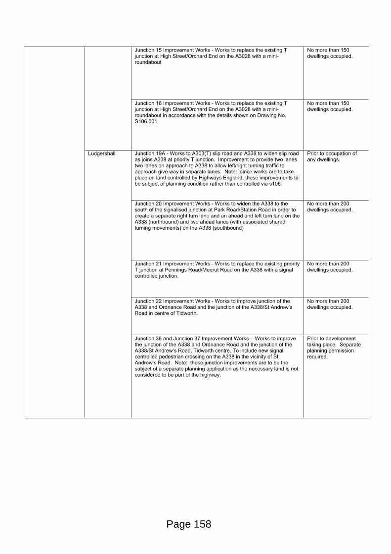
Junction 15 Improvement Works - Works to replace the existing T junction at High Street/Orchard End on the A3028 with a mini-roundabout
No more than 150 dwellings occupied.
Junction 16 Improvement Works - Works to replace the existing T junction at High Street/Orchard End on the A3028 with a mini-roundabout in accordance with the details shown on Drawing No. S106.001;
No more than 150 dwellings occupied.
Junction 19A - Works to A303(T) slip road and A338 to widen slip road as joins A338 at priority T junction. Improvement to provide two lanes two lanes on approach to A338 to allow left/right turning traffic to approach give way in separate lanes. Note: since works are to take place on land controlled by Highways England, these improvements to be subject of planning condition rather than controlled via s106.
Prior to occupation of any dwellings.
Junction 20 Improvement Works - Works to widen the A338 to the south of the signalised junction at Park Road/Station Road in order to create a separate right turn lane and an ahead and left turn lane on the A338 (northbound) and two ahead lanes (with associated shared turning movements) on the A338 (southbound)
No more than 200 dwellings occupied.
Junction 21 Improvement Works - Works to replace the existing priority T junction at Pennings Road/Meerut Road on the A338 with a signal controlled junction.
No more than 200 dwellings occupied.
Junction 22 Improvement Works - Works to improve junction of the A338 and Ordnance Road and the junction of the A338/St Andrew’s Road in centre of Tidworth.
No more than 200 dwellings occupied.
Ludgershall
Junction 36 and Junction 37 Improvement Works - Works to improve the junction of the A338 and Ordnance Road and the junction of the A338/St Andrew’s Road, Tidworth centre. To include new signal controlled pedestrian crossing on the A338 in the vicinity of St Andrew’s Road. Note: these junction improvements are to be the subject of a separate planning application as the necessary land is not considered to be part of the highway.
Prior to development taking place. Separate planning permission required.
Page 158
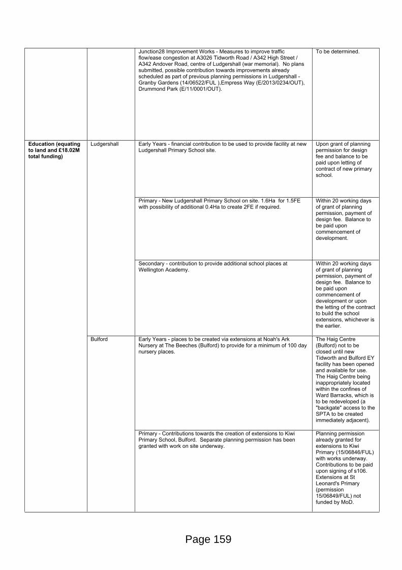
Junction28 Improvement Works - Measures to improve traffic flow/ease congestion at A3026 Tidworth Road / A342 High Street / A342 Andover Road, centre of Ludgershall (war memorial). No plans submitted, possible contribution towards improvements already scheduled as part of previous planning permissions in Ludgershall - Granby Gardens (14/06522/FUL ),Empress Way (E/2013/0234/OUT), Drummond Park (E/11/0001/OUT).
To be determined.
Early Years - financial contribution to be used to provide facility at new Ludgershall Primary School site.
Upon grant of planning permission for design fee and balance to be paid upon letting of contract of new primary school.
Primary - New Ludgershall Primary School on site. 1.6Ha for 1.5FE with possibility of additional 0.4Ha to create 2FE if required.
Within 20 working days of grant of planning permission, payment of design fee. Balance to be paid upon commencement of development.
Ludgershall
Secondary - contribution to provide additional school places at Wellington Academy.
Within 20 working days of grant of planning permission, payment of design fee. Balance to be paid upon commencement of development or upon the letting of the contract to build the school extensions, whichever is the earlier.
Early Years - places to be created via extensions at Noah's Ark Nursery at The Beeches (Bulford) to provide for a minimum of 100 day nursery places.
The Haig Centre (Bulford) not to be closed until new Tidworth and Bulford EY facility has been opened and available for use. The Haig Centre being inappropriately located within the confines of Ward Barracks, which is to be redeveloped (a "backgate" access to the SPTA to be created immediately adjacent).
Education (equating to land and £18.02M total funding)
Bulford
Primary - Contributions towards the creation of extensions to Kiwi Primary School, Bulford. Separate planning permission has been granted with work on site underway.
Planning permission already granted for extensions to Kiwi Primary (15/06846/FUL) with works underway. Contributions to be paid upon signing of s106. Extensions at St Leonard's Primary (permission 15/06849/FUL) not funded by MoD.
Page 159
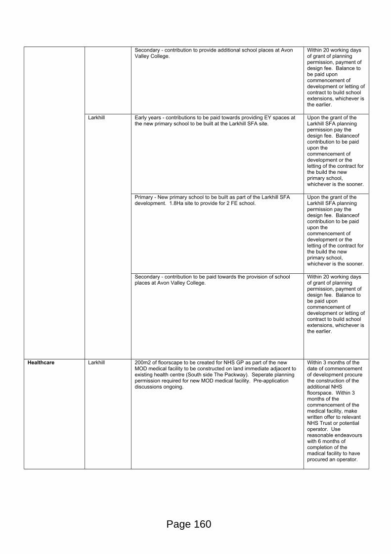
Secondary - contribution to provide additional school places at Avon Valley College.
Within 20 working days of grant of planning permission, payment of design fee. Balance to be paid upon commencement of development or letting of contract to build school extensions, whichever is the earlier.
Early years - contributions to be paid towards providing EY spaces at the new primary school to be built at the Larkhill SFA site.
Upon the grant of the Larkhill SFA planning permission pay the design fee. Balanceof contribution to be paid upon the commencement of development or the letting of the contract for the build the new primary school, whichever is the sooner.
Primary - New primary school to be built as part of the Larkhill SFA development. 1.8Ha site to provide for 2 FE school.
Upon the grant of the Larkhill SFA planning permission pay the design fee. Balanceof contribution to be paid upon the commencement of development or the letting of the contract for the build the new primary school, whichever is the sooner.
Larkhill
Secondary - contribution to be paid towards the provision of school places at Avon Valley College.
Within 20 working days of grant of planning permission, payment of design fee. Balance to be paid upon commencement of development or letting of contract to build school extensions, whichever is the earlier.
Healthcare Larkhill 200m2 of floorscape to be created for NHS GP as part of the new MOD medical facility to be constructed on land immediate adjacent to existing health centre (South side The Packway). Seperate planning permission required for new MOD medical facility. Pre-application discussions ongoing.
Within 3 months of the date of commencement of development procure the construction of the additional NHS floorspace. Within 3 months of the commencement of the medical facility, make written offer to relevant NHS Trust or potential operator. Use reasonable endeavours with 6 months of completion of the madical facility to have procured an operator.
Page 160

Sports, Leisure and Community facilities
Applies to all SFA planning applications
Implementation of "Sports and Community Access Scheme". Such a scheme compels the MoD to make sports and leisure facilities available to approved clubs and organisations by prior arrangement. The SCAS is to encourage use of facilities and will allow for parties to meet regularly so as to manage the scheme. Facilities include:
Ludgershall (Perham Down) –
New gym hall (including squash courts)
New Community centre – community room
Somme Road Rugby Pitch
Somme Road Football Pitch
Somme Road Cricket Pitch
Somme Road Polo Area
New 2x Football Pitches (1x grass and 1x 3G pitch)
Bulford –
Swimming Pool (WDO 006)
Beeches Community Centre
Marlborough Road 3G Football Pitch
Marlborough Road Cricket Pitch
Marlborough Road 5-a-side Football Pitch
Marlborough Road Changing Rooms
Double Hedges Football Pitch
Double Hedges Cricket Pitch
New 3G Football Pitch
New Cinder Running Track
Larkhill –
Church of St Albans with St Barbara (LL0368)
St Barbara’s Hall (LA0404)
Larkhill Community Centre (LA0609)
Sharpe Hall (LA0234)
Newcombe Hall (LA0360)
Home Barracks 5-a-side Football Pitch (LA0115)
Cricket Pitch (LA0321)
Cricket Pavillion (LA0012)
Astro-turf Pitch (LSX003)
Shrapnel Park Tennis Courts (LSX013 to 015)
No later than 3 months after commencement of development, submission of Sports and Community Access Scheme to Council for approval (s106 merely sets out principles and lists facilities). Implementation of SCAS within 3 months of Council's written approval.
Page 161
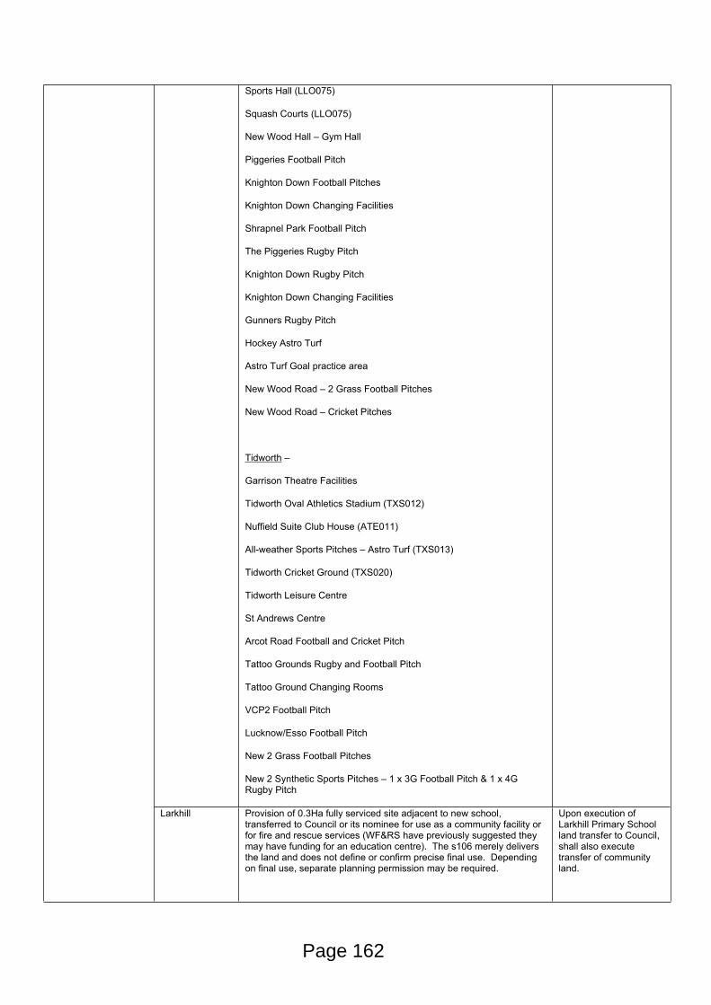
Sports Hall (LLO075)
Squash Courts (LLO075)
New Wood Hall – Gym Hall
Piggeries Football Pitch
Knighton Down Football Pitches
Knighton Down Changing Facilities
Shrapnel Park Football Pitch
The Piggeries Rugby Pitch
Knighton Down Rugby Pitch
Knighton Down Changing Facilities
Gunners Rugby Pitch
Hockey Astro Turf
Astro Turf Goal practice area
New Wood Road – 2 Grass Football Pitches
New Wood Road – Cricket Pitches
Tidworth –
Garrison Theatre Facilities
Tidworth Oval Athletics Stadium (TXS012)
Nuffield Suite Club House (ATE011)
All-weather Sports Pitches – Astro Turf (TXS013)
Tidworth Cricket Ground (TXS020)
Tidworth Leisure Centre
St Andrews Centre
Arcot Road Football and Cricket Pitch
Tattoo Grounds Rugby and Football Pitch
Tattoo Ground Changing Rooms
VCP2 Football Pitch
Lucknow/Esso Football Pitch
New 2 Grass Football Pitches
New 2 Synthetic Sports Pitches – 1 x 3G Football Pitch & 1 x 4G Rugby Pitch
Larkhill Provision of 0.3Ha fully serviced site adjacent to new school, transferred to Council or its nominee for use as a community facility or for fire and rescue services (WF&RS have previously suggested they may have funding for an education centre). The s106 merely delivers the land and does not define or confirm precise final use. Depending on final use, separate planning permission may be required.
Upon execution of Larkhill Primary School land transfer to Council, shall also execute transfer of community land.
Page 162
Ludgershall Provision of 0.4Ha fully serviced site adjacent to new school complete with existing building thereon, transferred to Council or its nominee (most likely Ludgershall Town Council) for use as a community facility. The s106 merely delivers the land and building and does not define or confirm precise final use. Depending on final use, separate planning permission may be required.
Upon execution of Ludgershall Primary School land transfer to Council, shall also execute transfer of community land to include the existing building on the land, with connection to water and power services.
Waste Applies to all SFA planning applications
Payment of contribution towards the provision of waste and recycling containers. Charged at £91 per dwelling.
Prior to occupation of any dwellings.
Page 163
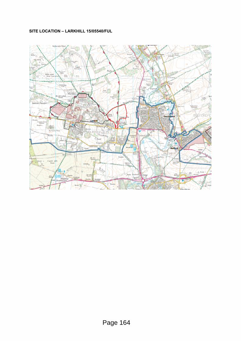
SITE LOCATION – LARKHILL 15/05540/FUL
Page 164
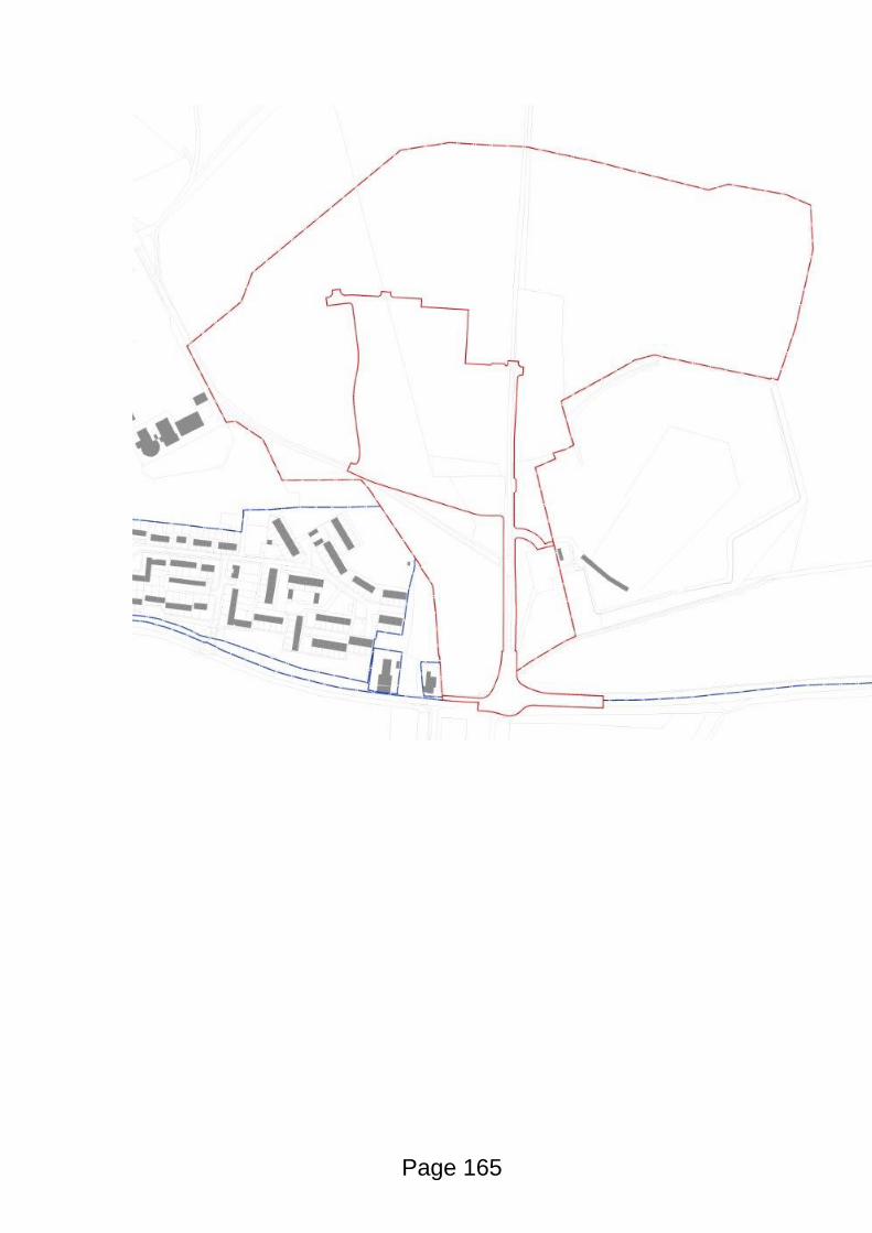
Page 165

This page is intentionally left blank
CM09650/2
Wiltshire Council
Strategic Planning Committee
13 April 2016
Subject: West Warminster Urban Extension masterplan
Cabinet Member: Councillor Toby Sturgis -Strategic Planning, Development Management, Strategic Housing, Property and Waste
Key Decision: Endorse
Executive Summary
The Wiltshire Core Strategy sets the strategic framework for growth and development in Wiltshire up to 2026, which includes at Core Policy 31 the allocation of land to the west of Warminster (the West Warminster Urban Extension – or ‘WWUE’) for the delivery of housing, employment and associated infrastructure. Core Policy 31 sets out that the WWUE will deliver 900 dwellings and 6ha employment land over the Core Strategy plan period to 2026. A development framework for this site is also set out in Appendix A of the Core Strategy which requires, along with a range of specific infrastructure to support the development, that the development should be preceded by a comprehensive masterplan for the whole of the site. The masterplan should be endorsed before any planning application on the site can be determined.
A draft masterplan has been prepared by the developers with interests in the WWUE site, which has been subject to public consultation. The draft masterplan is shown at Appendix 1 of this report.
This report recommends that the draft WWUE masterplan be endorsed, subject to the proposed modifications, scheduled in Appendix 2 and summarised in paragraph 17 of this report.
Proposals
That Strategic Planning Committee:
(i) Endorse the draft WWUE masterplan as a significant material consideration, subject to the recommended changes set out in Appendix 2 and summarised in paragraph 17 of this report; and
Page 167
Agenda Item 9
CM09650/2
(ii) Authorise the Associate Director for Economic Development and Planning, in consultation with the Cabinet Member for Strategic Planning, Development Management, Strategic Housing, Property and Waste, to make any further necessary minor changes in the interest of clarity and accuracy.
Reason for Proposals
The Wiltshire Core Strategy relies upon the delivery of the WWUE to meet its strategic housing and employment requirements for the area. In accordance with the Core Strategy, which seeks to deliver plan-led growth, the delivery of the strategic allocation is to be steered by a comprehensive masterplan for the whole of the site which will indicate the quanta and general location of development and infrastructure.
Endorsement of a comprehensive masterplan will enable subsequent planning applications to be determined, and will ensure that the site can start to deliver the housing, employment land and essential infrastructure that are planned for within the Core Strategy. This will boost jobs in the area, provide much needed affordable homes, enable the delivery of key infrastructure, and help the Council towards delivering a positive five year housing land supply position for the duration of the Core Strategy plan period.
Alistair CunninghamAssociate Director for Economic Development and Planning
Page 168
CM09650/2
Wiltshire Council
Strategic Planning Committee
13 April 2016
Subject: West Warminster Urban Extension masterplan
Cabinet Member: Councillor Toby Sturgis -Strategic Planning, Development Management, Strategic Housing, Property and Waste
Key Decision: Endorse
Purpose of Report
1. To:
(i) Endorse the draft WWUE masterplan shown at Appendix 1 to this report, subject to the recommended changes set out in Appendix 2 and summarised in paragraph 17 of this report; and
(ii) Authorise the Associate Director for Economic Development and Planning, in consultation with the Cabinet Member for Strategic Planning, Development Management, Strategic Housing, Property and Waste, to make any further necessary minor changes in the interest of clarity and accuracy.
Relevance to the Council’s Business Plan
2. The masterplan will guide the future development of the WWUE, which will deliver a significant portion of the town’s housing and employment needs over the Core Strategy plan period to 2026. The delivery of the WWUE will deliver much needed housing (including affordable), boost employment opportunities, and infrastructure to support this growth.
Background
3. The Wiltshire Core Strategy was adopted in January 2015, and sets the strategic framework for growth and development in Wiltshire up to 2026. The Core Strategy allocates 16 strategic housing and employment sites across a range of the larger settlements in Wiltshire. This includes the strategic allocation to the west of Warminster, as set out in Core Policy 31. Each of the strategic allocations are supplemented by a ‘development template’ which set out a range of infrastructure and mitigation measures that must be delivered as part of the development of the strategic allocation. The development template for the WWUE can be found at pages 356-361 of the Core Strategy.
Page 169
CM09650/2
4. In addition to the Infrastructure and mitigation requirements set out in the development template, the Core Strategy also requires planning applications for development of the site to be guided by a comprehensive masterplan, which is to be produced in consultation with the local community and should be done prior to any planning applications being determined. Once endorsed, the masterplan will guide the determination of any subsequent planning applications across the site.
5. The developers with current interests in the development of the WWUE (Persimmon Homes, Hannick Homes and Redrow Homes) have jointly produced the draft masterplan, which can be found at Appendix 1 to this report. The masterplan proposes the development of approximately 1,550 homes and 6ha employment land. It should be noted the housing figure proposed is substantially higher than the 900 homes set out in Core Policy 31, although the intention of the masterplan is that delivery of the site will extend beyond the Core Strategy plan period to 2026. The development trajectory included within the masterplan estimates that 893 dwellings will be delivered within the Core Strategy Plan period to 2026, with the remaining figure to be delivered over the following years to 2033.
6. The masterplan has been subject to consultation with the local community and other consultees (statutory and non-statutory), details of which can be found below.
7. Based on the feedback that has been received during the most recent public consultation period, officers have produced a schedule of recommended changes that can be found at Appendix 2 and summarised in paragraph 17 of this report. This summarises the responses that were received during the most recent consultation, and where applicable sets out recommended changes to be considered by the Strategic Planning Committee.
Main Considerations for the Council
8. The masterplan, once endorsed, will guide the determination of subsequent planning applications on land within the WWUE allocation area.
9. The main considerations for members of the Strategic Planning Committee will be whether the submitted masterplan, in combination with the schedule of changes proposed in officer comments at Appendix 2 and summarised in paragraph 17 of this report, are sufficient to address the requirements set out in the Core Strategy development template for the strategic allocation.
10. Members will also need to consider the scale of development proposed over and above the Core Strategy allocation of 900 homes, and consider whether the masterplan provides sufficient justification for this.
Page 170
CM09650/2
Consultation
11. Consultation on the first draft of the masterplan took place in November 2015, comprising a series of three topic based meetings with community focus groups to discuss questions from the community regarding the principle of development, highways matters, and flooding and drainage matters.
12. The feedback from these topic based meetings, together with feedback from internal specialists at Wiltshire Council was given to the developers to inform a revised version of the masterplan.
13. The revised masterplan, as shown at Appendix 1, was then subject to a three week period of public consultation between Thursday 18th February and Friday 11th March 2016. The consultation was publicised via a range of channels, including:
- Information made available on the Council’s website- Paper copies of the draft masterplan made available at Trowbridge
County Hall, Warminster Civic Centre and Warminster Library- Emails sent out to all statutory consultees- Emails sent out to other consultees with an interest in the WWUE site- Letters sent out to adjoining residents- Emails and letters sent out to all who had made comment on planning
applications on the site- Numerous site notices posted in and around the site- Advertisement placed in Wiltshire Times
14. The schedule of responses received during this consultation can be found at Appendix 2. This provides details of all of the representation received, along with a response from officers, recommending changes to the masterplan where applicable. A summary of the recommended changes are also summarised in paragraph 17 of this report.
General Summary of Comments
15. Appendix 2 to this report sets out a comprehensive schedule of the comments received during the most recent consultation on the draft masterplan.
16. The common themes arising from the consultation responses can be summarised as follows:
- A number of respondents felt that the masterplan should reflect only the 900 homes that are planned for in the Core Strategy, and that to plan beyond this number would be beyond the remit of the masterplan.
- Some respondents expressed that the infrastructure to be planned for as part of the WWUE must be delivered in a timely manner.
- There was some concern raised over who would take responsibility for the ongoing maintenance of infrastructure into the future.
Page 171
CM09650/2
- A number of respondents were of the view that the community facilities to be delivered as part of the school should be disaggregated from this use to ensure equity of access.
- There was also concern that the masterplan does not appear to show land allocated for a doctor’s surgery.
- A number of respondents also felt that the sports provisions within the WWUE site would be more suitable agglomerated into a single site rather than dispersed through the site.
- Concerns were also raised regarding the proficiency of the proposed highway network through the site.
- There were also comments raised in relation to the ecological impacts of development on the site
- A number of respondents raised objection to the possible impacts on the West Wilts Downs & Cranborne Chase Area of Outstanding Natural Beauty.
- Other concerns were raised relating to impacts on the Cley Hill Scheduled Monument to the west of the site.
Overview of proposed changes needed to the Master Plan
17. As a result of the consultation responses, some further amendments are proposed to the West Warminster Urban Extension masterplan. The proposed changes to the masterplan can be summarised as follows:
i. Community facilities to be disaggregated from the proposed school, to a location to be agreed with the Council.
ii. Introduction of a more effective buffer between homes and employment.
iii. Relocation of all balancing ponds away from the flood plain.
iv. Detail the approach to the public realm strategy to be implemented in future applications.
v. Revisions to demonstrate that junction from Bath Road to the Link Road will adequately protect the amenity of local residents.
vi. To move the school out of the landscape buffer, or to provide further evidence demonstrating that landscape impacts can be mitigated in this location.
vii. Explanation and illustration of where a doctor’s surgery could potentially be accommodated on the site.
viii. Further information is submitted to and agreed by the Council providing evidence for the effectiveness of the proposed landscape strategy including: landscape heritage sensitivity assessment; the advance planting schedule to include retained landscape features and new semi-mature native species (including approximate
Page 172
CM09650/2
timetable and costings) ; the deliverability, construction and effectiveness of the major landscaping scheme (including bund).
Safeguarding Implications
18. There are no direct safeguarding implications arising from this report, which is about enabling the plan-led delivery of the strategic allocation for Warminster to be delivered in a timely manner.
Public Health Implications
19. Public health bodies will continue to be consulted on planning matters, including in relation to any subsequent planning applications that come forward within the strategic allocation site.
Corporate Procurement Implications
20. There are no direct procurement implications arising from the report.
Equalities Impact of the Proposal
21. The masterplan seeks to boost the supply of much needed homes in Warminster, which will increase the availability of affordable homes, reduce disadvantage and inequality, and seek to deliver resilient communities.
Environmental and Climate Change Considerations
22. Statutory bodies including the Environment Agency, Natural England and Historic England have been consulted on the draft masterplan, and their comments, along with officer recommendations of changes to be made are set out in full at Appendix 2 of this report, and summarised at paragraph 17. Consultation with environmental bodies will continue to take place on planning matters in any subsequent planning applications within the WWUE site.
Risk Assessment
23. By endorsing a comprehensive masterplan for the West Warminster Urban Extension site, this will allow planning applications that accord with the masterplan to be approved, which will in turn reduce the risk of the Council being unable to maintain a five year supply of housing in the North and West Housing Market Area.
Risks that may arise if the proposed decision and related work is not taken
24. If the masterplan is not agreed, the Council will be unable to take it into account in the determination of planning applications on this allocation site, and further delay could further risk the Council being unable to maintain a five year supply of housing in the North and West Housing Market Area. This could result in speculative development that is not plan-led through the Core Strategy coming forward, which may not deliver the
Page 173
CM09650/2
same level of planned infrastructure as would be delivered through development on this site.
Risks that may arise if the proposed decision is taken and actions that will be taken to manage these risks
25. If the masterplan (incorporating officer recommendations) is agreed, the Council will need to ensure that any subsequent planning applications on the WWUE site are determined in accordance with the masterplan.
Financial Implications
26. Endorsing the WWUE masterplan will ensure that the Council can take positive steps towards the delivery of housing and employment that is planned within the Wiltshire Core Strategy. Once subsequent planning applications can be approved and development commences, the Council will be in receipt of funds derived from Community Infrastructure Levy contributions.
Legal Implications
27. Section 70(2) of the Town and Country Planning Act 1990 and section 38(6) of the Planning and Compulsory Purchase Act 2004 require that the determination of planning applications must be made in accordance with the Development Plan, unless material considerations indicate otherwise. The Wiltshire Core Strategy forms the relevant development plan for Wiltshire and in accordance with the Core Strategy, the land identified as the WWUE is allocated for the delivery of housing, employment and associated infrastructure, to be delivered through a comprehensive masterplanning process. Endorsement of a masterplan which conforms to the Core Strategy and national policy will enable subsequent planning applications to be determined through the plan-led approach set out in the Core Strategy. The Government has placed great emphasis on the expediency of plan making, as well as in the determination of planning applications, and having an endorsed masterplan in place will assist the expedient delivery of this allocation.
Options Considered
28. The Core Strategy is clear in its requirement that a site-wide masterplan should precede the determination of any individual planning applications on the WWUE site. Therefore no alternative approaches to the production of a masterplan have been considered.
Conclusions
29. The masterplan for the WWUE strategic allocation is a requirement set out in the Core Strategy to guide future planning applications on the allocated site. The draft masterplan at Appendix 1 has been subject to public consultation with members of the public,
Page 174
CM09650/2
stakeholders and statutory bodies, as well as internal specialists at Wiltshire Council. Subject to the changes that are recommended at paragraph 17 of this report, and as detailed in Appendix 2, the masterplan represents a framework for the delivery of the site which can be used to guide the determination of subsequent planning applications on the site.
30. Having an endorsed masterplan in place will enable the Council to expedite the delivery of the strategic allocation which will provide a range of infrastructure, employment opportunities, and much needed housing (including affordable). The delivery of housing on the site will also enable the Council to improve its five year housing land supply position in the North and West Housing Market Area.
Alistair CunninghamAssociate Director for Economic Development and Planning
Report Authors:
David MiltonSpatial Planning Manager, Economic Development and PlanningTel: 01722 434354
Natasha StylesSenior Planning Officer, Economic Development and PlanningTel: 01722 434385
Anna McBridePlanning Officer, Economic Development and PlanningTel: 01722 434394
(31 March 2016)
The following documents have been relied on in the preparation of this report:
Wiltshire Core Strategy
Appendices
Appendix 1 – Draft masterplan for the West Warminster Urban ExtensionAppendix 2 – Schedule of comments received and officer responses
Page 175

This page is intentionally left blank
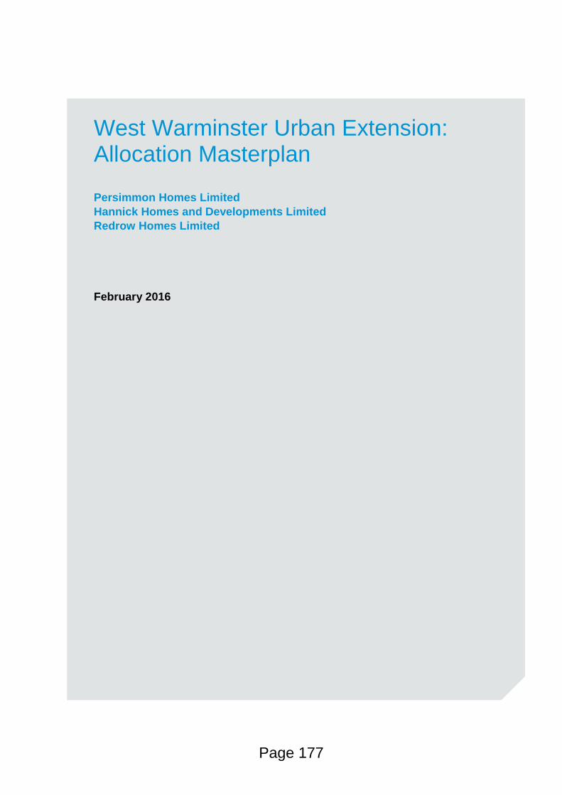
West Warminster Urban Extension: Allocation Masterplan
Persimmon Homes Limited
Hannick Homes and Developments Limited
Redrow Homes Limited
February 2016
Page 177
Allocation Masterplan, February 2016
Page 2 of 45
J:\Bristol Planning\Job Files - Live\J029240 & J029241 - West of Warminster Urban Extension\Reports\160202 WWUE Allocation Masterplan - Final.docx
Contents
Section Page
INTRODUCTION 3 1
THE WILTSHIRE CORE STRATEGY 2006-2026 (ADOPTED 2015) 6 2
WWUE: CONTEXTUAL OVERVIEW 9 3
THE PROPOSALS 16 4
SUPPORTING EVIDENCE: AN OVERVIEW 30 5
URBAN DESIGN 40 6
PHASING & DELIVERY 42 7
Appendices
APPENDIX A: INDICATIVE HOUSING DELIVERY TIMETABLE
Page 178
Allocation Masterplan, February 2016
Page 3 of 45
J:\Bristol Planning\Job Files - Live\J029240 & J029241 - West of Warminster Urban Extension\Reports\160202 WWUE Allocation Masterplan - Final.docx
INTRODUCTION 1
This strategic masterplan responds to the Wiltshire Core Strategy (2015) requirement for an 1.1
allocation-wide masterplan to be prepared for the West Warminster Urban Extension (WWUE).
Once agreed, the masterplan will inform the determination of subsequent planning applications at
the site.
The WWUE forms part of Wiltshire Council’s strategic growth plan as established in the Wiltshire 1.2
Core Strategy; it is one of 16 ‘Strategic Sites’ in the County where there are proposals for large
scale mixed-use development.
The Wiltshire Core Strategy requires 6ha of employment land and approximately 2,060 new homes 1.3
to be provided within the Warminster Community Area over the period 2006-2026, with the full
quantum of employment land and 900 dwellings being delivered at the WWUE. At the time of
writing, there is a residual housing requirement of approximately 1,260 dwellings1 and 6ha of
employment land to be delivered within the Community Area over the period to 2026.
The proposed WWUE extends to approximately 115ha; a scale that facilitates the delivery of a 1.4
development which mitigates impacts and caters for on-site delivery of housing, employment, open
space, community facilities and supporting infrastructure that will benefit future residents and the
wider community.
There is a need to ensure that the design and layout of the site is informed by detailed evidence, 1.5
particularly with a view to minimising visual impacts on surrounding landscape and heritage assets
including Cley Hill (a Scheduled Ancient Monument and a Site of Special Scientific Interest),
Cranborne Chase and West Wiltshire Downs Area of Outstanding Natural Beauty (AONB),
Warminster Conservation Area and heritage assets such as the Grade II Listed Bugley Barton
Farmhouse. A landscape-led approach to design is therefore a fundamental principle that must be
pursued in delivering development at the site. This entails the strategic use of trees, planting and
open space to minimise visual impacts and to provide a framework of greenspace within which
development can be located. Detailed evidence is also required in respect of other considerations
including, but not limited to, transport, flood risk and ecology.
In addition to mitigating potential impacts, proposals will also need to ensure that the site is 1.6
developed in a sustainable and efficient manner given the primacy of the site within the spatial
strategy for Warminster (as set out in the Core Strategy), the amount of land allocated as part of the
WWUE and the opportunity to adopt a long-term view to accommodating growth in Warminster.
1 Wiltshire Council’s ‘Housing Land Supply Statement’ (September 2015)
Page 179
Allocation Masterplan, February 2016
Page 4 of 45
J:\Bristol Planning\Job Files - Live\J029240 & J029241 - West of Warminster Urban Extension\Reports\160202 WWUE Allocation Masterplan - Final.docx
This masterplan has been prepared by Persimmon Homes Limited, Hannick Homes and 1.7
Developments Limited and Redrow Homes Limited (‘the developers’). The developers are not
landowners but have option agreements with relevant landowners at the site. Under the terms of
the option agreements, the developers promote the land for development and upon receipt of
planning permission will be in a position to acquire ownership of the land in its totality or on a
phased basis from the landowner(s).
The developers have undertaken extensive stakeholder consultation over the course of the last four 1.8
years regarding the development of the site and this has informed their respective planning
applications that are currently with Wiltshire Council for determination2. Therefore, the content of
this masterplan benefits from the detailed technical analysis and previous consultation that informed
the applications – something that is usually not available at the stage when allocation-wide
masterplans such as this are being prepared.
The content of this masterplan has also been subject of focused consultation with representatives 1.9
of Wiltshire Council and the local community (via Community Reference Groups appointed by the
Town Council and Councillor Ridout) that culminated in topic-based meetings on the 6th November
and 27th November 2015. In response to feedback on the draft masterplan that was received from
Wiltshire Council, Statutory Consultees and the Community Reference Groups, this masterplan was
subsequently updated.
Where relevant, and to avoid repetition, this masterplan cross-references documents and plans that 1.10
form part of the two aforementioned planning applications (Refs. 15/01800/OUT and 14/06562/FUL)
and can be accessed on Wiltshire Council’s website. (Please see Table 1.2 for more information on
relevant background documents and plans.)
Purpose of the Plan
In accordance with the Wiltshire Core Strategy, this masterplan addresses the requirement for an 1.11
allocation-wide masterplan to be prepared through a process involving the local community,
Wiltshire Council, infrastructure providers and statutory consultees. The masterplan will guide the
delivery of the WWUE alongside the Core Strategy Development Template for the allocation.
This is a high level strategic masterplan which provides an overview of how the allocation and major 1.12
infrastructure can be delivered in a comprehensive manner having regard to the detailed technical
information that is now available for the majority of the WWUE.
2 Planning Application Ref. 15/01800/OUT (Persimmon Homes Limited and Hannick Homes and Developments Limited) and Planning
Application Ref. 14/06562/FUL (Redrow Homes Limited).
Page 180
Allocation Masterplan, February 2016
Page 5 of 45
J:\Bristol Planning\Job Files - Live\J029240 & J029241 - West of Warminster Urban Extension\Reports\160202 WWUE Allocation Masterplan - Final.docx
The masterplan does not seek to prescribe detailed design matters; this is a function of submitted 1.13
and subsequent planning applications. Moreover, the anticipated housing delivery timetable
(attached as Appendix A) for the site extends beyond the end of the Plan period and therefore the
masterplan needs to be sufficiently flexible to respond to changing circumstances.
The submitted planning applications are intended to be in general accordance with this masterplan 1.14
and any future applications will also be informed by the content of the Plan. Where outline planning
applications are pursued, more detailed layouts and design matters are addressed at the Reserved
Matters stage.
The delivery of the WWUE also needs to be informed by national and local level planning policy and 1.15
guidance.
Page 181
Allocation Masterplan, February 2016
Page 6 of 45
J:\Bristol Planning\Job Files - Live\J029240 & J029241 - West of Warminster Urban Extension\Reports\160202 WWUE Allocation Masterplan - Final.docx
THE WILTSHIRE CORE STRATEGY 2006-2026 (ADOPTED 2015) 2
The Wiltshire Core Strategy (WCS) is an employment-led 2.1
strategy that sets out strategic planning policy for Wiltshire over
the period 2006-2026. The WCS confirms that the minimum
housing target for the County is 42,000 homes and this will be
accompanied by the delivery of 178ha of new employment land.
Strategic sites such as the WWUE form a fundamental 2.2
component of the WCS; these sites are major developments that
will deliver a mix of uses, critically local employment as well as
homes. The co-location of employment and new homes informs
a desire to reduce commuting and provide employment and
community infrastructure in the immediate vicinity of where that
need arises.
The strategic sites also allow infrastructure (for example: primary schools; community facilities; 2.3
formal and informal recreation facilities; and local shops and services) necessary to support the
development of the site and wider impacts of significant growth to be delivered in a timely, phased
manner alongside proposed growth having regard to economies of scale.
Warminster is identified as a key market town in Wiltshire where there is potential for significant 2.4
development. The strategy for Warminster in the WCS3 is based on increasing the level of
employment, town centre retail and service provision, along with residential development, as part of
sustainable growth. Core Policy 31 of the WCS confirms that over the period 2006-2026, 6ha of
new employment land (in addition to that already present or planned before 2006) and
approximately 2,060 new homes will be provided in the Warminster Community Area.
The WWUE was the only strategic site identified in Warminster through the WCS. The site extends 2.5
to approximately 115ha as allocated. Core Policy 31 proposes that 900 homes and 6ha of
employment land, representing the full quantum of additional employment land required in
Warminster to cater for the 2,060 new homes planned for the town and its surrounding (community)
area, will be delivered at the WWUE between 2006 and 2026.
The WWUE therefore represents a significant step in the town’s long-term growth as it has the 2.6
potential to deliver housing, employment and local service needs of Warminster up to 2026 and
beyond. A critical mass of population at the WWUE will ensure that all essential infrastructure
including community facilities to service the new community, can be viably delivered and
3 Paragraph 5.154, Wiltshire Core Strategy
Page 182
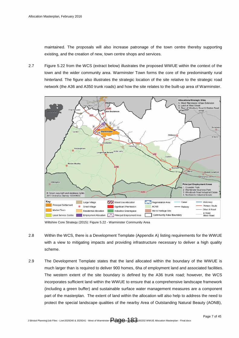
Allocation Masterplan, February 2016
Page 7 of 45
J:\Bristol Planning\Job Files - Live\J029240 & J029241 - West of Warminster Urban Extension\Reports\160202 WWUE Allocation Masterplan - Final.docx
maintained. The proposals will also increase patronage of the town centre thereby supporting
existing, and the creation of new, town centre shops and services.
Figure 5.22 from the WCS (extract below) illustrates the proposed WWUE within the context of the 2.7
town and the wider community area. Warminster Town forms the core of the predominantly rural
hinterland. The figure also illustrates the strategic location of the site relative to the strategic road
network (the A36 and A350 trunk roads) and how the site relates to the built-up area of Warminster.
Within the WCS, there is a Development Template (Appendix A) listing requirements for the WWUE 2.8
with a view to mitigating impacts and providing infrastructure necessary to deliver a high quality
scheme.
The Development Template states that the land allocated within the boundary of the WWUE is 2.9
much larger than is required to deliver 900 homes, 6ha of employment land and associated facilities.
The western extent of the site boundary is defined by the A36 trunk road; however, the WCS
incorporates sufficient land within the WWUE to ensure that a comprehensive landscape framework
(including a green buffer) and sustainable surface water management measures are a component
part of the masterplan. The extent of land within the allocation will also help to address the need to
protect the special landscape qualities of the nearby Area of Outstanding Natural Beauty (AONB),
Wiltshire Core Strategy (2015): Figure 5.22 - Warminster Community Area
Page 183
Allocation Masterplan, February 2016
Page 8 of 45
J:\Bristol Planning\Job Files - Live\J029240 & J029241 - West of Warminster Urban Extension\Reports\160202 WWUE Allocation Masterplan - Final.docx
the setting of Cley Hill (a Scheduled Ancient Monument and a Site of Special Scientific Interest) and
the identified flood risk.
The WWUE will play a critical role in catering for the long term growth requirements of Warminster. 2.10
In allocating the site for development, the WCS in effect concluded that it is the most sustainable
location for long-term growth in Warminster and it represents an opportunity to facilitate the creation
of a more resilient community and economy.
Page 184
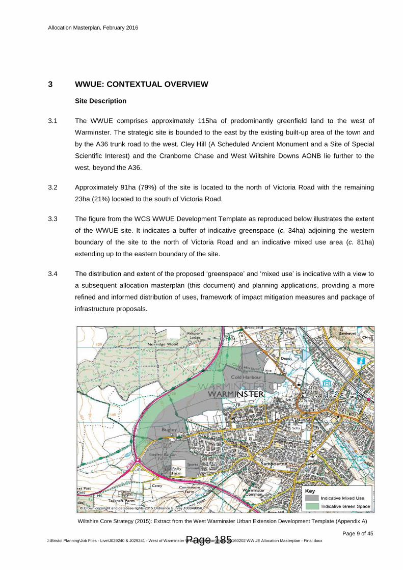
Allocation Masterplan, February 2016
Page 9 of 45
J:\Bristol Planning\Job Files - Live\J029240 & J029241 - West of Warminster Urban Extension\Reports\160202 WWUE Allocation Masterplan - Final.docx
WWUE: CONTEXTUAL OVERVIEW 3
Site Description
The WWUE comprises approximately 115ha of predominantly greenfield land to the west of 3.1
Warminster. The strategic site is bounded to the east by the existing built-up area of the town and
by the A36 trunk road to the west. Cley Hill (A Scheduled Ancient Monument and a Site of Special
Scientific Interest) and the Cranborne Chase and West Wiltshire Downs AONB lie further to the
west, beyond the A36.
Approximately 91ha (79%) of the site is located to the north of Victoria Road with the remaining 3.2
23ha (21%) located to the south of Victoria Road.
The figure from the WCS WWUE Development Template as reproduced below illustrates the extent 3.3
of the WWUE site. It indicates a buffer of indicative greenspace (c. 34ha) adjoining the western
boundary of the site to the north of Victoria Road and an indicative mixed use area (c. 81ha)
extending up to the eastern boundary of the site.
The distribution and extent of the proposed ‘greenspace’ and ‘mixed use’ is indicative with a view to 3.4
a subsequent allocation masterplan (this document) and planning applications, providing a more
refined and informed distribution of uses, framework of impact mitigation measures and package of
infrastructure proposals.
Wiltshire Core Strategy (2015): Extract from the West Warminster Urban Extension Development Template (Appendix A)
Page 185
Allocation Masterplan, February 2016
Page 10 of 45
J:\Bristol Planning\Job Files - Live\J029240 & J029241 - West of Warminster Urban Extension\Reports\160202 WWUE Allocation Masterplan - Final.docx
Constraints Overview
While the allocation of the WWUE within the WCS was informed by strategic level analysis, the 3.5
preparation of this masterplan enables the developers, Wiltshire Council, statutory consultees and
the local community to better understand the constraints and opportunities using more detailed
evidence relating to the majority of the site.
Table 1.1 below contains a summary of the key constraints to development at the WWUE. This 3.6
masterplan will explore in later sections how the constraints have been addressed.
Table 1.1: A Summary of Known Constraints affecting the WWUE
Constraint Description
Landscape /
Visual
Impacts
The strategic site comprises an area of open land that is predominantly in
agricultural use. While the site itself is not subject to a landscape designation,
the Cranborne Chase and West Wiltshire Downs AONB and Cley Hill (a
Scheduled Ancient Monument (SAM) and a Site of Special Scientific Interest
(SSSI)) lie to the west of the site, beyond the A36. There are also a number of
key views towards the site from surrounding areas. The site is in close proximity
to the Warminster Conservation Area and the Grade II Listed Bugley Barton
Farm.
The proposals will result in the loss of agricultural land. Approximately a quarter
of the allocated land north of Victoria Road comprises ‘Best and Most Versatile’
(BMV) agricultural land, while the majority of the allocated land south of Victoria
Road comprises BMV land. The proposed development of the site has already
been accepted in principle by virtue of the site’s allocation for development
within the WCS.
Transport Public consultation feedback and consultation with statutory consultees
revealed concern regarding the transport impacts arising from the WWUE
proposals. There was concern that the proposals would result in increased
west-to-east movements through the constrained town centre and would result
in congestion at junctions and narrow streets such as West Street.
Flood Risk /
Drainage
A small section of the site (north of Victoria Road) falls within Flood Zone 2,
where the site abuts the Were Brook to the north of Victoria Road. Consultation
feedback on the planning application proposals revealed concern regarding the
risk of increased flooding both at the site but also in the wider catchment
area(s) owing in part to the reliability of the flood maps prepared by the
Environment Agency in this area.
There are two surface water catchment areas affecting the site; the land north
of Victoria Road forms part of a different catchment to the land south of Victoria
Road.
Page 186
Allocation Masterplan, February 2016
Page 11 of 45
J:\Bristol Planning\Job Files - Live\J029240 & J029241 - West of Warminster Urban Extension\Reports\160202 WWUE Allocation Masterplan - Final.docx
Heritage The Grade II Listed Bugley Barton Farmhouse is the only designated heritage
asset within the site.
Cley Hill (a SAM and SSSI) is located to the west of the site, beyond the A36.
There are a number of Listed Buildings located along Victoria Road and Bath
Road in close proximity to the site. The Warminster Conservation Area is also
located to the east of the site. While some of the northern part of the allocation
lies within an ‘area of higher archaeological potential’ as identified in the West
Wiltshire District Plan Proposals Map, archaeological surveys undertaken in
support of Planning Application Ref. 15/01800/OUT (Persimmon/Hannick
Homes) did not identify any significant archaeological deposits.
A detailed Archaeological Assessment also supports Planning Application Ref.
14/06562/FUL (Redrow Homes) and this did not identify any significant
archaeological deposits.
Ecology The site in general is of low ecological interest as it predominantly comprises
arable farmland that is in intensive use. Ecology surveys supporting the two
planning applications at the site have confirmed the site supports common
reptile species, foraging bats and dormouse where mitigation will be necessary.
The site also abuts the Coldharbour Meadows County Wiltshire Site.
As per all development within the Warminster Community Area, the
development of the site needs to have regard to the need to protect the River
Avon Special Area of Conservation (SAC) owing to risks associated with
phosphate loading.
Noise The proximity of the site to the A36 trunk road means there is a risk of noise
and vibration impacts affecting properties located near the road.
Social
Infrastructure
Consultation feedback from service providers confirmed there is insufficient
capacity in existing primary schools and Kingdown Secondary School to cater
for all of the pupils that will be generated by the development.
NHS England has advised that additional healthcare infrastructure will be
required to cater for the proposals. Wiltshire Council has also confirmed a need
for extra care provision, allotment provision and cemetery provision to cater for
the proposals.
Land Control
In early 2016 the majority of the strategic site (approximately 108ha) is controlled by the developers 3.7
(i.e. the developers have an option agreement with respective landowners to promote their land for
development) as illustrated in Figure 1.1 below. The developers do not ‘own’ the land but have a
legal agreement with the relevant landowners to promote their land for development through
planning applications and to acquire ownership of the land once there is planning permission for the
development.
While land control at the site may change over time through developers entering option agreements 3.8
with the two outstanding landowners at the allocated land south of Victoria Road or developers may
Page 187
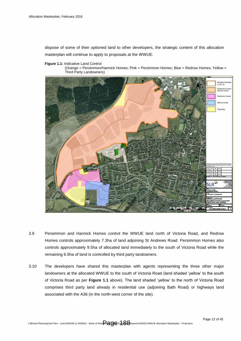
Allocation Masterplan, February 2016
Page 12 of 45
J:\Bristol Planning\Job Files - Live\J029240 & J029241 - West of Warminster Urban Extension\Reports\160202 WWUE Allocation Masterplan - Final.docx
dispose of some of their optioned land to other developers, the strategic content of this allocation
masterplan will continue to apply to proposals at the WWUE.
Persimmon and Hannick Homes control the WWUE land north of Victoria Road, and Redrow 3.9
Homes controls approximately 7.3ha of land adjoining St Andrews Road. Persimmon Homes also
controls approximately 9.5ha of allocated land immediately to the south of Victoria Road while the
remaining 6.5ha of land is controlled by third party landowners.
The developers have shared this masterplan with agents representing the three other major 3.10
landowners at the allocated WWUE to the south of Victoria Road (land shaded ‘yellow’ to the south
of Victoria Road as per Figure 1.1 above). The land shaded ‘yellow’ to the north of Victoria Road
comprises third party land already in residential use (adjoining Bath Road) or highways land
associated with the A36 (in the north-west corner of the site).
Figure 1.1: Indicative Land Control
(Orange = Persimmon/Hannick Homes; Pink = Persimmon Homes; Blue = Redrow Homes; Yellow = Third Party Landowners)
Page 188
Allocation Masterplan, February 2016
Page 13 of 45
J:\Bristol Planning\Job Files - Live\J029240 & J029241 - West of Warminster Urban Extension\Reports\160202 WWUE Allocation Masterplan - Final.docx
Stakeholder Consultation
There has already been extensive stakeholder consultation on emerging proposals at the WWUE 3.11
both during the preparation of the WCS, and to inform the content of two planning applications
(discussed below) that were submitted to Wiltshire Council for determination in July 2014 and
March 2015:
i) Planning Application Ref. 14/06562/FUL (Redrow Homes): Full planning permission for
the delivery of 203 dwellings and associated infrastructure on land to the west of St.
Andrews Road. This application was registered by Wiltshire Council on 04 July 2014. Prior
to the submission of the application, two public consultation events were held in January
2014 (circa 200 attendees) and May 2014 (circa 100 attendees).
ii) Planning Application Ref. 15/01800/OUT (Persimmon and Hannick Homes): Outline
planning permission for the delivery of up to 1,200 homes, 6ha of employment land, a local
centre and associated infrastructure. The application was registered by Wiltshire Council on
03 March 2015. In addition to various meetings with stakeholder organisations and statutory
consultees, the proposals were informed by 3 public consultation events in May 2013
(approximately 300 attendees), September 2013 (approximately 250 attendees) and July
2014 (approximately 130 attendees). Further background information on the public
consultation undertaken in support of the application can be found in the Statement of
Community Involvement (January 2015) supporting the planning application.
This masterplan has been influenced by consultation responses and submissions made by the local 3.12
community and through input from stakeholders including Natural England, the AONB Partnership
and the Environment Agency during the preparation of the above planning applications. The
following aspects were derived from the consultation process:
Locating the employment land at the northern part of the site to facilitate synergies with existing
employment facilities to the east of Bath Road, avoid the need for HGVs to travel through the
centre of Warminster and minimise visual impacts;
Preparing a comprehensive landscape framework comprising trees, planting and open space.
The inclusion of woodland areas and advance planting (the early planting of trees in areas
where visual impacts of development are greatest) forms an integral part of the landscape
framework. This is necessary to mitigate visual impacts from the development and provide an
appropriate setting for development at this sensitive site at the western edge of Warminster;
On land north of Victoria Road, identifying a linear park adjoining the eastern boundary of the
site in order to provide a green buffer between new and existing development;
Providing for on-site surface water attenuation measures to ensure that the rate of surface water
run-off is less than the current green-field rate, thereby reducing the risk of flooding at the site
and elsewhere in Warminster;
Page 189
Allocation Masterplan, February 2016
Page 14 of 45
J:\Bristol Planning\Job Files - Live\J029240 & J029241 - West of Warminster Urban Extension\Reports\160202 WWUE Allocation Masterplan - Final.docx
Providing for a Local Centre that will accommodate local shops and services and a community
building;
Including a site for a new doctors surgery in response to comments from the local community
and feedback from NHS England/Smallbrook Surgery;
Providing for allotments, full-size and junior-size sports pitches, and formal children’s play areas
in accordance with the standards listed in the West Wiltshire Leisure and Recreation DPD;
Identifying an area for an ecology park in response to comments from the Wiltshire Wildlife
Trust; and
Providing for the delivery of a new through-school in response to comments from the community,
Wiltshire Council’s Education Department and Kingdown Secondary School.
The above public consultation informing the planning applications was subsequently supplemented 3.13
by allocation masterplan meetings between the developers’ consultants, representatives of the local
community (via Community Reference Groups appointed by the Town Council and Councillor
Ridout) and Wiltshire Council on 05 November and 27 November 2015.
In support of the proposals at the allocation, the developers instructed teams of specialist 3.14
consultants to undertake detailed environmental and transport analysis. The two planning
applications at the site are supported by Environmental Impact Assessments (EIAs) which
objectively identify potential impacts and mitigation measures where relevant before concluding on
any residual impacts.
Table 1.2 below lists relevant documents/plans informing the planning applications which are relied 3.15
upon and referenced in later sections of this masterplan. The application documents/plans can be
accessed on Wiltshire Council’s website using the ‘planning application search’ facility4 and typing
in the relevant planning application reference numbers.
Table 1.2: WWUE Technical Studies
Topic Area Planning Application Ref. 15/01800/OUT (Persimmon and Hannick Homes)
Planning Application Ref. 14/06562/FUL5
(Redrow Homes)
Design
Parameters
Design and Access Statement
(RPS)
Design and Access Statement
(NLP/CDS)
Transport Transport Assessment, Umbrella
Travel Plan and Chapter 7 of the
Environmental Statement (PFA
Consulting)
Transport Assessment (WYG
(formally FMW))
Landscape Landscape Strategy and Implementation Plan and Chapter 11 of the Environmental Statement (SLR
Landscape and Visual Impact
Statement and Chapter G of the
Environmental Statement (Pegasus)
4 http://planning.wiltshire.gov.uk/Northgate/PlanningExplorer/ApplicationSearch.aspx
5 The Environmental Statement supporting the planning application also includes an Addendum dated May 2015.
Page 190
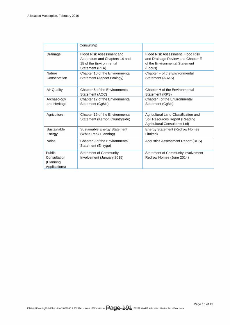
Allocation Masterplan, February 2016
Page 15 of 45
J:\Bristol Planning\Job Files - Live\J029240 & J029241 - West of Warminster Urban Extension\Reports\160202 WWUE Allocation Masterplan - Final.docx
Consulting)
Drainage Flood Risk Assessment and
Addendum and Chapters 14 and
15 of the Environmental
Statement (PFA)
Flood Risk Assessment, Flood Risk
and Drainage Review and Chapter E
of the Environmental Statement
(Focus)
Nature
Conservation
Chapter 10 of the Environmental
Statement (Aspect Ecology)
Chapter F of the Environmental
Statement (ADAS)
Air Quality Chapter 8 of the Environmental
Statement (AQC)
Chapter H of the Environmental
Statement (RPS)
Archaeology
and Heritage
Chapter 12 of the Environmental
Statement (CgMs)
Chapter I of the Environmental
Statement (CgMs)
Agriculture Chapter 16 of the Environmental
Statement (Kernon Countryside)
Agricultural Land Classification and
Soil Resources Report (Reading
Agricultural Consultants Ltd)
Sustainable
Energy
Sustainable Energy Statement
(White Peak Planning)
Energy Statement (Redrow Homes
Limited)
Noise Chapter 9 of the Environmental
Statement (Enzygo)
Acoustics Assessment Report (RPS)
Public
Consultation
(Planning
Applications)
Statement of Community
Involvement (January 2015)
Statement of Community involvement
Redrow Homes (June 2014)
Page 191
Allocation Masterplan, February 2016
Page 16 of 45
J:\Bristol Planning\Job Files - Live\J029240 & J029241 - West of Warminster Urban Extension\Reports\160202 WWUE Allocation Masterplan - Final.docx
THE PROPOSALS 4
The WWUE Masterplan provides for the comprehensive delivery of a sustainable urban extension 4.1
where employment, community, transport, surface water drainage and open space infrastructure is
co-located alongside new homes.
In preparing the development proposals for the WWUE, the developers have assessed and sought 4.2
to mitigate, where appropriate, all potential environmental impacts through the identification of a
comprehensive framework of mitigation measures. This impact assessment and mitigation
subsequently informed the quantum and layout of the proposed development proposals having
regard to the need to make the most efficient use of development land; significantly boost the
supply of housing; co-locate new housing development alongside employment, community facilities
and infrastructure; and to ensure that the proposals are sustainable having regard to the WCS and
the National Planning Policy Framework (NPPF).
The layout of the site is largely predicated on the linear shape of the allocation, the provision of a 4.3
green buffer at the western boundary of the site and the WCS requirement for a link road
connecting Bath Road, Victoria Road and St. Andrews Road.
An appraisal of existing social infrastructure informed by input from Wiltshire Council, the local 4.4
community and infrastructure providers, identified additional infrastructure needs to be addressed
as part of the WWUE proposals. In identifying and providing for such social infrastructure, regard
also needs to be had to achieving sufficient critical mass (population) at the WWUE to ensure such
services could be viably delivered and maintained. This is particularly prudent at a time when
public finances are constrained.
The WWUE proposals include: 4.5
i) New Homes (including affordable and starter homes and extra-care accommodation)
Approximately 1,550 new homes comprising a mix of dwellings to meet the needs of
the Warminster Community Area.
The WWUE will provide for a wide range of dwelling types, sizes and tenures to cater
for people with different incomes and at different stages of their lives. This will include
up to 30% affordable housing in accordance with Core Policy 43 of the Core Strategy,
including an element of extra-care provision.
This amount of development at a single location also facilitates the delivery of critical
mass of local population to sustain local facilities and public transport proposals
arising from the development.
Page 192
Allocation Masterplan, February 2016
Page 17 of 45
J:\Bristol Planning\Job Files - Live\J029240 & J029241 - West of Warminster Urban Extension\Reports\160202 WWUE Allocation Masterplan - Final.docx
ii) Employment
At least 6ha of employment land. The employment land target (6ha) in the WCS was
based on the overall housing target for the Warminster Community Area of 2,060
homes.
The employment land will be delivered as part of the first phase of development on
allocated land north of Victoria Road. This will be delivered at a single location at the
most northerly point of the site with a view to facilitating synergies with existing
employment facilities on Bath Road and minimising the need for haulage vehicles to
pass through the centre of Warminster.
In order to maximise the prospect of the employment land being acquired by
prospective occupiers as quickly as possible, the WWUE provides for a flexible
employment use.
The employment land will be promoted through a joint marketing strategy between the
developers and Wiltshire Council. The marketing strategy will be a legal requirement
set out in the S106 Agreement relating to Planning Application Ref. 15/01800/OUT
(Persimmon and Hannick Homes). To maximise the attractiveness of the land to
prospective occupiers, the land will be fully serviced.
iii) Community / Social Infrastructure
A through-school comprising a 1.5FE primary school (future-proofed to facilitate
expansion to a 2FE school) and part-secondary school comprising facilities for year 7
secondary school children.
During the preparation of this masterplan and the associated planning applications,
Wiltshire Council and Kingdown School made clear that there was no scope to expand
Kingdown School at its existing site to accommodate the projected level of pupils
generated by the proposed development of 1,550 homes.
Persimmon and Hannick Homes, through dialogue and agreement with Wiltshire
Council and Kingdown School, have now set aside land at the WWUE to
accommodate a through-school that can address the expansion requirements of
Kingdown School. Should this option for providing additional secondary school places
be pursued, it is the intention that Kingdown School will become an all-through
academy (4-19 age range) delivering education across two sites (the existing
Kingdown Academy site and a new site on the WWUE). The WWUE school site would
accommodate the full year 7 secondary cohort (approx. 300 – 325) of children
attending Kingdown School.
A shared community hall to be delivered as part of the school complex. The hall will
be designed to suit school and community uses whilst also ensuring maintenance
costs associated with such a facility are minimised.
A mixed use local centre extending to approximately 1.3ha is proposed close to
Victoria Road and adjoining the link road in order to maximise accessibility for all new
residents of the WWUE.
Page 193
Allocation Masterplan, February 2016
Page 18 of 45
J:\Bristol Planning\Job Files - Live\J029240 & J029241 - West of Warminster Urban Extension\Reports\160202 WWUE Allocation Masterplan - Final.docx
The local centre, combined with the school facilities will form a community hub within
the WWUE. New and existing residents will be able to make use of small-scale
services within the local centre which will accommodate a range of uses including a
small scale shop, café, pub, hairdressers and takeaway. The local centre will also
include extra-care accommodation owing to the close proximity of services.
iv) Landscaping and Open Space
Approximately 52ha of greenspace comprising:
o Full and junior sized playing pitches (approximately 5) and associated changing
facilities. An off-site financial contribution toward the upgrade or provision of sports
pitches where on-site provision is not possible. With regards to the Redrow
planning application (ref: 14/06562/FUL), the Council has stated a preference for
the contribution to be used to assist in the upgrade/replacement of indoor sports
facilities at Warminster Sports Centre and/or the upgrading of facilities at
Warminster Rugby Club.
o Formal children’s play areas distributed throughout the site.
o Allotments (approx. 0.45ha).
o Parkland and green areas (including dog walking routes, nature trails and street
furniture). A raised (planted) earth bund up to 2.5m high will run along western
boundary of the site.
o Formalised access to the AONB via the development site through utilising the
existing A36 underpass.
o An ecological park and wetland park will include appropriate landscaping
designed to attract, and act as a refuge for wildlife.
o Extensive areas of woodland designed to screen the proposed development but
to also encourage active recreation and facilitate a high quality of life for all
residents.
o The third party (highways) land at the north western corner of the site will remain
unchanged (planting and a drainage basis associated with the A36).
v) Transport Infrastructure
A link road from Bath Road to Victoria Road and St Andrew’s Road.
Financial contributions towards a new and/or enhanced bus service linking the site
with Warminster Town Centre, Kingdown School and the east of Warminster. This
service will be provided by First Group and will commence following the occupation of
the 50th home on land north of Victoria Road. As patronage for the service increases
and it becomes self-financing, the service will provide a regular 30 minute bus service
to/from Warminster Town Centre and would serve the entire town to the west, not just
the site. (Please see the public transport strategy submitted as part of Planning
Page 194
Allocation Masterplan, February 2016
Page 19 of 45
J:\Bristol Planning\Job Files - Live\J029240 & J029241 - West of Warminster Urban Extension\Reports\160202 WWUE Allocation Masterplan - Final.docx
Application Ref. 15/01800/OUT (Persimmon and Hannick Homes) for further
information).
The provision of new and improved footway and cycle track links within and without
the site to secure high class connectivity to the town and adjoining communities.
vi) Drainage/Flood Risk Proposals
Comprehensive drainage strategies that will ensure that the rate of surface water run-
off will be better than current green-field rates.
The above WWUE proposals reflect the main content of the planning applications and the public 4.6
consultation feedback that informed the planning applications. They also represent an efficient and
appropriate use of land, based on informed design capacity testing.
Delivery of the WWUE will extend beyond the end of the Core Strategy period in 2026. 4.7
Approximately 900 homes are expected to be delivered before 2026, a figure that equates to the
homes target proposed for the site in the WCS.
A management company responsible for the long-term stewardship of the WWUE will be 4.8
established through funding from the developers and through an on-going service charge from
development within the WWUE. The management company will be responsible for maintaining the
communal areas, public open space, formal open space, landscaping, play facilities and surface
water drainage attenuation. Should any issues arise relating to the up-keep of the above facilities,
the management company will be on-call and will be held accountable by the proposed residents of
the development.
In response to feedback from dialogue with the Community Reference Groups in November 2015, 4.9
the developers are willing to enter dialogue with representatives of local sports clubs who may wish
to use the recreational facilities (particularly the sports pitches) at the WWUE in the future with a
view to ensuring the detailed design stage (full planning applications/reserved matters
submissions) can incorporate suggestions where possible.
Scale of Proposed Development
The WWUE represents the long-term strategic solution to comprehensively and sustainably 4.10
accommodate the growth requirements of Warminster to 2026 and beyond.
The WWUE proposals within the WCS are based on a high-level assessment of potential site 4.11
capacity and a precautionary approach to impact mitigation. The indicative approach within the
WCS included provision of a landscape buffer to protect the setting of Cley Hill and the AONB to the
west of the A36, and to allow for sufficient space to accommodate on-site flood risk attenuation.
However, as with all local plan allocations, there is a need for more site-specific evidence prepared
Page 195
Allocation Masterplan, February 2016
Page 20 of 45
J:\Bristol Planning\Job Files - Live\J029240 & J029241 - West of Warminster Urban Extension\Reports\160202 WWUE Allocation Masterplan - Final.docx
as part of planning applications to allow stakeholders to gain a more thorough understanding of
potential impacts and derive the most appropriate mitigation measures. It is therefore clear that
comprehensive landscape and visual impact assessments and flood risk assessments are critical in
influencing how the WWUE can be developed.
This masterplan is informed by a more comprehensive evidence base than was available at the 4.12
time the WCS allocation was finalised. Substantial additional evidence has been prepared at a
more detailed level (necessary to support planning applications) and this represents a material
consideration. This evidence includes, but is not limited to, Landscape and Visual Impact
Assessments, Heritage Assessments, Biodiversity Reports/Surveys, Flood Risk Assessments and
Transport Assessments6. The evidence expands upon and updates the high level assessments of
site capacity that was available to policy-makers when the WCS was being prepared.
i) Detailed Landscape and Visual Impact Analysis
The Landscape and Visual Impact Assessments informing the two planning applications and 4.13
particularly the Landscape Strategy and Implementation Plan (submitted as part of Planning
Application Ref. 15/01800/OUT (Persimmon and Hannick Homes)) sets out the rationale for
departing from the use of a solitary area of greenspace adjoining the western boundary of the site
to the north of Victoria Road as per the WCS.
While the indicative greenspace adjoining the A36 as illustrated in the WCS represented a 4.14
precautionary measure that principally sought to protect the setting of Cley Hill and the AONB, the
landscape strategy informing this masterplan also seeks to address the following objectives in
addition to protecting the settings of the aforementioned heritage/landscape designations:
Integrate the proposed development into its setting;
Provide a green buffer adjoining the eastern boundary of the land north of Victoria Road to
provide an appropriate green edge where the site abuts the Were Brook, existing development
and Coldharbour Meadows County Wildlife Site;
Enhance this new western edge to Warminster;
Make a positive contribution to the local vegetation pattern and landscape character; and
Provide new wildlife habitats.
In addressing all of the above objectives, the proposed landscape strategy proposes a 4.15
comprehensive suite of landscape proposals for the entire WWUE which results in a higher level of
greenspace provision than set out in the WCS whilst still maintaining a green buffer adjoining the
A36 that extends from 45m to 90m in depth along the western boundary of the site. The proposed
green buffer also includes a raised earth bund that will be up to 2.5m high. The green buffer has
6 See Table 1.2 for list of relevant evidence.
Page 196
Allocation Masterplan, February 2016
Page 21 of 45
J:\Bristol Planning\Job Files - Live\J029240 & J029241 - West of Warminster Urban Extension\Reports\160202 WWUE Allocation Masterplan - Final.docx
been extended southwards through the allocated land south of Victoria Road; something that was
omitted from the WCS.
Key elements and benefits of the proposed landscape strategy informing the proposals include: 4.16
The strategy provides for approximately 18ha more greenspace than illustrated in the WCS
diagram. The site, as identified in the WCS, extends to 115ha, of which approximately 81ha of
land was identified for ‘indicative mixed use’ and 34ha for ‘indicative green space’ (through a
single green buffer on the western boundary of the site north of Victoria Road). In comparison,
this masterplan proposes approximately 52ha of green space and 63ha of mixed use
development. The mixed use figure includes proposed new homes, existing residential
properties located within the allocation, employment development, parking, residential gardens,
roads, squares and streets.
The redistribution of some of the ‘indicative’ greenspace on WWUE land north of Victoria Road
to provide swathes (fingers) of woodland planting and open space through the site in a west-east
direction before linking with a linear wetland park along the eastern boundary of the allocation on
land north of Victoria Road. The green buffer has also been extended along the western
boundary of the WWUE land south of Victoria Road.
The green buffer has been supplemented with an earth bund extending up to 2.5m in height
alongside the A36. The bund will be planted.
In the most visually sensitive parts of the site advance planting is proposed with a view to
ensuring development in such phases can be effectively screened as soon as possible.
The permeation of landscaping through the site also facilitates the creation of distinct
neighbourhoods at the WWUE that support community identities and creates a more attractive
environment with large amounts of formal and informal open space that is accessible for new
and existing residents of west Warminster.
A new linear, wetland park (utilising the SUDs attenuation ponds) is proposed adjoining the
eastern boundary of the WWUE north of Victoria Road to maximise the recreational and wildlife
advantages of the Were Brook and the proposed attenuation ponds. This park also represents a
buffer between the proposed development and existing properties to the east of the site.
Utilising landscaping, including woodland planting to fragment the proposed built form rather
than just creating a green buffer at the western edge of the site.
The landscape strategy represented the starting point for informing the WWUE proposals. As is 4.17
discussed in more detail in Section 5 of this masterplan, Natural England does not object to the
proposed landscape strategy (so far as it relates to the WWUE land north of Victoria Road).
ii) Quantum and Extent of Proposed Development
Further to the formulation of the landscape strategy, the developers then advanced the masterplan 4.18
proposals with a view to assessing the level of development that the site could sustainably
accommodate having regard to a range of considerations including environmental impacts,
infrastructure delivery and ensuring the scheme facilitates the delivery of a new community where
the employment, community and open space needs of residents are provided for on-site or funded
through financial contributions towards the provision of new or upgraded off-site facilities/services.
Page 197
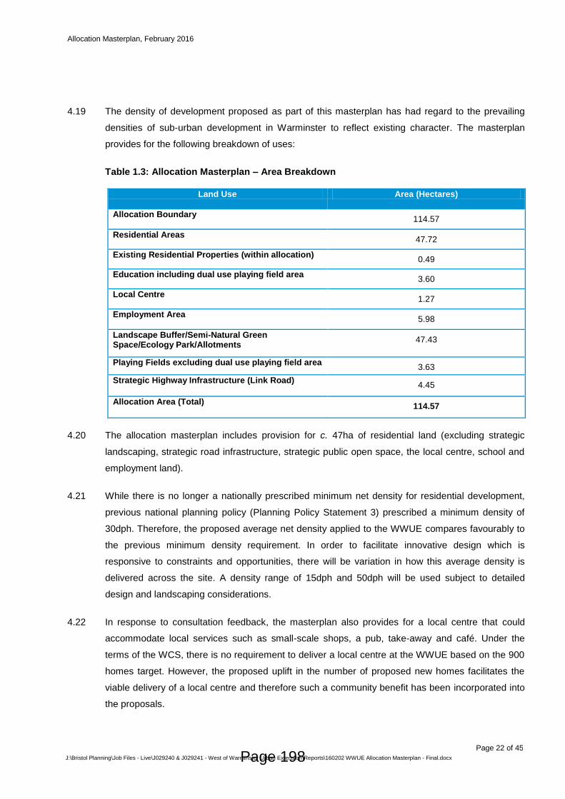
Allocation Masterplan, February 2016
Page 22 of 45
J:\Bristol Planning\Job Files - Live\J029240 & J029241 - West of Warminster Urban Extension\Reports\160202 WWUE Allocation Masterplan - Final.docx
The density of development proposed as part of this masterplan has had regard to the prevailing 4.19
densities of sub-urban development in Warminster to reflect existing character. The masterplan
provides for the following breakdown of uses:
Table 1.3: Allocation Masterplan – Area Breakdown
Land Use Area (Hectares)
Allocation Boundary 114.57
Residential Areas 47.72
Existing Residential Properties (within allocation) 0.49
Education including dual use playing field area 3.60
Local Centre 1.27
Employment Area 5.98
Landscape Buffer/Semi-Natural Green Space/Ecology Park/Allotments
47.43
Playing Fields excluding dual use playing field area 3.63
Strategic Highway Infrastructure (Link Road) 4.45
Allocation Area (Total) 114.57
The allocation masterplan includes provision for c. 47ha of residential land (excluding strategic 4.20
landscaping, strategic road infrastructure, strategic public open space, the local centre, school and
employment land).
While there is no longer a nationally prescribed minimum net density for residential development, 4.21
previous national planning policy (Planning Policy Statement 3) prescribed a minimum density of
30dph. Therefore, the proposed average net density applied to the WWUE compares favourably to
the previous minimum density requirement. In order to facilitate innovative design which is
responsive to constraints and opportunities, there will be variation in how this average density is
delivered across the site. A density range of 15dph and 50dph will be used subject to detailed
design and landscaping considerations.
In response to consultation feedback, the masterplan also provides for a local centre that could 4.22
accommodate local services such as small-scale shops, a pub, take-away and café. Under the
terms of the WCS, there is no requirement to deliver a local centre at the WWUE based on the 900
homes target. However, the proposed uplift in the number of proposed new homes facilitates the
viable delivery of a local centre and therefore such a community benefit has been incorporated into
the proposals.
Page 198

Allocation Masterplan, February 2016
Page 23 of 45
J:\Bristol Planning\Job Files - Live\J029240 & J029241 - West of Warminster Urban Extension\Reports\160202 WWUE Allocation Masterplan - Final.docx
As shall be discussed in more detail below in respect of ‘growth benefits’, the masterplan provides 4.23
for the full target of employment land (6ha) needed to accompany planned housing growth across
Warminster over the period to 2026 (2,060 homes).
iii) Housing Delivery in Warminster (2006-present)
Since the beginning of the WCS period in 2006, approximately 606 homes have been delivered and 4.24
planning permission secured for 194 additional homes within the Warminster Community Area7.
This is against a housing target of 2,060 new homes over the period to 2026. This demonstrates a
delivery profile of c. 600 homes during the first 9 years of the Plan period; with a further 1,454
homes remaining to be built during the next 11 years.
The ability of the WWUE to accommodate a greater amount of development than 900 dwellings and 4.25
6ha of employment land, while still mitigating environmental/transport impacts, means it presents a
viable, sustainable and plan-led solution to accommodating development in Warminster up to 2026
and beyond. This provides long-term certainty for the community and infrastructure providers on
how and when development will be delivered. As set out in the housing delivery timetable at
Appendix A, the WWUE is likely to cater for approximately 650 homes between 2026 and 2033,
thereby reducing development pressures in Warminster at the beginning of the next plan period.
The WWUE, in providing a site for a through-school, addresses an existing problem of secondary 4.26
school capacity. Wiltshire Council in collaboration with Kingdown School had previously explored a
number of options aimed at providing additional secondary school places but none proved suitable.
The through-school option does not prevent the Council or Kingdown School identifying an
alternative option for delivering additional secondary school places in Warminster in future years;
the delivery of any such alternative option would also benefit from secondary education developer
contributions from the WWUE.
iv) Growth Benefits
In preparing the WCS, Wiltshire Council used a thorough site selection process in identifying 4.27
strategic development sites. The WWUE was identified as the most sustainable location for
strategic level growth in Warminster and while competing sites were promoted during the plan WCS
preparation process; Wiltshire Council and the independent Planning Inspector concluded that the
allocation of the WWUE was sound.
The evidence prepared by the developers demonstrates that the WWUE is capable of sustainably 4.28
accommodating more development than anticipated within the Wiltshire Core Strategy while
suitably mitigating environmental and other impacts.
7 Wiltshire Council’s ‘Housing Land Supply Statement’ (September 2015)
Page 199
Allocation Masterplan, February 2016
Page 24 of 45
J:\Bristol Planning\Job Files - Live\J029240 & J029241 - West of Warminster Urban Extension\Reports\160202 WWUE Allocation Masterplan - Final.docx
The provision of housing, employment and social infrastructure at a single location facilitates the 4.29
establishment of a new community. Moreover, the increase in the number of homes at the site
allows more infrastructure, particularly community infrastructure, to be viably delivered by
developers as part of the development. The resultant population increase also improves the viability
and up-take of new services in the area (e.g. shops, schools and public transport) and supports the
creation of a new, prosperous community.
The allocation proposals are also required to facilitate the delivery of a new or expanded bus 4.30
service where the level of projected patronage (from a new development) informs how the bus
operator will deliver the service and if such a service can be viably maintained well into the future
when developer contributions have been exhausted. The same principle applies to the proposed
delivery of a primary school within the site and to the healthcare facilities that are catered for as part
of the local centre.
In terms of wider sustainability, directing long-term growth to the WWUE ensures that the most 4.31
efficient use of development land is pursued, thereby reducing pressures to release more greenfield
land elsewhere in the Community Area and provides for a better prospect of housing development
being phased alongside infrastructure and employment delivery.
Notwithstanding on-site provision of infrastructure and financial contributions towards off-site 4.32
infrastructure to be addressed at the planning application stage via CIL and S106 legal agreements,
the WWUE proposals will also generate funding via the Government’s New Homes Bonus (NHB).
This is a fiscal incentive aimed at rewarding local authorities and communities through annual
bonus payments paid over a 6-year period from the date that the dwellings have come into use.
Based on current estimates and 30% affordable housing provision, the allocation proposals would
generate approximately £14.6 million in NHB payments.
The allocation proposals will also generate employment during the construction and operational 4.33
phases. During the operational phase, the employment / school / local centre uses are likely to
generate between 700 and 1,000 jobs. Meanwhile, the proposals are likely to generate in excess of
400 jobs during the construction phase.
In addition to the above and as summarised in Table 1.4 below, the increase in the level of 4.34
proposed development at the WWUE facilitates the provision of a number of benefits that would not
otherwise be delivered based on the 900 dwellings figure.
Page 200
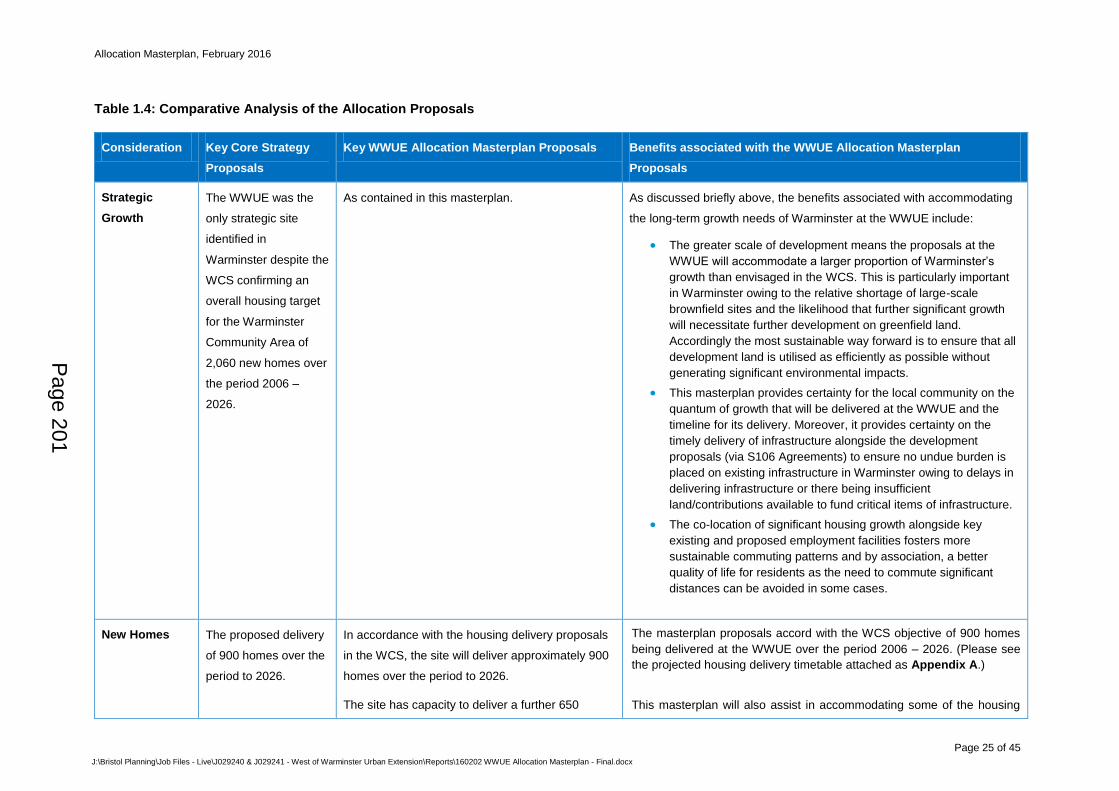
Allocation Masterplan, February 2016
Page 25 of 45
J:\Bristol Planning\Job Files - Live\J029240 & J029241 - West of Warminster Urban Extension\Reports\160202 WWUE Allocation Masterplan - Final.docx
Table 1.4: Comparative Analysis of the Allocation Proposals
Consideration Key Core Strategy
Proposals
Key WWUE Allocation Masterplan Proposals Benefits associated with the WWUE Allocation Masterplan
Proposals
Strategic
Growth
The WWUE was the
only strategic site
identified in
Warminster despite the
WCS confirming an
overall housing target
for the Warminster
Community Area of
2,060 new homes over
the period 2006 –
2026.
As contained in this masterplan. As discussed briefly above, the benefits associated with accommodating
the long-term growth needs of Warminster at the WWUE include:
The greater scale of development means the proposals at the
WWUE will accommodate a larger proportion of Warminster’s
growth than envisaged in the WCS. This is particularly important
in Warminster owing to the relative shortage of large-scale
brownfield sites and the likelihood that further significant growth
will necessitate further development on greenfield land.
Accordingly the most sustainable way forward is to ensure that all
development land is utilised as efficiently as possible without
generating significant environmental impacts.
This masterplan provides certainty for the local community on the
quantum of growth that will be delivered at the WWUE and the
timeline for its delivery. Moreover, it provides certainty on the
timely delivery of infrastructure alongside the development
proposals (via S106 Agreements) to ensure no undue burden is
placed on existing infrastructure in Warminster owing to delays in
delivering infrastructure or there being insufficient
land/contributions available to fund critical items of infrastructure.
The co-location of significant housing growth alongside key
existing and proposed employment facilities fosters more
sustainable commuting patterns and by association, a better
quality of life for residents as the need to commute significant
distances can be avoided in some cases.
New Homes The proposed delivery
of 900 homes over the
period to 2026.
In accordance with the housing delivery proposals
in the WCS, the site will deliver approximately 900
homes over the period to 2026.
The site has capacity to deliver a further 650
The masterplan proposals accord with the WCS objective of 900 homes
being delivered at the WWUE over the period 2006 – 2026. (Please see
the projected housing delivery timetable attached as Appendix A.)
This masterplan will also assist in accommodating some of the housing
Page 201
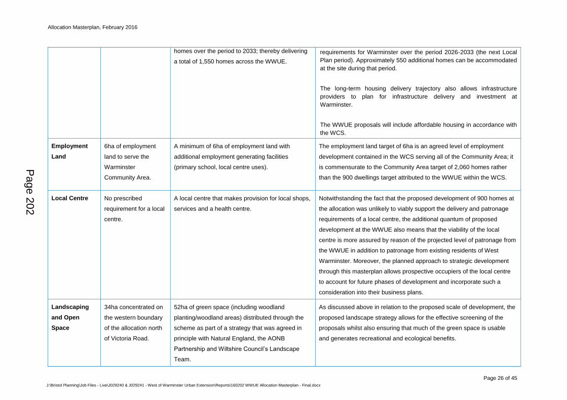
Allocation Masterplan, February 2016
Page 26 of 45
J:\Bristol Planning\Job Files - Live\J029240 & J029241 - West of Warminster Urban Extension\Reports\160202 WWUE Allocation Masterplan - Final.docx
homes over the period to 2033; thereby delivering
a total of 1,550 homes across the WWUE.
requirements for Warminster over the period 2026-2033 (the next Local
Plan period). Approximately 550 additional homes can be accommodated
at the site during that period.
The long-term housing delivery trajectory also allows infrastructure
providers to plan for infrastructure delivery and investment at
Warminster.
The WWUE proposals will include affordable housing in accordance with
the WCS.
Employment
Land
6ha of employment
land to serve the
Warminster
Community Area.
A minimum of 6ha of employment land with
additional employment generating facilities
(primary school, local centre uses).
The employment land target of 6ha is an agreed level of employment
development contained in the WCS serving all of the Community Area; it
is commensurate to the Community Area target of 2,060 homes rather
than the 900 dwellings target attributed to the WWUE within the WCS.
Local Centre No prescribed
requirement for a local
centre.
A local centre that makes provision for local shops,
services and a health centre.
Notwithstanding the fact that the proposed development of 900 homes at
the allocation was unlikely to viably support the delivery and patronage
requirements of a local centre, the additional quantum of proposed
development at the WWUE also means that the viability of the local
centre is more assured by reason of the projected level of patronage from
the WWUE in addition to patronage from existing residents of West
Warminster. Moreover, the planned approach to strategic development
through this masterplan allows prospective occupiers of the local centre
to account for future phases of development and incorporate such a
consideration into their business plans.
Landscaping
and Open
Space
34ha concentrated on
the western boundary
of the allocation north
of Victoria Road.
52ha of green space (including woodland
planting/woodland areas) distributed through the
scheme as part of a strategy that was agreed in
principle with Natural England, the AONB
Partnership and Wiltshire Council’s Landscape
Team.
As discussed above in relation to the proposed scale of development, the
proposed landscape strategy allows for the effective screening of the
proposals whilst also ensuring that much of the green space is usable
and generates recreational and ecological benefits.
Page 202
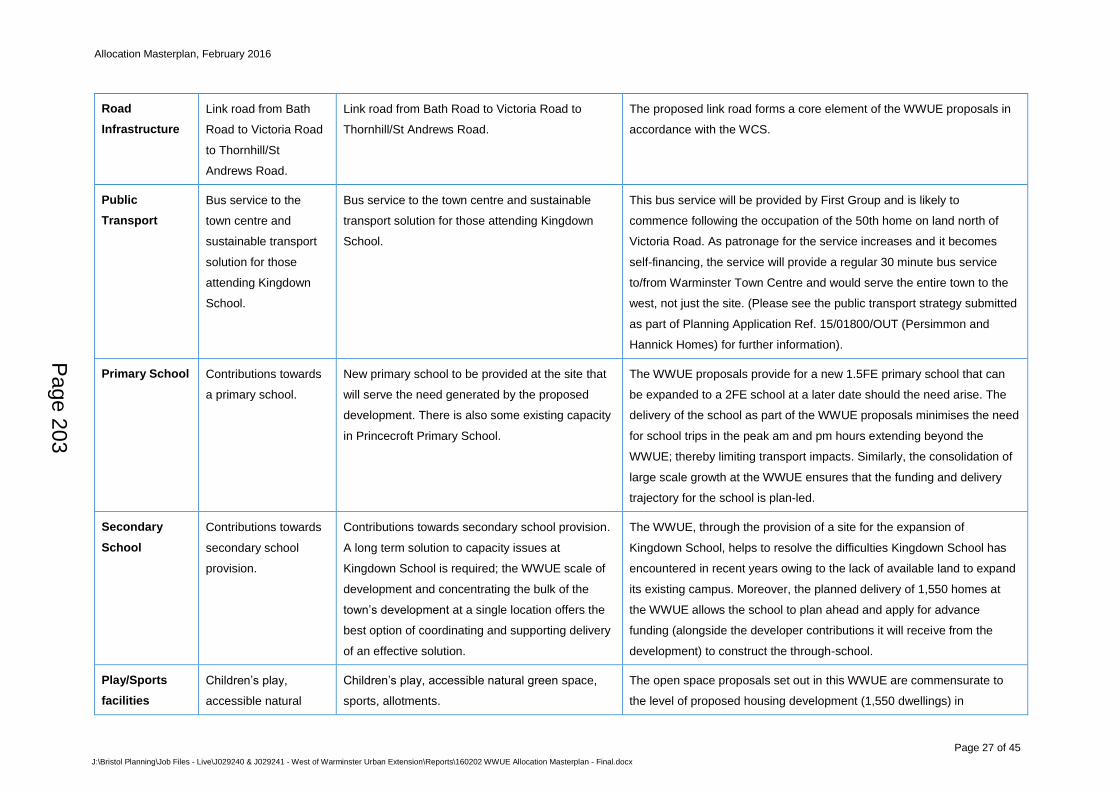
Allocation Masterplan, February 2016
Page 27 of 45
J:\Bristol Planning\Job Files - Live\J029240 & J029241 - West of Warminster Urban Extension\Reports\160202 WWUE Allocation Masterplan - Final.docx
Road
Infrastructure
Link road from Bath
Road to Victoria Road
to Thornhill/St
Andrews Road.
Link road from Bath Road to Victoria Road to
Thornhill/St Andrews Road.
The proposed link road forms a core element of the WWUE proposals in
accordance with the WCS.
Public
Transport
Bus service to the
town centre and
sustainable transport
solution for those
attending Kingdown
School.
Bus service to the town centre and sustainable
transport solution for those attending Kingdown
School.
This bus service will be provided by First Group and is likely to
commence following the occupation of the 50th home on land north of
Victoria Road. As patronage for the service increases and it becomes
self-financing, the service will provide a regular 30 minute bus service
to/from Warminster Town Centre and would serve the entire town to the
west, not just the site. (Please see the public transport strategy submitted
as part of Planning Application Ref. 15/01800/OUT (Persimmon and
Hannick Homes) for further information).
Primary School Contributions towards
a primary school.
New primary school to be provided at the site that
will serve the need generated by the proposed
development. There is also some existing capacity
in Princecroft Primary School.
The WWUE proposals provide for a new 1.5FE primary school that can
be expanded to a 2FE school at a later date should the need arise. The
delivery of the school as part of the WWUE proposals minimises the need
for school trips in the peak am and pm hours extending beyond the
WWUE; thereby limiting transport impacts. Similarly, the consolidation of
large scale growth at the WWUE ensures that the funding and delivery
trajectory for the school is plan-led.
Secondary
School
Contributions towards
secondary school
provision.
Contributions towards secondary school provision.
A long term solution to capacity issues at
Kingdown School is required; the WWUE scale of
development and concentrating the bulk of the
town’s development at a single location offers the
best option of coordinating and supporting delivery
of an effective solution.
The WWUE, through the provision of a site for the expansion of
Kingdown School, helps to resolve the difficulties Kingdown School has
encountered in recent years owing to the lack of available land to expand
its existing campus. Moreover, the planned delivery of 1,550 homes at
the WWUE allows the school to plan ahead and apply for advance
funding (alongside the developer contributions it will receive from the
development) to construct the through-school.
Play/Sports
facilities
Children’s play,
accessible natural
Children’s play, accessible natural green space,
sports, allotments.
The open space proposals set out in this WWUE are commensurate to
the level of proposed housing development (1,550 dwellings) in
Page 203
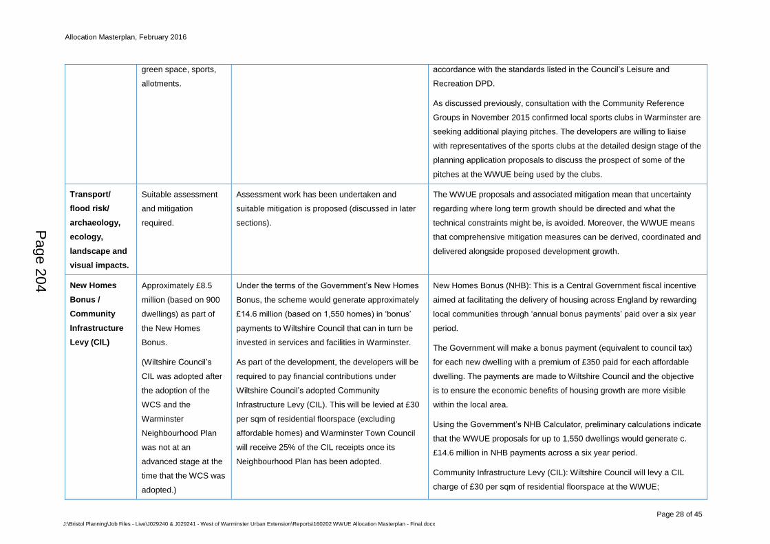
Allocation Masterplan, February 2016
Page 28 of 45
J:\Bristol Planning\Job Files - Live\J029240 & J029241 - West of Warminster Urban Extension\Reports\160202 WWUE Allocation Masterplan - Final.docx
green space, sports,
allotments.
accordance with the standards listed in the Council’s Leisure and
Recreation DPD.
As discussed previously, consultation with the Community Reference
Groups in November 2015 confirmed local sports clubs in Warminster are
seeking additional playing pitches. The developers are willing to liaise
with representatives of the sports clubs at the detailed design stage of the
planning application proposals to discuss the prospect of some of the
pitches at the WWUE being used by the clubs.
Transport/
flood risk/
archaeology,
ecology,
landscape and
visual impacts.
Suitable assessment
and mitigation
required.
Assessment work has been undertaken and
suitable mitigation is proposed (discussed in later
sections).
The WWUE proposals and associated mitigation mean that uncertainty
regarding where long term growth should be directed and what the
technical constraints might be, is avoided. Moreover, the WWUE means
that comprehensive mitigation measures can be derived, coordinated and
delivered alongside proposed development growth.
New Homes
Bonus /
Community
Infrastructure
Levy (CIL)
Approximately £8.5
million (based on 900
dwellings) as part of
the New Homes
Bonus.
(Wiltshire Council’s
CIL was adopted after
the adoption of the
WCS and the
Warminster
Neighbourhood Plan
was not at an
advanced stage at the
time that the WCS was
adopted.)
Under the terms of the Government’s New Homes
Bonus, the scheme would generate approximately
£14.6 million (based on 1,550 homes) in ‘bonus’
payments to Wiltshire Council that can in turn be
invested in services and facilities in Warminster.
As part of the development, the developers will be
required to pay financial contributions under
Wiltshire Council’s adopted Community
Infrastructure Levy (CIL). This will be levied at £30
per sqm of residential floorspace (excluding
affordable homes) and Warminster Town Council
will receive 25% of the CIL receipts once its
Neighbourhood Plan has been adopted.
New Homes Bonus (NHB): This is a Central Government fiscal incentive
aimed at facilitating the delivery of housing across England by rewarding
local communities through ‘annual bonus payments’ paid over a six year
period.
The Government will make a bonus payment (equivalent to council tax)
for each new dwelling with a premium of £350 paid for each affordable
dwelling. The payments are made to Wiltshire Council and the objective
is to ensure the economic benefits of housing growth are more visible
within the local area.
Using the Government’s NHB Calculator, preliminary calculations indicate
that the WWUE proposals for up to 1,550 dwellings would generate c.
£14.6 million in NHB payments across a six year period.
Community Infrastructure Levy (CIL): Wiltshire Council will levy a CIL
charge of £30 per sqm of residential floorspace at the WWUE;
Page 204
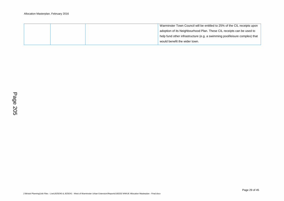
Allocation Masterplan, February 2016
Page 29 of 45
J:\Bristol Planning\Job Files - Live\J029240 & J029241 - West of Warminster Urban Extension\Reports\160202 WWUE Allocation Masterplan - Final.docx
Warminster Town Council will be entitled to 25% of the CIL receipts upon
adoption of its Neighbourhood Plan. These CIL receipts can be used to
help fund other infrastructure (e.g. a swimming pool/leisure complex) that
would benefit the wider town.
Page 205
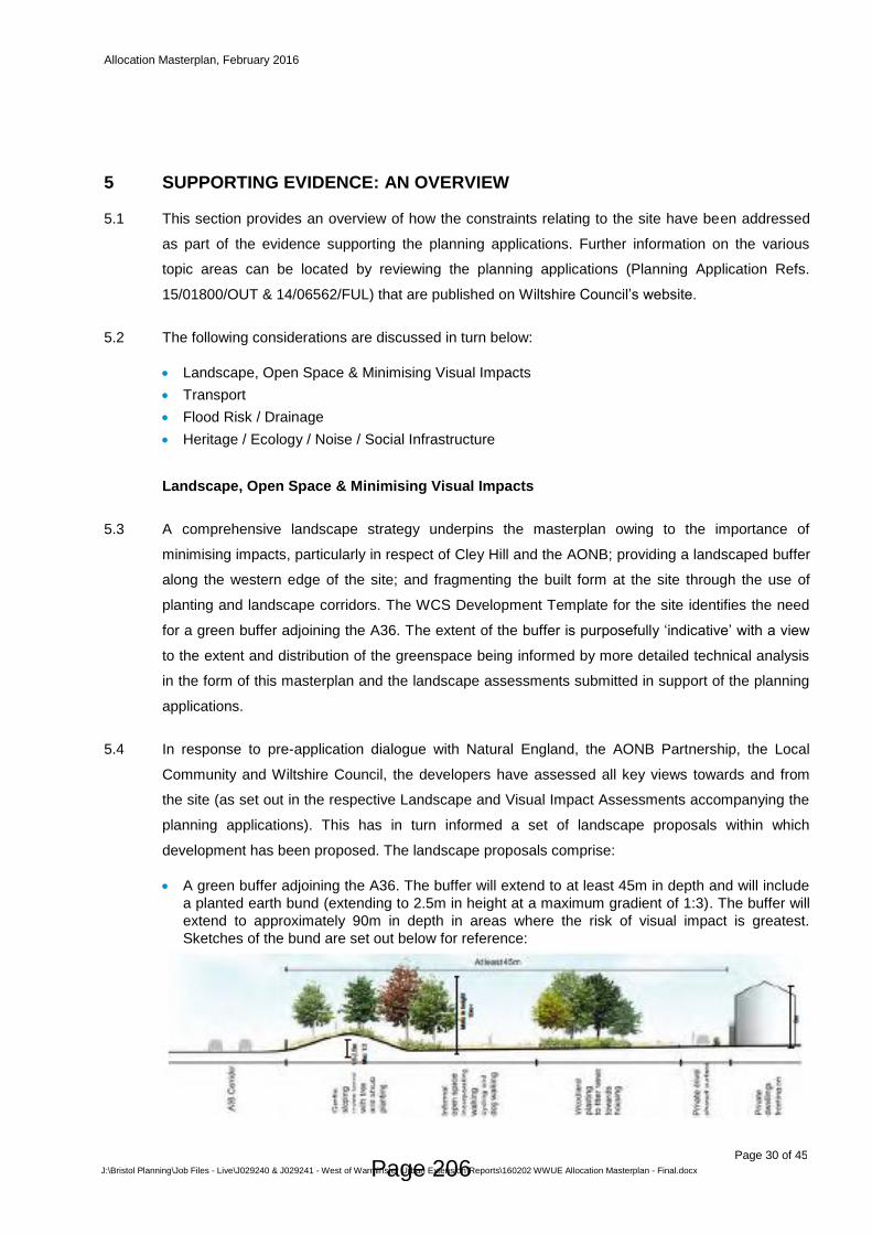
Allocation Masterplan, February 2016
Page 30 of 45
J:\Bristol Planning\Job Files - Live\J029240 & J029241 - West of Warminster Urban Extension\Reports\160202 WWUE Allocation Masterplan - Final.docx
SUPPORTING EVIDENCE: AN OVERVIEW 5
This section provides an overview of how the constraints relating to the site have been addressed 5.1
as part of the evidence supporting the planning applications. Further information on the various
topic areas can be located by reviewing the planning applications (Planning Application Refs.
15/01800/OUT & 14/06562/FUL) that are published on Wiltshire Council’s website.
The following considerations are discussed in turn below: 5.2
Landscape, Open Space & Minimising Visual Impacts
Transport
Flood Risk / Drainage
Heritage / Ecology / Noise / Social Infrastructure
Landscape, Open Space & Minimising Visual Impacts
A comprehensive landscape strategy underpins the masterplan owing to the importance of 5.3
minimising impacts, particularly in respect of Cley Hill and the AONB; providing a landscaped buffer
along the western edge of the site; and fragmenting the built form at the site through the use of
planting and landscape corridors. The WCS Development Template for the site identifies the need
for a green buffer adjoining the A36. The extent of the buffer is purposefully ‘indicative’ with a view
to the extent and distribution of the greenspace being informed by more detailed technical analysis
in the form of this masterplan and the landscape assessments submitted in support of the planning
applications.
In response to pre-application dialogue with Natural England, the AONB Partnership, the Local 5.4
Community and Wiltshire Council, the developers have assessed all key views towards and from
the site (as set out in the respective Landscape and Visual Impact Assessments accompanying the
planning applications). This has in turn informed a set of landscape proposals within which
development has been proposed. The landscape proposals comprise:
A green buffer adjoining the A36. The buffer will extend to at least 45m in depth and will include
a planted earth bund (extending to 2.5m in height at a maximum gradient of 1:3). The buffer will
extend to approximately 90m in depth in areas where the risk of visual impact is greatest.
Sketches of the bund are set out below for reference:
Page 206
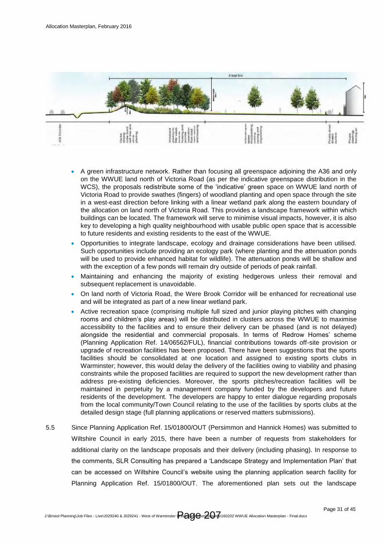
Allocation Masterplan, February 2016
Page 31 of 45
J:\Bristol Planning\Job Files - Live\J029240 & J029241 - West of Warminster Urban Extension\Reports\160202 WWUE Allocation Masterplan - Final.docx
A green infrastructure network. Rather than focusing all greenspace adjoining the A36 and only
on the WWUE land north of Victoria Road (as per the indicative greenspace distribution in the
WCS), the proposals redistribute some of the ‘indicative’ green space on WWUE land north of
Victoria Road to provide swathes (fingers) of woodland planting and open space through the site
in a west-east direction before linking with a linear wetland park along the eastern boundary of
the allocation on land north of Victoria Road. This provides a landscape framework within which
buildings can be located. The framework will serve to minimise visual impacts, however, it is also
key to developing a high quality neighbourhood with usable public open space that is accessible
to future residents and existing residents to the east of the WWUE.
Opportunities to integrate landscape, ecology and drainage considerations have been utilised.
Such opportunities include providing an ecology park (where planting and the attenuation ponds
will be used to provide enhanced habitat for wildlife). The attenuation ponds will be shallow and
with the exception of a few ponds will remain dry outside of periods of peak rainfall.
Maintaining and enhancing the majority of existing hedgerows unless their removal and
subsequent replacement is unavoidable.
On land north of Victoria Road, the Were Brook Corridor will be enhanced for recreational use
and will be integrated as part of a new linear wetland park.
Active recreation space (comprising multiple full sized and junior playing pitches with changing
rooms and children’s play areas) will be distributed in clusters across the WWUE to maximise
accessibility to the facilities and to ensure their delivery can be phased (and is not delayed)
alongside the residential and commercial proposals. In terms of Redrow Homes’ scheme
(Planning Application Ref. 14/06562/FUL), financial contributions towards off-site provision or
upgrade of recreation facilities has been proposed. There have been suggestions that the sports
facilities should be consolidated at one location and assigned to existing sports clubs in
Warminster; however, this would delay the delivery of the facilities owing to viability and phasing
constraints while the proposed facilities are required to support the new development rather than
address pre-existing deficiencies. Moreover, the sports pitches/recreation facilities will be
maintained in perpetuity by a management company funded by the developers and future
residents of the development. The developers are happy to enter dialogue regarding proposals
from the local community/Town Council relating to the use of the facilities by sports clubs at the
detailed design stage (full planning applications or reserved matters submissions).
Since Planning Application Ref. 15/01800/OUT (Persimmon and Hannick Homes) was submitted to 5.5
Wiltshire Council in early 2015, there have been a number of requests from stakeholders for
additional clarity on the landscape proposals and their delivery (including phasing). In response to
the comments, SLR Consulting has prepared a ‘Landscape Strategy and Implementation Plan’ that
can be accessed on Wiltshire Council’s website using the planning application search facility for
Planning Application Ref. 15/01800/OUT. The aforementioned plan sets out the landscape
Page 207
Allocation Masterplan, February 2016
Page 32 of 45
J:\Bristol Planning\Job Files - Live\J029240 & J029241 - West of Warminster Urban Extension\Reports\160202 WWUE Allocation Masterplan - Final.docx
proposals/principles in more detail and the same principles will also apply to the WWUE land to the
south of Victoria Road.
Both Landscape and Visual Impact Assessments submitted in support of the planning applications 5.6
conclude that through the implementation of mitigation strategies, the proposed development of the
WWUE would not have an unacceptable impact on sensitive receptors. In response to the
Landscape Strategy and Implementation Plan, Natural England confirmed on 23 October 2015 that
the proposals contained within the Plan addressed its concerns and it has no objection. This letter
can be accessed on Wiltshire Council’s website using the planning application search facility for
Planning Application Ref. 15/01800/OUT.
Transport
Transport Assessments (TA) have been submitted with both planning applications demonstrating 5.7
that the highways network can accommodate additional traffic generated by the planning
application schemes.
The TA prepared in support of Planning Application Ref. 15/01800/OUT is supported by a 5.8
Warminster-wide ‘S-Paramics Micro-Simulation Traffic Model’ (S-Paramics Model). This bespoke
traffic model was prepared using a computer programme and comprised the following:
(i) The model uses information collected using Automatic Number Plate Recognition
cameras at key transport junctions/routes within, and on the periphery of, Warminster
with a view to capturing all car trips within, entering and exiting the town. The locations
of the cameras for the purpose of understanding traffic movements were agreed with
Wiltshire Council’s Highways Department and Highways England beforehand. Other
information collected included traffic surveys, junction counts, queue length surveys and
journey time surveys.
(ii) The information on traffic movements was then collated and inputted to the model which
in turn graphically illustrated how traffic moved around the town in 2013 (the base year)
to reflect the existing traffic flows and congestion.at morning and evening peaks. The
parameters informing this baseline model were forwarded to Wiltshire Council Highways
and Highways England; both organisations agreed that the model adequately represents
the existing highways network in Warminster. The model was also presented to
representatives of the Warminster Neighbourhood Plan Group where feedback informed
the final calibration of the model.
(iii) Once the baseline model was agreed, projected traffic arising from approximately 1,550
homes, 6ha of employment land, a primary school and a local centre at the WWUE was
inputted to the model. This modelled weekday peak periods in the morning (07:00-
10:00) and afternoon (16:00–19:00). As part of the Reference Group dialogue in
November 2015, it was suggested that traffic peaked between 15.00 and 16.00 in the
afternoon owing to school-related trips. The traffic counts attained by PFA Consulting
confirmed that traffic flows in the town centre were lower between 15:00-16:00 (694
trips) than between 16:00-17:00 (730 trips) or 17:00-18:00 (767 trips). The same applied
to traffic on Victoria Road (357 trips between 15:00-16:00 whereas the number of trips
exceeded 400 each hour between 16:00 and 18:00). Accordingly, the model was robust
in using 16:00 – 18:00 as the peak afternoon traffic period.
Page 208
Allocation Masterplan, February 2016
Page 33 of 45
J:\Bristol Planning\Job Files - Live\J029240 & J029241 - West of Warminster Urban Extension\Reports\160202 WWUE Allocation Masterplan - Final.docx
(iv) The modelling confirms that the proposed 1,550 new homes and employment
development at the WWUE would increase in traffic queuing and delay on the
surrounding local highway network in Warminster without mitigation. Significant
increases in journey times would be experienced for westbound traffic on the B3414
passing through the town centre during the afternoon peak period. Exacerbated queuing
would also be witnessed along Market Place, Station Road, East Street and Copheap
Lane.
(v) The modelling allowed mitigation measures (to be delivered/funded by the developers)
to be identified including, but not limited to:
a. The introduction of an interactive traffic light system at the High Street/Market
Place/Weymouth Street junction that would improve the through-flow of traffic which
is currently hampered by the phasing of the lights.
b. The conversion of the Portway/Westbury/Copheap Lane priority junction to a
compact roundabout that will reduce queuing at the junction.
The model confirms that the above mitigation proposals coupled with other minor
improvements (e.g. access arrangements at the WWUE) to the local highway network
will ensure that the 1,550 homes and employment proposals at the WWUE will have no
unacceptable impacts on the local or strategic highways network in accordance with
established highways standards and criteria.
Based on the aforementioned traffic model and analysis (set out in more detail in the transport 5.9
assessments/travel plans informing the planning applications) the WWUE proposals will not result
in significant adverse impacts on the local or strategic highway networks.
Wiltshire Council’s Highways Department and Highways England have concluded that the transport 5.10
modelling undertaken in support of the applications is robust and it demonstrates that the proposals
will not have an unacceptable impact on the surrounding road network subject to the
implementation of the suggested mitigation measures. The modelling included a scenario that
allowed for 1,550 homes at the WWUE.
In terms of the requirement for a link road between Bath Road and St Andrews Road, the 5.11
developers agree to address the requirement for the estate link road within their respective planning
application schemes with a view to delivering sections of the road on a phased basis. This link road
is likely to have a speed limit of 30mph and will be capable of accommodating a bus route. The
width of the link road leading from the Bath Road entrance to the employment area will be wider
than the remainder of the road in order to cater for traffic and haulage vehicles associated with the
employment area.
In accordance with the WCS, the developers will fund (via S106 or CIL as appropriate) the delivery 5.12
of new or upgraded pedestrian routes within and adjoining the site where applicable. For example,
in response to Redrow’s planning application, the Council has requested upgrades to an existing
PRoW and provision of a contribution towards a controlled crossing on Victoria Road in order to
connect the PRoWs known as WARM6 and WARM70. This will be particularly important for
ensuring safe routes to school.
Page 209
Allocation Masterplan, February 2016
Page 34 of 45
J:\Bristol Planning\Job Files - Live\J029240 & J029241 - West of Warminster Urban Extension\Reports\160202 WWUE Allocation Masterplan - Final.docx
Construction traffic is a key consideration and the focus of growth at the west of Warminster, 5.13
adjoining the A36, will minimise the risk of construction vehicles travelling through the Town Centre.
It is agreed that the developers will use all reasonable endeavours to ensure construction vehicles
use the A36, Bath Road and Victoria Road to access the allocation without having to travel through
the centre of Warminster. At present, the allocated land between Redrow’s site and Victoria Road is
not subject of a planning application, construction vehicles serving this development parcel will be
required to use St. Andrews Road governed by strict criteria relating to construction delivery hours
and vehicle cleaning facilities, as agreed with the LPA’s Highways Department. These measures
will be captured under Construction Management Plans which the developers at the allocation will
be required to submit to Wiltshire Council for approval prior to development commencing.
For further information on all of the above, please see the transport analysis supporting Planning 5.14
Application Refs. 15/01800/OUT and 14/06562/FUL (which includes a Construction Traffic
Management Plan within the St Andrews Road ES Addendum (May 2015), Chapter D, Appendix
5.1).
Surface Water Drainage / Flood Risk
There are two surface water catchment areas affecting the WWUE; surface water flows from land 5.15
north of Victoria Road form part of a separate drainage catchment (including the majority of the
town) to the drainage catchment associated with the land south of Victoria Road. Accordingly the
two land areas are independent of one another and different circumstances and mitigation
measures apply to each.
Land North of Victoria Road
A small section of the WWUE land north of Victoria Road falls within Flood Zone 2, where the site 5.16
abuts the Were Brook. There is also a need to ensure that the proposals do not adversely impact
on flooding elsewhere in the drainage catchment and a requirement within the WCS for developers
at the WWUE to provide Wiltshire Council and the Environment Agency with robust data to assist in
modelling of the wider catchment.
The predominant soil type at the site does not facilitate easy infiltration (soakage) of surface water 5.17
and therefore in restricting surface water flows to greenfield run-off rates or better, the proposals
north of Victoria Road include on-site attenuation measures in the form of attenuation ponds,
swales and two storage basins. As set out in the Flood Risk Assessment (FRA) submitted as part of
Planning Application Ref. 15/01800/OUT, these measures restrict the flow of surface water during
times of peak rainfall to the point where the rate of run-off is better than that currently associated
with the undeveloped site.
Page 210
Allocation Masterplan, February 2016
Page 35 of 45
J:\Bristol Planning\Job Files - Live\J029240 & J029241 - West of Warminster Urban Extension\Reports\160202 WWUE Allocation Masterplan - Final.docx
The distribution of the attenuation measures (principally attenuation ponds) has been informed by 5.18
the site levels and the division of the site into sectors where each sector is allocated a pond(s); this
also ensures that the mitigation measures can be provided alongside each phase of development.
Moreover, all development is located outside the flood plain as per this masterplan and the
aforementioned outline planning application.
Since the application (Ref. 15/01800/OUT) was submitted to Wiltshire Council in February 2015, the 5.19
Environment Agency (EA) and Wiltshire Council have requested further flood risk analysis to
support the content of the FRAs and to test the robustness of the EA’s flood map for the area. This
necessitated modelling of water flows at the Were Brook by Persimmon and Hannick Homes. The
resultant analysis confirmed that the EA’s flood map was inaccurate in part and additional mitigation
in the form of two on-site storage basins, defence bunds and the removal of an on-site culvert was
required to address the findings of the modelling.
The above modelling, analysis and mitigation measures are set out in the FRA Addendum 5.20
submitted as part of Planning Application Ref. 15/01800/OUT and it confirms that the rate of surface
water run-off will be equal to, or less than, current greenfield rates.
Land South of Victoria Road
In terms of surface water drainage, given the uncertainty regarding the delivery of the other land to 5.21
the north and west which falls outside of Redrow’s control, it is more difficult to bring forward a
strategic solution at this stage. Consequently, Redrow has designed a solution to mitigate the
impacts of its proposed scheme on land at St Andrews Road only (circa 200 dwellings). However,
more importantly, the proposed drainage solution will not prejudice further development to the south
of Victoria Road coming forward from a drainage perspective.
In terms of surface water drainage, developers on land to the south of Victoria Road essentially 5.22
have the choice of an infiltration solution or a gravity solution. On land at St Andrews Road,
Redrow is proposing an infiltration solution, which will comprise an on-site tank and pond
attenuation with soakaway disposal. Most importantly, the proposals have been designed to ensure
that the balance of the surface water runoff, not already being drained to soakaway, would be
attenuated in a below ground tank with a restricted discharge into an infiltration basin. This is
designed to allow for up to and including the 1 in 100 year event plus a 30% allowance for climate
change. This means that none of the surface water runoff from the development will discharge into
either the existing sewer or land drainage networks.
Redrow’s proposals will in no way impede any future developer from designing an independent on-5.23
site infiltration solution, as is being proposed on land at St Andrews Road on the remainder of the
WWUE to the South of Victoria Road. Conversely, should rates not allow for this, the developer
Page 211
Allocation Masterplan, February 2016
Page 36 of 45
J:\Bristol Planning\Job Files - Live\J029240 & J029241 - West of Warminster Urban Extension\Reports\160202 WWUE Allocation Masterplan - Final.docx
could bring forward a gravity solution, which Redrow will not prejudice, given that they are not
proposing such a solution themselves.
Furthermore, it is important to acknowledge that there is an existing drainage problem in 5.24
Warminster and the proposed scheme by Redrow will provide betterment to the existing position,
taking additional pressure off the downstream network. Their proposals will therefore not prejudice
any future development to the south of Victoria Road. Ultimately, all planning applications at the
WWUE will need to demonstrate that the proposals will not flood and will not increase the risk of
flooding elsewhere in accordance with established guidance. Where it is not possible to rely on off-
site mitigation, on-site provision will need to be allowed for within application layouts.
During the operational phase of development, the drainage attenuation measures will be 5.25
maintained by Wiltshire Council (via reasonable financial contributions secured within S106
Agreements pursuant to the applications at the WWUE) or through a private management
company that will be funded by the developers and an on-going service charge from development
within the WWUE. At the time of writing, the developers intend to appoint a private management
company to oversee the maintenance of the drainage measures, landscaping and general up-keep
of the application sites.
Foul Drainage
As part of the application proposals to the north of Victoria Road (Application Ref. 15/01800/OUT), 5.26
Persimmon and Hannick Homes commissioned Wessex Water to undertake foul drainage
modelling to assess if there is capacity to accommodate up to 1,200 homes and advise on any
works/contributions that will be required from the developers to enable connection to the existing
foul drainage network.
Wessex Water advised by letter dated 16 November 2015 that there is sufficient capacity to cater 5.27
for the proposals; however, contributions (approximately £300,000) will be required to facilitate
connection to the existing network and to provide for upgrades to the Portway Pumping Station.
In terms of the application proposals on land adjoining St Andrew’s Road (Application Ref. 5.28
14/06562/FUL), a new adoptable pumping station will be provided on-site with a rising main laid
through the development to the southern boundary. This will continue as a requisitioned rising main
laid by Wessex Water from the site boundary to the agreed point of connection into an existing
adopted foul sewer approximately 1.5km to the south east. The rising main will have sufficient
capacity to serve up to 400 dwellings to the south of Victoria Road and thus provides a strategic
solution. It has been agreed with Wessex Water that initially the Pumping Station will have capacity
for the Redrow development only. However, when other development to the south of Victoria Road
Page 212
Allocation Masterplan, February 2016
Page 37 of 45
J:\Bristol Planning\Job Files - Live\J029240 & J029241 - West of Warminster Urban Extension\Reports\160202 WWUE Allocation Masterplan - Final.docx
comes forward, minor upgrade works to the pumps will be undertaken by Wessex Water at their
cost, in order to accommodate these other units.
Heritage / Ecology / Noise
The developers, in support of their planning applications, submitted plans and documents 5.29
addressing all of the above in detail.
i) Heritage
The developers commissioned consultants (CgMs) to describe the significance of any heritage 5.30
assets affected by proposals at the WWUE including any contribution made by their setting in
accordance with the NPPF. The evidence includes desk-based assessments and field evaluations
while CgMs also commissioned Richard K Morriss & Associates to prepare ‘An Impact Assessment
of Proposed Development on Nearby Heritage Assets’ in support of Planning Application Ref.
15/01800/OUT. All of the above evidence can be accessed on Wiltshire Council’s website as per
Table 1.2 of this masterplan.
The archaeological assessments did not identify any significant archaeological remains at the 5.31
planning application sites; however, the WWUE land falling outside the two planning applications
will need to be subject of further desk-based analysis and possible field evaluation.
There are a number of heritage assets (listed buildings, locally designated buildings and the 5.32
Conservation Area along Bath Road and Victoria Road) to the east of the site, Cley Hill Scheduled
Ancient Monument to the west of the site beyond the A36, and the Grade II Listed Bugley Barton
Farmhouse is located within the WWUE (immediately to the south of Victoria Road).
The allocation masterplan adopts a precautionary principle and provides for a green buffer around 5.33
Bugley Barton Farmhouse. All future planning applications at the WWUE will need to be
informed/supported by an appropriate desk-based assessment which assesses the significance of
the heritage asset (including Bugley Barton Farm) and its setting whilst also considering the impact
of a proposal on the asset/its setting. Similarly, such applications will need to be supported by desk-
based assessments and field surveys that assess the potential presence of archaeological deposits.
ii) Ecology
Ecology surveys have been undertaken as part of the planning applications to better understand the 5.34
ecological value of the application sites (comprising the majority of the WWUE) and the potential
presence of protected species. These have concluded that the relevant land is of low ecological
interest as it predominantly comprises arable land together with smaller areas of species-poor,
Page 213
Allocation Masterplan, February 2016
Page 38 of 45
J:\Bristol Planning\Job Files - Live\J029240 & J029241 - West of Warminster Urban Extension\Reports\160202 WWUE Allocation Masterplan - Final.docx
semi-improved grassland. The fauna identified as part of the surveys included common reptile
species, foraging bats, skylark and dormouse.
As part of the proposed mitigation strategy, it is proposed to retain existing woodland and hedgerow 5.35
network where possible. Moreover, the landscape framework discussed previously within this
document will result in net ecological benefits. The allocation proposals also include an ecology
park and wetland park.
Phosphate levels in the River Wyle need to be managed to prevent adverse effects upon the River 5.36
Avon SAC, particularly as this stretch of the river is failing its conservation targets and has been
identified as a ‘high risk’ sub-catchment in the recent EA/NE/WC Nutrient Management Plan. There
is a risk that further modelling (in progress) and subsequent negotiation with the statutory bodies
may identify that mitigation measures are required for levels of development at the town beyond
those planned in the WCS (1920 dwellings), post 2026. Based on the housing trajectory shown in
Appendix A, to accommodate development beyond the plan period, a permission for development
north of Victoria Road may need to include a contingency for the developer to help fund iron dosing
of waste water at the sewage treatment works (subject to agreement with Wessex Water), or an
alternative measure, should such a need for mitigation arise. Development of the remaining land
south of Victoria Road, not subject to a current planning application, will be subject to screening
under the Habitats Regulations which may also result in the need for additional mitigation.
iii) Noise
Owing to the proximity of the site to the A36 trunk road, there will inevitably be noise impacts arising 5.37
from this busy road. The landscape strategy makes provision for a planted earth bund adjoining the
A36 that integrates seamlessly with the green buffer that is proposed along the western boundary of
the allocation proposals. The bund8, coupled with the landscape buffer and sensitive layout/design
of the homes closest to the western boundary of the site will assist in avoiding any potential
significant noise impacts. At the detailed design stage (reserved matters) further detailed
attenuation measures can be incorporated into homes including high specification insulation,
glazing and ventilation.
iv) Agricultural Land
In terms of the quality of the agricultural land, an assessment of agricultural land quality of the 5.38
planning application site north of Victoria Road (Application Ref. 15/01800/OUT) is contained at
Chapter 16 of the Environmental Statement submitted with the application. This confirms that less
8 More detail on the proposed noise bund can be found in the Landscape Strategy and Implementation Plan submitted to Wiltshire
Council in support of Planning Application Ref. 15/01800/OUT.
Page 214
Allocation Masterplan, February 2016
Page 39 of 45
J:\Bristol Planning\Job Files - Live\J029240 & J029241 - West of Warminster Urban Extension\Reports\160202 WWUE Allocation Masterplan - Final.docx
than quarter of the application site, representing the majority of the WWUE land, comprises ‘Best
and Most Versatile’ (BMV) Agricultural Land – the highest quality of agricultural land.
The ‘Agricultural Land Classification and Soil Resources Report’ supporting the planning application 5.39
to the south of Victoria Road (Application Ref. 14/06562/FUL) confirms that the land comprises
BMV Agricultural Land. However, the principle of development at the WWUE has already been
established and accepted as part of the WCS. To off-set the loss of BMV agricultural land, the
proposals need to make the most efficient use of the land for development with a view to minimising
the need to develop BMV agricultural land elsewhere on the periphery of Warminster.
Page 215
Allocation Masterplan, February 2016
Page 40 of 45
J:\Bristol Planning\Job Files - Live\J029240 & J029241 - West of Warminster Urban Extension\Reports\160202 WWUE Allocation Masterplan - Final.docx
URBAN DESIGN 6
Introduction
Distinctive and high quality design, public realm and open space coupled with the provision of 6.1
associated infrastructure will play a significant role in the delivery of a successful and sustainable
development. As discussed above, the pursuance of a landscape-led approach to the delivery of
the WWUE is critical in both mitigating environmental impacts and delivering a scheme where
community cohesion and well-being is fostered.
In this regard, the following urban design principles will, at the full planning application stage or 6.2
reserved matters stage, inform the proposed development at the site:
Having regard to the landscape strategy referenced in this masterplan (vid. Landscape
Strategy and Implementation Plan submitted in support of Planning Application Ref.
15/01800/OUT), proposals should provide for a mix of densities with the highest densities
located adjoining the link road and in close proximity to the Local Centre. The lowest density
areas will be located in hamlets at the most visually sensitive parts of the site along the south
west boundary of the allocated land north of Victoria Road. Planning application
14/06562/FUL is accompanied by a detailed landscape strategy which has been agreed with
the Council.
The majority of dwellings on site will be 2-2.5 storeys with some 3-storey buildings used at key
locations (adjacent to the link road and within the Local Centre) to frame vistas and to
accommodate a limited number of apartments and extra-care facilities to meet local needs.
Planning application 14/06562/FUL includes a mix of units from 1 bed flats to 4 bed detached
units. The scheme also provides a number of bungalows to the eastern boundary to limit
impact on neighbouring properties.
Buildings (& gardens) should be orientated to maximise opportunities for solar gain where
possible.
Street layouts will predominantly adhere to a loose grid where cul-de-sacs will not be
encouraged unless a case can be made for their provision.
Buildings will, where possible, be orientated to front onto streets and open spaces to maximise
natural surveillance and encourage social interactions.
Development blocks will be designed to maximise legibility and connectivity.
Any layouts informing full planning applications or reserved matter submissions will be subject of 6.3
public consultation prior to their completion and submission to the Local Planning Authority.
Land off St. Andrews Road
While the Planning Application by Persimmon and Hannick Homes is in outline with all matters 6.4
reserved except access, Redrow Homes’ planning application is submitted in full and therefore
more detail on urban design matters is available. Redrow Homes’ planning application has been the
subject of significant scrutiny and negotiation by the Council’s urban designer. Since the scheme
was originally submitted in June 2014, major changes to the proposed layout have been made to
respond to comments received including reducing the number of dwellings, softening of the road
Page 216
Allocation Masterplan, February 2016
Page 41 of 45
J:\Bristol Planning\Job Files - Live\J029240 & J029241 - West of Warminster Urban Extension\Reports\160202 WWUE Allocation Masterplan - Final.docx
layout, reducing the number of cul-de-sacs, moving the public open space to a more central
location, and the provision of bungalows in response to comments from the local community.
The proposed gross density of c. 28 dwellings per hectare is deemed appropriate for the context of 6.5
the site. It will make an efficient use of the land whilst being reflective of existing plot sizes of
neighbouring residential properties on St. Andrews Road to the east and Haygrove Close to the
north. It will therefore make a positive contribution to the character of Warminster by responding to
the existing townscape in terms of the built form.
Most importantly, the proposed layout will allow the development to be delivered independently 6.6
from the wider strategic site, without compromising its future integration in terms of townscape,
access routes and green infrastructure.
Further details are provided in the Design and Access Statement (May 2015) submitted as part of 6.7
the planning application (Ref. 14/06562/FUL).
Page 217
Allocation Masterplan, February 2016
GL Hearn Page 42 of 45
J:\Bristol Planning\Job Files - Live\J029240 & J029241 - West of Warminster Urban Extension\Reports\160202 WWUE Allocation Masterplan - Final.docx
PHASING & DELIVERY 7
The Wiltshire Core Strategy (WCS) covers the period 2006-2026. However, due to the 7.1
extended examination and adoption process, the WCS was not adopted until January
2015, 9 years into the Plan period. Delivery of the WWUE has therefore also been
delayed.
As discussed above, at the time of writing there are two undetermined planning 7.2
applications at the WWUE that have yet to be determined. The two planning application
schemes will have significantly different delivery trajectories:
(i) Planning Application Ref. 14/06562/FUL (Redrow Homes Limited): This is
a full planning application for the development of 203 homes on land adjoining
St. Andrews Road. Should the planning application be approved in 2016, the
scheme is likely to start delivering new homes in 2017/18.
(ii) Planning Application Ref. 15/01800/OUT (Persimmon Homes Limited and
Hannick Homes and Developments Limited): This is an outline planning
application with all matters reserved except access. The proposals comprise
up to 1,200 homes, 6ha of employment land, a local centre, a primary school
and ancillary infrastructure. Should the outline planning application be
approved in 2016, reserved matters approval for detailed design matters would
then need to be sought before development commences. Moreover, core
services/infrastructure will need to be delivered prior to the homes/other uses.
In terms of housing delivery, this is unlikely to occur before 2018/19.
The forecasting of housing delivery at the WWUE is inherently difficult owing to the 7.3
number of variables, not least market demand. However, based on information currently
available to the developers and based on experience of delivering residential schemes
elsewhere, an indicative housing delivery trajectory for the WWUE is enclosed as
Appendix A.
The trajectory is indicative and delivery rates may be greater or less than those indicated 7.4
owing to variables such as market demand, the number of competing outlets, planning
timelines and drawing down land from landowners. Moreover, the delivery trajectory could
extend beyond 2033.
It is estimated that within the WWUE allocation site, approximately 900 homes will be 7.5
delivered by 2026 with the residual housing proposals (c. 650 homes) being delivered
over the period 2026-2033. Accordingly the allocation will deliver the 900 dwellings
required under the WCS over the period to 2026.
With the exception of the Redrow Homes Scheme which can be treated as a single phase, 7.6
Persimmon and Hannick Homes agree to provide a detailed phasing plan to guide
development of their respective proposals as part of full or reserved matters applications
when the layout and composition of individual development parcels is known. The
Page 218
Allocation Masterplan, February 2016
GL Hearn Page 43 of 45
J:\Bristol Planning\Job Files - Live\J029240 & J029241 - West of Warminster Urban Extension\Reports\160202 WWUE Allocation Masterplan - Final.docx
employment land, subject to market demand, should form part of the first phase of
development.
As part of the phasing plan for each development parcel, structural planting designed to 7.7
screen the proposed development will be implemented as soon as practical (having
regard to the need to provide services and infrastructure initially). Each phase will include
open space provision with recreational facilities being delivered commensurately with
population increase at the allocation.
The proposed internal link road (extending from Bath Road to Victoria Road and St. 7.8
Andrews Road) represents a key item of infrastructure at the WWUE that will be delivered
on a phased basis linked to the delivery of new homes at the allocation. Specific trigger
points for the phased delivery of the link road will be set out in relevant S106 Agreements.
The allocation will provide for a primary school (capable of accommodating the need for 7.9
school places generated by the new development), local centre and employment land.
The employment land will be delivered as part of the early phases of development on land
north of Victoria Road and it will be jointly marketed by Persimmon, Hannick Homes and
Wiltshire Council. The requirement for a joint marketing strategy will be captured in the
relevant S106 legal agreement. The Local Centre also makes an allowance for the
potential delivery of a health centre should there be a requirement for, and commercial
interest in, delivering such a facility.
Page 219
Allocation Masterplan, February 2016
GL Hearn Page 44 of 45
J:\Bristol Planning\Job Files - Live\J029240 & J029241 - West of Warminster Urban Extension\Reports\160202 WWUE Allocation Masterplan - Final.docx
APPENDIX A
Indicative Housing Delivery Timetable
Page 220
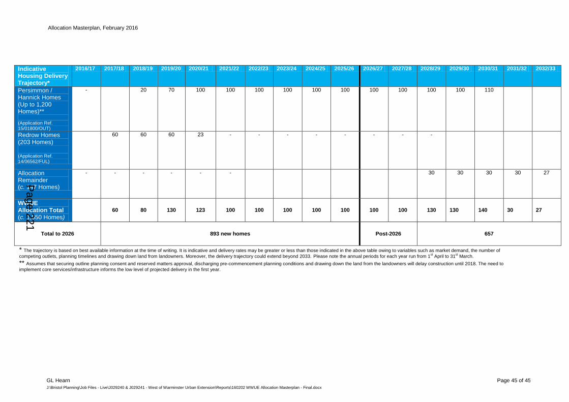
Allocation Masterplan, February 2016
GL Hearn Page 45 of 45
J:\Bristol Planning\Job Files - Live\J029240 & J029241 - West of Warminster Urban Extension\Reports\160202 WWUE Allocation Masterplan - Final.docx
Indicative Housing Delivery Trajectory*
2016/17 2017/18 2018/19 2019/20 2020/21 2021/22 2022/23 2023/24 2024/25 2025/26 2026/27 2027/28 2028/29 2029/30 2030/31 2031/32 2032/33
Persimmon / Hannick Homes (Up to 1,200 Homes)** (Application Ref. 15/01800/OUT)
- 20 70 100 100 100 100 100 100 100 100 100 100 110
Redrow Homes (203 Homes)
(Application Ref. 14/06562/FUL)
60 60 60 23 - - - - - - - -
Allocation Remainder (c. 147 Homes)
- - - - - - 30 30 30 30 27
WWUE Allocation Total (c. 1,550 Homes)
60 80 130 123 100 100 100 100 100 100 100 130 130 140 30 27
Total to 2026 893 new homes Post-2026 657
* The trajectory is based on best available information at the time of writing. It is indicative and delivery rates may be greater or less than those indicated in the above table owing to variables such as market demand, the number of
competing outlets, planning timelines and drawing down land from landowners. Moreover, the delivery trajectory could extend beyond 2033. Please note the annual periods for each year run from 1st April to 31
st March.
** Assumes that securing outline planning consent and reserved matters approval, discharging pre-commencement planning conditions and drawing down the land from the landowners will delay construction until 2018. The need to
implement core services/infrastructure informs the low level of projected delivery in the first year.
Page 221

This page is intentionally left blank
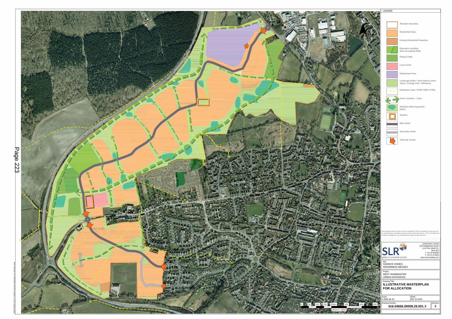
Rugby Club
A36
Vict
oria
Roa
d
Rugby Club
A36
Vict
oria
Roa
d
LEAP
NEAP
Allocation Boundary
Residential Areas
Education / includingshared use playing fields
Local Centre
Employment Area
Landscape Buffer / Semi-Natural GreenSpace / Ecology Park / Allotments
Existing Residential Properties
Pedestrian Links
Green Corridors / Links
Squares
Main Street
Secondary Street
Vehicular Access
Playing Fields
Indicative balancing ponds /basins
Contains OS data © Crown copyright [and database rights] (2015) 0100031673.Contains public sector information licensed under Open government Licence v3.0
www.slrconsulting.com
Drawing Number Revision
Scale Date
SUITE 1 POTTERS QUAY5 RAVENHILL ROADBELFASTBT6 8DNNORTHERN IRELANDT: +44 (0)28 9073 2493
0465
6.00
008.
29.0
01.2
.WW
UE
llus
trativ
e M
aste
rpla
n fo
r Allo
catio
n.dw
g
8 PARKER COURTSTAFFORDSHIRE TECHNOLOGYPARK, BEACONSIDE,STAFFORD ST18 OWPT: +44 (0)1785 241755F: +44 (0)1785 241780
Drawing Title
Project
Revision By Chk'd By CommentsDate
NOTESLEGEND
Site
TREENWOOD HOUSEROWDEN LANEBRADFORD-ON-AVONWILTS. BA15 2AUT: 01225 309400F: 01225 309401
LANGFORD LODGE109 PEMBROKE ROAD
CLIFTON, BRISTOLBS8 3EU
T: 01179 064280F: 01173 179535
FULMAR HOUSEBEIGNON CLOSEOCEAN WAYCARDIFF. CF24 5PBT: 029 2049 1010F: 029 2048 79034 WOODSIDE PLACECHARING CROSSGLASGOWG3 7QFT: 0141 353 5037F: 0141 353 50384/5 LOCHSIDE VIEWEDINBURGH PARKEDINBURGHEH12 9DHT: +44 (0)131 335 683065 WOODBRIDGE ROADGUILDFORDSURREYGU1 4RDT: +44 (0)1483 8898008 STOW COURTSTOW-CUM-QUYCAMBRIDGECAMBRIDGESHIRE. CB25 9AST: 01223 813805F: 01223 813783214 UNION STREETABERDEENAB10 1TLT: +44 (0)1224 517405SUITE 1,JASON HOUSEKERRY HILLHORSFORTHLEEDS. LS18 4JRT: 0113 2580650F: 0113 281883219 HOLLINGWORTH COURTTURKEY MILLMAIDSTONEKENT. ME14 5PPT: 01622 609242F: 01622 695872SAILORS BETHELHORATIO STREETNEWCASTLE UPON TYNETYNE AND WEAR. NE1 2PET: 0191 261 1966F: 0191 230 2346ASPECT HOUSEASPECT BUSINESS PARKBENNERLEY ROADNOTTINGHAM. NG6 8WRT: 01159 647280F: 01159 7515767 WORNAL PARKMENMARSH ROADWORMINGHALL, AYLESBURYBUCKS. HP18 9PHT: 01844 337380F: 01844 337381SUITE 5, BRINDLEY COURTGRESLEY ROADSHIRE BUSINESS PARKWORCESTER WR4 9FDT: +44 (0)1905 751310F: +44 (0)1905 7513112ND FLOORHERMES HOUSEHOLSWORTH PARKOXON BUSINESS PARKSHREWSBURY,SY3 5HJT: 01743 239250DIGITAL WORLD CENTRE1 LOWRY PLAZATHE QUAYSSALFORDMANCHESTER. M50 3UBT: +44(0)161 216406469 POLSLOE ROADEXETERDEVONEX1 2NFT: +44 (0)1392 490152F: +44(0)1392 495572WATERHOUSE BUSINESS CENTRE,UNIT 772, CROMAR WAYCHELMSFORD,ESSEX, CM1 2QET: 01245 392170F: 01245 392171
LEGEND
SLR CONSULTING IRELAND7 DUNDRUM BUSINESS PARKWINDY ARBOURDUBLIN 14T: +353-1-2964667F: +353-1-2964676UNIT 2, NEWTON BUSINESS CENTRETHORNCLIFFE PARK ESTATENEWTON CHAMBERS ROADCHAPELTOWNSHEFFIELD, S35 2PWT:+44 (0)114 2455153 2 LINCOLN STREETLANE COVENEW SOUTH WALES 2066AUSTRALIAT: 61 2 9427 8100F: 61 2 9427 820083 VICTORIA STREETLONDONSW1H 0HWT: +44 (0)203 691 5810NO. 68 STIRLING BUSINESSCENTREWELLGREENSTIRLINGFK8 2DZT: +44 (0)1786 239900BUROCLUB157/155 COURS BERRIAT38028 GRENOBLE CEDEX 1FRANCET: + 33 4 76 70 93 41
N© Crown copyright [and database rights] 0100031673 Expires
HANNICK HOMESPERSIMMON WESSEX
WEST WARMINSTER URBAN EXPANSION
ILLUSTRATIVE MASTERPLANFOR ALLOCATION
1:5000 @ A2 05-10-2015
416.04656.00008.29.001.2 2
[DD/MM/YY]2015
0 50 100 150 200m 300 400 500
Metres 1:5000
This drawing and its content are the copyright of SLR Consulting Ltd and may notbe reproduced or amended except by prior written permission. SLR Consulting Ltdaccepts no liability for any amendments made by other persons.
c Getmapping PLC
/ Public Right of Way
Education including dual use playing fields
3 3
Page 223

This page is intentionally left blank
Appendix 2 - Schedule of comments received and officer responses
Rep No
Surname, Name
Organisation
Support / Object
Summary of Issue Raised Officer Comment Change to be made
1 Childcare Co-ordinator - Early Years Provision
Wiltshire Council
Object Requests £1,067,040.00 through Section 106 contributions for Early Years Education Provision. Please see original representation for full explanation and justification.
The question of whether section 106 contributions on early learning matters are appropriate and necessary here, and if so, at what level, is a matter that should be properly addressed through discussions on individual planning applications.
n/a
2 Medland, Claire
Education Wiltshire Council
Noted It is noted that the Masterplan refers to the two planning applications Ref 14/06562/FUL and 15/01800/OUT•The total number of houses expected to be delivered by both applications is 1403 and Education has therefore based its comments and requirements on this level of development.•The LA is supportive of the proposals identified in Section 4(iii) Community/Social Infrastructure on page 17 of the Masterplan, and in Table 1.4 • of an all-through school proposal on a new site identified within the WWUE development. The all-through facility will provide a 1.5 FE primary school (with a site large enough to be able to be expanded to 2FE at a later date if required), plus accommodation for Secondary, Year 7 children to be collocated on the same site.• I am content with the proposed location of a 3.6 Ha site identified in the WWUE Masterplan• Whilst the principle of a community hall is supported, it should be noted that the school will require exclusive use during the school day and community use, as required, will need to be managed in association with the school out of school hours• to note that in addition to the new school proposal, the neighbouring Princecroft Primary School, will need to be expanded to at least 1FE to meet increase in demand for places.There appears to be no mention of nursery/early years facilities. Angela Brennan has previously responded to the application, stating a requirement for some 130 early years places being required?
General support for approach in masterplan is noted as is agreement over schools site size and location noted.
Possible disaggregation of community facilities needed from school to ensure equitable access for local community
Require revisions to Masterplan to disaggregate community facilities from School to a location to be agreed with the Council.
3 Russell, Maxine
Landscape Officer, Wiltshire Council
Object Consultation Response from WC Landscape
WWUE alternative illustrative masterplan DRAFT (SLR) Relocation of the school to accommodate education requirements will alter the appearance of the scheme when viewed from the AONB. We have
The latest iteration shows the school site within the landscape buffer and this could be injurious to the setting of the AONB and Cley Hill SAM. The landscape statement explaining and
The masterplan is not endorsed until such time that it is revised to move the school out of the landscape
Page 225
Rep No
Surname, Name
Organisation
Support / Object
Summary of Issue Raised Officer Comment Change to be made
worked tirelessly to protect the setting of the AONB and valued views from Cley Hill.
To date we haven't received a revised landscape strategy or any other information to confirm the acceptability of this location for the school in terms of landscape and visual effects on the setting of AONB & Cley Hill SAM.
We must retain the clumps of woodland/wooded character of this edge (as illustrated Figure 3.1 Landscape Strategy Plan) as a minimum, as it will be important habitat for biodiversity/connectivity as well as visual mitigation
justifying this choice was submitted late in the process.
As per the Wiltshire Core Strategy the protection of the AONB is of paramount importance when managing development in Wiltshire
buffer or further evidence is provided demonstrated that it can be mitigated to the satisfaction of the Council.
4 Kanzurovska, Belinda
Housing, Wiltshire Council
No further comment at this time.
Many thanks for advising that the draft masterplan is available for comments in relation to the above.Please note that at this time we do not have any further comments to make. We note that up to a 30%affordable housing contribution is stated and that the total number of dwellings proposed includesaffordable housing, starter homes and extra care homes.
Noted n/a
5 Southwell, Richard
My comments are as chairman of a charity based in Warminster, as patron of a school in Warminster adjacent to the site, and as a daily user of the facilities within the town.1. It is essential that provision is made for a GP Surgery within the Plan area, either to enable Smallbrook Surgery to relocate, or to provide an additional Surgery to cope with the medical needs of the new residents as well as some of the existing residents on the west side of the town. THIS WILL BE VITAL FOR ALL THE NEW RESIDENTS.2. Within the community centre, there will be a need for the church congregations in the town to be able to have a presence within the area of the new houses for the benefit of the new residents.
The Masterplan document on page 14 states a site has been allocated for a surgery within the local centre, in response to comments from the community, NHS and Smallbrook surgery. However, it is not clear where in the allocation area this would be delivered and it is not illustrated on the masterplan itself.
Masterplan to be endorsed to indicate where a Drs surgery could potentially be located, if there is a future need for one.
6 Nicklin, Tony
Object The Master Plan does NOT comply with the emerging neighbourhood Plan Policy numbers L4,L5,E5
It is a fundamental flaw in the plan that the sporting facilities are fragmented
The plan shows a lack of consideration for the location of housing backing on to the employment when the less desirable visual needs can
The masterplan is required to comply with the Core Strategy and the Development Template in Appendix A. Whilst some weight can be given to the emerging Neighbourhood Plan, examination has yet to take place and full weight cannot be attributed at this point in time.
The masterplan should only be endorsed subject to revisions which more clearly illustrate an effective buffer between homes and employment.
Page 226
Rep No
Surname, Name
Organisation
Support / Object
Summary of Issue Raised Officer Comment Change to be made
be screened and separatedThe proposed sports facilities are dispersed throughout the large site to provide wider access and diversification of choice.
It is agreed that housing adjacent to employment uses needs improved screening
7 Monkcom, G
Object I think it may be time for us to move on.Having had two children, a responsible number. It seems that we have to develop more houses in this already over-crowded country.We have to be Mad, to think this is in any way a solution. The Solution is blindingly obvious .... less people.It’s time to STOP Concreting over farm land, please fight this lunacy.
Meeting the objectively assessed housing needs of Wiltshire is a national policy requirement and the growth needed identified through Strategic Housing Market Assessment and Core Strategy Examination process. Providing a decent stock of market and affordable homes for all is a key priority of the Core Strategy, which also sets out a policy framework for protecting the most sensitive parts of the countryside.
n/a
8 Henry, Tania
Object Could you please explain the, 'View a list of neighbours consulted' link as I appear on a list of 'Neighbours consulted' when I haven't, to my knowledge, been consulted. This, if the inferred meaning is that I have been asked for information or my opinion, would be an error.
Records show a consultation letter was sent
n/a
9 George, Jim
Object My 2 main concerns with this application are as follows.1 site traffic through St Andrews Road. Ours are small cul-de-sacs with young children and elderly people making extensive use of the roads & paths before & after school. Therefore in addition to the constraints on cleanliness, volumes & flow I would urge Redrow to avoid 08:00-09:00 & 15:00-17:00 weekdays and all day at weekends without prior arrangement with nominated local residents. In addition the developers should provide on-site parking away from existing houses as a priority to avoid construction workers using our estate as a car park. Finally I would urge the developers to make construction traffic one way through the 2 cul-de-sacs.2 The provision of a link road is of paramount importance and should be mandated to be delivered before the delivery of the last of Redrow's
Agreed that due to existing residential properties that any planning application will need to be subject to a CEMP (Construction Environmental Management Plan) to include routing of construction traffic, wheel washing, management of waste and hours. This will correctly sit at the detailed planning application stage.
Agree that detailed planning require a phasing plan to ensure access is adequately made to all new
n/a
Page 227
Rep No
Surname, Name
Organisation
Support / Object
Summary of Issue Raised Officer Comment Change to be made
dwelling on the St Andrews Road site. development.10 Dickins,
Michael Object The planning application is for more than the 900 homes required under
the Core Strategy. Any further increase in houses on the Bath side of town above the 900 figure would create complete seizure of local roads especially West Street and the Bath Road. The proposed split of secondary education provision in the town would worsen the traffic as parents with children will have to make trips across the town in both directions and both if they have children of different ages. It is not clear from the plan which facilities and infrastructure proposed for the location may be conditional on the approval and development of the of additional houses over the 900 limit. If this issue is not clarified the developers will be able to walk away from developing these facilities if the additional houses are not built or use it as a lever to force the Council to grant permission. I find no detailed analysis of the effect of the additional traffic on the key roads into the town or at the junction in the High Street. Cross town movement is already fraught at busy times of the day. The proposal for drainage in the St Andrews section of the development is too vague to have any confidence that it will not increase run off through the town.
The Masterplan shows up to 900 homes within the life time of the Core Strategy (up to 2026). The Core Strategy also is based on a minimum number not an absolute ceiling.
Agreed that a comprehensive approach to delivering critical physical and social infrastructure at the right time. This is the reason the Core Strategy requires a masterplanning process based on consultation with the local community and key stakeholders, to ensure these issues are identified and addressed satisfactorily. Key input has been made by highways, education, housing, landscape, drainage and ecological specialists.
Planning decisions will include conditions and legal agreements to ensure the vital infrastructure is secured in a timely manner
n/a
11 Cooper, Andrew
Object I have three concerns about this plan.Firstly, access through the cul-de-sacs in St Andrew's Road. This is an issue raised many times before yet contractors appear to be ignoring it! St. Andrew's Road is narrow, many vehicles, of necessity, park routinely on the street and, more significantly, many elderly people and young children reside here. Safety will be the first casualty of this plan - any access through these cul-de-sacs will inevitably, not possibly, result in injury or worse even if time restrictions are imposed.
Secondly, there is insufficient infrastructure to support such a project - Doctors, schools, shops, parking to name but four.
Thirdly, the impact on the natural environment - this cannot be understated. Last year red kites returned to nest and breed - an unusual occurrence. Buzzards and kestrels are amongst other frequent residents
Vehicular access to the site was subject to high level strategic assessment at the Core Strategy stage. This assessment has carried on in more detail during the masterplanning negotiations and will continue through the planning application stages. Highways specialists do not consider there to be any barriers to effective, safe use of this access per se. All access will be designed to national standards and a CEMP (Construction Environmental Management Plan) to include routing of construction traffic, wheel washing, management of waste
n/a
Page 228
Rep No
Surname, Name
Organisation
Support / Object
Summary of Issue Raised Officer Comment Change to be made
and visitors in the build area. and hours of operation. This will correctly sit at the detailed planning application stage.
Agreed that a comprehensive approach to delivering critical physical and social infrastructure at the right time. This is the reason the Core Strategy requires a masterplanning process based on consultation with the local community and key stakeholders, to ensure these issues are identified and addressed satisfactorily. Key input has been made by highways, education, housing, landscape, drainage and ecological specialists.
Planning decisions will include conditions and legal agreements to ensure the vital infrastructure is secured in a timely manner.
The Core Strategy was subject to an appropriate assessment under the Habitat Regulations and strategic flood risk assessment which identified that subject to appropriate mitigation no insurmountable barriers to development of 900 homes on this site were identified and hence it inclusion as a strategic allocation. The masterplan acknowledges that any development in excess of that planned within the Core Strategy will need to be subject to screening under Habitats Regulations. As with highways, more detailed ecological mitigation will be identified at planning application stage.
Page 229
Rep No
Surname, Name
Organisation
Support / Object
Summary of Issue Raised Officer Comment Change to be made
12 Gregory, W
Object If this scheme goes ahead, I can only assume that the world is going mad. From the plan, I guess at least 300 houses would result, assume 2 road vehicles per house and imagine the result on Warminster roads. At times now the town is swamped with traffic. This plan seems to be made to make a few people wealthy, whilst the rest suffer. Please put a stop to it, it borders on insanity.
Comment noted n/a
13 Norris, Robert
Object We would like to register our objections to the proposals for 900 new houses to be built onto the West of Warminster. FLOODING, which has been seen to be a real worry this year, will be increasingly a problem when the fields which now allow rainwater to dispense will be covered in concrete, leading to a high risk of flooding. A stream runs between the fields and ensures that rainwater is contained at the moment. TRAFFIC congestion will be a real concern in the town, as it is already, during going to work/school times. 900 houses will mean at least 1,800 cars crossing town to get children to Kingdown School/ work. The existing Bath Road and Victoria Road / West Street traffic routes both converge on the Obelisk Junction which is already under pressure. SERVICES such as Primary Schools, Secondary Schools and Drs Surgeries, which are already full to bursting, will not be able to cope with the increase. Sports facilities are already under pressure and will struggle to expand to meet the needs of a growing population. CONSERVATION of wildlife and their habitats will be under threat when all these houses are built. We consider that the number of 900 houses is far too great for out lovely Market Town to absorb without it affecting our enjoyment of living here. Many local people enjoy walking the footpaths with h adjoining fields and this will be spoilt for future generations. One of the jobs of living in Warminster is the easy access to the surrounding countryside, providing a positive sense of well-being and exercise in open spaces. We feel that the number of houses proposed for the West Urban Extension will unbalance the town and cause many problems for the existing population.
Meeting the objectively assessed housing needs of Wiltshire is a national policy requirement and the growth needed identified through Strategic Housing Market Assessment and Core Strategy Examination process. Providing a stock of decent market and affordable homes for all is a key priority of the Core Strategy, which also sets out a policy framework for protecting the most sensitive parts of the countryside.
Strategic highways modelling demonstrates that with mitigation, the site can accommodate the number of home proposed.
Planning decisions will include conditions and legal agreements to ensure the vital infrastructure is secured in a timely manner.
The Core Strategy was subject to an appropriate assessment under the Habitat Regulations and strategic flood risk assessment which identified that subject to appropriate mitigation no insurmountable barriers to development of 900 homes on this site were identified and hence it inclusion as a strategic allocation. The
n/a
Page 230
Rep No
Surname, Name
Organisation
Support / Object
Summary of Issue Raised Officer Comment Change to be made
masterplan acknowledges that any development in excess of that planned within the Core Strategy will need to be subject to screening under Habitats Regulations.
14 Norris Kay Object We would like to register our objections to the proposals for 900 new houses to be built onto the West of Warminster.
FLOODING, which has been seen to be a real worry this year, will be increasingly a problem when the fields which o=now allow rainwater to dispense will be covered in concrete, leading to a high risk of flooding. A stream runs between the fields and ensures that rainwater is contained at the moment.
TRAFFIC congestion will be a real concern in the town, as it is already, during going to work/school times. 900 houses will mean at least 1,800 cars crossing town to get children to Kingdown School/ work. The existing Bath Road and Victoria Road / West Street traffic routes both converge on the Obelisk Junction which is already under pressure.
SERVICES such as Primary Schools, Secondary Schools and Drs Surgeries, which are already full to bursting, will not be able to cope with the increase. Sports facilities are already under pressure and will struggle to expand to meet the needs of a growing population.
CONSERVATION of wildlife and their habitats will be under threat when all these houses are built.
We consider that the number of 900 houses is far too great for out lovely Market Town to absorb without it affecting our enjoyment of living here. Many local people enjoy walking the footpaths with h adjoining fields and this will be spoilt for future generations. One of the jobs of living in Warminster is the easy access to the surrounding countryside, providing a positive sense of well-being and exercise in open spaces. We feel that the number of houses proposed for the West Urban Extension will unbalance the town and cause many problems for the existing population.
Meeting the objectively assessed housing needs of Wiltshire is a national policy requirement and the growth needed identified through Strategic Housing Market Assessment and Core Strategy Examination process. Providing a decent affordable home for all is a key priority of the Core Strategy, which also sets out a policy framework for protecting the most sensitive parts of the countryside.
Strategic highways modelling demonstrates that with mitigation, the site can accommodate the number of home proposed.
Planning decisions will include conditions and legal agreements to ensure the vital infrastructure is secured in a timely manner.
The Core Strategy was subject to an appropriate assessment under the Habitat Regulations and strategic flood risk assessment which identified that subject to appropriate mitigation no insurmountable barriers to development of 900 homes on this site were identified and hence it inclusion as a strategic allocation. The masterplan acknowledges that any development in excess of that planned
n/a
Page 231
Rep No
Surname, Name
Organisation
Support / Object
Summary of Issue Raised Officer Comment Change to be made
within the Core Strategy will need to be subject to screening under Habitats Regulations.
15 ABC Warminster
ABC Warminster submits a vision for the South of Victoria Road element of the WWUE that predominantly consists of recreation land to include Rugby, hockey, football, conservation and water protection zone, sensory garden trail allotments, a community building and an iconic entrance.With the supporting documentation of the National Planning Policy Framework (NPPF), Wiltshire Core Strategy (wCS), Wiltshire North & West Housing Market Assessment (wHMA) and key stakeholders; including the Emerging Neighbourhood Plan (eNP) and Warminster Community, we are submitting a vision for South of Victoria Road (sVR) element of the West Warminster Urban Extension (wWUE) indicative of using this strategic site in the way it was intended (Ref Map 1),thereby:• Providing a high quality, integrated development, • Protecting the Area of Outstanding Natural Beauty (AONB), • Conserving and enhancing the environment within the strategic site, • Reducing the flood risk and transport pressures, • Delivering a unique growth opportunity.Thus enabling Warminster to prosper by delivering self-containment of our town and resilient sustainable Community integration for 2026 and beyond.Please see original representation for full explanation and justification, available on the website. This includes an amended map reflection the latest feedback for the proposed wWUE ABC Community vision. Please add the attached amended map reflecting the latest feedback for the proposed wWUE ABC Community vision for sVR. In addition and conjunction to ABC Warminster document registered 02/03/16 on this consultation.This map illustrates how the land was originally designated in the Wiltshire Core Strategy (wCS) to be used ‘landscape led mixed use’ not 500 plus houses South of Victoria Road (sVR) over 17 years. CP31 statement was specifically written to increase the wellbeing of Warminster, develop a great extension to the town, improve facilities long overdue and ensure minimal impact to our beautiful surroundings, promoting wildlife connections for people and keep a balanced ecology to the area. The total wWUE tract of land is stated as 900 dwellings to be completed by 2026 and the remaining lands to be used for landscaping and infrastructure to support this massive growth of Warminster. wCS CP31 states ‘and the development quanta will remain set at 900 homes and 6 haemployment land’ for the
It is agreed that creation of a high quality integrated development which is served by effective infrastructure and mitigates impacts upon the environment is paramount. While there may be alternative masterplan options, this site is governed by Core Strategy policy including the Development Template at Appendix A. The officer’s report indicates that the masterplan submitted, subject to the revisions identified, does indeed meet the Core Strategy objectives.
It’s important to emphasise the reasons behind the dwelling figure proposed in the Wiltshire Core Strategy. The strategic site covers the whole area between the built up area and the A36. The 900 dwellings set in the Core Strategy is deliberately much lower than the site area suggests because the plan recognises that there needs to be an extensive amount of landscaping to prevent harm to the setting of Cley Hill fort scheduled monument and the Area of Outstanding Natural Beauty directly on the other side of the A36. A low figure also allows for a considerable amount of space for flood mitigation work in addition to the flood risk areas within the site that will be left completely undeveloped. A low figure was set in the Core Strategy which specifically
n/a
Page 232
Rep No
Surname, Name
Organisation
Support / Object
Summary of Issue Raised Officer Comment Change to be made
whole complete strategic site for total delivery by 2026.Masterplan Feb2016 16/01323/MAS is in direct breach of the USE statement and the KEY objectives and time period designated throughout wCS document when referencing Warminster. It is clearly unethical and must be refused on this legal point alone. Either remove the land and reduce the size of the strategic site from development for this time period or take action to do the right thing for Warminster and let the Community Vision be the driver for this area and help us to deliver the vision. Give Warminster a future we can all be proud of, deliver and live up to your strap line ‘Wiltshire where everyone matters’. Our MP and the Minster of Housing and Communities support the wCS. Legal documentation of the NPPF, your wCS and Warminster’s emerging NP, surely this is worth standing up for.
says the area ‘does not provide for additional development and the development quanta will remain set at 900 homes and 6 ha employment’. By law planning applications must be ‘determined in accordance with the development unless material considerations indicate otherwise’. The onus is therefore entirely on a developer to demonstrate why any development should exceed the scale set down.
Since the strategic site was proposed developers have carried out a considerable amount of detailed work looking at how to deal with flood risks and landscape impact. They have stated that their more detailed work demonstrates that landscape and flood risk issues can be treated properly while allowing a greater scale of development. The responsible bodies, the Environment Agency and Natural England do not appear to be rejecting the principles of the developer’s approach and so some higher scale of development has to be contemplated. Set in the context of the Core Strategy requirement for at least 42,000 homes to be delivered in Wiltshire over the plan period, it would be unreasonable to reject a scheme simply because it proposed more than 900 dwellings.
This is an indicative masterplan and any subsequent planning applications will need to be determined on its own
Page 233
Rep No
Surname, Name
Organisation
Support / Object
Summary of Issue Raised Officer Comment Change to be made
merits and the law requires it to accord with policy unless the developers can demonstrate why other factors should be considered in allowing development as an exception to policy.
16 Ellie Challans
Environment Agency
General Comments
We would take this opportunity to remind Wiltshire Council and the developer(s) of the need, in accordance with the NPPF, to demonstrate that the Sequential Test (and Exception Test as necessary) is passed if development is proposed with Flood Zones 3 & 2. This consultation includes Rev 3 of the ‘Illustrative Masterplan for Allocation’ and an updated report dated February 2016. We have compared Rev 3 of the Masterplan against Rev 2 and there would not appear to be any major differences, although we notice that Rev 3 now includes the position of ‘indicative balancing ponds / basins’. We request that our published Flood Zones 3 & 2 (Flood Map for Planning) are superimposed onto the Masterplan to allow the LPA and the EA to spatially understand the extent of the site shown to lie (indicatively) within an area at risk of flooding. In Table 1.1 on page 10 and in paragraph 5.16 on page 34 it states that a small section of the site falls within Flood Zone 2. It would be helpful to understand in more detail the location of this, and provide clear evidence that none of the site lies within Flood Zone 3. As suggested above if the Flood Zones were superimposed on the Masterplan then this could provide the evidence. Paragraph 5.19 refers to flood risk analysis, including modelling of water flows at the Were Brook to test the robustness of the EA’s Flood Map, and goes on to state that the EA’s Flood Map is inaccurate in part. We are not aware of any challenge to our published Flood Map. We have only very recently updated the Flood Map, to reflect the results of river modelling carried out by HR Wallingford in conjunction with a Flood Map challenge submitted to us as part of a planning application to develop land adjacent to Grovelands Way. The published Flood Map has
As advised laying the flood maps over the masterplan does show that some of the balancing ponds are in fact within a flood zone. This would mean they would be ineffectual and not perform the mitigation required. The developers have agreed to amend the masterplan accordingly.
The masterplan has been designed to ensure development is outside of the designated flood zone
The masterplan should only be endorsed subject to revisions to relocate all balancing ponds away from the flood plain.
Page 234
Rep No
Surname, Name
Organisation
Support / Object
Summary of Issue Raised Officer Comment Change to be made
been updated (by agreement with HR Wallingford) upstream of the balancing pond. Wiltshire Council, in its role as the Lead Local Flood Authority, will provide detailed comment on all matters related to surface water drainage and as such if not already done so we recommend the LPA formally consult the Council’s flood risk management team to ensure the draft Masterplan, and future supporting evidence, meets the requirements of the strategic allocation as set out in their Core Strategy Pre-Submission Document, and specifically the ‘physical measures’ detailed therein. Whilst disposal of surface water run-off from a development site is now a matter for the LLFA as part of their planning consultation role, we notice that some of the proposed balancing ponds would appear to be positioned within the Flood Zones. If this is the case we advise it is inappropriate, because in times of flood the balancing ponds may be inundated with flood water and hence not be able to utilise their full design storage capacity.
17 Brown, Colin
Leisure Services, Wiltshire Council
Leisure Services is not convinced that the splitting of the Outdoor Sports Pitches is right for the wider community, it would make more sense on sustainability grounds to have all of the Sports Pitches in one site with appropriate changing accommodation and car parking. It could be that the parking for the proposed School and Outdoor Pitches could be shared as the major usage would be at differing times. Examples of successful local multi pitch sites are Stanley Park – Chippenham and Beversbrook – Calne.To make the most of the sports pitch provision in terms of sustainability, income, usage and need - serious consideration should be given to the provision of a full size 3G Artificial Turf Pitch, the under provision of such facilities together with the lack of quality of grass sports pitches is identified in the West Wiltshire DC DPD and is a key element in the emerging Wiltshire Council Playing Pitch Strategy. If this asset was provided the school could have agreed year round access.To make the most of the sports pitches from a community perspective whilst still providing the necessary school access, it is key that either the Town Council or a Management Company manage the assets thereby being able to rationalise use and reinvest income.
The requirement for sports provision to be delivered on one enlarged site raises concern that given the size of the masterplan area (94ha), which is likely to be phased over the next 10-20 years that centralising sports facilities may result in delivery problems and conflicts Furthermore the dispersal of the sports facilities on such a large site will allow greater local access and provide wider choice.
n/a
18 Morgan, Barbara
Network Rail
Network Rail has found that where new large developments occur people will drive to the nearest station to access trains to London etc,
It is agreed that developers should contribute if it can be demonstrated
n/a
Page 235
Rep No
Surname, Name
Organisation
Support / Object
Summary of Issue Raised Officer Comment Change to be made
and this proposed development with additional housing proposal will put parking pressure on Westbury and Warminster Stations, therefore Network Rail would suggest a S.106 is in place for improvements to these stations as a result of the envisaged increased demand.
Many stations and routes are already operating close to capacity and a significant increase in patronage may create the need for upgrades to the existing infrastructure including improved signalling, passing loops, car parking, improved access arrangements or platform extensions.
As Network Rail is a publicly funded organisation with a regulated remit it would not be reasonable to require Network Rail to fund rail improvements necessitated by commercial development. It is therefore appropriate to require developer contributions to fund such improvements.
The likely impact and level of improvements required will be specific to each station and each development meaning standard charges and formulae may not be appropriate. Therefore in order to fully assess the potential impacts, and the level of developer contribution required, it is essential that where a Transport Assessment is submitted in support of a planning application that this quantifies in detail the likely impact on the rail network.
To ensure that developer contributions can deliver appropriate improvements to the rail network we would recommend that Developer Contributions should include provisions for rail and should include the following:
- A requirement for development contributions to deliver improvements to the rail network where appropriate.- A requirement for Transport Assessments to take cognisance of impacts to existing rail infrastructure to allow any necessary developer contributions towards rail to be calculated.- A commitment to consult Network Rail where development may impact on the rail network and may require rail infrastructure improvements. In order to be reasonable these improvements would be restricted to a local level and would be necessary to make the development acceptable. We would not seek contributions towards
that their development directly lead to upgrades to station facilities being required to handle the additional footfall caused.
The request therefore to be consulted on any subsequent planning applications so detailed negotiations can take place is noted and agreed.
Page 236
Rep No
Surname, Name
Organisation
Support / Object
Summary of Issue Raised Officer Comment Change to be made
major enhancement projects which are already programmed as part of Network Rail’s remit.
We would appreciate the Council providing Network Rail with an opportunity to comment on any future planning applications should they be submitted for sites adjoining the railway, or within 10 metres of relevant railway land as we may have more specific comments to make (further to those above).
19 Leonardo, Raquel
Wiltshire Council
Constraints- Should make reference to existing public rights of way and listed building. - The land control plan submitted does not explain the proposed road layout alignment within the parcel to the north of Victoria Road. If all that land is within control of the developers then why is the road following such an awkward alignment? Chapter 6 (Urban Design)- Include explanatory paragraph on land use, taking into account the conflicting relationship between the adjacent residential and employment which needs readdressing as it could prove to be quite hard to conciliate. It’s preferable to locate residential on one side of the road only and to create instead a substantial landscape buffer next to the employment centre. - Add detail on the proposed densities within the main text but also on a parameters plan. - Add detail on the proposed heights on a parameters plan. - Movement framework:The masterplan drawing should reflect the comments above on the street alignment (i.e. realign if there is control of all the land). Secondary streets should also be shown on the parcel north of Victoria Road. What is the nature of the “green corridors link”? Will this include a pedestrian and cycle link? - Explanatory paragraph on the public realm strategy (including key public spaces, features and gateways). - Include a paragraph on drainage, namely on the ecological, landscape and recreational value of the attenuation ponds, including also a narrative explaining in fairly simple terms the nature and size of those features.
It is agreed that housing adjacent to employment uses needs improved screening
Agreed that parameters plan, more detailed road alignments, and green corridors link is required and that will be provided at the detailed planning application stage
A public realm strategy is integral part of a masterplan process as it will set a framework for how a coherent sense of place is to be achieved
The masterplan should only be endorsed subject to revisions which illustrate more effective buffer between homes and employment and to detail the approach to the public realm strategy in future applications.
20 Wished to remain anonymous
Anonymous
Object I personally think that this very badly written document is a cynical attempt by developers to get the Master Plan thrown out so that they can submit even more applications for building all over the WWUE citing the fact that there has been no acceptance of their ‘perfectly reasonable’ attempt to produce a coherent document.There are items that needed to be in the document that are not. These are:• The early provision of the link road from Victoria Road to St Andrews road – this is not being offered until Persimmon get their act together and overdevelop the remainder of the land at Bugley Barton Farm. A Proper
Early and timely delivery of link roads will be essential and will be secured through necessary phasing agreements to accompany a planning application and be negotiated with the Council Highways engineers. The Masterplan will not preclude this in any way.
The requirement for sports provision
Require revisions to Masterplan to disaggregate community facilities from School to a location to be agreed with the Council.
Page 237
Rep No
Surname, Name
Organisation
Support / Object
Summary of Issue Raised Officer Comment Change to be made
Master Plan would identify sensible joined up approaches from developers who should be able to work together if they actually believed the trite nonsense that they spout about working towards a better community. Personally I do not want the road but I recognize that early provision of such a road would alleviate the misery of 3.5 years of continuous construction traffic through the very small culs de sac that are St Andrews Road. If ever there were a reason for compulsory purchase or refusal to give planning permission then the inability of 2 huge property exploiting companies to actually come up with a sensible plan for a road would be top of the list!• The sports facilities should not be pepper-potted. They should be in one area so that proper changing facilities can be provided at each pitch. Pepper-potting them throughout a development may look pretty and make the developers look green but it is not a sustainable way to do things – and sustainability is what these altruistic companies are all about – or so we are told.• The community hall should not be the same building as the pavilion/changing rooms. If it is there is a danger of the less active members of the community being squeezed out of community functions by the football teams, hockey teams and others who will have regular fixtures and slowly ease out the old peoples groups and knitting circles. • There is no consultative link with the other areas affected by the WWUE. For example the document states: o ‘A management company responsible for the long-term stewardship of the WWUE will be established through funding from the developers and through an on-going service charge from development within the WWUE. The management company will be responsible for maintaining the communal areas, public open space, formal open space, landscaping, play facilities and surface water drainage attenuation. Should any issues arise relating to the up-keep of the above facilities, the management company will be on-call and will be held accountable by the proposed residents of the development. ‘ Here the responsibility is purely for the surface water drainage attenuation for the site. There is no link to those locations further down stream, as it were. o Will the people at St Andrews -being offered to the nation as Cley View before planning applications have been approved – be responsible to the same management company. Will they pick up the bill when their surface water attenuation facility fails and floods the houses in Haygrove Close and further down stream? Legally as the company has not been involved in any of the design how will the negligence for bad
to be delivered on one enlarged site raises concern that given the size of the masterplan area (94ha), which is likely to be phased over the next 10-20 years that centralising sports facilities may result in delivery problems and conflicts. Furthermore the dispersal of the sports facilities on such a large site will allow greater local access and provide wider choice.
Possible disaggregation of community facilities needed from school to ensure equitable access for local community
The masterplan is indicative and sets a framework for development and is based on an allocation made within the Core Strategy. Both have been subject to strategic level flood assessment which demonstrate that the there are no insurmountable barriers to development on this site. This does not obviate the need for detailed technical drainage matters to be resolved at the appropriate detailed planning application stage.
The Core Strategy was subject to an appropriate assessment under the Habitat Regulations and strategic flood risk assessment which identified that subject to appropriate mitigation no insurmountable barriers to development of 900 homes on this site were identified and hence it inclusion as a strategic allocation. The masterplan acknowledges that any development in excess of that planned
Page 238
Rep No
Surname, Name
Organisation
Support / Object
Summary of Issue Raised Officer Comment Change to be made
engineering decisions be legally sorted out? The broad brush Management Company statement does not give enough detail.• There is no proper environmental assessment re flora and fauna. The WWUE consists of far more land than contained in the two initial planning applications. Some of the most diverse fauna exists to the South of Victoria Road in the areas that are under option to Persimmon and within 10m of Redrow’s area. Here we have moorhen, newts and water shrews in a run off pond that is going to be adversely affected by SUDs measures proposed. In addition we have roosting bats. The whole WWUE should be examined if this is a proper ’Masterplan’ not just bits.• There is nothing on the quality of the houses to be developed. I am fairly sure that, even though they are not final, Persimmon’s planners should have some idea of the quality levels of the homes they are planning on building. Redrow do not state the build levels for their houses. The NP and the CS say that the quality should he high. In this day we should be demanding the highest quality possible to ensure sustainability. The houses should all be built in line with at least the new Building Regulations, which are being retitled as “the new national technical standards” and are being set at the old code for Sustainable Homes Code level 4. It would be more sustainable if they were built to the more stringent level 6 levels of the old code.Additionally it would appear that none of the infrastructure will be completed until the end of each phase. This is ridiculous and leads to the disasters with developers as seen in Persimmon’s inept handling of the problems at H12 in Warminster. On the traffic flow modeling the timing for the traffic census was carefully planned to avoid the junior school collection time and only looked at the timings from 4 pm to 6pm. The suggestion that all the traffic to various schools will be internal – because there will be a school in the WWUE holds no water. The follow on argument that the children will go to school by bus shows a total disregard for the fact that busses are not provided free for children living within 3 miles of a school. Most parents faced with paying for a bus or dropping little Jimmy off or collecting him at/from school in their car on the way to or from the shops will choose the car option. The traffic study should be redone and this will show that Victoria Road and the obelisk will become completely gridlocked twice a day by parents whose children are at present at Kingdown moving their children to the new school at WWUE and the others moving their children from the site to Kingdown. The modeling is flawed and the simplistic answer in the Master plan
within the Core Strategy will need to be subject to screening under Habitats Regulations. As with highways, more detailed ecological mitigation will be identified at planning application stage.
The specific point regarding ecological impacts on the existing pond is acknowledged and it is agreed that detailed planning applications on the site will need to be supported by evidence to demonstrate that the ecological value of existing watercourses and ponds will not be jeopardised by the proposals.
The Government has abolished the Code for Sustainable Homes and seeks to achieve equivalent ends through the Building Regulations regime.
Agreed that a comprehensive approach to delivering critical physical and social infrastructure at the right time. This is the reason the Core Strategy requires a masterplanning process based on consultation with the local community and key stakeholders, to ensure these issues are identified and addresses satisfactorily. In addition, key input has been made by highways, education, housing, landscape, drainage and ecological specialists.
Planning decisions will include conditions and legal agreements to ensure the vital infrastructure is secured in a timely manner
Page 239
Rep No
Surname, Name
Organisation
Support / Object
Summary of Issue Raised Officer Comment Change to be made
paragraphs 5.8 is disingenuous to say the least. No provision has been made for the inward travel or the outward travel from the WWUE. As a former Operational Analyst, used to these kinds of models, I can state quite categorically that the question asked significantly affects the answer given and in this case I am pretty sure that the wrong question has been asked in order to produce a result that supports the Masterplan with minimum cost implications to the developers.The comments about the fact that the land to the South of Victoria Road is BMV agricultural land and, because it is being despoiled by building for the WWUE, the density should be increased so that other BMV land is not lost to development beggars belief!This document is not a plan, as it appears to have no timeline or cohesion except for the building years of the houses. It is a collection of platitudes with no commitment on the developers to actually do anything other than make huge amounts of money for their shareholders and a few greedy farmers.I sadly accept that if we do not have a Masterplan then there will be a developer’s free for all throughout the WWUE and the rest of town I ask you as a council to throw out this phoney Masterplan and ask for it to be resubmitted having been properly written as a cohesive document that actually shows vision with real aims and proper requirements towards which the developers can work together. I understand that there is a risk that the developers will just ignore this and plow on regardless submitting planning application after planning application all around the town. A Masterplan with no teeth is no more use than a chocolate fire guard and is open to abuse similar to that that we will have if there was no plan at all. A good Master Plan will be a beacon for all developers to see. Guess which we will get!
21 Karen, Tracy
ABC Warminster
Please add the attached amended map reflecting the latest feedback for the proposed wWUE ABC Community vision for sVR. In addition and conjunction to ABC Warminster document registered 02/03/16 on this consultation.This map illustrates how the land was originally designated in the Wiltshire Core Strategy (wCS) to be used ‘landscape led mixed use’ not 500 plus houses South of Victoria Road (sVR) over 17 years. CP31 statement was specifically written to increase the wellbeing of Warminster, develop a great extension to the town, improve facilities long overdue and ensure minimal impact to our beautiful surroundings, promoting wildlife connections for
It is agreed that creation of a high quality integrated development which is served by effective infrastructure and mitigates impacts upon the environment is paramount. While there may be alternative masterplan options, this site is governed by the Core Policy including the Development Template at Appendix A. The officer’s report indicates that the masterplan as submitted, subject to the revisions
n/a
Page 240
Rep No
Surname, Name
Organisation
Support / Object
Summary of Issue Raised Officer Comment Change to be made
people and keep a balanced ecology to the area. The total wWUE tract of land is stated as 900 dwellings to be completed by 2026 and the remaining lands to be used for landscaping and infrastructure to support this massive growth of Warminster. wCS CP31 states ‘and the development quanta will remain set at 900 homes and 6 ha employment land’ for the whole complete strategic site for total delivery by 2026.Masterplan Feb2016 16/01323/MAS is in direct breach of the USE statement and the KEY objectives and time period designated throughout wCS document when referencing Warminster. It is clearly unethical and must be refused on this legal point alone. Either remove the land and reduce the size of the strategic site from development for this time period or take action to do the right thing for Warminster and let the Community Vision be the driver for this area and help us to deliver the vision. Give Warminster a future we can all be proud of, deliver and live up to your strap line ‘Wiltshire where everyone matters’. Our MP and the Minster of Housing and Communities support the wCS. Legal documentation of the NPPF, your wCS and Warminster’s emerging NP, surely this is worth standing up for.
identified, does indeed meet the Core Strategy objectives.
It’s important to emphasise the reasons behind the dwelling figure proposed in the Wiltshire Core Strategy. The strategic site covers the whole area between the built up area and the A36. The 900 dwellings set in the Core Strategy is deliberately much lower than the site area suggests because the plan recognises that there needs to be an extensive amount of landscaping to prevent harming the setting to Cley Hill fort ancient monument and the Area of Outstanding Natural Beauty directly on the other side of the A36. A low figure also allows for a considerable amount of space for flood mitigation work in addition to the flood risk areas within the site that will be left completely undeveloped. A low figure was set in the Core Strategy which specifically says the area ‘does not provide for additional development and the development quanta will remain set at 900 homes and 6 ha employment’. By law planning applications must be ‘determined in accordance with the development unless material considerations indicate otherwise’. The onus is therefore entirely on a developer to demonstrate why any development should exceed the scale set down.
Since the strategic site was proposed developers have carried out a
Page 241
Rep No
Surname, Name
Organisation
Support / Object
Summary of Issue Raised Officer Comment Change to be made
considerable amount of detailed work looking at how to deal with flood risks and landscape impact. They have stated that their more detailed work demonstrates that landscape and flood risk issues can be treated properly while allowing a greater scale of development. The responsible bodies, the Environment Agency and Natural England do not appear to be rejecting the principles of the developer’s approach and so some higher scale of development has to be contemplated. Set in the context that the Core Strategy requires at least 42,000 homes to be delivered in Wiltshire over the plan period, it would be unreasonable to reject a scheme simply because it proposed more than 900 dwellings.
This is an indicative masterplan and any subsequent planning applications will need to be determined on their own merits and the law requires it to accord with policy unless the developers can demonstrate why other factors should be considered in allowing development as an exception to policy.
22 Adlam, Sandra
Having viewed the” View a list of neighbours” consulted; it would infer a postal letter would be received requesting the chance to have an opinion and view, but to my knowledge no letter has been received. The master plan does not comply with the Wiltshire Core Strategy Policy 31-900 dwellings and six hectares of employment -The area identified as “indicative mixed use ”represents an area of land that is much larger than required to deliver 900 homes, 6 ha employment and associated facilities. The final development area is yet to be identified through a
Agreed that housing and employment needs to be delivered in tandem to try and build more resilient and self-contained communities. The masterplan demonstrates the location and a phasing plan will be a prerequisite of granting planning permission to ensure that the
Require revisions to Masterplan to disaggregate community facilities from School to a location to be agreed with the Council.
Page 242
Rep No
Surname, Name
Organisation
Support / Object
Summary of Issue Raised Officer Comment Change to be made
comprehensive master planning process with the local Community. The master planning process will need to consider all aspects of this development template and the larger area of land provides space for further mitigation if required to cover areas such as landscape and the impact on the Warminster Conservation Area. It does not provide for additional development and the development quanta will remain set at 900 homes and 6 ha employment.The Master plan does not identify delivery of the employment 6 ha prior to housing delivery therefore forcing 20% of the proposed housing delivery to be without infrastructure or employment. As suggested “The co-location of significant housing growth alongside key existing and proposed employment facilities fosters more sustainable commuting patterns and by association, a better quality of life for residents as the need to commute significant distances can be avoided in some cases There are no details of conditions or timescales for providing infrastructure or management of infrastructure in relationship to the build programmes suggested There seems to be no detail relating responsibility of the effects of said build to neighbouring and downstream parties if the build is to be over a 5 - 10 year period. For example at what point will Attenuation Ponds be fully running effectively and maintained. Will this be prior to the build commencing or at the end in 10 years? If so what is the effect to surround areas and downstream, if this infrastructure is not provided? When will the school, nurseries surgeries be provided in relationship to the housing?The proposal for flooding, drainage, surface water and pumping station in the ‘Redrow‘ development is too vague to have any confidence that it will not increase issues to surrounding residential areas and mitigate to western regions such as Fore Street. “ A management company responsible for the long-term stewardship of the WWUE will be established through funding from the developers and through an on-going service charge from development within the WWUE. The management company will be responsible for maintaining the communal areas, public open space, formal open space, landscaping, play facilities and surface water drainage attenuation. Should any issues arise relating to the up-keep of the above facilities, the management company will be on-call and will be held accountable by the proposed residents of the development”. How will the infrastructures, green spaces and flood risk attenuation managed by Management Company’s ensure that no knock-on effects will occur to residential areas outside the managed area (caused by the managed
employment is delivered in a timely manner.
Agreed that a comprehensive approach to delivering critical physical and social infrastructure at the right time. This is the reason the Core Strategy require a masterplanning process based on consultation with the local community and key stakeholders, to ensure these issues are identified and addresses satisfactorily. Key input has been made by highways, education, housing, landscape, drainage and ecological specialists.
Planning decisions will include conditions and legal agreements to ensure the vital infrastructure is secured in a timely manner together with a legally binding a maintenance process.
The requirement for sports provision to be delivered on one enlarged site raises concern that given the size of the masterplan area (94ha), which is likely to be phased over the next 10-20 years that centralising sports facilities may result in delivery problems and conflicts. Furthermore the dispersal of the sports facilities on such a large site will allow greater local access and provide wider choice.
Disaggregation of community facilities needed from school to ensure equitable access for local community.
Page 243
Rep No
Surname, Name
Organisation
Support / Object
Summary of Issue Raised Officer Comment Change to be made
area) and how will these contacts be communicated and held accountable? The Master Plan does NOT comply with the emerging Neighbourhood Plan the eNP which states “a centralised sports open field facility and independent community hall “ The plans for sporting facilities if fragmented will attract more need for vehicle movements. Having a centralised facility adjacent to the A36 would minimise movement of traffic visiting from outside of Warminster and would reduce the need to use the already congested roads of west Warminster. Events like County Day for Rugby and Football and Hockey Tournaments attract 200- 300 cars. Where will be the provision for parking large events like these? Stanley Park in Chippenham is a fine example of how this should work. The community hall and sports facilities if fragmented are subject to non-delivery post 10 years or at all, therefore should be conditions of planning consent. These facilities will be essential to the Well being of the community Warminster. Why are proposals of 2.5 storey apartments at urban density (28) proposed dominating areas in direct view of AONB and Cley Hill? For example: Redrow’s Cley View (as named by Redrow) is sited in an elevated position. “ A proposed buffer will extend to approximately 90m in depth in areas where the risk of visual impact is greatest” will have no impact of screening on this area at all. There seems to be minimal bungalows provided throughout when the % population of elderly is increasing. Bungalows would free up housing for families and enabling downsizing for the older generations who no longer need or able to cope with two level homes. What is the quality of homes to be provided? What will be the standards?The master plan does not seem to identify the existence of Ecology and biodiversity – numerous red and amber status species in decline have been recorded inhabiting the area. Under the Wildlife Conservation and Protection Acts How will the developers ensure the protected wildlife, trees and hedgerows are protected during breeding periods from damage and disturbance during development. It seems in many parts of the country we are trying to re-generate wildlife that has been lost. Why assume we have no wildlife then try to replace it after it has been destroyed, if not only to provide for developer greed and free rain in over-developments. By sticking to the no more than 900 proportionately spread this could minimise the free for all and devastation. Surely Warminster residents should be provided with a pleasant place to live providing the housing requirements over and above the WWUE 900 by delivering brown field
Page 244
Rep No
Surname, Name
Organisation
Support / Object
Summary of Issue Raised Officer Comment Change to be made
sites previously supported by WTC (01.09.16) at 40 a year over 10 years, thus minimising the effects of over-development .An Urban Blot on the landscape devastating the views from Clay Hill.This master plan seems to bid more questions than answers.
23 Andrews, Nick
object I do not want this planning application to go ahead. It will lower the value of my house and the others around it and reduce the quality of life for those living on the west side of Warminster. However, I accept that it will go ahead but I would like to comment and raise the following objections:-
i)the link road goes ahead from the developments on Victoria road to the Bath Road in order to reduce an already badly congested road. The sooner this is put in place the better.
ii) The drainage ponds and associated drainage infrastructure is put in place appropriately. I hope the council and local residents have a right to legal redress should this not be the case as flooding in fore street will occur and we will have a new lake in Warminster.
iii) During the construction phase movement is kept to the minimum as the quality of life for the residents in the area will go down in terms of air and noise pollution as well as increased congestion. Are we to be compensated at all for the reduction in our quality of life during the construction phase as a result of the negative externalities produced?
Agreed that due to existing residential properties that any planning application will need to be subject to a CEMP (Construction Environmental Management Plan) to include routing of construction traffic, wheel washing, management of waste and hours. This will correctly sit at the detailed planning application stage.
Agree that detailed planning require a phasing plan to ensure access is adequately made to all new development
n/a
24 Brough, Anne
object First of all we need to see a plan showing what these houses will look like spread over these sites. Victoria Road and narrow West Street will not be able to cope with the added congestion of traffic that will result from these housing estates. Services to the community such as the surgery which is already under pressure will not be able to cope with the added volume of patients. I understand that when the by-pass was built this green belt area was deemed protected so that housing would never be extended to the edge of the by-pass. Concreting over farmland will result in increased flooding as rainwater will not be able to disperse naturally. These proposed sites are the habitat of wildlife such as red kites, buzzards and kestrels and are constantly used by dog walkers and have been preserved as the last areas for local people to enjoy on the edge of the ancient market town of Warminster and must not be allowed to be developed for housing. Where I live I overlook the fields that run along
Page 40, Paragraph 6 of the Masterplan document, sets out the approach to Urban Design. It is agreed that high quality outcomes should be sought. The elevational detail of the dwellings will be submitted and scrutinised for suitability in line with the Masterplan at the detailed planning application stage.
The land in question is not designated Green Belt.
The masterplan is indicative and sets a framework for development and is
n/a
Page 245
Rep No
Surname, Name
Organisation
Support / Object
Summary of Issue Raised Officer Comment Change to be made
the back of Bugley Barton Farm and I just cannot imagine this beautiful and peaceful unspoilt area ruined by intensive development. I feel I will be left with no alternative but to leave this house and possibly Warminster.
based on an allocation made within the Core Strategy. Both have been subject to strategic level flood assessment which demonstrate that the there are no insurmountable barriers to development on this site. This does not obviate the need for detailed technical drainage matters to be resolved at the appropriate detailed planning application stage.
The Core Strategy was subject to an appropriate assessment under the Habitat Regulations and strategic flood risk assessment which identified that subject to appropriate mitigation no insurmountable barriers to development of 900 homes on this site were identified and hence it inclusion as a strategic allocation. The masterplan acknowledges that any development in excess of that planned within the Core Strategy will need to be subject to screening under Habitats Regulations. As with highways, more detailed ecological mitigation will be identified at planning application stage.
25 Clifford, Tracy
Object Objection registered: The master plan released after months of discussion, over 70 questions and very few answers continues to reflect a summary of two individual applications with added clauses for future applications. This document does not follow the core strategy, CP 31, the NPPF or even attempt to embrace the eNP from Warminster Community.Firstly, we support the 900 homes, 6 ha of employment land and related infrastructure. We are not standing in the way of development, on the contrary we want Warminster to prosper. Our objection is based on the maximum quanta for completion by the end of the plan period across the whole tract of land – 900 dwellings, 2026.
It is agreed that creation of a high quality integrated development which is served by effective infrastructure and mitigates impacts upon the environment is paramount. This site is governed by the Core Policy including the Development Template at Appendix A. The officer’s report indicates that the masterplan as submitted, subject to the revisions
n/a
Page 246

Rep No
Surname, Name
Organisation
Support / Object
Summary of Issue Raised Officer Comment Change to be made
This is what Warminster was sold, it would be unethical to do anything differentWe have a wCS plan period 2026, we have an emerging NP 2026 why can the developers go to 2033?The masterplan does not comply with the eNP on ‘a place to live, work and enjoy’ it fails to comply on the following policiesL1-5, W2, E3, E5, E13, E14This masterplan ignores the single site designated policy e.g. developers refusing a single access point, taking different approaches to flood, visual ecological approaches, sewage there is no over-arching principles, basic standards or cohesive holistic solution which makes the best use of this high grade BVM green field site.The substantial green buffer and noise bund continues to be an issue with only 45m depth in places with a noise bund of only 2.5m which is lower than the road in places. Where is an accurate map with a border indicated.Where is the trajectory for all the infrastructure, milestones for actual delivery of the theory, a true commitment. I don’t see it and I believe Warminster will never see it. We have been woefully penalised historically accepting housing with no infrastructure at such poor design and finish it is yet to be adopted by our council . If this plan is passed we will have a lot more of the same.Flooding concerns are well founded and this masterplan gives no confidence. EA response to eNP gives us good advice ‘have an independent flood assessment of the whole of Warminster and truly understand how to develop our town sustainably.The masterplan is written and presented in a more professional manor, however it says the same thing as the draft version. This is 1550 dwellings or more, with disjointed plans lack of focus on the overall sVR development. Redrow application gets the spot light here and yet this is one of many and it will destroy everything, existing business, ecology, LGS proposal. Why would any sane town want to do this? Why would any Council force this on a town? It is poorly designed as a masterplan, which should take a strategic approach to the land available and how best to use it, not just because a developer has an option on it. Shocking and shame on us all if it is passed.
identified, does indeed meet the Core Strategy objectives.
It’s important to emphasise the reasons behind the dwelling figure proposed in the Wiltshire Core Strategy. The strategic site covers the whole area between the built up area and the A36. The 900 dwellings set in the Core Strategy is deliberately much lower than the site area suggests because the plan recognises that there needs to be an extensive amount of landscaping to prevent harming the setting to Cley Hill fort ancient monument and the Area of Outstanding Natural Beauty directly on the other side of the A36. A low figure also allows for a considerable amount of space for flood mitigation work in addition to the flood risk areas within the site that will be left completely undeveloped. A low figure was set in the Core Strategy which specifically says the area ‘does not provide for additional development and the development quanta will remain set at 900 homes and 6 ha employment’. By law planning applications must be ‘determined in accordance with the development unless material considerations indicate otherwise’. The onus is therefore entirely on a developer to demonstrate why any development should exceed the scale set down.
Since the strategic site was proposed developers have carried out a
Page 247
Rep No
Surname, Name
Organisation
Support / Object
Summary of Issue Raised Officer Comment Change to be made
considerable amount of detailed work looking at how to deal with flood risks and landscape impact. They are suggesting that their more detailed work demonstrates that landscape and flood risk issues can be treated properly while allowing a greater scale of development. The responsible bodies, the Environment Agency and Natural England do not appear to be rejecting the principles of the developer’s approach and so some higher scale of development has to be contemplated. Set in the context that the Core Strategy requires at least 42,000 homes to be delivered in Wiltshire over the plan period, it would be unreasonable to reject a scheme simply because it proposed more than 900 dwellings.
This is an indicative masterplan and any subsequent planning applications will need to be determined on their own merits and the law requires it to accord with policy unless the developers can demonstrate why other factors should be considered in allowing development as an exception to policy.
26 Davies, Julie
Object The draft masterplan does not enlighten me one bit, it is very poor. I have no idea what the development will look regarding design, space, available amenities plus traffic flow. All I can see is that every bit of available land is going to be built on. I cannot visualise me saying I would like to live there all I can visualise is a concrete jungle of houses and cars. Regarding the development off St Andrews Road, I am not in agreement with the access via the cul-de-sacs and feel access should be off the
Page 40, Paragraph 6 of the Masterplan document, sets out the approach to Urban Design. It is agreed that high quality outcomes should be sought. The elevational detail of the dwellings will be submitted and scrutinised for suitability in line with the Masterplan at the detailed
n/a
Page 248
Rep No
Surname, Name
Organisation
Support / Object
Summary of Issue Raised Officer Comment Change to be made
main Frome road. Let's have the access in place before any building starts and this should be at the developers expense not at the residents expense.
planning application stage.
Agreed that a comprehensive approach to delivering critical physical and social infrastructure at the right time. This is the reason the Core Strategy require a masterplanning process based on consultation with the local community and key stakeholders, to ensure these issues are identified and addresses satisfactorily. Key input has been made by highways, education, housing, landscape, drainage and ecological specialists.
Planning decisions will include conditions and legal agreements to ensure the vital infrastructure is secured in a timely manner
27 Rev. Cooper, Andrew
I have three concerns about this plan.
Firstly, access through the cul-de-sacs in St Andrew's Road. This is an issue raised many times before yet contractors appear to be ignoring it! St. Andrew's Road is narrow, many vehicles, of necessity, park routinely on the street and, more significantly, many elderly people and young children reside here. Safety will be the first casualty of this plan - any access through these cul-de-sacs will inevitably, not possibly, result in injury or worse even if time restrictions are imposed.
Secondly, there is insufficient infrastructure to support such a project - Doctors, schools, shops, parking to name but four.
Thirdly, the impact on the natural environment - this cannot be understated. Last year red kites returned to nest and breed - an unusual occurrence. Buzzards and kestrels are amongst other frequent residents and visitors in the build area.
Vehicular access to the site was subject to high level strategic assessment at the Core Strategy stage. This assessment has carried on in more detail during the masterplanning negotiations and will also will through the planning application strategy. Highways specialists do not consider there to be any barriers to effective, safe use of this access per se. All access will be designed to national standards and a CEMP (Construction Environmental Management Plan) to include routing of construction traffic, wheel washing, management of waste and hours of operation. This will correctly sit at the detailed planning application stage.
n/a
Page 249
Rep No
Surname, Name
Organisation
Support / Object
Summary of Issue Raised Officer Comment Change to be made
Agreed that a comprehensive approach to delivering critical physical and social infrastructure at the right time. This is the reason the Core Strategy require a masterplanning process based on consultation with the local community and key stakeholders, to ensure these issues are identified and addresses satisfactorily. Key input has been made by highways, education, housing, landscape, drainage and ecological specialists.
Planning decisions will include conditions and legal agreements to ensure the vital infrastructure is secured in a timely manner.
The Core Strategy was subject to an appropriate assessment under the Habitat Regulations and strategic flood risk assessment which identified that subject to appropriate mitigation no insurmountable barriers to development of 900 homes on this site were identified and hence it inclusion as a strategic allocation. The masterplan acknowledges that any development in excess of that planned within the Core Strategy will need to be subject to screening under Habitats Regulations. As with highways, more detailed ecological mitigation will be identified at planning application stage.
28 Dickens, Michael
The planning application is for more than the 900 homes required under the Core Strategy. Any further increase in houses on the Bath side of town above the 900 figure would create complete seizure of local roads especially West Street and the Bath Road. The proposed split of
Agreed that a comprehensive approach to delivering critical physical and social infrastructure at the right time. This is the reason the Core
n/a
Page 250
Rep No
Surname, Name
Organisation
Support / Object
Summary of Issue Raised Officer Comment Change to be made
secondary education provision in the town would worsen the traffic as parents with children will have to make trips across the town in both directions and both if they have children of different ages. It is not clear from the plan which facilities and infrastructure proposed for the location may be conditional on the approval and development of the of additional houses over the 900 limit. If this issue is not clarified the developers will be able to walk away from developing these facilities if the additional houses are not built or use it as a lever to force the Council to grant permission. I find no detailed analysis of the effect of the additional traffic on the key roads into the town or at the junction in the High Street. Cross town movement is already fraught at busy times of the day. The proposal for drainage in the St Andrews section of the development is too vague to have any confidence that it will not increase run off through the town.
Strategy requires a masterplanning process based on consultation with the local community and key stakeholders, to ensure these issues are identified and addressed satisfactorily. Key input has been made by highways, education, housing, landscape, drainage and ecological specialists.
Planning decisions will include conditions and legal agreements to ensure the vital infrastructure is secured in a timely manner.
It is agreed that creation of a high quality integrated development which is served by effective infrastructure and mitigates impacts upon the environment is paramount. This site is governed by Core Strategy policies including the Development Template at Appendix A. The officer’s report indicates that the masterplan as submitted, subject to the revisions identified, does indeed meet the Core Strategy objectives.
It’s important to emphasise the reasons behind the dwelling figure proposed in the Wiltshire Core Strategy. The strategic site covers the whole area between the built up area and the A36. The 900 dwellings set in the Core Strategy is deliberately much lower than the site area suggests because the plan recognises that there needs to be an extensive amount of landscaping to prevent harming the setting to Cley Hill fort ancient
Page 251
Rep No
Surname, Name
Organisation
Support / Object
Summary of Issue Raised Officer Comment Change to be made
monument and the Area of Outstanding Natural Beauty directly on the other side of the A36. A low figure also allows for a considerable amount of space for flood mitigation work in addition to the flood risk areas within the site that will be left completely undeveloped. A low figure was set in the Core Strategy which specifically says the area ‘does not provide for additional development and the development quanta will remain set at 900 homes and 6 ha employment’. By law planning applications must be ‘determined in accordance with the development unless material considerations indicate otherwise’. The onus is therefore entirely on a developer to demonstrate why any development should exceed the scale set down.
Since the strategic site was proposed developers have carried out a considerable amount of detailed work looking at how to deal with flood risks and landscape impact. They are suggesting that their more detailed work demonstrates that landscape and flood risk issues can be treated properly while allowing a greater scale of development. The responsible bodies, the Environment Agency and Natural England do not appear to be rejecting the principles of the developer’s approach and so some higher scale of development has to be contemplated. Set in the context that the Core Strategy requires at least
Page 252
Rep No
Surname, Name
Organisation
Support / Object
Summary of Issue Raised Officer Comment Change to be made
42,000 homes to be delivered in Wiltshire over the plan period, it would be unreasonable to reject a scheme simply because it proposed more than 900 dwellings.
This is an indicative masterplan and any subsequent planning applications will need to be determined on its own merits and the law requires it to accord with policy unless the developers can demonstrate why other factors should be considered in allowing development as an exception to policy.
29 Dowling, Timothy
As a resident of Victoria fields I would like to share my views of living in a new build and what lessons Persimmons and other developers can learn from Victoria Fields.1.) You need to provide adequate off street parking for all residents. If it's a 5 bedroom house then it needs at least 3 parking spaces excluding the garage.2.) The car ports and garages need to be wide enough to comfortably fit an average size car in. ( I challenge anyone to park in my car port and open their door fully.)3.) The car ports, garages and parking bays need to be next to their respective properties. Humans are inherently lazy, so they won't use their designated spots if it means further to walk.4.) Ensure that all houses are built to the highest energy efficiency standard possible. My house is rated a C which I think is shocking for a new build.This is the best way for us to reduce our carbon footprint long term.5.) Try to maximize the number of south facing roofs and install 4Kw photo voltaic systems on them. I have halved my electricity costs and am now less of a burden to the national grid. This would especially benefit the tenants of social housing(the ones who need it most.)Think of the buying power a developer like Persimmons has if the decided to install solar panels on the roofs of all new builds. The cost could easily be past on to the new home owner. 6.) Lay descent fibre optic cables down so that everyone has access to super fast broadband and cable television.It's not in Victoria Fields!7.)Think about having space for allotments.8.) Build a park that is suitable for children of all ages and
Comments noted and detailed design stages will ensure adequate parking is provided for residents.
The Government has abolished the Code for Sustainable Homes and seeks to achieve the same ends through the Building Regulations regime. The Council can no longer insist on measures to ensure Code Level 4 as originally adopted in Core Policy 41.
n/aPage 253
Rep No
Surname, Name
Organisation
Support / Object
Summary of Issue Raised Officer Comment Change to be made
not just 4 year olds9.) Make sure there are plenty of waste bins allocated around the site. The litter in Victoria Fields is atrocious
30 Dowling, Bianca
As a new build owner myself I would like to ensure lessons learnt are transferred across to the new site. It is a large plan and will require due diligence throughout the project plan. There is certainly serious thought needed around parking for residents as no-one uses their garage for parking their car (they seem to be way to small) so alternative off street parking is a necessity and appropriate spaces by house size. As you are entering into a long term building project it would seem obvious that the number of houses being built would mean discounts for certain products and services such as fibre optic cableing and solar panels. Surely its cheaper as a bulk lot and while building is taking place. This is a great way for everyone to be participating in reducing the UK carbon footprint, saving on costs and great PR for the developers. Something that has been a huge issue is public spaces and bins provided, litter is already an issue in England some consideration needs to be considered with a large development to ensure adequate waste bins and recycling bins are provided for the general public in the area. I am not petitioning against the development but hopefully providing some food for thought based on experience living in a new build.
Comments noted and detailed design stages will ensure adequate parking is provided for residents.
A public realm strategy is being requested as a revision to the masterplan and this will include the siting of litter bins in public areas
The masterplan should only be endorsed subject to revisions more to detail the approach to the public realm strategy in future applications.
31 Ellis, John Please find enclosed my comments in relation to the current consultation for the WWUE. I would appreciate acknowledgement of safe receipt of this e-mail, and that the content has been recorded against the Masterplan proposal.My comments relate to the Allocation Master Plan for the West Warminster Urban Extension dated February 2016. In principle, I support the document and the overall direction of the strategic plan, particularly in relation to the maximum number of houses limited to 893 up to 2026.However I also wish to comment regarding the impact to properties close to the Bath Road end of the development link road (specifically Brick Hill Farm) the lack of meaningful consultation entered into, and the absence of any detail regarding the link road junctions, other than that has previously been presented at public meetings.Section 1.5 “the strategic use of trees, planting and open space to minimise visual impact” does not align with the outline designs previously put forward for the roundabout on Bath Road, situated approximately five metres from Brick Hill Farm.Section 1.8 “The developers have undertaken extensive stakeholder consultation” does not align with an e-mail dated 10th September 2015 from Mr Chris Isherwood of PFA Consulting responsible for designing
The need to protect the amenity of existing neighbours from potential impacts of new development is required in Core Policy 57 of the Core Strategy. The developers will be required to produce detailed technical designs of all junctions which show how this can be achieved. It is considered reasonable that the impacts on 48 Bath Road are addressed through supporting information to the Masterplan
The masterplan should only be endorsed subject to revisions to demonstrate that junction from Bath Road to the Link Road will adequately protect the amenity of local residents.
Page 254
Rep No
Surname, Name
Organisation
Support / Object
Summary of Issue Raised Officer Comment Change to be made
and presenting the proposed roundabout on Bath Road: “I have taken instructions from my clients and as a result we will not be providing any further information” and “my clients are not obliged to go beyond the community consultation events they have held to date”. This was following a face to face discussion at a publicconsultation whereby Mr Isherwood committed, by way of meaningful consultation, to answer further, more detailed questions that he was unable to answer directly at the public forum. This was specifically with respect to Brick Hill Farm since initial ‘concept designs’ had placed the roundabout directly on our property.2Section 3.6 Table 1.1: Transport. The concerns raised during consultation, and specifically the Transport Technical Report submitted on behalf of Mr & Mrs Ellis during previous consultations relating to additional traffic on Bath Road have not been adequately addressed.Section 3.6 Table 1.1: Noise. The risk of noise and vibration impacts from the A36 area recognised, but are not considered for Bath Road, and specifically any junction with the development that would carry construction traffic of the next 10 years through to 2026.Section 3.14: Given previous concerns raised over the design proposals for a roundabout at Bath Road adjacent to Brick Hill Farm, I do not support that the transport and environmental analysis has “objectively identified potential impacts and mitigation measures”Section 4.2: Similarly, the developers may have assessed, but have not sought to mitigate all potential environmental impacts, specifically Brick Hill Farm. The statement “the need to make the most efficient use of development land, significantly boost the supply of housing” contradicts the suggestion that environmental mitigation was in the forefront of the developers’ minds rather than maximising housing density and profit.Section 4.16: Reference section 3.6 Table 1.1 the same noise and environment buffers have not been implemented in relation to properties along Bath Road.Section 5.4: Again in relation to the A36 buffer, this specifically references minimising visual impact, however this appears to have overlooked for properties along Bath Road.Section 5.8 (iii) The traffic model used, and assumptions made, has been challenged by the independent technical traffic objection previously submitted on behalf of Mr & Mrs Ellis. These concerns have not been addressed.Section 5.8 (v) Whilst the model output observed “that the above mitigation proposals coupled with other minor improvements (eg: access arrangements at the WWUE)” – no detail, nor consultation, has been forthcoming.Section 5.13 acknowledges the increase in
Page 255
Rep No
Surname, Name
Organisation
Support / Object
Summary of Issue Raised Officer Comment Change to be made
construction traffic along Bath Road, and my implication the junction to the development. As stated, the developers will “use all reasonable endeavours to ensure this”. There is no detail provided as to how this impact will be mitigated.Section 5.37 Again, no reference to the “inevitable noise impacts” of the development and construction on properties on Bath Road, nor any mitigating actions.Section 7.5 The limit of 900 houses is supported.
32 Ellison, Jane
I would like to pass comment on this application in light of the confusing process undertaken by the developers and WCC with regards to the changing details within this plan.I believe that this response includes a change in the number of properties from 900 to 1550 solely to persuade the council into agreeing, if not now but at a later date, that 900 is not viable if all the conditions are to be adhered to by the developers. WCC should be in control of this process on behalf of its residentsAs a local resident I feel that unless a realistic 3D presentation is made of the proposed houses, their sizes, construction, location plus other key factors within the development, we shall continue to misunderstand the plans as they stand and their impact upon the community. Wordy documents are always used to confuse rather than clarify.I believe most of Warminster''s residents do not fully understand the plans or the process and therefore are unaware of the impact this development will have upon their lives. Simplifying the presentations takes away the superiority of the planners and developers and puts it into the public domain.
People cannot currently see any positive movement towards addressing their concerns about traffic problems in Victoria Road and Bath Road, nor the move towards developing better Health and Education services when current ones are poor already without additional populations adding to the problem.
The wording of the Masterplan (??) deliberately confuses the average resident, especially the threatening usage of the word Urban. The area is currently rural but will become urban if this allowed to develop further, especially without definite plans to overcome people''s current concerns and fears about the development of Warminster.
Comments noted.
The indicative masterplan sets a framework for the development and includes design principles at paragraph 6, page 40. Detailed planning applications will include full plans which will detail how the development will look and these will be subject to further consultation prior to decisions being made.
The Masterplan document on page 14 states a site has been allocated for a surgery within the local centre, in response to comments from the community, NHS and Smallbrook surgery. However, it is not clear from the masterplan where this would potentially be located.
Agreed that a comprehensive approach to delivering critical physical and social infrastructure at the right time. This is the reason the Core Strategy require a masterplanning process based on consultation with the local community and key stakeholders, to ensure these issues are identified and addresses satisfactorily. Key input has been made by highways, education, housing, landscape,
Masterplan to be amended to indicate where a Drs surgery could potentially be located, if there is a future need for one.
Page 256
Rep No
Surname, Name
Organisation
Support / Object
Summary of Issue Raised Officer Comment Change to be made
I accept that we need extra housing but I do not approve of the way these matters are being handled for the electorate of West Warminster in particular and of Warminster as a whole.
Please address some of these concernsIn addition, I hope that any additional requests for house building and development from other developers are used to comply with the plan for the town, as whole and not agreed willy nilly without assessing their impact upon neighbours, traffic, wild life corridors etc. Infilling can also impact the bigger picture if not properly managed. I shall be sad to see the loss of the beautiful surroundings of Warminster as the concrete jungle encroaches. It may not affect me in the long term but for the younger generations the green lung effect is vital to the good of everyone.Please get it right now so we don’t have to regret the decisions in the long term!
drainage and ecological specialists.
Planning decisions will include conditions and legal agreements to ensure the vital infrastructure is secured in a timely manner
33 Gardner, R C (on behlaf of Mrs Burton)
Humberts
Object The proposed development scheme would surround Mrs Burton's property and there would be a number of severe consequences to her enjoyment of it and depreciation of its value.The property is currently situated in a quiet and peaceful rural location albeit fronting Bath Road and the roundabout to Crusader Park. It adjoins farmland on the other three sides. The proposed scheme would have the effect of "urbanising" the location thereby destroying its rural quality.The access to the new development is proposed from a new roundabout in Bath Road a short distance to the north-west of the property. This would become a major junction in view of the number of dwellings that it would serve. The resulting increase in traffic around the junction and in Bath Road would be very significant.Bath Road already carries heavy traffic as it is one of the main peripheral routes into the town. It also provides access to Crusader Park, and traffic tailbacks already occur. The current traffic problem causes difficulty in gaining both vehicular and pedestrian access to and from Avontor and the proposed new road layout with increased traffic would make this situation far worse.My client is already concerned about the sub-standard construction of the existing roundabout outside Avontor and this was the subject of a letter that I wrote to Mr Tilley of Wiltshire Council Highways Department dated 8 January 2014 (copy enclosed). For the reasons stated in that letter I consider that the current road layout is inadequate and the new proposals would compound the problem. In my opinion the proposed
Support in principle noted.
The need to protect the amenity of existing neighbours from potential impacts of new development is required in Core Policy 57 of the Core Strategy. The developers will be required to produce detailed technical designs of all junctions which show how this can be achieved. It is considered reasonable that the impacts on 48 Bath Road are addressed through supporting information to the Masterplan
The masterplan should only be endorsed subject to revisions to demonstrate that junction from Bath Road to the Link Road will adequately protect the amenity of local residents.
Page 257
Rep No
Surname, Name
Organisation
Support / Object
Summary of Issue Raised Officer Comment Change to be made
road layout to the new development should be redesigned in order to lessen the impact on existing dwellings and to improve the access to Crusader Park as well as the proposed new mixed use development.Apart from the difficulty in gaining vehicular and pedestrian access to Avontor, my client is also particularly concerned about the potential noise and fumes arising from the increased volume of traffic using the new road layout and the stopping and starting of vehicles, particularly lorries, using the two roundabouts. No doubt there would be new street lighting around these roundabouts and through the new housing estate and thiswouldfurther depreciate the value of Avontor.The proposed new housing area would be adjacent to the western boundary of Avontor with the consequence that there would be significant overlooking, particularly if the new dwellings are three storey, which tends to be the design of modern housing estates. An earth bund and landscaping can only do so much to screen such development and my client's privacy is bound to be affected. A significant proportion of this new housing is likely to be low cost affordable dwellings, possibly flats, and this too would have further effect on the enjoymentof my client's property.It is further proposed in the scheme that there will be a recreation ground immediately adjoining the southern boundary of Avontor. My client is very concerned about the potential noise and disturbance arising from the use of this recreation ground immediately adjacent to her dwelling. She sees no reason why that cannot be moved to a different location in order that she can continue to enjoy a rural aspect at least on one side of her property.In view of the above comments my client objects most strongly to the proposed development scheme in general and also objects to the specific design that will affect her enjoyment of Avontor. She would therefore like the Planning Committee to oppose the proposals and refuse planning permission.
34 Unknown Object More houses resulting in more congestion. Vehicular access to the site was subject to high level strategic assessment at the Core Strategy stage. This assessment has carried on in more detail during the masterplanning negotiations and will also will through the planning application strategy. Highways specialists do not consider there to be any barriers to effective,
n/a
Page 258
Rep No
Surname, Name
Organisation
Support / Object
Summary of Issue Raised Officer Comment Change to be made
safe use of this access per se. All access will be designed to national standards and a CEMP (Construction Environmental Management Plan) to include routing of construction traffic, wheel washing, management of waste and hours of operation. This will correctly sit at the detailed planning application stage.
Agreed that a comprehensive approach to delivering critical physical and social infrastructure at the right time. This is the reason the Core Strategy require a masterplanning process based on consultation with the local community and key stakeholders, to ensure these issues are identified and addresses satisfactorily. Key input has been made by highways, education, housing, landscape, drainage and ecological specialists.
Planning decisions will include conditions and legal agreements to ensure the vital infrastructure is secured in a timely manner.
35 Harris, Nicola
Firstly, I would like to say that this masterplan has confused the issue rather than clarified it. Judging from some of the comments received, people think they are commenting on a planning application but that is not the case. The two planning applications are separate to this masterplan and will need to be altered should this plan be adopted as they do not correspond to the changes and additions within the masterplan.
The plan is flawed in many ways as already commented on by others in this portal but the biggest failure is that the houses have not been drawn on to the plan so we can see exactly where 893 are going to be
The Core Strategy requires the site to be subject to a masterplan which meets to objectives set out in the Development Template in Appendix A. All subsequent application will be determined in accordance with conformity with the masterplan along with national and local planning policy.
The masterplan does show indicative land use disposition including homes,
n/a
Page 259
Rep No
Surname, Name
Organisation
Support / Object
Summary of Issue Raised Officer Comment Change to be made
positioned. For all we know they could be squashed into a couple of fields leaving even more space for future development post 2026 when the current Core Strategy ceases to be relevant. Having the only secondary school on a split site will cause unbelievable traffic chaos as already mentioned. The flooding issues have not been addressed nor has the time scale of the development of the additional services, school;doctors;community centre leaving us doubting that these will ever materialise. I would also like to know where the current pond adjacent to Haygrove close has disappeared to on all plans. This is quite a large pond seemingly totally overlooked by the developers.We need to be clear that if the Masterplan is adopted or approved that the developers will be asked to go back and rethink their current planning applications and please give us a plan which shows what 893 houses look like spread across these sites.
employment, local centre, landscaping and balancing ponds.
The indicative masterplan sets a framework for the development and includes design principles at paragraph 6, page 40. Detailed planning applications will include full plans which will detail how the development will look and these will be subject to further consultation prior to decisions being made.
36 Moffat, Barry
Object I am writing to you in relation to the proposed development on the west of Warminster. As a resident of St Andrews Road in one of the cul-de-sacs which are due to become an access to the development I have some concerns that I would like to raise.One of my main concerns is traffic, this being both the increase in vehicles around the broadway estate as a whole not just the cul-de-sacs, and also the site traffic. The increase in vehicles is going to put a strain on all roads on the west of Warminster and I don't feel some of roads can cope with that. If you add in site access that is definitely not feasible with roads such as Shelley Way, Pound Street, Fore Street & West Street not being able to accommodate such large vehicles. The safety aspect of the traffic also concerns me due to being a family man who currently lives in a very quiet cul-de-sac which is soon about to change. The speed at which cars will travel along the road will worry me as the new development will be a continuation of the straight cul-de-sac and therefore not giving any driver a need to slow down to access the estate. I believe something like a bottleneck on access to the new estate from the current cul-de-sacs would allow the traffic to slow, or another traffic calming solution. I do fear cars will speed past my property to enter the estate and this will be dangerous for children and animals. I am aware that Warminster needs to grow and develop but I also believe this needs to be done safely, steadily and realistically. Therefore meaning please think careful about this proposed development and the impact it will have on current residents of the west of Warminster in relation to safety, noise levels, rural views being taken away and extra pollution added.I strongly
Vehicular access to the site was subject to high level strategic assessment at the Core Strategy stage. This assessment has carried on in more detail during the masterplanning negotiations and will also will through the planning application strategy. Highways specialists do not consider there to be any barriers to effective, safe use of this access per se. All access will be designed to national standards and a CEMP (Construction Environmental Management Plan) to include routing of construction traffic, wheel washing, management of waste and hours of operation. This will correctly sit at the detailed planning application stage.
Agreed that a comprehensive approach to delivering critical physical and social infrastructure at the right time. This is the reason the Core Strategy require a masterplanning process based on consultation with the
n/aPage 260
Rep No
Surname, Name
Organisation
Support / Object
Summary of Issue Raised Officer Comment Change to be made
oppose this development however should building be granted I wish for my points to be addressed.
local community and key stakeholders, to ensure these issues are identified and addresses satisfactorily. Key input has been made by highways, education, housing, landscape, drainage and ecological specialists.
Planning decisions will include conditions and legal agreements to ensure the vital infrastructure is secured in a timely manner.
37 Moffat, Katheryn
Object I am writing to you in relation to the West Warminster Urban Extension. As a resident of St Andrews Road (number 30) I have strong views on how this will divide the town and put to much pressure on the roads of the west.
I moved to St Andrews Road over 4 years ago with my husband as we were drawn to the family orientated feel to the broadway estate. The cul-de-sac that I live in is a very quiet and friendly place and I now have a 2 year old daughter, and another due, and I am keen to bring up in such an area where she is safe to play out on her bike and enjoy the quietness of the area.
The proposed development to the west of Warminster including the opening of the end of our cul-de-sac, seems a very large amount of properties for the west of town. The roads could not cope with extra traffic, especially the Broadway estate, West Street and Victoria Road. If the increase of vehicles per day is added to the roads this would take away the opportunity for the family play that people currently have, it would make the area too busy for residents and noise and safety would be definite issues.
I chose to live where I do based on safety, peacefulness and family atmosphere but I honestly feel all those things will be jeopardised if planning is granted for the amount of houses being added to the west of Warminster.
Based on all of my points above I wanted you to be aware that I strongly
Vehicular access to the site was subject to high level strategic assessment at the Core Strategy stage. This assessment has carried on in more detail during the masterplanning negotiations and will also will through the planning application strategy. Highways specialists do not consider there to be any barriers to effective, safe use of this access per se. All access will be designed to national standards and a CEMP (Construction Environmental Management Plan) to include routing of construction traffic, wheel washing, management of waste and hours of operation. This will correctly sit at the detailed planning application stage.
Agreed that a comprehensive approach to delivering critical physical and social infrastructure at the right time. This is the reason the Core Strategy require a masterplanning process based on consultation with the local community and key stakeholders, to ensure these issues are identified
n/a
Page 261
Rep No
Surname, Name
Organisation
Support / Object
Summary of Issue Raised Officer Comment Change to be made
oppose the size of the development for the West Warminster Urban Extension for the safety of my family and my neighbours with the extra traffic it will bring, the noise it will add and the rural views which will be taken away from all the properties. I feel development should be shared across the town as otherwise the west will become detached from town based on access with the current roads already being an issue and to keep the rural town aspect Warminster has always offered.
and addresses satisfactorily. Key input has been made by highways, education, housing, landscape, drainage and ecological specialists.
Planning decisions will include conditions and legal agreements to ensure the vital infrastructure is secured in a timely manner
38 Montgomery, John
Durmast Ltd
Durmast Ltd own land north of Grovelands Way as identified by SHLAA reference 1007. Paragraph 1.13 and Appendix A – It is noted that the anticipated housing delivery for the site extends beyond the end of the Plan period. However there is an urgent need to deliver more housing within the Housing Market Area to meet local needs. It is for this reason that Durmast promotes Site 1007 which can deliver this much needed housing early within the Plan period.Paragraph 3.6 and Table 1.1 – Whilst acknowledging that the Environment Agency Flood Maps which informed the Core Strategy (and this Master Plan) were out of date HR Wallingford have been working with the EA and through modelling of the water regime have updated the flood risk areas for the Site 1007 and the land the subject of this draft Master Plan. Paragraph 3.8 – Acknowledgement that the current developers may sell on castes further doubt on the early delivery of housing on the WWUE. As pointed out above the development of Site 1007 will enable early delivery.Paragraph 3.11 – The sum total of the two applications is just over 1400 dwellings – significantly in excess of that contemplated by Core Policy 31. Given the known constraints on the WWUE this number is simply not achievable. The fact that both applications have been with the LPA for a considerable period of time despite extensive pre-application discussions is a clear indication that the current proposals are unrealistic. Paragraph 4.2 – Following from paragraph 3.11 above the impact assessment and mitigation which subsequently informed the quantum and layout of the proposed development proposals appears flawed. For instance there are outstanding objections for the Environment Agency and Wiltshire’s Drainage Engineer who are far from satisfied that there is an acceptable drainage solution to the development of the WWUE land. Paragraph 4.25 – It has not been demonstrated that the WWUE can accommodate a greater amount of development than 900 dwellings. Indeed the current indications flowing
The law requires strategic land use decisions to be taken in accordance with adopted planning policy. The Core Strategy clearly indicates that the West of Warminster Urban Extension is the principle site to meet the towns growth needs up to 2026.
The Core Strategy requires 900 homes up to 2026. This is an indicative masterplan and any subsequent planning applications will need to be determined on its own merits and the law requires it to accord with policy unless the developers can demonstrate why other factors should be considered in allowing development as an exception to policy.
n/a
Page 262
Rep No
Surname, Name
Organisation
Support / Object
Summary of Issue Raised Officer Comment Change to be made
from the current planning applications is that it cannot. It is noted that the number proposed has attracted an objection from the AONB Team, The National Trust, Natural England and Warminster Town Council.In conclusion Durmast support the development of the land currently allocated as the WWUE but considers that number of dwellings proposed is unrealistic. It is also concerned that there are clearly unresolved drainage issues that could impact on Site 1007.
39 Nicklin, Anthony
Object The Master Plan does NOT comply with the emerging neighbourhood Plan Policy numbers L4,L5,E5it is a fundamental flaw in the plan that the sporting facilities are fragmented the plan shows a lack of consideration for the location of housing backing on to the employment when the less desirable visual needs can be screened and separated
The requirement for sports provision to be delivered on one enlarged site raises concern that given the size of the masterplan area (94ha), which is likely to be phased over the next 10-20 years that centralising sports facilities may result in delivery problems and conflicts Furthermore the dispersal of the sports facilities on such a large site will allow greater local access and provide wider choice.
It is agreed that housing adjacent to employment uses needs improved screening
The masterplan should only be endorsed subject to revisions more introduce a more effective buffer between homes and employment.
40 Norris, Kay Object We would like to register our objections to the proposal for 900 new houses to be built on the West of Warminster.FLOODING, which has been seen to be a real worry this year, will be increasingly a problem when the fields which now allow rainwater to disperse will be covered in concrete, leading to a high risk of flooding. A stream runs between the fields and ensures that rainwater is contained at the moment.TRAFFIC congestion will be a real concern in the town, as it is already, during going to work/school times. 900 houses will mean at least 1,800 cars crossing town to get children to Kingdown School/work. The existing Bath Road and Victoria Road /West street traffic routes both converge onto The Obelisk Junction which is already under pressure.SERVICES such as Primary Schools, Secondary Schools and Ors Surgeries, which are already full to bursting, will not be able to cope with the
Strategic highways modelling demonstrates that with mitigation, the site can accommodate the number of home proposed.
Planning decisions will include conditions and legal agreements to ensure the vital infrastructure is secured in a timely manner.
The Core Strategy was subject to an appropriate assessment under the Habitat Regulations and strategic flood risk assessment which identified that subject to appropriate mitigation no
n/a
Page 263
Rep No
Surname, Name
Organisation
Support / Object
Summary of Issue Raised Officer Comment Change to be made
increase. Sports Facilities are already under pressure and will struggle to expand to meet the needs of a growing population.CONSERVATION of Wildlife and their habitats will be under threat when all these houses are built.We consider that the number of 900 new houses is far too great for our lovely Market Town to absorb without it affecting our enjoyment of living here. Many local people enjoy walking the footpaths with the adjoining fields and this will be spoilt for future generations. One of the joys ofliving in Warminster is the easy access to the surrounding countryside, providing a positive sense of well-being and exercise in open spaces. We feel that the number of houses proposed for the West Urban Extension will unbalance the town and cause many problems for the existing population.
insurmountable barriers to development of 900 homes on this site were identified and hence it inclusion as a strategic allocation. The masterplan acknowledges that any development in excess of that planned within the Core Strategy will need to be subject to screening under Habitats Regulations.
Agreed that a comprehensive approach to delivering critical physical and social infrastructure at the right time. This is the reason the Core Strategy require a masterplanning process based on consultation with the local community and key stakeholders, to ensure these issues are identified and addresses satisfactorily. Key input has been made by highways, education, housing, landscape, drainage and ecological specialists.
Planning decisions will include conditions and legal agreements to ensure the vital infrastructure is secured in a timely manner
41 Ozanne, James
The new small town should provide residents with the following: - Zero Carbon Flats and Houses.- Flats and houses providing flexi accommodation for elderly
residents and young families – please consult NHS England’s director Philip Stevens, who has initiated the development of such accommodation (see “Times”, March 2016).
- A small parade of shops; work-live units; 1 clinic/surgery; 2 small public access parks, including wooded habitats for wildlife; 1 small Primary School.
- Adequate/appropriate 20/10 mph road access.
The masterplan makes provision for a local centre (including retail), public open space and a school. Core Policy 46 requires the needs of the elderly to be planned for in new housing and will be a requirement of any detailed planning applications.
The Government has abolished the Code for Sustainable Homes and seeks to achieve the same ends through the
n/a
Page 264

Rep No
Surname, Name
Organisation
Support / Object
Summary of Issue Raised Officer Comment Change to be made
Building Regulations regime. The Council can no longer insist on measures to ensure Code Level 4 as originally adopted in Core Policy 41.
42 Pearce, Roy
There still seems to be no concrete figures as to the number of houses likely to be built in this extension.Are there to be 900 or are there to be 1200, 1300, 1400 or any other figure being bandied about?If indeed there are to be 900, all these can be easily accommodated on the ground to the north of Victoria Road. At such a density each one could be given a generous garden or has someone missed out the one infront of the 900?Given that the houses could be built on this tract of land; why is it proposed to develop land to the south of Victoria Rd?There will be a new access road into the development but somewhere it must meet the existing roads going into Warminster.Very recently the local paper highlighted the danger faced by schoolchildren in Church St. The passage of several hundred more cars per day is hardly likely to make their plight any easier.It seems to me that the developers/planners have shown a completely cavalier disregard to the residents of West St. Had the planners done any research it would be quite obvious to them that there is already a severe traffic flow problem here. When several hundred more cars try to use it the problem will become intolerable. What then? Yellow lines on one or both sides of the street? Will the developers be compensating the West St residents for the fall in value of their homes when the nearest parking is ???The problem of drainage is to be solved by directing water towards Longleat. Apart from the Were there are no watercourses on the Warminster side of the watershed. So is the plan to direct the water in the direction of Longleat as far as the headwater of the Were and then let it flow naturally down into the town causing severe problems in wet seasons? Or is it to pump a huge volume of water over the watershed and thence to the Wyle? Heavy and expensive stuff to move about and a real credit to the sustainable and green credentials which will doubtless be lauded on this iconic or visionary plan. Choose your own adjective from the ones which are current favourites.
It’s important to emphasise the reasons behind the dwelling figure proposed in the Wiltshire Core Strategy. The strategic site covers the whole area between the built up area and the A36. The 900 dwellings set in the Core Strategy is deliberately much lower than the site area suggests because the plan recognises that there needs to be an extensive amount of landscaping to prevent harming the setting to Cley Hill fort ancient monument and the Area of Outstanding Natural Beauty directly on the other side of the A36. A low figure also allows for a considerable amount of space for flood mitigation work in addition to the flood risk areas within the site that will be left completely undeveloped. A low figure was set in the Core Strategy which specifically says the area ‘does not provide for additional development and the development quanta will remain set at 900 homes and 6 ha employment’. By law planning applications must be ‘determined in accordance with the development unless material considerations indicate otherwise’. The onus is therefore entirely on a developer to demonstrate why any development should exceed the scale set down.
Since the strategic site was proposed
n/a
Page 265
Rep No
Surname, Name
Organisation
Support / Object
Summary of Issue Raised Officer Comment Change to be made
developers have carried out a considerable amount of detailed work looking at how to deal with flood risks and landscape impact. They are suggesting that their more detailed work demonstrates that landscape and flood risk issues can be treated properly while allowing a greater scale of development. The responsible bodies, the Environment Agency and Natural England do not appear to be rejecting the principles of the developer’s approach and so some higher scale of development has to be contemplated. Set in the context that the Core Strategy requires at least 42,000 homes to be delivered in Wiltshire over the plan period, it would be unreasonable to reject a scheme simply because it proposed more than 900 dwellings.
This is an indicative masterplan and any subsequent planning applications will need to be determined on its own merits and the law requires it to accord with policy unless the developers can demonstrate why other factors should be considered in allowing development as an exception to policy.
Strategic highways modelling demonstrates that with mitigation, the site can accommodate the number of home proposed.
Planning decisions will include conditions and legal agreements to
Page 266
Rep No
Surname, Name
Organisation
Support / Object
Summary of Issue Raised Officer Comment Change to be made
ensure the vital infrastructure is secured in a timely manner.
The Core Strategy was subject to an appropriate assessment under the Habitat Regulations and strategic flood risk assessment which identified that subject to appropriate mitigation no insurmountable barriers to development of 900 homes on this site were identified and hence it inclusion as a strategic allocation. The masterplan acknowledges that any development in excess of that planned within the Core Strategy will need to be subject to screening under Habitats Regulations.
43 Perrin, Bryan
In response to your letter dated 18th February 2016, I would wish to reiterate my overwhelming concern regarding the projected development for the town of Warminster. These concerns will be well known to the planning department within the council offices, as you will be well aware, affected Warminster residents have over the last 3 years at least, been advised to make clear their opinions over the dubious and unnecessary destruction of our town and it’s environs.I would be pleased to be made aware of why Warminster, as a rural market town has to become a metropolis, when Swindon, Bath, Bristol and other larger towns in this part of the country would benefit more from domestic development. Warminster is a small rural town, with very little business interest, one might say it is a dormitory town already, sitting on the edge of increasingly valuable (in terms of food production) prime agricultural land which is going to be an essential source of food to help feed our already overpopulated country. The land under current development proposals produces high yield, high quality foodstuffs, once built on this valuable resource will be irreversibly destroyed. As Swindon is undergoing massive development, why is it deemed necessary to destroy the rural communities? Swindon alone must surely absorb the allocation of new properties to be built in Wiltshire, and has the potential to offer local employment.
Meeting the objectively assessed housing needs of Wiltshire is a national policy requirement and the growth needed identified through Strategic Housing Market Assessment and Core Strategy Examination process. Providing a decent affordable home for all is a key priority of the Core Strategy, which also sets out a policy framework for protecting the most sensitive parts of the countryside.
Core Policy 1 of the adopted Wiltshire Core Strategy sets out a sustainable settlement strategy for Wiltshire which is based on an analysis of the role and function of town and villages across Wiltshire. The development levels proposed are proportionate to its scale and identified housing needs and the services it provides. The aim is
n/a
Page 267
Rep No
Surname, Name
Organisation
Support / Object
Summary of Issue Raised Officer Comment Change to be made
Any development in smaller towns will assuredly escalate congestion and pollution on already overcrowded roads, as residents fight their way to and from their place of work in the far off towns which do provide employment. Is the county council considering the cost of this mass migration twice daily? Not, just in terms of fuel and pollution, but in terms of repairing the roads, and assuredly having to vastly improve the capacity of these roads. The current infrastructure of Warminster and its environs is totally incapable of coping with this mass influx of population. The town centre today is often at a standstill as vehicles struggle to negotiate the narrow road through the market place, just one delivery vehicle, legally offloading does bring the town centre to a halt. Currently access to the town centre is hazardous as the narrow sinuous roads are congested with parked vehicles, which is mostly due to the lack of suitable car parking facilities within the town, and because of the antiquity of the town, many homes in Warminster do not have car parking facilities. Warminster, as it now stands, will require considerable and expensive redevelopment to accommodate the inordinate increase in traffic, and this will have serious repercussions for many of the listed buildings within the town. Again the situation in Swindon springs to mind as an illustration of the lack of forward thinking when setting out plans to over develope a community, the town centre remains built around it’s Victorian origins which are totally incapable of coping with the amount of traffic now trying to negotiate it’s way to and from the core of the town. An incident now on the A319/A320 brings Swindon into gridlock. Essentially major new roads should have been built converging on the town centre, this of course would have entailed the destruction of many buildings, and this is what is going to be required within the town of Warminster, for it to be able to begin to accommodate the vast increase in population with its reliance on road access, yellow lines and one way systems are not the answer. In addition to the above, supply and installation of services, i.e. gas, electric, water, sewage, internet and telephones is going to create untold disruption to the town whilst all this “development” is taking place, and for some time after. Further, who is to pay for this large scale infrastructure, hopefully not the council tax payer, who does not want this development in the first place! Will the developers pay for the infrastructural work, the provision of shops, schools, surgeries, leisure facilities, car parks et al. we are all familiar with the nebulous promises
to achieve more resilient self-contained settlements.
Bristol, Bath and Swindon are also required to identify land to meet their own objectively assessed housing needs. It is not agreed that carefully planned, properly managed growth will harm Warminster, neither that the homes are exclusively to meet in-migration, but also the growing local population caused by extended life-expectancy and to allow local young people opportunity to afford homes in their own community.
Strategic highways modelling demonstrates that with mitigation, the site can accommodate the number of home proposed.
Planning decisions will include conditions and legal agreements to ensure the vital infrastructure is secured in a timely manner.
Agreed that a comprehensive approach to delivering critical physical and social infrastructure at the right time. This is the reason the Core Strategy require a masterplanning process based on consultation with the local community and key stakeholders, to ensure these issues are identified and addressed satisfactorily. Key input has been made by highways, education, housing, landscape, drainage and ecological specialists.
Page 268
Rep No
Surname, Name
Organisation
Support / Object
Summary of Issue Raised Officer Comment Change to be made
of the developer, and his ability to “cut and run” as soon as the profitable houses are built.Access to the site west of St. Andrews road, both during and after development is also contentious, and, so far, ill conceived, as you, and your colleagues are well aware from previous correspondence from residents. If this development has to go ahead, the land mentioned above is better suited to development, as a school and sports centreOther than a little lip service, inadequate attention has been given to the leisure requirements within the developer’s proposal. There are no large areas of green parks for walking riding or running. Little in the way of children’s play areas, and Warminster residents will still have to travel to Trowbridge, Frome, Salisbury etc. for theatre, cinema and other adequate sport and leisure facilities.Of course there is also the impact on our ever decreasing wildlife populations. Warminster is fortunate, because of it’s rural location, to have numerous species of birds, insects, mammals and reptiles within the town and surrounding countryside, any development is going to destroy this valuable asset, residents and especially children, are becoming ever less aware of the importance to human survival, of man’s ability to live along side and to promote and protect nature. Suffice to say that any developer is determined to destroy whatever lies in his path, just so long as the money keeps rolling in. Overdevelopment has ruined many towns in Wiltshire, Melksham being a prime example, although Melksham does have close access to Bower Hill trading estate, for some employment of residents. Warminster is and should remain a rural agricultural based society, alongside our pride in being a garrison town, why spoil it?Finally any houses built in Warminster, or anywhere else, are not going to ease the so called “housing shortage”, simply because any property today is priced well above young people’s affordability. Were the government and local authorities at all concerned over homelessness, rather than the delusion that building vast numbers of houses is going to bring about financial gain, then something should be done to price existing homes more realistically, and to reduce the value of the initial deposit.
44 Reddish, Paul
Object I wish to object to the Masterplan 16/01323/mas for the Warminster WUE, it is a direct breach of the Wiltshire Core Strategy for Warminster. The WCS states that ONLY 900 homes can be built on the WWUE. Redrow Homes Ltd, Persimmon Homes Ltd and Hannick Homes clearly
It’s important to emphasise the reasons behind the dwelling figure proposed in the Wiltshire Core Strategy. The strategic site covers the
n/a
Page 269
Rep No
Surname, Name
Organisation
Support / Object
Summary of Issue Raised Officer Comment Change to be made
state in this document that they intend to build 1550 homes on the WWUE. The Masterplan should be rejected on this legal point alone. The document also states that community facilities and the local centre will NOT be built unless they are allowed to build 1550 homes on the WWUE. Yet another reason to reject this masterplan, that will only benefit the developers and not the residents of Warminster.I totally object to any link road from Victoria road into St Andrews road, the proposed connections to St Andrews road are two small cul-de-sacs which were never designed to take through traffic. Any such link road will become a rat run into the Broadway estate. Any development of the land South of Victoria road should take place from Victoria road. The Broadway estate should never be subjected to any construction traffic, building supply deliveries, employee's vehicles etc. The employment area, new medical centre and school should be completed BEFORE any homes are built on the WWUE, and not just in the first phase or later in the time scale of the development.What I do fully support is the ABC Balanced Community Vision for the WWUE, it promotes the land South of Victoria road as being a multi-purpose community facility and a centralised open sports area. The vision for the North of Victoria road is again a balance of green space, housing, employment and community facilities. This is in stark contrast to the developers vision of dense housing, minimal green space and limited community facilities.Please LISTEN and take notice of the Warminster community voice and not the greedy, uncaring and misleading developers.
whole area between the built up area and the A36. The 900 dwellings set in the Core Strategy is deliberately much lower than the site area suggests because the plan recognises that there needs to be an extensive amount of landscaping to prevent harming the setting to Cley Hill fort ancient monument and the Area of Outstanding Natural Beauty directly on the other side of the A36. A low figure also allows for a considerable amount of space for flood mitigation work in addition to the flood risk areas within the site that will be left completely undeveloped. A low figure was set in the Core Strategy which specifically says the area ‘does not provide for additional development and the development quanta will remain set at 900 homes and 6 ha employment’. By law planning applications must be ‘determined in accordance with the development unless material considerations indicate otherwise’. The onus is therefore entirely on a developer to demonstrate why any development should exceed the scale set down.
Since the strategic site was proposed developers have carried out a considerable amount of detailed work looking at how to deal with flood risks and landscape impact. They are suggesting that their more detailed work demonstrates that landscape and flood risk issues can be treated properly while allowing a greater scale
Page 270
Rep No
Surname, Name
Organisation
Support / Object
Summary of Issue Raised Officer Comment Change to be made
of development. The responsible bodies, the Environment Agency and Natural England do not appear to be rejecting the principles of the developer’s approach and so some higher scale of development has to be contemplated. Set in the context that the Core Strategy requires at least 42,000 homes to be delivered in Wiltshire over the plan period, it would be unreasonable to reject a scheme simply because it proposed more than 900 dwellings.
This is an indicative masterplan and any subsequent planning applications will need to be determined on its own merits and the law requires it to accord with policy unless the developers can demonstrate why other factors should be considered in allowing development as an exception to policy.
Strategic highways modelling demonstrates that with mitigation, the site can accommodate the number of home proposed.
Planning decisions will include conditions and legal agreements to ensure the vital infrastructure is secured in a timely manner.
Agreed that a comprehensive approach to delivering critical physical and social infrastructure at the right time. This is the reason the Core Strategy require a masterplanning
Page 271
Rep No
Surname, Name
Organisation
Support / Object
Summary of Issue Raised Officer Comment Change to be made
process based on consultation with the local community and key stakeholders, to ensure these issues are identified and addressed satisfactorily. Key input has been made by highways, education, housing, landscape, drainage and ecological specialists.
45 Wakeling, Jane
Object I am writing with reference to the above and to voice my objection to the plan. I object 100% to the development going ahead and oppose it vehemently.Firstly it will be an eyesore - at present the countryside here is beautiful and I walk this area regularly and to lose this land to housing would be devastation, not only to myself and others that enjoy the area but to the wildlife/ trees etc. We cannot let this happen.We were promised, when the by-pass was built, that development would not occur in this green belt area and would never extend to the edge of the by-pass.The traffic would increase considerably and West Street in particular is bad enough now with congestion let alone with hundreds more cars travelling along it.Please do not let this happen.
The land in question is not designated green belt.
The masterplanning approach and Core Policy 57 of the Core Strategy require high quality design and place shaping. There will be a further chance to comment at detailed planning application stage.
Strategic highways modelling demonstrates that with mitigation, the site can accommodate the number of home proposed.
Planning decisions will include conditions and legal agreements to ensure the vital infrastructure is secured in a timely manner.
n/a
46 Walton, Roger
We at 92 St Andrews Road are totally against this proposal, flooding is already a problem, where is the water going to go on days like to day if you concrete all the fields. 09/03/2016 The council have stated 900 houses the application is for over 1200 houses which is true.The two small cul-de-sacs will not take the traffic from all these houses, if the project go's ahead parking of construction vehicles must be on site and not on surrounding roads. The through road should be built
The Masterplan document on page 14 states a site has been allocated for a surgery within the local centre, in response to comments from the community, NHS and Smallbrook surgery. However, the masterplan does not clearly set out where this
Masterplan to be amended to indicate where a Drs surgery could potentially be located, if there is a future need for one.
Page 272
Rep No
Surname, Name
Organisation
Support / Object
Summary of Issue Raised Officer Comment Change to be made
first. The GP surgery's in the town are already under real pressure with both the Avenue and Smallbrook surgery's being rated low in a national survey, what plans are being made to increase GP capacity.Traffic is at present a problem in Warminster, in West street large vehicles have problems getting through, I've witnessed a Berry's Coach having to back up West street to Luxfield Road to turn round then travel along the by pass to Deverill Road to enter the town, this was at 9.30am when school runs are over. This firm now uses the Deverill road route from Froome most day because of West Street. Parking in Warminster is problematic at present, with large stores, with car parks, policing them as well as the Mall/Iceland car park. If the car count is increased by some 2000 to 3000 parking in the town will be nonexistent and resident will go to other towns, Trowbridge,Bath and Salisbury. Warminster could be come a dormitory town for shopping, not that the town is great for shopping at present. How is planning the traffic management plan, the council or the contractors? and in who's interest are they doing it?Where are the sports pitches and the skate board areas?
would be located if it is to be required.
Strategic highways modelling demonstrates that with mitigation, the site can accommodate the number of home proposed.
Planning decisions will include conditions and legal agreements to ensure the vital infrastructure is secured in a timely manner.
The need to protect the amenity of existing neighbours from potential impacts of new development is required in Core Policy 57 of the Core Strategy. The developers will be required to produce detailed technical designs of all junctions which show how this can be achieved at a detailed planning stage.
47 Wilson, Harriet
Thornhill Book Keeping
Access - I feel that the link road from St Andrew's to Victoria Road is key to the development, not only for existing residents in the immediate area but also to make the development more appealing to new residents. Access to the bypass makes that busy road more appealing and not just a constant background noise.The access roads at the moment, Fore Street, Pound Street, West Parade (particularly the junction with Pound Street) are not wide enough for constant traffic particularly as there is residential parking on all of themDrainage - this needs to be of paramount consideration. Fore Street and properties at the base of Thornhill Road are liable to temporary flooding at the moment, also the area that Persimmon has options on, south of Victoria Road is liable to saturation
Comments noted Agreed that a comprehensive approach to delivering critical physical and social infrastructure at the right time. This is the reason the Core Strategy require a masterplanning process based on consultation with the local community and key stakeholders, to ensure these issues are identified and addressed satisfactorily. Key input has been made by highways, education, housing, landscape, drainage and ecological specialists.
n/a
Page 273
Rep No
Surname, Name
Organisation
Support / Object
Summary of Issue Raised Officer Comment Change to be made
Infrastructure - this development (north and south of Victoria Rd) has to be made attractive to prospective buyers. There must be provision for a small supermarket. I understand that there may be a vets being built on the Victoria Road site at the entrance to Grovelands. This would be great, but please let's avoid another empty plot of land that was promised as a community shop being left in the new development.The Swaledale Rd estate has been thoughtfully planned and built with different types of building materials, styles and sizes, mature trees being left in situ and green spaces/playing areas and pedestrian routes included. Please take all these factors into consideration for this new development.
48 Abernethie, Heather
Warminster T.C
Warminster Town Council's Planning Advisory Committee and Neighbourhood Plan working group are providing the response to the submitted draft masterplan for the West Warminster Urban Extension dated February 2016. The Council has used its emerging Neighbourhood Plan policy list as its reference point and is submitted with this letter outlining where the policies do not comply. However it is also noted that the masterplan does not refer to the Neighbourhood Plan in any great detail except for a scant reference in terms of payment of CIL. The Town Council does not support the draft masterplan in its current form and is dismayed at the inference that community enhancement would be lost if it didn't accept the numbers proposed.Warminster Town Council would welcome all of the developers to consider the following concerns and in particular the relevance of our Neighbourhood Plan.1. We wish to reiterate that the Core Strategy strategic site does not provide for additional development and the development quanta should remain set at 900 homes and 6ha employment which is outlined in the emerging Neighbourhood Plan and also theadopted Core Strategy.2. The provision of education in the form of a through school is welcome and needed, but the inference that shared facilities will be on offer rather than individual facilities for the town's community is a great concern. There is no statement within the masterplanabout the phasing of the educational provision and it would be preferable if this is provided early on in the development. However the Council believes that the masterplan should include a secondary school due to the impact on the students suffering from having to transfer between sites. We seek greater clarification on the educational impact of the suggestion of a through sc hool.3. In the west of the town, since there are currently no community hall facilities of any description, an
It’s important to emphasise the reasons behind the dwelling figure proposed in the Wiltshire Core Strategy. The strategic site covers the whole area between the built up area and the A36. The 900 dwellings set in the Core Strategy is deliberately much lower than the site area suggests because the plan recognises that there needs to be an extensive amount of landscaping to prevent harming the setting to Cley Hill fort ancient monument and the Area of Outstanding Natural Beauty directly on the other side of the A36. A low figure also allows for a considerable amount of space for flood mitigation work in addition to the flood risk areas within the site that will be left completely undeveloped. A low figure was set in the Core Strategy which specifically says the area ‘does not provide for additional development and the development quanta will remain set at 900 homes and 6 ha employment’. By law planning applications must be ‘determined in accordance with the development unless material
Require revisions to Masterplan to disaggregate community facilities from School to a location to be agreed with the Council.
Page 274
Rep No
Surname, Name
Organisation
Support / Object
Summary of Issue Raised Officer Comment Change to be made
individual community accessible feature is required. If this is to be shared with a school, we can only deduce that this would be available at limited timesand would not be a true community facility but more of a school facility. A separate facility managed by the Town Council or any other constituted body should be considered and we would seek an opportunity to discuss this further.4. An offsite financial contribution towards the upgrade or provision of sports pitches where onsite provision is not possible is not a solution for this large scale development. Full size playing pitches and associated changing facilities are required for fullcommunity use for sports other than an education commitment and the rugby club. These facilities should be provided within one area within the WU E as outlined in the emerging Neighbourhood Plan. A mention of the financial contribution appears toindicate an upgrade of the indoor sports facilities at Warminster Sports Centre, but this facility is still attached to the education facility and is not a total community use space.Additional sports have been sidelined and no consideration has been given for pitches for football or hockey of which there are large established groups requiring space on this site. Equally there are indoor sports such as table tennis, which has a high profilewithin the town and local leagues and which is being ignored altogether. 5. Approximately 0.45 hectares of land have been provided for allotments, which equates to approximately 1.1 acre. This will provide approximately ten standard allotment plots. Some allotment societies are providing half size allotment plots which would enable thearea to provide 20. With the number of homes about to be built a larger area is appropriate and therefore this provision is wholly inadequate.6. The provision of a link road from Bath Road to Victoria Road is considered to be essential at the beginning of the development and not at the end. The Council is aware of the commercial need to sell completed homes to fund some of the development butreviewing the indicative housing delivery trajectory, the site is expected to take nine years to deliver the proposed 900 homes which would force use of the current difficult transport route and create increasingly severe inconvenience to existing home owners.The council strongly objects to construction traffic being allowed to use St Andrews Road as the masterplan proposes. The Council urges all developers to see the benefits of introducing this road at the start of the project and not towards the end.7. Clarification is sought on the potential new management company set up to manage service charges from the
considerations indicate otherwise’. The onus is therefore entirely on a developer to demonstrate why any development should exceed the scale set down.
Since the strategic site was proposed developers have carried out a considerable amount of detailed work looking at how to deal with flood risks and landscape impact. They are suggesting that their more detailed work demonstrates that landscape and flood risk issues can be treated properly while allowing a greater scale of development. The responsible bodies, the Environment Agency and Natural England do not appear to be rejecting the principles of the developer’s approach and so some higher scale of development has to be contemplated. Set in the context that the Core Strategy requirements for at least 42,000 homes to be delivered in Wiltshire over the plan period, it would be unreasonable to reject a scheme simply because it proposed more than 900 dwellings.
This is an indicative masterplan and any subsequent planning applications will need to be determined on its own merits and the law requires it to accord with policy unless the developers can demonstrate why other factors should be considered in allowing development as an exception to policy.
Page 275
Rep No
Surname, Name
Organisation
Support / Object
Summary of Issue Raised Officer Comment Change to be made
developments within the West Urban Extension and whether this will be an additional commitment expected to be paid for by local residents. Arethere discussions likely to be held with the principal authority on future management to be paid for from CIL or section 106 monies?8. The siting of the employment zone in one place is helpful but there appears to be no screening to ensure that there is clear delineation from existing as well as new residential properties and there is a clear site line to the commercial area. Any industrialzone with traffic passing through residential areas is quite unacceptable in modern urban design. The promise of a dedicated road to access the employment land is not identified in the masterplan.9. We believe there is reference to the landowners keeping an option to remove existing hedgerows. This must be avoided at all costs. The Core Strategy states that the current field pattern should be conserved and enhanced by repairing gaps in hedges andplanting new hedgerow trees of large native species.10. There are serious concerns about the level of transport with the provision of 900 new homes on the existing road network. There appears to be little concern in the masterplan about additional traffic particularly in West Street nor the provision of anypotential solutions to protect existing town residents from experiencing more disruption and the management of safety. What the Council has not seen is the consequence of the development and future impact from the traffic analysis providedto Wiltshire Council. Local knowledge has outlined the impact the additional traffic will have and this has not been considered in this masterplan. The Core Strategy outlines that existing issues associated with traffic congestion will need to be addressed carefullyand that development must not impact on traffic along West Street. There is no evidence of this in the masterplan.11. There is a statement in the document referring to the Environment Agency's flood map being inaccurate. The impact downstream of works in this area is still a concern and it is hoped that the relevant authorities will ensure there is no additional impact on existingflood zones throughout the town. The Core Strategy states that a Strategic Flood Risk Assessment is needed to provide a robust understanding of flood risk and inform decisions about the town's growth. The Core Strategy also states that the strategicallocation (WU E) can be delivered in advance of the result of this assessment but an early report on the likely sequential impact should be provided to alleviate concerns local residents have. As Warminster market town is earmarked for significantdevelopment we
Strategic highways modelling demonstrates that with mitigation, the site can accommodate the number of home proposed.
Planning decisions will include conditions and legal agreements to ensure the vital infrastructure is secured in a timely manner.
Possible disaggregation of community facilities needed from school to ensure equitable access for local communityThe Community Infrastructure Levy will ensure monies towards justifiable off site infrastructure will be collected as the TC suggest.
Agreed that due to existing residential properties that any planning application will need to be subject to a CEMP (Construction Environmental Management Plan) to include routing of construction traffic, wheel washing, management of waste and hours. This will correctly sit at the detailed planning application stage.
A detailed landscape strategy is required by the Core Strategy to accompany applications, which retains and supplements hedgerows wherever possible. This will be subject to conditions and monitoring to ensure effective implementation.
Agreed that mitigating traffic and flood risk is critical. While the Core Strategy was subject to an appropriate
Page 276
Rep No
Surname, Name
Organisation
Support / Object
Summary of Issue Raised Officer Comment Change to be made
request equal treatment with Trowbridge, Chippenham and Salisbury with the provision of a Strategic Flood Risk Assessment which would benefit the whole town.12. There is no mention of design of the development reflecting the principles of the Building for Life 12 (Bfl12) industry standard which is outlined in the emerging Neighbourhood Plan. The Bfl12 standard has been produced by the partnership of theHome Builders Federation (HBF), Design for Homes and CABE at the Design Council, and as Persimmon is a member of the HBF the Council would like to see comment on this standard which it feels could provide the link to heritage that the town wishes to keep.13. The Town Council has noted the big discrepancy between the buffer zone illustrated in the Core Strategy extension development template and illustrative masterplan allocation drawing that has been submitted.14. The Town Council does not support the land to the south of Victoria Road being developed for housing. It is believed this land should be retained as a green lung, earmarked for recreational use and future demand for organised sports.The Town Council continues to remain involved and active in the planning process and would welcome the opportunity for further discussion when more detailed plans come before it.
assessment under the Habitat Regulations, traffic modelling and strategic flood risk assessments which subject to appropriate mitigation identified no insurmountable barriers to development (for a development of 900 dwellings), it is the case that further detailed assessment to identify specific technical mitigation will be required to support subsequent planning applications for a higher number. This will include detail highways engineering requirements, travel plans, and agreement with drainage bodies over water attenuation measures.
Meeting the objectively assessed housing needs of Wiltshire is a national policy requirement and the growth needed identified through Strategic Housing Market Assessment and Core Strategy Examination process which sets out the type of homes required to meet need. Providing a decent affordable home for all is a key priority of the Core Strategy, which also sets out a policy framework for protecting the most sensitive parts of the countryside. The design of development is governed by Core Policy 57 and it is incumbent on the developer to demonstrate how they will meet the place shaping criteria contained therein. There will be further opportunity to see detailed plans and comment on design at the planning application stage. Page 40 of the Masterplan statement sets out
Page 277
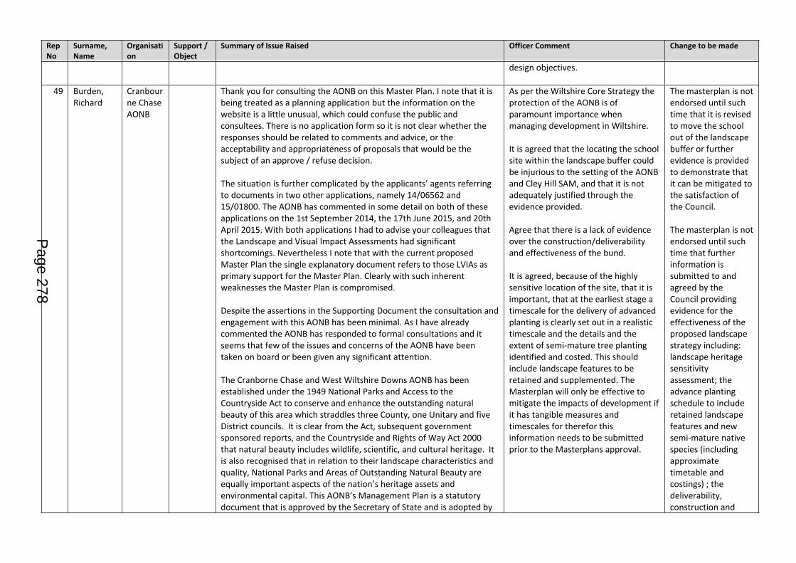
Rep No
Surname, Name
Organisation
Support / Object
Summary of Issue Raised Officer Comment Change to be made
design objectives.
49 Burden, Richard
Cranbourne Chase AONB
Thank you for consulting the AONB on this Master Plan. I note that it is being treated as a planning application but the information on the website is a little unusual, which could confuse the public and consultees. There is no application form so it is not clear whether the responses should be related to comments and advice, or the acceptability and appropriateness of proposals that would be the subject of an approve / refuse decision.
The situation is further complicated by the applicants’ agents referring to documents in two other applications, namely 14/06562 and 15/01800. The AONB has commented in some detail on both of these applications on the 1st September 2014, the 17th June 2015, and 20th April 2015. With both applications I had to advise your colleagues that the Landscape and Visual Impact Assessments had significant shortcomings. Nevertheless I note that with the current proposed Master Plan the single explanatory document refers to those LVIAs as primary support for the Master Plan. Clearly with such inherent weaknesses the Master Plan is compromised.
Despite the assertions in the Supporting Document the consultation and engagement with this AONB has been minimal. As I have already commented the AONB has responded to formal consultations and it seems that few of the issues and concerns of the AONB have been taken on board or been given any significant attention.
The Cranborne Chase and West Wiltshire Downs AONB has been established under the 1949 National Parks and Access to the Countryside Act to conserve and enhance the outstanding natural beauty of this area which straddles three County, one Unitary and five District councils. It is clear from the Act, subsequent government sponsored reports, and the Countryside and Rights of Way Act 2000 that natural beauty includes wildlife, scientific, and cultural heritage. It is also recognised that in relation to their landscape characteristics and quality, National Parks and Areas of Outstanding Natural Beauty are equally important aspects of the nation’s heritage assets and environmental capital. This AONB’s Management Plan is a statutory document that is approved by the Secretary of State and is adopted by
As per the Wiltshire Core Strategy the protection of the AONB is of paramount importance when managing development in Wiltshire.
It is agreed that the locating the school site within the landscape buffer could be injurious to the setting of the AONB and Cley Hill SAM, and that it is not adequately justified through the evidence provided.
Agree that there is a lack of evidence over the construction/deliverability and effectiveness of the bund.
It is agreed, because of the highly sensitive location of the site, that it is important, that at the earliest stage a timescale for the delivery of advanced planting is clearly set out in a realistic timescale and the details and the extent of semi-mature tree planting identified and costed. This should include landscape features to be retained and supplemented. The Masterplan will only be effective to mitigate the impacts of development if it has tangible measures and timescales for therefor this information needs to be submitted prior to the Masterplans approval.
The masterplan is not endorsed until such time that it is revised to move the school out of the landscape buffer or further evidence is provided to demonstrate that it can be mitigated to the satisfaction of the Council.
The masterplan is not endorsed until such time that further information is submitted to and agreed by the Council providing evidence for the effectiveness of the proposed landscape strategy including: landscape heritage sensitivity assessment; the advance planting schedule to include retained landscape features and new semi-mature native species (including approximate timetable and costings) ; the deliverability, construction and
Page 278
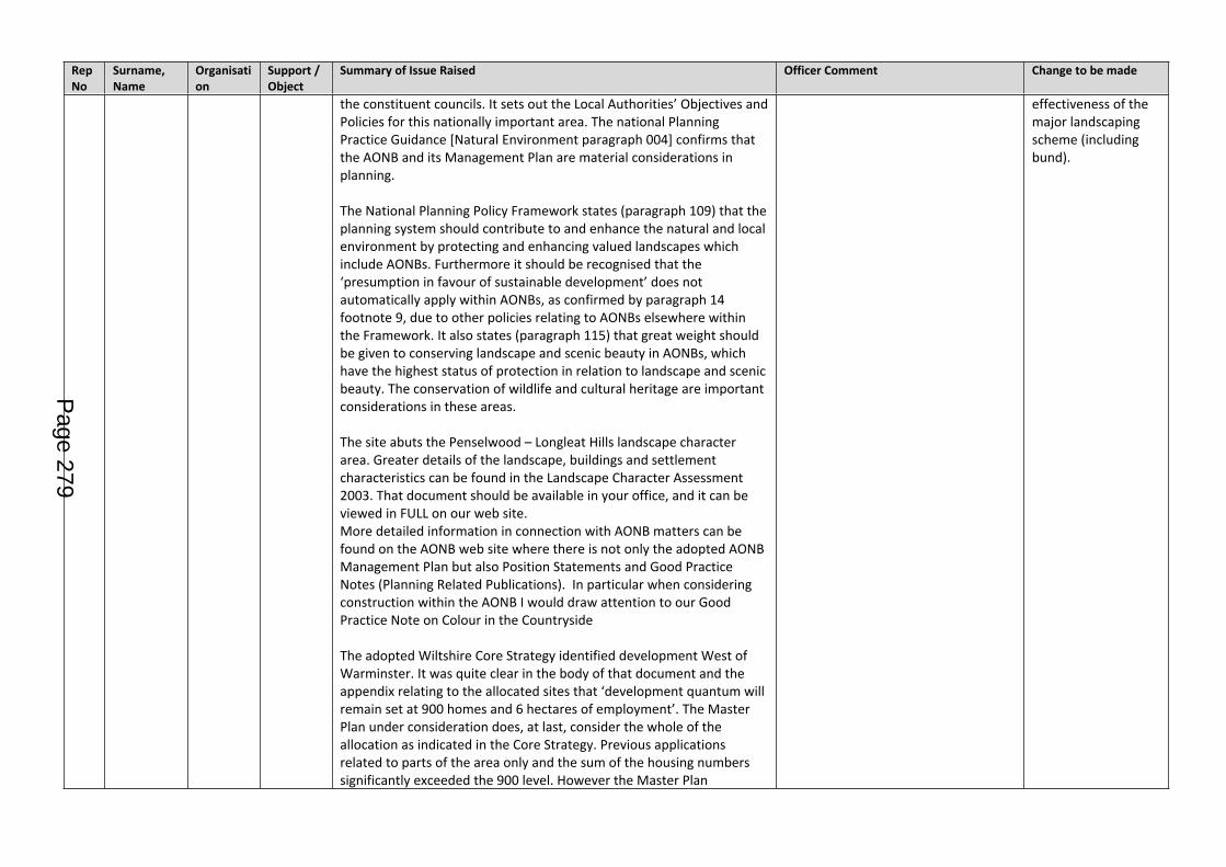
Rep No
Surname, Name
Organisation
Support / Object
Summary of Issue Raised Officer Comment Change to be made
the constituent councils. It sets out the Local Authorities’ Objectives and Policies for this nationally important area. The national Planning Practice Guidance [Natural Environment paragraph 004] confirms that the AONB and its Management Plan are material considerations in planning.
The National Planning Policy Framework states (paragraph 109) that the planning system should contribute to and enhance the natural and local environment by protecting and enhancing valued landscapes which include AONBs. Furthermore it should be recognised that the ‘presumption in favour of sustainable development’ does not automatically apply within AONBs, as confirmed by paragraph 14 footnote 9, due to other policies relating to AONBs elsewhere within the Framework. It also states (paragraph 115) that great weight should be given to conserving landscape and scenic beauty in AONBs, which have the highest status of protection in relation to landscape and scenic beauty. The conservation of wildlife and cultural heritage are important considerations in these areas.
The site abuts the Penselwood – Longleat Hills landscape character area. Greater details of the landscape, buildings and settlement characteristics can be found in the Landscape Character Assessment 2003. That document should be available in your office, and it can be viewed in FULL on our web site. More detailed information in connection with AONB matters can be found on the AONB web site where there is not only the adopted AONB Management Plan but also Position Statements and Good Practice Notes (Planning Related Publications). In particular when considering construction within the AONB I would draw attention to our Good Practice Note on Colour in the Countryside
The adopted Wiltshire Core Strategy identified development West of Warminster. It was quite clear in the body of that document and the appendix relating to the allocated sites that ‘development quantum will remain set at 900 homes and 6 hectares of employment’. The Master Plan under consideration does, at last, consider the whole of the allocation as indicated in the Core Strategy. Previous applications related to parts of the area only and the sum of the housing numbers significantly exceeded the 900 level. However the Master Plan
effectiveness of the major landscaping scheme (including bund).
Page 279
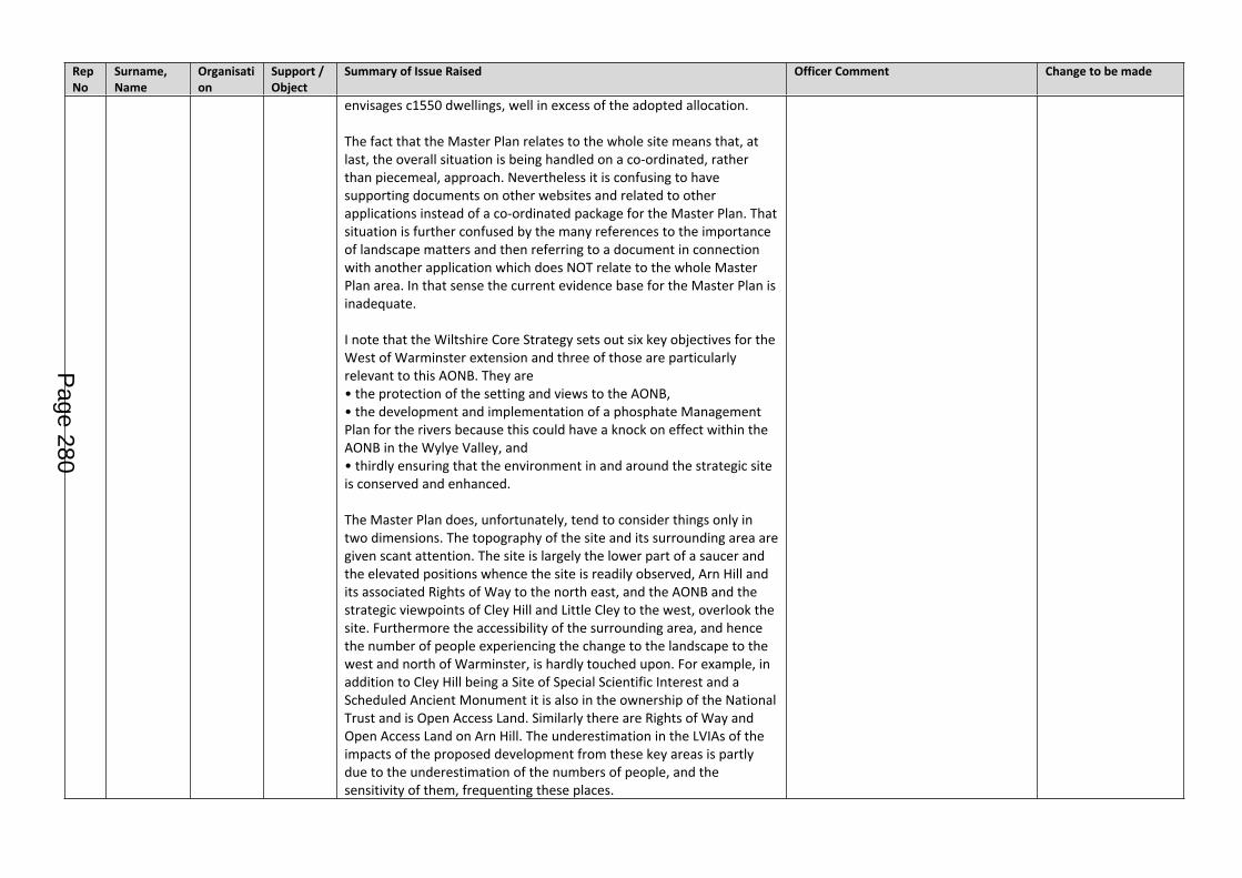
Rep No
Surname, Name
Organisation
Support / Object
Summary of Issue Raised Officer Comment Change to be made
envisages c1550 dwellings, well in excess of the adopted allocation.
The fact that the Master Plan relates to the whole site means that, at last, the overall situation is being handled on a co-ordinated, rather than piecemeal, approach. Nevertheless it is confusing to have supporting documents on other websites and related to other applications instead of a co-ordinated package for the Master Plan. That situation is further confused by the many references to the importance of landscape matters and then referring to a document in connection with another application which does NOT relate to the whole Master Plan area. In that sense the current evidence base for the Master Plan is inadequate.
I note that the Wiltshire Core Strategy sets out six key objectives for the West of Warminster extension and three of those are particularly relevant to this AONB. They are • the protection of the setting and views to the AONB, • the development and implementation of a phosphate Management Plan for the rivers because this could have a knock on effect within the AONB in the Wylye Valley, and • thirdly ensuring that the environment in and around the strategic site is conserved and enhanced.
The Master Plan does, unfortunately, tend to consider things only in two dimensions. The topography of the site and its surrounding area are given scant attention. The site is largely the lower part of a saucer and the elevated positions whence the site is readily observed, Arn Hill and its associated Rights of Way to the north east, and the AONB and the strategic viewpoints of Cley Hill and Little Cley to the west, overlook the site. Furthermore the accessibility of the surrounding area, and hence the number of people experiencing the change to the landscape to the west and north of Warminster, is hardly touched upon. For example, in addition to Cley Hill being a Site of Special Scientific Interest and a Scheduled Ancient Monument it is also in the ownership of the National Trust and is Open Access Land. Similarly there are Rights of Way and Open Access Land on Arn Hill. The underestimation in the LVIAs of the impacts of the proposed development from these key areas is partly due to the underestimation of the numbers of people, and the sensitivity of them, frequenting these places.
Page 280
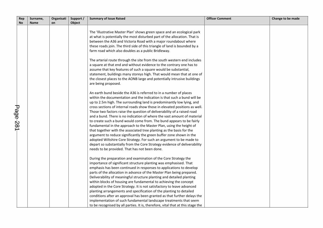
Rep No
Surname, Name
Organisation
Support / Object
Summary of Issue Raised Officer Comment Change to be made
The ‘Illustrative Master Plan’ shows green space and an ecological park at what is potentially the most disturbed part of the allocation. That is between the A36 and Victoria Road with a major roundabout where these roads join. The third side of this triangle of land is bounded by a farm road which also doubles as a public Bridleway.
The arterial route through the site from the south western end includes a square at that end and without evidence to the contrary one has to assume that key features of such a square would be substantial, statement, buildings many storeys high. That would mean that at one of the closest places to the AONB large and potentially intrusive buildings are being proposed.
An earth bund beside the A36 is referred to in a number of places within the documentation and the indication is that such a bund will be up to 2.5m high. The surrounding land is predominantly low lying, and cross sections of internal roads show those in elevated positions as well. Those two factors raise the question of deliverability of a raised road and a bund. There is no indication of where the vast amount of material to create such a bund would come from. The bund appears to be fairly fundamental in the approach to the Master Plan, using the height of that together with the associated tree planting as the basis for the argument to reduce significantly the green buffer zone shown in the adopted Wiltshire Core Strategy. For such an argument to be made to depart so substantially from the Core Strategy evidence of deliverability needs to be provided. That has not been done.
During the preparation and examination of the Core Strategy the importance of significant structure planting was emphasised. That emphasis has been continued in responses to applications to develop parts of the allocation in advance of the Master Plan being prepared. Deliverability of meaningful structure planting and detailed planting within blocks of housing are fundamental to achieving the concept adopted in the Core Strategy. It is not satisfactory to leave advanced planting arrangements and specification of the planting to detailed conditions after an approval has been granted as that further delays the implementation of such fundamental landscape treatments that seem to be recognised by all parties. It is, therefore, vital that at this stage the
Page 281
Rep No
Surname, Name
Organisation
Support / Object
Summary of Issue Raised Officer Comment Change to be made
timescale for the delivery of advanced planting is clearly set out in a realistic timescale and the details and the extent of semi-mature tree planting identified and costed. Furthermore, explicit details of the protection to be given to existing trees and hedgerows needs to be set out now so that the extent of additional landscape work and planting can be reliably identified and costed.
If advanced planting is to be successful then it does have to be truly carried out in advance, and that means a number of years rather than a few weeks. Clearly a strategy that reinforces, supplements, and enhances existing planting is more likely to achieve the greening and softening effects than planting a few standard trees in otherwise open ground. It is of considerable concern that reference is made to an arboricultural report and the removal of existing trees and hedges.
Whilst it is positive to see the importance of the landscape treatments being emphasised in the documentation it is also crucial that the implementation of the landscape proposals is critically assessed at the same time. Without detailed attention to the landscape planting and that planting being carried out at a density and with substantial plants that achieve the effect quickly the proposed development will be clearly visible in the views as a dramatic extension of the town across the breadth of key views for more than a decade.
The Landscape Strategy and Implementation Report appears to relate to another application but is referred to as a supporting document for the Master Plan. It is laudable in its aims and presentation but it is extremely weak on its scale and timing of its proposals. As I have already mentioned the lack of details at this stage, and the overt statement that details would only be prepared after a planning permission, means that the timescale for achieving houses on the ground does not relate to providing realistic advance planting to create the greening and screening everyone recognises is required. Furthermore, as was made clear in responses to the draft Core Strategy and other planning applications, significant specimens of large trees need to be planted so that they have a quick effect and, in the longer term, become feature trees.
I note that Historic England have responded to the consultation and I
Page 282
Rep No
Surname, Name
Organisation
Support / Object
Summary of Issue Raised Officer Comment Change to be made
agree that there does seem to be a lack of available and necessary evidence to support assertions that are being made. The issue of setting seems to have been largely overlooked in the supporting document in favour of extended arguments as to why the quantum of housing needs to be exceeded.
The Support Document for the Master Plan refers in paragraph 5.6 to Natural England having no objection to the development. However that letter relates to a Discretionary Advice Service (Charged Advice) response that GL Hearn had commissioned Natural England to carry out. The caveat within the letter is quite clear that ‘it does not constitute a statutory response or decision, which will be made, by Natural England acting corporately in its role as statutory consultee to the competent authority after an application has been submitted. The advice given is therefore not binding in any way and is provided without prejudice to the consideration of any statutory consultation response or decisions that may be made by Natural England in due course’. The statement in paragraph 5.6 of the Supporting Document is, therefore, inaccurate and inappropriate.
However, the formal letter from Natural England dated 11th March 2016 does not give confidence that the local team have a full understanding of the site and proposals when the letter refers to ‘the relationship between the WWUE and the North Wessex Downs AONB’. That letter does, however, indicate an educational use being relocated close to the A36 and to the west of the spine road through the development. That is potentially a very sensitive location, and as school buildings tend to be quite large that could be a significant intrusion in the view from Cley Hill. Furthermore that particular part of the site is on a slight rise and any buildings would be particularly obvious. The Natural England letter quite rightly points to the extent of housing aligned along the view line from Cley Hill that appears in the Master Plan on the land south of Victoria Road. Significant and substantial structure planting on a north south alignment would be needed to provide adequate screening and blurring of development south of Victoria Road.
This AONB has also considered the response from the National Trust. The assessment of recreational use of Cley Hill on both historic environment and ecological perspectives appear valid. The AONB
Page 283
Rep No
Surname, Name
Organisation
Support / Object
Summary of Issue Raised Officer Comment Change to be made
therefore agrees that further consideration should be given to countryside recreation and access to the countryside. In that context I note that there is a single safe access by public Right of Way which passes under the A36 in the south western corner of the site. That is a considerable distance from the vast majority of the proposed housing. Nevertheless there are two other public Rights of Way closer to the main housing on the north side of Victoria Road and these cross, with no protection whatsoever, the A36. It would be naïve to think that none of the occupants of 900 houses would try to use these crossings of what is a very busy road. There is scope to create a footbridge where the A36 is in a shallow cutting so that such a bridge would not be a significant visual intrusion into the scene. Such access to the wider countryside should be a fundamental element of the Master Plan for development at this allocated site.
Warminster Town Council’s response covers a wider range of issues than those that relate to this AONB. Nevertheless, this AONB notes the Council’s fundamental policy objections to the scale of development proposed in the Master Plan (points 1 and 13) and the concern about home owners removing hedges (point 9).
To conclude, the AONB Partnership is of the view that the Master Plan does not comply with the Wiltshire Core Strategy. I am also extremely concerned that the documentation provides no evidence to demonstrate that advance planting is deliverable, adequate, or sufficient. Safe access to the countryside is seriously deficient.
50 Richardson, Alan
Object To open up 2 cul de sacs on St Andrews Road is a non starter because the number of cars after completion using these and then into Thornhill Road or Broxburn Road will cause major traffic problems.In particular Thornhill Road which already has problems with cars double parking by the roundabout, cars parked on yellow lines, care parked part on the pavement and also parked on the roundabout itself.The access should be via Bugley Farm using the existing track from Victoria Road with a new roundabout at the entrance.The number of new properties will bring a large number of families to the Town. There will be children so have the schools sufficient availability. What about medical facilities as our two medical centres cannot cope now. At present you have to wait two weeks to see a
The Masterplan document on page 14 states a site has been allocated for a surgery within the local centre, in response to comments from the community, NHS and Smallbrook surgery. However, the masterplan does not clearly show or explain where the surgery would be located, if it is required.
The site will include a new school.
Masterplan to be amended to indicate where a Drs surgery could potentially be located, if there is a future need for one.
Page 284
Rep No
Surname, Name
Organisation
Support / Object
Summary of Issue Raised Officer Comment Change to be made
doctor, The two centres do not have the room to expand thus are unable to cope wit an influx of new patients.As a former Town Clerk I understand the need for housing but not just anywhere.What about the houses in the two entrances these will also certainly loose value so will there be compensation available.You are able to include conditions so is a school included, what a new medical centre similar to both Westbury and Melksham Spa.This development requires far more thought and exploring other alternatives.
Vehicular access to the site was subject to high level strategic assessment at the Core Strategy stage. This assessment has carried on in more detail during the masterplanning negotiations and will also will through the planning application strategy. Highways specialists do not consider there to be any barriers to effective, safe use of this access per se. All access will be designed to national standards and a CEMP (Construction Environmental Management Plan) to include routing of construction traffic, wheel washing, management of waste and hours of operation. This will correctly sit at the detailed planning application stage.
51 Sandy, Rachel
Highways England
No Objections
Thank you for consulting Highways England in respect of the Draft Masterplan for the West Warminster Urban Extension. Highways England have previously responded to planning applications reference 15/01800/OUT and 14/06562/FUL raising no in-principle objections. We understand that the Draft Masterplan is indicative of the way in which the wider site will be developed during the Plan period and have no objection to the proposed spatial arrangement of the various elements of the development.
It would be useful for Highways England to understand how the various development elements will be brought forward, particularly the likely phasing and programme of delivery. We look forward to receiving your thoughts on this matter.
I trust the above is clear but please do not hesitate to contact me should you wish to discuss further.
No objections in principle noted.
Agreed that a phasing programme is an essential part of subsequent planning applications.
n/a
52 Wordsworth, A
Object 900 new houses are planned to be built on the green fields between the Bath and Frome Roads in West Warminster.These have been imposed on our small market town by the previous government after their un-mandated and non democratic policy to introduce a huge increase in immigration.
Comment noted.
Agreed that a comprehensive approach to delivering critical physical and social infrastructure at the right
n/a
Page 285
Rep No
Surname, Name
Organisation
Support / Object
Summary of Issue Raised Officer Comment Change to be made
If these houses are built there will be a large impact on our pleasant and safe town. 2000 more people will be competing for resources.
There will be an increase of about 900 cars on the road increasing traffic congestion and parking problems.
There will be a longer wait to see our GP. I already have to wait one month for an appointment.
Where will these people work? There are not enough well paid jobs locally. The people will commute. The train services to Bath and Bristol are already under served.
Some think they will revitalise our High Street but there is no proof of this, being out of town the residents might just as well shop online adding more traffic and pollution and no economic value to Warminster. There will be more demand for water and sewerage and other utilities: fire, police, schools. There is danger of flooding. There will be traffic problems in both those main roads in to town.
Currently the Bath road is an attractive road leading in to Warminster giving a good impression of the town. This will be ruined by a bland estate.
The only winners will be the extra council tax the council will hope to raise. I don’t know if that will cover the extra costs this influx of people will incur.
The County Council are not listening to the majority of current residents of Warminster who don’t want any more houses built on green fields. Turning our well designed town into sprawling suburbs like Westbury and Trowbridge.
time. This is the reason the Core Strategy require a masterplanning process based on consultation with the local community and key stakeholders, to ensure these issues are identified and addresses satisfactorily. Key input has been made by highways, education, housing, landscape, drainage and ecological specialists.
Planning decisions will include conditions and legal agreements to ensure the vital infrastructure is secured in a timely manner.
53 Funnel,, Mark
National Trust
Thank you for the opportunity to comment on the draft masterplan for the whole West Warminster Urban Extension (WWUE) area. The National Trust owns the open access land at the top of Cley Hill, and
As per the Wiltshire Core Strategy the protection of the AONB, SSSI and SAM is of paramount importance when
The masterplan is not endorsed until such time that further
Page 286
Rep No
Surname, Name
Organisation
Support / Object
Summary of Issue Raised Officer Comment Change to be made
also the triangle of land that comprises the car park adjacent to the A362. The Trust has a statutory duty under the National Trust Acts to promote the conservation of places of historic interest and natural beauty. Quantum of development We have previously drawn attention to the fact that the Core Strategy sets the WWUE ‘development quanta’ at 900 houses and states that it does not provide for additional development. The draft masterplan proposes an additional 650 houses, and we are concerned that the 72% increase in housing numbers would have greater landscape, ecological and archaeological impacts than those envisaged in the Core Strategy. We would advocate the masterplan uses a figure much closer to that in the Core Strategy. Impacts on views from Cley Hill Despite assurances in the masterplan we continue to be concerned about the impacts of this major development proposal on the views from Cley Hill and also the setting of the Cranborne Chase AONB. The Core Strategy requires a ‘substantial landscape buffer’ yet the current plans show a reduced landscape buffer within a landscape framework. As per our comments on application ref. 15/01800/OUT, we would advocate a genuinely ‘substantial’ landscape buffer – including additional tree planting – to better screen views of the urban extension from Cley Hill and to provide wider landscape benefits.Increased recreational use of Cley Hill (ecological impacts) The potential ecological implications of the increased use of Cley Hill are of particular concern. Cley Hill is designated as an SSSI because of its botanically rich chalk grassland, and our Wildlife and Countryside Adviser (Simon Ford) comments that: • Cley Hill is already quite stressed by visitors with erosion scars and trampling of rare and endemic species such as early gentian and various orchids as well as marsh fritillary [a European Protected Species], chalkhill and Adonis blue butterfly. • Dog faeces will cause enrichment of the ground to the detriment of many species of calcareous grassland. • The fence [at the base of the hill] was installed to try and spread visitor load although people now climb it or go under it. • The Rangers have recently had to repair erosion scars with packed chalk on earthworks.
managing development in Wiltshire.
Agree that there is a lack of evidence over the construction/deliverability and effectiveness of the bund designed to soften impacts from Cley Hill and that because of the highly sensitive location of the site, that it is important, that at the earliest stage a timescale for the delivery of advanced planting is clearly set out in a realistic timescale and the details and the extent of semi-mature tree planting identified and costed. This should include landscape features to be retained and supplemented. The Masterplan will only be effective to mitigate the impacts of development if it has tangible measures and timescales for therefor this information needs to be submitted prior to the Masterplans approval. .Regarding increased impact caused by recreational use of Cley Hill, it is agreed that providing alternate local choice is an important factor in reducing potential impacts. The masterplan makes provision for significant recreational facilities and there are extant opportunities in Warminster and beyond, which should ensure a dispersal of recreational activities for new residents. It might be that the issue can also be addressed through management of the site and may be measures such as reduced car parking and/or rerouting of paths.
information is submitted to and agreed by the Council providing evidence for the effectiveness of the proposed landscape strategy including: landscape heritage sensitivity assessment; the advance planting schedule to include retained landscape features and new semi-mature native species (including approximate timetable and costings); the deliverability, construction and effectiveness of the major landscaping scheme (including bund).
Page 287
Rep No
Surname, Name
Organisation
Support / Object
Summary of Issue Raised Officer Comment Change to be made
The National Planning Policy Framework states that development likely to have an adverse impact on an SSSI “should not normally be permitted” (para. 118). It includes an exception test where the public benefits of the development “clearly outweigh” the impacts, and states that “opportunities to incorporate biodiversity in and around developments should be encouraged”. The Persimmon/Hannick outline application, for the bulk of the new dwellings, concludes that adverse impacts on Cley Hill SSSI would be caused, including trampling of vegetation and possible eutrophication issues relating to dog waste – and that the “topographical prominence” of Cley Hill means that it is likely to have a “relatively stronger ‘draw’” compared to the proposed on-site open space. Indeed, the draft masterplan housing would lead to a 20% increase in the population of Warminster*, and there is likely to be a proportionate increase in visitor footfall and recreational impacts on the hill. Anyone wanting a more satisfying dog walk or better views than the on-site open space provides would just need to go through the A36 underpass and follow the Mid Wilts Way up to Cley Hill, around 1km away. We would therefore advocate a further area of land – between the A36 and Cley Hill –being set aside for recreational purposes, to act as a ‘buffer area’ in advance of the hill itself. This land could be re-seeded with a chalk downland mix and this would benefit many species which are at present confined to the hilltop ‘island’. It is understood that one of the WWUE landowners owns land on the west side of the A36 as well. The creation of a permissive footpath linking the byway to the north of Cley Hill and the Mid Wilts Way to the south would also provide an alternative for walkers. There is already a desire line in place along a stretch of this route (from the end of Little Cley Hill to the byway). Being able to link the two routes would provide a circular route for dog walkers seeking to avoid livestock, which graze the open access land at Cley Hill.Measures such as these that improve biodiversity and access to the countryside would appear to be supported by the NPPF and the Council’s Leisure and Recreation DPD; although we appreciate that they would also require landowner co-operation. Finally, we would also ask that the Council considers the case for a financial contribution towards the management of Cley Hill, which could involve measures to combat erosion and trampling from increased
It is acknowledged that the site is within a walkable distance to Cley Hill SSSI and there is potential for recreational impacts. However, the masterplan proposes significant formal and informal open space, including children’s play areas, allotments, parkland, dog walking routes, nature trails, woodland and wetland park and it is considered that this together with the existing opportunities in the town and countryside will not mean a singular focus on Cley Hill. Therefore it is unreasonable under the NPPF and WCS to insist on more open space/opportunities or a financial contribution to the National Trust for the management of Cley Hill without firm evidence of the projected increase footfall and what damage this may actually cause in reality and over what timescale. This would need to be balanced against the recreational benefits it would afford new residents.
Page 288
Rep No
Surname, Name
Organisation
Support / Object
Summary of Issue Raised Officer Comment Change to be made
visitor access (including improvements to fencing), measures to support the grazing regime (including improved water supply to the hill), and scrub management. Increased recreational use of Cley Hill (historic environment) Cley Hill has been an iconic landscape feature for the local population since prehistoric times. The distinctive profile of the hill has been sculpted by archaeology. Cley Hill is therefore a key scheduled monument for Warminster of national significance with a range of archaeological features. These include the Iron Age hillfort enclosure that surround the summit and within this two Bronze Age burial mounds which give the hill its distinctive profile. The slopes of the hill are terraced with medieval strip lynchets and there are the grassed-over disused remains of a large 19th century quarry and lime kiln. The importance of Cley Hill within its archaeological setting has been demonstrated by the finds of Roman and Saxon remains in the fields between Cley Hill and Warminster suggesting extensive occupation remains under the ploughsoil. Most important of these discoveries is the rare 9th century decorated Saxon pointer, thought to have been commissioned by King Alfred and now on display in Salisbury Museum. It demonstrates the importance of Cley Hill in relation to the early development of Warminster as a Saxon minster town. Increased recreational use and visitor footfall across Cley Hill, particularly over the steep slopes would increase erosion scars across the scheduled earthworks – and irreversible damage to the stratified buried archaeology unless additional management time for repair is funded. Therefore, broadening the recreational land use surrounding the hill and developing permissive paths would also be a positive influence for the archaeology and historic environment of Cley Hill. It would alleviate the additional impact on the hill and allow residents and visitors to explore the wider landscape of which the hill is part, rather than concentrate footfall on the vulnerable slopes of the scheduled monument. Conclusion We are concerned that the draft WWUE masterplan proposes a significantly greater number of houses than the figure set in the adopted Core Strategy, whilst containing less mitigation of landscape and visual impacts and having greater potential impacts on ecological and archaeological interests. We do not consider that the urban extension, as currently conceived, accords with the objectives
Page 289
Rep No
Surname, Name
Organisation
Support / Object
Summary of Issue Raised Officer Comment Change to be made
established in the Core Strategy, nor with the relevant development template. However, there may be scope to improve the masterplan and the development scheme as per our suggestions in this letter.
54 Kelly, David
Object If you are going to go ahead with 900 new properties in the west of Warminster, can I please state the need for more parking spaces. On the estate that has been built most recently, the roads are to small and there is no-where to park when I visit my many friends. Also it would be sensible to install solar panels on these houses. Hope this email will not be ignored.
Agreed and new homes will all be planned to meet parking standards.
55 Kjaer,
Steven and Alison
Object Please find below comments on the draft plan which I would be grateful for your consideration. I would be very happy to clarify any of the content if so required.
Overall an improved plan with more detail and items of concern beginning to be addressed. Hopefully we have the bones of a masterplan which can be amended to reflect a fairer and more community leaning view.
Generally the document is very unclear HOW the responsibilities, mitigations etc. promised by the master plan will be shared/owned by the developers and under what legal basis any agreed master plan will be ENFORCED and who in council planning has the responsibility to ensure that the promises made by the developers are delivered IN AGREED TIME PHASES.
See below for some specific concerns, especially around required infrastructure and mitigation.
1.5 "Landscape-led" sounds like hogwash - what will it mean in principle and how will it be enforced by planning!
1.12 Who has the responsibility (developers and council) to ensure that any agreed high level masterplan is enforced?
2.3 At what POINT IN TIME is the infrastructure built/finished? A common complaint is that developers shirk this responsibility until forced because it is non-profit generating. How does the masterplan ENFORCE any of this? E.g. x homes built = new surgery, school etc.
The Council as Local Planning Authority has the responsibility under the planning acts to add conditions to planning permissions and require legally binding agreements (section 106), to ensure that undertakings made through the planning process are effectively carried through and implemented. Major developments are monitored as they proceed.
As per the Wiltshire Core Strategy the protection of the AONB, SSSI and SAM is of paramount importance when managing development in Wiltshire.
Agree that there is a lack of evidence over the construction/deliverability and effectiveness of the bund designed to soften impacts from Cley Hill and that because of the highly sensitive location of the site, that it is important, that at the earliest stage a timescale for the delivery of advanced planting is clearly set out in a realistic timescale and the details and the extent of semi-mature tree planting identified and costed. This should include landscape features to be retained and supplemented. The
The masterplan is not endorsed until such time that further information is submitted to and agreed by the Council providing evidence for the effectiveness of the proposed landscape strategy including: landscape heritage sensitivity assessment; the advance planting schedule to include retained landscape features and new semi-mature native species (including approximate timetable and costings) ; the deliverability, construction and effectiveness of the major landscaping scheme (including bund).
Page 290
Rep No
Surname, Name
Organisation
Support / Object
Summary of Issue Raised Officer Comment Change to be made
2.5 When do the homes above the 900 agreed with our MP get built?
2.6 Does "critical mass" mean that the developers decide when they have sold enough houses to invest in infrastructure?
3.2 % suggests 189 properties south of Victoria Road - please confirm.
Constraints (Page 10):
Landscape/Visual Impacts: The majority of land south of VR is BMV - this suggests that we would better focus development to the North and preserve this land for the 0.5 ha etc of allotments? Brilliant opportunity!
Transport: Already a major issue for residents who use Victoria Road and West street. Requires an urgent, updated, INDEPENDENT and appropriately timed (for commuter and school traffic) survey!!
Flood Risk/Drainage: Flood risks need to be revisited. Environment Agency and Developers need to meet, plan and agree mitigations (funded by developers).
Ecology: "Mitigation will be necessary" - what measures, by whom and how enforced?
Noise: Which is why we have a green belt. If we continually erode this we lose habitat, species and increase noise. Simple.
Social Infrastructure: At what point will additional schools and healthcare be made available - how is the capacity to be agreed?
3.12 - How are surface water run-off rates to be policed/enforced?
3.14 Strong objection. This does not constitute a rigorous, independent traffic survey. One need only refer to the bias already shown in Redrow's estimates on motor cars per household to see the dangers of anything other than an INDEPENDENT survey.
4.2 "comprehensive framework of mitigation measures" - an impressive description. Where is it? Who agrees it? And how is it enforced?
Masterplan will only be effective to mitigate the impacts of development if it has tangible measures and timescales for therefor this information needs to be submitted prior to the Masterplans approval. .
Agreed that a comprehensive approach to delivering critical physical and social infrastructure at the right time. This is the reason the Core Strategy require a masterplanning process based on consultation with the local community and key stakeholders, to ensure these issues are identified and addresses satisfactorily. Key input has been made by highways, education, housing, landscape, drainage and ecological specialists.
Planning decisions will include conditions and legal agreements to ensure the vital infrastructure and mitigatory measures are secured in a timely manner together with a legally binding a maintenance process.
As per the Core Strategy the development will deliver no more than 900 homes up to the year 2026.
At this time 203 dwelling are proposed to the south of Victoria Road.
There is significant formal and informal open space shown on the masterplan, including children’s play areas, allotments, parkland, dog walking routes, nature trails, woodland and
Page 291
Rep No
Surname, Name
Organisation
Support / Object
Summary of Issue Raised Officer Comment Change to be made
Landscaping and Open Space (p.18)- NO! This is too far from the WWUE site. Green space and rec needs to be properly accommodated within the site. Are we encouraging people to drive across
town to Kingdown Sports Centre which already cannot provide enough parking spaces and has limited space for development.
v) Recognises the fact that the town centre is well removed from the site and is, again, encouraging motor traffic. Hardly green.
4.25 Disagree. There is NO independent evidence to suggest that the infrastructure can accommodate 900 homes, let alone higher figures. Conjecture!
5.7 As above. Strong disagreement. Existing surveys were done with specific aims in mind. They are out of date, biased and inaccurate.
5.7 (IV) and (V) Unsubstantiated mitigations. There is ALREADY (without any development) unacceptable levels of delay on the existing road network. When would all the mitigations be in place? A timeline is required here.
wetland park. It is considered that this provides generous and diverse recreational opportunities within the site.
In accordance with Policy 61 of the Core Strategy subsequent applications will require detailed transport assessments demonstrating how consideration has been given to providing sustainable transport opportunities for visually and mobility impaired pedestrians, cyclists, public transport, goods vehicles, and private motor vehicles.
56 Yeates, Dan
Savills on behalf of Hallam
No objection to prinicple
These Representations are submitted by Savills on behalf of Hallam Land Management (HLM) in response to the consultation on the West Warminster Urban Extension Allocation Masterplan submitted to Wiltshire Council by Persimmon Homes, Hannick Homes and Developments, and Redrow Homes.HLM do not object to the principle of the western urban extension but these Representations address the scale of development proposed within the Draft Masterplan, the evidence provided to justify an increase from the adopted Core Strategy allocation allowance, and the impacts on delivery timescales which are likely to result.Overall, we do not support the approach proposed in the Masterplan which directs all growth to the west of the town in a single urban extension. It is our view that a more balanced response is needed to the growth of Warminster. There are a number of reasons for this which are explored within these representations.In summary, we object to the scale of development in the Masterplan
It’s important to emphasise the reasons behind the dwelling figure proposed in the Wiltshire Core Strategy. The strategic site covers the whole area between the built up area and the A36. The 900 dwellings set in the Core Strategy is deliberately much lower than the site area suggests because the plan recognises that there needs to be an extensive amount of landscaping to prevent harming the setting to Cley Hill fort ancient monument and the Area of Outstanding Natural Beauty directly on the other side of the A36. A low figure also allows for a considerable amount
n/a
Page 292
Rep No
Surname, Name
Organisation
Support / Object
Summary of Issue Raised Officer Comment Change to be made
for the following reasons:1) Inconsistency with the adopted allocation in the Core Strategy (Core Policy 31), and the draft Neighbourhood Plan.2) Technical evidence fails to demonstrate that an increase in the scale of development is acceptable, particularly the proposed significant reduction in the landscape buffer which was established and then independently tested through the Core Strategy.3) Scale of development proposed is in excess of the number of dwellings currently being determined as part of two planning applications on the site, for which there is a high degree of uncertainty given the significant concerns and objections raised.4) Relying on a single urban extension to deliver the majority of the need for Warminster will have risks to the delivery of housing to meet the needs of the town. In particular, an increase in the scale of development over and above that outlined in the adopted allocation has the potential to stall the development of the site for a prolonged period of time.5) The proposals outlined within the Draft Masterplan do not recognise that there might be a preferable alternative to an increased strategic allocation. Alternative sites must be assessed to establish whether alternative, more balanced, sustainable, development opportunities are available which could make a positive contribution to meeting housing needs for Warminster in the timescales envisaged within the adopted Core Strategy.
of space for flood mitigation work in addition to the flood risk areas within the site that will be left completely undeveloped.
A low figure was set in the Core Strategy which specifically says the area ‘does not provide for additional development and the development quanta will remain set at 900 homes and 6 ha employment’. By law planning applications must be ‘determined in accordance with the development unless material considerations indicate otherwise’. The onus is therefore entirely on a developer to demonstrate why any development should exceed the scale set down.
Since the strategic site was proposed developers have carried out a considerable amount of detailed work looking at how to deal with flood risks and landscape impact. They are suggesting that their more detailed work demonstrates that landscape and flood risk issues can be treated properly while allowing a greater scale of development. The responsible bodies, the Environment Agency and Natural England do not appear to be rejecting the principles of the developer’s approach and so some higher scale of development has to be contemplated. It may not. In any event the Council would be unreasonable to reject a scheme simply because it proposed more than
Page 293
Rep No
Surname, Name
Organisation
Support / Object
Summary of Issue Raised Officer Comment Change to be made
900 dwellings.
This is an indicative masterplan and any subsequent planning applications will need to be determined on its own merits and the law requires it to accord with policy unless the developers can demonstrate why other factors should be considered in allowing development as an exception to policy.
57 Cheese, Kayleigh
Natural England
Thank you for your consultation on the above dated and received by Natural England on 18 February 2016. Natural England is a non-departmental public body. Our statutory purpose is to ensure that the natural environment is conserved, enhanced, and managed for the benefit of present and future generations, thereby contributing to sustainable development. The Wildlife and Countryside Act 1981 (as amended) The Conservation of Habitats and Species Regulations 2010 (as amended) The National Park and Access to the Countryside Act 1949 Landscape Natural England welcomes the updated Masterplan for WWUE, which provides a firm basis for considering the relationship between the WWUE and the North Wessex Downs AONB. The Allocation Masterplan document also refers to the Landscape Strategy and Implementation Plan for parts of the allocation north of Victoria Road, which Natural England had sight of in October 2015, though it does not appear to be on the Council’s website for this application. Higher numbers of dwellings than the original allocation will mean higher densities and make landscape mitigation more difficult. We can only rely on landscape mitigation within the green areas of the Masterplan, in public spaces with site management. It is important there are not assumptions that tree planting across the whole site will assist with filtering views and landscaping, as those in private gardens may not be retained. Land north of Victoria Road Together, the revised Masterplan and the LSIP provide greater
As per the Wiltshire Core Strategy the protection of the AONB and SSSI is of paramount importance when managing development in Wiltshire.
It is agreed that the locating the school site within the landscape buffer could be injurious to the setting of the AONB and Cley Hill SAM, and that it is not adequately justified through the evidence provided.
It is agreed, because of the highly sensitive location of the site, that it is important, that at the earliest stage a timescale for the delivery of advanced planting is clearly set out in a realistic timescale and the details and the extent of semi-mature tree planting identified and costed. This should include landscape features to be retained and supplemented. The Masterplan will only be effective to mitigate the impacts of development if it has tangible measures and timescales for therefor this information needs to be submitted
The masterplan is not endorsed until such time that it is revised to move the school out of the landscape buffer or further evidence is provided demonstrated that it can be mitigated to the satisfaction of the Council
The masterplan is not endorsed until such time that further information is submitted to and agreed by the Council providing evidence for the effectiveness of the proposed landscape strategy including: landscape heritage sensitivity assessment; the advance planting
Page 294
Rep No
Surname, Name
Organisation
Support / Object
Summary of Issue Raised Officer Comment Change to be made
confidence that our previous concerns regarding landscape and visual impacts associated with the AONB can be addressed, particularly for the bulk of the allocation, north of Victoria Road. We support the principles and further detail set out for design and mitigation. Most importantly, measures pertaining to advance planting of trees in the most visually sensitive locations and the effort to break-up the views towards blocks of built development by use of green ‘fingers’ along northwest-southeast boundaries within the site will filter views from the AONB. Having said that, the Masterplan now shows the school as being relocated from the east of the main street to the west, thereby introducing built development into an area which was previously shown as sports pitches and effectively part of the green buffer running along the western edge of the site. The effect this would have, particularly on views from Cley Hill is unclear. We understand an updated Landscape Strategy and Implementation Plan is being produced, however, to date we have not yet received this. We would be happy to review this additional information, which should show an assessment of effects and mitigation options required, from the amendments to the plan. Land to the south of Victoria Road We note that the Masterplan for the part of the WWUE south of Victoria Road remains largely unchanged and the density of housing remains higher compared to the rest of the allocation area. Whilst the views from Cley Hill and the AONB may be less sensitive to development in this part of the allocation, views would still be affected and there is scope to minimise those effects. We suggest additional green corridors or ‘fingers’ (as used north of Victoria Road) running North to South adjacent to the East side of the rugby club up to the main street and from the roundabout at Victoria Street to the north west corner of the rugby club. River Avon SAC We note paragraph 5.36 refers to phosphate levels in the River Wylye which leads to the River Avon SAC. Additional development (over 900 dwellings) should plan to provide mitigation so as not to increase phosphorus concentrations in the River Wylye/River Avon SAC, on a timetable subject to the findings of further work on what improved standard of phosphorus removal is technically possible at Warminster STW and what reductions are likely from other sources of phosphorus to the river. Development of the remaining land south of Victoria Road, not subject to a current planning application, will be subject to
prior to the Masterplans approval. . schedule to include retained landscape features and new semi-mature native species (including approximate timetable and costings) ; the deliverability, construction and effectiveness of the major landscaping scheme (including bund). .
Page 295
Rep No
Surname, Name
Organisation
Support / Object
Summary of Issue Raised Officer Comment Change to be made
screening under the Habitats Regulations which may also result in the need for additional mitigation. Cley Hill SSSI Whilst we did not acknowledge a major risk to the SSSI at the plan stage or in previous advice on planning refs: 15/01800/OUT and 14/06562/FUL, there are existing issues with recreational impacts on Cley Hill. Without mitigation, and taking account of the rising number of homes to be delivered through WWUE, recreational pressure would inevitably increase. We note the response made by the National Trust and support measures that would help avoid and mitigate impacts. We would be happy to comment further should the need arise but if in the meantime you have any queries please do not hesitate to contact us. For any queries relating to the specific advice in this letter only please contact Kayleigh Cheese on 02080 260981. For any new consultations, or to provide further information on this consultation please send your correspondences to [email protected]. We really value your feedback to help us improve the service we offer. We have attached a feedback form to this letter and welcome any comments you might have about our service.
58 Fry, Leslie Object Some form of planning permission, which is most likely, should consider the area as 'one' and not separate as the development propose for 203 homes off St Andrews Road would create. Access off St Andrews Road is only via a five bar gate this is utterly crazy and beyond belief.
The whole complex would be a commuter settlement with little connectivity with existing Warminster - further access to the town in an easterly direction is presently a nightmare with constant weaving in and out of parked cars plus the bad junction by the Obelisk.
Will the adjoining stretch of the A36 be able to cope with much more traffic generated by the proposed massive development.
Mindful that 16 sites have been identified within Wiltshire then a sensible 'balance' of numbers of homes could be more evenly achieved. The proposed Local Centre MUST provide a medical complex (surgery).
The 'open view' from the renowned Cley Hill would be spoilt when looking west to east towards Warminster.
Vehicular access to the site was subject to high level strategic assessment at the Core Strategy stage. This assessment has carried on in more detail during the masterplanning negotiations and will also will through the planning application strategy. Highways specialists do not consider there to be any barriers to effective, safe use of this access per se. All access will be designed to national standards
Agreed that a comprehensive approach to delivering critical physical and social infrastructure at the right time. This is the reason the Core Strategy require a masterplanning process based on consultation with the
The masterplan is not endorsed until such time that further information is submitted to and agreed by the Council providing evidence for the effectiveness of the proposed landscape strategy including: landscape heritage sensitivity assessment; the advance planting schedule to include retained landscape features and new semi-mature native
Page 296
Rep No
Surname, Name
Organisation
Support / Object
Summary of Issue Raised Officer Comment Change to be made
On Friday afternoon (11th March) I rang Spatial Planning to verify the access off Victoria Road only to be told the three people involved in the consultation were not in the office - not at work I assume??
Thank you for the opportunity of partaking in the consultation.
local community and key stakeholders, to ensure these issues are identified and addresses satisfactorily. Key input has been made by highways, education, housing, landscape, drainage and ecological specialists.
Planning decisions will include conditions and legal agreements to ensure the vital infrastructure is secured in a timely manner.
The Masterplan document on page 14 states a site has been allocated for a surgery within the local centre, in response to comments from the community, NHS and Smallbrook surgery. However, the masterplan down not clearly show or explain where this would be delivered.
As per the Wiltshire Core Strategy the protection of the AONB and SSSI is of paramount importance when managing development in Wiltshire.
It is agreed, because of the highly sensitive location of the site, that it is important, that at the earliest stage a timescale for the delivery of advanced planting is clearly set out in a realistic timescale and the details and the extent of semi-mature tree planting identified and costed. This should include landscape features to be retained and supplemented. The Masterplan will only be effective to mitigate the impacts of development if it has tangible measures and
species (including approximate timetable and costings) ; the deliverability, construction and effectiveness of the major landscaping scheme (including bund).
Masterplan to be amended to indicate where a Drs surgery could potentially be located, if there is a future need for one.P
age 297
Rep No
Surname, Name
Organisation
Support / Object
Summary of Issue Raised Officer Comment Change to be made
timescales for therefor this information needs to be submitted prior to the Masterplans approval.
59 Chick, Roger
Comments
1. GENERALThe Wiltshire Core Strategy states that only 900 houses can be built on the West Warminster Urban Extension. This limit must be enforced. It is understood that developers wish to build 1,500 houses. This must not be allowed to happen – it would devastate Warminster (traffic congestion, town centre parking, GP facilities, etc. Even the proposed 900 houses will have a major and unwelcome impact on Warminster.
2. ROADS, TRAFFIC, CAR PARKINGOccupants of most of the houses in the proposed development are likely to have at least one car, and increasingly 2 or 3. Even taking a conservative average of only 1.5 cars per house for the proposed 900 new houses would indicate that 1,350 additional cars could sometimes be on the roads of Warminster, possibly significantly more with increasing 2-3 car ownership. This would inevitably result in a massive increase in Warminster town centre traffic resulting in the congestion in the town centre becoming much worse, particularly at peak times.
The very large increase in cars travelling to and from the town centre would also impact many existing roads. Traffic to/from the town centre via the 2 southern access points on the proposed development ‘spine road’ will result in congestion in several roads and routes: St Andrews Road, Broxburn Road and/or Thornhill Road, Brook St and Fore St (using Weymouth St to reach the town centre) or via Pound Street and Vicarage Street (using Silver St to reach the Town centre); or via Victoria Road, West Street, Vicarage Street then via Silver St. Several of these roads already suffer congestion from through traffic, particularly in roads where cars are parked on both sides of the road (e.g. West Street, Pound Street) or are very narrow (Vicarage Street).
To cope with the major increase in cars travelling to and from the town centre for shopping etc, a significant increase in town centre parking provision will be needed. Where would the additional car parking space be found? A solution would need to be underway during the early phases, not delayed until development completion. It is essential that a
Meeting the objectively assessed housing needs of Wiltshire is a national policy requirement and the growth needed identified through Strategic Housing Market Assessment and Core Strategy Examination process. Providing a decent affordable home for all is a key priority of the Core Strategy, which also sets out a policy framework for protecting the most sensitive parts of the countryside.
It’s important to emphasise the reasons behind the dwelling figure proposed in the Wiltshire Core Strategy. The strategic site covers the whole area between the built up area and the A36. The 900 dwellings set in the Core Strategy is deliberately much lower than the site area suggests because the plan recognises that there needs to be an extensive amount of landscaping to prevent harming the setting to Cley Hill fort ancient monument and the Area of Outstanding Natural Beauty directly on the other side of the A36. A low figure also allows for a considerable amount of space for flood mitigation work in addition to the flood risk areas within the site that will be left completely undeveloped. A low figure was set in the Core Strategy which specifically says the area ‘does not provide for additional development and the
Masterplan to be amended to indicate where a Drs surgery could potentially be located, if there is a future need for one.
Page 298
Rep No
Surname, Name
Organisation
Support / Object
Summary of Issue Raised Officer Comment Change to be made
viable, costed & funded solution system is in place BEFORE development proceeds.
3. LOCAL SHOPSFor the convenience of residents in the new development, to minimise traffic to and from the town centre for shopping, and to reduce the additional car parking requirement in the Town Centre, a local neighbour shopping area that includes a small supermarket and adequate car parking.
4. GP FACILITIES, ETCThe two existing GP surgeries in the town centre are already running at capacity. Warminster needs an additional GP surgery and it would make sense for a new surgery to be incorporated in the development plan.
5. EDUCATIONExisting Warminster Primary schools are full. Therefore need to include at least one new Primary school in the first phase of the development. Kingdown Secondary school is at capacity. Another Secondary school is needed in Warminster and it would make sense to include it within the development.
6. LEISURE FACILITIES & OPEN SPACESProvision of suitable and adequate leisure facilities is essential - Local Play areas, a local park with swings etc. Consideration could be given to incorporating a new swimming pool and Leisure Centre in the development; the existing pool is inadequate in size and facilities for a town the size of Warminster.
7. PUBLIC RIGHTS OF WAYThe development area is crossed by many rights of way. The existing paths are well used. The aim should be to retain existing Rights of Way, to augment them where possible to improve the rights of way network, and also to incorporate cycle routes. Warminster has its own popular walking group (Warminster Walkers) and other walking groups often offer walks in the Warminster area.
8. BALANCING PONDSA large number of balancing ponds are included in the MasterPlan as a
development quanta will remain set at 900 homes and 6 ha employment’. By law planning applications must be ‘determined in accordance with the development unless material considerations indicate otherwise’. The onus is therefore entirely on a developer to demonstrate why any development should exceed the scale set down.
Since the strategic site was proposed developers have carried out a considerable amount of detailed work looking at how to deal with flood risks and landscape impact. They are suggesting that their more detailed work demonstrates that landscape and flood risk issues can be treated properly while allowing a greater scale of development. The responsible bodies, the Environment Agency and Natural England do not appear to be rejecting the principles of the developer’s approach and so some higher scale of development has to be contemplated. In the context of the ‘at least’ figure of 42,000 homes to be delivered across Wiltshire by the Core Strategy, it would be unreasonable to reject a scheme simply because it proposed more than 900 dwellings.
This is an indicative masterplan and any subsequent planning applications will need to be determined on its own merits and the law requires it to accord with policy unless the developers can demonstrate why
Page 299
Rep No
Surname, Name
Organisation
Support / Object
Summary of Issue Raised Officer Comment Change to be made
flood. Hopefully this will ensure no flooding takes place in the new development. Unfortunately dumping has occurred at the existing balancing pond in Swaledale Road. Perhaps it will be possible to incorporate some avoidance measures in this development.
other factors should be considered in allowing development as an exception to policy.
In accordance with Policy 61 of the Core Strategy subsequent applications will require detailed transport assessments demonstrating how consideration has been given to providing sustainable transport opportunities for visually and mobility impaired, pedestrians, cyclists, public transport, goods vehicles, and private motor vehicles.
The masterplan includes a mixed use local centre of some 1.3ha, which will include retail facilities for the new residents.
The masterplan makes provision for both a new school and doctors surgery, albeit the latter is not shown or clearly explained in the masterplan.
There is significant formal and informal open space shown on the masterplan, including children’s play areas, allotments, parkland, dog walking routes, nature trails, woodland and wetland park. It is considered that this provides generous and diverse recreational opportunities within the site.
Detailed landscape plans required to accompany subsequent planning applications will be required to show retention and enhancement of public
Page 300
Rep No
Surname, Name
Organisation
Support / Object
Summary of Issue Raised Officer Comment Change to be made
access.
Any planning permission will be subject to conditions and legal agreements requiring the construction of and future maintenance of balancing ponds.
60 Stuart, David
Historic England
WEST WARMINSTER URBAN EXTENSION: DRAFT MASTERPLAN CONSULTATION
Thank you for your consultation on the latest draft of the masterplan for the West Warminster Urban Extension.
We responded to your authority’s last consultation on this emerging document in our letter dated 13th November 2015 (our ref 2341). In this we made comments which can effectively be summarised as follows:
• That there was an absence of available and necessary evidence to demonstrate that the masterplan as then promoted could be delivered without causing unacceptable and unjustified levels of harm to heritage assets;• While the allocation of buffer areas to protect the settings and views of specified heritage assets were welcome in principle any evidence needed to demonstrate that these were appropriate provisions;• We had no objection in principle to the site delivering more development than specified in the Core Strategy provided evidence could demonstrate that this could be accommodated without causing harm to heritage assets.
The latest version of the masterplan provides no additional evidence within itself nor are supporting documents part of this consultation it but asserts that documents submitted in support of applications 14/06562/FUL and 15/01800/OUT satisfy the relevant policy statutory requirements of the National Planning Policy Framework (NPPF) and the Core Strategy and relevant site related heritage considerations.
The latest masterplan differs from our previous consultation primarily in that it now provides a larger area of buffer space at the western end of
As per the Wiltshire Core Strategy the protection of the AONB, SAM and heritage assets is of paramount importance when managing development in Wiltshire.
It is agreed, because of the highly sensitive location of the site, that it is important, that at the earliest stage a timescale for the delivery of advanced planting is clearly set out in a realistic timescale and the details and the extent of semi-mature tree planting identified and costed. This should include landscape features to be retained and supplemented. The Masterplan will only be effective to mitigate the impacts of development if it has tangible measures and timescales for therefor this information needs to be submitted prior to the Masterplans approval.
The masterplan is not endorsed until such time that further information is submitted to and agreed by the Council providing evidence for the effectiveness of the proposed landscape strategy including: landscape heritage sensitivity assessment; the advance planting schedule to include retained landscape features and new semi-mature native species (including approximate timetable and costings) ; the deliverability, construction and effectiveness of the major landscaping scheme (including bund).
Page 301
Rep No
Surname, Name
Organisation
Support / Object
Summary of Issue Raised Officer Comment Change to be made
the site between the proposed main street and the A36. While what might be seen as an enhanced provision is welcome – as is the buffer space associated with Bugley Barton Farmhouse - it is still not clear how this allocation is an informed response to the significance, particularly the setting, of relevant heritage assets such as Cley Hill. Heritage reports prepared in support of the two aforementioned planning applications do not define the setting of the monument in sufficient detail to allow precise and necessary buffer characteristics to be determined. While the masterplan may highlight the need for individual applications to address this need for further evidence it would be premature to concede at this time more development than the Core Strategy allows without knowing that it can be satisfactorily accommodated without constricting the amount, location and form of space and its treatment which the appropriate protection of designated heritage assets might require.
For example, much attention is given in the supporting heritage reports to visual impact and these and the masterplan indicate that planting, bunds and boundary treatments can minimise the impacts on views to and from Cley Hill. However, it is reasonable to conclude that these must inevitably foreshorten views between the monument and the town and reduce the asset’s association with a wider landscape in this quarter, quite apart from potentially introducing alien landscape features within its setting.
In conclusion we regrettably do not believe that this latest version of the masterplan addresses those points made in our previous letter. This is a disappointing position to have to promote and we would therefore continue to encourage your authority to seek further improvements to satisfy the policy provisions of the NPPF and Core Strategy.
61 Beaver, Chris
Planning Sphere
The background to the promotion of Bore Hill Farm is summarised in our letter to the Council dated 30th March 2015 (attached). Subsequent to this please note the following updates:1. The site owners are in advanced discussions with Smallbrook
Surgery in Warminster about a potential relocation to Bore Hill Farm. The surgery has received confirmation of funding from the NHS, and further work in relation to the drawdown of this funding and matters relating to project procurement are currently in progress. It is likely that a planning application proposal for a new
It is agreed that the Masterplan should have been developed earlier in the process to guide development most effectively. Nevertheless it is a requirement of the Core Strategy that a masterplan is to be produced. It is the role of the Council to determine it upon its own merits to assess whether it represents an effective and
n/a
Page 302
Rep No
Surname, Name
Organisation
Support / Object
Summary of Issue Raised Officer Comment Change to be made
GP surgery will be progressed later this year as a standalone planning application.
2. The Phase 2 employment site, which has the benefit of an extant planning permission, has now been levelled and prepared for development. A revised outline planning application for the Phase 2 employment site will be progressed later this year.
3. The balance of the site, circa 3ha of greenfield land, including adjoining third party land at Bradley Road, continues to be promoted through the Wiltshire Housing Site Allocation DPD process. A recent masterplanning exercise has confirmed that the potential residential site has capacity to accommodate up to c. 90 dwellings plus onsite public open space and a GP surgery.
We would be grateful if the following points could be noted in respect of the draft WWUE masterplan:
1. General observation on consultation process: it is regrettable that the WWUE Masterplan was not prepared in advance of the planning applications that have been submitted by Persimmon Homes and Hannick Homes (15/01800/OUT), and Redrow Homes (14/06562/FUL), particularly as the requirement to agree a masterplan with the community is explicit in the adopted Core Strategy. As such the integrity of the consultation process itself is highly questionable in planning terms as the masterplan is effectively being retrofitted to accommodate the live planning applications. It would have been more appropriate for current planning applications to have been withdrawn and resubmitted following the finalisation of the WWUE masterplan.
2. Proposed increase in housing numbers: by definition, the WWUE masterplan, should be in conformity with the adopted Core Strategy. Therefore, the quantum of development should not exceed the 900 homes and 6ha of employment land set out in Policy CP2 of the adopted Core Strategy. In our view any additional housing proposed in the WWUE masterplan should be assessed through the medium of the Housing Sites Allocation DPD process. This would enable the Council to conduct a robust sustainability appraisal of alternative growth options such as the land at Bore Hill Farm. To seek such a significant increase in housing at WWUE (c.1550 homes), i.e. a further 650 homes over the 900 home Core Strategy allocation,
sustainable framework for development without prejudice from or to any individual planning applications.
It’s important to emphasise the reasons behind the dwelling figure proposed in the Wiltshire Core Strategy. The strategic site covers the whole area between the built up area and the A36. The 900 dwellings set in the Core Strategy is deliberately much lower than the site area suggests because the plan recognises that there needs to be an extensive amount of landscaping to prevent harming the setting to Cley Hill fort ancient monument and the Area of Outstanding Natural Beauty directly on the other side of the A36. A low figure also allows for a considerable amount of space for flood mitigation work in addition to the flood risk areas within the site that will be left completely undeveloped. A low figure was set in the Core Strategy which specifically says the area ‘does not provide for additional development and the development quanta will remain set at 900 homes and 6 ha employment’. By law planning applications must be ‘determined in accordance with the development unless material considerations indicate otherwise’. The onus is therefore entirely on a developer to demonstrate why any development should exceed the scale set down.
Page 303
Rep No
Surname, Name
Organisation
Support / Object
Summary of Issue Raised Officer Comment Change to be made
through a non-statutory masterplanning process undermines the integrity of the development plan making process.We consider that a more dispersed spatial strategy of allocating other sites in Warminster through the Housing Sites Allocation DPD process would deliver a more balanced outcome. Provision of housing on alternative deliverable sites such as Bore Hill Farm would widen housing choice and diversity, and would increase housing delivery rates by not competing with the volume home builder product that will be delivered at WWUW. Furthermore, housing development at Bore Hill Farm has the potential to capitalise on synergies with the renewable energy that is being generated by the biogas plant which will enable the delivery of low carbon housing.
3. Provision of Health Centre at WWUE: the status of the ‘health centre’ in the WWUE is ambiguous. We note that under Table 1.4 there is reference to a health centre. However, the text on p.17/18 under Community / Social Infrastructure does not make any reference to the provision of a health centre. It is understood that the promoters of WWUE received a consultation response from NHS England asking that the planning application proposal makes provision for health services either on or off site.
4. Warminster currently has two GP practices. We understand that the Avenue Surgery have no plans to expand or relocate their services. As noted above, the preferred relocation site for Smallbrook Surgery is Bore Hill Farm.
5. We therefore submit that the reference to a Health Centre in WWUE masterplan should be deleted on the basis that it is not deliverable. The Council should secure a financial contribution from the developers of WWUE to help fund the expansion and relocation of Smallbrook Surgery to Bore Hill Farm. Any such contribution should be triggered to be paid to the Council at the commencement of development pursuant to any planning permission that is granted at WWUE to enable the new GP surgery to be provided at Bore Hill Farm.
Since the strategic site was proposed developers have carried out a considerable amount of detailed work looking at how to deal with flood risks and landscape impact. They are suggesting that their more detailed work demonstrates that landscape and flood risk issues can be treated properly while allowing a greater scale of development. The responsible bodies, the Environment Agency and Natural England do not appear to be rejecting the principles of the developer’s approach and so some higher scale of development has to be contemplated. Set in the context of the ‘at least’ 420,000 homes figure, it would be unreasonable to reject a scheme simply because it proposed more than 900 dwellings.
This is an indicative masterplan and any subsequent planning applications will need to be determined on its own merits and the law requires it to accord with policy unless the developers can demonstrate why other factors should be considered in allowing development as an exception to policy.
There is clear community support for a new Doctors surgery in Warminster and on this site in particular. The Masterplan makes provision for such a facility should it be needed and agreed with service providers at the subsequent planning application stage. However, the location of a potential
Page 304
Rep No
Surname, Name
Organisation
Support / Object
Summary of Issue Raised Officer Comment Change to be made
surgery is not explained or shown clearly in the masterplan.
62 Wootton, Patricia
Support in principle
In principle, I support the strategic plan, particularly the proposal to limit the maximum number of houses to 900.However, I have some strong concerns regarding the impact on the existing properties on the Bath Road side of the development, specifically that of my own property (44 Bath Road) and that of my immediate neighbours (48 Bath Road) as follows:- It is not clear what is planned about the junction from Bath Road to
the Link Road, particularly with the roundabout which, on the outline designs, was placed only five metres from 48 Bath Road. This has been demonstrated to be a dangerous and impractical scenario, but this does not appear to have been addressed to date.
- The strong negative impact to those living on the Bath Road from noise and vibration both during the construction phase and beyond has not been addressed. In sections 4.16: Reference section 3.6 Table 1.1 and Section 5.4 mention plans to minimize noise and visual impact. However, this appears not to relate to properties along Bath Road, which have been overlooked.
- I see that there are plans to minimize visual impact with strategic use of trees, planting and open space, but it is not clear how these would help or how they relate to properties to properties on Bath Road.
- I see that Section 1.8 states “The developers have undertaken extensive stakeholder consultation”. This appears to me not to be the case because the developers have not consulted directly with me even though their concept designs for placement for a roundabout on Bath Road would have a direct impact on the access to my property.
- Previously my neighbours at 48 Bath Road have challenged the traffic model used, but their concerns don’t appear to have been addressed.
Support in principle noted.
The need to protect the amenity of existing neighbours from potential impacts of new development is required in Core Policy 57 of the Core Strategy. The developers will be required to produce detailed technical designs of all junctions which show how this can be achieved. It is considered reasonable that the impacts on 48 Bath Road are addressed through supporting information to the Masterplan
The masterplan should only be endorsed subject to revisions to demonstrate that junction from Bath Road to the Link Road will adequately protect the amenity of local residents.
63 Weston, Peter
Land Drainage Engineer, Wiltshire Council
General comment
Table 1.1 acknowledges 2 catchments for storm water disposal – correct – however feel that they need to add that as a result storm schemes for each will be different (5.15)
Also feel that table should mention intention/need to reduce the current flows (as being detailed in other paperwork soon to be
Noted that the masterplans storm drainage strategies are effective. Subsequent planning applications will need to show greater level of technical detail.
n/a
Page 305
Rep No
Surname, Name
Organisation
Support / Object
Summary of Issue Raised Officer Comment Change to be made
submitted) (4.5 iv)
Issue over full catchment effect? (5.16)
As a master plan the foul and storm drainage strategies are acceptable– the devil is in the detail to make the strategies work
64 Busbuy, John
Object There seems to be a lack of clarity from the start: a master plan and yet two SEPARATE planning applications. A lack of co-ordination and overabundance of vested interests.The fundamental problem revolves (yet again) around infrastructure. Is planning application 16/01323/MAS joining all the other local and national applications denying the impact of this urban extension on current Warminster.We need to be honest:Warminster 2016 cannot cope with people and/or traffic - look at the traffic around Market Place and Fairfield Road between 3-30 and 5p.m. On Copheap Lane we have a thousand plus vehicles a day. Look at the major roads A36/A361 – totally incapable of absorbing current levels.The local MP did say that a development of this size will result in a new "band of commuters"; local employment will be unable to absorb these "new dwellers". Irrespective of social, welfare, educational and consumer facilities, it is possible to imagine TWO Warminsters; equally where will the old "join with" the new?Other commentators have highlighted other aspects, all worthy of further consideration but is any of this REALLY feasible?An architect was once cynically defined as a person who built houses but NEVER lived in them. Define a STRATEGIC PLANNER. We must all look at theBroader (broadest) picture: we have to create a JIGSAW where ALL the pieces fit: be honest; use our eyes and imagine the area under consideration and ask yourself once again: Will this REALLY work ?
The Masterplan is required to comply first and foremost with the Core Strategy and the Development Template in Appendix A. The assessment of compliance with this and the NPPF is included in the report to committee.
Agreed that a comprehensive approach to delivering critical physical and social infrastructure at the right time. This is the reason the Core Strategy require a masterplanning process based on consultation with the local community and key stakeholders, to ensure these issues are identified and addresses satisfactorily. Key input has been made by highways, education, housing, landscape, drainage and ecological specialists.
Planning decisions will include conditions and legal agreements to ensure the vital infrastructure is secured in a timely manner.
n/a
65 Cheese, Kayleigh
Natural England
[Supplementary comments made to Rep No. 57, relating to the supporting Landscape Strategy and Implementation Plan Rev.4]
We note the latest changes made to the Masterplan, in the part of the WWUE North of Victoria Road. It is difficult to make detailed comments without a site visit and so we would first re-iterate the points we have previously made about the need for clear commitment to implementing
The latest iteration shows the school site within the landscape buffer and this could be injurious to the setting of the AONB and Cley Hill SAM. The landscape statement explaining and justify this choice was submitted late in the process.
The masterplan is not endorsed until such time that it is revised to move the school out of the landscape buffer or further evidence is provided
Page 306
Rep No
Surname, Name
Organisation
Support / Object
Summary of Issue Raised Officer Comment Change to be made
measures that can help mitigate effects on views from the Cranborne Chase & West Wiltshire Downs AONB. Providing for advanced planting at the earliest stage possible and in the most sensitive locations is, in our view, of utmost importance.
The school is now located on the north side of the main road through the development, in an area previously shown as housing. We also see the new local centre and the addition of a green link between the school and the local centre. These changes appear to introduce larger buildings than previously planned into relatively visually sensitive parts of the site. Whilst the visualisations appear to have taken account of these changes, they do not, alone, give great confidence that views will be effectively mitigated or filtered within a reasonable timescale. We therefore advise that the final LSIP makes clear the specific measures in place to address potential effects on views from the AONB relating to the relocation of the school and the inclusion of the new local centre.
As per the Wiltshire Core Strategy the protection of the AONB is of paramount importance when managing development in Wiltshire
demonstrated that it can be mitigated to the satisfaction of the Council.
66 Stuart, David
Historic England
[Supplementary comments made to Rep No. 60, relating to the supporting Landscape Strategy and Implementation Plan Rev.4]
We have now been able to consider the updated Landscape Strategy and Implementation Report.
The contents refer primarily to assessing the visual impacts on key receptors arising from the proposals using LVIA methodology. While this is helpful to gauging the effects upon landscape character and particularly the AONB the report does not appear to utilise the specialist approach we would promote for assessing the significance of heritage assets and impacts upon their settings as encouraged in our letter to your authority dated 13 November last year.
While we are therefore pleased to note in Section 3.0 (p16) that the exercise takes account of views from Cley Hill the fact that it is a Scheduled Ancient Monument could be seen as an incidental status. At the same time, while layout changes and landscaping treatments may benefit the AONB it is possible that evidence could demonstrate that such proposals might also benefit the setting of the monument.
Nonetheless, the conclusion on p39 that on completion visual effects from Cley Hill will be “not significant” cannot on the basis of this report
Note that the revised landscape information does not satisfy Historic England that no harm will be caused the heritage assets and so see additional information required under Rep 60 above.
The masterplan is not endorsed until such time that further information is submitted to and agreed by the Council providing evidence for the effectiveness of the proposed landscape strategy including: landscape heritage sensitivity assessment; the advance planting schedule to include retained landscape features and new semi-mature native species (including approximate timetable and costings); the
Page 307
Rep No
Surname, Name
Organisation
Support / Object
Summary of Issue Raised Officer Comment Change to be made
alone be regarded as an appropriately informed opinion of the impact on views to and from, and of the setting of, the monument in terms of their role in defining its heritage significance. Similarly, while woodland belts between housing parcels might break up the massing of the built form this intervention in itself needs to demonstrate its relevance and beneficial impact relative to an understanding of that significance.
In summary, though we are grateful for the opportunity to comment on this report, it provides little new information to specifically help address the necessary heritage considerations.
deliverability, construction and effectiveness of the major landscaping scheme (including bund).
67 Russell, Maxine
Landscape, Wiltshire Council
[Supplementary comments made to Rep No. 03, relating to the supporting Landscape Strategy and Implementation Plan Rev.4]
We have collaborated with stakeholders and the applicant to develop a strong design concept that would protect the setting of the AONB and views from Cley Hill. Advanced planting along the A36 and a ‘garden city’ approach was deemed the best solution to reduce landscape and visual effects upon nationally significant designated landscapes. The key change in the Masterplan is the relocation of the school adjacent to the A36. This decision was not informed by the Landscape and Visual Impact Assessment but enforced upon the master plan to accommodate education requirements. The Landscape Strategy is therefore misleading by stating at 3.0 landscape Strategy Evolution: Location of the schools near to the AONB, due to the reduced built form and associated playing fields. Although the quantum of development in this area is reduced in the current masterplan, the size and scale of building required for a school, the associated paraphernalia and clutter, the likelihood of temporary classrooms and future extensions are all elements that have been given little consideration in landscape terms. I appreciate that we may have the opportunity to be involved in the design of the school at a later stage, however I am somewhat pessimistic given the precedent that this Landscape Strategy sets.
Notwithstanding the detailed ecology comments from Melanie Dodd, I am generally happy with the design principles established in the strategy, the details for phasing and management proposals.
Further assurance is required from a landscape impact perspective to ensure that any future development of the school in the general location indicated on the masterplan would not result in unacceptable harm to the landscape setting of the AONB and views from Cley Hill.
The masterplan is not endorsed until such time that it is revised to move the school out of the landscape buffer or further evidence is provided to demonstrate that it can be mitigated to the satisfaction of the Council.
Page 308