age and weathering rate of sediments in small catchments: the role of hillslope erosion
TRANSCRIPT

Available online at www.sciencedirect.com
www.elsevier.com/locate/gca
ScienceDirect
Geochimica et Cosmochimica Acta 132 (2014) 238–258
Age and weathering rate of sediments in small catchments:The role of hillslope erosion
Anthony Dosseto a,⇑, Heather L. Buss b, Franc�ois Chabaux c
a Wollongong Isotope Geochronology Laboratory. School of Earth and Environmental Sciences, University of Wollongong. Wollongong,
NSW 2522, Australiab School of Earth Sciences, University of Bristol, Wills Memorial Building, Bristol BS8 1RJ, UK
c Laboratoire d’Hydrologie et de Geochimie de Strasbourg (LHyGES), Universite de Strasbourg et CNRS, 1 rue Blessig, 67084 Strasbourg
Cedex, France
Received 19 June 2013; accepted in revised form 10 February 2014; Available online 24 February 2014
Abstract
Uranium-series (U-series) isotopes in river material can be used to determine quantitative time constraints on the transferof erosion products from source to sink. In this study, we investigate the U-series isotope composition of river-borne materialin small catchments of Puerto Rico and southeastern Australia in order to improve our understanding of (i) the controls onthe U-series isotope composition of river-borne material and (ii) how erosion products acquire their geochemical character-istics. In both regions, thorium isotopes track the origin of sediment and dissolved loads. Stream solutes are mainly derivedfrom the deepest part of the weathering profile, whereas stream sediments originate from much shallower horizons, even inlandslide-dominated Puerto Rican catchments. This suggests that in environments where thick weathering profiles have devel-oped, solutes and sediments have distinct origins.
The U-series isotope composition of stream sediments was modelled to infer a weathering age, i.e. the average time elapsedsince the sediment’s minerals have started weathering. In southeastern Australia, the weathering age of stream sedimentsranges between 346 ± 12 kyr and 1.78 ± 0.16 Myr, similar to values inferred from weathering profiles in the same catchment.Old weathering ages likely reflect the shallow origin of sediments mobilised via near-surface soil transport, the main mecha-nism of erosion in this catchment. Contrastingly, in Puerto Rico weathering ages are much younger, ranging from 5.1 ± 0.1 to19.4 ± 0.4 kyr, reflecting that sediments are derived from less weathered, deeper saprolite, mobilised by landslides. Weatheringages of stream sediments are used to infer catchment-wide, mineral-specific weathering rates that are one to two orders ofmagnitude faster for Puerto Rico than for southeastern Australia. Thus, the type of erosion (near-surface soil transportvs. landslide) also affects the weathering rate of river sediments, because their weathering ages determine the potential for fur-ther weathering during sediment transport and storage in alluvial plains.� 2014 Elsevier Ltd. All rights reserved.
1. INTRODUCTION
The measurement of uranium-series isotopes in rivermaterial can be used to determine time constraints on
http://dx.doi.org/10.1016/j.gca.2014.02.010
0016-7037/� 2014 Elsevier Ltd. All rights reserved.
⇑ Corresponding author. Tel.: +61 2 4221 4805; fax: +61 2 42214250.
E-mail address: [email protected] (A. Dosseto).
erosion and weathering processes (Vigier et al., 2001,2005, 2006; Chabaux et al., 2003b, 2006, 2008; DePaoloet al., 2006; Dosseto et al., 2006a,b,c, 2008a; Granetet al., 2007, 2010; Lee et al., 2010; Vigier and Bourdon,2011). One particularly important parameter to understandthe dynamics of soil formation, erosion and sedimenttransfer at the catchment scale is the weathering age of soiland sediment as inferred from U-series isotopes (termed in
A. Dosseto et al. / Geochimica et Cosmochimica Acta 132 (2014) 238–258 239
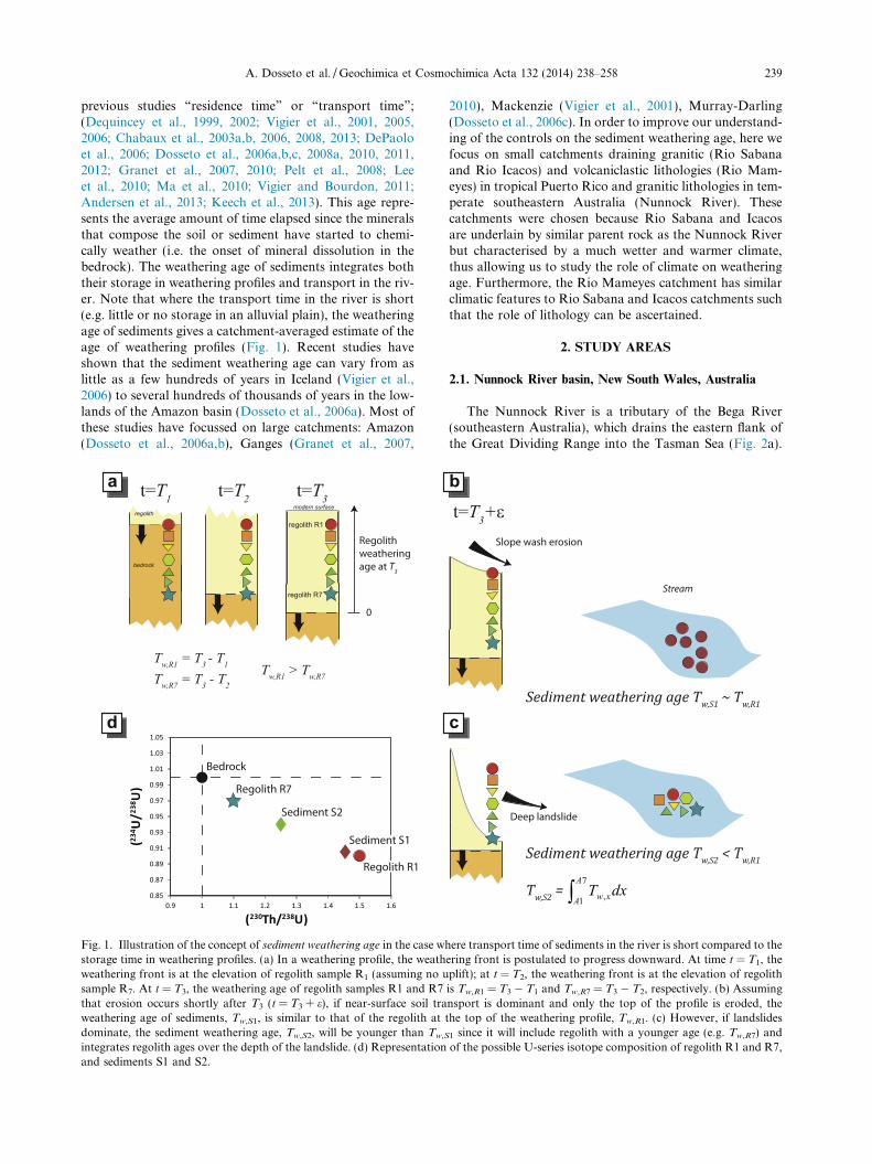
previous studies “residence time” or “transport time”;(Dequincey et al., 1999, 2002; Vigier et al., 2001, 2005,2006; Chabaux et al., 2003a,b, 2006, 2008, 2013; DePaoloet al., 2006; Dosseto et al., 2006a,b,c, 2008a, 2010, 2011,2012; Granet et al., 2007, 2010; Pelt et al., 2008; Leeet al., 2010; Ma et al., 2010; Vigier and Bourdon, 2011;Andersen et al., 2013; Keech et al., 2013). This age repre-sents the average amount of time elapsed since the mineralsthat compose the soil or sediment have started to chemi-cally weather (i.e. the onset of mineral dissolution in thebedrock). The weathering age of sediments integrates boththeir storage in weathering profiles and transport in the riv-er. Note that where the transport time in the river is short(e.g. little or no storage in an alluvial plain), the weatheringage of sediments gives a catchment-averaged estimate of theage of weathering profiles (Fig. 1). Recent studies haveshown that the sediment weathering age can vary from aslittle as a few hundreds of years in Iceland (Vigier et al.,2006) to several hundreds of thousands of years in the low-lands of the Amazon basin (Dosseto et al., 2006a). Most ofthese studies have focussed on large catchments: Amazon(Dosseto et al., 2006a,b), Ganges (Granet et al., 2007,
a
d
Fig. 1. Illustration of the concept of sediment weathering age in the case wstorage time in weathering profiles. (a) In a weathering profile, the weathweathering front is at the elevation of regolith sample R1 (assuming no usample R7. At t = T3, the weathering age of regolith samples R1 and R7that erosion occurs shortly after T3 (t = T3 + e), if near-surface soil traweathering age of sediments, Tw,S1, is similar to that of the regolith atdominate, the sediment weathering age, Tw,S2, will be younger than Tw,S
integrates regolith ages over the depth of the landslide. (d) Representationand sediments S1 and S2.
2010), Mackenzie (Vigier et al., 2001), Murray-Darling(Dosseto et al., 2006c). In order to improve our understand-ing of the controls on the sediment weathering age, here wefocus on small catchments draining granitic (Rio Sabanaand Rio Icacos) and volcaniclastic lithologies (Rio Mam-eyes) in tropical Puerto Rico and granitic lithologies in tem-perate southeastern Australia (Nunnock River). Thesecatchments were chosen because Rio Sabana and Icacosare underlain by similar parent rock as the Nunnock Riverbut characterised by a much wetter and warmer climate,thus allowing us to study the role of climate on weatheringage. Furthermore, the Rio Mameyes catchment has similarclimatic features to Rio Sabana and Icacos catchments suchthat the role of lithology can be ascertained.
2. STUDY AREAS
2.1. Nunnock River basin, New South Wales, Australia
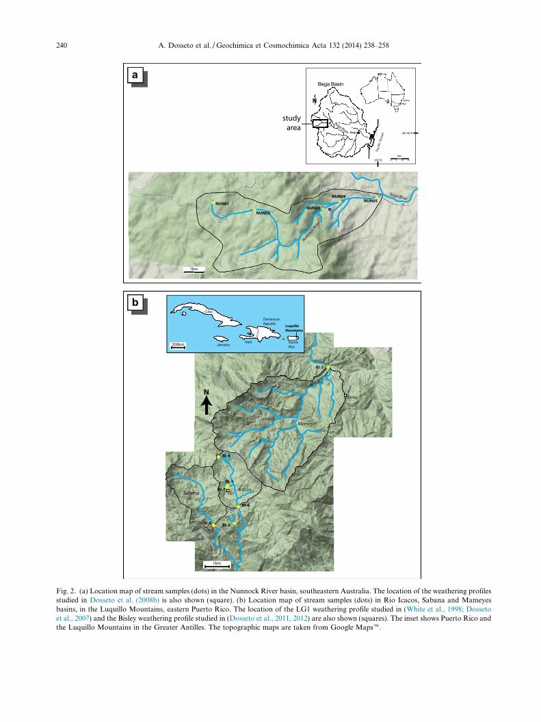
The Nunnock River is a tributary of the Bega River(southeastern Australia), which drains the eastern flank ofthe Great Dividing Range into the Tasman Sea (Fig. 2a).
b
c
here transport time of sediments in the river is short compared to theering front is postulated to progress downward. At time t = T1, theplift); at t = T2, the weathering front is at the elevation of regolithis Tw,R1 = T3 � T1 and Tw,R7 = T3 � T2, respectively. (b) Assumingnsport is dominant and only the top of the profile is eroded, thethe top of the weathering profile, Tw,R1. (c) However, if landslides
1 since it will include regolith with a younger age (e.g. Tw,R7) andof the possible U-series isotope composition of regolith R1 and R7,
b
a
Fig. 2. (a) Location map of stream samples (dots) in the Nunnock River basin, southeastern Australia. The location of the weathering profilesstudied in Dosseto et al. (2008b) is also shown (square). (b) Location map of stream samples (dots) in Rio Icacos, Sabana and Mameyesbasins, in the Luquillo Mountains, eastern Puerto Rico. The location of the LG1 weathering profile studied in (White et al., 1998; Dossetoet al., 2007) and the Bisley weathering profile studied in (Dosseto et al., 2011, 2012) are also shown (squares). The inset shows Puerto Rico andthe Luquillo Mountains in the Greater Antilles. The topographic maps are taken from Google Mapse.
240 A. Dosseto et al. / Geochimica et Cosmochimica Acta 132 (2014) 238–258
A. Dosseto et al. / Geochimica et Cosmochimica Acta 132 (2014) 238–258 241
This relief formed as a result of the initiation of rifting thatopened the Tasman Sea approximately 80 Ma ago (Ollier,1982) and has been slowly propagating inland since then.Altitude ranges 1100 m at the source of the Nunnock Riverto 220 m at the confluence with the Bega River. The catch-ment is underlain by the Palaeozic granodioritic Bembokasuite of the Bega batholith (White and Chappell, 1983).
The Nunnock River catchment is vegetated by schlero-phyl forest dominated by stringy bark eucalyptus. Rainfalls throughout the year and the mean annual precipitationis �910 mm/yr (Bureau of Meteorology Australia, 1999).The average annual temperature is 10 �C (Bureau ofMeteorology Australia, 1999). Hillslope erosion is dominatedby near-surface soil transport, as illustrated by numericalmodelling of hillslope sediment transport in this catchment(Braun et al., 2001; Heimsath et al., 2002). This in agree-ment with Prosser et al. (2001, 2003) who suggest that inthis region near-surface soil erosion dominates over rilland gully erosion. Furthermore, based on field and satelliteimagery survey, no evidence for landsliding was found.Field survey also suggests that there is no significant allu-vium storage in the Nunnock River catchment. Dischargehas not been monitored and no measurement was availableat the time of sampling. The concentration of suspendedsediments was measured at the time of sampling and rangesfrom 2 to 12 mg/l. The river was sampled at five differentlocations (Fig. 2a). Sample NUN01 was collected near thesource of the river and integrates a very small swamp area(�0.25 km2). Samples NUN01, 02 and 03 were collected atsites where the river only drains the plateau area, whichcovers �18 km2, while at NUN04 and 05 sample sites theriver drains both the plateau and the escarpment. AtNUN05, the drainage area is �33 km2. About 5–10 L werecollected and filtered at 0.2 lm to separate the suspendedsediments from the dissolved + colloidal load. Bedload sed-iments were also sampled for the three most downstreamlocations. The channel width at these locations was only�1–2 m and the water height <1 m. Bedload sedimentswere collected across the river bed over �10 m of channellength. These sediments are medium to coarse sands andare only expected to experience significant transport duringhigh discharge events. Two soil samples were collected at 30and 50 cm depth from a pit located on the same hillslope asthe one studied in Dosseto et al. (2008b).
2.2. Luquillo Mountains, Puerto Rico
The river basins studied are located in the LuquilloExperimental Forest (Luquillo Mountains, eastern PuertoRico; Fig. 2b). The Rio Icacos and Rio Sabana run fromnorth to south and are tributaries of the Rio Blanco, whichdrains into the Caribbean Sea on the southeast side of theisland. The Rio Mameyes runs south to north and dis-charges directly into the Atlantic Ocean on the north sideof the island.
Relief is characterised by steep slopes in all three catch-ments with elevation varying between 616 and 844 m forIcacos above the stream gage, between 84 and 1040 m forMameyes above the stream gage at Puente Roto, and be-tween 330 and 1024 m for Sabana, which is not gauged.
The Icacos and Sabana basins are underlain by the RioBlanco quartz diorite (49–42 Ma; Smith et al., 1998) whichconstitutes 99% of the lithology drained, whereas the RioMameyes basin is mostly underlain by marine-depositedbasaltic to andesitic volcaniclastics of the Fajardo and Tab-onuco Formations (both about 100 Ma; Jolly et al., 1998b),with some quartz diorite and contact-metamorphosed vol-caniclastics in the uppermost parts of the catchment. Thevegetation in the studied catchments is mostly subtropicalto lower montane rainforest, with dwarf forests at the high-est elevations and Sierra Palm forests at lower elevations.The Mameyes River basin is covered by lower montanerainforest dominated by Tabonuco trees (Dacryodes excel-
sa) and the Icacos and Sabana River basins by lower mon-tane wet forest dominated by Colorado trees (Cyrilla
racemiflora). Precipitation increases with elevation andranges from 3530 to 4850 mm/yr with an average value of4200 mm/yr in the Icacos basin and 3482 mm/y in theMameyes basin (White et al., 1998; Heartsill-Scaley et al.,2007). Mean annual temperature is 22 �C. Mean monthlytemperatures at lowest elevations range from about23.5 �C in January to 27 �C in September, and at the high-est elevations from 17 �C to 20 �C. Discharge is highlyvariable with very high discharge during rain events return-ing quickly to very low base flows after the events. Meanannual runoff for Rio Icacos is 3610 mm/yr with a drainagearea of 3.26 km2 (Peters et al., 2006). Mean annual runofffor Rio Mameyes is 2441 mm/yr with a drainage area of17.8 km2 (Larsen and Stallard, 2000). Rio Icacos meanannual sediment yield is 954 t/km2 and the median annualsediment concentration is 27.7 mg/L (Larsen, 2012).Mameyes River mean annual sediment yield is 227 t/km2
and the median annual sediment concentration is12.8 mg/L (Larsen, 2012). Runoff and sediment yields havenot been determined for the Sabana River. Landslides arethe major erosion drivers in the Icacos and Mameyesbasins, where they constitute 93% and 98% of the total hill-slope erosion, respectively (Larsen, 2012). Landslides aretwice more frequent in the Icacos basin compared toMameyes, which is accounted for by the more erodiblenature of the soil and saprolite derived from the quartzdiorite (Larsen, 2012). Mean landslide depth ranges from2 to 9 m for Icacos, and 2 to 12 m for Mameyes (Larsen,2012). Mass balance on in-situ 10Be concentrations inIcacos sediments suggest that, for the samples considered,55% of the sediments are derived from mass wasting events(Brown et al., 1995). In both watersheds, fractured bedrockcorestones are embedded in saprolite below about 5 mdepth (Buss and White, 2012; Buss et al., 2008, 2013),providing multiple weathering interfaces supplying freshlyweathered sediments at depth.
Sampling was undertaken in July 2005 during base flowconditions. Water was filtered soon after collection (see Sec-tion 2.3). Bedload sediments were collected from sixstreams. In all instances, bedload sediments were mediumto coarse sands. For RI-2, RI-4 and RI-7, the stream widthwas <1 m and the water height <0.5 m, thus bedload sam-ples were collected across the stream bed over a channellength of �4 m. RI-7 “bank” sediments were collected fromthe side of the stream channel, above the water level.
242 A. Dosseto et al. / Geochimica et Cosmochimica Acta 132 (2014) 238–258
Similar aspect (grain size and mineral type) to RI-7 bed sed-iments suggests that the material sampled was not soil butindeed stream sediment. For RI-3 and RI-5, the channelwidth was 5–10 m and 2–4 m, respectively, and the waterheight <1.5 m; bed sediments were collected across thechannel over a channel length of �10–20 m. For RI-6, thechannel width was 2–4 m and the water height <1 m; bedsediments were collected across the channel over a channellength of �10 m. For samples RI-2 and RI-4, grain size ofbedload sediments appeared finer (silt size) than for othersediment samples (based on field observations since grainsize distribution was not measured). Parent rock sampleswere also collected from outcrops in both the Icacos andMameyes catchments. Although the composition of theparent rock varies somewhat across the catchments (e.g.,Jolly et al., 1998a; Turner et al., 2003; Buss et al., 2013),these samples are only used as an estimate of the composi-tion of the parent material for comparison to that of ero-sion products. Regolith samples from the LG1 weatheringprofile studied in Buss et al. (2005, 2010), Pett-Ridgeet al. (2009a,b), Schulz and White (1999) and White et al.(1998), were also analysed.
2.3. Analytical techniques
For Puerto Rico, river water samples were processed atthe US Geological Survey at Guaynabo (Puerto Rico) usingtwo different techniques: (i) filtration at 0.2 lm using acetatecellulose filters in a PTFE enclosure. The filtered water, i.e.<0.2 lm fraction, was labelled “dissolved + colloidal load”.The suspended load (i.e. >0.2 lm fraction) was recoveredfrom the filter by rinsing it with 18 MX water, centrifugingthe solution and discarding the supernatant, followed bydrying at 80 �C in acid-washed PTFE containers. (ii) Filtra-tion at 25 lm (cellulose mesh) followed by tangential filtra-tion using a stack of membranes allowing successivefiltrations at 0.2 lm, 100 kilo-daltons (kDa) and 10 kDa.Thus in the second procedure, we obtained two suspendedload size fractions: >25 lm and 2–25 lm, two colloidal sizefractions: 100 kDa–0.2 lm, 10–100 kDa, and the dissolvedload: <10 kDa. The size fraction >25 lm was collected byrinsing the mesh with 18 MX water, centrifuging the solu-tion and discarding the supernatant, followed by drying at80 �C in acid-washed PTFE containers. Colloidal fractionswere dried down at 80 �C in acid-washed PTFE containers.For southeastern Australia, river water samples were filteredin the field at 0.2 lm as described above. At both study sites,the concentration of suspended matter was determined byfiltering a known volume of water (generally 1L) and weigh-ing the filter after drying. The error estimated on suspendedmatter concentrations is no more than 5–10%.
Colloidal fractions, suspended, bedload sediments andregolith samples were homogenised and gently crushed inan agate mortar. Sediments and regolith were first dried at100 �C to remove the water. The Loss-on-ignition (LOI)was determined at the Geochemical Analysis Unit (Macqua-rie University) by ashing a weighed amount of dry sample(�2 g for each sample) at 550 �C for 5 h in a furnace. LOIis used as a proxy for soil organic content, as previouslysuggested in numerous studies (e.g. Dean, 1974; Spain
et al., 1982; Bengtsson and Enell, 1986; Goldin, 1987;Donkin, 1991; Heiri et al., 2001), noting however that thisparameter can also include dehydration of clay mineralsand metal oxides (Heiri et al., 2001). Nevertheless, neglectingthe role of clays on LOI values still accounts for 91% of thevariance between LOI and measured organic carbon content(Spain et al., 1982). Soil samples were processed at theResearch School of Earth Sciences (Australian NationalUniversity) to produce quartz separates, as commonly performedfor in-situ cosmogenic isotope measurement, and following aprocedure modified from Kohl and Nishiizumi (1992).
For Zr (and other trace elements) analyses, standardmethods were employed (e.g. Eggins et al., 1997). Samplepreparation was performed at the Geochemical AnalysisUnit (Macquarie University). Approximately 100 mg ofground solid sample was weighed into clean 15 ml Savillex�
PFA vials. Samples were digested using a 1:1 mixture of HF(Merck, Suprapur grade) and HNO3 (Ajax) at 160 �C for24 h, then dried down and repeated. The samples were thenfurther digested in 6 M HNO3 for 24 h, dried down again,and diluted to 10 ml in 2% HNO3 with trace HF. Then1:1000 dilutions of each sample were individually spiked witha 15 ll aliquot of a solution of Li, As, Rh, In, Tm and Bi in2% HNO3. Samples and standards were analysed by quadru-pole inductively coupled plasma mass spectrometry (ICP-MS) on an Agilent 7500 c/s system at the GAU, MacquarieUniversity. BCR-2 was used as a calibration standard to cor-rect for instrument sensitivity and run drift. The backgroundwas measured on a 2% HNO3 rinse solution.
For Sr isotope determination, sample preparation wasundertaken at the Geochemical Analysis Unit (MacquarieUniversity). Purification of Sr was carried out using pow-ders digested in PFA vials with concentrated HF andHNO3. Samples were then dried down and �1 ml of con-centrated HClO4 was added, followed by 4 ml 6 M HCland H2O2. These were dried down once again, dissolvedin 6 M HCl, dried, dissolved in HCl and HF, and centri-fuged to check for the presence of any undissolved residue(none was observed). The samples were then loaded ontoTeflon columns using Biorad� AG50W-X8 (200–400 mesh)cation exchange resin and eluted in 2.5 N HCl–0.1 N HF.Strontium isotopic analyses were obtained by thermalionisation mass spectrometry (TIMS) using a ThermoFinnigan Triton system at the GAU, Macquarie University,Sydney. Strontium was loaded onto single rheniumfilaments with a Ta activator and analysed between 1380and 1430 �C in a static measurement mode with rotatingamplifiers. NIST SRM 987 was analysed for instrumentsensitivity during times of the analyses (n = 17) andgave a long-term reproducibility of 87Sr/86Sr = 0.710250(2SD = 0.000034). Ratios were normalised to 86Sr/88Sr =0.1194 to correct for mass fractionation.
For U-series isotope determination, sample preparationand analysis were performed Geochemical Analysis Unit(Macquarie University). A tracer solution enriched in236U–229Th and another tracer solution enriched in 228Rawere added to the ground solid sample, in order todetermine U, Th and 226Ra concentrations, respectively(Tables 1 and 2). The masses of sample and 236U–229Th tra-cer solution were chosen to minimise its contribution on
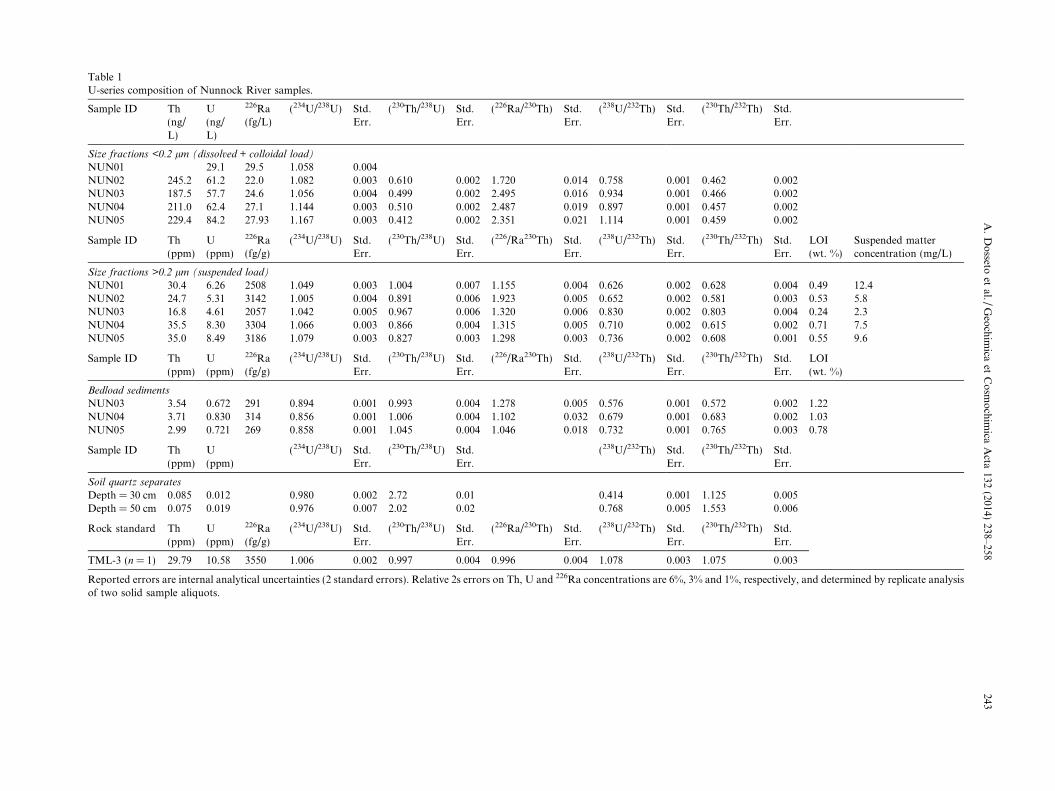
Table 1U-series composition of Nunnock River samples.
Sample ID Th(ng/L)
U(ng/L)
226Ra(fg/L)
(234U/238U) Std.Err.
(230Th/238U) Std.Err.
(226Ra/230Th) Std.Err.
(238U/232Th) Std.Err.
(230Th/232Th) Std.Err.
Size fractions <0.2 lm (dissolved + colloidal load)
NUN01 29.1 29.5 1.058 0.004NUN02 245.2 61.2 22.0 1.082 0.003 0.610 0.002 1.720 0.014 0.758 0.001 0.462 0.002NUN03 187.5 57.7 24.6 1.056 0.004 0.499 0.002 2.495 0.016 0.934 0.001 0.466 0.002NUN04 211.0 62.4 27.1 1.144 0.003 0.510 0.002 2.487 0.019 0.897 0.001 0.457 0.002NUN05 229.4 84.2 27.93 1.167 0.003 0.412 0.002 2.351 0.021 1.114 0.001 0.459 0.002
Sample ID Th(ppm)
U(ppm)
226Ra(fg/g)
(234U/238U) Std.Err.
(230Th/238U) Std.Err.
(226/Ra230Th) Std.Err.
(238U/232Th) Std.Err.
(230Th/232Th) Std.Err.
LOI(wt. %)
Suspended matterconcentration (mg/L)
Size fractions >0.2 lm (suspended load)
NUN01 30.4 6.26 2508 1.049 0.003 1.004 0.007 1.155 0.004 0.626 0.002 0.628 0.004 0.49 12.4NUN02 24.7 5.31 3142 1.005 0.004 0.891 0.006 1.923 0.005 0.652 0.002 0.581 0.003 0.53 5.8NUN03 16.8 4.61 2057 1.042 0.005 0.967 0.006 1.320 0.006 0.830 0.002 0.803 0.004 0.24 2.3NUN04 35.5 8.30 3304 1.066 0.003 0.866 0.004 1.315 0.005 0.710 0.002 0.615 0.002 0.71 7.5NUN05 35.0 8.49 3186 1.079 0.003 0.827 0.003 1.298 0.003 0.736 0.002 0.608 0.001 0.55 9.6
Sample ID Th(ppm)
U(ppm)
226Ra(fg/g)
(234U/238U) Std.Err.
(230Th/238U) Std.Err.
(226/Ra230Th) Std.Err.
(238U/232Th) Std.Err.
(230Th/232Th) Std.Err.
LOI(wt. %)
Bedload sediments
NUN03 3.54 0.672 291 0.894 0.001 0.993 0.004 1.278 0.005 0.576 0.001 0.572 0.002 1.22NUN04 3.71 0.830 314 0.856 0.001 1.006 0.004 1.102 0.032 0.679 0.001 0.683 0.002 1.03NUN05 2.99 0.721 269 0.858 0.001 1.045 0.004 1.046 0.018 0.732 0.001 0.765 0.003 0.78
Sample ID Th(ppm)
U(ppm)
(234U/238U) Std.Err.
(230Th/238U) Std.Err.
(238U/232Th) Std.Err.
(230Th/232Th) Std.Err.
Soil quartz separates
Depth = 30 cm 0.085 0.012 0.980 0.002 2.72 0.01 0.414 0.001 1.125 0.005Depth = 50 cm 0.075 0.019 0.976 0.007 2.02 0.02 0.768 0.005 1.553 0.006
Rock standard Th(ppm)
U(ppm)
226Ra(fg/g)
(234U/238U) Std.Err.
(230Th/238U) Std.Err.
(226Ra/230Th) Std.Err.
(238U/232Th) Std.Err.
(230Th/232Th) Std.Err.
TML-3 (n = 1) 29.79 10.58 3550 1.006 0.002 0.997 0.004 0.996 0.004 1.078 0.003 1.075 0.003
Reported errors are internal analytical uncertainties (2 standard errors). Relative 2s errors on Th, U and 226Ra concentrations are 6%, 3% and 1%, respectively, and determined by replicate analysisof two solid sample aliquots.
A.
Do
ssetoet
al./G
eoch
imica
etC
osm
och
imica
Acta
132(2014)
238–258243
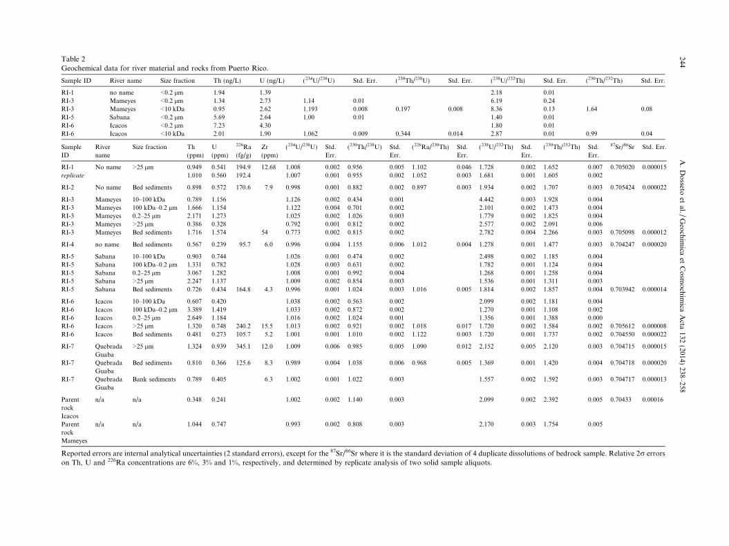
Table 2Geochemical data for river material and rocks from Puerto Rico.
Sample ID River name Size fraction Th (ng/L) U (ng/L) (234U/238U) Std. Err. (230Th/238U) Std. Err. (238U/232Th) Std. Err. (230Th/232Th) Std. Err.
RI-1 no name <0.2 lm 1.94 1.39 2.18 0.01
RI-3 Mameyes <0.2 lm 1.34 2.73 1.14 0.01 6.19 0.24
RI-3 Mameyes <10 kDa 0.95 2.62 1.193 0.008 0.197 0.008 8.36 0.13 1.64 0.08
RI-5 Sabana <0.2 lm 5.69 2.64 1.00 0.01 1.40 0.01
RI-6 Icacos <0.2 lm 7.23 4.30 1.80 0.01
RI-6 Icacos <10 kDa 2.01 1.90 1.062 0.009 0.344 0.014 2.87 0.01 0.99 0.04
Sample
ID
River
name
Size fraction Th
(ppm)
U
(ppm)
226Ra
(fg/g)
Zr
(ppm)
(234U/238U) Std.
Err.
(230Th/238U) Std.
Err.
(226Ra/230Th) Std.
Err.
(238U/232Th) Std.
Err.
(230Th/232Th) Std.
Err.
87Sr/86Sr Std. Err.
RI-1 No name >25 lm 0.949 0.541 194.9 12.68 1.008 0.002 0.956 0.005 1.102 0.046 1.728 0.002 1.652 0.007 0.705020 0.000015
replicate 1.010 0.560 192.4 1.007 0.001 0.955 0.002 1.052 0.003 1.681 0.001 1.605 0.002
RI-2 No name Bed sediments 0.898 0.572 170.6 7.9 0.998 0.001 0.882 0.002 0.897 0.003 1.934 0.002 1.707 0.003 0.705424 0.000022
RI-3 Mameyes 10–100 kDa 0.789 1.156 1.126 0.002 0.434 0.001 4.442 0.003 1.928 0.004
RI-3 Mameyes 100 kDa–0.2 lm 1.666 1.154 1.122 0.004 0.701 0.002 2.101 0.002 1.473 0.004
RI-3 Mameyes 0.2–25 lm 2.171 1.273 1.025 0.002 1.026 0.003 1.779 0.002 1.825 0.004
RI-3 Mameyes >25 lm 0.386 0.328 0.792 0.001 0.812 0.002 2.577 0.002 2.091 0.006
RI-3 Mameyes Bed sediments 1.716 1.574 54 0.773 0.002 0.815 0.002 2.782 0.004 2.266 0.003 0.705098 0.000012
RI-4 no name Bed sediments 0.567 0.239 95.7 6.0 0.996 0.004 1.155 0.006 1.012 0.004 1.278 0.001 1.477 0.003 0.704247 0.000020
RI-5 Sabana 10–100 kDa 0.903 0.744 1.026 0.001 0.474 0.002 2.498 0.002 1.185 0.004
RI-5 Sabana 100 kDa–0.2 lm 1.331 0.782 1.028 0.003 0.631 0.002 1.782 0.001 1.124 0.004
RI-5 Sabana 0.2–25 lm 3.067 1.282 1.008 0.001 0.992 0.004 1.268 0.001 1.258 0.004
RI-5 Sabana >25 lm 2.247 1.137 1.009 0.002 0.854 0.003 1.536 0.001 1.311 0.003
RI-5 Sabana Bed sediments 0.726 0.434 164.8 4.3 0.996 0.001 1.024 0.003 1.016 0.005 1.814 0.002 1.857 0.004 0.703942 0.000014
RI-6 Icacos 10–100 kDa 0.607 0.420 1.038 0.002 0.563 0.002 2.099 0.002 1.181 0.004
RI-6 Icacos 100 kDa–0.2 lm 3.389 1.419 1.033 0.002 0.872 0.002 1.270 0.001 1.108 0.002
RI-6 Icacos 0.2–25 lm 2.649 1.184 1.016 0.002 1.024 0.001 1.356 0.001 1.388 0.000
RI-6 Icacos >25 lm 1.320 0.748 240.2 15.5 1.013 0.002 0.921 0.002 1.018 0.017 1.720 0.002 1.584 0.002 0.705612 0.000008
RI-6 Icacos Bed sediments 0.481 0.273 105.7 5.2 1.001 0.001 1.010 0.002 1.122 0.003 1.720 0.001 1.737 0.002 0.704550 0.000022
RI-7 Quebrada
Guaba
>25 lm 1.324 0.939 345.1 12.0 1.009 0.006 0.985 0.005 1.090 0.012 2.152 0.005 2.120 0.003 0.704715 0.000015
RI-7 Quebrada
Guaba
Bed sediments 0.810 0.366 125.6 8.3 0.989 0.004 1.038 0.006 0.968 0.005 1.369 0.001 1.420 0.004 0.704718 0.000020
RI-7 Quebrada
Guaba
Bank sediments 0.789 0.405 6.3 1.002 0.001 1.022 0.003 1.557 0.002 1.592 0.003 0.704717 0.000013
Parent
rock
Icacos
n/a n/a 0.348 0.241 1.002 0.002 1.140 0.003 2.099 0.002 2.392 0.005 0.70433 0.00016
Parent
rock
Mameyes
n/a n/a 1.044 0.747 0.993 0.002 0.808 0.003 2.170 0.003 1.754 0.005
Reported errors are internal analytical uncertainties (2 standard errors), except for the 87Sr/86Sr where it is the standard deviation of 4 duplicate dissolutions of bedrock sample. Relative 2r errorson Th, U and 226Ra concentrations are 6%, 3% and 1%, respectively, and determined by replicate analysis of two solid sample aliquots.
244A
.D
osseto
etal./
Geo
chim
icaet
Co
smo
chim
icaA
cta132
(2014)238–258
A. Dosseto et al. / Geochimica et Cosmochimica Acta 132 (2014) 238–258 245
234U, 235U, 238U, 230Th and 232Th (<0.1%) while yieldingbeams greater than 50,000 cps for 236U and 229Th. Themasses of sample and 228Ra tracer solution were optimisedto yield a measured 228Ra/226Ra as close to 1 as possible.The mixture of sample and tracer solutions was then dis-solved in HClO4, HF and HNO3. Fluorides were drivenoff by evaporation at 100 �C followed by step evaporationat 150 �C, 170 �C and 200 �C. Samples were then takenup in 7 M HNO3 and centrifuged to check for the presenceof any undissolved residue (none was observed) beforeU–Th separation. For dissolved and dissolved + colloidal loadsamples, about 30 mg of 236U–229Th solution and �500 mgof 228Ra solution were added to �300 g of <10 kDa frac-tion or to �20 g of <0.2 lm fraction. This mixture was leftto equilibrate at room temperature for 3–5 days. It was thendried down at 100 �C and re-dissolved in 7 M HNO3. U–Thwere separated by ion chromatography using a BioRade
AG1X8 anionic resin (yields > 99%; Price et al., 2007;Dosseto et al., 2008b). Ra was collected from the U–Thcolumn and processed through a series of two columns withBioRade AG50W-X8 cationic resin and a last column withEichrom Sr-SPEC resin (yields > 99%; Chabaux and Alle-gre, 1994). U and Th isotopes were measured on a NuInstruments Nu Plasmae multi-collector ICP-MS follow-ing procedures described in Sims et al. (2008). Briefly, massbias and SEM/Faraday cup yield were corrected by stan-dard bracketing using CRM145 for U and Th”U” for Th.A linear 232Th tail correction was applied on 230Th wasmeasuring at masses 230.5 and 229.5. Ra was measuredby TIMS on a Thermo Scientific Tritone following a pro-cedure similar to that described in Turner et al. (2000).Total procedure blanks were <10 pg for U and Th, and belowdetection limit (�10 fg) for Ra. Accuracy was determinedby measurement of the gravimetric rock standard TML-3(Table 1). U, Th and 226Ra concentrations are within1.2%, 0.7% and 1.4%, respectively, of published values(Pietruszka et al., 2002; Sims et al., 2008) whilst (234U/238U),(230Th/238U), (226Ra/230Th) and (230Th/232Th) ratios arewithin 0.6%, 0.3%, 0.4% and 0.1% respectively, of publishedvalues. In comparison, reproducibility of sample processingand analysis is poor, probably reflecting heterogeneity innuclide distribution: 6%, 3% and 1% for Th, U and 226Raconcentrations, respectively; 5% and 3% for (226Ra/230Th)and (230Th/232Th) activity ratios (each replicate was mea-sured on a different aliquot of sample that underwent theentire preparation separately). Nevertheless, reproducibilitywas much more satisfying for (234U/238U) and (230Th/238U)ratios: respectively 0.1% and 0.01%. Note that the poorreproducibility on concentrations and (226Ra/230Th) and(230Th/232Th) ratios does not affect our conclusions becausethe model used to calculate sediment weathering ages onlyconsiders (234U/238U) and (230Th/238U) ratios.
3. RESULTS AND DISCUSSION
3.1. U-series isotope composition of river-borne material
3.1.1. Southeastern Australia
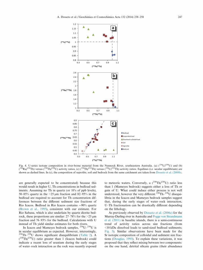
The U and Th concentrations in Nunnock River sus-pended sediments are higher than those in the bedrock
(by a factor 1–3 for Th, 2–3 for U). This is consistent withthe loss of more soluble elements, effectively concentratingU and Th in the suspended load. In contrast, the U, Thand 226Ra concentrations in bedload sediments are aboutan order of magnitude lower than those in the suspendedload. This can be explained if quartz (a U–Th–poor mineralphase) is abundant in the bedload, effectively “diluting” U,Th and 226Ra concentrations by a factor of 10. Assumingthat quartz contains no Th (or in the expected range of10’s of ppb; Table 1), a bedload composition of 80–97 wt.%quartz would be required to explain the difference in Thconcentrations between suspended and bedload sediments.Considering a higher Th concentration in quartz and/or asignificant proportion of quartz in the suspended loadwould only increase the required proportion of quartz inthe bedload. Although the calculated proportions of quartzare high, they are not unrealistic for bedload (see similarcalculations for Puerto Rico below).
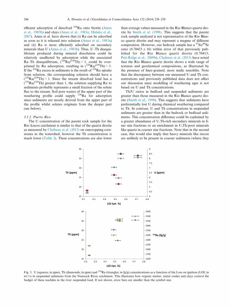
In suspended sediments, U, Th and 226Ra concentra-tions are positively correlated to the Loss-on-ignition(LOI; Fig. 3). This suggests that the abundance of these ele-ments in the suspended load is controlled by adsorptiononto organic particles or coatings (the LOI being com-monly used a proxy for organic matter; Dean, 1974; Spainet al., 1982; Bengtsson and Enell, 1986; Goldin, 1987;Donkin, 1991; Heiri et al., 2001). This relationship is notobserved in bedload sediments despite higher LOI values,suggesting that organic matter has little effect on theirU–Th–226Ra budget.
Activity ratios for suspended sediments fall between val-ues for bedload sediments and dissolved + colloidal loads(Fig. 4). This is likely to reflect the contribution of second-ary phases precipitated with the isotopic composition of thestream water or the soil pore water. For instance,(234U/238U) > 1 in suspended sediments is a common obser-vation (see e.g. Plater et al., 1992; Chabaux et al., 2003b,2008; Dosseto et al., 2008a) and is generally explained byan input of U during the precipitation of secondary phasesfrom a solution with (234U/238U) > 1. (234U/238U) less than1 and (230Th/238U) greater than 1 in bedload sediments fol-low the expected behaviour of 234U, 238U and 230Th duringweathering: depletion of 238U over 230Th since U is gener-ally more soluble than Th in oxidised conditions, and pref-erential loss of 234U over 238U as a result of (i) direct recoilof 234Th out of mineral grains and subsequent decay into234U, (ii) preferential release of recoiled 234U from crystallattice damages (Kigoshi, 1971; Fleischer and Raabe,1978; Fleischer, 1980, 1982a,b; Hussain and Lal, 1986).Ra is also expected to be more soluble than Th because itis an alkali-earth and its behaviour is expected to followthat of Ca or Mg, (226Ra/230Th) less than 1 should be foundin stream sediments. However, the opposite is observed. Apossible explanation for (226Ra/230Th) > 1 in sedimentscould be via the deposition of dust with (226Ra/230Th) > 1.This hypothesis has been invoked to account for 226Ra ex-cesses in weathering profiles (Krishnaswami et al., 2004).However, Australian dust is characterised (226Ra/230Th) < 1(Table A1; Marx et al., 2005) such that bulk depositioncannot account for ratios greater than 1 in sediments.Alternatively, 226Ra excesses could be explained by the
246 A. Dosseto et al. / Geochimica et Cosmochimica Acta 132 (2014) 238–258
efficient adsorption of dissolved 226Ra onto biotite (Ameset al., 1983b) and clays (Ames et al., 1983a; Hidaka et al.,2007). Ames et al. have shown that (i) Ra can be adsorbedas soon as it is released into solution (Ames et al., 1983a)and (ii) Ra is more efficiently adsorbed on secondaryminerals than U (Ames et al., 1983b). Thus, U–Th disequi-librium produced during mineral dissolution could berelatively unaffected by adsorption while the associatedRa–Th disequilibrium, (226Ra/230Th) < 1, could be over-printed by Ra adsorption, resulting in (226Ra/230Th) > 1.If the 226Ra excess in sediments is the result of 226Ra uptakefrom solution, the corresponding solution should have a(226Ra/230Th) < 1. Since the stream dissolved load has a(226Ra/230Th) greater than 1, the solution supplying Ra tosediments probably represents a small fraction of the soluteflux to the stream. Soil pore waters of the upper part of theweathering profile could supply 226Ra for adsorptionsince sediments are mostly derived from the upper part ofthe profile whilst solutes originate from the deeper part(see below).
3.1.2. Puerto Rico
The U concentration of the parent rock sample for theRio Icacos catchment is similar to that of the quartz dioriteas measured by Chabaux et al. (2013) on outcropping core-stones in the watershed, however the Th concentration ismuch lower (Table 2). These concentrations are also lower
Fig. 3. U (squares; in ppm), Th (diamonds; in ppm) and 226Ra (triangles;wt.%) in suspended sediments from the Nunnock River catchment. Thisbudget of these nuclides in the river suspended load. If not shown, error
than average values measured in the Rio Blanco quartz dio-rite by Smith et al. (1998). This suggests that the parentrock sample analysed is not representative of the Rio Blan-co quartz diorite and may represent a magma of differentcomposition. However, our bedrock sample has a 87Sr/86Srratio (0.70433 ± 16) within error of that previously pub-lished for the Rio Blanco quartz diorite (0.70413;Pett-Ridge et al., 2009b). Chabaux et al. (2013) have notedthat the Rio Blanco quartz diorite shows a wide range oftextures and geochemical compositions, as illustrated bythe presence of finer-grained, more mafic xenoliths. Notethat the discrepancy between our measured U and Th con-centrations and previously published data does not affectour discussion since modelling of weathering ages is notbased on U and Th concentrations.
Th/U ratios in bedload and suspended sediments aregreater than those measured in the Rio Blanco quartz dio-rite (Smith et al., 1998). This suggests that sediments havepreferentially lost U during chemical weathering comparedto Th. In contrast, U and Th concentrations in suspendedsediments are greater than in the bedrock or bedload sedi-ments. This concentration difference could be explained bya greater abundance of U,Th-rich secondary minerals in fi-ner size fractions or an enrichment in U,Th-poor mineralslike quartz in coarser size fractions. Note that in the secondcase, this would also imply that heavy minerals like zirconare unlikely to be present in coarser sediments (where they
in fg/g) concentrations as a function of the Loss on ignition (LOI; inillustrates how organic matter, metal oxides and clays control thebars are smaller than the symbol size.
a
b
c
Fig. 4. U-series isotope composition in river-borne material from the Nunnock River, southeastern Australia. (a) (234U/238U) and (b)(226Ra/230Th) versus (230Th/238U) activity ratios. (c) (230Th/232Th) versus (238U/232Th) activity ratios. Equilines (i.e. secular equilibrium) areshown as dashed lines. In (c), the composition of saprolite, soil and bedrock from the same catchment are taken from Dosseto et al. (2008b).
A. Dosseto et al. / Geochimica et Cosmochimica Acta 132 (2014) 238–258 247
are generally expected to be concentrated) because thiswould result in higher U, Th concentrations in bedload sed-iments. Assuming no Th in quartz (or 10’s of ppb levels),50–85% quartz in the >25 lm fraction and 82–95% in thebedload are required to account for Th concentration dif-ferences between the different sediment size fractions ofRio Icacos. Bedload in Rio Icacos contains �90% quartz(Brown et al., 1995), consistent with our estimate. ForRio Sabana, which is also underlain by quartz diorite bed-rock, these proportions are similar: 27–78% for the >25 lmfraction and 76–93% for the bedload. Calculations with Uinstead of Th yield similar estimates for both rivers.
In Icacos and Mameyes bedrock samples, 234U–238U isin secular equilibrium as expected. However, interestingly,230Th–238U shows significant disequilibrium (Table 2). A(230Th/238U) ratio greater than 1 (Icacos bedrock) couldindicate a recent loss of uranium during the early stagesof water–rock interaction as the rock was recently exposed
to meteoric waters. Conversely, a (230Th/238U) ratio lessthan 1 (Mameyes bedrock) suggests either a loss of Th orgain of U. What could induce either process is not wellunderstood, however the very different 230Th–238U disequi-libria in the Icacos and Mameyes bedrock samples suggestthat, during the early stages of water–rock interaction,U–Th fractionation can be drastically different dependingon the lithology.
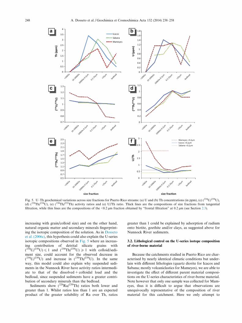
As previously observed by Dosseto et al. (2006c) for theMurray-Darling river in Australia and Pogge von Strandmannet al. (2011) in basaltic islands, there is a semi-continuoustrend of activity ratios across size fractions (from<10 kDa dissolved loads to sand-sized bedload sediments;Fig. 5). Similar observations have been made for theSr isotopic composition of colloidal and sediment size frac-tions (Douglas, 1993). To explain these variations, it wasproposed that they reflect mixing between two components:on the one hand, detrital silicate grains (their abundance
a b
c d
e f
Fig. 5. U–Th geochemical variations across size fractions for Puerto Rico streams: (a) U and (b) Th concentrations (in ppm), (c) (234U/238U),(d) (230Th/234U), (e) (230Th/232Th) activity ratios and (e) U/Th ratio. Thick lines are the compositions of size fractions from tangentialfiltration, while thin lines are the compositions of the <0.2 lm fraction obtained by “frontal filtration” at 0.2 lm (see Section 2.3).
248 A. Dosseto et al. / Geochimica et Cosmochimica Acta 132 (2014) 238–258
increasing with grain/colloid size) and on the other hand,natural organic matter and secondary minerals fingerprint-ing the isotopic composition of the solution. As in Dossetoet al. (2006c), this hypothesis could also explain the U-seriesisotopic compositions observed in Fig. 5 where an increas-ing contribution of detrital silicate grains with(234U/238U) 6 1 and (230Th/238U) P 1 with colloid/sedi-ment size, could account for the observed decrease in(234U/238U) and increase in (230Th/238U). In the sameway, this model could also explain why suspended sedi-ments in the Nunnock River have activity ratios intermedi-ate to that of the dissolved + colloidal load and thebedload, since suspended sediments have a greater contri-bution of secondary minerals than the bedload.
Sediments show (226Ra/230Th) ratios both lower andgreater than 1. Whilst ratios less than 1 are an expectedproduct of the greater solubility of Ra over Th, ratios
greater than 1 could be explained by adsorption of radiumonto biotite, goethite and/or clays, as suggested above forNunnock River sediments.
3.2. Lithological control on the U-series isotope composition
of river-borne material
Because the catchments studied in Puerto Rico are char-acterised by nearly identical climatic conditions but under-lain with different lithologies (quartz diorite for Icacos andSabana; mostly volcaniclastics for Mameyes), we are able toinvestigate the effect of different parent material composi-tions on the U-series characteristics of river-borne material.Note however that only one sample was collected for Mam-eyes, thus it is difficult to argue that observations areunequivocally representative of the composition of rivermaterial for this catchment. Here we only attempt to
A. Dosseto et al. / Geochimica et Cosmochimica Acta 132 (2014) 238–258 249
identify strongly contrasting differences between Rio Mam-eyes, on the one hand, and Rio Icacos and Sabana, on theother hand.
Although the Rio Icacos and Nunnock Rivers are char-acterised by very different climatic conditions, the degree ofU release from the granitic bedrock, as measured by the ra-tio of U concentration in the dissolved load over that in thebedrock, is similar for both catchments (1–3 � 10�5 for theNunnock River, 0.8–1.8 � 10�5 for Rio Icacos). In con-trast, the degree of U release from the volcaniclastic bed-rock of Rio Mameyes is much lower (3.5–3.7 � 10�6).This suggests that lithology has a much stronger role on dis-solved U concentrations than climate. This could be ex-plained by the difference in weathering susceptibility ofthe minerals dominating the U budget of sediments: biotiteand hornblende for the Rio Blanco Formation quartz dio-rite (White et al., 1996), chlorite for the Fajardo Formationvolcaniclastic rock (Buss et al., 2013).
Whilst Mameyes and Icacos/Sabana show similar(230Th/238U) ratios across the range of size fractions ana-lysed, there is a strong contrast in 234U–238U disequilibriumin river-borne material between these two catchmentgroups. In the volcaniclastic catchment, sediments show agreater depletion in 234U, and dissolved and colloidalfractions a greater 234U enrichment, than in granitic catch-ments. The contrasting (234U/238U) ratios in river-bornematerial between the Mameyes and Icacos/Sabana catch-ments could be explained by a difference in the surfaceproperties of sediments exported from each basin: theparental material in the Mameyes catchment is a fine-grainedvolcaniclastic rock, thus likely to produce sediments with agreater surface area than those of Rio Icacos/Sabana.A high surface area promotes the loss of 234U during recoil,which would account for larger 234U depletions in sedi-ments and enrichments in waters.
3.3. Tracking solutes and sediments back to the weathering
profile
Thorium isotopes are unlikely to fractionate duringchemical weathering. Although 230Th can be preferentiallylost by recoil during radioactive decay of its parent, 234U,or leaching of recoil tracks in which it is embedded, 230This rapidly re-adsorbed on the sediment surface because ofits high reactivity with particles (e.g. Plater et al., 1992).Moreover, because the half-life of 230Th is 75.6 kyr (Chenget al., 2013), U–Th fractionation during solute and sedi-ment transport in the river will only modify their(230Th/232Th) ratio if the transport time in the fluvial systemis longer than a few 10’s of kyr. As it can be safely assumedthat this is not the case for the catchments considered(because of the absence of contribution from old ground-water and the lack of significant alluvial deposits), the(230Th/232Th) ratio of solutes and sediments could be poten-tially used as a tracer of their origin.
For the Nunnock River, both bedload and suspendedsediments have (230Th/232Th) similar to that in soils fromthe same catchment, but higher than saprolite values(Fig. 4c; Dosseto et al., 2008b). Conversely, in the dissolvedload, (230Th/232Th) ratios are lower and less variable,
ranging between 0.457 and 0.466, comparable to saprolitevalues (Fig. 4c). This suggests that stream sediments (bothbedload and suspended load) are derived from the upper-most soil horizons (consistent with physical erosion domi-nated by near-surface soil transport in this catchment)whereas the dissolved load originates from the deeper partsof the weathering profile.
In Puerto Rico, (230Th/232Th) ratios increase systemati-cally with size fraction (Fig. 5e). In comparison, in theLG1 weathering profile (located in the Rio Icacos catch-ment), (230Th/232Th) ratios increase with decreasing depth,from the saprock (mean = 0.952 ± 0.012, weighted 2 stan-dard error; n = 6), through the saprolite (1.460 ± 0.14;n = 10) to the soil (1.775 ± 0.024; n = 5) (Table A2 andFig. A1). Note that all three means are statistically different(t-test, p = 0.05). Thus, similar to the Nunnock River, high(230Th/232Th) in Rio Icacos sediments (1.4–2.1) could indi-cate that they are derived from the upper horizons ofweathering profiles whereas lower (230Th/232Th) ratios incolloidal and dissolved loads (1–1.2) could suggest that sol-utes and colloids originate from the lowermost horizons.This is consistent with previous studies in the Rio Icacosbasin which have shown that most chemical weathering(thus solute production) takes place in the saprock (Whiteet al., 1998; Buss et al., 2008; Pett-Ridge et al., 2009b).Kurtz et al. (2011) used Ge/Si ratios to determine that sol-utes in the Rio Icacos derive largely from the saprock androck fractures during baseflow and from shallow soil andoverland flow during stormflow.
The Sr isotopic composition of Icacos/Sabana streamsediments varies between 0.70471 and 0.70561 (Table 2).Pett-Ridge et al. (2009b) have shown that 87Sr/86Sr ratiosdecrease approximately linearly with increasing depth inthe LG1 weathering profile, from values >0.710 in the top-soil to �0.704 in the saprock (depth > 5 m). Thus, it is pos-sible to reconcile the low Sr and high Th isotopiccomposition of stream sediments if they originate fromintermediate depths of the weathering profile (4–5 m). Itis not implied that stream sediments derive exclusively fromthis horizon, but instead suggests that the sediment budgetis dominated by material from the relatively deep saprolite.Because we are focussing on bedload sediments, it is possi-ble that finer-grained material from the upper horizons waswashed away preferentially by hydrodynamic sorting. Thedeep origin of stream sediments is not surprising since land-slides 2–12 m deep are the main mechanism for hillslopeerosion in the Luquillo Mountains (Larsen and Torres-San-chez, 1992; Larsen, 2012).
Although the origin of Rio Mameyes sediments is diffi-cult to assess because there is no systematic (230Th/232Th)variation in the only weathering profile in this catchmentstudied for U-series isotopes (Dosseto et al., 2012), the(230Th/232Th) of the dissolved and colloidal fractions(1.64 ± 0.08) is similar to that of the bedrock sample ana-lysed (1.754 ± 0.005). This would suggest that the relativelydeep origin of solutes applies not only to different climaticenvironments (i.e. Puerto Rico vs. southeastern Australia)but also different lithologies. However, this hypothesisneeds verification by further analyses of dissolved loadsand bedrock of this catchment.
250 A. Dosseto et al. / Geochimica et Cosmochimica Acta 132 (2014) 238–258
In summary, stream solutes and sediments have very dis-tinct origins. On the one hand, solutes are derived from thedeeper parts of the weathering profile, where mineralswhich dissolve readily have not yet been entirely consumed.On the other hand, sediments are derived from shallowerhorizons, from depths that depend on the mechanism oferosion (shallow depths where near-surface soil transportdominates like in the Nunnock River; deeper depths wherelandslides prevail like in the Rio Icacos). While these obser-vations may not reflect global solute fluxes, considering thesmall size of the studied catchments, they seem valid regard-less of climatic conditions (at least in tropical and temperateenvironments), and possibly for different lithologies. Thus,in slowly eroding environments where thick weatheringprofiles develop, not only do solute and sediment transportoperate on different timescales, but they also are character-ised by distinct spatial origins. Previous studies have usedthe geochemical composition of dissolved and sedimentloads to assess whether erosion is in steady-state in a catch-ment, i.e. whether the flux of solute and sediment exportedis balanced by the flux produced by bedrock weathering(Bouchez et al., 2011; Dosseto et al., 2006a,b,c, 2008a;Gaillardet et al., 1995, 1997). However, these approachesassume that solutes and sediments have the same origin.Our results suggest that this assumption might not be validfor catchments where thick weathering profiles are present.
3.4. Quantification of the sediment weathering age
As explained above, it is possible to use the U-series iso-tope composition of river-borne material to determine theweathering age of sediments (Fig. 1; Vigier et al., 2001;Chabaux et al., 2003b, 2008; Dosseto et al., 2008a). Weuse the model of Dosseto et al. (2008b) modified fromDequincey et al. (2002), that describes the time evolutionof a nuclide j abundance in the sediments, Nj (in numberof atoms), as follows (see also Dosseto et al., 2012;Chabaux et al., 2013):
dN j
dt¼ kiN i � kjN j þ CjN j;0 � wjN j ð1Þ
where Ni is the abundance of the parent nuclide i (in num-ber of atoms), ki and kj are the decay constants for nuclidesi and j respectively (in yr�1), Cj is the input constant (inyr�1) representing the gain of nuclide j for instance by pre-cipitation of secondary minerals from the solution or byaeolian input, Nj,0 is the initial abundance of nuclide j inthe bedrock (i.e. at time = 0, the onset of bedrock weather-ing) and wj is the dissolution constant for nuclide j. Exam-ples of evolution curves are shown on Fig. 6.
This equation can be written for 238U, 234U and 230Th(note the first term of the right side of Eq. (1) disappearsfor 238U since it has no parent nuclide). The weatheringage, Tw, is defined as the duration of continuous loss andgain of nuclides to evolve from the bedrock compositionto the observed composition in sediments. In the model,the following assumptions are made:
– The bedrock is in secular equilibrium. If the age of thebedrock is greater than 1 Myr, this assumption is
verified. The observation of activity ratios – 1 in a rockolder than 1 Myr simply indicates it has undergonewater–rock interaction. This could imply that the U-ser-ies isotopic “clock” starts at a depth greater than therock-regolith boundary. If this is the case, calculatedweathering ages should be taken as maximum values;
– For a given set of samples, common C and w valuesapply and the difference in activity ratio between eachsample is the result of different weathering ages. Thisimplies that conditions for gain and loss of nuclidesare similar across the set of samples considered. Thisassumption is reasonable for weathering profiles andsmall catchments but could be problematic for largecatchments. However, it has been shown that there is agood correlation between weathering ages (calculatedwith the same approach) and independent indices ofchemical weathering at the scale of the Rio Madeirabasin in South America (a major tributary of the Ama-zon River), suggesting that this assumption may still bevalid at the regional scale (Dosseto et al., 2006b);
– The coefficients for nuclide loss, w, and gain, C, are con-stant over the duration of weathering. This assumptionis commonly made in studies modelling chemicalweathering (e.g. Chamberlain et al., 2005; Ferrier andKirchner, 2008) and laboratory experiments suggestconstant w values for a given mineral (White and Brantley,2003). Moreover, this is a reasonable assumption consid-ering that dissolution and input constants are likely tobe similar at the small scale of the studied catchments,and climatic variations have not been extreme over thepast 10’s of thousands of years in the areas investigated.Even if spatial and temporal variations were significant,the values calculated provide average estimates for eachnuclide over Tw.
Only (234U/238U) and (230Th/238U) ratios in sedimentsare used to calculate weathering ages. Thus, the numberof known parameters in the model is 2n, where n is the num-ber of samples (i.e. (234U/238U) and (230Th/238U) ratios foreach sample). The number of unknown parameters is n + 6,one C and one w value for each of the three nuclides consid-ered and one weathering age for each sample. If the numberof samples considered is such that there are more unknownparameters than known, further assumptions need to bemade in order to reduce the number of unknowns. Themodel is solved by minimising the sum of the squared dif-ferences between the observed activity ratios and the activ-ity ratios calculated with a random set of C, w and Tw
values. The minimisation is performed using the geneticalgorithm function in Matlabe. Variables are allowed totake values within a set range shown in Table A3. A largenumber of solution sets is generated (>1000) and the solu-tion retained is the median of this population. The error onsolution parameters is calculated as the standard deviationof the population of solutions.
For Rio Icacos/Sabana catchments, we considered 5bedload sediment samples, excluding RI-2 which shows a(230Th/238U) < 1 unlike other samples from these catch-ments. We used bedload sediment compositions as theyare the least affected by secondary mineral precipitation
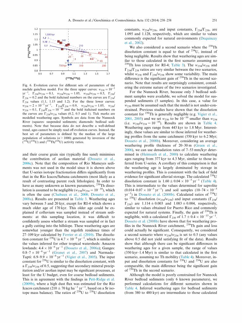
Fig. 6. Evolution curves for different sets of parameters of thenuclide gain/loss model. For the three upper curves: w238 = 10�5
yr�1, C238/w238 = 0.1, w234/w238 = 1.05, w230/w238 = 0.5, C230/
C238 = 0.2 and the bold italicised numbers on the curves are C234/
C238 values (1.1, 1.15 and 1.2). For the three lower curves:w238 = 2 � 10�5 yr�1, C234/C238 = 0.9, w234/w238 = 1.05, w230/
w238 = 0.1, C230/C238 = 10�10 and the bold italicised numbers onthe curves are C238/w238 values (0.2, 0.5 and 1). Tick marks aremodelled weathering ages. Symbols are data from the NunnockRiver (squares: suspended sediments; diamonds: bedload sedi-ments). Note that because data do not describe a well-definedtrend, ages cannot be simply read off evolution curves. Instead, thebest set of parameters is defined by the median of the largepopulation of solutions (n > 1000) generated by inversion of the(234U/238U) and (230Th/238U) activity ratios.
A. Dosseto et al. / Geochimica et Cosmochimica Acta 132 (2014) 238–258 251
and their coarse grain size (typically fine sand) minimisesthe contribution of aeolian material (Dosseto et al.,2006c). Note that the composition of Rio Mameyes sedi-ments was not used in the model since it is shown abovethat U-series isotope fractionation differs significantly fromthat in the Rio Icacos/Sabana catchments (most likely as aresult of contrasting parent rock lithologies). In order tohave as many unknown as known parameters, 230Th disso-lution is assumed to be negligible (w230/w234 = 10�10), whichis often the case (Chabaux et al., 2008; Dosseto et al.,2008a). Results are presented in Table 3. Weathering agesvary between 5 and 20 kyr, except for RI-4 which shows amuch older age of 170 kyr. This older age could be ex-plained if colluvium was sampled instead of stream sedi-ments: at this sampling location, it was difficult toconfidently assess whether a stream was sampled or in facta gully cutting into the hillslope. These weathering ages aresomewhat younger than the regolith residence times of27–109 kyr calculated by Ferrier et al. (2010). The dissolu-tion constant for 238U is 4.7 � 10�6 yr�1, which is similar tothe values inferred for other tropical watersheds: Amazonlowlands: 4.4 � 10�6 yr�1 (Dosseto et al., 2006a); Ganges:0.8–7 � 10�6 yr�1 (Granet et al., 2007) and Narmada–Tapti: 6.9–9.9 � 10�6 yr�1 (Vigier et al., 2005). The inputconstant for 238U is similar to the dissolution constant, witha C238/w238 of 0.5, suggesting that secondary mineral precip-itation and/or aeolian input may be significant processes, atleast for the U budget, even for coarse bedload sediments.This is in agreement with the findings in Pett-Ridge et al.(2009b), where a high dust flux was estimated for the RioIcacos catchment (210 ± 70 kg ha�1 yr�1, based on a Sr iso-tope mass balance). The ratios of 234U to 238U dissolution
constants, w234/w238, and input constants, C234/C238, are1.095 and 1.128, respectively, which are similar to valuescommonly expected for natural environments (Dequinceyet al., 2002).
We also considered a second scenario where the 230Thdissolution constant is equal to that of 234U, instead ofbeing negligible. Results show that weathering ages are sim-ilar to those calculated in the first scenario assuming no230Th loss (except for RI-4; Table 3). The w234/w238 andC234/C238 ratios are very similar between the two scenarios,whilst w238 and C238/w238 show some variability. The maindifference is the significant gain of 230Th in the second sce-nario. Note that results are surprisingly consistent, consid-ering the extreme nature of the two scenarios investigated.
For the Nunnock River, because only 3 bedload sedi-ment samples were available, we solved the model for sus-pended sediments (5 samples). In this case, a value forw230 must be assumed such that the model is not under-con-strained. Previous studies have shown that the dissolutionconstant for 230Th is generally negligible (e.g. Vigier et al.,2001, 2005) and we set w230 to be 10�10 smaller than w234
(i.e. w230/w234 = 10�10). Results are shown in Table 4.Weathering ages range from 443 kyr to 1.8 Myr. Interest-ingly, these values are similar to those inferred for weather-ing profiles from the same catchment (550 kyr to 6.2 Myr;Dosseto et al., 2008b). Moreover, considering an averageweathering profile thickness of 20–30 m (Green et al.,2006), we can use denudation rates of 7–53 mm/kyr deter-mined in (Heimsath et al., 2000) to calculate weatheringages ranging from 377 kyr to 4.3 Myr, similar to those in-ferred from U-series. A corollary of this comparison is thatthe weathering age is largely dominated by storage inweathering profiles. This is consistent with the lack of fieldevidence for significant alluvial storage. The calculated 238Udissolution constant is 1.60 ± 0.04 � 10�5 yr�1 (Table 4).This is intermediate to the values determined for saprolite(0.014–0.07 � 10�5 yr�1) and soil samples (10–74 � 10�5
yr�1) in Dosseto et al. (2008b). Calculated ratios of 234Uto 238U dissolution (w234/w238) and input constants (C234/
C238) are 1.114 ± 0.003 and 1.083 ± 0.004, respectively,similar to values obtained for Puerto Rico and commonlyexpected for natural systems. Finally, the gain of 230Th isnegligible, with a calculated C230 of 1.7 ± 0.4 � 10�15 yr�1.Dosseto et al. (2008b) have shown that for weathering pro-files in the Nunnock River catchment, 230Th gain and losscould actually be significant. Consequently, we considereda second scenario where w230/w234 is set to 0.5 (any valuesabove 0.5 did not yield satisfying fit of the data). Resultsshow that although there can be significant differences inweathering ages for a given sample, the range of values(350 kyr–1.4 Myr) is similar to that calculated in the firstscenario, assuming no Th mobility (Table 4). Moreover, in-put and dissolution constants for 238U and 234U are alsocomparable, the main difference being the significant gainof 230Th in the second scenario.
Although the model is poorly constrained for NunnockRiver bedload sediments (only 6 known parameters), weperformed calculations for different scenarios shown inTable 4. Inferred weathering ages for bedload sediments(from 380 to 480 kyr) are intermediate to those calculated

Table 3Solutions of the continuous loss-input nuclide model for Rio Icacos/Sabana catchments.
Sample ID Tres (kyr) 2 Std. Err. Value 2 Std. Err.
w230/w234 set to 10�10
RI-4 174 3 w238 (yr�1) 4.65E�06 1.7E�07Icacos 5.1 0.1 w234/w238 1.095 0.002Quebrada Guaba bed 19.4 0.4 C238/w238 0.54 0.03Quebrada Guaba bank 10.5 0.2 C234/C238 1.128 0.007Sabana 11.7 0.3 C230/C234 0.022 0.003
w230/w234 set to 1
RI-4 85 12 w238 (yr�1) 1.00E�05 8.3E�07Icacos 5.4 0.3 w234/w238 1.100 0.002Quebrada Guaba bed 22.1 0.8 C238/k238 0.19 0.08Quebrada Guaba bank 12.1 0.3 C234/C238 1.341 0.013Sabana 13.7 0.4 C230/C234 1.831 0.025
Table 4Solutions of the continuous loss-input nuclide model for Nunnock River.
Sample ID Tw (kyr) 2 Std. Err. Value 2 Std. Err.
Suspended sediments
w230/w234 set to 10�10
NUN01 443 10 w238 (�10�5 yr�1) 1.60 0.04NUN02 1423 88 w234/w238 1.114 0.003NUN03 552 20 C238/w238 0.56 0.02NUN04 1783 161 C234/C238 1.083 0.004NUN05 1472 144 C230/C234 1.7E-10 4E-11
w230/w234 set to 0.5NUN01 346 12 w238 (�10�5 yr�1) 0.92 0.05NUN02 460 29 w234/w238 1.042 0.002NUN03 378 29 C238/w238 0.13 0.01NUN04 534 30 C234/C238 1.127 0.002NUN05 1356 102 C230/C234 0.17 0.05
Bedload sediments
w230/w234 and C230/C234 set to 10�10, and w234/w238 set to 1.05NUN03 418 23 w238 (�10�5 yr�1) 2.59 0.10NUN04 407 21 C238/w238 0.22 0.01NUN05 379 20 C234/C238 0.899 0.001
w230/w234 and C230/C234 set to 10�10, and w234/w238 set to 1.1NUN03 439 21 w238 (�10�5 yr�1) 1.17 0.05NUN04 425 19 C238/w238 0.30 0.01NUN05 393 18 C234/C238 0.927 0.001
w230/w234 and C230/C234 set to 0.5, and w234/w238 set to 1.05NUN03 478 19 w238 (�10�5 yr�1) 1.60 0.05NUN04 471 16 C238/w238 0.008 0.002NUN05 453 17 C234/C238 0.894 0.001
252 A. Dosseto et al. / Geochimica et Cosmochimica Acta 132 (2014) 238–258
for the suspended load. The dissolution constant for 238U issimilar to that calculated for suspended sediments, whilstthe input constant can vary extensively depending on thescenario considered. The ratio of 234U to 238U input coeffi-cients, C234/C238 reflects the 234U–238U composition of thecomponent supplying U to sediments. In bedload sedi-ments, the C234/C238 ratio is less than 1 and could beexplained by the contribution of aeolian material with(234U/238U) < 1. In suspended sediments, dust contributioncould be overprinted by the gain of U with (234U/238U) > 1from metal oxides and organic matter coatings, resulting inan overall modelled C234/C238 > 1 for suspended sediments.
3.5. Catchment-wide weathering rates
Weathering ages as short as 5 kyr for Puerto Rico aresurprising considering that weathering profiles in the RioIcacos basin are several meters thick (White et al., 1998).Considering a minimum regolith thickness of 3 m (Whiteet al., 1998), such a young age would imply a minimum ero-sion rate of 600 mm/kyr, which would be much greater thanprevious estimates using cosmogenic isotopes of �43 mm/kyr (Brown et al., 1995) or 100 ± 23 mm/kyr (from amal-gamated soil samples; Riebe et al., 2003). Moreover, weath-ering ages calculated here are somewhat younger than
A. Dosseto et al. / Geochimica et Cosmochimica Acta 132 (2014) 238–258 253
regolith residence times inferred in Ferrier et al. (2010).Young weathering ages suggest that stream sediments“bypass” the weathering profile and are instead removed di-rectly from the deeper horizons, having undergone lesschemical weathering (Fig. 1c). This scenario is plausible inPuerto Rico where hillslope erosion is strongly dominatedby landslides with a mean depth between 2 and 12 m(Larsen, 2012). In contrast, older weathering ages calcu-lated for the Nunnock River catchment reflect removal ofsediment only from the top of old weathering profiles vianear-surface soil transport (Fig. 1b).
An alternative hypothesis to explain older weatheringages for the Nunnock River would be to consider thatweathering age is related to catchment size, where a largercatchment would imply a longer sediment transport timeand thus a longer duration of weathering. Although theNunnock River catchment is about ten times larger thanRio Icacos, there is no evidence for significant alluvial stor-age in either of these catchments that could justify such arelationship.
Yoo and Mudd (2008), building on work by White andBrantley (2003), proposed a law for the ground surfacearea-normalised weathering rate of minerals in regolith thatcombines mineral dissolution rate constants with weather-ing duration:
wj ¼6ajbjxj
Djql;js
ajþbjj mj ð2Þ
where subscript j refers to the mineral of interest, wj is theweathering rate (in kg/m2/yr), xj the molar mass (in mol/kg), Dj the particle diameter (in m), ql,j the density (inkg/m3), mj the present mass of mineral j per ground surfacearea (in kg/m2) and sj is the amount of time mineral j hasbeen exposed to weathering, i.e. the weathering age of min-eral j. The constants a, b, a and b describe the relationshipbetween the mineral dissolution rate constant, R, the min-eral surface roughness, k, and time: R = asa and k = bsb.The evolution of the mass of mineral j is described by thefollowing equation:
mj ¼ mj;0 exp � 6ajbjxj
Djql;jð1þ aj þ bjÞs
1þajþbjj
" #ð3Þ
where mj,0 is the initial mass of mineral j per ground surfacearea (in kg/m2). It is calculated as mj,0 = Xj,0qrh, where Xj,0
Table 5List and values of parameters used to calculate weathering rates.
Parameter Unit j = biotite j = plag Comments
aj mol/m2/yr 1.51 � 10�5 1.09 � 10�5 Constant raj unitless �0.603 �0.564 Constant rbj unitless 13.6 13.6 Constant rbj unitless 0.2 0.2 Constant rxj kg/mol 0.408 0.263 Mineral moDj m 0.0005 0.0005 Mineral paqu,j kg/m3 3000 2600 Mineral deXj,0 kg/kg 0.095 0.564 Initial masXj,0 kg/kg 0.05 0.12 Initial mash m 9 9 Weatheringh m 30 30 Weathering
is the initial mass fraction of mineral j (in kg/kg), qr is thedensity of the parent rock and h is the weathering profilethickness.
Eqs. (2) and (3) can be used to estimate catchment-wideweathering rates for specific minerals from the averageweathering ages determined from U-series isotopes in sedi-ments (this study) and values for the other parameters fromthe literature (Table 5; Murphy et al., 1998; White andBrantley, 2003; Buss et al., 2008; Yoo and Mudd, 2008;Ferrier et al., 2010). For Rio Icacos, using weathering agesbetween 5 and 20 kyr, we calculate catchment-wide biotiteweathering rates between 1.8 � 10�9 and 0.91 � 10�9 mol/m2/s. In a previous study, Murphy et al. (1998) have calcu-lated biotite weathering rates from pore water Mg and Kconcentrations in a regolith profile of Rio Icacos. Theseweathering rates, wBET,j, were normalised to mineral sur-face area (measured by the N2 Brunauer–Emmett–Teller,BET, method). They can be compared to our catchment-wide estimates by converting wBET,j values to ground sur-face area-normalised rates:
w0j ¼ wBET ;j6kmj
Dql;jð4Þ
The resulting biotite dissolution rate, w0j, is 0.63 � 10�9
mol/m2/s, which is slightly lower but comparable to ourestimates.
Catchment-wide weathering rates can also be deter-mined for other minerals with our approach. For plagio-clase, we infer values ranging from 7.0 � 10�9 to13 � 10�9 mol/m2/s. These rates are similar to those calcu-lated from cosmogenic nuclides and mineral abundances:Ferrier et al. (2010) reported a plagioclase weathering rateof 9.8 � 10�9 mol/m2/s for Rio Icacos saprolite (at 2.2 mdepth) whilst Buss et al. (2008) calculated a faster rate of27 � 10�9 mol/m2/s for the Rio Icacos saprock (convertedfrom a BET surface area-normalised rate using Eq. (4),assuming a 5 kyr weathering age and a 0.5 m profile thick-ness representing the thickness of the saprock layeranalysed).
As anticipated because of older weathering ages, calcu-lated plagioclase weathering rates for the Nunnock Riverare slower than for Rio Icacos: between 0.075 � 10�9 and0.78 � 10�9 mol/m2/s (calculated for weathering ages be-tween 350 and 1800 kyr). This is similar to weathering ratesestimated for a hillslope in this catchment by Green et al.
elating mineral dissolution rate to time (White and Brantley, 2003)elating mineral dissolution rate to time (White and Brantley, 2003)elating surface roughness to time (Yoo and Mudd, 2008)elating surface roughness to time (Yoo and Mudd, 2008)lar mass
rticle diameter (Murphy et al., 1998; Buss et al., 2008)nsitys fraction of mineral, Rio Icacos (White et al., 1998)s fraction of mineral, Nunnock River (Burg and Wilson, 1988)
profile thickness, Rio Icacos (White et al., 1998)profile thickness, Nunnock River (Green et al., 2006)
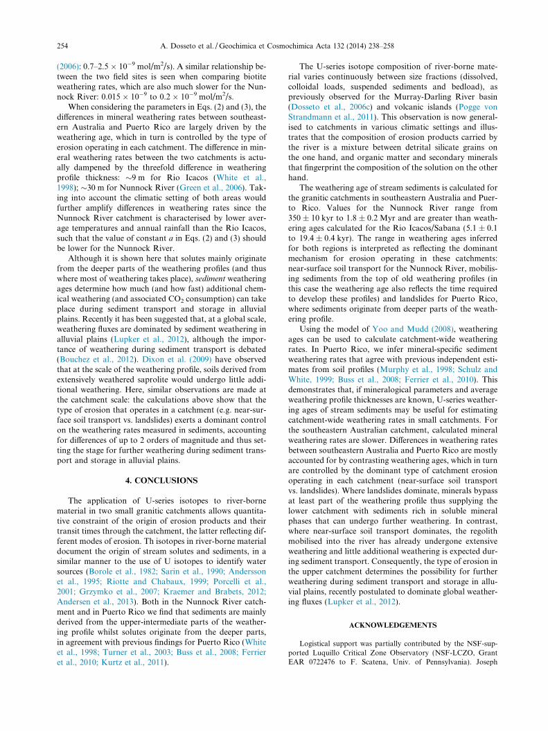
254 A. Dosseto et al. / Geochimica et Cosmochimica Acta 132 (2014) 238–258
(2006): 0.7–2.5 � 10�9 mol/m2/s). A similar relationship be-tween the two field sites is seen when comparing biotiteweathering rates, which are also much slower for the Nun-nock River: 0.015 � 10�9 to 0.2 � 10�9 mol/m2/s.
When considering the parameters in Eqs. (2) and (3), thedifferences in mineral weathering rates between southeast-ern Australia and Puerto Rico are largely driven by theweathering age, which in turn is controlled by the type oferosion operating in each catchment. The difference in min-eral weathering rates between the two catchments is actu-ally dampened by the threefold difference in weatheringprofile thickness: �9 m for Rio Icacos (White et al.,1998); �30 m for Nunnock River (Green et al., 2006). Tak-ing into account the climatic setting of both areas wouldfurther amplify differences in weathering rates since theNunnock River catchment is characterised by lower aver-age temperatures and annual rainfall than the Rio Icacos,such that the value of constant a in Eqs. (2) and (3) shouldbe lower for the Nunnock River.
Although it is shown here that solutes mainly originatefrom the deeper parts of the weathering profiles (and thuswhere most of weathering takes place), sediment weatheringages determine how much (and how fast) additional chem-ical weathering (and associated CO2 consumption) can takeplace during sediment transport and storage in alluvialplains. Recently it has been suggested that, at a global scale,weathering fluxes are dominated by sediment weathering inalluvial plains (Lupker et al., 2012), although the impor-tance of weathering during sediment transport is debated(Bouchez et al., 2012). Dixon et al. (2009) have observedthat at the scale of the weathering profile, soils derived fromextensively weathered saprolite would undergo little addi-tional weathering. Here, similar observations are made atthe catchment scale: the calculations above show that thetype of erosion that operates in a catchment (e.g. near-sur-face soil transport vs. landslides) exerts a dominant controlon the weathering rates measured in sediments, accountingfor differences of up to 2 orders of magnitude and thus set-ting the stage for further weathering during sediment trans-port and storage in alluvial plains.
4. CONCLUSIONS
The application of U-series isotopes to river-bornematerial in two small granitic catchments allows quantita-tive constraint of the origin of erosion products and theirtransit times through the catchment, the latter reflecting dif-ferent modes of erosion. Th isotopes in river-borne materialdocument the origin of stream solutes and sediments, in asimilar manner to the use of U isotopes to identify watersources (Borole et al., 1982; Sarin et al., 1990; Anderssonet al., 1995; Riotte and Chabaux, 1999; Porcelli et al.,2001; Grzymko et al., 2007; Kraemer and Brabets, 2012;Andersen et al., 2013). Both in the Nunnock River catch-ment and in Puerto Rico we find that sediments are mainlyderived from the upper-intermediate parts of the weather-ing profile whilst solutes originate from the deeper parts,in agreement with previous findings for Puerto Rico (Whiteet al., 1998; Turner et al., 2003; Buss et al., 2008; Ferrieret al., 2010; Kurtz et al., 2011).
The U-series isotope composition of river-borne mate-rial varies continuously between size fractions (dissolved,colloidal loads, suspended sediments and bedload), aspreviously observed for the Murray-Darling River basin(Dosseto et al., 2006c) and volcanic islands (Pogge vonStrandmann et al., 2011). This observation is now general-ised to catchments in various climatic settings and illus-trates that the composition of erosion products carried bythe river is a mixture between detrital silicate grains onthe one hand, and organic matter and secondary mineralsthat fingerprint the composition of the solution on the otherhand.
The weathering age of stream sediments is calculated forthe granitic catchments in southeastern Australia and Puer-to Rico. Values for the Nunnock River range from350 ± 10 kyr to 1.8 ± 0.2 Myr and are greater than weath-ering ages calculated for the Rio Icacos/Sabana (5.1 ± 0.1to 19.4 ± 0.4 kyr). The range in weathering ages inferredfor both regions is interpreted as reflecting the dominantmechanism for erosion operating in these catchments:near-surface soil transport for the Nunnock River, mobilis-ing sediments from the top of old weathering profiles (inthis case the weathering age also reflects the time requiredto develop these profiles) and landslides for Puerto Rico,where sediments originate from deeper parts of the weath-ering profile.
Using the model of Yoo and Mudd (2008), weatheringages can be used to calculate catchment-wide weatheringrates. In Puerto Rico, we infer mineral-specific sedimentweathering rates that agree with previous independent esti-mates from soil profiles (Murphy et al., 1998; Schulz andWhite, 1999; Buss et al., 2008; Ferrier et al., 2010). Thisdemonstrates that, if mineralogical parameters and averageweathering profile thicknesses are known, U-series weather-ing ages of stream sediments may be useful for estimatingcatchment-wide weathering rates in small catchments. Forthe southeastern Australian catchment, calculated mineralweathering rates are slower. Differences in weathering ratesbetween southeastern Australia and Puerto Rico are mostlyaccounted for by contrasting weathering ages, which in turnare controlled by the dominant type of catchment erosionoperating in each catchment (near-surface soil transportvs. landslides). Where landslides dominate, minerals bypassat least part of the weathering profile thus supplying thelower catchment with sediments rich in soluble mineralphases that can undergo further weathering. In contrast,where near-surface soil transport dominates, the regolithmobilised into the river has already undergone extensiveweathering and little additional weathering is expected dur-ing sediment transport. Consequently, the type of erosion inthe upper catchment determines the possibility for furtherweathering during sediment transport and storage in allu-vial plains, recently postulated to dominate global weather-ing fluxes (Lupker et al., 2012).
ACKNOWLEDGEMENTS
Logistical support was partially contributed by the NSF-sup-ported Luquillo Critical Zone Observatory (NSF-LCZO, GrantEAR 0722476 to F. Scatena, Univ. of Pennsylvania). Joseph
A. Dosseto et al. / Geochimica et Cosmochimica Acta 132 (2014) 238–258 255
Troester is thanked for support in the field and helpful discussions,Manuel Rosario Torres and all the staff at the US Geological Sur-vey (USGS) Guaynabo, Puerto Rico, for their help and facilitatingsample processing after collection. We also thank Grant Douglasfor help with filtration logistics and Derek Fabel for preparing soilquartz samples. AD is supported by an Australian Research Coun-cil Future Fellowship (FT0990447). HLB acknowledges support ofthe USGS Water Energy and Biogeochemical Budgets program.This work was supported by two Australian Research CouncilDiscovery grants (DP0451704 and DP1093708).
APPENDIX A. SUPPLEMENTARY DATA
Supplementary data associated with this article can befound, in the online version, at http://dx.doi.org/10.1016/j.gca.2014.02.010.
REFERENCES
Ames L. L., McGarrah J. E. and Walker B. A. (1983a) Sorption oftrace constituents from aqueous solutions onto secondaryminerals. II Radium. Clays Clay Miner. 31, 335–342.
Ames L. L., McGarrah J. E. and Walker B. A. (1983b) Sorption ofuranium and radium by biotite, muscovite and phlogopite.Clays Clay Miner. 31, 343–351.
Andersen M. B., Vance D., Keech A., Rickli J. and Hudson G.(2013) Estimating U fluxes in a high-latitude, boreal post-glacial setting using U-series isotopes in soils and rivers. Chem.
Geol. 354, 22–32.Andersson P. S., Wasserburg G. J., Chen J. H. and Papanastassiou
D. A. (1995) 238U–234U and 232Th–230Th in the Baltic Sea andin river water. Earth Planet. Sci. Lett. 130, 217–234.
Bengtsson L. and Enell M. (1986) Chemical analysis. In Handbook
of Holocene Palaeoecology and Palaeohydrology (ed. B. E.Berglund). John Wiley & Sons Ltd, Chichester, pp. 423–451.
Borole D. V., Krishnaswami S. and Somayajulu B. L. K. (1982)Uranium isotopes in rivers, estuaries and adjacent coastalsediments of western India: their weathering, transport andoceanic budget. Geochim. Cosmochim. Acta 46, 125–137.
Bouchez J., Lupker M., Gaillardet J., France-Lanord C. andMaurice L. (2011) How important is it to integrate riverinesuspended sediment chemical composition with depth? Cluesfrom Amazon River depth-profiles. Geochim. Cosmochim. Acta
75, 6955–6970.Bouchez J., Gaillardet J., Lupker M., Louvat P., France-Lanord
C., Maurice L., Armijos E. and Moquet J.-S. (2012) Flood-plains of large rivers: weathering reactors or simple silos? Chem.
Geol. 332–333, 166–184.Braun J., Heimsath A. M. and Chappell J. (2001) Sediment transport
mechanisms on soil-mantled hillslopes. Geology 29, 683–686.Brown E. T., Stallard R. F., Larsen M. C., Raisbeck G. M. and
Yiou F. (1995) Denudation rates determined from the accu-mulation of in-situ produced 10Be in the Luquillo ExperimentalForest, Puerto Rico. Earth Planet. Sci. Lett. 129, 193–202.
Bureau of Meteorology Australia. (1999) Climate average for Bega,NSW, 1879–1996; Bombala, NSW, 1885–1996; and Nimmita-bel, NSW, 1894–1996.
Burg J. P. and Wilson C. J. L. (1988) A kinematic analysis of thesouthernmost part of the Bega Batholith. Aust. J. Earth Sci. 35,1–13.
Buss H. and White A. (2012) Weathering processes in the RioIcacos Watershed. In Water Quality and Landscape Processesof Four Watersheds in Eastern Puerto Rico (eds. S. F. Murphyand R. F. Stallard). U.S. Geological Survey, pp. 249–262.
Buss H. L., Bruns M. A., Schultz M. J., Moore J., Mathur C. F.and Brantley S. L. (2005) The coupling of biological ironcycling and mineral weathering during saprolite formation,Luquillo Mountains, Puerto Rico. Geobiology 3, 247–260.
Buss H. L., Sak P. B., Webb S. M. and Brantley S. L. (2008)Weathering of the Rio Blanco quartz diorite, Luquillo Moun-tains, Puerto Rico: coupling oxidation, dissolution, and frac-turing. Geochim. Cosmochim. Acta 72, 4488–4507.
Buss H. L., Mathur R., White A. F. and Brantley S. L. (2010)Phosphorus and iron cycling in deep saprolite, LuquilloMountains, Puerto Rico. Chem. Geol. 269, 52–61.
Buss H. L., Brantley S. L., Scatena F. N., Bazilievskaya E. A.,Blum A., Schulz M., Jimenez R., White A. F., Rother G. andCole D. (2013) Probing the deep critical zone beneath theLuquillo Experimental Forest, Puerto Rico. Earth Surf. Proc.
Landforms 38, 1170–1186.Chabaux F. and Allegre C. J. (1994) 238U–230Th-226Ra disequilibria
in volcanics: a new insight into melting conditions. Earth
Planet. Sci. Lett. 126, 61–74.Chabaux F., Dequincey O., Leveque J.-J., Leprun J.-C., Clauer N.,
Riotte J. and Paquet H. (2003a) Tracing and dating recentchemical transfers in weathering profiles by trace-elementgeochemistry and 238U–234U–230Th disequilibria: the exampleof the Kaya lateritic toposequence (Burkina-Faso). CR Geosci.
335, 1219–1231.Chabaux F., Riotte J. and Dequincey O. (2003b) U–Th–Ra
fractionation during weathering and river transport. In Ura-
nium-series Geochemistry (eds. B. Bourdon, G. M. Henderson,C. C. Lundstrom and S. P. Turner). Geochemical Society –Mineralogical Society of America, Washington, pp. 533–576.
Chabaux F., Granet M., Pelt E., France-Lanord C. and Galy V.(2006) 238U–234U–230Th disequilibria and timescale of sedimen-tary transfers in rivers: clues from the Gangetic plain rivers. J.
Geochem. Explor. 88, 373–375.Chabaux F., Bourdon B. and Riotte J. (2008) U-Series Geochem-
istry in Weathering Profiles, River Waters and Lakes, Radioac-
tivity in the Environment. Elsevier.Chabaux F., Blaes E., Stille P., di Chiara Roupert R., Pelt E.,
Dosseto A., Ma L., Buss H. L. and Brantley S. L. (2013)Regolith formation rate from U-series nuclides: implicationsfrom the study of a spheroidal weathering profile in the RioIcacos watershed (Puerto Rico). Geochim. Cosmochim. Acta
100, 73–95.Chamberlain C. P., Waldbauer J. R. and Jacobson A. D. (2005)
Strontium, hydrothermal systems and steady-state chemicalweathering in active mountain belts. Earth Planet. Sci. Lett.
238, 351–366.Cheng H., Lawrence Edwards R., Shen C.-C., Polyak V. J.,
Asmerom Y., Woodhead J., Hellstrom J., Wang Y., Kong X.,Spotl C., Wang X. and Calvin Alexander, Jr., E. (2013)Improvements in 230Th dating, 230Th and 234U half-life values,and U–Th isotopic measurements by multi-collector inductivelycoupled plasma mass spectrometry. Earth Planet. Sci. Lett.
371–372, 82–91.Dean W. E. (1974) Determination of carbonate and organic matter
in calcareous sediments and sedimentary rocks by loss onignition; comparison with other methods. J. Sediment. Res. 44,242–248.
DePaolo D. J., Maher K., Christensen J. N. and McManus J.(2006) Sediment transport time measured with U-series iso-topes: results from ODP North Atlantic drift site 984. Earth
Planet. Sci. Lett. 248, 394–410.Dequincey O., Chabaux F., Clauer N., Liewig N. and Muller J.-P.
(1999) Dating of weathering profiles by radioactive disequilib-ria: contribution of the study of authigenic mineral fractions.CR Acad. Sci. Ser. IIA Earth Planet. Sci 328, 679–685.
256 A. Dosseto et al. / Geochimica et Cosmochimica Acta 132 (2014) 238–258
Dequincey O., Chabaux F., Clauer N., Sigmarsson O., Liewig N.and Leprun J.-C. (2002) Chemical mobilizations in laterites:evidence from trace elements and 238U–234U–230Th disequilib-ria. Geochim. Cosmochim. Acta 66, 1197–1210.
Dixon J. L., Heimsath A. M. and Amundson R. (2009) The criticalrole of climate and saprolite weathering in landscape evolution.Earth Surf. Proc. Land. 34, 1507–1521.
Donkin M. J. (1991) Loss-on-ignition as an estimator of soilorganic carbon in A-horizon forestry soils. Commun. Soil Sci.
Plant Anal. 22, 233–241.Dosseto A., Bourdon B., Gaillardet J., Allegre C. J. and Filizola N.
(2006a) Timescale and conditions of chemical weathering undertropical climate: study of the Amazon basin with U-series.Geochim. Cosmochim. Acta 70, 71–89.
Dosseto A., Bourdon B., Gaillardet J., Maurice-Bourgoin L. andAllegre C. J. (2006b) Weathering and transport of sediments inthe Bolivian Andes: time constraints from uranium-seriesisotopes. Earth Planet. Sci. Lett. 248, 759–771.
Dosseto A., Turner S. and Douglas G. B. (2006c) Uranium-seriesisotopes in colloids and suspended sediments: timescale forsediment production and transport in the Murray-DarlingRiver system. Earth Planet. Sci. Lett. 246, 418–431.
Dosseto A., Turner S., Buss H. L. and Chabaux F. (2007) Thetimescale of sediment transport in a small tropical watershed.Geochim. Cosmochim. Acta 71(Suppl. 1).
Dosseto A., Bourdon B. and Turner S. P. (2008a) Uranium-seriesisotopes in river materials: insights into the timescales oferosion and sediment transport. Earth Planet. Sci. Lett. 265, 1–17.
Dosseto A., Turner S. P. and Chappell J. (2008b) The evolution ofweathering profiles through time: new insights from uranium-series isotopes. Earth Planet. Sci. Lett. 274, 359–371.
Dosseto A., Hesse P., Maher K., Fryirs K. and Turner S. P. (2010)Climatic and vegetation control on sediment dynamics. Geology
38, 395–398.Dosseto A., Buss H. and Suresh P. O. (2011) The delicate balance
between soil production and erosion, and its role on landscapeevolution. Appl. Geochem. 26, S24–S27.
Dosseto A., Buss H. L. and Suresh P. O. (2012) Rapid regolithformation over volcanic bedrock and implications for land-scape evolution. Earth Planet. Sci. Lett. 337–338, 47–55.
Douglas G. B. (1993) Characterization of Suspended Particulate
Matter in the Murray-Darling River System. Monash Univer-sity, Melbourn.
Eggins S. M., Woodhead J. D., Kinsley L. P. J., Mortimer G. E.,Sylvester P., McCulloch M. T., Hergt J. M. and Handler M.R. (1997) A simple method for the precise determination of P40 trace elements in geological samples by ICPMS usingenriched isotope internal standardisation. Chem. Geol. 134,311–326.
Ferrier K. L. and Kirchner J. W. (2008) Effects of physical erosionon chemical denudation rates: a numerical modeling study ofsoil-mantled hillslopes. Earth Planet. Sci. Lett. 272, 591–599.
Ferrier K. L., Kirchner J. W., Riebe C. S. and Finkel R. C. (2010)Mineral-specific chemical weathering rates over millennialtimescales: measurements at Rio Icacos, Puerto Rico. Chem.
Geol. 277, 101–114.Fleischer R. L. (1980) Isotopic disequilibrium of uranium: alpha-
recoil damage and preferential solution effects. Science 207,979–981.
Fleischer R. L. (1982a) Alpha-recoil damage and solution effects inminerals: uranium isotopic disequilibrium and radon release.Geochim. Cosmochim. Acta 46, 2191–2201.
Fleischer R. L. (1982b) Nature of alpha-recoil damage: evidencefrom preferential solution effects. Nucl. Tracks Radiat. Meas.
(1982) 6, 35–42.
Fleischer R. L. and Raabe O. G. (1978) Recoiling alpha-emittingnuclei. Mechanisms for uranium-series disequilibrium. Geo-
chim. Cosmochim. Acta 42, 973–978.Gaillardet J., Dupre B. and Allegre C. J. (1995) A global mass
budget applied to the Congo Basin rivers: erosion rates andcontinental crust composition. Geochim. Cosmochim. Acta 59,3469–3485.
Gaillardet J., Dupre B., Allegre C. J. and Negrel P. (1997)Chemical and physical denudation in the Amazon River Basin.Chem. Geol. 142, 141–173.
Goldin A. (1987) Reassessing the use of loss-on-ignition forestimating organic matter content in noncalcareous soils.Commun. Soil Sci. Plant Anal. 18, 1111–1116.
Granet M., Chabaux F., Stille P., France-Lanord C. and Pelt E.(2007) Time-scales of sedimentary transfer and weatheringprocesses from U-series nuclides: clues from the Himalayanrivers. Earth Planet. Sci. Lett. 261, 389–406.
Granet M., Chabaux F., Stille P., Dosseto A., France-Lanord C.and Blaes E. (2010) U-series disequilibria in suspended riversediments and implication for sediment transfer time in alluvialplains: the case of the Himalayan rivers. Geochim. Cosmochim.
Acta 74, 2851–2865.Green E. G., Dietrich W. E. and Banfield J. F. (2006) Quantifi-
cation of chemical weathering rates across an actively erodinghillslope. Earth Planet. Sci. Lett. 242, 155–169.
Grzymko T. J., Marcantonio F., McKee B. A. and Mike StewartC. (2007) Temporal variability of uranium concentrations and234U/238U activity ratios in the Mississippi river and itstributaries. Chem. Geol. 243, 344–356.
Heartsill-Scaley T., Scatena F. N., Estrada C., McDowell W. H.and Lugo A. E. (2007) Disturbance and long-term patterns ofrainfall and throughfall nutrient fluxes in a subtropical wetforest in Puerto Rico. J. Hydrol. 333, 472–485.
Heimsath A. M., Chappell J., Dietrich W. E., Nishiizumi K. andFinkel R. C. (2000) Soil production on a retreating escarpmentin southeastern Australia. Geology 28, 787–790.
Heimsath A. M., Chappell J., Spooner N. A. and Questiaux D. G.(2002) Creeping soil. Geology 30, 111–114.
Heiri O., Lotter A. F. and Lemcke G. (2001) Loss on ignition as amethod for estimating organic and carbonate content insediments: reproducibility and comparability of results. J.
Paleolimnol. 25, 101–110.Hidaka H., Horie K. and Gauthier-Lafaye F. (2007) Transport and
selective uptake of radium into natural clay minerals. Earth
Planet. Sci. Lett. 264, 167–176.Hussain N. and Lal D. (1986) Preferential solution of 234U from
recoil tracks and 234U/238U radioactive disequilibrium innatural waters. Proc. Indian Acad. Sci. Earth Planet. Sci. 95,245–263.
Jolly W. T., Lidiak E. G., Dickin A. P. and Wu T.-W. (1998a)Geochemical diversity of Mesozoic island arc tectonic blocks ineastern Puerto Rico. In Tectonics and Geochemistry of the
Northeastern Caribbean (eds. E. G. Lidiak and D. K. Larue).Geological Society of America, Boulder, Colorado, pp. 67–98.
Jolly W. T., Lidiak E. G., Schellenkens J. H. and Santos J. (1998b)Volcanism, tectonic and stratigraphic correlations in PuertoRico. In Tectonics and Geochemistry of the Northeastern
Caribbean (eds. E. G. Lidiak and D. K. Larue). GeologicalSociety of America, Boulder, Colorado, pp. 1–34.
Keech A. R., West A. J., Pett-Ridge J. C. and Henderson G. M.(2013) Evaluating U-series tools for weathering rate andduration on a soil sequence of known ages. Earth Planet. Sci.
Lett..Kigoshi K. (1971) Alpha-recoil thorium-234: dissolution into water
and the uranium-234/uranium-238 disequilibrium in nature.Science 173, 47–48.
A. Dosseto et al. / Geochimica et Cosmochimica Acta 132 (2014) 238–258 257
Kohl C. P. and Nishiizumi K. (1992) Chemical isolation of quartzfor measurement of in-situ-produced cosmogenic nuclides.Geochim. Cosmochim. Acta 56, 3583–3587.
Kraemer T. F. and Brabets T. P. (2012) Uranium isotopes(234U/238U) in rivers of the Yukon Basin (Alaska and Canada)as an aid in identifying water sources, with implications formonitoring hydrologic change in arctic regions. Hydrogeol. J.
20, 469–481.Krishnaswami S., Williams G. A., Graustein W. C. and Turekian
K. K. (2004) The effect of weathering regime on uranium decayseries and osmium in two soil profiles. Geochem. J. 38, 651–660.
Kurtz A. C., Lugolobi F. and Salvucci G. (2011) Germanium–silicon as a flow path tracer: application to the Rio Icacoswatershed. Water Resour. Res. 47.
Larsen M. C. (2012) Landslides and sediment budgets in fourwatersheds in Eastern Puerto Rico. In: Water Quality andLandscape Processes of Four Watersheds in Eastern PuertoRico (eds. S.F. Murphy and R. F. Stallard). U.S. GeologicalSurvey, p. 292.
Larsen M. C. and Stallard R. F. (2000) Luquillo Mountains,Puerto Rico. A water, energy, and biogeochemical budgetsprogram site. USGS Fact Sheet 163-99.
Larsen M. C. and Torres-Sanchez A. J. (1992) Landslides triggeredby Hurricane Hugo in Eastern Puerto Rico, September 1989.Carib. J. Sci. 28, 113–125.
Lee V., DePaolo D. J. and Christensen J. N. (2010) Uranium-seriescomminution ages of continental sediments: case study of aPleistocene alluvial fan. Earth Planet. Sci. Lett. 296, 244–254.
Lupker M., France-Lanord C., Galy V., Lave J., Gaillardet J.,Gajurel A. P., Guilmette C., Rahman M., Singh S. K. andSinha R. (2012) Predominant floodplain over mountain weath-ering of Himalayan sediments (Ganga basin). Geochim. Cos-
mochim. Acta 84, 410–432.Ma L., Chabaux F., Pelt E., Blaes E., Jin L. and Brantley S. L.
(2010) Regolith production rates calculated with uranium-seriesisotopes at Susquehanna/Shale Hills Critical Zone Observatory.Earth Planet. Sci. Lett. 297, 211–255.
Marx S. K., Kamber B. S. and McGowan H. A. (2005) Estimatesof Australian dust flux into New Zealand: quantifying theeastern Australian dust plume pathway using trace elementcalibrated 210Pb as a monitor. Earth Planet. Sci. Lett. 239, 336–351.
Murphy S. F., Brantley S. L., Blum A. E., White A. F. and DongH. (1998) Chemical weathering in a tropical watershed,Luquillo Mountains, Puerto Rico: II. Rate and mechanism ofbiotite weathering. Geochim. Cosmochim. Acta 62, 227–243.
Ollier C. D. (1982) The great escarpement of Eastern Australia:tectonic and geomorphic significance. J. Geol. Soc. Aust. 29, 13–23.
Pelt E., Chabaux F., Innocent C., Navarre-Sitchler A. K., Sak P. B.and Brantley S. L. (2008) Uranium–thorium chronometry ofweathering rinds: rock alteration rate and paleo-isotopic recordof weathering fluids. Earth Planet. Sci. Lett. 276, 98–105.
Peters N. E., Shanley J. B., Aulenbach B. T., Webb R. M.,Campbell D. H., Hunt R., Larsen M. C., Stallard R. F.,Troester J. and Walker J. F. (2006) Water and solute massbalance of five small, relatively undisturbed watersheds in theU.S. Sci. Total Environ. 358, 221–242.
Pett-Ridge J. C., Derry L. A. and Barrows J. K. (2009a) Ca/Sr and87Sr/86Sr ratios as tracers of Ca and Sr cycling in the Rio Icacoswatershed, Luquillo Mountains, Puerto Rico. Chem. Geol. 267,32–45.
Pett-Ridge J. C., Derry L. A. and Kurtz A. C. (2009b) Sr isotopesas a tracer of weathering processes and dust inputs in a tropicalgranitoid watershed, Luquillo Mountains, Puerto Rico. Geo-
chim. Cosmochim. Acta 73, 25–43.
Pietruszka A. J., Carlson R. W. and Hauri E. H. (2002) Precise andaccurate measurement of 226Ra–230Th–238U disequilibria involcanic rocks using plasma ionization multicollector massspectrometry. Chem. Geol. 188, 171–191.
Plater A. J., Ivanovich M. and Dugdale R. E. (1992) Uraniumseries disequilibrium in river sediments and waters: the signif-icance of anomalous activity ratios. Appl. Geochem 7.
Pogge von Strandmann P. A. E., Burton K. W., Porcelli D., JamesR. H., van Calsteren P. and Gislason S. R. (2011) Transportand exchange of U-series nuclides between suspended material,dissolved load and colloids in rivers draining basaltic terrains.Earth Planet. Sci. Lett. 301, 125–136.
Porcelli D., Andersson P. S., Baskaran M. and Wasserburg G. J.(2001) Transport of U- and Th-series nuclides in a Baltic Shieldwatershed and the Baltic Sea. Geochim. Cosmochim. Acta 65,2439–2459.
Price R. C., George R., Gamble J. A., Turner S., Smith I. E. M.,Cook C., Hobden B. and Dosseto A. (2007) U–Th–Rafractionation during crustal-level andesite formation at Ruape-hu volcano, New Zealand. Chem. Geol. 244, 437–451.
Prosser I. P., Rutherfurd I. D., Olley J. M., Young W. J.,Wallbrink P. J. and Moran C. J. (2001) Large-scale patterns oferosion and sediment transport in river networks, with exam-ples from Australia. Mar. Freshw. Res. 52, 81–99.
Prosser I., Moran C. J., Lu H., Olley J., DeRose R., Cannon G.,Croke B., Hughes A., Jakeman T., Newham L., Scott A. andWeisse M. (2003) Basin-Wide Mapping of Sediment and Nutrient
Exports in Dryland Regions of the Murray-Darling Basin.CSIRO Land and Water, Canberra, pp. 1–38.
Riebe C. S., Kirchner J. W. and Finkel R. C. (2003) Long-termrates of chemical weathering and physical erosion fromcosmogenic nuclides and geochemical mass balance. Geochim.
Cosmochim. Acta 67, 4411–4427.Riotte J. and Chabaux F. (1999) 234U/238U) activity ratios in
freshwaters as tracers of hydrological processes: the Strengbachwatershed (Vosges, France. Geochim. Cosmochim. Acta 63,1263–1275.
Sarin M. M., Krishnaswami S., Somayajulu B. L. K. and MooreW. S. (1990) Chemistry of uranium, thorium, and radiumisotopes in the Ganga–Brahmaputra river system: weatheringprocesses and fluxes to the Bay of Bengal. Geochim. Cosmo-
chim. Acta 54, 1387–1396.Schulz M. S. and White A. F. (1999) Chemical weathering in a
tropical watershed, Luquillo Mountains, Puerto Rico III:Quartz dissolution rates. Geochim. Cosmochim. Acta 63, 337–350.
Sims K. W. W., Gill J. B., Dosseto A., Hoffmann D. L., LundstromC. C., Williams R. W., Ball L., Tollstrup D., Turner S.,Prytulak J., Glessner J. J. G., Standish J. J. and Elliott T. (2008)An inter-laboratory assessment of the thorium isotopic com-position of synthetic and rock reference materials. Geostand.
Geoanal. Res. 32, 65–91.Smith A. L., Schellenkens J. H. and Diaz A. M. (1998) Batholiths
as markers of tectonic change in the northeastern Caribbean. InTectonics and Geochemistry of the Northeastern Caribbean (eds.E. G. Lidiak and D. K. Larue). Geologic Society of America,Boulder, Colorado, pp. 99–122.
Spain A. V., Probert M. E., Isbell R. F. and John R. D. (1982)Loss-on-ignition and the carbon contents of Australian soils.Aust. J. Soil Res. 20, 147–152.
Turner B. F., Stallard R. F. and Brantley S. L. (2003) Investigationof in situ weathering of quartz diorite bedrock in the Rio Icacosbasin, Luquillo Experimental Forest, Puerto Rico. Chem. Geol.
202, 313–341.Turner S., Bourdon B., Hawkesworth C. and Evans P. (2000)
226Ra–230Th evidence for multiple dehydration events, rapid
258 A. Dosseto et al. / Geochimica et Cosmochimica Acta 132 (2014) 238–258
melt ascent and time scales of differentiation beneath theTonga-Kermadec island arc. Earth Planet. Sci. Lett. 179, 581–593.
Vigier N. and Bourdon B. (2011) Constraining rates of chemicaland physical erosion using U-series radionuclides. In Handbook
of Environmental Isotope Geochemistry (ed. M. Baskaran).Springer, Berlin Heidelberg, pp. 553–571.
Vigier N., Bourdon B., Turner S. and Allegre C. J. (2001) Erosiontimescales derived from U-decay series measurements in rivers.Earth Planet. Sci. Lett. 193, 546–563.
Vigier N., Bourdon B., Lewin E., Dupre B., Turner S., VanCalsteren P., Subramanian V. and Allegre C. J. (2005) Mobilityof U-series nuclides during basalt weathering: an example of theDeccan Traps (India). Chem. Geol. 219, 69–91.
Vigier N., Burton K. W., Gislason S. R., Rogers N. W., DucheneS., Thomas L., Hodge E. and Schaefer B. (2006) The relation-ship between riverine U-series disequilibria and erosion rates ina basaltic terrain. Earth Planet. Sci. Lett. 249, 258–273.
White A. J. R. and Chappell B. W. (1983) Granitoid types and theirdistribution in the Lachlan Fold Belt, southeastern Australia.In Circum-Pacific Plutonic Terranes (ed. J. A. Roddick).Geological Society of America, pp. 21–34.
White A. F. and Brantley S. L. (2003) The effect of time on theweathering of silicate minerals: why do weathering rates differin the laboratory and field? Chem. Geol. 202, 479–506.
White A. F., Blum A. E., Schulz M. S., Bullen T. D., Harden J. W.and Peterson M. L. (1996) Chemical weathering rates of a soilchronosequence on granitic alluvium: I. Quantification ofmineralogical and surface area changes and calculation ofprimary silicate reaction rates. Geochim. Cosmochim. Acta 60,2533–2550.
White A. F., Blum A. E., Schulz M. S., Vivit D. V., Stonestrom D.A., Larsen M., Murphy S. F. and Eberl D. (1998) Chemicalweathering in a tropical watershed, Luquillo Mountains, PuertoRico: I. Long-term versus short-term weathering fluxes. Geo-
chim. Cosmochim. Acta 62, 209–226.Yoo K. and Mudd S. M. (2008) Discrepancy between mineral
residence time and soil age: implications for the interpretationof chemical weathering rates. Geology 36, 35–38.
Associate editor: S. Krishnaswami