a tale of two valleys: an examination of the hydrological union of the mezquital valley and the...
TRANSCRIPT
Chapter
A TALE OF TWO VALLEYS: AN EXAMINATION OF THE HYDROLOGICAL
UNION OF THE MEZQUITAL VALLEY AND THE BASIN OF MEXICO1
Jonathan Graham* Yale University
ABSTRACT
This chapter will highlight the consequences of the hydrological union of Mexico City and the Mezquital Valley begun in earnest in 1900 after the opening of the Gran Canal del Desagüe. Though the history of the desagüe of Mexico City is well known, what happens to the aguas negras once they leave the valley, and their impact on the people and environment of the Mezquital where the waters are drained is less so. This chapter will place emphasis on the results of connecting the hydrological regime of what has been the largest city in the Western Hemisphere for much of the last five centuries and the Mezquital, the heartland of the Otomí indigenous group. The relationship between Mexico City and the Mezquital took on unique importance as the rapidly-growing city expanded onto the former lakebeds. Today, around half of the city’s residents—between 8 and 10 million people—live on the sinking soils that once supported the lakes and are utterly dependent on the hydrological union to keep them and their property above water.
In the Mezquital, agriculturalists have adapted to the hydrological union with mixed results. The Mezquital today is home to the world’s largest wastewater irrigation districts,
1 All translations are mine unless otherwise noted. This chapter is an initial report on dissertation research currently
underway. A more detailed account of the hydrological union, with a focus on Ixmiquilpan, will be included in the dissertation’s last chapter. This chapter presents a general picture of the two valleys’ interdependence since 1900, the motivations behind its construction, and its consequences. I would like to thank the MacMillan Center, the Mellon Fund, the Fox Foundation, and Yale’s Agrarian Studies and Center for Latin American and Iberian Studies (CLAIS) for generously funding my pre-dissertation and dissertation research. Thanks are due as well to Gil Joseph, Stuart Schwartz, J. R. McNeill and John Tutino for reading and providing comments for various drafts of this chapter.
Jonathan Graham 2
providing aguas negras to more than 100,000 ha of land. The aguas negras not only carry prodigious amounts of human waste—which to the present are untreated—and the infectious diseases associated with it, but also industrial waste, heavy metals and pharmaceutical compounds. Yet the pros and cons of the hydrological union cannot be summarily compared, for the introduction of massive amounts of new water has changed the economic potential of one of the poorest regions in Mexico.
Presently, the hydrological union is about to become even more complex. The latest in a long line of desagüe projects will make the hydrological union bi-directional. As CONAGUA’s actions and the response of the Otomí farmers during the droughts has shown, making the hydrological union bi-directional has the potential of creating a paradoxical and lopsided struggle between millions of city residents who depend on the Mezquital for drainage and food on the one hand and around 100,000 agriculturalists who depend on the aguas negras to make a living by supplying the city with meat (through alfalfa production) and produce on the other. As much of the developing world faces the challenges of rapid urbanization, lagging sanitation infrastructure, and aridity, NGOs and other groups have looked to the Mezquital as a template, which could, when applied to other regions, simultaneously jump-start rural development and improve urban sanitation.
Keywords: Valley of Mexico, Hydrological Union, Mezquital Valley, water deficit, irrigation, and national politics
INTRODUCTION In the Mexican highlands more than 7,000 feet above sea level, one of the world’s most
complex water utilization schemes connects a valley and a basin. Inside the basin stands Mexico City, covering an area twice the size of Rhode Island and home to approximately seventeen percent of the nation’s populace (Birkle, Rodríguez & Partida, 1998, pp. 502). To the north lies the Valle del Mezquital, the most arid region of Central Mexico, and heartland of the Otomí (hñahñu) indigenous group. Using the wastewater flowing from Mexico City, agriculturalist in the Mezquital have gradually converted the region’s bottomlands into what scholars and NGOs have called the largest and oldest wastewater irrigation district in existence (cf. Foster & Chilton, 2004). Since 1607, massive public works projects had tried to drain the lakes of the Basin of Mexico into the Mezquital, but effective drainage had to wait until the Gran Canal del Desagüe (Great Drainage Canal) opened in 1900 (Peña, 2000, 2011, pp. 148). The Gran Canal, followed by other drainage works, created a hydrological union which has had negative and positive effects in both regions.
Satellite images reveal how “green” wastewater irrigation in the Mezquital has proven to be. The verdant fields within the irrigation districts stand in sharp contrast to the semi-desert scrub that predominates outside the canals’ reaches. Not only do such images clearly delineate the boundaries of the districts, they underline how profoundly wastewater irrigation has changed the region’s ecology (Jiménez, 2005, pp. 347). Recycling wastewater for agriculture also makes the union “green” in a figurative sense, as it reduces demand on the Mezquital’s own hydrological regime. From another perspective, however, draining Mexico City’s untreated sewage into the Mezquital represents a case of NIMBY (not in my backyard) politics: a megacity exporting its problems to its less politically-powerful hinterlands (Ezcurra, 1999, pp. xiv).
A Tale of Two Valleys 3
For their part, Mezquital farmers, many of whom are Otomí, have made the best of the situation which, despite the drawbacks, has been hailed as their salvation. The region today provides much of the grains and vegetables, as well as meat and milk (through alfalfa production) sold in Mexico City, Toluca, Pachuca, and parts of the states of Mexico, Puebla, and Tlaxcala (Pérez Acosta, 2002). After a century of adaptation, agriculture in the Mezquital, if not life itself, is now built on a bed of sewage.
On the other side of the drainage network, the urban population of the Valley of Mexico has increased from approximately 500,000 in 1900 to 22 million today, while the greater metropolitan area has expanded from 27km2 to 7,854km2 in the same period (Oswald Spring, 2011, pp. 499). Rapid urbanization from the 1960s to 1980s saw neighborhoods built on the basin’s mountain slopes, inhibiting the recharge of the Mexico City Aquifer, the main source of water for the megalopolis. In addition, about half of the city today, including its poorest neighborhoods, stands on the former lakebeds; as a consequence, the twin issues of inadequate drainage and subsidence combine during the rainy season (June to October) to put millions of residents at risk of property damage and even death by drowning.
Lock-in and interdependence define the hydrological union. The Mezquital depends on the Basin of Mexico to provide wastewater and the human fertilizer it contains to raise crops, while the concrete megalopolis relies on the Mezquital to act as a drain and a supplier of food. Any major change in this wastewater system would have serious consequences for these two regions united by rivers of aguas negras (wastewater). Projects currently underway, however, are designed to do just that.
This chapter is divided into four parts. Part one provides the background to the hydrological union. The ecological disparities between the Basin of Mexico and the Mezquital presented in this section highlight how profound the effect of the hydrological union has been, as well as the promise it held for both regions. Part two integrates the social, economic, political, and ecological developments in the Mezquital and Mexico City after 1900, and examines how they placed new importance on the union. Simply put, without linking the Basin of Mexico’s water regime to the Mezquital, Mexico City today would be a far different place, and the Mezquital would not have the world’s largest wastewater irrigation network. Part three looks at the hydrological union today. Using scientific literature on the Mezquital produced over the last two decades, this section examines the water infrastructure connecting the valleys, the wastewater economy of the Mezquital, and the ecological effects of a century of wastewater irrigation. Finally, part four looks toward the future of the hydrological union and the projects currently underway that could profoundly change the Mezquital’s agricultural regime.
Farmers use large amounts of wastewater in Mexico (the second largest user of aguas residuales in terms of percent)2, China (the greatest user overall), Israel (having the greatest percent of harvests produced with wastewater), Vietnam, Tunisia, and elsewhere. The Mezquital case has shown that artificially linking a megalopolis’s water regime to its arid hinterlands can be understood as sustainable or unsustainable, depending on the question asked.
2 CONAGUA (2012a, p. 75), estimates that 5,051 million m3, equivalent to 106m3/s of wastewater is used for
agriculture in Mexico. The quote about the second-largest user of aguas negras is from “Es México segundo lugar en uso de aguas negras para riego,” El Universal, August 10, 2006.
Jonathan Graham 4
PART I: THE BACKGROUND AND CREATION OF THE HYDROLOGICAL UNION
Formation of the Basin of Mexico
The relationship between mountains and water—the component pieces of the word
altépetl, the term in Nahuátl for a sovereign state (Lockhart, 1992, pp. 14, 607)—strongly influenced the ecological regimes of the Basin of Mexico and the Mezquital Valley, as well as the location of Mexico City. To a large extent, both regions owe their differences and similarities to volcanism and mountain formation.
The Basin of Mexico sits at an average elevation of 2,240m, with its lowest elevation at 2,235m (Ezcurra, 1999, pp. 30, 144). Its valleys cover 9,600 km2, and it is surrounded by the Sierra de las Cruces to the west, the Sierra Nevada to the east, and the Sierra Chichinautzin to the south. To the north lie lower mountains and hills, leaving the division between parts of the southern Mezquital and the northern Basin of Mexico ill-defined. The basin originally had two paths to drain its waters, one to the south, toward Morelos, and another to the west, into the Lerma River basin. Lava flows, however, sealed off the western drainage in the Pleistocene era—the southern drainage having been blocked more than 500,000 years before—turning the future home of Tenochtitlán into an endorheic basin (having no outlet to the sea). Tectonic and volcanic activity during the Holocene continued to elevate the surrounding mountains, especially the Sierra de las Cruces, the western mountains which capture the precipitation blowing in from the Caribbean during the rainy season (Espinosa, 1902, p. 12; Evans & Webster, 2013, p. 297-8; Mooser, 1975).
Over centuries, the sequestered waters filled mountain springs, aquifers, and most notably, lakes on the basin floor, creating the rich ecosystem that human inhabitants would later make great use of (Lugo Hubp, Pastrana, Flores & Zamorano, 2001). By the time of Tenochtitlán’s foundation in 1325, the basin’s inhabitants had a well-developed system of lacustrine utilization. The most famous aspect of that system, dredged-earth plots known as chinampas in Lakes Chalco and Xochimilco—and, as recent studies suggest, the brackish waters of Zumpango and Xaltocan as well—produced multiple harvests a year by utilizing large amounts of lake water and human waste, much of it from Tenochtitlán (e.g., Armillas, 1971; Morehart, 2012).
Agriculture, however, represented only one aspect of the alimentary system on and around the lakes; abundant sources of fish, amphibians, waterfowl, and insects also helped support the largest conurbation in the hemisphere (Memoria…Drenaje Profundo, Vol. 1, pp. 41). Together, the natural abundance of the lacustrine system and the chinampas provided an unrivaled alimentary base that allowed for the diversification of labor (Berres, 2000; Rojas Rabiela, 1998). This included a warrior class which the Triple Alliance, as the Aztec state was known, used to subjugate areas outside the basin by the late fourteenth century. Although lake levels fluctuated greatly over the centuries, putting cities and towns at risk of inundation, the lakes also protected against drought and crop failure. It is therefore unsurprising that the two Mesoamerican empires the Spanish conquistadors encountered—the Aztec empire and the Tarascan empire in Michoacán—were at heart lacustrine societies (e.g., Pollard, 2008).
A Tale of Two Valleys 5
Formation of the Mezquital Valley and Its Consequences The Mezquital did not enjoy the same ecological advantages as its southern neighbor.
Today, the Valle del Mezquital makes up the western third of the State of Hidalgo, as well as small regions in the State of Mexico and Querétaro. Though the region’s exact limits are debated, at least 25 municipios in Hidalgo fall within the Mezquital. Most scholars include all of the diamond-shaped area in Hidalgo stretching from Tepeji del Río de Ocampo in the south to Zimapan and the Sierra Alta to the north, and from the Sierra de Metztitlán in the east to the Río San Juan and the Sierra Gorda to the west, and designate Ixmiquilpan as the region’s center (Fabre Platas, 2004, pp. 33).
Despite significant variations in rainfall and elevation, aridity and the predominance of semi-desert vegetation give the Mezquital a regional identity. The Mezquital also has two distinct sub-regions—the “green” Mezquital and the “dry” or “high” Mezquital. The “green” Mezquital encompasses the Tula Valley, site of the modern Irrigation District 003 (López Aguilar, 2005, pp. 39). In the “High Mezquital,” the site of Irrigation District 100 Alfajayucan, the region becomes significantly drier. Whereas annual rainfall in the southern Mezquital averages 700 mm, Actopan, Ixmiquilpan, Alfajayucan, and Tasquillo receive closer to 400 mm, less than half of the state average (CONAGUA, 2012a, 153).
The presence of karstic limestone formations and alluvial deposits confirms that a series of lakes like those in the Basin of Mexico once covered the Mezquital’s bottomlands. However, the Mezquital lost its lakes after the prehistoric waters found a path to the sea through the Sierra Alta, depriving its future residents of a lacustrine system. This gives the Mezquital another defining characteristic: its rivers drain into the Moctezuma River, a tributary of the Pánuco. The Pánuco, in turn, deposits its waters into the Gulf of Mexico at Tampico over 500km away (Cervantes-Medel & Armienta, 2004, 479).
The region’s aridity derives in large part from the surrounding mountains’ location and their elevation relative to the valley floor. In contrast to the Basin of Mexico, where the western rim (orilla) catches rainfall, the Mezquital lies in the rain shadow of the Sierra Gorda to the northwest, the Sierra Alta to the north, and the Sierra Huasteca to the east, in addition to having a lower altitude. The Huastecas cast the most consequential rain shadow, as they block the rain-bearing winds and clouds from which Central Mexico gains the majority of precipitation. Other times, storms, and especially hurricanes, succeed in crossing the Huastecas, bringing heavy rains and floods. These two variables—mountains capturing or blocking rain and an outlet to the sea—led to quite different outcomes in the human settlement patterns of the Basin of Mexico and the Mezquital (Diehl, 1989; López Aguilar & Fournier García, 2009, pp. 122).
The Mezquital has a semi-arid climate with cool winters and summer rains, corresponding to BS1kw (w) on the Köppen Climate Scale (Granados-Sánchez, López-Ríos, & Hernández-Hernández, 2004, pp. 119). General aridity, paired with significant variations in the timing and amount of rainfall have made the Mezquital among the hardest places to practice rain-fed (temporal) agriculture in Mexico. Though the southern and northern Mezquital experience the same rainfall variation patterns, it affects the northern Mezquital, the area deepest in the overlapping rain shadows, most. Since measurements have been taken in the northern Mezquital, rainfall has not only varied widely, but the yearly average has more than doubled. The National Irrigation Commission (CNI) reported in 1930 that its meteorological station at Ixmiquilpan received an average of 191.6 mm of precipitation per
Jonathan Graham 6
year, compared to 494.5mm for Tula. During the driest year recorded, only 29.6mm of rain had fallen; in its wettest year, however, the town received 704.0mm (“Los climas en los Sistemas Nacionales de Riego,” pp. 30). From 1951 to 2003, Ixmiquilpan registered average rainfalls of 362.0mm, which increased to 413.3mm from 2002 to 2009 (www.inegi.gob. mx/est/contenidos/.../c13030_ 01.xls ). In addition to aridity and the variability in the timing of rainfall, droughts lasting five years or more have been frequently reported in the Mezquital since the 18th century (Swan, 1982). To make matters worse, both sub-regions are also susceptible to frost in the winter and hail in the summer, despite being located south of the Tropic of Cancer and having elevations as low as 1700m.
The Mezquital before the Hydrological Union During the colonial period, the Mezquital continued in its role from the Aztec era as a
hinterland sending raw materials, taxes, and tributes to the capital. Additionally, the region provided wool, goat meat, and mutton to urban markets, as well as gold, silver, and lead to viceregal coffers. In the eighteenth and nineteenth centuries, haciendas in the Mezquital and the similarly-arid Llanos de Apan also supplied Mexico City with vast amounts of a liquid: pulque, an intoxicant made from the maguey (agave) (Guerrero y Guerrero, 1985; Hernández Palomo, 1979; Tutino, 2002).
The incorporation of pastoralism into the Mesoamerican agricultural complex reconfigured the human geography of the Mezquital. Like other Mesoamerican groups, Otomís made pulque from several species of maguey, a hardy succulent that flourishes in arid environments. Apart from the process of extracting aguamiel from the heart of the plant, magueys required minimal labor after being planted and castrated. A mature maguey could produce aguamiel in quantities exceeding an individual’s daily water requirements, as well as cloth, fiber, cooking apparatuses, and building material (Fournier García, 2007, pp. 139-173). The relatively low labor demands of pulque production and the ability to leave the plants unattended for extended periods allowed pulqueros to tend to flocks, and, if needed, relocate them to better pastures outside the region—the practice of transhumance. As sheep, unlike corn, could be moved when rains failed to come, transhumance provided a hedge against drought. Though far from ideal, sheep and pulque production, when pursued jointly, enabled settlers to move away from the rivers and utilize lands that had previously been unable to support permanent human settlement (Fabre Platas, 2004, pp. 24; Tutino, 2002, 2007).
The sheep-pulque regime, however, created different outcomes in the northern and southern Mezquital. Before the conquest, most Otomí pueblos (andehé), with the exception of the mining centers of El Cardonal and Zimapan, were located in the bottomlands next to rivers or springs. In the region where Irrigation District 03 would later be formed, inhabitants were clustered around Tula, Atitalaquia, Tlahuelilpan, Mixquiahuala, and Chilcuautla, where small-scale irrigation watered corn, chile, and other crops (Doolittle, 1990; López Águilar, 2005, chap. 1). The Spanish settlers who began to move to the region in the 1530s received land grants (mercedes) to raise livestock; a handful of them were also granted “trusteeship” (encomienda) over indigenous towns, which provided them a cheap and local source of labor (Melville, 1994, pp. 21-22). Viceregal authorities made room for the incoming settlers and their livestock by consolidating indigenous populations in rounds of congregaciones and
A Tale of Two Valleys 7
relocating other communities from prime tracts of riverine territory through reducciones (Hunter, 2009, pp. 47, 123-4). By the end of the century, large swaths of the southern Mezquital’s valleys had been converted into haciendas at the expense of the pueblos, many of whom were eventually surrounded by the estates (e.g., Mixquiahuala) or completely absorbed by them (e.g., Tlahuelilpan) (Melville, 1994, p. 89-96).
Over the course of the next two centuries, the haciendas of the southern Mezquital would evolve into some of the largest haciendas in Central Mexico, which gained the attention of two eighteenth-century peninsular migrants: Servando Gómez de la Cortina and Pedro Romero de Terreros. At the behest of his uncle, José Gómez de la Cortina, Gómez had migrated from Cantabria and purchased a number of properties in the jurisdictions of Tula, Actopan, and Ixmiquilpan, including the Hacienda de Tlahuelilpan, a large pulque hacienda (Villanueva, 2003, pp. 265). By the mid-1700s, two Jesuit haciendas, Santa Lucía and Xalpa, stretched from the northern shores of Lake Zumpango in the Basin of Mexico to Actopan in the northern Mezquital, with annexes further north (Konrad, 1980). After their expulsion from New Spain in 1767, Romero de Terreros paid 1.2 million pesos for Santa Lucía, Xalpa, and several smaller haciendas—the largest land transaction of the colonial period (Gibson, 1964, pp. 290). In recognition of their wealth and status, the Crown gave both men noble titles: Romero de Terreros became the first Conde de Regla, and Gómez, the first Conde de la Cortina. Ultimately, much of the haciendas’ profits that the condes used to acquire more land, build irrigation networks, and in the case of the Conde de Regla, invest in mining, came from sheep and pulque production.
In A Plague of Sheep, a seminal book in Latin American environmental history, Elinor Melville argued that the introduction of livestock after 1530 produced an ecological disaster in the Mezquital. Throughout the remainder of the sixteenth century, in a phenomenon known as an ungulate irruption, sheep reproduced exponentially in the region’s “virgin soils” until they exceeded carrying capacity; shortly after stripping the land bare, flock sizes fell by as much as ninety percent. This biological process, along with Spaniards’ ignorance of the landscape and the intentional overstocking of sheep estancias provoked erosion, deforestation, desiccation, and the invasion of desert scrub in the bottomlands. In the wake of the ungulate irruption, the region transformed into a semi-arid scrubland deserving of the title it would later receive: the Mezquital, “the place of the mesquites” (Melville, 1994).
Melville’s thesis has been challenged by historical geographers K. W. and E. K. Butzer, who used the same archival resources as Melville, yet came to the opposite conclusion: not only had the die-off of the indigenous population during the epidemics offset the ecological impacts of the introduction of livestock, pastoralism introduced a new form of wealth for indigenous and non-indigenous inhabitants (Butzer & Butzer, 1995, 1997). More recently, however, archaeologists have reported that evidence in the Mezquital points to desertification beginning not in the fifteenth century, as some had suggested, but the sixteenth century, during the “plague of sheep” (López Ágular & Fournier García, 2009, pp. 118-19).
Despite the seemingly-incompatible conclusions of the Butzers and Melville, the effects of livestock introduction in the sixteenth century likely had a high level of variation from region to region, even pueblo to pueblo, leaving room for both interpretations on the local level. It is clear, however, that by the seventeenth century, sheep and pulque enabled a new way of life. In the Dry Mezquital, pre-Columbian pueblos in the valleys—Actopan, Ixmiquilpan, and Huichapan—became the centers of colonial administration (cabeceras), while its haciendas, though smaller and less profitable than those of the south, eventually
Jonathan Graham 8
grew into large estates (CARSO, DLXII.2.1.0, 104-109; Melville, 1994, pp. 111). More importantly, much of the indigenous population in the north, in contrast to the southern Mezquital, resided in the sierras (Miranda, 1966, pp. 5).
Orizabita, situated in the arid sierra north of Ixmiquilpan, exemplified the indigenous republics across the region after the conquest. A group of Otomís founded the republic in 1610 after receiving a land grant for their services in the Chichimec War.3 More of a ranchería than a nucleated pueblo, Orizabita stood on a marginal piece of land more than two miles away from the nearest source of water (AGN, Operaciones de Guerra, Vol. 96, p. 263v). Though its location forced inhabitants to haul water from, and drive their livestock to, small reservoirs (jagüeyes and ojos de agua) and seasonal arroyo streams, it also gave them access to ample pasturage and forests. In such circumstances, pulque often replaced drinking water. An example of the substitution comes from another sierra republic to the southeast of Ixmiquilpan. The vecinos of El Alberto and its subject towns petitioned the viceroy for an exemption to the tax on pulque producers in 1815, after a prolonged drought had substantially reduced the output of their magueys. In a letter accompanying the petition, Ixmiquilpan’s Administrador de Rentas made the viceroy aware that:
In the barrio named Maguey Blanco, in the jurisdiction [of El Alberto], water is so
scarce that when its use is absolutely necessary for the Indians, they have to take it from the river [Tula], which is more than two leguas [5 miles] from the said barrio; as such, they use pulque instead, whether for drinking water (agua del tiempo) or for grinding and preparing chile, their usual diet (AGN, Oficio de Soria, Vol. 4, Exp. 3, p. 55). Despite the difficult ecological and political circumstances, the sierra republics grew
rapidly in the seventeenth and eighteenth centuries. As a result, the jurisdicción of Ixmiquilpan experienced one of the greatest demographic recoveries in New Spain; from 1650 to 1800, the indigenous population increased by almost 500%, compared to the colonial average of 200% (Miranda, 1966, pp. 5-6).
Riverine communities as well as the sierra republics regularly went without sufficient amounts of water by the late colonial period. Though valley pueblos such as Ixmiquilpan, Tula, and Tetepango had irrigation systems in their municipal lands (fundos legales) by 1800, haciendas had also begun to divert entire streams to their fields during the workweek, affecting communities with long-established water rights (Fournier-García & Mondragón, 2003; Ramírez Calva, 2013). Thus many Otomís—75% of the valley’s overall population (Tutino, 2002, pp. 300)—continued to go without water for irrigation or even personal consumption. Instead, they lived by the vagaries of pastoralism, pulque production and rain-fed (temporal) agriculture in a region which has been called “a land without clemency,” “the Valley of Tears,” and even “The Valley of Death” because of its aridity (Rodríguez, 1951; Schmetzer, 1968).
In general, by the end of the colonial period, most of the indigenous population in the southern Mezquital lived on, or in the vicinity of, the haciendas and worked as labradores on the estates, while the majority of their counterparts in the arid sierra worked as day laborers (jornaleros), artisans, traders, and livestock raisers (Miranda, 1966, pp. 5). The tremendous
3 INAH Chapultepec, Microfilm Room, “Serie Hidalgo,” Roll 25, “Yndice de los títulos ê Ynstrumentos
pertenecientes á las tierras del Comun y Naturales del Pueblo de Orizava de la Provincia de Yzmiquilpan.”
A Tale of Two Valleys 9
demographic growth in the sierras, however, produced a concomitant rise in disputes over water. By the 1780s, subject towns, villages, and even barrios in the northern Mezquital were declaring themselves independent from their cabeceras, a process which Fernando López Aguilar (2005) has called “bifurcation.” In most cases, the motivation for second- and third-tier settlements to seek jurisdictional independence came from a desire to secure primary resources, and water above all, for their growing populations. As a result, multi-lateral disputes over the sierra’s few arroyos and jagüeyes played out simultaneously in court and in skirmishes at boundary markers (mojoneras). These disputes carried over into the War of Independence, and played a critical role in whether individual communities supported the insurgency.4
Otomís across the Dry Mezquital declared in favor of the insurgency during the War of Independence. Except for Ixmiquilpan, a cabecera with a militia and royalist garrison, insurgents dominated the region from 1810 to 1813. Groups at times numbering in the thousands allied with wartime caudillos such as Julián and “Chito” Villagrán, attacking towns, haciendas, churches, and priests; other times insurgents pursued local objectives, such as repositioning boundary markers or stealing livestock.5 Once again, the southern Mezquital’s experience during the War of Independence contrasted with the north. Though by no means free of insurgent activity or support, the Mezquital south of Actopan remained firmly in royalist hands due to the efforts of the hacendados. After insurgents began to operate in the northern Mezquital in late 1810, the second Conde de la Cortina ordered the administrator of the Hacienda Tlahuelilpan to protect his estates by organizing eight volunteer companies pulled from the ranks of hacienda laborers—a force of more than a thousand men. In order to defeat the insurgents, the conde spent 1.7 million pesos from 1810 to 1815 launching counterattacks, provisioning the volunteers, protecting convoys, giving stipends to the widows and orphans of deceased soldiers, and providing horses for the royalist cavalry (CARSO, Fondo CCLXXXVII, Leg. 8, Carpeta 682, Doc. 1).
While the War of Independence fundamentally changed landholding patterns in regions such as the Bajío (Tutino, 1998, pp. 368), haciendas continued to dominate the bottomlands and water of the Mezquital after 1821. In 1827, legislators imposed the contribución directa, a capitation tax, to provide the fledgling State of Mexico with desperately-needed revenue. Moreover, haciendas encroached on pueblos’ commons after the passage of the Liberal land reforms. Far from resigning themselves to these circumstances, Mezquital Otomís fought in each of the national conflicts of the 19th century, and fomented several major rebellions. The First Mezquital Revolt (1849-51), began as a protest over the seizure of half of Mixquiahuala’s common lands by the Cortina family, and expanded into a general revolt against the contribución directa (BENSON, Mariano Riva Palacios Collection, 3837, 3905, 3917, 4054, and 4772). Anger over the contribución contributed to the outbreak of another so-called caste war in 1861, when Sostenes Montejano, a Conservative officer and Otomí speaker, gathered a force of approximately 10,000 from the arid sierra and attacked a number of haciendas and towns (AHSDN, 0/481-4/8442). In the Second Mezquital Revolt from 1869 to 1872, groups of “bandits” with various motivations created a state of lawlessness in the
4 e.g., Bancroft Library, MSS 2003/183m, Hidalgo State Legal Documents, Box 2:3, Cases, “Criminal, En
averiguacion de quien hurió á Manuel Fran.co Yndio de Orizava.” 5 AGEH, Fondo Ixmiquilpan, Serie Administración de Justicia, C8, E35, 1r-3v. For overviews of the insurgency,
see Ballesteros García (2005, p. 11-41) and Van Young (2001, p. 168-189).
Jonathan Graham 10
newly-formed State of Hidalgo and the northern and eastern Basin of Mexico (AHSDN, XI/481.4/10760, XI/481.4/10761).
The Porfiriato (1876-1910), however, ushered in a new era. Some scholars have attributed the decline in agrarian movements to the repressive policies of the Cravioto clan, old allies of Porfirio Díaz who ruled Hidalgo until 1897 (Herrera Cabañas, 1995; Hernández Mogica, Rivas Paniagua, & Luvián Torres, 2000, pp. 36-7). However, such policies alone cannot be credited with the marked reduction in conflict in the Mezquital during the second half of the Porfiriato, especially after the Craviotos lost control of the governorship. The hope that water coming into the Mezquital from the Basin of Mexico would liberate the region from what had been its chief limitation—aridity—also played a decisive role. By accident of geography, the only real candidate to receive the waters of the Basin of Mexico, the Mezquital, was also the region that could use them most.
Mexico City, Desagüe, and the Gran Canal Mexico City’s attempts to achieve equilibrium with the lakes and prevent flooding
produced one of the most famous chapters in Latin American environmental history, as well as one of the most recognizable changes in landscape: the desiccation of the lacustrine system (Miller, 2007, pp. 70). Moreover, the desagüe del valle (drainage of the valley) into the Mezquital represents the largest and costliest public works project undertaken in the Spanish Empire, which raises the question of why it was necessary in the first place.
Changes in the relationship between the capital city and Lake Texcoco developed soon after the conquest. The cultural and economic shifts in the transition from México-Tenochtitlán to Spanish Mexico City began to turn initial environmental advantage into disadvantage. The introduction of Spanish agricultural practices and livestock, as well as the preference for wheat over corn, rapidly changed the ecology of the Basin of Mexico. Fallow wheat fields encouraged erosion, which made the lakes shallowerd and quickened the flow of water to the basin floor. Bernal Díaz, for one, praised the changes. In a passage describing Itzapalapan, Díaz related that when the Conquistadors had arrived in 1519, the town was
of considerable magnitude, built half in the water and half on dry land. The spot
where it stood is at present all dry land; and where vessels once sailed up and down, seeds are sown and harvests gathered. In fact, the whole face of the country is so completely changed that he who had not seen these parts previously, would scarcely believe that waves had ever rolled over the spot where now fertile maize plantations extend themselves on all sides; so wonderfully has everything changed here in a short space of time! (Díaz del Castillo, 1844, pp. 220) Within the capital, the preference for horses, carriages, and carts for transport over canoes
led to many of the canals (acequias) being filled in, seriously impairing the city’s drainage capacity. A sign of things to come came in 1555, when the outskirts of the city, no longer protected by the dikes (albarradones) built in the Aztec period, were inundated after heavy rainfall (Perló Cohen & González Reynoso, 2006). (Table 1)
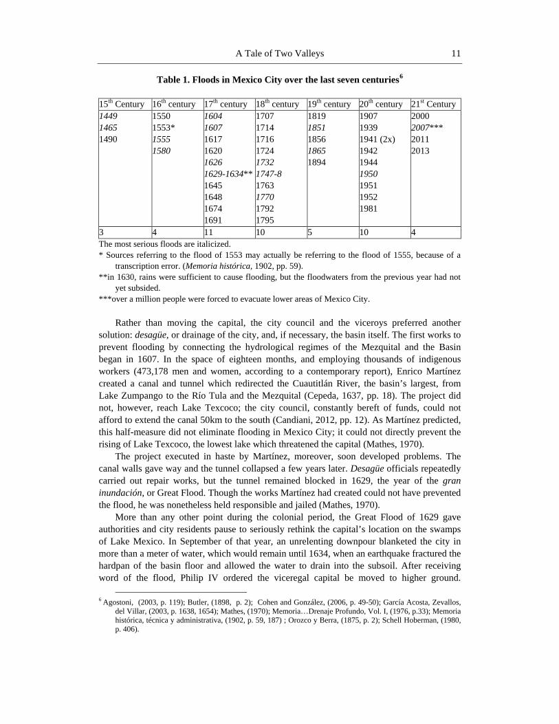
A Tale of Two Valleys 11
Table 1. Floods in Mexico City over the last seven centuries6
15th Century 16th century 17th century 18th century 19th century 20th century 21st Century 1449 1465 1490
1550 1553* 1555 1580
1604 1607 1617 1620 1626 1629-1634** 1645 1648 1674 1691
1707 1714 1716 1724 1732 1747-8 1763 1770 1792 1795
1819 1851 1856 1865 1894
1907 1939 1941 (2x) 1942 1944 1950 1951 1952 1981
2000 2007*** 2011 2013
3 4 11 10 5 10 4 The most serious floods are italicized. * Sources referring to the flood of 1553 may actually be referring to the flood of 1555, because of a
transcription error. (Memoria histórica, 1902, pp. 59). **in 1630, rains were sufficient to cause flooding, but the floodwaters from the previous year had not
yet subsided. ***over a million people were forced to evacuate lower areas of Mexico City.
Rather than moving the capital, the city council and the viceroys preferred another
solution: desagüe, or drainage of the city, and, if necessary, the basin itself. The first works to prevent flooding by connecting the hydrological regimes of the Mezquital and the Basin began in 1607. In the space of eighteen months, and employing thousands of indigenous workers (473,178 men and women, according to a contemporary report), Enrico Martínez created a canal and tunnel which redirected the Cuautitlán River, the basin’s largest, from Lake Zumpango to the Río Tula and the Mezquital (Cepeda, 1637, pp. 18). The project did not, however, reach Lake Texcoco; the city council, constantly bereft of funds, could not afford to extend the canal 50km to the south (Candiani, 2012, pp. 12). As Martínez predicted, this half-measure did not eliminate flooding in Mexico City; it could not directly prevent the rising of Lake Texcoco, the lowest lake which threatened the capital (Mathes, 1970).
The project executed in haste by Martínez, moreover, soon developed problems. The canal walls gave way and the tunnel collapsed a few years later. Desagüe officials repeatedly carried out repair works, but the tunnel remained blocked in 1629, the year of the gran inundación, or Great Flood. Though the works Martínez had created could not have prevented the flood, he was nonetheless held responsible and jailed (Mathes, 1970).
More than any other point during the colonial period, the Great Flood of 1629 gave authorities and city residents pause to seriously rethink the capital’s location on the swamps of Lake Mexico. In September of that year, an unrelenting downpour blanketed the city in more than a meter of water, which would remain until 1634, when an earthquake fractured the hardpan of the basin floor and allowed the water to drain into the subsoil. After receiving word of the flood, Philip IV ordered the viceregal capital be moved to higher ground.
6 Agostoni, (2003, p. 119); Butler, (1898, p. 2); Cohen and González, (2006, p. 49-50); García Acosta, Zevallos,
del Villar, (2003, p. 1638, 1654); Mathes, (1970); Memoria…Drenaje Profundo, Vol. I, (1976, p.33); Memoria histórica, técnica y administrativa, (1902, p. 59, 187) ; Orozco y Berra, (1875, p. 2); Schell Hoberman, (1980, p. 406).
Jonathan Graham 12
Although only 400 out of 20,000 Spanish families had stayed in Mexico City during the flood, the propertied classes disobeyed the royal decree and refused to allow the city to be relocated (Ramírez Rodríguez, 2008).
The refusal to abandon Mexico City underscores how locked-in to the capital’s location the colonial administration had become. The location had many advantages. Cortés had been aware of them, which had led him to go against the advice of his men and build the viceregal seat on the rubble of the Aztec capital. Alimentary advantage had been central to the expansion of the Triple Alliance. The Aztecs had created a positive-feedback cycle in which a large, well-provisioned military force had subjected tribute states, which in turn sent more food and items for trade to the basin. The natural beauty of the landscape and ease of aquatic transportation also had to be taken into consideration. To keep these advantages, as well as to assure the uninterrupted flow of tributes, Cortés had decided to rebuild rather than relocate (Ramírez Rodríguez, 2008, et. al.).
The denizens of Mexico City during the Great Flood were paying for that decision. For the propertied classes, too much had been invested in real estate and too much would be lost by relocating. Therefore, the costly and largely-ineffective drainage works—as well as floods—would continue off and on throughout the colonial period (Musset, 1993, pp. 53).
The second change in the desagüe of the basin into the Mezquital came during the late-18th century, when plans for more effective drainage focused on replacing Martínez’s tunnel at Huehuetoca. Bourbon administrators argued, as many had a century before, that if the tunnel had been problematic, it should be turned into an open “cut.” Thus began the “Tajo” de Nochistongo, one of the largest earthmoving projects before the use of the steam engine. Once completed in 1789, the Tajo conducted the first regular stream into the Mezquital, but still only drained the Cuautitlán River and the excess waters of Lake Zumpango (cf.. Abedrop, 2012, pp. 24-32).
The desire for desagüe carried over into the independence period, but substantial works had to wait until the 1880s, when political will, economic stability, and the ability to gain international credit came together, allowing the Díaz regime to construct the Gran Canal del Desagüe. To solve this most “Mexican” (referring to the city and the basin) of problems—flooding—required international participation. The plan put into action was designed by a US Army engineer during the Mexican-American War, adapted by capitalino engineer Francisco de Garay, approved by Maximillian during the French Intervention, financed with loans from Europe, and completed by two English firms (Read & Campbell and Pearson & Son) (Garay, 1878, pp. 5-8; Memoria del Ministerio de Fomento, 1866, pp. 5-9). Only by creating a permanent drainage of the entire basin into the Mezquital, it was thought, would the relentless threat of flooding end and public health in the city improve (cf. Raigosa, 1881).
To drain Lake Texcoco and Mexico City’s sewage into the Río Tula, the plan called for a canal between San Lázaro, now a neighborhood in Mexico City, and Tequixquiac, at the northern end of the basin, where a tunnel would conduct the water to the Río Tula. The construction of the Gran Canal and the Tunnel of Tequixquiac represented the largest project undertaken by the Díaz government and one of the earliest reclamation projects in the Western Hemisphere (Wakild, 2006, pp. 7). As Emily Wakild has stated:
Taking fifteen years to complete and using up one-third of the national treasury, it was
the culminating effort of the Díaz regime to control nature around the capital city, legitimize
A Tale of Two Valleys 13
the rule of Díaz, and reinforce the need for a powerful governmental apparatus rooted in scientific management(ibid). The Gran Canal’s construction fulfilled more than the prosaic need for drainage in the
capital. While other world capitals were erecting monuments that glorified their national past, Mexico City and the Díaz regime created “monuments of progress” in the form of canals, trenches, pumps, hydroelectric plants, and tunnels (Agostoni, 2003). The work’s keystone—the Tunnel of Tequixquiac—was named in honor of Don Porfirio, and a plaque bearing his name was placed on the tunnel’s facade, watching over the new river of filth (“Valley Drainage”).
In the presence of notables and the archbishop of Mexico on site at Tequixquiac, Don Porfirio presided over the Gran Canal’s inauguration on March 17, 1900. (“El desagüe del Valle de México,” 1900, March 17; “Inauguración de las obras del desagüe del Valle de México,” 1900, March 18). That moment fitfully represents the beginning of the hydrological union. The Gran Canal did what no previous project had before: provide a possible exit for all of the waters of the Basin of Mexico to the sea. As such, the Gran Canal’s inauguration also represented the birth of a valley which would become completely dependent on its neighbor to keep the city within it above water.
PART II. POOR MEZQUITAL, SO FAR FROM GOD, SO CLOSE TO MEXICO CITY? THE CREATION AND PROMISE OF THE
HYDROLOGICAL UNION
Wastewater Irrigation in the Mezquital from the Opening of the Gran Canal to the 1990s
In the first two decades after the Gran Canal’s opening, the hydrological union appeared
to work as designed. Within the former basin, the Gran Canal quickly eliminated large portions of lakes Zumpango, Xaltocan, San Cristóbal, and Texcoco, freeing reclaimed lands for urban and agricultural use. At the other end of the tunnel of Tequixquiac, prodigious volumes of aguas negras—approximately sixty million cubic meters a year—were flowing into the Mezquital, while clean water (agua blanca) continued to flow through the Tajo de Nochistongo and into the Río Salado (Pérez, Jiménez, & Chávez, 2000, pp. 2).
The negative impacts of the drainage, however, became apparent by the early 1920s (Jiménez, 2005, p. 345). Wind blowing over the exposed lakebeds brought dust storms to the city, which continued well into the 1970s. While reforestation projects, as Miguel Ángel de Quevedo argued, could reduce dust storms, another issue—land subsidence—could not be remedied so easily (“La invasión de polvo en la Metropoli,” 1922, May 10; “Peligros del famoso lago de Texcoco,” 1922, April 16). Areas of the city had begun to sink at noticeable rates: at an average of 5cm per year between 1900 and 1936, increasing to 18cm between 1938 and 1948 (Breña Puyol, 2003).
Since the signing of the contracts for the Gran Canal’s construction in 1889, elites in the Mezquital, particularly mine owners and hacendados, had been anxiously awaiting the arrival
Jonathan Graham 14
of the lake- and sewage water.7 Supporters of the desagüe in the Tula Valley, as well as in Actopan and Ixmiquilpan, had grand plans for the new water. One particularly vocal supporter, Anselmo Gómez, the jefe político of Actopan, had written to several newspapers in Mexico City in the 1880s stating that if the waters of the Basin of Mexico were drained into the Mezquital, eighty square leagues (2,470km2) of land that was otherwise unusable could be used to raise wheat and provide 150,000 residents a good living (Gómez, 1880, December 23; 1883, March 29).
The first wastewater system began in 1896 in the Tlaxcoapan-Tlahuelilpan-Mixquiahuala region of the Tula Valley (Medel & Armienta, 2008). However, since the Río Tula served as the main distributor of the waters coming from Tequixquiac, the hacendados there did not hold a monopoly over aguas negras use. Farmers all along the river began using the Valley of Mexico’s waters shortly after it began flowing. Moreover, by reducing the Río Tula to a sewage canal, the desagüe also fouled the region’s main water supply.
The Gran Canal had been undertaken for public benefit in Mexico City, but in the Mezquital, irrigation firms carried out canal projects for private use and profit. In the Tula region, for example, José Luis Requena, owner of the El Mexe hacienda, constructed the first dam, later named in his honor, to store the waters coming from the basin. Leading from the dam, Requena excavated a 70-kilometer canal that supplied the Jaso, Tlahuelilpan, Ulapa, and San Antonio haciendas before terminating in El Mexe (Peña, 2000, pp. 65). In the region between Ixmiquilpan and Actopan, Alejandro Athié, a Lebanese immigrant and owner of the Ocotzhá hacienda, had built a 26-kilometer canal in 1917 to transport aguas negras to newly-planted mulberry trees for sericulture (AHA, Aprovechamientos Superficiales [AS], C 252, E 6072, 2).
From the moment water began to flow from Tequixquiac and into the Tula River, it was earmarked for modernizing the region which many believed was among the most undeveloped in the nation. The irrigation companies provided services to those who could pay for it: mining companies, factory owners, cities, and hacendados.8 The largest of the firms, the Compañía Eléctrica en el Estado de Hidalgo—later renamed the Compañía de Luz y Fuerza y Ferrocarriles de Pachuca to reflect their ambitions—dug canals to provide wastewater for agriculture and hydroelectricity. D. Thomas Braniff, the company president, announced in 1898 that work would soon commence to bring irrigation to “considerable parts of the rich district of Actopan, whose land has been up to now almost non-productive due to the constant lack of rain ….”9 The new irrigation project would complement the excavation work they had begun the year before: a canal leading to the Juandhó waterfall, where the company was also installing a hydroelectric plant to provide electricity to the Compañía de Regla (“Una gran empresa,” 1898, December 8).
While upstart, locally-funded companies carried out the canal-building projects, President Díaz also planned for indigenous farmers to benefit from the water leaving Tequixquiac. Through a decree issued in 1898, Díaz proclaimed that Otomí farmers would have rights to the water flowing through the Tunnel of Tequixquiac for agricultural use in perpetuity.
7 See the notice in El Universal, December 31, 1889, p.1 for the contract with Pearson & Son to excavate the Gran
Canal in three years’ time. 8 Another multi-purpose irrigation company in the region was the Compañía Irrigadora de Ixmiquilpan, S. A,
created in 1916. AHA, Aprovechamientos Superficiales, C 107, E 219. 9 “Una gran empresa. Irrigación y energia eléctrica. Obras Soberbias,” (1898, December 8); also see AHA,
Aprovechamientos Superficiales, C 599, E 8719, 1
A Tale of Two Valleys 15
Additionally, in 1905, the president gave indigenous users the right to use aguas negras in the municipal lands of Tasquillo and Ixmiquilpan, and made the right inalienable by an additional decree in 1908 (AHA, AS, C 109, E 2288, pp. 65-67v). Díaz had first-hand knowledge of the living conditions of the Mezquital Otomí from his days as commander of the Cuartel General del Oriente in the 1860s, which likely influenced his decisions to grant the concessions (cf. AGEM, Gobernación, Vol. 67, Exp. 41, pp. 51-2). The fact that the Mezquital Otomí largely “sat out” the violent phase of the revolution after a century of revolt owes in part to the Porfirian reforms as well as to the promise of prosperity which wastewater irrigation could bring (Graham, 2013).
The drawbacks and benefits of having large quantities of raw sewage flowing directly from Mexico City into the Río Tula became evident almost immediately. An early example of the love-hate relationship Mezquital residents would have with aguas negras comes from Mixquiahuala in the 1910s. The farmers of Mixquiahuala had been receiving water from Tequixquiac since 1896, and in 1911 requested a greater allotment (AHA, AS, C4484, E59323). In the following year, they complained that the companies responsible for their own irrigation networks, as well as the hacendados of the Zumpango region, were using more water than their rights stipulated, and demanded that the Ministry of Development (Secretaría de Fomento) stop the overdraw (AHA, AS, C4467, E59001). Two years later, in 1914, the community petitioned Fomento again, except this time they complained that the levels of salts in the water from Lake Texcoco and the sewage from Mexico City had damaged their fields and rendered them unusable (AHA, AS, C4481, E59267). Nonetheless, Mixquiahuala farmers asked Fomento to formalize their wastewater irrigation rights in 1916 because of the privations they had suffered at the hands of the Compañía Hidroeléctrica e Irrigadora (AHA, AS, C4481, E59265).
A report from Ixmiquilpan in 1904 revealed that the northern Mezquital was also feeling the negative consequences of the hydrological union. In a letter dated November 7, Marín Yañez, one of the region’s largest landholders and the town’s jefe político, informed Fomento
It is not possible for this office to make an analysis of the water and speak with
exactitude about its contents, but it can note the damages it inflicts on agriculture, fish and public health, and propose methods that it deems appropriate [to remedy them].
Since the common lands were divided, as I had the honor of carrying out, the smallhold farmers leave their lands fallow only long enough to prepare their lands for the following sowing […. B]ecause of this, they need irrigation[. I]f the water that comes when the plant sprouts is of bad quality, it kills the shoot, leaving the lands barren[. E]ven worse, the substances that the water contains harden the land, which when plowed brings up clods that turn into dust and leave all of the salts the soil has absorbed, rendering it infertile. […]
The only water available for general drinking supply and for animals is that of the river. Among individuals it causes stomach illnesses that sometimes develop into malaria [sic, lit. paludismo] because of the corruption of the water from the canal, or its decomposition by the death of fish, causing illnesses such as stomach pain, diarrhea, dysentery, and some other [ailments] in the intestines. On the river banks, the bad odor from water contamination is intolerable, as it also is in the irrigation canals where the same waters run; this has to be the cause of the malarial illnesses occurring in all of the riverine communities beginning at Chilcuautla.
Jonathan Graham 16
When it is absolutely necessary to irrigate and the proprietor risks taking the water as it comes, risking all to win all, the water bends the plants at their base to the point of breaking, which mends only with difficulty; this happens because people for this work [of properly irrigating the fields] cannot be found at any price.
Regarding livestock, when sheep and goats, beset by thirst, drink the water, they get sick in the intestines and die, and there have even been cases among cattle; the same happens with poultry, with the difference that in most cases it kills them instantly (AHA, AS, C4481, E59260, p. 4, 7-8). All this only four years after the Gran Canal’s inauguration, and eight years after the first
water began to flow. Ixmiquilpan would have to wait until 1914 to have potable water again (AHA, AS, C634, E9157).
Work continued throughout the Mexican Revolution on expanding the irrigation networks in the Mezquital. By 1920, wastewater regularly irrigated 10,000ha of land in the Tula region, thanks to the creation of the Taximay and Requena dams. The Compañía de Luz y Fuerza completed work on Taximay in 1912. Since 1933, when the National Irrigation Commission (CNI) had the cordon raised to 34m, Taximay has had a capacity of 42.7 million m3 (Cervantes-Medel & Armienta, 2004, pp. 477). Work commenced on the Requena dam in 1912 and was completed in 1919. After the cordon was raised in 1930, the dam had a capacity of 70.67 million m3. Smaller reservoirs built for irrigation purposes during the period include Tlamaco, El Tablón, Las Cadenas, El Nopal, and Debodhé, while the Juandhó, La Cañada, and Elba dams were built to supply hydroelectric plants (Cervantes-Medel & Armienta, 2004, p. 8; Peña, 2000, 71).10
The Endhó dam, however, would prove to be the most important reservoir for the future of wastewater irrigation in the Mezquital. The Sercretaría de Recursos Hidráulicos (SRH) built the dam between 1947 and 1949 to hold the majority of the aguas negras coming from Mexico City (Anzaldo Lara, 1995, pp. 8). With a capacity of 144 million m3 and a cordon 45m high, the Endhó is the largest dam in the Mezquital as well the State of Hidalgo. The Endhó Dam, which today receives 80% of Mexico City’s wastewater, also holds the ignoble title of “la cloaca mas grande del mundo,” or the world’s biggest sewage reservoir.11
The Requena, Taximay, and Endhó dams served three crucial functions for the maintenance and expansion of the wastewater networks. First, they allowed for more land to be brought under irrigation. Second, the dams regularized the flow of water so that fields could be irrigated year-round. Third is perhaps most important of all: though only dimly understood at the time, holding aguas negras in a reservoir for a period of time has the dual benefit of allowing solar radiation to break down many harmful substances while letting others settle out. In essence, the dams serve the same role as settlement or oxidation ponds do in modern sewage treatment plants (cf. Instituto Mexicano del Petróleo, p. 8).
Change in the irrigation system loomed on the horizon in the mid-1920s as municipalities, riparian landholders, and indigenous communities began to challenge the companies’ and hacendados’ wastewater rights. Additionally, the federal government declared the Río Tula as national property in 1919, as it did to the water flowing within the canals in 1922. In response, many of the proprietors, with the exception of the energy
10 ibid, 8; Peña, op. cit., 71. 11 ibid. “Detectan en la presa Endhó cianuros y metales pesados,” La Jornada, June 28, 2008; “Endhó, la ‘cloaca
más grande del mundo’,” El Universal, April 28, 2009.
A Tale of Two Valleys 17
producers of the Juandhó system, began to relinquish their rights and sell their canal systems to the federal government. Requena sold his rights and network in 1927 for 750,000 pesos, which became the core of the Distrito de riego 03 Tula, organized by presidential decree on January 20, 1955 (Anzaldo Lara, 1995, p. 6.; Peña, 2000, p. 69).
The idea of using irrigation to bring about the Social Revolution came to the Mezquital not during the Calles period, as had occurred in northern Mexico, but during the sexenio of Lázaro Cárdenas. Indigenista scholars in the capital and Cárdenas himself shifted the objectives of wastewater irrigation in the Mezquital from a modernizing scheme carried out by private interests to a wide-ranging, government-directed reform initiative aimed at “redeeming” the Otomí indigenous population. Cárdenas showed his support of the Otomís—members of the “raza de bronce”—by delivering the inaugural address of the Primer Congreso Regional Otomí, held in Ixmiquilpan in 1936 (Memoria del Primer Congreso Regional Indígena, 1938). Two years later, Cárdenas enacted land reforms in the region by creating ejidos and dissolving the haciendas.
Scholars including Alfonso Caso, director of the Instituto Nacional Indigenista (INI), Juan Comas, and Miguel de Mendizábal y Othón sought to first understand and then correct what had by then become a pervasive idea—the “Mezquital problem.” According to the theory, the “problem” had begun with the conquest and the encomienda. The imposition of the colonial system had “frozen” Otomí cultural progress, relegating them to a sub-human status. Therefore, while Otomís had preserved the racial and cultural “purity” of the pre-Columbian past, which deserved praise, they had emerged from the colonial period as living fossils in need of rescue. The prescribed antidote to their misery involved ending their linguistic and economic “isolation” by incorporating them into the revolutionary state—in other words, by making them “Mexicans.” (cf. Madrid Guzmán, 1952).
Manuel Gamio, perhaps the most famous of the indigenista scholars, led the efforts to find a solution to the general “Indian question” and the specific “Mezquital Problem.” Gamio headed the Escuela Regional Campesina, founded in the ex-hacienda of El Mexe in 1936, and persuaded UNAM to begin its Summer Institute to investigate the economic, social, political, and ecological bases of the Mezquital problem. Subsequently, from the 1930s to the 1980s, scholars from Mexico and abroad used the Mezquital as a field school for economic, sociological, anthropological, and public health research.12 The overall goal of the social program—improve the living standards of the Otomí—was to be achieved through an expansion of their economic activity, which, in turn, would end their isolation. Gamio encouraged several economic activities including the production of artisanal textiles and pottery, yet he shared the conviction with other indigenistas that, in the case of the Mezquital, progress could only take place through the proliferation of the wastewater irrigation network to areas that could not support crops otherwise (CDI, “Don Manuel Gamio, Proyecto Valle del Mezquital (1932-1956),” 2 vols.). As Gamio suggested in a 1960 article, to bring about social reforms in the region, geography itself had to be overcome (Gamio, 1960).
By 1938 and the land reforms, virtually all of the bottomlands between Mixquiahuala and Tula, including the hacienda lands distributed to ejidatarios, had been incorporated into Irrigation District 03 (Jiménez, Siebe, & Sifuentes, 2005, pp. 47-50). In the northern Mezquital, however, expansion occurred much more slowly. As the Río Tula passes through a series of canyons and narrow valleys north of Chilcuautla, the geography of the region
12 Scholars from the US were part of this wave of research in the Mezquital. See Kenny &Bernard (1973).
Jonathan Graham 18
offered limited tracts of irrigable land. Consequently, few ejidos received ready-to-irrigate plots; the plots that were given out, moreover, averaged only a few hectares. For the remaining communities, water would have to be brought to them in canals yet to be built.
The indigenista program reached new heights in 1951 with the creation of the Patrimonio Indígena del Valle del Mezquital (Indigenous Patrimony of the Mezquital Valley), which institutionalized the search for an answer to the “Mezquital Problem.” An article appearing the year before summarized the motives behind the creation of the PIVM. In “The Tragedy of the Mezquital,” appearing in Excelsior, April 2, 1950, Carlos A. Echanove Trujillo, an academic who had spent time in the region, wrote:
In the case of the Mezquital, the indigenous population has neither known how, nor
has been able to, use the environment as people with a more advanced culture certainly would have by now. From this perspective, transforming, above all, the mentality of human groups like the Otomí of the Mezquital Valley, whose own mind is their worst enemy [and prevents] their spiritual and material betterment, is of critical importance. If culture is ultimately a psychic phenomenon, derived from others who make up a complete culture, obviously, in the case of social planning for the benefit of a “primitive” community, it has to begin with the mentality of that community (Trujillo, 1950, April 2). Trujillo’s understanding of the Mezquital problem, echoed by other scholars and
politicians, minimized the effects of persistent ecological limitations, colonial subjugation and present marginalization, and instead emphasized cultural inferiority and lack of education. The PIVM’s structure reflected this high-handed approach toward “nuestro indio” (“our Indian”) (e. g. Ramírez Beltrán, 1957, pp. 74). Below the honorary president—the President of the Republic—and the executive director (vocal ejecutivo), the PIVM’s directory board consisted of one representative from each of the federal ministries, a number of anthropologists, and, if requested, representatives of UNESCO, which had played a role in the patrimony’s creation. The agency’s large hierarchy, however, left little if any room for Otomí leaders. Though the federal executive branch had created the autonomous organization with a mandate to facilitate “the study and resolution of the problems that affect the populace of the geographic zone denominated the Mezquital Valley,” non-indigenous actors would be in charge of the studies and reform programs (“Acuerdo que crea el Patrimonio Indígena del Valle del Mezquital,” 1951, September 1; “Decreto que crea el Organismo denominado Patrimonio Indígena del Valle del Valle del Mezquital,” 1952, December 31).
In a conference held December 26, 1951, Quintín Rueda Villagrán, the recently-elected governor of Hidalgo who had been one the central protagonists in the PIVM’s creation, announced the agency’s opening. In his speech, the governor stated that:
We have the conviction that it is not necessary for the Otomí to leave this region—
which, until now, has been unproductive and repellent wherever there is a lack of irrigation—to save themselves from misery. Surely, we cannot strip the Otomí from the land where for centuries they have awaited their economic redemption. No. We want this land to produce. We will plant in it what is appropriate for its climate, and we will teach the Indian what it is to be the victor in the struggle against nature (Rueda Villagrán, 1951, p. 11, emphasis added).
A Tale of Two Valleys 19
Despite the racialized rhetoric and the top-down nature of the reforms, the PIVM did effect change by expanding wastewater irrigation and other works. The agency’s jurisdiction covered the entire Mezquital, but it focused mostly on areas where irrigation had not yet expanded. In partnership with the SRH, the PIVM first set a goal to expand the irrigation networks, using aguas negras and aguas blancas, by 25,000 ha (Sills, 1992, pp. 416-17). In areas that could not utilize wastewater, the PIVM drilled wells and installed pumps for groundwater irrigation, while in the sierras, the agency planted olive trees (in partnership with the National Olive Commission), fruit trees (peach, apricot, and others), and grapevines for viticulture in new collective orchards. By 1970, the PIVM and SRH had installed sewers, community fountains and faucets, as well as concrete canals across the Mezquital, and had surpassed their original goal by irrigating 40,000 ha. (ibid; SRH, 1969, pp. 47-70). Through expanding irrigation, the PIVM generated new wealth in more ways than one. By the late 1960s, irrigation had dramatically increased yields as well as land value; the price of former temporal plots, for example, rose from 3-500 pesos to 20,000 pesos per hectare (CDI, Fondo Documental, D02861, PIVM, “Actividades del Patrimonio Indigena de Valle del Mezquital, Ixmiquilpan, Hgo., 5 de Abril de 1968,” pp. 2).
The PIVM’s successes encouraged the federal government in the 1970s to expand its charter to include the mountainous regions to the north and east. Yet by the time of the PIVM’s reformation into the Patrimonio Indígena del Valle del Mezquital y la Huasteca Hidalguense (“Decreto por el que se reforma los artículos lo., 2o., 4o., 5o., 6o., 8o., 9o. y 11o…,” 1982, December 30), the agency’s scope of operations had declined from its high-water mark in 1969, and had lost most of its reformist zeal. Developments within the agency including caciquismo—the practice of elites using informal economic and political power to control the indigenous population—one of the “backward” aspects that reformers had wanted to eliminate, threatened to undermine the agency’s effectiveness and even existence. Sociologist Roger Bartra and his acolytes, whose investigations the PIVM funded, focused on analyzing the roots of cacicazgo in the Mezquital—the region of Mexico, Bartra claimed, where the practice was most entrenched (Bartra, 1978). The agency designed to circumvent the power of the caciques, however, was ultimately overcome by it.
The most powerful cacique the Mezquital and the PIVM produced during this time, Alfonso Corona del Rosal, rose to the highest ranks of the PRI, serving as party president and the regent of Mexico City before becoming a serious contender for the presidency. Rosal’s use of the PIVM’s directorate for personal empowerment illustrates how the agency had been woven into the clientelist network that connected local caciques to the PRI state by the early 1970s (Villavicencio, 1990, pp. 223-24). During his tenure as director, he cultivated another cacique, known as Don Anselmo, who, with Corona’s backing, controlled the all-important Junta de Aguas of Ixmiquilpan. By controlling the irrigation canals’ sluicegates, the junta wielded the power of life or death over crops. With such power, the Junta de Aguas had considerable clout among agriculturalists that made up the majority of the region’s populace as well as its voting bloc (Calvo, 1972, pp. 725). One researcher noted in 1972 that in the Ixmiquilpan region,
A strong cacicazgo has controlled the population for years and presently the
ideological fight on the national level is reflected strongly here for a simple reason: this cacicazgo is of such magnitude that it has sent [Corona] to the highest realms of national politics as one of their representatives (ibid, p. 724).
Jonathan Graham 20
When internal politics in the PRI turned against Rosal in 1975, President Luis Echeverría
undermined Rosal’s political base by invoking his power as president of the PIVM and removing the cacique from office (Corrales, 1982, pp. 129). From Rosal’s time as director onward, detractors of the PIVM/PIVMHH accused the agency not only of failing to living up to the promises of bettering the living conditions of the Otomí, but also of rampant corruption, nepotism, and clientelism—in short, of being yet another organism maintaining the dominance of the PRI in Hidalgo. Therefore, few campesinos mourned when President Salinas de Gotari dissolved the defunct organization in 1990 (“De decreto que deroga el decreto publicado en el Diario Oficial…,” 1990, December 6).
Caciques had informally ruled the Mezquital before the PIVM, and their power and influence stretched far beyond its mandate. In fact, they had played a role in deepening the hydrological union after the Mexican Revolution. In return for their services to the official party, “the federal executive branch looked for ways to increase the irrigated area, beginning in the 1930s” (Oswald Spring, 2011, pp. 148). In addition, the expansion of the wastewater irrigation networks fortified their positions and power locally. Apart from their control of water boards, caciques’ influence with state and federal bureaucracies often determined when, or if, irrigation canals reached a community. Ejidatarios and others, seeking the security and profits that irrigation might bring, became caciques’ clients and voted for their selected political candidates, thus perpetuating cacicazgo.
In other situations, caciques prevented the transfer of ejido lands. In one notorious case, caciques had colluded with commissioners of the ejido of Mixquiahuala since 1928 to hold 2,000 ha of its land for private use. To keep control of the land, the co-conspirators used violence against the ejidatarios including house burnings and crop seizures. Only in 1974, after forming the Unión de Campesinos Despojados del Ejido de Mixquiahuala, were the ejidatarios able to invade the properties and take back what legally belonged to them (Robles, 1992, p. 201).
Over the course of his research in the late 1960s, Fernando Benítez discovered that caciquismo had flourished in the irrigation zones of the Tula valley, which he labeled “Paradise,” as well as in the northern Mezquital, which he named “Hell.” In the fourth volume of his landmark Los indios de México, Benítez titled his section on the Mezquital Otomí “The book of infamy” to call attention to the fact that “ubiquitous caciquismo, the deterioration of the political system and the agrarian reform have created new latifundia as powerful and degenerative as those of the epoch of Porfirio Díaz” (Benítez, 1972, p. 9). Despite the positive ecological changes that had made “Paradise,” ejidatarios still faced a grim socio-political reality. As Benítez put it:
Of course the thousands of Otomís who occupy the Tula region, now turned into the
paradise that is Irrigation district 03, have benefitted substantially by becoming farmers, but this Eden has its snake, and this snake is named cacicazgo, an infuriating curse from which the inhabitants of the [northern] Mezquital also suffer (ibid, pp. 46-7) While caciquismo thrived in the irrigated Eden of the Tula Valley, depriving many
ejidatarios of land and a living wage, the snake’s bite had claimed lives in the north. In one case, ten ejidatarios from Pueblo Nuevo, near Ixmiquilpan, were murdered in April of 1968 at the behest of caciques holding the campesinos’ lands as private property (ibid, pp. 176-77).
A Tale of Two Valleys 21
The new latifundia Benítez described differed from the legally-recognized entities of the Porfiriato he compared them to; they had been cobbled together from a patchwork of lands rented, leased, and bought outright from smallholders and ejidos. Razor-thin margins on corn, wheat, and alfalfa put ejidatarios, who relied on the muscle power of their families, at a serious disadvantage to medium- and large-scale farmers who had mechanized their planting and harvesting. Moreover, lack of credit and the decreasing size of their plots left many ejidatarios no choice but to lease their lands to more affluent farmers (ibid, Chapter 1).
Changes in the federal law regarding irrigation districts in the early 1970s gave smaller farmers a reason to hope that their situation would improve. The Federal Water Law of 1971 brought the management of all districts practicing grande irrigación directly under the control of the federal government. Throughout the decade, the SRH subsidized the operation and expansion of irrigation districts, including 03 Tula and 100 Alfajayucan. Using the investments, the SRH extended irrigation canals to lands, much of it in ejidos, which previously had been fit only for pasturage (Palacios, 1997, pp. 2). By the end of the 1980s, federal subsidies amounted to three-quarters of irrigation districts’ budgets. Despite this, most districts had neglected infrastructural maintenance. The Mezquital fit the national pattern: in the 1970s and 1980s, the irrigation districts expanded at the fastest rate in their history, yet the pre-existing infrastructure was beginning to show its age (ibid).
The financial crisis of the 1980s, however, made continuing the subsidies program impracticable. In order to reduce the federal government’s financial burden, Congress passed a law in 1992 which replaced the 1971 act and ordered the transfer of irrigation districts’ operation, maintenance, and management to water user associations. Congress gave the task of overseeing the transfers to the National Water Commission, known as the CNA or CONAGUA, a new bureaucratic body that had replaced the SRH. Part four addresses Mezquital farmers’ resistance to the transfer (ibid, pp. 2-3).
As the PIVM’s influence waned, a new social phenomenon began to take shape across the Mezquital in the 1970s and 1980s: autogestión, or self-management, in which Otomís created organizations to promote literacy, education, and bilingualism in their communities. Villages and farmers also created the Consejo Supremo Hñahñu and the Asociación Civil Comunidades del Valle with the goal of representing themselves before municipal, state, and federal governments. Such organizations continue to represent communities, particularly in the fight over the future of aguas negras use (Robles, 1992, pp. 204-17).
Rapid Growth in Tandem: The Mezquital and Mexico City, 1950-1990 Irrigation expansion projects in the Mezquital since 1950 would not have been possible
without a simultaneous increase in the volume of water flowing from the capital. Mexico City’s population boom from 1950 to 1990 required vast new amounts of water for the city’s residents and industries, as well as a place to drain them afterward. As Mexico City evolved into a sprawling megalopolis, the Mezquital irrigation districts expanded apace (Foster, Gale, & Hespanhol, 1994, p. 12).
The 1950s represented a turning point in the hydrological union. The first year of the decade witnessed Mexico City’s worst flood of the 20th century; three-quarters of the city, including downtown and the historic districts, were inundated. The flood served as a reminder that the desagüe was proving inadequate for a city much larger in area and population than it
Jonathan Graham 22
had been in 1900. The Gran Canal, moreover, had begun to lose its slope from subsidence—the process it had begun—greatly reducing its drainage capacity. In addition, the central parts of the city were sinking at accelerated rates. One sign of this came in 1950, when pumps had to be installed at San Lázaro to get the city’s sewage into the Gran Canal (Tortajada, 2003, pp. 128). In 1954, the second Tequixquiac tunnel opened, bringing some relief to the overstrained system, but administrators realized it would be insufficient as the city continued to grow—and sink. Subsidence had also reversed the positions of the capital and Lake Texcoco. In 1910, the lakebed of Texcoco had stood 1.9m below Mexico City; by 1970, however, downtown Mexico City had sunk 5.5 meters below it (Breña Puyol, 2003). President Díaz Ordaz commissioned the next major drainage project, the Drenaje Profundo (Deep Drainage), in 1967 to: “fundamentally relieve the Gran Canal, avoiding an overflow which might cause a catastrophe by flooding the central and most valued part of the city with more than two meters of water” (Memoria…Drenaje Profundo, Vol 1., 1975, pp. 58).
The Drenaje Profundo, a 6.5m-diameter tube conducting water from Mexico City to the Río Salado, rivaled the Gran Canal in scale—3.5 million m3 of material excavated, 1.4 million m3 of concrete poured, and 21,000 tons of rebar used for reinforcement (ibid, xxxiii). Its completion in 1975 marked the last major drainage project in Mexico City for more than 25 years (“Programa de Sustentabilidad Hídrica,” 2007, November 8). Fortunately, the Drenaje Profundo had come online just in time: five years later, the Gran Canal registered a negative slope, requiring another set of pumps to push the water over the “hump” that had formed at canal kilometer 18+500 (López Pérez, 2011, pp. 4).
Meanwhile, Mexico City’s population continued expanding rapidly. In 1930, the city had had a population of 1,229,600. Over the next decade, the number of inhabitants increased by 73.6%, and then 60% and 41.1% in the following twenty and ten years, respectively. The population had quintupled in the space of four decades, bringing the figure to 6,874,100 in 1970. In addition, Mexico City’s urban zone had expanded beyond the Federal District in the 1950s; a decade later, 17.6% of the urban population lived in the State of Mexico. Two of the four fastest-growing neighborhoods from 1960 to 1970, Nezahualcóyotl and Ecatepec, stood on the former lakebeds of Texcoco and San Cristobál, respectively, putting them at the highest risk of flooding (Memoria…Drenaje Profundo, Vol. 1, 1975, p. 75).
The expansion of Mexico City over state and district lines complicated the already-difficult task of city administration, planning, and infrastructural development, which led to a water crisis in the 1980s. Most of the immigrants flocking to Mexico City since the 1960s could not afford to live in the city itself. “Irregular settlements,” the term the city government used to refer to the squatter shantytowns (Stanley, 2003, pp. 25-26; Tortajada, 2006, pp. 387), sprouted up outside the city proper in environmentally sensitive regions: the piedmont, where the city’s aquifers recharge, and the lakebeds. Water and sewer lines extended to these unofficially-occupied areas slowly, creating insalubrious conditions for the entire city. By 1980, six million inhabitants in the ZMVM lacked indoor plumbing; most of their excrement was thrown out and exposed to the sun. Not only did this effect water quality in the aquifer underlying the city, their excrement, along with that of two million dogs, turned to dust, which winds dispersed over the city. On average, 20 tons/km2 of the dust descended on the capital every month, reaching its highest levels during the dry season (Castro, 2006, pp. 90-1; Sonnenfeld, 1992, pp. 44).
Events in the global economy also contributed to the worsening conditions of sanitation and drainage in Mexico City. Stagflation in the early 1980s left Mexico unable to service its
A Tale of Two Valleys 23
foreign debt. Decades of deficit-financed projects ground to a halt, causing much of the water infrastructure to go without proper maintenance. The Drenaje Profundo—often referred to as the most important pipe in Mexico (e.g., Ellingwood, 2008)—pumped water out of the Valley of Mexico continuously for fifteen years (1976-1991) without being serviced. When the water was finally diverted so the pipe could be inspected, the team of engineers conducting the inspection discovered that the constant flow of water and suspended solid waste had scoured a groove averaging six inches deep along the bottom of the solid steel pipe (Castro, 2006, pp. 113-18; National Academy of Sciences, 1995, p. 6).
By the early 1990s, the municipal government had mostly lost the battle to keep water infrastructure intact while the city continued to sink. The amount of potable water lost to leakage equaled or slightly exceeded all of the water provided by the Cutzamala system (discussed below). As potable water generally flows from the west to the east—where, not accidentally, some of the poorest neighborhoods in the ZMVM are located—the volume of available water decreases substantially. Even today, five percent of houses with indoor plumbing in Nezahualcóyotl rely on water trucks to fill rooftop supply tanks because they either receive no water, or what comes out of the tap is undrinkable. As several studies have shown, by the time water reaches the city’s easternmost reaches, it contains very high levels of fecal matter and coliforms which infiltrate the system through the leaks and breaks in the piping. In these conditions, drainage, water treatment, and water access became central planks of political campaigns in the eastern half of the city, as they continue to be today (Tortajada, 2006, p. 15-16).
The demographic explosion of the city and its expansion onto the former lakebeds in the 1960s and 70s has locked Mexico City into a vicious cycle of sinking, flooding, and lack of potable water. Rapid urbanization placed a high demand on new drainage works to prevent flash flooding in low-lying areas. Simultaneously, hundreds of wells were drilled into the Mexico City Aquifer to provide potable water for millions of internal migrants. The overexploitation of the aquifers led to drawdown, which in turn exacerbated subsidence, and created yet more need for efficient drainage. Though the hydrological union had always been tilted in favor of the capital, the rapid expansion of Mexico City’s metropolitan area made the basin even more dependent on the Mezquital. (Table 2)
PART III. THE HYDROLOGICAL UNION AT PRESENT
The Water Infrastructure of the Union: Supply and Distribution in Mexico City
Currently, Mexico City’s municipal water system receives 35m3/s of the liquid, which is
distributed through 690km of water mains and 10,000km of secondary pipes. The secondary system also contains 243 storage tanks with a capacity of 1.5 million m3 of water and 227 pumping stations. The network supplying water to the distribution mains includes 910km of primary network pipes, 524km of aqueducts and conduction lines, and 11,900km of distribution pipes. Twenty-seven stations treat approximately 60% of the water supply (Ruíz & Ruíz, 2013, p. 368).
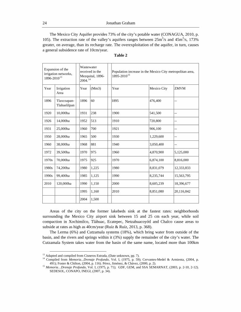
Jonathan Graham 24
The Mexico City Aquifer provides 73% of the city’s potable water (CONAGUA, 2010, p. 105). The extraction rate of the valley’s aquifers ranges between 25m3/s and 45m3/s, 173% greater, on average, than its recharge rate. The overexploitation of the aquifer, in turn, causes a general subsidence rate of 10cm/year.
Table 2
Expansion of the irrigation networks, 1896-201013
Wastewater received in the Mezquital, 1896-2004.14
Population increase in the Mexico City metropolitan area, 1895-201015
Year Irrigation Area
Year (Mm3) Year Mexico City ZMVM
1896 Tlaxcoapan-Tlahuelilpan
1896 60 1895 476,400 --
1920 10,000ha 1931 238 1900 541,500 --
1926 14,000ha 1952 513 1910 720,800 --
1931 25,000ha 1960 700 1921 906,100 --
1950 28,000ha 1965 500 1930 1,229,600 --
1960 38,000ha 1968 881 1940 3,050,400 --
1972 39,500ha 1970 975 1960 4,870,900 5,125,000
1970s 70,000ha 1975 925 1970 6,874,100 8,816,000
1980s 74,200ha 1980 1,225 1980 8,831,079 12,333,833
1990s 99,400ha 1985 1,125 1990 8,235,744 15,563,795
2010 120,000ha 1990 1,150 2000 8,605,239 18,396,677
1995 1,160 2010 8,851,080 20,116,842
2004 1,500
Areas of the city on the former lakebeds sink at the fastest rates: neighborhoods
surrounding the Mexico City airport sink between 15 and 25 cm each year, while soil compaction in Xochimilco, Tláhuac, Ecatepec, Netzahuacoyótl and Chalco cause areas to subside at rates as high as 40cm/year (Ruíz & Ruíz, 2013, p. 368).
The Lerma (6%) and Cutzamala systems (18%), which bring water from outside of the basin, and the rivers and springs within it (3%) supply the remainder of the city’s water. The Cutzamala System takes water from the basin of the same name, located more than 100km
13 Adapted and compiled from Cisneros Estrada, (Date unknown, pp. 7). 14 Compiled from Memoria...Drenaje Profundo, Vol. I, (1975, p. 59); Cervantes-Medel & Armienta, (2004, p.
491); Foster & Chilton, (2004, p. 116). Pérez, Jiménez, & Chávez, (2000, p. 2). 15 Memoria…Drenaje Profundo, Vol. I, (1975, p. 71); GDF, GEM, and SSA SEMARNAT, (2003, p. 2-10, 2-12).
SEDESOL, CONAPO, INEGI, (2007, p. 34).
A Tale of Two Valleys 25
west of Mexico City, and transports it across the Lerma Basin to the western base of the Sierra de las Cruces. Then, a series of pumps hauls the water up more than a vertical kilometer (1,100m) over the mountains and then down to the basin floor, thereby adding 485 million m3 a year to the city’s supply network. In delivering the water to Mexico City, the Cutzamala System consumes 0.6% of all energy produced in the country, at a cost of US$ 141,850,000 per year (US$ 388,619 per day) (CONAGUA, 2010, p. 105).
After the Cutzamala system began to deliver water to the basin of Mexico in 1991, it united four drainage areas: the Valley of Mexico, the Mezquital, the Lerma Basin, and the Cutzamala Basin. To put this in perspective: water which would otherwise flow to the Pacific Ocean in the Cutzamala Basin is pumped into a former endorheic basin 2,400m above sea level, and then drained into the Mezquital, where, if the water does not deposit in aquifers, it continues on to the Pánuco and deposits in the Gulf of Mexico. Even this massive water engineering system has not corrected Mexico City’s water deficit. The Cutzamala and Lerma Systems contribute 20m3/s to the water supply; however, broken pipes, mostly in the eastern half of the city, leak 25m3/s into the soils (Robles, 2011, June 5; also see Part 4). CONAGUA and other governmental agencies have thus continued to search for other exploitable sources of water, including in the Mezquital.
The Wastewater Economy of the Mezquital Officially, Irrigation Districts 03 and 100 cover 85,000ha; however, between 100,000 and
120,000ha receive wastewater from the 3,000km of canals crisscrossing the Mezquital.16 The Tula Valley alone possesses 22% of all land irrigated with wastewater in Mexico, and receives 30% of the volume (Chavez, Rodas, Prado, Thompson, & Jiménez, 2012, pp. 77). The districts have more than 50,000 registered users, divided almost equally between private concessionaries and ejidatarios (“Operarios, obligación histórica de la Federación…,” 2004, June 12). Though many ejidatarios possess only a fraction of a hectare of cultivable land, the average plot size within the irrigation districts rises to 1.5ha when private concessionaries’ fields are included (World Health Organization, 1997, p.5).
Considered jointly, the Mezquital irrigation districts represent one of the most important agricultural regions in the country, ranking third in overall production by 2002 (IMP, pp. 1-11). In the early 1990s, districts 03 Tula and 100 Alfajayucan were already producing one-quarter of the national chile and alfalfa harvests (Robles, 1992, pp. 195). The USDA reported in 2003 that thanks to the Mezquital’s high yields, Hidalgo produced twice the amount of alfalfa of any other state save Guanajuato (USDA 2003). Presently, districts 03 and 100 produce 73.4% of all green alfalfa grown in the nation’s irrigation districts (3,170,171 tons/year, CONAGUA, 2011a, pp. 98) and 60% of the crops grown in the state (Cruz Sánchez, 2011, March 12).
Mezquital agriculturalists dedicate 30% of irrigable land to alfalfa, while secondary crops include forage oats, corn, beans, marrow, and tomatoes. In smaller plots, farmers also grow spinach, lettuce, chiles and cilantro and sell them in markets in Toluca, Mexico City, and
16 “Rechazan campesinos de Hidalgo asumir control de distritos de riego,” (2004, June 12) gives the total irrigated
area at 120,000 in districts 03 and 100, while a more recent article (“La region más contaminada, Presa Endhó,” 2014, January 21) states that the irrigated zone covers 100,000ha. Both articles, however, cite CONAGUA officials.
Jonathan Graham 26
Pachuca. Dairy conglomerates Nestlé, Santa Clara, and Lala use alfalfa produced in the Mezquital to feed their cows in neighboring regions, while transnational corporations including Pilgrim’s Pride purchase Mezquital’s corn for poultry production (Cuenca, 2008, June 9). In total, CONAGUA estimates that the fodder and foodstuffs grown in the irrigation districts have a yearly market value of $2.25 billion pesos (~US$ 173 million) (CONAGUA, 2011a, pp. 219; Lucho-Constantino, Álvarez-Suárez, Beltrán-Hernández, Prieto-García, & Poggi-Varaldo, 2005, pp. 58). 250,000 people directly participate in wastewater agriculture, while 500,000 people—one-quarter of the state’s population—benefit from the larger wastewater economy.17
Regional agricultural statistics, however, disguise the inequalities between large and smallholders. With ninety percent of its population falling at or below the poverty line, Hidalgo has become an “emerging region” of immigration to the US (“Hidalgo, entre las 10 entidades más pobres de México,” 2010, April 11). From 2002 to 2012, the state jumped from ninth to fifth place in the percentage of its workforce that had migrated (“Hidalgo, entre los 5 estados con más migración,” 2012, March 6). Within Hidalgo, the Mezquital presents the highest rates of outmigration. Although much of the Mezquital has become an irrigated vergel (orchard), the economic miracle planners envisioned has not materialized for many campesinos; as a consequence, the Mezquital, and specifically the northern Mezquital, exhibits high outmigration rates. International migration began with the Bracero program in the 1940s, accelerated in the 1970s, and boomed in the 1990s. The municipio of Ixmiquilpan in 2000, with 10% of its populace living in the US, claimed the state’s highest migration rate, as well as its highest remittance rate (Serrano Avilés, 2006, pp. 54-9, 65, 77-8).
Mezquital Otomí migration forms a distinct subset within Mexican migration to the United States; Las Vegas, Nevada and Clearwater, Florida, for example, today have sizeable hñahñu communities. Males seeking temporary work as field hands in US farms and orchards make up a disproportionate number of the migrants. In a phenomenon the state government has termed “swallow migration” (movimiento golondrino), an estimated 150,000 Mezquital inhabitants migrate to and from the US with the seasons (Camacho, 2006, September 17; Fabre Platas, 2004, pp. 56-7). Other migrants, however, do not return. As a consequence, by 2030, the population of the municipio of Ixmiquilpan is predicted to decrease 17% from its 2000 level (Serrano Avilés, 2006, p. 61; Quezada Ramírez, 2008, p. 54).
Ecological Consequences of a Century of Wastewater Use Although hundreds of dams and storage tanks in the Cutzamala System, the Valley of
Mexico, and the Mezquital make the hydrological union possible, human bodies represent the key reservoirs for wastewater agriculturalists. Recent studies in Irrigation District 03 reveal how much the hydrological union has altered natural rhythms and processes. According to a 2012 report, the beginning of the dry season can now be dated precisely to Semana Santa (the week before Easter), which is “due to inhabitants leaving Mexico City on vacation [which] causes a decrease in the flow of water coming from the City” (Venado & Viquiera, 2012, pp. 6-7).
17 According to the letter of José Antonio Cabrera Quintanar, state director of CONAGUA, included in “Correo
Ilustrado”, op. cit.
A Tale of Two Valleys 27
A direct relationship exists, in other words, between the number of humans in the city, their use of utilities, and the amount of irrigation water available in the Mezquital. Moreover, the constant flow of wastewater has shifted the agricultural season by months. The natural dry season runs from October to April; the new, “irrigated” dry season beginning with Semana Santa lasts into the summer, the traditional rainy season. During the new dry season, when the volume of irrigation water decreases, conflict over the liquid increases substantially. In a sense, then, an inverse relationship also exists between the number of bodies in Mexico City and conflicts in the Mezquital.
The human excrement that makes wastewater irrigation so productive forms only one part of the desagüe. Of the average 52m3/s of water flowing from the Valley of Mexico in 1995, 12m3/s consisted of stormwater and 40m3/s wastewater (Jiménez, Siebe, & Cifuentes, 2005, p. 36). Storm runoff currently amounts to 20% of the yearly outflow, while sewage contributes the remaining 80%. Two distinct sewage “streams” merge before leaving the Valley of Mexico: a stream of domestic waste (57%) and another of industrial waste (43%). At present, only 6% of the wastewater entering the Mezquital receives any form of treatment; therefore, the fecal-borne parasites from the domestic stream and toxic waste from the industrial remain in the mix of 180,000 tons of suspended solids carried into the Mezquital every year (CONAGUA, 2009).
The Domestic Stream With the water and the free fertilizer in the domestic stream, irrigation in the Mezquital
produces much higher yields—150% for corn and 100% for barley, for example—than areas irrigated with clean water (Jiménez, 2005, pp. 348). Irrigated plots receive “2,400kg of organic matter, 195 kg of nitrogen, and 81 kg of phosphorous per hectare per year” from wastewater (Qadir, 2013, p. 438). Nitrogen use efficiency as a consequence exceeds 85%, making additional fertilizer inputs largely unnecessary (Siebe, date unknown). Farmers in the Tula Valley irrigate their fields, on average, fifteen times a year with amounts ranging from 170mm to 240mm per unit of land. Otherwise put, fields annually receive 2.55 to 3.6 meters of wastewater—more than five times the highest annual precipitation rate in the Mezquital—allowing alfalfa raisers to have up to ten harvests a year (Chavez, Rodas, Prado, Thompson, & Jiménez, 2012, p. 77).
Illnesses linked to wastewater use have been present in the Mezquital since the beginning of the hydrological union (e.g., Echanove Trujillo, 1952, p. 126). Inhabitants across the Mezquital suffer from various intestinal diseases and infections, the most common being gastritis. Raw wastewater introduces bacteria and parasites found in human digestive systems—fecal coliforms, helminths, and giant roundworm (Ascaris lumbricoides) chief among them—into the region’s water regime. Other ailments common to wastewater districts have appeared in the Mezquital, including cysticercosis, an infection of the pig tapeworm in humans. In 1990, doctors treated 161 cases of the infection over eighteen months, giving the region the unwelcome distinction of having the highest rate of infection in the world (Valle del Mezquital, primer lugar mundial en cisticercosis, 1990, May 29).
The dams of the wastewater system, however, greatly reduce concentrations of water-borne parasites. Moreover, transport of aguas negras to the Mezquital in open, unlined canals also improves water quality as it travels. As mentioned above, the dams receiving aguas
Jonathan Graham 28
negras act as a settlement pond, allowing many harmful elements to precipitate out of the water and leaving the water flowing out of the dams significantly cleaner (Siemens, Huschek, Siebe, & Kaupenjohann, 2008, p. 2126). Settlement in dam catchments, however, reduces concentrations of only some parasites and bacteria. Those with smaller size and mass, including fecal coliforms (2-3 µm), do not precipitate out of the water as efficiently and require extended periods of storage for solar radiation to break them down (Jiménez, Siebe, & Cifuentes, 2005, p. 40). In general, however, a number of investigators have concluded that the “natural” filtration process in the Mezquital wastewater system is equal or superior to primary treatment in a plant (World Health Organization, 1997, pp. 4-11).
Another consequence of using Mexico City’s untreated waste—the accumulation of pharmaceutical compounds in Mezquital soils—has begun to receive attention only recently. Three studies published in the last five years have compared sales records of common drugs in Mexico City with known human excretion rates to estimate the speed of accumulation in irrigated soils. Researchers discovered that while wastewater flowing into the Mezquital contained five drugs that exceeded the US FDA’s concentration limit, the time it spent in the Endhó reservoir decreased concentrations of most drugs significantly (Siemens, Huschek, Siebe, & Kaupenjohann, 2008, pp. 2126). Acidic compounds had accumulated at very low rates (0-7%), while basic compounds had accumulated at slightly higher rates (0-25%). Only one medication, Carbamazepine, showed high rates of accumulation (55-107%) (Siemens, Huscheck, Siebe & Kaupenjohann, 2008; Dalkmann, 2012; Gibson, Durán-Álvarez, Estrada, Chávez, & Jiménez Cisneros, 2010).
The Industrial Stream In contrast to the domestic stream which provides both water and fertilizer, the main
benefit of the industrial stream in wastewater irrigation is the increase in volume. The additional water, however, comes at a high price. Untreated industrial wastewater, as the Mezquital presently has no choice but to accept, changes how soils react to pollutants over the long term. Numerous studies have demonstrated that although industrial waste has flowed into the Mezquital for a century, the soils of the irrigation zones (vertisols, leptosols, and phaeozems) have retained a remarkable ability to minimize heavy metal sorption (Lucho-Constantino, Álvarez-Suárez, Beltrán-Hernández, Prieto-García, & Poggi-Varaldo, 2005; Reyes-Solís, Solís, Isaac-Olive, García, & Andrade, 2009). Throughout the irrigation zones, soils contain higher-than-normal amounts of copper, zinc, nickel and manganese, yet fall below maximum acceptable levels set by the Mexican government, the US EPA and the EU. Fields irrigated with wastewater for several decades show higher levels of several metals, while the oldest fields display even higher levels of lead, cadmium, and copper. In each of these cases, however, concentrations are “not at hazardous conditions” (Ramírez-Fuentes, Lucho-Constantino, Escamilla-Silva, & Dendooven, 2002, p. 187) Near-limit levels of boron and chromium represent exceptions to the rule.18
On the other hand, long-term industrial wastewater use has affected the soils’ microbial communities, and thus the process of mineralization that makes nutrients available to plants.
18 (Lucho-Constantino, Álvarez-Suárez, Beltrán-Hernández, Prieto-García, & Poggi-Varaldo, 2005). If maximum
boron levels are exceeded, it will lead to crop phytotoxicity.
A Tale of Two Valleys 29
The concentrations of one fungus crucial to agricultural soils (arbuscular mycorrhizal fungi) have decreased significantly in Mezquital plots irrigated for more than ninety years. As fungi give crops “greater tolerance to toxic metals and other adverse conditions in the soil,” their reduction presents a double threat to crops (Ortega-Larrocea, Siebe, Becard, Mendez, & Webster, 2001, pp. 155). Lower numbers of bacteria and fungi and elevated levels of heavy metals in the soils also impede the process of nitrogen fixation, despite the buildup of organic matter (sewage). As a result, while “characteristics of the soils appear not to have deteriorated after years of application of wastewater,” (Ramírez-Fuentes, Lucho-Constantino, Escamilla-Silva, & Dendooven, 2002, pp. 187) the lack of nitrogen mineralization leaves today’s farmers in the Mezquital as dependent on the wastewater to provide fertilizer as they were a century ago (Lucho-Constantino, Álvarez-Suárez, Beltrán-Hernández, Prieto-García, & Poggi-Varaldo, 2005, p. 171; Friedel, Langer, Siebe, & Stahr, 2000).
A few rare disorders and illnesses with direct relations to heavy metal pollution such as Itai-Itai and methemoglobinemia have appeared in the region since the 1990s (CONCYTEQ, 1998, pp. 29). While inhabitants, journalists, and health officials suspect that wastewater pollution causes a number of ailments from dermatitis to cancer, those directly attributable to heavy metal contamination have occurred in limited frequency and are often isolated to a small region, such as the areas surrounding the Endhó and Zimapan dams at opposite ends of the Mezquital (“Aguas negras contaminan salud y tierras,” 2008, June 10; “¿De qué se enferman los hidalguenses?”, 2011, August, 11; Ryan, 1989, p. 420).
Effects on Crops and Consumers Apart from the health impacts of wastewater use on producers, the most important
question for scientists and policy makers has been whether the vegetables and grains grown in the Mezquital, as well as the milk produced with the region’s alfalfa, are safe for human consumption. A recent study found that although the soils in Mixquiahuala display relatively high concentrations of heavy metals, the alfalfa grown there only absorbs zinc in high amounts; the rest “are not transferred efficiently to the cultivated plants” (Cajuste, Carrillo, Cota, & Laird, 1991, pp. 763; Solís, 2005, p. 353). Some metals found in lesser quantities such as lead, however, can be efficiently transferred to alfalfa at rates that exceed legal limits. While these metals accumulate in soils over time, at present they still remain “well below the ‘normal’ ones reported in the literature” (Siebe, 1995, pp. 29-34). Once again, the Mezquital’s soils, which “all present high buffer qualities due to their neutral or slightly alkaline reaction” prevent the efficient transfer of pollutants (Siebe, 1995, p. 34). In addition, research on milk produced with Mezquital alfalfa has shown that despite the relatively high presence of heavy metals in the soils and lead in the alfalfa, the milk is safe to drink and well below maximum acceptable levels (Solís, Isaac-Olive, Mireles, & Vidal-Hernandez, 2009, p. 12).
Though the soils of the Mezquital act as a buffer by inhibiting the efficient transfer of heavy metals to crops, and dairy cows filter out the lead in alfalfa, making their milk safe for human consumption, the same cannot be said for vegetables. In a 1987 report, the US EPA tested vegetables from the region and found that they contained twice the maximum allowable amount of lead (“‘Black Water’ Makes Valley Bloom,” 1990, October 19).
Three years after the report (1990), Asiatic Cholera spread north from Peru throughout South and Central America. After hundreds of farmers in the Mezquital exhibited cholera-like
Jonathan Graham 30
symptoms, President Salinas de Gotari officially banned the planting and harvesting of vegetables consumed raw (Pescod, 1992, pp. 29; Simon, 1992, January 11). As CONAGUA agents began to seize banned crops, farmers in the Ixmiquilpan region formed the Crop Defense Committee (Comité en Defensa de las Hortalizas) to protest the prohibition and prevent the agency from destroying their crops (Jiménez, 2005, p. 151).
Though many leafy vegetables are still banned, farmers grow spinach, lettuce, squash, zucchini, and other vegetables because of the higher returns relative to alfalfa and forage oats. As most of the vegetables sold in Pachuca, just east of the Mezquital, come from the irrigation districts, researchers have analyzed food from the city’s restaurants and markets for evidence of the transference of harmful substances from the wastewater. Their findings, published in 2012 and 2013, were alarming. In a test on fresh carrot juice, “[a]ll samples had poor microbiological quality” (Torres‐Vitela, Gómez Aldapa, Cerna‐Cortes, Villarruel‐López, Rangel‐Vargas, & Castro‐Rosas, 2013, pp. 180). Of the 280 samples, 96.8% contained fecal coliforms, over half contained E. coli, and all contained coliform bacteria (ibid). Ready-to-eat salads displayed similar levels of fecal coliforms and had an even higher incidence (85%) of E. coli (Castro-Rosas, Cerna-Cortés, Méndez-Reyes, Lopez-Hernandez, Gómez-Aldapa, & Estrada-Garcia, 2012). In a third study on raw jalapeño and serrano peppers sold in Pachuca’s markets, once again 100% of the samples tested positive for coliform bacteria, leading the research team to conclude that the peppers “could be an important factor contributing to the endemicity of … gastroenteritis in Mexico” (Cerna-Cortes, Gómez-Aldapa, Rangel-Vargas, Torres-Vitela, Villarruel-López, & Castro-Rosas, 2012, p. 444). Though they did not test Mezquital-grown vegetables in Mexico City, there is little reason to believe the findings would be different.
Effects on Groundwater It must be mentioned that the hydrological union has also had positive, if unintended,
effects on the Mezquital’s ecology. The water table has risen since the 1960s and ‘70s, and several springs with flows between 400 and 600 liters per second have appeared. Presently, half a million people rely on these springs for drinking water. Irrigation runoff, percolation in fields, and absorption in unlined canals have also created a new system of shallow aquifers covering 87,000 ha with inflows of 25m3/s—the greatest rate of unintentional aquifer recharge in the world (Jiménez, Siebe, & Cifuentes, 2005).
These aquifers will determine the future of the hydrological union. CONAGUA and water management specialists in the capital, looking for new sources of water for Mexico City, have carried out a number of tests since 2000 to see whether these new aquifers could help reverse the increasing water deficit in the capital. They estimate that 15 million m3/year of exploitable water remains in the aquifers after local use. (Jiménez, 2005, p. 356; López Álvarez, 2004, pp. 157; Oswald Spring, 2011, pp. 192-3). Once several reports confirmed the feasibility of the project, government officials stated in March, 2006 that tapping the “mega aquifers” could “solve the water problem as well as stop the overexploitation of the Valley of Mexico’s groundwater” (“Detectan un mega acuífero en zona de Tula,” 2006, March 13).
CONAGUA thus announced in 2012 that work would commence on the Sistema Mezquital, a network of wells, pumps, and pipes to tap the aquifers and provide more potable water for Mexico City. The quality of the water is considered to be good, thanks to the soils,
A Tale of Two Valleys 31
which act as a “slow sand filter” and remove much of the water’s impurities before it reaches the aquifers (Muñoz & Mólgora, 2011, pp. 192). Once completed, the Sistema Mezquital will make the hydrological union bidirectional: water flowing from the Basin of Mexico will irrigate crops, eventually deposit into the aquifers, and be pumped back to the city, starting the cycle again (CONAGUA, 2014; Gobierno del Distrito Federal, 2007, iv, 15, 44).
PART IV. HACIA EL FUTURO: A DEEPENING OF THE HYDROLOGICAL UNION
An illustrated pamphlet published in 1997 tells the story of a father educating his young
son on the benefits and dangers of wastewater irrigation in the Mezquital. In one scene, the son asks, “Papá, why do you say this water has always helped to sustain us if it is so dirty and smelly?” The father replies,
Son, before [wastewater], we had no water except for what fell from the sky and thus
no hay for our animals, but now we have our house made of brick, shoes to wear, you have a full belly and also, if you didn’t know, this wastewater enriches our lands with the excrement it carries (Grupo Ecologista del Valle del Mezquital, 1997, p. 7). The pamphlet, printed by the Grupo Ecologista del Valle del Mezquital, goes on to argue
for the avoidance of overwatering, the introduction of municipal water treatment plants and the improvement of hygienic practices across the region. The ecological group, however, did not call for the end of raw wastewater irrigation. The father’s reply summarizes the argument of many Mezquital farmers: despite all of the drawbacks to using Mexico City’s sewage, things are better than they had been before because of it (ibid, 7-24). And as the network grew incrementally, some of them remember the days before the arrival of “black gold” better than others (Cuenca, 2008, June 9; “El ‘alto costo’ de las aguas negras,” 2008, June 10).
Two changes on the horizon threaten to decrease the benefits of the hydrological union in the Mezquital. The first, the transfer of Irrigation Districts 03 and 100, has been underway only in the last few years. The other, the Planta de Tratamiento de Aguas Residuales (PTAR) Atotonilco, has not yet been completed. If the fears of many agriculturalists are realized, these changes will have a crippling effect on the Mezquital’s wastewater agricultural regime.
Since the passage of the 1992 water law, the federal government has transferred the responsibility of irrigation districts’ administration and maintenance to water user boards. Before a transfer can take place, however, user boards must create plans to maintain financial solvency. Most districts have achieved this by increasing water tariffs more than 400%. In an effort to expedite the transfers, CONAGUA pledged to help the irrigation districts modernize their irrigation infrastructure and acquire new equipment. Although 87% of the area of medium- and large-scale irrigation districts had been transferred by 1996, the promises of government assistance after the transfers, however, “were only partially kept” (Palacios, 1997, p.1). At present, 98% of irrigation district modules have been transferred (CONAGUA, 2011b, p. 4)
For two decades, CONAGUA has pushed to transfer the Mezquital districts, but some users have staunchly refused. As a result, Irrigation Districts 03 and 100 are the only districts
Jonathan Graham 32
in the nation that have not been fully transferred (ibid, 1, 14-15, 18). The campesinos who continue to resist the transfer fear that politics and higher tariffs will jeopardize the flow of the liquid to their fields. Previous experiences have shown that their concerns are justified. Transfers in other irrigation districts have seen local elites politicize water boards and use them as springboards for careers in state and national government. The creation of a centralized water user board in the Mezquital, where the local juntas de aguas already possess a high level of influence, might leave the door open to a new form of cacicazgo. Farmers would have little choice but to accept the terms dictated by the new water user associations for a simple reason: agricultural productivity in the Mezquital depends on a cheap and uninterrupted supply of wastewater. As a representative for the irrigators in the Actopan region stated in 2006, “If it weren’t for these waters, we would die of hunger” (Camacho
2006, October 23). Disturbing as this eventuality may be, other issues require immediate attention. Although
the irrigation networks have continued to expand, older infrastructure has fallen into disrepair. Sluice gates, on average, have not been replaced in sixty years, while 1,400 km of canals remain unlined and filled with trash (“Exigen usuarios mejorar canales de riego en Hidalgo,” 2002, June 20; “Productores de la región se niegan a la transferencia …,” 2006, October 23). Opponents of district transfer, moreover, relate that unlined canals lose as much as 60% of their water to the soil (Cuenca, 2008, June 9). According to CONAGUA, to clean and modernize the system would require between $1.5 and $3 billion pesos and take up to fifteen years to complete (Camacho, 2006, October 23; Montoya, 2011, August 22). Therefore, the stalemate continues: agriculturalists demand that CONAGUA modernize the system before the transfer, while the agency continues to push for full transfer before maintenance works are complete. Even if CONAGUA does not service the canals before transfer, the price of irrigation will rise (Camacho, 2004, June 12).
Privatization would have the greatest impact on the Otomís’ rights to wastewater. As part of the transfer, CONAGUA will abrogate the 1898 decree giving Otomí farmers the right to use Mexico City’s aguas negras in perpetuity. To facilitate the transition to a fee-based system that makes no distinction between indigenous and non-indigenous users, CONAGUA will give Otomí farmers a twenty-year concession before they lose all rights to wastewater. The announcement of this provision in the early 2000s provoked violence and the kidnapping of state, municipal, and CONAGUA officials (“Secuestran a líder campesino en Ixmiquilpan, Hidalgo,” 2001, June 6; “Retienen indígenas a seis funcionarios en Hidalgo,” 2006, June 12).
While farmers may be able to adjust to the higher prices in irrigation, the opening of the PTAR Atotonilco will make the transfer even more onerous. The PTAR Atotonilco, scheduled for completion in 2015, will treat raw aguas negras, thereby turning them into aguas grises (gray water). Work on the project began in 2010 after Carlos Slim signed a 9.5-billion-peso contract with the federal government for his conglomerate, the CARSO group, to build the treatment plant under the direction of CONAGUA. Despite being the largest treatment plant in Latin America, and the fifth largest in the world, the PTAR Atotonilco at maximum capacity will only treat sixty percent of wastewater flowing into the Mezquital (Norandi, 2010, January 8; CONAGUA, 2013, p. 18).
The construction of the PTAR Atotonilco, the first treatment plant in Hidalgo for Mexico City’s aguas negras, has put Mezquital agriculturalists in a paradoxical situation. While the PTAR will improve health conditions by reducing water-borne diseases, it will also remove organic material from wastewater—the key to the region’s agricultural success. Academics
A Tale of Two Valleys 33
have debated how much the treatment process will reduce human fertilizer, but there is little disagreement that nitrogen and phosphorous levels will decrease. As far back as 2002, researchers found that due to the soils’ low nitrogen fixation rate, “the treatment of the wastewater will dramatically increase the need for inorganic fertilizer to replace the nutrients normally applied with it” (Ramírez-Fuentes, Lucho-Constantino, Escamilla-Silva, & Dendooven, 2002, p. 185). At the same time, however, using treated wastewater will allow agriculturalists to legally grow vegetables in such quantities that the irrigation districts “could produce an amount … equal to the demand from the Metropolitan Valley of Mexico City (MVMC)” (Oswald Spring, 2014, p. 5).
Mezquital farmers are thus caught between two arguably well-meaning reforms whose implementation could deliver a one-two punch to the wastewater economy. Not only will transfer cause an immediate price hike in wastewater, it could create a new cacicazgo. In addition, water treatment will require farmers to use additional fertilizer to maintain their yields, increasing their outlay. Larger landholders may be able to accommodate the new costs and have the credit to acquire fertilizers, but many ejidatarios will be unable to without outside assistance.
A further development threatening the status quo of wastewater irrigation comes not from developments in the capital or sewage treatment, but from other wastewater users. Though Mexico City’s growth rate has declined from the years of rapid expansion, and the basin’s drainage capacity has decreased since the opening of the Drenaje Profundo, CONAGUA has worked with the state government of Hidalgo to expand aguas negras irrigation and bring the Mezquital’s agricultural “miracle” to new regions. In the southeastern Mezquital, Irrigation District 112 Ajacuba, covering more than 4,600 ha was organized in 1998. Two new districts, Tunititlán and Xothó, use wastewater for drip irrigation (CONAGUA 2012b; Cardón, 2013).
By giving inhabitants a new source of income, the state government has wagered that the new irrigation districts will reduce the Mezquital’s high rates of international migration (e.g., “Inauguración presa de almacenamiento “El Yathé”). The State of Mexico’s adoption of wastewater irrigation, however, has been blamed for the decrease of aguas negras in districts 03 and 100. Four districts presently irrigate 35,000ha with wastewater that would otherwise flow into the Mezquital (CONAGUA, 2012a, p. 140; López, 2013, April 23). Consequently, the combined demand for aguas negras over the last decade has outstripped supply on several occasions, redoubling the effects of drought in the Mezquital.
The users of the new irrigation districts have become as dependent upon the regular flow of aguas negras as those in the Mezquital, which has introduced an aspect of legal lock-in to the hydrological union. Though conflicts flare and users in one district blame irrigators in another for the lack of water during times of dearth, the presidential decrees that created the districts give each of them inalienable rights to use wastewater. Therefore, the districts furthest “down-canal” that are at the highest risk of losing wastewater—03 Tula and 100 Alfajayucan—have little recourse to challenge the rights of the other districts when alleged overdraw “up-canal” threatens their harvests. In a cruel irony, by showing that using Mexico City’s aguas negras can produce bumper crops in otherwise unproductive lands, the Mezquital districts have become victims of their own success.
To combat district transfer, declining per-farmer volumes of wastewater, and the threat of losing precious fertilizer, campesinos have banded together to form the Movement in Defense of the Wastewater of the Mezquital Valley (MDANVM). Pablo Balleza Estrada, its leader, has not only defended untreated aguas negras use, but also has sharply criticized CONAGUA
Jonathan Graham 34
for not repairing the canals. Balleza’s criticisms raise an interesting point: if the canals are lined to stop the absorption of wastewater into the soil, as farmers want, the unintentional aquifer recharge will likely decline and make the Sistema Mezquital a less-attractive proposition for Mexico City (“Abandonó Conagua canales de riego en el Valle del Mezquital: campesinos,” 2013, March 26; “CONAGUA condiciona reparación de canaletas de distrito de riego,” 2013, April 26). However, another ongoing project, the Túnel Emisor Oriente (TEO)—the first new drainage tunnel into the Mezquital since the second tunnel of Tequixquiac opened in 1954—will help reverse the decrease in water when completed. (“Abandera Calderón Programa de Sustentabilidad Hídrica,” 2007, November 8; CONAGUA, 2009, p.4, 2013, p. 23).
While the TEO and PTAR Atotonilco may change the volume and quality of the wastewater arriving in the Mezquital, the Sistema Mezquital will change the character of the hydrological union itself. Whereas draining the capital’s aguas negras into the Mezquital has been portrayed as mutually beneficial, at least in part, pumping water from Mezquital aquifers puts both regions in competition over the same water for the same purpose. If the Sistema Mezquital extracts 6m3/s from the aquifers, as CONAGUA has promised, then the impact on the Mezquital will be slight under normal conditions. However, during years of drought, Mexico City’s reliance on the Tula aquifers might bring urban and agricultural interests head to head.
There have already been signs of things to come. The Mezquital has historically been prone to droughts, but they have been more frequent, and the summers hotter, over the last decade. In June, 2005, temperatures in the Mezquital reached 100 degrees or more, killing cattle and depriving 25 of the state’s 84 municipalities of sufficient potable water. In the Mezquital, as many as 51,000 ha suffered crop losses. By mid-summer, even the desagüe had been affected: the Endhó and Taxhimay dams held half the wastewater they did the year before (“Podrían declarar desastre agrícola,” 2005, June 14).
Three years later, in the winter of 2008, Central Mexico suffered its worst drought in forty years. In Irrigation District 03, 10,600 users went without irrigation. Both districts’ users showed their anger over the 30% decrease in water, but the farmers of Irrigation District 100 were particularly incensed. They accused users “up-canal” in DR03 of overdrawing wastewater, leaving nothing for them, and looked to CONAGUA to prevent the users to the south from “stealing” water. In February, hundreds of campesinos traveled to Pachuca, where they held protests and erected roadblocks to draw attention to their situation. When change failed to materialize and the drought continued, campesinos from the northern Mezquital reunited on April 8 in front of the CONAGUA offices in Pachuca, invaded the agency building, and took the regional director, and 170 agency employees hostage (“Exigen Conagua explicación …,” 2008, April 9). Then, in September, when campesinos learned that Mendoza Gutiérrez had “arbitrarily” reduced the funds destined for the rehabilitation of existing canals and the creation of new ones, more than 1,000 farmers rode buses to Pachuca, where, once again, they took over CONAGUA offices (“Campesinos del Valle del Mezquital toman oficinas de Conagua,” 2008, Sept. 12).
During yet another drought in the summer of 2011, average reservoir levels in the Mezquital had dropped to thirty percent capacity. The Endhó Dam, at 32.9%, registered its lowest level since construction. The two dams downstream from Endhó supplying DR 100 Alfajayucan held only 9.2 and 3.4% of their capacity, respectively. Tensions mounted between up-canal and down-canal users at the sluicegates as the lack of wastewater
A Tale of Two Valleys 35
threatened the harvests of 21,000ha in Tula, Alfajayucan, and Ajacuba (“Conagua Hidalgo encamina acciones para reducir afectaciones al campo,” 2011, June 8; “Crítico, el nivel de presas en Hidalgo,” 2011, June 3). Several police agencies and the army were called in to prevent further bloodshed and see to a fair division of the remaining wastewater. In an article appearing the day after the supervised division of the waters (“El Ejército y policías vigilan canales,” 2011, June 14), El Sol de Hidalgo announced, “[i]f the army had not intervened, there would have been a civil war over wastewater in the Mezquital.” One interviewee added, “If the Federal Police, the Army, the Task Force, and the Hydraulic Police had not been sent to oversee the equitable distribution of water, today we would be experiencing a tragedy. We would be fighting amongst ourselves, campesino against campesino, man to man” (“El Ejército y policías vigilan canales,” 2011, June 14).
An announcement three days before had added a new sense of urgency to the campesinos’ demands for aguas negras, as a new claimant to the water had come forward. On June 11, CONAGUA announced that if rains did not come, the Río Tula would be redirected to the capital to supply drinking water. Farmers protested, stating that taking away the last of the water to provision the capital would ruin them financially. Fortunately, the agency never put the plan into action; a hurricane dumped nearly one meter of water on Mexico City shortly thereafter, leaving parts of Ecatepec and the eastern neighborhoods under water (“Conagua exprime presas por sequía,” 2011, June 21).
Once the Sistema Mezquital begins hauling water back to Mexico City, requisitioning additional amounts of the Mezquital’s waters will be easier, and the water taken far cleaner. Another severe drought, which global climate change will almost certainly bring to the region, will pit the water rights of Mezquital farmers and towns against that of the megalopolis (cf. de Oca & Pantoja, 2009; López Pérez, 2011). And if the historical precedent of the hydrological union stands, the demands of the city will prevail.
CONCLUSION The hydrological union of the Basin of Mexico to the Mezquital Valley in 1900
represented the culmination of three centuries of work to provide effective drainage and prevent floods in Mexico City. Having a lower elevation, an outlet to the sea, and the least opposing mountains separating it from the basin made the Mezquital the only serious candidate to receive the basin’s excess waters. Engineers in the colonial period chose the Mezquital for these reasons; giving the driest region in Central Mexico new water for agriculture would be a side effect rather than a goal. In contrast, irrigation entrepreneurs and the federal government labored jointly during the construction of the Gran Canal to turn the Mezquital into a breadbasket producing for Mexico City. The Porfirian reform idea involved allowing private irrigation companies to develop a canal network benefitting the haciendas, while indigenous farmers in riparian irrigation systems gained the right to use river water in perpetuity. The revolutionary irrigation system that followed it reconceptualized who the irrigation network was supposed to benefit: campesinos, and specifically Otomí campesinos. The Mezquital’s wastewater regime today bares resemblance to the futures envisioned in both periods.
Jonathan Graham 36
Over the last century, the Mezquital has been a microcosm of national politics and revolutionary reforms in the countryside. From the Cárdenas period to the end of the 1970s, changes in the regional ecology allowed irrigation to expand, making possible a social reform program carried out by academics, bureaucrats, and eventually caciques to “rescue” the Otomí from poverty and marginalization. However, the days of rapid, state-subsidized irrigation expansion ended with the economic crisis of the 1980s. As some farmers have refused irrigation district transfer, the Mezquital’s irrigation districts, and its ageing infrastructure, have become the last remnant of that age. In most respects, the era of seemingly-limitless amounts of water flowing from Mexico City has ended as well. Districts 03 and 100 now have to share the wastewater with several other districts, and will soon share their aquifers with Mexico City as well. As a consequence, the irrigation practices adopted by farmers in the 1960s and ‘70s that make wastewater irrigation so productive today may soon be impracticable.
Scientific research in the Mezquital has shown that the region’s soils are key protagonists in the hydrological union, as they prevent wastewater irrigation from turning into an ecological disaster. Wastewater irrigation, moreover, has given the region vast new amounts of water for agriculture use as well as drinking water for half a million people. Far from the days before 1900, the region’s agricultural regime ranks among the most productive in the country. In fact, the wastewater districts in the Mezquital amount to a high-tech recreation of the chinampa system. Just as Tenochtitlán once provided “night soils” to chinamperos, who in turn used them to raise crops for sale in the city’s markets, Mexico City drains its untreated sewage into the Mezquital, the city’s orchard and garden.
The Mezquital’s inhabitants have paid a price to benefit from the hydrological union. The soils have accumulated metals that are toxic in large amounts. Infection and morbidity rates from illnesses directly associated with wastewater have affected a sizeable portion of the regional population for over a century. Moreover, the tradeoff between sanitary conditions and economic benefit has fallen unevenly across the region, contributing to the region’s high levels of migration.
The paradoxical outcomes of the hydrological union also apply to the crops the region produces. While the Mezquital continues to have the nation’s highest alfalfa yields, and fodder crops have been declared safe to feed to animals, vegetables grown in the irrigation districts contain dangerous levels of heavy metals and bacteria. Yet the creation of the PTAR Atotonilco, which will decrease contamination in vegetables, make their production legal, and provide a new source of income, will also deprive farmers of the organic materials that have been the lynchpin of high productivity. The water treatment plant will reduce the amount of pollutants and parasites, improving the health of the region’s inhabitants, but it has presented yet another paradox: farmers fighting against water treatment (Malkin, 2010, May 4).
In general, the hydrological union represents a major departure in the environmental histories of both regions that provoked rapid political, economic, and social change. Once the passage of time “naturalized” these changes, dependence on the union grew. The effects of the hydrological union have been dynamic, rather than static: the Gran Canal and subsequent drainage projects unleashed secondary and tertiary consequences that continue to alter the natural and human landscapes.
Though the union may have proven mutually beneficial, its political aspects have been unequal from the beginning. President Díaz and the Junta del Desagüe del Valle de México who oversaw the creation of the Gran Canal did not ask the Mezquital’s inhabitants whether
A Tale of Two Valleys 37
they wanted the basin’s waters. Similarly, water management specialists in the capital did not question whether the Tula aquifers should be used to provide water for the capital, but rather if building the Sistema Mezquital would provide enough water to justify the expenditure. If the hydrological union turns from benefit to threat, as Mexico City's relationship to the lakes once did, the waves of protest in recent years over the declining amount of wastewater will continue to escalate.
REFERENCES
Archives
Archivo General Agrario (AGA) Archivo General de la Nación (AGN) Archivo General del Estado de Hidalgo (AGEH) Archivo General del Estado de México (AGEM) Archivo Histórico de la Secretaría de la Defensa Nacional (AHSDN) Archivo Histórico del Agua (AHA) Bancroft Library, MSS 2003/183m, “Hidalgo State Legal Documents.” Biblioteca Juan Rulfo, CDI, Fondo Documental, Mexico City (CDI) Centro de Estudios de Historia de México CARSO (CARSO) INAH Chapultepec, Mexico City, Microfilm Room, “Serie Hidalgo.” Nettie Lee Benson Library, Mariano Riva Palacios Collection, University of Texas, Austin.
(BENSON)
Secondary Literature
Abedrop L., S. (Ed.). (2012). El gran reto del agua en la ciudad de México. Mexico City: Sistema de Aguas de la Ciudad de México.
Agostoni, C. (2003). Monuments of Progress: Modernization and Health in Mexico City, 1876-1910. Boulder, CO: University Press of Colorado.
Anzaldo Lara, J. M. (1995). Evaluación de la recarga inducida por irrigación con aguas residuales en el Valle del Mezquital, Hgo. (Doctoral dissertation, UNAM, Escuela Nacional de Estudios Profesionales, Acatlán).
Armillas, P. (1971). Gardens on swamps. Science, 174(4010), 653-661. Ballesteros, V. M. (2005). Síntesis de la Guerra de Independencia en el estado de
Hidalgo (Vol. 1). Pachuca: UAEH. Bartra, R., & Huerta, E. (1978). Caciquismo y poder político en el México rural. Siglo XXI. Benitez, F. (1972). Los indios de México, (vol. 4). Mexico City: Ediciones ERA. Berres, T. E. (2000). Climatic change and lacustrine resources at the period of initial Aztec
development. Ancient Mesoamerica, 11(1), 27-38. Birkle, P., Rodríguez, V. T., & Partida, E. G. (1998). The water balance for the Basin of the
Valley of Mexico and implications for future water consumption. Hydrogeology Journal, 6(4), 500-517.
Jonathan Graham 38
Boyer, R. E. (1973). Mexico City and the great flood: aspects of life and society, 1629-1635. Hartford, CT: University of Connecticut.
Brading, D. A. (1988). Manuel Gamio and official indigenismo in Mexico.Bulletin of Latin American Research, 7(1), 75-89.
Breña Puyol, A. (2003). “Sistema de drenaje de la zona metropolitana de la ciudad de México,” In Hidrología urbana. Mexico City: Universidad Autónoma Metropolitana. Retrieved from http://www.foroagua.uam.mx/publicaciones/libros/hidrologia_urbana/.
Butzer, K. W., & Butzer, E. K. (1995). Transfer of the Mediterranean livestock economy to New Spain: Adaptation and ecological consequences. In B. L. Turner, (Ed.), Global land use change: A perspective from the Columbian encounter (pp. 151-193). Madrid: Consejo Superior de Investigaciones Científicas.
Butzer, K. W., & Butzer, E. K. (1997). The ‘natural’vegetation of the Mexican Bajío: archival documentation of a 16th-century savanna environment. Quaternary International, 43, 161-172.
Cajuste, L. J., Carrillo, R. G., Cota, E. G., & Laird, R. J. (1991). The distribution of metals from wastewater in the Mexican Valley of Mezquital. Water, Air, and Soil Pollution, 57(1), 763-771.
Calvo, P. (1972). La ideología de la burguesía agraria en México. Revista Mexicana de Sociologia, 34(3/4), 713-739.
Candiani, V. (2012). The Desagüe Reconsidered: Environmental Dimensions of Class Conflict in Colonial Mexico. Hispanic American Historical Review, 92(1), 5-39.
Castro, J. E. (2006). Water, power, and citizenship: Social struggle in the Basin of Mexico. New York: Palgrave-Macmillan.
Castro-Rosas, J., Cerna-Cortés, J. F., Méndez-Reyes, E., Lopez-Hernandez, D., Gómez-Aldapa, C. A., & Estrada-Garcia, T. (2012). Presence of faecal coliforms, Escherichia coli and diarrheagenic E. coli pathotypes in ready-to-eat salads, from an area where crops are irrigated with untreated sewage water. International Journal of Food Microbiology, 156(2), 176-180.
Cepeda, F. (1637). Relación universal legitima y verdadera del sitio en que está fundada la muy noble, insigne, y muy leal Ciudad de México. Mexico City: Imprenta de Francisco Salbago.
Cerna-Cortes, J. F., Gómez-Aldapa, C. A., Rangel-Vargas, E., Torres-Vitela, M., Villarruel-López, A., & Castro-Rosas, J. (2012). Presence of some indicator bacteria and diarrheagenic E. coli pathotypes on jalapeño and serrano peppers from popular markets in Pachuca City, Mexico. Food microbiology. 32(2): 444-447.
Cervantes-Medel, A., & Armienta, M. A. (2004). Influence of faulting on groundwater quality in Valle del Mezquital, Mexico. Geofísica Internacional, 43(3), 477-493.
Chavez, A., Rodas, K., Prado, B., Thompson, R., & Jiménez, B. (2012). An evaluation of the effects of changing wastewater irrigation regime for the production of alfalfa (Medicago sativa). Agricultural Water Management, 113 (2012), 76-84.
Cisneros Estrada, O. X., Aguas Residuales para Riego Agrícola en México, 1ra parte, El caso del D.R. 03 Tula, Hidalgo (Valle de Mezquital). (Date unknown) Working paper of the Instituto Mexicano de Tecnología del Agua.
CONAGUA. (2009). El Túnel Emisor Oriente duplicará la capacidad del drenaje profundo del Valle de Mezquital. Press release. Accessed Jan 3, 2012. Retrieved from http://atl.org.mx/aguadf/images/docs/Folleto_El_Tunel_Emisor_Oriente.pdf
A Tale of Two Valleys 39
__________. (2010). Statistics on Water in Mexico, 2010 edition. Mexico City: SEMARNAT.
__________. (2011a). Estadísticas agrícolas de los distritos de riego, año agrícola 2009/2010. México City: SEMARNAT.
__________. (2011b). Programa de Infraestructura de Riego, Auditoría de Desempeño: 11-0-16B00-07-0365. Accessed March 23, 2014. Retrieved from http://www.asf.gob.mx /Trans/Informes/IR2011i/Grupos/Desarrollo_Economico/2011_0365_a.pdf
__________. (2012a). Estadísticas del agua en México, edición 2011. Mexico City: SEMARNAT.
__________. (2012b). Programa modernización y tecnificación de unidades de riego 2012. Padrón de productores beneficiados con recursos del programa S217 MOTUR 2012.” Accessed March 24, 2014. Retrieved from http://www.conagua.gob.mx/CONAGUA07/ Noticias/TRANS-EDOS-MTUR-2012-2013.p df
__________. (2013). Proyectos Estratégicos: Agua Potable, Drenaje, Saneamiento. Working paper. Accessed March 24, 2014. Retrieved from https://www.agua.org.mx/index.php/ component/docman/doc_download/1401-proyectos-estrategicos-de-agua-potable-drenaje-y-saneamiento-conagua-2012?Itemid=
__________. (2014). Proyectos estragéticos: Agua Potable, Drenaje, Saneamiento. Working paper. Accessed March 22, 2014. Retrieved from http://www.conagua.gob.mx/ CONAGUA07/Noticias/SeguimientoPNI.pdf.
CONCYTEQ (Consejo de Ciencia y Tecnología del Estado de Querétaro). (1998). Ramiro Rodríguez Castillo, (Ed.). Diagnóstico preliminar del estado de las afectaciones ambientales potenciales asociadas a la Presa Zimapán. Mexico City: Gobierno estatal de Querétaro.
Corrales, I. T. (1982). Heterogeneidad del Estado y conflictos regionales. Desaparición de poderes en Hidalgo. Revista Mexicana de Sociologia, 119-149.
Dalkmann, P., Broszat, M., Siebe, C., Willaschek, E., Sakinc, T., Huebner, J., ... & Siemens, J. (2012). Accumulation of pharmaceuticals, Enterococcus, and resistance genes in soils irrigated with wastewater for zero to 100 years in Central Mexico. PloS one, 7(9), e45397.
Díaz del Castillo, B. (1844). The Memoirs of the Conquistador Bernal Diaz Del Castillo, (Vol. 2). London: J. Hatchard and Son.
Diehl, Richard A. (1989). The Physical Setting. In D. M. Healan, (Ed.). Tula of the Toltecs: excavations and survey, (Vol. 1), (pp. 7-12). Iowa City: University of Iowa Press.
Doolittle, W. E. (1990). Canal irrigation in prehistoric Mexico: The sequence of technological change. Austin: University of Texas Press.
Echanove Trujillo, C. A. (1952). Estudios Verificados en el Valle del Mezquital. In Hechos y Problemas del México Rural: Mesa Redonda del Seminario Mexicano de Sociología, sobre Sociología Rural Mexicana. Mexico City: Semanario Mexicano de Sociología.
Espinoza, L. (1902). Descripción oro-hidrográfica y geológica del Valle de México. In Memoria histórica, técnica y administrativa de las obras del desagüe del Valle de México, 1449-1900, (Vol. I). Mexico City: Tipografía de la Oficina Impresora de Estampillas.
Evans, S. T., & Webster, D. L. (Eds.). (2013). Archaeology of Ancient Mexico and Central America: An Encyclopedia. New York: Routledge.
Jonathan Graham 40
Ezcurra, E. (Ed.). (1999). The Basin of Mexico: critical environmental issues and sustainability (Vol. 4). Tokyo: United Nations University Press.
Fabre Platas, D. (2004). Una mirada al Valle del Mezquital desde los textos. Mexico City: Impresora Universidad Autónoma del Estado de Hidalgo.
Fournier García, P. (2007). Los Hñähñü del Valle del Mezquital: maguey, pulque y alfarería. México City: INAH.
Fournier-García, P., & Mondragón, L. (2003). Haciendas, ranchos, and the Otomí way of life in the Mezquital Valley, Hidalgo, Mexico. Ethnohistory, 50(1), 47-68.
Foster, S. S. D., & Chilton, P. J. (2004). Downstream of downtown: urban wastewater as groundwater recharge. Hydrogeology Journal, 12(1), 115-120.
Foster, S. S. D., Gale, I. N., & Ivanildo Hespanhol. (1994). Impacts of wastewater use and disposal on groundwater. London: British Geological Survey.
Friedel, J. K., Langer, T., Siebe, C., & Stahr, K. (2000). Effects of long-term waste water irrigation on soil organic matter, soil microbial biomass and its activities in central Mexico. Biology and Fertility of Soils, 31(5), 414-421.
Gamio, M. Los grupos indígenas y la interpretación de la geografía. Boletín Bibliográfico de Antropología Americana, 23/25(1), 227-229.
Garay, F. (1878). El desagüe del valle y el desagüe de la ciudad. Mexico City: Imprenta de Francisco de Francisco Diaz de León.
García Acosta, V., Zevallos, J. M. P., & del Villar, A. M. (2003). Desastres agrícolas en México: Epocas prehispánica y colonial (958-1822), (Vol. 1). Mexico City: CIESAS.
GDF, GEM, & SSA SEMARNAT. (2003). Programa para Mejorar la Calidad del Aire de la ZMVM 2002-2010. Mexico City: SEMARNAT.
Gibson, C. (1964). The Aztecs under Spanish rule: a history of the Indians of the Valley of Mexico, 1519-1810. Stanford: Stanford University Press.
Gibson, R., Durán-Álvarez, J. C., Estrada, K. L., Chávez, A., & Jiménez Cisneros, B. (2010). Accumulation and leaching potential of some pharmaceuticals and potential endocrine disruptors in soils irrigated with wastewater in the Tula Valley, Mexico. Chemosphere, 81(11), 1437-1445.
Gobierno del Distrito Federal, Programa de Manejo Sustenable del Agua para la Ciudad de México. (2007). Accessed March 1, 2014. Retrieved from http://www.sma. df.gob.mx/ dgpcp/pdf/ProgAgua_Cd.pdf
Graham, J. (2013). Effluent Capitalism and Otomí Communities: The Mexican Mezquital, 1890-1910. Paper presented at the First International CIPIAL conference, Oaxaca, Mexico, October 24, 2013.
Granados-Sánchez, D., López-Ríos, G. F., & Hernández-Hernández, J. (2004). Agricultura nhanñhu-otomí del Valle del Mezquital, Hidalgo. TERRA Latinoamericana, 22(1), 117-126.
Grupo Ecologista del Valle del Mezquital. (1997). Influencia de las Aguas Negras en el Medio Ambiente del Valle del Mezquital. Alfajayucan: Publisher Unknown.
Guerrero y Guerrero, R. (1985). El Pulque. Mexico City: INAH. Gutiérrez Ángeles, S. (1998). Aplicación de un modelo hidrogeoquímico en el Valle del
Mezquital, Hidalgo. In Gestión ambiental en el siglo XXI. (pp. 1-10). Mexico City: APIS. Hernández Mogica, J., Rivas Paniagua, E., & Luvián Torres, E. (2000). Organización
campesina y lucha agraria en el estado de Hidalgo, 1917-1940. Pachuca: UAEH.
A Tale of Two Valleys 41
Hernández Palomo, J. J. (1979). La renta del pulque en Nueva España, 1663-1810. Mexico City: Editorial CSIC-CSIC Press.f
Herrera Cabañas, A. (1995). Los movimientos campesinos en el Estado de Hidalgo, 1850-1876. Pachuca: Gobierno del Estado de Hidalgo.
Hunter, R. W. (2009). People, sheep, and landscape change in colonial Mexico: The sixteenth-century transformation of the Valle del Mezquital. (Doctoral dissertation, Louisiana State University).
Inauguración presa de almacenamiento “El Yathé” Alfajayucan Hidalgo. Video posted to http://www.youtube.com/watch?v=-UwtVfu0CKA.
Instituto Mexicano del Petróleo (IMP). (Date Unknown). Impactos al agro por los recursos hídricos en el Valle de Mezquital, Hidalgo. Gustavo Rodolfo Pérez Acosta. Undated (created after 2003). Retrieved from www.bvsde.paho.org/bvsaidis/mexico13/072.pdf.
Jiménez, B. (2005). El Mezquital, Mexico: The Largest Irrigation District Using Wastewater. In V. Lazarova & A. Bahri, (Eds.), Water Reuse for Irrigation: Agriculture, Landscapes, and Turf Grass (pp. 345-362). New York: CRC Press.
Jiménez, B., Siebe, C., & Cifuentes, E. (2005). El reúso intencional y no intencional del agua en el valle de Tula. In Jiménez, B., Marín, L., Morán, D., Fuentes, O. A. E., Alcocer, J., & Martínez, V. H. (Eds.). El agua en México vista desde la academia (pp. 33-55). Mexico City: Academia Mexicana de Ciencias.
Kenny, M., & Bernard, H. R. (1973). Ethnological field training in the Mezquital Valley, Mexico. Ixmiquilpan Field Schools in Cultural Anthropology and Linguistics. Department of Anthropology, The Catholic University of America, Washington DC. Washington, D. C.: Catholic University.
Konrad, H. W. (1980). A Jesuit Hacienda in Colonial Mexico: Santa Lucía, 1576-1767. Stanford: Stanford University Press.
Lockhart, J. (1992). The Nahuas after the Conquest: A Social and Cultural History of the Indians of Central Mexico, Sixteenth through Eighteenth Centuries. Stanford: Stanford University Press.
López Aguilar, F. (2005). Símbolos del tiempo: inestabilidad y bifurcaciones en los pueblos de indios del Valle del Mezquital. Pachuca: Cultura Hidalgo, Consejo Estatal para la Cultura y las Artes.
López Aguilar, F., & Fournier, P. (2009). Espacio, tiempo y asentamientos en el Valle del Mezquital: un enfoque comparativo con los desarrollos de William T. Sanders. Cuicuilco, 16(47), 113-146.
López Álvarez, Briseida. (2004). “Ampliación del sistema de riego en el Valle del Mezquital con aguas subterráneas.” (Doctoral dissertation, Instituto Politécnico Nacional).f
López Pérez, M. (2011). “Inundaciones en el Valle de México y su exacerbamiento por el impacto del cambio climático,” CONAGUA presentation. Retrieved from http://www. cmic.org/comisiones/sectoriales/infraestructurahidraulica/varios/Dialogos_por_el_Agua_12-oct-2011/panel_iv/Inunda_VMex8.pdf.
Lucho-Constantino, C. A., Álvarez-Suárez, M., Beltrán-Hernández, R. I., Prieto-García, F., & Poggi-Varaldo, H. M. (2005). A multivariate analysis of the accumulation and fractionation of major and trace elements in agricultural soils in Hidalgo State, Mexico irrigated with raw wastewater. Environment international, 31(3), 313-323.
Lucho-Constantino, C. A., Prieto-García, F., Del Razo, L. M., Rodríguez-Vázquez, R., & Poggi-Varaldo, H. M. (2005). Chemical fractionation of boron and heavy metals in soils
Jonathan Graham 42
irrigated with wastewater in central Mexico. Agriculture, ecosystems & environment, 108(1), 57-71.
Lugo Hubp, J., Inbar, M., Pastrana, A., Flores, A., & Zamorano, J. J. (2001). Interpretation of the geomorphic setting of the Cuicuilco basin, Mexico City, affected by the pre-Hispanic eruption of the Xitle volcano. Géomorphologie, (3), 223-232.
Madrid Guzmán, J. E. (1952). El problema agrario del Valle del Mezquital.” (Doctoral dissertation, UNAM).
Mathes, W. M. (1970). To save a city: The Desague of Mexico-Huehuetoca, 1607. The Americas, 26(4), 419-438.
Melville, E. G. (1997). A plague of sheep: environmental consequences of the conquest of Mexico. New York: Cambridge University Press.
Memoria de las obras del sistema de drenaje profundo del Distrito Federal (2 vols.). (1975). Mexico City: Departamento del Distrito Federal.
Memoria del Ministerio de Fomento, Año de 1865. (1866). Mexico City: J.M. Andrade y F. Escalante.
Memoria del Primer Congreso Regional Indígena celebrado en Ixmiquilpan, Hgo., 26-27 Sept 1936. (1938). Mexico City: DAAI.
Memoria histórica, técnica y administrativa de las obras del desagüe del Valle de México, 1449-1900, (Vol. 1). (1902). Mexico City: Tipografía de la Oficina Impresora de Estampillas.
Miller, S. W. (2007). An Environmental History of Latin America. New York: Cambridge University Press.
Miranda, J. (1966). La población indígena de Ixmiquilpan y su distrito en la época colonial. Estudios de Historia Novohispana, 1(1), 1-13.
Mooser, F. (1975). Historia geológica de la Cuenca de México. In Memoria de las obras del sistema de drenaje profundo del Distrito Federal, (Vol. 1), (pp. 7-38). Mexico City: Departamento del Distrito Federal.
Morehart, C. T. (2012). Mapping ancient chinampa landscapes in the Basin of Mexico: a remote sensing and GIS approach. Journal of Archaeological Science, 39(7), 2541-2551.
Muñoz, J. E. C., & Mólgora, C. G. C. (2011). Potable Water Use from Aquifers Connected to Irrigation of Residual Water. In U. O. Spring, (Ed.). Water Resources in Mexico: Scarcity, Degradation, Stress, Conflicts, Management, and Policy (pp. 189-200). Berlin: Springer Berlin Heidelberg.
Musset, A. (1993). El siglo de oro del desagüe de México. In Obras hidráulicas en América Colonial. Madrid: Ministerio de Obras Públicas, Transporte y Medio Ambiente, 53-6.
National Academy of Sciences. (1995). Mexico City’s Water Supply: Improving the Outlook for Sustainability. Washington, DC: National Academy Press.
de Oca, G. S. M., & Pantoja, M. H. (2009). Estudio sobre el impacto del cambio climático en el servicio de abasto de agua de la Zona Metropolitana de la Ciudad de México. Retrieved from http://www.cvcccm.unam.mx/documents/investigaciones/ Agua_ Soto_abast_cc_RepFinal.pdf
Ortega-Larrocea, M. P., Siebe, C., Becard, G., Mendez, I., & Webster, R. (2001). Impact of a century of wastewater irrigation on the abundance of arbuscular mycorrhizal spores in the soil of the Mezquital Valley of Mexico. Applied Soil Ecology, 16(2), 149-157.
Oswald Spring, Ú. (2011). Aquatic systems and water security in the Metropolitan Valley of Mexico City. Current Opinion in Environmental Sustainability, 3(6), 497-505.
A Tale of Two Valleys 43
____________, _. (2014). Water security and national water law in Mexico,” Earth Perspectives 1(7), 1-15. Retrieved from http://www.earth-perspectives.com/1/1/7.
Palacios, Enrique. (1997). Benefits and second generation problems of irrigation management transfer in Mexico. Washington, DC: The World Bank.
Peña, F. (2000). La esperanza en las aguas de desecho. Construcción de una región irrigada en el Valle del Mezquital. Frontera Interior, Revista de Ciencias Sociales y Humanidades, (3-4), 59-74.
Peña, F. (2011). Social Problems with the Agricultural Use of Urban Wastewater. In U. O. Spring, (Ed.). Water Resources in Mexico: Scarcity, Degradation, Stress, Conflicts, Management, and Policy (pp. 145-154). Berlin: Springer Berlin Heidelberg.
Pérez, R., Jiménez, R., Jiménez, B. E., & Chávez, A. (2000). Agua del valle del Mezquital, fuente de abastecimiento para el valle de México? In Federación Mexicana de Ingeniería Sanitaria y Ciencias Ambientales, Ciencia y conciencia compromiso nacional con el medio ambiente: memorias técnicas (pp. 1-9). Mexico City: FEMISCA.
Pérez Acosta, G. R., Cortina, C. R. R., & Vázquez, K. A. (2002). Impactos al agro por los recursos hídricos en el Valle del Mezquital, Hidalgo. In Federación Mexicana de Ingeniería Sanitaria y Ciencias del Ambiente, Memorias (pp. 1-11). Mexico City: FEMISCA.
Perló Cohen, M., & González Reynoso, A. E. (2006). Del agua amenazante al agua amenazada. Cambios en las representaciones sociales de los problemas del agua en el Valle de México. In J. U. Soria and J. Martínez Fernández, (Eds.), Más allá del cambio climático: Las dimensiones psicosociales del cambio ambiental global (pp. 47-64). Mexico City: INE-SEMARNAT.
Pescod, M.B. (1992). Wastewater treatment and use in agriculture. Rome: FAO. Pollard, H. P. (2008). A model of the emergence of the Tarascan state. Ancient
Mesoamerica, 19(2), 217-230. Qadir, M., Wichelns, D., Raschid-Sally, L., Minhas, P. S., Drechsel, P., Bahri, A., ... & van
der Hoek, W. (2013). Agricultural use of marginal-quality water: opportunities and challenges. In D. Molden, (Ed.), Water for Food, Water for Life: A Comprehensive Assessment of Water Management in Agriculture (pp. 425-437). New York: Routledge.
Quezada Ramírez, M. F. (2008). La migración hñahñú del Valle del Mezquital, Estado de Hidalgo. México City: CDI.
Raigosa, Genaro. (1881). Discurso Pronunciado por el Señor Senador Genaro Raigosa, En la sesion del día 16 de Noviembre de 1881, sobre el contrato celebrado entre el Secretario de Fomento y el Señor Antonio de Mier y Celis para el desagüe y saneamiento de la ciudad y Valle de México. Mexico City: Imprenta del gobierno.
Ramírez Beltrán, R. A. (1957). Régimen Jurídico del Patrimonio Indígena del Valle del Mezquital. (Doctoral dissertation, UNAM.
Ramírez Calva, V. C. (2013). Sistemas de riego en Ixmiquilpan, Tetepango y Tula, siglos XVII-XIX. Relaciones. Estudios de historia y sociedad,34(136), 147-185.
Ramírez-Fuentes, E., Lucho-Constantino, C., Escamilla-Silva, E., & Dendooven, L. (2002). Characteristics, and carbon and nitrogen dynamics in soil irrigated with wastewater for different lengths of time. Bioresource Technology, 85(2), 179-187.
Ramírez Rodríguez, E. (2008). La gran inundación. Vertientes, 15(151), 7-9. Raschid-Sally, L. (2010). The role and place of global surveys for assessing wastewater
irrigation. In Irrigation and drainage systems, 24(1-2), 5-21.
Jonathan Graham 44
Reyes-Solís, I. E., Solís, C., Isaac-Olive, K., García, N. E., & Andrade, E. (2009). Fractionation analysis of trace metals in humic substances of soils irrigated with wastewater in Central Mexico by particle induced X-ray emission. Microchemical Journal, 91(1), 129-132.
Robles, R. (1992). La Unión de Comunidades del Valle del Mezquital: la autogestión en las tierras de la extrema pobreza. In J. Moguel, C. Botey, L Hernández, & L. H. Navarro. Autonomía y nuevos sujetos sociales en el desarrollo rural. Mexico City: Siglo XXI.
Rojas Rabiela, Teresa. (1998). La cosecha del agua en la cuenca de México. Mexico City: CIESAS.
Rueda Villagrán, Q. (1951). Patrimonio indígena del Valle del Mezquital. Pachuca: Talleres Gráficos del Estado.
Ruíz, G., & Ruíz, R. (2013). Multi-Temporal Analysis for Mexico City Aquifer. In P. Rowinski, (Ed.). Experimental and Computational Solutions of Hydraulic Problems (pp. 365-374). Berlin: Springer Berlin Heidelberg.
Ryan, M. C. (1989). An investigation of inorganic nitrogen compounds in the groundwater in the valley of Mexico. Geofísica Internacional, 28(2), 417-434.
Schell, Hoberman, L. (1980). Technological Change in a Traditional Society: The Case of the Desagüe in Colonial Mexico. Technology and Culture, 386-407.
Secretaría de Recursos Hidráulicos (SRH). (1969). Hidalgo: Obras en el estado, enero de 1969. Mexico City: Secretaría de Recursos Hidráulicos.
SEDESOL, CONAPO, INEGI, (2007). Delimitación de las zonas metropolitanas de México 2005. Secretaría de Desarrollo Social, Consejo Nacional de Población, Instituto Nacional de Estadística, Geografía e Informática. Mexico City: SEDESOL.
Serrano Avilés, T. (2006). Y, se fue--: los municipios hidalguenses de muy alta migración internacional. Pachuca: UAEH.
Siebe, C. (1995). Heavy metal availability to plants in soils irrigated with wastewater from Mexico City. Water Science and Technology, 32(12), 29-34.
_____, _. (date unknown). “Reuse of untreated municipal wastewater for agriculture over a century at the Mezquital Valley, Mexico,” a presentation found on the UN’s Water Activity Information System website. Accessed March 25, 2014.
Siemens, J., Huschek, G., Siebe, C., & Kaupenjohann, M. (2008). Concentrations and mobility of human pharmaceuticals in the world's largest wastewater irrigation system, Mexico City–Mezquital Valley. Water research, 42(8), 2124-2134.
Sills, M. A. (1992). Ethnocide and Interaction Between States and Indigenous Nations: A Conceptual Investigation of Three Cases in Mexico. (Doctoral dissertation, University of Denver).
Solís, C., Isaac-Olive, K., Mireles, A., & Vidal-Hernandez, M. (2009). Determination of trace metals in cow's milk from waste water irrigated areas in Central Mexico by chemical treatment coupled to PIXE. Microchemical Journal, 91(1), 9-12.
Solís, C., Andrade, E., Mireles, A., Reyes-Solis, I. E., García-Calderón, N., Lagunas-Solar, M. C., ... & Flocchini, R. G. (2005). Distribution of heavy metals in plants cultivated with wastewater irrigated soils during different periods of time. Nuclear Instruments and Methods in Physics Research Section B: Beam Interactions with Materials and Atoms, 241(1), 351-355.
Sonnenfeld, D. A. (1992). Mexico’s “Green Revolution,” 1940-1980: towards an environmental history. Environmental Review, 16(4), 28-52.
A Tale of Two Valleys 45
Stanley, J. (2003). “Financing Matters: Where funding arrangements meet resettlement in three Mexican dam projects.” Oxford Refugee Studies Centre, Working Paper No. 14.
Swan, S. L. (1982). Drought and Mexico's Struggle for Independence. Environmental History Review, 6(1), 54-62.
Torres‐Vitela, M. D. R., Gómez Aldapa, C. A., Cerna‐Cortes, J. F., Villarruel‐López, A., Rangel‐Vargas, E., & Castro‐Rosas, J. (2013). Presence of indicator bacteria, diarrhoeagenic Escherichia coli pathotypes and Salmonella in fresh carrot juice from Mexican restaurants. Letters in applied microbiology, 56(3), 180-185.
Tortajada C. (2006). Who has access to water? Case Study of Mexico City Metropolitan Area. Human Development Report 2006, Human Development Report Office occasional paper.
Tortajada, C., & Castelán, E. (2003). Water management for a megacity: Mexico City metropolitan area. AMBIO: A Journal of the Human Environment, 32(2), 124-129.
________________________. (2006). Water Management for a Megacity: Mexico City Metropolitan Area. Water Resources Development, 22(2), 353-376.
_____, __. (2007). The Revolutionary Capacity of Rural Communities: Ecological Autonomy and Its Demise. In E. Servín, L. Reina, & J. Tutino, (Eds.). Cycles of Conflict, Centuries of Change: Crisis, Reform, and Revolution in Mexico. Durham, NC: Duke University Press, 211-261.
Tutino, J. (2002). Buscando independencias populares: conflicto social e insurgencia agraria en El Mezquital mexicano, 1800-1815. In M. Terán & J. A. Serrano Ortega, (Eds.). Las guerras de independencia en la América Española. Mexico City: El Colegio de Michoacán, 296-321._____, __. (1998). The Revolution in Mexican Independence: Insurgency and the Renegotiation of Property, Production, and Patriarchy in the Bajío, 1800-1855. Hispanic American Historical Review, 367-418.
Urías Horcasitas, B. (2002). Las ciencias sociales en la encrucijada del poder: Manuel Gamio (1920-1940). Revista mexicana de sociología, 64(3), 93-121.
USDA, Production Estimates and Crop assessment division, Foreign Agricultural Service, (2003). Mexico: Hidalgo State Little Recognized.
Van Young, E. (2001). The Other Rebellion: Popular Violence, Ideology, and the Mexican Struggle for Independence, 1810-1821. Stanford: Stanford University Press.
Venado, G. & Viquiera, J. P. (2012). Movilizaciones en época de estiaje en el Distrito de Riego 003 Tula. Paper presented at the Segundo Congreso Red de Investigadores Sociales Sobre Agua, March 21-3, 2012. Retrieved from http://www.biblio. colpos.mx:8080/jspui/bitstream/handle/10521/1817/Venado_Godinez_MG_MC_Desarrollo_Rural_2012.pdf?sequence=1.
Villanueva, R. M. (2003). De la vieja montaña a la Nueva España: Los caminos hacia la nobleza titulada (siglo XVIII). In F. J. Aranda Pérez, (Ed.). Burgueses o ciudadanos en la España moderna, (No. 75), (pp. 257-302). Albacete: Universidad de Castilla La Mancha.
Villavicencio, M. A. (1990). Tiempo nuestro: Investigación científica y tecnológica. Pachuca: UAEH.
Wakild, E. (2006). “It is to preserve life, to work for the trees”: The Steward of Mexico's Forests, Miguel Angel de Quevedo, 1862-1946. Forest History Today, 4-15.
World Health Organization. (1997). Case Study VII—The Mezquital Valley, Mexico. Prepared by Humberto Romero-Alvarez, Retrieved from http://www.who.int/water_ sanitation_health/resourcequality/ wpcasestudy.pdf.
Jonathan Graham 46
Newspaper Articles
“Abandera Calderón Programa de Sustentabilidad Hídrica,” (2007, November 8). Crónica. Retrieved from http://www.cronica.com.mx/notas/2007/332113.html.
“Abandonó Conagua canales de riego en el Valle del Mezquital: campesinos,” (2013, March 26). La Jornada, p. 30.
Acuerdo que crea el Patrimonio Indígena del Valle del Mezquital. (1951, September 1). Diario Oficial, 2.
Aguas negras contaminan salud y tierras. (2008, June 10) El Universal. Retrieved from http://www.eluniversal.com.mx/ciudad/90510.html.
‘Black Water’ Makes Valley Bloom. (1990, October 19). Christian Science Monitor, 12. Butler, E. C. (1898, December 30). The Sewers: An Historical Problem Nearing Situation.
Drainage of the Valley and Plans Being Followed to Give the City a Modern Sewerage System. The Mexican Herald, 2.
De decreto que deroga el decreto publicado en el Diario Oficial de la Federación el 31 de diciembre de 1952 por el que se crea el organismo descentralizado actualmente denominado “Patrimonio Indígena del Valle del Mezquital y la Huasteca Hidalguense” y su modificatorio publicado en el Diario Oficial de la Federación el 30 de diciembre de 1982, presentada por el ejecutivo federal en la sesión del jueves 6 de diciembre de 1990. (1990, December 6). Diario Oficial. Retrieved from http://cronica.diputados.gob.mx/ Iniciativas/54/198.html
¿De qué se enferman los hidalguenses? (2011, August 15). El Universal. Retrieved from http://www.eluniversal.com.mx/notas/786061.html.
Decreto que crea el Organismo denominado Patrimonio Indígena del Valle del Valle del Mezquital. (1952, December 31). Diario Oficial, 12.
Decreto por el que se reforma los artículos lo., 2o., 4o., 5o., 6o., 8o., 9o. y 11o. y deroga los artículos 7o. y 10o. del Decreto que creó el Organismo Público con personalidad jurídica propia, denominado Patrimonio Indígena del Valle del Mezquital. (1982, December 30). Diario Oficial. Retrieved from http://dof.gob.mx/nota_detalle.php? codigo=4787864 &fecha=30/12/1982.
Camacho, Carlos. (2004, June 12). Rechazan campesinos de Hidalgo asumir control de distritos de riego. La Jornada. Retrieved from http://www.jornada.unam.mx/ 2004/06/12/027n1est.php?origen=index.html&fly=1.
_______, _____. (2006, September 17). Riesgo de que no haya control ni cabeza a la cual dirigirse, según estudio interno. Preocupa al gobierno de Hidalgo la proliferación de grupos no católicos: Persistentes conflictos interreligiosos en comunidades de Ixmiquilpan a raíz de la migración. La Jornada. Retrieved from http://www.jornada.unam.mx/2006/09/17/index.php?section=estados&article=035n1est.
_______, _____. (2006, October 23). Productores de la región se niegan a la transferencia de los distritos de riego Canales del valle del Mezquital, abandonados. La Jornada. Retrieved from http://www.jornada.unam.mx/2006/10/23/index.php?section=estados& article=038n2est.
A Tale of Two Valleys 47
Campesinos del Valle del Mezquital toman oficinas de Conagua. (2008, September 12). La Jornada. Retrieved from http://www.jornada.unam.mx/2008/09/12/index.php? section=estados&article=042n1est.
Cardón, Hugo. (2013, September). Obras para distritos de riego en zona Mezquital. La Crónica de Hidalgo. Retrieved from http://www.cronicahidalgo.com/2013/09/ obras-para-distritos-de-riego-en-zona-mezquital/.
CONAGUA condiciona reparación de canaletas de distrito de riego. (2013, April 26). La Jornada. Retrieved from http://www.zunoticia.com.mx/index.php/hidalgo/valle-del-mezquital/58-actopan/1393-conagua-condiciona-reparaci%C3%B3n-de-canaletas-de-distrito-de-riego.html.
Conagua exprime presas por sequía. (2011, June 21). Milenio Hidalgo, p.1. Conagua Hidalgo encamina acciones para reducir afectaciones al campo,” (2011, June 8). El
Sol de Hidalgo. Retrieved from http://www.oem.com.mx/elsoldehidalgo/notas/n 2100441.htm.
Contrato sobre el canal del desagüe. (1889, December 31). El Universal, 1. Crítico, el nivel de presas en Hidalgo, Ante la falta de agua, al menos 17 mil hectáreas de
cultivo se encuentran en riesgo de perderse. (2011, June 3). El Universal. Retrieved from http://www.eluniversal.com.mx/estados/80653.html.
Cruz Sánchez, A. (2011, March 12). Se riegan con aguas negras 60% de cultivos agrícolas en Hidalgo,” La Jornada. Retrieved from http://www.jornada.unam.mx/2011/03/12/ estados/032n1est.
Cuenca, A. (2008, June 9). Aguas de drenaje, ‘oro negro’ del Mezquital. El Universal. Retrieved from http://www.eluniversal.com.mx/ciudad/90507.html.
Detectan en la presa Endhó cianuros y metales pesados. (2008, June 28). La Jornada. Retrieved from http://www.jornada.unam.mx/2008/02/28/index.php?section= estados& article=030n1est.
Detectan un mega acuífero en zona de Tula. Se recarga con agua residual filtrada naturalmente, aseguran funcionarios. (2006, March 13). El Universal. Retrieved from http://www.eluniversal.com.mx/ciudad/74956.html.
Echanove Trujillo, C. A. (1950, April 2). Sociología Mexicana—La Tragedia del Mezquital. Excelsior. Page unknown. Manuel Gamio Collection titled, “Don Manuel Gamio: Proyecto Valle del Mezquital (1932-1956)” CD 2, Exp. 35, Doc. 1, at the CDI’s Biblioteca Juan Rulfo, Mexico City.
El ‘alto costo’ de las aguas negras. (2008, June 10). El Universal. Retrieved from http://www.eluniversal.com.mx/ciudad/90512.html.
El Ejército y policías vigilan canales. (2011, June 14). El Sol de Hidalgo. Retrieved from http://www.oem.com.mx/elsoldehidalgo/notas/n2107058.htm.
Endhó, la ‘cloaca más grande del mundo’. (2009, April 28). El Universal. Retrieved from http://www.eluniversal.com.mx/estados/71575.html.
Es México segundo lugar en uso de aguas negras para riego. (2006, August 10). El Universal. Retrieved from http://www.eluniversal.com.mx/notas/367951.html.
Exigen Conagua explicación por falta de ayuda durante protesta en Hidalgo. (2008, April 9). El Universal. Retrieved from http://www.eluniversal.com.mx/notas/496989.html.
Exigen usuarios mejorar canales de riego en Hidalgo. (2002, June 20). El Universal. Retrieved from http://www.eluniversal.com.mx/notas/72823.html.
Jonathan Graham 48
Gómez, Anselmo. (1880, December 23). EL DESAGÜE DEL VALLE. El Monitor Republicano, 3.
______, _______. (1883, March 29). CORRESPONDENCIA PARTICULAR PARA EL “Monitor Republicano.” El Monitor Republicano, 1.
Hidalgo, entre las 10 entidades más pobres de México. (2010, April 11). El Universal. Retrieved from http://www.eluniversal.com.mx/notas/671995.html.
Hidalgo, entre los 5 estados con más migración: Al año, 20 mil hidalguenses salen de la entidad para buscar oportunidades laborales en Estados Unidos. (2012, March 6). El Universal. Retrieved from http://www.eluniversal.com.mx/notas/834308.html.
Inauguración de las obras del desagüe del Valle de México. (1900, March 18). El Mundo Ilustrado, 1.
El desagüe del Valle de México. (1900, March 17). El País, 1-2. Ellingwood, Ken. (2008, April 28). This giant basin's plumbing is getting a major overhaul.
L.A. Times. Retrieved from http://articles.latimes.com/2008/apr/28/world/fg-drain28. La invasión de polvo en la Metropoli. (1922, May 10). Excelsior, 1. La region más contaminada, Presa Endhó. (2014, January 21). La Jornada. Retrieved from
http://www.jornada.unam.mx/2014/01/21/politica/002n1pol. Los climas en los Sistemas Nacionales de Riego. (1930). Irrigación en México, 2(1), 26-34. Malkin, E. (2010, May 4). “MIXQUIAHUALA JOURNAL: Fears That a Lush Land May
Lose a Foul Fertilizer.” New York Times. Retrieved from http://www.nytimes.com/ 2010/05/05/world/americas/05mexico.html?pagewanted=all&_r=0.
Montoya, J. R. (2011, August 22). Sin mantenimiento en 100 años, entregarán distrito de riego 003,” El Independiente de Hidalgo. Retrieved from http://www.elindependien tedehidalgo.com.mx/2011/08/32313.
Mota López, D. (2013, April 23). Afectadas 50 mil hectáreas en Hidalgo por recorte de agua. El Universal. Retrieved from http://www.eluniversal.com.mx/notas/918618.html/.
Norandi, M. (2010, Jan 8). Slim firma contrato para construir en Hidalgo planta de tratamiento de aguas,” La Jornada, 5. Retrieved from http://www.jornada.unam.mx/ 2010/01/08/politica/005n2pol.
Operarios, obligación histórica de la Federación: labriegos. Comienza lucha en valle de Mezquital contra transferencia de aguas negras. (2004, June 12). La Jornada. Retrieved from http://www.jornada.unam.mx/2004/06/12/027n2est.php?origen=estados.php&fly=1.
Orozco y Berra, M. (1875, April 19). Dictamen presentado á la Sociedad Mexicana de Geografía y Estadística por la mayoría de la commission nombrada para estudiar la cuestión relative al desagüe del Valle de México. El Siglo Diez y Nueve, 2.
Peligros del famoso lago de Texcoco. (1922, April 16). Excelsior, 1, 5. Peña inaugurará en Hidalgo presa de almacenamiento El Yathé. (2013, November 19). La
Jornada. Retrieved from http://www.jornada.unam.mx/ultimas/2013/11/19/pena-inaugurara-en-hidalgo-presa-de-almacenamiento-el-yathe-3794.html.
Podrían declarar desastre agrícola en 181 mil hectáreas; sembrada, sólo 14% de tierra programada Estragos en Hidalgo por el calor; sin agua potable, 25 de 84 municipios. (2005, June 14). La Jornada, Retrieved from http://www.jornada.unam.mx/2005/06/ 14/index.php?section=estados&article=034n1est.
Productores de la región se niegan a la transferencia de los distritos de riego Canales del valle del Mezquital, abandonados. (2006, October 23). La Jornada. Retrieved from http://www.jornada.unam.mx/2006/10/23/index.php?section=estados&article=038n2est.
A Tale of Two Valleys 49
Retienen indígenas a seis funcionarios en Hidalgo. (2006, June 12). El Universal, 19: 11. Retrieved from http://www.eluniversal.com.mx/notas/355118.html.
Robles, J. (2011, June 5). Debe parar irracional extracción del agua. El Universal. Retrieved from http://www.eluniversal.com.mx/notas/770510.html.
Rodríguez, A. (1951, January 30). Con los Otomíes, en una Tierra sin Clemencia. El Nacional. Page unknown. Manuel Gamio Collection titled, “Don Manuel Gamio: Proyecto Valle del Mezquital (1932-1956)” CD 2, Exp. 36, Doc. 1, at the CDI’s Biblioteca Juan Rulfo, Mexico City.
Schmetzer, U. (1968, July 22). Mexico Reviving ‘Valley of Death’. The Washington Post, Times Herald, A8.
Secuestran a líder campesino en Ixmiquilpan, Hidalgo. (2001, June 6). El Universal. Retrieved from http://www.eluniversal.com.mx/notas/2123.html.
Simon, J. (1992, January 11). Mexico—The Black Waters rise in the Valley of Tears. Farmers are glad to water their crops with untreated, cholera-laden waste from neighbouring Mexico City. Fleeing the disease would not help support a family. The Globe and Mail, D2.
Una gran empresa. Irrigación y energia eléctrica. Obras Soberbias. (1898, December 8). Periódico Oficial del Estado de Hidalgo, 2.
Valle del Mezquital, primer lugar mundial en cisticercosis. (1990, May 29). La Jornada, 10-A.
Valley Drainage; Inaugurated formally by the President; A Banquet Given and a Speech Made by Gen. Díaz. (1900, March 18). The Mexican Herald, 16. M.CH.