a formal model to infer geographic events from sensor observations
TRANSCRIPT

RESEARCH ARTICLE
A Formal Model to Infer Geographic Events from SensorObservations
Anusuriya Devarajua∗, Werner Kuhnb and Chris S. Renschlerc
aAgrosphere Institute, Forschungszentrum Julich; bInstitute fur Geoinformatics,University of Munster; cDepartment of Geography, University at Buffalo.
The Sensor Web provides wider access to sensors and their observations viathe Web. A key challenge is to infer information about geographic events fromthese observations. A systematic approach to the representation of domainknowledge is vital when reasoning about events due to heterogeneous obser-vational sources. This paper delivers a formal model capturing the relationsbetween observations and events. The model is exploited with a rule-basedmechanism to infer information about events from in-situ observations. Thepaper also describes how the model’s vocabularies are used to formulate spatio-temporal queries. A use case for reasoning about blizzard events based on realtime series illustrates the formal model.
Keywords: events, sensor web, ontology, rule-based reasoning, event-oriented queries
1. Introduction
Environmental sensors provide users with an increased understanding of geographic phe-nomena. For example, river stage sensors aid forecasters in tracking overflow into agri-cultural fields, satellites and weather stations help weather forecasters to predict hurri-cane development and movement, and groundwater monitoring systems provide insightsinto groundwater fluxes and nutrient dynamics. Frank suggests that, “our knowledge ofthe world follows (only) from observations. [...] processes change observable properties”(Frank 2003). The premise here is that sensors observe certain properties; these values
∗This work is carried out through a collaboration between University of Muenster and
University at Buffalo. It is funded through the International Research Training Group on
Semantic Integration of Geospatial Information by the DFG (German Research Founda-
tion), GRK 1498. Corresponding author: [email protected]
bNow at Department of Geography, University of California Santa Barbara.
1

2
can be used to reason about geographic events and their interactions with the environ-ment (Devaraju 2012). Consider the following: when a bush fire develops, it changessurrounding thermo-physical conditions that are indicated by observed properties suchas temperature, relative humidity, wind speed and dryness of vegetation. We infer thepresence and behavior of a bush fire from these properties and their changes.
1.1. Motivation
How can we infer meaningful descriptions of geographic events from observations? Thisinference is usually carried out by environmental numerical models or spatio-temporalmodels. Numerical models contain implicit assumptions concerning the occurrence-of-interest, and are limited to domain experts and hard to manipulate, thereby limitinginteroperability across different applications (Alexandrov et al. 2011). In the geospatialdomain, there are numerous spatio-temporal models1, stemming from snapshot models(Armstrong 1988), object or feature-oriented models representing changes of objects interms of spatial and attributes (Langran and Chrisman 1988, Langran 1992, Worboys1994), or event- and process-oriented models (Peuquet and Duan 1995, Worboys 2005,Yuan 2001, Claramunt and Theriault 1995, Worboys and Hornsby 2004). Worboys (2005)identifies the last stage of development as “a full-blooded treatment of changes”, in whichoccurrences, i.e., events, processes or actions are treated as primary modeling entities. Ac-cording to Yuan, while various event-oriented models have introduced ideas to integratespatial and temporal data, “the lack of common definitions in terminology and coherenttheoretical frameworks presents many challenges to further developments in temporalGIS ”(Yuan 2008, p.1147). “In addition to common vocabularies and theoretical frame-works, research is needed in spatiotemporal ontology, representation, reasoning, queryanalysis [...]” (Yuan 2008, p.1148). Peuquet also emphasized that “semantically-drivenrepresentations and query languages are needed that seem ‘natural’ to the human user,and that at the same time utilize the medium of computing to best advantage”(Peuquet2001, p.7). Nittel et al. also expressed that, “looking at the flood of collected and inte-grated real-time sensor data, it becomes clear that the cognitive aspects of users must beaddressed and that higher-level, semantically rich data representation models and querylanguages [concerning events] are necessary”(Nittel et al. 2008, p.4). The work presentedin this paper is comparable to the last stage of development of spatio-temporal modelsas suggested by Worboys (2005) in terms of its objectives, which are to represent com-plex events, their participants and the relations between them. However, it differs fromthe existing event-oriented models in several aspects. First, we use an ontology-basedapproach to provide common and explicit descriptions of events as well as their sensinginformation. The sensing concepts are modeled after the OGC’s Observations and Mea-surements (O&M) data model (Cox 2007). Second, the ontological vocabularies are meantto be ‘building blocks’ for developing application ontologies that support inferences ofevents from in-situ observations. Third, we have utilized Semantic Web technologies andreasoning mechanisms to interpret observations from various sensors. Finally, meaningfulqueries concerning events are also supported.
Various ontologies have been developed to classify geographic events, e.g., (Tripathi2005, Babitski et al. 2009, Brodaric and Probst 2009, Raskin et al. 2004). Some of thesespecifications are designed for specific application domains, and only represent events
1For the literature on existing spatio-temporal models, see Langran (1989), Peuquet (2001), Pelekis et al. (2004),Worboys (2005), Galton (2009), Yuan and Hornsby (2007).
3
for their applications. They do not offer common vocabularies for representing complexevents; consider for example, how a complex event such as a run-off is made of otherevents like precipitation, interception, and infiltration. Moreover, there is no support fordistinguishing participants. For instance, amounts of rainfall are produced-by a hurricaneand a number of states are affected-by the event. In the Semantic Web, event-oriented on-tologies (Scherp et al. 2009, Schlenoff et al. 2000, Shaw et al. 2009, Van Hage et al. 2011)capture common characteristics of events, including participation and composition rela-tions, spatial and temporal properties. Nevertheless, the event concept is not explicitlyassociated with sensing concepts such as observation event, sensor and result. A SensorWeb consists of web-accessible sensors where the sensors and their observations can beaccessed via a common standard such as the OGC’s Sensor Web Enablement framework.Existing formal specifications related to the framework, e.g., Bermudez et al. (2006),Probst (2006), Compton et al. (2009) primarily represent sensors and observations. Theydo not capture information concerning events (Broering et al. 2009).
As more and more observations are gathered from heterogeneous sources in the SensorWeb, the relations between observations and inferred events should be made explicit ina machine-readable form. Here, constructing an ontology is a promising solution as anontology can formally capture the knowledge of a domain, while making the domainassumptions explicit (Noy and McGuinness 2001). Further, an ontology supports reason-ing, thereby discovering implicit facts about the domain of interest. An ontology-basedquery expansion is also useful to discover relevant information, as opposed to traditionalsearch queries based on relational constraints (Fu et al. 2005, Bhogal et al. 2007).
1.2. Goals and Scope
What is currently missing is a formal specification that elucidates concepts associatedwith events that are particularly significant from a sensing viewpoint, and at the sametime are designed to reach Sensor Web applications. The goals of the paper are to:
a. Develop an ontology formally representing the relations between geographic eventsand observations.
b. Exploit the ontological vocabularies with a reasoning and querying mechanism toretrieve events and their sensing information.
The work described in this paper contributes to the research effort towards a genericand formal model of events for the Sensor Web. Unlike existing work (Parent et al.1999) dealing with multiple perspectives of the same geographic phenomena, the SensingGeographic Occurrences Ontology (SEGO) models events from a sensing point of view.The ontology supports inferences of institutionalized events (Reitsma 2005) based onthe time-series produced by in-situ sensors. Institutionalized events refer to real-worldnatural events whose definitions are institutionally defined. The ontology is kept at asufficiently general level as to be widely applicable and in accordance with the standardobservational data model (Cox 2007). We leave the technical details of sensors and sensingprocedures unspecified and to be supplied by a sensor-specific ontology such as Barnaghiet al. (2010), Janowicz and Compton (2010).
The next section specifies related work. Section 3 presents the formal model, andsection 4 describes its implementation. Section 5 delivers the application of the model inreasoning about blizzards over hourly time-series. A comparison between our approachand alternative approaches is made in Section 6. Section 7 delivers conclusions.

4
2. Related Work
Table 1 provides a comparison of several semantic-based approaches to modeling andreasoning about geographic events. The comparison provides insights for the developmentof our formal model in Section 3. The
√mark indicates that the listed approach has the
specified characteristic.
Criteria
Gal
ton
and
Miz
ogu
chi
(2009
)
Yuan
(200
1,
2009)
Cam
pel
oet
al.
(201
1)
Cla
ram
unt
and
Ther
iault
(199
6)
Gro
ssner
(2010
)
Sch
erp
etal.
(200
9,20
12)
Shaw
etal.
(2009
)
Hen
son
etal.
(200
9),
Patn
i(2
011
)
Rude
and
Bea
rd(2
012)
Wor
boy
sand
Hor
nsb
y(2
004)
,W
orb
oys
(2005
)
E=Event ; P=Process E P E P E P E P E P E E E E E
REPRESENTATIONEvent-Process DistinctionsAn occurrence with well-defined temporal bounds, i.e.,a beginning and an end.
√ √ √ √ √ √ √ √ √ √
An ongoing open-ended occurrence.√ √ √
Emphasis on the whole happening, i.e., an occurrencedenotes a summary of what has happened.
√ √ √ √
Emphasis on mechanisms, i.e., a progression of relatedphases over time.
√ √ √
Inter-relations between OccurrencesA composite event is made of other sub-events.
√ √ √ √ √
A durative event constitutes one or more processes.√ √ √ √
A process constitutes one or more events.√ √ √
A punctual event is an instantaneous temporal bound-ary; it is not composed of any process.
√
ParticipantsInvolvement of one or more participants in an occur-rence
√ √ √ √ √ √ √ √
Characterization of the role of a participant.√ √ √ √
Space and TimeThe location of occurrences can be asserted to spatialregions or named places.
√ √ √ √ √ √ √
The location of an occurrence is derived from the spa-tial location of its participants.
√ √
Occurrences have a direct relation to time.√ √ √ √ √ √ √ √ √ √
Sensing conceptsSensor, sensing event, results, and observed property.
√ √
APPLICATIONCharacterizing a natural occurrence and its temporalparts.
√ √ √ √ √ √ √
Identifying geographic objects participating in an oc-currence.
√ √ √ √ √ √ √
Reasoning about events from observations.√ √ √
Occurrence-centric information searching and re-trieval.
√ √ √ √
Table 1.: Representing and reasoning about events from sensor observations.
Events and Processes. A common agreement is that the distinctions between eventsand processes are established on the basis of their temporal characteristics. Events aredescribed as having built-in terminations beyond which they cannot proceed, while pro-cesses are not having any termination. The choice of representing these concepts is alsodriven by the emphasis of an occurrence (Galton and Mizoguchi 2009, Yuan 2009, Clara-munt and Theriault 1996). For example, one can center on events to indicate a summaryof what has happened and use processes to describe the progression of the occurrence.Some authors assimilate events to facts. For instance, Shaw et al. (2009) considered anevent to be a record of history reported by some agent, e.g., a historian or journalist.

5
Rude and Beard (2012) focused on visualization and exploration of sensor observationsand introduced primitive events as units of change of sensing data streams. Grossner(2010) specified historical-process as a theory of event relations. In Grossner’s terminol-ogy, a process is known as activity. Any set of one or more activity instances given tempo-ral boundaries is an event. Worboys (2005) does not distinguish events from processes, butrather uses the term event to encompass all kinds of occurrences; events in his approachare represented using algebraic approaches. Processes are also considered in the form ofactions that result in the changes of a geographic object. For instance, (Hornsby andEgenhofer 2000) presented research on specifying identification-based change, whereasClaramunt and Theriault (1996) defined three types of spatio-temporal processes tospecify the evolution of a single entity, the functional relationships between entities, andthe evolution of spatial structures. Recent work in this direction includes a logical frame-work called Reasoning about Geographical Processes Campelo et al. (2011). The ontologydescribed in this paper does not rely entirely on the temporal character to distinguishevents from processes, but also analyzes these concepts from a sensing perspective. Thisencourages an ontologically and practically sound representation. Yuan (2009) definedan event as a notable occurrence that takes places when environmental or participants-oriented conditions are met. This aspect is related to institutionalized events (Reitsma2005), and has been adapted in our ontology (see Section 3.2).
Interrelation between Occurrences. There are several relations that may be definedbetween events and between events and processes. For example, a complex event is com-posed of several primitive events; an event may constitute one or more processes or aprocess may constitute several events. Galton and Mizoguchi (2009), Grossner (2010)suggested the relation between events and processes by looking at the way objects andmatter relate. This work goes back at least as far as (Bach 1986) emphasizing an eventis made of processes as an object is made of matter. In the same direction, Worboysand Hornsby (2004) identified symmetries between events and objects, thereby suggest-ing their relations in terms of taxonomy, composition and functionality. However, thereis redundancy between functional relations suggested between events (e.g., a perpetu-ating event playing a positive role in the continuation of another event) and betweenevents and objects (e.g., perpetrator object). Our model supports both taxonomy andcomposition relations; the difference is that the functional relations (Section 3.2.2) aremodeled only between objects and events due to the ontological commitment. Campeloet al. (2011) proposed a process as a ‘chunking’ of the same type of event (e.g., spatialchanges) involving the same participants. While we agree that a process may exist byvirtue of a sequence of events, this is not a part of our ontological analysis. The mainfocus of our approach is to infer information about events from observations producedby sensors that are triggered by related processes occurring in the sensing environment.Although the reasoning is focused on events, the notion of process is needed here toexplain how event descriptions are abstracted from the physical world; see Section 3.2.1.
Participants. Neither matter-object nor process-event is ontologically prior to the other.This has been agreed upon by most of the existing approaches, which suggest a com-mon participation relation. What is currently missing is the classification of functionalparticipatory relations (Worboys 2005). Some incorporate ‘roles’ to distinguish entitiesparticipating in an event (Galton and Mizoguchi 2009, Scherp et al. 2009). Although‘roles’ enable a conceptually sound model, it introduces another level of complexity interms of ontological representation and implementation (Probst 2007). For simplicity, wedo not accept this idea. We introduce several function-based participatory relations andspecify how these relations can be used to formulate observational queries (Section 3.2.2).
6
Spatial and Temporal Information. Events have a direct relation to time. Similar toexisting approaches, our formal model includes representation of instants, intervals, andtemporal elements. Scherp et al. (2009, 2012) suggested that the spatial location of anevent is determined by the location of its participants. However, this does not necessarilyapply to all sensing applications. For further discussion and the proposed solution, seeSection 3.2.7.
Sensing Information. Most approaches lack formal vocabularies to describe how ob-servations are related to a natural event. An exception to this generalization is theO&M-OWL ontology supporting the Semantic Sensor Observation Service (SemSOS)(Henson et al. 2009). The ontology classifies real world entities (e.g., object and event)as instances of feature-of-interest (i.e., observation targets). While this is acceptable duea different ontological commitment, the issue here is that the ontology also characterizesan information object (e.g., coverage) as a feature-of-interest. As defined by O&M-OWLontology, “a coverage is a feature that acts as a function to return values from its rangefor any direct position within its spatiotemporal domain”. Probst (2006) has shown thatthis kind of overly-general notion prevents an ontologically sound representation, andthereby inhibits semantics-based information discovery.
Applications. The existing events-oriented models have been employed in several usecases. Few models have been applied to infer events from actual observations, e.g., Yuan(2001), Rude and Beard (2012), Henson et al. (2009), Patni (2011). Yuan (2001) devel-oped a hierarchical framework of events, processes, and states to derive storm events fromremotely-sensed layers; the work presented in this paper infers events from multiple sen-sors producing only point observations. The model proposed by Rude and Beard (2012)indicates the events’ spatial progression patterns over a sensed region, but it partiallycovers sensing information; events and sensing information are represented implicitly.Henson et al. (2009), Patni (2011) proposed an ontology-based approach for inferringevents in the Sensor Web. This work is the most closely related to the scope of the ap-plication of our approach. Therefore, we compare these approaches with our approach interms of reasoning and querying support in Section 6.
3. An Ontology of Geographic Events for the Sensor Web
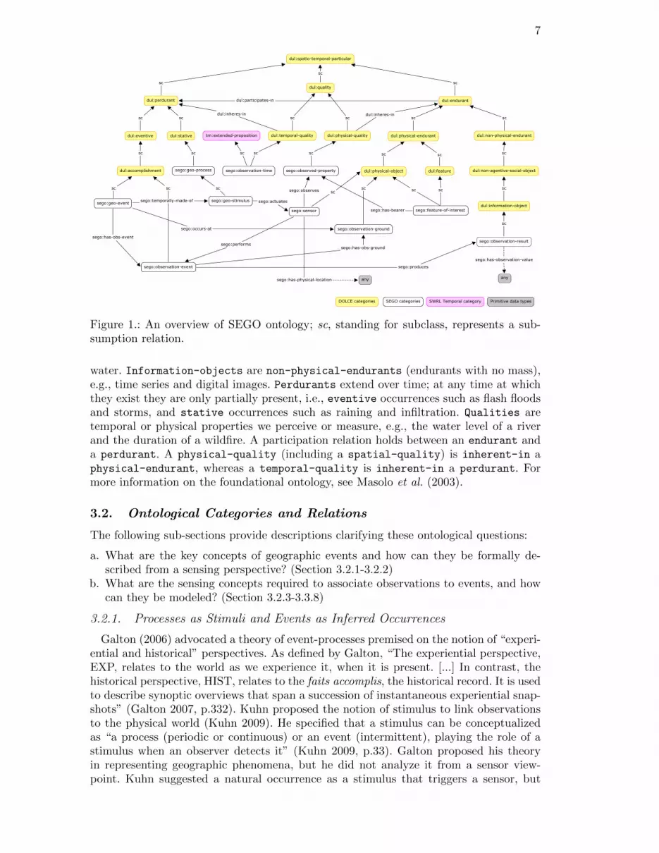
Figure 1 presents an overview of the proposed ontology. The ontological contributionsare summarized in Section 3.3. Throughout the remainder of this paper, typewriterfont is used for ontological categories and relations.
3.1. DOLCE Foundational Ontology
The foundational Descriptive Ontology for Linguistic and Cognitive Engineering(DOLCE) (Masolo et al. 2003) is adopted as a starting point for building the ontology.The reason for choosing DOLCE is that it provides most of the general notions underwhich the domain concepts can be classified. DOLCE is relatively mature in the sensethat several ontologies (Brodaric and Probst 2009, Kuhn 2009, Barnaghi et al. 2010,Probst 2006) addressing different aspects of geospatial and sensing domains have al-ready been aligned to DOLCE. The top categories of DOLCE are endurant, perdurant,quality and abstract (Figure 1). Endurants exists as wholes at any time they arepresent. At different times the same endurant may lose or acquire new parts, e.g.,physical-object such as lake and forest, and amount-of-matter such as sediment and
7
Figure 1.: An overview of SEGO ontology; sc, standing for subclass, represents a sub-sumption relation.
water. Information-objects are non-physical-endurants (endurants with no mass),e.g., time series and digital images. Perdurants extend over time; at any time at whichthey exist they are only partially present, i.e., eventive occurrences such as flash floodsand storms, and stative occurrences such as raining and infiltration. Qualities aretemporal or physical properties we perceive or measure, e.g., the water level of a riverand the duration of a wildfire. A participation relation holds between an endurant anda perdurant. A physical-quality (including a spatial-quality) is inherent-in aphysical-endurant, whereas a temporal-quality is inherent-in a perdurant. Formore information on the foundational ontology, see Masolo et al. (2003).
3.2. Ontological Categories and Relations
The following sub-sections provide descriptions clarifying these ontological questions:
a. What are the key concepts of geographic events and how can they be formally de-scribed from a sensing perspective? (Section 3.2.1-3.2.2)
b. What are the sensing concepts required to associate observations to events, and howcan they be modeled? (Section 3.2.3-3.3.8)
3.2.1. Processes as Stimuli and Events as Inferred Occurrences
Galton (2006) advocated a theory of event-processes premised on the notion of “experi-ential and historical” perspectives. As defined by Galton, “The experiential perspective,EXP, relates to the world as we experience it, when it is present. [...] In contrast, thehistorical perspective, HIST, relates to the faits accomplis, the historical record. It is usedto describe synoptic overviews that span a succession of instantaneous experiential snap-shots” (Galton 2007, p.332). Kuhn proposed the notion of stimulus to link observationsto the physical world (Kuhn 2009). He specified that a stimulus can be conceptualizedas “a process (periodic or continuous) or an event (intermittent), playing the role of astimulus when an observer detects it” (Kuhn 2009, p.33). Galton proposed his theoryin representing geographic phenomena, but he did not analyze it from a sensor view-point. Kuhn suggested a natural occurrence as a stimulus that triggers a sensor, but

8
he did not elaborate further on its representation. We incorporate these two indepen-dent positions to describe how events and processes link to a sensing domain. From anobservation perspective, geographic processes (geo-process) are conceptualized as “ex-periential” entities. They are ongoing processes (geo-stimulus) that actuate a sensorto produce observations. Not all geographic processes are necessarily stimuli. Therefore,geo-process subsumes geo-stimulus. Geographic events (geo-event) are not directlyinteracting with sensors, but rather they are “historical entities” inferred from observa-tions. The beginning and the end of an event is identified based on certain propertiesdefined by a domain-of-interest. To illustrate, a series of wind speed measurements in-dicates an ongoing airflow process triggering an anemometer. A high-wind event2 isinferred by applying a delimiting condition over the time series. A complex example is acombination of processes that actuate a sensor. Consider, for instance, a lysimeter thatestimates water loss from a plant-covered soil. The sensor involves water inflow (e.g.,irrigation) and water outflow (e.g., water percolation) as its stimuli. DOLCE allows forthe possibility that a parthood or a constitution relation can exist between any instancesof perdurants (Masolo et al. 2003). Our proposal is that a complex event may have otherevents as its parts (temporal-sub-event-of), and each of these sub-events is constitutedby (temporally-made-of) processes.
3.2.2. Participating Entities
The participants of an inferred event include the feature-of-interest observed bya sensor. One way to distinguish participants from one another is by the different rolesthey play in an event. In lexical semantics, these are known as thematic roles (Sowa1996, Smith and Grenon 2004). An attempt to classify different kinds of functional par-ticipation is presented in a lower module of DOLCE-Lite-Plus (DLP)3. However, theserelations are restricted to non-agentive-physical objects (e.g., social object) andintentional-based types of perdurants (e.g., activity and action). Therefore, follow-ing Sowa, Smith and Grenon (ibid.), we identify several types of participatory relationsspecializing DOLCE’s participant-in relation (Table 2).
Participation Examples
Direct and agentive participationperforms, performed-by This is the parent relation of initiates, perpetuates and terminates.initiates, initiated-by Amounts of precipitation initiate an infiltration occurrence.perpetuates, perpetuated-by Amounts of sandy soil perpetuate an infiltration occurrence.terminates, terminated-by A roadblock terminates the flow of traffic on a road.Indirect and agentive participationfacilitates, facilitated-by A plot of vegetation facilitates the rainwater infiltration into the soil.hinders, hindered-by An amount of saturated soil hinders quantities of rainwater from infiltrating
into the ground.Primary productproduces, produced-by A snow storm produces a huge amount of snow on a specific region.Secondary productaffects, affected-by The eruptions of Mount Merapi affected several settlements.
Table 2.: The functional participatory relations.
3.2.3. Observation Event
Barnaghi et al. (2010) classified an observation-event as a situation (i.e., a so-cial object). Since we want to emphasize actual as well as scheduled sensing activities,
2http://forecast.weather.gov/glossary.php?word=HIGH%20WIND3The DOLCE Lite (DOL) is the core version of the foundational ontology, whereas DLP contains all the basicextensions (e.g., Descriptions, Places, Time, and Functional Participation) that are plugged to the DOL.

9
and how they lead to inferences of real events, we classify an observation-event asa sub-class of DOLCE’s accomplishment. The observed properties, results, as well asspatial and temporal details are associated with an observation event, not with a sen-sor. This has the advantage that one can acquire information about distinct observationevents performed by the same sensor. An observation-event produces one or moreobservation-result. Following Probst (2006), the observation-result is modeled asa sub-class of the DOLCE’s information-object. A result can range from numericalmeasurements (e.g., time-series) through categorical measurements (e.g., human weatherobservations such as mild, windy and rainy) to images (e.g., aerial photographs).
3.2.4. Sensor
OGC’s SensorML specification describes sensors as entities capable of observing aproperty and returning a value (Botts 2007). We model sensors as physical-object
responding to stimuli. For example, devices (e.g., a wind profiler or a stream gage) andhuman observers (e.g., citizens supplying data about noise level in their neighbourhood).
3.2.5. Feature-of-Interest (FOI)
The O&M specification allows any entity to be classified as a FOI, such as sensing plat-forms, regions, artifacts of sampling, events, sample media, and geographic objects (Cox2007). Probst modeled the feature-of-interest4 as a subcategory of role in DOLCE,but did not provide a full account of its representation. It is unclear how a FOI can beginand cease playing a role, a role can be played by multiple entities, and an entity can playmultiple roles at the same time. In fact, Probst later acknowledged that “incorporatingroles into ontology engineering will yield philosophically sound ontologies at the priceof a drastically increased complexity”. For simplicity, we treat a feature-of-interest
as either a physical-object (e.g., a lake, a catchment or a volcano) or a feature5
(e.g., a gulf or a cross-section of a river) as defined in DOLCE. Most importantly, afeature-of-interest shall be an identifiable entity from an application domain. It canbe an object itself (e.g., a river) or a part of the object that can be recognized andobserved (e.g., a branch of a river). Amounts seem to be not directly observable as itis difficult to distinguish different portions of matter (Scheider et al. 2011). Therefore,we do not regard an amount-of-matter as a feature-of-interest, but rather as aconstituent of a physical-object. For example, we can assign a lake (with some waterconstituents) as the feature-of-interest that carries a water salinity property. Thispractice of assigning indirect hosts as if they were the actual hosts is an essential partof the conceptualization underlying natural language (Probst 2007), and is relevant toretrieving information in a sensing domain.
3.2.6. Observed Property
We regard an observed-property as a physical-quality that inheres in a FOI. Forexample, the temperature, the dissolved oxygen and the water level of a water body. Wedo not consider non-sensorial, abstract properties such as a foreign-exchange rate.
3.2.7. Spatial Information
Some authors (Lombard 1986, Scherp et al. 2009) suggested that the spatial locationof an event is determined by the sum of the regions of space occupied by its participants.This proposal will run into difficulties when the participants of an event cannot be fully
4Probst (2006) named this category as entity-of-interest.5A feature is a tangible and “parasitic” entity that is dependent on a physical-object.

10
represented. For example, from a sensing point of view, there is lack of resources withwhich to describe which amounts of water participated in a stream overflow or whichpuff of clouds is involved in a precipitation. In some cases, the question of where an eventtakes place may refer to different aspects of the location of interest. An example of thisis the difference between the source location and the run-up location of a tsunami. Froman empirical point of view, an event can have a direct spatial location. Nevertheless, itis not possible to model this in DOLCE, as a spatial-quality is only inherent-in
a physical-endurant; the spatial location of a perdurant comes indirectly from thespatial location of its participants (Masolo et al. 2003). The solution is that we allow thelocation of an event to be expressed in terms of physical locations (e.g., geo-coordinates)or social conventions (e.g., administrative units).
An observation-ground is a physical-object where a sensing is assumed to be valid.Its spatial extent is defined empirically, and implies the representative area of an inferredevent for a given in-situ sensor. For a ground in-situ observation, the sensor is in contactwith the FOI it observes, and deployed on the observation-ground, e.g., a weatherstation. There can be cases where the FOIs are part-of an observation-ground
(e.g., a plot for sampling vegetation) or present near the ground (e.g., a layer ofmoist air, an aquifer). For the latter, a FOI covers an observation-ground if itis a one-sided-specific-constant-dependence ((Masolo et al. 2003, p.31)) on theground, and is not a part of the ground, e.g., a bush shelter covering the ground. Afeature-of-interest can be related to an observation-ground with spatial relationssuch as underneath, surroundness, connectivity and containment. This aspect of researchhas not been fully investigated and requires further exploration. Some of the relationshave been specified by Bittner et al. (2009), Parent et al. (2006).
3.2.8. Temporal Information
Several efforts have been made in the Semantic Web community to develop tem-poral specifications, e.g., the DAML Ontology of Time6, the W3C’s Time Ontol-ogy7, and the SWRL Temporal Ontology8. The observation-time specializes theextended-proposition defined in the SWRL temporal ontology (O’Connor and Das2011). We choose the temporal ontology due to its simplicity with considerable expres-sivity. Further, it offers a set of rule-based built-ins that can be used to reason withtemporal information defined using the model.
3.3. Discussion I: Ontological Representation
Summarizing, we conceive a sensor as an object that responds to stimuli (e.g., geographicprocesses), and thereby allows the observation of properties of a particular feature-of-interest. A geographic event is inferred based on standardized rules expressed in termsof observed properties. Its participants include the observed feature-of-interest. The fol-lowing are several refinements that are applied to DOLCE.
a. In DOLCE, the event-process distinction is mainly based on two linguistic-philosophically derived notions: homeomericity and cumulativity.9 However, from an
6http://www.cs.rochester.edu/~ferguson/daml/7http://www.w3.org/TR/owl-time/8http://swrl.stanford.edu/ontologies/built-ins/3.3/temporal.owl9An occurrence is cumulative if it holds of the mereological sum of two of its instances, where it is homeomeric ifall its temporal parts can be described in the same way used for the whole occurrence.

11
empirical viewpoint, geographic processes can be conceptualized as homeomeric onlyup to a certain intrinsic granularity; such a granularity varies across and within sens-ing applications. A human observer may conceive a snowing process that stops andstarts repeatedly as homeomeric, but a sophisticated sensor may observe small breaksin between. Therefore, in the latter case, the process is regarded as anti-homeomeric.We distinguish events from processes (stimuli) by means of their relations to a sensor,and their temporal characteristics to cater theoretical and practical needs.
b. DOLCE allows a parthood relation between any types of perdurants, including pro-cesses, events and states. If we follow the principle that the parthood relation canrelate only occurrences that share a similar temporal shape, then geographic pro-cesses ought not to be specified as parts of a geographic event (or vice versa). Wespecified the relation (i.e., constituent) between events and processes in analogy tothe way objects and matter relate (Bach 1986).
c. DOLCE also suggests that the spatial location of an occurrence comes indirectly fromthe location of its participants. However, we have argued in Section 3.2.7 that froman empirical point of view, an event can have its own spatial location. Therefore, weintroduce the category observation-ground to denote the location where an eventis detected. This proposal pertains to in-situ sensors.
Sensing concepts are developed here based on (Cox 2007, Kuhn 2009, Probst 2006, Bar-naghi et al. 2010) representing observations and sensors. The existing specifications haveleft a number of open questions. They have been resolved as follows:
a. Kuhn (2009) suggested both events and processes as stimuli triggering a sensor, buthe did not fully elaborate on their representation. We represent geographic processesas stimuli that actuate sensors, and geographic events as inferred occurrences. Thisproposal also clarifies the question addressed by Barnaghi et al. (2010) - “The clas-sification of events in DUL is a work in progress. For instance, there is nothing saidabout how processes differ from other kinds of events. Therefore, the pattern definesa stimulus as a subclass-of DUL:Event”.
b. While a comprehensive specification may describe amounts asfeatures-of-interest, we take a pragmatic approach. We model features ofinterest as something that can be identified wholly, e.g., physical-object orfeature in DOLCE.
c. Several functional relations have been specified to distinguish participants in an event.They are meant to formulate meaningful observational queries (Section 6.2).
d. Barnaghi et al. (2010), Janowicz and Compton (2010) used the user-defined relationsto link an observation event to a sensor or an observation event to its results, withoutreferring explicitly to the participation relation. Probst (2006) described the relationbetween an observation event and an instrument via the general participation re-lation. We refine this with the functional participatory relations. For instance, theproduces relation indicates the primary product of an observation-event, which isan observation-result. We specify the performs relation to link a sensor to itsobservation-event as a sensor is conceptualized as the doer directly controlling anobservation event.
e. Figure 2 depicts several relations between sensing categories. Some of these relationsare inferred automatically with a rule-based mechanism, thereby eliminating the needto specify them manually. This is described in Section 5.2.

12
4. System Implementation
Figure 2 illustrates a system architecture which has been implemented using Java andSemantic Web technologies. The ObservationManager retrieves and parses timeseriesfrom Climate Data Online10 and stores them in the observational database. The on-tology repository consists of a three-layered ontology, in which a blizzard applicationontology specializes SEGO, and SEGO extends DOLCE. The application ontology rep-resents blizzards and their related events with respect to properties observed by weatherstations. SEGO11 is expressed in the Web Ontology Language (OWL-DL). OWL DLhas its foundations in description logics. SEGO also incorporates the SWRL temporalontology to represent temporal information. The OntologyManager collates the obser-vation data from the database into a knowledge base. The EventDetector supports theOntologyManager to infer information about events, their temporal parts and their sens-ing information from the ontological model. Here, standard and rule-based reasoning areemployed. Queries (Table 4) are expressed in SPARQL12 and executed using the Jena’sSPARQL query engine on the Pellet-backed inference model. Inferred events and theirsensing details are accessible via the online clients (Figure 3).
SWRL Rules
Query M
anager
Ontology &
Rule R
easoners (JE
SS
, Pellet, Jena query engine)
Visualization Manager
Event Detector
Ontology Manager
SEGO
DOLCE
Top Level
Domain Level
Application Level
SWRL Temporal
A formal description of blizzards and weather observations
Observational Database
Climate Data Online
Ontology Repository
Timeline & Timemap
Obs
erva
tion
Man
ager
Figure 2.: System architecture. Figure 3.: Events timeline and timemap.
Standard Ontological Reasoning. The standard reasoning is done with the Pellet OWLreasoner13 to check the logical consistency of the model, deduce new information andupdate the model with inferred information. A consistency checking ensures that the on-tology does not contain any contradictory facts. Consider for example, the domain andrange constraints on the observes relation: instance1 observes instance2. Constraintson the relation restrict that instance1 must be a sensor and the instance2 must bean observed-property. The reasoner will produce an ontological inconsistency error
10http://climate.weatheroffice.gc.ca/climateData/canada_e.html11http://anusuriya.com/sego/SEGO.htm12SPARQL is a W3C Recommendation. It is a query language for accessing data in the Semantic Web.13http://clarkparsia.com/pellet/

13
if an instance of a geo-event is linked to an instance of an observed-property withthe relation. Similarly, assigning an individual to two disjointed categories (geo-eventand geo-process) will make the ontology inconsistent. Automated classification is alsopossible on defined categories or relations through the reasoner. Consider the case wherewe represent that every observed-property must have at least one has-bearer relationwith a particular feature-of-interest. This is declared as a necessary and sufficientcondition for membership in the category observed-property. When an individual satis-fies such a condition, the reasoner automatically infers that such individual is an instanceof the specified category. Another example is when a relation (e.g., performs) has aninverse relation (e.g., performed-by). By only asserting the first relation, the reasonerwill automatically include the latter relation. These examples show the benefits of in-corporating an ontology-based approach within the application using an observationaldatabase.
Rule-based Reasoning. Some inferences require additional reasoning beyond that sup-ported by the standard reasoning with OWL-DL semantics. Therefore, we employed arule-based mechanism on top of the ontology. Rules are expressed in terms of ontologicalvocabularies (Figure 1) using SWRL14; see Table 3 for examples of implemented rules. Arule has the form: antecedent → consequent; this indicates that whenever the condi-tions specified in the antecedent are satisfied, those specified in the consequent must alsobe satisfied. For reasoning with the rules, we use the Jess15 inference engine. The SWRLRule Engine Bridge API supports the translation of OWL and SWRL rules to Jess factsand rules, executing the rules engine, and importing the results back into the ontology.The SWRL temporal built-ins support temporal reasoning, and the SWRL query built-in(sqwrl:select) enables rule-based queries.
5. Use Case: Reasoning about Blizzards from Weather Observations
The ontology is evaluated by inferring blizzards from hourly time series supplied bythe Meteorological Service of Canada. Definitions for blizzards are varied, according towhether the events occur south or north of the tree line. We use the definition of blizzardapplicable to the south of the tree line: (a) wind chill ≥ 1600 Wm−2; (b) mean wind speed≥ 40kmh−1; (c) visibility ≤ 1km; (d) presence of blowing snow or falling snow; all thespecified conditions (a-d) are expected to last for ≥ 4 hours. A lull period of three hoursor less is allowed before a new event is logged (Lawson 2003). A lull period is judgedto be a minimal period before a new event is identified. In 2010, Environment Canadachanged the definition of a blizzard to harmonize the warnings and criteria across thecountry.16 We use the old definition as our approach infers blizzards from the historicaldata and verifies the results against published event reports.
5.1. Data Descriptions and Inference Results
To minimize missing data periods, we use timeseries of consecutive months (Nov-Dec,1995-1997) from 8 selected stations in Manitoba. For the specified period, a total numberof 12 blizzards were inferred, including events that occurred within the same day, between
14http://www.w3.org/Submission/SWRL/15http://herzberg.ca.sandia.gov/16http://www.theweathernetwork.com/news/storm_watch_stories3&stormfile=what_is_a_blizzardij_010211

14
two days and events with lull periods. In addition, different types of weather events (e.g.,snow and blowing snow) were also inferred based on timeseries from the Brandon Airportstation for the period 1958 to 1995 (see Figure 3). For some stations, wind chill valueswere occasionally missing and influenced reasoning results. We estimate the missingvalues with the provided wind speeds and temperates using the Siple-Passel formulae(Siple and Passel 1945) recognized by the weather agency. For all selected stations, theinference results match the number and duration of events as specified in the eventreports17. A tabular view of the results is also available on the timeline application.
5.2. Reasoning with Domain and Application-Specific Rules
Table 3 shows examples of domain and application specific rules related to the applica-tion. Variables are marked by question mark prefix (?x) and represent the individuals.
Purpose Domain Rules
R1 Relate a geographic eventto its feature of interest
geo-event(?g) ∧ observation-event(?e) ∧ feature-of-interest(?f)
∧ has-obs-event(?g,?e) ∧ has-foi(?e,?f) → participant-in(?f,?g)
R2 Determine participants ofa complex event based onits sub-events
geo-event(?e1) ∧ geo-event(?e2) ∧ physical-endurant(?o) ∧participant-in(?o,?e1) ∧ temporal-sub-event-of(?e1,?e2) →participant-in(?o,?e2)
R3 Identify the feature of in-terest of an observationevent
observation-event(?e) ∧ observed-property(?p) ∧feature-of-interest(?f) ∧ has-obs-property(?e,?p) ∧has-bearer(?p,?f) → has-foi(?e,?f)
R4 Relate a sensor to its ob-servation results
sensor(?s) ∧ observation-event(?e) ∧ observation-result(?r) ∧performs(?s,?e) ∧ produces(?e,?r) → has-obs-result(?s,?r)
Purpose Application Rules
R5 Identify a blizzard’s sub-events at a given station
blizzard(?b) ∧ blowing-snow(?s) ∧ observation-ground(?r) ∧observation-event(?e) ∧ occurs-at(?b,?r) ∧ occurs-at(?s,?r)
∧ has-obs-event(?b,?e) ∧ has-obs-event(?s,?e) ∧has-t-quality(?b,?tq1) ∧ has-t-quality(?s,?tq2) ∧hasValidTime(?tq1,?tb) ∧ hasValidTime(?tq2,?ts) ∧contains(?ts,?tb,temporal:Hours) → sqwrl:select(?b,?s,?tb,?r)
R6 Infer a blizzard’s partici-pants
blizzard(?b) ∧ snow-event(?s) ∧ physical-endurant(?o) ∧participant-in(?o,?s) ∧ temporal-sub-event-of(?s,?b) →participant-in(?o,?b)
R7 Reclassify a general eventto a specific type of event
blizzard(?b) ∧ extreme-blowing-snow(?bs) ∧ snow-event(?s) ∧temporal-sub-event-of(?bs,?b) ∧ temporal-sub-event-of(?s,?b) →traditional-blizzard(?b)
R8 Identify the occurrence ofblizzards across neighbor-ing stations.
weather-station(?s1) ∧ weather-station(?s2) ∧neighbour-of(?s1,?s2) ∧ has-obs-result(?s1,?r1) ∧has-obs-result(?s2,?r2) ∧ performs(?s1,?obs1) ∧performs(?s2,?obs2) ∧ blizzard(?b1) ∧ blizzard(?b2)
∧ has-obs-event(?b1,?obs1) ∧ has-obs-event(?b2,?obs2)
∧ has-t-quality(?b1, ?tq1) ∧ has-t-quality(?b2,?tq2)
∧ hasValidTime(?tq1, ?tv1) ∧ hasValidTime(?tq2,
?tv2) ∧ overlaps(?tv1,?tv2, temporal:Hours) →sqwrl:select(?b1,?b2,?s1,?s2?r1,?r2)
Table 3.: Domain and application-specific rules.
a. R1 automatically links an inferred event to the observation domain with afeature-of-interest being the participant of the event. This rule is necessary as
17Atmospheric Hazards Northern and Prairie Region, http://pnr.hazards.ca/blizzard.html [accessed 15th Decem-ber 2011]

15
descriptions about a feature of interest are usually recorded during an observationevent, whereas information about an event is inferred later.
b. R2 implies that if an event is a temporal-sub-event-of another, then the partici-pants of the latter include the participants of the former. This rule is generic and canbe applied to different types of events. For example, R6 describes how the participantsof a blizzard event are inferred on the basis of the participants of its sub-event, at aparticular observation site.
c. R3 relates an observation event to its FOI. This kind of rule is useful in case of theinformation about a feature-of-interest is only available after a scheduled observationis performed. For example, a storm-prone area (a feature-of-interest) that is identifiedbased on a weather radar observing the reflectivity of a catchment.
d. Observation-event is the central category holding other sensing categories. The cat-egory should be specified in most of the queries retrieving sensing information. Tosimplify observational queries, R4 infers a direct relation between a sensor and itsresults based on their relations to the relevant observation events.
e. Various kinds of events can be inferred from the same observations depending onevents rules. Co-occurrence relations between these events can be identified via tempo-ral reasoning. Both blowing snow and blizzard events are identified independently. R5helps inferring the temporal part of a prolonged blowing-snow event corresponding toa blizzard event. Apart from the temporal containment, this rule can also be modifiedto support other temporal relations such as contains/during, overlaps/overlapped-byand equal.
f. There are two types of blizzards - the traditional-blizzard and theground-blizzard. The primary difference is that the latter solely occurs when highwinds blow snow that is already present at the surface (NOAA 2009). This meansthat a ground blizzard does not involve a snowfall event. R7 re-classifies an existingblizzard to a specific type of blizzard.
g. An interesting aspect is to analyze how properties of an event change from one sen-sor to another neighboring sensor. The weather agency suggests that nearby stationsrefer to stations within a radius of 25km of a latitude/longitude. In our rule imple-mentation, we use the Haversine formula18 to find neighboring stations that are withinthe radius distance of a given station. With this, the selected station is linked to itsnearby stations with a symmetric neighbour-of relation. Using this relation and atemporal operation, R8 retrieves the occurrence of blizzards across nearby stations.The observed values associated with the blizzards are also included in the reasoningresults.
5.3. Discussion II : Reasoning Support
Although the use case focuses on a specific type of event (blizzards and related weatherevents), modeling and reasoning about other geographic events are possible following asimilar approach, especially when it comes to institutionalized events and their inferencesbased on point observations. We have kept the ontology generic enough to be reused forother applications. After all, the aim of using ontology is to ensure its re-usability andextension by an application ontology. Of course, this requires additional application-specific classes and relations to be incorporated into the developed ontology. Since the
18http://www.movable-type.co.uk/scripts/latlong.html
16
ontology is available online19, it can be imported into an ontology-development tool suchas Protege to accomplish such a task. Simple rules are embedded in the ontology, whereascomplex rules are included in the system implementation. Both can be overridden byapplications wishing to modify the rules.
There are several advantages of using rules in our approach. Unlike OWL DL semantics,a complex relation between composed properties is formed via a rule-based mechanism,e.g., R1-R8. These rules are specified in terms of SEGO vocabularies as SWRL has aclose association with OWL. Each of these rules represents a distinct separate unit ofknowledge that can be added, modified or removed independent of the other rules. Forexample, R2 is modified to form R6. Both ontologies and rules are embedded in a commonlogical language; this promotes rules sharing and re-usability. In addition, SWRL featurestemporal and comparison built-ins that make the rules implementation easier, e.g., R5and R8.
SWRL has the full power of OWL DL, but at the price of decidability (Motik et al.2005). Decidability means that we can determine whether an argument expressed in thelanguage of the system is valid or not in a finite amount of time. In our implementation, wehandle this by DL-safe rules, i.e., a rule-extension of OWL DL and a decidable fragmentof SWRL. Practically, this means that the variables in rules are only bound to knownindividuals, thereby making the rules decidable.
The OWL semantics adopts an Open-World Assumption (OWA), in which the valida-tion is limited, e.g., there is no way to use negation as failure. Similarly, SWRL does notallow non-monotonic negation in the rules. A ground blizzard is a blizzard that does notinvolve a snowfall event. This definition is inherently closed world in the sense that theinformation is assumed to be complete. Therefore, we identify ground-blizzards by usingthe SPARQL filter expression not exists. This expression supports negation in SPARQL.It can be used to verify the absence of a query pattern in an inferred model.
Another issue is that some rules include additional constructs to the actual individualarguments that need to be considered during the reasoning. The “unwanted” proliferationof rule constructs makes the reasoning cumbersome. For example, R5 and R8 includeadditional rule expressions as the event’s temporal property from SEGO specializes thetemporal category in the external ontology.
6. Comparison With A Closely Related Approach
This section compares our approach with the Kno.e.sis Semantic Sensor Web20 project.The comparison is made with respect to the ontological support for retrieving eventsand their sensing descriptions. Within the Kno.e.sis project, there are two closely relatedefforts: (a) A semantically enabled Sensor Observation Service (SemSOS) that introducesan O&M-OWL ontology to support the retrieval of high-level knowledge from low-levelobservations (Henson et al. 2009), and (b) another application implementing the ontologyto derive meaningful abstractions from data streams and publishing these as Linked Data(Patni 2011).21
The similarity between our ontology and that of SemSOS lies in their covering the basic
19http://www.anusuriya.com/sego/SEGOv3.owl20http://knoesis.org/projects/ssw21Patni (2011), Patni et al. (2011) uses the O&M component of the Sensor and Sensor Network (SSN) ontologyprior to the modularisation and alignment of the ontology to DOLCE Ultra Lite. This component of the ontologyresembles the SemSOS O&M-OWL ontology.

17
notions addressed by the OGC’s observational model. The differences between the twoapproaches are in the way the relations between sensing categories, and between observedproperties and inferred events are represented. Two aspects covered by the SemSOSontology that are not fully specified in SEGO are descriptions of sensing methods, andunits of measurement. However, in our ontology, the relation between a sensor and anobservation-event is general enough to enable one to extend the respective categoriesto describe the sensing methods based on Barnaghi et al. (2010), Janowicz and Compton(2010). The categories observation-result and observed-property can be extendedwith classes from ontologies such as the Measurement Units Ontology (MUO)22 and theOntology of Units of Measure (OM)23.
Query O&M-OWL
SEGO
Group A: Asking sensing information.(Q1) Specify the location and properties observed by the weather station [station id/name]. (Q2) What are the observed properties of the [feature-of-interest] and which sensors ob-serve them?
(Q3) What are the wind speed values and their observed time produced by the [stationid/name] on YYYY-MM-DD?
Group B: Asking information about events and their sensing information.(Q4) What are the observed values associated with the blizzard detected by the [stationid/name] on YYYY-MM-DD?
H#
(Q5) Which station detects more than one blizzard in YYYY and how long do these eventslast?
H#
(Q6) Are there any ground blizzards detected by the [station id/name] between YYYY-MM-DD and YYYY-MM-DD?
N/A
(Q7) How do observed values associated with a blizzard occurs on YYYY-MM-DD changefrom the [station id/name] to its nearby stations?
H#
Group C: Asking information about interrelation between events.(Q8) Has a snow event occurred during the last HH hours of the blizzard [event id]? H# (Q9) How long does a blowing snow event last during the blizzard occurred at [observationsite] on YYYY-MM-DD?
N/A
Group D: Asking information about participants and their roles.(Q10) Which atmospheric features have involved in the snow event [event id]? N/A (Q11) Which atmospheric features have perpetuated the blowing-snow [event id]? N/A Full Support H# Partial Support # Not Supported N/A: Not Applicable
Table 4.: The comparison of querying support by two ontological approaches.
6.1. Retrieving Events and Sensing Information
Previous work (Yuan and McIntosh 2002, Worboys and Hornsby 2004) suggested severalclasses of queries that reflect information users would like to retrieve from an event-oriented model. Following these suggestions, four groups (Group A-D) of application-specific queries (Table 4) have been designed to compare both approaches. These queriesare also similar to scenarios proposed by Henson et al. (2009), Patni (2011), includingfinding sensing information, higher-level events, and temporal relatedness between se-quences of weather events. Examples of SPARQL translations of the queries are includedin Section 6.2. Note that the queries return results based on the information held inthe inferred model. Similar to SQL, they can be easily modified or extended to returnother relevant information. In Table 4, Full Support means that the specified query canbe performed with the vocabularies offered by the respective ontology. Partial Supportmeans that some of the vocabularies needed to form the query were missing, or that
22http://idi.fundacionctic.org/muo/muo-vocab.html23http://www.wurvoc.org/vocabularies/om-1.6/

18
incomplete reasoning or unsatisfactory query results were found. N/A indicates that thequery is not within the scope of the approach.24
6.2. Discussion III: Querying Support
This section discusses how the differences in ontological representation and incompletereasoning mechanisms influence the retrieval of event-driven information.
Group A: Sensing Information: While both approaches can retrieve results from thesequeries, the difference is that our approach simplifies the query formulation, as notevery query expression requires that an observation-event be specified. In the SemSOSontology, no relation is specified, for example, between a sensor and the properties itobserves, or between a sensor and its observation-result. We use rule-based reasoning(e.g., Table 3 (R3, R4)) to automatically infer these relations. Thus, Q1 and Q3 areperformed without explicitly specifying an observation-event (see Listing 1).
PREFIX sego:<http :// data.observedchange.com/sego.owl#>PREFIX xpth: <http ://www.w3.org /2005/ xpath -functions#>
SELECT ?sensor ?prop WHERE {?prop sego:has -bearer ?foi.?foi sego:has -name ?foiname.?prop sego:observed -by ?sensor.FILTER(xpth:contains(str(? foiname), <featureId >))}
Listing 1: (Q2) Identify properties and sensors based on a <featureId>.
Group B: Events and Observations: These queries retrieve inferred events and theirsensing information, e.g., Listing 2. For Q4 and Q5, there are discrepancies between thepublished event report and the results produced by the alternative approach due to thereasoning mechanism. The blizzard definition implies that an event is identified whenits duration is preceded by a time period in which the criteria are no longer satisfied,then a further period that again meets the criteria. Our approach detected a blizzardoccurring for 5 hours at Winnipeg Richardson Airport from 7pm to 11pm on 9th January1997. This matches the event record published by the weather agency. However, with theblizzard observation rule proposed by (Henson et al. 2009), five individual events areidentified, as it infers a new event at each time instant when the measurements satisfythe event’s condition. Our approach also supports more ‘realistic’ event reasoning asit considers the post-condition of an event (i.e., a lull period) when identifying a newevent. For example, a blizzard is detected by our model from the same station on 8thDecember 1995, from 7am until 8pm. This also matches the event record in the publishedreport. The time period of the event includes a lull interval (8am-9am), as during thisinterval wind speed measurements do not satisfy the blizzard’s definition. However, thealternative approaches failed to consider this in their rule-based mechanism.
To analyze the occurrence of an event beyond a particular station, one should identifynearby stations and a temporal overlapping between inferred events. Q7 is not withinto the scope of the alternative research. However, a related aspect is that Patni (2011)uses the GeoNames25 service to link the location of each weather station to its nearbynamed location in GeoNames. This allows for the discovery of sensors near a given
24The alternative approaches infer events based on the definition specified by NOAA’s National Weather Service.Since our implementation uses data from Environment Canada, we modify the rules specified by the approachesto comply with the definition set by the weather agency.25http://www.geonames.org/

19
named location. The same method can be adapted to find nearby stations of a selectedstation26; however, the weather stations in our study area are not fully supported bythe service. Our implementation includes complete records of weather stations from theweather agency. Therefore, we use a rule-based query (see Table 3 (R8)) to discoverrelated events across several neighboring stations. The radius determining a nearbystation can be overridden by applications wishing to modify the rule.
PREFIX rdf: <http :// www.w3.org /1999/02/22 -rdf -syntax -ns#>PREFIX dul: <http ://www.loa -cnr.it/ontologies/DOLCE -Lite.owl#>PREFIX met: <http :// data.observedchange.com/meteo/blizzard.owl#>PREFIX sego:<http :// data.observedchange.com/sego.owl#>PREFIX time:<http :// swrl.stanford.edu/ontologies/built -ins /3.3/ temporal.owl#>PREFIX xpth: <http ://www.w3.org /2005/ xpath -functions#>
SELECT ?station ?eventOfInterest ?obsEvent WHERE {?station rdf:type met:weather -station. ?station sego:performs ?obsEvent.?eventOfInterest rdf:type met:blizzard. ?eventOfInterest sego:derived -from ?obsEvent.{
SELECT ?sensor ?sensingEvent WHERE {?blz sego:derived -from ?sensingEvent.?sensingEvent sego:performed -by ?sensor.?blz dul:has -t-quality ?tq. ?tq time:hasValidTime ?st.?st time:hasStartTime ?stime.?st time:hasFinishTime ?etime.FILTER(xpth:substring(str(?stime ) ,1 ,4)="1997" &&xpth:substring(str(?etime ) ,1 ,4)="1997").}GROUP BY ?sensor ?sensingEvent HAVING (COUNT (?blz) > 1)
} FILTER (? station =? sensor && ?obsEvent =? sensingEvent) }
Listing 2: (Q5) Identify stations that detected more than one blizzard in 1997.
PREFIX rdf: <http :// www.w3.org /1999/02/22 -rdf -syntax -ns#>PREFIX rdfs:<http ://www.w3.org /2000/01/ rdf -schema#>PREFIX dul: <http ://www.loa -cnr.it/ontologies/DOLCE -Lite.owl#>PREFIX met: <http :// data.observedchange.com/meteo/blizzard.owl#>PREFIX sego:<http :// data.observedchange.com/sego.owl#>PREFIX time:<http :// swrl.stanford.edu/ontologies/built -ins /3.3/ temporal.owl#>PREFIX xpth: <http ://www.w3.org /2005/ xpath -functions#>
SELECT distinct ?blz ?snEvent ?startSnow ?endSnow WHERE {?blz rdf:type met:blizzard. ?blz sego:occurs -at ?obsReg.?obsReg rdfs:label ?regName. ?blz dul:has -t-quality ?tqBlz.?tqBlz time:hasValidTime ?vtBlz. ?vtBlz time:hasFinishTime ?blzEnd.?blz sego:has -temporal -sub -event ?snEvent. ?snEvent rdf:type met:snow.?snEvent dul:has -t-quality ?tqSnow. ?tqSnow time:hasValidTime ?vtSnow.?vtSnow time:hasStartTime ?startSnow. ?vtSnow time:hasFinishTime ?endSnow.FILTER (? regName =" Brandon Airport" && xpth:substring (str(? blzEnd ) ,1 ,10)="1995 -12 -04") }
Listing 3: (Q8) Determine the occurrence of snow during a blizzard.
Group C: Interrelation between Events: Patni (2011) uses the “isBefore” relation torepresent the order in which the events are detected by the system. While this impliesthat an event of the same type is detected before another, it is not possible to reasonabout the temporal relation of different types of events detected by the same sensor orbetween nearby sensors. In SEGO, the temporal information of inferred events is speci-fied with the SWRL temporal ontology. Therefore, SWRLTemporalBuiltIns can be usedin rules to perform temporal operations at a particular granularity, e.g., duration, before,after, overlaps, etc. For example, R5 in Table 3 is implemented to form a parthood rela-tion (temporal-sub-event) between events inferred at an observation site. This relationsupports Q8 and Q9 (e.g., Listing 3). In our application ontology, the category snowprecipitation subsumes different types of snow events, e.g., snow squall and snow flur-ries. With this subsumption relation, Q8 also considers all individuals that are instances
26This service returns the station closest to a given point: api.geonames.org/findNearByWeatherJSON?

20
of the category snow precipitation. This is an example of the advantages of using anontology-based search over conventional search in terms of being able to make inferencesand matches not available to standard keyword retrieval.
Group D: Event-Object Participation: As we emphasized in Section 3.2.2, more in-depthinformation about events should also include their participants. Consider observationalqueries such as, Who initiated the Korean War in 1950? Does the bridge hinder smoltfrom emigrating? How much rain was produced by the storm? Which US states wereaffected by Hurricane Katrina? In SemSOS ontology, a feature can be characterizedas an information object (e.g., coverage) as well as a real world entity (e.g., objectand event). For the discovery of information sources it is important to know whetherthe observation is performed on an individual real world entity or on an informationobject (Probst 2006). Our ontology restricts feature-of-interest to real-world objects onwhich an observation is performed, and they participate in an inferred event. With thisdistinction, we can gain understanding about event-object interactions within a sensingenvironment, e.g., Q10 and Q11. Another advantage of using an ontology-based searchis that Q10 is able to retrieve all the features playing different roles in a snow event.The features roles are represented by the functional participatory relations, which area sub-property of DOLCE’s participant relation (Table 2). Due to this sub-propertyassertion, it is inferred that these features are also participants of the event.
In short, SEGO formally captures the descriptions of events, their sub-events, partici-pating entities, and their sensing information. By leveraging these ontological descriptionswith reasoning capabilities, meaningful queries over simple observations are supported.
7. Conclusions and Future Work
The contribution of the research lies in the development of SEGO, which constitutescommon building blocks for constructing application ontologies that account for infer-ences of institutionalized events from in-situ observations. The paper has shown howthe ontological vocabularies are exploited with reasoning mechanisms to infer informa-tion about events and their sensing information. This is particularly useful in the SensorWeb in which observations are often presented in a purely syntactic way, and higherlevel inferences of events based upon them are missing. The strengths and limitationsof the proposed approach have been discussed in terms of representation (Section 3.3),reasoning (Section 5.3) and queries (Section 6.2).
An interesting follow-up is to use SEGO to develop test cases concerning institution-alized events. For instance, in the meteorology domain, weather agencies have publishedthe definitions of weather events in their official glossaries. Future work should also makethe location of an inferred event more explicit, through spatial reasoning of representativeareas of several stations. Related work in this aspect is representing spatial progressionpatterns of an inferred event over an observed region (Rude and Beard 2012). We haveused time-series produced by an in-situ sensor. It is also possible that a number of eventsthat actually occurred cannot be identified fully, as the weather station might not producesufficient information, for example, due to the absence of one or more observations re-lated to the event criteria. The use of this approach, combined with concepts representingground-measured and satellite-derived observations as well as human observations, willbe valuable for reasoning about events. The characteristics of similar geographic eventsmay differ considerably and are region-dependent. To illustrate, despite the classificationof tropical cyclones being driven from wind strength, they are described differently by

REFERENCES 21
the Regional Specialized Meteorological Centres worldwide. A useful extension of the for-mal model is to communicate these differences to aid global information access. Relatedapproaches in this topic are Parent et al. (2006), Brodaric (2008), Scherp et al. (2012).
References
Alexandrov, G., et al., 2011. Technical assessment and evaluation of environmental mod-els and software: Letter to the Editor. Environmental Modelling & Software, 26 (3),328–336.
Armstrong, M.P., 1988. Temporality in spatial databases. Proceedings: GIS/LIS, 88 (2),880–889.
Babitski, G., et al., 2009. Ontology-Based Integration of Sensor Web Services in DisasterManagement. In: K. Janowicz, M. Raubal and S. Levashkin, eds. Third InternationalConference of GeoSpatial Semantics (GeoS 2009), Vol. 5892 of Lecture Notes inComputer Science Springer Berlin / Heidelberg, 103–121.
Bach, E., 1986. The Algebra of Events. Linguistics and Philosophy, 9 (1), 5–16 0165-0157.Barnaghi, P., et al., 2010. Semantic Sensor Network XG Final Report. Technical report.Bermudez, L., Graybeal, J., and Arko, R., 2006. A Marine Platforms Ontology: Ex-
periences and Lessons. In: Semantic Sensor Networks Workshop, Athens, Georgia,USA.
Bhogal, J., Macfarlane, A., and Smith, P., 2007. A review of ontology based query ex-pansion. Inf. Process. Manage., 43 (4), 866–886.
Bittner, T., Donnelly, M., and Smith, B., 2009. A Spatio-Temporal Ontology for Geo-graphic Information Integration. International Journal of Geographical InformationScience, 23 (6), 765–798.
Botts, Mike, R.A., 2007. OpenGIS Sensor Model Language (SensorML) ImplementationSpecification. Technical report OGC 07-000, Open Geospatial Consortium.
Brodaric, B., 2008. A Foundational Framework for Structuring Geographical Categories.In: Information Semantics and its Implications for Geographic Analysis (ISGA ’08).
Brodaric, B. and Probst, F., 2009. Enabling Cross-Disciplinary E-Science by IntegratingGeoscience Ontologies with Dolce. IEEE Intelligent Systems, 24 (1), 66–77.
Broering, A., et al., 2009. Semantic Challenges for Sensor Plug and Play. In: J.D. Car-swell, A.S. Fotheringham and G. McArdle, eds. 9th International Symposium onWeb and Wireless Geographical Information Systems, Vol. 5886 10.1007/978-3-642-10601-9 6 Springer, 72—86.
Campelo, C.E.C., Bennett, B., and Dimitrova, V., 2011. Identifying geographical pro-cesses from time-stamped data. In: Proceedings of the 4th International Confer-ence on GeoSpatial Semantics, GeoS’11, Brest, France Berlin, Heidelberg: Springer-Verlag, 70–87.
Claramunt, C. and Theriault, M., 1995. Managing Time in GIS An Event-Oriented Ap-proach. Workshops in Computing, In: J. Clifford and A. Tuzhilin, eds. Recent Ad-vances in Temporal Databases. Springer London, 23–42.
Claramunt, C. and Theriault, M., 1996. Toward semantics for modelling spatio-temporalprocesses within GIS. In: J.M. Kraak and M. Molenaar, eds. Advances In GIS Re-search II: Proceedings of the Sixth International Symposium on Spatial Data Han-dling, Vol. 1 Taylor and Francis, 47–64.
Compton, M., et al., 2009. A Survey of the Semantic Specification of Sensors. In: K. Tay-lor, A. Ayyagari and D.D. Roure, eds. 2nd International Workshop on Semantic

22 REFERENCES
Sensor Networks, 8th International Semantic Web Conference (ISWC 2009), Vol.CEUR-WS Vol-522, 17–32.
Cox, S., 2007. Observations and Measurements Part 1 - Observation Schema. Opengisimplementation standard, Open Geospatial Consortium Inc.
Devaraju, A., 2012. Representing and Reasoning about Geographic Occurrences in theSensor Web. Dissertations in Geographic Information Science (GISDISS) Vol. 7.AKA Verlag ISBN: 9783898386739.
Frank, A.U., 2003. A linguistically justified proposal for a spatio-temporal ontology. In:Workshop on Fundamental Issues in Spatial and Geographical Ontology, Conferenceon Spatial Information Theory (COSIT 2003), Ittingen, Switzerland.
Fu, G., Jones, C.B., and Abdelmoty, A.I., 2005. Ontology-Based spatial query expansionin information retrieval. In: Proceedings of the 2005 OTM Confederated interna-tional conference on On the Move to Meaningful Internet Systems: CoopIS, COA,and ODBASE - Volume Part II, OTM’05, Agia Napa, Cyprus Berlin, Heidelberg:Springer-Verlag, 1466–1482.
Galton, A., 2006. On What Goes On: The Ontology of Processes and Events.. In: B. Ben-nett and C. Fellbaum, eds. Formal Ontology in Information Systems: Proceedings ofthe Fourth International Conference (FOIS 2006), Vol. 150 of Frontiers in ArtificialIntelligence and Applications IOS Press, 4–11.
Galton, A., 2007. Experience and History: Processes and their Relation to Events. Journalof Logic and Computation, 18 (3), 323–340.
Galton, A., 2009. Processes and Events in Geographic Space. In: Tutorial at COSIT2009, Aber Wrac’h, France, 1–37.
Galton, A. and Mizoguchi, R., 2009. The water falls but the waterfall does not fall: Newperspectives on objects, processes and events. Journal of Applied Ontology, 4 (2),71–107.
Grossner, K.E., 2010. Representing Historical Knowledge in Geographic Information Sys-tems. Thesis (PhD). Department of Geography, University of California, Santa Bar-bara.
Henson, C.A., et al., 2009. SemSOS: Semantic Sensor Observation Service. In: Proceedingsof the 2009 International Symposium on Collaborative Technologies and Systems(CTS) IEEE Computer Society, 44–53.
Hornsby, K.S. and Egenhofer, M., 2000. Identity-based change: A foundation for spatio-temporal knowledge representation. International Journal of Geographic Informa-tion Science, 14 (2), 207–224.
Janowicz, K. and Compton, M., 2010. Sensors. In: The Stimulus-Sensor-ObservationOntology Design Pattern and its Integration into the Semantic Sensor Network On-tology., 7–11.
Kuhn, W., 2009. A Functional Ontology of Observation and Measurement. In: K. Janow-icz, M. Raubal and S. Levashkin, eds. Third International Conference on Geospa-tial Semantics (GeoS 2009), Vol. 5892 of Lecture Notes in Computer Science10.1007/978-3-642-10436-7 3 Springer, 26–43.
Langran, G., 1989. A review of temporal database research and its use in GIS applica-tions. International journal of geographical information systems, 3 (3), 215–232.
Langran, G., 1992. Time in Geographic Information Systems. Taylor & Francis.Langran, G. and Chrisman, N.R., 1988. A Framework For Temporal Geographic Infor-
mation. Cartographica The International Journal for Geographic Information andGeovisualization, 25 (3), 1–14.
Lawson, B.D., 2003. Trends in Blizzards at Selected Locations on the Canadian Prairies.

REFERENCES 23
Natural Hazards, 29 (2), 123–138.Lombard, L.B., 1986. Events: A Metaphysical Study. Routledge & Kegan Paul.Masolo, C., et al., 2003. WonderWeb EU Project Deliverable D18: The WonderWeb
Library of Foundational Ontologies. Technical report, Laboratory For Applied On-tology - ISTC-CNR.
Motik, B., Sattler, U., and Studer, R., 2005. Query Answering for OWL-DL with Rules.Web Semantics: Science, Services and Agents on the World Wide Web, 3, 41—60.
Nittel, S., Labrinidis, A., and Stefanidis, A., 2008. Introduction to Advances in Geosen-sor Networks. In: S. Nittel, A. Labrinidis and A. Stefanidis, eds. GeoSensor Net-works., Vol. 4540 of Lecture Notes in Computer Science 10.1007/978-3-540-79996-2 1Springer Berlin / Heidelberg, 1–6.
NOAA, 2009. National Weather Service Glossary. [online] Accessed: 30 September 2010.Noy, N.F. and McGuinness, D.L., 2001. Ontology Development 101: A Guide to Creating
Your First Ontology. Technical report, Stanford Knowledge Systems Laboratory.O’Connor, M.J. and Das, A.K., 2011. A Method for Representing and Querying Temporal
Information in OWL. In: H.G. Ana Fred Joaquim Filipe, ed. Biomedical EngineeringSystems and Technologies: Third International Joint Conference, BIOSTEC 2010,Vol. 127 of Communications in Computer and Information Science Springer-Verlag,97–110.
Parent, C., Spaccapietra, S., and Zimanyi, E., 2006. The MurMur Project: Modelingand Querying Multi-representation Spatio-temporal Databases. Inf. Syst., 31 (8),733–769.
Parent, C., Spaccapietra, S., and Zimanyi, E., 1999. Spatio-temporal Conceptual Models:Data Structures + Space + Time. In: Proceedings of the 7th ACM InternationalSymposium on Advances in Geographic Information Systems, GIS ’99, Kansas City,Missouri, USA New York, NY, USA: ACM, 26–33.
Patni, H., et al., 2011. Demonstration: Real-Time Semantic Analysis of Sensor Streams.In: K. Taylor, A. Ayyagari and D. De Roure, eds. Proceedings of the 4th InternationalWorkshop on Semantic Sensor Networks 2011 (SSN11), 96–99.
Patni, H.K., Real Time Semantic Analysis of Streaming Sensor Data. Electronic thesisor dissertation, Wright State University, 2011. .
Pelekis, N., et al., 2004. Literature review of spatio-temporal database models. TheKnowledge Engineering Review, 19 (3), 235–274.
Peuquet, D. and Duan, N., 1995. An Event-Based Spatiotemporal Data Model (ESTDM)for Temporal Analysis of Geographical Data. International Journal of GeographicalInformation Systems, 9 (1), 7–24.
Peuquet, D.J., 2001. Making space for time: issues in space-time data representation.GeoInformatica, 5, 11–32.
Probst, F., 2006. Ontological Analysis of Observations and Measurements. In: M. Raubal,H.J. Miller, A.U. Frank and M.F. Goodchild, eds. 4th International Conference ofGeographic Information Science, Vol. 4197 of Lecture Notes in Computer ScienceSpringer, 304–320.
Probst, F., 2007. Semantic Reference Systems for Observations and Measurements. The-sis (PhD). Institute for Geoinformatics, University of Muenster.
Raskin, R., Pan, M., and Mattmann, C., 2004. Enabling semantic interoperability forearth science data. [online].
Reitsma, F., 2005. A New Geographic Process Data Model. Thesis (PhD). University ofMaryland, College Park.
Rude, A. and Beard, K., 2012. High-Level Event Detection in Spatially Distributed Time

24 REFERENCES
Series. In: N. Xiao, M.P. Kwan, M. Goodchild and S. Shekhar, eds. Geographic In-formation Science., Vol. 7478 of Lecture Notes in Computer Science Springer Berlin/ Heidelberg, 160–172.
Scheider, S., et al., 2011. Semantic Referencing of Geosensor Data and Volunteered Ge-ographic Information. In: A.P.S. Naveen Ashish, ed. Geospatial Semantics and theSemantic Web, Vol. 12 of Semantic Web And Beyond Computing for Human Ex-perience Springer, 27–59.
Scherp, A., et al., 2009. F–A model of events based on the foundational ontologyDOLCE+DnS ultralight. In: Proceedings of the fifth international conference onKnowledge capture, K-CAP ’09 ACM, 137–144.
Scherp, A., et al., 2012. A core ontology on events for representing occurrences in thereal world. Multimedia Tools and Applications, 58, 293–331.
Schlenoff, C., et al., 2000. The Process Specification Language (PSL) Overview and Ver-sion 1.0 Specification. Technical report, National Institute of Standards and Tech-nology.
Shaw, R., Troncy, R., and Hardman, L., 2009. Vol. 5926 of Lecture Notes in ComputerScienceIn: LODE: Linking Open Descriptions of Events., 153–167 Springer Berlin /Heidelberg.
Siple, P.A. and Passel, C.F., 1945. Measurements of Dry Atmospheric Cooling in Sub-freezing Temperatures. Proceedings of the American Philosophical Society, 89 (1),177—199.
Smith, B. and Grenon, P., 2004. The Cornucopia of Formal-Ontological Relations. Di-alectica, 58 (3), 279–296.
Sowa, J.F., 1996. Vol. 1115 of Lecture Notes in Computer ScienceIn: Processes and par-ticipants., 1—22 Springer Berlin / Heidelberg.
Tripathi, A., 2005. Developing a Modular Hydrogeology Ontology Extending the SweetOntologies. Thesis (PhD). Department of Geosciences.
Van Hage, W.R., et al., 2011. Design and use of the Simple Event Model (SEM). WebSemantics Science Services and Agents on the World Wide Web, 9 (2), 128–136.
Worboys, M.F., 1994. A Unified Model for Spatial and Temporal Information. ComputerJournal, 37 (1), 36–34.
Worboys, M.F., 2005. Event-oriented approaches to geographic phenomena. InternationalJournal of Geographical Information Science, 19 (1), 1–28.
Worboys, M.F. and Hornsby, K., 2004. From Objects to Events: GEM, the GeospatialEvent Model. 3234, 327–343.
Yuan, M., 2001. Representing Complex Geographic Phenomena in GIS. Journal of Car-tography and Geographic Information Science, 28 (2), 83–96.
Yuan, M., 2008. Temporal GIS and Applications. In: S. Shekhar and H. Xiong, eds.Encyclopedia of GIS. 1 ed. Springer, chap. Processes and Events, 1147–1150.
Yuan, M., 2009. 13. In: Toward Knowledge Discovery about Geographic Dynamics inSpatiotemporal Databases., 347–365 CRC Press.
Yuan, M. and Hornsby, K.S., 2007. Computation and Visualization for Understand-ing Dynamics in Geographic Domains: A Research Agenda. CRC Press ISBN-10:1420060325.
Yuan, M. and McIntosh, J., 2002. A Typology of Spatiotemporal Information Queries. In:M.A. K. Shaw R. Ladner, ed. Mining Spatiotemporal Information Systems. KuwerAcademic Publishers, 63–82.