4301931193.pdf - utah - oil and gas
TRANSCRIPT
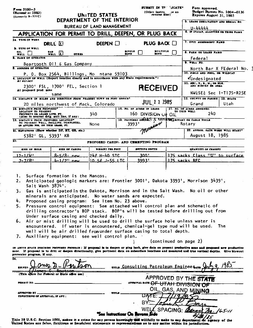
SUBNIT IN TV VCATE* Foran approved.Porm 3160-3(Other test as on Budget Bureau No. 1004-0136','A UhiTED STATES '•••'•A** E=Pir••^=ru•t 31. 1985
DEPARTMENTOF THE INTERIOR G. I.BASE DBS30NATION AND BERIAL WO.
BUREAU OF LAND MANAGEMENT_444
APPLICATIONFOR PERMITTO DRILL,DEEPEN,ORPLUG BACK A.lFINDIAN,aLLOTTEROBTRIBENAME
18. T¶PS OF WORK
DRILLO DEEPENO PLUG BACK O ' """ ^°•""'"' "'b. TTPE OF WELL
°'LO •'.•,... O .,...•.a*." O ".;NLE A. FARM OR leBASE WAME
s. naus or orsaarom FederalBeartooth Oi1 6 Gas Company 9.war.a.no.
8. Annassa or orsaaton North Bar X FEderal No. 3P. O. Box 2564, Bi ll ings, Mo ntana 59103 1Û. FIELD AND POOL, OR WILDCAT
4. ALOCATE N OF WN.L (Report location clearly and in accordance with any State requiresnents.•) Ándesignated11. SEC., T., B., M., OR BLK.
AtpodprF L, 1700' FEL, Section i RECEIVED ^" "'"
"same NWhSEh Sec 1-Tl7S-R25E14. DIETANCE IN MILES AND DIBBCTION FROM NEABBBT TOWN 05 POST OFFICE' 12. COUNTT OR PARISE 18. BTATE
20 mi les northwest of Mack, Colorado ÛÊ··1 1 1985 Grand Utah10. DISTANCE FROM PROPOSED* 16. WO. OF ACRES IN Lasaz 17. WO. OF ACAES ABBIONED
LOCATION TO NEAREST TO THIS WELLraormarr on s.sa.= I.r==. FT- 340 160 DIVISION U OJL 240(Also to nearest drig. anit line, if any)
18. DiaTANCE PROM PROPOSED LOCATION* 19. PROPOSED DOÅS ROTART OR CABLE TOOLSTO NEAREsT WELL, DRILLING. COMPLETED, No 3993' ' Rotar08 APPLIED TOR. ON Tms LEASE, Fr.
Bl. SIEVATIONS (ShoW WhetÎter DF. $Î, ÛË, &tc.) 22. APPROz. DATE WORK WILL START*
5382' GL, 5393' KB August 18, 198523. PROPOSED CABING AND CEMENTING PROGRAM
SIEE OF ROLE BESE OF CASING WEIGHT PER POOT sgTTING DEPTH QUANTITT OF CEMENT
17-1/h" R-5/R• now 7hR N-kn STC RODI 175 sacks Class "G" to surface-7/Ril h-1/7" new 10 SR .1-44 i TC 19A3' 174 marks RFC
1. Surface formation is the Mancos.2. Anticipated geologic markers are: Frontier 3001', Dakota 3393', Morrison 3439',
salt Wash 3874'.3. Gas is anticipated in the Dakota, Morrison and in the Salt Wash. No oil or other
minerals are anticipated. No water sands are expected.4. Proposed casing program: See Item No. 23 above.5. Pressure control equipment: See attached well control plan and schematic of
drilling contractor's BOP stack. 80P's will be tested before drilling out fromUnder surface casing and checked daily.
6. Air or mist drilling will be used to drill the surface hole unless water isencountered. If water is encountered, chemical-gel type mud will be used. Thewell will be air drilled fronunder surface casing to total depth.
7. Auxiliary equipment: see well control plan.(continued on page 2)
IN ABOVE SPACE DESCRIBE PROPOSED PROORAM : If þroþ0Bal to to deepen or plag back, give data on present predactive some and proposed new prodnetiresone. It proposal is to drill or deepen directionally, give pertinent data on subsurface locations and meaanred and true vertieel depths. Give blowout
agrnpr m .
weer.m COnsulting Petroleum Engineer,ay.Ì~f1"" Û ÎÏ"Ilt""" i (,(This space for Pederal or State oSee ase)
APPROVEDBY TNE gy gPER1f TT W APPROVAL DATE
olL, GAS. ANp I NGAPPROTED $7 ** I E met
CONDITIONS OF APPROVAL, IF ANT:
. B ·
,
WE SPACING: Sp. / 54'Seeinmueno.«Onteve...AdeTitle 18 U.S.C. Section 1001 makes it a crime for any person knowingly 14 willfully to make to any department er egency of theUnited States any taise. fictitions or freudulent statements or representations as to any matter within its

Application for Permit to Drill, Deepen, or Plug BackNorth Bar X Federal No. 3NW¾SEi Sectionl-Tl7S-R25EGrand County, Utah Page 2
8. The logging program will consist of a DIL log from TD to base of surface casing,and GR-FDC-CNL logs from TD to above the Frontier. No cores or DST's are planned.
9. No abnormal pressures or temperatures are anticipated. No poisonous gas isanticipated.
10. Anticipated spud date is August 18, 1985. Completion operations should commencewithin 30 days of rig release.
11. Survey plats are attached.12. The gas is dedicated to Mesa Pipeline.13. The spacing unit will be the Ni, N#Si ofSection I,as per Utah Cause No. 165-11 allowing
2 - 240 acre wells on one spacing unit. This order was approved February 28, 1985.14. Designation of Operator forms from Hawthorn Oil Company are attached.15. The well will be drilled under Utah Blanket Bond No.

SEC.1, I /75 , R. 24E. OF THE .A.M. LOC T/OA/gCAT~
LOT4 LOT S Loy g LOT I
? ARTOO M GIL 4 CAW C
GD- E LE
ooo
LEGENDeranonne Locareon erO ,
es.o conNggs FOUNO
OWELL i.OCATOON STAMED.
EFE RENCE DOCUMENTS
GLO PLAT
AR-A NASI LIT-CDUADRANGL.E , USGS
¢. ôÿ• Bd'M/ 5278.¢¿' G.L-Q.
THIS WELL LOCATION PLAT WAS PREÞARED FOR MAgroory Qu.4f GA5 CO.
TO LOCATE THE Nnn¶M MR -X {4/( , f Spo' E,,f, L.S/100' FL L. IN THE ,Ñ&'.....l/4 f/4, OF SECTION _.
_...,TO., R.OF THER. (paANO COUNTY, (Arg/A
SURVEYOR S CERTIFICATE
I, LARRY D. BECKER A REGISTERED L.AND SURVEYOR fNTHE STATE OF UTAAI 00 HEREBY CERTIFY THAT THISSURVEY WAS MADE UNDER MY DIRECT BUPERVISIONAND THAT THIS LAT REPRESENTS SAID SURVEY.
unv vo ENEROY vas noneron oneva,swrr ano "' *
awn /p/, ORANO •¢UNCYiON, CO ISOf 00 NO.ENOINEERINO OORP. Taos; res - yggi
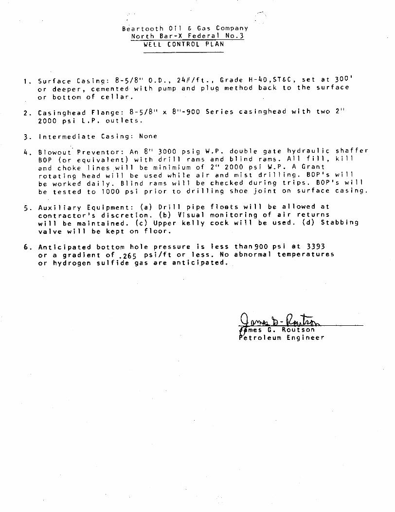
Beartooth Oil & Gas CompanyNorth Bar-X Federal No.3
WELL CONTROL PLAN
1. Surface Casing: 8-5/8" 0.D., 24#/ft., Grade H-40,ST&C, set at 300'or deeper, cemented with pump and plug method back to the surfaceor bottom of cellar.
2. Casinghead Flange: 8-5/8" x 8"-900 Series casinghead with two 2"2000 psi L.P. outlets.
3. Intermediate Casing: None
4. Blowout Preventor: An 8" 3000 psig W.P. double gate hydraulic shafferBOP (or equivalent) with drill rams and blind rams. All fill, killand choke lines will be minimium of 2" 2000 psi W.P. A Grantrotating head will be used while air and mist drilling. 80Pis willbe worked daily. Blind rams will be checked during trips. BOP's willbe tested to 1000 psi prior to drilling shoe joint on surface casing.
5. Auxiliary Equipment: (a) Drill pipe floets will be allowed atcontractor's discretion. (b) Visual monitoring of air returnswill be maintained. (c) Upper kelly cock will be used. (d) Stabbingvalve will be kept on floor.
6. Anticipated bottom hole pressure is less thanSOO psi at 3393or a gradient of
.265psi/ft or less. No abnormal temperatures
or hydrogen sulfide gas are anticipated.
mes G. Routsontroleum

t.ncrmlTL UT DUY blALK
Air drilled wells using 900 series wellhead equipment.
Interval from 300' to total depth.
Rotat ing Head
Blouie Line
Blind Rams
i
Drill Pipe Ramt
Or i ll i ng SpoolI¯¯1D<E×'l lE×'I\ «Choke Lin
Kill Line
r--u><s r><na-,Casing
t.ncrmlTL UT DUY blALK
Air drilled wells using 900 series wellhead equipment.
Interval from 300' to total depth.
Rotat ing Head
Blouie Line
Blind Rams
i
Drill Pipe Ramt
Or i ll i ng SpoolI¯¯1D<E×'l lE×'I\ «Choke Lin
Kill Line
r--u><s r><na-,Casing

SURFACE USE PLAN
BEARTOOTHOIL & GAS COMPANYNORTH BAR X FEDERAL #3
NWhSEk Section 1-Tl7S-R25EGrand County, Utah
1. Existing Roads
See Vicinity and Topo Maps. This proposed well is approximately 16 airmiles northwest of Mack, Colorado. It is reached by going 9.5 miles westof Mack on Old Highway 6 & 50 to Mesa County 2 road; then turn right andgo 4.1 miles northwesterly up 2 Road to the Colorado-Utah State line (fence).Then turn right and go 3.2 miles up (north) the state line fence road; turnleft (west) and go 2.4 miles on the County oilfield road; then turn right(north) and go 1.7 miles to the Beartooth 011 & Gas Company North Bar X #lwell where the 0.6 mile of new road begins. All of the existing roadsexcept for the last 1.7 miles are County roads. Beartooth has authorizationto use the last 1.7 miles of existing oilfield road as access to its NorthSar X #1 well. All of the existing roads will be maintained by Beartoothin conjunction with the County and area oil and gas operators. The existingroads are colored green on the maps.
2. Access Roads to be Constructed and Reconstructed
See.Map #1 - Access and Topo Map. The 0.6 mile of new road will be constructed asa BLM-Moab Class III well access road. It will have an 18 foot wide drivingsurface with a total disturbed width of 35 to 55 feet depending on topography.The road will be ditched and crowned on flat ground and insloped 2% on sidebillcuts. Drainage design will utilize natural land contour and water will becarried across the road with water dips. No culverts will be used. No fences,modifications, nor cattleguards are necessary. There is one low water washcrossing just west of the wellsite.
Road surfacing materials will be the existing native materials. The maximumroad grade is S%-6%. The road is flagged with orange flagging. The new accessroad is colored red on Map #1.
3. Location of Existing Wells
See Map No. 3
4. Location of Existing and/or Proposed Facilities if Well is Productive
(a) On Well Pad - See Plat No. 5
(b) Off Well Pad - See Facilities Map
Beartooth Oil & Gas Company proposes to construct a buried 2" gas line fromthe North Bar X #3 to Beartooth's existing pipeline at the North Bar X #1 well.This line will be constructed adjacent to the new access road. The line isconsidered an amendment to Beartooth's existing North Bar X pipeline system.R/W Grant

Surface Use Plan - page 2
5. LocationandType of Water Supply
The water source for this well is West Salt Greek. The pickup point is anOld Highway 6 & 50 approximately 2.5 miles west of Mack, colorado.
6. Source of Construction Materials
No construction materials will be used other than native materials. Soilfrom cuts will be used in fills. No outside material will be brought in.
7. Methods for Handling Waste Disposal
Cuttings will be buried in the reserve pit at clean up. Garbage and otherwaste material will be contained in a trash cage. This cage will be dumpedat an approved sanitary land fill. Human waste will be disposed of inchemically treated sanitary pits.
Drilling fluids will be contained in the reserve pit and left to evaporate.Any fluids produced during testing operations will be collected in a test tank.If a test tank is not available, the fluids will be contained in the reservepit. Any spills of oil, gas, salt water or noxious fluid will be cleaned upand removed.
If the well is productive, produced water will be disposed of on site for 30days only, or 90 days with the permission of the District Manager. After thattime, application willbe made for approval of permanent disposal method incompliance with old MMSOrder NTL-2B, and the rules and regulations of theState of Utah.
8. Ancillary Facilities
No ancillary facilities are planned.
9. Wellsite Layout
See Plat #2 - Pit and Pad LayoutSee Plat #3 - Cross Sections of Pit and PadSee Plat #4 - Rig Layout
The location will be constructed large enough to accommodate the drilling rigand associated equipment with allowance made for future completion and fracturingequipment.
The location construction will begin by stripping and stockpiling all available(4-6") topsoil. The stockpile will be along the east and west ends of thelocation.
The reserve pit will be constructed along the north side of the well pad. Thepit will be fenced on three sides during drilling and closed on the fourth sideat rig release. The fence will be maintained through completion and while thepit area is

Surface Use Plan - page 3
10. Plans for Reclamation of the Surface
If the well is productive, the reserve pit will be allowed to dry and thenbackfilled. All of the area not necessary for production will be restoped,
covered with available topsoil and revegetated using a seed formula supplied
by the BLM.
If the well is abandoned, the entire area of disturbance will be returned to
a reasonable contour approximating the topography of the surrounding area.
The topsoil will be distributed over the recontoured area and revegetated
using the appropriate seed formula.
Clean-up will begin after completion rig release and resloping should becompleted by the Fall of 1985.
11. Surface Dwnershiþ
All lands involving new construction.are Federal lands.
12. Other Information
The well site sits between two washes on the Mancos desert floor. The vegetation
is sparse and includes juniper, sagebrush, western wheatgrass, Indian rice grass
and a few annual plants.
13. Lessee's or Operator's Representatives and Certification
James G. Routson Ken CurreyBeartooth Oil & Gas Company Beartooth 011 & Gas CompanyP. O. Box 3564 P. 0. Box 1491Billings, Montana 59103 Fruita, colorado 81521
Office Phone: 406-259-2451 office/Home: 303-858-3257
Home Phone: 406-245-8797 Mobile: 303-245-3660, Unit 5858
I hereby certify that 1, or persons under my direct supervision, have inspected
the proposed drillsite and access route; that I am familiar with the conditionswhich currently exist; that the statements made in this plan are to the best of
my knowledge, true and correct; and that the work associated with operationsproposed herein will be performed by Beartooth Oil & Gas Company and its
contractors and subcontractors in conformity with this plan and the terms and
conditions under which it is approved.
Date mes G. Routsononsulting Petroleum

17 S
658
c57
2o
14 1
srss=
c
17 S
658
c57
2o
14 1
srss=
c

ost
cousv MA LVIC/W M
I. :a E R 26 E
2,eso.oooc
. -- - - -- -- 8 26 E
30 as 34 35 156½
15 E Conv Ga F
it is 25
400 000
21
s
cz
L
15
31 ' ik 73
oit
n n ur n ,2. ,a a .. .«
ost
cousv MA LVIC/W M
I. :a E R 26 E
2,eso.oooc
. -- - - -- -- 8 26 E
30 as 34 35 156½
15 E Conv Ga F
it is 25
400 000
21
s
cz
L
15
31 ' ik 73
oit
n n ur n ,2. ,a a .. .«
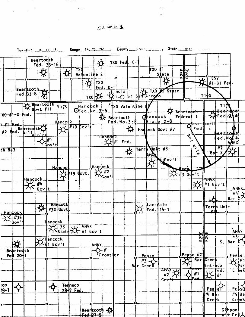
VELL MAP NO, )
Township 6-11., 85, Ronge 24, 2 26E , County Arm , State _a¿te
Begrtoo hFed. 3 -16
TXU Fed. C-
TX9 FXO 1 wwVallenti se 2 .. S ate
33 1----34 ----- ----35
' 30 $i ------
TXO #1-31 Fe- .
.. .Reartool . _-..
................ ...
OFed. 33-8 'c a r XO St ste
.5 TX0 #1 5 rg, o T 1 S
""8aliFUMFGavt t 11 T175 anc ck 1XO V lentine T1
XO tX ed.Starto th ancack Federa 1 'Fed A 6
el Far! Henco k Fed.Nr .)- tate 2 8
#2 edlie rtoct #10 GovHa ock 3ovt #7 Fed
--- ----- - -L..- ~'
....-te.a.C . b.ed.1 .
Fed.ov t
Terr a ni t #8 #7
cv't
Hencoc Ha c ck
19 Govt.
....-. ....
......
Ba
Han:ock#32 Govt ed 14-1 Ter Un t
#35ov' an o:k
33 AMAstatt #1 ov't A x
nAMA
S. Ba
Be rtot th #1Fe 20- 1 ont er
21 Pease se #2 Peake#3 Bar Cree #1
Bor Cree Entr da or.... .......... . .. .... ... .... ..... ....
.. ....... ....... .. .... A --
ek
C t#1
---- -- -•-
------ --- ---- ........ ... . ......... .....- ..-. . .§.il
PcABr #SaaCre k Cr ek
Bea oot--+-- ·- ---- ed- 27•91---- -- --- -- -- -----+----

L o
e'
, ac
CCTo L ock
A E 0 1 L to' di 10
AG (0LL cworn/
L o
e'
, ac
CCTo L ock
A E 0 1 L to' di 10
AG (0LL cworn/
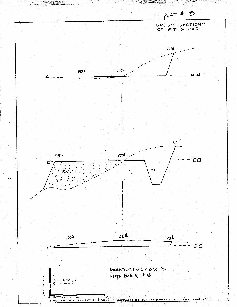
CR0SS-SECTIONSOF PIT & PAD
C7Ê ---
vol co'---- AA
cd
reB- - - - - BB
coi c c
C- CC
o otew, M.
SCALE
one so roo
NC SO FEFÌ 0Mi .PREPággy av eutaangtsew y«Wu uma
CR0SS-SECTIONSOF PIT & PAD
C7Ê ---
vol co'---- AA
cd
reB- - - - - BB
coi c c
C- CC
o otew, M.
SCALE
one so roo
NC SO FEFÌ 0Mi .PREPággy av eutaangtsew y«Wu uma

A.am..ek, . .
4-ou
3cio Sel asnou - i' hossauseena
sar et
dHfidi @ft
L
,os ,or
ti MA@S O
1 enw
,7;"
a> o
O e
O 6-14
3dC Sf E\
9 al
av tqoopi o y Che Co.
AINTNg.A
A.am..ek, . .
4-ou
3cio Sel asnou - i' hossauseena
sar et
dHfidi @ft
L
,os ,or
ti MA@S O
1 enw
,7;"
a> o
O e
O 6-14
3dC Sf E\
9 al
av tqoopi o y Che Co.
AINTNg.A

1. Wellhead will be an 8-5/8" Larkin Fig. 92 or equivalemt. Tubing headwill be a 41/2" x 6"-900 Series with two 2" 3000 psi screwed valves.Tree will be 2" screwed x 2000 psi W.P.
2. Line between wellhead and separator will be approximately 100 feetin length and constructed of 2-3/8" .218 wall seamless, welded,wrapped and buried approximately 5 feet deep.
3. Line between separator and meter will be 4" or 4.028 00 seamless,welded, coated, wrapped and buried, and will be approximately 25feet in length.
4. Meter run will be American 2" run, or equivalent, 1000 psi staticrating, 100" of water differential rating.
5. Pit will be 10'x 10', enclosed by dikes and
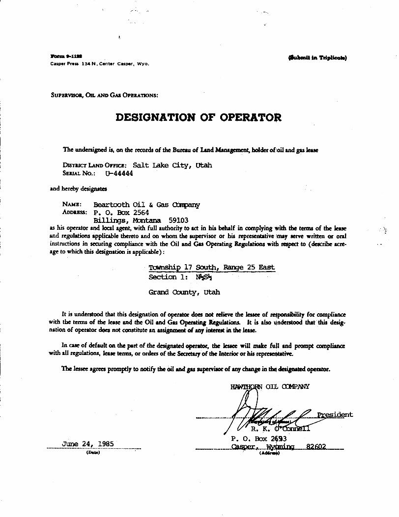
Norm e-nsa ghabanitin Tdplicate)CasperPress 134N.Center Casper, Wyo.
SUPERVISon, OR. AND GAs OPERATIONS:
DESIGNATION OF OPERATOR
The undersigned is, on the records of the Bureau of I.and Management,holder of oil and gas lesse
DISTRICT I.AND ÛFFICE: Salt Ixalte City, Ut;ahSERIAI. No.: U-44444
and hereby designates
NAME: Beartooth Oil & Gas 00mpanyADDRESS: P. O. Box 2564
Billings, Montana 59103as his operator and local agent, with full authority to act in his behalf in complying *ith the termsof the leaseand regulations applicable thereto and on whom the supervisor or his representative may serve written or oralinstructions in securing compliance with the Oil and Gas Operating Regulations with respect to (describeacre-age to which this designation is applicable) :
Tt:mnship 17 South, Range 25 EastSection 1: I@sS½
Grand County, Utah
It is understood that this designationof operator doesnot relieve the lesseeof re4ponsibility for compliancewith the terms of the lease and the Oil and Gas Operating Regulations. It is also gnderstoodthat this desig-nation of operator does not constitute an assignment of any interest in the lesse.
In case of default on the part of the designatedoperator, the lessee will make fugland prompt compliancewith all regulations, ease terms, or orders of the Secretaryof the Interior or his represe4tative.
The lessee agreel promptlyto notify the oil and gas supervisorof any change in the designatedoperator.
Immi on amen«
/ / President
R. K.P. O. Box 2§¾3
.......... F...B.f....9.Ÿ.9................. Casper . Wydsti ng 82 fiß2(Data)

OPERATOR s DATE 7 ffWELLNAl€
SEC //N T /75 R COUNTY
API N TYPEDELEASE
CHECKOFF:
PLAT BOND NEARESTWELL
LEASE FIELD POTASHOROIL SHALE
PROCESSING NT
APPROVALLETTER:
SPACING: A-3 c-3-a / yffff'UNIT CAUSENO. A DATE
c-3-b c-3-c
STIPULATION :
11/2/84
OPERATOR s DATE 7 ffWELLNAl€
SEC //N T /75 R COUNTY
API N TYPEDELEASE
CHECKOFF:
PLAT BOND NEARESTWELL
LEASE FIELD POTASHOROIL SHALE
PROCESSING NT
APPROVALLETTER:
SPACING: A-3 c-3-a / yffff'UNIT CAUSENO. A DATE
c-3-b c-3-c
STIPULATION :
11/2/84
O STATEOF UTAH Normon H. Bongerter, Govemor
NATURALRESOURCES Dee C. Honsen. Executive Director
Oil. Gas & Mining ÖlonneR. Nielson, Ph.D., Division Director
355 W. North Temple • 3 Triod Center • Suite 350 • Solt Loke City. UT84180-1203• 801 5340
3uly 19, 1985
Beartooth 011 & Gas CompanyP. O. Box 2564Bilings, Montana 59103
Gentlemen:
Re: Well No. North Bar X Federal 3 - NWSE Sec. 1, T. 17Sä R. 25E2300* FSL, 1700*FEL - Grand County, IJtah
Approval to drill the above-referenced gas well is he¢eby granted inaccordance with the Order of Cause No. 165-11 dated February 28, 1985 subjectto the following stipulations:
1. Prior to commencement of drilling, receipt by the Division ofevidence providing assurance of an adequate and approved supply of
In ad tion, the following actions are necessary to flully comply withthis approval:
1. Spudding notification to the Division within 24 hours after drillingoperations commence.
2. Submittal to the Division of completed Form OGC-4-X, Report of WaterEncountered During Drilling.
3. Prompt notification to the Division should you d4termine that it isnecessary to plug and abandon this well. Notify (3ohn R. Baza,Petroleum Engineer, (Office) (801) 538-5340 (Hothe) 298-7695, orR. 3. Firth, Associate Director, (Home) 57116068;
on equal opportunity
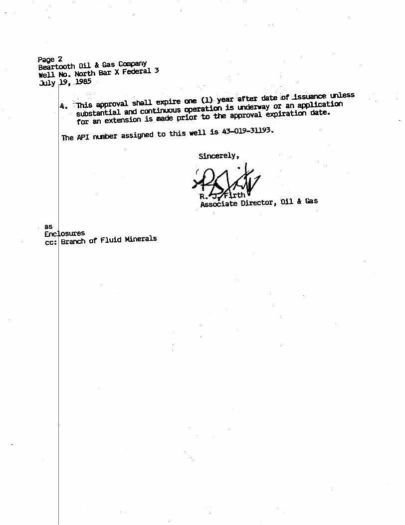
Page 2Beartooth 011 & Gas CompanyWell No. North Bar X Federal 3July 19, 1985
4. his approval shall expire one CL) year af ter date ST .issuanceunless
substantial and continuous operation is underway of an application
for an extension is made prior to the approval exp‡ration date.
The API number assigned to this well is 43-019-31193.
Sincerely,
R. thAssociate Ðirector, 011 & Gas
asEnc osurescc: Branch of Fluid

orm
-31
3 Ar MDO JUL11 1985 aveurr rs macÀTE' Form approved.ovemþër 19 3) (Other insk Aons qu Budget Bureau No. 1004-0136
a.....,w e-m > UWITED STATES reT•rse side) Expires August 31, 1985DEPARTMENT OF THE INTERIOR -
5. LEANE DESIGNATION AND SERIAL NO.
BUREAUOF LAND MANAGEMENT U-44444APPLICÀTION FOR PERMITTO DRILL,DEEPEN, OR PLUG BAC O WINDIAN,AILONHORRIMMAME
28. TTPE Or won
DRILL DEEPENO PLUG BACK O ' """ ''"'"'"' "'""b. Trra or wsLL
w LL oTann NE B E 6. - Os LEAsa -
2. wans or orssaron Federa lBeartcoth Oi l t, Gas Company " "©
a. ADDREBBOPOFERATOR North Bar X FEderal No. 3P. O. Box 2564, Bi11ings, Mo ntana 59103 ro. ÊlELD AND POOL, OR WILDCAT
4. LocaTroN or t'sLL (Report location clearly and in accordance with any St te requirements *) Undes i ona tedAt suriner11. s-C., T., B., M., OR BLE.
2300' FSL, 1700' FEL, Section 1 ano.vavaroaansaAt proposed prod. sone
same NWiSE¿ Sec l-Tl7S-R25E14. DiaTANCE IN MILES AND DIRECTION FROM NEAREST TOWN OR POST OFFICE 12. COUNTT OR PARISH 18. BTATE
20 miles northwest of Mack, Colorado Grand Utah10. DISTANCE FSCM PROPoaED" 16. NO OF ACBES IN LEA F ACRES ASSIGNED
LOCATION TO NEASERT IS WELLPROPERTT OR I.EASE UNE, PT. 340 160 240(Also to nos Pest drig. unit line, if any i
18. DISTANCE FROM PROPOSED LOCATION* 19. PROPOSED DEPTH 20. R ART OR CgLE ÝOOLSTO NEAREST WEOÒL, DRIL 0. OMPLETED,
21. mzavArzona (Ebow whether DF. RT, OR. etc.) 22. APPROz. DATE WOBE W3LL START*
5382' GL, 5393' KB August 18, 198523.
PROPOSED CASING AND CEMENTING PROGRAM
BIEE OF MO «E 01EE OF CABING WEIGRT PER FOOT BETTING DEPTH QUANTITT OF CEMENT
17-l/h" R-5/R• now Ph? H-Lin STC. 300' 175 sacks Class "G" to surface7-7/8 ' 4-1/7" now 10 SR .\-BR I TC 3993' 175 sacks RFC
1. Surface formation is the Mancos.2. Anticipated geologic markers are: Frontier 3001', Dakota 33 3', Morrison 3439',
salt Wash 3874'.3. Gas is anticipated in the Dakota, Morrison and in the Salt Wsh. No oil or other
minerals are anticipated. No water sands are expected.4. P ropo|sed cas i ng prog ram: See I tem No. 23 above.5. Pressure control equipment: See attached well control plan and schematic of
drilling contractor's BOP stack. BOP's will be tested before drilling out fromUnder surface casing and checked daily.
6. Air or mist drilling will be used to drill the surface hole unless water isencountered. If water is encountered, chemical-gel type mud will be used. Thewell will be air drilled fromunder surface casing to total depth.
7. Auxiliary equipment: see well control plan.(continued on page 2)
IN ABOVE SPACE ISBCRIBE PROPOSED PROomax : If proposal is to deepen or plug back, give data on present pgnetire sone and proposed new prodnettresone. It proposat is to drill or deepen directionally, give pertinent data on subsurface locations and messiged and true vertical depths. Give blowoutprey
N
PERNIT Wo ammmovatnATE
APPROVED BY TITLE BATECONDITIONB OF APPROVAL, IF ANT :
CONDITIONSOF APPROVALATTACHED F RWSUBEC O -A
DahmTTO RIGHTOF WAY •SeeInstructiourOnRevers.Sd. DATED1/1/80
Title 18 U.S.C. ction 1009, makes it a crime for any person knowingly and willfully to make to a y department or agency of theUnited States en false. fictitious or fraudulent statements or representations as to any matter witi in its

Beartooth Oil & Gas CompanyWell No. North Bar X Federal 3NWSE Sec. 1, T. 17 S., R. 25 E.Grand County, UtahLease U-44444
CONDITIONS OF APPROVAL
A. DRILLING PROGRAM
A backup source, capable of closing the B.O.P.'s in case ofa primary source failure, will be available.
All pressure tests on B.O.P.E. will be recorded in the driller'slog.
Both casing strings will be tested to at least 1000 psi. Thiswill be recorded in the driller's log.
All lease operations will be conducted in full compliance withapplicable regulations (43 CFR 3100), Onshore Oil and Gas Order1, and the approved plan of operations. The aperator is fullyresponsible for the actions of.his subcontractors. A copy ofthese conditions and the approved plan will bd made available tothe field representative to insure compliance.
No 1Ëcationwill be constructed or moved, no well will be plugged,and no drilling or workover equipment will be temoved from a wellto be placed in a suspended status without pri r approval of theDistrict Office. If operations are to be susp nded, prior approvalof the District Office will be obtained and notification givenbefore resumption of operations.
The spud date will be reported orally to the A ea Office withina minimum of 24 hours prior to spudding. Writ en notification inthe form of a Sundry Notice (Form 3160-5) will be submitted to theDistrict Office within 24 hours after spudding. If the spuddingoccurs on a weekend or holiday, the written report will be submittedon the following regular work day.
In accordance with Onshore Order No. 1 this wegl will be reportedon Form 3160-6, "Monthly Report of Operations"à starting withthe month in which operations commence and continued each monthuntil the well is plugged and abandoned. This|report will be sentto the District Office, P.O. Box 970, Moab, Utah 84532.
Immediate Report: Spills, blowouts, fires, legks, accidents, orany other unusual occurrences shall be prompt1ý reported to theOffice in accordance with requirements of

If a replacement rig is needed for completion operations, A SundryNotice (Form 3160-5) to that effect will be f(led for prior approvalfrom the District Office, and all conditions 4f this approved planare applicable during all operations conducted with the replacementrig. In emergency situations verbal approval to bring on a replace-ment rig will be approved through the District Office.
Whether the well is completed as adrybhole
og as a producer,"Well Completion and Recompletion Report and tog" (Form 3160-4)will be submitted to the District Office not iater than thirty(30) days after completion of the well or aftër completion ofoperations being performed, in accordance wit 43 CFR 3164. Twocopies of all logs, core descriptions, core analyses, well testdata, geologic summaries, sample description, and all other surveysor data obtained and compiled during the drilging, workover, and/orcompletion operations, will be filed with Fori 3160-4. Samples(cuttings, fluids, and/or gases) wili be submitted when requestedby the Moab District Manager.
If the well is to be completed for production \the Area Office isto be contacted in order to set up a pre-prodúction conference.When the well is placed in a producing status the District Officeis to be notified by telegram or other written communication withinfive working days.
Approval to vent/flare gas during initial well evaluation will beobtained from the District Office. This preliminary approval willnot exceed 30 days. Approval to vent/flare b yond this initial testperiod will require District Office approval pursuant to guidelinesin NTL-4A.
No well abandorment operations will be commenced without the priorapproval of the District Office. In the case iof newly-drilled dryholes or failures, and in emergency situations, oral approval willbe obtained from the District Office. A Subsdquent Report ofAbandonment (Form 3160-5) will be sent to the histrict Office within30 days following completion of the well for abandoment.Thisreport will indicate where plugs were placed dad the current statusof surface restoration. Final abandonment wil not be approveduntil the surface reclamation work required by the approved APDor approved abandonment notice has been completed to the satis-faction of the Area Office, or the appropriate surface managingagency. Upon completion of approved plugging, a dry hole markerwill be erected in accordance with 43 CFR 3162.6. The top of themarker will be closed or capped. The following minimum informationwill be permanently placed on the marker; "Fedd or "Ind", asapplicable, "Lease number", "Well number", locátion of well by1/41/4 section, township, and

B. SURFACEUSE PROGRAM
The operator will contact the Grand Resource Area at (801) 259-8193,forty-eight (48) hours prior to beginning any dirt work on thislocation.
Surface disturbance and vehicular travel will be limited to theapproved location and access road. Any additional area needed willbe approved by the Area Manager in advance.
The access road will be rehabilitated or brought to Resource (ClassIII) Road Standards within sixty (60) days of dishantling of thedrilling rig. If this time frame cannot be met, the Area Managerwill be notified so that temporary drainage contrb1 can be installedalong the access road.
Immediately upon completion of drilling, the locagion, andsurrounding areas will be cleared of all remaining debris, materials,trash, and junk not required for production.
Produced waste water will be confined to a unlined pit.
If a tank batter.y is constructed on this lease, it will be surroundedby a dike of sufficient capacity to contain 1-1/2 times the storagecapacity of the battery.
All loading lines and valves will be placed inside the bermsurrounding the tank battery.
All site security guidelines identified in 43 CFR 3162.7 regulationswill be adhered to.
All off-lease storage, off-lease measurement, or ¢ommingling on-leaseor off-lease will have prior written approval from the DistrictManager.
All product lines entering and leaving hydrocarbon storage tanks willbe effectively sealed.
Gas meter runs for each well will be located within five hundred(500) feet of the wellhead. The gas flowline wil) be buried from thewe11head to the meter along with any other sections occurring on thepad. Meter runs will be housed and/or fenced.
The oil and gas measurement facilities will be installed on the welllocation. The oil and gas meters will be calibrated in place priorto any deliveries. Tests for meter accuracy will be conductedmonthly for the first three (3) months on new meter installations andat least quarterly thereafter. The Area Manager Will be providedwith a date and time for the initial meter calibration and all futuremeter-proving schedules. A copy of the meter calibration reportswill be submitted to the Resource Area Office. All meter measurementfacilities will conform with the API standards for liquidhydrocarbonsand the AGAstandard for natural
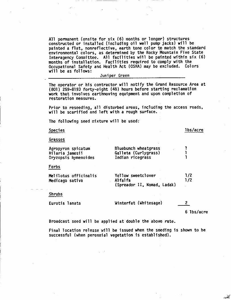
All permanent (onsite for six (6) months or longeir) structuresconstructed or installed (including oil well pump jacks) will bepainted a flat, nonreflective, earth tone color tb match the standardenvironmental colors, as determined by the Rocky Mountain Five StateInteragency Committee. All facilities will be palinted within six (6)months of installation. Facilities required to cpmply with theOccupational Safety and Health Act (OSHA) may be excluded. Colorswill be as follows:
Juniper Green
The operator or his contractor will notify the Grand Resource Area at(801) 259-8193 forty-eight (48) hours before starting reclamationwork that involves earthmoving equipment and upon completion ofrestoration measures.
Prior to reseeding, all disturbed areas, including the access roads,will be scarified and left with a rough surface.
The following seed mixture will be used:
Species 1bs/acre
Grasses
Agropyron spicatum Bluebunch wheatgrass . 1Hilaria jamesii Galleta (Curlygrass) 1Oryzopsis hymenoides Indian ricegrass 1
Forbs
Melilotus officinalis Yellow sweetclover 1/2Medicago sativa Alfalfa 1/2
(Spreador II, Nomad, Ladak)
Shrubs
Eurotia lanata Winterfat (Whitesage) 2
6 lbs/acre
Broadcast seed will be applied at double the above rate.
Final location release will be issued when the s eding is shown to besuccessful (when perennial vegetation is
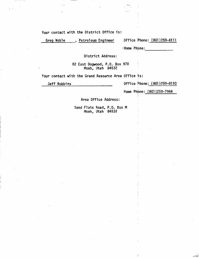
Your contact with the District Office is:
Greg Noble , Petroleum Engineer Office Phone: (801)259-6111
·Home Phone:
District Address:
82 East Dogwood, P.O. Box 970Moab, Utah 84532
Your contact with the Grand Resource Area Office is:
Jeff Robbins Office Ëhone: (801)259-8193
Home Phone: (801)259-7964
Area Office Address:
Sand Flats Road, P.O. Box MMoab, Utah

w/ Colorado
DIVISIMOFOILGASANDMINING
SPUDDINGlifDFIATI API #44-019-31193
NAFEOFCfFPANY: amonnow
WFII NAPEj NORTH BAR X FEDERAL #3
SECTION NW SE 1 TOWNSHIP 17S RANGE 25E COUNTYGrand
DRIttlNGTRITRAffDRveco
RI6# I
SPUDDED:DATE 10-25-85
TIME 5 PM
ÑOW notary
DRILLINGWILLCO9ENCF
REPORTEDBY Marilyn
ELËPHONE# 406-259-2451
|
DATF 10-28-85 SIGNED

lber983) UNITESSTATES ucar s',,
,"a°a.'ai "" &..rtye-sat) DEPÀRTMr T OF THE INTERIOR•••• •••••••••=wsw••a=••···sa•••
BUREAUkr LANDMANAGEMENTU-44444& 8-BIAW, ALt@ETSB OB TRIBB NAME
SUNDRYNOTKESAND REPORTSON WELLS(De not use this form to •O
N E -
r og ha Street resorreir.
. OWR 60BBBMENT NAMS
IL GASWBLL WELL OTHER
A NAMS 09 OPERATOg. PARM OB LBABB RAME
BEARTOOTHOIL & GASCOMPANYFederal
8. asemass or orsaatos 9. wm.L 80.
PO Box 2564, BILLINGS, MONTANA59103North Bar-X Federal No. 3
4. incarson or «sto port loestion elearly and la secordance with any State re airements.• 10. 9tate AND POOL, os WILac&T
y,*,1 ."" Undesignated
2300' FSL, 1700' FEL, Section 1 * ""lii.'â".""aSa""·'""NASA Sec 1-T17S-R25E
14. PERat!T NO. 15. ELEVATIONS (ShoW whether DF, NT, 88, te,) ÎÊ. 00 NTT OR TARME 18. RATE
43-019-31193 5382 GL, 5393 KB Granti Iltah
ze OlecicAppropnoteBoxTo indicate Natureof Notice, Repon,or Oth.«DataNOTICE OF INTENTION TO : SUSS$QUMMT 887052 Or :
YEST WATER SBOT-Orr PCLL OR ALTER CAstNO WATER BRUT-OFF BSPAIRING WELL
FBACTURE TREAT MULTIPLE COMPI.ETE FRACTURE TREATMENT ALTERING CAalNo
OHOOT OR ACIDIza ABANDON* SBOOTING 08 ACIDiz!NG ABANDONMENT*
REPAIR WELL CHANCE PLANE (Other) Status ort T(Other) m ti
Rreco te Bp ntDor
.)
17. DESCRIBE PROPOSED OR CO3tPLETED OPERATIOxs (Clearly state all pertinent details, and give pertinent dates, ineledi t estimatea date of starting anyproposed work. It well is directionaBy drilled, give subsurface loestions and measured and true vertical depths for all markers and gones perti-aunt to this work.) *
Spudded 12-1/4" hole at 5:00 p.m., 10/25/85, w/ Veco Briliing Company Rig No. 1.Drilled to 313'. Ran 8-5/8", 24#, J-55 casing to 304'. Cemented to surfacewith 175 sx Class "G", 3% CaCl2, 1/4# celloflake/sack. Pressure tested casing,casing head, 80Ps to 1000 psig before drilling out.
RECEli/EDNOV0 11soa
DIVOIMN o, «
GABAMINIM4
18. I hereby certify that the forego is e and correct
SIGNED TITLE CODSUlting Ÿ€trO. Engr. ,,,,,, 10/28/85mot enn
(This for Federal or State oSce ase)
APPROVED BY TITLE DATECONDITIONS OF APPROVAL, IT ANT:
*S., insireenonson Revers.Side
Title 18 U.S C. Section 1001, makes it a crime for any person knowingly and willfully to make to any department or agency of theUnited States any false, fictitious or fraudulent statements or representations as to any matter within its

Poem approved.om 16983) Ul†''TD STATES agrr; TO E 1 a a t
100985·-0135Formerly 9-331) DEPARTME OF THE INTERIOR TerBE Bidt) A. LEASE SERIGNATIGN AND BEALWO.
BUREAU OF LAND MANAGEMENT U-44444SUNDRYNOTICESAND REPORTSON WELLS
(Do not use this form for re nals to drill or to deepea or plag hath to a digereat reservoir.Use "AP CATION FOR PERMIT- " for eneb proposais.)
i. 7. UNIT assassaar WaxaOIL SAsWELL WELL OTHER
2. sans or orsaaron a. raam os saams massBeartooth 011 & Gas company NOVû 4 19g Federal
o. 3at ..,«.« GAS& MINING Undesignated
11. sec., r., a.. x, 05 55.5. AND
2300' FSL, 1700' FEL, Section 1 NNË$$e1-T17S-R25E14. PSBMit NO. 15. BIÆVATIONa]Šhow whe¾ or, ar, om, etc.) 12. Ceuxtr om ramisa 18. staWa
43-019-31193 5382' GL, 5393' KB Grand Iltah10' (Aeck AppropriofeBoxTo indicate Natureof Nonce,Report,or ther Dela
NOTICE OF INTENTION TO: SUBS NT BSPORT 07:
TEST WATER BRUT-OFF PCLL OR ALTER C.481NG WATER BRUT4977 BBPAIRING WELLFRACTURE TREAT MULTIPLE COMPfÆTE FRACTURE TBBATMENT ALTERING CABINGBliOOT OR ACIDIžE ABANDON* SBOOTING OR ACIDizlNG ABANDONNENT*AEPAlt WELL CHANGE PLANs (Other) Statusleport T
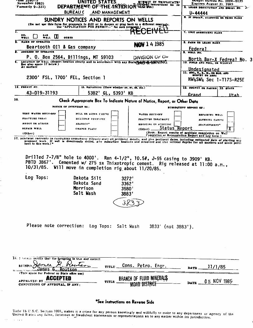
(NoTE: Report resultà of multiple eompletion on Wel(Other)_ Completion or Recosa¢letion Report and Log term.)17. DEBORIBE PROPOBED OR CO¾tPLETED OPERATIO.Ns (Clearly state all pertinent details, and give pertinent dat including estimated date of starting anproposed work. If well is directionally drilled. sive subsurface locations and measured and true vertLdepths for all markere and genes pertnent to this work.) *
Drilled 7-7/8" hole to 4000'. Ran 4-1/2", 10.5#, J-55 casing to 3909' KB.PBTD3867'. Cemented w/ 275 sx Thixotropic cement. Rig relhased at ll:00 a.m.,10/31/85. Will move in completion rig about 11/20/85.Log Tops: Dakota Silt 3272'
Dakota Sand 3362'Morrison 3580'Salt Wash 3883'
ii I áriÃy certify that the reso is true and correct
SIGNED A . TITLE ÛOns. Petro. Engr. nar, 11/1/85(This space for Pederal or State ogee ase)
APPROVED BY TITLE DATECONDITIONS OF APPROVAL, IF ANY:
*Seeinsiruenonson ReverseSideTitle IS U.S.C. Section 1001, makes it a crime for any person knowingly and willfully to make to any department or agency of theUnited States any false, fictitious or frandulent statements or representations as to any matter within its
Poem approved.om 16983) Ul†''TD STATES agrr; TO E 1 a a t
100985·-0135Formerly 9-331) DEPARTME OF THE INTERIOR TerBE Bidt) A. LEASE SERIGNATIGN AND BEALWO.
BUREAU OF LAND MANAGEMENT U-44444SUNDRYNOTICESAND REPORTSON WELLS
(Do not use this form for re nals to drill or to deepea or plag hath to a digereat reservoir.Use "AP CATION FOR PERMIT- " for eneb proposais.)
i. 7. UNIT assassaar WaxaOIL SAsWELL WELL OTHER
2. sans or orsaaron a. raam os saams massBeartooth 011 & Gas company NOVû 4 19g Federal
o. 3at ..,«.« GAS& MINING Undesignated
11. sec., r., a.. x, 05 55.5. AND
2300' FSL, 1700' FEL, Section 1 NNË$$e1-T17S-R25E14. PSBMit NO. 15. BIÆVATIONa]Šhow whe¾ or, ar, om, etc.) 12. Ceuxtr om ramisa 18. staWa
43-019-31193 5382' GL, 5393' KB Grand Iltah10' (Aeck AppropriofeBoxTo indicate Natureof Nonce,Report,or ther Dela
NOTICE OF INTENTION TO: SUBS NT BSPORT 07:
TEST WATER BRUT-OFF PCLL OR ALTER C.481NG WATER BRUT4977 BBPAIRING WELLFRACTURE TREAT MULTIPLE COMPfÆTE FRACTURE TBBATMENT ALTERING CABINGBliOOT OR ACIDIžE ABANDON* SBOOTING OR ACIDizlNG ABANDONNENT*AEPAlt WELL CHANGE PLANs (Other) Statusleport T
(NoTE: Report resultà of multiple eompletion on Wel(Other)_ Completion or Recosa¢letion Report and Log term.)17. DEBORIBE PROPOBED OR CO¾tPLETED OPERATIO.Ns (Clearly state all pertinent details, and give pertinent dat including estimated date of starting anproposed work. If well is directionally drilled. sive subsurface locations and measured and true vertLdepths for all markere and genes pertnent to this work.) *
Drilled 7-7/8" hole to 4000'. Ran 4-1/2", 10.5#, J-55 casing to 3909' KB.PBTD3867'. Cemented w/ 275 sx Thixotropic cement. Rig relhased at ll:00 a.m.,10/31/85. Will move in completion rig about 11/20/85.Log Tops: Dakota Silt 3272'
Dakota Sand 3362'Morrison 3580'Salt Wash 3883'
ii I áriÃy certify that the reso is true and correct
SIGNED A . TITLE ÛOns. Petro. Engr. nar, 11/1/85(This space for Pederal or State ogee ase)
APPROVED BY TITLE DATECONDITIONS OF APPROVAL, IF ANY:
*Seeinsiruenonson ReverseSideTitle IS U.S.C. Section 1001, makes it a crime for any person knowingly and willfully to make to any department or agency of theUnited States any false, fictitious or frandulent statements or representations as to any matter within its
oeb 1983) UNITED STATES o o su agrgra· FL*;',"¿'" ',°,°¿-°136
Formerly 9-331> DEPAgfdEMU OP HEAARIOÀ t) U. LEASE DBalcNATION AND Bami. 80.
BUREAUC .ANDMANAGEMENT U-44444SUNDRYNOTICESAND REPORTSON WELLS "'" ' "'^"°""°¯"'"
(Do not use this form for proposals to drilt or to deepen or plug back to a diferent rese r.Use ''APPLICATION FOR PERMIT-" for each pro s.)
OIL GASWELL WELL OTHERa-.... ., ........ g 1 4 1985 * "'" °* """ "'""
Beartooth OIl & Gas company FederalS. WWI.L NO.
P. 0. Box 2564, Billings, MT59103 DivisloN of G Nort.hBar-1 Fedreal No. 34. LocATaos or wsLL (Report location clearly and in accordance with any StatggegMÑ$ 10. FIBl.D AND POOI., OR WH.DCATSee also spaer 17 below.)** """'** Undesignated
11. sac., T., a., m. os ans. Axo
2300' FSL, 1700' FEL, Section 1 NWËÊ$e1-T17S-R25E14. PERMIT No. 15. ExxvArioNs (Show whether or, aT, on, etc.) 12. COUNTY on PAssas 18. BTATE
43-019-31193 5382' GL, 5393' KB Grand Iltah16. (ÑtCk AppropriateBoxToindicateNatureof Notice,Report,or OtherData
NOTICE OF INTENTION 20: BUBBBQUNNT BBPORT 07:
TEST WATER BRUT-Orr PCLL OR ALTER CASING WATER BRUT-OFF REPAIRING WELL
FRACTURE TREAT IICLTIPLE COntPLETE FRACTt'RE TREATMENT ALTERING CASING
SHOOT OR ACIDIZE ABANDON* BBOOTlWC Ort ACIDIZING ABANDONNENT*
REPAIR WELL CHANCE PLANs (Other) StatusTeport T(NoTE: Report resulta of multiple completion on We:(Other) empletion or Recolapletion Report and Log form.)
H. ois RIBE PROPOSED OR CO3tPLETED OPERATroNr (Clearly state all pertinent details, and give pertinent dates, including estimated date of starting anyproposed work. If well is directionally drilled. give subsurface locations and measured and true vertical depths for all markers and sones perti-nent to this work.) •
Drilled 7-7/8" hole to 4000'. Ran 4-1/2", 10.5#, J-55 casing to 3909' KB.PBTD 3867'. Cemented w/ 275 sx Thixotropic cement. Rig released at 11:00 a.m.,10/31/85. Will move -in completion rig about 11/20/85.
Log Tops: Dakota Silt 3272'Dakota Sand 3362'Morrison 3580 'Salt Wash 3883'
Please note correction: Log Tops: Salt Wash 3833' (not 3883').
e:e.» eertify that the rego is true and correct
swNED TITLE CONS. Petro. Engr. var, 11/1/85James 6, Routson(This space for Federal or State esce nee)
ACCEPTED BRENOFFLutoWNQtALS 6 NOV1985;TIEO SMOFAPPROVAL, IF ANY:
TITLE DATE 5
*SeeInstructionson ReverseSide
Title 16 U.S.C. Section 1001, makes it a crime for any person knowingly and willfully to make to any department ur agency of theUniteo S.ates any false, fictitious or fraudulent statements or representations as to any matter within its

tikrmerly9-330) Ui'Ù I.i.) O i A i t"..O Expires August 31, 1985DEPARTMEÀT OF THE INTERIOR 2. ,..... ...,.. ,,,, ,,, ,,,,
BUREAUOF LANDMANAGEMENT 'U-44444
WELLCOMPLETIONOR RECOMPLETIONREPORTAND LOG* "'"'^"'^"°""°""'"
to. TYPE OF WELL: on. GAa -----
WRI.L WEI.i. DET Other 7. I'NIT AGREMMENT NAMS
k TYPE OF CONPLETION:NEW WitBK .
ÞEWP- Pi l's ÞiWF.WRI.$. OVER EN IIAf'K RENTR. Û(h‡¶ ANN $$ LEAAA NAN
s. na.. ,, ........ Federa lBeartooth Oil & Gas Company e- •==.6 m•.
8. a...... or er.nassa North Bar-X No. 3P. O. Box 2564, Billings, Montana 59103 10. FIELD AND POOI.. 08 WH.DCAT
4. IACATION OF W¾i.L (Ñfgert lodetion citorig GNd (N 6¢cordSNCE 3etta.., se.te ree.fre....,,,. UndesignatedAt surface 11. MEC.. T., R.. M., OR BLOCK AND 80xygt2300' FSL, 1700' FEL, Section 1 •= •••
At top prod. Interval reported below
At total deptg300' FSL, 1700' FEL, Section 1 NW¾SѾSec 1-T17S-R25E14. PERMIT NO. DATE 188tBD 12. COUNTT OR 13. STATESame as above · **==••43-019-31193 I July 19, 1985 Grand Utah
15. DATE SPCDDED $$. DATE T.D. REACHED 17. DATE COMPL. (Ready ‡0 prog.) 18. ELEVATiuNa (DF, RIGli, RT, 08, ETC.) 19. ELET. CASINOBBAD
10/25/85 10/29/85 11/22/85 I 5382_GLe5393 KB I 538420. 19tAL DEFTH. ED A TTD Ê1. PLUO, BACK T.D.. MD & TVD 22. IF Mt I.TIPLE COMPL., 2& INTERTAlis ROTARY TOOLS CABLE TOOLE
HOW MANT* DRILLED AT4000 3839 ---+ \ 0 - TD \ Nene
24. PRODUCING INTERTAL(a), or THis COMPLET10N-TOP, BOTTOM, NAME (MD AND TVD)* 25. WAS DIRECTIONALBURVET MADE
Dakota Sand 3382-3462 No26. TTPS ELECTSIC AND OTHER a arN 27. WAS WELL COBRD
- P- · GR-CBL-VDL No28. CARING RECORD (Report eN strings set in wen)
CAS3NO SIES WRIORT. LE./FT. DEPTH BET (MD) NOLE 882E CEMENTIWo ascoan AMOUNT POLLED
8-5/8" 24# J-55 304 12-1/4" 175 mr (to surface) Nngn4-T/2" 10.5# 0-55 3909 7-7/8" 275 tw (top 8 PARR) Nano
29. LINER RECORD 30. TUBING RECORDSISE TOP (MD¶ BOTTOM (MD) BACKS CENENT* BCREEN (MD) sizE DEPTH ST (MD) PACEER SET (MD)
None 1-1/2" 3477 None
$1. waaromation ascono (Aniereel, sire end usmier) 32. ACID. BHOT, FRÀCTURE. CEMENT SQUEEEIL ETC,DEPTN INTERVAL (MD) AMOUWT AND KIND OF MÅTBBIAL USED
3400, 3403, 3432, 3434, 3436, 3450, 3400-3458 500 gallons 15% HC13454, 3458,; total of 8 jets, .31" diameter 3400-3458 Foam frac with 20,000# 100 meshsand, 80,000# 20-40 sand,81,480 gallons 75 Quality foam
33.• PRODUCTIONDATE PERST PRODUCTION PRODUCTION METHOD (Flowing, gas ifft, pampiNg-@igg @MAÉgp€ Of psap) WELL STATUS (Froducing or
11/21/85 Flowing Sut'-inDATE OF TEST ROcts TESTED €BOEB BIEE PROD'N. POR OIL-88L. GAS-MOW. WATER BEL. GAB<nL RATIO
11/21/85 12 1/2" 0 1079 0 -
FiaW. TOBINO 78-55. CASINO PREBBURE PALCULATED Oll.-BBL. GAS-NCF. WATiba-BBL. OIL GRATITT•API (CORE.)370 psig 480 psig " 0 2158 ( 0 -
84. asswostrioN or eAa (Bold, used for fati, vested, etc.) TiaT WITNassan afVented | Ralph Snow
$5. LEST OF ATTACEMENTS
None, logs sent directly by Service Companies36. I hereby eer ify that the foregoing and attached information is complete and correct as determined trda all available records
BIONED TITI.E Û0DSulting Petro. Engr. gay, 11/25/85famPS H PnuTson
*(SeeInstructionsand SpacesIcr AdditionalDoloon ReverseSde)Title 18 U.S.C. Section 1001, snakes it a crime for any person knowingly and willfully to make to any department or agency of theUnited States any false, fictitious or fraudulent statements or representations as to any matter within its

37.
SUM
MA
RY
OP
POR
OU
S2O
NES
:(S
how
all
impo
rtant
sone
sof
poro
sity
and
cont
ents
ther
eof;
core
din
terv
als;
and
all
drill
-ste
m,
test
s,in
clud
ing
dept
hin
terv
alte
sted
,cu
shio
nus
ed,
time
tool
open
,flo
win
gan
dsh
ut•in
pres
sure
s,an
d38
.G
EOLO
GIC
MA
RK
ERS
reco
verie
s):
FOR
MA
TIO
NTO
PB
OTT
OM
DES
CR
IPTI
ON
,C
ON
TEN
TS,
ETC
.TP
NA
ME
MEA
S.D
EPTH
TRU
$V
ERT.
DEP
THD
akot
a33
8234
62G
as
Mor
rison
3600
3607
Tigh
tga
s&
wat
erM
anco
sSu
rfac
e
Mor
rison
3680
3695
Tigh
tga
s&
wat
erFr
ontie
r30
08
Dak
ota
Silt
3272
Dak
ota
Sand
3362
Mor
rison
3580
Salt
Was
h
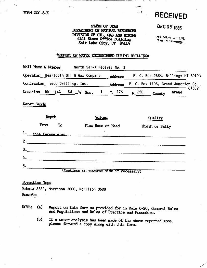
ooc-a-x RECEIVEDsTATEOF UrAH DEC0 5 Iggyamammr Œ MERE RESŒmcES
DIVISIΠΠOIL GASANDMINDE vr 0;4 1 S L
MCPŒT OF WATR WOUNTRUEDIHŒÐ REE
Well Name & Number North Bar-X Federal No. 3
Operator Beartooth Oil & Gas Company Ress P. 0. Box 2564, BilTings MT 59103
Contractor vecoDrilling, Inc· Address P. 0. Box 1705, Grand Junction Co81502
Incation NW 1/4 SW 1/4 Sec. 1 7. T7S R. 25E Mty Grand
Water Sands
Depth Volume qualityFrom To Flow Rate or Head Fresh or Salty
1• None Fncountered
2.
3.
5.(Continue on reverse side if necessary)
Formation TopsDakota 3382, Morrison 3600, Morrison 3680Remarks
NOTE: (a) Report on this form as provided for in Rule C-20, General Rulesand Regulations and Rules of Practice and Procedure.
(b) If a water analysis has been maa of the above reported zone,please forward a copy along with this
s
EXPRESS MAIL ROUTING SLIP
PAM 2-
TAMI
VICKY / /
CLAUDIA /STEPHANE /,2 '/2CHARLES /O |# j 2 IL
RULA ydda y
MARY ALICE /0, 1 /
CONNIE
s
EXPRESS MAIL ROUTING SLIP
PAM 2-
TAMI
VICKY / /
CLAUDIA /STEPHANE /,2 '/2CHARLES /O |# j 2 IL
RULA ydda y
MARY ALICE /0, 1 /
CONNIE

Form approved.1& UNil STATES E
ret N3,
10098'5 135
...rar e--san DEPARTMEN FTHE INTERIOR .se•> s. a.•••••=.i•=ar... 2.. ..... ...
BUREAUO LANDMANAGEMENT 0-44444. IP IMDIAN, ALLOTTRE OB TRIBB NAME
SUNDRYNOTICESAND REPORTSON LLS(De aet use this to to ro-o t ro a pl-agpba tereat reservoir.
1.Olt. SA.
RE elvI-D '· -------
WWW WELE. OTER
2. NAMS 09 OFEBAtot 8. FARM 08 LBASS NAME
BEARTOOTHOIL & GASCOMPANY DEC23 1985 Federal8. assassa or osanamos e. was.r. no.
P. 0. Box 2564, Billings MT59103 VINif .OILNorth Bar-X Federal #3
4. A x or wnL port location clearly and in accordance with anyNG d
WILDCAT
11. sac., 2., s., x. omat.x. Amp
2300' FSL, 1700' FEL, Section 1 ""°¯
NW¾SEkSec 1-T17S-R25E14. Pannst No. 15. MIÆTATIONs (Show whether or, sT, an, etc.) 12. COUNTY 05 PAmtax 18. arATE
43-019-31193 5382' GL, 5393' KB Grand Utahle ChecicAppropriateBoxTo indicate Nature of Notice,Report,or Ods.«Data
NOTICE OF INTENTION TO: BUBBBQUENT REPORT 07•
TEST WATER BRUT4FF PCLL 08 ALTER CASING WATER BRUT<þrr REPAIRING WELL
FRACTURE TREAT MULTIPLE COMPI.ETE FRACTURE TREATMENT ALTERING CASING
BROOT OR ACIDIES ABANDON* BROOTING OR ACIDIZING ABANDONNENT*
REPAIR WELI. CHANGE PI,ANS (Other) FirsT Production T(NoTa: Report results of multiple completion on Wel
¯¯
(Other) Completion or Recompletion Report and Log form.)17. DESCRIBE PROPOSED OR COMPLETED OPERATIONS (Clearly state all pertineut details, and give pertinent dates, including estimated date of starting aar
proposed work. If well is directionally drilled. give subsurface loestions and measured and true vertical depths for all markers and sones parti-nent to this work.) •
Well put on production at 12:30 p.m., 12/18/85.BLMin Moab, Utah, notified by telephone on 12/19/85.
18. I hereby certify that the forego is true and correct
RENED - TITLE Û0nsulting Petro. Engr. ex•:a 12/19/85hmne f' Rnlitenn
(This space for Federal or State omte ase)
APPROVED BT TITLE DATECONDITIONS OF APPROVAL, IP ANY:
*S.. Insirectionson ReverseSide
Title 18 U.S.C. Section 1001, makes it a crime for any person knowingly and willfully to make to any department or agency of theUnited States any inise, fictitious or fraudulent statements or representations as to any matter within its

SUBNIT IN TV VCATE* Foran approved.Porm 3160-3(Other test as on Budget Bureau No. 1004-0136','A UhiTED STATES '•••'•A** E=Pir••^=ru•t 31. 1985
DEPARTMENTOF THE INTERIOR G. I.BASE DBS30NATION AND BERIAL WO.
BUREAU OF LAND MANAGEMENT_444
APPLICATIONFOR PERMITTO DRILL,DEEPEN,ORPLUG BACK A.lFINDIAN,aLLOTTEROBTRIBENAME
18. T¶PS OF WORK
DRILLO DEEPENO PLUG BACK O ' """ ^°•""'"' "'b. TTPE OF WELL
°'LO •'.•,... O .,...•.a*." O ".;NLE A. FARM OR leBASE WAME
s. naus or orsaarom FederalBeartooth Oi1 6 Gas Company 9.war.a.no.
8. Annassa or orsaaton North Bar X FEderal No. 3P. O. Box 2564, Bi ll ings, Mo ntana 59103 1Û. FIELD AND POOL, OR WILDCAT
4. ALOCATE N OF WN.L (Report location clearly and in accordance with any State requiresnents.•) Ándesignated11. SEC., T., B., M., OR BLK.
AtpodprF L, 1700' FEL, Section i RECEIVED ^" "'"
"same NWhSEh Sec 1-Tl7S-R25E14. DIETANCE IN MILES AND DIBBCTION FROM NEABBBT TOWN 05 POST OFFICE' 12. COUNTT OR PARISE 18. BTATE
20 mi les northwest of Mack, Colorado ÛÊ··1 1 1985 Grand Utah10. DISTANCE FROM PROPOSED* 16. WO. OF ACRES IN Lasaz 17. WO. OF ACAES ABBIONED
LOCATION TO NEAREST TO THIS WELLraormarr on s.sa.= I.r==. FT- 340 160 DIVISION U OJL 240(Also to nearest drig. anit line, if any)
18. DiaTANCE PROM PROPOSED LOCATION* 19. PROPOSED DOÅS ROTART OR CABLE TOOLSTO NEAREsT WELL, DRILLING. COMPLETED, No 3993' ' Rotar08 APPLIED TOR. ON Tms LEASE, Fr.
Bl. SIEVATIONS (ShoW WhetÎter DF. $Î, ÛË, &tc.) 22. APPROz. DATE WORK WILL START*
5382' GL, 5393' KB August 18, 198523. PROPOSED CABING AND CEMENTING PROGRAM
SIEE OF ROLE BESE OF CASING WEIGHT PER POOT sgTTING DEPTH QUANTITT OF CEMENT
17-1/h" R-5/R• now 7hR N-kn STC RODI 175 sacks Class "G" to surface-7/Ril h-1/7" new 10 SR .1-44 i TC 19A3' 174 marks RFC
1. Surface formation is the Mancos.2. Anticipated geologic markers are: Frontier 3001', Dakota 3393', Morrison 3439',
salt Wash 3874'.3. Gas is anticipated in the Dakota, Morrison and in the Salt Wash. No oil or other
minerals are anticipated. No water sands are expected.4. Proposed casing program: See Item No. 23 above.5. Pressure control equipment: See attached well control plan and schematic of
drilling contractor's BOP stack. 80P's will be tested before drilling out fromUnder surface casing and checked daily.
6. Air or mist drilling will be used to drill the surface hole unless water isencountered. If water is encountered, chemical-gel type mud will be used. Thewell will be air drilled fronunder surface casing to total depth.
7. Auxiliary equipment: see well control plan.(continued on page 2)
IN ABOVE SPACE DESCRIBE PROPOSED PROORAM : If þroþ0Bal to to deepen or plag back, give data on present predactive some and proposed new prodnetiresone. It proposal is to drill or deepen directionally, give pertinent data on subsurface locations and meaanred and true vertieel depths. Give blowout
agrnpr m .
weer.m COnsulting Petroleum Engineer,ay.Ì~f1"" Û ÎÏ"Ilt""" i (,(This space for Pederal or State oSee ase)
APPROVEDBY TNE gy gPER1f TT W APPROVAL DATE
olL, GAS. ANp I NGAPPROTED $7 ** I E met
CONDITIONS OF APPROVAL, IF ANT:
. B ·
,
WE SPACING: Sp. / 54'Seeinmueno.«Onteve...AdeTitle 18 U.S.C. Section 1001 makes it a crime for any person knowingly 14 willfully to make to any department er egency of theUnited States any taise. fictitions or freudulent statements or representations as to any matter within its
Application for Permit to Drill, Deepen, or Plug BackNorth Bar X Federal No. 3NW¾SEi Sectionl-Tl7S-R25EGrand County, Utah Page 2
8. The logging program will consist of a DIL log from TD to base of surface casing,and GR-FDC-CNL logs from TD to above the Frontier. No cores or DST's are planned.
9. No abnormal pressures or temperatures are anticipated. No poisonous gas isanticipated.
10. Anticipated spud date is August 18, 1985. Completion operations should commencewithin 30 days of rig release.
11. Survey plats are attached.12. The gas is dedicated to Mesa Pipeline.13. The spacing unit will be the Ni, N#Si ofSection I,as per Utah Cause No. 165-11 allowing
2 - 240 acre wells on one spacing unit. This order was approved February 28, 1985.14. Designation of Operator forms from Hawthorn Oil Company are attached.15. The well will be drilled under Utah Blanket Bond No.
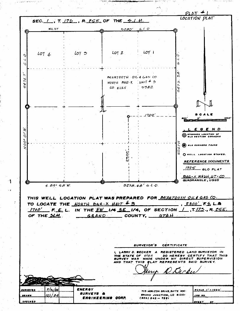
SEC.1, I /75 , R. 24E. OF THE .A.M. LOC T/OA/gCAT~
LOT4 LOT S Loy g LOT I
? ARTOO M GIL 4 CAW C
GD- E LE
ooo
LEGENDeranonne Locareon erO ,
es.o conNggs FOUNO
OWELL i.OCATOON STAMED.
EFE RENCE DOCUMENTS
GLO PLAT
AR-A NASI LIT-CDUADRANGL.E , USGS
¢. ôÿ• Bd'M/ 5278.¢¿' G.L-Q.
THIS WELL LOCATION PLAT WAS PREÞARED FOR MAgroory Qu.4f GA5 CO.
TO LOCATE THE Nnn¶M MR -X {4/( , f Spo' E,,f, L.S/100' FL L. IN THE ,Ñ&'.....l/4 f/4, OF SECTION _.
_...,TO., R.OF THER. (paANO COUNTY, (Arg/A
SURVEYOR S CERTIFICATE
I, LARRY D. BECKER A REGISTERED L.AND SURVEYOR fNTHE STATE OF UTAAI 00 HEREBY CERTIFY THAT THISSURVEY WAS MADE UNDER MY DIRECT BUPERVISIONAND THAT THIS LAT REPRESENTS SAID SURVEY.
unv vo ENEROY vas noneron oneva,swrr ano "' *
awn /p/, ORANO •¢UNCYiON, CO ISOf 00 NO.ENOINEERINO OORP. Taos; res - yggi

Beartooth Oil & Gas CompanyNorth Bar-X Federal No.3
WELL CONTROL PLAN
1. Surface Casing: 8-5/8" 0.D., 24#/ft., Grade H-40,ST&C, set at 300'or deeper, cemented with pump and plug method back to the surfaceor bottom of cellar.
2. Casinghead Flange: 8-5/8" x 8"-900 Series casinghead with two 2"2000 psi L.P. outlets.
3. Intermediate Casing: None
4. Blowout Preventor: An 8" 3000 psig W.P. double gate hydraulic shafferBOP (or equivalent) with drill rams and blind rams. All fill, killand choke lines will be minimium of 2" 2000 psi W.P. A Grantrotating head will be used while air and mist drilling. 80Pis willbe worked daily. Blind rams will be checked during trips. BOP's willbe tested to 1000 psi prior to drilling shoe joint on surface casing.
5. Auxiliary Equipment: (a) Drill pipe floets will be allowed atcontractor's discretion. (b) Visual monitoring of air returnswill be maintained. (c) Upper kelly cock will be used. (d) Stabbingvalve will be kept on floor.
6. Anticipated bottom hole pressure is less thanSOO psi at 3393or a gradient of
.265psi/ft or less. No abnormal temperatures
or hydrogen sulfide gas are anticipated.
mes G. Routsontroleum
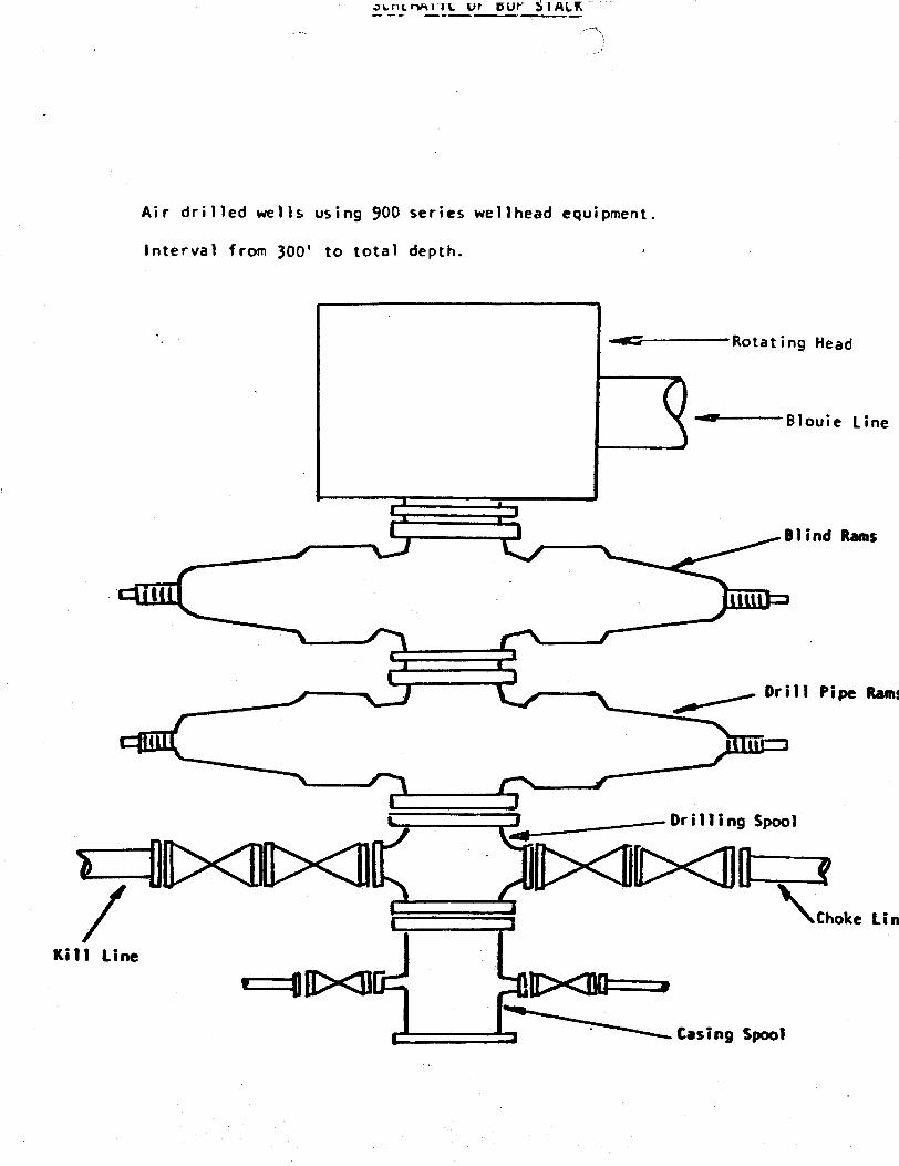
t.ncrmlTL UT DUY blALK
Air drilled wells using 900 series wellhead equipment.
Interval from 300' to total depth.
Rotat ing Head
Blouie Line
Blind Rams
i
Drill Pipe Ramt
Or i ll i ng SpoolI¯¯1D<E×'l lE×'I\ «Choke Lin
Kill Line
r--u><s r><na-,Casing
t.ncrmlTL UT DUY blALK
Air drilled wells using 900 series wellhead equipment.
Interval from 300' to total depth.
Rotat ing Head
Blouie Line
Blind Rams
i
Drill Pipe Ramt
Or i ll i ng SpoolI¯¯1D<E×'l lE×'I\ «Choke Lin
Kill Line
r--u><s r><na-,Casing
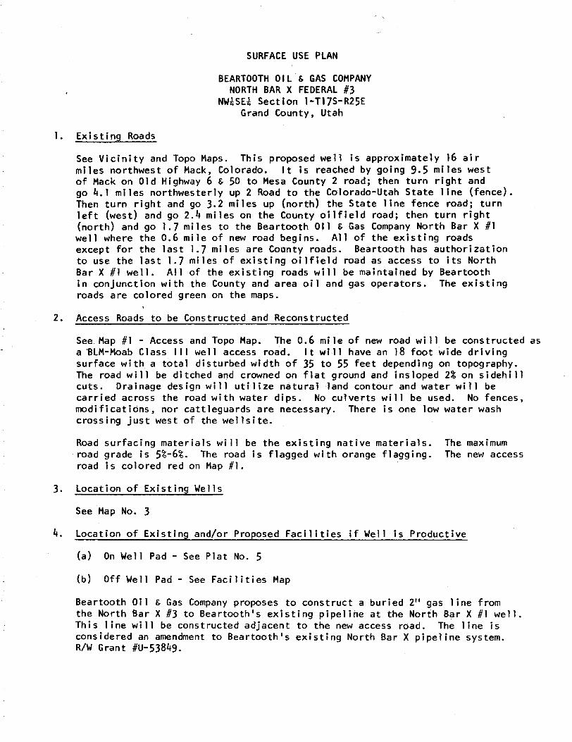
SURFACE USE PLAN
BEARTOOTHOIL & GAS COMPANYNORTH BAR X FEDERAL #3
NWhSEk Section 1-Tl7S-R25EGrand County, Utah
1. Existing Roads
See Vicinity and Topo Maps. This proposed well is approximately 16 airmiles northwest of Mack, Colorado. It is reached by going 9.5 miles westof Mack on Old Highway 6 & 50 to Mesa County 2 road; then turn right andgo 4.1 miles northwesterly up 2 Road to the Colorado-Utah State line (fence).Then turn right and go 3.2 miles up (north) the state line fence road; turnleft (west) and go 2.4 miles on the County oilfield road; then turn right(north) and go 1.7 miles to the Beartooth 011 & Gas Company North Bar X #lwell where the 0.6 mile of new road begins. All of the existing roadsexcept for the last 1.7 miles are County roads. Beartooth has authorizationto use the last 1.7 miles of existing oilfield road as access to its NorthSar X #1 well. All of the existing roads will be maintained by Beartoothin conjunction with the County and area oil and gas operators. The existingroads are colored green on the maps.
2. Access Roads to be Constructed and Reconstructed
See.Map #1 - Access and Topo Map. The 0.6 mile of new road will be constructed asa BLM-Moab Class III well access road. It will have an 18 foot wide drivingsurface with a total disturbed width of 35 to 55 feet depending on topography.The road will be ditched and crowned on flat ground and insloped 2% on sidebillcuts. Drainage design will utilize natural land contour and water will becarried across the road with water dips. No culverts will be used. No fences,modifications, nor cattleguards are necessary. There is one low water washcrossing just west of the wellsite.
Road surfacing materials will be the existing native materials. The maximumroad grade is S%-6%. The road is flagged with orange flagging. The new accessroad is colored red on Map #1.
3. Location of Existing Wells
See Map No. 3
4. Location of Existing and/or Proposed Facilities if Well is Productive
(a) On Well Pad - See Plat No. 5
(b) Off Well Pad - See Facilities Map
Beartooth Oil & Gas Company proposes to construct a buried 2" gas line fromthe North Bar X #3 to Beartooth's existing pipeline at the North Bar X #1 well.This line will be constructed adjacent to the new access road. The line isconsidered an amendment to Beartooth's existing North Bar X pipeline system.R/W Grant
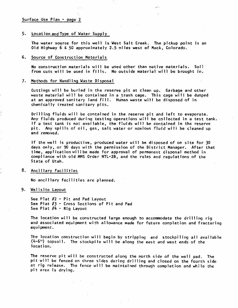
Surface Use Plan - page 2
5. LocationandType of Water Supply
The water source for this well is West Salt Greek. The pickup point is anOld Highway 6 & 50 approximately 2.5 miles west of Mack, colorado.
6. Source of Construction Materials
No construction materials will be used other than native materials. Soilfrom cuts will be used in fills. No outside material will be brought in.
7. Methods for Handling Waste Disposal
Cuttings will be buried in the reserve pit at clean up. Garbage and otherwaste material will be contained in a trash cage. This cage will be dumpedat an approved sanitary land fill. Human waste will be disposed of inchemically treated sanitary pits.
Drilling fluids will be contained in the reserve pit and left to evaporate.Any fluids produced during testing operations will be collected in a test tank.If a test tank is not available, the fluids will be contained in the reservepit. Any spills of oil, gas, salt water or noxious fluid will be cleaned upand removed.
If the well is productive, produced water will be disposed of on site for 30days only, or 90 days with the permission of the District Manager. After thattime, application willbe made for approval of permanent disposal method incompliance with old MMSOrder NTL-2B, and the rules and regulations of theState of Utah.
8. Ancillary Facilities
No ancillary facilities are planned.
9. Wellsite Layout
See Plat #2 - Pit and Pad LayoutSee Plat #3 - Cross Sections of Pit and PadSee Plat #4 - Rig Layout
The location will be constructed large enough to accommodate the drilling rigand associated equipment with allowance made for future completion and fracturingequipment.
The location construction will begin by stripping and stockpiling all available(4-6") topsoil. The stockpile will be along the east and west ends of thelocation.
The reserve pit will be constructed along the north side of the well pad. Thepit will be fenced on three sides during drilling and closed on the fourth sideat rig release. The fence will be maintained through completion and while thepit area is
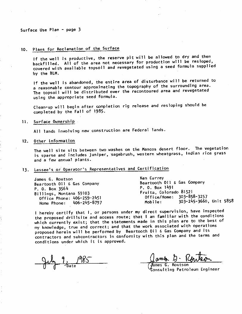
Surface Use Plan - page 3
10. Plans for Reclamation of the Surface
If the well is productive, the reserve pit will be allowed to dry and thenbackfilled. All of the area not necessary for production will be restoped,
covered with available topsoil and revegetated using a seed formula supplied
by the BLM.
If the well is abandoned, the entire area of disturbance will be returned to
a reasonable contour approximating the topography of the surrounding area.
The topsoil will be distributed over the recontoured area and revegetated
using the appropriate seed formula.
Clean-up will begin after completion rig release and resloping should becompleted by the Fall of 1985.
11. Surface Dwnershiþ
All lands involving new construction.are Federal lands.
12. Other Information
The well site sits between two washes on the Mancos desert floor. The vegetation
is sparse and includes juniper, sagebrush, western wheatgrass, Indian rice grass
and a few annual plants.
13. Lessee's or Operator's Representatives and Certification
James G. Routson Ken CurreyBeartooth Oil & Gas Company Beartooth 011 & Gas CompanyP. O. Box 3564 P. 0. Box 1491Billings, Montana 59103 Fruita, colorado 81521
Office Phone: 406-259-2451 office/Home: 303-858-3257
Home Phone: 406-245-8797 Mobile: 303-245-3660, Unit 5858
I hereby certify that 1, or persons under my direct supervision, have inspected
the proposed drillsite and access route; that I am familiar with the conditionswhich currently exist; that the statements made in this plan are to the best of
my knowledge, true and correct; and that the work associated with operationsproposed herein will be performed by Beartooth Oil & Gas Company and its
contractors and subcontractors in conformity with this plan and the terms and
conditions under which it is approved.
Date mes G. Routsononsulting Petroleum
175
658
o Gas Wel
656
20-
14 1
175
658
o Gas Wel
656
20-
14 1
COUNTY
Vi Ci 's6
R25E
2ew.oooc
6E1½
10
15 ½ 13 18 17 15 17 14
Easi Convan Gas F etd16
s-
..
-- 400 000
te 21 n 20
--- cz
19 e 27 26 o 25 27
po 23
as se
N 13 25
d 3 1
cz
L
n is
sa a 19 u ne se
..
OL &LA UN (1
$$ 29 H 3 30 as if 74 M 30 I'

VELL MAP NO, )
Township 6-11., 85, Ronge 24, 2 26E , County Arm , State _a¿te
Begrtoo hFed. 3 -16
TXU Fed. C-
TX9 FXO 1 wwVallenti se 2 .. S ate
33 1----34 ----- ----35
' 30 $i ------
TXO #1-31 Fe- .
.. .Reartool . _-..
................ ...
OFed. 33-8 'c a r XO St ste
.5 TX0 #1 5 rg, o T 1 S
""8aliFUMFGavt t 11 T175 anc ck 1XO V lentine T1
XO tX ed.Starto th ancack Federa 1 'Fed A 6
el Far! Henco k Fed.Nr .)- tate 2 8
#2 edlie rtoct #10 GovHa ock 3ovt #7 Fed
--- ----- - -L..- ~'
....-te.a.C . b.ed.1 .
Fed.ov t
Terr a ni t #8 #7
cv't
Hencoc Ha c ck
19 Govt.
....-. ....
......
Ba
Han:ock#32 Govt ed 14-1 Ter Un t
#35ov' an o:k
33 AMAstatt #1 ov't A x
nAMA
S. Ba
Be rtot th #1Fe 20- 1 ont er
21 Pease se #2 Peake#3 Bar Cree #1
Bor Cree Entr da or.... .......... . .. .... ... .... ..... ....
.. ....... ....... .. .... A --
ek
C t#1
---- -- -•-
------ --- ---- ........ ... . ......... .....- ..-. . .§.il
PcABr #SaaCre k Cr ek
Bea oot--+-- ·- ---- ed- 27•91---- -- --- -- -- -----+----
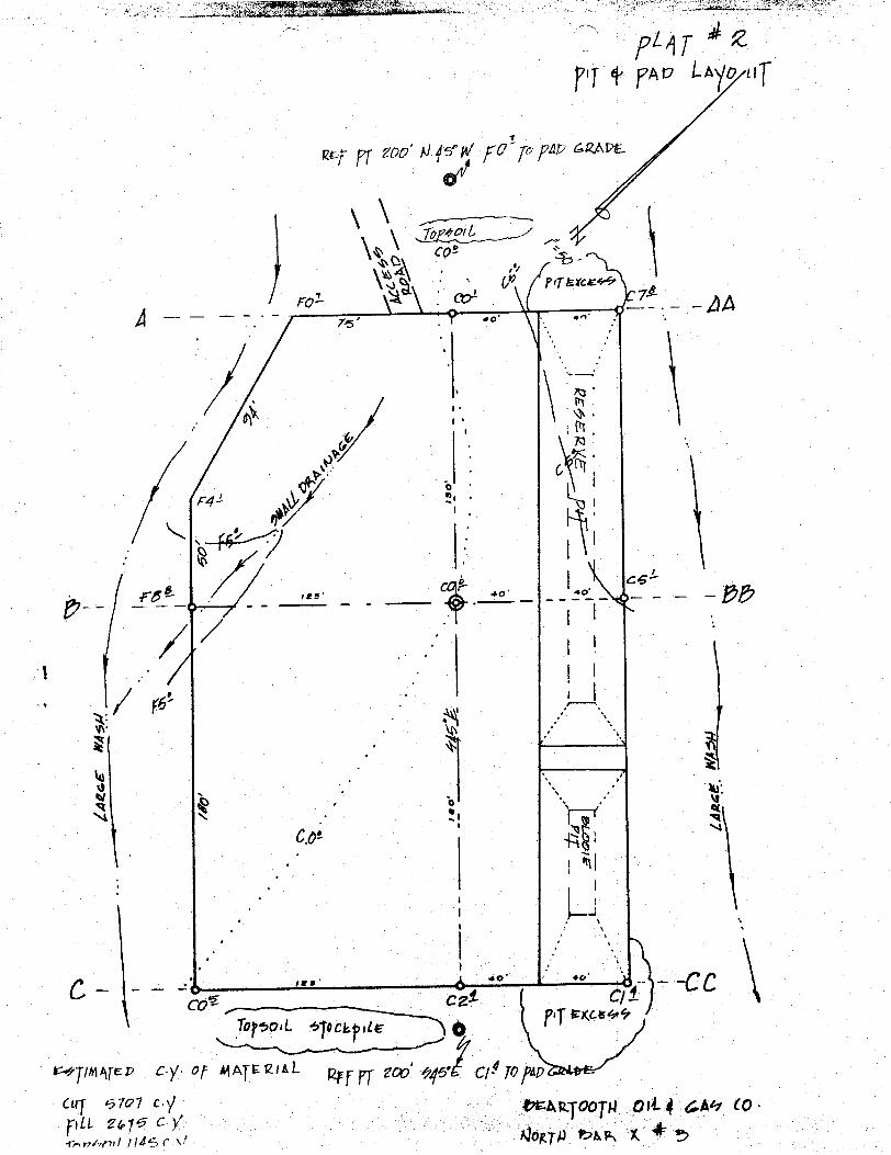
L o
e'
, ac
CCTo L ock
A E 0 1 L to' di 10
AG (0LL cworn/
L o
e'
, ac
CCTo L ock
A E 0 1 L to' di 10
AG (0LL cworn/

CR0SS-SECTIONSOF PIT & PAD
C7Ê ---
vol co'---- AA
cd
reB- - - - - BB
coi c c
C- CC
o otew, M.
SCALE
one so roo
NC SO FEFÌ 0Mi .PREPággy av eutaangtsew y«Wu uma
CR0SS-SECTIONSOF PIT & PAD
C7Ê ---
vol co'---- AA
cd
reB- - - - - BB
coi c c
C- CC
o otew, M.
SCALE
one so roo
NC SO FEFÌ 0Mi .PREPággy av eutaangtsew y«Wu uma
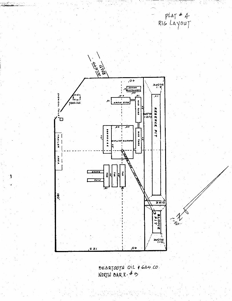
A.am..ek, . .
4-ou
3cio Sel asnou - i' hossauseena
sar et
dHfidi @ft
L
,os ,or
ti MA@S O
1 enw
,7;"
a> o
O e
O 6-14
3dC Sf E\
9 al
av tqoopi o y Che Co.
AINTNg.A
A.am..ek, . .
4-ou
3cio Sel asnou - i' hossauseena
sar et
dHfidi @ft
L
,os ,or
ti MA@S O
1 enw
,7;"
a> o
O e
O 6-14
3dC Sf E\
9 al
av tqoopi o y Che Co.
AINTNg.A
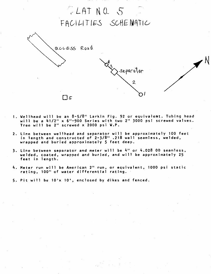
1. Wellhead will be an 8-5/8" Larkin Fig. 92 or equivalemt. Tubing headwill be a 41/2" x 6"-900 Series with two 2" 3000 psi screwed valves.Tree will be 2" screwed x 2000 psi W.P.
2. Line between wellhead and separator will be approximately 100 feetin length and constructed of 2-3/8" .218 wall seamless, welded,wrapped and buried approximately 5 feet deep.
3. Line between separator and meter will be 4" or 4.028 00 seamless,welded, coated, wrapped and buried, and will be approximately 25feet in length.
4. Meter run will be American 2" run, or equivalent, 1000 psi staticrating, 100" of water differential rating.
5. Pit will be 10'x 10', enclosed by dikes and

Norm e-nsa ghabanitin Tdplicate)CasperPress 134N.Center Casper, Wyo.
SUPERVISon, OR. AND GAs OPERATIONS:
DESIGNATION OF OPERATOR
The undersigned is, on the records of the Bureau of I.and Management,holder of oil and gas lesse
DISTRICT I.AND ÛFFICE: Salt Ixalte City, Ut;ahSERIAI. No.: U-44444
and hereby designates
NAME: Beartooth Oil & Gas 00mpanyADDRESS: P. O. Box 2564
Billings, Montana 59103as his operator and local agent, with full authority to act in his behalf in complying *ith the termsof the leaseand regulations applicable thereto and on whom the supervisor or his representative may serve written or oralinstructions in securing compliance with the Oil and Gas Operating Regulations with respect to (describeacre-age to which this designation is applicable) :
Tt:mnship 17 South, Range 25 EastSection 1: I@sS½
Grand County, Utah
It is understood that this designationof operator doesnot relieve the lesseeof re4ponsibility for compliancewith the terms of the lease and the Oil and Gas Operating Regulations. It is also gnderstoodthat this desig-nation of operator does not constitute an assignment of any interest in the lesse.
In case of default on the part of the designatedoperator, the lessee will make fugland prompt compliancewith all regulations, ease terms, or orders of the Secretaryof the Interior or his represe4tative.
The lessee agreel promptlyto notify the oil and gas supervisorof any change in the designatedoperator.
Immi on amen«
/ / President
R. K.P. O. Box 2§¾3
.......... F...B.f....9.Ÿ.9................. Casper . Wydsti ng 82 fiß2(Data)
OPERATOR s DATE 7 ffWELLNAl€
SEC //N T /75 R COUNTY
API N TYPEDELEASE
CHECKOFF:
PLAT BOND NEARESTWELL
LEASE FIELD POTASHOROIL SHALE
PROCESSING NT
APPROVALLETTER:
SPACING: A-3 c-3-a / yffff'UNIT CAUSENO. A DATE
c-3-b c-3-c
STIPULATION :
11/2/84
OPERATOR s DATE 7 ffWELLNAl€
SEC //N T /75 R COUNTY
API N TYPEDELEASE
CHECKOFF:
PLAT BOND NEARESTWELL
LEASE FIELD POTASHOROIL SHALE
PROCESSING NT
APPROVALLETTER:
SPACING: A-3 c-3-a / yffff'UNIT CAUSENO. A DATE
c-3-b c-3-c
STIPULATION :
11/2/84

O STATEOF UTAH Normon H. Bongerter, Govemor
NATURALRESOURCES Dee C. Honsen. Executive Director
Oil. Gas & Mining ÖlonneR. Nielson, Ph.D., Division Director
355 W. North Temple • 3 Triod Center • Suite 350 • Solt Loke City. UT84180-1203• 801 5340
3uly 19, 1985
Beartooth 011 & Gas CompanyP. O. Box 2564Bilings, Montana 59103
Gentlemen:
Re: Well No. North Bar X Federal 3 - NWSE Sec. 1, T. 17Sä R. 25E2300* FSL, 1700*FEL - Grand County, IJtah
Approval to drill the above-referenced gas well is he¢eby granted inaccordance with the Order of Cause No. 165-11 dated February 28, 1985 subjectto the following stipulations:
1. Prior to commencement of drilling, receipt by the Division ofevidence providing assurance of an adequate and approved supply of
In ad tion, the following actions are necessary to flully comply withthis approval:
1. Spudding notification to the Division within 24 hours after drillingoperations commence.
2. Submittal to the Division of completed Form OGC-4-X, Report of WaterEncountered During Drilling.
3. Prompt notification to the Division should you d4termine that it isnecessary to plug and abandon this well. Notify (3ohn R. Baza,Petroleum Engineer, (Office) (801) 538-5340 (Hothe) 298-7695, orR. 3. Firth, Associate Director, (Home) 57116068;
on equal opportunity

Page 2Beartooth 011 & Gas CompanyWell No. North Bar X Federal 3July 19, 1985
4. his approval shall expire one CL) year af ter date ST .issuanceunless
substantial and continuous operation is underway of an application
for an extension is made prior to the approval exp‡ration date.
The API number assigned to this well is 43-019-31193.
Sincerely,
R. thAssociate Ðirector, 011 & Gas
asEnc osurescc: Branch of Fluid
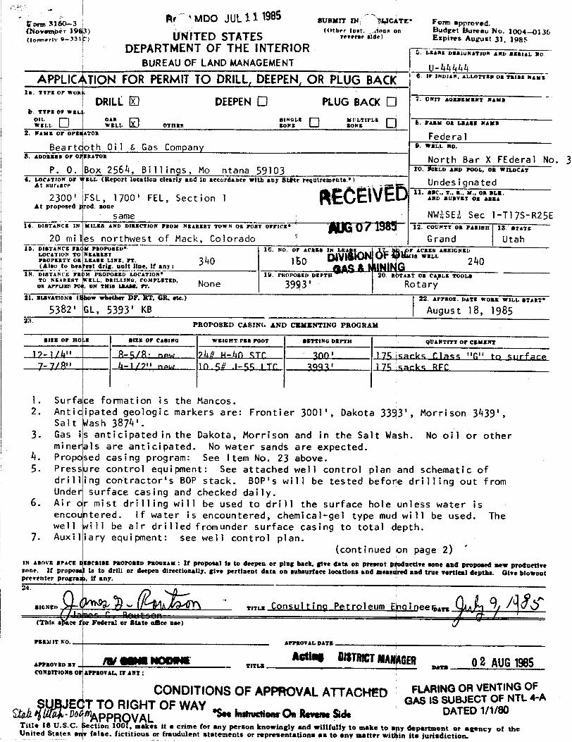
orm
-31
3 Ar MDO JUL11 1985 aveurr rs macÀTE' Form approved.ovemþër 19 3) (Other insk Aons qu Budget Bureau No. 1004-0136
a.....,w e-m > UWITED STATES reT•rse side) Expires August 31, 1985DEPARTMENT OF THE INTERIOR -
5. LEANE DESIGNATION AND SERIAL NO.
BUREAUOF LAND MANAGEMENT U-44444APPLICÀTION FOR PERMITTO DRILL,DEEPEN, OR PLUG BAC O WINDIAN,AILONHORRIMMAME
28. TTPE Or won
DRILL DEEPENO PLUG BACK O ' """ ''"'"'"' "'""b. Trra or wsLL
w LL oTann NE B E 6. - Os LEAsa -
2. wans or orssaron Federa lBeartcoth Oi l t, Gas Company " "©
a. ADDREBBOPOFERATOR North Bar X FEderal No. 3P. O. Box 2564, Bi11ings, Mo ntana 59103 ro. ÊlELD AND POOL, OR WILDCAT
4. LocaTroN or t'sLL (Report location clearly and in accordance with any St te requirements *) Undes i ona tedAt suriner11. s-C., T., B., M., OR BLE.
2300' FSL, 1700' FEL, Section 1 ano.vavaroaansaAt proposed prod. sone
same NWiSE¿ Sec l-Tl7S-R25E14. DiaTANCE IN MILES AND DIRECTION FROM NEAREST TOWN OR POST OFFICE 12. COUNTT OR PARISH 18. BTATE
20 miles northwest of Mack, Colorado Grand Utah10. DISTANCE FSCM PROPoaED" 16. NO OF ACBES IN LEA F ACRES ASSIGNED
LOCATION TO NEASERT IS WELLPROPERTT OR I.EASE UNE, PT. 340 160 240(Also to nos Pest drig. unit line, if any i
18. DISTANCE FROM PROPOSED LOCATION* 19. PROPOSED DEPTH 20. R ART OR CgLE ÝOOLSTO NEAREST WEOÒL, DRIL 0. OMPLETED,
21. mzavArzona (Ebow whether DF. RT, OR. etc.) 22. APPROz. DATE WOBE W3LL START*
5382' GL, 5393' KB August 18, 198523.
PROPOSED CASING AND CEMENTING PROGRAM
BIEE OF MO «E 01EE OF CABING WEIGRT PER FOOT BETTING DEPTH QUANTITT OF CEMENT
17-l/h" R-5/R• now Ph? H-Lin STC. 300' 175 sacks Class "G" to surface7-7/8 ' 4-1/7" now 10 SR .\-BR I TC 3993' 175 sacks RFC
1. Surface formation is the Mancos.2. Anticipated geologic markers are: Frontier 3001', Dakota 33 3', Morrison 3439',
salt Wash 3874'.3. Gas is anticipated in the Dakota, Morrison and in the Salt Wsh. No oil or other
minerals are anticipated. No water sands are expected.4. P ropo|sed cas i ng prog ram: See I tem No. 23 above.5. Pressure control equipment: See attached well control plan and schematic of
drilling contractor's BOP stack. BOP's will be tested before drilling out fromUnder surface casing and checked daily.
6. Air or mist drilling will be used to drill the surface hole unless water isencountered. If water is encountered, chemical-gel type mud will be used. Thewell will be air drilled fromunder surface casing to total depth.
7. Auxiliary equipment: see well control plan.(continued on page 2)
IN ABOVE SPACE ISBCRIBE PROPOSED PROomax : If proposal is to deepen or plug back, give data on present pgnetire sone and proposed new prodnettresone. It proposat is to drill or deepen directionally, give pertinent data on subsurface locations and messiged and true vertical depths. Give blowoutprey
N
PERNIT Wo ammmovatnATE
APPROVED BY TITLE BATECONDITIONB OF APPROVAL, IF ANT :
CONDITIONSOF APPROVALATTACHED F RWSUBEC O -A
DahmTTO RIGHTOF WAY •SeeInstructiourOnRevers.Sd. DATED1/1/80
Title 18 U.S.C. ction 1009, makes it a crime for any person knowingly and willfully to make to a y department or agency of theUnited States en false. fictitious or fraudulent statements or representations as to any matter witi in its
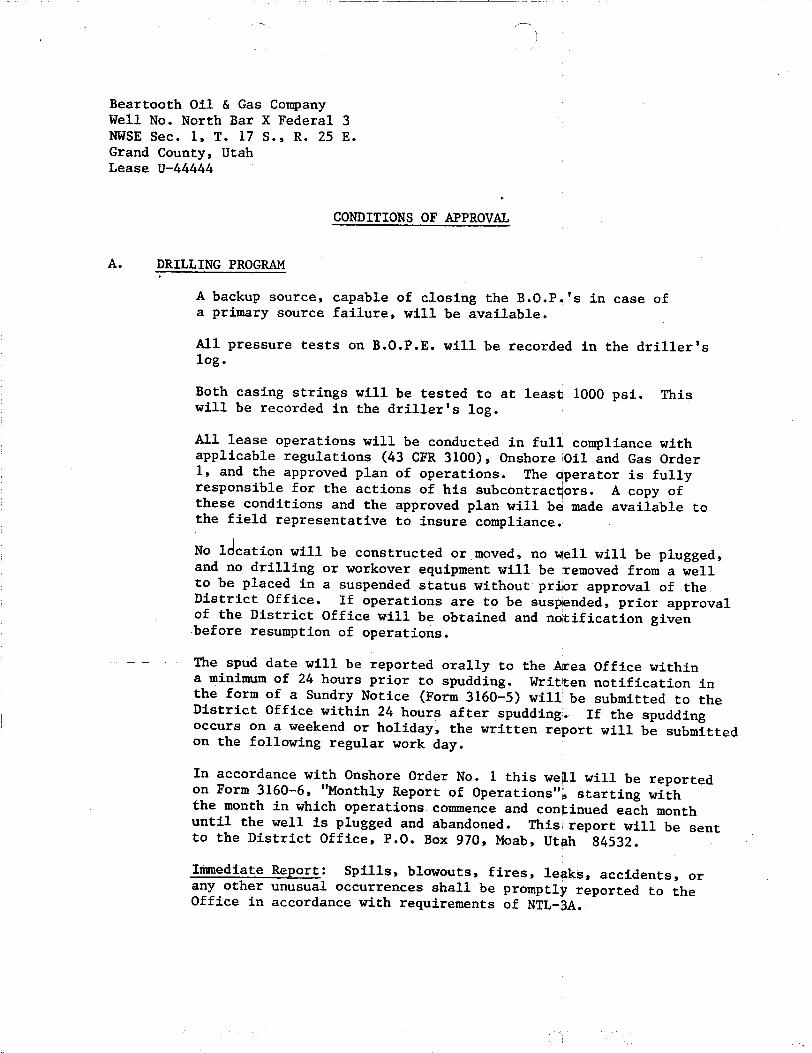
Beartooth Oil & Gas CompanyWell No. North Bar X Federal 3NWSE Sec. 1, T. 17 S., R. 25 E.Grand County, UtahLease U-44444
CONDITIONS OF APPROVAL
A. DRILLING PROGRAM
A backup source, capable of closing the B.O.P.'s in case ofa primary source failure, will be available.
All pressure tests on B.O.P.E. will be recorded in the driller'slog.
Both casing strings will be tested to at least 1000 psi. Thiswill be recorded in the driller's log.
All lease operations will be conducted in full compliance withapplicable regulations (43 CFR 3100), Onshore Oil and Gas Order1, and the approved plan of operations. The aperator is fullyresponsible for the actions of.his subcontractors. A copy ofthese conditions and the approved plan will bd made available tothe field representative to insure compliance.
No 1Ëcationwill be constructed or moved, no well will be plugged,and no drilling or workover equipment will be temoved from a wellto be placed in a suspended status without pri r approval of theDistrict Office. If operations are to be susp nded, prior approvalof the District Office will be obtained and notification givenbefore resumption of operations.
The spud date will be reported orally to the A ea Office withina minimum of 24 hours prior to spudding. Writ en notification inthe form of a Sundry Notice (Form 3160-5) will be submitted to theDistrict Office within 24 hours after spudding. If the spuddingoccurs on a weekend or holiday, the written report will be submittedon the following regular work day.
In accordance with Onshore Order No. 1 this wegl will be reportedon Form 3160-6, "Monthly Report of Operations"à starting withthe month in which operations commence and continued each monthuntil the well is plugged and abandoned. This|report will be sentto the District Office, P.O. Box 970, Moab, Utah 84532.
Immediate Report: Spills, blowouts, fires, legks, accidents, orany other unusual occurrences shall be prompt1ý reported to theOffice in accordance with requirements of
Beartooth Oil & Gas CompanyWell No. North Bar X Federal 3NWSE Sec. 1, T. 17 S., R. 25 E.Grand County, UtahLease U-44444
CONDITIONS OF APPROVAL
A. DRILLING PROGRAM
A backup source, capable of closing the B.O.P.'s in case ofa primary source failure, will be available.
All pressure tests on B.O.P.E. will be recorded in the driller'slog.
Both casing strings will be tested to at least 1000 psi. Thiswill be recorded in the driller's log.
All lease operations will be conducted in full compliance withapplicable regulations (43 CFR 3100), Onshore Oil and Gas Order1, and the approved plan of operations. The aperator is fullyresponsible for the actions of.his subcontractors. A copy ofthese conditions and the approved plan will bd made available tothe field representative to insure compliance.
No 1Ëcationwill be constructed or moved, no well will be plugged,and no drilling or workover equipment will be temoved from a wellto be placed in a suspended status without pri r approval of theDistrict Office. If operations are to be susp nded, prior approvalof the District Office will be obtained and notification givenbefore resumption of operations.
The spud date will be reported orally to the A ea Office withina minimum of 24 hours prior to spudding. Writ en notification inthe form of a Sundry Notice (Form 3160-5) will be submitted to theDistrict Office within 24 hours after spudding. If the spuddingoccurs on a weekend or holiday, the written report will be submittedon the following regular work day.
In accordance with Onshore Order No. 1 this wegl will be reportedon Form 3160-6, "Monthly Report of Operations"à starting withthe month in which operations commence and continued each monthuntil the well is plugged and abandoned. This|report will be sentto the District Office, P.O. Box 970, Moab, Utah 84532.
Immediate Report: Spills, blowouts, fires, legks, accidents, orany other unusual occurrences shall be prompt1ý reported to theOffice in accordance with requirements of
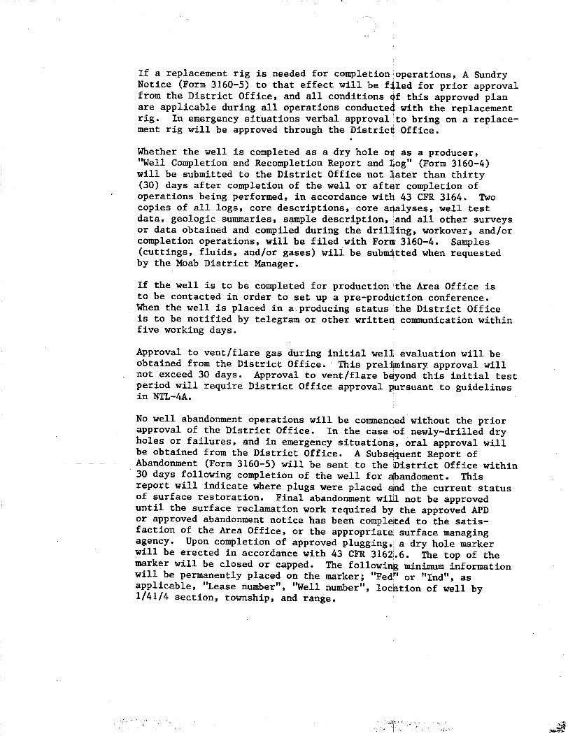
If a replacement rig is needed for completion operations, A SundryNotice (Form 3160-5) to that effect will be f(led for prior approvalfrom the District Office, and all conditions 4f this approved planare applicable during all operations conducted with the replacementrig. In emergency situations verbal approval to bring on a replace-ment rig will be approved through the District Office.
Whether the well is completed as adrybhole
og as a producer,"Well Completion and Recompletion Report and tog" (Form 3160-4)will be submitted to the District Office not iater than thirty(30) days after completion of the well or aftër completion ofoperations being performed, in accordance wit 43 CFR 3164. Twocopies of all logs, core descriptions, core analyses, well testdata, geologic summaries, sample description, and all other surveysor data obtained and compiled during the drilging, workover, and/orcompletion operations, will be filed with Fori 3160-4. Samples(cuttings, fluids, and/or gases) wili be submitted when requestedby the Moab District Manager.
If the well is to be completed for production \the Area Office isto be contacted in order to set up a pre-prodúction conference.When the well is placed in a producing status the District Officeis to be notified by telegram or other written communication withinfive working days.
Approval to vent/flare gas during initial well evaluation will beobtained from the District Office. This preliminary approval willnot exceed 30 days. Approval to vent/flare b yond this initial testperiod will require District Office approval pursuant to guidelinesin NTL-4A.
No well abandorment operations will be commenced without the priorapproval of the District Office. In the case iof newly-drilled dryholes or failures, and in emergency situations, oral approval willbe obtained from the District Office. A Subsdquent Report ofAbandonment (Form 3160-5) will be sent to the histrict Office within30 days following completion of the well for abandoment.Thisreport will indicate where plugs were placed dad the current statusof surface restoration. Final abandonment wil not be approveduntil the surface reclamation work required by the approved APDor approved abandonment notice has been completed to the satis-faction of the Area Office, or the appropriate surface managingagency. Upon completion of approved plugging, a dry hole markerwill be erected in accordance with 43 CFR 3162.6. The top of themarker will be closed or capped. The following minimum informationwill be permanently placed on the marker; "Fedd or "Ind", asapplicable, "Lease number", "Well number", locátion of well by1/41/4 section, township, and
If a replacement rig is needed for completion operations, A SundryNotice (Form 3160-5) to that effect will be f(led for prior approvalfrom the District Office, and all conditions 4f this approved planare applicable during all operations conducted with the replacementrig. In emergency situations verbal approval to bring on a replace-ment rig will be approved through the District Office.
Whether the well is completed as adrybhole
og as a producer,"Well Completion and Recompletion Report and tog" (Form 3160-4)will be submitted to the District Office not iater than thirty(30) days after completion of the well or aftër completion ofoperations being performed, in accordance wit 43 CFR 3164. Twocopies of all logs, core descriptions, core analyses, well testdata, geologic summaries, sample description, and all other surveysor data obtained and compiled during the drilging, workover, and/orcompletion operations, will be filed with Fori 3160-4. Samples(cuttings, fluids, and/or gases) wili be submitted when requestedby the Moab District Manager.
If the well is to be completed for production \the Area Office isto be contacted in order to set up a pre-prodúction conference.When the well is placed in a producing status the District Officeis to be notified by telegram or other written communication withinfive working days.
Approval to vent/flare gas during initial well evaluation will beobtained from the District Office. This preliminary approval willnot exceed 30 days. Approval to vent/flare b yond this initial testperiod will require District Office approval pursuant to guidelinesin NTL-4A.
No well abandorment operations will be commenced without the priorapproval of the District Office. In the case iof newly-drilled dryholes or failures, and in emergency situations, oral approval willbe obtained from the District Office. A Subsdquent Report ofAbandonment (Form 3160-5) will be sent to the histrict Office within30 days following completion of the well for abandoment.Thisreport will indicate where plugs were placed dad the current statusof surface restoration. Final abandonment wil not be approveduntil the surface reclamation work required by the approved APDor approved abandonment notice has been completed to the satis-faction of the Area Office, or the appropriate surface managingagency. Upon completion of approved plugging, a dry hole markerwill be erected in accordance with 43 CFR 3162.6. The top of themarker will be closed or capped. The following minimum informationwill be permanently placed on the marker; "Fedd or "Ind", asapplicable, "Lease number", "Well number", locátion of well by1/41/4 section, township, and
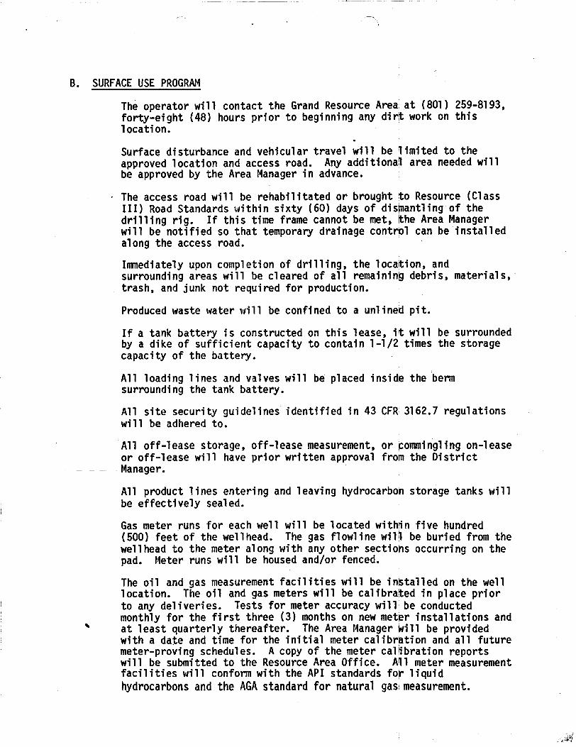
B. SURFACEUSE PROGRAM
The operator will contact the Grand Resource Area at (801) 259-8193,forty-eight (48) hours prior to beginning any dirt work on thislocation.
Surface disturbance and vehicular travel will be limited to theapproved location and access road. Any additional area needed willbe approved by the Area Manager in advance.
The access road will be rehabilitated or brought to Resource (ClassIII) Road Standards within sixty (60) days of dishantling of thedrilling rig. If this time frame cannot be met, the Area Managerwill be notified so that temporary drainage contrb1 can be installedalong the access road.
Immediately upon completion of drilling, the locagion, andsurrounding areas will be cleared of all remaining debris, materials,trash, and junk not required for production.
Produced waste water will be confined to a unlined pit.
If a tank batter.y is constructed on this lease, it will be surroundedby a dike of sufficient capacity to contain 1-1/2 times the storagecapacity of the battery.
All loading lines and valves will be placed inside the bermsurrounding the tank battery.
All site security guidelines identified in 43 CFR 3162.7 regulationswill be adhered to.
All off-lease storage, off-lease measurement, or ¢ommingling on-leaseor off-lease will have prior written approval from the DistrictManager.
All product lines entering and leaving hydrocarbon storage tanks willbe effectively sealed.
Gas meter runs for each well will be located within five hundred(500) feet of the wellhead. The gas flowline wil) be buried from thewe11head to the meter along with any other sections occurring on thepad. Meter runs will be housed and/or fenced.
The oil and gas measurement facilities will be installed on the welllocation. The oil and gas meters will be calibrated in place priorto any deliveries. Tests for meter accuracy will be conductedmonthly for the first three (3) months on new meter installations andat least quarterly thereafter. The Area Manager Will be providedwith a date and time for the initial meter calibration and all futuremeter-proving schedules. A copy of the meter calibration reportswill be submitted to the Resource Area Office. All meter measurementfacilities will conform with the API standards for liquidhydrocarbonsand the AGAstandard for natural

All permanent (onsite for six (6) months or longeir) structuresconstructed or installed (including oil well pump jacks) will bepainted a flat, nonreflective, earth tone color tb match the standardenvironmental colors, as determined by the Rocky Mountain Five StateInteragency Committee. All facilities will be palinted within six (6)months of installation. Facilities required to cpmply with theOccupational Safety and Health Act (OSHA) may be excluded. Colorswill be as follows:
Juniper Green
The operator or his contractor will notify the Grand Resource Area at(801) 259-8193 forty-eight (48) hours before starting reclamationwork that involves earthmoving equipment and upon completion ofrestoration measures.
Prior to reseeding, all disturbed areas, including the access roads,will be scarified and left with a rough surface.
The following seed mixture will be used:
Species 1bs/acre
Grasses
Agropyron spicatum Bluebunch wheatgrass . 1Hilaria jamesii Galleta (Curlygrass) 1Oryzopsis hymenoides Indian ricegrass 1
Forbs
Melilotus officinalis Yellow sweetclover 1/2Medicago sativa Alfalfa 1/2
(Spreador II, Nomad, Ladak)
Shrubs
Eurotia lanata Winterfat (Whitesage) 2
6 lbs/acre
Broadcast seed will be applied at double the above rate.
Final location release will be issued when the s eding is shown to besuccessful (when perennial vegetation is

Your contact with the District Office is:
Greg Noble , Petroleum Engineer Office Phone: (801)259-6111
·Home Phone:
District Address:
82 East Dogwood, P.O. Box 970Moab, Utah 84532
Your contact with the Grand Resource Area Office is:
Jeff Robbins Office Ëhone: (801)259-8193
Home Phone: (801)259-7964
Area Office Address:
Sand Flats Road, P.O. Box MMoab, Utah
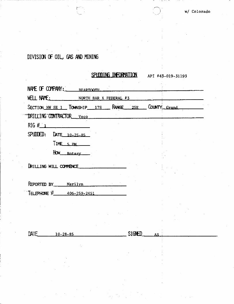
w/ Colorado
DIVISIMOFOILGASANDMINING
SPUDDINGlifDFIATI API #44-019-31193
NAFEOFCfFPANY: amonnow
WFII NAPEj NORTH BAR X FEDERAL #3
SECTION NW SE 1 TOWNSHIP 17S RANGE 25E COUNTYGrand
DRIttlNGTRITRAffDRveco
RI6# I
SPUDDED:DATE 10-25-85
TIME 5 PM
ÑOW notary
DRILLINGWILLCO9ENCF
REPORTEDBY Marilyn
ELËPHONE# 406-259-2451
|
DATF 10-28-85 SIGNED
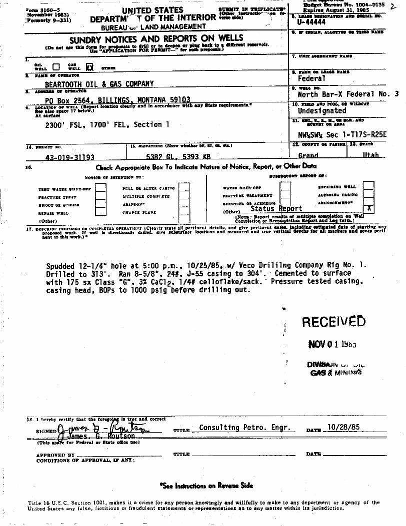
lber983) UNITESSTATES ucar s',,
,"a°a.'ai "" &..rtye-sat) DEPÀRTMr T OF THE INTERIOR•••• •••••••••=wsw••a=••···sa•••
BUREAUkr LANDMANAGEMENTU-44444& 8-BIAW, ALt@ETSB OB TRIBB NAME
SUNDRYNOTKESAND REPORTSON WELLS(De not use this form to •O
N E -
r og ha Street resorreir.
. OWR 60BBBMENT NAMS
IL GASWBLL WELL OTHER
A NAMS 09 OPERATOg. PARM OB LBABB RAME
BEARTOOTHOIL & GASCOMPANYFederal
8. asemass or orsaatos 9. wm.L 80.
PO Box 2564, BILLINGS, MONTANA59103North Bar-X Federal No. 3
4. incarson or «sto port loestion elearly and la secordance with any State re airements.• 10. 9tate AND POOL, os WILac&T
y,*,1 ."" Undesignated
2300' FSL, 1700' FEL, Section 1 * ""lii.'â".""aSa""·'""NASA Sec 1-T17S-R25E
14. PERat!T NO. 15. ELEVATIONS (ShoW whether DF, NT, 88, te,) ÎÊ. 00 NTT OR TARME 18. RATE
43-019-31193 5382 GL, 5393 KB Granti Iltah
ze OlecicAppropnoteBoxTo indicate Natureof Notice, Repon,or Oth.«DataNOTICE OF INTENTION TO : SUSS$QUMMT 887052 Or :
YEST WATER SBOT-Orr PCLL OR ALTER CAstNO WATER BRUT-OFF BSPAIRING WELL
FBACTURE TREAT MULTIPLE COMPI.ETE FRACTURE TREATMENT ALTERING CAalNo
OHOOT OR ACIDIza ABANDON* SBOOTING 08 ACIDiz!NG ABANDONMENT*
REPAIR WELL CHANCE PLANE (Other) Status ort T(Other) m ti
Rreco te Bp ntDor
.)
17. DESCRIBE PROPOSED OR CO3tPLETED OPERATIOxs (Clearly state all pertinent details, and give pertinent dates, ineledi t estimatea date of starting anyproposed work. It well is directionaBy drilled, give subsurface loestions and measured and true vertical depths for all markers and gones perti-aunt to this work.) *
Spudded 12-1/4" hole at 5:00 p.m., 10/25/85, w/ Veco Briliing Company Rig No. 1.Drilled to 313'. Ran 8-5/8", 24#, J-55 casing to 304'. Cemented to surfacewith 175 sx Class "G", 3% CaCl2, 1/4# celloflake/sack. Pressure tested casing,casing head, 80Ps to 1000 psig before drilling out.
RECEli/EDNOV0 11soa
DIVOIMN o, «
GABAMINIM4
18. I hereby certify that the forego is e and correct
SIGNED TITLE CODSUlting Ÿ€trO. Engr. ,,,,,, 10/28/85mot enn
(This for Federal or State oSce ase)
APPROVED BY TITLE DATECONDITIONS OF APPROVAL, IT ANT:
*S., insireenonson Revers.Side
Title 18 U.S C. Section 1001, makes it a crime for any person knowingly and willfully to make to any department or agency of theUnited States any false, fictitious or fraudulent statements or representations as to any matter within its
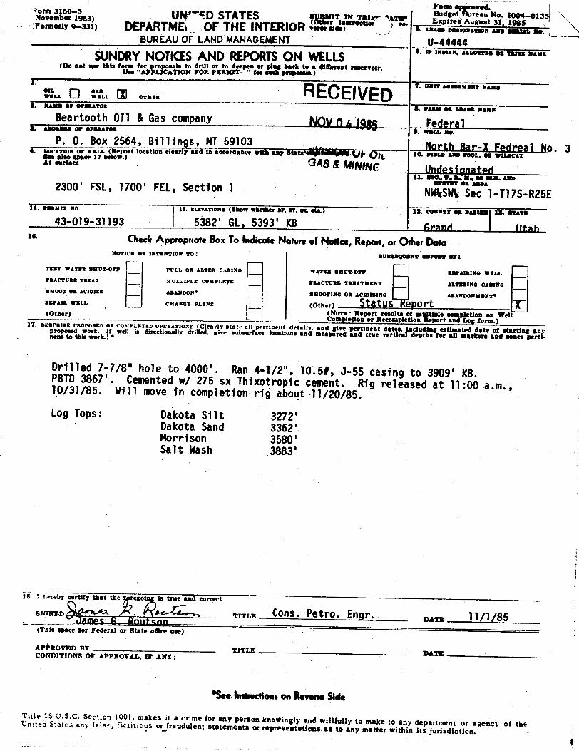
Poem approved.om 16983) Ul†''TD STATES agrr; TO E 1 a a t
100985·-0135Formerly 9-331) DEPARTME OF THE INTERIOR TerBE Bidt) A. LEASE SERIGNATIGN AND BEALWO.
BUREAU OF LAND MANAGEMENT U-44444SUNDRYNOTICESAND REPORTSON WELLS
(Do not use this form for re nals to drill or to deepea or plag hath to a digereat reservoir.Use "AP CATION FOR PERMIT- " for eneb proposais.)
i. 7. UNIT assassaar WaxaOIL SAsWELL WELL OTHER
2. sans or orsaaron a. raam os saams massBeartooth 011 & Gas company NOVû 4 19g Federal
o. 3at ..,«.« GAS& MINING Undesignated
11. sec., r., a.. x, 05 55.5. AND
2300' FSL, 1700' FEL, Section 1 NNË$$e1-T17S-R25E14. PSBMit NO. 15. BIÆVATIONa]Šhow whe¾ or, ar, om, etc.) 12. Ceuxtr om ramisa 18. staWa
43-019-31193 5382' GL, 5393' KB Grand Iltah10' (Aeck AppropriofeBoxTo indicate Natureof Nonce,Report,or ther Dela
NOTICE OF INTENTION TO: SUBS NT BSPORT 07:
TEST WATER BRUT-OFF PCLL OR ALTER C.481NG WATER BRUT4977 BBPAIRING WELLFRACTURE TREAT MULTIPLE COMPfÆTE FRACTURE TBBATMENT ALTERING CABINGBliOOT OR ACIDIžE ABANDON* SBOOTING OR ACIDizlNG ABANDONNENT*AEPAlt WELL CHANGE PLANs (Other) Statusleport T
(NoTE: Report resultà of multiple eompletion on Wel(Other)_ Completion or Recosa¢letion Report and Log term.)17. DEBORIBE PROPOBED OR CO¾tPLETED OPERATIO.Ns (Clearly state all pertinent details, and give pertinent dat including estimated date of starting anproposed work. If well is directionally drilled. sive subsurface locations and measured and true vertLdepths for all markere and genes pertnent to this work.) *
Drilled 7-7/8" hole to 4000'. Ran 4-1/2", 10.5#, J-55 casing to 3909' KB.PBTD3867'. Cemented w/ 275 sx Thixotropic cement. Rig relhased at ll:00 a.m.,10/31/85. Will move in completion rig about 11/20/85.Log Tops: Dakota Silt 3272'
Dakota Sand 3362'Morrison 3580'Salt Wash 3883'
ii I áriÃy certify that the reso is true and correct
SIGNED A . TITLE ÛOns. Petro. Engr. nar, 11/1/85(This space for Pederal or State ogee ase)
APPROVED BY TITLE DATECONDITIONS OF APPROVAL, IF ANY:
*Seeinsiruenonson ReverseSideTitle IS U.S.C. Section 1001, makes it a crime for any person knowingly and willfully to make to any department or agency of theUnited States any false, fictitious or frandulent statements or representations as to any matter within its

oeb 1983) UNITED STATES o o su agrgra· FL*;',"¿'" ',°,°¿-°136
Formerly 9-331> DEPAgfdEMU OP HEAARIOÀ t) U. LEASE DBalcNATION AND Bami. 80.
BUREAUC .ANDMANAGEMENT U-44444SUNDRYNOTICESAND REPORTSON WELLS "'" ' "'^"°""°¯"'"
(Do not use this form for proposals to drilt or to deepen or plug back to a diferent rese r.Use ''APPLICATION FOR PERMIT-" for each pro s.)
OIL GASWELL WELL OTHERa-.... ., ........ g 1 4 1985 * "'" °* """ "'""
Beartooth OIl & Gas company FederalS. WWI.L NO.
P. 0. Box 2564, Billings, MT59103 DivisloN of G Nort.hBar-1 Fedreal No. 34. LocATaos or wsLL (Report location clearly and in accordance with any StatggegMÑ$ 10. FIBl.D AND POOI., OR WH.DCATSee also spaer 17 below.)** """'** Undesignated
11. sac., T., a., m. os ans. Axo
2300' FSL, 1700' FEL, Section 1 NWËÊ$e1-T17S-R25E14. PERMIT No. 15. ExxvArioNs (Show whether or, aT, on, etc.) 12. COUNTY on PAssas 18. BTATE
43-019-31193 5382' GL, 5393' KB Grand Iltah16. (ÑtCk AppropriateBoxToindicateNatureof Notice,Report,or OtherData
NOTICE OF INTENTION 20: BUBBBQUNNT BBPORT 07:
TEST WATER BRUT-Orr PCLL OR ALTER CASING WATER BRUT-OFF REPAIRING WELL
FRACTURE TREAT IICLTIPLE COntPLETE FRACTt'RE TREATMENT ALTERING CASING
SHOOT OR ACIDIZE ABANDON* BBOOTlWC Ort ACIDIZING ABANDONNENT*
REPAIR WELL CHANCE PLANs (Other) StatusTeport T(NoTE: Report resulta of multiple completion on We:(Other) empletion or Recolapletion Report and Log form.)
H. ois RIBE PROPOSED OR CO3tPLETED OPERATroNr (Clearly state all pertinent details, and give pertinent dates, including estimated date of starting anyproposed work. If well is directionally drilled. give subsurface locations and measured and true vertical depths for all markers and sones perti-nent to this work.) •
Drilled 7-7/8" hole to 4000'. Ran 4-1/2", 10.5#, J-55 casing to 3909' KB.PBTD 3867'. Cemented w/ 275 sx Thixotropic cement. Rig released at 11:00 a.m.,10/31/85. Will move -in completion rig about 11/20/85.
Log Tops: Dakota Silt 3272'Dakota Sand 3362'Morrison 3580 'Salt Wash 3883'
Please note correction: Log Tops: Salt Wash 3833' (not 3883').
e:e.» eertify that the rego is true and correct
swNED TITLE CONS. Petro. Engr. var, 11/1/85James 6, Routson(This space for Federal or State esce nee)
ACCEPTED BRENOFFLutoWNQtALS 6 NOV1985;TIEO SMOFAPPROVAL, IF ANY:
TITLE DATE 5
*SeeInstructionson ReverseSide
Title 16 U.S.C. Section 1001, makes it a crime for any person knowingly and willfully to make to any department ur agency of theUniteo S.ates any false, fictitious or fraudulent statements or representations as to any matter within its
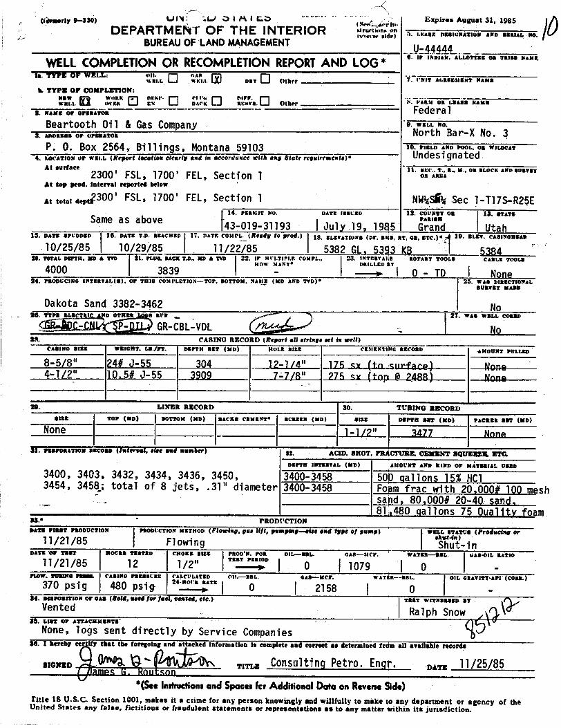
tikrmerly9-330) Ui'Ù I.i.) O i A i t"..O Expires August 31, 1985DEPARTMEÀT OF THE INTERIOR 2. ,..... ...,.. ,,,, ,,, ,,,,
BUREAUOF LANDMANAGEMENT 'U-44444
WELLCOMPLETIONOR RECOMPLETIONREPORTAND LOG* "'"'^"'^"°""°""'"
to. TYPE OF WELL: on. GAa -----
WRI.L WEI.i. DET Other 7. I'NIT AGREMMENT NAMS
k TYPE OF CONPLETION:NEW WitBK .
ÞEWP- Pi l's ÞiWF.WRI.$. OVER EN IIAf'K RENTR. Û(h‡¶ ANN $$ LEAAA NAN
s. na.. ,, ........ Federa lBeartooth Oil & Gas Company e- •==.6 m•.
8. a...... or er.nassa North Bar-X No. 3P. O. Box 2564, Billings, Montana 59103 10. FIELD AND POOI.. 08 WH.DCAT
4. IACATION OF W¾i.L (Ñfgert lodetion citorig GNd (N 6¢cordSNCE 3etta.., se.te ree.fre....,,,. UndesignatedAt surface 11. MEC.. T., R.. M., OR BLOCK AND 80xygt2300' FSL, 1700' FEL, Section 1 •= •••
At top prod. Interval reported below
At total deptg300' FSL, 1700' FEL, Section 1 NW¾SѾSec 1-T17S-R25E14. PERMIT NO. DATE 188tBD 12. COUNTT OR 13. STATESame as above · **==••43-019-31193 I July 19, 1985 Grand Utah
15. DATE SPCDDED $$. DATE T.D. REACHED 17. DATE COMPL. (Ready ‡0 prog.) 18. ELEVATiuNa (DF, RIGli, RT, 08, ETC.) 19. ELET. CASINOBBAD
10/25/85 10/29/85 11/22/85 I 5382_GLe5393 KB I 538420. 19tAL DEFTH. ED A TTD Ê1. PLUO, BACK T.D.. MD & TVD 22. IF Mt I.TIPLE COMPL., 2& INTERTAlis ROTARY TOOLS CABLE TOOLE
HOW MANT* DRILLED AT4000 3839 ---+ \ 0 - TD \ Nene
24. PRODUCING INTERTAL(a), or THis COMPLET10N-TOP, BOTTOM, NAME (MD AND TVD)* 25. WAS DIRECTIONALBURVET MADE
Dakota Sand 3382-3462 No26. TTPS ELECTSIC AND OTHER a arN 27. WAS WELL COBRD
- P- · GR-CBL-VDL No28. CARING RECORD (Report eN strings set in wen)
CAS3NO SIES WRIORT. LE./FT. DEPTH BET (MD) NOLE 882E CEMENTIWo ascoan AMOUNT POLLED
8-5/8" 24# J-55 304 12-1/4" 175 mr (to surface) Nngn4-T/2" 10.5# 0-55 3909 7-7/8" 275 tw (top 8 PARR) Nano
29. LINER RECORD 30. TUBING RECORDSISE TOP (MD¶ BOTTOM (MD) BACKS CENENT* BCREEN (MD) sizE DEPTH ST (MD) PACEER SET (MD)
None 1-1/2" 3477 None
$1. waaromation ascono (Aniereel, sire end usmier) 32. ACID. BHOT, FRÀCTURE. CEMENT SQUEEEIL ETC,DEPTN INTERVAL (MD) AMOUWT AND KIND OF MÅTBBIAL USED
3400, 3403, 3432, 3434, 3436, 3450, 3400-3458 500 gallons 15% HC13454, 3458,; total of 8 jets, .31" diameter 3400-3458 Foam frac with 20,000# 100 meshsand, 80,000# 20-40 sand,81,480 gallons 75 Quality foam
33.• PRODUCTIONDATE PERST PRODUCTION PRODUCTION METHOD (Flowing, gas ifft, pampiNg-@igg @MAÉgp€ Of psap) WELL STATUS (Froducing or
11/21/85 Flowing Sut'-inDATE OF TEST ROcts TESTED €BOEB BIEE PROD'N. POR OIL-88L. GAS-MOW. WATER BEL. GAB<nL RATIO
11/21/85 12 1/2" 0 1079 0 -
FiaW. TOBINO 78-55. CASINO PREBBURE PALCULATED Oll.-BBL. GAS-NCF. WATiba-BBL. OIL GRATITT•API (CORE.)370 psig 480 psig " 0 2158 ( 0 -
84. asswostrioN or eAa (Bold, used for fati, vested, etc.) TiaT WITNassan afVented | Ralph Snow
$5. LEST OF ATTACEMENTS
None, logs sent directly by Service Companies36. I hereby eer ify that the foregoing and attached information is complete and correct as determined trda all available records
BIONED TITI.E Û0DSulting Petro. Engr. gay, 11/25/85famPS H PnuTson
*(SeeInstructionsand SpacesIcr AdditionalDoloon ReverseSde)Title 18 U.S.C. Section 1001, snakes it a crime for any person knowingly and willfully to make to any department or agency of theUnited States any false, fictitious or fraudulent statements or representations as to any matter within its
37.
SUM
MA
RY
OP
POR
OU
S2O
NES
:(S
how
all
impo
rtant
sone
sof
poro
sity
and
cont
ents
ther
eof;
core
din
terv
als;
and
all
drill
-ste
m,
test
s,in
clud
ing
dept
hin
terv
alte
sted
,cu
shio
nus
ed,
time
tool
open
,flo
win
gan
dsh
ut•in
pres
sure
s,an
d38
.G
EOLO
GIC
MA
RK
ERS
reco
verie
s):
FOR
MA
TIO
NTO
PB
OTT
OM
DES
CR
IPTI
ON
,C
ON
TEN
TS,
ETC
.TP
NA
ME
MEA
S.D
EPTH
TRU
$V
ERT.
DEP
THD
akot
a33
8234
62G
as
Mor
rison
3600
3607
Tigh
tga
s&
wat
erM
anco
sSu
rfac
e
Mor
rison
3680
3695
Tigh
tga
s&
wat
erFr
ontie
r30
08
Dak
ota
Silt
3272
Dak
ota
Sand
3362
Mor
rison
3580
Salt
Was
h

ooc-a-x RECEIVEDsTATEOF UrAH DEC0 5 Iggyamammr Œ MERE RESŒmcES
DIVISIΠΠOIL GASANDMINDE vr 0;4 1 S L
MCPŒT OF WATR WOUNTRUEDIHŒÐ REE
Well Name & Number North Bar-X Federal No. 3
Operator Beartooth Oil & Gas Company Ress P. 0. Box 2564, BilTings MT 59103
Contractor vecoDrilling, Inc· Address P. 0. Box 1705, Grand Junction Co81502
Incation NW 1/4 SW 1/4 Sec. 1 7. T7S R. 25E Mty Grand
Water Sands
Depth Volume qualityFrom To Flow Rate or Head Fresh or Salty
1• None Fncountered
2.
3.
5.(Continue on reverse side if necessary)
Formation TopsDakota 3382, Morrison 3600, Morrison 3680Remarks
NOTE: (a) Report on this form as provided for in Rule C-20, General Rulesand Regulations and Rules of Practice and Procedure.
(b) If a water analysis has been maa of the above reported zone,please forward a copy along with this

s
EXPRESS MAIL ROUTING SLIP
PAM 2-
TAMI
VICKY / /
CLAUDIA /STEPHANE /,2 '/2CHARLES /O |# j 2 IL
RULA ydda y
MARY ALICE /0, 1 /
CONNIE
s
EXPRESS MAIL ROUTING SLIP
PAM 2-
TAMI
VICKY / /
CLAUDIA /STEPHANE /,2 '/2CHARLES /O |# j 2 IL
RULA ydda y
MARY ALICE /0, 1 /
CONNIE
Form approved.1& UNil STATES E
ret N3,
10098'5 135
...rar e--san DEPARTMEN FTHE INTERIOR .se•> s. a.•••••=.i•=ar... 2.. ..... ...
BUREAUO LANDMANAGEMENT 0-44444. IP IMDIAN, ALLOTTRE OB TRIBB NAME
SUNDRYNOTICESAND REPORTSON LLS(De aet use this to to ro-o t ro a pl-agpba tereat reservoir.
1.Olt. SA.
RE elvI-D '· -------
WWW WELE. OTER
2. NAMS 09 OFEBAtot 8. FARM 08 LBASS NAME
BEARTOOTHOIL & GASCOMPANY DEC23 1985 Federal8. assassa or osanamos e. was.r. no.
P. 0. Box 2564, Billings MT59103 VINif .OILNorth Bar-X Federal #3
4. A x or wnL port location clearly and in accordance with anyNG d
WILDCAT
11. sac., 2., s., x. omat.x. Amp
2300' FSL, 1700' FEL, Section 1 ""°¯
NW¾SEkSec 1-T17S-R25E14. Pannst No. 15. MIÆTATIONs (Show whether or, sT, an, etc.) 12. COUNTY 05 PAmtax 18. arATE
43-019-31193 5382' GL, 5393' KB Grand Utahle ChecicAppropriateBoxTo indicate Nature of Notice,Report,or Ods.«Data
NOTICE OF INTENTION TO: BUBBBQUENT REPORT 07•
TEST WATER BRUT4FF PCLL 08 ALTER CASING WATER BRUT<þrr REPAIRING WELL
FRACTURE TREAT MULTIPLE COMPI.ETE FRACTURE TREATMENT ALTERING CASING
BROOT OR ACIDIES ABANDON* BROOTING OR ACIDIZING ABANDONNENT*
REPAIR WELI. CHANGE PI,ANS (Other) FirsT Production T(NoTa: Report results of multiple completion on Wel
¯¯
(Other) Completion or Recompletion Report and Log form.)17. DESCRIBE PROPOSED OR COMPLETED OPERATIONS (Clearly state all pertineut details, and give pertinent dates, including estimated date of starting aar
proposed work. If well is directionally drilled. give subsurface loestions and measured and true vertical depths for all markers and sones parti-nent to this work.) •
Well put on production at 12:30 p.m., 12/18/85.BLMin Moab, Utah, notified by telephone on 12/19/85.
18. I hereby certify that the forego is true and correct
RENED - TITLE Û0nsulting Petro. Engr. ex•:a 12/19/85hmne f' Rnlitenn
(This space for Federal or State omte ase)
APPROVED BT TITLE DATECONDITIONS OF APPROVAL, IP ANY:
*S.. Insirectionson ReverseSide
Title 18 U.S.C. Section 1001, makes it a crime for any person knowingly and willfully to make to any department or agency of theUnited States any inise, fictitious or fraudulent statements or representations as to any matter within its
RECEIVED: Feb. 14, 2018
STATE OF UTAHDEPARTMENT OF NATURAL RESOURCES
DIVISION OF OIL, GAS, AND MINING
FORM 9
5.LEASE DESIGNATION AND SERIAL NUMBER: UTU-44444
SUNDRY NOTICES AND REPORTS ON WELLSDo not use this form for proposals to drill new wells, significantly deepen existing wellsbelow current bottom-hole depth, reenter plugged wells, or to drill horizontal laterals.Use APPLICATION FOR PERMIT TO DRILL form for such proposals.
6. IF INDIAN, ALLOTTEE OR TRIBE NAME:
7.UNIT or CA AGREEMENT NAME:
1. TYPE OF WELL Gas Well
8. WELL NAME and NUMBER: N BAR X FED 3
2. NAME OF OPERATOR: BEARTOOTH OIL & GAS CO
9. API NUMBER: 43019311930000
3. ADDRESS OF OPERATOR: PHONE NUMBER: P O BOX 2564 , BILLINGS, MT, 59103 406-259-2451
9. FIELD and POOL or WILDCAT: BAR X
4. LOCATION OF WELL FOOTAGES AT SURFACE: 2300 FSL 1700 FEL QTR/QTR, SECTION, TOWNSHIP, RANGE, MERIDIAN: Qtr/Qtr: NWSE Section: 1 Township: 17S Range: 25E Meridian: S
COUNTY: GRAND
STATE: UTAH
11.CHECK APPROPRIATE BOXES TO INDICATE NATURE OF NOTICE, REPORT, OR OTHER DATA
TYPE OFSUBMISSION TYPE OF ACTION
NOTICE OF INTENTApproximate date work will start:
SUBSEQUENT REPORTDate of Work Completion:
12/4/2017
SPUD REPORTDate of Spud:
DRILLING REPORTReport Date:
ACIDIZE ALTER CASING CASING REPAIR
CHANGE TO PREVIOUS PLANS CHANGE TUBING CHANGE WELL NAME
CHANGE WELL STATUS COMMINGLE PRODUCING FORMATIONS CONVERT WELL TYPE
DEEPEN FRACTURE TREAT NEW CONSTRUCTION
OPERATOR CHANGE PLUG AND ABANDON PLUG BACK
PRODUCTION START OR RESUME RECLAMATION OF WELL SITE RECOMPLETE DIFFERENT FORMATION
REPERFORATE CURRENT FORMATION SIDETRACK TO REPAIR WELL TEMPORARY ABANDON
TUBING REPAIR VENT OR FLARE WATER DISPOSAL
WATER SHUTOFF SI TA STATUS EXTENSION APD EXTENSION
WILDCAT WELL DETERMINATION OTHER OTHER:
12. DESCRIBE PROPOSED OR COMPLETED OPERATIONS. Clearly show all pertinent details including dates, depths, volumes, etc. Beartooth located and squeezed a hole in the 4 1/2" casing. Hole at 660'-665',
squeezed with 25 sx Class G cement. Replaced the 1 1/2" tubing string with 23/8", 8R, J-55 tubing. Tubing landed at 3448'.
NAME (PLEASE PRINT) PHONE NUMBER Laura L. Roberts 406 259-2451
TITLE President
SIGNATURE N/A
DATE 2/14/2018
August 21, 2018
Sundry Number: 86277 API Well Number: 43019311930000Sundry Number: 86277 API Well Number: 43019311930000
FORM 9STATE OF UTAH
DEPARTMENT OF NATURAL RESOURCES5.LEASE DESIGNATION AND SERIAL NUMBER:DIVISION OF OIL, GAS, AND MINING UTU-44444
SUNDRY NOTICES AND REPORTS ON WELLS 6. IF INDIAN, ALLOTTEE OR TRIBE NAME:
Do not use this form for proposals to drill new wells, significantly deepen existing wellsbelow current bottom-hole depth, reenter plugged wells, or to drill horizontal laterals. 7.UNIT or CA AGREEMENT NAME:
Use APPLICATION FOR PERMIT TO DRILL form for such proposals.
1. TYPE OF WELL 8. WELL NAME and NUMBER:Gas Well N BAR X FED 3
2. NAME OF OPERATOR: 9. API NUMBER:BEARTOOTH OIL & GAS CO 43019311930000
3. ADDRESS OF OPERATOR: PHONE NUMBER: 9. FIELD and POOL or WILDCAT:PO BOX 2564 , BILLINGS, MT, 59103 406-259-2451 BAR X
4. LOCATION OF WELL COUNTY:FOOTAGES AT SURFACE: GRAND
2300 FSL 1700 FELQTR/QTR, SECTION, TOWNSHIP, RANGE, MERIDIAN: STATE:
Qtr/Qtr:NWSE Section: 1 Township: 17S Range: 25E Meridian: S UTAH
11.CHECK APPROPRIATE BOXES TO INDICATE NATURE OF NOTICE, REPORT, OR OTHER DATA
TYPE OF TYPE OF ACTIONSUBMISSION
ACIDIZE ALTER CASING CASING REPAIR
NOTICE OF INTENTApproximate date work will start: CHANGE TO PREVIOUS PLANS CHANGE TUBING CHANGE WELL NAME
CHANGE WELL STATUS COMMINGLE PRODUCING FORMATIONS CONVERT WELL TYPE
SUBSEQUENT REPORTDate of Work Completion: DEEPEN FRACTURE TREAT NEW CONSTRUCTION
12/4/20 17OPERATOR CHANGE PLUG AND ABANDON PLUG BACK
SPUD REPORTPRODUCTION START OR RESUME RECLAMATION OF WELL SITE RECOMPLETE DIFFERENT FORMATION
Date of Spud:REPERFORATE CURRENT FORMATION SIDETRACK TO REPAIR WELL TEMPORARY ABANDON
TUBING REPAIR VENT OR FLARE WATER DISPOSAL
DRILLING REPORT WATER SHUTOFF SI TA STATUS EXTENSION APD EXTENSIONReport Date:
WILDCAT WELL DETERMINATION OTHER OTHER:
12. DESCRIBE PROPOSE ) OR COMPLETED OPERATIONS. Clearly show all pertinent details including dates, depths, volumes, etc.Beartooth located and squeezed a hole in the 4 1/2" casing. Hole at 660'-665',squeezed with 25 sx Class G cement. Replaced the 1 1/2" tubing string with 2 Accepted by the
3/8", 8R, J-55 tubing. Tubing landed at 3448'. Utah Division ofOil, Gas and Mining
FOR RECORD ONLYAugust 21, 2018
NAME (PLEASE PRINT) PHONE NUMBER TITLELaura L. Roberts 406 259-2451 President
SIGNATURE DATEN/A 2/14/2018
RECEIVED: Feb. 14,
RECEIVED: Feb. 14, 2018
STATE OF UTAHDEPARTMENT OF NATURAL RESOURCES
DIVISION OF OIL, GAS AND MINING
FORM 9
5. LEASE DESIGNATION AND SERIAL NUMBER:
SUNDRY NOTICES AND REPORTS ON WELLS6. IF INDIAN, ALLOTTEE OR TRIBE NAME:
Do not use this form for proposals to drill new wells, significantly deepen existing wells below current bottom-hole depth, reenter plugged wells, or todrill horizontal laterals. Use APPLICATION FOR PERMIT TO DRILL form for such proposals.
7. UNIT or CA AGREEMENT NAME:
1. TYPE OF WELLOIL WELL GAS WELL OTHER
8. WELL NAME and NUMBER:
2. NAME OF OPERATOR: 9. API NUMBER:
3. ADDRESS OF OPERATOR:
CITY STATE ZIP
PHONE NUMBER: 10. FIELD AND POOL, OR WILDCAT:
4. LOCATION OF WELL
FOOTAGES AT SURFACE: COUNTY:
QTR/QTR, SECTION, TOWNSHIP, RANGE, MERIDIAN: STATE:
UTAH
11. CHECK APPROPRIATE BOXES TO INDICATE NATURE OF NOTICE, REPORT, OR OTHER DATA
TYPE OF SUBMISSION TYPE OF ACTION
NOTICE OF INTENT (Submit in Duplicate)
Approximate date work will start:
ACIDIZE DEEPEN REPERFORATE CURRENT FORMATION
ALTER CASING FRACTURE TREAT SIDETRACK TO REPAIR WELL
CASING REPAIR NEW CONSTRUCTION TEMPORARILY ABANDON
CHANGE TO PREVIOUS PLANS OPERATOR CHANGE TUBING REPAIR
CHANGE TUBING PLUG AND ABANDON VENT OR FLARE
SUBSEQUENT REPORT (Submit Original Form Only)
Date of work completion:
CHANGE WELL NAME PLUG BACK WATER DISPOSAL
CHANGE WELL STATUS PRODUCTION (START/RESUME) WATER SHUT-OFF
COMMINGLE PRODUCING FORMATIONS RECLAMATION OF WELL SITE OTHER:
CONVERT WELL TYPE RECOMPLETE - DIFFERENT FORMATION
12. DESCRIBE PROPOSED OR COMPLETED OPERATIONS. Clearly show all pertinent details including dates, depths, volumes, etc.
NAME (PLEASE PRINT) TITLE
SIGNATURE DATE
(This space for State use only)
(5/2000) (See Instructions on Reverse Side)
Sundry Number: 86277 API Well Number: 43019311930000Sundry Number: 86277 API Well Number: 43019311930000
STATE OF UTAH FORM 9DEPARTMENT OF NATURAL RESOURCES
DIVISION OF OIL, GAS AND MINING 5. LEASE DESIGNATION AND SERIAL NUMBER:UTU-44444
6. IF INDIAN,ALLOTTEE OR TRIBE NAME
7. UNIT or CA AGREEMENT NAME:Do not use this form for proposals to drill new wells, significantly deepen existing wells below current bottom-hole depth, reenter plugged wells, or to
drill horizontal laterals. Use APPLICATION FOR PERMIT TO DRILL form for such proposals.1. TYPE OF WELL 8. WELL NAME and NUMBER:
OIL WELL GAS WELL OTHER N Bar X Federal #32. NAME OF OPERATOR: 9. API NUMBER:
Beartooth Oil & Gas Company 43019311933. ADDRESSOF OPERATOR: PHONE NUMBER: 10. FIELD AND POOL, OR V\nLDCAT:
P.O. Box 2564 BillingS STATE MT ZIP 59103 (406) 259-2451 Bar X4. LOCATION OF WELL
FOOTAGESATSURFACE: 2300' FSL, 1700' FEL COUNTY: Grand
QTR/QTR, SECTION, TOWNSHIP, RANGE, MERIDIAN: NWSE 1 17S 25E STATE:UTAH
11. CHECK APPROPRIATE BOXES TO INDICATE NATURE OF NOTICE, REPORT, OR OTHER DATATYPE OF SUBMISSION TYPE OF ACTION
ACIDIZE DEEPEN REPERFORATE CURRENT FORMATIONNOTICE OF INTENT
(Submit in Duplicate) ALTER CASING FRACTURE TREAT SIDETRACK TO REPAIR WELL
Approximate date work will start: CASING REPAIR NEW CONSTRUCTION TEMPORARILY ABANDON
CHANGE TO PREVIOUS PLANS OPERATOR CHANGE TUBING REPAIR
CHANGE TUBING PLUG AND ABANDON VENT OR FLARE
SUBSEQUENT REPORT CHANGE WELL NAME PLUG BACK WATER DISPOSAL(Submit Original Form Only)
CHANGE WELL STATUS PRODUCTION (START/RESUME) WATER SHUT-OFFDate of work completion:
COMMINGLE PRODUCING FORMATIONS RECLAMATION OF WELL SITE OTHER:12/4/2017
CONVERT WELL TYPE RECOMPLETE -DIFFERENT FORMATION
12. DESCRIBE PROPOSED OR COMPLETED OPERATIONS. Clearly show all pertinent details including dates, depths, volumes, etc.
Beartooth located and squeezed a hole in the 4 1/2" casing. Hole at 660'-665', squeezed with 25 sx Class G cement. Replacedthe 1 1/2" tubing string with 2 3/8", 8R, J-55 tubing. Tubing landed at 3448'.
NAME(PLEASEPRINT) Ken Currey TITLE ViCe President
SIGNATURE DATE 12/28/2017
(This space for State use only)
(5/2000) (See Instructions on Reverse Side)
RECEIVED: Feb. 14,
RECEIVED: Feb. 14, 2018
INSTRUCTIONS
This form shall be submitted by the operator to show the intention and/or completion of the following:! miscellaneous work projects and actions for which other specific report forms do not exist;! all other work and events as identified in section 11, Type of Action, or as required by the Utah Oil and Gas
Conservation General Rules, including:- minor deepening of an existing well bore,- plugging back a well,- recompleting to a different producing formation within an existing well bore (intent only),- reperforating the current producing formation,- drilling a sidetrack to repair a well,- reporting monthly the status of each drilling well.
This form is not to be used for proposals to - drill new wells,- reenter previously plugged and abandoned wells,- significantly deepen existing wells below their current bottom-hole depth,- drill horizontal laterals from an existing well bore,- drill hydrocarbon exploratory holes such as core samples and stratigraphic tests.
Use Form 3, Application for Permit to Drill (APD) for such proposals.
NOTICE OF INTENT - A notice of intention to do work on a well or to change plans previously approved shall besubmitted in duplicate and must be received and approved by the division before the work is commenced. The operatoris responsible for receipt of the notice by the division in ample time for proper consideration and action. In cases ofemergency, the operator may obtain verbal approval to commence work. Within five days after receiving verbal approval,the operator shall submit a Sundry Notice describing the work and acknowledging the verbal approval.
SUBSEQUENT REPORT - A subsequent report shall be submitted to the division within 30 days of the completion ofthe outlined work. Specific details of the work performed should be provided, including dates, well depths, placementof plugs, etc.
WELL ABANDONMENT - Proposals to abandon a well and subsequent reports of abandonment should include reasonsfor the abandonment; data on any former or present productive zones, or other zones with present significant fluidcontents not sealed off by cement or otherwise; depths (top and bottom) and method of placement of cement plugs;mud or other material placed below, between and above plugs; amount, size, and method of parting of any casing, liner,or tubing pulled and the depth to top of any left in the hole; method of closing top of well; and date well site conditionedfor final inspection looking to approval of the abandonment.
In addition to any Sundry Notice forms submitted, Form 8, Well Completion or Recompletion Report and Log mustbe submitted to the division to report the results of the following operations:! completing or plugging a new well,! reentering a previously plugged and abandoned well,! significantly deepening an existing well bore below the current bottom-hole depth,! drilling horizontal laterals from an existing well bore,! drilling hydrocarbon exploratory holes such as core samples and stratigraphic tests,! recompleting to a different producing formation.
Send to:
Utah Division of Oil, Gas and Mining Phone: 801-538-53401594 West North Temple, Suite 1210Box 145801 Fax: 801-359-3940Salt Lake City, Utah 84114-5801
(5/2000)
Sundry Number: 86277 API Well Number: 43019311930000Sundry Number: 86277 API Well Number: 43019311930000
INSTRUCTIONS
This form shall be submitted by the operator to show the intention and/or completion of the following:e miscellaneous work projects and actions for which other specific report forms do not exist;e all other work and events as identified in section 11, Type of Action, or as required by the Utah Oil and Gas
Conservation General Rules, including:- minor deepening of an existing well bore,- plugging back a well,- recompleting to a different producing formation within an existing well bore (intent only),- reperforating the current producing formation,- drilling a sidetrack to repair a well,- reporting monthly the status of each drillingwell.
This form is not to be used for proposalsto- drill new wells,- reenter previously plugged and abandoned wells,- significantly deepen existing wells below their current bottom-hole depth,- drill horizontal laterals from an existing well bore,- drill hydrocarbon exploratory holes such as core samples and stratigraphic tests.
Use Form 3, Application for Permit to Drill (APD) for such proposals.
NOTICE OF INTENT - A notice of intention to do work on a well or to change plans previously approved shall besubmitted in duplicate and must be received and approved by the division before the work is commenced. The operatoris responsible for receipt of the notice by the division in ample time for proper consideration and action. In cases ofemergency, the operator may obtain verbal approval to commence work. Withinfive days after receiving verbal approval,the operator shall submit a Sundry Notice describing the work and acknowledging the verbal approval.
SUBSEQUENT REPORT - A subsequent report shall be submitted to the division within 30 days of the completion ofthe outlined work. Specific details of the work performed should be provided, including dates, well depths, placementof plugs, etc.
WELL ABANDONMENT- Proposals to abandon a well and subsequent reports of abandonment should include reasonsfor the abandonment; data on any former or present productive zones, or other zones with present significant fluidcontents not sealed off by cement or otherwise; depths (top and bottom) and method of placement of cement plugs;mud or other material placed below, between and above plugs; amount, size, and method of parting of any casing, liner,or tubing pulled and the depth to top of any left in the hole; method of closing top of well; and date well site conditionedfor final inspection looking to approval of the abandonment.
In addition to any Sundry Notice forms submitted, Form 8, Well Completion or Recompletion Report and Log mustbe submitted to the division to report the results of the following operations:• completing or plugging a new well,• reentering a previously plugged and abandoned well,• significantly deepening an existing well bore below the current bottom-hole depth,• drilling horizontal laterals from an existing well bore,• drilling hydrocarbon exploratory holes such as core samples and stratigraphic tests,• recompleting to a different producing formation.
Send to:
Utah Division of Oil, Gas and Mining Phone: 801-538-53401594 West North Temple, Suite 1210Box 145801 Fax: 801-359-3940Salt Lake City, Utah 84114-5801
(5/2000)
RECEIVED: Feb. 14,