4300730415.pdf - utah - oil and gas
TRANSCRIPT
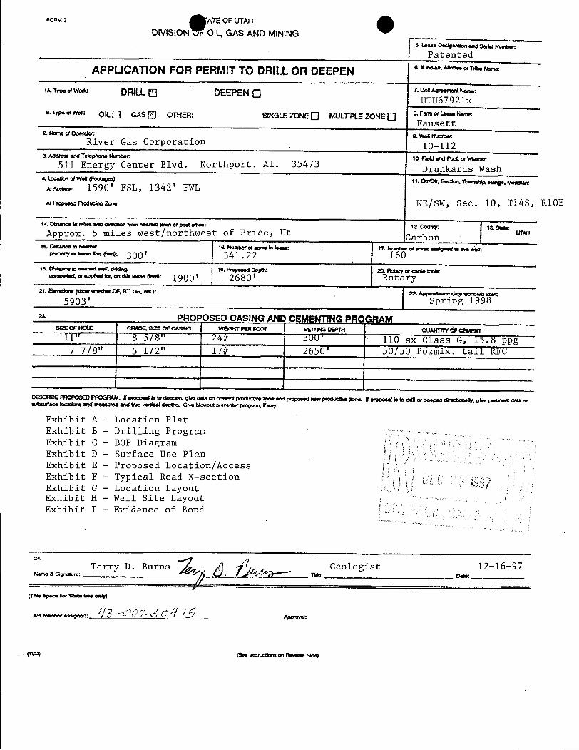
FORMa ATËOF UTAH
DIVISION vF OlL, GAS AND MtNINGs um.. Designason ano sea.I Numbm-
Patented
APPLICATION FOR PERMITTO DRILLOR DEEPEN an-me.eña.s.
1A Tmda DRILLEl DEEPEN """''*"'""
UTU67921xe. Type ofwen: OILO GAS Of NER: SINGLEZONEO MULWLE ZONE O s. Fan «um.. Name:
Fausett2 Nmne of Operator 9. Weß Number:
River Gas Corporation 10-1123. Address and T Numr• 14 Flokt WWI f¾o( or Wildeet:
511 Energy Center Blvd. Northport, A1. 35473 Drunkards Wash4, tocationofwonµmstages) 11. Otr/Otr, Secdon. Y Range,
uswa.: 1590' FSL, 1342' FWL
hawwwemuson-: NE/SW, Sec. 10, T14S R10E
14 Distance in mbos ama aseson somnearnst two or post amee: la County; umApprox. 5 miles west/northwest of Price., Ut Carbon .
ur15, Distance in naams! la Number et acres in lease: 17. Nunmar of acres amigned ¾ Um ;wav«m-•"'** 300' 341.22 160le, oisiancee nearestwoi, ddng, 10. Poposed Os¢h• :20. Octwy or cable W
anni.e.a...ppa.eror.ontal.l....«..e: 1900' 2680' Rotary21. EltYndans (thoW Whether CF, ftT W et): 22, Appadmain duty work MUIstwt
5903' Spring 1998
PROPOSED CASINGANI CEMENTING PROGRAMstzs os as am erzeor came wow« PER MOT SERM DEPN QUMOTY ÔF CEMBR
11" 8 5/8" 24# 300' 110 sx Class G, 15.8 ppg7 7/8" 5 1/2" 17# 2650' 50/50 Pozmix, tali RFC
DESCRIBE PACPOSED PROGRAlk f proposails to doopen, gWe data en present poducdve 2eee and propaged newpregueëve gone. Wproposer is to dsŒ or deepen direenanaOy. give pettinertdala onoutsurface locations arid meesafedand true verdcal depUm Ghe W preventer program, ¥any.
Exhibit A - Location PlatExhibit B - Drilling ProgramExhibit C - BOP DiagramExhibit D - Surface Use PlanExhibit E - Proposed Location/AccessExhibit F - Typical Road X-sectionExhibit G - Location LayoutExhibit H - Well Site LayoutExhibit I - Evidence of Bond
Terry D. Burns >û Geologist 12-16-97Name a sige. Ç/ .
. nue: o.s.
(1\na) (See instarsons on neverse
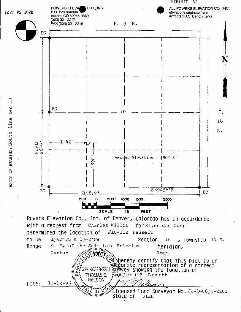
EXHIBIT "A"POWERS ELEV J CO., INC. . ALL POWERS ELEVATIONCO., INC.
Form PS 102B P.O. Box 440889 elevations originate fromAurora, CO 80044-0889 accepted U.S. Benchmarks(303) 321-2217FAX (303) 321-2218 R, 9 E .
BC
BC
I S.
Gro nd Elevation = 902.5'Oi
Bcn
5158 ?, s39 58'E BC500 0 500 1000 1500 2500
SCALE I N FEET
Powers Elevation Co., Inc. of Denver, Colorado has in accordancewith a request from Charles Willis fOr River Gas Corp
determined the location of #10-112 Fausett
to be 1590'FS & 1342'FW Section 10 , Township i4 s.Range 9 E. of the S Lake Principal Meridian,
Carbon Utah
... ereby certify that this plot is ans,: • urate representation of a correct122-140833-2201ivey showing the location of
THOMASE. : Ë#10-112 Fausett
D0te: 10-12-95 .
NELSON .•
EoͶÀ.icensedLand Surveyor No. 22-140833-2201Illittittu\ State of
O O
1
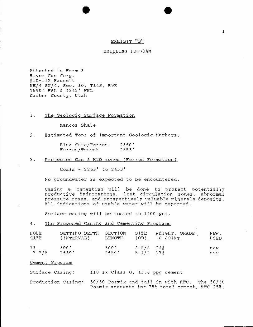
EXHIBIT "B"
DRILLING PROGRAM
Attached to Form 3River Gas Corp.#10-112 FausettNE/4 SW/4, Sec. 10, Tl48, R9E
Carbon County, Utah
1. The Geologic Surface Formation
Mancos Shale
2. Estimated Tops of Important Geologic Markers.
Blue Gate/Ferron 2360'Ferron/Tununk 2553'
3. Projected Gas & H2O zones (Ferron Formation)
Coals - 2263' to 2433'
No groundwater is expected to be encountered.
Casing & cementing will be done to protect potentiallyproductive hydrocarbons, lost circulation zones, abnormalpressure zones, and prospectively valuable minerals deposits.All indications of usable water will be reported.
Surface casing will be tested to 1400 psi.
4. The Proposed Casing and Cementing Programs
HOLE SETTING DEPTH SECTION SIZE WEIGHT, GRADE NEW,SIZE (INTERVAL) LENGTH (OD) & JOINT USED
11 300' 300' 8 5/8 24# new7 7/8 2650' 2650' 5 1/2 17# new
Cement Program
Surface Casing: 110 sz Class G, 15.8 ppg cement
Production casing: 50/50 Pozmix and tail in with RFC. The 50/50Pozmix accounts for 75% total cement, RFC
O O
1
EXHIBIT "B"
DRILLING PROGRAM
Attached to Form 3River Gas Corp.#10-112 FausettNE/4 SW/4, Sec. 10, Tl48, R9E
Carbon County, Utah
1. The Geologic Surface Formation
Mancos Shale
2. Estimated Tops of Important Geologic Markers.
Blue Gate/Ferron 2360'Ferron/Tununk 2553'
3. Projected Gas & H2O zones (Ferron Formation)
Coals - 2263' to 2433'
No groundwater is expected to be encountered.
Casing & cementing will be done to protect potentiallyproductive hydrocarbons, lost circulation zones, abnormalpressure zones, and prospectively valuable minerals deposits.All indications of usable water will be reported.
Surface casing will be tested to 1400 psi.
4. The Proposed Casing and Cementing Programs
HOLE SETTING DEPTH SECTION SIZE WEIGHT, GRADE NEW,SIZE (INTERVAL) LENGTH (OD) & JOINT USED
11 300' 300' 8 5/8 24# new7 7/8 2650' 2650' 5 1/2 17# new
Cement Program
Surface Casing: 110 sz Class G, 15.8 ppg cement
Production casing: 50/50 Pozmix and tail in with RFC. The 50/50Pozmix accounts for 75% total cement, RFC
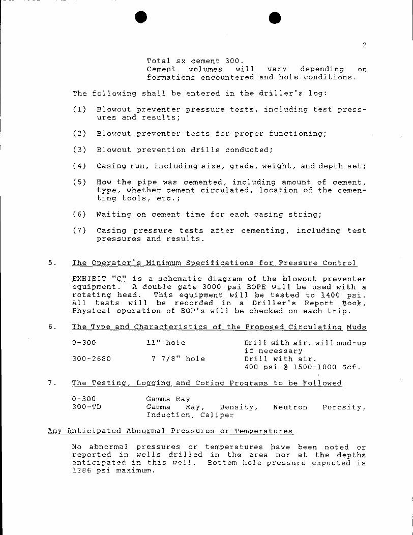
O O2
Total sz cement 300.Cement volumes will vary depending onformations encountered and hole conditions.
The following shall be entered in the driller's log:
(1) Blowout preventer pressure tests, including test press-ures and results;
(2) Blowout preventer tests for proper functioning;
(3) Blowout prevention drills conducted;
(4) Casing run, including size, grade, weight, and depth set;
(5) How the pipe was cemented, including amount of cement,type, whether cement circulated, location of the cemen-ting tools, etc.;
(6) Waiting on cement time for each casing string;
(7) Casing pressure tests after cementing, including testpressures and results.
5. The Operator's Minimum Specifications for Pressure Control
EXHIBIT "C" is a schematic diagram of the blowout preventerequipment. A double gate 3000 psi BOPE will be used with arotating head. This equipment will be tested to 1400 psi.All tests will be recorded in a Driller's Report Book.Physical operation of BOP's will be checked on each trip.
6. The Type and Characteristics of the Proposed Circulating Muds
0-300 11" hole Drill with air, willmud-upif necessary
300-2680 7 7/8" hole Drill with air.400 psi @ 1500-1800 Scf.
7. The Testing, Loqqing and Coring Programs to be Followed
0-300 Gamma Ray300-TD Gamma Ray, Density, Neutron Porosity,
Induction, Caliper
Any Anticipated Abnormal Pressures or Temperatures
No abnormal pressures or temperatures have been noted orreported in wells drilled in the area nor at the depthsanticipated in this well. Bottom hole pressure expected is1286 psi
O O3
No hydrogen sulfide or other hazardous gases or fluids havebeen found, reported or are known to exist at these depths inthe area.
8. Anticipated starting Date and Duration of the Operations.
The well will be drilled in June 1996.
Verbal and/or written notifications listed below shall besubmitted in accordance with instructions from theDivision of Oil, Gas & Mining:
(a) prior to beginning construction;
(b) prior to spudding;
(c) prior to running any casing or BOP tests;
(d) prior to plugging the well, for verbal plugginginstructions.
Spills, blowouts, fires, leaks, accidents or other unusualoccurrences shall be reported to the Division of Oil, Gas &Mining
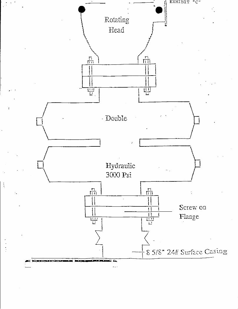
EXHIBIT "C"
e elRotatine
Head
a l iU¯fi
Double
l
Hydmulic3000 Psi
iii
Screw onFlange
8 5/8" 2¾ Surface
EXHIBIT "C"
e elRotatine
Head
a l iU¯fi
Double
l
Hydmulic3000 Psi
iii
Screw onFlange
8 5/8" 2¾ Surface
O O1
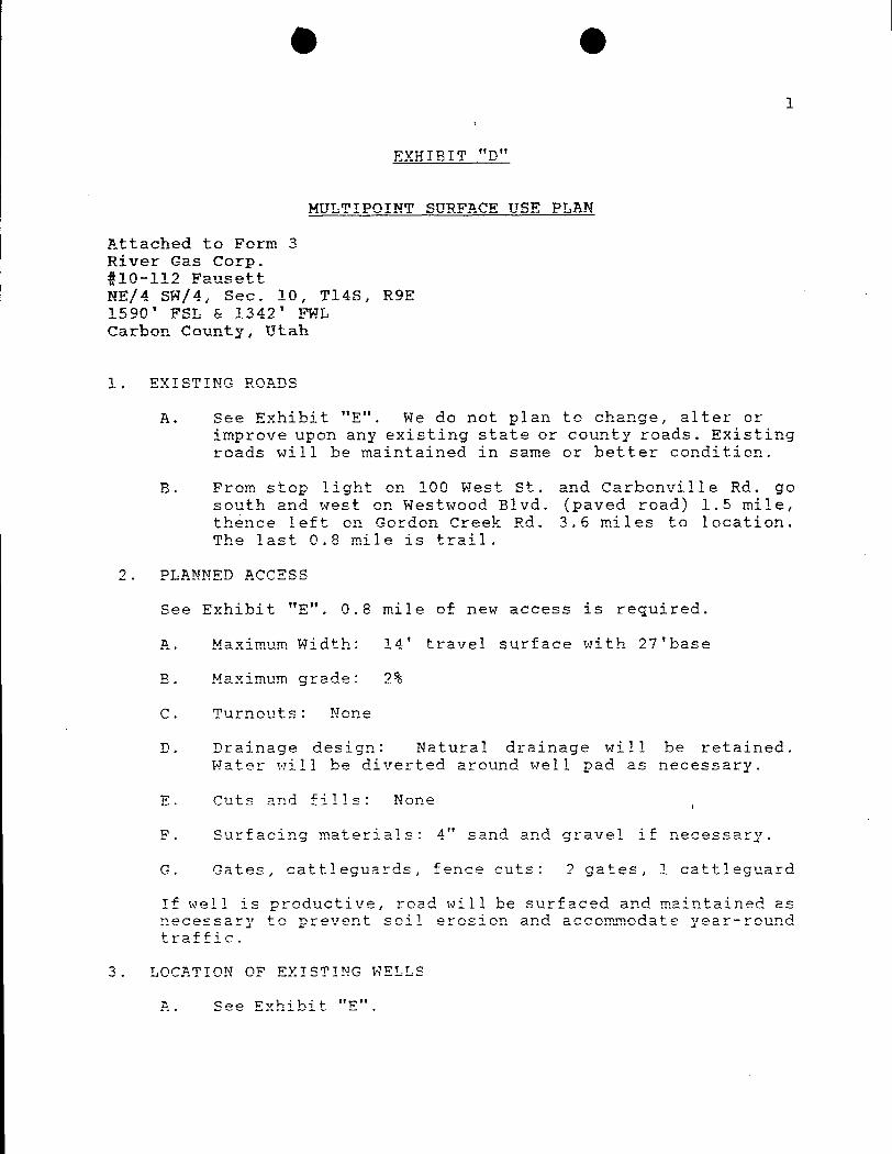
EXHIBIT "D"
MULTIPOINT SURFACE USE PLAN
Attached to Form 3River Gas Corp.#10-112 FausettNE/4 SW/4, Sec. 10, Tl4S, R9E1590' FSL & 1342' FWLCarbon County, Utah
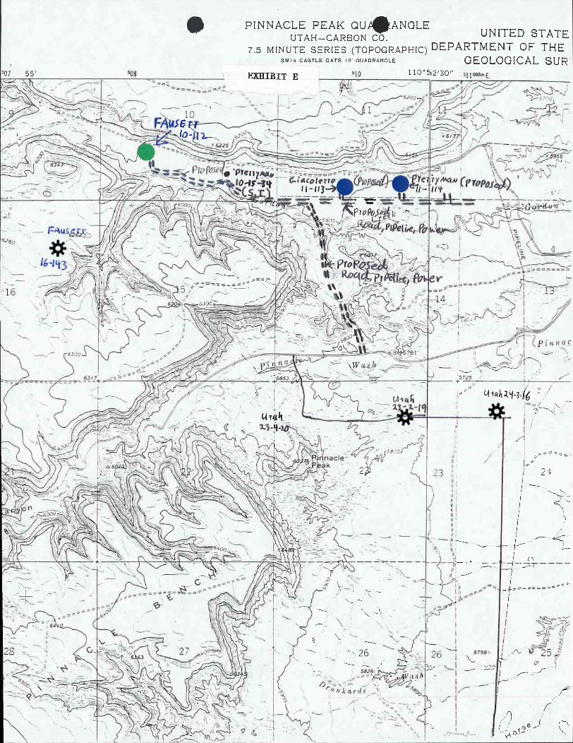
1. EXISTING ROADS
A. See Exhibit "E". We do not plan to change, alter orimprove upon any existing state or county roads. Existingroads will be maintained in same or better condition.
B. From stop light on 100 West St. and Carbonville Rd. gosouth and west on Westwood Elvd. (paved road) 1.5 mile,thence left on Gordon Creek Rd. 3.6 miles to location.The last 0.8 mile is trail.
2. PLANNED ACCESS
See Exhibit "E". 0.8 mile of new access is required.
A. Maximum Width: 14' travel surface with 27'base
B. Maximum grade: 2%
C. Turnouts: None
D. Drainage design: Natural drainage will be retained.Water will be diverted around well pad as necessary.
E. Cuts and fills: None
F. Surfacing materials: 4" sand and gravel if necessary.
G. Gates, cattleguards, fence cuts: 2 gates, 1 cattleguard
If well is productive, road will be surfaced and maintained asnecessary to prevent soil erosion and accommodate year-roundtraffic.
3. LOCATION OF EXISTING WELLS
A. See Exhibit
O O1
EXHIBIT "D"
MULTIPOINT SURFACE USE PLAN
Attached to Form 3River Gas Corp.#10-112 FausettNE/4 SW/4, Sec. 10, Tl4S, R9E1590' FSL & 1342' FWLCarbon County, Utah
1. EXISTING ROADS
A. See Exhibit "E". We do not plan to change, alter orimprove upon any existing state or county roads. Existingroads will be maintained in same or better condition.
B. From stop light on 100 West St. and Carbonville Rd. gosouth and west on Westwood Elvd. (paved road) 1.5 mile,thence left on Gordon Creek Rd. 3.6 miles to location.The last 0.8 mile is trail.
2. PLANNED ACCESS
See Exhibit "E". 0.8 mile of new access is required.
A. Maximum Width: 14' travel surface with 27'base
B. Maximum grade: 2%
C. Turnouts: None
D. Drainage design: Natural drainage will be retained.Water will be diverted around well pad as necessary.
E. Cuts and fills: None
F. Surfacing materials: 4" sand and gravel if necessary.
G. Gates, cattleguards, fence cuts: 2 gates, 1 cattleguard
If well is productive, road will be surfaced and maintained asnecessary to prevent soil erosion and accommodate year-round
traffic.
3. LOCATION OF EXISTING WELLS
A. See Exhibit
O O2
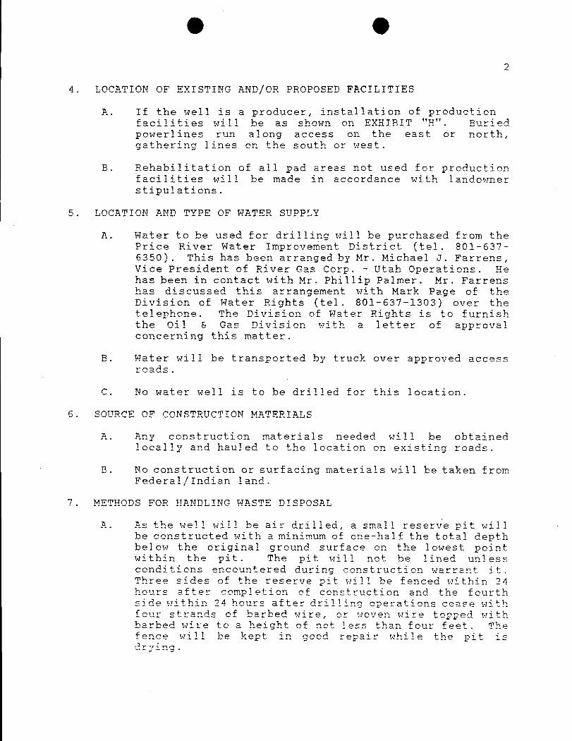
4. LOCATION OF EXISTING AND/OR PROPOSED FACILITIES
A. If the well is a producer, installation of productionfacilities will be as shown on EXHIBIT "H". Buriedpowerlines run along access on the east or north,gathering lines on the south or west.
B. Rehabilitation of all pad areas not used for productionfacilities will be made in accordance with landownerstipulations.
5. LOCATION AND TYPE OF WATER SUPPLY
A. Water to be used for drilling will be purchased from thePrice River Water Improvement District (tel. 801-637-6350). This has been arranged by Mr. Michael J. Farrens,Vice President of River Gas Corp. - Utah Operations. Hehas been in contact with Mr. Phillip Palmer. Mr. Farrenshas discussed this arrangement with Mark Page of theDivision of Water Rights (tel. 801-637-1303) over thetelephone. The Division of Water Rights is to furnishthe oil & Gas Division with a letter of approvalconcerning this matter.
B. Water will be transported by truck over approved accessroads.
C. No water well is to be drilled for this location.
6. SOURCE OF CONSTRUCTION MATERIALS
A. Any construction materials needed will be obtainedlocally and hauled to the location on existing roads.
B. No construction or surfacing materials will be taken fromFederal/Indian land.
7. METEODS FOR HANDLING WASTE DISPOSAL
A. As the well will be air drilled, a small reserve pit willbe constructed with a minimum of one-half the total depthbelow the original ground surface on the lowest pointwithin the pit. The pit will not be lined unlessconditions encountered during construction warrant it.Three sides of the reserve pit will be fenced within 24hours after comPletion of construction and the fourthside within 24 hours after drilling operations cease withfour strands of barbed wire, or woven wire topped withbarbed wire to a height of not less than four feet. Thefence will be kept in good repair while the pit is
O O2
4. LOCATION OF EXISTING AND/OR PROPOSED FACILITIES
A. If the well is a producer, installation of productionfacilities will be as shown on EXHIBIT "H". Buriedpowerlines run along access on the east or north,gathering lines on the south or west.
B. Rehabilitation of all pad areas not used for productionfacilities will be made in accordance with landownerstipulations.
5. LOCATION AND TYPE OF WATER SUPPLY
A. Water to be used for drilling will be purchased from thePrice River Water Improvement District (tel. 801-637-6350). This has been arranged by Mr. Michael J. Farrens,Vice President of River Gas Corp. - Utah Operations. Hehas been in contact with Mr. Phillip Palmer. Mr. Farrenshas discussed this arrangement with Mark Page of theDivision of Water Rights (tel. 801-637-1303) over thetelephone. The Division of Water Rights is to furnishthe oil & Gas Division with a letter of approvalconcerning this matter.
B. Water will be transported by truck over approved accessroads.
C. No water well is to be drilled for this location.
6. SOURCE OF CONSTRUCTION MATERIALS
A. Any construction materials needed will be obtainedlocally and hauled to the location on existing roads.
B. No construction or surfacing materials will be taken fromFederal/Indian land.
7. METEODS FOR HANDLING WASTE DISPOSAL
A. As the well will be air drilled, a small reserve pit willbe constructed with a minimum of one-half the total depthbelow the original ground surface on the lowest pointwithin the pit. The pit will not be lined unlessconditions encountered during construction warrant it.Three sides of the reserve pit will be fenced within 24hours after comPletion of construction and the fourthside within 24 hours after drilling operations cease withfour strands of barbed wire, or woven wire topped withbarbed wire to a height of not less than four feet. Thefence will be kept in good repair while the pit is
O O3
B. Following drilling, the liquid waste will be evaporatedfrom the pit and the pit backfilled and returned tonatural grade.
No liquid hydrocarbons will be discharged to the reserve pitor location.
C. In the event fluids are produced, any oil will beretained in tankage until sold and any water producedwill be retained until its quality can be determined.The quality and quantity of the water will determine themethod of disposal.
D. Trash will be contained in a portable metal container andwill be hauled from location periodically anddisposed of at an approved disposal site. Chemicaltoilets will be placed on location and sewage willbe disposed of at an appropriate disposal site.
8. ANCILLARY FACILITIES
A. We anticipate no need for ancillary facilities with theexception of three trailers to be located on the drillsite.
9. WELLSITE LAYOUT
A. Available topsoil will be removed from the location andstockpiled. If ground frost prevents the segregation andremoval of the topsoil material from the less desirablesubsoil material, cross-ripping to the depth of thetopsoil material may be necessary. Location of mudtanks, reserve and burn pits, and soil stockpiles will belocated as shown on the attachments.
B. A blooie pit will be located 150' diagonally from thedrill hole. A line will be placed on the surface fromthe center hole to the burn pit. Burn pit will not belined, but will be fenced on four sides to protectlivestock/wildlife.
C. Access to the well pad will be as shown on Exhibit "G".
D. Natural runoff will be diverted around the well pad.
10. PLANS FOR RESTORATION OF SURFACE
A. All surface areas not required for producing operationswill be graded to as near original condition aspossible and contoured to maintain possible erosionto a
O O
3
B. Following drilling, the liquid waste will be evaporatedfrom the pit and the pit backfilled and returned tonatural grade.
No liquid hydrocarbons will be discharged to the reserve pitor location.
C. In the event fluids are produced, any oil will beretained in tankage until sold and any water producedwill be retained until its quality can be determined.The quality and quantity of the water will determine themethod of disposal.
D. Trash will be contained in a portable metal container andwill be hauled from location periodically anddisposed of at an approved disposal site. Chemicaltoilets will be placed on location and sewage willbe disposed of at an appropriate disposal site.
8. ANCILLARY FACILITIES
A. We anticipate no need for ancillary facilities with theexception of three trailers to be located on the drillsite.
9. WELLSITE LAYOUT
A. Available topsoil will be removed from the location andstockpiled. If ground frost prevents the segregation andremoval of the topsoil material from the less desirablesubsoil material, cross-ripping to the depth of thetopsoil material may be necessary. Location of mudtanks, reserve and burn pits, and soil stockpiles will belocated as shown on the attachments.
B. A blooie pit will be located 150' diagonally from thedrill hole. A line will be placed on the surface fromthe center hole to the burn pit. Burn pit will not belined, but will be fenced on four sides to protectlivestock/wildlife.
C. Access to the well pad will be as shown on Exhibit "G".
D. Natural runoff will be diverted around the well pad.
10. PLANS FOR RESTORATION OF SURFACE
A. All surface areas not required for producing operationswill be graded to as near original condition aspossible and contoured to maintain possible erosionto a
O O4
B. Available topsoil will be stockpiled and will be evenlydistributed over the disturbed areas and the area will bereseeded as prescribed by the landowner.
C. Pits and any other area that would present a hazard towildlife or livestock will be fenced off when the rig isreleased and removed.
D. Any oil accumulation on the pit will be removed oroverhead flagged as dictated by then existing conditions.
E. Date of commencement will be June, 1996. Rehabilitationwill commence following completion of the well. Rat andmouse holes will be filled immediately upon release ofthe drilling rig from the location. If the wellsite isto be abandoned, all disturbed areas will be recontouredto the natural contour as is possible.
11. SURFACE OWNERSHIP
A. The wellsite and access road will be constructed on landsowned by Orlin Fausett, 1189 West 290 North, Price, UT84501. The operator shall contact the landowner and theDivision of Gil, Gas & Mining 48 hours prior to beginningconstruction activities.
12. OTHER INFORMATION
The primary surface use is grazing. The nearest dwelling is±1.1 mile east of the location. Nearest live water is800' south (Gordon Creek).
If there is snow on the ground when construction begins,it will be removed before the soil is disturbed, andpiled downhill from the topsoil stockpile location.
The backslope will be constructed no steeper than 4:1,the foreslope no steeper than 4:1.
All equipment and vehic3es will be confined to the accessroad and well pad.
A complete copy of the approved Application for Permit toDrill (APD) including conditions and stipulations, shall be onthe wellsite during construction and drilling operations.
There will be no deviation from the proposed drilling and/orworkover program without prior approval from the Division ofOil, Gas &
O O
5
13. COMPANY REPRESENTATIVE
THROUGH A.P.D. APPROVAL MAIL APPROVED A.P.D. TO
Janet Watson Terry EurnsAgent/Consultant for River Gas Corp.River Gas Corp. 511 Energy Cntr. Blvd.P. O. Box 440889 Northport, AL 35476Aurora, Co. 80044 (205) 759-3282(303) 321-2217
FIELD REPRESENTATIVE DIRT CONTRACTOR
Steve Prince NELCO(8013 637-8876 LarrY Jensen
M-(801) 636-5256 (801) 637-3495M-(801) 636-5268
14. CERTIFICATION
I hereby certify that I, or persons under my directsupervision have inspected the proposed drillsite and accessroute; that I am familiar with the conditions which presentlyexist; that the statements made in this plan are, to the bestof my knowledge, true and correct, and that the workassociated with the operations proposed herein will beperformed by River Gas Corp. and its subcontractors inconformity with this plan and the terms and conditions underwhich it is approved.
Date' 'Jan WatsonAge½t for River Gas
PINNACLE PEAK QU ANOLEUTAH-CARBON CO. UNITED STATE
7.5 MlNUTE SERIES (TOPOGRAPHIC) DEPARTMENT OF THESW/4 CASTLE CATE 15' QUADRANOLE GEOLOGICAL SUR
Po
Vitahdij l 7 __ 5853 .
5725
PINNACLE PEAK QU ANOLEUTAH-CARBON CO. UNITED STATE
7.5 MlNUTE SERIES (TOPOGRAPHIC) DEPARTMENT OF THESW/4 CASTLE CATE 15' QUADRANOLE GEOLOGICAL SUR
Po
Vitahdij l 7 __ 5853 .
5725
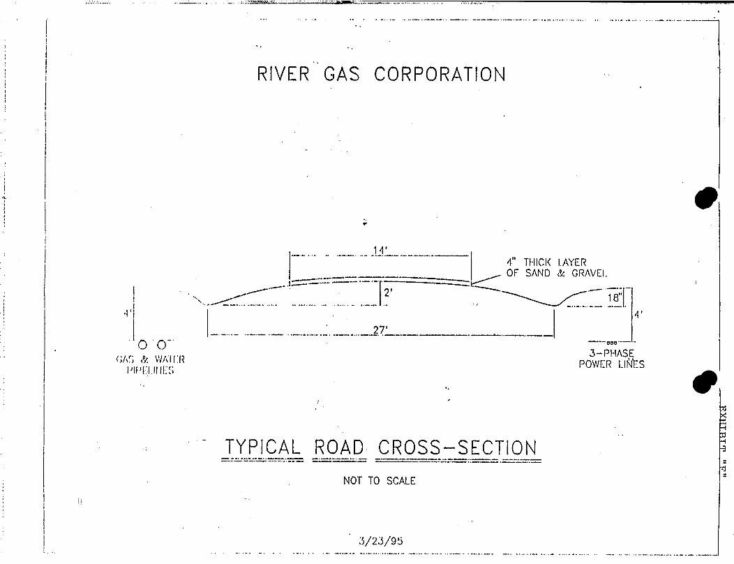
RIVER GAS CORPORATION
14'..--
4" THICK 1AYEROF SAND & GRAVEL
27OO
EAS & WAlER POWER LlÑ'ESlall'l I.IllES
J
TYPlCAL ROAD CROSS-SECTION
NOTTO SCALE
RIVER GAS CORPORATION
14'..--
4" THICK 1AYEROF SAND & GRAVEL
27OO
EAS & WAlER POWER LlÑ'ESlall'l I.IllES
J
TYPlCAL ROAD CROSS-SECTION
NOTTO SCALE
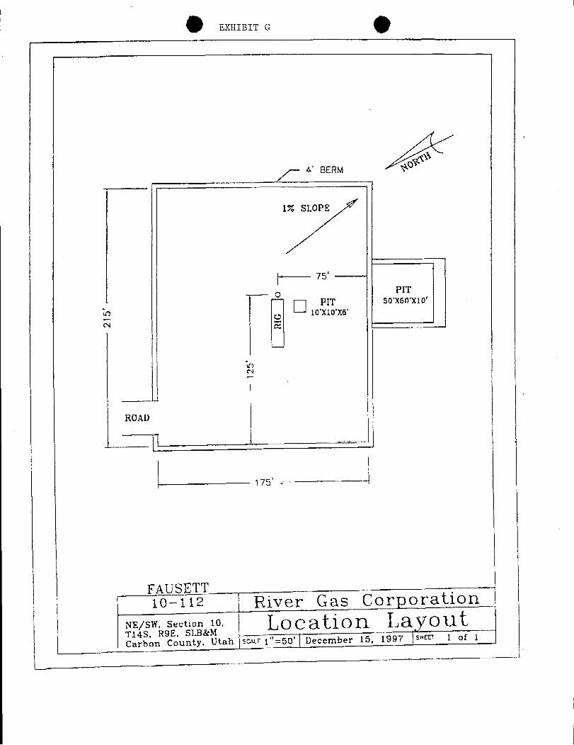
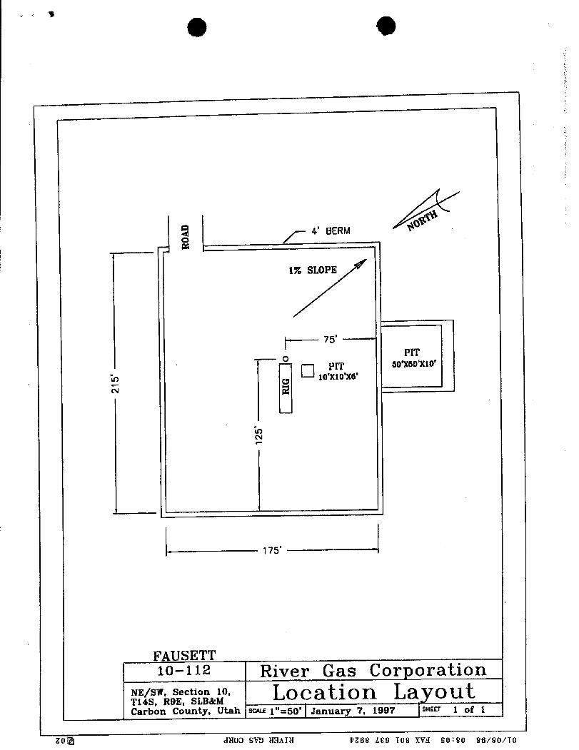
EXHIBIT G
BERM *
iv. stors
75'PIT
" °xwxio
...
10'X10°X6'
ROAD
175'
FAUSETT10-112 River Gas Corporation
/sw sectan i Location LayoutCarbon County, Utah SWE 1"=50' December 15, 1997 SHEET 1 of
EXHIBIT G
BERM *
iv. stors
75'PIT
" °xwxio
...
10'X10°X6'
ROAD
175'
FAUSETT10-112 River Gas Corporation
/sw sectan i Location LayoutCarbon County, Utah SWE 1"=50' December 15, 1997 SHEET 1 of
OANCHOR(TYP. 4 PL.)
125' : - ---> 90'75'
...WELL
,,PUMPING ,
HEAD UNIT - 's,
...MOTOR
44
100'
LtJ
Lt] (f)
O
RTU"STARTER
3-PHASE SEPARATORELEC' TRANSFORMER XH
HHl
RIVER GAS CORP. =
WELL SITE LAYOUTE215' X 175'
OANCHOR(TYP. 4 PL.)
125' : - ---> 90'75'
...WELL
,,PUMPING ,
HEAD UNIT - 's,
...MOTOR
44
100'
LtJ
Lt] (f)
O
RTU"STARTER
3-PHASESEPARATORELEC' TRANSFORMER X
H
HHl
RIVER GAS CORP. =
WELL SITE LAYOUTE215' X 175'
. AmSouth Bank EXHIBIT "I" Birmingham:4 TELEX: 6827189Cable:AMSOUBKBHM' ' SW.IFT.AMSBUS44
AMSOUTM,.gK OF ALABAMA International Services1900 FIFTH AVENUE NORTH Mobile:
.BIRMINGHAM, ALABAMA 35203 USA, TEUÐ(:6821116
OUR REFERENCE NUMBER: S308586 Cable:AMSOMBLS.W.III.AMSBUS44
AMENDMENT NUMBER: 002TO LETTER OF CREDIT NUMBER: S308586DATE: NOVEMBER 13, 1995
BENEFICIARY:STATE OF UTAH \
DEPT. OF NATURAL RESOURCESDIV. OF OIL, GAS AND MINING355
WEST°WMPLE3 TRIAD CENTER - ' - - = - - · +-
. ,.
SUITE 350SALT LAKE CITY, UTAH 84180-1203
AT THE REQUEST OF RIVER GAS CORPORATION 3600 WATERMELON ROADSUITE 204 NORTHPORT, ALABAMA 35476 AND FOR THE ACCOUNT OF SAME
WE HEREBY AMEND QUR LETTER OF CREDIT NUMBER 5308586 DATEDDECEMBER 3, 1993 OPENED IN YOUR FAVOR AS FOLLOWS:
-ACCOUNT PARTY'S ADDRESS IS CHANGEDTOs 511 ENERGY CENTER BLVD
NORTHPORT, ALABAMA 35476
**REFERENCES HEREIN TO AMSOUTH BANK N.A. SHALL BE DEEMED TO REFERTO AMSOUTH BANK OF ALABAMA.**
ALL DTHËR TERMS AND CONDITIONS REMAIN UNCHANGED.THIS AMENDMENT BECOMES AN INTEGRAL PART OF THE ORIGINAL LETTER OFCREDIT AND IS TO BE ATTACHED THERETO.
THORIZED
AmSouth Bank EXHIBIT "I" Birmingham:PMS OTM BANK OF ALABAMA I TELEX:68271891900-FIFTH AVENUE NORTH Cable:AMSOUBKBHMBIRMINGHAM, ALABAMA 35203 USA S.W.l.!].AMSBUS44OUR RËÌË ÈNCE NUMBER: 5304606 International Services
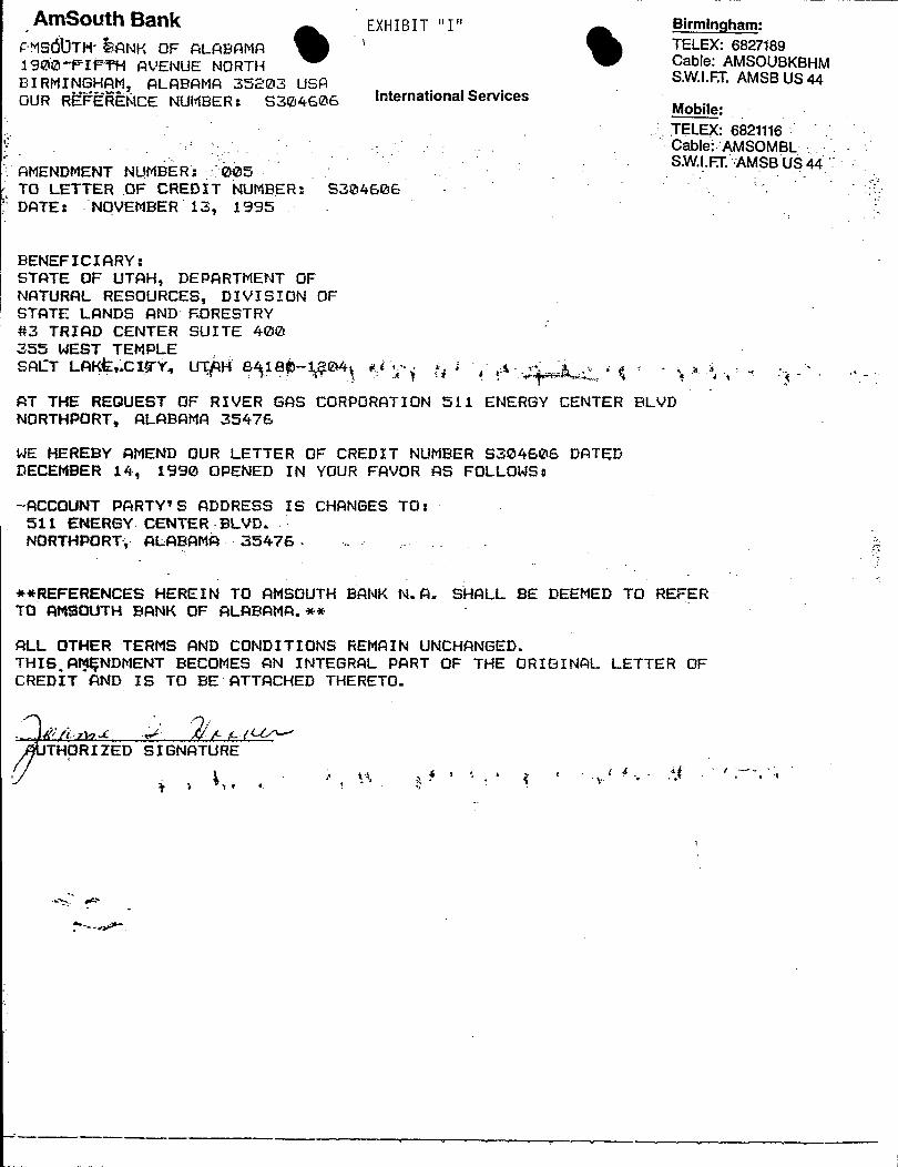
Mobile:TELEX: 6821116Cable AMSOMBLS.W.I.FT. AMSB US 44AMENDMENT NUMBER 005
TO LETTER OF CREDIT NUMBER: 5304606 :
DATE: NOVEMBER 13, 1995
BENEFICIARY:STATE OF UTAH, DEPARTMENT OFNATURAL RESOURCES, DIVISION OFSTATE LANDS AND F.DRESTRY#3 TRIAD CENTER SUITE 400355 WEST TEMPLESACT LAKt,.CIffÝ«UTfH 8418þ-gO4 gi -
AT THE REQUEST OF RIVER GAS CORPORATION 511 ENERGY CENTER BLVDNORTHPORT, ALABAMA 35476
WE HEREBY AMEND DUR LETTER OF CREDIT NUMBER 5304606 DATEDDECEMBER 14, 1990 OPENED IN YOUR FAVOR AS FOLLOWS:
-ACCOUNT PARTY'S ADDRESS IS CHANGES TO:511 ENERGY-CENTER BLVD.NORTHPORT4 ALABAMA- 35476-
**REFERENCES HEREIN TO AMSOUTH BANK N.A. SHALL BE DEEMED TO REFERTO AMSOUTH BANK OF ALABAMA.**
ALL OTHER TERMS AND CONDITIONS REMAIN UNCHANGED.THIS.AMÇNDMENT BECOMES AN INTEGRAL PART OF THE ORIGINAL LETTER OFCREDIT AND IS TO BE ATTACHED THERETO.
THORIZED SIGNATURE
AmSouth Bank EXHIBIT "I" Birmingham:PMS OTM BANK OF ALABAMA I TELEX:68271891900-FIFTH AVENUE NORTH Cable:AMSOUBKBHMBIRMINGHAM, ALABAMA 35203 USA S.W.l.!].AMSBUS44OUR RËÌË ÈNCE NUMBER: 5304606 International Services
Mobile:TELEX: 6821116Cable AMSOMBLS.W.I.FT. AMSB US 44AMENDMENT NUMBER 005
TO LETTER OF CREDIT NUMBER: 5304606 :
DATE: NOVEMBER 13, 1995
BENEFICIARY:STATE OF UTAH, DEPARTMENT OFNATURAL RESOURCES, DIVISION OFSTATE LANDS AND F.DRESTRY#3 TRIAD CENTER SUITE 400355 WEST TEMPLESACT LAKt,.CIffÝ«UTfH 8418þ-gO4 gi -
AT THE REQUEST OF RIVER GAS CORPORATION 511 ENERGY CENTER BLVDNORTHPORT, ALABAMA 35476
WE HEREBY AMEND DUR LETTER OF CREDIT NUMBER 5304606 DATEDDECEMBER 14, 1990 OPENED IN YOUR FAVOR AS FOLLOWS:
-ACCOUNT PARTY'S ADDRESS IS CHANGES TO:511 ENERGY-CENTER BLVD.NORTHPORT4 ALABAMA- 35476-
**REFERENCES HEREIN TO AMSOUTH BANK N.A. SHALL BE DEEMED TO REFERTO AMSOUTH BANK OF ALABAMA.**
ALL OTHER TERMS AND CONDITIONS REMAIN UNCHANGED.THIS.AMÇNDMENT BECOMES AN INTEGRAL PART OF THE ORIGINAL LETTER OFCREDIT AND IS TO BE ATTACHED THERETO.
THORIZED SIGNATURE
STATE OF ALABAMA ) Fausett:ss. 10-112
COUNTY OF TUSCALOOSA )
AFFIDAVIT CONCERNING SURFACE OWNERCONSENT REGARDING WELL SITE CONSTRUCTION
JOSEPH L. STEPHENSON,being first duly sworn upon his oath,deposes and states:
1. I am Vice President - Land of River Gas Corporation("RGC"), an Alabama corporation duly authorized to transactbusiness in the State of Utah, and am authorized to execute thisAffidavit on behalf of said corporation.
2. As Vice President - Land, I am responsible forsupervision of lease records and reviewing title records and legalopinions affecting lands where RGC proposes to conduct operations,and obtaining surface land use agreements associated with thedevelopment of leased mineral rights.
3. RGC proposes to drill a coalbed methane gas well namedthe Fausett 10-112 located in the NE1/4 of SW1/4 of Section 10,T14S, R9E, Carbon Countv. Utah, the surface area affected by theproposed well site being owned by Orlin Ross Fausett, Individuallyand' as Trustee under that certain James W. Fausett Family InterVivoe Revocable Trust Agreement dated APril 13, 1978 (hereaftercalled "fee owner").
4. As evidenced by copy of MEMORANDUMOF SURFACE LAND USEAGREEMENT dated March 15, 1996 attached hereto as Exhibit "A", andby this reference incorporated herein, the above described feeowner of the Fausett 10-112 well site agreed to certain surface useas described therein.
5. The matters stated herein are true of my own knowledge,except to any matters stated herein upon information and belief,and, as to those matters, I believe them to be true.
DATED this 22nd day of May, 1996.
O PH L. S EPHENSON
Subscribed, sworn and acknowle ged to and by Joseph L.Stephenson before me this 22nd day of May, 1996.
NOTARY PUBLIC(SEAL) Residing at:
1429 20th kvenue EastMy Commission Expires: 3/8/98 Tuscaloosa, AL
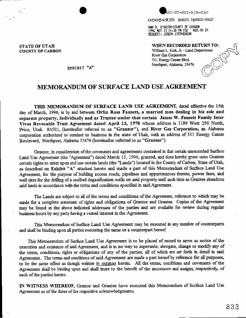
oooS4935 Bk00371Pg00833-00837
ANNB. O'BRIE]H'0UNTYOFCARBON19% MRY13 14:38 PMFEE $20.00 BYREQUEST:JOSEPHSTEPHENSON
STATE OF UTAH WHEN RECORDED RETURN TO:COUNTY OF CARBON WilliamL. Kirk, Jr. - Land Department
River GasCorporation511 EnergyCenterBlvd.
EXHIBIT "A,, Northpon, Alabarna 35476
MEMORANDUM OF SURFACE LAND USE AGREEMENT
THIS MEMORANDUM OF SURFACE LAND USE AGREEMENT, dated effective the 15thday of March, 1996, is by and between Orlin Ross Fausett, a married man dealing in his sole andseparate property, Individually and as Trustee under that certain James W. Fausett Family InterVivos Revocable Trust Agreement dated April 13, 1978 whose address is 1189 West 290 North,Price, Utah 84501, (hereinafterreferred to as "Grantor"), and River Gas Corporation, an Alabamacorporation authorized to conduct to business in the state of Utah, with an address of 511 Energy CenterBoulevard, Northport, Alabama 35476 (hereinafter referred to as "Grantee").
Grantor, in consideration of the covenants and agreements contained in that certain unrecorded SurfaceLand Use Agreement (the "Agreement") dated March 15, 1996, granted, and doeshereby grant unto Granteecertain rights to enter upon and use certain lands (the "Lands") located in the Countyof Carbon, State of Utah,as described on Exhibit "A" attached hereto and made a part of this Memorandumof Surface Land UseAgreement, for the purpose of buildingaccess roads, pipelines and appurtenances thereto, power lines, andwell sites for the drillingof a coalbed degasificationwells on said property until suchtime as Grantee abandonssaid lands in accordance with the terms and conditions specified in said Agreement.
The Lands are subject to all of the terms and conditions of the Agreement, reference to which may bemade for a complete statementof rights and obligations of Grantor and Grantee. Copiesof the Agreementmay be found at the above indicatedaddresses of the parties and are available for review during regularbusinesshours by any partyhaving a vested interest in the Agreement.
This Memorandum of SurfaceLand Use Agreement may be executed in any number of counterpartsand shall be bindingupon allparties executing the same or a counterpart hereof
This Memorandum of Surfaceland Use Agreement is to be placed of record to serve as notice of theexecution and existence of said Agreement, and is in no way to supersede, abrogate, change or modify any ofthe terms, conditions, rights or obligations of any of the patties, all of which are set forth in detail in saidAgreement. The terms and conditions of said Agreement are made a part hereofby reference for all purposes,to be the same effect as though written in extenso herein. All the terms, conditions and covenants of theAgreement shall be binding upon and shall inure to the benefrt of the successors and accigne, respectively, ofeach ofthe parties hereto.
IN WITNESS WHEREOF, Grantor and Grantee have executed this Memorandum of Surface Lmd UseAgreement as ofthe dates ofthe respective acknowledgments.
8 3
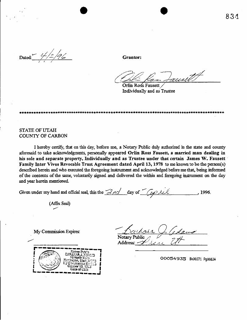
O O 8 3 4
Dated Grantor:
Orlia RoËFausettIndividually and as Tmstee
***************************************************************************************
STATE OF UTAHCOUNTY OF CARBON
I hereby certify, that on this day, before me, a Notary Public duly authorized in the state and countyaforesaid to take acknowledgments, personally appeared Orlin Ross Fausett, a married man dealing inhis sole and separate property, Individually and as Trustee under that certain James W. FausettFamily Inter Vivos Revocable Trust Agreement dated April 13, 1978 to me knownto be the person(s)describedherein and who executed the foregoing instrument and acknowledged beforeme that, being informedof the contents of the same, vohmtarily signed and delivered the within and foregoinginstoment on the dayand year herein mentioned.
Givenunder my hand and officialseal, this the Šno day of , 1996.
(AfBxSeal)
My Commi on Expires: O/ L fy sy
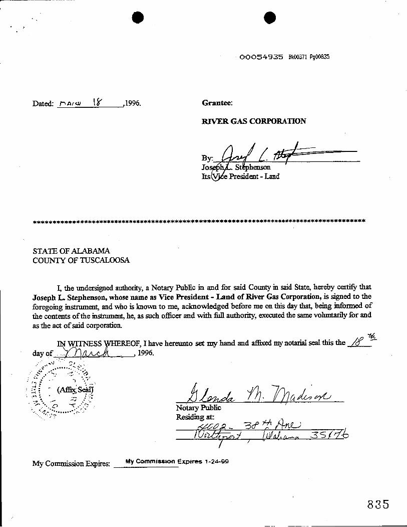
e eOOOS4935 Bk00371Pg00835
Dated· i, Ar<» ,1996. Grantee:
RIVER GAS CORPORATION
ByJo StIts President - Land
**************************************************************************************
STATE OF ALABAMACOUNTY OF TUSCALOOSA
I, the undersigned authority, a Notary Public in and for said Countyin said State,hereby certify thatJoseph L Stephenson, whose name as Vice President - Land of River Gas Corporation, is signed to theforegoing instrument,and who is known to me, acknowledged before me on this daythat, being informed ofthe contents ofthe instrument,he, as such officer and with full authority, executed the same vohmtarily for andas the act of said corporation.
day of .
OF, I9have hereunto set my hand and affixed my notarial seal this the
Notary PublicResiding at·
My Commincion Expires: My commisssonExpires 1-24-99
8 3
836
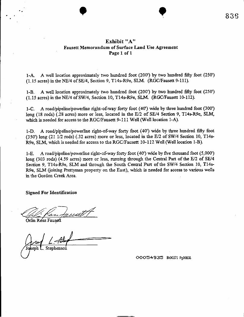
Exhibit "A"Fausett Memorandum of Surface Land Use Agreement
Page 1 of 1
1-A. A well location approximately two hundred foot (200') by two hundred fifty foot (250')(1.15 acres) in the NE/4 of SE/4, Section 9, T14s-R9e, SLM. (RGC/Fausett 9-111).
1-B. A well location approximately two hundred foot (200') by two hundred fifty foot (250')(1.15 acres) in the NE/4 of SW/4, Section 10, T14s-R9e, SLM. (RGC/Fausett 10-112).
I-C. A road/pipeline/powerline right-of-way forty foot (40') wide by three hundred foot (300')long (18 rods) (.28acres) more or less, located in the E/2 of SE/4 Section 9, T14s-R9e, SLM,which is needed for access to the RGC/Fausett 9-111 Well (Well location 1-A).
1-D. A road/pipeline/powerline right-of-way forty foot (40') wide by three hundred fifty foot(350') long (21 1/2 rods) (.32acres) more or less, located in the E/2 of SW/4 Section 10, T14s-R9e, SLM, which is needed for access to the RGC/Fausett 10-112 Well (Well location 1-B).
1-E. A road/pipeline/powerline right-of-way forty foot (40') wide by five thousand foot (5,000')long (303 rods) (4.59 acres) more or less, running through the Central Part of the E/2 of SE/4Section 9, T14s-R9e, SLM and through the South Central Part of the SWl4 Section 10, T14s-R9e, SLM (joiningPrettyman property on the East), which is needed for access to various wellsin the Gordon Creek Area.
Signed For Identification
Orlin R$ss Fausett
J h . Stephenson
OOOS4935 Ek00371
836
Exhibit "A"Fausett Memorandum of Surface Land Use Agreement
Page 1 of 1
1-A. A well location approximately two hundred foot (200') by two hundred fifty foot (250')(1.15 acres) in the NE/4 of SE/4, Section 9, T14s-R9e, SLM. (RGC/Fausett 9-111).
1-B. A well location approximately two hundred foot (200') by two hundred fifty foot (250')(1.15 acres) in the NE/4 of SW/4, Section 10, T14s-R9e, SLM. (RGC/Fausett 10-112).
I-C. A road/pipeline/powerline right-of-way forty foot (40') wide by three hundred foot (300')long (18 rods) (.28acres) more or less, located in the E/2 of SE/4 Section 9, T14s-R9e, SLM,which is needed for access to the RGC/Fausett 9-111 Well (Well location 1-A).
1-D. A road/pipeline/powerline right-of-way forty foot (40') wide by three hundred fifty foot(350') long (21 1/2 rods) (.32acres) more or less, located in the E/2 of SW/4 Section 10, T14s-R9e, SLM, which is needed for access to the RGC/Fausett 10-112 Well (Well location 1-B).
1-E. A road/pipeline/powerline right-of-way forty foot (40') wide by five thousand foot (5,000')long (303 rods) (4.59 acres) more or less, running through the Central Part of the E/2 of SE/4Section 9, T14s-R9e, SLM and through the South Central Part of the SWl4 Section 10, T14s-R9e, SLM (joiningPrettyman property on the East), which is needed for access to various wellsin the Gordon Creek Area.
Signed For Identification
Orlin R$ss Fausett
J h . Stephenson
OOOS4935 Ek00371
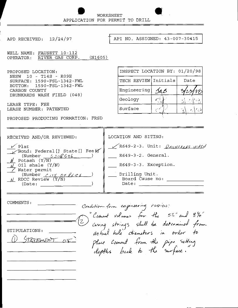
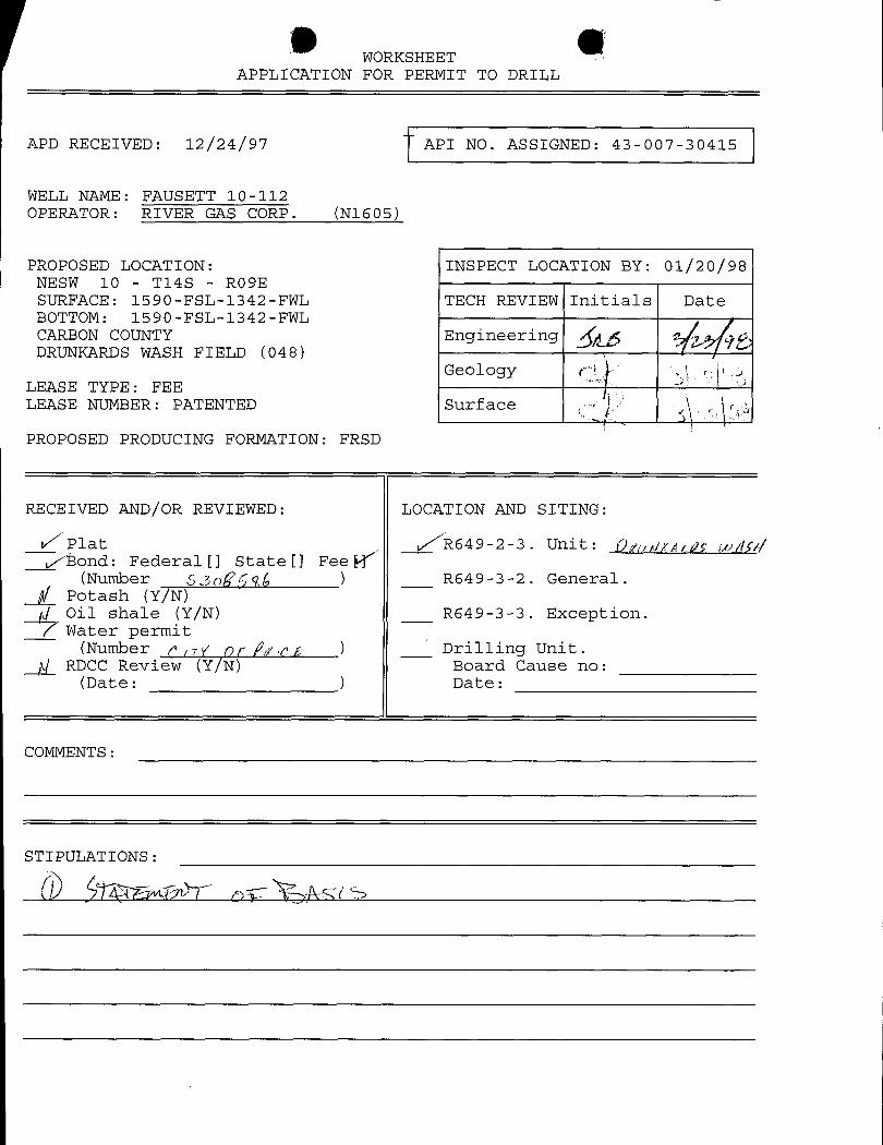
WORKSHEETAPPLICATION FOR PERMIT TO DRILL
APD RECEIVED: 12/24/97 API NO. ASSIGNED: 43-007-30415
WELL NAME: FAUSETT 10-112OPERATOR: RIVER GAS CORP. (N1605)
PROPOSED LOCATION: INSPECT LOCATION BY: 01/20/98NESW 10 - T14S - RO9ESURFACE: 1590-FSL-1342-FWL TECH REVIEW Initials DateBOTTOM: 1590-FSL-1342-FWLCARBON COUNTY EngineeringDRUNKARDS WASH FIELD (048)
GeologyLEASE TYPE: FEELEASE NUMBER: PATENTED Surface
PROPOSED PRODUCING FORMATION: FRSD
RECEIVED AND/OR REVIEWED: LOCATION AND SITING:
Plat R649-2-3. Unit: ÛArdfuff IP//f?
Bond: Federal [] State [] Fee(Number S3ogge,£ ) R649-3-2. General.
Potash (Y/N)Oil shale (Y/N) R649-3-3. Exception.Water permit
(Number nV op f¿ eg ) Drilling Unit .
ALRDCC Review (Y/N) Board Cause no:(Date: ) Date:
COMMENTS:
WORKSHEETAPPLICATION FOR PERMIT TO DRILL
APD RECEIVED: 12/24/97 API NO. ASSIGNED: 43-007-30415
WELL MAME: FAUSETT 10-112OPERATOR: RIVER GAS CORP. (N1605)
PROPOSED LOCATION: INSPECT LOCATION BY: 01/20/98NESW 10 - T14S - RO9ESURFACE: 1590-FSL-1342-FWL TECH REVIEW Initials DateBOTTOM: 1590-FSL-1342-FWLCARBON COUNTY EngineeringDRUNKARDS WASH FIELD (048)
GeologyLEASE TYPE: FEELEASE NUMBER: PATENTED Surface
PROPOSED PRODUCING FORMATION: FRSD
RECEIVED AND/OR REVIEWED: LOCATION AND SITING:
Plat /R649-2-3. Unit: Q,,,,ggepç ¡py/ /¯¯
Bond: Federal[] State[] FeeW'(Number 530ggg(, ) R649-3-2. General.
Potash (Y/N)Oil shale (Y/N) R649-3-3. Exception.Water permit
(Number p og op /¿eg ) Drilling Unit.RDCC Review (Y/N) Board Cause no:
(Date: ) Date:
COMMENTS:
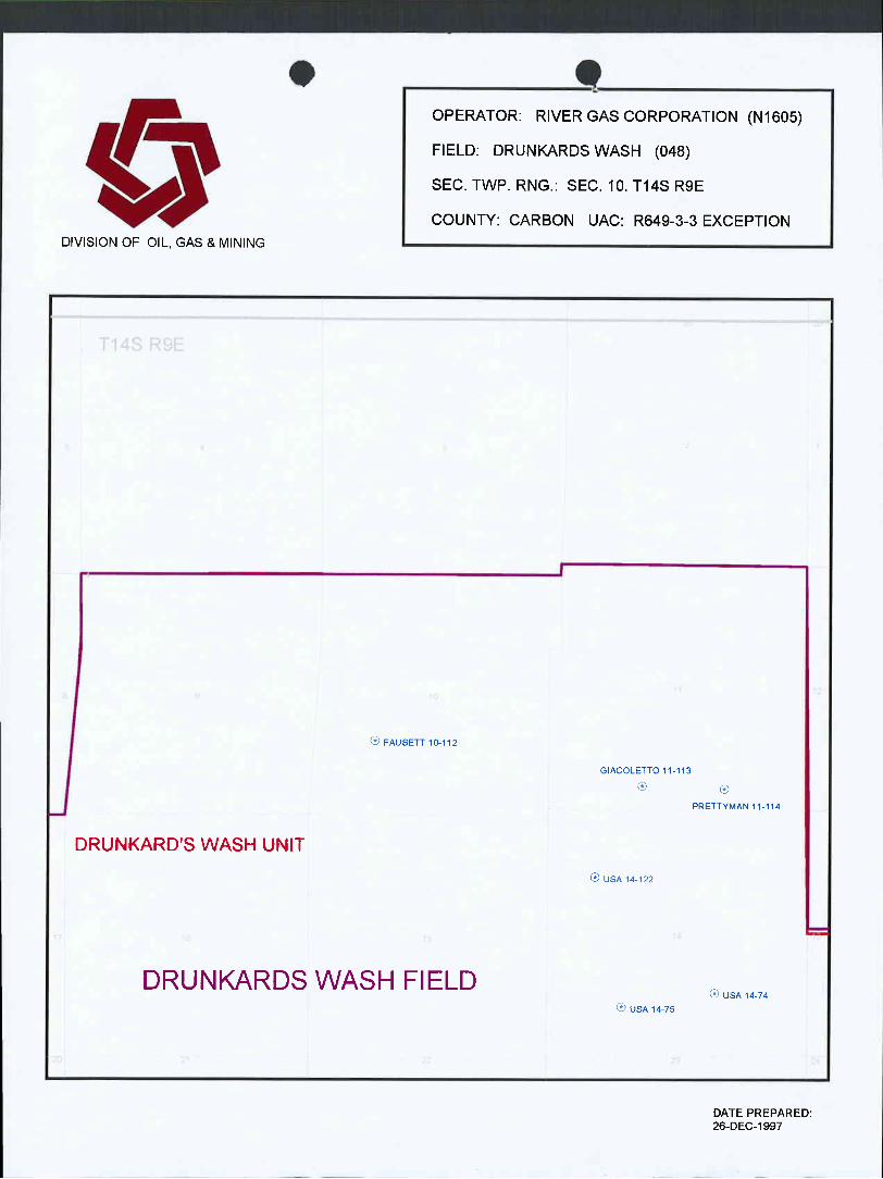
• 9OPERATOR: RIVER GAS CORPORATION (N1605)
FIELD: DRUNKARDSWASH (048)SEC. TWP. RNG.: SEC. 10. T14S R9E
COUNTY: CARBON UAC: R649-3-3 EXCEPTIONDIVISION OF OIL, GAS & MINING
I
FAUSETT10-112
GIACOLETTO 11-113
PRETTYMAN 11-114
DRUNKARD'SWASH UNITUSA 14-122
DRUNKARDSWASH FIELDUSA 14-74
USA 14-75 |
DATE PREPARED:
• 9OPERATOR: RIVER GAS CORPORATION (N1605)
FIELD: DRUNKARDSWASH (048)SEC. TWP. RNG.: SEC. 10. T14S R9E
COUNTY: CARBON UAC: R649-3-3 EXCEPTIONDIVISION OF OIL, GAS & MINING
I
FAUSETT10-112
GIACOLETTO 11-113
PRETTYMAN 11-114
DRUNKARD'SWASH UNIT
USA 14-122
DRUNKARDSWASH FIELDUSA 14-74
USA 14-75 |
DATE PREPARED:
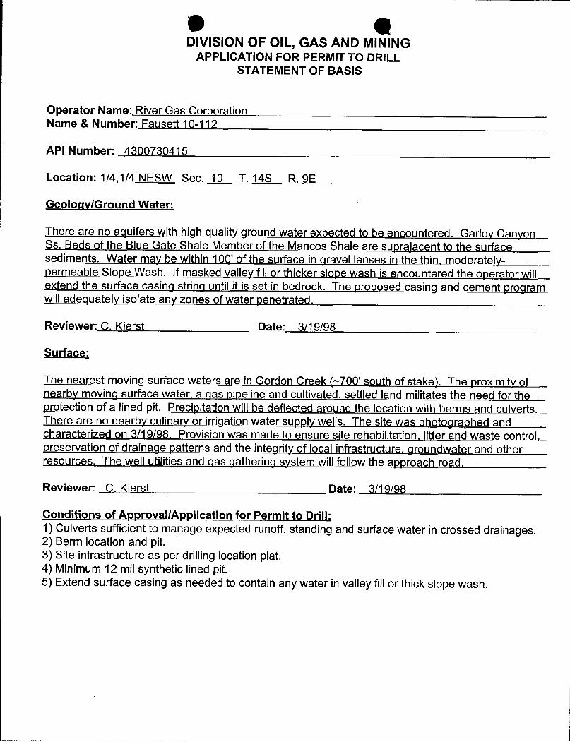
DIVISION OF OIL, GAS AND MININGAPPLICATION FOR PERMIT TO DRILL
STATEMENT OF BASIS
Operator Name: River Gas CorporationName & Number: Fausett 10-112
API Number: 4300730415
Location: 1/4,1/4 NESW Sec. 10 T. 14S R. 9E
Geoloqy/Ground Water:
There are no aquifers with high quality ground water expected to be encountered. Garley CanyonSs. Beds of the Blue Gate Shale Member of the Mancos Shale are suprajacent to the surfacesediments. Water may be within 100' of the surface in gravel lenses in the thin,moderately-permeable Slope Wash. If masked valley fillor thickerslope wash is encountered the operator willextend the surface casing string until it is set in bedrock. The proposed casing and cement programwilladequately isolate any zones of water penetrated.
Reviewer: C. Kierst Date: 3/19/98
Surface:
The nearest moving surface waters are in Gordon Creek (~700'south of stake). The proximity ofnearby moving surface water, a gas pipeline and cultivated, settled land militates the need for theprotection of a lined pit. Precipitation will be deflected around the location with berms and culverts.There are no nearby culinary or irrigation water supply wells. The site was photographed andcharacterized on 3/19/98. Provision was made to ensure site rehabilitation, litter and waste control,preservation of drainage patterns and the integrity of local infrastructure, groundwater and otherresources. The well utilities and gas gathering system will follow the approach road.
Reviewer: C. Kierst Date: 3/19/98
Conditions of ApprovallApplication for Permit to Drill:1) Culverts sufficient to manage expected runoff, standing and surface water in crossed drainages.2) Berm location and pit.3) Site infrastructure as per drilling location plat.4) Minimum 12 mil synthetic lined pit.5) Extend surface casing as needed to contain any water in valley fillor thickslope
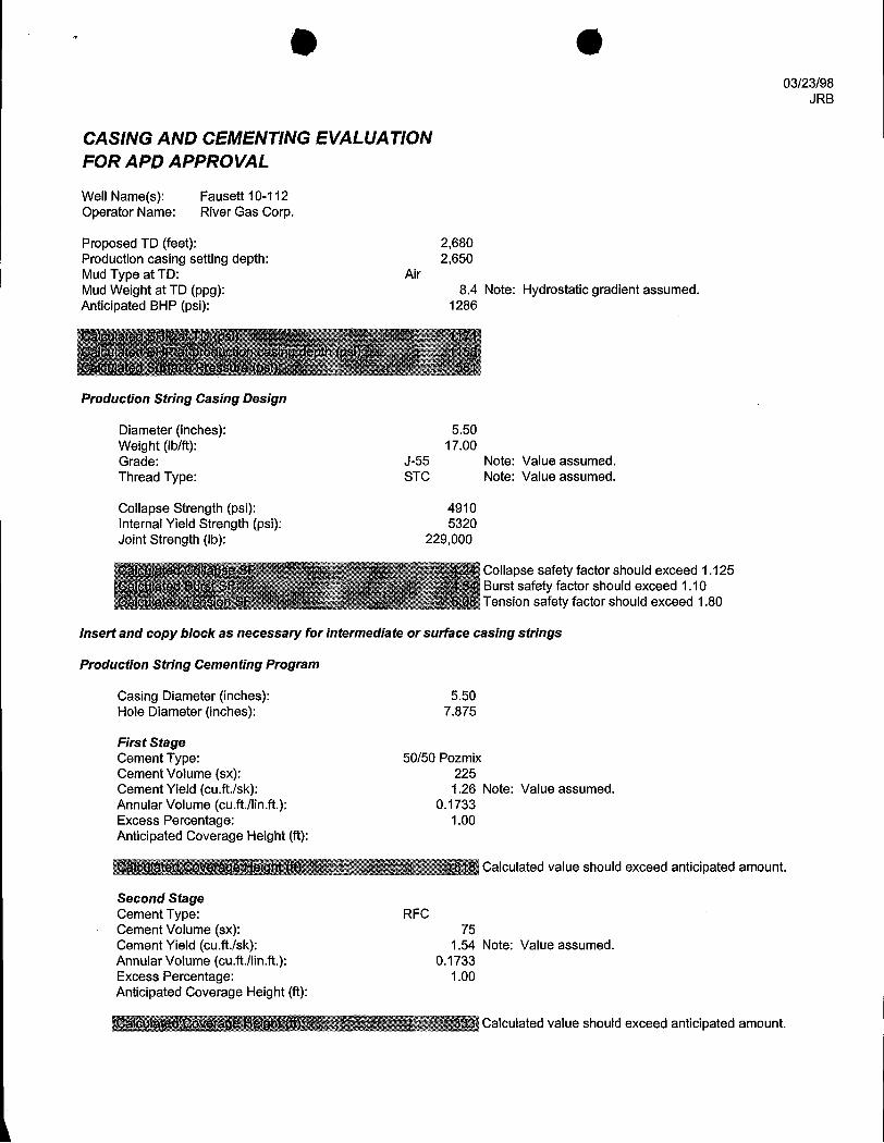
O O03/23/98
JRB
CASING AND CEMENTINGEVALUATIONFOR APD APPROVAL
Well Name(s): Fausett 10-112Operator Name: River Gas Corp.
Proposed TD (feet): 2,680Production casing setting depth: 2,650Mud Type at TD: AirMud Weight at TD (ppg): 8.4 Note: Hydrostatic gradient assumed.Anticipated BHP (psi): 1286
Product¡on String CasIng Des¡gn
Diameter (inches): 5.50Weight (Ib/ft): 17.00Grade: J-55 Note: Value assumed.Thread Type: STC Note: Value assumed.
Collapse Strength (psi): 4910Internal Yield Strength (psi): 5320Joint Strength (Ib): 229,000
Collapse safety factor should exceed 1.125Burst safety factor should exceed 1.10Tension safety factor should exceed 1.80
Insert and copy block as necessary for intermediate or surface casing strings
Product¡on String Cementing Program
Casing Diameter (inches): 5.50Hole Diameter (inches): 7.875
First StageCement Type: 50/50 PozmixCement Volume (sx): 225Cement Yield (cu.ft./sk): 1.26 Note: Value assumed.Annular Volume (cu.ft.Ilin.ft.): 0.1733Excess Percentage: 1.00Anticipated Coverage Height (ft):
818 Calculated value should exceed anticipated amount.
Second StageCement Type: RFCCement Volume (sx): 75Cement Yield (cu.ft.lsk): 1.54 Note: Value assumed.Annular Volume (cu.ft./lin.ft.): 0.1733Excess Percentage: 1.00Anticipated Coverage Height (ft):
Calculated value should exceed anticipated
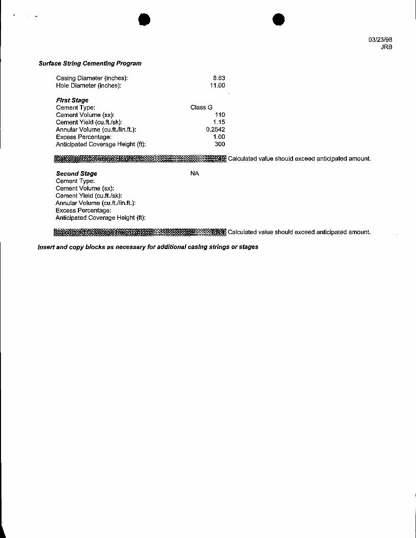
03/23/98JRB
Surface String Cementing Program
Casing Diameter (inches): 8.63Hole Diameter (inches): 11.00
First StageCement Type: Class GCement Volume (sx): 110Cement Yield (cu.ft.lsk): 1.15Annular Volume (cu.ft.llin.ft.): 0.2542Excess Percentage: 1.00Anticipated Coverage Height (ft): 300
Calculated value should exceed anticipated amount.
Second Stage NACement Type:Cement Volume (sx):Cement Yield (cu.ft.lsk):Annular Volume (cu.ft.llin.ft.):Excess Percentage:Anticipated Coverage Height (ft):
Calculated value should exceed anticipated amount.
Insert and copy blocks as necessary for additional casing str¡ngs or
O 6ON-SITE PREDRILL EVALUATION
Division of Oil, Gas and Mining
OPERATOR: River Gas Corporation
WELL NAME & NUMBER: Fausett 10-112
API NUMBER: 4300730415
LEASE: Fee FIELD/UNIT: Drunkard's Wash
LOCATION: 1/4,1/4 NESW Sec: 10 TWP:14S RNG: 9E 1590 FSL 1342 FWL
LEGAL WELL SITING: F SEC. LINE; F 1/4,1/4 LINE; F ANOTHER WELL.
GPS COORD (UTM): X=508,126; Y=4,385,533
SURFACE OWNER: Orlin Fausett, 1189 W, 290 N, Price UT 84501
PARTICIPANTSC. Kierst (DOGM), D. Hamilton (RGC), B. Griffin (RGC), Ross Fausett
REGIONAL/LOCAL SETTING & TOPOGRAPHYWestern margin of Colorado Plateau/~4.5 miles south of the Book Cliffson agricultural canyon bottomland at the foot of 200' cliffs of GordonCreek Canyon and ~700' north of Gordon Creek. Location is below thelower bench and ~4 miles west of Price, Utah and 3 miles southwestof the Price River.
SURFACE USE PLAN
CURRENT SURFACE USE: Grazing, habitat
PROPOSED SURFACE DISTURBANCE:~0.8 mile of access road from E-W branchroad.
LOCATION OF EXISTING WELLS WITHIN A 1 MILE RADIUS: Prettyman 10-15-34
LOCATION OF PRODUCTION FACILITIES AND PIPELINES: Powerline andgathering system follow approach road.
SOURCE OF CONSTRUCTION MATERIAL: Gravel approach road and location;soil stored in berm.
ANCILLARY FACILITIES: None
WASTE MANAGEMENT
O OPortable toilets; garbage cans on location will be emptied intocentralized dumpsters which will be emptied into an approved landfill.
ENVIRONMENTAL PARAMETERS
AFFECTED FLOODPLAINS AND/OR WETLANDS: ~ 700'north of Gordon Creek;~3 miles southwest of the Price River; confluence ~4 miles east.
FLORA/FAUNA: Cottonwood, greasewood, cactus / birds, lizards, coyotes,rodents, golden eagle nests, elk and deer critical winter range,reptiles
SOIL TYPE AND CHARACTERISTICS: Silty, moderately-permeable soil onQuaternary Slope Wash over Blue Gate Shale Member of the Mancos ShaleDML).
SURFACE FORMATION & CHARACTERISTICS: Quaternary Slope Wash over BlueGate Shale Member of the Mancos Shale (light gray, bentonitic shaleand sandstone ledges). Below Garlev Canyon Beds.
EROSION/SEDIMENTATION/STABILITY: Stable terrain away from 10-30' deepGordon Creek draw.
PALEONTOLOGICAL POTENTIAL: Poor
RESERVE PITCHARACTERISTICS: 50' X 50' X 10' natural soil, dugout and bermed todeflect runoff.
LINER REQUIREMENTS (Site Ranking Form attached): 12 mil systheticliner.
SURFACE RESTORATION/RECLAMATION PLANAs Der Surface Owner's Agreement.
SURFACE AGREEMENT: On file.
CULTURAL RESOURCES/ARCHAEOLOGY: Cleared and on-file.
OTHER OBSERVATIONS/COMMENTSOver a mile to the nearest occuoied dwelling. A ditch runs from thecreek to a nearbv Christmas tree grove, east of the pad, overated bythe surface owner. It is on the south side of the pad. Questar gaspipeline off pad on north side.
ATTACHMENTS:4 photos.
Chris Kierst 3/13/1998 10:00AMDOGM REPRESENTATIVE

O OEvaluation Ranking Criteria and Ranking ScoreFor Reserve and Onsite Pit Liner Requirements
Site-Soecific Factors Ranking Site Ranking
Distance to Groundwater (feet)>200 0100 to 200 575 to 100 1025 to 75 15<25 or recharge area 20 10
Distance to Surf. Water (feet)>1000 0300 to 1000 2200 to 300 10100 to 200 15< 100 20 2
Distance to Nearest Municipal Well (feet)>5280 01320 to 5280 5500 to 1320 10<500 15 0
Distance to Other Wells (feet)>1320 0300 to 1320 10<300 20 0
Native Soil TypeLow permeability 0Mod. permeability 10High permeability 20 10
Fluid TypeAir/mist 0Fresh Water 5TDS >5000 and <10000 15TDS >10000 or Oil Base 20Mud Fluid containing highlevels of hazardous constituents 0
Drill CuttingsNormal Rock 0Salt or detrimental 10 0
Annual Precipitation (inches)<10 010 to 20 5>20 10 5
Affected Populations<10 010 to 30 630 to 50 8>50 10 0
Presence of Nearby UtilityConduits
Not Present 0Unknown 10Present 15 15
Final Score (Level I Sensitivity)
Fo M 3 CTATEOF UTAH
DJVISION JL, GAS AND MINING
Patented
APPLICATION FOR PERMlT TO DRILLOR DEEPEN * "' «¾Num
Imda DRILLEJ DEEPEN O ""UTU67921x
s. Type « won: OIL GAS OTHER: SINGLEZONE MULTIPLEZONE e, Fann um New.
Fausett1Kond4mer G.WANotr
River Gas Corporation 10-112
511 Energy Center Blvd. Northport, Al. 35473 so.r.w.eme,s m.
Drunkards Wash
sun.e.: 1590' FSL, 1342 FWL
kwProse.now U i IUL I inL. NE/SW, Sec. 10, TlAS, RO9E
14. Distanco in rnbos wg Ckmetim frma M « poet A: 12 N 11&Approx. 5 miles west/northwest of Price, Ut Carbon
15. Otstance to l a Nemoor ei acres kr 17. Ntuncer « acres to wasweg;womas--mu<: 300' 341.22 160is. CEsarme e near.at wea, 19. Popesos a m-y cr case:cem
aos-aw.=m-m: 1900' 2680' Rotary21. wt.ether CP. RT, OR. a): 22. Appemstas a dce m a y
5903' Spring r998PRQPOSED CASING AND CEMENT1NG PAOGRAM
s 2s met.s ( o se er em:NG V Km FUT SEUM DEPN CUMOTY CF CO.ŒNT
11" 8 5/8" 249 3UU' 110 sx Class G, 15.8 ppg¯
7 7/8" 5 1/2" 17# 2650' 50/50 Pozmix, tail RFC
Céscrf2E PFKERAM- Em is to M g•«o data ce creser:t pockx-::Ye zerw ard proposod tww prc<tte re : e. f ge:cx:sal is to ddx cr doopers M-any. Che perunset sa amanurface and meescred stus •rx verocal det;oe, Ghe M preven:e< cuterarn.V a.9y.
Exhibit A - Location PlatExhibit B - Drilling ProgramExhibit C - BOP DiagramExhibit D - Surface Use PlanExhibit E - Proposed Location/AccessExhibit F - Typical Road X-sectionExhibit G - Location LayoutExhibit H - Well Site LayoutExhibit I - Evidence of Bond
Terry D. Eurns . Geologist 12-16-97
JAN O5 1998
DIV.OFOIL,GAS&
POWERS ELEVA J CO., INC. ALL POWERS ELEVATIONCO., INC.Form PS 1028 P.O. Box 440889 elevations originate from
Aurora, CO 80044 9 accepted U.S. Benchmarks(303) 321-2217FAX (303) 321-2218 R, 9 E .
BC
l II \
o ,H Io Ec | \a- -- 10 - - T .1
14I
S.
Gro d Elevation = 902.5'
Ec 5158 ?'s89°58'E
BC
500 0 500 1000 1500 2500
SCALE I N FEET
Powers Elevation Co., Inc, of Denver, Colorado has in accordancewith a request from Charles Willis f0FRiver Gas Corp
determined the location of ýlO-ll2 Fausett
to be 1590'Fs a 1342'FW Section lo , Township 14 5.
Range 9 E. of the sait Lake Principal Meridian,\UGHICarbon Utah
..••
•.. ereby certify that this plat is an• urate representat ion of a correct22-MOB33·2201°sfliveyshowing the locotlon of
Tii MASE. #10-112 Fausett
Date: 10-12-95 •-.
NELSON ..
o°Íicensed Land
Surve-yorNo. 22-140833-2201
'""unt" State of
RGGRIVER GAS CORPORATION
511 Energy Center BoulevardNorthport, Alabama 35473
Phone (205) 759-3282Fax (205) 758-5309
December 29, 1997
Mr. Mike HebertsonUtah Division of Oil, Gas, and Mining1594 West North TempleSalt Lake City, Utah 84114-6100
Dear Mr. Hebertson:
Enclosed is a corrected Form 3 from the APD for Fausett well # 10-112. As you know,the Range location was listed as R10E, and should have been RO9E.
I apologize for any inconvenience.
Sincerely,
Terry BurnsV 0 NNG
(801)637-8876(801)6374914 fa
R/>l 5 7 - 7 n/ / - Ÿ7
a.» Ñ / -//2 2 nr /n ,' ove
CC: .
OUrgent O ForReview D PleaseComment D PleaseReply D PleaseRecycle
N s:
o
(801)637-8876(801)6374914 fa
R/>l 5 7 - 7 n/ / - Ÿ7
a.» Ñ / -//2 2 nr /n ,' ove
CC: .
OUrgent O ForReview D PleaseComment D PleaseReply D PleaseRecycle
N s:
o
O O
I
4' BERM
1% SLOPE
75'PIT
---o
O "10'K10'X6'
175°
FAUSETT10-112 River Gas Corporation
NE/SW, Section 10 Location LayoutT14S, ROE, SLB&M .
Carbon County, Utah scALE 1"=50' January 7, 1997 SHEET 1 Of
O O
I
4' BERM
1% SLOPE
75'PIT
---o
O "10'K10'X6'
175°
FAUSETT10-112 River Gas Corporation
NE/SW, Section 10 Location LayoutT14S, ROE, SLB&M .
Carbon County, Utah scALE 1"=50' January 7, 1997 SHEET 1 Of
O OO State of Utah
DEPARTMENT OF NATURAL RESOURCESDIVISION OF OIL, GAS AND MINING1594 West North Temple, Suite 1210
Michael O. Leavitt PO Box 145801GovernorSalt Lake City, Utah 84114-5801
Ted StewartExecutive Director 801-538-5340
Lowell P. Braxton 801-359-3940 (Fax)Division Director 801-538-7223 (TDD)
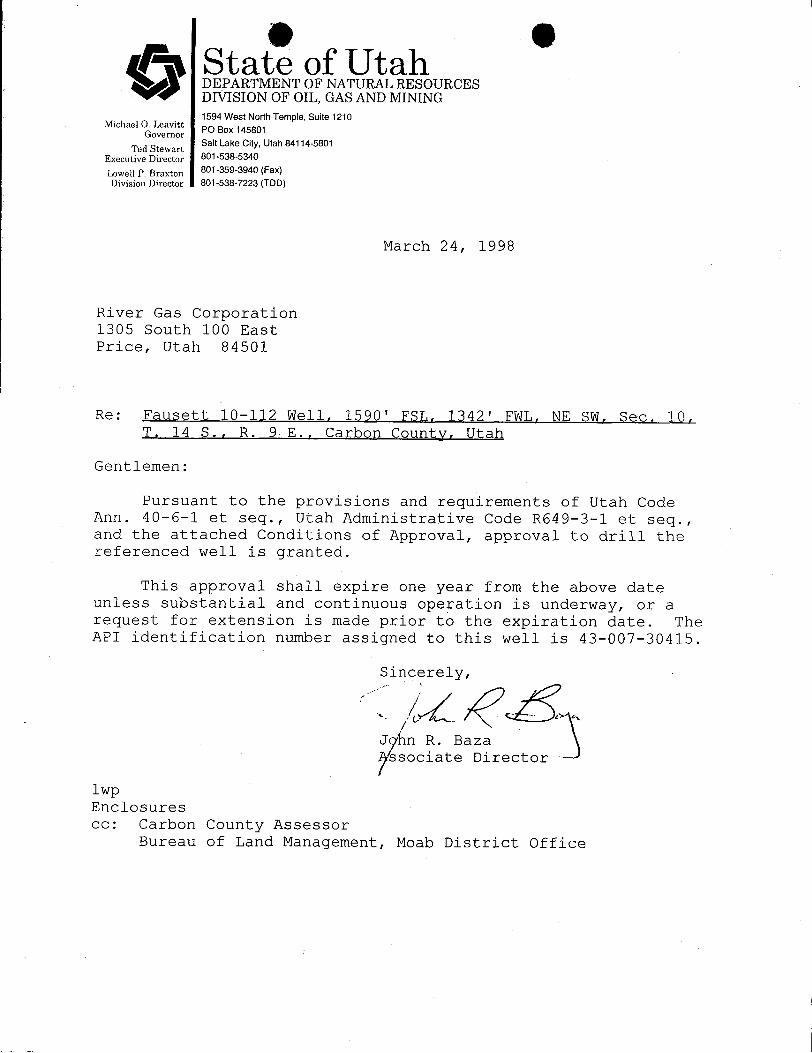
March 24, 1998
River Gas Corporation1305 South 100 EastPrice, Utah 84501
Re: Fausett 10-112 Well, 1590' FSL, 1342' FWL, NE SW, Sec. 10,T. 14 S., R. 9 E., Carbon Countv, Utah
Gentlemen:
Pursuant to the provisions and requirements of Utah CodeAnn. 40-6-1 et seq., Utah Administrative Code R649-3-1 et seq.,and the attached Conditions of Approval, approval to drill thereferenced well is granted.
This approval shall expire one year from the above dateunless substantial and continuous operation is underway, or arequest for extension is made prior to the expiration.date. TheAPI identification number assigned to this well is 43-007-30415.
Si ce y,
J n R. Bazassociate Director
lwpEnclosurescc: Carbon County Assessor
Bureau of Land Management, Moab District
O OO State of Utah
DEPARTMENT OF NATURAL RESOURCESDIVISION OF OIL, GAS AND MINING1594 West North Temple, Suite 1210
Michael O. Leavitt PO Box 145801GovernorSalt Lake City, Utah 84114-5801
Ted StewartExecutive Director 801-538-5340
Lowell P. Braxton 801-359-3940 (Fax)Division Director 801-538-7223 (TDD)
March 24, 1998
River Gas Corporation1305 South 100 EastPrice, Utah 84501
Re: Fausett 10-112 Well, 1590' FSL, 1342' FWL, NE SW, Sec. 10,T. 14 S., R. 9 E., Carbon Countv, Utah
Gentlemen:
Pursuant to the provisions and requirements of Utah CodeAnn. 40-6-1 et seq., Utah Administrative Code R649-3-1 et seq.,and the attached Conditions of Approval, approval to drill thereferenced well is granted.
This approval shall expire one year from the above dateunless substantial and continuous operation is underway, or arequest for extension is made prior to the expiration.date. TheAPI identification number assigned to this well is 43-007-30415.
Si ce y,
J n R. Bazassociate Director
lwpEnclosurescc: Carbon County Assessor
Bureau of Land Management, Moab District
O O
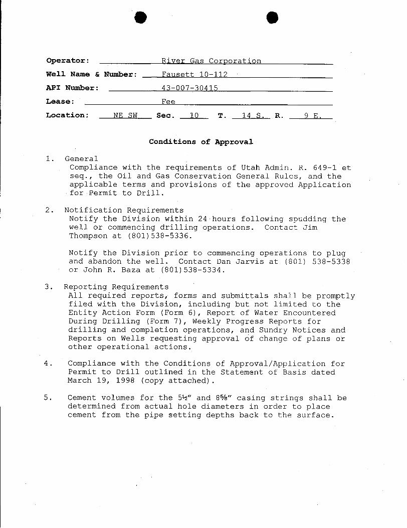
Operator: River Gas Corporation
Well Name & Number: Fausett 10-112
API Number: 43-007-30415
Lease: Fee
Location: NE SW Sec. 10 T. 14 S. R. 9 E.
Conditions of Approval
1. GeneralCompliance with the requirements of Utah Admin. R. 649-1 etseq., the Oil and Gas Conservation General Rules, and theapplicable terms and provisions of the approved Applicationfor Permit to Drill.
2. Notification RequirementsNotify the Division within 24 hours following spudding thewell or commencing drilling operations. Contact JimThompson at (801)538-5336.
Notify the Division prior to commencing operations to plugand abandon the well. Contact Dan Jarvis at (801) 538-5338or John R. Baza at (801)538-5334.
3. Reporting RequirementsAll required reports, forms and submittals shall be promptlyfiled with the Division, including but not limited to theEntity Action Form (Form 6), Report of-Water EncounteredDuring Drilling (Form 7), Weekly Progress Reports fordrilling and completion operations, and Sundry Notices andReports on Wells requesting approval of change of plans orother operational actions.
4. Compliance with the Conditions of Approval/Application forPermit to Drill outlined in the Statement of Basis datedMarch 19, 1998 (copy attached).
5. Cement volumes for the 5½" and 8%" casing strings shall bedetermined from actual hole diameters in order to placecement from the pipe setting depths back to the
O O
Operator: River Gas Corporation
Well Name & Number: Fausett 10-112
API Number: 43-007-30415
Lease: Fee
Location: NE SW Sec. 10 T. 14 S. R. 9 E.
Conditions of Approval
1. GeneralCompliance with the requirements of Utah Admin. R. 649-1 etseq., the Oil and Gas Conservation General Rules, and theapplicable terms and provisions of the approved Applicationfor Permit to Drill.
2. Notification RequirementsNotify the Division within 24 hours following spudding thewell or commencing drilling operations. Contact JimThompson at (801)538-5336.
Notify the Division prior to commencing operations to plugand abandon the well. Contact Dan Jarvis at (801) 538-5338or John R. Baza at (801)538-5334.
3. Reporting RequirementsAll required reports, forms and submittals shall be promptlyfiled with the Division, including but not limited to theEntity Action Form (Form 6), Report of-Water EncounteredDuring Drilling (Form 7), Weekly Progress Reports fordrilling and completion operations, and Sundry Notices andReports on Wells requesting approval of change of plans orother operational actions.
4. Compliance with the Conditions of Approval/Application forPermit to Drill outlined in the Statement of Basis datedMarch 19, 1998 (copy attached).
5. Cement volumes for the 5½" and 8%" casing strings shall bedetermined from actual hole diameters in order to placecement from the pipe setting depths back to the
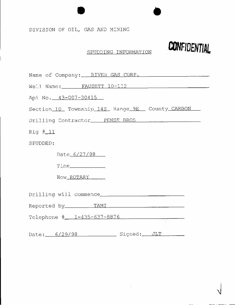
DIVISION OF OIL, GAS AND MINING
SPUDDING INFORMATION
Name of Company: RIVER GAS CORP.
Well Name: FAUSETT 10-112
Api No. 43-007-30415
Section 10 Township 14S Range 9E County CARBON
Drilling Contractor PENSE BROS
Rig # 11
SPUDDED:
Date 6/27/98
Time
How ROTARY
Drilling will commence
Reported by TAMI
Telephone # 1-435-637-8876
Date: 6/29/98 Signed:
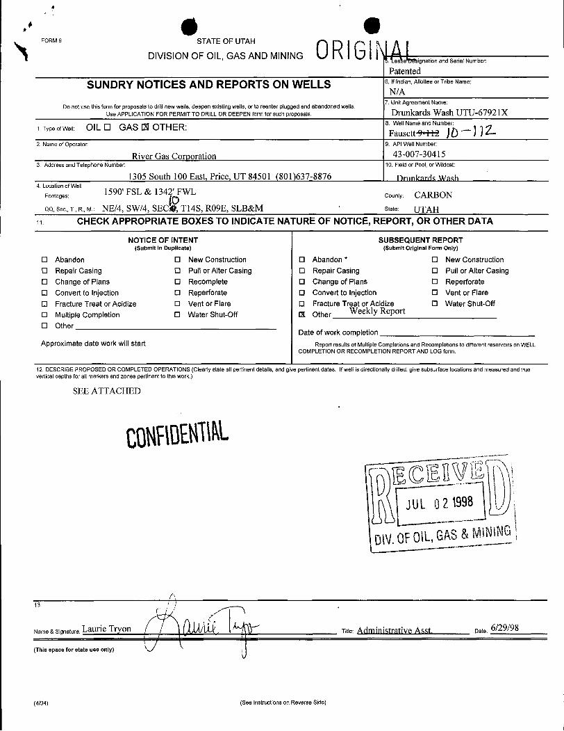
FORM 9 STATE OF UTAH
DIVISION OF OIL, GAS AND MINING 0RIG\e .LignationandSerialNumber:
Patented
SUNDRY NOTICES AND REPORTS ON WELLS 6. If Indian, Allottee or Tribe Name:
N/A7. Unit Agreement Name:
Do not use this form for proposals to drill new wells, deepen existing wells, or to reenter plugged and abandoned wells.Use APPLICATION FOR PERMIT TO DRILL OR DEEPEN form for such proposals. Drunkards Wash UTU-67921X
1.TypeofWell: OIL O GAS 12lOTHER: 8. WellNameandNumber:
FausettM )Ò~) ) i2. Name of Operator: 9. API Well Number:
River Gas Corporation 43-007-304153. Address and Telephone Number: 10. Field or Pool, or Wildcat:
1305 South 100 East, Price, UT 84501 (801)637-8876 Drimkarris Wash4. Location of Well
Footages: 1590' FSL & 1342' FWL County: CARBONQQ,Sec., T., R., M.: NE/4, SW/4, SEC4 Tl4S, RO9E, SLB&M state: UTAH
11. CHECK APPROPRIATE BOXES TO INDICATE NATURE OF NOTICE, REPORT, OR OTHER DATA
NOTICE OF INTENT SUBSEQUENT REPORT(Submit in Duplicate) (Submit Original Form Only)
O Abandon O New Construction 0 Abandon * O New ConstructionO Repair Casing O Pull or Alter Casing O Repair Casing O Pull or Alter CasingO Change of Plans O Recomplete O Change of Plans O ReperforateO Convert to Injection O Reperforate O Convert to Injection O Vent or FlareO Fracture Treat or Acidize O Vent or Flare O Fracture Treat or Acidize O Water Shut-Off
O Multiple Completion 0 Water Shut-Off 13 Other Weekly Report
O OtherDate of work completion
Approximate date work will start Report results of Multiple Completions and Recompletions to different reservoirs on WELLCOMPLETlON OR RECOMPLETION REPORT AND LOG form.
12. DESCRIBE PROPOSED OR COMPLETED OPERATIONS (Clearly state allpertinent details, and give pertinent dates. Ifwell is directionally drilled, give subsurface locations and measured and trueverticaldepths for all markers and zones pertinent to this work.)
SEE ATTACHED
JUL 02 1998
Name & Signature: Laurie Tryon / Titie: A<iiviiviistrativeAsst. Date: 6/29/98I
(This space for state use only)
(4/94) (See Instructions on Reverse
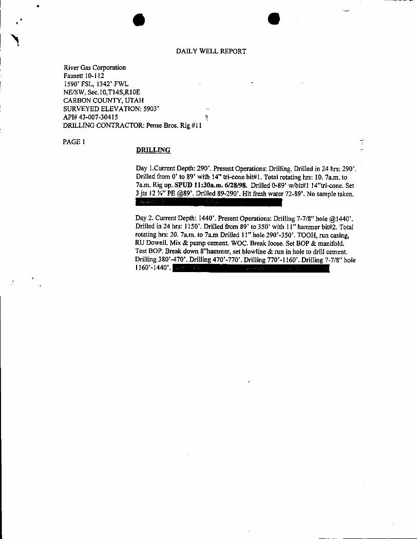
.. 6 O
DAILY WELL REPORT
River Gas CorporationFausett 10-1121590' FSL, 1342' FWL '
NE/SW, Sec.10,Tl4S,RIGECARBON COUNTY, UTAHSURVEYED ELEVATION: 5903'API# 43-007-30415 1DRILLING CONTRACTOR: Pense Bros. Rig #ll
PAGE IDRILLING
Day 1.Current Depth: 290'. Present Operations: Drilling. Drilled in 24 hrs: 290'.Drilled from O' to 89' with 14" tri-cone bit#1. Total rotating hrs: 10. 7a.m. to7a.m. Rig up. SPUD 11:30a.m. 6/28/98. Drilled 0-89' w/bit#1 14"tri-cone. Set3 jts 12 ¾" PE @89'.Drilled 89-290'. Hit fresh water 72-89'. No sample taken.
Day 2. Current Depth: 1440'. Present Operations: Drilling 7-7/8" hole @1440'.Drilled in 24 hrs: 1150'. Drilled from 89' to 350' with 11" hammer bit#2. Totalrotating hrs: 20. 7a.m. to 7a.m Drilled 11" hole290'-350'. TOOH, run casing,RU Dowell. Mix & pump cement. WOC. Break loose. Set BOP & manifold.Test BOP. Break down 8"hammer, set blowline & run in hole to drill cement.Drilling 380'-470'. Drilling 470'-770'. Drilling 770'-1160'. Drilling 7-7/8" hole
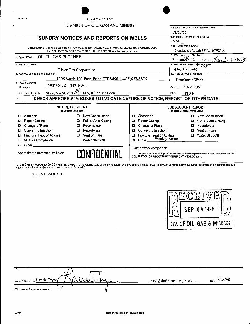
OFORM 9 STATE OF UTAH
DIVISION OF OIL, GAS AND MINING5. Lease Designation and Serial Number:
Patented
SUNDRY NOTICES AND REPORTS ON WELLS 6.Ifindian,AllotteeorTribeName:
N/A7. Unit Agreement Name:
Do not use this form for proposals to drill newwells, deepen existing wells, or to reenter plugged and abandoned wells.Use APPLICATION FOR PERMIT TO DRILL OR DEEPEN form for such proposals. Drunkards Wash UTU-67921X
1. Type of Well: OlL O GAS E OTHER: 8. Well Nam d Number:
Fausettx-112 A em Ÿ2. Name of Operator: 9. API Well Number: Uý| -
River Gas Corporation 43-007-304153. Address and Telephone Number: 10. Field or Pool, or Wildcat:
1305 South 100 East, Price, UT 84501 (435)637-8876 Drunkerrls WashI 4. Location of Well
Footages: 1590' FSL & 1342' FWL county: CARBONQQ, Sec., T., R., M.: NE/4, SW/4, SEC Tl4S, RO9E, SLB&M state: UTAH
CHECK APPROPRIATE BOXESTO INDICATE NATURE OF NOTICE, REPORT, OR OTHER DATA
NOTICE OF INTENT SUBSEQUENT REPORT(Submit in Duplicate) (Submit Original Form Only)
O Abandon O New Construction O Abandon * O New ConstructionO Repair Casing O Pull or Alter Casing O Repair Casing O Pul\ or Alter CasingO Change of Plans O Recomplete O Change of Plans O ReperforateO Convert to Injection O Reperforate O Convert to Injection O Vent or FlareO Fracture Treat or Acidize O Vent or Flare O Fracture Treat or Acidize O Water Shut-OffO Multiple Completion O Water Shut-Off 11 Other Weekly Report
O Other
RLOCDANDate of work completion
Approximate date workwill starÊ Report resu1tsof Multiple Completions and Recompletions to different reservoirs on WELLCOMPLETION OR RECOMPLETION REPORT AND LOG form.
12. DESCRIBE PROPOSED OR COMPLETED OPERATIONS (Clearly state all pertinent details, and give pertinent dates. Ifwell is directionally drilled, give subsurface locations and measured and trueverticaldepths for all markers and zones pertinent to this work.)
SEE ATTACHED
DECElvaSEPQ4 1998
DIV.OFOlL,GAS&MINING
13.
Name& Sianature.LaurieTryo .. , Title: Administrative Asst. Date: 8/28/98
(This space for state use only)
(4/94) (See Instructions on Reverse
OFORM 9 STATE OF UTAH
DIVISION OF OIL, GAS AND MINING5. Lease Designation and Serial Number:
Patented
SUNDRY NOTICES AND REPORTS ON WELLS 6.Ifindian,AllotteeorTribeName:
N/A7. Unit Agreement Name:
Do not use this form for proposals to drill newwells, deepen existing wells, or to reenter plugged and abandoned wells.Use APPLICATION FOR PERMIT TO DRILL OR DEEPEN form for such proposals. Drunkards Wash UTU-67921X
1. Type of Well: OlL O GAS E OTHER: 8. Well Nam d Number:
Fausettx-112 A em Ÿ2. Name of Operator: 9. API Well Number: Uý| -
River Gas Corporation 43-007-304153. Address and Telephone Number: 10. Field or Pool, or Wildcat:
1305 South 100 East, Price, UT 84501 (435)637-8876 Drunkerrls WashI 4. Location of Well
Footages: 1590' FSL & 1342' FWL county: CARBONQQ, Sec., T., R., M.: NE/4, SW/4, SEC Tl4S, RO9E, SLB&M state: UTAH
CHECK APPROPRIATE BOXESTO INDICATE NATURE OF NOTICE, REPORT, OR OTHER DATA
NOTICE OF INTENT SUBSEQUENT REPORT(Submit in Duplicate) (Submit Original Form Only)
O Abandon O New Construction O Abandon * O New ConstructionO Repair Casing O Pull or Alter Casing O Repair Casing O Pul\ or Alter CasingO Change of Plans O Recomplete O Change of Plans O ReperforateO Convert to Injection O Reperforate O Convert to Injection O Vent or FlareO Fracture Treat or Acidize O Vent or Flare O Fracture Treat or Acidize O Water Shut-Off
O Multiple Completion O Water Shut-Off 11 Other Weekly Report
O Other
RLOCDANDate of work completion
Approximate date workwill starÊ Report resu1tsof Multiple Completions and Recompletions to different reservoirs on WELLCOMPLETION OR RECOMPLETION REPORT AND LOG form.
12. DESCRIBE PROPOSED OR COMPLETED OPERATIONS (Clearly state all pertinent details, and give pertinent dates. Ifwell is directionally drilled, give subsurface locations and measured and trueverticaldepths for all markers and zones pertinent to this work.)
SEE ATTACHED
DECElvaSEPQ4 1998
DIV.OFOlL,GAS&MINING
13.
Name& Sianature.LaurieTryo .. , Title: Administrative Asst. Date: 8/28/98
(This space for state use only)
(4/94) (See Instructions on Reverse
O O
DAILY WELL REPORT
River Gas CorporationFausett 10-1121590' FSL, 1342' FWLNE/SW, Sec.10,Tl4S,RI0ECARBON COUNTY, UTAHSURVEYED ELEVATION: 5903'API# 43-007-30415 DIVOF0DRILLING CONTRACTOR: Pense Bros. Rig #11 & MS &MININŒPAGE 1
DRILLING
Day 1.Current Depth: 290'. Present Operations: Drilling. Drilled in 24 hrs: 290'.Drilled from O' to 89' with 14" tri-cone bit#1. Total rotating hrs: 10. 7a.m. to7a.m. Rig up. SPUD 11:30a.m. 6/28/98. Drilled 0-89' w/bit#1 14"tri-cone. Set3 jts 12 ¾" PE @89'.Drilled 89-290'. Hit fresh water 72-89'. No sample taken.
Day 2. Current Depth: 1440'. Present Operations: Drilling 7-7/8" hole @1440'.Drilled in 24 hrs: 1150'. Drilled from 89' to 350' with 11" hammer bit#2. Totalrotating hrs: 20. 7a.m. to 7a.m Drilled 1I" hole 290'-350'. TOOH, run casing,RU Dowell. Mix & pump cement. WOC. Break loose. Set BOP & manifold.Test BOP. Break down 8"hammer, set blowline & run in hole to drill cement.Drilling 380'-470'. Drilling 470'-770'. Drilling 770'-1160'. Drilling 7-7/8" holeI160'-1440'.
Day 3. Current Depth:2720'. Present Operations: Mixing fresh water mud.Drilled from 350' to 2720' with 7 7/8" hammer bit#3. Total rotating hrs: 32.66.7a.m. to 7a.m. Drilling 1440'-1880'. Drilling 1880'-2240'. Drilling 2240'-2450'.Drilling 2450'-2630'. Drilling 2630'-2720'. 6/29/98TD@2720' 7:35p.m.Clean hole. TOOH. RU Ioggers. RIH w/log. Hit bridge @2187'.Logging abovebridge & RD loggers. Set up to run drill collars & nipple up. TIH to 2180'.Moving tanks & mixing mud.
Day 4. 6/30/98.Current Depth:2720'. Present Operations: Sitting up to run 5 ½"production casing. Total rotating hrs: 32.66. Drilled in 24 hrs:0'. 7a.m. to 7a.m.Mixing mud & circulating @2180'.Running in hole w/7 7/8" tri-cone & mud.Circulate on bottom & condition hole. Short trip out to 2180' and backdown.Circulate on bottom to condition hole. TOOH. Rig Up loggers. Logging well.
nt to new location.
COMPLETION:
7/1/98. Present Operations: Moved rig. Rig up. Spot pipe rack & catwalk.Unload 5 ½" casing & tally. Tripped in hole. Hung off casing @2705.95.Rigged up Dowell & cemented long string. Pumped 290 sks lead of 50/50 POZ& 65 sks tail of RFC. 13 Bbls. Cement returned to surface. Plug [email protected] down Dowell. Shut down for
O O
DAILY WELL REPORT
River Gas CorporationFausett 10-1121590' FSL, 1342' FWLNE/SW, Sec.10,Tl4S,R10ECARBON COUNTY, UTAHSURVEYED ELEVATION: 5903'API# 43-007-30415DRILLING CONTRACTOR: Pense Bros. Rig #11
PAGE 27/2/98. TD:2705'. Present Operations: Nipple down B.O.P. Made up tubinghead & tally tubing. Trip in hole with casing scraper to 2695'. Trip out. Laiddown tubing on trailer. Rig down. Moved rig.
8/27/98. Rigged up Computalog and Halliburton. Perf and frac three zones.Total pumped 1000 gal 15% acid, 99,136 gal gel, 90,020# 20/40 sand, 144,500#12/20 sand. 14,883 gal water w/clayfix II for step rate test. Pressure high cut12/20 sand went to flush. Pumped half of flush. Screened out. Shut down. Wait.Flowback.
8/28/98. Move on location. Rig up. Tally tubing. Make up retrieving tool & tripin hole. Tag @2428'.(2'fill).Hook up pump & tank. Circulate clean. Latch plug& trip out of hole. Lay plug down. Make up retrieving tool. Trip inhole. Tag fill@2485'.(15'fill).Circulate to plug@2500'. Circulate clean latch plug & trip outof hole. Lay plug down. Make up saw tooth collar. Trip in hole. Tag fill@2650'.(55'fill).Circulate clean to TD @2705'.Trip out of hole. Make up mudanchor assembly & run in hole. Set seat nipple @2587'.End of tubing @2624'.Shut down for night.
8/29/98. Nipple down BOP. Nipple up tubing head. Install guides on rods. Makeup pump on rods. Run 2 ½ x 2" x 18'. RWAC pump, -61 ¾ rods, -42 - 7/8 rods,-1 - 7/8 x 8' pony rod. 1-1 ¼ x 22' polish rod. Space out pump. Hook upflowlines & rig
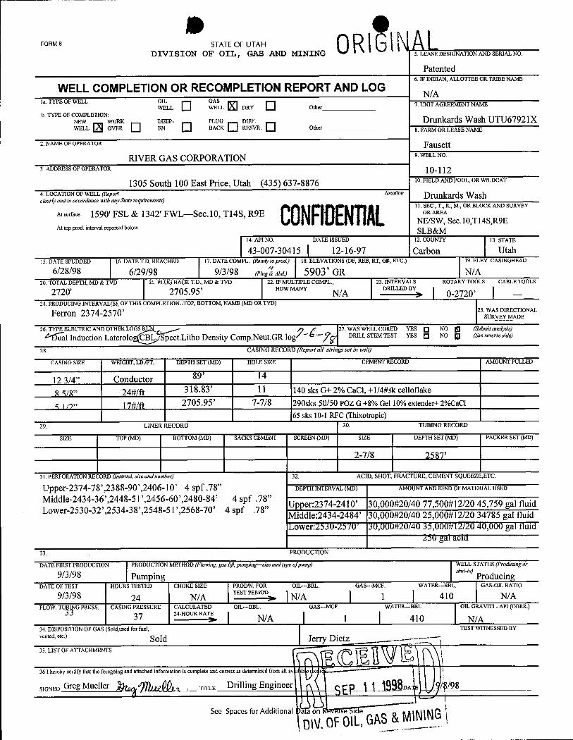
FORM 8 STATE OF UTAHDIVI SION OF OIL , GAS AND MINING 5. LEASE DESIGNATION AND SERIAL NO.
Patented6. IF INDIAN, ALLOTTEE OR TRIBE NAME
WELL COMPLETION OR RECOMPLETION REPORT AND LOG N/Ala. TYPE OF WELL: OIL GAS
WELL WELL DRY Other 7. UNIT AGREEMENT NAME
b. TYPE OF COMPLETION:NEW WORK DEEP- PLUG DIFF. Drunkards Wash UTU67921XWELL OVER EN BACK RESVR. Other 8. FARM OR LEASE NAME
2. NAME OF OPERATOR FausettRIVER GAS CORPORATION 9.WELLNO.
3. ADDRESS OF OPERATOR 10-112
1305 South 100 East Price, Utah (435) 637-8876 10.FIELD AND POOL, OR WILDCAT
4. LOCATION OF WELL (Report location Drunkards Washclearly and in accordance with any State requirements)
0 11. SEC., T., R., M., OR BLOCK AND SURVEYAtsurface 1590' FSL & 1342' FWL--Sec.10, Tl4S, R9E ORAREA
NE/SW, Sec.10,Tl4S,R9EAt top prod, interval reported below SLB&M
14. API NO. DATE ISSUED 12. COUNTY 13. STATE
43-007-30415 12-16-97 Carbon Utah15. DATE SPUDDED 16. DATE T.D. REACHED 17. DATE COMPL. (Ready toprod.) 18. ELEVATIONS (DF, REB, RT, GR, ETC.) 19. ELEV. CASINGHEAD
6/28/98 6/29/98 9/3/98 cris°'aar 5903' GR N/A20. TOTAL DEPTH, MD & TVD 21. PLUG BACK T.D., MD & TVD 22. IF MULTIPLE COMPL, 23. INTERVALS ROTARY TOOLS CABLE TOOLS
2720' 2705.95' HOW MANYN/A
DRILLED BY> 0-2720'24. PRODUCING INTERVAL(S), OF THIS COMPLETION-TOP, BOTTOM, NAME (MD OR TVD)
Ferron 2374-2570' 25. WAS DIRECTIONALSURVEY MADE
26. TYPE ELECTRIC AND OTHER LOGS R , 27. WAS WELL CORED YES O NO g (Submitanalysis)
al Induction Laterolo CBL ISpect.Litho Density Comp.Neut.GR log/ ' ¯- DRILL STEM TEST YES Q NO g (Seereverseside)
28. CASING RECORD (Report all strings set in well)
CASING SIZE WEIGHT, LB./FT. DEPTH SET (MD) HOLE SIZE CEMENT RECORD AMOUNT PULLED
12 3/4" Conductor 89' 14
8 5/8" 24#/ft 318.83' 11 140 sks G+ 2% CaCl, +1/4#sk celloflake
5 119" l7#ln 2705.95' 7-7/8 290sks 50/50 POZ G+8% Gel 10% extender+ 2%CaCl65 sks 10-1 RFC (Thixotropic)
29. LINER RECORD 30. TUBING RECORD
SIZE TOP (MD) BOTTOM (MD) SACKS CEMENT SCREEN (MD) SIZE DEPTH SET (MD) PACKER SET (MD)
2-7/8 2587'
31. PERFORATION RECORD (Interval, size andnumber) 32. ACID, SHOT, FRACTURE, CEMENT SQUEEZE,ETC.
Upper-2374-78',2388-90',2406-10' 4 spf .78" DEPTH INTERVAL (MD) AMOUNT AND KIND OF MATERIAL USED
Middle-2434-36',2448-51',2456-60',2480-84' 4 spf .78"
,,Upper:2374-2410' 30,000#20/40 77,500#12/20 45,759 gal fluidLower-2530-32',2534-38',2548-51',2568-70' 4 spf 78 Middle:2434-2484' 30,000#20/40 25,000#12/20 34785 gal fluidLower:2530-2570' 30,000#20/40 35,000#12/20 40,000 gal fluid
250 gal acid33. PRODUCTION
DATE FIRST PRODUCTION PRODUCTION METHOD (Flowing, gas hyt,pumping-size and type ofpump) WELL STATUS (Producingor
9/3/98 Pumping ProducingDATE OF TEST HOURS TESTED CHOKE SIZE PROD'N. FOR OIL-BBL. GAS--MCF. WATER--BBL GAS-OIL RATIO
9/3/98 24 N/A TESTPERIOD: N/A 1 410 N/AFLOW. GPRESS. CASINGPRESSURE CALCULATED OIL-BBL GAS---MCF. WATER-BBL OILGRAVITI-API(CORR.)
37 24-HOUR RATE I I Ia | N/A 1 410 N/A
34. DISPOSITION OF GAS (Sold,used for fuel, TEST WITNESSED BYvented, etc.) Sold Jerry Dietz35. LIST OF ATTACHMENTS
36 I hereby certify that the foregoing and attached information is complete and correct as determined from all av il b r
SIGNED Gry Muene ¿y a , TITLE Drilling Engineer DA
See Spaces for Additional a a on se i e
ON,OFOIL,GAS
FORM 8 STATE OF UTAHDIVI SION OF OIL , GAS AND MINING 5. LEASE DESIGNATION AND SERIAL NO.
Patented6. IF INDIAN, ALLOTTEE OR TRIBE NAME
WELL COMPLETION OR RECOMPLETION REPORT AND LOG N/Ala. TYPE OF WELL: OIL GAS
WELL WELL DRY Other 7. UNIT AGREEMENT NAME
b. TYPE OF COMPLETION:NEW WORK DEEP- PLUG DIFF. Drunkards Wash UTU67921XWELL OVER EN BACK RESVR. Other 8. FARM OR LEASE NAME
2. NAME OF OPERATOR FausettRIVER GAS CORPORATION 9.WELLNO.
3. ADDRESS OF OPERATOR 10-112
1305 South 100 East Price, Utah (435) 637-8876 10.FIELD AND POOL, OR WILDCAT
4. LOCATION OF WELL (Report location Drunkards Washclearly and in accordance with any State requirements)
0 11. SEC., T., R., M., OR BLOCK AND SURVEYAtsurface 1590' FSL & 1342' FWL--Sec.10, Tl4S, R9E ORAREA
NE/SW, Sec.10,Tl4S,R9EAt top prod, interval reported below SLB&M
14. API NO. DATE ISSUED 12. COUNTY 13. STATE
43-007-30415 12-16-97 Carbon Utah15. DATE SPUDDED 16. DATE T.D. REACHED 17. DATE COMPL. (Ready toprod.) 18. ELEVATIONS (DF, REB, RT, GR, ETC.) 19. ELEV. CASINGHEAD
6/28/98 6/29/98 9/3/98 cris°'aar 5903' GR N/A20. TOTAL DEPTH, MD & TVD 21. PLUG BACK T.D., MD & TVD 22. IF MULTIPLE COMPL, 23. INTERVALS ROTARY TOOLS CABLE TOOLS
2720' 2705.95' HOW MANYN/A
DRILLED BY> 0-2720'24. PRODUCING INTERVAL(S), OF THIS COMPLETION-TOP, BOTTOM, NAME (MD OR TVD)
Ferron 2374-2570' 25. WAS DIRECTIONALSURVEY MADE
26. TYPE ELECTRIC AND OTHER LOGS R , 27. WAS WELL CORED YES O NO g (Submitanalysis)
al Induction Laterolo CBL ISpect.Litho Density Comp.Neut.GR log/ ' ¯- DRILL STEM TEST YES Q NO g (Seereverseside)
28. CASING RECORD (Report all strings set in well)
CASING SIZE WEIGHT, LB./FT. DEPTH SET (MD) HOLE SIZE CEMENT RECORD AMOUNT PULLED
12 3/4" Conductor 89' 14
8 5/8" 24#/ft 318.83' 11 140 sks G+ 2% CaCl, +1/4#sk celloflake
5 119" l7#ln 2705.95' 7-7/8 290sks 50/50 POZ G+8% Gel 10% extender+ 2%CaCl
65 sks 10-1 RFC (Thixotropic)29. LINER RECORD 30. TUBING RECORD
SIZE TOP (MD) BOTTOM (MD) SACKS CEMENT SCREEN (MD) SIZE DEPTH SET (MD) PACKER SET (MD)
2-7/8 2587'
31. PERFORATION RECORD (Interval, size andnumber) 32. ACID, SHOT, FRACTURE, CEMENT SQUEEZE,ETC.
Upper-2374-78',2388-90',2406-10' 4 spf .78" DEPTH INTERVAL (MD) AMOUNT AND KIND OF MATERIAL USED
Middle-2434-36',2448-51',2456-60',2480-84' 4 spf .78"
,,Upper:2374-2410' 30,000#20/40 77,500#12/20 45,759 gal fluidLower-2530-32',2534-38',2548-51',2568-70' 4 spf 78 Middle:2434-2484' 30,000#20/40 25,000#12/20 34785 gal fluidLower:2530-2570' 30,000#20/40 35,000#12/20 40,000 gal fluid
250 gal acid33. PRODUCTION
DATE FIRST PRODUCTION PRODUCTION METHOD (Flowing, gas hyt,pumping-size and type ofpump) WELL STATUS (Producingor
9/3/98 Pumping ProducingDATE OF TEST HOURS TESTED CHOKE SIZE PROD'N. FOR OIL-BBL. GAS--MCF. WATER--BBL GAS-OIL RATIO
9/3/98 24 N/A TESTPERIOD: N/A 1 410 N/AFLOW. GPRESS. CASINGPRESSURE CALCULATED OIL-BBL GAS---MCF. WATER-BBL OILGRAVITI-API(CORR.)
37 24-HOUR RATE I I Ia | N/A 1 410 N/A
34. DISPOSITION OF GAS (Sold,used for fuel, TEST WITNESSED BYvented, etc.) Sold Jerry Dietz35. LIST OF ATTACHMENTS
36 I hereby certify that the foregoing and attached information is complete and correct as determined from all av il b r
SIGNED Gry Muene ¿y a , TITLE Drilling Engineer DA
See Spaces for Additional a a on se i e
ON,OFOIL,GAS
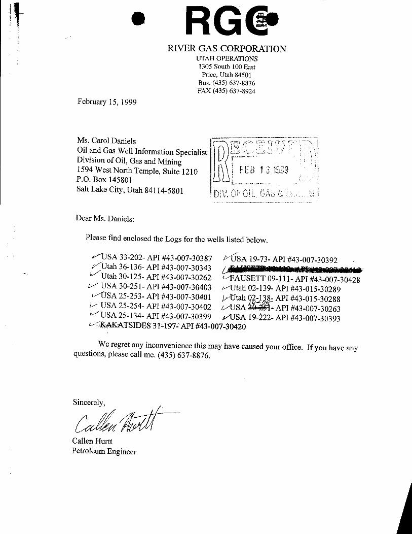
• RG&RIVER GAS CORPORATION
UTAH OPERATIONS1305 South 100 EastPrice, Utah 84501
Bus. (435) 637-8876FAX (435) 637-8924
February 15, 1999
Ms. Carol Daniels COil and Gas Well Information SpecialistDivision of Oil, Gas and Mining1594 West North Temple, Suite 1210 FEBP.O. Box 145801Salt Lake City, Utah 84114-5801
Dear Ms. Daniels:
Please find enclosed the Logs for the wells listed below.
x"TJSA 33-202- API #43-007-30387 SA 19-73- API #43-007-30392Utah 36-136- API #43-007-30343Utah 30-125- API #43-007-30262 t FAUSETT 09-111- API #43-007-30428USA 30-251- API #43-007-30403 «Utah 02-139- API #43-015-30289'ÛSA 25-253- API #43-007-30401 //Utah 0 ,-1 8- API #43-015-30288USA 25-254- API #43-007-30402 t/USA API #43-007-30263USA 25-134- API #43-007-30399 a/USA 19-222- API #43-007-30393KAKATSIDES 312T97-API #432007-30420
We regret any inconvenience this may have caused your office. If you have anyquestions, please call me. (435) 637-8876.
Sin
Callen HurttPetroleum
blAlt ut utAll RIVER GAS CORPORATION H I QDIVISION OF OIL, GASAND MINING OPERATOR OPERATORACCT. NO. | D
ENTITYACTION FORH - roRM 6 . ADDRESS 511 Energy Center Blvd
Northport, Alabama 35476
ACTION CURRENT NEW API HUNDER WELL NAME WF1I t GCATTON SPUD : EFFECTIVECODE ENTITY NO. ENTITY NO. QQ SC TP RG COUHTY DATE DATE '
12373 11256 4300730315 Utah 36-162 SENE . 36 14S 8E Carbon 6/1/98
WELL 1 COMMENTS: AS 8 (b taxa - 9
12374 11256 4300730317 Utah 36-164 SESW 36 14S 8E Carbon 6/1/98
LL 2 COMMENTS:
CONROI\AL12015 11256 4300730318 Utah 36-165 SWSE 36 14S 8E Carbon 6/1/98
WELL3 COMMENTS: /1/
CONFllENTIAL6- 12406 11256 4300730428 Fausett 09-111 NESE 9 14S 9E Carbon 6/1/98
WELL 4 COMMENTS:
CONFllENTIAL12405 11256 4300730415 Fau ett 10-112 NES 10 14S 9E Carbon 5/,1/98
WELL5 COMMENTS: Ô //\fd¾ /L
CONF1ENTIAL'ACTION CODES(See instructions on back of form) /
A - Establish new entity for new well (single well onl ) -9/gx-,• ("f"
B - Add new well to existing entity (group or unit wel ) SynaturC - Re-assign well from one existing entity to another existing en Produkion Tech.0 - Re-assign well from one existing entity to a new entityE - Other (explain in connents section) Title Date'
205 759-3282NOTE: Use CONNENTsection to explain why each Action Code was selected. \ . Phone No. ( )
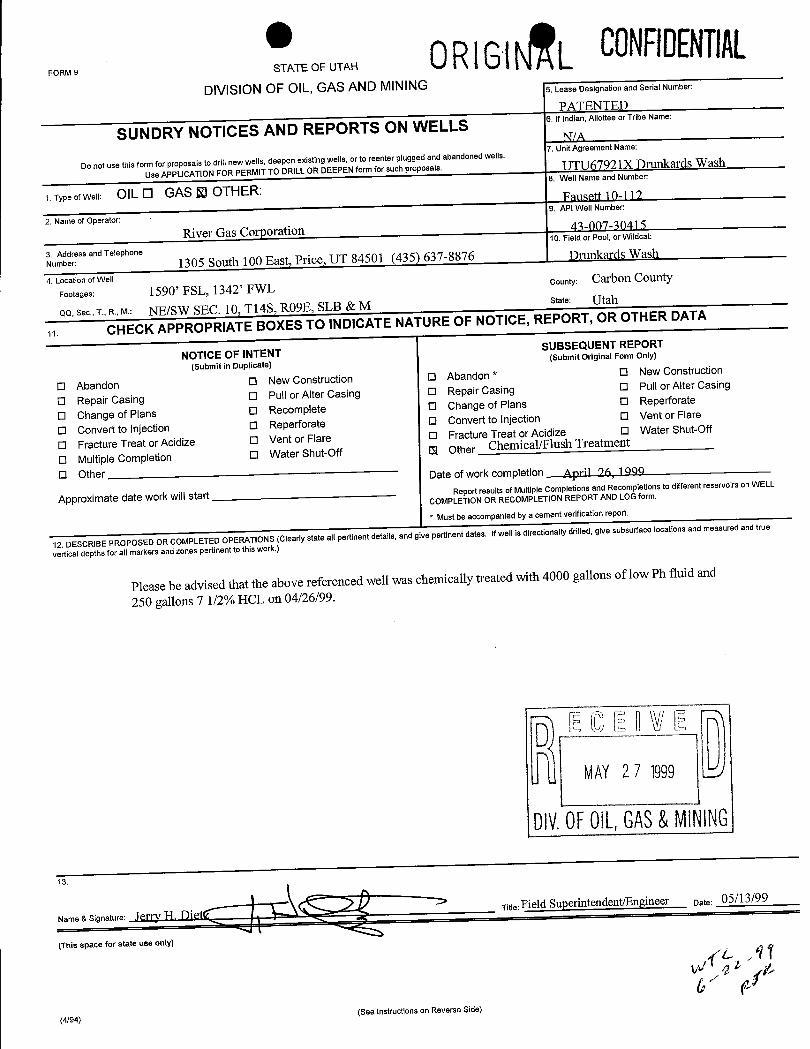
FORMSTEOFUTAH 0RIGiÊL CONFilENTIAL
DIVISION OF OIL, GAS AND MINING 5. Lease Designation and Serial Number:
PATENTED
SUNDRY NOTICES AND REPORTS ON WELLS6.Ifindian,AllotteeorTríbeName:
Do not use this form for proposals to drill new wells, deepen existingwells, or to reenter plugged and abandonedwells.7. Unit Agreement Name:
UseAPPLICATIONFOR PERMIT TO DRILL OR DEEPENform for such proposals UTU67921X Drunkards Wash
1. Type of Well: OIL O GAS RI OTHER:8. Well Name and Number:
Fmisett 10-112
2. Name of Operator: - 9. API Well Number:
River Gas Corporation 43-007-30415
3. Address and Telephone
10. Field or Pool, or Wildcat:
Number: 1305 South 100 East, Price, UT 84501 (435) 637-8876 Drunkards Wash
4. Location of Well
Footages: 1590' FSL, 1342' FWLCounty: Carbon County
QQ, Sec., T., R., M.: NE/SW SEC. 10, T14S, RO9E, SLB & M state: Utah
19. CHECKAPPROPRIATE BOXES TO INDICATE NATURE OF NOTICE, REPORT, OR OTHER DATA
NOTICE OF INTENTSUBSEQUENT REPORT
(Submit in Duplicate)(Submit Original Form Only)
O Abandon O New Construction O Abandon * O New Construction
O Repair Casing O Pull or Alter Casing O Repair Casing 0 Pull or Alter Casing
O Change of Plans O Recomplete O Change of Plans O Reperforate
O Convert to Injection O Reperforate O Convert to Injection 0 Vent or Flare
O Fracture Treat or Acidize O Vent or Flare O Fracture Treat or Acidize O Water Shut-Off
O Multiple Completion O Water Shut-Off 13f Other Chemical/Flush Treatment
O Other Date of work completion April 96 10 O
Approximate date work will start Report results of Multiple Completions and Recompletions to different reservoirson WELL
COMPLETION OR RECOMPLETION REPORT AND LOG form.
* Must be accompanied by a cement verification report
12. DESCRIBE PROPOSED OR COMPLETED OPERATIONS (Clearly state all pertinent details, and give pertinent dates. Ifwell is directionally drilled, give subsurface locations and measured and true
vertical depths for allmarkers and zones pertinent to this work.)
Please be advised that the above referenced well was chemically treated with 4000 gallons of low Ph fluid and
250 gallons 7 1/2% HCL on 04/26/99.
MAY2 7 1999
DIV.0FOlL,GAS&MINING
ame & Signature: .I / FI )]eTitle:Field Superintendent/Engineer Date: 05/13/99
|(This space for state use only)
(4/94)(See Instructions on Reverse Side)
STATE ÖF UTAH 0RIGINAL OPERATOR River Gas Corporation OPERATOR ACCT. NO.DIVISION OF OIL, GAS AND MINING ADDRESS 1305 South 100 EastENTITYACTiON FORM - FORM 6 Price IIT 84501
ACTION CURRENT NEW API NUMBER WELL NAME WELL LOCATION SPUD DATE EFFECTIVECODE ENTITY NO. ENTITY NO QO SC TP RG COUNTY DATE
A O 43-007-30420 Kakatsides 31-197 NWINE 31 14S 9E Carbon 6/12/98
WELL 1 COMMENTS: ¡\Jm ( ,--g-
A c 43-007-30387 USA 33-202 SEINW 33 14S 9E Carbon 6/16/98
WELL2COMMENTS: CONFilENTlALA 43-007-30263 SA 14-75 SE/SW 14 14S 9E Carbon 6/20/98
WELL3COMMENTS: 00NFilENTlAL
A 43-007-30318 Utah 36-165 SWISE 36 14S 8E Carbon 10/6/96
WELL4COMMENTS: est e- 00NFilENTALA 3-015-30338 D7 ALAby SWISE 2 16S 9E Emery 6/23/98
WELL5COMMENTS: CONFIDENT\ALACTION CODES (See Instructions on back of form)
A - Establish new entity for new well (single well only) Laurie A. TryolfB - Add new wellto existing entity (groupor unitwell) SignatureC - Re-assign well from one existing entity to another existingentity
xnpln in cm
enexa er tityto a new entity JUL 02 1998 Administrative Asst. Date6/29/98
NOTE: Use COMMENT section to explain why each Action Code was selected Phone No. (435)637-8876
DIV.0FOILGAS&
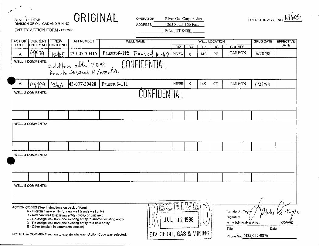
TATE OF UTAH 0RIGINAL OPERATOR River Gas Corporation OPERATOR ACCT. NO.DivislON OF OIL, GAS AND MINING ADDRESS 1305 South 100 EastENTITYACTION FORM - FORM 6 Price UT 84501
ACTION CURRENT NEW API NUMBER WELL NAME WELL LOCATION SPUD DATE EFFECTIVECODE ENTITY NO. ENTITY NO. OO SC TP RG COUNTY DATE
A g 43-007-30415 FausettM NE/SW 9 14S 9E CARBON 6/28/98WELL 1 COMMENTS:
e & ad - CONFIDENTIALA 43-007-30428 Fausett 9-111 NE/SE 9 14S 9E CARBON 6/23/98
WELL2COMMENTS: 00NFilENTlAL
\ \ \ | |\NELL3COMMENTS:
I I I I |WELL 4 COMMENTS:
| | | | \WELL 5 COMMENTS:
ACTION CODES (See Instructions on back of form)A - Establish new entity for new well (single well only) ------- Laurie A. TryB - Add new well to existing entity (groupor unit well) Signature |C - Re-assign well from one existing entity to another existing entity JUL 02 1998D - Re-assign well from one existing entity to a new entity Administrative Asst. 6/29/ 8E - Other (explain in comments section) Title Date
NOTE: Use COMMENT section to explain why each Action Code was selected. DIV.OFOlL,GAS&M\NING Phone No.
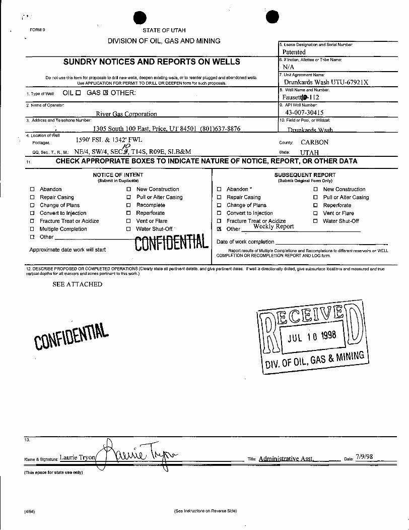
FORM 9 STATE OF UTAH' DIVISION OF OIL, GAS AND MINING
5. Lease Designation and Serial Number:
Patented
SUNDRY NOTICES AND REPORTS ON WELLS 6.Ifindian,AllotteeorTribeName:
N/ADo not use this form for proposals to drill newwells,deepen existingwells, or to reenter plugged and abandoned wells.
7. Unit Agreement Name:
Use APPLICATION FOR PERMIT TO DRILL OR DEEPEN form for such proposals. Drunkards Wash UTU-67921X
1 Type ofWell: OlL O GAS 121OTHER: 8. Well Name and Number:
Fausetg-1122. Name of Operator: 9. API Well Number:
River Gas Corporation 43-007-304153. Address and Telephone Number: 10. Field or Pool, or Wildcat:
. 1305 South 100 East, Price, UT 84501 (801)637-8876 Drimkar<¾ Wash4. Location of Weil
Footages: 1590' FSL & 1342' FWL county: CARBONQQ.Sec., T., R., M.: NE/4, SW/4, SEC $ Tl4S, RO9E, SLB&M state: UTAH
19. CHECK APPROPRIATE BOXES TO INDICATE NATURE OF NOTICE, REPORT, OR OTHER DATA
NOTICE OF INTENT SUBSEQUENT REPORT(Submit in Duplicate) (Submit Original Form Only)
O Abandon O New Construction O Abandon * O New ConstructionO Repair Casing O Pull or Alter Casing O Repair Casing O Pull or Alter CasingO Change of Plans O Recomplete O Change of Plans O ReperforateO Convert to Injection O Reperforate O Convert to Injection O Vent or FlareO Fracture Treat or Acidize O Vent or Flare O Fracture Treat or Acidize O Water Shut-Off
O Multiple Completion O Water Shut-Off OL Other Weekly Report
O OtherDate of work completion
Approximate date work will start Report results of Multiple Completions and Recompletions to different reservoirs on WELLCOMPLETION OR RECOMPLETION REPORT AND LOG form.
12. DESCRIBE PROPOSED OR COMPLETED OPERATIONS (Clearly state all pertinent details, and give pertinent dates. Ifwellis directionally drilled, give subsurface locations and measured and truevertical depths for all markersand zones pertinent to this work.)
SEE ATTACHED
DIV.OFOIL,GAS&MINING
ame&Signature:LaurieTryon Titie: Administrative Asst- Date:
(This space for state use only)
(4/94) (See Instructions on Reverse
FORM 9 STATE OF UTAH' DIVISION OF OIL, GAS AND MINING
5. Lease Designation and Serial Number:
Patented
SUNDRY NOTICES AND REPORTS ON WELLS 6.Ifindian,AllotteeorTribeName:
N/A
Do not use this form for proposals to drill newwells,deepen existingwells, or to reenter plugged and abandoned wells.7. Unit Agreement Name:
Use APPLICATION FOR PERMIT TO DRILL OR DEEPEN form for such proposals. Drunkards Wash UTU-67921X
1 Type ofWell: OlL O GAS 121OTHER: 8. Well Name and Number:
Fausetg-1122. Name of Operator: 9. API Well Number:
River Gas Corporation 43-007-304153. Address and Telephone Number: 10. Field or Pool, or Wildcat:
. 1305 South 100 East, Price, UT 84501 (801)637-8876 Drimkar<¾ Wash4. Location of Weil
Footages: 1590' FSL & 1342' FWL county: CARBONQQ.Sec., T., R., M.: NE/4, SW/4, SEC $ Tl4S, RO9E, SLB&M state: UTAH
19. CHECK APPROPRIATE BOXES TO INDICATE NATURE OF NOTICE, REPORT, OR OTHER DATA
NOTICE OF INTENT SUBSEQUENT REPORT(Submit in Duplicate) (Submit Original Form Only)
O Abandon O New Construction O Abandon * O New ConstructionO Repair Casing O Pull or Alter Casing O Repair Casing O Pull or Alter CasingO Change of Plans O Recomplete O Change of Plans O ReperforateO Convert to Injection O Reperforate O Convert to Injection O Vent or FlareO Fracture Treat or Acidize O Vent or Flare O Fracture Treat or Acidize O Water Shut-Off
O Multiple Completion O Water Shut-Off OL Other Weekly Report
O OtherDate of work completion
Approximate date work will start Report results of Multiple Completions and Recompletions to different reservoirs on WELLCOMPLETION OR RECOMPLETION REPORT AND LOG form.
12. DESCRIBE PROPOSED OR COMPLETED OPERATIONS (Clearly state all pertinent details, and give pertinent dates. Ifwellis directionally drilled, give subsurface locations and measured and truevertical depths for all markersand zones pertinent to this work.)
SEE ATTACHED
DIV.OFOIL,GAS&MINING
ame&Signature:LaurieTryon Titie: Administrative Asst- Date:
(This space for state use only)
(4/94) (See Instructions on Reverse
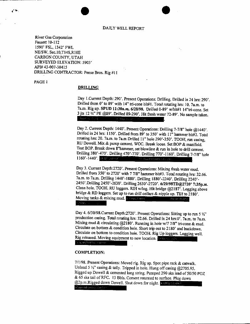
e •DAILY WELL REPORT
River Gas CorporationFausett 10-1121590' FSL, 1342' FWLNE/SW, Sec.10,Tl4S,R10ECARBON COUNTY, UTAHSURVEYED ELEVATION: 5903'API# 43-007-30415DRILLING CONTRACTOR: Pense Bros. Rig #11
PAGE 1DRILLING
Day 1.Current Depth: 290'. Present Operations: Drilling. Drilled in 24 hrs: 290'.Drilled from O' to 89' with 14" tri-cone bit#1. Total rotating hrs: 10. 7a.m. to7a.m. Rig up. SPUD 11:30a.m. 6/28/98. Drilled 0-89' w/bit#l 14"tri-cone. Set3 jts 12 ¾" PE @89'.Drilled 89-290'. Hit fresh water 72-89'. No sample taken.
Day 2. Current Depth: 1440'. Present Operations: Drilling 7-7/8" hole@1440'.Drilled in 24 hrs: 1150'. Drilled from 89' to 350' with 11" hammer bit#2. Totalrotating hrs: 20. 7a.m. to 7a.m Drilled 11" hole 290'-350'. TOOH, run casing,RU Dowell. Mix & pump cement. WOC. Break loose. Set BOP & manifold.Test BOP. Break down 8"hammer, set blowline & run in hole to drill cement.Drilling 380'-470'. Drilling 470'-770'. Drilling 770'-1160'. Drilling 7-7/8" hole1160'-1440'.
Day 3. Current Depth:2720'. Present Operations: Mixing fresh water mud.Drilled from 350' to 2720' with 7 7/8" hammer bit#3. Total rotating hrs: 32.66.7a.m. to 7a.m. Drilling 1440'-1880'. Drilling 1880'-2240'. Drilling 2240'-2450'.Drilling 2450'-2630'. Drilling 2630'-2720'. 6/29/98TD@2720' 7:35p.m.Clean hole. TOOH. RU loggers. RIH wllog. Hit bridge @2187'.Logging abovebridge & RD Ioggers. Set up to run drill collars & nipple up. TIH to 2180'.Moving tanks & mixing mud.
Day 4. 6/30/98.Current Depth:2720'. Present Operations: Sitting up to run 5 ½"production casing. Total rotating hrs: 32.66. Drilled in 24 hrs:0'. 7a.m. to 7a.m.Mixing mud & circulating @2180'.Running in hole w/7 7/8" tri-cone & mud.Circulate on bottom & condition hole. Short trip out to 2180' and backdown.Circulate on bottom to condition hole. TOOH. Rig Up loggers. Logging well.Rig released. Moving equipment to new location. ma
COMPLETION:
7/1/98. Present Operations: Moved rig. Rig up. Spot pipe rack & catwalk.Unload 5 ½" casing & tally. Tripped in hole. Hung off casing @2705.95.Rigged up Dowell & cemented long string. Pumped 290 sks lead of 50/50 POZ& 65 sks tail of RFC. 13 Bbls. Cement returned to surface. Plug [email protected] down Dowell. Shut down for night. -
I
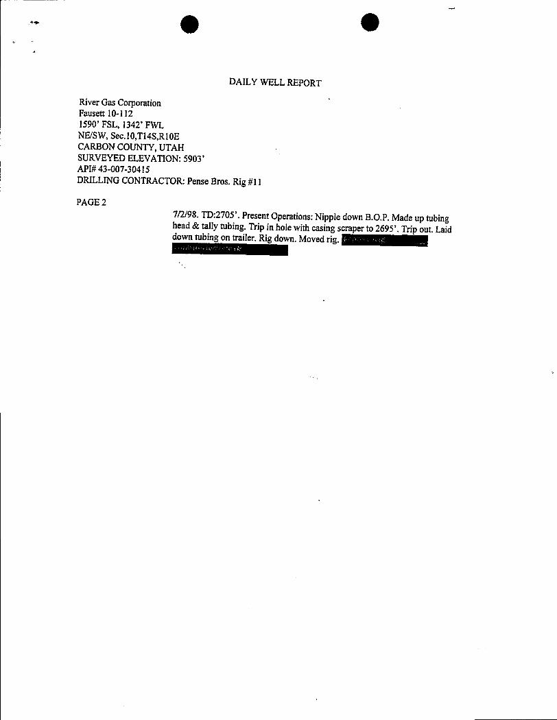
O O
DAILY WELL REPORT
River Gas CorporationFausett 10-1121590' FSL, 1342' FWLNE/SW, Sec.10,Tl4S,Rl0ECARBON COUNTY, UTAHSURVEYED ELEVATION: 5903'API#43-007-30415DRILLING CONTRACTOR:Pense Bros. Rig #ll
PAGE 27/2/98. TD:2705'. Present Operations:Nipple down B.O.P. Made up tubinghead& tally tubing. Trip in hole with casing scraper to 2695'. Trip out. Laiddowntubing on trailer. Rig down. Moved
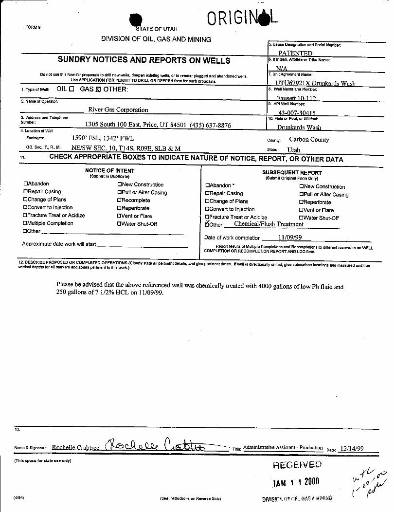
g OR\GINgLFoRMs S ATE OF UTAH
DIVISION OF OIL, GAS AND MINING5. Lease Designation and Serial Number
PATENTEDSUNDRYNOTICES AND REPORTS ON WELLS 6.Windian,AllotteeorTribeName:
N/A7. UnitAgreement Name:Do not use this form for proposals to drill new wells, deepen existingwells,or to reenter plugged and abandoned wells.
Use APPLICATION FOR PERMITTO DRILLOR DEEPEN form for such proposals. UTU67921X Drunkards Wash1. Type of Well: OIL 0 GAS El OTHER: 8. Well Name and Number
Fmisen10-1122. Name of Operator:
9. API WellNumberRiver Gas Corporation 43-007-30415
3. Address and Telephone 10. Field or Pool, or WildcatNumber 1305 South 100 East, Price, UT 84501 (435) 637-8876 Drunkards Wash4. Location of Well
Footages: 1590' FSL, 1342' FWL County: Carbon CountyQQ. Sec., T., R., M.: NE/SW SEC. 10, Tl4S, RO9E, SLB & M stat•: Utah
11. CHECKAPPROPRIATE BOXES TO INDICATENATURE OF NOTICE,REPORT, OR OTHER DATANOTICE OF INTENT SUBSEQUENT REPORT(Submit in Duplicate) (Submit Original Form Only)
OAbandon ONew Construction OAbandon * ONew ConstructionORepair Casing OPull or Alter Casing ORepair Casing OPull or Alter CasingOChange of Plans ORecomplete OChange of Plans OReperforateOConvert to Injection OReperforate OConvert to Injection OVent or FlareOFracture Treat or Acidize OVent or Flare OFracture Treat or Acidize OWater Shut-OffOMultipleCompletion OWater Shut-Off ither Chemical/Flush TreattnentOOther
Date of work completion I1/09/99Approximate date workwill start Report results of Multiple Completions and Recompletions to different reservoirs on WELL
COMPLETION OR RECOMPLETIONREPORTAND LOGform.
12. DESCRIBE PROPOSED OR COMPLETEDOPERATIONS (Clearlystate all pertinent details, and give pertinent dates. Ifwell is directionally drilled, give subsurface locations and measured and truevertical depths for all markers and zones pertinent to this work.)
Please be advised that the above referenced well was chemically treated with 4000 gallons of low Ph fluid and250 gallons of 7 1/2% HCL on 11/09/99.
13.
Name & Sianature' ËOOÎlll TO Title: Adrninistrative Assistant - Production Date: 12/14/99
(This space for state use only) REGE IVED
(4/94) (See instructions on Reverse Side) ÛN
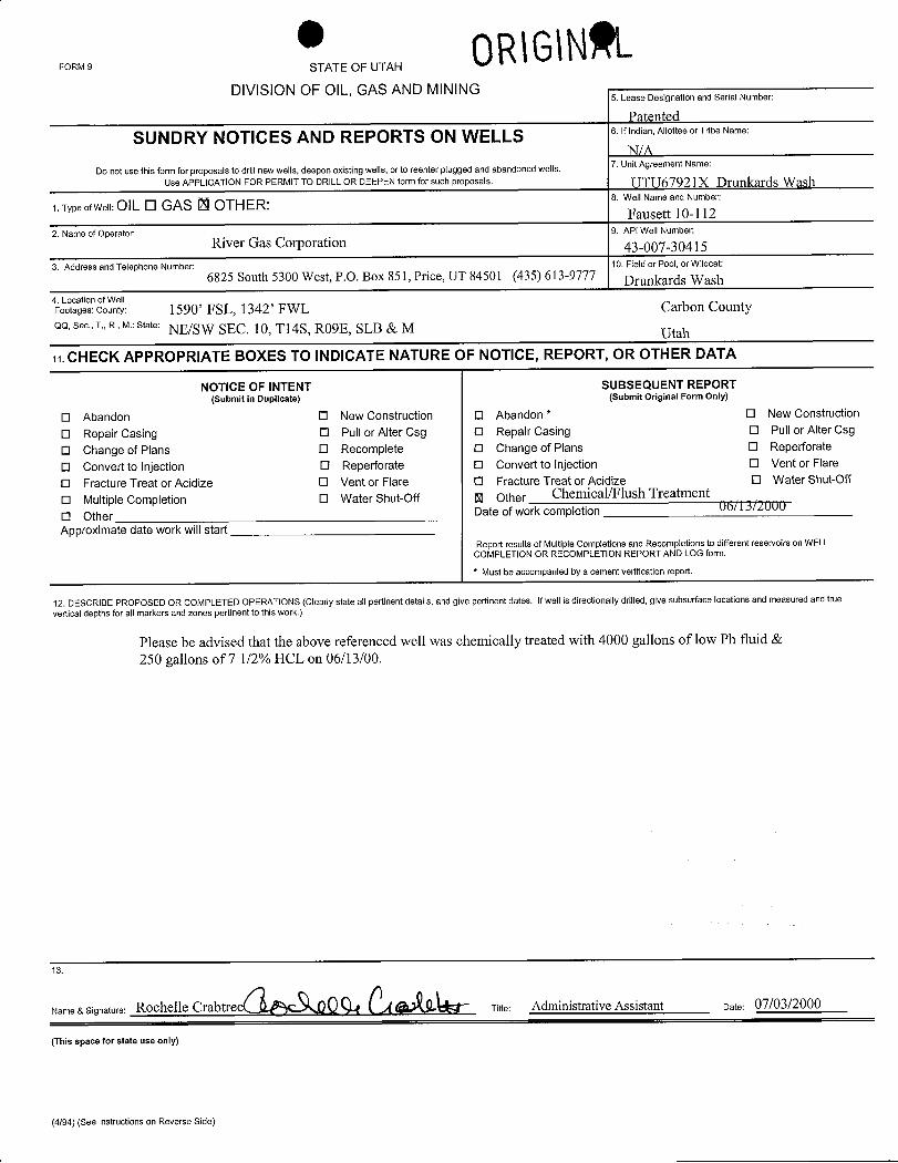
* OR\G\NALFORM 9 STATE OF UTAH
DIVISION OF OIL, GAS AND MINING5. Lease Designation and Serial Number:
Patented
SUNDRY NOTICES AND REPORTS ON WELLS 6.Iffndian,AllotteeorTribeName:
N/A7. Unit Agreement Name:
Do not use this form for proposals to drill new wells, deepen existing wells, or to reenter plugged and abandoned wells.Use APPLICATION FOR PERMlT TO DRILL OR DEEPEN form for such proposals UTU67921X Drunkards Wash
1.TypeofWell:OILO GAS Ë OTHER: 8. WelINameandNumber:
Fausett 10-1122. Name of Operator: 9. AP1Well Number:
River Gas Corporation 43-007-304153. Address and Telephone Number: 10. Field or Pool, or Wildcat:
6825 South 5300 West, P.O. Box 851, Price, UT 84501 (435) 613-9777 Drunkards Wash4. Location of WellFootages: County: 1590' FSL, 1342' FWL Carbon CountyQQ. Sec., T., R., M.: State: NE/SW SEC. 10, T14S, R09E, SLB & M Utah
11.CHECK APPROPRIATE BOXES TO INDICATE NATURE OF NOTICE, REPORT, OR OTHER DATA
NOTICE OF INTENT SUBSEQUENT REPORT(Submit in Duplicate) (Submit Original Form Only)
O Abandon O New Construction O Abandon * O New Construction
O Repair Casing O Pull or Alter Csg O Repair Casing O Pull or Alter Csg
O Change of Plans O Recomplete O Change of Plans O Reperforate
O Convert to Injection O Reperforate O Convert to Injection O Vent or Flare
O Fracture Treat or Acidize O Vent or Flare O Fracture Treat or Acidize O Water Shut-Off
O Multiple Completion O Water Shut-Off U Other Chemical/Flush Treatment
O Other Date of work completion U6/l.5MOOD
Approximate date work will startReport results of Multiple Completions and Recompletions to different reservoirs on WELL
COMPLETION OR RECOMPLETION REPORT AND LOG form.
* Must be accompanied by a cement verification report,
12. DESCRIBE PROPOSED OR COMPLETED OPERATIONS (Clearly state all pertinent details, and give pertinent dates. Ifwellis directionally drilled, give subsurface locations and measured and truevertical depths for all markers and zones pertinent to this work.)
Please be advised that the above referenced well was chemically treated with 4000 gallons of low Ph fluid &250 gallons of 7 1/2% HCL on 06/13/00.
13.
Name & Signature: Rochelle Crabtree Titie: Administrative Assistant Date: 07/03/2000
(This space for state use only)
(4/94) (See instructions on Reverse
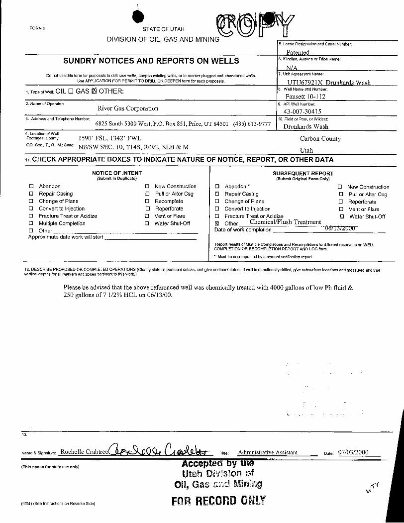
FORM 9 STATE OF UTAH
DIVISION OF OIL, GAS AND MINING5. Lease Designation and Serial Number:
PatentedSUNDRY NOTICES AND REPORTS ON WELLS 6.Ifindian,AllotteeorTribeName:
N/A7. UnitAgreement Name:Do not use this form for proposals to drill new wens, deepen existingwells, or to reenter plugged and abandoned wells.
Use APPLICATION FOR PERMIT TO DRILL OR DEEPEN form for such proposals. UTU67921X Drunkards Wash1. Type ofWell: OIL O GAS O OTHER: 8. Well Name and Number:
Fausett 10-1122. Name of Operator: 9. API Well Number:
River Gas Corporation 43-007-304153. Address and Telephone Number: 10. Field or Pool, or Wildcat:
6825 South 5300 West, P.O. Box 851, Price, UT 84501 (435) 613-9777 Drunkards Wash4. Location of WeltFootages: County: 1590' FSL, 1342' FWL Carbon CountyQQ, Sec., T., R., M.: State: NE/SW SEC. 10, T14S, RO9E, SLB & M Utah11. CHECK APPROPRIATE BOXES TO INDICATE NATURE OF NOTICE, REPORT, OR OTHER DATA
NOTICE OF INTENT SUBSEQUENT REPORT(Submit in Duplicate) (Submit Original Form Only)
O Abandon O New Construction 0 Abandon * O New ConstructionO Repair Casing O Pull or Alter Csg O Repair Casing O Pull or Alter CsgO Change of Plans O Recomplete O Change of Plans O ReperforateO Convert to Injection O Reperforate O Convert to Injection O Vent or FlareO Fracture Treat or Acidize O Vent or Flare O Fracture Treat or Acidize O Water Shut-OffO Multiple Completion O Water Shut-Off U Other Chemical/Flush TreatmentO Other Date of work cornpletion 06/1.suÜOÙApproximate date work will start
Report results of Multiple Completions and Recompletions to different reservoirs on WELLCOMPLETION OR RECOMPLETION REPORT AND LOG form.* Must be accompanied by a cement verification report.
12. DESCRIBE PROPOSED OR COMPLETED OPERATIONS (Clearly state all pertinent details, and give pertinent dates. If well is directionally drilled, give subsurface locations and measured and truevertical depths for all markers and zones pertinent to this work.)
Please be advised that the above referenced well was chemically treated with 4000 gallons of low Ph fluid &250 gallons of7 1/2% HCL on 06/13/00.
13.
Name & Signature: Rochelle Crabtree / OÛ Titie: Administrative Assistant Date: 07/03/2000
(This space for state use only) Accepted by theUtah DMalon of
Oil, Gas añd Mining <
(4/94) (See Instructions on Reverse Side) FORRECOHD 0N

FoRM e ATE OF UTAH
DIVISION OF OIL, GAS AND MINING5 Lease Designationand SerialNumber:
SUNDRY NOTICESAND REPORTS ON WELLS 6 Ifindian,AllotteeorTribeName:
Do not use this form for proposals to drill newwells,deepen existingwells,or to reenterplugged and abandoned wells 7 Unit Agreement Name:
Use APPLICATION FOR PERMIT TO DRILLOR DEEPEN form for such proposals
9 Type o<weli: OIL O GAS El OTHER: 8 Well Name and Number:
2 Name of Operator: 9 API Well Number:
River Gas Corporation3 Address and 10 Field or Pool, or Wildcat:TelephoneNumber: 6825 S. 5300 W. P.O. Box 851 Price, Utah 84501 (435) 613-97774 Location ofWell
Footages: County Carbon CountyQQ. Sec
, T ,R , M : State
SLB & M Utaha CHECK APPROPRIATE BOXES TO INDICATE NATURE OF NOTICE, REPORT, OR OTHER DATA
NOTICE OF INTENT SUBSEQUENT REPORT'(Submit in Duplicate) (Submit Original Form Only)
O Abandon O New Construction O Abandon * O New ConstructionO Repair Casing O Pull or Alter Casing O Repair Casing O Pull or Alter CasingO Change of Plans O Recomplete O Change of Plans O ReperforateO Convert to injection O Reperforate O Convert to injection O Vent or FlareO Fracture Treat or Acidize O Vent or Flare O Fracture Treat or Acidize O Water Shut-OffO Multiple Completion O Water Shut-Off O Otherf§ Other Change of Operator Date of work completionApproximate date work will start
Report results of Multiple Completions and Recompletions to different reservoirs on WELLCOMPLETION OR RECOMPLET10N REPORT AND LOG form* Must tw ccompaniedby a cement verification report
12 DESCRIBE PROPOSEDOR COMPLETED OPERATIONS (Clearly state all pertinent details, and give pertinent dates if wellis directionally drilled, give subsurface locations and measured and truevertical depths for all markers and zones pertinent to thiswork )
Please be advised that River Gas Corporation is transferring ownership of the attached list of wells to Phillips PetroleumCompany 9780 Mt. Pyramid Court, Englewood, CO 80112.Please direct all correspondence and reports to: Phillips Petroleum Company P.O. Box 3368, Englewood, CO 80155-3368.Effective 1/1/01
a signature:Cal Hurtt uw Development Manager oam
(This space for state use only)
(4/94) (See instructionson Reverse
FoRM e ATE OF UTAH
DIVISION OF OIL, GAS AND MINING5 Lease Designationand SerialNumber:
SUNDRY NOTICESAND REPORTS ON WELLS 6 Ifindian,AllotteeorTribeName:
Do not use this form for proposals to drill newwells,deepen existingwells,or to reenterplugged and abandoned wells 7 Unit Agreement Name:
Use APPLICATION FOR PERMIT TO DRILLOR DEEPEN form for such proposals
9 Type o<weli: OIL O GAS El OTHER: 8 Well Name and Number:
2 Name of Operator: 9 API Well Number:
River Gas Corporation3 Address and 10 Field or Pool, or Wildcat:TelephoneNumber: 6825 S. 5300 W. P.O. Box 851 Price, Utah 84501 (435) 613-97774 Location ofWell
Footages: County Carbon CountyQQ. Sec
, T ,R , M : State
SLB & M Utah
a CHECK APPROPRIATE BOXES TO INDICATE NATURE OF NOTICE, REPORT, OR OTHER DATA
NOTICE OF INTENT SUBSEQUENT REPORT'(Submit in Duplicate) (Submit Original Form Only)
O Abandon O New Construction O Abandon * O New ConstructionO Repair Casing O Pull or Alter Casing O Repair Casing O Pull or Alter CasingO Change of Plans O Recomplete O Change of Plans O ReperforateO Convert to injection O Reperforate O Convert to injection O Vent or FlareO Fracture Treat or Acidize O Vent or Flare O Fracture Treat or Acidize O Water Shut-OffO Multiple Completion O Water Shut-Off O Otherf§ Other Change of Operator Date of work completionApproximate date work will start
Report results of Multiple Completions and Recompletions to different reservoirs on WELLCOMPLETION OR RECOMPLET10N REPORT AND LOG form* Must tw ccompaniedby a cement verification report
12 DESCRIBE PROPOSEDOR COMPLETED OPERATIONS (Clearly state all pertinent details, and give pertinent dates if wellis directionally drilled, give subsurface locations and measured and truevertical depths for all markers and zones pertinent to thiswork )
Please be advised that River Gas Corporation is transferring ownership of the attached list of wells to Phillips PetroleumCompany 9780 Mt. Pyramid Court, Englewood, CO 80112.Please direct all correspondence and reports to: Phillips Petroleum Company P.O. Box 3368, Englewood, CO 80155-3368.Effective 1/1/01
a signature:Cal Hurtt uw Development Manager oam
(This space for state use only)
(4/94) (See instructionson Reverse
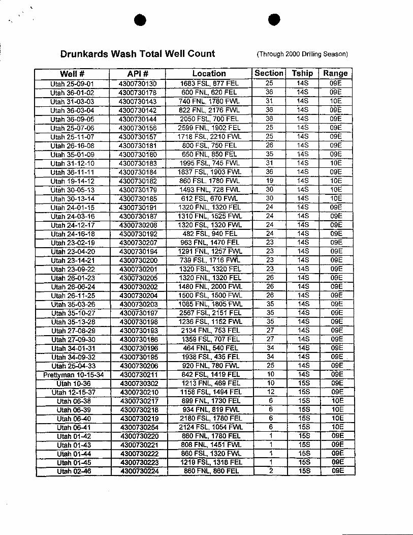
\
Drunkards Wash Total Well Count (Through 2000 DrillingSeason)
Well # API # Location Section Tship RangeUtah25-09-01 4300730130 1683FSL,877 FEL
__
25 14S 09EUtah 36-01-02 4300730178 600FNL,620 FEL 36 14S 09EUtah 31-03-03 4300730143 740 FNL, 1780 FWL 31 14S 10EUtah 36-03-04 4300730142 822 FNL, 2176 FWL 36 14S 09EUtah36-09-05 4300730144 2050FSL,700FEL 36 14S 09EUtah25-07-06 4300730156 2599FNL,1902 FEL 25 14S 09EUtah25-11-07 4300730157 1718 FSL,2210 FVVL 25 14S 09EUtah26-16-08 4300730181 800FSL,750 FEL 26 14S 09EUtah35-01-09 4300730180 650FNL,850FEL 35 14S 09EUtah31-12-10 4300730183 1995FSL,745 FVVL 31 14S 10EUtah36-11-11 4300730184 1837 FSL,1903 FVVL 36 14S 09EUtah 19-14-12 4300730182 860 FSL,1780 FVVL 19 14S 10EUtah 30-05-13 4300730179 1493 FNL, 728 FWL 30 14S 10EUtah 30-13-14 4300730185 612 FSL,670 FVVL 30 14S 10EUtah24-D1-15 4300730191 1320FNL,1320FEL 24 14S 09EUtah24-03-16 4300730187 1310FNL,1525FVVL 24 14S 09EUtah24-12-17 4300730208 1320FSL,1320FVVL 24 14S 09EUtah24-16-18 4300730192 482FSL,940FEL 24 14S 09EUtah23-02-19 4300730207 963FNL,1470FEL 23 14S 09EUtah23-04-20 4300730194 1291 FNL,1257 FVVL 23 14S 09EUkdi23-14-21 4300730200 739FSL,1716FVfL 23 14S 09EUtah23-09-22 4300730201 1320FSL,1320FEL 23 14S 09EUtsd126-D1-23 4300730205 1320FNL,1320 FEL 26 14S 09ELitah26-06-24 4300730202 1480FNL,2000 FVVL 26 14S 09EUtah26-11-25 4300730204 1500FSL,1500 FVVL 26 14S 09EUtah 35-03-26 4300730203 1085 FNL, 1805 FWL 35 14S 09EUtah35-10-27 4300730197 2567FSL,2151 FEL 35 14S 09EUtah 35-13-28 4300730198 1236 FSL, 1152 FWL 35 14S 09EUtah 27-08-29 4300730193 2134 FNL, 753 FEL 27 14S 09EUtah 27-09-30 4300730186 1359 FSL, 707 FEL 27 14S 09EUtah 34-01-31 4300730196 464FNL,540 FEL 34 14S 09EUtah34-09-32 4300730195 1938FSL,435FEL 34 14S 09EUtah 25-04-33 4300730206 920 FNL, 780 FWL 25 14S 09E
PreRyntan 10-15-34 4300730211 842FSL,1419FEL 10 14S 09EUtah 10-36 4300730302 1213FNL,469FEL 10 15S 09E
Utah 12-15-37 4300730210 1158FSL,1494FEL 12 15S 09EUtah06-38 4300730217 899FNL,1730FEL 6 15S 10EUtah06-39 4300730218 934FNL,819 FVVL 6 15S 10EUtah 06-40 4300730219 2180FSL,1780FEL 6 15S 10EUtah06-41 4300730254 2124FSL,1054 FVVL 6 15S 10EUtah01-42 4300730220 860FNL,1780FEL 1 15S 09EUtah01-43 4300730221 808 FNL,1451 FVVL 1 15S 09EUkúlO1-44 4300730222 860FSL,1320FVVL 1 15S 09E084101-45 4300730223 1219FSL,1318FEL 1 15S 09EUtah02-46 4300730224 IM¾)FNL,860FEL 2 15S
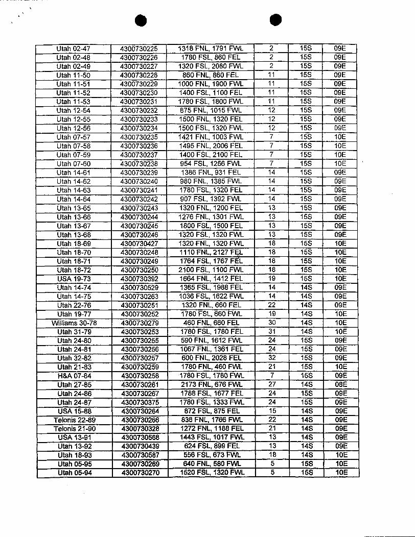
Utah02-47 4300730225 1318FNL,1791 FVVL 2 15S 09EUtah02-48 4300730226 1780 FSL,860 FEL 2 15S 09EUtah 02-49 4300730227 1320 FSL, 2080 FWL 2 15S 09EUtah 11-50 4300730228 860FNL,860 FEL 11 15S 09EUtah 11-51 4300730229 1000FNL,1900FVVL 11 15S 09EUtah 11-52 4300730230 1400FSL,1100 FEL 11 15S 09EUtah 11-53 4300730231 1780FSL,1800FVVL 11 15S 09EUtahi2-f¼ 4300730232 875FNL,1015F3NL 12 15S 09EUtah 12-55 4300730233 1500 FNL,1320 FEL 12 15S 09EUtah 12-56 4300730234 1500FSL,1320 FVVL 12 15S 09EUtah07-57 4300730235 1421 FNL,1003 FVVL 7 15S 10EUtah 07-58 4300730236 1495 FNL,2006FEL 7 15S 10EUtah07-59 4300730237 1400FSL,2100 FEL 7 15S 10EUtah 07-60 4300730238 954 FSL,1256 FVVL 7 15S 10EUtah 14-61 4300730239 1386FNL,931 FEL 14 15S 00EUtah 14432 4300730240 980 FNL,1385FVVL 14 15S 09EUtah 14-63 4300730241 1780 FSL,1320FEL 14 15S 09EUtah 14434 4300730242 907FSL,1392 FVVL 14 15S 09EUtah 13435 4300730243 1320FNL,1200FEL 13 15S 09EUtah 13436 4300730244 1276FNL,1301 FVVL 13 15S 09EUtah 13-67 4300730245 1800FSL,1500FEL 13 15S 09EUtah13458 4300730246 1320FSL,1320FVVL 13 15S 09EUtah 18-69 4300730427 1320FNL,1320 FVVL 18 15S 10EUtah 18-70 4300730248 1110FNL,2127Fg. 18 15S 10EUtah 18-71 4300730249 1764FSL,1767FEL 18 15S 10EUtah 18-72 4300730250 2100 FSL, 1100 FWL 18 15S 10EUSA19-73 4300730392 1664FNL,1412FEL 19 15S 10EUtah14-7.4 4300730529 1365FSL,1988FEL 14 14S 09EUtah 14-T5 4300730263 1036FSL,1622FVVL 14 14S 09EUtah22-76 4300730251 1320FNL,660FEL 22 14S 09EUtah 19-T7 4300730252 1780FSL,660FVVL 19 14S 10E
VVilliams30-78 4300730279 460 FNL, 660 FEL 30 14S 10EUtah31-79 4300730253 1780FSL,1780FEL 31 14S 10EUtah24-80 4300730255 590FNL,1612 FVVL 24 15S 09EUtah24-81 4300730256 1067FNL,1361 FEL 24 15S 09EUtah3242 4300730257 600FNL,2028FEL 32 15S 09EUtah21-83 4300730259 1780FNL,460FVVL 21 15S 10EH8/r07494 4300730258 1780FSL,1780RNL 7 15S 09EUtah27-85 4300730261 2173FNL,676 FVVL 27 14S 08EUtah24 86 4300730267 1788FSL,1677FEL 24 15S 09EUtah24-87 4300730375 1780FSL,1333F3NL 24 15S 09EUSA15-88 4300730264 872FSL,875FEL 15 14S 09E
Telonis22 89 4300730266 836FNL,1766FVVL 22 14S 09ETelonis21-90 4300730328 1272FNL,1188FEL 21 14S 09E
USA 13-91 4300730568 1443 FSL, 1017 FWL 13 14S 09EUtah13-92 4300730439 624FSL,899FEL 13 14S 09EUtah 18-93 4300730587 556 FSL, 673 FWL 18 14S 10EUtah05-95 4300730269 640FNL,580 FVVL 5 15S 10EUtah 05-94 4300730270 1520 FSL, 1320 FWL 5 15S
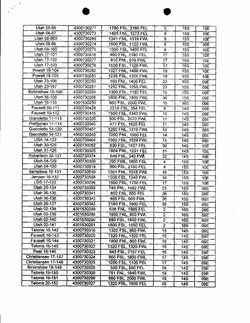
Litah05496 4300730271 1780FSL,2180FEL 5 15S 10ELitah08-97 4300730272 1495 FNL,1273FEL 8 15S 10E
Utah08498X 4300730285 1341 FNL,1319FVVL 8 15S 10ELitah08419 4300730274 1500FSL,1120RNL 8 15S 10E
Utah08-100 4300730275 1500 FSL,1400 FEL 8 15S 10EUtah 17-101 4300730416 460 FNL,2180 FEL 17 15S 10EUtah 17-102 4300730277 810FNL,910 FVVL 17 15S 10ELitah 17-103 4300730278 1520FSL,1120FVVL 17 15S 10E
Powell'H3-104 4300730282 1327FNL,1458FVIL 19 15S 10EPowell19-105 4300730283 1239FSL,1325FVVL 19 15S 10EUtah23-106 4300730280 150FNL,1400FEL 23 15S 09EUtah23-107 4300730281 1252FNL,1255FYJL 23 15S 09E
Birkinshaw19-108 4300730284 1305 FNL,1192FEL 19 15S 09EUtah36-109 4300730268 1800FNL,1800FVVL 36 15S 09EUtah 16-110 4301530250 860FSL,2000FVVL 16 16S 00E
Fauseu09-111 4300730428 2215FSL,354FEL 9 14S 09EFauseñí0-112 4300730415 1590FSL,1342FVVL 10 14S 09E
Giacoleûo11-113 4300730335 500FSL,2070 FVVL 11 14S 09EPrettyman11-114 4300730340 471 FSL,1828FEL 11 14S 09EGiacoletto 13-120 4300730407 1200 FNL, 1219 FWL 13 14S 09EGiacoletk>14-121 4300730345 1200FNL,1060FEL 14 14S 09E
USA14-122 4300730404 1500FNL,1039FYVL 14 14S 09EUtah30-125 4300730262 630FSL,1627FEL 30 14S 10EUtah31-126 4300730305 1954FNL,1291 FEL 31 14S 10E
Robenson32-127 4300730374 646FNL,349RNL 32 14S 10EUtah(M-129 4300730309 700FYVL,1850FSL 4 15S 10EUtah 04-130 4300730519 860 FSL,2150FEL 4 15S 10E
Sampinos16;-131 4300730610 1201 FNL,1016FNVL 16 15S 10EJensen 16-132 4300730588 1206 FSL,1240 FVVL 16 15S 10E
LDS 17-133 4300730296 1500FSL,1700FEL 17 15S 10EUtah25-134 4300730399 745FNL,1482 FVVL 25 15S 09EUtah36-135 4300730341 850FNL,850FEL 36 15S 09EUtah36-136 4300730343 465FSL,660FNVL 36 15S 09EUtah3€wi37 4300730342 2180FSL,1800FEL 36 15S 09EUtúl02-138 4301530288 638FNL,1865FEL 2 16S 09EUtah02-139 4301530289 1890FNL,850RNL 2 16S 09EUtah02-140 4301530290 850FSL,1800FVVL 2 16S 09EUtúl02-141 4301530291 1800FSL,1950FEL 2 16S 09E
Tek>nis15-142 4300730319 1320FSL,860FANL 15 14S 09EFauset16-143 4300730320 1320FNL,1320FEL 16 14S 09EFauseR16-144 4300730321 1800FNL,860FANL 16 14S 09ETelonis 16-145 4300730322 1320 FSL, 1320 FWL 16 14S 09E
Paar16;-146 4300730323 843FSL2157FEL 16 14S 09EChdstiansen 17-147 4300730324 860FSIL,1800FVVL 17 14S 09EChnstiansen 17-148 4300730325 1250FSL,1100FEL 17 148 09EBirkinshaw18-149 4300730326 500 FSL,500FEL 18 14S 09E
Telonis 19-150 4300730300 751 FNL, 1840 FWL 19 14S 09ETelonis 19-151 4300730299 860 FSL, 2000 FWL 19 148 09ETekniis2CW152 4300730327 1320FNL,1900FEL 20 14S
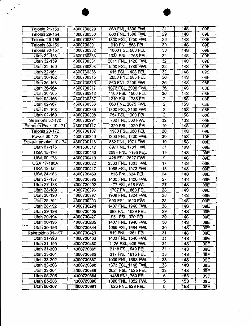
Tisionis21-153 4300730329 860FNL,1800FVVL 21 14S 09E135|onis29-154 4300730330 800FNL,1500 FVVL 29 14S 09ETillonis29-155 4300730331 1800FSL,1250FVVL 29 14S 09E1391onis30-156 4300730301 910FNL,868FEL 30 14S 09ETelonis30-157 4300730332 1800FSL,580FEL 30 14S 09E
Utah 32-158 4300730333 1038FNL,1768FEL 32 14S 09EUtah 32-159 4300730334 2011 FNL,1426 FVVL 32 14S 09EUtah 32-160 4300730398 1500FSL,1780FVVL 32 14S 09EUtah 32-161 4300730336 415 FSL,1408 FEL 32 148 09ELitah36-162 4300730315 2053 FNL,685 FEL 36 14S 08EUtah 36-163 4300730316 860FNL,2100 FVVL 36 14S 08EUtah 36.-164 4300730317 1070FSL,2000FVVL 36 14S 08EUtah36-165 4300730318 1100 FSL,1500 FEL 36 14S 08EUtah 02-166 4300730337 1219FNL,1738FEL 2 15S 08EUtah02-167 4300730338 660FNL,2075FVVL 2 15S 0.8EUtah02-168 4300730339 1800 FSL,2100FVVL 2 15S 08EUtah02-169 4300730308 754FSL,1000FEL 2 15S 08E
Searnons32-170 4300730291 700FNL,500 FVVL . 32 13S 09EPinnackšPeak 19-171 4300730117 1320FSL,1320 FEL 19 14S 09E
Telonis20-172 4300730107 1980FSL,660 FEL 20 148 09EPcnWelI30-173 4300730346 1200FNL,1200 FVVL 30 15S 10E
Stella-Harnaker10-174 4300730116 852FNL,1971 FVVL 10 15S 08EJtah31-175 4301530317 897FNL,1731 FVVL 31 16S 09EUSA15-176 4300730450 2588FNL,1155FEL 15 14S 09EUSA09-178 4300730419 428 FSIL,2527 FVÝL 9 14S 09E
U:SA17-180A 4300730622 2563 FNL,1383 FVVL 17 14S 09EU6LA181-182 4300730417 1068 FSL,1972 FVVL 18 14S 09EUEsA24-183 4300730469 828FNL,624FEL 24 14S 08EUtah 27-187 4300730395 1400 FNL, 1400 FWL 27 14S 09EUtah27-188 4300730292 477 FSL,518 FVVL 27 14S 09EUtah28-189 4300730396 1707FNL,868 FEL 28 14S 09EUtah28-190 4300730397 1969FNL,1324 FVVL 28 14S 09ELitah28-191 4300730293 693 FSL,1623 FVVL 28 14S 09EUtah28-192 4300730294 1407FNL,1940FVVL 28 14S 09EUtah29-193 4300730405 693 FNL,1029FEL 29 14S 09EUtah29-194 4300730427 951 FSL,370FEL 29 14S 09EUtah 30-195 4300730265 1407FNL,1940 FVVL 30 14S 09EUtah30-196 4300730344 1056 FSL,1984FVVL 30 14S 09E
Kakatsidas31-197 4300730420 619FNL,1361 FEL 31 14S 09EUtah31-198 4300730406 1403 FNL,1540FVVL 31 14S 09EUtah31-199 4300730480 1125FSL,928 FVVL 31 14S 09EUtah 31-200 4300730385 2118FSL,549FEL 31 14S 09EUtah 33-201 4300730386 317 FNL, 1815 FEL 33 14S 09EUtah33-202 4300730387 1939FNL,159313AA. 33 14S 09EUtah 33-203 4300730388 1373 FSL, 1140 FWL 33 14S 09EUtah33-204 4300730389 2024FSL,1525FEL 33 148 09EUtah05-205 4300730384 1485FNL,760FEL 5 15S 09EUtah05-:206 4300730390 1300FNL,1352FVVL S 15S 09EUtahde-207 4300730391 825FNL,928FEL 6 15S
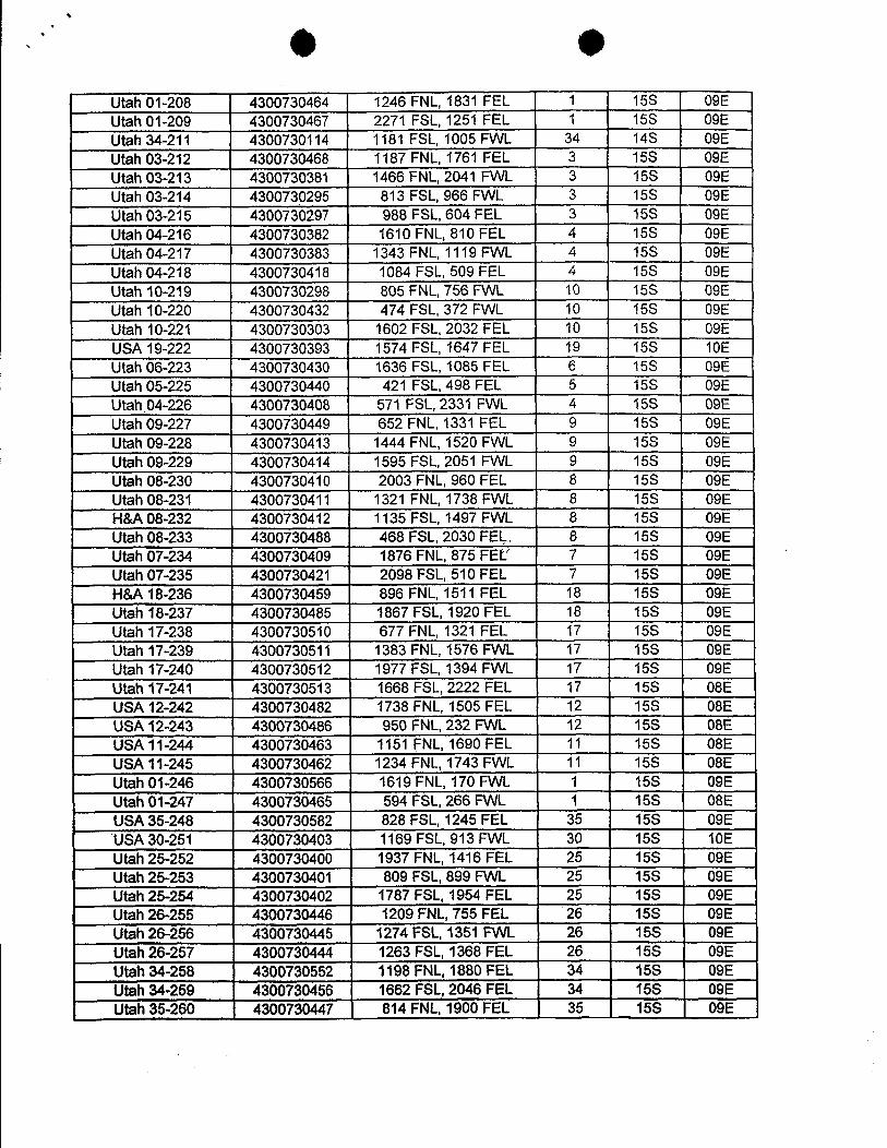
Utah01-208 4300730464 1246FNL,1831 FEL 1 15S 09EUtah01-209 4300730467 2271 FSL,1251 FEL 1 15S 09EUtah 34-211 4300730114 1181 FSL,1005 FVVL 34 14S 09EUtd103-212 4300730468 1187FNL,1761 FEL 3 15S 09EUtah03-213 4300730381 1466 FNL,2041 FVVL 3 15S 09EUtah03-214 4300730295 813 FSL,966 FVVL 3 15S 09EUtah03-215 4300730297 988 FSL,604FEL 3 15S 09EUtah 04-216 4300730382 1610 FNL,810 FEL 4 15S 09EUtah04-217 4300730383 1343FNL,1119FVVL 4 15S 09EUtah04-218 4300730418 1084 FSL,509 FEL 4 15S 09EUtah 10-219 4300730298 805 FNL,756 FVVL 10 15S 09EUtah 10-220 4300730432 474 FSL,372 FVVL 10 15S 09EUtah 10-221 4300730303 1602 FSL,2032 FEL 10 15S 09EUSA19-222 4300730393 1574 FSL,1647 FEL 19 15S: 10EUtah06-223 4300730430 1636FSL,1085FEL 6 15S 09EUtah05-225 4300730440 421 FSL,498 FEL 5 15S 09EUtah04-226 4300730408 571 FSL,2331 FVVL 4 15S 09EUtah09-227 4300730449 652FNL,1331 FEL 9 15S 09EUtah09-228 4300730413 1444 FNL,1520 FVVL 9 15S 09EUtah09-229 4300730414 1595 FSL,2051 FVVL 9 15S 09EUtah08-230 4300730410 2003 FNL,960FEL 8 15S 09EUtah08-231 4300730411 1321 FNL,1738 FVVL 8 15S 09EH&A08-232 4300730412 1135 FSL, 1497 FWL 8 15S 09EUtah08-233 4300730488 468 FSL,2030FEL 8 15S 09EUMh07-2:W 4300730409 1876FNL,875FEL' 7 15S 09EUtah07-235 4300730421 2098FSL,510FEL 7 15S 09EHIL418-236 4300730459 896 FNL,1511 FEL 18 15S 09EUtah18-237 4300730485 1867FSL,1920FEL 18 15S 09EUtah 17-238 4300730510 677 FNL,1321 FEL 17 15S 09EUtah 17-239 4300730511 1383 FNL, 1576 FWL 17 15S 09EUtah 17-;240 4300730512 1977 FSL,1394 FVVL 17 15S 09EUtahi7-2.41 4300730513 1668FSL,2222FEL 17 15S 08ELELA12-242 4300730482 1738FNL,1505FEL 12 15S 08ELKWA12-243 4300730486 950FNL,232 FVVL 12 15S 08EUSA 11-244 4300730463 1151 FNL, 1690 FEL 11 15S 08ELEL411-245 4300730462 1234FNL,1743 FVVL 11 15S 08EUtah01-:246 4300730566 1619FNL,170FVVL 1 15S 09EUtah01-247 4300730465 594FSL,266 FVVL 1 15S 08EUSIA35-248 4300730582 828FSL,1245FEL 35 15S 09EUSA30-:251 4300730403 1169FSL,913FVVL 30 15S 10EUtah25-252 4300730400 1937 FNL,1416 FEL 25 15S 09EUtah 25-253 4300730401 809 FSL, 899 FWL 25 15S 09EUtah25-2:54 4300730402 1787FSL,1954FEL 25 15S 09EUtah 26-255 4300730446 1209 FNL, 755 FEL 26 15S 09EUtah 26-256 4300730445 1274 FSL, 1351 FWL 26 15S 09EUtah 26-257 4300730444 1263 FSL, 1368 FEL 26 15S 09EUtah 34-258 4300730552 1198 FNL,1880 FEL 34 15S 09EUtah&i-259 4300730456 1662FSL,2046FEL 34 15S 09EUtah 35-260 4300730447 814 FNL, 1900 FEL 35 15S
Utah01-208 4300730464 1246FNL,1831 FEL 1 15S 09EUtah01-209 4300730467 2271 FSL,1251 FEL 1 15S 09EUtah 34-211 4300730114 1181 FSL,1005 FVVL 34 14S 09EUtd103-212 4300730468 1187FNL,1761 FEL 3 15S 09EUtah03-213 4300730381 1466 FNL,2041 FVVL 3 15S 09EUtah03-214 4300730295 813 FSL,966 FVVL 3 15S 09EUtah03-215 4300730297 988 FSL,604FEL 3 15S 09EUtah 04-216 4300730382 1610 FNL,810 FEL 4 15S 09EUtah04-217 4300730383 1343FNL,1119FVVL 4 15S 09EUtah04-218 4300730418 1084 FSL,509 FEL 4 15S 09EUtah 10-219 4300730298 805 FNL,756 FVVL 10 15S 09EUtah 10-220 4300730432 474 FSL,372 FVVL 10 15S 09EUtah 10-221 4300730303 1602 FSL,2032 FEL 10 15S 09EUSA19-222 4300730393 1574 FSL,1647 FEL 19 15S: 10EUtah06-223 4300730430 1636FSL,1085FEL 6 15S 09EUtah05-225 4300730440 421 FSL,498 FEL 5 15S 09EUtah04-226 4300730408 571 FSL,2331 FVVL 4 15S 09EUtah09-227 4300730449 652FNL,1331 FEL 9 15S 09EUtah09-228 4300730413 1444 FNL,1520 FVVL 9 15S 09EUtah09-229 4300730414 1595 FSL,2051 FVVL 9 15S 09EUtah08-230 4300730410 2003 FNL,960FEL 8 15S 09EUtah08-231 4300730411 1321 FNL,1738 FVVL 8 15S 09EH&A08-232 4300730412 1135 FSL, 1497 FWL 8 15S 09EUtah08-233 4300730488 468 FSL,2030FEL 8 15S 09EUMh07-2:W 4300730409 1876FNL,875FEL' 7 15S 09EUtah07-235 4300730421 2098FSL,510FEL 7 15S 09EHIL418-236 4300730459 896 FNL,1511 FEL 18 15S 09EUtah18-237 4300730485 1867FSL,1920FEL 18 15S 09EUtah 17-238 4300730510 677 FNL,1321 FEL 17 15S 09EUtah 17-239 4300730511 1383 FNL, 1576 FWL 17 15S 09EUtah 17-;240 4300730512 1977 FSL,1394 FVVL 17 15S 09EUtahi7-2.41 4300730513 1668FSL,2222FEL 17 15S 08ELELA12-242 4300730482 1738FNL,1505FEL 12 15S 08ELKWA12-243 4300730486 950FNL,232 FVVL 12 15S 08EUSA 11-244 4300730463 1151 FNL, 1690 FEL 11 15S 08ELEL411-245 4300730462 1234FNL,1743 FVVL 11 15S 08EUtah01-:246 4300730566 1619FNL,170FVVL 1 15S 09EUtah01-247 4300730465 594FSL,266 FVVL 1 15S 08EUSIA35-248 4300730582 828FSL,1245FEL 35 15S 09EUSA30-:251 4300730403 1169FSL,913FVVL 30 15S 10EUtah25-252 4300730400 1937 FNL,1416 FEL 25 15S 09EUtah 25-253 4300730401 809 FSL, 899 FWL 25 15S 09EUtah25-2:54 4300730402 1787FSL,1954FEL 25 15S 09EUtah 26-255 4300730446 1209 FNL, 755 FEL 26 15S 09EUtah 26-256 4300730445 1274 FSL, 1351 FWL 26 15S 09EUtah 26-257 4300730444 1263 FSL, 1368 FEL 26 15S 09EUtah 34-258 4300730552 1198 FNL,1880 FEL 34 15S 09EUtah&i-259 4300730456 1662FSL,2046FEL 34 15S 09EUtah 35-260 4300730447 814 FNL, 1900 FEL 35 15S
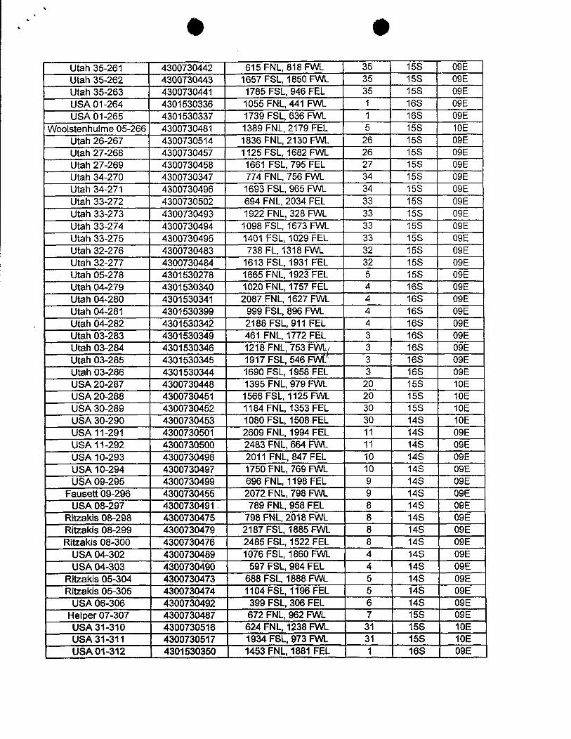
Utah 35-261 4300730442 615FNL,818FVVL 35 15S 09EUtah 35-262 4300730443 1657FSL,1850 FVVL 35 15S 09EUtah35-263 4300730441 1785FSL,946FEL 35 15S 09EUSA01-264 4301530336 1055 FNL,441 FVW_ 1 16S 09EUSA01-265 4301530337 1739FSL,636FVW. 1 16S 09E
Woolstenhulme 05-266 4300730481 1389 FNL, 2179 FEL 5 15S 10ELJtah26-267 4300730514 1836 FNL,2130FVVL 26 15S 09EUtah 27-:268 4300730457 1125FSL,1682 FVVL 26 15S 09ELitah27-269 4300730458 1661 FSL,795FEL 27 15S 09EUtah 34-270 4300730347 774 FNL,756FVVL 34 15S 09EUtah 34-271 4300730496 1693 FSL,965FVVL 34 15S 09EUtah 33-272 4300730502 694 FNL,2034 FEL 33 15S 09ELitah 33-273 4300730493 1922 FNL,328FVVL 33 15S 09ELitah 33-274 4300730494 1098FSL,1673 FVVL 33 15S 09EUtah 33-275 4300730495 1401 FSL,1029FEL 33 15S 09ELitah 32-276 4300730483 738 FL,1318 FVVL 32 15S 09EUtah 32-277 4300730484 1613FSL,1931 FEL 32 15S 09EUtah 05-278 4301530278 1665 FNL,1923 FEL 5 15S 09EUtah04-279 4301530340 1020 FNL,1757FEL 4 16S 09EUtah04-280 4301530341 2087FNL,1627FYVL 4 16S 09EUtah 04-281 4301530399 999FSL,896FVVL 4 16S 09ELitah 04-282 4301530342 2188FSL,911 FEL 4 16S 09ELitah03-283 4301530349 461 FNL 1772FEL 3 16S 09EUtah 03-284 4301530346 1218 FNL, 753 FWL, 3 16S 09EUtah 03-285 4301530345 1917 FSL, 546 FWU 3 16S 09EUtah03-286 4301530344 1690FSL,1958FEL 3 16S 09EUSA 20-287 4300730448 1395 FNL, 979 FWL 20 15S 10EUSA20-288 4300730451 1566FSL,1125 FVVL 20 15S 10EUSWA30-289 4300730452 1184 FNL,1353FEL 30 15S 10ELASA30-:290 4300730453 1080FS:L1508FEL 30 14S 10EU6L411-291 4300730501 2609FNL,1994FEL 11 14S 09EU6WA11-292 4300730500 2483FNL,664f3AL 11 14S 09EUELA10-293 4300730498 2011 FNL,847FEL 10 14S 09ELMSA10-:294 4300730497 1750FNL,769FVVL 10 14S 09ELJSA09-295 4300730499 696FNL,1198FEL 9 14S 09E
FauseRO9-296 4300730455 2072FNL,798FVVL 9 14S 09ELDSA08-:297 4300730491 789FNL,958FEL 8 14S 09E
Ritzakis08-298 4300730475 798FNL,2018FVVL 8 14S 09ERitzakis08-:299 4300730479 2187FSL,1885FANL 8 14S 09ERitzakis08-300 4300730476 2485FSL,1522FEL 8 14S 09E
USA04-302 4300730489 1076 FSL,1860 FVVL 4 14S 09E060404-303 4300730490 597FSL,984FEL 4 14S 09E
Ritzakis05-304 4300730473 688FSL,1888FVVL 5 14S 09ERitzakis05-305 4300730474 1104FSL,1196FEL 5 14S 09E
USA06-306 4300730492 399FSL,306FEL 6 14S 09EFielper07-307 4300730487 672 FNL,962 FVVL 7 15S 09EUSA31-310 4300730516 624FNL,1238FRAL 31 15S 10EUSA31-311 4300730517 1912WFSL,973RAL 31 15S 10EUSA01-312 4301530350 1453FNL,1881 FEL 1 16S
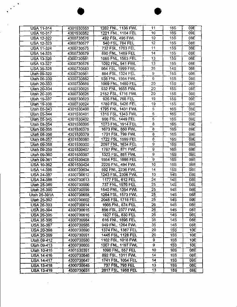
l
USUA11-314 4301530353 1262FNL,1136FVVL 11 16S 09EL¾SA10-317 4301530352 1221 FNL,1104 FEL 10 16S 09EthBA 12-322 4300730576 492 FSL,495FVVL 10 15S 08ELDSA12-323 4300730577 540FSL,784FEL 12 15S 08EUSA11-324 4300730575 732FSL,1763FEL 11 15S 08ELhSA14-325 4300730579 890 FNL,1469FEL 14 15S 08EUS;A13-326 4300730581 1065FNL,1563FEL 13 15S 08EUSA13-327 4300730578 1092 FNL,941 FVVL 13 15S 08EUSA35-328 4300730583 964 FSL,1999 FVVL 35 14S 08EUtah 09-329 4300730561 884FSL,1324FEL 9 15S 09EUtah06-330 4300730562 938FNL,1564F\¾L 6 15S 09EUtah20·-333 4300730669 1069FNL,1460 FEL 20 15S 09EUtah20-334 4300730625 932FNL,1655FVVL 20 15S 09EUtah20-335 4300730626 2152 FSL,1716FVVL 20 15S 09EUtah 19-337 4300730623 926FNL,768FEL 19 15S 09ËUtah 19-338 4300730624 1789FSL,1426FEL 19 15S 09EUtah 05-343 4301530400 1795FNL,1431 FVVL 5 16S 09EUtah05-344 4301530401 1316FSL,1343FVVL 5 16S 09EUtah05-345 4301530402 908 FSL,1449 FEL 5 16S 09EUtah08-354 4301530395 1073FNL,1914FEL 8 16S 09EUtah08-355 4301530378 1673 FNL,850FVVL 8 16S 09EUtah 08.-356 4301530379 1701 FSL,799FVVL 8 16S 09EUtah08-357 4301530380 1722FSL,1599FEL 8 16S 09EUtah 09-358 4301530300 2097 FNL,1634 FEL 9 16S 09EUtah 09-359 4301530407 1787FNL,871 FVVË 9 16S 09EUtah09-360 4301530397 1323FSL,881 FVVL 9 16S 09EUtah 09-361 4301530408 1564FSL,1998 FEL 9 16S 09ELRL410I-362 4301530424 2225FNL,494 FVVL 10 16S 09EU'SA14-386 4300730634 592 FNL,2236 FVVL 14 15S 08E060424-387 4300730612 1243FSL,2306FVVL 10 14S 08EUSDA24-388 4300730613 1177FSL,612 FEL 24 14S 08EUtah 25-389 4300730600 737 FNL, 1976 FEL 25 14S 08EUtah 25-390 4300730599 1540 FNL, 1354 FWL 25 14S 08E
Utah25-391A 4300730658 1264FSL,1573FVVL 25 14S 08EUtah25-392 4300730602 2045FSL,1718FEL 25 14S 09EUSA26-393 4300730614 1666FNL,874FEL 26 14S 08EUSA26-394 4300730615 856 FSL, 2377 FWL 26 14S 08EUSA26-395 4300730616 1927FSL,830FEL 26 14S 08E ,
Ufš422i-396 4300730584 616FNL,1896FEL 35 14S 08E \UEL435-397 4300730585 949FNL,1264F3NL 35 145 08EUSA20!-398 4300730590 1374FNL,1387FEL 20 15S 10EUSA20-399 4300730591 1445FSL,1128FEL 20 15S 10EUtah09-412 4300730580 1102FSL,1018FVVL 9 15S 10EUtah 09-413 4300730605 1007 FNL,1197 FWL 9 15S 10E :
Utah 10415 4301530391 1090FNL,557FEL 10 16S 08EUfl414-416 4300730646 892FSL,1311 FVVL 14 15S 08E.USA14-417 4300730647 1741 FSL,1054FEL 14 15S 09EUIL413-418 4300730645 737FSL,793FEL 13 15S 08EUSA13-419 4300730631 2617FSL,1958FEL 13 15S
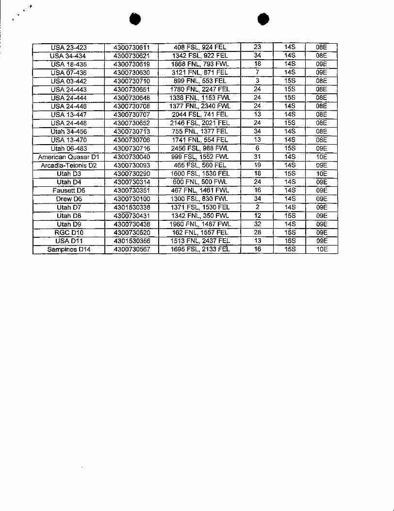
USA23423 4300730611 408FSL,924FEL 23 14S 08ELESA34-434 4300730621 1342 FSL,922 FEL 34 14S 08EUELA18-435 4300730619 1868FNL,793FVVL 18 14S 09ELLSA07-436 4300730630 3121 FNL,871 FEL 7 146. 09EUSA03-442 4300730710 899FNL,553FEL 3 15S 08EUSA 24-443 4300730651 1780 FNL, 2247 FEL 24 15S 08EUSUk24-444 4300730648 1338FNL,1153FVVL 24 15S 08EUSU\24-446 4300730708 1377 FNL,2340FVVL 24 14S 08EUELA13-447 4300730707 2044 FSL,741 FEL 13 14S 08EUSuk24-448 4300730652 2146 FSL,2021 FEL 24 15S 08EUtah34-456 4300730713 755FNL,1377 FEL 34 14S 08EUSA13-470 4300730706 1741 FNL,554 FEL 13 14S 08EUtah06-483 4300730716 2456FSL,988 FVVL 6 15S 09E
American QuasarDi 4300730040 999 FSL,1552 FVVL 31 14S 10EAscadia-Telonis D2 4300730093 465FSL,560FEL 19 14S 09E
Utah D3 4300730290 1600 FSL,1530FEL 18 15S 10EUtah D4 4300730314 600FNL,500 FVVL 24 14S 09E
FauseRD5 4300730351 467FNL,1461 FVVL 16 14S 09EDrewD6 4300730100 1300FSL,830FVVL 34 14S 09EUtahD7 4301530338 1371 FSL,1530FEL 2 14S 09ELJtahD8 4300730431 1342FNL,350F\¾L 12 15S 09EUtah D9 4300730438 1960FNL,1487FVVL 32 14S 09E
RGCD10 4300730520 162FNL,1557FEL 28 15S 09EUSAD11 4301530356 1513FNL,2437FEL 13 16S 09E
Sany>inosD14 4300730567 1695FSL,2133FE'L 16 15S
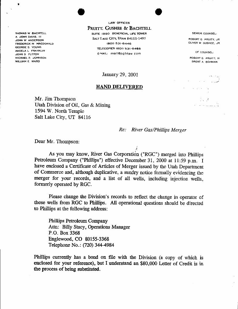
LAW OFFICES
PRUTTT, GUSHEE ôr BACHTELLTNOMAS W BACHTELL SUITE ISSO BENEFICIAL LIFE TOWER SENIOR COUNSEL:A JOHN DAVIS. 111JOMN W ANDERSON SALT LAKE CITY, UTAH 84111-1495 ROBERT G PRUITT, UR
FREDERICK M MACDONALD (800 531-8446 OLIVER W GUSHEE, JR
GEORGE S YOUNG TELECOPIER (801) 531-8468ANGELA L FRANKLIN
JOHN S FLITTON E-MAIL: maif@pgblaw com OF coUNSEL:
MICHAEL S JOHNSON ROBERT G PRUITT, 111WILLIAM E WARD BRENT A BOHMAN
January 29, 2001
HAND DELIVERED
Mr. Jim ThompsonUtah Division of Oil, Gas & Mining1594 W. North TempleSalt Lake City, UT 84116
Re: River Gas/Phillips Merger
Dear Mr. Thompson:
As you may know, River Gas CorporatiËn("RGC") merged into PhillipsPetroleum Company ("Phillips") effective December 31, 2000 at 11:59 p.m. Ihave enclosed a Certificate of Articles of Merger issued by the Utah Departmentof Commerce and, although duplicative, a sundry notice formally evidencing themerger for your records, and a list of all wells, including injection wells,formerly operated by RGC.
Please change the Division's records to reflect the change in operator ofthese wells from RGC to Phillips. All operational questions should be directedto Phillips at the following address:
Phillips Petroleum CompanyAttn: Billy Stacy, Operations ManagerP.O. Box 3368Englewood, CO 80155-3368Telephone No.: (720) 344-4984
Phillips currently has a bond on file with the Division (a copy of which isenclosed for your reference), but I understand an $80,000Letter of Credit is inthe process of being
g eMr. Jim ThompsonJanuary 29, 2001Page 2
On behalf of Phillips, I thank you for your cooperation. Should you haveany further questions or concerns, please do not hesitate to contact me.
Yo y truly,
Frederick M. MacDonaldFMM:cs2078.16Enclosurescc: W. H. Rainbolt
Billy
g eMr. Jim ThompsonJanuary 29, 2001Page 2
On behalf of Phillips, I thank you for your cooperation. Should you haveany further questions or concerns, please do not hesitate to contact me.
Yo y truly,
Frederick M. MacDonaldFMM:cs2078.16Enclosurescc: W. H. Rainbolt
Billy
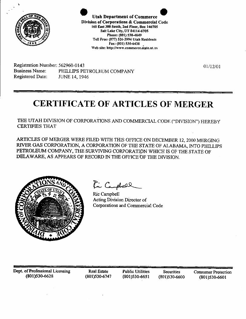
or targ. Utah Department of CommerceDivision of Corporations & Commercial Code
160 East 300 South, 2nd Floor, Box 146705Salt Lake City, UT 84114-6705
Phone: (801) 530-4849. Toll Free: (877) 526-3994 Utah Residents
se Fax: (801) 530-6438,
Web site: http://www.commerce.state.ut.us
Registration Number: 562960-0143 01/12/01Business Name: PHILLIPS PETROLEUM COMPANYRegistered Date: JUNE 14, 1946
CERTIFICATE OF ARTICLES OF MERGER
THE UTAH DIVISION OF CORPORATIONS AND COMMERCIAL CODE ("DIVISION") HEREBYCERTIFIES THAT
ARTICLES OF MERGER WERE FILED WITH THIS OFFICE ON DECEMBER 12, 2000 MERGINGRIVER GAS CORPORATION, A CORPORATION OF THE STATE OF ALABAMA, INTO PHILLIPSPETROLEUM COMPANY, THE SURVIVING CORPORATI¶)N WHICH IS OF THE STATE OFDELAWARE, AS APPEARS OF RECORD IN THE OFFICE ÒF THE DIVISION.
Ric CampbellActing Division Director of' Corporations and Commercial Code
Dept. of Profëssional Licensing Real Estate Public Utilities Securities Consumer Protection(801)530-6628 (801)530-6747 (801)530-6651 (801)530-6600
State of DelatoarePAGE 1
Ofice of the Secretary of State
I, EDWARD J. FREEL, SECRETARY OF STATE OF THE STATE OF
DELAWARE, DO HEREBY CERTIFY THE ATTACHED IS A TRUE AND CORRE
COPY OF THE CERTIFICATE OF OWNERSHIP, WHICH MERGES:
"RIVER GAS CORPOPATION", A ALABAMA CORPORATION,
WITH AND INTO "PEILLIPS PETROLEUM COMPANY" UNDER THE NAME OF
"PHILLIPS PETROLEUM COMPANY", A CORPORATION ORGANIZED AND
EXISTING UNDER TEE LAWS OF TEE STATE OF DELAWARE, AS RECEIVED
AND FILED IN THIS OFFICE THE SIXTH DAY OF DECEMBER, A.D. 2000,
AT 10 O' CLOCK A.M.
AND I DO HEREBY FURTEER CERTIFY TOT THE EFFECTIVE DATE OF
THE AFORESAID CERTIFICATE OF OWNERSHIP IS THE TEIRTY-FIRST DAY lOF DECEMBER, A.D. 2000, AT 11:59 O'CLOCK A.M. o
o
A FILED COPY OF THIS CERTIFICATE HAS BEEN FORWARDED TO THE
NEW CASTLE COUNTY RECORDER OF DEEDS.
stateetutanDepertment et M
Olvisionet corperakxxMMtHerebycertitythottheC. onesepproecion --
In ine emceofth¡s oncihereby Mthiscertmeatetreeof.
PILEED oot.
DE12 2000 weG DIREC10R
UkkWv.OfCup.&Coma.Code
Edward J.Freel, Secretary of State0064324 8100M AUTHENTICATION: 0837738
001609453 DATE:
State of DelatoarePAGE 1
Ofice of the Secretary of State
I, EDWARD J. FREEL, SECRETARY OF STATE OF THE STATE OF
DELAWARE, DO HEREBY CERTIFY THE ATTACHED IS A TRUE AND CORRE
COPY OF THE CERTIFICATE OF OWNERSHIP, WHICH MERGES:
"RIVER GAS CORPOPATION", A ALABAMA CORPORATION,
WITH AND INTO "PEILLIPS PETROLEUM COMPANY" UNDER THE NAME OF
"PHILLIPS PETROLEUM COMPANY", A CORPORATION ORGANIZED AND
EXISTING UNDER TEE LAWS OF TEE STATE OF DELAWARE, AS RECEIVED
AND FILED IN THIS OFFICE THE SIXTH DAY OF DECEMBER, A.D. 2000,
AT 10 O' CLOCK A.M.
AND I DO HEREBY FURTEER CERTIFY TOT THE EFFECTIVE DATE OF
THE AFORESAID CERTIFICATE OF OWNERSHIP IS THE TEIRTY-FIRST DAY lOF DECEMBER, A.D. 2000, AT 11:59 O'CLOCK A.M. o
o
A FILED COPY OF THIS CERTIFICATE HAS BEEN FORWARDED TO THE
NEW CASTLE COUNTY RECORDER OF DEEDS.
stateetutanDepertment et M
Olvisionet corperakxxMMtHerebycertitythottheC. onesepproecion --
In ine emceofth¡s oncihereby M
thiscertmeatetreeof.
PILEED oot.
DE12 2000 weG DIREC10R
UkkWv.OfCup.&Coma.Code
Edward J.Freel, Secretary of State0064324 8100M AUTHENTICATION: 0837738
001609453 DATE:
szensraar or svaraDIVISION OF CORPORATIONSFILZD 10: 00 AM 12/06/2000
001409453 - 0064324
CERTIFICATEOF OWNERSH1PAND MERGER
OF
RIVERGAS CORPORATION
(an Alabama corporation)
into
Phillips Petroleum Company
(a Delaware corporation)
It is hereby certified that
1. Phillips PetmleumCompany [hereinafter sometimes referred to as the"Corporation"] is a business corporationof theState ofDelaware.
2. The Corporation is the owner of all,of the outstanding shares of each -
class of stock of River Gas Corporation, which is a b'usiness corporationof the State of N
Alabama.o
3. The laws of the Jurisdictionof organizationof River Gas Corporation opermit the merger of a business corporationofthat jurisdictionwith a business corporation oof another jurisdiction.
4. The Corporation hereby merges River Gas Corporation into theCorporation.
5. The following is a copyof the resolutionsadopted on November 21, 2000by the Board of Directors of the Corporation to merge the said River Gas Corporationinto the Corporation:
"1. Phittips Petroleum Company, which is abusiness corporationof the State of Delaware and is theowner of all of the outstanding shares of River GasCorporation, ùthichis a business corporationof the State ofAlabama, hereby merges River Gas Corporation into PhillipsPetroleum Company pursuant to the provisions of theAlabama Business Corporation Act and pursuant to
szensraar or svaraDIVISION OF CORPORATIONSFILZD 10: 00 AM 12/06/2000
001409453 - 0064324
CERTIFICATEOF OWNERSH1PAND MERGER
OF
RIVERGAS CORPORATION
(an Alabama corporation)
into
Phillips Petroleum Company
(a Delaware corporation)
It is hereby certified that
1. Phillips PetmleumCompany [hereinafter sometimes referred to as the"Corporation"] is a business corporationof theState ofDelaware.
2. The Corporation is the owner of all,of the outstanding shares of each -
class of stock of River Gas Corporation, which is a b'usiness corporationof the State of N
Alabama.o
3. The laws of the Jurisdictionof organizationof River Gas Corporation o
permit the merger of a business corporationofthat jurisdictionwith a business corporation oof another jurisdiction.
4. The Corporation hereby merges River Gas Corporation into theCorporation.
5. The following is a copyof the resolutionsadopted on November 21, 2000by the Board of Directors of the Corporation to merge the said River Gas Corporationinto the Corporation:
"1. Phittips Petroleum Company, which is abusiness corporationof the State of Delaware and is theowner of all of the outstanding shares of River GasCorporation, ùthichis a business corporationof the State ofAlabama, hereby merges River Gas Corporation into PhillipsPetroleum Company pursuant to the provisions of theAlabama Business Corporation Act and pursuant to

provisions of Section 253 of the General Corporation Law ofDelaware.
"2. The separate existence of River Gas Corporation shallcease at theeffectivetime and date of the merger pursuant tothe provisions of the Alabama Business Corporation Act; andPhillips Petmieum Company shallcontinueits existence as thesurvivingcorporationpursuant to the provisions of Section 253of the General Corporation Law of Delaware.
"3. The Articles of Incorporationof Phillips PetroleumCompany are not amended in any respect by this Plan ofMerger.
"4. The issued shares of River Gas Corporation shall notbe converted or exchanged in any manner, but each saidshare which is issued immediately prior to the effective timeand date of the merger shall be surrendered and extinguished.
"5. Each shareofPhillipsPetroleumCompanyoutstandingimmediately prior to the effective timeand date of the mergeris to be an identical outstanding share of Phillips PetroleumCompany at the effectivetimeand date of the merger.
"6. No shares of Phillips Petroleum Company and noshares, securities,or obligationsconvertibleinto such sharesare to be issued or delivered underthis Plan of Merger.
"7. The Board of Directors and the proper officers ofPhillips Petroleum Company are hereby authorized,empowered, and directed to do any and all acts and things,and to make, execute, deliver, file, and/or record any and allinstruments, papers, and documentswhichshall be or becomenecessary, proper, or convenientto carryout or put into effectany of the provisions of this Plan of Merger or of the mergerherein provided for. "
* This Company approves that the effective time and date ofthe merger herein providedfor in the State of Alabama shallbe 11:59 p.m.on December 31, 2000,"
"Any Vice President, the Treasurer, any Assistant Treasurer,the Secretaty, any Assistant Secretary, and each of themseverally, be and hereby is authorized to make,
deliver, file, and/orrecordanyand attinstruments,papers, anddocuments which shall be or become necessary, proper, orconvenientto carry out or put into effectany of the provisionsof these resolutions and to do or cause to be done all suchacts as are necessaryto give effectto the purpose and intentof theapprovalherein set forth."
6. ThisCertificate of Ownershipand Merger shallbe effectiveat 11:59 p.m.on December 31, 2000.
Executed on November2, 2000
Phillips Petroleum Company
N.A. Lottis,Assistant Secretary
t · U ed States Department of th terior• BUREAU OF LAND MANAGEMENT
Utah State OfficeP.O. Box 45155
Salt Lake City, UT 84145-0155
in Reply Refer To:sio6 ~JAN3 0 mUTU-47157 et al(UT-932)
NOTICE
Phillips Petroleum Company : Oil and GasAttn: W. H. Rainbolt, Rocky Mtn. Region-LandBox 1967Houston, TX 77251-1967
Merger Recognized
Acceptable evidence has been filed in this officeconcerning themerger of River Gas Corporation into PhillipsPetroleum Company with Phillips Petroleum Company being the survivingentity.
The oiland gas lease files and rights-of-wayfiles identified on theenclosed exhibit have been noted as tothemerger. The exhibitis thelistsuppliedby the representative ofthecompanies, and verified byour computerizedrecords. We have not adjudicated the case files to determine if the entityaffected by the merger holds aninterest in the leases identified, norhave we attempted toide(itifyleases where the entity is the operator on theground, maintaining no vested record title or operating rights interest. We are notifying the MineralsManagement Service and all applicable BLM offices of the merger by a copy of this notice. If additionaldocumentation for a change of operator is required by our Field Offices, you willbe contacted by them.
By recognition of the merger the obligor is automatically changed by operation of law from River GasCorporation to Phillips Petroleum Company on LetterofCredit No. P-207337 (BLM Bond No. UTO829). A riderto BLMBond No. ESOO48 assuming any and all liabilities of BLM Bond No. UTO829 must be submitted forapproval tothe Eastern States Office, Attn: BillForbes, 7450 Boston Boulevard, Springfield, VA22153. Afterthe rider is approved, the Letter of Credit will be retumed to the financial institution that issued it.
ROBERT LOPEZ
Robert LopezChief, Branch ofMinerais Adjudication
Enclosure 6 -
Exhibit of
O Occ: Moab Field Office
Vemal Field OfficePrice Field OfficeMMS-Reference Data Branch, MS 3130, P.O. Box 5860, Denver, CO 80217State of Utah, DOGM, Attn:Jim Thompson (Ste. 1210), Box 145801, SLC, UT 84114The Chase Manhattan Bank, Attn: Standby Letter ofCredit Dept., 4 Chase Metrotech Center, 8°Floor
Brooklyn, NY 11245Teresa Thompson (UT-931)LaVerne Steah (UT-942)Pruitt, Gushee & Bachtell, Attn: Frederick M. MacDonald, Suite 1850 Beneficial Life Tower,
Salt Lake City, Utah 84111-1495BLM, Eastern States Office (Attn: Bill
O OD vision 'o£()il, Gas and MiningROUTING
OPERATOR CHANGE WORKSHEET 1. GLH , 4-KAS y2. CDW BK3. JLT 6-FILE
Enter date after each listed item is completed
Change of Operator (Well Sold) Designation of Agent
Operator Name Change (Only) X Merger
The operator of the well(s) listed below has changed, effective: 12-31-2000
FROM: (Old Operator): TO: ( New Operator):RIVER GAS CORPORATION PHILLIPS PETROLEUM COMPANYAddress: 6825 S. 5300 W. P. O. BOX 851 Address: P. O. BOX 3368
PRICE, UT 84501 ENGLEWOOD, CO 80155-3368Phone: 1-(435)-613-9777 Phone: 1-(720)-344-4984Account N1605 Account N1475
CA No. Unit: DRUNKARDS WASH
WELL(S)API ENTITY SEC. TWN LEASE WELL WELL
NAME NO. NO. RNG TYPE TYPE STATUSSTELLA-HAMAKER 10-174 43-007-30116 10849 10-15S-08E FEE GW PRITZAKIS 5-304 43-007-30473 11256 05-14S-09E FEE GW PRITZAKIS 5-305 43-007-30474 11256 05-14S-09E FEE GW PRITZAKIS 8-298 43-007-30475 11256 08-14S-09E FEE GW PRITZAKIS 8-299 43-007-30479 11256 08-14S-09E FEE GW PRITZAKIS 8-300 43-007-30476 11256 08-14S-09E FEE GW PFAUSETT 9-111 43-007-30428 11256 09-14S-09E FEE GW PFAUSETT 09-296 43-007-30455 11256 09-14S-09E FEE GW PPRETTYMAN 10-15-34 43-007-30211 11256 10-14S-09E FEE GW PFAUSETT 10-112 43-007-30415 11256 10-148-09E FEE GW PGIACOLETTO 11-113 43-007-30335 11256 11-14S-09E FEE GW PPRETTYMAN 11-114 43-007-30340 11256 11-14S-09E FEE GW PGIACOLETTO 13-120 43-007-30407 11256 13-14S-09E FEE GW PGIACOLETTO 14-121 43-007-30345 11256 14-14S-09E FEE GW PTELONIS 15-142 43-007-30319 11256 15-14S-09E FEE GW PSAMPINOS 16-131 43-007-30610 11256 16-15S-10E FEE GW PLDS 17-133 43-007-30296 11256 17-15S-10E FEE GW PPOWELL 19-104 43-007-30282 11256 19-15S-10E FEE GW PPOWELL 19-105 43-007-30283 11256 19-15S-10E FEE GW PPOWELL 30-173 43-007-30346 11256 30-15S-10E FEE GW POPERATOR CHANGES DOCUMENTATION
1. (R649-8-10) Sundry or legal documentation was received from the FORMER operator on: 01/29/2001
2. (R649-8-10) Sundry or legal documentation was received from the NEW operator on: 01/29/2001
3. The new company has been checked through the Department of Commerce, Division of Corporations Database on:
O OD vision 'o£()il, Gas and MiningROUTING
OPERATOR CHANGE WORKSHEET 1. GLH ,4-KAS y
2. CDW BK3. JLT 6-FILE
Enter date after each listed item is completed
Change of Operator (Well Sold) Designation of Agent
Operator Name Change (Only) X Merger
The operator of the well(s) listed below has changed, effective: 12-31-2000
FROM: (Old Operator): TO: ( New Operator):RIVER GAS CORPORATION PHILLIPS PETROLEUM COMPANYAddress: 6825 S. 5300 W. P. O. BOX 851 Address: P. O. BOX 3368
PRICE, UT 84501 ENGLEWOOD, CO 80155-3368Phone: 1-(435)-613-9777 Phone: 1-(720)-344-4984Account N1605 Account N1475
CA No. Unit: DRUNKARDS WASH
WELL(S)API ENTITY SEC. TWN LEASE WELL WELL
NAME NO. NO. RNG TYPE TYPE STATUSSTELLA-HAMAKER 10-174 43-007-30116 10849 10-15S-08E FEE GW PRITZAKIS 5-304 43-007-30473 11256 05-14S-09E FEE GW PRITZAKIS 5-305 43-007-30474 11256 05-14S-09E FEE GW PRITZAKIS 8-298 43-007-30475 11256 08-14S-09E FEE GW PRITZAKIS 8-299 43-007-30479 11256 08-14S-09E FEE GW PRITZAKIS 8-300 43-007-30476 11256 08-14S-09E FEE GW PFAUSETT 9-111 43-007-30428 11256 09-14S-09E FEE GW PFAUSETT 09-296 43-007-30455 11256 09-14S-09E FEE GW PPRETTYMAN 10-15-34 43-007-30211 11256 10-14S-09E FEE GW PFAUSETT 10-112 43-007-30415 11256 10-148-09E FEE GW PGIACOLETTO 11-113 43-007-30335 11256 11-14S-09E FEE GW PPRETTYMAN 11-114 43-007-30340 11256 11-14S-09E FEE GW PGIACOLETTO 13-120 43-007-30407 11256 13-14S-09E FEE GW PGIACOLETTO 14-121 43-007-30345 11256 14-14S-09E FEE GW PTELONIS 15-142 43-007-30319 11256 15-14S-09E FEE GW PSAMPINOS 16-131 43-007-30610 11256 16-15S-10E FEE GW PLDS 17-133 43-007-30296 11256 17-15S-10E FEE GW PPOWELL 19-104 43-007-30282 11256 19-15S-10E FEE GW PPOWELL 19-105 43-007-30283 11256 19-15S-10E FEE GW PPOWELL 30-173 43-007-30346 11256 30-15S-10E FEE GW P
OPERATOR CHANGES DOCUMENTATION
1. (R649-8-10) Sundry or legal documentation was received from the FORMER operator on: 01/29/2001
2. (R649-8-10) Sundry or legal documentation was received from the NEW operator on: 01/29/2001
3. The new company has been checked through the Department of Commerce, Division of Corporations Database on:
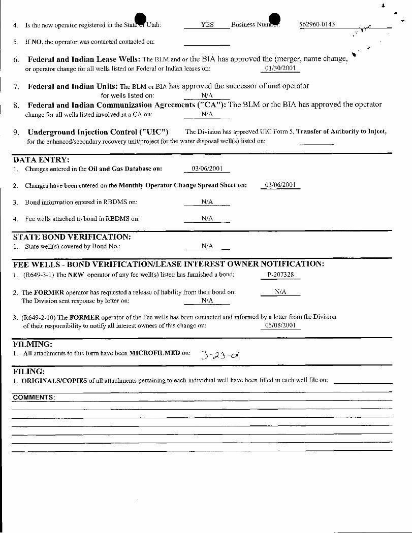
4. Is the new operator registered in the Stat Utah: YES Business Num 562960-0143
5. If NO, the operator was contacted contacted on:
6. Federal and Indian Lease Wells: The BLM and or the BIA has approved the (merger, name change,or operator change for all wells listed on Federal or Indian leases on: 01/30/2001
7. Federal and Indian Units: The BLM or BIA has approved the successor of unit operatorfor wells listed on: N/A
8. Federal and Indian Communization Agreements ("CA"): The BLM or the BIA has approved the operatorchange for all wells listed involved in a CA on: N/A
9. Underground Injection Control ("UIC") The Division has approved UIC Form 5, Transfer of Authority to Inject,
for the enhanced/secondary recovery unit/project for the water disposal well(s) listed on:
DATA ENTRY:1. Changes entered in the Oil and Gas Database on: 03/06/2001
2. Changes have been entered on the Monthly Operator Change Spread Sheet on: 03/06/2001
3. Bond information entered in RBDMS on: N/A
4. Fee wells attached to bond in RBDMS on: N/A
STATE BOND VERIFICATION:1. State well(s) covered by Bond No.: N/A
FEE WELLS - BOND VERIFICATION/LEASE INTEREST OWNER NOTIFICATION:1. (R649-3-1) The NEW operator of any fee well(s) listed has furnished a bond: P-207328
2. The FORMER operator has requested a release of liability from their bond on: N/AThe Division sent response by letter on: N/A
3. (R649-2-10) The FORMER operator of the Fee wells has been contacted and informed by a letter from the Divisionof their responsibility to notify all interest owners of this change on: 05/08/2001
FILMING:1. All attachments to this form have been MICROFILMED on:
FILING:1. ORIGINALS/COPIES of all attachments pertaining to each individual well have been filled in each well file on:
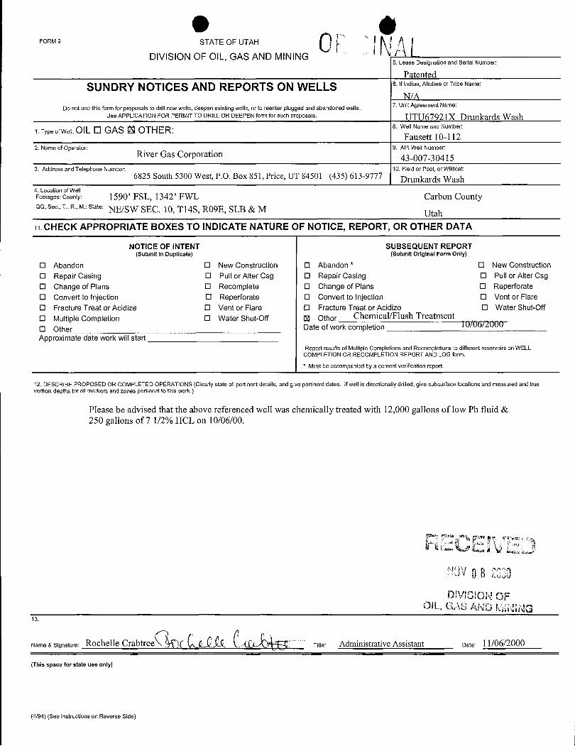
e 0FORM 9 STATE OF UTAH
DIVISION OF OIL, GAS AND MINING5. Lease Designation and Serial Number:
PatentedSUNDRY NOTICES AND REPORTS ON WELLS 6.lfindian,AllotteeorTribeName:
7. Unit Agreement Name:Do not use this form for proposals to drill new wells,deepen existingwells, or to reenter plugged and abandoned wells.Use APPLICATION FOR PERMIT TO DRILL OR DEEPEN form for such proposals UTU67921X Drunkards Wash
1. Type of Well: OlL O GAS U OTHER: 8. Well Name and Number:
Fausett 10-1122. Name of Operator: 9. API Well Number:
River Gas Corporation 43-007-304153. Address and Telephone Number: 10. Field or Pool, or Wildcat:
6825 South 5300 West, P.O. Box 851, Price, UT 84501 (435) 613-9777 Drunkards Wash4. Location of WellFootages: County: 1590' FSL, 1342' FWL Carbon CountyQQ, Sec., T., R., M.:State: NE/SW SEC. 10, Tl4S, RO9E, SLB & M Utah11. CHECK APPROPRIATE BOXES TO INDICATE NATURE OF NOTICE, REPORT, OR OTHER DATA
NOTICE OF INTENT SUBSEQUENT REPORT(Submit in Duplicate) (Submit Original Form Only)
O Abandon O New Construction O Abandon * O New ConstructionO Repair Casing O Pull or Alter Csg O Repair Casing O Pull or Alter CsgO Change of Plans O Recomplete O Change of Plans O ReperforateO Convert to Injection O Reperforate O Convert to Injection O Vent or FlareO Fracture Treat or Acidize O Vent or Flare O Fracture Treat or Acidize O Water Shut-Off
O Multiple Completion O Water Shut-Off U Other Chemical/Flush TreatmentO Other Date of work completion 10/06 000Approximate date work will start
Report results of Multiple Completions and Recompletions to different reservoirs on WELLCOMPLETION OR RECOMPLETION REPORT AND LOG form.* Must be accompanied by a cement verification report.
12. DESCRIBE PROPOSED OR COMPLETED OPERATIONS (Clearly state all pertinent details, and give pertinent dates. Ifwell is directionally drilled, give subsurface locations and measured and truevertical depths for att markers and zones pertinent to tNs work.)
Please be advised that the above referenced well was chemically treated with 12,000 gallons of low Ph fluid &250 gallons of 7 1/2% HCL on 10/06/00.
DMCION OFOIL, GAS AND WNWG
13.
Name & Signature: Rochelle Crabtree )[ Titie: Administrative Assistant Date: 11/06/2000
(This space for state use only)
(4/94) (See Instructions on Reverse
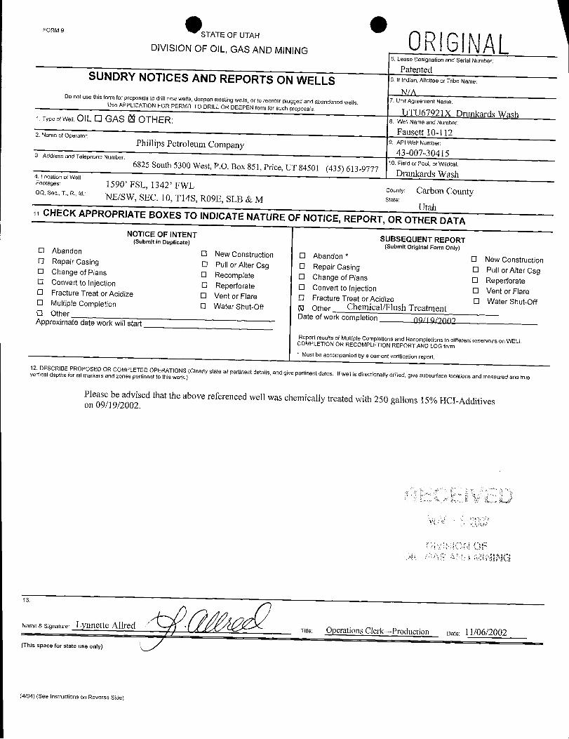
FORM9STATE OF UTAH 0RIGlNALDIVISION OF OIL, GAS AND MINING
5. Lease Designation and Serial Number:
PatentedSUNDRY NOTICES AND REPORTS ON WELLS 6.Ifindian,AllotteeorTribeName:
N/A7. Unit Agreement Name:
Do not use this form for proposals to drill new wells,deepen existing wells, or to reenter plugged and abandoned wells.Use APPUCATlON FOR PERMlT TO DRILL OR DEEPEN form for such proposais. UTU67921X Drunkards Wash1. Type of Welt OIL O GAS O OTH ER: 8. Well Name and Number:
Fausett 10-1122. Name of Operator:9. API Well Number:Phillips Petroleum Company
43-007-304153. Address and Telephone Number:10. Field or Pool, or Wildcat:6825 South 5300 West, P.O. Box 851, Price, UT 84501 (435) 613-9777
Drunkards Wash4. Location of WellFootages: 1590' FSL, 1342' FWL county: Carbon Countyoo,see,T.a.,u NE/SW, SEC. 10, Tl4S, R09E, SLB & M state:
UtahCHECK APPROPRIATE BOXES TO INDICATE NATURE OF NOTICE, REPORT, OR OTHERDATANOTICE OF INTENT SUBSEQUENT REPORT(Submit in Duplicate)
(Submit Original Form Only)O Abandon O New Construction O Abandon *
O New ConstructionO Repair Casing O Pull or Alter Csg O Repair Casing O Pull or Alter CsgO Change of Plans O Recomplete O Change of Plans O ReperforateO Convert to injection O Reperforate O Convert to injection O Vent or FlareO Fracture Treat or Acidize O Vent or Flare O Fracture Treat or Acidize O Water Shut-OffO Multiple Completion O Water Shut-Off M Other Chemical/Flush TreatmentO Other Date of work completion 09/19 9000Approximate date workwillstartReport results of Multiple Completions and Recompletions to different reservoirs on WELLCOMPLETION OR RECOMPLETION REPORT AND LOG form.
* Must be accompanied by a cement verification report.12. DESCRIBE PROPOSED OR COMPLETED OPERATIONS (Clearly state all pertinent details, and give pertinent dates. Ifwellis directionally drilled, give subsurface locations and measured and truevertical depths for all markers and zones pertinent to thiswork.)
Please be advised that the above referenced well was chemically treated with 250 gallons 15% HCI-Additiveson 09/19/2002.
ame & Signature: Lynnette AllredTitre Operations Clerk--Production Date: 11/06/2002
(This space for state use only)
(4/94) (See instructions on Reverse
FORM9STATE OF UTAH 0RIGlNALDIVISION OF OIL, GAS AND MINING
5. Lease Designation and Serial Number:
PatentedSUNDRY NOTICES AND REPORTS ON WELLS 6.Ifindian,AllotteeorTribeName:
N/A7. Unit Agreement Name:
Do not use this form for proposals to drill new wells,deepen existing wells, or to reenter plugged and abandoned wells.Use APPUCATlON FOR PERMlT TO DRILL OR DEEPEN form for such proposais. UTU67921X Drunkards Wash1. Type of Welt OIL O GAS O OTH ER: 8. Well Name and Number:
Fausett 10-1122. Name of Operator:9. API Well Number:Phillips Petroleum Company
43-007-304153. Address and Telephone Number:10. Field or Pool, or Wildcat:6825 South 5300 West, P.O. Box 851, Price, UT 84501 (435) 613-9777
Drunkards Wash4. Location of WellFootages: 1590' FSL, 1342' FWL county: Carbon Countyoo,see,T.a.,u NE/SW, SEC. 10, Tl4S, R09E, SLB & M state:
UtahCHECK APPROPRIATE BOXES TO INDICATE NATURE OF NOTICE, REPORT, OR OTHERDATANOTICE OF INTENT SUBSEQUENT REPORT(Submit in Duplicate)
(Submit Original Form Only)O Abandon O New Construction O Abandon *
O New ConstructionO Repair Casing O Pull or Alter Csg O Repair Casing O Pull or Alter CsgO Change of Plans O Recomplete O Change of Plans O ReperforateO Convert to injection O Reperforate O Convert to injection O Vent or FlareO Fracture Treat or Acidize O Vent or Flare O Fracture Treat or Acidize O Water Shut-OffO Multiple Completion O Water Shut-Off M Other Chemical/Flush TreatmentO Other Date of work completion 09/19 9000Approximate date workwillstartReport results of Multiple Completions and Recompletions to different reservoirs on WELLCOMPLETION OR RECOMPLETION REPORT AND LOG form.
* Must be accompanied by a cement verification report.
12. DESCRIBE PROPOSED OR COMPLETED OPERATIONS (Clearly state all pertinent details, and give pertinent dates. Ifwellis directionally drilled, give subsurface locations and measured and truevertical depths for all markers and zones pertinent to thiswork.)
Please be advised that the above referenced well was chemically treated with 250 gallons 15% HCI-Additiveson 09/19/2002.
ame & Signature: Lynnette AllredTitre Operations Clerk--Production Date: 11/06/2002
(This space for state use only)
(4/94) (See instructions on Reverse
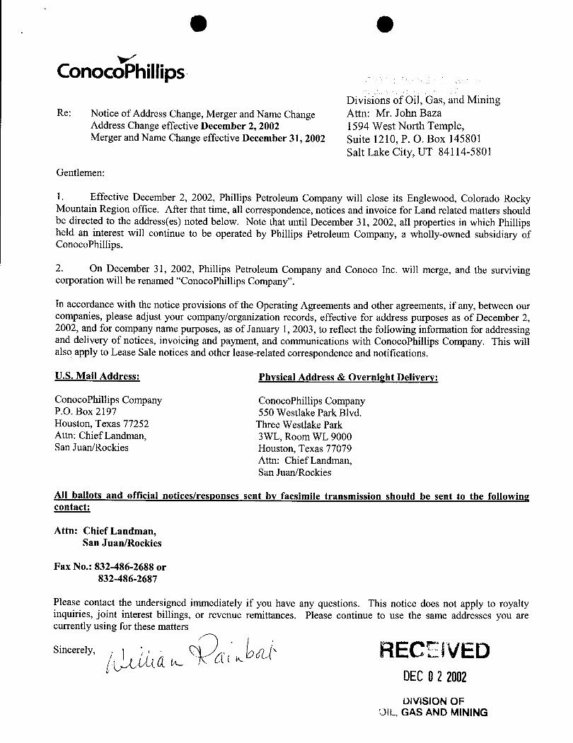
O O
ConocoPhillips.Divisions of Oil, Gas, and Mining
Re: Notice of Address Change, Merger and Name Change Attn: Mr. John BazaAddress Change effective December 2, 2002 1594 West North Temple,Merger and Name Change effective December 31, 2002 Suite 1210, P. O. Box 145801
Salt Lake City, UT 84114-5801
Gentlemen:
1. Effective December 2, 2002, Phillips Petroleum Company will close its Englewood, Colorado RockyMountain Region office. After that time, all correspondence, notices and invoice for Land related matters shouldbe directed to the address(es) noted below. Note that until December 31, 2002, all properties in which Phillipsheld an interest will continue to be operated by Phillips Petroleum Company, a wholly-owned subsidiary ofConocoPhillips.
2. On December 31, 2002, Phillips Petroleum Company and Conoco Inc. will merge, and the survivingcorporation will be renamed "ConocoPhillips Company".
In accordance with the notice provisions of the Operating Agreements and other agreements, if any, between ourcompanies, please adjust your company/organization records, effective for address purposes as of December 2,2002, and for company name purposes, as of January 1, 2003, to reflect the following information for addressingand delivery of notices, invoicing and payment, and communications with ConocoPhillips Company. This willalso apply to Lease Sale notices and other lease-related correspondence and notifications.
U.S. Mail Address: Physical Address & Overnight Delivery:
ConocoPhillips Company ConocoPhillips CompanyP.O. Box 2197 550 Westlake Park Blvd.Houston, Texas 77252 Three Westlake ParkAttn: Chief Landman, 3WL, Room WL 9000San Juan/Rockies Houston, Texas 77079
Attn: Chief Landman,San Juan/Rockies
All ballots and official notices/responses sent by facsimile transmission should be sent to the followingcontact:
Attn: Chief Landman,San Juan/Rockies
Fax No.: 832-486-2688 or832-486-2687
Please contact the undersigned immediately if you have any questions. This notice does not apply to royaltyinquiries, joint interest billings, or revenue remittances. Please continue to use the same addresses you arecurrenrelymusi h atters
RECElVEDDECO2 2002DIVISIONOF
DIL, GAS AND
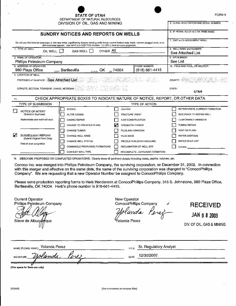
O OSTATE OF UTAH FORM 9
DEPARTMENT OF NATURALRESOURCESDIVISIONOF OIL, GAS AND MINING 5. LEASE DESIGNATION AND SERIAL NUMBER:
6. IF INDIAN,ALLOTTEE OR TRIBE NAMESUNDRY NOTICES AND REPORTS ON WELLS
7. UNIT or CA AGREEMENT NAME:Do not use thisform for proposals to drill new wells, significantlydeepen existing wells below current bottom-hole depth, reenter plugged wells, or to
drillhorizontal laterals. Use APPLICATION FOR PERMIT TO DRILLform for such proposals.1.TYPEOFWELL 8.WELLNAMEandNUMBER:
OIL WELL Q GAS WELL D OTHER All See Attached List2. NAMEOFOPERATOR: 9.APINUMBER:
Phillips Petroleum Company See List3. ADDRESS OF OPERATOR: PHONE NUMBER: 10. FIELD AND POOL, OR WILDCAT:
980 Plaza Office aTy Bartlesville a OK ,,,74004 (918) 661-44154. LOCATION OF WELL
FOOTAGES AT SURFACE: COUNTY:
QTR/QTR, SECTION, TOWNSHIP, RANGE, MERIDIAN: STATE:UTAH
n. CHECK APPROPRIATE BOXES TO INDICATENATURE OF NOTICE, REPORT, OR OTHER DATATYPE OF SUBMISSION TYPE OF ACTION
O ACIDIZE DEEPEN REPERFORATE CURRENT FORMATIONO NOTICE OF INTENT(Submit in Duplicate) ALTER CASING FRACTURE TREAT SIDETRACK TO REPAIR WELL
Approximate date work willstart: CASING REPAIR NEW CONSTRUCTION TEMPORARILYABANDON
O CHANGE TO PREVIOUS PLANS OPERATOR CHANGE TUBING REPAIR
O CHANGE TUBING PLUG AND ABANDON VENT OR FLARE
SUBSEQUENT REPORT CHANGE WELL NAME PLUG BACK WATER DISPOSAL(Submit Original Form Only)
O CHANGE WELL STATUS PRODUCTION (START/RESUME) WATER SHUT-OFFDate of work completion:
O COMMINGLE PRODUCING FORMATIONS RECLAMATIONOF WELL SITE OTHER:
O CONVERT WELL TYPE RECOMPLETE - DIFFERENT FORMATION
12. DESCRIBE PROPOSED OR COMPLETED OPERATIONS. Clearly show all pertinent details including dates, depths, volumes, etc.
Conoco Inc. was merged into Phillips Petroleum Company, the surviving corporation, on December 31, 2002. In connectionwith this merger and effective on the same date, the name of the surviving corporation was changed to "ConocoPhillipsCompany". We are requesting that a new Operator Number be assigned to ConocoPhillips Company.
Please send production reporting forms to Herb Henderson at ConocoPhillips Company, 315 S. Johnstone, 980 Plaza Office,Bartlesville, OK 74004. Herb's phone number is 918-661-4415.
Current Operator New OperatorPhillips Petroleum Company ConocoPhillips Company > RECEIVED
Steve de Albuq que olanda PerezDIV.OFOIL,GAS&MINING
NAME(PLEASEPRINT) Yolanda Perez
SIGNATURE
T TLE Sr. Re latory Analyst
(This space for State use only)
(5/2000) (See Instructions on Reverse
O O
ConocoPhillips
SECRETARY'S CERTIFICATE
I, the undersigned, Jennifer M. Garcia, Assistant Secretary of ConocoPhillips Company,formerly Phillips Petroleum Company, organized and existing under and by virtue of the laws ofthe State of Delaware (the"Corporation"), hereby certify that:
1. As Assistant Secretary I am authorized to execute thiscertificateon behalf of the Corporation.
2. The attached photocopy of the Certificate of Amendment to theRestated Certificate of incorporation of Phillips PetroleumCompany (to be renamed ConocoPhillips Company) is a trueand correct copy as filed in the officeof the Secretary of State ofDelaware on the 12th day of December 2002, with an effectivedate of January 1, 2003 and such Certificate of Amendment hasnot been modified,amended, rescinded or revoked and is in fullforce and effect as of the date hereof.
3. The attached photocopy of the Certificate of Merger of ConocoInc. with and into ConocoPhillips Company is a true and correctcopy as filed in the office of the Secretary of State of Delawareon the 12 day of December 2002, with an effective date ofDecember 31, 2002 and such Certificate of Merger has not beenmodified,amended, rescinded or revoked and is in full force andeffect as of the date hereof.
IN WITNESS WHEREOF, I have hereunto set my hand as Assistant Secretary andaffixed the corporate seal of the Corporation this7th day of January 2003.
Áss ecréaryo ocoPhillips Company
STATE OF TEXAS §§
COUNTY OF HARRIS §
This instrument was acknowledged before me on January 7, 2003, by Jennifer M. Garcia,Assistant Secretary of ConocoPhillips Company, a Delaware corporation, on behalf of saidCorporation.
RECEIVED No y Public
. JANO82003DIV.0FOIL,GAS&
PAGE 1
'The irst State
I, HARRIET SMITH WINDSOR, SECRETARY OF STATE OF THE STATE OF
DELAWARE, DO HEREBY CERTIFY THE ATTACHED IS A TRUE AND CORRECT
COPY OF THE CERTIFICATE OF AMENDMENT OF "PHILLIPS PETROLEUM
COMPANY", CHANGING ITS NAME FROM "PHILLIPS PETROLEUM COMPANY" TO
"CONOCOPHILLIPS COMPANY", FILED IN THIS OFFICE ON THE TWELFTH
DAY OF DECEMBER, A.D. 2002, AT 1:41 O'CLOCK P.M.
AND I DO HEREBY FURTHER CERTIFY THAT THE EFFECTIVE DATE OF
THE AFORESAID CERTIFICATE OF AMENDMENT IS THE THIRTY-FIRST DAY
OF DECEMBER, A.D. 2002, AT 11 O'CLOCK P.M.
RECEIVEDJANO8 2003
DIV.OFOIL,GAS&MINING
Harriet Smith Windsor, Secretary of State
0064324 8100 AUTHENTICATION: 2183360
030002793 DATE:
STATE OF DELANARE
FROMRL&F#l (THU)12.12'0213:32 ST.13:M9Dr4064Wr39E SDIVISION OF CORPORATIONSFILZD 01: 41 PM 12/12/2002
020763238 - 0064324
CERTIFICATE OF AMENDMENT
to the
RESTATED CRRTIFICATE OF INCORPORATION
of
PHILLIPS PETROLEUM COMPANY(to be renamed ConocoPhillips Company)
Phillips Petroleum Company ("Phillips"), a corporation organized and existing
under the General Corporation Law of the State of Delaware (the "DGCL"), hereby certifies that:
1. The amendments to Phillips' Restated Certificate of Incorporation set
forth below were duly adopted in accordance with the provisions of Section 242 of the DGCL
and have been consented to in writing by the sole stockholder of Phillips in accordance with
Section 228 of the DGCL.
2. Phillips' Restated Certificate of Incorporation is hereby amended by
deleting Article I thereof and n:placing in lieu thereof a new Article I reading in its entirety as
follows:
"The name of the corporation (which is hereinafter referred to as the"Corporation") is ConocoPhillipsCompany."
3. Phillips' Restated Certificateof Incorporation is hereby amended by
deleting Section 1 of Article IV thereof and replacing in lieu thereof a new Section 1 reading in
its entirety as follows:
"Section 1. The Corporationshall be authorizedto issue 2,100 shares of capitalstock, of which 2,100 shares shall be shares of Common Stock, $.01par value ("CommonStock")."
4. Pursuant to Section103(d) of the DGCL, this amen ent will become
effective at 11;00 p.m., Eastern time, on December 31, 2002.
HOUO3:554504.1 RECEIVEDJANO8 2003
DIV.0FOIL,GAS&
OFROMRL&F#1
IN WITNESS WHEREOF,Phillips has caused this certificate to be executed this12th day of December, 2002.
PHILLIPS PETROLEUMCOMPANY
By = -Nami 'ck A. HarringtonTitle: SeniorVice President, Legal.,
and GeneralCounsel
RECEIVEDsocom JANO8 2003
DIVOFOIL,GAS&
OFROMRL&F#1
IN WITNESS WHEREOF,Phillips has caused this certificate to be executed this12th day of December, 2002.
PHILLIPS PETROLEUMCOMPANY
By = -Nami 'ck A. HarringtonTitle: SeniorVice President, Legal.,
and GeneralCounsel
RECEIVEDsocom JANO8 2003
DIVOFOIL,GAS&
e ePAGE 1
'The irst State
I, HARRIET SMITH WINDSOR, SECRETARY OF STATE OF THE STATE OF
DELAWARE, DO HEREBY CERTIFY THE ATTACHED IS A TRUE AND CORRECT
COPY OF THE CERTIFICATE OF MERGER, WHICH MERGES:
"CONOCO INC. ", A DELAWARE CORPORATION,
WITH AND INTO "CONOCOPHILLIPS COMPANY" UNDER THE NAME OF
"CONOCOPHILLIPS COMPANY", A CORPORATION ORGANIZED AND EXISTING
UNDER THE LAWS OF THE STA.TE OF DELAWARE, AS RECEIVED AND FILED
IN THIS OFFICE THE TWELFTH DAY OF DECEMBER, A.D. 2002, AT 1:44
O'CLOCK P.M.
AND I DO HEREBY FURTHER CERTIFY THAT THE EFFECTIVE DATE OF
THE AFORESAID CERTIFICATE OF MERGER IS THE THIRTY-FIRST DAY OF
DECEMBER, A.D. 2002, AT 11:59 O'CLOCK P.M.
RECEIVEDJANO8 20.03
DIV.OFOIL,GAS&MINING
Harriet Smith Windsor, Secretary of State
0064324 8100M AUTHENTICATION: 2183370
030002793 DATE:
O eST TE OF DELANARE
FROMRL&F#1 (THU)12.12'02 13:35/ST.13:* 486WWMEP 16DIVISION OF CORPORATIONSFILED 01:44 PM 12/12/2002
020763253 - 0064324
CERTEFICATE OF MERGER
of
Conoco Inc.(a Delaware corporation)
with and into
ConocoPhiIIIps Company(a Delawareestporation)
Phillips Petroleum Company,a Delaware corporation to be renamed ConocoPhillipsCompany prior to the effective time of this certificate of merger (the"Surviving Corporation"),in compliance with the requéements of the General CorporationLawof the State of Delaware(the "DGCL") and desiring to effect a merger of Conoco Inc., a Delawarecorporation formerlyincorporated underthe name Dtt Pont Holdings, Inc. (the "Merging Corporation," and together
with the Surviving Corporation, the "Constituent Corporations"), with and into the Surviving
Corporation, and acting by its duly authorized ofHeer,DOESHEREBY CERTIFY that:
First: As of the date hereof, the name and state of incorporation of each of theConstituent Corporations of the merger are as follows:
NAME STATE OF INCORPORATION
PHILLIPSPETROLEUMCOMPANY Delaware
CONOCO INC. Delaware
Second: An agreement and plan of merger has been approved, adopted, certified,executed and acknowledged by each of the Constituent Corporations in accordance with therequirements of Section 251 of the DGCL; -
Third: The narne of the Surviving Corporation will be ConocoPhillips Company;
Fourth: The Certificateof Incorporation of ConocoPhillipsCompany immediatelyprior to the merger shall he the Certificate of Incorporation of the Surviving Corporation until
such time as it may be amended in accordance with applicable law and the provisions thereof;
Fifth: The executed agmement and plan of merger is on file at an ofIice of the
Surviving Corporation, the address of which is 600 North Dairy Ashford, Houston, Texas
77079;
RECElVEDnovoa.or/67s.« 1 JANO8 2003
DIV.0FOIL,GAS&
O OFROMRL&F#1 (THU)\2. 12'02 13:35/ST.13:3 NO.4864756279P 17
e
Sixth: A copy of the agreement and plan of merger will be fumished by theSurviving Corporation, on request and without cost, to any stockholder of any ConstituentCorporation; and
Seventh: Pursuantto Section103(d)of theDGCL, this certificate of mergerwill becomeeffective at 11:59 p.m.,Eastemtime, on December31, 2002.
Dated: December 12,2002
PIHLLIPSPETROLEUM COMPANY(a Delawarecorpo
By:Name: k A. HarringtonTitle: Senior Vice President, Legal,
and GeneralCounsel
RECEIVEDJANO8 2003
Houotsmys^DIVOF OIL,GAS&
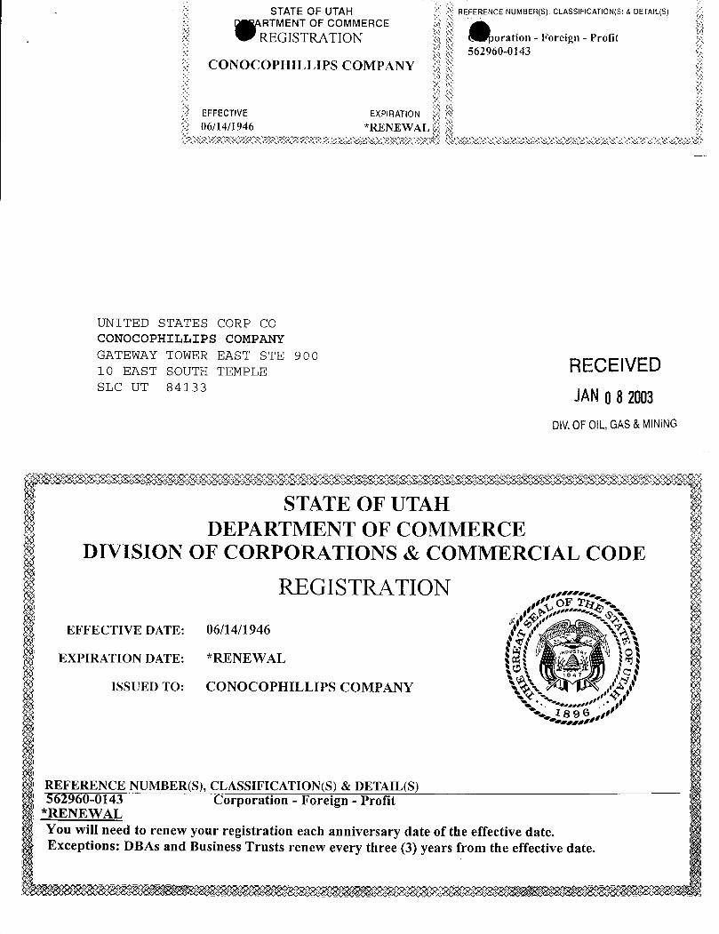
STATE OF UTAH REFERENCE NUMBER(S) CLASSIFICATION(S)& DETAIL(S)RTMENT OF COMMERCEREGISTRATION oration - Foreign - Profit
562960-0143CONOCOPHILLIPS COMPANY
UNITED STATES CORP COCONOCOPHILLIPS COMPANYGATEWAY TOWER EAST STE 900 RECEIVED10 EAST SOUTH TEMPLESLC UT 84133 JANO82003
DIV.0FOIL,GAS&MINING
STATE OF UTAHDEPARTMENT OF COMMERCE
DIVISION OF CORPORATIONS & COMMERCIAL CODE
REGISTRATIONOF
EFFECTIVE DATE: 06/14/194600574
EXPIRATION DATE: *RENEWAL
ISSUED TO: CONOCOPHILLIPS COMPANY \'
REFERENCE NUMBER(S), CLASSIFICATION(S) & DETAIL(S)562960-01 Corporation - Foreign - Profit
*RENEWALYou will need to renew your registration each anniversary date of the effective date.Exceptions: DBAs and Business Trusts renew every three (3) years from the effective
STATE OF UTAH REFERENCE NUMBER(S) CLASSIFICATION(S)& DETAIL(S)RTMENT OF COMMERCE
REGISTRATION oration - Foreign - Profit562960-0143
CONOCOPHILLIPS COMPANY
UNITED STATES CORP COCONOCOPHILLIPS COMPANYGATEWAY TOWER EAST STE 900 RECEIVED10 EAST SOUTH TEMPLESLC UT 84133 JANO82003
DIV.0FOIL,GAS&MINING
STATE OF UTAHDEPARTMENT OF COMMERCE
DIVISION OF CORPORATIONS & COMMERCIAL CODE
REGISTRATIONOF
EFFECTIVE DATE: 06/14/194600574
EXPIRATION DATE: *RENEWAL
ISSUED TO: CONOCOPHILLIPS COMPANY \'
REFERENCE NUMBER(S), CLASSIFICATION(S) & DETAIL(S)562960-01 Corporation - Foreign - Profit
*RENEWALYou will need to renew your registration each anniversary date of the effective date.Exceptions: DBAs and Business Trusts renew every three (3) years from the effective
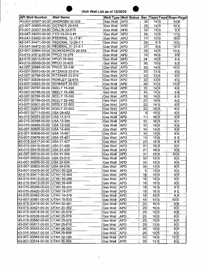
Utah Well List as of 12/26/02
API Well Number Well Name Well Type Well Status Sec Twpn Twpd Rngn Rngd43-007-30887-00-00 ANDREEN 32-529 Gas Well APD 32 14 S 10 E43-007-30865-00-00 COTNER 29-549 Gas Well APD 29 14 S 10 E43-007-30837-00-00 DALLIN32-615 Gas Well APD 32 13 S 9 E43-ÕÄ7-34551-00-00FED 43-24-3 #1 Gas Well APD 24 10 S 17 E43-047-33982-00-00 FEDERAL 12-17 #1 Gas Well APD 17 10 S 18 E43-047-34471-00-00 FEDERAL 12-29-7 1 Gas Well APD 29 9 S 19 E43-047-34472-00-00 FEDERAL 31-31-6 1 Gas Well APD 31 9 S 19 E43-007-30864-00-00 MCKENDRICK 29-548 Gas Well APD 29 14 S 10 E43-015-30512-00-00 PPCO 19-379 Gas Well APD 19 16 S 9 E43-015-30515-00-00 PPCO 24-562 Gas Well APD 24 16 S 8 E43-015-30548-00-00 PPCO 30-605 Gas Well APD 30 I 16 S 9 E43-007-30888-00-00 PRICE 32-438 Gas Well APD 32 14 S 10 E43-007-30813-00-00 RITZAKIS 33-514 Gas Well APD 33 13 S 9 E43-007-30766-00-00 RITZAKIS 33-516 Gas Well APD 33 13 S 9 E43-007-30838-00-00 ROWLEY 32-616 Gas Well APD 32 13 S 9 E43-007-30863-00-00 SCHMIDT 29-531 Gas Well APD 29 14 S 10 E43-007-30797-00-00 SEELY 15-498 Gas Well APD 15 14 S 8 E43-007-30798-00-00 SEELY 15-499 Gas Well APD 15 14 S 8 E43-007-30799-00-00 SEELY 15-500 Gas Well APD 15 14 S 8 E43-007-30796-00-00 SEELY 22-492 Gas Well APD 22 14 S 8 E43-007-30801-00-00 SEELY 22-502 1Gas Well APD 22 141S 8 E43-007-30802-00-00 SEELY 22-503 Gas Well APD 22 14 S 8 E43-007-30711-00-00 USA 09-452 Gas Well APD 9 15 S 8 E43-015-30351-00-00 USA 11-313 Gas Well APD 11 16 S 9 E43-015-30398-00-00 USA 12-385 Gas Well APD 12 16 S 9 E43-015-30409-00-00 USA 12-426 Gas Well APD 12 16 S 9 E43-007-30805-00-00 USA 14-490 Gas Well APD 14 14 S 8 E43-007-30806-00-00 USA 14-491 Gas Well APD 14 14 S 8 E43-007-30676-00-00 USA 15-421 Gas Well APD 15 15 S 8 E43-015-30417-00-00 USA 21-427 Gas Well APD 21 16 S 9 E43-015-30416-00-00 USA 21-428 Gas Well APD 21 16 S 9 E43-015-30415-00-00 USA 21-429 Gas Well APD 21 16 S 9 E43-007-30515-00-00 USA 31-309 Gas Well APD 31 15 S 10 E43-007-30835-00-00 USA 33-515 Gas Well APD 3Š 13 S 9 E43-007-30836-00-00 USA 33-624 Gas Well APD 33 13 S 9 E43-007-30803-00-00 USA 34-518 Gas Well APD 34 14 S 8 E43-007-30478-00-00 UTAH 05-224 Gas Well APD 5 15 S 9 E
-015-30411-00-00 UTAH 16-365 Gas Well APD 1g 16 S 9 E43-015-30412-00-00 UTAH 16-366 Gas Well APD 16 16 S 9 E43-015-30413-00-00 UTAH 16-430 Gas Well APD 16 16 S 9 EiŠ 015-30299-00-00 UTAH 18-374 Gas Well APD 18 16 S 9 E43-015-30420-00-00 UTAH 19-377 Gas Well APD 19 16 S 9 E43-015-30492-00-00 UTAH 19-378 Gas Well APD 19 16 S 9 E43-007-30891-00-00 UTAH 19-533 Gas Well APD 19 14 S 10 E43-015-30414-00-00 UTAH 20-381 Gas Well APD 20 16 S 9 E43-015-30421-00-00 UTAH 20-382 Gas Well APD 10 16 S 9 E43-015-30518-00-00 UTAH 25-576 Gas Well APD 25 16 S 8 E43-015-30539-00-00 UTAH 25-578 Gas Well APD 25 16 S 8 E43-015-30540-00-00 UTAH 25-579 Gas Well APD 25 16 S 8 E43-007-30817-00-00 UTAH 25-618 Gas Well APD 25 13 S ÜE43-015-30543-00-00 UTAH 26-582 Gas Well APD 26 16 S 8 E43-015-30547-00-00 UTAH 29-608 Gas Well APD 29 16 S 9 E43-007-30889-00-00 UTAH 32-128 Gas Well APD 32 14 S 10 E43-007-30814-00-00 UTAH 35-506 Gas Well APD 35 13 S 9
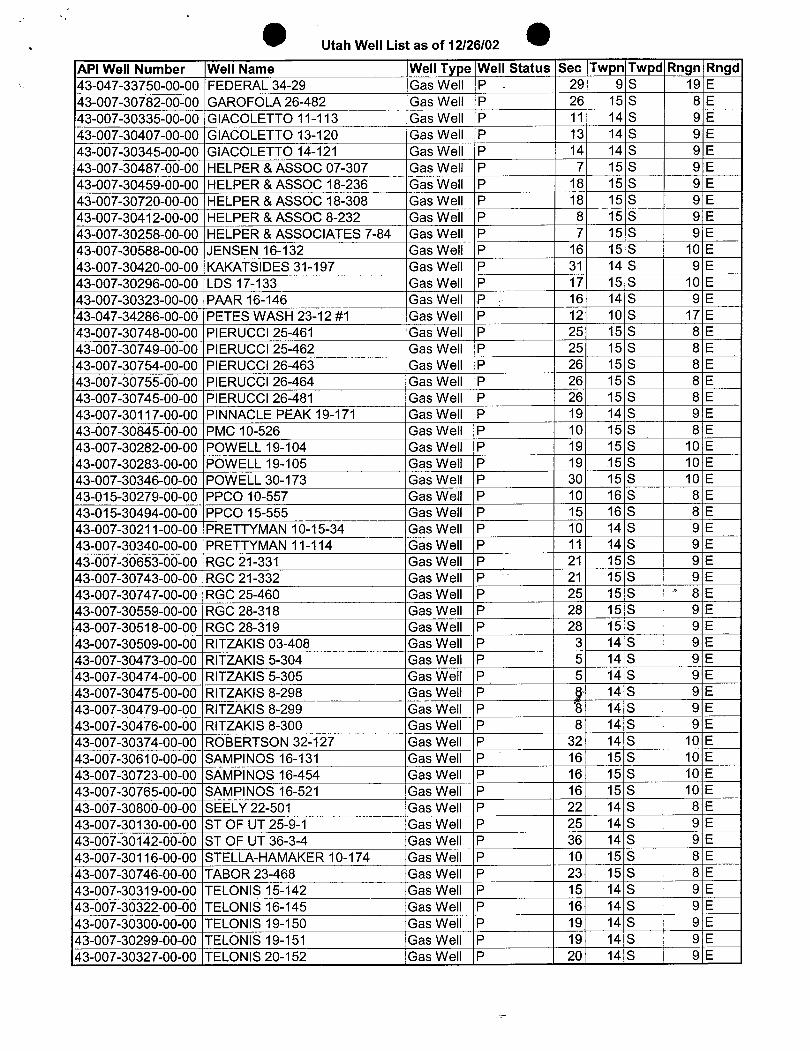
Utah Well List as of 12/26/02
API Well Number Well Name Well Type Well Status Sec Twpn Twpd Rngn Rngd43-047-33750-00-00 FEDERAL 34-29 Gas Well P - 29 9 S 19 E43-007-30782-00-00 GAROFOLA 26-482 Gas Well P 26 15 S 8 E43-007-30335-00-00 GIACOLETTO 11-113 Gas Well P 11 14 S 9 E43-007-30407-00-00 GIACOLETTO 13-120 Gas Well P 13 14 S 9'E43-007-30345-00-00 GIACOLETTO 14-121 Gas Well P 14 14 S 9 E43-007-30487-00-00 HELPER &ASSOC 07-307 Gas Well P 7 15 S 9 E43-007-30459-00-00 HELPER & ASSOC 18-236 Gas Well P 18 15 S 9 E43-007-30720-00-00 HELPER & ASSOC 18-308 Gas Well P 18 15 S 9 E43-007-30412-00-00 HELPER & ASSOC 8-232 Gas Well P 8 15 S 9 E43-007-30258-00-00 HELPER &ASSOCIATES 7-84 Gas Well P 7 15 S 9 E43-007-30588-00-00 JENSEN 16-132 Gas Well P 16 15 S 10 E43-007-30420-00-00 KAKATSIDES 31-197 Gas Well P 31 14 S 9 E43-007-30296-00-00 LDS 17-133 Gas Well P 17 15 S 10 E43-007-30323-00-00 PAAR 16-146 Gas Well P 16 14 S 9 E43-047-34286-00-00 PETES WASH 23-12 #1 Gas Well P 12 10 S 17 E43-007-30748-00-00 PIERUCCI 25-461 Gas Well P 25 15 S 8 E43-007-30749-00-00 PIERUCCI 25-462 Gas Well P 25 15 S 8 E43-007-30754-00-00 PIERUCCI 26-463 Gas Well P 26 15 S 8 E43-007-30755-00-00 PIERUCCI 26-464 Gas Well P 26 15 S 8 E43-007-30745-00-00 PIERUCCI 26-481 Gas Well P 26 15 S 8 E43-007-30117-00-00 PINNACLE PEAK 19-171 Gas Well P 19 14 S 9 E43-007-30845-00-00 PMC 10-526 Gas Well P 10 15 S 8 E43-007-30282-00-00 POWELL 19-104 Gas Well P 19 15 S 10 E43-007-30283-00-00 POWELL 19-105 Gas Well P 19 15 S 10 E43-007-30346-00-00 POWELL 30-173 Gas Well P 30 15 S 10 E43-015-30279-00-00 PPCO 10-557 Gas Well P 10 16 S 8 E43-015-30494-00-00 PPCO 15-555 Gas Well P 15 16 S 8 E43-007-30211-00-00 PRETTYMAN 10-15-34 Gas Well P 10 14 S 9 E43-007-30340-00-00 PRETTYMAN 11-114 Gas Well P 11 14 S 9 E43-007-30653-00-00 RGC 21-331 Gas Well P 21 15 S 9 E43-007-30743-00-00 RGC 21-332 Gas Well P 21 15 S 9 E43-007-30747-00-00 RGC 25-460 Gas Well P 25 15 S ' 8 E43-007-30559-00-00 RGC 28-318 Gas Well P 28 15 S 9 E43-007-30518-00-00 RGC 28-319 Gas Well P 28 15 S 9 E43-007-30509-00-00 RITZAKIS 03-408 Gas Well P 3 14 S 9 E43-007-30473-00-00 RITZAKIS 5-304 Gas Well P 5 14 S 9 E43-007-30474-00-00 RITZAKIS 5-305 Gas Well P 5 14 S 9 E43-007-30475-00-00 RITZAKIS 8-298 Gas Well P g 14 S 9 E43-007-30479-00-00 RITZAKIS 8-299 ÒasWell P 8 14 S 9 E43-007-30476-00-00 RITZAKIS 8-300 Gas Well P 8 14 S 9 E43-007-30374-00-00 ROBERTSON 32-127 Gas Well P 32 14 S 10 E43-007-30610-00-00 SAMPINOS 16-131 Gas Well P 16 15 S 10 E43-007-30723-00-00 SAMPINOS 16-454 Gas Well P 16 15 S 10 E43-007-30765-00-00 SAMPINOS 16-521 Gas Well P 16 15 S 10 E43-007-30800-00-00 SEELY 22-501 Gas Well P 22 14 S 8 E43-007-30130-00-00 ST OF UT 25-9-1 Gas Well P 25 14 S 9 E43-007-30142-00-00 ST OF UT 36-3-4 Gas Well P 36 14 S 9 E43-007-30116-00-00 STELLA-HAMAKER 10-174 Gas Well P 10 15 S 8 E43-007-30746-00-00 TABOR 23-468 Gas Well P 23 15 S 8 E43-007-30319-00-00 TELONIS 15-142 Gas Well P 15 14 S 9 E43-007-30322-00-00 TELONIS 16-145 Gas Well P 16 14 S 9 E43-007-30300-00-00 TELONIS 19-150 ,Gas Well P 19 14 S 9 E43-007-30299-00-00 TELONIS 19-151 Gas Well P 19 14 S 9 E43-007-30327-00-00 TELONIS 20-152 Gas Well P 20 14 S 9
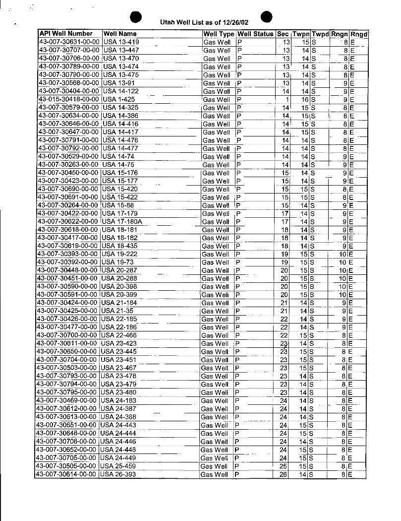
Utah Well List as of 12/26/02
API Well Number Well Name Well Type Well Status Sec Twpn Twpd Rngn Rngd43-007-30631-00-00 USA 13-419 Gas Well P 13 15 S 8 E43-007-30707-00-00 USA 13-447 Gas Well P 13 14 S 8 E43-007-30706-00-00 USA 13-470 Gas Well P 13 14 S 8 E43-007-30789-00-00 USA 13-474 Gas Well P 13 14 S 8 E43-007-30790-00-00 USA 13-475 Gas Well P 13 14 S 8 E43-007-30568-00-00 USA 13-91 Gas Well P 13 14 S 9 E43-007-30404-00-00 USA 14-122 Gas Well P 14 14 S 9 E43-015-30418-00-00 USA 1-425 Gas Well P 1 16 S 9 E43-007-30579-00-00 USA 14-325 Gas Well P 14 15 S 8 E43-007-30634-00-00 USA 14-386 Gas Well P 14 15 S 8 E43-007-30646-00-00 USA 14-416 Gas Well P 14 15 S 8 E43-007-30647-00-00 USA 14-417 Gas Well P 14 15 S 8 E43-007-30791-00-00 USA 14-476 Gas Well P 14 14 S 8 E43-007-30792-00-00 USA 14-477 Gas Well P 14 14 S 8 E43-007-30529-00-00 USA 14-74 'Gas Well P 14 14 S 9 E43-007-30263-00-00 USA 14-75 Gas Well P 14 14 S 9 E43-007-30450-00-00 USA 15-176 Gas Well P 15 14 S 9 E43-007-30423-00-00 USA 15-177 Gas Well P 15 14 S 9 E43-007-30690-00-00 USA 15-420 Gas Well P 15 15 S 8 E43-007-30691-00-00 USA 15-422 Gas Well P 15 15 S 8 E43-007-30264-00-00 USA 15-88 Gas Well P 15 14 S 9 E43-007-30422-00-00 USA 17-179 Gas Well P 17 14 S 9 E43-007-30622-00-00 USA 17-180A Gas Well P 17 14 S 9 E43-007-30618-00-00 USA 18-181 Gas Well P 18 14 S 9 E43-007-30417-00-00 USA 18-182 Gas Well P 18 14 S 9 E43-007-30619-00-00 USA 18-435 Gas Well P 18 14 S 9 E43-007-30393-00-00 USA 19-222 Gas Well P 19 15 S 10 E43-007-30392-00-00 USA 19-73 Gas Well P 19 15 S 10 E43-007-30448-00-00 USA 20-287 Gas Well P 20 15 S I 10 E43-007-30451-00-00 USA 20-288 Gas Well P 20 15 S 10 E43-007-30590-00-00 USA 20-398 Gas Well P 20 15 S 10 E43-007-30591-00-00 USA 20-399 Gas Well P 20 15 S i 10 E43-007-30424-00-00 USA 21-184 Gas Well P 21 14 S 9 E43-007-30425-00-00 USA 21-35 Gas Well P 21 14 S 9 E43-007-30426-00-00 USA 22-185 Gas Well P 22 14 S 9 E43-007-30477-00-00 USA 22-186 Gas Well P 22 14 S 9 E43-007-30700-00-00 USA 22-466 Gas Well P 22 15 S 8 E43-007-30611-00-00 USA 23-423 Gas Well P 2g 14 S 8 E43-007-30650-00-00 USA 23-445 Gas Well P ž3 15 S 8 E43-007-30704-00-00 USA 23-451 Gas Well P 23 15 S 8 E43-007-30503-00-00 USA 23-467 Gas Well P 23 15 S 8 E43-007-30793-00-00 USA 23-478 Gas Well P 23| 14 S 8 E43-007-30794-00-00 USA 23-479 Gas Well P 23 14 S 8 E43-007-30795-00-00 USA 23-480 Gas Well P 23 14 S 8 E43-007-30469-00-00 USA 24-183 Gas Well P 24 14 S 8 E43-007-30612-00-00 USA 24-387 Gas Well P 24 14 S 8 E43-007-30613-00-00 USA 24-388 Gas Well P 24 14 S 8 E43-007-30651-00-00 USA 24-443 Gas Well P 24 15 S 8 E43-007-30648-00-00 USA 24-444 Gas Well P 24 15 S 8 E43-007-30708-00-00 USA 24-446 Gas Well P 24 14 S 8 E43-007-30652-00-00 USA 24-448 Gas Well P 24 15 S 8 E43-007-30705-00-00 USA 24-449 Gas Well P 24 15 S 8 E43-007-30505-00-00 USA 25-459 Gas Well P 25 15 S 8 E43-007-30614-00-00 USA 26-393 Gas Well P 26 14 S 8
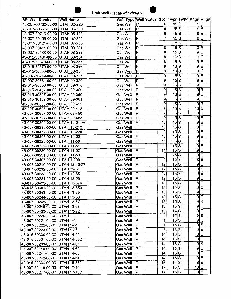
Utah Well List as of 12/26/02
API Well Number Well Name Well Type Well Status Sec Twpn Twpd Rngn Rngd43-007-30430-00-00 UTAH 06-223 Gas Well P 6 15 S 9 E43-007-30562-00-00 UTAH 06-330 Gas Well P 6 15 S 9 E43-007-30716-00-00 UTAH 06-483 GaiWell P 6 15 S 9 E43-007-30409-00-00 UTAH 07-234 Gas Well P 7 15 S 9 E43-007-30421-00-00 UTAH 07-235 Gas Well P 7 15 S 9 E43-007-30411-00-00 UTAH 08-231 Gas Well P 8 15 S 9 E43-007-30488-00-00 UTAH 08-233 GaTWell P 8 15 S 9 E43-015-30464-00-00 UTAH 08-354 Gas Wel\ P 8 16 S 9 E43-015-30378-00-00 UTAH 08-355 Gas Well P 8 16 S 9 E43-015-30379-00-00 UTAH 08-356 Gas Well P 8 16 S 9 E43-015-30380-00-00 UTAH 08-357 Gas Well P 8 16 S 9 E43-007-30449-00-00 UTAH 09-227 Gas Well P 9 15 S 9 E43-007-30561-00-00 UTAH 09-329 Gas Well P 9 15 S 9 E43-015-30300-00-00 UTAH 09-358 Gas Well P 9 16 S 9 E43-015-30407-00-00 UTAH 09-359 Gas Well P 9 16 S 9 E43-015-30397-00-00 UTAH 09-360 Gas Well P 9 16 S 9 E43-015-30408-00-00 UTAH 09-361 Gas Well P 9 16 S 9 E43-007-30580-00-00 UTAH 09-412 Gas Well P 9 15 S 10 E43-007-30605-00-00 UTAH 09-413 Gas Well P 9 15 S 10 E43-007-30657-00-00 UTAH 09-450 Gas Well P 9 15 S 10 E43-007-30722-00-00 UTAH 09-453 Gas Well P 9 15 S 10 E43-007-30302-00-00 UTAH 10-01-36 Gas Well P 10 15 S 9 E43-007-30298-00-00 UTAH 10-219 Gas Well P 10 15 S 9 E43-007-30432-00-00 UTAH 10-220 Gas Well P 10 15 S 9 E43-007-30303-00-00 UTAH 10-221 Gas Well P 10 15 S 9 E43-007-30228-00-00 UTAH 11-50 Gas Well P 11 15 S 9 E43-007-30229-00-00 UTAH 11-51 Gas Well P 11 15 S 9 E43-007-30230-00-00 UTAH 11-52 Gas Well P 11 15 S 9 E43-007-30231-00-00 |UTAH 11-53 Gas Well P 11 15 S 9 E43-007-30467-00-00 UTAH 1-209 Gas Well P 1 15 S 8 E43-007-30210-00-00 UTAH 12-15-37 Gas Well P 12 15 S 9 E43-007-30232-00-00 UTAH 12-54 Gas Well P 12 15 S 9 E43-007-30233-00-00 UTAH 12-55 Gas Well P 12 15 S 9 E43-007-30234-00-00 UTAH 12-56 Gas Well P 12 15 S 9 E43-015-30493-00-00 UTAH 13-376 Gas Well P 13 16 S 8 E43-015-30301-00-00 UTAH 13-550 Gas Well P 13 16 S 8 E43-007-30243-00-00 UTAH 13-65 Gas Well P 13] 15 S 9 E43-007-30244-00-00 UTAH 13-66 Gas Well P 1g 15 S 9 E43-007-30245-00-00 UTAH 13-67 Gas Well P 13 15 S 9 E43-007-30246-00-00 UTAH 13-68 Gas Well P 13| 15 S 9 E43-007-30439-00-00 UTAH 13-92 |Gas Well P 13 14 S 9 E43-007-30220-00-00 UTAH 1-42 Gas Well P 1 15 S 9 E43-007-30221-00-00 UTAH 1-43 Gas Well P 1 15 S 9 E43-007-30222-00-00 UTAH 1-44 Gas Well P 1 15 S 9 E43-007-30223-00-00 UTAH 1-45 Gas Well P 1 15 S 9 E43-015-30330-00-00 UTAH 14-551 Gas Well P 14 16 S 8 E43-015-30331-00-00 UTAH 14-552 Gas Well P 14 16 S 8 E43-007-30239-00-00 UTAH 14-61 Gas Well P 14 15 S 9 E43-007-30240-00-00 UTAH 14-62 Gas Well P 14 15 S 9 E43-007-30241-00-00 UTAH 14-63 Gas Well P 14 15 S 9 E43-007-30242-00-00 UTAH 14-64 Gas Well P 14 15 S 9 E43-015-30334-00-00 UTAH 15-553 Gas Well P 15 16 S 8 E43-007-30416-00-00 UTAH 17-101 Gas Well P 17 15 S 10 E43-007-30277-00-00 UTAH 17-102 Gas Well P 17 15 S 10
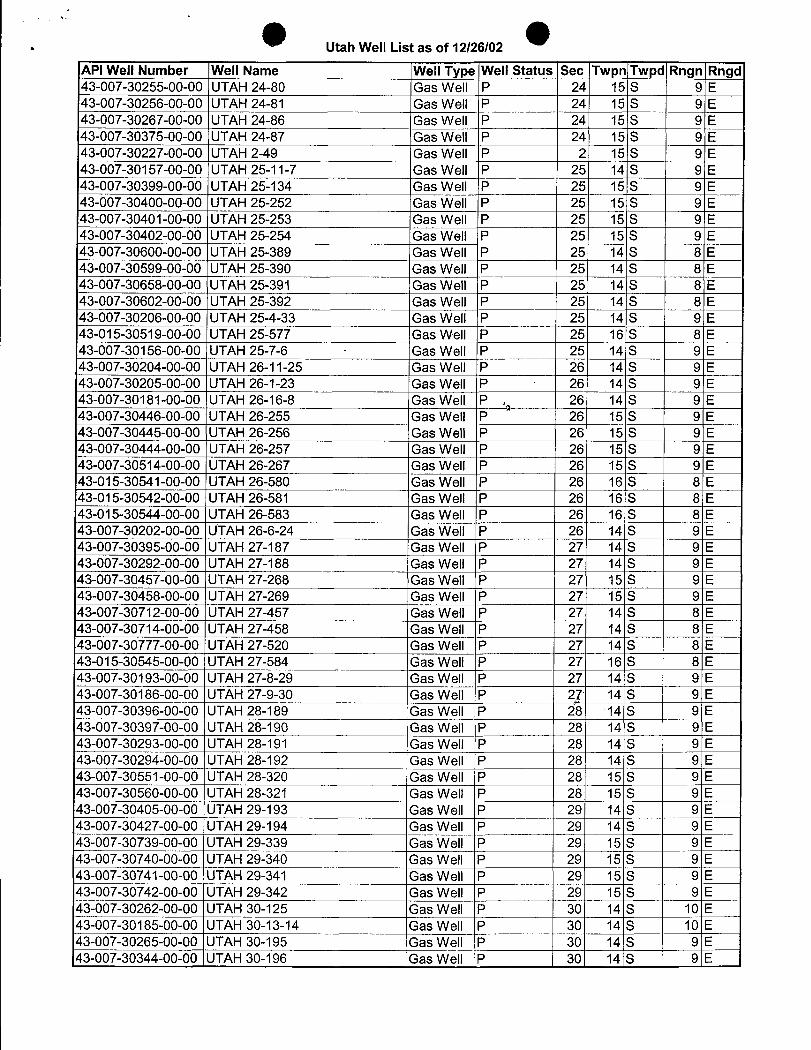
Utah Well List as of 12/26/02
API Well Number Well Name Well Type Well Status Sec Twpn Twpd Rngn Rngd43-007-30255-00-00 UTAH 24-80 Gas Well P 24 15 S 9 E43-007-30256-00-00 UTAH 24-81 Gas Well P 24 15 S 9 E43-007-30267-00-00 UTAH 24-86 Gas Well P 24 15 S 9 E43-007-30375-00-00 UTAH 24-87 Gas Well P 24 15 S 9 E43-007-30227-00-00 ÜTAH 2-49 Gas Well P 2 15 S 9 E43-007-30157-00-00 UTAH 25-11-7 Gas Well P 25 14 S 9 E43-007-30399-00-00 UTAH 25-134 Gas Well P 25 15 S 9 E43-007-30400-00-00 UTAH 25-252 Gas Well P 25 15 S 9 E43-007-30401-00-00 UTAH 25-253 Gas Well P 25 15 S 9 EÄ3-007-30402-00-00UTAH 25-254 Gas Well P 25 15 S 9 E43-007-30600-00-00 UTAH 25-389 Gas Well P 25 14 S 8 EA3-007-30599-00-00UTAH 25-390 Gas Well P 25 14 S 8 E43-007-30658-00-00 UTAH 25-391 Gas Well P 25 14 S 8 E43-007-30602-00-00 UTAH 25-392 Gas Well P 25 14 S 8 E43-007-30206-00-00 UTAH 25-4-33 Gas Well P 25 14 S 9 E43-015-30519-00-00 UTAH 25-577 Gas Well P 25 16 S 8 E43-007-30156-00-00 UTAH 25-7-6 Gas Well P 25 14 S 9 E43-007-30204-00-00 UTAH 26-11-25 Gas Well P 26 14 S 9 E43-007-30205-00-00 UTAH 26-1-23 Gas Well P 26 14 S 9 E43-007-30181-00-00 UTAH 26-16-8 Gas Well P , 26 14 S 9 E43-007-30446-00-00 UTAH 26-255 Gas Well P 26 15 S 9 E43-007-30445-00-00 UTAH 26-256 Gas Well P 26 15 S 9 E43-007-30444-00-00 UTAH 26-257 Gas Well P 26 15 S 9 E43-007-30514-00-00 UTAH 26-267 Gas Well P 26 15 S 9 E43-015-30541-00-00 UTAH 26-580 Gas Well P 26 16 S 8 E43-015-30542-00-00 UTAH 26-581 Gas Well P 26 16 S 8 E4Š-015-30544-00-00 UTAH 26-583 Gas Well P 26 16 S 8 E43-007-30202-00-00 UTAH 26-6-24 Gas Well P 26 14 S 9 E43-007-30395-00-00 UTAH 27-187 Gas Well P 27 14 S 9 E43-007-30292-00-00 UTAH 27-188 Gas Well P 27 14 S 9 E43-007-30457-00-00 UTAH 27-268 Gas Well P 27 15 S 9 E43-007-30458-00-00 UTAH 27-269 Gas Well P 27 15 S 9 E43-007-30712-00-00 UTAH 27-457 Gas Well P 27 14 S 8 E43-007-30714-00-00 UTAH 27-458
, Gas Well P 27 14 S 8 E43-007-30777-00-00 UTAH 27-520 'Gas Well P 27 14 S 8 E43-015-30545-00-00 UTAH 27-584 Gas Well P 27 16 S 8 E43-007-30193-00-00 UTAH 27-8-29 Gas Well P 27 14 S 9 E43-007-30186-00-00 UTAH 27-9-30 Gas Well P g 14 S 9 E43-007-30396-00-00 UTAH 28-189 Gas Well P 28 14 S 9 E43-007-30397-00-00 UTAH 28-190 iGas Well P 28 14 S 9 E43-007-30293-00-00 UTAH 28-191 Gas Well P 28 14 S 9 E43-007-30294-00-00 UTAH 28-192 Gas Well P 28 14 S 9 E43-007-30551-00-00 JUTAH 28-320 Gas Well P 28 15 S 9 E43-007-30560-00-00 UTAH 28-321 Gas Well P 28 15 S 9 E43-007-30405-00-00 UTAH 29-193 Gas Well P 29 14 S 9 E43-007-30427-00-00 UTAH 29-194 Gas Well P 29 14 S 9 E43-007-30739-00-00 UTAH 29-339 Gas Well P 29 15 S 9 E43-007-30740-00-00 UTAH 29-340 Gas Well P 29 15 S 9 E43-007-30741-00-00 UTAH 29-341 Gas Well P 29 15 S 9 E43-007-30742-00-00 UTAH 29-342 Gas Well P 29 15 S 9 E43-007-30262-00-00 UTAH 30-125 Gas Well P 30 14 S 10 E507-30185-00-00UTAH 30-13-14 Gas Well P 30 14 S 10 E¾07-30265-00-00UTAH 30-195 Gas Well P 30 14 S 9 E43-007-30344-00-00 UTAH 30-196 Gas Well P 30 14 S 9
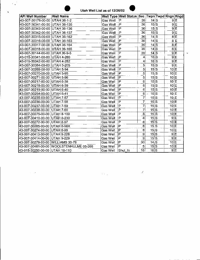
Utah Well List as of 12/26/02
API Well Number Well Name Well Type Well Status Sec Twpn Twpd Rngn Rngd43-007-30178-00-00 UTAH 36-1-2 Gas Well P 36 14 S 9 E43-007-30341-00-00 UTAH 36-135 Gas Well P 36 15 S 9 E43-007-30343-00-00 UTAH 36-136 Gas Well P 36 15 S 9 E43-007-30342-00-00 UTAH 36-137 Gas Well IP 36 15 S 9 E43-007-30315-00-00 UTAH 36-162 Gas Well P 36 14 S 8 E43-007-30316-00-00 UTAH 36-163 Gas
Well¯P36 14 S 8 E
43-007-30317-00-00 UTAH 36-164 Gas Well P 36 14 S 8 E43-007-30318-00-00 UTAH 36-165 Gas Well P 36 14 S 8 E43-007-30144-00-00 UTAH 36-9-5 Gas Well P 36 14 S 9 E43-015-30341-00-00 UTAH 4-280 Gas Well P 4i 16 S 9 E43-015-30342-00-00 UTAH 4-282 Gas Well P 4 16 S 9 E43-007-30384-00-00 UTAH 5-205 Gas Well P 5 15 S 9 E43-007-30269-00-00 UTAH 5-94 Gas Well P 5 15 S 10 E43-007-30270-00-00 UTAH 5-95 Gas Well P 5 15 S 10 E43-007-30271-00-00 UTAH 5-96 Gas Well P 5 15 S 10 E43-007-30217-00-00 UTAH 6-38 Gas Well P 6 15 S 10 E43-007-30218-00-00 UTAH 6-39 Gas Well P 6 15 S 10 E43-007-30219-00-00 UTAH 6-40 Gas Well P 6 15 S 10 E43-007-30254-00-00 UTAH 6-41 Gas Well P 6 15 S 10 E43-007-30235-00-00 UTAH 7-57 Gas Well P 7 15 S 10 E43-007-30236-00-00 UTAH 7-58 Gas Well P 7 15 S 10 E43-007-30237-00-00 UTAH 7-59 Gas Well |P 7 15 S 10 E43-007-30238-00-00 UTAH 7-60 Gas Well P 7 15 S 10 E43-007-30275-00-00 UTAH 8-100 Gas Well P 8 15 S 10 E43-007-30410-00-00 UTAH 8-230 Gas Well P 8 15 S 9 E43-007-30272-00-00 UTAH 8-97 Gas Well P 8 15 S 10 E43-007-30285-00-00 UTAH 8-98X Gas Well P 8 15 S 10 E43-007-30274-00-00 UTAH 8-99 Gas Well P 8 15 S 10 E43-007-30413-00-00 UTAH 9-228 Gas Well P 9 15 S 9 E43-007-30414-00-00 UTAH 9-229 Gas Well P 9 15 S 9 E43-007-30279-00-00 WILLIAMS 30-78 Gas Well P 30 14 S 10 E43-007-30481-00-00 WOOLSTENHULME 05-266 Gas Well P 5 15 S 10 E43-015-30250-00-00 UTAH 16-110 Gas Well Shut In 16 16 S 9
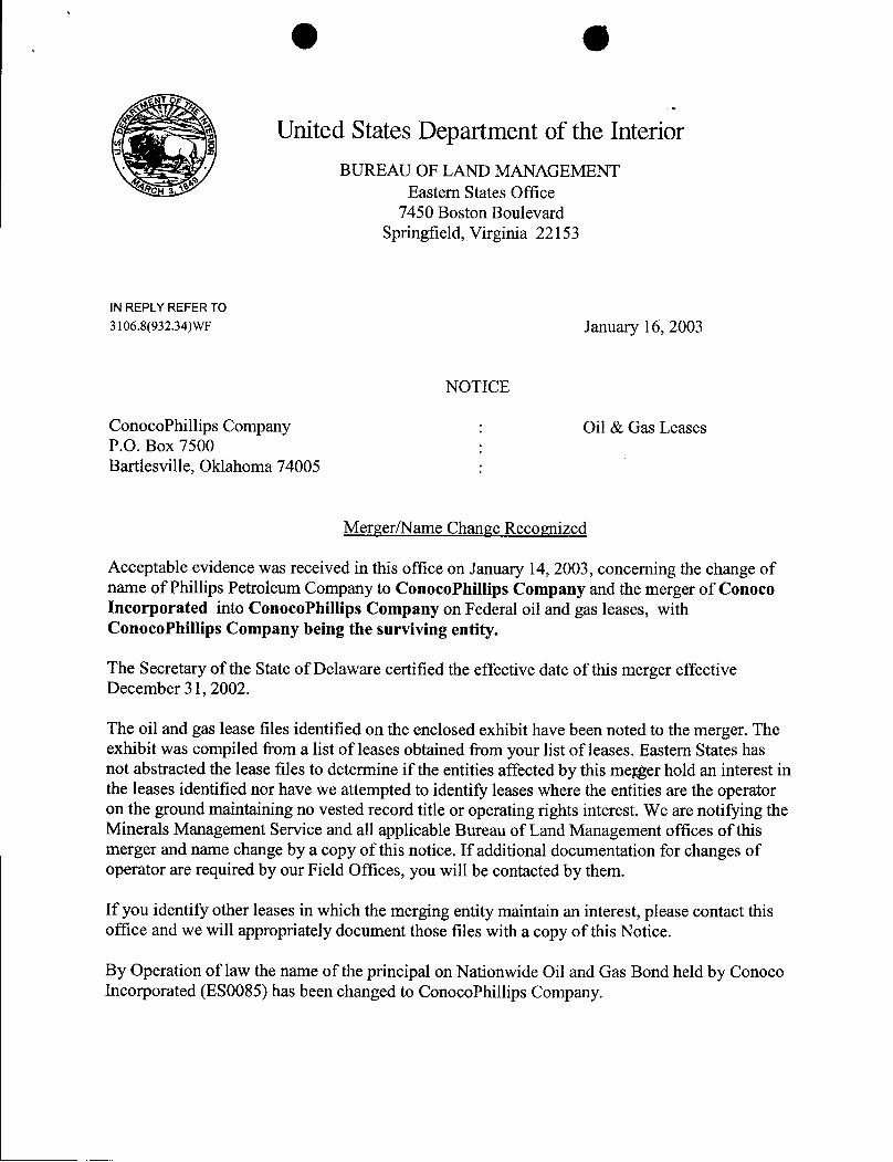
O O
United States Department of the InteriorBUREAU OF LAND MANAGEMENT
Eastern States Office7450 Boston Boulevard
Springfield, Virginia 22153
IN REPLY REFER TO3106.8(932.34)WF January 16, 2003
NOTICE
ConocoPhillips Company : Oil & Gas LeasesP.O. Box 7500Bartlesville, Oklahoma 74005
Merger/Name Change Recognized
Acceptable evidence was received in this office on January 14, 2003, concerning the change ofname of Phillips Petroleum Company to ConocoPhillips Company and the merger of ConocoIncorporated into ConocoPhillips Company on Federal oil and gas leases, withConocoPhillips Company being the surviving entity.
The Secretary of the State of Delaware certified the effective date of this merger effectiveDecember 31, 2002.
The oil and gas lease files identified on the enclosed exhibit have been noted to the merger. Theexhibit was compiled from a list of leases obtained from your list of leases. Eastern States hasnot abstracted the lease files to determine if the entities affected by this merger hold an interest inthe leases identified nor have we attempted to identify leases where the entities are the operatoron the ground maintaining no vested record title or operating rights interest. We are notifying theMinerals Management Service and all applicable Bureau of Land Management offices of thismerger and name change by a copy of this notice. If additional documentation for changes ofoperator are required by our Field Offices, you will be contacted by them.
If you identify other leases in which the merging entity maintain an interest, please contact thisoffice and we will appropriately document those files with a copy of this Notice.
By Operation of law the name of the principal on Nationwide Oil and Gas Bond held by ConocoIncorporated (ES0085) has been changed to ConocoPhillips
FEB-03-2003NON11:15AN FAXÑO, P. 03
If you have any questions, pleasecontact BillForbes at 703-440-1536.
Wilbert B. ForbesLand Law ExaminerBranch of UseAuthorizationDivisionof Resources Planning, UseandProtection
be: JFO. BLM StateOffices, MMS, ES RF. 930 RF. ES-932:Oforbes:wbf:01/16/03:440-1536/ConocoPhillips
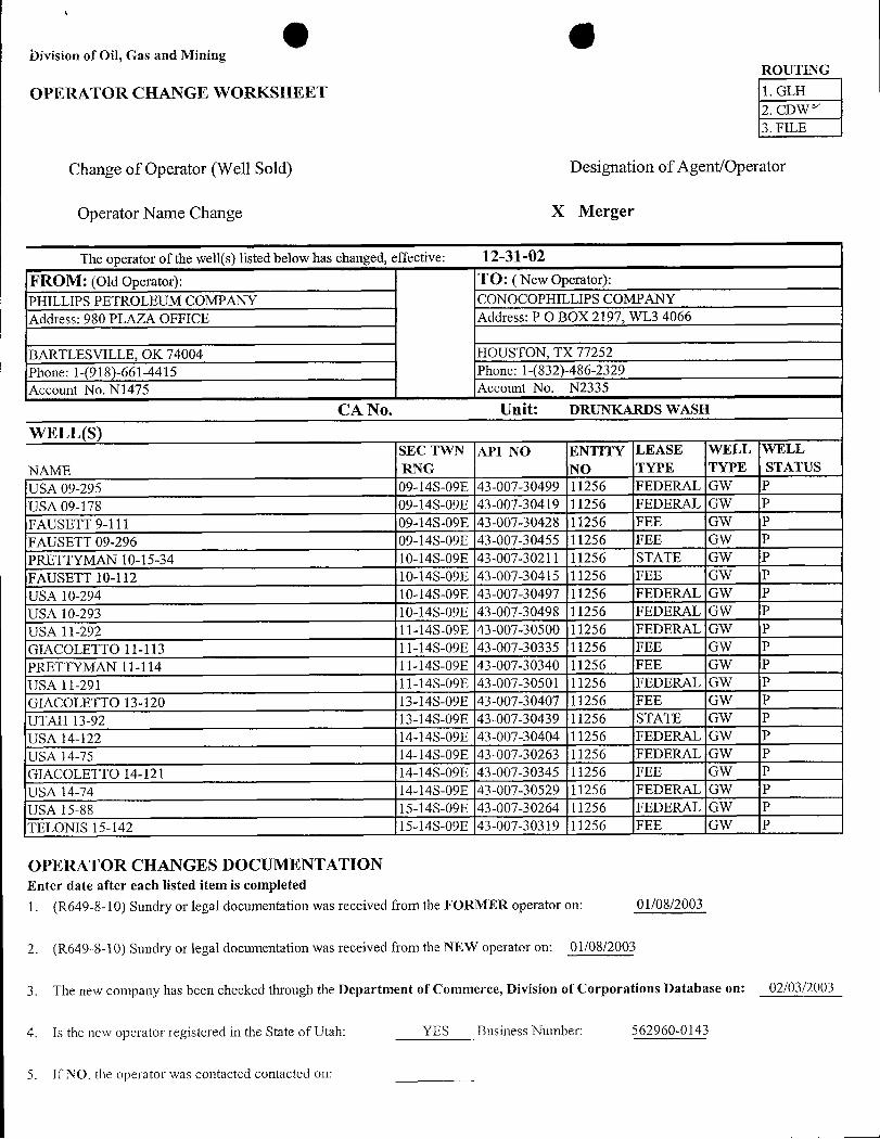
bivision of Oil, Gas and MiningROUTING
OPERATOR CHANGE WORKSHEET 1. GLH2. CDW/
3. FILE
Change of Operator (Well Sold) Designation of Agent/Operator
Operator Name Change X Merger
The operator of the well(s) listed below has changed, effective: 12-31-02
FROM: (Old Operator): TO: ( New Operator):PHILLIPS PETROLEUM COMPANY CONOCOPHILLIPS COMPANYAddress: 980 PLAZA OFFICE Address: PO BOX 2197, WL3 4066
BARTLESVILLE, OK 74004 HOUSTON, TX 77252Phone: 1-(918)-661-4415 Phone: 1-(832)-486-2329
Account No. N1475 Account No. N2335
CA No. Unit: DRUNKARDS WASH
WELL(S)SEC TWN API NO ENTITY LEASE WELL WELL
NAME RNG NO TYPE TYPE STATUSUSA 09-295 09-14S-09E 43-007-30499 11256 FEDERAL GW PUSA 09-178 09-14S-09E 43-007-30419 11256 FEDERAL GW PFAUSETT 9-111 09-14S-09E 43-007-30428 11256 FEE GW PFAUSETT 09-296 09-14S-09E 43-007-30455 11256 FEE GW PPRETTYMAN 10-15-34 10-14S-09E 43-007-30211 11256 STATE GW PFAUSETT 10-112 10-14S-09E 43-007-30415 11256 FEE GW PUSA 10-294 10-14S-09E 43-007-30497 11256 FEDERAL GW PUSA 10-293 10-14S-09E 43-007-30498 11256 FEDERAL GW PUSA 11-292 11-14S-09E 43-007-30500 11256 FEDERAL GW PGIACOLETTO 11-113 11-14S-09E 43-007-30335 11256 FEE GW PPRETTYMAN 11-114 11-14S-09E 43-007-30340 11256 FEE GW PUSA 11-291 11-14S-09E 43-007-30501 11256 FEDERAL GW PGIACOLETTO 13-120 13-14S-09E 43-007-30407 11256 FEE GW PUTAH 13-92 13-14S-09E 43-007-30439 11256 STATE GW PUSA 14-122 14-14S-09E 43-007-30404 11256 FEDERAL GW PUSA 14-75 14-14S-09E 43-007-30263 11256 FEDERAL GW PGIACOLETTO 14-121 14-14S-09E 43-007-30345 11256 FEE GW PUSA 14-74 14-14S-09E 43-007-30529 11256 FEDERAL GW PUSA 15-88 15-14S-09E 43-007-30264 11256 FEDERAL GW PTELONIS 15-142 15-14S-09E 43-007-30319 11256 FEE GW P
OPERATOR CHANGES DOCUMENTATIONEnter date after each listed item is completed
1. (R649-8-10) Sundry or legal documentation was received from the FORMER operator on: 01/08/2003
2. (R649-8-10) Sundry or legal documentation was received from the NEW operator on: 01/08/2003
3. The new company has been checked through the Department of Commerce, Division of Corporations Database on: 02/03/2003
4. Is the new operator registered in the State of Utah: YES Business Number: 562960-0143
5. If NO. the operator was contacted contacted
bivision of Oil, Gas and MiningROUTING
OPERATOR CHANGE WORKSHEET 1. GLH2. CDW/
3. FILE
Change of Operator (Well Sold) Designation of Agent/Operator
Operator Name Change X Merger
The operator of the well(s) listed below has changed, effective: 12-31-02
FROM: (Old Operator): TO: ( New Operator):
PHILLIPS PETROLEUM COMPANY CONOCOPHILLIPS COMPANYAddress: 980 PLAZA OFFICE Address: PO BOX 2197, WL3 4066
BARTLESVILLE, OK 74004 HOUSTON, TX 77252Phone: 1-(918)-661-4415 Phone: 1-(832)-486-2329
Account No. N1475 Account No. N2335
CA No. Unit: DRUNKARDS WASH
WELL(S)SEC TWN API NO ENTITY LEASE WELL WELL
NAME RNG NO TYPE TYPE STATUSUSA 09-295 09-14S-09E 43-007-30499 11256 FEDERAL GW PUSA 09-178 09-14S-09E 43-007-30419 11256 FEDERAL GW PFAUSETT 9-111 09-14S-09E 43-007-30428 11256 FEE GW PFAUSETT 09-296 09-14S-09E 43-007-30455 11256 FEE GW PPRETTYMAN 10-15-34 10-14S-09E 43-007-30211 11256 STATE GW PFAUSETT 10-112 10-14S-09E 43-007-30415 11256 FEE GW PUSA 10-294 10-14S-09E 43-007-30497 11256 FEDERAL GW PUSA 10-293 10-14S-09E 43-007-30498 11256 FEDERAL GW PUSA 11-292 11-14S-09E 43-007-30500 11256 FEDERAL GW PGIACOLETTO 11-113 11-14S-09E 43-007-30335 11256 FEE GW PPRETTYMAN 11-114 11-14S-09E 43-007-30340 11256 FEE GW PUSA 11-291 11-14S-09E 43-007-30501 11256 FEDERAL GW PGIACOLETTO 13-120 13-14S-09E 43-007-30407 11256 FEE GW PUTAH 13-92 13-14S-09E 43-007-30439 11256 STATE GW PUSA 14-122 14-14S-09E 43-007-30404 11256 FEDERAL GW PUSA 14-75 14-14S-09E 43-007-30263 11256 FEDERAL GW PGIACOLETTO 14-121 14-14S-09E 43-007-30345 11256 FEE GW PUSA 14-74 14-14S-09E 43-007-30529 11256 FEDERAL GW PUSA 15-88 15-14S-09E 43-007-30264 11256 FEDERAL GW PTELONIS 15-142 15-14S-09E 43-007-30319 11256 FEE GW P
OPERATOR CHANGES DOCUMENTATIONEnter date after each listed item is completed
1. (R649-8-10) Sundry or legal documentation was received from the FORMER operator on: 01/08/2003
2. (R649-8-10) Sundry or legal documentation was received from the NEW operator on: 01/08/2003
3. The new company has been checked through the Department of Commerce, Division of Corporations Database on: 02/03/2003
4. Is the new operator registered in the State of Utah: YES Business Number: 562960-0143
5. If NO. the operator was contacted contacted
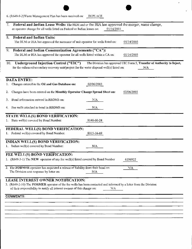
O O6. (R649-9-2)Waste Management Plan has been received on: IN PLACE
7. Federal and Indian Lease Wells: The BLM and or the BIA has approved the merger, name change,or operator change for all wells listed on Federal or Indian leases on: 01/14/2003
8. Federal and Indian Units:The BLM or BIA has approved the successor of unit operator for wells listed on: 01/14/2003
9. Federal and Indian Communization Agreements ("CA"):The BLM or BIA has approved the operator for all wells listed within a CA on: 01/14/2003
10. Underground Injection Control ("UIC") The Division has approved UIC Form 5, Transfer of Authority to Inject,for the enhanced/secondary recovery unit/project for the water disposal well(s) listed on: N/A
DATA ENTRY:1. Changes entered in the Oil and Gas Database on: 02/06/2003
2. Changes have been entered on the Monthly Operator Change Spread Sheet on: 02/06/2003
3. Bond information entered in RBDMS on: N/A
4. Fee wells attached to bond in RBDMS on: N/A
STATE WELL(S) BOND VERIFICATION:1. State well(s) covered by Bond Number: 8140-60-24
FEDERAL WELL(S) BOND VERIFICATION:1. Federal well(s) covered by Bond Number: 8015-16-69
INDIAN WELL(S) BOND VERIFICATION:1. Indian well(s) covered by Bond Number: N/A
FEE WELL(S) BOND VERIFICATION:1. (R649-3-1) The NEW operator of any fee well(s) listed covered by Bond Number 6196922
2. The FORMER operator has requested a release of liability from their bond on: N/AThe Division sent response by letter on: N/A
LEASE INTEREST OWNER NOTIFICATION:3. (R649-2-10) The FORMER operator of the fee wells has been contacted and informed by a letter from the Division
of their responsibility to notify all interest owners of this change on: N/A
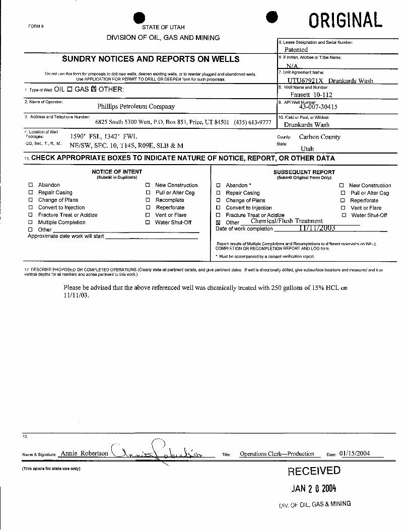
ORIGINALFORM 9 STATE OF UTAH
DIVISION OF OIL, GAS AND MINING5. Lease Designation and Serial Number:
PatentedSUNDRY NOTICES AND REPORTS ON WELLS 6.lfindian,AllotteeorTribeName:
7. UnitAgreement Name:Do not use this form for proposals to drill newwells, deepen existingwells,or to reenter plugged and abandoned wells.Use APPLICATION FOR PERMIT TO DRILL OR DEEPEN form for such proposals. UTU67921X Drunkards Wash
1. Type of Well: OIL O GAS O OTH ER: 8. Well Name and Number:
Fausett 10-1122. Name of Operator: 9. API Well Number:
Phillips Petroleum Company 43-007-30415
3. Address and Telephone Number: 10. Field or Pool, or Wildcat:6825 South 5300 West, P.O. Box 851, Price, UT 84501 (435) 613-9777 Drunkards Wash
4. Location of WellFootages: 1590' FSL, 1342' FWL county: Carbon CountyQQ, Sec., T., R., M.: NE/SW, SEC. 10, Tl4S, RO9E, SLB & M state:
Utah11. CHECK APPROPRIATE BOXES TO INDICATE NATURE OF NOTICE, REPORT, OR OTHER DATA
NOTICE OF INTENT SUBSEQUENT REPORT(Submit in Duplicate) (Submit Original Form Only)
O Abandon O New Construction O Abandon * O New ConstructionO Repair Casing O Pull or Alter Csg O Repair Casing O Pull or Alter CsgO Change of Plans O Recomplete O Change of Plans O ReperforateO Convert to Injection O Reperforate O Convert to Injection O Vent or FlareO Fracture Treat or Acidize O Vent or Flare O Fracture Treat or Acidize O Water Shut-OffO Multiple Completion O Water Shut-Off U Other Chemical/Flush TreatmentO Other Date ofwork completion i Îl I 1/A003Approximate date work will start
Report resultsof Multiple Completions and Recompletions to different reservoirs on WELLCOMPLETION OR RECOMPLETIONREPORT AND LOG form.* Must be accompaniedby a cement verification report.
12. DESCRIBE PROPOSED OR COMPLETED OPERATIONS (Clearly state all pertinent details, and give pertinent dates. Ifwell is directionally drilled, give subsurface locations and measured and truevertical depths for all markers and zones pertinent to this work.)
Please be advised that the above referenced well was chemically treated with 250 gallons of 15% HCL on11/11/03.
13.
Name & Signature: Annie Robertson Titie: Operations Clerk-Production Date: 01/15/2004
(This space for state use only) RECElVED
JAN202004
Div.OFOIL,GAS&
ORIGINALFORM 9 STATE OF UTAH
DIVISION OF OIL, GAS AND MINING5. Lease Designation and Serial Number:
Patented
SUNDRY NOTICES AND REPORTS ON WELLS 6.lfindian,AllotteeorTribeName:
7. UnitAgreement Name:Do not use this form for proposals to drill newwells, deepen existingwells,or to reenter plugged and abandoned wells.Use APPLICATION FOR PERMIT TO DRILL OR DEEPEN form for such proposals. UTU67921X Drunkards Wash
1. Type of Well: OIL O GAS O OTH ER: 8. Well Name and Number:
Fausett 10-1122. Name of Operator: 9. API Well Number:
Phillips Petroleum Company 43-007-30415
3. Address and Telephone Number: 10. Field or Pool, or Wildcat:6825 South 5300 West, P.O. Box 851, Price, UT 84501 (435) 613-9777 Drunkards Wash
4. Location of WellFootages: 1590' FSL, 1342' FWL county: Carbon CountyQQ, Sec., T., R., M.: NE/SW, SEC. 10, Tl4S, RO9E, SLB & M state:
Utah11. CHECK APPROPRIATE BOXES TO INDICATE NATURE OF NOTICE, REPORT, OR OTHER DATA
NOTICE OF INTENT SUBSEQUENT REPORT(Submit in Duplicate) (Submit Original Form Only)
O Abandon O New Construction O Abandon * O New ConstructionO Repair Casing O Pull or Alter Csg O Repair Casing O Pull or Alter CsgO Change of Plans O Recomplete O Change of Plans O ReperforateO Convert to Injection O Reperforate O Convert to Injection O Vent or FlareO Fracture Treat or Acidize O Vent or Flare O Fracture Treat or Acidize O Water Shut-OffO Multiple Completion O Water Shut-Off U Other Chemical/Flush TreatmentO Other Date ofwork completion i Îl I 1/A003Approximate date work will start
Report resultsof Multiple Completions and Recompletions to different reservoirs on WELLCOMPLETION OR RECOMPLETIONREPORT AND LOG form.* Must be accompaniedby a cement verification report.
12. DESCRIBE PROPOSED OR COMPLETED OPERATIONS (Clearly state all pertinent details, and give pertinent dates. Ifwell is directionally drilled, give subsurface locations and measured and truevertical depths for all markers and zones pertinent to this work.)
Please be advised that the above referenced well was chemically treated with 250 gallons of 15% HCL on11/11/03.
13.
Name & Signature: Annie Robertson Titie: Operations Clerk-Production Date: 01/15/2004
(This space for state use only) RECElVED
JAN202004
Div.OFOIL,GAS&
FORMS TATEOFUTAH 0RlGINALDIVISION OF OIL, GAS AND MINING
5. Lease Designation and Serial Number:
PatentedSUNDRY NOTICES AND REPORTS ON WELLS 6.lfindian,AllotteeorTribeName:
N/A7. Unit Agreement Name:Do not use this form for proposals to drill new wells, deepen existingwells, or to reenter plugged and abandoned wells.
Use APPLICATION FOR PERMIT TO DRILL OR DEEPEN form for such proposals UTU67921X Drunkards Wash1.TypeofWell:OILO GAS 13 OTHER: 8. Well NameandNumber:
Fausett 10-1122. Nameof Operator: 9. API Well Number:
ConocoPhillips Company 43-007-304153. Address and Telephone Number: 10. Field or Pool, or Wildcat:
6825 South 5300 West, P.O. Box 851, Price, UT 84501 (435) 613-9777 Drunkards Wash4. Location ofWellFootages: 1590' FSL, 1342' FWL county: Carbon CountyQQ, Sec., T., R., M.: NE/SW, SEC. Ë,T14S, RO9E, SLB & M state:
Utah11. CHECK APPROPRIATE BOXES TO INDICATE NATURE OF NOTICE, REPORT, OR OTHER DATA
NOTICE OF INTENT SUBSEQUENT REPORT(Submit in Duplicate) (Submit Original Form Only)
O Abandon O New Construction O Abandon * O New Construction0 Repair Casing 0 Pull or Alter Csg O Repair Casing O Pull or Alter CsgO Change of Plans O Recomplete O Change of Plans O ReperforateO Convert to Injection O Reperforate O Convert to Injection O Vent or FlareO Fracture Treat or Acidize O Vent or Flare O Fracture Treat or Acidize O Water Shut-OffO Multiple Completion O Water Shut-Off U Other Chemical TreatmentO Other Date of work completion 09/99 oggyApproximate date work will start
Report results of Multiple Completions and Recompletions to different reservoirs on WELLCOMPLETION OR RECOMPLETION REPORT AND LOGform.* Must be accompanied by a cement verification report.
12. DESCRIBE PROPOSED OR COMPLETED OPERATIONS (Clearly state all pertinent details, and give pertinent dates. Ifwellis directionally drilled, give subsurface locations and measured and truevertical depths for all markers and zones pertinent to thís work.)
Please be advised that the above referenced well was chemically treated with 250 gallons of TA-13 Acid fluidon 09/22/2005.
N3ame
& Signature: Lynnette Allred Titie: Sr. Operations Assistant Date: 10/05/2005
(This space for state use only)
RECEIVEDOCT1120
(4/94) (See instructions on Reverse Side)
9 AF0\L,GAR