2003 rock-art in the tolmer sandstones, northern territory, australia
TRANSCRIPT
Rock-art in the Tolmer sandstones, Northern Territory,Australia
Before Farming 2003/2 (7)
RG GunnAboriginal Sites Consultant, RMB 2008, Stawell VIC 3380, Australia
KeywordsRock-art, regions, analysis, Umbrawarra, Australia.
AbstractLittle has been reported of the rock-art in the area between Darwin and the Daly River, in the Northern Territory.
Recent management surveys, however, have revealed that the northern end of the outcropping Tolmer Sandstone
contains a small but significant corpus of rock-art. While having aspects in common with the adjacent areas of the
Victoria/Upper Daly River region to the south-west and western Arnhem Land to the east, the differences are
enough to indicate that the sites in the area constitute a distinct art region in their own right. Further, within this
corpus there is a pattern of bichrome art occurring on the edge of the escarpments and adjacent to the resources
of the nearby wetlands, and older looking red paintings in the interior of the range.
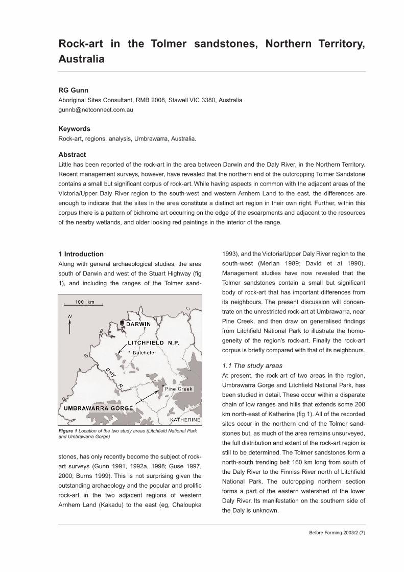
1 IntroductionAlong with general archaeological studies, the area
south of Darwin and west of the Stuart Highway (fig
1), and including the ranges of the Tolmer sand-
stones, has only recently become the subject of rock-
art surveys (Gunn 1991, 1992a, 1998; Guse 1997,
2000; Burns 1999). This is not surprising given the
outstanding archaeology and the popular and prolific
rock-art in the two adjacent regions of western
Arnhem Land (Kakadu) to the east (eg, Chaloupka
1993), and the Victoria/Upper Daly River region to the
south-west (Merlan 1989; David et al 1990).
Management studies have now revealed that the
Tolmer sandstones contain a small but significant
body of rock-art that has important differences from
its neighbours. The present discussion will concen-
trate on the unrestricted rock-art at Umbrawarra, near
Pine Creek, and then draw on generalised findings
from Litchfield National Park to illustrate the homo-
geneity of the region’s rock-art. Finally the rock-art
corpus is briefly compared with that of its neighbours.
1.1 The study areasAt present, the rock-art of two areas in the region,
Umbrawarra Gorge and Litchfield National Park, has
been studied in detail. These occur within a disparate
chain of low ranges and hills that extends some 200
km north-east of Katherine (fig 1). All of the recorded
sites occur in the northern end of the Tolmer sand-
stones but, as much of the area remains unsurveyed,
the full distribution and extent of the rock-art region is
still to be determined. The Tolmer sandstones form a
north-south trending belt 160 km long from south of
the Daly River to the Finniss River north of Litchfield
National Park. The outcropping northern section
forms a part of the eastern watershed of the lower
Daly River. Its manifestation on the southern side of
the Daly is unknown.
Figure 1 Location of the two study areas (Litchfield National Parkand Umbrawarra Gorge)
2 Before Farming 2003/2 (7)
The area was traditionally occupied by a number
of Aboriginal groups including the Wagiman,
Tagoman, Kungarakany, Waray, Werat and
Marranunggu (AAPA files; Tindale 1974). There
appears to have been considerable social movement
between these groups and some reorganisation of
land affiliations in the region over the last 100 years
or so (Tindale 1974; Kearney 1991). A major religious
difference between the inland Wagiman and Tagoman
people, and the coastal groups to the north and west,
was that the former practised the rites of sub-incision
circumcision while the others did not (Tindale 1974).
However, as this practice was moving northwards in
historic times (ibid), the difference between the two
groups may not have existed during the period of the
rock-art’s production.
Umbrawarra is a steep-sided gorge that cuts
through a low sandstone range on the eastern margin
of the Daly River plains. It lies 20 km south-west of
Pine Creek and 180 km south of Darwin (fig 1). It is
acknowledged to be under the custodianship of the
Wagiman (Mearns 1987), and the word ‘Umbrawarra’
is a Wagiman place name. The principal Dreaming is
Barramundi (Manamyayn) but it also has association
with an important Chicken-hawk Dreaming (Kearney
1991:77). The Dreamings link Umbrawarra with other
sites and people to the north and south-west and indi-
cate a close cultural connection across the sub-inci-
sion boundary. While several rock-art sites at
Umbrawarra occur in the vicinity of the Dreaming
sites, according to current custodians, none of their
artwork is specifically related to either of the two
major Dreamings. The range consists of an elevated
tableland that rises to 276 m (asl), which is 100 m
above the eastern plain. The tablelands consist of a 3
km wide belt of the Middle Proterozoic Depot Creek
sandstone, flanked on the western side by a 1 km
wide band of Stray Creek sandstone. Both are part of
the Tolmer Group, a belt of gently south-west dipping
sandstone and minor siltstone that continues north-
west to Litchfield National Park (Pietsch 1989). The
formation is well-jointed and cut by several deep
gorges, and due to faulting has a 60 m escarpment
on its western face. The Depot Creek sandstone, in
which most of the rock-art sites occur, both here and
at Litchfield, consists of a pink to brown, medium to
coarse, quartz sandstone (Stuart-Smith et al
1987:19). The top unit, which crops as a prominent
ledge, has silicified to quartzite (ibid). The gentle dip-
ping of the beds has resulted in the formation of small
stacks and mushroom-shaped rock shelters above
the eastern end of the gorge, while the steep walls of
the gorge have provided numerous shelters and
capped vertical panels suitable for rock-art.
To the east of the range lies an undulating land-
scape of granite pavements with tor clusters and scat-
tered sandy rises. Quartz veins are common in the
granite hills (Stuart-Smith et al 1987:27) and it is
these that were probably the source of the quartz
flakes found at archaeological sites on top of the
gorge. Hornfels, another stone-type conspicuous at
several of the sites, outcrops over a large region near
Pine Creek (ibid). To the west of the range lie the
extensive, flat and flood-prone, carbonate plains of
the Daly River basin. Pine Creek has an average
annual rainfall of around 1500 mm. This falls mostly
within the monsoonal wet-season from November to
April (ibid:1). Climate data from Woolianna on the
Daly River (Bureau of Meteorology 2000) gives a
mean rainfall of 1386 mm, with January and February
being the wettest months and May-August the driest
with no rainfall at all in most years. The mean month-
ly temperatures range from 30o C to 36o C with the
highest temperatures in October-November and the
lowest in July. The creek through the gorge can cease
flowing in the dry season but even then it retains a
string of waterholes that can be regarded as perma-
nent. From personal observation, the vegetation can
be subdivided into four groups: eastern plains, range
top, western plains, and gorge. The eastern plains
consist of open woollybutt, bloodwood and salmon
gum woodland with sparse, tall grassy understorey.
The range top had open woollybutt, bloodwood and
stringybark woodland with a spinifex understorey. The
western plains were of open woollybutt and blood-
wood savannah woodland with a dense, tall grass
understorey. Large paperbarks, pandanus and reedy
grasses dominated the swampy area at the western
end of the gorge. With its permanent water and
greater range of vegetal foods, the gorge would
undoubtedly have been a major attraction for the
Wagiman and other local groups passing from the
Daly River to the Pine Creek hinterland.
The European incursion of the region began in the
1860s with the arrival of explorers, geologists and
surveyors, followed by several gold rushes in the
1870s that continued for the next 50 years. An alluvial
tin-field, 6 km east of the gorge, was also developed
Rock-art in the Tolmer sandstones: Gunn
at this time (Stuart-Smith et al 1987:30). Following the
initial mining boom, cattle stations were quickly estab-
lished in the region. The Wagiman and other local
Aboriginal groups were an inconvenience to these
enterprises at first, but then they were subjugated into
a seasonal workforce that became indispensable to
the profitability of many of these properties. This
intimidation had a devastating effect on the traditional
lifestyle of all the tribes in the region. Further disrup-
tion was caused through alcohol, opium and debilitat-
ing diseases introduced by the Europeans and
Chinese. Together these factors caused a rapid
depopulation of the Daly River tribes (Kearney
1991:3; and see Pearce 1982, 1983).
The introduction of equal wages in 1967 meant
that those families that had stayed on the traditional
lands by working for the local pastoral stations then
had to move away. Most Wagiman moved either to the
Daly River Mission or the town camps of Pine Creek.
In 1981 Kybrook farm was set up between Pine Creek
and Umbrawarra and became the home for the tradi-
tional owners of the gorge.
2 Previous investigationsRay Petherick, along with custodians from the
Woolaning Community, has been recording rock-art
in and around Litchfield National Park since 1954. He
is currently preparing a report on this major study
focusing on the correlation of clan territories and motif
types. This work is the most comprehensive study of
the region’s rock-art to date. Pearce (1982) provides
the only published records of the rock-art in the Pine
Creek area to date but these are scant and lacking in
detail. The only known recording of the art of
Umbrawarra was that by Brazier & Motti (1987). This
was a three-hour pilot project for the Northern
Territory Museum to demonstrate the value of pho-
togrammetric recording. Their report however is of lit-
tle archaeological value. Pearce (1983) and Bauman
& Deveson (1983) both mention rock-art sites near
Pine Creek, though they offer little description of this
rock-art. Pearce noted that one site contained paint-
ings consisting of human figures, animals and hand
stencils (faded and damaged by mud wasps).The site
also had evidence of stone quarrying. One Wagiman
family used this shelter as a campsite some 60 years
ago (Bauman & Deveson 1983:27).
Baker (1983) found that the limestone escarp-
ments to the west of Pine Creek and north-east of
Umbrawarra, contained numerous rock shelters with
evidence of Aboriginal occupation and rock-art. He
also found that the granite areas, such as that imme-
diately east of the gorge, typically contained large tors
around the base of which stone artefacts and other
evidence of Aboriginal use were often detected. Apart
from the rock shelters, the most common site types
recorded were quarries on hornfels outcrops though
no such outcrops occur in the vicinity of Umbrawarra.
Surface scatters of stone artefacts include flakes of
hornfels, chert, quartz and quartzite. A few glass arte-
facts were also recorded indicating the use of the
sites during the contact period. Other archaeological
surveys support these findings (Hiscock 1991; Kinhill
1992; Mulvaney 1992, 1993a & b; Guse 1995, 1998)
and show that there was extensive quarrying of horn-
fels outcrops throughout the Pine Creek area.
Mulvaney (1993b) recognised four site types in the
area:
• quarries (worked hornfels outcrops)
• work areas (away from quarries but also mostly
hornfels)
• other artefact scatters (hornfels but with quartz and
coloured cherts)
• isolated artefacts (large blade flakes or stone axes).
It was concluded by Kinhill (1992:29) that the
numerous creeks and rivers in the meta-sedimentary
and granitic parts of the landscape would probably
contain similar hornfels outcrops and associated
workings. The Pine Creek area then, was one of con-
siderable economic importance to the Wagiman and
other local Aboriginal groups.
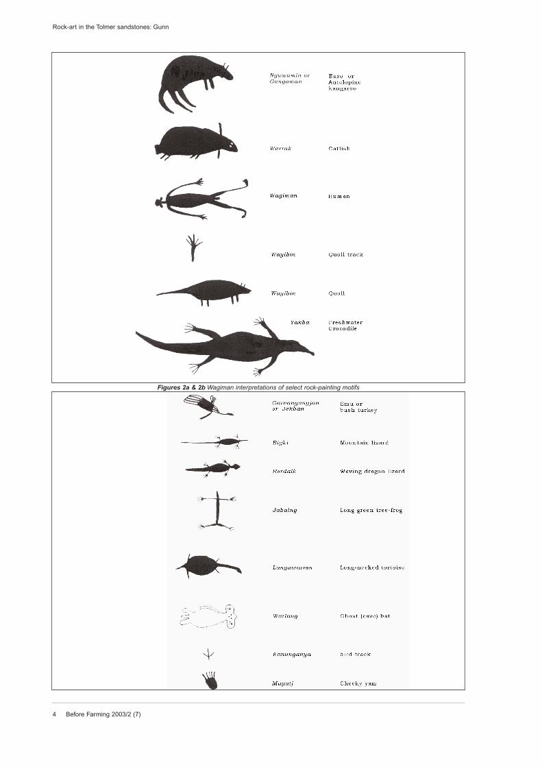
3 Indigenous interpretationsAs mentioned above, the gorge has particular mytho-
logical significance through the actions of the
Dreaming characters, but the area was also of signif-
icance as a general camping place. On visiting the
site with the author in 1998, senior Wagiman custodi-
ans (both men and women together, and men on their
own), readily interpreted the general pattern of site
use around the gorge and many individual figurative
motifs were confidently identified to species (figs 2a &
2b). They recalled that family groups used the rock
shelter sites at the eastern end of the gorge for
Before Farming 2003/2 (7) 3
Rock-art in the Tolmer sandstones: Gunn
4 Before Farming 2003/2 (7)
Rock-art in the Tolmer sandstones: Gunn
Figures 2a & 2b Wagiman interpretations of select rock-painting motifs
shelter during the wet season. They also recalled that
the paintings here were the work of the old men
‘drawing’ aspects of the Dreaming stories for explana-
tion to their children. They could offer little, however,
about the function of the art sites within the central
section of the gorge. They knew that red and yellow
ochres, suitable for rock-art pigments, occur in small
quantities throughout the region and were, and still
are, picked up casually as encountered. White pig-
ment, in contrast, was quarried from a specific and
very significant outcrop, associated with another
Dreaming being, to the east of the gorge.
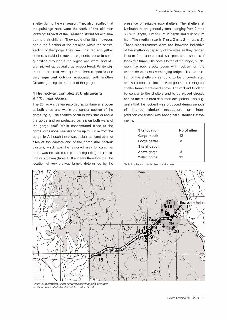
4 The rock-art complex at Umbrawarra4.1 The rock sheltersThe 20 rock-art sites recorded at Umbrawarra occur
at both ends and within the central section of the
gorge (fig 3). The shelters occur in rock stacks above
the gorge and on protected panels on both walls of
the gorge itself. While concentrated close to the
gorge, occasional shelters occur up to 300 m from the
gorge lip. Although there was a clear concentration of
sites at the eastern end of the gorge (the eastern
cluster), which was the favoured area for camping,
there was no particular pattern regarding their loca-
tion or situation (table 1). It appears therefore that the
location of rock-art was largely determined by the
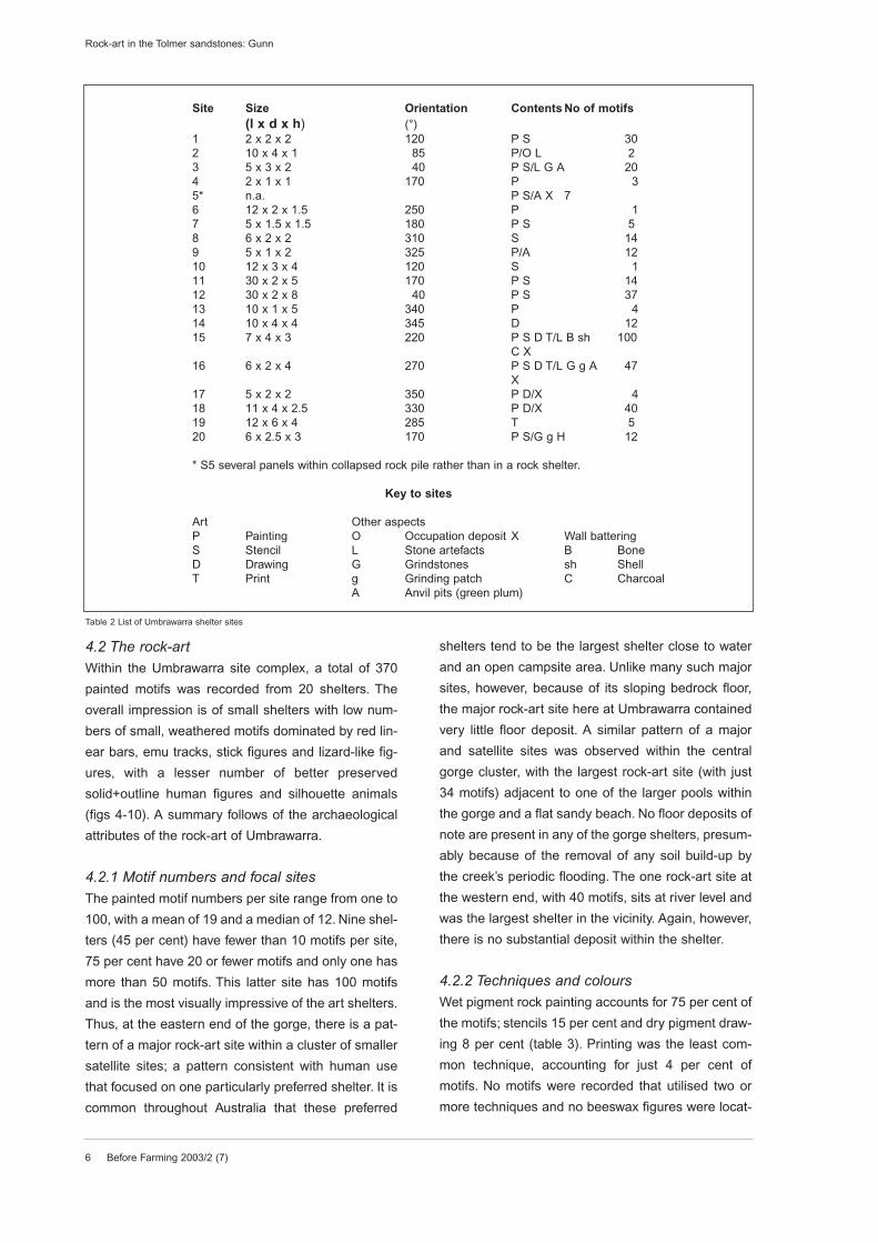
presence of suitable rock-shelters. The shelters at
Umbrawarra are generally small, ranging from 2 m to
30 m in length, 1 m to 6 m in depth and 1 m to 8 m
high. The median size is 7 m x 2 m x 2 m (table 2).
These measurements were not, however, indicative
of the sheltering capacity of the sites as they ranged
in form from unprotected wall panels on sheer cliff
faces to a tunnel-like cave. On top of the range, mush-
room-like rock stacks occur with rock-art on the
underside of most overhanging ledges. The orienta-
tion of the shelters was found to be uncoordinated
and was seen to reflect the wide geomorphic range of
shelter forms mentioned above. The rock-art tends to
be central to the shelters and to be placed directly
behind the main area of human occupation. This sug-
gests that the rock-art was produced during periods
of intense shelter occupation, an inter-
pretation consistent with Aboriginal custodians’ state-
ments.
Before Farming 2003/2 (7) 5
Rock-art in the Tolmer sandstones: Gunn
Site location No of sites
Gorge mouth 12
Gorge centre 8
Site situation
Above gorge 8
Within gorge 12
Table 1 Umbrawarra site locations and situations
Figure 3 Umbrawarra Gorge showing location of sites. Bichromemotifs are concentrated in the belt from sites 17–20
6 Before Farming 2003/2 (7)
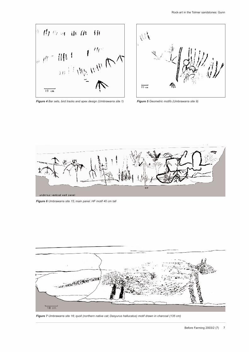
4.2 The rock-artWithin the Umbrawarra site complex, a total of 370
painted motifs was recorded from 20 shelters. The
overall impression is of small shelters with low num-
bers of small, weathered motifs dominated by red lin-
ear bars, emu tracks, stick figures and lizard-like fig-
ures, with a lesser number of better preserved
solid+outline human figures and silhouette animals
(figs 4-10). A summary follows of the archaeological
attributes of the rock-art of Umbrawarra.
4.2.1 Motif numbers and focal sitesThe painted motif numbers per site range from one to
100, with a mean of 19 and a median of 12. Nine shel-
ters (45 per cent) have fewer than 10 motifs per site,
75 per cent have 20 or fewer motifs and only one has
more than 50 motifs. This latter site has 100 motifs
and is the most visually impressive of the art shelters.
Thus, at the eastern end of the gorge, there is a pat-
tern of a major rock-art site within a cluster of smaller
satellite sites; a pattern consistent with human use
that focused on one particularly preferred shelter. It is
common throughout Australia that these preferred
shelters tend to be the largest shelter close to water
and an open campsite area. Unlike many such major
sites, however, because of its sloping bedrock floor,
the major rock-art site here at Umbrawarra contained
very little floor deposit. A similar pattern of a major
and satellite sites was observed within the central
gorge cluster, with the largest rock-art site (with just
34 motifs) adjacent to one of the larger pools within
the gorge and a flat sandy beach. No floor deposits of
note are present in any of the gorge shelters, presum-
ably because of the removal of any soil build-up by
the creek’s periodic flooding. The one rock-art site at
the western end, with 40 motifs, sits at river level and
was the largest shelter in the vicinity. Again, however,
there is no substantial deposit within the shelter.
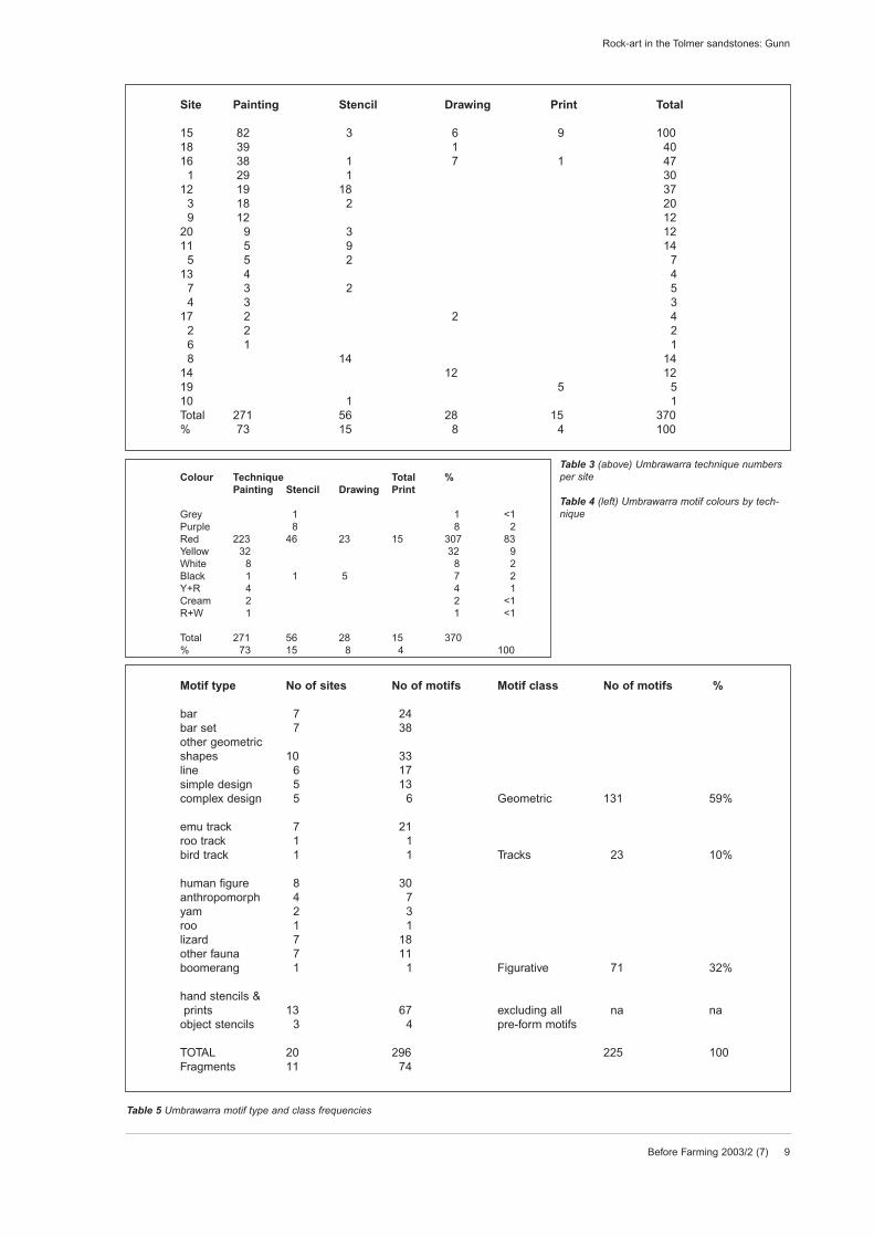
4.2.2 Techniques and coloursWet pigment rock painting accounts for 75 per cent of
the motifs; stencils 15 per cent and dry pigment draw-
ing 8 per cent (table 3). Printing was the least com-
mon technique, accounting for just 4 per cent of
motifs. No motifs were recorded that utilised two or
more techniques and no beeswax figures were locat-
Rock-art in the Tolmer sandstones: Gunn
Site Size Orientation Contents No of motifs(l x d x h) (°)
1 2 x 2 x 2 120 P S 302 10 x 4 x 1 85 P/O L 23 5 x 3 x 2 40 P S/L G A 204 2 x 1 x 1 170 P 35* n.a. P S/A X 76 12 x 2 x 1.5 250 P 17 5 x 1.5 x 1.5 180 P S 58 6 x 2 x 2 310 S 149 5 x 1 x 2 325 P/A 1210 12 x 3 x 4 120 S 111 30 x 2 x 5 170 P S 1412 30 x 2 x 8 40 P S 3713 10 x 1 x 5 340 P 414 10 x 4 x 4 345 D 1215 7 x 4 x 3 220 P S D T/L B sh 100
C X16 6 x 2 x 4 270 P S D T/L G g A 47
X17 5 x 2 x 2 350 P D/X 418 11 x 4 x 2.5 330 P D/X 4019 12 x 6 x 4 285 T 520 6 x 2.5 x 3 170 P S/G g H 12
* S5 several panels within collapsed rock pile rather than in a rock shelter.
Key to sites
Art Other aspectsP Painting O Occupation deposit X Wall batteringS Stencil L Stone artefacts B BoneD Drawing G Grindstones sh ShellT Print g Grinding patch C Charcoal
A Anvil pits (green plum)
Table 2 List of Umbrawarra shelter sites
Before Farming 2003/2 (7) 7
Rock-art in the Tolmer sandstones: Gunn
Figure 7 Umbrawarra site 16; quoll (northern native cat; Dasyurus hallucatus) motif drawn in charcoal (135 cm)
Figure 6 Umbrawarra site 15; main panel. HF motif 40 cm tall
Figure 4 Bar sets, bird tracks and apex design (Umbrawarra site 1) Figure 5 Geometric motifs (Umbrawarra site 9)
8 Before Farming 2003/2 (7)
Rock-art in the Tolmer sandstones: Gunn
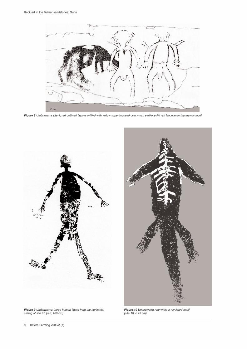
Figure 8 Umbrawarra site 4; red outlined figures infilled with yellow superimposed over much earlier solid red Nguwamin (kangaroo) motif
Figure 9 Umbrawarra: Large human figure from the horizontalceiling of site 15 (red; 160 cm)
Figure 10 Umbrawarra red+white x-ray lizard motif(site 16, c 45 cm)
Before Farming 2003/2 (7) 9
Rock-art in the Tolmer sandstones: Gunn
Site Painting Stencil Drawing Print Total
15 82 3 6 9 10018 39 1 4016 38 1 7 1 47
1 29 1 3012 19 18 37
3 18 2 209 12 12
20 9 3 1211 5 9 14
5 5 2 713 4 4
7 3 2 54 3 3
17 2 2 42 2 26 1 18 14 14
14 12 1219 5 510 1 1Total 271 56 28 15 370% 73 15 8 4 100
Motif type No of sites No of motifs Motif class No of motifs %
bar 7 24bar set 7 38other geometric shapes 10 33line 6 17simple design 5 13complex design 5 6 Geometric 131 59%
emu track 7 21roo track 1 1bird track 1 1 Tracks 23 10%
human figure 8 30anthropomorph 4 7yam 2 3roo 1 1lizard 7 18other fauna 7 11boomerang 1 1 Figurative 71 32%
hand stencils &prints 13 67 excluding all na na
object stencils 3 4 pre-form motifs
TOTAL 20 296 225 100Fragments 11 74
Colour Technique Total %Painting Stencil Drawing Print
Grey 1 1 <1Purple 8 8 2Red 223 46 23 15 307 83Yellow 32 32 9White 8 8 2Black 1 1 5 7 2Y+R 4 4 1Cream 2 2 <1R+W 1 1 <1
Total 271 56 28 15 370% 73 15 8 4 100
Table 5 Umbrawarra motif type and class frequencies
Table 3 (above) Umbrawarra technique numbersper site
Table 4 (left) Umbrawarra motif colours by tech-nique
10 Before Farming 2003/2 (7)
ed. A number of spinifex resin marks on floor-slabs of
one site were considered to be natural. In general, the
sites with the greater number of motifs also contained
the greatest range of techniques (table 3). However,
three sites stand out in this regard as each contains a
motif in a single, minor technique (stencilling, drawing
and printing respectively). If these techniques repre-
sent chronologically distinct phases or different art
functions, then the lack of other techniques suggests
that they were uncharacteristic sites and probably the
result of a single, insular event (by an individual or
group). Most of the gorge’s motifs (83 per cent) were
produced from red pigment (table 4). Of the seven
monochrome colours, and also in the two bichrome
combinations, yellow was the only other numerically
significant colour (nine per cent). Red is also the most
common colour amongst all the techniques, though of
the other colours, purple is only represented amongst
the stencils, and black is most common amongst the
drawings. The purple may be a discolouration of an
original red pigment and therefore may indicate some
antiquity for these motifs. The black is assumed to be
charcoal and therefore represents the most readily
available medium that did not require further prepara-
tion and hence suggests a more spontaneous series
of events.
4.2.3 Motif typesThe most common motif is the handstencil, both in
overall numbers and in the number of sites represent-
ed (table 5). There is a tendency for a positive corre-
lation between motif numbers and motif type repre-
sentation per site, indicating that there is a common
core of motif types throughout the gorge. When the
preform techniques (stencils and prints) are excluded
(on the basis of differences in form, technique and
probable function), the most numerous types are bar
sets, other geometric shapes, and human figures,
with a lesser group of bar, emu track, lizard, line and
simple design types (figs 4-6). Aggregating the types
into broad classes, geometrics are the most common
(60 per cent), followed by figurative (30 per cent) and
then tracks (10 per cent). As with techniques, there is
a tendency for the most numerous types to present
the greatest range of colours (table 6). The exception
to this however is the singular bar motifs which only
occur in red. Bar sets are also predominantly red with
only a single yellow pair located (fig 4). The five
bichrome motifs consist of four human figures and
one lizard (figs 7 & 8).The greater input into these five
figurative motifs implies that they were of particular
significance despite the greater predominance of the
geometric types in the repertoire. The lack of any yel-
low or white handstencils or prints is seen as signifi-
cant as these are the two least stable pigments and
therefore presumably amongst the most recent sur-
viving colours. This suggests that either handstencils
and prints were not produced in the most recent peri-
od of the sites’ use, or else there was some predispo-
sition for the use of red and black with these two tech-
niques. Otherwise, however, there is too little data at
present to note any other colour preferences that may
represent stylistic changes over time.
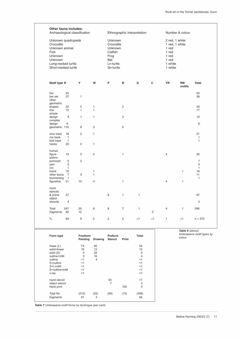
4.2.4 Motif formsOf the freeform motifs (whose size and shape is not
dictated by their technique), linear forms dominate
both paintings and drawings (74 per cent and 40 per
cent respectively; table 7, fig 6). It is in the minor tech-
niques however, that potentially significant differ-
ences occur. Amongst the paintings, solid+linear
forms constitute the only other numerically significant
group (fig 8), whilst solid forms are the second most
numerous group amongst the drawings (fig 7). These
differences do not just reflect differences in technique
but indicate that a different stylistic convention was
being used. In contrast, the preform types (handsten-
cils, handprints and object stencils) clearly reflect the
techniques in which they were produced (though this
need not always be the case; eg, Walsh 1983). The
range of forms that occurs here is for the most part
common throughout much of Australia. The single,
simple x-ray motif recorded (a lizard with internal
skeleton depicted, fig 10) is a variation on the form
developed to a very specialised extent in the Kakadu
region of western Arnhem Land (eg, Taçon 1989,
1992; Taylor 1989; Chaloupka 1993). Similar simple x-
ray motifs have, however, also been recorded in the
Litchfield area to the north (Gunn 1992a), though
these are more fully developed than the Umbrawarra
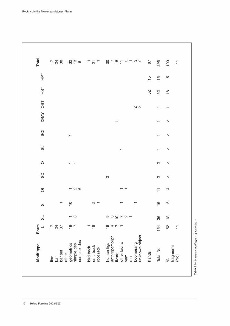
example. Motif types by form (table 8) show that
hands are restricted to either stencils or prints and
that the greater numbers of all other motif types are
linear. This again implies a consistency throughout
the repertoire. The greatest range of forms occurred
in the other geometrics and other animals classes.
There was also a greater use of solid+linear forms
amongst the figurative motifs, such as in the depiction
Rock-art in the Tolmer sandstones: Gunn
Before Farming 2003/2 (7) 11
Rock-art in the Tolmer sandstones: Gunn
Other fauna includes:Archaeological classification Ethnographic interpretation Number & colour
Unknown quadrupeds Unknown 2 red, 1 whiteCrocodile Crocodile 1 red, 1 whiteUnknown animal Unknown 1 redFish Catfish 1 redUnknown Frog 1 redUnknown Bat 1 redLong-necked turtle Ln-turtle 1 whiteShort-necked turtle Sn-turtle 1 white
Motif type R Y W P B G C YR RW Total motifs
bar 24 24bar set 37 1 38other geometric shapes 25 5 1 2 33line 15 1 1 17simpledesign 9 1 1 3 13complex design 6 6geometric 116 8 3 5
emu track 18 2 1 21roo track 1 1bird track 1 1tracks 20 2 1
humanfigure 18 5 2 1 4 30anthro-pomorph 5 2 7yam 3 3roo 1 1lizard 16 1 1 18other fauna 7 3 1 11boomerang 1 1figurative 51 10 4 1 4 1
handstencils& prints 57 8 1 1 67objectstencils 4 4
Total 247 20 8 8 7 1 4 1 296fragments 60 12 2
% 83 9 2 2 2 <1 <1 1 <1 n = 370
Form type Freeform Preform TotalPainting Drawing Stencil Print
linear (L) 74 40 54solid+linear 16 12 12solid (S) 4 28 5outline+infill 3 16 4outline <1 4 <1S+outline <1 <1S+L+infill <1 <1S+outline+infill <1 <1x-ray <1 <1
hand stencil 93 17object stencil 7 2hand print 100 5
Total No (210) (25) (56) (15) (306)fragments 61 3 64
Table 7 Umbrawarra motif forms by technique (per cent)
Table 6 (above) Umbrawarra motif types bycolour
12 Before Farming 2003/2 (7)
Rock-art in the Tolmer sandstones: Gunn
Mo
tif
typ
eF
orm
Tota
lL
SL
SO
IS
OO
SLI
SO
IX
RAY
OS
TH
ST
HP
T
line
1717
bar
2424
bar
set
371
38ot
her
geom
etric
s18
110
11
132
sim
ple
des
73
21
13co
mpl
ex d
es6
6
bird
tra
ck1
1em
u tr
ack
192
21ro
ot r
ack
11
hum
an f
igs
199
230
anth
ropo
mor
ph
43
7liz
ard
710
118
othe
r fa
una
17
11
111
yam
21
3ro
o1
1bo
omer
ang
12
3un
know
n ob
ject
22
hand
s52
1567
Tota
l No
154
3616
112
21
11
452
1529
5
%52
125
4<
<<
<<
118
510
0fr
agm
ents
(No)
1111
Tab
le 8
Um
braw
arra
mot
if ty
pes
by fo
rm (
nos)
of solid bodies with linear limbs. Most of the human
figures are linear and variations on the stick figure
type. The two solid+outline human figures are a pair
of bichrome figures in the one shelter.Their difference
in form and location implies a greater importance and
some functional difference to others in the area.
Another unusual form amongst the figurative motifs is
a solid+linear+infill catfish motif with a solid body, lin-
ear fins and dark-red eyes painted onto the red body.
This large (60 cm) and impressive motif is also placed
in a prominent location, suggesting a clear impor-
tance at this central gorge site.
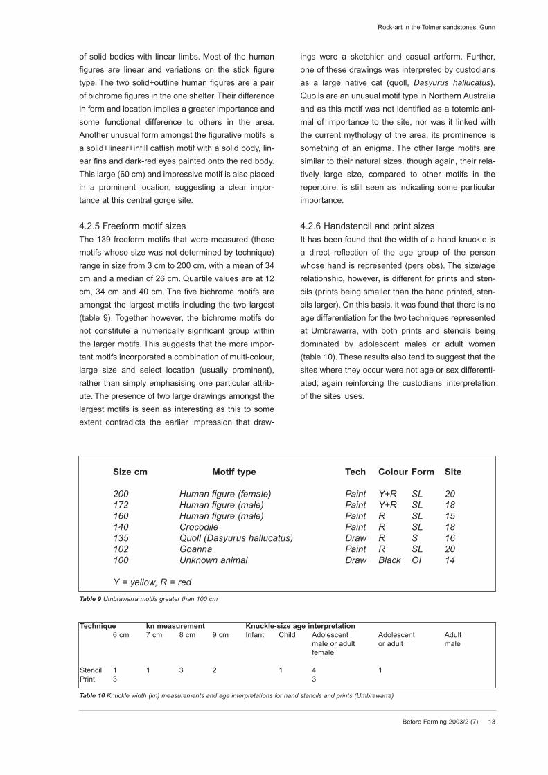
4.2.5 Freeform motif sizesThe 139 freeform motifs that were measured (those
motifs whose size was not determined by technique)
range in size from 3 cm to 200 cm, with a mean of 34
cm and a median of 26 cm. Quartile values are at 12
cm, 34 cm and 40 cm. The five bichrome motifs are
amongst the largest motifs including the two largest
(table 9). Together however, the bichrome motifs do
not constitute a numerically significant group within
the larger motifs. This suggests that the more impor-
tant motifs incorporated a combination of multi-colour,
large size and select location (usually prominent),
rather than simply emphasising one particular attrib-
ute. The presence of two large drawings amongst the
largest motifs is seen as interesting as this to some
extent contradicts the earlier impression that draw-
ings were a sketchier and casual artform. Further,
one of these drawings was interpreted by custodians
as a large native cat (quoll, Dasyurus hallucatus).
Quolls are an unusual motif type in Northern Australia
and as this motif was not identified as a totemic ani-
mal of importance to the site, nor was it linked with
the current mythology of the area, its prominence is
something of an enigma. The other large motifs are
similar to their natural sizes, though again, their rela-
tively large size, compared to other motifs in the
repertoire, is still seen as indicating some particular
importance.
4.2.6 Handstencil and print sizesIt has been found that the width of a hand knuckle is
a direct reflection of the age group of the person
whose hand is represented (pers obs). The size/age
relationship, however, is different for prints and sten-
cils (prints being smaller than the hand printed, sten-
cils larger). On this basis, it was found that there is no
age differentiation for the two techniques represented
at Umbrawarra, with both prints and stencils being
dominated by adolescent males or adult women
(table 10). These results also tend to suggest that the
sites where they occur were not age or sex differenti-
ated; again reinforcing the custodians’ interpretation
of the sites’ uses.
Before Farming 2003/2 (7) 13
Rock-art in the Tolmer sandstones: Gunn
Size cm Motif type Tech Colour Form Site
200 Human figure (female) Paint Y+R SL 20172 Human figure (male) Paint Y+R SL 18160 Human figure (male) Paint R SL 15140 Crocodile Paint R SL 18135 Quoll (Dasyurus hallucatus) Draw R S 16102 Goanna Paint R SL 20100 Unknown animal Draw Black OI 14
Y = yellow, R = red
Table 9 Umbrawarra motifs greater than 100 cm
Technique kn measurement Knuckle-size age interpretation6 cm 7 cm 8 cm 9 cm Infant Child Adolescent Adolescent Adult
male or adult or adult malefemale
Stencil 1 1 3 2 1 4 1Print 3 3
Table 10 Knuckle width (kn) measurements and age interpretations for hand stencils and prints (Umbrawarra)
14 Before Farming 2003/2 (7)
4.2.7 Visual compositions and arrangementsWhile not a major part of Australian rock-art, compo-
sitions and arrangements do feature at a number of
sites and in a number of regional styles (eg, the
dynamic figures of Arnhem Land, Chaloupka 1993).
No obvious compositions were noted at Umbrawarra
however, although custodians felt that the painting of
three different lizard species over a large crocodile
was significant but they could offer no explanation for
this association. The fact that many of the motifs here
are arranged in horizontal rows is not seen as a par-
ticular cultural arrangement but rather as reflecting
the long and narrow shape of many of the panels.
These panel shapes have resulted from the narrow
depth of the different geological layers within the
sandstone.
4.2.8 Rock-art classes and sequenceSeveral classes of rock-art are apparent within the
gorge, although at present it is not possible to allocate
all of the motifs recorded to one or other of these
classes. The classes recognised are:
• handstencils (but including a small number of object
stencils)
• linear monochrome geometrics, tracks and stick fig-
ures
• figurative humans and animals (principally lizards)
in either monochrome, solid+outline or x-ray tech-
niques
• handprints
• drawings.
These classes do not appear to be chronological-
ly distinct, and while the handstencils and linear
classes appear to be the earliest they continued
through into the latest art period. This then suggests
that handstencils may be either a subset of the linear
class or a functionally distinct class that has operated
in tandem with the linear class. At some time after the
initial linear artwork, a number of handprint and figu-
rative motifs were added (along with some very large
examples) and, most recently, a suite of drawings was
appended to the repertoire.
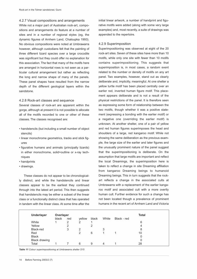
4.2.9 SuperimpositionSuperimpositioning was observed at eight of the 20
rock-art sites. Seven of these sites have more than 10
motifs, while only one site with fewer than 10 motifs
contains superimpositioning. This suggests that
superimposition is, in most cases, a random event
related to the number or density of motifs on any art
panel. Two examples, however, stand out as clearly
deliberate and, implicitly, meaningful. At one shelter a
yellow turtle motif has been placed centrally over an
earlier red, inverted human figure motif. This place-
ment appears deliberate and is not a result of the
physical restrictions of the panel. It is therefore seen
as expressing some form of relationship between the
two motifs, though whether it was a positive state-
ment (expressing a bonding with the earlier motif) or
a negative one (overriding the earlier motif) is
unknown. At another shelter, one of a pair of yellow
and red human figures superimposes the head and
shoulders of a large, red kangaroo motif. While not
showing the same deliberation as the previous exam-
ple, the large size of the earlier and later figures and
the unusually prominent nature of the panel suggest
that the superimpositioning is deliberate. On the
assumption that large motifs are important and reflect
the local Dreamings, the superimposition here is
taken to reflect a change in site Dreaming affiliation
from kangaroo Dreaming beings to humanoid
Dreaming beings. This in turn suggests that the rock-
art reflects a change in the associated cults at
Umbrawarra with a replacement of the earlier kanga-
roo motif and associated cult with a more overtly
human cult. Further evidence for such a change has
not been located though a prevalence of prominent
humans in the recent art of Arnhem Land and Victoria
Rock-art in the Tolmer sandstones: Gunn
Underlayer Overlayer Totalblack red yellow black White Black - red
White 1 2 2 1 6Yellow 2 2 4Black-red 3 2 3 8Red 2 6 1 1 10Black 0Black drawing 0Total 1 7 6 9 4 1 28
Table 11 Colour superimpositioning at Umbrawarra shelter S15
River has been recorded (Gunn 1992b, Flood 1997).
A study of colour superimpositioning at the major site
of the eastern cluster (table 11) reveals little pattern-
ing. For example, red, yellow and black occur over
most other colours while white and red occur beneath
most other colours. Black-red occurs both over and
under red. However, while the single black drawing
involved says little about the sequence, the occur-
rence of black paintings only in the overlayer sug-
gests that this colour may have been a recent addition
to the repertoire. This is the impression gained when
viewing the panel.
4.2.10 RepaintingThere were two examples of re-painting involving the
addition of details to an earlier motif and, in both
cases, this involved the use of complementary
colours. At one site, a large human figure in yellow
had a penis and testes added in red. A similar red
colour was used to paint a stick figure, line, and three
emu track motifs over the same yellow figure. At
another site, a red lizard motif was re-outlined in white
and a white internal design (skeletal structure?) was
added (fig 10). In both cases the repainting reinforces
rather than detracts from the original integrity of the
motifs and is therefore seen as indicating a continua-
tion of the significance of the motif over time.
5 PreservationThe motif preservation ranged from a few very good
motifs, with their impasto pigment still retained, to
those in a very poor state, where even the pigment
stain was reduced to a smear and the definition of the
motif was very indistinct. Most motifs were in a poor
condition. The sites within the gorge contained a
notably higher proportion of better preserved motifs.
This was attributed to the more siliceous nature of the
sandstone within the gorge. In contrast, the more
fragmented nature of many of the earlier motifs on top
of the plateau is attributed to the more granular sand-
stone of the residual stacks.
6 AgeNo absolute dating of the Umbrawarra Gorge rock-art
has been attempted and no chronological markers
such as extinct fauna or contact motifs have been
recognised within the artwork. It is highly likely that
some of the motifs within the gorge are of consider-
able antiquity. These motifs are visually similar in pig-
ment colour and bonding to motifs in Arnhem Land
(pers obs) that one authority claims to be greater than
8000 years old (Chaloupka 1993:89). Similar appar-
ently ‘old’ rock-art occurs to the south-west along the
Victoria River (Gunn 1989). Whether or not the sand-
stone of Umbrawarra Gorge is as stable as that at
Kakadu or along the Victoria River has yet to be
determined. Guse (1997:26) has obtained basal
dates for three rock shelters at Litchfield of 2700 BP,
4700 BP and 8000 BP. The deposits suggested that
the most intensive occupation of the shelters was
within the Holocene period concomitant with a range
of regional environmental changes, particularly the
development of freshwater wetlands to the west
between the ranges and the coast (Guse 2000).
7 Shelter contentsWhile several shelters on top of the ridge contain
shallow floor deposits, only one appears to contain
any substantial area and depth of deposit. This shel-
ter, in the eastern cluster and within the densest
group of sites, is a tunnel-cave form that offered the
most protected floor area of any of the shelters
recorded. However, with a floor area of 10 m x 4 m,
and a low 1 m ceiling, even this shelter could have
accommodated, at most, only a single family at any
one time. As was mentioned above, none of the shel-
ters within the gorge held any floor deposits. Areas of
bedrock battering (or flaking) were located in four of
the shelters. None of the battered areas was exten-
sive, being reminiscent of quality testing of the flaking
properties of the rock rather than periodic quarrying
or repeated ritual. Such battering is common in out-
crops of quartzitic or siliceous sandstone, being com-
monly found in rock shelters on rear-wall cornices
(eg, Gunn 1983, Rosenfeld 1999). Three shelters
here however, contain large and fractured bedrock
slabs that have been subject to battering. In another
shelter, the battering was on a protruding cornice
hanging off the ceiling. Sandstone grindstones and
bedrock grinding-patches were located in and around
sites in the eastern cluster. Portable sandstone grind-
stones (maldnar) were located in three shelters, while
grinding patches were found in another three shel-
ters. No interpretation for their use was collected but,
consistent with interpretations elsewhere (Gorecki et
al 1997), they probably result from the grinding of
seeds, ochre or stone-axes, or a combination of these
functions. A concentration of over 95 anvil-pits was
Before Farming 2003/2 (7) 15
Rock-art in the Tolmer sandstones: Gunn
16 Before Farming 2003/2 (7)
located on a waist-high sandstone slab in one shelter
in the eastern cluster and other singular examples
were found on rock slabs in front of the site.
Custodians interpreted these as green-plum pits
(anvils) that were used to hold the plum (kalbanyan)
while it was smashed with a pebble pounder (barpu).
The anvils were also used to pound-up kangaroo
meat. Such pits are common in rock shelters with
occupation deposits in western Arnhem Land and
Litchfield (pers obs). Three other sites were found to
have small numbers of these anvils. These contents,
along with the occurrence of bone, shell and charcoal
(table 2), further support the custodians’ claims that
family groups used these eastern cluster shelters for
general, domestic occupation.
8 The rock-art of UmbrawarraThe rock-art at Umbrawarra is scattered in small shel-
ters within and around the gorge. Loose concentra-
tions occur in the central gorge and at its eastern end.
Motif numbers are low, with most shelters having less
than 20 motifs and with the maximum number being
100. Three motif suites visually dominate the rock-art:
• a linear class incorporating small (<20 cm), mono-
chrome bars, simple geometric shapes, emu tracks
and stick figures. Red was the most common colour
though yellow, black and white examples also occur.
While most were painted, a number of the more
recent examples were drawn with either charcoal or
a red ochre nodule. This style appears to represent
the earliest existent rock-art, though the style also
continued into the recent past. The suite occurs
throughout the complex
• a figurative class incorporating human figures and
animals. These range from 20 cm to 200 cm in
length, with the larger incorporating two or more
colours. This group also includes the single x-ray
lizard figure. This class appears to have appeared
first at some time after the linear class had been well
established, though the two classes appear to have
continued together up until the recent past. This
class is most common at the sites at the eastern
cluster and on top of the gorge. Its distribution
superficially appears to parallel the sites with the
most recent occupation
• handstencils and handprints in either red or black.
These appear to be concurrent with both of the early
linear and later figurative art classes identified. As
such it may constitute a particular aspect of the lin-
ear class or alternatively it may represent an aspect
of the art that pre-dates but continues throughout
the period of both the linear and figurative classes.
While not all motifs readily conform to this prelim-
inary classification it is felt that further study will con-
firm its overall integrity. Further sub-sets and idiosyn-
cratic motifs, however, are expected to be identified.
From the distribution of rock-art sites and custodians’
comments it appears that the shelters were primarily
used during the wet season. Recent occupation, at
least, was focused on top of the gorge in the eastern
cluster of sites, providing ready access to the
resources of both the gorge and the drier hinterlands
of the Pine Creek region. It is likely therefore that the
area was a base camp for the periodic (seasonal)
exploitation of these resources by the local land own-
ing group. Also, as the Gorge was on an established
pathway from the Daly River to Pine Creek, transient
groups would also have made use of the gorge sites.
The three largest motifs at Umbrawarra are all human
figure types (table 9, fig 9) and these occur at both
ends of the gorge. The few human figure motifs with-
in the central section of the gorge are all small. This
suggests that the predominant theme of the rock-art
at the peripheries of the gorge was related to human-
istic Dreamings rather than to local totemic species,
and that this differed to that represented in the art of
the gorge interior. As the more recent rock-art
appears to also occur at the entrances of the gorge, it
is possible that the differences reflect a change in the
rock-art over time from a geometric based motif
vocabulary, to a more figurative one. As was suggest-
ed above, the art may also document a change in reli-
gious cults in the region from an animal based one to
a more overtly human cult.
The major archaeological/art site at Umbrawarra
is also the most important site to custodians and is
considered by them to be different to those sites on
top of the gorge. This site contains a plethora of both
geometric motifs and schematic human figures, a few
small animals, a very large human figure on its ceiling
and a single unique zoomorphic figure at the far, left
end of the shelter (figs 6 & 9). The shelter, midway up
the side of the gorge, has a sloping bedrock floor that
makes it unsuitable for habitation. These factors sug-
gest that the site’s function was different from that of
the other nearby occupation shelters on top of the cliff
and it can be inferred that it was probably of a more
Rock-art in the Tolmer sandstones: Gunn
esoteric nature. Although this concurs with custodi-
ans’ ‘feelings’ about the site, this interpretation can no
longer be verified.
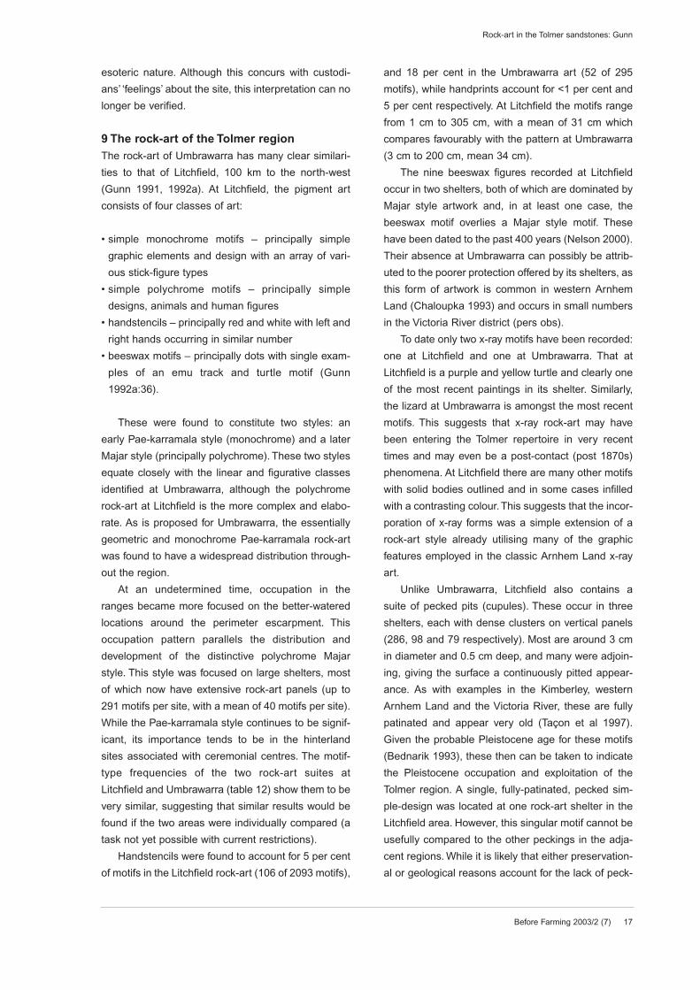
9 The rock-art of the Tolmer regionThe rock-art of Umbrawarra has many clear similari-
ties to that of Litchfield, 100 km to the north-west
(Gunn 1991, 1992a). At Litchfield, the pigment art
consists of four classes of art:
• simple monochrome motifs – principally simple
graphic elements and design with an array of vari-
ous stick-figure types
• simple polychrome motifs – principally simple
designs, animals and human figures
• handstencils – principally red and white with left and
right hands occurring in similar number
• beeswax motifs – principally dots with single exam-
ples of an emu track and turtle motif (Gunn
1992a:36).
These were found to constitute two styles: an
early Pae-karramala style (monochrome) and a later
Majar style (principally polychrome). These two styles
equate closely with the linear and figurative classes
identified at Umbrawarra, although the polychrome
rock-art at Litchfield is the more complex and elabo-
rate. As is proposed for Umbrawarra, the essentially
geometric and monochrome Pae-karramala rock-art
was found to have a widespread distribution through-
out the region.
At an undetermined time, occupation in the
ranges became more focused on the better-watered
locations around the perimeter escarpment. This
occupation pattern parallels the distribution and
development of the distinctive polychrome Majar
style. This style was focused on large shelters, most
of which now have extensive rock-art panels (up to
291 motifs per site, with a mean of 40 motifs per site).
While the Pae-karramala style continues to be signif-
icant, its importance tends to be in the hinterland
sites associated with ceremonial centres. The motif-
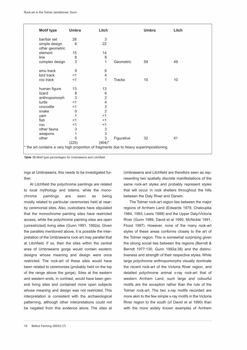
type frequencies of the two rock-art suites at
Litchfield and Umbrawarra (table 12) show them to be
very similar, suggesting that similar results would be
found if the two areas were individually compared (a
task not yet possible with current restrictions).
Handstencils were found to account for 5 per cent
of motifs in the Litchfield rock-art (106 of 2093 motifs),
and 18 per cent in the Umbrawarra art (52 of 295
motifs), while handprints account for <1 per cent and
5 per cent respectively. At Litchfield the motifs range
from 1 cm to 305 cm, with a mean of 31 cm which
compares favourably with the pattern at Umbrawarra
(3 cm to 200 cm, mean 34 cm).
The nine beeswax figures recorded at Litchfield
occur in two shelters, both of which are dominated by
Majar style artwork and, in at least one case, the
beeswax motif overlies a Majar style motif. These
have been dated to the past 400 years (Nelson 2000).
Their absence at Umbrawarra can possibly be attrib-
uted to the poorer protection offered by its shelters, as
this form of artwork is common in western Arnhem
Land (Chaloupka 1993) and occurs in small numbers
in the Victoria River district (pers obs).
To date only two x-ray motifs have been recorded:
one at Litchfield and one at Umbrawarra. That at
Litchfield is a purple and yellow turtle and clearly one
of the most recent paintings in its shelter. Similarly,
the lizard at Umbrawarra is amongst the most recent
motifs. This suggests that x-ray rock-art may have
been entering the Tolmer repertoire in very recent
times and may even be a post-contact (post 1870s)
phenomena. At Litchfield there are many other motifs
with solid bodies outlined and in some cases infilled
with a contrasting colour. This suggests that the incor-
poration of x-ray forms was a simple extension of a
rock-art style already utilising many of the graphic
features employed in the classic Arnhem Land x-ray
art.
Unlike Umbrawarra, Litchfield also contains a
suite of pecked pits (cupules). These occur in three
shelters, each with dense clusters on vertical panels
(286, 98 and 79 respectively). Most are around 3 cm
in diameter and 0.5 cm deep, and many were adjoin-
ing, giving the surface a continuously pitted appear-
ance. As with examples in the Kimberley, western
Arnhem Land and the Victoria River, these are fully
patinated and appear very old (Taçon et al 1997).
Given the probable Pleistocene age for these motifs
(Bednarik 1993), these then can be taken to indicate
the Pleistocene occupation and exploitation of the
Tolmer region. A single, fully-patinated, pecked sim-
ple-design was located at one rock-art shelter in the
Litchfield area. However, this singular motif cannot be
usefully compared to the other peckings in the adja-
cent regions. While it is likely that either preservation-
al or geological reasons account for the lack of peck-
Before Farming 2003/2 (7) 17
Rock-art in the Tolmer sandstones: Gunn
18 Before Farming 2003/2 (7)
ings at Umbrawarra, this needs to be investigated fur-
ther.
At Litchfield the polychrome paintings are related
to local mythology and totems, while the mono-
chrome paintings are seen as being
mostly related to particular ceremonies held at near-
by ceremonial sites. Also, custodians have stipulated
that the monochrome painting sites have restricted
access, while the polychrome painting sites are open
(unrestricted) living sites (Gunn 1991, 1992a). Given
the parallels mentioned above, it is possible the inter-
pretation of the Umbrawarra rock-art may parallel that
at Litchfield. If so, then the sites within the central
area of Umbrawarra gorge would contain esoteric
designs whose meaning and design were once
restricted. The rock-art of these sites would have
been related to ceremonies (probably held on the top
of the range above the gorge). Sites at the eastern
and western ends, in contrast, would have been gen-
eral living sites and contained more open subjects
whose meaning and design was not restricted. This
interpretation is consistent with the archaeological
patterning, although other interpretations could not
be negated from this evidence alone. The sites at
Umbrawarra and Litchfield are therefore seen as rep-
resenting two spatially discrete manifestations of the
same rock-art styles and probably represent styles
that will occur in rock shelters throughout the hills
between the Daly River and Darwin.
The Tolmer rock-art region lies between the major
regions of Arnhem Land (Edwards 1979, Chaloupka
1984, 1993; Lewis 1988) and the Upper Daly/Victoria
River (Gunn 1989, David et al 1990, McNickle 1991,
Flood 1997). However, none of the many rock-art
styles of these areas conforms closely to the art of
the Tolmer region. This is somewhat surprising given
the strong social ties between the regions (Berndt &
Berndt 1977:130, Gunn 1992a:38) and the distinc-
tiveness and strength of their respective styles. While
large polychrome anthropomorphs visually dominate
the recent rock-art of the Victoria River region, and
detailed polychrome animal x-ray rock-art that of
western Arnhem Land, such large and colourful
motifs are the exception rather than the rule of the
Tolmer rock-art. The two x-ray motifs recorded are
more akin to the few simple x-ray motifs in the Victoria
River region to the south (cf David et al 1990) than
with the more widely known examples of Arnhem
Rock-art in the Tolmer sandstones: Gunn
Motif type Umbra Litch Umbra Litch
bar/bar set 28 3simple design 6 22other geometricelement 15 14line 8 8complex design 3 1 Geometric 59 49
emu track 9 6bird track <1 4roo track <1 1 Tracks 10 10
human figure 13 13lizard 8 6anthropomorph 3 2turtle <1 4crocodile <1 3snake 0 2yam 1 <1fish <1 <1roo <1 <1other fauna 3 3weapons 1 3other 0 3 Figurative 32 41
(225) (904)** the art contains a very high proportion of fragments due to heavy superimpositioning.
Table 12 Motif type percentages for Umbrawarra and Litchfield
Land (cf Taçon 1992, Chaloupka 1993). Another clear
distinction is the difference in the overall quantity of
rock-art in the three regions with the Tolmer region
having notably fewer and less densely decorated
shelters than either the Victoria River or Arnhem Land
regions. While to some degree this can be attributed
to the fewer and smaller rock shelters in the Tolmer
region, the occurrence of only a few polychrome
paintings at Umbrawarra and in many area of
Litchfield is notable. The vertical panel of pecked pits
at the Majar shelter has counterparts in both regions
and, given the probable Pleistocene age for these
motifs (Bednarik 1993, Taçon et al 1997), suggests
that the Tolmer region was occupied and exploited
during this period. However, there are probably more
differences than similarities between the regions,
seen particularly in the absence of Panaramitee
peckings, abraded grooves and large, repainted,
polychrome anthropomorphs in the Tolmer region that
are features of the rock-art of the other two regions.
More generally however, there is a common pattern of
early red styles being replaced by polychrome later
styles in all three regions. Within this commonality
then, the rock-art of Tolmer region stands apart as
having its own idiosyncrasies that make the region
unique. The next questions to ask are therefore, how
extensive is the region and why does its art so differ
from its neighbours?
10 ConclusionThe existence of a small but significant corpus of
rock-art is reported from the north-west corner of the
Northern Territory. The occurrence at two widely sep-
arated areas of the Tolmer Sandstone suggests that
further rock-art complexes may exist within outcrops
of this rock formation. The artwork in both areas
consists of two styles:
• red linear geometrics and stick figures with
solid+infill polychrome designs
• figurative humans and animals.
While having aspects in common with the adjacent
areas of the Victoria/Upper Daly River region to the
south-west and western Arnhem Land to the east, the
differences are enough to indicate that the sites in the
area constitute a distinct rock-art region in their own
right.
AcknowledgementsMy thanks go first to the custodians who permitted
me to record their rock-art: Paddy, Joe and George
Huddleston, Daisy Majar, Tom Petherick, Margaret
Daiyi, Cathy Devereau, Peter Melyin, Vai Stanton,
Gabe Hazelbane, Tony Kenyon. The fieldwork was
undertaken with the assistance of Ray Petherick, Joe
and Maureen Huddleston, George and Ivy
Huddleston, Terry Liddy, Johnny and Les Waters, Ann
Robb, Martin Armstrong, Ken Mulvaney, Sharon
Taylor and Catherine Mulvaney. Thanks also to Lesley
Mearns, David Ritchie and the late Roger Gleeson for
organisational support. Paul Taçon, Leigh Douglas,
and an anonymous reviewer suggested useful
improvements to the draft text, though I accept all
responsibility for any errors and also the report-ish
style, which I find difficult amend. The original studies
were funded by the Australian Institute of Aboriginal
and Torres Strait Islander Studies, Canberra (RAPP
grants), and the Aboriginal Areas Protection
Authority, Darwin. The studies were undertaken for
the Conservation Commission of the Northern
Territory and the Aboriginal Areas Protection
Authority, Darwin.
Before Farming 2003/2 (7) 19
Rock-art in the Tolmer sandstones: Gunn
20 Before Farming 2003/2 (7)
Rock-art in the Tolmer sandstones, Northern Territory,Australia
RG Gunn
References
Aboriginal Areas Protection Authority, no date. Unpublished files, Darwin.
Baker, R 1983. Pine Creek Gold mine environmental studies: archaeology. Report to Kinhill Stearns, Adelaide.
Bauman, T & Deveson, T 1983. Clearance of Renison Goldfields EL and GML areas at Pine Creek. Restricted
report to the Aboriginal Sacred Sites Authority, Darwin.
Bednarik, RG 1993. About cupules. Rock Art Research 10(2):138-139.
Berndt, RM & Berndt, CH 1977. The world of the first Australians. Sydney: Ure Smith.
Brazier & Motti Pty Ltd 1987. A site record of Aboriginal rock-art: Umbrawarra Gorge, Northern Territory. Unsolicited
report to the Northern Territory Museum, Darwin.
Bureau of Meteorology 2000. Climate averages. www.bom.gov.au/climate/averages. Site accessed November
2002.
Burns, T 1999. Subsistence and settlement patterns in the Darwin coastal region during the late Holocene period:
a preliminary report of archaeological research. Australian Aboriginal Studies 1999/1:59-69.
Chaloupka, G 1984. From paleo art to casual paintings Monograph Series 1. Darwin: Northern Territory Museum
of Arts & Sciences.
Chaloupka, G 1993. Journey in time: the world’s longest continuing art tradition. Sydney: Reed.
David, B, David, M, Flood, J & Frost J 1990. Rock paintings of the Yingalarri region. Memoirs of the Queensland
Museum. 28(2):442-462.
Edwards, R 1979. Australian Aboriginal art: the art of the Alligators Rivers region, Northern Territory. Canberra:
Australian Institute of Aboriginal Studies.
Flood, J 1997 Rock-art of the Dreamtime. Sydney: Angus & Robertson.
Gorecki, P, Grant, M, O’Connor, S & Veth, P 1997. The morphology function and antiquity of grinding implements
in Australia. Archaeology in Oceania 32:141-150.
Gunn, RG 1983. Aboriginal rock-art in the Grampians. Records of the Victorian Archaeological Survey No 16.
Melbourne: Ministry for Conservation.
Before Farming 2003/2 (7) 21
Rock-art in the Tolmer sandstones: Gunn
Gunn, RG 1989. Langgay rock-art survey. Report to the Conservation Commission of the Northern Territory,
Darwin. Katherine.
Gunn, RG 1991. The rock-art of Litchfield National Park; a resource assessment with implications for the Park
Management. Report to the Conservation Commission of the Northern Territory, Darwin. Batchelor.
Gunn, RG 1992a. The rock-art of Litchfield National Park: a second survey. Report to the Conservation
Commission of the Northern Territory, Darwin. Darwin.
Gunn, RG 1992b. Bulajang - a reappraisal of the archaeology of an Aboriginal cult. In MacDonald, J & Haskovec,
IP (eds) State of the art. Occasional AURA Publication 6. Melbourne: Australian Rock Art Research
Association:174-194.
Gunn, RG 1998. Umbrawarra Aboriginal art-site complex: recording and assessment. Report to Aboriginal Areas
Protection Authority, Darwin.
Guse, D 1995. Archaeological survey of the proposed realignment of the North Australia Railway, Pine Creek to
Union Reefs, NT. Report to Australian National Rail.
Guse, D 1997. Werat archaeology: a study of archaeological sites in the Finniss and Reynolds River region: stage
1 report. Report to the Australian Heritage Commission, Canberra.
Guse, D 1998. A report on the collection of archaeological sites at Union Reefs Gold Mine, NT. Report for Union
Reefs Gold Mine, Acacia Resources.
Guse, D 2000. Investigation of archaeological sites in the Finniss/Reynolds/Daly Rivers coastal biogeographic
region. Report to the Australian Heritage Commission, Canberra.
Hiscock, P 1991. An archaeological investigation of the proposed Stuart Highway re-alignment at Pine Creek.
Report to Pine Creek Goldfields Ltd, Pine Creek.
Kearney, J 1991. Upper Daily Land Claim Volumes 1, 2 & 3. Report by the Aboriginal Land Commissioner to the
Minister of Aboriginal Affairs and the Administrator of the Northern Territory. AGPS, Canberra.
Kinhill Engineers Pty Ltd 1992. Union Reefs gold project: historic and prehistoric archaeological heritage. Report
to Union Reefs Project, Shell Co (Aus) Pty Ltd, Darwin.
Lewis, D 1988. The rock paintings of Arnhem Land, Australia. Oxford: British Archaeological Reports 415.
McNickle, HP 1991. A survey of rock-art in the Victoria River District, Northern Territory. Rock Art Research 8(1):36-
47.
Mearns, L 1987. The documentation of Wagiman sites around Kalay and of Kuna.gnart.gnart at Umbrawarra
Gorge. Report to the Aboriginal Sacred Sites Protection Authority, Darwin.
Merlan, F 1989. The interpretative framework of Wardaman rock-art: a preliminary report. Australian Aboriginal
Studies 1989/2:14-24.
Mulvaney, K 1992. Aboriginal archaeological survey: Gandy’s Hill project. Report to AGC Woodward-Clyde Pty Ltd,
22 Before Farming 2003/2 (7)
Rock-art in the Tolmer sandstones: Gunn
Darwin.
Mulvaney, K 1993a. Aboriginal archaeological investigation: Mount Porter proposed gold mine. Report to Pine
Creek Goldfields Ltd, Pine Creek.
Mulvaney, K 1993b. Preliminary archaeological survey: Mt Todd 22kv transmission line. Report to the Department
of Transport and Works, Darwin.
Nelson, DE (ed) 2000. The beeswax art of northern Australia CD. Burnaby: Simon Fraser University.
Pearce, H 1982. Pine Creek Heritage scheme report: Volume 1. Report to the National Trust of Australia (Northern
Territory).
Pearce, H 1983. Aboriginal sites in the Pine Creek district. Report to the Aboriginal Sacred Sites Authority, Darwin.
Aboriginal Areas Protection Authority report R83/41.
Pietsch, B A 1989. Explanatory notes: Reynolds River 5071. Northern Territory Geological Survey, Darwin. AGPS,
Canberra.
Rosenfeld, A 1999. Rock art and rock markings. Australian Archaeology 49:28-33.
Stuart-Smith, PG, Needham, PS, Bagas, L & Wallace, DA 1987. Pine Creek Northern Territory; 1:100 000
Geological map commentary. Northern Territory Geological Survey, Darwin. AGPS, Canberra.
Taçon, PSC 1989. Art and the essence of being: symbolic and economic aspects of fish among the peoples of
western Arnhem Land, Australia. In Morphy, H (ed) Animals into art. London: Unwin Hyman:236-250.
Taçon, PSC 1992. Somewhere over the Rainbow: an ethnographic and archaeological analysis of recent rock
paintings of western Arnhem Land. In MacDonald, J & Haskovec, IP (eds) State of the art. Occasional AURA
Publication 6. Melbourne: Australian Rock Art Research Association:202-215.
Taçon, PSC, Fullagar, R, Ouzman, S & Mulvaney, K 1997. Cupule engravings from Jinmium-Granilpi (northern
Australia) and beyond: exploration of a widespread and enigmatic class of rock marking. Antiquity 71:942-965.
Taylor, L 1989. Seeing the ‘Inside’: Kunwinjku painting and the symbol of the divided body. In Morphy, H (ed)
Animals into art. London: Unwin Hyman:371-389.
Tindale, NB 1974. Aboriginal Tribes of Australia. Canberra: Australian National University Press.
Walsh, GL 1983. Composite stencil art: elemental or specialised. Australian Aboriginal Studies 2:34-44.

Before Farming 2003/2 (7) 23
Rock-art in the Tolmer sandstones: Gunn

24 Before Farming 2003/2 (7)
Rock-art in the Tolmer sandstones: Gunn

Before Farming 2003/2 (7) 25
Rock-art in the Tolmer sandstones: Gunn

26 Before Farming 2003/2 (7)
Rock-art in the Tolmer sandstones: Gunn

Before Farming 2003/2 (7) 27
Rock-art in the Tolmer sandstones: Gunn