development of machilipatnam port,
TRANSCRIPT


Development of Machilipatnam Port,
Krishna District, Andhra Pradesh
UPDATED FORM 1
August 2014
Machilipatnam Port Limited
Corp off: 8-2-293/82/A/379&379A, Ground Floor,
Plot No. 379, Road No.10, Jubilee Hills, Hyderabad – 500033, India
Tel: +91-40-23339990/91/92 Fax: +91-40-23337789

Development of Machilipatnam Port – Phase I Updated Form1
Page: 1
UPDATED FORM I (Revised as per Notification of MoEF dated 01.12.2009) (I) BASIC INFORMATION
S.
No.
Item Details
1 Name of the project Development of Machilipatnam Deep Water Port,
Krishna District, Andhra Pradesh
2 S. No. in the schedule 7 (e)
3 Proposed capacity/ area/
length/ tonnage to be
handled/ command area
/ lease area /number
wells to be drilled
Proposed capacity of Machilipatnam Port in Phase-I
to handle cargo in an area of 685 ha (1692 acres)
approved by the MoEF as per the CRZ and
Environmental Clearance accorded by MoEF vide
Lr. F.No.10-5/2009-IA.III Dt. 25th November, 2009
(Annexure-A) remains unchanged. Break up details
of cargo handling:
Cargo Capacity
(MTPA)
No. of Berths
Coal 9.3 2
Iron Ore 2.5 1
General Cargo /
Container
3.99
Liquid Bulk Cargoes 0.81
OSVs 1000 no.s 1
4 New/ Expansion
/Modernization
Request is for extension of validity of prior
Environmental Clearance granted by MOEF vide
F.No. 10-5/2009.IA.III dated 25th November 2009.
5 Existing Capacity /Area
etc. Capacity of the Machilipatnam port Phase–I is 16.60
MTPA of various cargoes in a designated area of
685 ha (1692 acres).
GoAP has so far leased about 412.57 acres of land
to MPL for the port development. The Phase –I
development of the port shall be implemented
immediately upon the GoAP making available major
part of the remaining land on lease as per the
Concession Agreement. Land acquisition and
alienation process is now being rigorously pursued
by GoAP.
Annexure - I
Development of Machilipatnam Port – Phase I Updated Form1
Page: 2
S.
No.
Item Details
6 Category of Project i.e.
'A' or 'B'
Category- ‘A’
7 Does it attract the
general condition? If yes,
please specify
Not Applicable
8 Does it attract the
specific condition? If yes,
please specify
Not Applicable
9 Location Project site located at :
16º 12’ N latitude
81º 12’ 48” E. longitude.
Location map is enclosed as Figure-1.
Plot/Survey/Khasra No. The survey numbers falling in the land identified for
Phase I development of Machilipatnam Port are
shown in Figure-2 and details of extents of the
area with village Field Survey Numbers is enclosed
as Annexure - B.
Village Manginapudi, Tavisapudi, Gopuvanipalem, China
Karagraharam
Tehsil Machilipatnam
District Krishna
State Andhra Pradesh
10 Nearest railway station/
airport along with
distance in kms.
Nearest Railway Station:
Chilakalapudi – ~3 km
Machilipatnam - ~8 km
Nearest Airport:
Vijayawada (Domestic) – ~70 km and
Hyderabad (International) – ~350 km
11 Nearest Town, city,
District Headquarters
along with distance in
kms.
Nearest Town: Machilipatnam (~ 8 km)
District Headquarters : Machilipatnam
Development of Machilipatnam Port – Phase I Updated Form1
Page: 3
S.
No.
Item Details
12 Village Panchayats, Zilla
Parishad, Municipal
Corporation, Local body
(complete postal address
with telephone nos.)
Manginapudi, Tavisipudi, Gopuvanipalem and
China Kara Agraharam villages of Krishna District,
Andhra Pradesh
13 Name of the applicant M/s Machilipatnam Port Limited (MPL)
(Earlier M/s Vajra Seaport Private Limited)
14 Registered address M/s Machilipatnam Port Ltd
Plot No. 379, Jubilee Hills, Road No. 10,
Hyderabad, Andhra Pradesh – 500 033
15 Address of correspondence:
Name S.B.Puri Mr. MAR Ansari
Designation (Owner/
Partner/CEO)
Director President - Engineering
Address Plot No. 379, Jubilee
Hills, Road No. 10,
Hyderabad, Andhra
Pradesh
Plot No. 379, Jubilee
Hills, Road No. 10,
Hyderabad, Andhra
Pradesh
Pin Code 500 033 500 033
E-mail [email protected]
Telephone No. 040-23339990 040-23339990
Fax No. 040-23337789 040-23337789
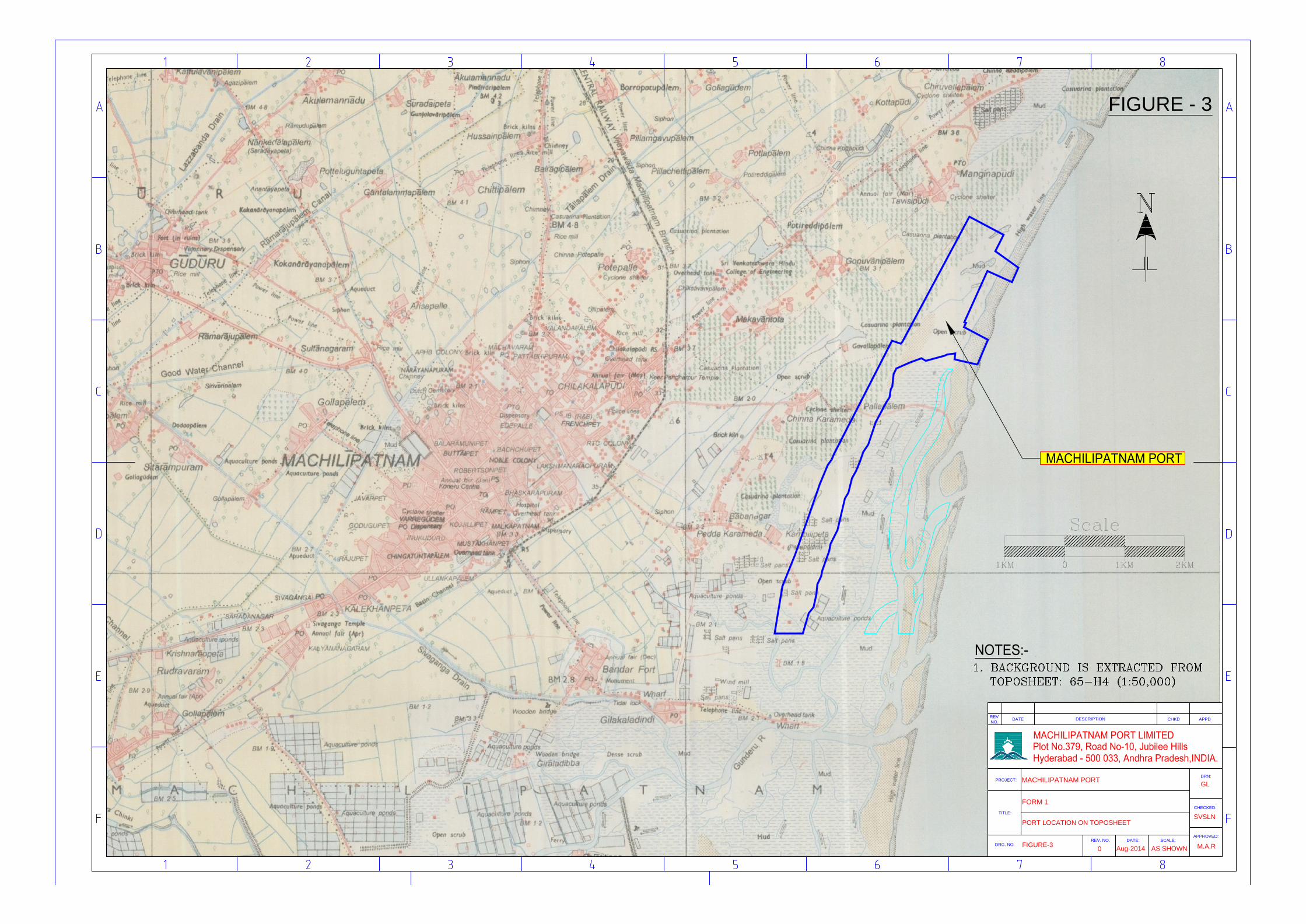
16 Details of Alternative
Sites examined, if any.
Location of these sites
should be shown on a
topo sheet.
Location of the project site approved in the CRZ and
Environmental Clearance accorded by MoEF
remains unchanged and shown in Figure-3.
17 Interlinked Projects No
18 Whether separate
application of interlinked
project has been
submitted?
Not Applicable

Development of Machilipatnam Port – Phase I Updated Form1
Page: 4
S.
No.
Item Details
19 If yes, date of submission Not Applicable
20 If no, reason Not Applicable
21 Whether the proposal
involves approval/
clearance under: if yes,
details of the same and
their status to be given.
(a) The Forest
(Conservation) Act,
1980?
(b) The Wildlife
(Protection) Act, 1972?
(c) The C.R.Z
Notification, 1991?
a) The proposed project does not involve any forest
land
(b) The proposed project does not involve any
wildlife sanctuary.
(c) The proposed project attracts the CRZ
notification for the foreshore facilities. Physical
demarcation of HTL, LTL and delineation of CRZ
boundaries for the project site was carried out by
the National Institute of Oceanography and the HTL
/ LTL CRZ map was submitted with the EIA report.
CRZ and Environmental clearance was accorded by
MOEF vide F.No. 10-5/2009.IA.III dated 25th
November 2009.
22 Whether there is any
Government Order/
Policy relevant / relating
to the site?
Yes; GoAP entered into a Concession Agreement
with M/s. Machilipatnam Port Ltd for Development
of Machilipatnam Port at the proposed site as a
PPP project on BOOT basis. The entire land for port
development is being provided on lease basis by
GoAP as per the Concession Agreement. Extract of
relevant clauses of the Concession Agreement is
enclosed as Annexure-C.
GoAP have decided to allocate 5324 acres of land
for the Port development as per the G. O. Ms. No.
11 Dt. 02.05.2012. Copy enclosed as Annexure-D.
Accordingly, alienation / acquisition of the land is on
hand and is now being rigorously pursued by GoAP.
23 Forest Land involved
(hectares)
Not Applicable
Development of Machilipatnam Port – Phase I Updated Form1
Page: 5
S.
No.
Item Details
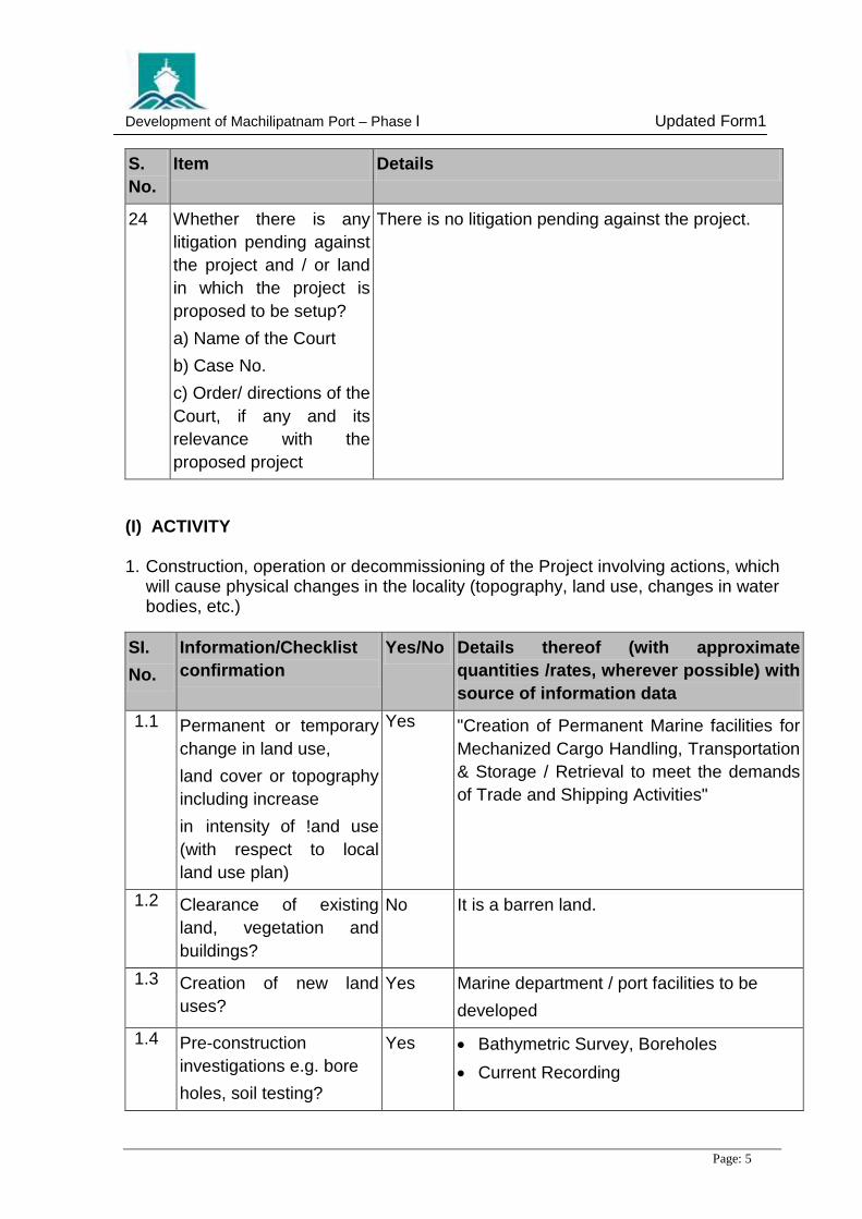
24 Whether there is any
litigation pending against
the project and / or land
in which the project is
proposed to be setup?
a) Name of the Court
b) Case No.
c) Order/ directions of the
Court, if any and its
relevance with the
proposed project
There is no litigation pending against the project.
(I) ACTIVITY 1. Construction, operation or decommissioning of the Project involving actions, which
will cause physical changes in the locality (topography, land use, changes in water bodies, etc.)
SI.
No.
Information/Checklist
confirmation
Yes/No Details thereof (with approximate
quantities /rates, wherever possible) with
source of information data
1.1 Permanent or temporary
change in land use,
land cover or topography
including increase
in intensity of !and use
(with respect to local
land use plan)
Yes "Creation of Permanent Marine facilities for
Mechanized Cargo Handling, Transportation
& Storage / Retrieval to meet the demands
of Trade and Shipping Activities"
1.2 Clearance of existing
land, vegetation and
buildings?
No It is a barren land.
1.3 Creation of new land
uses?
Yes Marine department / port facilities to be
developed
1.4 Pre-construction
investigations e.g. bore
holes, soil testing?
Yes Bathymetric Survey, Boreholes
Current Recording
Development of Machilipatnam Port – Phase I Updated Form1
Page: 6
SI.
No.
Information/Checklist
confirmation
Yes/No Details thereof (with approximate
quantities /rates, wherever possible) with
source of information data
Seismic Profiling
Updating Traffic Forecast Study
Mathematical model studies for wave
transformation, coastal process,
tranquility and dredge disposal area
Port layout is enclosed as Figure-4.
1.5 Construction works? Yes The berth would be jetty type structures with
retaining wall on the rear side either by
constructing diaphragm walls or other
suitable methods like rock pitching for
retaining the back fill.
The breakwater would be rubble mound
type.
1.6 Demolition works? No Does not arise.
1.7 Temporary sites used for
construction works
or housing of construction
workers?
Yes Sufficient temporary dwelling units will be
provided with necessary infrastructure
including sanitation facilities.
1.8 Above ground buildings,
structures or earthworks
including linear
structures, cut and fill or
excavations
Yes Offices and facilities required for port
operation will be constructed.
1.9 Underground works
including mining or
No Does not arise.
1.10 Reclamation works? Yes Reclamation only to the extent behind the
berths is envisaged. Site grading will be
done to the required land area.
1.11 Dredging? Yes The approach channel and the turning circle
would need to be dredged up to a depth
required for berthing of panamax vessels
Development of Machilipatnam Port – Phase I Updated Form1
Page: 7
SI.
No.
Information/Checklist
confirmation
Yes/No Details thereof (with approximate
quantities /rates, wherever possible) with
source of information data
1.12 Offshore structures? Yes Breakwater on Southern and Northern
sides of the approach channel and harbour
basin
1.13 Production and
Manufacturing
processes?
No Does not arise
1.14 Facilities for storage of
goods or materials?
Yes Storage facilities will be provided.
1.15 Facilities for treatment or
disposal of solid waste or
liquid effluents?
Yes As mentioned in the EIA Report, the effluent
from coal stack yard shall be collected in the
settling /guard ponds. The sludge, mostly
coal, settled in the settling/guard ponds shall
be cleared and deposited in the coal stack
yards. Other solid wastes will be disposed of
duly adhering to the local municipal rules in
the existing municipal dumping ground.
The sewage from port operational areas
covering various buildings will be treated at
a sewage treatment plant (STP) located
suitably and the treated effluent from the
STP is proposed to be recycled for
horticulture purposes for the green belt
provided & dust suppression in the port
area.
1.16 Facilities for long term
housing of operational
workers?
Yes Facilities for long term housing of
operational workers will be provided as may
be needed
1.17 New road, rail or sea
traffic during construction
or operation?
Yes Due to the port development, increase in
Road, Rail and Waterway Traffic is
expected.
1.18 New road, rail, air
waterborne or other
transport infrastructure
Including new altered routes and stations, ports, airports
Yes Existing routes will not be altered.
New Connectivity will be made only to the
extent of meeting the Port Operational
Demands.
Development of Machilipatnam Port – Phase I Updated Form1
Page: 8
SI.
No.
Information/Checklist
confirmation
Yes/No Details thereof (with approximate
quantities /rates, wherever possible) with
source of information data
etc? As per the Concession Agreement GoAP
provides Port Road Connectivity to National
Highway.
SC Railway, in-principle approved the
proposed Port Rail connectivity. Schemes
for doubling and electrification of main
railway line from Vijayawada to
Machilipatnam is approved by the Planning
Commission and are being implemented by
the SC Railway.
1.19 Closure or diversion of
existing transport
routes or infrastructure
leading to changes in
Traffic movements?
No
1.20 New or diverted
transmission lines or
pipelines?
No
1.21 Impoundment, damming,
culverting, realignment or
other changes to the
hydrology of
watercourses or
aquifers?
Yes Necessary vents will be provided for
water passage.
1.22 Stream crossings? Yes
1.23 Abstraction or transfers of
water form ground
or surface waters?
No
1.24 Changes in water bodies
or the land surface
affecting drainage or run-
off?
No
Development of Machilipatnam Port – Phase I Updated Form1
Page: 9
SI.
No.
Information/Checklist
confirmation
Yes/No Details thereof (with approximate
quantities /rates, wherever possible) with
source of information data
1.25 Transport of personnel or
materials for construction,
operation or
decommissioning
Yes During construction period transport facility
will be provided for personnel, construction
material & equipment.
During operation phase, transport facility will
be provided for personnel & cargo handling.
1.26 Long-term dismantling or decommissioning or Restoration works?
No No dismantling or decommissioning is proposed.
1.27 Ongoing activity during decommissioning which could have an impact on the environment?
No
1.28 Influx of people to an area in either temporarily or permanently?
Yes Influx of construction, operational personnel is expected.
1.29 Introduction of alien species?
Yes Casuarina as wind breaker and cashew plantation as soil binder will be provided.
1.30 Loss of native species or genetic diversity?
No All native species will be nourished and maintained as part of Green belt.
1.31 Any other actions? Yes As and when required, actions will be
Initiated.
2. Use of Natural resources for construction or operation of the Project (such as land, water, materials or energy, especially any resources which are non-renewable or in short supply):
SI.
No.
Information/Checklist
confirmation
Yes/
No
Details thereof (with approximate quantities
/rates, wherever possible) with source of
information data
2.1 Land especially undeveloped or agricultural land (ha)
No
Development of Machilipatnam Port – Phase I Updated Form1
Page: 10
SI.
No.
Information/Checklist
confirmation
Yes/
No
Details thereof (with approximate quantities
/rates, wherever possible) with source of
information data
2.2 Water (expected source & competing users) UNIT KLD
Yes Machilipatnam municipality. No competing
users.
Daily needs to the extent of 1500 KLD of raw
water and 50 KLD of potable water.
As per the concession Agreement, GoAP provides required water supply upto the port boundary.
2.3 Minerals (MT) No --
2.4 Construction material - stone, aggregates,
sand 1 soil (expected source - MT)
Yes Construction material - breakwater rock and
aggregate from Ibrahimpatnam or G. Kondur or
A.Konduru quarries about 30 lakh tons, sand
approximately 1.6 lakh tons from Avanigadda.
2.5 Forests and timber
(source - MT)
No No forest in the vicinity
2.6 Energy including
electricity and fuels
(source, competing
users) Unit: fuel (MT),
energy (MW)
Yes Permanent Power Supply expected from
Andhra Pradesh State Power Distribution
Company Limited (APSPDCL)
2.7 Any other natural
resources (use
appropriate
standard units)
No
3. Use, storage, transport, handling or production of substances or materials, which could be harmful to human health or the environment or raise concerns about actual or perceived risks to human health.
SI.
No.
Information/Checklist
confirmation
Yes/
No
Details thereof (with approximate quantities
/rates, wherever possible) with source of
information data
3.1 Use of substances or
materials, which are
hazardous (as per
MSIHC rules) to human
No

Development of Machilipatnam Port – Phase I Updated Form1
Page: 11
SI.
No.
Information/Checklist
confirmation
Yes/
No
Details thereof (with approximate quantities
/rates, wherever possible) with source of
information data
health or the environment
(flora, fauna, and
water supplies)
3.2 Changes in occurrence of
disease or affect
disease vectors (e.g.
insect or water borne
diseases)
No
3.3 Affect the welfare of
people e.g. by changing
living conditions?
Yes The port facility will improve socio-
economic conditions of the region as well as
bring economic benefit to the people.
It will also increase business &
employment opportunity.
3.4 Vulnerable groups of
people who could be
affected by the project
e.g. hospital patients,
children, the elderly etc.,
No --
3.5 Any other causes No --
4. Production of solid wastes during construction or operation or decommissioning (MT/month)
SI.
No.
Information/Checklist
confirmation
Yes/
No
Details thereof (with approximate quantities
/rates, wherever possible) with source of
information data
4.1 Spoil, overburden or mine
wastes
No --
4.2 Municipal waste
domestic and or
commercial wastes)
Yes Solid waste will be handled as per the
Municipal Solid Waste ,Management and
Handling Rules.
4.3 Hazardous wastes (as
per Hazardous Waste
Management Rules)
No

Development of Machilipatnam Port – Phase I Updated Form1
Page: 12
SI.
No.
Information/Checklist
confirmation
Yes/
No
Details thereof (with approximate quantities
/rates, wherever possible) with source of
information data
4.4 Other industrial process
wastes
No
4.5 Surplus product No
4.6 Sewage sludge or other
sludge from effluent
treatment
Yes The treated effluent will be used
Internally for greenbelt and dust suppression
and sludge will be used for raising greenbelt.
4.7 Construction
or demolition wastes
Yes All Construction waste will be used for site
grading. No demolition is envisaged.
4.8 Redundant machinery or
equipment
No Does not arise.
4.9 Contaminated soils or other materials
No Does not arise.
4.10 Agricultural wastes No Does not arise.
4.11 Other solid wastes No Not envisaged
5. Release of pollutants or any hazardous, toxic or noxious substances to air (Kglhr)
SI.
No.
Information/Checklist confirmation
Yes/
No
Details thereof (with approximate quantities/rates, wherever possible) with source of information data
5.1 Emissions from combustion of fossil fuels
from stationary or mobile sources.
Yes During construction emission from vehicles & construction equipment is expected.
5.2 Emissions from production processes
No
5.3 Emissions from materials handling including
Storage or transport.
Yes Appropriate mitigation measures will be adopted so that during construction as well as operation phases emissions are within permissible norms.
Development of Machilipatnam Port – Phase I Updated Form1
Page: 13
SI.
No.
Information/Checklist confirmation
Yes/
No
Details thereof (with approximate quantities/rates, wherever possible) with source of information data
5.4 Emissions from construction activities including plant and equipment
Yes During construction emission from vehicles & construction equipment is expected. Appropriate mitigation measures will be adopted so that during construction as well as operation phases emissions are within permissible norms.
5.5 Dust or odours from handling of materials including construction materials, sewage and waste.
Yes Dust is expected during construction & operation phases; appropriate mitigation measures will be adopted to control dust.
5.6 Emissions from incineration of waste
No
5.7 Emissions from burning of waste in open air
(e.g. slash materials, construction debris)
No Does not arise,
5.8 Emissions from any other sources
- Not expected
6. Generation of Noise and Vibration, and Emissions of Light and Heat:
Sl.
No.
Information/Checklist
confirmation
Yes
/ No
Details thereof (with approximate
quantities/rates, wherever possible) with
source of information data
6.1 From operation of
equipment e.g. engines,
ventilation plant, crushers
Yes The entire operation is within the port area.
There will not be any adverse impact on
surroundings. Workers will be provided with
personal protection equipment.
6.2 From industrial or similar
processes
No
Development of Machilipatnam Port – Phase I Updated Form1
Page: 14
Sl.
No.
Information/Checklist
confirmation
Yes
/ No
Details thereof (with approximate
quantities/rates, wherever possible) with
source of information data
6.3 From construction or
demolition
Yes During construction phase noise is expected from loading and unloading of construction materials, equipment handling/running, piling operations, dredging etc.
Noise levels are being monitored to ensure
compliance to norms.
6.4 From blasting or piling Yes No blasting
There will be deployment of state of the art
hydraulic rotary type equipment’s for piles
activity which result in low noise levels.
However, susceptible work force will be
provided with PPE
6.5 From construction or
operational traffic
Yes From vehicles carrying construction material.
From vehicles involved during operation stage
and inland cargo movement etc.
It will be ensured that all vehicles are in good
condition, properly lubricated & maintained to
keep noise within permissible limits.
6.6 From lighting or cooling
systems
Not expected.
6.7 From any other sources - Not expected.
7. Risks of contamination of land or water from releases of pollutants into the ground or into sewers, surface waters, groundwater, coastal waters or the sea:
Sl.
No.
Information/Checklist
confirmation
Yes/
No
Details thereof (with approximate
quantities/rates, wherever possible) with
source of information data
7.1 From handling, storage,
use or spillage of
hazardous materials
No There are no plans to handle hazardous
cargo from the proposed berths.
7.2 From discharge of sewage
or other effluents
No Garland drains will be provided to drain
water. The sewage will be drained to the
Development of Machilipatnam Port – Phase I Updated Form1
Page: 15
Sl.
No.
Information/Checklist
confirmation
Yes/
No
Details thereof (with approximate
quantities/rates, wherever possible) with
source of information data
to water or the land
(expected mode and
place of discharge)
proposed "Sewage Treatment Plant".
7.3 By deposition of pollutants
emitted to air into the land
or into water
- Not expected.
7.4 From any other sources - Not expected.
7.5 Is there a risk of
long term buildup of
pollutants in the
environment from these
sources?
No
8. Risk of accidents during construction or operation of the Project, which could affect human health or the environment
Sl.
No.
Information/Checklist
confirmation
Yes/
No
Details thereof (with approximate
quantities/rates, wherever possible) with
source of information data
8.1 From explosions,
spillages, fires etc from
storage, handling, use or
production of
hazardous substances
No
8.2 From any other causes No
8.3 Could the project be
affected by natural
disasters causing
environmental damage
(e.g. floods, earthquakes,
landslides, cloudburst
etc)?
No
Development of Machilipatnam Port – Phase I Updated Form1
Page: 16
9. Factors which should be considered (such as consequential development) which could lead to environmental effects or the potential for cumulative impacts with other existing or planned activities in the locality
Sl.
No.
Information/Checklist
confirmation
Yes/
No
Details thereof (with approximate
quantities/rates, wherever possible)
with source of information data
9.1 Lead to development of
supporting facilities,
ancillary development or
development stimulated
by the project which
could have impact on the
environment e.g.:
• Supporting
infrastructure (roads,
power supply, waste or
waste water treatment,
etc.)
• housing development
• extractive industries
• supply industries
• other
Yes "Creation of the New Port, its marine and
other facilities would lead to new
connectivity to the hinterland by rail as well
as by road and induce potential investors to
set up port-based industries and
ancillaries, thereby creating a positive
impact with increased and improved
economic activity and prosperity in the
region as a whole"
9.2 Lead to after-use of the
site, which could have an
impact on the
environment
No
9.3 Set a precedent for later
developments
No Not envisaged
9.4 Have cumulative effects
due to proximity to other
existing or planned
projects with similar
effects
No
Development of Machilipatnam Port – Phase I Updated Form1
Page: 17
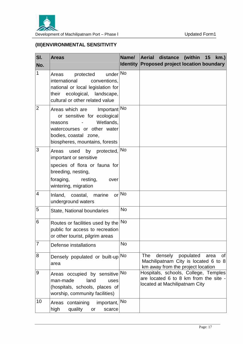
(III)ENVIRONMENTAL SENSITIVITY
Sl.
No.
Areas Name/
Identity
Aerial distance (within 15 km.)
Proposed project location boundary
1 Areas protected under
international conventions,
national or local legislation for
their ecological, landscape,
cultural or other related value
No
2 Areas which are Important
or sensitive for ecological
reasons - Wetlands,
watercourses or other water
bodies, coastal zone,
biospheres, mountains, forests
No
3 Areas used by protected,
important or sensitive
species of flora or fauna for
breeding, nesting,
foraging, resting, over
wintering, migration
No
4 Inland, coastal, marine or
underground waters
No
5 State, National boundaries No
6 Routes or facilities used by the
public for access to recreation
or other tourist, pilgrim areas
No
7 Defense installations No
8 Densely populated or built-up
area
No The densely populated area of Machilipatnam City is located 6 to 8 km away from the project location
9 Areas occupied by sensitive
man-made land uses
(hospitals, schools, places of
worship, community facilities)
No Hospitals, schools, College, Temples are located 6 to 8 km from the site - located at Machilipatnam City
10 Areas containing important,
high quality or scarce
No

FIGURES

ANDAMAN AND
NICOBAR ISLANDS
TAMILNADU
K
E
R
A
L
A
KARNATAKA
ORISSA
C
H
A
T
T
I
S
G
A
R
H
MADHYA PRADESH
MAHARASHTRA
GUJARAT
JHARKHAND
WEST
RAJASTHAN
UTTAR PRADESH
BIHAR
ASSAM
UTTARANCHAL
HARYANA
PUNJAB
HIMACHAL
PRADESH
JAMMU & KASHMIR
BENGAL
B A Y O F B E N G A L
A R A B I A N
LAKSHADWEEP
GOA
SIKKIM
MEGHALAYA
MANIPUR
MIZORAM
TRIPURA
NAGALAND
ARUNACHAL
PRADESH
SRILANKA
S E A
ANDHRA PRADESH
PROPOSED
MACHILIPATNAM PORT
Nagayalanka
Koduru
Avanigadda
Mopidevi
Challapalle
Ghantasala
Guduru
Movva
Pedana
Pamarru
Gudlavalleru
GudivadaMudinepalle
Vuyyuru
Pedaparupudi
Erala
Talagadadivi
Repalle
Ganapeswaram
Kammavaripalem
Yelatturdibba
Palletummalapalem
Polatitippa
Gundupalem
Bandar Fort
Nidumolu
Kavutaram
Nallajerla
Manginapudi
Nandamuru
Bantumilli
Krudivennu
Kalidindi
Korukolle
Lingala
Pallepalem
Moturu
Kuchipudi
Kapileswarapuram
Pamidimukkala
Thotlavalluru
Kankipadu
Penamaluru
Mangalagiri
Vijayawada
Gannavaram
Unguturu
Nandivada
Mandavalli Kaikalur
Akividu
Bhimavaram
Mattagunta
Kondapalle
Pedda Avutapalle
Viravalli
TelaproluKolleru
Pallevada
214A
9
MACHILIPATNAM
Bapatla
Bhattiprolu
Ponnuru
Srikakulam
Tenali
GUNTUR
5
214
Kollery lake
Bapatla Beach
Vadarvu Beach
False Divi Point
Divi Point
B
a
y
o
f
B
e
n
g
a
l
214A
MACHILIPATNAM PORT
Other Roads
Railway Line
National Highway
Major Roads
LEGEND:
River/Canal/Drain
District Boundary
K R I S H N A
K
r
i
s
h
n
a
R
i
v
e
r
ADILABAD
NIZAMABADKARIMNAGAR
WARANGAL
KHAMMAM
NALGONDA
MAHABOOBNAGAR
GUNTUR
KRISHNA
RANGAREDDY
PRAKASAM
KURNOOL
ANANTAPUR
CUDDAPAH
NELLORE
CHITTOOR
TO
B
ALH
AR
SH
A
TO
N
AG
PU
R
NAGARAM
VIZIA
SRIKAKULAM
G
O
D
A
V
A
R
I
WEST
GODAVARI
T
O
M
A
N
M
A
D
M A H A R A S H T R A
K A
R
N
A
T
A
K
A
K A R N A T A K A
T A M I L N A D U
B
A
Y
O
F
B
E
N
G
A
L
TO
M
U
M
BA
I
T
O
M
U
M
B
A
I
T
O
B
A
N
G
A
L
O
R
E
T
O
C
H
E
N
N
A
I
T
O
K
O
L
K
A
T
A
T
O
R
A
IP
U
R
O R I S S A
C H A T T I S G A R H
NATIONAL HIGHWAY
RAILWAY LINE BG
RIVER
STATE BOUNDARY
DISTRICT BOUNDARY
LEGEND:
R
I
V
E
R
EAST
VISAKHAPATNAM
GODAVARI
HYDERABAD
PROPOSED
MACHILIPATNAM PORT
MEDAK
A N D H R A P R A D E S H
KR
ISH
NA
RIV
ER
P
E
N
N
AR
I
V
E
R
DESCRIPTION
REV
NO.
DATE CHKD APPD
PROJECT:
TITLE:
DRN:
CHECKED:
APPROVED:
SCALE:
DRG. NO.
PORT OF MACHILIPATNAM
NTS
GL
SVSLN
DATE:
Aug-2014
REV. NO.
0
M.A.R
UPDATED FORM I
LOCATION MAP
FIGURE-1
FIGURE - 1
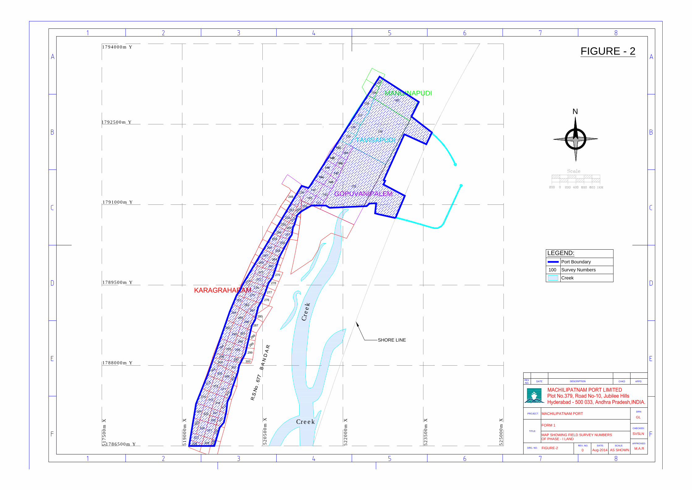
GOPUVANIPALEM
TAVISAPUDI
138
1786500m Y
517500m
X
1788000m Y
1789500m Y
1791000m Y
1792500m Y
1794000m Y
519000m
X
520500m
X
522000m
X
523500m
X
525000m
X
MANGINAPUDI
SHORE LINE
C
r
e
e
k
Creek
NN
Port Boundary
LEGEND:
Survey Numbers100
Creek
DESCRIPTION
REV
NO.
DATE CHKD APPD
PROJECT:
TITLE:
DRN:
CHECKED:
SCALE:
DRG. NO.
MACHILIPATNAM PORT
DATE:REV. NO.
APPROVED:
FORM 1
FIGURE-2
MAP SHOWING FIELD SURVEY NUMBERS
Aug-20140
M.A.R
SVSLN
GL
AS SHOWN
OF PHASE - I LAND
FIGURE - 2
DESCRIPTION
REV
NO.
DATE CHKD APPD
PROJECT:
TITLE:
DRN:
CHECKED:
SCALE:
DRG. NO.
MACHILIPATNAM PORT
DATE:REV. NO.
APPROVED:
FORM 1
FIGURE-3
Aug-20140
M.A.R
SVSLN
GL
AS SHOWN
PORT LOCATION ON TOPOSHEET
FIGURE - 3
FUTURE
FUTU
RENORTH BREAKW
ATER
900m
TURNINGCIRCLE500m DIA
1
2
3
8
9
1
0
1
1
1
2
1
3
7
5
4
6
1
5
1
8
2
3
4
MAIN RECEIVING SUB STATION
TRUCK PARKING
OVER HEAD TANK
WORK SHOP
SHUNTING LOCOSHED
INTERLOCKING CABIN
U G RESERVOIR & PUMP HOUSE
FIRE FIGHTING
DISPENSARY
ADMINISTRATION BUILDING
CANTEEN
PORT USERS BUILDING
SEWAGE TREATMENT PLANT
IRON ORE
TRUCK TERMINAL
COAL STOCKYARD
GENERAL CARGO
OSV
COA
L
SOUTH BREAKWATER 1700m
APROACHCHANNEL
osv
IRO
NO
RE /
GEN
ERA
L CA
RGO
50 m WIDE GREEN BELT
20 m WIDE GREEN BELT
650
25000
300
1000
1200
250
100
450
300
500
400
50000
15000
100000
30000
60000
1
2
3
4
5
6
7
8
9
10
11
12
13
14
15
16
17
18
DESCRIPTION
REV
NO.
DATE CHKD APPD
PROJECT:
TITLE:
DRN:
CHECKED:
SCALE:
DRG. NO.
MACHILIPATNAM PORT
DATE:REV. NO.
APPROVED:
FORM 1
FIGURE-4
PROPOSAL IN 2009 PHASE - I LAYOUT
Aug-20140
M.A.R
SVSLN
GL
AS SHOWN
FIGURE - 4

ANNEXURES

ANNEXURE A
ENVIRONMENTAL CLEARANCE
OF MOEF
Annexure - A


ANNEXURE B
FIELD SURVEY NUMBERS &
EXTENT OF AREA
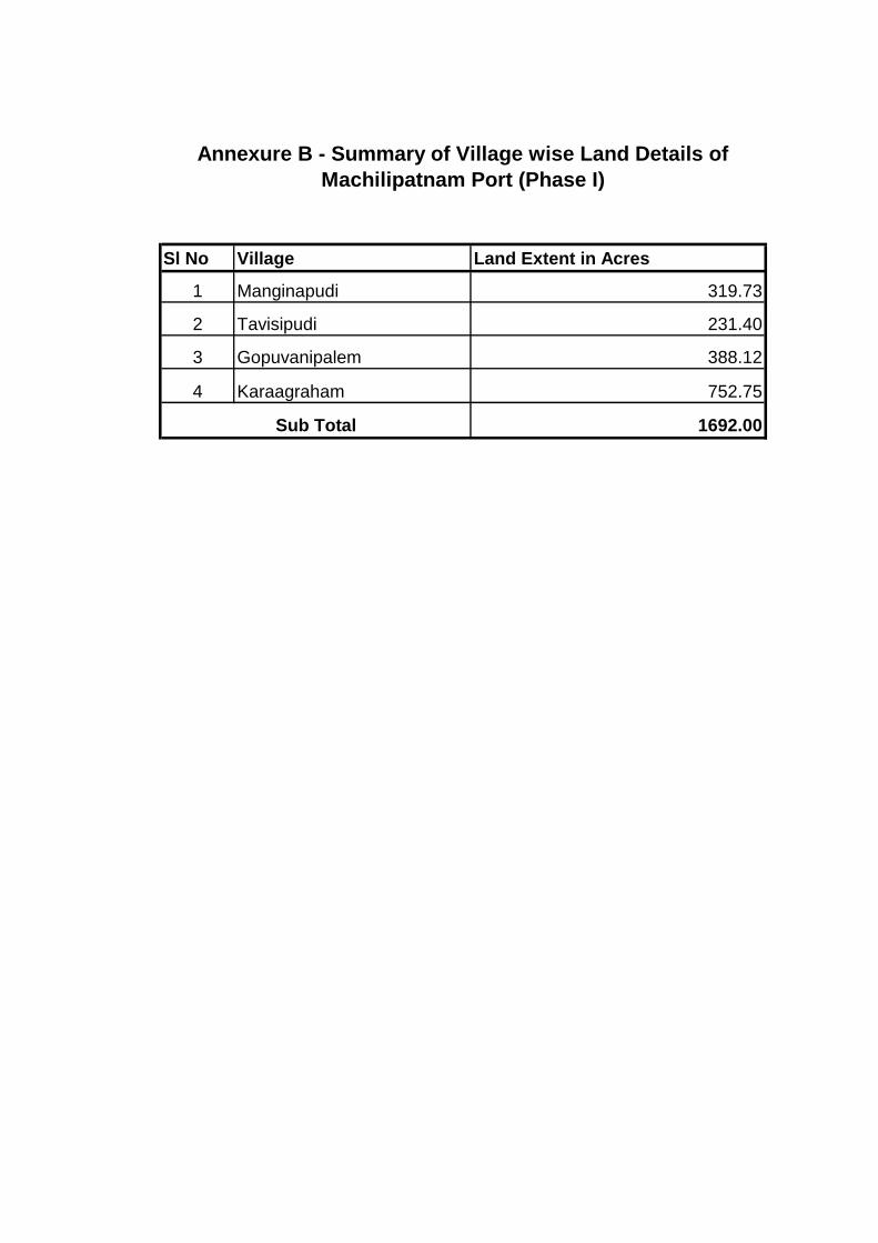
Sl No Village Land Extent in Acres
1 Manginapudi 319.73
2 Tavisipudi 231.40
3 Gopuvanipalem 388.12
4 Karaagraham 752.75
1692.00Sub Total
Annexure B - Summary of Village wise Land Details of
Machilipatnam Port (Phase I)

Annexure B
Sl No Survey No Area ( Acres)
1 183 8.50
2 184 8.56
3 185 302.67
Total 319.73
Sl No Survey No Area ( Acres)
4 135 11.84
5 136 12.16
6 137 14.4
7 138 10.84
8 139 182.16
Total 231.4
Sl No Survey No Area ( Acres)
9 138 23.26
10 140 9.30
11 141 8.24
12 142 12.54
13 143 11.66
14 144 11.60
15 145 7.80
16 146 10.48
17 147 7.40
18 148 9.80
19 149 5.66
20 150 13.84
21 151 7.60
22 152 248.94
Total 388.12
FIELD SURVEY NUMBERS & THE EXTENT OF AREA
Manginapudi Lands
Tavisipudi Lands
Gopuvanipalem Lands

Annexure B
Sl No Survey No Area ( Acres)
23 249 9.10
24 250 7.40
25 251 10.84
26 252 11.40
27 253 7.02
28 254 9.00
29 255 11.08
30 256 10.68
31 257 9.84
32 258 8.75
33 259 11.22
34 260 6.97
35 261 11.08
36 262 9.56
37 263 8.98
38 264 9.26
39 265 7.51
40 270 10.36
41 271 9.18
42 272 9.70
43 273 23.55
44 274 9.68
45 275 9.72
46 276 9.72
47 277 9.06
48 278 10.20
49 280 11.00
50 281 13.15
51 282 11.16
52 283 5.73
53 284 9.35
54 285 10.44
55 286 9.89
56 287 11.85
57 288 4.00
58 289 7.20
59 290 6.18
60 291 5.35
61 292 9.88
62 293 11.93
63 294 9.88
64 295 9.40
65 296 5.43
66 297 4.76
Karagraharam Lands
Annexure B
Sl No Survey No Area ( Acres)
67 298 10.86
68 299 9.46
69 300 4.21
70 302 10.66
71 303 8.23
72 304 9.85
73 305 9.30
74 306 8.47
75 307 6.83
76 310 9.46
77 311 11.12
78 312 10.16
79 313 9.28
80 314 10.68
81 315 10.38
82 316 10.82
83 317 10.28
84 320 10.33
85 321 5.22
86 322 5.50
87 323 10.18
88 324 9.48
89 325 7.26
90 326 8.00
91 327 8.05
92 328 8.07
93 329 11.93
94 330 12.28
95 331 7.74
96 332 5.55
97 335 65.67
752.75Total
Karagraharam Lands (Cont..)
ANNEXURE C
RELEVANT EXTRACT OF
CONCESSION AGREEMENT ON
LAND LEASE

Annexure -C·''~ .. ;;; ':5 ., .. -:-~
.,~ -, ,,~ ., "~ ('~
.,
"~ .,
"~ ·~ .;;i
" ., "
' ·~
'.~ ,, ' "
:3 •'
·~ '
·.•:i .:;i I
' I .~ I
I .. .;i
.. ~
•:i ' I ,,;i I I
··.~ I '
\~ ,,~
,,,)
.~
~
,;i ii i
·~ I il
.;:i l
.~ ·l
::i i 'I
::i l '- ...
·~ j l
~ l j
~ I '
\~ l -•-,
·,;i
~ " :,.- 1,)
'~
::::>
I
DEVELOPMEJ'.'T OF MAC'HlLIPATNAM POllT REVISED COl'l'CESSION AGREEMtNT
3.21 Land
An extent of 6262. 19 acres of land at Machilipatnam, as projected in the RFP document, belonging to GoAP shall be provided for the purpose of Port Development on lease, the period shall commence from the date of allotment, ccrterminus with the Concession Period which is extendable on par with the Lease Period without any further act or deed by either party.
3.22 Land Lease Charges
(<!) Jn consideration of the Lease of the land required for the project (excluding submerged limd ) described in Schedule E, Concessionaire shall pay to GoAP the Lease· Charge calculated at the rate of 2% of the fair market value of the land Leased for the first year and for every subsequent year, there shall be an escalation of 6.5% per annum over the previous year's amount. With respect to the submerged land and the water area, Concessionaire shall pay tease Charges at the rate of Rs.11- (Rupee one only) per annum per 1000 acres during the entire Lease Period.
. (bLln .C?~e. o(l'id<:\ition?U\lnd.ouecl!li.1.11ed land.is gi~enJoJease_by_GaAP.to ... Concessionaire in future, then the Lease ·charges for such additional land or reclaimed land shall be on the same terms as defined above.
(c) The Lease charges shall be payable 15 days before beginning of each financial year.
3.23 Additional Land
GoAP agrees to make available more land belonging to GoAP, if found necessary, at the appropriate time as may be required by the Concessionaire for future development plans in connection with the Port. Such additional land would be made available on an annual lease rental (for the first year) at the rate (as mentioned in Schedule 'E' of Concession Agreement) of Fair Market Value as provided by the Collector, Machi\ipatnam. For subsequent years during the Concession Period, the lease rentals would be escalated at the rate as mentioned in the abov8 schedule (Schedule 'E') over the previous years amount. Such additional land shall stand vested in the GoAP, free of all encumbrances, at the end of the Concession Period.
3.24 Reclaimed Land
for· the development of the Port, the Concessionaire may, with prior approval of GoAP, reclaim and use, further land on the waterfront within the Port Limits over and above the land allotted to the Concessionaire. The cost of such reclamation, as valued by an Independent Engineer and/or Independent Auditor shall be reimbursed by GoAP on completion of such reclamation work. On reimbursement of the reclamation cost by GoAP, the ownership of the reclaimed land shall stand vested with GoAP. Such reclaimed land would be made available on an annual lease rental (for the first year) at the the rate (as mentioned in Schedule 'E' oi Concession Agreement) of the amount reimbursed by GoAP towards the reclamation cost. For subsequent years during the Concession Period, the lease rentals would be escalated at rate as mentioned in the above schedule (Schedule 'E') over the previous years ·amount. Such reclaimed land shall stand vested in the GoAP, free of all encumbrances, at the end of the Concession Period.
~~~L-·SpGtial Secretary lo Government
Infrastructure & lnveslment Depar!ment Government of Andhra Pradesh·
A.P, Secretariat, Hyderabad - ZZ.
... .. :· .. :: .. ·:· .. ··.:.' .. ':.·-'"
PAGE250F71 .
"
ANNEXURE D
GOMs DATED 2nd
MAY 2012 ON
5324 ACRES OF LAND FOR
PORT DEVELOPMENT
Annexure - D
::2::
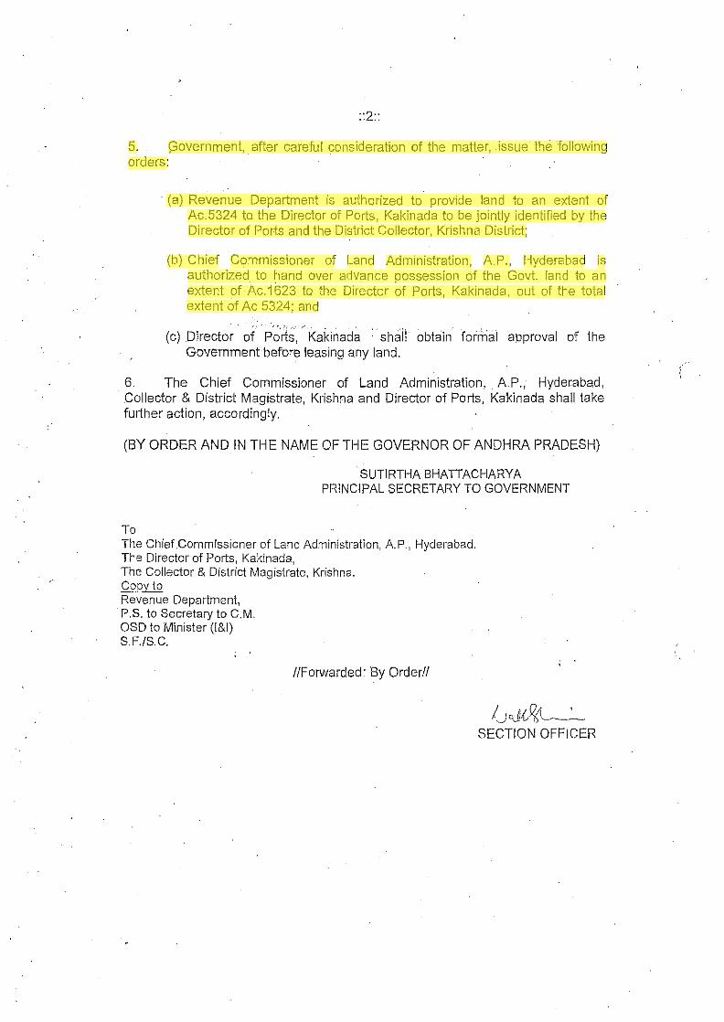
5. (3overnment, after careful consideration of the matter, issue the following orders:
· (a) Revenue Department is authorized to provide land to an extent of Ac.5324 to the Director of Ports, Kakinada to be jointly identified by the Director of Ports and the District Collector, Krishna District;
(b) Chief Commissioner of Land Administration, A.P., Hyderabad is authorized to hand over advance possession of the Govt land to an extent of Ac.1623 to the Director of Ports, Kakinada, out of the total extent of Ac 5324; and
·.,. ,,_ •... -., .. (c) Director of Ports, Kakinada : · shali obtain foimai approval of the
Government before leasing any land.
6. The Chief Commissioner of Land Administration, A.P., Hyderabad, Collector & District Magistrate, Krishna and Director of Ports, Kakinada shall take further action, accordingly.
(BY ORDER AND IN THE NAME OF THE GOVERNOR OF ANDHRA PRADESH)
SUTIRTHA BHAITACHARYA PRINCIPAL SECRETARY TO GOVERNMENT
To The Chief .Commissioner of Land Administration, A. P., Hyderabad. The Director of Ports, Kakinada, The Col.lector & District Magistrate, Krishna. Copy to Revenue Department, P.S. to Secretary to C.M. OSD to Minister (l&I) S.F./S.C.
//Forwarded: By Order//
/._yJ{.~~· . SECTION OFFICER