developing a distributed hydrology model for use in forest ... · 2 developing a distributed...
TRANSCRIPT
Derek Van Marter, Executive Director Upper Columbia Salmon Recovery Board 11 Spokane St, Suite 101 Wenatchee, WA 98801 02/14/2014
Dear Mr. Van Marter: In response to your request for proposals issued on January 7th 2014 (Development of hydrology models for use in forest restoration), I am submitting (with the permission of my team members) the attached project proposal entitled: “Developing a Distributed Hydrology Model for Use in Forest Restoration Planning to Increase Snowpack, Runoff and Streamflow in the Upper Columbia” for consideration by the Upper Columbia Salmon Recovery Board. Our team is comprised of: University of Washington, Seattle (Dr. Erkan Istanbulluoglu, and Christopher D Frans, PhD Candidate); Earth Systems Institute (Dr. Daniel Miller and Dr. Lee Benda); US Geological Survey (Dr. Matt Bachmann); and ICF International (Eric Doyle, MMA). Each institution will have their defined roles in the project. UW will be responsible for hydrologic model development, tests, and feasibility analysis of model applications for forest restoration practices. USGS will lead the development of satellite and observational data for snow. ESI will lead a proof-of-concept development of a decision support tool that integrates hydrologic model predictions with geospatial data and inform other pertinent components of a robust decision support tool. ICF International will work with Ecosystem Diagnosis and Treatment (EDT) models and contribute to the proof-of-concept decision support tool development and analysis. Our team is very enthusiastic about the proposed project and future opportunities for developing decision support tools for hydrologic forest restoration applications. If you have any questions on this proposal please contact me. We are looking forward to work with the UCSRB on this and other opportunities. Sincerely,
Dr. Erkan Istanbulluoglu Associate Professor of Civil and Environmental Engineering 160 Wilcox Hall Box 352700 Seattle, WA 98195-2700 [email protected] 206.543.7923 fax 206.543.1543 http://faculty.washington.edu/erkani/index.html

2
Developing a Distributed Hydrology Model for Use in Forest Restoration Planning to Increase Snowpack, Runoff and Streamflow in the Upper Columbia
Erkan Istanbulluoglu1, Lee Benda2, Dan Miller2, Matt Bachmann3, Chris Frans1, Kevin Andras2, Eric Doyle4
1Department of Civil and Environmental Engineering, University of Washington, Seattle, WA 2Earth Systems Institute, Shasta, CA / Seattle, WA
3United States Geological Survey, Tacoma, WA 4ICF International, Seattle, WA
1. Introduction
Observational and experimental studies highlighting the potential of enhancing water supply through forest management practices in snowmelt dominated maritime watersheds date back to the middle of the 20th century (e.g., Kittredge, 1953; Anderson et al., 1958; Anderson and Hoover, 1976). Forest canopies have the potential to intercept snowfall and emit longwave radiation to the snow surface (increasing mass loss) on the ground, but also shelter snow from solar radiation and wind (decreasing mass loss). There is general agreement that the manipulation of the dimensions, densities, and spatial patterns of forest openings influence snow accumulation and melt rates, affecting discharge timing and volume in snowmelt dominated watersheds (Varhola et al., 2010). However these influences are likely to vary greatly with factors including regional climate, topography, and vegetation (tree) species. Recent work has suggested that in temperate western North American forests the effect of forest thinning through management practices has the potential to enhance snow retention (Lundquist et al, 2013), influence timing of peak flows through the melt season (Green and Alila, 2012), and reduce the severity of low flows (Moore and Wondzell, 2004). Quantitative estimates on the influence of the interactions between the forest, snow pack, and watershed hydrology requires the use of hydrologic models with sophisticated representations of snow dynamics and detailed parameterization of forest and landscape properties. Furthermore, linking such a hydrologic model with an interactive geospatial database is essential for developing a forest restoration decision support tool that can be used to assess the feasibility of using forest management practices to enhance snowpack volume, snowmelt runoff, and streamflow.
Building a forest restoration decision support tool to prioritize and develop future forest
restoration projects requires more than a robust distributed hydrology model. Other important watershed factors that need to be considered include forest stand structure, pre-wildfire and post fire land cover conditions as input for improved snow and hydrology modeling and forest practices. Spatially variable hillslope erosion and landslide potential, distribution and quality of fish habitat, forest road dynamics (runoff and erosion), and riparian processes (thermal loading, wood recruitment in the context of forest thinning), are data types that can be used for assessing the environmental implications of hydrologic changes with forest practices. A forest restoration decision support tool would need to integrate all these factors to design and locate timber harvest to optimize increased snowmelt, runoff, and streamflow to enhance fisheries while eliminating or reducing negative impacts associated with forestry practices.
3
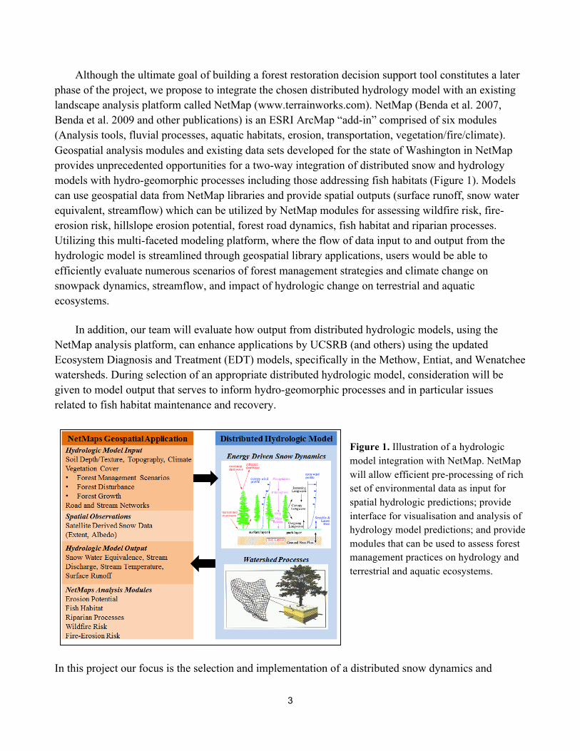
Although the ultimate goal of building a forest restoration decision support tool constitutes a later phase of the project, we propose to integrate the chosen distributed hydrology model with an existing landscape analysis platform called NetMap (www.terrainworks.com). NetMap (Benda et al. 2007, Benda et al. 2009 and other publications) is an ESRI ArcMap “add-in” comprised of six modules (Analysis tools, fluvial processes, aquatic habitats, erosion, transportation, vegetation/fire/climate). Geospatial analysis modules and existing data sets developed for the state of Washington in NetMap provides unprecedented opportunities for a two-way integration of distributed snow and hydrology models with hydro-geomorphic processes including those addressing fish habitats (Figure 1). Models can use geospatial data from NetMap libraries and provide spatial outputs (surface runoff, snow water equivalent, streamflow) which can be utilized by NetMap modules for assessing wildfire risk, fire-erosion risk, hillslope erosion potential, forest road dynamics, fish habitat and riparian processes. Utilizing this multi-faceted modeling platform, where the flow of data input to and output from the hydrologic model is streamlined through geospatial library applications, users would be able to efficiently evaluate numerous scenarios of forest management strategies and climate change on snowpack dynamics, streamflow, and impact of hydrologic change on terrestrial and aquatic ecosystems.
In addition, our team will evaluate how output from distributed hydrologic models, using the
NetMap analysis platform, can enhance applications by UCSRB (and others) using the updated Ecosystem Diagnosis and Treatment (EDT) models, specifically in the Methow, Entiat, and Wenatchee watersheds. During selection of an appropriate distributed hydrologic model, consideration will be given to model output that serves to inform hydro-geomorphic processes and in particular issues related to fish habitat maintenance and recovery.
Figure 1. Illustration of a hydrologic model integration with NetMap. NetMap will allow efficient pre-processing of rich set of environmental data as input for spatial hydrologic predictions; provide interface for visualisation and analysis of hydrology model predictions; and provide modules that can be used to assess forest management practices on hydrology and terrestrial and aquatic ecosystems.
In this project our focus is the selection and implementation of a distributed snow dynamics and
4
hydrologic modeling capacity to support forest management decisions in North Central Washington. The project will include the following tasks, which will be developed in close collaboration with the UCSRB’s technical advisory group: 1) Model selection: select a distributed hydrologic model from a group of candidate models with a representation of snow dynamics that includes a sufficient level of complexity for forest restoration projects, in collaboration with UCSRB’s technical advisory group; 2) Database development: compile satellite-derived snow products in varying spatial resolutions, existing in-situ snow depth and water equivalent measurements, and streamflow for model evaluations at local and regional scales. 3) Model testing: refine, confirm, and test the selected hydrologic model at watershed (HUC 5) scales and develop proof-of-concept model simulations at limited regional scales (including Wenatchee, Entiat, Methow, and Okanogan subbasins) to examine the feasibility of forest management actions on spatial snow dynamics and streamflow. 4) Formulate a conceptual framework for incorporating the selected hydrological model into a decision support system for restoration planning. During the testing and evaluating of the candidate distributed hydrological models, our team will formulate a conceptual framework to consider how model output will support other pertinent numerical components of a robust decision support tool including fish habitats, hillslope erosion, forest roads, riparian processes and climate change. These tasks are detailed in the section below. 2. Tasks and deliverables 2.1. Selection of a Distributed Hydrology Model
Distributed hydrologic models are valuable tools for land and water managers to evaluate the cumulative effects of varying forest conditions under changing climate. These tools promote hydrologic analysis beyond the scale of local and plot level field studies. Numerous hydrologic models have been used in forest management and climate change applications in watersheds across Western North America (Beckers et al., 2009). Models vary greatly in complexity leading to a range of functionality with respect to forest management applications linked with climate change.
Watershed models can employ empirical, semi-empirical, and physically-based process
representations, solved either using analytical solutions or numerical approximations, and can be spatially lumped or distributed. Early models of hydrology (1960-1990) typically relied on empirical approaches with a number of calibration parameters (e.g., snowmelt coefficients, linear reservoir timescales) and represent watersheds as spatially lumped units. Lumped models are unlikely to capture the impacts of environmental change including forest management practices because most lumped models (a) rely on empirical equations that do not use physical and measurable parameters, and (b) do not represent spatial variability of climate, soils, and vegetation (Xu and Singh, 2004). Models developed in the last couple of decades to study climate and environmental change fall in the category of distributed and physically-based models. Physically-based processes used in such models (e.g, surface energy balance, energy-driven snow dynamics) are derived from equations of conservation of mass and energy. Such models are preferred for evaluating climate and land use and land cover change
5
impacts on watershed hydrologic response as they use spatially distributed climate, soil, and vegetation (e.g., vegetation type, cover fraction, height, and canopy structure) properties to estimate spatially distributed hydrologic fluxes. Semi-distributed models can be considered as a “hybrid” category between lumped and distributed physically-based models. Semi-distributed models divide the watershed into individual response units to enhance the representation of spatial variability across the landscape, and when discretized using a digital elevation model can represent elevation driven climatic gradients (e.g., temperature lapse rate and orographic influences on precipitation) in some limited fashion.
Distributed physically-based models offer the most flexibility in the representation of spatial
variability in biophysical variables (soil and vegetation properties) and climate forcing, and allow lateral moisture exchange between model elements driven by topographic gradient. For the purposes of this project dynamic fluxes of energy and mass between the snowpack, overlying vegetation, and the atmosphere need to be quantified. A limited number of models that contain this necessary level of physical complexity exist, and fewer have the flexibility and ease of implementation appropriate for operational applications. Based on a ranking of 30 different hydrologic models used in forest management applications (Beckers et al., 2009), we have preliminarily selected four hydrologic models to be considered for the proposed work. A brief review of the models, applications, and algorithms pertinent to the simulation of interactions between vegetation and the snowpack is provided below. Other hydrological models can be evaluated based on guidance from the technical advisory group. DHSVM The Distributed Hydrology Soil Vegetation Model (DHSVM, Wigmosta et al. 1994), developed at the University of Washington, is the most widely used hydrology model in Pacific Northwest (PNW) forested watersheds. Its applications span several decades in both academic research and operational activities. Some applications include forested tributaries of the upper Columbia River (e.g., Storck et al., 1998; VanShaar et al., 2002; Lanini et al., 2009). Model parameters are distributed on a gridded mesh, matching the resolution of a digital elevation model (10-200 m) for areas up to 10,000 km2. DHSVM components most salient to the proposed work include the snow accumulation and melt (Andreadis et al., 2009) and vegetation algorithms. The melting of snow is simulated using a surface energy balance approach and is solved at sub-daily time intervals using a two layer representation of the snowpack. The upper layer represents short term exchanges of mass and energy with the atmosphere and overlying vegetation canopies, while the lower layer serves as storage of mass and energy at longer time scales. Vegetation is represented using a two layer canopy model. Snow intercepted over the plant canopy is also subject to full energy-driven melt processes, and melt water forms through fall to the ground surface. A vegetation class is specified for each grid cell, and corresponding vegetation-specific biophysical parameters are assigned for model algorithms (e.g., seasonally varying leaf area index and albedo, stomatal resistance, hemispherical fractional cover). Proponents at the University of Washington are actively developing and improving the snow and more recently glacier components of DHSVM (Naz et al., 2014). Our current modeling efforts on snow and
6
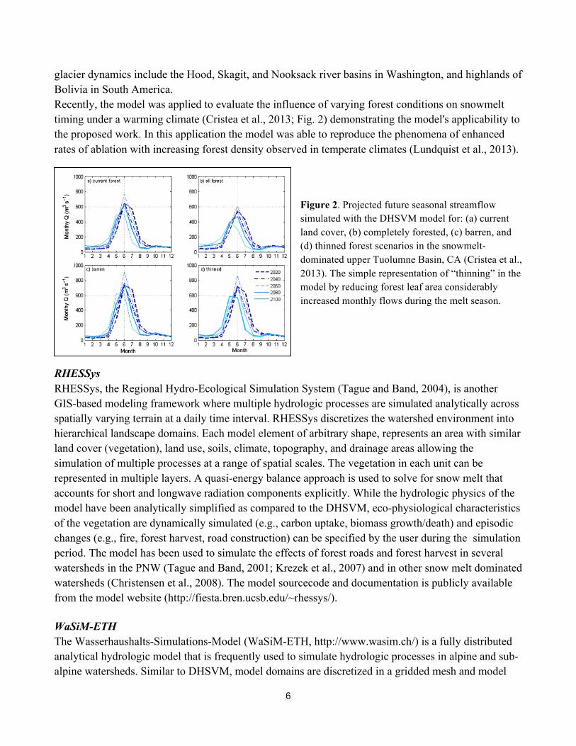
glacier dynamics include the Hood, Skagit, and Nooksack river basins in Washington, and highlands of Bolivia in South America. Recently, the model was applied to evaluate the influence of varying forest conditions on snowmelt timing under a warming climate (Cristea et al., 2013; Fig. 2) demonstrating the model's applicability to the proposed work. In this application the model was able to reproduce the phenomena of enhanced rates of ablation with increasing forest density observed in temperate climates (Lundquist et al., 2013).
Figure 2. Projected future seasonal streamflow simulated with the DHSVM model for: (a) current land cover, (b) completely forested, (c) barren, and (d) thinned forest scenarios in the snowmelt-dominated upper Tuolumne Basin, CA (Cristea et al., 2013). The simple representation of “thinning” in the model by reducing forest leaf area considerably increased monthly flows during the melt season.
RHESSys RHESSys, the Regional Hydro-Ecological Simulation System (Tague and Band, 2004), is another GIS-based modeling framework where multiple hydrologic processes are simulated analytically across spatially varying terrain at a daily time interval. RHESSys discretizes the watershed environment into hierarchical landscape domains. Each model element of arbitrary shape, represents an area with similar land cover (vegetation), land use, soils, climate, topography, and drainage areas allowing the simulation of multiple processes at a range of spatial scales. The vegetation in each unit can be represented in multiple layers. A quasi-energy balance approach is used to solve for snow melt that accounts for short and longwave radiation components explicitly. While the hydrologic physics of the model have been analytically simplified as compared to the DHSVM, eco-physiological characteristics of the vegetation are dynamically simulated (e.g., carbon uptake, biomass growth/death) and episodic changes (e.g., fire, forest harvest, road construction) can be specified by the user during the simulation period. The model has been used to simulate the effects of forest roads and forest harvest in several watersheds in the PNW (Tague and Band, 2001; Krezek et al., 2007) and in other snow melt dominated watersheds (Christensen et al., 2008). The model sourcecode and documentation is publicly available from the model website (http://fiesta.bren.ucsb.edu/~rhessys/). WaSiM-ETH The Wasserhaushalts-Simulations-Model (WaSiM-ETH, http://www.wasim.ch/) is a fully distributed analytical hydrologic model that is frequently used to simulate hydrologic processes in alpine and sub-alpine watersheds. Similar to DHSVM, model domains are discretized in a gridded mesh and model
7
algorithms are solved at sub-daily time steps. The vegetation canopy is represented with multiple layers with a dynamic representation of phenological characteristics. The model user has the option to use a temperature index or analytical energy balance algorithm to simulate snow melt. In the analytical energy balance method, melting from radiation, heat advection, and turbulent energy transfers are represented individually through empirical parameters. The model also includes an advanced representation of groundwater. The model has been widely applied in snow melt dominated watersheds (Verbunt et al. 2003; Jasper et al. 2004; Klok et al. 2001; Kleinn et al. 2005) and more recently in estimating future streamflow in the Upper Columbia River Basin (Bürger et al., 2011). Topnet Topnet (Bandaragoda et al., 2004), a hydrologic model developed at Utah State University, is based on the topographically derived concepts of TOPMODEL and is applied over large watersheds using small drainages as individual model elements. Spatial variability of soil moisture and snow water equivalent within each model element is represented with a topographic wetness index and an area depletion curve, respectively. A unique attribute of Topnet, applicable to the proposed study, is it’s use of a surface energy balance melt model, the Utah Energy Balance Snowmelt model (Tarboton et al., 1995). The snowpack is represented as a single layer, however, it accounts for differences in average pack temperature and surface temperature using a force-restore approach (You, 2004). The snowmelt model was recently updated to include a more sophisticated representation and parameterization of the vegetation canopy and demonstrated accurate performance in the simulation of net radiation of snowpack surfaces under canopies of different vegetation classes in a forest study area in the Rocky Mountains of Utah (Mahat and Tarboton, 2012). In model selection we will compare and contrast models with respect to the following criteria: (a) level of physical sophistication in the representation of vegetation-snow-atmosphere interactions and models usability for decision support purposes; (b) the number and types of required physical (measurable/observable) and empirical parameters used in snowmelt and vegetation algorithms and the potential for prescribing such parameters from local and remote measurements (satellite-derived data) or from previously published values; (c) the number of meteorological forcing variables required, and the potential for obtaining or estimating such variables either from existing observations, gridded datasets, or satellite remote sensing data; (d) performance in earlier studies that examined forest restoration impacts on snow dynamics and hydrology; (e) models capacity in representing both humid and semiarid climatic conditions in steep forested watersheds, including evapotranspiration and lateral soil moisture and subsurface flow transport. (f) sensitivity to initial conditions and changes in parameters as well as their computational efficiency; (g) their utility for informing other pertinent components of a robust decision support tool including fish habitat (including EDT), hillslope erosion, forest roads, riparian processes and climate change.
Although we do not anticipate to run these models during the model selection processes, in cases

8
where a clear distinction cannot be made among models we will develop relatively simple model sensitivity analysis for their snowmelt components. For this purpose we expect to code the snow accumulation and melt algorithms of individual hydrologic models as stand alone snow modules using a high-level computer programming language such as MATLAB for limited model inter-comparisons. Simple parameter sensitivity analysis will be conducted for each of these models. Any model that has very extreme sensitivities or no sensitivity to key vegetation parameters (LAI, canopy cover, tree height, radiation attenuation), indicating high predictive uncertainty under changing environmental conditions, will be identified. Deliverable: A report will be developed evaluating the selected models (briefly presented above) with respect to our model selection criteria. During the model selection phase we will plan to meet with the advisory committee at least twice either face-to-face or through conference calls. This will be critical for the future usability of the selected models for decision support purposes. 2.2. Spatial Data and Parameter Estimation
To run the selected model we will first need to estimate values for model parameters. Some of the model parameters will be static (such as physical constants and coefficients for well-known relations) and others will vary in space and time. The latter group will include vegetation and snowpack properties. Following vegetation classification, biophysical and phenological parameters of vegetation types (e.g., Leaf Area Index, Albedo, canopy radiation attenuation, height) will be assigned to each vegetation classification through a detailed literature review of previous biological and silvicultural studies conducted in the region. Most of these parameters have been selected for the DHSVM model in other applications in central and eastern Washington. With further refinement from more recent literature, existing parameters may be used for other models, if DHSVM is not selected as the study model. In addition to characterizing and parameterizing the current state of land cover, additional work parameterizing vegetation resulting from future management strategies will be required. To represent these management and disturbance (pest, disease, fire) scenarios, the distribution and parameterization of numerous forest states will be formulated. These scenarios will include, but are not limited to, the effects of forest harvest, thinning through the creation of forest gaps at a range of spatial scales, prescribed burns, and other natural disturbances (wildfire, pests, disease/stress mortality).
The snow accumulation and melt models that are included in the preliminarily proposed
hydrologic models are largely physically based and energy driven and do not include many parameters that need to be assigned by the user. However, some attention is required to evaluate the applicability of the representation of the snow surface albedo. Typically the albedo of the snow surface is simulated to decay with the amount of time since the last snowfall (Laramie and Schaake, 1972). The maximum snow albedo and this rate of decay have been observed to vary regionally, with and without canopy cover, and after forest fires (Gleason et al., 2013). The formulation of albedo in the model will need to be evaluated and adjusted as required to match satellite derived observations of albedo and observed rates of ablation at SNOTEL observation locations.

9
The parameterization of the distribution of meteorological data across the landscape will also influence the rates of snow accumulation and ablation. Typically in hydrologic models temperature and precipitation are estimated for local model elements from the points where they are measured or from the centroids of gridded meteorological data (typically of coarser spatial resolution than the hydrology model) using prescribed elevation lapse rates. In models lapse rates can vary spatially and temporally and are usually determined from local observations or high resolution gridded climatological data (PRISM, Daly et al., 1994). Lapse rates will be adjusted to match local conditions and possible perturbations in their distributions will be evaluated for future projections.
We will perform sensitivity analysis for the snowmelt and water balance components of the
selected distributed hydrology model at select single locations (using a single model grid) for each of the represented vegetation types in the study regions. These locations will be selected based on climate and snow data availability. Ideally these analysis will be done at weather/SNOTEL station sites. We will examine, through point model calibrations, the need for any model refinement especially in the snow component of the selected hydrology model. As refinement we will consider adding new components to increase model complexity or reducing model complexity based on the initial complexity of the selected model and its performance against data. This model refinement strategy was applied in an earlier large scale modeling study by the UW group at the upper Mississippi river basin (Frans et al., 2013).
To evaluate and tune the performance of the snow model, remotely sensed estimates of snow
properties will be collected and organized. Satellite (Moderate Resolution Imaging Spectroradiometer, MODIS, NASA) derived products that estimate snow areal extent (MODSCAG, Painter et al., 2009) and snow area estimates from Landsat Thematic Mapper imagery (Landsat, NASA) using Normalized Snow Difference Index (NDSI) methodology will be assembled for the model testing phase. The resolutions of these products (500m, 30m, respectively) are likely too coarse to evaluate snow disappearance dates in smaller forest gaps or forest patches with varying canopy densities. To evaluate snow covered area and melt rates for varying forested conditions at finer spatial scales, high resolution satellite imagery available through the United States Geological Survey (USGS) will be processed and analyzed to monitor snow covered area and snow depth (through photogrammetric methods) throughout the melt season. The U.S. Department of Interior Civil Applications Committee, through its Global Fiducials Program, maintains a library of the U.S. National Imagery Systems’ imagery at 1 meter spatial resolution, for climate studies, global change investigations, ecosystem modeling, and other related applications. Request for the capture of imagery for specific targets during upcoming melt seasons will be made, providing a time series of imagery with a temporal frequency of down to once a week, depending on cloud cover. A proponent of the proposed work has experience in processing and analyzing such data in the monitoring of snow and ice in a glaciated watershed in the North Cascades. Deliverable: We will summarize our results for model parameter estimation and refinement in a detailed report. The report will describe our methods for parameter selection and model refinement and

10
include maps of distributed model vegetation and snow parameters. We will plan to hold regular meetings with the technical advisory group to discuss and provide feedback of all aspects of model parameterization. In particular, we anticipate to develop vegetation parameters for future forest management strategies and potential disturbances (fire, pest) in close interaction with the technical advisory group. An inventory of the spatial data described above will be provided following the organizational structure described in the following section. 2.3. Data and Information Inventory
The selected hydrologic model will require a wide range of input data (e.g., soil texture, vegetation, topography, channel network, individual channel segments); vegetation (forest condition) will vary with different forest management scenarios. Additionally, when considering future projections under a warming climate, the model will require multiple datasets of future meteorological data representing the range in future climate predictions. Therefore, the application and testing of the selected distributed hydrologic model will require the use of a numerically robust digital representation of the terrain to organize and store model input and output data. The “digital landscape” should include a synthetic and attributed channel network and a data structure that hydrologically connects all terrestrial locations in a watershed with the channel network at the scale of forest gaps (~0.01 hectare) and individual stream reaches (~100 m). We propose to use the existing digital landscapes that cover all of eastern Washington in the modeling platform NetMap (www.terrainworks.com). The NetMap data structure and associated suite of Open Source (GPLv3) Fortran programs will enhance our ability to make predictions of snow accumulation, melt, runoff and the generation of streamflow at the scale of individual hillsides to entire river networks, including down to the scale of individual stream reaches. In particular, NetMap’s data structure and existing tool interfaces will allow us to build a user friendly interface to run the selected hydrological model, including importing of geospatial data (vegetation cover, soils, climate) and exporting (and display) of modeling predictions (snow accumulation, melt, runoff and stream discharge) at a variety of spatial scales. Use of the existing modeling platform (NetMap) will promote efficiency in project development, saving funds for use in other important components (e.g., testing and evaluating distributed hydrological models and building a user friendly graphical user interface). Deliverable: An organized user friendly inventory of all geospatial data used in hydrologic model simulations will be provided. The same framework used to store this data will also be created for the organization and storage of hydrologic model output data. An interface streamlining the flow of data to and from the hydrologic model will be developed. 2.4. Model Application, Testing, and Evaluation Model application and testing will occur in two phases: (1) We propose to first apply and test the model framework at small to medium spatial scales as a proof of concept. We will seek guidance from the technical advisory group on where to target initial model application efforts, highlighting local restoration interests. A likely candidate for this phase would be within the Entiat Subbasin including detailed analyses within individual drainages. This
11
subbasin contains the United States Forest Service (USFS) Entiat Experimental Forest, which was designated in 1957 as representative land on the eastern slopes of the Cascade Mountains to study the hydrologic response to forest management practices (Tiedman and Klock, 1974). The subbasin has a history of stand-replacing fires, with the most notable fires occurring in 1970 (Entiat Zone Fire) and 1994 (Tyee Fire), providing a landscape consisting of various stages of forest growth. The subbasin also includes three USGS stream gage measurement locations and one SNOTEL SWE measurement site (Pope Ridge). DHSVM was recently applied to the Entiat subbasin by researchers at the University of Washington to evaluate influences of 21st century climate change on streamflow (Carrasco and Hamlet, 2010), to predict post-fire sediment delivery to streams (Lanini et al., 2009), and to describe the role of soil moisture and drought stress on historical patterns of forest regrowth, in addition to predicting future drought stress in a warming climate (Elsner et al., 2011). Alternative, or additional, small to medium sized watersheds for this initial phase where long term streamflow and SWE observations are available include the Chiwawa River in the Wenatchee Subbasin and the Methow River above Goat Creek in the Methow Subbasin.
(2) Leveraging modelling conducted at small to medium spatial scales of the initial phase described above, next the model will be applied regionally, with the goal of model applications in the four large subbasins, the Wenatchee, Entiat, Methow, and Okanogan. Again, the selection of this modeling domain will occur through coordination with the technical advisory group targeting restoration interests.
Multiple hydroclimatic variables that are locally and remotely measured will be used to test and evaluate the model. The simulation of snow melt will be evaluated using several different sources of observational data. First, snow water equivalent (SWE) continuously measured at point locations in the Natural Resources Conservation Service (NRCS) snow telemetry network (SNOTEL) will be compared with model simulated SWE corresponding to the measurement locations. Evaluating the simulation of snow covered area and snow disappearance dates, model simulations will be compared with the remote sensing products introduced in section 2.2. Additionally, the higher resolution satellite data allows us to assemble time series of ablation rates and snow covered areas to be used to corroborate model results at a finer spatial resolution. Furthermore, these spatial observations of snow will be analyzed independently to generalize observed patterns of snowmelt for different known forest types. While the simulation of snow in forests is the focus of the study, the simulation of watershed discharge will be compared with observed discharge ensuring acceptable prediction of streamflow and water balance. This will include a rigorous evaluation of the model’s performance in predicting mid and late summer flows where snowmelt is critical for sustaining discharge and maintaining adequate flows for fish habitats. Deliverable: A report summarizing all model applications (including local and regional), model evaluation experiments, and final fully calibrated results. Model simulated data through these
12
applications will be archived in the geospatial inventory described in the previous section. All of the necessary source code and data required to run operate the model will be provided with proper documentation. 3. Formulating a Conceptual Framework: Integrating the Chosen Hydrology Model within a Future Forest Restoration Decision Support Tool
During the course of this project focused on selecting and testing a hydrological model, our team will consider, conceptually, the ultimate goal of integrating the model into a robust decision support tool that will need to consider other key watershed processes. A future decision support tool could be used by planners to design types and locations of forestry activities so that they optimize the positive effects of streamflow enhancement on the best and most sensitive fish habitats but in ways that protect other watershed values.
Manipulating forest cover (patch harvest, thinnings, prescribed fire) in watershed headwaters in
eastern Washington (the majority of land is contained within headwater basins) to enhance summer flow and fisheries is a multi-faceted and interdisciplinary watershed management problem that extends beyond modifying snow accumulation and melt dynamics. (1) Forestry activities (even in the context of forest restoration) typically require use of existing forest road networks or the building of new roads, and these in combination with timber harvest can lead to increases in erosion including road surface erosion and mass wasting (landslides and debris flows). Thus, any decision support tool would need to consider the potential that forest restoration activities would have on impacts to water quality and fish habitats. (2) Building a decision support tool that includes optimizing where forest restoration occurs to enhance fish habitats, via increased summer streamflow, would benefit from understanding the distribution, abundance and intrinsic quality of fish habitats, specifically for anadromous fish. (3) Forest operations (thinning or patches) in riparian areas, including for the purpose of reducing wildfire risk, need to consider the key riparian processes of in-stream wood recruitment and thermal loading (e.g., to not negatively affect riparian processes important for maintaining fish habitats). (4) Forest restoration may utilize information about predicted fire probability and severity, databases readily available through federal and state agencies. For instance, thinning and harvesting patches could occur in forest areas with the highest fire probability and severity. Fire probability and severity predictions could determine where forest restoration (e.g., fuels reduction) would have the greatest impact on reducing post wildfire erosion and thus negative impacts on fish habitats and water quality. Consequently, these four key watershed process domains would likely become integral in the future development of a decision support tool for planning forestry activities in the context of sustaining summer flows for fisheries enhancement.
The ultimate goal of building a forest restoration decision support tool constitutes a later phase of
this project. Nevertheless, we propose to use the NetMap platform for hydrological modeling because it provides the numerical and functional infrastructure to efficiently evolve the hydrological component into the next decision support tool phase. NetMap addresses the four watershed process domains listed
13
above. It contains capabilities for analyzing the potential for surface erosion, shallow landslide, gully erosion, debris flows and earthflows, and the potential for sediment delivery to streams. The modeling platform includes capabilities for predicting the hydrologic connectivity and erosion potential of forest road networks and the potential for sediment delivery to streams; an upcoming module will predict road erosion reduction optimization strategies (for existing and future forest roads). The attributed and routed synthetic stream networks (derived from DEMs, either NED 10 m or LiDAR) are used in NetMap to predict the intrinsic potential for three salmonid species (coho, steelhead and Chinook) and for two resident species (west slope cutthroat and Bull Trout). Moreover, NetMap’s rich set of attributes and river network analysis capabilities make it well suited to support applications of updated Ecosystem Diagnosis and Treatment (EDT) models, including increasing its efficiency and cost effectiveness.
NetMap’s riparian tools include thermal loading and in-stream wood recruitment that can be
applied at stream reach and watershed scales (and over time periods ranging from single years to a century or longer) to determine where, in watersheds, management in riparian areas (including thinning to reduce wildfire risk) would have the least impact. In addition, the in-stream wood recruitment tool contains a module for calculating tree tipping, directional felling of trees into streams to offset any losses of wood due to thinning or harvest and for habitat enhancement. Finally, forest restoration planning could be enhanced by considering wildfire probability and severity, and coupling that to impact on erosion and water quality, and this NetMap capability could be used to strategically locate forestry activities. 4. Timeline March 2014 A literature survey of hydrologic models used in forest management applications in the Pacific Northwest will be completed. Simple parameter sensitivity analyses will be conducted as required to differentiate models. Through coordination with the technical advisory committee a single model will be selected for the proposed work. April - July 2014 1) All geospatial data required for the modeling applications will be collected and organized through the use of the NetMaps application. Collection and processing of remote sensing data will begin. The parameterization of existing vegetation properties in the study region will occur through literature review. 2) Begin linking NetMaps applications to the hydrologic model, using NetMaps to prepare inputs required by the hydrologic model. 3) The hydrologic model will be initialized for multiple small to medium sized watersheds. Exploratory simulations will be conducted to evaluate and fine tune parameters used in the model’s snowpack algorithms, representation of climatic gradients, meteorological forcings, and soil parameters influencing streamflow timing.

14
August - October 2014 1) Complete model initialization, calibration, and parameterization for the small to medium sized watersheds. Parameterize multiple forest management strategies. Evaluate multiple management strategies at this spatial scale. 2) Further development on the interface between the NetMaps application and the hydrologic model, focusing on processing and storage of hydrologic model output. November - February 2014 Expand modeling efforts to a larger spatial scale, including several tributaries located in the Upper Columbia Basin. March - April 2015 Complete modelling applications. Organize all results in a geospatial inventory. Create detailed user guide describing the organization of all geospatial data and hydrologic model output. Create user guide for applying hydrologic model and interface with the NetMaps geospatial application. Summarize all model applications and results in a final report. April - June 2015 Refinement of the project report with UCSBR and addressing any issues raised by the technical advisory committee. 4. Budget UW: $97,500. UW will lead model development, tests, and confirmation. The requested amount will fund Chris Frans in the spring quarter as a graduate student and a full time postdoc starting from July 2014 until the end of the proposal . The requested amount will also include 2 weeks of salary for Erkan Istanbulluglu. ESI: $35,700. ESI will lead the formulation of the conceptual framework for the decision support tool. Partial salaries are requested for Dan Miller and Lee Benda and for Kevin Andras for computer programming to integrate hydrologic model and EDT with NetMap, development of user interface, and technical documentation. USGS: $25,000. USGS will lead the compilation of satellite-derived snow products in varying spatial resolutions, SNOTEL, and streamflow data. The budget will fund salary for USGS personnel for database development. ICF International: $10,000. ICF international will contribute to the the formulation of the conceptual framework and incorporate hydrologic model simulation results to inform proof-of-concept EDT applications. The budget will fund salary for Eric Doyle for ~ 70 hours of his time.
15
5. Statement of Qualifications Erkan Istanbulluoglu, PhD Department of Civil and Environmental Engineering, University of Washington (UW) Erkan Istanbulluoglu is an Associate Professor and the PI of the Ecohydrology group at the UW (http://faculty.washington.edu/erkani/index.html). Erkan’s research focuses on understanding and modeling of the hydrologic, ecologic, and geomorphic processes in river basins at a range of spatial and temporal scales. Erkan has more than 15 years of experience in research and has published 30 journal articles. His primary research method is numerical modeling and he has contributed to the development of a number of numerical models in different institutions including hillslope and landscape erosion models (CHILD, Landlab), a cellular automata dynamic vegetation model (CATGraSS), urban ecohydrology model (UEM). In his recent research Erkan and his graduate student Chris Frans have worked on the development of a glacier component within the DHSVM model as part of a large group including scientists from UW, Oregon State University, and University of British Columbia. The project was funded by NASA (PI Dennis Lettenmaier, Co-PI Istanbulluoglu). Currently Erkan is leading two projects funded by the National Science Foundation (NSF) on ecologic and geomorphic model development; projects on snow and glacier modeling at the Skagit (funded by the Seattle City Light), and the Nooksack river basins, and a project on assessing climate change impacts on forest road networks (funded by the National Park Service). Daniel Miller, PhD Earth Systems Institute Earth Systems Institute (ESI) is a 501(c)3 organization incorporated in 1997 with a mission to foster wise land use by increasing access to information, by developing tools for watershed analysis and assessment, and by educating watershed users. ESI has led development of a community-based watershed-science system consisting of digital watersheds using a uniform data structure coupled to a suite of advanced watershed analysis tools. This system, ‘NetMap’, is integrated with GIS to provide a simple user interface and is used with numerous resource management, restoration and conservation projects across western North America (http://terrainworks.com/projects); NetMap data sets and software are maintained by TerrainWorks, Inc). ESI has offices in Seattle, WA and in Mt. Shasta, CA. Dan Miller is a co-founder of ESI, with Lee Benda. Dan has over 20 years of experience using numerical analyses to explore watershed process interactions. Projects include development of watershed-wide simulation of sediment and woody debris fluxes (ESI 2002. Landscape dynamics and forest management. General Technical Report RMR@-GTR-101-CD. Rocky Mountain Research Station), linking simulations to coho life-cycle models to explore metapopulation dynamics, development of large-scale wood recruitment (e.g., BLM 2008, Western Oregon Plan Revision EIS, Appendix J) and landslide models (e.g., Coastal Landscape Analysis and Modeling Study, http://www.fsl.orst.edu/clams/prj_wtr_brd_indx.html), and development of the data structures and Fortran code used in NetMap. Lee Benda, PhD

16
Earth Systems Institute Lee Benda earned a Masters and Ph.D. degree from the University of Washington (Seattle) in 1997 focusing on hillslope and fluvial geomorphology (Dept. of Geological Sciences). Dr. Benda’s research has focused on the sediment supply characteristics of low-order, headwater streams and their relationship to the sediment transport and storage dynamics of larger river systems (e.g., disturbance ecology). Other work skills and experience focus on the coupling of hydro-geomorphic processes with fish habitats in the Pacific Northwest, California and Alaska. Since 2007, Lee has been involved with the creation of NetMap, a community based system of tools and digital landscapes (www.terrainworks.com). The goal of NetMap is to provide advanced decision support tools in resource use, risk mitigation, restoration and conservation. Kevin Andras, MS Earth Systems Institute Kevin works as programmer and analyst for the last 12 years at Earth Systems Institute. Kevin develops NetMap graphical user interfaces involving interdisciplinary applications related to landscape analysis tools, aquatic (salmonid, resident) fish habitats, erosion processes, roads, and riparian processes using a combination of VB.Net, ArcObjects, ArcGIS and Fortran programs. Kevin is also the lead creator of NetMap's Digital Landscapes with coverage across WA, OR, CA, ID, MT and parts of southeast and southcentral Alaska. Matthew Bachmann, PhD United States Geological Survey After earning a B.S. in geology from Caltech and a Ph.D. in hydrology from Penn State, Matt Bachmann has spent the past six years doing numerical modeling with the U.S. Geological Survey office in Tacoma, Washington. While most of his previous research has been related to water supply issues in the Pacific Northwest, he has recently assumed leadership of the USGS regional cryospheric research program. The USGS Climate and Land Use Change mission area supports this program and its designated focus on how regional climate change is expected to impact alpine hydrology, with a particular emphasis on downstream impacts including timing and magnitude of melt-derived streamflow, habitat restoration efforts, and reservoir management scenarios. This work has been greatly facilitated by the use of restricted satellite imagery from National Imagery systems, which provide unprecedented detail about snow accumulation and melt rates in otherwise unmonitored areas. Chris Frans, MS Department of Civil and Environmental Engineering, University of Washington Chris has spent the last five years as a research assistant in the Ecohydrology Research Group in the Department of Civil and Environmental Engineering. His experience is centered on the development and application of distributed hydrologic models. Chris lead a study on modeling the influences of land use and climate change in the midwestern United States (Frans et al., 2013) and more recently, as part of his Ph.D. dissertation, has been working on the development of coupling glacier dynamics with the
17
snow algorithms in the DHSVM hydrologic model through a NASA funded project (Naz et al., 2013). Through this work, Chris has extensive experience in working with and applying DHSVM in forested alpine and subalpine watersheds in the Pacific Northwest including the Hood River (in coordination with the United States Bureau of Reclamation, USBR), the Skagit River (funded through Seattle City Light), and the Bow River (Alberta, CA, funded through NASA). Eric Doyle, MMA ICF International Eric Doyle is a certified fisheries biologist and interdisciplinary environmental specialist with 15 years of experience in the environmental consulting field. He has extensive ecological modeling experience with emphasis on the effects of changing habitat conditions on habitat potential for Pacific salmon and steelhead, with specific experience in the Upper Columbia Region of Washington State. Eric has relevant expertise in the biology and ecology of salmonids as well as other freshwater and marine species in the Pacific Northwest. He is also well versed in aquatic habitat restoration theory and practice, including watershed process-based restoration. He has worked with a range of clients from private entities to tribes and government agencies. Eric is also a field biologist with experience in salmonid habitat surveys; biological monitoring; and marine biological surveys in intertidal, open water, and benthic environments.

18
References Anderson, H., and M. Hoover (1976), Forests and water: Effects of forest management on floods, sedimentation, and water supply, USDA For. Serv. Gen. Tech. Rep. PSW-18, p. 115, U.S. Department of Agriculture, Forest Service, Pacific Southwest Forest and Range Experiment Station, Berkeley, Calif. Anderson, H. W., R. M. Rice, and A. J. West (1958), Snow in forest openings and forest stands, Proc. Soc. Am. For., 1958, 46–50. Andreadis, K. M., Storck, P., & Lettenmaier, D. P. (2009). Modeling snow accumulation and ablation processes in forested environments. Water resources research, 45(5). Bandaragoda, Christina, David G. Tarboton, and Ross Woods. "Application of TOPNET in the distributed model intercomparison project." Journal of hydrology 298.1 (2004): 178-201. Beckers, Jos, Brian Smerdon, and Matt Wilson. "Review of hydrologic models for forest management and climate change applications in British Columbia and Alberta." FORREX Series 25 (2009). Benda, L. D. Miller, S. Lanigan, and G. Reeves. 2009. Future of applied watershed science at regional scales. EOS, Transaction American Geophysical Union 90:156-157. Benda, L.D. Miller, K. Andras, P. Bigelow, G. Reeves, and D. Michael. 2007. NetMap: A new tool in support of watershed science and resource management. Forest Science 52(2): 206-219. Bürger, G., J. Schulla, and A. T. Werner. "Estimates of future flow, including extremes, of the Columbia River headwaters." Water Resources Research 47.10 (2011). Carrasco, P., Hamlet, A.F. (2010). Fine Scale Hydrologic Model of the Entiat Basin. Final report to USDA Forest Service Forestry Sciences Lab, Wenatchee, WA. Christensen, L., C.L. Tague, and J.S. Baron. 2008. Spatial patterns of simulated transpiration response to climate variability in a snow dominated mountain ecosystem. Hydrological Processes 22(18):3576–3588. Cristea, N. C., Lundquist, J. D., Loheide, S. P., Lowry, C. S., & Moore, C. E. (2013). Modelling how vegetation cover affects climate change impacts on streamflow timing and magnitude in the snowmelt-dominated upper Tuolumne Basin, Sierra Nevada. Hydrological Processes. Daly,C., R.P. Neilson, and D.L. Phillips, (1994). A statistical-topographic model for mapping climatological precipitation over mountainous terrain. J. Appl. Meteor., 33, 140-158.
19
Elsner, M., Hamlet, A. F., Woodsmith, R. D., Littell, J. S., & Istanbulluoglu, E. (2011, December). The Effects of Soil Moisture Stress on Forest Recovery in the Entiat River Basin after Stand Replacing Fire. In AGU Fall Meeting Abstracts (Vol. 1, p. 05). Frans, C., Istanbulluoglu, E., Mishra, V., Munoz-Arriola, F., & Lettenmaier, D. P. (2013). Are climatic or land cover changes the dominant cause of runoff trends in the Upper Mississippi River Basin? Geophysical Research Letters,40(6), 1104-1110. Gleason, K. E., Nolin, A. W., & Roth, T. R. (2013). Charred forests increase snowmelt: Effects of burned woody debris and incoming solar radiation on snow ablation. Geophysical Research Letters, 40(17), 4654-4661. Green, K. C., and Y.Alila (2012), A paradigm shift in understanding and quantifying the effects of forest harvesting on floods in snow environments, Water Resour. Res., 48, W10503. Jasper, K., P. Calanca, D.S. Gyalistras, and J. Fuhrer. 2004. Differential impacts of climate change on the hydrology of two alpine river basins. Climate Research 26:113–129. Kittredge, J. (1953). Influences of forests on snow in the Ponderosa, Sugar Pine, Fir Zone of the Central Sierra Nevada. University of California. Kleinn, J., C. Frei, J. Gurtz, D. Lüthi, P.L. Vidale, and C. Schär. 2005. Hydrologic simulations in the Rhine basin driven by a regional climate model. Journal of Geophysical Research 110(D0), 4102. Klok, E.J., K. Jasper, K.P. Roelofsma, A. Badoux, and J. Gurtz, J. 2001. Distributed hydrological modelling of a heavily glaciated alpine river basin.” Hydrological Sciences Journal 46(4):553–570. Krezek, C., I. Creed, C. Tague, and D. Stanford, D. 2007. Impacts of timber harvesting on the flow regime of a coastal stream; from the headwaters to the entire watershed. In Air, ocean, earth and ice on the Rock. CMOS, CGU, AMS Congress 2007, St.John’s, NL. Lanini, J. S., Clark, E. A., & Lettenmaier, D. P. (2009). Effects of fire-precipitation timing and regime on post-fire sediment delivery in Pacific Northwest forests. Geophysical Research Letters, 36(1). Laramie, R. L., & Schaake, J. D. (1972). Simulation of the continuous snowmelt process. Ralph M. Parsons Laboratory for Water Resources and Hydrodynamics, Massachusetts Institute of Technology. Lundquist, J. D., Dickerson-Lange, S. E., Lutz, J. A., & Cristea, N. C. (2013). Lower forest density enhances snow retention in regions with warmer winters: A global framework developed from plot-scale observations and modeling. Water Resources Research, 49(10), 6356-6370.
20
Mahat, V., and D. G. Tarboton (2012), Canopy radiation transmission for an energy balance snowmelt model, Water Resour. Res., 48, W01534. Moore, R., & Wondzell, S. M. (2005). Physical hydrology and the effects of forest harvesting in the Pacific Northwest: a review. JAWRA Journal of the American Water Resources Association,41(4), 763-784. Naz, B. S., Frans, C. D., Clarke, G. K. C., Burns, P., & Lettenmaier, D. P. (2013). Modeling the effect of glacier recession on streamflow response using a coupled glacio-hydrological model. Hydrology & Earth System Sciences Discussions, 10(4). Painter, T. H., Rittger, K., McKenzie, C., Slaughter, P., Davis, R. E., & Dozier, J. (2009). Retrieval of subpixel snow covered area, grain size, and albedo from MODIS. Remote Sensing of Environment, 113(4), 868-879. Storck, P., Bowling, L., Wetherbee, P. and Lettenmaier, D. (1998), Application of a GIS-based distributed hydrology model for prediction of forest harvest effects on peak stream flow in the Pacific Northwest. Hydrol. Process., 12: 889–904. Tarboton, D. G., T. G. Chowdhury and T. H. Jackson, (1995),"A Spatially Distributed Energy Balance Snowmelt Model," in Biogeochemistry of Seasonally Snow-Covered Catchments, ed. K. A. Tonnessen et al., Proceedings of a Boulder Symposium, July 3-14, IAHS Publ. no. 228, p.141-155. Tague, C. and L.E. Band. (2001). Simulating the impact of road construction and forest harvesting on hydrologic response Earth Surface Processes And Landforms 26(2):135–151. Tague, C. and L.E. Band. (2004). RHESSys: regional hydro-ecologic simulation system: an object-oriented approach to spatially distributed modeling of carbon, water and nutrient cycling. Earth Interact 8(19): 1–42. Tiedmann, A.R., Klock, G.O., Development of Vegetation After Fire, Seeding, and Fertilization on the Entiat Experimental Forest. 1974. Pacific Northwest Forest and Range Experiment Station, USDA Forest Service, Wenatchee, WA. Troendle CA. 1983. The potential for water yield augmentation from forest management in the Rocky Mountain region. Water Resource Bull 19: 359–73. VanShaar, J. R., Haddeland, I. and Lettenmaier, D. P. (2002), Effects of land-cover changes on the hydrological response of interior Columbia River basin forested catchments. Hydrol. Process., 16: 2499–2520.

21
Varhola, A., N. C. Coops, M. Weiler, and R. D. Moore (2010), Forest canopy effects on snow accumulation and ablation: An integrative review of empirical results, J. Hydrol., 392(3-4), 219–233. Verbunt, M., M. Groot Zwaaftink, and J. Gurtz. 2005. The hydrologic impact of land cover changes and hydropower stations in the Alpine Rhine basin. Ecological Modelling 187(1):71–84. Wigmosta, M. S., Vail, L. W., & Lettenmaier, D. P. (1994). A distributed hydrology-vegetation model for complex terrain. Water Resources Research, 30(6), 1665-1679. Xu, C. Y., & Singh, V. P. (2004). Review on regional water resources assessment models under stationary and changing climate. Water resources management, 18(6), 591-612. You, J. (2004), Snow hydrology: The parameterization of subgrid processes within a physically based snow energy and mass balance model, Ph.D. thesis, Utah State University, Logan, Utah.
22
Erkan Istanbulluoglu Civil & Environmental Engineering
University of Washington Wilcox Hall, Box 352700, Seattle, WA 98195-2700
[email protected] (402) 613 0912
Professional Preparation
Uludag University, Turkey Agricultural Engineering B.S. 1996 Uludag University, Turkey Agricultural Engineering M.S. 1998 Utah State University Civil and Env. Engineering Ph.D. 2003 Massachusetts Inst. of Tech. Civil and Env. Engineering Postdoc, 2002-2005
Appointments: Associate Professor: Civil and Environmental Engineering 09/2013-present
University of Washington, Seattle, WA Assistant Professor: Civil and Environmental Engineering 09/2009-09/2013
University of Washington, Seattle, WA Assistant Professor: Geosciences, School of Nat. Resour., and Biol. Sys. Eng (Jointly) 2005-2009
University of Nebraska, Lincoln, NE Publications (closely related, *indicate student/postdoc)
Gutierrez-Jurado, H. A., E. R. Vivoni, C. Cikoski, J. B. J. Harrison, R. L. Bras, and E. Istanbulluoglu (2013), On the observed ecohydrologic dynamics of a semiarid basin with aspect-delimited ecosystems, Water Resour. Res., 49, doi:10.1002/ 2013WR014364.
Frans, C.*, E. Istanbulluoglu, V. Mishra, F. Munoz-Arriola and D. P. Lettenmaier (2013), Are climatic or land cover changes the dominant cause of runoff trends in the Upper Mississippi River Basin?, Geophys. Res. Lett., 40, 1104–1110, doi:10.1002/grl.50262.
Zhou X.*, E. Istanbulluoglu and E.R. Vivoni (2013). Modeling the ecohydrological role of aspect-controlled radiation on tree-grass-shrub coexistence in a semiarid climate. Water Resour. Res., 49, doi:10.1002/wrcr.20259.
Istanbulluoglu E., T. Wang*, and D.A. Wedin (2012). Evaluation of Ecohydrologic Model Parsimony at Local and Regional Scales in a Semiarid Grassland Ecosystem. Ecohydrol. 5, 121–142, doi: 10.1002/eco.211.
Soylu E.*, E. Istanbulluoglu, J.D. Lenters, and T. Wang* (2011). Quantifying the Impact of Groundwater Depth on Evapotranspiration in a Semi Arid Grassland Region, Hydrol. Earth Syst. Sci., 15, 787–806.
Other Related Publications Flores-Cervantes, J.H.* E. Istanbulluoglu, E.R. Vivoni, and R.L. Bras (2013). A geomorphic perspective on
terrain-modulated organization of vegetation productivity: Analysis in two semiarid grassland ecosystems in Southwestern United States. Ecohydrology (in press)
Soylu E. 1, J.D. Lenters, E. Istanbulluoglu, and S.P. Loheide (2012). On evapotranspiration and shallow groundwater fluctuations: A Fourier-based improvement to the White method. Water Resour. Res., 48, W06506, doi:10.1029/2011WR010964.

23
Istanbulluoglu E., T. Wang*, O. M. Wright1, and J.D. Lenters (2012). Interpretation of Hydrological Trends from a water balance perspective: The role of groundwater storage in the Budyko hypothesis, Water Resour. Res., 48, W00H16, doi:10.1029/ 2010WR010100.
Yetemen O.*, E. Istanbulluoglu, and E.R. Vivoni (2010). The implications of geology, soils, and vegetation on landscape morphology: Inferences from semiarid basins with complex vegetation patterns in Central New Mexico, USA. Geomorphology, 116 (2010) 246–263.
Istanbulluoglu E. (2009). An Eco-hydro-geomorphic Perspective to Modeling the Role of Climate in Catchment Evolution. Geography Compass- Hydrology and Water Resources section DOI: 10.1111/j.1749-8198.2009.00229.x, April.
Synergistic Activities • Short courses: (1) National Center for Earth Dynamics (NCED) 2010 Summer Institute, University
of Minnesota: “Rivers and Vegetation” August 18-27, 2010. (2) The Honors Center of Italian Universities: Summer school on landscape form and processes: Models and applications in watershed analysis, Viterbo, IT, 26 – 30 June, 2006. (3) GIS Terrain Analysis for Hydrogeomorphic Applications, Polytech Institute of NYU, July, 2008. (4) University of Palermo Civil and Hydraulics Eng., Sicilia, Italy Analysis and Processing of DEMs for hydrological and surface energy budget applications, 2011 and 2012.
• Invited lectures and seminars: Total of 18, 5 of which are at international destinations. • Community service:
Deputy chair of AGU Ecohydrology Task Committee Associate Editor, Water Resources Research AGU fall meeting session co-convener, 2007, 2010, 2011, and 2012 fall meetings. University of Washington representative of Universities Council on Water Resources (UCOWR). Collaborations, Co-authors, Co-editors and Other Affiliations Rafael L. Bras, Georgia Tech.; Nicole Gasparini Tulane University; Gregory E. Tucker, University of Colorado; Enrique R. Vivoni Arizona State University: Alan Hamlet, University of Notre Dame, Bruce Harrison, Fred Phillips New Mexico Tech.; Dennis Lettenmaier , Jessica Lundquist, Richard Horner; U of Washington; Ayse Irmak, Suat Irmak, Tiejun Wang, David Wedin, Shery Fritz, John D. Lenters, Francisco Munoz University of Nebraska; Valeriy Ivanov U. Michigan; , Steve Loheide, Evren Soylu University of Wisconsin; Valerio Notto, Antonio Francipane U of Palermo;, New Mexico Tech.; Durelle Scott Virginia Tech.
Graduate and Postdoctoral Advisors Rafael L. Bras, currently at Georgia Institute of Technology (Postdoc advisor) David G. Tarboton, currently at Utah State University (PhD advisor)
Graduate Student and Postdoc Advising: (9 grad students; 4 postdocs) Dr. Homero Flores, postdoctoral associate, University of Washington (spring 2010-2012); Dr. Christina Bandaragoda, research associate, University of Washington (1/2014-current); Dr. Tiejun Wang, postdoctoral associate, University of Washington (2008-2010); Dr. Gu Wenquan, visiting scholar, University of Washington (2010-2011); Christopher D. Frans, PhD. candidate (current), MS. with thesis, 2011; Sai Nudurpati, PhD. candidate (current); Domenico Caracciolo, PhD. candidate (current, U of Palermo, IT); Evren Soylu- PhD. 2011, University of Nebraska; Ronda Strauch - PhD. candidate (current); Steven Walters- MS. With thesis 2009, University of Nebraska; Olivia M Wright, MS, with thesis, 2012; Omer Yetemen, PhD. candidate (current), MS. with thesis 2008, University of Nebraska; Xiaochi Zhou, MS with thesis, 2011
24
Vitae Lee E. Benda Earth Systems Institute/TerrainWorks Inc. 310 N. Mt. Shasta Blvd, Suite 6 Mt Shasta, CA 96067 ph: 530 926-1066/cell: 206 200-3452 [email protected] Education Ph.D., Geological Sciences, University of Washington 1994 M.Sc, Geological Sciences, University of Washington 1988 Employment Research Geomorphologist, Earth Systems Institute (www.earthsystems.net) 1997 - present Geologist, Lee Benda and Associates, Inc. 1992 – present Research Associate, Geological Sciences, University of WA 1994 – 1996 Geologist, King County, Washington 1990 - 1992 Geologist, Fisheries Research Institute, UW 1987 – 1989 Affiliations Licensed Geologist and Engineering Geologist, Washington and California American Geophysical Union Websites: www.terrainworks.com www.earthsystems.net Selected Publications (and see here) Bidlack, A., L. Benda, T. Miewald, G. Reeves and G. McMahan. (in press) Intrinsic Potential Habitat Modeling for Chinook Salmon in the Copper River Watershed, Alaska. American Fisheries Society Benda, L. and P. Bigelow (2014) Recruitment, storage transport and function of wood in northern California streams. Geomorphology 79:79-97. Benda, L.E., D.J. Miller, J. Barquin. 2011. Creating a catchment scale perspective for river restoration, Hydrology and Earth System Science. 15, 2995-3015. Benda, L. 2009. Future of Applied Watershed Science at Regional Scales EOS, Transactions, American Geophysical Union Volume 90 Number 18 5 May 2009. Benda, L. 2008. Confluence environments at the scale of river networks. Chapter 13 (pg. 271-300) in River Confluences, Tributaries, and the Fluvial Network, Ed. by Rice, S.P., Roy, A.G., and Rhoads, B.L. Wiley and Sons. Miller, D. J., Burnett, K.M and Benda, L. 2007. Factors controlling availability of spawning habitat for salmonids at the basin scale. in Salmonid Spawning Habitat in Rivers: Physical Controls, Biological Responses, and Approaches to Remediation. American Fisheries Society. Benda, L., D. J. Miller, K. Andras, P. Bigelow, G. Reeves, and D. Michael. 2007. NetMap: A new tool in support of watershed science and resource management. Forest Science 52:206-219. Bigelow, P., L. Benda, D. J. Miller, and K. M. Burnett. 2007. On debris flows, river networks, and the spatial structure of channel morphology. Forest Science 52:220-238.

25
Benda, L., Hassan, M. and Church, M., and May, C. 2005. Geomorphology of headwaters: transition from hillslopes to channels. Journal of American Water Resources, 41(4): 835-851. Benda, L., Miller, D., Dunne, T., Poff, L., Reeves, G., Pollock, M, and Pess, G. 2004. Network dynamics hypothesis: spatial and temporal organization of physical heterogeneity in rivers. BioScience, Vol. 54, No. 5, pp. 413–427. Benda, L., Andras, K., and Miller, D. 2004. Tributary effects in river networks: role of basin scale, basin shape, network geometry, and disturbance regimes. Water Resources Research, Vol. 40, 1-15. Benda, L., Miller, D., Sias, J., Martin, D., Bilby, R., Veldhuisen, C., Dunne, T. 2003. Wood Recruitment and Wood Budgeting, The Ecology and Management of Wood in World Rivers, Ed. by S. Gregory, K. Boyer, and A. Gurnell. American Fisheries Society Symposium 37: 49-73. Benda, L., Veldhuisen, C., and Black, B. 2003. Tributary confluences, debris flows, and channel morphology, Olympic Peninsula, Washington, Geological Society of America Bulletin, 115:1110-1121.. Benda, L., Miller, D., Bigelow, P., and Andras, K. 2003. Effects of post-fire erosion on channel environments, Idaho. Journal of Forest Ecology and Management, Special Edition: Fires and Aquatic Ecosystems. V. 178: 105 – 119. Miller, D., Luce, C., and Benda, L. 2003. Time, Space, and Episodicity in Physical Disturbance in Streams. Journal of Forest Ecology and Management, Special Edition: Fires and Aquatic Ecosystems. V. 178: 121-140. Benda, L. and Sias, J. 2003. A quantitative framework for evaluating the wood budget. Journal of Forest Ecology and Management, Elsevier Press. 172:1-16. Benda, L, Bigelow, P., and Worsley, T. 2002. Recruitment of wood to streams in old growth and second growth redwood forests in northern California. Canadian Journal of Forest Research, 32:1460-1477. Benda, L., Poff, N.L., Tague, C., Palmer, M. A., Pizzuto, J., Copper, Sc., Stanley, E., and Moglen, G. 2002. How to avoid trainwrecks in the use of science in environmental problem solving. BioScience, 52:1127-1136. U. S. F. S. 2002. Landscape Dynamics and Forest Management: Educational CD-ROM. General Technical Report, RMRS-GTR-101CD, USDA, Rocky Mountain Research Station; screenplay Benda, L. and Miller, D. Benda, L. and Dunne, T. 1997. Stochastic forcing of sediment supply to the channel network from landsliding and debris flow, Water Resources Research, Vol.. 33, No.12, 2849-2863 Benda, L. and Dunne, T. 1997. Stochastic forcing of sediment routing and storage in channel networks, Water Resources Research, Vol. 33, No.12 2865-2880.
26
Vitae Daniel Miller Earth Systems Institute, 3040 NW 57th Street, Seattle, WA 98107 [email protected], (206) 633-‐1792 Education and Experience
University of Washington Geomorphology Post Doctoral 1994-‐96
University of Washington Geology Ph.D. -‐ 1993
University of Hawaii Geophysics M.S. -‐ 1987
University of Nebraska Physics B.S. -‐ 1979
Appointments
1990 to present Co-‐owner, M2 Environmental Services
1997 to present Co-‐founder, Earth Systems Institute, TerrainWorks Inc.
Recent Publications:
McCleary, R. J., M. A. Hassan, D. Miller, and R. D. Moore, 2011. Spatial organization of process domains in headwater drainage basins of a glaciated foothills region with complex longitudinal profiles, Water Resour. Res., 47, W05505, doi:10.1029/2010WR009800.
Benda, L.E., D.J. Miller, J. Barquin, 2011. Creating a catchment scale perspective for river restoration, Hydrology and Earth System Science, 15, doi:10.5194/hess-‐15-‐2995-‐2011
Fullerton, A., K. Burnett, A. Steel, R. L. Flitcroft, G. Pess, B. Feist, C. Torgersen, D. Miller and B. Sanderson, 2010. Hydrologic connectivity for riverine fishes: measurement challenges and research opportunities. Freshwater Biology 55: 2215-‐2237.
Benda, L., D. Miller, S. Lanigan, and G. Reeves, 2009. Future of Applied Watershed Science at Regional Scales. EOS Forum, Transactions of the American Geophysical Union 90(18):156-‐157.
Burnett, K.M., C. E. Torgersen, E.A.Steel, D.P. Larsen, J.L. Ebersole, R.E. Gresswell, P.W. Lawson, D.J. Miller, J.D. Rodgers, and D.L. Stevens. 2009. pp 873-‐902 in C.C. Krueger and C.E. Zimmerman, eds. Data and modeling tools for assessing landscape-‐level influences on salmonid populations: Examples from western Oregon. American Fisheries Society Symposium 70, Bethesda, Maryland.
Miller, D.J., K.M. Burnett, and L.E. Benda, 2008. Factors Controlling Availability of Spawning Habitat for Salmonids at the Basin Scale, in Sear, D. and P. DeVries, (eds), Salmon Spawning Habitat in Rivers: Physical Controls, Biological Responses and Approaches to Remediation, Amer. Fisheries Society. pp. 103-‐120.
Clarke, S., Burnett, K.M., and D.J. Miller. 2008. Modeling streams and hydrogeomorphic attributes in Oregon from digital and field data. Journal American Water Resources Association, 44:459-‐477.
Miller, D.J. and K.M. Burnett, 2008. A probabilistic model of debris-‐flow delivery to stream channels, demonstrated for the Coast Range of Oregon, USA. Geomorphology 94:184-‐205.

27
Fullerton, A.H., D. Jensen, E.A. Steel, D. Miller, P. McElhany, 2008. How certain are salmon recovery forecasts? A watershed-‐scale sensitivity analysis. Environ Model Assess, DOI: 10.1007/s10666-‐008-‐9185

28
Resume
Kevin Andras
Earth Systems Institute, 310 N. Mt Shasta Blvd #6,
Mount Shasta, CA 96067 530 926 1066, [email protected]
Education and Professional Experience
1997– 2001 Humboldt State University, Arcata, CA; M.S., Geology, Graduated Summa Cum Laude.
1992–1997 University of California, Los Angeles, Los Angeles, CA; B.S., Geology
Employment
2002 – Present Earth Systems Institute Mt Shasta, CA
Scientist / Analyst / Programmer: Lead developer of NetMap graphical user interfaces involving interdisciplinary applications related to landscape analysis tools, aquatic (salmonid, resident) fish habitats, erosion processes, roads, and riparian processes using a combination of VB.Net, ArcObjects, ArcGIS and Fortran programs. Kevin is also the lead creator of NetMap's Digital Landscapes with coverage across WA, OR, CA, ID, MT and parts of southeast and southcentral Alaska.
2001 – 2002 California Geological Survey Arcata, CA; Technician; Developed landslide inventory for Redwood Creek; developed maps and GIS datasets.
1998 – 1999 College of the Redwoods Eureka, CA; Associate Professor; Lecturer in Geology and Oceanography; coordinated and led geology field trips.
1998 – 1999 Humboldt State University Arcata, CA; Teaching Assistant; Taught laboratory classes in Geology; Led field trips

29
Matthew P. Bachmann U.S. Geological Survey 934 Broadway, Suite 300 Tacoma, WA 98402 Email: [email protected] Phone: (253) 552-1672 Education: The California Institute of Technology Geology B.S. 2000 The Pennsylvania State University Geosciences Ph.D. 2007 Appointments: 2012-present Regional Ice and Climate lead, U.S. Geological Survey, Washington Water Science
Center, Tacoma, WA 2008-2012 Hydrologist, U.S. Geological Survey, Washington Water Science Center, Tacoma,
Washington 2001-2007 NSF-IGERT Fellow, Department of Geosciences, The Pennsylvania State University,
University Park, PA Publications: Bachmann, M.P. and Jones, J.J., 2014. Contaminant Plume Migration and Remediation Scenarios, Naval Air Station Whidbey Island, Washington. U.S. Geological Survey Open File Report 2014-xxxx, 72p, in editorial review. Bachmann, M.P., 2014 Nitrate Source Tracking in the Lower Yakima Valley, U.S. Geological Survey Scientific Investigation Report 2014-xxx, 42p, in editorial review. Tangborn, W., Bachmann, M.P. 2014, Mass Balance of the Wrangell Range Glaciers and its Relation to Global Climate, in preparation. Bidlake, W.J., Bachmann, M.P. 2013, Reanalysis of Geodetic and Glaciological Mass Balances for South Cascade Glacier, Washington, J. Glaciology, submitted, in review. Bachmann, M.P., D.M. Ely, and J.J. Vaccaro, 2008. Approaches for Assessing Groundwater Availability Under Competing Demands and Climate Change, Eos Trans. AGU, 89(53), Fall Meet. Suppl., Abstract H13G-1015. Bachmann, M.P. 2013, Warming Temperatures Threated Water Supplies in the Pacific Northwest by Shrinking Mountain Glaciers, Abstract GC23D-0979, presented 2013 Fall Meeting, AGU, San Francisco. Bachmann, M.P. 2012, Fluctuations of a Temperate Mountain Glacier in Response to Climate Change, Abstract C54A-0828 presented at 2012 Fall Meeting, AGU, San Francisco.

30
Ely, D.M., M.P. Bachmann, and J.J. Vaccaro 2011. Numerical simulation of groundwater flow for the Yakima River Basin aquifer system, Washington: U.S. Geological Survey Scientific Investigation Report 2011-5155, 90p. http://pubs.usgs.gov/sir/2011/5021/ Frans, LM, M.P.Bachmann, S.S. Sumioka, and T.D. Olsen 2011. Conceptual Model and Numerical Simulation of the Groundwater-Flow System of Bainbridge Island, Washington: U.S. Geological Survey Scientific Investigation Report 2011-5021, 96p. http://pubs.usgs.gov/sir/2011/5021/ Professional Affiliations: American Geophysical Union, 2003-present Washington Hydrologic Society, 2008-present Northwest Glaciologists, 2012-present
31
Christopher D. Frans 261 Wilcox Hall, Box 352700 616.901.7523 Civil and Environmental Engineering [email protected] University of Washington, Seattle, WA 98195 http://students.washington.edu/chrisf2/ EDUCATION
PhD Civil and Environmental Engineering, College of Engineering, University of Washington, Seattle, Washington. Dissertation Title: “Vulnerabilities of water resources in response to glacier recession” Expected Completion: December, 2014.
M.S. Civil and Environmental Engineering, College of Engineering, University of
Washington, Seattle, Washington. Thesis: “Influences of 20th century climate and land use change on the hydrology of the Upper Mississippi River Basin, 1918-2007” December, 2011.
B.S. Earth and Space Sciences, College of Arts and Sciences, University of Washington,
Seattle, Washington, Fall 2005.
PROFESSIONAL EXPERIENCE Ecohydrology Research Group, University of Washington: Research Assistant Fall 2009 – Present
Participate in research projects developing and applying numerical models for water resource applications. Research topics include climate change, glacier recession, and land use change. Hydrology models include the Distributed Hydrology Sediment Vegetation Model (DHSVM) and the Variable Infiltration Capacity (VIC). Other tasks include assisting in the preparation of proposals and maintaining the group’s website.
Associated Earth Sciences, Inc., Kirkland, WA: Staff Geologist March 2007 –
September 2009 Duties included but not limited to geologic subgrade interpretation, conducting in situ geotechnical testing, geotechnical and environmental sampling, field quality control and assurance of
geotechnical construction activities, contractor oversight, groundwater well monitoring, erosion and
sediment control inspection and consulting, and geotechnical laboratory testing.
Epoch Well Services, Bakersfield, CA: Wellsite Geologist March 2006 – March 2007
Duties included acquiring/preparing rock samples, microscopic lithology description, analysis of hydrocarbon gases, calibration and maintenance of instrumentation, acting as a liaison from well site to drilling project clients.
AWARDS
32
2013 Ronald E. Nece Fellowship for Outstanding PhD Student in Hydrology, Water Resources, and Environmental Fluid Mechanics; Department of Civil and Environmental Engineering, University of Washington
2013 Studebaker Fund for Graduate Support in Science 2013 University of Washington Graduate Student Travel Award, Graduate School Fund for
Excellence and Innovation, 2013 AGU Fall Meeting, San Francisco 2011 University of Washington Graduate Student Travel Award, Graduate School Fund for Excellence and Innovation, 2011 AGU Fall Meeting, San Francisco
PUBLICATIONS
Frans, C., E. Istanbulluoglu, V. Mishra, F. Munoz-Arriola and D. P. Lettenmaier (2013), Are climatic or land cover changes the dominant cause of runoff trends in the Upper Mississippi River Basin?, Geophys. Res. Lett., 40, 1104–1110, doi:10.1002/grl.50262. Research Highlight: "Hydrology: More Rain for the Central Plains." Nature 496.7444 (2013): 141. 28
May 2013, doi.org/10.1038/496141d.
Naz, B., Frans, C., Clarke, G., Burns, P., Nolin, A., and Lettenmaier, D.P. (accepted) Modeling the effect of glacier recession on streamflow response using a coupled glacio-hydrological model, Hydrology and Earth System Sciences.
ORAL PRESENTATIONS Frans, C., Istanbulluoglu, E., Lettenmaier D.P. , Naz, B., Clarke, C., and Nolin, A. (2014, January). Evaluating the influence of glacier recession on watershed hydrology through coupled modeling of glacier and hydrologic processes. USGS Washintgon State Water Science Center Brown Bag Seminar Series, Tacoma, WA, USA. Frans, C., Istanbulluoglu, E., Naz, B., Lettenmaier D.P., Condom, C., Clarke, G., Burns, P. and Nolin, A. (2013, December). Historical and future hydrologic response to glacier recession in the Cordillera Real, Bolivia. Oral presentation at the 2013 American Geophysical Union Annual Fall Meeting. Frans, C., Istanbulluoglu, E., Naz, B., Lettenmaier D.P., Condom, C., and Clarke, G. (2013, September). 21st century glacier recession and water resources of La Paz, Bolivia. Oral presentation at the 2013 University of Washington / University of British Columbia Water Symposium, Vancouver, BC, Canada. Frans, C., Naz, B., Istanbulluoglu, E., and Lettenmaier D.P. (2012, September). Integrating a dynamic glacier model within a distributed hydrology model: model development and applications. Oral presentation at the 2012 University of Washington / University of British Columbia Water Symposium, Seattle, WA, USA.
Frans, C., Istanbulluoglu, E., and Lettenmaier D.P. (2011, September). Influences of historic climate and land use on the hydrology of the Upper Mississippi River Basin: 1918-2007. Oral presentation at the 2011 University of Washington / University of British Columbia Water Symposium, Vancouver, BC, Canada., Vancouver, BC, Canada.

33
POSTER PRESENTATIONS Naz, B., Frans, C., Burns, P., Cuo, L., Duan, K, Clarke, G., Nolin, A., Istanbulluoglu, E., and Lettenmaier D.P. (2012, December). Streamflow response of partially glacierized river basins to glacier recession using a coupled glacio-hydrological model. Poster session presented at the 2012 American Geophysical Union Fall Meeting, San Francisco, CA. .
Frans, C., Istanbulluoglu, E., and Lettenmaier D.P. (2012, June). Deciphering the role of climate and land use on regional hydrologic trends: A modeling study of the upper Mississippi River Basin . Poster presentation at the 2012 Computational Methods in Water Resources, Urbana-Champaign, IL, USA.
Frans, C., Istanbulluoglu, E., Mishra, V., Munoz-Arriola, F. and Lettenmaier D.P. (2011, December). Examining the role of climate and land use change on hydrologic trends in the Upper Mississippi River Basin. Poster session presented at the 2011 American Geophysical Union Fall Meeting, San Francisco, CA.
Frans, C., Munoz-Arriola, F., Istanbulluoglu, E., and Lettenmaier D.P. (2011, January). Impacts of variable agricultural extensification on regional-scale hydrology: the case of the Mississippi River Basin. Poster session presented at the 2011 American Meteorological Society Annual Meeting, Seattle, WA.
Frans, C., Munoz-Arriola, F., Istanbulluoglu, and Lettenmaier D.P. (2010, December). Hydrologic response to agricultural extensification and climate variability: The Case of the Upper Mississippi River Basin. Poster session presented at the 2011 American Geophysical Union Fall Meeting, San Francisco, CA.
TEACHING EXPERIENCE Distributed Hydrologic Modeling, Guest Lecture, CEE 574 Spring 2013, CEE 599 Spring 2012,
University of Washington. Sanitary Sewer Network Design, Guest Lecture, CEE 481 Winter 2013, University of Washington. Estimating Infiltration and Runoff: Philips equation and SCS curve number methods, Guest Lecture,
CEE 476 Fall 2012, University of Washington. TECHNICAL SKILLS
• Operating Systems: Windows, Mac OS, Unix • Application Tools: Matlab, ESRI ArcGIS / ArcINFO, Excel, Powerpoint, Word, STELLA, NCO • Programming Languages: C, CSH/BASH, AWK/SED, HTML, GMT, NCL, LINGO, PERL
PROFESSIONAL AFFILIATIONS • American Geophysical Union – Student Member • American Water Resource Association – Student Member • American Meteorological Society –Student Member
• American Society of Civil Engineers – Student Member

34
ERIC DOYLE Senior Fisheries Biologist
Eric Doyle is a certified fisheries biologist and interdisciplinary environmental specialist with 15 years of experience in the environmental consulting field. He has extensive ecological modeling experience with emphasis on the effects of changing habitat conditions on habitat potential for Pacific salmon and steelhead, with specific experience in the Upper Columbia Region of Washington State. Eric has relevant expertise in the biology and ecology of salmonids as well as other freshwater and marine species in the Pacific Northwest. He is also well versed in aquatic habitat restoration theory and practice, including watershed process-based restoration. He has worked with a range of clients from private entities to tribes and government agencies. Eric is also a field biologist with experience in salmonid habitat surveys; biological monitoring; and marine biological surveys in intertidal, open water, and benthic environments.
Selected Experience Okanogan Subbasin Salmonid Habitat Status and Trends Monitoring—Colville Confederated Tribes, Washington Project manager and technical lead. ICF is currently working with the Colville Confederated Tribes (CCT) Okanogan Basin Monitoring and Evaluation Program (OBMEP) to develop an integrated habitat status and trends monitoring and reporting tool. This effort involves the integration of the Ecosystem Diagnosis and Treatment (EDT) model, a salmonid life cycle-based habitat model, with quantitative habitat status and trends monitoring in the Okanogan subbasin. OBMEP/EDT integration allows for the direct translation of empirical habitat data into EDT model inputs, producing results that characterize habitat status and trends in terms of the change in habitat potential for steelhead and Chinook salmon. In addition to managing model construction and the supporting QA/QC process, Mr. Doyle developed a customized set of reporting tools that were specifically designed to meet CCT needs consistent with regional habitat status and trends report requirements. The first OBMEP/EDT habitat status and trends analysis has been completed and is currently being used for: the identification and prioritization of habitat restoration opportunities; prioritizing information needs; evaluating the effectiveness of restoration actions; regional coordination; and decision support. The integrated model and reporting tools have been recognized by the Upper Columbia Salmon Recovery Board, Bonneville Power administration and Northwest Power and Conservation Council as a useful tool supporting the implementation of federally funded salmon recovery efforts in the Columbia Basin.
Years of Experience Professional start date: 05/1997 ICF start date: 11/2011
Education MMA, Marine Affairs, University of
Washington, 1997
BS, Marine Biology/Chemistry, Western Washington University, 1989
Professional Memberships American Fisheries Society
Certifications Certified Fisheries Professional,
American Fisheries Society, No. 2930