czech historical atlas · the czech historical atlas portal will open an innovative, still unused...
TRANSCRIPT
Proceedings, 6th International Conference on Cartography and GIS, 13-17 June 2016, Albena, Bulgaria
ISSN: 1314-0604, Eds: Bandrova T., Konecny M.
718
CZECH HISTORICAL ATLAS
Jakub Havlicek, Tomas Janata
Ing. Jakub Havlicek;
Department of Geomatics, Faculty of Civil Engineering;
Thakurova 7, 166 29 Praha 6, Czech Republic;
+420 728 613 633, [email protected];
Ing. Tomas Janata;
Department of Geomatics, Faculty of Civil Engineering;
Thakurova 7, 166 29 Praha 6, Czech Republic;
+420 777 000 745, [email protected]
Abstract
The article deals with the preparation of the Historical Atlas of the Czech Republic. The atlas will include maps
displaying important historical events of the 20th
century. The project is a follow-up to the successful Academic Atlas of
Czech History, published in 2014, within which numerous classical and innovative maps covering selected events of the
Czech history were created. The new Historical Atlas of the Czech Republic aims to extend and further develop selected
20-century topics from the Academic Atlas of Czech History and choose other significant topics from the Czech history.
The results will be presented in a printed atlas and on a web application. The first phase of the project will be focused
on research addressing the selection of significant historical events and wider topics which will be presented in the
atlas. A survey of older historical atlases, both Czech and foreign ones, together with a literature search of the potential
of website applications and technologies through which the atlas will be presented on the web will be conducted. It will
be interesting to map prominent international issues as they are recorded in other historical atlases in neighbouring
countries.
Keywords: Web atlas, History, Historic Atlas, Czech Republic, Web map application,
INFORMATION ON THE CZECH HISTORICAL ATLAS PROJECT
The project of the “Czech Historical Atlas” is part of the NAKI programme of the Ministry of Culture CR, which
should present and link historical fields of science with archaeology, cartography, national, regional and local identity
and traditions through a printed as well as electronic atlas. The knowledge of history should be a precondition for the
preservation of memory and traditions in the national context.
The project is based on the existing cooperation of the Institute of History CAS and the Department of Geomatics at the
Faculty of Civil Engineering, Czech Technical University in Prague in the field of historical atlas cartography in the
elaboration of the Academic Atlas of Czech History and other historical and cartographic works. The Academic Atlas
of Czech History was published in print in 2014 and won many awards (among others Magnesia Litera 2015). The
objective of the project is to make a follow-up to the printed atlas, which was not able to encompass numerous still
untreated, but historically and socially significant and attractive topics, mapping particularly the period of the 20th
century, and publicise these topics on the prepared electronic web portal “Czech Historical Atlas”, both in the Czech
and English version, in the form of specialised maps with a text and picture commentary using modern methods and
approaches.
The Czech Historical Atlas portal will open an innovative, still unused in the Czech Republic approach to the results of
historical investigations through electronic historical cartography to the professional as well as general public or
students. Electronic historical atlases accessible on the Internet are highly demanded by the public in the Czech
Republic, although only Internet atlases of foreign origin may be used at the moment. These atlases inform about the
Czech and Czechoslovak history very superficially and often contain biased views. Therefore, the Czech Historical
Atlas will also fulfil the role of transferring historical science into education using modern cartographic methods,
preserving national memory, forming national identity and culture in the widest, multicultural sense and forming the
historical awareness of society. The portal will publicise the knowledge of the Czech and Czechoslovak history in
international contexts aiming also at foreign visitors.

Proceedings, 6th International Conference on Cartography and GIS, 13-17 June 2016, Albena, Bulgaria
ISSN: 1314-0604, Eds: Bandrova T., Konecny M.
719
HISTORICAL EVENTS OF 20 CENTURY
The paragraphs below depict significant historical moments related to the Czech Lands or a wider Central European
space on examples of maps elaborated for the above mentioned Academic Atlas of Czech History.
During the 20th
century, numerous significant events deserving to be displayed in the map form in the Czech Historical
Atlas took place on the territory of today’s Czech Republic in the context of all-European development. Political
systems changed very often and the history of the Czech state was mostly interconnected with the historical events of
Central Europe.
At the start of the 20th
century, Bohemia, Moravia and Silesia were part of the Austro-Hungarian Empire. These lands
belonged to the industrially most developed regions of the Empire. The Czechs felt oppressed by Austria at that time
and longed for greater competences, or for their own state. The map of Austria-Hungary of that time is in Fig. 1.
Figure 1. Central Europe in 1918 (Semotanova, 2014)
During World War One, Czech soldiers were drafted to the Austro-Hungarian army. It often happened during the war
that entire Czech regiments deserted to the enemy and founded so-called legions, which were most numerous in Russia
and in France. With the capitulation of Austria-Hungary, this Empire fell apart into several independent republics,
including Czechoslovakia, which consisted of Bohemia, Moravia, part of Silesia and Carpathian Ruthenia. The
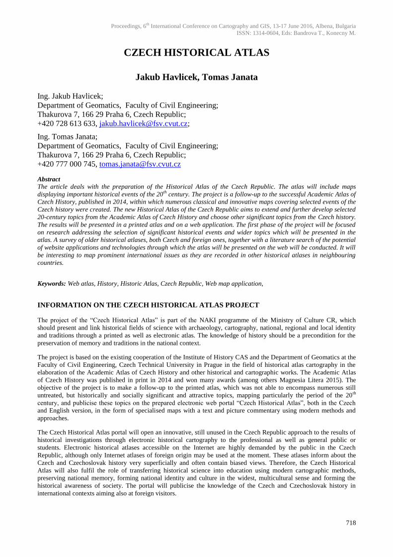
administrative and territorial subdivision of Czechoslovakia in 1920–1938 is displayed in Fig. 2.
The First Republic was marked by the rise and a prominent position of the Czechoslovak state among developed
countries of the world. After 1933, when Adolf Hitler was appointed Chancellor in Germany, the industry became
oriented towards armament. The political situation in Europe was getting worse and worse. The so-called First Republic
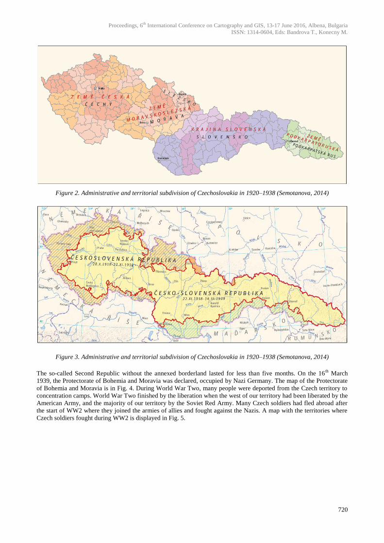
ended by the Munich Agreement (29. 9. 1938) when the representatives of four European powers – Great Britain
(Neville Chamberlain), France (Édouard Daladier), Germany (Adolf Hitler) and Italy (Benito Mussolini) agreed on the
annexation of Czechoslovak border lands by Germany, Hungary and Poland. The map of Czech Republic’s borders
before and after the Munich Agreement is in Fig. 3.
Proceedings, 6th International Conference on Cartography and GIS, 13-17 June 2016, Albena, Bulgaria
ISSN: 1314-0604, Eds: Bandrova T., Konecny M.
720
Figure 2. Administrative and territorial subdivision of Czechoslovakia in 1920–1938 (Semotanova, 2014)
Figure 3. Administrative and territorial subdivision of Czechoslovakia in 1920–1938 (Semotanova, 2014)
The so-called Second Republic without the annexed borderland lasted for less than five months. On the 16th
March
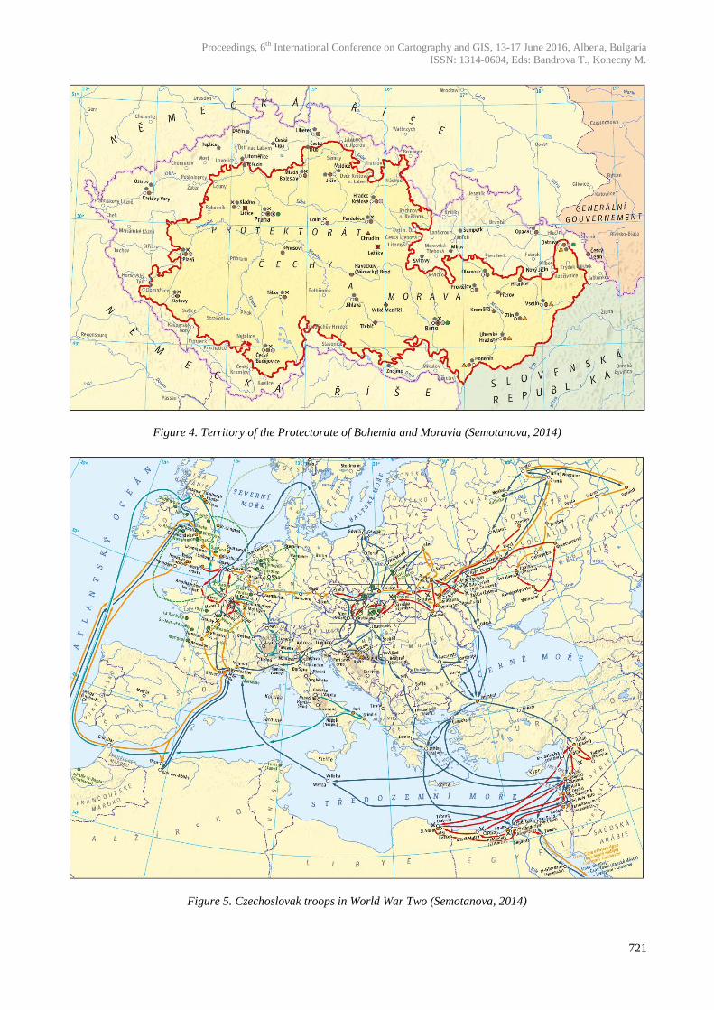
1939, the Protectorate of Bohemia and Moravia was declared, occupied by Nazi Germany. The map of the Protectorate
of Bohemia and Moravia is in Fig. 4. During World War Two, many people were deported from the Czech territory to
concentration camps. World War Two finished by the liberation when the west of our territory had been liberated by the
American Army, and the majority of our territory by the Soviet Red Army. Many Czech soldiers had fled abroad after
the start of WW2 where they joined the armies of allies and fought against the Nazis. A map with the territories where
Czech soldiers fought during WW2 is displayed in Fig. 5.
Proceedings, 6th International Conference on Cartography and GIS, 13-17 June 2016, Albena, Bulgaria
ISSN: 1314-0604, Eds: Bandrova T., Konecny M.
721
Figure 4. Territory of the Protectorate of Bohemia and Moravia (Semotanova, 2014)
Figure 5. Czechoslovak troops in World War Two (Semotanova, 2014)
Proceedings, 6th International Conference on Cartography and GIS, 13-17 June 2016, Albena, Bulgaria
ISSN: 1314-0604, Eds: Bandrova T., Konecny M.
722
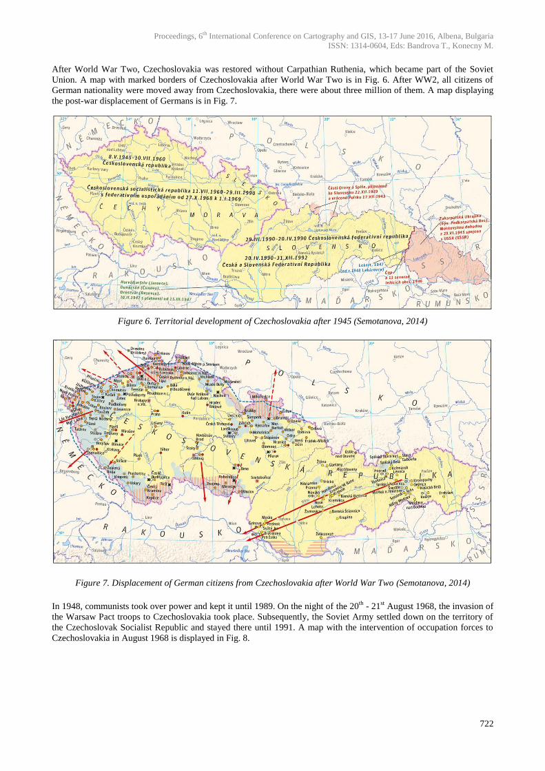
After World War Two, Czechoslovakia was restored without Carpathian Ruthenia, which became part of the Soviet
Union. A map with marked borders of Czechoslovakia after World War Two is in Fig. 6. After WW2, all citizens of
German nationality were moved away from Czechoslovakia, there were about three million of them. A map displaying
the post-war displacement of Germans is in Fig. 7.
Figure 6. Territorial development of Czechoslovakia after 1945 (Semotanova, 2014)
Figure 7. Displacement of German citizens from Czechoslovakia after World War Two (Semotanova, 2014)
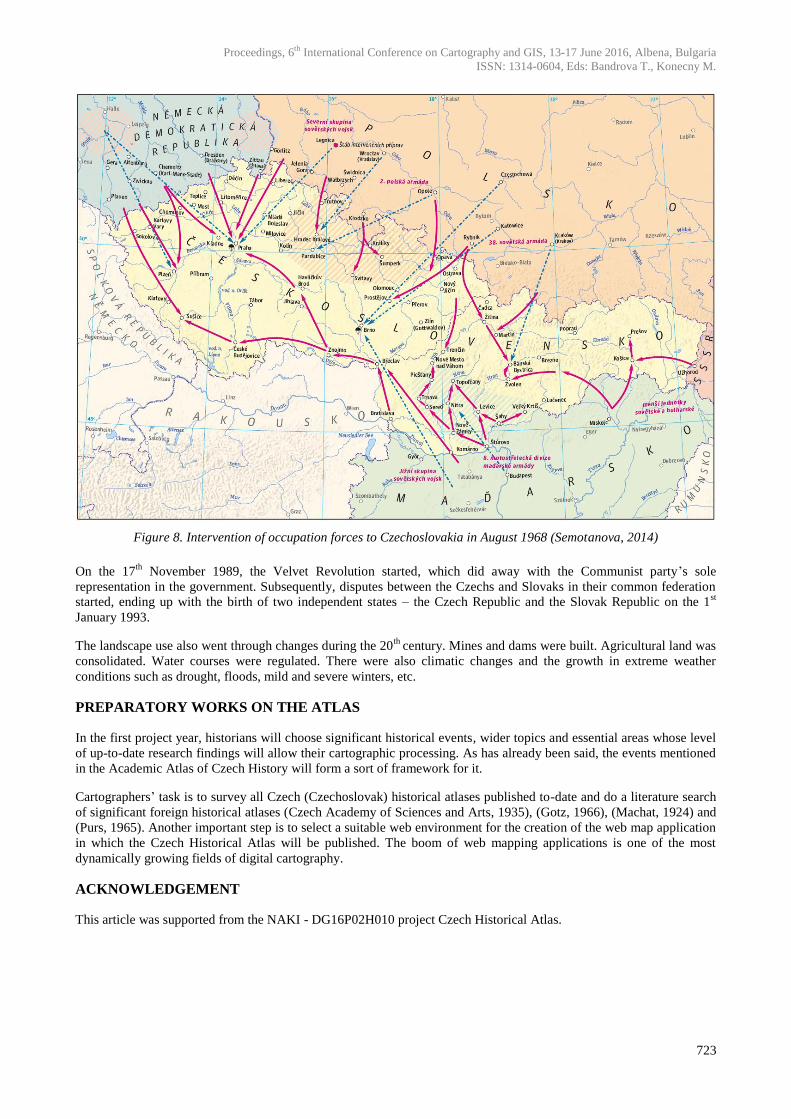
In 1948, communists took over power and kept it until 1989. On the night of the 20th
- 21st August 1968, the invasion of
the Warsaw Pact troops to Czechoslovakia took place. Subsequently, the Soviet Army settled down on the territory of
the Czechoslovak Socialist Republic and stayed there until 1991. A map with the intervention of occupation forces to
Czechoslovakia in August 1968 is displayed in Fig. 8.
Proceedings, 6th International Conference on Cartography and GIS, 13-17 June 2016, Albena, Bulgaria
ISSN: 1314-0604, Eds: Bandrova T., Konecny M.
723
Figure 8. Intervention of occupation forces to Czechoslovakia in August 1968 (Semotanova, 2014)
On the 17th
November 1989, the Velvet Revolution started, which did away with the Communist party’s sole
representation in the government. Subsequently, disputes between the Czechs and Slovaks in their common federation
started, ending up with the birth of two independent states – the Czech Republic and the Slovak Republic on the 1st
January 1993.
The landscape use also went through changes during the 20th
century. Mines and dams were built. Agricultural land was
consolidated. Water courses were regulated. There were also climatic changes and the growth in extreme weather
conditions such as drought, floods, mild and severe winters, etc.
PREPARATORY WORKS ON THE ATLAS
In the first project year, historians will choose significant historical events, wider topics and essential areas whose level
of up-to-date research findings will allow their cartographic processing. As has already been said, the events mentioned
in the Academic Atlas of Czech History will form a sort of framework for it.
Cartographers’ task is to survey all Czech (Czechoslovak) historical atlases published to-date and do a literature search
of significant foreign historical atlases (Czech Academy of Sciences and Arts, 1935), (Gotz, 1966), (Machat, 1924) and
(Purs, 1965). Another important step is to select a suitable web environment for the creation of the web map application
in which the Czech Historical Atlas will be published. The boom of web mapping applications is one of the most
dynamically growing fields of digital cartography.
ACKNOWLEDGEMENT
This article was supported from the NAKI - DG16P02H010 project Czech Historical Atlas.
Proceedings, 6th International Conference on Cartography and GIS, 13-17 June 2016, Albena, Bulgaria
ISSN: 1314-0604, Eds: Bandrova T., Konecny M.
724
REFERENCES
Czech Academy of Sciences and Arts (Česká akademie věd a umění, in Czech): Atlas of the Czechoslovak Republic (Atlas
republiky Československé, in Czech). Prague: Orbis, 1935.
Gotz, A., and more: Atlas of the Czechoslovak Socialist Republic (Atlas československé socialistické republiky, in Czech). Prague:
Czech Academy of Sciences, 1966.
Machat, F.: Otto's geographic atlas (Ottův zeměpisný atlas, in Czech). Prague: J.Otto, 1924.
Purs, J. and more: Atlas of the Czechoslovak history (Atlas československých dějin, in Czech). Prague: Central Management of
Geodesy and Cartography, 1965.
Semotanová, E.; Cajthaml, J.; Seemann, P.; and more.: Academic Atlas of Czech History (Akademický atlas českých dějin, in
Czech). Prague: Academia, 2014, ISBN 978-80-200-2182-3, 559 p.
BIOGRAPHY
Jakub Havlicek (1985) ), Dept. of Geomatics, Faculty of Civil Engineering, CTU in Prague
He is a post-graduate student at the Czech Technical University in Prague, Faculty of Civil Engineering, Department of
Geomatics. His specifications of post-graduate study are focused on cartography and GIS. The main theme of his
research are olds maps and problematic aspect of the georeferenced old maps. Jakub Havlicek is the author of many
articles on Czech and international conferences. Currently he is working on two projects of the Ministry of Culture of
the Czech Republic dealing with creating Czech History Atlas and creating interactive web mapping application of the
cultural heritage displayed on old photographs.
Tomáš Janata (1984), Dept. of Geomatics, Faculty of Civil Engineering, CTU in Prague
As a post-graduate student of cartography, Tomáš Janata mainly focuses on geospatial data processing and analyses. As
a part of an interdisciplinary research team he also deals with historical iconographic sources of the Czech lands and
their processing. He teaches several courses thematically connected with digital cartography and geographic
information systems. In grant projects in several past years he participated in the creation of the Academic Atlas of
Czech History and other cartographic works.